19th International Sedimentological Congress from 18 to
845
19th International Sedimentological Congress from 18 to 22 august 2014 in Geneva, Switzerland Sedimentology at the crossroads of new frontiers Abstracts Book
-
Upload
khangminh22 -
Category
Documents
-
view
0 -
download
0
Transcript of 19th International Sedimentological Congress from 18 to

19th International Sedimentological Congress from 18 to 22 august 2014 inGeneva, SwitzerlandSedimentology at the crossroads of new frontiersAbstracts Book

PLLEN
19th
ISC 2
NA
M
2014 18-22
ARY
A
ED
2 August, G
Y LE
AND
DAL
eneva, Swit
ECT
D
LIST
tzerland
TU
TS
UREES

1
19th
ISC 2014 18-22 August, Geneva, Switzerland
MONDAY, 18 AUGUST –– 13:30 –– R380 –– PLENARY LECTURE Sedimentary Records of the Ice Sheet Behavior During Past Warm Intervals: An Ocean Drilling Strategy Escutia, C. Instituto Andaluz de Ciencias de la Tierra CSIC-Univ. de Granada, 18100 Armilla-Granadas, Spain – [email protected] Polar ice is an important component of the Earth Climate System, affecting global sea level, ocean circulation/heat transport, albedo, and marine productivity, among other. Despite of their relevance, polar areas are largely unsampled and as a result the correlations between: 1) the records of temperature, CO2 and ice sheet volume (and equivalent sea level), and 2) the mechanisms responsible for glacial-interglacial cycles (i.e., role of atmospheric CO2) have not been yet fully elucidated. The study of ice cores retrieved from the polar ice cap has afforded major breakthroughs in understanding natural climate variability over the last 800,000 years. However, at no time during the last 1 million years (m.y.), CO2 concentrations in the atmosphere reached the 400ppm we experience at present. In fact, the lower values of atmospheric CO2 and temperatures forecasted for the end of this century (IPCC, 2013) have not been experienced on our Planet for over 4 m.y. (i.e. before the Arctic ice sheets formed), and the higher forecasted values since before the ice sheets in Antarctica formed. Antarctica and its margins are therefore key locations from where to retrieve the long-term sediment records needed for a detailed understanding of how ice sheets responded to past climate forcings. During the last decades ocean drilling in Antarctica (e.g., DSDP, ODP Legs 178, 188, IODP Expedition 318, ANDRILL and SHALDRIL) has revealed regional information about sea ice and ice sheets development and evolution. Although these records are still sparse and incomplete, they are complimentary and allow for a preliminary assessment of the variations between different ice sheet sectors. Additional records are needed if we are to address key knowledge gaps about the role of polar ice in climate change, targeting questions such as: how do ice sheets respond to warmer than present conditions (elevated CO2 and temperatures); ice-ocean interactions (and equivalent sea level rise); timing of events; rates of change; tipping points; regional variations; and northern vs. southern hemispheres (in phase or out-of-phase) variability. This data is critical to provide constrains to sea-ice and ice sheet models, which are the basis for forecasting the future of the cryosphere in a warming world. A multiplatform, multinational strategy has been developed within the SCAR PAIS (Scientific Committee for Antarctic Research-Past Antarctic Ice Sheet Dynamics) Program to collect sediment records from ice-to-abyss transects in vulnerable areas of the Antarctic ice sheets. With this strategy, PAIS aims to improve our understanding of the sensitivity of the Antarctic Ice Sheets to a broad range of past climatic and oceanic warm conditions (i.e., “greenhouse” climates, times of more recent warming and ice sheet retreat during glacial terminations). Ocean Drilling is key to this strategy. The ECORD Mission Specific Platforms will allow access to coastal and ice-covered areas, and will allow for higher recovery of glacial sediments. Ship-based drilling (i.e., JOIDES Resolution-type) is required for obtaining long-term high-quality paleoclimate and paleocenanographic records in deeper, ice-free areas of the margin. These records will be linked with ice core and continental records of past ice sheet behavior and sea level, yielding an unprecedented view of past changes in ice sheet geometry, volume, and ice sheet-ocean interactions.

2
19th
ISC 2014 18-22 August, Geneva, Switzerland
TUESDAY, 19 AUGUST –– 13:30 –– R380 –– PLENARY LECTURE Earth’s Deep-Time Insight into Our Climate Future Montañez, I.P.
Dept. of Earth and Planetary Sciences, University of California, Davis, California 95616, U.S.A. - [email protected]
Earth has two fundamentally different climate states—a cool ‘icehouse’ state characterized by the waxing and waning of continental-based ice sheets at high latitudes, and a ‘greenhouse’ state characterized by much warmer temperatures globally and only small—or no—ice sheets. Although Earth has been in an icehouse for the past 34 million years, warmer greenhouse conditions have been the ‘typical’ climate state of the past half billion years. At the current rate of global C emissions, atmospheric CO2 is projected to increase within this or the following century to levels last experienced on Earth prior to the onset of our current glacial state. Insight into how the Earth system will function in such an evolving and high CO2 environment uniquely resides in the deep-time geologic record — the only integrated archive of the full spectrum of climate-related processes, feedbacks, and complex climate-ecosystem interactions in the earth system. The paleoclimate record of the recent past unquestionably provides a critical baseline against which future climate change can be assessed given its resolution and precision. However, it captures only part of the known range of climate phenomena as it has been derived from a time dominated by low (30% lower than today) and relatively stable atmospheric CO2 and bi-polar glaciations. Study of the deep-time geologic record reveals climate change in the past that was at times far more dynamic than suggested by reconstructions of the past few hundred thousand years and further elucidates feedbacks in the climate system that have operated differently in the past. Data-climate model comparisons of past warm periods further suggest that the magnitude and duration of climate change and the CO2 levels at which critical climate and ecological thresholds could be crossed may well be underestimated by current climate projections. This presentation will place current and projected levels of atmospheric CO2 into a deep-time context and use three examples of past major transitions to document the dynamic nature of past global warmings during both ice- and green-houses, evidence for atmospheric CO2-climate coupling throughout Earth history, and to illustrate climate and ecological thresholds of greenhouse-gas forced climate change.

3
19th
ISC 2014 18-22 August, Geneva, Switzerland
THURSDAY, 21 AUGUST –– 13:30 –– R380 –– PLENARY LECTURE Sedimentology Frontiers from Earth to Mars: Dunes, Deformation, and Diagenesis Chan, M.A. Department of Geology and Geophysics, University of Utah, 115 S. 1460 E., Salt Lake City, Utah 84112, U.S.A. - [email protected] An enticing challenge of sedimentology is applying our knowledge to new exploration settings, using clues and proxies to deduce the processes of sedimentation. Mars has held our interest since ancient times, but now through new technologies and instrumentation advances we have the ability to scientifically explore the Red Planet at unprecedented scales. Studies of sedimentary environments on Earth are critical, as terrestrial analogs help us interpret depositional and diagenetic processes, as well as determine where habitable environments for life might exist. Three comparative sedimentary examples of Earth settings show remarkable similarities to recent satellite and rover imagery from Mars:
1. Ergs on Earth are globally important reservoir units for both hydrocarbons and water. Mars has spectacular dune forms and dust devil tracks, reflecting the ubiquitous nature of eolian processes shaping the surface of Mars. Porous dune sediments record the interactions of the atmosphere and the surface, and have the potential to hold hold fluid volumes or cement mineralogies in the subsurface. 2. Soft-sediment deformation with varying expressions (e.g., contorted cross bed sets, massive sandstone layers, and clastic injectites) occur in eolian units. These can provide clues to past water table conditions and the susceptibility of the sediments to strong ground motion. Weathering patterns in these sandstones can reflect differences in the massive versus cross-bedded host rock textures. 3. Finally, Earth sandstones commonly show different colors of iron oxide cementation reflecting the mobility of iron in the Earth’s crust. These diagenetic records of past fluid flow histories provide clues about reservoir properties for aquifers and hydrocarbons. Is diagenesis a biogenic as well as a physical process? Many diagenetic relationships suggest a very strong link.
Mars is an exciting frontier for sedimentology, offering opportunities for serendipitous discoveries of what might exist within its sedimentary layers and surface landforms.

4
19th
ISC 2014 18-22 August, Geneva, Switzerland
FRIDAY, 22 AUGUST –– 13:30 –– R380 –– PLENARY LECTURE Sea Level Rise: Recent Past, Present and Future Cazenave, A. LEGOS-CNES, Toulouse, France - [email protected] - [email protected] It is now well established that the Earth‘s climate is warming and that the main reason is the accumulation inside the atmosphere of green house gases produced by anthropogenic fossil fuel combustion and change in land use (IPCC AR5, 2013). Global warming has already several visible consequences, in particular increase of the Earth’s mean temperature and of ocean heat content, melting of glaciers, and ice mass loss from the Greenland and Antarctica ice sheets. Ocean warming causes thermal expansion of sea waters, hence sea level rise. Similarly, land ice melt that ultimately reaches the oceans, also causes sea level to rise. Sea level rise induced by global warming and its impacts in coastal zones has become a question of growing interest for in the scientific community, and the media and public. In this presentation, we summarize the most up-to-date knowledge about climate change and associated impacts on ocean warming, land ice melt and sea level rise. We also present sea level projections for the 21st century under different warming scenarios, highlighting the regional variability that superimposes the global mean rise. Finally, we address the question of the sea level rise impacts. We discuss the many factors (due to natural phenomena and direct anthropogenic forcing) causing adverse effects in coastal zones and show that climate-related sea level rise will generally amplify the vulnerability of these regions.
5
19th
ISC 2014 18-22 August, Geneva, Switzerland
THURSDAY, 21 AUGUST –– 17:05 –– R380 –– SORBY MEDAL Unlikely carbonates; they are so cool! James, N.P. Geological Sciences and Geological Engineering, Queen’s University, Kingston, Ontario, Canada K7L 3N6 - [email protected] The most improbable carbonate sediments and rocks are those that form in the cold, frigid, and freezing ocean well outside the soft, warm, sunlit, waters of the tropics. When the IAS was born some 60 years ago and until recently such deposits were barely mentioned – all limestones were obviously tropical! Now temperate and polar limestones are an integral part of mainstream sedimentology. How has this happened? It was intuitively obvious, even in the 1800’s, that limestones were tropical creations and so we happily went to modern environments in the Caribbean, the Persian Gulf, and the Pacific to understand them. Although cool water calcareous sediments had been long described the first inklings of serious cool-water extratropical limestones came from Cenozoic successions in New Zealand, islands surrounded by shelves covered with almost identical cool-water calcareous sediments. But so what? This was far away whereas a new succession of Phaneroizic limestones was daily being interpreted as tropical and correlated with burgeoning new information on warm water deposits. The breakthrough came simultaneously on several fronts about 25 years ago; 1) it was realized that southern Australia was an enormous area of cool-water carbonate deposition, vast carbonate banks of ancient cool-water carbonates were now possible, 2) the southern hemisphere, as well as the Mediterranean, had extensive Cenozoic temperate carbonate deposits, and 3) some Paleozoic limestones looked astonishingly like these Cenozoic rocks. The realization began to sink in that cool-water limestones had been part of the carbonate world all along. Increased research has since resulted in a rush of discoveries; 1) cool-water seagrasses are prolific sediment factories whose carbonate productivity exceeds that of similar tropical marine angiosperm, 2) macrophye (kelp) factories are significant carbonate factories, especially in cold high latitude marine environments, 3) cool marine carbonates can occur adjacent to marginal marine peritidal evaporite-dolomite environments, 4) bryozoan-sponge reef mounds, long thought to be extinct Paleozoic buildups, grow in modern cool-water upper slope environments, 5) high latitude, polar deposits unexpectedly form at the coldest and not the warmest of times, 6) extensive seafloor dissolution is occurring in the temperate neritic zone well above the lysocline, 7) diagenetic implications of cool-water calcite-only sediments are profound, there is insignificant early meteoric cementation thus pathways of burial diagenesis are profoundly different and those of warm-water carbonates. Cool carbonates have come of age and perhaps the most important aspect is that they provide is a framework against which to compare the warm water deposits and thus a more realistic vision than ever before of ancient and very ancient seascapes. Our evolving knowledge of neritic carbonates has taken two totally different intellectual pathways. First, understanding of carbonate sedimentation evolved differently in the two hemispheres. Acceptance of cool-water carbonates came largely from the southern hemisphere because there were no vast cool-water systems in the north – too much dirt from recent glaciation. Second, limestones were so fossiliferous and so intuitively tropical, thus research focused on the tropical seafloors - the rock record drove research on modern sediments. By contrast cool-water carbonate sediments were long known but not equivalent limestones - modern sediments drove research into ancient rocks. We are students of the earth but we should never forget that we are also prisoners of our personal experience.

6
19th
ISC 2014 18-22 August, Geneva, Switzerland
THURSDAY, 21 AUGUST –– 17:50 –– R380 –– WALTHER MEDAL Flood record in marine sediments Mulder, T. Université de Bordeaux, UMR5805 EPOC / OASU Bât. B18, Allée Geoffroy St Hilaire, CS 50023, 33615 Pessac Cedex, France - [email protected] River flood-generated turbidity currents (hyperpycnal flows) form at mouths of rivers at a frequency varying from one event per year, to one event every millennium or so. Particular geological environment (presence of easily erodable sediment) and climate (long wet season or monsoon) are the main causes for exceptional high-frequency of hyperpycnal flows (south-Asian rivers). Hyperpycnal floods generally have a meteorological origin, but catastrophic hyperpycnal floods can also occur due to dam outburst in the catchment area of a river. In some cases, catastrophic floods are associated with earthquakes or volcanic activity. This talk focuses on the processes, character and significance of flood-related turbidity currents and their deposits (hyperpycnites) in the geological record based on selected examples from modern environments, outcrops, sediment cores and seismic reflection profiles. Excess density when compared to density of the ambient water in the receiving basin allows the transport along the basin floor. Most of the suspended sediment supplied to the river mouth is transported during flood-generated flows, because: (1) hyperpycnal flows form during major flood events, and (2) for suspended load-dominated hyperpycnites, the rating curve of a flood event is represented by a power law relationship between discharge and load. Consequently, flood-generated deposits can represent a significant part of basin-fill in basins supplied by a siliciclastic source. Flood-generated flows transport mainly fine-grained suspended particles, but also a significant amount of sand as bed load. Classical hyperpycnal-flow deposits (hyperpycnites) are located seaward of 1) dirty small-sized mountainous rivers, 2) cleaner rivers that are occasionally subjected to landslides or bank-failure in areas of earthquake activity or jökulhlaups, or lahar events and 3) other rivers through density cascading and reconcentration processes. Taking into account reconcentration, as much as 84% of the world river can generate hyperpycnal flows with initial concentration at the river mouth as low as 5 kg m-3. Classical hyperpycnal deposits (hyperpycnites) are characterized by a coarsening-upward basal unit formed during the rising limb of the flood (waxing flow) and a fining-upward upper unit formed during the falling limb of the flood (waning flow). During major floods the basal part may be eroded. Hyperpycnites collected on the prodelta of the Rhône River show that geochemistry can help to the diagnosis of flood-related deposits. Flood sequences are enriched with continent-supplied elements (Si, Ti). The deposit sequences also show enrichment in organic matter related to the abundance of plant fragments. This analysis shows that (1) hyperpycnal flows can generate deposits in many deep-sea environments; (2) These frequent, long duration, quasi-steady flows are good candidates to explain canyon and meandering channel-levee systems and more distal, basinal fan lobes both in marine and lacustrine environments. (3) Because of the duration of flood-generated turbidity currents, a distinguishing feature of hyperpycnal flows is long distance that sand can be transported despite the smaller proportion of sand relative to many classical slide-induced turbidity currents. (4) Because they are related to floods, frequency and thickness of flood,-deposits represent a good deep-sea marker on climatic change across continents. This is particularly the case of major flood deposits that formed during the dismantlement of the North-American ice sheet at the end of the last glacial period (Lake Bonneville or Lake Missoula floods).

7
19th
ISC 2014 18-22 August, Geneva, Switzerland
THURSDAY, 21 AUGUST –– 17:55 –– R380 –– YOUNG SCIENTIST AWARD Shaken and Stirred: Extreme events archived in the sedimentary records of lakes and continental margins Strasser, M.
Geological Institute, ETH Zurich, 8092 Zürich, Switzerland - [email protected] The study of insitu-deformed, remobilized and redeposited marine and lacustrine sediments affected by geological extreme events such as subaquatic landslides, earthquakes and tsunamis aims at better understanding causes and consequences of such geohazard processes. Earthquakes and tsunamis induce ground shaking and hydro-dynamic effects, respectively, which induce transient dynamic stresses acting on unconsolidated sediments on our lake’s and ocean’s floor, triggering sediment instability and remobilization and leaving characteristic sedimentary deposits and structures in the sedimentary record after the transient stresses cease. The sedimentary record therefore can be used to investigating past occurrences and to make inferences of intensities of such extreme events in the geological past. Here, I present some highlights of more than 10 years of my research studying subaquatic mass movement deposits and its relation to tectonic processes and earthquakes in contrasting seismotectonic environments: The study areas range from (1) lakes in the intraplate region of Central Switzerland, where characteristic pattern of subaquatic mass-movements deposits are used to reconstruct past earthquakes in the last 15’000 years; and (2) active subduction zones offshore Japan, where (2a) Integrated Ocean Drilling Program (IODP) drilling allows for studying more than 1 Million years of submarine landslide history in the actively deforming Nankai accretionary prism, and (2b) where the most recent magnitude 9 earthquake and devastating tsunami in 2011 (Tohoku-oki event) provides a unique opportunity to investigating the sedimentary fingerprint and how it will be preserved in the geological record of the Japan Trench I present data ranging from margin- (basin-) wide geophysical imaging of the sea/lake- and subsea-/lakefloor, to sedimentological, geotechnical, geochemical and X-ray computed tomography (X-CT) analyses of cores and scanning electron microscopy (SEM) imaging micro-scale structures and features. This aims at studying extreme event deposits resulting from subaquatic mass movements on various scales and deciphering sedimentological, geotechnical, magnetic, biological and/or chemical signatures preserved in the deposits that may allow us to reconstruct transport dynamics, preconditioning and triggering mechanism of subaquatic mass transport and slope instability initiation, respectively. The integration of data and results from the three presented case studies, will allow for discussion if, how, and in which setting, we can use the sedimentary record of lakes and continental margins as natural seismographs for reconstructing the earthquake history towards better characterizing the seismotectonic setting and better understanding long-term recurrence patterns. Acknowledgements: My research is currently supported by the Swiss National Science Foundation grant PP00P2-133481.

8
19th
ISC 2014 18-22 August, Geneva, Switzerland
TUESDAY, 19 AUGUST –– 19:00 –– R380 –– PUBLIC LECTURE GEothermie 2020 : mieux connaître le sous-sol genevois pour réinventer l’eau chaude ! Meyer, M. Services Industriels de Genève (SIG), Chemin Château-Bloch 2, 1211 Genève 2 – michel.meyer@sig-ge-ch Les calcaires blancs visibles sur les crêtes jurassiennes ou sur les flancs du Salève recèlent des trésors méconnus. Ils nous renseignent sur l’histoire ancienne de notre région et nous apprennent, entre autre, qu’une mer chaude et peu profonde, jalonnée d’iles peuplées de dinosaures, recouvrait la région il y a environ 140 millions d’années, bien avant que les Alpes et le Jura ne se forment. Ces mêmes couches calcaires plongent sous le bassin genevois où ils pourraient être le siège d’une autre richesse : de l’eau chaude en grande quantité. De quoi fournir jusqu’à 2/3 des besoins de chaleur de l’agglomération genevoise ! En effet, la chaleur de la terre – environ 35°C gagnés par kilomètre d’enfouissement - combiné avec un sous-sol gorgé d’eau semblent offrir de magnifiques possibilités pour que la géothermie soit l’énergie de demain à Genève. Cependant, le sous-sol genevois est encore très mal connu et toutes les couches géologiques ne renferment pas de l’eau en quantités équivalentes. Pour exploiter cette richesse de manière durable et intelligente, il va falloir le cartographier finement, tirer le maximum d’enseignements des données existantes, et profiter des sciences géologiques pour identifier les secteurs les plus favorables. L’Etat et les SIG ont lancés le programme de prospection et d’exploration du sous-sol GEothermie 2020. Les géologues, paléontologues, sédimentologues, géophysiciens et géochimistes, par leurs compétences et grâce à des outils d’analyse modernes, vont permettre de préciser la nature du sous-sol genevois et de réduire les risques d’échecs de futurs projets géothermiques. Le département de géologie de l’Université de Genève, spécialiste en sédimentologie et en géologie de réservoirs, est mandaté par SIG pour accompagner ce projet et y mettre toutes les compétences spécifiques requises. Est-ce que la géothermie fonctionne ? Quelles sont les techniques de prospection et d’exploration qui seront utilisées ? Comment imager le sous-sol à plusieurs kilomètres de profondeurs ? Quels enseignements tirer des montagnes qui nous entourent ? Qu’est-ce que la sédimentologie ? Autant de questions qui seront abordées pour expliquer comment passer de l’eau chaude des mers du Jurassique à l’eau chaude de la Genève de demain !

19th
ISC 2
S
SY
2014 18-22
ESS
A
YM
2 August, G
SIO
AND
MPO
eneva, Swit
ON
D
OSI
tzerland
NS
IA

9
19th
ISC 2014 18-22 August, Geneva, Switzerland
Porosity Characterization and Flow Units Identification of the Upper Khartam Member, Khuff Formation (Permian-Triassic): Outcrop Approach, Central Saudi Arabia Abdulraziq, A.1, Abdullatif, O.1, Babalola, L.2
1 Earth Sciences Department, King Fahd University of Petroleum and Minerals (KFUPM), P. O. Box: 701,
Dhahran, 3126, Saudi Arabia - [email protected] 2 Center for Petroleum & Minerals - Research Institute, King Fahd University of Petroleum and Minerals
(KFUPM), P. O. Box: 701, Dhahran, 3126, Saudi Arabia The study investigates the porosity and flow units’ characteristics of the Permian-Triassic Upper Khartam Member of the Khuff Formation, in At Tarafiyah area, Qasim region, central Saudi Arabia. The objectives of this study are: to identify the geometrical characteristics for each pore type and subdivide the individual pore type based on their geometries, assess the flow units according to their porosity-permeability and their reservoir quality index (RQI) at the outcrop scale. Thin section petrography was used to identify the different types of porosity and the diagenetic alterations that may affect the porosity. The pore sizes, aspect ratio, roundness factor, and frequencies were determined for each pore type using Petrographic Image Analysis (PIA) technique. Microporosity in the investigated samples was identified with the aid of scanning electron microscopy microscope (SEM). Core plugs’ poroiometer and permeameter were used to get measure the total porosity and the permeability. The outcrop succession is mainly composited of well-sorted oolitic grainstone, cross-bedded oolitic skeletal grainstone and graded mudstone to packstone facies. Based on the thin section studies, moldic porosity is classified geometrically into oomoldic and skelmoldic porosities. Similarly, vuggy porosity shows two different geometrical-sizes that are called vuggy-1 and vuggy-2. Moreover, the porosity types are ranked based on their sizes into eight different classes. Oomoldic and vuggy-1 have the best ranking classes, while intracrystalline and intragranular porosities have the worst ranking classes. The combination of oomoldic and vuggy-1 form the optimum reservoir quality. Integration of the (RQI), core porosity-permeability values and outcrop lithofacies shows detailed petrophysical behavior of the flow units laterally and vertically.

10
19th
ISC 2014 18-22 August, Geneva, Switzerland
Spatial distribution of the 2011 Tohoku-oki tsunami deposits in a narrow valley at the southern end of Sendai Plain Abe, T.1, Goto, K.2, Sugawara, D.2 1 Department of Geography, Graduate School of Environmental Studies, Nagoya University, Furo-cho,
Chikusa-ku, Nagoya 464-8601, Japan - [email protected] 2 International Research Institute of Disaster Science, Tohoku University This study focuses on spatial sedimentary process of the 2011 Tohoku-oki tsunami in a narrow valley at the south end of the Sendai Plain. Previous researches have tended to study tsunami deposits along transect line(s). However, tsunami flow is complex due to local topography and as such a broader spatial distribution should be investigated. In this study, we investigated tsunami deposits at 176 sites within a narrow valley and analyzed thickness, grain size, sedimentary structures. We examined elevation data and aerial photographs of before and after tsunami. In addition to, we analyzed the grain size distributions of the sandy deposit and diatom assemblages of the muddy deposit. The main valley stretched east to west with 2.4 km long and some sub-valleys stretched south to north with 10 meters to 100 m and surrounded by the high terraces. A small pond is located in a wetland at distances of 0.7-0.9 km from the coastline. The tsunami reached 2.2 km from the coastline and ran up to 11.6 m at the valley head. The average tsunami directions of up flow, estimated from orientation of the knocked-down tress, suggest that main direction of tsunami inflow was westward. On the other hand, return flow was complex on the basis of distribution of debris and shape of erosional features formed by backwash. The sandy tsunami deposits were ranged in thickness up to 40 cm. Sand beach and sand dune were fairly eroded by the tsunami flow and may supply inland a plenty amount of sand. Grain size distributions were similar among the tsunami sand, beach sand and dune sand. As for tsunami deposits, sand thickness generally decreased inland, but they were spatially fluctuating associated with slope, topographic features and artificial structures. The muddy tsunami deposits were ranged in thickness up to 40 cm. Paddy field and bottom of the pond were eroded by the tsunami flow. In consequence of a mud transport from the pond, mud thickness rapidly increased around the pond. Diatom assembles suggest that muddy tsunami deposit sourced from the pond bottom sediments and rice paddy soil. In the sub-valley area and upper main valley area with higher than 3 m in elevation, the sand thickness became thinner with increasing in elevation and the sand layer was mostly composed of single unit. On the other hand, in the lower main valley area with lower than 3 m in elevation, the sand thickness was less influenced by elevation and the sand layer was mostly composed of 2-5 units. The number of sub-unit might be related to the tsunami wave number in this valley. Therefore, it is probably that at least 5 waves inundated over the lowland with lower than 3 m in elevation. We concluded that the change of tsunami hydrodynamic processes at the slope change point trigger characteristic thickness distribution and sedimentary processes. Besides, we estimated that the depositional volume of the sand was enough to be explained by erosional volume of beach and dune sand, and more than half of the erosional volume discharge into the sea by the return flow. Depositional volume of the mud was also sufficient amount for erosional volume of land and pond. We concluded that the tsunami deposits in this valley were mostly sourced from land and the pond. Acknowledgements: This research was supported by Grant-in-Aid for JSPS Fellows (no. 2610914)

11
19th
ISC 2014 18-22 August, Geneva, Switzerland
Can petrographic fabric analysis be used as a tool to recognised supercritical-flow bedforms in cores? An outcrop case study from a Late Carboniferous deltaic setting Acikalin, S.1, Cartigny, M.2, Ventra, D.3, Bijkerk, J.4 1 Badley Ashton and Associates Ltd, Winceby House, Winceby, Horncastle, Lincolnshire, UK –
[email protected] 2 National Oceanography Centre, Southampton, UK 3 School of Earth and Environment, University of Leeds, UK 4 Faculty of Geosciences, University of Utrecht, The Netherlands Reservoir characterisation is often based on integrated studies of few to several tools such as seismic profiles, wireline logs, borehole image, core observations and petrography. Typically these tools provide either information about the regional architecture of the reservoir like seismic data does or the data is limited to a vertical section on a single point like core data. This relatively large gap in scale of the various data sources result in a lack of data on a meter to tens of meter scale. Outcrop studies, where available, provide valuable data; and upscaling/downscaling of the information obtained from outcrops can fill the gap between the seismic and core scale. Recent flume experiments and direct submarine observations of turbidity currents on delta channels have increased our knowledge about their flow dynamics and sediment deposition processes. One of the outcomes of these studies is that supercritical-flow bedforms are far more abundant than was previously thought. Initial experimental results indicate that the deposits left behind by these supercritical-flow bedforms consist of aggradational backset packages composed of mainly structureless to crudely stratified sandstones. In one such backset, various bed-scale fabrics are likely to occur due to changes in flow characteristics and associated sediment transport processes over the stoss side of these bedforms. These cyclic steps are typically in a sub-seismic scale, yet they are very difficult to recognise in core. Better understanding of downstream facies and thereby formed vertical stacking pattern of bed-scale fabrics seems to be the key to recognise supercritical-flow bedforms like cyclic steps in cores. In this study, we aimed to link outcrop-scale properties of cyclic steps to core and micro-scale features of bed-scale fabrics in order to be make an attempt to use petrography as a tool for recognition of bed-scale fabrics and hence the cyclic steps in core. Additionally, detail and micro-scale characterisation of various bed-scale fabrics of cyclic steps can be used as a reservoir quality prediction tool in future studies. For this case study, outcrops of Late Carboniferous sandstones of the Lower Kinderscout Grit, that were deposited in fluvio-deltaic to shallow-marine setting has been selected. The outcrop study was carried out in the Derby Delph Quarry (near the Booth Wood Reservoir, Rishworth, West Yorkshire) which comprises sets of large-scale (10s of meters in wavelength), undulating sandstone beds. These sandstones are typically massive, poorly to very poorly sorted and predominantly ungraded. In the main quarry wall, four aggradational bedsets, separated by distinct erosive surfaces are recognised. Preliminary petrographical studies on various transects throughout the bedsets of Derby Delph Quarry yielded promising result on possibility of using petrography as a tool for cyclic step recognition in cores.

12
19th
ISC 2014 18-22 August, Geneva, Switzerland
The sedimentary and paleoenvironmental expression of mass extinctions, where do we stand? Adatte, T.1 1 ISTE, Lausanne University, 1015 Lausanne, Switzerland - [email protected] Main mass extinctions in the Phanerozoic are almost always related with severe climate changes and large sea-level fluctuations. Over the last 30 years considerable research efforts have been directed toward understanding the context and nature of environmental changes that occurred immediately prior to, at, and after the five major Phanerozoic mass extinctions. Actually, earth volcanic activity linked to LIPS is one of the two leading scenarios proposed to explain the pattern of mass extinctions in the Phanerozoic, the other involving asteroid impacts. The consistent association of large magmatic provinces (LIPs and CFBPs) with all but one (end-Ordovician) of the five major Phanerozoic mass extinctions implies that volcanism played a major role. Faunal and geochemical evidence from the end-Permian, end-Devonian, end-Cretaceous and Triassic/Jurassic transition suggests that the biotic stress was due to a lethal combination of tectonically induced hydrothermal and volcanic processes, leading to eutrophication in the oceans, global warming, sea level transgression and oceanic anoxia. Evidence of regression giving rise to a shallowing-upward succession quickly followed by transgression marked by the widespread deposition of black shales are well established for all the five major Phanerozoic extinctions, with the exception of the Cretaceous- Tertiary boundary (KTB) one. If a rising sea level marks also the uppermost Maastrichtian leading to the deposition of a condensed interval at the KTB, however black shales deposits remain quite rare. Their absence is probably linked to more dynamic paleooceanographic conditions linked to increased paleolatitudinal gradient, which prevailed since the mid-Maastrichtian cooling events. Major magmatic events and their long-term environmental consequences are the main contributors, though not the sole causes of mass extinctions. Sudden mass extinctions, such as at the K/T boundary, may require the coincidence of major volcanism and a very large impact. Mass extinction is therefore the culmination of many factors, which contributed to high-stress environmental conditions, including long-term perturbations (volcanism, e.g. Deccan traps for the end-Cretaceous, cooling, sea-level fluctuations) and short terms events (impacts). No single kill mechanism can really be identified.

13
19th
ISC 2014 18-22 August, Geneva, Switzerland
Carbonate rhizoliths: from morphology to metabolism Adrijan, K.1 1 Institute of Palaeontology ZRC SAZU, Ljubljana, Slovenia, and School of Earth & Ocean Sciences, Cardiff
University, UK - [email protected] Rhizoliths, i.e., traces and remains of plant roots preserved in mineral matter, most commonly composed of calcium carbonate, are among the most prominent features of paleosurfaces and may constitute the dominant fabrics in some forms of calcretes. However, except for their gross morphology, even the typical macroscopic rhizoliths may show no biologically influenced carbonate fabrics. Moreover, many forms of secondary carbonate in soils and palaeosols which are considered rhizogenic (implying direct or indirect role of live plant roots in CaCO3 precipitation) actually show no or very limited conclusive evidence of biogenicity. Macroscopic rhizoliths (cm to m scale) can be the most obvious in outcrops but have only a minor significance for the understanding of the carbonate precipitation mechanisms. Large rhizoliths correspond to parts of a coarse root system, comprised of lower order roots, which are responsible for mechanical support and the transport of substances between the soil and the shoot. In both annual and perennial plants, the dominant component of the root system is a structurally and functionally complex population of fine roots, <1-2 mm in diameter, which are responsible for the water and nutrient uptake, as well as mycorrhizae formation. Fine roots have short lifespan (days-months), but are replaced by the plant in a continuing process of root 'turnover'. A narrow zone surrounding fine roots where soil properties and microbial populations are influenced by root exudates, is called rhizosphere. Very large reactive surface area of fine root systems per soil volume indicates the crucial role of the rhizosphere in near-surface precipitation terrestrial carbonates. Ion exchange processes between fine roots and solid soil phases can result in carbonate biomineralisation in- or around fine roots. CaCO3 precipitation in the rhizosphere is mediated mainly by the root-associated microorganisms in the soil (fungi and bacteria). Significant accumulations of secondary carbonate in soils and palaeosols are formed through biologically induced CaCO3 mineralisation in cortical cells of fine roots. Intracellular calcification, coupled with extrusion of protons, most probably represents an effective nutrient acquisition mechanism. Processes and products of root-influenced carbonate biomineralisation will be shown using Holocene and Pleistocene examples of laminar calcretes from San Salvador and North Andros (Bahamas), Florida Keys, and calcified roots from Pleistocene and modern soils of Spain (the Alicante region and the Island of Mallorca). Well-documented Quaternary examples will be compared with possible analogues in carbonate sequences in the rock record.

14
19th
ISC 2014 18-22 August, Geneva, Switzerland
Formation of ironstone crusts in the Cenomanian deposits of the Bahariya Depression, Western Desert, Egypt – Environmentally or diagenetically constrained? Afify, A.M.1, Sanz-Montero, M.E.1, Calvo, J.P.1 1 Departamento de Petrología y Geoquímica, Facultad de CC. Geológicas (UCM), C/ José Antonio Nováis, 12,
28040, Madrid, Spain - [email protected] Ironstone crusts are prominent throughout the lower and upper members, though absent in the middle member, of the Cenomanian Bahariya Formation, north of the Bahariya Depression. This stratigraphic formation is mainly composed of siliciclastic rocks, i.e. cross-bedded and massive sandstone, siltstone, variegated shale and fossiliferous sandstone/sandy limestone. Dark bituminous-rich sandstones occur in the middle member of the formation. Full understanding of the Bahariya ironstones requires not only a clear description and interpretation of sedimentary facies but also the paragenetic mineral sequence forming the ironstones and their host siliciclastic rocks. Field sedimentological work, XRD mineral determinations, standard petrography and SEM and electron microprobe (EMPA) analyses indicate that the ironstones are composed of a variety of diagenetic minerals formed throughout eo-, meso-, and telodiagenetic stages. New mineral phases formed during early diagenesis, i.e. siderite, barite, Mn-minerals and goethite coatings, are volumetrically less important than those produced during burial and later telodiagenetic stage. These latter diagenetic products comprise Fe-dolomite/ankerite, bitumen, silica/feldspar overgrowths and high amount (up to 65%) of iron oxyhydroxides. During burial, dolomite and ankerite replaced preferentially micrite matrix, bioclasts and several calcrete features as well as infilled vugs. Also during the mesodiagenesis, the decomposition of organic matter resulted in the formation of bitumen and created reducing conditions favourable for the mobilization of iron-rich fluids in divalent stage. Telodiagenesis of the Cenomanian Bahariya deposits took place during the Turonian-Santonian. Uplift resulted in partial to total dissolution of the Fe-dolomites and subsequent precipitation of iron oxyhydroxides. The preservation of large centers and clear rims with no collapse features of the Fe-dolomites implies alteration by solution. Fe-dolomite and ankerite dissolution was concomitant to iron oxyhydroxide precipitation upon mixing with shallow oxygenated water. Source of iron for the ironstone crusts of the Bahariya Formation has been debated and various formative sources have been proposed. These include alteration of clay minerals and heavy minerals, extensive weathering of older rocks and further transport of iron in solution or as colloid, whether in the sediment load or by groundwater inflow, etcetera. Circulation of reducing iron-rich fluids through fractures and inter and intrastratal discontinuities is proposed as an alternative model. The origin of iron-rich fluids is probably related to basement rocks but contribution from other underlying formations of Paleozoic, Jurassic or earlier Cretaceous in age is not excluded. This model explains better the lateral continuity and heterogeneous geometries of the ironstones in Bahariya, which are related to main faults in the area. Acknowledgment: We would like to acknowledge the Egyptian Government due to their financial support for the project through Ph.D. grant of the first author.
15
19th
ISC 2014 18-22 August, Geneva, Switzerland
Late stage diagenetic alterations in Turonian- Maastrichtian Kawagarh Formation, Hazara Basin (NW Lesser Himalayas, Pakistan): Based on petrographic, geochemical and stable isotopic information Ahsan, N.1, Shah, M.M.2, Meng, F.W.3, Ni, P.4, Rehman, S.U.5, Jamil, N.6 1 Institute of Geology, University of the Punjab, Lahore-54590, Pakistan - [email protected] 2 Department of Earth Sciences, Quaid I Azam University, Islamabad, Pakistan 3 Nanjing Institute of Geology and Palaeontology, Chinese Academy of Sciences, Nanjing, China 4 Institute of Geo-Fluids, School of Earth Sciences and Engineering, Nanjing University, Nanjing, China 5 Department of Earth Sciences, University of Sargodha, Sargodha, Pakistan 6 College of Earth and Environmental Sciences, University of the Punjab, Lahore, Pakistan The Kawagarh Formation is dominantly composed of limestone with subordinate dolomite and marl. It was deposited in warm tropical homoclinal ramp settings at 23˚S latitude when the Indian Peninsula collided with the Kohistan Island Arc at ca. 65 Ma. The present study involves detailed sampling of eight stratigraphic sections, petrographic analysis (n=880), XRD (n=15), major (Ca and Mg) and minor (Sr, Na, Mn and Fe) trace element geochemistry (n=110), and stable isotopic (δ18O and δ13C) signatures (n=32). The petrographic studies demonstrate that Kawagarh Formation has been subjected to complex diagenetic history including compaction, minor dripstone, meniscus cementation and dolomitization. Close packing of grains, point contacts, dissolution seams and stylolites indicate effects of both mechanical and chemical compaction. Mostly dissolution seams are parallel to bedding and may have dolomite or clays. Stable isotope analyses indicate depleted δ18O signatures (-3.70 to -7.81‰ PDB) of the host limestones that points to readjustment due to fluid interaction. In case of dolomite, depleted δ18O values (-3.22 to -7.28‰ PDB) indicate interaction of relatively warm Mg- rich fluids with the host limestone. Besides this, δ13C values (-3.95 to +2.88‰ PDB) suggest late stage (meteoric) calcitization/dedolomitization process. Nearly comparable average trace elements (Sr, Na, Mn and Fe) in limestone and dolomite indicate a same source i.e. limestones of mixed mineralogy were modified in meteoric realm. Moreover, covariant trend perceived in compositions of oxygen and carbon isotopes proposes influence of meteoric diagenesis. Various plots of the trace elements with δ18O and δ13C show mixing between marine and meteoric waters. This fact is further substantiated by loss of Sr and Na, and enrichment in Mn and Fe. Ambient sea surface temperature of about 27°C to 33°C is assessed for warm tropical waters to deposit the sediments. In conclusion, depletion in 18O and 13C as well as Sr and Na and elevated Fe and Mn content confer interaction of relatively hot dolomitizing fluids, followed by meteoric diagenesis.
16
19th
ISC 2014 18-22 August, Geneva, Switzerland
Palaeo-environmental reconstructions of the non-marine Lower Cretaceous English Wealden: New Insights from Petrographic, Geochemical and Siderite analyses Akinlotan, O.1, Cundy, A.1, Ullyott S.1, Smith, M.1
1 School of Environment and Technology, University of Brighton, Lewes Road, Brighton, UK BN2 4GJ –
[email protected] Palaeo-environmental reconstructions of the fluvial Wealden strata in southeast England have been based mainly on field, fossil and mineralogical data. We present new insights into the palaeo-depositional environments of these Lower Cretaceous sediments based on the analyses of petrographic, geochemical and siderite data. Field and mineralogical data also supplemented these interpretations. Petrographic analyses show that the Wealden sandstones are mainly quartz arenites which originated from a stable continental margin and from low-lying massifs that are characterized by arid/semi-arid climate. Their rounded shapes and texture which show their maturity demonstrate that the sediments have travelled reasonably long distance prior to deposition. Elemental composition of widespread early diagenetic siderites confirmed the fresh water, non-marine origin of these sediments and provided information about low sea level and non-acidic pH levels in the Wealden times. Geochemical data confirmed felsic igneous sources for these sediments and revealed anoxic and reducing conditions. These new data sets complement existing interpretations on the palaeo-depositional environments of the Wealden sediments.

17
19th
ISC 2014 18-22 August, Geneva, Switzerland
Late Quaternary fluvial and aeolian interaction, Skeleton Coast, northern Namibia Alkathery, M.1, Mountney, N.P.1
1 Fluvial & Eolian Research Group, School of Earth and Environment, University of Leeds, UK –
[email protected] The Skeleton Coast dune field (erg) of the Atlantic coastline of NW Namibia forms a ~300 km-long and 6 to 22 km-wide, north-northwest trending zone of active aeolian construction and accumulation that covers a 2000 km2 region within which bed-forms of various morphological types are present and attain heights up to 50 m. The climate of the Skeleton Coast erg is hyper-arid with less than 50 mm average annual rainfall. Although the network of dunes forms a major obstacle to fluvial flow, several ephemeral rivers drain south-southwestwards through the erg towards the Atlantic Ocean. Aeolian dunes are composed predominantly of large isolated barchan forms and chains of transverse, barchanoid forms that coalesce as compound crescentic dunes, most of which are actively migrating northwards. Significant and regionally extensive flood events have been recorded in 1934, 1982, 1984, 1988, 1995, 1997 and 2000. Fluvial systems are ephemeral and undertake marked changes in discharge in response to seasonal monsoonal rainfall events in their continental-interior catchments; they are characterized by networks of shallow braided channels with longitudinal sand bars. During major flood events, rapid rises to peak discharge result in channel breaching and widespread flooding into adjacent interdune depressions at the eastern erg margin. Flood waters inundate low-lying interdune areas adjacent to the main river courses at points where fluvial systems pass into the erg along open corridors between dunes, leaving deposits of gravel, sand and silt, which are draped by clay-prone mud layers up to 15 cm thick that represent waning-stage flood deposits. Ponded flood waters within interdunes evaporates and infiltrates to leave deposits of thin beds of cohesive mud that tend to resist aeolian reworking and accumulate progressively over multiple floods. Data from the Hoanib, Hunkab and Uniab rivers, which pass through the erg, document spatial changes in the morphology of aeolian dunes and interdunes that are present in close proximity to the rivers. Geomorphological relationships have been examined through analysis of high-resolution satellite imagery data from Google Earth Pro software and quantitative data relating to the geometry, orientation and morphology of 1400 dunes and 800 interdunes have been recorded to demonstrate systematic changes with increasing proximity to the major river courses. Along the eastern erg margin, episodic damming of Hoanib River results in the development of an extensive flood reservoir basin ponded behind a dune wall. Once the water level within the basin attains a critical level it floods into the erg interior via so-called dune break-through at points where dune cols are overtopped. Floods of the Uniab River penetrate into the erg, passing through the dune field along a long-lived breakthrough corridor that runs between adjacent barchanoid dunes. The Hunkab River interacts with the erg system in a different manner; the main flood channel is commonly completely dammed by dune walls at the eastern erg margin because limited fluvial discharge events emanating from catchments of restricted area are typically insufficient to breach into the erg. Results serve as the basis for the development of a series of predictive models that can be used to predict likely preserved stratigraphic style in aeolian dune-field margins that are subject to repeated fluvial incursions. A major outcome of this work is the construction of a series of quantitative facies models that can be used to assess likely subsurface prospectively in mixed fluvial-aeolian reservoir successions that range from aeolian dominated inner erg-margin settings to fluvial dominated outer erg-margin settings.

18
19th
ISC 2014 18-22 August, Geneva, Switzerland
Human Activities on the Shores of Kuwait and Its Environmental Impact on Beaches Ecosystems and Economy Al-langawi, A.1
1 PAAET- Science Department, College of Basic Education, P.O.Box: 1975 Al Ardiyah-2, Kuwait –
[email protected] The Arabian Gulf is a 1000 km long and 200-300 km wide open shelf in an arid subtropical area, with an average overall depth of about 35 m. Maximum depth at 100 m occurs along the Iranian coast. Kuwait is situated on the northwestern shore of the Arabian Gulf. Normally the beaches along Kuwait coasts are exposed to the strong northwesterly winds (The Shamal Winds) and the southeasterly winds (Kose Winds). The long shore currents travel southward along the shores of Kuwait after circling anti-clock wise following interring the Gulf from the Strait of Hormuz. The shores of Kuwait can be divided into three sedimentological zones. 1) The northern-coastal zone which starts from Warba Island up to Al-Salmiya, are mainly mudflats compoed of fine sands, silt and clays which are brought as suspension sediments with the long shore currents from the north. These sediments are part of the terrigenous load of the rivers Tigress and Euphrates. 2) The middle-coastal zone which starts after Al-Salmiya and ends at Mina Abd Allah between Al Fahaiheel and Al-Julaia’a, I composed of sand and some granules resulting from erosion by waves of the pre-existing beach rocks and landfill compounds. 3) The southern-coastal zone starts from Mina Abd Allah and ends at Ras Al-Himarah (the southern border with Saudi Arabia). The southern beaches are the only carbonate beaches in Kuwait and composed of oolitic sand and carbonate mud. Human activates along the shores of Kuwait raised up many problems including environmental or economical issues which have an impact on life in this region. Most of the coastal projects that were constructed by Kuwait Government did not take into account the fragile beach environment. The majority of these problems are due to the discharging of tertiary water (treated sewage water) from more than thirty outlets along the shores of Kuwait which caused an increase of pollution level in the water. This is evidenced, e.g., by blooming of algae in some seasons indicative of the increased pollution level in sea-water along the coasts. The second factor is the landfill of the shores and establishments of the Water-front Project which affected the beaches ecosystems. The third is the disturbance of water currents by: building groins, new beach resorts along the shores, and dredging the natural and artificial sea-water channels. The construction of cement groins and wave repellant should conducted after careful scientific study of the environment to prevent future problems. The main problem is the formation of precipitation (accumulation) versus erosion areas on both sides of the cement groins that started to affect the life and economy of some coastal areas. The building of coastal resorts, especially in the Al Khiran area-south of Kuwait, were constructed on carbonate sabkhas and by creating artificial channels fed by seawater. This extraordinary and huge project has already affected the water currents circulation and both desert and coastal environments, and will raise more environmental issues in the near future. This research is based on yearly observations during fieldtrips to the affected areas since 2001, comparing land sat images through time, and petrographic study of beach sediments.

19
19th
ISC 2014 18-22 August, Geneva, Switzerland
A classification scheme for styles of fluvial-aeolian system interaction in modern and ancient dune-field margin settings Al-Masrahy, M.1, Mountney, N.P.1
1 Fluvial & Eolian Research Group, School of Earth & Environment, University of Leeds, LS29JT, UK –
[email protected] Desert dune fields are not necessarily continuously covered with active aeolian bedforms; most additionally include other morphological bodies of aeolian-derived or aeolian-related sediment deposits including interdunes, sand sheets, soils, lacustrine systems, and perennial, intermittent or ephemeral fluvial systems developed between active aeolian dunes, especially at dune-field margins. A diverse range of styles of system interaction gives rise to considerable complexity in terms of geomorphology, sedimentology and preserved stratigraphy. Aeolian-fluvial interactions govern the extent, shape and form of the boundaries of individual dune fields. In dryland settings, recycling of sediment via both fluvial and aeolian processes over multiple erosion and deposition episodes is common, meaning that establishment of robust criteria for distinguishing between deposits of fluvial versus aeolian origin can be problematic. This study proposes a generalised framework with which to account for the diverse styles of interaction known to exist between aeolian and fluvial depositional systems. Specific objectives of this study are to: (i) illustrate the variety of styles of aeolian fluvial interaction present in modern dune-field margin settings and analogous ancient preserved outcrop and subsurface successions; (ii) demonstrate the significance of aeolian dune type and orientation relative to fluvial-system orientation in determining the style of fluvial incursion into dune fields; (iii) demonstrate the role played by open versus closed interdune corridors in controlling the distance and style of penetration of fluvial systems into dune fields. A database recording the temporal and spatial scales over which aeolian and fluvial events operate and interact in a range of present-day and ancient desert-margin settings has been collated using high-resolution satellite imagery, and field observation. Ten distinct styles of fluvial-aeolian interaction are recognised: fluvial incursions aligned parallel to the trend of linear chains of aeolian dune forms; fluvial incursions oriented perpendicular to the trend of aeolian dunes; bifurcation of fluvial systems around aeolian dunes; through-going fluvial channel networks that cross entire aeolian dune fields; flooding of dune fields due to regionally elevated water-table levels associated with fluvial floods; fluvial incursions emanating from a single point source into dune fields; incursions emanating from multiple sheet (line) sources; cessation of the encroachment of entire aeolian dune fields by fluvial systems; termination of fluvial channel networks into playas within aeolian dune fields; long-lived versus short-lived styles of fluvial incursion. The physical boundaries between the geomorphic systems are dynamic over short temporal timescales. Across desert margins, where fluvial and aeolian systems interact, the location of assemblages of surface landforms may change gradationally or abruptly and this governs the preserved architectural expression of facies units in ancient successions. The varied range of temporal and spatial scales over which aeolian-fluvial processes interact means that simple generalised models for the classification of styles of interaction must be applied with caution when interpreting ancient preserved successions, especially those known only from outcrop and the subsurface. By understanding the nature and surface expression of various styles of aeolian and fluvial interaction and by considering their resultant sedimentological expression and mechanisms of accumulation, predictions can be made about how the preserved deposits of such interactions might be recognised in the ancient stratigraphic record.

20
19th
ISC 2014 18-22 August, Geneva, Switzerland
Palaeoenvironmental controls and ichnotaxonomy of insect trace fossil occurrences in the Miocene continental deposits of the Calatayud-Daroca Basin, Zaragoza, Spain Alonso-Zarza, A.M.1, Genise, J.F.2, Verde, M.3
1 Departamento de Petrología y Geoquímica, Fac. CC. Geológicas, IGEO (CSIC, UCM). C/ Jose Antonio Novais, 12, 28040, Espagne - [email protected]
2 CONICET, División Icnología, Museo Argentino de Ciencias Naturales, Av. Angel Gallardo 470, 1405 Buenos Aires, Argentina
3 SNI-ANII PEDECIBA Geociencias, Facultad de Ciencias, Universidad de la República, Iguá 4225, CP 11400, Montevideo, Uruguay
A great effort has been devoted to the study of different continental ichnofacies and their palaeoenvironments. Insect trace fossils, dominated by wasp, bee and beetle traces, are characteristic of continental carbonates deposited in environments with scarce plant coverage and arid to semi-arid climates and are mostly included in the Celliforma Ichnofacies. In this contribution we describe abundant trace fossils recorded for the first time from the continental mudflat deposits of the Miocene of Orera area, in the Calatayud-Daroca Basin. Our aims are to describe and provide an ichnotaxonomical arrangement for the trace fossils occurring there, to determine the sedimentary controls for the presence and/or preservation of trace fossils and to point out the utility of insect trace fossils as paleoenvironmental indicators in continental deposits. The Miocene continental deposits in the Orera area of the Calatayud-Daroca Basin are made up of cyclic sequences formed by red and brown mudstones, sepiolite and dolomicrites deposited in periodically desiccated shallow lakes, whereas mudstones with platy-like carbonates were deposited in wet-mudflat areas. Two different ichnospecies of insect trace fossils, Fictovichnus gobiensis and Fictovichnus isp. nov. were found. Fictovichnus gobiensis, are 15–18 mm long, 8–9 mm wide ellipsoid casts of smooth surface. One of the ends of specimens is rounded, whereas the other shows a truncated tunnel. Some of the specimens show an outer micritic layer. They are attributed to coleopteran pupation chambers. In contrast, one end of Fictovichnus isp. nov. is rounded and the other pointed. This ichnospecies is attributed to wasp, possibly sphecid or pompilid, coccons. Its holotype is 26 mm long and 9 mm wide. Contact with the matrix is composed of two micritic layers; possibly they are remains of the original silky wall constructed by the wasp larva. In both ichnospecies the micromorphology of the casts is similar to the matrix where they are found. Indicative of subaerial exposition, Fictovichnus gobiensis is found in all four facies/environments, whereas Fictovichnus isp. nov. is restricted to the wet mudflat. They are controlled by: a) shallow groundwater that permit the installation of phreatophytic plants and the nesting of wasps in dry upper soil horizons, and b) the rise of groundwater table that favored decomposition of plants and cementation of both, the filling and the lining between the matrix and the chambers, enabling the preservation of the insect trace fossils. Combined sedimentological and ichnological studies of continental basins can lead to a better understanding of the characteristics of sedimentary processes, as well as to the diagenetic processes and paleoecology of ancient terrestrial landscapes. Our study shows that very early diagenetic processes, controlled by the rise of groundwater, are key for the preservation of these insect traces. The lack of these processes may be responsible for the scarcity of insect trace fossils in other similar continental basins. Acknowledgements: This research a contribution to CGL2011-27826-C02-01 MINECO project.
21
19th
ISC 2014 18-22 August, Geneva, Switzerland
Quantitative Analysis of Fluvial Sandbodies of the Toolachee Formation, Cooper Basin, Australia Alqahtani, F. A.1 1 Department of Petroleum Geology & Sedimentology, Faculty of Earth Science, King
Abdulaziz University, Jeddah, Kingdom of Saudi Arabia - [email protected] The Cooper basin produces oil and gas from numerous fluvial channel sandstone bodies deposited within several formations such as the Late Permian Toolachee formation; however, the geometry of these fluvial deposits are not well-constrained. Five sandstone bodies (SS1 to SS-5) have been identified within the Toolachee Formation. These sandstone bodies are characterized mainly by fining-upward packages which have been interpreted to be deposited by high-sinuous channels. This study aims to determine and interpret the size, geometry, and architecture of these fluvial sandstone bodies identified within the Toolachee Formation from well logs in Meranji field. The morphometric parameters examined in this study include channel width (w), channel depth (d), and meander belt width (mbw). All of these parameters have been determined using the empirical equations driven from modern river. The estimated maximum bankfull depth (d) ranges from 3.3 to 6 m and the estimated channel width (w) from ranges from 42 to 105 m which indicates that these sandstone bodies were deposited by relatively small fluvial channels. The estimated meander-belt width (mbw) from ranges from 800 to 2000 m which indicates that some of these sandstone bodies (e.g. SS-1, SS-4, and SS-5) are connected and can be correlated between the adjacent wells within the Meranji Field. This indicates that these sandstone bodies are excellent reservoirs due to good their lateral extent. The empirical equations described above have improved the quantitative estimations of the channel dimensions and connectedness of the sandstone bodies. These equations can help to reduce the number of wells that are planned to be drilled in Meranji Field.
22
19th
ISC 2014 18-22 August, Geneva, Switzerland
Response of shallow-marine C-isotope record to environmental and diagenetic changes. Bearing on orbital cyclicity and chronostratigraphy of Barremian-Aptian times Amodio, S.1, Ferreri, V.2, Weissert, H.3, D’Argenio, B.2 1 Dip. Scienze e Tecnologie, 80143-Naples, Italy - [email protected] 2 IAMC-CNR, 80133-Naples,Italy 3 Geological Institute, ETH, 8092-Zürich, Switzerland This study contributes to a better understanding of the Lower Barremian-Lower Aptian shallow-water carbonates, which were deposited during a period of enhanced climatic changes due to greenhouse conditions punctuated by cooling episodes. Detailed lithostratigraphic and cyclostratigraphic study was presented in Amodio et al. (2013). Here we discuss the C-isotope stratigraphy of shallow-marine carbonates from S. Maria cores drilled in the central Apennines and from M. Faito section that crops out in the southern Apennines. Analysis of C and O isotopes was performed on 737 bulk carbonate samples. No systematic variation of the δ13C values within the lithofacies associations was recognised in both case studies. Moreover, low to moderate covariance of the δ13C versus δ18O bulk samples indicates the absence of strong meteoric diagenetic alteration of stable isotope signal. For the purpose of isotope correlation a five-point moving average was calculated for all C-isotope values of the analysed sections. The δ13C curves of the S. Maria and M. Faito appear to preserve potentially the global marine C-isotope signature registered during the Early Barremian-Early Aptian time interval. This is also confirmed by the regional C-isotope correlation with the reference section of M. Raggeto (M. Maggiore, southern Apennines, Di Lucia et al., 2012, Wissler et al., 2004). Based on the precise location of the magnetozone M0r and the pelagic Selli Level Equivalent (SLE), a high-resolution C-isotope correlation of the three above mentioned carbonate sequences with other Tethyan sections of Cluses (Urgonian Platform, France, Huck et al., 2013) and Gorgo a Cerbara (Umbria-Marche Basin, Sprovieri et al., 2006) has been carried out. The Cluses and the Gorgo a Cerbara sections represent the stratigraphically most complete records in shallow and deep waters, respectively. Notwithstanding the shallow-marine sections show exposure events (and more extended gaps), with consequently fluctuating carbon-isotope values, the Barremian–Aptian δ13C pelagic excursions appear well preserved here. On the other hand, the Gorgo a Cerbara section provided a detailed time calibration for the CM0-CM3 boundaries, recognized throughout the section as well as for the Barremian Stage. Based on orbital chronostratigraphy, we have registered 13 superbundles (400ky orbital cycles) up to the base of CM0r and estimate a minimum duration for the Barremian of 5.2 my, which is similar to about 4.5 my estimated for the Barremian Stage in Sprovieri et al. (2006). By additional data from S1 core drilled at M. Raggeto, where CM3-CM5 boundary was identified, we consider the base of M. Raggeto section close to the base of the Barremian. On the other hand, in the Aptian segment our orbital cyclostratigraphy suggests that Chron M0r may span about 0.4 my; the SLE begins at about 0.4 my after the end of Chron M0r and lasts about 1.2 my. These results agree with the duration suggested by several authors and referred to in the Geological Time Scale 2012.

23
19th
ISC 2014 18-22 August, Geneva, Switzerland
Early Miocene, flat-topped carbonate ramp: a wave-dominated, tide-modulated islands environment (Sardinia, Italy) Andreucci, S.1, Pistis, M.1, Funedda, A.1, Loi, A.1 1 Dipartimento di Scienze Chimiche e Geologiche, Università di Cagliari, Italy - [email protected] At the onset of the Miocene the Corse-Sardinia Block was part of the southern European continental margin, it was located close to the present-day Gulf of Lione and represented the Arc-Back-Arc zone associated with the westward subduction of Adria Plate beneath south-Europe. In this geodynamic context the west side of Sardinia Island was segmented into several sub-basins and subsequently formed a 100 km long, NNW-SSE oriented seaway. This work discusses the Oligocene-Early Miocene temperate-type carbonates developed in the Isili sub-basin (SE Sardinia, Italy, Western Mediterranean). The carbonate system developed in a small strait environment between an island and the mainland, this morphology was related to the tilting of basement blocks that occurred during the extensional tectonics affecting the Arc zone. The depositional profile of the carbonates resembles a flat-topped ramp, which progradeed landward, filling a shallow-marine embayment. The micro- and macro-faunal constituents are consistent with a paleo-bathymetry of 5-30 m depth with several species (oysters, barnacles and lithophaga) indicative of an intertidal/shallow-subtidal setting. The system is characterized by two main depositional zones recording different levels of hydrodynamic energy: the flat zone and the onshore-directed ramp. The flat zone is characterized by planar to trough cross-stratified and cross-laminated rudstone/grainstone bodies alternating with highly bioturbated (Glossifungites-like) floatstones/packstones. This is interpreted to represents a moderate energy environment with colonized by algal forests and scattered seagrass meadows, with strong fluctuations in the hydrodynamic regime. The prevailing energies acting over the flat were unidirectional, onshore-directed currents that formed extensive rhodolith and bioclastic-rich banks. The formation of these banks is interpreted to have resulted from storm events, with a multiannual tidal cyclicity controlling onshore-directed migration. The onshore ramp zone is characterized by a flood tidal delta-like system with decametre-long sigmoidal bodies. These were generated by the flow expansion of multiple current events promoting the formation and migration of several bedload structures along an inclined profile (clinoform). Multiple events generated clinoforms that built up lobe-shaped bodies arranged in a complex lateral and vertical stacking pattern. The narrow constriction created by the emergent island most-likely controlled the water circulation amplifying wave, wind and tidal currents, however, bedforms are also present where the embayment is wider. Although wave mechanisms in micro-tidal settings could be invoked to explain some of the individual sedimentary structures, it is not realistic to apply this explanation for the complete sedimentary system of the study area. A wave-dominated, tidal-modulated origin within a meso- to macro-scale tidal regime provides the best explanation. The ability of a basin to develop a large tidal range depends on the interaction between the amphidromic system and the basin configuration. Thus, the coexistence of a narrow, shallow-water seaway together with large tidal waves that could enter into the older western Mediterranean from the Atlantic sea through a wider Gibraltar Strait would have promoted tidal range amplifications along the study area during the onset of the Miocene.

24
19th
ISC 2014 18-22 August, Geneva, Switzerland
Devonian lacustrine shore zone architecture: giving perspective to cliff exposures with ground penetrating radar Andrews, S.D.1, Moreau, J.2, Archer, S.1
1 University of Aberdeen, AB24 3UE, UK - [email protected] 2 University of Copenhagen, DK-1350, Denmark Lake margin sedimentary systems have been the subject of only limited study. The orbitally controlled cyclic lacustrine successions of the Middle Old Red Sandstone of Northern Scotland contains repeated developments of shore zone sandstones and thus provides an ideal location for the study of these units. The cycles are on average 16 m thick and comprise deep lake, perennial lake and playa facies. The shore zone facies reaches 2 to 3.5 m in thickness and is found within the playa facies. Detailed field observations are presented alongside ground penetrating radar data which has aided the three dimensional characterisation of these sand bodies. Loading and discrete channel forms are recognised in thin-bedded sandstones within the lower portion of the lake shore zone successions. Radar profiles provide evidence for an extensively developed sharp base to these units with some erosional features also recognised. Up-section the sandstone beds appear to become amalgamated forming subtle low angle accretionary bar complexes. These features are imaged well on the radar profiles where successive erosion/accretion can be recognised and their three dimensional form and distribution mapped. The orientation of these features is consistent with extensive palaeocurrent measurements from oscillation ripples. Further loaded sandstone beds and sand-filled shallow channel features overlie the bar forms. The channels are well imaged in the radar scans where their wider context can be gained. The shore zone sandstones overlie playa facies which contains abundant desiccation horizons, reflecting the most arid phase in the climatically controlled lacustrine cycle. As climatic conditions ameliorated the rejuvenation of fluvial systems resulted in the transport of sand out into the basin. Initial deposition was limited to intermittent events where sediment was laid down on a water saturated substrate. Some of these may have occurred subaqueously as small scale turbidity flows. High resolution fluctuations in lake level resulted in periodic short lived reworking events along the lake margin which produced amalgamated sands which formed low relief bars. Shore zone reworking is likely to have occurred over a wide area as the lake margin migrated back and forth, and gradually transgressed. Continued transgression forced fluvial systems back towards the basin margin.

25
19th
ISC 2014 18-22 August, Geneva, Switzerland
Detrital Zircon and Rutile Geochronology and Petrochronology of the Central Northern Alpine Foreland Basin, Switzerland Anfinson, O.A.1, Stockli, D.F.1, Miller, J.C.2, Smye, A.J.1
1 University of Texas at Austin, Jackson School of Geoscience, Austin, TX, 78712 - [email protected] 2 Zia Geological, Artesia, NM, 88210 The sedimentary deposits of the Eocene to Miocene central Northern Alpine Foreland Basin in Switzerland are well studied yet they lack thorough geochronologic and petrochronologic analysis of detrital zircon and rutile. The tightly constrained depositional ages of the strata provide an excellent opportunity to use U-Pb geochronology coupled with rare earth element and trace element data (petrochronology) on detrital zircon and detrital rutile to elucidate the tectonic activity of the central Alpine Orogen from the late Eocene to mid Miocene and to provide further insight on provenance of the strata. The well-constrained nature of the basin provides an exceptional setting to test the utility of detrital zircon and rutile petrochronology in provenance analysis. The central Northern Alpine Foreland Basin in Switzerland is characterized by two upward coarsening mega-sequences divided into five lithostratigraphic units: North Helvetic Flysch (NHF), Lower Marine Molasse (UMM), Lower Freshwater Molasse (USM), Upper Marine Molasse (OMM), and Upper Freshwater Molasse (OSM). These strata record the exhumation of the central Alpine Orogen and have well documented bio- and magneto-stratigraphic constraints on depositional age. The samples analyzed are collected primarily from exposures within the sub-Alpine Molasse near Lake Lucerne, Switzerland. Samples were also collected from secondary sections near Lake Constance and Lake Thun. Over 2500 detrital zircon U-Pb ages obtained from the Lake Lucerne section are dominated by recycled ages of the Cadomian, Caledonian and Variscan Orogens. During deposition of the NHF, UMM, and lower USM from 35-23 Ma, the detrital zircon U-Pb populations are dominated by age groups of 550-600 Ma (Cadomian), 450-480 Ma (Caledonian) and 300-320 Ma (Variscan). At around 23 Ma, within the USM, through deposition of the UMM, and to the youngest sample at approximately 13.5 Ma the detrital zircon U-Pb populations are dominated by 270-290 Ma (post-Variscan) ages, with a secondary abundance of 450-480 Ma (Caledonian) ages. The Cadomian, Caledonian, and Variscan ages from the 34 Ma to 23 Ma units are consistent with previous interpretations that initial deposition into the basin records the exhumation and erosion of Austroalpine cover units. The dominant post-Variscan age peak from units deposited between 23 Ma and 13.5 Ma records the exhumation of upper-Penninic units. While analyzing for detrital zircon U-Pb ages on the LA-ICPMS, the sample gas from select samples was “split-streamed” to a second ICPMS to determine Rare Earth Element and trace element abundances simultaneously (Petrochronology). The REE and trace element data provide a link between age and genesis of the zircon. This same method of petrochronology was also applied to detrital rutile. Similar to zircon, rutile is one of the most stable detrital minerals within a sedimentary system and individual grains contain an informative geochronologic and trace element signature. Rutile petrochronology was used to determine the contribution of mid- to high-grade metamorphic sources available to the sediment budget of the central Northern Alpine Foreland Basin during growth of the central Alps. The detrital rutile U-Pb ages also document a shift in provenance around 23 Ma. The combined techniques of detrital zircon and rutile geochronology and petrochronology help to further constrain the exhumational and tectonic history of the central alpine orogen. In turn, the well-constrained depositional history of the basin allows us the opportunity to evaluate the effectiveness of the analytical techniques and provide insight on their use in other sedimentary basins.

26
19th
ISC 2014 18-22 August, Geneva, Switzerland
Volcanogenic Sediment Identification as prolific hydrocarbon in Western part of South Sumatra basin Anggie, A.P.1, Galih, R.R.1, Muhammad, H.P.1 1 TAC Pertamina EP-BWP Meruap, Cyber 2 Tower, 27th Floor, Jalan H.R. Rasuna Said Block X-5 No: 13
Jakarta 12950, Indonesia - [email protected] Volcanogenic sediment or Volcanoclastic sedimentary rocks known as a differential product of volcanic eruption which redeposited with tranport mechanism such as fall dawn, flow and surge. The most volcanic activity are distributed in plate boundaries and form the volcanic rock distribution area such as Indonesia that well known as the ring of fire. South Sumatra Basin (SSB) where placed at plate boundaries also one of these volcanic rock including volcanogenic sediment distribution in Indonesia. The Meruap field which Air Benakat formation as reservoir in this field where regionally known as a delta-shallow marine conventional sedimentary rock, thereafter drilled several development well, we found difficulties in geological correlation and modelling. Revisit geological study such as core interpretation, petrography analysis, X-RD analysis, X-RF analysis and petrophysic studies with their advance open hole wireline logging interpretation were conducted in this field. Result of these analysis were showing volcanogenic sediments like volcanic sandstone, tuff and volcanic breccia (lapilli tuff) as a reservoir. Bunga Mas field where situated in southern of Meruap field that recently drilled some exploration well, conducted same analysis where the result also showing volcanogenic sediments as reservoir rocks, there are not only in Air Benakat formation but also in the older formation like Gumai Formation and Talang Akar formation. According into the data of these two field, we identified volcanogenic sediment as reservoir distributed in the western part of SSB, it means the western part have different sedimentary system with the eastern part of SSB. These differences would change previous regional geology understanding in SSB. Keywords: Volcanogenic sediment, SSB, Sedimentary system

27
19th
ISC 2014 18-22 August, Geneva, Switzerland
Sedimentological, geochemical and petrophysical characteristics of fault front travertine, Western Anatolia, Turkey Aratman, C.1, Özkul, M.1, Claes, H.2, Swennen, R.2 1 Pamukkale University, Department of Geological Engineering, TR–20070 Denizli, Turkey –
[email protected] 2 Katholieke Universiteit Leuven, Geology, Celestijnenlaan 200E, B-3001 Leuven, Belgium Quaternary travertine and tufa bodies, attached to a normal fault plane that bound the Denizli Extensional Basin (Turkey) from the southeast have been investigated from a sedimentological, geochemical and petrophysical point of view. The travertine bodies that occur in different elevations precipitated mainly in two depositional settings, i.e. Slope (1) and Waterfall (2). North-facing slope deposits at the lower elevation, consist mainly of smooth- and terraced-slope facies, of which the most dominant lithotype consists of crystalline calcite layers associated with dark micrite, erosion surfaces and palaeosol horizons including lithoclasts. Terrace pools were filled by dark and light coloured travertine layers, palaeosols and lithoclasts. Locally, bedding surfaces and cavity walls as well as reed molds were lined by secondary calcite. Slope travertines pass laterally and vertically into the pool facies dominated by dark and light micrite. Horizontal to subhorizontal bedded travertines of the pool facies occasionally overlap with slope facies. In some cases, leveling up from the terraced slope to smooth slope facies or steepening up from smooth slope to the terraced slope are evident. In contrast, the coalesced waterfall tufa bodies occurring at higher altitude (from 595 to 650 m) are attached directly on the normal fault plane delimiting the Mesozoic limestone. The waterfall bodies consist of inclined, porous layers with angles up to 45°, hanged curtains and flowstones. Occasionally, the inclined layers are accompanied by coarse detrital materials derived from limestone bedrock. The most abundant trace elements are Sr (256 to 2035 ppm), Mg (148 to 6624 ppm) and S (most values between 2000 and 5000 ppm), while Ba is low (up to 33 ppm). Stable Carbon and Oxygen (δ13C and δ18O) values of the travertine-tufa samples range between +2.7 to +6.2‰ (V-PDB) and -8.7 to -7.5 ‰ (V-PDB), respectively. Crystalline calcite samples from terrace pool rimstones and smooth slope facies display a more uniform distribution of the δ13C (+4.9 to +6.1‰). Helium porosimetry, air permeability and mercury injection capillary pressure (MICP) tests allowed to petrophysically characterise the travertine samples. Qualitatively, the reed-biomoldic, fenestral and separate or touching vuggy pore types constitute the most prominent pore spaces both on micro and macro scales. According to MICP tests, the most common pore size is determined as meso-pores, ranging between 0.5 and 6 µm, especially in the crystalline crust and dark-coloured micrite lithotypes. Generally porosity values in the travertine samples studied are high (37.8 to 8.3%), while the corrected permeability values are relatively low (16.56 to 0.05 mD). This likely relates to the patchy distribution of the pores. Although some of the crystalline crust and dark-coloured micrite lithotypes possess high porosity values with pores uniformly distributed, permeability values of them is low. While this indicates that the eukaryote and bacterial microorganisms increase the porosity by leaving numerous isolated spherical, blocky and tubular micron and meso-sized holes with uniform outline as observed in the scanning electron microscope, carbonate mud produced by these microorganisms also causes the occlusion of pore spaces. In addition, cementation that caused by pore-fluid of high Mg/Ca leads to gradual reduction in pore connectivity. In conclusion, the studied travertine deposits apparently display low reservoir characteristics.

28
19th
ISC 2014 18-22 August, Geneva, Switzerland
Sediment monitoring around submarine outfalls at continental shelf adjacent to Guamare Oil Pole, NE Brazil Araújo, I.1, Nascimento Neto, F.1, Tabosa, W.1, Vital, H.1, 2
1 Departamento de Geologia, Universidade Federal do Rio Grande do Norte - [email protected] 2 Programa de Pós-Graduação em Geodinâmica e Geofísica The Guamaré Oil Pole is located in the Northern Rio Grande do Norte State, in the extreme NE of Brazil. Geologically it is inserted in the Potiguar Basin. Its adjacent shelf presents mixed siliciclastic-carbonate composition, and seabed features ranging from incised valleys to submerged dunes. Literature studies indicate the division of this shelf in three different environments: the inner shelf (mainly siliciclastic sediments, with longitudinal dunes formation), middle shelf (mixed sediments, forming transverse dunes) and outer shelf (bioclastic sediments, steeper morphology). Its features of geomorphology, sedimentology and structural are strongly correlated with the adjacent coastal environments, such as the dynamic and sedimentation correlation are very important. Great influence of hydrodynamic agents like W-E longshore drift, SE and N winds and semidiurnal tides cause mobilization in large scale of sediments that further erosional processes. As the oil and gas industry in this region has been installed since the 80s, with exploration, exploitation and transport activity, is very important execute the environmental monitoring in order to prevent and minimize possible accidents. The water used in all marine and terrestrial fields, after passing through the wastewater treatment process, is discharged at sea through two outfalls, with total load about 80,000 m³ per day. The objective of this work was the seabed sediment characterization surrounding these outfalls, in two different times (October 2009 – June 2011), in order to observe if sedimentological changes occur in the area. Sediment samples were collected from the first 10 cm, with a dredger-type van-veen. The sampling grid defined around the outfalls was composed by concentric circles in the main discharge area (50m, 200m, 500m, and 1000m radius). One control area with a 20 kilometers distance to the East was also defined. Samples were first processed in laboratory for salt washing, carbonate content and grain size analyses Using a binocular reflected light microscope, the qualitative sediments characterization was taken in relation to their mineralogical composition, percentage of siliciclastic (quartz, high density minerals and rock fragments) and textural aspects (sphericity and roundness). The results indicate that most of the samples present medium roundness varying from sub-angular to sub-rounded in both cruises. As well as an increase in the siliciclastic grains contents from one cruise to the other, and also an increase in the percentage of rock fragments and high density minerals. This increase could be associated to seasonal changes, since October is a dry period, while June is a rainy one; or even due to the human factors, in this case related to the outfall fixing. However, more studies, such as provenance and geomorphologic studies, must be performed to better explain these results. Acknowledgments: Thanks are due to PETROBRAS, PRH22-ANP/MCTI and CNPq for funding support. Keywords: seabed composition, oil exploration, Potiguar Basin.

29
19th
ISC 2014 18-22 August, Geneva, Switzerland
Isotopic composition of the water of crystallization of gypsum as a tool for genetic interpretation: Application to the Vilobí Gypsum Unit (Miocene, Barcelona) Arbiol, C.1, Rosell, L.1, Playà, E.1 1 Departament de Geoquímica, Petrologia i Prospecció Geològica, Universitat de Barcelona, 08028 –
Barcelona, Spain - [email protected] The isotopic composition of the water of crystallization of hydrous minerals has numerous applications in studies of recent climate change and ore deposits. However, the isotopic analysis of oxygen and hydrogen has been a complex procedure until the first on-line methodologies appeared. These techniques are based on a continuous-flow isotope ratio mass spectrometer equipped with a thermal reduction furnace and a chromatographic column. We present an improvement of the methodology previously reported for the extraction and isotopic determination of the water of crystallization of hydrous sulphates, and its application to the Vilobí Gypsum Unit (Barcelona) in order to decipher its origin and diagenetic evolution. The major improvements achieved are related to the height within the furnace where the dehydration of the sample occurs. Thus, a height of 135 mm was set below the top of the ceramic tube and at that point the reactor acquired a temperature of 600º C which is the appropriate to release the water of crystallization of most hydrated sulphates. The methodology developed in this work was applied to the Vilobí Gypsum Unit (Miocene, Barcelona). This evaporite unit shows an interesting range of gypsum types (primary and secondary gypsum) and textural varieties (alabastrine, radial aggregates and lenticular megacrystals), as well as gypsum cements related to different fracture sets. The sulphur and oxygen isotopic compositions suggest a marine origin for the sulphate of the primary and secondary gypsum subunits. However, the isotopic composition of the water of crystallization of the primary gypsum has allowed us to reinterpret the origin of this subunit: isotope values suggest that it was formed from non-marine water, possibly in a lacustrine environment, and not from marine water as previously reported. This data is in agreement with a closure of the basin and an interruption of the marine water contribution. Isotopic values of the water of crystallization of the secondary gypsum indicate a meteoric origin, as expected. Isotopic differences between the textural varieties of the secondary gypsum could not be established. Finally, the isotopic composition obtained for the gypsum cements suggests precipitation from meteoric waters saturated in calcium sulphate. As a result of the improvements developed in this study, the on-line, continuous-flow methodologies for the extraction and isotopic analysis of the water of crystallization of hydrous sulphates are suitable for this purpose, as well as quick and inexpensive. Acknowledgements: This research was funded by projects CGL2009-11096 and SGR1451. The authors are indebted to Dr. Juan José Pueyo, Rosa Mª Marimon, Eva Aracil and Dr. Javier García-Veigas (Universitat de Barcelona) for their support and advice.

30
19th
ISC 2014 18-22 August, Geneva, Switzerland
Effect of igneous dykes on geochemical properties of shallow marine-originated black shales: Kimmeridgian Jhuran Formation, India Arora, A.1, Banerjee, S.1, Dutta, S.1
1 Department of Earth Sciences, Indian Institute of Technology Bombay, Powai, Mumbai-400076 –
[email protected] This study focuses on organic geochemical characterization of carbonaceous shales in the Kimmeridgian Jhuran Formation in Kutch mainland basin within western India and highlights the effects of igneous dykes on geochemical properties of shales. Unconformably resting over Dhosa Oolite carbonate succession, the three-tiered Jhuran Formation exhibits extensive organic-rich shale in the lower and middle segments, which are intervened by siltstone and sandstone interbeds of variable thicknesses at different levels. The lower and middle segments of the formation together indicate deepening upward trend while the upper segment exhibits shallowing upward trend, and is unconformably overlain by Early to Late Cretaceous Bhuj Formation. Shallow marine origin of the carbonaceous shale has been inferred by frequent presence of plant leaves and twigs, abundant wave ripples on interbedded sandstones, occurrences of hummocky cross-stratified sandstones, polymodal palaeocurrent direction of tool marks at the base of sandstones and occurrences of trace fossils Gyrochorte, Arenicolites, Skolithos, Planolites. Total organic carbon (TOC) content and Tmax of these shales range from 1.7% to 2.8% and 427°C to 431°C, respectively. The values suggest immature nature of the organic matter. HI and OI values range from 46 to 158 mg/g and 19 to 71 mg/g, respectively suggesting dominance of type-III kerogen in shales. Low S1 values (av. 0.04 mg/g) suggest absence of free hydrocarbons. Biomarker study reveals abundance of coniferal compounds namely ent-beyerane, phyllocladane, ent-kaurane, retene and simonellite. Igneous dykes intrude the shales at several localities, altering organic geochemical characteristics of these shales. Present study focuses on the alteration of geochemical properties of shale against a mafic igneous dyke of about 17 m thickness in a 21 m thick outcrop. The dyke causes an intensely burnt zone of alteration around its periphery up to 2.0 m, and weakly burnt zone up to 17 m distance. Average TOC and Tmax values of the samples at the intensely burnt zone are 2.5% and 595°C respectively. Sharp drop in Tmax is recorded from 589°C in the intensely burnt zone to 458°C in the weakly burnt zone. Thereafter, Tmax values decreases gradually within the weakly burnt zone from 458°C to 432°C for the systematically collected shales samples (1 m spacing) from the same bed. Average HI and OI values of the intensely burnt zone are 10 and 20, respectively suggesting complete burning of organic matter. Weakly burnt zone to unburnt shales exhibit more or less gradual increase in HI values from 39 to 84 and OI from 36 to 80. Although most major and trace elemental concentrations of bulk samples are minimally affected by igneous dyke Sc, Y, Zn, V, Mn, Sr show a marked depletion, Zr, Co, Cu, Cr show preferential enrichment within intensely burnt zone and Ba, Ti, P concentrations remains unaltered. The organic geochemical data of outcrop samples reflects sharp change of Tmax in the intensely burnt zone and systematic changes in HI, OI and Tmax in the weakly burnt zone and minor alteration of bulk elemental concentrations of shales.

31
19th
ISC 2014 18-22 August, Geneva, Switzerland
Using foraminifera to characterize the depositional environments of deep-marine basins Arthur, K.L.1, Kneller, B.C.2, Lemos, V.B.1, Wakefield, M.I.3 1 Universidade Federal do Rio Grande do Sul, Instituto de Geociências, Av. Bento Gonçalves, 9500, CEP
91501-970 Porto Alegre, Brazil - [email protected] 2 Department of Geology and Petroleum Geology, University of Aberdeen, Aberdeen, AB24 3UE, UK 3 BG Energy Holdings Limited, Thames Valley Park Drive, Reading, RG6 1PT, UK Deep marine sedimentary systems are important locations for the formation of hydrocarbon reservoirs and accumulation of hydrocarbon deposits. While large-scale basin analysis can be resolved seismically, the identification of the different depositional environments within these systems is reliant on detailed sedimentological studies to unravel the fine-scale complexity of these systems. To help constrain the sub-environments of deep-marine basin systems, outcrop analogues can be studied and used as a basis for interpretation of paleoenvironment and the depositional setting. In this study we aim to provide a foraminiferal classification scheme for deep marine environments that incorporates the diversity of depositional setting that are recognized in outcrop analogues, and which can later be applied to subsurface deposits. To aid in the identification of these systems, outcrop analogues in France (Grès d’Annot) and Italy (Marnoso-Arenacea) and Mexico (Rosario Formation) will be studied. A classification scheme using microfossils will be developed for the purpose of improving knowledge of the deep-marine systems and providing a classification system to be used in the context of subsurface deposits. The Grès d’Annot system represents confined to ponded submarine fans; the Marnoso-Arenacea system represents a variably confined submarine fan to basin plain deposit; the Rosario Fornation represents a slope system including channels and levees. These systems have been chosen as outcrop analogues of subsurface systems because of the comparability in age and depositional setting with some offshore Brazil deep-marine sedimentary basin deposits. Foraminifera are useful in biostratigraphic and environmental indicators of their depositional environments and are ubiquitous in global oceans throughout the geological history. A classification scheme for the deep marine systems will be established using planktic and benthic foraminifer species abundance and benthic morphogroups characteristic of each sub-environment. Benthic morphogroups are particularly informative because of the relationship between foraminifera test morphology and environment. The association of key species and morphogroups with different water depths, environments, sedimentary substrate will enable the definition of fine-scale depositional features within context of the broader deep-sea basin system. Reworking or mass transport can also be recognized in the qualitative assessment of foraminiferal preservation and depth habitat analysis. Preliminary results presented here will provide an outline of the foraminifer classification scheme based on a pilot study of the outcrop systems. Preliminary foraminifer species and benthic morphogroup analysis will provide an initial paleoenvironmental interpretation of the various sub-environments within the two systems. This will provide the basis for further detailed study and the creation of a detailed classification scheme for application to subsurface samples, improving interpretation of depth and depositional environment of subsurface deep marine sedimentary deposits.

32
19th
ISC 2014 18-22 August, Geneva, Switzerland
Sedimentary evolution of a microbial-siliceous sponge dominated carbonate platform (Bajocian, Iberian Basin, Spain) Aurell, M.1, Bádenas, B.1
1 Dpto. Ciencias de la Tierra, Universidad de Zaragoza, 50009 Zaragoza, Spain - [email protected] Facies analysis of the Bajocian outcrops exposed near Moscardón (Iberian Basin, NE Spain) has resulted in the reconstruction of the facies architecture in a key area of the carbonate platform, characterised by the widespread occurrence of microbial crusts. The obtained data provides further understanding of the sedimentary processes, facies and building blocks found in the transition area between the shallow and relatively deep carbonate platform domains, located above and below wave base level respectively. Widespread development of microbial crusts took place in the slop segment of the carbonate platform located below wave base level. On the upper slope, in a depth range around 30–50 m, microbial crusts and siliceous sponges formed up to 3–6 m-thick lens-shaped biostromes, which were piled up to form larger-scale mounds. The overall geometry of these mounds was controlled by the evolution of the accommodation. During stages of rapid accommodation gain, vertical aggradation of the biostromes resulted in the formation of up to 25 m-thick mounds, with flanks dipping up to 25º in a down-slope direction. During stages of sea level highstand the building blocks were dominated by lateral accretion, resulting in lens-shaped geometries up to 10–20 m thick. The transition between the upper slope and the shallow platform area was dominated by microbial-encrusted intraclastic-bioclastic packstones. Episodic microbial crust development above wave base helped to stabilize the sand-size seafloor sediments, allowing the eventual in-situ accumulation of grain-supported facies. This episodic formation of flat, stable substrates explains the overall geometry of the shallow platform facies, which form a pile of plane-parallel and continuous beds that were able to build above wave base level. The interaction of relative sea-level changes (i.e., two transgressive-regressive Baj-1 and Baj-2 sequences recognized at basin-scale) and internal factors (i.e., microbial growth and wave base level location) was the major control on the geometry and overall facies architecture of the carbonate platform. The stacking pattern of the Baj-1 sequence, mostly developed below wave base in the study area, consists of an aggradational transgressive hemicycle, followed by a stage of accommodation fill with local offlap geometries during the regressive hemicycle. In contrast, during the early regressive hemicycle of the Baj-2 sequence, the stage of large carbonate production over the upper slope areas, combined with wave erosion during the stable sea level, resulted in the erosional truncation of the upper slope progradational clinobeds. During the late regressive hemicycle of the Baj-2 sequence, the shallow grain-supported facies deposited above wave base were able to build up an aggradational (and shallowing upward) stacking pattern with plane-parallel geometries.
33
19th
ISC 2014 18-22 August, Geneva, Switzerland
Holocene sedimentation and palaeoecology of the Herodotus historical coastal lake of Keri, Zakynthos Island, Greece Avramidis, P.1, Kalaitzidis, S.1, Iliopoulos, G.1, Papadopoulou, P.1, Nikolaou, K.1, Papazisimou, S.1, Christanis, K.1 1 Department of Geology, University of Patras 26504 Rio-Patras Greece - [email protected] In the present study we interpret the depositional palaeoenvironment of the coastal Keri Lake, which is located on Zakynthos Island, western Greece. The first information about the Keri Lake came 2500 years ago from Herodotus, the famous ancient Greek historian of the fifth century BC, thus the lake was named after him. However, it is also well known because of asphalt-hydrocarbon seepage. In order to interpret the Holocene evolution of the area, samples from vibracores to a depth of seven meters were analyzed for their total organic carbon, total nitrogen and sulfur contents, as well as for their micro- and macro-fauna. The chronological framework of our study was based on three 14C dates, while the age depth model and the sedimentation rate were calculated applying OxCal software. The age depth model infers an age around 6000 yrs BP, while the rate of sedimentation shows a mean of 1 mm/yr. The micro and macrofossil assemblages indicate two different sedimentological units. The lower one (7.00-3.80 m deep beneath surface) is strongly influenced by the sea, since it contains mainly planktonic (up to 90%) and shallow shelf benthic foraminifera. The upper one (3.80 m deep up to the surface) is indicative of fresh water deposits as it contains mainly fresh water low salinity ostracods, fresh water gastropods and charophyte gyrogonites; in addition two anoxic/hypoxic events are observed. The trends of the geochemical parameters TOC, TN and TS reflect the different sedimentological units. The obtained results show that during the middle Holocene the Herodotus Lake was influenced by a sudden sea water inundation event, possibly as result of tsunami or storm events, while in the late Holocene it used acting as a brackish coastal fen, where peat was accumulating, under the significant inflow of fresh water originated from the karstic systems of the catchment area.

34
19th
ISC 2014 18-22 August, Geneva, Switzerland
Linking flume and field: Bedform in cohesive Sand-Mud in the Dee Estuary, UK Baas, J.H.1, Baker, M.1, Hope, J.2, Malarkey, J.1, Rocha, R.1, and COHBED Project Team3 1 School of Ocean Sciences, Bangor University, Menai Bridge, Isle of Anglesey, United Kingdom –
[email protected] 2 Scottish Oceans Institute, East Sands, University of St Andrews, St Andrews, United Kingdom 3 Alan Davies (Bangor University); Daniel Parsons, Leiping Ye (University of Hull); Jeffrey Peakall
(University of Leeds); Dougal Lichtman, Peter Thorne (NOC Liverpool); Sarah Bass, Andrew Manning, Robert Schindler (University of Plymouth); Rebecca Aspden, Emma Defew, Julie Hope, David Paterson (University of St Andrews)
Recent laboratory experiments and field measurements have shown that small quantities of cohesive clay, and in particular ‘sticky’ biological polymers, within a sandy substrate dramatically reduce the development rate of sedimentary bedforms, with major implications for sediment transport rate calculations and process interpretations from the sedimentary record. Flow and sediment transport predictions from sedimentary structures found in modern estuaries and within estuarine geological systems are impeded by an almost complete lack of process-based knowledge of the behaviour of natural sediments that consist of mixtures of cohesionless sand and biologically-active cohesive mud. Indeed, existing predictive models are largely based on non-organic cohesionless sands, despite the fact that mud, in pure form or mixed with sand, is the most common sediment on Earth and also the most biologically active interface across a range of Earth-surface environments, including rivers and shallow seas. The multidisciplinary COHBED project uses state-of-the-art laboratory and field technologies to measure the erosional properties of mixed cohesive sediment beds and the formation and stability of sedimentary bedforms on these beds, integrating the key physical and biological processes that govern bed evolution. The development of current ripples on cohesive mixed sediment beds was investigated as a function of physical control on bed cohesion versus biological control on bed cohesion. These investigations included laboratory flume experiments in the Hydrodynamics Laboratory (Bangor University, Wales) and field experiments in the Dee estuary (at West Kirby near Liverpool, UK). The flume experiments showed that winnowing of fine-grained cohesive sediment, including biological stabilisers, is an important process affecting the development rate, size and shape of the cohesive bedforms. The ripples developed progressively slower as the kaolin clay fraction in the sandy substrate bed was increased. The same result was obtained for xanthan gum, which is a proxy for biological polymers produced by microphytobenthos. Yet, the xanthan gum was several orders more effective in slowing down ripple development than kaolin clay, suggesting that the cohesive forces for biological polymers are much higher than for clay minerals, and that sedimentological process models should refocus on biostabilisation processes. The first results of the field experiments show that the winnowing of fines from developing ripples and the slowing down of current ripple development in mixed cohesive sediment is mimicked on intertidal flats in the Dee estuary. In particular, these field data reveal that current ripples in cohesive sediment are smaller with more two-dimensional, straight crestlines than in non-cohesive sand. The wider implications of these findings will be discussed.

35
19th
ISC 2014 18-22 August, Geneva, Switzerland
Swelling caves from the weathering zone of anhydrite rocks in western Ukraine Bąbel, M.1, Yatsyshyn, A.2, Ługowski, D.1, Nejbert, K.1, Olszewska-Nejbert, D.1, Bogucki, A.2, Kremer, B.3 1 Faculty of Geology, University of Warsaw, PL-02-089 Warszawa, Poland - [email protected] 2 Faculty of Geography, National University of Lviv, 79000 Lviv, Ukraine 3 Polish Academy of Sciences, Institute of Paleobiology, PL-00-818 Warszawa, Poland Weathering of the anhydrite rocks, exposed during the exploitation of the Badenian (Middle Miocene) gypsum deposits in the Pisky quarry, near Schyrets’, 25 km south of Lviv in west Ukraine, has led to development of the unique deformational structures at the bottom of the quarry. The formation of these structures is in progress since 90’s of the XX century, when they were recorded in the initial form for the first time by the authors. The structures originate due to volume expansion during hydration of anhydrite (CaSO4) and its transformation into secondary gypsum (CaSO4·2H2O). The deformation includes the formation of bulges, domes, pressure ridges and tepee structures, as well as associated network of fractures, joints, as well as thrust and strike-slip faults. The deformation structures appear at the bottom of the quarry, within the area ca. 150x100 m, in the marginal zone of a small pond with the seasonally fluctuating water level. The presence of this pond apparently accelerates the hydration processes of the anhydrite rocks. Within the periodically flooded and emerged area, some tepee and dome structures grow rapidly attaining relatively large sizes – commonly over one meter in height. Because the open empty interiors of some domes and tepees are large enough to shelter a man these interiors can be considered as caves, and represent thus a specific kind of caves related to volume increase during hydration of anhydrite called the swelling caves (Germ. Quellungshöhlen). Swelling caves are rare and so far known only from several places in the world including Germany, USA, and Canada. More than ten of such swelling caves have now been discovered in the Pisky quarry. The most spectacular cave occurs within the anhydrite-gypsum dome, which is over 2 m high, 18.1 m long and 15.5 m wide. The cave within this dome is 9.5 m in length, 7.8 m in width, and 1.2 m in height, and is the largest in volume. The highest cave occurs inside the giant tepee structure having the shape of a inverted letter “V” and attains 2.4 m in height. The sizes of the caves grow because the process of anhydrite hydration continues. The monitoring of the rate of the deformation in the period 2009-2014 based on the system of benchmarks fixed in the rocks revealed a differentiated rate of fracture opening and overthrusting of gypsum-anhydrite slabs. Commonly this rate is in order 1-3 mm per year, however in some places, where the pressure associated with hydration of anhydrite is rapidly released, this rate attains a few tens of centimeters per year and is associated with the formation of the new swelling caves in these places. One of such caves suddenly appeared in 2012-2013, and in May 2014 it attained over 1 m in height. The Pisky quarry offers thus a unique possibility to study the swelling caves in time of their creation and to monitor their evolution. It is expected that karst dissolution will lead to destruction of these rare forms in future. Acknowledgements: Research sponsored by National Science Centre, Poland, grant no. DEC-2012/05/B/ST10/00918.

36
19th
ISC 2014 18-22 August, Geneva, Switzerland
Holocene paleo-earthquake successions, established by turbidite paleosismology along the Algerian margin, reveal bimodal seismic sequences Babonneau, N.1, Ratzov, G.1, Cattaneo, A.2, Lateb, T.1, 3, Déverchère, J.1, Yellès, K.3
1 IUEM, Laboratoire CNRS UMR6538 « Domaines Océaniques », Université de Brest (UBO), Place N.
Copernic, 29280 Plouzané, France – [email protected] 2 IFREMER, Géosciences Marines, Laboratoire « Environnements Sédimentaires », BP 70, 29280 Plouzané,
France 3 CRAAG, BP63, Bouzareah, Alger, Algeria Northern Algeria is affected by seismic activity resulting from the slow convergence between the African and European plates (~3mm/yr). It occurs through moderate to large earthquakes, activating fault segments partly located offshore along the Algiers segment, as shown by the 2003 M 6.9 Boumerdès earthquake. This earthquake triggered numerous and widespread turbidity currents responsible for 29 submarine cable breaks in the Algerian basin, over ∼150 km along the margin. This event demonstrates the multi-source and multi-path character, and the distal extension of turbidity flows triggered by earthquakes along this margin segment. While the signature of turbidity currents is mostly erosional on the continental slope, these submarine gravity events are preserved as fine-grained turbidite deposits in the distal basin alternating with hemipelagic sedimentation. A large dataset of piston cores was collected along the Algerian margin during four oceanographic cruises between 2003 and 2007 (Maradja 2003, Prisma, Maradja 2, and Prisme Cruises). Along the Algiers segment, the cores located in the distal part of the margin (close to 2003 cable break sites) were firstly studied in order to identify the turbidite deposits correlable at regional scale, as the possible signature of turbidity currents generated by earthquakes. Radiocarbon datings provide age models for hemipelagic sediments and allow establishing chronology of turbidite deposits. Results on sediment core PSM-KS23, the most distal core collected along the Algiers segment, show 12 turbidites during the last 9 ka with irregular recurrence intervals ranging from ~200 to ~1700 years. Two historical events are potentially recorded in the last 2000 years. A bimodal time distribution of events is distinguished with clusters of 3 to 4 events with mean recurrence intervals of ~200-900 years, separated by periods of quiescence of ~1.2-1.7 ka. Turbidite correlation between distal and proximal cores is complex along the Algiers segment. The number and frequency of turbidites increase toward the base of the slope and the age uncertainties increases with the reduction of hemipelagic intervals. Along the El-Asnam margin segment, located to the west of the Algiers segment, deformation is mainly accommodated onland along thrusts and strike-slip faults, as attested by the Orleansville M 6.7 event in 1954 and the El Asnam M 7.3 earthquake in 1980 located ~20km southwards. In 1954, the earthquake also generated turbidity currents on the submarine slope, documented by the break of submarine communication cables. Sedimentological and chronostratigraphic analysis of piston cores collected at the base of the submarine slope of the El-Asnam margin segment show that thirteen coastal paleo-earhquakes underpin clusters of 3 to 6 events with mean recurrence intervals of ~300-600 years, separated by two periods of quiescence of ~1.7 ka without major events. The Holocene turbidite record in two adjacent tectonic segments of the Algerian margin provides a new paleoseismic catalog. It outlines a similar pattern consisting of periods of low reccurence intervals (few hundreds years) alternating with periods of quiescence without any major earthquake over a thousand of years. Such sequences support earthquake supercycling, and show that it should be a major strain release process along the Africa-Eurasia plate boundary.

37
19th
ISC 2014 18-22 August, Geneva, Switzerland
Study on the Cretaceous tight oil reservoir quality in JiuQuan Basin,Western China Bai, B.1, Zhu, R.1, Li, T.1, Luo, Z.1, Su, L.1 1 State Key Laboratory of Enhanced Oil Recovery (Research Institute of Petroleum Exploration &
Development), Beijing 100083, China - [email protected]
The tight oil reservoir in the Cretaceous Xiagou formation of JiuQuan basin located in the western part of China includes many rock types,such as terrigenous sedimentary rock, carbonate rock,mixed sedimentary rock and exhalative rock.The main lithology contains dolomitic mudrock,argillaceous mudstone,dolomite-bearing mudrock,mud-bearing dolomite, and mudstone.The main composition consists of dolostone, calcite, plagioclase, k-feldspar, clay minerals,quartz and organic matter.The reservoir exhibits poor physical property,with porosity of 0.6%-8% ,the average of which is 2.33%,and its air permeability is only 1.1md.To the reservoir,its microscopic structure is complex,which is one of the key factors influencing reservoir quality. 1).Seasonable terrigenous materials flowed into the center of lake,forming alternative laminations of organic and non-organic minerals.The lamination associations are summarized as:A.organic matter+dolomite、calcite;B.organic matter+dolomite、albite and quartz;C. illite+quartz+albite+ chlorite. The organic matter,with laminated and scattered microscopic distribution feature, cooperates with non-organic minerals,forming symbiosis of tight oil source and reservoir rock. 2).The reservoir pore-throat type、size and distribution closely relate to mineralogical composition.In the laminations of high-content carbonate or felsic minerals, intragranular corroded micropores in dolomite and intergranular micropores in feldspar develop,with the pore diameter ranging from 500nm to 2300nm,seen as large micro-scale pores;In the laminations of high-content organic or clay minerals,nano-scale organic micropores dominate,the size of which is from 50 to 800nm. Micro-fractures develop between laminations of organic matter and non-organic minerals,with an extension of 1 to 10um,acting as the important determinant of highly permeable reservoir and also the main pathways of occurrence and movement for tight oil. 3).The source-reservoir rock microstructure and fracture systems predominantly control tight-oil accumulations.Laminated organic matters expel hydrocarbon more easily and they are the preferable collection area for tight oil at low-maturity evolution stage of organic matters.Scattered organic matters have trouble in hydrocarbon expulsion,and they are advantageous collection area for tight oil at high-maturity evolution stage of organic matters. Therefore,the microscopic distribution feature of reservoir minerals, mineralogical composition and micro-fractures altogether mainly control the reservoir quality,besides,they are also the basis of realizing symbiosis of tight oil source and reservoir rock, determinating the storage, flow, and accumulation of tight oil.

38
19th
ISC 2014 18-22 August, Geneva, Switzerland
Quantitative Analysis on the Formation Mechanism of Chang 8 Tight Sandstone Reservoir in Southwest of Ordos Basin Bai, Q.1, Yang, S.1 1 College of Geosciences in China University of Petroleum, Qingdao 266580, China - [email protected] Chang 8 member of Trassic deposited in braided stream delta front in the southwest of Ordos Basin. The tight reservoir with average porosity of 7.34% and average permeability of 0.46×10⁻³um2 are in a current depth of 2000-2500m. The diagenesis and porosity evolution was analyzed by means of casting thin sections, cathodoluminescence, scanning electron microscope and so on. Sandstone reservoirs are currently in the stage A of middle diagenesis phase. The main causes of low porosity and permeability include 5 aspects. (1) The fine grained sediments make the original porosity and permeabillity of reservoir be poor. (2) The easily deformed components of Rock debris and micas hold a high proportion in rocks, which results in large loss to the reservoir space. (3) The strong calcareous cementation due to sufficent carbonate supplies in source region, accompanying the cementation of clay minerals block most of pore and throat. (4) Tectonic study results indicate that no significant structural activities developed after Triassic Yanchang Formation deposited. The pore fluid saturated with carbonate can't exchange actively with outside so that there are few acid water effectively dissolve the reservoir. As a result, limited amount of secondary pores generated. (5) The asphaltenes produced in the process of oil migrating in the skeletal sand bodies filled part of pore and throat, which decreases the reservoir properties. Taking different factors into consideration, calculated the evolution parameters of reservoir physical properties and quantitaive analyzed the evolution characteristic of porosity. The result shows that the porosity of primary sediment particles is about 31.6%. Compaction and cementation make the largest contribution to the destruction of reservoir physical properties, which makes the porosity reduce 15.9% and 8.4%. In addition, porosity reduces 3.76% in the process of asphaltenes filling and porosity increases only 3.8% in the process of dissolution.

39
19th
ISC 2014 18-22 August, Geneva, Switzerland
Sedimentation Microfacies Identification Based on Wavelet Transformation Fine Depicting Shape of Well Logging Curves Bai, Q.1, Yang S.1 1 College of Geosciences in China University of Petroleum, Qingdao 266580, China - [email protected] Wavelet transform technology can fine depict shape characteristic of well logging curves, which is able to rapidly and accurately identify sedimentation microfacies by using well logging information. This method can reduce the uncertainty of using traditional log facies analysis to identify sedimentation microfacies. The representative sedimentation microfacies with obvious facies marker was selected from small layers of Chang 8 member in the southwest of Ordos Basin. The variation in direction of the well logging curves was presented by calculating the first order of center distance. Then wavelet transform technology was used to reconstruct high-frequence information and low-frequence information of these logging curves. The first 10 low-frequence wavelet coefficients can perform well in reconstructing varation trend of logging curves. There are significant differences in the wavelet coefficients and reconstructed low-frequence curves and high-frequence curves among different sedimentation microfacies. The variation law of low-frequence wavelet coefficients in every microfacies was analyzed from the hydrodynamic force and other sedimentology aspects. By doing these, the abstract information of sedmentation microfacies belonging to geological space was converted into specific low dimensional feature vector of digital space. Based on this point and combing the characteristic of low-frequence curves and high-frequence curves, a set of sedmentation microfacies identification templates were established. Sedimentation microfacies was identified by calculating the minimum Euclidean distance of logging curves between small layer and identification templates, with combination of comparing the characteristic of low-frequence curves and high-frequence curves between them. The results show that the coincidence rate can reach up to 95% after contrasting identification results with the sedimentation microfacies of core wells, which is better than the results of using traditional log facies analysis to identify sedimentation microfacies. The method not only transfer the complicated issue of sedimentation microfacies identification into a simple process of calculating several low-frequence wavelet coefficients, but also enlarge the discrepancy of different sedimentation microfacies to promote the accuracy of identification.

40
19th
ISC 2014 18-22 August, Geneva, Switzerland
Presence of ankerite in the Timber Bay Formation (Pliocene, Mayaguana, Bahamas): a testimony of specific conditions during dolomitization? Baldessin, E.1, Kindler, P.1, Machel, H.G.2, Adatte, T.2
1 Section of Earth and Environmental Sciences, University of Geneva, 13 rue des Maraîchers, CH-1205 Geneva,
Switzerland - [email protected] 2 Department of Earth and Atmospheric Sciences, University of Alberta, Edmonton, Alberta, Canada, T6G 2E3 3 Institute of Earth and Environmental Sciences, University of Lausanne, Geopolis, CH-1015 Lausanne,
Switzerland The discovery of non-stoichiometric, Fe-rich dolomite in the Timber Bay Formation (Pliocene) on Mayaguana Island, SE Bahamas, is of major importance because this type of dolomite has not yet been found on other Caribbean islands, and further provides constraints on the characteristics of the precursor limestone and the environmental conditions during dolomitization. The Pliocene Timber Bay Formation (TBF) is unique in the Bahamas. While it crops out at the surface of Mayaguana, a small carbonate island nestled in the southeastern part of the archipelago, equivalents of this unit are found only at considerable depth on other Bahamian banks. The TBF forms low-elevation reefal terraces made of partially to completely dolomitized coral-algal boundstone with a bioclastic grainstone matrix. Petrographically, these dolostones consist of two types of dolomite: (a) a fine-crystalline, polymodal, planar-s dolomite that mimecally replaces micrite and allochems (mainly red algae, echinoderms and foraminifera), and (b) limpid dolomite cements that form either isopachous rims or blocky fillings in both inter- and intragranular pores. A late phase of sparry low-Mg calcite cement occludes some pores. X-ray diffraction analyses were performed on fourteen dolostone samples collected from three localities (Little Bay, Curtis Creek, and Timber Bay) along the north coast of Mayaguana. Although the X-ray patterns of the dolomite show some traces of the precursor calcite, the TBF dolostones mainly consist of heterogeneous, Ca- and Fe-rich dolomite showing a sharp diffraction peak between 30.65° and 30.85° 2Ɵ. The texture of the TBF dolomite could be due to the high permeability of the precursor limestone and/or its mineralogy. In a highly permeable carbonate precursor, the flow of diagenetic fluids is rapid, leading to the development of numerous nucleii and thus many small crystals that preserve the original fabric of the precursor limestone. As for the mineralogy, the dolomitization of metastable carbonates (aragonite or HMC) occurs at a faster rate than that of low-Mg calcite, thus resulting in non-stoichiometric dolomite. Influence of both factors could explain the texture and stoichiometry of the TBF dolomite. The presence of iron in the composition of most of the TBF dolomite could indicate: reducing conditions during dolomitization, influence of continental groundwaters, or an eolian contamination. Since Mayaguana is an isolated carbonate platform away from any continental influence, the role of continental groundwater can be ruled out. This research is supported by the Swiss National Science Foundation (grant no 200020-140420/1).

41
19th
ISC 2014 18-22 August, Geneva, Switzerland
Diverse provenance of Pannonian Basin loess indicated by quartz grain SEM images Banak, A.1, Pavelić, D.2, Kovačić, M.3, Mandic, O.4
1 Croatian Geological Survey, Department of Geology, Sachsova 2, HR-10000 Zagreb, Croatia –
[email protected] 2 Faculty of Mining and Petroleum Engineering, University of Zagreb, Pierottijeva 6, HR-10000 Zagreb,
Croatia 3 Faculty of Science, Department of Mineralogy and Petrology, University of Zagreb, Horvatovac 95,
HR-10000 Zagreb, Croatia 4 Geological-paleontological Department, Natural History Museum Vienna, Burgring 7, A-1010 Wien, Austria Loess is terrestrial clastic sediment, composed dominantly of silt-sized particles formed by the accumulation of wind-blown dust. It is usually inter-bedded with soil horizons forming loess-paleosol successions (LPS). Two loess profiles were chosen for the purpose of this investigation. First one is Zmajevac Pleistocene loess-paleosol sequence (LPS) in the easternmost Croatian region of Baranja. It is exposed along the southern slope of Bansko hill on the western bank of the Danube River. The investigated 17.5m thick section displays 4 paleosols embedded in loess. Second one is located in Daranovci, on the northern slopes of Požeška Mt., in Western Slavonia region and it is 150km westward from Zmajevac LPS. It is 25.5m thick section comprised of loose silt and thin conglomerate lenses within. The complex process of producing and transporting silt/sand particles can be best explained with SEM images, which display shape of quartz grains and their surface microtextures. The study of surfaces under high magnification provides insight into the mechanical fractures of quartz grains and explaines different types of origin and transportation processes. On most grains from Zmajevac LPS conchoidal fractures and V-shaped percussion marks are visible. Conchoidal fractures were detected in over 40% of the grains in the samples. A small number of grains have conchoidal fractures that are nearly the size of the length of the longer axis of the grain, while the majority of grains have conchoidal fractures with 1/3 or 1/4 of axis length. V-shaped percussion marks are visible in 15% of the grains. They are usually clustered on smooth, flat surfaces of grains, although in a small number of grains single V-shaped percussion marks are present. SEM images of quartz grains confirmed complex multi-phase transport mechanisms preceding final deposition. The proposal for division into five phases for Zmajevac profile has been made as follows: (1) Grinding, abrasion, thaw-freezing process, (2) fluvial transport, (3) sedimentation in plains, (4) dried sediment deflation (5) aeolian silt sedimentation. The second loess profile in Daranovci dispalys different provenance of quartz grains. Conchoidal fractures that are visible in 40% of grains are one of the most distinct features observed on quartz grains from loess deposits. They can be an effect of glacial and aeolian transport of silt and sand. Another process which can produce these kind of features on quartz grains is salt weathering. Salt weathering can produce up to 12% of silt and sand quartz relative to the whole rock mass from which they originated. Conchoidal fractures observed in samples from Daranovci are not so deep and distinct as in samples from Zmajevac LPS, which leads us to conclusion that salt weathering, and not glacial grinding is dominant process which induced their formation. A majority of grains on their surface also have fracture faces. These features can be formed in almost any kind of geological processes. Feauters observed on SEM images from Daranovci samples imply that quartz grains originated by salt weathering during arid period of early Miocene. Acknowledgements: This paper was supported by Projects no. 181-181-1096-1093, 195-1951293-2703 and 195-1951293-0237 of the Ministry of Science, Education and Sports of the Republic of Croatia.

42
19th
ISC 2014 18-22 August, Geneva, Switzerland
Microbial mat-related structures in siliciclastics as palaeo-environmental proxies: examples from Precambrian Vindhyan basin and modern Gulf of Cambay, India Banerjee, S.1 1 Department of Earth Sciences, Indian Institute of Technology Bombay, Powai, Mumbai-400076, India –
[email protected] Although Precambrian siliciclastics remained overlooked many years for microbial mat record, the last decade witnessed considerable focuss on this topic. This study presents microbial mat-related structures (MRS) in siliciclastic rocks of the ca. 1.7 to 0.6 Ga Vindhyan Supergroup in central India for their palaeo-environmental implications. Study of modern MRS, carried out in hypersaline tidal estuaries in the Gulf of Cambay is presented to provide high-resolution environmental interpretations of shallow marine-originated Precambrian mat features. Inferred palaeo-environments of deposition of the ~4.5 km thick Vindhyan sedimentary succession range from marine outer shelf to subaerial, through inner shelf, shoreface and coastal. Repeated swings through this depositional settings caused alternations between transgressive systems tracts (TSTs) and highstand systems tracts (HSTs). The inner to outer shelf-originated shale members develop deepening- and fining upward TSTs till the maximum flooding zone is reached, and the sandstone members, mostly of shallow marine origin largely constitute the HSTs. The microbial mat features reported from the shales of the TSTs include wavy and crinkly carbonaceous laminae, rolled-up and folded carbonaceous laminae and pyritic laminae. Although predominantly low energy depositional setting in subtidal conditions favoured uninterrupted microbial mat growth, occasional high energy events related to storms, however, caused tearing, transportation and deformation of mat fragments. The soles of storm-laid sandstone beds in TSTs contain various features related to impressions of torn mat fragments, while the bed-tops commonly exhibit varieties of wrinkle structures. Interbedded sandstone at the bases of the HSTs exhibits broadly similar characteristics as those of TSTs, the MRS comprise wrinkle structures, kinneyia, elephant-skin features and occasional disc-shaped microbial colonies. The maximum diversification of MRS on sandstone bed surfaces has been observed in shallow marine segment of the HSTs, environmental implications of which is better constrained on the basis of study of modern MRS. Petee ridges, sand-cracks, gas domes, multi-directed ripples, reticulate surfaces, sieve-like surfaces, disc-shaped microbial colonies and setulfs are mostly found in upper intertidal to lower supratidal conditions in modern envrionment. Formation of roll–up structures, rafted-mat fragments, sand chips and multidirectional ripple marks in these zones requires action of currents strong enough to cause deformation of microbial mat-covered sandy surfaces. Beyond this zone, the wave/current actions may be too weak in the upper supratidal condition to form these MRS, while too strong energy conditions in the lower intertidal condition discourages mat growth. Drying and desiccating mat in these zones produce petee ridges, sand-cracks and gas domes. Formation of setulf is related to eolian actions against minute obstacles such as torn mat fragments and the feature is commonly found in microbial mat covered sands in upper intertidal to lower supratidal zones. Wrinkle structures and patchy ripples reflect broader range of palaeogeographic settings from the supratidal to shallow subtidal conditions and are not suitable as palaeo-environmental proxies. Vindhyan case study suggests a range of settings for the MRS, which is considerably broader than intertidal–supratidal niches of the modern setting. As such, the MRS greatly enhances the resolution of palaeo-environmental interpretations of Precambrian sedimentary succession, and extends the proxies available to sedimentologists for such studies.

43
19th
ISC 2014 18-22 August, Geneva, Switzerland
Mineralogy and Diagenesis of the Paleoproterozoic FA and lower FB Formation, Franceville Basin, Gabon Bankole, O.1, El Albani, A.1, Gauthier-Lafaye, F.2 1 Laboratoire Hydrasa, IC2MP, UMR 7285, Universite de Poitiers, 5 rue Albert Turpin, 86073, France –
[email protected] 2 Centre de Sedimentologie et Geochimie de la Surface, CNRS Universite Louis Pasteur, 1 rue Blessig, 67084
Strasbourg The Paleoproterozoic (2.1Ga) Franceville series represents one of the oldest world petroleum systems and ranked as one of the major Precambrian accumulations of organic matter. The series has been divided into five lithostratigraphic units, namely: FA, FB, FC, FD and FE Formations. The FA Formation consists of unmetamorphosed uranium and bitumen mineralized sandstone and conglomerate that was deposited during the early evolution of the Franceville basin, a continental basin in south eastern Gabon. This study involves sedimentological and petrographical analysis of the oldest FA Formation and basal part of the overlying FB (FB1) Formation from the proximal to distal part of the basin. Three lithofacies assemblages can be recognized in the FA Formation consisting of conglomerate, sandstone, and minor mudstone. The facies associations indicate deposition in fluvial and fluvio-marine transitional environments. Three principal colour variations are identified from the base to the top: red/pink-green-black/grey which are independent on lithofacies assemblage. The colour contacts between these sediments are irregular which suggests diagenetic control to changes in oxidation-reduction condition during fluid flow. Three lithofacies consisting of sandstone, black shales, mudstone characterizes the lower sediments of the overlying marine FB1 Formation. The rocks of the FA Formation present a succession of upward-finning to coarsening successions consisting of poorly sorted, coarse grained arkosic arenite fluvial facies in the lower unit and moderate to well sorted medium grained quartz arenite tidal-deltaic facies at the uppert part of FA Formation with interlayer mudstones. The quartz arenites undergo early secondary silica cementation and serves as diagenetic aquicludes for fluid flow and subsequent diagentic changes. The arkosic arenites have undergone significant diagenetic alteration processes such as compaction, grain dissolution, and cementation. Clay minerals, carbonates, anhydrite and barite are the main authigenic cement minerals. XRD and SEM/EDX data reveal that illite and Fe-chlorite are the only authigenic clay minerals present in the FA Formation while FB1 Formation consists an assemblage of illite, chlorite, and mixed-layer illite/smectite. Illite and chlorite form as pore filling, grain linings, and replacement minerals in feldspar and mica. The clay mineral diagenesis at lower FB1 consists of transformation of I/S mixed layer from R0 to R1. Illite is the most abundant clay minerals and present in all the samples from the top to bottom while Fe-chlorite is limited to samples above an approximate depth of 500m within the FA Formation. The mineralogical assemblages and textural occurrence of the mineralogy suggest that the main diagenetic process is circulation of fluid which is controlled by the hydraulic properties of the lithofacies.

44
19th
ISC 2014 18-22 August, Geneva, Switzerland
Shoreline prediction under conditions of global climate change using a semi-empirical model Banno, M.1, Kuriyama, Y.2, Hashimoto, N.3
1 Port and Airport Research Institute, 239-0826 Yokosuka, Japan - [email protected] 2 Port and Airport Research Institute, 239-0826 Yokosuka, Japan 3 Kyushu University, 819-0395 Fukuoka, Japan Future sea-level rise and change of wave climate due to the global climate change will cause severe beach erosion. Although many studies focus on future shoreline change, models considering the influence of changes in sea level and wave conditions simultaneously have been little used to predict future shoreline positions. We developed a shoreline change model in which the effects of changes of wave regime and sea level are incorporated, in order to predict future shoreline positions along the Hasaki Coast of Japan, facing the Pacific Ocean. The high-water shoreline positions used for the model calibration cover all workdays during period 1986 to 2007 along the Hasaki Coast. The future shoreline positions from 2008 to 2095 were predicted with the scenarios of sea-level rise of IPCC AR4 (59 cm / 100 year). The future trends of wave climate change follow the high-resolution atmospheric general circulation model and the global wave model, which predict that the future mean wave heights will decrease near Japan, whereas extreme wave heights would increase. The calculations were repeated 10,000 times using normal random number generation by Monte-Carlo simulation. The predicted shoreline position at the present high-water level shows a shoreline-retreated of approximately 20 m in 2095 owing to the sea-level rise. Given the rise in the reference sea level, the future shoreline position at high water would be approximately 40 m landinward of the present one. On the other hand, the future wave climate change tends to increase the variation of the future shoreline positions, especially at the seaward side of the distribution. This is because the seaward shoreline change will be enhanced by a decrease in the averaged wave height, but the backward one due to an increase in the extreme wave heights will be suppressed by non-linearity of the shoreline response to the wave energy.

45
19th
ISC 2014 18-22 August, Geneva, Switzerland
Geochemical characteristics of glauconite within transgressive deposits of Early to Late Cretaceous Karai Shale, Cauvery Basin, India Bansal, U.1, Banerjee, S.1, Pande, K.1 1 Department of Earth Sciences, Indian Institute of Technology Bombay, Powai, Mumbai–400076, India –
[email protected] This study presents geochemical characterization of glauconites within transgressive systems tract deposits of onshore Karai Shale in Cauvery basin and constrains its age by Ar–Ar method. Detailed petrography and XRD study was performed before mineral chemical analysis of 125 sample points of glauconite by EPMA and Ar–Ar geochronology. The roughly 450m thick Early to Late Cretaceous Karai Shale gradationally overlies Dalmiapuram Formation, exhibits deepening upward trend at the lower part, shallowing upward trend at the upper part and unconformable contact with the overlying Garudamangalam Sandstone. The lower part of the Karai Shale is highly fossiliferous, containing belemnites, bivalves, foraminifera, ostracoda, bryozoa and algae, whereas the upper part is poorly fossiliferous. The glauconitic interval (~50.8m thick) of the Karai Shale occurs near the top part of the deepening upward transgressive segment, close to the maximum flooding zone. Green shales of glauconitic interval (1.5m to 9m thickness) are intervened by occasional 15cm to 80cm thick, sharp–based, storm-originated calc–arenite beds and moderately dispersed phosphorite (fluorapatite) nodules. Dark green to moderately green glauconite grains comprise about 40 to 50% of the constituents in shales and calc–arenite beds. The typical foraminiferal assemblage of Rotalipora reicheli, Praeglobotruncana stephani, P. delrioensis, Gavelinella plummerae, Gyroidinoides globosa indicate outer shelf depositional setting. Petrographic studies reveal three modes of occurrence of glauconite, as (i) pellets mostly of fecal origin (ii) infillings in bioclasts and (iii) replacement along detrital mica grains which is referred to as vermicular glauconite. XRD studies reflect characteristic peak of 10Å from basal (001) reflection of glauconite. The average K2O content of glauconites decreases from 6.34% in pellets to 5.36% in vermicular variety through 6.16% in infillings. Average total Fe2O3 is higher in pellets (27.17%) compared to infillings (25.76%) and vermicular variety (25.81%). The K2O content of the glauconites suggests ‘evolved’ to ‘slightly evolved’ stage of maturation. All varieties of glauconites (except bryozoan pore infillings) exhibit variation in composition from core (K2O ~6.50% and Fe2O3 ~27.48%) to the rim (K2O ~4.92% and Fe2O3 ~22.59%). Rims are, therefore, indicative of possible later alteration in presence of K–poor water. CaO content of the glauconite infillings is considerably less (average 0.37%) notwithstanding bioclast substrate. Average K2O of the infillings varies depending on the type of bioclasts, viz. 6.81% in foraminifera, 6.73% in ostracoda and 5.60% in bryozoan pore. The variation in K2O content may be related to preferred circulation of K-rich fluid through large pore system in bioclasts, causing greater degree of maturation. The cross plot of K2O–Fe2O3 (total) and K2O–Al2O3 displays good correlation which suggests simultaneous fixation of total Fe in octahedral sites and K in interlayer sites. Al2O3–total Fe2O3 plot exhibits negative correlation indicating substitution of the former by the latter during the course of glauconitization. The results of cross plots contradicts established ‘Verdissement theory’ of glauconitization and suggest that initial authigenic precipitates of K–poor glauconite was matured by simultaneous addition of K and total Fe. Ar–Ar dating of two glauconite samples from 17.25 m segment of the glauconitic interval provides 121.80±6.8 Ma and 98.02±0.59 Ma which indicate a sedimentation rate approximately 0.75m/Ma.

46
19th
ISC 2014 18-22 August, Geneva, Switzerland
14C mapping of organic carbon in continental margin surface sediments Bao, R.1, McIntyre, C.1, 2, Zhao, M.3, 4, Eglinton, T.I.1 1 Biogeoscience group, Geological Institute, ETH Zürich, 8092 Zürich, Switzerland - [email protected] 2 Laboratory for Ion Beam Physics, ETH Zürich, 8092 Zürich, Switzerland 3 Key Laboratory of Marine Chemistry Theory and Technology (Ocean University of China), Qingdao 266100,
China 4 Ministry of Education / Qingdao Collaborative Innovation Center of Marine Science and Technology,
Qingdao 266100, China Continental shelves form a crucial interface between the land and the ocean, receiving organic carbon inputs from both reservoirs. These systems account for ~90% of global organic carbon burial in the modern oceans, however considerable uncertainty remains concerning the source and fate of organic carbon delivered to, and produced over continental shelves. In particular, controls on spatial variability in the content and composition of sedimentary organic matter on continental shelves remain uncertain. In addition to the magnitude and nature of organic matter supply from terrestrial sources and from surface ocean productivity, there is evidence that hydrodynamic processes and physical protection mechanisms play a critical role in influencing the dispersal and eventual burial of organic matter on the continental shelf. Through combined organic geochemical and sediment fabric analysis of bulk surface sediment samples and corresponding grain size fractions, we show that sedimentological processes in the Chinese marginal seas (CMS) exert important control on composition and age of organic carbon. Variations in hydrodynamic sorting and physical protection of organic matter are observed in relation to grain size and related sedimentary properties. An extensive survey of CMS surface sediments reveals that pre-aged organic carbon is associated with distinct grain sizes. Organic carbon contents and isotopic compositions coupled with grain size distributions suggest that pre-aged organic matter with relatively high organic carbon content and 13C-depleted signatures, accumulates on the inner shelf and in high energy regions. As a consequence of protracted entrainment in deposition-resuspension loops, the organic matter becomes more refractory during aging, and subject to widespread dispersal via benthic nepheloid layer transport. These results shed new light on the sources and fate of organic matter on continental shelf seas, and on controls on organic carbon preservation in underlying sediments. Pre-aged organic carbon may be an important consideration in developing budgets of global terrestrial organic carbon burial on the continental shelves.

47
19th
ISC 2014 18-22 August, Geneva, Switzerland
Upper Cretaceous of Albas syncline (Northern Pyrenees, France) - A highly pedogenized Distributive Fan System Barnier, M.1, Rubino, J.-L.2, Malartre, F.3, Delgorgue, V.2, Arnaud, B.3 1 Total Norge, Stavanger, Norway - [email protected] 2 Total SA, CSTJF Avenue Larribau, Pau 64018 cedex, France 3 ENSG Rue du Doyen Marcel Roubault, BP40 54500 Vandoeuvre, France In the E-W trending Albas syncline belonging to Northern Pyrenees folded belt, (SE France), a well dated Campanian-Maastrichtian continental series, 200m thick, is continuously exposed over more than 6km at right angle from the sediment supply. The series is deposited during a quiescence phase of foreland basin flexure as shown by regional isopacity. A detailed stratigraphical and sedimentological analysis allows to evidence three depositional sequences with depositional environments ranging from fluvial channels, palustrine and lacustrine carbonates. The first Campanian-Maastrichtian sequence is laterally onlapping against a palaeohigh and starts with transgressive lacustrine limestones, then the overlying prograding part of the sequence consists of anastomosed isolated sandy channels showing a gradual channels width increases from base to top. Channels are isolated within reddish pedogenised flood plain silts and shales. At the base of the Upper Maastrichtian, a sharp contact occurs. It corresponds to a continental sequence boundary with minor erosion. It is sealed by a network of amalgamated conglomeratic channels forming an almost continuous belt, most likely deposited during an aggradational phase; with a slight base level rise. The average channels width within the belt upward increases. Then a new flooding occurs with palustrine to lacustrine limestones interbedded with extensive red soils. A new phase of continental progradation occurs including by place meandering channels grading again into isolated sandy to conglomeratic channels. Like in the underlying sequence, meanwhile the upward coarsenning character of the fluvial series, the channels width also increases. Finally near the top of the section an incision occurs (IVF type), it is filled with stacked narrow (10 to 50m in width) sandy or conglomeratic channels and then a major lacustrine carbonates bar defined the latest Maastrichtian lacustrine flooding prior to the K/T boundary. The overlying prograding part of the sequence is very thin and includes a single channel belt prior to a new lacutrine flooding within the Danian. The vertical evolution of the regressive fluvial series of the two Cretaceous superimposed sequences shows a channels pattern which do not corresponds to this classically encountered in conventional alluvial sequence where channel width decreases upstream in the prograding profile. Here, their width increases, is more in agreement with this found in Distributive Fan Systems which are also prograding, In such systems which could be deposited all along the drainage basin, the channels width trend is clearly increases upstream as well as the grain size. In addition because of the low sedimentation rate and a permanent water table in a poorly drained flood plain, most of the series including the sandy channels are entirely pedogenised making sometime difficult the sedimentary features identification with the pervasive development of tubular roots network. Preliminary regional correlations tends to suggests even if the slope gradient of the fluvial system are high according to the above described facies association that we are not far away from the marine base level (less than 50Km northwestward), however any tidal evidence being observed, we are confident that we are significantly upstream of both tidal limit and bayline.

48
19th
ISC 2014 18-22 August, Geneva, Switzerland
Process-Based Modelling of Sediment Deposition and Compaction: Stratigraphy in the Peïra Cava sub basin at reservoir scale Basani, R.1, Aas, T.E.2, Hansen, E.1, Howell, J.3 1 Complex Flow Design AS, Trondheim, Sør Trondelag, Norway – [email protected] 2 Statoil ASA, Stavanger, Rogaland, Norway 3 University of Aberdeen, Aberdeen, United Kingdom Turbidity currents are the most important mechanism for the dispersal and deposition of sand in deep-sea settings and thus of major importance for the formation of oil and gas reservoirs in deep water deposits. Turbidity currents are difficult to study in modern environments, while their laboratory representations are typically hampered by scaling issues, unrealistic geometries, and short durations. Computational fluid dynamics (CFD) is being developed to fill the gap between the small and large scale, integrating data from nature, theory, and experiments. The deterministic process software MassFLOW-3D™ has been developed and successfully used to construct a 3D model for the simulation of turbidity currents. All principal hydraulic properties of the flow and its response to topography can be monitored in 3D over the full duration of the turbidity current. The aim of the current study is to confirm the applicability of process-based modeling to predicting bed geometry and grain size distribution in a single bed (Marker Unit 5) in the deep-marine Peïra Cava Basin (Eocene-Oligocene Annot Sandstone, SE France), extensively studied by Amy et al. (2007). The modelling required a seafloor surface to represent the base of this particular bed at the time of deposition. The first stage of the modelling was to create the pre-MU5 stratigraphy to capture the bathymetry onto which the MU5 bed was deposited. This was done with four composite flow events starting from the base Annot Sandstone surface (reconstructed from outcrop observations) with subsequent modelling of compaction and isostatic bending after each flow simulation. The cumulative deposited thickness of the four flows matched the observed thickness at the control points. In a second phase the process-based flow simulation of the MU 5 bed, starting from the thus created surface, was performed. MU5 stratigraphy is present in 6 of the 7 available logs which were used to constrain the input parameters for the simulation. The thickness values available were used to estimate the total sediment volumes in the system, and therefore the boundary conditions for the numerical simulations. Four grain sizes were used for the MU5 flow simulation: 80 µm,200 µm, 400 µm and 1 mm, based on the available data-points. Available data suggested the initial volumetric concentration of each grain size: 35% very fine sand, 35% fine sand, 20% medium sand, and 10% coarse sand. The total flow volumetric concentration was 10%, based on the literature. With regards to thickness and distribution of grain-sizes at the available data points, the results for the MU5 sand bed were encouraging, in particular for the coarse- and medium-sized particles. Detailed modelling of the key bed resulted in a good match between the calculated de-compacted thicknesses of the bed at the know data-points and the sediment deposited during the flow simulation. There is a reasonable match between the observed and modelled grain size distributions although with some deviation. Overall the study has confirmed the capability of the MassFLOW-3D™ software to deal with multiple grain-sized turbidity currents and that process-based modelling is a useful tool for predicting the distribution of sand thickness and grain size, which in turn is a proxy of modelling stratigraphy for reservoir quality. We suggest that such an approach can be part of a probabilistic workflow and be used to capture likely ranges of parameters for improved exploration and reservoir management.

49
19th
ISC 2014 18-22 August, Geneva, Switzerland
Influence of subaqueous processes on the construction and accumulation of an aeolian sand sheet Basilici, G.1, Führ Dal’ Bó, P.F.2 1 Department of Geology and Natural Resources, Institute of Geosciences, State University of Campinas,
13083-870, Campinas (SP), Brazil, Tel. 55.19.35214577. Fax: 55.19.32891562 - [email protected] 2 Universidade Federal do Rio de Janeiro; In aeolian sand sheets the interaction between aeolian and subaqueous processes is considered one of the principal factors that controls this depositional environment. To examine the role played by the subaqueous processes on the construction and accumulation of sand sheets, surface deposits and subsurface sedimentary sections of a currently active aeolian sand sheet, located in the Upper Tulum Valley (Argentina), have been examined. On the sand sheet surface, airflows enable the construction of nabkhas, wind-rippled mantles (flattened accumulations of sand forming wind ripples), megaripples, and small transverse dunes. Subaqueous deposits consist of sandy current ripples covered by muddy laminae. The latter are generated by annual widespread but low-energy floods, that emanate from the nearby mountains in the aftermath of episodes of heavy precipitations. Deposits of subaqueous origin constitute 5% of the accumulated sand sheet thickness. The construction of the sand sheet is controlled by meteorological seasonal changes: the source area, the San Juan river alluvial fan, receives sediment by thaw-waters in spring-summer; in fall-winter, when the water table lowers in the alluvial fan, the sediment is available for aeolian transport and construction of the sand sheet area. The flood events play an important role in enabling sand sheet accumulation: the muddy laminae serve to protect the underlying deposits from aeolian winnowing. Incipient cement of gypsum on the sand and vegetation cover acts as an additional stabilising agent that promotes accumulation. Episodic and alternating events of erosion and sedimentation are considered the main reason for the absence of soils and palaeosols. Results from this study have enabled the development of a generic model with which to account for (i) the influence of contemporaneous subaqueous processes on the construction and accumulation in recent and ancient sand sheets and (ii) the absence of developed soils in this instable topographic surface. FAPESP, process n. 2012/232090, is thanked for financial support.

50
19th
ISC 2014 18-22 August, Geneva, Switzerland
Palaeosol as stratigraphic and palaeoenvironmental proxies in aeolian succession Basilici, G.1, Führ Dal' Bó, P.F.2, Marinho, T.S.3 1 Instituto de Geociências, UNICAMP, Brazil - [email protected] 2 Universidade Federal do Rio de Janeiro 3 Universidade Federal do Triângulo Mineiro Although the palaeosols are an useful tool for palaeoenvironmental and stratigraphic studies of the continental sedimentary successions, they are yet few known amongst the sedimentologists. This work used the palaeosols and deposits to genetically discriminate the stratigraphy and the palaeoenvironmental evolution of the Bauru Group (Upper Cretaceous, SE Brazil). This unit is a sandstone succession, in which the palaeosols constitutes on average 65% of the thickness. The deposits were formed on an aeolian sand sheet by wind ripples activity on dry or damp surfaces and by subaqueous flows on local and temporary flooded surfaces (playa-lake). In order of abundance, the palaeosols are: Aridisols, Vertisols, Alfisols, Inceptisols, and Entisols. Aridisols testify an arid or semiarid environment, characterised by thick calcrete horizon (Bk), clay illuviation horizon (Bt), and well-developed structures. Alfisols have thick Bt horizon and absent or reduced Bk horizon, molar relationship basis/alumina greater than 1, and well-developed structures; they suggest more humid climate with forested surface. Vertisols have high content of expansive clays and they are characteristic of environments with well defined dry and humid seasons. Inceptisols and Entisols are few developed palaeosols; Entisols are not more than 0.3 m thick, and they show only A and C horizons. The distribution of palaeosols and deposits allows to distinguish three genetic-stratigraphic units. The lower unit is 36 m thick and is constituted of Alfisols, Entisols, climbing translatent strata, adhesion laminations, and subaqueous flow deposits. The deposits suggest a groundwater level near or temporarily above the topographic surface in a palaeoenvironment where clastic transport was dominated by wind. The palaeosols indicate interruptions of the depositional processes and the establishment of a forested environment. The intermediate unit, 46 m thick, shows and interbedding of climbing translatent strata and Entisols. This second unit suggests a general aridification of the environment due to the abundance of wind ripples and the presence of Entisols, that indicate only short interruptions of the sedimentary aeolian processes. The upper unit, 85 m thick, show 92% of the thickness constituted of palaeosols, organised in pedocomplexes. The palaeosols are mostly formed of Aridisols, and secondarily of Vertisols, Entisols Inceptisols, and Alfisols. The deposits are constituted of climbing current ripple sandstone, which constitute the parent material of the palaeosols. In general, this interval records arid or semiarid climate and long interruptions of the sedimentary processes which caused well-developed palaeosols profiles. In conclusion, the Bauru Group formed in an arid and/or semiarid aeolian sand sheet where the sedimentary and pedogenic processes were controlled by the climate. The drier phases are represented by period dominated by wind deposition and the more humid phase are represent by an interruption of the sedimentation and pedogenesis. In this general context, the lower unit testifies a period of lesser aridity with forested surfaces, characterised by local and temporary groundwater level at or close the topographic surface. The climate became drier during the deposition of the intermediate and upper unit. However, the periods of pedogenesis were shorter in the intermediate unit, and longer in the upper unit. FAPESP, process n. 2012/232090, is thanked for financial support.

51
19th
ISC 2014 18-22 August, Geneva, Switzerland
Cumulative palaeosols: a particular geological conditions for "accumulation" of sauropods eggs (Upper Cretaceous, Tama, La Rioja) Basilici, G.1, Fiorelli, L. E.2, Hechenleitner, E. M.2, Grellet-Tinner, G.2 1 Instituto de Geociências, UNICAMP, Cidade Universitária, Campinas, 13083-870, Brazil –
[email protected] 2 Centro Regional de Investigaciones Científicas y Transferencia Tecnológica (CRILAR-CONICET), Entre
Ríos y Mendoza s/n., 5301, Anillaco, La Rioja, Argentina. The Los Llanos Formation is a stratigraphic unit that crops out in La Rioja Province. Whilst the age of this formation is still debated, fossil remains of sauropods (bones and eggs) and ostracods indicate a Cretaceous age. In this communication, the palaeoenvironmental aspects that allowed the "accumulation" of sauropod eggs will be discussed. We will consider the aspects of construction, accumulation, and preservation of the eggs, considering them as part of the geological record. At the discovery site of the eggs (Tama, La Rioja), the Los Llanos Formation is 160 m thick. It consists of poorly sorted, on average fine- to coarse-grained sandstone, and few beds of sandy conglomerate. The sandstone beds represent a succession of palaeosol profiles, whereas the sandy conglomerate beds appear to have been yielded by no-channelized subaquatic flows. The lack of clastic fraction less than coarse-grained silt coupled with abundant rounded and frosted grains of medium-grained sand and rare ventifact pebbles suggest that the parent material was transported and deposited by wind. The palaeosols succession is characterised by a prevalent pale reddish orange colour, infrequent Bk horizons (calcrete), and rare silica pseudomorphs after gypsum that suggest oxidising and arid palaeoenvironmental conditions. However, light gray horizons, ubiquitous root traces, and platy structures, separated by thin sparitic laminae, indicate localised stagnant-water in the ancient soil profile and root activity. Thus, the palaeosols suggest semi-arid conditions, with sufficient precipitation to sustain an adequate vegetation cover. The palaeosol profiles are immature because pedogenic features, which form in a time interval greater than 1 ka, are uncommon, and the Bk horizons are limited to isolated nodules. Moreover, the horizons show an exaggerated thickness, on average more than 1 m. Immaturity and highly thick horizons suggest that the palaeosols were formed in environments subjected to high sedimentation rate by wind action. The pedogenesis kept pace with the sedimentation, and the deposits were pedogenised shortly after their formation. However, the soils did not acquire well-developed structures because the continuous input of sediments increased the topographic surfaces and continuously rejuvenated the soils. The palaeosol profiles formed under such conditions are called cumulative. In conclusion, (1) the "construction" (ovideposition) of the sauropod eggs was promoted by a vegetated palaeoenvironment with shallow groundwater level, which was adequate for sauropods nesting; (2) the "accumulation" (burial) of the eggs was facilitated by the high rate of sedimentation; (3) the "preservation" is due to the creation of accommodation space, which origin is debated. Acknowledgments: FAPESP, process n. 2012/232090, is thanked for financial support.

52
19th
ISC 2014 18-22 August, Geneva, Switzerland
Carbonate Deposition in the Great Salt Lake, Utah Baskin, R.L.1, Wright, V.P.2 1 University of Utah, Salt Lake City, Utah 84112 - [email protected] 2 Natural Sciences, National Museum of Wales, Cardiff, UK
Great Salt Lake, Utah is the largest known extant carbonate lacustrine deposystem, providing an analogue for terminal lake carbonates in rift systems. Limited siliciclastic input has created a carbonate province currently covering over 4,000 square kilometres, with a carbonate factory dominated by aragonite ooids and microbialites. The hydrologically closed lake has limited groundwater recharge and no significant hydrothermal input. Spring mounds occur locally along the lake margins but larger sub-lacustrine mounds are still poorly understood. Waters of Great Salt Lake are supersaturated with calcium carbonate throughout the year and become significantly more saturated during the summer months. The lake is subdivided by a causeway that limits the supply of fresh water and sediment available to the north part of the lake. Halite currently precipitates in the area north of the causeway and microbialite development has ceased in salinities of ~26%. Developing a stratigraphic facies model presents problems as the current deposystem is likely less than 10, 000 years old, although the rift system has over 4kms of post-Oligocene sediment fill. The lake is shallow, with an average depth of 4.45 meters, with a maximum depth of 10 m. The prevailing wind is from the NW and the long axes of the lake sub-basins are north-south, and with wave base around 4m most of the lake is wave-influenced. Ooid shoals dominate many shorelines and the supra-littoral zones are commonly veneered by oolitic intraclast breccias. Microbial bioherms cover more than 1,000 square kilometres and occur as dispersed to laterally-connected forms, ranging from centimetres to over 2m in diameter, with relief up to 1.5m. They are prone to burial by sediment and are extensively developed on topographic highs formed on the footwalls of small faults, being onlapped by sediments on the footwalls. Thus the microbialites are highly sensitive to salinity, and water depth in terms of wave energy, light availability, and sedimentation. Great Salt Lake is an example of a high energy, ramp-margin lake and predicting what might enter the stratigraphic record is highly speculative. Preservation potential of microbial deposits in the lake depends, in large part, on the hydrologic balance. The present ooid-microbialite sediment veneer might be preserved under salt, deeper-water sediments, or eroded during an extended lowstand. Examination of sub-bottom lithology and the hypersaline north part of the lake provides clues as to possible methods of preservation for such fragile and unique deposystems.

53
19th
ISC 2014 18-22 August, Geneva, Switzerland
Shelf Morphology as an Indicator of Sedimentary Regimes: The Case Study of the Eastern Brazilian Shelf Bastos, A.C.1, Marangoni, M.B.2, Quaresma, V.S.1, D’Agostini, D.P.1, Bourguignon, S.N.1, Cetto, P.H.3, Silva, A.E.1 1 Departamento de Oceanografia, Programa de Pós Graduação em Oceanografia Ambiental, Universidade
Federal do Espírito Santo, Brazil - [email protected] 2 Laboratório de Geologia Marinha, Programa de Pós-Graduação Geologia e Geofísica Marinha, Universidade
Federal Fluminense, Niterói, RJ, Brazil. 3 GeoRadar Serviços Offshore, Rio de Janeiro, RJ, Brazil. Modern shelf morphology is the result of the interplay between short and long term sedimentary processes. The relation between rates of sediment supply/carbonate growth and the creation of accommodation space not only control coastal transgression and regression, but also define the shelf sedimentary regimes acting to shape the seabed. Therefore, shelf morphology and sedimentology are investigated in order to discuss how these characteristics can be representative of distinct sedimentary regimes. The study area is located in the eastern Brazilian shelf where coastal retrogradation and progradation coexist with the most important coral reef system of the South Atlantic. A compilation of existing published and unpublished data was carried out in order to produce morphological and faciological maps and to compare the mapped features with high-resolution seismic and sonographic data. The results show three major regions or morphological compartments: Abrolhos Shelf, Doce River Shelf and the Paleovalley Shelf. Rhodolith beds predominate over the outer shelf along the entire area, coralline reefs are present along the northern Abrolhos inner shelf, and a significant terrigenous mud deposit is observed associated to the Doce River adjacent to the inner shelf beds. The rest of the shelf is composed of bioclastic or terrigenous mud sand and gravel. Terrigenous sedimentation is always restricted to the shoreface or inner shelf shallower areas and carbonate sands and gravels are predominant elsewhere. The Abrolhos shelf shows two distinct sectors; the northern area characterized by mixed terrigenous sedimentation supplied by a longshore current mainly from coast to shore, and a carbonate sedimentation characterizing the inner and outer shelf. The southern shelf morphology and sedimentation are controlled by a preexisting topography and is typically a depositional shelf with associated rhodolith beds. The Doce river shelf is a supplying area where 5 to 8m thick regressive deposits with downlapping clinoforms occur. Southward from the Doce river shelf, a significant shift in sedimentary regime is observed as the morphology becomes very irregular with associated hardbottoms and unfilled paleovalleys. This is the Paleovalley shelf deposition sector. The interpretation shows that the entire study area can be defined as a mixed sedimentation shelf, showing supply and deposition regimes. Shelf morphology is responsible of these changes. Carbonate/terrigenous deposition occur during a highstand/regressive phase coeval along the eastern Brazilian shelf, either laterally and across shelf. This lateral/along coast variation in sediment supply and carbonate growth lead to distinct lateral facies and geometry, so these spatial changes in morphology and facies is very important for the correlation or interpretation of the geological record, especially stratigraphic surfaces and sequence units.

54
19th
ISC 2014 18-22 August, Geneva, Switzerland
Oman oases: contrasting carbonate sediments on the Gondwana margin in the immediate aftermath of the Permian-Triassic boundary mass extinction Baud, A.1, Goudemand, N.2, Brosse, M.3, Frisk, Å.3, Bucher, H.3, Richoz, S.4 1 Parc de la Rouvraie 28,CH-1018 Lausanne, Switzerland - [email protected] 2 Paleobiology Group, Stanford, Palo Alto, CA, USA 3 Paleontological Institute and Museum, CH-8006 Zurich, Switzerland 4 Institute of Earth Sciences, University of Graz, Heinrichstrasse 26, Graz, A-8010, Austria Basal Triassic carbonate sediments are cropping out on the Gondwana margin in Oman, which are well dated (Hindeodus parvus to Isarcicella isarcica zones). These sediments reveal the contrasted oceanic conditions that prevailed in the immediate aftermath of the end-Permian “great dying”. The Griesbachian shallow water carbonate platform consists of a 20 m. thick stack of light grey lime mud beds (5-20 cm thick), and is lacking skeletal material and trace fossils. This shallow water platform exported non-skeletal lime mud on the slope. Extended slope deposits are exposed in the Wadi Maqam of the Sumeini area in northwestern Oman. The Permian-Triassic Boundary shales are overlain by laminated limestone, which are 10m thick, and consist of lime mud, which is locally thinly contorted, without any skeletal elements. Some trace fossils appears only in the upper part of the Isarcicella isarcica conodont zone. Coeval, Griesbachian shallow oceanic plateau carbonates were recently discovered in the Batain area (southeastern Oman). These are reworked as boulders in mid-Jurassic conglomerates. In marked contrast with the shallow water platform sediments, these boulders consist of highly diversified skeletal accumulations. A one-meter thick boulder contains a varied and abundant benthic and nektonic fauna of crinoids, echinoids, ammonoids, bivalves, gastropods, microconchids, ostracods, conodonts and foraminifers. Echinoderms are the main component of the calcarenite (lime packstone with lime mud matrix). The disarticulated crinoid columnals are mixed with mostly unbroken molluscan shells showing no signs of abrasion or bioerosion. This preservation suggests either absence of or minimal lateral transport. This crinoidal limestone, deposited within the early to mid Griesbachian Hindeodus parvus to Isarcicella isarcica conodont zones, differs from the coeval part of the less diversified Wasit block, recording a coquina build-up floating in calcite cement (lime floatstone). There is no evidence of anoxia on this well oxygenated shallow neritic plateau, nor any sign of "intense post-extinction acidification". This may explain why the Oman neritic oceanic plateau records a very early (i.e. Griesbachian) episode of marine ecosystem recovery. The oceanic mounds or plateaus apparently escaped the environmental deterioration that prevailed on the continental platform and slope and may have functioned as oases.

55
19th
ISC 2014 18-22 August, Geneva, Switzerland
Paleoweathering profile developed on homogenous sedimentary basement: an integrated approach from the CDB1 deep borehole (Rennes Basin, France) Bauer, H.1, Wyns, R.1 1 BRGM, ISTO, UMR 7327, BP 36009, 45060 Orléans, France - [email protected] Weathering profiles are mostly studied on their upper part (crust, saprolite) where leaching and concentration/precipitation of valuable element occur. For water resource and hydrocarbon purpose, the transition between saprolite and fresh basement is of utmost importance. Here is found the fissured layer, a highly fissured bedrock that it favorable for aquifer/reservoir properties. Such a weathering profile model is well known on igneous and metamorphic rocks, but curiously very poorly documented on sedimentary, non-metamorphic, basement. On behalf the CINERGY project, a 675m-long borehole (CDB1) was cored through the sedimentary infill (405 m), then the weathered basement (110 m) and finally the fresh bedrock (160 m). The basement is made of the “brioverian schists”, which actually are epimetamorphic shales and fine grained sandstones, highly folded and cleaved. Here is presented an integrated (well-logging, mineralogy, petrography) study of the weathering profile that has been preserved under the sedimentary infill of the Rennes Basin. The well logging tools include Gamma-Ray, long and short resistivity, neutron porosity, gamma-gamma density, Pef, Full wave Sonic, BHTV and caliper. The cores were regularly sampled for total rock and clay mineralogy and some petrographic control were realized on specific facies and fracture fillings. The core description gives a first visual sequence of the weathering profile. From up to bottom, we observe a 1 m-thick interval of massive ochrish clays, followed by 0.7 m-thick of structured ochrish clays, becoming greyish downward. The clays tend to become harder downward, and from around 422 m to ~470 m, the shales look highly fractured. From 470 m to the bottom of the core, the rocks look very hard. When looking at the physical parameters from the well logging, the interval boundaries do not look the same, and especially the saprolite/fissured layer boundary is very hard to point out, as the parameters show a gradual change all along the weathered profile. It is only towards 520 m that parameters (GR, sonic, resistivity) seem to reach a steady state, highlighted by the very monotonous lithology of the basement. The clay mineralogy is made of kaolinite, illite and chlorite. Chlorite is dominant below 510 m whereas kaolinite becomes more abundant from this depth upward; illite looks quite constant throughout the core. Petrographic control on the fracture fillings shows a polyphased precipitation of chloritic quartz, followed by carbonated (calcitic and dolomitic) and pyritized fillings. Oxidization of pyrite into goethite is observed even deep into the weathering profile (480 m). These first results show that the classic model of weathering profile is not suitable for sedimentary basement, which is in this case made of argillaceous sediments which did not develop a real fissured layer and so did not allow the aquifer/reservoir layer to take place. Acknowledgements: The CDB1 borehole was funded by Région Bretagne, CG35, Chartres-de-Bretagne, Rennes Métropole, IAV, SMG35, SMPBR and Préfecture de Bretagne. The BRGM, AELB and ADEME agencies funded the scientific survey and geological studies.

56
19th
ISC 2014 18-22 August, Geneva, Switzerland
Palaeoenvironments and palaeoclimate records in lacustrine deposits at the Eocene-Oligocene Transition. New insight from de CDB1 borehole (Rennes Basin, France) Bauer, H.1, Châteauneuf, J.J.C.2, Bourdillon, C.3, Saint-Marc, P.4, Guillocheau, F.5
1 BRGM, ISTO, UMR 7327, BP 36009, 45060 Orléans, France - [email protected] 2 BRGM (retired) 8 quai du Châtelet, 45000 Orléans, France 3 ERADATA, 170 avenue Félix Geneslay 72100 Le Mans, France 4 SEMM LOGGING, Les Maufras - 18360 Vesdun, France 5 Université de Rennes 1, UMR 6118 Géosciences Rennes, Campus de Beaulieu, 35042 Rennes Cedex, France On behalf the CINERGY project, a 675m-long borehole was cored through the sedimentary column (405 m) and the basement (270 m). The studied interval encompasses 3 lithostratigraphic units, from 66m to 405m depth. The chronostratigraphic framework of the sedimentary series relies on benthic foraminifera and palynology. Palaeoenvironmental reconstruction is based on sedimentology, pollen analysis and clay mineralogy. The Natica Marls Fm (66-85m) is a lagoon-marine unit exhibiting metric sequences from restricted bay to salt marsh (schorre). Pollen grains, Mollusks and Dinocysts assemblages give a Rupelian age. The Lower Sapropels Fm (85-375m) is the thickest unit and exclusively made of lacustrine and palustrine clay deposits. Clays are either thinly laminated (varve-like) or massive, blocky with pedoturbation and/or brecciated fabric, alternating in thick (20-40m) sedimentary sequences. Both facies show varying organic content, up to 40% TOC. Pollen assemblages show a bimodal repartition between the laminated and massive facies. The former are interpreted as an open lacustrine system and the latter, as a closed lacustrine system whose floating mats vegetation, characterized by papyrus and lotus is typical of permanent flooded areas. The first occurrence of the Early Rupelian marker B. hohli is observed at 195.13m. First results from magnetostratigraphy and cyclostratigraphy argue for an E/O boundary at ~202 m depth. The Eocene-Oligocene Transition is thus recorded in a detailed, continuous depositional environment. The Chartres-de-Bretagne Fm (375-405m) corresponds to alternating sandy and clayey deposits. Depositional environments range from fluvio-lacustrine to fluvio-marine settings with occasional mangal development as attested by Avicennia. The formation is assigned to the Bartonian by benthic foraminifera and palynology. The lowermost samples yielded a ‘Biarritzian’ age, which is equivalent to the Early-Middle Bartonian. The palynological record shows a gradual palaeoclimate change. The Bartonian is quite similar to the Lutetian of the Paris Basin, with a warm and humid “tropical” climate. The Early Priabonian, up to 278m, is still under humid and warm conditions, but development of herbaceous vegetation attests for a slight seasonality. During the Late Priabonian, a large development of Pinaceae coeval with a decrease in megathermic flora points to the EOT major climatic change. Indeed, Early Rupelian assemblages show even greater percentages in Pinaceae (above 50%) despite a steady lacustrine environment. The very last megathermic elements disappear at the base of the Natica Marls Fm. The clay mineralogy evolution looks more abrupt. The clay assemblage from the Bartonian to the Late Priabonian is fully kaolinitic. The Early Rupelian assemblage is still dominated by the kaolinite but smectite appears in a significant amount (up to 60%). Whether the sudden mineralogical change across de E/O boundary is related to a change in source material or to a change in the hydrolysis in soil clay production, a climatic origin is very likely. Acknowledgements: This work was funded by Région Bretagne, CG35, Chartres-de-Bretagne, Rennes Métropole, IAV, SMG35, SMPBR, Préfecture de Bretagne, the BRGM, AELB and ADEME agencies.

57
19th
ISC 2014 18-22 August, Geneva, Switzerland
Tectonic controls for location of swamp to continental lacustrine–flood plain deposition in tropical settings (Andes of Colombia) Bayona, G.1, Jaramillo, C.2, Montes, C.3
1 Corporación Geológica ARES, Colombia - [email protected] 2 STRI, Panamá 3 Universidad de los Andes, Colombia Cenozoic deformation in the northern Andes controlled tectonic subsidence in continental basins, whereas humid conditions in tropical settings favored development of water columns. We review how the changes in tectonic setting controlled the areal distribution of swamp to lacustrine – flood plain continental deposition. 1. CRUSTAL TILTING, CARIBBEAN SUBDUCTION Crustal tilting framed the one km-thick coal-bearing strata accumulation in swamps (Guaduas Fm.) during Maastrichtian time in the south and then in the north during the Paleocene (Umir, Cerrejon fms). Maastrichtian swamps document marine influence, whereas Paleocene swamps are continental. Internal crustal-tilting blocks favored the accumulation of thick flood plain deposits with paleosol development (Bogota Fm.). The crustal tilting model explains a large separation of source-sink areas, with high subsidence in one border and low topography in the opposite border. The large distance between exposed source areas and the basin favored accumulation of fine-grained strata in 100´s km width and several 100´s km long swamps and flood plain conditions. Fine-grained sandstone interbeds have dominantly sheet-like geometries, documenting dominance of unconfined fluvial processed bordering the swamps or cutting the floodplains. 2. STRIKE-SLIP SETTING Eocene oblique subduction of the Caribbean plate conditioned deformation in basins adjacent to the collisional margin allowing the record of one-km-thick units within isolated basins bounded by internal uplifts. The record consists of fine to medium grained channel-fill sandstones interbedded with floodplain mudstones with strong paleosol development in the south (Fusagasuga Fm.), whereas basins in the north are more humid favoring localized development of swamps and paleosol profiles (Esmeraldas Fm.). In the northern area, a marine incursion favored the thin record of ephemeral lake system. Internal uplifts and basin geometries are more related to strike-slip tectonics, with localized depocenters for deposition of swamps and flood plains, and only one marine ingression is recorded at the top of the northern unit. 3. FORELAND SETTING, PACIFIC SUBDUCTION Pacific plate subduction favored the development of mountain belts bounded by continental foreland systems. In the western Magdalena foreland basin, the only record of fresh-water conditions is during the Early Miocene (Santa Teresa Fm) within a wedge-top depozone. In the central axial cordillera foreland basin, uppermost Eocene to lower Oligocene strata (Usme –Concentration fms) record swamp deposition with brackish-water influence. Elongated swamp-lacustrine systems are bounded by the geometry of thrust belts. Basal sandstones of the eastern Llanos foreland basin (Carbonera Fm.) are overlying by mudstones that accumulated in ephemeral lakes that separates orogen- from forebulge-derived fluvial systems. Dynamic topography and flexural subsidence and global rise of sea level favored a regional marine transgression that covered rapidly the Llanos basin (ca 400 km width by 600 km long) in ca 20 Ma. Deltaic-fluvial sandstones (upper Carbonera Fm.) rapidly filled the large-scale brackish to lacustrine system. However, an increase of tectonic subsidence and climate in the Middle Miocene favored the record of large-scale fresh water lakes with temporal connection with brackish to marine waters (Leon Fm). The onset of late Miocene Andean deformation caused the basin-wide filling of the lake system.

58
19th
ISC 2014 18-22 August, Geneva, Switzerland
Documenting the timing of change of regional drainages during the Paleogene in the northern Andes Bayona, G.1, Lamus, F.1, Cardona, A.2, 1 Corporación Geológica ARES, Colombia - [email protected] 2 Universidad Nacional de Colombia Uplift of ranges in the northern Andes began since latest Cretaceous time, creating northeast to east-flowing drainages that change to the present northward direction of the Magdalena and Cauca rivers in Colombia. When was formed this northward-directed river system? Integration of stratigraphic, provenance and thermochronological analyses in the 2.2 km thick Paleogene succession of the axial zone of the Eastern Cordillera (Usme Syncline, US) and 2-km thick section in the western thrust belt (Fusagasuga Syncline, FS), allow proposing a evolution model of the paleo-Magdalena drainage. The location of these two sections is fundamental to understand when the Central Cordillera stopped supplying sediments to sections located in the axial zone of the Eastern Cordillera. Sedimentological and palynological analyses in both sections indicate the dominance of continental environments for Paleogene strata. Palynology and detrital volcanic zircons indicate different age for thick paleosols record. The 1.4-km-thick paleosol and fluvial record in the US indicate a late Paleocene-early Eocene, whereas coeval strata in the FS are 100 m. In contrast, the 1.7-km-thick paleosol and fluvial succession in the FS is Middle Eocene-Oligocene, whereas coeval deposition in the US decreased abruptly with dominance of fluvial quartzose strata. Provenance analysis integrates sandstone petrography, heavy mineral association, and detrital zircon geochronology. In the US, sandstone compositional maturity decreases upsection from quartzarenites and sublitharenites in lower Paleocene strata to litharenites and feldspathic litharenites in upper Paleocene – lower Eocene strata, with a volcaniclastic interval. In contrast, compositional maturity increases abruptly to sublitharenites and quartzarenites in middle Eocene-early Oligocene strata. Heavy mineral association changes similarly to the sandstone composition, being the volcaniclastic interval upper Paleocene strata with the highest concentration of unstable minerals. In the FS, sandstone compositional maturity decreases upsection in Middle Eocene-Oligocene strata with a higher content of feldspar grains than in the Usme section. Heavy mineral association is dominated by apatite and garnet, with no major changes in the stratigraphic column. Detrital zircon ages in the Paleocene-lower Eocene strata of the US, and for all the units in the FS, show dominance of 70-90 Ma and 220-290 Ma populations indicating supply from the Central Cordillera. In contrast, detrital zircon ages older than 500 Ma increased in samples of middle Eocene-Oligocene strata of the US are interpreted as reworking of the Cretaceous sedimentary cover. The change in sandstone composition, heavy mineral association and detrital zircon ages in the US is coincident with a change from high subsidence rates in late Paleocene – early Eocene time to an interval of low subsidence rates in middle to late Eocene time. Detrital zircon population, reworked Cretaceous pollen and glauconite, and the change in sandstone composition indicate provenance from westerly uplifts during the Paleocene-early Eocene (Central Cordillera + nearby uplifts with Cretaceous cover). Source areas for middle Eocene-lower Oligocene strata in the US were composed of quartzose Cretaceous rocks located eastward; at this interval tectonic subsidence rates decreased in comparison with coeval strata in the FS, where the provenance analysis indicate supply from the Central Cordillera. The change of source area in middle Eocene time and onset of exhumation in early Oligocene time coincides with culmination of deposition along the axial zone of the Eastern Cordillera and generation of northward-directed paleodrainage systems.

59
19th
ISC 2014 18-22 August, Geneva, Switzerland
The influence of climate on an evolving fluvial system: an example from the Cretaceous Ghaggar-Hakra Formation, Barmer Basin, Rajasthan, India Beaumont, H.1, Clarke, S.1, Taylor, A.2, Whiteley, N.3, Mohapatra, P.3 1 Basin Dynamics Research Group, School of Physical and Geographical Sciences, Keele University, Keele,
Staffordshire, UK - [email protected] 2 Ichron – part of the RPS Group, Century House, Gadbrook Business Centre, Northwich, Cheshire, U.K 3 Carin India, 3rd and 4th Floor, Vipul Plaza, Sun City, Sector 54, Gurgaon, India Fluvial systems are often strongly influenced by the prevailing climatic conditions under which they evolve. An example of this is the Cretaceous-aged Ghaggar-Hakra Formation, exposed at outcrop in Barmer Basin, Rajasthan, India. It is a poorly-documented fluvial sedimentary succession that comprises three distinct fluvial channel-dominated sandstone units that interbeds with significant thicknesses of mudrocks that are devoid of channel elements. This work presents the first detailed account of this succession from outcrop studies, which in time, will be compared to a subsurface dataset where the same sandstones are part of a producing reservoir. We attribute to evolution of the formation to a single fluvial system in response to variations in climate and sediment supply. Starting at the base, the Darjaniyon-ki Dhani Sandstone, comprises debris- and fluid-flow successions, distinctive of an immature fluvial system with a high sediment load. The second sandstone, the Sarnoo Sandstone, constitutes point bars, chute channels and amalgamated channel-fills which we attribute to a low-sinuosity meandering fluvial system. The upper-most sandstone succession is the Nosar Member which constitutes amalgamated channel-fill succession of braid bars with little floodplain deposition typical of a braided fluvial system. The intervening mudrocks of the Ghaggar-Hakra Formation are attributed to floodplain deposition. In general the floodplain lacks fluvial channels (such as chutes and rills) and locally develops palaeosols, which suggests a high rate of sediment supply to the floodplain. There is a marker vertisol horizon below the Sarnoo Sandstone which suggests a significant drying out period which is key point in the evolution of the fluvial system. We interpret the evolution of the fluvial succession from high sediment bed-load more chaotic short-lived braid plain into extensive floodplains with sinuous river channels. The Nosar Member marks the change back to a long-lived regionally mapped braided system. The palaeodrainage direction remains constant during this time; however, the fluvial style changes reflect variations in river gradient, runoff and bedload linked to climate cyclicity and active tectonics. The outcrops are located in uplifted and rotated footwalls to a set of Mesozoic-aged faults. It follows that climatic / tectonic influence on fluvial development has significant implications for reservoir quality of the Ghaggar-Hakra Formation. Acknowledgements: Cairn India for funding and administrating all field work and providing working materials, gratitude goes to Ichron (part of the RPS) for the latter.
60
19th
ISC 2014 18-22 August, Geneva, Switzerland
Deciphering creep versus co-seismic offset increments on submerged sections of active faults through associated sedimentation. Tentative paleo-magnitude estimations Beck, C.1, Campos, C.1 1 ISTerre, UMR CNRS 5275, University of Grenoble-Alps-Savoy, 73 376 Le Bourget du Lac, France –
[email protected] Beside trenching across outcropping active faults, the analysis of lacustrine or marine sediments deposited above such faults, along submerged segments, may represent a useful complement of the onshore data for earthquake hazards estimation. As faults behavior may consist, either in a continuous slow displacement (creep), or in spaced co-seismic offset increments (or both in some cases), this discrimination is a key datum. For the later ones, assessment and quantification of seismic hazards is based on seismotectonic parameter (rupture length, offsets, etc.) and chronology. We present several case studies where we could characterized specific sedimentary events and their particular geometrical relationship with active faults, in marine basins. Based on high resolution seismic imaging and core analyses, recent sedimentary archives permit: 1) to assess co-seismic offsets through coeval sedimentary events (homogenites resulting from reflected tsunamis), 2) to estimate recurrence time intervals of major events for the last 20 000 yrs. Furthermore, in one favorable case (Lesser Antilles, Sea of Marmara central basin), co-seismic offsets could be precisely measured. Taking into account the precision of high resolution seismic profiles and a possible sediment compaction, the vertical component of the total displacements appears - for the observed period - as resulting of the sum of co-seismic offsets (little or no creep). Thus, paleo-magnitudes could be proposed, adding geometrical and mechanical data.
61
19th
ISC 2014 18-22 August, Geneva, Switzerland
Earthquake imprints on 400 years of marine sedimentation in the western Gulf of Corinth, Greece Beckers, A.1, 2, 3, Hubert-Ferrari, A.1, Beck, C.2, Tripsanas, E.8, Reyss, J.-L.4, Albini, P.5, Rovida, A.5, Scotti, O.6, De Batist, M.7, Sakellariou, D.8, Bernard, P.9 1 University of Liège, Institut de Géographie (B11), Dept of Physical Geography and Quaternary, Liège,
Belgium - [email protected] 2 ISTerre, CNRS UMR 5275, University of Savoie, F-73376 Le Bourget du Lac, France 3 FRIA, Brussels, Belgium 4 LSCE, CNRS UMR 8212, avenue de la Terrasse, 91198, F-91191 Gif-sur-Yvette, France 5 Istituto Nazionale di Geofisica e Vulcanologia Via E. Bassini, 15, 20133 Milano, Italy 6 Institut de Radioprotection et de Sûreté Nucléaire (IRSN), Fontenay-aux-Roses, France 7 Renard Centre of Marine Geology, University of Gent, B-9000, Gent, Belgium 8 Institute of Oceanography, Hellenic Center of Marine Research, GR-19013 Anavyssos, Greece 9 IPGP, CNRS UMR7154, PRES Sorbonne Paris Cité, France The Corinth rift is one of the fastest spreading rifts on Earth. In the western tip of the Rift, no major historical earthquake (Mw≥6) is known for the last 300 yrs, while the geodetic extension rate is the highest of the whole Corinth Rift. The question of seismic hazard is consequently particularly relevant. In this framework, we investigated the offshore sediments in order to look for sedimentary signature of past earthquakes. 12 short gravity cores have been retrieved in different environments: two shelves (40 and 100 m deep), one sub-basin (180 m deep) and the deep Gulf axis (330 m deep). The cores are 0.5 to 0.85 m long, permitting to analyze up to 400 yrs of sedimentation. Several sedimentological analyses have been performed: magnetic susceptibility, grain-size, XRF, ASM. Chronology is based on 137Cs and 210Pb decay. In parallel, an in-depth analysis of existing and newly found documents has been done to re-interpret macroseismic intensity fields of historical earthquakes and to build an updated earthquake catalogue for the area. These new data allowed us to estimate a macroseismic intensity threshold for submarine slope failures in the area, based on 16 reported events. Sedimentary events have been identified in all cores. On the first shelf, despite a visually homogenous, silty, sedimentation, 3 events have been highlighted by high resolution grain-size analysis and 210Pb decay profile’s disturbances. The upper one could be a back-wash flow tsunami deposit. On the second shelf, 4 high-concentration density flow deposits occurred with a recurrence time of ~58 yrs. In the canyon and in the sub-basin, sandy turbidites occurred with recurrence times of ~26 and ~56 years respectively. The possible seismic origin of these deposits is discussed based on their sedimentary characteristics and the macroseismic intensities assessed for the sediments source areas for each core location.

62
19th
ISC 2014 18-22 August, Geneva, Switzerland
Dolomitizing fluid flow along fractures – Case study on textures in dolomitized Permian host rock in the Central Oman Mountains Beckert, J.1, Vandeginste, V.1, John, C.M.1 1 Qatar Carbonates and Carbon Storage Research Centre, Department of Earth Science and Engineering,
Imperial College London, SW7 2BP London, U.K. - [email protected] Dolomitization occurring at intermediate or deep burial conditions is commonly linked to preferential fluid flow along fractures. Fracture-related breccia structures associated with these dolomite bodies represent a frequently observed phenomenon, e.g., linked to burial leaching by mixing or cooling of formation fluids, or to fault activity. However, the presence of breccia structures could arguably also refer to eodiagenetic karst processes predating the migration of dolomitizing fluids. In order to establish a breccia formation model we investigated a tens of meter wide breccia structure hosted in dolomitized Permian platform carbonates (Lower Khuff equivalent) in the Central Oman Mountains. This research is especially of importance with respect to petrophysics as large scale dolomitized breccia structures form potential heterogeneities and can yield high porosities relevant to the Lower Khuff reservoir rocks. Field observations, thin section analyses and stable carbon and oxygen isotope measurements from samples taken across the breccia, allowed us to distinguish an early diagenetic dolomite phase generated during Triassic times (ED) and a late diagenetic dolomite phase (DT2). The latter is related to the migration of warm fluids during mesodiagenesis (End Triassic to Mid Cretaceous). The investigated large-scale breccia structure within a DT2 dolomite body reveals angular limestone and ED clasts floating in a medium- to coarse-grained dark red DT2 dolomite matrix. In addition, DT2 clasts were observed at the periphery of the breccia structure. The clast arrangement is very poorly sorted and lacks gravity grading, compositional sorting or coarse-grained cement phases covering clasts. Primary meteoric cement phases are absent. As a rarely observed phenomenon horizontal to subhorizontal pipes at the edge of the breccia show angular clasts penetrating the pipe walls. The lack of clast sorting and the lack of indications in favour of the involvement of meteoric fluids suggest breccia formation is not related to the formation of collapse structures and karstification during early diagenesis. This assumption is supported by horizontal pipes filled with unsorted clast material. Furthermore, the presence of stylolite strike - dip directions in breccia clasts deviating erratically from orientations measured in the surrounding host rock, implies that the brecciation postdates burial pressure solution. From a tectonic point of view, none of the regional tectonic lineaments reveal gouges that are tens of meters wide and, hence, the observed large breccia features are unlikely to represent a single major fault gouge. V-shape fractures within clasts as well as clasts penetrating pipe walls point to the involvement of hydraulic fluid flow along feeder faults and fractures at the base of the breccia. In summary, the framework of abrasion processes along fractures, hydraulic fluid flow and partial dissolution potentially initialized the formation of the large scale breccia fabric. Furthermore, different clast compositions with respect to dolomite phases point to at least two pulses of fluid migration, potentially linked to differences in the hydraulic fluid pressure regime. This study is funded jointly by Qatar Petroleum, Shell and the Qatar Science & Technology Park.

63
19th
ISC 2014 18-22 August, Geneva, Switzerland
Fluvial silicoclastic and tufa facies from upper Pleistocene deposits: the Quequén Salado Valley (Argentina) Beilinson, E.1, Tomassini, R.2, Rabassa. J.3, Zárate, M.A.4, Gasparini, G.M.5, Deschamps, C.6 1 Centro de Investigaciones Geológicas (UNLP-CONICET) - [email protected] 2 UNS – CONICET 3 CADIC-CONICET y UNTDF 4 INCITAP – UNLPam – CONICET 5 Museo de La Plata (UNLP) - CONICET 6 Museo de La Plata (UNLP) - CIC In the Quequén Salado River (SE Buenos Aires province, Argentina) several upper Pleistocene tufa successions were identified, interbedded with silicoclastic deposits. The main objective of this contribution is to elaborate a facies model for the tufa successions and to propose a palaeoenvironmental framework for both, tufa and silicoclastic deposits. The succession studied can be divided into three different stratigraphic intervals according to their vertical facies arrangement. The lower interval has a tabular geometry and a thickness of 1.7 m. Deposition began with massive sandy siltstones with abundant root casts (Fm facies) followed by laminated pale olive (colour code: 10Y 6/2) mudstones (Fl facies) with root casts and gastropods. These deposits are followed by coarse siltstones with a variable content of bioclasts (Sb facies) that show a vertical arrangement from very fragmented to well preserved gastropod shells. This gradation is accompanied by a change towards finer deposits. Finally, this lower interval ends with a framestone of macrophytes (Lst 1 facies) and rudstones and floatstones of phytoclasts with a micritc matrix and malacofauna (Lph facies). The base of the middle stratigraphic interval is an erosive surface followed by a tabular to lenticular phytoclastic limestone (Lph facies). These deposits are 30 cm thick and do not show internal organization. The identifiable biologic content are fragments of stems. On top of the Lph facies, a tabular boundstone with horizontal and undulating lamination can be recognized (Ls facies) which top is characterized by an erosive surface followed by lenticular conglomerates (G facies). Lenses are 15 to 20 cm thick and 4 m wide. Finally, lenses and patches (30 to 40 cm thick) of a boundstone of charophytes characterize the top of the middle interval. Charophytes display several morphologies from calcified bushes, vertical or inclined, alternated with laminar forms (Lch facies). The upper stratigraphic interval is the thickest of the studied succession with almost 2.5 m thick and tens of meters of lateral extent and a general lenticular geometry. It starts with a phytoclastic limestone (Lph facies). Phytoclasts are large (around 10 cm) and surrounded by a micritic matrix. Planar and undulatory layers of a microbial boundstone (Ls facies) follow Lph facies deposits. The top of this interval is characterized by alternating deposits of a boundstone of vertical stems with calcitic coating, mm to cm in diameter and up to 1 m long (Lst 2 facies); botryoidal laminar crusts, 5 – 10 cm in diameter and mm thick laminae of micirte and sparite (Lsp facies) and 20 cm of bioclastic sandstones and marls with fragmented malacofauna and macrophytes. The vertical arrangement of the identified facies allowed to propose different facies models to account for the palaeoenvironmental evolution of the analyzed succession. Deposition started with fluvio-palustrine and palustrine deposits (Fm, Fl, Sb, Lst 1 and Lph facies). Deposition of Ls, Lch and G facies points to the development of fluvio-lacustrine tufas, with Ls facies interpreted as calm areas. Finally, Ls, Lst 2 and Lsp facies indicate increased energy and the development of tufa facies in a fluvial environment, characterized by barrages. Here, Ls facies were interpreted as accumulated in fast-flowing areas of the river bed such as cascades.

64
19th
ISC 2014 18-22 August, Geneva, Switzerland
Mass wasting processes and their triggering mechanisms in Hardangerfjorden, Western Norway Bellwald, B.1, Hjelstuen, B.O.1, Sejrup, H.P.1, Haflidason, H.1
1 Department of Earth Science, University of Bergen, Allégaten 41, N-5007 Bergen –
[email protected] Submarine failures are a common sedimentary process within fjord systems and may represent a severe geohazard to infrastructures and populations along fjord coastlines. The triggering mechanisms of these failures are, however, still not well constrained. This study aims to better understand the processes involved in mass wasting in fjords, to determine triggering mechanisms and to reveal new knowledge about mass wasting frequencies for the time period since the Last Glacial Maximum. In order to resolve these questions we combine TOPAS high resolution seismic profiles, bathymetric data and up to 16 m long sediment cores from the inner part of the Hardangerfjorden system, which has a distance of 70 km from the coast. The Hardangerfjorden system is the third longest fjord in the world and has a width of 1-10 km, a maximum water depth of 860 m and fjord flanks that are up to 80° steep. The fjord bottom, on the other hand, has a gradient of around 1°. The fjord system was last deglaciated shortly after the Younger Dryas time period and geomorphologic thresholds are separating it into several basins. Our results show that the fjord basins are filled by up to 150 m of sediments (estimated volume of 3 km3), of which the lower part is characterized by glacimarine deposits and the upper part by stacked slide debrites intercalated by turbidite layers. All in all, seven slide debrites are identified and can be followed for about 40 km in the different fjord basins. The slide debrites have a maximum thickness of 14 m and their transport seems to have occurred along significant glide planes, which can be traced into slide wedges deposited along the fjord flanks. At a depth around 55 m below seafloor of the deepest basin, the deposits change abruptly into a continuous laminated character. We assume that these glacimarine sediments, which may partly be intercalated by turbidite layers, were deposited during the last deglaciation/deglaciations of the fjord system. The identified slide debrites are assumed to have mainly been initiated during the rapid uplift of Fennoscandia immediately following the melt-down of the ice sheet. Ten prominent slide scars, having heights of up to 15 m, are crossing the fjord bottom in the study area. We note that the observed seabed slide escarpments are often associated with up to 0.6 km2 cone-shaped depocenters of higher sediment flux from the fjord flanks. Processes involved in the build-up of these rapidly deposited depocenters may thereby have acted as potential triggering mechanisms for slides and turbidity currents moving towards the deepest part of the fjord. Subaerial datasets suggests river floods, glacier outbursts, landslides and snow avalanches as the significant processes building up these cones. Younger Holocene submarine mass movements in Western Norwegian fjords have previously been attributed to the Storegga Slide tsunami (8200 cal. BP), variations in climate (around 3000 cal. BP) and earthquakes (around 2000 cal. BP). Acknowledgements: We thank Captain John Hugo Johansen and the crew onboard R/V G.O. Sars for their help collecting data during the research cruise in February 2014. Special thanks goes to DOF Subsea Norway AS and Statnett for the use of their bathymetric dataset.

65
19th
ISC 2014 18-22 August, Geneva, Switzerland
The difficulty of understanding Tunnel Valleys and their infill dominated by northward dipping clinoforms in the Southern North Sea – a 3D seismic and borehole data study Benvenuti, A.1, Moscariello, A.1 1 Department of Earth Sciences, Section of Earth and Environmental Sciences, University of Geneva, Rue des
Maraîchers, 13, CH-1205 Geneva, Switzerland - [email protected] Tunnel Valleys (TVs) are the most typical landforms created by conspicuous erosion of the substrata by glacial-related processes. Their genesis is still debated and generally associated with 1) catastrophic jökulhlaup-like outbursts, 2) a steady state overpressured condition or 3) a time transgressive formation following the retreating ice margin. TVs can be left completely unfilled or partly/ totally filled with sediments. Sediments could be laid down by glacial-related processes during or shortly after the ice-retreat (e.g. subglacial to proglacial range of processes…) or/and by different post-glacial processes in several depositional environments. The main aim of this study is to clarify the genesis of the incision, the sediment provenance (i.e. syn-glacially reworked bedrock vs. postglacial sourced fluvial deposits), the chronostratigraphy of the sediment succession and, subsequently, the process which driven the sediment deposition. Here, we present the results of an architectural and compositional study of a buried TV in the Dutch sector of the Southern North Sea (SNS) focusing on the terminal sector (last 40 km) of the largest TV of the SNS (width: 5 km, thickness: 400 m, length: 100 km ca.). For this study a high resolution 3D seismic database is used to map the TV and its infill geometries in detail. The seismic interpretation is constrained by compositional data from cutting samples and a gamma ray log from a gas exploration well (K14-12) entering the TV in the study area. The TV has a strikingly straight north-south orientation with the exception of its southernmost part in which it exhibits a more sinuous geometry. The valley base is flat in its southernmost sector while it is incised by a narrow channel (686m wide and 65m deep in average) to the North. Tributary valleys are present on both sides of the TV; their depth is considerably lower than the TV floor. The overall infill geometry is dominated by northward-dipping seismic stratigraphic units that diverge in shape and seismic facies, varying from transparent to high-amplitude reflectors in parallel to more complex to chaotic reflector geometries. Such dominant infill architecture is partly consistent with other TVs described in the SNS area (e.g. the backstepping clinoforms of Praeg 1996; 2003; Moreau et al., 2012); however, it is clearly more complex than simple prograding clinoforms: 1) the size of seismic bodies changes considerably along and perpendicular to the valley axis, 2) very differently and shaped seismic bodies constitute the TV infill, 3) channel-like geometries are present towards the top of seismic bodies and 4) the infill of tributary valleys consistently shows specific shapes where they connect with the TV. Results from seismic stratigraphy and geomorphological analysis provide insights on TV formation which we interpret as dominated by meltwater erosion in subglacial environment during an ice-retreat phase. The presence of a narrow incision at the bottom of the valley highlights the importance of the erosive action of confined subglacial meltwater. This localized erosion probably occurred at the same time as the erosion occurring at the base of the ice, which was mainly able to enlarge and deepen progressively the valley bed. These observations point towards a steady state formation of the tunnel valley rather than a catastrophic one. The results from stratigraphy, grain-size distribution, biostratigraphy, palynology and clay mineralogy on cutting samples from the TV’s infill sediments do not univocally indicate whether the infill depositional process was linked to glacial processes or to fluvial/deltaic deposition from South in a post-glacial time. However, the TV infill is dominated by a fining-up sequence which, together with the clinoform architecture, suggests that sediments were provided from the North. Therefore, a glaciogenic infill is more plausible than a post-glacial deltaic filling process from South. On the other hand, the presence of lacustrine proxies (gastropods and pollens) of non-glacial origin within the deposits makes the interpretation difficult and requires further analysis.
66
19th
ISC 2014 18-22 August, Geneva, Switzerland
Unravelling the glacial imprint on a thick sandstone dominated deposit using provenance data – Tazekka (Morocco) Benvenuti, A.1, Moscariello, A.1, Ghienne J.-F.2 1 Department of Earth Sciences, Section of Earth and Environmental Sciences, University of Geneva, Rue des
Maraîchers, 13, CH-1205 Geneva, Switzerland - [email protected] 2 Institut de Physique du Globe de Strasbourg, UMR7516, CNRS/Université de Strasbourg, France Glaciogenic sediments of the Hirnantian glaciation have been deposited in several areas of North Africa and Middle East during Late Ordovician times. These may form important hydrocarbon and groundwater reservoirs however their highly heterogeneous nature makes the prediction of their lateral extension difficult. Detailed outcrop studies therefore can help to understand better these sedimentary systems. In Morocco, subglacial incisions and related infill can be detected in the Anti-Atlas region (Central Morocco) while sandy units in the Tazekka National Park (NE Morocco) are thought to be distal glaciomarine in origin. The latter sector of Morocco is thought to be located beyond the maximum extension reached by the Ordovician ice-sheet front where only glaciomarine conditions were recorded, as shown by the presence of fine-grained strata with dropstones. Here, the sand-dominated syn-glacial succession (Tifarouine Fm.) can be divided into 4 stratigraphical units which alternate similar characteristics: Units 1 and 3 would refer to distal turbidite deposits while Units 2 and 4 are likely to be originated by proximal high energy flows. The facies variability is likely to reflect the two glacial advances registered in Anti-Atlas through subglacial incisions, namely Units 2 and 4 reflecting more proximal conditions than Units 1 and 3. However, the different aspect of these units may also be related to different transport/depositional processes related to different sources of material which may be involved in the glacial related deposits (e.g. glacially eroded basement vs Cambro-Ordovician sediment). Possible source rocks for glacial related sediments could in fact be units which are now cropping out or are in direct contact with glacial related sediments: (1) The Western African Craton (from SE), which crops out in the Reguibat shield (Mauritanie) and to the South in the Leo-Man ridge (Mali); (2) The Touareg Shield (Hoggar area; from SW), which crops out in Algeria; (3) Reworked mature Cambro-Ordovician sediments (both from SW and from SE). The aim of this study is to unravel which causes mainly contributed to the creation of the Tazekka succession and determined its variability (provenance vs hydraulic sorting based). A better understanding of the provenance and depositional processes leading to the formation of sand dominated glaciogenic units will improve the understanding of the regional distribution of these deposits and help developing a conceptual model for proglacial deposition at the margin of the Late Ordovician ice-sheet. Preliminary results of a high-resolution set of major and trace element geochemical analysis, together with analysis of heavy minerals spectra and automated petrography modal mineralogy, performed on 170 rock samples collected from a pre-, syn- and post-glacial sedimentary sequence in the Tazekka National Park (NE Morocco) are here shown. Acknowledgments: The authors would like to thank Jean-Francois Ghienne, leader of the project involving many universities on the Moroccan “glacial” Ordovician, and all people involved in it for the great opportunity to work on this subject and their sedimentological interpretation of the Tazekka succession where our study is based on.

67
19th
ISC 2014 18-22 August, Geneva, Switzerland
Sedimentation on the Eocene Arabian Carbonate Platform: Outcrop studies from Central Oman Bernecker, M.1, Mattern, F.2 1 Department of Applied Geosciences, AGEO, German University of Technology in Oman, GUtech Halban
Campus, Barka, Sultanate of Oman - [email protected] 2 Earth Science Department, Sultan Qaboos University, 123 Al Khoud, Sultanate of Oman The Eocene is an epoch characterized by a warm climate and widespread shallow marine seas. The biogenic carbonate production was very high in this warm and tropical, life-supporting environment. The SE Arabian shelf was a tropical carbonate factory at that time, located in middle to low latitudes producing thick successions of biogenic limestone, deposited around the Hajar Mountains in Central Oman. We study Eocene outcrops in Central Oman focussing on carbonate sedimentology and stratigraphy. Sections were measured and samples taken for thin-section analysis to investigate the depositional patterns from West to East to compare the facies variations from more landward and more seaward parts of the platform. The following limestone formations of Central Oman were selected for this study: the Jafnayn and Seeb formations in the Capital area in the East and the Dammam Formation in the West, close to the Emirati border. The studied limestone succession covers a time span from the Early to Middle Eocene. Biostratigraphic attribution could be confirmed by larger benthic foraminifera (LBF). The Jafnayn Fm contains thick bedded to massive bioclastic wackestone to packstone partly with quartz grain layers and can be divided into several main lithofacies types: wackestone to packstone with a varying percentage of alveolinid foraminifera, rhodolithic bindstone with encrusting corallinacean red algae, boundstone to floatstone with corals forming isolated dendroid or globular colonies and coral banks, gastropod floatstone, -yster rudstone and mudstone to wackestone with burrows and bioturbation. The Seeb/Dammam FMs occur as a thick succession of nodular, poorly bedded bioclastic packstone to wackestone or grainstone containing larger benthic foraminifera (LBF) dominated by Nummulites/Assilina and Discocyclina. Minor components include smaller benthic foraminifera, bivalves, gastropods and echinoid fragments. These two predominantly carbonate formations (Jafnayn and Seeb/Dammam) are locally divided by intercalations of evaporites and siliciclastics of varying thickness (Rusayl FM). The lithofacies of this formation includes dolomitic sandstone and claystone, bioclastic and microbialitic limestone. This facies could be interpreted as a restricted marginal marine shelf environment. During the Eocene the Arabian platform was subjected to widespread subsidence followed by extensive transgression and aggradation of thick bedded, tropical marine limestone. The onset of the carbonate platform development correlates with the Early Eocene climate optimum (EECO). The investigated limestone formations represent the two main phases of the Early Paleogene carbonate platform development on the SE Arabian shelf: 1) Late Paleocene/Early Eocene (Jafnayn FM) and 2) Middle Eocene (Seeb & Dammam FMs in Central Oman outcrops). Facies variations along the W-E transect show an inner shelf to an outer shelf setting. Local morphologies are formed by patchy colonial coral and incrusting coralline red algae bio-constructions in the Early Eocene and by accumulation of larger benthic foraminifera (LBF) as shoals in the Middle Eocene.

68
19th
ISC 2014 18-22 August, Geneva, Switzerland
Turbidite paleoseismology along the Chile continental margin – feasible or not? Bernhardt, A.1, Strecker, M.R.1 1 Department of Earth and Environmental Sciences, Universität Potsdam, Karl-Liebknecht-Strasse
24-25, 14476 Potsdam, Germany - [email protected] Although much progress has been made in the assessment of seismic recurrence intervals of great subduction-zone earthquakes using terrestrial paleoseismological records and geomorphic analysis, the finer details of the formation of these extreme events and their significance for an unambiguous evaluation of seismic hazards are the subject of ongoing controversy. Paleoseismological records often provide excellent information on multiple seismogenic ruptures of areally extensive seismotectonic segments on centennial to millennial timescales, but terrestrial archives can be incomplete and sometimes even selective in their rendition of past extreme events. Turbidite paleoseismology, the analysis of the frequency of turbidity current deposition and its use to decipher the recurrence of large earthquakes, may bridge the gap between different and disparate paleoseismological data sets to provide a potential means to guide infrastructural planning, development, and seismic hazard mitigation along convergent margins. To establish recurring seismicity as a trigger mechanism for turbidity currents, however, synchronous deposition of turbidites in widely spaced, isolated depocenters has to be demonstrated. Here, we present two marine sites along the Chile active margin that were tested for the feasibility of compiling paleoseismic records based on turbidite deposits. Our results suggest that the deposition of widespread, synchronous turbidity currents triggered by seismicity is largely controlled by sediment supply and, hence, the climatic and geomorphic conditions on the adjacent continent; as sediment supply is mainly driven by the strong onshore rainfall and surface-process gradients and the related geomorphic processes in the drainage basins. We find that the feasibility of compiling a turbidite paleoseismic record depends on the delicate balance between sufficient sediment supply providing material to fail frequently during seismic shaking, and sufficiently low sedimentation rates to allow for the accumulation of planktonic foraminifera for high-resolution radiocarbon dating. We conclude that between 29 and 32.5 S lat, Holocene turbidite paleoseismology is not feasible, because sediment supply from the semi-arid mainland is too low and almost no Holocene turbidites are recorded in cores. In contrast, frequent Holocene turbidite deposition may generally correspond to seismic and paleoseismic events in the region between 36 and 38S lat. However, high sedimentation rates on the order of 1-6 m/ kyr prevent high-resolution radiocarbon dating. The region between 32.5 and 36S lat is best suited for turbidite paleoseismology and corresponds to the northern part of the rupture zone of the Maule earthquake (2010, Mw = 8.8) and the rupture zone of the 1985 earthquake offshore Valparaíso (Mw = 7.8). Here, sediment input may be high enough to grant failure during major seismic events, but sedimentation rates are neither as high nor as low as in the northern sectors to prevent establishing a chronology of individual events.
Acknowledgements: We thank the Bundesanstalt für Geowissenschaften und Rohstoffe (BGR) Hannover and the MARUM Center for Marine Environmental Sciences Bremen for granting access to their sediment cores. M. Wiedicke-Hombach and A. Lückge from the BGR and D. Hebbeln, M. Mohtadi, U. Röhl, and V. Lukies from the MARUM Research Center provided invaluable help during core analysis and sampling.

69
19th
ISC 2014 18-22 August, Geneva, Switzerland
Record of major climate changes documented by rapid transition between climate sensitive facies: hints from sedimentological observations Berra, F.1
1 Università degli Studi di Milano, Dipartimento di Scienze della Terra “A. Desio”, Via Mangiagalli 23, 20133-
Milano, Italy - [email protected] Juxtaposition of climate sensitive facies represents the best evidence of changes in the past climate, that can be gradual or rapid. Nevertheless, the reliability of different types of facies as proof of past climate is extremely different, so that detailed sedimentological observations are required to correctly interpret climate constraints from sedimentary rocks: some sediments can be considered important and indisputable witness of specific climate conditions (i.e. sabkha facies), whereas other are more ambiguous. The strengthen of climate interpretation from ancient successions thus requires a detailed sedimentological database which is improved by the integration of observations on the same time interval at a regional scale, as local observations often are not able to consider all the different types of data that can be obtained by a wider-scale investigation. The Mesozoic sedimentary record of Western Tethys is characterized by facies changes that can be gradual or, frequently, rapid. In some cases, these changes record also changes in the climate conditions by the geologically rapid and synchronous changes of climate-sensitive facies. Whereas gradual changes are of difficult interpretation and requires the integration of different analytical methods for a correct, high-resolution reconstructions, the study of sedimentary succession highlight the presence of major, abrupt facies changes between units that clearly record the juxtaposition of rocks that were deposited in markedly different climate conditions. Clearly, these major changes are better expressed when different depositional system are directly superimposed, without a significant gap in sedimentation. In the Triassic succession of the Western Tethys different examples of rapid changes of climate-sensitive facies are recorded, favoured by deposition in a tropical belt where dominantly carbonate platform systems are episodically affected by input of siliciclastics. The rapid shift between these two systems represents a favourable situation for the study of the registration of major rapid climate changes in the deep past. The shift from pure carbonate environments to siliciclastic-dominated facies can be followed from shallow water (carbonate platform top) to deeper water settings. Whereas on platform top the transition between carbonate and siliciclastic sedimentation is frequently associated with a gap in sedimentation (recorded generally by subaerial exposures of the platform top), the corresponding basinal change is instead characterized by continuous sedimentation, thus permitting to identify the nature of this transition, that is invariably sharp in the considered successions. The observations from the Triassic succession of the Western Tethys indicate that major climate changes are well-documented in the lithological record, when climate sensitive facies are identified at a regional scale by detailed sedimentological analyses. Furthermore, it is possible to demonstrate in the studied succession that climate changes are frequently associated with sea-level fall, suggesting that also in the greenhouse Mesozoic successions it is possible, in favourable conditions, to associate major climate changes with sea-level fall, as typically observed in the Quaternary ice-house conditions. The observed evolution represents a possible model for other major rapid changes between different types of climate sensitive facies (also with different frequencies), that are described in different basins and in different time intervals.

70
19th
ISC 2014 18-22 August, Geneva, Switzerland
Resedimented carbonates in a fault-controlled intraplatform basin: a depositional model from field data (Zorzino Limestone; Southern Alps, Norian, Lombardy, Italy) Berra, F.1, Bonamini, E.2 1 Università degli Studi di Milano, Dipartimento Scienze della Terra, Via Mangiagalli 34, 20133-MI, Italy –
[email protected] 2 ENI SpA, Via Emilia 1, 20097-San Donato Milanese, MI, Italy Resedimented carbonates present a wide range of sediment textures, mostly controlled by various gravity-driven processes, such as slides, slumps, debris flows, turbidity flows. Resedimented carbonates in intra-platform basins may reach considerable thickness and, where basin circulation is restricted, frequently contain a significant amount of organic matter, thus becoming potential source rocks. This study defines the processes governing the deposition of resedimented carbonates close to high-relief carbonate platforms. The study focuses on the definition of the source area by employing a integrating paleogeography and microfacies of selected stratigraphic sections from the basinal carbonates. The studied basinal successions (Upper Triassic, Southern Alps of Italy) were deposited during the Norian syndepositional extensional-transtensional tectonic event that dissected the large flat-topped inner platform system of the Dolomia Principale. This event created numerous intraplatform troughs, where up to 1000 m of dark, bedded limestones and dolostones, bordered by talus breccias, were deposited. Seven stratigraphic sections, from proximal to depocentral basinal areas, have been studied and sampled. Sediment composition and sedimentary structures were utilised to identify facies associations, to define their occurrence in the different parts of the basin and to reconstruct the source area of the carbonate material (platform top vs. slope). For each facies type, a dominant depositional process has been proposed. The distribution of sediment was strongly controlled by the steepness of the slope which, in turn, was often fault-controlled. Sediments bypassed the slope to be deposited at the toe of slope and in the basinal area, with rapidly changing sedimentological features from proximal to distal settings. Slope failures are highlighted as the source of a significant proportion of fine-grained slope facies to the intraplatform basin. The contribution of the carbonate high is volumetrically small and is limited to the proximal area of the basin. In the studied setting, most of the basinal sediments are thus provided by the slope, a fact that strongly differentiates between the depositional processes in carbonate basins with respect to siliciclastic basins, where the input point of sediments is geographically relatively fixed. An abundance of pelagic carbonate mud and early marine cementation also played a major role in the studied carbonate depositional system, affecting sediment stability on the slope. Syndepositional tectonics were also important in controlling the depositional processes in the studied basins, probably triggering major collapses along the slope. The facies associations along a proximal to distal depositional profile of the studied Late Triassic intraplatform basins reflect the contribution of the different depositional processes. Sedimentary characteristics are controlled by cementation, source area, depositional profile and slope topography, showing a facies pattern significantly different from that observed in resedimented siliciclastic basinal successions.

71
19th
ISC 2014 18-22 August, Geneva, Switzerland
Late Paleozoic glaciation and post-glacial transgressions in eastern peninsular India: extent and implications Bhattacharya, B.1, Bhattacharya, H.N.2 1 Department of Earth Sciences, Indian Institute of Technology, Roorkee, Uttarakhand, India– 247667 –
[email protected], [email protected] 2 Department of Geology, Presidency University, 86/1, College Street, Kolkata, India– 700073 Sedimentary rocks of the Gondwana Supergroup (Late Carboniferous to Early Cretaceous) occur in multiple half-graben type basins, distributed along major palaeorift valleys in peninsular India. The basal most unit of this Supergroup, the Talchir Formation (Late Carboniferous to Early Permian), distinctly differs from the overlying lithounits in terms of its sedimentological and ichnological attributes, manifesting evidences of continental glaciations and marine interactions. This glaciation event corresponds to the Late Paleozoic icehouse condition that affected widespread areas in most of the Gondwanaland continents. Talchir Formation represents the sole paradigm of this event in peninsular India. Facies attributes of the Talchir sedimentary successions (average thickness varying from ~100m to >400m) from ten adjacent Gondwana Basins in eastern peninsular India reveal altogether sixteen facies types, with full or truncated preservation in individual basins. Correlation of vertical sedimentary logs prepared from each of the basins show the nature of facies transitions within three broad co-genetic facies associations, viz., (i) the proglacial conglomerate-sandstone facies association (TCS), (ii) the foreshore-shoreface conglomerate-sandstone-mudstone facies association (TCSM) and (iii) the prodelta-shelf sandstone-mudstone facies association (TSM). Overall facies architecture reflect initial ice-covered terrestrial subglacial sedimentation, subsequent reworking and emplacement of glacigenic sediments by subaqueous mass-flows and shallow marine processes in front of the ice-grounding line, and finally covered by post-glacial storm-laid prodelta-shelf to slope sediments. The facies succession manifest repeated phases of glacial retreat-advancements accompanied by shifts in the position of the ice-grounding line during phases of climatic amelioration, leading to development of alternate HST and FSST separated by major sequence boundaries. Decoupled ice sheet and floating icebergs contributed ice-rafted debris (IRD) to these sediments. Gradual retreat of the ice sheet with climatic amelioration restricted the supply of IRD towards top of the succession. Crustal downsagging due to glacier loading forced a sustained onlap of shoreface-shelf sediments (a LST, followed by a TST) on the glacigenic sediments. Reworking of these sediments by open marine tide and wave/storm and intense bioturbation by marine invertebrates (mostly crustaceans, soft-bodied annelids and worms, gastropods, bivalves, etc.) help to interpret the extent of marine incursion. The marine flooding event with climatic amelioration related to glacial retreat led to favourable ecological condition for abundant sediment-organism interactions. This transgressive sequence (TST) ends up with a thick, basinal mudstone at the top, which represents the MFS, marking the end of the Talchir depositional system. Subsequently, complete disappearance of the ice sheet caused basinal exhumation along with crustal upliftment due to isostatic rebounce, leading to a major regressive pahse with development of multiple horst-graben bounded basinal systems, which received post-Talchir coal-bearing Gondwana sediments.

72
19th
ISC 2014 18-22 August, Geneva, Switzerland
Sedimentology and ichnology of Permian fluvio-marine Barakar Formation, Raniganj Basin, India Bhattacharya, B.1, Banerjee, S.2, Bhattacharjee, J.1, Bandyopadhyay, S.2 1 Department of Earth Sciences, Indian Institute of Technology, Roorkee-247667, India –
[email protected]; [email protected] 2 Department of Geology, Hooghly Mohsin College, Chinsurah, Hooghly, West Bengal-712101 Integrated sedimentologic and ichnologic analysis of the Permian Barakar Formation allows recognition of a sedimentary succession resulting from tide-wave influenced fluvio-marine interactive depositional system, as exposed along different streams and mine-cut sections in the Raniganj Basin, peninsular India. Based on detailed facies analysis and delineation of the facies associations, two main sub-environments were identified, viz., (i) a fluvio-deltaic sequence with meandering distributary channels prograding over delta front depositional system, characterizing the lower part of the succession, and (ii) a marine tide-wave influenced transgressive fluvio-estuarine system, constituting the upper part of the succession. Both the lower and the upper part of the succession contain abundant coal seams. Thickness of the coal seams decreases upsection. The transgressive upper part of the succession is characterized by vertical increase in ichnodiversity and bioturbation intensity with gradual changeover from brackish-water to fully marine ichnofaunal assemblages. Fluvio-deltaic sediments in the lower part of the succession are mostly unbioturbated, and dominantly formed as a falling stage system tract (FSST) with marked erosional surfaces, caused by a major regressive phase related to climatic amelioration and post-glacial (post-Talchir) crustal rebound. The estuarine deposits in the upper part of the succession, on the other hand, represents phases of sustained sea level rise at a later phase and its intercalation with the fluvial system producing lowstand system tract (LST) followed by transgressive systems tract (TST). This sequence comprises tidal channels, tidal point bars, coal-bearing marshes, and estuary mouth deposits. Infaunal distributions vary as a function of sediment grain size and subaerial exposure condition. Muddier substrates that experience less subaerial exposure display a higher degree of bioturbation (bioturbation index [BI] 2–5). Sand beds are generally bioturbated to a lesser degree (BI 0–1) except in the lower distributary plain with higher degrees of bioturbation (BI 3–5). Estuarine ichnofabric is characterized by simple tiering structures, low degrees of bioturbation, low ichnodiversity, and dominance of simple burrows produced by inferred trophic generalists of mixed Skolithos-Glossifungites ichnofacies. The wave- and tide-modified marine transgressive sequences dominantly bear deposit-feeding burrows with low bioturbation intensity, belonging to an impoverished Cruziana ichnofacies. Burrow density, trace fossil size, and homogeneity in the vertical distribution of the trace fossils increase in the seaward direction. Overall shallow-tiered ichno-communities, impoverished trace-fossil assemblages, dominance of deposit-feeding structures over minor suspension-feeding elements suggest that different paleoenvironmental stresses, such as changes in salinity, water turbidity, and fluctuations in energy with sedimentation rates, affected the sediment-organism interaction pattern in the tide-wave influenced fluvio-marine setting during the Permian time. Acknowledgements: B. Bhattacharya is grateful to Department of Science and Technology (DST), Government of India, for financial support in the form of ‘Fast Track Research Project for Young Scientists’ (No. SR/FTP/ES-170/2010).

73
19th
ISC 2014 18-22 August, Geneva, Switzerland
Outer marginal post-rift collapse along the north-western fringe of Indian shield - evolution of a Paleoproterozoic continental passive margin Bhattacharya, H.N.1 1 Department of Geology, Presidency University, Kolkata, India, 700073 - [email protected] The Aravalli Supergroup exposed around Udaipur, Rajasthan, India records an uniterrupted history of Paleoproterozoic rift-related sedimentation along the north-western flank of the Indian shield. Due to inversion during Paleo/Mesoproterozoic and deep erosion, the Aravalli basin provides an opportunity to evaluate paleogeographic and tectonic evolution of the basin through analysis of outcrop scale data. Sedimentary successions that are exposed between a number of linear basement highs (rift shoulders) represent unconformity bounded half-graben fill mega-sequences that preserve records of sedimentation under active tectonic control. Detailed analysis of such successions reveals how the process of gradual or rapid foundering of the basin floor coupled with phases of intermittent exhumation took place during movements along basin marginal or intra-basinal master faults that controlled the sedimentation pattern. Each half-graben shows asymmetric sediment-filling with coarser basin margin clastics in the east and deep-water and finer basinal clastic sediments in the west. Initial riftogenic carbonate dominated shallow margin carbonate-siliciclastic facies association was capped by a top rift unconformity which represents an appreciable time period for basinal reorganization. Some of the half-grabens experienced repeated syn-rift fault controlled foundering before exhumation and development of top rift unconformity. A 3.5 km thick fining upward flysch-turbidite succession was floored by short-lived storm induced platformal sediments and overlapped the top rift unconformity. These overlapping deep basinal sediments signify an appreciably faster rate of basinal subsidence to accommodate deep basinal sediments. The total thickness of the deep-water facies assemblages is higher in those half-grabens, which occur towards west, away from the main continental block, indicating development of larger and deeper basins towards west. Such westerly deepening advocates in favour of formation of a larger half-graben encompassing earlier half-grabens and basin wide tilt of the crustal segment. The tilting may be explained as result of shearing along the crust mantle boundary and exhumation of upper mantle serpentinised ultramafics towards the continent-ocean transition zone. Rapid subsidence or 'sag' attests to pre-drift collapse phase of the passive continental margin evolution and is strictly tectonic in nature. Such a tectonic model for the evolution of Aravalli sequences finds strong support from a modern analogue along the southeastern cratonic margin of Brazil, where riftogenic sediments are buried under deep basinal sediments under the influence of rapid tectonic collapse. This rift-collapse succession was accreted on the Indian shield margin at c. 1650 Ma following a terminal orogeny. A crustal level regional fault, related to this movement marks the outer boundary of this accreted succession. Serpentinised ultramafic bodies were tectonically emplaced along the boundary fault. Acknowledgements: The author thanks the authority, Presidency University, Kolata for financial support and students who have accompanied him in the field.

74
19th
ISC 2014 18-22 August, Geneva, Switzerland
Authigenic carbonates from Gulf of Mexico Gas Hydrate Seafloor Observatory archive sources and dynamics of fluid seepage Birgel, D.1, Feng, D.2, Peckmann, J.1, Roberts, H.H.3, Joye, S.B.4, Sassen, R.5, Liu, X.-L.6, Hinrichs, K.-U.6, Chen, D.2 1 Department of Geodynamics and Sedimentology, Center for Earth Sciences, University of Vienna, 1090
Vienna, Austria - [email protected] 2 Key Laboratory of Marginal Sea Geology, South China Sea Institute of Oceanology, Chinese Academy of
Sciences, Guangzhou 510301, China 3 Coastal Studies Institute, Department of Oceanography and Coastal Sciences, School of the Coast and
Environment, Louisiana State University, Baton Rouge, LA 70803, USA 4 Department of Marine Sciences, University of Georgia, Athens, GA 30602, USA 5 Environmental Research Group, Texas A&M University, College Station, TX 77845, USA 6 Organic Geochemistry Group, MARUM Center for Marine Environmental Sciences & Department of
Geosciences, University of Bremen, 28359 Bremen, Germany
Authigenic carbonate rocks were recovered from the Gulf of Mexico gas hydrate seafloor observatory Mississippi Canyon (MC) 118 at approximately 900 m water depth. The rocks were studied for mineralogy, bulk geochemical composition, and lipid biomarkers. They occurred as fractured blocks and nodular masses incorporated in carbonate breccias. The major composition of carbonates comprises high-Mg-calcite and aragonite. The stable carbon isotope composition (δ13C) of authigenic carbonate ranged from 29.8‰ to 18.1‰ vs. V-PDB, suggesting mixture of various carbon sources. Oxygen isotopes (δ18O) ranged from +3.4‰ to +5.8‰. Most likely, the observed 18O-enrichment in relation to the calculated equilibrium values reflects decomposition of gas hydrates. The most abundant lipid biomarkers preserved in the carbonates were isoprenoidal glycerol dibiphytanyl glycerol tetraethers (GDGTs), predominated by GDGTs containing either 2 or 3 cyclopentane rings. GDGT-2 and GDGT-3 are typically indicators of anaerobic methane oxidizing Archaea (ANMEs). This assumption is further confirmed by the extreme negative δ13C values of the GDGTs, measured as mono- and bicyclic biphytanes (derived after ether cleavage of GDGT-2 and -3), which is characteristic for ANMEs. Interestingly, large differences between the δ13C values of the archaeal diether archaeol and acyclic biphytane (derived from cleavage of GDGT-0) on the one hand, and monocyclic biphytane (GDGT-1/GDGT-2 derived) on the other hand, suggest the presence of Archaea other than ANMEs. Archaeol and GDGT-0 (containing two acyclic biphytane moieties) are commonly assigned to various methanogenic Archaea. At the MC118 seep and gas hydrate site, microbial communities must cope with rapidly changing conditions, as well as longer-term fluctuations in oil and gas seepage or the temporary cessation of hydrocarbon flux. The change from methane seepage to oil seepage and vice versa in addition to flux variability apparently favors the establishment of complex prokaryotic communities dominated by Archaea. In addition to anaerobic oxidation of methane, local production of methane is apparently significant at the study site based on the prominent occurrence of biomarkers of methanogens in the authigenic seep carbonate. This finding adds to the ongoing multidisciplinary effort to better constrain the environment at the MC118 hydrate observatory site and to determine the locally dominant biogeochemical processes.

75
19th
ISC 2014 18-22 August, Geneva, Switzerland
Sedimentation Modelling as a proxy tool for reconstruction of a Falling Stage System Tract on a Proterozoic Carbonate Ramp: Evidence from Simla Group, Western Lesser Himalaya, India Biswas, A.1, Mukhopadhyay, B.P.1, Banerjee, T.1, Mazumdar, P.1, Thorie, A.1 1 Dept. of Earth Sciences, Indian Institute of Engineering Science & Technology, Shibpur, India –
[email protected] Rifted continental margins are often characterised by accumulation of thick sedimentary sequence that is attributed to a prolonged phase of subsidence due to gravity loading. The Proterozoic Simla Group of the western Lesser Himalaya, India is an example of a rifted basin comprising 1500m thick coarsening-upward clastic succession characterised by the development of a mixed siliciclastic-carbonate ramp sequence topped by a regressive succession of a fan-delta deposit ultimately incised by a veneer of thin fluvial deposit. The Simla sequence is divisible into the lower Basantpur, middle Chaaosa and upper Sanjauli Formations. Outcrop based facies analysis of the Basantpur Formation allows reconstruction of a distally steepened carbonate ramp influenced by sea level fluctuations, where outer, mid and inner ramp sub-environments were identified. Spatial arrangements of seventeen lithofacies illustrates that the ramp is distally steepened with an interval of deep-water carbonates. The outer ramp is characterized by oolitic grainstones, calcareous black shale, calcarenite, silty shale, black shale and calcareous debrites. The mid ramp is characterised by low-energy facies affected by storms with abundance of molar tooth carbonates. The inner ramp is predominant and characterized by tidal flat facies (wackestones, packstones, grainstones, cross-bedded quartz-arenites, quartzose dolosiltite, dolomudstone, wavy–lenticular bedding and symmetrical ripples) dissected by tidal channels and abundance of algal mounds. This transition from inner-mid to outer ramp is marked by a distinct slope break that has been cited as an example of a distally steepened ramp. The mid-Simla fan-delta siliciclastics cap the Basantpur limestones due to forced regression and develop a Falling stage system tract (FSST). Sea level history of the Simla Group is represented by two types of stacking pattern: a normal progradational shoreline pattern with well developed transgressive Basantpur sequence sets (TST) and an abrupt-regressive Chhaosa fan-deltaic succession capping the TST. Base of the FSST sandstones marks the sequence boundary between the regressive Chhaosa succession and the transgressive Basantpur limestones. Sedimentological study suggests the middle to upper part of the Simla Group reveals preservation of fan-delta environments. Three facies associations have been delineated (i) Fan-delta front deposit (channelised conglomerate, cross-stratified pebbly to conglomeratic sandstones, wave-rippled sandstone) (ii) Delta-slope deposit (sandstone with cross-stratifications, slump beds, chaotic pebbly mudstone) and (iii) Prodelta deposit (couplets of fine sandstone and siltstone and turbidites with Ta, Tb, and Tc units). The upper part of the fan-delta recorded a major marine regression leading to the shifting of the shoreline basinward thereby resulting in fluvial incision on its top. Development of a braided ephemeral fluvial system with prominent fluvial incision is marked by presence of conglomerate-sandstone facies associations, sandstones with couplet beds, channels, laminations, pebbly sandstones, clast-supported conglomerates. Prominent fluvial incision on top of the fan-delta deposits marks the presence of sub-aerial TYPE 1 unconformity. The fluvial deposits on the fan-delta mark the closure of sedimentation in the basin which ultimately got terminated by a major marine transgression leading to deposition of the overlying Neoproterozoic Infrakrol-Krol carbonates in the south western part of the basin. Acknowledgement: We are thankful to ONGC,Ltd.,India for providing fund to undertake the research.

76
19th
ISC 2014 18-22 August, Geneva, Switzerland
Reevaluation of the Pennsylvanian subtropical successions of Wyoming and surroundings (United States): implications for the low-latitude response to dynamic glacial regimes Blanchard, S.1, Fielding, C.R.1, Frank, T.D.1 1 Department of Earth and Atmospheric Sciences, University of Nebraska-Lincoln, Bessey Hall, Lincoln, NE
68583 - [email protected] The dynamic character of the Late Palaeozoic Ice Age is evident from near-field, glacial deposits, but its impact on climate and sea-level variations in low-latitudes is not well constrained. Some recent studies have attempted to resolve paleotropical climate evolution and to provide interpretations of relative sea-level fluctuations, but they have focused mainly on the records present in carbonate platform and cyclothemic successions (humid to seasonally-dry environments). Alternations between aeolian sandstones, sabkha deposits and calcic paleosols are known from the Pennsylvanian of the western United States, and thus provide a potential record of the arid subtropical response to these dynamic changes. In this study, we provide a new interpretation for the stratigraphic architecture of the Amsden and Tensleep Formations (early to middle Pennsylvanian / Northern Wyoming, USA) using both surface exposures and available subsurface data. The Amsden Formation is characterized by a basal sandstone member overlain by red siltstones containing occasional evaporites and pisolitic layers. The upper member consists of dolomite beds containing marine fossils and evidence for pedogenic modifications. The Tensleep Formation contains a wider range of facies that abruptly varies, both vertically and horizontally. Our preliminary results indicate that the Amsden and Tensleep Formations record a change from low to high-amplitude relative sea-level variations that could be related to changing glacial conditions in southern Gondwana. We then compare this new understanding with the available descriptions for equivalent formations in surrounding states. Units composed of alternations between aeolian sandstones and shallow marine dolomites are widespread and found in time-equivalent intervals in Montana, Dakota, Utah, and Colorado. These units are found interbedded with thick intervals dominated by marine limestones, which may represent periods of prolonged relative sea-level highstand. Intervals dominated by high-frequency and high-amplitude sea-level fluctuations seem to correspond to periods where widespread glacial deposits have been documented around southern Gondwana. Reevaluation of these formations, when compared to our new understanding of the dynamic late Palaeozoic climate, can provide new constraints for the timing and magnitude of climate and sea-level changes.

77
19th
ISC 2014 18-22 August, Geneva, Switzerland
Organic-sedimentary processes of the Salgada lagoon (Rio de Janeiro, Brazil) during the past 7000 years ap: paleoenvironmental implications Blanco, A.M.1, Fernandes, C.1, Silva, C.2
1 Universidade Federal Fluminense, Departamento de Geoquímica Ambiental – [email protected] 2 Universidade Federal Fluminense, Departamento de Geología The northern sector of Rio de Janeiro State coast preserves coastal plains that were formed under the influence of sea level oscillations, generating lagoonal systems influenced by terrestrial and oceanic sediment sources and usually of high salinity. This study aimed to characterize the paleoenvironment of the Salgada lagoon, which is part of the Paraíba do Sul river delta complex. This was revealed through the use of lithology, C:N ratio, δ13C and δ15N isotopes of the organic matter (OM) and a chronological model using 14C of the OM on core S-15. The chronological model was constructed by linear regression with ages calibrated using the CALIB 7.0 software and 2σ confidence intervals for the selection of the most probable ages. It recovered sediment representing an interval of approximately 7.0 kyrs. The S-15 core results showed three units (I , II, and III) and nine lithological subunits (A, B, C , D, E , F, G , H and I) correlated to sediment and OM variations. The siliciclastic sediment records intercalated phases of mud-sandy and silt-clay mud suggesting energy variations in the system. The isotopic geochemistry of S-15 core showed little variation throughout the sedimentary succession. The variability of δ13C and δ15N suggested three phases of organic sedimentation (fluvial, estuarine and lagoonal) due to the transition from the marine environment to the lagoonal, influenced by river delta evolution and sea level variations. The values of C:N ratio suggests mixture sources of allochthonous and autochthonous OM (C3 terrestrial plants, bacteria, and phytoplankton). The regional semiarid conditions imposed by the coastal upwelling favored the precipitation of salts and carbonates, since the isolation of the lagoon in the coastal plain. The geochemistry and sedimentation processes changed through time creating specific conditions for the development of microbial mats. The high δ15N, the increase in the total organic carbon percentages, and low C:N indicated a primary production of OM determined by cyanobacteria to the top of the sedimentary succession since 3.0 kyrs when the conditions to the carbonate precipitation started to be created in the system with the precipitation of stromatolites from 2.8 kyrs to the present.

78
19th
ISC 2014 18-22 August, Geneva, Switzerland
Organic Matter Source Assessment from Lake Constant Sediments: Does Mineralogy Exercise Control over Organic Matter Preservation? Blattmann, T.1, Wessels, M.2, Plotze, M.1, McIntyre, C.1, Eglinton, T.1
1 ETH Zürich - [email protected] 2 ISF Langenargen. Knowing the provenance of organic carbon (OC) preserved in sedimentary archives is one of the most fundamental prerequisites to interpreting Earth history archives. OC sourced from terrestrial versus aquatic, and pedogenic versus petrogenic sources exhibit different molecular and isotopic characteristics. Traditionally, stable carbon isotopic compositions often measured in conjunction with OC to nitrogen ratios have been utilized for assessing organic matter provenance. This study investigated source-to-sink processes influencing OC in the Lake Constance drainage basin with particular emphasis on the role of mineralogical overlays on OC transfer and preservation. In addition to information derived from stable carbon isotopic and elemental composition, this study exploited the augmented resolution provided radiocarbon isotopic composition for enhanced interpretation and quantification of OC type. This study employed isotope mass spectrometry for assessing stable carbon isotopic compositions and accelerator mass spectrometry for determining radiocarbon content of OC from bulk samples. Prior to isotopic analysis of OC, inorganic carbon was removed by vapor acidification. For identifying and quantifying mineralogical compositions, quantitative x-ray diffraction with Rietveld refinement was employed. Specific mineral surface areas were assessed with adsorption of nitrogen and water. Density fractionation using sodium polytungstate heavy liquid separation was employed to isolate OC-rich mesodensity fractions from environmental matrices. Oxidation treatments using buffered sodium persulfate were performed to assess resistance of OC to wet chemical assault, used here as a crude assessment of refractory components. Pedogenic, petrogenic, and lacustrine OC from the Lake Constance catchment and basin yielded pools of distinct stable carbon and radiocarbon isotope ratios. This allowed the quantitative assignment of OC type contributing to the bulk OC composition using a ternary mixing model. The soil end member is characterized by an elevated bomb carbon signature with a C3-plant character. The lacustrine end reflects a light phytoplankton signature with lower radiocarbon values, presumably reflecting a hard water effect. The influx of rock-derived, radiocarbon-dead OC is exposed by 14C depleted inputs especially from Rhine sediments. Strong trends between mineral surface area and OC contents found for soils and sediments suggest associations between organic matter and mineral surfaces. Large amounts of oxidation-resistant OC fractions were found in phyllosilicate-rich (smectite and illite), high-surface-area soil and sediment mesodensity fractions, supporting the notion that phyllosilicates participate strongly in the stabilization of organic matter. There is evidence for associations between petrogenic OC and quartz in modern soils and sediments inherited from eroding parent sedimentary rocks. Environmental matrices with phyllosilicate fractions high in smectite content exhibit rapid OC turnover. Coupled stable and radiocarbon measurements provided constraints on contributions of pedogenic, petrogenic, and lacustrine OC to Lake Constance. Petrogenic OC, which represents a significant but previously unrecognized component of Lake Constance sedimentary OC, must be sourced mainly from the Bundnerschiefer formations. Trends between OC amount, isotopic composition, mineralogy, and mineral surface area hint at associations between organic matter and mineral surfaces.

79
19th
ISC 2014 18-22 August, Geneva, Switzerland
Mutual alteration of sediments and hydrothermal solution in the Guaymas Basin, Gulf of California Blinova, E.V.1, Kurnosov, V.B.1
1 Geological Institute, Russian Academy of Sciences, 119017-Moscow, Russia – blinova.helen@gmailcom The Guaymas Basin represents a modern example of tectonics, sedimentation, and high hydrothermal activity during the early stage of oceanic crust formation by rifting of the continental crust. Up to 440 m thick Upper Pleistocene hemipelagic diatom ooze and turbidites overlay here the newly formed basaltic basement. Guaymas Basin includes two segments – southern and northern troughs. During 64 cruise of DSDP there were situated three drilling sites: 477 in southern trough, 481 in northern trough and 478 between them. There was measured a heat flow on each site and the highest level was registered in the southern trough (up to 20 HFU). The most important difference of Guaymas Basin from other rift zones in the ocean is thick sedimentary cover, because of extremely high rates of sedimentation. Sediments are hydrothermally altered under the influence of fluids ascending through the sediment strata. Sediments from the hole 477A are mostly altered up to greenschist facies of metamorphism with chlorite-epidote-sphene-pyrite-pyrrhotite mineral assemblage, which reflects the temperature of a mineral formation near 300°C. In addition the sediments are intruded by a doleritic sill in the interval 58–105 m. The study of sediments from DSDP Holes 477 & 477A (the southern rift of the Guaymas Basin) in thin sections as well as by XRD, ICP-MS, XRF showed their mineralogical and chemical transformation under a strong influence of hydrothermal solutions strengthened by thermal impact of the sill. The comparison of altered sediments from holes 477/477A with unaltered sediments from holes 478, 481 shows that the process of water-rock interaction has varying degrees of influence on the transformation of hydrothermal solution for different groups of chemical elements. The contents of Zn, Cu, Cd and Fe++ are several times higher in altered sediments while on the contrary the contents of Rb, As, K, Br and Cl are several times lower. These two groups of elements have the most important value to the transformation of hydrothermal solution composition. For other elements, such as Pb, Be, Co, Si, Ca this influence is not so obvious and can be characterized as insignificant. In addition these results were compared with known data of chemical composition of hydrothermal solutions in Guaymas Basin and on the 21°N on the East Pacific Rise where is no sedimentary cover. As a result there is an assumption that solution in Guaymas Basin, which goes directly to the sedimentary cover differs from solutions on 21° N EPR. The main reason of this difference is the fact that seawater in Guaymas Basin is probably partly altered during its downward path through the sedimentary cover in a circulating cell. This research used samples and data provided by the Ocean Drilling Program and was funded by the Russian Foundation for Basic Research (grant №11-05-00347).
80
19th
ISC 2014 18-22 August, Geneva, Switzerland
Evolution of hydrocarbon seepage mechanisms and flux through time deduced from the vertical succession of methane-derived authigenic carbonates: A case study from Gigors, SE France
Blouet, J.P.1, Imbert, P.2, Foubert, A.1, Pierre, C.3, Ho, S.4
1 University of Fribourg, Department of Geosciences, 1700 Fribourg, Switzerland –
[email protected] 2 Total S.A., 64018 Pau, France 3 Université Pierre et Marie Curie ; LOCEAN, Institut Pierre Simon Laplace, place Jussieu 75252 Paris, France 4 3D Lab, Cardiff University, School of Earth and Ocean Sciences, Main Building, Park Place, CF10 3YE
Cardiff, UK, Wales
Fluid seepage is an important phenomenon occurring in different marine settings and can include leakage of hydrocarbons from marine sediments. The precipitation of authigenic carbonates associated with seepage of methane-rich fluids is the result of the anaerobic oxidation of methane coupled with sulfate reduction. The morphology and geometry of methane-derived authigenic carbonates (MDAC) is strongly influenced by the processes and style of methane seepage. In order to establish a potential link between the mechanisms and fluxes of seepage and the geometric character of MDAC, the Aptian/Albian Marnes Bleues Formation, well-exposed in Gigors (Vocontian Basin, SE France), has been investigated in detail. The Marnes Bleues Formation in Gigors is characterized by several types of carbonate concretions, which have been classified based on their morphology and mapped over an area that is 150 m in vertical and 200 m in lateral extent. A detailed petrographic study of the sampled carbonate concretions has been performed using classic microscopy, SEM, fluorescence and cathodoluminescence microscopy. Stable isotope analyses have been measured to trace the diagenetic pathways and the fluids involved in carbonate precipitation. Mapping and sampling of the carbonate concretions distinguished two main morphologies: 1) sub-spherical nodules and 2) complex ramified carbonate tubes characterized by a central conduit. The carbonate concretions are either aligned along beds, gently crossing stratigraphic layers or clustered in vertically stacked groups. Stable isotope analysis provides evidence that concretions are depleted in δ13C (with lowest values of - 41‰PDB), and slightly enriched in δ18O (as high as 1‰PDB) in comparison to normal marine carbonates. These values imply that anaerobic oxidation of methane is most likely responsible for the precipitation of the carbonate concretions that can thus be interpreted as MDAC. Based on the amount of MDAC quantified through mapping, it is possible to calculate the hydrocarbon flow necessary to precipitate the observed quantity of carbonate concretions. Preliminary calculations indicate an estimated flux of approximately 10-2mol/m²/year. This value is far below the quantity of methane measured in modern seep environments, suggesting that only a certain quantity of methane has been involved in the formation of MDAC. However, we are aware that mapping is only based on the exposed sections and that 3D analysis of the whole outcrop may reveal a larger quantity of MDAC. The carbonate concretions aligned along specific beds may indicate a widespread and relatively short methane venting event, while the vertically stacked succession of MDAC clusters could be the result of a multi-phase but focused seepage mechanism.

81
19th
ISC 2014 18-22 August, Geneva, Switzerland
Timing and causes of multiple carbon isotope excursions during the Early Jurassic (late Pliensbachian – Toarcian) Bodin, S.1, Krencker, F.-N.1, Kothe, T.1, Heimhofer, U.2, Kabiri, L.3, Immenhauser, A.1
1 Ruhr-Universität Bochum, Institut für Geologie, Mineralogie und Geophysik, D-44870 Bochum, Germany –
[email protected] 2 Leibniz Universität Hannover, Institut für Geologie, Callinstraße 30, D-30167 Hannover, Germany 3 Faculty of Science and Techniques Errachidia, University of Moulay Ismaïl, BP 509, 52000 Boutalamine-
Errachidia, Morocco Across the Pliensbachian-Toarcian boundary (P-To, Early Jurassic), ca. 1 Myr before the Toarcian Oceanic Anoxic Event (T-OAE), an initial negative carbon isotope excursion has been documented in western Tethys sedimentary rocks. In carbonate, its amplitude (2–3‰) is similar to the subsequent excursion recorded at the onset of the T-OAE. The significance of this first carbon isotope shift, in terms of paleoenvironmental interpretation and triggering mechanism, remains however elusive. Taking advantage of expanded and rather continuous sections in the High Atlas of Morocco, several high-resolution, paired organic-inorganic carbon isotope records have been obtained across the Upper Pliensbachian - Lower Toarcian interval. At the onset of the T-OAE, an abrupt 1–2‰ negative shift is recorded in both organic and inorganic phases, succeeded by a relatively longer term 1–2‰ negative trend and a final slow return to pre-excursion conditions. In accordance with previous interpretations, this pattern indicates a perturbation of the entire exogenic carbon isotope reservoir at the onset of the T-OAE associated with the sudden release of isotopically light carbon into the atmosphere. By contrast, there is no negative shift in carbon isotopes for the P-To event recorded in bulk organic matter of Morocco. Given the strong dominance of terrestrial particles in the bulk organic matter fraction, this absence indicates that massive input of 13C-depleted carbon into the atmosphere is not likely to have happened during the P-To event. A pronounced (2‰) and abrupt negative shift in carbon isotope is however recorded in the bulk carbonate phase. We suggest that this decoupling between organic and inorganic phase is due to changes in the nature of the bulk carbonate phase due to the neritic carbonate factory collapse occurring during the P-To event. Even though no massive injection of light carbon isotope into the ocean/atmosphere is observed at the onset of the P-To event, the latter is nonetheless associated with numerous features common to the T-OAE event. These include a pronounced warming (ca. 4°C), marine transgression, a significant extinction among different faunal and floral groups, a drastic reduction of neritic carbonate production and enhanced hydrological cycling. This raises the question on the exact causes and consequence of the release of 13C-depleted carbon into the exogenic reservoir during the T-OAE, which will be discussed in the light of recurrent perturbations of the carbon cycle during the Early Jurassic. Acknowledgments: This research was financed by the Deutsche Forschungsgemeinschaft (DFG, project n° BO 3655/1-1 and BO 3655/1-2).

82
19th
ISC 2014 18-22 August, Geneva, Switzerland
Early Bajocian hydrocarbon-seep carbonates (High Atlas, Morocco): witness of environmental change and the collapse of a neritic carbonate factory Bodin, S.1, Rose, J.1, Hönig, M.1, 2, Krencker, F.-N.1, Niedermayr, A.1, Kabiri, L.3
1 Ruhr-Universität Bochum, Institut für Geologie, Mineralogie und Geophysik, D-44801 Bochum, Germany –
[email protected] 2 Royal School of Mines, Department of Earth Science and Engineering, Imperial College London, SW7 2BP,
London, UK 3 Faculty of Science and Techniques Errachidia, University of Moulay Ismaïl, BP 509, 52000 Boutalamine-
Errachidia, Morocco Numerous episodes of neritic carbonate factory change or demise are observed during the Middle Jurassic. Their exact timing, spatial extension, cause(s) and consequence(s) remain however poorly understood. In Morocco, outstanding exposures reveal a complex history of neritic carbonate factory development during the Aalenian-Bajocian, intersected by several drowning episodes or drastic reduction in carbonate production. The most prominent carbonate platform demise event occurred during the earliest Bajocian (Discites ammonite zone). It was followed by a relatively long period of non-deposition or marl-dominated sedimentation before the reinstallation of vigorous neritic carbonate production during the late early Bajocian (Humphresianum ammonite zone). Within middle lower Bajocian deposits, several seep carbonates and carbonate concretions are observed in deep-water settings. Seep deposits are made of decimetric beds, showing numerous chimney and pipe structures, characterized by several phases of 13C-depleted authigenic carbonates. Bioclasts (mostly small fragments of bivalves and serpulids) are numerous in some phases. The development of hydrocarbon seeps during the middle early Bajocian, as well as their relationship with the collapse of neritic carbonate productivity, can be explained by a common array of causes. Indeed, the middle early Bajocian of Morocco was a period of high primary productivity (as highlighted by enhanced phosphorus content and relative enrichment of organic matter in deep-water marls). Therefore, seawater eutrophication might explain the demise of the shallow-water carbonate factory, whereas the subsequent deposition of organic matter-rich sediments may have provided the background for hydrocarbon generation and seepage. Acknowledgments: This research was financed by the Deutsche Forschungsgemeinschaft (DFG, project n° BO 3655/1-1 and BO 3655/1-2).

83
19th
ISC 2014 18-22 August, Geneva, Switzerland
Ultrasound video interpretation of transport and deposition of sediment gravity flows Boffo, H.C.1, Buffon, P.1, Manica, R.1, Borges, A.L.O.1, Moraes, M.A.S.1 1 NECOD – Núcleo de Estudos em Correntes de Densidade - Instituto de Pesquisas Hidráulicas da
Universidade Federal do Rio Grande do Sul – Brazil - [email protected]
Physical simulations of sediment gravity flows were performed aiming to visualize mechanisms of transport and sediment deposition: a regular side view with a camcorder; a very detailed side view (high-speed camera) and a non-intrusive inside view with two medical ultrasound recorders at the centre of the flume. Two series of experiments were performed in a 2D glass flume, 4.5 m long x 0.4 m wide x 0.13 m high. Gravity flows consisted of different ratios of non-cohesive (mineral coal d50 = 42 µm) and cohesive sediment (kaolin d50 = 7 µm) ranging from 25% to 85% clay and from 5% to 35% by volume. The mixtures were injected into a continuous flow with flow rates between 0.06 and 0.2 l/s, and flow advance velocities varied between 8 and 12 cm/s. Ultrasound recorders were at 1.2 and 2.7 m from the injection point and the 700 fps high-speed camera at 1.95 m. Videos from both camcorders and ultrasound records were transformed into image sequences for analysis and interpretation. A carefully analysis in terms of geometric current parameters, such as head height, thickness of the current, upper and inner mixed layer and near-bed concentration shows two distinct mechanisms of transport and deposition: (1) classical low-density turbidity current [cv = 5 %] characterized by turbulence-dominated flows and deposition of individual particles (aggradation beds) and (2) high-density turbidity currents with massive deposition by frictional (low amount of clay) or cohesive freezing (high amount of clay) after the passage of the very turbulent head of the current. Moreover, a bipartite flow with significant velocity differences was observed in the near-bed high-concentration layer, caused by the presence of singular lower density stratification layers. The mechanism of generation of these layers is still unclear; however observations suggest that the formation of bands of different densities may be linked to early hydrodynamic processes nearby the injection point. The initial turbulence is damped by the high amount and/or cohesiveness of particles, and as a consequence a massive layer close to the bottom slips downwards along the channel with shear on the top of this layer. After the injection finished, the density current settled immediately and water escape was observed within the high-density deposits. The use only video analysis (particularly ultrasound video) proved to be a complementary tool leading to a better detailed understanding of the mechanisms of transport and deposition of density currents formed by a wide spectre of the sediment gravity flows (flow turbidity currents to closely debris flows). The mechanism of transport and deposition will be discussed and compared to current models.

84
19th
ISC 2014 18-22 August, Geneva, Switzerland
Methanogenesis-driven formation of siderite concretions and a fresh-water limestone induced by swamp development in the Neogene Orava-Nowy Targ basin Bojanowski, M.J.1, Wysocka, A.2, Łoziński, M.2
1 Institute of Geological Sciences, Polish Academy of Sciences, Twarda 51/55, 00-818 Warsaw, Poland –
[email protected] 2 Faculty of Geology, University of Warsaw, Żwirki i Wigury 93, 02-089 Warsaw, Poland The Orava-Nowy Targ basin is an intramontane basin situated on the Slovakian-Polish cross-border area north-west of the Tatra Mountains. It is filled with more than 1.3 km terrigenous series of mainly clastic deposits with frequent intercalations of lignites and pyroclastic layers. The sedimentation has taken place in rivers, lakes or swamps since Miocene. Siderite concretions occur in grey silts representing overbank deposits that are covered by clays intercalated with lignites deposited in swamps. One of the lignite layer is directly overlain by up to 20-cm thick fresh-water, organic carbon-rich limestone containing gastropod and ostracod shells which are very well preserved and apparently in life positions. Petrography and stable C and O isotopic composition of the concretions and the limestone was examined in order to recognize their genesis and sources of substrates. Rhizoliths occur in the concretions, but not in the surrounding sediments, suggesting that the concretions formed very early and close to the sediment surface where roots could reach. The concretions acted as shelters preserving the structure of roots which were otherwise lost in the surrounding sediments. Rhodochrosite filling these structures is the first generation of carbonate cements. It is depleted in 13C by 13 to 22‰ relative to the PDB standard. The main concretionary cement is siderite which postdates rhodochrosite and is significantly enriched in 13C by 3 to 8‰. δ18O values do not differ between those cements and range from -6.1 to -3.5‰ which is typical for meteoric water. This sequence of cements and their C isotopic compositions indicate that concretionary growth commenced with rhodochrosite precipitation around roots as a result of the oxidation of isotopically light organic matter coupled to Fe and Mn reduction in suboxic conditions. However, the main stage of siderite concretion formation took place in anoxic conditions at a shallow burial depth when methanogenesis operated. The concretions are found in silts only in sections where they are capped by lignites representing swamp deposits. Therefore, particularly favorable conditions for carbonate cementation occurred where the host sediments were covered by peat. Transition from flood plain to swamp resulted in decelerated sedimentation rate which hindered compaction and in increased organic deposition which enhanced preservation of organic matter from oxidation. This allowed for the development of anoxic conditions at a shallow subsurface and the production of isotopically heavy inorganic carbon by methanogenesis. Such prolonged steady-state diagenetic conditions permitted this extensive siderite precipitation. The limestone bed exhibits very high δ13C values that range from 4 to 13‰ and very low and invariant δ18O values that range from -7.9 to -7.2‰. This isotopic composition is similar to that of the concretions and indicates methanogenesis as the main source of inorganic carbon. However, petrography and preservation of fossils indicate that the limestone formed in subaquaeous conditions over peat. This shows that methanogenesis operated not only in subsurface, but methane was also liberated to the water column inducing carbonate sedimentation. The limestone occurs in different parts of the basin, but does not form a continuous layer. Thus, there were rather small and isolated water bodies in the basin where biogenic methane was produced from organic carbon-rich substrate during Miocene. Acknowledgements: This study was financed by the National Science Centre (grant no. 2011/01/B/ST10/07591).

85
19th
ISC 2014 18-22 August, Geneva, Switzerland
Millennial-scale response of a western Mediterranean river to climate changes : A view from the deep sea Bonneau, L.1, 2, Jorry, S.2, Toucanne, S.2, Silva Jacinto, R.2, Emmanuel, L.1 1 Laboratoire Biominéralisations et Environnements Sédimentaires, ISTeP-UMR 7193, Université Pierre et
Marie Curie, 75252 Paris, France 2 Laboratoire Environnements Sédimentaires, IFREMER, 29280 Plouzané, France – [email protected] During Late Quaternary, Southern Europe has repeatedly undergone rapid climatic changes including Dangaard-Oeschger cycles and Glacial termination that affected erosion of land surfaces (Hinderer 2001; Macklin et al. 2012) and may have resulted in changes in the sediment budget delivered to the ocean (Kettner and Syvitsky 2008; 2009). These changes remain difficult to detect from the marine sedimentary archive because of the strong overprint exerted by the associated high-frequency high-amplitude sea level changes. Uncertainties remain about the ability of fluvial systems to transmit the signal of those perturbations into the ocean (Castelltort and Driessche 2003; Allen 2008; Simpson and Castelltort 2012; Armitage et al. 2013). This study is focused on the sediment deposition pattern of the Var sedimentary system (VSR), located in the NW Mediterranean Sea, where the absence of a continental shelf results in direct connection between the Var river mouth and the deep basin during both high and low stands of the relative sea level (Savoye et al. 1993). Based on high-resolution stratigraphic of four cores collected on deep-sea turbiditic levee (Var Sedimentary Ridge) we reconstructed Late-Pleistocene-to-Holocene temporal changes of unconfined turbidity current activities. Fluctuating turbidite frequency of the VSR indicates highest frequencies during maximum glacial conditions (16-30 ka). The turbidite frequency rapidly decreases thereafter, i.e. during the last glacial-interglacial transition (Termination 1), and reaches minimum values during the Holocene. During MIS3 and MIS4 (30-75 ka), peaks in the turbidite frequency occurred synchronously with Dangaard-Oeschger stadials, while interstadial conditions correspond to low to very low turbidite frequencies. As a result, the turbidite activity seems to be directly connected to Dangaard-Oeschger climate perturbations according to a cold/high turbidite activity - warm/low turbidite activity pattern. We conclude that turbidite activity on the VSR mainly reflects changes in magnitude of hypepycnal currents spilling over the ridge in relation with variations in the sediment concentration of the Var River floods. We show that this signal is sensitive to changes in sediment flux induced by climatic perturbations occurring inland: (1) the decrease in glacier-derived sediment input after glacier retreat (2) changes in erosion induced by Dangaard-Oeschger shifts in the vegetation. Our findings show that rivers can transmit climate-driven high-frequency changes in pure sediment flux to deep-basin.

86
19th
ISC 2014 18-22 August, Geneva, Switzerland
Authigenic clays of microbial origin: How to identify them in ancient sedimentary rocks? Bontognali, T.R.R.1, Ruiz, F.M.2, Nascimento, G.S.1, McKenzie, J.A.1, Vasconcelos, C.1, Anjos, S.3
1 ETH-Zurich, Geological Institute, Sonneggstrasse 5, 8092 Zurich, Switzerland – [email protected]
2 Instituto Andaluz de Ciencias de la Tierra, Av. de las Palmeras 4, 1810 Granada, Spain 3 Petrobras E&P, Av Republica Chile 330, Rio de Janeiro, Brazil
Research conducted in natural environments, as well as the results of laboratory experiments, have shown that microbes can mediate the formation of clay minerals in various geological settings, at low temperatures and neutral pH. The results of these studies challenge the commonly held view that authigenic clays precipitate from solution exclusively in restricted lakes characterized by unusual water chemistry, or in proximity of deep-sea hydrothermal sources. Indeed, in the presence of microbes or within biofilms, authigenic clays have been observed to precipitate from normal sweater. A series of laboratory experiments designed to understand the mechanism through which microorganisms mediate the formation of clay minerals has been carried out at the Geomicrobiology Laboratory of ETH Zürich, using both cultures of living microbes and artificial organic compounds that simulate functional groups present in natural biofilms. The results of these experiments suggest that extracellular polymeric substances (EPS) that are released by microbes in their surrounding environments play a key role for the mineralization process, by binding and concentrating silica, and by stabilizing cations in specific coordinations, which is crucial for the initial nucleation step of the clay mineral. Organic molecules that have chelating properties resulted to be particularly efficient in promoting this microbially influenced mineralization process, mediating the formation of various type of smectites at 25°C and pH7. Experiments are currently in progress to find geochemical signatures that allow for differentiating, within ancient rocks, clay minerals that formed abiotically through metamorphic, high-temperature reactions from those that formed through the microbially influenced process described above. Specifically, we are testing the hypothesis that Si absorption on EPS may be accompanied by a kinetic isotopic fractionation, causing a distinctive geochemical signature that is eventually preserved into the clay mineral. An unambiguous identification of microbial clays in ancient rocks would allow for more accurate paleoenvironmental reconstructions, which, in some cases, may fundamentally differ from that based on a “classical interpretation” of these silicates minerals.

87
19th
ISC 2014 18-22 August, Geneva, Switzerland
Characterization of the pre-OAE1a Event (early Aptian): reconciliation of sedimentology and carbon isotope records along the NW Tethyan Margin (Switzerland and SE France) Bonvallet, L.1, Godet, A.2, Adatte, T.1, Spangenberg, J.E.3, Arnaud Vanneau, A.4, Stein, M.5, Föllmi, K.B.1 1 Institut des Science de la Terre, Université de Lausanne, CH-1015 Lausanne, Switzerland –
[email protected] 2 Department of Geological Sciences, The University of Texas at San Antonio, TX 78249, San Antonio, USA 3 Institut des dynamiques de la surface terrestre, Université de Lausanne, CH-1015 Lausanne, Switzerland 4 Association Dolomieu, 38700 Grenoble, France 5 Institut de Physique du Globe de Strasbourg, University of Strasbourg – EOST, 67084 Strasbourg, France The early Aptian Oceanic Anoxic Event 1a (OAE1a, approximately 120 My ago) is the best studied palaeocenographic event of the Early Cretaceous. It has been triggered by important climate change linked to the Ontong Java Large Igneous Province activity. The OAE1a is associated to the presence of black shale deposits in basins and to a negative spike followed by a positive excursion in the carbon-isotope record. Several evidences suggest that climatic perturbations started well before this event. On the northwestern Tethyan margin, the type of carbonate production changed twice from photozoan (Urgonian Limestone) to predominantly heterozoan, as a response to increased detrital and nutrient input, and led to the subsequent deposition of the Rawil and Grünten Members (“Lower and Upper Orbitolina Beds”) in the early Aptian before the unfolding of the OAE1a. Our research aims at illustrating the palaeoclimatic impact on the sequence stratigraphic organisation of the lower Aptian Rawil and Upper Schrattenkalk Members. Sediments of the Rawil Member and equivalents are widespread around the Tethys, and are characterized by important Orbitolinids contents. Studies dealing with this member suggest synchronous deposition. We studied the stratigraphy and sedimentology of the two aforementioned members based on the observation of thin sections and carbon-isotope records of outcrops from the Helvetic nappes in Switzerland (L’Ecuelle section in the Morcles nappes, Tierwis and Valsloch sections in the Säntis nappe), which are representative of the northwestern Tethyan margin. Based on facies and microfacies evolution, these sections were correlated with sections from the Vercors, Chartreuse and Bornes Massifs in southeastern France. With regards to the carbon-isotope records, the trends are less well correlated with the basinal records, because of diagenetic effects and the incomplete sedimentary record on the platform. However, δ13C records are useful to identify and confirm emersion phases, and - combined with biostratigraphy and trends in both facies and microfacies as well as in sequence stratigraphy, they may be used for short distance correlation in both members studied here. Furthermore, this study highlights a similarity in the succession of the microfacies types in the parasequences on a large scale through the northwestern Tethyan margin (Vercors, Chartreuse, Bornes, Helvetic nappes). The microfacies and sequence-stratigraphic correlation scheme allows us to quantify the hiatus linked to the emersive sequence boundary of this first sequence of the Aptian.

88
19th
ISC 2014 18-22 August, Geneva, Switzerland
Possible connection between large volcanic eruptions and level rise episodes in the Dead Sea Basin Bookman, R.1, Filin, S.2, Avni, Y.3, Rosenfeld, D.4, Marco, S.5
1 Department of Marine Geosciences, Charney School of Marine Sciences, University of Haifa, Mt. Carmel,
Haifa 31905, Israel - [email protected] 2 Department of Transportation and Geo-Information Engineering, Technion – Israel Institute of Technology,
Haifa 32000, Israel 3 Geological Survey of Israel, 30 Malchei Yisrael St., Jerusalem 95501, Israel 4 Institute of Earth Sciences, The Hebrew University, Jerusalem 91904, Israel 5 Department of Geophysics and Planetary Sciences, Tel Aviv University, Tel Aviv 69978, Israel The June 1991 Pinatubo volcanic eruption perturbed the atmosphere, triggering short-term worldwide changes in surface and lower troposphere temperatures, precipitation, and runoff. The following winter was anomalously wet in the Levant, with a ~2-meter increase in the Dead Sea level that created a distinct morphological terrace along the lake's shore. Given the global radiative and chemical effects of volcanogenic aerosols on climatic systems, we tested the hypothesis that the 1991-92 winter shore terrace is a modern analogue to the linkage between past volcanic eruptions and a sequence of shore terraces on the cliffs around the Dead Sea Basin. Analysis of historical annual precipitation series from Jerusalem showed a significant positive correlation between the Dust Veil Index (DVI) of the modern largest eruptions and corresponding annual rainfall. The DVI was found to explain nearly 50% of the variability in the annual rainfall, such that greater DVI means more rainfall. Other factors that may affect the annual rainfall in the region as the Southern Oscillation Index (SOI) and the North Atlantic oscillations (NAO) were incorporated along with the DVI in a linear multiple regression model. It was found that the NAO did not contribute anything except for increased noise, but the added SOI increased the explained variability of rainfall to more than 60%. The atmospheric effect of the volcanic aerosol cloud produced after the Mt. Pinatubo eruption shows responses in the climate system on a hemispherical to global scale. Volcanic eruptions with a VEI of 6, as in the Pinatubo, occurred about once a century during the Holocene period at a rate that persisted throughout the last glacial-interglacial cycle, though with large variations in the mean. This occurrence is similar to the frequency of shore terrace build-up during the Lake Lisan desiccation. Sixteen shore terraces, detected using airborne laser scanning data, were interpreted as indicating short-term level rises due to episodes of enhanced precipitation and runoff during the dramatic drop in Lake Lisan’s (palaeo-Dead Sea) level at the end of the Last Glacial Maximum. The terraces were compared with a dated time series of volcanogenic sulfate from the GISP2 ice core, and similar numbers of sulfate concentration peaks and shore terraces were found. Furthermore, a significant correlation was found between SO4 concentration peaks and the heights of the terraces. This correlation may indicate a link between the explosivity of past eruptions, the magnitude of stratospheric injection, and their impact on the northern hemisphere water balance. The record of such short-term climato-hydrological effects is made possible by the dramatic desiccation of Lake Lisan. Detailed records of such events, albeit rare because of their vulnerability and short longevity, provide an important demonstration of global climatic teleconnections.

89
19th
ISC 2014 18-22 August, Geneva, Switzerland
Evaluation of sedimentological changes in the Brazilian equatorial margin under drilling activity Borges, M.1, Vital, H.1
1 Programa de Pós-Graduação em Geodinâmica e Geofísica, Universidade Federal do Rio Grande do Norte,
Campus Universitário, C. P. 1596; 59072-970, Natal – RN, Brasil – [email protected] Petroleum exploration activity occurs on the offshore Potiguar Basin (NE Brazil), from very shallow (2-3 m) until about 50 m water depth, extending from Alto de Touros (RN) to Alto de Fortaleza (CE). Take in account the biological importance and the heterogeneity of sediments on this area, it is necessary the understanding of the sedimentological dynamics, and mainly the changes generated by petroleum exploration to prevent possible damages to environment. Despite the intense activity of oil exploration in this area, and the environmental monitoring reports carried by oil industry, research papers are still rare. In order to fill this gap, this study was developed to evaluate sedimentological, mineralogical and geochemical changes in the vicinity of a exploration well, here designated as well A, located on the Middle continental shelf, near the transition to Outer shelf from NE Brazil. The well selected for this study was the first one drilled with Riserless Mud Recovery technology (RMR) in Brazil. The main difference from this to the conventional method is the possibility of drilling phase I of the well with return of drilling material to the rig tank, minimizing fluid and gravel discharging around the well, during this phase. Monitoring consisted of three surveys, first of them done before start drilling, the second one done 19 days after the end of drilling and the third one done one year after then. Comparison of the studied variables (calcium carbonate and organic matter content, sediment size, mineralogy and geochemistry) was done with their average, median and coefficient of variation values to understand the changes after drilling activity. The results indicated a predominantly sandy environment along the three surveys. Calcium carbonate and organic matter content showed a good correlation, increasing in deeper areas (near Outer shelf). Siliciclastic sand facies sediments are prevalent at all surveys, and quartz is the main component (more than 80%). Silica, aluminium, potassium, calcium and bromine are the mean elements for this siliciclastic sand facies. Iron, titanium and manganese were most described in heavy minerals (garnet, turmaline, zircon and ilmenite). Granitic rock fragments and mud aggregates also were observed. Bioclastic facies sediments are dominated by coralline algae (more than 45%) and mollusks (more than 30%), followed by benthic foraminifera, bryozoans and worm tubes. More rarely was observed ostracoda and spike of calcareous sponge. For this facies the predominant elements are calcium and magnesium, from bioclastic organisms and calcite cement generated at higher depths. Take in account the low changes of the sediments from one cruise to the other, and the using of RMR method in the drilling, it was possible to conclude that drilling activity did not promote significant alteration on the local sediment cover. Acknowledgments: Thanks are due to PETROBRAS, PRH22-ANP/MCTI (CTPETRO) and CNPq for funding support. Keywords: Continental Shelf, oil exploration, Potiguar Basin.
90
19th
ISC 2014 18-22 August, Geneva, Switzerland
Late Bronze Age Lacustrine Deposits Trapped within the Losentse Alluvial Fan in the Central Swiss Rhône Valley Boulicault, L.1, Sartori, M.1, Moreau, J.2, Moscariello, A.1 1 Earth Sciences Department, Geneva University, Switzerland - [email protected] 2 IGN Department, Copenhagen University, Denmark The glacial Swiss Rhône Valley (Valais) is filled up with c. 900 m of Quaternary sediments deposited by glaciers, alluvial fans, temporary lakes and the Rhône River. In this study, we focus on the Losentse alluvial fan, one of the largest active fan of the central Swiss Rhône Valley. This work aims at understanding the evolution of the fan through time and space and in particular with respect to the larger trunk of the valley. The Losentse fan extends over c. 8 km2, with a radius of 3 km and a slope of ~4° to the south. The Losentse channel incises the fan and shows natural cross-sections up to 10 m high and 500-m long, allowing the description of 5 detailed stratigraphic logs. The fan mostly consists of a vertical stack of amalgamated conglomeratic debris-flow deposits forming gently dipping tabular beds. The beds are occasionally interrupted by graded lenticular gravels and coarse-grained sand plugs within channels (bed load deposits). The detailed sedimentary analysis revealed, intercalated within the conglomeratic debris flow succession, the presence of c. 2 m-thick clayey and silty deposits containing several wood fragments and well preserved fresh-water gastropod shells. The deposits are draping the distal and mid parts of the fan up to the altitude of 520 m. To explore the fine-grained lacustrine deposits continuity, two Ground Penetrating Radars (GPR) antennae (250 and 50 MHz) have been used to produce radar reflection profiles at different resolutions and penetrations. Seven kilometres of profiles oriented slope-parallel and along the contour lines have been acquired in total. The GPR data show the wide 3D spatial extension of a sharp reflector visible on all the GPR profiles. The correlation of those profiles with the sedimentary logs allows us to interpret this sharp reflector as being the fine-grained lacustrine layer within the fan. The AMS Carbon-14 dating of the fresh-water gastropods contained within the fine-grained deposit indicates a 2810 BP (+/- 30 yrs) age. Therefore, we interpret those deposits as the record of a major lacustrine event during the Late Bronze Age. The lacustrine deposits found in the Losentse fan are 45 m above the current altitude of the Swiss Rhône Valley. If this lake is a local feature it implies the presence of an approximative 50-m high dam in the distal part of the fan during the Late Bronze Age. There are no geomorphological evidences for such a dam however other lacustrine deposits have been discovered below 520 m in two other places in the Swiss Rhône Valley. Those deposits also contain wood fragments and fresh-water gastropods and their Carbon-14 age determinations are under progress. We expect the new datings to help the correlation with the other lacustrine deposits strengthening a wide Central Swiss Rhône Valley lake hypothesis. It is suggested that landslides have locally concealed the valley section during a short period of time. The narrowest and nearest potential damming site is the Saint Maurice glacial sill. This hypothesis could also provide an explanation to the lack of human settlements below the altitude of 520 m in the Swiss Rhône Valley during the Late Bronze Age. We acknowledge the Augustin Lombard and the Murithienne Fundations, The Institute of Geophysics of the University of Lausanne and the IGN Department of the University of Copenhagen for their financial and technical supports.

91
19th
ISC 2014 18-22 August, Geneva, Switzerland
How catchment geologies can influence alluvial fans? Comparative study of three alluvial fans and their respective catchments in the Swiss Rhône Valley Boulicault, L.1, Moscariello, A.1, Sartori, M.1, Ventra, D.1, Moreau, J.2 1 Departement of Earth Sciences, Section of Earth and Environmental Sciences, University of Geneva, 13, Rue
des Maraîchers, 1205 Genève, Switzerland – [email protected] 2 IGN Department, Copenhagen University, Denmark The Swiss Rhône Valley is filled with ~900 m of Quaternary deposits. This study focuses on the comparison of three fan-catchment systems in the valley, the Illgraben, the Losentse and the Abboyeu alluvial fans by integrating different methods. We aim at understanding how catchment attributes (shape, relief, geology, etc.) can influence alluvial-fan morphologies and their internal stratigraphic architecture. The Illgraben and the Losentse fans have similar areal extent with 9 km² and 8 km², although the Losentse catchment is 3 times larger (30 km²) than the Illgraben catchment. The Abboyeu system is smaller: 2 km² for the fan and 6 km² for the catchment. Longitudinal exposures along incised fan channels offer stratigraphic sections up to 15 m high and 500 m long. The fans mostly consist of vertically stacked and amalgamated debris-flow deposits with intercalated channel-fills and graded lenticular gravels from runoff processes. The Losentse fan also contains a laterally continuous, 2m-thick unit of massive, silty-clayey and weakly laminated lacustrine deposits intercalated within the debris-flow units constitutive of the fan. Systematic textural analyses were carried out for the main depositional units within each fan. As a result, it appears that the Illgraben debris-flow deposits feature a larger volume of clayey-silty matrix than the Losentse or Abboyeu fans, implying dominantly cohesive flow rheology. Gravel clasts were sampled within each fan for petrographic analysis. Topographic and geological maps for the catchments were integrated into a GIS model with maps of vegetation type and cover, in order to provide ‘erodibility maps’. As expected, debris flows comprise clasts provenance mainly from denudated and fractured zones in the catchments. Finally, we noticed that the Losentse fan surface morphology presents a knickpoint at ~520 m asl, possibly related to the occurrence of lacustrine deposits. We used Ground Penetrating Radar (GPR) for imaging the spatial extension of the lacustrine deposits as well as the internal architecture of the fan. GPR profiles show that the fine-grained lacustrine deposits are continuously traceable within the fan up to its medial section (~520 m asl), suggesting that the lacustrine deposits draped the distal and medial fan segments during temporary impoundment of a lake body. Profiles also highlight the complex 3D architecture of debris-flow deposits within the fan. This study illustrates the importance of both catchments attributes (shape, relief, geology, etc.) and valley attributes (available space, base level, etc) on fan morphology. A systematic analysis of additional fan-catchment systems along the Swiss Rhône Valley will enable us to better understand the Quaternary morphological evolution of the valley.

92
19th
ISC 2014 18-22 August, Geneva, Switzerland
Sedimentary evolution of a chalk contourite system (Stevns-2 core, Upper Cretaceous, Denmark) Boussaha, M.1, Stemmerik, L.2, Thibault, N.1, Moreau, J.1 1 University of Copenhagen, Department of Geosciences and Natural Resource Management, Øster Voldgade
10, Copenhagen 1350 Denmark - [email protected] 2 Natural History Museum of Denmark, Øster Voldgade 5-7, Copenhagen 1350 Denmark Chalk is a marine fine-grained sediment formed by the accumulation of coccoliths, calcitic remains of microscopic phytoplanktonic algae. The Upper Cretaceous chalk of the Danish Basin constitutes an excellent hydrocarbons and groundwater reservoir, which has fostered research in this area. However, sedimentary processes involved in chalk deposition are still poorly understood. Many studies on chalk from the Danish Basin are in progress in order to understand and explain the different mechanisms leading to chalk deposition, remobilization and later, diagenesis. We present results from an integrated study of the Stevns-2 core (eastern Denmark), resolving the main processes and settings leading to the deposition of Chalk. The core penetrated 350 m of upper Campanian–Maastrichtian sediments (upper Chalk Group), and was studied in great details. Numerous methodological analyses have been used, including facies descriptions, calcareous nannofossil biostratigraphy, ichnology, wireline log analysis and bulk oxygen and carbon stable isotope geochemistry. The calcareous nannofossil biozonation spans the time interval from the UC16aBP (upper Campanian) to NNT1 (lowermost Danian) and is tied to carbon-isotope stratigraphy. Oxygen isotopes trends record successive climatic events occurring in the Late Cretaceous: (1) the late Campanian warm climatic optimum, (2) the early Maastrichtian cooling event, (3) the mid-Maastrichtian warming event, (4) the late Maastrichtian cooling event and (5) the end-Maastrichtian greenhouse warming. The sedimentological data display a the distribution of facies through time evolving from: (1) alternating marl and mudstone-wackestone chalk with conglomerates, to (2) bioturbated white mudstone and wackestone chalk alternating with grey chalk and laminated chalk, then to (3) flint alternating with laminated chalk, mudstone and wackestone chalk, and finally to (4) bryozoan wackestone and packstone. Our study shows how the chalk deposits are influenced by global and regional mechanisms. The facies evolution displays short-term cyclic patterns evolving from wackestone-dominated facies to mudstone-dominated facies. The short-term cyclic trends from coarse- to fine-grained are interpreted as finning-upward depositional sequences, and may be related to 4th and 5th order sea-level changes. Long-term cyclic patterns evolve from mudstone-dominated facies to conglomerate-dominated facies and then to wackestone-dominated facies. The long-term sequences can be correlated with palaeotemperatures (bulk oxygen isotopes). Therefore we suggest that chalk deposition in the Late Cretaceous Danish Basin resulted from the interplay between palaeoclimatic (palaeotemperature) and sea-level variations. In addition, some particular wackestone facies can be defined by their high content in coarse clasts and bioclastic laminae. The laminae are interpreted as the result of winnowing/erosion from high velocity bottom currents. The sedimentary signal is superimposed onto the global climatic and eustatic record. The occurrence and frequency of the wackestone compared with the mudstone facies can thus reflect changes in the intensity of bottom currents throughout the late Campanian–Maastrichtian. The intensity of contour currents is probably driven by climate. This sedimentary record may constitute a new proxy for palaeoenvironmental reconstruction of the Chalk Sea. Acknowledgments: Funding for this study was provided by Maersk Oil, the Danish Natural Science Research Foundation and the University of Copenhagen.

93
19th
ISC 2014 18-22 August, Geneva, Switzerland
Factors controlling development of modern hypersaline microbialites, Cayo Coco lagoon, Cuba Bouton, A.1, Pace, A.2, Vennin, E.1, Bourillot, R.2, Thomazo, C.1, Visscher, P.3, Dupraz, C.3, Désaubliaux, G.4, Portier, E.4, Rojas, R.5 1 Laboratoire Biogéosciences UMR uB/CNRS 6282 Université de Bourgogne, 6 boulevard Gabriel, 21000
Dijon, France - [email protected] 2 ENSEGID, EA 4592, – Institut Polytechnique de Bordeaux, 1 allée Daguin, 33607 Pessac, France 3 Department of Marine Sciences, Center for Integrative Geosciences, University of Connecticut, 1080
Shennecossett Road, Groton, CT 06340, USA 4 GDF-Suez, Direction E&P, 1 place Samuel de Champlain, 92930 Paris la Défense Cedex, France 5 Museo Nacional de Historia Natural, Obispo 61, Plaza de Armas, 10100 Ciudad Habana, Cuba The study of modern microbial-dominated carbonate sedimentary systems contributes to our knowledge of environmental conditions required for (i) microbial mats to establish and (ii) their particular morphologies. Furthermore, specific morphologies of extant microbialites may facilitate interpretation of ancient microbial-dominated systems Extant microbialites are found in Cayo Coco, located at the Atlantic side of Cuba. These systems developed in a complex lagoonal network, the Cayo Coco Lagoonal System (CCLS), located on southern side of Cayo Coco and in connection with the Bahía de Perros, a hypersaline (30 to 80 ‰, obtained from the conductivity) coastal lagoon measuring 40 km by 20 km with a depth of less than 3 m. The study site is situated in a lagoon to the far east of the CCLS, where the system terminates, extending over 1000 m with a width of 600 m and a maximum water depth of 80 cm. Due to its furthest position from the intake of surface oceanic water, the lagoon appears to be predominantly fed by subsurface recharges. Therefore, it presents the most confining conditions of the CCLS. This lagoon, at the time of the campaign (January 2013), is a slightly alkaline (pH ranged between 8.19 and 8.77) and hypersaline (67 and 75‰) water body surrounded by tropical mangrove in its western and southern border. We discuss the origin of the morphological characteristics of this lagoonal system, and propose a heritage from a Pleistocene aeolian dune field. The development of microbial systems probably results from induced prevailing physico-chemical conditions. Four main depositional environments can be distinguished (from the edge to the center of the lagoon): (i) Hinterland mangroves; (ii) Supratidal bedrock; (iii) Intertidal mudflats and (iv) Subtidal lagoon. Most of the mineralizing mats are present in the intertidal mudflat zone, while the center of lake is covered with soft mats. Nine macrofabrics can be distinguished among mineralizing mats. Microbialites show different morphologies at windward and leeward margins. The leeward area is covered with flat to low-relief hemispheroid mats, while the windward-margin is covered with laminated microbialites, including parallel ridges, forming cm to dm reliefs above the surrounding sediment. Ridge crests are perpendicular to the dominant winds, indicating a strong control of wind waves and associated erosion on microbialite morphology. We identify several external controlling factors (confinement of the lagoon, bathymetry, wind…) which could influence the distribution of the different microbial structures and allows us to propose a comprehensive conceptual model of controls in microbialites formation which might help us in the future to better understand Phanerozoic to Precambrian microbialites deposits.

94
19th
ISC 2014 18-22 August, Geneva, Switzerland
Facies analysis of the Holocene wildfire related megaflood sediments of the Huis River, Western Cape, South Africa Bowen, D.A.1, Bordy, E.M.1, Moore, J.2 1 Department of Geological Sciences, University of Cape Town, 7701, Cape Town, South Africa –
[email protected] 2 Department of Geology, Rhodes University, 6400, Grahamstown, South Africa Wildfire and subsequent flash-flooding are common in semi-arid environments and are key driving forces in the evolution of the biodiversity and geomorphology of these regions. As modern processes, these phenomena are relatively well-understood, but their role in the shaping of the geological record of semi-arid environments has been poorly studied. The Holocene sediments of the bedrock-confined upper Huis River of the Western Cape, South Africa, have provided an opportunity to study the unique erosional-depositional dynamics created by the interaction between these processes. This study examined a number of semi-consolidated, charcoal-bearing Holocene sediment outcrops, preserved in situ in the Palaeozoic bedrock-confined valley of the upper Huis River. The sediments are vertically extensive, preserved up to 11 m above the present-day riverbed. There is a strong textural contrast between the massive, vertically-extensive proximal deposits, constrained by the canyon walls, and the distal, layered deposits at the down-slope positioned mouth of the canyon. With the aid of field-based facies analysis techniques, five distinct, yet genetically related sedimentary facies associations can be identified. Radiocarbon analysis of selected charcoal specimens revealed that the major depositional events occurred from 2165 ±37 to 653 ±35 year ago. Evidence for peak flood conditions are preserved in a compacted massive orthobreccia layer, grading into a parabreccia, at the base of the succession. Their sedimentary features suggest that these layers are products of a non-cohesive pseudoplastic debris flow. The overlying, semi-stratified to massive parabreccia represents a transitional, high matrix strength debris flow deposit, with evidence of heterogeneous fluid content and flow behaviour. Graded gravelly-sand deposits overlying the parabreccia represent the overriding of the low-cohesion debris flow tail. Charcoal-rich, massive to horizontally laminated sands with openwork quartz sand to grit lenses, preserved in a small cave, are evidence for scouring by eddy currents, followed by eddy abandonment and deposition from standing water in a hollow. A series of massive sand layers and sandy-gravel lenses, with basal units of clast-supported gravel, indicate intermittent periods of channel flow, reworking of older debris flow sediments and immature pseudoplastic debris flows. A series of massive sands, with imbricated gravel lenses conclude the succession forming a gravel armour over the older sediments. These facies associations are interpreted as the evolutionary record of sediment gravity flow events associated with a series of floods. The initial debris flow deposits, give way to cyclic deposits over time. The spatial proximity of the debris flow-filled canyon to the redeposited, layered sediments at the canyon mouth, with a steep change in outcrop height and without evidence of a transitional zone, suggests that the debris flow was retarded behind a blockage in the mid-canyon, and redeposited sediments accumulated down-current from this mid-canyon obstruction. These charcoal-bearing sediments preserve evidence for several palaeofloods, at least one of which was a high magnitude flood event (i.e., a megaflood), which was potentially preceded by a major wildfire that likely maximized the erosional and sediment carrying capacity of the flood. This association highlights the importance of wildfire in regulating flash-flood cyclicity and the possible role of wildfires as triggers of megafloods. Acknowledgements: The authors would like to acknowledge the financial contributions of the African Origins Platform and the National Research Foundation of South Africa to the completion of this project.

95
19th
ISC 2014 18-22 August, Geneva, Switzerland
Quantifying the contribution of seagrass carbonate factories from the Paleocene to the Present
Brandano, M.1, 2, Cuffaro, M.2, Gaglianone, G.1, Mateu-Vicens, G.3, Petricca, P.1
1 Dipartimento Scienze della Terra, Università Roma La Sapienza, P.Aldo Moro 5, I-00185, Roma, Italy –
[email protected] 2 Istituto di Geologia Ambientale e Geoingegneria (IGAG) CNR, Sez. Sapienza, c/o Dipartimento Scienze
della Terra, Università Roma La Sapienza, P.Aldo Moro 5, I-00185, Roma, Italy 3 Càtedra Guillem Colom Casasnovas, Universitat de les Illes Balears, Cra. de Valldemossa Km 7,5, 07122
Palma de Mallorca, Spain Seagrass produce extensive submarine meadows in the euphotic zone along temperate to tropical coastlines worldwide. Seagrass meadows host a diverse array of organisms, dwelling either as epiphytic or infaunal forms. Many of these organisms possess a calcareous skeleton (i.e., echinoids, molluscs, bryozoans, foraminifers, red algae), which contributes to the role of the seagrasses as carbonate-sediment factories. Since the impact of carbonate production and accumulation in the global carbon cycle is of fundamental importance to Earth’s climate, this work aims to assess the efficiency of this factory by quantifying the epiphytic carbonate production of a Posidonia oceanica seagrass from the southern Tyrrhenian Shelf (Maratea, Southern Italy). Thirty six shoots of Posidonia oceanica were sampled, dried, weighed and combusted to calculate the amount of epiphytic calcareous portion (ashes calcimetry). The shoot density range was also measured in order to obtain a range of the epiphytic carbonate production for the Tyrrhenian shelf and make a comparison with other Mediterranean localities. The average carbonate production of Posidonia oceanica meadows of the Tyrrhenian Shelf is 400 gr m2 year-1. As seagrass appeared during Late Cretaceous times, and were widespread throughout the Paleogene and Neogene, we aim to investigate the contribute of the seagrass carbonate factory between the Paleocene to the Present, quantifying the rations of cost development during this time. For this purpose, we propose to test global plate tectonic reconstructions, obtained with recent rotation vectors relative to the mantle, over several time intervals, selected to correspond with key lithospheric plate reorganizations.

96
19th
ISC 2014 18-22 August, Geneva, Switzerland
Role of lateral tributaries in the morphodynamic evolution of tidal meander bends: inferences from the Venice Lagoon (Italy) Brivio, L.1, Ghinassi, M.1, D’Alpaos, A.1, Finotello, A.1, Carniello, L.2, Marani, M.2, 3 1 Dept. of Geoscience, University of Padova, Via Gradenigo 6, 35131 Padova, Italy –
[email protected] 2 Dept. Civil, Environmental and Architectural Engineering, University of Padova, Via Loredan 20, 35131
Padova, Italy 3 Division of Earth and Ocean Sciences, Nicholas School of the Environment and Department of Civil and
Environmental Engineering, Pratt School of Engineering, Duke University, Durham, NC 27708 Despite meanders being ubiquitous features of the tidal landscape, very few papers have analyzed their morphodynamic evolution or internal architecture, particularly compared with their fluvial counterparts. We contribute to filling this gap in understanding by analyzing echo-sounder data from a tidal point bar located in the northern part of the Venice Lagoon (Italy), the largest Mediterranean brackish water body. A sub-bottom sonic profiler was used to obtain a high-resolution characterization of sediment velocity and stratal architecture of deposits along a bend of the Gaggian channel. Sub-bottom profiles were collected along transects oriented both parallel and transverse to the main channel axis. At the study site the channel is 100 m wide and 3 – 5 m deep, it defines a bend with a curvature radius of about 200 m, and receives numerous tributaries both along the inner and outer bank zone. The two main tributaries entering the outer bank have also been analyzed, to obtain information on the interaction between water and sediment fluxes at confluences. The point bar occupying the meander bend consists of silty sand deposits. The deepest part of the main channel hosts medium to medium-coarse sand. Fine sand and silt occur along the thalweg and at the outlet of the two tributaries. Geophysical data highlight the presence of two main laterally extensive key surfaces, which separate the in-channel deposits into three sedimentary units (up to 6.0, 4.0 and 3.5 m thick, respectively), associated with three main depositional stages of meander bend evolution, which emphasize ebb-dominated transport. The first stage is associated with the formation of laterally-accreting, point-bar beds dipping at about 10-20°. The second stage is associated with aggradation and lateral accretion in the landward side of the meander bend. The third stage is characterized by accumulation of deposits at the outlet of the two tributaries entering along the outer bank of the channel. A numerical model for sediment entrainment, transport and deposition promoted by the combined action of tidal currents and wind waves in shallow micro-tidal systems has been used to analyze the morphodynamic evolution of the bend. Model results suggest that important changes in flow and solid discharges have occurred in the main channel and within the tributaries in the last seventy years. Model results also emphasize the progressive increase in the flow and solid discharges within the tributaries, which likely affected sediment dynamics and deposition patterns within the main channel, where sedimentation occurs unexpectedly along the outer bank.

97
19th
ISC 2014 18-22 August, Geneva, Switzerland
Fault creep revealed by the mismatch between trench-documented fault displacements and a nearby record of lacustrine seismites Brocard, G.1, Anselmetti, F.2, Adatte, T.3
1 Department of Earth and Environmental Sciences, University of Pennsylvania, USA –
[email protected] 2 Institute of Geological Sciences, University of Bern, Switzerland 3 Institute of Earth Sciences, ISTE, University of Lausanne, Switzerland The Polochic and Motagua strike-slip faults accommodate the 2 cm/y displacement between the Caribbean and North American plates in Guatemala. Both faults have the potential of producing major destructive earthquakes, as demonstrated by the Mw 7.5 earthquake of 1976 on the Motagua fault that claimed more than 25,000 lives. Other major earthquakes have been attributed to these faults based on the areal extent of destructions to Precolombian Mayan cities and churches. The available record, however, remains surprisingly poor in major earthquakes, suggesting that the historical record is either incomplete or that major earthquakes are effectively infrequent. To understand the behavior of the plate boundary we have started opening trenches across the Polochic fault in Late Pleistocene, Holocene and recent fluvial sediments at several locations along more than 50 km of the fault trace. We have combined the trenching with the study of seismites in a lake Chichój, located only three kilometers from the Polochic fault, to analyze the corresponding seismicity. Trenching in Uspantán and Agua Blanca reveals distinct slip event along the Polochic fault than were 14C-dated and span the Late Pleistocene to late Columbian period. In Agua Blanca, 7 km from the lake, the fault displaces soils less than 350 years old. The lake itself is ideally suited for a high resolution paleoseismic studies: mapping shows that it is comprised of three separate basins and up to 3.3m-long gravity cores show that each of them contains a distinctive record of slumps and turbidites. Turbidites produced by floods and subaqueous mass wasting have completely distinct geochemical, mineralogical and magnetic signatures, allowing for an easy identification of turbidites produced by lacustrine slope failure. Using 210Pb and 136Cs we dated and correlated turbidites and slumps produced coevally in adjacent basins in the 20th Century. By comparing the 20th Century earthquakes record to the lake record, we found that MMI of VI and higher are necessary to trigger turbidites and slumps in the lake. Using this calibration we analyzed our longer 14C-dated earthquake record spanning the past 12 centuries, and identified a cluster of earthquakes with MMIs > VI between 830 and 1450 AD. The oldest seismite matches widespread destructions in Mayan cities around 830 AD. Surprisingly however, no significant earthquakes are recorded between 1450 and 1976 AD. Yet, trenches opened only 7 km from the lake demonstrate that substantial slip occurred over this specific time period on the Polochic fault. We propose therefore that fault slip was not accompanied by any substantial earthquake production, and must have been achieved either by creeping on the fault, or less likely by a swarm of earthquakes with magnitudes smaller than Mw 5.
98
19th
ISC 2014 18-22 August, Geneva, Switzerland
Methodologies for estimating sediment output from soft rock cliffs under rising sea level Brooks, S.M.1 1 Department of Geography, Environment and Development Studies, Birkbeck, University of London, Malet
Street, London WC1E 7HX, UK - [email protected] Soft rock cliffs around the world retreat rapidly (typically 3-5 ma-1). Elevation and alongshore extent combine with rapid retreat to deliver large volumes of sediment to the nearshore zone. These sediments contribute to natural shoreline protection (salt marshes and nearshore sand bars). However, decadal scale variations in sediment release rates, reflecting alternating phases of transport-limited and supply-limited sediment delivery, drive similar variations in protective capacity. In this paper a new methodology is developed to enable the rapid and accurate quantification of sediment release from rapidly-retreating soft rock cliffs at decadal, annual and event-based timescales. The methodology is applied for the recent past (last 20 years), in the present-day and for the near future (next 50 years), to quantify sediment release as shorelines respond to rising sea levels and changing storminess. Knowledge of future sediment inputs to the nearshore zone is especially important for sediment transport modelling and for medium-term (50-year timescale) shoreline management. For the recent past, georeferenced aerial imagery provides an accurate (± 50cm horizontally) record of shoreline position, defined using the digitised clifftop. For retreating cliffs in East Anglia imagery is available annually since 1992. For the present, Real Time Kinematic (RTK) / Global Navigation Satellite Systems (GNSS) field surveys (accurate to ±50 mm) provided changing cliffline positions for individual events. Under different sea level rise scenarios, future cliffline positions were modelled using a shoreline response model, calibrated against past sea level rise and cliffline retreat rates. Topographic imagery enables heights and alongshore extent of past, present and future clifflines to be determined. Digitised clifftop polyline shapefiles created within the GIS software package ArcMap 10, were superimposed on topographic images obtained using Light Detection And Ranging (LiDAR) and the minimum, maximum and mean cliff elevations were extracted for each cliffline. The combination of cliff extent, cliff elevation (adjusted for sea level rise) and retreat rate was then used to find decadal, annual and event-based sediment release rates. Inter-annual variation in sediment release since 1992 was found to range between ca.20 000 m3 a-1 (low retreat) and 300 000 m3 a-1 (high retreat). Importantly, quantification of sediment release under individual storm events was also assessed. The storm that occurred on 5-6th December, 2013 brought considerably elevated (>2m above predicted) water levels to the southern North Sea and was the greatest storm surge on the UK east coast for 60 years. RTK GNSS field surveys before and after this event, along with the utilisation of the ArcMap methodology, showed that the volume of sediment released in this one event was ca. 150 000 m3, well in excess of annual sediment volumes delivered in many individual years. Future sediment release volumes also showed considerable decadal variation, dependent upon the topographic elevations encountered as the cliffs retreat. Sediment transport modelling has traditionally relied upon past estimates of sediment inputs which are lumped over time. The methodology developed here will enable future sediment volumes and their associated annual, decadal and event-based variability to provide improved input data to such models. This is particularly important for shallow basins such as the southern North Sea, where modelling the evolution of naturally protective sedimentary structures is important for near-future coastal management planning. Acknowledgements: The author acknowledges aerial imagery (Shoreline Management Group (Anglian Region) of the UK Environment Agency), Environment Agency LiDAR imagery and NextMap data (UK NERC Earth Observation Data Centre).

99
19th
ISC 2014 18-22 August, Geneva, Switzerland
Late Quaternary aggradation rates and stratigraphic architecture of the southern Po Plain, Italy Bruno, L.1, Amorosi, A.1, Severi, P.2, Costagli, B.1 1 Department of Biology, Earth and Environmental Sciences, University of Bologna, Via Zamboni 67, 40126-
Bologna, Italy - [email protected] 2 Geological, Seismic and Soil Survey, Regione Emilia-Romagna, Italy. Viale della Fiera 8, 40127- Bologna,
Italy Enhanced accumulation and preservation of huge sedimentary packages in the Po River Basin has taken place since the Pliocene, because of continuing tectonic subsidence. The Po Plain, thus, represents an ideal site to assess changing aggradation rates and their influence on stratigraphic architecture. Based on a subsurface stratigraphic database of thousands of boreholes, a markedly contrasting stratigraphy of Late Pleistocene and Holocene deposits is reconstructed across the southern Po Plain. Laterally extensive fluvial-channel bodies and pedogenized floodplain muds, dating back to 40-18 cal ky BP, are unconformably overlain by Holocene (< 12 ky BP) overbank fines, with lateral transition to ribbon-shaped fluvial-channel bodies. Holocene alluvial deposits grade seaward into predominantly palustrine, lagoonal and nearshore facies associations. The Pleistocene-Holocene boundary is marked, in general, by a stiff paleosol dating back to about 13.5-10 ky BP. Lateglacial sediments (18-12 cal ky BP) are patchily distributed in the subsurface of the Po Plain. Sediment accumulation curves from 37 radiocarbon dated cores reveal a sharp increase in aggradation rates (AR) at the transition between Late Pleistocene deposits (0.2-0.9 mm/y) and Holocene sediments (0.9-2.95 mm/y). No specific trends were found within the Holocene succession, where AR may vary locally between 0.5 and 75 mm/y. Where present, Lateglacial deposits display AR similar to the Holocene values. The mean AR calculated for both Late Pleistocene and Holocene show progressively increasing values from the Apenninic margin to the coastal plain, as an effect of large-scale basin configuration. Holocene AR, however, exhibit systematically higher values than Pleistocene AR irrespective of location in the basin. We infer that low AR between 30 and 18 ky BP reflect fluvial activity under low accommodation (lowstand) conditions, with lateral migration through contemporaneous bank erosion and sediment deposition. Extensive pedogenesis occurred in the interfluves, interrupted by short periods of aggradation. During the Lateglacial, early transgressive alluvial sedimentation was restricted mostly to narrow valley systems. During the Holocene, under higher accommodation conditions, rivers aggraded, locally reaching values higher than 20 mm/y. Late transgressive sedimentation took place almost continuously in the interfluves, where only short periods of pedogenesis are recorded. In more distal positions, estuaries, bays and lagoons formed with rising sea level, whereas progradation of deltas and strandplains occurred during the subsequent sea-level highstand. In these areas, an extremely variable spatial distribution of AR was primarily controlled by autogenic processes, such as channel avulsion, delta lobe switching and local subsidence. Our results are in line with data from coeval alluvial-coastal plain systems in and outside the Mediterranean area, which show the same contrasting AR distribution of uppermost Pleistocene and Holocene deposits. Stratigraphic analysis of four pollen profiles spanning Marine Isotope Stages (MIS) 1 to 5e (last 130 ky BP) are consistent with data from the last 30 ky BP, showing high AR (0.27-2.54 mm/y) during the interglacials/interstadials (MIS 5e, 5c, 5a and 3) i.e., periods of increasing accommodation. In contrast, periods of sea-level fall/lowstand (= glacials/stadials – MIS 5d, 5b, 4 and 2) are characterized by significantly lower AR values (0.1-1.25 mm/y).

100
19th
ISC 2014 18-22 August, Geneva, Switzerland
Ichnodiversity as a proxy for environmental stress and stability in facies analysis: Potential and limitations Buatois, L.A.1, Mángano, M.G.1 1 Department of Geological Sciences, University of Saskatchewan, 114 Science Place, Saskatoon,
Saskatchewan, Canada - [email protected] Ichnology has experienced an explosive development during the last forty years and its application in facies analysis has been at the front of this field. Ichnodiversity is commonly used as a proxy for environmental stress and stability in facies analysis. Within this conceptual framework, low ichnodiversity is therefore thought to indicate stress factors, such as salinity dilution by freshwater discharge (e.g. estuaries, deltas), hypersalinity (e.g. underfilled lakes), oxygen depletion (e.g. restricted basins), and high energy (e.g. foreshore, upper shoreface, strongly storm-affected lower to middle shoreface). On the contrary, high ichnodiversity is thought to reflect stable and predictable environmental conditions, namely normal-marine salinity, well-oxygenated bottom and interstitial waters and low energy, as typically illustrated by offshore and weakly storm-affected lower shoreface complexes. Although ichnodiversity is a valuable tool in facies analysis, its uncritical use may be misleading. Potential pitfalls result from the fact that ichnodiversity is strongly influenced by taphonomy, macroevolution, and complex feedback loops between environmental conditions and the role of animal activity. The importance of taphonomic factors on ichnodiversity cannot be overemphasized. For example, if monospecific ichnofaunas occur in intensely bioturbated ichnofabrics produced by deep bioturbators, the low ichnodiversity may have a taphonomic origin rather than an ecologic one, because deeply emplaced structures tend to destroy shallow-tier ones, thereby dramatically reducing ichnodiversity. The counterpart to this situation is that high diversity of superficial to shallow-tier trace fossils may result from enhanced preservation in cohesive substrates due a poorly developed mixed layer, rather than a true reflection of ecosystem performance. The macroevolutionary dimension of ichnodiversity should be taken into account as well. Ichnodiversity has experienced different trajectories in various depositional environments through the Phanerozoic and is, therefore, the result of the interplay between evolutionary radiations and mass extinctions. Trace-fossil facies models need to be calibrated according to geologic time. Finally, the complexity of the interactions between animals and substrate are illustrated by coral reef ecosystems, where the relationship between diversity of bioerosion structures and environmental stability is far from simple. It has been shown that moderate levels of bioerosion may promote diversity and stability of coral reefs in many ways. However, if environmental conditions decline for a long time, then the reef ecosystem collapses. Under these conditions, diversity and intensity of bioerosion are inversely related to environmental stability, with bioerosion becoming a major agent of biological destruction. In short, robust trace-fossil models need to be constructed by finding innovative ways of integrating all available lines of evidence and applying conceptual tools. Ichnodiversity cannot be assessed without analyzing their building blocks, the trace fossils themselves, as well as the associated sedimentary fabric, the role of the fossilization barrier as a taphonomic filter, the macroevolutionary dimension of biogenic structures, and the complexities of animal-substrate interactions.

101
19th
ISC 2014 18-22 August, Geneva, Switzerland
Micropaleontological assemblages from the Lowermost Cretaceous of the eastern part of the Getic Carbonate Platform (Romania) Bucur, I.I.1, Lazar, I.2, Săsăran, E.1, Grădinaru, M.2, Grădinaru, E.2
1 Babeş-Bolyai University, Department of Geology 400084 Cluj-Napoca, Romania – [email protected] 2 University of Bucharest, Department of Geology, 010041, Bucharest, Romania The studied arrea is located in the eastern part of the Southern Carpathians, and represents the easternmost part of the Getic Carbonate Platform. We investigated several sections from two regions: Dâmbovicioara and Codlea-Braşov. Both are characterized by a stratigraphic succession in which Upper Jurassic-Lowermost Cretaceous Štramberk-like, white massive limestones are covered by uppermost Valanginian-Hauterivian, up to Aptian, marly-limestones, limestones and marls. In both regions, a hardground-type unconformity was identified. The aim of the present contribution is to investigate the micropaleontological assemblages from the carbonates below and above the unconformity, and to check the possibility of dating the two rock sequences, and thus to identify the gape corresponding to this unconformity. The Štramberk-like limestones from Dâmbovicioara region delivered a quite rich micropaleontological assemblage consisting of foraminifers and calcareous algae . Among foraminifers the most important are: C. campanellus, C. cherchiae, C. delphinensis, Conicopfenderina? jourdanensis, Haplophragmoides joukowskyi, Meandrospira favrei, Montsalevia salevensis, Pfenderina neocomiensis, Protopeneroplis banatica, P. ultragranulata, Pseudotextulariella courtionensis, ?Valdanchella and other unidentified orbitolinids. Calcareous algae are represented by Clypeina parasolkani, Pseudocymopolia jurassica, Salpingoporella pygmaea, S. praturloni, Selliporella neocomiensis. Microfossils are less frequent in the marly-limestones and limestones above the unconformity. The hemipelagic deposits just above the unconformity contain calcareous dinoflagellate cysts among which we identified Crustocadosina semiradiata olzae. The stratigraphic range of the foraminifera and algae cover, as a whole, the late Berriasian-Valanginian time interval. Because Meandrospira favrei a foraminifer found only in Valanginian-Lower Hauterivian deposits was detected both below and above the unconformity, and Crustocadosina semiradiata olzae having a range from Valanginian to Aptian occurs above the unconformity, we consider that the unconformity, correspond most probably to a time gape between Early and Late Valanginian. In the Codlea area, the uppermost part of the Štramberk-like limestones contain a quite similar foraminiferal assemblage. that indicate a Berriasian-?Early Valanginian age interval. The basal bed of the deposits situated just over the uncomformity in the Codlea section contains, together with rare foraminifera, few calpionellid and calcareous dinocyst assemblage: Calpionella alpina, C.elliptica, Tintinopsella carpathica, , Calpionellopsis oblonga, Cadosina fusca fusca, Colomisphaera conferta, C. vogleri, Crustocadosina semiradiata olzae, and Stomiosphaera echinata. This assemblage indicate a Middle Berriasian-Valanginian-?Hauterivian age. Considering that from this bed was previously described an upper Valanginian ammonites fauna, we consider that this bed represents a condensed level. Comparying this situation with Dâmbovicioara region, we assume that the unconformity from Codlea is also intra-Valanginian, most probably located within the lower Valanginian. The micropaleontological data suggest that the unconformity is most probably diachronic in the two investigated regions. Acknowledgement : The research was financed by the grant PN-II-ID-PCE-2011-3-0025.

102
19th
ISC 2014 18-22 August, Geneva, Switzerland
Sediments from glacially overdeepened valleys as archives of past glaciations Buechi, M.W.1, Lowick, S.E.2, Graf, H.-R.3, Menzies, J.4, Anselmetti, F.A.5 1 Institute of Geological Sciences and Oeschger Centre of Climate Change Research, University of Bern, Bern,
Switzerland - [email protected] 2 Institute of Geological Sciences and Oeschger Centre of Climate Change Research, University of Bern, Bern,
Switzerland 3 Dr. von Moos AG, Geotechnisches Büro, Gächlingen, Switzerland 4 Department of Earth Sciences, Brock University, St. Catharines, Canada 5 Institute of Geological Sciences and Oeschger Centre of Climate Change Research, University of Bern, Bern,
Switzerland The sedimentary infill of overdeepened glacial troughs in the Alps and their foreland provides an important archive reflecting environmental processes during the Middle and Late Pleistocene. Such records are crucial to complement the fragmentary character of the terrestrial Quaternary stratigraphy in repeatedly glaciated areas, and to reconstruct the timing and extent of past glaciations. While the formation of overdeepened valleys, or 'tunnel valleys', by subglacial processes of warm-based glaciations is undisputed, the timing of erosion and the nature of subsequent infilling are largely unknown. We are currently investigating the geometry and infill of a major overdeepened valley system in Northern Switzerland (~5 km N of the airport of Zurich). Five drill cores, of up to 190 m long, that recovered the complete valley fill down to bedrock have allowed a detailed stratigraphic and macroscopic description of the sediment. Further analysis has also been conducted following sampling for bulk geochemistry, quantitative clast lithological analysis, micromorphology and for optically stimulated luminescence (OSL) dating. The sediments comprising the valley fill consist of laminated fines and sands as well as intercalations of coarse diamictons. The lithofacies associations are interpreted as reflecting transitions from subglacial or ice-proximal basin-floor sedimentation, to ice-distal glaciolacustrine sedimentation. Micromorphological analysis of diamictons shows evidence of different degrees and styles of deformation, which potentially allows the distinction of subglacial tills from diamictons formed by other processes, e.g. subaqueous debris flows. Direct dating of glaciolacustrine fines using OSL indicates high sedimentation rates and distinct hiatuses. Overall it appears that that the changing focus and magnitude of subglacial erosion allows sediments of older glaciations to be preserved in overdeepened valleys. The associated nested depositional geometries are therefore the expression of several erosional and depositional phases. This project is a pilot-study in the context of the international drilling initiative “Drilling overdeepened Alpine valleys” (DOVE) that aims to drill overdeepened valleys all around the Alps and involves all Alpine countries (ICDP proposal status). More information available here: http://www.icdp-online.org/projects/world/europe/alpine/details/
103
19th
ISC 2014 18-22 August, Geneva, Switzerland
Chemical composition of Lake Bafa Sediments: Implications for the Holocene environment of Western Anatolia Bulkan, Ö.1, Toksoy, B.1
1 Istanbul University, Geological Engineering Department, 34320 Avcılar, Turkey - [email protected] Lake Bafa is characterised as a significant inland lake area (water surface:315 km2, volume: 692 hm3, maximum depth: 20 m) around the Aegean coast of Western Turkey. Lake was formed as a brackish residual lake in the southern part of the former Latmian Gulf and lost its connection to the Aegean Sea during the Late Holocene. In this study, lithological, sedimentological and chemical characteristics of Lake Bafa sediments are investigated along an east-west directed profile. Within the aim of the study, two cores were taken from the lake (Baf36:1.3 m; Baf37:4.2 m) and additional one location drilled (BS: 12m) in the swamp area. These sections contain sediments, accumulated during the last 5000 years and indicate marine, lagoon and lake transitional phases. A systematic study was performed by using digital X-RAY Radiography, TOC analyzer, ICP-Ms method and AMS radiocarbon dating applications. These methods were applied to define the chemical conditions of the Lake Bafa, in terms of salinity, redox, organic matter productivity and initial enrichment processes of inorganic carbonate, within the water column. Sediments retrieved from the western swamp area contain sand layers in the uppermost 3 m. Through the lower parts of the section, layers enriched in Cardium shells and sands (3-4.2 m depth interval), homogenous and varved clays (4.2-9 m depth interval) and coarse sand bands (9-12 m depth interval) were observed. TOC values are in the range of 1 to 0.3% within an average value of 0.6%. Average Ca (10%), Sr (268 ppm) and Ba (372 ppm) concentrations indicate time-dependent enrichments. Sediments collected from the recent lake area indicates homogenous massive mud layers in the uppermost 1 m of the core, deposited in the lake environment. A characteristic layer, enriched in Cardium shells, is recorded between 2.1 and 2.2 m depth. Furthermore, laminated silt-clay intercalations and sand layers are observed in the lower parts of the core (3.2-4 m). Primary enrichment of Ca, Sr and Ba elements are relatively higher than the sediments investigated in the BS section, with the average values of 12%, 428 ppm, 310 ppm, respectively. Primary enrichment of Ca, Ba and Sr increases through the western parts of the lake. On the contrary, lower contributions of detrital elements are observed (K:1.7%, Ti:0.3%, Al:7%) in western parts. Higher TOC values are determined, in the range of 5.2 to 1.7%, within the average value of 4.4%. Consequently, chemical characteristics of the sediments, collected from Lake Bafa and surrounding swamp area were investigated along an east-west profile. Lake record indicates a time-dependent change, beginning with a marine phase to high productive brackish lake environment. Recent conditions led to enhanced organic matter deposition, especially in the western parts of the lake. Acknowledgements: This study is supported by the TUBITAK with the project number 113Y070 and Istanbul University research fund with project numbers 28942 and 17828.

104
19th
ISC 2014 18-22 August, Geneva, Switzerland
The effect of surrounding physical processes on depositional environment of the Lake Bafa (Western Anatolia), during the last 2500 years Bulkan, Ö.1, Yalamaz, B.2, Çağatay, N.2
1 Istanbul University, Geological Engineering Department, 34320, Turkey - [email protected] 2 İstanbul Technical University, Geological Engineering Department, 34469, Turkey
Lake Bafa is a brackish residual lake located in the southern part of the former Latmian Gulf, with a water surface of 315km2, volume of 692hm3 and a maximum depth of 20m. The aim of the study is to define the main external effects which control the depositional environment of Lake Bafa, in terms of energy level variations, changes of the main transport mechanisms and their sources. A systematic multi-parameter study was performed on dated lake sediments (Core: Baf37), which covers the uppermost 4.50m section of sedimentary record. Within the aim of the study, Geotek multi sensor core logger (MSCL), X-RAY radiography and laser particle size analyser were used to determine the physical properties of the sediments. Furthermore, TOC Analyser was applied for the determination of Total Organic Content (TOC) and Total Inorganic Carbon (TIC) contents. Sedimentary record indicates marine, transitional lagoon and lake phases. Homogenous thick mud layers of the uppermost 1m of the core, consists higher TOC values within the range of 4 to 2.5%, has probably been deposited in a permanent lake phase. Lowest TOC values are measured for the 1m to 3.2m interval, with a minimum value of 1.3%. A contribution of Cardium shells are observed below the 2.1m depth. Additionally, a characteristic layer, enriched in Cardium shells is recorded in between 2.1 to 2.2m depths. The deeper parts of the core (2.2 to 4.2m depths) consists higher organic matter contribution with a maximum value of 5.3%. Furthermore, the most obvious variations of the TOC contributions are also observed in lower parts of the core (especially in the 3.2-4m interval). The main sedimentary characteristic of the lowest parts of the core is laminated silt and clay intercalations, cutted by the sand layers. Coarse sand layers were probably deposited in a high energy environment producing the mass flow events. Furthermore, simultaneous variations of the grain size distributions, densities, TIC and TOC contributions are also observed. Consequently, a marine-lake transition is recorded in the 2.1m depth of the core, indicated by a layer, enriched in Cardium shells. After the deposition of this characteristic layer, a permanent lake sedimentation phase is proposed. During the last 100 years, a tendency through the higher energy environment and shallow water conditions are also suggested. Acknowledgements: This study is supported by the TUBITAK whit the project number of 113Y070 and Istanbul University research fund with the project number of 28942 and 17828.

105
19th
ISC 2014 18-22 August, Geneva, Switzerland
What do we know about the deposition of calcareous nannofossil ooze of the Late Cretaceous, NW Europe? Buls, T.1, Anderskouv, K.1, Thompson, C.E.L.2, Stemmerik, L.3, Fabricius, I.L.4, Friend, P.L.5, Bjerrum, C.J.1 1 Department of Geosciences and Natural resource Management, University of Copenhagen, Oester Voldgade
10, DK-1350, Copenhagen K, Denmark - [email protected] 2 School of Ocean and Earth Science, University of Southampton, National Oceanography Centre,
Southampton, Hampshire SO14 3ZH, United Kingdom 3 Natural History Museum of Denmark, Oester Voldgade 5–7, DK-1350, Copenhagen K, Denmark 4 Department of Civil Engineering, Technical University of Denmark, Brovej, Building 118, 2800 Lyngby,
Denmark 5 Pacific Rubiales USA Inc., 5555 San Felipe St, Suite 1250, Houston, Texas 77056, USA The notion of chalk deposits as uniform, monotonous sequences of pelagic sediments settled in a quiescent environment have been shown incorrect. An abundance of sedimentary structures, e.g. drifts, sediment waves and moats, visible in the chalk of NW Europe provides evidence for a dynamic depositional environment. Speculation on the strength of the currents that shaped the seafloor of the Cretaceous Chalk Sea on the European shelf has been based on only a few studies of modern deep sea calcareous sediments that hardly can be used as an analogue for European Cretaceous chalk ooze. Our work presented here focuses on experimental studies of the physical behaviour of calcareous nannofossil ooze from the Late Cretaceous European shelf in an attempt to improve the understanding and reconstruction of the depositional environment of this time. Experimental ooze was produced by gently disaggregating very fine-grained, non-cemented, highly porous Maastrichtian chalk with < 2 % non-carbonate content. Image analysis of backscatter scanning electron micrographs and laser-based grain-size analyses confirms that the experimental ooze is texturally comparable to the chalk. A series of experiments were conducted using annular flumes to study the influence of bed density (varying for different pre-experiment consolidation times), smectite clay content and organic matter on the mobility of the ooze. Results show a positive correlation between bed density and erosional threshold and a negative correlation with rate of erosion. Increasing clay mineral and marine organic matter concentration also results in increasing bed stability. Significantly, low amounts of organic matter (< 1 wt. %) have a similar effect on the mobility of the ooze as much higher smectite clay content (30 wt. %). Future experiments will quantify the impact of bioturbation on bed stability.

106
19th
ISC 2014 18-22 August, Geneva, Switzerland
Evolution of a glacially-sourced subaqueous fan complex: proglacial to ice contact facies in the Kingston Peak Formation, Sperry Wash, California Busfield, M.E.1, Le Heron, D.P.1
1 Department of Earth Sciences, Royal Holloway, University of London, Egham, Surrey, TW20 0EX – [email protected]
The early Cryogenian (Sturtian) Kingston Peak Formation is a glacially-influenced siliciclastic succession which outcrops in the Death Valley region, California. The formation is subdivided into four units (KP1-4, in ascending stratigraphic order), comprising a pre-glacial unit succeeded by three glacially-influenced sequences. KP3 represents the thickest and most extensive unit, forming the entire exposed section at Sperry Wash, and correlated to a major re-advance in the Kingston Range type section†. At Sperry Wash, ice-distal proglacial turbidites initially lack a clear glacial influence, although this becomes increasingly prevalent up-section with the introduction of ice-rafted debris (IRD) and interbedded glaciogenic debris flow deposits. These deposits are succeeded by ice-marginal and in turn ice-proximal facies comprising a spectrum of thick-bedded IRD-bearing turbidites, hyperconcentrated and cohesive debris flow deposits, lonestone-bearing shales and rain-out diamictites. These strata are interpreted to record deposition on the fringe of a grounding-line fan. The succession is capped by a thick accumulation of subglacial diamictites, interbedded with glaciotectonically deformed finely laminated sediments, representing the ice-contact fan apex, deposited during peak glacial conditions. The recognition of subglacial diamictites stands in contrast to interpretations of earlier authors who preferred an entirely proglacial origin for these strata. Multiple onlap surfaces above the subglacial diamictites likely reflect episodes of minor transgression following initial ice retreat; however the top of the succession is truncated by an angular unconformity with the Cambrian Noonday Dolomite Formation. Overall the Sperry Wash section demonstrates a clear progradational signature driven by advance of the ice front, as evidenced in the increasing glacial influence up-section and evolution from proglacial to ice-contact depositional environments. †See Le Heron & Busfield: New insights into the processes of glacial re-advance in a Sturtian snowball Earth event. Acknowledgements: This work was partially funded by the Geological Society of London Fermor Fund. The authors are extremely grateful to Tony Prave for general guidance and field assistance.

107
19th
ISC 2014 18-22 August, Geneva, Switzerland
Paleoenvironments of the Cañadón Asfalto Formation (type locality), Cañadón Asfalto basin (Jurassic). Patagonia, Chubut province, Argentina. Stable Isotopes, Sedimentology and Paleontology Cabaleri, N.1, Cagnoni, M.1, Armella, C.1, Gallego, O.1, Monferran, M.1, Volkheimer. W.1 1 CONICET. Buenos Aires. Argentina - [email protected] Cañadón Asfalto Fm (CA) with Las Chacritas (LCh) and Puesto Almada (PA) members, represents the lacustrine sedimentation during the rift development of the CA basin. The lower member, LCh, is characterized by expansion/contraction cycles, with a shallowing trend and reduction of the waterbody. The lacustrine sedimentation was interrupted by several basaltic flows. In Cerro Cóndor depocenter (CA creek, type locality), the paleolake is defined by extended littoral and marginal facies with palustrine facies which prevailed within the middle and upper part of the sequence. The littoral and marginal facies (expansion stage) are represented by mudstone, microbialites, stromatolites, wackestones and paleosols. The fauna is represented by euestherids and eosestherids conchostracan which well developed shells indicate a stable environment during a period of time. On the other hand, bivalves (Sphaeridae?) suggest a lenthic environment with moderate currents and less than 10 m in depth while cf. Diplodon shells evidence poor transport. The lacustrine system received siliciclastic inputs from surface inflows. The palustrine facies (contraction stage) are represented by bioturbated mudstone with benthic fauna and carbon debris, shales, storm levels and evaporites. The long-lasting palustrine environment is characterized by long periods of decrease in freshwater discharge, fluctuating wet lake margins and high organic productivity under reduction conditions that slowed organic matter oxidation. PA Mb represents the restricted stage of the paleolake. The lower section is characterized by shallow water and marginal deposits with pyroclastic inputs. This record suggests a drying trend in the climatic conditions. The conchostracan found are eosestherids, afrograptids and anthronestherids with small shells. This feature could reflect an accommodation to the ephemeral water level with adverse physical and chemical conditions for their development. As ostracods, the monospecific associations in abundant populations are indicative of adverse paleoenvironmental conditions. The marginal littoral environment is represented by mudstones interbedded with palustrine shales. In the upper part of the section, tuffs are dominant and associated with mudstone with mudcracks or with ripples. The small bivalve shells suggest that they were opportunist fauna which development was related with episodes of favorable conditions. Insect larvae (trichopterans) were also found. δ13C and δ18O data of the lacustrine carbonates show moderate positive covariance (r= 0.68 LCh Mb) to strong covariance (r=0.89 PA Mb). The two separate covariant trends reflect changes in the basin hydrology between LCh and PA carbonates. The former trend indicates that carbonates precipitated in a waterbody periodically hydrologically closed with sporadic water discharges (δ18O between -12.1‰ and -17.5‰). Maxima in δ13C (2.0‰) is associated with productivity (photosynthesis). The latter trend is characteristic for carbonates precipitated under closed lake environmental conditions (r≥0.8). The higher values in δ13C (maximum 5.1‰) are associated with atmospheric CO2 exchange due to extended water residence time while the higher values in δ18O (maximum -2.1‰) reflect aridity and high evaporation rates in the paleolake. In conclusion, identification of two different covariant trends confirmed the hydrological changes of the basin which have affected the isotopic identity of the water body, in agreement with the sedimentological and paleontological data.

108
19th
ISC 2014 18-22 August, Geneva, Switzerland
Precipitation of magnesium bearing-sulphates in saline lakes: Influence of sedimentary structures and microbial processes Cabestrero, O.1, Sanz-Montero, M.E.1, García del Cura, M.A.2 1 Department of Petrology & Geochemistry, Faculty of Geological Sciences, University Complutense Madrid,
c/ Jose Antonio Novais 12, 28040, Madrid, Spain - [email protected]; [email protected] 2 IGEO, CSIC-UCM, c/ Jose Antonio Novais, 12, 28040, Madrid, Spain The chemical controls on evaporite minerals in saline lakes are known although their surface distribution and the biological control are not completely understood yet. The present study deals with the processes of mineral precipitation in relation to sedimentary structures and microbial mats that occurs in shallow evaporitic lakes located in Toledo, central Spain. Water measurements and analyses indicate that concentrations of Ca2+ (23.65 to 44.71 meq) and SO4
2- (69.06 to 506.48 meq) are typical of continental brines gypsum saturated. The high contribution of other ions in the water results in the ability to precipitate also other minerals, such as Mg2+ (41.07 to 729.18 meq), Na+ (21.75 to 525.05 meq) and Cl- (11.96 to 707.28 meq). The conductivity was between 0.4 and 7.1 S/m (salinity 2 - 48g/L), and pH between 8 and 10. The smooth surfaces of the lakes host a veneer of microbial mats showing a green, occasionally purple and a black layer with depth; the latter indicates sulphate reduction processes by bacteria. The mat types and related sedimentary structures change seasonally according to a variety of processes. During spring and summer, beetles and flies, among others, persistently dig burrows on the microbial mat-covered sediments. When desiccated, the lake floor becomes cracked and vesiculated. Apart from detrital minerals, a variety of evaporitic minerals are present in the sediments as determined by XRD; optical microscopy, epifluorescence and SEM-ESEM techniques. Gypsum is the dominant mineral. Lenticular gypsum crystals up to 500µm encrust the surface and also appear as intrasediment precipitates embedded by the microbial mats. Minor tabular celestite crystals commonly replace the gypsum. Magnesium sulphates (hexahydrite, epsomite, pentahydrite and starkeyite) precipitate around the surficial pores in the sediment-air interface. The porosity created by burrowing, cracking and gases released from decaying organic matter, allows fluids to move upward and keeps the upper layers wet. The rising fluids supply the ions required for the precipitation of the magnesium and sodium-rich sulphates. Wetting also favors microbial recolonization of pores. Sodium-magnesium sulphates such as bloedite, (and loweite and konyaite as precursors) enclose the magnesium sulphates previously formed. By further drying of the sediment surface, the sodium sulphates (thenardite and its precursor mirabilite) are formed. Halite and sylvite are the most soluble and remain in solution until the final stages of this sequence of precipitation. The fluid rising through porosity is caused by capillary evaporation pumping and/or hydraulic pressure. The latter resulted from confinement under the microbial mats forming gas domes and blisters when fluids try to escape to the surface through the vesiculated sediment. The results indicate that mat related structures and microbial metabolisms play an important role in the precipitation of sulphates in shallow saline environments where microbial mats thrive. Acknowledgements: The study has made possible by the project CGL-2011-26781 and the 2012-054282-BES-FPI scholarship from the Spanish Ministery of Economy and Competitivity.

109
19th
ISC 2014 18-22 August, Geneva, Switzerland
Deep sea sediments in a Mexican polymetallic nodules field Cabrera-Ramírez, M.1, Jaramillo-Rivera, A.2, Carranza-Edwards, A.3
1 Facultad de Ingeniería, Universidad Nacional Autónoma de México, Ciudad Universitaria, México D. F.
04510, México - [email protected] 2 GEOEXPLORA S.A DE C.V. 3 Instituto de Ciencias del Mar y Limnología, Universidad Nacional Autónoma de México The presence of elements such as cobalt, nickel, platinum, and REEs in manganese nodules represents one of the most significant components in the ocean basin. Studying the interrelationships between the nodules and the sediments in which they are generated allow the establishment of their distribution and enrichment mechanism in different environments. In this study we analyze the texture, mineralogy and geochemistry of pelagic sediments associated with polymetallic nodules collected during the oceanographic cruise MIMAR VI. The cruise was organized by Institute of Marine Sciences and Limnology at 13 oceanographic stations around Clarion Island within the Exclusive Economic Zone of the Mexican Pacific. A sediment sample from each oceanographic station was studied for mineralogical and chemical composition. Mineralogical analyses of sediments performed by petrographic microscope and by means of X-ray diffraction, in order to obtain the geochemical data samples, were analyzed for major elements using X-ray Fluorescence and inductively coupled plasma mass spectrometry for trace elements and rare earth elements. The results showed that the main components of the sediment are authigenic (micronodules), biogenic (radiolarians and diatoms) and terrigenous (pumice, volcanic rock fragments, volcanic glass, quartz and plagioclase). Though mineralogy of sediments associated with manganese nodules is not fully indicative of the genesis of these, the relationships of the major elements (Mn, Fe, Al and Si) and trace elements (Co, Ni, Cu) show a main hydrogenic component of the sediments north of the study area. While in the south, the diagenetic component is more important and is characterized by abundance of Mn, Ni, and Cu. The Si, Al, Ca, Na and K are related to aluminosilicates while Mn, Fe, Ni, Cu and Co is associated with abundance in nodules and micronodules. High ratios Mn / Fe and high concentrations of Ni and Cu contained in the nodules are usually associated with siliceous sediments in the study area’s south. The average REE concentration was found to be 941.73 ppm in the nodules and 454.36 ppm in the sediments, the Upper Continental Crust (UCC)-normalized patterns of sediments showed major elements concentration near UCC except for the Mn which has a slightly higher average concentration. This abundance may be attributed to the smectite formation related to diagenetic processes. The metal content such Ni and Co near Clarion Island is about 1757 ppm and 402 ppm respectively and shale-normalized REE patterns showed positive Ce anomalies related with the well oxigenated area. The metal content could have economic interest for Mexico. Acknowledgedments: Thanks to the project PAPIIT IN 105710, Research on the origin of polymetallic nodules and associated sediment composition in the Mexican Pacific. To the Instituto de Ciencias del Mar y Limnología (ICMyL) at the Universidad Nacional Autónoma de Mexico. To the Engineer Faculty at the same University.
110
19th
ISC 2014 18-22 August, Geneva, Switzerland
The Dolomia Principale carbonate platform in the eastern Southern Alps (NE Italy, W Slovenia): the depositional system of its early stages Caggiati, M.1, Gianolla, P.1, Rigo, M.2, Preto, N.2
1 University of Ferrara, Physics and Earth Science Dep. Via Saragat,1 – 40122 Ferrara (Italy) –
[email protected] 2 University of Padova, Dep. of Geoscience, Via G. Gradenigo, 6 – 35135 Padova (Italy) The Dolomia Principale (DPR) is one of the best known Upper Triassic stratigraphic units of the Southern Alps. It is related to a wide carbonate platform, outcropping in the Southern Apennines, Dinarids chain, Australpine (Hauptdolomit Fm.) and Hungary. Margin-to-slope facies are known from the Norian, facing both intraplatform basins and open pelagic areas. However, data about the late Carnian start-up stage are limited to northeastern Italy, and little is known of the early depositional system. The Tuvalian succession was investigated by studying several geological sections along the western Julian Alps. Amulti-disciplinary approach was adopted, involving macro- and micro-facies analysis, sequence-stratigraphy and biostratigraphy (mostly ammonoids and conodonts). The lower Tuvalian was characterized by low-relief mixed terrigenous/carbonate systems (Tor Fm.), emplaced on an almost flat paleotopography since the late Julian and showing few lateral paleoenvironmental changes in a W-E direction and a transgressive- regressive trend. Mixed systems graded in a widespread high-energy inner ramp environment characterized by dominant carbonate sedimentation (amalgamated grainstone bodies). Diagenetic processes originated a dolomitized lithosome (Portella Fm.) extending over a wide area with uniform thickness (ca. 15- 20 m), and showing only local variation to peritidal settings. The top of the unit could be considered as a surface on which disparate upper Tuvalian environments were established: while northeastern areas show evidence of pure basinal sedimentation with anoxic episodes (Carnitza Fm). The southwestern sector of the Julian Alps was patterned by shallow marginal marine, mixed terrigenous/carbonate deposits, attributable to low-energy restricted (sometimes evaporitic) environments (Travenanzes Fm. and Monticello Mb-DPR). These features are related to the emplacement of a platform margin belt (DPR) approximately oriented WNW-ESE. Depositional geometries are partially preserved and the shelf-break profile denotes the evolution of a first stage marked by the margin platform onset followed by increase of the slope angle and deepening of a starved basin. The lower, main aggradational stacking pattern, is followed by an upper strongly progradational stage, dated to the uppermost Tuvalian (Spinosus Zone). Micro-facies analysis of upper slope-to-margin debris occurring in proximal breccia and calcarenite layers reveals a microbial-dominated carbonate factory. Together with microbial crusts, encrusting calcareous sponges, Tubiphytes and other Microproblematica organisms represent the main components. Moreover, an inner margin, relatively shallower and sheltered, has been described with oncoidal- bioclastic facies and microbialite layers. This area is laterally interdigitating with protected zones in which peritidal sedimentation prevails. Connection with the innermost area, subjected to southern siliciclastic input and mixed sedimentation (at least for the first aggradational stage), is missed due to Alpine tectonic displacements and elisions. Margin to slope features strictly recall typical steep slope carbonate platforms of the Mesozoic, with a dominant M-type carbonate factory. However, the whole depositional system of the early stage is quite different, northern carbonate construction was attached to a southern terrigenous coastline and alluvial system. Peritidal carbonate sedimentation was extended to the whole ESA only in the late Carnian.

111
19th
ISC 2014 18-22 August, Geneva, Switzerland
Basinal inlets in a wide carbonate platform system: a case history from the Late Triassic of northeastern Dolomites (Southern Alps, NE Italy) Caggiati, M.1, Gianolla, P.1, Rigo, M.2, Roghi, G.3, Dal Corso, J.2, Mietto, P.2
1 University of Ferrara, Ph. and Earth Science Dep. Via Saragat, 1 – 40122 Ferrara (Italy) –
[email protected] 2 University of Padova, Dep. of Geoscience, Via G. Gradenigo, 6 – 35135 Padova (Italy) 3 IGG-CNR, Padova (Italy) Upper Carnian to Norian successions cropping out in the Dolomites (eastern Southern Alps, ESA) are typically characterized by a thick (locally over to 1000 m) succession of peritidal cycles known as Dolomia Principale (DPR), mainly representing inner facies of one of the widest carbonate platform of the Mesozoic. Despite the Dolomites represent an area affected by minor tectonic deformation, faulting and displacements increase eastwards, resulting in the complex structural assessment of the S. Stefano di Cadore-Val Bordaglia area. Among several tectonic units, the Mt. Col Unit stands out for its peculiar Upper Triassic stratigraphic framework. Particularly attention has been paid to a Tuvalian carbonate-terrigenous basinal succession cropping out along the riverbed of the Rio di Mezzodì. Lithofacies are mainly represented by dark marl/pelite and limestone alternations, with irregular coarse to fine calcarenite intercalations. Carbonate grains of finer lithology are frequently represented by fragments of pelagic bivalves and benthic forams, whereas coarser beds commonly contain also gastropods, echinoderms and occasionally cortoids and Microproblematica-type fragments. Pyrite crystals and phosphatized shells are frequent, suggesting disoxic conditions on the sea bottom. The unit overlies a dolomitized interval consisting of bivalve and gastropod-rich packstones to grainstones, with common crustacean fecal pellets, attributable to a carbonate ramp environment (Heiligkreuz Fm.). No specific stratigraphic trend is identifiable in this basinal succession, but its top is always truncated and it is commonly flanked to massive facies of DPR. Recent and new ammonoid findings allocate the deep water series to the T. Dilleri/Subbullatus – A. Spinosus Zone, allowing good correlation with the Carnitza Fm. which crops out 90 km eastwards (Julian Alps, S. Karawanken). A georeferenced database containing all geological data available from literature about the Tuvalian substage of the ESA was created. Punctual and areal informations have been interpolated taking account of structural constraints, and a non-palinspastic paleoenvironmental map has been developed for the T. Subbullatus Zone. Results show a general SW to NE transition of environmental belts, respectively from subaerial/alluvial plain settings to shallow terrigenous- carbonate lagoons, with a narrow carbonate platform margin elongated in an approximate WNW-ESE direction, facing open pelagic environments northwards. Considering the polyphase Alpine tectonic displacement of the Mt. Col unit and its presumable northern provenance, the continuous occurrence of a W-E elongated basin could be hypothesized for the Carnic Alps, and likely for a restricted region north to the current Insubric-line position. In the wider paleogeographic scenario of the Tethyan region, a western pelagic inlet connected to the eastern Hallstatt marine domain can be depicted, separating thus the ESA from the Upper Australpine nappes, at least during late Carnian. Moving westwards, away from true open marine areas, water circulation became more and more restricted, justifying disoxic conditions inferred from sediments. Simultaneously, the terrigenous input increased in the same direction, because of the approach to inner sectors, where a direct connection of coastal carbonate-siliciclastic systems to the basin cannot be excluded. The occurrence of a sea-slice cutting the wide DPR carbonate platform environment cannot be ignored in future paleogeographic reconstruction, even if more work is needed to detect those causes that led to its onset.

112
19th
ISC 2014 18-22 August, Geneva, Switzerland
Lacustrine Basin Fill in the Center of Africa (DRC): the Jurassic Stanleyville formation Caillaud, A.1, Guillocheau, F.2, Delvaux, D.3, Blanpied, C.4
1 CVA Engineering 9/11, allée de l'Arche, Tour Egée, 92671 Courbevoie, La Défense, France –
[email protected] 2 Université Rennes 1, Géosciences-Rennes, 263 Av. du général Leclerc, 35042 Rennes, France
3 Royal Museum for Central Africa, Geodynamics and Mineral resources, B-3080, Tervuren, Belgium 4 TOTAL SA EP/PN, 2 place Jean Millier La Défense 6, 92 278, Paris La Défense cedex, France The Congo basin, located in the Democratic Republic of Congo, is the largest sedimentary basin of Africa. Mesozoic sediments of this intra-cratonic basin outcrop along its eastern edge, south of Kisangani (former Stanleyville). The Stanleyville formation (dated Upper Jurassic) was described in the last century as a lacustrine series resting on a basal thin marine limestone, the “Limefine”. Since this early model was proposed, the depositional environment of the Stanleyville formation and in particular the possible marine incursion has been strongly debated, but without revising the existing core and outcrop samples for the type location near Kisangani that are available at the Royal Museum for Central Africa (MRAC/KMMA, Tervuren, Belgium). In order to refine the former sedimentary descriptions, a series of 9 mining cores drilled in the Kisangani region have been selected for this purpose. The cores were made available during a project with the MRAC/KMMA. This study focuses on sedimentary structures and facies analysis (that will be detailed in a separate poster presentation). It aims at integrating sedimentary facies in existing lacustrine models and examines the validity of the hypothesis of the presence of Kimmeridgian marine deposits along the Congo River near Kisangani, which lies in the middle of the African continent. The main findings are as follows:
- Eight sedimentary facies are identified, allowing to classify this lake system as a “balanced-fill low-relief margin/shallow basin” according to the lacustrine model proposed by Bohacs et al., in 2000.
- The base of the Stanleyville formation corresponds to fluvial conglomerates which fill an inherited Triassic paleo-topography.
- Above these conglomerates, a typical lacustrine parasequence is observed. It can be divided into 3 system tracts: (1) Transgressive System Tract, which corresponds to flooding of the paleo-topography with formation of a lake system and deposition of littoral to sublittoral sediments, (2) Highstand System Tract, during which the lake reaches its maximum extent (sublittoral to profundal deposits) and (3) Lowstand System Tract when the lake reaches its minimum surface area due to higher evaporation, with littoral, lake shore and lake plain deposits (mudflats, calcareous sandstones and muddy lake plain).
- Unlike what has been proposed, the “Limefine” limestone bed, formerly assigned to a Kimmeridgian marine transgression, appears to be lacustrine limestone. We conclude therefore in the absence of Jurassic marine sediments in the Kisangani region.

113
19th
ISC 2014 18-22 August, Geneva, Switzerland
Sedimentary Lacustrine Facies from the Stanleyville formation (DRC) Caillaud, A.1, Guillocheau, F.2, Delvaux, D.3, Blanpied, C.4
1 CVA Engineering 9/11, allée de l'Arche, Tour Egée, 92671 Courbevoie, La Défense, France –
[email protected] 2 Université Rennes 1, Géosciences-Rennes, 263 Av. du général Leclerc, 35042 Rennes, France
3 Royal Museum for Central Africa, Geodynamics and Mineral resources, B-3080, Tervuren, Belgium 4 TOTAL SA EP/PN, 2 place Jean Millier La Défense 6, 92 278, Paris La Défense cedex, France The Congo basin, located in the Democratic Republic of Congo, is the largest sedimentary basin of Africa. Mesozoic sediments of this intra-cratonic basin outcrop along its eastern edge, south of Kisangani (former Stanleyville). The study of 9 cores (the cores were made available during a project with the MRAC/KMMA) drilled for mining purposes in the Stanleyville formation in the eastern region of the RDC resulted in the identification of the 8 sedimentary facies here presented, and characterizing a typical lacustrine environment. The spatial and temporal evolution of such facies illustrates the lacustrine model proposed by Bohacs et al, in 2000. The eight identified facies highlighted in the poster are: (1) Fine-Grained Stromatolites, (2) Organic - rich mudstones, (3) Muddy Lake Plain, (4) Greenish Marls, (5) Greenish Calcareous Sandstones, (6) Clean Sandstones, (7) Conglomerates and (8) Flood Deposits.

114
19th
ISC 2014 18-22 August, Geneva, Switzerland
IODP / ECORD : New opportunities in scientific drilling and subseafloor investigation Camoin, G.1
1 CNRS-INSU, ECORD Managing Agency, CEREGE, Europôle Méditerranéen de l'Arbois, B.P.80, 13545
Aix-en-Provence cedex 4, France - [email protected] The Science Plan for the International Ocean Discovery Program (IODP): “Illuminating the Earth's Past, Present and Future” is designed to guide multidisciplinary, international collaboration in scientific ocean drilling during the period 2013 to 2023. This Science Plan highlights four main themes, each encompassing a short list of high-priority scientific challenges :
“Climate and Ocean Change, Reading the Past and Informing the Future” targets one of the most pressing questions about the climate, ocean and ice-sheet response to ongoing increase in greenhouse gases.
“Biosphere Frontiers” includes exploration of deep life within the sub-seafloor and the study of ecosystem response to environmental forcing and ocean events.
Earth Connections will concentrate on the links between surface, lithospheric and deep Earth processes.
Earth in Motion addresses dynamic processes that occur on human time scales, including those leading to and resulting from earthquakes, landslides, and tsunamis.
To maximise drilling capability in IODP, three primary platforms will be operated by three independent Platform Providers : the multipurpose drillship JOIDES Resolution by the USA, the riser-drilling-capable Chikyu by Japan, and Mission-Specific Platforms (MSP) by the European Consortium for Ocean Drilling Research (ECORD). MSPs may include not only drilling platforms but also sea bed technologies operated from standard R/Vs, long piston coring, and lift boats carrying standard coring or mining-type rigs, as determined by IODP scientific priority and operational efficiency. They are chartered on a specific project basis for drilling in technically challenging conditions, including high latitudes and shallow-water environments. A major objective for ECORD will be to deliver an average of one MSP expedition a year in the new IODP by adjusting the numbers of low, medium, and high-cost expeditions and creating new opportunities through external co-funding, in-kind contributions, and the close collaboration with other science programmes and initiatives such as the International Continental Drilling Program – ICDP -, the International Marine Past Global Changes Studies – IMAGES - , and the European Multidisciplinary Seafloor Observation – EMSO -. Joint IODP-ICDP “amphibious” proposals that include offshore and onshore boreholes to achieve common scientific goals will combine capabilities of these two programs. Working towards the establishment of a European Infrastructure to better co-ordinate various European Universities or Institutes that operate and/or develop tools that investigate the sub-seafloor will be amongst ECORD’s main goals in the near future. Europe has a leadership position in the development, innovation and potential commercialisation of many cutting-edge technologies regarding sub-seafloor investigations, which require integration, co-ordination and further developments for maximising their use.

115
19th
ISC 2014 18-22 August, Geneva, Switzerland
Assessing Event Sedimentation in the Cretaceous Bluesky Formation of the Peace River Oil Sands (Alberta, Canada) using the Ichnogenus Rosselia Campbell, S.G.1, Botterill, S.E.1, Gingras, M.K.1 1 Department of Earth and Atmospheric Sciences, University of Alberta, T6G 2E3, Edmonton, Alberta
CANADA - [email protected] Introduction. Spectacular examples of well-preserved, stacked Rosselia Dahmer, 1937 in bitumen-rich Bluesky Formation core from the Peace River oil sands deposit of west-central Alberta, Canada provided a unique opportunity to measure depositional aspects of these reservoir sediments. Depositional rates and volumes are fundamentally important to process sedimentology, however, assessing these parameters in the rock record is extremely difficult. Rosselia is a spindle to funnel shaped mud-lined tube interpreted to be the feeding and sediment-stowage burrow of a terebellid polychaete. Stacked Rosselia segments are considered to be re-equilibration adjustment structures of a single tracemaker maintaining its connection to the sediment-water interface following high sedimentation. The length and number of stacked re-adjustments can be measured and used as a proxy for assessing the magnitude and frequency of depositional events. Theory and Methods. A number of wells penetrating the Cretaceous Bluesky Formation have been studied and recovered core was logged as part of a larger project. Two cores containing assemblages of robust, stacked Rosselia were selected for further scrutiny. In order to shed light on modal sedimentation in the Bluesky Formation, the length and number of stacked segments were measured and counted in the core where Rosselia occurred. An uninterrupted continuous stack of Rosselia segments represents the upward burrowing of one organism over its sedimentologically preserved life, and each segment along the stack reflects one re-adjustment following a depositional event. The height of each segment corresponds to the vertical distance the burrower climbed to re-equilibrate; therefore, it was possible to determine the amount of sediment deposited by measuring the length of each segment. The frequency of depositional events in any one lifetime was determined by counting the number of segments in a stack. Results. Re-adjustment distances of Rosselia in both cores were measured. In response to sedimentation, the average tracemaker re-equilibration response in one core was 3.6 cm and 5.6 cm in the other. This re-positioning suggests that the amount of event deposition averaged 3.6 cm and 5.6 cm, respectively. Extreme adjustments were observed when the cumulative effect of an organism’s movements was considered, i.e., a single tracemaker may have been subjected to almost 30 cm of sediment deposition over four separate events in the course of its lifetime. Given that all segmented burrows of a stacked Rosselia occur in the biological lifespan--months to perhaps two years--of a single tracemaker, the Bluesky Rosselia assemblage in the study area records significant sediment deposition in a relatively short time period. Conclusions. Depositional rates and volumes are fundamentally important to process sedimentology, however, assessing these parameters in the rock record is extremely difficult. The presence of stacked Rosselia in these two cores provided a unique opportunity to study depositional events and environments in the Bluesky Formation. These traces have been used as a ‘measuring stick’ for determining the magnitude and frequency of sedimentation events. Rosselia observed in this work suggest that large volumes of sand were deposited in a relatively quick period of time. This study highlights the use of Rosselia as a precision tool for fine-timescale analyses in the rock record.
Acknowledgements: This study was made possible through the generous support of Murphy Oil Corporation Ltd. and a matching collaborative research grant by the Natural Sciences and Engineering Research Council of Canada.

116
19th
ISC 2014 18-22 August, Geneva, Switzerland
Origin and palaeoenvironmental significance of the Berrazales carbonate spring deposit, North of Gran Canaria Island, Spain Camuera, J.1, Alonso-Zarza, A.M.1, 2, Rodríguez-Berriguete, Á.1, 2, Rodríguez-González, A.3 1 Departamento de Petrología y Geoquímica, Fac. CC. Geológicas, IGEO (CSIC, UCM). C/ José Antonio
Novais 12, 28040 Madrid, Spain - [email protected] 2 Instituto de Geociencias (UCM-CSIC). C/ José Antonio Novais 12, 28014 Madrid, Spain 3 Departamento Física GEOVOL, Campus de Tarifa, Universidad de Las Palmas de Gran Canaria, 35017 Las
Palmas de Gran Canaria, Spain Berrazales carbonate spring deposit, constituted mainly by cascade-like morphologies, is located in the north-west of Gran Canaria Island. This carbonate deposit, classified as travertine from geochemical point of view and as tufa from textural point of view, overlies volcanic lavas (basanite) with around 2700-3100 years old. The deposit is made of four main facies: 1) Fibrous dense macrocrystalline facies formed by rapid degassing under high-flow conditions, 2) framestone facies consist in coated plant molds formed in moderate water-flows which favoured the presence of biological supports, 3) micrite/microsparite facies are primary precipitates in which crystalline aggregates nucleated on organic filaments and/or EPS during slow water-flows, and 4) banded micrite-coarse crystalline facies are the result of alternating physical-chemically and biologically induced precipitation in areas of varying flow-velocities. Biogenic and abiogenic processes played an important role during fibrous dense macrocrystalline facies formation. In a first stage, microbial filaments provided a favourable site for calcite nucleation, although slow crystal growth allowed filaments not to be completely entombed. During a second stage, crystallization rate increased (mainly due to rapid CO2 degassing) and physicochemical precipitation prevailed over biogenic growth. In micrite/microsparite facies the degradation of exopolymeric substances (EPS) linked to microbial filaments liberated Ca+2, Mg+2 and HCO3
-, increasing cation concentration in solution and allowing Mg-calcite to precipitate. The deposit is affected by micritization, dissolution and cementation processes. Micritization is due to abiogenic and biogenic processes. Abiogenic micritization caused by undersatured water inflow affected fibrous dense macrocrystalline facies, whereas biogenic micritization occurred when microbial filaments perforated crystals, dissolving and micritizing them. Isotopic analyses show positive delta13C values (from +2.63 to +4.29 per mil VPDB) and negative delta18O (from -5.65 to -4.48 per mil VPDB) values. Positive delta13C values indicate a thermogene-travertine formed from “deep-sourced” fluids. Spring water temperature was calculated under disequilibrium conditions. Minor variations in delta13C values reflect biological processes due to the lighter carbon isotope consumption during CO2 removal. Likewise, variations in delta18O values can also reflect effects of evaporation, changes in water temperature, degassing of CO2 and/or groundwater inflow. Calculations give a temperature range from 20ºC to 35ºC, characteristic of cold to warm spring waters which favoured biogenic activity (microbes and plants). Berrazales spring deposit unravelled the thermal-volcanic influence in the formation of carbonate spring deposits in volcanic setting and the role of biogenic versus abiogenic processes and their interrelation during and after crystalline growth. The presence of this type of deposits in the Canary Islands is very scarce due to their low preservation potential so their study can be an aid to understanding the main processes and controls involved in the formation of travertines in volcanic settings, and their palaeoenvironmental and palaeohydrological significance. Acknowledgements: This research is financed by CGL2011-27826-C02-01 MINECO project.

117
19th
ISC 2014 18-22 August, Geneva, Switzerland
Sedimentation and its response to regional tectonics evolution in the Jurassic Yabulai Basin, Northwestern China Cao, H.1
1 China University of Geosciences Lumo Road 388,Hongshan District Wuhan City Hubei Provience China
430074 – [email protected]
Yabulai Basin is one of the small to medium Meso-Cenozoic faulted basins in Hexi Corridor in NW China. According to the regional tectonic structures and Jurassic sedimentations in northwestern China, the basin group shows a same overprint extension and inversion tectonics environment. Typically, the evolution of Yabulai Basin can be classified into a few distinct tectonic events: firstly, an episode of subsidence in Jijigou and Qingtujing Formation, Early Jurassic; secondly, normal faulting and continuing subsidence in Xinhe Formation, Middle Jurassic; thirdly, a Late Jurassic-Early Cretaceous basin inversion associated with approximately N-S compression; Lastly, shrinkage stage of the basin. The tectonic activities during different tectonic stages have profound influences on accommodation space, tectonic subsidence rate, synsedimentary faulting activity and paleo-structural framework of the basin, which controlled the development of sequence stratigraphy units and sedimentary cycles at various levels, as well as the spatial-temporal distribution and configuration of depositional system tracts in the sequence stratigraphic framework. Cores, logging curves and reflection-seismic lines were used to analysis the sequence stratigraphy, sedimentations and their respond to the basin tectonic evolution. As a result, seismic interpretations of sequence divide Jurassic into four third order sequences: SQJ2q, SQJ2x
1, SQJ2x
2, SQJ3s. Seven sedimentary facies associations are identified: the shoreland plain, fan delta, braided delta, turbidite deposits, shallow lakes, half-deep lake and alluvial fan systems. From SQJ2q to SQJ2x
2, growing delta dominated sedimentary systems indicate a continue subsidence during the faulted stage. The alluvial fan systems developed in SQJ3s response to the tectonic inversion of Late Jurassic. The correspondence of sedimentary infill and its response to tectonic movements have been demonstrated in Yabulai Basin. Different sequence stratigraphy and sedimentary infill features in three stages, which correspond to three tectonic processes of Jurassic, generally show the “weak-strong-weak” development features of Yabulai Basin.

118
19th
ISC 2014 18-22 August, Geneva, Switzerland
Classification of Subaqueous Sedimentary Gravity Flows and Recognition of Their Deposit in Lacustrine Basin with Example of Jiyang Depression, East China Cao, Y.1, Yang, T.1, Wang, Y.1, Zhang, S.M.1
1 School of Geosciences, China University of Petroleum (East China), Qingdao, Shandong, China, 266580 –
[email protected] The classification of subaqueous sedimentary gravity flows and its characteristics is the basis of subaqueous sedimentary gravity flows theory in lacustrine basin. This study focus on the Paleogene subaqueous sedimentary gravity flows deposits in the Jiyang depression in East China,attempts to propose a simple classification of sedimentary gravity flows in lacustrine basin and discusses the recognition mark of their deposit, based on rheological behavior, sediment concentration, flow duration, content of cohesive mud, depositional process interpreted from the features preserved in the deposits. According to their rheological behavior, subaqueous sedimentary gravity flows are divided into debris flows (non-Newtonian flows) and turbidity currents (Newtonian flows). The subdivision of debris flows primarily based on content and function of cohesive mud, with two main classes: mud debris flows with matrix in texture and sandy debris flows with matrix on the composition. The subdivision of turbidity currents primarily based on origin, flow duration and features observed in deposits, with two main classes: surge-like turbidity currents origin of sediment failure with very short duration, quasi-steady hyperpycnal turbidity currents triggered by rivers in flood permits longer flow duration. The deposits of mud debris flows are always freeze en masse with a sequence of thick-bedded massive matrix-supported pebbly mudstone,conglomeratic arenose mudstone and arenaceous mudstone with clasts, sharp upper and basal contacts. The deposits of sandy debris flows, also called sandy debrites, are mainly thick-bedded massive sandstones, which have features as sharp upper and basal contacts, inverse grading, floating mudstone clasts and armored mudstone balls at the middle or top of sandstones bed. The typical features of surge-like turbidity currents deposits are complete or truncated Bouma sequence, normal grading deposits are common with sharp or erosional basal contact and gradational upper contact. Quasi-steady hyperpycnal turbidity currents deposits range from inversely graded units overlain by a normally graded sequence with a sharp or erosional intrasequence contact which reflects the waxing and waning stage of flood. If the erosion is strong enough, the inversely graded units maybe completely eroded and form normally graded sequence. Climbing ripples and horizontal laminae are also common in quasi-steady hyperpycnal turbidity currents deposits.

119
19th
ISC 2014 18-22 August, Geneva, Switzerland
First mapping of sediment distribution and processes in the Sound of Corcubión (NW of Spain): a multidisciplinary study Cartelle, V.1, García-Gil, S.1 1 Dpto. Geociencias Marinas, Univ. of Vigo, Spain - [email protected] Introduction. The Corcubión Sound is located in the passive Atlantic margin of western Galicia (NW Spain). It is an open, south-oriented embayment with a very strong oceanic influence. The outer limits of the sound are Cape Finisterre and Remedios Point, delimiting an area of approximately 130 km2, with a mean depth of 30 m and a maximum of 80 m. The entire sound is characterised by the existence of abrupt granite outcrops hindering navigation and generating several islands, the Lobeiras Rocky Isles and others of smaller dimensions. Inside the Sound, two bays and two coves can be recognized. The Ézaro River is the only relevant freshwater input and the ria of Corcubión in the innermost part of the sound is the most protected area. Methodology. Two seismic surveys were carried out in the area to study the recent sedimentary infill: RIAL-2005 (recording 124 km of seismic profiles) and CECOMER-2013 (127 km). The seismic data were acquired using a “modified Boomer”, with a single Boomer source (AAE CSP 300) and a sub-bottom profiler receiver (ORE 3.5 kHz). Two gravity cores were also recovered in the inner part (GC1 and GC2) and sampled to analyse methane, sulphate, TOC, etc. Results. Seafloor response to high-frequency seismic energy permits the identification of acoustic facies, characterising different echo-character types. Analysing these echo-characters facilitates analysis of the seabed’s texture, microtopography and sedimentary processes. The detailed analysis of sub-bottom profiler records in the Sound permitted us to generate a classification of echo-characters, identifying a total of six different echo-character types. Four echo types (types 1, 2, 5 and 6) were characterised in areas of sediment deposition, while two types (3 and 4) correspond to basement outcrops. A map of acoustic facies was elaborated based on the performed classification. The Sound is clearly dominated by two types of echoes (type 2 and 4) that represent over 70% of the surveyed area. One characteristic echo-character (type 5) is associated with the presence of gas in the underlying sediment. Analyses performed in two cores confirm the presence of methane. A GIS data base was used to integrate echo-character map, bathymetry and superficial sediment data from nautical charts (IHM, Spanish Navy), coastal geology (IGME, Spain) and wave dynamics from the models of generation of swell waves (Ports of State, Spain). Conclusions. The integration of data into the GIS allowed us to generate a detailed map of sediment distribution in the Sound of Corcubión, the first performed for the area, as well as a map of sedimentary processes. The mapping of sediment distribution shows an increase in sediment grain size from the inner to the outer part of the sound, denoting the energy increase due to marine processes (mainly waves). This distribution is modified by the presence of several basement outcrops and by the geomorphology of the area. The Lobeiras islands act as a baffle generating a zone of lower energy behind, where sediment of fine grain size is accumulated and several methane gas fields have been found. The erosive and high-energy depositional processes are dominant in the external and most exposed part of the sound, where bioclastic gravels appear. However, the ria of Corcubión and the inner part of the sound areas are dominated by low-energy depositional processes. Acknowledgments: This work was supported by the projects CGL2012-33584 (MINECO) co-supported by FEDER and CN2012/301 (Xunta de Galicia). V. Cartelle was funded by the FPI- MINECO research program (BES-2013-066901). We would like to thank IHS who provided free the Kingdom Suite Software used for seismic interpretation.

120
19th
ISC 2014 18-22 August, Geneva, Switzerland
What can supercritical-flow bedforms tell us about the internal structure of turbidity currents? Cartigny, M.J.B.1, Watkins, H.1, Vellinga, A.J.2, Talling, P.1, Eggenhuisen, J.T.2
1 Marine Geosciences, National Oceanography Centre, European Way, SO14 3ZH, Southampton, UK – [email protected]
2 Department of Earth Sciences, University Utrecht, Budapestlaan 4, 3584 CD, Utrecht, The Netherlands Although submarine canyons and channels form the main gateway for sediment into the deep sea, the processes involved in this transport are still far from understood. As bathymetric measurements of these submarine canyons and channels increase in resolution, it appears that their thalwegs are not as smooth as is generally presumed. Thalwegs show a hierarchy of bedforms in a manner similar to the familiar ripple/dune/bar hierarchy known from rivers, but in contrast to those bedforms the submarine bedforms show very different geometries and dynamics. Although recent studies have produced evidence to interpret these submarine bedform hierarchy as a sequence of supercritical-flow bedforms ranging from antidunes to cyclic steps. The dynamics of these bedforms is, however, still far from understood. The main contradiction seem to lay in the fact that, if the bedforms are interpreted as supercritical bedforms, then their flow size should be much smaller (meter scale) than those measured (tens of meter scale). This seems to imply that there might be a thinner and denser supercritical flow at the base of the larger dilute flow. Such dense basal layer could then explain the small size of the bedforms. Additionally, such dense basal layer would be consistent with the transport of heavy monuments through the Monterey Canyon as well as the typical high-density facies we observe in outcrops examples of cyclic steps in submarine channels. Here we use the high-resolution bathymetry of the bedforms in the Monterey Canyon, as collected by the Monterey Bay Aquarium Research Institute, to single out bedforms trains in different parts of the Monterey Canyon. These bedforms are then classified on the basis of their geometry. Once the bedforms are categorized as either antidunes or cyclic steps we use basic published relations between bedforms geometries and flow properties to deduce rough predictions on the properties of potential dense basal layers.

121
19th
ISC 2014 18-22 August, Geneva, Switzerland
Application of a grain-size trend model to the southern sector of Rio de Janeiro state coastline, SE Brazil Carvalho, B.C.1, 2, Guerra, J.V.1
1 Department of Geological Oceanography, School of Oceanography, Universidade do Estado do Rio de Janeiro, 20550-900, Rio de Janeiro, Brazil - [email protected]
2 CAPES Master’s fellowship The assessment of sediment transport patterns from the spatial variability of statistical parameters - mean (µ), sorting (σ) and asymmetry (Sk) - derived from granulometric data, has been carried out through distinct methods including the so-called grain-size directional trend analysis (STA models). Sediment grain size may become finer (F) or coarser (C), sorting may become better (B) or poorer (P), and the asymmetry may be either positive (+) or negative (-). Up to 14 possible combinations have been identified although only a subset of them are typically employed. There are three main STA models: the McLaren method, STA® (1981, J. Sediment. Petrol, 94, 97-107); the Gao and Collins model (1991, J. Sediment. Petrol.,61, 143-146; 1992, Sedimen. Geol., 80, 47-60); and the Le Roux method (1994, Sedimen. Geol., 94, 97-107). Based mainly on the two latter models, Poizot and Méar developed the software GiSedTrend (2010, Environ. Modell. Softw., 25, 513-525), that was used in this work. The study area lies in southern Rio de Janeiro coast (SE Brazil) and comprises a sector of Sepetiba bay and the bayside coastline of Marambaia, a barrier island that partially isolates it from the open ocean. One-hundred sediment samples, collected in 2013, were preprocessed in the laboratory (sea salt, organic matter and calcium carbonate removal) and then dry-sieved into 13 size fractions (-2Ф to 4Ф). The fine-size fraction (< 4Ф) was wet-sieved and then had its size distribution determined through a laser diffraction granulometer (MalvernTM). Statistical parameters were computed with the software GRADISTAT (Blott & Pye, 2001, Earth Surf. Proc. Land., 26, 1237-1248), and then used to prepare the sediment transport trend maps. The results show that the barrier island bayside coastline is composed mainly of medium sand and, subordinately, by coarse sand, varying between very well and well sorted, whereas the subaqueous sediment samples beyond the 2-m isobath, grade from fine, well-sorted sands to fine, poorly sorted silt. Two distinct sedimentological trends were identified: the first, associated with a 6 km long and narrow spit (Pombeba Point), exhibits converging trend vectors in both sides of this feature. The second, related to the central sector of the study area, shows trend vectors directed from the middle of the bay towards the barrier island (a north to south trend). The application of the software GiSedTrend allowed recognition of four sediment trend combinations that are statistically more significant in the study area: (CB), (CB), (FB) and (FB). The results of this study suggest interpretations somewhat distinct from those presented by previous studies, which indicated that the two above-mentioned areas are high-energy sectors due to the presence of bedforms and erosional scarps. Our results also verified that the processes involved in the sedimentary dynamics of the study area are highly complex and require further observations in order to be fully understood. Acknowledgements: This study was supported by two Brazilian research funding agencies: FAPERJ (E-26/ 103.248/2011) and CAPES (Edital Ciências do Mar 2010), that also provided a Master’s fellowship to the first author.
122
19th
ISC 2014 18-22 August, Geneva, Switzerland
Origin of ordered dolomite in lacustrine, pedogenic and diagenetic continental deposits from Miocene of the Madrid Basin Casado, A.I.1, Alonso-Zarza, A.M.1, La Iglesia, A.1 1 Departamento de Petrología y Geoquímica, Fac. CC. Geológicas, IGEO (CSIC, UCM). C/ Jose Antonio
Novais, 12, Madrid 28040. Spain - [email protected] In the last decades dolomite has been found in varied contexts including in purely continental and experimental studies have been able to synthesize dolomite and ambient temperature in the presence of microbes that provide suitable surfaces for nucleation of a poorly-ordered, Ca-rich dolomite. Dolomite may form abiotically due to the catalytic effect of carbohydrates resulting from degradation of organic matter. Our paper presents a detailed study of different types of dolomites formed in a well-constrained alkaline and Mg-rich sedimentary/pedogenic/diagenetic environment. The aim of the study is to show that there are high variety of mechanisms (precipitation versus replacement) and controls (biogenic or not) that make the formation of ordered dolomite possible under suitable conditions. Ordered dolomite occurs in the transition between distal alluvial fans and lake environments of the northern area of the Madrid Basin. Homogeneous smectite-rich mudstones, with traces of analcime, were deposited in the distal areas of alluvial fans. The mudstones contain dolomite and silica laminae interpreted as mineralized root-mats indicating poorly developed paleosoils. Dolostones with prismatic structure constitute the topmost of Stage III dolocretes which also have patches of isotropic silica. Homogeneous lacustrine dolomudstones show some features indicative of subaerial exposure. The overall facies contain a variety of dolomite textures including: microcrystalline dolomite, coarse crystalline mosaics located in root cavities, dolomite dumbbells within root cavities and replacing clays and dolomite spheroids replacing clays, dolomudstones or opal. All dolomite types are ordered and mean MgCO3 content is 51.5 per cent/ mol of MgCO3. The delta18O values range between -3.65 and -5.51per mil VPDB. The delta13C values range between -7.19 and -8.38 per mil PDB, there is not significant differences between the different facies types. The varied dolomite textures indicate different mechanisms of formation. Dolomicrite formed in alkaline lakes by direct precipitation and replacing clays within the soil. Roots structures were very favourable sites for dolomite formation either on the walls of their cells (dolomite mosaics) or in the rhizosphere. Some dolomite dumbbells nucleate and grow on these dolomite cell walls under high oversaturation conditions, in cases as cement but in other cases replacing clays. Spheroidal dolomite replaced clays and opal under early phreatic diagenesis. The wide distribution of smectites, other Mg-rich clays, silica and analcime indicated that these pedogenic and lacustrine environment were alkaline with pH above 9. Smectites and/or carboxyl groups provided by the degradation of organic matter acted as abiotic catalysts favouring the incorporation of Mg into dolomite and promoting crystallinity. Our study indicates that in these settings the kinetic barriers for dolomite precipitation are overcome by the high pH and rich Mg, but not saline solutions. Under these conditions dolomite formed under biogenic and abiogenic controls and it is not that significant to decipher which one is the prevailing one, as the key control is the highly alkaline Mg-rich environment during sedimentation, pedogenesis and early diagenesis. In short, our paper may open a new insight to understand the dolomite problem as it shows that in relatively well-constrained alkaline environments once the kinetic barriers are overcome a variety of ordered primary dolomite textures may form controlled or not biogenically. Acknowledgements: This research is sponsored by Repsol and a contribution to CGL2011-27826-C02-01 MINECO project.

123
19th
ISC 2014 18-22 August, Geneva, Switzerland
Late Jurassic to Early Cretaceous evolution of the Arabian Platform in the Central Oman Mountains Celestino, R.F.1, Wohlwend, S.1, Reháková, D.2, Weissert, H.J.1
1 Geological Institute, ETH Zürich, Zürich, Switzerland - [email protected] 2 Faculty of Natural Sciences, Comenius University, Bratislava, Slovakia The time period between the Late Jurassic and the Early Cretaceous experienced dramatic changes in terms of plate configuration and paleoceanography. Perturbations of the global carbon cycle have been determined with the help of carbon isotope data available for different locations around the world. Especially the Western Tethys and North Atlantic regions were examined in great detail. Towards the most eastern part of the Tethys and the Pacific, available data is not very dense and additional information is helpful in order to understand how other paleogeographic regions were affected by the above-mentioned changes. The Oman Mountains preserve a Mesozoic succession, which was deposited at this most eastern part of the Tethys realm. It provides new information on impact of climatic and/or environmental changes in a region, which can be described as a window to the Indo-Pacific Ocean. Stable isotope geochemistry of carbon and oxygen was performed on bulk carbonate samples from sedimentary successions from the Upper Jurassic to Lower Cretaceous formed on the Arabian Platform and outcropping today in the Central Oman Mountains. In addition, calpionellid assemblages were defined on selected samples allowing the definition of some biostratigraphic tie points. On the Arabian platform, the Upper Jurassic is marked by an erosional sequence and sub aerial exposure, which induced the formation of a karstified surface on top of the grain-supported limestones of the Sahtan Formation. The overlying Rayda Formation shows a fining upward succession from reddish packstones and grainstones to light grey mudstones containing chert nodules. The top of the Rayda Formation is defined with the onset of centimeter bedded marl-limestone alterations of the prograding Salil Formation. The measured δ13C values show very stable values between 1‰ and 1.5‰ in the lower part of the Rayda Formation before rapidly increasing towards values of ∼3‰ at the uppermost part. After this positive excursion, the values decrease and stay at ∼2‰ within the lowermost part of the Salil Formation. The obtained geochemical and biostratigraphic data, together with a detailed description of the facies, allows a reconstruction of the environmental conditions at a paleogeographic position towards the Pacific. Contrary to the stratigraphy found in today’s literature, the here-obtained data indicates that the upper part of the Rayda Formation in the Central Oman Mountains is not Berriasian but Valanginian in age. Further the δ13C values reproduce very nicely the numerous datasets from other locations such as the Southern Alps and the positive excursion found in the uppermost part of the Rayda Formation could be related to the Valanginian Weissert oceanic anoxic event.

124
19th
ISC 2014 18-22 August, Geneva, Switzerland
Mineralogical and Geochemical Characteristics of Sediment Cores from the Eastern Arctic Ocean during the last 200 ka Chang, S.W.1, Vogt, C.2, Nam, S.-I.3, Stein, R.4, Matthiessen, J.4
1 Korea Institute of Geoscience and Mineral Resources, Daejeon, 305-350, Korea - [email protected] 2 ZEKAM, University of Bremen, 28359-Bremen, Germany 3 Korea Polar Research Institute, 406-840 Incheon, Korea 4 Alfred-Wegener-Institute for Polar and Marine Research, 27568-Bremerhaven, Germany The mineralogy and chemistry of two glaciomarine sediment cores recovered from the Eastern Arctic Ocean during the Arctic Expedition ARK-XX/3 of R/V ‘Polarstern’ in 2004 were analyzed in this study. Core PS66/321-4SL was recovered from the deep-sea floor east of Yermark Plateau (ca. -2,359m) and core PS66/325-3SL was from the northern continental margin of the Barents Sea (ca. -896m). There were two main objectives in this study. The first one is to show whether mineralogical variations reflect the paleo-environment or not. The second one is to find the significant elements by XRF core scanner. The bulk mineralogical compositions by XRD were used to correlate with other proxies including chemical compositions. Organic-geochemical proxy data, sulfur, biogenic opal, and sand contents were also compared with the mineralogical and chemical compositions. Hierarchical cluster analyses based on the correlation coefficient of the mineralogical compositions and some organic-geochemical proxy data were done for about 300 sub-samples. Carbonate, calcite, δ13Ctot, gypsum, and dolomite make Ca-rich group. Sand, K-feldspar, and plagioclase show strong positive correlations and make IRD group together with quartz, pyroxene, garnet, magnetite, and aragonite. Mixed layer clay, kaolinite, smectite, Fe-hydroxide, and opal make smectite-kaolinite group. Siderite, halite, TOC, C/N ratio, and sulfur make organic-group. Illite, chlorite, and barite make illite-chlorite group. Ca-rich group, IRD group, and illite-chlorite group might be derived from terrigenous source whereas smectite-kaolinite group and organic-group might be mostly originated from marine source. Graphical presentation of mineralogical compositions versus core depth, together with organic-geochemical proxy data, sulfur, biogenic opal, and sand contents might indicate the paleo-environments. Mineralogical and chemical compositions from characteristic 50-54 samples selected from the two sediment cores were also analyzed and correlated each other to recognize the major chemical elements which reflect the characteristics of mineralogical compositions and organic-geochemical proxy data. Pd, Hf, and Ag show strong positive correlations and make rare-metal group together with Y, Au, W, and Pt. SrO, Rh, and CaO make Ca-rich group derived from calcite and gypsum and show positive correlation with δ13Ctot. Plagioclase, pyrite, k-feldspar, and amphibole constitute sand fractions and make one IRD group. Fe2O3, As, Mo, and P2O5 make Fe-hydroxide group. MnO make another IRD group together with smectite, pyroxene, magnetite, and aragonite. Te might be derived from diagenetic opal. Nb and Ta might be derived from garnet. Co, Ni, MgO, and Pb have positive correlations. Rb, Cs, Be, and K2O have also positive correlations. REE and Th have strong positive correlations each other. TiO2, Sc, Li2O, Zn, Cr2O3, V2O3, Al2O3, Ga, and ZrO2 have positive correlations. All these elements might be derived from IRD of terrestrial source. Bi, U, and barite belong to one group. FeO might be derived from chlorite and/or siderite. From those correlations, core analysis by XRF scanning for CaO, MnO, MgO, K2O, TiO2, and Al2O3 seems to be meaningful in the recognition of the mineralogical variations. CaO designates carbonate sediments, whereas MnO designates the IRD sediments mostly of smectite, pyroxene, magnetite, and aragonite. MgO, K2O, TiO2, and Al2O3 seem to imply the REE-enriched sediments probably of terrestrial source.
Acknowledgements: This study was a part of collaboration study between KIGAM and AWI and also supported by basic research programs of KIGAM (14-3614-1) and KOPRI (PE14062).

125
19th
ISC 2014 18-22 August, Geneva, Switzerland
Thin-bedded mudstone hyperpycnites in a Cretaceous lake (Hwangsan Tuff Formation), SW Korea Chang, T.S.1, Chun, S.S.2 1 Korea Institute of Geoscience & Mineral Resources, 305-350 Daejeon, Republic of Korea –
[email protected] 2 Faculty of Earth Systems & Environmental Sciences, Chonnam National University, 500-757 Gwangju,
Republic of Korea Hyperpycnal flows are rheologically turbulent flows and hence constitute a type of turbidity current. However, they are characterized by long-lived and sustained discharges with fluctuating velocities. The typical resulting deposits are a compound of a basal coarsening-up unit deposited during the waxing period of discharge, followed by a fining-up unit deposited during waning flows. The units are often demarcated by intrasequence erosional surfaces associated with a peak flood. These characteristics depart significantly from classical surging and episodic turbidity flow deposits. Unlike the sandy turbidite or hyperpycnite, the muddy counterpart is generally poorly documented. It lacks typical sequences indicative of traction processes associated with sandy turbidity flow deposits, although the overall inverse to normal grading patterns in grain size are still evident. The upper successions of the Cretaceous Hwangsan Tuff in southwestern part of Korea are dominantly composed of thin-bedded mudstones that were deposited by various types of turbidity or hyperpycnal flows. This study addresses the characteristics and depositional processes of the lacustrine muddy hyperpycnite. The Hwangsan Tuff is composed of reworked volcaniclastics up to 300 m thick, deposited in a lake margin, on a delta front to the basin plain. The sequences show a fining-upward grain-size trend with a transition in depositional environments from a marginal delta to the distal, basin plain. The observed retrogradational stacking pattern indicates backstepping of depositional systems. This was probably due to gradual subsidence of the basin relative to sediment supply rate under an extensional tectonic regime. The upper sequence of the Hwangsan deposits contain peculiar thin-bedded mudstones that is difficult to explain by the characteristics of conventional turbidity currents. Most mudstone beds show overall normal grading and are wavy in form, but internally demonstrate the existence of a depositional break such as an erosional surface and the repetition of rippled units. Thin-bedded mudstone with a pronounced normal grading is interpreted to have been deposited by small, dilute turbidity currents. However, a composite bed of lower massive siltstone overlain by a structureless claystone suggests deposition from slow-moving, high-density flows with high clay content. The hyperpycnal flow deposits in muds are characterized by a thickness change in the horizontal laminae, internal erosion scour, and the recurrence of rippled units, all of which are features indicating deposition from flow fluctuations in long-lived hyperpycnal flows. The low intensity of bioturbation and the presence of abundant plant debris additionally support this hypothesis. In the Hwangsan sequence, the hyperpycnal flows contributed to the building of a mouth bar to a delta front in the lake margin. This implies that the riverine sources in this study area were not located far away, although a 700-km-long distance from the source was reported for modern analogues. In addition, the abundant occurrence of hyperpycnites and the thickness of the mudstone succession among all the deposits suggest a high-stand lake level and an arid climate at the time of deposition.

126
19th
ISC 2014 18-22 August, Geneva, Switzerland
Late Quaternary stratigraphy and evolution of Korean tidal flats: implications for glacial-last interglacial sedimentation Chang, T.S.1, Kim, J.C.1, Yi, S.1 1 Korea Institute of Geoscience & Mineral Resources, 305-350 Daejeon, Republic of Korea –
[email protected] Quaternary sediments in coastal regions contain signals of sedimentation/erosion histories as well as sea-level and climate change. The west coast of the Korean Peninsula is an indented ria-type coast with broad tidal flats. Sediments in this region are highly sensitive to sea-level fluctuations as a result of Quaternary glacial-interglacial cycles. This study presents a high-resolution sedimentological/geochemical study of five boreholes recovered from Korean tidal flats. Together with the chronology of 14C AMS and OSL dates, sedimentological and geochemical data suggest that the Korean tidal flat deposits are composed of four sedimentary units: 1) Saalian basal fluvial gravel/paleosol, 2) Eemian tidal mud, 3) Weichselian gravel lag/paleosol, and 4) Holocene tidal deposits, in ascending order. The Holocene tidal deposits are grouped into two sequences, separated by weathered/oxidized paleosol and gravel layers. Stratigraphically, the sequence in each core starts with fluvial deposits followed by tidal deposits. The lowermost fluvial/paleosol deposits are interpreted to have formed during a sea-level lowstand prior to coastal inundation during the Eemian Stage. The transition from the gravel beds to the overlying tidal deposits represents a trangressive erosion surface, implying an abrupt change from fluvial to tidal deposition. Towards the Weichselian glacial period, the fall in sea level must have resulted in the erosion of considerable portions of the Eemian tidal succession, thereby eliminating any MIS5 deposits. Erosion/nondeposition continued up to the MIS3 Weichselian glaciation when the sea-level lowstand prior to the postglacial transgression was once again dominated by fluvial deposits. With the onset of the postglacial transgression toward the Holocene, tidal processes in the coastal region resulted in the modern tidal sequence. This study provides a clear link between nearshore sedimentation and glacial-last interglacial climate-driven sea-level changes, and also serves regional stratigraphic correlations and the applicability of the Asian monsoon climate model to the Yellow Sea.

127
19th
ISC 2014 18-22 August, Geneva, Switzerland
Towards a chemically assisted appraisal of detrital modes and mineralogical distributions in Eocene series from the south central Pyrenees (Tremp basin) Chanvry, E.1, 2, 3, Garcia, D.2, Joseph, P.1, Deschamps, R.1, Teinturier, S.3 1 IFP Energies Nouvelles, 1-4 avenue de Bois Préau, 92852 Rueil-Malmaison, France –
[email protected] 2 Ecole des Mines de St. Etienne 158 Cours Fauriel - 42023 Saint-Etienne, France 3 TOTAL, CSTJF, Avenue Larribau, 64018 Pau Eocene sections of the South Central Pyrenees record well exposed siliciclastic sequences encompassing continental to deep-sea accumulations in a foreland basin. Assessing primary mineralogical distributions in such a system requires facing the burial-related problem of mineralogical reworking together with the difficulty of directly assessing detrital modes for various grain-size classes from the sands to the muds. We report here preliminary results from two Eocene sections in the Tremp basin (Isabena and Campo sections), that pave the way towards a chemically-assisted strategy for the quantification of detrital modes. Systematic bulk rock geochemical analysis of correlated sequences is used to screen the intersample variability as a function of age, sedimentological facies and average grain size, and to select for detailed petrographic and DRX studies the most extreme compositions, i.e. the envelope of the compositional cloud. As usual, the latter is largely shaped by grain-size variations, so the challenge turns to filter out this environmental bias to get access to provenance-related signals and the original characteristics of detrital grain populations. Preliminary results from the sections under study suggest that compositional variability may be interpreted based on the principle of settling/hydraulic equivalences as a means to soften particle size related environmental biases (Garzanti et al. 2009). Of particular interest in this respect are the strong covariations of Zr/Al and Si/Al, Ti/Al, V/Al, Cr/Al that correlate with both the nature and the petrographic diversity of siliciclastic lithoclasts as compared with framework grains (Q F) in sands, and the sustained increase in Mg/Al ratios in finer grained sand fractions that correlate with the well-known relative enrichment in dolostones as compared with the other less dense Q F L grains. Sediment sources range from basement-dominated (high K calk-alcaline plutonic series from the Pyrenean axial zone with their medium grade metamorphic envelope) to thrust-dominated sources (Mesozoic carbonates and low grade sandstones, possibly with some Palaeocene contributions). The relative abundance of these two types of sources varies in time and space as a function of catchment positions and is illustrated in the geochemical/petrographic record. Garzanti E., Ando S. & Vezzoli G. (2009). Grain-size dependence of sediment composition and environmental
bias in provenance studies. Earth & Planetary Science Letters 277, 422-432.

128
19th
ISC 2014 18-22 August, Geneva, Switzerland
Orbital forcing as a driving force behind the Weissert Episode (Valanginian, Early Cretaceous): new insights from detrital and nutrients influxes into the Vocontian Basin Charbonnier, G.1, Duchamp-Alphonse, S.1, Adatte, T.2, Föllmi, K.B.2, Spangenberg, J.E.3, Colin, C.1, Gardin, S.4, Galbrun, B.5 1 UMR CNRS 8148 GEOPS, Géoscience Paris Sud, University Paris Sud XI, Bâtiment 504, 91405 Orsay,
France - [email protected] 2 Institut des Sciences de la Terre, Quartier UNIL-Mouline, Bâtiment Géopolis, 1015 Lausanne, Switzerland 3 Institut des Dynamiques de la Surface Terrestre, Quartier UNIL-Mouline, Bâtiment Géopolis, 1015 Lausanne,
Switzerland 4 UMR-CNRS 7072 CR2P, University Pierre et Marie Curie, 4 place Jussieu, 75252 Paris CEDEX 5, France 5 UMR-CNRS 7193 ISTeP, Université Pierre et Marie Curie, 4 place Jussieu, 75252 Paris CEDEX 5, France The Valanginian stage is characterized by a positive carbon isotope excursion (CIE, 1.5‰), the so-called « Weissert Event ». This event coincides with a widespread crisis of carbonate producing biota associated with important platform drowning events. The formation of the Parana-Etendeka large igneous province (LIP) (ca. 134 Ma) has been widely assumed to be responsible for an increase of CO2, triggering long-term greenhouse conditions, increased weathering and elevated nutrient transfer rates from continents to oceans. However, many aspects of this model have recently been questioned. Climate is the fundamental parameter of the model proposed in the previous studies as it is linked to both geodynamic and stratigraphic events. However, despite the ongoing importance of the debate on Valanginian climate variations, there are relatively few studies that detail high-resolution climatic changes during the positive C-isotope shift. The aim of the study is to assess the changes in terrigeneous and nutrient influxes into the Vocontian Basin associated to fluctuations in weathering processes. The multiproxy approach used herein is focused on high-resolution mineralogical (clay assemblages) and geochemical (major elements, CaCO3 and phosphorus contents) analyses performed on the marl-limestone alternations of the Upper Berriasian–Valanginian Orpierre section (SE France). This section consists of a continuously deposited sedimentary succession, which is well calibrated by biostratigraphy and cyclostratigraphy. At Orpierre, it appears that mineralogical and geochemical trends reflect a primary signal driven by palaeoenvironmental changes. Based upon a previous cyclostratigraphic study, performed at Orpierre, terrigenous, nutrient and clay influxes are calculated for the first time during the Valanginian. The fluctuations of the terrigenous, phosphorus and clay influxes reflect changes in terrigenous input and nutrient levels linked to changes in the weathering regime in the source areas. At Orpierre it appears that during the Valanginian time interval, the weathering pattern resulted mainly from climate variations. Three major climate episodes have been highlighted: (i) near the Late Berriasian–Valanginian boundary : the Berriasian–Valanginian Episode (BVE) with a duration of ~576 kyr ; (ii) near the Early–Late Valanginian transition that includes the positive carbon isotope excursion : the Weissert episode (WE) with a duration of ~653 kyr ; and (iii) in the Late Valanginian : the Late Valanginian–Hauterivian Episode (VHE) with a duration of ~516 kyr. These episodes are marked by higher terrigenous and nutrient influxes related to enhanced humid conditions. Over the full record, they closely follow the variations in the insolation induced by Earth orbital parameters. Particularly, maxima eccentricity are recorded when wetter conditions and higher terrigenous inputs are recorded in the Vocontian Basin. The orbital forcing is probably the driving force behind the palaeoenvironmental changes that prevailed along the northwestern margin during the Berriasian–Valanginian interval.

129
19th
ISC 2014 18-22 August, Geneva, Switzerland
The Urgonian olistolites of the Aravis Range (Haute-Savoie, France). Evidence of the progradation of the Urgonian platform in Late Hauterivian times in the Northern Subalpine Mountain Ranges Charollais, J.1, Clavel, B.2, Busnardo, R.3, Conrad, M.4, Granier, B.5, Müller, A.6, Decrouez, D.7, Metzger, J.8
1 Département des sciences de la Terre, Université de Genève, 13, rue des Maraîchers, 1205 Genève,
Switzerland - [email protected] 2 24, ch. des Champs d’Amot, 74140 Messery, France ([email protected]) 3 ch. Meruzin, F - 69370 St Didier au Mont d’Or, France 4 71, ch. de Planta, 1223 Cologny, Switzerland 5 Department of Ecology and Evolutionary Biology, The University of Kansas, 1200 Sunnyside Avenue,
Lawrence, Kansas 66045, USA 6 14, ch. de la Troupe, CH - 1253 Vandoeuvres, Switzerland 7 93, impasse des Voirons, Findrol, F.- 74130 Contamine-sur-Arve, France 8 25, quai Charles-Page, 1205 Genève, Switzerland In the Savoyard area of the Northern Subalpine Mountain Ranges, particularly in the Aravis Range, olistolites with Urgonian facies are embedded in hemipelagic facies with ammonites, echinoids and large benthic foraminifers (orbitolinids) of Late Hauterivian age. These olistolites document the collapse of the edge of a pre-existing carbonate platform. They are referred to the lowstand systems tracts of sequences Ha6 and Ha7 of Clavel et al. (2007). This peculiar setting results from the coeval progradation of the Urgonian Platform. The succession from bottom to top consists of: 1. A cherty limestone formation (Kieselkalk) with Toxaster retusus, the top of which is ascribed to the Upper Hauterivian (Ligatus Zone p.p.): transgressive systems tract and highstand systems tract of sequence Ha5. 2. A lower lithostrome with Urgonian olistolites with Toxaster retusus, Valserina primitiva, Palaeodictyoconus beckerae, Montseciella glanensis, and Clypeina paucicalcarea, i.e., an assemblage corresponding to the Upper Hauterivian (upper part of the Ligatus Zone - lower part of the Balearis Zone): Lowstand systems tract of sequence Ha6. 3. A lower hemipelagic unit with Pseudothurmannia cf. pseudomalbosi, P. cf. angulicostata, P. stanislasi, Toxaster retusus, Valserina primitiva, V. broennimanni (forme primitive), Palaeodictyoconus beckerae, Montseciella glanensis, and Paracoskinolina cf. sunniladensis, i.e., an assemblage corresponding to the Upper Hauterivian (upper part of the Balearis Zone - lower part of the Ohmi Zone): transgressive systems tract and highstand systems tract of sequence Ha6; 4. An upper lithostrome with Urgonian olistolites with Valserina primitiva, Paleodictyoconus cuvillieri, and Montseciella glanensis, i.e., an assemblage corresponding to the Upper Hauterivian (medial part of the Ohmi Zone): lowstand systems tract of sequence Ha7; 5. An upper hemipelagic unit with Paraspiticeras gr. percevali, Emericiceras gr. emerici, Torcapella cf. fabrei, T. suessiformis, Raspailiceras sp., and Toxaster seynensis, i.e., an assemblage corresponding to the transition of the Upper Hauterivian (upper part of the Ohmi Zone) to the lowermost Barremian (lower part of the Hugii Zone): transgressive systems tract and highstand systems tract of sequence Ha7; 6. The ‘Urgonian cliff’, the base of which is lowermost Barremian (lower part of the Hugii Zone): lowstand systems tract of sequence Ba1.

130
19th
ISC 2014 18-22 August, Geneva, Switzerland
Lake Pavin paleolimnology and sedimentary records of regional Natural Hazards over the last 7,000 years (French Massif Central) Chassiot, L.1, Chapron, E.1, 2, Beauger, A.3, Miras, Y.3, Albéric, P.1, Ledoux, G.4, Lajeunesse, P.4, Schwab, M.5, Develle, A.-L.6, Arnaud, F.6, Lehours, A.-C.7, Jézéquel, D.8
1 ISTO, UMR 7327 Univ Orléans, CNRS, BRGM, Orléans, France – [email protected] 2 GEODE, UMR 5062 Université Toulouse 2, CNRS, France 3 GEOLAB, UMR 6042, Univ Blaise Pascal CNRS, Clermont Ferrand, France 4 Centre d’Etudes Nordiques, Univ Laval, Québec, Canada 5 GeoForschungsZentrum, Potsdam, Germany 6 EDYTEM, UMR Univ Savoie, CNRS, Le Bourget du Lac, France 7 LMGE, UMR 6023, Univ Blaise Pascal, CNRS, Aubière, France 8 LGE, UMR 7047, Univ Paris Diderot, IPGP, Paris, France In order to understand past interactions between human societies, climate and natural environments, lacustrine archives are widely studied around the world. Among them, volcanic lakes can also provide information about natural hazards specific to volcanic areas such as limnic eruption. In Western Europe, Lake Pavin (France) is a meromictic maar formed ca. 7,000 years ago. This lake is almost circular with an area of 44 ha and has a maximum depth of 92 meters with anoxic waters below 60 meters depth. Recent studies on the water column confirm the presence of methane and carbon dioxide in these anoxic waters. In this study, we focused on sedimentary deposits using geophysical mapping techniques (multibeam bathymetry and high-resolution seismic reflection) and sediment cores retrieved both in shallow water environments and within anoxic waters in the deep central basin. Multi-proxies analyses were carried out on sediments including X-Ray fluorescence, spectrophotometry and organic geochemistry by Rock-Eval pyrolysis. Radiocarbon dating has been performed both on leaves debris and bulk sediment. Results report gas-rich sediments mainly consisting of diatoms, deposited in three sedimentary environments: a littoral area, a plateau clipped by a landslide scar in the north part of the lake and a flat central basin surrounded by steep slopes. A 14 m long core retrieved in the central basin is mainly composed of two in-situ diatomite units separated by a massive unit resulting from an instantaneous deposit dated ca. AD 1300 and originating from the slide scar identified at the edge of the plateau. Evolution in diatom and pollen assemblages, but also in mineral and organic content reflects changes in the trophic status of the lake from its origin to the present day, with a progressive transition from a young lacustrine system fed by allochtonous material to an organic maar with strong algal supplies. On the plateau, acoustic mapping and sedimentary analyses indicates a slump deposit dated around AD 600 that may have been caused by a crater outburst and followed by a water-level drop in the lake and a catastrophic flood in the valley. These two major events in AD 1300 and AD 600 were associated with waves that have been identified through erosive sand and leaves layers on the littoral. A major lake-level drop is also confirmed by changes in sedimentary organic matter composition after AD 600. Finally, this study provides new elements about trophic status evolution of maars and brings information about regional Natural Hazards through the late Holocene in the French Massif Central.

131
19th
ISC 2014 18-22 August, Geneva, Switzerland
Moroccan phosphate deposits: An example of transgressive tracts influenced by storms Chellai, E.H.1, Mouflih, M.2, Marzoqi, M.1, Jourani, E.3, Daafi, Y.3, Amaghzaz, M.3 1 Marrakech University, Faculty of sciences semlalia, Maroc - [email protected] 2 Casablanca Universty, Faculty of Sciences Ben Msik, Casablanca, Maroc 3 OCP-Group Youssoufia & Khouribga, Maroc The exploitable phosphates of Morocco are of Maastrichtian to Eocene age. They consist of transgressive successions overlaying a Paleozoic basement and reflect four types of phosphate particles: phosphate grains, fossiliferous or bioclastic particles, composite grains or reworked sediments and coprolites. Phosphate grains represent the dominant fraction (up to 80 wt%) with particle sizes ranging between 0.04 mm and 2 mm. There is no dominance of any type of grain in the succession. However, dominance can be observed at the scale of depositional sequences and stratigraphic stages. The P2O5 and CO2 contents allow exploration of the spatial evolution of the deposits. The application of sequence stratigraphy to the sedimentary successions allows us to determine their depositional sequences, evolution and the geometry of the sedimentary successions. The sedimentary successions reflect recurring sediment dynamics during periods of maximum opening and deepening. Opening periods represent transgressive phases, which allow phosphate sedimentation to develop under the marked influence of basin hydrodynamics. Closing periods are marked by deposition of fine carbonate and clay sediments. The depositional sequences are globally characterized by irregular extension and in particular by the nodular character of phosphates at the end of each sequence. Correlations of these sequences reveal a substratum of irregular sedimentation influenced the lateral variations, as shown by the number of genetic sequences recorded. The geochemistry, especially the high content of trace elements (Zn and Sr), indicates a slow sedimentation with low rate of accumulation. High P2O5 contents can be explained by the influence of storm waves and ocean circulation patterns. This canvas can be justified by the grain-size, aspect and form of phosphate particles as well as by the sedimentary structures observed in the sequence. Acknowledgements: IRSES Medyna project.

132
19th
ISC 2014 18-22 August, Geneva, Switzerland
The Middle-Late Triassic Event Sediments in Ordos Basin: Indicators for Episode of the Indosinian Movement Chen, A.1, Zhang, C.1, Chen, H.1, Lou, Z.2, Xu, S.1
1 Institute of Sedimentary Geology, Chengdu University of Technology, Chengdu 610059 China –
[email protected] 2 Ocean College, Zhejiang University, Hangzhou 310058 China Episode of Indosinian Orogenies at the end of the Middle Triassic was marked by an unconformity between the Middle Triassic and Late Triassic sequences in the eastern part of North China Plate, but it is difficult to recognize in this unconformity in the western part of North China (Ordos Basin) due to the successive sedimentation of Triassic stratum. Based on the drilling cores of the Yanchang Fm., this study fosuses on the characteristics, frequency, scale and time sequences of these event sediments such as sublacustrine fan, seismites, tuff and kerogenous shale. The results indicate that these sequences are present predominantly at the initial stage of Chang-7 section of the Yanchang Fm, whose deposition coincides with the time episode of the Indosinian movement. This is an important dodumentation of Indosinian movement in Ordos Basin. It further implies that the boundary between the Middle Triassic and Upper Triassic may be roughly equivalent to that between Chang-7 section and Chang-8 section. The planar distribution of the event deposits is characterized by weakening trend from southwest to northeast of the basin, suggesting that these events responsed to Indosinian Qinling orogeny. The genetic relations of these event sediments and Dickinson triangular diagram reveal that the Indosinian-Qinling collisional orogenic process led to the unprecedented changes of Ordos basin and the genetic dynamic resulted mainly from the collisional suture between the Yangtze plate and the North China plate during the closure of the Paleo-Tethys. Keywords: Indosinian orogenies, Event sediments, Yanchan formation, Middle-Late Triassic, Ordos basin

133
19th
ISC 2014 18-22 August, Geneva, Switzerland
Lithofacies of Deepwater Fine-Grained Depositional System and Its Significance for Shale Gas and Oil Exploration in Lacustrine Basin: An Insight from Qingshankou Formation, Qijia-Gulong Depression, Songliao Basin, Northeast China Chen, B.T.1, Pan, S.X.1, Wang, T.Q.1, Liang, S.J.1, Liu, C.Y.1 1 PetroChina Research Institute of Petroleum Exploration and Development-Northwest, 730020-Lanzhou,
China - [email protected] In order to clarity the types of lithofacies in deepwater area of continental lacustrine basin and its affection towards shale gas/oil exploration, fine core observation, well logging analysis, interpretation of high resolution 3D seismic data, determination of whole core macerals and field emission scanning electron microscope pore research have been carry out in the deepwater area of Qingshankou Formation in Qijia-Gulong Depression, Songliao Basin. The results show that, six lithofacies can be identified in deepwater fine-grained depositional system, including oil shale, deepwater mud, bottom current rework sand (BCRS), shelly beach, turbidite, and mass transport deposits (MTD). Based on maceral analysis of 36 samples in deep water area of Qingshankou Fm in the study area, the occurrence of organic matter was divided into three types, which were enriched along the layer, disperse and enriched along layer-reworked. Hydrocarbon accumulation types of shale oil/gas were divided into three types on the basis of former study and division, which were matrix-dominated type, interlayer-dominated type and pore-dominated type. Good correlation has been found between lithofacies and the occurrence of organic matter, reservoir space types, and hydrocarbon accumulation types. Reservoir space types of oil shale and deepwater mud are dominated by organic matter pores, intergranular pores between clay minerals, intergranular pores between authigenic pyrite, and microfractures, which belonged to matrix-dominated hydrocarbon accumulation; shelly beach, bottom current rework sand (BCRS), and turbidite lithofacies were interlayer-dominated hydrocarbon accumulation, which were the favorable targets of shale gas and oil exploration; while mass transport deposits (MTD) were pore-dominated hydrocarbon accumulation with well developed primary pores and secondary dissolved pores. Acknowledgements: This study was supported by PetroChina Research Program.

134
19th
ISC 2014 18-22 August, Geneva, Switzerland
Structurally-controlled dolomitization of the Cambrian to Lower Ordovician carbonates at Quruqtagh area, northeastern flank of Tarim Basin, NW China Chen, D.1, Dong, S.1, Qian, Y.2, Zhou, X.1, Qing, H.3 1 Key Laboratory of Petroleum Resources Research, Institute of Geology and Geophysics, Chinese Academy of
Sciences, Beijing 100029, China - [email protected] 2 Wuxi Branch of Exploration & Production Research Institute, SINOPEC, Wuxi 214151, China 3 Department of Geology, University of Regina, Regina SK Canada S4S0A2 Dolomites extensively occur in the Lower Cambrian to Lower Ordovician carbonates at Quruqtag area, northeastern flank of Tarim Basin. Enormously thick (≤ 1 km) hemi-pelagic to pelagic carbonates (mainly dark grey banded and lenticular limestones) were deposited from the Early Cambrian to Early Ordovician. The dolomitized rocks generally occur as irregular or anastomozed light-coloured (beige) dolomite bodies along fracture/fault networks which crosscut the stratified limestone beds. Based on detailed field investigations and petrographic examinations on the structurally-controlled dolomites, three types of matrix dolomite (fine crystalline planar-e float, fine to coarse crystalline planar-s (e) and fine to coarse crystalline nonplanar-a dolomites) and one type of cement dolomite (non-planar saddle dolomite) are further distinguished. Two episodes of vein-filling calcites postdate the cement dolomites. The occurrence of floating dolomite rhombs commonly along stylolites in limestones suggests that they were formed in the remnant Cambrian-Ordovician seawater preserved in the precursor limestones, and were closely associated with burial pressure dissolution through which minor Mg ions were released from the host; this is supported by the similar C, O and Sr isotope values to those of host limestones. The preferential distribution of the rest matrix and cement dolomites along the fracture/fault networks suggests structural controls on the dolomitization, along which hydrothermal fluids at depths were readily channeled and migrated upwards. With the fracture/fault networks, dolomite replacement of fractured limestones and subsequent precipitation of dolomite cements in cavities preferentially took place there when Mg concentration reached saturation with respect to dolomite as a result of increasing entrainment of Mg ions in the upward-migrating hydrothermal fluids in the context of enhanced water-rock interactions. However, the large overlaps of O and C isotope values between dolomites (matrix and cement) and host limestones suggest somewhat fluid heritance from the remnant connate seawaters within formations. On the other hand, the more radiogenic 87Sr isotope compositions and higher homogenization temperature of the saddle dolomite cements suggest stronger fluid-rock interaction with elevated temperatures in which case the more Mg ions were likely released from the argillaceous limestone host and/or more deeply-seated siliciclastic rocks during fluid migration. Regional geological evolution suggests that hydrothermal dolomitizaiton was favoured within the end-Carboniferous to Early Permian. During this interval, although the study area was located within an overall transpressional tectonic regime due to oblique collision of the Middle Tianshan arc to northeast onto the Tarim Basin, the secondary transtensional faults and/or fractures could have provided relatively favorable fluid conduit systems along which hydrothermal dolomitizing fluids were readily channeled from depths, leading to extensive dolomitization upon limestones there, thereby forming irregular networked dolomitized bodies enclosed within the limestone host. However, with the progressive tectonic uplift during the Late Hercynian orogeny, consecutive downward charges of meteoric fluids finally resulted in termination of the dolomitization and shift to calcitization.

135
19th
ISC 2014 18-22 August, Geneva, Switzerland
New U-Pb zircon chronology of the Ediacaran-Cambrian boundary strata in South China Chen, D.1, Zhou, X.1, Fu, Y.2, Wang, J.1, Yan, D.3
1 Institute of Geology and Geophysics, Chinese Academy of Sciences, Beijing 100029, China –
[email protected] 2 College of Resource and Environmental Engineering, Guizhou University, Guiyang 550012, China 3 Key Laboratory of Tectonics and Petroleum Resources of Ministry of Education, China University of
Geosciences, Wuhan 430074, China During Ediacaran-Cambrian (E-C) transition, remarkable biological, oceanic and geochemical and tectonic changes occurred simultaneously; the most remarkable was the disappearance of Ediacaran fauna at the end of Neoproterozoic and subsequent explosive radiation of skeletonized animals from the Early Cambrian (namely “Cambrian explosion”), which was exemplified well by the Chengjiang Biota in SW China. Therefore, exact radiometric dating for the E-C boundary is fundamental to explore and understand the early geological evolution, particularly the co-evolution of early life and earth surface processes in a more refined time stratigraphic framework. In the pre-trilobite Lower Cambrian strata of platform successions, small shelly fossils (SSFs) are widely used as the correlation tool, in the absence of trace fossils Phycodes (or Treptichnus) pedum occurring at the base of Cambrian at the stratotype section in Newfoundland. The E-C boundary in South China was initially proposed as the first appearance of the SSFs named as Marker A, and lately as the marked increase in SSF diversity named as marker B in the shallow-water succession at the traditional section of Meishucun, eastern Yunnan, SW China. Some researchers, however, favored the co-appearance of SSF Anabarites trisulcatus and Protohertzina anabarica as the indicator to mark the boundary, which commonly lie above Marker A. Therefore, the placement of the E-C boundary has been highly debated due to the absence of precise radiometric ages, facies-dependent occurrences of fossil assemblages and possible presence of depositional hiatus in shallow-water strata. In deeper slope and basin successions, in absence of SSFs of shallow-water origination in general, the occurrence of basal phosphoritic bands/nodules and subsequent appearance of sponge spicules in the thick Niutitang (or equivalents) black shales that overlies the Liuchapo or Dengying Formations, was traditionally taken as the base or near the base of Cambrian. Without additional constraints, the stratigraphic correlation between shallow-water platform and slope-basin strata is highly illusive and uncertain. Here we present two sets of new high-resolution SIMS U-Pb zircon ages of four samples from the tuffaceous beds preserved in the boundary successions (Dengying, Liuchapo and Niutitang formations) off carbonate platforms in western Hunan and eastern Guizhou, South China, to constrain the E-C boundary and coeval geological evolution. One set of two concordant U-Pb ages of 542.1±5 Ma near the base of Liuchapo Formation deposited in marginal zone-foreslope at Ganziping, western Hunan, and 542.6±3.7 Ma in the mid-upper part of Liuchapo cherts of basinal setting at Bahuang, eastern Guizhou, for the first time, provide the direct age constraint on the E-C boundary in South China, and further affirm the diachroneity of Liuchapo Formation deposited in different depositional settings. The age-anchored negative carbon isotope excursion at this horizon further confirms the E-C boundary placement coincident with the global biogeochemical anomaly. Another set of two U-Pb ages of 524.2±5.1 and 522.3±3.7 Ma at the base of Niutitang Formation at two localities, eastern Guizhou indicates that this widespread formation was deposited about 20 Ma later than the onset of Cambrian. All these data refine the geochronology of lowermost Cambrian in South China and correlation with equivalents elsewhere.

136
19th
ISC 2014 18-22 August, Geneva, Switzerland
Is the Cretaceous Aeolian Sandstones of Xinjiang Basin in Jiangxi Province the Sedimentary Response of the Eastern China Plateau? Chen, L.1, Guo, F.1, Tang, C.1 1 Fundamental Science on Radioactive Geology and Exploration Technology Laboratory, East China Institute
of Technology, Nanchang, Jiangxi, 330013, China - [email protected] The Cretaceous was a period of great prosperity for the continental red faulted basins in South China. The Cretaceous red beds are widespread in Jiangxi province, which are mainly composed of brick- and purplish-red conglomerates, sandstones, making up of important foundation of the Danxia landform, such as the well-known Longhu Mountain World Geopark. The red beds have been traditionally described as fluvial fan and river sediments by most previous studies, but the aeolian sandstones were ignored. However, many sets of large-scale high angle tabular and wedge-shaped cross-bedding fine-grained sandstones of the Upper Cretaceous Tangbian Formation are well exposed in Guixi, Yiyang and Hengfeng areas of Xinjiang basin, northeastern Jiangxi. The cross-beddings have 1.5 to 6.0 m- thick cosets and 2 to 4 cm- thick sets with the dip angle of 18° to 42° and somewhat converges dowornward. Grains of more than 2 mm and erosive surfaces were not found at outcrops. Both the compositional and fabric maturity of the sandstones are relatively high. The content of quartz is very high, and the cement is mainly calcite. Detrial composition statistics and Dickinson plotting show that the sediments were mainly derived from the craton interior of the continental block provenances, which imply intensive weathering and long distance transportation. Based on the major element geochemistry, the tectonic setting of the provenance area was deduced as passive continental margin. From the SEM images, most quartz grains from the large-scale cross-bedding sandstones are characterised by very good roundness, and there are aboundant typical textures, including dish pits, crescent-shaped pits and SiO2 pellicle on the surfaces of the quartz grains, which are all the typical identification marks of aeolian sedimentary environment. Because of the above macro- and micro-scopic sedimentary evidence, the large-scale cross-bedding sandstones of the Upper Cretaceous Tangbian Formation in Xinjiang basin should be interpreted as the product of aeolian instead of fluvial fan or river environment, which maybe the sedimentary response of the Eastern China Plateau during the Late Mesozoic. The Plateau with a height of more than 4000m was assumed to block off warm and wet air current from the eastern Pacific, leading to the arid and hot semi-desert and saline sedimentary environments under a tropic-subtropical paleoclimate condition. Therefore, the investigation on the aeolian sandstones of Xinjiang basin could provide important clues for the Cretaceous paleoclimate and paleoenvironment in Southeastern China and add new content to the Longhu Mountain World Geopark as well. Moreover, the aeolian sandstones need to be paid more attention for the research of the Cretaceous depositional systems in Southeastern China. Key Words: Aeolian Sandstone; Cretaceous; Paleoclimate; Xinjiang Basin; Eastern China Plateau Acknowledgements: This work was financially supported by the scientific and technologic research project of Jiangxi Provincial Education Development (GJJ13438), opening fund of State Key Laboratory Breeding Base of Nuclear Resources and Environment (NRE1210) and Fundamental Science on Radioactive Geology and Exploration Technology Laboratory (RGET1304).

137
19th
ISC 2014 18-22 August, Geneva, Switzerland
The role of lake-level fluctuation in generating depositional trends in continental rift basins: a case study of Dongying Formation, Nanpu Sag, Bohai Bay Basin Chen, L.1, Ji, H.C.1, Zhang, L.1 1 State Key Laboratory of Petroleum Resource and Prospecting, China University of Petroleum (Beijing),
Beijing 102249 - [email protected] Conventional sequence stratigraphy, developed for passive-margin basins, suggests that allogenic controls determine the generation of the sequence architectures. Through a case study of Nanpu Sag of the Bohai Bay Basin (a typical continental down-faulted depression), we demonstrate that in continental rift basins, lake-level fluctuation, represent one of the main allogenic controls but may not determine the depositional trend in the same way as eustasy on passive margins. During deposition of Dongying Formation (50~25Ma), three estuaries developed successively due to the segmentation of its northern boundary fault, the Xinanzhuang Fault. During this period, the depositional trend (progradation, retrogradation, aggradadtion) was different along the Xinanzhuang Fault. In these estuary areas, a progradational or aggradational trends are evident, whilst retrogradation is shown in non-estuary areas. A comparison of the estuary areas in well-log data and 3-D seismic data also reveals sedimentological differences between them. During deposition of the Dong 3 formation, downcutting is evident in the estuaries of the Gaonan area. During deposition of the Dong2 and Dong1 formations, similar downcutting is limited. In the estuaries of the Laoyemiao and Beipu regions, no downcutting is evident. These phenomena indicate that sediment flux in Gaonan region was higher than in the other two. During Dong3 times, the depositional trend of the Gaonan area shows progradation and aggradation but in both Laoyemiao and Beipu areas, even though progradation parasequence sets can be identified, the depositional trend is retrogradational as a whole. Our study emphasizes the conclusion that the lake-level does not solely control the depositional trend, and its fluctuation is influenced by the flux of sediment through the estuaries because even during periods of lake level rise, progradation is evident due to the occurrence of a high sediment flux. Outside of these regions, retrogradation is evident in non-estuary areas. Different levels of progradation and/or down cutting reflect changes in sediment flux and can determine the location of the main estuary regions of elevated sediment flux.
138
19th
ISC 2014 18-22 August, Geneva, Switzerland
Mass Transport and Its Petroleum Geological Significances in Deep Water Deposits of Lacustrine Basin — A Case Study of Deep Water Deposits in Ordos Basin Chen, Q.1, Li, X.1, Liu, H.1, Wang, J.1 1 Research Institute of Petroleum Exploration & Development- Northwest, PetroChina, Lanzhou, China –
[email protected] Mass transport system was developed extensively in marine deep water deposits, and it plays an important role in controlling the distribution of oil and gas, This view has caused worldwide concern in the study of marine deep water deposits in recent years. The paper studies Yanchang formation in Ordos Basin through using many outcrops, rock cores and assaying data. The research indicates that mass transport system was also developed extensively in the deepwater area in large-scale depressed lacustrine basin, and we can briefly recognize it with geologic and seismic methods. This study further shows that the deep water deposits of Yanchang formation is divided into three kinds of sediment gravity flows which are slump,sandy debris flow and classic turbidite, as well as traction underflow. Slump and sandy debris flow belong to mass transport but classic turbidite and traction underflow belong to fluid transport, the two types of gravity flows have essential distinction in the rheological features. For the sand body to form in this area, many scholars enormously exaggerate the size of fluid transport(especially turbidity effects), in fact, mass transport is the main reason. Sandy debris flow is the most important mechanism to form the thick oil sand in the deep water deposits of Yanchang formation. Keywords: mass transport; sandy debris flow; sediment gravity flows; petroleum geological significances; Yanchang formation; Ordos Basin

139
19th
ISC 2014 18-22 August, Geneva, Switzerland
Accumulation mechanism of shallow marine gravity flow deposits - large efficient reservoir bodies of the Huangliu Formation in the Yinggehai Basin, South China Sea Chen, S.1, 2, Wang, H.1, Liao, J.1, Sun, M.1 1 Key Laboratory of Tectonics and Petroleum Resources, MOE, China University of Geosciences, 430074-
Wuhan, China - [email protected] 2 Jackson School of Geosciences, The University of Texas at Austin, 78712-Texas, USA Large efficient reservoir-shallow marine gravity flow deposits of the member 1 of Huangliu Formation in the central Dongfang area of the Yinggehai Basin, South China Sea, is enigmatic in preserved sedimentary features and interpreted depositional mechanism. Paleontological study of these gravity flow deposits indicates that the paleo water depth was 40-110 m (shallow shelf). The gravity flow features include convolute deformation beddings and contemporaneous deformation structures. The vertical series are mainly Bouma sequence A and AB, lacking Bouma CDE. The gravity flow deposits show the characters of deposition from multiple events (superposition of 3 large turbidite events and combination of vertical series), and developed continuously though vertical evolutions. The comprehensive genetic mechanism of the large gravity flow deposits that formed in shallow marine environments incudes: (1) continuous sediment supply, (2) large-scale regression during the depositional period, (3) episodic dynamic and differential subsidence of the shelf. The continental shelf experienced several rapid subsidence increments, which made the sediments that are from same source be transferred to different directions and form various systems on the slope break. (4) Coupling and response relationship between these three factors. The gravity flow deposits that developed on the shallow marine shelf are the combined results of sediment supply from Lanjiang provenance, tectonic activities of the slope break in the central part of basin, and relative fall in sea-level. This study focuses on the macroscopic and microcosmic features, accumulation control factors, and particular mechanism of the shallow marine gravity flow deposits based on the research methods and techniques of tectonic-sequence stratigraphy, sedimentology, and geophysics exploration. Research Contents include the sedimentations, architectures, and distributions of the shallow marine gravity flow deposits. The plane scale of the turbidite system changed as it migrated laterally through time. Therefore, intensive study of the genetic mechanism of these large scale shallow marine gravity flow deposits as well as its vertical evolution show important theoretical value and practical significance for the theoretical research of large gravity flow deposits in shallow marine environment, and also provide reference for the frontier exploration of oil and gas. The main conclusions include: (1) The maximum thickness of gas bearing sandstones that was exposed in drilling log is about 87 m, which presents large scale, sustainable developed, and multi-periods characters of the shallow marine gravity flow deposits that stacked and distributed within 2000 km2 areas. (2) The shelf paleogeomorphology experienced dynamic changes controlled by the episodic tectonic subsidence, which made the paleo-shelf steep (3-5°dip angle) and unstable. (3) After long distance transport on the shelf, the tractive currents evolved into gravity flows due to the dynamic subsidence of the shelf, which produced deposits of both fluid flow and gravity flow types. (4) The transit process from fluid flows to shallow marine gravity flows make the deposits well sorted with good physical property and compositional maturity, which provides essential conditions for efficient reservoirs. Acknowledgements: Thanks to the China University of Geosciences for administrative support and the National Natural Science Foundation of China (Grant No. 41272122) for financial support.

140
19th
ISC 2014 18-22 August, Geneva, Switzerland
Cenozoic tectono-sedimentary analysis of the Bohaiwan basin, eastern China Chen, S.G.1, Ren, J.Y.1, 2
1 Faculty of Earth Resources, China University of Geosciences, Wuhan, 430074, China –
[email protected] 2 Key Laboratory of Tectonics and Petroleum Resources of Ministry of Education, Wuhan, 430074, China As the typical rifting basin developed in Cenozoic Era in eastern China, the Bohaiwan basin consists of four uplifts and seven depressions. There were also many normal faults and extensional strike-slip structures in these depressions. On the basis of the seismic and drilling data, the palaeogene chrono-stratigraphic sequence framework is established. Accordingly, by the analysis of sequence thickness and fault activities, the palaeogene tectonic evolutionary process is divided into two rifting episodes. Rifting episode 1 or the initial rifting period (Ek~Es4, 65~42Ma): Ek~Es4 formations mainly distributed around the basin, but hardly developed in the central part of the basin. Rifting episode 2 or strong rifting period (Es3~Ed, 42~24.6Ma): Es3 formation spread all over the basin at much higher deposition rate. And the sedimentation center moved to the central part of the basin during Es2~Ed period. Under the control of complex multiphase tectonic evolution, the type of sedimentary facies and the distribution of sedimentary systems showed an obvious regularity. During the period of Ek~Es4, the basin-controlling faults started to develop and mainly dominated the alluvial fan and fluvial depositional systems. Therefore, the lithology was mainly made up of sandy conglomerate, purplish gray mudstone, gypsum-mudstone, salt-rock, sandstone, a few limestone and dolomite. Up to Es3, the tectonic activities became stronger, and the deep and half-deep lacustrine and lacustrine delta sediments developed. Correspondingly, the lithology consisted of deep gray mudstone, thin layer sandstone and oil shale. During the period of Es2~ Es1, the tectonic activities were significantly weakened. The shore shallow lacustrine and delta facies developed in the basin, while the lithology included coarse clastic rocks interbedded with red and lacustrine pale grey mudstone, bioclastic limestone and dolomite. Since the time of early-middle Ed, the deposit center of the basin moved to the present Bohai Sea where the lacustrine and delta sedimentary systems were controlled by strong tectonic activities and the lithology mainly contained gray or dark gray mudstone and delta sandstone. However, the current land part of the basin came into the shrinking period and developed fluvial sedimentary systems, where the lithology was characterized by the red and green mudstone interbedded with sandstones reflecting the floodplain swamps facies. Until later Ed, the basin experienced a short-rising and erosion process on the effect of a slight EW compressive stress. The characteristics of the sedimentary evolution in this basin are closely related to the subduction of the Pacific Plate under the Eurasian Plate. Due to the direction-changing of the Pacific Plate subduction from NNW to NWW during Es3 (42Ma), the Tan-Lu fault in eastern China also experienced relevant changing from sinistral rotated compressive shearing activity to dextral transtensional activity, which formed the dynamic background for the episodic rifting activity in Bohaiwan basin. In addition, the dextral strike-slip and pull-apart activities between the Tan-Lu fault and Lan-Liao fault had become the key factors that caused the subsidence center migrating to the central part of the basin since Es3. Acknowledgements: We thank the CNOOC for providing the drill data and seismic data, and the financial support by National Science and Technology Major Project of China (No. 2011ZX05023-001-001).

141
19th
ISC 2014 18-22 August, Geneva, Switzerland
Orbitally forced sea level changes in the Cemanian of the Tethyan Himalaya Chen, X.1, Wang, C.1, Wu, H.1, Yu, E.1 1 State Key Laboratory of Biogeology and Environmental Geology, China University of Geosciences, Beijing
100083, China - [email protected]
Although data suggest elevated temperatures and high sea level in Cenomanian, rapid sea level changes possibly caused by polar ice growth and melting events were discussed (e.g. Gale et al., 2002). We investigated the Cenomanian marine strata of the Tethyan Himalaya tectonic zone. The bio- and C-isotopic stratigraphies of the upper Cretaceous sediments within the studied area were initially established by Li et al. in 2006 and Wendler et al. in 2009. We undertook new studies of the planktonic foraminifers as well as detailed sedimentary logging and sequence stratigraphic analysis. The C-isotopic events additionally correlate well with the ones in the European reference curve. The strata are mainly composed of marl and marly limestone couplets and thin bedded limestones. Based on stratal geometry, the lithology assemblages, microfacies, physical and chemical proxies of sea level changes (CaCO3 content and magnetic susceptibility), the succession was subdivided into twelve forth order sequences. Two sequence boundaries of third order sequences within the succession were identified as well. The carbonate content and magnetic susceptibility values were measured at a resolution of ~20 cm. The carbonate of marine sediments is mainly originated from skeletons of marine fauna, while the magnetic susceptibility is related to the content of terrigeneous input which dilutes the autogenic minerals in the sediment. They were used as proxies to characterize the effects of marine and terrigeneous fluxes on the sediments in hemipelagic and pelagic basins. Spectral analysis of these proxies reveals peaks at ~0.57 m, 0.71 m, 1.34m, 2m and ~5.7 m. The ratios of these frequences match well with Late Cretaceous orbital parameters. We therfore relate them to the eccentricity and obliquity forcing. Based on lithology assemblage, microfacies, %CaCO3 and magnetic susceptibility, the relative sea level curve were estimated. Our work indicates that the sedimentary and carbonate cycles are mainly controlled by global sea level changes and occur in concert with changes in the Earth’s orbital parameters. Two significant fast falling events in the Cenomanian were identified, which correspond with the global sea level curves established in other continents. The effects of subsidence, sediment loading and thermal expansion in the study area can hardly lead to the abrupt and significant sea level falls. The only mechanism for the two falling events is the growth and melting of polar glaciers. Acknowledgement: This work was jointly supported by the National Key Basic Research Development Program of China (2012CB822005), the National Science Foundation of China (41002035). It also contributes to IGCP 609.
142
19th
ISC 2014 18-22 August, Geneva, Switzerland
The collection and analysis of high-resolution sedimentary process data at Dagu river mouth of Jiaozhou Bay, China Chen, X.Y.1, 2, Yin, P.1, 2
1 Qingdao Institute of Marine Geology, 62 South Fuzhou Rd., Qingdao 266071, P R China –
[email protected] 2 Key Laboratory of Marine Hydrocarbon Resources and Environmental Geology, Ministry of Land and
Resources, 62 South Fuzhou Rd., Qingdao 266071, P R China 1. Introduction
The study of sedimentary process from small river systems has become a focus in recent years. When extreme events (such as flood events induced by typhoons) occur, river flux increases rapidly and can have great impact on sedimentary environments of river mouth and coastal zones. The Dagu River is a typical small mountain river in the north of China. It is 179.9 km in length and originates in Fushan moutain in Zhaoyuan of Shandong province. The drainage area is 6131.3 km2 and the gradient of the slope decreases gradually downward. Dagu River is the largest river flowing into Jiaozhou Bay and supplies over 85% of the fresh water to Jiaozhou Bay. In this research, the high-resolution sedimentary process data at Dagu river mouth has been recorded and analyzed.
2. Data and methods
A platform with autonomous instruments was developed to investigate synchronized waves, currents, water level, seabed changes and water turbidity at the Dagu river mouth from Sept 24 to Oct 4, 2012. The related data has been seized and recorded effectively during the strong wind weather process.
40 surficial sediment samples were collected within 2 cm below the sediment surface in cross-shore sections of the coastal zones on Oct 2, 2012. The positions of sampling sites were determined with GPS. All the samples were treated by the following procedure: (1) 2g dry sample of sediment, 15ml distilled water and 5ml H2O2 (30%) were mixed and slightly heated, then left for 24 hours and organic matter removed. (2) 1-2 drops of (NaPO3)6 solution were added as dispersant and the mixture was placed in an ultrasonic bath to agitate and disperse for 2 hours. A Malvern2000 was used for measuring the grain size distribution of the sediments. According to their gravel+sand/silt/clay ratios, the sediments were classified following the classification of Shepard (1954). The sediment parameters were calculated according to the methods of Folk and Ford (1957). The sediment transportation tendency was based on the method of Gao and Collins.
3. Results and conclusion
(1) We observed an obvious increase of SSC during a strong wind weather event. SSC was positively correlated with wave height and the duration of increased wave action. Increases in SSC were not constant but appeared to be correlated with peaks in wave height. The highest SSC was also associated with the peak of an ebb tide.
(2) The seabed has showed rapid erosion with high SSC during the strong wind weather. However, when the strong wind weather ended, the SSC decreased sharply and seabed also showed rapid deposition.
(3) According to the grain size data, the surface sediment of seabed showed a Southeast transporting tendency, which suggests that the sediment in the study area mainly sourced from Dagu river. Acknowledgments: Support of the National Natural Science Foundation (41006033), East China Normal University (SKLEC-KF201204), and the Marine Geological Engineering of China (GZH201100203) is acknowledged. We would like to thank Ke Cao, Lei Guo, Jinqing Liu, Zhen Wang, for assistance during the field experiments.

143
19th
ISC 2014 18-22 August, Geneva, Switzerland
IGCP 630: Permian-Triassic climatic and environmental extremes and biotic response: A launch Chen, Z.-Q.1 1 State Key Laboratory of Biogeology and Environmental Geology, China University of Geosciences, Wuhan
430074, China - [email protected] Many marine ecosystems are under threat at the present day. The geological record provides numerous analogues of environmental upheavals and major biocrises, the most disruptive of which occurred during the Permian-Triassic (P-Tr) transition at ~252 million years ago. Many of the factors that contributed to the P-Tr biocrisis, e.g., increased atmospheric CO2 concentrations, rapid global warming, and oceanic anoxia are also observed in the present-day or are anticipated to develop in the near future. The P-Tr transition may thus record a natural experiment in global-scale ecosystem collapse that, if properly deciphered, could provide important insights into possible responses of modern marine ecosystems to present-day climate and environmental change. This project addresses themes related to current global concerns and issues including the response of the biosphere to global warming, sustenance of global biodiversity, and maintaining the habitability of planet Earth. After completing successfully the IGCP 572: P-Tr ecosystems (2008-2013), a group of geoscientists, including Zhong-Qiang Chen (China), Thomas J. Algeo (USA), Margret L. Fraiser (USA), Steve Kershaw (UK), Jinnan Tong (China), Sylvie Crasquin (France), Michael J. Benton (UK), Guang R. Shi (Australia), Charles M. Henderson (Canada), Arnie Winguth (USA), Paul B. Wignall (UK), Kunio Kaiho (Japan), Ghulam Bhat (India), and Yuri D. Zakharov (Russia), are co-leading a new IUGS-sponsored International Geosciences Program project (IGCP 630) working on the P-Tr climatic and environmental extreme events (2014-2018). More than 130 researchers from 27 countries participated in IGCP 630. The new IGCP project aims to investigate the climatic and environmental extremes and ecosystem’s response during the P-Tr mass extinction and its aftermath through analyses of the rock and fossil records from around the world. Through detailed studies of latest Permian to Early Triassic biostratigraphy, palaeontology, palaeoecology, sedimentology, geochemistry, and biogeochemistry, IGCP 630 will attempt to document global ecosystem’s collapse and rebuilding in seas and on land, formulate the mechanism biotic response to climatic and environmental extremes; to reconstruct the global P-Tr oceanic and climatic conditions and probe mutual effect; and to correlate all of this data in a global stratigraphic framework. Ultimately, IGCP 630 will (1) reveal climatic and environmental extremes at a global scale and their impacts on ecosystems in seas and on land, (2) elucidate the factors controlling biotic recovery in various habitats and climate zones, (3) determine the similarities and differences in the responses of different marine groups to biotic crisis, and (4) assess the effect factors slowing the restoration of devastated ecosystems. These goals will be achieved primarily by collaborative fieldwork in >10 different countries over five years and related laboratory work in over 20 different countries. The results of our project will advance scientific understanding of the interactions between the biosphere and geosphere and lead to a better understanding of ancient defaunation events. As a result, IGCP 630 will provide a friendly platform for participants to communicate their own research results and also bring together global experts, and research facilities to solve a truly global-scale problem. Acknowledgements: IGCP630 is sponsored by the International Union of Geological Sciences and United Nations Educational, Scientific and Cultural Organization. We thank all project members for their strong support for the new IGCP project.

144
19th
ISC 2014 18-22 August, Geneva, Switzerland
Detailed Internal Architecture of a Braided River Delta in Modern Lake Daihai, North China, Determined from Trenches, Cross Section, and Ground-Penetrating Radar Chengpeng, T.1, Xinghe, Y.1, Shunli, L.1 1 School of Energy Resource, China University of Geoscience, Beijing, China –
Detailed geological information from trenches and cross section are integrated here with ground-penetrating radar (GPR) for analysis of modern deposits analog in braided river delta reservoir. Twenty eight trenches were d igged with a depth of 1.5~2.0m and sedimentary logging are recorded in the field. A representative cross section of 1.2km long and 1.8m high incised by Bantanzi braided river where pebbly braided channels and sandy mouth bar can be identificated obviously. Better still, the cross setion is continuous from delta plain to front, so it is a resource for geoscientists interested in the architecture and sedimentology of braided river delta, such as dimensions and continuity of facies associations, and the transformation from channels in plain to mouth bar in front. In addition, five lines of two-dimensional GPR surveys were made with a length of 0.9~1.7km and a depth of 1.8m. To facilitate comparison of geologic features in the depth domain and radar reflectors in the time domain, the radar data are depth migrated. The GPR interpretation is carried out mainly on migrated 500 MHz data with a vertical resolution of about 0.1 m. Based on dissection of the trenches, cross section and GPR, four architectural elements are identified and described. Internally, braided channels in delta plain consist of trough cross-bedded gravels, and mouth bar in delta front consists of wave ripples fine sands. The same sedimentary architectural elements and associated bounding surfaces are distinguished in the GPR data by making use of principles developed in seismic stratigraphic analysis. Measures of the spatial continuity and variation of the bounding surfaces are obtained by the Bantanzi cross section and GPR for each architectural element. According to interpretation of the section and GPR, the interspaces between trenches are estimated, and a lithologic fence diagram has been built to exactly cognize the deltaic complex. This work also confirms that different types of hydrocarbon reservoirs require different correlation techniques. In delta plain, channels concave eroded fine sediments and existed in isolation, or superposed with other channels. In delta front, mouth bar prograded gradually and formed foreset bed. Therefore, two correlation models are built which lithostratigraphic model is suitable for channels in delta plain, and chronostratigraphic model is much suitable for mouth bar in delta front.

145
19th
ISC 2014 18-22 August, Geneva, Switzerland
Cyclic patterns of the Valdorria carbonate platform-top deposits (Carboniferous, Northern Spain) Chesnel, V.1, Samankassou, E.1, Merino-Tomé, Ó.2, Fernandez, L.P.2, Villa, E.2 1 Université de Genève, Département des Sciences de la Terre, CH-1205, Genève, Switzerland –
[email protected] 2 Universidad de Oviedo, Departamento de Geología, Arias de Velasco, 33005, Oviedo, Spain Carbonate platforms exhibiting cyclic patterns are widely known in the rock record. The controlling factors of cycles include intrinsic and externally imposed processes such as eustasy and tectonic . As during the Pleistocene, glacio-eustatic sea-level fluctuations during the Late Paleozoic ice age with Gondwana ice sheet waxing and waning triggered cyclothems in several basins around the world. The Valdorria carbonate platform, dated of Bashkirian, exhibits such cyclic deposits. The platform is particularly well preserved and tilted at nearly 90°, allowing to constrain its overall 2D geometry and stratal patterns. The aggrading phase reaches up to 240 m in thickness and extends on more than 4 km, prograding eastwards. Cyclic units are flat westwards and gently dip eastwards, at a maximum angle of 18°. Fusulinids gave an age belonging to the Asatauian Horizon (late Bashkirian), which lasted for 1.6 My. Nine major continuous cycles (C1 to C9, respectively) have been defined in the platform-top strata of the eastern margin. Cycles extend over a 2 km long area and can be delineated through nine well-developed sub-aerial exposure surfaces (S1 to S9, respectively), which can be traced on the outcrop and mapped in detailed. Internally, seven cycles (C1 and C3 to C8) out of nine show lateral and vertical variations of facies, with a shoaling upwards predominant trend. These seven cycles have only minor, 1-2 centimeter-thick dissolution features on their top, likely implying short emersion intervals. On the contrary, cycle 2, mainly consisting of Donezella-rich boundstones, lacks vertical variation, but exhibits karst and dissolution features as deep as 1 m. Cycle 9 exhibits a well-developed 3 m thick calcrete bed at top, along with extensive karstification basinwards affecting deeper outer platform deposits. These features imply a more significant sea-level fall and long-lasting emersions. The cyclicity was most likely driven by glacio-eustatic factors superimposed on intrinsic processes, in particular subsidence at the local or regional scale. The occurrence of small-scale minor cycles within major cycles supports an orbital control. Karst features of the Valdorria platform are of further interest because they are comparable with those assumed for coeval (Serpukhovian to Bashkirian) platforms yielding important hydrocarbon reservoirs, e.g., Karachaganak, Kashagan and Tengiz fields.

146
19th
ISC 2014 18-22 August, Geneva, Switzerland
Distribution and Controls of Carbonate Reservoirs in Middle Permian, Sichuan Basin, China Chi, Y.1, Xu, Z.1, Wang, H.1, Jiang, Q.1, Lu, W.1, Bian, T.1 1 Research Institute of Petroleum Exploration and Development, Beijing, 100083 - [email protected] Qixia-Maokou Formation was the first industrial gas production area in Sichuan Basin. The discovered gas reservoirs are mainly located in south part of the basin. Tight rock and poor physical property are the main restraining factors for the extending of gas exploration in this layer. This article, using micro and macro analysis methods, studies the controls and distribution of valid reservoirs in details, which are very important for the extending of exploration in this layer. Reservoir controls: Data based on14518 samples from 100 wells show the physical property in Qixia-Maokou Formation is generally poor except some local area with relatively good physical property. Dolomitization and corrosion play an important role for forming valid reservoirs. Dolomitization can improve physical property of reservoirs: the average porosity of dolomite is 2.1 %, the maximum of it is 16%, while that of the limestone is only1.08%. Corrosion is the most important control for improving physical property of reservoirs of carbonate. The discovered reservoirs in south part of Sichuan Basin belong to fault-cavern or fault-cave type with low porosity and permeability. Distribution of dolomite reservoirs: Based on outcrop investigation and stratigraphy correlation, weakly dolomization carbonates, such as calcareous dolomite and dolomitic limestone, distributed in large area and have poor physical property of reservoirs, which is not better than limestone. Saccharoidal dolostone, dolomite content is larger than 90%, is good reservoir, whose original lithology is limestone of high-energy shoal facies. The most of them are distributed in the margin of platform of western basin, while a few of them distributed in the inner platform within Longnvsi and Guangan region. The thickness of dolomite reservoirs changes rapidly in lateral. The thickest of dolostone within middle Permian is found at Zhougongshan-Hanwangchang area in southwest of the basin, where the thickness of it is thicker than 100m. The strata pinched out northward to Daxingchang and eastward to Sansuchang. Dolostone of the second member of Qixia-Maokou Formation in northwest Sichuan Basin is mainly formed in Kuangshanliang-Tianjingshan area. Distribution of karst reservoirs: Based on 21 profile stratigraphy correlations, Middle Permian was eroded in different degrees in Sichuan Basin, which indicate that the basin was uplifted during Dongwu Period after the sedimentation of the strata. The residue thickness figures compiled based on data of 1200 wells confirm that 3 paleo-uplifts was developed, located in Luzhou, Kaijang, and Mianyang. Moxi-Gaoshiti area of Central basin, located on the karst slop between Luzhou and Kaijiang paleo-uplift, which is similar to accumulation status of Jingbian gas field in Ordos Basin, is favorable for the forming large kart gas reservoirs. So that, Moxi-Gaoshiti area is favorable exploration plays for Middle Permian gas reservoirs.
147
19th
ISC 2014 18-22 August, Geneva, Switzerland
Methane and carbon dioxide fluxes at the sediment-water interface in organic-rich reservoirs, Federal State of Micronesia Cho, J.H.1, Shin, D.H.1, Kum, B.C.1, Jang, S.1, Park, H.S.2
1 Maritime Security Research Center, Korea Institute of Ocean Science & Technology, 426-744, Seoul, Korea –
[email protected] 2 Pacific Ocean Research Center, Korea Institute of Ocean Science & Technology, 426-744, Seoul Introduction: Mangrove swamps, wetlands of the tropics and subtropics, are important ecological environments and sensitive ecosystems that link between terrestrial and marine environments. The magnitude and pathways of the annual flux of organic matters and carbon through many of the world's ecosystems is unclear including mangrove forests [1]. Some estimates suggest that the tropics are net source and temperate ecosystems are large sink for carbon dioxide and organic carbon [2]. This is particularly true for coastal ecosystems in the tropical ocean, such as mangroves, coral reefs and estuaries. However, delivered large amount of organic matters from terrestrial input, marine organisms and tree itself are settled in mangrove forests. Therefore, dissolved oxygen is depleted to decompose the organic matter and bottom conditions are changed to anoxic or suboxic environments. Methane and carbon dioxide, produced from anoxic sediments, are released into the atmosphere which results in a global warming [3]. In this study, we present data on the rate of oxygen consumption, hydrocarbon gas concentration and diffusive fluxes of methane, carbon dioxide and decomposed substances at the sediment-water interface in anoxic environments of mangrove swamps and oxic sandy sediments. Methods: Five sediment cores were recovered from mangrove forest (4 sites) and coral-based sandy sediment (1 site) in Federated States of Micronesia (FSM) during 2013. In each site, one sediment core was prepared for porewater extraction and sediment organic carbon analysis, the other one was incubated for oxygen consumption rate and released gas detection. Porewater was extracted in the laboratory after obtaining the push cores by using modified Rhizon samplers which vacuum produced syringe at interval in the range of 3 cm. To determine the total oxygen uptake from the sediment, cores were incubated at in situ conditions. Results: The organic contents are recorded in mangrove swamps and sandy sediment as 10.5-34.3 mg g-1, 0.3-1.1 mg g-1, respectively. In the incubation chamber, the oxygen consumption rate is larger in organic-rich mangrove sediments (7.6 ± 0.3 to 13 ± 0.6 mmol O2 m
-2 d-1) than in the sandy sediment (2.3 ± 0.2 mmol O2 m-2
d-1). The diffusive flux of methane and carbon dioxide from sediments to the overlying water are 0.5-10 μmol CH4 m
-2 d-1, 32.4 - 82.1 mmol CO2 m-2 d-1, respectively.
Conclusions: Mangrove swamps as a sink of organic matters transform the large amounts of carbon delivered from terrestrial and marine ecosystem. As a consequence of anoxic- or suboxic degradation of carbon in the sediment and the water column, carbon dioxide and methane are emitted into the atmosphere. Acknowledgements: This research was a part of the project entitled ‘Culture of marine living resources and supports on related basic studies in Pacific Research Base (PE99234)”. References [1] Gattuso, JP, Frankignoulle, M, and Wollast, R (1998). “Carbon and carbonate metabolism in coastal aquatic
ecosystems”. Annu. Rev. Ecol. Syst., Vol 29, pp 405-434. [2] Dixon, RK, Brown, S, Houghton, RA, Solomon, AM, Trexler, MC, and Wisniewski, J (1994). “Carbon
pools and flux of global forest ecosystems”. Science, Vol 263, pp 185-192. [3] IPCC (2007). “Climate Change 2007: The Physical Science Basis. Contribution of Working Group I to the
Fourth Assessment Report of the Intergovernmental Panel on Climate Change”. Solomon, S, Qin, D, Manning, M, Chen, Z, Marquis, M, Averyt, KB, Tignor, M, and Miller, HL, (eds.). Cambridge University Press, Cambridge, United Kingdom and New York, NY, USA.

148
19th
ISC 2014 18-22 August, Geneva, Switzerland
Preliminary report of a multidisciplinary stratigraphic research on the upper Paleozoic strata near Ny-Alesund, Broggerhalvoya, Spitsbergen Choe, M.Y.1, Woo, J.1, Lee, S.2, Park, T.-Y. S.1, Kim, Y. H.1, 3, Kihm, J.-H.1 1 Division of Polar Earth-System Sciences, Korea Polar Research Institute, Incheon 406-840, Korea –
[email protected] 2 School of Life and Environmental Sciences, Deakin University, Melbourne, Australia 3 Polar Science, Korea University of Sciences and Technology, Daejeon, Korea In spite of harsh polar environment, upper Paleozoic strata of Spitsbergen have been considerably studied for more than a century because not only of their superb exposure on the vegetation-free arctic terrain but also of their well-preserved primary structures and abundant fossil occurrences. Special interest has been given to environmental changes during the late Paleozoic which finally led to the biggest mass extinction in the end Permian. However, the upper Paleozoic stratigraphic framework has been made mainly based on outcrop sections in the Isfjorden area and many other regions have been limitedly investigated. The time-equivalent sections in the Broggerhalvoya is placed within the West Spitsbergen Fold-and-Thrust Belt and numerous stacking by nappes hampers straightforward understanding of the strata and distracts stratigraphers’ concern. This collectively resulted in the upper Paleozoic strata of the region remained as poorly understood. The upper Paleozoic strata of the Broggerhalvoya is represented by the Gipsdalen Group (upper Carboniferous to lower Permian) which is further divided into the Broggertinden, Scheteligfjellet, Wordiekammen, and Gipshuken formations in ascending order. The Kapp Starostin Formation of the Tempelfjorden Group (middle to late? Permian) overlies the Gipsdalen Group and marks the top of the Paleozoic in the area. A new trial for the refinement of litho- and bio-stratigraphy of the upper Paleozoic strata in the Broggerhalvoya has been made by a group of sedimentologists and paleontologists with special interests in detrital zircon ages, carbonate microfacies, and marine sessile benthic faunas. A total of 300 m of the exposed sections have been measured in detail (1:50 scale) with recording occurrences of fossil faunas. The preliminary results confirm the transitional boundaries between clastic Broggertinden and carbonate Scheteligfjellet formations. Transition from the Scheteligfjellet Formation to the Morebreen Member of the Wordiekammen Formation, which is characterized by appearance of chert nodules in the gray limestone and dolomite, is also gradual. The boundary between the Morebreen and the overlying Tyrrellfjellet members also seems to be gradual. In the upper part of Tyrrellfjellet member a transition from bedded dolomite to carbonate breccia were recognized but it is not certain if it indicates the boundary between the Wordiekammen and Gipshuken formations. The Gipshuken Formation was not investigated yet. In addition, a detailed sedimentary measurement with fossil collecting was carried out for the Kapp Starostin Formation in the region. Fossiliferous silicious limestone and glauconitic sandstone with intercalated shale are recognized in the lower part of the Stollnuten section. However, the Voringer Member, which is known as the lowest unit of the formation and commonly documented from all other regions in Spitsbergen, is evidently absent in the section. The overlying units are represented by thick succession of dark colored chert beds. Other than the detailed measurements of the sections and the routine rock samples, invertebrate macrofossils and bulk samples for microfossils are intensively collected from the Schetelligfjellet and the Kapp Starostin formations for biostratigraphic analysis and further studies on ecological and environmental changes in the Boreal realm through the late Paleozoic. Most of the sandstone units are sampled for detrital zircon geochronology aiming resolving changes in sedimentary provenance and refining depositional age. Tabular coral-multithecapora-bryozoan bioherms are discovered in the Morebreen Member and the samples are prepared for the detailed researches. Continuing this preliminary survey, Korea Polar Research Institute has started another 3-year project for the multidisciplinary stratigraphic researches on the Broggerhalvoya area.

149
19th
ISC 2014 18-22 August, Geneva, Switzerland
Sedimentological Controls on Prospective Conventional and Unconventional Resource Plays: Case Studies from the Devonian of the Western Canada Sedimentary Basin Chow, N.1, Bates, K.B.1, Eggie, L.A.1, McDonald, D.M.1, Nicolas, M.P.B.2 1 Department of Geological Sciences, University of Manitoba, Winnipeg, Manitoba, R3T 2N2, Canada –
[email protected] 2 Manitoba Geological Survey, 1395 Ellice Avenue, Winnipeg, Manitoba, R3G 3P2, Canada
Conventional petroleum exploration in the Western Canada Sedimentary Basin is considered by many to be at a mature stage. Along the eastern margin of the basin, however, there is still considerable potential for new conventional and unconventional resource plays as only limited deep-well information is available. In Manitoba, out of the 6729 vertical wells drilled (as of April 2014), only 146 wells intersect Middle Devonian strata. Oil shows have been documented in almost all Devonian formations but no economic discoveries have been made in these formations to date. We have investigated the sedimentology and organic petrology of the Middle Devonian Winnipegosis Formation and the Upper Devonian Duperow Formation in Manitoba with the goal of understanding the sedimentological controls on their reservoir and source rock potential and stimulating exploration of deep targets in the region. Detailed core examination, carbonate and organic petrography, geochemistry and Rock-Eval pyrolysis were done for this project. The Winnipegosis Formation consists of fossiliferous dolostones and minor limestones, up to ~100 m thick, which are divided into a lower member of ramp facies and an upper member of rimmed shelf-to-basin facies with isolated reefs. Potential exists for conventional reef and platform plays in dolomitized facies which have up to 35% intercrystalline and vuggy porosity. Bituminous laminites in ramp and platform strata are up to 70 cm thick and have total organic carbon (TOC) values of up to 52%, suggesting potential for a resource play with local sourcing. These bituminous laminites are interpreted to be the product of elevated phytoplankton productivity and are best developed in stratigraphic intervals associated with the transition from ramp to platform/basin and from open to restricted basin. The Duperow Formation in Manitoba is a 122–195 m-thick succession of fossiliferous limestones, dolostones and evaporites interpreted to represent deposition in the arid interior of a rimmed shelf. The Wymark Member is recognized as the main reservoir unit in the Duperow Formation but live-oil staining is observed throughout the formation. Reservoir intervals of porous subtidal and intertidal facies, up to 14 m thick, are capped by tight evaporite lithofacies, up to 3.5 m thick. Facies-controlled dolomitization, attributed to sabkha evaporative pumping and seepage reflux, appears to be the primary control on porosity development, with dissolution as a secondary influence. Massive dolostone and dolomitic microbial bindstone have up to 25% intercrystalline and vuggy porosity and up to 210 mD permeability. Porosity reduction is due to synsedimentary marine cements of radial-fibrous and radiaxial-fibrous calcites and burial cements of nonferroan blocky calcite, anhydrite and gypsum, which variably occlude interparticle and intercrystalline pores and vugs. In conclusion, the sedimentology and organic petrology of the Winnipegosis and Duperow formations along the eastern margin of the Western Canada Sedimentary Basin reveal potential for new conventional and resource plays. Acknowledgments: Funding for this project was provided by ARC Resources Ltd., Natural Sciences and Engineering Research Council of Canada, and University of Manitoba. Logistical support was kindly provided by the Manitoba Geological Survey and Manitoba Petroleum Branch.

150
19th
ISC 2014 18-22 August, Geneva, Switzerland
High-resolution δ13C and δ18O chemostratigrapy of carbonates from the Miocene Ries Crater lake margin (Hainsfarth Quarry, S Germany): Environmental versus diagenetic control Christ, N.1, Kutschera, E.1, Maerz, S.1, Mutti, M.1 1 Institute for Geosciences, University of Potsdam, K.-Liebnecht-Str. 24, 14476 Potsdam-Golm, Germany –
[email protected] The isotopic composition (δ13C and δ18O) of carbonates is routinely used as palaeoclimatic proxy from modern and recent lakes. Ancient lakes, however, were seldom investigated for their primary carbon and oxygen isotope composition. This is due to some extent to the diagenetic overprint of primary environmental signatures in carbonates with time and, perhaps, also to the difficulty to identify seasonal mechanisms in ancient lacustrine systems. Miocene Carbonates of the Ries Crater Lake (Southern Germany) have formerly been analysed for C and O isotope geochemistry on drilling cores taken on the southern basinal and slope areas. Combined to other geochemical, petrographic and palynological proxies, these previous studies showed a chemical evolution of a closed lake system from a freshwater stage towards a hypersaline one. In this study we present the first geochemical analyses of the proximal/shoreline facies of the Ries Lake system cropping out at the Hainsfarth Quarry. These carbonates certainly represent a portion amongst the youngest and latest infillings of the lake system. These deposits are located at the northern margin of the lake and are principally characterized by a succession of ostracodal/gastropodal packstones/grainstones, algal (cladophora) boundstone as bioherms and nodules, and palustrine facies. A high-resolution chemostratigraphic analysis (one sample every 5 to 25 cm) has been undertaken on bulk and micritic carbonate intervals with the aim of identifying environmental change in the lake system. In order to clarify the “pristine” nature of the geochemical signatures observed in our dataset, these data will be complemented by analyses of the δ13C and δ18O of preserved ostracode shells, SEM analyses and cathodoluminescence microscopy. The δ13C values of the bulk and micritic carbonates range from -7.4 to +4.0‰ (mean = 0.3‰) and the oxygen isotopic composition shows a very similar pattern with δ18O values varying from -7.7 to +3.9‰ (mean = -0.4‰). The correlation of both carbon and oxygen isotopic values is positive and almost perfectly linear (R² = 0.95). This trend is in agreement with the previous interpretation of the lake as a closed saline system. The fluctuating trend of the isotopic profiles suggests? seasonal environmental changes from a saline lake towards what are interpreted as freshwater conditions. Care must be taken, however, when interpreting these results since such negative carbon and oxygen isotope ratios may also reflect a freshwater/meteoric diagenesis of carbonates that were previously formed under saline conditions. The studied carbonates, being located at the lake margin, were indeed likely sensitive to changes in lake levels and potentially experienced several emersion phases and therefore meteoric alteration.

151
19th
ISC 2014 18-22 August, Geneva, Switzerland
Early Cretaceous tectonic rejuvenation of an Early Jurassic margin at Mt. Cosce (Narni Ridge, Central Apennines, Italy) Cipriani, A.1, Santantonio, M.1
1 Dipartimento di Scienze della Terra, “Sapienza” Università di Roma, Piazzale Aldo Moro 5, 00185, Italy –
[email protected] Evidence for an extensional phase in the Early Cretaceous was detected in the western sector of Central Apennines during a geological mapping project (1:10,000 scale) in the Narni Ridge, at Mt Cosce (~100km N of Rome). A pelagic succession of the Umbria-Marche-Sabina type overlies shallow-water carbonates (Calcare Massiccio Fm., Hettangian). Jurassic sedimentation was controlled by the local architecture of the W-Tethyan rift, which dismembered the vast Calcare Massiccio platform. While tectonic subsidence forced the drowning of hangingwall-block carbonate factories around the Hettangian/Sinemurian boundary, followed by deeper marine sedimentation, benthic carbonate production survived on horsts until the early Pliensbachian, when they became sites of condensed pelagic deposition. From the Pliensbachian to Early Cretaceous, basin-fill deposits onlapped and eventually buried the inactive marginal escarpments of structural highs. A Jurassic structural high corresponds to Mt. Cosce. While its top and condensed succession are not exposed due to orogenic deformation and modern erosion, its margins are locally preserved, marked by the angular unconformity with basinal units and the diagenetic modification (silicification) of the C. Massiccio. One arresting feature at Mt. Cosce is a sedimentary breccia (Mt. Cosce Breccia), forming sparse to laterally continuous outcrops, which rests unconformably on the horst-block C. Massiccio. The polygenic breccia is chaotic, and displays: I) heterometric clasts made of rocks not younger than the Early Cretaceous, set in a greenish matrix; II) white pebbly mudstones, with radiolarian- and calpionellid-rich (Maiolica Fm.) elements. The lithoclasts were clearly fed locally, and represent formations from the C. Massiccio to the Jurassic basinal succession, as well as various Jurassic condensed facies. The youngest age detected within clasts, the absence of calpionellids and the occurrence of Hedbergella sp. in the matrix, suggest an Hauterivian-Barremian age for the breccia. The unconformity and breccia indicate in our interpretation an episode of reactivation of an Early Jurassic fault, and exhumation of a paleoescarpment tract that had been buried by the lower part of the Maiolica Fm. (with calpionellids). A purely gravitative cause must be ruled out based on the geometries and composition of the breccia: several clasts represent pre-Cretaceous units, like Middle/Late Jurassic radiolarian cherts. Their presence can only be explained by inferring that they found themselves topographically uplifted with respect to the Cretaceous basin. In our interpretation the clasts were fed from the exhumed vestiges of the Middle/Late Jurassic onlap wedge, including the peritidal substrate and the former epi-escarpment deposits (condensed facies), as a product of escarpment rejuvenation, erosion, and displacement along an Early Cretaceous fault. A non-tectonic interpretation would imply deep (100’s of m) erosion down to the Jurassic part of the basin-fill sequence along submarine canyons, for which no evidence whatsoever exists in the area. While the breccia now occupies the eastern slopes of Mt. Cosce, undoing the Neogene thrusting-related deformation (Mt. Cosce is part of the hangingwall anticline of the Narni Thrust) indicates it must in fact document a former W-facing margin as the Mesozoic paleoescarpment was rotated due to folding. Last, Quaternary extensional faults further dissected the folded and thrusted rocks embedding the Jurassic rift.

152
19th
ISC 2014 18-22 August, Geneva, Switzerland
Sedimentology and palynofacies of the Triassic Gokdere-type pelagic succession in western Taurides (Southern Turkey): implications for palaeogeographic reconstruction Cirilli, S.1, Martini, R.2, Tekin, K.3, Spina, A.1
1 Dept. of Physics and Geology, Univ. of Perugia, Via Pascoli, 06123 Perugia, Italy - [email protected] 2 Dept. of Earth Sciences, Univ. of Geneva, 13 rue des Maraîchers, 1205 Geneva, Switzerland 3 Dept. of Geological Engineering, Univ. of Hacettepe, 06800 Beytepe-Ankara, Turkey The presented results take part of a research project carried out in the frame of the 3-year Darius-Programme focused on the areas fringing southern Eurasia, in the Middle East and western Central Asia. The project aimed to reconstruct the stratigraphic architecture and palaeogeographic evolution of the central Taurides during the Late Triassic–Early Jurassic, a critical time interval lying between the closure of the Palaeo-Tethys Ocean and the onset of the Cimmerian deformation. The data collected during the 3-year project come from sections pertaining to different tectono-stratigraphic units belonging to the Antalya Nappes (southern Taurides), from both the Çataltepe (CN) and the Alakirçay (AN) Nappes. The first one, largely cropping out in the west of the Antalya gulf, was deposited on a Triassic shelf evolving to a Jurassic-Cretaceous slope and basin deposits. The Alakircay Nappe differs from the other Antalya Nappes for the presence of a continuous Middle-Upper Triassic to Cretaceous pelagic sequence, sometime associated to basic volcanics (rift deposits) at its lower part. Our data come from the Yaylakuzdere section (AN) cropping out in the western Taurides, west of the Antalya Gulf. In this region, the Antalya Nappes are exposed as imbricated tectonic slices between the Mediterranean Sea and Beydagları. In the Yaylakuzdere section, the Middle to Upper Triassic pelagic succession includes the Karadere-type spilitic pillow basalts and part of the Gokdere-type pelagic sediments. The Upper Triassic volcano-sedimentary succession differs from the other investigated successions of the same Nappe in displaying peculiar sedimentary and organic matter facies marked by the presence of organic rich shales dominated by amorphous organic matter, marine phytoplankton (acritarchs) and relatively high TOC values. The sedimentary succession consists of muddy limestones, marls and black shales intercalated to calciturbidites. The mixed carbonate-siliciclastic calciturbidites contain carbonate debris associated with large amount of quartz (mostly of sedimentary provenance) and minor micas. The Gokdere-type pelagic succession contains well preserved palynological assemblages composed of in situ Triassic and recycled Palaeozoic palynomorphs. Reworked palynological assemblages of Gondwanan affinity, shows close similarities with Devonian-Permian microflora already documented in the SE Turkey, in Saudi Arabia and in Oman. The in situ palynomorphs confirm a late Carnian-Norian age for this unit, as previously documented in the literature. The colour index of the recycled Palaeozoic sporomorphs indicate a thermal alteration index (TAI) of approximately 2.7-3 corresponding to a temperature not more than 120° for this type of OM. Facies and organic facies indicate an epicontinental basin as depositional environment, strongly controlled by relative sea level fluctuations. During the progressive steps of sea level rise the basin depocenter lowered beneath the mixed layer surface favouring the accumulation and preservation of amorphous organic matter under anoxic-low dysoxic conditions and the black-shale sedimentation. At the time of sea level fall the increased area of exposed land and older rocks led to an increase in the total debris content (both organic and minerals) transported by turbidity currents into the adjacent basin. The increased oxygenation caused pronounced organic matter degradation as it settled through the water column. The relatively good preservation degree and TAI data of recycled sporomorphs and the presence of quartz of sedimentary provenance indicate unmetamorphosed Palaeozoic sandstones and shales as source area. According to the present knowledge of the regional geology, the Palaeozoic reworked debris could have originated in the Sultandagi Region, at the northern part of the Anamas-Akseki Autochthonous and in the Antalya Nappes (Tauride High).
153
19th
ISC 2014 18-22 August, Geneva, Switzerland
Diagenetic overprint on the primary record in varved coccolith limestones, Lower Oligocene, Outer Carpathians
Ciurej, A.1, Haczewski, G.1 1 Institute of Geological Sciences, Polish Academy of Sciences, Research Centre in Kraków, Poland –
[email protected] Oligocene coccolith limestones, known as the Tylawa Limestones, dated at nannoplankton zone NP 23, laid down in the landlocked basin of Parathetys, are composed of alternating the sub- millimetre couplets of light and dark laminae. The laminae resemble varves, but their sequences could not be correlated laterally for distances greater than ca. 20 km, while similar laminae in a younger Jasło Limestone (dated at nannoplankton zone NP 24) are correlatable over hundreds of kilometers. This raised doubts about the varve (annual) nature of laminae in the Tylawa Limestones. The ultrastructure of laminae in the Tylawa Limestones from the Polish part of the Carpathians was studied using various techniques in optical and electron microscopes. The light laminae consist of coccolith debris packed in fecal pellets and irregular aggregates. The skeletal material of coccolithophores is well preserved, often as complete coccospheres. Diagenetic alteration in the light laminae consists mainly calcium carbonate cementation and destructive effects of diagenesis are limited to scarce traces of dissolution and mechanical breakage. The thinner, dark laminae are composed mainly of fine siliciclastic grains and organic matter. They include numerous characteristic voids and dissolution surfaces. The size and shape of the voids indicates that they originated by dissolution of pennate diatom frustules. The voids are largely compressed and partly filled with host sediment. The dark laminae, are interpreted as record of seasonal blooms of diatoms. The siliceous skeletons, originally abundant, were selectively eliminated by dissolution during diagenesis. Alternation of laminae laid down during blooms of coccolithophores (summer) and diatoms (spring) proves that laminae in the Tylawa Limestones are true varves. Selective dissolution and reduction in thickness of the dark laminae disturbed lamination to such extent that lateral continuity of distinctive patterns of the light and dark laminae cannot be correlated over large distances, but the laminae may still be used for approximate time calibration of the sedimentary record. Study was financed by the National Science Centre (NCN) grant 2011/01/D/ST10/04617 to AC.
154
19th
ISC 2014 18-22 August, Geneva, Switzerland
The Ballık travertine system: a seismic scale travertine Claes, H.1, Soete, J.1, Erthal, M. M.1, 3, Claes, S.1, Özkul, M.2, Swennen, R.1 1 Geology, Earth and Environmental Sciences, KU Leuven, Celestijnenlaan 200E, 3001 Heverlee, Belgium –
[email protected] 2 Geological Engineering, Pamukkale University, Kınıklı Campus 20070, Denizli, Turkey. 3 Petrobras Research Center, Av. Horácio de Macedo Cidade Universitária, 950, Ilha do Fundão, RDJ, 21941-
915, Brazil. In 2006 the Lula oil field was discovered, with Pre-Salt continental carbonates acting as reservoir rocks. Similar reservoir discoveries, in front of the east coast of South America as well as west of Africa, resulted in an increased interest in these continental carbonates. Several of the observed core fabrics are widely recognized in travertines. Furthermore, seismic data reveal domal progradational-aggradational carbonate build-ups and in the Namibe Basin (Angola) fracture fed moundlike morphologies are linked to fissure ridge and “dam and cascade” travertines. From an exploration point of view the distribution and extension of different geobodies and their petrophysical properties need to be delineated. However sedimentological observations in discovered reservoirs are limited to core scale and should therefore be extrapolated to a larger context. Hence the necessity for travertine analogue studies worldwide. A sedimentpetrological investigation was executed on travertines of the Ballık area (Denizli Basin, Turkey). A 3D depositional model was constructed in combination with an extensive sedimentological description from fabric to geobody scale. The petrophysical properties are determined with helium porosimetry and nitrogen permeability measurements, mercury injection capillary pressure, water saturation, nuclear magnetic resonance, acoustic velocity and computed tomography. The large-scale depositional travertine system can best be compared to a mound or fissure ridge, with the spring(s) controlled by tectonic activity within the Denizli Basin. The travertine build-up can be split up into two main systems. The first system, represented by the sub-horizontal and biostromal reed travertines, was formed in a shallow sub-aquatic environment. The second travertine system, mainly represented by the sloping facies, formed in a thin water film in a sub-aerial setting. A general progradation of the system is observable due to the occurrence of the stacked sloping travertines, resulting in sigmoidal clinoforms with downlap terminations. The question could be raised how these travertines would look on a seismic line. They would appear with an external mound morphology, associated to normal faults in an extensional setting. Contacts with other lithologies will be easily recognisable due to their different acoustic impedance. The external morphology of the mound will thus result in strong reflectors. Inside the mound, the biggest acoustic impedance will be caused by differences in porosity and pore types. The lithofacies distribution will thus dominate the internal structure. Particularly waterfall travertines (with primary caves), when present, should be observable. They would result in a progradational pseudo-seismic line in an angle to the contacts of the sloping with the sub-horizontal facies. The size, morphology, and extensional tectonic setting are in good agreement with the aggradational-progradational carbonate build-ups reported for the Pre-Salt play of the South Atlantic. The presented lithofacies geobody model in combination with petrophysical and acoustic data can thus possibly form the basis for a reservoir analogue and synthetic seismic modeling of the Pre-Salt carbonates and other domal travertine reservoirs worldwide.

155
19th
ISC 2014 18-22 August, Geneva, Switzerland
Upscaling in complex carbonate reservoirs: a (geo)statistical approach Claes, S.1, Huysmans, M.1, Soete, J.1, De Boever, E.1, Claes, H.1, Ozkül, M.2, Swennen, R.1 1 Geology, Earth and Environmental Sciences, KULeuven, Celestijnenlaan 200E 3001 Heverlee, Belgium –
[email protected] 2 Pamukkale University Engineering Faculty Dept. of Geological Engineering, Kınıklı campus 20070, Denizli-
Turkey Heterogeneity is a general characteristic of carbonate reservoir rocks, and relates to their geological history: sedimentary origin, burial history and diagenetic processes. These processes have an influence on the complexity of the porosity network. Especially in travertine rocks the size and shape of the pores result in a very complex porosity network. Hence, a critical decision has to be made at which scale petrophysical measurements should be taken in order to be representative and statistically stationary. This study aims to quantify the representativeness of porosity types at different scales in complex carbonate reservoirs. The concept of the Representative Elementary Volume (REV), i.e. the smallest value that can be taken as a representation for the entire sample area/volume that does not respond to small changes in volume or location, was introduced by Bear in 1972. CT datasets provide a large amount of 3D data, which allow to investigate the influence on the REV of both pore shapes and resolution of the dataset. In this case study two approaches to calculate the REV are proposed and compared. The first method consists of defining the fluctuation of the porosity parameter, using the chi-square criterion. The chi-square parameter measures how much a single tested subsample deviates from the mean value of all realizations. If this deviation remains small enough for decreasing sample sizes, the REV is reached. The second method uses the relationship between the REV and geostatistical interpretations. A volume Vi falls within the REV domain if Y(x,Vi) can be treated as a stationary random function for any x in the domain. This approach provides additional information about the shape of the REV. The REV’s of travertine samples, calculated using both methods are similar and vary between 1 and 45cm3 based on 10cm diameter cores (300 x 300 x 500μm resolution). The large variation in volume can be explained by facies type of the examined samples. The horizontal laminated travertine facies (small pores and a homogeneous distribution of porosity) typically has a small REV, while a waterfall travertine facies (large pores and a heterogeneous distribution of porosity) has the largest REV. The REV’s calculated based on 2.5cm diameter plugs ((12μm)3 resolution) vary between 3 and 20mm3, again depending on the facies type of the sample. These results confirm the existence of different REV’s when a nested structure of scales is used. This observation leads to the necessity to establish a link between different datasets, which have different resolutions. This can be achieved by using a workflow derived from multiple point geostatistical studies. This technique combines the strengths of pixel-based and object-based techniques. The shape of the pores is reproduced, while retaining the flexibility of a pixel-based method. Scans of the 2.5cm diameter plugs are used as a training image while data from 10cm diameter cores are used for conditioning. The quality of the simulated datasets is determined by comparing pore shape distributions and the simulated permeability value of a corresponding part of both the original dataset and the simulated dataset. The simulated samples provide further information about the size of the REV over the studied scale range and bridge the gap between 10cm and 2.5cm diameter samples. This study illustrates that the size of the REV is dependent of the lithology of the analyzed rocks. Only by calculating the REV at different scales, reservoir properties in complex carbonate rocks can be evaluated correctly.

156
19th
ISC 2014 18-22 August, Geneva, Switzerland
Are landslide-turbidite recurrence intervals random and what are the implications of a common distribution for triggers, regional controls and climatic influence? Clare, M.1, Talling, P.J.1, Hunt, J.E.1 1 National Oceanography Centre Southampton, Waterfront Campus, Southampton, SO17 3ZH –
[email protected] Due to their potential volume and speed, submarine landslides can generate destructive tsunamis that cause fatalities, or damage expensive seafloor structures. Understanding their timing is therefore important for future hazard assessments; however, dating large numbers of landslides close to their origin is logistically difficult. Previous landslide studies are typically limited to fewer than ten observations. To address this we analyse long-term (0.15-19.45 Myr) turbidite records from several deep-sea basins which are interpreted to be the distal deposits of large, disintegrative landslides. Our records include sufficient number of turbidites (N=125-1571) for robust statistical analysis which allows us to look at long-term controls on event timing and test for relationships with possible triggering mechanisms such as earthquakes, sea level, climate change and volcanic activity. We present case studies from five modern and ancient systems based on detailed analysis of outcrops and sediment cores. Basin plains that feature multiple sediment input points (Zumaia, Marnoso-arenacea, Balearic and Madeira Abyssal Plains) closely approximate a Poisson distribution for turbidite recurrence intervals. A Poisson distribution indicates a lack of memory in the system and a constant probability of event recurrence through time. This suggests that temporally-ordered controls such as sea level and climate change are not a strong dominant control. We validate this conclusion using proportional hazard and generalised linear modelling which show no statistical significance between sea level change and recurrence rate. It is possible that overprinting of multiple input sources creates this apparent random distribution; however, for sites where it is possible to differentiate flows by source, we also see a Poisson distribution. A case study for Canary Island-sourced flows provides insight into possible triggers for volcanic island collapse, showing a lack of direct sea-level control. The Iberian Abyssal Plain represents a more open slope-fed basin plain setting, with only one main input source. Turbidite recurrence intervals closely fit a log-normal distribution over a period of almost 20.0 Myr, as well as for subsets of the data over shorter (0.5 to 3.9 Myr) timescales. We demonstrate that while the mean recurrence changes over time (as shown by a Gaussian finite mixture model), the form of the distribution does not. This may indicate that the nature of sediment input and/or triggers were similar, but that their tempo was modified by tectonic or climate effects. We present a model explaining how Poisson and log-normal distributions might be generated for turbidite recurrence based on basin morphology and in response to different triggering mechanisms. While Poisson and log-normal models explain the predominance (>95%) of turbidite recurrence frequency, a few anomalously long recurrence intervals infrequently punctuate our records. These are periods of unexpected quiescence for landslide and turbidity current activity. The overarching distributions diagnose background characteristic recurrence; however, such short-term perturbations in recurrence may be explained by major climatic and/or tectonic events. Our novel approach to landslide-turbidite recurrence frequency provides unusually detailed and long-term records. Detailed quantitative, statistical analyses of turbidite records provides key data for future hazard assessments, landslide-climate studies and also for understanding the geological tempo of large volume, sediment delivery to the deep sea.

157
19th
ISC 2014 18-22 August, Geneva, Switzerland
Extreme global warming and submarine landslide activity – cause and effect at the Initial Eocene Thermal Maximum and implications for the future Clare, M.1, Talling, P.J.1, Hunt, J.E.1 1 National Oceanography Centre Southampton, Waterfront Campus, Southampton, SO17 3ZH –
[email protected] A set of previous studies suggest that submarine landslides and associated turbidity currents may become more likely due to future extreme global warming. Determining whether global warming increases likelihood assists in assessment of landslide-triggered tsunami hazards and risk posed to seafloor structures. It has also been proposed that release of methane from gas hydrate within marine sediment, due to landslides or other processes, could be a major control on atmospheric methane abundance. The validity of this “clathrate gun hypothesis” is contentious. Methane emissions from wetlands may exceed those from gas hydrates hosted in marine sediments, as suggested by isotopic analysis of methane within ice core records. Turbidite records (N=285 to 421) at two deep-water sites show prolonged hiatuses in turbidity current activity during the Initial Eocene Thermal Maximum (IETM) at ~55 Ma. The IETM represents the warmest period on Earth during the Cenozoic, featuring, at its peak, a dramatic 6-8oC warming of global deep waters over a period of approximately 10 kyr. This is marked by a major carbon isotopic excursion in marine records. Understanding changes in the frequency of landslides and turbidity currents in response to the IETM may help to predict future changes in landslide and turbidity current frequency as climate warms. Here we consider whether the results from two locations provide evidence that landslide-turbidity current activity increased during the IETM, and whether landslides may have helped to drive climate change through methane emissions. This has not previously been investigated using continuous turbidite records across well dated climatic excursions. It is likely that our records mainly represent large and fast moving disintegrative submarine landslides. Statistical analysis of long term (>2.3 Myr) records indicates that the IETM corresponds to a reduction in turbidity current and landslide activity, and was followed by a period of significantly reduced turbidity current and landslide activity. Our results have important implications for future landslide-triggered tsunami predictions, and assessment for subsea structures that may be vulnerable to turbidity current impacts. Finally, we do not identify an increase in landslide activity prior to the IETM. A global review of other IETM sites appears to also support this conclusion. We therefore suggest that globally widespread, landslide-triggered dissociation of hydrate may not be a likely cause for the negative carbon isotopic excursion during the IETM.

158
19th
ISC 2014 18-22 August, Geneva, Switzerland
Late Hauterivian and Barremian progradation of the Urgonian platforms surrounding the Vocontian Basin (France), illustrated by NNE-SSW and WSW-ENE transects Clavel, B.1, Busnardo, R.2, Granier, B.3, Charollais, J.4, Conrad, M.5, Metzger, J.6 1 24, ch. des Champs d’Amot, 74140 Messery, France - [email protected] 2 ch. Meruzin, 69370 St Didier au Mont d’Or, France 3 Department of Ecology and Evolutionary Biology, The University of Kansas, 1200 Sunnyside Avenue,
Lawrence, Kansas 66045, USA 4 Département des sciences de la Terre, Université de Genève, 13, rue des Maraîchers, 1205 Genève,
Switzerland 5 71, ch. de Planta, 1223 Cologny, Switzerland 6 25, quai Charles-Page, 1205 Genève, Switzerland A number of Urgonian sections from the Jura, Chartreuse, Vercors and Vivarais regions are known from geological literature, and were re-sampled in recent years. These sections are tentatively correlated within a sequence stratigraphic framework. Although some agreement can rather easily be reached regarding the identification of transgressive surfaces or maximum flooding surfaces, there have always been arguments regarding the position of the sequence boundaries. In shallow-water settings the TS and the SB merge together but, in deeper settings, we tentatively identify the best candidates for the SB where there are apparently significant downward shifts of facies. This sequence stratigraphic model is biostratigraphically-constrained, with the primary markers being ammonites. They are found mostly in the hemipelagic facies below and above the Urgonian facies but there are also a few ammonitic records associated to flooding episodes within in the Urgonian facies themselves. These primary markers, particularly those associated to flooding episodes, provide sufficient evidence to show that Urgonian (Rudistid) limestones are at least as old as the Late Hauterivian, commonly of Early Barremian age and are not restricted to the Late Barremian-Bedoulian times as stated by some people. It should be noted that the Barremian–Bedoulian transition marks a general change in facies trends, which predates the end of Urgonian platforms in many localities. The secondary biostratigraphic markers are benthic foraminifers and calcareous algae that primarily lived in shallow-water environments but were commonly redeposited in deeper-water environments within calcareous turbidites. As recently documented in L’Estellon section (Drôme, France; relabeled the “Rosetta Stone” of the Urgonian stratigraphy) the first and last occurrences of the above mentioned microfossils within these turbidites can eventually be calibrated directly with the ammonite zones. These secondary markers allow us to check, better constrain and refine the earlier stratigraphic framework, particularly in those sections where ammonites are lacking. The keys to the understanding of the Urgonian platforms are to be found at the platform edges or in the coeval basins, not in their interiors. The “progradational” model for Urgonian platforms has been successfully tested over the last two decades and it can easily be exported to many other places of the Mediterranean realm, including France (Provence, Corbières, the Pyrenees), Spain, Portugal and even to the Middle East.

159
19th
ISC 2014 18-22 August, Geneva, Switzerland
Well data analysis in the view of reconstructing channel morphology and sandbody geometry in fluvial meandering systems Cojan, I.1, Rivoirard, J.1, Weill, P.1, Ors, F.1 1 Géosciences, Mines-ParisTech, 35 rue St-Honoré, F-77300 Fontainebleau, France –
[email protected] Process-based models dedicated to meandering systems, such as FLUMYa, although producing realistic sand-bodies geometries, require parameters, not directly accessible from the rock record, in particular from well data: channel geometry, floodplain slope, sand ratio, flood intensity and return period, avulsion period. We developed a method that combines the distribution of the sand crossing and hydraulic relationship to infer most of these parameters. Sandy deposits in fluvial successions correspond to different unitary or amalgamated sedimentary bodies: crevasse splay, sandplug or point bar. The point bar height (eg channel maximum depth at the meander bend) can be easily related to the channel mean bankfull depth (eg in straight reaches) from hydrological studies on modern systems. From well data, the characteristic point bar height is identified based on the slope breaks observed on the co-variogram built from the sand crossings. Then, the fluvial hydraulic parameters from channel to drainage area are obtained from specific relationship relating these parameters to the point bar height for different climatic settings and various ranges of drainage area. Large sand-crossings reflect the amalgamation of several deposits more likely to be point bar during periods dominated by lateral sweeping of the floodplain by the meanders in a low aggradation context. Estimation of the sand body extension is based on the assumption that for given surface and sand proportion, the number of stacked sand bodies (e.g. mainly point bars deposits) show a good correlation with sand body lateral dimension. A heuristic formula is proposed based on a simplified description of a unitary point bar deposit. Identification of these geometric elements constitutes a breakthrough for the process-based modelling as it enables informing the major key elements of a simulation: discharge, avulsion period.... a FLUMY: processed-based and stochastic modeling of meandering systems.

160
19th
ISC 2014 18-22 August, Geneva, Switzerland
Estimation of rock uplift from fluvial incision. Example from Seine river system during the middle-upper Pleistocene Cojan, I.1, Voinchet, P.2, Bahain, J.-J. 2, Beucher, H.1, Brulhet, J.3, Stab, O.1
1 Géosciences, Mines-ParisTech, 35 rue St-Honoré, F-77300 Fontainebleau - [email protected] 2 Dépt de Préhistoire du MNHN, UMR 5198 CNRS – USM 204, 1 rue René Panhard F-75013, Paris 3 Andra, 1-7 rue Jean Monnet, F-92200 Châtenay-Malabry The rate of fluvial incision, based on elevation and chronostratigraphic pattern of stepped terraces, is commonly interpreted as the rate of rock uplift, assuming that terrace formation is a transient step in the long-term process of formation of a graded stream profile. In the following, we discuss the contribution of the absolute sea-level elevation to the incision rate in region characterized by low tectonic forcing. A new fluvial terrace chronostratigraphy of the Aube and Yonne Rivers correlated to the Seine river terrace system is supported by terrace long profiles, new ESR ages and published ages. It is at first sight similar to the European terrace framework. Over the past Million years, the incision rate of these streams has been non-uniform. Coherent incision patterns have been obtained from the upper reaches of the Aube, Yonne and Seine (Montereau) and the lower reach of the Seine (Paris, Rouen). Three periods are identified: before 0.8 Ma, the stepped terraces present low differences in altitude corresponding to incision rates estimated to 20-30 m/My; between 0.8 and 0.4 Ma, a fivefold increase of the incision rate is observed (100 m/My); then from 0.4 Ma and onwards, the incision rate decreased more notably along the lower reach of Seine river (20m/Ma) than along the upper reaches of the Seine River and its tributaries (60m/My). The change in incision rate between the first and second period is classically attributed to the development of the 100 ka climatic cycles, a periodic climatic change from glacial to temperate conditions that controlled the sediment flux and water discharge driving the erosion processes and the terrace genesis. Major incision occurred during the climatic change from warm and humid conditions to cold and dry ones. The large sediment yield during the cold period resulted in the deposit and reworking of a coarse alluvial layer over a large floodplain. Another incision, of limited amplitude, is also observed during the transition from glacial to interglacial period. The increase in incision rate during the second period although driven by climate recorded the response of the fluvial system to a eustatic fall that affected the low sea level (around -120m) as well as the high sea level (elevation some 40m below the high sea level of periods 1 and 3). Thus during period 2, the river incision had probably been effective during the high sea level periods, reworking the cold period alluvial layer. A change in tectonic uplift might have produced similar responses of the fluvial system. However, this hypothesis is not considered as the long term incision rates are uniform on rivers of the Paris Basin that are not influenced by base level changes (Meuse, Moselle). Based on our data, the non uniform rate of incision of the Seine river system during the last million years is attributed to changes in climatic and eustatic conditions rather than changes in tectonics uplift. Rates of rock uplift are to be estimated during periods characterized by sea level fluctuations in-between stable minima and maxima to avoid bias in the estimation.

161
19th
ISC 2014 18-22 August, Geneva, Switzerland
Use of outcrop analogue-based tools for predicting large-scale architecture of fluvial reservoirs and aquifers Colombera, L.1, Mountney, N.P.1, Howell, J.A. 2, McCaffrey, W.D.1
1 FRG-ERG, University of Leeds, LS2 9JT, Leeds, UK - [email protected] 2 University of Aberdeen
Outcrop analogues are routinely employed as a means for achieving geological realism in static models of fluvial hydrocarbon reservoirs and aquifers, whereby outcrop-derived experience is transferred to the subsurface through tools applicable in stochastic modelling and well correlation practice. Well correlation of fluvial sandstones can be guided by reference to ‘correlability’ models, which quantify the likelihood of correlation of channel bodies across equally spaced wells, based on analogue sandstone width distributions. Sequential indicator simulations of the distribution of permeable deposits can be conditioned by indicator variograms that can be parameterized based on geological knowledge using existing empirical relationships. This study demonstrates the application of a technique to test the value and limitations of these tools, and to assess the impact of analogue choice in workflows involving their use. Outcrop panels that capture large-scale sedimentary heterogeneity present in extensively exposed fluvial successions provide ideal tests of the proposed predictive tools, which are here used to model outcrop architecture following a typical subsurface workflow. As a test for benchmarking correlability models and analogue-informed indicator variogram models, an architectural panel of a large photo-interpreted outcrop of the continental interval of the Cretaceous Blackhawk Formation (Wasatch Plateau, Utah, USA) has been employed. Vertical logs, intended to represent 'dummy' wells, have been constructed across the panel, and the intervening architecture has been predicted by correlability models and sequential indicator simulations, informed by outcrop analogue data drawn from an architectural database (FAKTS). FAKTS output was used to compile correlability models and indicator variogram models for the cross-gradient horizontal direction for channel and floodplain deposits, on the basis of data from: (i) a range of analogues that partially match with the Blackhawk Formation in terms of system classification (accumulation under the influence of humid to subhumid climates in foreland basins), and (ii) empirical relationships relating depositional-element width statistics (mean, standard deviation) to net-to-gross. The forecasting methods are assessed by quantifying the mismatch between predicted inter-well architecture and outcrop observations. Results highlight the value of correlability models as a way to check for the geological realism of correlation panels, and show the need for sampling of a statistically significant number of bodies for the method to be most valuable. The relationship between the FAKTS-based correlability models and the correlability of the sampled outcrop is consistent with the choice of analogues displaying slightly optimistic or pessimistic sandstone-width distributions, and supports the use of alternative analogues as a way to account for uncertainty in analogue choice. Correspondingly, geostatistical simulations conditioned on indicator variogram models based on the same analogues display degrees of approximation of the models to the outcrop that reflect the goodness-of-fit of analogue channel-complex descriptive statistics, if model-outcrop similarity is considered in terms of size distribution of connected components. Yet, a consistent overestimation of vertical and horizontal connectivity functions for channel deposits is indicative of algorithm limitations. As the proposed analysis effectively demonstrates value and problems connected with the use of analogue-based tools, further work of this type will result in the provision of best-practice guidelines for improving the way analogues are used in subsurface modelling scenarios.

162
19th
ISC 2014 18-22 August, Geneva, Switzerland
A peak-over-threshold extreme precipitation lake record since AD 1374 in NE Iberian Peninsula Corella, J.P.1, Benito, G.1, Rodriguez-Lloveras, X.1, Brauer, A.2, Valero-Garcés, B.L.3
1 Museo Nacional de Ciencias Naturales, (MNCN‐CSIC, Serrano 115bis, 28006 Madrid, Spain –
[email protected] 2 Deutsches GeoForschungsZentrum Potsdam, Sektion 5.2 Klimadynamik und Landschaftsentwicklung,
D-14473 Potsdam, Germany 3 Instituto Pirenaico de Ecología (IPE‐CSIC), Avda Montañana 1005, 50059 Zaragoza, Spain Lake Montcortès is a small (0.14 km2 surface area), 30 m deep, karstic lake located in the eastern Pre-Pyrenees (NE Spain). The permanent anoxic hypolimnetic conditions in this lake have favored the preservation of finely annually laminated sediments in central-distal areas of the lake basin for the last three millennia. A robust age model has been established through varve counting on petrographic thin sections combined with radiocarbon and 210Pb dating. The good correlation of the varve counting with the 14C AMS dates underlines the annual nature of the lamination. Three main types of detrital microfacies have been distinguished in the varves: i) non-continuous detrital layers; ii) continuous detrital layers; iii) matrix-supported layers. In addition, two types of turbidite layers have been identified. Transport mechanisms have been proposed for those deposits including slope reworking processes as well as interflow and underflow events. Annual number of detrital layers interbedded within this varve record was compared against instrumental records of extreme daily rainfalls (available since 1917) providing minimum rainfall thresholds and return periods associated to the identified types of clastic microfacies. Non-continuous detrital layers are deposited during rainfall events higher than 80 mm (> 2 years in average recurrence interval) while graded detrital layers and turbidites were associated with even higher amplitude rainfall events (> 90mm and > 4 years recurrence interval). The frequency distribution of extreme hydro-meteorological events during the last centuries is not stationary and its pattern coincides with historical floods from the nearby Segre River. Higher heavy rainfall frequency occurred during AD 1347-1400 and AD 1844-1894, while less rainfall events happened at AD 1441-1508, 1547-1592, 1656-1712, 1765-1822 and 1917-2012. Variations in extreme rainfall frequencies prior to the 20th century show a positive correlation with solar activity, suggesting solar induced-changes in atmospheric circulation patterns. The 20th century stands out as the longest interval of low number of extreme rainfall events within the studied period and contradicts foreseen regional trends of increasing frequency of extreme rainfalls under warmer climate scenarios.

163
19th
ISC 2014 18-22 August, Geneva, Switzerland
Sedimentary processes, transport mechanisms and triggers of debris flows in subaquatic canyons in the Rhone delta (Lake Geneva, Switzerland, France) Corella, J.P.1, 2, Loizeau, J.-L.3, Hilbe, M.4, Le Dantec, N.5, Sastre, V.3, Girardclos, S.2 1 Museo Nacional de Ciencias Naturales (MNCN-CSIC), 28003 Madrid, Spain - [email protected] 2 Environmental Sciences Institute (ISE) and Section of Earth and Environmental Sciences, University of
Geneva, 1205 Geneva, Switzerland 3 Institut F.-A- Forel, University of Geneva, Versoix (Switzerland), 1290 Versoix, Switzerland 4 Institute of Geological Sciences, University of Bern, 3012 Bern, Switzerland 5 CEREMA, Margny-Lès-Compiègne and Laboratoire Domaines Océaniques, Technopôle Brest Irosie, 29280
Plouzané, France Deep-water marine channels are highly dynamic environments due to the erosive power of sediment-laden currents. These underflows reshape the morphology of the subaquatic conduits during episodic events such as large floods, major earthquakes and/or landslides. Gravity flows, which can be associated with scarp failures in proximal levees or major floods, can be transported thousands of kilometres to distal areas of canyons. Nevertheless, the evolution of these underflows is still poorly understood because of their complex rheology, their large spatial scale and the difficult monitoring of these energetic events. For this reason, Lake Geneva´s sub-aquatic canyon in the Rhone Delta, with its smaller size, well-known boundary conditions and detailed bathymetric data, makes an excellent analogue to understand these types of hydro-sedimentary processes that usually occur in deep-water channels in the marine realm. A multidisciplinary research strategy including innovative coring via MIR submersibles, in situ geotechnical tests, geophysical and sedimentological analyses, as well as acquisition of repeated multibeam bathymetric data sets, were applied to understand the triggering processes, transport mechanisms and deposition features of gravity flows throughout the active canyon of the Rhone Delta. The difference between two bathymetric surveys in 1986 and 2000 revealed an inversion in the topography of the distal active canyon, as the former distal channel was transformed into a mound-like structure. A 12 m-thick layer was deposited in the canyon. Sediment cores from this deposit were retrieved in 2002 and 2011 via the “F.-A. Forel” and Russian MIR submersibles, respectively. These cores contained a homogeneous, sandy material. Its sediment texture, grain-size, high density and shear strength, and low water content suggest that it corresponds to a debris-flow deposit that possibly took place after the initiation of a mass movement due to a scarp failure in proximal areas of the canyon. In addition, in situ geotechnical tests on the modern canyon floor have shown a soft top layer above a stiffer substratum. This soft layer, which increases in thickness towards distal areas, may act as a basal surface for hydroplaning, and might have allowed the debrite to be transported ~9 km away from the source of the scarp failure. This study highlights how large mass movements in proximal sites influence the morphology of distal areas by damming the channel and, eventually, forming new conduits, as revealed by multibeam bathymetries acquired in AD 2012 in this subaquatic canyon.

164
19th
ISC 2014 18-22 August, Geneva, Switzerland
Use of garnets in determining provenance of sandstones at Alagoas stage, Campos Basin – Rio de Janeiro Costa, C.Z.1, Remus, M.V.D.1
1 Federal University of Rio Grande do Sul - Porto Alegre - RS – Brazil - [email protected] Sandstones record a wide variety of source areas, thus the provenance studies focus on the analysis of this type of rock. It is considered to be an excellent resource for the study of basins, indispensable for identifying sediment distribution routes, and also fundamental for the recognition of the potential sectors of occurrence of hydrocarbon reservoirs. Garnets, among all heavy minerals, are considered ideal for these studies due to several characteristics: they suffer little variation in density which reduces the effect of hydraulic selection; maintains certain stability during weathering, transport and diagenesis, and even have a compositional variation that allows detailed information about the rock types of source rocks. To conduct this study, samples from offshore boreholes of Alagoas Stage, at the Campos Basin, were processed. The Alagoas Stage, Aptian age, corresponds to a transitional sequence and is usually placed in the package of rocks between the so-called "pre-Alagoas unconformity" and the top of the evaporitic package. Analyses of the chemical composition of garnets were made on 35 samples through 13 boreholes. The results were plotted in two distinct triangular diagrams represented by vertices: P, ALS, GAU and PGAU (P: pyrope; ALS: almandine + spessartine; GAU: grossular + andradite + uvarovita and PGAU: pyrope + grossular + andradite + uvarovita). These diagrams discriminate five compositional fields: (A), (B), (C), (D) and (E) corresponding to eight groups of source rocks that carry garnets. The analysis of partial data indicates the predominant presence of three main compositional groups of garnets. A preliminary interpretation suggests that populations are mostly from high-grade lands (granulites and gneisses - field A), low to medium grade metapelites (field B), and a minority of amphibolites and mafic gneisses (field C). Garnets set in field B are the majority, and may alternatively indicate source lithologies of granitic pegmatite type or granitic type S. They have low levels of PGAU and high values of spessartine. Compositional analyzes allowed the identification of significant changes in provenance, especially in three particular wells. One of the aspects observed in some samples is the appearance of garnets rich in calcium derived from metamorphic limestones. These garnets are grossularias with low levels of andradite. Another important change is the appearance of garnets from granitic rocks: pegmatites and granitoids. Such garnets are fairly representative in several boreholes in the study. Finally, the participation of garnets with characteristics of amphibolite / mafic gneisses is minimal. Therefore, the significant population of garnets plots in ternary diagrams fields indicates that 55% of the samples have granite derivation, confirming the origin of these sands.

165
19th
ISC 2014 18-22 August, Geneva, Switzerland
Sand dunes – an important source of atmospheric dust and loess in deserts Crouvi, O.1, Enzel, Y.2, Amit, R.1, Schepanski, K.3, Gillespie, A.R.4 1 Geological Survey of Israel, 30 Malkhe Israel St., Jerusalem 95501, Israel - [email protected],
[email protected] 2 The Fredy and Nadine Herrmann Institute of Earth Sciences, The Hebrew University of Jerusalem, Jerusalem
91904, Israel 3 Leibniz Institute for Tropospheric Research (TROPOS), Permoser Str. 15, 04318 Leipzig, Germany 4 Department of Earth and Space Sciences, University of Washington, Seattle, Washington 98195, USA Sources of both fine (<10 µm) and coarse (20-80 µm) dust grains have been debated for decades. Fine dust plays multiple roles in mediating physical and biogeochemical exchanges among the atmosphere, land and ocean, and thus is an active component of the global climate. Coarse dust sequences (loess) archives Quaternary climate changes. Thus, to better estimate past, current, and future impacts of dust on the climate and the environment, and to better reconstruct climatic information from loess sequences, we address the questions regarding sources of dust and the mechanisms that generate dust grains. We present our recent findings on the sources of both atmospheric dust and loess in Africa and Arabia. We conclude: (1) Sand seas are an important source for desert loess; all examined loess regions are located downwind of adjacent sand seas, present mineralogical similarity, and their activity is coeval with the sand dunes. (2) Multiple sources of current atmospheric dust exist in the Sahara, but ~30% of the examined dust storms originated from active sand dunes (and additional ~20% from leptosols and calcisols, each, ~15% from arenosols). Moreover, the wind erodibility of sand dunes is the highest of all examined geomorphic units and soil types. Since only limited silt and clay grains are stored in the active dunes, we postulate that the fine and coarse dust grains were/are generated through active eolian abrasion of sand grains in the dunes. Past laboratory and field experiments showed that abrasion of natural sand grains generate finer grains by either: (1) spalling, chipping or breakage of grains, forming silt-size quartz grains, and (2) removal of grain surface coatings composed mainly of clay minerals. Our results explain the concurrent loess accumulation and increased dustiness during the last glacial period, when sand dunes covered large portion of the Sahara, and their activity has been more common than during the Holocene. This study has the potential to improve regional scale dust-transport models that aim to assess future effects of dust on the climate.
166
19th
ISC 2014 18-22 August, Geneva, Switzerland
Integrated geological, geophysical and numerical modeling studies applied to the understanding of Amazon River Mouth Basin evolution Cruz, A.1, Gorini, C.1, Reis, A.T.2, Haq, B.I.3, Silva, C.4, Granjeon, D.5
1 Universite Pierre et Marie Curie, ISTeP, Paris, France - [email protected] 2 Faculdade de Oceanografia, Universidade do Estado do Rio de Janeiro (UERJ), Brazil 3 National Science Foundation, Washington DC, USA 4 Lagemar, Universidade Federal Fluminense (UFF), Nitéroi, Brazil 5 IFP-Institut Français du Petróle, Rueil Malmaison, France
This work focuses on the evolution of the stratigraphic record in the central and northwestern shelf and slope areas of the Amazon River Mouth Basin, since the Late Miocene, when the basin saw a shift from predominantly carbonate to siliciclastic sedimentation. The investigation is based on analysis of 2D multichannel seismic sections and chronostratigraphic data from exploratory wells, followed by numerical stratigraphic modelling performed with the software DIONISOS®. A biochronostratigraphic analysis indicated an age of between 9.5 and 8.3Ma for the definitive cessation of the carbonate sedimentation on the shelf. This is somewhat more recent than has been reported. By this time the Amazon shelf had also been incised by a canyon that allowed the direct influx of sediment to the basin floor, thus confirming that the paleo-Amazon fan was already initiated by this time. During a prolonged lowstand, Messinian third-order sequences are preserved only in the incised-valley fills of the canyon with no equivalent strata on the shelf. Third and fourth-order sequences, younger than Messinian, are preserved when an early Pliocene sea-level rise overtopped the shelf. Sequences younger than 3.8 Ma often show a fourth-order cyclicity with an average duration of 400 kyr (larger scale eccentricity cycles), especially in areas of high sedimentation rates. This analysis of the seismic and chronostratigraphic database allowed the recognition and proposition of an age model for five sedimentary sequences developed in the study area between the Late Miocene and Recent: S1 (9,5-5,6 Ma); S2 (5,6-3,8 Ma); S3 (3,8-2,4 Ma); S4 (2,4-1,8 Ma) and S5 (1,8-0,0 Ma). In turn, the numerical stratigraphic modelling represented an important analytical tool, allowing the quantification of the main parameters that conditioned the deposition of the sequences, such as: the sedimentary input, and the regional and local subsidence rates induced by gravity tectonic structures (normal and reverse faults). These digital models allowed the definition of probable basin scenarios that developed during the evolution of the Late Miocene-Recent stratigraphic succession. These scenarios include three stages:
1. The central-north region of the Amazon River Mouth Basin evolved under comparatively lower rates of sedimentary input and subsidence between 9.5 and 3.7 Ma (sequences S1 and S2), after the cessation of the carbonate sedimentation on the continental shelf. Concurrent with this was the deposition of carbonate sediments eroded from the shelf into the deep basin.;
2. After this stage, between 3.8 and 2.4 Ma (sequence S3), the dominant prograding basin architecture was achieved by enhanced subsidence rates, with huge volumes of sediments also being carried into the basin. These parameters would be responsible for both the progradation and aggradation of the shelf sedimentary systems as seen through the entire study area;
3. During the Quaternary, between 2,4 Ma and the Recent (sequences S4 and S5), the rates of subsidence and sedimentation kept increasing, which allowed the construction of large sedimentary wedges characterized by even stronger progradation of shelf sedimentary systems, as well as aggradational units. The Quaternary sequence shows the greatest thickness at the current shelf break and upper slope, indicating that the major depocenters previously described in the same region were actually formed during the Quaternary.

167
19th
ISC 2014 18-22 August, Geneva, Switzerland
Microbially-colonized sediments in a wind-driven hydrodynamic coastal system Cuadrado, D.G.1, 2, Pan, J.1, Gómez, E.A.1, 3, Raniolo, L.A.1
1 IADO-CONICET Instituto Argentino de Oceanografía, 8000-Bahía Blanca, Argentina –
[email protected] 2 Universidad Nacional del Sur, Dep. Geología, 8000-Bahía Blanca, Argentina 3 Universidad Tecnológica Nacional. Facultad Bahía Blanca, 8000-Bahía Blanca, Argentina
Special attention has been given in recent years to the study of microbial mats in modern environments, in relation to the processes involved in the formation and deformation of sedimentary structures. These modern studies aid in the recognition of analogous structures in fossil records with the consequent inference in paleoenvironment research. However, the reconnaissance of the physical processes behind fossil mat structures still remains a challenge, since a number of physical processes such as those dominated by currents and wind may produce similar signatures in rocks. This research documents the wind action over structures and provides a basis for their identification in sediment profiles. The study area (Paso Seco, Argentina; 40°33′S; 62°14′W) comprises a blind tidal channel choked by a sandbar forming a wide sedimentary platform (~2.5 × 0.3 km) with the presence of small saline ponds (S = 60.5, pH = 8.8). With a maximum tidal amplitude of 0.27 m (measured at spring tide with a HOBO water level logger), tidal range is negligible. The closed basin, a sabkha-type evaporitic environment, is comprised mainly by siliciclastic sediments colonized by microbial mats. Although the area has a semi-arid climate (precipitation < 400 mm year-1) with strong local NNE winds (average maximum velocity 40 km h-1), the underlying sediments obtain moisture from precipitation and the ascending capillary movement of sub-surface water, stimulated by evaporation. Three types of mat structures, typical of evaporitic environments, were recognized in relation to their proximity to water. Type I structures, found along the shoreline of the tidal channel, are similar to those found in estuarine environments, such as desiccation cracks with upward curved edges, characterized by spring-tide flooding. Type II structures include cauliflower-like nodules encrusted with salt and knotty structures, which are typically colonized by cyanobacteria. Type III structures, located farthest from the tidal channel on a platform that gets inundated only by precipitation, exhibit the formation of mat-tears, flipped-over mats and wrinkles; and more resistant structures such as folds and roll-ups (with several involutions). Large portions of mats are detached from the underlying substrate, and strong winds sweep them starting along pre-existing desiccation cracks, thus forming these structures due to their flexible behavior. The axes of folds and crumples are perpendicular to the prevailing wind direction. A striking feature of these thick (>5 mm) mats is a highly coherent structure produced by interwoven filaments of the cyanobacterium Microcoleus chthonoplastes, giving it a remarkable leathery appearance. Pennate diatoms (e.g. Navicula phyllepta, Gyrosigma spencerii, Cylindrotheca closterium) appear in smaller proportions. Consortia of EPS-producing prokaryotes are found on the top layer of the mat. The EPS and the microbial architecture of interwoven trichomes provide high cohesiveness and elasticity, conditions necessary for a torn mat to exhibit flexible deformation under wind-shear stress. Core sections show biolaminites up to 3 cm-thick, which reflect aeolian conditions with the presence of rounded medium-sand grains (0.25 to 0.5 mm). This research contributes novel evidence of wind-related mat deformation structures, which can be interpreted as signatures in geological records, provided microbial mats enhance the preservation of these structures.
168
19th
ISC 2014 18-22 August, Geneva, Switzerland
Characterization and Formation of longitudinal pinch-out geometries in turbidite systems: the Peïra Cava syncline (Annot Sandstone Formation) Daghdevirenian, L.1, Migeon, S.2, Rubino, J.-L.3, Gorini, C.4
1 Total CSTJF, 64018 Pau cedex, France - [email protected] 2 Upmc, Géoazur, 06560 Valbonne, France 3 Total CSTJF, 64018 Pau cedex, France 4 Upmc, ISTEP, Paris VI, 75252 Paris cedex 05
The Grès d’Annot sandstones of Late Eocene/early Oligocene is a well-known example of turbidite accumulations deposited in a foreland basin setting. In such settings, turbidite systems are usually laterally control by syntectonic activity generating lateral pinch-outs of the infilling accumulation against the basin walls. Such tectonic activity together with progradation and retrogradation stages of the whole turbidite system could also lead to local disconnection between the continental-slope and the basin deposits and to the formation of sealed potential sand-rich reservoirs. The aim of the work is to better constrain how turbidite systems pinch out longitudinally, in both upstream and downstream directions and to characterize some typical lithofacies evolutions. Our work focused on the Peîra Cava syncline (Maritime Alps, France) where particles are sourced from the Maures, Esterel and Corso-Sarde mountains and flow towards the north following structurally-controlled conduits. Thirty lithological logs 100-m thick were acquired following the western N170-trending side of the syncline. Correlations made between the various sections allowed reconstructing the topography of the top of the blue marls that existed before the emplacement of the turbidite accumulation. This reconstruction revealed the occurrence of two types of longitudinal pinch-out geometries against relatively high-slope angles, and trending either downcurrent or upcurrent. The strongest evolution of depositional facies is observed close to upstream pinch-out surfaces. Here, turbidite deposits thin and fine longitudinally while cohesive debris-flow deposits stop over distances as short as 200 m. Then, going upward in the serie above the pinch-out surface, both turbidite and debris-flow deposits are lesser affected and finally become continuous. These observations allowed defining a depositional model for gravity flows within a confined basin. It revealed similarities with the "fill and spill" model by Sinclair and Tomasso (2002), characterized by several stages of infilling. In a first stage, a pre-existing topography consisting in several depressions 1-2 km long controlled the longitudinal-facies evolution by blocking the highest-concentrated flows along their reverse-slope flanks. As the depression is infilled, flows are able to overtop the reverse-slope flank to settle down in the following depression. Once the pre-existing topography is buried, channelized bodies prograde within the basin with alternating incision and by pass processes. This work allowed us to better constrain the formation of longitudinal pinch-out surfaces during the first stages of a basin infilling and the impact of a pre-existing topography on the deposition of thick sand-prone basin accumulations.

169
19th
ISC 2014 18-22 August, Geneva, Switzerland
Filling up the Abrolhos depression – Holocene sedimentation in a palaeolagoon on the eastern Brazilian shelf D’Agostini, D.P.1, Bastos, A.C.1
1 Universidade Federal do Espírito Santo, Vitória, ES, Brazil - [email protected] Sediment accumulation patterns along the continental shelf are mainly a response to a combination of sediment supply and relative sea level changes. In this context, carbonate and siliciclastic systems respond differently to relative changes in sea level. The Abrolhos Shelf is a mixed-sedimentation shelf located along the Brazilian eastern margin. The shelf morphology along its southern portion is characterized by the Abrolhos Depression, which represents a palaeolagoon. According to previous studies based on benthic foramimifers, the Abrolhos Depression was a mixohaline lagoon between 11,000 to 8,000 years BP, becoming an open marine environment throughout the last 8,000 years. This work revisits the Abrolhos Depression by discussing post-glacial sedimentation patterns through the analysis of a sedimentary core and high-resolution seismic data. The main objective is to investigate the sedimentary response during deglaciation and to determine when the palaeolagoon was flooded. A sediment core location was determined utilising high-resolution seismic data. A piston-corer was used in 55 m water depth to recover a 3.5 m long core. Sediment samples were analyzed for grain size, calcium carbonate and organic matter content. The seismic interpretation revealed that the last glacial maximum (LGM) unconformity lies at approximately 60 m depth in the Abrolhos Depression. The Holocene deposits range approximately in thickness between 2 to 9 m in this area and a high-amplitude reflection was mapped above the LGM unconformity. In terms of facies analysis, three depositional sequences can be distinguished: a shallow-estuarine sequence, a mixohaline lagoon sequence and a marine carbonate sequence. The sedimentary facies indicate the transition of typically terrigenous sediments at the bottom to mixed facies and carbonate sediments at the top. The shallow-estuarine sequence is predominantly composed of terrigenous facies at the base of the core (3.4 to 3.5 m core depth). This facies is composed of sandy sediments with a high siliciclastic and organic matter content. This sequence corresponds to lowstand deposits and is bounded at the top by a well-marked transgressive surface in the seismic record (high-amplitude reflection surface). Hence, this facies indicates a very-shallow environment where accommodation space was low and the lowstand deposits were either missing or reworked as transgressive sediments. This transgressive surface marks the transition between lowstand and transgressive deposits. The mixohaline sequence is observed between 3.4 to 2.4 m. It is composed of sandy sediments with an increase in calcium carbonate content, which characterizes mixed sediment of a lagoon system. The base of this sequence (0.4 m thick) is defined by an intercalation of two facies: a siliciclastic facies overlaps carbonate facies and so on. This intercalation implies high-frequency sea-level oscillations, which probably occurred during middle post-glacial transgression. The marine carbonate sequence corresponds to the upper 2.4 m of the sediments and is mainly composed of high-carbonate-content sediment. Considering its deposition during the last post-glacial transgression and its thickness, two scenarios are possible: high sedimentation rates and/or high-frequency sea-level fluctuations during that time. It is notable that a definitive maximum flooding surface is not observed, but the relatively increase of mud content and decrease of sand content in the upper 0.3 m of the sediments may indicate maximum flooding.

170
19th
ISC 2014 18-22 August, Geneva, Switzerland
Facies-specific acoustic and petrophysical properties in continental spring carbonates based on a travertine dome core section in the Ballik area (Denizli, Turkey) De Boever, E.1, 2, Champenois, F.1, Anselmetti, F.3, Swennen, R.1, Foubert, A.2, Özkul, M.4, Virgone, A.5
1 Department of Earth and Environmental Sciences, KU Leuven, Leuven, Belgium –
[email protected]; [email protected] 2 Department of Geosciences – Geology, University of Fribourg, Switzerland 3 Institute of Geological Sciences and Oeschger Centre for Climate Change Research, University of Bern,
Switzerland 4 Department of Geological Engineering, Pamukkale University, Denizli, Turkey 5 TOTAL E&P Recherche Développement, Paris, France Continental microbial carbonate deposits gained recently interest due to their potential as reservoir rocks, e.g. for hydrocarbons. Travertines are a particular type of continental carbonates that form at relatively hot springs. In these settings, the interplay of physico-chemical processes and micro-organisms along the downstream flow path influences the fast-precipitating carbonate fabric and its petrophysical properties. Diagenetic overprinting may, in addition, drastically affect the primary fabric and porosity. Until present, very little information has been available about the parameters controlling the acoustic and petrophysical properties of these rocks. Earlier work suggested that velocity variations in continental carbonates are primarily linked to sample heterogeneity, i.e. differences in fabric and pore types and, as such, reflect the facies succession along the spring downstream flow path. This study uses drill cores (total length of 120 m) from two wells in one of the key travertine exposures in the northern flank of the Denizli Basin (Turkey) to investigate and understand facies-specific acoustic and petrophysical signatures in continental travertine deposits. Representative core sections (± 60 m in total) were described in detail and logged for p-wave velocity and gamma ray density with a resolution of 1 cm (GEOTEK MSCL). The time-equivalent quarry exposures nearby allow up-scaling through the direct link between 3D facies architecture and 1D core-/well-based output. The core sections document, from bottom to top, the presence of large-scale pond facies intercalated with different levels of alluvial conglomerates and marly deposits. This system evolves into a domal build-up, in which macrophyte-dominated distal and slope deposits are dominant. In places, typical white crusts composed of dendrites are recognized in the core sections. Towards the top, highly porous sections composed of ‘streamer-like’ fabrics occur. Porosity and permeability analyses on plugs (1.5 inch diameter) allowed calibrating porosity estimations based on the logged parameters. Specific core sections where imaged by medical computer tomography to visualize and quantify the (macro)-pore structure and pore types in 3D. The presence of microporosity (mainly based on petrographical observations) is playing a primordial role in particular fabric types. The most common microporosity types (interdendritic and intracrystalline due to zonal leaching) have been found in dendritic crusts (proximal slope and pond facies) and distal slope facies with macrophyte fabrics. Likewise, these facies correspond to highest permeability values and show horizons of important pore clustering as derived from 3D micro-tomographic analyses. Trends and variations in overall porosity can be identified in the P-wave velocity and gamma ray attenuation log records.

171
19th
ISC 2014 18-22 August, Geneva, Switzerland
System-Scale Travertine Facies Distributions: a comparison of modern (Mammoth Hot Springs, Yellowstone, USA) and ancient deposits (Denizli Basin, Turkey) De Boever, E.1, 2, 3, Foubert, A.2, Lopez, B.1, 4, 5, Swennen, R.1, Özkul, M.6, Virgone, A.5, Fouke, B.3
1 Department of Earth and Environmental Sciences, KU Leuven, Leuven, Belgium –
[email protected] 2 Department of Geosciences – Geology, University of Fribourg, Switzerland 3 Institute of Genomic Biology and Department of Geology, University of Illinois at Urbana-Champaign, IL,
USA 4 Université Aix-Marseille, CNRS, CEREGE, Aix-en-Provence, France 5 TOTAL E&P Recherche Développement, Paris, France 6 Department of Geological Engineering, Pamukkale University, Denizli, Turkey The facies and carbonate fabrics of (hot) spring deposits change along the downstream flow path as a function of environmental conditions and the interplay of physico-chemical and microbial processes. This study links System-scaled facies distributions from a modern and ancient key ‘travertine’ complex to understand the architecture, preservation and controls on the 3D facies distributions. A km-scale map of modern to Holocene travertine depositional facies has been constructed for Mammoth Hot Springs (MHS) at Yellowstone (USA), and directly compared and contrasted with travertine depositional facies distributions observed in the Cakmak quarry (Pleistocene,Ballik area, Denizli, Turkey). Whereas the active system at MHS provides highly detailed observations on short-term dynamics and spatial variability, the vertical cross-section in Cakmak quarry (+/- 50m high, 200 m length) provides insight into longer time-scale patterns. A process-based approach to facies distributions provides the necessary context for better understanding of the microbial, physical and chemical mechanisms that create and preserve the (micro)porosity and fabrics at submicrometer to meter scales, and the stacking of facies-specific pore fabrics throughout travertine bodies at meters to hundreds of meters scale. The MHS map incorporates geomorphology (domes, terraces, fissure ridges), surface hydrology and a five-fold facies model (Vent, Apron-Channel, Pond, Proximal Slope and Distal Slope). This facies succession is consistently formed along downstream flow paths as the spring water rapidly cools (T = 73-25oC), degasses CO2 (pH = 6-8), and precipitates travertine (up to 5 mm/day), and the associated microbial communities exhibit 90% partitioning with respect to each facies. It represents an idealized downstream sequence along a 2D (unidirectional) primary flow path. The Cakmak quarry facies map shows the terraced system stepping down to the western corner. At the scale of tens to hundreds of meters, different packages can be identified. The lower part of the active pit reveals a large pond-like facies that evolved in a sloped system marked by the decimeter-alternation of porous layers of encrusted macrophytes and dense (dendritic crust) layers (no equivalent at the recent MHS deposits). Subhorizontal layers overprinted by molds of former reed plants mark the distal end of these slope deposits. The nature of the slope deposits changes vertically to typical proximal slope dendritic crusts and granular fabrics. Prograding surfaces with streamer–like fabrics, similar to the Apron-Channel facies, occur near the top. Detailed mapping demonstrated: the hundreds of meters scale terrace geomorphology with different terrace systems developing one onto the other, the high density of vents in active systems and their poor preservation in the geological record, the small areal coverage of active springs at any one moment in time when compared to the total body of travertine deposits, the important breaks in slope gradients systematically marked by prograding Apron-Channel facies, and the aereal/volumetric dominance of proximal slope, distal slope and to a lesser extent pond facies in travertine complexes.

172
19th
ISC 2014 18-22 August, Geneva, Switzerland
Triassic-Jurassic reservoir quality evolution in Central East Greenland Decou, A.1, Andrews, S.2, Whitham, A.1
1 CASP, Department of Earth Sciences, University of Cambridge, West Building, 181A Huntingdon Road, Cambridge, CB3 0DH, U.K. - [email protected]
2 Department of Geology & Petroleum Geology, University of Aberdeen, King's College, Aberdeen, AB24 3UE, Scotland, UK.
In the North Atlantic region it is well established that Triassic sandstones form poorer quality reservoirs for hydrocarbon than Jurassic sandstones. However, the reasons for this are not clearly understood. The best place in the region to investigate the cause for this improvement in reservoir quality is the Jameson Land Basin of East Greenland. The Triassic and Jurassic clastic successions are thick, well-exposed and there are few breaks in sedimentation. The Jameson Land Basin is located between 71º12’ and 72º25’N. It is a north-south aligned rift basin about 280 km long and 80 km wide. Development of accommodation space during the Triassic and Jurassic was driven by rifting in the Early Triassic, Mid Triassic and Middle to Late Jurassic. During this time there is a shift in depositional environment from continental to shallow marine with the transition occurring in the Early Jurassic. Greenland drifted northwards from around 30ºN, in the northern arid climatic belt in the Early Triassic to around 60ºN by the Late Jurassic. To investigate the changes in reservoir quality, sandstones were analysed petrographically and porosities and permeabilities measured using core plugs. This was combined with clay mineralogical work on sandstones and mudstones throughout the succession and by heavy mineral analysis to investigate the controls on reservoir quality. Petrography, porosity and permeability work indicate the main improvement in reservoir quality occurred between the Late Triassic and Early Jurassic. The clay mineralogical work reveals that this change is controlled by a trend towards more humid climatic conditions. Provenance variations do not have a significant influence. A strong link is therefore shown between climate and the improvements in reservoir quality.

173
19th
ISC 2014 18-22 August, Geneva, Switzerland
Seismic geomorphological reconstructions at Goban Spur: implications for Plio-Pleistocene MOW bottom current variability Delivet, S.1, Van Rooij, D.1, Van Eetvelt, B.1, Xavier Monteys, X.2
1 Ghent University, Department of Geology and Soil Science, Renard Centre of Marine Geology, Krijgslaan
281 s8, B-9000 Ghent, Belgium – [email protected] 2 Geological Survey of Ireland, Beggars Bush, Haddington Road, Dublin 4, Ireland The Goban Spur shelf break forms a gentle terraced environment, located at the boundary between the canyon-incised Celtic margin, and the relatively smooth Porcupine Seabight to the north. Bathed from 1000 to 1500 m water depth, it is currently lying within the Mediterranean Outflow Water (MOW) lower interface, along its northward pathway. IODP Exp 307 has proven that MOW assisted the development of large cold-water coral (CWC) mounds in the Porcupine Seabight since the late Pliocene. However, the precise timing of MOW introduction remains difficult to assess due to regionally large hiatuses at the CWC mound base. On the other hand, the DSDP site 548 on Goban Spur recorded a more complete sequence, especially regarding the Pliocene to Pleistocene transition. High-resolution single channel sparker seismic data revealed the presence of large-scale sediment waves nearby DSDP site 548. Downhole geophysical data of DSDP site 548 and the seismic stratigraphic analysis allowed the proposition of a Time/Depth correlation chart. Based upon the seismic geomorphological characteristics of the observed seabed and the buried sediment waves, the relative bottom current variability may be assessed throughout time. Energetic alongslope bottom currents are thought to be the driving mechanism for the sediment waves development. These currents are driven on their turn by an enhanced internal tide regime that could be attributed to the MOW introduction which indicates the presence of a strong pycnal gradient. The seismic units are bounded by local erosional events, frequently associated with mass wasting events, which seem to synchronously occur to well-documented global climatic rearrangements, respectively at: the Lower Pliocene Revolution (LPR at ~4.2 Ma), the Upper Pliocene Revolution (UPR at ~2.7 Ma), and the Middle Pleistocene Revolution (MPR from ~1.2 to 0.8 Ma). The lower sequence (from ~4.2 to ~2.7 Ma) shows no morphological evidence of bottom current driven sedimentation. From the intermediate sequence (i.e. UPR to MPR) large scale sediment waves are gradually developed in close association with palaeo-seafloor irregularities, inferring that the sedimentation resumed with a marked large bottom current energy increase. The latest sequence demonstrates active sediment wave formation, strongly mimicking the previous sequence. Although the Goban Spur sediment waves cannot be regarded as a contourite drift as such, the stratigraphic evolution shows striking similarities to well-known MOW induced contourite drift systems all along the northeast Atlantic margin. Within the Porcupine Seabight, IODP Exp 307 (Belgica mound province) showed that most of the Pliocene to middle Pleistocene series were absent and to which the present work may provide some key elements in understanding the past margin evolution.

174
19th
ISC 2014 18-22 August, Geneva, Switzerland
The hydrothermal travertines of the Acque Albule basin (Tivoli, Central Italy): facies character and architecture Della Porta, G.1, Croci, A.1, Marini, M.1, Felletti, F.1 1 Earth Sciences Department, Milan University, via Mangiagalli 34, 20133 Milan, Italy –
[email protected] The sedimentary succession of the extensional Acque Albule Basin (Tivoli, eastern periphery of Rome Basin) includes Pleistocene fluvial lacustrine deposits intercalated with K-alkaline pyroclastites, which are overlain by and partially coeval to tens of metres thick hydrothermal travertines. In the literature, travertine deposition is related to hydrothermal circulations hosted in the Mesozoic-Cenozoic carbonate bedrock, favoured by extensional tectonics and relatively high geothermal gradients linked to the Colli Albani volcanism. To investigate the Acque Albule travertines, six boreholes were drilled and cored along a 3 km long N-S transect. The travertine unit is wedge-shaped (20-45 m thick) and gently dips towards the South, conformably to the topographic gradient. In the southernmost part , travertines are intercalated with fluvio-lacustrine siltstone and sandstone and overlay fluvial conglomerates of the Aniene river. Stratigraphic relationship between the travertine unit and the underlying succession suggests that the onset of hydrothermal carbonate precipitation followed the deposition of organic matter-rich mudstones of marsh environment over the studied area. The travertine succession is pin-pointed by numerous centimetre- to a few metres thick intraclastic/extraclastic wackestone to floatstone/rudstone indicative of periods of non deposition and erosion, due to temporary interruption of the flow of thermal water out of the vents. Two major unconformities, 0.5-8 m thick, are recorded across the whole 3 km transect allowing lateral correlations. The travertine unit can be divided in three zones (proximal, intermediate and distal) with respect to facies composition and depositional environments. In the northern proximal area, close to the hydrothermal vents, travertines are characterized by facies types indicative of shallow ponds and pools of terraced slopes, such as clotted peloidal micrite dendrites boundstone, radial pisoid grainstone, coated reeds, clotted peloidal micrite grainstone to boundstone. The low-angle terraced system deposition alternates with a few metres thick, lens-shaped units, rich in coated vegetation and Charophytes boundstone to packstone. The intermediate depositional zone, nearly 1-2 km southward of the proximal area, is characterized by 10 m thick, smooth slope facies with crystalline dendrite cementstone, laminated boundstone and radial pisoid grainstone with dips up to 45°. Slope beds are overlain by shallow pool facies following a several metres thick unconformity. The distal zone, in the southernmost part of the studied transect, consists of travertine ponds dominated by coated vegetation and Charophytes due to cooled-down thermal water or to freshwater input, intercalated with siltstone and sandstone. Evidences of low-angle terraced and smooth slope systems suggest that the Tivoli travertines did not accumulate in a shallow lake as proposed in previous studies. Intervals of shallow lacustrine/palustrine facies with abundances of carbonate coated vegetation and Charophytes characterize most of the distal pond succession in the southern end of the analysed transect, and are, only locally, comprised within the proximal and intermediate zones. This occurrence of facies comparable to the distal pond zone also in proximal areas might be related to the general low temperature of the Acque Albule thermal water at the vent (present-day 23°C) and/or to events, related to the Pleistocene climate or local hydrology, during which thermal water mixed with freshwater to allow the growth of plants and Charophytes also in proximity of the hydrothermal vents.

175
19th
ISC 2014 18-22 August, Geneva, Switzerland
Microbial mats and carbonate precipitation in active hydrothermal systems from Central Italy Della Porta, G.1, Reitner, J.2, Capezzuoli, E.3, Reimer, A.2 1 Earth Sciences Department, Milan University, via Mangiagalli 34, 20133 Milan, Italy –
[email protected] 2 Geowissenschaftliches Zentrum, Universität Göttingen, Goldschmidtstr. 3, 37077 Göttingen, Germany 3 Department of Physics, Earth and Environmental Sciences, Siena University, 53100 Siena, Italy The study of microbial mats and carbonate sediment formation in extreme environments, such as hydrothermal system, has significant implications for the understanding of the role played by microorganisms in carbonate precipitation. Three active travertine-precipitating hydrothermal systems were selected in Central Italy to investigate the products of probable abiotic processes of carbonate precipitation (thermal water CO2 degassing and cooling) and biologically mediated and controlled mineralization. Carbonate and associated microbial mat samples were fixed in the field with formaldehyde and glutardialdehyde solutions, impregnated in resin for petrographic analysis, and dehydrated with increasing ethanol concentrations for SEM analysis. Samples at Bullicame (Viterbo, Latium) were collected from a decimetre-wide channel departing from the vent pool at the centre of a travertine mound (300 m in diameter). Water temperature was 55⁰C, cooling down to 50⁰C, nearly 60 m from the vent; pH increased along the channel from 6.74 to 7.4, whereas alkalinity decreased from 15.6 to 14.52 meq/l due to CO2 degassing and carbonate precipitation. The proximal channel centre was characterized by centimetre-size fans of filamentous microbes (sulphide oxidizing bacteria - SOX), encrusted by carbonate. The channel margins and the distal channel were draped by orange to green microbial mats with calcified gas bubbles and rafts. Bagni San Filippo (Tuscany) vent temperature was 46-49.5⁰C. From the vent pools, water flowed through a channel (10-30 cm wide, 25 m long). At the vent, pH was 6.5 (alkalinity 31.65 meq/l) and increased to 7.3 at 14 m from the orifices, where temperature had dropped to 41.4⁰C and alkalinity to 21.55 meq/l. Carbonate precipitates consisted of micro-terraced crusts, rafts, coated gas bubbles and millimetre-size dendrites associated with green microbial mats. The Gorello waterfall (Saturnia, Tuscany) is characterized by a decametre-scale travertine terraced slope system with metre-scale horizontal pools separated by decimetre-high walls. Water temperature was 33⁰C and alkalinity 9.07 meq/l; pH values increased from 7.7 to 7.9 in the flow direction. The pool rims and walls were coated by green microbial mats alternating with millimetre-thick carbonate crusts. The pool floor included millimetre- to centimetre-size oncoids. The three settings analysed are different for water chemistry, temperature and travertine morphology. At the microscale, carbonate precipitates are similarly dominated by calcite microsparite crystals (5-20 µm) organised in radial spherulitic structures associated with biofilm EPS and microbes. The lower temperature Gorello system is also characterized by nanometre-scale micrite precipitation. Despite similarities of the microscale precipitates, microbial communities are different. A first analysis exhibits three microbial associations of decreasing temperature: a) a proximal hottest water association (55-49°C) of filamentous and rod-shaped sulphide oxidizing bacteria, b) an intermediate association (50-40°C) dominated by Spirulina cyanobacteria, c) a cooler (38-30°C) association of filamentous cyanobacteria, including Phormidium, sparse Spirulina and diatoms. This study demonstrates that microbial communities vary as a function of thermal water temperature; carbonate precipitation is influenced by microbes acting as low-energy substrates for crystal nucleation, or it takes place within the biofilm EPS.

176
19th
ISC 2014 18-22 August, Geneva, Switzerland
Tectonic and oceanographic influence on Middle Jurassic sediment deposition in Northern Switzerland Deplazes, G.1, Bläsi, H.2, Meier, B.3, Schnellmann, M.1 1 Nagra, Hardstrasse 73, CH-5430 Wettingen - [email protected] 2 Institute of Geological Sciences, University of Bern, Baltzerstrasse 1 + 3, CH-3012 Bern 3 Proseis AG, Schaffhauserstrasse 418, CH-8050 Zürich During the Middle Jurassic (Bajocien-Bathonien) Northern Switzerland was covered by a shallow epicontinental sea at the northern shelf of the Tethys Ocean. In the study area east of the Burgundian carbonate platform dominantly fine-grained siliciclastic but also calcareous and iron oolithic sediments were deposited. There is an ongoing debate about the major governing factors of the depositional regime such as tectonic subsidence, eustatic sea level or ocean currents. More specifically, it is discussed to which account reactivation of deep-seated, tectonic structures (e.g. Permo-Carboniferous troughs) can explain the observed sedimentary facies changes. The frame of this study is given by sedimentological analysis of numerous new and old drillcores, cuttings and outcrops in northern Switzerland (Olten to Schaffhausen regions). Correlation of cores is additionally supported by clay mineral content records which were calculated from geophysical well logs. Time control in major wells is improved essentially by palynological analyses. Sediment facies changes are then additionally traced by seismic facies analyses of new and existing 2D-seismic campaigns. The new litho-, mineralo- and biostratigraphic correlation show distinct facies changes mostly in E-W direction. In the west the occurrence of a temporal carbonate platform can be traced by oolithic limestones (Hauptrogenstein Formation). Towards the east the influence of the platform diminishes but can partly be recognised (Klingnau Formation). In the east, more distal clay-rich sedimentation dominates (e.g. Parkinsoni-Württembergica-Schichten). However within the clay-rich sediments a series of sediment successions can be detected which are often separated by iron oolithic horizons. Iron oolithic horizons indicate periods with no or strongly reduced sediment deposition and their succession has been related to eustatic sea-level changes. The thickness distribution and sediment composition of time-equivalent successions show considerable lateral changes. This pattern is interpreted to indicate a large-scale separation of the study area in deeper subbasins and shallower ridges. Seismic facies analyses reveal dipping reflections and onlaps that can be traced over several seismic lines. In general, regions with dipping reflections build up a positive relief, which is filled up with sediment characterized by onlapping, horizontally layered reflections. Most of the regional lateral facies changes are observed in a general E-W direction, which could hypothetically point to roughly north-south striking tectonic structures dividing the basin in subbasins. However, most of the effectively mapped tectonic structures in the area show a WSW to NNE strike and according to the analysis of available seismic data there is in most cases no evident direct relationship between seismic facies changes and identified tectonic structures. The bodies characterized by dipping reflections build up a positive relief on a more or less flat underground and are interpreted as big sand waves or dunes. Their occurrence may reflect paleo-oceanic current patterns. Although tectonic movements may have influenced the general Middle Jurassic depositional environment in Northern Switzerland, the observed regional facies changes cannot generally be directly related to underlying tectonic structures.
177
19th
ISC 2014 18-22 August, Geneva, Switzerland
Geomorphological and geochemical evidence of paleo-vertisols in relationship with Quaternary climatic changes in Far North Cameroon Diaz, N.1, Dietrich, F.1, Cailleau, G.1, Decrouy, L.1, Ngounou Ngatcha, B.2, Sebag, D.3, Verrecchia, E.P.1 1 Institute of Earth Surface Dynamics, University of Lausanne, Switzerland – [email protected] –
[email protected] 2 Department of Earth Science, University of Ngaoundere, Cameroon. 3 Continental and Coastal Morphodynamics, Department of Geology, University of Rouen and Hydrosciences
Montpellier, University of Montpellier, France These authors contributed equally to this study
Continental Carbonate Formations (CCF) containing nodules are observed in a carbonate-free watershed of the Mayo Tsanaga (belonging to the Chad basin, Maroua region, Far North Cameroon). The regional climate has a Sudano-Sahelian regime. CCF in the Maroua region have various morphologies, such as mounds, flat circles, and “whalebacks”. They are always surrounded or even buried by carbonate-free alluvial sediments. Calcium carbonate nodules, a centimetre to a decimetre in size, cover the CCF surface. They are also present in deeper horizons, but in lower quantities. These nodules represent an important quantity of calcium "trapped" as carbonate in a silicate watershed. According to the setting, CCF seem to be in disequilibrium both geomorphologically and geochemically with the present-day environment. The aim of this study is to identify processes leading to their formation and breakdown, by identifying the general characteristics of CCF, as well as the associated Ca distribution. Characterisation of the soil matrix associated with CCF and nodules was performed using X-ray diffraction for the mineral content, X-ray fluorescence for the elemental chemistry, laser diffraction for grain size analysis, and mass-loss after HCl dissolution for carbonate content. pHH2O was measured on the soil samples, and exchangeable cations were extracted by the cobaltihexammine chloride method and determined using ICP-OES. Radiocarbon dating on carbonate was also performed. The structure and texture of soil matrix associated with CCF are massive and clayey. Soil pHH2O ranges from 7.5 to 9.6 and soil carbonate content from 1 to 7 wt%. Calcium is the major cation in the exchangeable complex and ranges from 12 to 23 cmol+/kg. Total calcium content ranges from 8 to 24 mg/g in soils associated with CCF. The soil mineralogy is mainly composed of quartz, K-feldspar, Na-plagioclase, and phyllosilicates, as well as calcite and ankerite, but in smaller amounts. Smectites and kaolinite are the major clay components. On the other hand, the carbonate content is about 60 wt% in the nodules. Their mineralogy is dominated by calcite, quartz, K-feldspar, and phyllosilicates, and a small amount of Na-plagioclase and ankerite is present. Clays are mainly smectites, kaolinite, and illite. Dating of a carbonate nodule provides an age of 6029yr BP ± 33 BP, which puts CCF genesis likely during the African Humid Period (AHP ~10000 to 5500 BP). This supports the hypothesis that CCF must have formed in different environmental conditions than those observed today. Interestingly, in another area near Maroua, vertisols developing on alkaline rocks with carbonate nodules have been mentioned in the literature. This type of soil, enriched in swelling clays (smectites), is known to concentrate soluble compounds (such as sulphate or carbonate) and ions (such as calcium and sodium). It is not surprising then to observe calcium carbonate precipitation. Regarding data previously presented, CCF characteristics are similar to those of vertisols, suggesting a potential genetic link. Consequently, CCF might have been vertisols in the past. In the present-day landscape, they seem to appear as a relict of different climatic conditions.

178
19th
ISC 2014 18-22 August, Geneva, Switzerland
A PDC event in the Val d'Aveto Formation Di Capua, A.1, 2, Groppelli, G.2 1 Università degli Studi di Milano-Bicocca, 20126-Milan, Italy – [email protected] 2 CNR-Istituto per la Dinamica dei Processi Ambientali, 20133-Milan, Italy Val d'Aveto Formation (32 – 29 Ma, Northern Apennines, Italy) is a turbidite system, composed for its two thirds of volcanoclastic bodies. In the last 5 years, new studies have been carried on this formation, whose stratigraphic record seems to have been influenced, above all, by the Oligocene particular climatic circumstances and the onset of an explosive volcanism in the sediments source area. In brief, Val d'Aveto Formation represents the onset of a siliciclastic sedimentation in a deep-sea environment, in respond to the Oligocene sea level drops, rapidly exceeded by the incoming of high volcanoclastic supply. Because preliminary fieldwork and pebbles counts on both siliciclastic and volcanoclastic conglomerate bodies have highlighted only a general increase on average clasts size, unexpectedly without substantial changes in lithological associations in the gravel grain size classes, we have initially concluded that the role of an active syn-sedimentary volcanism in a source area may generally increase the energy in sediment transport, and may affect the sediments compositions strongly dependently on grain size. We present here the features of the central thickest volcaniclastic conglomerate body and discuss its probably depositional mechanism in relation to the preservation of the volcanic characteristics in the deep-sea record. After a new fieldwork pebbles count, a matrix sample has been collected in order to be optically observed and to compositionally characterized throughout XRD analyses. Fieldwork pebbles count confirms that gravel lithological association is mostly composed of metamorphic (orthogneiss, paragneiss and quarzites) and sedimentary (overall dark calcilutite limestone) clasts, with minor volcanic and plutonic detritus. Clasts average maximum dimension is around 20cm, and can reach 70cm (an ortogneiss boulder). Shape is generally sub-rounded to rounded, independently from dimensions and lithologies. Matrix analyses reveal that the sample is characterized by a volcanic felty texture, due to the devitrified nature of the ground mass. The mineral fraction is represented by phenocrysts of zoned plagioclase and amphibole, while ortogneissic fragments are included as accidental lithics. XRD results identified plagioclase (59.6%), illite/sericite (22.2%), clinochlore (7.1%), biotite (6.1%) and horneblende (5.1%) as mineralogical fraction. Rare metamorphic accidental lithics have been also documented. Ongoing SEM-EDS analyses will provide us better optical images of the volcanic glass eventually preserved. The matrix microscopical analyses and texture, strongly comparable with PDCs ones, reveals the primary volcanic nature of this conglomerate. Its occurrence and preservation in the deep-sea record of the Val d'Aveto Formation give us another time the opportunity to speculate on mechanisms that can help the flow to get to the water, as well as to preserve its volcanic characteristics. The enrichment in rounded substrate-derived lithic clasts (~80%) indicates that flow was channelized in a continental (mountain?) drainage, where fluvial deposits were incorporated. This process has probably also limited a shocking flow-water mix, as testified by the preservation of the primary volcanic microstructure and the absence of oxidation rims, triggering a low-temperature and, consequently, no-explosive flow-water interaction, once the current started entering the basin. Acknowledgements: This work has been supported by the Confalonieri Fellowship (A.D.C.). We thank A. Cavallo for laboratory support and discussion.

179
19th
ISC 2014 18-22 August, Geneva, Switzerland
Taveyanne sandstones: primary or secondary volcaniclastic turbidites? Di Capua, A.1, 2, Groppelli, G.2 1 Università degli Studi di Milano-Bicocca, 20126-Milan, Italy - [email protected] 2 CNR-Istituto per la Dinamica dei Processi Ambientali, 20133-Milan, Italy Cropping out from the SW French Alps to the E Swiss ones, Taveyanne Sandstones (Lower Oligocene) are thick volcaniclastic turbidite sequences deposited at the frontal margins of the submarine Alpine thrust wedge. Their significance is strictly related to Periadriatic Magmatism event, which affected the Alpine Chain between 40 and 28 Ma ca. The absence of surely primary volcaniclastic layers, gas pipes and volcanic shards has always been interpreted as the main proof of a post-volcanism erosion supply, strongly constraining the paleo-recostruction of the source area-basin system. However, rapid accumulation in the basin and the lack of time between magmatic primary crystallization, erosion and deposition of the same volcaniclastic material (ca. 0.5Ma) outline more complex interactions between the volcaniclastic supply and the depositional basins. In this work, we investigate the possibility to unravel their primary/secondary nature, also comparing them with modern cases, whose sedimentation is strictly controlled by pyroclastic/epiclastic events. So, new logs have been measured and facies analyses performed on three different localities across the French-Swiss Haute Savoie (Col de l'Oulette, Flaine, Taveyane), and 40 samples of sandstones and shales collected. On them, compositional analyses have been carried out through statistical point counts on sandstones and XRD diffraction on shales. Supplementary XRF analyses have been used to geochemically support the compositional analyses. In general, incomplete Bouma sequences, inverse to normal grain size distributions, angular andesite clasts, plurimetric shale boulders-front and density-stratified events are the main features alternatively characterizing the different turbidite facies of the Taveyanne Sandstones. Petrographic compositions show that the volcanic input (rock fragments and minerals) is definitively more important than the contemporary siliciclastic/carbonatic ones (basement, calcareous and bioclasts fragments) in sandstones deposits, while ratio significantly could decrease in some shales and thinner layers. Combining the dataset obtained with the ones on modern settings, we conclude that, while the siliciclastic/carbonatic sedimentation recorded the tectonic erosion of plutonic/metamorphic and sedimenary covers in the Alpine Belt, volcaniclastic signal was even related to more variable, higher energetic events, carrying on instantaneously huge quantities of material along up to hundreds kilometers down to the submarine Alpine thrust wedge. Moreover, even if probably the major supply was due to syn-volcanic or immediately after volcanic activity remobilitization processes (lahars), some facies could correspond to PDCs sub-acqueous deposits. The alternative presence of angular andesite clasts, inverse to normal grading, plurimetric shale boulders-front and density-stratified events, together with the absence of certain primary volcanic structures, may indicate that only distal, more “turbiditic” parts of the PDCs have been preserved in the Molassa basin, while the proximal ones were eroded together with the volcanic centers during the tectonic evolution of the chain. So, volcanic centers maybe were close to the shoreline, allowing the PDCs to get hot to the water, favoring the elutriation of the fines throughout hydrovolcanic explosions and their rapidly transformation into water-supported mass flows. Acknowledgements: This work has been supported by the “Fr.lli Confalonieri” Fellowship (A.D.C.).

180
19th
ISC 2014 18-22 August, Geneva, Switzerland
Glacio-isostatically forced proglacial deltas: the example of the Portneuf-Forestville delta, North Shore of the St-Lawrence estuary, Québec, Canada Dietrich, P.1, Ghienne, J.F.1, Schuster, M.1, Deschamps, R.2, Lajeunesse, P.3, Nutz, A.1, Roquin, C.1, Duringer, P.1 1 Institut de Physique du Globe de Strasbourg UMR 7516, CNRS/Université de Strasbourg, 1 rue Blessig,
67084 Strasbourg Cedex, France - [email protected] 2 IFP-EN, 1-4 Av. de Bois Préau, 92852 Rueil-Malmaison Cedex, France 3 Centre d’études nordiques & Département de Géographie, Université Laval, Québec, Canada, G1V 0A6
Proglacial deltas differ from conventional models by (i) recurrent outburst-flow conditions, (ii) active aggrado-progradation during forced regression (glacio-isostatic rebound). Here we document such a setting based on the North Shore of the St-Lawrence estuary, an area characterized by proglacial deltas initiated during the retreat of the Laurentide Ice Sheet and marine invasion in this glacio-isostatically depressed basin. Our main exposure is an uninterrupted sea cliff, reaching 85 m in height, 7 km in length, allowing the characterization of a late Wisconsinian to early Holocene succession (architecture from panoramic photographs, sedimentological logs, geomorphology of the hinterland, 14C dating). Marine limit (highest marine sediments) lies at 140 m.a.s.l. and correlatively deep prodeltaic deposits outcrop at the current shoreline. The Portneuf-Forestville delta initiated at ca. 11.5 ka Cal BP reflects stabilization of the retreating ice margin on coastal basement highs. Two major structural valleys drained meltwater flows which differ in their stratigraphic development. At the shallower valley mouth (Forestville), the stillstand allowed the development of an outwash fan, initially subaqueous but rapidly growing into a fluvioglacial fan (outburst-related mega-conglomerates, kettle holes). Coeval facies of the delta front comprise sandy turbiditic lobes and channel-levees. In the axis of the deeper Portneuf valley, deposition of muds and ice-rafted debris reflect the activity of meltwater plumes in front of a marine-based ice margin. A subsequent retreat of the ice-margin and the associated marine invasion farther inland turned the Portneuf valley into a fjord setting, while a proglacial lake formed in the Forestville valley. Proglacial streams carrying large amount of sand-sized sediments fed a fjord-head and a moraine-dammed lacustrine delta, respectively. The rapid progradation of these two adjacent but contrasted systems filled up the entire in-valley accommodation space. Outwash deltas prograded beyond the mouth of the valleys (onto the wave-influenced marine shelf) and became coalescent. The two deltas merged in a single one with a tripartite architecture: delta plain (braided streams), delta front and bottomsets (settling from buoyant meltwater plumes under tidal influences, sandy turbidites). Delta front deposits are distributed along foresets with 8-12° slopes, including background-stage mouth-lobe deposits (upper part) and diversified facies suites reflecting proglacial outburst flow conditions (lower part): muddy channel-levees, turbiditic sandy lobes, debrites & slump. The proglacial delta migrated almost 10 km in 1000 years while rates of relative sea-level fall reached 5-10 cm/y. This system remained active until the ice-margin withdrawal outside of the Portneuf and Forestville river watersheds, at ca. 10.5 ka Cal BP. Throughout the proglacial delta evolution, no major fluvial incision has occurred owing to a proglacial fluvial equilibrium profile that was steeper than the descending regressive accretionary shoreline trajectory. The large amount of glacier-derived sediments is responsible for such a stratigraphic architecture, despite coeval high rates of RSL-fall. Severe river entrenchment essentially resulted of the paraglacial evolution that was characterized by low sediment supply in a setting of decreasing rates of glacio-isostatic uplift.

181
19th
ISC 2014 18-22 August, Geneva, Switzerland
The rules of “collapsed” karst reservoirs development in Ordovician strata, Daniudi area, Ordos Basin, West China Ding, X.1, 2, Han, M.2, Zhang, S.-Y.3, Bai, X.-L.2, Liu, X.1
1 State Key Laboratory of Oil and Gas Reservoir Geology and Exploitation, Chengdu University of Technology,
Chengdu 610059, China - [email protected] 2 School of Geoscience and Technology, Southwest Petroleum University, Chengdu 610500, China. 3 Department of geology, University of Regina, Canada, s4s 3x3. Due to wide application of horizontal well fracturing technology in Ordovician strata, Daniudi area, Ordos Basin, West China, Karst reservoir exhibits its great potential of oil and gas production, regardless of its low porosity and permeability, strong heterogeneity. A series of research has been conducted, which include core observation combining with well-logging, lithofacies and reservoir petrophysical data analysis. The results suggest: (1) Karst reservoir is characterized by low porosity (averaged value of 3.8%) and low permeability (averaged value of 0.052md); the pore space is mainly composed by dolomite intercrystalline pores, intercrystalline dissolution pores and rare gypsum dissolution pores. (2) Related to the regional tectonic uplift, three Karst cycles can be identified in Majiagou Formation, late Ordovician strata. Upper two karst cycles formed in the earlier time, have larger scale than the lower cycle; therefore the development of karst reservoir is mainly related to the upper two karst cycles. (3)The long-term dissolution of gypsum-dolomite layers produces fractures in cave-roof zone and finally collapse of overlying strata, forming a thick layer of breccias. (4) Reservoirs mainly develop in crackle-mosaic breccias areas with relatively low karst effect, which distribute in monadnock of palaeogeomorphology slope and intact vadose zone of upper two karst cycles vertically. For the further exploration in this study area, the research on karst cycles and lithofacies will play significant role in the reservoir predication. Key words: karst; reservoir; lithofacies; Ordovician; Ordos basin

182
19th
ISC 2014 18-22 August, Geneva, Switzerland
Late Cenozoic tectono-stratigraphic evolution of the Western Alboran Sea basin: insights on the geodynamic history Do Couto, D.1, Gorini, C.2, 3, Auxietre, J.-L.4, d’Acremont, E.2, 3, Jolivet, L.5, 6, Ammar, A.7, Jabour, H.8
1 Département des Sciences de la Terre, 13 Rue des Maraîchers, 1205 Genève, Switzerland –
[email protected] 2 UPMC Université Paris 6, UMR 7193, ISTEP, 75005, Paris, France 3 CNRS, UMR 7193, ISTEP, F-75005, Paris, France 4 Total S.A., 2 Place De La Coupole, 92078 Paris La Défense Cedex, France 5 Université d’Orléans, ISTO, UMR 7327, 45071, Orléans, France 6 CNRS/INSU, ISTO, UMR 7327, 45071 Orléans, France 7 Département de Géologie, Université Mohammed V, Faculté des Sciences, avenue Ibn-Batouta, B. P. 1014,
Rabat, Maroc 8 ONHYM, 34 Avenue Al Fadila, Rabat, Morocco
During the Neogene, the geodynamics of the Mediterranean Sea was marked by the development of backarc basins initiated after a major change in the subduction regime, during the Oligocene. The Alboran domain represents the westernmost termination of the peri-Mediterranean Alpine belt orogeny. Its arcuate shape, delimited by the Betic and Rif fold-and-thrust belts, is the result of subduction, collision and slab migration processes that mainly occurred during the Miocene. The thickest and oldest sedimentary depocentre, the Western Alboran Basin (WAB), has been created and developed coevally with the exhumation and denudation of its underlying metamorphic continental crust. The Western Alboran Basin formation has always been a matter of debate as it has been defined either as a backarc or a forearc basin. According to its internal geometrical configuration, authors differently interpreted its tectonic formation. Based on recent 2D seismic profile analysis, combined with older seismic database and field data compilation, we clarify the tectonic and stratigraphic history of the Western Alboran Basin. A thick pre-rift sequence is observed beneath the Miocene basin and interpreted as the topmost basement complex composing the Alboran domain (Malaguide/Ghomaride complex). The structural position of this unit by comparison with the exhumation history of the metamorphic basement underlying the basin, leads us to interpret the Early Miocene subsidence of the basin through an extensional detachment. Above the Early Miocene, a thick Serravallian siliciclastic sequence shows almost no extensional structures and its geometry is that of a sag basin, that evolved until the Late Tortonian and followed the migration of the slab during its westward retreat, subsidence being mostly driven by the downward pull of the steep migrating slab.

183
19th
ISC 2014 18-22 August, Geneva, Switzerland
The Early Paleozoic Tectonic Transformation of the north margin of Tarim block, NW China: Constraints from detrital zircon geochronology and provenance system Dong, S.1, Li, Z.1 1 Institute of Geology and Geophysics, Chinese Academy of Sciences, 100029-Beijing, China –
Basin depositions, especially the clastic sediments adjacent to the orogenic belts, record the orogenic tectonic evolution information in a great extent. Hence, provenance analysis has been a common means in studying paleogeography reconstruction and basin-range coupling. Tarim Block was located south to Central Asian Orogenic Belt (CAOB) adjacently during Paleozoic, thus the northern margin of Tarim Block is a key area for us to understand the basin-range coupling process and geodynamic mechanism between them. Massive studies have been conducted on whether the northern Tarim margin was passive or active during the Paleozoic, but the conclusions remain hugely controversial. With the aim to place tighter constrain on the above issues, we conducted studies on Ordovician-Silurian detrital zircon LA-ICP-MS U-Pb-Lu-Hf dating of several sandstone samples from the north margin areas of Tarim block, i.e., Quruqtagh and Tabei. In Quruqtagh, two studied Upper Ordovician sandstone samples yield generally five age groups of 527–694 Ma, 713–870 Ma (peaking at 760 Ma), 904–1090 Ma, 1787–2094 Ma (peaking at 1975 Ma) and 2419–2517 Ma, which are highly consistent with those of the Tarim basement. Besides, no Early Paleozoic ages signifying subduction or collision events of the periphery tectonic-active belts were detected in the two samples, indicating that the Middle-Upper Ordovician detrital sediments in South Quruqtagh and northern Mangar depression were mainly derived from intracontinental uplifts, i.e., the North Quruqtagh uplift or the Tabei paleo-uplift. In terms of Hf isotopic compositions, 98 percent of 713–870 Ma detrital zircons are characterized by negative εHf (t) values ranging from −38.07 to −0.61, which can be matched well with those of Neoproterozoic granites from the Quruqtagh area. Consequently, we can conclude that the northeastern Tarim margin did not experience evident tectonic activities and acted as a passive continental margin during Late Ordovician. However, the Upper Silurian sandstone samples from Quruqtagh area yield entirely different U-Pb dating and Hf isotopic composition features from the Upper Ordovician ones. Specially, a small amount ages of 420-430Ma, close to the depositional age, are detected from the Upper Silurian detrital zircons, and CL images show the 420-430Ma zircons yield euhedral crystal and magmatic oscillation zone, indicating that the provenance are proximal magmatic rocks. Coincidently, the magmatic rocks owning the formation ages of approximately 420 Ma have been gradually discovered in Korla area during recent years. Based on those above, we consider that the 420-430Ma zircons are derived from the northeastern Tarim magmatic belts generated by the southward subduction of the South Tianshan Ocean. Conclusively, the clastic rocks in northeastern Tarim margin did not reveal evident information of juvenile magmatic-arc material, indicating the South Tianshan area was of back-arc calm phase generated by the southward subduction of the Terskey Ocean in Late Ordovician. With the southward subduction proceeding, the South Tianshan Ocean formed due to the back-arc extension in early Silurian. To late Silurian, the South Tianshan Ocean conducted southward subduction to Tarim Block, causing the northeastern Tarim margin change into an active continental margin proved by the emergence of evident juvenile materials. Acknowledgements: We thank Gao Jian, Xu Jianqiang and Guo Chuntao for their enthusiastic help in our testing processes.

184
19th
ISC 2014 18-22 August, Geneva, Switzerland
Seismic Sedimentology Study of the Tertiary Hetaoyuan Formation in the central-south of the Biyang Sag, Nanxiang Basin, China Dong, Y.1, 2, Zhu, X.1, 2, Xian, B.1, 2, Hu, T.3, Geng, X.4
1 College of Geosciences, China University of Petroleum, 102249-Beijing, China - [email protected] 2 State Key Laboratory of Petroleum Resources and Processing, China University of Petroleum, 102249-
Beijing, China 3 The Third Plant of Dagang Oilfield, 0610359-Cangxian, Hebei Province, China 4 School of Energy Resources, China University of geosciences, 100083-Beijing, China
The main objective of this article has been to demonstrate the utility of stratal slice images for exploring the sequence stratigraphy and sedimentology of complex depositional systems. A seismic-sedimentologic study was performed to map sediment-dispersal characteristics of the Tertiary Hetaoyuan Formation in the central-south of the Biyang Sag, located in the Nanxiang Basin of China. The Biyang Sag is underlain by a productive, petroleum-prone, non-marine Cenozoic-age stratigraphic section. Main data types in this study area are wire-line logs and 3D seismic. A meaningful development in improving thin-bed seismic imaging is seismic sedimentology. The specific objectives of this investigation are to (1) construct the high-frequency 3D sequence-stratigraphic framework, (2) define the general depositional systems with each of four-order sequences and make clear their distribution and evolution on the basis of stratal slices and wireline-log facies patterns, and (3) develop the sequence stratigraphy and sedimentary models and predict the favorable area for further exploration and development. The seismic attribute used in the stratal slicing was inverted AI. AI is a useful indicator of lithology in the process of demonstrating the sizeable difference between sandstone and shale. 4 representative AI stratal slices were selected for discussion in this article to provide support for prediction the lateral changes of the thin sandbodies. The study survey is dominated by three seismic facies: strongly negative amplitude (red), weakly negative amplitude, and positive amplitude (black). At the edge of the sag, appears weakly negative amplitude with mostly chaotic reflections. Strongly negative amplitude is abundant in the northeast study area, being imaged on one-third of the amplitude stratal slices. The center of the study area displays a broad positive amplitude. Note that the continuity of various seismic facies was damaged slightly for the existence of several faults. 1. The main study strata, the upper member 3 of the Hetaoyuan Formation, were divided into 4 fourth-order sequences. 2. Four types of depositional systems: near-shore subaqueous fans, braided deltas, slumped turbidite fans and shallow to deep lacustrine systems, were identified on well-based analysis of sedimentary facies. 3. Seismic sedimentologic study of the Hetaoyuan Formation in this study area highlights distribution of the most important reservoirs. The gentle- sloping north tectonic zone is composed of braided deltas. The steeply-sloping south is tectonic zone represented by near-shore subaqueous fans. In the deep central-depression of the Biyang Sag, the Hetaoyuan Formation is composed of slumped turbidite fans and shallow to deep lacustrine deposits.
Acknowledgments: The authors wish to thank Austin Geo-Modeling, Inc. for providing Recon and Recon StratalSlice Software as well as Landmark Graphics Corporation for providing software. We especially extend our gratitude to Henan Oil Company of SINOPEC for use of their seismic and well data. The authors thank reviewers, Hongliu Zeng and Lesli J. Wood, for their constructive comments and suggestions. The research is supported by National Nature Science Foundation of China(Project No. 41202078, 41172104)and Science Foundation of China University of Petroleum, Beijing (No. KYJJ2012-01-31).

185
19th
ISC 2014 18-22 August, Geneva, Switzerland
Pyroclastic dune bedforms from the 2006 eruption of Tungurahua Douillet, G.A.1, Kueppers, U.1, Dingwell, D.B.1 1 Earth & Environmental Sciences, Ludwig Maximilian University, 80333 Munich, Germany –
[email protected] Introduction Pyroclastic density currents (PDCs) are fast and dangerous mass flows produced by explosive volcanic eruptions. They belong to the group of particulate density currents, i.e. mixtures of particles and ambient fluid that behave, as a whole, in a manner similar to a homogenous liquid flow, the source of momentum being their higher density compared to the ambient fluid, and the excess density agent being the particle load. Deposits of dilute PDCs (i.e., traction dominated basal boundary and low particle concentration) often exhibit cross stratification and dune bedforms (DBs) with a characteristic sedimentary signature. Analysis of DBs provides an essential insight for the understanding of the parental flow dynamics, yet they remain poorly understood and described. We document PDC cross-stratification from the 2006 eruption of Tungurahua (Ecuador) and suggest an interpretation for the main characteristics. Methods Our data comprises results from surface geomorphological eye-witness classification as well as terrestrial laser scanner (TLS) surveys for numerical quantification. Internal patterns are documented through freshly lain open outcrops for general description, lacquer peels that permit fine scale analysis and ground penetrating radar (GPR) surveys for the 3D evolution. Finally, we use results of wind tunnel measurements to support our interpretations. Results Four types of outer shapes are recognized in DBs, each of them outcropping in distinct parts of the depositional areas. TLS data analysed with Matlab permit the measurement of slope (0-35º), length (1-20m) and thickness (0.1-1.6m) of DBs without user bias. The internal structures mainly consist of stoss-aggrading patterns, either thick (up to 20cm) massive layers, or crudely laminated bedsets of ash. From lacquer peels, one can observe that many of the stoss-aggrading sets are in fact made up of ripple-sized foreset laminae. Overturned laminae (ca. 5cm expressions) are present and seem to result from basal shear instabilities, as also observed in other deposits. From GPR data, one observes that within a single DB, the patterns can laterally evolve from stoss-aggrading, to aggrading, to stoss-erosive. The internal images of individual surface expressions show that the outer shape is a record of late stage sedimentation, but the entire bedform is a complex composite structure made of several successive small scale packages with different sedimentary patterns. Wind tunnel measurements using pyroclasts suggest that the distinct shape of the latter has not a first order influence on the saltation threshold, but that the characteristic stoss-aggrading structure of DB is related to the bed shape and particulate density current nature of the parental PDCs. Conclusion Pyroclastic dune bedforms record various and detailed information about the flow dynamics during their sedimentation. However, their description has often been hindered by hasty interpretation as antidunes. We suggest an alternative genesis that is controlled by the basal boundary together with the particulate-density-current nature of the flows. This interpretation can thus hold for bedforms with similar characteristics from e.g. turbidity currents, glacial outbursts flows, and floods.

186
19th
ISC 2014 18-22 August, Geneva, Switzerland
Soft-sediment deformation and overturned beds in deposits of dilute pyroclastic density currents
Douillet, G.A.1, Kueppers, U.
1, Dingwell, D.B.
1
1 Earth & Environmental Sciences, Ludwig Maximilian University, 80333 Munich, Germany –
[email protected] Deposits of dilute pyroclastic density currents (PDCs) are commonly cross-stratified. This is often interpreted as indicating a tractional basal boundary layer of the parent flow (saltation dominated). Occasionally, this bedding can exhibit convolutions and distortion of a limited stack of beds, known as soft-sediment deformation (SSD). SSD has received considerable attention in recent years and has been documented for many types of sediments and environments. Several types of deformation exist and are generally interpreted as related to fluid escape, rapid loading of sediment, syn- or post- sedimentation shearing, or represent seismites. We document examples from deposits of dilute pyroclastic density currents, which are likely to have undergone any of the above mechanisms. Examples from the Tungurahua (Ecuador) 2006 eruption consist of overturned beds in the downstream direction with a convolute shape. They have small amplitudes and seem to affect no more than 5 individual laminae of mm scale thickness, on a length of ca. 5 cm. They lie on the lee side of a dune bedform, around 20 cm down the crest. Curiously, 2 individual sequences of overturned beds lie almost on top of each others, separated by sets of undisturbed, planar laminae. They cannot be correlated with any impact sag and the eruption is known to have been “dry”, i.e. the deposits have never been water saturated. The Tungurahua overturned beds can clearly be identified as syn-depositional convolute stratification, most likely due to basal shear by a granular traction carpet. The SSD structures from Ubehebe (USA) and Purrubete (Australia) craters also exhibit overturned beds in the direction away from the vent. They have amplitude of ca. 10 cm and repeat laterally at least 4 times in train. A slight size increase is visible between each “convolution”. Interestingly, the sequence in both cases consists of underlying and overlying massive ash with ca. 20 cm of planar stratification of fine and of coarse ash where the disturbance occurs. Small scale overturned bed with an eddy shape also occur around 40 cm below the main deformation for a single preserved strata in the Ubehebe outcrop. Numerous convolute beds with no specific orientation have also been documented there. Both craters are interpreted as related to phreatomagmatic eruptions. The SSD could thus result there from fluid (water) escape, with or without seismic triggering, some pressure drop related to the volcanic column, or correspond to shear instabilities at the base of the flows. At Laacher See (Germany), SSD occurs as angular overturned beds with large amplitude (ca. 70 cm) for length of ca. 1 m. It encloses several thick (>10 cm) beds of ash and of lapilli. Overlying and underlying beds are undisturbed and planar. This single structure is anecdotic and only one other occurrence of overturned beds of smaller dimensions was found approx. 100 m away. This SSD event can be related to some kind of small-scale slumping, with or without seismic, flow shear or impact sag trigger, at the contact of a fine-grained sliding layer at the lower boundary of the deformation. The interpretation of SSD structures in the pyroclastic context is complexified by the likely occurrence of many types of triggers. It can however bring fundamental insights into the parental flows’ particle-concentration, presence of water and seismic activity during or after deposition.

187
19th
ISC 2014 18-22 August, Geneva, Switzerland
Using sedimentological principles to trace the transition from active rifting to post-rift tectonics: A case study from the Cambrian–Ordovician in northern Tasmania, Australia Driscoll, J.P.1, Hall, M.1
1 School of Earth, Atmosphere and Environment, Monash University, P.O. Box 28, Clayton VIC 3800 –
[email protected] The Upper Cambrian–Lower Ordovician siliciclastic sequence in northern Tasmania, Australia, represents an excellent case study to trace the transition from an active rifting succession to a post-rift system. The initial rifting event developed in response to a renewed phase of extension that followed the Late Cambrian Tyennan Orogeny. This rifting event created a complex system of graben and half-graben, providing accommodation space for large volumes of basement-derived material. These basins were initially infilled with extensive alluvial fan and low-sinuosity, multiple-channel braided river successions. The stratigraphic architecture of the succession comprises a series of fining-up conglomerate, sandstone and (minor) siltstone/claystone cycles that display marked lateral variations in both thickness and grain-size, particularly of the lower conglomeratic sequences where the varying composition and texture suggests considerable relief on hinterland palaeotopography. The documented fining-up signature of the approximately 4,000 m thick siliciclastic sequence suggests denudation of the hinterland source area and a corresponding decrease in sediment supply, with the depositional environment changing from proximal to more distal braided fluvial characteristics with increasingly common marginal marine (tidal) to shallow marine incursions. However, the observed general decrease in grain-size is not uniform, and there are numerous changes in sedimentation as a consequence of uplift and subsidence in the source and basinal areas, resulting in the depocentres shifting and migrating both spatially and temporally as rifting continued. The depocentres are defined by syndepositional bounding fault systems that are difficult to identify in the field since they are commonly covered with Quaternary scree and talus. However, the distribution of thickly-bedded, coarse-grained conglomerate sequences, the juxtaposition of differing lithological successions, and the construction of numerous geological cross-sections give insights to the location and position of several major bounding faults. These faults were subsequently reactivated during the Early–Middle Devonian Tabberabberan Orogeny, and a significant amount of reverse movement is recorded on the basis of structural restorations. Provenance of detrital sediments is a vital tool in understanding the source terrain and basin-wide dynamics. Consequently grain-size, composition of clasts and populations of heavy minerals have been used to provide information on the nature of the bedrock and weathering processes operating in the source area. A fundamental difference in clast provenance is demonstrated in the more northern and western parts of the research area where chert predominates, compared to the southern section where the clasts are dominantly quartzite. The spatial and temporal migration of depocentres is documented in the Badgers Range where two fining-up successions are separated by a slight angular unconformity with a lower quartzite-rich sequence being succeeded by a chert lithic-rich sequence. It is apparent that depocentres were compartmentalised by topographic highs, and the sedimentary fill of these depocentres reflects the lithological composition of these highs. Keywords: alluvial fan, braided fluvial, Cambrian–Ordovician, rifting, Tyennan Orogeny, Tasmania, Australia.

188
19th
ISC 2014 18-22 August, Geneva, Switzerland
Comparing ooid formation processes in lake deposits of the Cretaceous Pozo D-129 Formation, Argentina: the role of microbes Droeven, C.1, Pacton, M.2, 3, Bahniuk, A.3, 4, Mc Kenzie, J.A.3, Gomez de Agüero, V.1, Vasconcelos, C.3
1 Pan American energy LLC, Argentina - [email protected] 2 Laboratoire de Géologie de Lyon, Université Claude Bernard-Lyon 1, France. 3 Geological Institute, ETH Zürich, Zürich, Switzerland 4 Laboratorio de Análises Minerais e Rochas, Brasil
Several cores from the Cretaceous Pozo D-129 Fm. (Barremian-Aptian) at the northern flank of the Golfo San Jorge Basin underwent a detailed sedimentological analysis. Two of these cores (i.e., wells A & B) show the presence of several intervals of ooids. Ooid formation is still a matter of debate as they are generally assumed as resulting from purely physicochemical processes, while microbial activity has been recently identified to play a key role in freshwater ooid formation. Petrographic studies indicate in well A, that the presence of a nucleus is occasional, and in well B, ooids have a nucleus and some show polynuclei. Mineralogy of the ooid grains is quite different in both wells: ooid cortices in well A are composed of fibro-radiaxial calcite and sparite containing organic matter, while in well B, Mg-carbonates are dominating. Elemental mappings coupled with scanning electron microscopy indicates that the ooids in well A are mainly composed of Ca-carbonate, whereas the matrix encasing the ooids is mostly composed of Mg-Si phases. In well B, cortices are composed of low Mg-calcite, which is associated with extracellular polymeric substances (EPS), while no Mg-Si phases have been identified in the matrix. Well-preserved microbial remains have been found in these ooid facies as honeycomb-like arrangement of EPS, coccoid and rod bacteria, as well as microbial filaments closely associated with the Si-phases. Therefore, the presence of microbial remains and the high TOC content in the studied Cretaceous samples would support that microbes play an important role in ooid formation, which may have impacted porosity.

189
19th
ISC 2014 18-22 August, Geneva, Switzerland
Impact of microbial activity on reservoir quality in tuffaceous sediments Droeven, C.1, Pacton, M.2, 4, Bahniuk, A.3, 4, McKenzie, J.A.4, Gomez de Agüero, V.1, Vasconcelos, C.4
1 Pan American energy LLC, Argentina - [email protected] 2 Laboratoire de Géologie de Lyon, Université Claude Bernard-Lyon 1, France. 3 Laboratorio de Análises Minerais e Rochas, Brasil 4 Geological Institute, ETH Zürich, Zürich, Switzerland The Golfo San Jorge Basin (Southern Patagonia, Argentina) has one of the largest oil accumulations in Argentina. It contains a volcanic-sedimentary complex comprising an Upper Cretaceous fluvial system (Comodoro Rivadavia Formation and El Trebol Formation) and an overlying Paleocene marine system (Salamanca Fm. and Glauconitic Mb). The underlying Lower Cretaceous fluvial and lacustrine systems (Mina del Carmen Formation) have always been considered to be of secondary economic interest, although this formation displays, in certain areas, unusual high porosity and permeability. These reservoirs contain tuffaceous sandstones and vitric tuffs, which have been strongly impacted by diagenetic processes. The research presented here focuses on the porosity and on the presence of microbes within organic matter (OM), which may have played a role in mineral dissolution. Characterization of these tuffaceous sediments has been made using microscopic (optical and electron) and mineralogical (XRD, Spectral Gamma Ray and Photoelectrical factor) approaches, in combination with gamma ray logs. Special interest has been focused on the abundance and preservation of microbial remains. Preliminary results show dissolution of the vitric matrix and feldspars along with re-precipitation of rims around these crystals. Quartz also shows similar features suggesting pH variations triggered dissolution, which has occurred at an early stage Recrystallization occurred at a later stage with the precipitation of tiny crystals of feldespars, quarz and clays (smectite). These crystals also show dissolution along their euhedral faces. Extracellular polymeric substances (EPS) and filaments have been found within the porosity suggesting that this type of induced pH variations may have been the result of complex microbial processes. Precipitation of framboidal pyrite within the vugs was most likely of microbial origin and indicates that conditions were anoxic during oil migration.
190
19th
ISC 2014 18-22 August, Geneva, Switzerland
Rapidly deposited layers from Western Hudson Bay (Canada): a possible record of floods from the Nelson and Churchill Rivers in the last 500 years Duboc, Q.1, 2, St-Onge, G.1, 2, Lajeunesse, P.3 1 Canada Research Chair in Marine Geology, Institut des sciences de la mer de Rimouski (ISMER), Université
du Québec à Rimouski, G5L3A1, CANADA – [email protected] 2 GEOTOP Research Center 3 Département de géographie & Centre d’études nordiques (CEN), Université Laval Hudson Bay is a large shallow inland sea that receives about 30% of the total Canadian river runoff and experiences a complete annual sea-ice cover. With their mouths located in western Hudson Bay, the Nelson and Churchill Rivers drain watersheds across several Canadian provinces, making their hydrology and sediment discharge highly sensitive to climatic oscillations (NAO and AO) and environmental changes in central Canada. Moreover, these rivers were dammed in the 1970s, and a major part of the natural Churchill River flow has been diverted to the Nelson River channel. Here, by analysing radiocarbon- and 210Pb-dated sediment cores recovered at their mouths on board the CCGS Pierre-Radisson as part of the ArcticNet program, we reconstruct variations in river dynamics in relation to climatic and anthropogenic changes during the last centuries or millennia. In order to achieve this goal, two gravity cores were collected near the Nelson River mouth (778 and 780), one at the Churchill River mouth (776), and a fourth one 200 km offshore from these rivers (772) that will serve as a witness core without the major influence of a river. Back in the laboratory, all the cores were imaged by CAT-scan, and their physical and chemical properties measured using a Multi Sensor Core Logger (MSCL). Discrete samples were also taken to determine the grain size, as well as the elemental and isotopic composition of carbon and nitrogen. Moreover, an Alternating Gradient force Magnetometer (AGM) was used on some samples to measure the rock-magnetic properties of the sediment, reflecting changes in magnetic grain size and mineralogy. Preliminary results indicate that the offshore core (772) is homogenous and consists of fine silt, whereas the three river mouth cores (776, 778 and 780) exhibit greater sediment variability, alternating between finer and coarser silt with occasional fine sand layers. According to 210Pb and 14C data, core 772 spans the last 1700 years and most of the physical sediment properties do not show significant variability. However, elemental and isotopic C and N data indicate that the organic matter content in the sediment increases during the last 300 years, possibly reflecting an increase in primary production. On another hand, 14C and/or 210Pb data for cores 776, 778 and 780 suggest that they span less than the last 500 years. Most of cores 778 and 780 consist of sediment layers characterized by a coarsening-upward unit followed by a fining-upward unit, without traces of bioturbation and often laminated. These features are typical of hyperpycnal currents caused by river floods, and may have resulted from floods of the Nelson River since the last few centuries. These rapidly deposited layers may explain the 14C age reversals obtained for these cores and the anomalous 210Pb activity observed in core 780. Further work will focus on the sedimentology of core 776 (Churchill River) in order to assess the climatic and anthropogenic factors controlling the recurrence or magnitude of rapidly deposited layers at both river mouths.

191
19th
ISC 2014 18-22 August, Geneva, Switzerland
The surface sediments of Lake Biel – 35 years later Dubois, N.1, Brunner, I.1, Meuriot, L.1, 2, Freydier, L.1, Wüest, A.3, 4, Girardclos, S.5, Raman, L.4
1 Eawag, 8600 Dübendorf, Switzerland - [email protected] 2 ETH, 8093 Zurich, Switzerland 3 Eawag, 6047 Kastanienbaum, Switzerland 4 EPF, 1015 Lausanne, Switzerland 5 Département des sciences de la Terre, Section des sciences de la Terre et de l’environnement, Université de
Genève, 13, rue des Maraîchers, 1205 Genève, Switzerland
Lake Biel is a large lake (15 x 4 km, 31 m deep on average) located on the Swiss Plateau, whose watershed includes nearly 20% of Switzerland. Since the rerouting of the Aare River, engineered at the end of the 19th century, the lake-water has a relatively low residence time of 58 days. This rerouting considerably changed the sediment delivery from the catchment, with the Aare River now delivering 80% of the water and suspended sediment to the lake. Studies of sediments and circulation patterns in Lake Biel were conducted more than 30 years ago, suggesting that inflow-induced currents play a key role in the dispersion and deposition of catchment-derived particles in the lake (e.g. Nydegger, Beitr. Geol. Schweiz, Hydro. 16, 1976; Weiss, Univ. of Bern, Switzerland, 1977). In April 2014, we recovered 50 surface sediment samples throughout the lake. This contribution will not only compare the composition of surface sediments (using calcium carbonate content and particle-size distribution) to the results obtained 35 years earlier and thus retrace its evolution, it will also present results from additional tracers of particle provenance, transport and deposition within the lake. Sediment resuspension will be assessed using 7Be, a naturally occurring radioisotope. On the other hand, man-made radioisotopes such as 60Co and 137Cs will be used to investigate the distribution of river-borne pollutants, the nuclear power plant “Muehleberg” being located on the Aare River ~20 km upstream of Lake Biel. Acknowledgements: We thank A. Zwyssig, A. Lueck and A. Pregler for technical assistance.

192
19th
ISC 2014 18-22 August, Geneva, Switzerland
Paleoenvironmental conditions at the western margin of the Bangombe Plateau, Francevillan basin, Gabon: preliminary results from a new drill cores campaign Dubois, M.1, Lopez, M.1, Orberger, B.2, Pambo, F.3, Rodrigues, S.3, Boulepa, A.4 1 Geoscience Univ. Montpellier - [email protected] 2 ERAMET Research 3 ERAMET-COMILOG 4 Université des sciences et techniques de Masuku, Gabon The Franceville basin (2.1 Ga) in southeastern Gabon host exceptionally preserved unmetamorphised and almost undeformed shaley series covering a surface of ≈ 35 000 km2 with variable thicknesses from 400 to 1000 m. In particular, the FB formation contains a rich suite of black shale and associate Mn-carbonates deposits that represent the protore of the Mn-oxide ore mined on the Bangombe plateau. Since the discovery of the oldest multicellular fossils, this formation focused the interest of the entire scientific community for paleoenvironment characterization and oxygen emergence; in particular, the Lomagundi event was recently evidenced by isotopic analysis (Mo, C, O). Despite these interests, the paleoenvironment and biochemical conditions of the FB unit and in particular, the depositional mechanisms, paleobathymetry, paleoatmosphere, oxygen conditions and associate biochemical processes still remain questioned or even disputed. This work is the first systematic study on recently drilled cores through the upper part of the FB1 series along the western margin of the Bangombe Plateau with complementary results from outcrops and ancient drill cores. The objective is a detailed characterization of the paleoenvironmental conditions in particular of the upper part of the FB1 series. Preliminary results based on sedimentological, petrological, mineralogical and geochemical studies on the first eight drill core, suggest a division in four major lithostratigraphic units. The bottom unit (Unit 1) is composed of alternating silty and clayey shales, and fine grained carbonate-quartz sandstone showing load casts, convolute bedding and overturned to partly draped current ripples. This facies association is typical for suspension settling processes periodically interrupted by bottom currents and nepheloid plumes, partly coming from the platform (carbonate sands) and indicating an overall deepening of the depositional system with emplacement of a current network. Unit 2 is mainly composed of clayey shales with very fine cross-bedded sandstone lamina set. Increased organic matter and clay contents indicate that suspension settling is the dominant process with some inputs of deltaic current, typical for prodelta deposits. Unit 3 corresponds to the Mn carbonates-rich black shale interval locally crossed by sandstone intrusions (injectites). This facies is massive or laminated with variable pyrite contents and typical fenestrae structures indicating microbial to algo-bacterian genesis on the seefloor. Locally some rippled sandstone layers show overturned structures, indicating shearing processes by strongly shearing bottom currents. Additionally, the sandstone layers contains tenth of micron large quartz shards indicating syndepositional volcanic activity. This unit is interpreted as a reducing and confined marine environment periodically submitted to deformation and input by bottom currents. Unit 4, at the top of recovered interval, is composed of sharp-based cross-lamination microconglomerates with dispersed mud casts grading into medium sandstone. It is interpreted as the progressive terrestrial input, with possible submarine channel development. The sedimentary succession evidenced in the western part of the Bangombe plateau recorded anoxic to suboxic conditions with isochronous Mn carbonate formation at the hinge point of the FB megasequence. It argues for deep marine high rate deposition and bottom current processes coming both from a major deltaic siliciclastic wedge and a lateral carbonate platform.
193
19th
ISC 2014 18-22 August, Geneva, Switzerland
The hypersaline stromatolites of Storr’s Lake (San Salvador, Bahamas): toward a unified ecological model of laminae formation? Dupraz, C.1, Fowler, A.3, Visscher, P.T.2 1 Stockholm University, 10691-Stockholm, Sweden - [email protected] 2 University of Connecticut, 06269-Storrs, USA 3 George Mason University, 22030-Fairfax, USA Storr’s lake is a unique geomicrobiological laboratory that allows the study of stromatolites (laminated microbialites) in several stages of development: (1) early nucleation in metabolically-active Scytonema knobs, (2) formation of lamination resulting from iterative succession of two different stages of microbial growth at the top of the structure, (3) emerging microbialite morphology from small, fine-laminated knobs to larger, complex stromatolitic/thrombolitic buildups, and (4), finally, early diagenesis of these organosedimentary structures. Comparison of modern and fossil stromatolites is often based on microstructure. However, do similar processes in mats always produce the same microstructure? Would different mats no be able to generate the same mineral precipitate? As a consequence, microstructural features alone may be not sufficient when comparing modern and fossil microbialites. As an example, the relevance of modern coarse-grained stromatolites is often questioned for the interpretation of fossil, fine-grained counterparts, because of microstructure differences. Coarse-grained stromatolites are rare in the fossil record and they could indeed represent an end-member in the ‘stromatolite family’. However, our study suggests that succession of microbial communities is a defining and maybe a unifying feature of laminae formation in stromatolites. Our conceptual ecological model can potentially be applied to a variety of environments (from hypersaline microbialites to open marine stromatolites). Despite the obvious differences in microstructure, the emerging ecological model of laminae formation resulting from the iterative succession of microbial communities at the top of the Scytonema stromatolitic knobs of Storr’s lake can be applied to the formation of coarse-grained, open marine stromatolites. Therefore, both fine- and coarse-grained living stromatolites can be used as model systems to understand the formation of fossil laminated microbialites.

194
19th
ISC 2014 18-22 August, Geneva, Switzerland
Growth and demise of Bahamian carbonate platforms within changing tectonic settings Eberli, G.P.1, Kula, D.1, Massaferro, J.L.2, Jo, A.1, Lüdmann, T.3, Betzler, C.3
1 University of Miami, Miami, FL 33149, USA – [email protected] 2 YPF, Buenos Aires, Argentina 3 Institut für Geologie, University of Hamburg, Bundesstr. 55, 20146 Hamburg, Germany The carbonate platforms of the Bahamian archipelago experienced three different tectonic regimes since their initiation in the Late Jurassic. The platform growth reflects these tectonic changes. During times of tectonic quiescence the platforms expand laterally to form coalesced megabanks, while during times of tectonic change platforms either aggrade, backstep, and in some cases drown. The Bahamas platforms established on the rifted margin of the opening Atlantic and experienced prolific growth during the drifting stage in the Early Cretaceous when subsidence was governed by passive margin tectonics. High sedimentation rates filled rift grabens and platform progradation welded most platforms together to form a large carbonate province that became known as the “megabank”. At the beginning of the late Cretaceous, the regional stress regime changed as the Caribbean plate started to move into the proto-Caribbean realm. Deep-seated extensional faults were reactivated, causing the break-up of the megabank. The collision of the advancing arch with the North American continent caused over-thrusts and loading of the plate. As a result the megabank disintegrated and partly drowned. The drowning process was not a one-time event but progressed from south to north as the archipelago was transformed into a foreland basin. This progressive drowning that is in lockstep with the evolution of foreland basin indicates that faulting and increased subsidence rates are sufficient for the demise of carbonate platforms. With the opening of the Cayman Trough and the concomitant shift of the plate boundary south of the Cuba the archipelago was largely reversed to a passive margin setting. The platforms also resumed their sea-level controlled lateral expansion. An exception is Cay Sal Bank, which remains part of Cuban fold and thrust belt. As a consequence, the Bahamian archipelago today has platforms in two tectonic settings. Most platforms are on a passive margin setting, while Cay Sal Bank is in a tectonic active setting. Yet, their morphology is similar. All platforms are flat-topped and steep-sided, although Cay Sal Bank is about five meters deeper than GBB that is 7 – 12 m deep. The difference is mostly in the subsurface. Multi-channel seismic and multi-beam data reveal several structural elements along the eastern side of Cay Sal Bank. Deep-rooted faults with both thrust and wrench fault characteristics separate the platform from the adjacent basin. Two of these faults reach the seafloor, forming 30 km long and 50 m high scars on the seafloor. Anticlines that are dissected by faults display Holocene fold-growth strata. Both these features, together with recent earthquakes, document the neo-tectonic activity in this part of the archipelago. Neo-tectonics does not change the general bank morphology but it is reflected in the slope development. GBB with its 450 km long margin that is nearly perpendicular to the Cuban fold and thrust belt displays the decreasing tectonic influence from south to north. In the proximity of the fold and thrust belt, large margin failures are common. Away from plate boundary only slope failures are observed that are most likely not triggered by tectonic processes. The evolution of the Bahamian platforms within the changing tectonic settings reveals the competition between tectonic destruction and platform growth. Faulting combined with changes in subsidence rate can potentially disrupt platform growth without other environmental changes.

195
19th
ISC 2014 18-22 August, Geneva, Switzerland
Characterization of some Quaternary Deposits in Wadi Al kuf (Sector1), Tansolukh Area, Al Jabal Al Akhdar, NE Libya El-Elkhfifi, S.1
1 University of Benghazi, 0000, Benghazi, Libya - [email protected] The study area sector (1) is located in the northwestern part of Al Jabal Al Akhdar region. The study was conducted in Wadi Al kuf of Tansalukh area. In this region, Quaternary laminated carbonates rich in pebbles and red soil horizons, the focus of the study, overlay Tertiary rocks. The purpose of the present study is to investigate sequence characteristics, position and lithologic features of such occurrences. Stratigraphically, the study area consists of five Formations ranging in age from Middle Eocene to Late Miocene. The stratigraphic correlation between measured sections (numbered 1 to 5) indicates that the northern sections (3 & 5) are predominantly composed of stratified red soil layers, while the southern sections (1, 2 and 4) are mainly composed of debris-flow deposits underlain by relatively coarse-grained materials of bedrock suggesting deep river incision at this vicinity. The geologic record preserved in surficial deposits in some localities of Wadi Al Kuf is greatly common between most wadies in Tansolukh area, suggestting that the rivers draining the northwestern slopes of the main escarpments had broad flood plains. The relatively wide and flat valley floor of Wadi Al Kuf (NW side between escarpments) suggests that the stream level in this Wadi have been stable throughout the Late Quaternary. The presence of numerous local bedrock exposures along the studied profiles indicates that the river incised much deeper than their present level. Additionally, the local presence of deeply weathered debris-flow deposits at or near the level of present drainage also suggests that the Late Quaternary fluvial down cutting has been modest. Acknowledgements: Thanks for all assistance of international sedimentologists conference. Thanks for giving me the chance to contribute by my paper, and also, deepest thanks go to the scientific community of the congress.
196
19th
ISC 2014 18-22 August, Geneva, Switzerland
Phosphate pollution in the Gulf of Gabes (Tunisia): the problem of the phosphogypsum discharge El Kateb, A.1, Stalder, C.1, Spezzaferri, S.1 1 Departement of Geosciences, University of Fribourg; Ch. Du Musée 6, 1700 Fribourg, Switzerland –
akram.elkateb.unifr.ch Important phosphate deposits are present in Western Tunisia. They are currently exploited in five different mining centers and phosphate minerals are treated in three main industries on the eastern coast (Sfax, Skhira and Gabes). Phosphate treatment consists of the transformation phosphate ore into phosphoric acid using sulfuric acid. During this process, a large amount of phosphogypsum waste is produced. Phosphogypsum as a waste product is stored into spoil tips along the coasts and near the industries of Sfax and Skhira. It contains a low level of P2O5 (around 1 % in wt.), which is partially soluble, thus causing important environmental pollution. Previous environmental studies showed contamination with P2O5 by leaching process of spoil tips. Indeed the P2O5 content into sea water next these industries exceed the current standard. The situation at Gabes is even worse because the totality of phosphogypsum is discharge directly into the sea. To assess the P2O5 pollution, seven coast stations were sampled (sediments and water) in the Gulf of Gabes between Skhira and the north edge of Djerba Island. One station was also sampled at El Kantaoui located in the Gulf of Hammamet in the northern part of Tunisia to compare the phosphorus content between the northern and southern part of Tunisia. Total phosphorus content was measured on water samples and phosphorus content in the sediment by the sequential SEDEX extraction method. The phosphorus content in the sediment and in the sea water near the phosphates industries of Gabes shows the higher concentrations, lower concentrations occur between Gabes and the edge of isle of Djerba. However, the phosphorus content in the water does not exceed the phosphorus standard in the Mediterranean Sea (0-0.35mg/L), except near the Gabes industries. Phosphorus contents in the water and the sediments are much higher in the Gulf of Gabes than those recorded in the Mediterranean. For this reason the high concentration at Gabes may be the result of industry discharge of phosphogypsum causing an eutrophication of the marine environment. Acknowledgements: This project is founded by the Swiss SNF (200021_149589) and the University of Fribourg.
197
19th
ISC 2014 18-22 August, Geneva, Switzerland
Post depositional evolution of MIS5e encrusting algal rims (Porto Alabe, Sardinia, Italy) Elshazly, A.1, 2, Sechi, D.2, Andreucci, S.3, Pascucci, V.4, El-Sayed, M.Kh.1 1 Oceanography Department, Faculty of Science, Alexandria University, Egypt - [email protected] 2 Dipartimento di ScienzeNaturali e delTerritorio, Università di Sassari, Italy 3 Dipartimento di ScienzeChimiche e Geologiche, Università di Cagliari, Italy 4 Dipartimento di Architettura, Design e Urbanistica, Università di Sassari, Italy Late Quaternary marine carbonate deposits and aeolian sand grains crop out extensively in the northwestern coast of Sardinia. Carbonates OSL dated at 125±10 ka “last interglacial deposits (MIS5e)” typify some places. They consist of up to 1 m thick cemented marine shells (Patella ferruginea, Stramonita haemastoma, Chelyconus ermineus, Glycymeris glycemeris, Arca noae, …) with encrusting red coralline algae, mostly Lithophyllum byssoides. The aim of this work is to define the diagenetic evolution of these encrusted carbonates in Porto Alabe (western coast of Sardinia). Samples are collected from Porto Alabe and thin-sections for microscopical studies using both optical and scanning electron microscope were performed. Micrite is the dominant matrix constituent of the studied samples. Carbonate bioclasts, mostly fragmented, with average size ranging from <1 mm to several centimeters have been identified. Two types of coralline algae were found: the non-geniculate crustose corallines Lithophyllum byssoides -the most abundant and the geniculate corallines. Bivalve or univalve shells (mollusks, serpulids) or multi-element/multi-plate shells (echinoderms) are dominant. Both planktonic and benthic foraminifera exist. Terrigenous grains are sub-rounded and mostly made of quartz, alkali feldspars, calcic plagioclase and heavy minerals. Fabric-selective porosity dominates. It is represented by interparticle porosity, which is not high because pores are partially occluded by cement and sediment, and intraparticle porosity. Non-fabric selective porosity is only represented by vuggy porosity. The results revealed that micritization, dissolution and cementation are the most important elements of the diagenetic process. The partial alteration of some carbonate grains “micritization” with the preservation of relics of the original structure is evident. Secondary porosity is found either as dissolution of carbonate grains or as moldic porosity. The predictable major types of interparticles cement are: 1) microcrystalline high-Mg calcite equant rims, 2) isopachous crust of aragonite and aragonite fibrous cements. Interparticle and intraparticle equant or granular calcite cement were also identified. Cement morphology and mineralogy suggest that diagenesis occurred in the marine and mixed phreatic environments. We here hypothesize that this may have occurred during MIS5c when sea level was lower than MIS5e but still 2 m higher than the present.

198
19th
ISC 2014 18-22 August, Geneva, Switzerland
Characteristics of deep sea sediments from the Levantine basin (Israel economic zone) - Preliminary results Elyashiv, H.1, Crouvi, O.1, Almogi-Labin, A.1, HarLavan, Y.1, Hyams-Kaphzan, O.1
1 Geological Survey of Israel, 30 Malkhe Israel, Jerusalem 95501, Israel - [email protected] The Levant Basin, situated in the Eastern Mediterranean Sea, is a semi-enclosed intercontinental basin. Previous research in the area focused either on the distribution and sources of clay minerals, or reconstruction of Quaternary paleoclimate (sapropels). These studies indicated that the clays in the basin area are mostly contributed by the Nile River and Saharan dust. However, in terms of sediment characterization, transport mechanism and sedimentation rates, most of this region is still unexplored. In addition, recent discoveries of gas and oil in the Levant Basin within the economic water of Israel (~28,000 km2) have led to an accelerated development. In light of this, there is a need to better characterize the surface sediments. The current study was designed to characterize the grain size, chemical and mineralogical composition and microfauna of the sediments. Here we present preliminary results of the grain size analysis along with their geochemistry. A systematic sampling campaign was carried out by Israel Oceanographic and Limnological Research Institute (R/V Shiqmona) and the Geological Survey of Israel during June-July 2013. Sediments were sampled in 52 locations along the slope and the basin floor area at 200-2000 m water depth. In each location, surface (0-1 cm) and subsurface sediments (9-10 cm) were sampled using a box corer. Samples < 1 mm were pretreated to dissolve salts and carbonate and analyzed for particle size distribution (PSD) using laser diffraction analyzer. Each sample was measured as bulk and after dissolution of carbonates. Most of the bulk surface samples are composed of fine-silt to clayey grains, with a uni-modal PSD. The PSD mode gradually decreases towards the west from ~8 µm at the slope to ~4 µm at the basin. An additional coarser mode (50-70 µm) is present in some upper slope samples (mostly quartz and biogenic fragments) and also present in the deepest parts of the basin (>1300 m water depth) where it is mostly composed of whole and fragmented planktonic foraminifera and pteropods. Similar to the surface sediments, the subsurface sediments (9-10 cm) exhibit finning trend with depth but the PSD mode is finer (~ 6-3 µm). For most surface and subsurface samples, the carbonate-free fraction exhibits a pronounced uni-modal PSD. In the basin deepest parts, the sand fraction decreases from 12% (bulk) to ~1% (carbonate free), an observation which supports the relative increase of the clay fraction compensating the dissolution of biogenic sand-size component. The mode is still very fine (6-3 µm); however in places the PSD mode of the carbonate free fraction increases to the sortable silt fraction (10-21 µm). The %CaCO3 in the samples though has a wide range (9 - 65%) shows a good correlation between the %CaCO3 of the surface sample to the subsurface, suggesting an overall stable depositional environment. The major and trace element compositions of the insoluble residue of these samples show good correlation among K, Ba, Fe, Mg and Cu, Ni and Co. These correlations indicate presence of mica and/or illite, plagioclase and possibly hornblende in the detritus. In general, the finning trend of the surface PSD follows the bathymetry. The results of the bulk PSD indicate an almost uniform westward fining trend from the slope towards the basin; however the carbonate free fraction suggests that the sorting process is somewhat more complex. Further research will focus on estimation of deposition ages and sedimentation rates, chemical analysis and microfauna characterization. We thank the Ministry of Energy fund No. 34.06.04.39, Israel Oceanographic and Limnological Research Institute and the R/V Shiqmona team.

199
19th
ISC 2014 18-22 August, Geneva, Switzerland
First Maps of the Mesozoic and Cenozoic Structural-Sedimentation Floors of the Easternmost Mediterranean and their Relationship with the Deep Geophysical-Geological Zonation Eppelbaum, L.1, Katz, Y.2
1 Dept. of Geophysics and Planetary Sciences, Tel Aviv University, Tel Aviv, Israel - [email protected] 2 Steinhardt Museum of Natural History & National Research Center, Tel Aviv, Israel, Tel Aviv University The easternmost Mediterranean is a tectonically complex region within the Neo-Tethyan collision zone. It is mainly composed of the Mesozoic terrane belt and the adjoining oceanic crust complex of the northern part of the Sinai plate. Despite years of investigation, the geological-geophysical structure of the easternmost Mediterranean is not completely known. The recent discovery of large hydrocarbon deposits has attracted a great deal of attention to this region. The performed investigation is based on the integrated analysis of geological, geophysical, paleodynamical and paleobiogeographical data. For the first time a series of maps (from the Triassic to Neogene-Quaternary stages) reflecting the structural distributions of six structural floors in the easternmost Mediterranean was developed. On one hand, the maps reflect the postaccretional stage of the Triassic and Jurassic structure disposition and their subsequent deformation in recent times. On the other hand, it is known that they are partially associated with terranes formed to the north-east of their modern location and were part of shelf and rift zones of the Ethiopian paleobiogeographic province. The Triassic and Jurassic structural floors exhibit a strongly discordant position related to the tectonic structures within the terrane belt and foreland. The combined geological-geophysical and biogeographical data testify to the fact that the terrane belt and most of the oceanic crust of the easternmost Mediterranean are allochthonous structures transferred along the series of transform faults from the east. The marginal western terranes were transferred probably from the region disposed to the NW from the modern position of the Persian Gulf. For the first time a Kiama paleomagnetic hyperzone of reverse polarity was delineated in the easternmost Mediterranean (to the east of the Eratosthenes). This zone occurs discordantly and returned clockwise at 90o. Revealing this zone confirms the conception of remnant kind of the Earth’s crust in the Mediterranean basin. A paleomagnetic map constructed on the basis of magnetic, paleomagnetic, tectonic, petrological, paleobiographical, radiometric and facial data indicates that to west of the Kiama zone situates Jalal zone, and to east – Illawarra, Omolon and Gissar zones. The easternmost part of the oceanic crust is associated with the Middle Triassic-Jurassic according to Carmel’s ophiolite investigation. We can suggest that the Kiama zone and the oceanic crust adjacent to it from the east may represent a part of small oceanic basin. Analysis of the satellite derived gravity field pattern and its transformations (spatial derivatives and entropy map), airborne observed magnetic field, seismic data and some thermal characteristics along with the tectonic-structural reconstructions indicate the clear isolation of the Sinai plate from the Arabian and Nubian plates. Within the oceanic Levantine plate, Late Messinian salt plays an important role in forming hydrocarbon reservoirs. The rear depression of the terrane belt adjacent to this basin contains prospective oil and gas collector facies of Late Messinian erosional incisions and delta cones. Obviously the revealed geodynamic zones control the deep influx of hydrocarbons and form structural hydrocarbon traps in different tectonic and sedimentary floors. The geological and geophysical maps and these corresponding tectonic conclusions have considerable importance for the development of future hydrocarbon search strategies and its exploitation in the easternmost Mediterranean.

200
19th
ISC 2014 18-22 August, Geneva, Switzerland
Lateral and vertical variation of lacustrine travertine shrub layers as possible analogue for the Pre-Salt microbialite reservoirs Erthal, M.M.1, Claes, H.2, Soete, J.2, Swennen, R.2, Capezzuoli, E.3
1 Petrobras Research Center, Av Horácio de Macedo, 950, Ilha do Fundão, RJ 21941-915, Brazil; present
address: Department of Geology, Earth and Environmental Sciences, KU Leuven, Celestijnenlaan 200E, 3001 Heverlee, Belgium - [email protected]
2 Geology, Earth and Environmental Sciences, KU Leuven, Celestijnenlaan 200E, 3001 Heverlee, Belgium 3Università di Siena, Via Laterina 8, Siena, 53100, Italy Recent discoveries in the Pre-Salt section, offshore Brazil, revealed continental carbonates which possess very good oil reservoir characteristics. However, unfortunately lacustrine travertines are poorly documented from a sedimentological point of view. Only recently sequence stratigraphy was applied on continental carbonate outcrops, but it is still incipient, especially for travertines. Travertines from Tivoli possess a shrub-like fabric. The latter are laterally very continuous, and are remarkably similar to the ones described for the Pre-Salt reservoirs. Two quarries were analysed in the Tivoli area (Central Italy), with the aim to document the lateral facies variations and to unravel the stacking patterns and cyclicity in travertine shrubs. Three sequences, limited by erosive surfaces and covered by paleosols, were recognized and described in detail from an ~11m high and ~100m long wall. The first sequence comprises 2m of a small terrace facies that varies laterally into a lacustrine facies. The small terrace facies is composed of shrub-like fabrics, that occur mainly on rims and in small bumps. The lacustrine facies correspond to a laminated mudstone (possibly microbial mats) locally with reworked intraclastic travertine. The second sequence displays an impressive thickness of 6m with laterally continuous shrub-type layers. The shrub facies were deposited under low energy, very shallow (less than 1m) conditions with very low gradients, typical for alkaline sheet lakes, fed by multiple vents. The shrubs occur intercalated on millimeter to centimeter (0.5 – 5cm) scale with micritic and coated bubble facies. They vary laterally in morphology, size and consequently porosity-permeability characteristics. They present shallowing upward cycles marked by an erosive surface and paleosols on top of the sequences. The third sequence, approximately 4m in thickness, comprehends very porous reworked reed facies at the bottom with an irregular architecture, followed by flat shrub layers. The paleosols, indicating fluctuations of the water table, represent stages of reduced accommodation space, and possibly more arid conditions. They correspond to the shallowest part of the described cycles and they pinch out towards the deepest part of the basin. The contacts between the paleosols and the other facies is marked by an erosional surface and large vugs. The vugs are related to late water percolation and dissolution. If the couple of shrub and micritic layers comprise cycles of one year (summer-winter) an average of 3mm/yr growth rate can be calculated. In one parasequence with about 2m of thickness, bound by unconformities, they possibly correspond to 3th - 4th order cycles. So, the three main sequences are interpreted as 3th order cycles, and high frequency, meter to centimeter cycles possibly correspond to 5-6th order cycles. The stacking patterns of these bodies are aggradational, slightly retrogradational, with shallowing-upward cycles. The study of sequence stratigraphy is extremely important to facies prediction and global events correlation. The Tivoli travertines correspond to an interesting area with regard to this reservoir analogue study, because they are travertines that were deposited in a lacustrine domain. Furthermore they possess similarities with the Pre-Salt facies.
201
19th
ISC 2014 18-22 August, Geneva, Switzerland
Possible early signature of the Late Paleozoic Ice Age in Early Pennsylvanian paleo-cave deposits, southwestern Colorado, U.S.A. Evans, J.E.1, Soreghan, M.2
1 Department of Geology, Bowling Green State University, Bowling Green, Ohio 43403 U.S.A. – [email protected]
2 School of Geology & Geophysics, University of Oklahoma, Norman, Oklahoma 73019 U.S.A. Other researchers have shown that Cenozoic cave deposits can be linked to dust or loess (eolian silt) sources, either via direct eolian deposition into the cave or through a process of dust trapping on the overlying land surface and subsequent redeposition in cave passageways by hydrologic events. This study extends these concepts to the geologic record to show that Early Pennsylvanian paleo-cave deposits may represent the earliest terrestrial record of the Late Paleozoic Ice Age (LPIA) in North America. The study utilized stratigraphy, petrography, textural analysis, SEM/EDS analysis, XRD analysis, and zircon thermochronology. In southwestern Colorado, late Mississippian eustatic sea-level fall created karst features in the Mississippian Leadville Limestone. These features included phreatic tubes, breakout domes, tower karst (kegelkarst), solution valleys (poljes), sinkholes (dolines), solution-enhanced joints (grikes), surficial flutes (rillenkarren), and solution pans (kamenitzas). Autochthonous cave sediments (flowstone, dripstone, and cave pearls) were interbedded with parautochthonous cave sediments (mosaic, crackle, and chaotic breccias) and allochthonous cave sediments. The overlying Early Pennsylvanian Molas Formation is a loessite (eolian siltstone) composed of angular quartz silt having ferruginous kaolinite clay rims on grains. The U-Pb ages of accessory zircons in the loessite indicate that the source areas for the eolian silt are from the peri-Gondwanan and Grenville provinces of eastern and southern North America, which are approximately 2000 km to the east. There is also a province signature from the rising Ancestral Rocky Mountains. The evidence suggests that, during the Early Pennsylvanian, the dust was trapped on the land surface by a combination of topography (paleokarst landscape), moisture, and vegetation. Weak paleosols in the Molas Formation suggest relatively rapid rates of dust accumulation. It has been observed that in modern loess soils, the high porosity and low bulk density make them susceptible to groundwater piping or sapping. It is hypothesized this mechanism may have facilitated redeposition of the Molas Formation loess into karst passageways. Alternatively, surface run-off may have delivered loess into karst passageways. The paleo-cave sediments in the Leadville Limestone can be linked to the overlying loess in the Molas Formation by compositional and textural matches. In addition, facies analysis of the paleo-cave sediments documents transport and deposition by episodic hydrologic events, producing flood deposits (inundites) and debris flow deposits (debrites) in paleo-cave passageways. Mudcracked surfaces within the paleo-cave successions indicate intervals between successive hydrologic events. These event deposits are also interbedded with speleothems such as flowstones and dripstones. In summary, the paleo-cave sediments in the Mississippian Leadville Limestone can be shown to be derived from the overlying Molas Formation loessite. This loessite was derived in part from dust sources in tectonic highlands at least 2000 km to the east. The high preservation potential of the paleo-cave sediments has created a geological archive of what may be the oldest terrestrial evidence of the LPIA.

202
19th
ISC 2014 18-22 August, Geneva, Switzerland
Dynamics and facies model of a macrotidal estuary with tidal bores (the Qiantang Estuary, China) Fan, D.D.1, Tu, J.B.1, Shang, S.1, Zhang, Y.1 1 State Key Laboratory of Marine Geology, Tongji University, Shanghai 200092, China - [email protected] Recognition of tidal-bore deposits (TBD) in modern and ancient environments has recently attracted significant interest. The macrotidal Qiantang Estuary breeds the world’s biggest tidal bores. Hydrodynamics, morphodynamics and sedimentary characteristics of tidal bores and related processes are studied using ADCP and OBS data over a few tidal cycles, time series of field photos and satellite images, and the textural and structural composition of 26 short cores from tidal flats along the north and the south bank. The results show that the channel morphology is extremely mobile in terms of rapid growth and shifts of intertidal banks over short-term and large spatial scales because channel sediments, dominated by fine sand and coarse silt, are easily resuspended and dispersed by shooting flood flows due to energetic tidal bores, and by strengthening river runoff during rainy seasons. This generally favours sediment dispersal upstream and accumulation along the north bank, and the consequent development of extensive intertidal flats during dry seasons and vice versa during rainy seasons over multi-year periods. A tidal bore is a hydrodynamic shock as the tidal flow turns to rise, and its passage is very rapid, only lasting a few seconds to a few minutes. High-energy tidal bores have little to do with deposition but are known as a destructive agent to induce significant erosion, sediment suspension and dispersion, and deformation of newly depositional strata. Intense erosion and sediment dispersion are continuous toward and throughout the subsequent rapid flooding period. Most of the suspended sediments fall out immediately after the flow is halted to slow down quickly, and rapid deposition produces massive sandy beds, overlain with parallel laminated sands by the critical flow. Therefore, a general stratigraphical package formed by a series of genetically correlated processes is referred to here as tidal-bore deposition. A typical TBD consists of at least two of the following sedimentary features: (1) erosion surface, (2) massive bedding, (3) graded bedding, (4) parallel lamination, and (5) soft-sediment deformation structures. Tidal-bore deposits differ from other tidal sandy deposits in having coarser sizes and poorer sorting because of their rapid deposition. Lateral variations in sedimentary facies are obvious in the middle Qiantang Estuary with tidal bores. Four sedimentary facies are identified: (1) tidal-bore deposits in the main channel and on the lower tidal flat, (2) hybrid deposits near the mean low-water neaps, (3) tidal rhythmites (TR) with (incomplete) spring-neap tidal cycles on the middle to upper tidal flats, and (4) annual rhythmites (AR) on the upper tidal flat and marshland. Along the axis, three facies divisions are obvious and consist of: (1) linear depositional ridges and erosion troughs at the outer estuary, (2) TBDs at the middle estuary, and (3) coarse fluvial deposits at the upper estuary. The tripartite facies model of the Qiantang Estuary is similar to other well-known tide-dominated estuarine facies models, but it is the first to stress tidal-bore deposition in the sedimentary facies using detailed discriminative textural and structural characteristics. The approaches offer the potential to better understand tidal-bore processes and their important role in sediment dispersion and facies formation within modern and ancient macrotidal to hypertidal estuaries. Acknowledgements: This work is supported by the National Natural Science Foundation of China (No. 41276045), and the China Geological Survey (GZH201100203). We wish to thank Yijing Wu, Guofu Cai, Lingling Chen and Mengying Zhang for their assistance in fieldtrips and laboratory work.

203
19th
ISC 2014 18-22 August, Geneva, Switzerland
Sedimentary patterns of different locations in varied subfacies zones of fluvial-delta system in Songliao Basin, China Fan, G.1, Ma, S.1, Wen, H.1, Yan, B.1, Li, T.1, Sun, Y.1, Cong, L.1
1 Northeast Petroleum University, College of Geosciences, 163318, Daqing, China – [email protected] Utilising a large area (10.2 km2), with a highly dense well pattern (275 wells/km2), a lot of layers (150 sedimentary time units), logging data from approximately 3000 wells, and initial potential and production performance data, the sedimentary characteristics and patterns of different locations in a fluvial-delta system of a typical target area in Daqing placanticline in the Songliao Basin were analyzed. It is indicated that sandbodies in the fluvial-delta system resemble a big tree, which is divided into three parts, i.e. trunk, branch and leaves. The “trunk” sandbody is large-scale wide band-shaped highly curved channel sandbody, which frequently swings and changes channel in the plan and has serious vertical superposition. The “branch” sandbody is an abundant (83 branches), high density (3.2 branches/km), dominantly small-narrow (90%) subaqueous distributary channel sandbody. The “leaves” sandbody is very thin (no effective thickness and sandstone thickness more than 0.5m) large-sized interchannel sandbody. Based on the depositional setting, sedimentary characteristics and sedimentary facies types of the typical area, nine sedimentary patterns of different locations in varied zones of fluvial-delta system were established. They are: sedimentary pattern of meandering river in the fluvial facies zone, far, transitional, near from lake shoreline in the deltaic distributary plain zone, far, transitional, near offshore from the lake shoreline in the deltaic inner front zone, parallel source direction and fluvial-controlling band-shape sandbody, vertical source direction wave-controlling distant sand bar and scattered lump-shaped sandbody in the deltaic outer front zone. It provides significant geological foundation for the identification of single cause monosandbody, establishment of three-dimensional geological mode and further production of remaining oil. Acknowledgements: This work was financially supported by the National Science and Technology Major Project of China (2011ZX05006-005). Keywords: sedimentary pattern; channel sandbody;fluvial-delta system; Songliao Basin; Daqing placanticline

204
19th
ISC 2014 18-22 August, Geneva, Switzerland
Relationship between lithofacies and total organic carbon content in Lower Cambrian organic-rich shales of Lower Yangtze region, China Fan, J.L.1, Liu, X.F.1 1 Faculty of Earth Resources, China University of Geosciences, 430074-Wuhan, China –
[email protected] The Lower Cambrian marine shales in the Lower Yangzi region, which are deposited in a deeper water passive continental margin basin, are the favorable target for shale gas exploration. The purpose of this study is to identify the different lithofacies of the organic-rich shales from XY1 well and to confirm the relationship between lithofacies and total organic carbon (TOC) content. Cores from XY1 well were observed from the perspective of lithological character, sedimentary structure and the feature of mineral. Fifty-two thin sections were prepared and analyzed from rock fabric, texture, fossils and mineralogy. Thirty-two samples were served for organic carbon test while fifty-two samples were analyzed for mineralogy by X-ray diffraction (XRD) analysis. Four general lithofacies are recognized through the analysis of Gamma-ray (GR) log, sedimentary structures, mineral composition and fossils. The characters of different lithofacies can be described as follows: (1) Argillaceous silicalite is rich in quartz (77%) and carbonate mineral (9%), with abnormally high GR value (550 API); (2) Sponge spicule-bearing siliceous shale is the predominant lithofacies in the organic-rich shales, characterized by extensive sponge spicule fossils and pyrite laminations. The lithofacies presents high content of quartz (58%) and clay mineral (21.59%), with average GR value 180 API. (3) Calcareous mudstone is composed dominantly of calcareous and dolomitic mudstones, which develop the massive bedding and faint pyrite laminae. The content of carbonate mineral, clay mineral and quartz are 21%, 25%, 41% respectively. Its average GR value is 130 API. (4) Laminated limestone mainly consists of argillaceous limestone and a few dolomicrite, characterized by dark to light gray laminations. The light-gray laminae are abundant in calcite or dolomite, while the dark-gray laminae are rich in clay organic. Stylolitic structure and slump deformation can be observed. The content of carbonate mineral is relatively high at 71%. It has the lowest average GR value (65 API). The lithofacies varies not only in petrological and mineralogical properties, but also in TOC content. Through organic carbon test, it is found that the average TOC content of argillaceous silicalite is 11.8%,which is much higher than other lithofacies; TOC content of sponge spicule-bearing siliceous shale ranges from 2.05 to 6.16% and the average is around 3.66%; Average TOC content of calcareous mudstone is 1.95%, with a range of 1.25 to 2.37%; TOC content of laminated limestone is 1.65%. Through the analysis of sedimentary structures, lithofacies and fossils, it can be inferred that the Lower Cambrian sedimentary facies of XY1 well developes in deep-water slope facies. The argillaceous silicalite and sponge spicule-bearing siliceous shale belong to the basinal facies and the sediment-water interface locates below the Carbonate Compensation Depth (CCD), which is favorable for the preservation of organic matter with anoxic environment. The laminated limestone and calcareous mudstone with relatively low TOC content belong to slope facies and the depositional interface locates near or above the CCD, which is unfavorable for the preservation of organic matter. The findings of this study suggest that TOC content varies a lot in different lithofacies, which is determined by sedimentary environment. The authors express their gratitude to East China Branch Company, SINOPEC for providing the core samples and well log data.

205
19th
ISC 2014 18-22 August, Geneva, Switzerland
The Early Toarcian Oceanic Anoxic Event and its sedimentary record in Switzerland Fantasia, A.1, Föllmi, K.B.1, Adatte, T.1, Spangenberg, J.E.1, Montero-Serrano, J.-C.2
1 ISTE, University of Lausanne, 1015 Lausanne, Switzerland - [email protected] 2 ISMER, University of Rimouski, Quebec G5L 3A1, Canada In the Jurassic period, the Early Toarcian Oceanic Anoxic Event (T-OAE), about 183 Ma ago, was a global perturbation of paleoclimatic and paleoenvironmental conditions. This episode was associated with a crisis in marine carbonate accumulation, climate warming, an increase in sea level, ocean acidification, enhanced continental weathering, whereas organic-rich sediments are noticeable for example in the Atlantic and in the Tethys. This episode was also associated with a global perturbation of the carbon cycle, which is characterized by a distinctive negative carbon isotope excursion (δ13C) of 3 to 8‰. The cause(s) of this environmental crisis remain(s) still controversial. Nevertheless, the decrease in δ13C values is commonly interpreted as due to injection of isotopically-light carbon associated with (1) the thermal metamorphism of carbon-rich sediments, (2) formation of the Karoo-Ferrar basaltic province in southern Gondwana, and/or (3) a massive gas hydrate injection. These environmental changes, associated with enhanced greenhouse conditions, are thought to have induced a rise in seawater temperature and oxygen depletion. Several studies of the T-OAE have been conducted on sediments in central and northwest Europe but only few data are available concerning the Swiss sedimentary records. This project will focus on Swiss sections in order to evaluate and better constrain the impact of the T-OAE on the depositional environment of the northwest Tethys Ocean. In northern Switzerland (Folded and Tabular Jura Mountains), the Early Toarcian succession accumulated in a slowly subsiding basin between the southwestern Germany basin and the eastern Paris basin. Two sections were studied so far. The lithology of the Rietheim section (canton Aargau) is about 7.6 meters thick and consists of organic-rich mudstone including fossiliferous laminated bituminous marly clays (Kartonschiefer-Fazies). Well-laminated limestone beds (Unterer Stein and Oberer Stein) are present and can be traced over several kilometres and are marker beds. The Gipf section (canton Aargau) consists of fossiliferous clayey marls which grade upward into laminated bituminous marly clays (about 1 meter thick) with intercalated limestone beds. The Unterer Stein bed is clearly distinguishable and shows laminations. A multidisciplinary approach has been chosen and the tools to be used are based on sedimentological observations (sedimentary condensation, etc.), biostratigraphy, mineralogy (bulk rock composition), facies and microfacies analysis (presence or absence of benthos, oxygenation levels), clay mineralogy composition (climatic conditions), major and trace elements analyses (productivity, redox conditions, etc.), phosphorus (trophic levels, anoxia), carbon isotopes and organic matter content (source of organic matter and preservation).

206
19th
ISC 2014 18-22 August, Geneva, Switzerland
Microbial mats, microbialites and endoevaporites in High Andean Wetlands: A source of biodiversity and alternative geochemical cycles Farías, M.A.2, Rascovan, N.1, Toneatti, D.2, Maldonado, J.2, Vazquez, M.P.1, Kurth, D.2, Rajuk, C.2, Novoa, F.3, Contreras, M.3, Visscher, P.T.4 1 Instituto de Agrobiotecnología de Rosario (INDEAR), Ocampo 210 bis (2000), Predio CCT Rosario, Santa
Fe, Argentina 2 Laboratorio de Investigaciones Microbiológicas de Lagunas Andinas (LIMLA), Planta Piloto de Procesos
Industriales Microbiológicos (PROIMI), CCT, CONICET, San Miguel de Tucumán, Tucumán, Argentina – [email protected]
3 Centro de Ecología Aplicada (CEA) Suecia 3304, Ñuñoa, Santiago, F: 56-2-2741872 Chile 4 Center for Integrative Geosciences University of Connecticut, 354 Mansfield Road Storrs, CT 06269, USA Andean Wetlands are extreme environments where microbial ecosystems develop in association with minerals, either precipitating (e.g., carbonates), or finding shelter (e.g., gypsum, halite). These ecosystems in which microbes associate with minerals (MAM) include biofilms, microbial mats, microbialites and endoevaporites. Here we present the first report of a wide diversity of MAM ecosystems found in Andean wetlands. They include mats and endoevaporitic systems associated with gypsum and halite (in Tebenquiche), mats, carbonates microbialites and ¨phytomicrobialites¨ (in La Brava), stromatolites (in Socompa) and biofilms associated with gaylussite in Laguna Diamante (inside Volcano Galan). All of these MAM are high productive systems developing under multiple-extreme conditions. Oxygen and sulfide profiles indicated the presence of various metabolisms, but not that of oxygenic photosynthesis, as the main autotrophic process in some of these MAM. Microbial diversity demonstrated to be very different to previously studied MAM ecosystems across the world: MAM in Atacama, Chile, were dominated by Archaea (Crenearcheota and Euryarcheota), Planctomycetes and OP1 group. Cyanobacteria and Proteobacteria were almost absent; therefore suggesting that oxygenic and anoxygenic photosynthesis are not the dominant carbon fixation process. This raises the question how these ecosystems fix carbon and obtain energy? We speculate that the answer lies in alternative carbon fixation pathways described for Creanearchaeota, Plantomycetes and OP1, metagenomic analyses of alternative carbon fixation pathways are presented. In addition, the relationship between arsenic and Archaea: based on arsenite oxidase and arsenate reductase are presented. This is based on metagenomic studies performed red biofilm that flourish associated to gaylussite in the bottom of microbialites in Lake Diamante (Volcano Galan at 4650 m altitude), under extreme conditions such as high arsenic concentration, alkalinity, salinity and UV radiation and low oxygen. These biofilms are composed of Haloarchaea (93%) (16S rRNA shotgun sequencing). Metagenomic analysis indicated a high abundance of arsenite oxidases (Aio) and respiratory arsenate (As(V)) reductases (ArrA) encoded by the Haloarchaea. Phylogenetic analysis revealed a new clade of Aio enzymes in this group of Archaea that gives stronger support to the LUCA hypothesis. A pure culture of an Halorubrum strain isolated from the biofilm, showed the presence of Aio and ArrA genes, and enhanced growth in presence of As(III) under both light and dark conditions with an effective oxidation of As(III) to As(V), indicating that Aio enzymes are functional. Our results are the first to demonstrate that Archaea (e.g., Haloarchae) can benefit from arsenic through As(III) oxidation and give strong support for As(III) as a primary source of energy in early forms of life. Therefore, MAM ecosystems in Andean wetlands could be an analog for early life on Earth. A comprehensive study of these ecosystems, their ecological value and preservation is a challenge we face as scientists and as a society.

207
19th
ISC 2014 18-22 August, Geneva, Switzerland
Stable isotopes of fluid inclusions: a new method to ground truth climate archives in coral skeletons Feenstra, E.J.1, Vonhof, H.B.1, Mienis, F.2, Verdegaal-Warmerdam, S.J.A.1, Reijmer, J.J.G.1
1 VU University, De Boelelaan 1085, 1081 HV, Amsterdam, The Netherlands - [email protected] 2 Royal NIOZ, Postbus 59, 1790 AB Den Burg, Texel, The Netherlands This study is based on the analyses of the stable isotope composition of fluid inclusions with a new geochemical technique of cold-water corals from carbonate mounds at the western margin of Rockall Trough, NE Atlantic Ocean. This technique is on-line delta2H and delta18O analyses of inclusion fluid with a continuous-flow crushing device. The measurement of inclusion fluid in all sampled species supports the presence of an intra- and/or inter-skeletal fluid. On average, the stable isotope composition of the inclusion fluid is higher in 18O and lower in 2H in relation to seawater, indicating that the fluid in cold-water corals is not of seawater composition. The cold-water coral Lophelia pertusa shows the largest variation, which is likely due to non-equilibrium fractionation effects inside the coral polyp. This variation can be a kinetic fractionation effect, as both delta2H and delta18O are simultaneously depleted. However, kinetics alone cannot explain why the fluid is enriched in relation to seawater. One argument for the high delta18O values is mixing of seawater with isotopic substances with a high delta18O and a low delta2H during metabolic processes. Cold-water corals either feed on phytodetritus or zooplankton or a combination of both sources. Stable isotope ratios were determined of phytodetritus collected at 4 m above the bottom with a sediment trap in the proximity of the cold-water corals at the western Rockall Trough margin. Measurements were done on a Thermo Finnigan Delta XP mass spectrometer equipped with a TC-EA pyrolysis furnace. The results from our study fall on a hypothetical mixing line between seawater and average food values and calculations show that the measured fluid has a 38% metabolic and 62% seawater origin. Hence, the results demonstrate that biological fractionation effects cannot be neglected, which is crucial for the use of cold-water coral skeletons as archive for palaeo-temperature reconstruction. More research needs to be done to support these first results. A first exploration study to determine the stable isotope composition of inclusion fluids of warm-water corals looked very promising, while much less variation observed. If the relationship between warm-water coral fluid delta18O and carbonate delta18O proves to be linear, it might provide a method to estimate non-equilibrium isotopic fractionation effects. In conclusion, the fluid inclusion method has shown to be a very promising lead so far in understanding the coral skeleton climate archives of cold- and warm-water corals.

208
19th
ISC 2014 18-22 August, Geneva, Switzerland
Differentiation of the Bathonian-Callovian epicontinental deposits from the Polish Basin - from carbonate ramp to open siliciclastic shelf Feldman-Olszewska, A.1 1 Polish Geological Institute – National Research Institute, Warsaw, Poland, 00-975 Warszawa Rakowiecka 4 –
[email protected] Sedimentation of the Middle Jurassic deposits in the central part of the Polish Basin occurred in a shallow epicontinental sea. During the Bathonian and Callovian times, the sea covered almost the whole area. A wide variety of facies and depositional systems are observed across the basin from east to west. The easternmost part of the basin (the Lublin Region) sits over part of the East European Platform. A marine transgression entered this area at the Middle to Late Bathonian transition. Sedimentation of reddish-brown crinoidal limestones with mollusks, bryozoans, abundant limonite and ferruginous ooids dominated there. A carbonate ramp depositional system is invoked to explain their origins. The thickness of these limestones is from a few to 50 meters. To the south-east, siliciclastic deposits appear. The lower part of the section consists of deltaic and middle/upper shoreface sandstones. They pass upwards into sandy dolomites with anhydrite nodules and then into dolomites. All of these deposits point to sabkha environments. In the central part of basin (Kujavian Region of the Mid-Polish Trough), Bathonian and Callovian sediments are fully developed in five transgressive-regressive cycles. Their thickness is from 100 to 300 m. The Lower Bathonian cycle is built of transgressive offshore black shales and a progradational regressive succession of mudstones and heteroliths topped by lower or middle shoreface sandstones. The three Middle and Upper Bathonian cycles begins with transition zone sediments or lower shoreface deposits. The uppermost parts of these cycles are composed of sandstones and limestones representing the upper shoreface, foreshore and lagoon environments. The uppermost Bathonian and Callovian deposits are connected withtransgressive part of the last cycle and are documented by carbonate-siliciclasticshoreface deposits (gaizes, calcareous sandstones and sandy limestones) which pass upwards into spongy limestones of the Upper Jurassic. At the boundary between the Middle and the Upper Jurassic in both areas (eastern and central parts of Polish basin) a condensed bed from a few to several tens of centimeters in thickness, called the “nodular bed,” occurs. It spans a number of ammonite zones of the Middle and Upper Callovian. In the western part of the Polish Basin, deep water Bathonian and Callovian calcareous or non-calcareous claystones and mudstones with ammonites, pyrite, pyritized flora and marly-sideritic concretions dominate. These deposits correlate laterally with offshore and transition zone sediments of an epicontinental sea that intercalate with chloritic sandstones with abundant bivalve fauna and often with ferruginous ooids. These features indicate sedimentation in a shoreface environment. Thickness of the Bathonian-Callovian deposits ranges here from 100 to 200 m. In this part of the basin, a condensed bed at the boundary between the Callovian and Oxfordian is not observed. The Middle and Upper Callovian is represented by tens of meters of offshore – transition zone claystones and mudstones; in the most northern part shoreface sandstones also occur. The overlying Upper Jurassic beds are also developed in siliciclastic facies.

209
19th
ISC 2014 18-22 August, Geneva, Switzerland
Genetic mechanism analysis of deep tight reservoirs based on multi-factor coupling — a case study from Bashijiqike Formation of Kelasu tectonic zone in Kuqa Depression, Tarim Basin Fen, L.1, 2, Zhu, X.1, 2, Pan, R.1, 2, Li, Y.1, 2, Xue, M.1, 2 1 College of Geosciences, China University of Petroleum (Beijing), 102249-Beijing, China. 2. State Key
Laboratory of Petroleum Resource and Prospecting (China University of Petroleum, Beijing), 102249-Beijing, China - [email protected]
The Kuqa Depression is a Mesozoic and Cenozoic foreland basin developed on a Proterozoic and Paleozoic basement, which is located in the northern Tarim Basin. Under the effect of Himalayan orogeny, a series of thrust faults formed in the mountain front with resulting fold structures. Kelasu tectonic zone is in the northern Kuqa Depression, whose main gas-bearing reservoir is the Cretaceous Bashijiqike Formation that comprised fan delta front and braided delta front deposition. The Bashijiqike Formation of Kelasu tectonic zone in Kuqa Depression developed the tight reservoir whose average porosity was lower than 10% and permeability was lower than 0.1×10⁻³μm2. Based on the analytical data including thin sections, property tests, CT scans, rate-controlled mercury penetration techniques, temperature tests of the fluid inclusion, the property evolution of reservoir during the whole geological history was inverted quantitatively under the control of “diagenetic evolutionary sequence - pore structure”. Combined with the stratigraphic burial history and the hydrocarbon accumulation history, the genetic mechanism of the tight reservoir in Bashijiqike Formation was studied. The result shows that the origin of tight reservoir is controlled by multiple geological factors including deposition, diagenesis, tectogenesis, burial history, gypsum-salt effect and hydrocarbon infill. The burial history of Bashijiqike formation can be divided into three stages consisting of early slowly shallow burial, middle rapid deep burial and late varied adjustment stage. Taking Keshen area as an example, during early burial period (130Ma-23Ma) the burial rate was low with 21m/Ma for burial depth < 2200m. The reservoir experienced mechanical compaction. During the middle burial period (23Ma-1.64Ma) the burial rate was about 210m/Ma for burial depth ranging from 2200m to 6700m. Deep compaction and cementation occurred during this period. Carbonate cements were partly dissolved by acidic water generated from hydrocarbon filling, which produced intergranular secondary pores. Under the ground of thrust-napple tectonic movement, rapid uplift and subsequently rapid burial of Bashijiqike Formation during the late burial period (1.64Ma-), the stress release was fast, leading to development of fracture which improved the physical property of deep buried reservoir. The gypsum-salt layers whose thickness were between several hundred metres and two thousand metres overlain on the Bashijiqike Formation, absorbed tectonic stress, reduced the pressure of overlying formation and preserved the pore space of underlying formation due to the suspended lift of plastic strata. After quantitative inversion of porosity, the initial porosity of Bashijiqike Formation was 34.5%. With a present burial depth of 7000m, compaction and cementation were the main causes of porosity loss. The secondary porosity gained by dissolution of feldspar particles and carbonate cements contributed with 1.4% to porosity increase. Controlled by the various geological factors above, the present porosity of Bashijiqike Formation was 3-5%, forming deep-buried effective reservoirs.

210
19th
ISC 2014 18-22 August, Geneva, Switzerland
Reservoir diagenesis modeling and quantification evaluation from the deep strata in the Kuche Foreland Basin Feng, J.1, 2, Gao, Z.1, 2, Cui, J.1, 2, Zhou, C.1, 2
1 Petroleum geology research and laboratory center, RIPED, 100083-Beijing, China – [email protected] 2 State Key Laboratory of Enhanced Oil Recovery, 100083-Beijing, China In this study, using an independently developed diagenetic physical modeling system, we conducted a series of geologic process-constrained experiments to simulate sandstone diagenesis and porosity evolution of the Cretaceous reservoirs in the Kuche Foreland Basin. These experiments simulated early, long-term, shallow burial and subsequent rapid, deep burial, reproducing the process of rapid vertical compaction of deep reservoirs during the unique burial mode of the foreland basin. The diagenetic modeling system used here consists of six reaction furnaces and a computer-controlled assembly. All reaction furnaces are equipped with metal kettles to hold laboratory samples. Mineral percentages in the simulated sandstone samples were proportioned to correspond with detrital components in actual Bashijiqike sandstones, which include coarse, medium, and fine sand grains. The sample in each reaction kettle included mudstone and sandstone in two parts: a 14-cm-thick layer of sandstone in the upper part of the sampling tube and a 4-cm-thick mudstone in the lower part. The formation water in the Cretaceous sediments of the Kuche foreland basin is mainly of calcium chloride type, so a calcium chloride solution of 2 wt.% as well as acetum of 1 wt.% was added to the experimental fluid. Reservoir sandstone samples were observed and characterized using an polarizing microscope. (1) During simulations of shallow burial depths of 1000 m and 3000 m, point contacts between clastic particles are dominant in medium- and fine-grained sandstones, and most primary intergranular pores are preserved. (2) At simulated burial depths of 3000 m and 5000 m, point contacts still dominate between clastic particles in medium- and fine-grained sandstones. (3) At simulated burial depths of 5000 m and 7000 m, point to line contacts between clastic particles are replaced by line contacts only due to intense compaction. (4) At simulated burial depths of 7000 m and 9000 m, line contacts dominate between clastic particles, with minor particle cracks and underdeveloped dissolution also present. Intergranular pores are mainly residual primary intergranular pores. The analysis of deep-reservoir diagenetic evolution and the quantitative assessment of pore types, density, sizes, and throat sizes field the following findings. (1) The evolution of deep-reservoir porosity in a foreland basin can be divided into four stages: (i) long-term, shallow burial; (ii) a transition from shallow burial to rapid, deep burial; (iii) early, rapid, deep burial; and (iv) late, rapid, deep burial. Of these, the third stage is crucial to the improvement of deep-reservoir porosity and permeability, and thus to the formation of favorable reservoirs. (2) Clastic grain breakage and diagenetic fissures originating from rapid, deep burial and dissolution are responsible for the occurrence of favorable deep reservoirs. (3) Reservoir pores and pore throats show a significant increase at a burial depth of 5000-7000 m, and are characteristics of the most favorable reservoirs within this depth interval. Acknowledgements: We acknowledge the National Science and Technology and PetroChina Science and Technology for funding and Guo Hongli for guidance.
211
19th
ISC 2014 18-22 August, Geneva, Switzerland
On the Early Triassic “Great Bank of Guizhou” in Guizhou Province, South China
Feng, Z.1, Bao, Z.1, Zheng, X.1
1 China University of Petroleum (Beijing), Beijing 100083, China - [email protected]
The “Great Bank of Guizhou” was termed for the isolated carbonate platform that grew in the Luodian area of southern Guizhou Province, South China during latest Permian to Middle Triassic. Re-examination of the Triassic carbonate successions in the southern Guizhou Province allows reconstruction of the latest Permian to Middle Triassic paleogeographical configuration of the southern Guizhou areas. We also found that (1) the isolated Luodian Carbonate Platform grew in the Nanpanjiang basin during the Early Triassic; (2) there were not banks, penebanks and embryonic banks in Luodian and adjacent areas because grainstone is < 10% within the Lower Triassic Luolou and Ziyuan Formations, and thus the “Great Bank of Guizhou” is not recommended.

212
19th
ISC 2014 18-22 August, Geneva, Switzerland
Spatial characterization of turbidite deposits under the influence of autogenic controls: a 3D physical modelling approach Fick, C.1, Manica, R.1, Toldo Jr, E.E.1
1 Universidade Federal Do Rio Grande Do Sul, Instituto de Pesquisas Hidráulicas, Núcleo de Estudos de
Correntes de Densidade. Adress: Postal Code 91501-970, Av. Bento Gonçalves, 9500, Porto Alegre – Brasil – [email protected]
Autogenic and allogenic controls are an important parameter for the spatio-temporal evolution of submarine fans. 3D physical simulations of turbidity currents with accurate autogenic controls were carried out. Two series of 10 similar experiments with high-density turbidity currents (HDTC) and low-density turbidity currents (LDTC) were run keeping all others input parameters (discharge, volumetric concentration, type and grain size of sediment) constant. A new statistical approach based on the analysis of variance is used to characterize the geometry of the deposits ((a) symmetry, L/W aspect ratio, morphodynamic evolution) in terms of their deterministic or random nature. Results indicate that local autogenic processes may change the flow evolution, the transport capacity) and deposits of submarine fans. The morphodynamic evolution generated by HDTC showed complex stages of filling and stacking, caused by two types of autogenic channelling of the flow governed by autogenic controls. Type I is characterized by flows channelized due to the elevation of the levees without avulsions and efficient sediment transport with well-developed terminal lobes; and Type II: flow channelling with avulsions, less efficient sediment transport, and with terminal lobes less well developed. Nevertheless, deposits show a random behaviour with respect to the length/width ratio, the evolution of the depocentre of sediment bodies and distinct morphological elements such as elongate central deposits, fringes and distal lobes. In contrast, LDTC morphodynamics are simple without self-confining processes or distinct elements. All geometric elements show a deterministic nature. The experiments show evidence that high rates of sediment supply decisively influence the evolution and morphodynamics of sedimentation. High concentrations induce heterogeneous deposition with strong compensational stacking.

213
19th
ISC 2014 18-22 August, Geneva, Switzerland
Anatomy of falling-stage deltas in the Turonian Ferron Sandstone of the western Henry Mountains Syncline, Utah: growth faults, slope failures, and mass transport complexes Fielding, C.R.1 1 Department of Earth & Atmospheric Sciences, 214 Bessey Hall, University of Nebraska-Lincoln, NE 68588-
0340, USA - [email protected] Recent work on the Upper Cretaceous (Turonian) Ferron Sandstone in the western Henry Mountains Syncline of south-central Utah has established its environment of deposition as a series of modest-sized (5-20 km wide), probably asymmetric, mixed-influence deltas (“Ferron Notom Delta”: FND) that dispersed sediment eastward from the rising, Sevier orogenic hinterland into the Western Cordilleran Foreland Basin. Analysis of sandstone body stacking patterns in a 67 km-long, depositional strike-parallel (north-south) transect indicates that the growth of successive deltas was strongly forced by synsedimentary growth of a long wavelength (~100 km, 50 m amplitude) fold structure. Herein, I document two discrete areas within this transect which provide superb three-dimensional exposure, in order to determine the details of stratal stacking patterns in the depositional dip direction, and thereby to assess the stratigraphic context of the FND. In the two study areas, dip transects expose facies representing from river mouth bar to distal delta front environments over distances of 2-4 km. Key stratal packages are clinothems that offlap, downlap, and describe descending regressive trajectories with respective to basal and top datums. They are thus interpreted as the product of relative sea-level fall. The vertical extent of clinoforms suggests that deltas prograded into <30 m of water. Furthermore, these deltaic successions preserve abundant evidence of delta front slope failure, growth faulting, and incision and filling of deep (<15 m), slope gullies. Gully fills are composed of chaotic intraformational breccia and/or massive sandstone, and constitute linear, “shoestring” sand bodies in the distal portions of individual paleodelta systems. They are interpreted to have been cut and filled during the late falling stage and lowstand of sea-level cycles. The north-south distribution of the stratal style described above seems to be focused on the flanks of the growth anticline, and so the numerous falling-stage systems tracts preserved within the FND likely owe their origin to synsedimentary structural growth, and the unstable fluid pressure regime that this growth imposed on the sea floor and shallow subsurface. The ancient deltas of the FND are small and yet because of this, entire delta systems can be examined in this well-exposed field area. The scaling relationships established here likely apply to larger deltas in the rock record.

214
19th
ISC 2014 18-22 August, Geneva, Switzerland
New insights into far-field response to the onset of late Paleozoic glaciation: data from the upper Mississippian succession of East Fife, Scotland Fielding, C.R.1, Frank, T.D.1 1 Department of Earth & Atmospheric Sciences, 214 Bessey Hall, University of Nebraska-Lincoln, NE 68588 –
0340, USA - [email protected] Several recent studies of Carboniferous stratigraphy worldwide converge upon a late Mississippian (Visean, Asbian, basal Chesterian, c. 333-332 Ma) age for the earliest large-scale, relative fluctuations of sea-level attributed to growth of Gondwanan ice centers and the onset of the late Paleozoic Ice Age (LPIA). In this study, we document a well-exposed, c. 500 m thick succession of Asbian-Brigantian age in eastern Scotland. We suggest that a major upward change in the dominant facies assemblages from coastal fluvial and estuarine, to marine and deltaic, signals a change in the frequency and magnitude of relative sea-level fluctuations. We attribute this change to the onset of large-magnitude glacio-eustatic sea-level excursions in the latest Asbian. The section of interest spans the upper part of the Strathclyde Group (Asbian-Brigantian) and the overlying Lower Limestone Formation (Brigantian), and is continuously exposed in intertidal platforms between the villages of Pittenweem and St Monans on the Fife coast. The succession can be divided broadly into three facies assemblages with minor overlapping elements. The first assemblage comprises erosionally-based, cross-bedded sandstones (coastal fluvial channel belt deposits) and thinly interbedded sandstones and mudrocks with thin coals and carbonaceous shales (coastal floodplain and mire deposits). The second facies assemblage consists of heterolithic sandstone-mudrock intervals in many cases organized into coarsening-upward cycles a few meters thick and thin carbonaceous intervals (estuarine channels, flats and basins). The third assemblage contains some of the facies noted above, but in addition preserves thick monotonous mudrock intervals, bioclastic limestones (both offshore marine shelf deposits), and thicker (<30 m) coarsening-upward intervals (delta front). The interval as a whole preserves a complex interstratification of the three facies assemblages, with an overall upward shift from dominantly fluvial to dominantly marine/deltaic facies. The Brigantian Lower Limestone Formation, which forms the uppermost 100 m of this succession, preserves exclusively the marine/deltaic facies assemblage. This assemblage denotes a regime in which large-magnitude sea-level fluctuations were common, in contrast to the lower parts of the succession where such fluctuations are not recorded. The change in regime occurs within an interval corresponding to the latest Asbian, suggesting that growth of Gondwanan ice sheets was first felt at this time in the far-field paleotropical realm of eastern Scotland. This interpretation is consistent with a variety of recently-published estimates of LPIA onset, and somewhat earlier than the onset interpreted from near-field stratigraphic records of eastern Australia, suggesting that the initial growth of ice centers in Gondwana was not synchronized.

215
19th
ISC 2014 18-22 August, Geneva, Switzerland
Quaternary evolution of the Mayaguana Bank (SE Bahamas) from skeletal to non-skeletal carbonates. How old is the Lucayan Limestone? Fischer, G.1, Kindler, P.1
1 Departement of Earth Sciences, Section of Earth and Environmental Sciences, University of Geneva, 13 rue
des Maraîchers, CH-1205 Geneva - [email protected] A transition from skeletal to non-skeletal carbonates was first documented from cores drilled on Great Bahama Bank (NW Bahamas) during the 1980’s. Dated, by various methods, from the Late Pliocene, around 2.8 to 3.2 Ma, this shift led to the definition of two lithostratigraphic units, respectively known as the Pre-Lucayan and the Lucayan Limestone. Investigations of shallow drill-cores from Mayaguana Island suggest that this shift in carbonate production occurred more recently in the geologic record of this platform. The Lucayan Limestone consists of patchily-cemented peloidal-oolitic limestone containing lenses of skeletal grainstone and coralgal boundstone. This unit is restricted to the platform interior, thus excluding marginal reefs and coral-bearing limestones. The Lucayan Limestone contains numerous discontinuity horizons, up to 1 per 2 m of core. The Pre-Lucayan Limestone consists of well-lithified, randomly dolomitized, skeletal packstone to wackestone, in which cm-sized coral fragments are common. Discontinuity horizons are less abundant, approximately 1 per 5 m of core. The Mayaguana Bank (SE Bahamas) is a small carbonate platform (57 x 12 km) capped by a low-relief island. The bank lies 50 km to the north of the east-west trending Cauto-Nipe strike-slip fault, and nearly 300 km to the north of the North Caribbean Plate Boundary Zone. The stratigraphic record of the island spans the Early Miocene to the Present and consists of peritidal carbonates. Fifteen ca. 30 m-long drill cores have been recovered from Mayaguana Island with a mean recovery of 71.1%. A total of 458 thin sections have been manufactured, and 400 of these have been examined with a petrographic microscope. Seventeen whole-rock samples have been prepared and sent for Sr-isotope dating. The Lucayan Limestone is between 1 m and 6.5 m thick in the studied cores, from the coastline towards the platform interior, and contains up to 5 discontinuity horizons. The base of this formation is reached between 2 m above sea-level and 5 m below sea-level. The lower boundary corresponds to a sharp limit or an erosive surface atop a lithified limestone or dolostone. A lateral facies change is observed between the platform margin and the platform interior. The former is characterized by oolitic-peloidal sand with minor skeletal components, whereas that latter shows peloidal packstone containing few mollusc fragments. By superposition, the age of the Lucayan Limestone is inferred to span the Middle and the Late Pleistocene. The underlying, well-lithified, Pre-Lucayan Limestone consists of bioclastic grainstone-packstone and coralgal floatstone, which are rich in encrusting organisms. This formation ranges from the Late Miocene to the Early Pleistocene according to Sr-isotope dating. Discontinuity horizons are less common, on average 1 per 5 m of core. The Lucayan Limestones vary greatly in thickness throughout the Bahamas, from 43 m on the Great Bahama Bank to 1 m on Mayaguana. This could be related to differential subsidence between the banks, or to regional folding centred on the Great Bahama Bank leading to higher sinking rates for this platform. The transition from skeletal to non-skeletal sediments has tentatively been linked to the closure of the Central American Seaway, around 3.6 Ma, which triggered the Northern Hemisphere Glaciations around 3.2 Ma. The younger age of this shift recorded on the Mayaguana platform shows that this hypothesis needs some refinements, or that the age of the Lucayan Limestone on the Great Bahama Bank should be revised.

216
19th
ISC 2014 18-22 August, Geneva, Switzerland
Distinguishing storm and seismogenic turbidites in lacustrine records: examples from South Island, New Zealand Fitzsimons, S.1, Howarth, J.2
1 Department of Geography, University of Otago, New Zealand - [email protected] 2 Department of Active Landscapes, GNS Science, New Zealand Precisely dated lacustrine sediments from lakes adjacent to active plate boundaries have the potential to yield records of the frequency and magnitude of landscape perturbations. However, distinguishing earthquakes from other perturbations such as floods and non-seismically generated mass wasting remain challenging impediments to the development of lacustrine paleoseismology. In addition conventional approaches to palaeoseismology using lakes with negligible fluvial sediment input overlook the potential of using the volume of sediment delivered to lakes from landscape responses to earthquakes as a way of reconstructing shaking intensity. In this study we have used lakes located along the strike of the Alpine fault in the South Island of New Zealand to develop a precisely dated chronology that records seismic shaking from episodic rupture of the fault and high magnitude storm events. Storm deposits can be distinguished from seismic shaking deposits on the basis of the layer sequence, thickness, frequency and the regional extent of perturbations. Earthquake deposits consists of 150 to 200mm thick turbidites that are interpreted as coseismic mass wasting deposits formed by the collapse of lake margin and delta sediments during seismic shaking. These deposits lack soft sediment deformation and liquefaction structures because the lakes are adjacent to the Alpine fault and experience catastrophic collapse of subaqueous slopes during earthquakes. The seismic origin of these deposits is independently verified by Bayesian age modeling of numerous radiocarbon dates to correlate event stratigraphy along strike and with known ruptures on the Alpine Fault. The seismic deposits are overlain by stacks of 2 to 100mm thick hyperpycnites that represent landscape responses to seismic shaking. These deposits are generated by sediment liberated by seismic shaking and transported to the lakes during floods within ~50 years of the earthquakes. These deposits are overlain by alternating organic-rich and inorganic silt beds that record relatively long periods between major earthquakes (c 200yrs) when the landscape is in a quiescent state interrupted by episodic delivery of sediment from precipitation-driven landsliding and flooding. We conclude that distinguishing flood and seismic deposits depends on building a robust and independently testable depositional model that couples landscape responses to perturbations with lacustrine processes.

217
19th
ISC 2014 18-22 August, Geneva, Switzerland
The Early Cretaceous climate conundrum Föllmi, K.B.1
1 Institute of Earth Sciences, University of Lausanne, 1015 Lausanne, Switzerland - [email protected] Early Cretaceous life and the environment were strongly influenced by the accelerated break up of Pangea, which was associated with the formation of a multitude of rift basins, intensified spreading, and important volcanic activity on land and in the sea. These processes likely interacted with greenhouse conditions, and Early Cretaceous climate oscillated between "normal" greenhouse, predominantly arid conditions, and intensified greenhouse, predominantly humid conditions. Arid conditions were important during the latest Jurassic and early Berriasian, the late Barremian, and partly also during the late Aptian. Humid conditions were particularly intense and widespread during shorter episodes of environmental change (EECs) - the Valanginian Weissert, the latest Hauterivian Faraoni, the latest Barremian to earliest Aptian Taxy, the early Aptian Selli, the early late Aptian Fallot and the late Aptian to early Albian Paquier Episodes. Arid conditions were associated with evaporation, low biogeochemical weathering rates, low nutrient fluxes, and partly stratified oceans, leading to oxygen depletion and enhanced preservation of laminated, organic-rich mud (LOM). Humid conditions enabled elevated biogeochemical weathering rates and nutrient fluxes, important runof and the buildup of freshwater lids in proximal basins, intensified oceanic and atmospheric circulation, widespread upwelling and phosphogenesis, important primary productivity and enhanced preservation of LOM in expanded oxygen-minimum zones. The transition of arid to humid climates may have been associated with the net transfer of water to the continent due to the infill of dried-out groundwater reservoirs in internally drained inland basins. This resulted in shorter-term sea-level fall, which was followed by sea-level rise. These sea-level changes and the influx of freshwater into the ocean may have influenced oxygen-isotope signatures. These changes mimicked changes towards cooler conditions, and part of the Early Cretaceous climate conundrum, related to two schools of thought – one advocating the presence of transient cooler and even glacial conditions and the other in favor of warm and more equable climate conditions – may be resolved by this interpretation.

218
19th
ISC 2014 18-22 August, Geneva, Switzerland
Studying the geochemistry of Platygyra sinensis coral as a temperature proxy in the Persian Gulf Forouzan, F.1, Swart, P.K.2, Ghazban, F.1, Ardestani, M.1 1 Faculty of Environment, University of Tehran, 14155-6135 Tehran, Iran - [email protected] 2 Rosenstiel School of Marine Science, University of Miami, Miami, Florida, USA 3314 Introduction. The instrumental records of the sea surface temperature (SST) rarely exceed a few decades. This makes proxy recorders of environmental conditions such as corals, valuable candidates as a proxy for temperature in tropical and subtropical regions. It is well-known that the ratio of strontium to calcium (Sr/Ca) in coral skeletal varies inversely with SST. Various studies, typically in the Pacific, have reconstructed SST values using coral Sr/Ca ratio and oxygen isotopes. However, such studies are very limited in the Persian Gulf. In this work, we attempt to develop a climate archive for the Persian Gulf region using Sr/Ca and oxygen isotopes in Platygyra sinensis, a widespread coral in the Persian Gulf, within a 35-year calibration window. Summary of Methods. A coral head of Platygyra sinensis with a diameter of 72 cm and a height of about 58 cm was collected from the Persian Gulf close to the Hengam Island in water depth of 10 m. The sample slab of 10-mm thickness was cut from the head parallel to the axis of maximum coral growth and X-rayed to identify annual growth rate bands. The powder samples of coral skeleton were milled out of the coral along the continuous polyp tracts at each step increment of 1 mm. About 80µg of the powdered sample was used for oxygen and carbon isotopic measurements using a Delta Plus mass spectrometer coupled to an automatic Kiel III-carbonate device at the laboratory in Rosenstiel School of Marine and Atmospheric Science (RSMAS), University of Miami (USA). Measurements of Sr/Ca ratios were carried out using a Vista-Pro Inductively Coupled Plasma Optical Emission Spectrometer (ICP-OES) housed at the laboratory of RSMAS. Results As there has been no calibration study for Platygyra sinensis, in order to reconstruct SST values, we used the previously reported equation established between the Sr/Ca ratio in the skeleton of the Montastraea annularis and SST in south Florida: Sr/Ca = 9.994(±0.042) – 0.0377(±0.0029)[SST(n = 95; r2 = 0.62)] Other equations developed by other scientists were also examined for comparison. The results showed a strong seasonal temperature signal which ranged from 13 to 36 °C. The results were compared with the values derived from the Comprehensive Ocean-Atmosphere Data Set (COADS). Although the SST values reconstructed from coral sample had lower mean values than that derived from COADS, a significant correlation is observed between them. The oxygen isotope variations in coral skeletons are primarily controlled by the temperature-induced fractionation and seawater oxygen isotope values. The seawater oxygen isotope itself is a function of seawater salinity (SSS). Having the Sr/Ca-based temperature and the coral oxygen isotopes values, the SSS values can be estimated using the following equations: SST(°C) = 5.18 – 4.523(δ18Ocoral – δ18Owater) SSS(ppt) = (δ18Owater+19)/0.54 The SSS values obtained from these equations ranged from 30.0 to 39.5 ppt with an average of 34.6 ppt. Conclusion. In general, our results suggested that the massive coral Platygyra sinensis could be used to develop proxies of SST and SSS variability in the eastern Persian Gulf region. Acknowledgments: The authors would like to acknowledge the contributions of Prof. Bernhard Riegl, Dr. Ali Pourmand, and Dr. Ali Javadi. This project was partially supported with funding from the RSMAS, University of Miami.
219
19th
ISC 2014 18-22 August, Geneva, Switzerland
Microbial controls on the distribution of micro-porosity within travertine facies Foubert, A.1, De Boever, E.1, 2, Dong, Y.3, Mayandu, S.3, Fried, G.3, Swennen, R.2, Virgone, A.4, Fouke, B.3
1 Department of Geosciences, University of Fribourg, 1700 Fribourg, Switzerland - [email protected] 2 Department of Earth and Environmental Sciences, University of Leuven, 3000 Leuven, Belgium 3 Institute for Genomic Biology, University of Illinois Urbana-Champaign, 61801 Illinois, US 4 Sedimentology laboratory, TOTAL S.A., 64018 Pau Cedex, France Travertine hot-spring depositional systems precipitate CaCO3 at rates which are orders-of-magnitude higher than any other carbonate factories. Additionally, travertine hot spring systems witness high rates and large magnitudes of physical and chemical gradient (e.g., temperature, pH and CO2 degassing) along their downstream flow pathways, resulting in distinct travertine fabrics. These crystallization rates and high gradients in physico-chemical conditions over short distances combine to make individual travertines disproportionately deposited at very different length scales. Recent investigations confirm the important role of microbes within the observed travertine fabrics and evidence the distinctive microbial communities in the observed in downstream facies (vent, apron and channel, pond, proximal slope and distal slope facies). As a result of those high rates of carbonate precipitation and high environmental gradients over small spatial scales, the primary micro-porosity encountered in the different travertine fabrics is directly influenced by both abiotic (surface tension, temperature, degassing) and biotic (microbial influence) factors. Secondary early and late diagenetic processes may additionally influence the primary micro-porous networks. This study especially aims to quantify the role of microbes in producing specific primary textures, and thereby porosity and permeability networks at micro-scale. The microcrystalline architecture of complex carbonate build-ups has traditionally hampered comprehensive interpretations of their porosity and permeability evolution. A critical spatial dimension in these deposits is the 1 µm average diameter of the microbial cells that serve to mediate CaCO3 crystal precipitation via metabolic and physiological mechanisms. However, newly developed visualization techniques are now revolutionising our ability to accurately reconstruct the depositional and diagenetic histories of these microporous fabrics at the nanometer to centimeter scale. This includes integrated applications of transmitted-light microscopy, confocal laser imaging, scanning electron microscopy and X-ray computer tomography. Results yield 3D visualization and parameterization of the travertine crystalline fabric, pore geometry and connectivity, and stratigraphy across previously inaccessible spatial and temporal scales. These new visualization approaches have been applied in two specific case studies in two distinctive travertine systems. The first case study focuses on terrestrial hot-spring travertine deposits in the Denizli Basin of Turkey (700-900 ka) and the second case study on the travertine fabrics in Yellowstone National Park (0-31 ka at Mammoth Hot Springs, WY, and Gardiner, MT, US). Results provided crucial information on the role of microbial presence and activity in producing specific primary textures and carbonate cements. This will serve as the contextual framework for tracking the interaction between the microbial entombment, metabolism and pore network evolution, providing input parameters for pore network simulations.
220
19th
ISC 2014 18-22 August, Geneva, Switzerland
4D-DIAGENESIS@MOUND: Understanding the temporal and spatial variability of early diagenesis in carbonate mounds Foubert, A.1, Wehrmann, L.2, Jaramillo-Vogel, D.1, Hancock, L.2, Feenstra, E.1, Van Rooij, D.3, Pirlet, H.3, * 1 Department of Geosciences, University of Fribourg, 1700 Fribourg, Switzerland - [email protected] 2 Department of Earth Sciences, University of California – Riverside, California, US 3 Renard Centre of Marine Geology, University of Ghent, 9000 Ghent, Belgium * Current address: Flanders Marine Institute, 8400 Ostend, Belgium Cold-water coral carbonate mounds are important, yet often underestimated, carbonate factories in mid- to deeper slope environments. Frontier research during the last decades in such systems led to a better understanding of carbonate systems thriving in colder and mostly deeper realms. Recent to Sub-recent (Plio-Pleistocene to Holocene) carbonate mounds localized on the European continental margins cannot be any longer neglected in the study of carbonate systems. They clearly play a major role in the dynamics of mixed siliciclastic-carbonate continental slopes. The primary (palaeo)-environmental architecture of such carbonate mounds, composed of cold-water corals embedded in hemipelagic matrix sediments, is well-characterized. However, despite proven evidences of aragonite dissolution and the precipitation of secondary solid mineral phases overprinting the primary environmental record, the spatial and temporal variability of early diagenetic and biogeochemical processes shaping the final nature and petrophysical character of mounds is until now not yet fully understood. Understanding the functioning of a carbonate mound as biogeochemical reactor, triggering early diagenetic processes in space and through time is necessary (vital) for the reliable prediction of potential late diagenetic processes and the better understanding of ancient mud mound systems. Approaching the fossil carbonate mound record, through a profound study of recent carbonate bodies is innovative and will help to better understand processes observed in the fossil mound world. The 4D-DIAGENESIS@MOUND project aims to decipher the temporal and spatial variability of (microbial-mediated) diagenesis in carbonate mounds influenced by a shallow sulphate-methane transition zone (SMTZ). In first instance the spatial variation has been further deciphered through the detailed study of gravity cores taken on two carbonate mounds on Pen Duick Escarpment in the Gulf of Cadiz (pore water analysis, solid phase geochemistry, petrographical microscopy). Additional core sections on the top of carbonate mounds in the Melilla Mound Field in the Alboran Sea have been targeted for the further quantification of diagenetic imprints (especially coral dissolution and authigenic microbial-induced carbonate precipitation). The cores were recovered within the framework of the EuroFLEETS campaign ‘The Mediterranean-Atlantic Gateway Code: The Late Pleistocene Carbonate Mound Record’ aboard the R/V Marion Dufresne. During a second phase of the project, carbonate mound sediments will be brought within a bioreactor to monitor dissolution and precipitation of mineral phases through time under constrained lab-conditions. Special attention will be paid to the development of an in-house bioreactor simulating the environment wherein carbonate mound systems thrive, as well as to the 3D visualization of the diagenetic phases within mound sediments by means of multi-scaled nanotomography.

221
19th
ISC 2014 18-22 August, Geneva, Switzerland
Rare earth element geochemistry of the Early Devonian Kess Kess carbonate mounds (Eastern Anti-Atlas, Morocco) Franchi, F.1, 2, Cavalazzi, B.2, 3, Hofmann, A.3, Wilson, A.4, Barbieri, R.2 1 ISMAR, CNR, Bologna, via Gobetti 101, 40129 Bologna, Italy - [email protected] 2 Dipartimento BiGeA, via Zamboni 67, 40126, Bologna, Italy 3 Department of Geology, University of Johannesburg, Kingsway PO Box 524 Auckland Park 2006,
Johannesburg, South Africa 4 School of Geosciences, University of Witwatersrand, 1 Jan Smuts Avenue, Braamfontein 2000, Johannesburg,
South Africa Rare earth element (REE) analysis has the potential to elucidate the oxidation state (using the Ce anomaly) of Early Devonian oceans when the Kess Kess developed and to test claims for a supposed hydrothermal input into the sea water (using the Eu anomaly). Detailed petrological and geochemical analyses were carried out on Early Devonian Kess Kess mound limestones of the Seheb el Rhassel Group exposed in the Hamar Laghdad Ridge (Tafilalt platform, Eastern Anti–Atlas, Morocco) in order to evaluate marine vs hydrothermal processes for the origin of these mounds. The Kess Kess mounds have been the centre of a long-time debate and were recently interpreted as hydrothermally derived. The upper part of the Kess Kess formation (formally Seheb el Rhassel Group) is characterized by mound and inter-mound facies, both consisting of fossiliferous limestones with variable amounts of skeletal debris and carbonate cements. Warm fluid circulation affected these limestone during the Early Devonian resulting in the formation of a hydrothermal plumbing system preserved in the mound and inter-mound facies (cavities, veins and dykes). Fluids seepage may have been responsible of the formation of vent systems in the upper part of the group. Shale-normalized REE patterns for limestones display pronounced LREE depletion compared to MREE (average PrSN/DySN=0.46) and HREE (average PrSN/YbSN=0.55). The REE+Y patterns of most limestones are characterized by a high Y/Ho ratio (up to 87), positive La anomaly and distinct but variable negative Ce anomaly. Most of the samples show negative to slightly positive Ce-anomaly, whereas samples from trilobite rudstone and vein fills show a pronounced positive Ce anomaly. Samples from vein fills and layered micrite display a positive Eu anomaly of 1.5 consistent with precipitation from relatively high temperature hydrothermal fluids. Samples of ironstone and quartz-bearing rocks were collected from vent systems in the upper part of the Seheb el Rhassel Group. Ironstone shows a seawater REE pattern, whereas quartz reveals strong depletion in total REE content and a positive Eu anomaly. By using partition coefficients derived from modern natural proxies and experimental values we calculated hypothetical Early Devonian seawater REE (EDS-REE) patterns. EDS-REE patterns were calculated using samples with typical marine REE patterns (e.g. inter-mound facies) and samples with a weak marine signature (e.g. fossiliferous limestones). Ce anomalies in the EDS-REE pattern vary systematically with the facies, which may imply mixing of Early Devonian seawater with other fluids. In order to test if studied limestones and their variable facies distribution, reflect variable redox conditions typical of seep/vent environments, our data set was compared with data from other carbonate mounds and reefs (e.g. Canning Basin). Although most samples show REE patterns consistent with open ocean seawater, Ce concentration recorded changes in redox conditions consistent with variation of depositional facies. In particular, the data revealed that those facies affected by circulation of mixed fluids, that were part of the plumbing system, show a positive Ce anomaly, low ΣREE content and Eu anomaly greater than 1 probably due to hydrothermal input into seawater.

222
19th
ISC 2014 18-22 August, Geneva, Switzerland
Initial geochemistry data of the Lake Ohrid (Macedonia, Albania) “DEEP” site sediment record: The ICDP SCOPSCO drilling project Francke, A.1, Wagner, B.1, Sulpizio, R.2, 3, Zanchetta, G.2, Leicher, N.1, Gromig, R.1, Krastel, S.4, Lindhorst, K.4, Wennrich, V.1, and the SCOPSCO science team 1 Institute of Geology and Mineralogy, University of Cologne, Germany - [email protected] 2 Dipartimento di Scienze della Terra, University of Pisa, Italy 3 Dipartimento di Scienze della Terra e Geoambientali, University of Bari, Italy 4 Institute of Geosciences, Christian-Albrechts-Universität zu Kiel, Germany Ancient lakes, with sediment records spanning >1 million years, are very rare. The UNESCO World Heritage site of Lake Ohrid in the Balkan region is thought to be the oldest lake in continuous existence in Europe and, with 212 endemic species described to date, is a hotspot of evolution. An international group of scientists working on a project entitled ‘Scientific Collaboration on Past Speciation Conditions in Lake Ohrid (SCOPSCO)’ realized a deep drilling campaign of Lake Ohrid in spring 2013. Based on several coring seismic campaigns between 2004 and 2011, Lake Ohrid became the target of an ICDP deep drilling campaign, with specific research aims: (i) obtain precise information about the age and origin of the lake, (ii) unravel the lake’s seismotectonic history, (iii) obtain a continuous record of Quaternary volcanic activity and climate change, and (iv) investigate the influence of major geological/environmental events on evolution and the generation of extraordinary endemic biodiversity. Drilling was carried out by DOSECC (Salt Lake City, USA) using the DLDS (Deep Lake Drilling System) with a hydraulic piston corer for surface sediments and rotation drilling for harder, deeper sediments. Overall, about 2,100 m of sediment were recovered from 4 drill sites. At the “DEEP” site in the center of the lake, seismic data indicated a maximum sediment fill of ca. 700 m, of which the uppermost 569 m sediment were recovered. Initial data from core catcher samples and on-site susceptibility measurements indicate that the sediment sequence covers more than 1.2 million years and provides a continuous archive of environmental and climatological variability in the area. Currently, core opening, core description, XRF and MSCL –scanning, core correlation, sub-sampling, and biogeochemical analyses (TOC, TIC, TS, TN) of the sediment cores from the “DEEP” site is conducted at the University of Cologne. High-resolution geochemical data obtained from XRF-scanning and biogeochemical data (16 cm resolution) imply that the sediments from the “DEEP” site are highly sensitive to climate and environmental variations in the Balkan area over the last glacial-interglacial cycles. Interglacial periods are characterized by high Ca counts and high TIC and TOC contents, likely associated with high contents of calcite and organic matter in the sediments. Previous studies have shown that the calcite contents in sediments from Lake Ohrid are predominantly triggered by precipitation of endogenic calcite resulting from enhanced photosynthesis and higher temperatures. Moreover, high Ca counts mostly correspond to low K counts indicating reduced clastic input and a denser vegetation cover in the catchment. In contrast, high K and low Ca counts characterize glacial periods, indicating reduced precipitation of endognic calcite and enhanced deposition of clastic material. The variations in Ca and K counts mainly represent climatic variations on a glacial-interglacial timescale. Inorganic geochemistry data shall also be used to improve the age control of the “DEEP” site sequence. First findings of macroscopic tephra horizons allow a preliminary age control on the sediment succession, and peaks in K, Sr, Zr, and magnetic susceptibility might indicate the occurrence of cryptotephra layers in the sediment sequence.

223
19th
ISC 2014 18-22 August, Geneva, Switzerland
Compositional variation of rhodoliths: Examples from the South Atlantic Ocean, Brazil Franco, T.1, Leal, R.N.2, Longo, L.L.1, 2, Amado-Filho, G.M.2, Bastos A.C.1 1 Universidade Federal do Espírito Santo, 29075-910 – Vitória, Brazil - [email protected] 2 Instituto de Pesquisas Jardim Botânico, 22460-030 – Rio de Janeiro, Brazil Rhodoliths are free-living nodular calcareous structures composed mostly (>50%) of crustose coralline algae (CCA) and a variety of endofauna. Rhodolith banks are common in the oceans occurring from tropical waters to polar regions and from intertidal zone to the limit of the photic zone. Rhodolith banks occur in Brazil between 3° and 25°S and present the longest continuous rhodolith bank in the world, located in the Abrolhos Shelf. Herein, the objective is to present and discuss the variation in rhodolith composition along the eastern Brazilian shelf, considering distinct oceanographic settings, shelf morphology and sediment supply. The rhodoliths were collected through diving at different water depths: Central Abrolhos shelf (Ab) (shallow waters: 20 to 30m deep waters and 55 to 76m); and Southern Espírito Santo shelf (ES) (shallow: 32m and deep: 50m). The average diameter was measured from the largest, smallest and intermediate axes. The calcium carbonate content (%CaCO3) was obtained by using hydrochloric acid. The estimated voids spaces volume was performed using computed X-ray tomography. The samples were classified if massive or laminar internal arrangement. The Ab rhodoliths showed average diameters of 8cm for shallow and 10.1cm for deep areas. The internal structure was classified as massive. The %CaCO3 was 98.6±0.3% for deep and 94.2±0.2% for shallow areas. The biotic composition, the CCA with laminar growth Peyssonnelia, Lithoporella and Mesophyllum, and foraminifers as Amphistegina were identified. The associated fauna was composed by the ichnofossils Gastrochaenolites, Entobia, and Trypanites. Bryozoans, corals, bivalve shells, serpulids tubes, foraminifers and sponges were also observed forming structures. The ES rhodoliths were the smallest, with mean diameter of 4.7cm for shallow and 8.6cm for deep areas. These rhodoliths showed laminar structure, with %CaCO3 of 95.3±0.6% for shallow region and 92.3±3.1% for deep ones. Despite of the similar levels of %CaCO3 between the sampled areas, the occurrence of voids spaces frequent in the ES samples led them to present a smaller volume of CaCO3 comparing to Ab rhodoliths. The biotic components of ES samples were mainly CCA with laminar growth, Spongites, Peyssonnelia and Lithophyllum besides bryozoans, occurred in the deep region, whereas in the shallow depths, Mesophyllum, Lithothamnium and Lithophyllum were registered. For the fauna, in the deep area, bryozoans were the most abundant component in addition to serpulids tubes, foraminifera, bivalve shells and coral fragments. For the shallow area, corals were the most abundant organisms, followed by bryozoans, gastropod shells, bivalves and balanids. On both areas it was observed a decrease in the abundance of fauna while increasing the depth. Similar situation have been mentioned for the vitality of rhodolith, which could lead to a difficulty of its use by benthic organisms. Comparing samples from the shallow to deep regions between the study areas, it was observed that species richness did not showed significant variation, however, the abundance of organisms differed considerably. The massive structure of Ab rhodoliths seems to be a limiting factor for the association of endobionts. Thus, the rhodoliths from Abrolhos and Espírito Santo showed structural differences that were associated with the characteristics such as shelf geomorphology and sediment supply, quite distinct between them. The environmental characteristics are marked in the rhodoliths structure and if analyzed with precaution in fossil rhodoliths could be used as paleoenvironments proxies.

224
19th
ISC 2014 18-22 August, Geneva, Switzerland
Patterns of nearshore temperature and meltwater input along a high-latitude margin during the prolonged demise of Gondwanan glaciation Frank, T.D.1, Shultis, A.I.1, Fielding, C.R.1 1 Department of Earth and Atmospheric Sciences, University of Nebraska-Lincoln, Lincoln, NE 68588-0340
USA - [email protected] Palaeoenvironmental reconstructions from across the globe indicate that the climatic and oceanographic changes that accompanied the Permian transition from deep icehouse to greenhouse conditions were uneven and asynchronous. Because of a paucity of well-constrained data, environmental changes in Gondwana remain poorly understood relative to tropical Pangaea. In this regard, the Permian System of eastern Australia provides a unique record of the response to this transition along a high-latitude, open marine shelf. Not only was glaciation protracted here relative to other regions of Gondwana, but the record also spans high temperate to polar palaeolatitudes, providing an opportunity to examine environmental changes along a latitudinal transect. We use Mg/Ca ratios and oxygen isotope compositions of well-preserved brachiopods and calcitic bivalves to assess the evolution of meridional temperature gradients and glacial meltwater contributions during the Permian acme and demise of the late Palaeozoic ice age. Geochemical proxy data are considered within the context of the shallow marine deposits that contain the analyzed fossils. The stratigraphy records glacial activity along the entire north-south extent of the margin, with glacial severity generally increasing to the south. Glaciation was not continuous, but rather focused into four discrete, glacial epochs (P1-P4), each several million years in length, which spanned Asselian through Capitanian time. These were separated by warmer ‘nonglacial’ intervals of similar duration. Glacials P1 and P2 were the most intense, and coincide with evidence for the development of widespread ice sheets across many areas of Gondwana, whereas glacials P3 and P4 were less intense and likely of alpine scale. Geochemical proxy records correspond to climatic changes indicated by sedimentological data. Results indicate that the meridional temperature gradient along the margin decreased as glacial conditions became less-severe, from c. 0.6°C/°latitude to c. 0.4°C/°latitude. These gradients are not diagnostic of the overall ocean temperature gradient, but rather highlight the amplified effects of global warming at high latitudes. Oxygen isotope records show considerable variability, not only between glacial and nonglacial epochs, but also along the length of the palaeolatitudinal transect. When integrated with Mg/Ca-derived palaeotemperatures, it is evident that glaciers contributed substantial amounts of 18O-depleted meltwater to coastal shelves. Meltwater inputs were relatively high and variable during the early part of the record (P1-P2), especially in the southern portion of the transect, and gradually decreased as glacial influence waned. This δ18O variability reveals the importance of considering local effects—in this case meltwater input—in the interpretation of oxygen isotopic data from ancient fossil materials. Acknowledgments: This project was supported by NSF Grant EAR-0645504 to T. Frank.

225
19th
ISC 2014 18-22 August, Geneva, Switzerland
Control of depositional process and response on the architecture of Upper Cretaceous mudrocks: Insights from outcrops and cores: Texas, USA Frébourg, G.1, Ruppel, S.C.1, Loucks, R.G.1, Lambert J.R.1 1 Bureau of Economic Geology, Jackson School of Geosciences, UT Austin, Austin, TX, United States –
[email protected] The prolific Eagle Ford Formation exploited in South Texas as an unconventional shale reservoir crops out as the Boquillas Formation in Val Verde County, West Texas. Though commonly referred to as shale because of their fine grain size, these formations comprise cyclically interbedded pelagic organic-matter-rich, globigerinid wackestones and organic-matter poor, planktonic skeletal grainstones. Volcanic ash beds commonly co-occur with the grainstone deposits. The Eagle Ford/Boquillas was deposited on a drowned shelf during the Cenomanian – Turonian, in dysaerobic/anaerobic water conditions as a second order stratigraphic sequence. This study focuses on the middle member of the Boquillas, interpreted to be the analogue of the best producing facies in subsurface.The alternating of the two main lithologies, though interspersed with ash beds, gives to the Eagle Ford an apparent cyclicity. The key question is: can this cyclicity be used for correlations? Literature review shows two opposing hypotheses regarding the accumulation of the grainstone beds: deposition above storm wave base by storms or below storm wave base by reworking by bottom currents. Sedimentological observations were made on 5 main outcrops, representing 1.4 km combined length of exposure. Large hand samples were slabbed for visual analysis and classical petrography was made on thin sections. This data set was supplemented with LIDAR panorama and GigaPan high-resolution photomosaics of on the most laterally extensive of the outcrops from this study (10 to 12 meters high and 400 meters long). Globigerinid wackestones consist of laminae of tests and fragments of planktonic foraminifera, inoceramids prisms, calcispheres, and rare radiolarians, in a calcareous mud matrix of coccospheres, coccoliths, , organic matter, and clay minerals. These deposits display planar bedding, very low angle laminations, abundant reactivation surfaces, scouring and filling but lack bioturbation. Larger scale, undulating erosive surfaces are also present and generally extend over several to tens of meters cutting through firm or hard grounds. Planktonic skeletal grainstone deposits are characterized by silt to sand size pelagic bioclastic material (planktonic foraminifera, calcispheres, peloids, some saccoccomid articles and possibly inoceramid fragments),very minor clay minerals. The only mud sized sediment is encountered in the peloids. The geometry of the planktonic skeletal grainstone deposits is variable, with laterally continuous beds and laterally discontinuous isolated deposits on a same stratigraphic horizon. Both beds and lenses have sharp bases with rare evidences of erosion. Sedimentary features include: low angle cross stratification, trough cross stratification, sigmoidal foresets, low angle foresets, low-angle tangential bottom foresets, steep foresets, planar bedding, sub-horizontal lamination and reactivation surfaces. Large current ripples have been observed at the top of the beds. Some lenses display barchanoid morphology with steep foresets. Both the globigerinid wackestones and the planktonic skeletal grainstone beds and lenses were deposited below storm wave base under the influence of bottom currents. The abundance of the coarse planktonic skeletal material derived from higher trophic level predators is a function of the reproduction of primary producers which is driven by the input of iron from the volcanic ash beds. Boquillas cyclicity is a function of alternating periods of lower primary productivity with lower sediment accumulation rates (globigerinid wackestones), and shorter periods of high primary productivity and higher accumulation rates (planktonic skeletal grainstones). Organic matter content is a function of the bioclastic sedimentary dilution. The discontinuous character of the planktonic skeletal grainstone beds and lenses makes wide scale correlation using these impossible. Acknowledgements: The authors would like to express their gratitude to the members of the Mudrock Systems Research Laboratory for their sponsorship and support.

226
19th
ISC 2014 18-22 August, Geneva, Switzerland
Deep water depositional dynamics of the Atokan (Middle Carboniferous) 13 Fingers Formation, Anadarko Basin, Texas Panhandle, USA Frébourg, G.1, Ruppel, S.C.1, Smith, A.S.2, Carr, D.L.1, Ambrose, W.A.1, Rhoden, E.S.2
1 Bureau of Economic Geology, Jackson School of Geosciences, UT Austin, Austin, TX, United States –
[email protected] 2 Arete Resources LLC, 1310 S 1st Street, suite 110, Austin, TX, 78704 The Atokan (Uppermost Bashkirian – Lower Moscovian) 13 Fingers Formation of the Anadarko Basin owes its name to the distinctive wireline-log signature it displays across most of the basin This succession displays more than a dozen alternating highs and lows of similar thickness on the gamma, neutron density, resistivity, and spontaneous potential curves. Previous studies have interpreted the 13 Fingers Formation to be a third-order sequence. The climatic regime at the time of deposition was Icehouse, with high amplitude, low frequency sea-level variations. Due to its very high organic carbon content, this formation has recently triggered increasing interest in hydrocarbon unconventional exploration, which, so far, has proved to be challenging. This study focuses on the depositional dynamics of the 13 Fingers Formation based on sedimentological descriptions of slabbed core, and petrographic analyses of thin-sections. Major and trace element composition was investigated using a handheld X-ray fluorescence scanner and a gamma-ray spectrometer. During the early Pennsylvanian, the studied core was located offshore, on the northwestern slope of the Anadarko Basin. Four main lithologies are observed on the core that can be divided in 5 different sedimentary facies based upon their depositional dynamics. Fine-grained sandstones are interpreted to be prodelta deposits including proximal delta front turbidites, prograding prodelta fine-grained sands and prodelta. Sapropelic layers reach up to 64% TOC (alginate). Geochemical data and sedimentology indicate marine deposition. Two types of carbonate deposits are encountered. Their heterozoan faunal association indicates mesotrophic level. Some beds are dolomitized and have moderate TOC (<2%). Calcilutites show evidence of deposition as mass flows of different degrees of viscosity (from high viscosity to turbulent) originating from shallower parts of the basin. Calcisiltite beds are interpreted to be contourites, formed from shallow-water-derived carbonate material deposited by mass flows and redeposited by bottom currents. The organic-matter-rich mudrocks exhibit high levels of TOC (5-15%) and represent pelagic sediment that accumulated below storm-wave base and was then reworked under the influence of bottom currents in a dysoxic to anoxic environment. The typical wireline-log signature of the 13 Fingers Formation is related to the rhythmical alternation of contrasting lithologies. Control of these lithological variations can be linked to a simple eustasy related model, possibly explaining the wide spread character of the wireline log signature. Fine-grained sandstone intervals correspond to lowstand system tracts. The sapropelic layers represent maximum flooding deposits when detrital input was minimal. Both types of carbonate beds are associated with increased highstand carbonate production updip. TOC-rich mudrocks consist of pelagic fine grained material that accumulated under the influence of bottom currents. Their high organic matter content suggests deposition as transgressive system tracts when detrital input was minimal. Acknowledgements: The authors would like to express their gratitude to the members of the Mudrock Systems Research Laboratory for their sponsorship and support and The State of Texas Advanced Resource Recovery project for the initial funding of this project.
227
19th
ISC 2014 18-22 August, Geneva, Switzerland
Sedimentary rock colour and palaeoclimate: An example from a Late Triassic lake succession in East Greenland Frobøse, N.1, Clemmensen, L.B.1
1 Department of Geosciences and Natural Resource Management, Øster Voldgade 10, 1350 Copenhagen K,
Denmark – [email protected] A key element in lacustrine sedimentology is to test and develop new climate proxies. Geochemical or geophysical analysis is often used to provide a variety of climate signatures. Processing of samples required can be very time consuming and requires expensive equipment. However, colour measurements of ancient lacustrine sediments constitute a relatively cheap, efficient and simple approach to interpret past climate change. Modern studies use the CIE Lab colour system when describing sedimentary rock colour. The CIE Lab colour system is a three dimensional colour sphere with the xyz-axis defining the three variables: Lightness, green/red and blue/yellow values. In this study we examined a succession of Late Triassic lacustrine deposits in East Greenland. The lake basin was situated at about 40° N at the margin of the dry interior of Pangaea. The sediments varied from red mudstones to light grey dolomitic limestones and showed a clear cyclicity in the field. In order to test if this cyclicity could be related to orbital control we investigated rock colour variation in two overlapping sections with a total thickness of 77 m. Samples, which were taken every 33 cm, were oven dried and crushed to fine-grained silt before the colour was determined on a CM-5 Spectofotometer from Konica Minolta. In addition to rock colour we also examined lithology (every 2 cm), magnetic susceptiblity (every 33 cm), and gamma ray variation (every 33 cm). Frequency analysis of the proxies was carried out using PAST. Variations in lightness as well as in green/red and blue/yellow values show significant peaks (cycles) with thicknesses of 0.95, 1.6, and 5.5 m. These peaks match well those defined by variations in lithology, magnetic susceptibility, and gamma ray. The ratios between these cycles (1 : 1.8 : 5.8) suggest that the 0.95 m cycle records the 20.000 year precession cycles, the 1.6 m cycle the 36.000 year obliquity cycle and the 5.5 m cycle the 100.000 year eccentricity cycles. In addition a 19.0 m cycle is identified in some of the proxies and probably records the long eccentricity cycle of 413.000 years. The interpretation of orbital-scale cyclicity is supported by magnetostratigraphical data. The orbital cycles apparently controlled precipitation in the area, lake dynamics and colour of the formed sediments. It is inferred that the red mudstones formed during an arid climate in ephemeral lakes and that part of the sediment is of aeolian origin (loess). The lightest sediments (dolomitic limestones) most likely represent a humid climate and formed in perennial lakes. A clear long-term trend towards lighter colours is seen in the succession and is interpreted to represent a gradual change towards more humid conditions. It is speculated that the lake basin initially lay within the reach of monsoonal rain, but that the basin due to slow continental drift towards the north gradually became influenced of a climate controlled by the westerlies.

228
19th
ISC 2014 18-22 August, Geneva, Switzerland
The mechanism of formation of bioclastic shoals at shelf-edges of the Mishrif Formation (Cenomanian) in the Halfaya area, Southern Iraq
Fu, M.1, Zhou, W.1, Zhao, L.2, Guo, R.2
1 Resources Institute, Chengdu University of Technology, Chengdu 610059, China – [email protected] 2 Research Institute of Petroleum Exploration & Development, Beijing 100083, China. The Cenomanian Mishrif Formation extends over most parts of the Arabian Basin including Southern Iraq. The formation is approximately 400 m thick in the Halfaya area. The main facies of the formation represent open-platform and shelf-edge depositional settings. This paper focuses on the mechanism of formation of the shoals at the shelf-edges of the MB2-MC1 layers of the Mishrif Formation. The lithologies of the MB2-MC1 layers were studied using core and microfacies analysis and are mainly composed of grainstones and packstones, together with minor wackstones and mudstones. A wide range of bioclasts were identified, including rudists, bivalves, bryozoans, benthic foraminifera, echinoderms and green alga. Based on the characteristic of the lithologies and bioclastic types, we propose five facies for the MB2-MC1 layers. (A) Rudist debris grainstone; Rudist debris were derived mainly from rudist banks/reefs along the shelf margin to the east of the southern Mesopotamian Basin; (B) Mollusc-fragment grainstone; (C) Bioclastic packstone/wackestone; (D) Skeletal sand grainstone; (E) Peloidal grainstone. The shoals are here divided into four types, these being rudist debris shoals, mollusc-fragment shoals, bioclastic shoals and peloidal shoals, respectively. The vertical profile of lithology indicates that there were three times of shoal growing, with more than 100m thick. We define two main mechanisms for the formation of shoals in the Mishrif Formation of the Halfaya area. The first mechanism was shoal formation as a result of rudist banks/reefs eroded, at the windward side of shelf-edges. This resulted in the exposure of the shoal, with carbonaceous mudstone deposited at the crest of the shoal. This process produced the rudist debris and mollusc-fragment shoals (facies A&B). The second mechanism for shoal formation was by shallowing of the subtidal zone at the leeward side of shelf-edges. This resulted in bioclastic shoals (facies C&D) containing significant proportions of benthic foraminifera and green alga indicative of an open marine facies. Facies E was deposited at the shelf-edge during early regression. The presence of hummocky cross bedding implies that this setting may have been influenced by storms. The highest porosities and permeabilities occur in the shelf-edge facies A and B. This is consistent with similar observations made elsewhere in the Middle East.

229
19th
ISC 2014 18-22 August, Geneva, Switzerland
The Late Triassic succession of the Tamar Valley (northern Julian Alps, Slovenia): remarks and implications for the eastern Southern Alps paleogeography Gale, L.1, Celarc, B.1, Caggiati, M.2, Kolar-Jurkovšek, T.1, Jurkovšek, B.1, Gianolla, P.2
1 Geological Survey of Slovenia, Dimičeva ul. 14, SI-1000 Ljubljana (Slovenia) - [email protected] 2 University of Ferrara, Physics and Earth Science Dep. Via Saragat, 1 – 40122 Ferrara (Italy) Late Triassic paleogeography of the eastern Southern Alps (easternmost Italy, western Slovenia) is poorly resolved. In present reconstructions, the majority of the Julian Alps belongs to the Julian Carbonate Platform, marked by a thick Upper Triassic sequence of peritidal Dachstein Limestone. The platform was bordered to the south by the Slovenian Basin, and the Bled Basin was likely located at its eastern margin. Numerous short-lived basinal successions are known besides, testifying for a much more complicated morphology of the platform. The succession outcropping in the Tamar Valley (NW Slovenia) has been revisited. In the lower part it consists of the Julian peritidal Conzen Dolomite, followed by marlstone and marly limestone alternations of the Julian-lowermost Tuvalian Tor Fm. Facies association can be related to a shallow terrigenous-carbonate ramp environment, grading later in the shallow water, loose carbonate grain dominated system of the Portella Dolomite. At the top, a deepening-upwards trend is marked by bedded dolomites attributable to the Carnitza Fm., followed by bedded cherty dolomites, sometimes with slump breccia layers, of the Bača Dolomite. Conodont sampling and biostratigraphical analysis point to an Upper Tuvalian age for the lower basinal unit, and to an Upper Tuvalian to lowermost Rhaetian time span for the upper unit. The series ends with thin-bedded bituminous limestones and marlstones of the Frauenkogel Formation. Based on correlation with known sections from western Julian Alps and Southern Karavanke (Klek/Hahnkogel structural unit), the Tamar Valley succession represents part of the Tarvisio Basin, likely extending as far as to Santo Stefano di Cadore (northeastern Dolomites), 90 km to the west. The basin was bordered to the south by the Dolomia Principale/Dachstein Limestone carbonate platform since the late Tuvalian, and experienced its progradation from the latemost Tuvalian onwards. However, the regressive trend stopped at some point in Norian, and deep-water conditions persisted in the neighbour Tamar Valley at least until the mid-Rhaetian. Even in the most distal part of the Tarvisio Basin, preserved in Southern Karavanke, pelagic sedimentation continued at least until the Lower Jurassic. Similarly to the Tarvisio Basin, also eastern Julian Alps record a deepening in the Upper Tuvalian followed by a closing prograding stage during early Norian (Martuljek Mountain Group), and somewhat later in more distal areas (Vrata Valley). A connection of this region with the aforementioned basin cannot be excluded, and the whole northern marine domain could be related to a western inlet of the Hallstatt/Meliata pelagic realm.

230
19th
ISC 2014 18-22 August, Geneva, Switzerland
Controls on non-marine microbialite deposition; Tectonic setting, Facies models and Palaeoenvironments. The lower Purbeck Formation (Late-Jurassic to Early Cretaceous), Dorset, Southern England Gallois, A.1, Bosence, D.1, Burgess, P.1, Kozlowski, E.1, McCaffrey, K.2
1 Royal Holloway University of London, Earth Sciences Department, Egham, TW20 0EX, UK – [email protected]
2 Department of Earth Sciences, Science Labs, Durham University, Durham, DH1 3LE, UK The discovery of Lower Cretaceous, non-marine carbonate hydrocarbon reservoirs in the South Atlantic, has triggered the interest of understanding such complex deposits. Sedimentary facies and basin architecture are controlled by a range of environmental parameters (i.e. climate, hydrology and tectonic setting) but facies models are few and limited in their predictive value. This study is developing new depositional models for non-marine microbialite in a semi-arid climate setting in an extensional basin; the Purbeck Formation (Upper Jurassic – Lower Cretaceous) exposed in Dorset (Southern England). Seismic data imaging the Lower-Upper Jurassic in south Dorset shows east-west syndepositional extensional faults separated by relay ramps in the southern Wessex Basin. This study presents evidence of syndepositional movement of the two main southerly dipping faults during Late Jurassic time; the Ridgeway fault in the eastern part and the Purbeck fault in the western part. These are linked via a relay ramp and new palaeogeographical maps indicate this relates to the “Mid Dorset Swell” of previous workers with accumulation of strata occurred in half-graben sub-basins controlled by these east-west extensional faults. The lower Purbeck limestones are characterised by the accumulation of in-situ microbialite mounds that occur within bedded inter-mound packstones-grainstones. The microbialite mounds are located in three stratigraphic units (“Skull”, “Hard” and “Soft Caps”) separated by three palaeosols (“Basal”, “Lower” and “Great Dirt Beds”) respectively within three shallowing-upward lacustrine sequences. These microbialite mounds change in thickness from about 0.5 to 4m, are developed around tree trunks and branches which are preserved as moulds (or silicified wood) and comprise three sub-facies (Stromatolites, Thrombolites and Burrowed Collar). Horizontal stratification onlapping and interfingering with the mounds suggest that the deposition occurred with the development of the mounds. Interpretation of high resolution ground-based LiDAR data collected from seven quarries in the Isle of Portland enables a quantitative description of the morphology of the mounds and their relationship with the inter-mound facies. The overall goal of this ongoing study is to predict the controls on the siting, the shape and the size of microbialite mounds and to constrain the facies models and palaeogeographies of the lower Purbeck within the Wessex Basin. Initial work suggests (1) that the two main extensional faults were active during Purbeck times; (2) development of microbialite mounds seems to be tectonically controlled as indicated by their relationship with the relay ramp; (3) mound occurrence is controlled by palaeotopography generated on sub-aerial exposure surfaces, palaesols and early conifer trees and (4) mounds are developed mainly on the shallowest area of the lake as indicated by their relationship with the inter-mound packstone-grainstone facies and the palaeosols. The new depositional models developed in this study integrate sedimentological facies models with the syn-rift setting of the Wessex Basin to explain the distribution of the microbialite mounds.

231
19th
ISC 2014 18-22 August, Geneva, Switzerland
Travertine: distinctive depositional features of the thermal-spring systems Gandin, A.1, Capezzuoli, E.1, Brogi, A.2 1 Dipartimento Scienze fisiche, della Terra e Ambientali Università di Siena, Italy - [email protected] 2 Dipartimento di Scienze della Terra e Geoambientali, Università di Bari, Italy Travertine limestone is a continental deposit commonly found associated with hydrothermal alkaline/Ca-rich spring systems, in extensional, tectonically active/volcanic regions of the earth. It shows specific lithologic features and facies associations that cannot be interpreted with the depositional models applied to the other subaerial terrestrial or marine carbonate deposits. Depending on multiple and interconnected parameters (from tectonic regime to climate), travertine bodies may develop with a wide variety of depositional fabrics and structures. Morphology, elevation and architecture are controlled by the physicochemical proprieties of the hypersaturated hot waters rising from spring vents and by the leading tectonic regime. The compared analysis of travertine facies and thermal field products suggests that their depositional features are inherent to the hydrothermal system and results in limestone bodies characterized by specific architectures. The auto-building capacity of the upwelling waters results from the joint effect of the water physicochemical proprieties, the rate of accumulation of calcium carbonate, the mechanics of flux (turbulent or laminar), the quantity, velocity and continuity/duration of supply and the morphology of the flowing surfaces. Fabric and structures of the carbonate buildups reflect the relative distance from the spring mouth, the energy/velocity of the flux and the morphology of the pathway of the running waters. Precipitation of Ca-carbonate in the vent zone, driven by the swift drop in temperature, intense degassing of the hypersaturated hot waters coupled with local structural/rheological parameters, produces punctiform vent mounds (sub-circular to pinnacle or shield-like) or composite fissure ridges with dominant macro-crystalline fabrics (crystalline travertine). Vertical banded sheets of palisade crystals represent the hypogean roots of open linear fractures. The discharge apron zone corresponds to the flowing surface departing from the vent. Here water velocity (slope gradient and thickness of water sheets) control the carbonate deposition). The slope locally becomes terraced (laminar flow and stagnant to very shallow sheet) and/or may evolve in waterfall (turbulent flow). The terraces, ephemeral pans bounded by half-moon crystalline (feather-like/dendritic) dams, are mainly filled with microbial and lime mud laminae (bedded travertine) while the waterfall front consist of subvertical sheets of botryoidal fan/ray crystals. The depression flats or wetland zone, the more distal part of the thermal depositional system, may occur close or far from the vent according to the morphology/inclination of the apron, the volume and continuity of the flux. The decrease of the flux energy, of the Ca concentration and water temperature joined to the likely input of meteoric (rain or karst-derived water) inhibit/reduce the growth of crusts and the autobuilding while promote the instauration of an intermittent paludal-to-”wetland” setting, where tufts of pioneer macrophytes (reeds) and calcretic soils can develop. The carbonate deposits produced in such a contaminated setting can be regarded as a hybrid travertine. The deposits of the different zones may coexist and juxtapose/superpose on each other without any regularity and consequently their architecture is represented by the casual succession of facies and superposition/distribution of lenticular units. Some of the discontinuities can be related to depositional (climatic/tectonic) interruptions of activity, but others may be only the result of diversion of the water-flow due to the unpredictable presence of self-built obstacles on the pathway.
232
19th
ISC 2014 18-22 August, Geneva, Switzerland
Sedimentary Succession and Facies Model of Ephemeral Streams in Arid Climate Gao, Z.1, Zhou, C.1, Feng, J.1, Cui, J.1, Wu, H.2
1 Experimental Research Center, Research Institute of Petroleum Exploration and Development, PetroChina, Beijing, Postcode 100083 - [email protected]
2 Faculty of Earth Sciences and Resources, China University of Geosciences, Beijing, Postcode 100083 Great breakthrough has been achieved for oil and gas exploration in widely-distributed thick-bedded sandstone in Jurassic of the Junggar Basin and Jurassic - Lower Cretaceous in Kuqa Depression of the Tarim Basin in western China, which indicates that study of reservoir sedimentary facies for widely-distributed thick-bedded Mesozoic sandstone in western basins is very important. As for lower Cretaceous Baxigai Formation - Bashijiqike Formation thick sandstone on Kuqa River outcrop of Kuqa Depression and thick conglomerate of the southern margin of Junggar basin Haojiagou – Toutunhe River outcrop and Manas River outcrop of Upper Jurassic, predecessors carried out a lot of sedimentary facies studies. It is believed that widely-distributed thick sandstone and conglomerate are mainly braided delta sedimentary facies. By study of lithology, clastic grain structure and sandbody sedimentary structure of lower Cretaceous red formation sandstone on Kuqa River outcrop, Baxigai Formation-Bashijiqike Formation were developed as aeolian sandstone sedimentation. Therefore, it can be seen that difference exists in the studies of widely-distributed Mesozoic thick sandstone and sedimentary facies of conglomerate in western basins. Nowadays, semiarid - arid climate presents in western China, and Cretaceous Period had the same climate, moreover, atmospheric circulation strength was similar with today’s status. Currently, in western China’s Xinjiang and Inner Mongolia etc., several ephemeral streams depositions are developed under arid climatic conditions. Ephemeral streams refer to a river that is dry and anhydrous in one of seasons or for a long time in one year. Generally, rivers in arid areas are ephemeral streams, large rivers in semiarid areas can be regular rivers but small rivers are generally ephemeral streams.Ephemeral streams sedimentation is the main sedimentation type in current south and north of Tianshan Mountain in Xinjiang Province, where fluvial facies sandstone and mudstone were deposited widely and thickly, creating broad alluvial plain sedimentations. By our survey on sedimentation outcrops of lower Cretaceous Baxigai Formation - Bashijiqike Formation on Kuqa River outcrop of Kuqa Depression, upper Toutunhe Formation in middle Jurassic-Qigu Formation and Kalazha Formation in upper Jurassic on Haojiagou – Toutun River outcrop and Manas River outcrop in the southern margin of Junggar basin, lithofacies combination features, rock colors, sandstone sedimentation structure and genetic mechanism, conglomerate features as well as ancient sedimentary environment are analyzed respectively, combined with ephemeral streams sedimentary features in modern south and north of Tianshan Mountain, it is believed that ephemeral streams in dry climates background and seasonal river delta sedimentation are the important sedimentary types in south and north of Tianshan Mountain during middle and late Jurassic – Cretaceous. Ancient ephemeral streams and modern seasonal rivers widely developed in north and south of Tianshan Mountain have very similar sedimentation characteristics, not only with typical fluvial rhythm sand body and wide deposition, detrital clay gravel at channel bottom and large thick massive cross-bedded sandstone well developed, but also showing high-energy fine-grained sandstone and siltstone deposition, with basic characteristics of low compositional maturity and high structure maturity. By above analysis of sedimentary facies marks and sedimentary succession, ephemeral streams sedimentary facies models of arid climatic background are established. Acknowledgements: This study was financially supported by National Science and Technology Major Project: Midwest foreland basin structural geology, reservoir characteristics and favorable area evaluation (2011ZX05003-002) and PetroChina Science and Technology Project: Midwest foreland basin sedimentary formation characteristics and favorable reservoir geology evaluation (2011B-0402).

233
19th
ISC 2014 18-22 August, Geneva, Switzerland
Magnesium carbonates in hydrothermal spring build-ups, Betic Range, SE Spain García-del-Cura, M.A.1, 2, Sanz-Montero, M.E.3, Benavente, D.2, 4, Ordóñez, S.2, 4 1 IGEO, CSIC-UCM, c/ José Antonio Novais 12, 28040 Madrid, Spain – [email protected] 2 Lab. Applied Petrology. UA-CSIC. Alicante Univ. 03690. Alicante, Spain 3 Department of Petrology & Geochemistry. UCM. c/ José Antonio Novais 12, 28040 Madrid. Spain 4 Department of Earth & Environment Sciences. Alicante Univ. 03690. Alicante Spain The hydrothermal spring deposits studied are located in the village of Baños de Mula at 38º02’16,37’’N, 1º25’34,69’’W (Murcia province, SE Spain). Water of spring is used in several local spas. The hot spring of Baños de Mula is related with hydrothermal circulation along the Mula-Archena active fault in a Neogene-Quaternary post-tectonic basin, placed in the geological area of Eastern Betic Range. In the XVIII century, this spring is moved to the current location by the reactivation of the fault system (Eastern Betic Shear Zone), which has induced seismicity in the area. The mineralogy was studied by X-Ray diffraction of powered samples. Samples were embedded in resin in order to make thin sections, and these were observed with an Axioscop Zeiss TLM. Surfaces were observed with a Hitachi S3000N VPSEM and a Zeiss SUPRA40VP (FESEM). Uncoated polished sections were studied with VPSEM-bse and an EDS Bruker XFlash 3001 model to examine the composition. Point by point analysis and mapping were carried out. Spring waters were analysed during 2013 and 2014 and results reveal that water temperature, electrical conductivity and pH range from 39 – 40 ºC, 2.7 - 4.8 S/m, 6.5 - 7.3, respectively. Anions and major cations were determined by ion chromatography and trace composition was performed by ICP-MS. The saturation index of different minerals (SI) was calculated using the PHREEQC program. Water is oversaturated with respect to calcite (0.61), aragonite (0.47), ordered dolomite (1.26), disordered dolomite (0.77) and undersaturated in gypsum (-0.46), magnesite (-0.92) and hydromagnesite (-10.54). The current hydrothermal spring emerges in a small outdoor fountain built with Red Mula travertine (a Pleistocene travertine extracted in a near quarry). Two types of carbonate build-ups were observed in the fountain: (i) thin laminated crusts, travertine crusts, in contact with the water flow and (ii) soft spongy moss tufa on the splash zone. Growth of the laminated build-ups adjacent to the outflow is mediated by thin microbial mats, dominated by cyanobacteria that colonize the surface. Accordingly this type of build-ups may be considered stromatolites, although many crystalline laminae lack clear evidence for biogenicity. The crystalline laminae as well as the tufa build-ups are composed mainly of calcite crystals, with size ranges from 20 to 50 µm. Gypsum and detrital quartz are present. VPSEM and EDS analyses indicate the presence of Mg-bearing carbonates, dolomite and magnesite, and celestite together with calcite in the laminated build-ups. Dolomite, magnesite and sometimes calcite crystal aggregates show globular shapes, which are associated with EPS and show three specific sizes: 2 µm, 10 µm or 20 µm. The surface of the globules consists of microcrystals that exhibit a wide variety of morphologies and degrees of isomorphism. The different sizes of the spherical aggregates suggest that their genesis may be related to the physiological activity of the different components of microbial mat communities, cyanobacteria, diatoms and bacteria. Primary dolomite was also found in spring deposits from this region (Alicún, Almería province, SE Spain). Its presence in these build-ups confirms that primary dolomite, and magnesite formed in springs are more common minerals than previously thought. This research was financed by the Spanish Ministry of Economy and Competitivity (Projects CGL2011-25162 and CGL2011-26781).

234
19th
ISC 2014 18-22 August, Geneva, Switzerland
First identification of MIS 3 sediments in shallow marine environments from the Ría de Vigo (NW Iberia) García-Gil, S.1, Martínez-Carreño, N.1, García-Moreiras, I.2, Muñoz Sobrino, C.2
1 Dpto. Geoc. Mari., Univ. of Vigo, Spain - [email protected] 2 Dpto. Biol. Veg. y CC del Suelo, Univ. of Vigo, Spain Introduction. Ría de Vigo is the southernmost of the Galician Rías Baixas. It is a large submerged incised valley, orientated SW-NE, with a distinctive funnel shaped physiography and an area extend of 176 km2. The underlying geology of the Galician coastal area is characterized by Palaeozoic sedimentary rocks, metamorphosed during the Hercynian orogeny. The geological framework, the relative sea level variations and the climatic and oceanographic conditions, constitute the main factors controlling the stratigraphic evolution and sedimentary facies distribution inside the ría. Methodology. More than 940 km of high-resolution seismic profiles have been recorded in several surveys carried out in the Ría de Vigo since 2003 to 2011. The seismic lines data were acquired using a “modified Boomer”. Two vibro-cores were retrieved in the ría, one located in the middle-inner part of the ría (B-5) and the other situated in the outer part (MRV-3). The sedimentological (grain size), geochemical (total organic carbon) and palynological characteristics of the core were analyzed. Some shells and vegetal remains were used to radiocarbon dating. Results. The combination of high-resolution seismic profiles together with new sedimentological, palynological and radiocarbon data lead us to make a new reinterpretation of the sedimentary record of the Ría de Vigo. Four main seismic sequences composing the stratigraphic infill of the ría have been identified in the seismic records. The lower sequence (Sq1) is characterised by irregular and in some case chaotic reflectors. The next sequence (Sq2) is constituted by parallel reflectors that are slightly folded; the upper facies of this Sq2 were recovered in both vibro-cores and correspond to mainly fine sand (B-5) and silt (MRV-3). The radiocarbon data confirm an age of 45380 cal. yr BP in the top of this sequence. The Sq3 shows quite irregular internal reflectors with a very irregular and erosive basal surface. The facies corresponding to Sq3 are not registered in the vibro-cores. The youngest sequence (Sq4) identified in the ría is constituted by a fining upward sequence (from sand to mud), whose bottom facies have been dated in 10800 cal. yr BP in core B-5. These changes in the facies are also accompanied with changes in the TOC content. Conclusions. Until now, the sedimentary infill of the ría has been attributed to the last 20 kyr with a tentatively undetermined Upper-Pleistocene age for Sq1. However, the new data have evidenced for the first time that MIS 3 sediment remains into the stratigraphic record of the ría. Therefore, now the two oldest seismic sequences are interpreted to be deposited during, at least, the last 60 kyr BP. This new interpretation is also supported by the existence of several radiocarbon dates as well as the pollen assemblages, including the presence of Carpinus betulus L. at the top of Sq2. During the last glacial period (aprox. 18 kyr BP) the sea level fell provoking the partial erosion of Sq1 and Sq2 within the ría and the sedimentation shifted to the shelf. After LGM, the sea level started to rise again until 11 kyr BP, when a new stabilization and/or slight drop took place during the Younger Dryas cold event. After this period, the sea level continued rising up to the present position. Acknowledgments: This work was supported by projects CTM2009-13926-C02-01 and CTM2009-08158-E (MCIIN) as well as by the project CGL2012-33584 (MINECO) co-supported by FEDER funds. N. Martínez Carreño is funded by the FPI- MCIIN research program (BES-2010-037268) and I. García-Moreiras by a PhD fellowship from the Xunta de Galicia (PRE/2013/404). We thank IHS who provided free the Kingdom Suite software.

235
19th
ISC 2014 18-22 August, Geneva, Switzerland
Archaeal populations in the water column above gassy sediments in the Ría de Arousa (NW of Spain) García-Gil, S.1, Smith, M.C.2, Cartelle, V.1, Martínez-Carreño, N.1, Comesaña, A.S.3, de Carlos, A.4
1 Dpto. Geociencias Marinas, Univ. of Vigo, Spain - [email protected] 2 School of Freshwater Science, Univ. of Wisconsin, Milwaukee, USA 3 CACTI, Univ. of Vigo, Spain. 4 Dpto. Bioquímica, Genética e Inmunología, Univ. of Vigo, Spain Introduction. The Ría de Arousa, is located in Atlantic Margin of Galicia (NW of Iberia). It is a drowned valley controlled by N-S, NE-SW, NNW-SSE Hercynian fault lineations reactivated during Tertiary. It has an area of 230 km2 with depths ranging from 5-10 m in the inner part to 50-60 m at its mouth. The Ulla and Umia rivers are the two main freshwater inputs influencing the circulation in the ria that behaves as a partially mixed estuary in the inner part. The middle and outer parts are dominated by the exchange of water with the Atlantic Ocean, causing a circulation in two layers. The Ría de Arousa is affected by upwelling events from May to October, which bring up nutrient-rich cold water resulting in a high primary production system. Gas fields in the ria for a total area of 48 km2 have been mapped. Methodology. CECOMER-2013 survey was carried out in the area in order to investigate the gas system. Two locations, A1 within the largest gas field, and A2 in the outer area free of gas accumulations, were selected for both gravity coring and water column sampling. Methane, sulphate, TOC, etc were measured from cores and water. Temperature and salinity data were acquired with a CTD system. The Sample Filtration and Archival (SaFA) instrument, developed at the University of Wisconsin Madison, allowed the collection, filtration and stabilisation of 12 time-stamped water samples of 500 mL of volume at A1 and A2 locations. Filters were obtained at 1 hour intervals over two 12 hour tidal periods. DNA from the microorganisms was extracted from filters and 16S rRNA gene was partially amplified by PCR employing Archaea-specific and Methanobacteria-specific primer pairs. Clone libraries were prepared and sequenced. The identity of the microorganisms was inferred by means of taxonomical analysis performed using the ARB-SILVA software. Results. Analysis performed in core samples confirms the existence of methane as the mayor component of the gas. Methane concentration ranges from a maximum of 1.6 mM in core A1 to 0.0042 mM in A2. Dissolved methane concentration in water column ranges between a maximum of 327 nM (A1) and a minimum of 45 nM (A2). Mean salinity and temperature were 34.95 PSU and 13.13 ºC at A1 and 35.44 PSU and 13.20 ºC at A2. PCR analysis allowed the detection of 16S bands of Archaea at locations A1 and A2. Methanobacteria were detected mainly at location A1 and, to a lesser extent at location A2. Taxonomical analyses lead to the detection of a variety of Archaea belonging to Crenarchaeota, Thaumarchaeota and Euryarchaeota phyla. Among the latter, phylotypes related to Methanomicrobiales and Methanosarcinales were also present in different amount depending on the location. QPCR analysis allowed the quantification of genomes present in the samples. Conclusions. The SaFA was a valuable instrument as allowed the in situ collection, filtration and stabilization of marine water samples during a whole marine tidal cycle. Gassy sediments and cold seeps are widely identified and mapped in the ria. Different environmental metagenomes related to the methane cycling were detected in the water column located above gassy and non-gassy marine sediments from the Ría de Arousa. Acknowledgments: This work was supported by the projects CGL2012-33584 (MINECO) co-supported by FEDER and CN2012/301 (Xunta de Galicia). V. Cartelle-Álvarez was funded by the FPI- MINECO research program (BES-2013-066901). N. Martínez Carreño was funded by the FPI- MCIIN research program (BES-2010-037268).

236
19th
ISC 2014 18-22 August, Geneva, Switzerland
The Early Toarcian Event in the Caucasus Basin Gavrilov, Y.1
1 Geological Institute RAS, 119017 Moscow, Russia - [email protected]
1. The display of Lias anoxic events are revealed in many areas of the World (Jenkyns, 1988). Among them, the early Toarcian anoxic event is the best known. The sediments related to this event are commonly presented by clayey shales rich in organic matter (OM). However, the sediments of different types accumulated in some areas. 2. In the European part of Russia, the most complete Toarcian successions are located in central Caucasus. The sediments formed in different paleo-shelf environments, from near- to offshore, are presented in the most central part of this area. The Toarcian sediments are characterized by cyclic structure: clayey sediments deposited at the base of each cycle change into siltstones and sandstones upward. The lower Toarcian shales show specific geochemical zonality. The abnormal amount of siderite-bearing beds (up to 8-10 per one meter) are observed in the sediments accumulated in nearshore area; they are characterized by low OM (<0.5%) and Fe (~ 1.5-2.5%) concentrations. Basinward, the amount of siderite-bearing beds gradually decreases while TOC and Fe contents increase (>1% and up to 5.5%, respectively). Thus, the lowest OM and Fe concentrations are featured for sediments with highest amount of siderite concretions. Inversed relationship between siderite enrichment and concentrations of OM and Fe in the siltstones led to conclusion that initial OM and Fe contents in the clayey sediments were significantly higher, but became reduced due to active diagenetic processes caused the formation of Fe++ compounds, their redistribution and contraction into concretions. Estimations suggest the initial OM content up to 4-5 %, i.e. the sediments can be highly enriched in OM. 3. Lower Toarcian clayey sediments accumulated during rapid eustatic transgression preceded by regression at the Pliensbachian/Toarcian boundary. Advancing sea water actively interacted with coastal humid landscape with many lakes and marshes (wetlands) that resulted in wide input of chemically reactive OM and many elements (Р, Fe, a.o.) into the basin. Fe could partially migrate in form of metal-organic compounds. Entering into the basin OM and Fe accumulated mainly in the nearshore areas, where diagenetic processes were the most intensive and wide siderite amount was formed. In the nearshore areas, terrestrial OM dominated, while the portion of basinal OM increased in the central part of the basin. 4. Lithological and geochemical characteristics of sediments do not suggest occurrence of anoxic environment in Caucasian basin during early Toarcian. At the same time, it should be kept in mind that: 1) input of great amount of solid and dissolved terrestrial OM caused the formation of the products of its oxygenation (СО2, a.o.) in the sea water and 2) exceptionally active diagenetic processes were accompanied by massive evacuation of СО2 into the sea water. These caused occurrence of carbon-dioxide contamination and acidification of the water at least in some parts of the basin that oppressed calcareous organisms. 5. Early Toarcian transgression in the Caucasian basin was the result of additive effect of global (eustatic sea-level rise) and regional (pulsed downwarping of the basin) factors. The formation of upper Pliensbachian sedimentary cycle in the central part of the Caucasian basin generally followed similar scenario. This research was supported by RFBR (Project no. 12-05-01138).

237
19th
ISC 2014 18-22 August, Geneva, Switzerland
The Late Cenomanian Paleoecological Event (OAE 2) in the Eastern Caucasus Basin: sedimentology, geochemistry, and biota Gavrilov, Y.1, Shcherbinina, E.1, Golovanova, O.1, Pokrovsky, B.1 1 Geological Institute RAS, 119121 Moscow, Russia - [email protected] The late Cenomanian Oceanic Anoxic Event (OAE 2) is readily recognizable in the sedimentary record of the eastern Caucasus basin, which represented a constituent of the northeastern Peri-Tethys. Sediments of the transitional Cenomanian/Turonian interval were investigated in seven sections. Based on the stratigraphic completeness, the sections are divided into three types: (1) sections with complete OAE 2 interval; (2) sections containing only the OM-rich sediments overlain by the middle Turonian limestones; and (3) sections marked by the complete erosion of OAE 2 sediments during the early Turonian transgression. The OAE 2 sediments are characterized by a distinct cyclic structure. The SB comprises 11 or 12 cyclites each up to 15–17 cm thick. The cyclites consist of alternating black marlstones (at the base) and gray clayey limestones. Together with the under and overlying sequences, the sediments rich in OM form a single sedimentary cycle. OM-rich sediments differ from their embedding rocks lithologically, geochemically, and paleontologically: they demonstrate positive δ13С and negative δ18О anomalies, elevated concentrations of many minor elements, substantial reorganizations in nannofossil assemblages, disappearance of benthic organisms, a.o. Since some changes are observable already in the underlying layer and extend up to the top of overlying layer, the interval of the OAE 2 seems to be larger than the layer rich in OM. Variations in the composition of nannofossil assemblages indicate environmental perturbations at the Cenomanian/Turonian transition. The increased relative abundance of cool-water species suggests relative cooling during OAE 2. At the same time, negative oxygen isotope excursion indicates relative warming or desalination of the basin. Widest occurrence of opportunistic Watznaueria spp., which are tolerant to changes in temperature, trophication and salinity, might suggest decreased salinity during this event. The formation of elementary cyclites evidently correlates with the Milankovitch precession cycles (~21 ka). The number of cyclites suggests that the duration of periods corresponding to the accumulation of OM-rich sediments was 230–250 ka, whereas the entire OAE 2 sequence in the most complete section accumulated during ~370–410 ka. Thus, the formation of the whole sedimentary cycle embracing all OAE 2 sediments likely corresponds to a single ~400 ka long eccentricity cycle or a complex of precessional cycles. The lithological and geochemical characteristics of OM-rich sediments imply the intermittent anoxic environment in the basin that involved insignificant part of the water column (mostly, bottom water layers). The role of anoxia in the accumulation of organic matter was not dramatic. OM-rich sediments were deposited during a rapid eustatic transgression, when basin waters became highly enriched with biophile elements transported from flooded coastal landscapes that stimulated the rapid growth of phyto- and bacterioplankton productivity and caused the accumulation of OM-rich sediments. The nonlinear development of the transgression resulted in the irregular influx of biophile elements to the basin affected the formation of cyclic sequences. Acknowledgements: Supported by RFBR (project no. 12-05-01138) and the Program of Presidium RAS (project no. 27).

238
19th
ISC 2014 18-22 August, Geneva, Switzerland
Triassic-Jurassic radiolarite events in the western Neotethyan realm Gawlick, H.-J.1, Suzuki, H.2, Missoni, S.1
1 Montanuniversitaet Leoben, 8700 Leoben, Austria - [email protected] 2 Otani University, Kyoto 603-8143, Japan Radiolarites occur widespread in the different orogenic belts around the Mediterranean. Their deposition is related to two oceanic realms, the Tethyan and the Atlantic oceanic systems. We focus on the Triassic-Jurassic radiolarite events in the eastern Mediterranean mountain ranges (Eastern and Southern Alps, West Carpathians, Pannonian units, Dinarides, Albanides, Hellenides). Rifting in the Neotethys Ocean started in the Permian, the oceanic break-up followed in the Middle Triassic (Late Anisian) and closure started in the late Early Jurassic accompanied by ophiolite obduction and formation of an orogen during Middle-Late Jurassic times. Rifting in the Alpine Atlantic (= Magura/Vah, Penninic, Piemont, Ligurian oceans) started around the Triassic/Jurassic-boundary, the oceanic break-up followed in the late Early Jurassic and closure started in the Late Cretaceous. The Triassic sedimentation in the eastern Mediterranean mountain ranges was triggered by the Neotethyan opening, and in the Jurassic by its closure. Whereas the more southern orogenic belts (Dinarides, Albanides, Hellenides) were practically not affected by the Atlantic related rifting in Jurassic times, the Eastern and Southern Alps, the West Carpathians and some units in the Pannonian were affected by both events: closure of the Neotethys and opening of the Alpine Atlantic. The oldest radiolarites were deposited in Late Anisian to Early Ladinian times, in both the Neotethyan ocean and in the (distal) passive margin setting, where the water depth did not exceed a few hundred metres. The peak event is in the Late Anisian (Illyrian), a period characterized by intense volcanism and restricted carbonate production and a relative high sea-level. In the southern orogenic belts pure radiolarites were deposited and in the northern orogenic belts siliceous radiolarian-rich limestones. The second more short-lasting radiolarite event followed the demise of the Ladinian - Early Carnian shallow-water platform cycle in the Middle Carnian (Julian), but was restricted to the remaining intra-platform basins before they become filled by siliciclastics. In the distal margin setting radiolarites are missing. Mid-Carnian radiolarites or radiolarian-rich cherty limestones occur therefore more rarely, but also in all mountain ranges. The peak of radiolarite event predates the Mid Carnian Pluvial Event and can be related to a sea-level lowstand. The Late Carnian to Norian is characterized by carbonate platform formation. Only in the Rhaetian in some areas of the distal margin radiolarian-rich sediments were deposited; this is related to the partial drowning of the Late Triassic platform due to the increase of siliciclastics with the formation of deep lagoonal areas. The final drowning of the Late Triassic platform around the Triassic/Jurassic boundary is widespread followed by radiolarite deposition in the earliest Jurassic; in the distal passive margin setting and in the former deep lagoon areas (sea-level lowstand to sea-level rise). In the deep lagoon grey cherty limestones, rich in radiolarians and spicula, were deposited. The Toarcian black shale event, with deposition of radiolarian-rich sediments is contemporaneous with the break-up of the Alpine Atlantic und the onset of intra-oceanic subduction in the Neotethys Ocean and therefore overall to recognize (sea-level highstand). Strong Middle Jurassic rifting in the Alpine Atlantic and onset of ophiolite obduction in the Neotethys resulted in the Bathonian-Oxfordian radiolarite event with the peak in the Callovian-Oxfordian. On the Neotethys-side new trench-like basins started to be filled with argillaceous-radiolaritic carbonate-clastic flysch from Bathonian times onwards. These radiolarites were deposited in a relative deep-water setting.

239
19th
ISC 2014 18-22 August, Geneva, Switzerland
Paleothermal Effects on an Organic Carbon Records of Paleozoic Carbonate Rocks of Peninsular Malaysia, Southeast Asia Gebretsadik, H.T.1, Sum, C.W.2, Hunter, A.W.1, 3, Major, R.P.1, Talib, J.A.2
1 South East Asia Carbonate Research Laboratory, Department of Geosciences, Technical University of
PETRONAS, 31750 Tronoh, Malaysia – [email protected] 2 Department of Geosciences, Technical University of PETRONAS, 31750 Tronoh, Malaysia 3 present address:
Department of Applied Geology, Western Australia School of Mines, Curtin University, GPO Box U1987, Perth 6845, WA, Australia
Peninsular Malaysia is in the southernmost part of the Southeast Asia mainland. It is divided into three stratigraphic belts based on major geological and geophysical differences: Western, Central, and Eastern. Within this tripartite division the Kinta Limestone is the most volumetrically important Paleozoic sequence, representing approximately 95% of Silurian through Permian time in rocks of the Kinta Valley region. Many of these rocks have been significantly diagenetially altered or metamorphosed and are sparsely fossiliferous as compared to northwestern equivalents. These alterations, and surface weathering, have increased the difficulty of geologically characterizing this formation. We described stratigraphic sections from outcrops in the Sungai Siput area at the northern margin of the Kinta Valley region. Core description, geophysical logging, petrographic thin-section description, trace and major element data, organic carbon data, micropaleotological data, and mineralogic analyses have allowed interpretation of depositional environment, age, and degree of thermal alteration of these rocks. Porosity and permeability measurements using the mercury injection method and carbon content determined by direct thermal digestion at 1200oC was conducted on a few representative samples. The Sungai Siput limestone section is characterized by fine-grained, light-to-dark gray, thinly laminated carbonate mudstone interbedded with black shale and siltstone. Sedimentary structures include syndepositional slumps. The section is dated as Upper Devonian to Lower Carboniferous based on identification of Polygnathus longiposticus? and Bispathodus sp.? conodonts. Conodont alteration index values range from 4 to 5. The permeabilities are very low, generally 22.7 x 10⁻⁶ to 870 x 10-6 mm2. The Mg/Ca is 0.026; the Mn/Sr is 2.21. One hundred twenty six meters of core from two boreholes are dominantly dark-gray carbonate mudstone with average total organic carbon (TOC) of 1.05 wt.%. The interbedded black shale has 4.93 wt.% TOC, and the siltstone has lower TOC. TOC distribution decreases with increasing grain size. Petrography and trace element data indicate marginal-marine and freshwater diagenesis. Well logs and porosimeter measurements indicate very low permeabilities. These low permeabilities might have contributed to preservation of sedimentary features because of hindered fluid flow, which would have also facilitated heat transfer through convection. The relationship of TOC and grain size suggests that organic matter content is associated with depositional environments. Conodont color alteration indices and preservation of high TOC suggest that the Sungai Siput limestone section was not actually metamorphosed. Indeed, the degree of thermal alteration of these rocks is lower than those at other localities and lower than what has been reported in the literature. TOC values indicate that these rocks might have once contained more organic matter. These data suggest an anoxic depositional environment and higher primary productivity. The higher carbon content also affects conodont color alteration indices because of surface staining, which exaggerates maximum time/temperature estimates. Acknowledgments: We are grateful to the IAS and South East Asia Carbonate Research Laboratory for financial and logistic support.

240
19th
ISC 2014 18-22 August, Geneva, Switzerland
Syn-tectonic Late Devonian platform evolution, Canning Basin, northwestern Australia George, A.D.1, Chow, N.2 1 School of Earth & Environment, University of Western Australia, Crawley WA 6009, Australia –
[email protected] 2 Department of Geological Sciences, University of Manitoba, Winnipeg, Manitoba R3T 2N2, Canada Well-exposed Late Devonian carbonate platforms of the northern Canning Basin (Lennard Shelf) developed on syn-rift fault blocks associated with oblique extension of the Fitzroy Sub-basin. A number of studies over the last 20 years have contributed to increased understanding of the tectonic history of the Fitzroy Sub-basin and the importance of both tectonism and eustasy in controlling platform evolution and architecture. We have integrated field- and core-based sedimentology and biostratigraphy, within a sequence-stratigraphic framework, to revise and refine the 2nd and 3rd-order relative sea-level history for the Lennard Shelf platforms. They are important outcrop analogues for the buried shelves on the southwestern margin of the Fitzroy Trough, coeval platforms of the neighboring Bonaparte Basin, and rift-related carbonate platforms and hydrocarbon reservoirs elsewhere. Backstepping Pillara (Late Givetian–Frasnian) and prograding Nullara (Famennian) platform geometry has long been recognised with backstepping typically associated with extension. This change in platform geometry occurred in the Late Frasnian (base conodont Zone 12/within lower rhenana Zone) and is associated with major platform collapse, siliciclastic influx, and a pronounced biotic change from stromatoporoid-microbial to microbial reef builders. Tectonic control is also interpreted for two major flooding events that resulted in marked backstepping along the Lennard Shelf. The Middle Frasnian event occurred at/near the base of conodont Zone 9 (~base Upper hassi) and resulted in major deepening with development of platforms on Precambrian basement along the northwestern Lennard Shelf. The Late Famennian event (late trachytera–postera conodont Zones) also caused major deepening and is associated with a significant change in biota and platform morphology. This Late Famennian platform phase appears to have been transitional to major carbonate ramps (Fairfield Group) that subsequently developed over the Lennard Shelf. Tectonic controls on 3rd-order platform development include rotation of fault blocks and subaerial exposure and karstification of fault block footwalls. At least seven Late Givetian–Late Frasnian platform phases of <2 myr duration are recognised and are typically bounded by prominent flooding surfaces. Biostratigraphic dating, mainly using conodonts, indicates synchronous flooding events within the resolution of the conodont zonal scheme, highlighting fault linkage across the Lennard Shelf during the Frasnian. Major subaerial unconformities are much less common although some flooding surfaces locally feature evidence for karstifcation prior to flooding. Progradational geometry is rare and one prominent phase was terminated by major platform margin collapse and coarse siliciclastic influx. Progradational reef complexes (latest Frasnian to mid Famennian) are characterised by fewer platform phases of longer duration (~3-4 myr) with common subaerial exposure features and siliciclastic lowstand wedges. Falling stage/lowstand carbonate facies are also recognised. In summary, tectonism exerted fundamental controls on 2nd-order platform history, morphology and biotic composition, with 3rd-order platform phases showing evidence for significant tectonic influence especially in the Frasnian. Acknowledgements: We thank colleagues for discussions over many years, funding from the Australian Research Council, Natural Sciences and Engineering Research Council of Canada, University of Manitoba and University of Western Australia, and permission from landowners, companies and Department of Mines & Petroleum to access outcrops and core.

241
19th
ISC 2014 18-22 August, Geneva, Switzerland
Downstream-migrating fluvial point bars and their recognition in ancient stratigraphic record Ghinassi, M.1, Aldinucci, M.2, Fustic, M.3, Ielpi, A.4, Nemec, W.5
1 Dipartimento di Geoscienze, Università di Padova, 35137 Padova, Italy – [email protected]
2 Weatherford Petroleum Consultants, ResLab Integration AS, 5257 Kokstad, Norway 3 Heavy Oil Technology Centre, Statoil Canada Ltd., Calgary, AB, T3A 1J3, Canada 4 Department of Earth Sciences, Dalhousie University, B3H 4R2, Halifax, NS, Canada 5 Department of Earth Science, University of Bergen, 5007 Bergen, Norway Textbook models traditionally portray point bars as evolving by channel-bend expansion, with an increasing bend radius and the bend apex migrating transversely away from the channel-belt axis. This mode of meander evolution is thus widely used as a guide in studies of ancient point bars for reconstructing their bedding architecture and sedimentary facies distribution. However, many modern meandering rivers in reality show bend translation with a down-valley migration of the bend apex and with little or no change in meander radius and wavelength. The resulting depositional architecture differs considerably from that predicted by the classical model. Downstream-migrating point bars (DMPBs) are little known from ancient fluvial channel belts, as their distinction from simple expanding bars requires outcrops revealing full 3D architecture. The present study reviews outcrop evidence of DMPBs from four different fluvial successions: the Jurassic Scalby Fm. of Yorkshire, UK; the Cretaceous McMurray Fm. of Alberta, Canada; the Eocene Cemalettin Fm. of Turkey; and the Pleistocene Aalat Fm. of Eritrea. These ancient point bars vary in grain size from coarse sand to mud, consist of laterally-accreted bed packages 5 to 40 m thick, and show evidence of down-valley migration by 250 m to several kilometres. The non-tilted Scalby Fm. is exposed along a modern tidal platform and adjoining cliffs, where both the palaeochannel-belt planform and 3D bedding architecture are recognizable. The McMurray Fm. is tectonically tilted, but affords good 3D outcrops. Only the McMurray fluvial system was tidally influenced. The outcrops of Cemalettin Fm. are extensive cliffs roughly parallel to the palaeochannel-belt axis. The 3D outcrop of Aalat Fm. reveals spatial evolution of a large, km-scale point bar. The main results of these four case studies can be summarized as follow: (1) DMPBs are common features of valley-confined meander belts (Aalat and Scalby fms.) or where the river cut-banks are poorly erodible (McMurray and Scalby fms.). Even though subordinate, the occurrence of DMPBs also in rivers with erodible banks (Scalby Fm.) suggests however that other factors may contribute to their development. (2) The development of DMPBs is not necessarily accompanied by the formation of counter-point bars or eddy-accretion deposits (Aalat and Scalby fms.), as these features seem rather to be a function of the impingement angle of thalweg flow against the cut-bank. Counter-point bars form when the angle is <70°, whereas eddy-accretion deposits tend to form when the angle is >70° and – contrary to earlier suggestions – are not necessarily coarser-grained than the adjacent point bars (Scalby Fm.). (3) When lacking three-dimensional exposure, the bedding of DMPBs in outcrop sections parallel to channel-belt axis may resemble that of classical expanding point bars (Scalby and Cemalettin fms.) and lead to misinterpretation of the channel-belt actual direction. (4) The DMPBs can form under channel-belt aggradation, as shown by the rising trajectory of the associated inter-bar thalweg in outcrop sections parallel to the belt axis (Cemalettin Fm.). (5) Overbank floodwater may re-enter the river channel at the DMPB’s downstream side and enhance development of secondary circulation cells, with deposition of meander scrolls on the downstream side (Aalat and Scalby fms.).

242
19th
ISC 2014 18-22 August, Geneva, Switzerland
The Aalat succession (Dandiero Basin): an archive for the Pliestocene environmental dynamics of the Eritrean Rift Ghinassi, M.1, Carnevale, G.2, Delfino, M.2, 3, Oms, O.4, Papini, M.5, Pavia, M.2, Rook, L.5, Scarciglia, F.6
1 Dipartimento di Geoscienze, Università di Padova, 35137 Padova, Italy - [email protected] 2 Dipartimento di Scienze della Terra, Università di Torino, 10125, Torino, Italy 3 Institut Català de Paleontologia Miquel Crusafont, Universitat Autònoma de Barcelona, 08193, Spain 4 Dpt. de Geologia, Universitat Autònoma de Barcelona, 08193, Bellaterra, Spain 5 Dipartimento di Scienze della Terra, Università di Firenze, 50121, Italy 6 Dipartimento di Biologia, Ecologia e Scienze della Terra, Università della Calabria, 87036 Arcavacata di
Rende, Italy The geology of East Africa has been deeply studied under the focus of numerous Earth Science disciplines. Environmental changes which affected East Africa since the Pliocene still represents a hot topic in Earth Sciences, mainly in the frame of the linkage between climate and human evolution. The detailed deep marine sedimentary record from the Red and Arabian Seas has been widely investigated to unravel these Pliocene - Pleistocene climate dynamics. Marine proxies were correlated with the coeval continental records from the sedimentary successions of Ethiopian and Kenyan basins, aiming at defining the time and mode of the main biotic and abiotic events. Notwithstanding, most of the continental sedimentary successions of East Africa are usually not sufficiently expanded to provide proxies with a resolution comparable with that obtained from the marine realm. This study focuses on Pleistocene deposits of the Dandiero Basin, located along the Eritrean rift margin, an area relatively poorly explored if compared with other areas of the main Ethiopian rift. The Early to Middle Pleistocene Dandiero Basin is located 110 km south of Massawa, and is filled by about 500-600 m thick fluvio-lacustrine deposits bearing Homo erectus remains. The aim of this study is to provide palaeoenvironmental and chronological constrains for a 285 m thick stratigraphic interval exposed in the Aalat section, in the northern part of the Dandiero Basin. The Aalat section includes six formations, from bottom up: Bukra Fm. (fluvial), Alat Fm. (fluvio-lacustrine), Wara Fm. (fluvial), Goreya Fm. (lacustrine), Aro Fm. (fluvio-deltaic) and Addai Fm. (alluvial fan). The upper part of the Alat Formation contains the largest preserved remains of vertebrates, and two main fossiliferous horizons have been identified therein. These intervals yielded a very rich vertebrate assemblage, which is currently investigated, comprising fishes, reptiles, birds and mammals, including a human skull and a few other human remains. The Aalat section displays three polarity chrons: a 70 m lower normal one (N1), a 165 m reverse one (R) and 50 m upper normal one (N2). The quality of paleomagnetic data, and its crossing with absolute dating (tephra layer at the base of the Aalat Fm.) and vertebrate paleontology, provide a robust correlation of the recorded magnetostratigraphy and allow the following correlations: N1 is C1r.1n (Jaramillo), R is C1r.1r and N2 is C1n (Brunhes). These results highlight that the studied succession was deposited under extremely high accumulation rates (also confirmed by the overall poor soil development of the sediments), which allowed an aggradation of about 160 m during C1r.1r (i.e. 210 kyrs). This expanded section can be correlated with other continental successions of East Africa (e.g. Turkana Basin) or deep sea records of the Red Sea – Gulf of Aden area (e.g. DSDP site 231) providing discussion on climate variations in the Lower-Middle Pleistocene transition in East Africa.

243
19th
ISC 2014 18-22 August, Geneva, Switzerland
Putting rockslide events into an environmental context: The search for the dust layer of the Flims rockslide, Graubünden, Switzerland Gilli, A.1 1 Geological Institute, ETH Zurich, Zurich, Switzerland - [email protected] Rockslides are the result of gravitational collapses of mountain flanks posing a major natural hazard in the alpine realm. Therefore, it is crucial to know the temporal occurrence of this natural hazard in order to understand the trigger mechanism. In the last decade, there was a great effort in dating numerous rockslides using different techniques. The two most common approaches are radiocarbon dating of organic material found below, within or atop of the rockslide deposit and surface exposure dating of rockslide bolder or the sliding surface. In case of the Flims rockslide, which was the largest one in the Alps, several newer dating approaches were conducted. Poschinger and Haas (1997, Bull. Angew. Geol., 2, 35–46) used tree trunks found within the rockslide deposit for dating, Deplazes et al. (2007, Terra Nova, 19, 252–258) dated the oldest sediments in lakes on top of the rockslide and Ivy-Ochs et al. (2009, Geomorphology, 103(1), 104-112) did exposure dating. All of them revealed an early Holocene age of 9.4 ka revising the classical view that the age of the Flims rockslide is Late Glacial. However, dating rockslides is one thing, but understanding the environmental conditions leading to the rockslide occurrence is another important issue, which is often neglected. It would be extremely interesting to investigate paleoenvironmental archives like lakes or peat bogs in the close vicinity of rockslides, where the rockslide event can be directly linked to the environmental record by the occurrence of its dust layer. Only in this way it would be possible to link unequivocal the rockslide event with a environmental record und understand the preconditions for the occurrence of a slope instability. For the Flims rockslide, there were attempts to find its dust layer in small lakes (e.g. Augenstein, 2007, Jber. Natf. Ges. Graubünden, 114, 43-57). Augenstein claimed to have identified remnants of the dust layer in Lake Dachli/Obersaxen, although the sedimentological evidence is not conclusive. Now, several peat bogs and ponds in the close vicinity of rockslide area of Flims were cored in order to find clear evidence for the presence of a dust layer. Currently, several layers have been identified as potential dust layers, which will be closer investigated to confirm an atmospheric origin of these sedimentary features. Combined with radiocarbon dating below and above the dust layer, an unequivocal link to the rockslide event should be possible.
244
19th
ISC 2014 18-22 August, Geneva, Switzerland
Paleoclimate similar to modern Mediterranean one as early as late Oligocene in Western Europe? Inputs of original climofunctions for alluvial Calcisols Gillot, T.1, Cojan, I.1, Badía-Villas, D.2 1 Mines-Paristech, Centre de Géosciences, Fontainebleau, France - [email protected] 2 Escuela Politécnica Superior de Huesca, Universitad de Zaragoza, Spain. Paleosols that are frequent in continental successions open the possibility of high-resolution reconstitutions. These are classically based on the study of paleontological remains, preserved in scarce lacustrine or swampy facies in alluvial succession. Specific-Calcisols climofunctions have been developed to estimate the paleoclimatic parameters of the Upper Oligocene-Lower Miocene in Western Europe. Published climofunctions based on physical description of paleosols are very useful when the entire profile is preserved and give info on Mean annual precipitations (MAP) and their seasonality. Other based on the geochemical composition giving MAP and MAT (temperatures) are unfortunately not adapted to alluvial Calcisols. The two original equations have been developed based on geochemical analyses of 28 modern Calcisols from NE Spain. Because they are forming on a heterogeneous alluvial substratum, we propose to include ratios of a geochemical index calculated for the superficial alteration horizon (B or Bt) on the same one for the parent material in order to allow comparisons between profiles. MAT (°C) = 1,255 x [(CaO+K2O)/Al2O3]B/C + 13,26 r² = 0,69 MAP (mm/yr) = 1126 exp [-0,639 x (Al2O3/SiO2)Bt/C] r² = 0,84 Their application to the pedogenic profiles from the Digne-Valensole (SE France) and Loranca (central Spain) basins suggests mean MAT around 15,4 °C ± 1 and mean MAT of 550 mm/yr ± 184 for both areas, which does not show any climatic gradient. In one hand, MAT are in agreement with those obtained from the study of paleoflora or the isotopic composition of rodent teeth, and some variations of temperatures appeared to be linked to global events recorded by the isotopic study of benthic foraminifera. In another hand, MAP quantified with paleosols are twice lower than those estimated by paleobotanical studies, which indicate a difference in the recording of the conditions of humidity, organic remains being preferentially preserved in humid zones and pedogenesis of Calcisols requiring a dry period. Indeed, the formation of these Calcisols is dependent of a strong seasonality in terms of precipitations/evaporation, and the seasonality calculated using the Bk horizon thickness is comprised between 20 and 152 mm ± 22. These results indicate a paleoclimate similar to modern Mediterranean semi-arid climate at least since the end of Oligocene, for which a tropical or subtropical humid and warm climate was proposed up to there. Moreover, it highlights the need to cross paleopedological and paleontological studies in paleoclimatic reconstitutions.

245
19th
ISC 2014 18-22 August, Geneva, Switzerland
Where did the ancient ice-sheet fronts stop? Girard, F.1, Ghienne, J.-F.2, Rubino, J.-L.3
1 Géosciences Montpellier, UMR5243, Université Montpellier II, France - [email protected] 2 Institut de Physique du Globe de Strasbourg, UMR7516, CNRS/Université de Strasbourg, France 3 Total S.A., Pau, France Ice-marginal subglacial to proglacial depositional environments are systems dominated by glacial meltwater processes and glacier-related tectonics. Their recognition in the sedimentary record, and that of related ice-sheet fronts, is crucial to the mapping of ancient ice-sheet extents or to the understanding of ice-recessional scenarios including time-transgressive ice-front still stands. While preserved glacial landsystems may help for the characterization of Quaternary ice fronts, the identification of ice-marginal systems from the pre-Pleistocene glacial record (e.g. Cryogenian, Late Ordovician, Carboniferous-Permian) is not straightforward, especially those related to recessional continental ice fronts. This study aims at characterizing ice-front related stratigraphic architectures and structures. A well-preserved ice-marginal domain and related succession have been recently identified in the Upper Ordovician (Hirnantian) glacial record of the western Murzuq Basin (SW Libya). The study area (40x20 km) offers opportunities for a seismic-scale analysis of glacigenics due to continuous outcrop belts available along walls of two deep wadis. Two main geological profiles have been reconstructed based on the combination of forty sedimentary logs, panoramic views and satellite images. They basically show a 90-150 m thick, sandstone-dominated depositional wedge corresponding to the last glacial sequence extended regionally where three superimposed depositional units have been delineated. The wedge comprises from base to top, a lower proglacial delta unit, a middle ice-marginal unit and an upper transgressive unit. The present study specifically deals with the middle, ice-marginal unit. It includes a range of glaciotectonic deformations and depositional settings, which has strong similarities with both present-day and Pleistocene ice-marginal systems. We first present an inventory of macro-scale ice-marginal features, organized on the basis of four categories of structures, differentiating: (i) Deformation structures from flowing glacier ice that include proglacial fold-and-thrust belt and subglacial shear zone dealing with intraformational glacial striae, S-C structures, sheath folds and normal microfaults, (ii) Structures from overpressured subglacial (meltwater) flows including clastic dykes and tunnel valleys, (iii) Subaerial depositional sedimentary structures from proglacial meltwater flows where sandstone intraclasts, large-scale bedforms, climbing-dune cross-stratification and kettle holes are documented, and (iv) Deformation structures from non-glacier ice comprising deformation from free-floating ice and ice crystal marks analysis. The understanding of this corpus of deformational and depositional features in the frame of a relative chronology based on cross-cutting stratigraphic relationships permits to reconstruct an ice-front evolution and to depict the development through time of the resulting ice-marginal sedimentary system. Results allow the identification of ice-front advance and retreat phases, which include coeval glacial basin development and formation of a glaciotectonic fold-and-thrust belt. Continental proglacial outwash sedimentation dominates at ice-sheet margin during ice-front fluctuations. Such fluctuations are related to short-lived advance and retreat phases during glacial stillstand occurring throughout the global ice-sheet recession over the platform. Our results are relevant to the delineation of other Upper Ordovician ice-marginal sedimentary and to any other situation where an ice-front evolution left behind a record associated with large scale, e.g. seismic scale, stratigraphic architectures.

246
19th
ISC 2014 18-22 August, Geneva, Switzerland
The influence of sea level, antecedent topography, and subsidence on reef development in Bora Bora, Darwin's type barrier reef (Society Islands, Pacific): first results Gischler, G.1, Isaack, A.1, Hudson, J.H.2, Camoin, G.3, Anselmetti, F.S.4 1 Institut für Geowissenschaften, J.W. Goethe-Universität, Altenhöferallee 1, D-60438 Frankfurt/Main,
Germany - [email protected] 2 ReefTech Inc., 8325 SW 68th Street, Miami, Florida 33143, USA 3 CEREGE UMR 7330 CNRS, BP 40, F-13545 Aix-en-Provence, France 4 Institute of Geological Sciences & Oeschger Centre for Climate Chnage Research, Universiät Bern,
Baltzerstrasse 1+3, CH-3012 Bern, Switzerland This project focusses on the Holocene development of the barrier reef system around Bora Bora, Society Islands, French Polynesia. Bora Bora is significant as it is one of the few oceanic barrier reefs. Charles Darwin selected Bora Bora as his type barrier reef to put forward his universally known subsidence theory, which genetically connects fringing, barrier, and atoll reefs based on subsidence and vertical reef accretion around volcanic islands. However, no subsurface data from Bora Bora exists. Rotary drilling in barrier, fringing and patch reefs, vibracoring in the lagoon, and shallow reflection seismics will be used to detail the late Quaternary history of this unique reef location. While the subsidence theory can be used to explain the formation of isolated barrier reefs and atolls in the open ocean over longer time periods, it does not sufficiently elucidate the formation of continentally-attached reef systems and Quaternary reefs in general because the influence of sea level variation and antecedent topography was neglected. The project focusses on elaborating five key questions, including (1) the influence of sea level, antecedent topography, and subsidence on barrier reef development, (2) the impact of the same factors on the formation of lagoonal fringing reefs, (3) the occurrence of microbialites in Holocene coralgal reefs, (4) patterns of lagoonal sedimentation including the role of siliciclastics, and (5) the nature of non-skeletal carbonate grain sedimentation. The occurrence of the latter opposes the widely-held concept of the virtual lack of these grain types in the Indo-Pacific as compared to Atlantic reef and carbonate platform systems. Bora Bora is well-suited for this type of study as it represents a small natural laboratory with the common occurrence of different types of reefs and lagoons in very close proximity. From a wider perspective, this project will contribute to a number of fundamental questions in carbonate sedimentology and coral reef geoscience. Apart from pure scientific interests, the study of environmental factors such as, e.g., sea level on reef and reef island development is also of socio-economic interest. More than 50 million people of the small island developing states live very close to sea level, many of them on reef islands, which are threatened by acute drowning. It will be crucial to understand the recent past of reefs and adjacent islands in order to be able to make predictions for the near-future, which will presumably be characterized by a rapid rise in sea level. First results of an expedition to Bora Bora in May 2014, which is being funded by the Deutsche Forschungsgemeinschaft, will be presented at the ISC in Geneva.

247
19th
ISC 2014 18-22 August, Geneva, Switzerland
Study of Sediment Dynamic on the Doce River Inner Continental Shelf using the bulk density Godinho, E.1, Oliveira, K. S. S.1, Quaresma, V. S.1 1 Department of Oceanography and Ecology, Federal University of Espirito Santo, Vitoria, Brazil –
[email protected] Bulk density of the surface sediments gives an indication as to how susceptible the material may be to resuspension events caused by wind-driven waves. So this sediment characteristic can be a suitable tool to infer sediment transport conditions and events. The aim of this study is to correlate bottom sediment bulk density to hydrological events and atmospheric conditions to infer the sediment dynamic pattern in a portion of a continental shelf. The study area located along the continental shelf adjacent to the Doce river, northern Espirito Santo state, eastern Brazilian coast. This area is covered by mud sediment supplied by the Doce river. As general knowledgement the shelf and coastal dynamics are controlled by physical processes (wind, waves and currents) and sediment supply. The wind plays an important role in the coastal region that includes mix, extent, direction and movement of river plume. At the study area trade winds are dominant during summer (October to March), and the waves generate longshore current southward. By contrast, during S/SE/SW cold front incursions mainly during winter months (April to September), generate a longshore currents flowing northward. The Doce river presents higher and lower discharges in summer (rainy) and winter periods (dry), respectively. The tidal range is microtidal with weak currents in the shelf. Surficial sediment sampling at 31 stations were collected during January, May, July and October, 2013 and January, 2014, using a Van Veen grab. Wind and river discharge data were obtained from database of the government agencies. Results showed that the bottom sediment bulk density varies during the year. The shallow shelf (<30m depth) is dominated by mud sediment that varies under different meteorological events. Lowers bulk densities were observed during January 2013 and January 2014. These results were expected, once during this period the river presented higher discharge values (5 m above the mean level) and the wind trades (NE winds) dominance. January 2014, due 5 m above the mean discharge presented a different deposition pattern, with two depocenters. May, July and October 2013 showed different scenarios. May 2013 presented higher bulk densities values (1700 kg/m3). In this case the wind pattern didn’t showed great direction variations from January 2013 (from N/NE to S/SE), so the bulk densities values probably were related to consolidation process. From May to July 2013 the meteorological forcing showed more cold fronts incursions that changed wind direction. It appears be indicated by the bottom fluidization process. October 2013 the weather conditions remained similar to period before. The results suggested that resuspension processes occurred since the sand bottom were exposed near to the river mouth. Besides that the depositional process occurred southward. This study showed that the Doce River shelf during periods of trade winds and higher rivers discharges presented a mud bottom with lower bulk density. Furthermore the bulk density of the mud bottom increased as result of consolidation processes. During the period of cold fronts dominance the dynamic increased as expected and was observed a sand bed exposition that were covered by mud previously, which suggested a sediment transport.
248
19th
ISC 2014 18-22 August, Geneva, Switzerland
Third Generation Paleoseismology: Convolving Sedimentology with Site Analysis, Slope Stability and the Earthquake Source in Sub-aqueous Settings Goldfinger, C.1, Patton, J.R.1, Morey, A.E.1, Black, B.1, Galer, S.1, Nelson, C.H.2, Gutiérrez-Pastor, J.2
1 Oregon State University, College of Earth, Oceanic and Atmospheric Sciences, 104 Ocean Admin. Bldg., Corvallis, Oregon 97331, USA - [email protected]
2 Instituto Andaluz de Ciencias de la Tierra (IACT) CSIC-Univ. de Granada, Campus de Fuentenueva s/n 18002 Granada, Spain
Third generation sub-aqueous paleoseismology is moving beyond event identification and dating, and to some extent beyond simply establishing long recurrence statistics. Long and detailed paleoseismic records afford uncommon opportunities to examine recurrence models, clustering, segmentation, interaction with other faults, long term strain history and paleo slip characteristics. Submarine paleoseismology is a multidiscipline endeavour, both requiring and benefitting from broad consideration of slope stability, drainages, source pathways, physiography and sedimentology to both test and develop an earthquake record from a sampling strategy that is commonly sparse. An important tool commonly unavailable in land paleoseismology is litho-stratigraphic correlation. Correlation of deposits over broad areas (relative to the size of the earthquake) is one key element (of many) in testing the stratigraphic record for earthquake origin. Detailed sedimentology alone is rarely enough to accomplish this task. Fortunately, well log correlation, a well-developed method, can be adapted to correlation of core samples. Many geophysical proxies such as CT and gamma density, and magnetic susceptibility can provide not only “wiggle” traces for comparison, but good grain size proxies that sometimes reveal very detailed structural similarities with deposits and deposit sequences over large as well as short distances. Although turbidite structure is commonly assumed to be controlled by hydrodynamics, we show that correlation across multiple environments can demonstrate that at least in the case of very large earthquakes, these effects can be overprinted with other factors, including earthquake source effects. Cores may be correlated between sites with continuous stratigraphy, and even between sites with no physical connection in some cases. In Cascadia, inter-site correlation has now been accomplished between deep marine sites in several settings, as well as both fjords and (tentatively) with onshore lakes with no physical connection to the deep water sites. Chirp seismic reflection profiles can be used to test for earthquake origin within lakes, and offshore between slope basins and by correlation of beds over very large distances. Other tests can be applied to test for synchronous origin, such as at channel confluences where provenance, flow direction and turbidite sequence and structure can be used to test for synchronous passage and deposition from turbidity currents far beyond the abilities of dating methods. As with all geologic methods, site selection is critical. Channelized turbidity currents may travel hundreds to thousands of km, but unconfined turbidity currents and their deposits may wane rapidly away from the source. Slope stability analyses typically show that relatively small earthquakes will generate slope failures. However, other factors such as the slip model of the earthquake, directivity, local physiography, and the “Q” distribution in the region of interest also likely factor into the distribution of interpretable deposits from earthquakes. Acknowledgements: We thank the U.S. National Science Foundation, and the U.S. Geological Survey for support of this work.

249
19th
ISC 2014 18-22 August, Geneva, Switzerland
Investigation of (authigenic) clay minerals and their distribution in limestones and hydrothermal dolomites of the Ramales platform, Cantabrian Mountains, Spain Golreihan, A.1, Swennen, R.1, Dewit, J.1 1 Geodynamics and Geofluids Research Group, Geology Section, Department of Earth and Environmental
Sciences, KU Leuven, Celestijnenlaan 200E, 3001 Heverlee – Belgium - [email protected] Structurally controlled hydrothermal dolomite reservoirs (HTD) have been considered in several petroleum fields worldwide, consequently there exists an increased interest in their importance with regards to reservoir characteristics. In this respect, in several studies, for instance Keith et al. (2002), Davies (2004), Shah (2011), authigenic clay minerals have been reported in HTDs, which is always a fascinating subject from sedimentological/diagenetical and petrophysical point of view. The precipitation of authigenic clay minerals even in small volumes in the pore space can remarkably influence reservoir properties of these carbonates. The Ramales carbonate platform in Northern Spain is one of the best examples of the development of authigenic clay minerals in hydrothermal dolomites. Host limestone (Aptian-Albian) are affected by hydrothermal dolomitization fluid circulation along the Pozalagua fault. In the current study carbonates from Pozalagua quarry in the Basque – Cantabrian Basin were examined in order to understand the origin of these clay minerals and to unravel the processes involved in their formation. Classical polarizing, cathodoluminescence and scanning electron microscopy and micro-CT were used to unravel the sedimentological, mineralogical and textural characteristics of these rock bodies. Optical microscope and electron probe micro-analyzer cathodoluminescence (OM-CL and EPMA-CL) are employed to reconstruct a paragenesis history. Quantitative XRD analysis on bulk sample and also on the clay fraction together with FEG-EPMA analysis are applied to investigate the mineralogy and chemical composition of the samples. Regarding on these investigations some changes in mineralogy, crystal size, fabric and spatial distribution of the different clay minerals and dolomite lithotypes has been revealed. Almost in all of the samples the carbonate part was >95%, however, clay minerals were less than 2%. Authigenic clay minerals in the Ramales platform carbonates are dominated by chlorite and kaolinite. Illite and several mixed layer clay minerals (corrensite, chlorite-smectite and smectite-illite) occur in small quantities. Iron (hydr) oxides as well as organic matter and some non-carbonate constituents present in the samples. Despite of small differences in distinct clays portions, the clay mineralogy of the samples were more or less the same even in the limestone host rock. Conversely, based on textural properties and crystallinity of clay minerals we assume a detrital origin for the clays presented in the limestones and stylolites, whereas, an authigenic origin is very likely for the clays present in intercrystalline pore spaces within the hydrothermal dolomites. Consequently, clay minerals point to an in-situ source of the constituents. Based on the current examinations, clay rich dolomites in Ramales platform are formed in different paragenetic phases of dolomitization from clay- lime cave filling precursors.
250
19th
ISC 2014 18-22 August, Geneva, Switzerland
Dolomitization simulation and investigation of its effect on reservoir properties of Sarvak formation in Hendijan oil field Golreihan, A.1, Shiroodi, S.K.2, Noori, B.2, Jahani, D.3, Kadkhodaei Ilkhchi, A.4, Swennen, R.1 1 Geodynamics and Geofluids Research Group, KU Leuven, 3001-Heverlee. Belgium –
[email protected] 2 National Iranian Oil Company, Tehran, Iran 3 Department of Geology, Faculty of Sciences, North Tehran Branch, Islamic Azad University, Tehran, Iran 4 Department of Geology, Faculty of Natural Science, Tabriz University, Tabriz, Iran The Hendijan oil field is an offshore field which is located in the north-west section of the Persian Gulf, 10km north-east of Bahregansar platform. The Sarvak Formation (Cenomanian to Turonian) is one of the main reservoirs in that region. Understanding the sedimentary characteristics, diagenetic processes and petrophysical properties of the Sarvak Formation as reservoir is critical for hydrocarbon exploration, production and management. A detail petrological and petrophysical study is carried out on Sarvak carbonates using thin sections, cores and XRD results of one single well and well log data from nine wells. Light microscopy and secondary electron microscopy (SEM) are employed to evaluate the porosity types. In addition, different well logs, i.e. RHOB, NPHI, PHIE, GR, DT are used to investigate log-facies to reconstruct a 3D facies distribution model of the reservoir by PETREL software. In order to model these facies, a sequential indicator simulation (SIS) geostatistical method was applied. Besides, the hydraulic flow units were calculated from measured porosity and permeability values to classify reservoir rock types. As a result of these studies, sedimentological analysis allowed to differentiate seven microfacies based on application of the Dunhum classification and dolomites textural parameters on first well. The later includes dolomite concentration, size, packing, nucleation centers, distribution, edges sharpness, and sorting. In addition, due to lack of cores from other wells, log-facies were codified using hierarchical cluster analyses of well logs by MATLAB software in the analyzed wells. Regarding on these data the Sarvak Formation was divided into seven hydraulic flow units based on flow zone indicator (FZI) variations. These studies show Sarvak Formation in Hendijan oilfield consists of limestones, dolomitic limestone and some anhydrite layers occurring at the top of the formation. Geophysical studies conform presence of a disconformity which diminish the thickness of the Sarvak Formation from the east toward the west of the study area. The depositional environment corresponds to a carbonate ramp. Additionally, dolomitization is the major diagenetic event which controls reservoir properties. Except a few overdolomitzed locations, dolomitization enhanced reservoir properties. Determined log-facieces are compared with hydraulic flow units. The match between calculated and measured data demonstrates that this relation can be used to predict permeability from well logs by zoning the data from training wells into hydraulic units. Both approaches show satisfactory results in reservoir geology of the Sarvak. Based on this study seven log facieses were constructed leading to several stochastic models. Finally, by making a comparison between log-facies established from well logs and those predicted from stochastic models, an optimal model among them was chosen with regard to the studied reservoir.

251
19th
ISC 2014 18-22 August, Geneva, Switzerland
Microfacies analysis and paleoenviornmental interpretation of the Pennsylvanian coral reef in Guangxi Gong, E.1, Chen, X.1, Guan, C.1, Zhang, Y.1 1 Northeastern University, Shenyang 110819 - [email protected] The early Late Carboniferous is a particular time interval of the Earth in terms of paleoclimate and paleoenvironment. The diversity of reef-building organisms is low. A Late Carboniferous coral reef developed in Longjiangdong village, Tianlin County, Guangxi Province.This reef located in the isolated carbonate platform margin of the Yunnan-Guizhou-Guangxi basin during the Bashkirian to Pennsylvanian. The key bed level belongs to the Huanglong Formation. The Longjiagndong reef is mainly distributed in the nearly EW direction, and the thickness of the outcrop about 31m in thickness and 15m in width. Three stages are distinguished, with a thickness of 3.8m, 2.5m and 9m respectively. The base of the reef is crinoid clastic bank. The mainly reef-building organisms is rugose corals of the genus Diphyphyllum sp., subordinate organisms are crinoids, brachiopods, foraminifera, calcisphere, bryozoans, bivalves, gastropods, solitary corals, ostracods, microbes and algae. The Longjiangdong reef is inferred to growth on the carbonate platform margin, and be divided into four facies: Shelf facies at the base of each stage in the reef. The main fabric is mudstone with high diversity bioclasts, which indicates that sedimentation took place in an open-marine environment below the fair-weather wave base, with low-energy conditions. Coral reefal facies, consisting of three reefal stages. A reef-framestone characterized by in-situ growth of phacelloid rugose coral. Inter-framework filled by mud and bioclasts including crinoid, brachiopods, gastropods, and foraminifers. This facies was deposited above the fair-weather wave base on an open-marine environment with shallow, clean, agitated and well-circulated water. Shoals facies: appeared at the end of the first stage. The overall lack of oolitic banks instead of bioclastic with low diversity and a spot of micrite matrix. It indicates that the strong current was lasting for a short period. And a lenticular brachiopod bank may be the result of a time interval of high-energy conditions. The facies suggests a normal marine environment above the fair-weather wave base with medium to high hydrodynamic energy environment. Restricted platform facies: It was posterior to the first and third stages, and common in intra-framework with restricted-low water energy conditions. This facies consists of fine-grained microcrystalline limestone and algae/microbe. This is poor in skeletal fragments and non-skeletal grains, only dominated by crinoid fragments. A high percentage of carbonate mud and the rare faunal elements suggest that deposition occurred in a shallow-low energy water environment. According to the changes of facies, the Longjiangdong reefs consist of three growth stages. Each stage may indicate the sedimentary environment with falling sea level, shallow water, enhanced water energy. The growth stage of the Longjiangdong reef occurred at a in an environment of relatively weak water energy. In terms of lithology, a high percentage of mudstone, wackstone and packstone, and the rare grainstone and oolite also suggest a low energy water environment. On the basis of the evolution of facies models, all of the three stages grow on the shelf facies. But the reasons that three stages stop growing have slight differences. The first stage was influenced by fluctuating conditions in the environment of deposition, while the second and third stages may be controlled by nutrition and the deposition rate of carbonate mud. Acknowledgements: This research was supported by Specialized Research Fund for the Doctoral Program of Higher Education of China (No 20120042110027); National Natural Science Foundation of China (No 41202018).
252
19th
ISC 2014 18-22 August, Geneva, Switzerland
Sedimentation controls diagenesis and reservoir properties in unconventional tight sandstones: a case from Yanchang Formation of Upper Triassic in Jiyuan Area of Ordos Basin Gong, F.H.1, Chen, S.W.1, Zhang, Y.L.1 1 SCCGS, 110034, Shenyang, China - [email protected]
During the research on Chang 6 oil group of Yanchang formation at Jiyuan Area, Ordos Basin, differences of oil-bearing between different part of sedimentary units from macro-scale to micro-scale were identified. Contrary to general understanding, oil occurs easily in the part of the sedimentary units which have worse initial porosity and permeability (such as upper part of subaqueous distributary channel, upper part of oblique bedding), while the other part of sedimentary units which have better original physical properties have serious carbonate cementation and low oil-bearing grade. Different oil-bearing grades from oil immersion sample to heterogeneous oil containing sample to no-oil sample were chosen to find the sedimentation controls on diagenesis and final reservoir properties of tight sandstones in the background of impact on the original properties, by analysis techniques of thin section, casting sections and scanning electron microscope(SEM). Oil immersion samples have low percentage of carbonate cement in pack-pore cementation type around 3%-5%. The surface of grain growth chlorite rim, and the pores are filled with chlorite cements and carbonate cements that attach to chlorite cements. Dissolution develops in framework grain which have chlorite rim, even remaining chlorite rim only. No oil samples have high percentage of carbonate cement in basal cementation type around 15%-23%.The surface of grains have no chlorite cements and the pores are fully filled with carbonate cement which attach to grains directly Heterogeneous oil containing samples have middle percentage of carbonate cements in basal to pack-pore cementation type around 8%-13%. The surface of grains are covered by carbonate cements or by chlorite rim wearing carbonate cements Through the analysis of different samples, four diagenesis evolution stages of Chang 6 tight sandstones were established according to basic tectonic evolution. First, original sedimentation compaction stage: Grains deposit under principle of mechanical sedimentary differentiation forming sedimentary heterogeneity from genesis unit scale to micro-scale, sediments are compacted initially under alkaline environment, and microcrystalline calcite cements developed. Second, early acidulous water injection stage: Indo-china movement uplift Ordos Basin, Calcium-rich groundwater have the priority impregnating into well porosity and permeability reservoir, and carbonate cementation occurred with the reduce of pore water CO2 partial pressure. Meanwhile, sandstones which were not disturbed by acid pore water for the lower porosity and permeability developed chlorite for the favorable temperature (28 with 3 /100m geothermal gradient and 25 LST), chemical environment and material conditions. Third, carbonate cementation obstruction stage: reservoir with better original physical properties was maximum filled with carbonate cements, chlorite cements existing in pores of worse original properties sandstones inhibited carbonate cements precipitating after the calcite-rich groundwater injection. Fourth, organic acid and hydrocarbon injections stage: Organic matter into the mature stage, it release Organic acids, which chould inject into the pore in chlorite cement, and dissolving grains with chlorite rim, which conversely have no channel to coming into reservoir badly carbonate cemented. The results above show that the sedimentary environment determines the original sediments properties, and controlling the diagenetic process, affecting the final reservoir properties in chang 6 unconventional tight sandstones.
253
19th
ISC 2014 18-22 August, Geneva, Switzerland
Antecedent Topography and Sea Level Controls to Holocene Coral Reefs of Maydolong, Eastern Samar, Philippines Gong, S.-Y.1, Sun, H.2, Albert-Delmoro, C.3, Azura-Café, L. 3, Shen, C.-C.2
1 Department of Geology, National Museum of Natural Science, Taichung 40419, Taiwan-ROC. – [email protected]
2 High-Precision Mass Spectrometry and Environment Change Laboratory (HISPEC), Department of Geosciences, National Taiwan University, Taipei 10617, Taiwan-ROC
3 The Eastern Samar State University, Eastern Samar, Philippines Holocene coral reefs are well developed along the coasts of Eastern Samar, Philippines, a cyclone-prone area, yet little is known about their history or internal structure. To investigate the controls over reef growth in the area, three cores of 12.4 to 19.6 m in length, were recovered from Holocene coral reef at Maydolong, Eastern Samar with two located at reef margin and one in the backreef zone. Lithofacies and 230Th ages of 15 fossil corals and 3 travertine samples from the cores show that the reef development was controlled by degalcial sea-level rise, and antecedent landform of the Pleistocene karst underlying the Holocene coral reef. The reef margin is dated to start from 8,296±19 yr BP (before 1950 AD) at 7.1 m below mean sea level (MSL) and ended about 5,710±13 yr BP when reached the paleosea level. Only 120 m landward, the backreef deposition occurred during 8,181±20 to 6,664±18 yr BP, comparable to the reef margin but start from a much lower depth, 17.7 m below MSL. Travertine occurs in the limestone underlying the Holocene reef and is dated to range from 35 to 55 kyr BP. The evidences suggest that antecedent karst topography decided the locations of reef framework. The backreef deposition started in a pre-existing depression but was able to catch up the sea-level rise at a sedimentation rate of 9.6 m/kyr before the paleosea level slowed down in the middle Holocene. Keywords: Holocene Coral Reef, U-Th dating, Antecedent topography, Sea level, Philippines
254
19th
ISC 2014 18-22 August, Geneva, Switzerland
Paleoenvironmental interpretations of the Cretaceous-Tertiary sequences and paleoecological approaches to larger benthics from the Nallıhan-Çayırhan area (western Ankara, Turkey) Görmüş, M.1, Us, M.S.1, Tekin, E.1, Kabakçı, B.1, Akpınar, S.2 1 Ankara University, Engineering Faculty, Geological Engineering Department, 06100, Tandoğan, Ankara -
[email protected] 2 General Directorate of Mineral Research and Exploration, Dumlupınar Bulvarı No: 139 06800
Çankaya/Ankara The Nallıhan-Çayırhan area including various Palaeozoic, Mesozoic and Tertiary sequences is located in the northwest of the Anatolid plate. In this study, paleoenvironmental interpretations of Cretaceous-Tertiary (C-T) sediments, particularly Campanian-Maastrichtian ones, their boundary relations and paleoecological approaches based on larger benthics are presented. For that purpose, revisions on the geological map using Google Earth satellite views and field works’ data, and several measured sections from the Maastrichtian sediments were realised. The widely exposed Campanian to Maastrichtian sequences has the importance for reconstruction of the geological history in the area. In the Nallıhan-Çayırhan and its surrounding area, Palaeozoic metamorphic rocks form the basement of the sequences. Jurassic to lower Cretaceous sequences namely Soğukçam limestone and its constituent Tokmaklı Member, unconformably overlie the basement. The Campanian to Maastrichtian sediments are represented by (from bottom to top): Haremiköy conglomerates, Nardin Formation including Çegiköy Member and Taraklı Formation. The paleoenvironmental reconstructions utilize stratigraphical, taxonomic and paleoecological information to show that there was a transgressive to regressive succession during the late Campanian to late Maastrichtian in the area. From bottom to top, the following main facies were defined: alluvial, reefal, open marine and shallow marine facies. From these, reefal and open marine facies further subfacies can be divided. Siliciclastic sediments of Taraklı Formation from the Nallıhan region, are middle to upper Maastrichtian in age. They include rich larger benthic foraminifers, bivalves, gastropods, echinoids, corals, and macro-traces and microboring activity are also seen abundantly within some levels of Orbitoides apiculatus Schlumberger abundance biozone. Curvichnus semorbis Nielsen and other microborings were identified. They were interpreted as an endobiontic parasitic and hermit-type life modes. As a result, different kinds of microboring activities and their paleoecological approaches to clastic and carbonate environments were taken into consideration. In addition to these paleoenvironmental interpretations of the unconformably overlying Tertiary sequences on the Cretaceous sequences, namely Kızılçay Group, Palaeogene-aged red bed clastics, and other terrestrial Miocene-aged clastics and carbonates were also briefly studied. In conclusion, during the late Campanian to late Maastrichtian, a transgressive to regressive succession mainly according to foraminiferal data and overturned sediments based on rudist fauna and field observations were supported. Mass killings of larger benthics identified as Orbitoides apiculatus related to environmental changes in the C/T boundary and microboring activity in their tests show that the Nallıhan region is one of the significant catastrophic event locations in Turkey. Acknowledgements: The authors would like to thank the Research Foundation of the Ankara University (BAP) for financial support of the project related to Nallıhan region.
255
19th
ISC 2014 18-22 August, Geneva, Switzerland
Permian climate change recorded in Gondwanan coal and black shale deposits: a South African perspective Götz, A.E.1 1 Rhodes University, Department of Geology, Grahamstown 6140, P.O. Box 94, South Africa - [email protected] Permian organic-rich sediments of the South African Karoo Basin play a crucial role in the study and interpretation of Gondwana's climate history and biodiversity in this time of major global changes in terrestrial and marine ecosystems. The palynological record of coal deposits reflects changes in land plant communities and vegetational patterns related to climate change and thus provide significant data for high-resolution palaeoclimate reconstructions in deep time. Marine black shale deposits contain sedimentary organic matter and palynomorphs that document both marine and terrestrial signatures and thus also allow for nonmarine-marine correlations. In the present study palynological data are presented from the Main Karoo Basin, documenting major changes in palaeoclimate. The spore/pollen ratios are used as a proxy for humidity changes. Stratal variations in the composition of the pollen group (monosaccate/bisaccate taeniate/bisaccate non-taeniate pollen grains) indicate warming and cooling phases. Variations in the amount and in the type, size and shape of phytoclasts reflect short-term changes in transport and weathering. The detected palaeoclimate signals are used for high-resolution correlation on basin-wide, intercontinental and intra-Gondwanic scales. Palynostratigraphic schemes for coal seam identification and correlation are refined and applied to correlate coal deposits of the NE Main Karoo Basin with marine black shale deposits of the N and S Karoo Basin. Major climate shifts are identified by the palynomorph record and are used for cross-basin correlations on high time resolution. Acknowledgements: This work is based on the research supported by the National Research Foundation of South Africa (Grant No. 85354).

256
19th
ISC 2014 18-22 August, Geneva, Switzerland
Old valleys of Mars (3.5 Gy) were they subglacial tunnel valleys? Gourronc, M.1, Pochat, S.1, Bourgeois, O.1 1 Laboratoire de Planétologie et Géodynamique de Nantes, CNRS UMR6112, Université de Nantes, 2 rue de
La Houssinière, BP92208, 44322 Nantes Cedex 3, France – [email protected] Large quantities of observables indicate that early Mars (3.5 Gy) was an hydrological active planet (old valley, mineralogy). But the true climatic conditions of Early Mars are still debated. Two end-members are in opposition: an earth-like model with rain or snow precipitation in ultra arid context or always icy Mars with ice melting. We study old martian valleys (3.5 Gyrs old) in the low to mid latitudes of Mars and measure their long profiles, slopes, depths and widths with MOLA PEDR data. We find “anomalous” valleys with an approximately constant width downstream and an undulating long profile with a lack of tributaries. Altogether, these geometric characteristics are similar to those of terrestrial tunnel valleys formed by meltwater drainage beneath ice covers. The undulating nature of terrestrial tunnel valleys profiles is due to erosion driven by water flowing under the pressure of the overlying ice. Observation of such undulating long profiles on Mars could indicate a subglacial origin for these “anomalous” valleys. Such an origin for those martian valley networks is consistent with an early mars cover by widespread patches of ice, with water circulation at the base of the glaciers.

257
19th
ISC 2014 18-22 August, Geneva, Switzerland
Facies, sedimentary environments and depositional history of Holocene tufa in Slovak Karst Gradzinski, M.1, Hercman, H.2, Jaskiewicz, M.1, Szczurek, S.1 1 Institute of Geological Sciences, Jagiellonian University, Oleandry 2a, 30-063 Kraków, Poland –
[email protected] 2 Institute of Geological Sciences, Polish Academy of Sciences, Twarda 51/55, 00-818 Warszawa, Poland Tufa is an important palaeoenvironmental archive recording climate, vegetation type, hydrological conditions, tectonic and the activity of the prehistoric humans. Several tufa complexes are known in the Slovak Karst. This area is built of Mesozoic carbonates, mainly Triassic in age. It is a typical karst area of a temperate climate. Carbonate plateaus are drained by karst systems which lead water to resurgences located in the valleys which are up to 300 m deep. Below the resurgences there are Holocene fossil tufa deposits that exceed 12 m in thickness. Three different inactive tufa successions – Haj, Hrhov and Gombasek – were selected for this study. Sixteen tufa sections were analyzed bed-by-bed. The facies were distinguished on their macroscopic and microscopic – including SEM – characteristics. The study was supplemented by geochemical analyses (content of Si, Al., Fe, Na, K by ICP-emission spectrometry and calcium carbonate contents by calcimeter) and by powder X-ray diffractometry. Radiocarbon dating of charcoal and terrestrial snail shell samples was carried out. The radiocarbon dates obtained were calibrated using the OxCal program and IntCal09 calibration data. Age-depth models were constructed using MOD-AGE software. The tufas include stromatolite, moss, phytoclastic, oncoidal, and intraclastic facies. Two depositional systems were recognized within the tufas studied. The tufas at Hrhov and Gombasek represent a perched springline transverse system whereas the tufas in the Haj Valley correspond to a longitudinal fluvial depositional system. It comprises tufa forming barrages and filling inter-barrage areas. The former are composed of moss, stromatolitic and phytoclastic tufa facies, whereas the latter comprise chiefly oncoidal and intraclastic tufa facies. Fluvial tufas were laid down in narrow, steep-sided valleys, down which a confined stream flowed with limited lateral migration. Barrages were formed in constrictions of a valley or associated with irregularities in the pre-existing valley bottom. Wood debris jams enabled inception and growth of barrages. In the inter-barrage areas, active stream channels existed, where oncoidal and intraclastic tufa were laid down. Perched springline tufas were deposited below resurgences located on the plateau slopes. Steep slopes prevented the creation of barrages and extensive dammed areas. This resulted in the formation of a lobe-shaped tufa body. Such tufas comprise moss, stromatolitic and phytoclastic tufa facies. The tufas studied were formed in the Mid-Holocene, namely in Atlantic and Sub-Boreal times. Subsequently, they experienced substantial erosion and were incised down to their Mesozoic basement. Erosion is hypothesized to have been stimulated by deforestation caused by prehistoric humans. Following erosion, this deposition of tufa was renewed. At present tufa grows at all the sites studied. Thus, the Slovak Karst represents an example of an area where after a late Holocene decline, which was a European-wide phenomenon, tufa deposition was reactivated. The study was financed by the National Science Centre grant N N307 151538.

258
19th
ISC 2014 18-22 August, Geneva, Switzerland
Bizarre freshwater carbonates associated with Permian hydrothermal karst; Kraków region, Poland
Gradziński, M.1, Lewandowska, A.2, Paszkowski, M.3, Duliński, M.4, Nawrocki, J.5, Żywiecki, M.6 1 Institute of Geological Sciences, Jagiellonian University, 2a Oleandry Str., 30-063, Kraków, Poland –
[email protected] 2 Institute of Geological Sciences, Jagiellonian Univeristy, 2a Oleandry Str., 30-063, Kraków, Poland 3 Institute of Geological Sciences, Polish Academy of Sciences, 1 Senacka Str., 31-002 Kraków 4 Faculty of Physics and Applied Computer Science, AGH – University of Science and Technology, 30 Al.
Mickiewicza, 30-059 Krakow, Poland 5 The Polish Geological Institute – National Research Institute, 4, Rakowiecka Str., 00-975 Warsaw, Poland 6 Faculty of Geology, Warsaw University, 93 Aleja Żwirki i Wigury, 02-089 Warszawa, Poland Facies architecture and conditions influencing the origins of freshwater carbonates have received increasing interest in recent years. This is stimulated by the discovery of oil and gas in the South Atlantic region within such kinds of carbonates. Bizarre freshwater carbonates have been found in the Kraków region, southern Poland. They occur mainly as fillings of extensive karst hosted by Middle Devonian to Mississippian age carbonates which form the Dębnik Anticline. In this region, activity of the major transcontinental strike-slip Hamburg-Kraków-Dobruja fault zone induced a series of minor, en echelon, extensional faults. This tectonic deformation was succeeded by Permian (ca. 300 Ma) post-Variscan volcanism which slightly predates the karstification. Presently visible fossil karst forms are up to a few metres in lateral extent. However, very large (up to around 100 m across) forms were recognized in the early 1980s, but have since been completely quarried out. The filling of the karst forms comprises: i) massive, subaqueous, coarse crystalline calcite spar; ii) crystalloclastic bedded limestone; iii) jasper lenses, and iv) kaolinitised tuff. The sediments are characterized by red colouration caused by iron compounds. Coarsely crystalline calcite spar composes beds up to several dozen centimetres in thickness. They are laminated and comprise frutexites type structures. The calcites are interbedded with pinkish-red crystalloclastic limestones, which are formed by detritic calcite crystals from silt-size to a few millimetres across. Some of the crystals are of skeletal type. Crystalloclastic limestones are normally graded. They are hypothesized to have been derived from fine carbonate structures growing in non-equilibrium conditions which were crushed, presumably during eruption of gases. Kaolinitised tuffs with jasper lenses underlie the carbonates and fill the lower parts of karst forms. The deposits underwent synsedimentary deformation, which resulted in brecciation. The karst forms are parts of an extensive circulation system. This was fed by waters of elevated temperature, rich in endogenic CO2, which is demonstrated by fluid inclusion and stable isotope analyses. The origin of this system and its filling were associated with volcanic activity. The roots of the system are represented by fissures filled with coarse crystalline, red and white vein calcites of onyx type, which are common in the Dębnik Anticline. Water issuing from this system onto the surface caused precipitation of red travertines that are only preserved as clasts in the Lower Permian conglomerates deposited in local tectonic depressions. The more distal facies is presumably represented by calcareous tufa, known as Karniowice tufa. The study was financed by Ministry of Science and Higher Education project N307 022.

259
19th
ISC 2014 18-22 August, Geneva, Switzerland
The contribution of calcareous green algae to the production of limestones Granier, B.1 1 Department of Ecology and Evolutionary Biology, The University of Kansas, 1200 Sunnyside Avenue,
Lawrence, Kansas 66045, USA - [email protected] Calcareous green algae (CGA) are an artificially united but highly heterogeneous group of large unicellular benthic algae with one character in common: all have the capability of secreting a calcareous coating on the outer side of the cytoplasmic envelope. The CaCO3 precipitated to form the coating is generally aragonite (the orthorhombic form). However, there are some exceptions during short periods of the geologic record where the calcite variant (the rhombohedric form) existed contemporaneously in few discrete species. Today, CGA remain a major contributor to carbonate sedimentation at all scales from clay-sized particles (aragonitic needles) to coarser grains (sand and gravel) and even to plurimetric sedimentary structures. Recent studies on Halimeda have shown that some of the Bryopsidales have the capability to calcify strongly in the lower portion of the euphotic zone (where respiration becomes more important than photosynthesis in the process of mineralization) and to produce positive sedimentary reliefs (bioherms) in situ below the fair-weather wave base. As a matter of facts there are fossil analogues to these features. Previous models of paleoenvironments considered the presence of Dasycladales or Bryopsidales to indicate shallow-water, that is the upper euphotic zone (from the sea surface down to -25 m), and predominantly low-energy, protected, lagoonal environments. When the algal remains were found in grain-supported facies, they were taken to have been subjected to dynamic transport and therefore indicative of high-energy environments of deposition. However, the finds of modern deeper-water self-supported Halimeda segments have changed interpretations of the environments ascribed fossil algae. A current conception is that ancestral inarticulated Bryopsidales could have grown at depths as great as -120 m (near the base of the lower euphotic zone). This preliminary review concludes with suggestions about fields for continuing investigations on CGA, both living and fossil.

260
19th
ISC 2014 18-22 August, Geneva, Switzerland
Calcareous turbidites are the key to understand contemporary carbonate platforms of neighbouring areas: Example of the Vivarais Urgonian Platform and the Vocontian Basin Granier, B.1, Clavel, B.2, Moullade, M.3, Busnardo, R.4, Charollais, J.5, Tronchetti, G.6, Desjacques, P.7
1 Department of Ecology and Evolutionary Biology, The University of Kansas, 1200 Sunnyside Avenue, Lawrence, Kansas 66045, USA - [email protected]
2 24, ch. des Champs d’Amot, 74140 Messery, France 3 Centre de Recherches Micropaléontologiques, Muséum d'Histoire naturelle, 60 Bd Risso, 06000 Nice, France;
Laboratoire de Géologie des Systèmes et des Réservoirs Carbonatés, Aix-Marseille Université, Campus St- Charles, Case 67, 3 Pl. Victor Hugo, 13331 Marseille Cedex 03, France
4 ch. Meruzin, F - 69370 St Didier au Mont d’Or, France 5 Département des Sciences de la Terre, Université de Genève, 13, rue des Maraîchers, 1205 Genève,
Switzerland 6 Laboratoire de Géologie des Systèmes et des Réservoirs Carbonatés, Aix-Marseille Université, Campus St-
Charles, Case 67, 3 Pl. Victor Hugo, 13331 Marseille Cedex 03, France 7 24 avenue de Bel-Air, 1225 Chêne-Bourg, Switzerland The L'Estellon section is located some 20 km north of the locality of Nyons in the Drôme department, SE France, a few kilometres north to the Chaudebonne section (Moullade. 1966) and south of the Crupies section (Ferry, 1976). As in both of these sections, the succession, which consists mostly of basinal marls and associated vermicular limestones, includes a number of intercalations of conglomerates (debris-flows) and oobioclastic allodapic calcarenites (turbidites). These coarse-grained floatstone and oobioclastic wackestone facies contain numerous foraminifers and calcareous algae thought to be transported (freshly reworked) laterally from neighbouring carbonate shelves, most probably from the Vivarais Platform. During this study the L’Estellon section was logged and a diverse ammonite fauna was collected from the argillaceous and muddy limestones. This fauna comprises Late Hauterivian and (Early and Late) Barremian forms. The co-occurrence of shallow- and deeper- water fossils allows us to use the ammonite biozones to reconfirm the calibration of the First Appearance Datum of these benthic foraminifers and algae. The L'Estellon section thus allows correlation of the distribution of allochthonous neritic (shallow-water) assemblages with time-equivalent sub-autochthonous pelagic (deeper-water) components in the fossil record. We infer that the L'Estellon section can be regarded as a ‘Rosetta Stone’ for Urgonian biostratigraphy. A comparison of these updated microfossil appearances with their ranges shown on current orbitolinid charts provides contrasting results: for instance, these results call for the withdrawal of one chart (that denies Early Barremian, or even older, occurrences as documented herein) and leads us to question the conclusions of the several publications relying on such a biostratigraphic framework. It has been proposed that there are no records of rudist-bearing, Urgonian-type oligotrophic limestones in Upper Hauterivian and Lower Barremian strata of Switzerland, France, Spain, Portugal, etc. Yet, the Dasycladacean algae at L’Estellon, here dated as Early Barremian, probably grew in the shallow-water environment of the Vivarais Platform. Their basinal occurrence demonstrates the possible existence of coeval platforms, that could have allowed the development of rudists and coral which, were either lacking (supposedly), eroded (eventually), or erroneously ascribed younger ages (most probably).

261
19th
ISC 2014 18-22 August, Geneva, Switzerland
Sedimentary distribution and exchanges along a partially closed tide-dominated estuary (bay of Brest, Britanny, France) Grégoire, G.1, Ehrhold, A.1, Jouet, G.1, Le Roy, P.3, Garlan, T.2 1 IFREMER, Technopôle Brest-Iroise, Géosciences Marines – BP.70 29280 Plouzané, France –
[email protected] 2 SHOM, Centre Hydrographique – BP.426 29275 Brest, France 3 Institut Universitaire Européen de la mer, Technopôle Brest-Iroise – 29280 Plouzané, France The bay of Brest (Western Britanny, France) constitutes an original megatidal system characterized by a large estuary that communicates to the open sea (Iroise Sea) by a narrow strait. Sediments are supplied to the bay both from two rivers (Aulne and Elorn) and from the ocean by tidal currents. Both areas are connected by paleovalleys that were incised in the Paleozoic basement during low sea levels and are still preserved in the present physiography. Using multibeam, side-scan sonar backscatter, archival (last century) and recent bathymetric data, a geomorphic and sedimentary study has been performed to apprehend the fluvial sediment dynamics and to highlight the sediment exchanges between the estuarine areas and the continental shelf. The reported features (dunes, mega-ripples, comet marks) seem to be a direct expresion of wave and tidal current activity. Particle size analyses (55 samples) allowed characterization of the sedimentary facies and linage of grain-size modes to river supply and/or marine deposits, thus defining the source of the sediments and the secular evolution of this sedimentary basin. By comparing the bay of Brest and its approaches, results clearly show a strong contrast between an inner area characterized by mixed sediments composed of very-fine to coarse lithoclastic and bioclastic grains and an outer area open to the ocean mainly draped by a shelly sand cover in the north. Inside the bay, the sedimentary facies is controlled by reversing tidal currents confined by the morphology of coasts and bedrocks. The bank of the Cormorandière, at the entrance of the bay is characterized by tidal dunes and scours which are established by ebb current on one side and flood on the other. The sedimentary features at the outlet of the bay (e.g., rippled scour depressions) reveal a control of sedimentary distribution by the southwest prevailing oceanic swells modulated by megatidal reversing currents. Indeed, the long scours are covered by megaripples that are oriented according to the swell whereas the morphology of scour slopes and bases are remodeled by tidal currents. The partially closed bay of Brest acts as a progressive filter that attenuates wave activity and enhances tidal-generated processes. The transition of hydraulic regimes allows the development of a broad spectrum of sedimentary forms and it is thus an excellent environment to calibrate sediment and bedform types with measurements and models of hydrodynamic processes.
262
19th
ISC 2014 18-22 August, Geneva, Switzerland
Detailed stratigraphic architecture and facies distribution of the Middle Cenomanian Sequence of the Natih Formation (Sequence II, Natih D and C members), from an outcrop study of the Jabal Shams area (SW Jabal Akhdar, Sultanate of Oman) Grelaud, C.1, Razin, P.1, Robinet, J.1, Peyre, M.1, Boichard, R.2, Caline, B.2, Poutier, A.2, Pigeaud, T.3, Al Tamimi, F.3, Fernagu, J.3 1 ENSEGID-Bordeaux INP, 1 allee Daguin, 33607-Pessac, France - [email protected] 2 TOTAL E&P, Technology Centre, CSTJF, avenue Larribau, 64018-Pau, France 3 TOTAL E&P Qatar, Al Fardan Tower, 61 Al Funduq Street, West Bay, Doha, Qatar The detailed study of approximately 5 km2 of continuously-exposed outcrops in the Jabal Shams area (SW Jabal Akhdar, Sultanate of Oman) has allowed the constraint of the geometries and distribution of significant stratigraphic heterogeneities observed within the overall tabular (‘layer cake’) Middle Cenomanian Sequence II of the Natih Formation (Natih D and C members). In the eastern Arabian Plate, the Middle Cenomanian corresponds to a very extensive inner carbonate platform system, which developed between the Arabian Shield in the southeast and the Tethys margin in the north. This platform records a regional third-order transgressive–regressive cycle, bounded by two regional exposure surfaces. In the studied area, this sequence is 60 m-thick and is isopachous. It comprises a flat-bedded, very-shallow mixed carbonate-clay system at the base, progressively grading up section to a more open carbonate-dominated system with abundant rudists above. Analysis of the Jabal Shams outcrops comprised the precise mapping of more than 20 fifth-order sequences over the study area, allowing the physical correlations of about 100 field-sections, in which facies were calibrated by thin-section analysis. This resulted in a robust, high-resolution, almost 3D, sequence stratigraphic model which records the evolution of the depositional profile and facies distribution of the carbonate system through time. Its study allows us to define the main factors controlling this evolution, to quantify the geometries and understand the distribution of highly-permeable geobodies, which developed locally within the sequence. The lower part of the Sequence (Natih D mb., 45 m-thick) corresponds to the homogenous, tabular aggradation of shallow-marine, muddy carbonate platform deposits during a period of overall increase in the rate of accommodation creation. The upper part of the sequence (Natih C mb., 15 m-thick) is characterised by much more complex stratigraphic geometries, displaying a wide range of dip angles (0° to 30°) and rather rapid lateral facies variations. This complexity is the result of the differential aggradation of shallow carbonate platform deposits during the period of maximum increase of accommodation rate, leading to the development of localized depressions (less than 10 m deep) on the platform top. The resulting low-angle dip of the depositional profile had a major influence on the hydrodynamic conditions of the system, as revealed by the progressive development of high-energy grainstone facies on the shallow ‘highs’. Improved marine conditions are inferred to have also been responsible for a palaeoecological change, as shown by the development of rudists and an increase in carbonate production at this time. This inversion of the ratio between accommodation and sedimentation rates resulted in the filling of the small depressions, characterized by a succession of prograding systems tracks of variable angles (5° to 15°) displaying rapid lateral facies changes (Gst grading to bioturbated mudstone along the foresets). Coarse, high-angle (up to 30°) rudist-rudstone sand-waves of high potential permeability developed locally and repeatedly within this regressive fill unit. This work provides a well constrained field analogue for the time-equivalent Natih and Mishrif reservoirs in the Middle East.
263
19th
ISC 2014 18-22 August, Geneva, Switzerland
Lithospheric convergence and drainage development: A case study from the Western Alps Grosjean, A.-S.1, 2, Gardien, V.2, Pittet, B.2, Mahéo, G.2, Leloup, P.-H.2 1 Laboratoire Magmas et Volcans, UMR CNRS 6524, Université Jean Monnet Saint-Etienne, 23 rue Dr Paul
Michelon, 42023 Saint-Etienne, France - [email protected] 2 Laboratoire de Géologie de Lyon, UMR CNRS 5276, Université Lyon1/ENS Lyon, Campus de La Doua, 2
rue Raphaël Dubois, 69622 Villeurbanne, France Understanding drainage network dynamics and development is crucial for deciphering the topographic response of mountain ranges to external forcing. Drainages classically display two main orientations: either transversal or longitudinal to the deformation front respectively. Transverse streams are dominant and stable toward the orogenic wedge participating actively to relief erosion, while longitudinal streams are commonly captured migrating toward the foreland during the propagation of the deformation. They preferably transport the detritus to the basin or partially constitute locus of deposition in the foreland. The European Alps result from crustal thickening associated with ocean closure and Cenozoic uplift due to lithospheric collision. The present-day morphology of the Western Alps is characterised by a N–S-oriented asymmetrical topography with a smoother western side and a steeper eastern side that already existed in the Oligocene time. Previous investigations in the French southern Western Alps foreland basin highlighted longitudinal rivers active during the Oligocene–Miocene. They were partially filled by conglomerates and sandstones originated in the exhumed internal massifs and possibly drained by transverse-dominated streams. However, the initiation and evolution of the regional drainage pattern are still debated due to the complex tectonic history of the Western Alps. New structural and sedimentological analysis, associated with published regional stress data, allow us to determine the impact of the structural heritage of the European margin basement on the initial geometry of the longitudinal drainage. The early N–S structuration of the foreland basin permitted maintaining the same location of the sedimentation during the transversal development of the drainage system in response to the rapid Oligocene exhumation of the southern Western Alps (1.5–2 km/Ma). We have reconstructed the geometrical evolution of this old drainage network (so called paleo-Durance) during the past by comparing with the modern Durance River system. Finally, we explain the extraordinary preservation of the initial longitudinal rivers on piggyback basins that characterise the modern foreland basin geometry. In that case, tectonics seems not only to induce reorganisation and river migration, but also drainage initiation and long-time preservation. Acknowledgements: This study was supported by the Agence Nationale de la Recherche, Project no. ANR-08-BLAN-0303-01 “Erosion and Relief Development in the Western Alps”.

264
19th
ISC 2014 18-22 August, Geneva, Switzerland
Stable isotope composition of quartz–calcite veins and their fluid inclusions: Implications for establishing regional fluid circulation pattern during mountain belt exhumation and sediment provenance Grosjean, A.-S.1, 2, Gardien, V.2, Dubois, M.3, Martini, R.4, Boulvais, P.5, Vennemann, T.W.6, Pittet, B.2 1 UMR CNRS 6524 Laboratoire Magma et Volcans, Université Jean Monnet Saint-Etienne, 23 rue Dr Paul
Michelon, F-42023 Saint-Etienne, France 2 UMR CNRS 5276 Laboratoire de Géologie de Lyon, Université Lyon1/ENS Lyon, Campus de la Doua, 2 rue
Raphaël Dubois, F-69622 Villeurbanne Cedex, France - [email protected] 3 Laboratoire Génie Civil et géoEnvironnement, Université Lille 1, EA 4515, F-59655 Lille France 4 Département des sciences de la Terre, Université de Genève, 13 Rue des Maraîchers, Switzerland 5 UMR CNRS 6118, Observatoire des Sciences de l’Univers de Rennes, Université Rennes 1, 35042 Cedex
France 6 Institute of Earth Sciences (ISTE) Géopolis 4634, University of Lausanne, CH-1015 Switzerland Veins record deformation history at different levels of the earth’s crust. They are often filled by one or more minerals precipitating from an aqueous fluid either of meteoric or metamorphic origin. These minerals sealing the veins can further contain fluid inclusions archiving the chemistry of the original fluids and their temperature of formation. Presently there are controversial views about the provenance of exogenous pebbles in the Cenozoic conglomerates of the French South Alpine Foreland Basin. Here we present geochemical results of several quartz and calcite veins and their fluid inclusions in pebbles of these conglomerates in attempt to discern whether they are coming from sediments of the Internal Alpine massifs or Mesozoic series from the foreland basin. Microthermometric results indicate P-T conditions of fluid entrapment for all lithological type ranging, between 500–675 bars and 170–215°C and thus corresponding to a crystallization of veins at an estimated burial depth of 2000 m. These estimations indicate that the source area of the studied samples have been the massifs that constituted part of the Internal Alps prior to their erosion. Well preserved two-phase fluid inclusions are aqueous with low salinity from 2.5 to 8.5 wt% eq. NaCl. The oxygen and carbon isotope composition of quartz/calcite veins (mean at +24.5‰ (VSMOW) and –1.15‰ to +2.05‰ (PDB) respectively) are close to the composition of host rocks (+17‰ to +24.3‰ (VSMOW) and –4‰ to +1.4‰ (VPDB) respectively) strongly suggesting water-rock interactions and a metamorphic water source. The δ18O and δ13C composition of the aqueous fluid in equilibrium with quartz and calcite were estimated at temperature between 150 and 200°C. They vary from +6.85‰ to +17.7‰ (VSMOW) and from –3.51‰ to +2.24‰ (VPDB) respectively confirming their development in a close system what implies a buffering of the fluid composition by host rocks during water transfer. These results are also confirmed by the subsequent development of microcracks and dissolution/recrystallizations structures commonly observed in the veins reflecting a complex fluid circulation during the exhumation of the Alpine massifs. Constraining the source area of pebbles of different lithologies provide crucial information about the location of the early exhumed and eroded massifs in the Western Alps.

265
19th
ISC 2014 18-22 August, Geneva, Switzerland
Seasonal vs tidal control on fluvial to shallow-marine ancient deposits (Lajas Formation, Argentina) Gugliotta, M.1, Dalrymple, R.W.2, Flint, S.S.1, Kurcinka, C.E.2
1 School of Earth, Atmospheric and Environmental Sciences, University of Manchester, UK –
[email protected] 2 Dept. of Geological Sciences and Geological Engineering, Queen’s University, Canada Heterolithic deposits are commonly interpreted as tidal in origin; however, they may also form in purely fluvial settings due to variations in river discharge on a seasonal or shorter time scale. Moreover, tidal and seasonal signals often coexist in the lower reaches of modern rivers and may be recorded in their deposits (e.g., Fraser River delta), making it difficult to distinguish between the two signals. The facies characterization of seasonal deposits is poorly constrained, leading to misinterpretation and overestimation of tidal processes with consequently less accurate facies and reservoir model reconstructions. We describe deposits from the Middle Jurassic Lajas Formation (Argentina) which formed in different fluvial to shallow-marine settings (fluvial, deltaic, estuarine? and shelf) during the back-arc, post-rift phase of the Neuquén Basin. The deposits of the Lajas Formation contain well-known tidal indicators, but also signs of seasonality which are described herein for the first time. Medial-distal parts of mouth-bars and crevasse mouth-bars show 0.10-0.40 m-scale interbedding of sandstones and siltstones or of coarser and finer grained sandstones. Couplets repeat regularly, but lack ordered rhythmicity. The coarser-grained dm-scale sandstone beds are usually slightly erosively based and/or show load structures. They are structureless or more rarely show cross-bedding and contain abundant mud clasts. Evidence of tidal action (e.g., drapes, rhythmicity and bidirectionality) or brackish salinity conditions (e.g., such as body or trace fossils) are commonly absent or greatly reduced in abundance relative to the intervening deposits. The deposits interbedded with these erosively based sandstones can consist of finer-grained sandstones or siltstones or a mixture of both (i.e. they can be heterolithic) and may show mud or carbonaceous/mica drapes forming mm-scale rhythmical couplets with bidirectional ripples and brackish-water trace fossils. The erosively based sandstone beds are interpreted as the deposits of river floods, whereas the intervening deposits with evidence of tidal processes and brackish salinity conditions are interpreted as interflood deposits formed during low river stage. Side-bar deposits of distributary channels and point-bar deposits of fluvial channels within valley-fills also show a similar pattern, which is commonly absent in other deposits such as shelf, the mud-rich part of the delta, channel thalwegs and the proximal parts of mouth-bars and crevasse mouth-bars. The seasonal signal is not preserved in shelf deposits and mud-rich deltaic deposits because of the lack or sporadic nature of the river input in these areas and also is rare in channel thalwegs and proximal mouth-bars and crevasse mouth-bars because the high energy during river floods results in removal of the interflood deposits and amalgamation of flood deposits. When conditions are ideal for preservation, seasonality is the main signal in the Lajas deposits as the interbedding is distinctive while tidal indicators are primarily restricted to the interflood deposits. A system dominated by tidal processes would profusely or completely overprint the seasonal signal showing tidal indicators through the whole deposit. Distinguishing seasonal and tidal signals and identifying which is the main control on deposition will improve our environmental reconstructions and reservoir models both at facies scale and in the prediction of larger-scale geometries. Moreover, the description of these deposits will help to recognize seasonality when other approaches (e.g., palaeobotanic, palaeontological) are not effective.

266
19th
ISC 2014 18-22 August, Geneva, Switzerland
Interaction of tidal and fluvial processes in ancient deltaic deposits, Lajas Formation (Argentina): tide-dominated or tide-influenced? Gugliotta, M.1, Flint, S.S.1, Hodgson, D.M.2, Veiga, G.D.3 1 School of Earth, Atmospheric and Environmental Sciences, University of Manchester, UK –
[email protected] 2 School of Earth and Environment, University of Leeds, UK 3 Centro de Investigaciones Geológicas (Universidad Nacional de La Plata – CONICET), La Plata, Argentina Modern deltas show a range of different morphologies, geometries, facies and grain size distributions. Although the interplay of several external factors may contribute to this variety, a significant role is played by the interaction of and balance between fluvial and marine processes. Constraining the relative importance of fluvial, tidal and wave effects in an ancient deltaic system, is crucial to improve prediction of 3D depositional architecture and reservoir connectivity over complete cycles of relative sea level change. This study provides an example from Middle Jurassic deposits of the Lajas Formation that accumulated in different fluvial and shallow marine settings, during the back-arc phase of the Neuquén Basin, Argentina. Sedimentological logging, correlation panel construction, architectural element and facies studies were combined with statistical analysis of rhythmicity in stratal thicknesses, to evaluate the degree of tidal influence during deposition. Lower parts of 5-12 m thickening/coarsening upward packages (medial/distal mouth bars) show ripple-scale bimodal palaeocurrents associated with brackish water trace fossils. Upper parts of these packages (proximal mouth bars) show unidirectional river-dominated paleocurrents and rhythmically distributed carbonaceous drapes to cross-beds, indicating modulation by tidal process. Fining-up sandstone packages 3-5 m thick lack trace and body fossils, bimodal paleocurrents, but have rare, rhythmically distributed carbonaceous drapes, and are interpreted as river-dominated distributary channel fills. Minor (0.5-2 m) thickening/coarsening upward packages are interpreted as crevasse subdelta systems which form in interdistributary, marine-influenced bays. Mud drapes, rhythmicity and rare bimodal palaeocurrents indicate tidal reworking during interflood periods. The Lajas example shows a clear dissipation of tidal effects in the mouth bars/lower reach of distributary channels, with little or no evidence of tidal influence in the upstream sections of channel-fills, but minor influence in interdistributary deposits. The Lajas Fm. characteristics lack key features of tide-dominated deltas such as delta front scours, fluid muds and fining upward tidal bars separating mutually evasive parts of tidal distributary channel-fills. Moreover, the positions of tidal bidirectionality and modulated facies appear to be shifted seaward compared to modern and ancient examples of tide-dominated deltas and this is attributed to the prevalence of river processes over tides. The Lajas Fm. is interpreted as a tidally-influenced rather than a tidally-dominated delta, which has implications for (1) geometry of mouth bars, which might be less elongate and more interconnected than if tidally reworked; and (2) grain size distribution in distributary channels, which will contain fewer fluid muds and drapes, and can thus be considered as important additional reservoirs. These results raise the possibility that the majority of ancient “tidal” deltas may be tide-influenced while ancient tide-dominated deltaic deposits, comparable to modern systems such as the Ganges-Brahmaputra or the Fly River deltas, have rarely been described and their facies model is still poorly constrained.

267
19th
ISC 2014 18-22 August, Geneva, Switzerland
Autochthonous versus allochthonous micrite in an Anisian platform from the western Dolomites (Sasso Bianco area) Guido, A.1, Mastandrea, A.1, Stefani, M.2, Russo, F.1 1 Department of Biology, Ecology and Earth Sciences, University of Calabria, 87036 Rende (CS), Italy –
[email protected] 2 Department of Architecture, University of Ferrara, 44121 Ferrara, Italy The Triassic carbonate platforms of the Southern Alpine Dolomites offer a good opportunity to investigate the relationship between carbonate production and the depositional geometry. In the region, the Anisian low relief platforms were followed by late Anisian and early Ladinian steep-sided, high relief buildups. This evolution records the increasing importance of the autochthonous micrite production, the syndepositional cementation, and, subordinately, the skeletal metazoans growth in the bioconstruction. Only in a few key outcrops in the Dolomites, less affected by the late diagenetic modifications, it is possible to perform micromorphological, mineralogical and geochemical investigations. One example is represented by the Sasso Bianco area, where an. upper Anisian buildup belonging to the Contrìn Formation is well exposed and preserved. The succession is characterized by micritic layers, alternated to calcarenites and less common fine-grained calcirudites. To characterize the microfacies of the succession, and to correlate them to the depositional geometry, optical and electron microscopy analyses were applied. Microfabric, epifluorescence and siliciclastic elements distribution were utilized to discriminate between autochthonous and allochthonous micrite. The lower part of the section is characterized by detrital calcareous facies, composed of bio-intraclastic packestones/wackestones. This facies is rich in bioclasts of echinoderms, gastropods, thick shelled pelecypods, brachiopods, sponges, etc., and benthic microforaminifers. Fragments of dasycladacean algae (Teutloporella) are sometimes abundant. Commonly the grains are engulfed into allochthonous micrite, rich in smaller bioclasts. Autochthonous micrite is rare in this lower portion, and, when present, it is subordinate to the detrital one. In the middle portion of the section the syndepositional cemented autochthonous micrite increases and alternates in dominance with the loose mud fraction. In the upper portion, the autochthonous micrite becomes dominant. The in situ deposition is testified by peloidal to clotted peloidal fabrics, engulfing Tubiphytes, encrusting foraminifers (e.g. Tolypammina gregaria) and sponges (e.g. Olangocoelia otti). The dasycladacean remains are absent and crinoids clasts are here rare. Agglutinated tube worms are on the contrary common within the clotted peloidal fabrics. Their tube are composed by small peloids and they are very similar to the terebellids recently recorded, in symbiosis with sulfate reducing bacteria, in cryptic cave environments (Guido et al., 2014). The increasing activity of bacterial communities and their role in the stabilization of the carbonate geometries is testified by the gradual increase of clotted peloidal micrite. The gradual change of the micrite type, from the loose detrital fraction, dominating the lower part of the section, to the syndepositional lithified fraction of the upper part, is associated with a gradual change in the depositional geometries of the carbonate body. A carbonate bank, initially developed in shallow water, evolved into an isolated platform with steep slopes, prograding onto a deeper water basin. We suggest that, during the sea level rise, suboxic/anoxic condition settled and permitted the proliferation of sulfate reducing bacteria. These communities probably developed on the available organic matter remains and induced micrite precipitation that cemented and stabilized the sediments. A clear correlation between the changing carbonate production and the evolution of the carbonate platform dynamics is therefore visible.
268
19th
ISC 2014 18-22 August, Geneva, Switzerland
Clotted peloidal micrite associated with agglutinated tube worms: a new datum in microbialite research Guido, A.1, Mastandrea, A.1, Rosso, A.2, 3, Sanfilippo, R.2, Tosti, F.4, Riding, R.4, Russo, F.1
1 Department of Biology, Ecology and Earth Sciences, University of Calabria, Cosenza, Italy –
[email protected] 2 Department of Biological, Geological and Environmental Sciences, Catania University, Catania, Italy 3 National Inter-University Consortium for the Sciences of the Sea (CoNISMa), Catania, Italy 4 Department of Earth and Planetary Sciences, University of Tennessee, Knoxville, USA Pendant bioconstructions (biostalactites) occur within submerged caves in the Plemmirio Marine Protected Area, south of Syracuse (SE Sicily, Italy). The main framework builders are serpulids of the genus Protula, and subordinately Semivermilia and Josephella. These small biostalactites, made up of autochthonous peloidal to clotted-peloidal, and aphanitic micrite, are cemented by microbial carbonates and have downward growth directions from the walls and ceilings of the caves. The autochthonous micrite, deposited via sulfate-reducing bacterial activity, stabilizes the biostalactites. Agglutinated polychaetes, attributed to terebellids, are also present. These latter worms have micritic tube walls in association with microbial clotted micrite. This distinctive association has been reported in several ancient deposits, such as Oxfordian and Upper Jurassic reefs, and in Late Jurassic to Early Cretaceous platform margin facies. The composition of the clotted peloidal micrite and agglutinated polychaete tubes suggests that calcification, promoted by bacterial sulfate reduction (BSR), is utilized by the terebellids to help develop their tubes. The bacteria obtain nutrients for growth from decaying metazoan organic matter, and the worms utilize the microbially induced peloids to form their skeletons. It is well-known that peloidal microbial carbonates are often associated with reef cavities and it is now recognized that these carbonates derive from BSR processes. Our case study of biostalactites in submerged caves from Sicily indicates an additional direct link between BSR and agglutinated polychaete growth. This appears to be the first report of such a mutualistic consortium in which invertebrates and sulfate-reducing bacteria combine to create carbonate skeletons.

269
19th
ISC 2014 18-22 August, Geneva, Switzerland
Constrains of lithofacies of Red Beds on the Formation of Danxia Landform: a Case from Xinjiang Basin, Jiangxi Province, South China Guo, F.1, Chen, L.1, Zhu, Z.1, Jiang, Y.1 1 College of Earth Sciences, East China Institute of Technology, Nanchang, Jiangxi, 330013, China –
[email protected] The Cretaceous red siliciclastic rocks are widespread in Xinjiang basin of Jiangxi province, China. The red beds are called Hekou Formation and Tangbian Formation, which are part of Guifeng Group. Hekou Fm is characterised by purplish- and brick-red conglomerates and sandstones, which is interpreted as sedimentary assemblage of the piedmont proluvial-alluvial fan facies. In the contrast, Tangbian Fm is mainly composed of brick-red fine sandstones, which is considered to be sedimentary association of meandering river and lacustrine facies. Analysis on lithofacies palaeogeography shows that Hekou Fm is distributed at the margin of the red basin, and Tangbian Fm lies in the center of the basin. We concluded that Hekou Fm and Tangbian Fm are the two different lithofacies of the same sedimentary period, and they are lateral overlapped. At the northern piedmont of Wuyi Mountain, Hekou Fm is dominated by three proluvial fans at the southeastern margin of the basin, where three typical Danxia landforms of old age are distributed. The coarse grain sediments of the proluvial fans provide the material base for the Danxia landforms. On the contrary, because of low weathering-resistance of fine grain sandstones, Tangbian Fm in the center of the basin has been eroded and leveled into peneplain. Tangbian Fm does not have the lithologic condition for the development of Danxia cliffs, and did not go through development stages of Danxia landform. Therefore, Tangbian Fm is not representative of extinction period of Danxia evolution. The result shows that the distribution of Danxia landform is obviously controlled by the lithofacies zones of the sedimentary basin. Because of great changes of the lithological features, the relief characteristics at the different part of the basin should not considered to be the different evolution stages of Danxia landform. The geomorphic evolution processes of the whole basin are different from each other, so which could not be explained by the same theory of Geomorphological Cycle (such as Davisian theory). Key Words: Danxia Landform; Sedimentary Facies; Xinjiang Basin; Theory of Geomorphological Cycle Acknowledgements: This work was financially supported by the Natural Science Foundation of China (41072077).

270
19th
ISC 2014 18-22 August, Geneva, Switzerland
Biological activity and the Earth’s surface evolution in early Mesoproterozoic: Insights from carbon and sulfur isotope records of the Jixian Group, North China Guo, H.1, Du, Y.S.1, Kah, L.C.2, Hu, C.Y.1, Huang, J.H.1, Huang, H.1, Yu, W.C.1, Han, X.1
1 Faculty of Earth Science, China University of Geosciences (Wuhan), 430074-Wuhan, China –
[email protected] 2 Department of Earth&Planetary Sciences, University of Tennessee, 37996-Knoxville, USA The Mesoproterozoic (1.6-1.0 Ga) has used to be termed the “boring period in earth time” and received substantially little attention, because of the relative stability of the time frame in terms of tectonic activity and atmospheric oxygenation. However, as illuminated in recent lots of relevant researches, the Mesoproteorozic era possibly represents a critical period with respect to biological innovation and earth’s surface system evolution. Further work is worthy to improve our knowledge for this time interval. The biogeochemical cycles of carbon and sulfur are closely linked through biotic and abiotic processes at and near the Earth’s surface and have been responsible in part for modulating oxygen concentrations in the oceans and atmosphere over geological time. The isotope compositions of carbon and sulfur thus can serve as key means to explore the biological activity and earth’s surface evolution. Here we put our focus on the early Mesoproterozic, we present high-resolution carbon isotopes for carbonate and organic matter, and sulfur isotopes for carbonate associated sulfate (CAS) from the early Mesoproteorozoic Jixian Group (1.6-1.4 Ga), Yanshan Basin, North China, in order to investigate biological and environmental evolution during this time period. Probable alteration of primary isotopic values from post-depositional recrystalization and contamination from sulfate derived from anoxic oxidation of pyrite during CAS extraction can be extensively ruled out by examining petrographic preservation of sedimentary microfacies, and elemental and isotopic trends. Carbonate carbon isotopes through the Jixian succession range from -2.6‰ to +1.8‰ and are arranged in a series of alternating positive and negative excursions with an average near 0‰, whereas δ13Corg display facies-dependent differences with a depth-gradient from shallow to deeper water environments (below wave-base) approaching +4‰ on average. The spatial heterogeneity in δ13Corg suggests dramatic differences in carbon cycling and microbial assembles between different depositional environments. Contrast with δ13Ccarb, stratigraphic variation in δ34SCAS is much more remarkable, δ34SCAS values range from +3.7‰ to +38.6‰ with more than two episodes of enrichments exceeding +35‰. The extremely positive δ34SCAS excursion occurred at deeper-water interval is found to coincide with δ13Ccarb negative excursion (δ13Ccarb go down to the minimum value of -2.6‰ within this succession), providing potential evidence for occurrence of sulfate reduction and associated organic carbon remineralization modulated by anaerobic heterotrophs. Anyway, the enhanced values and amplitude of variations in δ34SCAS reflect substantially low levels of sulfate in the early Mesoproterozoic oceans. All of these are most likely related to low oxygen conditions and dynamically maintained stratification of marine waters during this period. Even so low oxygen contents, if we view the Jixian Group as a whole, the carbon and sulfur isotope compositions show an approximately parallel positive isotopic excursion (~1‰ for δ13Ccarb and ~15‰ for δ34SCAS), which indicating a gradual increase in burial of organic matter and pyrite. The burial of reduced carbon and sulfur was expected to have likely induced a net increase in atmosphere pO2 and paved a way for multicellular radiation since late Mesoproterozoic.

271
19th
ISC 2014 18-22 August, Geneva, Switzerland
A global travertine GIS database - synthesis and implications for Pre-Salt reservoir targets Guo, L.1, de Ronde, A.1, Virgone, A.2, Lopez, B.2 1 CASP, University of Cambridge, 181a Huntingdon Road, CB3 0DH, Cambridge, UK –
[email protected] 2 TOTAL CSTJF, ISS/CARB BA 2053, Avenue Larribau, Pau CEDEX, 64800, France Travertine deposits are widespread in tectonically active settings, especially in rift systems, and potentially form Pre-Salt reservoirs in the South Atlantic. Travertine has been studied for more than a century, and there are large amounts of published data on the facies, depositional processes and water chemistry of associated springs. However, the literature is widely scattered and frequently difficult to access. Geographic Information System (GIS) technology can be used to assemble all this information together by 1) cataloguing the spatial characteristics of (travertine morphology/facies and their associated springs) and 2) integrating observed images, analytical results and geological background elements into a single and standardized database. This study has established an initial global travertine GIS database that contains 53 "provinces" located in 22 countries. The database can be used as a research tool to visualize and compare the spatial distribution of travertines and their geometric relationships. The database also enables users to assess the relationships between: 1) travertine deposition and spring chemistry; and 2) travertine deposits and geological background elements (such as faults, volcanoes, and limestones, with which travertines are typically associated). Ultimately, the database provides a valuable resource for synthesizing and generating conceptual models. Based on the GIS database, we conclude the following: 1) travertine formation mainly occurs in rift systems, but also in strike-slip to transtensional systems; 2) travertines are formed in subaerial and sublacustrine environments; 3) travertine morphologies (megascale: 10s-100s m to km) can be characterized as flat top platforms, step-like
mounds (large-scale terraces) and valley-filling belts in hillslope topographic settings and as fissure ridges, cones-mounds-mound complexes, and flats-pools in quasi-horizontal topographic settings.
We also propose the concept of Travertine Window as an approach to predicting travertine occurrence. Travertine can start to form at the beginning of rifting and continue more or less throughout the rifting phase. In these cases, in the absence of siliciclastics, travertine deposits can form most of the extensional basin fill, such as Itaboraí in Brazil. In other cases, such as in the Denizli Basin of Turkey and much of the central Italy, travertine deposits appear to have developed during the later stages of rifting. At these locations, travertine deposits are patchy and mostly scattered along basin margins. All travertines typically form in phases that were interrupted by intervals with little or no carbonate precipitation. This would suggest that travertine forms under potentially predictable conditions reflecting variations in tectonic and/or climate state. These synthesized models have important implications for reservoir targeting and model-building strategies in Pre-Salt fields.

272
19th
ISC 2014 18-22 August, Geneva, Switzerland
Stratigraphy, sedimentary environments and evolution of the Chinchiná-Palestina Basin (Colombia) Guzmán, C.1
1 Caldas University, 170004, Manizales, Colombia - [email protected] In the western central region of Colombia, there are some neogene basins associated to the Romeral Faults System (sinistral, with hundreds of kilometers in length). One of them is the so called Chinchiná-Palestina Basin into which a stratigraphical study and a facial analysis were carried out in order to establish the sedimentary environments and their relationships with volcanism associated to a subduction zone. To get these aims, six stratigraphic sections at 1:100 to 1:50 scales were studied. Within the basin, three formations were recognized. The Irra - Tres Puertas Formation (Late Miocene-Early Pliocene?) can be subdivided in three members. The Lower Member is composed of conglomerates interbedded with sandstones and mudrocks, its thickness attains 9 m; the basal part seems to correspond to an intereruptive stage, due to the presence of permanent shallow gravel braided streams and polymictic conglomerates, suggesting a paleovolcanic source. After deposition of this part, there is an abrupt change, increasing the grain size; the lack of inclined stratification and of channel-shaped margins and existence of the sediment graviy flows associated to alluvial fans, over a distance greater than 50 km from their possible source, would indicate syneruptive conditions. The Middle Member is constituted by mudrocks, lignites and volcanic conglomerates, is 2.5 m thick, the associated environments were gravel wandering and shallow gravel braided streams. It seems to correspond to intereruptive conditions, due to the coals have a limited lateral extent between the channels; moreover, the conglomerates are polymictic and show a channel shape geometry. The Upper Member is composed of volcanic sandstones and its thickness is about 15 m, was originated from a transition from braided gravel streams to meandering sandy streams that would indicate a change from intereruptive conditions to syneruptive conditions The Manizales Formation (Late Miocene –Early Miocene?) can be subdivided in two members. The Carminales Member interdigitates with Lower Member of the Irra- Tres Puertas Formation; is composed of mudrocks, conglomerates and lignites, its thicknes attains up to 20 m. It has features that toward the base of the lower part indicate intereruptive conditions, since the presence of swamps associated to meandering streams suggests periods where the volcanic activity decreases. Simultaneously, an allogenetic control related with seismicity was present producing soft-sediment deformation structures. In the top of the lower part of the Carminales Member a syneruptive aggradational period is suggested, due to predominance of gravity volcanic flows. The upper part of Carminales Member is corresponding to a syneruptive stage, as is indicated for the presence of gravity volcanic flows, unchanneled strata and high supply of pyroclasts. The El Guayabo Member interdigitates with Upper Member of the Irra-Tres Puertas Formation and is composed by volcanic sandstones, mudrocks with vegetal remains and massive tuffs, its maximum thickness is 25 m; the origin was associated to middle alluvial fan and syneruptive conditions, based on abundance of pumaceous sandstones with trough cross bedding and provenance from undissected arcs. The existence of soft sediment deformation structures relatively abundant, indicate that seismic events also controlled the sedimentation. Resting unconformably, is the Chinchiná Formation (Late Pliocene- Early Pleistocene?) composed of matrix-supported and clast-supported volcanic conglomerates, attains 8 m in thickness, was generated within the proximal part of alluvial fans with pyroclastic supply, developing type lahar flows and associated with syneruptive conditions. The author thanks Colciencias and Caldas University for the financial support.

273
19th
ISC 2014 18-22 August, Geneva, Switzerland
Dolomitization of Lower Triassic shallow-water, mixed siliciclastic-carbonate rocks from the Transdanubian Range, Hungary Győri, O.1, Haas, J.1, Hips, K.1 1 MTA-ELTE Geological, Geophysical and Space Science Research Group, Pazmany P. stny. 1/c, H-1117-
Budapest, Hungary - [email protected] The Lower Triassic succession of the Transdanubian Range (TR) is made up of carbonates with various siliciclastic content. Limestone, dolomite, marl, sandstone and siltstone occur in which the main constituents are calcite/dolomite, clay minerals and quartz that are present in variable amounts. These rocks deposited in tidal flat, lagoon and ooid shoal environments on the marginal ramp of the western Neotethys. Seven cores were chosen for detailed petrographic and preliminary stable isotope study to reconstruct the paragenetic sequence with particular interest on the dolomitization. Based on the microscopic investigations seven lithofacies types were differentiated: i) calcareous or dolomitic siltstone and sandstone, ii) silty and/or sandy limestone and dolomite, iii) fabric-retentive dolomite, iv) fabric-destructive dolomite, v) dolomitic limestone, vi) limestone. Dolomite occur in-between the quartz grains in the first two lithofacies types either as fine crystals or poikilotopically enclosing the quartz grains. Both fabric-retentive and fabric-destructive dolomites are characterized by nonplanar-a texture. The crystals commonly show sweeping extinction. Most of the dolomites in the different lithofacies types are stained to turquoise, indicating iron content. EDX measurements confirmed the presence of carbonate minerals from dolomite through ferroan dolomite to magnesian ankerite. Black organic matter is present in the growth zones of the dolomite crystals and in the intercrystalline pores. Relatively uniform oxygen isotope values of the sandy dolomite suggest dolomitization by fluids of slightly elevated temperature (–8.4 to –6.6‰ for O-isotope and –0.2 to 1.9‰ for C-isotope). Gypsum and anhydrite are relatively common in the NW part of the TR. Gypsum occurs as poikilotopic crystals in patches in sandstones, and also as fibrous crystals, filling fractures and anastomosing vugs. Furthermore it was found as nodules, enclosing 5 to 200 μm-sized anhydrite crystals or 50 to 200 μm-sized irregularly-shaped inclusions composed of dolomite crystals. Anhydrite is also present in various forms. It could completely fill the pore space in-between the quartz grains. It occurs in anastomosing vugs, enclosing 10 to 30 μm-sized dolomite crystals and crystal aggregates or quartz grains of similar size. Additionally, it was also found as needles in organic matter-rich dolomite. Siderite is present in fractures, vugs and along dolomite crystal boundaries. Traces of exotic minerals, such as barite, chalcopyrite, galenite and fahlores were found as filling of vugs and fractures in the dolomite-cemented sandstone. Fabric of the partially dolomitized limestone suggests that organic matter-rich deposits may got in contact with brines transferred from the underlying, compacting evaporite series. This process resulted in the reduction of the dissolved sulfate to sulfide. The available iron was incorporated either in the dolomite or precipitated as ankerite, siderite and/or sulfides under reducing conditions. Transfer of metal ions (such as Sb, Cu, Zn, Hg) might have been possible in the form of Cl-complexes, most probably originated from the underlying Permian siliciclastic rocks.

274
19th
ISC 2014 18-22 August, Geneva, Switzerland
Similarities and differences in the dolomitization history of two coeval Middle Triassic carbonate platforms, Balaton Highland, Hungary Haas, J.1, Budai, T.2, Győri, O.1, Kele, S.3 1 MTA-ELTE Geological, Geophysical and Space Science Research, H–1117–Budapest, Hungary –
[email protected] 2 Geological and Geophysical Institute of Hungary, H–1143–Budapest, Hungary 3 MTA Research Centre for Astronomy and Earth Sciences, H–1112–Budapest, Hungary Dolomitization of platform carbonates is commonly the result of multiphase processes. Documentation of the complex dolomitization history is difficult if completely dolomitized sections are studied. Two coeval Middle Triassic sections, representing the internal part of two carbonate platforms in the area of the Transdanubian Range, were investigated to determine the mechanism and history of their complex dolomitization. Both sections are made up of metre-scale peritidal–lagoonal cycles with significant pedogenic overprint. One of the sections contains non-dolomitized, partially dolomitized, and completely dolomitized intervals, whereas the other is completely dolomitized. From samples taken from cores and surface exposures detailed petrographic studies and stable isotope measurements were performed. In the partially dolomitized section, penecontemporaneous dolomite formation and/or very early post-depositional dolomitization were identified in various lithofacies types. In shallow subtidal facies porphyrotopic dolomite was found preferentially in microbial micritic fabrics. Microbially-induced dolomite precipitation and/or progressive replacement of carbonate sediments could be interpreted for stromatolites. Dolomite might also have been formed by pedogenic processes; dolomitic calcretes or dolocretes were developed in this way. Meteoric diagenesis during the recurrent subaerial exposure episodes may have locally resulted in partial dissolution and calcitization of the porphyrotopic dolomite. Fabric-destructive dolomite commonly found below these horizons was likely formed via reflux of evaporated sea-water. As a result of the different palaeogeographic settings of the two platforms, their shallow-burial conditions were different. One of the studied sections was located at the basinward platform margin where pervasive fabric-retentive dolomitization took place in a shallow-burial setting, probably via thermal convection. In contrast, in the area of the other, smaller platform shallow-water carbonates were covered by basinal deposits, preventing fluid circulation and accordingly pervasive shallow-burial dolomitization. In the intermediate to deep burial zone recrystallisation of partially dolomitized limestone and occlusion of newly opened fractures and pores by coarsely crystalline dolomite took place. By the Late Norian the Middle Triassic platform carbonates reached the deeper intermediate to deep burial zone. Recrystallisation of partially dolomitized limestone and occlusion of newly-opened fractures and pores by medium to coarsely crystalline dolomite can be attributed to this stage. The genesis of dolomitic rocks is usually the result of complex sedimentary and diagenetic processes. In many cases it is initiated by synsedimentary dolomite formation and/or early diagenetic dolomitization in a near-surface setting, but the subsequent dolomitization stages commonly destroy the traces of the early dolomitization processes. In these cases the comparative study of contemporaneously deposited successions that are completely and partially dolomitized respectively, or the study of transitional intervals between the dolomitized and partially or non-dolomitized rock-bodies may provide a good opportunity for reconstruction of the mechanism and history of dolomitization. This study reveals that even neighbouring and coeval platform carbonates with similar sedimentary features may show remarkably different dolomitization patterns due to their different palaeogeographic setting and burial history.

275
19th
ISC 2014 18-22 August, Geneva, Switzerland
Evolution of the Sefidrud delta (South West Caspian Sea) during the last millennia Haghani, S.1, Leroy, S.A.G.1 1 Institute for the Environment, Brunel University, Kingston Lane, UB8 3PH, Uxbridge, London, UK –
[email protected] The Sefidrud River has developed a large delta in the south west of the Caspian Sea. This delta is characterized by very rapid sedimentation rates in a steep slope setting, which can be used as a model for oil-bearing reservoirs. The Caspian Sea Level (CSL) has undergone significant changes over time with major impacts on the surrounding coasts. During the last millennium, the CSL has experienced two major fluctuations, a low-stand during the Medieval Climate Anomaly (MCA: AD 950-1250) and a high-stand during the Little Ice Age (LIA: AD 1300-1850). This study aims 1) to explain the evolution of the Sefidrud delta in the last millennia and to propose a mechanism for delta building; and 2) to detect the impact of sea level changes on sedimentation by a multiproxy analysis in different wetlands and lagoons. For this purpose, the Sefidrud Delta has been investigated using a large number of short cores (up to 3 m) and long cores (up to 13 m) taken onland and ofshore. Also, Ground Penetrating Radar (GPR) transects were obtained onland and seismic profiles offshore. The interpretation of the results from both methods were checked by cores taken on the geophysical profiles. The objectives of geophysical studies was to image the internal structure of sediments and consequently, to reconstruct the history of delta development. In addition lagoons and wetlands at various distances form the coast were cored. This study confirms that the Caspian Sea experienced a high stand during LIA following a low-stand during MCA and CSL was 5 m above the present sea level. Although previous studies in the southern coast of the CS have detected a high-stand during the LIA period, it is the first time that this high-stand has been reconstructed so far in land in a sedimentary sequence and at such a high altitude. Beside this, the internal sediment distribution patterns in the lagoons and along river distributaries were obtained using the correlation of cores and development of different lagoons and their evolutions under different situation were discussed. The highly dynamic sedimentation in the delta has been confirmed by radiocarbon and radionuclide dating.

276
19th
ISC 2014 18-22 August, Geneva, Switzerland
Diagenetic History of the Mid-Cretaceous Carbonates in Southwestern Iran and the Persian Gulf Hajikazemi, E.1, Al-Aasm, I.S.2, Coniglio, M.3
1 Iranian Offshore Oil Company, P.O. Box 193951-5591, Tehran, Iran - [email protected] 2 Department of Earth and Environmental Sciences, University of Windsor, Windsor, Ontario, N9B 3P4 Canada 3 Department of Earth and Environmental Sciences, University of Waterloo, Waterloo, Ontario N2L 3G1,
Canada The Mid- Cretaceous Sarvak Formation in southern Iran and the Persian Gulf represents a carbonate ramp that developed at the north eastern edge of the Arabian Plate. The carbonate platform which records the Anoxic Oceanic Event (OAE) was periodically subaerially exposed during Cenomanian-Turonian. Regional Turonian unconformity that marked the top of these carbonates greatly influenced the diagenesis of the underlying carbonates. In this study a detailed investigation of the Sarvak Formation diagenesis were carried out in surface and subsurface sections where the effects of the unconformities were documented. A combination of petrographic and geochemical analysis is utilized to unravel the diagenetic history of the Cenomanian-Turonian carbonates in the study area. Over 300 thin sections were examined using transmitted light and over 100 representative samples studied using a Technosyn 8200 MKII model cold cathodoluminescence (CL) microscopy. Rudist's shells, calcite matrix and different types of cements were micro-sampled. Powdered samples were analyzed for stable oxygen and carbon isotopes analysis using a Finnigan Mat Delta Plus mass spectrometer. All the results for oxygen and carbon isotope analysis are reported in per mil (‰) notation relative to the Vienna Pee Dee Belemnite (VPDB) standard. Precision for both isotopes was better than 0.05‰. Trace elements data were obtained using an ICP-MS at Great lake Environmental Research institute, University of Windsor. Based on field and petrographic investigations, the most important diagenetic processes which have influenced these strata could be summarized as; dissolution, compaction, dolomitization, pyrite formation and calcite cementation. The most abundant calcite cements observed include: Drusy mosaic, blocky, equant and syntaxial from which the drusy and blocky calcite cements were sampled for geochemical analysis. The δ13C and δ18O values of the calcite matrix range from -6.4‰ to 4.1‰ and -9.4 to -0.9‰, and drusy mosaic calcite cements display values ranging from -5.8 ‰ to 3.6‰ and -9.3‰ to -0.6‰ respectively. In blocky calcite cements the δ13C shows values between -2.4‰ to +3.6‰ and δ18O from -12.3‰ to -2.8‰ VPDB. Considering the petrographic and chemical analysis results, the Mid-Cretaceous carbonates in this area went through diagenesis in variety of environments ranging from marine to meteoric and burial. Although the results of the δ13C analysis of most of the drusy mosaic and blocky calcite cements indicate the marine origin and even the OAE traces in these cements, depleted δ18O values confirms their precipitation in mixed marine-meteoric environment. A likely mechanism that could cause δ13C depletion in some of drusy mosaic cements (i.e.,-5.8 ‰) is meteoric diagenesis associated with oscillations in sea level (mainly the Cenomanian- Turonian and mid Turonian sea-level fall) that episodically exposed these shallow-water carbonates. Low concentrations of Sr (= 59 ppm) in these cements could also confirm the influence of meteoric waters on them. Higher depletion of δ18O values (i.e. -12.3 ‰ VPDB) and two-phase fluid inclusions in some blocky calcite cements suggest their precipitation at higher temperatures in burial environment. Acknowledgment: We would like to thank IOOC and NISOC for assistance in sampling and StatoilHydro Company and Natural Science and Engineering Research Council of Canada (NSERC) for financial support of this study.
277
19th
ISC 2014 18-22 August, Geneva, Switzerland
Sea-level changes in French Polynesia over the past 6,000 years Hallmann, N.1, Camoin, G.1, Eisenhauer, A.2, Vella, C.1, Samankassou, E.3, Botella, A.4, Milne, G.A.4, Fietzke, J.2, Dussouillez, P.1, Plaine, J.1
1 CEREGE, Europôle Méditerranéen de l'Arbois, BP80, 13545 Aix-en-Provence cedex 4, France –
[email protected] 2 Helmholtz-Zentrum für Ozeanforschung GEOMAR, Wischhofstraße 1-3, 24148 Kiel, Germany 3 University of Geneva, Rue des Maraîchers 13, CH-1205 Geneva, Switzerland 4 University of Ottawa, Department of Earth Sciences, Ottawa, Ontario K1N 6N5, Canada Since the Last Glacial Maximum (around 23 ka), relative sea-level changes have resulted mainly from the melting of land-based ice and the associated gravitational, rotational and isostatic effects, often termed glacial isostatic adjustment (GIA). Studies of coral reef-based records from various regions (Barbados, Papua New Guinea and Tahiti [1]) have led to reconstructions of the last deglacial sea-level rise (19-6 ka). In contrast, sea-level changes during the Late Holocene (i.e., the past 6,000 years) in these regions are poorly constrained, thus hampering an accurate reconstruction of global ice volume changes spanning the deglacial and postglacial periods [2-4]. Extending the long time series records mentioned above into the Late Holocene is important in order to provide stronger constraints on GIA model parameters [5]. A primary aim of this work is to extend the Tahiti record using coral reefs from other islands in French Polynesia. Coral reefs are valuable recorders of past sea-level, climatic/environmental changes, and are sensitive to subtle ecological changes affecting their environment. They provide unique archives for the tropical realm and allow an accurate reconstruction of Late Holocene relative sea-level changes and associated climatic and environmental changes, thus helping in the understanding and the modelling of regional geophysical processes. This work aims to reconstruct relative sea-level changes during the Late Holocene in French Polynesia (South-Central Pacific) by examining coral reef records from five atolls from the Tuamotu Archipelago (Fakarava, Hao, Manihi, Rangiroa, Tikehau) and five high islands (Bora Bora, Mangareva, Maupiti, Moorea, Raivavae) from the Society, Gambier and Austral Archipelagos. These mid-ocean islands are ideal places for a sea-level study because: 1) they can be regarded as tectonically stable during the Late Holocene period, 2) they are located far from former ice sheets (‘far-field’), 3) they are characterized by a low tidal amplitude, and 4) they cover a wide range of latitudes which produces significantly improved constraints on GIA model parameters. Our reconstruction of sea-level changes relies on absolute U–Th dating of in situ coral colonies and their precise positioning via GPS measurements that are characterized by a vertical and horizontal precision of ± 2.5 cm and a few millimetres, respectively. Special attention has been given to coral microatolls which are sensitive low-tide recorders, as their vertical accretion is limited by the water level. Moreover, the occurrence of coral microatolls indicates periods of sea-level stillstands and allows the reconstruction of high-frequency sea-level fluctuations on centennial to decadal timescales during the Late Holocene. A sea level rise of less than 1 m is documented between 6 and 3-3.5 ka, and is followed by a gradual fall in sea-level that persisted until the past few centuries. This reconstructed sea-level curve therefore extends the Tahiti sea-level curve [1], and is in good agreement with a geophysical model tuned to fit far-field deglacial records [6]. References [1] Deschamps et al, 2012, Nature, 483, 559 [2] Lambeck et al., 2002, Quat. Sci. Rev.21, 343 [3] Milne et al., 2002, Quat. Sci Rev. 21, 361 [4] Peltier, 2002, Quat. Sci. Rev. 21, 377 [5] Peltier, 2004, Ann. Rev. Earth Planet. Sci., 32, 111 [6] Bassett et al., 2005, Science, 309, 925

278
19th
ISC 2014 18-22 August, Geneva, Switzerland
Late Holocene reef development in French Polynesia Hallmann, N.1, Camoin, G.1, Eisenhauer, A.2, Vella, C.1, Samankassou, E.3, Botella, A.4, Milne, G.A.4, Fietzke, J.2, Dussouillez, P.1, Plaine, J.1, Iryu, Y.5
1 Aix-Marseille Université, CNRS, IRD, CEREGE UMR 7330, Europôle Méditerranéen de l'Arbois, BP80,
13545 Aix-en-Provence cedex 4, France – [email protected] 2 Helmholtz-Zentrum für Ozeanforschung GEOMAR, Wischhofstraße 1-3, 24148 Kiel, Germany 3 University of Geneva, Rue des Maraîchers 13, CH-1205 Geneva, Switzerland 4 University of Ottawa, Department of Earth Sciences, Ottawa, Ontario K1N 6N5, Canada 5 Department of Earth Science, Graduate School of Science, Tohoku University, Sendai, Miyagi, Japan 980-
8578 Past records of reef responses to sea-level, climatic and environmental (temperature, salinity, nutrient concentration, etc.) changes may help in better understanding how coral reefs are likely to respond to current and future global changes. However, despite advances related to the outcomes of recent IODP expeditions #310 and #325, our knowledge regarding the impact of such changes on reef architecture and composition remains fragmentary. The Late Holocene (i.e., the past 6,000 years) provides an opportunity to document sea-level changes of similar amplitude to those that are likely to occur before the end of the current century when mean sea level is expected to rise between 0.5 and 1.5 m, therefore affecting coastal ecosystems and water supplies, and flooding densely-populated coastal communities. The analysis of the impact of sea-level change on reef accretion during the Late Holocene in French Polynesia (South-Central Pacific) is based on a multidisciplinary study of emerged reef platforms and features of five atolls from the Tuamotu Archipelago (Fakarava, Hao, Manihi, Rangiroa, Tikehau) and five high islands (Bora Bora, Mangareva, Maupiti, Moorea, Raivavae) from the Society, Gambier and Austral Archipelagos. Our reconstruction of sea-level relies on absolute U–Th dating of in-situ coral colonies and their accurate positioning via GPS RTK (Real Time Kinematic) measurements (vertical and horizontal precision of ± 2.5 cm and a few millimetres, respectively). The facies distribution and morphology of reef systems have been reconstructed both during a sea-level rise of less than 1 m, documented between 6 and 3-3.5 ka, and during a sea-level fall that occurred subsequent to the rise until the last few centuries. The composition of Late Holocene reefs is very similar to that of modern reefs, implying that the rate and amplitude of Late Holocene sea-level changes were too low to significantly affect their biological composition during this time frame. The facies distribution in Holocene and modern reefs is also similar and underwent a lateral shift ranging between a few metres to a few tens of metres during the studied period.

279
19th
ISC 2014 18-22 August, Geneva, Switzerland
3D visualization and characterisation of microbial dolomite through X-ray microtomography: results from an in-vitro lab experiment Hamaekers, H.1, 2, Foubert, A.2, Soete, J.1, De Muynck, W.3, Grobety, B.2, Swennen, R.1 1 Geology, Department of Earth and Environmental Sciences, KU Leuven, Celestijnenlaan 200E, 3001
Heverlee, Belgium - [email protected] 2 Department of Geosciences, University of Fribourg, Chemin du Musée 6, 1700 Fribourg, Switzerland 3 LabMET, Ghent University, Coupure Links 653, 9000 Ghent, Belgium The origin and formation of dolomite has been the topic of discussion for several decades. During the last years, many studies have revealed the potential influence of bacteria on the precipitation of dolomite and other Mg-carbonates. Different research groups were able to precipitate dolomite in a laboratory environment, either mediated or steered by bacteria. The presence of dolomite has been often confirmed by elemental point analyses during Scanning Electron Microscopy (SEM) and X-Ray Diffraction (XRD) measurements, but the presence of ordered dolomite - typically recognised by its 015 peak in a XRD diffractogram - has not always been confirmed and is therefore still an important point of discussion. During this study, 250 samples of microbial mediated Mg-carbonates precipitated in a monitored laboratory environment, were analysed. This large-scale experiment under aerobic conditions was set up to unravel the impact of the precipitation medium (agar plates, fluidum with Bacillus sphaericus), Ca/Mg ratio of the fluidum, urea (CO(NH2)2) concentrations (urease activity) and incubation temperatures (10°C – 25°C – 37°C) on the precipitation of Mg-carbonates. The impact of the drying temperature on the precipitates has been verified after cessation of the microbial activity through removal of the urea. The pH was measured at the start, after one day and at the end of the incubation period. A strain of Bacillus sphaericus was used because of its high urease activity, which increases the amount of Mg-carbonate precipitation in a short time period. The precipitates were analysed and visualised with SEM, TEM, XRD and micro-Computed Tomography (µCT). The latter technique has, until now, not very often been applied in geomicrobiological research to determine the mineralogy and to visualize the morphology and the 3D distribution of the microbial precipitates. However through the combined approach of SEM, XRD analyses and micro-computed tomography, microbial-induced dolomite precipitates could be segmented and extracted from X-ray tomographic scans through applying dual thresholding techniques. Most of the samples are dominantly composed of hydromagnesite, dypingite, dolomite, nesquehonite, bischofite and some minor quantities of calcite, aragonite and vaterite. Three standards of ordered dolomite were simultaneously scanned with the samples to determine the density threshold for the extraction of microbial-induced dolomite. Additionally, 3D µCT reconstructions allowed the visualization of the microbial dolomite fractions and so the study of the spatial relationships between the presence of dolomite spheres and other Mg-carbonates. The combination of XRD, SEM, TEM and µ-CT has the possibility to become a powerful tool to study microbial precipitates during laboratory experiments. However the authors are aware of the fact that good standards will be crucial to delineate and refine the density threshold for microbial dolomite in future investigations.

280
19th
ISC 2014 18-22 August, Geneva, Switzerland
The early diagenetic influence on the palaeo-environmental record of carbonate mounds unravelled by geochemical and mineralogical fingerprints Hamaekers, H.1, 2, Foubert, A.2, Stalder, C.2, Wienberg, C.3, Hebbeln, D.3, Swennen, R.1 1 Geology, Department of Earth and Environmental Sciences, KU Leuven, Celestijnenlaan 200E, 3001
Heverlee, Belgium - [email protected] 2 Department of Geosciences, University of Fribourg, Chemin du Musée 6, 1700 Fribourg, Switzerland 3 MARUM – Centre for Marine Environmental Sciences, University of Bremen, Leobener Strasse 2, 28359
Bremen, Germany Along the European continental margin, from northern Norway down to Mauretania, cold water coral carbonate mounds are occurring at intermediate water depths in well-delineated mound provinces. The carbonate mounds provinces (CMP) in the Gulf of Cádiz along the Moroccan margin have been intensively studied during the last decades, and remarkably, no living Scleractinians have been found on top of those carbonate mounds. The focus of this study is to unravel the potential influence of early diagenetic processes within two carbonate mounds localized north of Meknes mud volcano along the Moroccan margin. The matrix sediments of two gravity cores, taken during expedition 64PE284 aboard of the RV Pelagia and localized on top of two neighbouring carbonate mounds, have been analysed to determine the influence of early diagenetic processes on the palaeo-environmental record registered in these mounds. Inductively Coupled Plasma Optical Emission Spectroscopy (ICP – OES), a Sequential Extraction method (SEDEX) for Phosphorus (P) analyses, X-Ray Diffraction (XRD) and petrographical microscopy have been used to investigate the geochemical, mineralogical and petrographical characteristics of the mound sediments Dating of the cores has been performed with 14C and U/Th methods. Based on the dating results, the two cores could be correlated allowing a detailed comparative diagenetic study. Quantitative elemental analyses revealed the chemical composition of the mound facies. The main elements encountered are Ca, Si, Al, Ba, Fe, Mg, Mn, P and Sr. These results represent the occurrence of two major fractions; a carbonate-rich fraction and a siliciclastic-rich fraction, which can be directly linked to changing interglacial/glacial palaeo-environmental conditions. Mineralogical XRD analyses and statistical principal component analyses confirm the geochemical cyclic trends. Chemostratigraphy, based on the quantitative elemental compositions, could refine the correlation between the two core sections and confirmed the comparable palaeo-environmental framework of both mounds. P-analyses through SEDEX combined with Ba-concentrations (Baexcess) allowed distinguishing between early diagenetic processes changing the matrix sediments and changes related to palaeo-environmental processes. So through partial extraction procedures it was possible to unravel the different sources of P and Ba concentrations in the two cores. It should be emphasized that early diagenetic processes differ clearly between the two carbonate mounds evidencing that even at small local scale diagenesis can change the primary carbonate mound facies. Additionally, pyrite, secondary calcite and gypsum occurrences, together with coral aragonite dissolution show that sulphate reduction coupled to anaerobic oxidation of methane (AOM) are the main processes driving diagenesis in the studied core sections.

281
19th
ISC 2014 18-22 August, Geneva, Switzerland
Testing Sequence Stratigraphy on a Mega Scale: Lateral variation of key stratal surfaces from 3D seismic analysis of the Late Cenozoic Southern North Sea Harding, R.1, Huuse, M.1
1 University of Manchester, Williamson Building, Manchester M14 9PL. UK – [email protected]
‘MegaSurvey’ 3D seismic data and borehole data spanning the southern North Sea reveal an expanded sedimentary record for the Late Cenozoic, a period of intense climatic and eustatic changes leading to fully glacial conditions in high latitudes of the northern hemisphere. The Late Cenozoic of the North Sea Basin was dominated by a large clastic depositional system, fed by the Baltic River System (BRS) and the proto-Rhine, -Elb and –Meuse rivers. Periodically, deltas reached the rapidly prograding shelf edge and shed sediment into the basin in the form of basin floor fans. During the Late Miocene-Pliocene (12.4-2.58Ma) the main sediment input into the basin was from the northeast. From the earliest Pleistocene (2.58Ma-1.8Ma), sediment supply from easterly and southerly directions dominated in the southern North Sea. The lateral extent and character of sequence boundaries along strike within a sedimentary basin is a subject of debate in the literature. The spatially varying subsidence (regional and salt tectonic controls); variable sediment input (grade, volume and direction), changing climatic drivers and connection to the global ocean, in combination with extensive 3D seismic and borehole coverage, makes the Late Cenozoic North Sea a natural laboratory to test several sequence stratigraphic concepts. This includes the chronostratigraphic significance of seismic reflections, the lateral variability of sequence boundaries, and eustatic control on sequence development. High resolution chronostratigraphy is available for several wells in the Netherlands North Sea. Within the framework key seismic reflections have been picked which represent a large change in the sedimentation in the basin, either a lateral change or basinwards shift in facies. A suite of software has been used: Schlumberger Petrel for interpretation and attribute analysis; Ellis Paleoscan for auto interpretation and FFA Geoteric spectral decomposition to image stratigraphic features. The offshore seismic expression of this sediment input is in the form of largely low angle (<2°) clinoforms. They vary in style and height, from 50 m to 500 m, prograding and downlapping onto the Mid-Miocene Unconformity (MMU). Two main structural domains are identified within the basin: in the northeast the basin geometry is dominated by accelerated subsidence; and the southwest is dominated by Quaternary salt tectonic activity. Variation in coeval sequences across the basin suggests that although there is evidence for a strong influence of 40,000 year glacial/interglacial cycles between 2.58 and 1.8Ma, the creation and destruction of accommodation space by these two tectonic actions is shaping the resulting sequences. Maximum flooding surfaces are typically associated with downlap surfaces observed in seismic images and condensed shale layers observed in gamma-ray logs. These are the most traceable key stratal surfaces across the basin, and can be more consistently tied to the global sea level curve than erosional/onlap surfaces.

282
19th
ISC 2014 18-22 August, Geneva, Switzerland
Controls of shelf evolution on a mega scale: 3D seismic analysis of the Late Cenozoic Southern North Sea Harding, R.1, Huuse, M.1, Gawthorpe, R.2
1 University of Manchester, School of Earth, Atmospheric and Environmental Sciences, Oxford Road, M14
9PL, Manchester, UK - [email protected] 2 University of Bergen, Department of Earth Science, Postboks 7803, N-5007, Bergen, Norway ‘MegaSurvey’ 3D seismic data and borehole data spanning the Dutch, Danish and UK southern North Sea reveal an expanded sedimentary record for the Late Cenozoic, a period of intense climatic and eustatic changes leading to fully glacial conditions in high latitudes of the northern hemisphere. The Late Cenozoic of the North Sea Basin was dominated by a large clastic depositional system, fed by the Baltic River System (BRS) and the proto-Rhine, -Elbe and –Meuse rivers. Periodically, deltas reached the rapidly prograding shelf edge and shed sediment into the basin in the form of basin floor fans. The purpose of this oral presentation is to describe the geomorphology of the basin throughout the Miocene to Early Pleistocene and to discuss the allogenic driving mechanisms behind clinoform geometry and seismic architecture variability seen within the study. High resolution chronostratigraphy is available for several wells in the Netherlands North Sea. Within the framework key seismic reflections are interpreted which represent a large change in the sedimentation in the basin, either a lateral change or basinwards shift in facies. A suite of software has been used: Schlumberger Petrel for interpretation and attribute analysis; Ellis Paleoscan for auto interpretation and FFA Geoteric spectral decomposition to image stratigraphic features. Thickness maps of key units are integrated with maps from the Geopotenzial Deutsche Nordsee project to obtain a complete understanding of the offshore evolution of the shelf system. The offshore seismic expression of this sediment input is in the form of largely low angle (<2°) clinoforms. They vary in style and height, from 50 m to 500 m, prograding and downlapping onto the Mid-Miocene Unconformity (MMU). During the Mid Miocene-Pliocene (12.4-2.58Ma) the main sediment input into the basin was from the northeast and the main depocentres were focused in the German and Danish sectors of the North Sea. From the earliest Pleistocene (2.58Ma-1.8Ma), sediment supply from easterly and southerly directions dominated in the southern North Sea with the depocentres firmly placed in the Netherlands North Sea. Several periods of increased sediment delivery into the basin during the Gelasian (2.58-1.8Ma) are identified and two main types of submarine fan system are recognised. The two types are: a) a coeval series of line source fans individually 2-5km in width and fed by individual slope channels and: b) individual incised canyon fed submarine fans, 20-30km in width. Both types of fan have been imaged using spectral decomposition techniques. Shoreline trajectory analysis on representative seismic lines has been carried out from two main structural domains; in the northeast the basin geometry is dominated by accelerated subsidence; and the southwest is dominated by Quaternary salt tectonic activity. The resultant relative sea level curve is compared to the global sea level curve to understand the eustatic control on sequences in comparison to local structural controls.

283
19th
ISC 2014 18-22 August, Geneva, Switzerland
The evaluation of sand grain shape using elliptic Fourier and principal component analysis: implications for the discrimination of sedimentary environments Hashimoto, T.1, Suzuki, K.2, Fujiwara, H.2, Ohta, T.1 1 Department of Earth and Sciences, Faculty of Education and Integrated Arts and Sciences, Waseda University,
1-6-1 Nishiwaseda, Shinjuku-ku, Tokyo 169-8050, Japan - [email protected] 2 Graduate School of Creative Science and Engineering, Waseda University, 1-6-1 Nishiwaseda, Shinjuku-ku,
Tokyo 169-8050, Japan Investigations of the shape of clastic grains have long been pursued because shape possesses important information regarding transportation and deposition histories that individual grains underwent. Recently, Fourier analysis has been applied in order to quantitatively describe grain shapes. However, a full quantification of grain shapes using Fourier analysis has not yet been accomplished. This is because of the difficulties in handling the numerous descriptors that the Fourier analysis produces, which impedes to give a comprehensive interpretation. It is necessary to convert these numerous descriptors into simplified indices in order to give full description of grain forms. In this study, we developed quantitative indices for the evaluation of grain shapes by combining elliptic Fourier and principal component analysis (EF-PCA). The integrated EF-PCA method based on variance and correlation matrices enabled to quantify the overall form (macroscopic) and fine-scaled roughness (microscopic) features of the grains, respectively. These macro- and microscopic descriptors of grain shapes have been applied to medium sized quartz sands collected from glacial, foreshore, fluvial and aeolian environments. In total, 720 sand grain shapes from 8 different environmental sites were investigated. EF-PCA based on variance matrix produced macroscopic particle shape descriptors such as the elongation index (REF1) and two bump indices (REF2 and REF3). These indices indicate that sand grains exposed to subaqueous transportation (fluvial and foreshore) have forms that are more elongated than those exposed to subaerial transportation (aeolian dunes). Meanwhile, EF-PCA based on the correlation matrix is able to extract microscopic particle features, which can be interpreted as a surface roughness index (SEF). The SEF indicates that the surfaces of glacial grains are the most rugged, whereas those of aeolian grains are the smoothest because of greater abrasion. Consequently, these two approaches enable to separately measure both overall grain forms and grain surface roughness. On the SEF-REF1 diagram, samples from glacial, foreshore, fluvial, and aeolian sediments cluster in discrete regions, which allow sedimentary environments to be discriminated based on the shapes of the grains. The SEF-REF1 diagram indicates that sands morphologically mature in an order of transported by fluvial, foreshore and aeolian environments. Meanwhile, the SEF-REF1 diagram reveals that glacial grains are exposed to different morphological maturation pathways than are those from fluvial, foreshore and aeolian environments. These results indicate that sands transported in glacial environments mature differently from those exposed to fluid dynamic transport processes.

284
19th
ISC 2014 18-22 August, Geneva, Switzerland
Inversion Technique Based on Probabilistic Neural Network for Predicting Lithologic Reservoir in Delta Front - A Case Study of Melut Basin He, W.W.1, Shi, Z.S.1, Li, J.1, Ma, F.L.1 1 Research institute of Petroleum Exploration & Development-Northwest (NWGI), Lanzhou, Gansu Province,
China - [email protected] Lithologic reservoirs in continental delta front laterally change fast and vertically superimpose, and this type of lithologic reservoir has the characteristics of small thickness and strong heterogeneity, which means that it is hard to be identified by conventional reservoir prediction techniques based on linear hypothesis. This paper takes lithologic reservoir in Melut Basin as an example. Aiming at the difficulties of small thickness and strong heterogeneity, the inversion technique based on probabilistic neural network algorithm is applied to predict lithologic reservoir in delta front of the main productive layer, Yabus Fm. After well logging analysis and crossplotting, P-impedance is taken to be the most sensitive parameter to identify reservoir. Then, by extracting seismic traces around wells, the nonlinear relationship between P-impedance and multiple seismic attributes derived from seismic traces is predicted by probabilistic neural network algorithm; and by using the nonlinear relationship, P-impedance inversion is processed. The P-impedance cutoff of effective reservoir is obtained according to statistics from wells, and lithologic reservoirs of Yabus Fm. are identified and predicted in the study area. The comparison between well information and inverted results shows that it has a consistent rate of 70%. Finally, combined the structure characteristics and reservoir prediction results, a lithologic trap with 5.66km2 is identified accurately in the study area. The exploratory well drilled in this lithologic trap has already completed, and got good oil and gas shows. Study conclusions are as follows: 1. Reservoir inversion technique based on probabilistic neural network algorithm has a good application effect in the study of lithologic reservoir in delta front. It has obvious application advantages in predicting reservoir with strong heterogeneity. 2. Reservoir inversion technique based on probabilistic neural network algorithm avoids the influence of initial model and inversion wavelet of the conventional reservoir prediction methods. Taking reservoir heterogeneity into account, the prediction result is more consistent with the actual geological conditions. 3. The important basis of probabilistic neural network algorithm is to establish a nonlinear relationship between the logging curve reflecting reservoir and the seismic trace around wells, which is applied to the integrated seismic data in predicting the reservoir variation latterally and vertically. Acknowledgements: The authors would like to thank NWGI for permission to show the data example. Thanks and appreciation goes to colleagues involved in this reseach.

285
19th
ISC 2014 18-22 August, Geneva, Switzerland
Sedimentary facies of Member 3 of Liushagang Formation in WZ10-3 Oilfield and surrounding areas, Beibuwan Basin, China He, Y.B.1, Dong, G.Y.2, Sun, F.1, Li, M.3, Qi, Z.3
1 School of Geosciences, Yangtze University, 430100-Wuhan, China - [email protected] 2 College of Mining Engineering, Hebei United University, 063009-Tangshan, China 3 Zhanjiang Division of CNOOC Ltd., 524057-Zhanjiang, China Beibuwan Basin is located between Guangdong-Guangxi Paleozoic fold belt and Hainan fold belt, which is a Cenozoic sedimentary basin in the northwestern part of the South China Sea continental shelf. The sequence of basin filling can be divided into 3 parts, and in ascending order they are: the Paleogene continental deposits including Changliu Formation, Liushagang Formation and Weizhou Formation, the Neogene marine sediments and the Quaternary greyish yellow sands and grey clays. Weixinan Sag is a third-order tectonic unit located in the north of the Northern Depression of Beibuwan Basin, in which oil and gas resources are abundant. With the improvement of exploration degree, lithologic traps of the Liushagang Formation in Weixinan Sag have become key targets for hydrocarbon exploration. Member 3 of the Liushagang Formation is the main reservoir in WZ10-3 Oilfield and surrounding areas. Guided by the theory of high-resolution sequence stratigraphy, making use of the core, logging and seismic data, the high-resolution sequence stratigraphy and sedimentary facies of the Member 3 of Liushagang Formation in WZ10-3 Oilfield and surrounding areas have been studied in detail. On the basis of identification of the different-level sequence interfaces and maximum flooding surface, Member 3 of Liushagang Formation was divided into 2 long-term base-level cycles, i.e. LCS1 and LCS2, and 8 mid-term base-level cycles, i.e. MCS1 to MCS8. According to the facies analysis of single well, well correlation and plane, combined with seismic spectral decomposition technology, the distribution of sand bodies and the sedimentary facies of the Member 3 of Liushagang Formation in the study area had been studied. The results show that the sand bodies were widely distributed in the study area with various types, and they were the production of traction currents and sediment gravity flows including sandy debris flows, muddy debris flows and turbidity currents. In addition, the distribution of the sand bodies was significantly affected by ancient earthquakes and paleontological activities. Three sedimentary facies comprising alluvial fan, fan delta and lacustrine were identified in Member 3 of the Liushagang Formation, which can be further divided into 7 sub-facies of inner fan, middle fan, outer fan, fan delta plain, fan delta front, pro-fan delta and shore-shallow lacustrine. The debris-flow deposits were divided into 2 types, i.e., subaerial non-channelized and subaqueous non-channelized debris flows. On the basis of these, the sedimentary evolution of the sedimentary period of the MSC1 to MSC8 of Member 3 of the Liushagang Formation was discussed. During the sedimentary period of the MSC1 to MSC2, i.e., the initial stage of lake expansion, an alluvial fan-flood plain sedimentary system was developed, and the alluvial fan was widely distributed in the north and south of the study area, while palustrine deposit was restricted to the middle part of the study area. During the sedimentary period of the MSC3 to MSC8, with the rise of base level, a fan delta-lake sedimentary system was well developed. And the distribution pattern of sedimentary facies of this period is similar to that of the MSC1 to MSC2, that is, fan delta widely developed in the north and south of the study area, with shore-shallow lacustrine deposits in the middle part. During the sedimentary period of the MSC3 to MSC8, the fan delta front was the favourable facies belt for oil and gas reservoir because that is where the sand bodies are most developed.

286
19th
ISC 2014 18-22 August, Geneva, Switzerland
The development of cold-water coral mounds along the Moroccan Atlantic and Mediterranean margins revealed by MeBo drillings Hebbeln, D.1, Wienberg, C.1, Frank, N.2, and the MSM36 shipboard scientific party 1 MARUM – Center for Marine Environmental Sciences, University of Bremen, 28359 Bremen, Germany –
[email protected] 2 Institute for Environmental Physics, University of Heidelberg, 69120 Heidelberg, Germany Cold-water corals (CWC) mostly occur in intermediate water depths between 200 m and 1000 m and are capable of forming substantial seafloor structures, so-called coral mounds. These mounds can reach heights from a few meters up to >300 m and are composed of a mixture of CWC (and other shell) fragments and hemipelagic sediments, that both individually serve as distinct paleo-archives. IODP Leg 307 drilled through Challenger Mound at the Irish margin and revealed for the first time the full life history of a coral mound. However, although CWC occur almost worldwide, the 155 m long Challenger Mound record was for many years the only record from a coral mound exceeding 10 m in length. During expedition MSM36 with the German R/V MARIA S. MERIAN in spring 2014, several coral mounds along the Moroccan margin, both in the Atlantic Ocean and in the Mediterranean Sea, were drilled (actually: push-cored) by applying the Bremen Seafloor Drill Rig MeBo. The MeBo is a remotely controlled drilling system that is lowered from the vessel to the seafloor. Energy supply and video control are secured by an umbilical linking the MeBo to the vessel. The scientific foci of expedition MSM36 were to investigate (1) the long-term development of CWC mounds in both areas over the last several 100,000 years in relation to changes in the ambient environmental conditions in the respective intermediate waters, (2) the life time history of these mounds, and (3) the forcing factors for the initiation and decease of individual mounds. In both working areas, a total amount of 11 sites were successfully drilled with MeBo. Eight drillings were conducted at CWC mounds (on-mound sites) and 3 drillings in the direct vicinity of the mounds (off-mound sites) in order to obtain continuous paleoceanographic records. Drilling depths ranged between 17 m and 71 m with the latter corresponding to the maximum drilling depth of MeBo. The core recoveries varied between the sites and ranged between 47% and 96%. The coral-bearing on-mound cores were frozen and opened (i.e., cut lengthwise) with a stone saw to avoid a destruction of the original sediment texture with the embedded coral fragments. After opening, it became obvious that the quality of the MeBo cores is excellent and that it will allow detailed post-cruise analyses at the MARUM laboratories in Bremen. By obtaining on-mound records reaching lengths of >70 m ( focus #1), supplemented by the full penetration of two coral mounds ( foci #2 and #3) and by a >45-m-long double drilling at an off-mound site located between numerous fossil and buried mounds (allowing to put their full life history into a wider paleoceanographic context; foci #1 to #3), the major technical goals of this MeBo expedition were fully accomplished. The critical factor in applying MeBo is the sea state as during deployment and recovery dynamic loads on the umbilical might reach critical limits. Although during expedition MSM36 several MeBo deployments were done by wind speeds of 6 Bft, the sea state especially in the Mediterranean Sea allowed MeBo operations without any restrictions. On the Atlantic side, a high swell, which actually exceeded the operational limit given for secured MeBo operations, could be overcome by reducing the payload (i.e. reducing the maximum drill depth). Hence, the operational window could be widened allowing for almost continuous MeBo operations also in this area.

287
19th
ISC 2014 18-22 August, Geneva, Switzerland
The Vizcaíno “composite” Terrane – A potential Upper Triassic neighbour of the Mexican “Antimonio Terrane” Heerwagen, E.1, Martini, R.1
1 Department of Earth Sciences, University of Geneva, Rue des Maraîchers 13, 1205 Geneva, Switzerland –
[email protected] The North American Cordillera consists of several terranes that have a doubtful paleogeography, because the outcrop-situation for the time interval of the Upper Triassic is difficult. Taking into account todays reconstructions of the paleogeography and tectonic history of the Cordillera for this period, two potential terranes with shallow-water carbonates of Norian age were selected – the “Antimonio Terrane” (Sonora, Mexico) and the Vizcaíno ’composite‘ Terrane (Baja California Sur, Mexico). During two field trips, samples for the comparison of litho- and microfacies of the two localities were collected. Our aims are: - To prove a proximal relationship between the Antimonio and Vizcaíno areas, allowing us to reconstruct these
two potential terranes as a single “joint terrane” environment; - To compare these two localities with the previously-investigated Wallowa terrane in the Blue Mountain
Province (Oregon, USA), also containing Upper Triassic shallow water carbonates. The Upper Triassic succession of the Antimonio Terrane consists of shallow-marine sediments, whereas the deposits of the Vizcaíno ’composite‘ Terrane near the village of San Hipólito represent slope to deeper marine environments. In Sonora, we found limestones, calcareous siltstones, and fine grained sandstones. The first two lithologies contain shallow-water fossil assemblages that include chambered sponges and scleractinain corals. Near San Hipólito deepwater limestone, chert, a limestone breccia, and sandstone crop out. The Norian-dated clasts of the breccia contain shallow-water fossils. In particular the sponges and corals show strong affinities to the fossils observed in the Antimonio area. Acknowledgements: This project has been funded by the Swiss National Science Foundation No. RM 200020-13766.

288
19th
ISC 2014 18-22 August, Geneva, Switzerland
The Pre-Salt lacustrine systems: Comparisons of non-classical carbonates from divergent and convergent settings.
Held, A.E.1, Camoin, G.1, Virgone, A.2, Broucke, O.2, Masse, P.2, Rouchy, J.M.3, Séard, C.1 1 CEREGE/CNRS UMR7330, Aix en Provence, 13545, France - [email protected]
2 Total SA, Pau, 64000, France 3 Muséum National d'Histoire Naturelle, Paris, 75005, France Modern and ancient Pre-Salt lacustrine systems are characterized by worldwide distribution and a diversity of non-classical carbonates, such as microbialites, travertines and tufas. These systems are developed under a variety of conditions, such as fresh or saline, hot or cold waters, and convergent or divergent settings, and also continental to tropical climates. In the light of such diversity, it is crucial to compare different lacustrine basins in order to decipher and explain the importance and the impacts of the controlling factors on the development of such continental carbonate systems. Our study focused on two lacustrine systems from different regional settings, but containing similar carbonate facies. The first system formed during South Atlantic Rift opening (Lower Cretaceous). The Pre-Salt Formation of this basin corresponds to a lacustrine rift system characterized by a metamorphic to volcanic basement, a complex deep fracture network, and late rift sedimentation largely controlled by climate and hydrothermal fluid circulation. Sequence and stratigraphic analysis of this basin indicates north to south segmentation linked to rift geometry and its associated physiography, and to clastic inputs. The second system (Eocene, central U.S.A.) records lacustrine sedimentation of the late Laramide uplift phase in a foreland basin. The Green River Formation resulting from this lacustrine episode was associated with active volcanism, complex topography inherited from the Laramide orogeny, and climatic changes. These parameters led to the development of a lake network whose connections were controlled by climate and tectonic changes. Even though the regional settings of these two lacustrine basins are quite different, they record very analogous depositional environments and carbonate facies; i.e. the margins of the two lacustrine systems are both characterized by travertine or tufa deposits during increasing lake level stages, whereas microbialite deposition occurred on lacustrine margins during the high lake level stages. However, even though their depositional environments and macrofacies are comparable, it appears that the sedimentation rates, geometries, microfacies and diagenesis of the Pre-Salt and Green River Formation do differ; e.g., the thickness of the Pre-Salt Formation is three times (and even more) less than that of the Green River Formation, even though they both represent a 5 to 10 My interval. Hence, the comparison we propose aims to understand the impact and the importance of each controlling factor (tectonics, climate, physiography), and to describe the sedimentation rates, geometries, carbonate facies, depositional environments and, to a lesser extent, the diagenesis.

289
19th
ISC 2014 18-22 August, Geneva, Switzerland
Microbial carbonate build-ups in a Pre-Salt environment, the Afar Rift Lake System Held, A.E.1, Camoin, G.1, Virgone, A.2, Gaucher, E.2, Gisquet, F.2, Rouchy, J.M.3, Caminiti, A.M.4, Durlet, C.5, Teboul, P.A.1 1 CEREGE/CNRS UMR7330, Aix en Provence, 13545, France - [email protected]
2 Total SA, Pau, 64000, France 3 Muséum National d'Histoire Naturelle, Paris, 75005, France 4 Ministère de l'Energie et des Ressources Naturelles, Djibouti, 10010, Djibouti 5 Université de Bourgogne, UMR Biogéosciences, Dpt. ETEC, Djon, 21000, France The recent discovery of vast hydrocarbon reservoirs in Cretaceous marginal lacustrine deposits dominated by composite algal/microbial features in the South Atlantic has reopened the interest of the scientific community and oil companies in the study of recent and past continental carbonate systems. Recent and past continental carbonate analogs which developed in a wide range of depositional settings, from subaerial to subaqueous environments, provide some key elements to depict the sedimentological and sequential patterns observed at core scale and to better understand the impact of climate change, fluid flow and water chemistry on the carbonate factories. Quaternary carbonate systems from the Afar Rift area (Djibouti) are considered as a potential analog of the South Atlantic Cretaceous systems and are the subject of a multidisciplinary study. The Afar area is located at the junction of three magmatically active rifts, the Main Ethiopian Rift, the Red Sea and the Gulf of Aden. This rift-in-rift system is responsible for the occurrence of a wide volcanic basement and a specific topography hosting several perched lakes. To the east, the Abhé Lake represents the topographically higher lake and is hydrologically linked to the western and lower part of the system, the Gulf of Ghoubbat al Kharad. Changes in hydrological circulation are related to climatic conditions and therefore control the base level and the salinity of the lakes. Carbonates, mainly comprised of coquinas and algal/microbial build-ups, developed during wet periods typified by lake level highstands, while evaporites were deposited in lake depocenters during periods characterized by drier conditions and lake level lowstands. The interpretation of fossil systems will rely on the detailed reconstruction of stratigraphic relationships between carbonate build-ups, volcanic basement and salt deposits, the analysis of facies distribution and associated geometries, and the chemical characterization of the fluids which initiated and sustained the development of algal/microbial carbonate build-ups. This multidisciplinary project will elucidate the relationships between volcanic activity and the development of carbonate systems, especially through the role of hydrothermalism in diagenetic processes in carbonate build-ups. The end-products of the project will also include a 3D geological map displaying the facies distribution, the geometrical characters of the potential reservoirs, and the structural pattern.

290
19th
ISC 2014 18-22 August, Geneva, Switzerland
Neogene climate evolution in Central Asia deciphered from terrestrial sequences in SE Kazakhstan Hellwig, A.1, Voigt, S.1, Mulch, A.1, 2, Pross, J.3, Voigt, T.4
1 Goethe University Frankfurt, Institute of Geosciences, Altenhöferallee 1, 60438 Frankfurt am Main, Germany - [email protected]
2 Biodiversity and Climate Research Centre, Georg-Voigt Straße 14-16, 60325 Frankfurt, Germany 3 University of Heidelberg, Institute of Geosciences, Im Neuenheimer Feld 234, 69120 Heidelberg, Germany 4 Friedrich Schiller University Jena, Institute of Geosciences, Burgweg 11, 07749 Jena, Germany The Cenozoic climate evolution of Central Asia is dominated by a long-term cooling trend with short-lived interludes of warming lasting a few million years, most notably the Mid-Miocene Climatic Optimum. Since Central Asia experienced an extensive structural reorganization due to the collision with India in the Cenozoic, this collision event is thought to have had great impact on the climate evolution during that time. Changes in topography due to mountain uplift influenced the atmospheric moisture pattern, thereby contributing to global cooling and regional aridification. As aridification depends generally on a multitude of factors, any understanding of the aridification process of Central Asia critically hinges upon identifying the driving mechanisms involved and disentangling the interplay between them. We provide new sedimentological and stable-isotope data from the Cenozoic Ili-Basin in southeastern Kazakhstan spanning the time interval from the Oligocene to the Early to Middle Miocene. The about 350-m-thick sequence is characterized by an alternation of highly oxidized floodplain deposits and alluvial conglomerates with extensive pedogenesis in the lower part, indicating a semi-arid to arid climate. The succession yields a braided river facies in its middle part and finally grades into playa lake deposits. Pedogenic carbonate nodules as well as calcareous cements in alluvial to lacustrine sediments show a positive shift of nearly 4 permil in both oxygen isotopes and carbon isotopes, which is consistent with stable-isotope records from the adjacent Junggar and Tarim basins. This shift provides evidence for increased continentality. In addition, the facies transition from an alluvial to a lacustrine depositional environment likely reflects a regional base-level rise by the Tchokrakian Transgression of the Eastern Paratethys, possibly related to the Mid-Miocene Climatic Optimum. Hence, a connection to the Paratethys of an temporary open Ili-basin cannot be excluded. Therefore, besides the tectonically triggered aridification, the impacts of regional moisture sources have to be taken into account.

291
19th
ISC 2014 18-22 August, Geneva, Switzerland
Sedimentation styles in an intracratonic rift system; an example from southeast Australia Herley, S.S.1, Hall, M.1
1 School of Geosciences, Monash University, Geosciences, Building 28, Clayton, Victoria 3800, Australia – [email protected]
The Otway and Gippsland basins are two of a series of Late Jurassic- Cretaceous rift basins that formed along the southern margin of Australia as it separated from Antarctica during the breakup of Gondwana. Both basins have been successfully drilled for hydrocarbons, and understanding the sediments and their characteristics is vital to further exploration. In order to advance the understanding of sediment deposition, external controls, such as basin structures and climate, must also be understood. This research is focussed on the Barremian-Albian Upper Strzelecki Group of the Gippsland Basin and the Aptian-Albian Eumeralla Formation of the Otway Basin, both of which were likely sourced from a volcanic complex to the east of the Gippsland Basin and represent a dramatic change from the slightly older (Tithonian-Barremian) Crayfish Group sediments that were derived Palaeozoic basement rocks exposed along the rift margins. Particular attention is being paid to the manner in which the transitional structural regime may have affected the depositional styles in each basin: faulting had died out in the western Otway Basin, but continued in the east and also in the Gippsland Basin. In the past these basins and their sediments have been studied as two separate entities, but it serves to remember that they were contiguous at the time these sediments were deposited and thus, should be treated as a continuous corridor. The systems present in this region include channel sandstone, crevasse-splay sandstone, floodplain siltstones and mudstones, palaeosoil, coal seams and lacustrine shales. The aim of this research is to define the relationship between sedimentation and basin structures within the Otway and Gippsland basins and ultimately produce a regional model that explains the co-existence of trunk river deposits and extensive coal measures in a cold climate deposition system fed by a massive influx of volcaniclastic debris.

292
19th
ISC 2014 18-22 August, Geneva, Switzerland
Fault Seal Evaluation of Challis Reservoir, M Closure, Offshore Timor Sea, Indonesia Hidayat, R.1, Surjono, S.S.1 1 Geological Engineering Department, Gadjah Mada University. Jl. Grafika No.2, Kampus UGM, Yogyakarta –
Indonesia – [email protected] Since gas discovery in Abadi Gas Field, Offshore Timor Sea - Indonesia, many exploration works have been conducted in adjacent area, including M closure. However, so far no gas findings were reported in M closure. In order to determine post mortem analysis of M closure, evaluating fault seal is critical to understand trapping mechanism uncertainty. This evaluation is carried out at Triassic Challis sandstone reservoir, utilizing well data to obtain volume shale properties as well as 2D seismic data to map fault throw, orientation and juxtaposition. Shale Gouge Ratio (SGR) model will be calculated using Yielding algorithm. M closure is a horst structure, bounded by two NNE-SSW trending vertical faults as part of extensional event in Early Jurassic Rifting. SGR model revealed that bounding faults in M closure has in range of 0.5 – 0.7. Utilizing reference from earlier studies, it indicates that those bounding faults are categorized as moderately - likely sealed faults. Rejuvenation of bounding faults by compressional event in Neogene (Banda-Australia Collision) will be possibly giving more sealing tendencies. Therefore trapping mechanism is not considered as main geological risk issue for the failure of M closure. Acknowledgement: special thank to Directorate Oil and Gas Republic of Indonesia to allow the authors as scientific team members of joint study in the Offshore Timor, Indonesia.

293
19th
ISC 2014 18-22 August, Geneva, Switzerland
Spatial variations in geometries of polygonal faults due to stress perturbations & interplay with fluid venting features Ho, S.1, Carruthers, D.1, Imbert, P.2, Cartwright, J.1, Blouet, J.P.3 1 Total, CSTJF, avenue Larribau, 64018, Pau 2 3D Lab, Cardiff University, School of Earth and Ocean Sciences, Main Building, Park Place, Cardiff, UK,
Wales, CF10 3YE - [email protected] 3 Université de Fribourg, Department of Geosciences, 1700 Fribourg, Switzerland 3D seismic data from Offshore Angola is used to investigate how vertically migrating fluids were influenced by strata-bound arrays of compaction-related normal faults, here called polygonal faults (PFs), which deform Neogene-Quaternary hemipelagites. We discuss the sensitivity of fluid venting style to perturbations in the regional stress state due to salt tectonics, and locally due to salt diapirs and PFs. Regionally isotropic PFs become anisotropic around pockmarks, salt stocks and withdrawal basins. Aligned PF are attributed to local perturbations in a predominantly isotropic stress field. Four main patterns of aligned PFs are observed: ladder patterns composed of long (first-order) and short (second-order) faults which are orthogonal, radial patterns around salt stocks, concentric patterns around pockmarks and in salt withdrawal basins, and a hybrid form of radial and concentric fault pattern around pockmarks on diapir flanks. Fluid venting structures such as methane-derived carbonates and chimneys which are linear in plan view stem from PF intersections. Chimneys consistently have a linear planform and are interpreted to have formed by hydraulic fracturing. Hydraulic fractures propagated vertically and parallel to faults along the axis of PF grabens. We deduce from that observation that the geometry and location of linear venting conduits are controlled by the location of PF intersections. Most of the fluid venting structures with linear-to-elliptical planform geometries are controlled by the local state of stress around PFs. Our work highlights the sensitivity of polygonal fault systems to perturbations of local tectonic stresses caused by salt withdrawal and diapirism. Both PFs and the location stresses further control the location and geometry of fluid venting structures.

294
19th
ISC 2014 18-22 August, Geneva, Switzerland
Grain Size Control on Flow Efficiency within High-Density Gravity Flows: A Constant-Discharge Flume Experiment Hofstra, M.1, 2, Eggenhuisen, J.T.1, Cartigny, M.J.B.3
1 Department of Earth Sciences, University Utrecht, The Netherlands 2 Current: Stratigraphy Group, School of Earth and Environment, University of Leeds, UK - [email protected] 3 Current: Marine Geosciences, National Oceanography Centre, Southampton, UK Turbidity currents erode, transport and deposit sediments over the sea floor, thereby shaping the seascape. Experimental modelling has proven to be a powerful tool to increase our understanding of the basic flow characteristics of such turbidity currents. One of the key-learnings from previous experimental studies is that varying the grain-composition has a profound influence on the transport distance of a given sediment size in a fixed flow. These experiments showed that the addition of fine-sediment fraction can considerably increase the transport distances of the coarser sediment. This observation is often referred to as increased flow efficiency. The seminal work that established the flow efficiency concept included two lock-exchange studies. Unfortunately, these lock-exchange experiments are by their nature depletive experiments, meaning that the flow size continuously decreases with time. Such variations in flow size make these experiments unsuitable to single out grain-composition effects on the flow efficiency. We here present experimental turbidity currents with constant flow-sizes with variable: slopes (4-11.3°), initial sediment concentrations (5.5-21v%) and grain compositions. The sediment composition was modified by adding different proportions of non-cohesive silt (D50=50mu) to a background fine sand (D50=144mu). The experiments focussed on finding the minimum slope angle necessary to transport all the sediment within the flow without leaving a deposit. This minimum slope angle is here defined as the bypass slope. The main aim of the experiments was to find the variation in by-pass slope as a function of sediment composition. Such relation could give us valuable insights into the coupling between sediment composition and system architecture in real-world systems, where often just one of these variables is known. The results confirm previous observations showing that a proportion of 10v% silt-grade sediment in a sand-rich flow results in an increased flow efficiency and a reduction in the by-pass slope of 11-33%, depending on flow concentration. The efficiency increase, however, diminishes rapidly with increasing proportions of fine-grained materials, as the 50v% silt and 50v% sand runs show by-pass slopes very similar to those found in the 75v% sand - 25v% silt runs. Reduction in by-pass slope due to changes in grain size properties, is rather dependent on sediment concentrations as the reduction effect decreases with increased flow concentrations. These changes in flow efficiency are thought to be related to the effect grain size can have on flow suspension heights and vertical velocity/concentration structures. Most importantly, this study shows that relatively small portions of fine-grained material are enough to have major effects on flow efficiency. This implies that natural flows with slightly wider grain-size distributions will be able to transport sediment much further into the basin, which may result in much larger lateral extensive submarine fan systems.

295
19th
ISC 2014 18-22 August, Geneva, Switzerland
Submarine lobe architecture at the base-of-slope: an integrated outcrop and core study Hofstra, M.1, Hodgson, D.M.1, Peakall, J.1, Flint, S.S.2
1 Stratigraphy Group, School of Earth & Environment, University of Leeds, UK - [email protected] 2 Stratigraphy Group, School of Earth, Atmospheric and Environmental Sciences, University of Manchester,
UK The depositional architecture of submarine lobes that form in base-of-slope settings remains relatively poorly understood. The well constrained palaeogeographic context of exhumed basin floor fan systems of the Karoo Basin, South Africa permits comparison of sedimentary facies and architecture in different subenvironments within proximal lobes in base-of-slope settings and distal lobes in basin floor settings. Here, the geometry and stacking patterns of depositional elements constrained from outcrop observations are integrated with detailed facies observations from research boreholes that intersect proximal lobes in Fan 3 and Unit 5. Proximal lobes have a higher aspect ratio, contain numerous scour surfaces, and are commonly only partially preserved due to incision by younger channels, compared to their terminal counterparts. Upward thinning profiles dominate proximal lobe successions, while a range of stacking patterns exist further downdip. Distinctive sandstone facies in proximal lobes include individual sandstone beds with a high degree of internal variation in sedimentary structures including various ripple structures, planar lamination and long wavelength asymmetric wavy laminae. These internal structures suggest that flows were highly unstable, possibly related to local variations in seabed topography. These variations include changes from complex stratification structures to ripple lamination, which could both indicate rapid changes in flow direction and/or changes in flow regime. Banded sandstones are more readily identifiable in core than in outcrop. The banding is a function of alternating clean sand and dirty sand on a scale of 0.3-2 cm thick. The dirty sand is rich in mud and organic fragments with diffuse to sharp margins. The banded sandstones are interpreted as deposition from traction carpets with the alteration in character a function of the availability of mud and/or plant material, as well as variations in the nature of the flow. The integrated core and outcrop datasets show differences in sedimentary facies, stacking patterns, and architecture between distal and proximal lobe deposits. This does not imply that there are two discrete lobe types; rather a continuum exists with a large portion of lobes (especially in mid-fan settings) that share characteristics of both end members. The recognition of distinctive facies characteristics of submarine lobes in base-of-slope settings can be applied to reconstruct submarine fan systems where the palaeogeographic context is poorly constrained.

296
19th
ISC 2014 18-22 August, Geneva, Switzerland
Early Cretaceous atmospheric carbon dioxide concentration estimated from pedogenic carbonates in the Gyeongsang Basin, Korea Hong, S.K.1, Shinn, Y.J.1 1 Korea Institute of Geoscience and Mineral Resources, Daejeon, Korea - [email protected] Studying the role of atmospheric carbon dioxide concentration (pCO2) regulating temperature during the Cretaceous is important not only to understand the evolution of the Cretaceous climate but also to predict the future global warming. The Gyeongsang Basin, the largest Cretaceous non-marine basin located in Southeast Korea, contains several pedogenic carbonate-bearing strata, ranging in age from the Aptian to the Early Campanian. Hong and Lee (2012) reconstructed long-term Cretaceous pCO2 trend by combining the pCO2 levels calculated from carbon isotope compositions of pedogenic carbonates in the Gyeongsang Basin with the recalculated pCO2 levels obtained from the literature and suggested that the pCO2 variation was associated with long-term Cretaceous climatic change. However, the existing pCO2 estimates lack the resolution necessary to examine short-term climatic changes during the Cretaceous. Recently, a full cored borehole (total depth: 1200 m) was drilled in the Gyeongsang Basin. The cored sequence contains abundant pedogenic carbonate nodules in fluvial deposits (30-260 m) of the Albian age and thus provides an opportunity to report a more detailed Cretaceous atmospheric pCO2 record. The carbon isotopic compositions of pedogenic carbonate in the borehole range from -2.5‰ to -6.5‰, with an average of -4.9‰. The pCO2 estimates derived from pedogenic carbonates show a wide variation ranging from 780 ppmV to 2700 ppmV, with an average of 1400 ppmV. Although the average pCO2 level is similar to those estimated from other carbon isotope studies of Cretaceous pedogenic carbonate, the detailed trend of the pCO2 variations is different from the others. Our pCO2 curve, more accurate than in the previous study, shows extreme fluctuations during the Albian. We expect that the high resolution pCO2 curve can help to understand forcing mechanism of short-term climatic changes in the Cretaceous.

297
19th
ISC 2014 18-22 August, Geneva, Switzerland
Equatorial carbon cycling and the evolution of a carbonate factory across the Triassic-Jurassic boundary: evidence from the Musandam Peninsula, UAE Hönig, M.R.1, John, C.M.1
1 Qatar Carbonates and Carbon Storage Research Centre, Department of Earth Science and Engineering, Imperial College London, Prince Consort Road, London SW7 2BP, United Kingdom – [email protected]
The Triassic-Jurassic boundary was marked by global changes, including carbon-cycle perturbations and the opening of the Atlantic Ocean. These changes were accompanied by one of the major extinction events of the Phanerozoic. The carbon-cycle perturbations have been recorded in carbon isotope curves from bulk carbonates, organic carbon and fossil wood in several Tethyan locations and have been used for chemostratigraphic purposes. Here we present data from shallow-marine carbonates deposited on a homoclinal Middle Eastern carbonate ramp (United Arab Emirates). Our site was located at the equator and on the southeastern margin of the Tethys throughout the Late Triassic and the Early Jurassic, and this study provides the first constraints of environmental changes at the low-latitudes for the Triassic-Jurassic boundary. The studied shallow-marine carbonate depositional system is extremely sensitive to palaeoenvironmental changes and its palaeogeographic location gives us a unique insight into a tropical carbonate factory at a time of major global change. Stable isotope measurements (carbon and oxygen) were carried out on micrite samples from three locations approximately 35 km apart. The stable isotope results on micrite show a prominent negative shift in carbon isotope values of approximately 2 ‰ just below the inferred position of the Triassic-Jurassic boundary. A similar isotopic trend is also observed across the Tethys but with a range of amplitudes (from ~2 ‰ to ~4 ‰). These results seem to indicate that the neritic carbonates from our studied section can be used for chemostratigraphic purposes, and the amplitudes of the carbon isotope shifts provide critical constraints on the magnitude of carbon-cycle perturbations at low latitudes across the Triassic-Jurassic boundary. In the proximal part of the ramp the Triassic benthic automicrite carbonate factory dominated by microbialites was replaced by an ooidal-bioclastic ramp during the Jurassic. In the more distal part, microbialites with abundant siliciclastic detritus are overlain by muddy carbonates with few oolites. The clastic component in the distal part is very abundant and being sourced most likely from the Arabian Craton. The change in the carbonate factory across the Triassic-Jurassic transition, especially evident in the proximal part of the studied carbonate ramp is the result of an important change in palaeoenvironmental conditions, potentially induced by the coeval injection of large amounts of isotopically light CO2 into the atmosphere. We gratefully acknowledge funding from Qatar Petroleum, Shell and Qatar Science & Technology Park.

298
19th
ISC 2014 18-22 August, Geneva, Switzerland
The record of Hirnantian (upper Ordovician) δ13C excursion at Keping, NW Tarim, China Hou, M.C.1, 2, Liu, X.C.1, 2, Chang, X.L.2, Deng, M.2
1 State key laboratory of oil and gas reservoir geology and exploitation, 610059, Chengdu city, China –
[email protected] 2 The institute of sedimentary geology, Chengdu University of technology
In the upper Ordovician, there are two major global δ13C excursions, the oldest one is referred to as the Guttenberg isotopic carbon excursion (GICE), and the youngest one is known as the Hirnantian isotopic carbon excursion (HICE), and they both can be found in South America, Europe and South China. These two carbon isotope excursions provide time-varying signals which can be used for the upper-Ordovician stratigraphic correlation and division. Around 825Ma, since the breakup of Rodinia supercontinent, the Tarim plate is always regarded as one of the most important members of the Chinese continental tectonic research, but the GICE and the HICE are not found, so some researchers think the Hirnantian and Ordovician-Silurian Boundary (OSB) is missing because of the Caledonian movement. However, according to the latest research of lithofacies paleogeography, the southwestern Tarim region was always an environment of mixed continental shelf during the Ordovician, and the upper Ordovician is well-preserved in Dawangou section, so it can be helpful to the research of the upper Ordovician chemostratigraphy (Hirnantian). 82 micrite samples through the Kepintage Formation in Dawangou section show elevated δ13C values of 2.8‰ to -3.1‰, and a positive excursion from -1‰ to1.2‰ in the base of middle Kepingtage Fm. (206-215.4m), and a negative shift from 0.71‰ to -0.637‰ in the top of middle Kepingtage Fm. (221.5-230.1m), after that, the δ13C values rise to 0.733‰. These two δ13C excursions are coincident with other sections globally, so the Hirnantian can be confined and divided in the middle Kepingtage Formation, and the OSB is suggested to lie around 234.3m, which is about the uppermost part of the middle Kepingtage Fm. Key words: Hirnantian; NW. Tarim; δ13C excursion; Ordovician-Silurian boundary; Kepingtage Fm.

299
19th
ISC 2014 18-22 August, Geneva, Switzerland
Pleistocene sea-level changes, their timing and amplitude: Results from IODP Expedition 317, offshore New Zealand Hoyanagi, H.1, Nakamura, M.1, Yamada, K.1, Kawagata, S.2, Blum, P.3, Fulthorpe, C.S.4
1 Shinshu University, Institute of Science, Mtsumoto, 390-8621 Japan - [email protected] 2 Yokahama National University, Faculty of Education and Human Sciences, Yokohama, 240-8501 Japan
3 IODP-USIO, Texas A & M University, College Station, TX 77845 USA. 4 University of Texas, Institute for Geophysics, Austin, TX 78758 USA Introduction IODP Expedition 317 targeted a shelf-slope system, well imaged by high-resolution seismic surveys, in the Canterbury Basin on the eastern margin of the South Island of New Zealand. We drilled three sites on the continental shelf (84-122 m water depth) and one site on the upper slope (344 m water depth) from November 2009 to January 2010 using the drilling vessel JOIDES Resolution. Core recovery of Pleistocene sediments from these sites was good and most Pleistocene sequence boundaries were sampled. Methods We analysed cores from slope Site U1352 and shelf Site U1354. Seven major core discontinuities correspond to Pleistocene sequence boundaries interpreted on the seismic profiles. A depth-age curve was generated based on isotopic analysis of benthic foraminifera coupled with biostratigraphy. Sea level amplitudes between glacial and interglacial stages were reconstructed by the analysis of fossil ostracode assemblage taking into consideration subsidence and sedimentation rates. Results and conclusions Seven Pleistocene sequence boundaries (PT1 to PT7 in ascending order) were identified. The oldest (PT1) is at 550 m core depth at slope Site U1352 and at 132 m core depth at shelf Site U1354. The absence of the section from 2.7 to 1.8 Ma at PT1 results in a hiatus of 0.9 m.y. In contrast, the remaining sequence boundaries (PT2 to PT7) have shorter hiatuses (less than 0.36 m.y.) and correlate with glacial stages MIS 54, 22, 16, 12, 8 and 6, respectively. They therefore formed at global sea-level lowstands. The intervals between these sequence boundaries range from ~0.1 to 0.7 m.y. indicating that they are 4th or 5th order sequences. However, although they form at MIS lowstands, their timing does not correspond in any simple way to Milankovitch frequencies: not every MIS lowstand resulted in a sequence boundary. In addition, no sequence boundaries were recognized within a long gap during the mid-Pleistocene transition (1.56 to 0.86 Ma). The sequence boundaries that follow the mid-Pleistocene transition (PT3 to PT7) correspond to the highest-amplitude oxygen isotope positive excursions that occur during this period (MIS 22, 16, 12, 8 and 6) and the corresponding sequence durations are ~0.2 m.y.. In contrast to the younger boundaries, which correlate with individual MIS glacial events, PT1 is a 3rd-order sequence boundary. It formed in response to a long-term falling eustatic trend and could have occurred at the falling inflection point, as suggested in the original sequence stratigraphic concept and in contrast to the lowstand formation of the higher-order sequences. We estimate that eustatic amplitudes were ~50 m from 1.8 to 1.26 Ma and exceed 100 m from 0.9 Ma to present. We could not estimate amplitudes between 1.26 and 0.9 Ma because of a hiatus at shelf Site U1354. The results therefore suggest that sea level amplitudes increased after the mid-Pleistocene transition.
300
19th
ISC 2014 18-22 August, Geneva, Switzerland
The Early Cretaceous volcanic event and palaeogeography in the northern Indian margin: constrained by detrital zircon geochronology Hu, X.1, Garzanti, E.2, An, W.1 1 School of Earth Sciences and Engineering, Nanjing University, Nanjing 210029, China - [email protected] 2 Department of Earth and Environmental Sciences, Università di Milano-Bicocca, 20126 Milano, Italy A major intra-plate volcanic event affecting the entire northern passive margin of India in the Early Cretaceous has long been documented by studies of volcanic and volcaniclastic rocks exposed in various regions of the Himalayan orogen, such as the Zanskar Range, Spiti, Kumaon, Nepal and southern Tibet. Geochemical analyses of basaltic grains and of detrital Cr-spinels from these sandstones point to the alkaline character of the volcanism, consistent with a “within-plate” tectonic setting. Lower Cretaceous volcanic rocks have never been reported so far in the western Himalaya, but are well known to occur in the Lesser Himalaya of Nepal (Aulis Volcanics) and in the Tethys Himalaya of southeastern Tibet (Sangxiu Formation). This article provides new U-Pb ages and Hf isotopic compositions of detrital zircon grains from Lower Cretaceous volcaniclastic sandstones of the northern Tethyan Himalaya in southern Tibet, and a compilation of the available geochronological and isotopic data on detrital zircons from Cretaceous-Paleocene sandstones of the northern Indian margin, including the Lesser and Tethys Himalaya. Based on the abundant and precise radiometric ages available for detrital zircons ultimately produced during the Early Cretaceous magmatic event, the age range of volcanic activity will be accurately constrained. We will also discuss the paleogeographic significance of Early Cretaceous volcanism and the differences observed in the age distribution of detrital zircons in different regions and tectonic domains of the Himalayan belt.
301
19th
ISC 2014 18-22 August, Geneva, Switzerland
Himalayan detrital chromian spinels and timing of Indus-Yarlung ophiolite erosion Hu, X.M.1, An, W.1, Wang, J.G.1, 2, Garzanti, E.3, Guo, R.H.1
1 School of Earth Sciences and Engineering, Nanjing University, Nanjing 210029, China - [email protected] 2 Institute of Geology and Geophysics, Chinese Academy of Sciences, Beijing 100029, China 3 Department of Earth and Environmental Sciences, University of Milano-Bicocca, 20126 Milano, Italy The geochemistry of detrital chromian spinels is commonly used to discriminate provenance from different tectonic settings of mafic and ultramafic igneous rocks. Detrital spinels in Cenozoic foreland-basin successions fed from the Himalaya Orogen were assertively interpreted as sourced from the ophiolitic rocks of the Indus-Yarlung suture zone. This study compares the geochemistry of detrital Cr-spinels from the Tethys Himalaya passive margin and Cretaceous Xigaze forearc successions with those from the Indus-Yarlung ophiolites. Cr-spinels in the Indus-Yarlung ophiolites have low TiO2 (mostly < 0.2%) and high Al2O3 (10-48%). Detrital Cr-spinels from the Tethys Himalaya have instead high TiO2 (mostly > 0.2%) and low Al2O3 (mainly 6-23%), indicating a rift-related basaltic origin. Detrital Cr-spinels from the Xigaze forearc basin have either low TiO2 (mostly < 0.2%) and low Al2O3 (4-34%), suggesting provenance from a supra-subduction-zone peridotite, or high TiO2 (> 1.0%), indicating intra-plate basaltic origin. Compositional fingerprints of detrital Cr-spinels from Lower Eocene foreland-basin strata in the central-eastern Himalaya indicate provenance from the Lhasa Block without input from the Indus-Yarlung ophiolites. Only Cr-spinels from the Lower Eocene foreland-basin strata in the north-western Himalaya and the Upper Eocene-Lower Miocene remnant-ocean turbidites of the Bengal basin are mostly ophiolite-derived. The Indus-Yarlung ophiolites were thus emplaced and exposed to erosion since the Early Eocene (> 50 Ma) in the NW Himalaya, but only subsequently (50-38 Ma) in the eastern Himalaya.

302
19th
ISC 2014 18-22 August, Geneva, Switzerland
Paleoceanographic transition from the Aptian oceanic anoxic event 1a (OAE1a) to the oceanic red bed 1 (ORB1) in the Gorgo a Cebara section (central Italy) Hu, X.-M.1, Zhao, K.-D.1, Li, Y.-X.1, Li, X.1, Cai, Y.1, Sun, T.1
1 School of Earth Sciences and Engineering, Nanjing University, Nanjing 210029 - [email protected] The Gorgo a Cerbara section is located 3 km west of the town of Piobbico (Marche, Italy) and was the subject for numerous paleoceanograpic studies related to the early Aptian oceanic anoxic event 1a (OAE1a) and the Barriacian-Aptian boundary. We performed a detailed study of the stratigraphic transition from the OAE1a to the oceanic red bed 1 (ORB1) from the classic Gorgo a Cebara section in Umbira region of central Italy. In this study, we focused on the study of a suite of 25 m-thick stratigraphic succession (totally 234 samples) by analysing TOC, CaCO3, magnetic susceptibility, diffuse reflectance spectrophotometry, stable carbon and oxygen isotopes of both bulk and organic matter, and cyclicity. In the Gorgo a Cebara section, the Selli-equivalent level of the OAE1a (approximately 2.3 m thick) consists of laminated to bioturbated olive-grey, greenish-grey and dark-grey to black mudstones and shales, with 20 thin (1 to 3 cm) greyish-yellow, olive-grey and medium- to dark-grey radiolarian silty/sandy layers. The carbon isotopic record shows several very negative excursion (C3 stage) at the bottom of the Selli-equivalent black shales. TOC contents of samples from the Selli Level from the Gorgo a Cerbara section is as high as 8%. A 2.5 m thick stratigraphic interval separates the Selli Level and ORB1. It is lithologically characterized by bioturbated greenish-grey cherty limestones, marly limestones with subordinate marls, in beds 1- to 30-cm thick. ORB1 is over 15 m thick at the Gorge a Cerbara section. It is dominated by bioturbated, dark red marlstone, red marly limestones and red calcareous shales with subordinate gray marlstones and marly limestones, in beds 1- to 30-cm-thick. The red beds are generally less calcareous than the gray beds. The contacts between red beds and gray beds are commonly sharp. Within the intercalated gray beds, the color becomes more reddish in zones a few mm-thick, both near the base and the top of the beds. With new data, the paleoceanographic changes from OAE1a to ORB1 is discussed, and age durations of the OAE1a, ORB1 and OAE1a-ORB1 transition are calculated. We also compare the data with the Yenicesihlar section, central Turkey for the paleoceanographic changes of the OAE1a-ORB1.

303
19th
ISC 2014 18-22 August, Geneva, Switzerland
The Sedimentary Characteristics of Post Rifting Stage Aradeiba Formation in Muglad Basin, Sudan Huang, J.1, Ruan, W.1, Wang, T.Q.1, Wu, W.H.1, 1 PetroChina Research Institute of Petroleum Exploration and Development-Northwest, 730020-Lanzhou,
China - [email protected] The mud-rich Aradeiba Formation in Muglad Basin was always considered as caprocks, but recent wells documented the thin sandbodies in Aradeiba Formation with great potential as exploration targets. However, absent systemic study of sedimentary setting impeded the hydrocarbon exploration significantly. The isopach maps and tectonic characteristics showed the strata belonged to post rifting with quiet structure movement. It was hard to understand the mud-rich sediments formed in post rifting phase with low accommodation space. To solve this problem, abundant data including well data, seismic data and thin section were collected and analyzed. The well cuttings showed the shale usually showed red, brown color which suggested the oxidation environment dominated. Fine to very fine grain size sand bodies in the Aradeiba Formation, usually were 5-15m thickness of each beds with upward fining. The sand/mud was in a range of 10 % to 22 % and high value zone showed ribbon-like distribution. The seismic attribute showed channel features in plan view. The paleo-topography was rebuilt based on seismic information. The eastern flank displayed low gradient contrasting to western flank. The channel in eastern flank revealed high sinuosity comparing to low sinuosity channel in the western. The paleontology information also provided the evidence of flood plain. Finally, flooding plain and meandering channel sedimentary setting were established in this period. The distribution and geometry of meandering channel were predicted based on seismic data and paleo-topography. As a result, the channel belt with abundant sand sediments was confirmed as the favorable exploration zone. Key words: rift basin, flooding plain, paleo-topography
304
19th
ISC 2014 18-22 August, Geneva, Switzerland
Maturation of Neogene dolomite during shallow to deep burial: Xuande Atoll of Xisha archipelago, the South China Sea Huang, K.K.1, 2, Zhong, Y.J.1, 2, Huang, S.J.1, 2, Feng, M.S.1, 2
1 State Key Laboratory of Oil and Gas Reservoir Geology and Exploitation, Chengdu University of
Technology, Sichuan, chengdu 610059,China - [email protected] 2 Institute of Sedimentary Geology, Chengdu University of Technology, Sichuan, chengdu 610059, China
Dolomitization is the most striking diagenetic process affecting the subsurface carbonate beds at Xuande Atoll of Xisha islands in the South China Sea. Petrographically, extensive dolomitization have developed at a minimum burial depth of 298 m in Pliocene strata of the ZK-1 well. But dolomite crystals initially occurs at the depth of ~180m in Holocene-Pleistocene carbonate with relatively small concentrations. At a scale of thin section, these dolomites can be divided into two types: matrix dolomite and cement dolomite. Matrix dolomites are generally dirty-looking due to abundance of inclusion. The fact that most matrix dolomites typically exhibit mimetic textures or “ghosts” textures of precursor substantiates their replacive origin. One dolomite and cement dolomite generally grew as either overgrowths around inclusion-rich cores (type 1 cement) or pores-fillings, some of which may line the walls of biomolds. Most dolomite have planar crystal boundaries but matrix dolomite crystals are typically smaller (<1-20 µm) than dolomite cement ones (10-100µm). Under cathodoluminescence, dolomite cements are mostly homogeneous dull to nonluminescent and unzoned whereas the replacive matrix exhibits greyish-red doluminescence. Spot analyses show that matrix dolomites are Ca enrichment (average of 62.6 mol%) and have a significantly higher amount of Mn (average of 271.6 ppm) than cement dolomites (average of 19.4 ppm). The dolomite have experienced a progressive maturation process from shallow to deep depth was indicated by 1) an increase in crystal sizes with increased burial due to more volume of Limpid dolomite cements; 2) textural evolution from extensive fabric-retentive to predominantly mosaic texture; 3) alteration of metastable dolomite to stable dolomite during burial diagenesis involving the preferential dissolution of precursor, matrix crystal cores and subsequent reprecipitation process; 4)dolomite exhibits more well-ordered, stoichiometric downcore and 5) deeply-buried dolomite has relatively positive δ18O values (2.49‰~5.07‰) than shallow ones (-2.16‰~2.91‰). Positive δ18O values of dolomite, comparing to calcite, suggest that dolomitization or dolomite precipitation solutions were dominated by hypersaline brine, whereas δ13C values (1.76‰~3.49‰) indicate that diagenetic fluids were buffered by carbonate rocks. These geochemical and petrographic studies of Neogene dolomite from the Xuande Atoll have demonstrated that the early-formed metastable dolomite may occur in near-surface environments involving non-marine fluids but the seawater-derived fluids may respond for the maturation of dolomite in deeper burial diagenetic environments.

305
19th
ISC 2014 18-22 August, Geneva, Switzerland
Cenozoic Tertiary Sedimentary Facies and Reservoir Architecture Features of Block Junin-4 Huang, W.1, Wang, B.1, Chen, H.1 1 Research Institute of Petroleum Exploration and Development, Petrochina - [email protected] Block Junin-4 of Orinoco heavy oil zone is located in north of Orinoco River, southern margin of the East Venezuela Basin, where a fluvial-delta sedimentary system was developed under the transgression background in Cenozoic Tertiary period, and sediments were mainly sourced from the Guiana Shield to the south. It is revealed by this study that, Merecure Fm. (E), the primary target layer, is typical upper delta plain shallow water, near-source braided river deposit, developing braided channel fill, composite mid-channel bar and interchannel microfacies; the lower section (D~C) of Lower Oficina Member is upper delta plain meandering river deposit, developing meandering channel, flood plain, natural levee and crevasse-splay microfacies; and the upper section (B~A) of Lower Oficina Member is lower delta plain distributary channel deposit significantly affected by tide, developing distributary channel and interdistributary bay. The target layer of the study area is divided into thirteen lithofacies, i.e. lamellar shale, argillaceous siltstone, thick (shale lump-containing) sandstone, thick (shale lamina-containing) sandstone, moderately thick sand-shale, thin-bedded sand-shale, thin interbedded shale-siltstone, lenticular-convolute bedding sandstone, massive bedding sandstone, trough cross-bedding sandstone, horizontal bedding shale, boulder clay-granule-conglomerate and bioturbated sandstone, and then the typical lithofacies association for these sedimentary microfacies have been constructed. With the combination of modern depositional and outcrop studies, the division scheme of reservoir architecture for this block is proposed, and with this scheme eight types of architecture element unit under the control of the fourth-order interfaces within the basin have been divided, i.e. riverbed lag deposit, mid-channel sand bar, braided channel fill, interchannel deposit, meandering channel, flood deposit, natural levee and crevasse-splay, and the architecture model of fluvial delta system for the study area has been established.

306
19th
ISC 2014 18-22 August, Geneva, Switzerland
Forward stratigraphic modelling of sedimentary heterogeneities of shallow water deltas Huang, X.1, Liu, K.Y.1, 2
1 Research Institute of Petroleum Exploration and Development, PetroChina, Beijing 100083, China –
[email protected] 2 CSIRO Earth Science and Resource Engineering, P.O. Box 1130, Bentley, WA 6102, Australia For better predicting the spatial distribution of reservoir facies and permeability barriers, it is critical to understand the overall stratigraphic geometries and architecture of a basin fill. Stratigraphic forward modelling provides an intuitive tool to predict the deposition and evolution of sedimentary facies within a stratigraphic framework with given prior boundary conditions. The method mimics the depositional processes while taking into consideration a range of factors that affect sedimentation and basin evolution. We used Sedsim, a three-dimensional stratigraphic forward modelling program, to simulate the development and evolution of the shallow-water deltaic sequence of the Chang 8 Member of the Yanchang Formation in the Odors Basin. The simulation takes into account a number of key processes and parameters affecting delta deposition including lake-level fluctuations, types and discharge rates of sediment, and the pre-existing topography/bathymetry. The sediment characteristics and depositional processes of the modern Poyang Lake deltas were used as a modern analogue. The primary objective is to predict the distribution of the favourable reservoir plays within the Chang 8 Member. The results show that river-deltas from multiple sources migrate toward the subsiding basin centre resulting from the opening toward the southeast to the Odors Basin. The delta plain is dominated by distributary channel sand bodies, while the delta front is characterized by sheet sands. The sediment discharge from northeastern and southwestern sources accounts for 80% of the total sediment input, indicating that these are the two primary sources. In addition, the results indicate that sand bodies in the delta plain and delta front, with a porosity of 7%-13%, are potential future exploration targets. Stratigraphic forward modelling tools can be used to rapidly test multiple working hypotheses about the relationship between depositional processes and sedimentary facies at various scales. Such a process-based modelling approach serves to predict rock properties away from wells and below seismic resolution with a given degree of confidence. Available data such as well, seismic and modern analogue data can be used to constrain the model predictions at appropriate resolution. Acknowledgements: This research is sponsored by the “Element and process constraint petroleum system modeling” project (No. 2011A-0207) under the PetroChina Science Innovation programme from the Research Institute of Petroleum Exploration and Development, PetroChina.

307
19th
ISC 2014 18-22 August, Geneva, Switzerland
Measuring the Number of Turbidity Currents that Pass Through Submarine Channels Hubbard, S.M.1, Romans, B.W.2, Jobe, Z.R.3, Covault, J.A.4 1 University of Calgary, Calgary, AB T2N1N4, CANADA - [email protected] 2 Virginia Tech, Blacksburg, VA 24061, USA 3 Shell International E&P, Houston, TX 77082, USA 4 Chevron ETC, Houston, TX 77002, USA Seafloor surveys of submarine channels are continually captured at increased resolution, revealing critical insights into the sediment gravity flows that passed through them; however, the ability to directly monitor these flows remains largely elusive. In order to consider the dynamic history of channelized sediment transfer and deposition within slope channels, we examined the exceptionally preserved fill of submarine channels in outcrops of the Tres Pasos Formation (Cretaceous), Chile. This study reveals distinctive evidence for various processes, including turbidity current erosion, sediment bypass and deposition, all contained within channelform bodies 15-24 m thick and 200-400 m wide. This spectrum of processes results in distinctive fill patterns within channelforms, including: (1) an axial sandstone-dominated zone with steep and sharp composite erosion surfaces that define lateral contacts with (2) thin-bedded and finer grained channel margin units, the deposits of which drape or lap onto the composite edge of the channelform. In strike-oriented cross-section, 70-80 % of the channelform bodies studied consist of sandstone-dominated (axis) strata; conversely, 20-30% of the cross-section consists of more mudstone-prone (margin) strata. A series of sections (0.1 cm resolution) through a single channelform, from the channel axis through margin transition, documents the number and spatial distribution of sedimentation units, or turbidity current event beds. Our analysis reveals that 525 individual, distinct sedimentation units are identified in a single channelform, yet <5% of the recorded sedimentation units are preserved in cross-sectionally dominant channel axis deposits. Therefore, unprecedented insight is preserved in the proportionally limited, and generally overlooked, channel margin strata. Collectively, these data are a measurement of the minimum number of turbidity currents that passed through the slope channel. These results have the potential to inform numerous poorly constrained or unanswered questions about sediment transfer across channelized seascapes. For example, what can this more complete channel fill record, with insight into erosion and significant sediment bypass, shed about the formation and volume of linked depositional lobes in basinward positions? Additionally, ongoing research aims to deduce a detailed history of slope channel sedimentary processes, including the dynamic morphological expression of conduits, from inception to terminal filling. A simple, two-step cut and fill model, although widely considered, does not represent the true dynamic nature of slope channel systems.

308
19th
ISC 2014 18-22 August, Geneva, Switzerland
A history of ruptures of the North Anatolian Fault in front of Istanbul (Turkey) based on a submarine sedimentary records Hubert-Ferrari, A.1, Drab, L.2, Albini, P.3, Rovida, A.N.3, Scotti, O.4, Beckers, A.1, Beck, C.5, Schmidt, S.6, Martinez, P.6, Carlut,
J.6, El Ouahabi,
M.1
1 Université de Liège- Allée du 6 aout, 2, Bat. B11- Sart Tilman B 4000- Liège, Belgique –
[email protected] 2 Lamont-Doherty Earth Observatory, NY, USA 3 Istituto Nazionale di Geofisica e Vulcanologia(INGV), Milano, Italy 4 Institut de Radioprotection et de Sûreté Nucléaire, Fontenay-aux-Roses, Fontenay-aux-Roses, 92260, France 5 ISTERRE, Université de Savoie, Campus scientifique, 73376 Le Bourget du Lac Cedex 6 UMR 5805 EPOC- Site de Talence-Université Bordeaux 1- Avenue des Facultés-33405 Talence Cedex-
France Istanbul and its 12 million inhabitants borders the Marmara Sea, a submarine pull-apart basin related to the North Anatolian Fault (NAF), a major strike slip fault that ruptures in M>7 earthquakes. Constraining the recurrence rate of M>7 earthquakes that threaten the megacity is problematic because the active faults are submarine. An history of paleoearthquakes can be inferred only by using sediment cores. Here we focus on a main branch of the NAF just south of Istanbul, the Cinarcik Segment. To reconstruct the rupture history of this segment, we used a record of turbidites obtained in two cores. Core Klg04 (4 m long) was collected from a berm north of the fault and a second core (Klg03, 3.5 m long) was positioned in the Cinarcik Basin, 3 km south of the fault. Sedimentary sequences in the two cores were correlated using variations in Ca/Ti ratio, which reflect the local aquatic productivity compared with more terrigenous input. The turbidites between the two cores were then classified to distinguish the synchronous ones from the other ones. Radionuclide measurements suggest that the most recent turbidite recorded in both cores was triggered by the M=7.3 1894 earthquake. We identified the earthquake-generated turbidites based on: 1) their distinctive sedimentological and geochemical signatures, previously described and applied in the Marmara Sea; 2) on the correlation of turbidites between cores at berm and basin sites; 3) the match of the most recent turbidites with a 19th century historical earthquake; and 4) the elimination of others processes. Because of its specific geomorphological location, Klg04 core likely records only mass wasting events related to the rupture on the Cinarcik Segment. To date turbidites older than the 19th century, we used radiocarbon and paleomagnetic data to build an OxCal age model with a local reservoir correction of about 400yr. The Cinarcik Segment is found to have ruptured in AD1894, AD1509, sometime in the 14th century, AD989, AD740 and AD 480 and have a mean recurrence interval of rupture between 243 and 396 years. The obtained age model allows us to discuss past historical rupture scenario across the Marmara Sea. The fact that the 1766 earthquakes are not record is further discussed based on new macroseismic intensities and sedimentary records East of the Cinarcik Basin. Keywords: North Anatolian Fault, Marmara Sea, paleoseismology, seismoturbidites, reservoir age, earthquakes

309
19th
ISC 2014 18-22 August, Geneva, Switzerland
Calcretes in volcanic islands. Their Ca sources and palaeoclimatic implications (Lanzarote and Fuerteventura, Spain) Huerta, P.1, Rodríguez-Berriguete, A.2, 3, Martín-García, R.2, Martín-Pérez, A.4, La Iglesia Fernández, A.3, Alonso-Zarza, A.M.2, 3 1 Departamendo de Geología, Escuela Politécnica Superior de Ávila, Universidad de Salamanca, Avd/ Hornos
Caleros, 50, 05003 Ávila, Spain - [email protected] 2 Departamento de Petrología y Geoquímica, Fac. CC. Geológicas, Universidad Complutense de Madrid, C/
José Antonio Novais, 2, 28040 Madrid, Spain 3 Instituto de Geociencias, IGEO (CSIC, UCM). C/ José Antonio Novais, 2, 28040 Madrid, Spain 4 Institute of Palaeontology ZRC SAZU, Novi trg 2, SI 1000 Ljubljana, Slovenia Pedogenic calcretes are terrestrial carbonate materials whose formation, within a soil profile, results from the introduction of mostly vadose carbonate into soils, rocks or sediments. When calcretes develop on carbonates or carbonates are present in vadose or groundwaters the calcium sources are evident. On the contrary in Lanzarote and Fuerteventura (Canary Islands), where large areas of their impressive volcanic landscapes are covered by well-developed calcretes, several Calcium sources can be considered, 1) the basalt plagioclases, 2) the Sahara and Sahel wind-blown dust, 3) the marine sands exposed and transported during the last glacial, and 4) the marine spray. The different calcium sources have different palaeoclimatic implications in calcrete formation and different mechanisms of calcium carbonate accumulation. The sedimentological and petrological studies reveal that the calcretes are composed of various irregular carbonate lamina interbedded with fine clastic deposits partially or totally calcified. The geochemical study (87Sr/86Sr ratios, δ13C, δ18O, major, trace and REE) of the canarian calcretes does confirm the important role of aeolian dust input in the formation of these calcretes. Calcrete 87Sr/86Sr ratios (0.706357 to 0.709208) show strong affinity with those obtained in aeolian carbonate dust and marine deposits, and are relatively different from those obtained in basalts. REE, major and trace element concentrations show that Ca-bearing minerals from volcanic hostrock contributed little to calcrete formation and most of the calcium was supplied by aeolian deposits such as the aeolian dust coming from the Sahara and Sahel or sand dunes. The δ18O (-2.70 to +2.22 ‰VPDB) and δ13C (-8.21 to +0.24‰VPDB) values indicate that calcretes were formed by pedogenic processes. The δ13C values originated from soils with different proportions and densities of C3, C4 and CAM plants, as occurs nowadays in the eastern Canary Islands. Comparison of calculated ∆18O values for the Canary calcretes with continental mid-latitude calcrete values reflect the more homogeneous temperature regimes of calcrete formation in island (oceanic) settings. These calcretes developed in several aggrading stages. Dust and/or alluvial deposition during arid periods alternated with carbonate leaching and precipitation during more humid stages where plants, insects and bacteria played a role in calcrete formation. Acknowledgements: This research was funded by Project CGL-2011-27826-C02-01 from MINECO. We thank A. Meléndez and J. Genise for collaboration in previous field work studies.

310
19th
ISC 2014 18-22 August, Geneva, Switzerland
High molybdenum enrichments in the hypersaline region of Guerrero Negro, Baja California Sur, Mexico Huerta-Diaz, M.1, Valdivieso-Ojeda, J.2, Delgadillo-Hinojosa, F.1
1 Instituto de Investigaciones Oceanológicas, UABC, Campus Punta Morro, Ensenada, Baja California, Mexico
- [email protected] 2 Posgrado en Oceanografía Costera, UABC, Campus Punta Morro, Ensenada, Baja California, Mexico Modern hypersaline regions can be used as giant laboratories where biogeochemical processes can be studied and results extrapolated to the geological past, when hypersaline regions were considerably more widespread. One modern analog is the hypersaline (S = 40 psu) Ojo de Liebre Lagoon (OLL), located in the middle of the Baja California Peninsula, close to the town of Guerrero Negro (GN), Mexico. In this saltern, OLL water is passed through a series of 13 evaporation ponds (combined area of ~300 km2) with water depths between 1.0 and 1.5 m. Ponds are separated by dikes with openings through which the water flows from one pond to the other. Well developped benthic microbial mats (5-7 cm thick) are present in ponds 4, 5 and 6. Trace metal inputs to the ponds are negligible since the GN town (population: 30,000) is far (~28 km) from the ponds, there are no permanent rivers in the region and terrestrial vegetation and rain are scarce. Samples included one sediment core from each of the first six evaporation ponds (40-325 psu), 44 superficial samples from OLL and 20 samples from the surrounding soils. Total Mo (MoT) and Al (AlT) were extracted using concentrated HNO3, HClO4 and HF. Two additional fractions operationally defined as HCl (MoHCl) and pyrite (Mop) were extracted with 1 N HCl and concentrated HNO3, respectively. Metal concentrations were measured by flame or graphite atomic absorption. Precision and accuracy of the total concentrations were verified using the certified reference material MESS-3. Enrichment factors (EFMo) were calculated from the AlT-normalized MoT concentrations relative to Mo/Al ratios of Earth’s crust sedimentary rock shales using the equation EFMo=[(MoT/AlT)sample]/[(Mo/Al)crust], where EFMo values >1 and <1 indicate enrichment and impoverishment of Mo, respectively. Results indicate that average EFMo values were 0.0690.036 for OLL sediments, 0.0550.031 for soils, and between 4.75.5 and (1.845.5)x102 for the six pond sediment cores. The high enrichments measured in the ponds are not a consequence of contributions from the surrounding soils and sediments since the average soil and OLL EFMo values indicated Mo impoverishment, suggesting that Mo enrichments are produced by evapoconcentration and/or biogeochemical processes. Calculations made with MoT, salinities, evaporation rates, sediment densities and pond areas suggest that 7.0-19.5 ton of Mo have been evapoconcentrated since the salt company started extracting salt in 1953, explaining 45 to 513% of the Mo enrichment. Calculations made using reported Mo:C ratios for Trichodesmium and Crocosphaera (2.562.02 µmol mol-1 and 0.080.04 µmol mol-1, respectively) and organic C concentrations (7.92.2 mmol g-1) for GN indicate that up to 80% of the Mo associated to the reactive fraction (MoHCl+Mop) can be explained by biochemical processes involving N2 fixation by Mo-dependent enzymes used by cyanobacterias. Geochemical processes (e.g., pyrite formation) may contribute with ~50% of the enrichment through a so-called residual fraction (MoR=MoT-MoHCl-Mop) and another 50% through the Mop fraction, except in the ponds with microbial mats where ~37% can be attributed to the MoHCl fraction. Our results suggest that microbial mats from hypersaline regions may have been important for the Mo global cycle in the geologic past when these environments were more abundant. Used in combination with other trace metals (e.g., Fe, Cd), Mo could be used as a geochemical tracer of the presence of ancient hypersaline environments.

311
19th
ISC 2014 18-22 August, Geneva, Switzerland
Contrasting carbonate sediment facies in the Galápagos Islands – a result of oceanographic extremes Humphreys, A.1, Halfar, J.1, Riegl, B.2, Reymond, C.3, Westphal, H.3, Rivera, A.4 1 CPS-Department, University of Toronto, 3359 Mississauga Rd. N, Mississauga, ON, L5L 1C6, Canada –
[email protected] 2 NSU, USA 3 ZMT, Bremen 4 Instituto Nazca, Ecuador Since carbonate sediments are an expression of life-processes, we need to understand the limitations set by the environment, both on biological and sedimentological characteristics. This is particularly important when studying shallow-water carbonate-secreting organisms under a complex blend of contrasting trophic, temperature, and acidification conditions. The equatorial Galápagos carbonate systems are ideal for such a study as they feature areas of extremely high and low nutrient levels and well-defined gradients in temperature while being situated in a region of extremely low aragonite saturation levels and ocean pH. In fact, the equatorial Eastern Pacific has the lowest aragonite saturation levels of any tropical ocean. These natural sea-water properties are the consequence of upwelling, mixing CO2-enriched deep waters into the surface layers along a shallow thermocline. This process results in an impoverished coral fauna, poor carbonate cementation, and may favour high bioerosion rates. Hence, the conditions in the Galápagos Islands are comparable to future scenarios for ongoing ocean acidification, where a lowering of ocean pH will result in declining aragonite saturation globally. The eastern Pacific is thus a natural laboratory for studying the effect of ocean acidification on carbonate-secreting organisms. Here we calibrate shallow-water carbonate sediments collected across the geographical extent of the Galápagos Archipelago to remotely sensed nutrient and sea-surface temperature as well as carbonate saturation data. Biogenic composition was quantified on 187 sediment samples collected at depths ranging from 10 meters to 33 meters. Results reveal that, though the Galápagos are situated within tropical latitudes, the archipelago contains a gradient of shallow-water carbonate environments; ranging from tropical phototroph-dominated facies in the warm, oligotrophic north, to heterotroph-dominated sediments in the cool, eutrophic, and low-aragonite, regions in the south and southwest. Between these two extremes exists a geographical zone of mesotrophic conditions, which exhibit carbonate facies types exhibiting transitional characteristics between the two end-member environments. The heterotroph-dominated facies is characterized by a low abundance of coral-derived sediments, absence of carbonate cements, and high abundance of non-aragonitic biogenic components. These characteristics mimic carbonate systems from non-tropical higher-latitude settings even though they are forming directly across the equator. Our results not only stress the importance of multiple oceanographic controls in determining the biogenic makeup of shallow-water carbonates, but also demonstrate that caution needs to be taken when interpreting palaeoclimates and palaeoceanography from fossil carbonate systems. Furthermore, tropical carbonate systems similar to those of the East Pacific Galápagos Islands may become more common globally with an ongoing increase in ocean acidification. Funding is provided by the Natural Science and Engineering Research Council of Canada.

312
19th
ISC 2014 18-22 August, Geneva, Switzerland
The Miocene Mariño Formation (Central Argentinian foreland, Mendoza Region): a high-resolution integrated study of sedimentary and paleoenvironmental responses to tectonic and climatic forcing Hunger, G.1, Ventra, D.1, Veiga, G.2, Moscariello, A.1
1 Departement of Earth Sciences, University of Geneva, rue des Maraîchers 13, 1205 Geneva, Switzerland –
[email protected] 2 Centro de Investigaciones Geológicas, Universidad Nacional de La Plata - CONICET, Argentina Numerous studies relate foreland-basin infill to allogenic forcing, but to date only a few have been able to clearly disentangle the relative roles of tectonics and climate on long-term deposition. Here we present preliminary observations on the continental sedimentology and stratigraphy of the Central Argentinian Foreland near Mendoza. The basin comprises a thick (over 4 km), almost complete sedimentary infill recording local environmental change from the late Oligocene to the Quaternary, during active Andean orogeny. The Mariño Formation comprises a large part of the Neogene sediments in the Central Argentinian Foreland, dating from ~15.7 to 12.0 Ma and extending over almost 1100 m in stratigraphy. It is extensively exposed as the surface expression of folds related to Plio-Pleistocene uplift of the Precordillera. The formation comprises a continuous stratigraphic record of aeolian and ephemeral fluvial systems developed during the uplift of the Principal Cordillera in an arid to semiarid climate context. The basal part is characterized by the frequent intercalation of aeolian and fluvial deposits, followed vertically by the stacking of fluvial deposits with highly differentiated facies associations and architectures. This stratigraphic picture suggests the interaction of different allogenic controls in the region, namely climate change and tectonics. This project aims to provide a detailed reconstruction of paleoenvironmental dynamics and to unravel the relative roles of climate and tectonics through a high-resolution, integrated compositional and sedimentological analysis of the Mariño Formation. The main objectives are: to improve the current chronological framework by magnetostratigraphy; to obtain chemostratigraphic logs for sediment elemental composition (in order to detect geochemical signatures of allogenic controls); to track changes in sediment provenance and relative information on magmatism and exhumation in the uplifting Andes; and to recognize the effects of different allogenic drives on sedimentary processes and local environmental change. Part of the research consists of a multidisciplinary compositional study of 400 m-thick succession which comprises significant environmental (aeolian to fluvial) transitions. Our approach consists of high-resolution petrography (based on conventional thin section, XRD and QEMScan technology), heavy-minerals analysis, geochemistry (major and trace elements by XRF and LA-ICP-MS), radiogenic isotope analysis (Sr, Nd, Pb by MC-ICP-MS), U-Pb dating of detrital zircon, magnetostratigraphy and palynology. A first field campaign provided a detailed stratigraphic and facies architectural framework; sampling was conducted along multiple transects (logged as continuous vertical sections). The exceptional lateral exposure and the possibility to develop stratigraphic correlations calibrated with quantitative analytical approaches will constrain the relative role of different allogenic processes and offer insights for understanding similar sedimentary complexes in the subsurface.

313
19th
ISC 2014 18-22 August, Geneva, Switzerland
Record of sedimentation and tectonics in cretaceous to neogene paleokarsts of Southern France. Husson, E.1, Séranne, M.1, Camus, H.2, Combes, P.-J.1, Melinte-Dobrinescu, M.-C.3, Fondecave-Wallez, M.-J.4, Peybernès, B.1, Couëffé, R.5
1 Géosciences Montpellier, Université Montpellier 2, 34095 Montpellier, France –
[email protected] 2 Cenote, Val de Gour, 30000, Nîmes, France 3 National Institute of Marine Geology and Geo-ecology (GEOECOMAR), 23-25 Rue Dimitrie Onciul,
Bucharest, RO-024053 Roumanie 4 Géosciences Environnement Toulouse, Université Paul-Sabatier, 14 avenue Edouard-Belin, 31400, Toulouse,
France 5 BRGM – Georesources Division, 45060 Orléans, France Paleokarsts constitute a record of base-level variation through time: they are formed during base-level drop and they trap internal sediment during base-level rise. Base-level movements are related to: 1) eustacy, 2) tectonics (subsidence and uplift) and 3) desiccation/flooding of endoreic basins. Dating and amplitude analyses of base-level variations in paleokarst may therefore provide a record of geodynamics. Mesozoic carbonate massifs are well exposed in southern France. They underwent successive karstification events in relation with the well-constrained regional geodynamics of this area. Mapping shorelines, correlative continental sediments and karst systems provide downstream-upstream profiles for each paleokarst event. - Comparison of successive profiles allows to determine the amplitude of base-level changes and the amount of differential vertical movements across fault zones or flexure. In particular, Late Miocene uplift reached 400m amplitude in the hinterland, in the footwall of a major regional fault, while the hangingwall was uplifted by only 250m. - Occurrence of marine infill within paleokarst requires a base-level drop (karstification) followed by a rise (infill) of an amplitude at least equal to the vertical extend of the karst system. Early Paleocene foraminifera and nannofossils found in karst infill indicate up to three base-level variations ≥ 350m amplitude. Matching well-dated base-level changes with eustatic curves discriminates the mechanisms of base-level variation. The measured amplitude of Early Paleocene events exceeds eustacy-driven base-level changes, and the rate of change exceeds that of tectonic movements: this points to desiccation/flooding cycles of a silled endoreic basin. For the last 100My, we correlate upstream-downstream profile modifications due to base-level changes with the known geodynamics of Southern France. Such approach could constitute a tool to decipher geodynamics within the karst record of other (frontiers) areas.

314
19th
ISC 2014 18-22 August, Geneva, Switzerland
Sedimentary record of paleokarsts : a patch on uncomplete continental stratigraphic records. Case study from Cretaceous to Neogene paleokarsts in Southern France Husson, H.1, Séranne, M.1, Camus, H.2, Fondecave-Wallez, M.-J.3, Melinte-Dobrinescu, M.-C.4, Combes, P.-J.1, Peybernes, B.1, Couëffé, R.5 1 Géosciences Montpellier, Université Montpellier 2, 34095 Montpellier, France 2 Cenote, Val de Gour, 30000, Nîmes, France - [email protected] 3 Géosciences Environnement Toulouse, Université Paul-Sabatier, 14 avenue Edouard-Belin, 31400, Toulouse,
France 4 National Institute of Marine Geology and Geo-ecology (GEOECOMAR), 23-25 Rue Dimitrie Onciul,
Bucharest, RO-024053 Romania 5 BRGM – Georesources Division, 45060 Orléans, France Continental erosion and weathering destroy parts of the stratigraphic record. Analyses of the sedimentary filling of paleokarsts help completing the geological record of regions that have been submitted to post-depositional, long-term, continental evolution. Jurassic carbonate platform of Languedoc (South of France) has undergone several karstification phases from Cretaceous to Neogene. Later incision of canyons through the carbonate massifs allows to observe paleokarsts over 400m depth, within the massifs. Paleokarsts are partly filled with sediments. Some have yielded marine bioclasts (echinoderms, radiolars), foraminifera and nannofossils; others are composed of polygenic detrital sediments, including sources from the upstream Paleozoic basement (Cevennes). The age of the filling of successive paleokarsts can be constrained by structural relationships and by biostratigraphy. These findings suggests 1) the marine elements of the karstic filling relate to a Late Cretaceous to Early Paleocene interval, while 2) the Paleozoic basement-sourced-sediments were trapped in the karst during Miocene to Present. Karstic sediment containing Early Paleocene foraminifera and nannofossils are found in paleokarsts cavities distributed across the entire thickness of the carbonate massif (≥350m). This requires base-level lowering and associated karstification, followed by base-level rise and karst filling of at least 350 m amplitude, respectively. The time interval corresponding to the occurrence of foraminifera and nannofossils in karsts covers 10 Myrs ; surprisingly, no equivalent marine sediments are preserved on the surface. In addition, analyses of the different forams species suggests several (up to 3) distinct karstification and marine filling cycles. Finally, sedimentological facies analysis of the karst filling reveals the following succession of processes: low energy settling of mudstone, high energy reworking, transport and deposition of silts and sandstones within the karst system. Integration of geological, paleontological and sedimentological data, leads to a polyphase scenario in response to repeated base-level variations, more than 350m amplitude. Such an amplitude excludes eustacy, and the improbable repeated sequence of uplift and subsidence rules out tectonics, as driving forces for base-level change, respectively. We propose that the high-amplitude base-level changes results from a succession of desiccation-flooding events of an endorheic, silled, basin during Early Paleogene. The later detrital assemblage sourced in the Cevennes occurs on perched paleosurfaces and in karst cavities across the whole 350m-deep canyon walls. When found on paleosurfaces, they correspond to the south-flowing Early Miocene fluvial drainage, and can be correlated downstream with the marine, well dated, Early Miocene, sediments. When found within the karst cavities, they correspond to successive base-level surfaces connected to the progressive incision of the canyon. This canyon incision is coeval with a Late Miocene uplift of the hinterland.

315
19th
ISC 2014 18-22 August, Geneva, Switzerland
Facies changes and heterogeneity along a tidally influenced paralic Late Triassic transect in central Svalbard Husteli, B.1 1 University Centre in Svalbard, Pb. 156, 9171 Longyearbyen, Norway - [email protected] In Central Spitsbergen, 78 degrees north, at Deltaneset, a well exposed, 1 km long beach cliff in Late Triassic sandstones- mudstones makes the study of lateral changes of tidally influenced coastal facies possible. A succession of strata is continuously exposed from east to west due to a dip towards the southwest. The sediments are part of the Carnian Isfjorden Member of the De Geerdalen Formation and are equivalent to the Snadd formation in the Barents Sea. Regional studies have shown that the formation was deposited in a westward-prograding deltaic coastline in an epicontinental sea with the Urals as the main sediment source. Individual units resolved from seismic analysis exhibit lateral continuity on a scale of kilometers to tens of kilometers. Nevertheless, unit variation and heterogeneities below seismic resolution are seen on Svalbard, and are the focus of this study. 16 logs have been measured along the cliff, focusing in detail on two sand bodies. Two drill cores, each some kilometers southeast and southwest of the section constitute supporting data. The objectives were to become familiar with the small-scale lateral variation of the facies in this section combined with the km lateral variation when including the cores, because it can refine the understanding of the depositional setting and the environmental dynamics. With such an understanding, a likely three-dimensional architecture can be proposed. Additionally, the distributions of heterogeneities as a whole is aimed mapped, looking into the possible connections between facies and distribution of heterogeneities. The changes are interesting to reveal because a tidally influenced environment is subject to larger lateral variations than purely river-dominated and wave-dominated environments. Consequently, a tidally influenced coastal environment is prone to be complicated in terms of sedimentary heterogeneities. These data will serve as parameters in future studies, refining reservoir models of these kinds of deposits. The compilation of data indicate that the sedimentary rocks were deposited in an environment that began as marginal marine, passed through a wide variety of coastal sub-environments and culminated in an alluvial setting with several palaeosols. During this transition paleosols and marine sandstones alternate both horizontally and vertically, registering gentle repetitive variation of submergence and sub-aerial exposure. Consideration on whether the alternating marine and continental deposits are the result of avulsions or gentle sea level fluctuations will be discussed. Paleosol characteristics such as calcretes and calcic nodules in colourful unconsolidated fine-grained substrate suggest a warm and arid climate. Characteristics such as abundant mud drapes, cyclic mudstone intervals in sandstones and current reversals indicate that the palaeoenvironment was tidally influenced. The architecture appears to be largely progradational with cyclic aggradational episodes, allowing paleosols with low preservation potential to become part of the rock record. Studies are funded by the Climit Program of the Norwegian Research Council and Norwegian Government CO2 storage Coordinator Gassnova and belong to Longyearbyen CO2 lab project.

316
19th
ISC 2014 18-22 August, Geneva, Switzerland
Silica Diagenesis in Norian microbialites from the western Tethys platform margins (Italy) Iannace, A.1, Gasparrini, M.2, Caprino, E.2, 3, Jadoul, F.3, Nader, F.2 1 Università di Napoli Federico II, Naples, Italy - [email protected] 2 IFP Energies nouvelles, Rueil-Malmaison, France 3 Università degli Studi di Milano, Milan, Italy Norian carbonate successions widely outcropping in the Italian peninsula were dominated by the deposition of the Dolomia Principale (DP) a thick dolomitized carbonate platform formation which witnesses the existence of an epicontinental shelf, interrupted by small intra-platform basins with fault-controlled syn-rift margins, characterized by microbial-serpulid communities which represent the main reef-builders. A detailed diagenetic study was accomplished on Norian samples coming from the margin-upper slope of different intra-platform basins of the Lombardy Southern Alps (Iseo lake, Brembana, Seriana and Taleggio valleys) and completed for comparison with samples from the Southern Apennines (Picentini mountains and Calabria coastal range). A general paragenesis of the diagenetic events was reconstructed including multiple episodes of dolomitization, calcitization and silicification. In the Southern Alps outcrops from Lombardy a clear distinction can be made between a dark silica phase (Black Quartz) replacing the previously dolomitized biologically-induced microbialites (up to decametre wide and thick, coalescent oncolitic, domal thrombolitic and stromatolitic mounds) and a later translucent silica phase (Clear Quartz) cementing the framework pores. Such a distinction could not be made in the Southern Apennines where the quartz displays mostly a dark to rusty appearance. Microscopically most silica is given by megaquartz (100-300 mm) with patches of microquartz, whereas a radial-fibrous chalcedony texture is observed only in a few Calabria mound samples and in samples of the Riva di Solto Shale Fm. overlying the Lombardy microbial mounds. However, ghosts of an earlier fibrous silica, later recrystallized by megaquartz, are present in all of the studied outcrops. Oxygen isotope analyses were accomplished on the different petrographic types of silica and on large euhedral quartz crystals of possible hydrothermal origin from the Lombardy Southern Alps. A first population with the highest d18O values (29 to 32 ‰ SMOW) includes all the Southern Apennines samples and the Black Quartz from Lombardy. A second population with distinctly lower δ18O values (17 to 23 ‰ SMOW), includes the Clear Quartz and the euhedral quartz crystals from Lombardy. By applying known oxygen fractionation coefficients a low temperature origin (compatible with early diagenesis) and a high temperature origin (compatible with hydrothermal fluid circulation) is suggested for the first and the second population, respectively. The early diagenetic origin of the Back Quartz from Southern Alps is suggested also by the occurrence of reworked and silicified microbialite clasts in the breccia of the uppermost DP and by the presence of primary mono-phase fluid inclusions. These latter coexist with secondary bi-phase inclusions recording temperatures of recrystallization above 180 °C. The high d18O values are therefore the memory of early silica diagenesis preserved despite the complex history of burial and hydrothermalism suffered by the different areas. The presence of such early silicification in equivalent facies of the broad DP margin and upper slope domains is a strong advocate for a common origin. Three possible sources for early silica in these microbial facies will be discussed: 1) Silica from diagenesis of surrounding clays; 2) Biogenic silica from compaction of lateral basinal sediments; 3) Silica produced in-situ within the microbialites. Acknowledgements: The Diagenèse project (IFPEN) funded field surveys, analysis and a 6 months grant for the Ms internship of E. Caprino.

317
19th
ISC 2014 18-22 August, Geneva, Switzerland
Depositional system in the western Muroto Trough, a forearc basin along the Nankai Trough, Japan, and it influence to estimate recurrence intervals of Nankai earthquakes using the deep-sea turbidites Ikehara, K.1, Kanamatsu, T.2, Iwai, M.3
1 Geological Survey of Japan, AIST, Tsukuba 305-8567, Japan – [email protected] 2 JAMSTEC, Yokosuka 237-0061, Japan 3 Kochi Univ., Kochi 780-8520, Japan Muroto Trough is a forearc basin along the Nankai Trough. Turbidite paleoseismology in Japan originated using a sediment core from the Muroto Trough (Taira and Murakami, 1984). However, no detailed study on the turbidite paleoseismology has been conducted in the Muroto Trough. To understand the recurrence of turbidites in the Trough, we conducted a survey cruise, and collected three piston cores from the western Muroto Trough, where the None submarine canyon opens at the western end of the Trough. From the visual core descriptions, we recognized many fine-grained turbidite beds with sharp and erosional bottom contact and fining-upward grading structure in three cores. Based on radiocarbon age determinations using planktonic foraminiferal tests in hemipelagic mud and identification of tephra beds, the averaged sedimentation rates of three cores range from 33 ~ 70 cm/ky, and increase westward. On the other hand, the recurrence intervals of turbidites range from 72 ~ 1139 years, and increase westward. This means higher sedimentation rate and less turbidite occurrence in the western (proximal) area than in the eastern (distal) area. Most of the recurrence intervals in the eastern core indicate 100 ~ 200 years, which is well-concordant with the recurrence intervals of the historical Nankai interplate earthquakes along the Nankai Trough. This suggests that the deep-sea turbidite is a potential tool to reconstruct the past Nankai earthquakes. Spatial differences on the sedimentation rate and turbidite recurrence can be explained by the depositional system in the western Muroto Trough. Sub-bottom profiling records indicate that a submarine fan occurs at the western end of the Trough, and a submarine channel recognizes on the fan surface. More terrigenous mud supply through the None submarine canyon may contribute higher sedimentation rate in the western and proximal area than in the eastern and distal area. Occurrence of submarine channel on the fan confines the turbidity current, and only the overflowed turbidity currents can make turbidites on the fan. On the other hand, flat and well-stratified acoustic facies suggesting the sheet-like turbidite deposition found in the eastern area. Almost all turbidity currents can generate turbidites under the environment. Thus, it is very important to understand the depositional system of the study area for the evaluation of recurrence of the past large earthquakes from the deep-sea turbidite records. Reference Taira, A. and Murakami, H. (1984) Abstract of 1984 Annual Meeting of Seismol. Soc. Japan, 2, 195.

318
19th
ISC 2014 18-22 August, Geneva, Switzerland
Shallow marine sediment deformation, erosion, resuspension and redeposition by the 2011 Tohoku-oki earthquake and its related tsunami along the Tohoku coast Ikehara, K.1, Irino, T.2, Usami, K.1, Jenkins, G.R.3, Ashi, J.4, Tamura, T.1, Sawai, Y.1
1 Geological Survey of Japan, AIST, Tsukuba 305-8567, Japan - [email protected] 2 Hokkaido Univ., Sapporo 060-0810, Japan 3 Kanazawa Univ., Kanazawa 920-1192, Japan 4 AORI, Univ. Tokyo, Kashiwa 277-8564, Japan To use the sedimentary record as a paleoseismological tool, it is very important to understand what kinds of phenomena have been occurred by a particular earthquake and tsunami. The 2011 Tohoku-oki earthquake was a large and destructive earthquake. Huge tsunami attacked the Pacific coast of the northern Japan. To understand the influence of the earthquake and tsunami to sea floor, we examined the surface sediments in off Sanriku-Fukushima area. Soft sediment deformation recognized as vertically oriented planar structure with their height/spacing ratio of around 5 was found on the outer Sendai shelf near the fault rupture area. Strong ground shaking of sea floor with the predicted PGA of around 500 cm/s2 by the 2011 earthquake formed the deformation structure. On the inner-mid Sendai shelf, change in sedimentary structures and grain size before and after the 2011 earthquake and tsunami was recognized at several locations. Extremely coarse-grained thick sand beds, which created as the result of transport of beach-shoreface sand toward offshore, found at the shoreface-offshore transition zone. Deposition of clean and well-sorted medium-fine sand on the inner shelf floor is another example of the tsunami-related sandy deposits. Homogeneous or parallel laminated mud with upward fining grading structure is a typical example of the tsunami-related muddy deposits on the inner Sendai shelf. The sedimentary structures of the muddy event deposits suggest that the deposits were formed from suspended water masses. Large friction velocity of the 2011 tsunami waves intruding the shallow Sendai shelf eroded and resuspended the inner shelf sandy and muddy surface sediments, and formed the inner shelf event deposits. Thin but homogeneous muddy event beds found on Sanriku and Fukushima shelves suggest that sediment resuspension might occur at the wider area along the Pacific coast of Tohoku. Huge tsunami wave is the candidate for sediment resuspension, but strong ground shaking by the earthquake might contribute the resuspension of the surface sediments. Collapse of the suspended water masses generated turbidity currents, and formed muddy turbidites at offshore areas. Long-distance transport from the outer shelf to forearc basin floor was expected from the benthic foraminiferal assemblages of the muddy turbidite in the forearc basin. These facts indicate that the large tsunami has enough potential to erode and resuspend the shelf sediments, and to form the highly suspended water masses, and further to generate the turbidity currents and to transport sediment grains from shallow water to deep water.
319
19th
ISC 2014 18-22 August, Geneva, Switzerland
First description of Phanerozoic radiaxial fibrous dolomite Immenhauser, A.1, Richter, D.K.1, Heinrich, F.1, Geske, A.1, Neuser, R.D.1, Gies, H.1 1 Ruhr-University Bochum, Institute for Geology, Mineralogy and Geophysics, Universitätsstrasse 150, 44801
Bochum, Germany - [email protected]
Petrographic and crystallographic analysis of concretionary carbonate cements (“coal balls”) from Carboniferous paralic swamp deposits reveals the presence of radiaxial fibrous dolomite (RFD), a fabric previously not reported from the Phanerozoic rock record. This finding is important because earlier findings of Phanerozoic radiaxial fibrous carbonates are exclusively from calcitic mineralogies. The dolomite concretions described here formed beneath marine transgressive intervals within palustrine coal seams. This is of significance as seawater was arguably the main source of Mg2+ ions for dolomite formation. Here, we present data from optical microscopy, cathode luminescence, electron backscattered diffraction, X-ray diffraction and geochemical analyses that characterize three paragenetic dolomite phases and one calcite phase in these concretions. The main focus is on the earliest diagenetic, non-stoichiometric (degree of order: 0.41-0.46) phase I, characterized by botryoidal elongated dolomite built by fibers up to 110 mm wide that show systematic undulatory extinction and converging crystal axes. Petrographic and crystallographic evidence clearly qualifies phase I dolomites as radiaxial fibrous fabrics. Conversely, fascicular optic fabrics were not found. Carbon-isotope ratios (d13C) are depleted (between -11.8 and -22.1‰), as expected for carbonate precipitation from marine pore fluids in organic-matter-rich, paralic environments. Oxygen isotope ratios (δ18O) range between -1.3 to -6.0‰. The very early diagenetic nature of these cements is documented by the presence of ubiquitous, non-compacted fossil plant remains encased in phase I dolomites, as well as by the complex zoned luminescence patterns in these fabrics. We argue that organic matter, and specifically carboxyl groups, lowered the thermodynamic barriers to dolomite formation and facilitated Mg/CaCO3 precipitation. The data shown here reveal a hitherto unknown level of complexity with respect to radiaxial fibrous carbonates and are of importance for researchers concerned with dolomites and carbonate petrography in general.

320
19th
ISC 2014 18-22 August, Geneva, Switzerland
Hundred-meter-scale sediment wave-like stacking pattern of sediment–gravity flow deposits developed offshore of the fandelta, Neogene Aoshima Formation, Kyushu Island, Japan Ishihara, Y.1, Takii-Kawakami, K.1, Ohnishi, Y.1, Sasaki, H.2 1 Fukuoka University, 814-0180 Fukuoka Japan - [email protected] 2 Graduate School of Science, Fukuoka University In deep-sea environments, sediment waves ranging from hundreds meters to tens of km in wavelength scale are mostly observed. However, detailed sedimentary facies and depositional topographies in such scales have not been reported from outcrops, which could be attributed to limitations in the outcropping and variations in the scales of bed thickness. Neogene forearc basin fills of the Aoshima Formation, which are well exposed along the Nichinan Coast of Kyushu Island in southwestern Japan, consist of alternating hemipelagites and sediment–gravity flow deposits. This formation is located at the offshore region of fluvial–to–slope deposits of the Miyazaki Group, suggesting fandelta deposition. The alternation of the Aoshima Formation consists of a mudstone-dominated turbidite succession and distributes 13 km and 2 km to the north–south and east–west directions, respectively, along the Nichinan Coast. These turbidites, which are sediment–gravity flow deposits observed in the Aoshima Formation, do not exhibit typical Bouma or Lowe sequences. Most of them lack ripple-cross and parallel laminations of Bouma divisions (Tb and Tc). They have been classified into types G, showing graded beds; I, inversely graded beds; and M, massive beds. These types are composed of a combination of massive sections, including HCS-mimics, climbing-ripple cross lamina, spaced-planar lamina, and parallel lamina of Td. In this study, 35 stratigraphic logs of the alternation along 700 m in the paleocurrent direction were collected. Based on the logs, the cyclic lateral changes in the bed thicknesses and sedimentary facies suggesting sediment waves were found in the study horizon. The patterns of lateral changes in bed thickness and sedimentary structures of the sediment–gravity flow deposits are summarized in the following manner. (1) Depositional topography formed by successive sediment–gravity flow is clearly observed as reliefs of less than 2 m. (2) The sediment wave-like stacking pattern has a wavelength of ca. 400 m. (3) The rip–up mud clasts in the sediment–gravity flow deposits distribute intermittently in a lateral formation, which indicate upstream-ward migration. (4) Finally, the slope gradient of the depositional topography estimated from the stacks of the alternation suggests that the lateral thickening beds are observed at the sites of larger values of the slope gradient. These results suggest that the hydraulic jump of sediment–gravity flows causes a sediment–wave construction induced by self-organized topography.

321
19th
ISC 2014 18-22 August, Geneva, Switzerland
The Identified Lower Pleistocene “Huge Submarine Landslide Anomaly”, Southern Part of Kanto Basin, Japan Iwamoto, H.1 1 Awa Collaborate Research Group (ACRG), Kanto Natural Gas Development CO., LTD. 661 Morbara,
Mobara City, Chiba Prefecture, Japan 297-8550 - [email protected] The Southern Part of Kanto Basin located in the Boso Triple Trench Junction close to the west. Paleogene and Neogene deep see clastic rocks and sediments are dominated in E-W trends folding structures. Otherwise monoclinic Plio- Pleistocene is named Kazusa Group which reserved water dissolved biogenic type natural gas producer in middle to northern part of Boso Peninsular. It is often discussed as the fossil remain of methane hydrate resources. Our ACRG have been carried out detailed geological mapping in the southern most part of Boso Peninsular Japan, using bed by bed correlation of intercalating almost over 200 pyroclastic key beds (as described “tuff”), to investigate formative mechanism of folding structures during Plio- Pleistocene age. ACRG found out the chaotic deposit caused by huge submarine landslide anomaly (HSLA) intercalated in normal marine deposits. The summarized characteristics of HSLA are ,
1. Distribution characteristics of HSLA can be traced about 5 km laterally in strike direction. 2. HSLA is composed of two main characteristic parts, the chaotic slump deposits part of maximum 40 meter thickness, and non-deposition part with erosional surface due to slope failure, very resemble to unconformable contact which overlaying normal marine deposit. 3. HSLA deposition and erosional part are never distributed in northern folded area with slightly very fine sand weak intercalation, absent part estimated at least 2 meter distance with thickness. 4. Both two characters are overlaid by a same key bed (HF tuff-horizon: elder than Olduvai Event) all over the area. 5. The composition of HSLA deposits are almost block and clast approximately 60~70%, matrix composes of poor sorting pumiceous sand with shelly fragments. Many of HSLA successions are dominated in clast (grain) supported huge size blocks connected each other likely to bedded mudstone or faulted mudstone, to make difficult to identify normal deposit or abnormal one. 6. Many of tuffs HK, ME, ZR ....(tuff name) included in chaotic slump materials and blocks of HSLA can be correlated with those of normal original stratigraphic position can be identified, and approximately each block composition indicates overlaying by lower derives (ZR, ME...) on upper derives (HK...). HSLA might occurred in surface part at first, and gradually exposed more deep position slide as a result of slump deposit has formed. 7. Inferred from the stratigraphic sequence, original layer involved in HSLA is estimated about over 300 meter in thickness. The key bed SD is found in chaotic slump block, and other erosion dominated part, the SD is located immediately below KI is only preserved. 8. Surface distributed most eastern part is huge volume of slump material derives, which maximum eroded part remained E-W trend valley fill deposit after HF tuff deposited age. 9. HSLA was transported from north to south along the paleo-submarine slope controlled by geological settings, such as subsidence and uplifting which are partly indicated in paleo-current directions of turbidite intercalations.
Our ACRG don’t have any discussion about trigger force to start landslide, but whole HSLA seems not to be associated with earthquake induced liquefied flow of surface sediments, because sliding body masses are very thick and consolidated almost solid character, which preserve intercalated identified key bed any characters, color, grain size, grain mineral composition and stratified marker.
322
19th
ISC 2014 18-22 August, Geneva, Switzerland
Microfacies of the latest Jurassic–earliest Cretaceous limestones in the Kaminnyi Potik Unit (Ukrainian Carpathians) – reconstruction of a carbonate platform within a volcanogenic sequence Iwanczuk, J.1, Feldman-Olszewska, A.1, Krobicki, M.2, 3, Hnylko, O.4 1 Polish Geological Institute – National Research Institute, Rakowiecka 4, 00-975 Warszawa, Poland –
[email protected] 2 Polish Geological Institute – National Research Institute, Upper Silesian Branch, Krolowej Jadwigi 1, 41-200
Sosnowiec, Poland 3 AGH University of Science and Technology, Mickiewicza 30, 30-059 Krakow, Poland 4 Institute of Geology and Geochemistry of Combustible Minerals of National Academy of Science of Ukraine,
Naukova 3a, 79060 Lviv, Ukraine In the frontal region of the Marmarosh Massif in the Ukrainian Carpathians the Outer Dacides-Severinides are represented by the Kaminnyi Potik and Rachiv units (nappes). The Kaminnyi Potik Unit is the most internal and structurally highest unit of the Fore-Marmarosh units and in many places is directly covered by the Marmarosh nappes of the Central East Carpathians (Marmarosh Massif). In the Ukrainian Carpathians the Kaminnyi Potik Unit occurs from the vicinity of Rachiv city to the Chyvchynian Mountains (on the Ukrainian-Romanian border zone). The volcano-sedimentary complex of this unit consists of the Upper Jurassic Chyvchyn Formation (up to 1000 m in thickness) and the Tithonian-Valanginian Kaminnyi Potik Formation (thickness 200 m). Both of these formations are represented by trachyandesites (basalts?), that are locally developed as pillow lavas, and volcano-sedimentary breccias with blocks of limestones, trachyandesites (basalts?), small fragments of red radiolarites within a volcanic/tuffitic matrix, coral limestones with basalt fragments and pyroclastic intercalations and thin-bedded micritic limestones with cherts interbedded with coarse/fine-grained calcareous and pyroclastic flysch turbidites. In the stratotype of the unit (Kaminnyi Potik section) we found biodetritic limestones containing abundant corals, bryozoans and crinoids, with subordinate benthic fauna including bivalves and foraminifers. These limestones are overlain by carbonate turbidites with several pyroclastic layers. In the Chyvchyn Mount section a thick debris flow also contains large blocks of coral limestones (up to 6 m in diameter). Microfacies analysis documented a wide spectrum of carbonate sedimentation from a carbonate platform to a deep basin. These are represented by: oolitic-echinoderm packstones/grainstones, coral bioclasts, authigenic quartz packstones/grainstones, oolitic-lithoclast wackestones/packstones, lithoclast-echinoderm packstones, lithoclasts of packstone and radiolaria-echinoderm wackestones, radiolaria wackestones, radiolaria-calpionella wackestones and mudstones. Additionally, pyroclastic volcanic material is present either between grains or in the matrix. Occurrence of flow structures, graded beds and the range of lithoclasts indicate that the material was formed in shallower zones prior to downslope transport and deposition in deeper areas of the basin as carbonate-flysch deposits. We infer the carbonate lithologies to represent short-lived coral reef atolls as a part of a small but locally-differentiated carbonate platforms which surrounded active volcanoes during latest Jurassic/earliest Cretaceous times of the Outer Dacide-Severinide part of the Carpathian basins. This research was financially supported by Polish Geological Institute – National Research Institute (grant no. 61.2301.1301.00.0)

323
19th
ISC 2014 18-22 August, Geneva, Switzerland
Jurassic pelagic deposits of the Tatra Mountains: facies, depositional environments, integrated stratigraphy Jach, R.1, Djeric, N.2, Gorican, S.3, Rehakova, D.4 1 Institute of Geological Sciences, Jagiellonian University, Oleandry 2a, 30-063 Krakow, Poland –
[email protected] 2 Faculty of Mining and Geology, Belgrade University, Djusina 7, Belgrade, Serbia 3 Ivan Rakovec Institute of Palaeontology, ZRC SAZU, Novi trg 2, SI-1000 Ljubljana, Slovenia 4 Department of Geology and Palaeontology, Faculty of Natural Sciences, Comenius University, Mlynska
dolina G-1, 842 15 Bratislava, Slovakia Middle–Upper Jurassic deposits were studied in the Krížna Nappe of the Tatra Mountains (Central Western Carpathians), southern Poland and Slovakia. They comprise radiolarites and associated pelagic limestones. A carbon isotope stratigraphy of these deposits was combined with biostratigraphy based on radiolarians, calcareous dinoflagellates and calpionellids. Middle Jurassic deep-water deposits show distinct facies variations laterally and vertically. Basin succession is represented by thick, spotted limestones of the Bajocian age, followed by uppermost Bajocian–Middle Bathonian grey nodular limestones. Simultaneously, condensed Bositra-crinoidal limestones were laid down on the submarine highs and their slopes. Uniform radiolarite sedimentation started in the Late Bathonian (UAZ 7) or somewhat earlier in the latest Middle Bathonian, but intermittent radiolarian-bearing sedimentation occurred already in the Bajocian. This kind of sedimentation persisted to the early Late Kimmeridgian (UAZ 11). Recovery of carbonate sedimentation took place in the latest Kimmeridgian–Early Tithonian (Moluccana, Borza, Pulla, Malmica, Semiradiata and Chitinoidella zones), when red nodular limestones and platy limestones were laid down. These two carbonate facies interfinger with each other. Bulk-carbonate isotope composition of carbonate-siliceous deposits shows delta13C excursions in the Early Bajocian, Late Bajocian, Early Bathonian, Late Bathonian, Late Callovian, Middle Oxfordian and Late Kimmeridgian (Moluccana Zone). Additionally, the distinctive features of the studied δ13C curve are a pronounced increasing trend in the Callovian and a steadily decreasing trend from the Middle Oxfordian to the Early Tithonian. These trends correlate with the trends known from other areas of the Tethyan region. Increased delta13C values in the Middle Callovian–Middle Oxfordian and Late Kimmeridgian (Moluccana Zone) correspond to enhanced radiolarian production. In contrast, the onset of Late Bathonian radiolarite sedimentation coincides with a decreasing trend of delta13C. A distinct increase in calcium carbonate content is recorded just below the Middle Oxfordian delta13C excursion, which coincides with transition from green to variegated radiolarites. The study additionally suggests that delta13C of bulk-samples of micritic carbonates from carbonate-biosiliceous deposits containing only small amount of carbonate admixture (up to 12 wt% of calcium carbonate) can be effectively used in chemostratigraphic studies. Acknowledgement: The study was financed by the National Science Centre (Poland) grant N N307 016537, the Grant Agency of the Slovak Republic (projects VEGA 2/0068/11, VEGA 2/0042/12, LPP 0120-09), the Ministry of Education, Science and Technological Development of the Republic of Serbia (project No. 176015), and the Slovenian Research Agency (Project No. P1-0008).

324
19th
ISC 2014 18-22 August, Geneva, Switzerland
Geometry and evolution of fault-controlled syn-rift carbonate platform margins: the Upper Triassic Dolomia Principale depositional system (Western Southern Alps, Italy) Jadoul, F.1, Berra, F.1, Della Porta, G.1
1 Earth Sciences Department, University of Milan, via Mangiagalli 34, 20133 Milan, Italy –
[email protected] Extensional tectonic plays a relevant role on the accommodation rates, geometry and facies character of carbonate platforms, frequently promoting the development of intraplatform basins bordered by fault-controlled escarpment. Along the southern side of the westernmost Tethys, the Dolomia Principale (Val Taleggio Basin, Bergamasc Alps, N Italy) carbonate platform was dissected, at different regional and local scales during the Norian (Late Triassic) by extensional faults, generating several intraplatform basins. The restricted character of these basins promoted the development of a carbonate factory consisting of microbialites, frequently associated with serpulid-bivalve bioconstructions, which conquered the margin and slope environments. Fault activity along unstable, poorly-cemented platform margins triggered talus proximal slope polygenic breccia deposits, dominated by clasts of dolomitized microbial mounds associated with intraformational slope carbonates and minor platform-top peritidal and subtidal lithofacies. More distally into the basin, decimetre-thick debris flow breccia beds alternated with dolomitized calci-turbidites and calci-mudstone. The asymmetry of the half-graben extensional basin (5-20 km wide) is reflected in the geometry, lithofacies character, evolution and different thickness of the adjacent platform early dolomitized successions (from 800 up to 2000 m). In the studied Val Taleggio Basin, the steeper western margin corresponded to the master fault footwall characterized by a downward stepping profile, whereas the eastern hanging wall margin was lower angle. The western margin retrograded with a multistep retreat (at least 1.5 km) of the fault-controlled escarpment. Microbialites consisted of dolomicrite laminae (a few millimetres thick) alternating with trapped silt-sized peloidal intraclastic packstone (up to 2 cm thick). A few metres thick, planar to hemispheroidal mounds accreted on the top of the upper slope breccias and sub-horizontal terraces of the stepped escarpment morphology, commonly resedimented in breccia beds. In contrast, the ramp-type eastern margin was characterized by a thicker cyclic succession (up to 700 m thick), with microbialites preserved in place, alternating with finer grained and less common breccias, characterized by two major progradational/aggradational pulses, with clinoforms up to 10-15°, and a retrogradational phase at the top. In the upper slope succession, in situ, up to 6 m thick and hundreds of metres wide, microbial tabular and domal bioherms alternated with decametre-thick, lenticular breccia beds rich in microbialite debris. Microbialites were favoured by periods of tectonic quiescence, during which they played a key role in stabilizing the upper slope and in buffering the abundant lime mud exported from the non rimmed, subtidal dasyclad-rich platform interior. The different stratigraphic evolution of the studied Dolomia Principale succession demonstrates the role of syn-sedimentary extensional tectonic strongly controlling the development of carbonate platform margins, in terms of geometry, carbonate factory, lithofacies types and their vertical stacking and spatial distribution.
325
19th
ISC 2014 18-22 August, Geneva, Switzerland
Microbial Carbonate System at Shark Bay, Western Australia Jahnert, R. J.1, Collins, L. B.2 1 Petrobras Company, Avenida Chile 330, Rio de Janeiro, 20031912, Brazil – [email protected] 2 Department of Applied Geology, Curtin University, GPO Box U1987, Perth, WA 6845, Australia Shark Bay World Heritage area is located 800 kilometers north of Perth on Australia’s westernmost coast. The region is recognized for its natural beauty and scientific significance, particularly the conspicuous stromatolites and thrombolitic structures, produced mainly by bacterial communities. The microbial carbonate system has developed in response to a progressive change in environmental conditions transforming a near open marine system into a restricted embayment with abnormal salinity, high alkalinity and high evaporation. Microbial limestone started depositing at about 2000 years ago long after the Holocene maximum flooding of the sea level in response to sea level fall of about 2.5 meters, as a minor variation within the Holocene stratigraphic highstand system tract. The occurrence, external morphologies, internal fabrics, constructional mechanisms, cyanobacteria taxonomy, growth rates and sediment associations were investigated in the intertidal and previously little researched subtidal zone. Oldest dated heads are near 2000 years and the overall system was deposited in two stages; the first between 2000-1200 and the last from 900 years BP to the present. Slow growth rates vary from less than 0.1 mm/year to 0.5 mm/year. Different internal fabrics were constructed according to their position in relation to the littoral zone by distinct microbial communities, and known fabric relations have been expanded into the subtidal zone. Evidence of shallowing-upward fabric sequences of microbial origin reflects falling sea levels during the late Holocene and is likely useful in ancient environmental interpretation. A sequence of events and mechanisms were described emphasizing differences between the stromatolitic, thrombolitic and cryptomicrobial deposits in Shark Bay. Despite the very gentle morphologic gradient, the bacterial communities live in very specific positions showing definite zonation related to different water depth conditions in the tidal environment, as characterized in the new substrate map. Parameters like salinity, water depth, turbulence, luminosity and accommodation space, associated with shore morphology, waves, wind direction and sediment influx are responsible for the occurrence and distribution of the microbial communities and their resultant organo-sedimentary deposits. Substrate morphology in Hamelin Pool displays an important role in controlling the presence of microbial sediments growing as mats or build-up structures with conical, domical, elongate/ellipsoidal or club shaped morphologies dominant in places with steep gradient contrasting with mats that cover extensive areas with gentle substrate gradient. Based on the improved knowledge of the nature and distribution of Shark Bay microbial deposits a revised facies model has been constructed. Peritidal zones at Shark Bay are characterized by a relatively extensive and prolific activity of bacteria producing microbialites that are exposed in the supratidal zone and are progressively colonizing the subtidal zone as a consequence of sea level fall, although evidence of recolonization observed on the intertidal zone points to a recent short marine transgression.

326
19th
ISC 2014 18-22 August, Geneva, Switzerland
Tectonostratigraphy of Cretaceous Carbonate Platform and Slope in the Santaren Channel, Bahamas Janson, X.1, Kerans, C.1, Zahm, C.1, Dunlap, D.1
1 Jackson School of Geosciences, The University of Texas at Austin, University Station Bo X, Austin TX
78713, USA - [email protected] In the GOM/Caribbean area, aggrading to prograding Albian platforms are well known whereas Cenomanian platforms have not been widely recognized below the well-known Mid Cretaceous Unconformity (MCU) followed by a global flooding event. Based on an extensive 3D seismic dataset in the Santaren Channel area of the Bahamas, we investigate the development and demise of an Albian and a Cenomanian Platform in an active compressional tectonic setting. The initiation and development of an Albian platform corresponds to the onset of breakup of the Early Cretaceous Megabank with clear shelf-to-basin differentiation with in Late Albian. The top of the aggrading Albian platform is characterized by an heavily karsted exposure that produce extensive post-Albian karst collapse structure rooted in this Albian karst surface. Following the Albian exposure event, drowning of the Albian platform initiated the growth of keep-up pinnacles and subsequently results in the backstepping of the carbonate platform margin 15 to 25 km back from the Albian margin. The continuing post Albian overall relative sea-level increase leads to the development of an approximately 1000 m high aggrading Early Cenomanian platform. This steep-sided platform has spectacular margin faulting, collapse and rotation during Cenomanian time along margin parallel faults (or slides) plane that can clearly be seen in the coherency data. The steep sided Cenomanian platform has a by-pass slope with a thick sediment wedge onlaping the steep slope that contain high amplitude and slightly incoherent seismic reflection that are interpreted as a debris flow related to margin collapse. By the end of the Cenomanian platform growth, a 150 m rimmed-margin developed before the terminal exposure of the Mid Cenomanian platform. High amplitude, wavy and contorted reflections mark the top of the platform corresponds to the regionally recognized MCU exposure event. The subsequent drowning of the MCU platform is characterized by the development of numerous up to 800m wide and 200m high pinnacles. Tectonic loading and tilting of the platform produces normal faults and large slumps in the platform interior area. This slide can be recognized in the semblance volume by a rectangular shaped large slump scar up to 12 km wide and up to 100m high. The Cenomanian Platform morphology has lasting influence on the Tertiary deposits, potentially up to the sea floor. Tertiary pelagic sediment onlap that topography and differential compaction between the area of the Cenomanian platform and the more basinal area creates a margin parallel fault, which almost reaches the seafloor. The effect of the MCU platform on compaction can also be seen on the modern sea floor topography. The massive Cenomanian Platform seems to have a strong control on the shape of the folds associate with the Cuban orogeny. , Compression caused preferential deformation of the Albian and post-Albian pelagic sediment but seems to just have tilted the MCU platform while leaving it unfolded. As the deformation front propagated eastward, detachment occurs and thrust faults initiated on a deep ductile layer, a decollement potentially mediated by salt. Acknowledgement: Dr. Paul Gucwa is thanked for initiating the seismic stratigraphy project of the BPC seismic data. Mr. Simon Potter, CEO of Bahamas Petroleum Company PLC., kindly authorized the presentation of BPC subsurface data. Landmark Software and Service is thanked for providing academic license for their seismic interpretation software to the University of Texas at Austin.

327
19th
ISC 2014 18-22 August, Geneva, Switzerland
3D Seismic Geomorphology of the Neogene to recent leeward slope of the Great Bahama Bank in the Santaren Channel area Janson, X.1, Kerans, C.1, Zahm, C.1, Dunlap, C.1, Sitgreaves, J.1
1 Jackson School of Geosciences, The University of Texas at Austin - [email protected] The Tertiary to modern slopes of the Bahamas are by far the most studied carbonate slope system. The leeward slope of the Great Bahamas Bank (GBB) has been the focus of several seismic and drilling campaigns in the last 25 years. This leeward slope system has become the type system for muddy carbonate slopes. In the last 5 years, several studies have acquired high resolution multi-beam bathymetry, AUV bathymetry and high resolution 2D seismic data that has changed drastically our understanding of this slope system. In particular, previously unrecognized erosive canyon, channel levee complexes, gully systems, and large platform collapse scars and slumps have been spectacularly imaged in what was used to be thought as a rather homogeneous muddy leeward slope. In the Santaren Channel area, the shallow portion of BPC Pearl 3D seismic dataset provides unique insight into the geomorphology of the toe-of-slope part of this slope system, perhaps at a lower resolution than the recent studies mentioned above albeit in full 3D. This project uses stratal slicing through the semblance volume to extract the morphological features of the toe-of-slope to basin area of the GBB. A Mid-to-Late Miocene system of narrow, sinuous, and avulsing channels changes upward into wide straight channels. The sinuous channels have a width of approximately 100 to 200 m and are up to 20 m deep. The wider straight channels are up to 200 to 600 m wide and 40 m deep. The sinuous channels have very similar geometries and dimensions to the modern channels and gullies illustrated previous work. The resolution of the 3D seismic is not enough to image the levee complex in detail but enough to identify it for a few channels. As the slope steepens, the channel complex change into a more debris and slump dominated slopes. In particular, a large Plio-Pleistocene mass transport complex is well imaged on the semblance slice. These MTCs contain cemented blocks up to 2 km wide, likely composed of muddy slope deposits. The rectangular shape of the blocks, their pattern, and distribution point to a slope origin rather than a margin collapse. The slump and debris interval starts occurring around 3.6 MA, which is similar timing shown by previous study for the same interval further north. The Change from Channelized slope to Debris dominated slope coincides with the increase of slope angle after the Miocene. The steepening is probably related to the increase in the amplitude of sea level change resulting from the onset of Northern Hemisphere glaciation during the Pliocene. Deeper in the section, The Tertiary folding associated with the Cuban orogeny triggers MTCs made of pelagic sediment on their flank. We can also observe in the semblance data, deep water channel complexes that terminate on and are deviated by the topography created by the folds. Acknowledgement: Dr. Paul Guzwa is thanked for initiating the seismic stratigraphy project of the BPC seismic data. Mr. Simon Potter, CEO of Bahamas Petroleum Company PLC., kindly authorized the presentation of BPC subsurface data. Landmark Software and Service is thanked for providing academic license for their seismic interpretation software to the BEG.

328
19th
ISC 2014 18-22 August, Geneva, Switzerland
Sedimentary facies of beach sediments on an uninhabited reef island in the Spermonde Archipelago, SW Sulawesi, Indonesia Janßen, A.1, 2, Mann, T.1, Westphal, H.1, 2
1 Leibniz Center for Tropical Marine Ecology (ZMT), 28359 Bremen (Germany) –
[email protected] 2 University of Bremen, Faculty of Geosciences, Klagenfurter Straße 2, 28359 Bremen (Germany) Pulau Panambungan is an uninhabited reef island in the Spermonde Archipelago, southwest Sulawesi, Indonesia. Similar to other tropical islands, its elevation does not exceed a few meters above mean sea level. This landform is strongly affected by changing boundary conditions such as reversing monsoon wind directions. These influences control their morphological and sedimentary characteristics. However, detailed sedimentological studies on reef islands in Indonesia are still rare. During field campaigns in 2012 and 2013, we collected surface and subsurface sediment samples from Pulau Panambungan in order to analyze the facies distribution of this island. Additionally the topography of the island was surveyed along multiple transects, thus allowing a comparison of sedimentary characteristics with respect to their relative elevation within the island core. Preliminary results show that the island sediments contain coralline red algae, coral fragments, gastroprod shells, Halimeda segments, bivalves and echnioderm fragments. The lateral and vertical grain size distribution comprises particles from fine sand to gravel. Particles within individual samples are bimodal, trimodal and polymodal distributed and accordingly, the sediments analyzed range from very fine gravelly sand to sandy fine gravel with well to poor sorting. In combination with in-situ observations, this indicates that the geomorphology of the study island is largely affected by event-dominated sedimentation processes that resulted in successive accumulations of sand- to gravel-sized material on top of the islet. Such high-energy events mainly occur during the northwest monsoon and therefore indicate that the geomorphological evolution of reef islands in the Spermonde Archipelago is strongly influenced by seasonal climate variations.

329
19th
ISC 2014 18-22 August, Geneva, Switzerland
Tight interaction between marine and non-marine carbonate deposition in the Danakil Depression (Northern Afar, Ethiopia): Preliminary results from a first reconnaissance survey Jaramillo-Vogel, D.1, Foubert, A.1, Atnafu, B.2, Kidane, T.2, Henriet, J.-P.3
1 Department of Geosciences, University of Fribourg, Ch. Du Musée 6, 1700 Fribourg –
[email protected] 2 School of Earth Sciences, Addis Ababa University, Ethiopia 3 Renard Centre of Marine Geology, Ghent University, Krijgslaan 281, S8, B-9000 Ghent, Belgium The Danakil Depression, situated in the northern part of the Afar triple junction (up to 120 m below sea level), is part of an active rift associated to the break-up of the Afro-Arabian plateau, that started during Oligocene-Miocene times. In the center of the depression deposits are characterized by an evaporitic succession with a total thickness of more than 1000 m. Deposition at the basin margins was controlled by the interaction between tectonics and global eustatic sea-level changes that led to several episodes of marine transgression during the Quaternary. The last connection with the Red Sea, witnessing open marine conditions, took place during the Late Pleistocene. Episodes of marine flooding and desiccation resulted in the deposition of diverse carbonate units, ranging from open marine coralgal reefs to hypersaline microbial build-ups deposited in lacustrine environments. During a first field campaign in October 2013 a sedimentological and stratigraphic study was performed on six marine and two lacustrine localities of Pleistocene age on the western and southern side of the Danakil Depression. Samples of specific intervals were collected in order to date carbonate units and to characterize the sedimentary facies. The studied marine deposits consist of at least three superimposed coralgal units evidencing successive episodes of fringing reef formation around the Danakil depression (geographic extension of approximate 190 km x 70 km). These coralgal units are separated by erosional unconformities suggesting episodes of non-deposition and/or subaerial exposure. Monospecific bivalve- and gastropod shell accumulations occur between the coralgal units, evidencing alternating periods of restricted and open marine conditions. During earlier studies 230Th /234U and 14C datings have been performed on corals and bivalves, suggesting ages between 230 kyr and 32 kyr. In these studies, however, no detailed stratigraphic context was presented, making it impossible to differentiate between single coralgal units and their relation to eustatic sea-level changes. Moreover, older units have been probably undersampled due to scarceness and/or poor preservation of corals. Our observations show that younger units are dominated by corals, while older units are more lithified and dominated by red algae making absolute dating more difficult. Microbial deposits are found (1) in coralgal reef cavities, (2) as small stromatolites in reef slope environments and (3) at the margin of hypersaline lakes. The latter are witnessing restricted environmental conditions in a closed and arid basin. Detailed studies of these exceptionally well exposed marine and lacustrine microbial deposits will allow the better understanding of processes leading to microbial mediated carbonate precipitation in alternating marine and continental settings. The primary goal at the onset of this long-term project is to establish a well-constrained stratigraphic framework of the Quaternary succession supported by radiometric datings. This framework will provide the base for detailed sedimentological, palaeoecological and biogeochemical studies of these exceptionally well-exposed deposits. The combined study of marine and non-marine carbonate units at basin-scale will lead to the better understanding of (1) the younger flooding history of the Danakil depression, (2) the timing of final closure of the connection to the Red Sea and (3) the temporal and spatial relation between the different shallow marine and microbial carbonate units deposited at the rift margins, and the evaporites deposited in the central part of the rift basin. This will contribute to the better understanding of sedimentary facies evolution in an active rift setting.

330
19th
ISC 2014 18-22 August, Geneva, Switzerland
Depositional Models, Controlling Factors and Hydrocarbon Potential of the Daxing Conglomerates in the Paleogene Langgu Sag of the Bohai Bay Basin, North China Jiang, Z.1, Liu, H.2 , Li, H.1
1 College of Energy, China University of Geosciences, 100083, Beijing, China – [email protected] 2 Oil and Gas Survey, China Geological Survey, 100029, Beijing, China 1. Introduction - The Daxing Conglomerates developed in the 3rd member of the Paleogene Shahejie Formation (Es3) have become important exploration targets in the half-graben Langgu Sag of the Bohai Bay Basin. The conglomerates are distributed along the Gu’an-Jiuzhou structural belt and the NE-trending Daxing fault. The conglomerate reservoirs exhibit strong anisotropy with low porosity and permeability. Therefore, study of the Daxing Conglomerates will contribute significantly to our understanding of the conglomerate reservoirs and is key to further exploration and development. 2. Methods - This study utilized a comprehensive approach that integrated seismic, logging, core and well testing data. First, the sedimentary features of the Daxing Conglomerates were analyzed to develop depositional models and then palaeogeomorphology reconstruction and provenance analysis were carried out to find out the controlling factors of the depositional models. Finally, the reservoir quality of the three types of conglomerates and were discussed to compare their hydrocarbon potential. 3. Results - The Es3 member is characterized by interbedding of dark organic-rich mudstones and coarse conglomerates. The major lithofacies of the Daxing Conglomerates include matrix- and clast-supported conglomerates and the gravel-sized clasts are mainly of carbonate fragments. The conglomerates are texturally immature to submature. Sedimentary structures like load casts and flame structures have been found, indicating the conglomerates were of gravity flow origin. Therefore, the Daxing Conglomerates were deposited in a semi-deep to deep lacustrine environment and represents a series of proximal deep water gravity flows. Two types of depositional geometries are recognized using 3D seismic data: the banded conglomerates and fan-shaped conglomerates. Based on the depositional features and geometries, three depositional models were developed, including faulted-trough gravity flow deposits, subaqueous debris flow fans and subaqueous mud flow fans. The gravity flow faulted-trough deposits are characterized by primarily matrix- or clast-supported conglomerates. The subaqueous debris flow fan deposits are mainly clast-supported conglomerates while the subaqueous mud flow fan deposits are mainly matrix-supported conglomerates with higher mud content. 4. Conclusions - The palaeogeomorphology and provenance are major controlling factors of the formation of the Daxing Conglomerates. The palaeogeomorphology controls the conglomerate distribution and results in the difference of depositional geometry between faulted-trough gravity flow deposits and the subaqueous fan deposits. The provenance controls the composition of the conglomerates, and as a result the subaqueous fans developed under similar palaeogeomorphic conditions are further divided into the debris flow fan and the mud flow fan. The major pore types of faulted-trough gravity flow deposits are dissolution pores. The subaqueous debris flow fan conglomerates are characterized by intragravel dissolution pores and intercrystal pores while the subaqueous mud flow fan deposits are characterized mainly by intragravel dissolution pores. The subaqueous debris flow fan conglomerates have better reservoir quality and have shown higher hydrocarbon productivity compared with the other two types of deposits. Therefore, the braided channel conglomerates of the debris flow fan have greater potential for oil and gas exploration and development. Acknowledgement: This work was funded by the National Science and Technology Key Project (Grant No. ZX05009-002).

331
19th
ISC 2014 18-22 August, Geneva, Switzerland
Permian Laminated Hydrothermal Exhalative Microbial Dolostones, Santanghu Basin, NW China Jiao, X.1, Liu, Y.1, Zhou, D.1, Yang, W.2, Li, H.1, Jin, M.1, Nan, Y.1 1 Department of geology, Northwest University, Xi’an 710069, China - [email protected] 2 Geology and Geophysics Program, Missouri University of Science and Technology, Rolla, Missouri 65409,
USA The Santanghu basin is an intermontane, superimposed and reformed basin, located in north-eastern Xinjiang, NW China. During the Late Carboniferous, a series of normal fault-bounded rift basins formed by intracontinental rifting. Based on recent research, the Permian Lucaogou Formation shows that the basin was a starved and deep lacustrine intracontinental rift basin containing mainly hydroclastic deposits. These hydroclastites and hydrothermal exhalites, a distinctive newly discovered rock in the Lucaogou Formation, are a suite of mantle-originated magmatic- hydrothermal exhalative sedimentary rocks in the Santanghu basin, termed magmatic and hydrothermal exhalites (MHE). We focus on the laminated dolostones, one main type of MHE, to explore their mechanisms of formation and geological significance. Core-samples were studied using transmitted-light, CL, and SEM microscopy, microprobe and XRD analyses. Elemental composition, Sr and inorganic C and O isotopic compositions, were analyzed to interpret the formation of the dolostones and diagenetic fluids. The dolostones occur as fine mm-laminae, interlaminated with fine tuffaceous shale and composed mainly of dolomite (ranging from 51.2% to 83.2% and 70% on average), quartz (19.4%), alkaline feldspars (5.1%) and small amounts of analcime and pyrite. The dolomites have a uniform grain size, mostly less than 5μm, mainly anhedral, occasionally irregular elliptic and filiform, and a low degree of order. Carbon isotope values (δ13CPDB), ranging from 5.2‰ to 9.9‰, and 6.9‰ on average, may suggest that the formation of the dolomites is related to the bacterial methane generation. Oxygen isotope values (δ13OPDB), range from -1‰ to -17.4‰, and are -7.5‰ on average. The values of the dolostones dominated by rhombic dolomite are more negative than the irregular ones, which indicates recrystallization generated by hydrothermal activities. Whole-rock strontium isotope analysis of the dolostone samples produced a 87Sr/86Sr ratio of 0.70466 to 0.70538, and 0.70514 on average. This is lower than that of the 0.7067-0.7085 values for global Permian marine carbonate rocks and much lower than the average ratio of 0.720±0.005 for crustal sialic rocks, but similar to the global average of 0.70350 for mantle-sourced rocks, and indicates that the diagenetic fluids may be derived from the mantle. Repetitive occurrences of magmatic-volcanic and volcanic-hydrothermal activity unevenly increased the temperature of the lake-floors in the Lucaogou Formation, exceeding the dynamic barrier temperature (about 50 ) for precipitating dolomite. Mantle-originated fluids provided abundant Mg2+, Ca2+ and CO2- for dolomite formation. In this extreme environment, thermophilic bacteria near hydrothermal vents can multiply rapidly, creating suitable chemical conditions for dolomite precipitation. Summarily, the dolostones studied represent a rare type of mantle-originated hydrothermal exhalative microbial dolostone. This offers important insights into the origins of dolomite and dolostones, and also provides important clues to the nature of late Paleozoic regional tectonics and sedimentary environments in northern Xinjiang.
332
19th
ISC 2014 18-22 August, Geneva, Switzerland
Sedimentation in Liushagang Formation of Paleogene and its response to regional tectonics in the Fushan Sag, Beibuwan Basin, South China Sea Jin, S. D.1, Wang, H.1, Cao, H. Y.1
1 Department of Geodynamics and Sedimentology, University of Vienna, Althanstrasse 14, 1090 Wien, Austria - [email protected]
It is widely accepted that the tectonic activities control the syndepositional processes and significantly contribute to the sedimentation style in the continental basins. Under the isochronous constraint of sequence stratigraphic framework, the deposits preserve various sedimentary structures. The sediment infill and its response to the tectonic movements in Liushagang Formation of the Fushan Sag are recognized and described in this paper. The Fushan Sag has experienced four major tectonic episodes from Mesozoic to Cenozoic with complicated regimes of both extension and strike-slip characteristics, which generated complex palaeomorphology and hydrocarbon play fairways. Three third order sequences, namely SQEls3, SQEls2 and SQEls1 are identified in the Liushagang Formation based on sequence boundaries and maximum flooding surfaces delineated in seismic profiles. Four sedimentary facies associations are identified: a fan delta system, turbidite deposits, braided river delta system and a lake system. The sandstone percentages in three delta areas decreased from SQEls3 to SQEls2, which indicates a continuously transgressive process showing the transition from proximal to distal sites in most statistic wells and an obvious decrease of fan delta scales. The northeast-southwest strike faults controlled the lakeward distributions of delta fronts and turbidite fans. The tectonic activities are the main controlling factors of the sedimentary infill in the Fushan Sag. Meanwhile, the sedimentary spatial-temporal distributions response to the syn-rifting tectonic subsidence. The more active western part of the Lingao Fault has an important influence on the northeastward migration of depocenters in the Liushagang Formation. The fault activities of eastern boundary faults in the Fushan Sag decreased first and then increased, which influences the fan delta system in the Bailian Sub-sag. The activity of Meitai Fault obviously increased since Els2, which controls the turbidite system in Els2, the delta plain and delta front distributions in Els1. The topography developed continuously from Els3 to Els1, the diminished subsidence rate indicates the dominant geological process varying from intense fault rifting in an early stage to relatively gentle and overall subsidence in a later stage during the Paleogene.

333
19th
ISC 2014 18-22 August, Geneva, Switzerland
Rain Triggered Lahars at Tungurahua Volcano: Probabilistic Analysis of Initiation Thresholds and Antecedent Rainfall Impacts Jones, R.1, Manville, V.1, Andrade, D.2
1 University of Leeds, Leeds. LS2 9JT, United Kingdom - [email protected] 2 Instituto Geofisico, Escuela Politécnica Nacional, P.O. Box 1701-2759, Quito, Ecuador The current eruptive phase of Volcán Tungurahua (Lat. 01o28’S; Long. 78o27’W) began in October 1999 and has featured intermittent strombolian, vulcanian and sub-plinian eruptions that have repeatedly deposited pyroclastic material on the steep upper slopes of the 5,023 m high stratovolcano. Situated in the Eastern Cordillera of the Ecuadorian Andes, the 3,200 m tall steep-sided edifice experiences high annual rainfall due to the condensation of warm, moist, westward moving Amazonian air masses. The combination of this abundant rainfall, consistently replenished easily erodible deposits and steep relief has created a persistent rain-triggered lahar hazard at Tungurahua. Lahars are commonly defined as “rapidly flowing mixtures of rock debris and water (other than normal stream flow) from a volcano” and pose a significant hazard due to their potential for widespread inundation and impact damage. Tungurahua lahars threaten the popular tourist town of Baños (permanent population c. 18,000), which lies approximately 8 km from the crater, as well as other villages and vital infrastructure situated in close proximity to the dense drainage network of the volcano. The Vazcun Valley, which drains through Baños, and the La Pampa quebrada are two lahar-prone northern drainages of Tungurahua which are both crossed by the main road linking Baños to the Pan-American Highway. Acoustic Flow Monitor (AFM) records and rainfall data have been analysed from these two drainages in order to identify lahar-triggering rainfall thresholds and resulting flow magnitudes during the period March 2012-June 2013. Results indicate a power-law relationship between lahar-triggering rainfall intensity and duration, in common with previous studies of rain-triggered mass-flow events in disturbed earth systems, such as other active volcanoes and wild-fire impacted watersheds. The probability of an arbitrarily defined lahar “alert” flow magnitude being exceeded is also shown to be amplified by high levels of antecedent rainfall; predominantly when peak rainfall intensity is also high. Heightened antecedent rainfall acts to increase surface runoff via the reduction of deposit infiltration rates, whilst also amplifying the efficiency of flow bulking due to the associated high water content in channel floor sediments. This behaviour is displayed using a variety of antecedent rainfall timescales (24 hour, 3 day, 5 day and 7 day) and peak rainfall intensity timescales (10 minute, 30 minute and 1 hour). Ultimately, this analysis could be used to construct probabilistic rain-triggered lahar forecasts as an aid to hazard mitigation.

334
19th
ISC 2014 18-22 August, Geneva, Switzerland
A 13,500-years tephrostratigraphic framework for the Jura Mountains and French Massif Central, France Jouannic, G.1, Walter-Simonnet, A.V.1, Bossuet, G.1, Boivin, P.2, Cubizolle, H.3, Delabrousse, E.4 1 Chrono-Environment Laboratory, UMR 6249 CNRS/University of Franche-Comté, 16 route de Gray,
F-25030 Besançon Cedex, France - [email protected] 2 Laboratoire Magmas et Volcans (LMV), Université Blaise Pascal, rue Kessler, 63038 Clermont-Ferrand,
France 3 University of Lyon, EVS-ISTHME UMR 5600 CNRS, 6 rue Basse des Rives, 42023 Saint-Etienne cedex 2,
France 4 EA 4662 Nanomedicine, Imagery and Therapeutics Laboratory, University of Franche-Comté and Besançon
University Hospital, France Tephrostratigraphy has been considerably developed for 30 years, mainly in palaeo-environmental studies. In such studies, distal tephra layers are important chronological markers, but they are also tools to establish or specify record of past eruptions of a volcanic field. Many tephra layers have been recorded in Central Europe. The Laacher See tephra (ca. 12.9 ka) and Vedde Ash (ca. 12.1 ka) are very famous chronological markers related to two major volcanic eruptions in Germany and Iceland, recorded in Eastern France (Vosges and Jura mountains) and Swiss Plateau sequences. The Vasset-Kilian and Nugère tephras, attributed to the Chaîne des Puys volcanic field (French Massif Central), have also been detected in several sites in Eastern France and Switzerland, but there is not enough sites between Eastern France and the Chaîne des Puys to allow a strong correlation between them. We propose new tephrostratigraphical data from the Forez Mountains (Eastern French Massif Central) which allow to build a bridge between the Chaîne des Puys and Eastern France. These tephrostratigraphic studies have been carried out using a new detection method for tephra layers with, for the first time, a 3D resolution: the Computed Tomography Scan (CT- Scan). This method, regularly used in medicine, allows there to obtain pictures of materials density on 3D with inframillimetric measurement ranges. The CT-Scan enables to detect more tephra layers, quicker than usual methods do (magnetic susceptibility, X-Ray Fluorescence). Analyses of several tephra layers in sites situated in the Forez Mountains have highlighted Nugère and Vasset-Kilian tephras, and allow us to correlate sequences from the Forez Mountains with others sequences from Central Europe. We also present new chemical data which characterize the chronological history of volcanic activity for 13 500 years, and a new and young volcanic eruption in the Chaîne des Puys. These results confirm the interest in the study of tephra layers in central Europe and the need to grow tephrostratigraphy studies in order to correlate all the sites between themselves and with volcanic provinces.

335
19th
ISC 2014 18-22 August, Geneva, Switzerland
Characterization of syn-diapiric Jurassic sedimentation in the Taghia and Tazoult areas, Central High-Atlas, Morocco Joussiaume, R.1, Malaval, M.1, Razin, P.1, Grelaud, C.1, Messager, G.2, Martin-Martin, J.D.3, Saura, E.3, Moragas, M.3, Verges, J.3, Hunt, D.W.2 1 ENSEGID–IPB, 1 allee Daguin, 33607 Pessac, France - [email protected] 2 Statoil, TPD RD, Bergen, Norway 3 Institute of Earth Sciences Jaume Almera, CSIC, Barcelona, Spain
In the central part of the High-Atlas (Morocco), the Amezrai syncline preserves several thousand metres (<6000 m) of Early to Middle Jurassic deposits. The syncline is developed between two diapiric ridges; the ENE-WSW oriented Taghia Ridge to the south, and the NE-SW oriented Tazoult Ridge to the north. At depth, the ridges are thought to be controlled by synsedimentary faults, that localized the diapiric rise of Triassic shales, basalts and locally of Dogger magmatic rocks. Regionally, the Early to Middle Liassic sequences are formed by carbonate platform facies (<1000m thick), whereas the Late Liassic to Early Dogger sequences correspond to mixed carbonate/siliciclastic deposits (2500m thick or more). Carbonate platform sedimentation was re-established from Late Aalenian times. The structures, depositional geometries and facies distribution in both the carbonate and mixed systems attest to the synsedimentary nature of diapiric processes along the ridges. The response of these two types of sedimentary systems presents distinctive features. In carbonate systems, diapiric movements have a major role on the location and morphology of bioconstructed (lithiotis) carbonate platform margins and associated mini-basins, dominated by either hemipelagic or gravity-flow deposits. Localized periodic exposure of the carbonate platforms on the crest of the diapiric ridges is marked by carbonate breccia deposits. In mixed systems, synsedimentary halokinetic deformation (progressive unconformities with wedge/hook geometries) occurs only very close to the diapirs (>100 m). Significant variations of sedimentary facies (development of reefs, conglomerates, etc…) are very localized by the diapiric activity. Reactive diapirism initiated during a phase of extensional tectonic deformation in the Atlas Basin, and the development of Middle Liassic carbonate platform sedimentation. Subsequently, passive diapirs occurred during Late Liassic mixed carbonate-siliciclastic systems. The main phase of diapiric movements is sealed by Dogger (Late Aalenian-Bajocian) carbonate platform deposits in the study area.

336
19th
ISC 2014 18-22 August, Geneva, Switzerland
An integrated seismic and static modelling workflow for Fault-Related Dolomite (FRD): Example from Trenton-Black River hydrocarbon reservoirs, USA Juerges, A.1, Hasler, C.-A.1, Solum, J.G.1 1 Shell International Exploration and Production, Kessler Park 1, 2288 GS Rijswijk, The Netherlands –
[email protected] Faults and fractures often dominate the permeability architecture of carbonate reservoirs. During burial fault and fracture systems can act as fluid flow pathways for diagenetic fluids, which can result in the modification the host-rock limestone by dissolution or cementation. This is particularly true for fault-related dolomite reservoirs of North America, such as the Trenton-Black River in Michigan, New York State. The main hydrocarbon bearing interval (Trenton and Black River Formations) developed during the Ordovician, when the North East US was subject compression during the Taconic Orogeny. Transtension with localised areas of extension enabled dolomite saturated fluids to migrate along faults onto the Trenton Platform. Subsequent dolomitisation of the shallow to deep water ramp carbonates led to the development of fault-related dolomite in close proximity to the main feeder faults and at intersections with secondary, cross-cutting faults. This study uses an integrated seismic and static modelling workflow, implementing Shell in-house tools and process based approach to (A) construct a robust structural framework and (B) predict and model the geometry and distribution of fault-related dolomite geobodies within the Trenton-Black River of New York and Michigan State, USA. Four (11km x 11km) models were built within Petrel. Each run incorporated increasingly more data and complexity, taking the modelling from an exploration scale to more of a production scale. This enabled us to compare with production data for the fields and determine the optimum workflow and combination of techniques in order to produce a robust and geologically realistic set of models with realistic volumes. The models successfully reproduce the facies patterns and dolomite geobodies as constrained by seismic, well and published analogue data. The models suggest that for the Trenton-Black River of eastern US the development and distribution of fault related dolomite reservoirs follows NW-SE and E-W structural trends. Results also suggest that where possible an integrated seismic and static modelling workflow should be applied. However, even with limited data, robust analogue data and a process based modelling approach can be successfully implemented to create geologically realistic scenarios for fault-related dolomite reservoirs.

337
19th
ISC 2014 18-22 August, Geneva, Switzerland
Coring disturbances in IODP hydraulic piston cores Jutzeler, M.1, Talling, P.J.1, White, J.D.L.2 1 National Oceanography Centre Southampton, European Way, Southampton SO14 3ZH, United Kingdom –
[email protected] 2 University of Otago, Geology Dept., PO Box 56, Dunedin, 9054, New Zealand Piston cores collected from IODP drilling platforms provide the best long-term geological and climatic record of marine sediments worldwide. Since the early 1980s, IODP (and its predecessors) has collected numerous hydraulic piston cores. Coring disturbances affect the original structure and texture of the cores, and include deformation resulting from shear of sediment against core barrel, basal flow-in due to partial stroke or stuck bottom hole assembly, loss of stratigraphy, fall-in, sediment loss through core catchers, and structures formed during core recovery and on-deck transport. The most severe disturbances occur in non-cohesive (granular) facies, which are particularly common in volcanogenic environments and submarine fans. Consequently, coring disturbances can be significant, and their detection a challenge. Here, we give examples of coring disturbances from the IODP Expedition 340 (Lesser Antilles) and ODP Leg 126 (Sumisu rift, Izu Bonin arc) and propose possible technical alternatives to remediates to major coring disturbances. We re-evaluate facies from previous studies, and provide alternative interpretation for a very thick sandy succession in the Escabana trough (ODP 169; East Pacific).
338
19th
ISC 2014 18-22 August, Geneva, Switzerland
On the formation of marine ash beds from pumice rafts: satellite imagery, oceanic current modelling and abrasion experiments Jutzeler, M.1, Marsh, B.2, White, J.D.L.3, Talling, P.J.1 1 National Oceanography Centre Southampton, European Way, Southampton SO14 3ZH, United Kingdom –
[email protected] 2 University of Southampton, European Way, Southampton SO14 3ZH, United Kingdom 3 University of Otago, Geology Dept., PO Box 56, Dunedin, 9054, New Zealand Ash and pumice clasts deposited on the sea floor are derived from various processes, the most recognized being pyroclastic fall over the ocean. Ash beds derived from abrasion in pumice rafts remain poorly defined, and no marine examples have been clearly defined. Here, we compare MODIS satellite imagery to an eddy-resolving ocean model hindcast for the dispersal of pumice rafts generated during the deep submarine 2012 Havre eruption (Kermadec arc). Ash produced during rafting of pumice clasts create wide domains of discolored water that can be detected on satellite images, and is confirmed by wave-tank abrasion experiments. Abrasion experiments show that moderate wave action in open water can substantially abrade pumice clasts over a few days. Unlike atmospheric wind, ocean surface currents are multi-directional, and disperse pumice rafts over various directions, producing complex ash isopachs on the seafloor. Therefore, eruption intensity and source vent cannot be based on seafloor ash isopachs only. For future eruptions that produce potentially hazardous pumice rafts, our model allows real-time forecasts of dispersal routes, in addition to inference of ash/pumice deposit distribution in the deep ocean.

339
19th
ISC 2014 18-22 August, Geneva, Switzerland
New stratigraphic data from the fossiliferous Oligocene sequence at Ulantatal, Inner Mongolia, China Kaakinen, A.1, Salminen, J.2, Zhang, Z.3
1 Department of Geology and Geosciences, P.O.Box 64, University of Helsinki, Finland –
[email protected] 2 Department of Physics, P.O.Box 64, University of Helsinki, Finland 3 Key laboratory of Vertebrate Paleontology and Human Origins of Chinese Academy of Sciences, Institute of
Vertebrate Paleontology and Paleoanthropology, Chinese Academy of Sciences, 142 Xizhimenwai Street, 100044 Beijing, China
Since the discovery of the mammalian fossils from the Ulantatal region, Inner Mongolia, in 1970, several expeditions have collected fossils from the low-relief exposures in this area. Although the area has produced a significant collection of vertebrate faunas, the stratigraphy, ages and depositional environments have remained poorly known or nearly non-existing. This study presents preliminary results of the magneto-, litho-, and biostratigraphy from the Ulantatal area and provides age estimations for the fossil-bearing horizons. Our field investigations in Ulantatal have yielded over 5500 specimens including insectivores, lagomorphs, rodents, artiodactyles, perissodactyls, carnivores etc. The sequence produces fossils along much of the section with richest fossil occurrences in the lower half of the sequence. Five biostratigraphic units can be recognized by evolutionary level of taxa, faunal composition, and lithostratigraphic distribution. Lithologically, the sequence shows a rather uniform pattern characterized by interbedded reddish to yellowish brown claystones and siltstones with minor fine-grained sandstones. Paleomagnetic samples were collected every 20–50 cm through several local sections 20–25 m thick and analyzed using alternating field demagnetization. Samples yielded characteristic remanent magnetization carried by magnetite. Our magnetic section suggests a correlation in the magnetozones C15n through C9n with an age range of about 35–27 Ma and places the lowermost fossil site in Ulantatal to the latest Eocene. Sedimentation rates derived from these preliminary magnetostratigraphic results are in order of 1–6 cm/kyr. This correlation places for the first time a precise temporal control on the Oligocene stratigraphy of the Ulantatal area and provides a unique area to investigate in detail the physical and biotic changes during a period of major global paleoenvironmental changes. Acknowledgements: The research was funded by the Academy of Finland and Chinese ministry of Science and technology (2012CB821904). We thank all the Ulantatal field team for their assistance during our field works.
340
19th
ISC 2014 18-22 August, Geneva, Switzerland
Geochemical characteristics of historical inundation events from eastern Kyushu and western Shikoku Islands, Japan Kanamaru, K.1, 2, Jercinovic, M.2, Goto, K.3, Chiba, T.4 1 Hydrosphere Disaster Laboratory, Faculty of Safety Science, Kansai University - [email protected] 2 Department of Geosciences, University of Massachusetts Amherst, Amherst, MA 01003 3 International Research Institute of Disaster Science, Tohoku University 4 Faculty of Life and Environmental Sciences, University of Tsukuba The Nankai Trough, the subduction zone of the Philippine plate beneath the Eurasian plate, generates earthquakes (M>8), which then cause tsunamis that flood coastal areas of Honshu mainland and Shikoku Island in Japan. Historical accounts suggest that such earthquakes occurred every 100 - 200 years since 684AD that affect vast areas of western Japan. Further, it is suggested that somewhat smaller (~M>7) earthquakes have occurred every ~200 years since 1498AD along the coast of Kyushu Island. Although the historical accounts are pervasive in Japan, using such records, neither assessing the tsunami risk associated with Nankai Trough earthquakes nor determining the earthquake focus is straightforward, as these accounts are often objective and inconsistent with flood elevations derived from tsunami inundation models, particularly at eastern Kyushu and within the Bungo Channel. We present results from sediment cores from 1) Lake Ryugubi (32.844°N, 131.982°E), a freshwater pond located along the eastern coast of Kyshu Island and within the Bungo Channel, 2) a transect of Sakura River bank (33.417°N, 133.305°E) in Susaki, Kochi, approximately 1 km inland from southern coast of Shikoku Island, and 3) Lake Kaniga (33.427°N, 133.454°E), a freshwater pond located 13km east of Susaki and facing the Pacific coast of Japan. We use a multi-proxy approach to identify event deposits in the cores, based on unusually denser or coarse-grained clastic layers. We particularly focus on characterizing geochemical signatures of these events using an Itrax™ micro-XRF core scanner, high-resolution X-radiograph imagery, backscattered scanning electron imagery (BSEI), and Energy Dispersive Spectrometry (EDS) coupled with a Scanning Electron Microscope (SEM). We use these event deposits to assess the damages and provide constraints of one of the most prominent tsunami along the Nankai Trough generated by the Hoei earthquake of 1707AD.

341
19th
ISC 2014 18-22 August, Geneva, Switzerland
Morphological types, lithotypes, mineralogy and possible bio-mineralization processes in simple and iron-rich travertines from active thermogenic travertine-forming systems in Greece. The cases of Northern Euboea and Eastern Central Greece
Kanellopoulos, C.1 1 University of Geneva, Section of Earth and Environmental Sciences, Rue des Maraîchers 13, 1205, Geneva,
Switzerland – [email protected] In Greece, many hot springs occur because of the magmatic, volcanic processes and active fault systems which favor the rise of the water. Thermogenic travertine deposits near to the hot springs, where the hot water cools, degasses and rapidly precipitates calcium carbonate. Edipsos (N. Euboea; T=50.8-82oC, pH=5.6-7.5) and Thermopylae (Eastern Central Greece; T=32.8-33.5oC, pH=6-6.2) are probably the biggest active travertine-forming systems in Greece, while Ilia (N. Euboea; T=61-63oC, pH=6.1-6.4) is a smaller one. They are presenting great variety of morphological types and lithotypes, similar to Yellowstone. Indicative of the deposition size is the fact that many buildings have been constructed with the local travertines in Edipsos. According to Greek mythology these hot springs have been created by God Hephaestus after request from Goddess Athena, so Hercules could go and regain his powers. Also, Aristotle mentions the Edipsos hot springs in the book “Meteorologica” in an attempt to explain how they work. The main mineral phases are aragonite and calcite, which in many cases coexist. In Edipsos the predominant phase is aragonite (hexagonal prisms, which at many times create radial spheres), while calcite usually creates rhombohedral crystals, but also the rare form of Gothic arch bars was identified. In Ilia iron-rich travertine deposit and in some cases in Edipsos, in addition to CaCO3 mineral phases, amorphous ferrihydrite was identified, as main mineral phase. In Thermopylae samples, only calcite was identified as the main mineral phase. The presence of aragonite or calcite as dominant mineral phase is associated with the temperature and Sr content of the hot water and the presence of ferrihydrite with the iron concentration of the hot water. The chemical composition of CaCO3 minerals varies. Additionally to Ca, C, and O, in Edipsos CaCO3 minerals contain S and/or Si and/or Na and/or Cl and/or Fe, in Ilia they contain Fe and/or As and/or Si and/or S and/or Sr and/or Na and/or Cl and in Thermopylae they contain Mg and/or S. In the studied areas, 11 main morphological types of travertines were identified. Some types exist in all areas or in two of them, like dams, terraces, cascades etc., while some others are rare and exist only in one of them e.g. caves, speleothems, remoras etc. The main morphological types of the studied travertines are: i. spring mounds, ii. cascades, mainly keeled cascade and remora types, iii. dams (barrage), iv. fluvial crusts, v. lake deposits (terraces), vi. reefs, vii. paludal deposits, viii. cemented clasts, ix. allochthonous (clastic) travertines, x. travertine caves and xi. speleothems. In Edipsos straws, stalactites, stalagmites and flowstones with lamination forms were identified. The lithotypes that were found were of great variety, especially in Edipsos. Nine main lithotypes were identified, namely: i. crystalline crusts, ii. rafts (or calcite ice), iii. foam type, iv. shrubs, v. lamination, vi. spicular types, vii. pisoliths, viii. sinuous streamer fabric, and ix. framework. Until recently signs of biological processes were recorded both directly (growths of cyanobacteria and/or algae) and indirectly (lithotypes and crystal forms), suggesting possible inorganic and organic controls on carbonate precipitation in the studied systems. Recent data come to verify that fact. Ongoing research is conducted now in order to verify the contribution of organic processes on the formation of the iron-rich travertines.

342
19th
ISC 2014 18-22 August, Geneva, Switzerland
Origin and REE geochemistry of phosphorites from the South Korea Plateau, East Sea Kang, J.1, Jeong, K.-S.1, Cho, J.H.1, Jang, S.1, Lee, J.H.1, Woo, H.J.1
1 Institute of Ocean Science and Technology, Ansan 426-744, South Korea - [email protected] Physiographic features of the East Sea (Sea of Japan) are continental and island shelves, continental slopes and rises, the borderland of Japanese Islands, deep-sea basins (Japan, Yamato, and Ulleung), troughs, and seamounts. The geological structure of the bottom of the East Sea is determined by pre-Cenozoic consolidated basement and Cenozoic volcanic and sedimentary cover sequences. In previous study, phosphorites were found in the basal layers of the Upper Miocene deposits represented by gravels, sandstones, siltstones, diatomites, and rocks of intermediate types, mainly on submarine highs: Eastern Korea, Northern and Southern Yamato Plateaus, and the Oki Ridge. Phosphorites from the East Sea have been divided into three major groups: (1) massive phosphorites (hereafter Diatomite); (2) nodular phosphorites (Nodule), and (3) coarse-fine grained rocks with phosphatic cement (Rock). Most common are phosphorites of the first group as fragments of various form, dimension, density, and color. These phosphorites consist of a phosphatic matrix (70-80%) in which silt or fine-grained non-phosphatic material is randomly dispersed, including terrigenous grains of quartz, feldspars, glauconite and its relicts, glauconitized sedimentary rocks, and granites, rarely. The phosphatic matrix contains dispersed relics of diatoms, sponge spicules, and radiolaria replaced by phosphate, indicating that phosphorites had been formed by phosphatization of oozes during diagenesis. The second group is represented by friable nodules. In the center, it usually contains nuclei consisting of fish bones, mollusk shells or foraminiferal tests. The phos phatic matrix contains numerous diatom frustules, some terrigenous material, and relics of glauconite grains. The third group of phosphorites is represented by slightly lithified rocks consisting of poorly-sorted terrigenous clastic material of fine-grained-pebble-size. The phosphatic matrix is the same as in phosphorites of the first group, with numerous inclusions of relics of diatom frustules. The representative phosphorites (D1 and D2) with high P2O5 contents were collected from the eastern South Korea Plateau (SKP). Based on the major element contents, P2O5 (29.4%) and CaO (37.9%) contents from D1 were similar or close to types of Diatomite and Nodule. However, the elemental compositions, especially high Al2O3 (10.2%) and, relatively, lower P2O5 (7.4%) contents, from D4 indicated a typical Rock type. The CaO/P2O5 ratios (∼1.3) from the investigated samples showed authigenic origin rather than diagenetic origin, which is usually over 2. The structure and microstructure of phosphorites found within the East Sea indicated a diagenetic nature of the phosphatization process took place in unconsolidated clayey-diatomaceous oozes enriched in phosphorus and organic matter during the Miocene. In this study, elemental studies including rare earth elements (REEs) on phosphorites from the SKP have been conducted. From this REE geochemical approach, we provide a feasible scenario for their genesis.
Acknowledgements: This research was a part of the project titled ‘The Study of Marine Geology and Geological Structure in the Korean Jurisdictional Seas’, funded by the Ministry of Oceans and Fisheries, Korea.

343
19th
ISC 2014 18-22 August, Geneva, Switzerland
Late Pleistocene ice sheet decays, transport mechanism and provenance changes studied via heavy mineral geochemistry of central Arctic Ocean sediments Kaparulina, E.1, Strand, K.1, Lunkka, J.P.2 1 Thule Institute, University of Oulu, PO Box 7300, FI-90014, Oulu, Finland – [email protected] 2 Department of Geology, University of Oulu, PL 3000, FI-90014, Oulu, Finland The marine sediments are the most reliable recorders for major past environmental changes. The detailed study of marine sediments via different proxies provides valuable information for paleoenvironmental reconstruction. The sediments deposited in the seas and oceans or marine sediments provide the most continuous record of Earth surface processes because: there is nearly always accommodation space to put the sediment; sediment is always being transported from the land to the sea; and further sediments are being produced biologically and chemically in the ocean waters. The mechanisms for transport of sediments from the land to the sea are rivers, ocean currents, as well as sea ice and icebergs in high latitude environments. The detailed geochemical composition of heavy minerals in marine sediments provides information for prominent provenance areas with further reconstruction of the transport ways. The detailed study of two decays of Eurasian Arctic ice sheet by investigation the central Arctic Ocean sediments during Marine Isotopic Stages (MIS) 4-3 and 5-6 for their provenance and transport processes is the main aim of current research. The mineralogical and geochemical data generated from the sediment core (AO96-12pc1, Lomonosov Ridge) make it possible to evaluate the Barents-Kara Ice Sheet history and to make assumptions about those probable sediment drainage and provenance changes. Detailed study of sediments via heavy minerals proxy allows the best implications of the above mentioned aims. The obtained dataset of heavy minerals compositions by Electron Probe Microanalyzer (EPMA) were compared with previous published data generated from the study of rocks of the prospective provenance areas. Correlation of the generated data allows to assume the distinct source areas and also the prominent pathways of the central Arctic Ocean sediments of terrigenous origin by sea ice and iceberg transport.

344
19th
ISC 2014 18-22 August, Geneva, Switzerland
‘Clumped isotope’-based thermometry of travertine and tufa deposits: calibration of a new and water-independent method Kele, S.1, 2, Bernasconi, S.M.1, Capezzuoli, E.3, Kluge, T.4, John, C.M.5, Meckler, A.N.1, Ziegler, M.1, Millan, M.I.1, Breitenbach, S.F.M.1, Deák, J.6, Özkul, M.7, Gökgöz, A.7, Yan, H.8, Liu, Z.8 1 Geol. Inst., ETH Zürich, Sonneggstrasse 5, 8092 Zürich, Switzerland – [email protected] 2 Inst. for Geol. and Geochem., RCAES-HAS, Budaörsi u. 45, 1112 Budapest, Hungary 3 Dept. of Phys., Earth and Env. Sci., Univ. of Siena, Via Laterina 8, Siena 53100, Italy 4 Univ. of Heidelberg, Inst. für Umweltphysik, Im Neuenheimer Feld 229, D-69120 Heidelberg, Germany 5 Imperial College London, Prince Consort Road, London, SW7 2BP. U.K. 6 Gwis Ltd, Dunakeszi, Alkotmány u. 45, Hungary 7 Pamukkale Univ., Dept. of Geol. Eng., TR- 20070, Denizli, Turkey 8 State Key Lab. of Env. Geochem., Inst. of Geochem., Chinese Ac. of Sci., Guiyang 550002, China 560012 Terrestrial carbonates (travertines, tufa and speleothems) are among the most important continental climate archives. Although speleothems are generally better suited for detailed reconstruction of paleoclimate, travertines and tufa also provide useful proxies for paleoenvironment and past climatic changes. Their 18O values are widely used in paleoclimate research due to the temperature dependence of calcitewater oxygen isotope fractionation. However, there is a lack of consensus if the travertines and tufas are precipitated in isotopic equilibrium, which is crucial to the accuracy of calculations. Besides, for the temperature calculations, the 18O of palaeowaters has to be estimated, which introduces further uncertainty to the calculated temperatures. The formation temperature of carbonates can be also estimated using the recently developed clumped isotope method, which requires no assumptions about the 18O of water from which the carbonate precipitated. However, there is still some uncertainty in the published clumped-isotope calibrations. Furthermore, the clumped isotope temperature relationship has not been assessed for tufa and travertine deposits. Here we present a study of stable and clumped isotopes from recent calcitic and aragonitic travertine and tufa deposites forming from natural springs and wells, as well as their depositing karstic waters (5-95oC) from Italy, United States, China, Hungary and Turkey. Samples were measured with a Thermo Fisher Scientific Kiel IV device connected to a Thermo Fisher Scientific MAT 253 dual inlet mass spectrometer at ETH Zürich and on a Thermo Fisher MAT 253 dualinlet gassource isotope ratio mass spectrometer at Imperial College London. 47 data of 51 travertine and tufa samples show an excellent correlation with T (r2>0.9), indicating precipitation under equilibrium conditions in the vents. The slope of our calibration line is intermediate between the published ones. In general, 47 values decrease away from the springs, which may be related to kinetic isotope fractionation due to CO2 degassing in the different depositional sub-environments. Our empirical calibration based on vent samples significantly extends the calibration range of the clumped isotope thermometer to 95 oC and can be used to derive the isotopic composition of the depositing waters from ancient travertine and tufa deposits to reconstruct variations in meteoric water compositions and the palaeohydrological regimes of the study areas. Acknowledgements: This work was sponsored by the János Bolyai scholarship of the Hungarian Academy of Sciences, the Hungarian Scientific Research Fund (OTKA 101664), the SCIEX postdoctoral Fellowship (ClumpIT; Nr:13.071-2) and the Qatar Carbonates and Carbon Storage Research Centre, provided jointly by Qatar Petroleum, Shell, and Qatar Science & Technology Park.

345
19th
ISC 2014 18-22 August, Geneva, Switzerland
Recent Morphological Changes of the Nice Continental Slope Kelner, M.1, Migeon, S.1, Tric, E.1, Courboulex, F.1, Dano, A.1, Lebourg, T.1, Taboada, A.2
1 UMR Géoazur, Université de Nice Sophia-Antipolis, UPMC-CNRS-IRD, Observatoire de la Côte d’Azur,
06560 Valbonne, France - [email protected] 2 UMR Geosciences Montpellier, 34000 Montpellier, France Frequency, size and impact of small-scale landslide are not well-known and difficult to detect using classical tools. However it leads to regressive motion of continental slope, to the deposition of high-frequency turbidites in the basins and could generate local tsunami. The continental slope offshore the city of Nice (South East of France) has been studied to address the problems of recent landslides triggering and volumes that could be remobilised during an event. Nice is located between the Southern French Alps flank and the Northern continental slope of Ligurian sea (western Mediterranean). With a reduced continental shelf this area has been affected on October 16th 1979 by a submarine landslide which partially destroyed the international airport complex of Nice and triggered a 2m tsunami. We focused our study on this high vulnerability area, affected by recent instability to define and understand actual erosion process. Time-series bathymetric data acquired between 1991 and 2011 have been used to evaluate the recent morphological evolution. We compared four high-resolution bathymetric maps compiled from datasets acquired in 1991, 1999, 2006 and 2001 with vertical resolutions of 10 m, 2 m, 2m and 1 m, respectively. Mapping was undertaken to identify the morphology of landslide scarps and the location of the shelfbreak. Map comparisons were performed using the subtraction tool of ArcGIS “raster calculator” in order to calculate volume of missing deposits from slope variations through time. Sediment remobilization on the upper slope (up to depths of 200 m) is fast and significant; landslide scars with volumes greater than 25,000 m3 can appear with a frequency less than 8 years. Shelfbreak migration toward the coastline can reach rates of 60 m over 7-8 years where the continental shelf is over 200 m wide. Furthermore, this quantitative analysis reveals large variations in landslide frequency over short time periods (less than 7-8 years). Periods of enhanced landsliding (1999-2006) can increase erosion rates by a factor of 10. Such cycle-like landslide activity raises the issue of the triggering processes. On the Nice continental slope thick poorly consolidated beds rapidly deposited on a steep slope, earthquakes and rainfall leading to fresh water circulation below the shelf were identified as potential triggers. Our 4D bathymetric analysis reveals landslide processes that are still quite active and significant over the last 20 years. Their frequency and volume can change on very short periods of time. The triggering processes study suggests that over the last 20 years the greatest impacting factor may be freshwater outflows. Acknowledgements: Maelle Kelner is a PhD student funded by the French Ministry of Research. This work was partly funded by the French Action Marges program.

346
19th
ISC 2014 18-22 August, Geneva, Switzerland
Calibrating a paleotsunami record to a modern example – a case study from south central Chile Kempf, P.1, Moernaut, J.2, 3, Vandoorne, W.1, Van Daele, M.1, Pino, M.3, Urrutia, R.4, De Batist, M.1
1 Renard Centre of Marine Geology, Ghent University, Krijgslaan 281 S8, 9000 Ghent, Belgium – [email protected]
2 Geologisches Institut, ETH Zürich, Zürich Switzerland 3 Instituto Ambientales y Evolutivas, Universidad Austral de Chile, Valdivia, Chile 4 Centro EULA, Universidad de Concepción, Concepción, Chile In addition to sedimentary records that can be retrieved from beach systems, coastal plains, estuaries and lagoons that are commonly used to determine tsunami recurrence times, coastal lake records are fruitful archives for this purpose (e.g. Kelsey et al., 2005). Coastal lakes provide a rare, but invaluable source of information for paleotsunami studies, because of their high preservation potential and their unmatched temporal resolution due to a thick Holocene stratigraphy. From the risk point of view, understanding the recurrence pattern of tsunamis is essential. Equally important is the magnitude of these tsunamis. However, it is disproportionately more difficult to extract solid information on the magnitude of a tsunami by interpreting the deposit in areas that are as tectonically active as subduction zones. Vertical and horizontal shoreline displacements can affect the sensitivity of paleotsunami archives on very small time scales. This study is an attempt to extract information on paleotsunami magnitudes using a calibration approach with modern examples as end members. Our study area is located on the west coast of Chiloé Island, Chile (42.5 °S). Two coastal lakes, Lago Cucao and Lago Huelde, were repeatedly inundated by tsunamis and archived event deposits. The study area has experienced two near-field tsunamis in modern times: i) the 1960 Valdivia Earthquake (MW 9.5) tsunami, which had a wave height of 10 to 20 m on the Chiloé west coast, inundated both lakes, caused loss of life (also in Cucao) and vast infrastructural damage (Sievers et al., 1963; Weisner, 2003) and ii) the 2010 Concepcíon EQ tsunami, which was extremely destructive further north, but only produced a maximum wave height of 0.62 m (NOAA) and did not inundate either lake. These two tsunamis, one being extreme the other being comparatively small in the study area, frame the range of possible tsunami heights and are therefore suited as end members. The data available for this study includes sidescan sonar and 3,5 kHz pinger data from the lakes and more than 160 m in short cores, piston cores and short onshore push cores. The cores were analysed for magnetic susceptibility, grainsize and sedimentary features, such as mud rip-up clasts or event deposit thickness. Solid age control is provided by a combination of radionuclide analysis, radiocarbon dating and OSL-dating. The combined core data (onshore as well as lake cores) quantitatively describe the deposits of the modern example from 1960 with high spatial resolution. The sedimentary characteristics and physical properties of the 5300 year long paleotsunami record from the two lakes are used to describe semi-quantitatively each tsunami deposit down-core and tentatively assign a relative magnitude to each event. References Kelsey HM, Nelson AR, Hemphill-Haley E, et al. (2005) Tsunami history of an Oregon coastal lake reveals a
4600 yr record of great earthquakes on the Cascadia subduction zone. Geological Society of America Bulletin 117: 1009-1032.
Sievers HAC, Villegas GC and Barros G. (1963) The seismic sea wave of 22 May 1960 along the Chilean coast. Bulletin of the Seismological Society of America 53: 1125-1190.
Weisner L. (2003) Cucao - Tierra de Soledades, Santiago de Chile: Biblio-Diversidad. Homepage National Oceanic and Atmosphere Administration (NOAA), USA, National Geophysical Data Centre: www.ngdc.noaa.gov/
347
19th
ISC 2014 18-22 August, Geneva, Switzerland
Microbialites and rapid environmental change in carbonate systems: palaeogeographic and palaeoecological perspectives Kershaw, S.1, Crasquin, S.2, Collin, P.-Y.3
1 Inst for the Environment, Brunel University, Uxbridge, UB8 3PH, UK - [email protected] 2 UMR7207–Centre de Recherche sur la Paléobiodiversité et les Paléoenvironnements CNRS, UPMC Paris 6,
MNHN Université Pierre et Marie Curie T.46-56, 5ème étage, case 104-75252 Paris cedex 05, France 3 Université de Bourgogne, UMR CNRS 6282 Biogéosciences, 6 bd Gabriel, 21000 Dijon, France Microbialites in carbonate systems show complex relationships with environmental change, explored here in different scenarios. After the Permian-Triassic Boundary (PTB) extinction, microbialites (PTBMs) formed rapidly as a well-organised microbial-based shallow marine warm-water ecosystem, but disappeared soon after formation for unclear reasons, possibly due to Early Triassic sea level rise, because microbialites were facies-controlled. Abundant in low-latitudes in Tethys, they are not confirmed in latitude-equivalent western Pangaea. PTBMs are rare in higher latitudes, expected if temperature-influenced, but evidence of extreme warming for the extinction interval make uniformitarian interpretations problematic. Conflicting evidence of small-scale control on PTBMs is co-existence of low & normal oxygenation indicators in the same samples, requiring further work. PTBMs show significant palaeogeographic differences in types and sequences around Tethys; renalcid-group calcimicrobes dominate in S. China platforms in eastern Tethys, but in Iran & Turkey of western Tethys PTBMs are dominated by stromatolites and thrombolites, also with notable morphological and constructional differences. However, all three areas (China, Turkey, Iran) were in similar shallow marine settings, so migration of microbial organisms by currents in Tethys either did not occur, or local controls restricted microbial types. Finally, recent work interprets the mid-Permian extinction to be more significant than the end-Permian, but is not accompanied by a flourishing microbial community, why not? Microbialites grew after the Frasnian-Famennian extinction, but developed poorly after the Late Ordovician event. The Late Triassic extinction is accompanied, in England, by a spectacular very thin microbialite (Cotham Marble) proposed as a post-extinction microbialite, yet it occurred in a large inland sea as Late Triassic sea-level rose. Its association with extinction is equivocal, and like the PTB microbialites is facies-controlled. In deposits not associated with extinctions, questions regarding microbialite controls are shown in two examples: 1) Silurian of Europe: microbialite-rich reef facies in the Wenlock of Gotland & England developed with stromatoporoid-coral faunas in shallow marine reefs. These contrast shallow marine Ludlow stromatoporoid/coral-dominated reef biostromes in Gotland & Estonia where microbialites are almost lacking; so far there is no clear reason for this difference. 2) Pleistocene of Perachora Peninsula, Gulf of Corinth, central Greece: likely-unique calcified-cyanobacterial constructions of Rivularia as huge mounds, 10 m high, contrasting the few-cm sizes of modern Rivularia. Controversy about whether these grew in freshwater or partially marine conditions is unresolved (Rivularia is a freshwater cyanobacterium), coupled with remarkable occurrence of pendant bioconstructions of peloidal micrites and coralline algae. Decline of microbialite dominance after Cambrian-Ordovician time is commonly attributed to metazoan rise in the Great Ordovician Biodiversification Event, yet comparisons made here show no clear relationship between environmental change and microbialites. The proposed control by raised carbonate saturation may be the primary governing factor, but over-generalising is dangerous, each case needs consideration of potential governing controls.

348
19th
ISC 2014 18-22 August, Geneva, Switzerland
Microbially Mediated Iron-Oxide Bands at Petra (southern Jordan) are Oxidation Products of Late Diagenetic Siderite Kettler, R.M.1, Loope, D.B.W.1, Karrie A.1, Al Kuisi, M.2 1 Earth & Atmospheric Sciences, University of Nebraska, Lincoln, NE 68588-0340 - [email protected] 2 Department of Geology, University of Jordan, Amman, Jordan At Petra, a world-famous archaeological site, ancient Arabs carved elaborate edifices into quartz arenite of the Cambrian Umm Ishrin Formation. The carvings reveal elaborate, scalloped patterns of diagenetic iron oxide that most geologists would call Liesegang banding. We have seen similar patterns developed in the Triassic Shinarump Member of the Chinle Formation and the Jurassic Navajo Sandstone of the Colorado Plateau, USA. In all these rocks, accumulation of iron oxide along joints indicates that they developed after lithification, during late diagenesis. As in both of the North American sandstones, rinded iron-oxide concretions and iron oxide pseudomorphs after siderite (FeCO3) are spatially associated with the scalloped patterns in the Umm Ishrin Formation at Petra. SEM images of the convex edges of dense iron-oxide bands from Petra reveal structures closely resembling the twisted stalks of the iron-oxidizing microbe Gallionella. The scallops that comprise the patterns in the Umm Ishrin Formation are an order of magnitude larger than those within the Colorado Plateau sandstones. Large iron-rich dendrites and manganese oxide concretions are also present in the Jordanian sandstones. Unlike the Shinarump Member of the Chinle Fm. (where siderite developed early due to methanic floodplain deposits), the fluvial Umm Ishrin was deposited before the appearance of land plants. Like the Umm Ishrin, the Navajo Sandstone was also deposited in a setting with little or no syndepositional organic material. Bleached Cambrian sandstone and iron-oxide banding are present not only in Jordan, but also west of the Gulf of Aqaba in Egypt and the bleached rock (Disi Fm) is present at least 250 km south of Aqaba in Saudi Arabia. Trapping of methane and CO2 in the sandstone of the overlying Disi Formation bleached that unit. As CO2 dissolved in the formation waters, they became more dense and carried Fe++ downward from the Disi into the Umm Ishrin, where the waters reached saturation for siderite. CO2 likely came from Neogene magmas associated with opening of the Red Sea Basin. As uplift along the eastern shoulder of the Dead Sea fault zone and the Red Sea rift continued, oxidizing ground water started to reach the iron carbonates, initiating the formation of the bands and dendrites. When iron-oxidizing microbes were able to stabilize a redox boundary, they precipitated a dense, several mm-thick accumulation of iron-oxide cement. When oxygen broke through the colonies, a decimeter- to meter-thick zone of true Leisegang banding formed beyond them. Microbes then established themselves at the distal edge of those bands, regained control of the redox boundary, and precipitated another dense layer of iron oxide cement . The complex patterns of microbial iron-oxide and Liesegang bands exposed at Petra are broken by active strike-slip faults associated with the Dead Sea Fault Zone. At Petra, bands are no longer forming because they lie above the water table, where diffusion of ferrous iron is not possible and all siderite has been oxidized. It is likely, however, that the process continues in the subsurface.

349
19th
ISC 2014 18-22 August, Geneva, Switzerland
Oxfordian Anoxia in Gotnia Basin, Kuwait Khan, D.A.1, Al-Ajmi, M.M.1, Al-Fares, A.1
1 Kuwait Oil Company, P.O. Box: 9758, Ahmadi, Kuwait - [email protected] The Oxfordian is represented by highly kerogen rich sediments in Gotnia basin in Kuwait. These sediments are having variable thickness with overall increasing thicknesses towards south and southwest Kuwait. These sediments have poor reservoir quality and are excellent source rocks. The sediments are represented by Najmah Formation, which is having a complex subdivision in various part of Kuwait, hence a simplified subdivision is proposed. A depositional model for these sediments is proposed representing part of Kuwait. The depositional architecture for Lower and Middle Najmah was different in the southern part of the basin, suggestive of area to be closed to margin of the basin. The Upper Najmah was deposited on a gentle ramp over entire Kuwait with moderate to high energy conditions prevailing during the deposition of this unit. Petrographic features of fractures, paragenetic relations of the fracture system, and widespread sediment-hosted mineralization of these sediments are consistent with a hydrothermal basinal fluid source. Hydrothermal venting stratified the water column and might have created the widespread anoxic conditions. Partially and completely mineralized cracks are suggestive of early cohesive sediment ruptures rather than lithified rock fracturing for these sediments. The effect of diagenetic events on altering porosities is not very evident except fractures that have modified the porosity to some extent and permeability to a larger extent leading to a good productivity inspite of poor matrix porosities. Acknowledgements: Authors acknowledge Kuwait Oil Company and Ministry of Oil, Kuwait for permission to present this work.

350
19th
ISC 2014 18-22 August, Geneva, Switzerland
Structural-lythological geological-dinamic modeling of heavy minerals placers Khrushchov, D.1, Lalomov, A.2, Chizhova, I.2, Lobasov, I.1, Kovalchuk, M.1, Vasylenko, S.1, Kravchenko, E.1, Svivalneva, T.1 1 Institute of Geological Sciences of NAS of Ukraine 2 IGEM Russian Academy of Science - [email protected] Actuality of this project is related with the need to develop a methodology for informational support for geological activities aimed at mineral resources increasing in accordance with modern requirements and technical capabilities of recent technologies. This task is solved on the example of placer deposits of titanium and zirconium, gold and zinc. The target of the paper is the presentation of main results of the joint Russian-Ukrainian project “Structural-lythological geological-dinamical modeling of heavy minerals placers” (Russian and Ukrainian funds for fundamental researches, 2012-2013). The idea of the project was the combination of two authorized scientific directories: digital structural-lythological modeling (DSLM), Ukrainian working team and geological-dynamical modeling (GDM) (Russian working team). Methodology of DSLM is based upon copyright principles target dismemberment of geological objects on a wide range of lythological, geological, metallogenical and other characteristics. As a result of computer processing of target databases having been prepare on these principles by the special author programs, DSLM is obtained presents the most appropriate reflection structure and material characteristics of the object, with reflecting the spatial distribution of some elements of its structure and composition, including mineralization, processing characteristics, etc. Also characteristics, various parameters and coefficients, which may serve basis for the deposits prediction can be obtained. Created model is a high-tech, as provides instant broad range of derivatives of cartographic materials in accordance with the set of commands as well as some secondary derivatives, including automatic reserves calculation, resource assessment, forecasting various functional properties for specific characteristics based on regression, etc. Methodology of GDM for coastal-marine placers of heavy minerals is based on the studies of dynamical mechanisms of the main stages of placer forming (from the mobilization of ore material in primary sources up to sedimentation in the terminal basin). The purpose of modeling is to build a predictive spatial model for placers zonal and local rank (fields, deposits) with displaying their (mineral and geochemical) composition and other properties by defining of tectonic regimes, hydrodynamic mechanisms, lithodynamic and structural conditions of their formation. An important methodological principle of GDM is different-scales aspects, which consists of union of traditional methods of paleoreconstructions providing small-and medium-sized display of placer processes as a hole copyright methodological approaches display of geological dynamic processes of placer forming and the objects (placers) in medium and large scale. Last methodological aspect comprises two author's methods: masses balance and diffusion-convective model. Thus, geological-dynamic modeling provides the possibility of supplementing the structural-lithological models by identification and precising of tectonic, paleogeographic, geomorphological, lythodynamic, structural-sedimentary, facies conditions of the placer formations. The experimental patterns of specific geological objects (titanium-zirconium, cassiterite, gold placer) DSLM are demonstrated (according to three groups: structural and lythological digital models, geological and dynamic models, and combined (structural-lythological geological and dynamic). Opportunities, prospects and the main directions of further development of integrated forecasting retrospective statistical modeling have been designated. The work was done under support of Russian Found for Fundamental Research (RFFR) 13-05-00449-a and 14-05-90420 Ukr_а.

351
19th
ISC 2014 18-22 August, Geneva, Switzerland
Early Jurassic Staffelegg Formation in Northern Switzerland: New Results from Deep Boreholes and Reconstruction of Depositional Regimes Kiefer, L.M.1, Deplazes, G.1, Bläsi, H.R.2 1 Nagra, Hardstrasse 73, CH-5430 Wettingen - [email protected] 2 Institute of Geological Sciences, University of Bern, Baltzerstrasse 1 + 3, CH-3012 Bern One of the most promising formations in Switzerland for disposing of radioactive waste is the Middle Jurassic Opalinus Clay. Since the Staffelegg Formation (formerly known as ‘Lias’) is the lower confining unit of the Opalinus Clay, it is important to know the main characteristics of this unit and where potential flow paths might exist. Additionally, the Staffelegg Formation is important for oil and gas companies, particularly if unconventional gas reservoirs are considered. Lower Jurassic marine sediments have been characterised previously in the Jura Mountains as well as in Alpine regions. However, the knowledge about the distribution and facies of these marine deposits in the underground of the Swiss Plateau is still very limited. Conceptual models exist, but the data density is very low. In order to improve the state of knowledge about the Staffelegg Formation, core sections from Berlingen-1, Herdern-1, Lindau-1, Pfaffnau-1, Schafisheim and Weiach in Northern Switzerland were analysed macroscopically and with thin sections. Additionally, clay mineral contents calculated from geophysical well logs were used to correlate different members of the Staffelegg Formation. This study includes geophysical well logs from 18 boreholes in Northern Switzerland, from Pfaffnau in the SW to Herdern in the NE. The Staffelegg Formation is of reduced thickness (only around 30 m) in Northern Switzerland and condensed parts as well as some hiatuses exist. These characteristics, as well as the sequence of inter alia claystones, sandstones, (laminated) limestones, bituminous limestones and marls, hard ground and iron oolitic horizons, indicate different depositional regimes influenced by sea-level changes. At least some of these changes can be related to varying subsidence and uplift rates. Variable thicknesses of different members may point to synsedimentary tectonic movements. In a first step, two general facies areas were distinguished, a calcareous-sandy variant and a more clayey one. Three distinguishable clay-rich members can be found over most of the area in Northern Switzerland. The calcareous-sandy facies seems to be restricted to certain regions, namely the western part of the study area (Pfaffnau to Schafisheim boreholes and outcrops in the Weissenstein and Passwang area further north in the Jura Mountains) and in the region south of Lake Constance (over 60 km NE of Schafisheim). South of Lake Constance (e.g. Berlingen-1), a very sand-rich facies in the lower units of the Staffelegg Formation has been found, that had previously not been known to occur so far to the south. Because of similar characteristics to those of the lower Liassic units in SW Germany, it is proposed to use the stratigraphic names of the Swabian Jura there. The sediments of the Staffelegg Formation were deposited in an epicontinental sea. High sand content in the region Solothurn / Aargau may point to a land mass in the south (Allemanic islands) and the quartz content of the calcareous-sandy facies south of Lake Constance could indicate that a land mass (N)E of this region existed. This study clearly shows the potential of a correlation with clay mineralogy logs. A compilation of all collected data led in a second step to a schematic facies and thickness map for Northern Switzerland. Acknowledgments: Special thanks to SEAG for making their core materials available and to the University of Bern for providing their facilities.

352
19th
ISC 2014 18-22 August, Geneva, Switzerland
Anatomy of a sub-marine mixed carbonate-siliciclastic channel fill deposit in the Spurs Formation, the Mariner Group (Cambrian), northern Victoria Land, Antarctica Kim, Y.H.1, 2, Woo, J.1, Park, T.-Y.1, Choe, M.Y.1
1 Division of Polar Earth-System Sciences, Korea Polar Research Institute, Incheon 406-840, Korea – [email protected]
2 Polar Science, Korea University of Sciences and Technology (UST), Daejeon 305-333, Korea Early Paleozoic Ross Orogeny-related successions of northern Victoria Land, Antarctica are represented by an accretionary complex of sedimentary rocks in three tectonic terranes: Wilson, Bowers, and Robertson Bay terranes, from inboard to outboard. The Bowers Supergroup of the Bowers Terrane has been divided into the Sledgers, Mariner, and Leap Year groups in ascending order, which spans time period from Cambrian Series 3 (middle Cambrian) to the Lower Ordovician. The Mariner Group is subdivided into three units: Edlin, Spurs, and Eureka formations. The upward coarsening succession from shale of the Spurs Formation to rippled and burrowed sandstone and mudstone of the Eureka Formation has been interpreted as regression from deep marine to shallow marine environments. This study deals with the detailed sedimentology and stratal architecture of a submarine channel-fill deposit of the Spurs Formation exposed at the head of Mariner Glacier. An outcrop in the Eureka Spurs shows the NW end of transverse exposure of channel, which is ca. 100 m in width and ca. 20 m in thickness. The lower boundary is erosional contact to the underlying shale, with a stepped channel margin while the upper boundary gently undulates. The channel-fill deposit consists of breccia, diamictite, and thin bedded sandstone. The breccia is subdivided into oolite breccia, oolite breccia with sand blocks, and oolite breccia with limestone blocks. The breccia is clasts-supported, disorganized, and poorly sorted and composed of polymictic clasts (oolite, lime mudstone, sandstone, and mudstone) with variable size and shape. The matrix is fine sandstone or oolite. The diamictite is subdivided into diamictite with pebble-sized clasts and diamictite with boulder-sized clasts. The diamictite consists of a folded muddy matrix with varying concentration of well rounded, pebble- to boulder-sized clasts. The diamictite contains a lot more amount of matrix comparing to that of the breccia and is matrix supported. Facies packages of the underlying breccia and the overlying diamictite form meter-scale fining-upward cycles. The lower boundary of each cycle is irregular, sharp, and erosional. The vertical transition from breccia to overlying diamictite is abrupt. These cycle packages are continuous in the channel and thin out toward the NW channel wall. Vertical stack of 10–11 packages fills up the channel. A number of textural and sedimentary features of breccia, including erosional base, clasts-supported texture, and disorganized clast fabrics seem to indicate involvement of traction flow and related deposition in the axial part of the channel. Non-erosional base, folded matrix, folded sandstone raft, and boulder-sized limestone blocks in the matrix of the diamictite are suggestive of muddy debris-flow type deposition. Cyclic succession of fining-upward channel-fill packages is supposed to result from repetitive pulses of mass-flows. Further investigation on the detailed processes of the exceptional channel-fill deposit may reveal unique submarine channel system sourced from both carbonate and siliciclastic shallow part.

353
19th
ISC 2014 18-22 August, Geneva, Switzerland
Topography of buried valley under the postglacial sediments in Tokyo area, Japan Komatsubara, J.1 1 Geological Survey of Japan, AIST, 305-8567 Tsukuba, Ibaraki, Japan - [email protected] A deep valley stretches north-south beneath the urban area of Tokyo. It was incised at the last glacial maximum more than 60 m deep, filled with soft unconsolidated sediments during the following postglacial age. Above the deep buried valley one of the most populated city in the world has been developed for recent several hundred years. Because valley fills have never undergone much compaction and have quite low density, they amplify strong ground motion when an earthquake occurs. For example the Kanto Earthquake in 1923 the collapse rate of houses above the buried valley is remarkably high in spite of a great distance from the epicenter. On the other hand, water-saturated soft sediments of valley fill may cause severe ground sinkage when a water table goes down by groundwater pumping. In 20th century the ground level in the eastern area of Tokyo had been sinking, up to 4 m from original level, due to shrinkage of the postglacial valley fill sediments caused by groundwater pumping for industrial use, extraction of natural gas. Although water pumping was banned in 1970s, the subsided ground level had never been recovered at all. From the view point of disaster prevention described above, the information about the precise topography of the incised valley and properties of valley fills inside is important. Geological Survey of Japan has been investigating the incised valley and postglacial valley fills beneath the Tokyo area from 2004. The topography of valley is revealed based on the existing borehole data and all-core boring survey, except for the most coastal part, which is now under research. The number of borehole data is 9870, which is from local government offices, national research institutes (ex. NIED) and others. The postglacial valley fill is discriminated from underlying Pleistocene based on standard stratigraphy in all-core borehole survey and extrapolation according to lithofacies, N-value, and lateral continuity of them. Borehole data population is controlled as possible as one point in 250 m square each. Topography of the valley is calculated from these point data (locality and elevation of the boundary) using ESRI ArcGIS software with the kriging interpolation method. The bottom of the incised valley is covered with conglomerate of several meters thick. The altitude of their top surface is -65 m and the width is about 3 km at 7 km upstream from the coastline. The axis of the valley bifurcates into two tributaries at 14 km from the coastline, the slope of two tributaries are around 1/1000 both.

354
19th
ISC 2014 18-22 August, Geneva, Switzerland
Nummulitic Banks of the Crimean-Caucasian Region Kopaevich, L.1, Fokin, P.1, Lygina, E.1, Nikishin, A.1, Yakovishina, E.1
1 Lomonosov Moscow State University, Vorobievy Gory, 119234 Moscow, Russia - [email protected] Nummulitic facies are widely distributed from Pyrenees to Caspian region. Within the Eastern Black Sea area they are dated as Late Ypresian-Early Lutetian. Nummulitic limestones could be good collectors with high porosity and permeability in certain geological situations. Therefore they acquire a great interest in the region. Detailed lithologic and sedimentological description of 10 sections of the Crimea Peninsular and 4 outcrops of South-Western Caucasus was done. More than 100 thin sections of Crimean samples and 15 thin sections of West-Caucasian rocks were described. Ratio of various genera of Larger Benthic Foraminifera (LBF) and an analysis of distribution of their micro- and macrospheric forms and other fossils in the sections were studied using published data. Nummulitic limestones of studied area correspond to "nummulitic banks" formed in shallow warm-water sea basins. Crimean nummulitic bank has a minimum size of 120-150 km and it is assumed to be a single isolated carbonate platform. It was a relatively flat bank formed within quiet hydrodynamic conditions below fairweather wavebase (less than 50 m). Facial changes reflect variations in water depth. Different facies of the Crimean bank are clearly distinguished: a shoal, its lee- and windward side slopes, a shelf plain in the rear of the bank and a relatively deep basin-ward slope with predominant terrigenous sedimentation. Nummulites, Operculina, Assilina are common. Discocyclina and Actinocyclina are less abundant, their appearance related to a deepening of the basin. West-Caucasian nummulitic banks (Sukhum-Novy Athon, Bzyp and Tquarchal structures) are differed from Crimean bank. They aresmaller (i.e., 25-30 km in diameter) and the are mainly composed by Discocyclina, Nummulites with total absence of Operculina and Assilina, with occasional presence of red algae, echinoids and bryozoans. West-Caucasian banks formed in deeper conditions than the Crimean bank. Abundance of bioclastic limestones indicates higher hydrodynamic activity, presumably storm-induced. They were formed upon the local basement uplifts within the shelf basin of Georgian massif edged by deep troughs with active terrigenous supply. So the Georgian massif acted as a carbonate platform with local nummulitic banks within it. Reservoir properties of nummulitic limestones are very good to excellent within Central and South-Western Crimea. The age-equivalent nummulitic limestones of Western Caucasus do not possess such properties as they are strongly condensed in the post-diagenetic changes. Appearance and position of Crimean and West-Caucasian banks were tectonically controlled. Tectonic movements of Palaeocene-Eocene transition and early Eocene, related to the compressional event in Pontides, resulted in blocky movements, which created uplifts. These uplifted blocks were subsequently drowned during the Middle Eocene transgression allowing the development of nummulitic banks. The structure of the banks and the dominant contributors were governed with local tectonics, depositional depth and hydrodynamic condition. This work was supported by RFBR grants 12-05-00263 and 12-05-00690.

355
19th
ISC 2014 18-22 August, Geneva, Switzerland
Depositional Environment of Organic-Rich Rocks in Different Basins From West of Turkey: Using by Carbon and Nitrogen Isotopes Koralay, D.B.1
1 Pamukkale University, Faculty of Engineering, Department of Geological Engineering –
[email protected] Organic-rich rocks from the Bolu (NW of Turkey) and Denizli (W of Turkey) were compared for organic carbon content (TOC, %), carbon and nitrogen isotopes (δ13C, δ15N) and pristane/phytane (Pr/Ph) ratios. Studied samples were taken from oil shales of Kabalar Formation (Göynük/Bolu, NW of Turkey), Tokmaklar Formation (Mengen/Bolu, NW of Turkey) and carbonaceous rocks of Hayrettin Formation (Denizli, W of Turkey). Organic matter content (TOC, %) of Kabalar Formation samples range from 0.15 % to 10.78 %, Tokmaklar Formation samples range from 0.21 % to 19.14 %, Hayrettin Formation samples range from 0.21 % to 39.61 % and they show rich source rock quality in terms of organic carbon content. δ13C values of Kabalar Formation samples range from -31.37 ‰ to -34.07 ‰, Tokmaklar Formation samples range from -19.92 ‰ to -30.16 ‰ and Hayrettin Formation samples range from -23.88 ‰ to -26.06 ‰. When samples have compared with δ13C datas from various organic-rich sedimentary environments, it has also been identified to be similar with C3 vegetations. Most photosynthetic plants incorporate carbon into organic matter using the C3, Calvin pathway, which includes temperate shrubs and trees. 15N values of the Hayrettin Formation samples range from 2.63 ‰ to 3.33 ‰, and these are similar to 15N values of humic acid in the modern swamp environments and also the pristane to phytane ratio (Pr/Ph) is high (0.79-7.85) in the Hayrettin Formation and indicate that organic-rich rocks were deposited in a suboxic environment. Pr/Ph (0.65-0.3) ratio of the Kabalar Formation is low and indicate that organic-rich rocks were deposited in anoxic environment. Acknowledgements: This study is financially supported by the TÜBİTAK (The Scientificand Technological Research Council of Turkey) Foundation (Project number: 110Y356).

356
19th
ISC 2014 18-22 August, Geneva, Switzerland
Water depths, sea floor conditions and climate change as recorded in mixed siliciclastic/carbonate sequence, Pelsonian (M. Triassic), northern margins of Gondwana Korngreen, D.1, Weinbaum-Hefetz, M.2
1 Geological survey of Israel - [email protected] 2 Ben-Gurion University of the Negev 35 m of mixed siliciclastic/carbonate sequence from the Balatonicus ammonoid subzone of early Pelsonian, fr Ra'af and the Gevanim formations in southern Israel, was studied by thin sections, trace fossils, stable isotopes and grain size analysis. Vermicular carbonates (~90% carbonate) at the lower part of the section with Low-diverse ichno-fauna changes into a punctuated performance in which vermicular units alternate with siltic fossiliferous pavements. The sequence is topped by siliciclastic sediments (80-90% siliciclasts) and overlain by the siliciclastic dominant Gevanim Fm. Mass movements intercalate throughout the whole section. Calibration of the insoluble residue fraction of Ra'af Fm samples with grain size analysis samples from the present eastern sub-tropical Nile littoral cell of south-eastern Mediterranean offshore enabled the attribution of paleo-water depths. The lowermost vermicular part of the section is correlated with water depths of 80-100 m, the middle punctuated part is surprisingly assigned to a 100 m depth or more, whereas the upper part of the section (>90% siliciclasts) was found to be analogous to 40-50 m water depths at present Mediterranean off-shore settings. These average water depths are also supported by the filling with sediments in more than 100 m of accommodation space roofed by the occurrence of paleosol, some 110 m above the top of the current section, as shown by previous studies. This Balatonites zone deepening event could be well correlated with the event of MFS – 9 (An-3) that has already been identified in the Southern Alps. The mass movements are characterized throughout the whole section, expressed by mesostructures of emplacement and by the richness of transported macro- and microfauna. These transported units were originated by the abrasion of the sea floor at some 50-60 m water depth before bed transportation. The general carbonate dominance of the whole Ra'af Fm in the subsurface indicates a flourishing carbonate factory under less humid conditions. Hence, the current 35 m exposure at its uppermost part indicates climatic transition which acted over a 100 m water-depth subsiding basin. The low diverse vermicular pattern is interpreted as showing the arid climate that has influenced and dictated starvation of terrigenous supply and water stratification leading to reduced sea floor oxygenation and to low rate of siliciclastic supply. The overlaid punctuated unit indicates a turn-over to more humid conditions, ventilating the sea-floor and enhancing carbonate production on narrow margins together with mass movement phenomena. It is therefore suggested that the transition from the Ra'af to the overlaying Gevanim Fm in the Negev of Israel, shows a simultaneous drop-down in basin water depth together with a climatic shift to more humid conditions in the hinterland, during the Bindosus ammonoid subzone.

357
19th
ISC 2014 18-22 August, Geneva, Switzerland
Asymmetry in modern river deltas: patterns, controls, and stratigraphic effects Korus, J.T.1, Fielding, C.R.1 1 Department of Earth and Atmospheric Sciences, University of Nebraska-Lincoln, USA - [email protected] Understanding controls on sediment distribution in river deltas is paramount to predicting facies relationships and stratal architecture. Traditional classification schemes emphasize subaerial morphology, nearshore sand distribution, and proximal-distal facies trends, but new work is revealing the importance of subaqueous deposits and shore-parallel sediment distribution. Delta asymmetry has emerged as an important characteristic reflective of patterns of sediment transport, initial deposition, reworking, and long-term net accumulation. Asymmetry has been described from onshore and offshore environments from several different types of modern deltas, but aspects of asymmetry have not been fully documented and the degree to which these patterns are recorded in deltaic strata is not yet known. This study is the first comprehensive literature review of sediment distributions in modern deltas focusing on studies with high resolution geomorphic, geophysical, and geochronological datasets. We studied 27 deltas using over 100 papers primarily from the past 15-20 years. Morphological, facies, and stratigraphic aspects were analyzed across the entire spectrum of deposits from the delta apex to the most distal muds of the prodelta. We define quantifiable indices of asymmetry describing updrift vs. downdrift distribution of sediment volume, sediment area, sediment caliber, and distributary channels. All deltas in this study are asymmetrical to some degree with respect to one or more of these parameters. Many deltas are increasingly skewed toward the downdrift side from proximal to distal parts. Some deltas are skewed toward the updrift side in one part and toward the downdrift side in another part. Sand is preferentially deposited on the downdrift side of most deltas, but distributary channels tend to develop toward the updrift side. The highest sand:mud ratios are often on the updrift side in the lower delta plain, but in the delta front these ratios are highest on the downdrift side. These complex patterns of asymmetry reflect different combinations of controls including discharge partitioning, lobe abandonment and localized transgression, the influence of coastal physiography, plume deflection by littoral currents, dominance of longshore drift direction, variable subsidence, and anthropogenic factors. These processes may result in updrift-downdrift variations in clinoform geometry, rates of progradation, and stratal lapping relationships. Asymmetry has multiple aspects, manifestations, and controls—even within a single delta—but the long-term preservation potential of these patterns likely varies depending on depositional setting and shoreline trajectory. Studies of ancient deltas will be better-informed by recognizing the wide variety of controls on sediment distribution and avoiding the tendency toward a single model of delta asymmetry.
358
19th
ISC 2014 18-22 August, Geneva, Switzerland
Understanding Microbial Lacustrine Carbonates through Stratigraphic Forward Modelling: Mound Distribution in a Syn-Tectonic Setting Kozlowski, E.N.1, Burgess, P.1, Bosence, D.1, Gallois, A.1
1 Department of Earth Sciences. Royal Holloway University of London. Egham, Surrey. TW20 0EX, UK –
[email protected] Models of lacustrine microbial carbonates do not fully explain the variety of depositional settings where these rocks are found, probably because controls on non-marine carbonate deposition are inherently complex and our understanding of the processes that lead to their formation throughout the geological record is rather poor. Stratigraphic forward modelling (SFM) calculates the response of modelled geological processes to an initial set of conditions to produce digital strata that can be compared to the rock record. Therefore, it is a useful tool to test hypotheses concerning the conditions that led to the formation of these rocks. Studies on the Upper Jurassic to Lower Cretaceous Purbeck Formation outcropping in Southern England are being used to develop new SFMs to investigate basin-scale stratal architectures and outcrop-scale microbial build-up development. The lower part of the Purbeck limestones are dominated by levels containing microbial mounds, and associated intermound facies, separated by exposure surfaces. Evaporites and packstone-grainstone laminated and cross-bedded limestones overlie the mounded deposits. A variety of microbial textures, mound shape, sizes and spatial distributions are exhibited. New depositional models support the hypothesis that subsidence-driven water depth variations were a key control on facies distribution and thickness, and palaeotopographic and palaeoenvironment maps suggest that east-west normal fault activity was a key control on subsidence patterns. Seismic-scale features are investigated using a forward model based on Carbo-CAT. Two main characteristics of this program are the incorporation of a cellular automata algorithm that allows us to model carbonate factories interplay and the resulting facies clustering and migration, while a built-in module replicates subsidence associated with normal faulting and a relay ramp. Other geological processes include lake-level oscillations, depth and neighbouring facies dependent carbonate production rates and sediment transport. We are using this new forward model to better understand how synsedimentary normal faults and associated relay-ramps influence the accumulation of in-situ carbonate production and transported material. Three-dimensional SFMs are being developed to interrogate the interpretations made regarding the controls on mound morphology and distribution in lacustrine systems. Following field observations, and in concordance with previous work, microbial growth is set on local highs, while topographic lows are filled with transported sediment. Water depth, microbial growth rates, detrital sediment deposition and colonization are among the processes and controls that can be evaluated. Both models will feed information into each other, and comparison between mound development under conditions derived from different sectors within the seismic-scale model will help to validate and refine the depositional models based on outcrop data.

359
19th
ISC 2014 18-22 August, Geneva, Switzerland
The role of cyanobacterial mats in precipitation of authigenic silicates Kremer, B.1, Kazmierczak, J.1, Kempe, S.2, Babel, M.3
1 Institute of Paleobiology, Polish Academy of Sciences, Twarda 51/55, 00-818 Warszawa, Poland –
[email protected] 2 Institut für Angewandte Geowissenschaften, Technische Universität Darmstadt, Schnittspahnstr. 9, 64287
Darmstadt, Germany 3 Institute of Geology, University of Warsaw, Żwirki i Wigury 93, 02-089 Warszawa, Poland The fossil record of benthic cyanobacterial mats throughout Earth history indicates their intimate association with various mineral phases. Studies of modern cyanobacterial mats show that these minerals are usually precipitated within the extracellular polymeric substance (EPS) as a result of metabolic activity of mat-forming microbes. Such a process can be defined as biologically induced/mediated mineralization. A large spectrum of minerals can be created in this way, with carbonates, sulphates, sulfides, and iron and manganese oxides as the most common phases. Our comparative studies on modern and fossil cyanobacterial mats suggest that these microbial systems play a role in the formation of silicate minerals. In Lake Van (Turkey) microbially mediated calcium carbonates are massively formed with crucial role of benthic coccoidal cyanobacteria. These mats precipitate mostly micrometer-sized aragonite grains, but in their common mucilage sheaths microgranules of Al-Fe-silicates also occur. Microscopic, SEM and spectral observation showed the presence of authigenic carbonates and Al-Fe-silicates close to the mat surface. The primary silicates that nucleate in Lake Van mats are visible as amorphous or poorly ordered nano-granules. With time, the granules transform into more crystalline phases with a more specific chemical composition, making the silicates particularly distinct in older and subfossil parts of mats. Similarly, our study of early Silurian cyanobacterial mats occurring in black radiolarian cherts revealed that they also contain authigenic silicates often replacing organic remnants. The presence of silicates significantly increased the fossilization potential of the cyanobacterial sheaths and capsules, visible particularly well after etching the surface with a mild hydrofluoric acid. The detailed process controlling the formation of silicates in microbial mats is however poorly studied. It seems that heterotrophic bacteria occupying and degrading the EPS layers of cyanobacteria may bind various ions and serve as nucleation centers for the silicates. Besides, cyanobacteria themselves may complex or chelate various metals thus causing their local enrichment. Since silica solubility increases significantly with pH, diffusion of SiO2 into layers of the mat with heterotrophic reactions, i.e. reactions that generate CO2 and therefore lower the pH, could be the process controlling this phenomena. In Lake Van the ambient waters have a pH of 9.7 and therefore are a high-concentration source of SiO2 for the mats. Our studies showed explicitly that both in modern and Silurian cyanobacterial mats the silicate formation was an early diagenetic process which in the Lake Van mats proceeded almost simultaneously with precipitation of aragonite and in the Silurian mats with their silicification. The study was supported by the National Sciences Center grant 2011/03/B/ST10/05534 to BK.
360
19th
ISC 2014 18-22 August, Geneva, Switzerland
4000 years of mass movement history in deep Lake Geneva (France-Switzerland) Kremer, K.1, 2, 3, Hilbe, M.4, Simpson, G.1, Decrouy, L.5, Wildi, W.1, Girardclos, S.1, 2
1 DESTE, Section of Earth and Environmental sciences, University of Geneva, Rue des Maraîchers 13, 1205
Geneva, Switzerland - [email protected] 2 Institute for Environmental Sciences, University of Geneva, Site de Batelle, Carouge, Switzerland 3 Present address: Geological Institute, ETH Zurich, Sonneggstrasse 5, 8092, Zurich, Switzerland 4 Institute of Geological Sciences, University of Bern, Baltzerstrasse 1+3, 3012 Berne 5 Institute of Earth Surface Dynamics, University of Lausanne, Geopolis Bldg, 1015 Lausanne, Switzerland Lake sediments are excellent archives of past natural hazards. Mass transport deposits recorded in lake sediments represent traces of past events such as slope and delta failures triggered by sediment overload, rockfalls, earthquakes etc. Thus, the study of mass movements in lake sediments provides insights into past natural hazards at historic and prehistoric timescales. In Lake Geneva, high-resolution (3.5 kHz) seismic profiles were combined with sediment core data and radiocarbon ages from organic remains in order to study the mass movement history during the late Holocene. Seismic reflection profiles reveal the upper ~ 30 upper meters of late Holocene sedimentation history, which is divided into two sequences: Sequence A comprises the upper 5 meters and is characterized by parallel, continuous and high-amplitude reflections intercalated with transparent horizons. This seismic facies is interpreted as hemipelagic sediments interbedded with cm to dm-scale turbidite deposits. Two small-scale mass transport units are recognized in this sequence based on the transparent to chaotic seismic facies with irregular lower boundaries and associated to small slope failures. Using the seismic to core correlation, these units are interpreted as mass transport deposits (MTD). Based on the age model, this sequence covers the timespan from 563 AD to present. Sequence B forms the lower 25 m thick sequence consisting of a succession of six large MTDs that are associated to five different events that occurred from around 4000 cal BP to 563 AD. These MTDs are caused by (1) lateral slope failures: MTD B at 3895 ± 225 cal BP and MTDs A & C at 3683 ± 128 cal BP, most probably triggered by an earthquake and (2) Rhone delta collapses: MTDs D to G dated at 2650 ± 150 cal BP, 2185 ± 85 cal BP, 1920 ± 120 cal BP, 563 AD, respectively. MTDs D to F are likely due to sediment overload with unknown external triggers. For MTD G, a rockfall known from historical records (Tauredunum event in 563 AD) acted as external trigger. Independent of their origin and triggers, numerical simulations show that all recorded MTDs were large enough to have generated tsunami wave heights of up to several meters. Thus, the sedimentary record of the deep basin of Lake Geneva show that during past 4000 years, at least six tsunamis were generated by mass movements. This shows that the tsunami hazard in the Lake Geneva region should not be neglected, although they are not frequent. This project is funded by the Swiss National Fund nr. 200021-121666.

361
19th
ISC 2014 18-22 August, Geneva, Switzerland
Major eustatic sea-level drop in the wake of the Toarcian Oceanic Anoxic Event: Are hyperthermal events rooted in icehouse climate? Krencker, F.-N.1, Bodin, S.1, Kabiri, L.2, Immenhauser, A.1 1 Institute for Geology, Mineralogy und Geophysics, Ruhr-University Bochum, Universitätsstrasse 150,
D-44801 Bochum, Germany - [email protected] 2 Faculty of Science and Techniques Errachidia, University of Moulay Ismaïl, BP 509, 52000 Boutalamine-
Errachidia, Morocco The Toarcian ocean anoxic event (T-OAE, ca. 181 Ma) corresponds to a major perturbation of the C-cycle as reflected by a marked decrease (2 to 7‰) in carbon-isotope ratios of micrite, total organic matter and wood. Massive input of clathrates in the exogenic reservoirs has been invoked as a cause for this perturbation. However, the potential origin and setting of these clathrates have never been studied. Here, we present clear sedimentological evidences possibly linking the T-OAE hyperthermal to its preceding cold climate. Eleven stratigraphic sections located in the Central High Atlas Mountain in Morocco were investigated, making advantage of their outstanding exposure and continuity. The focus was on lateral as well as stratigraphic facies changes, sedimentary and textures, biota, trace fossils and diagenetic features. The sections are correlated based on biological and chemical (δ13Cmicrite and δ13Corg) stratigraphy. A 60 meters-deep incised valley fill was thus observed within the uppermost Polymorphum ammonite zone, just prior to the T-OAE. This incision is filled by shallow marine facies and finally capped by the tempestite-rich interval associated to the T-OAE. Together with published data of carbon isotope chemostratigraphy, pCO2 level, seawater paleotemperature reconstruction and the duration of the considered interval, our results indicate a glacio-eustatic cause for the incision that, beside of the paleo-tropical setting of Morocco, can also be observed in North Sea and Greenland basins. Moreover, due to the creation and storage of methane in permafrost, we hypothesise that the rapid thawing of ice coeval to the onset of the T-OAE warming was responsible for a rapid release of 13C-depleted carbon from polar regions into the atmosphere, leading to the Toarcian hyperthermal state. Acknowledgment: This research was financed by the Deutsche Forschungsgemeinschaft (DFG, project n° BO 3655/1-1 and BO 3655/1-2).

362
19th
ISC 2014 18-22 August, Geneva, Switzerland
Toarcian extreme warmth led to tropical storm intensification Krencker, F.-N.1, Bodin, S.1, Suan, G.2, Heimhofer, U.3, Kabiri, L.4, Immenhauser, A.1
1 Institute for Geology, Mineralogy und Geophysics, Ruhr-University Bochum, Universitätsstrasse 150,
D-44801 Bochum, Germany - [email protected] 2 UMR CNRS 5276 LGLTPE, Université Lyon 1, ENS Lyon, Campus de la Doua, Bâtiment Géode, F-69622
Villeurbanne Cedex, France 3 Institute for Geology, Leibniz Universität Hannover, Callinstraße 30, D-30167 Hannover, Germany 4 Faculty of Science and Techniques Errachidia, University of Moulay Ismaïl, BP 509, 52000 Boutalamine-
Errachidia, Morocco It has been modeled that tropical storm frequencies, trajectories and intensities should be modified in a warming planet. Observing this relationship remains however a difficult task since no clear trend is yet emerging from the anthropogenic record. Because tropical storms leave an imprint in the sedimentary archive often preserved after diagenesis, the geological past offers the opportunity to test the relationship between storm activity and rapid global warming. Here, we present sedimentological evidence accounting for an increase of the strongest tropical cyclones during the Toarcian Oceanic Anoxic Event (T-OAE, Early Jurassic, ca. 181 Ma) hyperthermal. In the Central High Atlas Mountains (Morocco), three sections forming a 17 km proximal/distal transect were logged and described bed by bed. All sections are time constrained using brachiopod and carbon isotope stratigraphy (δ13Cmicrite and δ13Corg). In the western Tethyan realm, increased occurrence of tempestites is systematically observed within the neritic sediments deposited during the T-OAE, notably at its onset. In the tide-dominated High Atlas Basin of Morocco, outstanding exposures allow to trace a drastic increase in the occurrence of storm related deposits, as well as the deepening of the effective mean storm weather wave base (MSWWB) during the onset of the T-OAE. The palaeolatitude of the High Atlas Basin (18° North during the Early Jurassic) rules out winter storms as the driving mechanism behind the formation of tempestites. Altogether, these observations unequivocally support a significant increase of tropical storms intensity associated with the Early Toarcian hyperthermal. Acknowledgment: This research was financed by the Deutsche Forschungsgemeinschaft (DFG, project n° BO 3655/1-1 and BO 3655/1-2).

363
19th
ISC 2014 18-22 August, Geneva, Switzerland
Depositional environment and oceanography of the Vaca Muerta Formation (Neuquén Basin), Southwest Argentina Krim, N.1, 2, Bonnel, C.2, Tribovillard, N.3, Imbert, P.1, Riboulleau, A.3, Bout-Roumazeilles, V.3, Aubourg, C.2 1 CSTJF, Total, Avenue Larribau, F-64018 Pau Cedex - [email protected] 2 UMR 5150 - CNRS, TOTAL, IPRA-Université de Pau et des Pays de l'Adour, BP 1155- F-64013 Pau Cedex 3 UMR Géosystèmes 8217 - CNRS-Université Lille 1. F-59655 Villeneuve d'Ascq The Vaca Muerta Fm. is one of the most prolific source rocks in the Neuquén Basin (southwest Argentina). It is Tithonian-Berriasian in age and consists of organic-rich, dark brown to black shales and mudstones deposited during a major transgression (Leanza, 1981). In the Picún Leufú Anticline (southern part of the basin), the Tithonian-Berriasian interval is interpreted as deposited on a low-angle ramp with gradual passage from shallow marine area along the southern margin, to the deepest area to the north, where the deep waters were anoxic. However, anoxia reached the south of the basin owing to progressive relative sea-level rise (Spalletti et al., 2000). The geometry and spatial relationships in the Tithonian–Berriasian interval were studied along the Picún Leufú Anticline through the analysis of seven sections. One of them was sampled for TOC, clay-mineral characterization and inorganic geochemistry to constrain the paleoenvironmental conditions. The close examination of the sections allowed defining 12 facies associations in a setting evolving from a clastic-dominated ramp to a mixed clastic-carbonate rimmed ramp. The siliciclastic setting collected mainly silty grey shales typical of outer ramp, with storm beds and channelized bodies attributed to mid-ramp environment. The rimmed ramp contrasts with the previous setting by the occurrence of silty green shales attributed to the outer ramp and evidence of lagoonal and tidal influence for the shallowest environments. Visual correlation of key markers (satellite images) and facies-association distribution in between allowed to split the Vaca Muerta Fm. into two large intervals. The lower one shows a prograding geometry with dip increasing towards the top. In detail, several m-scale sequences are observed with a high lateral variability; they define an overall transgressive-regressive pattern. The upper interval is characterized by the occurrence of green shales. It records first a transgression, then a regression and evolves at the top to aggrading tidal, shoal and lagoonal deposits. Besides, the stratigraphic evolution of the clay-mineral assemblages (kaolinite vs. smectite) links the evolution of the depositional environments of the study area to a paleoclimatic evolution of the basin at this period. The development of a siliciclastic ramp was associated to warm temperate conditions, where seasonal rainfall caused high runoff to the basin. In contrast, during drier periods, reduced runoff, hence low terrigenous supply, allowed the development of a mixed clastic-carbonate rimmed ramp. This result is consistent with published paleogeographic reconstitutions for the lower Cretaceous (Cuneo 2003; Sagasti, 2005). Trace-metal proxies (U vs. Mo diagram), indicate oxic conditions within the water column and reducing conditions at shallow depth below the sediment-water interface for the lower part of the Vaca Muerta Fm. In addition, a [TOC] vs.[Mo] diagram (Algeo and Lyons, 2006) suggests moderate water-mass restriction during deposition of the bottom part of the section, suggesting episodic limitation of water mass circulation during the first part of the Vaca Muerta deposition. To sum up, during the Tithonian-Berriasian times, the ramp setting of the SW Neuquén Basin collected silt-dominated, mixed clastic and carbonate sediments under normal marine conditions with occasional limited connections with the open sea. With ongoing sea-level rise, these limitations vanished and fully open marine conditions could be established.

364
19th
ISC 2014 18-22 August, Geneva, Switzerland
Toarcian-Aalenian condensed deposits in the Pieniny Klippen Belt of Ukraine and Tatra Mountains of Poland – their sedimentological characteristics and synsedimentary tectonic implications Krobicki, M.1, 2, Iwanczuk, J.3, Feldman-Olszewska, A.3, Wierzbowski, A.3 1 Polish Geological Institute – National Research Institute, Upper Silesian Branch, Krolowej Jadwigi 1, 41-200
Sosnowiec, Poland - [email protected] 2 AGH University of Science and Technology, Mickiewicza 30, 30-059 Krakow, Poland 3 Polish Geological Institute – National Research Institute, Rakowiecka 4, 00-975 Warszawa, Poland The Pieniny Klippen Belt (PKB) and the Tatra Mountains (TM) belong to the Inner Carpathians and their Mesozoic evolution represents a fragment of history of the northernmost part of the Western Tethys. During this time several tectonic events took place, which are well documented by sedimentological features such as: synsedimentary breccias, neptunian dykes, hard grounds, ommission surfaces, condensed carbonates etc. Thin layers of carbonates, especially multicoloured limestones, are full of nectonic faunas (e.g., ammonites, belemnites) which indicate several biostratigraphical zones, moreover there occur ferruginous-manganese concretions and/or crusts, numerous ommission surfaces as result of erosion and/or non-deposition, microbial structures – stromatolites and coated grains/nodules (oncoids). One of these tectono-sedimentary events was related with Toarcian-Aalenian episode of rift-related movements within the Ukrainian part of the PKB (e.g. Priborzhavskoye) and in the TM of Poland (Lower Subtatric – Krizna nappe). The uppermost Pliensbachian–Aalenian rocks of the Ukrainian PKB locality are represented by yellow-red condensed limestones (maximum to 25 cm in thickness) with stromatolites, several omission surfaces, ferro-manganeous oncoids and crusts, and ferruginous ooids in some places. These features indicate the extremely low sedimentation rate (or even a lot of gaps in sedimentation), and this horizone marks the important change of sedimentary regime after deposition of a thick sequence of clastic-carbonates of the Alpine Gresten-type facies and pelagic limestones/marls of Fleckenkalk/Fleckenmergel-type. Biostratigraphical control of this sequence is based on rich ammonite faunas. The discussed condensed facies could reflect an episode of initial extensional, rift-related regime and could be correlated with uplift effect of tillted blocks originated during first step of such rifting process. In the same time in the TM basin sedimentation of condensed cherry-red limestones full of large ferro-manganouse oncoids and crusts of the Toarcian age (dated by ammonites) took place. This unit is underlain by Fleckenmergel/Fleckenkalk-type spotty marls and limestones whereas the Aalenian deposits are missing, most probable due to rifting and non-deposition effect. In more deeper part of the TM basin some calcareous turbidite-type resedimentation occured formed by downslope transport from shallower zones. In both cases, the big contrast between pelagic sedimentation of Fleckenkalk/Fleckenmergel-type facies and condensed episode deposits took place and was an effect of isochronous rift-related event.

365
19th
ISC 2014 18-22 August, Geneva, Switzerland
Volcanogenic debris flows and pyroclastic turbidites in the Ukrainian Carpathians Krobicki, M.1, 2, Feldman-Olszewska, A.3, Iwanczuk, J.3, Hnylko, O.4, Jackowicz, E.3 1 Polish Geological Institute – National Research Institute, Upper Silesian Branch, Krolowej Jadwigi 1, 41-200
Sosnowiec, Poland - [email protected] 2 AGH University of Science and Technology, Mickiewicza 30, 30-059 Krakow, Poland 3 Polish Geological Institute – National Research Institute, Rakowiecka 4, 00-975 Warszawa, Poland 4 Institute of Geology and Geochemistry of Combustible Minerals of National Academy of Science of Ukraine,
Naukova 3a, 79060 Lviv, Ukraine) Debris flows and turbidites are immanent part of the orogenic system full of flysch-type deposits. Relationships between source areas with their erosion and depositional system in surrounding basins are a crucial for interpretation of such type of mass movements. The Outer Flysch Carpathians of the northernmost part of the Carpathian arc is one of the biggest belt of stack of flysch nappes in Europe. This belt is almost exclusively constructed by siliciclastic flysch-type rocks represented by different kind of thin-, medium- and thick-bedded sandstones intercalated by conglomerates and shales. Debris flows are proximal type of such kind of mass movements and represent chaotic apron-type deposits which contain a lot of gravels, pebbles and olistholites which occur usually within fine-grained matrix (e.g. different kind of gravelstones with well-rounded pebbles and/or exotics). The Kaminnyi Potik Unit (Nappe), in the frontal part of the Marmarosh Massif in the Ukrainian Carpathians, is full of volcanogenic debris flows. It is the most internal and structurally highest unit of the Fore-Marmarosh units and in many places is directly covered by the Marmarosh nappes of the Central East Carpathians. In the Ukrainian Carpathians they occur in vicinity of Rachiv city and its SE prolongation of the Chyvchynian Mountains (Ukrainian-Romanian transborder zone). Volcanogenic debris flows are volcano-sedimentary breccias/conglomerates (“gravelstones”) with volcano-tuffitic matrix and different size of blocks, pebbles and olistholites of limestones (often with corals and other benthic fauna; even huge blocks over 5 m), basic rocks (e.g. basalts – sometimes as pillow lavas), small fragments of radiolarites etc. From sedimentological point of view this type of sediment represents classical proximal-type of mass movements very close to source area, and records apron-type submarine debris flows with cohesive mechanism of sedimentation. On the opposite side are thin-bedded layers full of pyroclastic materials with classical features of turbiditic beds manifested by graded fractionation, sharp erosive base of beds, subtle cross-bedding structures, intercalations of shaly-pyroclastic materials between beds – typical Bouma sequence development. The most distal-type of such coarse/fine-grained calcareous pyroclastic flysch turbidites occur within thin-bedded micritic limestones (of the Alpine character Maiolica-type facies). Generally, pyroclastic flysch is very rare example among Phanerozoic world-wide known turbiditic systems. Contrary to intercalations of thin tuffitic leyers, which are popular in several flysch deposits, huge amount of pyroclastic material necessary to origin of pyroclastic turbidities indicate strong volcanic activity in source area and their proximity. This volcanogenic-flysch-type sequences have been formed during the transition Jurassic/Cretaceous time in the Outer Dacide-Severinide part of the Carpathian basins. In this case such volcanic activity could be one of the best proof for geodynamic history of the northernmost part of the Western Tethys. This research was financially supported by Polish Geological Institute – National Research Institute (61.2301.1301.00.0)

366
19th
ISC 2014 18-22 August, Geneva, Switzerland
Cretaceous dinosaurs in Shandong province, China: their ages and environments Kuang, H.1, Liu, Y.1, You, H.2, Peng, N.1, Xu, H.1, Zhang, P.3 1 Institute of Geology, Chinese Academy of Geological Science, 100037 Beijing, China - [email protected] 2 Key Laboratory of Vertebrate Evolution and Human Origins of Chinese Academy of Sciences;Institute of
Vertebrate Paleontology and Paleoanthropology, Chinese Academy of Sciences,100044 Beijing, China 3 School of the Earth Science and Resources, China University of Geosciences, 100083 Beijing, China Shandong province is situated in the middle eastern North China Craton(NCC). Tectonically, the province is divided into eastern and western segments separated by the famous Tan-Lu Fault Zone, namely the Yi-Shu Fault Zone( YSFZ) by local geologists. In the western terrain, Mesozoic (Lower Triassic, Jurassic, and Cretaceous) terrestrial deposits lay on the base of the North China Craton; whereas in the eastern terrain, only Cretaceous deposits exist in the Jiaolai Basin. The Cretaceous stratigraphy in Shandong is subdivided, in ascending order, into Lower Cretaceous Laiyang, Qingshan/Dasheng, and Upper Cretaceous Wangshi groups. Dashang Group is finger-interbedded with Qingshan Group. Wangshi Group is mainly composed by purple sandy conglomerates, coarser-grained sandstone, yellowish siltstone and mudstone deposited in a restricted area such as Zhucheng and Laiyang graben in the Jiaolai Basin. Mafic lavas, basalts dated as 73.5 Ma are locally interbeded with the sedimentary rocks. Dinosaur bone, footprint and egg fossils were widely found in the Jiaolai Basin. Theropod, sauropod and ornithopod footprints(or tracks) were mainly preserved in the middle Lower Cretaceous Laiyang Group in the Jiaolai Basin and in the upper Lower Cretaceous Dasheng Group inside the YSFZ. They well existed in fine sandstones to siltstones of delta front-shore and shallow lake environment, and often accompanied by abundant mud cracks, wave ripples, rain-prints and bioglyphs. Psittacosaurus and fragmentary sauropod fossils were mostly unearthed in the purple red and yellow green fluvial and lacustrine sandstone-mudstone deposits of upper Qingshan Group. However, Four bonebed quarries (Kugou, Longgujian, Xijiantun and Zangjiazhuang) (yielding Shantungosaurus, Zhuchengtyrannus, Sinoceratops and Zhuchengceratops) are excavated from the lower Hongtuya Formation of the Wangshi Group in Zhucheng,where bone fossils deposited in a succession of rhythmic lacustrine sandstones-siltstone-paleosoils and alluvial fan-braided channel sandy conglomerates and debris flow conglomerates. Bone fossils (Tanius, Tsintaosaurus, and Micropachycephalosaurus) and increasing-upwards dinosaur egg fossils together were also found in red alluvial fan sandy conglomerates of the middle-upper part of the Hongtuya formation in Doushan, Jiangjunding, Jingangkou and Hongtuya of Laiyang. Sedimentary and dinosaur bio-palaeogeographic researches indicate that Jiaolai Basin is an extensive lake with broad lake shore and delta environment and suitable warm-humidity climate in Laiyang period of the Early Cretaceous. In the Qingshan and Dasheng period, volcanisms were intensive along the YSFZ and Jiaolai Basin. Sudden flood water and mud flow took place frequently under hot and drought climate in the Wangshi period of Late Cretaceous. The earth surface ecological system deteriorated gradually toward the end of the Cretaceous. This paper is sponsored by the National Natural Science Foundation of China (41272021, 41372109), the key project of National Natural Science Fund of China (90914003). Key words: dinosaur; Shandong; Wangshi Group; Qingshan Group; Laiyang Group

367
19th
ISC 2014 18-22 August, Geneva, Switzerland
Late Quaternary landscape evolution along the Indus River, Ladakh Himalaya Kumar, A.1, Srivastava, P.1 1 Wadia Institute of Himalayan Geology, Dehradun-248001, India - [email protected] The river Indus flowing NW in a longitudinal valley along the Indus Tsangpo Suture Zone (ITSZ), which represents the first order geomorphological feature of Ladakh Himalaya. The Indus River arises from Mount Kailas and drains through Karakoram zone, Ladakh Batholith and tectonic units of ITSZ and sink into Arabian Sea via plains of Punjab (Pakistan). The Indus valley has a very large (1 106 km2) catchment area. Thus the landscape along this river has potential to unravel responses of the neotectonic evolution of ITSZ and climatic variability (arid – humid - arid) of Trans-Himalayan zone. The study has been done using ASTER DEM (1 arc second), SRTM (3 arc second) and Survey of India toposheets (1:50,000), geomorphological mapping and Optically Stimulated Luminescence (OSL) dating. The study area includes ~ 400 km stretch along Indus River from village Nyoma to Dah. In this stretch the river shows marked changes in channel pattern and geomorphic configurations. On the basis of geomorphologic and sedimentologic studies of this Quaternary landscapes, we have divided the studied terrain into two major zones- (i) it includes the valley aggradation phase of wide braided channel of upper reaches Indus between Nyoma and Leh (ii) bedrock strath terraces from downstream reaches from Nimmoo to Dah, where it flows into a narrow gorge. The former has been taken to reconstruct the climatic fluctuations by using palaeo-hydrologic approach that includes geometrical method on imbricated clasts of aggraded deposits and coupled with the observation made from the sand ramps. The later has been taken as a proxy to evaluate the tectonic history along the ITSZ. The Zanskar River cuts the Indus molasses orthogonally and resulted in the formation of a narrow gorge, indicate the history of deformation in response to northward movement of the Indian plate. The dating of strath terraces indicated the bedrock uplift rates varying from 2-5 mm/y, unexpectedly matches with the incision rates (2-12 mm/y, Burbank et.al, 1996 and Leland et.al, 1998) of NW Himalayan syntaxis. The high incision rates during Late Quaternary reveals that the thrust contact between the Ladakh Batholith and Indus Molasses was neo-tectonically active. Most likely it has suffered equal tectonic forces as in Nanga Parbat syntaxis. We therefore propose the bedrock incision in this zone is in response to the Pleistocene-Holocene uplift and crustal shortening of the Indus Molasse.

368
19th
ISC 2014 18-22 August, Geneva, Switzerland
Variations in coarse-grained clastic sediments and their tectonic control along the eastern periphery of the Miocene rift system of the Sea of Japan, Niigata, Japan Kurita, H.1, Narisawa, S.1, Ishikawa, Y.1, Yamazaki, K.K.1, Irisa, T.1 1 Department of Geology, Niigata University, Niigata 950-2181 Japan - [email protected] The Miocene and younger sediments of the Niigata sedimentary basin, northeast Japan, experienced rapid rifting during the early phase of the basin development, resulting in localized, substantial deposition of coarse-grained clastic sediments (Takano, 2002). This stage is economically important on account of being associated with the most significant hydrocarbon reservoirs in Japan. This study is based on surface mapping of selected areas along the eastern periphery of the Niigata basin, and discusses the variations in lithofacies and sediment thickness, as well as their control from basin geometry and tectonics. In the northern part of the Niigata basin, the Miocene and younger clastic sediments are exposed in two zones: the zone along the Shibata–Koide Tectonic Line (zone A) and the Tsugawa area (zone B). In these areas, the sediments are generally composed of conglomerates in the lower part and sandstones in the upper part. The fossil records of these area indicate an age range of 15–17 Ma and a warm paleoclimate (Kobayashi and Tateishi, 1992). This study also partly included previous data from the Tsugawa Collaborative Research Group (1979) and the Sasakami Collaborative Research Group (1980). The conglomerate beds in the lower part are mostly composed of debris flow deposits, as evidenced by their very poor sorting, lack of internal structures, and presence of outsized clasts, among other features. A major portion of the conglomerates and the overlying sandy facies is of shallow marine origin as indicated by the presence of large burrows and marine dinoflagellates (Kurita and Ishikawa, 2010). Collectively, these coarse-grained sediments represent fan systems, which were initially alluvial fans and then became fan deltas after submersion. This upward-fining trend likely resulted from the decreasing activity in the rift-border faults and resultant sediment build-up, with a consequent decrease in gradient and depth of the fan delta front (Prior and Bornhold, 1990). The fan delta deposition was followed by the rapid deepening of the entire basin because of post-rift thermal subsidence. In spite of the overall similarity in facies and vertical trend, lateral variations between the areas were present. The thickness of coarse-grained sediments in zone A ranged 240–305 m, except in an area where it reached 700 m. In contrast, zone B had a thickness of 40–180 m. This difference may be attributed to the variation in both the creation rate of accommodation space and the rate of clastic supply. Zone A was located along the large fault that delineates the major basin border, favoring the accommodation space. In addition, the clastics in zone A were fed laterally into the basin by channels cut along the relatively major syn-rift faults, which may be connected to large drainage areas. In contrast, the basins in zone B corresponded to small grabens formed as intra-rift depressions ~10 km wide, where the rate of deformation and the extent of the drainage areas tended to be limited. One of the major factors that affected syn-rift sediment accumulation in the Niigata basin, where normal faults of different scales and trends were simultaneously active during its genesis, was the basin geometry, controlled by the size and combination of faults involved in the creation of a given accommodation space. The most significant clastic accumulation occurred in areas where a rift-normal fault was directly connected with the major basin-border fault.
369
19th
ISC 2014 18-22 August, Geneva, Switzerland
Reservoirs rocks and reservoir properties of carbonate tidal flat facies: Examples from the Vendian-Cambrian (East Siberia Plate) and Devonian (Timan-Pechora Basin) Kuznetsov, V.1, Zhuravleva, L.1 1 Gubkin Russian State University of oil and gas, 119991, Moscow, Leninsky Prospect, 65 – [email protected] The microbial origin of shallow-water deposits is often deduced from particular features of rock record, e.g. in tidalites. The latter are considered to be deposited in very shallow intertidal and subtidal sediments. This work focuses on facies and reservoir property distribution for Vendian-Cambrian (the Berezov Depression, the Nepa-Botuoba High, the East Siberian Plate) and Lower Devonian (the Varandey-Adzva Zone, the Timan-Pechora Basin Province) carbonate rocks, identified as tidalites. Study was based on petrographic (polarizing microscope with transmitted light and scanning electron microscopy) and petrophysical analyses of core samples. For the latter, conducted tomography was used, along with investigation of scanned images of core samples. Analysis of pore space structure was carried out to characterize porosity and permeability connections. The origin of studied rocks was interpreted as shallow tidal flat with carbonate deposition and they were considered as tidalites. The prevalent type of rock is micritic limestone with a diversity of textures including numerous desiccation cracks and bioturbation. Rarely dolomitic muddy limestones occur. Laminations are interpreted as a result microbial films that contented coccoid bodies and accumulations of filamentous bacteria. These accumulations led both to carbonate deposition and clay accumulation, but also to trapping of organic material. It resulted in irregular distribution of muddy-organic material. Particular microbial conditions contributed to the formation of diagenetic dolomite, framboid pyrite and rarely anhydrite. Poor reservoir properties are determinate by micrograin texture. Relatively large pores occur, predominantly linked to caves, dolomitization and moldic pores. Small pores have isometric and simple shape whereas large pores are characterized by framework complexity. However the most important feature of these rocks is occurrence of subhorizontal pores in microbial muddy-carbonate layers, resulting in high values for permeability in such horizons. Concentration zones of subhorizontal pores form distinctive areas on tomography images. These zones are supposed having eogenetic origin and oriented along the microbial layers.
370
19th
ISC 2014 18-22 August, Geneva, Switzerland
Stratigraphic variability of tide dominated depositional systems within Miocene sandy succession of Bas Dauphine basin (Miocene Peri-Alpine foreland basin) SE France Kwasniewski, A.1, Rubino, J.-L.1, Gariteai, T.2, Lescanne, M.1, Mascle, A.3 1 Total SA, CSTJF Avenue Larribau, Pau 64018 cedex, France - [email protected] 2 Total SA, Paris la defense, France 3 IFPEN avenue Bois Préaux, 92000 Rueil-Malmaison, France The Bas Dauphiné basin constitutes one of the wider sub-basins within the Peri-Alpine Tertiary Molasse basin located in SE France, in Front of Chartreuse-Vercors sub-alpines Ranges. The basin is connected toward the north with the Swiss Molasse Basin and to the south to the Rhodano-Provencal basin. Tidal influence have been already reported, Rubino 1985; Lesueur et al. 1990. But no updating was done prior to this new work carried out in the framework of CO2 storage appraisal. Because we are quit North and marginal (i.e close to the forebulge) within the foreland basin, the flooding only occurs during Mid Miocene leading to the deposition of offshore marls of Langhian age (St Lattier Marls). This marls regionally belong mainly to the high stand system tract (HST) of what we call sequence S3 and proximal facies are not preserved. The second stratigraphic unit corresponds to Saint Donat Sandstones Fm. This formation starts with a bioclastic tidal dune complex sharply resting over St Lattier Marls. They are interpreted as transgressive transverse compound dunes. Above this unit, a siliciclastic wave and storm dominated shoreface progrades. Both define the sequence 4 of Lower Serravallian age. Still within the St Donat sandstones, the next sequence (S5) includes: a tide dominated transgressive shoal complex overlain by a prograding sandy HST with a mixed influence (fluvial and tidal) still within a large scale sandy shoal. A Mid Serravallian age is attributed to this sequence. The next sequence (S6) starts with a coarse to very coarse sandstones forming the base of the Hauterive-Cognet Sandstones Fms; like the basal sequence, these transgressive sandstones are compound dunes system; occurrence of channelized sandbodies suggest that they are probably form in distal estuary rather than in open shelf setting. The overlying HST sandstones show significant lateral facies changes, in the proximal part, they are constituted by superimposed channels bodies with a mixed influence grading distally in a pure tidal dominated shoal. Both systems belong to the distal part of a large scale fanglomerate (Notre Dame de l’Osier Conglomerates Fm.) feds by the subalpines ranges. The last sequence (S7) begins with transgressive tidal sandstones, Dionnay Sst Fm. (shoal or proximal tidal bars) grading upward into marines shales around Lower Tortonian maximum flooding. Significant facies changes occur at the basin scale with the local development of extensive tidal flats with tidal creeks and larger tidal channels like south of Lyon (St Fons Sandstones Fm.). The overlying HST includes: a new large scale prograding fan delta complex (Toutes Aures Conglomerates) grading into mixed tidal and fluvial dominated deposits. Finally, these sandstones grade toward the west into the Tersanne sandstones Fm. where, above a shallow water flooding still with tidal influence, continental conditions prevail with regressive fluvial deposits including brackish to fresh water pelycipods. In conclusions within few exceptions a strong tidal influence is recorded with the tertiary of Bas Dauphiné however tidal influence appears to be modulated according to the stratigraphy and the system tracts; basically transgressive system tracts are almost only tide whilst prograding HST according to the proximality gradient shows a balance between tidal and fluvial influx. Storm influence is weeks, HCS only occurs during the second order transgression climax around Langhian-Serravallian boundary when the basin is wider.

371
19th
ISC 2014 18-22 August, Geneva, Switzerland
Diagenetic Controls on Reservoir Pore Structure of Tight Sandstones: Examples from Upper Triassic Yanchang Formation Chang 8 Sandstones in Jiyuan Region, Ordos Basin, China Lai, J.1, Wang, G.1 1 China University of Petroleum-Beijing, 18 Fuxue Road, Changping District, Beijing, China, 102249 –
[email protected] The eighth member of Upper Triassic Yanchang Formation (Chang 8) is the major oil reservoir units in Jiyuan oil field, however, the sandstones are characterized with low porosity, low permeability and strong microscopic heterogeneity, which are commonly attributed to variations in diagenetic alterations during its lengthy and complex geologic history. This article addresses the controls exerted by diagenetic alterations on the modification of pore-network characteristics (porosity, pore types, sizes, shapes, and distribution), with the aim to unravel the formation mechanisms of this complex pore structure, and to improve the quantitatively characterization and classification evaluation for Chang 8 sandstone reservoirs. Detailed petrological study by thin section, X-ray diffraction, scanning electron microscopy, core analysis and mercury injection capillary pressure analyses have been used to investigate the lithogology characteristics, diagenesis, diagenetic minerals and their coupling impacts on petrophysical properties. The results show that Chang 8 sandstones comprise fine to medium-grained ubarkoses, feldspathic litharenites, the pore types are dominated by remaining primary intergranular pores secondary porosity and micropores, the pore structure is characterized by small pore throats, high capillary pressure and a tiny pore throat radius. Destructive diagenesis as compaction, cementation and micro-porosity continued to decrease the pore-throat size, while dissolution enlarges pores and pore throats. Comprehensive Coefficient of Diagenesis, considering the combined effect of diagenesis, shows strong statistical correlations with threshold pressure, sorting coefficient and even reservoir quality index, RQI. Comprehensive Coefficient of Diagenesis, is an integrative modulus of diagenesis and physical property, generally the higher the values, the better the pore structure is, it is suitable for quantitatively characterization for pore structure in tight sandstones, such as Chang 8 oil layers in Jiyuan oi field. Acknowledgments: We thank PetroChina Changqing Oilfield Company for providing samples and data access and for permission to publish this work. And this work was financially supported by the National Science & Technology Major Project (No.2011ZX05020-008) of China, we thank the sponsors of these projects.

372
19th
ISC 2014 18-22 August, Geneva, Switzerland
Diagenetic Controls on Reservoir Properties of Deeply Buried Tight Gas Sandstones: Examples from Lower Cretaceous Bashijiqike Formation in Keshen Area, Kuqa Depression in the Northern Tarim Basin of West China Lai, J.1, Wang, G.1, Chai, Y.1, Ye, R.1 1 State Key Laboratory of Petroleum Resources and Prospecting, China University of Petroleum, Beijing –
China University of Petroleum-Beijing, 18 Fuxue Road, Changping District, Beijing, China, 102249 – [email protected]
The deep buried Lower Cretaceous Bashijiqike tight sandstones are important gas exploration targets in Keshen Area, Kuqa Depression of Tarim Basin, exploration practice proves that there still contains excellent clastic rock reservoirs with depth of over 7900m, reservoir quality is a critical risk factor in this ultradeep reservoirs. Mineralogic, petrographic, and geochemical analyses have been used to investigate the diagenesis, diagenetic minerals, diagenetic evolution and their impact on reservoir quality with the aim to unravel the mechanisms to maintain anomalously high porosities in sandstones buried to such a great depth. The sandstones are dominantly fine-medium grained, well sorted lithic arkoses and feldspathic litharenite, averaged as Q42.1F32L25.9. Most primary pores have been lost by mechanical compaction or carbonate cementation, and reduction of porosity by mechanical compaction was more significant than by cementation. Dissolution of framework grain contributes to the enhancement of reservoir quality. Eogenesis mainly includes mechanical compaction and calcite and possibly clays precipitation; Mesogenesis is typical of framework grains dissolution by CO2 and organic acids and subsequent precipitation of clays and quartz; infiltration of meteoric water related to Teleogenesis would result in flushing of the framework grains. The special burial regime as early-stage shallow burial with late-stage rapid deep burial model contributes to porosity preservation in eogenesis, and the overpressure caused by intense structural compression in middle Himalayan movement can certainly retard compaction and help preserve porosity in the late rapid deep burial stage. Anomalously high porosity are mainly found in medium grained, well sorted sandstones with low clay and carbonate cements content, of which the porosity are preserved primarily and enhanced secondarily. Acknowledgments: We thank PetroChina Tarim Oilfield Company for providing samples and data access and Research Institute of Petroleum Exploration and Development for permission to publish this work. We also thank the works made by Hangzhou Institute of Geology, Research Institute of Petroleum Exploration and Development of PetroChina. And this work was financially supported by the National Science & Technology Major Project (No.2011ZX05020-008) of China.

373
19th
ISC 2014 18-22 August, Geneva, Switzerland
Distribution of Diagenetic Alterations within a High Resolution Sequence Stratigraphic Framework: Evidence from the Forth Member of Upper Triassic Xujiahe Formation in Central Sichuan Basin, China Lai, J.1, Wang, G.1, Chai, Y.1, Ye, R.1 1 State Key Laboratory of Petroleum Resources and Prospecting, China University of Petroleum, Beijing –
China University of Petroleum-Beijing, 18 Fuxue Road, Changping District, Beijing, China, 102249 – [email protected]
The Upper Triassic Xujiahe Formation hosts one of the most important petroleum systems in the Sichuan Basin, it can be divided into two super long-term sequence cycles (SLSC1, SLSC2) and five long-term sequence cycles (LSC1-LSC5), the forth member of Xujiahe Formation (Xu-4) is interpreted as a regional lake transgression-lake regression sedimentary cycles consisting of base-level rising and falling semi-cycles, corresponds to the 3rd order sequences. It is bounded by a sequence boundary (SB1) of super long-term base level cycle on the bottom and SB2 of long-term base level cycle on the top. The spatial and temporal distribution of diagenetic alterations and minerals has been constrained in relationship to the sequence stratigraphic framework of the Xu-4 sandstones. Mineralogic, petrographic, geochemical analyses combined with ECS logging data are used to investigate the diagenetic alterations, diagenetic minerals, diagenetic evolution and their impact on reservoir quality. Sequence stratigraphy-related diagenetic minerals include carbonates, feldspars dissolution, precipitation of carbonate cements is presumably to be enhanced to the relatively long residence time of the sediments at shallow depths below the SB2 (top of Xu-4 sandstones), high content of carbonates below the SB2 are actually observed in ECS logging and thin sections. However, the fairly low δ13C values of calcite cement suggest that carbon was partly derived from alteration of organic matters in Xu-3 source rocks, since local distributed carbonates above the SB1 can also be detected in ECS logging profile. Sandstones adjacent to sequence boundary are porous, intergranular pores by framework grains dissolution are commonly observed in this zone. Other minerals as quartz overgrowth and clay minerals show no obvious distribution pattern related to sequence stratigraphy due to the high diagenetic evolution level of the Xu-4 reservoirs. Loss of depositional porosity was greater due to compaction than to cementation in both the base level rising and falling cycles, and loss of depositional porosity caused by both compaction and cementation are great in sandstones of base level falling cycles than that of base level rising cycles. Porosity are preserved primarily in sandbodies of base level rising semi-cycle, of which the framework grains are coarse grained, well sorted and grounded, they have undergone the most feldspar dissolution coupled with its adjacent to SB1, thereby further enhancing reservoir quality. While for sandbodies of base level rising semi-cycle, the framework grains are finer grained, poorer sorted, due to the less feldspars dissolution and carbonates precipitation below SB2, the reservoir property is poor. Linking diagenesis to sequence stratigraphy framework allows a better understanding of the parameters controlling the spatial and temporal distribution of diagenetic alterations, and hence of reservoir quality. Acknowledgments: This work was financially supported by the National Science & Technology Major Project (No.2011ZX05020-008) of China.

374
19th
ISC 2014 18-22 August, Geneva, Switzerland
Large-scale seismically-induced lacustrine sediment disturbance in an active intraplate seismic zone: Lake Témiscouata, northeastern Appalachians (eastern Canada) Lajeunesse, P.1, Sinkunas, B.1, Normandeau, A.1, St-Onge, G.2, Locat, J.3 1 Centre d’études nordiques, GEOTOP & Département de géographie, Université Laval, Québec, QC Canada
G1V 0A6 - [email protected] 2 Canada Research Chair in Marine Geology, Institut des sciences de la mer de Rimouski & GEOTOP,
Université du Québec à Rimouski, Rimouski, QC Canada G5L 3A1 3 Département de géologie et de génie géologique, Université Laval, Québec, QC, Canada G1K 7P4 Mass-movement deposits are common in lacustrine basins located near active seismic zones. In eastern Canada, disturbed lacustrine deposits have been associated with past seismic events in the intraplate Western Québec Seismic Zone (WQZ) and the Charlevoix-Kamouraska Seismic Zone (CKSZ). With five major earthquakes that occurred during historical times (AD 1663: M>7; 1790: M=6; 1860: M=6; 1870: M=6.5 and 1925: M=6.2) and hundreds of minor earthquakes, the CKSZ is the most active seismic zone in eastern Canada. Here we present new high-resolution multibeam bathymetric, subbottom profiler and sediment core data collected in Lake Témiscouata, southeastern Québec, the largest lake located within the influence of the CKSZ. The occurrence of mass-movements in the highly cohesive glaciolacustrine deposits of the lake produced a peculiar sublacustrine landscape consisting of steep slide scars and residual mounds and very narrow residual crests. Our data indicate that postglacial times were marked by recurrent seismically-induced mass-movement events that cannot be individually identified in the sedimentary record due to the highly disturbed stratigraphy of the lake and to the absence of postglacial background sediments between events. The most recent recorded mass movement is a distinct debris flow sediment layer on the lake floor. This layer was deposited very shortly after a large-scale mass-movement event across the entire lake basins that occurred ~1300 cal BP. The presence of silt layers in gyttja overlying these disturbed units suggests that the region was affected by other seismic events following this event.
375
19th
ISC 2014 18-22 August, Geneva, Switzerland
New ilmenite-zircon placer province in Early Paleozoic paleobasin on the northwestern Russian platform Lalomov, A.1, Bochneva, A.1, Chefranov, R.1 1 Institute of Geology of Ore Deposits, Petrography, Mineralogy and Geochemistry of Russian Academy of
Science (IGEM RAS), Staromonetny 35, 119017, Moscow, Russia - [email protected] Heavy mineral ilmenite-zircon bearing placer deposits (heavy mineral sands - hereafter HMS) are of the most important source of titanium and zirconium which determine level of technological development of industry. HMS consists of well-sorted weathering resistant minerals that had high-grade separation in coastal and shallow-water conditions. Preliminary destruction of unstable minerals is favorable for the process of HMS formation. Due to long joint transportation the heavy minerals (ilmenite, zircon, rutile, leucoxene, monazite) are of the same hydraulic equivalence (fall velocity in the water) with minerals of light fraction (mostly quartz). So, separation of transported sediments and concentration of the heavy minerals occur only during horizontal movement of the particles on the surface of the bottom within the limits of the current velocity of 10–18 cm/s. There are two types of HMS placer deposits: present-day (Pleistocene to Holocene) coastal placers and ancient (Cenozoic to Mesozoic sometimes up to Paleozoic) buried placers mostly of coastal and shallow submarine genesis. Buried HMS deposits are located in three megaprovinces: Australian (Murray and Eucla basins), East European and West Siberian of Eurasia. Reference pattern of the burial HMS of economic importance is Malyshev placer of Miocene age in the east of Ukraine which is on of the largest in the world and unique on content and quality of ore minerals. Magmatic and metamorphic rocks of Ukrainian shield which contain placer-forming minerals were disintegrated in weathered crusts and became the source of HMS deposits. Eroded material was transported to Miocene basin and separated in coastal and shallow sea conditions. New forecasted HMS province is localized on the north-west of Russian plate closely to the south-east border of Baltic Shield. Host deposit consist of well-sorted mostly quartz Cambrian-Ordovician sands (COS). It is Early Paleozoic structural and lithological analogue of Cenozoic East Ukrainian placer province. Research of distribution of HMS in the territory of Russian Plate reveals consecutive decreasing of HMS age from Devonian in the central part to Miocene-Pliocene in the south that reflect tectonic and structural regularities of development of the Plate. Early Paleozoic HMS on the north part of the plate corresponds to this trend. COS Formation outcrops along narrow sub-latitudinal paleocliff ("glint"); in the southern direction the sequence is overlaid with cover of platform deposits. Researched of the outcrops do not reveal placer deposits of economic importance, but concentration of heavy minerals rise in south-east direction up to economic value, where the sequence plunge down under the cover deposits. Reconstruction of paleoconditions of the basin reveals that hydrodynamic in the west part of basin was too intensive for separation of heavy and light minerals, and in the south-east part it decrease to the value of effective separation. Thus, based on method of geological analogy (similarity of the studied Formation to large-scale HMS deposits of economic importance), paleohydrodynamic reconstructions and growth of HMS concentrations in south-east direction, we can forecast new ilmenite-zircon placer province in Cambrian-Ordovician sands on the north-west of Russian plate beneath sedimentary cover. Availability of this area for HMS was confirmed by research of core samples of separate drilling holes that reveals heavy mineral concentration of economic importance in the south-east slope of Baltic Shield. The work was done under support of Russian Found for Fundamental Research (RFFR) 13-05-00449-a and 14-05-90420 Ukr_а.

376
19th
ISC 2014 18-22 August, Geneva, Switzerland
Understanding of the diversity of earthquake turbiditic flows in a single lake: the case of the Lake Hazar on the East Anatolian Fault Lamair, L.1, Hage, S.1, Hubert, A.1, Avsar, U.2, Garcia, D.3, Boulvain, F.4, Cagatay, M.5
1 University of Liège, Department of Geography, Liège, Belgium – [email protected] 2 King Abdullah University of Science and Technology (KAUST), Thuwal, Saudi Arabia 3 Royal Observatory of Belgium, Section of Seismology, Brussels, Belgium 4 University of Liège, Department of Geology, Liège, Belgium 5 Istanbul Teknik Universitesi, Faculty of Mines, Istanbul, Turkey The East Anatolian Fault (EAF) is a major left-lateral strike-slip fault accommodating with the conjugate North Anatolian Fault the westward extrusion of the Anatolian Plate away from the Arabia-Eurasia collision zone. The East Anatolian Fault ruptured over most of its length during the 19th century in a series of magnitude ~7 earthquakes. During the 20th century this fault was less active with only two events of magnitude greater than 6. This absence of large earthquakes has resulted in relatively little attention being paid to the East Anatolian Fault compared to the North Anatolian Fault, which has ruptured during the last century in several earthquakes of Ms~7. To constrain the seismic history of the East Anatolian Fault in its central part, we focus on the Hazar Lake, occupying a 20 km long pull-apart basin. Short cores and long sedimentary cores were collected at three different sites to retrieve a paleoseismic record. Small correlative coarse-grained sedimentary events are identified in all cores. The age of the events is inferred combining radiocarbon and radionuclide (137 Cs and 210Pb) dating. We present here detailed analyses of three sedimentary events assigned respectively to the historical earthquakes occurring in 1789, 1513-1514, 1285. The source of the sedimentary events is different at the three sites. We combine X-ray imagery, magnetic susceptibility, grain-size and XRF measurements with thin section analysis to investigate the nature of sedimentary events. The analyses show first that the three sedimentary events are different. The magnitude of the terrigenous signal varies significantly. Second the correlative events have a different expression at the three sites. So each site has a different and specific sensitivity. In particular, an individual event can be composed of several coarse-grained sub-events of different magnitude with a time lapse in between greater than a week. The latter is reveals by the presence of bioturbation in particular by chironomids in individual thin sand layers. Thin section also shows that subevents are gradded. Each coarse-grained layer is thus a separated turbiditic flow. The site with the highest sensitivity is the one located near the near-shore steep submarine southern slopes overhanged by the steep subaerial slopes of the Hazar Mountains. The rivers draining the Hazar Mountains are ephemeral and provide a restricted sedimentary supply. In addition, seismic reflection data show that the submarine slopes do not to accumulate a significant sedimentary load. However on these steep slopes, an earthquake intensity of 6 or less is enough to trigger a slope failure and the associated turbiditic flow. We conclude that the different sub-events at this site may record a complete earthquake sequence, i.e the main-shock and its foreshocks and aftershocks.

377
19th
ISC 2014 18-22 August, Geneva, Switzerland
From Sturtian to Marinoan: sedimentary record from the Fulu Formation, South China Lang, X.1, Shen, B.1, Huang, K.1
1 School of Earth and Space Science, Peking University, Beijing, 100871, PR China - [email protected] There are two Neoproterozoic global glaciations, the Sturtian and Marinoan in chronological order. In South China Block (SCB), the younger Marinoan glaciation is represented by the Nantuo Formation that is distributed throughout the whole SCB. In contrast, the older Chang’an glaciation, which was correlated with the Sturtian glaciation, is restricted in deep basinal environment in northern Guangxi and southeastern Guizhou provinces. In the basinal settings, the interglacial deposition is represented by the Fulu Formation, the only depositional window in SCB recording the sedimentary history between the Sturtian and Marinoan glaciations. The Fulu Formation unconformably overlies the Chang’an diamictite, and begins with the deposition of ferruginous silty mudstone with regional occurrences of banded iron formation. In the Fulu section, the lower most Fulu Formation is composed of ~60-m-thick purplish ferruginous silt mudstone, which was deposited in low energy offshore environment as indicated by horizontal beddings. The ferruginous mudstone unit is underlain by ~ 67-m-thick pebbly inequigranular sandstone of low textural maturity. The size of polymictic clasts varies between 0.3-0.5 cm, with occasional occurrence of large clasts up to 20 cm in size. The pebble sandstone unit develops parallel and swash beddings, suggesting the deposition in foreshore facies with occasional presence of ice rafting. The overlying 173.6-m-thick rhythmite unit consists of repeated units of intercalated centimeter-thick well-sorted coarse sandstone and siltstone, the former of which is laminated with development of cross bedding. The rhythmite unit is probably deposited in regions close to the ice front, experiencing high frequency invention-retreat glacial cycles. The rhythmite unit is sharply truncated by ~10-m-thick polymictic diamictite. The size of polymictic clasts within the diamictite unit decreases gradually upward, and is finally replaced by well-rounded, but poorly sorted mud gravels, ranging in size from 0.5-5 cm. The deposition of diamictites unit represents an ice-proximal glaciomarine deposition during a glacial climax. The diamictite unit is overlain by a siltstone unit of ~ 90 m thick. The thin-bedded siltstone is intercalated by sandstone layers of various thicknesses, which contains either poorly sorted polymictic clasts or mud gravels. The siltstone unit is the typical ice-distal glaciomarine deposit. The boundary between the Fulu and Lijiapo (Nantuo) formations was traditionally placed at the top of the siltstone unit, above which massive pebbly sandstone intercalated with pebble-free sandstone\siltstone layers imply the deposition in an ice-proximal glaciomarine condition. In summary, the sedimentological evidence indicates that the deposition of Fulu Formation is strongly influenced by glaciations. From the ferruginous mudstone unit at the base of the Fulu Formation to the diamictite unit represents a sequence of deglaciation – ice-distal glaciomarine - ice front - ice-proximal glaciomarine sedimentation. And transition from the siltstone unit in the top of Fulu Formation to the Lijiapo Formation implies shifting from ice-distal to ice-proximal glaciomarine deposition. Our study suggests that the interglacial interval between the Sturtian and Marinoan global glaciations is not glacial free, instead, glaciations might have influenced up to 30°in latitude, where SCB was located during late Neoproterozoic. We also speculate that high latitude areas, possibly mid-latitude regions as well, might have been ice-covered for ~800 million years throughout the whole Cryogenian, and the two global glaciations, the Sturtian and Marinoan, represents two extremes when extension of glaciations to tropics.

378
19th
ISC 2014 18-22 August, Geneva, Switzerland
New high-resolution analyses of Arctic varved lakes and their potential to decipher strong climate signals Lapointe, F.1, 2, Francus, P.1, 2
1 Centre Eau Terre Environnement, Institut National de la Recherche Scientifique, Québec, Canada 2 GEOTOP Research Center, Montréal, Canada. (INRS-ETE, 490 rue de la Couronne, G1K 9A9, Qc, Canada –
[email protected] Current warming in the Arctic appears to be unprecedented since at least the last 2000 years (PAGES 2k Consortium. 2013). It is becoming critical to obtain high-resolution records of climate to better understand its natural variability in the past but also to strengthen the future climate projections. Annually laminated sediments (varves) are excellent candidates to track past environmental changes. This paper focuses on two varved lakes from Melville Island (Cape Bounty East Lake (CBEL), western arctic) and Ellesmere Island (South Sawtooth Lake (SSL), eastern arctic), and presents new techniques to retrieve sedimentological data at high-resolution. At CBEL, a 436-cm varve sequence was analysed using 86 thin sections. For each of the 2845 varves counted, particle size distribution (PSD) was extracted with a new software developped at INRS, University of Québec. The method makes possible the scanning of particle size at (sub) annual resolution. Comparison of coarse grain size with the annual largest rainfall recorded at the nearest weather station yielded a significantly positive correlation (R=0.85) (Lapointe et al. 2012). This correlation was much weaker for varve thickness (VT) (R=0.40). Furthermore, the long-term evolution of PSD and VT is strikingly different as shown by the weak correlation (R=0.29). In an attempt to find known cyclicty in the 1750-year varve record of CBEL, the method of the wavelets was applied on the grain-size dataset, i.e. coarse grain size (98th percentile). A persistant power band located at ~200 year period was found from AD 940 until recently. Spectral density and multitaper method revealed strong peaks at 170, 212 and 227 year. These dates are similar to that of the Suess solar cycle (~210 year). On the other hand, no such cyclicities were detected using the VT dataset. This suggests that time series analyses may be influenced when performed on parameters influenced by core compaction with increasing depth, i.e. varve thickness, while parameters that are not depth dependent, e.g. annual sediment fluxes and granulometry, seem to be stronger. In order to test wether the differences in cyclicities are due to climate or to the analysed parameters, we performed wavelet analysis using the VT of the 2828-year varve record of SSL. It shows a 90-year persistant power band over the last 600 years. Interestingly, the first ~600 years correspond to the very well defined and horizontal layers from the 90-cm gravity core. We will also discuss the results obtained on grain size on the SSL record. PAGES 2k Consortium (2013). Continental-scale temperature variability during the past two millennia. Nature Geoscience.

379
19th
ISC 2014 18-22 August, Geneva, Switzerland
Mud-rich carbonate mounds through space and time: paleozoic (Canada) and mesozoic (Morocco) case studies Larmagnat, S.1
1 Université Laval, Quebec city, G1V0A6, Canada - [email protected] Phanerozoic mud-rich carbonate mounds are diverse geobodies with variable dimensions, geometry and macrofacies and are geographically and chronologically widespread. By studying the relative importance of accretionary modes in terms of biomineralization, organomineralization and marine cementation we have established a continuum from organomineralic to cement-rich counterparts. The contribution from skeletons (e.g. bryozoans, polychaetes, corals) varies from insignificant to important as a function of paleogeography, water depth and level of adaptation. Telescoped environmental conditions within cryptic niches, as well as early diagenesis and ephemeral substrates, could play a critical role in mounds formation, mound taphonomy and therefore their preservation through geological time. The approach adopted compares the accretionary mechanisms and the early diagenesis of various mudmounds of different ages and from different depositional environments. The data is based on field observations, comparative petrography (macrofacies and microfacies) and geochemical character (stable isotopes of carbon and oxygen; rare earth element distribution) associated with the different carbonate phases. At the Chute Montmorency locality (Middle Ordovician, Quebec), bioherms are lenticular bodies where in situ trepostome bryozoans have built a classic reefal framework. Accretionary mechanisms rely mainly on biomineralization whereas organomineralization takes place within intra-reefal cryptic spaces. Cementation is absent. At the Anticosti Island locality (Lower Silurian, Quebec), mud-rich buildups have two distinct facies, both characterized by an abundance of marine cement. The crinoid-fenestrate bryozoan mudstone-wackestone facies is distinguished by volumetrically important polymud fabric and both shelter cavities and stromatactis. In this facies, biomineralization is of minor importance whereas organomineralization and, to a lesser extent, marine cementation within stromatactis are responsible for the net accretion. Regarding the fenestrate bryozoan cementstone facies, the contribution of biomineralization remains minor and organomineralization is absent. In this case, net accretion is the result of extensive marine cementation. At the Foum Zidet locality (Upper Sinemurian, Morocco), mounds contain well preserved, calcified siliceous sponges locally used as substrate by encrusting communities. Thus, mounds accretion combines organomineralization and, to a lesser degree, biomineralization whereas marine cement precipitation is lacking. At the Jebel Assameur locality (Bajocian, Morocco), mud-rich buildups contain important concentrations of scleractinian corals and coral debris. Accretionary processes consist of biomineralization resulting in classic patch reefs. Organomineralization and biomineralization are restricted to cryptic spaces and cement precipitation is minor. Detailed study of these five localities, and comparisons with fifteen more examples from the literature, allow for the discussion of the evolution of parameters controlling mounds formation and mounds preservation. Other than environmental and paleoecological variation, the kinetics of various natural reactions ongoing at/or near the seafloor appears to be an important factor that determines the resulting carbonate fabric. The author acknowledges F. Neuweiler (Universite Laval) for both financial and academic support, through his individual discovery grant from the Natural Sciences and Engineering Research Council of Canada.
380
19th
ISC 2014 18-22 August, Geneva, Switzerland
Geochemical and geophysical characterization of the Opalinus Clay (Mont Terri underground rock laboratory, Switzerland) Lauper, B.1, Foubert, A.1, Jaeggi, D.2, Anselmetti, F.S.3, Vogel, H.3 1 University of Fribourg, Department of Geosciences, 1700 Fribourg, Switzerland - [email protected] 2 Swisstopo, Mont Terri Consortium, 2882 St-Ursanne, Switzerland 3 University of Bern, Institute of Geological Sciences and Oeschger Centre for Climate Change Research, 3012
Bern, Switzerland Located in the Jura Mountains (St-Ursanne, NW of Switzerland), the Mont Terri underground rock laboratory is a research facility investigating the Opalinus Clay formation, particularly for the deep geological disposal of radioactive waste. The Opalinus Clay is characterized by mudstones accumulated in a shallow epicontinental shelf sea during the late Toarcian and Aalenian. Three distinctive sub-facies of the Opalinus Clay have been described in the past, i) a shaly facies, ii) a carbonate-rich sandy facies and iii) a sandy facies. Within the framework of the SO (Sedimentology of Opalinus Clay) experiment, which is part of the Mont Terri Project, this master thesis is investigating a 27 m-long core (BDM-B2) crossing the three different sub-facies, in order to reconstruct the paleoenvironmental and paleoclimatic settings. Different logging methods combined with a detailed facies description have been used to identify small-scaled facies variations. In order to improve the stability of fragmented hard-rock core sections during logging operations, the BDM-B2 core has been embedded in transparent polyethylene tubes filled with an epoxy resin. Geochemical logging at 1 cm resolution has been performed with the ITRAX XRF core scanner at the University of Bern. Moreover, the gamma-ray density, the p-wave velocity and the magnetic susceptibility have been measured with the GEOTEK Multi-Sensor Core Logger with a resolution of 0.5 cm. The XRF results and the lithological descriptions confirmed the occurrence of three major sub-facies with distinctive mineralogical characteristics, but identified also the importance of smaller-scaled facies variations within each sub-facies. On the basis of the logging data, boundaries between the sub-facies could be refined and variations in paleoenvironmental and depositional settings could be reconstructed. In order to establish a solid paleoenvironmental framework for the Opalinus Clay formation at the Mont Terri location, clay mineralogy, TOC measurements and detailed thin section analyses will be performed. Additionally, surface micro-texture analyses on Quartz grains will help in identifying the main sediment transport mechanisms.

381
19th
ISC 2014 18-22 August, Geneva, Switzerland
Outcrop analogues providing quantitative constraints on small-scale facies distribution and geobody architecture in Cretaceous carbonate platform settings Lavi, J.J.1, Hollis, C.1, Schröder, S.1, Burgess, P.2 1 School of Earth, Atmospheric and Environmental Sciences, University of Manchester, Manchester, M13 9PL,
United Kingdom - [email protected] 2 Department of Earth Sciences, Royal Holloway University of London, London, TW20 0EX, United Kingdom. Sub-seismic scale facies distribution patterns and geobody architecture pose a major obstacle when assessing reservoir properties in the subsurface, as they may frequently lead to reservoir heterogeneity and can alter fluid flow, while proving difficult to characterise using the conventional combination of seismic surveying and wellbore data. In carbonate platform settings such geobodies commonly include bioherms and buildups, as well as grainstone clinoforms. The presence of such elements can result in drastic changes of the sedimentological and petrophysical parameters of the rock over small distances, and is particularly challenging to predict as mature fields move into enhanced oil recovery. Finding and identifying analogous outcrops is a proven approach for describing such geometries, with digital outcrop models becoming an increasingly popular tool, given their potential for integration in various subsurface reservoir models and flow simulators. A combination of state-of-the-art outcrop digitalisation lidar-scanning techniques and traditional fieldwork methods is utilised in this study in order to describe sub-seismic-scale sedimentary geobodies. These include field based mapping of geobodies, sedimentary logging and sampling, with georeferencing using GPS, allowing precise placement of elements in later stages of data processing. With supporting microfacies analysis and modal analysis data, the resulting digital outcrop models can be supplemented with lithological parameters such as back-stripped porosity. Both strike and dip sections of the Cenomanian-Turonian Congost Formation and the Santonian Sant Corneli Formation are well-exposed in the Tremp area of the south-central Pyrenees, allowing detailed study and construction of digital outcrop models to quantify observable internal geometries. Both formations were deposited on carbonate platforms that were established during the multiple tecto-sedimentary cycles that resulted from the onset of the Alpine Orogeny. Sets of bioclastic grainstone and packstone clinoforms, up to several 10s of metres in length and few metres in thickness, are observable in the outcrops of the Congost Formation, prograding onto the underlying deeper-water sediments and pinching out basinwards. Mixed coral-rudist buildups with diameters reaching up to 10 m, as well as laterally extensive biostromes of elongate rudists are characteristic for the Sant Corneli Formation. These are commonly interbedded with foraminifera-rich calcarenites, which may display internal clinoform-type bedding surfaces, interpreted as the result of changing dominant environmental controls on sedimentary processes. Together, the investigated outcrops provide valuable examples of how the construction of digital outcrop models can contribute to understanding the distribution of carbonate sedimentary geobodies. The quantitative data derived from these models can be integrated into stratigraphic forward models and geocellular reservoir models through upscaling, as well as fluid flow simulations in subsurface environments. Subsequently, it is expected to contribute towards reduction of reservoir risk by allowing better insight on how small-scale changes in facies affect reservoir heterogeneity and how they can be better predicted through the implementation in seismic forward models.

382
19th
ISC 2014 18-22 August, Geneva, Switzerland
Paleoenvironmental control on Upper Ordovician hydrocarbon source rock types in North-America Lavoie, D.1, Zhang, S.2, Armstrong, D.3
1 Geological Survey of Canada – Québec, Quebec City, Quebec Canada, G1K 9A9 –
[email protected] 2 Canada – Nunavut Geoscience Office, Iqaluit, Nunavut, Canada, X0A 0H0 3 Ontario Geological Survey, Sudbury, Ontario, Canada. P3E 6B5 Late Ordovician is a time of widespread deposition of organic matter-rich mudstones. In North America, these Upper Ordovician hydrocarbon source rocks are present everywhere on the ancient Laurentia continent, their precise age being slightly variable with the oldest and thickest ones (Mohawkian; Sandbian) at the continental margin and the youngest and thinnest ones (Richmondian; end-Katian) in the central part of the continent. The Hudson Bay Basin is an intracratonic basin located in the center of Laurentia; this basin is the largest of the intracratonic basins in North America. The preserved succession covers the Late Ordovician to Late Devonian and is dominated by shallow marine carbonates, evaporites and shales. Three intervals of Upper Ordovician black shales are present in the succession, with a progressive younging and thinning of the shale intervals towards the Late Ordovician paleoequator at the northern margin of the basin. The organic matter rich shale (up to 35% TOC) are found in cyclic succession of peritidal carbonates with evaporites interpreted to record hypersaline conditions. The hypersaline setting is also supported by the shallow water and environmentally stressed conodont association that indicate maximum regression in the late Ordovician. The Upper Ordovician source rocks are markedly different on their petrographic characteristics and biomarker signatures. Upper Ordovician source rocks at or near the continental margins are locally rich in Gloeocapsomorpha prisca with biomarker signatures indicative of Type I/II source rocks. To the contrary, the Upper Ordovician source rocks at the northern reach of the Hudson Bay Basin are lacking G. prisca and their biomarker signatures indicates sulphur-rich organic matter (Type II-S). Compared to slightly older source rocks at the continental margins, those in Hudson Bay have higher abundances of C19 + n-alkanes and acyclic isoprenoids, and lower pristane/phytane ratios. These geochemical signatures indicate the Hudson Bay Basin source rocks were deposited in hypersaline and highly reducing environments in which anaerobic bacterias reworked the organic matter. Hypersaline-reducing environments are also indicated by the presence of 1-alkyl-2,3,6-trimethylbenzenes (which form in the presence of sulphur bacteria) in the aromatic fractions of Upper Ordovician units. The Ordovician source rocks in the Hudson Bay Basin also have low C32/C34 ratios and distributions of 17(H) - 21(H)-hopanes that are very similar to the Silurian hypersaline source rocks in the intracratonic Michigan Basin in central USA. The intrinsic character and geochemistry of Upper Ordovician source rocks indicate continental-wide tectonic and environmental controls. The thick succession (up to 600 m) of calcareous black shales at the continental margins of Laurentia (e.g., Utica Shale, Cape Phillips Formation) are present in a succession of deepening-upward open marine facies (carbonate and clastics) capped by flysch in response to tectonic foundering of the margin linked to accretion processes. These are dominated by Type II organic matter. Away from the continental margins, the Upper Ordovician source rocks (e.g., Collingwood and Yeoman formations) are included in open marine carbonate successions, these are dominated by Type I/II organic matter. Finally, in the central part of Laurentia, the Hudson Bay Upper Ordovician source rocks (e.g., Red Head Rapids, Amadjuak and Boas River formations) are younger and thinner (5 to 15 m), they are found in eustatically-controlled, shallowing-upward succession culminating in hypersaline conditions resulting in the formation of sulphur-rich Type II-S organic matter. Tectonic, paleogeographic and paleoenvironmental conditions controlled the characteristics of Upper Ordovician source rocks in North America. The presence of Type II-S source rock has economic significance as these will start to generate oil at lower burial temperatures compared to Types I and II.

383
19th
ISC 2014 18-22 August, Geneva, Switzerland
Diagenesis and burial history of Permian carbonates in Northern South America. Evolution from equatorial Pangea depositional condition to Northern Andean burial and exhumation regimes Laya, J.C.1, Tucker, M.2 1Department of Geology and Geophysics, Texas A&M University, College Station, TX 77843-3115, USA –
[email protected] 2School of Earth Sciences, University of Bristol, Bristol BS8 1RJ, UK After deposition, Palmarito strata in the Mucuchachi Basin of northwestern South America were affected by a range of diagenetic processes, taking place at different stages in the burial history. For the most part Palmarito strata are fine-grained, and there are few grainstones or cavity structures where coarse cements can be observed. The main post-depositional processes were compaction and cementation, as well as silicification and selective dolomitization. The latter has in some cases enhanced the porosity although elsewhere the most common primary intraskeletal porosity has been reduced. The Palmarito succession in the central and northeast part of the Andes has been affected by low-grade regional metamorphism; this is probably the result of intense tectonic activity in some regions and deep burial. However, in the south-western Venezuelan Andes the sediments are unmetamorphosed and this suggests a differential burial history for the basin here or a lower heat flow associated with the tectonic activity. For this study conventional petrography was carried out of about 170 thin-sections and a microfacies scheme was generated as well as the paragenesis, mostly involving compaction, cementation and dissolution. The stable isotopes δ13C and δ18O are useful for understanding the evolution of these rocks from subaerial exposure through to burial and subsequent uplift. In addition trace elements : iron (Fe), manganese (Mn), magnesium (Mg) and strontium (Sr), provided information on the diagenetic processes and fluids involved. Cathodoluminescence was used to identify the different stages of cementation. However, there were few cements to study since most of the facies were lime-mud rich which limited the use of this practical tool. Also, thermal analytical methods were applied to enable the construction of the thermal history of these rocks. Palmarito strata do contain evidence of early marine and meteoric diagenesis through to burial diagenesis with few stages of cementation. However, mechanical and chemical compaction is the most significant process that has affected the formation, and as a result, most of the primary porosity has been lost. Silicification and dolomitization has also affected Palmarito strata, replacing original or secondary calcite in later diagenesis. The succession in the central and northeast parts of the Andes has suffered low-grade regional metamorphism, that is probably related to more intense tectonic activity there with higher heat flow or a thermal event and deeper burial. However, in the south-western Venezuelan Andes there was no metamorphism, suggesting lower heat flow associated with minor tectonic activity. The complex history of the Northern South America area has resulted in a complicated post-depositional overlapping of processes. The thermal history model suggests that the northern area of the Andes reached a level of low grade metamorphism. However, the southern areas were buried to a maximum of 3.5 km until the Oligocene when rapid cooling exhumation occurred due to uplift of the Venezuelan Andes as a result of the complex Northern Andes-Caribbean tectonic regime.

384
19th
ISC 2014 18-22 August, Geneva, Switzerland
"Chemostratigraphical Characterization of Stratigraphic Sequences: Upper B Sandstones of Eocene Misoa Formation, Maracaibo Basin, Western Venezuela" Laya, A.1, Camposano, L.2, Urbani, F.3
1 Dirección Ejecutiva de Exploración y Estudios Integrados, PDVSA, 6023 - Puerto La Cruz, Venezuela –
[email protected]. 2 Gerencia de Exploración PDVSA INTEVEP, 1201- Caracas, Venezuela 3 Departamento de Ciencias de la Tierra Fundación Venezolana de Investigaciones Sismológicas, FUNVISIS.
El llanito- Caracas The Misoa Formation (Eocene) is characterized by a monotonous succession of sandstones and shales with scarce faunal content. This unit has been divided into several operational bodies based on its lithological, electric and radioactive log character. Its rich oil content, expressed in the wells studied in the area, leads to the need for a better knowledge and understanding of its stratigraphic development, in order to enhance its exploitation. This works is focus on the upper informal units (B1, B2, B3, B4 and B5) where their lithological content of interbedded sandstones and shales, make difficult to generate accurate chronostratigraphic correlations. Chemical analysis of 298 samples from three wells were developed to establish concentrations of major (wt%) chemical elements expressed in oxide SiO2, TiO2, Al2O3, Fe2O3, MnO, CaO, MgO, Na2O, K2O, P2O5, minor and trace elements (ppm) Ba, Ce, Co, Cu, La, Mo, V, S, Sn, Rb, Sr, Zr, Y, Cr, Ni, Pb and Zn, by using optical emission spectrometry with inductively coupled plasma (ICP-OES). In addition mutivariate statistical analysis was undertaken to conduct chemical characterization of informal units for each well. The use of inter-elemental ratio (V/Al) and V/(V+Ni) help to define maximum flooding surfaces (MFS) and flooding surfaces (FS), allowing to confirm the MFS-43 previously defined by seismic correlation in the study area. These results point out those B-informal units have higher geochemical fingerprint that can be chemically correlated and used in other areas of interest at this level of the Misoa Formation. This method probe to be a valuable tool, to be applied reliably statistically in siliciclastic sequences with little or no biostratigraphic control in order to reduce the uncertainty of the stratigraphic model, also this method contributes to the definition of high-frequency stratigraphic surfaces (thirth, fourth, fifth and up to sixth order).

385
19th
ISC 2014 18-22 August, Geneva, Switzerland
3D architectural complexity in coal-bearing successions: examples from Late Carboniferous fluvio-deltaic deposits of southeastern Kentucky (USA) Le Cotonnec, A.1, Ventra, D.1, Moscariello, A.1 1 Département des sciences de la Terre, Section des Sciences de la Terre de l’Environnement, Université de
Genève, 13 Rue des Maraîchers, 1205 Genève - [email protected] The exploration of coal-bearing reservoirs for hydrocarbon resources, both conventional and unconventional worldwide, has increased the interest in similar fluvial/estuarine successions. In this context, East Kentucky offers excellent outcrop analogues for Carboniferous fluvial-dominated deltaic where facies associations, depositional environments and sequence-stratigraphic patterns can be observed in detail. Extensive roadcuts and a vast database of well/core data (coal and gas exploration), available at the KGS (Kentucky Geological Survey) make of East Kentucky an excellent field laboratory for studying clastic sedimentology and stratigraphy in coal-bearing successions. The middle Pennsylvanian Pikeville and Hyden Formations are very well exposed along the US highways 23 and 119 in Pike County (SE Kentucky). The local stratigraphy is well known thanks to numerous studies focused on very extensive Pennsylvanian coal beds, used as stratigraphic markers for outcrop correlation. Both formations were deposited in a foreland basin adjacent to the then-active Appalachian orogeny. Fluvio-deltaic systems fed by the orogen prograded toward west and northwest across the basin, subject to periodic transgressions driven by high-amplitude glacio-eustatic base-level changes during the Late Palaeozoic Gondwanan glaciation.
Here we show preliminary results from two outcrops (Burning Fork and John’s Creek) along the US119, allowing 3D interpretations and modelling, and covering respectively an area of 0.5km2 and 0.15 km2. They were studied through detailed logging at facies scale and high-resolution rock sampling for characterization of porosity and permeability and for QEMScan rock-typing analsyses. The dominant facies associations allow us to distinguish deposits from three main depositional environments: low- to high-sinuosity rivers in coastal plains; paralic (estuarine or deltaic) settings; shallow-marine settings. Successions are formed by vertically stacked, erosively based depositional sequences with thickness from a few meters to a few tens of meters, with general architecture comprising three main elements: river-dominated valley fills; transitional sediments of coastal to marginal-marine environments, including coalbeds; and extensive marine shales locally intercalated with prograding mouth-bar deposits. Integrated with available subsurface datasets, logs will be used to derive 3D facies and architectural models (Petrel) of sandstone bodies, with an aim to link their properties to sequence-stratigraphic phase.
386
19th
ISC 2014 18-22 August, Geneva, Switzerland
A MATLAB program for subsidence analysis and 3D modelling: a case study of Miocene sediments in the Vienna Basin Lee, E.Y.1, Novotny, J.2, Decker, K.1, Wagreich, M.1
1 Department of Geodynamics and Sedimentology, University of Vienna, Vienna, Austria –
[email protected] 2 Institute of Computer Graphics and Algorithms, Vienna University of Technology, Vienna, Austria A MATLAB program for analysing and 3D modelling subsidence of a sedimentary basin consists of three steps; 1) data input, 2) subsidence analysis, and 3) 3D modelling. For analysing and modelling subsidence we arranged sample borehole data to a set of 3D points based on map location (x, y coordinates) and depth (z1, z2, z3, …) of stratigraphic boundaries and the subsided basement. Subsidence was analysed by using backstripping equations and additional data from boreholes and references. The process resulted in 3D Surface visualizations of total basement subsidence and tectonic subsidence. The reconstruction of subsidence maps from the arranged data used the Thin-Plate Spline (TPS) to reconstruct a smooth surface from a set of 3D points. The basic physical TPS model is based on the bending behaviour of a thin metal sheet that is constrained by a sparse set of fixed points. MATLAB was used to calculate the TPS interpolation function. Our program evaluates the TPS interpolation function at intersection points of a grid on the xy-plane. An adjustable resolution of the grid ensures that all details of the surface are captured. The final surface is obtained by linear interpolation between the grid points. The reconstructed surface can be viewed as a solid area or contour plot. A colour map is used to encode the depth of the surface in order to emphasize its shape. This program is still under development and other interpolation methods will be tested, in order to increase its usability and accuracy. The major functions of this program are illustrated by a case study from a 35 x 62 km2 area in the Neogene Vienna Basin. The studied data were largely derived from about 100 boreholes in the area. The stratigraphic column and age range were divided into six stages based on the Miocene Central Paratethys Stages . At each stage, visualizations of total basement subsidence and tectonic subsidence were generated. The software tool provides a better insight into the data and into the tectonic evolution of the Vienna Basin. However, the modelling approach currently cannot integrate the displacement and timing of faults completely. It therefore gives partly fuzzy, non-complete contours over faults. In addition, differences in the timing of fault movements may have caused differences in sedimentation and subsidence rates in different areas through time.

387
19th
ISC 2014 18-22 August, Geneva, Switzerland
Basin Evolution of the Vienna Basin – Insights from 3D subsidence modeling of the central and the northern parts Lee, E.Y.1, Novotny, J.2, Decker, K.1, Wagreich, M.1
1 Department of Geodynamics and Sedimentology, University of Vienna, Vienna, Austria –
[email protected] 2 Institute of Computer Graphics and Algorithms, Vienna University of Technology, Vienna, Austria This study analyzes a detailed quantification of subsidence in the central and the northern parts of the Vienna Basin by backstripping and 3D modelling technique to understand its tectonic evolution. Backstripping is a technique for progressively removing the sedimentary load from a basin, in order to reveal the tectonic driving mechanisms of basin. And, the 3D model is reconstructed by utilizing the Thin-Plate Spline Interpolation in MATLAB. The Vienna Basin is a tectonically complex Miocene pull-apart basin situated between the Alps, the Carpathians, and the Pannonian Basin System. About 100 boreholes were investigated in the basin, and sorted into 10 groups based on their position within the same block bordered by major faults. Compared to other publications on this topic, this study provides a more accurate analysis by the high density of considered boreholes, the geophysical evaluation of the porosity-depth relation, and the use of 3D modelling. During the Early Miocene, subsidence was shallow and producing NE-SW trending depocenters during the development of a piggy-back basin. From the late Early Miocene onwards data show very high subsidence rates caused due to sinistral transtension, which initiates pull-apart basin system. Subsequently, the curves show decreasing overall subsidence, however subsidence decreases leading to distinct subsidence patterns in the northern and the central parts. In the northern part, the subsidence decreases markedly, whereas the central part is characterized by gradually decreasing pattern and prolonged tectonic subsidence. There were two suggestions to explain the different subsidence patterns observed in the Vienna Basin. The first suggestion proposed a post-rift (thermal) subsidence for the central part. Thus, the Vienna Basin comprises a non-uniform extensional basin changing from thin-skinned extension in the northern part to whole lithospheric extension in the central part. It suggested also that the deep-rooted strike-slip faults reactivated the pre-existing fault planes which penetrated locally into the overlying thrust belt and created a new structural regime. However, there is no major thermal anomaly arguing for lithospheric extension and the heat flow is low. Additionally, in such a small size basin, the coexistence of two extension types seems highly speculative. The second model presented that the Vienna Basin provides an excellent example of how thin-skinned extension can create a sedimentary basin. It explained that post-extensional (or thermal) subsidence within the basin is impossible, because the extension and the associated strike-slip faulting were restricted to shallow levels. It analyzed subsidence curves of the basin for two different cases; (1) for the northeastern part, where most of the subsidence and sedimentation is of Early Miocene age or older, and (2) for the south-central part, where most of the subsidence is of the Middle to Late Miocene age. The model, however, fails to explain why subsidence happened locally in different times, and the study analyzed uncorrected subsidence curves neglecting compaction of sediments. Later studies of the Vienna Basin argue for polyphase thin-skinned extension and present that some extension and faulting have probably occurred until recently, or are still ongoing. In this study, 3D modeling allowed us to gain better insight into the data and helped to improve the theoretical models for the tectonic evolution of the Vienna Basin. It promotes approaches that active tectonics might influence on the subsidence patterns observed in the basin.
388
19th
ISC 2014 18-22 August, Geneva, Switzerland
Calcified microbial reefs in the Cambrian Series 2 of the North China Platform: implications on the evolution of Cambrian calcified microbes Lee, H.S.1, Lee, J.-H.2, Chen, J.3, Woo, J.4, Chough, S.K.5
1 Korea Institute of Geoscience and Mineral Resources, Daejeon 305-350, Korea - [email protected] 2 Korea University, Seoul 136-701, Korea 3 Nanjing Institute of Geology and Palaeontology, Chinese Academy of Sciences, Nanjing 210008, China 4 Korea Polar Research Institute, Incheon 406-840, Korea 5 Seoul National University, Seoul 151-747, Republic of Korea The microbial reefs of the Zhushadong Formation (Cambrian Series 2) in Shandong Province, China are the earliest in the North China Platform and consist of various thrombolites that are classified into three types based on their mesostructures: rimmed, grainstone-patched, and dendritic thrombolites. The thrombolites mainly occur within various coarse-grained carbonate facies, such as crudely stratified oolitic grainstone, stromatolitic grainstone, and disorganized limestone conglomerate. Various calcified microbes are recognized in the thrombolites, including Epiphyton, Kordephyton, tube-shaped microbe, Bija, Tarthinia, Renalcis, Amgaina, and Razumovskia. The thrombolites in the Zhushadong Formation mostly formed as small patch reefs within the grainstone shoal with repetitive burial and exposure processes. Rimmed thrombolites and grainstone-patched thrombolites grew with abundant input of carbonate grains (forming grainstone patches). Dendritic thrombolite solely formed by calcification of microbes including Epiphyton, Tarthinia, and tube-shaped microbe. Rims (crusts) of rimmed thrombolite formed under very high energy conditions. The calcified microbes in the Zhushadong Formation only occur in limited area (ca. 3 m thick interval, 1km2 in area). On the other hand, calcified microbes, mostly Epiphyton, thrived and formed ca. 180 m thick microbialite-oolite-dominated successions during the Cambrian Series 3 (Zhangxia Formation). The calcified microbes were, however, more diverse in the Zhushadong Formation compared with those of the overlying Zhangxia Formation, which was most likely due to changes in depositional environments (abundant siliciclastic input and tidal effects vs. stable carbonate platform) and global changes within reefal environments (end-Cambrian Series 2 extinction of archaeocyaths and calcified microbes). Decrease in diversity of calcified microbes in the North China Platform, where archaeocyaths were absent, may help understand evolutionary trends of calcified microbes apart from the influence of archaeocyaths.

389
19th
ISC 2014 18-22 August, Geneva, Switzerland
Transition in reefal environments and its relationship to major geological event during the middle to late Cambrian Lee, J.-H.1, Chen, J.2, Chough, S.K.3
1 Department of Earth and Environmental Sciences, Korea University, Seoul 136–713, Republic of Korea –
[email protected] 2 Nanjing Institute of Geology and Palaeontology, Chinese Academy of Sciences, Nanjing 210008, China 3 School of Earth and Environmental Sciences, Seoul National University, Seoul 151–747, Republic of Korea The reefs of the middle–late Cambrian (Cambrian Series 3–Furongian) have long been considered as microbialites that flourished in the aftermath of the archaeocyath extinction. This review shows that the Cambrian Series 3 and Furongian actually yield different types of reefs. The Cambrian Series 3 reefs were dominated by thrombolites and dendrolites, largely constructed by calcified microbe Epiphyton and Renalcis. On the other hand, the Furongian reefs consisted mainly of maze-like maceriate reefs and columnar stromatolites. The maceriate reefs most likely formed by siliceous sponges and calcified microbes including Girvanella and Tarthinia, whereas the columnar stromatolites mainly constructed by Girvanella, Tarthinia, and minor siliceous sponges. Other microbial reefs (e.g., non-columnar stromatolites) persisted during the Cambrian Series 3 and Furongian, mainly as small patch reefs or reefal crusts. Lithisitid sponge-microbial reefs initially formed in the Cambrian Series 3, but only occupied minor portion. The Cambrian Series 3 and Furongian were separated by a major geologic event, characterized by positive carbon and sulfur isotope excursion (Steptoean Positive Carbon Isotope Excursion; SPICE), eustatic sea-level drop, major faunal turnover of trilobites, diversification of new organisms, closure of Burgess-shale type preservation, and increase in characteristic sedimentary facies such as flat-pebble conglomerate (or limestone pseudoconglomerate) and hardground. Evidence collectively suggests that there was a major overturn in the entire earth ecosystem. Reefs were significantly affected by the event. Calcified microbes Epiphyton and Renalcis most likely decreased greatly due to sea-level fall and extinction of associated fauna, and gradually substituted by sponge-microbial association of the maze-like maceriate reefs and calcified microbes (mostly Girvanella) of the columnar stromatolites.

390
19th
ISC 2014 18-22 August, Geneva, Switzerland
Detection of disconformity by U-Pb geochronology of detrital zircons and the Korean early Paleozoic stratigraphy revisited Lee, Y.I.1, Choi, T.2, Lim, H.S.3, Orihashi, Y.4 1 School of Earth and Environmental Sciences, Seoul National University, Seoul, 151-747, Korea -
[email protected] 2 Department of Energy Resources Engineering, Chosun University, Gwangju 501-759, Korea 3 Department of Geological Sciences, Pusan National University, Pusan 609-735, Korea 4 Earthquake Research Institute, the University of Tokyo, Tokyo 113-0032, Japan This study reports the results of U-Pb ages of detrital zircons from the well-established lower Paleozoic platformal succession developed on the Precambrian gneiss and metasedimentary rocks in South Korea. Three stratigraphic units in the basal part of the succession are the Jangsan, Myeonsan, and Myobong formations. The unfossiliferous Jangsan (white to pink quartz sandstone) and Myeonsan (dark gray ilmenite-rich sandstone) formations are in fault contact, are considered to be coeval (Early Cambrian), and both strata are known to be conformably overlain by the dark gray fossiliferous fine-grained Myobong Formation (late Early-early Middle Cambrian). Detritus for both the Jangsan and Myeonsan formations was derived from local Paleoproterozoic-Archean sources, with detrital zircons ranging from 1.8 Ga to 3.5 Ga. The Myobong Formation, in contrast, contains abundant (80%) Mesoproterozoic-Neoproterozoic detrital zircons, but no potential source is known from the local provenance. Combined with the field-mapping results on the boundary between the Jangsan and Myobong formations, a significant change in provenance between the Jangsan/Myeonsan and Myobong formations suggests that the boundary between the Jangsan/Myeonsan and Myobong formations represents a disconformity, which indicates that contrary to the common stratigraphic concept, sedimentation was not continuous from the Jangsan/Myeonsan formations to the Myobong Formation. Along with similar zircon grain ages, features of the Myeonsan Formation such as the restricted areal distribution in the basin margin, the fault contact with the Jangsan Formation, and the presence of abundant gravelly clasts lithologically similar to that of the Jangsan Formation in the basal conglomerate bed all suggest that the deposition of the Myeonsan Formation post-dated the Jangsan Formation in a fault-bounded marginal marine basin. We interpret that the Jangsan Formation is of Precambrian in age, whereas the presence of trace fossils (Skolithos and Laevicyclus) in the Myeonsan Formation suggests the maximum depositional age being the latest Neoproterozoic. The results of this study reveal the existence of unappreciated two tectonic events, each occurred after deposition of the Jangsan Formation and after deposition of the Myeonsan Formation, and call for reevaluation of Precambrian-Paleozoic geologic history of the Korean Peninsula and further its correlation with East Asian tectonic blocks.

391
19th
ISC 2014 18-22 August, Geneva, Switzerland
Upper Cretaceous carbonate gravity-flow deposits in south Albania: lithofacies, sequences and mega-structures, an integrated overview Le Goff, J.1, 2, Cerepi, A.1, Swennen, R.2, Loisy, C.1, Caron, M.3, Muska, K.4, El Desouky, H.2, 5 1 EA 4592 G& E, University of Bordeaux, ENSEGID, 1 allée Fernand Daguin, 33607 Pessac cedex, France –
[email protected] 2 KU Leuven, Celestijnenlaan 200 E, B 3001 Heverlee, Belgium 3 Impasse de la Butte, 7, CH-1700 Fribourg, Switzerland 4 Polytechnic University of Tirana, Albania 5 Geology Department, Menoufia University, 32512 Shebin El-Kom, Menoufia, Egypt Being part of the NNW-SSE structural Ionian fold-and-thrust belt, the Upper Cretaceous carbonate deposits of the Ionian Basin expose a unique example of a gravity-flow system. Sediment input derived from the Apulian carbonate platform to the west, document a wide range of depositional processes building up the Upper Cretaceous sedimentary architecture. Our data provide a detailed view of the facies diversity. From inversely-graded coarse-grained decimeter-size clasts to finely grained laminated facies, a wide range of facies are documented, reflecting a wide diversity of depositional processes. Based on field observations and published studies on gravity-flow deposits, a number of typical stacking facies patterns were identified. They form carbonate sequences and document the composite nature of carbonate gravity-flow deposits. Large-scale slump deformations make up thick packages during the Maastrichtian. These mega-structures document a wide range of geometric features, allowing an assessment of type and degree of the soft-sediment deformation. Integrated in a three-scale classification (facies, sequences, and megastructures), the carbonate gravity system of south Albania can be described accurately regarding the settling of gravity-flow deposits and their syn-sedimentary deformations. Keywords: Albania, Upper Cretaceous, facies, carbonate gravity-flow, slumps

392
19th
ISC 2014 18-22 August, Geneva, Switzerland
Sedimentary evolution, facies and geometry of the Apulian carbonate platform during Upper Cretaceous in south Albania Le Goff, J.1, 2, Cerepi, A.1, Swennen, R.2, Loisy, C.3, Heba, G.4, Muska, K.2, El Desouky, H.2, 5
1 EA 4592 G& E, University of Bordeaux, ENSEGID, 1 allée Fernand Daguin, 33607 Pessac cedex, France – [email protected]
2 KU Leuven, Celestijnenlaan 200 E, B 3001 Heverlee, Belgium 3 DIAGNOS, 7005 Taschereau Blvd, Suite 340, Brossard, Quebec J4A 1A7, Canada
4 Polytechnic University of Tirana, Albania 5 Geology Department, Menoufia University, 32512 Shebin El-Kom, Menoufia, Egypt A 1220 meters thick succession of platform carbonates was studied in the south of Albania, on the Karaburuni peninsula, exposing the whole Upper Cretaceous interval. Dating is based on biostratigraphy relying on benthic foraminifera as well as Strontium Isotope Stratigraphy. Detailed sedimentological investigations unraveled ten lithofacies reflecting variations in depositional settings and evolution of the platform. The lithofacies are arranged in small-scale sequences recognizable in the field, that suggest a climatic and / or eustatic control of the sedimentation during the Upper Cretaceous. The variations in terms of facies and thicknesses of small-scale sequences in the Llogara carbonate succession records two evolutionary stages, namely (i) a Cenomanian and Early Turonian stage with shallow water conditions characterized by peritidal lithofacies and (ii) an Upper Turonian and Senonian stage when sedimentation rapidly evolved towards subtidal dominated setting. This paper unravels the sedimentary evolution of the cyclic carbonate platform during the Upper Cretaceous. Particular attention is attached to the integration of the studied area with neighboring platforms, towards a better understanding of the Upper Cretaceous sedimentary record over the peri-Adriatic region.
393
19th
ISC 2014 18-22 August, Geneva, Switzerland
Sedimentary Evolution of the eastern edge of Apulia during the Upper Cretaceous (Ionian Basin, Albania) Le Goff, J.1, 2, Cerepi, A.1, Swennen, R.2, Loisy, C.1, Caron, M.3, Muska, K.4, El Desouky, H.2, 5, Ghysels, G.2 1 EA 4592 G& E, University of Bordeaux, ENSEGID, 1 allée Fernand Daguin, 33607 Pessac cedex, France –
[email protected] 2 KU Leuven, Celestijnenlaan 200 E, B 3001 Heverlee, Belgium 3 Impasse de la Butte, 7, CH-1700 Fribourg, Switzerland 4 Polytechnic University of Tirana, Albania 5 Geology Department, Menoufia University, 32512 Shebin El-Kom, Menoufia, Egypt The petroleum potential of the Cretaceous to Eocene carbonate interval in Albania was discovered in the 60’s. Since then, few studies attempted to unravel the sedimentary evolution at a reservoir scale. The Upper Cretaceous deposits of the Ionian Basin are composed of pelagic and gravity-flow facies. They broadly outcrop in the south of the country along three main thrust belts with a NNW-SSW orientation, surrounded to the east by the Sazani Zone, exposing the Apulian platform succession. Our study focuses on the sedimentary deposition during the Upper Cretaceous in the Ionian Basin. Field investigations coupled with bio- and chronostratigraphical methods were performed in order to highlight the Upper Cretaceous sedimentary evolution. Hemipelagites and low-density calciturbiditic deposits, typically accumulating until the Santonian, are gradually replaced by coarser and thicker calciturbiditic and debris-flow deposits during the Campanian. The carbonate transport-system brutally turns into a large-scale slump system, showing soft-sediment deformation structures at pluri-metric scale during the Maastrichtian. Four slumped levels are identified during the late Upper Cretaceous, with a first deformation level reaching up to 50 meters in thickness in the distal part of the basin. These major levels are consistent with tectonic triggers affecting the Apulian Platform during this period. The large scale outcrops studied in the field and the extension of eight defined units throughout the basin allows unraveling the foredeep evolution of the Ionian Basin during the Upper Cretaceous, thus revealing the architecture of this basin at a reservoir exploration scale. Keywords: Albania, carbonates, slope, gravity-flow deposits, slump, basin evolution

394
19th
ISC 2014 18-22 August, Geneva, Switzerland
New insights into the processes of glacial re-advance in a Sturtian snowball Earth event Le Heron, D.P.1, Busfield, M.E.1 1 Department of Earth Sciences, Royal Holloway University of London, Egham, Surrey, TW20 0EX –
[email protected] The Kingston Range is a glaciogenic sedimentary succession of early Cryogenian (Sturtian) age that crops out in the Death Valley area, California. Widely accepted to be a glaciation of pan-global extent, it has recently been established that ice sheets were characterised by grounding-line oscillations. In the type area (the Kingston Range), detailed facies analysis reveals a basal diamictite unit and an upper boulder conglomerate were deposited by ice-proximal efflux processes. Previous work suggested that an olistostrome unit punctuating the succession was deposited in response to tectonically-induced downslope mobilisation of material during an interglacial isostatic rebound event. Building on this previous work, this poster provides detailed insight into the relationship between the olistostrome and overlying strata, allowing processes of glacial re-advance following an inter-glacial ice minima to be elucidated, and correlated to ice advance sequences elsewhere in the Death Valley region†. The olistostrome unit comprises an assortment of facies including unbedded km-scale megaclasts and carbonate breccias with shales. The upper surface of the olistostrome unit is sharp, and overlying strata comprise at least 50 m of dropstone-free shales, punctuated by thin sandstones. The trend toward thicker graded beds upsection, in concert with the gradual appearance and then abundance of dropstones, testifies to the resumption of a direct ice sheet control on sedimentation. Stratigraphic organisation into thickening and coarsening upward bedsets over a multi-metre scale reveals the accumulation of a classic subaqueous fan complex dominated by a spectrum of high to low density turbidites, and with thick graded boulder-conglomerates at intervals. The finer-grained facies assemblage is heterolithic; current ripple cross-laminated sandstones intercalated with shales that bear delicate granule to pebble-sized dropstones in abundance. This intercalation suggests an origin through dilute turbidites ultimately sourced from meltwater plumes. These latter deposits are proposed to result from steady-state meltwater drainage, whilst the boulder-conglomerates may correspond to more energetic outburst events. These findings imply styles of meltwater release directly analogous to those observed at modern ice margins, rather than a dramatic and dominantly catastrophic emergence from a snowball Earth state. †See Busfield & Le Heron: Evolution of a glacially-sourced subaqueous fan complex: proglacial to ice contact facies in the Kingston Peak Formation, Sperry Wash, California Acknowledgements: this work was part-supported by the Geological Society of London Fermor Fund. The authors are indebted to Tony Prave for earlier guidance.

395
19th
ISC 2014 18-22 August, Geneva, Switzerland
Neoproterozoic ice sheets and olistoliths: multiple glacial cycles in the Kingston Peak Formation, California Le Heron, D.P.1, Busfield, M.E.1, Prave, A.2 1 Department of Earth Sciences, Queen's Building, Royal Holloway University of London, Egham, Surrey,
TW20 0BY, UK - [email protected] 2 Department of Earth and Environmental Sciences, University of St Andrews, St Andrews, KY16 9AL, UK The Kingston Peak Formation is a diamictite-bearing succession that crops out in the Death Valley region, California, USA. An exceptionally thick (>1.5 km) outcrop belt in its type area (the Kingston Range), provides clear insights into the dynamics of early-Cryogenian (‘Sturtian’) ice sheets in Laurentia. Seven detailed logs allow the lateral and vertical distribution of facies associations to be assessed. We recognise (1) diamictite facies association (ice-proximal glacigenic debris flows), (2) lonestone-bearing facies association (ice-marginal hemipelagic deposits and low-density gravity flows with ice-berg rafting), (3) pebble to boulder conglomerate facies association (ice-proximal co-genetic glacigenic debris flows and high-density turbidites), (4) megaclast facies association (olistostrome and hemipelagic sediments subject to ice-rafting), and (5) interbedded heterolithics facies association (low-density turbidites and hemipelagic deposits). The stratigraphic motif allows three glacial cycles to be inferred across the range. Ice-minimum conditions interrupting the Kingston Peak are associated with the development of an olistostrome complex, succeeded by a thick accumulation of boulder conglomerates deposited during ice re-advance. The data testify to a strong glacial influence on sedimentation within this ancient subaqueous succession, and to highly dynamic ice sheet behaviour with clear glacial cycles during the Sturtian glaciation. Acknowledgments: This work was supported by a Fermor Fund grant from the Geological Society of London.

396
19th
ISC 2014 18-22 August, Geneva, Switzerland
Earthquake induced soft sediment deformation (seismites): new data from the Early Triassic Guryul Ravine section (Kashmir). Leu, M.1, Baud, A.2, Brosse, M.1, Meier, M.1, Bhat, G.3, Bucher, H.1, Goudemand, N.4 1 Paleontological Institute and Museum, Zurich, Switzerland - [email protected] 2 Parc de la Rouvraie 28, Lausanne, Switzerland 3 Department of Geology, University of Jammu, Jammu and Kashmir State, India 4 Paleobiology Group, Stanford, USA At the classical Guryul ravine section of Kashmir, the Permo-Triassic (P-T) boundary is located about 3 m above the base of the Khunamuh Formation. Brookfield et al. (2013) proposed that the deposits straddling the boundary between the Khunamuh Formation and the underlying, Permian Zewan Formation are Siberian Traps-induced seismites overlain by tsunamites. These deposits have been subject to a divergent re-interpretation by Krystyn et al. (2014), who rejected a Siberian-Traps origin. Here, we report the discovery of highly contorted beds at the top of a 7 m. thick, thin-bedded, light beige nodular lime mudstone, a new lithological unit recorded in the Early Triassic Khunamuh Formation, 120 m above the top of the Zewan Formation. These contorted beds, about 1 m thick, are showing typical earthquake induced soft sediment deformations, similar to the latest Permian in the lower part of the section. This new nodular limestone is of early Spathian age as indicated by our conodont sampling and crops out at the base of a cliff-forming limestone interval named Niti Limestone throughout the Tethys Himalaya area since the 19th century. It is interesting to note that both latest Permian and early Spathian seismites occur at a marked lithological change, i.e. a shift in the depositional settings. The latest Permian seismite occurs on a delta ramp with mixed quartzose sand, silt and shelly carbonate lenses, storm influenced deposits, followed by an abrupt contact with the overlying deeper, thin- bedded and siliceous clay mud turbidite deposits and rare lime mud lenses. The early Spathian one is intercalated at the top of a distal ramp nodular limestone deposits, just at the change to the shallower thick-bedded Niti limestone. The latest Permian seismic activity coincides with a platform drowning during a transgressive phase and the early Spathian one occurred during a platform uplift, also during a transgressive phase. Both may conceivably have been driven by recurrent phases of syn-sedimentary block faulting of the northern Indian passive margin. In this, we agree with the conclusions of Krystyn et al. (2014) that any relation between the local occurrences of seismites-tsunamites and the eruption of the Siberian traps is unlikely. Yet, we must keep in mind that both coincide also with global shifts in the geochemical, sedimentological, paleontological and climate records.

397
19th
ISC 2014 18-22 August, Geneva, Switzerland
Specific Features of the Mineral Composition of Titanium-Zirconium Placers in Russia Levchenko, E.1, Kalish, E.1 1 Institute of Mineralogy, Geochemistry, and Crystal Chemistry of Rare Elements (IMGRE), ul. Veresaeva 15,
Moscow, 121357 Russia - [email protected] In the world consumption of mineral deposits, complex coastal-marine placers (CMP) are virtually the single source of whole rutile, more than 95% of zircon, and more than 70% of ilmenite. In Russia, we have a number of well-explored placer deposits (with demonstrated reserves) that can satisfy the internal consumption for some tens of years. CMP deposits in Russia are characterized by lower concentrations of ilmenite, rutile, zircon, and other minerals; worse geographic-economic and mining-technological conditions (thick overburden); and worse mineralogical-technological properties of sands (high clay content and fine-grained structure). We analyzed specific features of the mineral composition of the Ti-Zr placers in Russia; the mineral composition and grain size distribution of sands therein; physical, chemical, and morphostructural properties of minerals; and other parameters. The most important conclusions obtained from the chemical analysis are related to the contents of useful components and hazardous admixtures. Contents of the major oxides vary within a relatively narrow range. Results of detailed investigation show that heavy minerals of various placers and even different sectors of a single placer can be represented by varieties with different physicochemical properties and other specific features. These differences are most essential for the ore minerals. The majority of titanium-zirconium placers is characterized by the presence of significantly altered ilmenite with properties strongly differing from those of the unaltered variety. Signs of alteration of mineral grains are diverse and interrelated (color, luster, surface, density, size, hardness, crushing strength at static loading, surface electric resistance, and so on). The degree of ilmenite alteration can qualitatively be estimated on the basis of its chemical composition, in which the TiO2 content usually exceeds the theoretical value. The degree of alteration inversely correlates with the specific magnetic susceptibility. The rational geological study of titanium-zirconium placers envisages an operative and low-cost prognosis of technological properties of new deposits discovered in the course of regional surveys with the application of methods of technical mineralogy. Investigations of the mineral composition of placers have demonstrated that ore sands of each placer province are characterized by specific features: placers of the East European province are characterized by the abundance of hazardous admixtures (phosphates and chrome spinels), ingrowths of ore and nonore minerals, and microinclusions of minerals (with other physical properties) inside the ore mineral grains, placers of the West Siberian province are marked by the fine-grained structure and clayey composition of sands, fine-grained structure of ore minerals, and a relatively low content of hazardous admixtures, placers of the North Caucasian province are characterized by a low content of the clayey fraction, relatively coarse-grained structure of sands and ore minerals, high degree of sorting, and low content of hazardous admixtures. Based on the analysis of specific features of the mineral composition of ore sands in five placer deposits of Russia, we developed criteria for the assessment of technological properties and dressability of titanium-zirconium placers at various stages of geological exploration. Based on the analysis of specific features of the mineral composition of ore sands in five placer deposits of Russia, we developed criteria for the assessment of technological properties and dressability of titanium-zirconium placers at various stages of geological exploration.
398
19th
ISC 2014 18-22 August, Geneva, Switzerland
Free gas zone as a primer for submarine failure: a case study from offshore Mauritania Li, A.1, Davies, R.J.1
1 Centre for Research into Earth Energy Systems (CeREES), Department of Earth Sciences, Durham University, Durham, DH1 3LE, UK - [email protected]
The study area is located ~75 km offshore of Mauritania. Here the representative architectural elements include gullies and canyons, demonstrating the predominance of gravity-driven sediments. We use three-dimensional (3-D) seismic data to examine a particularly well imaged mass transport complex (MTC), which sits immediately on the present base of the gas hydrate stability zone (BHSZ). This rarely documented spatial relationship between the BHSZ and a submarine failure provides compelling evidence that gas buoyancy may be a viable mechanism for submarine failure. The buoyancy is provided by the inter-connected gas column underlying the incipient failure plane and could have a significant impact on the excess pore pressure which could reduce the effective stress and move the Mohr circle to the left, making it closer to the failure envelope. We propose that the buoyancy pressure of methane below the BHSZ was the primer for failure rather than hydrates dissociation. The adopted 3-D seismic imaging workflow starts with manual or automatic picking on selected cross profile, followed by auto-tracking one specific reflection and ends with the calculation of the seismic attribute. Four key reflections were interpreted on the seismic data: seabed, top of MTC, base of MTC and BHSZ. Their attributes have been extracted and revealed through RMS and dip magnitude map. The RMS map is used to testify the existence of free gas while the dip magnitude map is to examine the vertical pathways (e.g. chimneys and faults).The related observation results are: a) Three separated areas of high amplitude anomaly (HAA) are located immediately under the present BHSZ and interpreted as the free gas zone (FGZ). Their current distribution is related in part to the geometry of the failure. b) Free gas exists extensively under the MTC. Based upon the height of the present gas column we estimate that gas columns were sufficient to reduce the shear strength to the degree that the upper section of the MTC was critically stressed and primed for failure. c) The chimneys penetrating the BHSZ vertically are absent in the area of the failure and elsewhere common which suggests the reduction in the preserved overpressure. Mass transport associated with hydrates is commonly attributed to hydrate dissociation. Here we propose an alternative mechanism that methane migrating through high-permeability pathways including chimneys and faults accumulated in a succession of strata directly overlain by the present BHSZ. The entire free gas zone had provided sufficient buoyancy to prime the submarine failure.

399
19th
ISC 2014 18-22 August, Geneva, Switzerland
Lacustrine slope apron deposits -- A type of sedimentation ignored in faulted lacustrine basin
Li, C.1, Zhang, J.1, 2, Xie, J.1, Chen, P.1
1 College of Geological Science and Engineering, Shandong University of Science and Technology, Qingdao,
China, 266590 - [email protected] 2 College of Resources Science and Technology, Beijing Normal University, Beijing, China, 100875 The sedimentary models of coarse grained conglomerates always were interpreted as fan delta or submarine fan in the steep zone of fault lacustrine basin, but these two kinds of model are not sufficient to meet the growing sandstone fine prediction demand as the acceleration of oil and gas exploration and development. Our study reveals another coarse grained conglomerates model: Lacustrine slope apron. The establishment of lacustrine slope apron model is based on the contrastive analysis of more than two thousand meters core section ( more than 100 wells ) in 4 lacustrine basins or depressions (Subei basin, Yitong fault depression, Dongying north depression and Chezhen depression). We described and interpreted twelve major types of lithofacies and occur into three types of lithofacies associations in the slope apron system: (1) Lithofacies association 1 forms disorganized conglomerate (Gmd) and massive conglomerate (Gm) up to 6-25m thick, alternating with dark gray mudstone(Fm1), constituting a positive rhythm which is dominated by multiple debris flow channels. (2)Lithofacies association 2 composed of disorganized conglomerate (Gmd), massive conglomerate (Gm), massive sandstone (Sm), trough cross-stratified sandstone(St) and horizontally stratified sandstone (Sh), coupletting with intercalation of mudstone(Fm1) and thin-bedded sandstone beds (Sdi), and is characterized by the combination of gravity flow sediments (Gmd, Gm and Sm ) and traction current sediments (St, Sh and Sdi). (3)Lithofacies association 3 dominates by thick black mudstone (Lm2) interbeding thin massive sand with mudstone clasts (Sm) dominated by sandy debris flow and the thin normal graded sandy layer (Sg) dominated by turbidity currents. Lacustrine slope apron model is with the characteristics as following: a. Line source (multiple sources) (Fig. 9) b. Multiple etching supply channels c. Regular sandstone distribution: coarse debris flows depositions in proximal zone, debirs flows and traction currents mixed depositions in middle zone and sandy debites and turbidites in distal zone. d. Presence of overall apron geometry and absence of fan geometry in map view. Our model is also different from the submerged fan models (also called submarine fan), with emphasis on the high density turbidity current and Bouma sequence. Reasons are as follows: a. The submarine is point resource but the slope apron is line resources. b. The submarine fan sediments are typified by course conglomerates and pebbley sandstones, interpreted as the deposits of high-density turbidity currents and non-cohesive debris flows (Ineson, 1989), but the slope apron is characterized by mixed sediments of gravity flows and traction currents. The significance of our model is it have been use to predict the distribution of sandstone reservoirs in Moliqing fault depresson and Shaobo are in Jiangsu North basin. The model may be applicable to other fault depression for predicting reservoir distribution. Acknowledgment: This paper is supported by Natural Science Foundation of China (41172109) and Shandong province postdoctoral innovation project special funds (201306069).

400
19th
ISC 2014 18-22 August, Geneva, Switzerland
Anomalous ooid primary mineralogy in the Early Triassic: a clue on varied seawater chemistry? Li, F.1, 2, Yan, J.1
1 State Key Laboratory of Biogeology and Environmental Geology, China University of Geosciences, 430074-
Wuhan, China - [email protected] 2 Institute of Karst Geology, Chinese Academy of Geological Sciences, 541004-Guilin, China The Early Triassic period was situated at the second “aragonite sea” of the Phanerozoic, and the primary mineralogy of ooid was supposed to be aragonite and possibly high–Mg calcite specially. Meanwhile, high seawater Mg/Ca ratio and sulfate concentrations, as well as icehouse climate are regarded as the diagnostic features during the interval of “aragonite sea”. However, newly published papers show very low sulfate concentrations, extremely high temperature, and remarkable increased atmospheric carbon dioxide partial pressure presenting in the Early Triassic. As one reliable indicator of palaeoceanographic chemical conditions, on the other hand, widespread ooid deposits also show a series of anomalies in mineral compositions after the end-Permian mass extinction event. During the latest Permian, primary aragonitic ooids were still overwhelming in shallow-water sections. But anomalies in structures and original minerals occurred intermittently in the Dienerian, late Smithian and late Spathian times, including overgrown sizes and bimineralic components (alternately low-Mg calcitic and aragonitic layers, as well as aragonitic and high-Mg calcitic layers). Moreover, well–preserved, finely radial-concentric fabric ooids suggested as primary low–Mg calcite were recorded in the Spathian and afterwards. Observed trends in ooid mineralogy may imply an unexpected variation in seawater chemistry during the Early Triassic. Since the Mg/Ca ratio driven by mid–ocean ridges spreading rates (with timescale 100-200Ma) sustains a relatively stable trend, some shorter timescales (<5 Ma) factors are suspected exerting effects on varied primary minerals at that time, including atmospheric carbon dioxide partial pressure, carbonate saturation state, total alkalinity, as well as sulfate concentrations. The interaction of atmosphere (high concentrations of carbon dioxide), land (strongly terrestrial weathering), and ocean (anoxic and unstable carbonate saturation state) environments may contribute to the anomalies in ooid primary mineralogy. This research was supported by the Open Research Program of BGEG (GBL21303).

401
19th
ISC 2014 18-22 August, Geneva, Switzerland
Lithofacies and Sequence Stratigraphy of an Eocene Calciclastic Lake Basin: A Case Study of the Shulu Sag in Bohai Bay Basin, North China Li, H.1, Jiang, Z.1, Zheng, L.1 1 College of Energy, China University of Geosciences, 100083, Beijing, China – [email protected] 1. Introduction - Unlike carbonate submarine fan deposits, the calciclastic deposits in the Eocene half-graben Shulu Sag had a different depositional mechanism and are composed of thick organic-rich calcilutites with interbeds of extraclastic calcirudites. Recent discoveries have shown good hydrocarbon potential in the tight extraclastic calcirudites but their spatial distribution remains unclear. Thus, the study of lithofacies and sequence stratigraphy of the carbonate succession may enable us to better understand the tight reservoirs and provide some insights for future exploration and development. 2. Methods - First we used detailed core description and thin section analysis to identify the lithofacies. Then a depositional model was developed based on sedimentary features and depositional geometries. Finally we established the sequence stratigraphic framework using 3D seismic, well log and geochemical data and discussed the controlling factors of the stratigraphic evolution via reconstruction of paleoclimate and tectonic history. 3. Results - The carbonate succession originated from the uplifted portion of the hanging-wall fault block, which is composed of Paleozoic carbonates and Proterozoic metamorphic rocks. A total of six lithofacies were identified: (1) extraclastic rudstone; (2) extraclastic floatstone; (3) extraclastic calcirudite containing intraclasts; (4) interlaminated calcisiltite and calcilutite; (5) laminated calcilutite; and (6) massive calcilutite. The extraclastic rudstone and floatstone are texturally immature and the maximum clast size reaches 1m. These two lithofacies indicate rapid sedimentation and are probably deposited by debris flows. The extraclastic calcirudite containing intraclasts include both the Paleozoic carbonate fragments and redeposited calcilutite clasts. This lithofacies indicates reworking of unconsolidated sediments, probably by hyperpycnal flows. The interlaminated calcisiltite and calcilutite contains silt- to clay-sized carbonate grains. The laminated calcilutite is composed of repetitive carbonate and clay laminae. These two lithofacies may result from alternating suspension settling and turbidity currents. The massive calcilutite comprises micrite and clay minerals. This lithofacies indicates bioturbation or deep water settings with nearly unchanging conditions. Based on sedimentary features and depositional geometries, the extraclastic rudstone and floatstone are interpreted as deposits formed in the fan delta plain and delta front while the calcirudite containing intraclasts is interpreted as deposits formed in the prodelta. The other three lithofacies are mainly deposited in the semi-deep to deep lake. Five depositional sequences were identified. The LST is characterized by the progradation of fan delta and a large areal extent of the conglomerate deposits. The TST mainly contains semi-deep to deep lake organic-rich deposits which act as source rocks. The HST is also marked by the delta progradation but with a much smaller areal extent. 4. Conclusions - The calciclastic deposits resulted from the interplay between provenance and tectonics and were mainly deposited in the fan delta and semi-deep to deep lake environments. The facies distribution is controlled by the systems tract and the LST conglomerates may be the most favorable exploration targets. Five episodes of faulting were identified, responsible for the formation of sequence boundaries. During periods of fault activity, new accommodation space was created in the central basin and the source area was lifted, resulting in unconformity along the basin margin. Acknowledgements: This work was funded by the National Science and Technology Key Project (Grant No. ZX05009-002).

402
19th
ISC 2014 18-22 August, Geneva, Switzerland
Carbon, Oxygen, Strontium and Neodymium Isotope Geochemistry of Middle Permian Lacustrine Carbonate Rocks in Lucaogou Formation, Xinjiang, Northwest China Li, H.1, Liu, Y.1, Quan, C.2, Feng, S.1, Lei, Y.1, Jiao, X.1, Yang, R.1 1 State Key Laboratory of Continental Dynamics, Department of Geology, Northwest University, Xi’an,
710069, China - [email protected] 2 Research Center of Paleotology and Stratigraphy, Jilin University, Changchun 130026, China The Middle Permian Lucaogou Formation (Corresponding to Wordian Stage, Guadalupian Series), exposed in Hongyanchi section at Urumchi, Northern Xinjiang, NW China, is characterized by lacustrine dark gray dolostones, gray limestones interbedded with thick black mudstones and oil shales. The dolostones are mainly composed of micro-crystalline dolomite, ferrodolomite and quartz. The limestones, occured at the upper part of Lucaogou Formation, are mainly composed of very fine to coarse calcite with some irregular cherts. Both limestones and dolostones contain abundant organic matter, fossil fragments (including shells of ostracods and fish scales) and microfossils (calcispheres). Forty six bulk rock samples of dolostones and limestones from the Hongyanchi section were measured for their δ18O, δ13C, 87Sr/86Sr and 143Nd/144Nd values. The δ18OPDB of dolostones ranged from -10.76‰ to -2.26‰; the δ18OPDB of limestones ranged from -11.06‰ to -7.34‰. The δ13CPDB of dolostones ranged from 4.37‰ to 16.6‰; the δ13CPDB of limestones ranged from 3.64‰ to 7.20‰. The positive δ13C values suggest the isotope fractionation by methanogens. From the bottom to the top, the values of carbon and oxygen isotopes increased gradually. 87Sr/86Sr ratios of the dolostones ranged from 0.705676 to 0.707362; the 87Sr/86Sr ratios of the limestones ranged from 0.705947 to 0.706167. The 87Sr/86Sr ratios of Lucaogou carbonate rocks are lower than those of Guadalupian seawater (0.706844 to 0.707135, Korte et al., 2006). 143Nd/144Nd ratios of the dolostones varied from 0.512044 to 0.513199; 143Nd/144Nd ratios of the limestones varied from 0.512704 to 0.512863. The neodymium ratios of Lucaogou carbonate rocks are close to that of bulk silica earth (Rollinsin, 1993). The neodymium ratios and the low strontium ratios indicate that hydrothermal flux from volcanism might participate in the formation of Lucaogou carbonates. Acknowledgements: This work is supported by NSFC (China National Nature Science Fund Committee, No. 41272115, 41272116).

403
19th
ISC 2014 18-22 August, Geneva, Switzerland
Palaeogene carbonate microfacies and sandstone provenance (Gamba, South Tibet): the stratigraphic response to initial India-Asia continental collision Li, J.1, Hu, X.1, Garzanti, E.2, An, W.1, Wang, J.3
1 State Key Laboratory of Mineral Deposit Research, School of Earth Sciences and Engineering, Nanjing
University, Nanjing 210093, China – [email protected] 2 Laboratory for Provenance Studies, Department of Earth and Environmental Sciences, Università di Milano-
Bicocca, 20126 Milano, Italy 3 Institute of Geology and Geophysics, Chinese Academy of Sciences, Beijing 100029, China The Palaeogene marine strata in the Gamba area of south Tibet comprise carbonates of the Zongpu Formation and siliciclastic rocks of the Enba and Zhaguo Formations, documenting the final stages of marine deposition in the Tethyan Himalaya. The 350-m-thick Zongpu Formation was dated as late Danian to Ypresian based on larger benthic foraminifers. Thirteen distinct microfacies identify three sedimentary environments. Mudstone, wackestone with Udoteacean algae, bioclastic-peloidal packstone, packstone with Rotaliids and green algae and floatstone with Alveolina and Orbitolites were deposited in restricted lagoonal environments. Bioclastic packstone and grainstone with Rotaliids were deposited in high-energy shoal environments. Floatstones with Nummulitids or Alveolinids were deposited in shallow open-marine environments. The Zongpu Formation was accumulated on a carbonate ramp. It documents two deepening-upward sequences separated by an unconformity corresponding to the Palaeocene/Eocene boundary and marked by a conglomerate with limestone clasts. The overlying Enba Formation comprises greenish grey calcareous shales intercalated with litho-quartzose sandstones in the upper part and capped by subaerial litho-quartzose red beds of the Zhaguo Formation. Petrographic analysis and detrital zircon geochronology and geochemistry indicate that detritus in the Enba and Zhaguo Formations, deposited on top of the Indian passive margin, was derived from the Asian active margin in the north. These clastic units were thus deposited after the onset of the India-Asia continental collision in the early Himalayan foreland basin. Major lithological and paleoenvironmental changes occur at three stratigraphic levels: the Jidula/Zongpu boundary (~62 Ma), the Paleocene/Eocene boundary (~56 Ma) and the Zongpu/Enba boundary (~51 Ma). Our provenance study confirms that the India-Asia collision was already under way during deposition of the Enba Member (~51 Ma) and, along with facies analysis and general palaeogeographic considerations, indicate that Neo-Tethys was still wide open during the Early-Middle Paleocene. It is thus argued, consistently with previous studies, that the Paleocene/Eocene disconformity documented in the Gamba area as in the northwestern Tethyan Himalaya is likely to record flexural uplift consequent to initial underthusting of the Indian continental margin beneath Asia at, or just a little earlier than, 56 Ma.

404
19th
ISC 2014 18-22 August, Geneva, Switzerland
Tectono-sedimentary system of the lower Urho Formation of the Permian of the Fifth and Eighth areas, northwestern margin of Junggar Basin, China Li, J.M.1, Tang, L.J.1, Li, W.F.1, Ren, Ch.Q.1 1 China University of Petroleum-Beijing, 18 Fuxue Road, Changping, Beijing China 102249 -
[email protected] Foreland basin strata provide an opportunity to review the depositional responses of alluvial systems to unsteady tectonic load variations at convergent plate margins. Tectonic elements that form the bounding northwestern margins of the Junggar Basin controlled both the deposition and structural development of the basin. Not only was it a significant provenance, but it also provided the tectonic load necessary to form the foredeep along the east side of the basin (Bird, Kenneth J., and Cornelius M. Molenaar). The lower Urho Group in northwestern margin of the Junggar Basin, one of the four hydrocarbon basins in western China, preserves a Neo-Hercynian record of sedimentation during initial foreland basin subsidence of the Zaire orogeny. Utilizing fluvial facies distributions and long-term stacking patterns within the context of a marginal-marine foreland basin provides stratigraphic evidence to distinguish a residual tectonic signature from eustatic sea level change events. Results from basin-wide facies analysis, corroborated with petrography, support a continental depositional system of alluvial fan-braided fluvial river-lacustrine depositional systems infilling of the foredeep during eustatic lowstands. Provenance data suggest that sediment was mainly derived from sedimentary rocks uplifted as part of the Zaire orogen, northwestern margin of the Junggar Basin. Tectonic elements that form the bounding northwestern margins of the basin controlled both the deposition and structural development of the basin. Not only was it a significant provenance, but it also provided the tectonic load necessary to form the foredeep along the east side of the basin. Along the northwestern margin, the north-west fault zone, Zhongguai Salient Area, western slope of Mahu Sag, and western slope of Changji Sag were clearly the dominating structural element affecting basin development. The fan deltafacies association is dominated by conglomerates, sandstones, and interbedded mudstone bodies of the Fifth and Eighth areas, northwestern margin of the Junggar Basin. Integration of subsurface and sandstone provenance data indicates significant, repeated paleogeographical shifts in alluvial facies distribution. Faulting, erosional truncation and lake-level fluctuation are interpreted from seismic-sequence analysis to have a small distribution of the Lower Urho in the basin margin. Long-term stacking patterns within the Fifth and Eighth areas are dominated by the fan delta. The transition is from fan delta plain at the edge of the basin to the fan delta front in the slope area. The bodies of the fan in the northern Eighth area extend widely to the lake basin. Controlled by the slope break belt, the basin floor fan developed along the slope break zone (slope fan).Reactivation along basement faults led to the development of a progradational fan. Our preliminary conclusion from this analysis is that oil and gas exploration in this area is benefitted by identifying the extension of the fan delta and the sublacustrine fan. Moreover, distinct wedges comprising composite sequences are bounded by successive shifts in alluvial facies and define three low-frequency tectonic accommodation cycles. Acknowledgements: We wish to acknowledge T.A. Cross for his help during the high-resolution stratigraphic correlation process. The paper also benefitted from discussions with many colleagues, particularly L.J. Tang (CUP-Beijing) and W.F. Li (Yangtze). The authors are grateful to the Karamay Oilfield Company (KOC) for providing data, field logistics, and continuous support. We would also like to thank geologists from KOC Exploration for their participation in field work and discussions.

405
19th
ISC 2014 18-22 August, Geneva, Switzerland
Sedimentary records of Mesozoic strata in northern margin of the South China Sea and Eastern Tethys Domain Li, Q.1, Shao, S.1, Hu, J.1, Fang, N.1 1 School of Marine Sciences, China University of Geosciences, No29 Xueyuan Road, Beijing, P. R. China,
100083 - [email protected] The Tethys domain is a global structural realm besides of Gondwana, Euro-Asian and Pacific realm, which is the product of the opening and closing of Tethys Ocean. The geological and geophysical data reveals that Mesozoic strata are distributed mainly in the depressions on the northern margin of the South China Sea (SCS), which include the Shenhu- Dongsha-Penghu-Beigang uplift belt. There is an obvious regional unconformity surface within the Mesozoic strata. Thus, it is important to reveal sedimentation breaks during the Mesozoic Era and the basin evolution in the northern margin of the SCS. Geophysical data has proved the existence of marine sediments in the northern South China Sea during the Mesozoic period, presuming that there are Tethys tectonic relics in the Mesozoic era. The characteristics of seismic profile are wedge-shaped, low amplitude, low frequency, and continuous seismic facies in Cretaceous strata, which indicated that top-cutting erosion phenomenon. It is a relatively stability of sedimentary environment in Jurassic period, as well as the regional distribution of strata. Thickness variations are minor and the depositional environments ranging from shallow to bathyal deposits. According to the Mesozoic strata distribution of the SCS and its surrounding area, the area experienced two important marine transgression during the middle and late Mesozoic Era, one occurring in the Indosinian after the late-Early Jurassic, another occurring in Late Jurassic and early Cretaceous. The transgression took place from the Tibet Lhasa block to the north and south of North Tethys Sea, which belongs to the eastward extension of the Tethys. The lithography, sedimentary facies and sequence of the Mesozoic both outcropped in land and occurred offshore may correlate well. The characteristics of stratigraphy and sedimentation based on the outcropped strata are helpful to study the related subjects of the Mesozoic offshore and can be a guide to petroleum exploration in the northern margin of the SCS. This project was supported by the National Natural Science Foundation of China "Key Phases of Margin Rupture in the north of the SCS and the Deep constraints of Its Tectonic Reversal"(Grant No 41034853).

406
19th
ISC 2014 18-22 August, Geneva, Switzerland
Study on the relationship between system properties of sedimentary environment and occurrence of source rocks in Huizhou Sag Li, S.1, He, S.1, 2, Wang, X.1, Cheng, T.1
1 Key Laboratory of Tectonics and Petroleum Resources, Ministry of Education ,Faculty of Earth Resources,
China University of Geosciences, Wuhan 430074, China - [email protected] 2 Department of Petroleum Engineering, Faculty of Earth Resources, China University of Geosciences, Wuhan,
Hubei Province 430074, China Wenchang and Enping Formation are two source rock series in Huizhou sag. On the basis of evaluation of organic abundance of source rocks, the different influence that systematic properties of sedimentary environment have on the occurrence of source rocks during these two geological periods are discussed according to the System Theory. Through the comparison of the Palaeotopographical features, redox condition, subsidence rates and sedimentation rates of these two source rock series, the systematic properties which are prone to form source rocks are recognized, and six conclusions are drawn: ① Source rocks of Wenchang Formation and Enping Formation have distinctive geochemical features. Source rocks of Wenchang Formation are middle-good source rocks which have high organic matter abundance; Coal-measure source rocks of Enping Formation have a wider distribution of Total Organic Carbon and are characterized by the section of mudstone of medium organic matter abundance, carbonaceous mudstone and coal. ② Palaeotopography that are prone to occur source rocks are different in these two periods. During Eocene, half-graben which are controlled by faults are good for the occurrence of source rocks; During late Eocene to early Oligocene, palaeotopographical types of “Analogous lagoon-tidal flat” and “shallow lake-fluvial” which are periodically covered by water , proximal to the source of organic matter supply and far from depocenter are prone to occur coal-measure source rocks; ③ Redox conditions of sedimentary environment have different impact on source rocks during these two period. Week-reducing to reducing conditions are advantageous for the occurrence of medium-good source rocks during Eocene. Source rocks of Enping Formation are formed in various redox conditions.④ Subsidence rates and sedimentation rates of Wenchang Formation and Enping Formation are different. Source rocks of Wenchang Formation are formed in the environment of moderate sedimentation rates. Sedimentation rates of 8.5~14.0cm/kyr are favorable for organic matter quickly going down to the reducing bottom of lake without being diluted by other particles or oxidized; Coal-measure source rocks of Enping Formation are formed near “Subsidence rate-sedimentation rate” balanced surface. Sedimentation rates of source rocks of are between 5.9~18.8cm/kyr and the upper limit of subsidence rates lie between 13.8 ~ 15.3 cm /kyr. ⑤ During Eocene, systematic properties of environment that are good for the occurrence of source rocks in Huizhou Sag are characterized by the half-graben which are controlled by faults, reducing environment and moderate sedimentation rates. ⑥ During late Eocene to early Oligocene, systematic properties of environment that are good for the occurrence of source rocks in Huizhou Sag are characterized by the palaeotopographical types of “Analogous lagoon-tidal flat” and “shallow lake-fluvial”, as well as the balance between subsidence and sedimentation. Key words: Sedimentary environment; system properties; source rocks; palaeotopography; redox condition; subsidence rate; sedimentation rates; Huizhou Sag. Acknowledgement: This work was supported by Key techniques in the fine exploration in bohai gulf basin (No.2011ZX05006-002) and China National Offshore Oil Company(CNOOC) we thanks for the help from CNOOC.

407
19th
ISC 2014 18-22 August, Geneva, Switzerland
Shoreline translation during transgressive-regressive cycles of the Lower Wilcox Margin, Gulf of Mexico Basin Li, S.1, 2, Steel, R.1, Olariu, C.1, Yu, X.2, Li, S.1, 2, Conwell, D.1
1 The University of Texas at Austin, 78712, TX, USA 2 China University of Geosciences, 100083, Beijing, PR China - [email protected] The Wilcox Group in the Gulf of Mexico Basin spans much of the Upper Paleocene and Lower Eocene, and extends from the Burgos Basin in northeast Mexico to central Alabama. It is an important reservoir of hydrocarbons and fresh water. Recent discoveries in deep-water Gulf of Mexico represent significant hydrocarbon resources in turbidite systems that are deep basin equivalents to the onshore Wilcox trend. Large distance of more than 250 miles between the shelf fluvial/deltaic systems and submarine fans implies a complicated transportation system during Wilcox deposition. In order to characterize cyclicity and shoreline translation of the Wilcox margin, this study identified thirteen repeated transgressive-regressive cycles on the basis of wire-line well log interpretation and core observation in the Houston embayment area. The thickness of each T-R cycle ranges from 40 m to 60 m, corresponding to a full cycle of transgressive and regressive shoreline shifts. The heterolithic facies with abundant crinkled mud drapes, double mud layers, rhythmic bedding, and herringbone cross stratification indicate that the transgressive half cycle in the lower Wilcox mainly consists of tidal-dominated estuary deposits. The facies include fluvial/tidal channel-bar complexes, sub-tidal sand flats, and supra-tidal sand/mud flats. The brackish water estuarine facies primarily show a Skolithos ichnofacies assemblage with moderate intensity of bioturbation. However, the regressive half cycle is composed of storm/wave dominated delta and shore face deposits, typically well-sorted sandstone with wave ripples and hummocky cross stratification. These fully marine deposits yield a high diversity and intensity of trace fossils including expressions of the Cruziana and Zoophycos ichnofacies. Shoreline translation during transgressvie-regressive cycles plays an important role in understanding sediment distribution and shelf construction. During the transgressive period, tidally influenced shorelines are indented due to the interaction of fluvial and tidal processes. During the regressive period, storm/wave influenced shorelines are more linear, due to strong wave energy reworking sediments. Quantified sedimentary facies and T-R cycles (thickness, proportion, and translation distance) were calculated in the lower Wilcox. The results suggest that the lower Wilcox estuarine shorelines were mainly tide-dominated in transgressions, but straight shorelines dominated by storm/wave in regressions. Keywords: Shoreline, Tidal-dominated estuary, Trace fossil, T-R cycle, Lower Wilcox Acknowledgements: This research is supported by Statoil. We also thank the MJ Systems for providing well logs, and the Bureau of Economic Geology for providing cores.

408
19th
ISC 2014 18-22 August, Geneva, Switzerland
Role of sea-level change in deep water deposition and reservoir architecture, Early and Middle Permian, Delaware Basin Li, S.1, 2, Yu, X.1, Li, S.1, 2
1 China University of Geosciences, 100083, Beijing, PR China - [email protected] 2 University of Texas at Austin, Texas 78712, TX, USA Architecture and sedimentary characteristics of deep water depositional systems can reflect influence of sea-level change on depositional processes at the shelf, slope, and basin floor. Outcrops of the northern slope and basin floor of the Delaware Basin in west Texas are progressively exposed due to canyon incision and road cutting. The Bone Spring, Cutoff, Brush Canyon, and Bell Canyon Formations within the Lower and Middle Permian were measured to characterize gravity flow deposits on the basin slope and floor. Subsurface data from the East Ford Field and Red Tank Field in the central and eastern Delaware basin were used to study reservoir architectures. Depositional models of deep water gravity flows at different stages of sea-level change were constructed on the basis of outcrop and subsurface data. In falling-stage system tracts, rapid sea-level fall and instability of shelf edge caused poorly-sorted sandy debris with clasts of reef carbonate from shelf edge to be deposited on the slope, and high density turbidities on the slope toe and basin floor. In low-stand system tracts, deep water fans that consist of mixed siliciclastic and carbonate facies on the basin floor are mainly comprised of debris and turbidities. However, in transgression and high-stand system tracts, channel-levee and elongate lobes of mud-rich calciturbidites deposition formed as a result of high deep water and less sediment supply. Geological heterogeneities of depositional systems such as sand distribution and net-to-gross ratio play a major role in reservoir exploration and exploitation. The fan-like debris and high density turbidities, which associated with mass-transport complexes, are composed of coarser sandstone and carbonate clasts. These basin floor fans show high net-to-gross ratio of 79.2%, which suggests high quality reservoirs for hydrocarbon accumulation. Lobe-like deep water fans with moderate net-to-gross ratio of 57.2% facilitate the formation of more seals and interlayer beds in sandy reservoirs. However, the elongate channel-levee systems with muddy calciturbidites at the high sea-level stand have low net-to-gross ratio of 26.0%, which primarily indicate source rocks and minor reservoirs for hydrocarbon accumulation. Keywords: sea-level change, debris flow, high density turbidities, calciturbidites, reservoir architecture

409
19th
ISC 2014 18-22 August, Geneva, Switzerland
The geological implications of the Cenozoic heavy minerals in Boxing Sag, north of the Luxi Rise Li, T.1, Xu, C.1, Ma, S.1, Wen, H.1, Yan, B.1, Sun, Y.1, Fan, G.1, Cong, L.1 1 Northeast Petroleum University, College of Geosciences, Daqing, Heilongjiang, China 163318 –
1 Introduction - Due to the lack of reliable analytical data, the understanding on Luxi Rise is still under debate and the disagreements are mainly focused on the regional exhumation rate, the temporal and spatial erosion variation and the resulted effect on adjacent basin. In this paper, the process of uplift and denudation of LuXi Rise is discussed based on the survey of clastic heavy minerals and their grouping patterns in Boxing Sag. The survey results are correlated with the outcrops of the adjacent area and the direction, composition and variety of the material source in study area.
2 Geological background - Located on the southwest of Dongying Sag, Boxing Sag is linked to Luxi Rise on south. As a secondary tectonic unit of the rift basin, Boxing Sag was developed during the Paleogene and the corresponding deposition here is comprised of Kongdian Formation, Shahejie Formation and Dongying Formation from bottom upward.
3 Methods and results of sample analysis - In this study, over 100 core samples were collected from more than 40 wells of Boxing Sag. All these samples are processed and tested in lab following Von Eynatten and Gaupp ‘s methods and 20 clastic heavy minerals were identified: zircon, apatite, anatase, rutile, barite, brookite, pyrite, sphene, garnet, pyroxene, hornblende, epidote, tourmaline, glauconite, chromium iron ore, leucoxene, ilmenite, hematite limonite, magnetite, monazite, et al. Among them, there are seven minerals and each of them shows a volume content over 10% of the whole and they are: zircon, garnet, epidote, apatite, red limonite, pyrite, magnetite and ilmenite. Based on the survey of the Cenozoic detrital heavy minerals in Boxing Sag and their correlation with the source rocks in studying area, it is indicated that the local metamorphic heavy mineral combination which represented by epidote is close to that of Luxi Rise. The statement that one provenance of Boxing Sag is from Luxi Rise is also supported by thin section analysis. In addition, another local metamorphic heavy mineral combination represented by garnet is close to that of Sulu. The evidence that Sulu as another provenance is provided by the probe analysis. As to the Paleogene depostion in Boxing Sag, the source rock of Kongdian formation and Shasi formation is comprised of Luxi metamorphic rock represented by epidote, Sulu metamorphic rock rich in garnet, volcanic and sedimentary rocks. Sha3 formation was mainly sourced from Luxi metamorphic and sedimentary rocks. From Plaeogen Sha2 to Neogene Guantao Formation, the lithology is pretty similar to that of Kongdian and Sha4 Formation. The source rock of Neogene Minghuazhen Formation mainly contains Luxi metamorphic and mafic igneous rocks. In the study area, both Kongdian Formation and Sha4 Formation contain metamorphic rock from Luxi and that from Sulu, which implies that Luxi Rise is low enough at that time and the study area received material from by both Luxi and Sulu. The increasing Luxi source and the decreasing Sulu source since Sha3 period indicates a weakened effect on Boxing Sag from Sulu as Luxi uplifted acceleratedly. During the deposition period of Neogene Minghuazhen Formation there is almost no source rock rich in garnet sag any more, which suggestd that the Luxi Rise had experienced a substantial uplift and the effect of Sulu provenance to sag is almost cut off. Key words: Heavy mineral; Provenance of source rocks; Sulu metamorphic belt; Boxing Sag; Luxi Rise Acknowledgements: This paper is benefited from the discussion with Prof. Li Zhong, of Chinese academy of sciences and the authors acknowledge his valuable comments. This work was supported by the National Science and Technology Major Project of China (2011ZX05006-005) and National Natural Science Foundation of China (40672083).

410
19th
ISC 2014 18-22 August, Geneva, Switzerland
Argillaceous parcel - a criterion for recognizing sandy mass-transport deposits: Deep-water massive sandstone of the Yanchang Formation (Upper Triassic), Ordos Basin, Central China Li, X.1, Chen, Q.1, Liu, H.1, Wang, J.1 1 PetroChina Research Institute of Petroleum Exploration & Development- Northwest, Lanzhou 730020, China
- [email protected] Numerous examples of sandy mass-transport deposits (SMTDs) in deep-marine and deep-lacustrine environments have been documented in recent years by researchers worldwide. However, there are no accepted criteria for identifying the deposits of subaqueous mass-transport processes. In this context, through rigorous examination of several outcrop profiles in the Ordos lacustrine basin in central China, we propose that the “argillaceous parcels” in the deep-water thick massive sandstone of the Yanchang Formation are a viable criterion for recognizing deposition from sandy debris flows in delta front environments. The depositional features suggest that the sediments containing the feature were characterized by en masse emplacement (i.e., a Bingham plastic behavior) and were supported by the strength of the plastic medium at all times. Accordingly, the “argillaceous parcels” are one of the most significant criteria indicating sandy debrites as the origin of the deep-water thick massive sandstones of the Yanchang Formation. This diagnostic feature may be of use in identifying analogous SMTDs in other localities.
Keywords: argillaceous parcel, deep-water deposits ,sandy-mass transport deposits, sandy debris flow, Yanchang Formation, Ordos Basin, Central China

411
19th
ISC 2014 18-22 August, Geneva, Switzerland
Cretaceous Climate in South China
Li, X.H.1, Zhang, C.K.1, Wang, Y.2, Liu, L.2, Cao, K.3 1 School of Earth Sciences and Engineering, Nanjing University, 210093-Nanjing, China - [email protected] 2 East China Mineral Exploration and Development Bureau of Jiangsu Province, Nanjing, 210007, China 3 Qingdao Institute of Marine Geology, Qingdao 200092, China
There are lots of small to medium Cretaceous continental basins in South China, in which variety of sediments and minerals can be used to analyze the paleoclimate. In this work, we tried to make interpretations of the Cretaceous climate in South China using paleosol type, clay mineral association, and carbon-oxygen isotope of lacustrine carbonate as well as atmospheric CO2 level. Four kinds of paleosols are recognized as argillisol, calcisol, oxisol, and spodosol based on observation of eleven cross sections in field. According to climate direction of paleosol type, observations suggest it was in aridity or semi-aridity of subtropic during the Aptian-Albian epoch in SW Zhejiang; and at the same time it was in semiaridity in tropic in SW Fujian. In the Cenomanian, it could become more moisture in SW Zhejiang, whereas the paleoclimate in SW Fujian in the Cenomanian might be similar with that in the Aptian-Albian. Components of clay mineral illite, smectite, kaolinite, and chlorite were measured and analyzed from twelve observed sections to interpret the Cretaceous paleoclimate in South China. In total, the relative content of illite is over 80% in average through the Cretaceous; and abundant smectites present in some formations in western Fujian and Zhejiang, indicating an arid-semiarid climate of tropic-subtropic in the Cretaceous in SE China with interruptions of hot-humid in western Zhejiang and dry-cold in western Fujian and western Zhejiang. Kaolinites are increased to 8-15% in Nanxiong basin, implying an ascending of moisture in the late Later Cretaceous through the Early Paleogene. Carbon and oxygen isotopic values of lacustrine carbonates were analyzed. δ13C values range between -5‰ and 3‰, and δ18O values are all negative (–19.3‰ ~ –7.4‰), likely indicatives of a brackish-salt environment and a arid-semiarid climate with strong evaporation during intervals of the late Berriasian and Valanginian age. Linear covariant ratios between δ13C and δ18O values demonstrate that lacustrine, palustrine, and pond systems were closed and evaporative under a regional arid-semiarid climatic setting. δ13C values of calcretes of the Lower Cretaceous pedogenic carbonates range from –7.0 to –3.0 ‰ and can be grouped into five episodes of increasing–decreasing values. The carbon isotope proxy suggests pCO2 mostly in range 1000–2000 ppmV at S(z)=2500 ppmV and 25C during the Hauterivian–Albian interval, being 4–8 times pre-industrial values and indication of compatibly hot climate. A high atmospheric CO2 level is featured in the Early Cretaceous although rapid rises in pCO2 are identified for early Hauterivian, middle Barremian, late Aptian, early Albian and middle Albian, and rapid falls for intervening periods. In summary, the climate is characterized by arid-semiarid of tropic-subtropic in South China in Cretaceous, during which it was interrupted by wet-hot and dry-cold in the Early Cretaceous and it had been increasing in moisture in the Late Cretaceous through the Early Paleogene.

412
19th
ISC 2014 18-22 August, Geneva, Switzerland
The characteristics of caves under different karst background in Tahe paleokarst reservoirs Li, Y.1, Hou, J.1, Liu, Y.1 1 China University of Petroleum Beijing, 0086-102249, China - [email protected] Tahe oilfield is the first oversize Paleozoic marine carbonate oilfield in China and the main oil-bearing formation of Ordovician is typical carbonate fracture-carvity reservoir. The carbonate fracture-carvity reservoir, with various types of reservoir space, has characteristics of very strong heterogeneity, while the cave plays the leading role in oil and gas preservation and permeation. In this paper, taking block 4 and block 7 of Tahe oilfield as an example, we divided the cave into horizontal pipe cave and isolated cave on the basis of genetic mechanism, and then discussed the characteristics of caves under different karst background in Tahe paleokarst reservoirs. Utilizing the outcrops, cores, logging data, seismic data and geology patterns comprehensively. We identified different types of caves. Then based on the core observation of 18 cored wells, we calibrated logging curves and identified the filling types in different caves of 53 logging wells. Tahe block 4, the karst highland topography, suffering from leaching, weathering and denudation of Atmospheric water, develops fractures relatively. Affected by vertical corrosion controlled by the fault and lateral erosion controlled by water surfaces, both pipe caves and isolated caves are better development. Pipe caves extend horizontally, while isolated caves present oval-shaped irregularly. Tahe block 7, the karst slope landform, with the poor development of fractures and underground runoffs, develops the pipe cave mainly. Block, develops 3 period pipe caves controlled by three period water surfaces and the cave size is larger than block 4. Pipe caves are filled with sand and mud fillings and fluvial beddings are visible in cores. Detrital components are mainly carbonate rock fragments, including stalactites fragments, biological detritus, calcite crystal, microcrystalline limestone, calcarenite and so on, nd are also rich in silty sand and other external components. Laminated structures are developed in lime mudstones and tuffaceous sandstones. Isolated caves are mainly filled with Collapse breccia. Breccia, with the size in the range of 2mm-30mm, is supported by particulates, and the components are calcarenite or microcrystalline limestone. Meanwhile, terrigenous quartz sandstone, shale, iron calcite crystal chips and gray sand filled among the breccia. However, block 4 is unfilled or partly filled, while block 7 is full filled mainly.

413
19th
ISC 2014 18-22 August, Geneva, Switzerland
Migration of the carbonate ramp and sponge buildup driven by the orogenic wedge advance in the early stage (Carnian), Longmen Shan foreland basin, eastern margin of Tibetan Plateau, China
Li, Y.1, Liu, S.-G.1, Zhou, W.1, Yan, Z.-K.1, Yan, L.1, Deng, H.-C.1 1 State Key Laboratory of Oil and Gas Reservoir Geology and Exploitation, College of Energy Resources,
Chengdu University of Technology, Chengdu 610059, China – [email protected] The marine Carnian Maantang Fm. overlies a flexural forebulge unconformity and records the initial establishment, drowning and migration of a carbonate ramp and sponge buildup along the forebulge margin of the Longmen Shan foreland basin. The Maantang Fm. is of wedge-shaped geometry, and is composed of oolitic and bioclastic limestone, siliceous sponge reef and shale in an upward-fining succession. The formation shows the establishment and drowning of a distal margin carbonate ramp and sponge buildup, deepening into offshore marine muds, followed by progradation of marginal marine siliciclastics. The formation also shows the transition from shale cratonward into carbonate rock southeastward. The sponge reefs and shoal were deposited on a carbonate ramp on the distal margin of the early foreland basin. The growth rate of sponge reefs is 0.04 mm/yr, equivalent to the rate of relative sea level rise of 0.01–0.05 mm/yr. The sponge buildup and oolitic shoal are divided into seven zones southeastward on the carbonate ramp along the basal unconformity. Their migration rate of 18 mm/yr from NW to SE coincides with the estimated orogenic wedge advance rate (5–15 mm/yr), a clear indication that the advancing wedge controlled the migration rate of foreland oolitic shoal–siliceous sponge reef. We have inferred that the tectonic load of the Longmen Shan orogenic wedge led to flexural subsidence and rising relative sea level in the foreland basin located at the western margin of the Yangtze craton, driving the growth and subsequent drowning of the oolitic shoal–sponge buildup in the early stage of the foreland basin. We propose that the drowning and migration process was the sedimentary response to the orogenic wedge advance towards the Yangtze craton, and to the rapid closure of the Carnian Songpan–Ganzi remnant ocean basin. This research was supported by National Natural Science Foundation of China grant 40972083, 41172162, 41274128, 41372114, 41340005

414
19th
ISC 2014 18-22 August, Geneva, Switzerland
Low permeability sandstone reservoir quality heterogeneity within a architectual element in the outcrop of Yanchang Formation, Ordos Basin, China Li, Z.1, Wu, S.1, Fu, J.1 1 Faculty of Geosciences, China University of Petroleum, Beijing 102249, China – [email protected] The low permeability sandstone reservoirs have become popular targets in petroleum exploration and development in recent years. The low permeability sandstone reservoirs were studied widely on the distribution of more favorable reservoirs in the basin scale. The reservoir quality within a architectural element has not been studied until now and it has significant influence on the development effect especially for the continental reservoirs. This study presents results of internal low permeability sandstone reservoirs quality heterogeneity in distributary-channel and controlling factors of the quality heterogeneity by using one well-exposed distributary-channel outcrop in Yanhe Section of the Yanchang Formation in Ordos Basin, China. The 21 samples evenly taken in different parts along the accretion in distributary-channel outcrop based on the analysis of architecture. By experimental petrological analysis, pore throat structure analysis and physical property analysis results taken from the outcrop samples, significant variability in the content of reservoir quality, textual and diagenetic components is present. Reservoir heterogeneity of distributary-channel sandstones is revealed in the analysis result of samples. Within the channel sandbody, the in-filling pattern and the distance from the mudstone of channel edge control the internal distribution of reservoir quality. The porosity and permeability decreases along its accretion direction overall and the channel edge parts which near mudstone are lower than the channel inside parts. The distribution contours of porosity and permeability tend to be parallel with the accretion surface within the same channel. The best reservoir in the single distributary-channel sandstone is commonly found in the early filling’s lower part. In the distributary-channel outcrop in Yanhe section, the sample which gets from early filling’s lower part’ porosity is 8.51%, permeability is 0.26×10⁻³μm2, and the end of filling part sample’ porosity is 6.52%, permeability is 0.046×10⁻³μm2. Filling patterns and the distance from the channel edge mudstone play an important role in reservoir quality heterogeneity of distributary-channel sandstones from consideration of average composition and thermal history. It is revealed in the following two aspects. (1) In original pore diameter and the throat width resulted from depositional fabric, The original pore diameter and the throat width both decrease with the finer of grain size and more matrix content which are associated directly with filling patterns along the accretion direction. The anisotropic pore structure and matrix content are both reflected in the variation of permeability. (2) At diagenetic intensitisy, the variation of grain size and matrix content according to filling pattern has important control on the intensity of diagenesis. Finer the grain size and more the matrix content, the compaction intensity is stronger. And the pore diameter and the throat width results from compaction provide spaces for cementation and dissolution, especially the dissolution when the secondary solution pores are more seen in this area. Matrix content and the distance from the mudstone of channel edge have complex influence on cementation intensity and types. Laumontite and calcite are two main important cements in this area. The more matrix content the less laumontite cementation. Closer to the channel edge mudstone the calcite cementation is more intense and this leads to the best part of the reservoir quality is not always the coarsest part of the channel sandbody. Acknowledgements: First and foremost, I would like to show my deepest gratitude to my mentor, Pr. Wu Shenghe, a respectable, responsible and resourceful scholar, who has provided me with valuable guidance in every stage of this research. His keen and vigorous academic observation enlightens me not only in this research but also in my future study. I shall extend my thanks to Mrs. Fu Jin for all her kindness and help. I would also like to thank all my teachers and workmates who have helped me with the fundamental sample work with great cooperation and essential academic competence. Last but not least, My sincere appreciation goes to my parents and friends for their encouragement and support.

415
19th
ISC 2014 18-22 August, Geneva, Switzerland
Structurally controlled diagenesis and porosity modification of the Ordovician carbonate reservoirs in deep-buried Tarim Basin, northwest China Li, Z.1, Yang, L.1, Yu, J.1, Liu, J.1 1 Institute of Geology and Geophysics, Chinese Academy of Sciences, Beijing 100029, China –
[email protected] Carbonate reservoir formation and distribution are generally related with sedimentary facies of high-energy and epidiagenetic processes. However, further data derived from petrological-mineralogical and geofluid records are presented here to improve our understanding of the origin of the Ordovician carbonate reservoir rocks deeply buried in the Tarim basin, northwest China. Syndepositional and early-stage diagenesis of the Ordovician carbonate in the Tahe of north Tarim basin and the Tazhong of Central Tarim basin, were mainly characterized by sustained and intense cementation in seawater, and the preserved carbonate reservoir distribution has only a limited genetic relationship with depositional facies. Therefore, late constructive diagenetic modification has been a key process allowing the Ordovician carbonates to become effective reservoirs for oil-gas accumulation. However, after epidiagenetic karstification, the late normal deep-burial diagenesis of the Ordovician carbonates of the Tahe region mainly resulted in multistage carbonate precipitation rather than dissolution, as inferred from the lack of evident retrograde dissolution related to decreasing temperature. On the other hand, from the Lower Ordovician to Upper Ordovician in the Tazhong, diagenetic records in the lower carbonate strata, including high-temperature fluid inclusions and special diagenetic minerals rich in 87Sr, shows stronger thermal fluid modification than that in the upper carbonate strata, which suggests the thermal fluid was deeply sourced and led to the development of strong heterogeneity in the deeply buried carbonate reservoirs. The constructive modification of structurally controlled thermal fluid flow on the Ordovician carbonates mainly occurred along the transtensional fault systems developed during the Middle-Late Devonian and Permian and/or the pre-existing karst systems basically formed during the Middle-Late Ordovician and pre-Carboniferous periods.

416
19th
ISC 2014 18-22 August, Geneva, Switzerland
Deepwater deposition mechanisms and significance for unconventional hydrocarbon exploration: A case study from the Lower Silurian Longmaxi shale in the Sichuan Basin, South China Liang, C.1, Jiang, Z.1, Guo, L.2 1 School of Energy Resources, China University of Geosciences, Beijing 100083 –
[email protected] 2 Department of Geology, Northwest University, Xi’an 710069, China The deposition mechanisms of the Longmaxi shale in the Sichuan Basin in southern China, as well as their significance, were studied. Based on the detailed observation of outcrops and cores, using petrographic and scanning electron microscopy examination of thin sections and other data analyses, five depositional processes that are potentially responsible for the deposition of the Longmaxi mudstone have been identified: 1) suspension deposition, 2) upwelling, 3) turbidity currents, 4) gravity slumps and 5) storm currents. The lithofacies deposited by these different mechanisms have been characterized in detail. Suspension deposition mainly forms laminated shale, and siliceous shale is associated with upwelling, whereas massive mudstone and siltstone are mainly deposited by turbidity currents, gravity slumps and storm currents. The deposition model and a vertical sequence have been established based on a cored well (Well Yuye-1) and an outcrop (Hongyanxi Outcrop). The deposition mechanisms have an important impact on the source rock and the reservoir properties. Suspension and upwelling can provide favorable conditions for the production and the conservation of organic matter and are conducive to the formation of high quality source rocks (TOC content up to 5.4%). The reservoir storage spaces are mainly interlaminated fractures and organic pores with good reservoir physical properties. Turbidity currents and storm currents may carry a large quantity of oxygen into the sea floor, resulting in the oxidation of organic matter, which is unfavorable for the preservation of organic matter. Gravity slumps inherit the primary characteristics of the lithology and the organic matter content. The lithofacies formed by turbidity currents and storm currents have relatively low TOC contents (mainly <1%). Structural fractures and intergranular pores can be the main reservoir storage spaces present. In summary, organic-rich shale and silicolite deposited by suspension deposition and upwelling are the key exploration targets for shale oil and gas. The widely distributed, multilayer tight sandstone can be important in the exploration for tight oil. A better understanding of the deposition mechanism and its impact on oil reservoirs may provide insight for finding favorable areas for exploration. Keywords: Deepwater deposition; deposition model; unconventional hydrocarbon; Longmaxi shale; Sichuan Basin

417
19th
ISC 2014 18-22 August, Geneva, Switzerland
Characteristics of Cenomanian cold seep carbonates in the eastern Tethys Ocean Liang, H.1, Chen, X.1, 2
, Wang, C.1, 2
1 School of Earth Sciences and Resources, China University of Geosciences (Beijing), Beijing 100083, China – [email protected]
2 State Key Laboratory of Biogeology and Environmental Geology, China University of Geosciences, Beijing 100083, China
Cold seep carbonates with distinctive structures which are related to the seepage of methane hydrates and have played an important role in paleoenvironmental evolution and disturbance of the carbon cycle. We studied Cenomanian cold seep carbonates in southern Tibet. The carbonates are widespread in shale and shale/silty sandstone alternation successions in the Xigaze Forearc Basin and Tethyan Himalaya zone, which were parts of the northern and southern margins respectively of the eastern Tethyan Ocean in the Cretaceous. The morphology, mineralogy and compositon of the carbon and oxygen isotopes were studied in detail. The carbonates display nodular, tubular, chimney-like, and massive morphologies. They are mostly composed of micritic calcite, scarce shells, and framboidal pyrite. Depleted δ13C values ranging from -7.89‰ to -29.35‰ indicate that the precipitation of the carbonate resulted from release of methane hydrates. The δ18O values (from -8.61‰ to -14.74‰) indicate that the carbonates suffered strong alteration. From margin to center, the δ13C values and element compositions are significantly different. The δ13C values are more depleted in the center than in the margins. We suggest that the margin is more significantly affected by the pore water of the surrounding sediments than are the central parts of the carbonates. Toward the centers, the Ca and Si contents increase and the Fe, Al, and K contents decrease. Therefore, we suggest that the influences by the surrounding sediments decreased from the margins to the cores of the carbonates. The depletion in Mn and occurrence of pyrite framboids indicate that the carbonates were deposited in a reducing environment. Based on these analyses, the formation of cold seep carbonates in the eastern Tethys Ocean can be divided into three stages as follows: formation of methane hydrates, release of methane hydrates, deposition of carbonates and interaction with surrounding sediments. Our study provides firm evidence of relatively large-scale seafloor methane leakage in the Cenomanian at both the southern and northern margins of the Tethys Ocean. Furture research is needed to examine the reason for the methane release and its implications for the evolution of Cretaceous paleoenvironment and paleoceanography. Acknowledgements: This work was jointly supported by the National Key Basic Research Development Program of China (2012CB822005), and the National Science Foundation of China (41002035).

418
19th
ISC 2014 18-22 August, Geneva, Switzerland
Lagoon-sediment evidence of typhoon strikes in southeastern Hainan Island, China Liang, Z.1, Shu, G.1, Peihong, J.1, Yong, Y.1, Chendong, G.1, Yaping, W.1, Dandan, W.1, Yangyang, Z.1 1 Ministry of Education Key Laboratory for Coast and Island Development, Nanjing University, Nanjing
210093, China - [email protected] Recently the increasing economic losses and casualties caused by tropical cyclones have attracted media and public attentions around the world. Tropical cyclones, originated on tropical or subtropical sea surface, are deemed to be disastrous events whose intensity is of great sensitivity to details of regional and tropical climate changes. Amount of works have focused on various factors that influence the seasonal-to-decadal variation of tropical cyclones and the effect of climate changes on tropical cyclone activity, especially in the Western North Pacific (WNP). The results of Emanuel’s research (2005) clearly show an upward trend to both longer storm lifetimes and greater storm intensities in the WNP and North Atlantic since the mid-1970s. However, studies based on plentiful tropical cyclone datasets showed that there were no statistically significant trends in typhoon intensity in the WNP in recent years. These contradictory results may be interpreted as the calibration problem because of a lack of instrumental records for a long time series. Previous works show that low-energy coastal depositional settings, such as lagoons and lakes, can offer favorable environments for the preservation of storm-induced deposits, which provide the information of past intense tropical cyclones. Marine incursions into these lagoons or lakes during extreme storms disrupt underlying sedimentary sequences and damage coral reefs by enhanced typhoons- generated waves and storm surges. Consequently, Cores collected from these sites may contain several meters of fine-grained units interbedded with coarse-grained event layers as a mixture of coarse sediments, calcium carbonate shells, and shell fragments. Considered as distinctive sedimentary signature, these layers can be used to reconstruct past records of typhoon-induced storm events. Moreover, information about past typhoons can also be retrieved from historical archives in libraries and museums, particularly in the regions with a tremendous source of valuable data on past weather and climate. Hainan Island is one of regions most frequently and seriously affected by tropical storms in the Western North Pacific. The most destructive typhoon that directly striking the Hainan Island since 1949 was Marge in September 1973, which brought wind gusts of up to 80 m/s. The landfall of Marge resulted in more than 926 people killed, thousands injured, 126,000 houses destroyed, and 37300 more acres of farmland damaged. Economic losses were estimated to exceed 1 billion RMB. As recently as September 26, 2005, Typhoon Damrey hit Hainan Island to cause widespread damages and casualties, to the extent of at least 21 persons killed and economic losses estimated at 12.1 billion RMB. Faced with expectations of a potentially rapid global climate change, any drastic changes in frequency and intensity of tropical cyclones would be detrimental to coastal communities and ecosystems and socio-economic development because of the rapid increase of economic development in Hainan province and other coastal zones in China. A thorough understanding of how the frequency and intensity of past tropical cyclones changes is essential for predicting future changes and making appropriate management decisions. In this study, we extend the records of tropical cyclones striking the Hainan Island to reconstruct the history of past tropical cyclones with sedimentary archive of overwash deposits preserved in two micro-tidal lagoons. Several sediment cores were taken from Xincun lagoon and Li’an Lagoon in southeastern Hainan Island. A set of storm-induced deposits were identified by a series of criteria, including detailed core descriptions, loss-on-ignition (LOI) and grain size analysis. These cores were precisely dated by the methods of 210Pb and AMS14C. Dating results suggest that deposition in the lagoon was continuous over the last 300 years with sedimentation rates varying from 4.95 to 12.6 mm/yr. The history of tropical cyclones during the last 300 years has been recovered by typhoon-induced deposits and examined by the corresponding historical documents. Keywords: paleostorms; typhoon-induced deposits; historical documents; lagoon; Hainan; China
419
19th
ISC 2014 18-22 August, Geneva, Switzerland
Quantitative provenance analysis of Changjiang River sediments (China) Limonta, M.1, Vezzoli, G.1, Garzanti, E.1, Yang, S.2 1 Department of Earth and Environmental Sciences, University of Milano-Bicocca, Italy –
[email protected] 2 State Key Laboratory of Marine Geology, Tongji University, Shanghai, China We use petrographic, mineralogical, geochemical and geochronological data on modern sandy sediments from all major branches of the Changjiang (Yangtze) River to investigate the relationships among geology and topographic relief of catchment areas, climatic conditions, impact of human activities, and sediment composition. The Changjiang River, the third longest river in the world, drains a variety of different geological units and has a complex source-to-sink sediment-transport system. At present, there are ~50,000 dams built in the Changjiang catchment, among which the Three Gorges Dam, the world's largest power station that became fully operational only recently. In the uppermost reaches in Tibet, sand is litho-quartzose with a moderately poor amphibole-clinopyroxene-epidote heavy-mineral assemblage. Sand becomes feldspatho-quartzo-lithic with abundant metamorphic and sedimentary rock fragments in the Jinshajiang downstream, where moderately rich hornblende-epidote assemblages include minor garnet and clinopyroxene. Sedimentary lithic grains increase further downstream of the Yalongjiang confluence at the expense of quartz and feldspars; the clinopyroxene-dominated moderately rich heavy-mineral suite includes hornblende and epidote. Changjiang sand downstream of the Minjiang confluence is quartzo-lithic, with common volcanic lithics and a variety of metasedimentary grains; heavy-mineral suites include augitic clinopyroxene with subordinate amphibole, garnet and apatite. Quartz and feldspar increase again downstream of the Jialingjiang confluence, and Changjiang sand in the Three Gorges is feldspatho-quartzo-lithic with very rich clinopyroxene-amphibole-epidote suites including garnet and zircon. Only in the lower course, downstream of the Hanjiang confluence, Chiangjiang sand becomes feldspatho-litho-quartzose with moderately rich, amphibole-dominated heavy-mineral suites. In the terminal tract farther downstream, sand composition ranges from feldspatho-litho-quartzose to litho-feldspatho-quartzose with moderately rich, amphibole-dominated heavy-mineral assemblages including epidote, clinopyroxene and garnet. This is the composition of sediments delivered by the Changjiang River to the East China Sea. Based on mineralogical and geochemical data, the complex controls of source-rock lithology and climate-induced weathering on sediment composition in the major tributaries and mainstream can be identified. By using multiple mathematical methods we quantify the relative contributions from each tributary and geological unit to the total bedload budget, and consequently evaluate sediment yield and modern erosion patterns in distinct parts of the drainage basin.

420
19th
ISC 2014 18-22 August, Geneva, Switzerland
Fine delta facies recognition for monosandbody in large scale overlap channels sand body: PI3 layer in Xing Beiwu area of Daqing Oilfield as an example Lin, C.1, Liu, Y.1, Ma, S.1, Li, W.2, Sun, Y.1, Fan, G.1, Wen, H.1, Li, T.1, Yan, B.1
1 College of Geosciences, Northeast Petroleum University, 163318-Daqing, China - [email protected] 2 NO.3 Production Plant, Daqing Oilfield Cooperation, 163152-Daqing, China Most oilfields in eastern China belong to delta facies, and the sand body of delta facies channel is an important sedimentary reservoir. The oilfields have entered high water cut and high recovery stage after decades of water injection development. Due to the accuracy of stratigraphic unit it has been difficult to meet the needs of oilfield production, especially inside the deltaic overlapped sand body, in which accuracy must be finely recognised to the level of a monosandbody. However, to identify the fine monosandbody is very difficult in overlapped serious channels sand body. Monosandbody, the sand body both in plan and vertical are continuous, though separated by mudstone or an impermeable interlayer between the upper and lower sand bodies. The reasons that monosandbodies are not connected to each other can be analyzed by parameters such as grain size, separation, matrix content and so on. There are many differences between different monosandbodies, such as the thin mudstone, argillaceous siltstone and argillaceous fine-grained sandstone interlayers. As a result the overlap channels sand body internal heterogeneity is strong, and the performance for the well oil-bearing is non-uniform, and many differences between the water well, which increased the difficulty of remaining oil exploitation in the old oilfield. Taking Xing Beiwu PI3 layer in Daqing oilfield (which is the largest oilfield in China), as an example, it is about 10 meters thick and overlap channels sand body is changeable in plan, overlap and they cut each other in vertical section. The fine delta facies is recognised for monosandbody in large scale overlap channels sand body, in view of the actual problems existed in the development, with the modern sedimentary theory of the depositional time unit division, the relationship study of overlap monosandbody of dense well pattern and the comprehensive utilization of core, logging data and dynamic data. The palaeogeographic environment is restored by the depositional model guide. The key to determine the different monosandbody are vertical installment marks and plane boundary marks of overlap channels sand body. The vertical marks are mud, calcium and physical interlayer. And the plan marks are abandoned channel, interchannel deposition, the “thick, thin, thick” phenomenon caused by overlapped channel lateral, elevation differences, thickness difference, interlayer development position difference and so on. There are 5 low-sinuosity meandering-type monosandbodies identified in PI3 layer in the study area on the basis above. The main distribution direction of the monosandbody is north-west to south-east in plan, which is band shape, 500 to 600 meters wide, 1 to 6 meters thick, and the ratio of width and thickness of monosandbody are also studied. Finally, the divided rationality of monosandbody can be verified by tracer material data and the different factors of different wells and different absorption location. Research of fine monosandbody recognition to oil and gas field exploration and development is of great significance. The study of monosandbody is an important factor for the formation of lithologic reservoirs in the aspect of exploration, and the distribution characteristics affect the design and development plan adjustment, which lay a foundation on the basis of production and find remaining oil better for the old oil fields in the aspect of development. Acknowledgements: This work was financially supported by the National Science and Technology Major Project of China (2011ZX05006-005).

421
19th
ISC 2014 18-22 August, Geneva, Switzerland
Deepwater Gravity-Flow Deposits, Paleogeography and Tectonic Setting of the Late Ordovician in Tarim Basin, West China Lin, C.1, Yang, H.2, Liu, J.1, Zhang, Y.1
1 School of Ocean Sciences, China University of Geosciences, Beijing 100083, China - [email protected] 2 Petroleum Exploration & Production Institute, PetroChina Company Limited, China The Upper Ordovician in the Tarim Basin consists of a 3,000 to 5,000 m thick sequence of siliciclastic and calciclastic deep-water gravity-flow deposits. Their depositional architecture and paleogeographic setting are documented in this investigation based on an integrated analysis of seismic, borehole and outcrop data. Eight depositional–geomorphologic elements have been identified in the gravity flow depositional systems: submarine canyon or deeply incised channels, broad and shallow erosional channels, erosional–depositional channel and levee–overbank complexes, frontal splays and lobes, non-channelized sheets and debris flow complexes. Gravity-flow deposits of the Sangtamu and Tierekeawati Formation comprise a regional transgressive-regressive megacycle which can be further classified into 6 sequences bounded by unconformities and their correlative conformities. A series of incised valleys or canyons and erosional–depositional channels are identifiable along the major sequence boundaries which might have been formed as the result of global sea-level falls. The depositional architecture of sequences varies from the upper slope to abyssal basin plain and is generally summarized into 4 major types. Regional change in tectonic setting from a passive continental margin to an active back-arc setting, with formation of the Tazhong and Tabei uplifts caused by compression related to orogeny around the basin during the Late Ordovician, greatly influenced the paleogeographic patterns and distribution of the gravity flow deposits in the basin. The thickest siliciclastic submarine-fan deposits accumulated along southeastern and northeastern deep-water depressions formed by compressive flexural subsidence in the Late Ordovician and they were predominantly sourced from the southeast and the north or northwest. Slide and mass transport deposits and a series of debris flow and turbidite deposits developed along the toes of unstable slopes on the margins of deep-water basins. Turbidite sandstones of channel fill and frontal splay origin and turbidite lobes in the submarine fan systems comprise potential stratigraphic hydrocarbon reservoirs in the basin.

422
19th
ISC 2014 18-22 August, Geneva, Switzerland
Sedimentary facies and evolution in the Qiantang River incised valley, eastern China Lin, C.M.1, Zhang, X.1, Wang, S.-J.1 1 School of Earth Sciences and Engineering, Nanjing University, Nanjing, 210093, China - [email protected] The sedimentary facies and evolution of the Qiantang River (QR) estuary, and the characteristics and formation of the incised valley sequences and the related shallow biogenic gas reservoir, are described on the basis of analysis of the newly drilled core SE2 and the observation of its correlation with more than 800 boreholes. The result shows that, since the last glaciation, the Late Quaternary formation of the QR estuary area underwent three stages: (1) deep-cutting stage; (2) rapid-filling stage; and (3) burial stage. From bottom to top, the incised-valley deposits are grouped into five stacked facies: amalgamated channel, floodplain and channel, paleo-estuary, offshore shallow marine and present-day estuary. The fall of global sea level during the last glacial maximum enhanced the fluvial gradient and river cutting, resulting in the formation of the large-scale QR and Taihu incised valleys, with the interfluve being exposed to air on both flanks of the incised valley. Fluvial terraces at thee elevations are present near the present QR estuarine mouth, corresponding to 60–70 m, 90–100 m and 115–125 m burial depths. The valleys were filled rapidly with fluvial sediments during the post-glacial period; with the rise of sea level, the river mouth migrated to landward, and backwater and retrogressive aggradation was enhanced. The QR and Taihu incised valleys are associated with an early filling and transgressive amalgamated channel-infilling sequence formation, and a late filling and transgressive floodplain and channel, paleo-estuary formation. Subsequently, the QR valley was buried under offshore shallow marine and present-day estuary sediments. The thickness of the amalgamated channel-infilling deposits is controlled mainly by base-level rising, backwater, retrogressive aggradation and neotectonism. Further, localized thickening took place where deeper scour pools were present in the incised valley or fluvial terraces were formed during the fall of relative sea level. During the deposition of the floodplain and channel, paleo-estuary facies, the conditions of sea-level rise, tidal regime, sediment supply and accommodation space were suitable for the development of a tidal ridge system; the sand lenses associated with this facies may represent a tidal ridge system in the incised valley. At the later stage when the present-day estuary were formed, the sedimentary conditions were no longer favourable, resulting in absence of sand ridge deposits. Biogenic gas is stored in the floodplain and channel sand lenses of the incised valleys. The Changjiang River provides the major sediment supply for present-day estuary sediments, and the QR carried sediments constitute only a small portion of the deposits. Acknowledgements: This research is jointly financially supported by the National Natural Science Foundation of China (Grants No. 40872075 and No. 40272063). We thank S. Gao, S.Y. Yang, D.D. Fan, Y. Yin, Y.L. Li, S.Y. Chen, C.W. Qu, Y.L. Yao, J. Zhou, and J. Yu for their helpful discussions, and assistance in sample analyses.

423
19th
ISC 2014 18-22 August, Geneva, Switzerland
The Xujiahe Formation sandstone in the Northern Sichuan Basin, China: compositional characteristics and response to tectonic activities Lin, L.1, Hao, Q.1, Yu, Y.1 1 State key laboratory of oil and gas reservoir geology and exploitation, Chengdu University of Technology,
Chengdu, 610059, P. R. China - linliangbiao08@ cdut.cn. The Upper Triassic Xujiahe Formation is an important natural gas producer in the Sichuan Basin. Tectonic was a main factor controlling the evolution of the Sichuan Basin during the Late Triassic. The sedimentary record of basin indicates multiple sources and facies changes. The variability in the sources is intimately related to the tectonic activities of the surrounding mountain belts, particularly the Micangshan– Dabashan and Longmenshan tectonic belts on its northern and western margins, respectively. The temporal and spatial variation of the provenance for the Xujiahe Formation is yet to be identified, which has prevented the prediction of the sand distribution regime and strongly limited the progress in oil–gas exploration in this area. In this paper, the Xujiahe Formation in the Northern Sichuan Basin is examined with respect to the sandstone rock type, debris type, heavy mineral association, and composition of the sandstone in order to characterize the provenance of components in this formation and its response to tectonic activities. Our results indicate that during the Xu-1 stage, the Longmenshan tectonic belt had not risen. The provenance at that time was predominantly the Micangshan Mountain on the northern margin. Prevalent heavy minerals typically presented a zircon, tourmaline, rutile, leucosphenite, garnet, hematite, and spinel association. During the Xu-2 stage, the northern arm of the Longmenshan tectonic belt began to rise and supplied material to the western part of the study area, where the debris mainly consisted of carbonatite. The provenance for the northern and eastern parts of the study area was the Micangshan–Dabashan tectonic belt on the northern margin, where the debris mainly consisted of epimetamorphic and siliceous rocks, including volcanics. At the end of the Xu-3 stage, subject to the Anxianian Movement, the Longmenshan tectonic belt on the western margin underwent thrusting and folding resulting into a mountain belt. Through this process, the Longmenshan Mountain became the main provenance for the study area; the Micangshan–Dabashan tectonic belt became a secondary provenance. During the Xu-4 stage, materials supplied from the Longmenshan Mountain appeared to be, by composition, typically carbonatite gravels, including siliceous rock gravels; volcanic rock gravels were not observed. The parent rocks of all of these gravels originated from the Devonian–Upper Triassic Ma’antang Formation. Materials supplied from the Micangshan–Dabashan, by gravel composition, typically consisted of siliceous rock gravels, including phyllite, siltstone, rhyolite, and carbonatite gravels. The parent rocks of these gravels originated from Sinian–Silurian strata. The results of this presentation demonstrate the importance of provenance and tectonic in the reconstruction of basin studies. Keywords: Sandstone composition; Xujiahe Formation; provenance; tectonic activity; northern Sichuan Basin.

424
19th
ISC 2014 18-22 August, Geneva, Switzerland
Siliciclastic particles dissolution under acid formation water condition with F participation Lin, X.1, Tian, J.1, Liu, L.1 1 Chengdu University of Technology, No1, Erxianqiao East 3rd road, Chengdu City, P.R.China -
[email protected] A series of important achievements about quartz dissolution in alkaline environments had been produced. However, it is still difficult to determine the characteristics of quartz dissolution through microscope and the HF factor which can also cause such dissolution is neglected all the way. Taking the strata of Xujiahe Formation in the West Sichuan Basin as an example, this paper had made clear the silicious debris dissolution event in the diagenetic series of clastic rocks and established the theoretical model for recognizing the phenomena of such dissolution by means of macroscopic observation of drilling cores and profiles in the field and testing data. The diagenetic types in Xujiahe Formation include compaction, cementation, dissolution and metasomatism et al. Dissolution of siliciclastic grains was proved and boundary shapes, remaining part and secondary pores of dissoved grains were recognized. While the formation water of Xujiahe Formation is CaCl2 type which represents a deep and stagnation condition. The PH value of the formation water is 6 which shows an acid environment. Meanwhile F element with a large changing range was detected in the formation water and had a high content near the structural high part with fracture development. And F element had also been detected in the conclusions of the second and 4th member of Xujiahe Formation. Therefore, the dissolution of siliciclastic particles happened under acid formation water condition with F participation. During the dissolution process of quartz particles, material exchange and trasformation of other mineral assemblages occurred at the same time, including felspar and rock debris dissolution, siliceous cementation etc. The recognition marks of siliceous dissolution mainly include: geochemistry characteristics, partly dissoved siliceous particles, open contact senm between siliceous grains in tight sandstone and mineral assemblages. Acknowledgements: We are grateful to the National Key Laboratory for oil and gas reservoir geology and exploitation engineering, Chengdu University of Technology for permission to publish.

425
19th
ISC 2014 18-22 August, Geneva, Switzerland
Characteristics and Controlling Factors on Sequence Stratigraphy of the Lower Miocene Zhujiang Formation at the Pearl River Mouth Basin, South China Sea Lin, Y.1, Ling, Y.1
1 Research Centre of Reservoir Geophysics, BGP Inc. of CNPC, 072750, Zhuozhou, China –
[email protected] The Pearl River Mouth Basin is an atypical passive margin basin due to the occurrence of a late Mesozoic folded basement and its location on the northern South China Sea. Since the Early Miocene, it was converted from a rifted basin to a down-warped basin and begun to deposit the Zhujiang Formation. Influenced by palaeo-landforms, inherited paleo-uplifts, multiple sediment sources and so on, the sequence architecture of the Zhujiang Formation is different from that of a typical passive margin basin. In this paper, the framework and controlling factors of sequence stratigraphy are studied based on data from various oil fields and the results of ODP Site 1148. The following are our conclusions: The Zhujiang Formation can be divided into 4 third-order sequences (SQ1 to SQ4) from the bottom upwards. As a typical shelf sequence, characterized by the lack of lowstand system tracts (LST), the SQ1 sequence forms under low subsidence rates and only occurs at the southern depression belt of the Pearl River Mouth Basin. As the subsidence rate of the basin increased dramatically, LST are well developed in the SQ2 and SQ3 sequences that were deposited on the marsh lands between the sedimentary slope breaks of Pearl River Delta and Dongsha Massif. In the later periods of the Zhujiang Formation, subsidence rates reached a maximum with relative sea level being at its highest. Hence, LST and TST deposits disappear during deposition of SQ4. The controlling factors on the sequence architecture of the Zhujiang Formation varied overtime, which results in both the temporal and spatial complexity of sequence architecture. During the late Oligocene to the early Early Miocene, the main controlling factors on the architecture of SQ1 are the tectonic movements, the inherited paleo-uplift and the palaeo-landform of the faults. The Baiyun tectonic movement forms a regional unconformity that formed a second-order sequence boundary. During this movement, the paleo-shelf break of the Pearl River Mouth Basin migrates from the southern uplift belt to the central uplift belt. Due to magmatic underplating, the Dongsha Massif was rapidly uplifted and eroded strongly. As a consequence, coastal sediments form around the Dongsha Massif in semi-closed marine environments. In paleo-fault depressions, sequence thicknesses in the central parts of the basin are greater than that of the margin. Fault breaks or flexure breaks are well developed around the paleo-basement faults, which influence the distribution of sand bodies at the northern depression belt. During the middle Early Miocene, tectonic movements were limited. Relative sea-level change and the position of the shelf break and sediment supply were the main controlling factors on the architecture of SQ2 and SQ3. The rate and extent of relative sea-level change will directly impact on the system tract type. It should be noted that relative sea level rises rapidly in this basin, during a period when global sea levels are thought to fall. The shelf break is a boundary between shallow-water deposits and deep-water deposits. Sand-rich delta systems are developed at the northern depression belt and the west of the central uplift belt, and turbidite fan systems are widely developed in the southern depression belt. There are three kinds of sediment supply in this basin, including the Paleo-Pearl River Delta, the Hanjiang Delta and the Dongsha Massif. The Dongsha Massif was submerged and formed carbonate platform at this period. During the end of early Miocene, SQ4 is mainly controlled by relative sea-level rise that caused retrogradation of the delta systems. Most areas at this time are covered by fine grained shelf deposits.

426
19th
ISC 2014 18-22 August, Geneva, Switzerland
A Seismic Exploration Example of Structural-lithologic Reservoirs at the Continental Shelf Break Region Lin, Y.1, Ling, Y.1, Gao, J.1
1 Research Centre of Reservoir Geophysics, BGP Inc. of CNPC, 072750, Zhuozhou, China –
[email protected] Extensive studies have been done on the exploration of the lithologic reservoir under the simple tectonic background. But exploration technologies and theories about the structural-lithologic reservoir controlled by both complex structure and lithology are not enough. The main challenges we have to face are accuracies on the structural interpretation and the sand body delineation. Taken Lower Miocene Zhujiang Formation of PY Oilfield in the Pearl River Mouth Basin as an example, structural-lithologic reservoirs at the shelf break region are studied comprehensively based on Geology and Geophysics. Pre-stack interference wave suppression, seismic processing of relative preserved reservoir information, high-resolution velocity modeling and sand bodies architecture anatomy are major approaches used in this study. There are seven main problems for structural-lithologic reservoirs in the study area, including the influence of multiples and gas chimney, long-wave low-frequency velocity variations caused by the dipping formation at the break region, seismic velocity errors caused by variations of sea bottom depth and Quaternary stratum thickness, seismic imaging shadows caused by the high-angle fault, structure mapping with the variable velocity model, interpretations of paleotopography and sedimentary evolution, contact relations and superimposed styles among sand bodies. The following methods are adopted to solve above problems. Firstly, a new seismic processing procedure driven by VSP data is applied to eliminate the impact of multiples, ghost reflection and gas chimney, and improve the spatial resolution. It is composed of several core technologies, including the compensation for spherical dispersion in time-frequency domain, Radon transform, and the statistical wavelet deconvolution. Secondly, the problems of low-frequency velocity variations are solved by analyzing the zero-offset VSP velocity from various wells. Besides, seismic velocity errors are decreased effectively and structure map accuracies are improved by the spatial variable velocity mapping based on practical interpretation experiences and velocity change laws. Compared with pre-stack time migration (PSTM), this mapping method is more suitable for the shelf break region. The error of structure map is often less than one meter. Thirdly, sedimentary evolutions and spatial distribution laws of sand bodies are analyzed using the attribute slices extracted along reference seismic horizons. Finally, boundaries and contact relations of single sand bodies are recognized, which is guided by the theories of sedimentary architecture, and based on the integration of geological analysis with seismic response analysis and seismic forward modeling constrained by facies. The drilling results show that seismic exploration errors on structural-lithologic reservoirs of the study area could be controlled within one thousandth using comprehensive research methods mentioned above. The researches can deepen the theory of seismic exploration effectively and reduce the exploration risk of such reservoirs. Therefore, It has significant theoretical and practical meanings.

427
19th
ISC 2014 18-22 August, Geneva, Switzerland
Applying Multi-scale Data to Semiquantitatively Study on Diagenesis Reservoir Facies—A Case of Upper Triassic Xujiahe Formation in Dayi Structure, Western Sichuan, China Lin, Y.1, 2, Ling, Y.1, Xu, Z.2 1 Research Centre of Reservoir Geophysics, BGP Inc. of CNPC, 072750, Zhuozhou, China –
[email protected] 2 State Key Laboratory of Petroleum Resource & Prospecting, China University of Petroleum, 102249,
Beijing, China Diagenetic reservoir facies are the integration of some diagenesis and special reservoir spaces to describe reservoir properties. It is critical for analyzing reservoir evolutionary process and sequence, exploring reservoir formation mechanism and predicting reservoir spatial distribution. Casting thin sections, scanning electron microscope (SEM), physical analysis and so on are considered as methods to research characteristics and diagenesis types of tight reservoirs of the Upper Triassic Xujiahe formation in Dayi Structure, western Sichuan. On the basis of it, types of diagenesis reservoir facies are divided, logging identification charts of diagenesis reservoir facies are built and the distribution laws of high-quality diagenesis reservoir facies are quantitatively predicted through seismic velocity inversion based on the acoustic curve reconstruction. The results showed that the main pore space types of tight reservoirs are micropores and microfractures. The average porosity is 2.94%, and the average permeability is 2.025×10⁻³μm2
Diagenesis reservoir facies of tight reservoirs in research area are divided into 4 types, namely, the dissolution pore-micropore-fracture diagenesis reservoir facies with strong fracture (Facies one), the micropore diagenesis reservoir facies with strong compaction (Facies two), the tight diagenesis reservoir facies with strong compaction (Facies three) and the tight diagenesis reservoir facies with strong cementation (Facies four). The curve cross plots of acoustic, density, resistivity and gamma are used to effectively identify different diagenesis reservoir facies. Among 4 types of diagenesis reservoir facies, the dissolution pore-micropore-fracture diagenesis reservoir facies (Facies one) are the high-quality diagenesis reservoir facies, whose porosity between 3% and 8%, and permeability more than 0.5×10⁻³μm2. At the early diagenesis stage A, the intergranular pore space of Facies one began to decrease owing to matrix filling and mechanical compaction. At the early diagenesis stage B, the intergranular pore space of Facies one decreased quickly and lost thirty percent under the influences of intense compaction and local cementation. At the middle diagenesis stage A, the primary intergranular pore almost disappeared. Because soluble components of quartz sandstone were rare, only mudstone matrix and rock debris were dissolved by organic acid. Commonly, intergranular micropores and dissolved pores developed well owing to the conversion of mixed-layers of illite/smectite and the deposition & dissolution of illite. At the middle diagenesis stage B, the recrystallization of mudstone matrix resulted in the occurrence of other intergranular micropores. The late Yanshan movement and Hemalaya movement resulted in the occurrence of tectonic fractures. The dissolution pore-micropore-fracture diagenesis reservoir facies (Facies one) mainly develop at distributary channel sand bodies of high structure positions and belong to quartz sandstone suffered strong compaction and fracture. The distributions of them are mainly controlled by sedimentary factors.

428
19th
ISC 2014 18-22 August, Geneva, Switzerland
Relative role of transfer zone in controlling sedimentary architecture: insights from the Fushan Depression, South China Sea Liu, E.1, 2, Shan, H.1, Wang, H.2, Li, Y.2
1 State Key Laboratory of Biogeology and Environmental Geology, China University of Geosciences, Wuhan 430074, China - [email protected]
2 Key Laboratory of Tectonics and Petroleum Resources, Ministry of Education, Faculty of Earth Resources, China University of Geosciences, Wuhan 430074, China
In sedimentary basins, transfer zone can be defined as a coordinated system of deformational features which has good prospects for hydrocarbon exploration. The Fushan Depression is a half-graben rift sub-basin, located in the southeast of the Beibuwan Basin, South China Sea. Comparative analysis of seismic reflection, palaeogeomorphology, fault activity and sedimentary facies distribution between the western and eastern areas in the Fushan Depression indicates that a transfer zone was developed in the central area, at the intersection of the western and eastern fault systems. Our results documents that the transfer zone had an important controlling effect on the sedimentary architecture by dividing the Fushan Depression into two tectonic systems with different sequence patterns, and causing the formation of the flexure slope belt in the central area. During the high-stand system tract (HST), under the controlling effect of transfer zone, the sand-rich sediments accumulated and distributed along its extensional direction. In contrast, during the low-stand system tract (LST), the transfer zone did not contribute a lot to the low-stand fan distribution in this region which was mainly controlled by the palaeogeomorphology (gradient). It seems that transfer zone allows a new perspective for sequence analysis in continental basins, especially for the interpretation of the formation mechanism of various sequence patterns. In addition, the transfer zone also controlled the hydrocarbon accumulation in the Fushan Depression, suggesting that the exploration targets may be non-uniform. Acknowledgements : This presentation was supported by State Key Laboratory of Biogeology and Environmental Geology, China University of Geosciences, and Key Laboratory of Tectonics and Petroleum Resources (China University of Geosciences) of Ministry of Education (No.TPR-2013-1 and No.TPR-2013-2)
429
19th
ISC 2014 18-22 August, Geneva, Switzerland
Sedimentary characteristics and genetic model of gravity flow deposits in a terrestrial postrift basin — A case study from Yanchang Formation in Ordos Basin Liu, F.1, 2, Zhu, X.1, 2, Li, Y.1, 2, Sun, J.1, 2, Xue, M.1, 2
1 College of Geosciences, China University of Petroleum, 102249-Beijing, China - [email protected] 2 State Key Laboratory of Petroleum Resource and Prospecting, China University of Petroleum, 102249-
Beijing, China The Ordos basin is a large-scale Paleozoic and Mesozoic superimposed basin with a multiphase history. Since the Mesozoic the basin was in a postrift stage that reached its peak in Late Triassic, when deltas developed in shallow water and gravity flows developed in deep water. Sedimentary characteristics and genetic model of Yanchang Formation in the southwest of Ordos Basin were systematically analyzed using cores and logging data. Five types of gravity flows were recognized: slide, slump, sandy debris, muddy debris and turbidites. Impacted by multiple provenances, slope break and paleogeomorphology, gravity flows resulted in sublacustrine fan and slope slump olistolith in slope and central basin. Sublacustrine fan (inner fan, middle fan and outer fan) developed channels extending from slope break to deep lake and including main channel, distributary channel, channel lateral margin, inter-channel and sheeted turbidite sand. Sublacustrine fan was original from seasonal floods, which carried a large number of shallow water sediments and formed gravity flows when they went into deep water. The gravity flows were rich in sand but poor in mud and formed incised main channels without the effect of aquaplaning. The channels in the slope break were connected with shallow water delta, then they branched off after going into the central lake basin and its sand bodies distributed continuously with a shape of sheets. Slope slump olistolith are thought to be triggered by volcanic events or earthquakes. It consisted of 4 parts: slide rock, slump rock, debris flow lobe and sheeted turbidite sand. Slope slump olistolith was rich in mud while poor in sand so that the debris flow lobe developed few channels because of the aquaplaning mechanism. Its sand bodies mainly located in the lower slope break and central lake basin, unconnected with those of shallow water delta. The slide rock, slump rock and debris flow distributed discontinuously with a shape of lobe while the turbidite deposits distributed continuously in the front. The practical exploration indicates that the main channel, distributary channel, sheeted turbidite sand of sublacustrine fan and the debris flow lobe of slope slump olistolith are all favorable exploration targets. Gravity flows make the deep lake rich in sand and mud, resulting in high-quality source rocks and reservoirs distributing widely in the plane and closely vertically. The mudstone and oil shale are not only source rocks but also the direct cap rocks of sand bodies, they formed multiple sets of sandwich-like source-reservoir-caprock assemblage, which improved the reliability of oil and gas exploration in the deep-water lake basin.

430
19th
ISC 2014 18-22 August, Geneva, Switzerland
The main diagenesis type and its impact on the reservoir of Lower to Middle Ordovician of Yubei, Tarim Liu, H.1
1Peking University, 100871, Beijing, PRC - [email protected] Open platform facies dominate the sediment of Penglaiba and Yingshan Formation of Mid-Low Ordovician in Yubei district, Tarim Basin. The main rock types are sparry calcarenite and dolomite. Dolomite is more developed in the lower Penglaiba Formation than the upper Yingshan Formation. Weak atmospheric corrosion in the limestone can be observed, while most are fully filled with calcite with only a small amount of mold pore and intragranular pore is preserved. So these pores contribute little to the reservoir. Dolomitization contribute to the preservation of mold pore and intragranular pore by preventing the cementation of calcite. Thin section observation and isotope analysis show that dolomite develops during the burial process. The intergranular pore contribute little to the reservoir due to the late stage of strong calcite filling. The main reservoir space of Penglaiba and Yingshan Formation in Yubei district are dissolution caves, which mainly develop within 200m below the top of Yingshan group. Seepage oolitic, collapse breccia, undercurrent caves and other karst phenomenon develop from top to bottom. Most of the caves are half or fully filled with silica and chlorite and the GR values increase in the corresponding position. Brecciated characteristics and C-O isotopes and Sr isotope characteristics are more consistent with the surrounding limestone indicate that the silica is more likely to gather from seawater rather than the hydrothermal source. Karst development may be controlled by local tectonic movement and is limited to a relative small extent. And large-scale karst reservoir cannot be expected.

431
19th
ISC 2014 18-22 August, Geneva, Switzerland
Geologic-Seismic Models and Prediction of Sands Based on High-frequency Sequence Stratigraphy as Applied to the Late Miocene, BZ Block 34, Huang Hekou Sag, Bohai Bay Basin, China Liu, H.1, Yuan, W.1 1 School of Marine Sciences, China University of Geosciences (Beijing), P. R. China, Beijing 100083 –
The Huanghekou Sag, located in the southeastern Bohai Bay Basin of northern China, provided excellent geological conditions for the formation of subtle hydrocarbon accumulations in this area due to the large-scale shallow water delta system developed in the Neogene. It is key to precisely describe reservoir sandbodies in analyzing geological conditions of the formation of subtle hydrocarbon accumulations; whereas the core issue is to establish relationship between lithology and its associations and attribute (amplitude) in analyzing sandbody reservoir or sedimentary facies. Detailed studies were carried out closely related with establishing this relationship: 1) High frequency sequence analysis is conducted within the third-order sequence framework and sequence is subdivided into parasequence set (fourth-order); 2) Lithology type and its association characteristics are counted and analyzed in details within high frequency sequence framework; 3) Extraction, correlation and optimization of attributes are conducted with high frequency sequence framework; 4) Selecting 3-D areas with relatively dense drilling wells to conduct analysis of relationship between seismic attribute and lithology at drilling well position via statistical methods; 5) The forward synthetic seismic models of 1-D sandbody development are established which indicates vertical associations of sandbody and mudstone, and the relationship between the microfacies they represent and synthetic seismic amplitude; 6) The vertical and horizontal development models and 2-D forward synthetic seismic models of genetic sandbodies are established; synthetic seismic records are correlated with practical seismic profiles to prove the credibility of the spatial development geological models of sandbodies which is the foundation of reasonably describing sandbodies in details. An example was targeted at sequence SQ1 of the lower member of the Upper Miocene Minghuazhen Formation in BZ34 block of the Huanghekou Sag, Bohai Bay Basin, and totally 10 parasequences were subdivided. Detailed statistics of lithology of each parasequence indicate they were dominated by sandbody and mudstone. Sandstone with larger thickness mainly distributed in PSS1 and PSS10 and other parasequences were dominated by thinner sandstones. Development of sandbody is mainly related with its deposited location within a sequence. Relationship between lithology and its association and amplitude was established as follows: strong amplitude agrees well with thicker sandbodies, weak amplitude represents poor development of sandbodies (with thickness of sandbody less than 2 m), and medium amplitude usually coincides with a large set of mudstone interbedded with medium-thin sandstone, based on statistics of RMS amplitude and lithology of well locations, 1-D forward simulation of 7 types of lithology associations, spatial distribution and forward simulation of 2-D sandbodies. Keywords: High frequency sequence; RMS amplitude; Geologic-geophysical model; Description of sandboy; Huanghekou Sag

432
19th
ISC 2014 18-22 August, Geneva, Switzerland
Sedimentary Characteristics and Seismic Geomorphology of Gravity-flow Channels in Rifted Basin: Oligocene Shahejie Formation, Qinan slope, Huanghua Depression of Bohai Bay Basin, China Liu, H.1, Chen, Q.1, Li, X.1, Wang, J.1 1 PetroChina Research Institute of Petroleum Exploration & Development- Northwest, Lanzhou 730020, China
- [email protected] In this study, seismic sedimentology was applied to characterize a lacustrine gravity-flow depositional system in the Oligocene Shahejie Formation on the Qinan slope in the Huanghua faulted depression of the Bohai Bay Basin, China. Ninety-degree phasing of seismic traces tied log lithologies (sandstone and shale) to the seismic signal in a relative impedance sense. Sedimentary textures from core descriptions and wireline-log facies analysis were used to convert seismic facies into depositional facies. A stratal slicing created a geologically time-equivalent seismic display that revealed the seismic geomorphologic patterns of the depositional systems, which were then employed to study the plan view pattern and vertical evolution of the depositional systems. This study suggests that there are at least three types of gravity-flow deposits developed in the Oligocene fault-depressed lacustrine basin, including sandy debris flows, slumps and turbidites. Among these, the sandy debris flow is the main and most important depositional type. The C-M plots from core analysis demonstrate that the sample points are distributed along the QR part and are approximately parallel to the base line of C=M. The cumulative granularity probability curve exhibits a circular-arcuate shape, with the suspension content exceeding 30-40% or more. The seismic facies of lacustrine gravity-flow channels can be divided into U-shaped (or V-shaped), saucer-like, worm-like, and spindle-shaped facies according to the shape of the seismic reflections, which are probably related to changes in the fluid energy from strong to weak. The stratal slices demonstrate that during the period when tectonic movement was active and the maximum lake flooding developed, the slope of the lacustrine basin was steep, and the gravity-flow channels that developed along the valley were narrow, straight, and almost parallel to each other. However, at the beginning of lake flooding and in the late period of highstand (HST), the width and sinuosity of the channels increased, and channels became braided downstream, resulting in less erosion of the underlying strata. The integrated gravity-flow depositional systems of the studied area consisted of channel deposits controlled mainly by sandy debrites and the fan-shaped turbidites that developed at the end of the channels, where the topography was open and relatively flat. The source of the gravity-flow sediments was mainly the delta front of the higher area, though some sediments brought from the floods cannot be expelled. Keywords: Seismic-Geomorphology, Seismic-Sedimentology, Lacustrine Gravity-flow Channels, Es1 Formation, Qinan slope

433
19th
ISC 2014 18-22 August, Geneva, Switzerland
Sequence Stratigraphic Framework: Upper Triassic Yanchang Formation, Ordos Basin, North China Liu, J.1, Liu, Z.1, Sun, X.1 1 China University of Petroleum-Beijing, 18 Fuxue Road, Changping, Beijing China 102249 –
[email protected] The Ordos Basin, located on the western part of the North China Platform, is one of the most petroliferous basins in China. Most of the oil production in Ordos Basin occurs from the Upper Triassic Yanchang Formation. An approach was adopted here that applies the principles and techniques of sequence stratigraphy to establish a sequence stratigraphic framework for the Yanchang Formation, and describe the sedimentary characteristics of the 3rd-order sequences. Using outcrop, core, well logs and seismic data, seven 3rd-order sequence boundaries and four 2nd-order sequence boundaries were identified. The sedimentary sequences and lithological cycles were recognized by studying natural gamma curves using the method of band-pass filtering, and six distinct lithologic cycles were determined in the Yanchang Formation. The identification of sequence boundaries and the determination of lithological cycles were integrated, allowing the Yanchang Formation to be divided into three 2nd-order sequences, and the three 2nd-order sequences to be subdivided into six 3rd-order sequences. During deposition of the Yanchang Formation, the Ordos Basin was a cratonic basin where laterally uniform sequences are separated by regional unconformities. These observations imply deposition in a relative stable depositional environment. Changes in the nature of deposition systems are affected by changes in the nature of tectonic zones in the basin. Alluvial fan deposits are located on the West Marginal Thrust Zone. Fluvial deposits are located on the northeast and southwest of the basin, adjacent to an active source of clastic sediment. Lacustrine deposits are located on the sag zone near the western part of the basin. Fan-delta systems are located on the West Marginal Thrust Zone and the South Marginal Zone. Meandering river delta deposits are located on the northeastern part of the basin. Braided river delta deposits are located on the southwestern part of the basin. The general absence of slope break zones, suggest that the thickness of sandstone bodies in lowstand systems tracts is not great. These sequences of the Yangchang Formation have the characteristics of multiprovenance (Northeast and Southwest) and multicycle (six cycles) deposits. Based on sedimentary facies, we also established a deposition architecture model for this formation in the Ordos Basin. Acknowledgements: We appreciate the Research Institute of Petroleum Exploration and Development (RIPED) and Changqing Oilfield Company for providing data and permission to publish the article.

434
19th
ISC 2014 18-22 August, Geneva, Switzerland
Reservoir bed characteristics and favorable reservoir bed prediction of tight sandstone within coal measure strata: A case study from the Lower Jurassic reservoir bed in Kuqa Depression, Tarim Basin, China Liu, L.1, 2, Dai, Q.1, 2
1 State Key Laboratory of Petroleum Resources and Prospecting, China University of Petroleum (Beijing), Beijing 102249, China - [email protected]
2 Basin and Reservoir Research Center, China University of Petroleum (Beijing), Beijing 102249, China Based on the study on reservoir bed characteristics and porosity evolution of the sandstone within the Lower Jurassic coal-measure strata in the Eastern Kuqa Depression, Tarim Basin, the reservoir bed in the study area is compacted under the influence of acidic aqueous media that was generated from coal measure strata during the early phase of diagenesis. The development of favorable reservoir bed is comprehensively controlled by sedimentation, diagenesis and tectonism: the effect on physical property of reservoir bed is more from compaction than cementation; coarser sandstone possesses stronger compaction resistance and is more vulnerable to dissolution; better developed fractures result in stronger dissolution ability of sandstone. Therefore, the coarse sandstone that occurs in braided channel facies and the strongly dissolved strata with well developed fractures are predicted to be the favorable reservoir beds in the study area. Acknowledgement: Thank for the national natural science fund project of China Fund project: the national natural science fund project (41372143)

435
19th
ISC 2014 18-22 August, Geneva, Switzerland
Oil accumulation related to migration of source kitchens in the Lukeqin Structural Belt, Turpan-Hami Basin, China Liu, Q.1, Liu, B.2
1 Hangzhou Research Institute of Geology, CNPC, 310023, Hangzhou, China - [email protected] 2 Northeast Petroleum University, Daqing, 163318, China
The Lukeqin structural belt is the main heavy oil accumulation zone in the Turpan-Hami Basin. The recent discovery of light oil in the Triassic indicates that there may be multiple source kitchens contributing to the oil accumulation. Oil geochemical analysis and oil-source correlation show that the oil in deep and shallow reservoirs of the Lukeqin Oilfield presents different physical and saturated hydrocarbon mass spectrum characteristics. The Triassic heavy oil is derived from northern Upper Permian lacustrine source rocks, and the light oil in the Yudong-9 Well from northwestern Lower Jurassic coal-measure source rocks. The timing of oil charging was determined by K/Ar isotope dating, reservoir fluid inclusion analysis and the evolution history of different source rocks. In summary, the accumulation process consists of two stages. From the end of the Triassic to the early Jurassic, the northern Permian source kitchen generated a considerable amount of oil, which was finally degraded to heavy oil, which migrated to the south and then accumulated. The northwestern Jurassic coal-measure source kitchen began to generate oil at the end of the Cretaceous, while the northern source kitchen could only generate a little hydrocarbon. The heavy oil and the light oil have different source rock locations, migration directions and accumulation times. The migration of hydrocarbon source kitchens affected the present-day distribution of heavy oil and light oil reservoirs.

436
19th
ISC 2014 18-22 August, Geneva, Switzerland
“Flood causes” braided river delta depositional model of the Upper Paleozoic in Ordos Basin
Liu, R.1, Xiao, H.1, Hao, A.1, Zhang, C.1
1 Research Institute of Petroleum Exploration & Development ‐ Lang fang, PetroChina,Langfang, China
065007 ‐ [email protected] Ordos basin is the second largest basin in China. Its total area is 25×104 km2. There is rich gas resource and broad exploration field in Ordos basin. Vertically, there are several gas bearing stratum. Horizontally, gas bearing area is large. In 1989, Jingbian gas field was found. Jingbian gas field is the first gas field with proven resource of 100 billion cubic meters located in weathering crust of lower Paleozoic. After that, several giant gas fields were found, such as Wushenqi, Yulin, Shenmu, Zizhou and Sulige gas field. Total proven gas resource is 3.54×10¹²m3. Gas exploration of upper Paleozoic mainly focused in Shanxi-He8 formation of middle- northern Yishan slope. Shanxi-He8 formations are main gas bearing strata. Lithology of Shan1 and He8 is sandstone and mudstone. And lithology of Shan2 is sandstone and mudstone interlayered with coal. Sandstone of Shan1-He8 formations is widespread in basin. Thickness and width of single sand body is 10~40m and 10~30km. These sand bodies are superimposed vertically and interconnected horizontally. Previous studies showed multiple interpretations for genesis of these sand bodies. Mainstream view maintained that genesis and widespread distribution of these sand bodies were results of braided river – delta sedimentation and frequent rework of river. While some researchers held that sand bodies of He8 formation were beach bars. In a word, previous researchers tried to explain widespread distribution of Shan1-He8 sand bodies. But, these models could not explain widespread distribution in whole basin. Especially, previous studies could not explain the existence of middle-coarse sandstone and pebbly sandstone in several wells in southern part of basin. In this paper, the author discussed the sedimentary system and distribution evolution model of Shan1-He8 formations based on outcrop and core description, modern geological investigation and water flood simulation experiment. Through analysis of palaeogeography and detailed description of cores, the author proposed that widespread distribution of coarse sandstone of Shan1-He8 formations is similar to "Flood causes" braided river delta sedimentation. The author validated "Flood causes" braided river delta sedimentation model by water flood simulation experiment. The experiment indicated that gentle landscape, repeated advance and retreat of water, strong hydrodynamic power and sufficient sediment supply are main controlling factors of widespread distribution of sand bodies. In relatively dry climate conditions, transportation of multiple-phases floods could lead to long distance extension of coarse sand. This resulted in horizontally widespread and vertically overlaying braided river delta sand bodies. The author drew distribution maps of sedimentary facies and sand bodies. These maps is helpful to find favorable exploration targets. Key words: Floods cause,Braided river delta,The relay carrying,Upper Paleozoic,Ordos basin

437
19th
ISC 2014 18-22 August, Geneva, Switzerland
Two different types of eyeball-shaped limestone from Mid-Permian of Sichuan Basin, Southwest China Liu, X.1, 2, Yan, J.2
1 MARUM - Center for Marine Environmental Sciences, University of Bremen, 28359-Bremen, Germany –
[email protected] 2 Faculty of Geosciences, University of Bremen, 28359-Bremen, Germany During the Mid-Permian, the Mid-Upper Yangtze region was covered by carbonate rocks, which have been identified as regional marine source rocks in the Paleozoic. One kind of special structure of these carbonate rocks is named eyeball-shaped limestone, composed of the "eyeball" and "eyelids" component. It is widely distributed in the lower section of Qixia Formation and the mid-lower part of Maokou Qixia Formation, Middle Permian. "Eyeball" is lighter in color, enriched in bioclastic, such as algae, brachiopods, foraminifera. In contrast, "eyelids" are darker in color, dominated by mudstone. They are rich in ostracods and experienced intensive chemical compaction, resulting in the oriented arrangement of the ostracod shells. Previous studies hypothesized that associated variations in eyeball and eyelids component were related to the development of upwelling, which could influence the paleo-oxygenation facies of the shallow shelf. Here we present two different types of eyeball-shaped limestone of Maokou Formation from Huayingshan and Dapuzi sections, Chongqing. Eyeball-shaped limestone of Huayingshan section show typical characteristics mentioned above. In addition, eyelids" are organic - rich. Eyeball-shaped limestone of Dapuzi section show the similar outcrop characteristics with that of Huayingshan section. However, when we observe "eyeball" and "eyelids" under the microscope, they both contain abundant fossil algae, dominated by dasycladacean algae, which usually live in shallow normal tropical water. Calcareous algae are well preserved in "eyeball", but they are pressed elliptical shape, and oriented parallel to bedding planes in "eyelids". Our results suggest that the genesis of eyeball-shaped limestone is more complex than expected. The "eyeball" and "eyelids” are not necessarily formed in different depositional environments. Fragile skeletons such as calcareous algae are well preserved in "eyeball", indicating that cementation took place during the early diagenesis with little diagenetic compaction. They were broken due to compaction of the unlithified "eyelids”, indicated by a large number of dissolution seams. We proposed that the upwelling cannot attribute to all the eyeball-shaped limestone in the Mid-Permian of Sichuan Basin. On the contrary, the environment deposited the "eyeball" and "eyelids” may be not so different, and early diagenesis seems to play a primary role in the development of this special structural. Furthermore, our finding in Huayingshan section indicates the dissolution of calcareous algae is not the main source of cement for carbonate sediments in the aragonite sea. Acknowledgments: This research is fund by NSFC project (41072078). Thanks to the China Scholarship Council (CSC) and the Bremen International Graduate School for Marine Sciences (GLOMAR) for supporting this PhD project.

438
19th
ISC 2014 18-22 August, Geneva, Switzerland
Tectonics, stratigraphy and Mesozoic hydrocarbon potential in the Levant Deep Marine Basin, Eastern Mediterranean Liu, X.B.1, Zhang, G.Y.1, Wen, Z.X.1, Wang, Z.M.1
1 Research Institute of Petroleum Exploration and Development, PetroChina, 20# Xueyuan Road, 100083,
Beijing, China - [email protected] The Syrian Arc (SA) is series of anticlines and synclines extending from central Syria, Jordan, Palestine and Sinai forming an S-shaped fold belt in the tectonically complex region of the Eastern Mediterranean (EM, here we refer to Levant Deep Marine Basin to the west and Pleshet Basin to the east). The recent large gas discoveries since 2009 are located within late tertiary deep-water of EM with total recoverable reserves of over 30 Tcf, attracting the attention of many researchers to this region. A proven gas reservoir in the Lower Miocene Tamar sands with over two thousand meters thickness is sealed by the Messinian Salt, trapped in ‘Syrian Arc (SA)’ type folds. Folding of the entire SA fold system was initiated in the late Turonian, causing an E-W trend with abrupt thickness changes of Mesozoic-Cenozoic formations and folding asymmetrically on the Western Bank of Syrian Arc (WBSA) which affected three stages (Pre-Jurassic, Late Mesozoic-Early Cenozoic and Late Eocene-Oligocene) in the region. Paleogeographic reconstructions show that shallow-marine carbonate shelf developed within the passive margin from the Middle Jurassic to the middle Cretaceous, followed by Tethyan transgression and pelagic and fluvial sedimentation from the late Cretaceous and late Tertiary, respectively. A stratigraphic summary of the WBSA from published seismic profiles show lithostratigraphic successions and depositional sequences from the Mesozoic times. All these successions include various source and reservoir rocks that were deposited in the proximal and distal parts of the EM. Hydrocarbon accumulations of the four main reservoirs are known in the EM: 1) oil-prone Middle-Upper Jurassic shallow-marine carbonates and 2) Lower Cretaceous shore-line sandstones, mainly in the Pleshet Basin; 3) gas-prone Upper Oligocene to Early Miocene Tamar turbidite sandstones and 4) lower Pliocene turbidites, below and above the Messinian evaporites, respectively, mainly in the Levant Deep Marine Basin and offshore Pleshet Basin. Oil source is organic-rich Barnea limestone in Middle Jurassic and Ghareb shale in Upper Cretaceous. The vertical oil migrations accumulate at the crest of the anticlines corresponding to the SA, according to published seismic profiles. We pronounce potential for hydrocarbon accumulations in the Mesozoic sediments in the Levant Deep Marine Basin. Acknowledgements: The authors are grateful for funding provided by Research Institute of Petroleum Exploration and Development, PetroChina.

439
19th
ISC 2014 18-22 August, Geneva, Switzerland
Carbon and Strontium isotope-stratigraphy research of the Carboniferous in Guizhou Province, Upper Yangzi region Liu, X.C.1, 2, Hou, M.C.1, 2, Chang, X.L.2, Deng, M.2, Liu, Y.F.2, Chao, H.2, Huang, Z.F.2, Zhang, R.2, Wang, S.3
1 State Key Laboratory of Oil and Gas Reservoir Geology and Exploitation, 610059, Chengdu city, China –
[email protected] 2 The Institute of Sedimentary Geology, Chengdu University of technology 3 College of Energy and Resources, Chengdu University of technology The Carboniferous is an important part of the Late Paleozoic, and there were many geological and biological events documented, e.g. three ice episodes, sea- level changes, and the end Serpukhovian extinction event, etc. The δ13C as a sensitive proxy of biological and environmental cycles can be used for high-resolution chemostratigraphical as well as biostratigraphical correlation in a short interval within a certain region; while, the 87Sr/86Sr is considered as having a stable trend and can be used as a global definition of the long interval of 2-50 Ma, which are sensitive proxies of the eustatic change and mantle-crust activities and benefit to the research of biological and environmental co-evolution. Nashui section is about 48 km southwest from Luodian City in Guizhou Province. A continuous sequence of Carboniferous deposits is well exposed along the east limb of a brachyanticline, and mainly consists of thin bedded cherty wackestone, carbonate turbidites and debris-flow deposits. 93 samples were collected for the measurement of δ13C ratios, and 50 micrites were selected for the analysis of 87Sr/86Sr. According to the data of carbon and strontium isotopes, δ13C and 87Sr/86Sr dating curves can be established and analyzed. Based on the different trends of carbon and strontium isotopes, the curves can be divided into five parts: (1) Middle and late Visean, 87Sr/86Sr and δ13C curves have the same trend of decline. Because it was developing at a time of the first ice age of the Carboniferous, many lands were covered with glaciers, and some biomass declined, it caused 87Sr/86Sr and δ13C ratios to fall; (2) End Visean, 87Sr/86Sr fall steadily, and the lowest value of the Carboniferous appeared, which is caused by the sea-level rise. But the δ13C curve has an opposite trend, and the negative shift caused by the increasing biomass, because it is a glacial time interval, so the transgression and warm climate make the biomass rise; (3) It represents the curves from the Serpukhovian to early Bashkirian. In this stage, 87Sr/86Sr and δ13C curves have a positive trend. However, the second ice age of the Carboniferous was developing in this interval. Then, 87Sr/86Sr and δ13C curves should be falling. The reason is that the second ice age isn’t in their top peak, there is also a strong continental weathering, and coal is deposited globally, so 87Sr/86Sr and δ13C curves have a positive excursion; (4) the curves from early Bashkirian to middle Kasimovian. They have opposite trends, 87Sr/86Sr ratios rise first and then decline, but δ13C curve has a negative shift first and then a positive excursion. And it is caused by the glacial episode in the early stage, and after this, came the interglacial stage, the sea level rose; (5) End Carboniferous stage, 87Sr/86Sr and δ13C ratios are depleting continuously, it might be caused by the formation of Pangea continent. Keywords: Carboniferous glaciers; Carbon isotopic stratigraphy; Strontium isotopic stratigraphy; The Upper Yangzi region

440
19th
ISC 2014 18-22 August, Geneva, Switzerland
Permian Mantle-Sourced Magmatic and Hydrothermal Exhalites, Santanghu Basin, NW China Liu, Y.1, Yang, W.2, Li, H.1, Jiao, X.1, Nan, Y.1, Zhou, D.1
1 Dept. of Geology, Northwest University, Xi’an, China 710069 - [email protected] 2 Geology & Geophysics Program, Missouri University of Science and Technology, MO 65409, USA A suite of new sedimentary rocks are discovered in Permian Lucaogou Fm. in Santanghu rift basin, Xinjiang, NW China, formed by Late Carboniferous intracontinental rifting. They are mm-laminated and 200 m thick and composed mainly of grains from a magmatic source and deposited in a starved profundal lake. They are named as magmatic and hydrothermal exhalites. Samples from cores and Yuejinggou outcrop were studied using transmitted and reflective-light, CL, and SEM microscopy, microprobe and XRD analyses. Element composition and Sr-Nd, inorganic C and O isotopic compositions were analyzed to interpret the origin of minerals and diagenetic fluids. Three groups are identified. Group I is magmatic-hydrothermal exhalites, composed of grains characteristic of magmatic or hydrothermal-smoker rocks. They were transported by explosive, effusive, or exhalative flows from subsurface and deposited directly on the lake floor. The first of three types is explosive exhalites of alkaline feldspars and fragments of carbonatite, pyroxenite, analcime phonolite, and intermediate-felsic and alkaline tuffs. The second is effusive exhalites of mainly carbonatite fragments. The third is hydrothermal exhalites of dolomite, ankerite, quartz, and pyrite, characteristic of black and white smokers. Group II are mixed sedimentary-exhalative rocks. The first of three types is composed of mixed plutonic fragments and carbonized grains, including carbonaceous alkaline and alkaline feldspar-dolomite rocks. The second is collapsing breccias, formed by in-situ or secondary deposition of fragments of collapsed smoker chimneys and pillars. The third is hydrothermal microbialite formed by thermophilic and toxin-loving microbes, including pyritized and apatitized microbialites and microbial dolostone. Group III is phreatomagmatic breccias, formed by brecciation of consolidated or semi-consolidated country rocks.
An example is beforsite explosive exhalite, containing beforsite fragments of serpentinized dolomite phenocrysts and irregular dolomite and serpentine groundmass. Six samples have a low Si (SiO2 < 34%), high Na and K (K2O+Na2O < 4%), and high Mg, Ca, and Fe (CaO+FeO+Fe2O3+ MgO = 33-39%) content. The Si and Mg content is higher and Ca lower than that of typical beforsites. The content of Ce, Zr, Ti, and P is characteristic of carbonatite, whereas that of Sr, Ba, Nb and REE is of alkaline rocks. The crystallization of high-T carbonatite magma was affected by metasomatism by a reducing fluid as indicated by enrichment of LREE and large lithophile elements Rb, Ba, Th, K, and Sr, depletion of HREE, P, and high field-strength elements Nb, Ti, and Zr, high concentration of LREE, and a negative Eu isotope. The other example is microcrystalline dolomitic hydrothermal exhalite, which occurs as laminae 0.5-3 mm thick and was produced by a white smoker. The 87Sr/86Sr ratio of 10 whole-rock samples is 0.70457-0.706194, average 0.705360. It is lower than 0.7067-0.7085 for Permian marine carbonate rocks and lower than the average 0.720 for crustal sialic rocks, but similar to the average 0.70350 for mantle-sourced rocks, suggesting a mantle source. Frequent mantle magmatic and hydrothermal activities caused explosive and effusive magmatic and exhalative hydrothermal processes in the basin. Group I formed during episodes of small active volcanism. Magma evolved to form peralkaline carbonatite and alkaline tuff initially and intermediate-felsic rocks at the end. The results show a special type of sedimentary rocks and shed light on processes of plate amalgamation and origin of tight oil in Lucaogou Fm. in northern Xinjiang during late Paleozoic.

441
19th
ISC 2014 18-22 August, Geneva, Switzerland
The Guadiana incised-valley system: preliminary results from the LASEA 2013 cruise Lobo, F.J.1, Lebreiro, S.2, Antón, L.2, Delivet, S.3, Espinosa, S.4, Fernández-Puga, M.C.5, García, M.1, Ibáñez, J.5, Luján, M.5, Mendes, I.6, Reguera, M.I.2, Sevillano, P.4, Sinde, C.4, Van Rooij, D.3, Zarandona, P.5
1 Instituto Andaluz de Ciencias de la Tierra (CSIC-Univ. Granada), 18100 Armilla, Spain –
[email protected] 2 Instituto Geológico y Minero de España, 28003 Madrid, Spain 3 Ghent University, B-9000 Gent, Belgium 4 Instituto Hidrográfico de la Marina, 11007 Cádiz, Spain 5 Universidad de Cádiz, 11510 Puerto Real, Spain 6 CIMA/Universidade do Algarve, 8005 Faro, Portugal
The LASEA 2013 cruise was executed in August 2013 in the northern margin of the Gulf of Cádiz, with the main goal of collecting data from the Guadiana River-influenced shelf, in order to: (1) study changes affecting the entire drainage basin, supposedly recorded in the shallow-marine record; (2) correlate shelf unit sequences with the upper slope sedimentary record, composed dominantly of contourite deposits in specific stretches of the margin. As thus, the shelf record should provide the crucial link from the catchment to the deep-sea domains. As a first approach, attention is paid to the most obvious sedimentary manifestation of the influence of the river on the shelf domain, represented by the Guadiana incised-valley system. Previous studies in the area identified several incised-valley features, but data coverage was not sufficient to capture their spatial variability and complexity. The database comprises both geophysical and sedimentological records. Geophysical data include multibeam bathymetry, TOPAS profiles and single-channel Sparker seismic profiles. Sedimentological data include sediment cores collected with gravity- and vibro-corer devices. These data were complemented with previous seismic profiles collected with both Sparker and Geopulse seismic sources, and with previous sediment cores, mainly collected by vibration method. Several incised-valley features are recognized at shallow waters (20-30 m), the most significant of them is identified at less than 20 m water depth, extending seaward up to more than 45 m water depth. The incised valley is at least 1.5 km wide in the most proximal (recognized) section, decreasing seawards in width. The internal architecture of the valley exhibits the intercalation of laterally prograding sediment bodies and high-amplitude, subparallel configurations laterally related to valley margin prograding wedges. The internal facies architecture suggests a transition from relatively high-energy fluvial to proximal estuarine environment to a lower-energy estuarine depositional environment. In addition, the main incised-valley system is located east of the present-day estuarine system linked to the Guadiana River. Thus, the study of the valley extension into the shelf is expected to provide clues for the recent reorganization of the entire fluvial system, during the course of the postglacial sea-level rise and ensuing sea-level stabilization. Acknowledgements: this study was completed in the framework of the project CGL2011-30302-C02-02. It is also a contribution to the INQUA International Focus Group on Rapid environmental changes and human activity impacting continental shelf systems.

442
19th
ISC 2014 18-22 August, Geneva, Switzerland
The Coniacian–Campanian Latium–Abruzzi carbonate platform, an example of a facies mosaic Loche, M.1, Brandano, M.2, 3 1 Curtin University, Department of Applied Geology, GPO Box U1987, Perth, WA 6845, Australia –
[email protected] 2 Dipartimento di Scienze della Terra, Sapienza, Università di Roma, P. A. Moro 5, I-00185 3 Istituto di Geologia Ambientale e Geoingegneria (IGAG) CNR, Via Salaria km 29, 300, 00016 Monterotondo,
Rome, Italy This study describes facies mosaics from a rudist dominated carbonate platform from the Coniacian–Campanian interval that widely crops out in the Central and Southern Apennines, Italy. The Upper Cretaceous succession has been analyzed in order to propose a depositional model to identify the building blocks and to analyze their vertical evolution and response to sea-level changes. The focus is on the western sector of the Latium–Abruzzi platform, where complex, gradual lateral and vertical facies changes are recorded. The studied succession is assigned to the ‘‘Accordiella conica & Rotorbinella scarsellai Biozone’’. According to the stratigraphic distribution of the same taxa recognized in the southern Campanian Cretaceous limestones of Appennine platform, and the finding of a bio-horizon bearing Keramosphaerina tergestina associated with Murgella lata and Scandonea samnitica, the fossil content suggests a stratigraphic interval not older than Coniacian-Campanian. Three lithofacies associations (LF-A, LF-B, LF-C) characterize the analyzed succession. The first lithofacies association (LF-A) is represented by rudist pillarstone and rudist rudstone/floatstone passing laterally into wackestone/packstone showing HCS. LF-A developed in the low to moderate energy environments of the inner shelf. The second lithofacies association (LF-B) is dominated by cross-bedded grainstone representing the reworking of bioclastic grains (rudist fragments) derived from the areas of the shelf colonized by rudist biostrome. The mobilization of sediment took place in response to storm or wave currents that promoted the development of migrating lime-sand shoals passed into submarine dunes in an open-shelf setting. The last lithofacies association (LF-C) represents the most proximal environments, between upper intertidal and restricted lagoon environments. The lithofacies is represented by mudstone to wackestone and laminated bindstone. Laminoid fenestrae and microbial layers are common. A correlation panel of five measured stratigraphic sections shows that the recognized LF laterally pass into one another over a few hundred meters, forming a facies mosaic. The recognized facies are arranged into shallowing-upward cycles characterized by silt- and mud-rich facies at the top of each cycle. However, due to the complexity of the carbonate system, these cycles were only recognized through the correlation of stratigraphic sections and were less evident by analyzing the single stratigraphic sections. Finally five major intervals were recognized, each of them dominated by one or two facies associations. With the exception of the basal part of interval I, which is composed of intensely dolomitized limestone, intervals II and III record an increase in hydrodynamic energy suggesting more open conditions. Successively, the dominance in mud-supported textures in interval IV, suggests more restricted conditions that culminated in emergence. A new episode of open-marine conditions is marked by the occurrence of LF-A and LF-B in interval V. This outcrop investigation evidences how the application of facies mosaic concept supports the role of the autocyclic factors in the generation of shallowing-upward cycles and attenuating the allocyclic forcing in a rudist dominated platform.

443
19th
ISC 2014 18-22 August, Geneva, Switzerland
Pockmarks in Lake Neuchâtel: studying the sedimentological and geochemical characteristics of three crater-shaped lake floor depressions Loher, M.1, Reusch, A.1, Lilley, M.2, Bouffard, D.3, Bernasconi S.M.1, Strasser M.1 1 ETH Zürich, Switzerland - [email protected] 2 University of Washington, USA 3 École Polytechnique Fédérale de Lausanne, Switzerland In the marine environment where pockmarks have been studied in great detail, it has been found that they are often the surface expression of focussed fluid flow. In lakes however, fewer studies of pockmarks are available and this paradigm stands yet to be more thoroughly verified for lacustrine settings. Here, we present a detailed sedimentological and geochemical study of three pockmarks, discovered as crater-shaped lake floor depressions during a multibeam bathymetric survey of Lake Neuchâtel (Western Switzerland) in 2012. Seismic data (3.5 kHz resolution) across the pockmarks show distinct seismic reflections intercalated within the background sedimentation. These signals have been interpreted as overflow deposits, documenting phases of active fluid flow and sediment mobilization from inside the pockmarks, causing sediment to be spilled over the rims and deposited on the outside of the craters. Our study aims at providing a detailed characterisation of the pockmarks based on their morphologic expression, sedimentological archives and geochemical fingerprints in order to understand the relationships between the overflow events and their triggers in the past and potentially today. The morphologic expressions have been studied by multibeam bathymetry and reflection seismic data, as well as lake floor video inspection with a remotely operated vehicle (ROV) provided by the lake police. In Kullenberg type long piston cores and gravity short cores adjacent to the pockmarks the sedimentary composition of the overflow material as well as the repeated occurrence of pockmark activity can be studied. The presence and isotopic signal of fluids (methane and/or water) possibly escaping through the pockmarks have also been investigated. Therefore, headspace methane of sedimentary pore fluid samples from inside the pockmarks have been analysed by gas chromatography and mass spectrometry. The pockmark named Chez-le-Bart (diameter ≈ 160 m, depth ≈ 10 m), is partially filled with poorly consolidated mud. Compared to the overflow material in the sediment cores, this mud shows clear similarities in terms of the total carbon (≈ 5.5 %C) and quartz grain contents (based on coulometer measurements and smear slide analyses respectively). A second pockmark – Treytel (diameter ≈ 100 m, depth ≈ 4 m) – encompasses two smaller sub-craters partly overprinting each other. A third pockmark – La Lance (diameter ≈ 95 m, depth ≈ 13 m) – seems to be associated with a tectonic fault zone and the evidence of sediment expulsion is less clear. Pore fluid measurements indicate that methane concentrations in the surface sediments (max. 90 cm depth) at all three pockmarks are low (< 6.0 µmol CH4/ml sediment). All isotopic values of δ13CCH4 average around 78.5 +/- 2.9 ‰ PDB indicating a microbial origin of the methane. From the sediment found within Chez-le-Bart and Treytel it is hypothesised that actively outflowing fluid prevents this material from properly consolidating. The low methane concentrations associated with the pockmarks indicate that groundwater rather than methane is responsible for the expression of activity at the craters. However, geochemical and sedimentological investigations are still ongoing in order to decipher the role and history of activity of these three pockmarks for Lake Neuchâtel. This work is supported by the SNSF (PP00P2-133481).

444
19th
ISC 2014 18-22 August, Geneva, Switzerland
Stable isotopes of tufa in temperate karstic regions: reliable palaeoenvironmental proxies or erratic records? Lojen, S.1, Zavadlav, S.1, 2, Dolenec, M.3, Rožič, B.3
1 Jožef Stefan Institute, 1000 Ljubljana, Slovenia - [email protected] 2 Slovenian Forestry Institute, 1000 Ljubljana, Slovenia 3 Faculty of Natural Sciences and Engineering, University of Ljubljana, 1000 Ljubljana, Slovenia The objective of the study was to evaluate the relevance of sub-recent tufa barriers in groundwater-fed rivers in temperate humid karst regions as (palaeo)environmental indicators. The main question investigated was, how do recent tufa formations in the Krka River reflect the hydrochemical and environmental conditions. 16 barrage tufa barriers formed in the Krka River (SE Slovenia) in a 14 km long section (between 7 and 21 km downstream the spring) were analysed for their elemental, mineral and stable isotopic (C, O) composition, and compared to the recent hydrogeochemical and climatic parameters. It was hypothesized that in spite of complex hydrological situation, the elemental and isotopic proxies in tufa would reflect general environmental conditions in the catchment area. The lithology of the catchment area reflects in the major solute composition of the river water, dominated by large input of HCO3
-, Ca2+ and Mg2+ originating from carbonate dissolution. The most conspicuous characteristics of the river water chemistry was its high Mg/Ca ratio (0.35 – 0.66), showing a high degree of dolomite relative to calcite dissolution. The overall carbon mass- and isotope balance of the river showed that approximately equal fractions of total dissolved inorganic carbon is of geogenic (aquifer dissolution) and biogenic origin, mostly washed out of the soil zone. The river water was up to 10 times supersaturated with respect to calcite throughout the year. Nevertheless, the tufa deposition is localized to rapids and cascades. The abiotic carbonate precipitation rate was calculated from measured hydrochemical parameters and the temperature, where the DBL (Diffusive Boundary Layer) model for a H2O-CO2-CaCO3 system supersaturated with respect to calcite was applied. Assuming the DBL thickness of 100 m and thickness of water layer above the precipitation surface of 10 cm, the calculated precipitation rate was between 1.32 and 1.38 mm yr-1, which yields the barrier growth rate of up to 1 cm per year; this is in good agreement with observations in the field. Chemical and mineralogical compositions of individual barriers were very variable, with calcite fractions between 75 and 98 %, and dolomite content up to 20 %. The Mg/Ca ratio of calcite precipitated from the river at ambient conditions should vary between 0.026 and 0.033, whereas the measured values were between 0.025 and 0.120 due to the Mg contributed by dolomite and non-carbonate detritus. Because of inhomogeneous distribution of Mg-bearing minerals in the texture of tufa, the elemental ratio cannot be used as an indicator of environmental conditions, apart from the mechanical weathering and erosion of dolomite in the watershed. While the dolomitic detritus can easily be identified through its chemical composition, this is not the case for the detritic calcite originating from limestone weathering, but both of them strongly affect the C and O isotopic composition of tufa, increasing its δ13C and δ18O values by up to 4 ‰. Of all analysed barriers, only a few represented “pure” tufa, where the C and O isotopic compositions, as well as Mg/Ca ratios reflected well the ambient conditions of precipitation, which was much more intense in the summer months than during the rest of the year. The results showed that both elemental and isotopic records of tufa precipitated from the same river may be subject to large spatial variability, in particular where dolomite is abundant in the watershed and weathering and erosion may contribute considerable proportion of detritic fraction.
445
19th
ISC 2014 18-22 August, Geneva, Switzerland
The sedimentological context of a complete whale skeleton hosted within a Holocene sabkha sequence Lokier, S.W.1, Stewart, J.R.2, Bateman, M.D.3
1 Petroleum Geosciences Department, The Petroleum Institute, PO Box 2533, Abu Dhabi, UAE –
[email protected] 2 Bournemouth University Talbot Campus, Fern Barrow Poole, Dorset, BH12 5BB. U.K. 3 Sheffield Centre for International Drylands Research, Department of Geography, Winter St., University of
Sheffield, Sheffield, S10 2TN. UK This study employs sedimentary sections hosting a cetacean skeleton as a new data source to constrain the timing of, and characterise the sedimentary sequence associated with, the Holocene sea level maximum in the Persian Gulf. During the Last Glacial Maximum (LGM) eustatic sea level lay 120 – 130 m lower than today exposing the floor of the Gulf to aeolian processes. With the end of the LGM, sea levels increased with marine waters reaching the Strait of Hormuz and entering the Gulf by 12.5 ka. Eustatic sea level reached present levels by approximately 7 ka and has since declined due to the effect of hydro-isostasy, yet, the timing and elevation of the Holocene highstand varies spatially and temporally. The study site lies at the termination of a dredged channel excavated through the Abu Dhabi coastal sabkha sequence. During 2006 a cetacean mandible was exposed in the channel wall, subsequent excavation revealed a largely-intact skeleton of a baleen whale of the genus Megaptera. The sedimentary sequence, within which the cetacean skeleton is hosted, records the termination of the Holocene reflooding of the Gulf. The lowermost facies comprises a siliciclastic horizon interpreted to represent a transgressive unit formed as the underlying quartz-rich aeolian dunes were flooded, eroded and admixed into the transgressive carbonates. An overlying microbial mat horizon is inferred to have been deposited in ponds associated with the flooding of the antecedent dune topography during slowing transgression followed by a stillstand. The hardground that immediately overlies the microbial mats is interpreted to have developed in the lower intertidal to subtidal zone during renewed, and rapid, transgression. As the lower portions of the cetacean jaws and skull are locally embedded within the upper part of the hardground, the cetacean must have been emplaced into the intertidal zone prior to complete lithification. The stratigraphic sequence overlying the hardground, and containing the cetacean skeleton, exhibits a fining-upward trend consistent with a reduction in energy regimes due to deepening of the palaeoenvironment during continued transgression. This sequence differs significantly from the sedimentary sequence described previously from the Abu Dhabi sabkha and associated with a progradational geometry. Of particular significance is the lack of a microbial mat horizon at the contact between the carbonate-dominated intertidal sediments and the overlying supratidal evaporite-dominated units. Microbial mats demark the uppermost intertidal zone and, during progradation, are easily preserved on entering the supratidal environment. Their absence from the Mussafah Channel section is consistent with a rapid fall in sea level in the form of a forced regression. The timing of emplacement of the whale has been constrained through radiocarbon dating of skeletal allochems associated with the skeleton. The calibrated ages are internally consistent with the oldest date (6887-6567 cal BP) being recorded from the hardground. A date of 5304-4957 cal BP was recorded from a barnacle that is believed to have been attached to the whale’s skin during life and, thus, dates its emplacement into the intertidal setting. The sediments surrounding the skeleton are dated to (5285-4922 cal BP); this is inferred to represent the latest stage of transgression. It is inferred that the Holocene highstand terminated at approximately 5,000 BP.
446
19th
ISC 2014 18-22 August, Geneva, Switzerland
Millennial fluctuations of sediment loads within the Rhone turbiditic system (Gulf of Lions, western Mediterranean) Lombo Tombo, S.1, 2, Dennielou, B.2, Berné, S.1, Bassetti, M.-A.1, Toucanne, S.2 1 CEFREM UMR 5110, Université de Perpignan Via Domitia, 52 Avenue Paul Alduy, 66860 Perpignan Cedex,
France - [email protected] 2 Laboratoire Environnements Sédimentaires, Géosciences Marines, IFREMER - French Research Institute for
Exploitation of the Sea, Technopôle Brest-Iroise, BP 70, 29280 Plouzané, France Turbiditic systems are active when they are fed by sediments transported from the shelf to the basin floor. However the sediment transfer depends upon the connexion between sediment source and the turbiditic system. This source-to-sink linkage is mainly controlled by climate and sea level changes. The Rhone Turbiditic System (RTS) is the largest sediment body in the western Mediterranean. It results mainly from the accumulation of sediments supplied by the Rhone River. Presently, the head of the Petit Rhone Canyon is situated at about 70 km from the river mouth; in contrast, direct connection existed during the Last Glacial Maximum (LGM). Temporal fluctuations linked to sea-level changes, together with climate changes in the watershed have had a major impact on the amount and lithology of sediment delivered to the basin floor, as well as on sedimentary processed controlling the architecture of the turbiditic system. Turbiditic environments are generally considered as inappropriate for bio-stratigraphic and chrono-stratigraphic reconstructions. However, we developed here a method for identifying hemipelagic beds within turbidites, based on the amount of reworked foraminifera. The isotopic signature of these hemipelagic beds is compared to a reference core and allows to establish a robust chronology of two cores situated within the RTS canyon and upper valley. Based on this chronological framework, it was possible to determine the temporal and spatial variability of the sedimentary record and to better understand the control of internal and external forcing. The results of our study allow to conclude that: 1) the pelagic material sampled between turbiditic beds has preserved paleoceanographic changes; 2) the morphology of the RTS controls the amount of confinement of the turbidity currents and results in various arrangements of lithofacies; 3) Hyperpycnal turbidites are recognized for the first time in the RTS; they correspond to the period of connexion between the Rhone river and the Petit-Rhone canyon head during the LGM. 4) the disconnection is marked by a decrease in the number and thickness of turbidites around 19 ka cal BP. The presence of hyperpycnites, despite the large size of the Rhone, testifies for the huge amount of sediment delivery to the deep-sea between 20 and 19 ka, in phase with glacier retreat in the Alps.

447
19th
ISC 2014 18-22 August, Geneva, Switzerland
Fauna associated to rhodoliths beds megahabitats from Vitória-Trindade Ridge, Espírito Santo, Brazil Longo, L. L.1, 2, Bastos, A. C.1, Amado-Filho, G. M.2
1 Universidade Federal do Espírito Santo, Av. Fernando Ferrari, 514, Goiabeiras, Vitória, ES, CEP 29075-910 – [email protected]
2 Instituto de Pesquisas Jardim Botânico do Rio de Janeiro, Rua Pacheco Leão, 915, Jardim Botânico, Rio de Janeiro, RJ, CEP 22460-030
The Vitoria Trindade Ridge (VTR; 20°S–21°S, 29–38° W) comprises a west-east chain of nine seamounts extending to 1,150 km distant from Espírito Santo State slope, with depths ranging from 10 to 100 meters (average depth near to 60 m) and includes two islands Trindade and Martin Vaz at its eastern end. Surveys using Side Scan Sonar (SSS) and Remote Operating Vehicle (ROV) were conducted on four main seamounts (Jaseur, Davis, Vitória and Almirante Saldanha) and revealed an large extension of rhodoliths beds megahabitas in the mesophotic zone (over 30 m depths). Rhodoliths are constituted by crustose coralline algae with laminar growth that form calcium carbonate nodules. The rhodoliths recover the bottom surface constituting a hard substrate that can support a high diversity of benthic organisms. We analyzed the benthic fauna associated to rhodolith beds, most of that contributing to the rhodoliths structure construction once they also present calcium carbonate skeleton. Thirty rhodolith units were collected from each sample site by technical dive on depths ranging from 30 to 72 meters. The nodules were preserved in 10% formaldehyde solution, measured on their diameter axes and their volumes were registered. The epifauna of each nodule was registered and then they were fragmented for accessing the criptofauna. The organisms were analyzed using stereomicroscopy and sorted on high taxonomic categories (Phyla). Their occurrences were registered and the most important taxa compounding the rhodoliths associated fauna were Foraminiferea, Annelida, Mollusca, Bryozoa, Arthropoda (Crustacea), Echinoderamata and Porifera. We found two main patterns of taxonomic groups characterizing the epifauna and the criptofauna, respectively, occurring in all depths sampled. Although some groups were registered on epifauna and criptofauna, they occurred in lower number in one than in another. The higher number of occurrence in epifauna was registered for Foraminiferea (64%), followed by Bryozoa (10%) and Annelida (Polychaeta – 9%). Other groups were also observed in epifauna: Arthropoda (Crustacea - 7%), Mollusca (5%) and Porifera (3%). For the criptofauna, Annelida (Polychaeta) accounted for 50% of all registered occurrences, followed by Mollusca (Bivalvia -19%) and Echinoderamata (Ophiuroidea - 18%), Sipuncula and Foraminiferea contributed with 6% and 4%, respectively. These are the first report on biota composition from mesophotic zone rhodoliths beds from Vitória-Trindade Ridge. This megahabitat was first identified using the acoustic seafloor mapping technics. Knowledge about rhodoliths beds communities structures could evidence sedimentary process, besides contributing themselves for the sediment carbonate composition. This study brought up essential information about habitats geomorphology and functionality as subsides for planning protected areas on such a peculiar environment.

448
19th
ISC 2014 18-22 August, Geneva, Switzerland
Bleached Sandstone and Ferrous Carbonate Cements are the Footprints of Ancient CO2 Reservoirs Loope, D.B.1, Kettler, R.M.1 1 Earth & Atmospheric Sciences, University of Nebraska, Lincoln, NE 68588 - [email protected] In the “Grand Staircase” north of Grand Canyon (USA), the upper Navajo Sandstone (Jurassic) crops out as the 75 km-long White Cliffs. The lower Navajo comprises the Vermillion Cliffs. Some geologists argue: 1) that the upper Navajo was originally red and was bleached by the accumulation of huge volumes of buoyant hydrocarbons; and 2) that bleaching of overlying rocks was the source of iron in the abundant iron-oxide concretions of the lower Navajo. These researchers go on to interpret the concretions as primary precipitates that formed where iron-bearing, reducing fluids mixed with oxidizing water. Our work indicates that the iron-oxide concretions are secondary, and formed via microbial oxidation of siderite (FeCO3) concretions. Rather than calling on two waters that mix, we argue that siderite and accompanying ferroan calcite precipitated in reducing water beneath bleached sandstone, and that later, as the Colorado Plateau was uplifted and oxidizing waters invaded the Navajo, siderite was altered to iron oxide. In contrast, ferroan calcite did not dissolve. Near-zero δ13C values from this calcite indicate minimal contribution from reduced carbon sources. Our reinterpretation of original mineralogy of concretions avoids the problem of how oxidizing water could have penetrated the lower Navajo while reducing fluids were bleaching the upper Navajo. We also answer the question of why iron was transported downward. When CO2 dissolves in water, it increases that water’s density. Researchers interested in the fate of supercritical CO2 injected into vertically confined aquifers have shown that dissolution of CO2 into formation water causes gravity-driven, convective transport systems to develop. In the study area, CO2 (likely sourced by Oligocene intrusions) and small quantities of methane migrated upward to the contact between the Navajo and overlying, impermeable rocks of the Jurassic Carmel Formation. Bleaching of the upper Navajo and downward transport of iron required two processes: 1) Sparse methane stripped the iron-oxide coatings from the sand grains, putting Fe2+ into solution; and 2) Dissolution of abundant CO2 added mass to the reducing water and caused down-dip and down-section transport of Fe2+, FeHCO3
-. HCO3-. Growth of ferrous carbonate cements took place in reducing waters in and beneath the
bleached zone, far from sources of oxidizing water. As the Colorado Plateau was uplifted, the Navajo on structural highs was breached, and oxidizing water invaded the formation. Iron-oxidizing microbes facilitated alteration of siderite, forming dense rinds cemented by iron oxide on the perimeters of precursor concretions. Ferroan calcite was preserved because its dissolution consumes rather than generates acid. Some iron-oxide concretions have central core zones with abundant rhombic iron-oxide pseudomorphs after siderite-- rather than diffusing to the microbes on the inner surface of the surrounding rind, the iron comprising the pseudomorphs was oxidized in situ. We propose that the change from rind thickening to core-stone oxidation (within an individual concretion) records drainage of the Navajo aquifer and the fall of the water table to a position below the oxidizing concretion. At Zion National Park, basalt dated at 1.02 Ma fills a paleovalley that was cut into concretion-bearing Navajo Sandstone. Rinded concretions with core stones lie just below the likely position of the water table at one million years ago, suggesting that they entered the vadose zone shortly after this time. Our work shows that bleached sandstone and underlying, iron-rich concretions delineate CO2 reservoirs, and that these concretions can record aquifer drainage and the emergence of the host rocks into the unsaturated zone.

449
19th
ISC 2014 18-22 August, Geneva, Switzerland
Depositional Model for Geothermal Spring Carbonates Lopez, B.1, 2, 3, Camoin, G.1, Swennen, R.2, Virgone, A.3
1 Geodynamics and Geofluids Research Group, Department of Earth and Environmental Sciences, Katholieke Universiteit Leuven, Celestijnenlaan 200E, B-3001 Leuven, Belgium - [email protected]
2 Aix-Marseille Université, CNRS, CEREGE UM34, 13545 Aix-en-Provence, France 3 TOTAL, Pau, France Geothermal spring carbonates form generally in hot spring setting. Proximal parts of this setting favor deposition of travertine rocks. Travertines are well studied in active and fossilized hot spring settings where waters are too hot and environments too harsh to allow vegetation to growth. Because water temperature rapidly decreases downstream and in isolated environments, plants colonize distal parts of geothermal springs forming tufa deposits. Studies have been performed in the Rapolano region (Italy), Denizli Basin (Turkey) and Mammoth Hot Springs (USA). Field observations and measurements have led to lithofacies classification and three-dimensional cartography. Lithofacies are well constrained by their distribution and morphologies. Different morpho-depositional systems and environments are recognized in the three studied areas. Newly acquired data has been compiled with environmental classifications of active (Fouke, 2001) and fossilized (Guo & Riding, 1998, 1999) springs to present a depositional model for fan-&-wedge mounds formed in geothermal spring settings. The model presents lithofacies and environmental distributions. Their lateral evolution is discussed according to the distance from the spring vent and from the primary path flow. Typical travertine lithofacies, e.g. dense laminated sparstones and porous laminated framestones (crystalline crusts, shrubs, etc…) form the more proximal deposits while typical tufa lithofacies, e.g., phytoclastic limestone and phytoherms, form distal deposits. Travertine lithofacies are also distributed according to spatial variations in spring water flow. Higher hydrodynamic conditions in the primary path flow, where spring waters are focused, lead to dense laminated sparstones. Secondary path flows are characterized by changes in hydrodynamic conditions as running and sluggish waters alternate. These conditions generally induce terrace formation. References Fouke, B.W. (2001) Depositional facies and aqueous-solid geochemistry of travertine-depositing hot springs
(Angel Terrace, Mammoth Hot Springs, Yellowstone National Park, USA) - Reply. Journal of Sedimentary Research, 71, 497-500.
Guo, L. and Riding, R. (1998) Hot-spring travertine facies and sequences, Late Pleistocene, Rapolano Terme, Italy. Sedimentology, 45, 163-180.
Guo, L. and Riding, R. (1999) Rapid facies changes in Holocene fissure ridge hot spring travertines, Rapolano Terme, Italy. Sedimentology, 46, 1145-1158.

450
19th
ISC 2014 18-22 August, Geneva, Switzerland
Architecture of Geothermal Spring Carbonates : example of Coexistence between Tufa and Travertine in Denizli Basin (Turkey) Lopez, B.1, 3, 4, Camoin, G.1, Özkul, M.2, Swennen, R.3, Virgone, A.4
1 Geodynamics and Geofluids Research Group, Department of Earth and Environmental Sciences, Katholieke Universiteit Leuven, Celestijnenlaan 200E, B-3001 Leuven, Belgium - [email protected]
2 Department of Geological Engineering, Pamukkale University, 20070 Kınıklı Campus, Denizli, Turkey 3 Aix-Marseille Université, CNRS, CEREGE UM34, 13545 Aix-en-Provence, France 4 TOTAL, Pau, France The studied deposit of Obruktepe (Basin Denizli, Turkey) is a Quaternary deposit which forms an elongated mound and corresponds to carbonates deposited in geothermal spring setting. The 3-Dimensional architecture of the deposit provides information about development of carbonates in geothermal spring settings and evolution of environments. In fact, detailed determination of lithofacies allows to distinguish five morpho-depositional systems: (1) vent system, (2) smooth slope system, (3) travertine terrace, (4) tufa barrage and (5) flood system. Depositional processes such as encrusting, trapping or settling have been identified according to integration of data acquired at different scales: from lithofacies observation (optical microscopy, cathodoluminescence and SEM) to geobodies observation (stratigraphic section and linedrawing) as well as stable isotope analysis. The mean values of δ13C and δ18O, respectively 4.9 ‰ and -8.74 ‰ PDB confirm the deep circulation of groundwater. However, the arrangement of environments strengthens the lateral continuum between travertine deposits and those of tufa in this geothermal system. As a result a depositional model is presented in which the deposit of carbonates are related to changes in spring water flow. This model allows us to discuss the factors that control the deposition of spring carbonate related to faults.

451
19th
ISC 2014 18-22 August, Geneva, Switzerland
Sediment-petrological study and reservoir characterization of travertine carbonates at Rapolano Terme, Italy Lopez, B.1, 2, 3, Honlet, R.1, Swennen, R.1
1 Geodynamics and Geofluids Research Group, Department of Earth and Environmental Sciences, Katholieke Universiteit Leuven, Celestijnenlaan 200E, B-3001 Leuven, Belgium - [email protected]
2 Aix-Marseille Université, CNRS, CEREGE UM34, 13545 Aix-en-Provence, France 3 TOTAL, Pau, France The travertine quarry La Chiusa in Rapolano Terme (Italy) has been the subject of several petrographical and geochemical studies (Chafetz & Folk, 1984; Guo & Riding, 1998) and has now been studied in the light of the increased interest in reservoir characteristics of microbial continental carbonates. Located in the back-arc of the Apenninic subduction, the western part of central Italy is characterized by extensional tectonics and high geothermal gradients. The combination of active thermal groundwater circulation, limestone subterranean reservoirs and permeable fault systems results in hot spring settings and deposition of carbonates. Both fossil and active deposits occur in the vicinity of extensional faults bordering the Siena back-arc basin. Detailed fieldwork revealed the 3D architecture of the continental carbonate deposits (with dimensions of a couple of hundreds of meters). Four boreholes have been drilled through the deposits. The core material and the quarry faces were correlated in order to identify depositional units, and studied with petrographical and petrophysical methods. The correlations and the petrological studies reveal 6 depositional environments which are organized from upstream to downstream: (i) travertine mound environment, (ii) travertine depression environment, (iii) alluvial plain environment, (iv) tufa mound environment, (v) tufa depression environment and (vi) paleosol. The organization of the depositional environments provides evidence that the deposits at La Chiusa have been created by a multiple spring system. The different environments form geographically restricted areas characterized by typical morphologies and depositional processes under different physical, chemical and biological conditions and influences. The result is a distinctive distribution of different primary pore networks controlled by the position of the springs and the direction of the path flows, as well as by the previous topography. The pore connections between the different environments are not obvious, but some main erosional surfaces and fractures amplify the primary pore networks and form good drainage systems. The data presented here concern a specific geothermal system but may explain geometries and lithofacies distributions in particular in poorly exposed systems or in well cores. The present work will be used as a model to investigate the spatial distribution of porosity and permeability in atypical buried carbonate reservoirs such as the Cretaceous microbial carbonate bodies recently discovered in the Atlantic Ocean. References Chafetz, H.S. & Folk, R.L. (1984) Travertines: depositional morphology and the bacterially constructed
constituents. J. Sedim. Petrol. 54, 289-316. Guo, L. & Riding, R. (1998) Hot-spring travertine facies and sequences, Late Pleistocene, Rapolano Terme,
Italy. Sedimentology 45, p. 163-180.

452
19th
ISC 2014 18-22 August, Geneva, Switzerland
Sand injection associated to channel margin instability on the Upper Miocene turbidites of the Inner Kwanza basin (Angola) Lopez, M.1, Cauxeiro, C.1, 2, Seyve, C.3 1 Géosciences Montpellier, Université de Montpellier 2, France - [email protected] 2 Universidade Agostinho Neto, Luanda, Angola 3 TOTAL Exploration-Production Angola, Luanda, Angola The Kwanza Basin is divided into an eastward raised part in the inland domain, the Inner Cuanza basin, and a westward shelf to the deep marine domain, the Outer Cuanza basin. During the Cenozoic period, the eastern part of the basin (now the Inner Cuanza basin) was submitted to an overall uplift that led to the continentalization of the domain and present-day sub-continuous outcrop along the coastal cliffs. In particular, Miocene to Early Pliocene turbiditic canyons, incised on the shelf and lower slope, have been evidenced on the 50 to 80 meter high coastal cliffs of the central domain from Cabo do Sao Braz to Barra do Cuanza (Cauxeiro, 2013). This work focus more specifically on the careful description and interpretation of peculiar post-depositional sand bodies cross-cutting Upper Miocene turbidite channel margin deposits at the Sangano beach, 70 km south Luanda. On this area, successive channel-levee systems show both a clear compensation pattern and a partial entrenchment into previous clayey levee deposits. Channels are one to several hundred meters wide and 30 to 50 meters thick in their axial part. They display both an overall fining upward sequence and an axial facies partitioning from mass-transported deposits in the central part to cross-bedded coarse sand and parallel laminated to rippled fine sand in the channel margins. Depending of the area, the contact between the channel and the levee deposits is sharp and steeply inclined or transitional. The coexistence of these two patterns would be consistent with highly meandering channel processes with both preferential erosion on the external part and inner levee building in the internal part of a meander loop. The sand injection network was specifically found in the channel-inner levee transition of the southern flank of a 150 meters wide channel. This transitional facies onlap a main erosional surface developed on an older external levee deposit. It is mainly composed of one decimeter to one meter thick medium to fine parallel laminated sand layers sandwiched with greenish gray pelites that indicate the alternation of high velocity plane bed transportation and suspension settling at the channel margin. The inner-levee deposits are partly tilted towards the channel axis demonstrating the progressive parallelization along the inclined erosional surface during differential loading. Close to the erosional surface several sandy layers show a duplex system by channel-ward sliding over a major decollement plane at the base of the bed. In this way, some beds are thickened by antiformal stack during a forward breaking slide sequence. These antiformal structures are topped by multiple staggered fine to medium well sorted sand injections, following and crosscutting successively the bedding plane with a stair-step (bayonet-like) pattern. This architecture is interpreted as a syn-sedimentary gravity driven slide sequence through the unconsolidated inner levee deposits during a main turbiditic event, with partial erosion of previous axial deposits. The instantaneous pressure gradient associate to both the decollement and the anticlinal stack, approaches the lithostatic pressure and led to lateral dewatering with partial fluidization and injection of the sand through the sandwiched pile above the antiformal stack. This syn-depositional injectite process must be taken into account for evaluating reservoir potential of inner levee deposits.

453
19th
ISC 2014 18-22 August, Geneva, Switzerland
Trace fossil evidence for targeted elasmobranch predation on thalassinidean shrimp Löwemark, L.1 1 Department of Geosciences, National Taiwan University, P.O. Box 13-318, 106 Taipei, Taiwan –
[email protected] Both terrestrial and marine invertebrate organisms often leave a record of their activities in the sediment in the form of trace fossils, at least during certain stages of their ontogeny. In contrast, trace fossils of the activities of vertebrate organisms are scarce, although some terrestrial trace fossils have provided exclusive insights into the social behavior of their producers. In the marine realm, trace fossils produced by vertebrates are relatively rare, difficult to identify, and problematic to interpret. However, in certain settings, observations on serendipitously preserved and exposed trace fossils can shed light on the predatory behavior of marine vertebrates. In Miocene outer shelf to nearshore sandstones of the Taliao Formation in NE Taiwan, large numbers of bowl-shaped trace fossils can be observed. Morphology and size range (diameter typically 10-30 cm, average depth around 10 cm) of these trace fossils agree well with feeding traces of modern stingrays, and the trace fossil Piscichnus waitemata, which has been attributed to bottom feeding rays. Stingrays direct a jet of water from their mouths to excavate a bowl-shaped pit in order to expose their prey. In the material filling the excavated bowl, broken pieces of two other common trace fossils, Ophiomorpha and Schaubcylindrichnus, are often found, and in a number of cases, vertical shafts of Ophiomorpha surrounded by dispersed pieces of wall material have been observed. In contrast, surrounding sediment rarely contains this kind of broken pieces of wall material. These observations clearly indicate that stingrays specifically targeted the producers of the trace fossils: thalassinoid crustaceans and worms, respectively. The targeted predation of these relatively deep burrowers furthermore suggests that the rays used their electroreceptive organs to locate the prey, as such direct targeting of buried prey only based on olfactory senses have been shown to be ineffective in experiments with extant myliobatifom rays.

454
19th
ISC 2014 18-22 August, Geneva, Switzerland
Evidence from the central Arctic Ocean for a late Quaternary outburst flooding event Löwemark, L.1, Gyllencreutz, R.2, Kirchner, N.3, Eriksson, J.2 1 Department of Geosciences, National Taiwan University, P.O. Box 13-318, 106 Taipei Taiwan –
[email protected] 2 Department of Geological Sciences, Stockholm University, SE-106 91 Stockholm, Sweden 3 Department of Physical Geography and Quaternary Geology, SE-106 91 Stockholm, Sweden On glacial time scales, the climate system is controlled by gradual processes such as e.g. variations in orbital parameters governing the distribution of solar radiation between the hemispheres and different latitudes. However, under certain conditions rapid processes in key regions can cause dramatic shifts in the system. A prime example is the repeated drainage of the pro-glacial Lake Agassiz, which is believed to have played a role in the onset of the Younger Dryas cold spell. Many cores from the Eurasian Basin of the Arctic Ocean contain a conspicuous gray layer, layer rich in ice rafted debris, with a sharp lower boundary and a lithology that is distinctly different from over- and underlying sediment. This layer is essentially missing in the Amerasian Basin. X-ray images made from several cores indicate that this widespread layer was deposited extremely rapidly over large parts of the Eurasian basin. Isotopic, sediment geochemistry, and clay mineral studies performed on a set of cores ties the gray layer to the Siberian hinterland west of the Putorana Plateau, and tentative dating associates the layer with the transition period from Marine Isotope Stages 4 to 3, 60-50.000 years ago. For this time interval, spatial reconstructions of the Eurasian ice sheet based on geomorphological data indicate the presence of huge ice dammed lakes at its south-eastern margin. This paleoceangraphic evidence thus support the hypothesis that sudden drainage of huge ice dammed lakes bordering the Eurasian ice sheet occurred at least once before the Lake Agassiz drainage events on the North American continent.

455
19th
ISC 2014 18-22 August, Geneva, Switzerland
Quantitative lithofacies palaeogeography of the Permian in the Middle and Upper Yangtze Region, China Luo, J.X.1, He, Y.B.1, Liu, Z.B.1, He, M.W.1
1 School of Geoscience, Yangtze University, 430100 – Wuhan, China - [email protected]
Quantitative lithofacies palaeogeography is developed on the foundation of traditional palaeogeography, the core of that is the quantitative palaeogeographic map. Quantity means that on the palaeogeographic map, the division and identification of each palaeogeographic unit are supported by the quantitative data and quantitative fundamental maps. The methodology of quantitative lithofacies palaeogeography is the single factor analysis and multifactor comprehensive mapping method which was initiated by Professor Feng Zengzhao. The Permian is widely developed and well exposed in the Middle and Upper Yangtze Region. Based on detailed investigation and study, the Permian in the study area can be divided into the Middle Permian Qixia Stage and Maokou Stage, the Upper Permian Wujiaping stage and Changxing stage, while the distribution of the Lower Permian is very limited. The Permian in the study area is composed of carbonate rocks, clastic rocks, siliceous rocks, pyroclastic rocks, volcanic rocks and coal, with carbonate rocks being dominant. Based on the petrological and paleoecological study, according to the specific methodology above, 8 single factors were chosen including thickness (m), content (%) of marine rocks, content (%) of shallow water carbonate rocks, content (%) of biograins with limemud, content (%) of biograins with sparry calcite cement, distribution of reefs, content (%) of deep water sedimentary rocks and content (%) of thin-bedded siliceous rocks, and 4 quantitative palaeogeographic maps of the Middle Permian Qixia Age and Maokou Age, the Late Permian Wujiaping Age and Changxing Age in the study area were composed. The results show that the framework of lithofacies palaeogeography of each age of the Permian in the study area is very clear, and can be generalized as follows: seas alternated with lands, platforms alternated with basins, there were banks and reefs on platforms, and there were slopes between platforms and basins. Meanwhile, the lithofacies palaeogeography of each age has its characteristics. The lithofacies palaeogeography of the Qixia Age was a carbonate platform. And there were many banks on the platform. The lithofacies palaeogeography of the Maokou Age is similar to that of the Qixia Age. Major difference between them is that slope and basin developed in the northeastern study area. The lithofacies palaeogeography of the Wujiaping Age is very similar to that of Changxing Age, the distribution of palaeogeographic units appear in the following forms from west to east: eroded area, fluvial plain, clastic platform, carbonate platform, slope and basin, and banks and reefs were developed on the carbonate platform. The major differences between the 2 ages were: the area of clastic platform of the Changxing Age decreased, while that of carbonate platform and basins increased; and over 50 reefs developed on the carbonate platform. An overall view of the evolution of lithofacies palaeogeography of each age of the Permian in the study area was characterized with succession, development and development stage. Succession is mainly reflects in the prominent similarity between the lithofacies palaeogeography of the Qixia Age and Maokou Age and between the Wujiaping Age and Changxing Age. Development is reflected in the fact that although the lithofacies palaeogeography shows obvious succession between the Qixia Age and Maokou Age and between the Wujiaping Age and Changxing Age, there is also change and development, and the change in some aspect is great. Development stage is reflected in the great difference between the lithofacies palaeogeography of the Middle Permian and Late Permian.

456
19th
ISC 2014 18-22 August, Geneva, Switzerland
The sedimentary model and formation mechanism of a sublacustrine fan on the steep slope-offshore and deepwater environment in a faulted basin Ma, S.1, Fan, G.1, Cong, L.1, Wen, H.1, Sun, Y.1, Li, T.1
1 College of Earth-Sciences, Northeast Petroleum University, 163318-Daqing, Heilongjing Province, China –
[email protected] On the steep slope of a faulted basin, a large set of gravity flow sediments are deposited, and surrounded by deep lacustrine mudstone forming hydrocarbon source rock in the upper and lower, sides and front. The gravity flow deposition system has become an important oil and gas enrichment zone under the conditions of deep water. This paper discusses the sedimentary model and the formation mechanism of a sublacustrine fan on the steep slope-offshore and deepwater environment in faulted a basin, and the effect of a sublacustrine fan on oil and gas reservoirs. Through comprehensive research to confirm that the facies types of DLH reservoir at Sug oilfield in Bohai Bay Basin, NE China is a sublacustrine fan sedimentary system on the steep slope-offshore and deepwater environment in a faulted basin, the main basis for a matrix-supported, graded bedded, gravel facies (A), parallel bedded coarse- medium-grained sand facies (B), ripple bedded siltstone facies (C), especially the overlapping sequence of AA, ABAB, ABCABC with the typical scour surface at the bottom. The graded bedding, gravel facies (A) are mainly pebbly fine conglomerate, and fine gravel mainly comes from provenance, medium gravel mainly comes from the erosion of the early formation in drainage area, and is of a floating type, multiple composition, poor sorting and grinding, a near source characteristics. Compared with the classic turbidite, a sublacustrine fan has the characteristics of coarse granularity, poor sorting and grinding. A segment thick and development, CDE segment undevelopment, vertical cutting and stacking serious; on the upper part of the steep slope of faulted basin, surrounded by deep lacustrine mudstone at the upper and lower, lateral and front direction.The above features reveal that the type of deposits is different from the typical turbidite, the shallow sublacustrine fan and deep-water distal fine-grained sublacustrine fan. According to the characteristics of core, logging, facies belt location, the topography of lake bottom, the sublacustrine fan on the steep slope-offshore and deepwater environment is further divided into 4 subfacies and 12 microfacies: inner fan subfacies (main ditch, main ditch levee, interditch, slump microfacies), middle fan subfacies (braided ditch, ditch margin, interditch microfacies), external fan subfacies (terminal seat, interseats microfacies), deep incised fan(incised ditch, ditch margin, terminal seats). Established a branch ditch sedimentary model about sublacustrine fan on the steep slope-offshore and deepwater environment by fine anatomy of 19 short-term base level cyclic sequences of plane microfacies with 374 development wells.Different from sedimentary model of typical turbidite and traditional sublacustrine fan, this sedimentary model is the dendritic pattern, each branch is a composite shoestring of gravity flow ditch- ditch margin- seats which are controlled by the ditch; each branch is a long and narrow strip; mud or even deep lacustrine mud deposit between branches. The sublacustrine fan is of obvious characteristics controlled by gravity flow ditch. The formation mechanism of dendritic sublacustrine fan controlled by ditch: during the transgressive and high level system tract of deep subsidence stage, strong flow water system which is near source and clastic supply sufficient flows into the lake and forms a plurality of dendritic debris flow along the main-ditch on the nearshore sublacustrine steep slopes or fault scarp into deep lacustrine, and deposits on the slope and the slope break. Acknowledgements: This paper was funded by the national science and technology major projects (2011ZX05006-005).

457
19th
ISC 2014 18-22 August, Geneva, Switzerland
Carbon isotope stratigraphy of the Lower Cretaceous carbonate strata of the Mural Formation, Sonora, Mexico Madhavaraju, J.1, Lee, Y.I.2, Scott, R.W.3, González-León, R.W.1, Ramasamy, S.4
1 Estación Regional del Noroeste, Instituto de Geología, Universidad Nacional Autónoma de México, Hermosillo, Sonora 83000, México - [email protected]
2 School of Earth and Environmental Sciences, Seoul National University, Seoul 151-747, Korea 3 Geosciences Department, University of Tulsa and Precision Stratigraphy Associates149 West Ridge Road,
Cleveland OK 74020-5037 4 Department of Geology, University of Madras, Chennai 600 025, India A thick sequence of clastic and carbonate rocks of the Mural Formation belonging to the Bisbee Group is widely distributed in Sonora, northwestern Mexico. The Mural Formation in north-central Sonora has been divided into six member’s viz.: Cerro La Ceja, Tuape Shale, Los Coyotes, Cerro La Puerta, Cerro La Espina and Mesa Quemada members. The purposes of the present study are: a) to provide an isotopic record of the Mural Formation, Sonora, and b) to identify OAE intervals in the Cerro Pimas section. The petrographic study reveals a range of lithofacies from bioclastic wackestone to boundstones. Prominent age-diagnostic fossils in the limestones of this section are benthic foraminifera. This biota is consistent with the published Upper Aptian to Lower Albian age of strata in this section. The limestones of the Mural Formation show negative to positive 13C values (-4.63 to +2.6‰ VPDB) and 18O values varying from -12.74 to -8.34‰ VPDB. The absence of correlation between δ13C and δ18O values supports a primary marine origin for the δ13C values of limestones from the Cerro Pimas section. The carbon isotopic curve of the Cerro Pimas section is compared with published curves of similar age that shows several comparable segments (C9, C10, C11, C12, C13, C14, and C15). In the lower part of the Cerro Pimas section, the Tuape Shale Member shows increased detrital input, followed by decreased detrital contamination in the Los Coyotes Member. Overlying the clastic interval in the Lower Albian Los Coyotes Member (segment C12), the commencement of OAE1b is indicated by an increase in 13C value followed by a decrease in 13C values. Furthermore, such abrupt changes in carbon isotopic fluctuations indicate the presence of OAE1b in the Mural Formation in northern Mexico and this interval is correlated with the Paquier event. Moreover, another significant negative carbon isotope shift is observed in the upper part of the Los Coyotes Member (segment C13), which also records the oceanic anoxic event that can be correlated to the Leenhardt event. The occurrences of both Paquier and Leenhardt events (OAE 1b sets) in the Cerro Pimas section confirm the global nature of the Early Albian anoxic event.

458
19th
ISC 2014 18-22 August, Geneva, Switzerland
Geochemistry of beach sands from Gulf of California, Mexico: Implications for paleoweathering and provenance Madhavaraju, J.1, Lee, Y.I.2, Tom, M.3, Pillai, R.B.3, Ramasamy, S.3
1 Estación Regional del Noroeste, Instituto de Geología, Universidad Nacional Autónoma de México, Hermosillo, Sonora 83000, México - [email protected]
2 School of Earth and Environmental Sciences, Seoul National University Seoul 151-747, Korea 3 Department of Geology, University of Madras, Chennai 600 025, India The Gulf of California is an intercontinental NW-SE rift zone with oblique separation of the Baja California peninsula to the west (Pacific plate) and Sonora to the east (North American plate). The structural pattern of the gulf is thus explained by an alternation of short spreading axes and longer dextral transform faults. The continental geologic frameworks adjacent to the coastal regions of Gulf of California, Mexico are dominated by igneous, sedimentary and metamorphic rocks with ages ranging from the Proterozoic to Recent. Beach sand samples were collected from 3 beaches (Puerto Peñasco, Desemboque and Bahia Kino) located in the northern Gulf of California and 2 beaches (Huatabampo and Altata) located in the southern Gulf of California, Mexico. The textural study reveals that the beach sands from Puerto Peñasco, Desemboque, Huatabampo and Altata are well sorted to moderately well sorted, whereas the Bahia Kino sands are well sorted to poorly sorted. Petrographic studies of beach sand samples show the presence of considerable amount of feldspars. Most of the sand samples are classified as felsic sands using SiO2 content. On the SiO2/Al2O3 vs.Fe2O3/K2O diagram, most of the samples from Puerto Peñasco, Desemboque and Bahia Kino plot in the Arkose field whereas Huatabampo and Altata sands fall in the wacke field. Large variation in ΣREE content is observed in Altata sands (109 to 331 ppm) than in Puerto Peñasco (24 to 73 ppm), Desemboque (86 to 102 ppm), Bahia Kino (57 to 89 ppm) and Huatabampo sands (85 to 129 ppm). Such large variation in ΣREE content in Altata sands is likely due to differences in fractionation of minerals. The chemical index of alteration values (CIA: 42 to 52) and A-CN-K (Al2O3 – CaO+Na2O – K2O) relationships for the five beach areas suggest the prevalence of low weathering conditions in the source areas. In chondrite normalized REE plot, all the sand samples show similar REE patterns with enriched LREE, depleted HREE and negative to positive Eu anomalies. The La/Sc, Th/Sc, Th/Co, Th/Cr, Cr/Th, (La/Yb)cn and Eu/Eu* ratios suggest that all sand samples were derived from felsic source rocks.

459
19th
ISC 2014 18-22 August, Geneva, Switzerland
Compare and contrast cuttings and core: characterizing the deep accretionary wedge of the Nankai Trough, Japan Maia, A.1, Schleicher, A. M.2, Fukuchi, R.3, Song, C.4, Yang, K.5, Tobin, H.6, Hirose, T.7, Saffer, D.8, Toczko, S.9, Maeda, L.10, and IODP Expedition 348 Scientists 1 School of Earth and Ocean Sciences, Cardiff University, Cardiff CF10 3YE, UK - [email protected] 2 Department of Earth and Environmental Sciences, University of Michigan, USA 3 Department of Earth and Planetary Science, The University of Tokyo, Japan 4 Department of Geological Sciences, University of Missouri-Columbia, USA 5 Department of Earth System Sciences, Yonsei University, Korea 6 Department of Geophysics, University of Wisconsin-Madison, USA 7 Kochi Institute for Core Sample Research, JAMSTEC, Japan 8 Department of Geosciences, The Pennsylvania State University, USA 9 Centre for Deep Earth Exploration, Japan Agency for Marine-Earth Science and Technology, Japan 10 Centre for Deep Earth Exploration, Japan Agency for Marine-Earth Science and Technology, Japan IODP Expedition 348 (part of the Nankai Trough Seismogenic Zone Experiment program – NanTroSEIZE) is the first scientific riser-drilling project to access the deep interior of an active accretionary wedge. One major objective for the primary riser hole at IODP Site C0002 was to understand the tectono-stratigraphic evolution of the wedge beneath the Kumano forearc basin by characterizing lithological and structural variations with depth using cuttings, core, and logging while drilling (LWD) measurements. Cuttings were described at ten-meter intervals from 875 to 3058 mbsf, and cores were recovered from 2163 to 2217 mbsf. As core availability was restricted to a short interval, the study of cuttings was crucial to interpret the lithostratigraphy throughout the drilled interval. The reliability of data acquired from cuttings is often questioned, due to significant artifacts related to the drilling process. The main issues encountered with the use of cuttings are (1) the mechanical deformation of rock chips and disaggregation of less consolidated lithologies caused by the drilling bit, (2) stratigraphic mixing of cuttings within the drilling mud column during their ascent from the bottom of the well to surface or due to collapse/cavings, and (3) contamination and alteration of the natural mineral and chemical signatures by the drilling fluids. The identification of sedimentary and natural deformation structures is limited in cuttings fragments, and features such as grain-size gradation, oriented bedding and faults are only observed in cores. However, cuttings can be used to assess rock textures, mineralogy, geochemistry and fossil content, and to recognize laminations, bioturbation, unoriented micro-fault textures, shear-related striations, small-scale deformation bands and vein mineral precipitation. In Hole C0002NP, the main lithologies observed in both core and cuttings consist of fine-grained turbiditic mudstones with coarser silty and sandy interbeds. The relative proportion of these lithologies in cuttings samples, combined with their mineralogical and geochemical analysis permitted the definition of three lithological units, exhibiting good depth consistency with the unit boundaries determined from the logging data. The difficulties associated with the study of cuttings can be partially overcome by the analysis of different size rock fragments, and integration of logging data and cores of intervals of interest. Despite having some limitations in their use, our results show that drill cuttings are a viable alternative to coring.

460
19th
ISC 2014 18-22 August, Geneva, Switzerland
Influence of wind-driven bottom currents on the sedimentology of different lake basin types Mäkinen, J.1 1 Geological Survey of Finland, P.O. Box 1237, FI-70211 Kuopio, FINLAND - [email protected] Lake Oulujärvi in Finland is a large and shallow lake that is comprised three sub-basins: Paltaselkä (area 176 km2, mean depth 7.4 m), Ärjänselkä (397 km2, 8.2 m) and Niskanselkä (345 km2, 7.3 m). Since isolation (9500 years BP), the area of the lake has doubled due to postglacial land uplift/tilting. This, combined with catchment evolution, wave erosion, and wind driven bottom currents has caused a complex sedimentological pattern in different parts of the lake. Because wind-driven wave erosion and bottom currents were expected to increase the complexity of the sedimentary record (SR), the highest SR variation was expected in Niskanselkä and Ärjänselkä, which are wide and open basins. Conversely, SR variation was expected to be lower in Paltaselkä, because the basin morphology is less open, containing many small islands. The detailed sediment morphology and quality of Lake Oulujärvi was mapped with sub-bottom echo sounding profiles (200 and 24 kHz) at 200-m intervals. The SR was investigated from 157 sediment cores (in average 2 m) using susceptibility measurements, but some cores were analyzed by multielement geochemical determination (EPA 3051). Variation in susceptibility values mainly reflects the ratio of minerogenic/organic material. The main composition trend, related to the postglacial soil evolution in the catchment, was found to be similar in all sub-basin gyttjas, namely a gradual/stepwise increase in carbon and a decrease in elements bound to fine-grained silicates (Al, Mg, K). However, more detailed SR analysis indicated significant differences between the sub-basins, i.e. each sub-basin has its own SR characteristics. The SR in Paltaselkä is almost uniform, which indicates constant sedimentological conditions in the whole sub-basin area. Some spatial variation in sediment quality and layer thickness reflects the type of eroded shore soil (sand, till, peat). The greatest variation in the top 30 cm of the SR in Paltaselkä is associated with anthropogenic activity. In Ärjänselkä, roughly half of the accumulation area has the same SR characteristics, but in some high energy/erosion or isolated areas the variability in the SR increases. In some cases, this can be attributed to the horizontal propagation of the accumulation area due to the bottom currents. The mm-scale layering is best developed in a low energy environment. The SR is most variable in Niskanselkä, indicating spatial variability in the basin sedimentology. The abundance of silty/sandy material in some gyttja accumulation areas reflects high-energy bottom currents. The differences in the sedimentation dynamics were also found to be reflected in the hypsographic data. In Niskanselkä, there are sandy formations with steep ramps, indicated in the hypsographic data as a deflection at the depth of 8 m. In contrast, the hypsographic distribution of Paltaselkä is quite smooth. Thus, the data indicate that both the size and morphometry of a basin determines the development of the SR. It is suggested that there is a morphometric threshold value, the lake area (km2)/shoreline (km) ratio, that determines the onset of the wind-driven bottom current dominance of SR development. This threshold value lies somewhere between 0.53 and 0.91 (Paltaselkä – Niskanselkä).

461
19th
ISC 2014 18-22 August, Geneva, Switzerland
Characterization of syn-diapiric Jurassic sedimentation in the Imilchil Area, Central High-Atlas, Morocco Malaval, M.1, Joussiaume, R.1, Razin, P.1, Grelaud, C.1, Messager, G.2, Martin-Martin, J.D.3, Saura, E.3, Moragas, M.3, Verges, J.3, Hunt, D.W.2 1 ENSEGID–IPB, 1 allee F. Daguin, 33607 Pessac, France - [email protected] 2 Statoil, TPD RD, Bergen, Norway 3 Institute Earth Sciences Jaume Almera, CSIC, Barcelona, Spain
The Jurassic Atlas intracontinental basin in the Central High-Atlas is characterized by a succession of ENE-WSW narrow anticlinal ridges and wide synclines, developed by the diapirism of Triassic sediments and later magmatic intrusion along major synsedimentary faults. The core of the diapiric ridges is made of Triassic red shales, magmatic rocks and some evaporites. These diapiric structures are particularly well preserved in the Imilchil region, an ideal area to study the interaction between sedimentation and diapirism. The objective of this study is to place local diapiric movements and associated deformation and facies changes within the context of regional subsidence and facies patterns. The effects of diapir movements on sedimentation are demonstrated by intra-formational geometries (thickness variations, unconformities), facies variations close to the diapirs (local influence on the depositional profiles), and/or by specific events (erosional surfaces, breccia, condensed levels). Toarcian to Bathonian halokinetic sequences define two main phases of diapiric activity. The first major phase of diapiric movements occurred during the Toarcian/Aalenian, and is characterized by the presence of progressive unconformities within relatively deep marls and carbonate deposits. In the regional context, this diapiric activity is concurrent with a period of normal faulting. In contrast, reduced diapirism during the Bajocian is recorded by the progradation of oolitic and bio-constructed carbonate platform systems. The second phase of major diapiric activity occurred from the end of the Bajocian to the Bathonian, in relation with a new phase of deformation in the Atlas Basin, associated with magmatic intrusions and tectonic movements. The latter are thought to be responsible for an increase of clastic influx. Carbonate platforms were subsequently replaced by relatively shallow mixed carbonate-siliciclastic and ultimately continental systems, themselves affected by significant synsedimentary diapiric activity and associated deformation. At this stage, the diapirs tended to emerge, and disconnect the mini-basins. The high subsidence rate in these mini-basins allowed the accumulation of 2000 to 3000 meters of sediments during the Bathonian.

462
19th
ISC 2014 18-22 August, Geneva, Switzerland
Quantitative analysis of Submarine-Flow Deposit Shape in the Marnoso-Arenacea Formation Malgesini, G.1, 2, 4, Talling, P.J.2, Armitage, D.3, Felletti, F.4 1 National Oceanography Centre, European Way, Southampton, SO14 3ZH, U.K. –
[email protected] 2 D’Appolonia S.P.A., Via A. Liri, 27 - 16145 Genova - Italy 3 ConocoPhillips, Sedimentology and Stratigraphy, Houston Texas 770794 4 Università degli Studi di Milano, Dipartimento di Scienze della Terra, Via Mangiagalli 34, 20133-Milano, Italy Submarine sediment density flows are one of the volumetrically most important processes for sediment transport across Earth. The sediment concentration of flows that reach the deep ocean has never been measured directly, and understanding these long run-out flows remains a major challenge. The Miocene Marnoso-Arenacea Formation in the Italian Apennines is the only ancient sequence where individual submarine sediment density flow deposits (single beds) have been mapped out for more than 100 km down-flow. Here we document the external shape and internal architecture of thirty-two individual beds that record flow evolution, and which can be compared to deposit shapes in mathematical or experimental models. The large number of beds allows modes of flow behavior to be identified. Larger-volume turbidite are typically dominated by massive or planar-laminated sandstone intervals that have a broad thickness maximum. This shape is important because it suggests that massive and planar laminated sandstones record hindered settling from dense near-bed layers, which have high (> 10 % volume) sediment concentrations. Previously, some authors have inferred that planar-laminated sandstones are mainly deposited by dilute flows. The position of the broad thickness maximum moves basinward as the volume of sand in the flow increases. It is suggested that the position of the thickness maximum depends on flow thickness, flow speed, and sediment settling velocity; as well as sediment concentration, variations in seawater entrainment rate, and local changes in seafloor gradient. Smaller-volume turbidite sandstone intervals are finer grained and dominated by ripple cross-lamination and have a near exponential decay in thickness that is consistent with deposition from a dilute sediment suspension. The rate of near-exponential thinning is controlled by sandstone volume. In contrast, turbidite mudstone intervals show a linear increase in thickness with distance. Flows that entered the basin in opposite directions produced turbidite mudstone intervals that thicken towards the same location, indicating that muddy turbidity currents can drain back over long distances to basinal lows.
463
19th
ISC 2014 18-22 August, Geneva, Switzerland
Paleoenvironmental analysis of early Priabonian coral buildups, San Martí Xic Formation, Orís (Vic, SE Ebro basin, Spain) Mancini, A.1, Ferràndez–Cañadell, C.1 1 Departament d'Estratigrafia, Paleontologia i Geociències Marines; Facultat de Geologia. Universitat de
Barcelona, Martí i Franquès s/n 08028, Barcelona - [email protected] The paleoecology of Paleogene hermatypic corals has been traditionally interpreted on actualistic grounds. They have been considered to live, like their recent counterparts, in conditions of clear, shallow, oligotrophic and high energy water, building patch reefs or fringing reefs. Recent studies have shown that most Paleogene coral buildups and some recent counterparts lack a true framework. Instead the are made of colonies surrounded by fine matrix, which correspond to a mixed carbonate-siliciclastic sedimentary environment with turbid and mesotrophic conditions. We studied the paleoenvironmental conditions of the early Priabonian coral buildups of Sant Martí Xic Fm at Orís (Vic, SE margin of Ebro Basin). The geometry and the internal architecture of the Orís coral buildups were reconstructed from sequenced stratigraphical logs and the analyses of the shape, diversity, and distribution of the coral colonies. The study of litho- bio- and microfacies allowed the paleoecological interpretation and the elaboration of a paleoenvironmental model. Corals in the Sant Martí Xic Fm developed on low paleohighs at the distal part of the fan delta lobes constituted by sandstones with Nummulites and Discocyclina, growing discontinuously in width, rather than in height during periods of low sedimentary rate. Laterally, coralline red algae facies were deposited in the low relieves between lobes. The results are a new contribution to understand Eocene coral buildups developing in mixed carbonate-siliciclastic sedimentation systems, with turbid, mesophotic mesotrophic waters. Key words: Eocene, cluster reef, corals, mixed sedimentation, paleoecology, larger foraminifera.

464
19th
ISC 2014 18-22 August, Geneva, Switzerland
The role of paleogeography and tectonic control in the Upper Eocene neritic facies of the NE Ebro basin: the Coll d’Úria Limestones Mancini, A.1, Ferrandez-Cañadell, C.1 1 Departament d'Estratigrafia, Paleontologia i Geociències Marines; Facultat de Geologia. Universitat de
Barcelona, Martí i Franquès s/n 08028, Barcelona - [email protected] The Bartonian-Priabonian of the NE part of the Ebro basin (Catalonia, Spain), shows different neritic facies developed in a mixed carbonate-siliciclastic platform. These facies, which have been extensively studied in the Igualada and Vic basins, are part of the La Tossa Fm and St. Martí Xic Fm, and represent the last marine event of the basin before its continentalization. The evolution of these neritic facies are associated to fan delta environments produced by the sediment suplied from the surrounding Pyrenees and Catalan Coastal Ranges. The main biotic components of these neritic facies (corals, larger foraminifera, bryozoa, coralline red algae) are embedded in either carbonate or siliciclastic matrix, directly correlated to the activity of the fan deltas, which also influenced the light penetration and the trophism of the waters. The Coll d’Úria Limestones, located near Olot (north-estern part of Ebro basin, 54 Km W of Girona 43 Km E of Vic) are the equivalent of the Bartonian-early Priabonian neritic facies of the Vic and Igualada basins. They are an isolated outcrop of hermatypic coral facies between the Vic and Igualada Basins, which can be related to the particular paleogeography of the eastern sector of the Ebro basin, controlled by structural features. The geometry of the different lithofacies was reconstructed from sequenced stratigraphical logs and the study of bio- and microfacies allowed the paleoenviromental interpretation. During the Early-Middle Eocene different faults with E-W trends were generated in the eastern part of the Ebro basin. These fault created a horst (Coubet-Olot) and graben (Ripoll-Vallfogona) system, delimitated by the Rocacorba and Amer faults, which configured the paleogeography of this sector. In the Upper Eocene, the tectonic activity stopped and the Horst of Coubet-Olot remained as a paleogeographic high, where an isolated carbonatic sedimentation developed (Coll d’Úria Limestone, equivalent to La Tossa Fm and St. Marti Xic Fm), while siliciclastic sedimentation (sands and marls, equivalent to Igualada Fm) took place in the graben. After this period of relatively tectonic calm the fault activity restarted, leading to the sedimentation of conglomerates near the Horst paleohigh and fine sands and marls in the graben basin. The horst-graben relieves were smothed and fosilized by the later deposition of the Artés continental formation, when the Ebro basin was closed. The carbonate platform facies of Coll d’Úria thus date the tectonic activity of the area and define the limits of the Horst of Coubet-Olot, controlled by the activity of the Amer and Rocacorba faults, which acted as a paleogeographic high between the Vic and Girona basins during the Upper Eocene. Key words: Upper Eocene, neritic facies, mixed sedimentation, hermatypic corals, Ebro Basin, tectonic control.

465
19th
ISC 2014 18-22 August, Geneva, Switzerland
Reconstructing past sea-level in the Spermonde Archipelago, SW Sulawesi, Indonesia Mann, T.1, Schöne, T.2, Rovere, A.1, 3, Klicpera, A.1, Satari, D.Y.4, Westphal, H.1, 5 1 Leibniz Center for Tropical Marine Ecology (ZMT), 28359 Bremen, Germany –
[email protected] 2 Helmholz Centre Potsdam GFZ German Research Center for Geosciences, 14473 Potsdam 3 MARUM – Center for Marine Environmental Sciences and Faculty of Geosciences, University of Bremen,
Germany 4 Research and Development Center for Marine, Coastal, and Small Islands, Hasanuddin Univeristy, Makassar,
Indonesia 5 University of Bremen, Faculty of Geosciences, Klagenfurter Straße 2, 28359 Bremen, Germany The reconstruction of relative sea-levels (RSLs) is important for understanding the dynamics and effects of sea-level changes at local scale. Variations in RSL are spatially and temporally not uniform and RSL histories of far-field locations (i.e. far away from former ice sheets) differ from those of higher latitudes due to glacial isostatic adjustment processes. In equatorial regions, leveling and dating fossil microatolls in growth position is a premium tool to assess RSL histories. Microatolls are annular coral colonies with a dead upper surface while polyps grow towards their periphery. In open reef flat positions, they are precise RSL indicators as their upward growth is approximately constrained by mean lower low water (MLLW) levels. Therefore, the relative elevations of the upper surfaces of fossil microatolls provide reliable information about the RSL history in a certain region. The Spermonde Archipelago in southwest Sulawesi, Indonesia, is formed by about 120 reef islands, some of which are still uninhabited. On the reef flats of Pulau Panambungan, Pulau Samalona and Pulau Barrang Lompo, three islets in the central part of the archipelago, we found several fossil and living microatolls. We surveyed a number of living microatolls using an optical level in order determine their mean thickness and to define the height of living coral (HLC), a datum approximating MLLW. This datum was transferred to the other islands by contemporaneous measurements of the tidal elevation above reference points on the three islands. We furthermore leveled and sampled 14 fossil microatolls located on the reef flat of Pulau Panambungan. The fossil microatolls (probably from the mid- to late-Holocene) range in elevation between +0.01 and +0.25 m relative to present HLC. The highest-elevated fossil microatolls display an eroded surface and have a thickness of 0.15 m. Compared to the mean thickness of living microatolls, it indicates that historical MLLW levels were approximately 0.40 m higher than present-day MLLW. Variations in the local RSL history largely result from a combination of tectonic, isostatic and gravitational influences on the water level relative to a certain datum. In this presentation we will discuss the impact of different influences on the RSL history in the Spermonde Archipelago and its implications for future sea-level changes in central Indonesia.

466
19th
ISC 2014 18-22 August, Geneva, Switzerland
Weathering Corrosion Effects on the Porosity of Volcanic-rock Reservoirs Mao, Z.1, 2, Zhu, R.1, 2, Wang, J.1, 2, Zhang, R.3, Luo, J.4, Du, Z.5
1 Research Institute of Petroleum Exploration and Development, Petrochina, Beijing, China –
[email protected] 2 State Key Laboratory of Enhanced Oil Recovery, Beijing, China 3 Chinese Academy of Geological Sciences, Beijing, China 4 Northwest University/Key National Laboratory for Continental Kinetics, Xi’an, China 5 Petrochina International Iraq FZE, PetroChina, Beijing, China Background and methods The weathering volcanic-rock pools have been found in the Junggar basin in the north-west of China in recent years. The reservoir spaces are mainly the secondary solution pores, dissolved fracture. The reservoir thickness can be up to 400m-450m. Through microscopic observation of weathered cores and physical corrosion simulation test of unweathered volcanic rocks, it is analysized to the weathering corrosion effect on the porosity of volcanic-rock reservoir of pore formation mechanism quantificationally. The weathered volcanic cores (53 samples from 15 wells of the Carboniferous system in the Junggar basin) were taken to observate pore types, and count content of the different pore under the microscope. The unweathered volcanic rocks basalt rocks (4 samples) and andesite rocks (4 samples) were taken to physical corrosion simulation tests under normal temperature and pressure conditions (25 , 1atm). The tests were simulated to the geological environments, such as atmospheric water and weathering time, by changing the CO2 concentration (10-6-10-1mol/L) in solution and solution time (0-4 days). Results and Conclusion Weathering corrosion has an important contribution to the porosity of volcanic-rock reservoirs. 1) the feldspar minerals and matrix in volcano rocks is easy to be corroded and formed abundant secondary pores under the weathering conditions. 2) weathering-corrosion pore is the most important reservoir space in this area. Weathering corrosion enhances the quality of volcanic reservoirs significantly. It can be increase porosity of 2.5%, and permeability of 30×10-3μm2. Acknowledgement: This work was sponsored by National Programs for Fundamental Research and Development of China (973 Program, 2014CB239001), and National Science and Technology Major Project of China (2011ZX05001).

467
19th
ISC 2014 18-22 August, Geneva, Switzerland
Paleoenvironmental changes in Lake Trasimeno (central Italy) since the middle Pleistocene Marchegiano, M.1, Gliozzi, E.2, Buratti, N.3, Ariztegui, D.1, Cirilli S.3 1 Earth & Environmental Sciences, University of Geneva, 13 rue de Maraîchers, 1205 Geneva, Switzerland –
[email protected] 2 Department of Science, University Roma Tre, Largo S. Leonardo Murialdo, 1, 00146 Roma, Italy 3 Department of Geological Sciences, University of Perugia, Piazza Università 1, 06100 Perugia, Italy Long terrestrial records such as lacustrine sediments are excellent archives of paleoenvironmental information. While the tectonic evolution of central Italy has been largely studied, there is a clear paucity of paleoenvironmental and paleoclimatic records covering the late Pleistocene. Lake Trasimeno is located in Central Italy (Umbria Region). Previous studies have shown that this presently very shallow (6m maximum water depth) and large lake (surface ~120km2) was formed at the end of the early Pleistocene during a phase of general uplift in the area. As in most shallow water ecosystems, climate change plays a fundamental role in its evolution. Thus, Lake Trasimeno is an outstanding site to better understand the paleoenvironmental history of this area since the late Pleistocene. A 175 m long sedimentary core was retrieved by the Geological Survey of the Umbria Region along the present southern shore of the lake (north of the Panicarola town). A multidisciplinary analysis of the lowermost 30 m is now in progress including physical properties, palynology, fossil remains, sedimentological and geochemical analyses. The sediments are relatively uniform comprising mostly green-gray clays with occasional sand intervals and evidence of oxidation layers probably caused by desiccation periods. TOC analyses reveal a low content of organic matter except for one level (from 29m to 29.52m) representing sapropel-like sediments. A preliminary age model based on pollen data suggests that the record may be as old as middle Pleistocene. Ostracod assemblages in lacustrine sediments provide an excellent tool for paleoenvironmental reconstructions. Despite that the Lake Trasimeno sediments are relatively uniform they contain ostracod remains showing distinctive changes. They are constantly present throughout the core except for the organic-rich level at the bottom and from 13 m to the uppermost part of the core that is sterile. The ostracod-rich interval is generally containing mature communities composed of adults and instars. On the whole, 16 species referable to 12 genera were collected (Ilyocypris gibba, Candona neglecta, Candona angulata, Cypridopsis vidua, Heterocypris salina, Limnocythere sp.1, Limnocythere sp.2, Limnocythere stationis, Darwinula stevensoni, Cyprideis sp., Leptocythere spp., Fabaeformiscandona fabaeformis, Cyclocypris ovum, Pseudocandona juv., Paralimnocythere sp.). Conspicuous changes in the abundance of these assemblages have been identified along the studied core alternating sections with very abundant ostracod remains with others with scant (or even null) individuals. The presence of species exclusives of certain intervals indicates substantial environmental changes. In particular, two intervals are significant for the paleoenvironmental reconstruction of the sedimentary successions: 1) the section from 25.60 m to 23.50 m is characterized by a rich ostracod fauna and presence of halophilic species (Cyprideis torosa and Leptocythere spp) that suggests an increasing of TDS concentration; 2) the interval from 21.05 m to 17.60 m contains. Limnocythere stationis a central European species, so far signaled for Italy only in the Panicarola core (this study) and in the Holocene of Sicily probably suggesting a period of prevailing cool waters. Starting at 15 m ostracod specimens are badly preserved to finally disappear from 13m upwards. The medium-low equitability of ostracodes indicates the predominance of one or more species, and thus pointing towards unstable environments. This is also confirmed by the observed medium-low specific diversity. Further ostracod identification as well as their geochemistry (stable isotopes and elemental analyses) will provide a more detailed reconstruction of the timing, tempo and magnitude of paleoclimatic changes in the Lake Trasimeno area.

468
19th
ISC 2014 18-22 August, Geneva, Switzerland
Integrated stratigraphic-petrographic and biostratigraphic analysis of Modino Unit turbiditic system (Northern Apennines, Italy) Marchi, A.1, Pandolfi, L.1, Catanzariti, R.2 1 Earth Science Department, Pisa University, Via Santa Maria 53-56126 Pisa, Italy –
[email protected] 2 Centro Nazionale delle Ricerche, Istituto di Geoscienze e Georisorse IGG-CNR Pisa, Italy The Northern Apennines is a key site for the study of the relationships between tectonic and sedimentation in foreland basins. The Apennine orogenesis started from late Oligocene, trought the formation of a belt verging towards the north-eastern sectors. In conjunction with the movement of overlapping fronts, the foreland basins were originated along the western margin of Adria plate. The migration of the foredeep-belt system is outlined by the infilling sequence age’s, getting younger from west to east. In this geological framework the study of turbiditic deposits internal organization is significant to estabilish which are the sedimentary processes that govern basin fill and their subsequent geodinamic evolution. In this work we presents the results of integrated stratigraphic-petrographic research on the turbidite system of Modino Unit depositional complex outcropping in the Tuscan-Emilian Apennines. The Modino Unit turbiditic system provides an excellent opportunity to study the sedimentary and structural variations within the contex of spatial and temoral distribuition of source rocks during the evolution of the Northern Apennines foreland basin. This study was carried out using a multidisciplinary approach: a stratigraphical study of facies and facies associations, a biostratigraphical study of calcareous nannofossils associations and a provenance study using the modal analysis technique. The Modino Unit succession shows a thickening and coarsening upward trend, passing from red and green shales with intercalations of turbidite-like-sandstones bed, Fiumalbo Shale Auctt., to a clayey-marly lithofacies, Marmoreo Marl Auctt. The upper part of this Unit is characterized by very poorly sorted corse to medium sandstone, which graded to poorly sorted fine to medium sandstones with horizontal laminae, passing upward to a well sorted medium to corse sandstone characterized by thinning and fining upward horizontal laminae, corresponding to Modino Sandstone Auctt. The facies analysis on this succession display a clear thinning-upward trend. Even if local sinsedimentary effects of sin-depositional tectonic activity have also been recorded especially in the lower part of the succession, where we can see associations of proximal and distal facies. The calcareous nannofossils assemblage assingn the studied sections an age spanning the Lutetian and Chattian, this suggest that this sequence starts its sedimentation in a pre-foredeep stage. The sandstone petrography makes possibile to place the studied Monte Modino Sandstone in the compositional evolution of the detritus deposited in the Northern Apennines foredeep during Oligocene time, like Macigno Fm. of Tuscan Nappe, but the modal analysis on the turbidite-like-sandstone beds of Fiumalbo Shale we can find a significative presence of non-metamorphic-serpentinite and radiolarite fragments, it’s probably suggest a clastic input derived from External Ligurian Units during the middle Eocene. In conclusion the Lutetian and Rupelian part of Modino Unit succession seems to be supplied by two different source areas, the classic Alpine source area and a more proximal “Liguride derived” source, maybe located in the proto-apenninic wedge. From these data we can assume the Modino Unit depositional system and it’s facies association are related to a re-equilibrium along the basin margins during the sedimentation of the turbiditic succession.

469
19th
ISC 2014 18-22 August, Geneva, Switzerland
Calcareous nannofossils biostratigraphy from Middle Eocene deposits of Jaca Basin (Pyrenees, Spain) Marchi, A.1, Remacha, E.2, Boya Duocastella, S.2, Roige, M.2 1 Earth Science Department, Pisa University, Via Santa Maria 53-56126 Pisa, Italy –
[email protected] 2 Departament de Geologia, Universitat Autònoma de Barcelona, 08193 Bellaterra, Spain The Jaca Basin is located in the South of the Pyrenean mountain chain in Spain and was formed by the late Cretaceous and Tertiary convergence between the Iberian and European tectonic plates. During the Middle Eocene the sediment arising from the uplifting Pyrenees was deposited in the basin, and leading the uplift of Boltaña anticline. For this reason emergent areas were created in the hinterland to the north and northeast of the Jaca Basin (Remacha et at., 1998). These areas became the source of the first deltaic system infilling Jaca Basin, the Sabiñanigo Sandstones delta of Lutetian age. A biostratigraphic study based on calcareous nannofossils was carried out on the Middle Eocene deposits of the Jaca Basin. In this contribution we present the results obtained from the analysis of calcareous nannofossil assemblages from three different sities located in Jaca Basin: Yebra de Basa section, Asieso section and Barós section. The purpose of this work is to analyze the content of calcareous nannofossils in some sections of Pyrenean areas in order to understand if the associations investigated can be compared and dated with the biozonal schemes used for the Mediterranean area. Calcareous nannofossils are abundant throughout the studied interval even if they are not well preserved and have low diversity. Most of the important markers used to define the zonations of Fornaciari et al., (2010) are presents but not in all different sections analyzed. The Barós section shows a relative increase in abundance of small Reticulofenestra umbilicus associated with a decrease of Sphenolithus sp and Cribrocentrum reticulatum, while Coccolithus pelagicus and Ericsonia formosa not seem to show a remarkable decrease. Cyclicargolithus floridanus is one of the dominant placoliths of the assemblage. From this data the nannofossil assemblages present in Barós section can be dated with the scheme proposed by Fornaciari et al., (2010) and can be compared with the association of Alano section, NE Italy, reported in the work of Toffanin et al., (2011).

470
19th
ISC 2014 18-22 August, Geneva, Switzerland
Alkaline-earth metal precipitates in meso-oligotrophic Lake Geneva (Switzerland): New clues for understanding the role of microbes in carbonate precipitation Martignier, A.1, Jaquet, J.-M.1, Nirel, P.2, Ariztegui, D.1 1 Département des Sciences de la Terre, Section des Sciences de la Terre et de l’environnement, Université de
Genève, 13 rue des Maraîchers, 1205 Genève, Switzerland – [email protected] 2 Service de l’Ecologie de l’Eau, DIME, 23 avenue Ste. Clotilde, 1211 Genève 8, Switzerland Recent laboratory experiments and field observations imply that cyanobacteria play an important role in carbonate precipitation in both freshwater and marine systems. Several investigations have shown that carbonate precipitation induced by cyanobacteria is not only the result of photosynthesis in carbonate-rich water. But the precise role of these microorganisms in carbonate formation is unresolved and whether they induce mineral precipitation or entrap abiotic mineral precipitates remain open questions. Furthermore, it is not clear yet whether the role of different microorganisms vary from one species to another. During a water-quality survey in meso-oligotrophic Lake Geneva (Switzerland), suspended matter was collected by filtration on 0.2 micrometer membranes between July 2012 and Spring 2014 at various depths in the water column. In most of the samples, scanning electron microscopy revealed the presence of numerous dark and gelatinous patches occluding the pores of the membranes, containing, in places, clusters of smooth microspheres 0.5-2 micrometers in diameter. Their chemical composition, determined by semi-quantitative, energy-dispersive X-ray spectroscopy (EDS) shows Mg, Ca, Sr and Ba (alkaline earth metals) to be the dominant cations. Carbon (as carbonate) and phosphorus (presumably as phospho-carbonate) are present as anions. The carbonate microspheres have been subdivided into two types: type I (CaSrBa) occurs as flat, circular clusters, and displays a broad variability in Ba/Ca, even within a given cluster; type II (CaSr) is devoid of Ba, but may incorporate P and S, and occurs as 20 micrometers spherical clusters. In contrast to the former types, phosphorus-rich microspheres are smaller and are found as isolated individuals or loose aggregates. The Type I composition resembles that of benstonite, a Group IIA carbonate that was recently found as intracellular granules in a cyanobacterium from alkaline Lake Alchichica (Mexico). Lake Geneva microspheres are solid, featureless and amorphous, as shown by TEM in diffraction mode. FIB-made sections through Type II microspheres display a change in composition from the center to the periphery. All types of microspheres are embedded in a mucilage-looking substance (EPS), often in the vicinity of picoplanktonic cells (possibly eukaryotes or cyanobacteria). In summer 2012, the macroscopic physico-chemical conditions in Lake Geneva epilimnion were such as to allow precipitation of calcite, but not strontium and barium carbonates. For these, favorable conditions might have been provided in the micro-environment by the combination of active phytoplankton in an EPS envelope. An ongoing multidisciplinary research program aims to gain a proper understanding of this intriguing process of alkaline-earth metals sequestration using a combination of methods including SEM/EDX/TEM, epifluorescence microscopy, flow cytometry and genomics. It addresses several questions such as the spatio-temporal distribution of the precipitates, their exact mineralogical composition, and the taxonomy and role of phytoplankton and microbes in the precipitation. Understanding the processes of incorporation of alkaline-earth metal precipitates in lacustrine carbonates and their eventual dependence on the nature of the phylogenetic lineage involved may shed new light on the actual function of microbes in carbonate precipitation.
471
19th
ISC 2014 18-22 August, Geneva, Switzerland
Formation of kerolite and stevensite associated with Mg-rich carbonates in cave environments Martín-Pérez, A.1, La Iglesia, Á.2, Alonso-Zarza, A.M.2, 3, Martín-García, R.3 1 Institute of Palaeontology ZRC SAZU, Novi trg 2, SI 1000, Ljubljana, Slovenia - [email protected] 2 Instituto de Geociencias, IGEO (CSIC, UCM). C/ José Antonio Novais, 2, 28040 Madrid, Spain 3 Dpto. de Petrología y Geoquímica, UCM, C/ José Antonio Novais, 2, 28040 Madrid, Spain Mg-clays can be a major component in some alkaline continental deposits, associated with variable amounts of carbonates. The genetic relationship between these clays and the precipitation of carbonates has lately received an increased interest, since a correlation between Mg-Si films/needles/gels and carbonate minerals have been recognised. These Mg-Si phases have been related to the presence of microbial extracellular polymeric substances (EPS) and they are considered to have a role in the precipitation of carbonates, specifically of dolomite. In Castañar Cave, Spain, Mg carbonates (dolomite, huntite, magnesite and hydromagnesite), together with aragonite, are forming speleothems like crusts, coatings and moonmilk. Interestingly, when observing these minerals under SEM, they are almost always associated with laths and flexible-like mats, which resemble organic biofilms. Detailed observations, however, show that these mats are mineralised, formed by intertwined fibres that exclusively contain Si and Mg, so presumably they are clay minerals. To characterize these particles, we have performed XRD, SEM, and TEM analysis on two types of samples: unaltered original speleothem samples, and insoluble residue, obtained after dissolution of carbonates by treatment with acetic/Na-acetate solution. XRD analysis of insoluble residue revealed the presence of kerolite, Mg-smectite (probably stevensite) and minor amounts of sepiolite. The clays display low crystallinity, as evidenced by the lack of sharpness of the peaks in XRD diagrams and diffuse diffraction patterns of single clay particles obtained by TEM. Under SEM the clays show a wide array of textures: individual fibres surrounding dolomite crystal subunits of dolomite spherulites, fibres intergrowing with huntite flakes, and tightly interwoven fibres forming mats. These mats can form flakes, honeycomb structures, wrinkled planar structures, or coatings that tightly cover all carbonate crystals. The attribution of each of these textures to kerolite or stevensite is not always possible, as all of them show almost identical composition, with only minor variations in the amounts of Si and Mg. Composition analysis performed in TEM also show a wide similarity between the samples, and no cations other than Si and Mg have been detected. The formation of kerolite and stevensite requires high pH, high Mg/Ca ratios, Si availability and, in most cases, evaporative conditions. In Castañar Cave, the dissolution and weathering of the host-rock, composed of magnesite, dolostone, shales and greywackes, provides Si ions and high Mg/Ca ratios to the cave waters. The Mg- mineral assemblages in this cave are formed by increase of Mg/Ca ratios by preferential removal of Ca trough precipitation of aragonite. Mg-clays can form as alteration products of other clays, as a direct precipitate, or from crystallization of a hydrated Si-Mg gel. Such gels have been often found associated to EPS and related to carbonate precipitation. EPS facilitates the concentration of ions from solution, and the produced Si-Mg phase act as a precursor to dolomite or calcite. In the studied case, no evidence of microbial activity or presence of EPS has been found. The genetic and diagenetic relationships between the Mg-clays and the Mg-carbonates of Castañar Cave need to be better defined, but the formation of colloidal Si-Mg phases itself, biotic or abiotic, may play an important role in the precipitation of dolomite and this possibility will be the aim of future studies.

472
19th
ISC 2014 18-22 August, Geneva, Switzerland
Evidence of rapid climate change at 10.77 ka coinciding with the Preboreal-Boreal transition in central Europe: a contribution from the varved record of Meerfelder Maar, Germany Martin-Puertas, C.1, Tjallingii, R.1, Deriot, A.1, 2, Brauer, A1 1 GFZ, German Research Centre for Geosciences. Telegrafenberg D-14473, Potsdam, Germany –
[email protected] 2 Université Claude Bernard Lyon 1. 43 boulevard du 11 Novembre 1918, 69622, Villeurbanne Cedex, France During the early Holocene (11.7-8.2 ka), remnants of the Laurentide ice sheet largely influenced climate in the Northern Hemisphere. In Europe, changes in vegetation define two major climatic stages within this first phase of the present interglacial, the Preboreal (relatively dry) and the Boreal (relatively wet). Environmental changes coinciding with this biostratigraphic transition have been recorded in peat bogs, glaciers and lake sediments, which suggest hemispheric climate change occurring midway through the early Holocene. However, there is still high uncertainty about the timing and abruptness of this climatic change, hence unresolved possible forcing and mechanisms behind. We aim to contribute to the state-of-the-art with a more precise dating and description of the climatic boundaries during the early Holocene in central Europe. For that, we study varve thickness variability and sediment composition obtained by XRF core scanning at sub-annual resolution from the sediment record of lake Meerfelder Maar, in the Eifel Mountains (Germany) during the early Holocene. The Meerfelder Maar varved record is renowned for its high precision chronology and sensitivity to North Atlantic climate variability. Thus, the annual proxy-data, combined with the published decadal to centennial resolved pollen assemblage, allow a better definition of timing and abruptness of the environmental and climatic changes. The Preboreal-Boreal transition is characterized in the Eifel region by a forest succession from Betula and Pinus species to Corylus dominance and abundant Quercus and Ulmus trees. Our main results show a synchronous change in both the vegetation and the sediments suggesting the climate change occurred at 10,768 varve yr BP, 232 years after the Ulmener volcanic eruption in the Eifel. However, while the vegetation transition lasted for ca. 200 yr, the distinct shift in the composition of the sediments was very rapid, in less than five years. Moreover, composition changes on decadal timescale suggest higher climate instability during the Preboreal interval. Our study supports multiproxy-based paleoenvironmental reconstructions of varved records for a better understanding of the climate variability in the past. Acknowledgements: We thank the coring team for recovering excellent cores and Dieter Berger and Gabi Arnold for technical support with thin section preparation. This study is a contribution to the climate initiative REKLIM Topic 8 ‘Schnelle Klimaänderungen aus Proxy-Daten’

473
19th
ISC 2014 18-22 August, Geneva, Switzerland
New annual proxy data from Lago Grande di Monticchio (southern Italy) contributing to chronological constraints and abrupt climate oscillations during the demise of the last interglacial (76-112 ka) Martin-Puertas, C.1, Brauer, A.1, Wulf, S.1, Ott, F.1, Lauterbach, S.1, Dulski, P.1 1 GFZ, German Research Centre for Geosciences, Section 5.2 Climate Dynamics and Landscape Evolution,
Telegrafenberg, 14473 Potsdam, Germany - [email protected] The varved sediments of Lago Grande di Monticchio (MON) in southern Italy compose the only sedimentary record with an annual resolution and an independent chronology from the present back to the penultimate glacial stage. The chronology is based on varve counting, tephrochronology and 40Ar/39Ar dating of tephra layers. The MON pollen assemblage at decadal to centennial resolution has demonstrated that the Mediterranean was sensitive to abrupt millennial-scale climatic fluctuations described in the Greenland ice cores (GS/GI) during the termination of the last interglacial period (70-130 ka). New continuous annual sedimentological proxies and sub-annual element scanner data from the MON sediment record allow a comprehensive reconstruction of abrupt climatic oscillations in the central Mediterranean during this period. Based on a revised MON 2013 varve chronology for the interval 76-112 ka, we present a detailed comparison with the Greenland ice-core record (NGRIP) and northern Alps speleothem data (NALPS). GS 25 to 20 are reflected in the MON sediments as intervals of thicker varves and high Ti intensities, which were interpreted as cooler and wetter episodes and supported by pollen-based palaeoclimate reconstruction. In addition, short-lived oscillations resemble climate changes superimposed to millennial-scale variability, which have been only described in NGRIP and NALPS, so far. Similar to the NALPS timescale, the MON-2013 chronology suggests a longer GS 22 than estimates in both, the GICC05 and AICC2012 ice-core chronologies; however there is still relatively high absolute age uncertainty, especially from GI23 to GI22. The comparison between climatic proxy-records of MON, NGRIP and NALPS suggests changes in temperature were largely consistent along the NW-SE transect between Greenland and the Mediterranean, but latitudinal distribution of atmospheric moisture over western Europe might have been influenced by ice-sheet dynamics.
474
19th
ISC 2014 18-22 August, Geneva, Switzerland
Diagenetic evolution of continental and marine Cretaceous sandstone reservoirs from the Espírito Santo Basin, eastern Brazil Martini, M.1, Zambonato, E.E.2, Campinho, V.S.3, De Ros, L.F.4 1 Petrobras, Av. República do Chile, 330, Centro, 13th floor, CEP 20031-170, Rio de Janeiro, RJ, Brazil –
[email protected] 2 Petrobras, Av. Nossa Senhora da Penha, 1688, Barro Vermelho, Bloco 3 P2-SE, CEP 29057-550, Vitória, ES,
Brazil 3 Petrobras, Av. República do Chile, 330, Centro, 13th floor, CEP 20031-170, Rio de Janeiro, RJ, Brazil 4 Instituto de Geociências, Universidade Federal do Rio Grande do Sul, Av. Bento Gonçalves, 9500, CEP
91501-970, Porto Alegre, RS, Brazil Cretaceous turbidite sandstones of the Urucutuca Formation and fluvial-deltaic sandstones of the Mucuri Member of the Mariricu Formation are major reservoirs in the Espírito Santo Basin, eastern Brazil. The Mucuri sandstones correspond to marginal facies of the recently discovered "pre-salt" extensive lacustrine carbonate reservoirs. The Aptian fluvial-estuarine Mucuri sandstones are dominantly medium to coarse-grained, poorly sorted, and rich in feldspars, plutonic rock fragments, micas and heavy minerals. Eodiagenetic smectite and K-feldspar authigenesis in these sandstones occurred due to reactions between these unstable grains and alkaline brines from the adjacent lacustrine system. Mesodiagenetic alterations are represented by minor chemical compaction and limited dolomite, quartz, illite and pyrite authigenesis. Heterogeneous, discontinuous dolomite cementation occurred locally. Conversely, pervasive eodiagenetic grain dissolution and kaolinization occurred in the upper Cretaceous Urucutuca turbidite reservoirs, owing to the influx of meteoric waters. Compaction was more important than cementation for porosity reduction, except in the samples with pervasive carbonate cementation. Precipitation of quartz, albite, K-feldspar, pyrite, siderite and TiO2 had limited effect on porosity. Porosity is mostly secondary from grain dissolution, although primary intergranular porosity is also important. The spatial and temporal characterization of the distribution, types and volumes of the major diagenetic alterations responsible for porosity modification will contribute to reduce the exploration risks and to optimize oil recovery from oilfields producing from Cretaceous sandstones of the Espírito Santo Basin. Furthermore, characterizing the diagenetic alterations of the Aptian sandstones will allow a better understanding of the environmental conditions prevailing along the margins of the lakes where the "pre-salt" carbonate reservoirs were formed.
475
19th
ISC 2014 18-22 August, Geneva, Switzerland
Retrograding breach flow slides in the Netherlands, observations and numerical modeling Mastbergen, D.R.1, Ham, G.A. van den1, Groot, M.B. de1, Kaaij, T. van der1, Peelen, G.P.1 1 Deltares, P.O. Box 177, 2600 MH DELFT, The Netherlands - [email protected] Flow slides, defined as retrograding slope and bank failures with successive massive transport of fine sands under water at mild slopes, have been detected frequently in estuaries and rivers in the Netherlands. Similar flow slides with bank failures have been reported in deep sand mining pits during and after dredging. The nature of flow slides has been investigated since they have accidentally resulted in bank and dike collapse, inundation and environmental damage. Due to its unpredictable nature, the bank failure itself, let alone the flow of sand under water, was rarely ever observed directly. In general, only the slope profile before and after the event, the damage profile, was measured. Recently, detailed yearly bathymetry surveys of the Eastern Scheldt estuary near the Storm Surge Barrier have been analyzed. Besides ongoing scour hole development, also a number of large flow slides could be identified, that had occurred in the unprotected estuary banks, under water only. In this paper the properties of one of these large flow slides will be given and the geometry will be used to apply the various numerical models for breach flow slide prediction presented here. Computations with a simple 1D - 2 layer numerical model (HMBreach) applied to the described flow slide event, prove that under specific conditions a small retrograding breach, that may be caused by local liquefaction or shear failure, can generate a massive supercritical turbidity current, strongly fueled by erosion of the downslope sand surface. Finally, on the mildly sloped toe, the flow decelerates, becomes subcritical and the sand is deposited again. Similar computations were carried out with the Deltares numerical hydrodynamic model Delft3D-Flow, in which erosion and sedimentation of sand, turbulence generation and density effects are incorporated. It was investigated if and under which conditions applying a small and slowly upslope moving sand source, the retrograding breach as a moving upper boundary condition, would generate an accelerating, erosive turbidity current. It was found that the sudden triggering mechanism resulting in an avalanche like turbidity current occurred indeed, but for very specific conditions again, depending on breach dimensions, local slope and sand characteristics. Although the model can compute morpho-dynamic slope development in time, so far it appeared not possible to compute the observed profile after retrogressive breach erosion, probably due to the high flow velocities and erosion rates resulting in large bed deformations and making the flow modeling unstable. To model the slope development in time and predict the damage profile anyway, a simple 1D parameterized model has been developed (Retrobreach), which is able to describe the retrogression of the breach in time and the flow downslope with erosion and deposition. Although the model is still under construction, it can predict a realistic development of the post-event profile as a result of a breaching flow slide. Acknowledgements: Rijkswaterstaat is acknowledged for having provided survey data and enabling ongoing research in dike safety assessment.

476
19th
ISC 2014 18-22 August, Geneva, Switzerland
Impact of pelagic carbonate production (calcareous nannofossils) on CCD fluctuations during the Middle Eocene Mattioli, E.1, Salaviale, C.2, Gollain, B.1 1 Laboratoire de Géologie de Lyon, UMR 5276 CNRS, Université Lyon 1, ENS Lyon, Bâtiment Géode,
Campus de la Doua, 69622 Villeurbanne Cedex, France - [email protected] 2 RPS Goldvale House, 27-41 Church Street West, Woking, Surrey, GU21 6DH, UK Ocean sediments are mainly formed by pelagic carbonates, constituted since the Jurassic of calcareous nannofossils in great amounts. Cenozoic sediments record glacial and interglacial periods, as well as thermal maximums as the PETM (Paleocene-Eocene Thermal Maximum) and MECO (Middle Eocene Climatic Optimum). The MECO, dated at about 40 Ma, occurred during a period of climate transition, namely the middle Eocene. This geological period shows variations in temperature and atmospheric CO2, as well as of the carbonate compensation depth (CCD). This study aims at highlighting the actions and feedbacks between climate (regulated by atmospheric CO2 concentrations, temperature, etc.), CCD fluctuations and calcareous nannofossils by the study of fluxes, size and assemblages between 48 and 39 Ma. Calcareous nannofossils were studied in ~60 samples taken approximately every 50 cm from the ODP (Ocean Drilling Project) Leg 198 Site 1209A, Shatsky Rise, in the North Pacific. Samples have been prepared with a technique for absolute quantification of nannofossils and studied in optical microscope and SEM for assemblages and biometry. The age model previously proposed has been slightly modified thanks to new data on nannofossil biostratigraphy and recalibrated according to the GTS 2012. Nannofossil assemblages and size show long-term changes during the Middle Eocene. Namely, Discoaster spp. show a decrease in size and relative abundance from 48 to 39 Ma. At 40 Ma, during the MECO, proportions of large coccoliths like Dictyococcites spp. and of Reticulofenestra pseudoumbilicus (>14 µm) increase. Nannofossil fluxes show significant increase during the CAEs 1 to 4 (Carbonate Accumulation Event of the authors), but they are low during the MECO. Fluxes seem not to be related to atmospheric CO2 (pCO2) changes. Conversely, nannofossil production seems to have importantly impacted the oceanic carbon cycle, by creating a carbonate flux to deep-ocean, in phase with deepening of the CCD.

477
19th
ISC 2014 18-22 August, Geneva, Switzerland
Differences of the growth mechanism of stalagmites beneath different vegetation in Minami-Daito Island, southwest Japan Matsuda, H.1, Kashima, M.1, Sato, Y.1, Yoshimura, K.2, Shimada, J.1 1 Dept. Earth Environ. Sci., Kumamoto University, Kumamoto 860-8555, Japan - [email protected] 2 Dept. Chem., Kyushu University, Fukuoka 812-8581, Japan Speleothems are typical terrestrial carbonates and their formation is dependent on a variety of geological, hydrological, chemical and climatic factors. For the reason, isotopic compositions of speleothems are known as a good indicator of paleoclimate and paleoenvironment. Especially, the 13C values and the growth rates are considered to be related to vegetation around the limestone cave, and decay of organic matter within the soil zone. Therefore, we attempted to clear the differences of the growth mechanism of stalagmites beneath different vegetation, based on carbon and oxygen isotopic composition and growth rates of stalagmites in Minami-Daito Island, southwest Japan. To make clear the differences of the growth mechanism of stalagmites, a stalagmite (IM-2) from Imamura Cave beneath sugarcane fields and a stalagmite (YS-4) from Yamashita Cave beneath sub-tropical natural forests were utilized. Dating of the stalagmites was carried out based on annual bands. Samples for the isotopic study were taken along the growth axis from the top 4-cm of the stalagmites at a sampling interval of 0.5 mm. As a result, an average growth rate of the IM-2 stalagmite is 44.9 microns/year before 1900 A.D., while the rate is 226.7 microns/year after 1900 A.D. The 13C values before and after 1900 A.D. range from -10.94 to -3.98‰ 13C PDB and from -2.52 to -0.86‰ 13C PDB, respectively. The drastic changes of the growth rate and the 13C values at 1900 A.D. are considered due to the change of vegetation from sub-tropical natural forests to sugarcane fields around the cave with cultivation by pioneers since 1900 A.D. On the other hand, the growth rate of the YS-4 stalagmite is about 60 microns/year constantly and the 13C values range from -11.85 to -5.00‰ 13C PDB, and the significant changes of the growth rates and the 13C values are not observed around 1900 A.D. This suggests that the growth mechanism of the stalagmite beneath natural forests was not affected by settling of the pioneers. Further, the 18O values of both stalagmites range from -8.57 to -6.7018O PDB (IM-2) and from -8.84 to -6.0418O PDB (YS-4), and the values before and after 1900 A.D. are not so different. However, some fluctuations of the 18O values are recognized, and this suggests that the 18O values of the stalagmites reflect the climatic variation of temperature, 18O values of rainfall and so on.

478
19th
ISC 2014 18-22 August, Geneva, Switzerland
Combining microbial fossil and mineral assemblages to reconstruct paleoenvironmental conditions during formation of Aptian lacustrine carbonate platform, Brazil Matsuda, N.S.1, Mutti, M.2, Campinho, V.S.1, Dos Anjos, S.M.C.1, Bontognali, T.3, McKenzie, J.A.3, Pacton, M.4, Vasconcelos, C.3 1 PETROBRAS/EXPLORATION, Brazil - [email protected] 2 University of Potsdam, Germany 3 ETH Zurich, Switzerland 4 University of Lyon, France The identification of microfossils in ancient sedimentary rocks is a very challenging endeavor, but is justified by the information that such fossil features may provide about the physico-chemical and sedimentological conditions under which the sediment formed. Morphological analysis of putative microfossils represents one of the major criteria for assessing their biogenicity. In some cases, their size, shape, and cell-wall mold allow for a precise taxonomic classification of the fossil structure. Moreover, such microfossils are sometimes found in close spatial association with minerals that are likely to be the result of metabolic activity. Thus, the association of specific microfossil-biomineral assemblages provides additional insight on the physiology of the micro-organisms, allowing for a more accurate reconstruction of the paleoenvironmental conditions. Here we present the results of a study whose aim was to identify microfossils and other evidence for past microbial activity in rocks constituting an Aptian carbonate platform. This formation extends 800km along the Brazilian eastern coast from Florianopolis High to Abrolhos High and encompasses three basins. These basins were formed during the Neocomian rifting and drifting stages of South American and African continents. Studied samples are from the Santos Basin, where a 5-km-thick sedimentary formation ranging from Neocomian to Tertiary age includes an extensive, ca. 405-m-thick, lacustrine carbonate platform capped by a thick halite deposit. The different carbonate facies constituting the platform, e.g., laminites, stromatolites, spherulites, and grainy carbonates, suggest that microbes played a crucial role in the formation of the sedimentary sequence. Moreover, such facies often include well-preserved microbial fossils, which we have identified using SEM and spectroscopic (SIMS and NanoSIMS) approaches. Many of the microbial structures are interpreted as fossilized extracellular polymeric substances (EPS), whereas other structures resemble possible Archea cells. Of special interest is the remarkable preservation of twisted microfossil structures that we interpret as microbes belonging to the Spirulina genus. This specific microbial fauna, combined the presence of the dawsonite ((NaAlCO3(OH)2), is consistent with an alkaline lacustrine paleoenvironment characterized by high salinity and pH above 9. Such conditions, which would also prevent grazing activity, explain the unusually good degree of preservation of the microfossils. Moreover, the presence of calcitic spherulites reinforces the hypothesis that the waters reached the conditions under which microbes ceased their metabolism. Sims and NanoSims measurements of the carbon isotope and C/N ratios reinforce this interpretation.

479
19th
ISC 2014 18-22 August, Geneva, Switzerland
Depositional Environment and Cyclic Sedimentation in Mixed Siliciclastic, Carbonate and Evaporite in the Permo-carboniferous Sequence of Amazonas Basin, Northern Brazil Matsuda, N.S.1, Cacela, A.M.S.1, Mutti, M.2, Nazare, C.P.P.1, Neves, M.P.1, Melo, E.G.C.P.1, Cavalcante, L.M.1, Mendonca, K.R.N.1, Brazil, F.A. de F.1, Longhim, M.E.1, Martins, F.de A.L.1, Melo, J.H.1, Wanderley Filho, J.R.1 1 PETROBRAS/ Brazil - [email protected] 2 University of Potsdam/ Germany The Late Paleozoic was characterized by alternating phases of glaciation and deglaciation, which have produced a widespread cyclothem record on the Pangea super continent as known from the midcontinent of North America, in Europe and in the Arctic. This work presents new data from the intracratonic Amazonas Basin, situated in the Northern Brazil which shows E-W narrow rectangular shape covering an area of about 500,000 km2 from Para to Amazonas states. Well logging data as well as deep well cores and seismic sections show that the basin is composed of more than 5,500 m thick sedimentary and sub-volcanic rocks ranging from Precambrian to Recent. The late Carboniferous (Pennsylvanian) to Permian Tapajos Group reaches a thickness of about 1,500 m and is subdivided into four major units: at the base the siliciclastic rich Monte Alegre Formation, overlain by mixed carbonatic-evaporitic and siliciclastic sequences of the Itaituba and Nova Olinda formations and, at the top the red beds of Andira Formation. Nine regional mapeable stratigraphic markers were identified with a core and well log study and have been recognized regional transgressive and regressive events. The study of outcrop and well core through entire Permo-carboniferous section revealed that the main rocks types are comprised by bioclastics and microbial carbonates, evaporites (halite/ anhydrite) and siliclastics. A total of 25 facies types and six facies associations were recognized and interpreted to reflect three main depositional system: supra-intertidal; subtidal manly composed by proximal carbonatic (lagoon-barrier) and, distal subtidal carbonatic with influence of siliclastics and evaporites. The depositional systems strongly influenced by siliciclastic were most probably deposited during more humid periods, whereas the restricted evaporitic systems were deposited during drier period, suggesting a strong glacial-eustasy climatic control over the sedimentological patterns. A special attention is given to the about 60 m thick lowermost rich carbonate section named M-65 which can be accessed in the outcrops and well cores. It revealed 22 microfacies mostly carbonates composed of mudstone, wackestone, packstone, grainstone and some siliciclastics. They are enriched in biodebris including brachiopods, echinoderms, foraminiferas, bryozoans, ostracods, gastropods, bivalves and trilobites. Peloids are predominant in some microfacies, mainly in the evaporitic section. Seven environmental domains were identified from microfacies ranging from deep open marine to productive bioclastic bar, protected area as lagoon, restricted flat upper intertidal/ supratidal, and subaerial land area with or without sanddunes. This 60 m section presents a typical sedimentary shallowing upward cycles of about 7,5 m each. Each cycle is identified by the black shale on the bottom and on the top, by evaporites and by a regular occurrence of dolomites with relatively high δ18O values. Additionally, into the M-65 marker was identified an interesting coal layer measuring about 1,5 m thick full of leaves and trunk fragments considered as the first appearance of coal in the Amazonian Gondwana land. In summary, the Permo-carboniferous sequence of the Amazonas basin represents a typical intracratonic basin composed of mixed siliciclastics, carbonates and evaporites sedimentary rocks. It shows several shallowing upward cycles pattern considered as controlled by glacio-eustasy climatic control. The tectonic control seems to be minor.

480
19th
ISC 2014 18-22 August, Geneva, Switzerland
Application of analytical and modeling techniques to burial diagenesis of quartzose sandstones for reducing uncertainty in prediction of hydrocarbon reservoir quality Matsui, R.1 1 Technical Research Center, INPEX Corporation, 157-0061, Tokyo, Japan - [email protected] Diagenetic alteration of hydrocarbon reservoir quality is widely recognized as a major subsurface uncertainty especially for reservoirs under deep burial environments. Since there are a number of potential factors, such as thermal exposure and depositional texture, that can be critical to the burial diagenesis, it is essential to understand the genetic relationship of those factors with porosity preservation and deterioration processes for accurate prediction of reservoir quality, irrespective of field development phases from exploration to exploitation. The example presented here is application to quartzose sandstones of an offshore gas field under appraisal, where a number of wells were drilled to date. However, the reservoir quality remains uncertain for the undrilled area, including peripheral aquifer, which may cause unexpected water production in the earlier stage of production. The evaluation method is combined use of petrographic analysis and numerical modeling techniques. The analysis utilizes hyperspectral petrographic mapping of sandstone samples including cathodoluminescense and X-ray signals (EDS/WDS) with spatial resolution at a few micrometers and is designed to provide quantitative petrographic measurement, including mineral composition and detrital grain size distribution. Since the reservoir has been subjected to severe thermal exposure, quartz cementation is conspicuous as a major porosity-occluding process. According to the petrographic interpretation, it is concluded that the occurrence of illitic clay seam and the grain size of detrital quartz account for the observed variation in quartz cement volume for a given thermal exposure. The former, which has subsequently evolved into stylolite, effectively promotes quartz dissolution at the contact to supply precipitant to the neighboring detrital quartz grains, and the latter determines total surface area of nuclei for quartz to be precipitated. A numerical model is then constructed for attempting prediction of reservoir quality at undrilled locations. It comprises forward models where mechanical compaction, quartz surface area, quartz cement volume and preserved porosity are calculated in sequence for each time step. Taking the regional-scale thermo-tectonic history into account, the model allows restoring the diagenetic history of the area by optimizing petrographic parameters with the existing wells used as constraints. In this example, the model suggests impact of the differential thermal exposure caused by the tectonic tilting during the Pliocene and later upon the areal variation of quartz cement volume. As a consequence, the diagenetic alteration of reservoir quality is considered to be primarily constrained by the depositional texture, namely, grain size distribution at the depositional scale, however; the recent tectonic event is interpreted to be of comparable importance and to affect the reservoir quality at the field size scale.
481
19th
ISC 2014 18-22 August, Geneva, Switzerland
Different kind of Burdigalian coral bioconstructions developed in the Bonifacio Basin Mazzucchi, A.1, Bosellini, F.R.2, Tomassetti, L.1, Brandano, M.1 1 Dipartimento di Scienze della Terra, La Sapienza Università di Roma, P. Aldo Moro 5, 00185 Rome, Italy –
[email protected] 2 Dipartimento di Scienze Chimiche e Geologiche, Università degli Studi di Modena e Reggio Emilia, Largo S.
Eufemia 19, 41121 Modena, Italy This study reports facies analysis of coral-rich deposits characterizing the mixed carbonate-siliciclastic systems of the Bonifacio Basin (Cala di Labra Fm). Four localities (Paraguano, Sperone, Ricetti and Rocchi Bianchi) have been investigated, where the exposure along the sea-cliff allowed detailed three-dimensional mapping on photomosaics of coral deposits and lateral and vertical facies distribution. Field observations were complemented with examination of thin sections. Four coral lithofacies have been distinguished: rigid domestone, loose domestone, loose platestone and coral rudstone to floatstone. The rigid coral domestone consists of relatively small bioconstructions at Sperone and Paraguano. Massive and domal colonies are closely intergrowth together with rare platy colonies. The inter-coral sediment is a floatstone-packstone dominated by red algae and larger benthic foraminifera (Miogypsina and Amphistegina) with low siliciclastic fraction. At Sperone is well observable the landward facies transition, from the rigid domestone trough the loose platestone interfingering with hybrid sandstone and finally passing into coarse sandstone with abraded bioclasts. The loose coral platestone facies consists of platy and flattened massive colonies occurring mostly in growth position and frequently dispersed in hybrid sandstone with cross-laminations. The basinward facies transect crops out at Paraguano, where the rigid domestone grades into the loose domestone and finally into the marl facies. The loose coral domestone is represented by sparse massive colonies occurring both in growth position and reworked. Associated sediment consists of floatstone-packstone with abundant red algae branches debris and subordinate bioclastic fragments. At Ricetti, the Hercynian basement is overlain by conglomerates rapidly colonized by the benthic fauna (oysters and more rare massive coral colonies), which evolve vertically to skeletal fine conglomerates and sandstones. Above these, a small bioconstruction made of the rigid domestone facies occurs, interfingering and laterally passing to Heterostegina/Operculina-rich skeletal sandstones. Rocchi Bianchi outcrop records reworked coral deposits. The coral facies is represented by the coral rudstone-floatstone and consists of lenticular bodies with cross-bedding. These are intercalated within nodular- to cross-bedded packstone to floatstone dominated by red algae debris and locally abundant Heterostegina/Operculina tests. Coral rudstone-floatstone is made up of reworked massive colonies and coral rubble. In addition, oysters and clypeasteroids fragments occur together with common turritellid gastropods and Heterostegina/Operculina in a hybrid sandstone matrix. The irregular crystalline basement strongly controlled the depositional systems. Above gently sloping substrate developed a wedge-shaped system. This system was characterized by a nearshore environment under high siliciclastic input and carbonate production in the meso-oligophotic zone, where coral colonies form small patch reefs grading basinward into the marl facies. Rocky coast may led to the formation of gravelly pocket beaches, where small bioconstruction can be found in the nearshore environment surrounded by skeletal fine conglomerates and sandstones. Reworked coral deposits intercalated within bioclastic facies represent coral bioconstruction-derived debris resedimented along the slope or at the slope talus of an infralittoral prograding wedge system.

482
19th
ISC 2014 18-22 August, Geneva, Switzerland
Characterisation of deep-marine depositional system architecture with palynofacies: an outcrop example from the channelized Rosario Fm., Baja California, Mexico McArthur, A.D.1, Kneller, B.C.2, Souza, P.A.1, Wakefield, M.I.3
1 Instituto de Geociências, Universidade Federal do Rio Grande do Sul, Porto Alegre, RS 91501-970, Brasil –
[email protected] 2 Department of Geology & Petroleum Geology, University of Aberdeen, Aberdeen, AB24 3UE, United
Kingdom 3 BG Energy Holdings Limited, Thames Valley Park Drive, Reading, RG6 1PT, UK Gross scale architectures of deep-marine depositional systems can largely be resolved seismically, but seismic data alone are often insufficient to identify complex stratigraphic architectural elements, e.g. confined levee or terrace deposits. Identification of specific elements of a deep-marine system currently relies on detailed sedimentological studies, which can be problematic in the sub-surface. Here we present the initial findings of an integrated sedimentological and palynological investigation from outcrops of a deep-marine channel complex, which aims to characterize components of the deep-marine system based upon their associated palynofacies. The Upper Cretaceous – lowermost Palaeocene Rosario Formation, in Baja California, Mexico, comprises the study material. Specifically the canyon confined Arroyo San Fernando channel-levee system, the architecture of which is well constrained by previous work, allowing a high degree of certainty in placement within the channel architecture. Stratigraphic elements reflect a lateral progression from channel axis to distal sub-environments, via overbank-terrace; confined levees internal to the channel belt; the main channel-bounding levee complex, with an inner and outer component, grading into background hemipelagic slope deposits. In conjunction with sedimentological logging of the Arroyo San Fernando, three hundred samples have been collected for palynofacies studies from fine grained lithofacies in the channel axis, channel terrace, confined and external levees, mud rich debris flows and hemipelagic drapes. 10 g from each sample were processed with hydrochloric and hydrofluoric acid and sieved at 10 µm before slide mounting. A count of three hundred pieces of palynodebris per slide was made and the characteristics and size of phytoclasts were recorded. Samples display a wide range of palynodebris, with a variety of allochthonous terrestrial material and also relatively autochthonous materials inferred to have been produced in the local marine environment. Initial results show a general decrease in sorting of palynodebris away from the channel axis assemblages, which are dominated by dense humic material (e.g. wood particles and resin). Less dense particles (e.g. miospores, phytoplankton and plant cuticle) were retained in suspension at lower energy, to be deposited in greater abundances in channel distal settings. The primary mechanism inferred for causing these changes is hydrodynamic sorting of the palynodebris, with flow strength decreasing at increasing distance from the main sediment conduit, reducing the capacity to transport dense particles. This result demonstrates the role of primary sediment dispersal mechanisms in controlling the distribution of organic matter in channel-levee systems, as well as the internal organization of the sediments. From the variation in type and abundance of palynodebris observed in the architectural elements, a classification scheme can be developed that enables recognition of the depositional setting within the deep-marine system. The palynofacies are particularly beneficial for discriminating turbidites deposited on confined terraces as opposed to levee sediments. Critically this scheme can be applied to sub-surface samples to assist exploration and characterisation of sub-surface submarine stratigraphic hierarchy, understanding of which is crucial for correct well planning and hydrocarbon field development.

483
19th
ISC 2014 18-22 August, Geneva, Switzerland
Reconstructing surface residence times from the stratigraphic record using stable cosmogenic nuclides: 21Ne concentrations in the Neogene of the Great Plains, Nebraska McCann, L.1, Sinclair, H.1, Stuart, F.2
1 University of Edinburgh – [email protected] 2 Scottish Environmental Research Centre, East Kilbride, UK Cosmogenic nuclides are commonly applied to measuring exposure ages of geomorphic landforms and assessing denudation rates from catchments. These approaches are dominated by the radiogenic nuclides of 10Be and 26Al with half-lives that limit their application to the Quaternary. Here, we investigate a novel application of the stable cosmogenic nuclide 21Ne as a tool for reconstructing the near surface residence time of grains in the stratigraphic record. Our study uses the Neogene succession of the Great Plains in Nebraska where a ~200m thick alluvial succession (Arikaree and Ogallala Groups) records repeated periods of floodplain/channel aggradation and subsequent incision. These changes from accumulation to incision on the Plains have been interpreted in terms of regional tectonic tilting (McMillan et al., 2006; Duller et al., 2012) and climatic change (Wobus et al., 2010). We analyse the 21Ne concentration from quartzite pebbles from Upper Miocene, Pliocene and modern river sediment in order to assess the near surface residence times of the pebbles during these intervals. In order to do this, we also characterised the 21Ne concentrations from shielded samples of the source area (the Medicine Bow Quartzite); this allows us to characterise any non-cosmogenic 21Ne inherited from the source rocks. The results show that the Miocene and Pliocene pebbles contained no more 21Ne than the rocks from which they were sourced, implying exhumation, sediment transfer and burial with no significant residence time in the upper ~2m of the surface. In contrast, pebbles from the modern North Platte River had up to 7 times higher 21Ne concentrations implying sustained near surface residence for these pebbles. This difference between Mio-Pliocene and modern concentrations is interpreted as a record of sustained, slow incision of the Great Plains since ca. 2.5 Ma in response to Pleistocene glaciations.

484
19th
ISC 2014 18-22 August, Geneva, Switzerland
Submarine paleoseismology along transform boundaries: Enriquillo Plantain Garden Fault, Canal du Sud, Haiti and North Anatolia Fault, Marmara Sea, Turkey McHugh, C.M.1, 2, Seeber, L.2, Cormier, M.-H.3, Hornbach, M.4 1 Queens College, City University of New York, Flushing, NY 11367, USA - [email protected] 2 Lamont-Doherty Earth Observatory of Columbia University, Palisades, NY 10964, USA 3 Univeristy of Rhode Island, Graduate School of Oceanography, Narragansett, RI 02882, USA 4 Southern Methodist University, Huffington Department of Earth Sciences, Dallas, TX. USA Continental transform boundaries cross heavily populated regions and are associated with destructive earthquakes worldwide, such as the devastating 2010 Haiti earthquake along the Enriquillo-Plantain Garden fault zone, and the 1999 Izmit and Duzce earthquakes along the North Anatolia fault, Turkey. The urgent need to improve hazard assessments along these plate boundaries has promoted the rapid emergence of the field of submarine paleoseismology that focuses its analysis on fault segments below or near water bodies. A useful first-order correlation between fault segment ruptures and sedimentation events has been widely established. The current focus is on more nuanced information from the sedimentary signal: How does this signal decay with distance from the rupture? How does the frequency of events affect the strength of the signal? In Canal du Sud, Haiti, the 2010 earthquake sedimentation event was tracked from the nearshore to the deep basin by measuring the excess 234Th, revealing mass-wasting, turbidites and turbidite-homogenite units. The 2010 turbidite recovered from the deepest part of Canal du Sud (~1700 m water depth) contains a 5 cm thick bed of cross-bedded sand with foraminifers of shallow water affinity and plant material. The transition between the ‘carpet’ sand and suspended muddy flows of the turbidity current were preserved as folded and contorted deposits in the mud above. This deposit is capped by a 50-cm-thick homogeneous mud, nearly barren of microfossils. The sandy part of the turbidite and muddy homogeneous deposit above share the same geochemical elemental composition and are called a turbidite-homogenite unit (THU). A plume of sediment remained in suspension in the water column for 600 m above the seafloor nearly two months after the earthquake. The THU in Canal du Sud, however, preserved a selective record of paleo-earthquakes, and may thus provide insights into style of rupture. We document an ~2,000-year gap between THU’s in Canal du Sud. This gap correlates with a similar 2,100 yr interval between two uplift events documented for the Tapion Ridge [Taylor et al., 2011]. This compressive structure, located along a bend of the EPG fault, bounds the Canal du Sud basin to the south and was at the center of thrust aftershocks that followed the main 2010 strike slip earthquake. Evidently, many historical earthquakes did not trigger uplift at the Tapion Ridge or turbidites in Canal du Sud. Sedimentation rates in this carbonate setting range from 0.003 to 0.006 cm/year, and we propose that in such low sedimentation rates only earthquakes associated with relative vertical motion under water initiate large-scale sediment transport events such as that generated by the 2010 earthquake. In contrast, sedimentation rates in the Marmara Sea depocentral basins are much higher (~0.16-0.22 cm/year). THU there constitute ~80% of sediment accumulation (similar for Haiti), and they show a good correlation to all M>=6.5 historic earthquakes that for the North Anatolia Fault extend back for 2000 years BP. Further, there is a robust spatial correlation between THU and the location of historic sea-floor earthquake ruptures inferred from historic data. We acknowledge the National Science Foundation OCE-0328119 and OCE-1028045 that supported this work

485
19th
ISC 2014 18-22 August, Geneva, Switzerland
The sedimentation record of the 2011 Tohoku megathrust earthquake along the Japan Trench McHugh, C.1, 2, 3, Kanamatsu, T.3, Cormier, M.-H.4, Seeber, L.2, Bopp, R.5, Ikehara, K.6, Usami, K.6 1 Queens College, City University of New York, Flushing, NY 11367, USA - [email protected] 2 Lamont-Doherty Earth Observatory of Columbia University, Palisades, NY 10964, USA 3 Japan Agency for Marine-Earth Science and Technology, Yokosuka, Kanagawa, 237-0061, Japan 4 Univeristy of Rhode Island, Graduate School of Oceanography, Narragansett, RI 02882, USA 5 Rensselaer Polytechnic Institute, Troy, NY 12180, USA 6 Geological Survey of Japan, AIST, Tsukuba, Ibaraki 305-8567, Japan The 2011 Tohoku Mw 9.0 megathrust earthquake and tsunami were devastating for the people of Japan and brought to the world’s attention the need for studying the sedimentation record of large subduction earthquakes. In 2013, the Japan Agency for Marine-Earth Science and Technology conducted expeditions NT13-02 and NT13-19 with R/V Natushima in 800-5,900 m water depth along the Japan trench slope, above the 2011 megathrust rupture. The goal was identifying earthquake-triggered deposits and mapping their spatial and temporal distribution, as a strategy to measure recurrence intervals of similar ruptures for assessment of seismic hazards. Twenty-four piston cores, 3 to 6 m long, were recovered during the NT13-19 expedition along a 300 km-long, N-S transect of the mid-slope terrace. This elongated structure is parallel to the strike of the Japan Trench, and located landward of the frontal prism where deformation is most intense. The width of the mid-slope terrace decreases from north to south from ~20-5 km. Thrust and normal faults, sometimes forming steep scarps, define small (5 km long) confined basins targeted for coring. Short-lived radioisotopes 134Cs, 137Cs and xs210Pb measured in the cores reveal that substantial volumes of sediment were deposited along the mid-slope terrace in water depths of 4,200 m to 5,900 m during and shortly after the 2011 megathrust earthquake and that their spatial distribution reflects differences in the amount of deformation along the 2011 rupture. This earthquake triggered mass-wasting downslope from the 2011 epicentral region, from ~39°N to 38°N. These deposits are 50-100 cm thick and contain, liquefaction and brecciation features, but no evidence of bioturbation. In contrast, the region to the north of the epicentral region, ~40°N to 39°N, was covered by an ~5-15 cm thick drape since the event (<2 years). Detection of 134Cs and enrichment of 137Cs provided a 2011 Fukushima reactor signature, now buried 5-15 cm beneath the seafloor. To maintain the extremely high concentrations in xs210Pb and high sedimentation rates we envision that a fluidized layer of surface sediment was transported downslope, also possibly incorporating 137Cs derived from global fallout over the past half century. Based on these results we propose a three stage depositional model for the mid-slope terrace: coseismic mass-wasting downslope from the region of maximum fault slip, fall out of 134Cs and 137Cs soon after Fukushima, a fluidized layer on top possibly related to sediment failures triggered by aftershocks. These layers of homogeneous sediment can be recognized in the stratigraphic record by their lack of bioturbation and fluidization structures. Their thickness vary according to circumstances on the sea floor, but also depending on the strength of the earthquake source below them. Several older event horizons separated by bioturbated sediments are recognized in the cores. Ongoing studies based on tephra chronology estimated an average recurrence interval of 100-500 years in most cores. But there are cores that display intervals of 1500-2000 years. We thank the officers and crew of the R/V Natsushima; NSF OCE-1139036; JAMSTEC

486
19th
ISC 2014 18-22 August, Geneva, Switzerland
Non-marine carbonates from the Lower Cretaceous (Valanginian), Maracangalha Formation, Recôncavo Rift System, Northeastern Brazil Medeiros, E.S1, Witzke, R.1, Milhomem, P.S.1 1 Petrobras, Salvador, Brazil – [email protected] The Recôncavo Basin, northeastern Brazil, is part of an intracontinental rift system developed during the Early Cretaceous as a response to the extensional processes that resulted in the opening of the Atlantic Ocean. The basin has a complex synrift sedimentary fill. In particular, the early rift lacustrine deposits have been considered a challenge for stratigraphic correlations. Seismic and geological interpretation of the rift section in central Recôncavo Basin has led to the identification of a thick interval of valanginian carbonate rocks. These carbonates are related to the lowermost portion of the Maracangalha Formation, which has been usually referred as a typical record of lacustrine terriginous rocks, comprising shales as well as sandstones related to mass gravity flows and turbidites. Therefore, the carbonates depict a different depositional environment and the lithotypes herein described may define a new lithostratigraphic unit, subdividing the Maracangalha Formation. The aim of this abstract is to characterize the non-marine carbonate rocks and its interpretation within a typical lacustrine terriginous environment in a rift system. Preliminary facies analyses of the carbonate rocks are based on side-wall samples collected from wells drilled close to the flexural border of the Recôncavo basin. Microscopic descriptions, integrated to the well-log curves (gamma ray and resistivity), were carried out to characterize the different lithofacies. The carbonate section includes basal oncoid to intraclastic packstone beds, 10 to 40 meters thick, with a micritic matrix. The oncoid grains have thin irregular coatings with bioclastic nuclei (ostracods) and the intraclastic grains are mainly mudstones. To the top, these lithofacies are followed by oolitic and bioclastic grainstone beds separated by shales. Most of the samples show up to 5% of siliciclastic grains and intense eogenetic calcite cementation is observed throughout the thin sections. The facies associations suggest that deposition would have occurred at the border of a structurally constrained lacustrine carbonate platform, as marginal carbonates. The deposition of different lithofacies would have responded to energy fluctuations in the lake system. The carbonate sequence has a maximum thickness of about 200 meters and extends over an area of approximately 20 km2. Its occurrence is mainly related to the footwall block of the NW-SE trending Mata-Catu Fault, a relief transversal fault accomodating extension along both the eastern fault system border and the western flexural border. The structural framework led to the development of carbonate deposition by providing a site relatively free of terriginous input. Small occurences of thinner carbonate beds of similar age are found elsewhere, but always related to the flexural margin of the basin.

487
19th
ISC 2014 18-22 August, Geneva, Switzerland
Porosity and permeability distribution in fluvial deposits affected by extensional tectonics: case study example from the Triassic Sherwood Sandstone Group, UK Medici, G.1, Odling, N.1, West, J.1, Mountney, N.P.1
1 School of Earth and Environment, University of Leeds, Woodhouse Lane, Leeds, W Yorkshire, LS2 9JT, UK
- [email protected] The Sherwood Sandstone Group of the UK is a red-bed succession of continental origin that accumulated in a series of rift basins, the evolution of which preceded the opening of the Atlantic Ocean. In the North Sea and Irish Sea, the Sherwood Sandstone is an important reservoir for hydrocarbons. The principal aim of this study is to identify and quantify the nature of sedimentary and tectonic heterogeneities that influence fluid flow via field- and laboratory-based analysis of samples collected from the East Irish Sea Basin (Cumbria) and the NE England Shelf (Yorkshire). Plug of samples have been tested for porosity and permeability measurements in orientations both parallel and perpendicular to bedding, and sedimentary textures have been investigated at the pore scale using scanning electron microscopy (SEM). The role of lithological heterogeneity associated with the depositional sedimentary architecture of preserved fluvial deposits has been assessed as a control on extensional faulting and fracturing style. A key aim of this work is to unravel the relation between depositional sedimentary architecture and tectonic structures to assess how extensional tectonics can change reservoir permeability properties in the vicinity of faults. In NE England, the Sherwood Sandstone is generally poorly lithified and comprises mostly fluvial channel deposits. Outcrop analyses demonstrate sedimentary heterogeneities characterized by bed-parallel laminations and low-angle-inclined trough cross-laminations. Porosity ranges from 25% to 35% and extensional tectonic structures (e.g. deformation bands, clay cores) along normal faults are characterized by porosity reduction processes. In NW England, the basal unit of the Sherwood Sandstone Group in the East Irish Sea Basin, the St Bees Sandstone Formation, is dominated by channel deposits. At the type section (St Bees Head), major channel elements comprise fills of alternating bed-parallel and cross-lamination arranged into 2-m-thick units and subordinate fine sandstone and siltstone layers characterized by bed-parallel laminations and desiccation crack structures. Porosity values in channel deposits range from 17% to 22%. The lithology is generally well lithified and extensional open fractures are well developed. Extensional fault zones are characterized by undulating fault planes formed by the coalescence of fracture meshes. Refraction of fractures occurs in response to differences in the lithology of fluvial beds which possess varying mechanical strengths. Thin, fine sandstone and siltstone layers represent the only facies capable of smearing in fault zones, which may locally represent baffles for fluid flow. Permeability measurements on plugs demonstrate that bed-parallel laminations and cross-laminations act as barriers to fluid flow with flow rates reduced in orientations perpendicular to sedimentary laminations. SEM analyses reveal the presence of platy clay minerals aligned parallel to the laminations in the East Irish Sea Basin as well as in the NE England Shelf region. In NE England, the fluvial deposits are highly porous and permeable, and are dominated by fault clays and deformation bands that act as barriers for fluid flow in hydrocarbon reservoirs. By contrast, in NW England, fluvial deposits are well cemented and organized in lithologically distinct fluvial elements that form separate units. Where affected by extension, such lithological units create fracture meshes of high connectivity that may act as potential flow-paths for fluids. Acknowledgements: The authors thank Total E&P UK Limited for funding this research.
488
19th
ISC 2014 18-22 August, Geneva, Switzerland
Upper Pliocene-lower Pleistocene isolated shallow-marine base-of-slope carbonate aprons in inherited indentations of a steep rocky slope (Salento peninsula, Apulia, Southern Italy) Meloni, D.1, Moretti, M.1, Tropeano, M.1, Gallicchio, S.1, Sabato, L.1, Spalluto, L.1
1 Dipartimento di Scienze della Terra e Geoambientali, Università degli Studi di Bari "A. Moro", Italy –
[email protected] In the eastern sector of the Salento peninsula (Southern Italy), a steep rocky slope, where Cretaceous to Pleistocene limestones crop out, connects a wide flat area, about 100 m in elevation, to the coast of the Otranto Strait (Ionian Sea). Along the rocky slope, tectonized pre-Pliocene units played a morphostructural role for the depositional features of younger carbonates. Stratigraphic and sedimentologic analyses have been carried out on an upper Pliocene-lower Pleistocene carbonate unit (the Calcarenite di Gravina Fm.) cropping out along the coast inside some indentations of the rocky slope. Facies features and stratigraphic geometries of this carbonate unit indicate a deposition along a slope and at its toe. In fact, these deposits form small isolated bodies with a variable thickness (up to several tens of metres), and are composed mainly of floatstones and packstones with coarse-grained bioclasts. The successions are characterized by long basinward-dipping well laminated and stratified clinobeds. These clinobeds are cut by irregular gullies (some meters in width), filled in their lower part by chaotic deposits (debris flow and slide deposits). Locally, tens of meters in length slump scars have been detected. Backsets made up of fine- to medium-grained limestone fill the main slump scars. Basinward, slumped beds occur as isolated thick slide bodies. Clinobeds developed thanks to grain flows, moving either bioclasts due to a local factory production (red algae, bryozoans, echinoids, brachiopods, planktonic foraminifers) or bioclasts coming from a shallower factory (bentic foraminifers; bivalves). The latter was hosted on the wide flat area today corresponding to the top of the Salento peninsula where upper Pliocene-lower Pleistocene carbonates are attributed to a different unit (the Uggiano la Chiesa Fm.). The studied carbonates discontinuously crop out at the base of the rocky slope; this discontinuity was an original feature since these deposits mainly developed inside indentations of the rocky slope, inherited by faults, when the region (the whole Salento peninsula and the rocky slope too) was submerged. Inside these indentations and at their base, isolated depositional systems corresponding to small shallow-marine aprons developed; they were both base-of-slope carbonate apron detached from upward-located coeval systems (whose factory could feed the aprons through currents bypassing the upper part of the submerged rocky slope), and, due to their shallow-marine position, also slope aprons fed by a local carbonate factory. These features simulate those ones of a distally steepened ramp, but facies distribution was induced by inherited morphostructural features of the bedrock rather than by the ability of the factories to produce an own depositional profile.

489
19th
ISC 2014 18-22 August, Geneva, Switzerland
Mixed (bioclastic/lithoclastic) carbonate clinoforms in the Matera area (Plio-Pleistocene, southern Italy): a mathematic approach Meloni, D.1, Tropeano, M.1, Coclite, G.M.2, Marsico, A.1, Sabato, L.1
1 Dipartimento di Scienze della Terra e Geoambientali, Università degli Studi "Aldo Moro" di Bari, Via Orabona 4, 70125 Bari, Italy - [email protected]
2 Dipartimento di Matematica, Università degli Studi "Aldo Moro" di Bari, Via Orabona 4, 70125 Bari, Italy During the Plio-Pleistocene, the Matera area was part of the foreland ramp of the southern Apennines (southern Italy) (Tropeano et al., 2002). The ramp was characterized by a complex horst and graben structure, that became an archipelago during subsidence (Tropeano and Sabato, 2000; Mateu-Vicens et al., 2008). Around islands, sediment supply was twofold: carbonate lithoclasts derived from exposed highlands and bioclasts produced in the newly flooded areas (Tropeano et al., 2009). Mixing of both types of carbonate particles occurred by deposition in the same environment rather than by mechanical mixing (Tropeano et al., 2010). These sediments form backstepping bodies internally showing a progradation of clinoforms. After the original definition of clinoform (Rich, 1951), a number of examples from outcrop and subsurface (seismic lines) was described in the literature. Studied cases range from small sedimentary structures (ripples) to basin margins (carbonate-platforms edges). Since the '90s, the interest in the modeling of clinoforms is increasing (e.g. Nittrouer and Kravitz, 1996), and a mathematical approach was proposed to define the observed structures (Schlager and Adams 2001). In the Mediterranean Sea, well developed, laterally continuous and still actively prograding clinoforms were observed on seismic lines in shallow marine settings (Cattaneo et al., 2004). According to Hernandez-Molina et al. (2000), these clinoforms form sediment bodies below wave base, and develop by avalanche processes induced by waves sweeping the shoreface zone. The same origin was suggested for the spectacular outcropping clinobeds observed in the Matera area by Pomar and Tropeano (2001). In order to arrive at a comparative model with clinoforms along present-day Mediterranean margins, a detailed study of the Matera outcrop is in progress. After a field control, the analysis of photomosaics will be used to depict geometries of sigmoidal surfaces. Using dedicated software (Plot Digitizer), these lines will be converted into x-y spatial coordinates. The results will be compared with the equations proposed by Adams and Schlager (2000).

490
19th
ISC 2014 18-22 August, Geneva, Switzerland
Characteristics and Controlling Factors of Paleogene Shahejie Formation Low Permeability Reservoir of BZ25-1 Oilfield in Bohai Bay Basin, China Meng, H.1, Zhong, D.1 1 College of Geosciences, China University of Petroleum, 102249-Beijing, China - [email protected] Introduction: BZ25-1 Oilfield was located in Bozhong Depression of Bohai Bay Basin in China. The main pay zones were the 2nd Member (called Sha-2) and 3rd Member (called Sha-3) of Paleogene Shahejie Formation. Reservoir of Sha-2 Member, buried in depth of 3200~3400m, had an average porosity of 15.8% and an average permeability of 41.6md; reservoir of Sha-3 Member, buried in depth of 3300~3900m, had an average porosity of 13.9% and an average permeability of 7.7md. Both of two reservoirs showed large contrasts in sandstone compositions, with unexpected low permeability although porosity was moderate-low. So, petrographic analyses were performed to investigate characteristics and genetic mechanism of low permeability reservoirs of the two layers. Methods: Rock constituents, pore geometry, cement morphology and diagenetic relationships were observed by using polarizing microscope and scanning electron microscope (SEM). Detrital and clay minerals component were analyzed by X-ray diffraction. Porosity and permeability values were examined by core measurements and well logs interpretation. Results: According to observation of cast thin sections and analysis of SEM, X-ray diffraction and data of well logs, the controlling factors of low permeability of the two hydrocarbon production layers were different. Reservoir of Sha-3 Member was composed of feldspathic litharenite and lithic arkose which deposited in sublacustrine fan gravity flows. Thus, it was poor sorted with generally coarse grain size (15.4% coarse-sand, 29.0% medium-sand and 27.8% fine-sand in 153 samples), high feldspar (average 36.3%), high lithic (average 17.2%) and also high matrix content (1%~17%) which resulted in lack of primary porosity. The original pore water was alkaline water which formed earlier carbonate cementation and illite cementation within the pores and so that compaction was weak-moderate. Therefore, dissolution pores mainly assembled in some instable minerals such as feldspar and lithic. Reservoir of Sha-2 Member was dominated by lithic arkose which deposited in braided river delta front and shallow lake beach-bar that belonged to tractive current environments. Thus, it was well sorted with mid-fine grain size (15.2% medium-sand, 41.9% fine-sand and 22.6 very fine-sand in 31 samples), relatively low feldspar (average 33%), low lithic (average 14%) and low matrix content. The shallow water environment and alkaline original pore water with saturated calcium carbonate resulted in earlier strong basal cementation and pore cementation of sparry calcite as well as syngenesis micritic calcite which especially occurred in the northern palaeohigh area. Besides earlier carbonate cementation, shallower burial than Sha-3 also made it had poor compaction. Therefore, dissolution pores mainly assembled in carbonate cement. Conclusions: The reasons caused low porosity low permeability of Sha-3 were considered as two factors: (1) Large quantities of matrix filled in primary pores that caused earlier poor carbonate cementation; (2) Later poor dissolution owing to lack of carbonate cement. The reasons caused moderate-low porosity low permeability of Sha-2 were also considered as two factors: (1) Earlier strong basal and pore carbonate cementation; (2) Later poor dissolution was connection with fine grain size and mud belt. Acknowledgements: This study is sponsored by the Tianjin Branch of China National Offshore Oil Corporation Ltd. We thank them for their support and permission to conduct the research.

491
19th
ISC 2014 18-22 August, Geneva, Switzerland
The palaeoequatorial microbial carbonate province of the Cantabrian Zone (Pennsylvanian, NW Spain) Merino-Tomé, O.1, Bahamonde, J.R.1, Della Porta, G.2, Chesnel, V.3, Villa, E.1, Samankassou, E.3, Fernández, L.P.1 1 Departamento de Geología, Universidad de Oviedo, 33005, Oviedo, Spain - [email protected] 2 Dipartamento di Scienze Della Terra, Universita´di Milano, Italy 3 Department of Earth Sciences, Section of Earth and Environmental Sciences, University of Geneva, Geneva,
Switzerland Vast carbonate deposition took place during the Pennsylvanian in the marine foreland basin of the Cantabrian Zone (NW Spain). This basin was located in the eastern embayment of the Palaeotethys Ocean, facing the growing Variscan orogenic chain resulting from the collision between Laurentia and Gondwana. Hot-humid climatic conditions prevailed in this palaeoequatorial area of the E coast of Pangea in a global icehouse context. A wide spectrum of high-relief and steep-fronted microbial-dominated carbonate platforms nucleated nearly synchronously during early Bashkirian times in the distal margin of the foreland basin, over an area as large as 120.000 km2, according to palinspastic restoration. New geological mapping of the Carboniferous strata of the southern areas of the Cantabrian Zone has allowed to identify and catalogue up to 22 individual carbonate platforms documenting their: 1) areal extent, 2) outcrop dimensions, 3) growth styles and evolution based on stratal patterns, 4) age of drowning and 5) diagenetic overprint by late hydrothermal dolomitization. Depending on their location in the basin, the rates of accommodation and the terrigenous input, these carbonate systems show different stacking patterns, growth styles and evolution prior to their demise. Close to the orogen, carbonate platforms consisted of isolated bodies of discrete dimensions (from a few km up to a few tens of km in diameter, and 500-1500 m in thickness), which are exceptional outcrop analogues of the subsurface reservoirs of the Pricaspian Basin (e.g., Tengiz, Korolev, Karachaganak). These isolated platforms show limited progradation and their demise is caused by the input of orogen-derived siliciclastic sediments during late Bashkirian to early Moscovian. In contrast, in more distal areas, carbonate platforms grew free of siliciclastic pollution until the late Moscovian-early Kasimovian. This larger timespan allowed for building a giant carbonate platform resulting from the lateral amalgamation of initially isolated buildups. This gigantic carbonate system, the so-called the Sierra del Cuera-Picos de Europa platform, covered an area of 12.000 km2 and shows remarkably high rates of margin progradation visible in numerous seismic-scale cross sections. This study permits to constrain the areas of platform nucleation in the basin and proposes a new insight for investigating the geological processes involved in the nucleation of such carbonate systems in marine foreland basins. The data here presented suggest that the spatial distribution of the carbonate build-ups or platforms is random and not controlled by the tectonic regime and configuration, and argue against previous hypotheses suggesting that platform nucleated on paleohighs resulting from tectonically-controlled uplift.

492
19th
ISC 2014 18-22 August, Geneva, Switzerland
Mid-Carboniferous calci-mudstones, sapropels and gypsum evaporites in northern Spain: analogues for the Mediterranean Sea during the Messinian salinity crisis? Merino-Tomé, O.1, Bahamonde, J.R.1, Fernández, L.P.1, Della Porta, G.2, Gómez-Borrego, A.3, Piñeiro, C.1, Samankassou, E.4, Chesnel, V.4, Martín-Llaneza, J.1 1 Departamento de Geología, Universidad de Oviedo, 33005. Oviedo, Spain - [email protected] 2 Dipartamento di Scienze Della Terra, Universita´di Milano, Italy 3 Instituto Nacional del Carbón, CSIC 4 Department of Earth Sciences, Section of Earth and Environmental Sciences, University of Geneva, 1205
Geneva, Switzerland Dark and finely laminated calci-mudstones and microsparites rich in organic matter accumulated across wide areas of the Variscan marine foreland basin of North Spain (Cantabrian Zone and Pyrenees) during Serpukhovian and early Baskirian times. The San Andres Member of the Alba Formation (Pendelian-early Arnsbergian in age) and the Barcaliente Formation (Late Arnsbergian-Alportian), with a thickness ranging from 70 to 300 m, extend over an area as large as 160000 km2 in the Cantabrian Zone, according to palinspastic restoration. Both stratigraphic units, consisting of laminated calci-mudstones, are virtually barren of biota (except rare crinoids, calcispheres, ostracods, goniatitids and scarce conodonts), lack sedimentary structures indicative of shallow-water environments and typical subaerial exposure surfaces recording Carboniferous glacioeustacy, and show a decametre-thick cyclic pattern marked by the recurrent occurrence of sapropels with higer TOC values and associated gypsum evaporites. The marine basin consisted of a subequatorial seaway (remnant of the Rheic Ocean) connecting Panthalassa and Palaeotethys Oceans. The basin closed around the Mississippian-Pennsylvanian boundary, changing fundamentally the global oceanic circulation system, the heat transport and affecting the Carboniferous climate. The San Andres Member and the Barcaliente Formation are of high scientific interest for several reasons: 1) The decametre-thick cyclic pattern marked by the recurrent occurrence of sapropels with associated evaporites, which might record high-frequency (orbital?) climatic signals in the deep-water setting; 2) The high OM content making these type of laminated calci-mudstones a valuable target for hydrocarbon exploration; 3) The gypsum evaporite levels, recording intermittent hypersaline conditions and providing evidence that the studied basin (a remnant of the Rheic Ocean) could be a good analogue of the Mediterranean Sea (a remnant of the Tethys Ocean) during the Messinian Salinity Crisis. 4) The significant volume of pelagic OM-rich limestones of the Barcaliente Formation (and equivalent units in the Pyrenees) making the basin a giant sink for atmospheric CO2 coinciding with the worldwide climatic cooling leading to the Late Paleozoic Ice Age.

493
19th
ISC 2014 18-22 August, Geneva, Switzerland
Carbonate, phyllosilicate and evaporite minerals associated with microbial biofilms, gels and mats in Neoproterozoic tidal flat deposits. Mettraux, M.1, Homewood, P.1, Dos Anjos, C.2, Lima, R.2 1 GEOSOLUTIONS TRD c/o Petrobras E&P-EXP/GEO, Centro RJ 20031-170, Brazil - [email protected] 2 CENPES/PDGEO/IRPS, Petrobras, Ilha do Fundão, RJ 21941-915, Brazil Microbialites of the Qarn Alam surface piercing salt dome in central Oman contain a Neoproterozoic record of organomineralised carbonates together with minor to trace amounts of environmentally significant minerals including phyllosilicates, phosphate, fluorite, iron oxides and hydroxides as well as halite. Both calcite and dolomite with some accompanying minerals are biologically induced. Several accompanying minerals are significant indicators of chemical conditions during deposition. The microbialite facies form 10m thick shallowing-up cycles, capped by a caliche crust and a bed of evaporites, indicating emersion and sabkha sedimentation at cycle boundaries. The four main facies show a succession of shallow subtidal to intertidal and finally salina to evaporitic features. From base to top in the cycles these four facies are: planar laminites; crinkly laminites; stromatolitic, layered and massive thrombolites; bushy thrombolites. Sedimentological analyses together with petrographic and geochemical studies suggest that each of the four facies was linked to a somewhat different microbial community: planar laminites with simple pellicular biofilms; crinkly laminites with mats or gels; stromatolitic, layered and massive thrombolites with thicker gels and mats; bushy thrombolites with a more complex community comprising gels and a sponge-like organism. Scattered bacteriomorphs and abundant microbial fossils do not allow identification of any particular microbial group or species. Although the rocks were buried several kilometres during their 540Ma history, both the organomineralised fabrics of EPS and the earliest cements (laid down during on-going sedimentation) have been extremely well preserved. SEM images of the organomineralised EPS and cathodoluminescence images of the early cements clearly show the primary mineral phases. The values of C and O stable isotopes for the different minerals in microbially induced fabrics (calcite clots, clumps of calcite clots, calcite or dolomite laminae, and matrix dolomicrospar) confirm the lack of resetting of primary chemical composition. The main products of organomineralisation are calcite and highly magnesian calcite to dolomite (syndepositional biologically induced mineralisation rather than primary biomineralisation or later permineralisation). The minor to trace fractions of glauconite, palygorskite, iron oxides and hydroxides and phosphate are intimately interwoven with the mineralised alveolar EPS structures of calcite or dolomite. These minerals are specifically associated with or limited to one or the other (or several) microbialite facies. They are clearly not a later mineral phase filling pore space or permineralising earlier phases. This suggests that in addition to providing indications of redox conditions, pH and salinity during microbial growth and microbialite sedimentation, the minor components are also a product of organomineralisation. In contrast, the occurrence of fluorite and halite more probably reflect the evaporative conditions toward the cycle tops. Organomineralised Mg-Ca carbonate in the thrombolites shows values close to dolomite stoichiometry in clotted microspar (EDS spectra of carbonate sediment EPS), and stoichiometric values for some bulk samples (XRD analyses of bulk carbonate sediment) so this organomineralised Ca-Mg carbonate phase may correctly be called dolomite. Petrobras E&P and Petrobras R&D and Sylvia Couto Anjos are acknowledged for giving support as well as permission to publish these results. Geosolutions TRD and Shuram Oil & Gas kindly provided logistical support for the sampling.

494
19th
ISC 2014 18-22 August, Geneva, Switzerland
New insight into the origin of porosity in the Aptian Shuaiba Formation, Al Shaheen Field, offshore Qatar Meyer, A.G.1, Hollis, C.1, Marquez, X.2 1 University of Manchester, Manchester, UK - [email protected] 2 Maersk Oil Qatar, Doha, Qatar Lower Cretaceous limestones constitute a prolific interval on the Arabian Plate. Porous sediments commonly reveal complex, multi-modal pore systems, often with average porosities above 20 % and permeabilities of several orders of magnitude. Abundant literature has related this multi-modal porosity to the long-lasting (ca. 5 Ma) subaerial exposure event which resulted from a sea-level drop during the Late Aptian, represented by a plate-wide unconformity and siliciclastic deposits. Abundant mouldic and vuggy porosity, embedded in a microporous matrix, are indeed typical of the upper 10m of the Shuaiba Formation, and sometimes appear associated with infiltrated clastic sediments. However, our preliminary results suggest that meteoric dissolution may have been over-estimated, and that the diagenetic history is more complex and multiphase. The Aptian Shuaiba in Al Shaheen Field, offshore Qatar, is composed of equatorial, shallow water carbonates deposited on the margin of an intra-platform depression. Well correlations reveal that the main reservoir is organized into a lagoonal platform separated from a muddy basin by extensive rudist deposits. Platform deposits include Lithocodium-coral assemblages and deeper-water Orbitolinid wackestones. Each depositional environment is characterized by highly variable porosity and permeability. However, although some of that variability can be attributed to primary lithologies, diagenetic processes have strongly overprinted the pore network in the Shuaiba Formation. Here, we document diagenetic features which weaken the “meteoric model”, including: (1) delicate, open macro-moulds that have been preserved from collapse and cementation; (2) porous halos along and adjacent to stylolites and fractures; (3) partial corrosion of mould-filling, burial calcite cements. Intermediate to deep burial conditions are therefore put forward to explain most of the open porosity. Ultimately, the aim of this multi-disciplinary project is to determine clear evidence for the timing of porosity modification, and consider the key processes controlling the distribution of flow-controlling pore types. Ultimately, the project aims to determine the fluid source, mechanism and timing for porosity modification, with relevance to age-equivalent reservoirs across the region. Acknowledgements: Special thanks to Niels Rameil (Maersk Oil) and Kieron Baggley (Mearsk Oil Qatar) for their collaboration in petrographic descriptions.

495
19th
ISC 2014 18-22 August, Geneva, Switzerland
Sediment transfer and deposition in the shelf canyon off the Ganges Brahmaputra Delta / Bangladesh Meyer, I.1, Palamenghi, L.2, Kudrass, H.R.3, Schwenk, T.2, Spiess, V.2
1 Renard Centre of Marine Geology (RCMG), Department of Geology and Soil Science, Ghent University, Krijgslaan 281/S8, B-9000 Gent, Belgium - [email protected]
2 Department of Geosciences, University of Bremen, Klagenfurter Straße, 28359 Bremen, Germany 3 Bundesanstalt für Geowissenschaften und Rohstoffe (BGR), Geozentrum Hannover, Stilleweg 2, 30655
Hannover, Germany In order to better understand the Asian monsoon and climate dynamics at timescales of societal importance, high-resolution sediment archives in the Bay of Bengal were investigated within the BMBF-project “Central Asia Recorded In Marine Archives” (CARIMA). A huge amount of sediment (about one billion tons) is supplied to the northern Bay of Bengal by the Ganges and Brahmaputra river system every year. The sediment is mainly accumulating in the submarine delta offshore Bangladesh and in a deep shelf canyon, called “Swatch of No Ground” (SONG). During the last 50 years the sediment accumulation rate in the prograding submarine delta has considerably changed as only in the central parts the accumulation rate has remained constant with some centimeters per year, whereas the rate has been greatly reduced in the eastern section. In the SONG, which is incised into the Bengal shelf and ends at the submarine delta, the annual accumulation rate decreases with distance from the shore, i.e. from 45 cm to 14 cm. In order to examine the sediment dynamics in the SONG and on the shelf four marine sediment cores with a length of up to 20 m were recovered along the axis of the canyon and analyzed by high-resolution grain-size laser methods, scanned by XRF, and dated by 137Cs isotopes. Results show that the sediments draping the canyon floor in up to 100 m thick undisturbed packages mainly consist of graded laminated sequences, which are assumed to be produced by tropical cyclones. Each graded sequence begins with a layer of clayey-silty fine sand, grades into mm-thick laminae of clayey silt, and ends with a layer of silty clay. The imperfect grain-size separation within the graded beds is caused by the relatively slow, about one-day long passage of individual cyclones, during which the sediment mobilization increases to a maximum and then decreases again. The storm-induced hyperpycnal suspension descends from the shallow parts of the submarine delta into the canyon as a broad flow and preferentially sand, but also silt and clay will settle from the cloud forming a graded bed. The lamination is suggested to be caused by tidal variations during the supply or by pulsation lobes within in the suspension cloud. Each of the graded layers in the 1994-2006 core sections can be correlated with the record of tropical cyclones of that period. Further detailed dating of other parts of the cores by 32Si will allow a further estimation of the frequency of cyclones affecting the northern Bay of Bengal. Moreover, the dominance of graded beds in the canyon material clearly demonstrates that the sediment transfer from the inner shelf to the offshore areas is governed by the transport through cyclones. As these frequent high-energy events are regularly affecting many coastlines, cyclones are steering the sediment dispersal in tropical shelves.

496
19th
ISC 2014 18-22 August, Geneva, Switzerland
The long sediment record of Lake Challa: a unique archive of East Africa’s environmental history Meyer, I.1, Van Daele, M.1, De Batist, M.1, Verschuren, D.2, and CHALLACEA & DeepChHALLA project partners 1 Renard Centre of Marine Geology (RCMG), Department of Geology and Soil Science, Ghent University,
Krijgslaan 281/S8, B-9000 Gent, Belgium - [email protected] 2 Limnology unit, Department of Biology, Ghent University, Ledeganckstraat 35, B-9000 Gent, Belgium. During the “CHALLACEA” project (2005-2008) detailed investigations of Lake Challa revealed that the lake is a key site for reconstructing the climate and environmental history of equatorial East Africa. Lake Challa is a relatively small and deep freshwater lake, located in a volcanic caldera on the eastern slope of Mt. Kilimanjaro and shared by Kenya and Tanzania. Detailed seismic-reflection data show a ~210-m thick sedimentary infill containing distinct seismic-stratigraphic signatures of late-Quaternary lake-level fluctuations representing a detailed record of climatic moisture-balance variations in equatorial East Africa, continuous over at least the last 130 kyr and encompassing in total ~250 kyr. During a field campaign in 2005 a 21.65 m long sediment core was retrieved from the center of the lake, encompassing the last 25,000 years. Various biological and bio-geochemical investigations of this CHALLACEA-core and linked aquatic, soil and surface-sediment samples helped to understand the present-day Lake Challa system as well as to reconstruct environmental changes in the past. However, the mineral rock sediment matrix of this sediment sequence has not been adequately analyzed and quantified. Hence, a new study will focus on the detailed examination of source areas of the siliciclastic fraction as well as transport pathways and variations in mineral input over time. Outcomes of this work will produce essential information about past environmental variations in East Africa and will allow a reconstruction of changes in various sedimentary processes, like changes in wind speed or direction, hydrological and land-surface conditions in the lake catchment etc. These results will help to strengthen ideas about future climate change in a region which is extremely sensitive to climate-driven changes in water supply, with potentially major impacts on several millions of inhabitants. Thanks to the high archival quality of the Lake Challa sediment record and its high scientific outcome, ICDP project “DeepCHALLA” was established with the aim to drill a longer sediment record, ideally to the base of the crater infill. The DeepCHALLA project will provide unique information about low-latitude environmental change over a complete glacial - interglacial cycle. It is expected that results of the new study on the available 25,000-year sequence can be applied to the longer DeepCHALLA record and hence open new opportunities to calibrate and quantify East African environmental changes and paleohydrological conditions much further back in time.

497
19th
ISC 2014 18-22 August, Geneva, Switzerland
Biomarkers of the Fossil-bearing phosphorites from Neoproterozoic Doushantuo Formation at Weng'an, South China Mi, W.1
1 School of mines, Inner Mongolia University of Technology, Hohhot 100051, China –
[email protected] Global phosphogenesis event and biotic evolution events occurred during the late Neoproterozoic-early Cambrian. Economic phosphorite sedimentary body occurs in Neoproterozoic Doushantuo Formation on the Yangtze Platform. The Doushantuo Formation in Weng'an yields the earliest unambiguous fossils, specifically phosphatized animal embryos and cyanobacteria. Here we report the organic geochemistry of the fossil-bearing phosphate strata of the Doushantuo Formation. Then, we discuss the dominant primary producers, the source of organic matter, biomineralization processes and the depositional environment of the fossil-bearing strata. The extraction process and saturated hydrocarbon were tested in Guangzhou Institute of Geochemistry, Chinese Academy of Sciences. GC-MS analyses of the aliphatic fractions were performed on a Finnigan Voyager analytical system coupled with a DB5-MS fused silica capillary column. The n-alkanes distribution pattern has a wide range of carbon atom numbers. A series of C12-C37 n-alkanes have been detected from the aliphatic fractions in samples analysed. The distribution of n-alkane shows a single-peak type, without any odd to even carbon-number-predominance. nC21
-/nC22+ is 0.85. (C21+ C22)/(C28+ C29) has the
value of 1.87. The C19 shows the main peak, which suggest cyanobacteria as the origin. The feature of n-alkanes indicate that organic source of phosphorite came from early life, such as prokaryotic eubacteria, eukaryotic algae and protozoa, and other microbes, which lived in aquatic environment. A series of regular isoprenoid hydrocarbons were founded in the aliphatic fractions of sample. The Pr/Ph value is 1.13, which points to oxidation of sedimentary environment, indicative of photosynthesis. Many steroid hydrocarbons, C27-C29 diasteranes, regular steranes and C21-C22 pregnanes were detected in phosphorite. The sterane contents of C27>C29>C28 in phosphate rock shows asymmetric "V" distribution. C28-steranes in phosphorite suggest that some precursor species of phytoplankton might have existed. C27-steranes predominance in phosphorite reveals that the source of organic matter was imported by cyanobacteria. Cyanobacteria in phosphorus ecological environment should belong to the primary producers, which play an important role on producing organic matter and concentrating phosphorus. The relative abundance of three pentacyclic terpane was more than tricyclic terpane. C19-C29 tricyclic terpanes were founded in the sample. Long chain of tricyclic terpanes may be generated by multicellular algaes of Weng' an Biota. The occurrence of various terpenoids could reveal that the source inputs of sedimentary OM comprise numerous lower organisms contributions, which consistent with the composition of Weng' an Biota. A certain amount of gammacerane was detected, which represented a higher salinity water column. This provides evidence for the biomineralization by numerous organisms in phosphorite. These biomarkers indicate that organic source inputs of phosphorite come from Weng' an biota. Hence, these biomarkers confirm the biomineralization in phosphorite during the Doushantuo period. Algae, cyanobacteria and eukaryotic phytoplankton were the predominant primary producers during the Doushantuo period in the paleo-ocean. Acknowledgements: This work is supported by the priority science research Foundation of Inner Mongolia University of Technology, China (Grant no. ZD201322) and scientific study project for institutes of higher learning, ministry of education, Inner Mongolia (Grant no. NJZY14067).

498
19th
ISC 2014 18-22 August, Geneva, Switzerland
Late Cretaceous paleogeography in West and East Georgia utilising planktonic foraminifera and nannoplankton Mikadze, K.1, Gavtadze, T.2, Manabde, A.3, Zviadi, C.2
1 Institute of Eartha Sciences, Ilia State University, 3/5 Cholokashvili Ave., 0162, Tbilisi, Georgia – [email protected]
2 LEPL Alexandre Janelidze Institute of Geology, M. Alexidze1/9, Tbilisi 0171, Georgia 3 Georgian National Museum, Institute of Paleobiology, Niagvris 4, Tbilisi 0108, Georgia In the Caucasian segment of the Alpine fold belt several geotectonic units are distinguished from each other by structural characters and their history of development. The Cretaceous sediments are mostly developed in the Gagra-Java zone. This zone is part of the Greater Caucasus Fold system (GCFS). The Upper Cretaceous sediments of the Gagra-Java zone are represented mainly by firm carbonate limestones with variegated flints. In the western part of the territory under study, the Upper Cretaceous sediments are mainly represented by carbonaceous rocks: marls, calcareous clays, chalk, calcareous marls. During the field-work 1800 samples were obtained. At present, there exists a definite methodology for the reconstruction of some parameters of the paleobasin that is based on quantitative interrelations of foraminifer associations. This technique is based on actualistic data from contemporary water areas. The Recent PF (Planktonic Foraminifer) data can be used for the interpretation of the fossil material data applicable in paleogeographic reconstructions specifying paleodepths. According to the percentage of the left- and right-coiling species of Globotruncanidae there have been estimated the temperature conditions of the Late Cretaceous basins. Carbonate Upper Cretaceous strata formed both in epicontinental basins and in comparatively deep, open ocean water areas are planktonogenic by nature. The appropriate quantitative calculations allow to build up the diagrams with curves showing in the section the changes of the Planktonic/Benthic relation, and also ratios "shallow" (down to 50m), "transitive" (50-100m) and “deep-water" (>100m) morphotypes. The course of curves allows approach the problem of reconstruction of transgressive-regressive cycles in the process of paleobasin development. The main factors having influence on foraminifer distributions in water column are depth, temperature and salinity of the marine basin. Thus on the basis of the detailed analysis of calcareous nannofossils and planktonic foraminifers in the sediments of the Zhinvali-Gombori subzone of the Mestia-Tianeti zone GCFS, all standard zones (СС) of the Late Cretaceous are identified. It has allowed to specify an age range, volume and capacity of lithostratigraphic units, composing the Upper Cretaceous of the Mestia-Tianeti zones. For this part of GCFS are reconstructed the main paleoclimate and paleogeographic events of the Late Cretaceous. Here has been established the existence of four sedimentary cycles: Cenomanian-Lower Turonian, Middle Turonian-Early Campanian, Late Campanian-Early Maastrichtian and Late Maastrichtian. In the Cenomanian-Early Turonian there was a basin of isolated, regressive sea in the southern part of the moderately cold-water belt. From the Late Turonian the boundary between the warm- and moderately cold-water belts moved to the north. Transgression that started in the Late Turonian lasted till the Early Coniacian. In the middle part of the Early Coniacian is outlined shoaling of the basin. From the Late Coniacian to the end of the Santonian sedimentation took place in the shallow, calm marine basin. The omission of the nannoplankton СС19, СС20, СС21 and СС22a, b zones from the sections of the Zhinvali-Pkhoveli nappe and the analysis of the redeposited forms enables to admit break in sedimentation caused by Early Campanian regression and Late Campanian transgression. At the end of the Middle Maastrichtian took place a short-term regression that was replaced by the Late Maastrichtian transgression.

499
19th
ISC 2014 18-22 August, Geneva, Switzerland
A simple method to compare length-series to time-series from sections through artificial deltas Mikeš, D.1, Berry, R.1 1 Geosciences Department ‐ Nelson Mandela Metropolitan University ‐PO Box 77000 ‐ 6031 Port Elizabeth,
South Africa - [email protected] Depo-systems are complex and their behaviour is irregular and unpredictable. A particular consequence of this is that deposition is discontinuous and hiatus occurs, which is pertinent to correlation between locations or with time. Yet to date we ignore the depo-ratio for any depositional system and we therefore ignore the temporal error made in correlations. The objective of the study is to test whether shore line correlates to base level for alluvial shallow deltas. The fundamental question is whether one can infer sea level time-series from sea level length-series. We create small artificial deltas, which possess sufficient kinetic similarity to justify comparison to large natural deltas. We grow a miniature delta in a flume tank under steady tectonic subsidence, periodic water (sea) level fluctuation and two periodic discharge fluctuation scenarios: in- and out-of-phase with sea level. We take photographs every 10 minutes and digital elevation models every 3.5 hours. At the end we obtain 4 radial cross-sections. We then convert length-series to time-series by way of a simple yet effective workflow. We measure the shore line in a cross-section for each lamina subsequently, i.e. distance of shore-line to delta apex, lamina for lamina, from oldest to youngest. Thus we obtain a shore line "length-series" of shore line for the cross-section. We then obtain depositional event times from the photographs. Thus we obtain a shore line "time-series" for the same cross-section. We convert the time-series to length-series by omitting hiatus and match the two. We then convert the length-series to time-series and hence obtain shore line time-series. We can now quantify misfit between time-series and length-series. The results show that deposition events are adequate samples to capture the lower order base level cycles accurately from shore line cycles, but two phenomena create significant misfit between the two: (1) irregular local deposition causes a varying phase shift between sea level and shore line cycles similar to varying sea level cycle period; (2) autogenic phenomena create additional shore line cycles similar to higher order sea level cycles. It is evident that one can not infer sea level time-series from shore line length-series.

500
19th
ISC 2014 18-22 August, Geneva, Switzerland
Bottom sediments like reflection of sedimentation processes in Klaipeda strait Mineviciute, I.1, Gulbinskas, S.1, Blazauskas, N.1 1 Marine science and technology center, Klaipeda University, H. Manto 84, Klaipeda, Lithuania –
[email protected] Klaipeda Strait is characterized as very extensive water and sedimentary matter transit area between the Curonian lagoon and the Baltic Sea. It is not only a geochemical barrier, separating fresh and saline waters, but also a very specific sedimentation zone of high anthropogenic pressure, occupied by Klaipeda port with intensive dredging and shipping activities. Dredging works are carried out in order to maintain the operational depth, also to deepen particular areas. During the last twenty years the depth of the port navigation channel was increased from 8-10 to 12-14, 5 m. These dredging works significantly changed sedimentation conditions, distribution and composition of bottom sediments in the strait area. Previous detailed sediment studies have been done in 1998; after that was concluded that fine sand is prevailing type of bottom sediments in Klaipeda strait. New full-scale sediment mapping of Klaipeda Strait was completed in Autumn of 2012. The scope of investigations included sediment sampling with Van Veen grab and hydrographical measurements (multi-beam echo sounder GeoSwath combined with side scan sonar). Sediment samples were collected in 197 stations, located in different parts of the strait. In most cases location of stations corresponded to 1998 survey. Grain-size of sediments was analyzed by laser diffraction method (Laser particle analyzer Analysette22 Micro Tec Plus, Fritsch). For sediment classification used a modified Wentworth classification system (adapted for GRADISTAT program) according to Folk classification diagram. For information on sediment grain size evolution and sedimentation conditions were chosen statistical indicators: median (Md), standard deviation (sorting), skewness and kurtosis. Klaipeda strait according bottom sediments distribution, hydrological conditions and bottom morphology could be divided in three parts: northern, central and southern. In the southern part of strait is very clear differentiation of sediment material displayed by variation of sediment types and quite successive transition from coarse material (in the very intensive transportation zone) to very fine (founded in closed bays of strait or next to berths). Sedimentary material to this zone comes from Curonian lagoon, so this zone could be called like Curonian lagoon accumulation zone. The central part of Klaipeda strait is like transitional zone of sedimentary material. The prevailing type of sediments in this area is sandy silt mostly brought from Curonian lagoon. In the northern part of Klaipeda strait is different situation than in both zones mentioned above primarily because here is sediment transport from the Baltic Sea. Then the main influence for this part bottom sediments composition is accumulation of sea sedimentary material. The prevailing type of sediments in northern part of Klaipeda strait is sand and silty sand. Deepening of the port have determined accumulation volumes and changed sediment composition. In comparison of studies made in 1998 and now, it is clear, that sediments size is going to fine part. It shows that because the natural and anthropogenic changes in the system Curonian lagoon became more dominating factor for Klaipeda strait bottom sediments composition. Acknowledgements: This research was made in frame of Interreg BSR program project Sustainable Management of Contaminated Sediments in the Baltic Sea (SMOCS; http://www.smocs.eu/).

501
19th
ISC 2014 18-22 August, Geneva, Switzerland
Submarine landslide contribution to the Golo Basin filling (Corsica Trough, North Tyrrhenian Sea): influence of tectonics, sea-level variations and contourite drifts Miramontes, E.1, Cattaneo, A.1, 2, Jouet, G.1, Garziglia, S.1, Thereau, E.1, Gaillot, A.1, Roubi, A.1, Rovere, M.1
1 IFREMER, Géosciences Marines, Centre de Brest, BP70, 29280 Plouzané, France –
[email protected] 2 joint affiliation: CNR-ISMAR, v. Gobetti 101, 40129 Bologna, Italy The Pianosa Ridge is a tectonic structure in the Northern Tyrrhenian Sea that forms the eastern flank of the Corsica Trough (between Corsica and the Tuscan shelf). The eastern part of the Golo Basin is characterised by submarine landslides and the Pianosa Contourite Depositional System, while the western part is dominated by the Golo turbidite channel-lobe systems. Multibeam bathymetry, High-Resolution-72 traces (50-250 Hz), Sysif deep-towed (220-1050 Hz), Chirp (1800-5300 Hz) seismic reflection profiles and Calypso piston cores were collected during cruises PRISME2 and PRISME3 in 2013. Up to 10 mass transport deposits of different sizes were identified in the study area, showing recurrent mass-wasting processes. Submarine landslides contributed to the basin filling, constrained the turbidite flows from the Golo and confined the distal lobes. The southern part of the Pianosa Ridge hosts the largest submarine landslides: the Pianosa Slump (13.4 km long and 4.8 km wide) and an older landslide (20 km long and 5 km wide). The Pianosa Slump morphology can still be appreciated in the bathymetry despite being covered by a 17-m thick hemipelagic drape. The slump deposit, sampled by a 28-m long Calypso piston core, presents heterogeneous facies derived from different types of flow or an evolving flow. Multiple factors could predispose the recurrent slope instability, such as relatively steep slope gradients (3.5° to 7.5°), the development of contourite drifts that present cyclic changes in lithology and the formation of pockmarks by fluid escapes. The presence of faults near landslide scars suggests that tectonic activity might be the most likely triggering process. Acknowledgements: We thank the Captain and crew of the PRISME2 and PRISME3 campaigns (2013) onboard R/V Atalante et R/V Pourquoi pas?, respectively. The thesis of Elda Miramontes is co-funded by TOTAL and Ifremer as part of the scientific project TOTAL-Ifremer PAMELA.

502
19th
ISC 2014 18-22 August, Geneva, Switzerland
Microfacies Analysis and Paleoenvironmental Interpretation of the Eocene Kohat Formation, Gumbat Section, Himalayan Fold and Thrust Belt, Northern Pakistan Mirza, K.1
1 Institute of Geology, University of the Punjab, Lahore-54590, Pakistan - [email protected] A section of the Middle Eocene Kohat Formation has been measured and sampled systematically for the microfacies analysis and paleoenvironmental interpretation in the Gumbat Section, Kohat Basin, Himalayan Fold and Thrust Belt, Northern Pakistan. The studied section of Kohat Formation is 84 m thick. A total number of 45 samples were collected from bottom to top in such a way that minor lithological variations were noticed and sampled. Out of these samples, 67 thin sections were made that were studied for microfacies analysis and paleoenvironmental interpretation. Four microfacies and eight subfacies have been identified in the section. These microfacies and their subfacies are: The benthic foraminiferal wackestone faciesis divided into five subfacies: Nummulites-milliolid wackestones, Nummulites-Alveolina-milliolid wackestones, Nummulites-Alveolina wackestones, alveolinid wackestones, Nummulites-Coskinolina wackestones. The benthic foraminiferal packstone facies includes three subfacies: Nummulites-Alveolina packstones, milliolid-peloid packstonesand Nummulites-Assilina packstones. The milliolid–peloid grainstone facies has been also characterized. These microfacies indicate some interesting results about the paleoenvironments at the time of deposition of the Kohat Formation in this area. The larger benthic foraminifera of different groups have been used for the interpretation of paleoenvironments. These micro organisms show a great susceptibility to the minor changes in climate, depth zone and the nature of substrate. These can safely be used for the paleoenvironmental interpretation of any carbonate system deposited in the marine realm. On the basis of above mentioned microfacies, it can be concluded that the Kohat Formation in Gumbat area was deposited in low to moderate energy conditions, open marine, shallow shelf environments.

503
19th
ISC 2014 18-22 August, Geneva, Switzerland
Mineralogical composition of Late Devonian to Carboniferous rocks of the Srebnen Depression (Dniepr Donets Basin, Ukraine) Misch, D.1, Wegerer, E.1, Makogon, V.2, Prigarina, T.2, Sachsenhofer, R.F.1, Scheucher, L.1
1 Chair of Petroleum Geology, University of Leoben, Peter-Tunner-Str. 5, 8700 Leoben, Austria - [email protected]
2 Ukrainian State Geological Institute, Chernigiv, Ukraine The Dniepr-Donets-Basin is a late-Devonian rift-basin, located within the East-European Craton. It contains up to 4 km thick syn-rift sediments, and post-rift successions up to 15 km in thickness. The DDB hosts more than 200 oil and gas fields, mainly in Carboniferous clastic rocks. Oil deposits are found in the shallow NW part, whereas gas deposits prevail in the deeper central and SE parts. Potential source rocks, mostly black shales, occur in various stratigraphic levels. The Upper Visean Rudov Beds, a succession of pelitic rocks up to several tens of meters in thickness overlying a Lower Visean carbonate platform, were deposited in the stage of a post-rift sag. The richest intervals with average TOC contents of 5 % lie within the so-called Srebnen Depression, a vast post-rift syncline surrounded by a reef belt, whereas the marginal areas show less source potential. Within the frame of the present study the mineralogical composition of black shales of Late Devonian to Bashkirian age as well as their stratigraphic and lateral variability were investigated using x-ray diffractometry. Lower Visean to Serpukhovian black shales in the SE part of the Srebnen Depression are characterized by high quartz and relatively low total clay contents irrespective of the stratigraphic position. In contrast, wells along the eastern and northern margin are characterized by higher clay mineral contents. In these wells kaolinite percentages decrease upwards. The Lower Visean carbonate platform is represented by a carbonate-dominated composition with total carbonate contents above 50% and very high pyrite contents. Increase in siderite coincides with increasing pyrite content, suggesting that S-supply at times did not suffice to bind the iron supply. All profiles show varying amounts of chlorite, illite and illite-smectite-mixed layer minerals with no clear depth relation, as well as varying feldspar contents. Increase in plagioclase indicates changes in origin of the sediment coming from the hinterland. Serpukhovian to Bashkirian rocks are often characterized by relatively high carbonate contents, whereas siderite is typically rare. The Rudov Beds are often characterized by a mineralogical composition, which is distinctly different to that of over- and underlying stratigraphic units. This is documented i.a. by relatively low kaolinite contents, the presence of apatite, and partly high silica contents. Moreover, significant vertical and lateral compositional variability within the Rudov Beds can be observed. Whereas clay rich rocks prevail along the northern reef margin as well as in the NW part of the Srebnen Depression, quartz-dominated siliceous facies occur in the SE part. The ratio between brittle and ductile mineral phases has an important effect on the suitability of the source rocks for shale oil and shale gas production. It is worth noting that, as a result of low Mesozoic heat flow, expandable clay minerals are preserved at a depth of more than 5 km. The portion of illite-mica, mixed-layer minerals and kaolinite in the clay mineral fraction is also highly variable. Nevertheless, illite and mixed-layer minerals are typically more abundant than kaolinite within the Rudov Beds, which is in clear contrast to the underlying Lower Visean shales.

504
19th
ISC 2014 18-22 August, Geneva, Switzerland
Carnian-Norian palaeo-seawater and tectonostratigraphy of an open-marine Hallstatt limestones section in the Budva Zone (Montenegro) Missoni, S.1, Gawlick, H.J.1, Richoz, S.2, Gorican, S.3, Prochaska, W.1, Gratzer, R.1, Lein, R.4, Krystyn, L.4 1 Montanuniversitaet Leoben: Department of Applied Geosciences and Geophysics, Leoben, Austria –
[email protected] 2 University of Graz, Institute of Earth Sciences, Graz, Austria 3 Ivan Rakovec Institute of Paleontology ZRC SAZU, Ljubljana, Slovenia 4 University of Vienna, Central of Earth Sciences, Vienna, Austria In the Budva zone of Montenegro deposition of hemipelagic sediments started in the Late Anisian to ?Early Ladinian with dark grey radiolarian cherts. Ladinian radiolarite deposition gradually passed to open-marine limestone deposition, similar to deep-water Hallstatt limestone successions elsewhere in the Alpine/Carpathian/Dinaride realm. During Carnian to Early Norian a more than 50 metres thick sequence is characterized by (1) a long lasting sub-marine gap (Mid Carnian to early Late Carnian), and (2) a thick middle Late Carnian to Early Norian succession with two intercalated polymictic breccia horizons (one around the Tuvalian 2/3 boundary and another from the Carnian/Norian boundary onwards during the Lacian 1-2). In the Canj bay (Budva zone), on top of early Carnian reddish-grey nodular limestones, and after a long lasting gap, the reddish to greyish nodular limestones with intercalated Halobia beds of the Tuvalian 2 are geochemically characterized by increasing molar ionic-concentrations of Li, Br and Cl. The basal breccia horizon around the Tuvalian 2/3 boundary shows the peak of molar ionic-concentrations in Li, Br, Cl and SO4. This corresponds exactly to the time equivalent peak measured in the West Carpathians, Eastern Alps, western Julian Alps and may correspond to the contemporaneous volcanic activity as known e.g. in the Buekk Mts. or the Eastern Carpathians. This breccia event is in the Tethyan realm widespread expressed by a rapid deepening, also evidenced in a decrease of the molar ionic-concentrations in Ca, Br, Cl and Li. In contrast to that Tuvalian event the Lacian 1-2 breccia interval shows partially no characteristic excursions in the molar ionic-concentrations. From the Tuvalian 3 onwards a normal open-marine environment is reflected beside the microfacies characteristics also in the molar ionic-concentrations of Br, Cl and Ca. The trend of the open-marine Hallstatt limestone succession in the Budva zone can be directly correlated with other high resolution Hallstatt limestone successions, dated by means of conodonts in the e.g. Eastern Alps, West Carpathians, Dinarides and Turkey. A deposition in an independent deep-water basin, which should be connected to the Mirdita-Pindos oceanic realm, is not reflected by depositional characteristics, tectonostratigraphic events, isotope excursions or the palaeo-seawater geochemistry. Acknowledgement: This study is founded by the FWF Hertha-Firnberg project of the Austrian Sciences Foundation T533-N21. Preliminary examinations have been undertaken in the framework of OEAD-WTZ project Sl 05/2007.
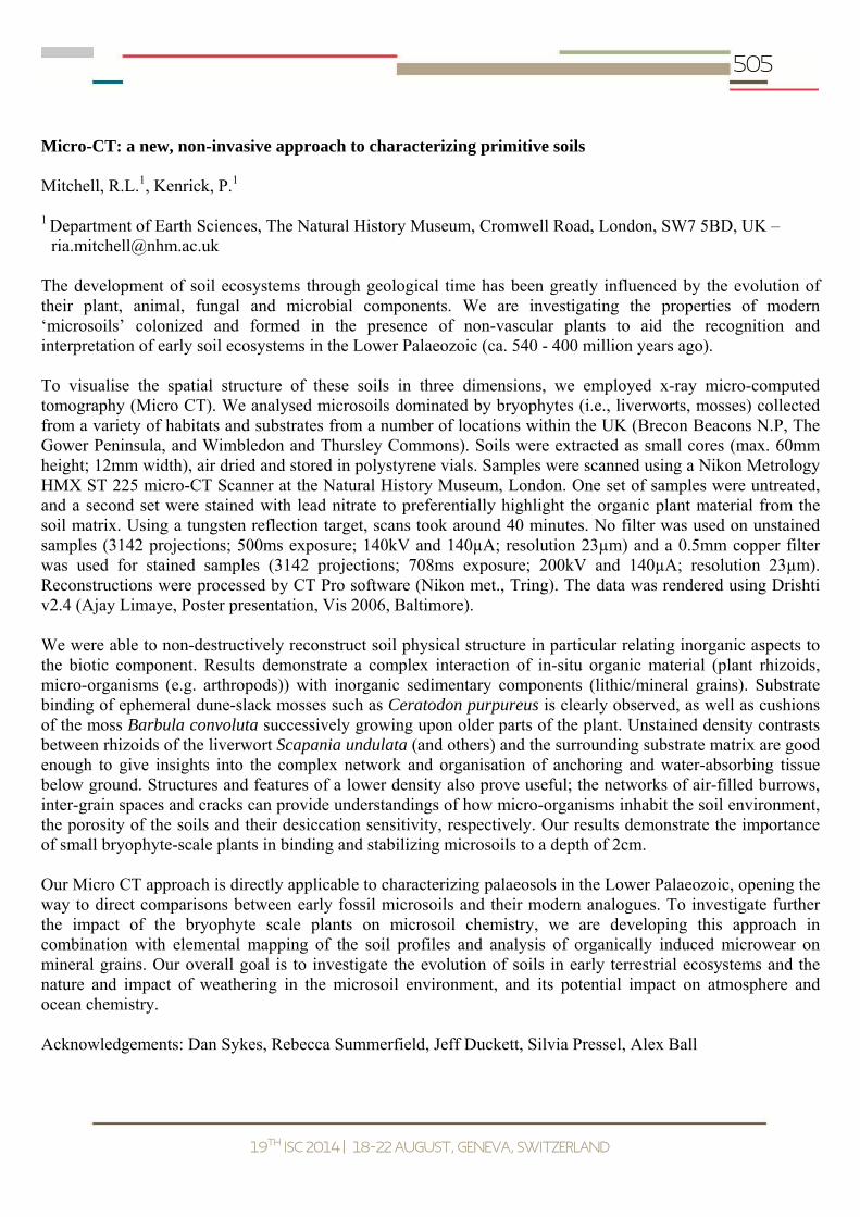
505
19th
ISC 2014 18-22 August, Geneva, Switzerland
Micro-CT: a new, non-invasive approach to characterizing primitive soils Mitchell, R.L.1, Kenrick, P.1 1 Department of Earth Sciences, The Natural History Museum, Cromwell Road, London, SW7 5BD, UK –
[email protected] The development of soil ecosystems through geological time has been greatly influenced by the evolution of their plant, animal, fungal and microbial components. We are investigating the properties of modern ‘microsoils’ colonized and formed in the presence of non-vascular plants to aid the recognition and interpretation of early soil ecosystems in the Lower Palaeozoic (ca. 540 - 400 million years ago). To visualise the spatial structure of these soils in three dimensions, we employed x-ray micro-computed tomography (Micro CT). We analysed microsoils dominated by bryophytes (i.e., liverworts, mosses) collected from a variety of habitats and substrates from a number of locations within the UK (Brecon Beacons N.P, The Gower Peninsula, and Wimbledon and Thursley Commons). Soils were extracted as small cores (max. 60mm height; 12mm width), air dried and stored in polystyrene vials. Samples were scanned using a Nikon Metrology HMX ST 225 micro-CT Scanner at the Natural History Museum, London. One set of samples were untreated, and a second set were stained with lead nitrate to preferentially highlight the organic plant material from the soil matrix. Using a tungsten reflection target, scans took around 40 minutes. No filter was used on unstained samples (3142 projections; 500ms exposure; 140kV and 140µA; resolution 23µm) and a 0.5mm copper filter was used for stained samples (3142 projections; 708ms exposure; 200kV and 140µA; resolution 23µm). Reconstructions were processed by CT Pro software (Nikon met., Tring). The data was rendered using Drishti v2.4 (Ajay Limaye, Poster presentation, Vis 2006, Baltimore). We were able to non-destructively reconstruct soil physical structure in particular relating inorganic aspects to the biotic component. Results demonstrate a complex interaction of in-situ organic material (plant rhizoids, micro-organisms (e.g. arthropods)) with inorganic sedimentary components (lithic/mineral grains). Substrate binding of ephemeral dune-slack mosses such as Ceratodon purpureus is clearly observed, as well as cushions of the moss Barbula convoluta successively growing upon older parts of the plant. Unstained density contrasts between rhizoids of the liverwort Scapania undulata (and others) and the surrounding substrate matrix are good enough to give insights into the complex network and organisation of anchoring and water-absorbing tissue below ground. Structures and features of a lower density also prove useful; the networks of air-filled burrows, inter-grain spaces and cracks can provide understandings of how micro-organisms inhabit the soil environment, the porosity of the soils and their desiccation sensitivity, respectively. Our results demonstrate the importance of small bryophyte-scale plants in binding and stabilizing microsoils to a depth of 2cm. Our Micro CT approach is directly applicable to characterizing palaeosols in the Lower Palaeozoic, opening the way to direct comparisons between early fossil microsoils and their modern analogues. To investigate further the impact of the bryophyte scale plants on microsoil chemistry, we are developing this approach in combination with elemental mapping of the soil profiles and analysis of organically induced microwear on mineral grains. Our overall goal is to investigate the evolution of soils in early terrestrial ecosystems and the nature and impact of weathering in the microsoil environment, and its potential impact on atmosphere and ocean chemistry. Acknowledgements: Dan Sykes, Rebecca Summerfield, Jeff Duckett, Silvia Pressel, Alex Ball

506
19th
ISC 2014 18-22 August, Geneva, Switzerland
A lacustrine perspective on turbidite and landslide cycles: implications for subaquatic paleoseismology Moernaut, J.1, Van Daele, M.2, Wiemer, G.3, Strasser, M.4, De Batist, M.2
1 Facultad de Ciencias, Universidad Austral de Chile, Chile - [email protected] 2 Renard Centre of Marine Geology, Ghent University, Belgium 3 MARUM, Bremen University, Germany 4 Geological Institute, ETH Zürich, Switzerland Turbidity currents often evolve from earthquake-triggered slope failures (i.e. landslides) via progressive dilution of the sliding mass and flow transformation. Hence, turbidite records are increasingly being utilized to reconstruct the paleoseismic history at oceanic margins. However, multibeam bathymetric mapping revealed that some recent large megathrust earthquakes (e.g. 2010 Chile, 2004 Sumatra) did not provoke any large submarine landslides. This would mean that turbidite records in such regions would provide an underrepresentation of large megathrust earthquake recurrence. In the present study, we explore the high-resolution lacustrine sedimentary archive and document the repeated deposition of landslides and turbidites in Chilean lake basins. We find striking differences in the recurrence pattern of landslides and turbidity currents, even though we can infer that both types of mass movements are induced by earthquake-triggered failure of hemipelagic sediment slopes. We also performed morphometric analysis, in-situ geotechnical measurements and slope stability modeling to better understand the processes involved in translational failure of subaquatic slopes. We hypothesize that turbidity currents -and thus turbidite paleoseismic records- can be created by surficial slope failures (< 0.5 m) or sediment resuspension upon seismic shaking. The factors controlling this process are significantly different from the preconditioning and triggering factors of the deep-seated and extensive slope failures typically identified on multibeam bathymetric data and reflection seismic profiles. Hence, the presence/absence of large slope failures on a given ocean margin or lake slope cannot be linked directly to turbidite records and should not be included in feasibility assessments regarding turbidite paleoseismology. Given this hypothesis, we further discuss the need for high-resolution geotechnical characterizations of very shallow soft sediments in the upslope regions to determine in which circumstances turbidity currents can be created independently of large landslides.

507
19th
ISC 2014 18-22 August, Geneva, Switzerland
Detrital zircon and provenance analysis in Eocene-Oligocene sandstones of the South Sistan Suture Zone, SE Iran: implication on the tectonic setting Mohammadi, A.1, Burg, J.-P.1, Winkler, W.1, Ruh, J.1, Von Quadt, A.2 1 Geological Institute, ETH-Zurich, Sonneggstrasse 5, CH- 8092 Zürich, Switzerland –
[email protected] 2 Institute of Geochemistry and Petrology, ETH Zurich, Clausiusstrasse 25, 8092, Zürich, Switzerland The Sistan Suture Zone in eastern Iran is considered to represent a narrow, short-lived strip of oceanic lithosphere. The South Sistan Suture Zone comprises Cretaceous and Early Eocene carbonates followed by turbiditic sediments ranging in age from Early Eocene to Oligocene. We present a provenance analysis on turbiditic sandstones, with the aim at reconstructing the assemblages of source rocks and the tectonic setting from which the clastic material was derived. Laser ablation ICP-MS resulted in ca 2502 new U-Pb ages of individual detrital zircons from 17 Eocene sandstone samples. 1845 detrital zircon ages range from 107 to 40 Ma (late Cretaceous to Eocene, Lutetian). 657 detrital zircon grains from Oligocene sandstones also range from 107 to 43 Ma (late Cretaceous to Eocene, Lutetian). Hf isotopes analyses were performed on 81 dated zircon grains from 3 Eocene and Oligocene samples. Positive (+2 to +12) value in Late Cretaceous zircons indicate island arc magmatism. Low negative to positive (-3 to +9) values in Paleocene zircons indicate transitional island to continental arc affinity. Negative (-15 to -1) values in Eocene zircons show crustal magma sources, which are common in continental arc environments. 300-400 points were counted in each of 20 sandstone thin sections following the Gazzi-Dikinson method. The sandstones are feldspathic litharenites and lithicarkoses. Feldspar is dominantly plagioclase (> 90%) with minor amounts of K-feldspar. Most of the quartz grains (85%) are mono-crystalline but poly-crystalline grains (≤15%) also occur. Rock fragments are represented by sedimentary, volcanic and metamorphic grains. Volcanic fragments mostly are andesite and volcanic chert. Sedimentary lithic grains comprise mostly sandstone, siltstone, limestone and dolomite. Metamorphic lithic grains generally are low-grade schists and phyllites. In various compositional ternary diagrams, the sources of the sandstones plot in the transitional to dissected arc fields. 200-300 grains were identified and counted in the same 20 samples. Heavy mineral suites show a highly variable composition including (1) a group of ultra-stable minerals (zircon, monazite, tourmaline, rutile, brookite, anatase and sphene) derived from a granitic continental crust, (2) metastable minerals from variable metamorphic-grade source rocks (epidote group, garnet, staurolite, chloritoid, kyanite, andalusite, glaucophane), (3) a group of pyroxene minerals derived from magmatic rocks, (4) Chromian spinel (2-20%) which indicates ultramafic rocks of ophiolitic affinity in the detrital source areas of Eocene and Oligocene sandstones. These new results, suggest a magmatic arc and synsedimentary magmatic activity from Late Cretaceous to Eocene (107 to 40 Ma). Hf isotope ratios indicate Late Cretaceous-Paleocene island arc system that was changed into a continental arc system in the Eocene. Similar zircon ages and change from island to continental magmatic arc is reported in Pakistan. In addition, the clastic chromian spinel implies that ophiolites were exposed in Late Cretaceous times.

508
19th
ISC 2014 18-22 August, Geneva, Switzerland
3D and 4D X-ray measurement of migrating sand ripples Montreuil, S.1, Long, B.1 1 Institut National de la Recherche Scientifique, 490 rue de la Couronne, Québec (Québec) G1K 9A9 Canada –
[email protected] Sediment transport CT-Scanner-flume experiments provide crucial information about internal bedform structures offering the best setup ever for fundamental and applied research. Passing an acrylic flume inside a mobile CT-Scanner gantry enhances the potential of flume experiments through density profiles. This innovating technique generates a view inside sediment ripples, revealing the dynamic phenomena acting on internal structures. Analysis results have provided a new set of sedimentary parameters defining internal migrating ripple architecture. The aim of this study is focused on the upper bedload transport layer and especially its delimiting point, creating a new definition of datum used as ripple surface, influencing sediment transport estimation. The 30 x 30 x 700 cm flume used in this research was specially built to fit into a CT-Scanner room and technically designed to avoid X-ray artefacts. The flume is filled with a 5 cm-thick pure silica sand layer and a 20 cm-high water column at 20 °C. The flow (0 – 80 cm·s-1) is measured and controlled by an electro-pneumatic valve inside a recirculating circuit. Two CT-Scanner measurement techniques have been developed: a global measurement technique uses a 3D matrix of 512 x 512 x 1500 voxels of 0.6 x 0.6 x 0.6 mm, resulting in a view at a precise moment in time (Lagrangian); the second (Eulerian) one is the periodic event technique generating a matrix set of 512 x 512 x 30 voxels separated by a t from 30 s to hours. From both techniques, matrixes are considered as vertical density profiles imaging the density from the water column to the bottom bed, passing through the boundary suspension-bedload. Interpretation of raw data images from CT-Scanner-flume experiments necessitate processing through medical reconstruction software. Best results were obtained with the SpineSpi B20s (Siemens) reconstruction filter. Results in HU based on relative density, are converted in SI units of density following a linear equation. Afterward, SI values are calibrated taking into account flume composition, sand properties and fluid density. Vertical density profiles for a 3D matrix provide values from the suspension-bedload transition towards the sediment bed’s interior (d50 = 0.470 mm and U = 28 cm·s-1). This reveals the impact of water, penetrating up to 10 mm deep into the sediment. This penetrating process is not linear and demonstrates the existence of an unknown internal phenomenon present during sediment transport. The thickness of the upper bedload transport layer varies from 0.6 mm to 10 mm respectively for the ripple summit and trough. Density at the upper suspension-bedload boundary varies, respectively for summit and trough, between 1.026 and 1.318 g·cm-3 and at its lower end between 1.645 and 1.903 g·cm-3. When observing density profiles along a migrating sand ripple, it appears that the bed surface used as a datum is located deeper into the sediment. Density values and profiles form at the water column base as a conduct to the definition of a boundary density point (former datum) under an upper bedload transport zone. Underneath this bedload transport zone, the maximum density is reached leading to the definition of a stricto sensu ripple surface. This new ripple surface location is 0.6 to 10 mm deeper than the one used in literature and depends on d50, flow current and position along the ripple structure. Innovative CT-Scanner results have revealed new phenomena that re-open the discussion about suspended and bedload transport during erosion and deposition processes, leading to a new way of looking inside active sediment transport. Protocols and processes developed in this study open new research opportunities in the field of sediment transport.
509
19th
ISC 2014 18-22 August, Geneva, Switzerland
Evolution of Kumano Forearc Basin from NanTroSEIZE drilling and 3D seismic expeditions Moore, G.F.1, Strasser, M.2, Boston, B.3, Dugan, B.4, Kanagawa, K.5, Underwood, M.6
1 Dept. Geology & Geophysics, Univ. Hawaii, Honolulu, HI 96822 USA - [email protected] 2 Geol. Inst., TH, 8092 Zurich Switzerland 3 Dept. Geology & Geophysics, Univ. Hawaii, Honolulu, HI 96822 USA 4 Dept. Geol. Sci., Univ. Missouri, Columbia, MO 65211 USA Sedimentary deposits in the forearc of the Nankai accretionary prism off Kii Peninsula, Japan, record complex interactions between sedimentation and deformation processes. Across the seaward half of the Kumano forearc basin, three-dimensional (3D) seismic data image more than 2 km of sediment in the basin deposited above an upper Miocene-lower Pliocene (5.0-5.9 Ma) accretionary prism. IODP drill cores show that the unconformity between the prism and the overlying basin sediments is time-transgressive. The unconformity separates 5.0 Ma prism rocks from 3.65 Ma basin deposits at drill Site C0002 and 5.6 Ma prism rocks from 3.8 Ma basin sediments at drill Site C0009 (~ 20 km landward of C0002). The basal basin sedimentary sequence is sub-parallel to the underlying accretionary prism and varies in thickness from ~50m in the seaward part of the basin to > 1100m in a basin a few km seaward of Site C0009. The sequence is interpreted as the lowermost forearc basin fill and underlying trench slope basin deposits. The landward thickening of this unit is interpreted to indicate that most of the sediment was derived from the Japanese Islands and was trapped in larger basins higher on the slope. The acoustic character of most strata filling the Kumano Basin consists of landward-tilted, high-amplitude, laterally-continuous reflections, interpreted as a sequence of turbidites. The turbidites lap onto the older unit. The onset of turbidite deposition in the basin began when accommodation space was created by the uplift of the outer ridge along the splay fault at ~1.65 Ma. The dominant lithology in IODP cores is dark olive-gray silty claystone. Minor lithologies include sandstone, sandy siltstone, silty claystone, calcareous claystone, and fine ash. Most samples are dominated by a siliciclastic grain assemblage of clay, quartz, and feldspar, with variable amounts of pelagic carbonate and a minor but persistent component of volcanic glass. The turbidites are tilted landward, presumably because slip along the megasplay fault promoted uplift at the seaward flank of the basin. Continuation of the uplift also migrated the locus of sedimentation landward. As the basin’s depocenter shifted landward, the basin expanded from ~10 km in width to > 30 km. The basin-fill strata are displaced by very young normal faults, many of which cut and displace the surface sediments. Within the upper km of the basin fill, there is one large-scale (4.5 km x 4.5 km x 135m) Mass Transport Deposit (MTD) as well as several smaller (50-75 m) MTDs. The MTDs seem to be sliding along bedding planes during uplift of the basin sequences.

510
19th
ISC 2014 18-22 August, Geneva, Switzerland
Proglacial vs postglacial depostional environments, the opposing processes that filled the southern North Sea tunnel valleys Moreau, J.1, Huuse, M.2 1 Department of Geosciences and Natural Resource Management, University of Copenhagen, Øster Voldgade
10, Copenhagen DK-1350, Denmark - [email protected] 2 School of Earth, Atmospheric and Environmental Sciences, University of Manchester, Oxford Road,
Manchester, M13 9PL Manchester, UK Tunnel valleys have long fascinated the geoscientists by their scale and the consequent intensity of the sedimentary processes responsible for their formation. Tunnel valleys may be up to 180 km in length, 4 km in width and 450 m in depth. The incisions are formed subglacially by overpressured meltwaters on the outer parts of continental-scale ice sheets. In addition to the peculiar incision process, the filling of tunnel valleys in the southern and eastern North Sea, when imaged by 3D seismic data, show a peculiar infill. In these areas, the infill of the valleys is mainly composed of clinoforms prograding north in opposing direction to the former ice flows whose southward-flowing meltwater excavated the valleys. The first hypothesis, by analogy with some small eskers introduced the concept of backfilling where the eroded sediments upstream is deposited directly below the ice margin, in a conveyor-belt fashion. The formation of the 'backsets' would have been enhanced by supercooling due to the pressure drop during the upward flow of the water from the deepest part of the valleys towards the ice margin, freezing and thus capturing the sediments on the adverse slope. Recently this model has been challenged by new observations on the architecture of the valleys and their infill sediments which appear to show many similarities in common with deltaic clinoforms observed in the pre-glacial succession of the southern North Sea. The new model states that the incision and the filling of the valleys are separate in times and from distinct sedimentary processes. The valleys are mainly incised by overpressured subglacial meltwater with probably some abrasion as a minor erosive agent including bedrock control on the incision depths and morphologies. The infill is interpreted as proglacial for the newly observed south-dipping clinoforms and postglacial for the north-dipping clinoforms onlapping the latter. The north-dipping clinoforms are interpreted to be formed within a large deltaic system associated with the Rhine-Meuse river(s). The delta was probably infilling a large lake system containing overdeeps (the underfilled tunnel valleys). The presence of clinoforms 50-80 m above the valley shoulders gives a fair idea of what could have been the general depth of the lake. However, the lake was certainly in the isostatic depression after partial or complete ice sheet retreat. The crust and mantle were not in equilibrium during that postglacial time, and the ice might have been occasionally present in the lacustrine basin so that the lake levels may have been very variable and difficult to tie to the present-day topographic configuration. This system of competition between one of the biggest river of Europe facing ice sheets and their proglacial depositional system generates a very intricate stratigraphy with multiple cross-cutting 'basins' in the form of valleys (c. 7 generations) which themselves contain up to 8 complete seismic sequences. Although the task to build up a complete stratigraphic scheme is immense and a long run project, it would be unique for this period in the region. We intend to solve part of the problem by numerically reconstructing the local landscape with the ice sheet and its isostatic depression. This allows to represent a type-sequence helping the understanding of the Rhine-Meuse migration and the position of the lacustrine systems which so far has remained elusive.

511
19th
ISC 2014 18-22 August, Geneva, Switzerland
Geochemical signature in a tsunami deposit detected in Lagoa dos Salgados (Portugal)
Moreira, S.1, 2, Costa, P. J. M.1, 2, Andrade, C.1, 2, Freitas, M. C.1, 2, Oliveira, M. A.1, 2, Silva, T.3, Lira, C.1, 2
1 Centro de Geologia da Universidade de Lisboa, 1749-016 Lisboa, Portugal - [email protected] 2 Departamento de Geologia, Faculdade de Ciências da Universidade de Lisboa, 1749-016 Lisboa, Portugal
3 Institut F.A. Forel, Université de Genève, 10, Route de Suisse, CP 416, 1290 Versoix, Switzerland Multiproxies are widely used to recognize tsunami deposits in coastal stratigraphy. Among these, the study of source- and environment-sensitive geochemical elements in sediments improve the understanding of these inundation processes. For example, Na, Cl, Br and I have been used as indicators of massive tsunami marine inundation in onshore depositional environments. In Lagoa dos Salgados (Algarve, south Portugal), a tsunami deposit associated with the AD1755 event has been described in the topmost section of the lagoonal Late Holocene sequence. The tsunamigenic unit is massive and located at 0.40m below surface (ca. 1.30m above mean sea level). This bioclastic medium to fine sandy deposit is under and overlaid by organic sandy clayey silt units. Its basal contact is erosive and occasionally presents rip-up clasts from the underlying layers. The tsunami deposit fines and thins inland until disappearance ca. 850m from present-day coastline. The lateral change in thickness is accompanied by variation in its sedimentary characteristics. In the seaward section, this sediment is coarser (fraction >63μm averaging 88% and bioclastic CaCO3 29%); further inland the proportion of mud-sized particles increases with increasing distance from the inlet (fraction >63μm averaging 54%, CaCO3 23% and organic matter 2%). Both the under and overlying units share strong similarities in texture, and are essentially constituted by brownish silt and clay material (fraction >63μm less than ~30%; CaCO3 averaging 9% and organic matter 4%). Due to their similarities, these units are macroscopically indistinguishable in places where the tsunami deposit is absent. The objectives of this study are the characterization of the geochemical signature of this event, focusing in: 1) the comparison between the extent of the inundation and that of its lithostratigraphic imprint; and 2) in the detection of the geochemical imprints of the different phases of inundation (run-in and backwash). A number of cores and trench-wall box-cores trending inland from the shoreline were retrieved from the lagoonal space. The coring network allowed sampling the wedging out of the tsunami sedimentary unit and framing sediment up to a distance where its textural imprint could no longer be detected. Depth variations in elemental contents and ratios (e.g. S, Cl, Ca, Sc, Br, Sr, I, REE, Al/Si, Ti/Ca Fe/Mn, Mn/Ti, Ba/Ti) along the cored sediments provide clues on provenance and help understanding the ability of both tsunamigenic and permanent-regime sediments to preserve a conspicuous imprint of marine inundation. Samples are being analyzed using an ITRAX™ Core Scanner at 4 mm resolution (CACTI, Vigo University). It is expected that the semi-quantitative geochemical results coupled with the sedimentological data will support and improve the preliminary results obtained on this issues at Boca do Rio lowland, a synchronous deposit preserved in similar lithostratigraphic context.
512
19th
ISC 2014 18-22 August, Geneva, Switzerland
Evidence of great Cascadia earthquakes in small Seattle area lakes Morey, A.E.1, Goldfinger, C.1, Galer, S.1 1 College of Earth, Ocean and Atmospheric Sciences, 104 CEOAS Admin. Bldg., CEOAS/OSU, Oregon State
University, Corvallis, OR 97331 - [email protected] We recently cored several small lakes from the coast to the foothills of the Cascades at the latitude of Seattle, Washington to look for evidence of great earthquakes. High-resolution computed tomography (CT) imagery revealed structure in these sediment cores that appeared otherwise visually homogenous, with only slight changes in color and texture. We compared all down-core physical property (CT and gamma density, RGB imagery, and magnetic susceptibility) data after linking records in time using the occurrence of the Mazama tephra (confirmed by electron microprobe analysis) and AMS radiocarbon ages. Dominant patterns can be traced between lake cores, suggesting the down-core variability represents a regional control driving changes in sediment characteristics. We also find strong correlations between the lake core data and the offshore record of seismoturbidites from Juan de Fuca Channel, suggesting great Cascadia earthquakes control sedimentation in both environments. Clues to the underlying mechanisms driving down-core variability can be found in sediment composition and setting, which we interpret within the context of the regional glacial history. Leland Lake (0.4 km2, 6.1 m deep, and 58 m MSL), Tarboo Lake (0.1 km2, 17.7 m deep, and 195 m MSL), and Lake Sawyer (1.1 km2, 17.7 m deep, and 156 m MSL) might be considered less than ideal paleoseismic recorders because of basin morphology and minimal overland stream-flow limiting the clastic input available to load lake margins. In contrast, nearby Lake Washington is considered a good paleoseismic recorder because it is a large (88.0 km2), deep (65 m), and steep-sided lake with numerous subaqueous margin failures. Smear slides show that our cores are composed primarily of diatoms, very fine organic matter, and a much small percentage of fine-grained clastics. We find that variations in both percentage and size of clastic particles drive the down-core variability that links the offshore and lake records. We see an overall increase in the size and percentage of clastics with depth in the cores at Leland Lake (which may reflect the removal of available sediment from a proglacial lake known to have occupied this area as the Puget Lobe retreated), and preliminary observations show that the percentage of vivianite, an authigenic iron phosphate mineral formed in reducing environments, seems to follow clastic variability suggesting a linkage between them. We are exploring the mechanism that strong shaking during an earthquake causes remobilization of margin sediments, and results in redeposition on the lake floor producing an organic-rich environment with the components necessary for the formation of vivianite. These results show that high-resolution CT density data can be used to identify disturbance deposits in low-sensitivity environments, and that small, flat-bottomed lakes with little clastic input may be good recorders of subduction zone earthquakes. We now have the opportunity to explore the impact of strong shaking from great Cascadia earthquakes using the sedimentary records from the numerous forearc lakes found throughout the Pacific Northwest. The authors would like to thank the United States Geological Survey for funding this project, and Dr. Brian Sherrod (USGS and University of Washington, Seattle) for providing equipment and expertise invaluable to this project.
513
19th
ISC 2014 18-22 August, Geneva, Switzerland
Reservoir geology of coal-bearing successions: new insights from outcrop and borehole based study in Eastern Kentucky (US) Moscariello, A.1 1 Earth and environmental Sciences, University of Geneva, 13, rue des Maraichers, 1205 Geneva, Switzerland –
[email protected] The increased focus on exploration and development of unconventional resources in the last 5-10 years has led to a renewed interest in coal-bearing fluvio-deltaic and coastal plain deposits. The latter holds the majority of coal bed methane resources for which is important to understand the extension and subsurface architecture of coal seams. On the other side, coal-bearing sand rich successions still represent very important conventional reservoirs such as the Coal Measures of Carboniferous in NW Europe, the Jurassic and Cretaceous successions of Eastern Russia and NE China, the Late Cretaceous-Tertiary successions of low latitudes (e.g. Arctic area of Alaska, Canada and Russia) and the Tertiary deposits in the Asia-Pacific region (e.g. Myanmar, Thailand, Indonesia, Australia). In all these cases, predictive model for sand and coal distribution in the subsurface are required to drive an effective and cost efficient hydrocarbon development strategy. The Eastern Kentucky and West Virginia road network provide world-class exposures of Upper Carboniferous coal bearing successions where the interplay between sand and shale intervals and intervening coals can be studied in detail. In this paper we present a summary of ongoing research recently carried out on the Pennsylvanian Hyden and Pikeville Formations where architecture and laterial facies variability of clastic deposits and associated coals can be observed and followed for several kilometers thanks to exceptional outcrop quality and dense borehole data from coal mining. Specifically, this paper focuses on geometry and genetic significance of coal seams and heterolithic clinoforms intervals. Coals, usually genetically associated with transgressive system tract lies often on top of channel-fill sandstone and under shale dominated intervals the latter recording the transition from a flooded coastal plain to shallow to deep marine environment. However coals are found as well draping irregular topographic surfaces where wide and relatively deep (10-20 m) incisions can be recognised. In this situations coals are typically overlain by channel fill sandstone forming the stratigraphical unit above. Often the sand is not eroding the underlying coal. In this cases, the coals are interpreted as forming during a low stand phase and thus possibly the true indicators of development of incised valleys. Five to ten meters-high inclined beds made of mixed heterolithic successions of sandstones and shales are associated with both fluvial-dominated mouth bars and point-bars develop in large meandering river systems often developed within estuarine environment. This study highlights the typical 3D features of these deposits allowing the definition of sedimentological and stratigraphical criteria to distinguish these tow systems in the subsurface. The Carboniferous succession of Eastern Kentucky is then compared with the coeval succession in the North Sea (The Netherlands) to highlight the importance of outcrop based analogues studies to help understanding the overall distribution of subsurface geology by providing practical criteria for a) carrying out a well-to-well correlation and b) reconstruct the overall 3D reservoir architecture.

514
19th
ISC 2014 18-22 August, Geneva, Switzerland
Preliminary characterization of transgressive deposits in the northern Adriatic Sea (Italy) Moscon, G.1, Stefani, C.1, Correggiari, A.2, Fontana, A.1, Remia, A.2
1 Dipartimento di Geoscienze, Università degli Studi di Padova, Via Gradenigo 6, 35131 Padova, Italy – [email protected]
2 ISMAR (CNR), Via Gobetti 101, 40129 Bologna, Italy The Adriatic Sea is an epicontinental semi-enclosed basin characterized by a low axial gradient shelf in the northern and central part and by a steeper gradient in the southern sector. During the Last Glacial Maximum (LGM, 30000 to 18000 year BP) an approximately 300 Km wide stretch of the northern Adriatic shelf was subject to subaerial exposure. The drainage network of this alluvial plain likely comprised a main trunk river, with Alpine and Apenninic tributaries. After 18-Ka the sea-level began to rise from -120 m s.l reached during the LGM and the coastline migrated landwards. Across the low-gradient northern shelf, the stepwise, high-amplitude relative sea-level rise favoured the deposition and in-situ drowning of different generations of transgressive barrier-lagoon-systems. Nowadays from Trieste to Ravenna, these transgressive deposits are located between -10 and -35 m w.d, in restricted areas showing a dominant longshore trend similar to the modern sea-level high-stand deposits. These bodies are wreak of ancient coastal wedges drowned in place and consist of well sorted sands capped by ravinement surface and frequently drapped by a thin veneer of high-stand mud. More transgressive deposits were analysed in order to understand their evolution before and during the last sea-level rise and their sand composition. Deposits located north of the Po delta have been characterized in order to understand their provenance, whereas one deposit situated south of the Po delta has been investigated in order to define the stratigraphic evolution during its formation. For the northern deposits a quantitative compositional point counting of large amount of samples will be carried out according to the standard Gazzi-Dickinson technique. Petrographic results show a compositional variation depending on the areal position of the deposit. The comparison with literature data allow us to distinguish three different petrographic provinces: northern deposits located offshore Lignano show an eastern Alpine signature underlined by the high percentage of terrigenous carbonates; middle deposits situated off-shore of the Venice lagoon show a mixed composition between carbonate Alpine supply and quartzolithic components of the Po drainage basin, while southern deposits located close to the Po mouths are characterized by a quartzolithic signature emphasized also by high amounts of heavy minerals. Regarding the offshore Ravenna deposit, covered by 765 Km of VHR seismic profiles, the transgressive surface and other three key reflectors have been digitalized and a digital elevation model has been produced for each surface. The surfaces modelling highlights a variation of the fluvial trend from east-northeast before the last-sea level rise and during the deposition of the first three surfaces to east-southeast during the deposition of the more recent key surface. Petrographic data confirm a different provenance of the deposits according with their position, in addition highlight a potential sediment dispersion linked to opposite marine currents in respect to the present or a northward shifting of the Po River paleo-mouth during the last sea-level rise. Moreover in the southern deposit it was possible highlight the evolution of the coastal plain environment during the last transgressive cycle identifying different fluvial phases between the transgressive and the ravinement surfaces.

515
19th
ISC 2014 18-22 August, Geneva, Switzerland
X-ray computed tomography analysis of volcanic ash aggregates Mueller, S.B.1, Cimarelli, C.1, Douillet, G.A.1, Hess, K.-U.1, Heuss-Aßbichler, S.1, Kueppers, U.1, Dingwell, D.B.1
1 Ludwig Maximilians Universität München (LMU Munich) Earth & Environmental Sciences Theresienstrasse
41 80333 Munich Germany – [email protected] Explosive volcanic eruptions release large amounts of particles into the atmosphere. Volcanic ash, by definition pyroclasts smaller than 2 mm, can be distributed around the globe by prevailing winds. Ash poses hazards to aviation industry by melting in jet turbines, to human health by entering respiration systems and to society by damaging infrastructure. Under certain circumstances, in plumes or pyroclastic density currents, ash particles can cluster together and build ash aggregates. Aggregates range in size from few mm to few cm and may exhibit complex internal stratigraphy. Ash aggregates are heavier and exhibit different aerodynamic properties than the surrounding ash and accordingly fall prematurely than individual ash grains. Ash aggregation is frequently observed in the geologic record and has also been described during eruptions. Still, the physical and/or chemical mechanisms generating the aggregates remain poorly understood. Distinguishing between the three main types of aggregates – ash clusters (massive), cored pellets (containing voids) or accretionary pellets (structures with concentric laminations) – is a first step to approach the understanding of the generation of aggregates. Besides field or thin-section analysis, another powerful tool to describe aggregates is x-ray computed tomography (x-ray CT). X-ray CT has the advantage that it is a non-intrusive method and permits 3D reconstruction of the sample. Further, the high resolution of x-ray CT (up to few µm) allows to image single grains within an aggregate. We use results from x-ray tomography of various ash aggregates (Iran, Italy, New Zealand) together with traditional thin-section analyses in order to describe the different structures and types of aggregates. This is a first step toward conclusions on the genesis of ash aggregation and the ongoing processes in ash plumes and PDCs.

516
19th
ISC 2014 18-22 August, Geneva, Switzerland
Sedimentary evolution in arid rift basins, El Qaa Fault Block, Suez Rift, Egypt Muravchik, M.M.1, Gawthorpe, R.L.1, Sharp, I.2
1 Department of Earth Science, University of Bergen, Bergen, Norway – [email protected] 2 Exploration Research, Statoil ASA, Bergen, Norway Most of the current sedimentary models for marine rift basins are based on a dominance of relatively humid climatic conditions. As a consequence, they assume the existence of perennial fluvial/alluvial systems constantly providing water and sediments to the marine environment. In arid to semiarid climates ephemeral depositional processes tend to prevail, favoring the development of strongly seasonally controlled sedimentary systems. Their coupling to the growth and evolution of normal fault zones leads to particular patterns in terms of location, geometry and stratal stacking of the sedimentary units. The interrelation between carbonates, evaporites and coarse-grained deltas in arid settings is studied from Miocene exposures of the El Qaa Fault Block, Suez Rift, Sinai Peninsula, Egypt. Conglomerate- and sand- dominated deltaic lobes up to 120 m thick were deposited at the eastern margin of the El Qaa half graben. They were sourced from the eastern rift shoulder and prograded across the half-graben towards the west. They are characterized by the presence of carbonate at their topsets and evaporite bodies at the bottomsets. The carbonates are of coral and algal origin up to 20-30 m thick that extend laterally for 0.7 to 2 km. The evaporites occur as anhydrite and gypsum forming 5 to 40 m thick tabular massive beds intercalated with mudstones that can extend laterally for several kilometers. The complex stacking pattern defined by the alternation of siliciclastic and carbonate bodies reveals progradational-aggradational cycles within the deltaic system that can be related to the deformation and subsidence of the hangingwall block. The conditions for development of the coral and algal bodies in the topset of the deltas result from a combination of ephemeral alluvial input of sediment and its reworking in the coastal setting. The deposition of the evaporites has a strong regional component defined by the intermittent oceanic connection experienced by the Suez Rift through the Red Sea basin and Mediterranean Sea during the Miocene. The superposition of these together with local effects such as hangingwall block tilting and hangingwall syncline formation proves to be decisive controls on the emplacement of the evaporites. The results show a complex interaction of arid to semiarid depositional processes controlled by the spatial and temporal evolution of the extensional structures with basin-scale processes such as seawater composition and circulation. The El Qaa half-graben constitutes a perfect analogue for other arid rift basins characterized by hyper-saline and marginal marine successions (e.g. sub-salt hydrocarbon plays in the South Atlantic).

517
19th
ISC 2014 18-22 August, Geneva, Switzerland
The Clumped Isotopic Signature of Mixed Calcite and Dolomite Murray, S.1, Swart, P.K.1 1 Department of Marine Geosciences, RSMAS, University of Miami, 4600 Rickenbacker Causeway, Miami Fl
33149 – [email protected] The application of the ‘clumped’ isotopic method (47) to the understanding of diagenesis in carbonates rocks offers the possibility to distinguish the competing roles of temperature and water 18O in controlling the 18O of the mineral. Although this is true for both calcite and dolomite, the study of dolomite still offers challenges in that there are (i) at least seven equations which link the 18O of dolomite to the temperature and the 18O of the fluid, and (ii) there is as yet no published empirical calibration between dolomite and 47. With regard to the second point is unclear whether the behavior of 47 with respect to temperature is similar in these two minerals or whether different equations are necessary. In order to better understand these relationships we have examined carbonates which have been partially dolomitized in a core drilled on the margin of Great Bahama Bank (GBB). The majority of the sediments in this core were originally aragonite and formed on the surface of GBB in shallow warm waters (~20-30oC). They were then swept off GBB and deposited along the flank in cool deeper water (~5-10oC). Here they were recrystallized to low-Mg calcite (LMC) and partially dolomitized. It could be argued that if dolomites and LMCs share the same temperature-47 relationship, then 47 should not vary function of % dolomite in the sample. This argument assumes both LMC and dolomite probably formed at the same temperature. The alternative is that if dolomites and LMC have different 47 -temperature relationships, then the 47 should change in the samples in which dolomite was higher. In order to test these ideas, a number of samples, which contained between 5-50% dolomite, were selected from the Clino core. The first step was to measure the bulk stable C & O isotopic and 47 in the samples. Next the dolomite in each sample was isolated/purified by treating crushed and sieved samples (< 63 m) with buffered acetic acid. After about two-three hours, the samples were washed and dried and the XRD and isotopic analyses were repeated. If the sample still showed remaining LMC, then the samples were leached for a 2nd or even 3rd time. After each leaching step all isotopic analyses were repeated. In this manner the 47 could be assessed on the pure dolomite fraction from a specific sample and by interpolation also on the original LMC. Initial interpretation of the data shows that the 47 does not change as a function percentage dolomite in the sample, implying either a similar temperature-47 relationship for dolomite and LMC, or a fortuitous combination of difference in formation temperature between the dolomite and LMC combined with a different temperature-47 relationship.

518
19th
ISC 2014 18-22 August, Geneva, Switzerland
Sedimentary environments of Late Carboniferous-Middle Permian in Santanghu Basin, NW China Nan, Y.1, Liu, Y.1, Zhou, D.1, Li, H.1, Jiao, X.1, Zhou, N.1, Yang, Y.1
1 Department of Geology, Northwest University, Xi’an 710069, China - [email protected] Santanghu Basin is an intracontinental superimposed reformation basin from Late Palaeozoic to Meso-Cenozoic, which is located between the Tianshan orogen and Altaides, NW China. It was a continental rift basin from Late Carboniferous to Middle Permian. Based on the data of lithological association, paleontology, element geochemistry, organic geochemistry and stable carbon and oxygen isotopes, integrated with the analysis of geotectonic evolution and marine/continental change, This paper discuss the sedimentary environment of Late Carboniferous-Middle Permian in Santanghu Basin. Considering the development of sedimentary rocks, we deeply studied on the Late Carboniferous Harjiawu Formation and Middle Permian Lucaogou Formation. (1) lithological association The Harjiawu Formation consists of basic-intermediate volcanic lavas, pyroclastic rocks and argillaceous rocks deposited during intermittent volcanic eruption. Previous researchers found that dolomicrite and tuffaceous shale is well developed in Lucaogou Formation. Besides, our research group discovers laminated hydrothermal exhalites recently, which is a new type of sedimentary rocks with abundant mantle-originated hydrothermal minerals and microscopic hydroclastic magmatic fragments. (2) paleontology Few fossils are recorded in the Harjiawu Formation, mainly leaf fossils. Pollen assemblage and flora indicate a temperate climate. The fauna of Lucaogou formation is dominated by brackish palaeoniscoids and the combination of Tomiella-Kelameilia- Panxiania ostracods. The plant fossil and sporopollen assemblages reflect the features of the Angara flora and represents a warm-humid climate. (3) organic geochemistry The organic geochemistry features of mudstone in Harjiawu Formation is high Pr/Ph value (between 1.10-3.01), low gammacerane abundance and very low β-carotane abundance, which reflects the freshwater and weak reduction-weak oxidizing environment of the Late Carboniferous. Characteristics of biomarkers in saturated hydrocarbon of argillaceous rocks in Lucaogou Formation is low Pr/Ph value (between 0.7-1.5), extremely high β-carotene alkanes, gammacerane and long chain tricyclic terpane abundance, which show salinized and reductive environment of the Middle Permian. (4) element geochemistry and stable carbon and oxygen isotope Sr/Ba ratio of Harjiawu Formation shale is less than 1.5, and B content is less than 300×10-6. Z values calculated from carbon and oxygen isotope of limestones are between 94.67 and 116.12, with an average of 102.18. It declares low salinity and freshwater environment of Late Carboniferous. The Sr/Ba ratio in dolomite and tuffaceous shale of Lucaogou Formation is from 10 to 13.86, and B content is 463×10-6. Z values of dolomicrite in Yuejingou outcrop range from 129.03 to 141.43, with an average of 134.6. All the above data suggest that the salinity is high and environment is saltwater in Middle Permian, which is consistent with the conclusion of organic geochemistry. It is a big controversy of Middle Permian sedimentary environments in the study area; some scholars believe that it is a residual sea environment, others think it is a typical paralic epicontinental lake. Residual sea of Middle Permian is not supported by Freshwater lacustrine of Late Carboniferous. The lithofacies-paleogeography show that the sea has retreated to the Yanchi bay and seawater intrusion may not appear. We suggest the Middle Permian is saltwater lacustrine environment, warm-humid climate, While Late Carboniferous is freshwater lacustrine environment, temperate climate. Water salinization of Middle Permian may be affected by the double impact of climate and ancient hydrothermal activity.
519
19th
ISC 2014 18-22 August, Geneva, Switzerland
Outcrop-based sedimentary facies and fourth order cyclicity in Miocene small-scale rift basins, Niigata, northeast Japan Narisawa, S.1, Kurita, H.1 1 Department of Geology, Niigata University, Niigata 950-2181 Japan – [email protected] The Niigata sedimentary basin, the most productive oil and natural gas area in Japan, is a Miocene rift basin formed during the extension of the Japan Sea, which eventually developed into a back arc basin. The clastic deposits of the rift phase are exposed in some areas of the eastern margin of the basin such as the Tsugawa area, an elongated depression about 15 km wide, much smaller than the typical rift valley. The basin was also characterized by an extensive acidic volcanism during the rift activity. The purpose of this study was to discuss the characteristics of small-scale rift basins in a coastal setting. This outcrop-based study, which included the geological mapping of the area covering 7 km×3.5 km of the Mikawa region, western part of Tsugawa, northeast Niigata, attempted to reconstruct the sedimentary systems and understand the genesis and development of the basins. The Miocene in the study area was divided in the Kanose, Tsugawa, and Araya/Igashima Formations, in ascending order. The Tsugawa Formation, covering the basement and the Kanose Formation with an unconformity, mainly consisted of sandstone. This formation received particular attention since it showed a remarkable vertical and lateral variation in the sedimentary facies. The Tsugawa Formation was composed by a depositional system of debris flow-dominated alluvial fan, fluvial (braided and meandering), barrier island, wave-dominated estuary, fan delta, and delta origin. Most of the Tsugawa Formation consisted of alluvial fan and fan delta facies under a coastal setting, with frequent occurrences of debris flow deposits. The Tsugawa Formation showed an overall upward-fining trend, in spite of its cycles of minor progradation and retrogradation. In the study area, the Tsugawa Formation and the basal part of the Igashima/Araya Formations were divided in three depositional sequences based on their upward fining and coarsening cyclicity. These sequences were called TS1, TS2, and TS3, in ascending order. Previous studies on geologic ages and dinoflagellate ages by the present study indicated an average maximum duration of 0.5–0.23 Ma for the formation of each sequence, which means a fourth-order cycle. Depending on the probable source area, the variation in sediment thickness, and the fault distribution, small-scale rift basins (<3 km wide) with N-S to NNE-SSW rift-border faults were present in the study area. Overall, the deposits from the steep slopes of the footwall formed thin sedimentary wedges within the half grabens. The distribution of the sequences showed a time lag between the genesis of each basin. The recognition of fourth-order cycles in this area showed that the rate of relative sea level change was similar to that of clastic supply. In addition, the deposits of the syn-rift phase were not very thick, suggesting that the fault activity and rate of subsidence were small during that period, with a eustasy-influenced sedimentation. However, in general, intermittent fault activity forms progradation and retrogradation in rift basins, so that the sedimentation cycles in this study might be influenced also by tectonics.

520
19th
ISC 2014 18-22 August, Geneva, Switzerland
Spatio-temporal micro-morphological changes in the inshore part of Eresos beach, Lesvos, Greece Nasras, S.1, Andreadis, O.1, Hasiotis, T.1, Psarros, F.1, Velegrakis, A.F.1 1 Department of Marine Sciences, University of the Aegean, University Hill, Mytilene 81100, Greece –
[email protected] Field observations and laboratory experiments have been used to observe and model shallow water wave/current ripple morphology. Usually, side scan sonar mapping cannot be utilized due to operational problems in shallow waters close to the coastline. The scope of this study is (i) the observation of the spatio-temporal variability of the seabed morphology and mobility of the bedforms in the narrow inshore area of Eresos beach and (ii) the analysis of the ripple characteristics from sonographs and their comparison with those expected from semi-empirical formulas. Eresos is a 1.7 km long touristic beach at the NW part of the island of Lesvos (NE Aegean Sea). The coastal area is exposed mainly to S and SW winds, which control longshore sediment transport and enhance coastal erosion mainly in the central and eastern parts of the beach. An RTK GPS and a single-beam echo-sounder were used for the coastal bathymetric survey. Repeated morphological surveys (4 surveys in a two year period) were carried out with a side scan sonar able to operate in shallow waters (< 10.0 m). Sediment samples and a drop down camera ground-truthed the geophysical results. The wave regime was hindcasted from data from a wind station locally installed. The study area is characterized by two longshore bars at 1.5 and ~3.0 m depth, rising 0.5 and 1.5 m, respectively. The depth of closure (the most landward depth seaward of which no significant change in bottom elevation occurs) is estimated to be at ~5.0 m, 250 m from the coast. The surficial sediments consist of sand with a mean size of -0.08 to 2.08 Ø, mostly being medium sands, well to moderately well sorted. Five seabed reflectivity types were distinguished in the sonar images, and their spatial distribution was mapped in each data set. The first two types are related to sediment textural changes and the third to low relief hardgrounds. The fourth type was observed at the central and western parts of the coastal zone, mainly deeper than the 5.0m isobath, resembling sand ribbons oriented almost perpendicularly to the shoreline; this suggests the presence of strong near-bed flows. The fifth type is a typical rippled seabed developing together with the other types, except from the third one. The rippled seabed shows various morphologies suggesting fresh or relict bedforms. The comparative study of the spatial changes in reflectivity types in each mosaic revealed differences ranging up to 100% that may be attributed to hydrodynamics. The ripple dimensions (length and height) were measured and compared from transects in the sonographs and literature bedform predictors. In the first approach the ripple lengths are 0.55-0.83 m (locally 4.0 m) and their height seems to be less than 0.1 m. According to the literature, lengths are predicted to be 0.1-1.4m and the heights 0.01-0.23 m. Long wave ripples probably suggest relict features with different dimensions from those computed. Also, ripples in deeper waters may be relict, generated during minor storms preceding the sonar observations. These results provide an example of the spatio-temporal complexity of the micro-morphology across the inshore part of the study area. Similar ripple dimensions are discussed in the literature from field observations using different approaches, in comparable wind/wave and grain-size settings, thus confirming the validity of the results. The presence/migration of bedforms (ripples and ribbon-like features) on the seabed gives a clear indication of the active sediment transport on Eresos beach. Acknowledgments: This research has been co-financed by ESF and Greek national funds through the operational program “Education and Lifelong Learning” of the NSRF Research Funding Program THALES-ISLA.

521
19th
ISC 2014 18-22 August, Geneva, Switzerland
The MIS 5-4 transition in sediments from the deep Dead Sea basin Neugebauer, I.1, Brauer, A.1, Schwab, M.J.1, Waldmann, N.2, Frank, U.1, Dulski, P.1, Tjallingii, R.1, Taha, N.2, and DSDDP Scientific Party3 1 Helmholtz Centre Potsdam, GFZ German Research Centre for Geosciences, Section 5.2 – Climate Dynamics
and Landscape Evolution, Telegrafenberg, D-14473 Potsdam, Germany - [email protected] 2 Department of Marine Geosciences, Leon H. Charney School of Marine Sciences, University of Haifa, Mount
Carmel 31905, Israel 3 The complete list of scientists involved in the Dead Sea Deep Drilling Project can be found at
http://www.icdp-online.org The Dead Sea and its Pleistocene precursor lakes accurately recorded climate change in the eastern Mediterranean region. The ~460 m long sediment core 5017-1 was retrieved from the deepest part of the lake and archives the regional climate variability of the last 200-250 ka. Here, we focus on the upper part of the Samra Formation (~135-70 ka BP) and the transition into the Lisan Formation (~70-14 ka BP), which includes a layered salt sequence deposited during the MIS 5-4 transition. The analyzed interval of ca 30 m covers a lower ~20 m thick interval of alternating aragonite and detritus (aad) accumulated during more humid climatic conditions, which is followed by a ~10 m thick interval of predominantly layered massive halite, reflecting a dryer climate. We present a multi proxy record including micro-facies analysis on large-scale petrographic thin sections, micro-XRF element scanning, grain size and magnetic susceptibility measurements. These analyses allow a high-resolution characterization of the sediments and interpretation in terms of depositional processes and their value as palaeoclimate proxies. These data show a short-lived (abrupt) dry interval directly before the onset of the relatively humid conditions corresponding to the Lisan Formation, suggesting a millennial-scale dry period. This is in agreement with a previously identified depositional hiatus and associated erosional unconformity in the shallower areas outcropping at the margins of the lake. However, the deposition of glacial-like aad sediments prior to this pronounced dry event contrasts to previous analyses on outcrops. These sediments from the deep Dead Sea basin will hence allow understanding and better deciphering the depositional processes in relation with climatic change during the MIS 5-4 transition on centennial and millennial time-scales. Acknowledgements: Funding by the International Continental Scientific Drilling Program (ICDP), the German Research Centre for Geosciences and the German Science Foundation (DFG grant BR 2208/10-1) is gratefully acknowledged.

522
19th
ISC 2014 18-22 August, Geneva, Switzerland
Sediment distribution in a cold climate salt-marsh Neumeier, U.1, Gibeault, C.1 1 Institut des sciences de la mer de Rimouski, Université du Québec à Rimouski, Rimouski QC G5L 3A1,
Canada - [email protected] Winter sea-ice in cold or subarctic marshes has a significant sediment-transport capacity. In the intertidal zone, sea ice can freeze, pull up and then raft layers of sand, mud, or salt-marsh soil. These processes have been described, but their implications with respect to sediment distribution and marsh evolution is less well documented. Is the sediment distribution in such marshes similar to that of temperate marshes? The Penouille salt-marsh is located in a microtidal, sandy lagoon at the eastern end of the Gaspé Peninsula, Québec, Canada. It is characterized by important seasonal variations with sea-ice cover from January to March. Sediment distribution in the marsh was investigated by analysing 215 surface samples for grain size and organic matter content. In addition, 10 sediments cores were taken to study marsh history. Lateral marsh evolution was determined over 50 years from historical aerial photographs and vertical evolution over 2 1/2 years with accretion plates. The Penouille marsh was established about 1000-1200 cal BP in the most landward sector. Long-term accretion rate measured in sediment cores is 0.35-1.0 mm/year, while accretion rate measured since the 1963 137Cs peak is 1-3 mm/year and accretion rate measured with accretion plates is 3.0 ± 4.7 mm/year. These accretion rates are similar to the present relative sea level rise (1.4 mm/year over 1969-2012), but are lower than the sea level rise expected during the 21st century. The outer marsh edge retreated only slowly, with a marsh area loss of 1 ‰/year from 1975 to 2008. Grain size gets finer while organic matter content increases locally with elevation on transects from the lagoon to the high marsh. However multiple linear regressions with all marsh samples showed a more complex pattern of sediment distribution. Grain size gets finer and organic content increases with increasing distance from the lagoon inlet, distance from the marsh-lagoon limit, and distance from the closest sediment source (creek, pan or lagoon). Surprisingly, the grain size trend is coarsening with elevation over the whole marsh, which can be explained by ice rafting (ice rafts often get stranded and melt on the upper marsh) and by aeolian transport from the seaward sandy peninsula. The classical sediment distribution pattern for temperate-climate marshes is only partially valid in cold-climate marshes, where ice rafting produced irregular, spatially highly variable sediment deposits with little grain-size sorting. This study was funded by Parks Canada.

523
19th
ISC 2014 18-22 August, Geneva, Switzerland
Drainage network response to transpressional tectonism along a strike-slip plate boundary in Sakhalin, Far East Russia Nicholson, U.1, Van Laningham, S.2, Macdonald, D.I.M.3 1 Sarawak Shell Berhad, Menara Shell, 211 Jalan Tun Sambanthan, 50470 Kuala Lumpur, Malaysia –
[email protected] 2 School of Fisheries and Ocean Sciences, 245 O'Neill Building, University of Alaska Fairbanks, Fairbanks,
AK, 99775, USA 3 Department of Geology and Petroleum Geology, University of Aberdeen, Aberdeen, AB24 3UE, UK The island of Sakhalin in the Russian Far East was the site of Neogene deposition of a thick (5 km) sequence of deltaic sediments, deposited by the Amur River. The deltaic sequence was deposited across an active strike-slip plate boundary, the Sakhalin-Hokkaido Shear Zone, which separates the Okhotsk Plate in the east from the Amur and Eurasian plates in the west. These sediments are now exposed in the exposed in the North Sakhalin Basin, where they are being actively deformed by Pliocene-Recent transpression along the underlying plate boundary. The homogeneous nature of the poorly lithified sedimentary sequence being deformed allows us to investigate landscape evolution along >200 km of the plate boundary in a relatively early stage of the orogenic process. We use fluvial geomorphological indicators, including planform morphology, concavity (θ), steepness indices (ks) and knickpoint distribution of rivers as evidence for active deformation of the landscape. Tectonics and topography are strongly coupled in this basin, and neotectonic activity can be observed directly from the fluvial landscape. ks values are strongly correlated with areas of recent and active uplift. Knickpoints are located along active fault planes or in areas of recent drainage capture, where they are associated with low concavity indices. Uplift of transpressional anticlines and disruption of drainage patterns appears to be diachronous, with the deformation front propagating to the northeast through time. This is consistent with plate motion velocity vectors previously recognised in the basin, which show a progressive change from pure translational faulting in north Sakhalin to oblique compression in the south of the island. Minimum uplift and strike-slip displacement rates are 0.63 mm/year and 1.95 mm/year, based on exhumed stratigraphy and offset drainage networks respectively.

524
19th
ISC 2014 18-22 August, Geneva, Switzerland
Echo-characters seismic and bedforms characterization in the shallow tropical shelf: Areia Branca, NE Brazil Nogueira, M.L.S.1, Lima, A.F2, Vital, H.1, 3, Borges, M.E.P.1
1 Geodynamic and Geophysics Programme, Federal University of Rio Grande do Norte, Campus UFRN. P.O.
Box 1596, Natal/RN, Brasil, 59072-970 - [email protected] 2 Department of Geophysical 3 Department of Geology High resolution (chirp) sub-bottom profiles surveys and sediment sampling were carried out along the northeastern Brazilian continental shelf adjacent to Areia Branca city. This area was selected because it is submitted to intense human activities related to fisheries, oil and salt industry, and nowadays, it is under severe erosion. The study area is inserted in the offshore Potiguar Basin, which integrates the scenery of the Meso-Cenozoic basins of the Brazilian equatorial margin. Neogene lithostratigraphic units (Tibau Formation, Guamaré Formation and Ubarana Formation) constitute the upper part of a large-scale regressive cycle and form a seaward-thickening coastal-shelf-slope-basin system. The used data set includes 78 sub-bottom profiles, 51 bottom sediments samples, bathymetric model and satellite images in GIS database. The integration of these data allowed the identification of four echo-characters seismic and the mapping of five types of bedforms in the study area. Four types of echo-characters were identified revealing the strong relation with the grain size distribution and bedforms. Echo-characters type A is associated with strong reflections of seabed without penetration of acoustic signal in the sandy (siliciclastics sand and bioclastic sand with granules and gravels) bottom areas, typical of the parallel-transverse dunes and flat bottom bedforms. Type B showed high penetration of acoustic signal in the muddy (carbonate marl and carbonate mud) bottom areas with reflections of the acoustic basement delineating erosional surface (laterally-prominent reflector, interpreted as representing the sub-aerial exposure of the continental shelf and limit Pleistocene/Holocene), and filled-incised valley Apodi-Mossoro features. The type C is associated with strong reflections without sub-bottom penetration, being represented by outcrops on the seabed mainly recognized by single or multiple hyperbolae and variation bathymetric of bottom in sand and muddy bottom areas. The type D showed strong reflections of seabed and low penetration of acoustic signal in sub-bottom, characterized by sismofacies with irregular paleo-relief and/or paleo-channels covered by small ripples and parallel dunes of composition bioclastic sand nowadays. These results indicated different sedimentary processes acting in seabed associated with current near the bottom, calm sedimentation and erosion by bottom current. In the sub-bottom the sedimentary processes is associated with erosion, structural and lithological controls possibly correlated with sea level change.
Keywords: Echo-character seismic, bedforms, Areia Branca. Acknowledgments: This work was supported by PRH-ANP22 (FINEP/MCT/ANP/CTPETRO), Ciências do Mar 207-10 (CAPES), PROBRAL 337-10 (CAPES/DAAD), Grant PQ 303481/2009-9 (CNPq), and PPGG/UFRN.
525
19th
ISC 2014 18-22 August, Geneva, Switzerland
Sediment-dwelling organisms mimicking laminoid fenestral fabrics in shallow water carbonates Nose, M.1, Schlagintweit, F.2, Hladil, J.3
1 Bayerische Staatssammlung für Paläontologie und Geologie, GeoBio-CenterLMU, Richard-Wagner-Str. 10,
80333 München, Germany - [email protected] 2 Lerchenauerstr. 167, 80935 München, Germany 3 Institute of Geology ASCR, v.v.i., Rozvojová 269, 16500 Praha, Czech Republic Laminoid fenestral (LF) fabrics of polygenic origin are commonly encountered in carbonate rocks. They may result from repeated wetting and drying of carbonate mud in supratidal settings, from drying out of cyanobacterial mat surfaces, and/or from degassing of decaying organic material. Arrangement and shape of the fenestrae, as well as the void/sediment ratio are the most important features used in classification. LF-A fabrics are characterized by solid laminoid fenestrae, whereas LF-B fabrics have irregularly laminoid fenestrae. Laminoid fenestral fabrics are common in modern intertidal to supratidal settings and are thought to be indicative of such settings also in the fossil record. However, such structures may also develop in a variety of subaqueous marine and non-marine environments. We present here a long-since known, but still enigmatic microorganism that mimicks laminoid fenestral fabrics (mainly of the LF-B type) in Palaeozoic shallow water carbonates. Irregularina BYKOVA is a poorly know taxon, usually viewed as representing a parathuramminid foraminifer. It occurs in great abundances within mid-Palaeozoic (Middle Devonian to Lower Carboniferous) fine grained bioclastic carbonates, in part with microbial characteristics. Based on the wide range of variations in morphology, a large number of different species within Irregularina have been introduced. Species are discriminated by differences in general outline, size, and the presence and number of restrictions and „apertural nozzles“. However, it is important to note that all „species“ of Irregularina are defined based on two-dimensional appearance in thin sections; none are based on isolated material. Moreover, the wide range of irregular but transitional external morphologies renders identification of consistent morphotypes impossible. As a consequence, external morphology and size do not represent reliable criteria in species definition within Irregularina, thus challenging the high species diversity proposed for this genus. Although the precise systematic affinities of Irregularina remain unresolved, our observations strongly suggest affinities to the lobose amoebozoans with a psammobiontic lifestyle based on small-scale sediment grain – organism interactions, as well as burrows associated with Irregularina. The high morphological variability is believed to be a result of the motility of Irregularina. A flexible, non-rigid outer body membrane appears to permit considerable changes in shape. It is likely that this organic membrane calcified during early rock lithification, and is recognizable in fossils as a dark micritic line. Since the Irregularinidae share certain similarities with Mesozoic Thaumatoporellaceae, including certain Liassic forms directly comparable with certain Devonian irregularinids, not only the mid-Palaeozoic but also Mesozoic laminoid fenestral fabrics perhaps originated from the growth of putative psammobiontic microorganisms. Depending on Irregularina abundance and lithological features, Irregularina-bearing facies types might falsely be interpreted as laminoid fenestral fabrics (including loferites). Occuring within microbialites, Irregularina can easily be mistaken for microbial growth cavities. All this might cause misinterpretations of the existing facies with regard to water depth and environmental setting. Putative laminoid fenestral fabrics and microbial growth cavities might in fact both result from the activities of Irregularina in the interstitial space within the sea floor sediment or on and within microbial crusts.
526
19th
ISC 2014 18-22 August, Geneva, Switzerland
Sedimentology and Stratigraphic Reconstruction of the Uppermost Miocene-Pliocene Part of the Celebes Molasse, SE Sulawesi, Indonesia Nugraha, A.M.S.1, Hall, R.1 1 SE Asia Research Group, Department of Earth Sciences, Royal Holloway University of London, Egham,
Surrey TW20 0EX, UK - [email protected] The Celebes Molasse is well known as weakly consolidated Neogene sedimentary deposits that rest unconformably on pre-Miocene rocks in Sulawesi. It is considered to be a post-orogenic unit and includes numerous poorly defined formations of uncertain Neogene age. This project is concerned with a detailed study of these sediments. New field observations of sediment characteristics (grain size, composition, colour etc.), sedimentary architecture, palaeontology, and palaeocurrent indicators have been collected from the Celebes Molasse across SE Sulawesi. The architectural elements and lithofacies have been integrated with biostratigraphic data and ichnofacies to interpret the sedimentation history and consider lateral change and correlation across a large area. Our observations indicate that the Celebes Molasse in SE Sulawesi can be subdivided into three units, which we refer to as: (1) a serpentine-rich clastic unit (pre-Latest Miocene), (2) a limestone unit (Latest Miocene – Holocene) and (3) a quartz-rich clastic unit (Late Miocene-Pliocene). The serpentine-rich clastic unit is the oldest Neogene deposit in the sequence and is unconformably overlain by the limestone and the quartz-rich clastic unit. Here we report some results from the quartz-rich clastic unit. Sedimentation began with a fluvial sequence which includes twenty-three sub-lithofacies (e.g. trough cross-bedded gravel, planar-cross bedded sand, parallel laminated sand, silt and mud, etc.) and were grouped into gravelly, sandy and fine grained lithofacies. Seven architectural elements were also recognised which include: (1) major channels, (2) minor channels, (3) gravelly bars, (4) sandy bars, (5) lateral accretion, (6) floodplain and (7) crevasse splay deposits. The upper part of the sequence is dominated by bioturbated sandstone and mudstone and includes shallow marine limestones. Floodplain deposits also increase upwards. Interpretation of the quartz-rich clastic unit indicates a fluvial to shallow marine depositional environment. Gravelly to sandy channel and bar deposits with minor mudstone deposits indicate a moderate to high energy fluvial braided system. Multi-storey channel fills and lack of very fine grained floodplain deposits indicate a restriction of accommodation. An equivalent age slumped delta front deposit was observed and indicates relatively rapid sediment accumulation. Subsequent deposition of tidally-influenced fluvial deposits and backstepping limestone indicate a transgressive sequence and terrestrial equivalents are suggested to show a relative increase of finer-grained overbank deposits. The evolution in time of these sediments may be related to basin-forming tectonic processes. Tectonism caused initial uplift and produced a regional unconformity above the serpentine-rich clastic unit. Following this event there was initially a low amount of accommodation space in which coarse grained fluvial sediments were deposited. With time, high discharge sedimentation occurred, possibly magnified by strong seasonal conditions (e.g. seasonal rainfalls and dry periods) producing flash-flood sedimentation.

527
19th
ISC 2014 18-22 August, Geneva, Switzerland
Depositional Process of the Ebenebe Sandstone and the Implication for the Paleogene Evolution of Southeastern Nigeria Sedimentary Basin Odunze, S.O.1, Obi, G.C.1 1 Department of Geology, Anambra State University Uli, 431124 Nigeria - [email protected] The Paleocene Imo Formation holds the key to understanding the Paleogene evolution of southeastern Nigerian sedimentary basin. The Formation contains one prominent sandstone member (the Ebenebe sandstone) that is encased by marine shales. This study integrates indications from lithofacies, textural and paleocurrent analysis to infer the depositional processes of the Ebenebe sandstone. Results of the analysis shows that the sandstone body display a proximal-fluviatile and distal-marine character and consists of a lower abruptly progradational wave-dominated shoreface facies that is overlain progressively by tidal and tidally-influenced, cross-bedded sandstone facies. Basinwards, the sandstone interfingers with estuarine central basin and marine shales. An overall similarity in lithofacies organization and interpretation is established between the Paleocene and the Campanian-Maastrichtian sandstones of southeastern Nigeria. This similarity suggests a progressive southward migration of the depositional systems. This indicates that the reported episodic and asymmetrical subsidence of the Campanian-Maastrichtian Anambra-Afikpo basin complex progressed into the Paleogene. Acknowledgement : We gratefully acknowledge constructive reviews of Prof. C.S. Nwajide and Dr. O.I Chiaghanam of Department of Geology, Anambra State University, Uli Nigeria, who served as very useful sounding board for some of the ideas herein expressed.

528
19th
ISC 2014 18-22 August, Geneva, Switzerland
Evidence of enhanced continental weathering during oceanic anoxic event 2 (OAE 2) in the western Panthalassa (proto-Pacific) Ocean Ohta, T.1, Kamigata, Y.2, Takagi, H.2 1 Department of Earth and Sciences, Faculty of Education and Integrated Arts and Sciences, Waseda University,
1-6-1 Nishiwaseda, Shijuku-ku, Tokyo 169-8050, Japan - [email protected] 2 Graduate School of Creative Science and Engineering, Waseda University, 1-6-1 Nishiwaseda, Shijuku-ku,
Tokyo 169-8050, Japan Mid-Cretaceous is characterized by intensified oceanic anoxia (Oceanic Anoxic Events: OAEs) that raised global deposition of organic black shales. The “Weathering hypothesis” that might have occurred during the middle Cretaceous has received wide attention because it may have played a crucial role in causing the OAEs. In this model, the cause of OAEs is explained by a following chain reaction, (1) global warmth and increase in atmospheric CO2 enhanced weathering of continental crust, (2) enhanced land weathering led excessive influx of nutrients from continents to oceans, (3) eutrophication enhanced primary productivity, (4) the excessive primary producers consumed dissolved oceanic oxygen that finally led to the OAEs. Several studies, in fact, revealed a causal relation between enhanced weathering and OAEs in northern Tethys region. This study explores, for the first time, the degree of continental paleoweathering during OAE 2 in the Panthalassa Ocean. The extent of hinterland paleoweathering was determined using the geochemical weathering index (W values) of mudstones from the Aptian to Campanian Yezo Group, exposed in Hokkaido, northern Japan. The W values obtained for the Yezo Group were in the range 30–50, which is equivalent to the W values of recent soils that developed under temperate mid-latitude climates. The W value increases from the Aptian to the Cenomanian, and then decreases towards the Campanian. The fluctuations in the W values are concordant with paleotemperature fluctuations (oxygen isotope) reported from the Exmouth Plateau. This agreement indicates that the change in paleotemperature governed the weathering rates of the East Asian continental crust. In addition, high-resolution measurements of W values around the OAE 2 interval revealed an abrupt increase in hinterland weathering rates during OAE 2 that ceased simultaneously with the termination of OAE 2. Moreover, the increase in the W value slightly predates the onset of OAE 2 (ca. 100–500 ka). Therefore, this preliminary result is consistent with the weathering hypothesis in two respects. As assumed in the weathering hypothesis, enhanced hinterland weathering is actually linked with the OAEs, and hinterland weathering did precede the onset of the OAEs. Previous studies revealed that weathering of continental crust increased during OAEs in the Tethys and proto-North Atlantic oceans. Our data suggest that a similar phenomenon also operated in the open ocean; i.e., in the Panthalassa Ocean. This indicates that enhanced hinterland weathering during the Middle Cretaceous was a global and pervasive event that caused OAEs.

529
19th
ISC 2014 18-22 August, Geneva, Switzerland
Sedimentary processes inferred from 3D ground-penetrating radar analysis of braid bars (Abe River, central Japan) Okazaki, H.1, Kwak, Y.2, Tamura, T.3 1 Natural History Museum & Institute, Chiba, 260-8682-Chiba, Japan - [email protected] 2 International Center for Water Hazard and Risk Management, Public Works Research Institute, Japan,
305−8516-Tsukuba, Japan 3 Geological Survey of Japan, AIST, 305-8567- Tsukuba, Japan We clarified the three-dimensional variation in the sedimentary facies of braid bars with various geomorphologic conditions, based on interpretation of ground-penetrating radar (GPR) profile. The surveyed bars are in the Abe River, located in Shizuoka Prefecture of central Japan. The river rises from the Akaishi Mountains (at 2000m) and flows 51 km to the Pacific Ocean. The Akaishi Mountains consist of Eocene–Miocene sedimentary rocks, where large rockslides and avalanches sometimes occur. The Abe River is thus characterized by a short flow length and high sediment discharge. Recently, ten-years return period flood occurred in the study area in September 2011. The exceptional flood reworked and deposited the surveyed bars. In the study area, the bars is approximately 600 m in length and 300 m in width and the grain size of sediment on the surface of bars is granule-pebble including <5 % cobbles and 25-40 % sands. A GPR survey was conducted using a 250 MHz antenna with a depth of penetration up to 2.5 m below the bar surface after the flood. GPR profiles were collected from three bars with different geomorphologic conditions (sites 1, 2, and 3). The bar surveyed at site 1 is an alternate bar located at 21.25 km apart from the river mouth, where the channel width is 200 m and the river bed gradient is 1/85. Site 2 is located at 15.5 km from the river mouth, where the channel width is 400 m and the gradient is 1/150. Two or three rows of bars are found in the channel. The bar surveyed at site 2 is formed in the downstream shadow of a prominent rock bank. Site 3 is 2.5 km from the river mouth, where the channel width is 500 m and the gradient is 1/250. Linguoid bars are observed at this site. The bar surveyed at site 3 is comprised of two bars and exhibits a compound bar. Major radar facies are distinguishable in the GPR profiles of the three sites. Inclined reflections mainly occur in the front and margin of the bar and represent accretion of a bar. Continuous horizontal to subhorizontal reflections are found at the head and upper parts of the bar and are formed by the aggradation of plane bed. Trough-shaped reflections make up the internal structure of channel fills and are formed by dunes. The GPR profiles also vary among the three sites and indicate different depositional processes. At site 1, large channel fills accrete laterally in the bar margin, and the bar downstream accretion is modest. The bar at site 2 is comprised of thin planar or gently inclined strata and might been deposited by sheet flooding from the river flow that turned at the back of the rock bank. At site 3, the bar appears to be the most active among the three sites. Multiple downstream and lateral accretions of the bars are evident in the profile. The GPR profiles revealed that the braid bars were formed by channel cutting, channel filling, and migration and accretion of the bars. Additionally, the facies variation found at these sites is due to the difference in the geomorphic conditions, especially the degree of stability of the channel.

530
19th
ISC 2014 18-22 August, Geneva, Switzerland
Depositional environment and structural deformation controls on sandstone distribution in unstable shelf edge deltas - Paleogene Lower Wilcox Guadalupe Delta, Texas, USA Olariu, M.I.1, Ambrose, W.A.1 1 Bureau of Economic Geology, The University of Texas at Austin, 10100 Burnet Rd, Austin, TX 78758 –
[email protected] The Wilcox Group in Texas is a thick sequence (about 2000 m) of clastic sediments deposited along the Gulf Coast during early Paleogene time. Shelf margin growth-faulting favored rapid sedimentation and accumulation of thick (tens of meters) deltaic deposits in the downthrown compartments. This study describes the stratigraphic and sedimentological character of the lower Wilcox Guadalupe Delta as examined in detail in cores and interpreted from well-logs. Sedimentary structures and trace fossil associations indicate a transition of depositional environments from fluvial-dominated and tide-influenced deltas to wave-dominated deltas as the system prograded basinward. Current ripples, organic matter, low trace fossil abundance and diversity, synsedimentary microfaulting and soft sediment deformation structures suggest deposition in a fluvial-dominated delta front environment. Upward-coarsening sequences with lenticular, wavy and flaser bedding support a tidal environment interpretation. Sand streaks in mud, wave-ripple lamination and cross-beds with mud or carbonaceous drapes are common. Low diversity, low density trace fossil suites that contain both dwelling and feeding structures suggest shallow brackish water conditions. As the shoreline advanced during deltaic progradation, relatively more sediment was deposited on the downthrown side of the faults and reworked along shore by wave processes. The sedimentary succession in the downthrown basin is characterized by repeated vertical stacking of shoreface sequences and pronounced increase in sediment thickness adjacent to the fault. The shoreface successions display an alternation of fair-weather suites with storm beds. The fair-weather assemblages are represented by thoroughly bioturbated muddy sandstones with Cruziana ichnofacies. Storm-dominated intervals are characterized by sharply-based or erosive hummocky cross-stratified sandstones. The intensity of burrowing is highly variable depending on the severity and frequency of the storms. The change in depositional environment from tide and fluvial-influenced to wave-dominated deltas in growth-faulted compartments indicates that significant volumes of sediments were trapped on the outer shelf. However, sandy deep water deposits suggest the existence of different coeval mechanisms of sediment transport, such as canyons at the shelf edge.

531
19th
ISC 2014 18-22 August, Geneva, Switzerland
The shelf edge to slope to basin-floor clinoforms and turbidite variability of the southernmost Neuquen Basin outcrops: Jurassic Los Molles Formation, Argentina Olariu, C.1, Vann, N.K.1, Tudor, E.P.1, Winter, R.R.1, Shin, M.1, Steel, R.J.1 1 The University of Texas at Austin, Department of Geological Sciences, 2275 Speedway Stop C9000 Austin,
TX 78712-1722, USA - [email protected] This study describes the clinoforms and turbidite-system architecture of the southernmost Neuquen Basin margin. Excellent Jurassic outcrop of the Los Molles Formation in northern Patagonia expose continuous shelf to slope to basin floor deposits for kilometers, with visible 2-300 meters high basin-margin clinoforms. Using a high resolution digital elevation model (DEM) and satellite images, ground photo-panels and sedimentary measured sections the deposits were correlated over 20 x 20 km, along depositional dip and strike. At the shelf edge the deposits are meter-thick structureless or cross-stratified sandstone to conglomerates, with abundant silicified wood that incise in places into the underlying muddy slope deposits. Slope deposits are dominated by thin laminated or structreless mud with thin (cm) sandstone beds. Isolated, up to5-10 m thick, erosionally based sandstone and conglomerate units with abundant mud clasts are encased in mudstones are interpreted as slope channels. Toward the base of the slope, turbidite channels have a lower thickness -to-width ratio, and they become laterally more extended (hundreds of meters). On the basin floor the deposits are interpreted as basin-floor turbidite channels and lobes based on their low relief (rarely erosional at the base) and lateral continuity for kilometers. These deposits are dominated by structureless and normally graded sandstone beds which are dm to m thick. Mapping of the individual 10-15 m basin-floor lobes shows the changes in facies from proximal to distal from dominantly structureless amalgamated and non-amalgamated sandstone beds to dominantly normal graded and laminated sandstone beds. Bed thickness increases from about 15 cm on average to 30 cm and then decreases again to 15 cm from proximal to distal. Grain size shows a more complex pattern but in general is also increasing and then decreasing form proximal to distal. On the basin floor there are also thick beds (up to 3-4 m) of pebble-conglomerate debris flow and mud flow deposits, that are more common in the older deposits (below the turbidite lobes) but also present within the lobe units. Lower to Middle Jurassic Los Molles Formation has been previously interpreted as syn-rift to post rift deposits. The architecture of the Neuqen Basin margin shows trends which are generally valid in many basins with a wide range of grain size and similar tectonic setting. We thank Statoil for generous support of the students and field research. Field discussions with Mason Dykstra highly improved our understanding of the deposits.

532
19th
ISC 2014 18-22 August, Geneva, Switzerland
Rates of progradation revisited; a case study from the coastal plain at Moruya, southeastern Australia Oliver, T.S.N.1, Woodroffe, C.D.1 1 University of Wollongong, NSW, 2522, Australia - [email protected] Holocene progadational coastal barriers (also called strandplains) are depositional environments, comprising a sequence of relict foredune ridges, which provide a repository of stratigraphical and sedimentological information. The ridges preserve a record of progradation. It is necessary to consider the overall barrier morphology in order to interpret chronological data, however. The prograded barrier at Moruya in southeastern Australia consists of a sequence of 60 distinct relict foredune ridges formed during the mid to late Holocene as a Palaeozoic bedrock valley infilled after sea-level stabilised 1-2 metres above its present level on this coastline. In this study, the morphology of a transect across this plain is described using high resolution elevation data (LiDAR) and Ground Penetrating Radar (GPR), and an Optically Stimulated Luminescence (OSL) chronology is developed to explore rates of shoreline progradation. The sand comprising the oldest ridge was deposited within 100 years of 7200 yrs BP, the published age at which sea level stabilised during the highstand. A large foredune dominates the seaward margin of the ridge sequence estimated to be 180-200 yrs BP. Incremental progradation of the barrier is apparent from relict beachface reflectors extracted from GPR, and volumetric calculations from LiDAR provide new insights into height variations between ridges and changes in embayment size. OSL dating indicates a linear trend of progradation from 7200 yrs BP to present at an average rate of 0.27 m/yr and implies that individual ridges were active for an average of around 110 years. This is in contrast to the earlier radiocarbon-based chronological evidence which had been interpreted to indicate a decelerating rate of progradation with little shoreline build-out since 3500 yrs BP. The OSL and radiocarbon chronologies are compared and inferences about the processes of barrier formation are discussed.
533
19th
ISC 2014 18-22 August, Geneva, Switzerland
The importance of the Avaldsnes High in development of the laterally extensive Upper Jurassic reservoir in the giant Johan Sverdrup field, North Sea, Norway
Olsen, H.1, Briedis, N.1, Charnock, M.A.2, Cummings, J.3, Dorn, A.3, Hammer, E.2, Kjølseth, T.2, Sørlie, R.2 Taylor, A.3, Throndsen, I.2 1 Maersk Oil Norway AS, Chr. August Thoringsveg 7, P.O.Box 8014, 4068 Stavanger, Norway –
[email protected] 2 Lundin Norway, Strandveien 50, PO Box 247, 1326, Lysaker, Norway 3 Ichron Ltd, Century House, Gadbrook Business Centre, Northwich, Cheshire CW9 7TL, United Kingdom Introduction. The Johan Sverdrup discovery made by Lundin (PL501 Operator) and partners Statoil and Maersk Oil in 2010 is one of the 5 largest oil finds ever made on the Norwegian continental shelf. The discovery well, located on the southeastern part of the Utsira High in the North Sea, has since been followed by more than 30 appraisal wells. The main reservoir is the Upper Jurassic Draupne Sandstone, which is dominated by coarse to very coarse sandstones with outstanding average permeability, in excess of 30 Darcies. The Avaldsnes High, on the east side of the field, appears to have played a key role in the laterally extensive accumulation of these high quality reservoir sands, at a distance of more than 10 km from the palaeoshoreline. Methods. This paper presents the results of a detailed facies analysis of more than 440 meters of conventional core, combined with petrographic, biostratigraphic, isotopic, petrophysical, FMI, MDT and DST analysis. Results. The Draupne Sandstone can be subdivided into a basal Kimmeridgian interval and a main Tithonian interval. The Kimmeridgian interval mainly occurs west of the Avaldsnes High. It is heterogeneous, ranging from fine sandstone to conglomerate, and was deposited on a shoreface during an initial marine transgression. At that time the Avaldsnes High was probably a partially emergent island in the area of the Johan Sverdrup field. The Tithonian interval is draped across an area of more than 200 km2, including the entire Avaldsnes High in the area of the oil field. This interval is relatively homogeneous, dominated by coarse to very coarse, often gravelly sandstone of shallow marine origin, deposited in response to continued transgression. Locally, along the western basin-margin, conglomerates were deposited in fan deltas. Various depositional models are discussed for the Avaldsnes High but the most likely interpretation is that it acted as a shallow marine platform during Tithonian transgression and associated subsidence. Sand was probably transported to the area by strong littoral currents from the southeast. Locally-derived coarser, immature sediments from exposed parts of the Avaldsnes High south of the field were supplied during strong storm events. A shallow water depth combined with wave action and tidal currents assisted in keeping the fines in suspension, allowing only coarse sand to be deposited. A modern example is found in the Breaksea Spit along the northeast coast of Australia. Sediments west of the Avaldsnes High may, in contrast, have been sourced mainly from the Utsira High in the west. Conclusions. The Avaldsnes High initially existed as a partially emergent island but was transgressed during the Tithonian, where it became a submarine platform that allowed laterally extensive deposition of coarse sand. The main depositional processes on the platform were littoral drift combined with wave action and tidal currents, in addition to storm-induced gravity flows. These processes resulted in sand with excellent reservoir qualities being distributed across an extensive area. Acknowledgements: Thanks are directed to colleagues at Maersk Oil, Lundin and Ichron for fruitful discussions. All the analysis and interpretations of those from the Avaldsnes High area are made by Maersk Oil, Lundin and Ichron only.

534
19th
ISC 2014 18-22 August, Geneva, Switzerland
Stratigraphic variations of terrigenous organic carbon ratios in flood and slope failure sediments of marine area, examples from the modern natural disasters of Japan Omura, A.1, Ikehara, K.2, Katayama, H.2, Usami, K.2, Irino, T.3, Kuwae, M.4, Shirai, M.5, Ashi, J.6 1 JSPS Research Fellow, Graduate School of Frontier Science, The University of Tokyo, 2778564-Kashiwa,
Japan - [email protected] 2 Geological Survey of Japan, AIST, Tsukuba Central 7, 3058567-Tsukuba, Japan 3 Faculty of Environmental Earth Science, Hokkaido University, 0600810-Sapporo, Japan 4 CMES, Ehime University, 7908577-Matsuyama, Japan 5 Department of Geography, Tokyo Metropolitan University, 1920397-Hachioji, Japan 6 Atmosphere and Ocean Research Institute, The University of Tokyo, 2778564- Kashiwa, Japan Understandings the modern depositional processes of sea-floor sediments are important in paleoseismic studies based on deep-sea turbidites, because turbidity currents are caused not only by slope failure during submarine earthquakes, but also by flood and storms. Large typhoons pass through the Japanese islands during summer and autumn, and submarine mega-earthquakes also occur around the Japanese islands. In this study, stratigraphic variations of muddy sea-floor sediments, which were deposited as results of flood and slope failure caused by the modern natural disasters, such as the 1596 Keicho-Bungo earthquake, the 1889 Totsukawa Flood, the 1959 Isewan Typhoon, the 2003 flood by Typhoon no.10 (Etau), the 2004 off-Kii Peninsula earthquakes, and the 2011 Kumano flood by Typhoon no.12 (Talas), were examined using terrigenous organic carbon (TerOC) ratios with stable carbon isotope analysis. Flood-induced turbidite mud by the 2003 Typhoon no.10 and the 1959 Isewan Typhoon were characterized by high TerOC ratio. Turbidite mud by the 1889 Totsukawa Flood has the highest peak of TerOC ratio in the base of turbidite, which include wood fragments, and high TerOC ratio through the mud. TerOC ratios of the lower part of thick turbidite mud by the 1959 Isewan Typhoon, the 2003 Typhoon no.10 and the 2011 Typhoon no.12 were lower than those of middle and upper parts of the turbidite mud, and TerOC ratios of middle and upper parts of turbidite mud were high and stable. These results suggest that the lower part of flood-induced turbidite was formed by erosion and deposition of sea-floor sediments during the early stage of flood. We consider that the middle and upper parts were formed by continuous supply and deposition of terrigenous materials from river mouth during the flood. Slope failure sediments by the 2004 off-Kii Peninsula earthquakes show low TerOC ratio. This result suggests that the sediments were considered to be remobilized and deposited on the sea floor near the slope, which contains marine plankton. Slope failure sediments by the 1596 Keicho-Bungo earthquake is characterized by upward decreasing of TerOC ratio. This result suggests that the turbidity currents were caused by collapse of delta slope sediments, which contain both terrigenous and marine organic carbon. These stratigraphic variations of TerOC in turbidite mud reflected depositional processes by flood and slope failure indiced turbidity currents. Therefore, the stratigraphic variations of TerOC ratio might be important information, when we use analyses of deep-sea turbidites in paleoseismic studies. Acknowledgements: This research was supported in part by Grant-in-Aid for Scientific Research from the Japan Society for the Promotion of Science (2540125).

535
19th
ISC 2014 18-22 August, Geneva, Switzerland
Impact event and radiolarian faunal turnover across the middle-upper Norian transition in the Late Triassic Onoue, T.1, Yamashita, D.1, Ikehara, M.2, Sato, H.3
1 Kumamoto University, Kumamoto 860-8555, Japan - [email protected] 2 Kochi University, Nankoku 783-8502, Japan 3 Kyushu University, Fukuoka 812-8581, Japan The Late Triassic was characterized by several marine and terrestrial biotic turnover events prior to the end-Triassic mass extinction. The causes of the end-Triassic mass extinction and these Norian to Rhaetian biotic turnover events are still the subject of debate. Catastrophic processes such as widespread eruption of the Central Atlantic Magmatic Province flood basalts and extraterrestrial impacts have been proposed to account for the biotic turnover events. Our previous studies have revealed that the Sakahogi section in central Japan contains an impact ejecta layer in the Late Triassic, which was derived from an extraterrestrial impact event. This ejecta layer is characterized by platinum group element (PGE) positive anomalies, Os isotope negative excursion, and abundant occurrences of Ni-rich magnetite grains and microspherules. Here we report middle to upper Norian radilarian biostratigraphy from the Sakahogi section across the impact ejecta layer. Based on the radiolarian biostratigraphy from the Sakahogi section, three radiolarian zones are recognized in ascending order as follows: Capnodoce-Trialatus zone, Trialatus robustus-Lysemelas olbia zone, and Lysemelas olbia zone. Detailed high-resolution sampling and biostratigraphical data allowed us to data precisely the ejecta layer, which occur in the base of the radiolarian Trialatus robustus-Lysemelas olbia zone. Our biostratigraphc analysis suggests that there was no mass extinction of radiolarians across the impact event horizon. Only one species became extinct at the ejecta horizon and the extinction rate of radiolarians (extinct species divided by total species at the same level) is estimated to be about 5% at the horizon. Major turnovers of radiolarians occur above the ejecta horizon within the Trialatus robustus-Lysemelas olbia zone. Biostratigraphic analysis shows that 20 radiolarian species became extinct in this zone and the extinction rate is estimated to be 83%. This turnover is associated with a deposition of spicular chert, suggesting temporal changes in marine ecosystems after the impact event. Given that the average sedimentation rate of the middle to upper Norian chert succession is 1.3 mm per thousand years, this turnover occurred 600 kyr after the impact event. Thus the meteorite impact did not direct cause of radiolarian extinction event.

536
19th
ISC 2014 18-22 August, Geneva, Switzerland
Depositional architecture of a Holocene fissure ridge developed along a left lateral strike-slip fault segment: A case from Eastern Anatolia, Turkey Özkul, M.1, Çolak Erol, S.2, Aksoy, E.3, Kele, S.4, Ghaleb, B.5 1 Pamukkale University, Department of Geological Engineering,TR- 20070 Denizli, Turkey –
[email protected] 2 Fırat University, Department of Geological Engineering, TR–23119, Elazığ, Turkey 3 Faculty of Engineering and Architecture, Bitlis Eren University, TR–13000, Bitlis, Turkey 4 Geological Institute, ETH Zurich, Sonneggstrasse 5, 8092 Zürich, Switzerland 5 Geotop-Uqam-McGill, Université du Québec à Montréal P.B. 8888, succ. centre-ville Montréal, QC, H3C
3P8, Canada Most of the travertine fissure ridges have been exposed in extensional provinces. In contrast, fissure ridge formation along strike-slip fault zones is quite limited. Aim of this contribution is to evaluate depositional architecture of a travertine fissure ridge in frame of left-lateral strike-slip movement zone. To achieve this aim, Travertine Fissure Ridge (HTFR) exposed near the Hacılar village along the Karlıova-Bingöl Segment (KBS) of the East Anatolian Fault System (EASF), which is a NE-trending sinistral strike-slip megashear belt, was investigated using depositional architecture and associated tectonic, geochemical and U-series age data. The EASF form a tectonic boundary between the Palaeozoic to Mesozoic metamorphics and Pliocene Solhan volcanics. The Bitlis metamorphics are seperated into a lower and upper group. The lower group is composed of high grade metamorphics (e.g., gneiss, amphibole schist), while the upper group is formed of low grade metamorphics such as micaschist, quartzite and marble. These brecciated rocks covered unconformably by basaltic-andesitic pyroclastics. At Hacılar, travertine precipitation occurred at two fissure ridges in elevations between 1560 and 1585 m above sea level. One of the fissure ridges has been destroyed because of human occupation. The second one, here called as the Hacılar Travertine Fissure Ridge (HTFR), located ~1 km southwest of the village was studied in detail. The NE- striking HTFR arose on a conjugate fault (i.e, Riedel shear) developed between strike-slip fault pair delimiting the main fault zone in the studied area. The ridge is 510 m long, 7 m high and 80 m wide at the base. Along the ridge axis, single fissure, multiple fissures arranged in en-echelon or bifurcated fissures occur. Individual fissure aperture varies from 3 to 12 cm. Fissure walls are sealed by vertically banded, light coloured, 1-2 cm thick and compact travertines. At some points along the fissure axis, 15 to 220 cm long bowl-shaped spring orifices can be observed. In several spring orifices, pisoids, up to 2 cm in dimension are attached to the fissure wall, which are the most probably resulted from bubbling hot waters. Fissure flanks consist of bedded travertines. Crystalline crust travertine layers, the most common type of bedded travertines, precipitated on the slope surfaces of from the turbulent flow of hot spring waters. In some cases, the upper surfaces of the crystalline crust beds are ornamented by microterrace pools. Growth of the crystalline crusts is probably controlled by high levels of supersaturation as a result of rapid CO2 degassing. Beds dip away from the ridge axis with angles up to 40° and reach up to 10 cm thick. Sr values are high (7104 to 16.292 ppm). The δ13C and δ18O values are +5.3 to +6.1 (‰ VPDB), and -18.6 to -15.0 (‰ VPDB), respectively. Along the ridge axis, recent to 6.965± 0.089 ka U-Th ages, corresponding to the Holocene (Marine Isotope Stage - MIS 1), were obtained from the vertically banded travertine samples. In conclusion, The HTFR resulted from the upwelling hydrothermal fluids that circulate in the brittle carbonate bedrock along the left-lateral strike slip movement of the KBS during Holocene.

537
19th
ISC 2014 18-22 August, Geneva, Switzerland
Distribution, fabrics and mineralization of microbialites in Great Salt Lake (Utah, USA) Pace, A.1, 2, Bouton, A.3, Bourillot, R.1, Vennin, E.3, Visscher, P.T.4, Dupraz, C.4, Thomazo, C.3, Galaup, S.1, Leleu, S.1, Kwasniewski, A.5, Pigot, L.1, Franceschi, M.1 1 EA 4592 Géoressources et Environnement, ENSEGID, 1 allée Daguin 33607 Pessac Cedex, France –
[email protected] 2 Université Bordeaux 3, Domaine Universitaire, 33607 Pessac, France 3 Laboratoire Biogéosciences UMR uB/CNRS 6282 Université de Bourgogne, 6 boulevard Gabriel, 21000
Dijon, France 4 Department of Marine Sciences, Center for Integrative Geosciences, University of Connecticut, 1080
Shennecossett Road, Groton, CT 06340, USA 5 Total, Avenue Larribau, 64018 Pau, France Great Salt Lake (GSL) is located in the Basin and Range province of Utah (USA). Its average surface is 4480 Km2 and maximum depth of is about 15m. It is a partly rainfed endorheic hypersaline lake (average salinity: 140g/L). Due to the high salinity, little or no predators are present in the lake, favoring the development of microbialites that cover the margin of the lake. This work aims at establishing the distribution, fabrics and mineralization processes of recent and modern microbialites on the western margin of Antelope Island. Stromatolites and thrombolites are used here as sedimentary archives to decipher the complex changes of the GSL chemistry over the last centuries. We established a detailed map of the carbonate, detrital and microbial deposits. The distribution of microbialites and their morphology has been studied along lakeshore to center transects, showing a contrasting spatial distribution in bay versus headland. Sedimentary dynamics, the nature of the substrate and syn-sedimentary tectonics seem to control microbialite distribution and morphology. Microfabrics show a great diversity, some microbialites being essentially built by microbial-mediated carbonate precipitation, while other show the predominance of trapping and binding processes. The nature and composition of the microbial carbonates have been determined through polarizing, CL, reflected fluorescence microscopy, XRD and isotope geochemistry in order to investigate the preservation of environmental signals in microbialites. Permeability and porosimetry coupled with CT scan have been used to compare fossil and modern microbialites pore networks and structures to better understand the different steps of the diagenesis. Cryo-SEM analyzes have been done on the living microbial mat samples permitting to show microcrystals in the organic matrix, which indicates a probable ongoing mineralization. In the mat, mineralization zones seem to coincide with maximal sulfate reduction hotspots. These results shed a new light on the understanding of the GSL sedimentary system.

538
19th
ISC 2014 18-22 August, Geneva, Switzerland
Freshwater and marine ooids: a common microbial origin? Pacton, M.1, 2, Grossi, V.1, Ariztegui, D.3, Mutti, M.4, Adam, P.5, Schaeffer, P.5, Rollion-Bard, C.6, Vasconcelos, C.2 1 Laboratoire de Géologie de Lyon, Université Claude Bernard Lyon 1, France - [email protected] 2 Geological Institute, ETH-Zürich, Switzerland 3 Section of Earth & Environmental Sciences, University of Geneva, Switzerland 4 Institut für Erd- und Umweltwissenschaften, Universität Potsdam, Germany 5 Laboratoire de Biogéochimie Moléculaire, UMR 7177 CNRS, Université de Strasbourg, France 6 Institut de Physique du Globe de Paris, UMR 7154, France Although ooids are one of the common constituents of ancient carbonate rocks, the role that microbial communities may or may not play in their formation remains controversial. Ooids are typically 2 mm (or less) in diameter and accrete around a nucleating fragment (quartz or bioclast) in agitated environments. They display different mineralogies such as aragonite or low-Mg calcite depending on the water chemistry, i.e., in lacustrine or marine settings. Although an abiotic origin of ooids has been advanced, recent studies have demonstrated a biological role in the formation of ooids in freshwater environments. Novel investigations based on molecular biology and lipid biomarkers further support a potential role of microbes in the formation of marine ooids. However, while photosynthetic microbes have been shown to mediate the formation of the entire cortex of ooids in Lake Geneva, there is a lack of in-depth studies to elucidate the precise role of microbes in carbonate precipitation in marine ooids. The present study focuses on the comparison between freshwater and marine ooids based on the evidence of microbial activity in relation to carbonate precipitation. Different ooid samples were collected in the Bahamas, Abu Dhabi and Lake Geneva and analysed using microscopic (scanning electron microscopy), spectrometric (in-situ 13C measurements) and lipid biomarkers (distribution and compound specific carbon isotopic composition) approaches. Preliminary results show that, in both marine and freshwater ooids, the inner carbonate cortex displays a light C-isotopic signature and is associated with low Mg-calcite. In the case of aragonite ooids, low Mg-calcite layers include microbial extracellular polymeric substances (EPS) and are intercalated within aragonite only in the inner part of the cortex, while the outer part is dominated by aragonite and microborings. The lipid biomarker (hydrocarbons and fatty acids) distributions and stable carbon isotopic compositions are consistent with mixed inputs from bacteria, terrestrial plants and algae to ooids. The highly similar lipid composition of freshwater and marine ooids strongly support the hypothesis that ooid formation is mediated by a specific microbial community.

539
19th
ISC 2014 18-22 August, Geneva, Switzerland
Exploring past microbial activity in high altitude lake sediments (lake Son Kul, Central Asia): a novel approach of sedimentary facies analysis Pacton, M.1, Sorrel, P.1, Bevillard, B.1, Zacaï, A.1, Vinçon-Laugier, A.1, Oberhänsli, H.2, 3 1 Laboratoire de Géologie de Lyon, Université Claude Bernard-Lyon 1, France - [email protected] 2 Helmholtz-Centre Potsdam, German Geoscience Research Centre (GFZ), Potsdam, Germany 3 Museum für Naturkunde, Leibnitz-Institute Berlin (Mineralogy), Berlin, Germany The fabric of sedimentary rocks in lacustrine archives usually contains long and continuous proxy records of biological, chemical and physical parameters that can be used to study past environmental and climatic variability. Here we propose a new approach of sedimentary facies analysis based on a coupled geomicrobiological and sedimentological study using high-resolution microscopical techniques (petrographic microscopy, scanning electron microscopy, transmission electron microscopy and laser scanning confocal microscopy) in combination with mineralogical (X-Ray) analyses. We test the applicability of this approach on sediments from Lake Son Kul, a high alpine lake in central Tien Shan (Kyrgyzstan, Central Asia). Preliminary studies on lake Son Kul revealed the sequence of palaeoenvironmental change during the last ca. 8000 years based on palynological and palaeolimnological approaches. This interdisciplinary study sheds a new light on the mineral fabric and microbial communities observed down to the nanoscale in lake sediments. Results indicate that lake Son Kul shares similarities with Antarctic lakes by aragonite predominance, which is here mainly of primary origin and driven by biological activity in the epilimnion. In contrast, other carbonates are formed during early diagenesis and triggered by sulphate-reducing bacteria and possibly methanotrophic archaea. Low lake levels are inferred between ca. 7000 and 5000 cal. BP, as indicated by the presence of interspersed aragonite deposits and microbial mat structures, in which anaerobic oxidation of methane played an important role and mediated the formation of a new morphotype of aragonite (i.e., spherulite-like precursor). Such microbial mat structures enhanced the preservation of viral relics, which have not been reported in Holocene lacustrine sediments yet. This study emphasizes the relevance of investigating microbe-mineral interactions to decipher biotic and abiotic processes in Quaternary sediments by complementing traditional facies sedimentology tools. Hence this approach can be used successfully for a comprehensive description of the fabric of laminated lake sediments and opens new perspectives for the search of microbial and viral biosignatures in lacustrine archives.

540
19th
ISC 2014 18-22 August, Geneva, Switzerland
Detrital fingerprints of arc-continent collision: contrasting signatures of accretion and unroofing in modern sands from Taiwan Padoan, M.1, Resentini, A.1, Vezzoli, G.1, Garzanti, E.1, Castelltort, S.2, Tien-Shun Lin, A.3 1 Department of Earth and Environmental Sciences, University of Milano-Bicocca, Piazza della Scienza 4,
20126, Milano, Italy - [email protected] 2 Department of Earth Sciences, University of Geneva, Geneva, Switzerland 3 Department of Earth Sciences, National Central University, Jungli, Taiwan Over a hundred modern sand samples from all major rivers and several beaches were collected all around the island of Taiwan, representing the archetypal tectonic product of arc-continent collision. The Taiwan orogen is a doubly-vergent wedge generated by the eastward subduction and collision of the Chinese passive margin with the Luzon volcanic arc (Byrne et al., 2011). From west to east, different tectono-stratigraphic units are exposed, each characterized by its own detrital signature: the Western Foothills, a fold-and-thrust belt consisting of accreted Oligo-Miocene sediments originally
belonging to the Chinese margin, sheds litho-quartzose sedimentaclastic detritus, with very poor heavy mineral assemblages including zircon, tourmaline, rutile, epidote and garnet;
the Slate Belt, made of very-low grade metapelitic rocks, sheds quartzo-lithic metasedimentaclastic detritus with very poor zircon-tourmaline assemblages;
the polymetamorphic Tananao Complex, including marbles, schists and gneisses, sheds quartzo-lithic metamorphiclastic detritus with moderately rich epidote-hornblende suites;
the Coastal Range includes Neogene volcanic rocks representing the remnants of the collided Luzon and syn-collisional Plio-Pleistocene siliciclastic rocks, shedding, respectively, feldspatho-lithic volcaniclastic sands with rich clinopyroxene-hypersthene suites and quartzo-lithic sands with cellular serpentinite and poor suites including hypersthene, epidote, clinopyroxene, volcanic hornblende and rare Cr-spinel.
Our provenance analysis based on numerous compositional parameters, including the Metamorphic Index (i.e., average metamorphic rank of rock fragments; Garzanti and Vezzoli, 2003) supports and extends to the present time the conclusions reached by previous petrographic and mineralogical studies of Neogene sedimentary rocks. In the western pro-side of the orogen, progressive accretion and recycling of accreted passive-margin strata determines an ongoing dilution of metamorphic detritus by sedimentary detritus shed from the frontal range (Nagel et al., 2014). Instead, progressive unroofing of the medium-grade axial roots of the orogen is documented along the eastern retro-side of the orogen (Dorsey, 1988). Quantitative mineralogical analysis of modern sands highlights efficiently the interplay between tectonic and surface processes, as well as erosion and exhumation patterns in different parts of Taiwan. This technique provides independent information comparable to the results of thermochronological analysis.
541
19th
ISC 2014 18-22 August, Geneva, Switzerland
External geometry of gravity-flow deposits in Songliao Basin, China: classification, controlling factors and hydrocarbon implication Pan, S.1, Liu, H.1, Wei, P.1, Liang, S.1, Liu, C.1
1 Research Institute of Petroleum Exploration & Development-Northwest, Petrochina, 730020, Lanzhou, China
- [email protected] External geometry of submarine gravity-flow deposits are widely described and discussed in the literatures. Growth fault, slope gradient, salt movement, mud volcano, gully or canyon system, regional tectonics settings, geomorphology of the slope and bottom current profoundly influenced sedimentary process, discharged places, run-out distance, internal architecture and external geometry of gravity-flow deposits. As a consequence, the sedimentary system does not exhibit classic fan-like geometry. Slope break of lacustrine basin is different from continent slope in term of framework, microfacies, sandbody, scale and shape, but slope break is an ideal discharge place for gravity depositions. In recent years gravity deposition has become one of the major targets for reserve growth in China nonmarine basins. However, little research has been pay attention to external geometry and its controlling factors of gravity-flow deposits in lacustrine setting. The main purpose of this study is to show that gravity-flow deposits in slope break of Qingshankou Formation, the Songliao Basin (SLB), exhibit several different external geometry. Another purpose is to emphasize that external geometry are influenced by local and external factors such as tectonic setting, climatic or lake-level changes, basin-floor geomorphology and bottom current. External and local controlling factors on slope break interplay to cause different geometry. Applied principle and technique of seismic geomorphology, large scale lacustrine gravity-flow deposits are identified within lacustrine mudstone of Qingshankou Formation in the central depression of SLB. Poststack 3-D seismic data used in this study have high quality in terms of data processing and frequency contents. Eight key surfaces had been mapped using the seismic data volume. These key surfaces included qn1 bottom, qn1top, qn2 top and qn3 top, as well as four reflectors of foreset sand bodies in the Qingshankou Formation. External geometry of gravity-flow deposits was achieved by seismic amplitude extractions. Three-dimensional seismic geomorphology provides a deterministic means of mapping the geometry of gravity-flow deposits. Based on the seismic geomorphology study of external geometry, three distinct categories of gravity-flow deposits are identified: (1) Channel-fan, (2)Fan-like and (3) Non-fan-like complexes. Furthermore, fan-like systems can be divided into three subcategories, including isolated fan, mother-son fan and stacked fan. Non-fan-like complexes can be divided into three subcategories: fault-controlled pit, fault-controlled valley and strip-like systems. The three-dimensional seismic data permits detailed study and mapping of the various external geometry of gravity-flow deposits. Growth fault, slope gully, slope gradient, basin-floor geomorphology and bottom current greatly influenced sedimentary process and external geometry of gravity-flow deposits in SLB. Gravity-flow deposits in SLB exhibit classic fan-like geometry and some special (non-fan-like) external geometry, and applying of conventional submarine fan models as a template to predict the distribution of deep-water sand is tenuous. Acknowledgments: The authors acknowledge the value of the many discussions with our colleagues, especially Li Xiangbo, Wei PIngsheng, Cheng bintao. The ideas presented here have also grown from numerous discussions and debates with geoscientists from many oil companies.

542
19th
ISC 2014 18-22 August, Geneva, Switzerland
Quantitative bed thickness and grain-size analysis for improved understanding of deep-marine depositional systems Pantopoulos, G.1, Kneller, B.C.2, De Ros, L.F.1, Hansen, L.2
1 Universidade Federal do Rio Grande do Sul, Instituto de Geociências, Av. Bento Gonçalves, 9500, CEP
91501-970 Porto Alegre, Brazil - [email protected] 2 School of Geosciences, University of Aberdeen, Aberdeen, AB24 3UE, UK Identification of depositional elements of deep-marine systems currently relies on detailed sedimentological studies, often requiring extensive outcrops. Components such as thinly-bedded terrace and levee sub-environments are particularly difficult to distinguish with limited datasets. The present study aims to improve the interpretation and understanding of variations among the architectural elements of submarine systems, by developing a quantitative classification scheme based on bed thickness and grain-size trends. Data is being collected from three extensively-studied, outcropping deep-marine systems, with well-understood stratigraphic architecture: the San Fernando slope channel and levee system, in Baja California, Mexico, the Marnoso-Arenacea system, in Italy, and the Grés de Annot system, in France. Fieldwork involves mapping the external geometry of turbidite packages, gathering of bed thickness data, and in-situ grain-size measurements using visual comparator and hand-lens. Laboratory analysis consists of detailed grain-size analysis conducted in representative thin sections of sandstone samples collected during fieldwork (or by laser particle size analysis if disaggregation of samples is possible), statistical processing of collected datasets, focusing on fitting of frequency distributions, quantitative recognition of non-random facies clustering, and detailed analysis for the presence of asymmetric cycles in vertical grain-size trends. The goal of the distribution fitting approach is to fit the observed empirical bed thickness populations to theoretical models which may reflect the depositional mechanisms. Fitting of theoretical models is being performed through numerical techniques, including maximum likelihood estimation (MLE), the Kolmogorov-Smirnov test, and the creation of a large synthetic bed thickness database, in order to produce reliable significance levels (p-values). Deconvolution of possible mixed distributions is being achieved by using MLE techniques (expectation-maximization algorithm) and Bayesian methods. Preliminary results indicate the possible presence of mixed distribution models (mainly of lognormal type), which may be related to flow characteristics and grain size range. Facies clustering analysis based on Hurst statistics and Monte Carlo simulation is also being implemented, revealing a possible irregular, non-periodic long-term clustering pattern of low and high bed thickness values. Additional investigation is needed to confirm the use of clustering, in combination with facies characteristics, as a reliable tool for environmental interpretations of deep-marine successions. Further study will focus on the detection of non-random grain-size trends, especially in channelized depositional settings, and will also investigate their potential genetic association with particular depositional processes in proximal or distal deep-marine deposits. This study will contribute to the predictive modeling of subsurface submarine systems. The use of bed thickness and grain size trends for the classification of deep-marine architectural elements can provide a powerful tool to assist the subsurface characterization of turbidite systems, which is crucial to improve planning of hydrocarbon exploration and oilfield development.

543
19th
ISC 2014 18-22 August, Geneva, Switzerland
Shallow water strait dominated dunefield (Sardinia, Italy) Pascucci, V.1, Andreucci, S.2, Cappucci, S.3, Cucco, A.4 1 Dipartimento di Architettura, Design e Urbanistica, Università di Sassari, Italy – [email protected] 2 Dipartimento di Scienze Chimiche e Geologiche, Università di Cagliari, Italy 3 ENEA, Agenzia Nazionale per le Nuove Tecnologie, l'Energia e lo Sviluppo Economico Sostenibile, Italy 4 IAMC-CNR - Istituto per l’Ambiente Marino Costiero CNR, Oristano, Italy This study is focussed on the analysis of the submerged dunefield forming in the offshore of the La Pelosa beach (NW Sardinia, Italy), developing under shallow water strait conditions in a microtidal regime affected by NW and E-NE dominant winds. The beach, located in the NW part of the Asinara Gulf, is protected by the Asinara Archipelago from the open Sardinia Sea to the west and is connected with the gulf through a narrow, NW-SE oriented shallow strait. The depositional model proposed for strait systems comprises 4 zones: the strait-centre (zone A) is the site of maximum current speed and is characterized by no sedimentation (bedrock exposure); Zone B is dominated by dunefield systems migrating downcurrents; the strait ends (Zone C) where the current energy declines and ripples developed. Laterally, along the strait margins shoreface may form (zone D). This model can easily be applied to the study area where the strait centre is bordered on the N-side by a small Island and on the S-side by the La Pelosa beach (Zones D). The beach is characterized by a narrow fan shaped emerged part and by a wide shoreface; both made of fine/medium sand with up to 45% quartz grains. A 450m wide and 1km long subaqueous dunefield develops on the N-side of the strait (Zone B), at the depth of -2m to -10m. Dunes are up to 7m high with a wavelength of about 140m and made of bioclastic (max 10% of quartz grains) coarse sand. They migrate toward the east. Dunes reduce in size in the easternmost part passing to ripples (Zone C) where they migrate over the upper limit of the seagrass meadow. Models of waters circulation indicate that the strait N-side is invariable, dominated by unidirectional, E-directed current due to NW and NE coming winds. In particular, the small island is responsible for the diffraction of E-NE winds which generate a resultant E-directed current flowing through the strait. The S-side of the strait, where the La Pelosa beach develops, is affected by SE and NW directed currents depending on the prevailing winds. As a consequence the beach has suffered several periods of erosion and growth over the last 30 years. The analysis of winds coming from the most proximal gauge to the La Pelosa beach indicates that both NW and NE-E winds experience a multiannual cyclicity with a time activity of 5 years for maximum and 3 yrs for the minimum frequency. Multi-annual photo images together with SSS and Multibeam surveys allowed creating the below depositional model. During low wind activity (phase 1), bioclasts from the sea grass meadow are carried westward by NW-directed currents and stored along the strait centre. In this phase La Pelosa beach growths and dunes are inactive. During high wind activity (phase 2) a dominant E-directed current re-transports sediments, stored in the strait centre, E-ward nourishing the dunefield. Phase 2 is dominated by an overall dunefield migrations eastward, the erosion of the La Pelosa beach and the almost complete remobilization of the sediments stored in the strait centre. The cyclic repetition of these two phases has allowed the formation of a wide sandy carpet and the retreat of the upper limit of the sea grass meadow. Dunefield systems, fed by sea grass meadows, are generally placed in the middle to outer ramp, well below the wave base, of ancient temperate platform. However, in archipelago and/or in strait environments, extensive dunefield systems can develop above the wave base.

544
19th
ISC 2014 18-22 August, Geneva, Switzerland
Impact of environmental conditions on microbialite formation: Thrombolites of Green Lake and Highborne Cay Patterson, M.M.1, Dupraz, C.P.1, 2, Conti, A.A.1, Visscher, P.T.1 1 Center for Integrative Geosciences, University of Connecticut, Storrs, CT, USA - [email protected] 2 Department of Geological Sciences, Stockholm University, Stockholm, Sweden Thrombolites are non-laminated, clotted microbialites that can form by the lithification of microbial communities through the trapping and binding of sediment and mineral precipitation. This precipitation (microbially-induced organomineralization) is highly controlled by both intrinsic (microbial) and extrinsic (environmental) factors, including salinity and temperature. These intrinsic and extrinsic factors dictate the carbonate saturation index and ultimately the precipitation of carbonate minerals within the microbialite structure. Thrombolitic structures have been found throughout Earth’s history (ca. 1.9 Ga) and are currently forming around the world in various locations including the Bahamas (open marine), northern New York (hard water), and Western Australia (hypersaline). By characterizing physical and chemical data from extant thrombolite-forming communities in Highborne Cay, Bahamas and Green Lake, New York, it may be possible to gain insight into the role of both the macroenvironment and the microorganisms in mineral precipitation, lithification, and overall formation of a thrombolitic structure. In this study we use geochemical and physical data to characterize extant thrombolite-forming environments, analyze thrombolitic structure, and study the processes of microbe-mineral interactions that lead to the formation of a microbialite. To understand the extrinsic conditions affecting microbialite growth, data such as water chemistry, temperature, salinity, light, and sediment supply is important. Microbialite samples are analyzed using thin section and scanning electron microscopy (SEM) to provide a context for formation of the thrombolitic structure. This includes: amount and type of trapped and bound sediment, location and morphology of mineral precipitation, and variation between environments and even seasons. This interdisciplinary approach provides unique insight into understanding the environmental factors that inhibit or induce microbialite formation. In characterizing extant thrombolite-forming communities using microscopic analyses of the thrombolitic fabric, mineral precipitation experiments, and geochemical and physical data from the environments, we hope to gain insight into the role both the macroenvironment and microorganisms play in mineral precipitation, lithification, and overall formation of the thrombolite structure. Additional research may provide a link to the fossil record, allowing us to use the knowledge of these structures and their formation to identify evidence of early life or life on other planets. If a link can be found between mineral morphology of thrombolites and varying environmental conditions, it may be also possible to infer the geochemistry and climate of Earth’s early environments. This research was supported by NASA, the National Science Foundation, and the Geological Society of America.
545
19th
ISC 2014 18-22 August, Geneva, Switzerland
Submarine Paleoseismology along the Sumatra-Andaman Subduction Zone Patton, J.R.1, Goldfinger, C.1, Djadjadihardja, Y.2, Udrekh, H.2
1 Oregon State University CEOAS, 104 CEOAS Admin Bldg., Corvallis, OR, USA 97331 –
[email protected] 2 Bandan Penghajian Dan Penerapan Teknologi (BPPT) BPPT 2nd Building, 19th Floor Jl.MH. Thamrin 8
Jakarta, 10340, Indonesia The paleoseismic history of earthquakes along subduction zones is an important tool to evaluate the cyclic hazards that millions of coastal residents are exposed to globally. Historic ruptures of the subduction zone fault offshore Sumatra have spanned the entire length of the subduction zone. These Sumatra-length coeval ruptures have been documented for various sections of the fault (Sieh et al., 2008; Meltzner et al., 2010, 2012) and may rupture in unison (over months to decades). From the R/V Roger Revelle, we sampled the sea floor with 109 gravity, Kasten, piston and trigger pair, and multi-cores offshore of Sumatra. We collected multibeam bathymetry and shallow seismic reflection data to locate our coring sites in places likely to be depocenters for these turbidite systems. We extend the paleoseismic record into the early Holocene with our sediment cores and into the latest Pleistocene using our seismic reflection data. There are many potential triggers for submarine landslides and one of the principal strategies to rule out many of them is based on stratigraphic correlation of these turbidites. Most all alternative trigger mechanisms act upon either site-specific spatial extent (e.g. methane hydrate destabilization or hyperpycnal flow from high fluvial discharge) or other regionally limited processes. Alternative triggers that do act upon regions as equally extensive as earthquakes are rarer than the deposits found in our cores (e.g. bolide impacts). If deposits can be correlated from sites that have unique sediment sources and the core sites extend a large lateral distance, it is reasonable to interpret them as seismoturbidites. We use litho- and chrono-stratigraphic methods to correlate turbidites between cores in sedimentologically isolated accretionary prism slope basins and trench settings. In 12 cores we interpret the uppermost turbidite to have been deposited as a result of seismic shaking related to the 2004 Sumatra-Andaman subduction zone earthquake. We interpret the seismic reflection data and conclude that some multi-pulse coarse Bouma Tb-Tc beds in the 2004 seismoturbidite are resolvable and that there is evidence that there may be cycles of large turbidites similar in size to the 2004 seismoturbidite. Measures of relative age (lack of oxidation in the core tops) and radiometric age (210Pb and 14C) support our interpretation of the uppermost turbidite. P_Sequence (OxCal software) age modelling results in an age of -60 ± 10 cal yrs BP. Using our correlations for the stratigraphic history spanning the last 6.5 ka, we estimate recurrence of earthquakes in the region of the 2004 earthquake to be 260 ± 160 years. Down-core variations of interseismic intervals show similar trends between cores, supporting our correlations. Recurrence of trans-oceanic paleotsunami records in the northern Indian Ocean is between 280 and 320 years, consistent with our estimate. Records of earthquakes in the submarine environment, found in sediment cores and seismic reflection data, are a useful tool to evaluate the cycling of strain along subduction zones. In order to test the hypothesis that slopes along the Sumatra margin are susceptible to seismic loading, we conduct slope stability Factor of Safety (FOS) analyses for seafloor surfaces imaged with multibeam bathymetry. We first model static slope stability and then apply a seismic load for a pseudostatic stability analysis. We thank the National Science Foundation for funding this research.

546
19th
ISC 2014 18-22 August, Geneva, Switzerland
Phosphorus impact on carbonate precipitation by increase of extrapolysacharides production of marine and freshwater cyanobacteria (Synechococcus) Paulo, C.1, Dittrich, M.1
1 Department of Physical & Environmental Sciences, University of Toronto Scarborough, 1265 Military Trail,
Toronto, ON M1C 1A4, Canada - [email protected] Phosphorus (P) availability can largely influence the synthesis and molecular composition of cyanobacterial extracellular polymeric substances (EPS). In aquatic systems, EPS macromolecules are widely recognized as promoters of carbonate formation. These macromolecules are extremely variable and alterations introduced by P concentration on cyanobacterial EPS is supposed to impact the calcification mechanism. In most cases, carbonate precipitation experiments with cyanobacteria are performed in solutions containing high P concentration. Consequently, the impact of P concentration on cells surface properties is neglected in the mechanism analysis. In our study we investigated how the molecular composition and reactivity of cyanobacteria cell envelope of freshwater and marine Synechococcus strains vary with exposure to wide range of P concentrations (57, 115 and 230 M). Synechococcus batch cultures were grown in Falcon Erlenmeyer culture Flasks (five replicates), at room temperature, constant light and their growth have been monitored during approximately 40 days. A combination of in situ spectroscopy techniques (Fourier Transform Infrared Spectroscopy (FTIR) and Tip Enhanced Raman Spectroscopy (TERS)), and Transmission Electron Microscopy (TEM) were used to characterize chemical and morphological the modifications induced by P concentrations in Synechococcus cell surface. Finally, calcium carbonate precipitation experiments were carried out using cells. Atomic Force Microscopy (AFM) was used to observe the carbonate formation on cyanobacterial cell envelope. Our findings show that the changes in P concentration caused to the modifications of the molecular composition of the cells, as well as the morphology of the external envelopes of Synechococcus cells Spectroscopy analysis revealed that the content of polysacharides - a major component of cyanobacterial EPS – increases linearly with P concentration. An inverse trend was observed for the average thickness of the cell envelope, measured in TEM sections (n=25), where higher P and polysacharides concentrations relate with a general reduction of the cell envelope thickness. Carbonate precipitation were found to be strongly impacted by the presence of cyanobacteria cells. This study provides a direct evidence of the impact of P in Synechococcus cell surface properties and reveals the importance of environmental factors in cyanobacteria EPS production.

547
19th
ISC 2014 18-22 August, Geneva, Switzerland
Late Miocene benthic foraminiferal assemblages associated with cold seeps in the active margin of the Guadalquivir Basin (S Spain) Pérez-Asensio, J.N.1, Aguirre, J.2, Braga, J.C.2, Martín, J.M.2, Puga-Bernabéu, Á.2, Sánchez-Almazo, I.M.2 1 Department of Earth Sciences, Section of Earth and Environmental Sciences, University of Geneva, Rue des
Maraîchers 13, 1205 Geneva, Switzerland - [email protected] 2 Departamento de Estratigrafía y Paleontología, Universidad de Granada, Fuentenueva s/n, 18002 Granada,
Spain Kilometer-scale (42 km long, 1.5–8 km wide) late Miocene heterozoan carbonates crop out in an isolated NE-SW-trending belt along the so-called El Alcor topographic high, from Carmona to Dos Hermanas (Sevilla, S Spain). These carbonates consist of bioclastic rudstones and grainstones, mainly composed of fragments of small chemosymbiont ‘bathymodiolins’ (a group of the family Mytilidae), deposited in the southern active margin of the Guadalquivir Basin, the foreland basin of the Betic Cordillera. The carbonates are up to 20 m thick, pass laterally into terrigenous sediments, and overlie marls, silts and sandstones. Fluid escape structures (pillars and dishes) are pervasive in the carbonates. Benthic foraminiferal assemblages were studied in the fine-grained sediments laterally equivalent to, and intercalated with, the carbonates. Carbon and oxygen stable isotope analyses were performed on bulk samples and on shells from several groups of organisms, including small benthic foraminifera, the serpulid Ditrupa, pectinids, and small mussels. In the benthic foraminiferal assemblages, Asterigerinata planorbis and Cibicides refulgens are the most abundant species, representing more than 40% of the total assemblage, followed by Cibicides lobatulus, Hanzawaia boueana and Reussella spinulosa. Some of the C isotope ratios measured in shells of the different organisms show very negative values (up to -16.1‰), whereas the δ18O results indicate normal marine values. Values of δ13C from the benthic foraminifera show wide variation, from +0.32 to -3.5‰. The origin of the El Alcor carbonates is very likely linked to methane seepage in an otherwise siliciclastic shelf. This interpretation is consistent with the almost monospecific composition of the chemosymbiont mussels, the depleted δ13C values, and the pervasive presence of fluid escape structures. The benthic foraminiferal assemblages indicate deposition in an outer-shelf setting. The carbon isotope values of benthic foraminifera in cold seeps display a wide range of variation, from normal marine to highly negative 13C. In the example studied here, the most negative values that we obtained are within the same range as the most negative values found in recent cold-seep benthic foraminifera from different areas, such as the Gulf of Mexico and the NE Pacific.

548
19th
ISC 2014 18-22 August, Geneva, Switzerland
Interpretation of a Jurassic oolitic platform in the Betic Cordillera (Spain) on the basis of petrologic features of the Bahamian sediments: an application of microfacies study Pérez-López, A.1, 2, López-Cabrera, F.J.1, Sawas, G.1
1 Dpto. Estratigrafía y Paleontología, Universidad de Granada, 18071-Granada, Spain – [email protected] 2 Instituto Andaluz de Ciencias de la Tierra (CSIC-Univ. Granada), 18100-Granada, Spain In this paper new research on the oolitic limestone unit of the Betic Cordillera is presented. This work also provides a useful methodology for the study of fractured and karstified Jurassic carbonates. The comparison of the oolitic limestone microfacies and petrologic features of the Joulters Cays sediments (Bahamas) allows an interpretation regarding sedimentary environments and evolution of a Middle Jurassic carbonate platform in the Betic domain. These Middle Jurassic white limestones are massive or crudely bedded. For this reason, various sections are measured and sampled along dip direction of beds. When it was possible to follow a bed laterally, samples were taken at intervals of 20 meters along this bed. More than 150 thin sections were studied under microscope. Each sample was characterised by its components. Size and degree of micritization of ooids for each thin section are given. These data are compared with the published petrologic descriptions of the Bahamas platform deposits, especially of the Joulters Cays oolitic sands. The microfacies studied are similar to the Bahamas deposits. It is possible to identify facies of different depositional environments such as tidal flats, channel/sand shoals, stabilised sand flats, ebb-tidal deltas, lagoons and “coralgal” facies. In some beds, ooids of over 1mm were found, and correspond to very high-energy deposits generated in a tidal wide channel. Marine currents are evident due to the fact that limestones with cross-stratification are observed in the field. At the same time, ooids with a big nucleus and a thin cortex are present and may indicate low turbulence in some environments. The presence of grapestones, peloids and micrite has been related to stabilised sand flats. All of these data meet the characteristics of a Bahamian platform model. Its final evolution takes place during a transgressive stage which is the beginning of what will be the Oxfordian transgression. These white limestones are overlain by nodular carbonates that appear to represent a deepening of the shallow platform. Reconstructing the facies distribution on an entire ancient platform is very difficult due to the complex of the sedimentary environments, which integrate the carbonate platform systems, and due to the weathering of the limestones that makes their study in the field difficult. In these cases microfacies analysis of many samples may help to identify the different sedimentary environments of a Middle Jurassic platform which shows tidal flats, channel/sand shoals, stabilized sand flats, ebb-tidal deltas, lagoon deposits and “coralgal facies”. This corroborates that extensive complex carbonate platforms like the Bahama model were developed during the Middle Jurassic, because similar carbonates are in a lot of outcrops in South Spain. This oolitic platform disappears which gives way to a deep isolated platform with deposition low rate due to the Oxfordian transgression. Acknowledgements: This study was supported by Research Projects CGL 2011-24408, CGL2012-33281 (Secretaría de Estado de I+D+I, Spain), and by a fund from the Junta de Andalucía RNM 208.

549
19th
ISC 2014 18-22 August, Geneva, Switzerland
Carnian reef biota in the Western Panthalassa domain: new data from the Sambosan Accretionary Complex, Southwest Japan Peybernes, C.1, Martini, R.1, Chablais, J.2 1 Department of Earth Sciences, Section of Earth and Environmental Sciences, University of Geneva, Geneva,
Switzerland - [email protected]
2 Geneva Petroleum Consultants International, Geneva CH-1211, Switzerland Microfauna from the Tethyan Upper Triassic carbonate platform have been studied extensively and described in detail. However, the microfauna inventory of the shallow water carbonate from the Panthalassa domain is has received little attention. In order to contribute to this effort, we present a new Carnian reefal microfaunal association from the Sambosan Accretionary Complex (SAC), Southwest Japan. The limestone that outcrops in the SAC represents the remains of an Upper Triassic atoll-type carbonate deposit at the top of a seamount(s) in the Western Panthalassa Ocean. The microfauna found in the Sambosan limestone include sponges, foraminifers, algae, calcimicrobes and microproblematica, amongst others. Conodont occurrences together with foraminifers and microproblematica associations indicate that parts of the outcropping limestone in Shikoku is Carnian. This study strengthens the understanding of the taxonomic and palaeoecological changes between this reef biota, attributed for the first time uncontestably to the Carnian in Shikoku, and the previously described Norian biota. Furthermore, our results show the crucial contribution of calcimicrobes and microproblematica as reef framebuilders and sediment producers in mid-oceanic shallow water environments during the Late Triassic. Finally, these new data are of great interest for microfaunal diversity and palaeobiogeography studies using global databases such as Paleoreef Database or Paleobiology Database. Acknowledgements: This project has been funded by the Swiss National Science Foundation No. RM 200020-13766.

550
19th
ISC 2014 18-22 August, Geneva, Switzerland
Upper Triassic build-ups in the Panthalassa domain: insights from the Sambosan Accretionary Complex, Southwest Japan Peybernes, C.1, Martini, R.1, Chablais, J.2 1 Department of Earth Sciences, Section of Earth and Environmental Sciences, University of Geneva, Geneva,
Switzerland - [email protected]
2 Geneva Petroleum Consultants International, Geneva CH-1211, Switzerland The Late Triassic was a time of important reef development and carbonate platform expansion. Most of the previous palaeontological and sedimentological studies on Upper Triassic shallow water environments have focused on Tethyan settings. However, since most of the pre-Jurassic oceanic crust ocean has been subducted, the shallow water environments of the Panthalassa are only recorded in the remains of former oceanic islands, preserved in circum-Pacific accretionary complexes. In the Sambosan Accretionary Complex (SAC), Southwest Japan, Upper Triassic limestone units outcrop with other lithologies such as OIB basalt, pelagic chert and trench-fill siliceous mudstone. The limestones are terrigenous-free atoll-type limestones, which record the mid oceanic shallow water environments of the West Panthalassa domain. A sedimentological and palaeontological study of the Sambosan limestone is presented in this contribution. Several microfacies corresponding to lagoonal, reefal and basinal settings are observed in the Sambosan limestone. The block-in-matrix mode of occurrence indicates a lack of lateral continuity between the different facies units. Nevertheless, comprehensive limestone sampling along the SAC, biotic association analysis and comparison with coeval well-defined facies zonation allow us to propose a theoretical model to illustrate the growing of the Upper Triassic build-ups of the SAC. In order to better constrain this model, we performed an integrated biostratigraphy including foraminifera, microproblematica, sponges and conodonts. Of particular interest are the reef facies, which contain a rich and diversified fauna that allow us to discriminate between Carnian and Norian limestone. Quantitative analyses such as point counting are performed in order to further investigate the evolution of the reef community with regards to the Carnian-Norian turn over. This integrated approach contributes to, and documents more precisely, the mid-oceanic shallow water environments in an area less investigated than its Tethyan counterparts. Our study provides valuable insight into the depositional setting, global palaeobiogeography and reef evolution in the Panthalassa Ocean.
Acknowledgements: This project has been funded by the Swiss National Science Foundation No. RM 200020-13766.

551
19th
ISC 2014 18-22 August, Geneva, Switzerland
Rapid Permian exhumation of the Montagne Noire dome recorded in provenance of Upper Paleozoic clastic strata in the Graissessac-Lodève Basin, France Pfeifer, L.S.1, Soreghan, G.S.1, Pochat, S.2, Van Den Driessche, J.3
1 University of Oklahoma, 73019-Oklahoma, USA - [email protected] 2 University of Nantes, 44322-Nantes, France 3 University of Rennes, 35042-Rennes, France The Graissessac-Lodève Basin (southern France) preserves a thick and exceptionally complete record of continental sedimentation spanning Late Carboniferous through Late Permian time. This section records the localized tectonic and paleogeographic evolution of southern France, in the context of the low-latitude Variscan Belt of Western Europe. This study presents new detrital zircon and framework mineralogy data that address the provenance of Upper Carboniferous-Upper Permian siliciclastic strata exposed in the Graissessac-Lodève Basin. Detrital zircons in eight samples yielded significant populations that correspond with the ages of regional tectonic events, including: 500-445 Ma (widespread granitic magmatism and volcanism caused by rifting and back-arc extension along the northern Gondwanan margin), 378-331 Ma (high pressure-low temperature metamorphism and deformation during fore-arc compression, and Variscan arc-continent collision), and 330-285 Ma (magmatism, volcanism, and migmatization, chiefly in the southern Massif Central, related to post-orogenic extension and collapse of the Variscan belt). The ages and compositions of units that constitute the Montagne Noire metamorphic core complex (proximal to the west of the Graissessac-Lodève Basin) dictate detrital zircon age populations and sandstone framework mineralogy in Permian formations. Cambrian-Archean detrital zircon populations, and metamorphic lithic-rich sandstone framework compositions are derived from recycled detritus of the Neoproterozoic-Early Cambrian metasedimentary Schistes X, which formerly covered the Montagne Noire dome. Ordovician ages and subarkosic framework modes result from erosion of orthogneiss units (deformed granitoid intrusions in the lower Schistes X) that form an “envelope” on the flanks of the dome. In the lower-middle Permian units, the youngest zircon population 330-285 Ma, together with feldspar-rich compositions, reflect derivation from Late Carboniferous-Early Permian granite units in the axial zone of the Montagne Noire. Hence, these data record exhumation, and progressive unroofing of the Montagne Noire dome. The timing of core complex exhumation was previously assumed to have occurred in the Pliocene-Miocene. Our results include 330-285 Ma zircon populations, linked to sandstone compositions of polycrystalline quartz, feldspar, and metamorphic lithics, which persist through the Permian section of the Lodève Basin (Loiras-Salagou formations). Using estimates of maximum depositional ages, this requires uplift and unroofing of the Montagne Noire core (source terrane) by ca. 295 Ma. The most recent migmatization, magmatism, and deformation occurred at 298 ± 2 Ma, at ~17 km depth (based on peak metamorphic conditions in the gneissic core). Accordingly, these new provenance data demonstrate that cooling and exhumation of the core was rapid (4-17 mm/year, within error), and early (300-295 Ma), reflecting local paleogeographic uplift in the southern Massif Central during post-orogenic extension. This research was supported by the National Science Foundation (grants OISE-1132792 and EAR-1053018). We thank George Gehrels and personnel at the University of Arizona LaserChron Center (supported by NSF-EAR 1032156) for help with detrital zircon analyses.

552
19th
ISC 2014 18-22 August, Geneva, Switzerland
Climate signals in Middle Eocene deep-marine clastic systems, Ainsa Basin, Spanish Pyrenees Pickering, K.T.1, Cantalejo, B.1, Scotchman, J.I.1 1 Department of Earth Sciences, University College London (UCL), London WC1E 6BT, UK –
[email protected] The Ainsa Basin, Spanish Pyrenees, occupies a pivotal position between the non-marine, marginal marine and shallow-marine environments that acted as the sediment-supply and staging areas for sediment transfer processes into the deep-marine environments of the Ainsa Basin, and the more distal Jaca and Pamplona basins. Studies of source-to-sink systems make the Eocene stratigraphy of the Pyrenees and adjoining areas one of the best natural laboratories worldwide for understanding a complete sedimentary system. Using a wide range of proxy physical and geochemical data, we show that Milankovitch forcing at a range of astronomical scales controlled deposition of the ambient fine-grained sediments in several parts of the basin that represent approximately 70% of the stratigraphy. The driver on sandy channelised submarine-fan deposition (the principal sandbodies) remains unresolved and may be predominantly due to climatic, tectonic and/or autocyclic processes, or a combination of these.

553
19th
ISC 2014 18-22 August, Geneva, Switzerland
Provenance of Miocene submarine fans in the Shikoku Basin: Results from NanTroSEIZE and implications for stratigraphic correlation of subduction inputs Pickering, K.T.1, Underwood, M.B.2, Moore, G.F.3 1 Department of Earth Sciences, University College London (UCL), London WC1E 6BT, UK –
[email protected] 2 Department of Geological Science, University of Missouri, Columbia, MO 65211, USA 3 Department of Geology & Geophysics, University of Hawaii at Manoa, Honolulu, Hawaii 96822, USA Seismo-stratigraphy, coring and LWD during IODP Expeditions 319, 322, and 333 (Sites C0011 / C0012) show three Miocene submarine fans in the NE Shikoku Basin, with broadly coeval deposits at ODP Site 1177 and DSDP Site 297, NW Shikoku Basin. Pickering et al. (2013) have shown that the sediment dispersal patterns for these fans have major implications for paleogeographies at that time. The oldest, Middle Miocene Kyushu Fan is the finest grained, has a sheet-like geometry, and was fed by quartz-rich sediment gravity-flows derived mostly from an ancestral landmass in the East China Sea. This likely sediment provenance is further supported by U-Pb zircon and fission track analysis of both zircons and apatites from sediments taken from the forearc and trench of the Nankai Trough, together with rivers from southwest Japan, that point to the influence of the Yangtze River in supplying into the Shikoku Basin prior to rifting of the Okinawa Trough at 10 to 6 Ma (Clift et al. 2013). During prolonged hemipelagic mud deposition at C0011-C0012 (12.2 to 9.1 Ma), sand supply continued at Sites 1177 and 297. Sand delivery into much of the Shikoku Basin, however, probably halted during a phase of sinistral strike-slip and oblique plate motion, after which the Daiichi Zenisu Fan (9.1 to 8.0 Ma) was fed by submarine channels. The youngest fan (Daini Zenisu; 8.0 to 7.6 Ma) has sheet-like geometry with thick-bedded, coarse-grained pumiceous sandstones. The pumice fragments were fed from a mixed provenance that included the collision zone of the Izu-Bonin and Honshu arcs. The shift from channelised to sheet-like flows was probably favoured by renewal of relatively rapid northward subduction, which accentuated the trench as a bathymetric depression. Understanding the stratigraphic position and 3-D geometry of the sandbodies has important implications for stratigraphic correlation throughout the northern Shikoku Basin, together with subduction-related processes, including the potential for focused fluid flow and fluid overpressures above and below the plate-boundary fault. References Pickering, K.T., Underwood, M.B., Saito, S., Naruse, H., Kutterolf, S., Scudder, R., Park, J.-O., Moore, G.F. &
Slagle, A. 2013. Geochemistry, Geophysics, Geosystems, 14, doi:10.1002/ggge.20107 Clift, P.D., Carter, A., Nicholson, U. & Masago, H. 2013. Tectonics, doi: 10.1002/tect.20033

554
19th
ISC 2014 18-22 August, Geneva, Switzerland
Contributing knowledge for conservation of the sensitive inner continental shelf of northeast Brazil Pierri, G.C.S.1, 2, Vital, H.1, Esteves, L.S.2, Leite T.S.3, Grimaldi, G.G.3
1 Postgraduate Programme in Geodynamic and Geophysics, Federal University of Rio Grande do Norte,
Campus Universitário, POBOX. 1596; 59072-970, Natal – RN, Brazil - [email protected] 2 Faculty of Science and Technology, Bournemouth University, Poole, BH12 5BB, UK 3 Postgraduate Programme in Ecology, Federal University of Rio Grande do Norte, Brazil Economic development is increasing the pressure for use and exploration of marine space and resources in Brazil. Fisheries, oil extraction and renewable energy compete with the need for conservation of unique marine habitats. The lack of knowledge prevents informed decision-making about habitats and species at threat and the locations better suited for their conservation. The narrow (about 20 miles wide) and shallow continental shelf of northeast Brazil consists of a sensitive environment susceptible to the impacts of maritime activities, pollution, overfishing and mineral extraction. This study aims to advance the understanding of how submerged geomorphologic features (geodiversity) contribute to the biodiversity of shallow tropical marine environments. Geological, geophysical and biological surveys were conducted to identify and map the seabed and the associated biodiversity of a selected area in the continental shelf of Rio Grande do Norte (Brazil). The techniques employed in this study comprise: multi-beam and side scan sonar surveys for seabed characterization; sediment samples and biological characterization through underwater photographic and video records obtained through scuba diving. Results revealed predominance of carbonate sediments on the middle and outer shelf (mainly rhodolith beds and bioclastic sands), planar and rippled surfaces, and presence of reefs (1.5 to 2.5 m high) at different depths of 3m, 13m, 23-26m and 32m showing orientation similar to the present coastline. Similar reefs occurring in adjacent areas within the Rio Grande do Norte Shelf were described as beachrock features reflecting drowned palaeo-shorelines. In a shallow tropical shelf, these hard substrate and the rhodolith beds allow colonization and development of a diverse ecosystem, contrasting with the much lower diversity found in adjacent seabed formed by unconsolidated sediment. The intertidal reefs provide nursery grounds for a wide range of fish, crustaceans, mollusks and cnidarian species, including (Siderastrea stellata). The submerged reefs are mainly covered by a high diversity of algae and sponges and represent important areas for commercial species of fish, crustaceans and mollusks. Overall, the area is home for endangered and threatened marine species, including: manatees (Trichechus manatus), dusky grouper (Epinephelus marginatus), hawksbill turtles (Eretmochelys imbricate), nurse shark (Ginglymostoma cirratum) and the goliath conch (Lobatus goliath). Identifying and mapping the resources at threat is a basic but essential step to support a sustainable management of natural resources, including the development and implementation of marine spatial planning, marine conservation areas and the regulation of human activities and impacts. Acknowledgements: Thanks are due to PRH22-ANP/MCTI (CTPETRO), PETROBRAS AMBIENTAL, CAPES and CNPq for funding support.

555
19th
ISC 2014 18-22 August, Geneva, Switzerland
Deepwater sandstone fairways and their interaction with substrate: analogues from the Numidian turbidites (Miocene) of Sicily. Pinter, P.1, Butler, R.1, Hartley, AJ.1, Maniscalco, R.2 1 University of Aberdeen, Aberdeen, United Kingdom - [email protected] 2 University of Catania, Catania, Sicily, Italy; Deepwater quartz-rich sandstones derived from mature cratons form reservoirs in many hydrocarbon provinces. These include not only rifted margins of the Atlantic but also tectonically active margins where turbidity currents have interacted with deformed substrate. An understanding of the controls on the distribution of sandstone body thickness and architecture will aid exploration and production strategies in these areas. The Numidian “flysch” is an Oligo-Miocene succession of clean, quartz-rich deep marine sandy turbidite deposits. It was sourced from the North African craton and transported northwards across the continental margin into the foredeep system of the Apennine orogen. The regional extent of these sands is well-established; they extend for some 500 km along strike and down dip with outcrops preserved within the Maghrebian-Apennine thrust belt of Sicily and southern Italy. These deposits are commonly regarded to have been deposited on undeformed substrate within ancentral foredeep, however there are evidences that the turbidity flows interact with active basin evidenced by large scale onlap and relationship between basin floor and slope substrata. This work focuses on detailed mapping of the Numidian stratigraphy and establishing the chronostratigraphic and structural relationships to underlying and overlying stratigraphic units in order to constrain local and regional basin architecture. Three areas have been studied in detail – Mt. Salici, Pollina and Muglia, Sicily – where key stratigraphic sections were logged and palaeocurrent data collected to establish facies schemes. Observations at outcrop and petrographic analysis are used to describe the facies. Modal analysis demonstrates that the Numidian sandstones are quartz-arenite type derived from craton interior. Also eleven sandstone samples were analyzed by LA-ICPMS and show detrital zircon ages strongly consistent with African source signature. Four facies associations have been identified in these two areas: massive sandstones; conglomerates; interbedded mudstone–sandstone association; and mudstone facies association. Slide-slump units are present in more mud-rich associations. The likely depositional setting is a muddy slope–apron system, cut locally by sand-rich channels, which fed channel lobe deposits. Biostratigraphic samples (foraminifera and microfossils) were collected mainly from top and base of sandstones to establish chronostratigraphic context and correlation between the sections. Panoramic views were traced to follow lateral continuity and geometry of the beds. Future work will focus on extending the study across northern and Central Sicily to better constrain the influence of basin tectonics on ponding and deflection of the Numidian gravity flows.

556
19th
ISC 2014 18-22 August, Geneva, Switzerland
Combining outcrop gamma-ray logging and sequence analysis in the study of Ordovician placer deposits: Sardinia (S Italy) and Armorican Massif (NW France) Pistis, M.1, Dabard, M.-P.2, Loi, A.1
1 Dipartimento di Scienze Chimiche e Geologiche, University of Cagliari, 09127, Via Trentino 51, CA, Italy – [email protected]
2 Géosciences CNRS UMR 6118 - Campus de Beaulieu, 35042 Rennes Cedex, France This work is aimed at acquiring knowledge and understanding of some placer deposits of the Ordovician of SE Sardinia (S Italy) and W Armorican Massif (NW France). These shallow water heavy mineral concentrations were deposited in a siliciclastic storm-dominated shelf environment where the stratigraphic evolution shows an apparently random distribution of such deposits in identical facies. Heavy minerals are mainly represented by titaniferous minerals (rutile and anatase), zircon and monazite; the tourmaline is less common. The study is based on high resolution sequence stratigraphy analysis in outcrops and backstripping procedure, supported by a petrophysical characterization and petrographic study. Gamma-ray logging has been performed on the basis of the presence of zircon and monazite minerals which are natural radioactive. Several gamma-ray facies have been identified. A high radioactivity facies is represented by sandy beds enriched in heavy minerals, in which modal analyses show that their concentration can reach 50%. The high radioactive signal is linked to the abundance of Uranium and Thorium in zircon and monazite. Two facies with medium radioactivity have been recognized; their radioactivity is linked to the Potassium in the silty-clayey intercalations. Stratigraphic key surfaces previously identified by the sequence analysis, are well highlighted also by the gamma-ray signal. Total Counts and K mark fourth-order sequences and stratigraphic key surfaces of third-order sequences (Maximum Regressive Surface and Maximum Flooding Surface), whereas the U and Th signal point out placer beds. The comparison between gamma-ray facies located within the depositional sequences and the results of the backstripping analysis point out that heavy mineral concentrations occur during major-order base-level rises in high-energy depositional environments (shoreface and upper offshore). In the shallow environments of shoreface and proximal inner shelf, the storm wave action favours high-density minerals deposition, but this process seems to be controlled by allocyclic factors such as base-level variations. We proposed a model based on the sediment volume partitioning and on the superposition of cycles of distinct frequencies. During major-order cycles sea-level rises, the decreasing of terrigenous inputs in the marine environments and the amalgamation of very high frequency sequences lead concentrations of the heavy minerals. On the contrary, during sea-level falls, the high-density minerals are diluted by abundant terrigenous flux. Acknowledgements: This work was financed by the Sardinia Regional Government (LR7-2007, N.7: “Promozione della ricerca scientifica e dell’innovazione tecnologica in Sardegna”).
557
19th
ISC 2014 18-22 August, Geneva, Switzerland
Historic deep sea tsunamites in the Ionian Sea Polonia, A.1, Cacchione, D.2, Gasperini, L.1, Nelson, C.H.3, Romano, S.1 Vaiani, S.4 1 ISMAR-CNR Bologna, Italy - [email protected] 2 CME (Coastal & Marine Environments) 3 CSIS, University of Granada, Spain 4 Dip. di Sc. Biol., Geol. e Amb., Univ. of Bologna, Bologna The Calabrian Arc (CA) subduction system, part of the Africa-Eurasia plate boundary, is one of the most seismically active regions in the Mediterranean Sea, and has been struck repeatedly by destructive historic earthquakes. We investigated the effects of historic tsunamigenic earthquakes on abyssal marine sedimentation through the analysis of the turbidite record. Resedimented units in the deep Ionian Sea represent more than 90% of the total thickness of the sedimentary record, while pelagic sedimentation is represented by thin layers bracketing turbidite beds. We dated the most recent turbidite sequences from two different cores using different radiometric methods; chronologies were refined through age modelling that provided age ranges (2δ) of each turbidite bed. The results suggest that turbidite emplacement was triggered by three historic earthquakes recorded in the region (i.e. the 1908, 1693 and 1169 events); their magnitude, epicentral location and associated tsunamis suggest fault sources located in the northern Ionian Sea or close to the coast. Textural, micropaleontological, geochemical and mineralogical signatures reveal that turbidite beds contain a chaotic mixture of lithic clasts, plant fragments and displaced benthic foraminifera derived from several sources and bathymetric ranges. They show cyclic ordered series of color triplets (from base to top: brown, dull brown and light brownish colored units) with Zr peaks at the base of the coarse unit and Mn, Fe, Ba peaks at the top of the turbidite. Ionian Sea turbidites, are characterized by mm- to cm-thick organic-rich layers, mainly composed of fine to medium sand, with a sharp basal contact, presumably erosional. CT scan images and the physical properties show stacked sandy units which have different compositions suggesting coeval multiple failures that synchronous triggering from earthquakes can create. The multiple coarse pulses are interpreted to the vertical stacking of material that has travelled downslope through different canyons along the margin. In our cores the upper light brownish units of the turbidite beds were interpreted to be the product of the tsunami waves and “seiche” effects and have been referred to as the “tsunamite foam”. Further geochemical and isotopic analysis on organic carbon, integrated with a detailed study of micropaleontological depth assemblages for each turbidite bed are being refined to define the source area and composition of each stacked turbidite and tsunamite cap. This will allow a better definition of the relative contribution of seismic shaking and tsunami wave processes that result in the deposition of these Ionian Sea seismo-turbidites.

558
19th
ISC 2014 18-22 August, Geneva, Switzerland
A day in the life of a microbialite: innovative metaproteomic analyses of early Earth microbial analogues in Shark Bay, Australia Pontifex, A.L.1, Burns, B.P.1
1 School of Biotechnology and Biomolecular Sciences, University of New South Wales, Sydney, NSW 2052,
Australia – [email protected] One of the major challenges in science is to identify modern living ecosystems that present unique opportunities to address fundamental questions in a range of interlinked fields. These include sedimentology, microbial ecology, geomicrobiology, and evolutionary biology. The living microbialites of Shark Bay on the western coast of Australia represent such a system. Australia not only has some of the oldest fossilised examples of these biotic structures but also possesses some of the most extensive living examples of these aquatic ecosystems. In addition to their established evolutionary significance, these microbialites are located in a hypersaline environment and are an ideal geobiological system for studying microbial processes and interactions critical to ecosystem function such as nutrient cycling and mineral precipitation. Advances in next generation (‘omic) technologies combined with classic geomicrobiological techniques has enabled unprecedented access to complex ecosystems such as these, that will facilitate a coherent understanding of modern microbialites at multiple levels simultaneously. Work presented here is the integration of metagenomic and metaproteomic analyses for the first time in the microbialite systems of Shark Bay. We focused on changes in genomic and proteomic profiles that occur over a diel cycle, as these may be critical to the processes of microbialite formation and preservation. The metaproteomes of two different Shark Bay microbialites (designated smooth and pustular microbial mats) was examined throughout the natural diel cycle - both day-time and night-time samples were analysed to delineate any differences and/or changes in protein abundance that are likely to be critical to ecosystem function. Total proteins were extracted from samples using a NoviPure® Soil Protein Extraction Kit (MO-BIO). Extracted proteins from both mat types taken over a diel cycle were analyzed by liquid chromatography tandem mass spectrometry. The resulting data was searched against metagenome databases from exactly the same samples. Metagenomic data obtained revealed potentially novel pathways relating to carbon fixation, nitrogen and sulfur cycling, and fermentation. It suggests ancient forms of carbon fixation could be active in modern day Shark Bay stromatolite systems. Dissimilatory sulfate reduction pathways out number sulfite oxidation by at least an order of magnitude, pathways shown in other systems to promote either precipitation or dissolution. After scaffolding against the metagenomic data, the metaproteomic results revealed over 500 proteins with a broach range of functions, as well as identifying a number of proteins from known phyla. Changes in type and abundance of proteins were noted both between mat types and between day and night. Interestingly, we have identified key light-harvesting proteins involved in photosynthesis in Synechococcus sp., which are known oxygenic phototrophs. We have also identified numerous enzymes involved in nutrient cycling such as sulfite reductase subunits from novel uncultured sulfate-reducing bacterium, as well as specific enzymes involved in glycolysis. Furthermore, proteins involved in carbon concentrating mechanisms, ATP synthesis, protein folding, and many other cellular functions have also been identified. Through the application of a rational and integrated approach, this research has provided valuable insights into these evolutionally significant biological systems. and will facilitate rational predictions on past environments and build valuable models in understanding early earth communities. It has enabled for the first time a dynamic and holistic view of these ecosystems and the complex network of processes occurring through space and time.

559
19th
ISC 2014 18-22 August, Geneva, Switzerland
Revealing the recurrence rate of megathrust earthquakes along the Alaskan-Aleutian subduction zone using lacustrine records Praet, N.1, Moernaut, J.2, 3, Van Daele, M.1, Kempf, P.1, Haeussler, P.4, Strupler, M.3, De Batist, M.1 1 Renard Centre of Marine Geology (Ghent University), BE-9000 Ghent, Belgium - [email protected] 2 Instituto de Ciencias Ambientales y Evolutivas (Universidad Austral de Chile), 14101 Valdivia, Chile 3 Geological Institute (ETH Zurich), CH-8092 Zurich, Switzerland 4 US Geological Survey, 99508 Anchorage, United States of America On March 27, 1964, the “Good Friday Earthquake” ruptured an 800 km-long segment of the Alaskan-Aleutian megathrust, representing the largest measured earthquake in North America (Mw 9.2). Recurrence rates of such megathrust earthquakes are typically in the order of hundreds of years. In order to acquire statistically robust data, high-quality paleoseismological records are necessary, which are able to extend the historical evidence thousands of years back in time. Lake sediments can produce such paleoseismological records since seismic shaking can generate subaquatic landslides and turbidites, which form distinct resedimentation deposits that are interbedded within the background sediments. During a reconnaissance survey in 2012, several short cores and high-resolution seismic data (3.5 kHz pinger source) were collected in Eklutna and Skilak Lake, Southern Alaska. These data showed that both lakes have the potential to yield a calibrated lacustrine record of megathrust earthquake recurrence. In spring 2014, we recovered long sediment cores at 5 locations throughout Eklutna Lake with respectively 15, 16, 17, 9 and 9 m of total length. In 2015, we aim to retrieve 6 long cores from Skilak Lake. These core data will be interpreted in the framework of the seismic stratigraphy of the lakes. A preliminary seismic-stratigraphic framework of Eklutna and Skilak Lake has been established by determining and picking seismic horizons on several seismic profiles throughout the lake basin. A seismic horizon was here defined by the presence of landslides and/or (mega)turbidites on the seismic profile. The seismic data revealed the presence of successive seismic horizons with mass-transport deposits and megaturbidites. Mapping these horizons allowed the construction of event maps that show the spatial distribution of the mass-wasting deposits. Multiple mass-wasting deposits are present for each event in both lakes, implying triggering by strong earthquake shaking. In Eklutna Lake, 10 megathrust-earthquake events can be identified, while Skilak Lake shows 7 events. Hence, Eklutna and Skilak Lake show a different earthquake-recording capacity: Eklutna shows evidence of more frequent but less voluminous events. This can partly be explained by the larger sedimentation rate (Pb/Cs data of the short cores reveal a sedimentation rate of 0.432 cm/yr for Eklutna and 0.253 cm/yr for Skilak Lake), resulting in more rapid loading of the slopes, which can lead to a more frequent occurrence of instabilities. Analysis of the long cores from Eklutna and Skilak Lake through these mass-wasting levels, will make dating of past megathrust earthquakes possible, for the last thousands of years. The length (5000 years) and high-resolution chronology (i.e. varved background) of the lacustrine record, using a combination of seismic-stratigraphy and long core data from both lakes, will allow to generate a unique, high-quality dataset of megathrust earthquake recurrence rate, mode and pattern along the Prince William Sound segment of the Alaskan-Aleutian subduction zone. This will be crucial for understanding the seismic hazard of Southern Alaska and in particular the more densely populated city of Anchorage.

560
19th
ISC 2014 18-22 August, Geneva, Switzerland
Geomorphology and sedimentology of a Modern isolated carbonate platform: the Glorieuses Archipelago, Sw Indian Ocean Prat, S.1, Jorry, S.1, Jouet, G.1, Camoin, G.2, Vella, C.2, Le Roy, P.3, Pastol, Y.4, Caline, B.5 1 IFREMER, Ctr Brest, Unité Géosciences Marines − BP.70 F-29280 Plouzané, France –
[email protected] 2 CEREGE, Europole de l'Arbois − BP.80 F-13545 Aix-en-Provence cedex 4, France 3 Univ. Bretagne Occidentale, IUEM, LDO UMR 6538 − F-29280 Plouzané, France 4 SHOM, Centre Hydrographique − BP.426 F-29275 Brest, France 5 TOTAL Exploration and Production, CSTJF, Avenue Larribau − F-64000 Pau, France To improve the interpretation of facies heterogeneities in fossil reefs, the study of modern carbonate platforms is used to identify factors controlling the distribution of carbonate sands according to specific platform configuration (i.e. barrier reefs and isolated carbonate platforms). Although the role of sea-level changes, tectonics and sedimentation on the dynamics and evolution of tropical carbonate platforms has been widely studied, factors controlling the sediment variability are poorly known. This study presents the geomorphological and sedimentological analysis of the Glorieuses Archipelago, an isolated carbonate platform located north of Madagascar. The dataset consists of dredges, sediment cores and sparker seismic lines collected in the frame of the REEFCORES project in 2011 and in 2013, and bathymetric/topographic (Lidar) data acquired in 2011 (Litto 3D project). Particle size analysis and composition of carbonate grains are used to characterize the distribution and heterogeneity of sand accumulated on the isolated platform. Main results show that the Glorieuses Archipelago is organized in several morphological units: an outer platform, a barrier reef, an apron, a semi-enclosed (<15 m depth) and an open (> 15 m depth up to 25 m) lagoon. The carbonate constituents are dominated by segments of Halimeda, larger benthic foraminifera, coral debris, molluscs, red algae, echinoderms, bryozoans and sponges. The absence of carbonate mud all along the archipelago islands can be explained by the exposure of lagoon to the open ocean. According to the shape and the position of intertidal sandwaves, the present arrangement of these well-sorted fine sand accumulations appears to be strongly influenced by the flood tidal current. The spatial heterogeneity of carbonate sediments on this isolated platform is mainly controlled by the distribution of carbonate producers and hydrodynamic factors (currents, waves, storms, etc). Seismic lines acquired from semi-enclosed to the upper slope of the platform demonstrate that most of the sediment is shedded along the leeward margin. At least, the sedimentary model proposed for isolated carbonate platforms allows to define the carbonate production area, the shallow accumulations and transport path which contribute to the sedimentary export to the steep seamount slopes and to the deep basin.

561
19th
ISC 2014 18-22 August, Geneva, Switzerland
Climate - tectonic signatures in sedimentary packages of Rukmawati River, Kachchh, Western India Prizomwala, A.D.1, 2, Chauhan, G.2, Bhattacharya, F.1, Thakkar, M.G.2, Rastogi B. K.1 1 Institute of Seismological Research, Raisan, 382009 - Gandhinagar India - [email protected] 2 Department of Earth and Environmental Science, KSKV Kachchh University, 370001 - Bhuj, India Dryland Rivers by virtue of their preservation potential, serve as suitable archives towards understanding climate-tectonic coupling. In the present study we investigated the fluvial records of southerly-draining rivers in the semi arid southern Kachchh, western India. Indian Summer Monsoon is the major source of moisture to the fluvial system which drains into the Gulf. Additionally the terrain is one of the most tectonically active regions in India. Considering these, it is therefore suggested that the temporal changes in fluvial sedimentation would help in reconstructing the influences of these forcing factors. Present study investigated the Rukmawati River which originates from the Katrol Hill Range in the north and flows towards the south into the Gulf of Kachchh. Along its course, the river cut across the east-west trending major geologic structures and lithological formations. Post depositional incision by the Rukmawati River has exposed Lithofacies assemblages. These are documented in upper, middle and lower reaches of river. A preliminary optical age on the lowermost litho unit suggests that fluvial aggradation in the region was initiated after the Last Glacial Maximum (LGM) during the onset of the Indian Summer Monsoon. The generalized stratigraphy of the terrain comprises of Mesozoic bedrock overlain by unit-1 which is clast supported gravel (Gcm). This is followed above by unit-2 comprising of crudely laminated gritty sand (Sp). Overlying this is unit-3 which consists of massive sand (Sm) which has also undergone scouring. Above this is the unit-4 which includes crudely laminate miliolitic sand (Ss) which is finally capped by unit-5 consisting of debris flow (Gmm, Gcm). The Gcm facies lying above the beveled planar bedrock represents erosional contact which suggests that sedimentation occurred after the beveling of the bedrock. This unit is considered as a marker horizon deposited throughout the terrain after LGM (18 ka). The beveling of the bedrock occurs due change in the ratio of vertical to lateral erosion which is a characteristic of the down-cutting river in an active terrain. The unit-1 lying above is a hyper concentrated gravity flow unit which consists of sediment budget mobilized from the catchment areas. The crudely-laminated and massive unit-2 and 3 (Sp, Sm) lying above this unit suggests strong monsoon condition deposited during the early Holocene period (6-12 ka). The scour and fill structures present in this unit represents typical characteristic of Dryland Rivers which scours during the increasing limb of the flood hydrograph and fills during the recession of the flood. Finally the sedimentation terminates with debris flow. From chronology of the lowermost unit, it could be suggested that the sedimentation in the Rukmawati river valley commenced after the LGM (~18 ka) with the deposition of hyper concentrated gravity flow unit.

562
19th
ISC 2014 18-22 August, Geneva, Switzerland
Climate-Tectonic Interactions in the Fluvial Sequences of the Eastern Northern Hill Range, Kachchh, Western India: Luminescence Chronometry and Geomorphic Evidences Prizomwala, S.P.1, Solanki, T.1, Chauhan, G.2, Bhatt, N.3, Basavaiah, N.4, Thakkar, M.G.2, Rastogi, B.K.1 1 Institute of Seismological Research, Raisan, 382009 - Gandhinagar, India –
[email protected] 2 Department of Earth and Environmental Science, KSKV Kachchh University, 370001 Bhuj, India 3 Department of Geology, The M. S. University of Baroda, 390002 – Vadodara, India 4 Indian Institute of Geomagnetism, New Panvel, 410218 - Navi Mumbai, India Kachchh region of western India is one of the most seismically active intraplate regions on earth, which has experienced three catastrophic events in past two centuries (1819 Allah Bund Earthquake ~ Mw 7.8; 1956 Anjar earthquake Mw ~ 6.0; 2001 Bhuj Earthquake Mw ~ 7.7). Kachchh Mainland Fault (KMF) is a 150 km long E-W oriented south dipping reverse fault, situated in the north of Northern Hill Range of mainland Kachchh. The KMF is neotectonically and seismically active fault substantiated by distinct geomorphology and earthquake history. It is explicated as steep north facing scarp in Northern Hill Range (NHR) abutting against the Quaternaries of Banni Plain and Great Rann of Kachchh towards north. Several ephemeral rivers namely Kaila, Pur, Kaswali, Lothia, Nirwaha and Khirsara originate from the Katrol Hill Range in south and drain northwards into the Banni Plains / Great Rann of Kachchh. In order to document the climatic / tectonic signatures archived by these fluvial sequences we studied them for their lithofacies assemblages and geomorphic variability. The major lithofacies documented in these fluvial sequences are Gcm, Gmm, Sm, Sh and Ss. Overall atleast two phases of aggradation and two phases of incision were documented. The aggradational phases were characterized by Gmm and Gcm facies overlain by Sm and Sh facies. Oldest aggradational phase occurred during the Late Pleistocene and youngest phase during the Middle to Late Holocene. The incision phases were marked in the form of two levels of terraces in Quaternary sediments. The incision phase - 1 occurred during the Early Holocene, most likely triggered due to the enhanced strength of the Indian Summer Monsoon. During the Late Holocene the western India, experienced relatively weaker and fluctuating climatic conditions. The incision phase - 2 took place during the Late Holocene, most likely due to tectonic uplift along the KMF, as evidenced by palaeo-seismological investigations. Several geomorphic anomalies like strath terraces, stream capture, offset channels, defeated streams, pressure ridges and offset ridges mark the expression of tectonic activity along the KMF. Interestingly the geomorphic anomalies provide a strong hint of segmented nature of KMF owing to several NW-SE, NNW-SSE and NE-SW oriented transverse faults. The KMF scarp is displaced by few meters to several hundred meters by these faults, indicating the tectonic activity along these transverse faults is younger than the KMF. The OSL chronology from sediment records provides robust support to this claim hinting at varying incision / uplift rate of KMF along different segments. Additional OSL dating is in progress which would shed light on the varying degree of timing of uplift / incision in fluvial sequences of eastern Northern Hill Range.

563
19th
ISC 2014 18-22 August, Geneva, Switzerland
Sustained and surge-type turbidites in the Cergowa Beds submarine fan (Oligocene, Outer Carpathians, Poland and Slovakia) Pszonka, J.1, Wendorff, M.2, Žecova, K.3
1 The Mineral and Energy Economy Research Institute of the Polish Academy of Sciences, ul. Wybickiego 7,
31-261 Kraków, Poland – [email protected] 2 AGH University of Science and Technology, al. Mickiewicza 30, 30-059 Kraków, Poland 3 Štátny Geologický Ústav Dionýza Štúra, Mlynská Dolina 1, 81704 Bratislava, Slovakia The lenticularly-shaped lithosome of the Cergowa Beds (Oligocene of the Outer/Flysch Carpathians; the Dukla and Fore-Dukla Tectonic Units in Poland and Slovakia) is composed of two main lithofacies: (i) the sandstone lithofacies localized in the axial part of the lithosome, and (ii) sandstones interbedded with shales that occur in the marginal parts of the lithosome. Sedimentary features and facies of the Cergowa Beds imply a submarine fan deposited by sediment gravity flows. Sediment provenance and interpretation of flow mechanisms are based upon the most recent analysis of detailed/bed-by-bed sedimentological logs, facies associations and micropalaeontological data. The presence of recurrent-homogeneous structures (e.g. Tbbb… or Tccc…) and recurrent-fluctuating structures (e.g. Tabcbc..., Tbcbc... or Tcbcb...) in thick- and very thick beds of some sandstone-dominated facies of the Cergowa Beds suggest sustained/long-duration turbidity currents. Abundant coalified plant detritus including large fragments of tree-trunks (up to 2 meters long) documents a strong influence of the deltaic supply system and located not far from the deposition site. We suggest that the sustained turbidity currents responsible for deposition of this facies were generated by hyperpycnal effluents. Other facies of the Cergowa Beds constitute of classical bottom-truncated Bouma sequences deposited by surge-type turbidity currents of medium and low concentration (e.g. Tbcde, Tcde, Tde). In summary: a significant part of the sandstone-dominated facies represent hyperpycnal effluent from delta front located close to shelf-margin, whereas the contrasting fine-grained turbidite facies were generated by slumps derived from the slope marginal to the Cergowa basin; this is further supported by the micropaleontological data. On the basis of the diagnostic species, the Cergowa Beds were assigned to the zone NP 23 (Lower Kiscellian) and NP 24 (Upper Kiscellian). The endemic species present in the assemblages of nannofossils from biozone NP 23 (Reticulofenestra cf. ornata and Transversopontos fibula) are characteristic for brackish and shallow water. This lends further support to the interpretation of delta-fed hyperpycnal effluents as the source of thick-bedded facies of the Cergowa Beds submarine fan.

564
19th
ISC 2014 18-22 August, Geneva, Switzerland
Precambrian phosphorites and the biogeochemical cycling of phosphorus on the early Earth Pufahl, P.K.1 1 Acadia University, Earth and Environmental Science, Wolfville, Nova Scotia, B4P 2R6, Canada –
[email protected] Precambrian phosphorites are rare and fundamentally different from those in the Phanerozoic. True phosphorite does not exist in the Archean because the weathering of phosphate-poor, mafic crust under an anoxic atmosphere limited its accumulation. The appearance of phosphorite in the early Paleoproterozoic approximately coincides with the Great Oxidation Event (ca. 2.4 to 2.3 Ga) and the beginning of oxic chemical weathering of the continents. Phosphorite vanished during the Mesoproterozoic and reappeared in the Neoproterozoic during the Neoproterozoic Oxygenation Event (ca. 700 to 550 Ma). Sedimentologic data from the Paleoproterozoic Michigamme Formation (ca. 1.85 Ga), Lake Superior region of North America, and the Neoproterozoic Sete Lagoas Formation (ca. 610 Ma), central Brazil, suggests most Precambrian phosphorites were small and restricted to shallow, non-upwelling related paleoenvironments. Phosphatic facies are stromatolitic and composed of peritidal microbialites and tide deposited lenticular- and flaser-bedded sandstones. In the Sete Lagoas Formation the absence of coarse terrigenous clastics and abundance of silt with fine, abraded quartz grains suggests an aeolian source of phosphorus. Phosphogenesis is interpreted the consequence of Fe-redox pumping and microbial respiration of sedimentary organic matter below a suboxic seafloor that developed in photosynthtically produced, nearshore oxygen oases. In deeper, anoxic environments these redox-sensitive phosphogenic processes were suspended in the water column, precluding the concentration of phosphorus in sediment. Such shallow-water phosphorite contrasts younger, larger late Neoproterozoic and Phanerozoic phosphatic deposits. These phosphorite giants formed in deeper upwelling environments after the Neoproterozoic Oxygenation Event ventilated the ocean. Thus, the increasing size of phosphorites through the Neoproterozoic is interpreted to record the progressive oxygenation of the water column and concomitant expansion of phosphogenic environments. This concentration of bioavailable phosphorus in an array of benthic settings may have been an important precondition for the Ediacaran evolution and diversification of multicellular animals. Acknowledgements: Funding was provided by a Natural Sciences and Engineering Research Council of Canada Discovery Grant and numerous industry grants. Presented ideas were developed with Eric Hiatt, Maisa Abram, Claudio Porto, Renee Delisle, Justin Drummond, Cole Edwards, and Gabe Nelson.

565
19th
ISC 2014 18-22 August, Geneva, Switzerland
The origin of Upper Sinian travertine in the northwestern Tarim basin, NW China: Petrological, geochemical and shrimp-U-Pb zircon geochronological constraints Qian, Y.X.1, Yang, S.2, Chen, D.Z.3, You, D.1, Chen, Y.1, Liu, Z.2, Wu, S.2
1 Wuxi Research Institute of Petroleum and Experiment Geology, SINOPEC, Wuxi, Jiangsu 214126, China – [email protected]
2 Exploration & Development Research Institute, SINOPEC, Beijing 100083, China 3 Institute of Geology and Geophysics, Chinese Academy of Sciences, Beijing 100029, China
Travertine and tufa are important proxies in the palaeo-climatic, palaeo-hydrological, palaeo-botanic and palaeo-environmental reconstructions and provide important clues in the neo-tectonic movement identification and assessment for environmental pollution. In this study, we describe the occurrence, geochemistry and U-Pb Zircon geochronology of travertine hosted in detrital rocks of the Upper Sinian Sugaitbulak Formation. travertine occurs as purple and brown terrigeous-clast-bearing vein-like and stratoid micritic limestone and medium dolomite; impregnated by hematite with thickness from 1 to 6 m,characterized by variously typical structures including: (a) rhyolitic-like flow, tubular and breccia structures; and (b) the matrix was cemented by various minerals in the order of fibrous dolomite, medium-coarse mosaic dolomite, calcite, quartz, and barite or minor gypsum. Compared with the overlying algal dolomite of Qigebulak Formation (Z2q), the travertine are enriched in terrigenous minerals such as quartz and clay. In addition, the presence of hematite indicates that it had been precipitated in relatively oxidizing environment. While enriched in Cr, V, Co, Ti, Cu, Zn, Hg and P while depleted in Sr (< 10 ppm). Take the low δ18OPDB (average at -8.6 ‰) and Z (<120) into account, it supposed be formed in a meteoric water environment. The 87Sr/86Sr ratios of the travertine (average at 0.710116, n=12) are relatively higher than those of the overlying Z2q algal dolomite (average at 0.709351, n=3). The Correlation of 87Sr/86Sr ratio withδ18OPDB, δ13CPDB and the content of SiO2 and Al2O3 indicate that the high 87Sr/86Sr ratio might be interpreted to a combination of results of clay mineral introduction, quartz dilution, and specific fluid-rock reaction. δ34SV-CDT of barite and gypsum range from 7.9 ‰ to 8.4 ‰, equivalent to or slightly higher than that of hydrothermal origin, suggested to be precipitated in an open system rich in SO4
2- and sulfate ion may be derived from formation water and/or a mixture of hydrothermal water and surface water. The average REE of travertines is 48.6 ppm. The PAAS-normalized REE pattern exhibits slightly positive Eu (average at 1.27) anomaly and weakly negative Ce anomaly (average at 0.93); both δEu and δCe are high that those of Z2q algal dolomite. Indicating it were formed from an oxidizing or weak-reducing environment. Microthermometric measurements of the homogenization temperature (Th) of fluid inclusions of cements calcites yield Th = 57.5 ºC- 127.5 ºC. It may be inferred to be precipitated as travertine rather than tufa. The detrital zircons of travertine were mainly of magmatic and re-sedimentary origin. For the magmatic zircons, Shrimp-U-Pb chronological analyses suggest that they were mainly of three groups: 1.938-2.029 Ga in Early-Proterozoic, 909.1 Ma in Neo-Proterozoic and 481.8-487.1 Ma in Early Ordovician. While the re-sedimentary zircons yield four groups of ages at 2.812-2.579 Ga, 1.9769 Ga, 803 Ma and 538.1 Ma. Since the most recent record of the zircons is 481.8-487.1 Ma, we believe that travertine were precipitated in the low-temperature hydrothermal fluids in The Middle Ordovician to late Ordovician, and might experience a series of geological process such as the meteoric water leaching and burial diagenesis. Key words: travertine, fabrics and structures, mineralogy and petrology, geochemistry, detrital zircon U-Pb geochronology, Upper Sinian, NW Tarim basin

566
19th
ISC 2014 18-22 August, Geneva, Switzerland
Diagenesis of Paleogene 3rd member of Hetaoyuan Formation in Biyang sag, East China and its influence on reservoir bed quality
Qiang, K.S.1, 2, Wang, M.3, Yang, D.Q.2, Lin, S.Q.2, Yan, Y.X.2, Luo, J.Q.2, Liu, G.L.2
1 College of geosciences, China University of Petroleum, 102249 Beijing, China - [email protected] 2 Research Institute of Petroleum Exploration and Development, Henan Oilfield, Sinopec, 450016 Zhengzhou,
China 3 Henan Oilfield Company, Sinopec, 473132 Nanyang, China The Biyang sag is one of Meso- Cenozoic minor faulted lake basin enriched in hydrocarbon in East China, and Paleogene 3rd member of Hetaoyuan Formation is an important reservoir bed. This paper studies the diagenesis of clastic reservoir bed in Paleogene 3rd member of Hetaoyuan Formation and its influence on reservior bed quality, based on rock thin section, scanning electron microscopy, cathodoluminescence, X diffraction and physical properties data. Paleogene 3rd member of Hetaoyuan formation was mainlt in the diagenesis A stage, with part in the diagenesis B stage. Diagenetic history was very different in different areas in the study area. The diagenesis in the southwestern Shuanghe area was more complex than the northeastern Houzhuang area. Diagenetic minerals include early particles wrapped chlorite, quartz and feldspar overgrowth and calcite cement crystal inlay in the Shuanghe area, and late diagenetic minerals are pore-filling barite, pyrite, kaolinite, montmorillonite and euhedral calcite. Due to scarce diagenetic authigenic minerals, only a small amount of quartz overgrowth, montmorillonite and kaolinite are found in the Houzhuang area. Composition of sandstone, sorting, and particle size change greatly, and rock types include feldspar, quartz sandstone, feldspathic sandstone, lithic feldspathic sandstone and feldspathic lithic sandstones, and these sandstones have a high content of unstable minerals. Compaction and cementation decreased primary porosity of reservoir bed and permeability as well, resulting in poor eservoir bed quality. However, late-period dissolution of sandstone promoted the development of secondary porosity and improved reservoir bed quality. The sandstone in the study area can be divided into four types of diagenetic facies: diagenetic compaction consolidation, carbonate cementation, weak cementation, and unstable components dissolution. Unstable components dissolution facies has the best reservoir bed quality, followed by weak cementations. Rservoir bed quality is the worst for both carbonate cementation and diagenetic compaction consolidation. Generation of sandsone porosity varies significantly, and porosity values are different with the highest of 29%. Secondary porosity dominates in the Shuanghe area, and primary porosity dominates in the Houzhuang area. Hydrocarbon migration and accumulation is closely related to secondary porosity in sandstone reservoir bed. Acknowledgements: The authors would like to thank SINOPEC for sponsoring the project and Henan oilfield for providing the sample material.
567
19th
ISC 2014 18-22 August, Geneva, Switzerland
Canyon-related wavy structures in the Shenhu Area, northern South China Sea Qiao, S.1, 2, 3, Su, M.1, 2, Kuang, Z.4, Yang, R.1, 2, Liang, J.4, Wu, N.1, 2
1 Guangzhou Institute of Energy Conversion, Chinese Academy of Sciences, 510640-Guangzhou, China –
[email protected] 2 Guangzhou Center for Gas Hydrate Research, Chinese Academy of Sciences, 510640-Guangzhou, China 3 University of Chinese Academy of Sciences, 100049-Beijing, China 4 Guangzhou Marine Geological Survey, 510075-Guangzhou, China Sediment waves have long been reported in a variety of marine setting in both tectonically active and inactive environments, including submarine levee-fan system and other basin or continental slope. The origins of sediment waves are ascribed to be generated beneath down-slope-flowing turbidity currents or tidal currents, along-slope flowing bottom current or gravitational processes. Sediment waves constructed by different processes vary in wave lengths, wave heights, wave dimensions change tendency along the slope and wave crest alignment related to the slope. Wave fields have been identified in high-resolution multichannel seismic reflection data from the Shenhu Area, northern South China Sea (SCS). The Shenhu Area is characterized by retrogressive erosion of several N-S orientated, sub-parallel and regularly-spaced submarine canyons. These submarine canyons seemed to migrate in a northeastward direction under a strong bottom current from the middle Miocene to present. Therefore, the sediment waves in the Shenhu Area were previously suggested to be built by the combination of bottom currents and gravitational deformation. Re-interpretation of high-resolution seismic data shows that the distribution of sediment waves in the Shenhu Area is limited to the head area of canyons and the crests between canyons. These sediment waves are classified into two types based on wave features and seismic reflection characteristics. Sediment waves in type are located on the head area of canyons in the north, and sediment waves in type are identified on the crests between canyons in the middle and lower reach of canyons. Although both of the two types of wavy structures exhibit some of the classical features of sediment waves, several specific characteristics exclude the inference that they would have a common origin. We argue that the wavy structures in field Ⅰ are produced by gravitational processes (gravity-driven down-slope creep), while the undulations in field are generated by depositional processes (overspilled or unconfined turbidity currents). Recognition of turbidity current sediment waves in the Shenhu Area doubts the strong bottom current effect from the middle Miocene and the subsequent migration of canyons. Keywords: Sediment waves; Submarine canyons; Gravitational creep; Turbidity current; South China Sea Acknowledgements: This study is supported by the National High Technology Research and Development Program (863 project) (2013AA0925010202), and the National Natural Science Foundation of China (No. 41202080 and 41206047). We are grateful to GMGS for permission to publish this material.

568
19th
ISC 2014 18-22 August, Geneva, Switzerland
Dissolution characters and it’s influerences to tight sand reservoir in Daniudi gas field, Ordos basin Qiu, L.1, Xu, N.1, Wang, J.2, Zhang, X.1, Yang, S.1 1 School of Geosciences, China University of Petroleum of EastChina, Qingdao Shandong 266585, China –
[email protected] 2 Geological Scientific Research Institute, SINOPEC Shengli Oilfield, Dongying, Shandong257015, China The paper studied reservoir characters, diagenesis and forming method of high quality reservoir under microscopic study of polarizing microscope and SEM, to the Carboniferous-Permian tight sand o in Daniudi area in Ordos basin. And the result shows that tight sandstone in Daniudi gas field of Ordos Basin has a variety of pore types including intergranular dissolution pores, intragranular dissolution pores, matrix dissolution pores etc. These three types approximately account for 80% of total pore quantity and intergranular dissolution pores are the most while the proportion of primary pores and fractures are less. Quartz dissolution pores, which represent 70% of dissolution pore quantity, is the most important pore type in studied area, the second is kaolinite matrix dissolution pores. Microscopic evidences of quartz dissolution pores in tight sandstone reservoir in this region contain embayment edge of quartz grains, intergranular opening seams, excessive dissolution, quartz overgrowths, quartzose fragments and authigenic kaolinite dissolution etc. Quartz is dissolved directly which can be demonstrated by the slight dissolution phenomena of cement and carbonate debris in reservoir and the occurrence of honeycomb intragranular pores in quartzose fragments. Dissolution quantity of alkali-unstable minerals in the reservoir is usually between 1% and 23% which can contribute to the formation of high quality reservoir when it reaches more than 5%. In general, the contribution rate of quartz dissolution pores can arrive at 60%~90% or more. Quartz dissolution, which was usually formed after reservoir had suffered strong diagenetic transformation, mainly lies in intergranular pores beside grain margins, the pores decreased slightly in the late process of continuous compaction, and the corrosion degree determines the final development of reservoir property and formation of high quality reservoir. Key words: tight sandstone, quartz dissolution pore, high quality reservoir, formation mechanism, Daniudi gas field

569
19th
ISC 2014 18-22 August, Geneva, Switzerland
Mapping Riverine Mud Deposits along the Inner Continental Shelf Adjacent to Doce River, Southeast Brazil Quaresma, V. da S.1, Catabriga, G.1, Godinho, E.1, Bastos, A.C.1 1 Dept Oceanography, Universidade Federal do Espírito Santo, Av Fernando Ferrari. 514 , CEP: 29075-910 –
Vitória-ES, Brazil - [email protected] The eastern Brazilian coast is characterized by four major deltas: Paraíba do Sul, Doce, Jequitinhonha and São Francisco. These regressive deposits are distinct features along a starved coast, usually formed by soft cliffs. In addition to the development of extensive coastal beach ridge plains, these deltas are responsible for the formation of inner shelf mud deposits. Herein, the mud deposit associated with the Doce River delta is mapped using acoustic tools and sediment sampling. Sub-bottom profiler (3.5kHz Stratabox) and side scan sonar (Edgetech 4100 500kHz) were combined with 70 sediment samples to investigate the extent and thickness of the mud deposit. Results showed that the inner shelf is predominantly muddy, with higher mud contents and lower density occurring to the south of the river mouth. Silt fraction corresponds up to 70% of the mud content. Sub-bottom profiler (SBP) echo-character mapping also revealed the distribution of the mud deposit, showing the occurrence of fluid mud layers represented by a reflection-free pattern. Higher mud content and fluid mud layers were observed to the south of the river mouth indicating that riverine sediments tend to disperse to the south and accumulate first in this area. In terms of mud thickness, SBP data revealed that mud deposits can be up to 7m thick northwards from the river mouth. This may indicate that although fine sediments tend to disperse and accumulate towards the south, wave and/or current action can resuspend and transport fine sediments to the north. The transition to sandy beds is characterized by no penetration of SBP signal and usually occurs around 25 to 30 m water depth. The mud deposit is interpreted as a modern Holocene regressive deposit prograding over relict or palimpsest sands. The internal structure of the deposit is characterized by the occurrence of clinoforms, corroborating its progradational character. Acknowledgments: This study was supported by CAPES (project 224/2010) and FAPES (project 54682860/2011).

570
19th
ISC 2014 18-22 August, Geneva, Switzerland
Discovery of two major sediment sources for the Voirons Flysch (Gurnigel Nappe, Haute-Savoie, France) Ragusa, J.1, Ospina-Ostios, L.M.2, Kindler, P.1 1 Department of Earth Sciences, Section of Earth and Environmental Sciences, University of Geneva, CH-1205
Geneva, Switzerland - [email protected] 2 University of Valle, Escuela de Ingeniería Civil y Geomática, Edificio 350, Cali, Colombia The Chablais Prealps (Haute-Savoie, France) are a stack of nappes thrusted in a northward direction during the build-up of the Alps in Early Tertiary times. The present study focuses on the Gurnigel Nappe, which is in this region solely comprised by the Voirons Flysch. It is subdivided into three units: the Voirons Sandstones (VS) representing distal channel to lobe deposits; the Vouan Conglomerates(VC), composed of proximal channel deposits; and the Saxel Marls (SM) represented by distal lobe deposits. Finally, according to other authors, the Allinges Sandstones (AS) to the northeast are considered as the lateral equivalent of the Voirons Sandstones and/or the Vouan Conglomerates. Recent biostratigraphic results yielded a Late Eocene - Early Oligocene age for the Voirons Flysch, which was previously believed to have been deposited during the Middle Eocene. This younger age is in disagreement with most palaeogeographic models, which propose that subduction of the realm from which the Gurnigel Nappe is derived took place prior to the Middle Eocene. Additionally, there are only few sedimentological studies about the Voirons Flysch. Provenance interpretation is largely based on results from the other flysch deposits of the Gurnigel nappe. Hence, the aim of the present study is to determine sediment provenance of the Voirons Flysch deposits to resolve this palaeogeographic conundrum. A total of 270 thin sections from the three members of the Voirons Flysch were prepared, from which we subsequently stained the feldspars and counted circa 300 grains following the Gazzi-Dickinson method. Our results show that the Voirons Flysch was fed from two major sources, the most important of which supplied three of the four members and is similar to that of the other flysch deposits of the Gurnigel Nappe. It is characterized by a quartzose assemblage with sedimentary to granitic lithoclasts and a heavy mineral population dominated by the ZTR mineral group. These observations suggest a Continental Block to Clastic Wedge provenance of the Garzanti model as the dominant source for the VS, SM and AS. In contrast, the Vouan Conglomerates are derived from a feldspathic source associated with metamorphic clasts and a heavy mineral population characterized by garnet. This implies a provenance related to the unroofing of the basement in the Axial Belt for VC.

571
19th
ISC 2014 18-22 August, Geneva, Switzerland
Iron reactivity in sediments of Ría de Vigo (NW, Spain) with shallow gas Ramírez-Pérez, A.M.1, de Blas, E.1, García-Gil, S.2 1 Dpto. Biología Vegetal y Ciencia del Suelo, Univ. of Vigo, 32004 Ourense, Spain - [email protected] 2 Dpto. Geociencias Marinas, Univ. of Vigo, 36310 Vigo, Spain The Ría de Vigo, in the northwest Iberian Peninsula, is a large submerged incised valley which is orientated SW-NE. In Ría de Vigo, the high biological productivity may lead to the deposition of organic-rich mud. The microbial degradation of this organic matter led to shallow gas accumulations of methane, currently distributed all along the ría. In this context, Fe minerals may be involved in redox reactions. To evaluate the iron reactivity in the Ría de Vigo, two gravity cores were extracted. A corer located at the inner part of the ría inside a gas field (C8) and the other at the outer part, in an area without methane at the analyzed depth (control, C10). For each corer pH, Eh, sulfide and sulfate concentration in pore water, methane concentration, and iron reactivity were measured. Three different fractions of reactive iron were extracted on separated subsamples, according to Holmkvist et al, 2011. i) highly reactive Fe (III): the fraction of iron minerals most readily soluble in acid was extracted, ii) dithionite reactive iron: this fraction is mainly composed of crystalline iron oxides (goethite and hematite), FeCO3 and FeS and, iii) total reactive Fe: fraction including both the more readily reactive iron fractions and reactive silicate-bound iron. In the corer without methane (C10), iron values tend to decrease with depth except at 230 cm where there is a significant increase, mainly dithionite reactive iron and total reactive iron (with 403.8±5.24 and 523.5±15.9 mmol kg-1, respectively). Dithionite reactive Fe and total reactive Fe values were positively correlated with sulfate contents (r = 0.701 and 0.7495 respectively). At the corer with methane (C8), a slight increase of dithionite reactive iron was observed in the sulfate-methane transition zone (between 60-90 cm). Above this zone, all the reactive irons analyzed were positively correlated with SO4
= and negatively with SH2. However, below this zone, no correlations were found excepting a negative correlation between dithionite reactive iron and SH2 (r = -0.644), which causes this iron become available for relatively fast diagenetic transformations in sediments and particularly for reactions with SH2. Acknowledgments: This work was supported by ECOMER project (reference number CGL2012-33584) financed by the MEC and co-supported by FEDER.

572
19th
ISC 2014 18-22 August, Geneva, Switzerland
Sediment dynamics and dispersal patters on the Grand Banks continental shelf and slope were tied to the Laurentide Ice-Sheet margin
Rashid, H.1, Sheppard, K.1, Oxford, B.1, Vermooten, M.1, Marche, B.1
1 Earth and Environmental Sciences, Memorial University of Newfoundland, Corner Brook, NL A2H 5G4,
Canada - [email protected] The expansion and contraction of the late Pleistocene Laurentide ice-sheet (LIS) was the crucial determining factor for the geomorphic features and shelf and slope sediments’ mobility on the eastern Canadian continental margin. Shaw et al. (2006) suggested that the ice-margin of the LIS crossed the outer shelf in the northeast Grand Banks and adjacent regions. As a result, numerous mass-transport deposits, glaciogenic debris-flow, and turbiditic deposits were found on the shelf, slope, and basin floor of the Orphan Basin. Here, we provide an assessment on the sediment dynamics and mass-transport deposits from the northeast Grand Banks shelf and slope, areas facing the Salar and Carson basins. We used seismic profiles such as air-gun, Huntec (deep-tow seismic) and high-resolution bathymetric data, and ground truthing piston cores. Centimeter-scale X-ray flourescent, grain size, and oxygen isotopes data allow us in providing fine-scale assessment on the sediment dynamics for the last glacial-interglacial cycle. Geotechnical measurements such as atterberg limit, consolidation and multi-stage isotropically consolidation tests from piston cores show slightly underconsolidated sediments indicating that the continental margin may be prone to instability. One of the important contributions of our study is characterizing the nature and stability of surficial sediments which has the potential to represent a significant constraint during offshore exploratory drilling and for subsequent seafloor installations for production.

573
19th
ISC 2014 18-22 August, Geneva, Switzerland
Secondary origin for hematite in the 3.46 billion-year-old Marble Bar Chert, Pilbara Craton, Australia: Evidence for post-depositional oxidation of iron-bearing minerals by surface fluids Rasmussen, B.1, Krapez, B.1, Muhling, J.R.1, 2
1 Department of Applied Geology, Curtin University, Kent St, Bentley, WA 6102, Australia – [email protected]
2 Centre for Microscopy, Characterisation and Analysis, The University of Western Australia, Stirling Highway, Crawley, WA 6009, Australia
The ancient history of atmospheric oxygen is not fully understood and is highly controversial. The most robust constraint, based on the sulfur isotope record of diagenetic pyrite in marine shales, suggests that atmospheric oxygen concentrations were exceedingly low prior to ~2.45 billion years ago, the onset of the so-called Great Oxidation Event (GOE). However, some data from the early Precambrian sedimentary record have been used to argue that atmospheric oxygen was present much earlier, and may have fluctuated significantly during the Archean. An important source of information in the debate about ancient oxygen concentrations has been the origin of hematite in jasper bands from the 3.46 billion-year-old Marble Bar Chert from a NASA-funded drill hole (Archean Biosphere Drilling Project [ABDP] no. 1) in the Pilbara Craton, Western Australia. The presence of hematite has been cited by some researchers as evidence for an oxygenated ocean 3.46 billion years ago, however, others argue that isotopic data from the same hematite-bearing chert indicates that the ocean was anoxic. It is agreed that hematite in jasper bands is an original constituent of the precursor sediment, representing either a direct hydrothermal precipitate proximal to a vent system or a dehydration product of Fe(III) oxyhydroxide particles that formed during anoxygenic photosynthesis. New sedimentological and petrographic work on drill-core samples from the Marble Bar Chert in drill-hole ABDP1 indicates that jasper bands contain hematite that formed during post-depositional alteration. A secondary origin for hematite is suggested by: i) the presence of residual cores of magnetite in hematite crystals; ii) the presence of octahedral crystals composed of hematite (i.e., “martite”), iii) the occurrence of magnetite in jasper layers that have undergone various stages of replacement, from unaltered octahedral inclusions in quartz grains to magnetite with hematite rims to hematite pseudomorphs along quartz grain boundaries; iv) the occurrence of hematite in fractures and along sedimentary bedding; v) the distribution of micron-sized particles of hematite (“dusty hematite”) around the outer margins of polygonal clusters of greenalite; and, vi) the lateral transition from laminated chert containing Fe(II)-rich minerals such as greenalite, siderite and magnetite to hematite-bearing chert. These observations are consistent with hematite replacement via fluid-mediated oxidation of iron-rich precursor minerals. If hematite in jasper bands from the Marble Bar Chert are secondary in origin, as suggested by our results, then arguments for an oxygen-bearing ocean ~3.46 billion years ago need to be critically reassessed. A post-depositional origin for hematite in the Marble Bar Chert may have implications for ferruginous cherts elsewhere, providing an alternative mechanism for the formation of Archean jasper bands. We conclude that it is critical to establish a primary origin for hematite in early Precambrian cherts, otherwise interpretations could lead to false conclusions about the redox state and composition of the ancient ocean and atmosphere.

574
19th
ISC 2014 18-22 August, Geneva, Switzerland
Sedimentary characteristics and the main controlling factors of gravity flow depositional system for the first member of Upper Miocene Huangliu Formation in Dongfang area, Yinggehai Basin, northwestern South China Sea Ren, J.1, 2, Wang, H.2, Sun, M.1, 2 1 Key Laboratory of Tectonics and Petroleum Resources (China University of Geosciences), Ministry of
Education, Wuhan 430074, China 2 Faculty of Earth Resources, China University of Geosciences, Wuhan 430074, China - [email protected] Great attention has been paid to the Dongfang area in the Yinggehai Basin because of the recently discovered DF132 gas field relevant to turbidity current in neritic continental shelf setting, which was mainly developed in the lowstand systems tract (LST) of the first member of Upper Miocene Huangliu Formation (Ehl1). Using integrated analysis of cores, logging and 3D seismic data, the sedimentary characteristics of the gravity flow be identified and described. And the sedimentary micro-facies types composed of neritic sandbar, continental shelf mud, main channel, bifurcated or cross-cutting distributary channel, overspill, and natural levee are revealed under the constraint of high precision sequence stratigraphic framework in the Ehl1.
This study show that the spatial evolution rule of the gravity flow is dominantly constrained by the integrated function of sediments supply of the large rivers in the LST, the development of local gradient change in sea floor, and the fall in relative sea level. More specifically, (1) The Blue River delta was formed by Blue River source of Central Vietnam in the basin margin, which has provided high sediment input for the gravity flow in the LST. (2) The flexure slope break between the Lin’gao Uplift and Central Depression, developed a gradient of 2°~3°, had created a favorable slope for the formation of the gravity flow system. (3) The gravity flow deposit system in the LST is divided into three evolution stages corresponding to periods of three parasequence sets. The gravity flow deposit was induced in the early LST, expanded rapidly in the middle LST and decreased slightly in the late LST. But its developing scale decreased sharply in the transgression systems tract (TST) and finally vanished in the highstand systems tract (HST). As a result, the Blue River shelf delta is defined as “background source”, the incised valley in the Yingxi Slope as “transporting channels”, and the shallow marine turbidite submarine fan in the low-lying Dongfang area as “sedimentary sink”. The sedimentary model is established as an optimal component of "source-channel-sink" for shallow marine turbidite submarine fan, which will provide guidance for the future exploration efforts in this area.

575
19th
ISC 2014 18-22 August, Geneva, Switzerland
Targeting the right grain size in detrital-geochronology studies Resentini, A.1, Malusà, M.G.1, Garzanti, E.1 1 Laboratory for Provenance Studies, Department of Earth and Environmental Sciences, University of Milano-
Bicocca, Piazza della Scienza 4, 20126 Milano, Italy - [email protected] Sampling is the first and crucial step in detrital-geochronology research. In modern-sand studies, the temptation to collect heavy-mineral-rich sand in the field to simplify sample treatment and speed up laboratory procedures may be strong, but may lead to severely biased results. In order to be sure that enough material is recovered, large samples are collected usually in the field. Only specific grain size classes (commonly 63-250 m or 250-500 m) are generally processed in the laboratory for separation, in the belief that precision can be increased by standardizing procedures and narrowing the analyzed size-window. These preliminary actions have not received much attention so far, which may explain why in several cases separation procedures end up with insufficient amounts of the targeted mineralogical species (e.g., apatite, zircon). Even when enough material is retrieved for analysis, the incorrect selection of the analyzed size-window may lead to biased results and to miss the information stored in other size-fractions. MinSORTING is a simple Excel® spreadsheet devised to calculate size-frequency distributions of detrital components in sediments according to the physical rules that govern particle setting in fluids. The required input parameters are: 1) sediment mean size and sorting; 2) density of detrital components (chosen from a given selection); 3) depositional fluid (i.e. air, seawater or freshwater), and; 4) bulk sediment composition (selected from an array of given compositions typical of different tectonic settings). MinSORTING calculates settling velocities and size-density relations of detrital grains according to Cheng’s empirical formula for sand, to Stokes’ law for fine sand to silt laid in water, and to the Impact law for eolian sediments. The software’s output is the size-frequency distribution at the desired 0.25, 0.5 or 1 intervals of 27 different detrital components, including quartz, feldspars, zircon, apatite, hornblende, muscovite, biotite, rutile, monazite and titanite. Users can thus select the most suitable size window for their samples, retrieve most of the mineral of interest, assess the amount of material missed in other size classes, and evaluate the representativeness of the results for any type of analysis.

576
19th
ISC 2014 18-22 August, Geneva, Switzerland
Correlative subaquatic landslide and sediment expulsion deposits as paleoseismological tool (in the Lake Neuchâtel region, Western Switzerland) Reusch, A.1, Moernaut, J.1, 4, Mosar, J.3, Anselmetti, F.S.2, Strasser, M.1
1 ETH Zurich, CH-8092 Zürich, Switzerland - [email protected] 2 University of Bern, CH-3012 Bern, Switzerland 3 University of Fribourg, CH-1700 Fribourg, Switzerland 4 Universidad Austral de Chile, Valdivia, Chile Lake sediments are key archives of environmental changes and geological events, such as earthquakes. Previous studies in the marine, as well as in the lacustrine realm, have calibrated the use of subaqueous mass transport deposits as indicators of past seismic events. Other studies have documented links between seismicity and activity of subsurface sediment mobilization structures (e.g. mud/sediment volcanoes), both onland and in the subaquatic realm. However, limited outcrop availability and the lack of detailed high-resolution sedimentary archives often hamper our ability to test the usage of subaquatic event deposits of such sediment/fluid expulsion processes as paleoseismological tool. In this study, we present the spatio-temporal distribution of event deposits from (1.) such sediment expulsion processes and (2.) subaqueous mass transport deposits archived in the sedimentary record of Lake Neuchâtel, Western Switzerland, and discuss potential paleoseismological implications. A geophysical approach using multiple tools provides precise high-resolution lake floor morphologic data and subsurface information of the sedimentary infill of Lake Neuchâtel. Radiocarbon dating on piston cores provides the base for the age-model. These data allow for a systematic spatial and temporal mapping of mass-movement deposits and sediment expulsion structures. Our data reveal strong evidence for at least two distinct events with multiple, basin-wide subaquatic landslides. These multiple landslide events are interpreted as the fingerprint of past earthquakes. Furthermore, seismic reflection and swath-bathymetry data image large, crater-shaped morphologic depressions of up to 160 m in diameter and 30 m depth. The levees of these crater-shaped depressions are characterized by several distinct overflow deposits, clearly showing multiple phases of sediment expulsion during discrete periods throughout the Holocene. Seismic-stratigraphic and core-to-core correlation between the event deposits reveals that the base of some of these levee-type overflow deposits correlate with the multiple landslide horizons. This correlation suggests that onset of sediment expulsion from the crater-shaped depression is simultaneous with or shortly after multiple landsliding in the lake. Therefore, we hypothesize a causal link between multiple landsliding and expulsion of subsurface sediment, likely triggered by past earthquakes. To further test this paleoseismological hypothesis, we discuss the event catalogue of Lake Neuchâtel in the context of general paleoseismology of the wider Western Swiss Molasse Basin. This project is financed by the Swiss National Foundation (Project Nr.: PP00P2-133481)

577
19th
ISC 2014 18-22 August, Geneva, Switzerland
Transitional heterozoan-photozoan facies from the upwelling region of Galápagos, Eastern Pacific Reymond, C.1, Zihrul, K.S.1, 2, Westphal, H.1, 2
1 Leibniz Center for Tropical Marine Ecology, 28359 Bremen, Germany - [email protected] 2 Universität Bremen, 24359 Bremen, Germany We highlight alternative sedimentary outcomes along a natural tropical upwelling gradient in the tropics. The facies patterns are not only important to understand future outcomes of eutrophication and ocean acidification, but also for deciphering tropical paleooceanography and paleolatitude. Contrasting carbonate environments on the Galápagos Archipelago are studied where a pronounced west to east upwelling gradient exists. Strongly influenced by seasonal and interannual (i.e. El Niño-Southern Oscillation) upwelling, the equatorial setting of the Galápagos Archipelago is cut into regions of defined temperature, nutrients and saturation state (Ω). To understand the relationship between oceanographic properties and the sediment deposition we analysed the sediment composition of shallow water (<15mwd) sea-bottom samples collected from 25 locations around 10 islands spanning the main geographical regions of the archipelago. The shallow water rocky reefs of Galápagos are characterised by coarse carbonates sands and mixed carbonate–siliciclastic sands. Although there is little difference in the amount of carbonate production, there is a major difference in the distribution and composition of key carbonate producing biota. This dynamic oceanographic setting is a distinctive tropical heterozoan facies with the injection of coralline red algae and phototrophic corals. Unlike other tropical reefs, there is a complete absence of Halimeda and an extremely low abundance of benthic foraminifera. The western side of the archipelago, which is strongly influenced by nutrient rich, low carbonate-saturated, subtropical temperature, resembles ‘cold-water’ carbonates facies (i.e. balanid, serpulid, echinoderm, gastropod, and bryozoan rich facies). The eastern, less upwelling-influenced side is composed of a transitional mixed (predominated by coralline red algae) facies, while the oligotrophic far northern shows a more closely resembling tropical facies with a greater proportion of heterotrophic and phototrophic corals. Although the temperature gradient would allow for a broader distribution of photozoan facies, the increased nutrient and in turn reduced light attenuation favours heterozoan carbonate factories. Acknowledgments: This project was funding by the Leibniz Center for Tropical Marine Ecology (ZMT). We would like to thank the Charles Darwin Research Station and the Galápagos National Park authority for assisting and permitting us to work in the marine park.

578
19th
ISC 2014 18-22 August, Geneva, Switzerland
Tide-Dominant Ancient Mahakam Delta Successions as Analogues for Transgressive Reservoir Successions in the Subsurface Riadi, R.S.1, 2, Nirsal, N.1, 3, Lambiase, J.J.1 1 Chulalongkorn University, 254 Phyathai Rd., Patumwan, Bangkok 10330, Thailand 2 Vico Indonesia, Jl.Jendral Gatot Subroto No.42. Jakarta, 12710, Indonesia - [email protected] 3 Mubadala Petroleum, Jl. Sultan Iskandar Muda Kav. V-TA. Jakarta, 12310, Indonesia The stratigraphy succession of the Grand Taman Sari Circuit (GTC) and Stadium Utama Kaltim (SUK) outcrops indicate that transgressive deltaic successions in the middle Miocene Mahakam Delta province have good reservoir potential, especially in the Balikpapan Formation which is a major exploration target. High resolution measured sections were created for both outcrops from centimeter-scale lithofacies observations. In general, both outcrops comprise thick (GTC almost 280 m, SUK nearly 170 m), highly aggradational and retrogradational parasequence sets deposited during transgressive conditions. The tide dominated transgressive successions consist of four general facies: 1) Cross-bedded coarse sandstone interpreted as back-filled distributary channels characterised by a wedged shape and erosive, sharp basal contacts. Grain size gradually fines upward from coarse to medium sand, whilst mud drapes and mud and organic flasers become more upward; 2) Alternating sandstones and mudstones that are characterised by a sheet sandstone geometry, abundant flaser bedding, lenticular bedding, asymmetrical ripples, mud drapes and moderately abundant bioturbation and interpreted as tidal sand flats; 3) Lenticular bedded and laminated mudstone that is interpreted as tidal mud flats, and 4) Bioturbated medium-grained, tabular sandstones that are highly and diversely bioturbated, gradually coarsen upward from fine to medium sand and are flaser bedded, wave and current rippled. They are interpreted as tidal bars. In both outcrops, there are two facies that have reservoir potential with respect to porosity and permeabilty. One is the back-filled distributary channels with thicknesses that vary from 10 – 20 m and the other is the tidal bars that are 2 – 5 m thick. Back-filled distributary channels can be up to 2 km wide with a straight to meandering channel shape whilst tidal bars are shoreline-perpendicular and up to 1 km wide, based on modern Mahakam Delta analogues. Deposition during transgressive back-stepping means that both facies can occur as isolated sandstones within a mudstone succession and are potential stratigraphic traps. It can be difficult to distinguish back-filled distributary channels from fluvial channels in the subsurface because they generate nearly identical, fining-upward well log signatures. Similarly, tidal bars can be mistaken for crevasse splay sands because they both generate coarsening-upward log patterns. However, an integrated sedimentologic and biostratigraphic analysis will often distiguish the transgressive and regressive facies. Acknowledgements: Ridha S. Riadi and Nadia Nirsal thank Chevron Thailand and PTTEP for their scholarships and funding the research. Mike Bidgood, Patrice Brenac and David Shaw did the biostratigraphic analysis and Syefriandi and Dendi Ratdika provided support in the field.

579
19th
ISC 2014 18-22 August, Geneva, Switzerland
Controls on sedimentation of a fluvial system: the case of salt related mini-basins, Sivas, Turkey Ribes, C.1, 2, Bonnel, C.1, Kergaravat, C.1, 2, Crumeyrolle, P.2, Callot, J.-P.1, Ringenbach, J.-C.2 1 LFC-R, UMR 5150, Université de Pau et des Pays de l’Adour, Pau, France –
[email protected] 2 TOTAL S.A., CSTJF, Pau, France Marine or continental sedimentary successions deposited on top of a thick salt layer tend to generate separated mini basins with differential subsidence controlled by salt flow. A limited number of mini-basins provinces have been described, especially with fluvial dominated infill. The evolution of mini-basins is dependent on local factors such as salt tectonic, which influences the rate and style of mini-basin subsidence and the surface topographic expressions. It is further dependent on the modification of regional factors such as climate, tectonic regime and rates of sediment input. To better understand the relative importance of allocyclic vs. autocyclic factors on sedimentation in a mini-basin, the study of salt tectonic provinces is essential. Most of the published papers refer to the three following classical examples: the Paradox Basin (USA), the PriCaspian basin (Kazakhstan) and the German and North Sea Permo-triassic basins. A spectacular outcrop analogue, recently re-interpreted, is the mini-basin province of the Sivas basin (Central Anatolian plateau, Turkey). The Sivas basin is an elongated Oligo-Miocene basin showing numerous mini-basins separated by evaporites structures such as welds and diapirs of various shapes. The mini-basins can be precisely mapped with aerial photos and fieldwork and these record a variability of fluvial dominated facies constituting the infill of the mini-basins. Our work focuses on six of the well-exposed mini-basins, which present a 1km to 2.5km sedimentary pile of continental sediment unconformably capped by marine deposits. The infill of these mini-basins began during the late Oligocene over an older basal evaporite layer, with (1) a playa-lake system deposited under arid climatic conditions, followed by (2) a braided fluvial system occurring during a humid period (Karayün Fm.), (3) then a lacustrine system that is finally capped by (4) shallow marine deposits (Karacaören Fm.) during the Early Miocene. This fluvial system with a lack of distinct river channels incision and related drainage patterns look like of distributary fluvial systems. The abrupt facies changes bounding stratigraphic units are related to base level changes in relation with regional climatic events modified locally by salt tectonics. Climatic as well as tectonic-driven variations at regional scale modify the rate and style of sediment supply and the regional subsidence, but all this events are recorded in a coeval manner by the fluvial system in each mini-basin. In contrast, the salt tectonic modify locally sedimentary record and associated stratal pattern within each mini-basin.
580
19th
ISC 2014 18-22 August, Geneva, Switzerland
Late Triassic carbon cycle stability with orbital control prior to the mass-extinction Richoz, S.1, Krystyn, L.2, Galbrun, B.3, Boulila, S.3, Heilig, P.2, Bartolini, A.4, Gardin, S.5
1 Institute of Earth Sciences, University of Graz, Heinrichstraße 26, 8020 Graz, Austria –
[email protected]. 2 University of Vienna, Department of Paleontology, Althanstrasse 14, 1090 Vienna, Austria 3 Université Pierre et Marie Curie Paris 6, UMR CNRS 7193 “Institut des Sciences de la Terre”, Paris, France 4 Muséum National d'Histoire Naturelle, CNRS UMR 7207 CR2P “Paleobiodiversité et paléoenvironnements”,
Paris, France 5 Université Pierre et Marie Curie Paris 6, UMR CNRS 7207 CR2P “Centre de Recherche sur la
Paléobiodiversité et les Paléoenvironnements”, Paris, France We established a new high-resolution carbonate isotope record from the lower Norian to the upper Rhaetian in the Northern Calcareous Alps in Austria. The new curve has an excellent biostratigraphic control based on ammonoids and conodonts. Among the four sections sampled was the proposed GSSP section (Steinbergkogel) for the Norian-Rhaetian Boundary. The middle Norian to lower Rhaetian is composed of a sequence of different Hallstatt-type limestone. These consist of fine-grained bioclastic wackestone deposited from periplatform ooze. The Rhaetian terrigenous event of the Zlambach Formation ended the Hallstatt facies deposition. Its background sedimentation of alternating marls and subordinate micritic limestone is episodically overlain by allodapic carbonate sedimentation. The Zlambach sequence was deposited in a toe-of-slope to basin environment. The carbon isotope curve display a gentle decrease from the late early Norian (3.5‰) to the base of the Rhaetian (1.8‰) with two accelerated steps, one in the middle Norian and the other one just after the Norian-Rhaetian Boundary. This last 1‰ decrease correspond however to a change in lithology between the Hallstatt facies and the alternation of marls and limestone. The values show then a small increase during the early Rhaetian, with a maximum in the middle Rhaetian (at 2.4‰). The general stability of the curve even through the Norian-Rhaetian boundary crisis event describes a stable oceanic structure prior to the mass extinction. Superposed to this long-term trend, the d13C isotopic curve in the Zlambach Formation records distinctive cycles of various thickness. Spectral analyses reveal a prominent 7 to 8 m thick cyclicity corresponding to 400 kyr orbital eccentricity modulation. These cycles occurring in the mid-Rhaetian Zlambach Formation show strong similarities with those observed in several Cenozoic and Cretaceous records, suggesting that a link between orbital forcing and carbonate cycling existed also in the Late Triassic time. These 400kyr cycles in the Late Triassic could have been linked to sea-level changes influencing the carbonate export from the platform or, as during the Cretaceous, be related to a fluctuating monsoonal regime.

581
19th
ISC 2014 18-22 August, Geneva, Switzerland
CO2-decline and the origin and abundance of Devonian-Mississippian carbonate mud mounds Riding, R.1
1 Department of Earth and Planetary Sciences, University of Tennessee, Knoxville, TN 37996, USA –
[email protected] Carbonate mud mounds were unusually large and abundant ~350 Ma ago, during the Late Devonian-Early Mississippian (LDEM). An origin by sediment baffling was suggested, but a suitable source of off-mound carbonate mud has been difficult to identify. Late Devonian atmospheric pCO2 reduction and pO2 increase were sufficiently large to induce CO2 concentrating mechanisms (CCM) in cyanobacterial phytoplankton. CCM act to maintain photosynthesis, and include bicarbonate transport into cells. This promotes extracellular pH rise that can cause water column precipitation of fine-grained carbonate (‘whitings’) if aquatic carbonate saturation state is elevated. It is proposed that imported off-mound whiting mud substantially augmented and may have exceeded LDEM on-mound carbonate production. Typical features of LDEM mud mounds that are consistent with current-driven accumulation of fine-grained carbonate include their (i) layered structure; (ii) geometries such as orientation, asymmetry, progradation and amalgamation, (iii) grainstone haloes; (iv) presence of current-reliant filter feeding organisms (bryozoans, crinoids, sponges); (v) formation over a wide depth range; and (vi) internal collapse structures (stromatactis and slumps). Carbonate mud derived from phytoplanktic whitings can be rich in organic matter which could have promoted microbial lithification (e.g., by bacterial sulfate reduction, BSR) that produced widespread development of clotted-peloidal microfabric. Off-mound carbonate mud production mediated by cyanobacterial oxygenic photosynthesis could therefore have been augmented by on-mound syndepositional lithification mediated by BSR mineralization of whiting organic matter. In addition to increase in carbonate mud mounds, CO2-induced changes in phytoplankton during the LDEM can potentially be linked to diverse and broadly coeval events in the marine realm whose relationships were hitherto unsuspected. These include black shale deposition, crinoid diversification, and acritarch and reef extinction. It is proposed that the proximal stimulus for these changes was CO2-decline that induced CO2-concentrating mechanisms in cyanobacteria, promoting their productivity by allowing them to overcome carbon-limitation. Increase in cyanobacterial sheath-calcification (and in whiting mud) is consistent with CCM induction. Proliferation of planktic cyanobacteria during this interval is suggested by increases in cyanobacterial biomarkers, positive δ13CPDB excursions, and organic-rich black shale accumulation. Cyanobacterial picoplankton could have contributed to the diversification of camerate and advanced cladid echinoderms by increasing the abundance of fine food particles. Phytoplankton community restructuring is also implied by marked decline in diversity of acritarchs, which may have been ill-equipped to respond to reduced CO2 availability. Changes in phytoplankton food supply (and in toxic bloom formation) could also have contributed to extinction of reef-building sponges and corals. Whether or not Late Devonian reef demise was linked to changes in phytoplankton, it would have left surplus CaCO3 in solution in seawater, favoring whiting precipitation. This reasoning, based on LDEM conditions, should not be applied to carbonate mud mounds in general or even to all LDEM mounds. Furthermore, an off-mound mud source in biogenic whitings does not exclude additional on-mound processes of carbonate production. Nonetheless, an external mud source appears consistent with many features of LDEM mounds, and assists development of an integrated explanation linking otherwise apparently unrelated contemporaneous global changes. It may also be applicable to episodes of increased carbonate mud and silt abundance at other times in the geological record. Not least, support for an off-mound mud source at a time when mounds were exceptionally abundant calls for reappraisal of concepts of on-mound origin that have dominated interpretation of carbonate mud mounds for decades.

582
19th
ISC 2014 18-22 August, Geneva, Switzerland
Ocean acidification and the late Quaternary decline of microbialite crusts in tropical reefs Riding, R.1, Liang, L.2, Braga, J.C.3
1 Department of Earth and Planetary Sciences, University of Tennessee, Knoxville, TN 37996, USA –
[email protected] 2 Environmental Sciences Division, Oak Ridge National Laboratory, Oak Ridge, TN 37831, USA 3 Departamento de Estratigrafía y Paleontología, Universidad de Granada, Campus Fuentenueva s/n, Granada
18002, Spain Ocean acidification by atmospheric carbon dioxide since the last glacial maximum, 21,000 years ago is expected to significantly impair tropical reef development, but effects on reefs at the present-day and in the recent past have proved difficult to evaluate. In contrast to major reef-builders which relatively closely control their calcification, such as coralline algae and corals, bioinduced bacterial calcification is very sensitive to ambient changes in carbonate chemistry. Cryptic microbialite crusts in reefs have declined in thickness over the past 14,000 years, with largest reduction 12,000 to 10,000 years ago. We interpret this as an early effect of deglacial ocean acidification and infer that crusts are likely to have been thicker when seawater carbonate saturation was elevated during earlier glacial intervals, and thinner during interglacials. Well-dated IODP cores through reefs at Tahiti show decline in crust thickness from 12 to ~2 cm between 12.5 and 6 ka ago. Global data are more limited, because most Holocene reefs are at or below sea-level and few have been cored, but information collated from tropical reef worldwide also indicates similar progressive reduction in crust thickness over the past 12 ka. This trend matches that of decline in calculated tropical surface ocean pH and carbonate saturation for the same interval. In addition to their relatively weakly controlled calcification, these microbialite crusts are composed of soluble Mg-calcite, increasing their susceptibility to ocean acidification. Crusts are most conspicuous in cavernous reefs in high-energy reef margins where seawater flushing is intensified, and locally constitute up to 80% of the solid reef structure. They can substantially strengthen reef structure by rigidly connecting and stabilizing the skeletal framework. Quaternary seawater was more alkaline during glacial periods and more acidic during interglacials. Thus, reef crusts should have been thicker during glacial periods, when seawater carbonate saturation was elevated, thereby strengthening reef frameworks, and thinner in response to interglacial acidification, leaving reefs weaker. Microbialite crust decline reveals previously unrecognized millennial-scale acidification effects on tropical reefs. Previous studies attributed the thinning of bacterial crusts to reduction in nutrient and alkalinity supply when slowing Holocene sea-level rise caused decline in terrestrial runoff and/or deep-water upwelling. We do not rule out these local effects, but the global extent of tropical crust decline, its correspondence with calculated ocean acidification rate and compatibility with dependence of bioinduced bacterial calcification on the degree of carbonate saturation, all implicate a progressive global factor, such as deglacial ocean acidification, as the more likely proximal cause. This suggests that reefs have been impacted by acidification that long pre-dates any effects so far observed in more controlled reef calcifiers such as corals and coralline algae. As anthropogenic carbon dioxide release exacerbates the current long-term ‘natural’ cycle of interglacial ocean acidification, it could extend its effects to organisms, such as corals, that until now appear to have maintained close control over their calcification. Evidence for similar interglacial acidification effects on calcification and reef structure could be preserved in earlier Quaternary glacial cycles and even for those much deeper in the geologic record.

583
19th
ISC 2014 18-22 August, Geneva, Switzerland
The Martin Bridge Carbonate Platform (Wallowa terrane, Northwestern USA): reassessment for a better understanding of the evolution of the Blue Mountains Province Rigaud, S.1, Stanley, G.D., Jr.2, Martini, R.1 1 Department of Earth Sciences, Section of Earth and Environmental Sciences, University of Geneva, Geneva,
13, rue des Maraîchers, 1205 Geneva, Switzerland - [email protected] 2 The University of Montana Paleontology Center, 32 Campus Drive, 59812 Missoula, Montana, USA The Wallowa terrane, 7-9 kilometer thick Lower Permian to Upper Jurassic volcano-sedimentary sequence, is one of the four allochtonous tectonostratigraphic terranes of the Blue Mountains Province (Oregon and Idaho, USA). It includes remnants of a Upper Triassic Panthalassan carbonate platform, known as the Martin Bridge Formation, whose development and drowning are believed to be tectonically controlled by an intra-oceanic arc-arc collision. Rocks of the Martin Bridge Carbonate Platform, extensively metamorphosed, are widely affected by Late Triassic–Early Cretaceous tectonic events, preventing accurate correlations and limiting our understanding of the 4D evolution of the platform. Unaltered outcrops have yet provided abundant and diversified reef, lagoon, slope and basin faunas including corals, sponges, foraminifers, gastropods, bivalves, algae, brachiopods, echinoderms, radiolarians, conodonts, and ammonoids, many conspecific with Tethyan taxa. For the first time, field investigations of the whole Martin Bridge Carbonate Platform have been undertaken. From the most famous outcrops of the Wallowa Mountains and Hells Canyon to smaller, isolated, or recrystallized localities, all limestone exposures have been meticulously sampled (~850 samples) and studied petrographically (~1000 thin sections), providing new data for the stratigraphic resolution, facies distribution, and geographical extant of the Martin Bridge Formation. Significant mix-ups between olistoliths, olistostromes, tectonical lenses, and Martin Bridge outcrops have been corrected, leading to a reinterpretation of the Wallowa terrane sequence, which has important regional implications.

584
19th
ISC 2014 18-22 August, Geneva, Switzerland
Syn-rift to post-rift sedimentary record of the Oligo-Miocene rifting of the Gulf of Aden (Dhofar area, Sultanate of Oman) Robinet, J.1, Razin, P.1, Serra-Kiel, J.2, Gallardo-Garcia, A.2, Roger, J.3, Leroy, S.4, 5, Grelaud, C.1, Malaval, M.1, 1 ENSEGID–IPB, 1 allee Daguin, 33607 Pessac, France - [email protected] 2 Departamento de Estratigrafía, Paleontología y Geociéncias Marinas, Facultad de Geología, University of
Barcelona, Spain 3 Olivet, France 4 UPMC, Univ Paris 06, UMR 7193, ISTEP, F-75005 Paris, France 5 CNRS, UMR 7193, ISTEP, F-75005 Paris France The southern stretched margin of the Arabian plate results from an Oligo-Miocene rifting phase that led to the setup of Ocean-Continent Transition (OCT) and to the oceanic opening of the Gulf of Aden since the Early Miocene. The Oligo-Miocene syn-rift to post-rift deposits preserved in the Ashawq Graben (Dhofar region, South Oman) offer the possibility to investigate the evolution of the sedimentary systems during the formation of the proximal northern margin of the Gulf of Aden. A new detailed sedimentological, stratigraphic, biostratigraphic and isotopic analysis of these Oligo-Miocene deposits has strongly improved the understanding of the evolution of vertical movements affecting a stretched margin during its formation. Moreover, the absence of terrigenous influx in this area during the rifting phases gives a rare opportunity to study the carbonate systems and their response to these vertical movements. After a period of aggradation of lacustrine deposits around the Eocene-Oligocene boundary, the beginning of the main rifting phases is marked by a regional retrogradation of the sedimentary systems during the Rupelian (Early Oligocene). During the Early Chattian, the development of a platform-basin system in the Ashawq Graben highlights a major transgressive phase recording an increase of the tectonic subsidence rate, related to the stretching of the continental crust (rifting climax). Then, the late Chattian syn-rift deposits record the inversion of this transgressive trend, marked by the beginning of the fill of the graben. This filling is made by the progradation of the carbonate platform over deeper carbonate slope deposits, followed by the onset of a Gilbert delta system during the Burdigalian. This sedimentary system evolution records the progressive decrease of accommodation space related to the decrease of the subsidence rate and then to the uplift of the proximal margin domain during the Early Miocene. The major uplift that occurred during the Burdigalian is associated with a phase of major activity along the Ashawq Graben normal faults and could be synchronous with the emplacement of the Ocean-Continent Transition since 19,6 Ma. These Early Miocene differential vertical movements led to the building of the current margin morphology and finally to the regional uplift and exposure of the proximal margin, including the whole Ashawq Graben. Finally, in the proximal domain of the margin, the post-rift stage (since the Late Burdigalian) is characterized by the aggradation and then by the progradation of a thin fan delta system. These deposits fossilize the major normal faults activity and record a new low subsidence phase, posterior to the Early Miocene major uplift. This thin post-rift unit, preserved in the Ashawq Graben, pass laterally toward the distal part of the margin to several thousand meters of deep gravity sediments overlying the oceanic crust.

585
19th
ISC 2014 18-22 August, Geneva, Switzerland
Burrowing beetles in saline lake shores: effects on the preservation of mat-related structures Rodríguez-Aranda, J.P.1, Sanz-Montero, M.E.2, Cabestrero, O.2
1 Department of Didactics of Experimental Sciences, Faculty of Education, University Complutense Madrid, c/ Doctor Royo Villanova, s/n., 28040 Madrid, Spain - [email protected]
2 Department of Petrology & Geochemistry, Faculty of Geological Sciences, University Complutense Madrid, c/ José Antonio Novais 12, 28040 Madrid, Spain
The formation of dense aggregations of salt beetles on the sea shores is a widely known phenomenon, although the impact of their digging activities in inland saline lakes deposits is poorly reported. Here we describe the presence of dense populations of the subsocial staphylinid beetle, Bledius, in the littoral zone of shallow saline lakes from central Spain. Bledius is the dominant macrobenthic animal thriving in the intertidal environment, but some solitary bees can also bioturbate the sediment. In Lake El Longar, the beetles are associated with shore flies that proliferate at the water´s edges. The smooth surfaces of the ephemeral lakes host a veneer of microbial mats that show a green, purple and a black layer with depth; the latter indicates sulphate reduction processes by bacteria. The mat types and related sedimentary structures change seasonally according to a variety of processes. The main saline precipitates consist of gypsum, a suite of Mg and/or Na-bearing sulphates and chlorides, all commonly embedded in the organic-rich mat laminae. During the spring and summer the beetles (adults and larvae) persistently dig burrows on the moist and microbial mat-covered sediments. Burrows can be located by distinguishing piles of excavation pellets left behind. The most common piles are rounded but elongated tumuli are also excavated in the zone of proliferation of Salicornia. In the rocky zones the beetles dig their burrows under the rocks for refuges. The bioturbation zone is crowded with a complex network of irregular burrows averaging 2–5 mm in diameter (maximum 10 mm). The burrows extend some 5 cm deep into the black layer of sulphate reduction, which favours the oxidation of the sediment around them and provides pathways for seepage of groundwater seepage that triggers sulphates precipitation. The bigger burrows show a distinct wall-lining stabilized by mucus, sulphate and halite crystals. Adults form vertical to oblique cylindrical tubes that may contain passive infill resulting from sediment collapse, and sediment transported backward. Smaller galleries produced by larvae are vertical to horizontal, straight to tortuous. The beetles harvest the bacteria and the diatoms from the surface, storing it in the excavated chambers, which leads to the destruction of the sedimentary structures. Instead the sediment show a peloidal texture, where the irregular peloids are formed by a mixture of organic biomass, sulphate crystals and beetle feces and debris. Beetles destruct the microbial mat structures and lamination through their burrowing, thus reducing the potential of preservation of them in the geological record. As a result, they create an unstructured mix of sulphate crystals, peloids and clay which can be analogous of some typical gypsiferous mudstone and marl facies found in the Cenozoic continental record. Cenozoic facies show L-shaped traces, attributed to coleopterans, where the intervening branches varies from 3 to 7 cm and the diameters range from 0.5 to 3 cm (Rodríguez-Aranda and Calvo, 1998). The presence of microbialites within these Cenozoic deposits is not as common as can be expected, probably due to burrowers activity. Acknowledgements: Dr. R. Oteruelo helped with the classification of beetles. The study was funded by project CGL2011-26781 (Spanish Ministery of Economy and Competitivity).

586
19th
ISC 2014 18-22 August, Geneva, Switzerland
From travertine to tufa: a proximal-distal model in a volcanic ravine (Gran Canaria, Canary Islands, Spain) Rodríguez-Berriguete, Á.1, 2, Alonso-Zarza, A.M.1, 2, Camuera, J.1, Martín-García, R.1 1 Departamento de Petrología y Geoquímica, Fac. CC. Geológicas, IGEO (CSIC, UCM). C/ Jose Antonio
Novais, 12, 28040, Madrid (Spain) - [email protected] 2 Instituto de Geociencias (UCM-CSIC). C/ Jose Antonio Novais, 12, 28040, Madrid (Spain) Downstream variations of various characteristics of fossil spring and related fluvial carbonate deposits from Azuaje ravine of volcanic island of Gran Canaria (Canary Islands, Spain) have been studied. Downflow trends through these carbonate deposits reflect environmental, and physic-chemical changes along the system and show a clear transition from travertine to tufa textures. Carbonate samples have been taken along 3 km of ravine. Petrographic observations were done using optical microscope and SEM. XRD and stable isotope (C, O) analysis were performed over selected samples. All results were compared among outcrops, and different trends were observed. Our study indicates that the system contains: 1. Proximal deposits dominated by coarse crystalline facies (rafts, dendrites, coated bubbles, crystalline crusts, shrubs, alternating laminations), barely identifiable biological remains. Microbial remains are not well preserved. Porosity is relatively low and small sized, mainly primary, intercrystal, interparticle and growth framework, but also secondary due to dissolution (vug) and fracturation processes. These deposits formed under disequilibrium at high precipitation rates and strong degassing rates, with relative high water temperature. 2. Medial deposits appear as finer crystalline facies, with more identifiable biological remains and strongly cemented plant-mould related deposits, with increasing downstream fabric-selective porosity, including intercrystal, inter- and intraparticle, growth framework and moldic. This facies reflect lower disequilibrium conditions, and lower degassing, precipitation rates and temperature. 3. Distal deposits are dominated by boundstones of stems and microbial related facies, commonly microcrystalline with high primary porosity. These deposits precipitated close to chemical and isotopic equilibrium under low precipitation rates enabling high fossil preservation and minor dissolution. The mineralogy of the system varies from aragonite-dominated in the proximal deposits to only calcitic in the distal ones. There is also an increase in delta18O values downflow. delta13C values increase strongly in the proximal facies from perched deposits (4 per mil VPDB) to cascades and pools at the ravine bottom (12 per mil VPDB) of the medial facies. In the distal deposits the delta13C signal decreases to more constant values (4-6 per mil VPDB). Proximal deposits underwent more intense diagenetic processes (neomorphism and dissolution) than distal ones as corresponds to its more instable mineralogy. The Azuaje ravine is a good example of the transition of fossil hot spring (travertines) to fluvial related deposits (tufas). Along this transition it is possible to study the changes in physic-chemical and biochemical controls that account for the downstream evolution of travertines to tufas. Acknowledgements: This research is a contribution to CGL2011-27826-C02-01 MINECO project

587
19th
ISC 2014 18-22 August, Geneva, Switzerland
Paleolimnology of Lake Iznik during the late Pleistocene to Holocene transition Roeser, P.A.1, Franz, S.O.1, Litt, T.1
1 Steinmann Institute for Geology, Mineralogy, and Paleontology; University of Bonn; Nussallee 8, 53115,
Bonn; Germany - [email protected] Lake Iznik, situated in the Marmara Region (NW Turkey), has mesotrophic character. With circa 310 km2 in size and an average water depth of 50 m, the water column is subject to complete mixis once a year. The lake has a low salinity of about 0.5 to 1 mg/L, contributed by the ionic composition as follows: for the cations Na+>Mg+2>K+≥Ca+2, and anions HCO3, CO3>>Cl->SO4. The distinctive water chemistry and a pH ca. 8.8 induce primary carbonate precipitation in the water column during the dry summer seasons. The endogen carbonate accumulation, e.g. aragonite, is expected to document past climate information. In order to differentiate site specific signals and responses to climatic forcing, a detailed understanding of the limnological system was achieved. This understanding relies on geochemical and mineralogical evidence from a continuous composite profile in a decadal to centennial time scale. A novel improved age model shows that the sediment record reaches up to ca. 31.5 ka cal BP. The endogen carbonate production proved to be a sensitive climatic indicator. Changes in carbonate concentration are timely associated to the inferred fluctuations in water column depth. The aragonite concentrations are most likely related to regional temperature, catchment hydrology and the mixing dynamics of the lake. The physical mixing dynamics of the lake is reflected in (a) behavior of elements mobile under oxic/anoxic conditions, and (b) geochemical patterns for carbonate bound elements in hardwater lakes, and (c) stability of various minerals. From ca. 31 ka cal BP until the deglaciation at ca. 18 ka cal BP, Lake Iznik is characterized by low productivity and higher detrital load, in association to a low carbonate accumulation. Thicker epilimnion and lower supersaturation states are inferred in association to a deeper water column. During the last glacial, i.e. from ca. 26 to ca.18 ka cal BP, Lake Iznik passes through prolonged stages of incomplete mixing of the water column, whereas the lake level is most likely maintained during most of the last glacial. In addition, the crystal structure of carbonates reflects mineral instability. At the Last Glacial Maximum (ca. 22 ka cal BP) carbonate accumulation in the lake is nearly absent. During the deglaciation, starting at ca. 18 ka cal BP, dynamic and pronounced lake level variations occur. A shallow water column is inferred at 16.5 ka cal BP, and a possible low stand is identified for the period between ca. 14 and ca. 9 ka cal BP. Generally, Marine Isotope Stage (MIS) 1 is marked by increased aragonite concentrations and enhanced chemical weathering. The terrestric organic load increases gradually and is accompanied by lake trophic conditions. Lake Iznik climate event stratigraphy highly correlates with the regional geological record. The endogen carbonate accumulation seems to occur in phase to Northern Hemisphere climate variability, for instance warm interstadials and cold stadials are depicted. In general, the cold phases are associated to a higher input of detrital calcite, likewise during the Younger Dryas cold event (ca. 12 ka cal BP). The early Holocene (from ca. 12 to ca. 9 ka cal BP) is characterized by pronounced summer stratification and higher epilimnion carbonate supersaturation. Recurrent stages of good lake mixing are accompanying a shallow water column. The middle Holocene is generally more humid, as indicated by enhanced chemical weathering and by two distinct lake level increases. This study established the current knowledge of the geochemical evolution of Lake Iznik. It further adds to the understanding of paleoclimate evolution in the Marmara region on a millennial time scale.

588
19th
ISC 2014 18-22 August, Geneva, Switzerland
The role of organic and inorganic deposition on salt marsh processes: insights from the northern Venice lagoon (Italy) Roner, M.1, D’Alpaos, A.1, Ghinassi, M.1, Franceschinis, E.2, Realdon, N.2, Marani, M.3, 4 1 Dept. of Geoscience, University of Padova, Via Gradenigo 6, 35131 Padova, Italy –
[email protected] 2 Dept. of Pharmaceutical and Pharmacological Sciences, University of Padova, Via Marzolo 5, 35131 Padova,
Italy 3 Dept. Civil, Environmental and Architectural Engineering, University of Padova, Via Loredan 20, 35131
Padova, Italy 4 Division of Earth and Ocean Sciences, Nicholas School of the Environment and Department of Civil and
Environmental Engineering, Pratt School of Engineering, Duke University, Durham, NC 27708 Salt marshes are typical features of the tidal landscape governed by the interaction between physical and biological processes. These crucially important ecosystems provide valuable services but are currently exposed to possibly irreversible transformation due to the effects of climate changes and human interferences. The increasing rate of relative sea level rise (RSLR) and the decreasing sediment supply are the dominant factors controlling the drowning of salt marshes and their disappearance worldwide. Improving current understanding of salt marsh biogeomorphic processes is a critical step to address a salt marsh response to changes in the environmental forcing. Although in the last decade a numbers of studies have analyzed the biomorphological evolution of salt-marsh systems, a complete understanding of the two-way feedbacks between physical and biological processes is still elusive. The temporal evolution of marsh elevation is governed by the balance between inorganic and organic accretion rates, and the rate of RSLR. Field observations and numerical models suggest that, under equilibrium conditions, the marsh inorganic deposition and the related platform elevations decrease with distance from the main creek, whereas the organic deposition gradually increases. In order to analyze the salt marsh response to the effects of physical and biological processes, a number of sediment samples were collected along three transects (about 40 m long) on the San Felice salt marsh (Venice Lagoon). GPS coordinates, surface elevations and the density of vegetation cover were measured for each sample, along with grain size distribution and organic/inorganic sediment content. Loss On Ignition and a double treatment with H2O2 and NaClO were used to estimate the amount of organic matter in each sample. Particle size analysis was carried out with a Mastersizer on the inorganic fraction. Our results show that all the transects are characterized by a concave-up profile, with highest elevations along the boundary, where the banks of tidal channels occur. The inorganic deposition, which is maximum along the outer marsh, decreases with distance from the channel edges, because as water moves across the marsh, the velocity is reduced and sediment particles are deposited. In contrast, the organic deposition gradually increases with distance from the channels to balance the decrease of inorganic deposition and to help the marsh to keep pace with the rate of RSLR. Interestingly, we note that the amounts of organic and inorganic sediment display non-monotonically trends and, regardless of the method used, the amounts of organic matter show the same qualitative trend, although characterized by different values for a single sample. The grain size of inorganic sediment shows a variable distribution between medium sand and clay. The grains along the marsh edge are coarser and become gradually finer toward the inner marsh. The distribution of vegetation over the salt marsh surface is organized in characteristic spatial patches. The above-ground biomass is greater along the marsh edge and reaches minimum values in correspondence of the pool zones, bringing new insight on the spatial distribution of organic and inorganic deposition.

589
19th
ISC 2014 18-22 August, Geneva, Switzerland
Tectonic control on the evolution of Late Pleistocene-Holocene fluvial terraces in the main southern Amazonian tributary Rossetti, D.F.1, Cohen, M.C.L.2, Bertani, T.C.1, Hayakawa, E.H.3, Paz, J.D.S.4
1 Instituto Nacional de Pesquisas Espaciais, 12245970−São José dos Campos, Brazil - [email protected]
2 Universidade Federal do Pará, 66075900−Belém, Brazil 3 Universidade Estadual do Oeste do Paraná, 85960000−Marechal Cândido Rondon, Brazil 4 Universidade Federal do Mato Grosso, 78060900−Cuiabá, Brazil Late Quaternary sedimentary deposits from Amazonian lowlands are important geological archives for understanding the origin, evolution and controls of the largest fluvial drainage basin on Earth. Climate has been most often claimed as the main factor affecting river evolution in this region. An increasing volume of publications have also highlighted tectonics as a relevant control. This work investigates the late Quaternary evolution of the Madeira River, the biggest southern tributary of the Amazonas Basin and a major waterway in South America, with the goal of discussing the factor with highest potential of influence on its development in space and time. The approach consisted of carrying out a detailed morphological, sedimentological and chronological characterization of terrace deposits. Three terraces were recognized, which record sandy/pebbly channel, muddy channel/oxbow lake, point bar, floodplain, as well as crevasse channel, crevasse splay and levee deposits. The topographically highest terrace T1 formed in the time interval before 43,500 and 31,696−32,913 cal yrs BP, the intermediate terrace T2 between 25,338−26,056 and 14,129−14,967 cal yrs BP, and the lowest terrace T3 between 12,881−13,245 to 3,158−3,367 cal yrs BP. These terraces are the testimony of successive downcutting and sediment aggradation. Episodes of terrace erosion and deposition cannot be fully accommodated within the framework of fluctuating river base level tied to Late Pleistocene−Holocene global or regional climate fluctuations. Changes in tectonic subsidence rates might have played an important role in the equilibrium state of this particular fluvial system. Hence, activity along pre−existing tectonic faults provided unsteadiness and caused overall valley incision. The recurrence of this process would have modulated variations in stream discharge and sediment loading, modifying the base level and the capacity of the river to erode and transport sediments. As a consequence, a succession of terrace downcutting and sediment aggradation took place. The data presented herein serves as a word of caution concerning the interpretation of late Quaternary paleoclimate in the Amazonian lowlands with on terrace successions. Similar investigations applied to other Amazonian rivers should be encouraged in order to improve time resolution of neotectonics in the region. This approach integrating geomorphological, sedimentological and chronological developments focusing terrace development of rivers from the Amazonian drainage basin might contribute in discussions of controlling mechanisms involved in the evolution of other mega river systems worldwide. Acknowledgments: This work is part of the research projects CNPq # 471483/06−0, CNPq # 550331/2010−7 and FAPESP 13/50475-5.

590
19th
ISC 2014 18-22 August, Geneva, Switzerland
Process variability in a sand-rich mixed-energy delta system: the Lajas Formation, Argentina Rossi, V.1, Steel, R.1, Perillo, M.1 1 The University of Texas at Austin, Austin, 78712, TX, USA - [email protected] Because tides are an important agent of erosion and sand transport/sorting in many shallow marine environments, there are both commercial and scientific reasons to improve our knowledge of tide-influenced processes, environments and depositional successions. Mixed-energy, tide-influenced depositional environments, specifically river delta systems, deposit sandstones and mudstones within architecturally complex stratal packages. This study focuses on the architecture and evolution of the mud-poor, Bajocian Lower Lajas Formation in the Neuquén Basin of Argentina. The outcrop dataset consist of 30 stratigraphic sections linked to high resolution photo-mosaics. Rich paleocurrent data have been measured to determine the direction and accretion style of these bodies (forward versus lateral accretion) in order to discriminate between large compound tidal dunes and tidal bars. The 300 m thick succession, exposed along a 7 km outcrop belt at Lohan Mahuida in the southeastern part of the Neuquèn Basin, is interpreted as a series of stacked subaqueous delta deposits, dominated by cross-stratified sandbodies, and intervening transgressive intervals. The succession is very sand-rich (80% Net to Gross) with relatively thin (dm up to two meters thick) intervening mudstones. Sandbodies thickness ranges between 3.5 and 15 m, and maximum width of 3 km. The Lower Lajas Formation shows mixed signals of wave, tidal and river currents, and each of these dominate or show influence in different stratigraphic intervals or sub-environments. The prodelta and offshore-transition deposits are dominated by wave processes, and characterized by fine-grained sandstones with wavy/lenticular bedding, HCS, and ripple-cross-lamination with a high degree of bioturbation. The delta front deposits along the main sediment fairway are tide-influenced and extensively cross-stratified. They are characterized by sharp-based sandstone bodies with upward trends from heterolithic facies to clean, medium-grained cross-bedded sandstones; they are interpreted as tidal bars where growing laterally or large compound dunes where growing forward. The associated distributary channels are fluvial-dominated and tide-influenced, characterized by broad and shallow, upper-medium and coarse-grained sandstones in which tidal modulation of river flow is recognizable as increasing/decreasing concentrations of organic fragments on the forests of cross-strata. The subaqueous delta, away from the axis of the system, is characterized by tide-influenced channel and bar deposits, which show lateral accreting cross-sets with double organic drapes or a pronounced alternation of river-flood deposits (decimeter thick structureless or cross-stratified sandstone beds) and inter-flood deposits (tidal rhythmites). The lower delta plain is characterized by low-relief (1-2 m), fluvial-dominated channels cutting into heterolithic fine-grained sediments. During transgressive intervals tidal inlet deposits and stacked estuarine bars are developed, characterized by large scale inclined cross-strata. The trace fossil assemblages throughout the deposits are dominated by Dactyloidites ottoi, Thalassinoides, Planolites, Paleophycus, Skolithos, Macharonichnus and minor Ophiomorpha and Cruziana. Careful and detailed use of sedimentary structures allows the separation of wave, river and tidal signals, thus giving a more accurate environmental reconstruction. The Lajas deltas show that complex interfingering of the sub-environments (locally dominated by waves, rivers and tides) can change dramatically over few hundred meters. Acknowledgements: I want to thank Lajas Project sponsors, Statoil, Woodside, BHP Billiton and VNG Norge for providing valuable advice in the field and financial support.
591
19th
ISC 2014 18-22 August, Geneva, Switzerland
Tidal straits (structural controlled basins) facies and architecture Rossi, V.1, Longhitano, S.2, Olariu, C.1, Steel, R.1 1 The University of Texas at Austin, Austin, 78712, TX, USA – [email protected] 2 Basilicata University, 85100 Potenza, Italy Straits are tectonically controlled marine passageways between two larger bodies of water where tidal currents can be amplified due to restriction of the cross-sectional area. Few studies provide conceptual models for strait facies architecture, despite their importance for paleogeographic reconstructions and as potentially good hydrocarbon reservoirs. The main depositional areas in a strait are characterized by large dune fields, which are located close to the strait ends. Here is proposed a three-fold facies partition based on the occurrence of erosional-, tidal-, or wave-dominated lithofacies, which are controlled by base level changes (tectonic or eustatic) through time. The proposed model maps the tripartite facies at one time, as well as their variation through time. The relative base level changes controls the strait cross-sectional area, and therefore the distribution of the tidal energy in its various parts. Variations in the average strait depth possibly control the interplay of processes related to erosion, traction of the tidal flows and waves, with direct influence on the distribution of the tripartite facies associations. The paleostraits in southern Italy (Amantea, Catanzaro, Siderno and Messina straits) developed as narrow grabens and half-grabens 2-3 km wide and 5-10 km long in relation to the migration of the Calabrian Arc towards the south-east, during the Middle Miocene. The stratigraphic infill developed during two transgressive episodes in the Lower Pliocene to Lower Pleistocene and it consists of mixed carbonate-siliciclastic sandstones and mudstones organized into stacked 2-D and 3-D cross-strata sets up to 8-9 m tick and characterized by tidal bundles. In particular, the Siderno paleo-strait has recognizable strait geometry with well-defined margins due to its young age (Plio-Pleistocene). The strait-fill stratigraphic succession has not been studied in detail despite the presence of a series of spectacular (1-2 km long cliffs) exposures. Detailed sedimentological sections measured along the depositional paleo-strike and dip of the paleostrait show cross-strata thickness which are useful to find the most energetic (tidal) facies, paleocurrents, grain size and sorting patterns, and facies association distribution through time (vertically). High-resolution photomosaics (Gigapan) of cliffs and of specific sandbodies can be used for detailed facies architecture mapping. This study will test the validity of the proposed model, providing a new and strong predictive tool for tidal facies distribution (in time and space) in tectonically confined basins. This approach combines a “static” model, based on facies distributions in modern straits, and a “dynamic” model, that consider tidal current speed changes induced by the basin (strait) cross sectional area variations. Acknowledgements: We want to thank Ronald K deFord Scholarship for field work support.

592
19th
ISC 2014 18-22 August, Geneva, Switzerland
Anthropogenic-driven changes in the coastal zone of the Campania region (southern Italy) Ruberti, D.1, Verde, R.2, Vigliotti, M.2 1 Department of Civil Engineering, Design, Construction Industry and Environment (DICDEA) - Second
University of Naples, Via Roma, 29, 81031 - Aversa (CE), Italy - [email protected] 2 Department of Environmental, Biological and Pharmaceutical Sciences and Technologies, Second University
of Naples, Via Vivaldi, 43, 81100 – Caserta, Italy
As most of the Mediterranean coastal areas, the Campania Plain (southern Italy), and particularly coastal plain and back-dune system, escaped direct human impacts until the beginning of the last century, as it was site of swamps and ponds bearing a high incidence of malaria. The main river feeding the above coastal plain is the Volturno River, the largest river of the southern Italy. The related delta plain is characterised by an outer delta formed mainly by beach ridges, and an inner plain containing numerous depressions of drained marsh regions. The remarkable thickness of marine sands with mollusk shells cored along the present day beach-dune system suggests the location of inner continental shelf and the associated coastline has been relatively stable and was accompanied by the development of a significant prograding sequence during the Latest Pleistocene – Holocene. In particular, a beach-dune system that sheltered a lagoonal area persisted at least up to the Roman times. This is also confirmed by the the tracks of the two major Roman roads crossing the Volturno plain (i.e. Appia and Domitiana Roads) that were either running along the sandy coastal belt (e.g. Domitiana Road) or completely avoided the wetland area, by crossing the coastal plain upstream, along its inland margin (e.g. Appia Road). No significative landscape and hydrographic changes of the above environmental system occurred since the end of the XVI century, when during the Spanish vicereign by Count of Lemos, Don Pedro from Toledo, ambitious reclamation works were carried out, as the entire area was subjected to ponding and swamping. Most of these marshy areas were reclaimed from 1811 until the early 1900s. Such interventions were achieved by earth accumulation by flooding; part of the river water was diverted and channelled, with the aim of elevating the land surface by filling the marshy areas with alluvial sediments. More than 150 km of canals were realised. The land surface in the area became about 120 cm higher and a particular kind of human-induced soil derived from the materials used in reclamation. Of the wide lagoon system that once developed within the Volturno delta, especially south of the river mouth, before the XVII century, only a few wet areas are preserved to date. A strong coastline retreat has been documented since the beginning of the 1900, following the reclamation of the channels and the interventions along the Volturno river course (dams, sand excavations, among others). The availability of reclaimed lands along the coastal alluvial plain favoured the development of agriculture and farming, with associated processing industries, to the detriment of the buffalo herd. Since the 60s, a strong coastal urbanization took place, along with the building of a touristic village with the related harbour. The cartographic restoration and the spatial analyses performed in a GIS environment underline the great relevance and importance of the informatic tools in such an analysis and provides an evolutionary framework of the geological history of a coastal sector of the Campania Plain, of considerable interest from the point of view of both scientific and socio-economic development. Such documentation and the results achieved could easily form the knowledge base for a rational management of the entire area.

593
19th
ISC 2014 18-22 August, Geneva, Switzerland
Recent evolution of a delta plain and a coastal zone: the Volturno delta system (southern Italy) Ruberti, D.1, Vigliotti, M.2, Di Natale, M.1, Ivaldi, R.3
1 Department of Civil Engineering, Design, Construction Industry and Environment (DICDEA) – Second
University of Naples, Via Roma, 29, 81031 - Aversa (CE), Italy – [email protected] 2 Department of Environmental, Biological and Pharmaceutical Sciences and Technologies, Second University
of Naples, Via Vivaldi, 43, 81100 – Caserta, Italy 3 Istituto Idrografico della Marina, Passo dell'Osservatorio 4, 16134 Genova, Italy
The Campania Plain plain has developed following the Holocene glacio-eustatic sea level rise after the Last Glacial Maximum. The establishment of the coastal progradational phase, in the last about 6000 ky BP, allowed the formation of a wave-dominated delta system of the Volturno River, with flanking strandplains forming beach-dune ridges partially enclosing lagoonal-marshy areas. The progradation of the Volturno alluvial delta created favourable conditions for the development of continental environments, characterised by marshes and wetland as an integral part of the alluvial flood plain within the lower Volturno delta system. The formation of a mature sand bar complex offshore caused a progressive isolation of the former coastal lagoonal area from the open Tyrrhenian Sea. About 2 ky cal BP, beach and lagoonal environments still persisted along the present coastal zone. Most of the marshy areas were reclaimed from 1811 until the early 1900s. As a result of the reclamation interventions, the development of agricultural and farming, with associated processing industries, took place as well as a strong urbanization. Among the morphological changes of the landscape induced by land reclamation, the Volturno River delta plain and related strandplain variation is perhaps the most striking. The analysis of the historical cartography and the comparison with recent maps up to the present, provide a sufficiently exhaustive picture of the evolutionary trend of the studied littoral. From the Roman times to the last century, the entire coastline has experienced progradational trends, with decreasing values from 100 m at 10 m per century, proceeding from southeast to northwest, with 15 m/year progradation speed recorded in the period 1809-1907. The GIS based comparison of georeferenced cartography has allowed to record the peak of progradation of the Volturno delta system during the 1800's, after which it began to evolve from cuspate to arcuate in a strongly asymmetric form. In fact, the first anthropic interventions along coastline and the catchment area reduced the volume of sediment available for the sedimentary balance, so that in the last century the erosion at the delta mouth triangle was registered. The eroded sediments of the cuspate delta apex were gradually stored by longshore transport along the lee-side; at the end, the shoreline has become parallel. In fact, from 1907 to 1954 the shoreline near the mouth area is suffering erosion phenomena with a rate of about 2 m per year, with the left mouth area subjected to a less conspicuous retreat (about 1m a year). From 1954 to 1982 the backward trend is continuing with values between 1 and 6 m/year in the right mouth area, and 1 to 19 m/year in left area. This phenomenon is partly due to massive urbanization and building of defensive works on the right side which have “hardened” the coast. Conversely, the establishment of the natural reserve on the other side has left the coastal area exposed to the erosion process. The comparison between the results of bathymetric measurements conducted in the 1887 and in 1987 enabled a detailed assessment of the morphological changes occurred during the last century showing the sea bed most severely eroded near the wings of the Volturno river delta; by contrast, in the northern and southern parts more sediments were deposited offshore.

594
19th
ISC 2014 18-22 August, Geneva, Switzerland
Paleowinds from magnetic fabric of Late Cenozoic eolian sediments in China Rui, Z.1
1 State Key Laboratory for Continental Dynamics of the Ministry of Education, Geology Department,
Northwest University. Xi’an, 710069 - [email protected] The eolian loess-paleosol sequences and underlying red-clay formation ranging in age from Miocene to Holocene has been widely accepted as a unique geologic archive for understanding the history and variability of the East Asian palaeomonsoon climate. While there is still no a direct evidence, for example, a proxy tool to identify which direction of the paleowind (westly jet,northerly winter monsoon,southeastly Asian summer monsoon and southwestly Indian summer monsoon) played a major role for the formation and fabric in the eolian sediments. The measured anisotropy of magnetic susceptibility (AMS) was compared to theoretically derived magnetic fabrics occuring in airflow conditions. The major and minor ellipsoid axis orientations were used to evaluate the paleowind direction in the Chinese Loess Plateau and northwestern China. In the new interpretation, the stronger southeastly monsoon is able to reorient particles which are on the ground until they are immobilized by the summer rain and vegetation. The stronger summer monsoon was responsible for the magnetic fabric formation of loess-paleosol sequence. The westly and northerly only brought the eolian material to the area while the sedimentary particles including magnetite were rearranged, settled, and fixed during the windy and rainy summer time. While for the underline red clay, the measured AMS apparently reveal that the maximum susceptibilities group in the NW quadrant and the minimum susceptibilities are clustered in the SE quadrant. It evidently showed that westly planetary wind still played a major role for the formation of the AMS ellipsoid orientation before the Pleistocene. We aim to construct the continuous process and to validate and clarify the time limit of the three climate system: planetary wind, ancient Asian monsoon and East Asian monsoon in the Loess plateau in turn from the dominant role. This will offer the Precision in the geologic record evidence for the prediction of evolution of our modern climate.

595
19th
ISC 2014 18-22 August, Geneva, Switzerland
Stratigraphy and Chemostratigraphy of the Valanginian record from open platform and hemipelagic sections of the Betic External Zones (southern Spain) Ruiz-Ortiz, P.A.1, Arias, C.2, Aguado, R.3, Castro, J.M.1, Company, M.4, de Gea, G.A.1, García-Zafra, S.1, Molina, J.M.1, Nieto, L.M.2, Quijano, M.L.5, Vilas, L.2
1 Departamento de Geología. Facultad de Ciencias Experimentales y CEACTierra. Universidad de Jaén. 23071
Jaén – [email protected] 2 Instituto de Geosciencias (CSIC-UCM). Departamento de Estratigrafía, Facultad de Geología, Universidad
Complutense de Madrid 3 Departamento de Geología y CEACTierra. EPS Linares. Universidad de Jaén. C/ Alfonso X el Sabio, 28.
23700 Linares, Jaén 4 Departamento de Estratigrafía y Paleontología. Universidad de Granada. 18071 Granada 5 Departamento de Química Inorgánica y Orgánica y CEACTierra, Universidad de Jaén. E-23071, Jaén Short Episodes of Environmental Change (EECs sensu Föllmi, 2012) have been identified along the Early Cretaceous. One of them, the “Weissert Episode” is characteristic of the early-late Valanginian transition. According to Föllmi (2012), the Valanginian “Weissert Episode” is defined by a positive d13C excursion, which started in the late early Valanginian Busnardoites campylotoxus Zone and ended in the early late Valanginian Saynoceras verrucosum Zone. In this contribution the d13C profiles of two Valanginian sections from the Betic External Zones, in southern Spain, are presented. One of the sections comes from the northernmost Prebetic, near Oliva, in the south of the Valencia province, and the other from the Subbetic, near Cehegín (Murcia), in the Loma de Solana area. The Oliva section records the drowning of the lower Valanginian shallow carbonate platform that is overlaid by a set of shallowing upwards sequences of open platform environments of late Valanginian age well dated with ammonoids and calcareous nannofossils. The Loma de Solana composite section is made up of typical marl and marly limestone alternations of hemipelagic origin coming from two partial sections, one recording the lower Valanginian and another the upper Valanginian. This composite section is accurately dated with ammonoids and shows apparent stratigraphic continuity between the two partial sections making it. The d13C profiles show that the “Weissert Episode” is recorded in both sections. Nevertheless some differences can be traced when both curves are compared. The Loma de Solana section shows a d13C curve that follows closely the standard morphology of curves from others alpine basinal sections (e.g. Vocontian basin, Duchamp et al., 2007). On the contrary, the d13C profile of the Oliva section shows an increase in the values of d13C that embraces most of the late Valanginian. Also other differences in the geochemistry of the sediments making up both sections can be highlighted. Thus, the RSTE, redox sensitive trace elements, analyzed in the Loma de Solana sections do not show any particular increase, as is typical of anoxic events, and consequently we conclude that anoxia did not exist in that part of the Subbetic basin during the Weissert EEC. The section of Oliva is, on the contrary, relatively rich in organic matter with evidences of anoxia-dysoxia, which reaches a maximum in the upper Valanginian Neocomites peregrinus Zone, coinciding with the end of the d13C positive excursion. From the comparison of the studied sections we conclude that the platform environments recorded a relative enrichment in organic matter and the “Weissert Episode” lasted longer than in the open marine pelagic environments. References : Duchamp-Alphonse, S., Gardin, S., Fiet, N., Bartolini, A., Blamart, D., y Pagel, M. (2007). Palaeogeography,
Palaeoclimatology, Palaeoecology 243, 132-151. Föllmi, K.B. (2012). Cretaceous Research 35, 230-257.

596
19th
ISC 2014 18-22 August, Geneva, Switzerland
Applying Chemostratigraphy to Define Facies and Facies Architecture in Mudrock Systems: Upsides and Downsides Ruppel, S.C.1, Rowe, H.P.J.D.1 1 Bureau of Economic Geology, The University of Texas, University Station, Box X, Austin, TX, USA –
Stephen.Ruppel @beg.utexas.edu Studies of outcrop and subsurface mudrock successions illustrates that the nature and distribution of depositional facies in these rocks is variable and complex. Although such heterogeneity is also present in coarser grained sandstone and carbonate systems, both our understanding of the processes and products responsible for this complexity in mudrock systems and the validity of conventional methods to characterize it must be re-evaluated. Traditional methods of rock description and thin section petrography are inadequate for defining facies and stacking patterns in these rocks and cannot form a basis for interpreting geophysical data nor defining stratal architecture and continuity. Although such conventional approaches should be used wherever possible, they must be considered secondary, although important, adjunct to the information provided by chemostratigraphic methods. We have collected comprehensive suites of chemostratigraphic data (including major, minor, and trace elemental concentrations, stable isotopes of carbon, oxygen, and nitrogen, and organic carbon abundances) from subsurface cores and outcrops in mudrock systems ranging in age from Devonian to upper Cretaceous age and used them to define high resolution variations in facies and the conditions under which these rocks were deposited. We complimented these analyses with biostratigraphic and geochronologic (U-Pb) data to constrain temporal relationships. Major elements (Ca, Al, Si, Mg, P, Fe) define shifts in mineralogical assemblages (dominantly carbonate, quartz, and clay minerals) and allow facies stacking patterns to be defined with high precision and correlated to subsurface borehole log response. These data are thus fundamental to correlating facies and determining their continuity. Redox sensitive trace elements (Mo, V, U) define changes in bottom water chemistry. In systems like the upper Cretaceous Eagle Ford and Upper Devonian Woodford formations where nutrient supply rather than eustasy and platform shedding control sediment flux and the application of sequence stratigraphic concepts is thus problematic, redox indices may be the best tools for temporal correlation. Once established, a chemostratigraphic facies framework provides a key template for studies of depositional process, diagenesis, organic matter type and distribution, pore development, hydrocarbon distribution, rock strength, etc., When supported by biostratigraphy and geochronology, such an integrated approach to mudrock characterization based on chemostratigraphic analysis is the only rigorous way to devise and test predictive models for rock attribute distribution in these highly complex sedimentary successions. Acknowledgements: Research supported by members of the Mudrock Systems Research Laboratory at the Bureau of Economic Geology.

597
19th
ISC 2014 18-22 August, Geneva, Switzerland
Rock Typing of Deep Geothermal Reservoirs in the Greater Geneva Basin
Rusillon, E.1, Clerc, N.1, Moscariello, A.1
1 Department of Earth Sciences, Earth and Environmental Sciences, University of Geneva, 1205-Geneva,
Switzerland - [email protected] In line with the current Swiss government strategy with regard to energy balance, a multistage program called GEothermie 2020 has been initiated by the State of Geneva (Switzerland). It aims at developing the deep geothermal energy resources of the trans-border (Swiss-French) Greater Geneva basin. Two research projects have been initiated to study the subsurface geology of the region. The first project focuses on seismic and basin structural analysis, fault-related fractures and their geometrical characteristics and properties. The second project focuses on characterizing facies distribution, petrophysical and thermal properties of the sedimentary sequence ranging from Permo-Carboniferous to Lower Cretaceous units. The study encompasses well logs and cores investigation for detailed petrophysical analysis, a micro-facies study using both conventional petrography and automated QEMSCAN analysis, diagenetic study by optical cathodoluminescence and sediments provenance analyses (QEMSCAN combined with ICPMS). The results of these multidisciplinary approaches will be used to build a consistent stratigraphic, facies and paleoenvironmental model of the study area. Furthermore, it will allow us to identify pore distinctive features and highlight paragenetic sequences of sedimentation and diagenesis. Both these outputs will be ultimately used to build a predictive model of reservoir characteristics across the Greater Geneva Basin. Previous studies already indicated potential reservoirs in different layer of the Mesozoic units. Based on these observations, 36 wells in France and 7 in Switzerland were selected for further investigations according to their depth and location. 14 cored wells were described, which are geographically distributed along a N-S transect across the Greater Geneva basin. The macro-facies core study highlighted lateral facies variations in the Muschelkalk and Raethian sediments, showing a proximal to distal trend towards the South. This trend could correspond to a likely NW-SE axe of the plate-form at this period. This observation is less evident in the Dogger and the Malm interval, although they show several different facies. In Cretaceous deposits, the “Urgonian” formation shows remarkable karsts with breccia and “Sidérolithique” continental sandstone infill, but also some hydrocarbons occurrence associated with fractures network. More than 200 plug samples were collected representing each different facies, and micro-facies and petrophysical properties are still under investigation. All parameters collected are being integrated in a 3D subsurface model, also containing seismic and structural analysis of the basin. Regional facies mapping based on reconstruction of depositional environment evolution through time coupled with structural analysis of the basin will help to understand better the distribution of productive reservoir facies and fractured zones within the Greater Geneva basin.

598
19th
ISC 2014 18-22 August, Geneva, Switzerland
Stratigraphic and geoacoustic model at the DH-1 long-core site in the Korean continental margin of the East Sea Ryang, W.H.1, Kim, S.P.2 1 Chonbuk National University, Jeonju 561-756, Republic of Korea - [email protected] 2 Korea Institute of Geoscience and Mining Resources, Daejeon 305-350, Republic of Korea A long core of 23.6 m was acquired at the DH-1 site in the Korean continental margin of the western East Sea. The core site is located near the Donghae City and the water depth is 357.8 m deep. The long-core sediment was recovered using the Portable Remotely Operated Drill (PROD), a fully contained drilling system, remotely operated at the seafloor. The recovered core sediments were analyzed for physical, sedimentological, and geoacoustic properties mostly at 10~30 cm intervals. Based on the long-core data and stratigraphic analysis with subbottom and air-gun profiles at the DH-1 core site, a geoacoustic model was firstly reconstructed including water mass. In the Korean continental margin of the western East Sea, the geoacoustic model with the long-core data helps fulfill acoustic works of underwater and sea bottom such as undersea surveillance system or geoacoustic inversion. The uppermost Unit A shows a sheet-draping reflector of relatively uniform thickness (average ca. 0.1 s twt) with well-stratified continuous reflector of high to moderate amplitude. This reflection configuration was interpreted as turbidite and hemipelagic sediments formed by relatively uniform sedimentation. The lower boundaries of the overlying Units A-1 and A-2 represent a progressive onlap termination against the apex of the anticlinal folding. The 3.5 kHz SBP profile shows the upper part of Unit A-1 and the uplifted lower units of Units B-1 and B-2. The upper unit is characterized by distinct, slightly dipping bottom echoes with continuous, parallel/subparallel subbottom reflectors. Sound penetration depth is about 30–40 m. Acoustic characteristics of the upper unit show continuous or partly discontinuous layering. In the study area, these acoustic characters of SBP are similar to the echo type of Chirp profile which was interpreted as hemipelagites and pelagites. The DH-1 core penetrated to the middle part of Unit A-1. The long core comprises alternating sediment units of dominant mud (M) and dominant sandy silt (sZ). The mean grain size of muddy units ranges from 7.0 φ to 8.7 φ and that of sandy units is 3.7–6.7 φ. Some particles of volcanic ash and pumice clasts, foraminifera, and peat are present in the core. Porosity is in a range of 36–79% and wet bulk density is 1.35–1.99 g/cm3. According to K/Ar-based ages of the tephra sediment, the lowermost subunit at the subsurface depth of 20.1 to 20.5 m in core DH-1 can be assigned an age of 1.49 Ma. The boundary of the subsurface 17.5 m in depth was interpreted as the Brunhes-Matuyama boundary (778 ka), based on paleomagnetic data of the DH-1 core. In the Korean continental margin of the western East Sea, a geoacoustic model of 7 geoacoustic units was reconstructed, located at 37°36.651´N and 129°19.709´E. The detailed geoacoustic model on the DH-1 core site was based on vertical data of the 125 P-wave velocities and 121 P-wave attenuations of 23.6 m core sediments. The geoacoustic model DH-1 probably contributes for reconstruction of geoacoustic models reflecting vertical and lateral variability of acoustic properties in the Korean continental margin of the western East Sea. Acknowledgements: This research was supported by Basic Science Research Program through the National Research Foundation of Korea (NRF) funded by the Ministry of Education, Science and Technology (2010-0025733) and by the Ministry of Trade, Industry, and Energy through the grant of Marine Geology and Geophysical Mapping Project (GP2010-013).

599
19th
ISC 2014 18-22 August, Geneva, Switzerland
The Laisvall sandstone-hosted Pb-Zn deposit along the erosional front of the Scandinavian Caledonides: A 50 Ma history of Cambrian–Ordovician hydrocarbon reservoir cementation Saintilan, N.J.1, Spangenberg, J.E.2, Schneider, J.3, Stephens, M.B.4, 5, Samankassou, E.1, Fontboté, L.1 1 Department of Earth Sciences, University of Geneva, 1205 Geneva, Switzerland - [email protected] 2 Institute of Earth Sciences, University of Lausanne, 1015 Lausanne, Switzerland 3 Department of Mineralogy, Teschnische Universität Bergakademie, 09596 Freiberg, Germany 4 Geological Survey of Sweden (SGU), SE-751 28 Uppsala, Sweden 5 Department of Civil, Environmental and Natural Resources Engineering, Division of Geosciences, Luleå
University of Technology, SE-971 87 Luleå, Sweden Stratabound, non-stratiform, epigenetic galena-sphalerite mineralization in Ediacaran–Cambrian sandstone, including the previously mined deposit at Laisvall, occurs along the eastern erosional front of the Caledonian orogen in Sweden and Norway. The sandstone is part of a transgressive, siliciclastic, platformal sedimentary sequence that rests unconformably on top of Proterozoic crystalline basement beneath the Caledonian thrust nappes. A detailed paragenetic sequence was established for the Laisvall deposit including several mineral phases that had not been described earlier. Stable isotope sulfur geochemistry was conducted on sulfide and sulfate phases. An age for the mineralizing event was determined by Rb-Sr geochronology on sphalerite. Distinctive mineral associations corresponding to separate paleoenvironments define successive cementation phases in sandstone paleoaquifers from the later part of the Lower Cambrian to the Middle Ordovician. Following Ediacaran–Lower Cambrian platformal sedimentation and anatase precipitation in the oxic zone, close to the water-sediment interface, xenotime, apatite, Ba-K-feldspar and pyrite illustrate anoxic conditions and early burial diagenesis in sandstone beneath an oxygen minimum layer in the later part of the Lower Cambrian. Early diagenetic calcite concretions in the overlying Middle Cambrian‒Lower Ordovician marine black shale were dated at 509.8±5.1 Ma (U-Pb) by others. The final stage of sediment compaction, protracted dewatering and diagenesis in black shale was dated at 478.2±4.9 Ma (Lower Ordovician) in a similar manner. It is suggested that the black shale subsequently entered the zone of catagenesis and started to generate petroleum. Sulfur isotope data (δ34Ssulfides: +27 to +35 ‰) identified Thermogenic Sulfate Reduction (TSR) through hydrocarbon oxidation as the main source of reduced sulfur for the Pb-Zn mineralization. It is suggested that TSR occurred in a closed system to HSO4
-, and reduction of sulfate was completed before the ore-forming fluids reached the site of deposition. Barite, calcite and fluorite cementation of the reservoir occurred during and after TSR, as indicated by bitumen inclusions in barite. Rb-Sr geochronology on sphalerite yields an age of 467.2±5.4 Ma (MSWD=1.4). TSR-derived reduced sulfur was consumed at an early stage mainly in sphalerite, while subsequent starvation of the system in reduced sulfur caused mainly galena to precipitate at the expense of early biogenic and/or diagenetic pyrite. Cementation by sulfides was possible due to creation of secondary porosity by local quartz dissolution. It is proposed that petroleum generation and migration that made TSR possible took place during the Lower–Middle Ordovician (478–467 Ma) in a foreland basin that developed on continental crust undergoing flexure. The basin was filled with siliciclastic material in response to uplift and erosion further outboard along the outermost part of the continental margin to Baltica, where the previously rifted margin to Baltica had been subducted around 490 Ma with the formation of high-P rocks including eclogite, and subsequently exhumed.

600
19th
ISC 2014 18-22 August, Geneva, Switzerland
Pre-salt Lacustrine Sedimentation Patterns in the Kwanza Basin, offshore Angola Saller, A.1, Olson, C.1, Inman, K.1, Rushton, S.1, Buambua, L.2, Cardoso, S.3 1 Cobalt International Energy, 920 Memorial City Way, Houston, Texas 77024 USA –
[email protected] 2 Sonangol EP/DEX and Cobalt International Energy, 920 Memorial City Way, Houston, Texas 77024 USA 3 Sonangol EP, Edificio Sede, Rua Rainha Ginga 29-36, Luanda, Angola Early Cretaceous (Barremian and Aptian) sedimentation in the Kwanza Basin of offshore Angola was dominated by lacustrine deposition. Barremian synrift sediments were deposited over faulted metamorphic and volcanic basement followed by deposition of Aptian “sag” deposits. Lacustrine systems included many different facies deposited in a variety of environments and lake types. Mollusk-rich sediments (including coquinas) were deposited in shallow water in Barremian, synrift lakes which had moderate to low salinities. The “sag” interval in the western part of the Kwanza Basin was dominated by saline lacustrine facies with microbial boundstones and spherulitic wackestones, packstones and grainstones deposited in shallow water while organic-rich dolomites were deposited in deeper lacustrine environments. Synrift and sag lithologies are dominated by limestone, dolomite and chert, all of which apparently precipitated out of lakes at different times. Some dolomitization and calcitization of dolomite occurred during shallow burial due to variations in lake chemistry while sediments were still in communication with lake waters. Hydrothermal waters feeding lakes were probably a key input for ions (Ca, Mg, Si) that were precipitated in those lakes, and variations of those ions are thought to be a major control on variations in precipitation of calcite, dolomite and chert during the Barremian and early Aptian.

601
19th
ISC 2014 18-22 August, Geneva, Switzerland
Cold-seep carbonates as tracers for the evolution of the platform-basin system in the Miocene of the northern Apennines (Italy) Salocchi, A.1, Fontana, D.1, Conti, S.1, Fioroni, C.1, Grillenzoni, C.1 1 Department of Chemical and Geological Sciences, University of Modena and Reggio Emilia, via Santa
Eufemia n. 19 – 41125 - Modena, Italy - [email protected] The peculiar methane-derived carbonates enclosed in pelitic and marly deposits of the Miocene inner foredeep in the northern Apennines are useful tracers for an evaluation of tectonic and sedimentary processes in the Miocene shelf-slope-basin system in a compressive geodynamic context. The carbonate precipitation is related to emissions of hydrocarbon-rich fluids and it is controlled by: - tectonic events (tectonics constrains the plumbing system, with faults and fractures serving as conduits and channelling water and methane up to the seafloor); - climatic events (carbonate formation seems to correlate with cold periods and sea-level low-stand). The correlation between methane-derived carbonates and climate during the Miocene in the northern Apennines has been suggested by recent results (Fontana et al,. 2013) of a sedimentological and biostratigraphic study of seep-carbonates and the enclosing hemipelagic Vicchio marls. The study suggests a correlation between the carbonate precipitation and the middle Miocene cooling event (Mi3b). The ascent and emission of methane-rich fluids may have been triggered by the pressure drop due to the eustatic fall. A detailed study of the δ18O record of carbonates and δ13C of total organic matter in enclosing marls has been performed in order to verify a correlative trend in correspondence of the climatic cooling event. A palaeocological study has allowed to check the influence of these stressed environmental conditions on benthic foraminifera assemblages. Therefore morphological, textural, biostratigraphic, geochemical studies could allow to characterize seep-carbonates related to climatic event. Results of this study could contribute to the reconstruction of transgressive-regressive events in the adjacent temperate-type carbonate platforms, as well as the definition of modes and rates of the demise of carbonate deposition and the onset of clastic sedimentation. The identification of cold phases and lowering of sea level in slope-basinal deposits and their detailed timing, may be an useful and innovative tool for correlation with coeval shallow-water successions, and for the reconstruction of the evolution of the Miocene platform-basin system in the compressive setting of the northern Apennines.

602
19th
ISC 2014 18-22 August, Geneva, Switzerland
Petrology, micro-XRF, XRD, SEM-EDS and stable isotope integrated study on carbonate core samples Sánchez, V.1, Caja, M.A.1, García, L.1, Pérez, J.P.1
1 Repsol Technology Center, Ctra.Extremadura km.18, 28931, Móstoles, Madrid, (Spain) –
[email protected] One of the challenges of the study of geological samples in the oil and gas industry is obtaining mineralogical properties of the rocks, from the thin section scale up to rock core. m‐XRF (X-Ray Fluorescence) scan of thin sections can be used as a very quick compositional screening tool that facilitates the preliminary definition of the sedimentological facies and diagenetic textures and processes by different element/minerals distribution. The integration of core observations and m‐XRF multi-element overlay images has permitted a quick preliminary sedimentological facies definition and the recognition of several diagenetic processes as dolomitization and/or silica levels in carbonate samples. Further XRD and SEM-EDS and bulk rock stable isotope C and O analysis have confirmed those sedimentologic and diagenetic interpretations. The core observation and the multi element overlay images generated by m‐XRF allowed the identification of 2 main sedimentology facies in carbonate samples: (1) Crinoidal–bryozoan rich grainstone-packstone and (2) Dolo-mudstone-wackestone. Other features identified with the m‐XRF images include calcite and silica cementation and replacement, dolomitization, stylolites, distribution of clay minerals, presence of evaporite minerals and sulphides. Silicification is a significant process replacing bioclasts in grainstone-packstone facies and especially important in dolomudstone facies affected by silica nodules replacing the dolomitic matrix. Silicification was not complete in some areas with evaporite minerals and numerous remnants of anhydrite were encased in megaquartz crystals. Clay minerals are abundant in argillaceous dolomudstone facies normally related to stylolite structures. Veins of kaolin minerals (identified by XRD and SEM-EDS) are related to silicified areas and euhedral dolomite crystals in grainstone-packstone facies. Two types of dolomites were recognized in petrographic studies and confirmed with the stable isotope (C&O) analyses: 1) early dolomite, replacing fine calcite matrix in dolomudstone facies, with d18O isotopic values between -4.8 and +0.9‰ and d13C isotopic values between +2.8 and -0.5‰; 2) later dolomite, occurring as single rhombs scattered throughout veins and filling porosity in grainstone-packstone facies with negative d18O and d13C isotopic values (from -15.1 to -7.7‰ and from -10.6 to -2.8‰ respectively). The O and C isotopic composition in early dolomites from dolomudstone facies retain the marine isotopic signal for carbonates rocks formed from chemically modified seawater. The isotopic 18O depletion in later dolomites indicates higher temperatures during vein filling. This isotopic depletion of the dolomites and their relationship with veins of kaolin minerals and silicified areas suggest that fluids could be hydrothermal in nature.

603
19th
ISC 2014 18-22 August, Geneva, Switzerland
Microbial carbonate precipitation under extreme acidic conditions Sanchez-Roman, M.1, Amils, R.1, Fernandez-Remolar, D.1, McKenzie, J.A.2, Vasconcelos, C.2
1 Centro de Astrobiologia (INTA-CSIC), Torrejon de Ardoz, 28850 Madrid, Spain –
[email protected] 2 Geological Institute, ETH-Zurich, CH 8092 Zurich, Switzerland Thermodynamic conditions fundamentally restrict carbonate precipitation to high pH environments (pH . 7), and, in terrestrial environments, the production of carbonates at pH, 4.5 does not occur either by abiotic or biotic mechanisms1. In spite of this general rule, iron-rich carbonate minerals (ankerite and siderite) have been recently recognized in the subsurface of Rio Tinto in mildly acidic to neutral pH (5–7) and somewhat reducing (Eh,0) conditions2. Rio Tinto is an acid-sulphate system considered as one of the potential analogues for life on early Earth and Mars2. The discovery of these iron-rich carbonates, in the extreme acidic environment of Rio Tinto, adds a new dimension to our understanding of carbonate formation. In order to study the formation of carbonates under acidic conditions, culture experiments were designed with an iron-reducing bacterium isolated from Rio Tinto, Acidiphilium sp. PM. Acidiphilium species are very abundant in Rio Tinto3, these alphaproteobacteria can grow on organic compounds under microaerobiosis and anaerobic conditions using ferric iron (Fe3+) and/or oxygen as electron acceptors4. Acidiphilium sp. PM culture experiments were conducted under low pH (3.5), micro-aerobic and room temperature conditions. Using a combination of Raman, sensitive energy dispersive X-ray Spectroscopy (EDS), TEM, SEM and AFM analyses, we identified the mineral composition and investigated the involvement of Acidiphilium sp. PM in the nucleation of carbonate minerals. Our research demonstrates that bacteria can create chemical microenvironments in the region directly surrounding their cell walls, and, thus, can effectively produce spatially restricted supersaturated conditions in which otherwise unpredicted minerals can precipitate. References Morse, J. W. & Arvidson, R. S. (2002) Earth Sci. Rev. 58, 51–84. Fernández-Remolar, D. C. et al. (2012) Earth. Planet. Sci. Lett. 351–352, 13–26. Garcia-Moyano, A. et al. (2012) FEMS Microbiol. Ecol. 81, 303–314. San-Martin-Uriz, P. (2011) J. Bact. 193, 5585–5586 .

604
19th
ISC 2014 18-22 August, Geneva, Switzerland
Sedimentary processes and origin of thick depositional events in the Ionian Sea, based on new regional sedimentological data (CIRCEE data): megaturbidite and homogenite significance. San Pedro, L.1, Babonneau, N.1, Gutscher, M.-A.1, Cattaneo, A.2
1 Laboratoire Domaines Océaniques, UMR 6538, Université de Brest – IUEM – Plouzané, France –
[email protected] 2 Laboratoire Environnements Sédimentaires, Géosciences Marines, IFREMER – Plouzané, France The Ionian Sea is a deep and narrow basin in the Central Mediterranean Sea, bounded by two accretionary wedges formed by the Calabrian and the Hellenic subduction zones, respectively to the North West and to the East. The Ionian Sea and specifically the East Sicily Calabria region has been the site of strong historical earthquakes and tsunami.
Sedimentation in the deep Ionian basin consists of pelagic deposits alternating with thick depositional events, including typical gravity flow deposits as turbidites and very thick deposits named megaturbidite or homogenite (Cita et al, 2000). These thick deposits were described in seismic data, showing several thick transparent layers in the Ionian abyssal plain (Hieke et al, 2000). First cores sampling the most recent thick layer, named Augias event, led to the interpretation of the deposit as a megaturbidite related to a large tsunami. This event was inititally interpreted as being connected to the major Santorini volcanic eruption at 3.5 ka (Cita et al, 2000). However, more recently new dating has led some workers to re-interpret this deposit, which is now correlated to the AD 365 Crete earthquake (Polonia et al, 2013).
Thick depositional events can have several sources and origins. They are related to major submarine slope instabilities, potentially triggered by extreme events such as earthquakes, tsunamis, or volcanic eruptions. Triggering mechanisms, transport and deposition processes are not well constrained at the regional scale.
New data, including piston cores and CHIRP echosounder profiles, were collected during CIRCEE-HR cruise, with N/O Le Suroit in October 2013, in the western Ionian Sea, including the western part of Calabrian accretionary wedge and the base of the Malta escarpment. With a wide regional distribution of the cores, this new dataset will allow us to revisit the interpretation of these mega-events in terms of sedimentary processes and origin.
Sedimentological core descriptions and CHIRP data interpretation revealed that the Augias megaturbidite was completely sampled in 6 cores. An older megaturbidite, possibly corresponding to the Deeper Transparent Layer (DTL), is also sampled in 3 cores. Geochemical signatures, thicknesses and grain sizes show a great variability for the same deposit between the cores. For example, the thickness of the Augias deposit varies between 70 cm and 605 cm, and the grain-size distribution of the base of the deposit is also highly variable, ranging from massive and laminated medium and to silty-clay grain size. For these two megaturbidites described in the cores, first estimation stratigraphy is proposed thanks to correlation with data described by Polonia et al. (2013). Radiocarbon dating is currently in progress and will provide new age constraints to confirm this first hypothesis of chronostratigraphy.
In order to better understand the extreme events that led to such deposits in the Ionian abyssal plain and along the Sicily/ Malta slope, our study aims to correlate the megaturbidites observed in the slope (western part of basin) and in the Ionian basin thanks to sedimentary facies analysis and CHIRP echosounder profiles. Furthermore, characterizing the megaturbidites, in terms of areal extent, thickness, chemical composition and grain size distribution will provide new constraints on their origin and the transport and depositional processes related to the megaturbidites in Ionian Sea.

605
19th
ISC 2014 18-22 August, Geneva, Switzerland
Rock transport by wind-driven currents in playa lakes Sanz-Montero, M.E.1, Rodríguez-Aranda, J.P.2, Cabestrero, O.1
1 Department of Petrology & Geochemistry, Faculty of Geological Sciences, University Complutense Madrid,
c/ José Antonio Novais 12, 28040 Madrid, Spain - [email protected] 2 Department of Didactics of Experimental Sciences, Faculty of Education, University Complutense Madrid, c/
Doctor Royo Villanova, s/n., 28040 Madrid, Spain
Altillo Chica is a 0.46 km × 0.42 km playa-lake in central Spain, at an elevation of 681 m, which is flooded in the wet season, occupying a Quaternary flat-bottomed depression. Over the winter the average water depth is lower than 5 cm. However, it has been observed that the advancing and retreating of lake waters due to wind stress will expose or cover many square metres of the playa in a short time. During the summer the surface desiccates completely. Long tracks left by rocks (sailing stones) along the smooth floor of the playa drew our attention in December 2012. The tracks (drag marks) ranged from a few to 25 m. At the end of the tracks, cobble-sized stones (or some other tools), weighing up to 2 kg, were found. The rock tracks coexisted with smooth traces produced by wrinkled mat piles and massive sediment piles. Rounded depressions which we referred to as sitz marks were commonly found at the beginning of the tracks. The tracks corresponded in orientation with the direction of strong winds blowing above 7 m/s over the area. In addition, the traces were associated with ripple and microbial mat deformation structures consistent with wind induced-water currents. Since then, two major generations of tracks were formed after windy storms, which further reinforced our previous interpretation of the above processes as the cause of the transport of rocks. In this work we describe the observed effects of two selected winter storms on sediment transportation, including the transportation of large objects. Our observations in the Altillo Chica and Altillo Grande playa lakes indicate that wind velocities higher than 8 m/s cause a great redistribution of the water mass and strong water currents in the playa lake. Wind-driven currents distribute fine-grained sediments and produce scour marks around the stones deposited on the bed. The results allowed us to reinterpret the sitz marks typically found at the beginning of the rock tracks as scour marks. Furthermore, our observations provide evidence for the transport of large object by wind-driven currents in shallow and very low gradient systems. Similar drag marks decorate some playa floors in the SW part of the USA, as well as parts of Tunisia and South Africa. Thus, hydrodynamics of flooded playa lakes appear to be dominated by wind-driven processes. Acknowledgements: Financial support by project CGL2011-26781 (Spanish Ministery of Economy and Competitivity) is acknowledged.

606
19th
ISC 2014 18-22 August, Geneva, Switzerland
Evaporite Deposition in a Dynamic Lacustrine Setting, Eocene Green River Formation, Piceance Basin, Colorado, USA – Implications for Climate Control Sarg, J.F.1, Tanavsuu-Milkeviciene, K.2
1 Department of Geology and Geol. Engineering, Colorado School of Mines, Golden, CO, USA 80401 –
[email protected] 2 Statoil ASA, Trondheim, Norway The lacustrine Lower-Middle Eocene Green River Formation in the Piceance basin comprises a mixed carbonate/evaporite/clastic sedimentary system that was deposited during the Eocene climate optimum and displays changes from fresh to saline conditions during its history that are interpreted to have been controlled by slow tectonic subsidence and wet and dry climate cyclicity. Lake sequences commonly form thin, 10-30 m thick, upward-deepening cycles. Lake center evaporites and lean silty oil shale record low lake levels. Rising lake levels are characterized by fluvial, deltaic, or shoreline quartz sandstones that are overlain by carbonates. These include molluscan coquinas intraclast rudstones and oolitic grainstones. During high salinity lake periods 1-5 m thick coarse-agglutinated stromatolites or thrombolites were deposited and capped by fine-grained laminated stromatolites. Sublittoral to profundal oil shale occurs at high lake times. Absolute age dates suggest that these sequences are 400 Ky eccentricity cycles. Changes in 13C and 18O stable isotope values are consistent with lake cycles. Trends to heavier 18O reflect increased evaporation and higher salinity, and trends to lighter 18O indicate increased inflow and freshening of the lake. The 13C values are covariant and suggest a closed lake basin. Positive excursion of 13C values may have resulted from increased photosynthesis and high organic productivity during lake level falls. Respiration processes, and dissolved inorganic carbon replenishment result in negative excursions of 13C values correspond to lake-level rises. The overall vertical succession of sedimentary deposits correlates with longer-term lake evolutionary stages. An initial Fresh to Mesosaline Lake Stage 1 is characterized by littoral coquina limestone and skeletal-oolitic lime grainstone deposits, deltaic and shoreline sandstones, and profundal illitic oil shale. An abrupt change to more restricted saline conditions occurs at the base of the Transitional Stage 2. Nahcolite and dawsonite were deposited in profundal areas. Mixed oolitic intraclast grainstones and rudstones and microbialite limestones were deposited along the lakeshore. Oil shale composition changes to siliceous feldspathic dolomudstone. The succeeding Highly Fluctuating Stage 3 phase is distinguished by the onset of nested high frequency depositional sequences of various scales. Hypersalinity occurred during low lake periods, and nahcolite and halite were deposited in the lake center. Deepening of the lake begins in the Rising Lake Stage 4, but the lake remains saline during low lake levels and nahcolite is common. This continues into High Lake Stage 5, and is accompanied by widespread oil shale deposition. Evaporite precipitation occurs at the lake surface and within the sediment column. Precipitation of dawsonite, nahcolite, and halite requires high alkalinity and salinity, and oxidizing conditions. At least three potential precipitation centers are present and result in different evaporate textures. In a meromictic lake, at low lake levels, (1) surface evaporation causes precipitation of crystals that rain down to form thin beds; and (2) at the chemocline during moderate mixing, resulting in thin bottom layers. And (3) during times of low lake levels, when the lake shifts to monomictic or polymictic conditions, nodule and crystal growth occur at and below the sediment water interface under more oxidized conditions related to lake turnover, respiration, and an increase in dissolved CO2. The authors acknowledge ExxonMobil, Total, and Shell for their support of this work.
607
19th
ISC 2014 18-22 August, Geneva, Switzerland
Sedimentary facies and thickness distribution of sediment-gravity flow deposits generated by flood and slope-failure intercalated in lacustrine varve deposits: Middle Pleistocene Hiruzenbara Formation, southwest Japan Sasaki, H.1, Ishihara, Y.2, Sasaki, Y.3, Saito-Kato, M.4, Naruse, H.5 1 Graduate School of Science, Fukuoka University, 814-0180 Fukuoka Japan – [email protected] 2 Fukuoka University 3 Asano Taiseikiso Engineering Co., Ltd 4 National Museum of Nature and Science 5 Kyoto University Some hypothesis and limitations of application on marine turbidite successions are required to distinguish between slope-failure and flood-generated sediment-gravity deposits. In contrast, lacustrine deposits are well suited for examining depositional processes of gravity-driven sediment, and are ideal for the examination because they are formed in relatively small sedimentary basins affected by simple processes. Because of these advantages, it is easy to distinguish between paleoslope-failures and river inflows. In addition, if lacustrine deposits are composed of varve, we can measure quantities and locations of basal erosion, and can analyze how stratigraphic changes of sediment-gravity flow deposits are related to climatic changes. In this study, we analyzed sedimentary facies, spatial and stratigraphic variations, and thickness distributions of slope-failure and flood-generated sediment-gravity flow deposits intercalated in varves of the Middle Pleistocene Hiruzenbara Formation. Results indicate that sediment-gravity deposits have distinctive characteristics and stratigraphic record of climatic change. Varved diatomite Paleo-Hirzenbara Lake was dammed by volcanic materials that formed during the cooling period of MIS13 to 12 or MIS 15 to 14 in the Hirzenbara Highland, Okayama Prefecture, Japan. Deposits of the lake include varved diatomites consisting of mostly (95% or more) fossil diatoms. Laminae of varved diatomite have an average thickness of 1.5 mm and comprise sets of light-green and dark-green colored layers. Most of the light-green colored laminae are made from a planktonic diatom that blooms in the winter season, whereas the dark-green colored laminae are made of planktonic material with fine-grained carbonaceous and silt particles. Therefore, a couplet of light- and dark-colored layers suggests about 1 year of deposits. The laminated diatomite consists of varve that was deposited over about 8,000 years. The varve shows upward thickening in stratigraphical, which is interpreted as representing a cooling period, with short-term (4–6, 8–12, and 20–25 years) and long-term (50–100 and 1,000 years) periodicity. Facies of sediment gravity-flow deposits Two kinds of sediment-gravity deposits are intercalated in the varved diatomite. Type SF consists of diatomaceous matrix with rip-up clasts of broken varved diatomites which are 3 to 20 mm thick, and type RF consists of carbonaceous silt, or silt to clay beds with thicknesses from 2 to 10 mm. We can easily distinguish them because type SF deposits are redeposits of varved dratomites, and type RF includes an assemblage of periphytic diatoms and consists of dark to light-gray silt or clay. In addition, most of type SF have irregularly eroded lower deposits except for a very thin layer, whereas type RF may have smooth-shaped concave lower erosional surfaces. Sedimentary facies analyses indicate that type SF were deposited by paleoslope-failure of the paleo-Hirzenbara Lake and type RF were likely flood-generated deposits. In some cases, a type RF may have an eroded lower-contact, which indicates a deposit from a hyperpycnal flow, whereas a bed with no-basal erosion indicates a deposit from a homopycnal or hypopycnal flow.
608
19th
ISC 2014 18-22 August, Geneva, Switzerland
Patch Reefs: A case study in Early Barreminan deposits from eastern part of Getic Nappe (Dâmbovicioara Couloir, Romania) Săsăran, E.1, Ungur, C.1, Bucur, I.I.1
1 Babeş-Bolyai University, Department of Geology 400084 Cluj-Napoca, Romania –
[email protected] The studied deposits are located in the easternmost part of the Getic Nappe (Southern Carpathians). The mixed carbonate-siliciclastic deposits of late Valanginian-Hauterivian-Aptian age from Dâmbovicioara Couloir follow unconformably the Kimmeridgian-Berrisian-?Lower Valanginian limestones of the Getic Carbonate Platform. The uppermost Valanginian-lowermost Hauterivian deposits are represented almost exclusively by limestones, including a rich glauconitic basal bed. The Hauterivian deposits are represented mainly by marls, with fine interlayers of lime-wackstone and peloidal lime-packstone, with fine terrigenous material, rarely with glauconite in some levels and with black, siliceous nodules in the middle part. They contain numerous foraminifers, cephalopods, rare gastropods, bivalves and rare brachiopods. The Barremian-Bedoulian deposits are also represented by marls rich in cephalopods, with slightly argillaceous limestones, but including thick, massive, light coloured, coarse lime-packstone and biolcastic rudstone, with rudists and occasionally with reef builders: ramified and lamelar corals, sometimes globulous, and sclerosponges. The late Barremian-Aptian marl succession includes, between levels containing Bedoulian ammonites, interlayers of limestones with foraminifers and calcareous algae. The aim of this study is the detailed analysis of the Early Barremian limestones intercalated between the cephalopode-rich marls, a fortunate case which gives us a control over the age. According to Patrulius (1969), the Barremian deposits contain four levels with rudists and corals, and the marls surrounding these reefs contain a typical Early Barremian ammonite fauna. The Barremian limestones are isolated and are easily distinguishable from the surrounding topographic features. The limestone patches are encased in marl deposits and are of meter to tens of meters in thickness and height. The numerous patches studied revealed the following depositional environments: distal shelf (offshore) and shallow external carbonate shelf. The distal shelf (offshore) facies are represented by marls and micritic limestone with sponge spicules, radiolarians and small foraminifera. They are located in the base and the top of the limestone succession. Shallow external carbonate shelf facies are represented by coral bioconstructions and bioclastic shoals. The limestones were accumulated on top of the micritic deposits in the base of the succession, while their transition is gradual. Two emersion surfaces have been identified in the top of these facies. The shallow water facies interlayered with the distal shelf (offshore) ones resulted as a consequence of a significant decrease of the relative sea level. This context favoured the formation of bioconstructions and of bioclastic shoals in the marginal areas of the carbonate shelf. The subaerial exposure of these limestone patches was due to the gradual reduction of the accommodation space which became negative as a result of the development and aggradation of the bioconstructions, or the progradation/migration of the bioclastic shoals. Acknowledgements: The research was financed by the grant PN-II-ID-PCE-2011-3-0025.

609
19th
ISC 2014 18-22 August, Geneva, Switzerland
Climate versus Tectonics: The competing roles of Late Oligocene warming and Alpine orogenesis in constructing alluvial megafan sequences in the North Alpine foreland basin
Schlunegger, F.1, Norton, P.K.2 1 Institute of Geological Sciences, University of Bern, Baltzerstrasse 1+3, CH-3012 Bern, Switzerland –
[email protected] 2 School of Geography, Environment and Earth Sciences, Victoria University of Wellington, New Zealand The Late Oligocene experienced a ca. 6°C warming as indicated by oxygen and carbon isotopic data collected from marine deposits. This warming occurred contemporaneously with the construction of the Napf alluvial megafan, located in the Molasse Basin to the north of the evolving European Alps. The age of the Napf deposits was established by magneto-polarity investigations, which yielded a chronology with a temporal resolution of 200 kyr. Because of the relatively small cross-sectional width of the basin (<50 km), a fluvial response time of c. 200-400 kyr should be short enough to record any perturbations related to changes in climatic and tectonic conditions, and to modifications in the granulometric composition of the supplied material. Here, we test whether the sedimentary archive can be uniquely understood as the result of: (i) a shift towards a warmer climate, (ii) a change in tectonic style in the adjacent Alpine mountain belt, or (iii) a modification in the granulometric composition of the supplied material. The observed larger grain sizes and the change in fluvial style from wandering to braided could be explained by a shift to drier conditions with sparse vegetation, but would have resulted in less than 400 m of additional accommodation space during the 1 Ma duration of change. Therefore, a climate scenario alone is not compatible with rapid sediment accumulation rates of > 1000 m/Ma and total sediment accumulation of c. 1500 m recorded at Napf, or with a lack of any remarkable shifts in the Froude number, which would be expected if water discharge changed substantially. However, flexural downwarping in response to a tectonic pulse could account for: (i) the fast sediment accumulation, (ii) the increase in grain size and (iii) the change in fluvial style from wandering (more distal facies) to braided (proximal equivalent). In addition, a change in the granulometric composition of the supplied material is required to explain the contemporaneous backstepping of the distal gravel front and progradation of the proximal braided facies. We thus suggest a scenario where a tectonic pulse increased the orogenic load and steepened the erosional hinterland, resulting in a more widespread exposure of lithologies with higher erosional resistance, as inferred from an increasing contribution of crystalline constituents in the clast suites. Such a change would result in a larger D50 and a higher clast size variability of the supplied sediment, which in turn would contribute to the observed change from wandering to braided, the shifts in depositional systems and the rapid accumulation of sediment. The archive in the mountainous Molasse contrasts to that recorded during the Palaeocene/Eocene Thermal Maximum in western Colorado where depocenter progradation was related primarily to global warming of a similar magnitude, which was associated with an increase in sediment supply. In the Molasse, the depositional systems stepped back during the first 1.5 Ma mainly because a fraction of the supplied material was retained at the Alpine margin, associated with megafan steepening. Accordingly, although warm epochs in Earth’s history can be associated with sediment pulses, the stratigraphic archives at Napf are more compatible with a tectonic scenario. It is possible that the low flexural strength of the foreland plate results in high rates and/or gradients of tectonically driven subsidence, which might mask any response of a climate forcing in the here reported stratigraphic record.

610
19th
ISC 2014 18-22 August, Geneva, Switzerland
Paleoshorelines of Megalake Chad (Holocene, Africa) Schuster, M.1, Roquin, C.1, Moussa, A.2, Duringer, P.1, Bouchette, F.3, Ghienne, J.-F.1, Durand, A.4, Allenbach, B.4 1 Institut de Physique du Globe de Strasbourg, UMR7516, CNRS – Université de Strasbourg / EOST, 1 rue
Blessig, 67084 Strasbourg Cedex, France - [email protected] 2 Département de Géologie et de Paléontologie, Faculté des Sciences, Université de N’Djamena, N’Djamena,
Tchad 3 Géosciences-Montpellier UMR 5243, CNRS – Université Montpellier II, 34095 Montpellier cedex 5, France 4 SERTIT, Université de Strasbourg, 300 Boulevard Sébastien Brandt, 67412 Illkirch-Graffenstaden, France Megalake Chad is a very large paleolake (water-surface : more than 350000km2 ; maximum water-depths : ∼150 m in the northern sub-basin, ∼40 m in the southern sub-basin) that developed during the African Humid Period (AHP). This climatic optimum was marked by major paleoenvironmental changes, notably by the reactivation of ancient river networks and the development of lakes in the Sahara. Considering the great extension of this lake system (from 10°N to 18°N, and from 12°E to 19°E), Megalake Chad is best understood from remote sensing which allows to identify both offshore deposits (widespread diatomites) and nearshore morphosedimentary features. Satellite imagery (SRTM, ASTER-GDEM, Landsat, Pleiades) reveals conspicuous relict coastal landforms, coherently distributed all around the Chad basin. These features, unexpected in a continental desert, include isolated ridges, Azov-type spits, beach ridges, wave-ravinement surface, tombolos and wave-dominated deltas. The successive paleoshorelines of Megalake Chad can thus be firmly outlined and mapped, allowing to define its maximal size and also to follow its progressive demise, as a direct response to the climate (precipitation/evaporation budget, Intertropical Convergence Zone, West African Monsoon System). Since the particular shape and distribution of these shoreline features are mostly controlled by the alongshore drift, prevailing paleowinds could be estimated and resulting paleohydrodynamics were then simulated. Paleoshorelines of Megalake Chad represent thus crucial archives of the climate and environment of the Sahara-Sahel region during the AHP. Paleoshorelines are to be considered as alternative/complementary archives of paleolakes. The spatial distribution and stratigraphic architecture of the coastal morphosedimentary features represent a record of the base/lake-level variations notably marked by a climate-driven forced regression (i.e., end of the AHP). Additionally, this study highlights the importance of wave related processes and deposits in lake systems. Acknowledgements: Thanks go to CNRS/INSU/SYSTER, Fondation Université de Strasbourg & Cercle Gutenberg, and CNES/Pleiades.

611
19th
ISC 2014 18-22 August, Geneva, Switzerland
Mid- to late Holocene climate variability recorded in sediments from the shallow and deep Dead Sea basin Schwab, M.J.1, Neugebauer, I.1, Brauer, A.1, Dulski, P.1, Frank, U.1, Kitagawa, H.2, Litt, T.3, Schiebel, V.3, Tjallingii, R.1, and DSDDP Scientific Party4 1 Helmholtz Centre Potsdam, GFZ German Research Centre for Geosciences, Section 5.2 – Climate Dynamics
and Landscape Evolution, Telegrafenberg, 14473 Potsdam, Germany - [email protected] 2 Graduate School of Environmental Studies, Nagoya University, Chikusa-ku, Nagoya 464-8601, Japan 3 Steinmann Institute of Geology, Mineralogy and Paleontology, University of Bonn, Nussallee 8, 53115 Bonn,
Germany 4 The complete list of scientists involved in the Dead Sea Deep Drilling Project can be found at
http://www.icdp-online.org Laminated lake sediments from the Dead Sea basin provide high-resolution records of climatic variability in the eastern Mediterranean region, which is considered, as is the entire Mediterranean region, being especially sensitive to changing climatic conditions. In the study presented here, we aim to reconstruct mid- to late Holocene palaeoclimatic changes and their relation to the frequency of flood/erosion and dust deposition events as archived in the Dead Sea basin. For this purpose, a ca 4 m thick, mostly annually laminated (varved) sediment section from the western margin of the Dead Sea (shallow-water DSEn-Ein Gedi profile) was selected as a test interval. The DSEn profile was correlated to the ICDP Dead Sea Deep Drilling Project core 5017-1 from the deep basin. To detect even single event layers, we applied a multi-proxy approach of high-resolution microscopic thin section analyses, µXRF element scanning and magnetic susceptibility measurements, supported by palynological analyses.
Radiocarbon dating revealed that the analysed section encompasses the mid- to late Holocene interval from ~4000 to 1900 years BP. At ca 3800-3300 yrs BP and 2800-2500 yrs BP two pronounced dry periods were detected that are characterized by a hiatus and enhanced frequency of coarse detrital layers, interpreted as erosion events, respectively, in the shallow-water DSEn core. In the 5017-1 deep basin core these dry periods are depicted by halite deposits. Following the later dry spell at 2800-2500 yrs BP, a 250-yrs period of increased dust deposition is observed. The dust deposits coincide with less arid climatic conditions, characterized by increased deposition of alternating aragonite and silty-detritus as well as enhanced percentages of trees and shrubs pollen. Our results show that micro-facies analysis is a valuable tool to identify event deposits in the Dead Sea sediments. This opens new perspectives to identify flood/erosion and dust deposition events in the 450 m long 5017-1 sediment record from the deep Dead Sea basin, which comprises the last two-glacial-interglacial-cycles. Acknowledgements: Funding by the International Continental Scientific Drilling Program (ICDP), the GFZ German Research Centre for Geosciences and the German Science Foundation (DFG grant BR 2208/10-1) is gratefully acknowledged. This study is a contribution to the Helmholtz Association (HGF) climate initiative REKLIM Topic 8 `Rapid climate change derived from proxy data.

612
19th
ISC 2014 18-22 August, Geneva, Switzerland
Testing luminescence dating methods on Pleistocene carbonate intertidal deposits (bioherms), NW Sardinia (Italy); problems and perspectives Sechi, D.1, Stevens, T.2, Andreucci, S.3, Pascucci, V.4 1 Dipartimento di Scienze Naturali e del Territorio, Università di Sassari, Italy - [email protected] 2 Department of Geography, Royal Holloway University of London, UK 3 Dipartimento di Scienze Chimiche e Geologiche, Università di Cagliari, Italy 4 Dipartimento di Architettura, Design e Urbanistica, Università di Sassari, Italy Optically Stimulated Luminescence (OSL) dating is now routinely used to accurately date deposits in a variety of sedimentary environments; such as aeolian, fluvial and shallow marine settings. However, while this group of methods is increasingly used by many Quaternary scientists, it has mainly been applied to siliciclastic-rich deposits and seldom to carbonate rich sediments. This paper explores the applicability of OSL for dating biologically constructed carbonate deposits (bioherms). These sedimentary bodies consist of mound-like biogenic rims built up by red and green encrusting calcareous algae (mostly Lithophyllum byssoides) and are widely colonized by intertidal invertebrate fauna (Barnacles and Serpulides). Dispersed abundant pebbles, granules, coarse sand and marine shells also occur. These deposits, interpreted as intertidal algal rims, are fundamentally important tools for reconstructing sea-level fluctuations during the Quaternary. Pleistocene algal rims crop out discontinuously along the NW Sardinia Island coast (Italy, Mediterranean Sea) and are often packed between a basal costal dunes and sandy beach deposits, dated respectively to MIS6 (150 ka) and MIS 5c (100 ka) using OSL. Based on their sedimentary features and stratigraphy, rim deposits were tentatively correlated to the MIS 5e highstand (113-125 ka). To test this, SAR OSL and post-IR IRSL at 290° C luminescence dating protocols has been performed on quartz and feldspar grains extracted from two samples of the bioherm. However, while quartz grains passed all the laboratory tests showing good luminescence characteristics, the first resultant OSL ages (177±16 ka and 138±12 ka) overestimated the expected burial age (115-130 ka). By contrast, feldspar post-IR ages agree with the expected ages (113±6 ka and 112±6 ka). Here, we consider the likely reasons for this discrepancy; including heterogeneity of radioisotopically driven dose rates, partial bleaching or post depositional mixing. For instance, a simple model applied to quartz ages for correcting the influence of dose rate heterogeneity yields ages more inline with those expected (113±9 ka and 90±7 ka). Although the causes of quartz age overestimation are under ongoing investigation, the feldspar ages suggest luminescence methods are promising tools in dating biologically constructed carbonate deposits.
613
19th
ISC 2014 18-22 August, Geneva, Switzerland
The study of sediment accumulation rates in reservoirs and oxbow lakes; Moravia river catchment area, Czech Republic Sedláček, J.1, Bábek, O.1, 2, Kielar, O.2 1 Department of Geology, Palacký University, Olomouc, Czech Republic - [email protected] 2 Department of Geological Science, Masaryk University of Brno, Czech Republic Reservoirs and abandoned meanders along regulated water courses represent ideal traps for suspended sediments. Those reservoirs often represent unique sedimentary archives for study of sediment accumulation rates, local climatic changes and rate of erosion in the watershed. The study area is located within Morava river catchment area in south-eastern part of the Czech Republic. Three reservoirs, Brno reservoir (filling in 1940), Plumlov reservoir (filling in 1933) and Nové Mlýny reservoir (filling gradually in 1978, 1981 and 1989) and four oxbow lakes were selected for high-resolution stratigraphic study of their bottom sediments. The obxow lakes are located especially in middle and lower part of Morava river along regulated and natural sections (Litovelské Pomoraví protected landscape). Stratigraphy of bottom sediments was studied from short sedimentary cores. We determined the sedimentation rate and depth of reservoir and oxbow lakes sediments. On the basis of 137Cs dating we can calculate sedimentation rate and create the age models. Magnetic susceptibility (MS), X-ray densitometry and spectral reflectance data were used to assess the stratigraphic framework of the cores. The sedimentation in reservoirs reveals a distinct pattern. The sediments are fine-grained and consist from sandy silts, silts, clays and organic matter. The thickness of reservoir sediments depends on underwater current velocity, location within the reservoir and accommodation space. The thickness decreases considerably from the proximal parts of the reservoirs lakes to its distal parts. The sites with higher accumulation rates are more prone to silting. The 137Cs peak was indicated in all cores and corresponds to the fallout from accident in the nuclear power plant in Chernobyl (1986). Older events (years 1952 and 1963) were detected in Brno reservoir; they should correspond with maximum in nuclear-weapon testing. All studied oxbow lakes and meanders reveal similar trends in lithology and sediment infill. The sediments are composed mainly of silty fraction with variable content of sandy fraction. Rarely coarser laminae are evidence from flood events. Organic layers, composed of plant remains are common. The pronounced 137Cs peak was observed in all studied cores from oxbow lakes. The observed maximum sedimentation rate is about 8 cm (Kurfurstovo rameno oxbow lake), 4.6 cm (Brno reservoir), 2.3 cm (Nové Mlýny reservoir) and 1.7 cm (Plumlov reservoir) per year. The high-frequency signal in MS coincides with the X-ray density and sediment colour and is interpreted as bed-scale grain-size variation. Positive MS peaks correspond often to fine-grained laminae and layers as indicated by the negative X-ray density and lower CIE L* values. Those proxies may serve as indicator of grain size. Multiproxy high-resolution stratigraphy proved as a useful tool in the identification of flood layers in the reservoirs lakes and the flooding history of river catchments on time scale. The database of the sediment accumulation rates can be used to predict short-term erosion rates in the watershed. Sedimentary record is more complete in reservoirs, but the sediment accumulation rates are lower in many cases due to higher accommodation space. Sediment supply is very irregular and is driven by floods in oxbow lakes. Accommodation space is much smaller according to reservoirs and this contributes to higher sedimentation rate. Sediment budget is strongly affected by human modification of fluvial environment of Morava river. This study was supported by the project GACR (GACR205/12/0573).

614
19th
ISC 2014 18-22 August, Geneva, Switzerland
High spatial imaging of the distribution and inter-element correlation of Fe, Zn, Cu, Ti and As in modern and ancient microbial mats from hypersaline environments Sforna, M.C.1, El Daye, M.1, 2, Philippot, P.1, Somogyi, A.2, van Zuilen, M.A.1, Medjoubi, K.2, Gérard, E.1, Visscher, P.T.3, Dupraz, C.4, Schoepp-Cothenet, B.5, Nitschke, W.5
1 Institut de Physique du Globe de Paris, 75005 - Paris, France - [email protected] 2 Synchrotron Soleil, 91192-Gif-sur-Yvette, France 3 University of Connecticut, CT 06340-Groton, USA 4 Stockholms Universitet, 10691-Stockholm, Sweden 5 AMU/CNRS, 13402-Marseille, France Metals, widely used by all microorganisms and could act as indicators of past microbial activity in the rock record but only if we are able to distinguish specific enrichment by microorganisms from unspecific enrichment by abiotic processes such as passive concentration by biofilms or metal remobilization caused by diagenesis (± metamorphism). Here we present the results of the investigations at different scale, from the cm- to the nm-scale, of metal and organic matter distribution and organization in 2.7 Ga-old stromatolites from the Tumbiana formation (Pilbara craton, Western Australia) and its modern analogue from the hypersaline lake of Big Pond (Bahamas) using a combination of Synchrotron Radiation X-ray Microfluorescence (SR-µXRF), Synchrotron Radiation X-ray Absorption Near-Edge Structure (SR-µXANES), Raman spectroscopy and Confocal Laser Scanning Microscopy (CLSM). Results show that the distribution of metals is mainly governed by abiotic processes both in modern and in ancient stromatolite. In the dm-scale drill core of the Big Pond stromatolite, Fe, Zn, Cu and As distribution change from a homogeneous distribution at the top toward a heterogeneous distribution at the bottom. These are best attributed to a passive metal sorption by the biofilm matrix progressively affected by a pyritization linked to the early diagenesis that affects the bottom part of the stromatolite. As for Tumbiana stromatolites, they present a strong metal enrichment in the organic fraction (Fe >> Ti > As > Zn, Cu), that can be explained either by early diagenesis processes when metals are spatially distributed or by pervasive diagenesis when metals are concentrated within remobilized organic matter layers or randomly distributed through the structure. In addition to these abiotically distributed metals, cell-like organic globules were identified, with significant enrichments in arsenic, with no, or only negligible contributions from other metals (specifically Fe) both in modern and ancient stromatolite. These As-bearing organic globules were interpreted as biological in origin. Although As-based metabolisms have been described in different environments and phylogenetic studies indicate that microbial arsenic metabolism is ancient and may have emerged prior to the Archaea/Bacteria split more than 3.4 billion years ago, it is the first time that a link between As-based metabolism and the primitive Earth is identified. These findings suggest that arsenate was available in the environment at least 2.7 Ga ago, thus providing niches for As(V)-respiring prokaryotes several hundred millions of years before oxygen became a permanent part of the atmosphere and shallow oceans.

615
19th
ISC 2014 18-22 August, Geneva, Switzerland
Effect of igneous intrusions on the reservoir properties of Khyber limestone (Devonian), Peshawar Basin (NW Pakistan) Shah, M.M.1, Khan, E.U.1, Ali, A.2, Ahsan, N.3, Ahmed, I.4
1 Department of Earth Sciences, Quaid-i-Azam University, 45320 Islamabad, Pakistan – [email protected] 2 Oil & Gas Development Company Ltd. I-9, 51000 Islamabad, Pakistan 3 Institute of Geology, University of the Punjab, 42000 Lahore, Pakistan 4 Department of Geology, Bacha Khan University, Charsadda, Pakistan Present studies revealed excellent exposures of Khyber carbonate succession (Devonian), comprising of limestone, dolomite and marble intruded by basic to intermediate igneous intrusions (dolerite dykes) in the Peshawar basin, NW Pakistan. These outcrops have NE-SW extension from Kali Shilman to Bara Fort respectively. Study area represents outcrop analogue for dolomitized carbonate reservoirs in relation to fracture-controlled igneous intrusions. Field relationship, petrographic studies and geochemical analyses helped in understanding the paragenetic history of the carbonate rocks and their relationship to igneous intrusions. Furthermore, effect of these intrusions on the reservoir properties of the Khyber limestone were also taken into consideration. Field observations indicated numerous mafic intrusions of variable thicknesses in the host limestone. Due to these igneous intrusions, contact metamorphism resulted in coarse crystalline marble. Cross-cutting relationship showed that dolomitization occurred after the emplacement of igneous intrusion in the host limestone. Petrographic studies revealed alteration of host limestone, which resulted in diagenetic alteration (i.e., dolomite formation) and metamorphism (marble). Cataclastic deformation resulted in brecciation of host limestone as well. Fractures and faults provided pathways to the hydrothermal fluids, which resulted in above mentioned alteration. It is also observed that marble resulted from contact metamorphism acted as barrier for dolomitising fluids to alter host limestone. Stable isotope analyses showed depleted δ18O values (-15.56 to -09.41‰ V-PDB), which shows high temperature fluids for dolomitisation (i.e., igneous origin). Carbonate rocks affected by igneous intrusions showed mineralogical alteration which resulted in either enhancement in porosity/permeability (due to dolomite) or reduction in porosity/permeability (due to marble). Air porosity and klinkenberg permeability of dolomite showed considerably higher values (8 to 12% and 4 to 10mD respectively). Besides this, marble showed negligible porosity (1 to 3%) and permeability (>1mD) values. Fracture porosity mostly contributed in the porosity enhancement of these carbonate successions (8 to 15%). Besides this, cataclastic deformation due to dolerite intrusions resulted in brecciation. This phenomenon also resulted in porosity enhancement (5 to 12%). Late stage calcite precipitation resulted in occludation of porosity and permeability. In conclusion, igneous intrusions showed positive impact on the reservoir behavior of the carbonate succession by increasing its porosity/permeability due to mineralogical substitution (i.e., dolomite formation) and cataclastic deformation. Besides this, lesser negative effect on reservoir properties due to marble formation is also evident. Keywords: Igneous intrusions, Dolomite, Marble, Flow paths, Alteration, Reservoir properties-

616
19th
ISC 2014 18-22 August, Geneva, Switzerland
Organic matter enrichment in typical faulted lake basin: A case study of the fifth organic-rich shale bed of the third Member of Hetaoyuan Formation in the Biyang Depression Shang, F.1, Xie, X.1, Fan, Z.2, Liu, Z.2, Guo, L.1
1 Faculty of Earth Resources, China University of Geosciences, Wuhan, 430074, China - [email protected] 2 Research Institute of Exploration and Development of Henan Oil field, Branch Company of SINOPEC,
Nanyang, 473132, China The Biyang Depression is taken as one of the more productive depression with a small area and high hydrocarbon production in China. 6 organic-rich shale beds in the third Member of Hetaoyuan Formation are the main exploration targets for shale oil. Of them, the fifth organic-rich shale bed is believed to be the best one in this depression. In this study, a plentiful core description, well-logging, lithologic data, and 80 samples in BYHF1 Well for trace elements and REEs are used to expound the forming mechanism of organic matter enrichment in a faulted lake basin. The sample analysis results show that the content of B varies from 44 ppm to 464 ppm with an average of 189 ppm, 71% of which are higher than average value of continental saline lake (135 ppm) and the content of "equivalent boron" is between 272.14 ppm to 968.98 ppm, demonstrating brackish to salt water environment. The value of V/(V+Ni) is between 0.71 and 0.84,and all of the values of Ceanom are higher than -0.1, indicating reducing environment. The differentiation of ΣLREE and ΣHREE is obvious, displaying low REE enrichments and high REE loss, the ratio of (La/Yb)n is obviously higher than 1, and the value of δCe range from 0.93 to 1.17 with an average of 0.99, which have vague or positive Ce anomaly. The value of (La/Yb)n and δCe reflect the relatively low depositional rate of sediments. The fact can be concluded that the fifth organic-rich shale bed was formed in semi-deep to deep lake environments in arid-semiarid paleoclimate. The increase of salinity, medium-high productivity and reducing environment are believed to be the origin of organic matter enrichment.

617
19th
ISC 2014 18-22 August, Geneva, Switzerland
Diapirs and their impact on the Central Canyon System in Eastern Qiongdongnan Basin, South China Sea Shang, Z.L.1, Xie, X.N.1, He, Y.L.1, Wang, Z.F.2, Li, X.S.2
1 Key Laboratory of Tectonics and Petroleum Resources of Ministry of Education, China University of
Geosciences, Wuhan 430074, China - [email protected] 2 China National Offshore Oil Corporation Limited, Zhanjiang 524057, China
Diapirs and deepwater canyon system are characteristics during the post-rift stage in the Qiongdongnan Basin (QDNB), northern margins of South China Sea. 10 diapirs near the Central Canyon System (CCS) are identified along the Central Depression of the basin on the basis of high-resolusion 2D/3D seismic data. They distributed on both sides and bottom of the CCS in Songnan Low-Uplift, Songnan-Baodao Depression and Changchang Depression. On top of the diapirs accompanied with synchronous normal fault, the strata with a decrease of thickness were uplifted and bent. In addition, at each side of diapirs, strata became inclined. Considering the geological background and morphology of diapirs, it is suggested that they are most likely magmatic diapirs. According to stratigraphic contact relationship and the synchronous fault effected youngest stratum, as well as other detailed characteristics in seismic profiles, duration of those diapirs are inferred to be classified into 5 episodes, at T60(21Ma), T50(15.5Ma), T29(4.2Ma), T28(3.8Ma) and T20(1.64Ma)respectively. And associated diapirs have been named as T60-1, T60-2, T60-3, T50-1, T29-1, T29-2, T29-3, T29-4, T28-1 and T20-1 respectively. Since the diapirs are very close to the CCS, they have a profound impact on formation and evolution of the CCS. The CCS begins to be formed since 10.5Ma (corrisponsing to the boundary of T40). Some diapirs formed earlier than the CCS, such as T60-1/2/3 located at Changchang Depression, are constrained the role of canyon wall directly. Some diapirs formed in the canyon filling stage, such as T29-2, were developed at southern CCS on Songnan Low-Uplift, where the canyon wall is characterized by asymmetry with steeper in South and gentler in north originally. In addition, diapirism led to the uplift of the southern wall of the canyon, and resulted in delay of the filling up time of the canyon. The seismic profiles revealed that those diapirs are developed along the main pre-existing faults, and the strike of each diapir is basically parallel to the CCS. They only distributed in the middle and eastern QDNB. Toward east, some diapirs formed at same time are present in the Xisha Trough. It is inferred that intense magma diapirs even during the post-rift stage are occurred along the almost E-W direction from the Northwest Subbasin, the Xisha Trough to the Central depression of the QDNB. Those diapirs also have significant effects on deepwater deposition.

618
19th
ISC 2014 18-22 August, Geneva, Switzerland
Latest Permian coals in southern China: their petrology, mineralogy and isotope geochemistry Shao, L.1, Wang, H.1, Wang, J.1, Large, D.2, Wignall, P.3
1 State Key Laboratory of Coal Resources and Safe Mining, College of Geosciences and Survey Engineering, China University of Mining and Technology (Beijing), D11 Xueyuan Road, Beijing, China, 100083 – [email protected]
2 Faculty of Engineering, University of Nottingham, UK, NG7 2RD 3 School of Earth and Environment, University of Leeds, UK, LS2 9JT Non-marine terrestrial coal measures of the Late Permian are developed in the Xuanwei area of Yunan Province (SW China). The C1 Coal, which contains the B1, B2, B3 sub-coal seams in descending order, lies in the uppermost portion of the Xuanwei Formation (Lopingian). The proximal nature of the C1 coal to the PTB (Permian and Triassic Boundary) has been established by a combination of biostratigraphic, geochemical and lithological evidences. For instance, above C1 no coal seam was found, and like elsewhere in the world, it indicates the beginning of the “coal gap” in the early Triassic. For these latest Permian coals, especially the B2 and B3 coal seams, we have investigated the coal petrology, mineralogy, organic carbon isotopes, organic sulfur isotopes, as well as heavy metal compositions. Coal petrology studies have revealed the upward increasing trend of the inertinite abundance in the latest Permian coals and this could imply that the Late Permian peatland was suffered from frequent wildfires. Since ignition and burning depend on sufficient oxygen, a model-based calculation suggests that the O2 levels at the latest Permian near the PTB could reach 28%. This indicates that the oxygen deficiency was not present at the end Permian. Different sulfur fractions of low sulfur (average 0.11%) coals from the latest Permian coal in Xuanwei area were analyzed isotopically at a high vertical resolution. Sorg (organic sulfur) accounts for 87% of the total sulfur content on average, while Spy (pyritic sulfur) is very low (13%) and relatively constant throughout the profile except for some insignificant additions in clay-rich layers. The δ34Sorg values have a relatively narrow range, from +1.5‰ to +7.6 ‰, and the stratigraphically lower coal (B3) has δ34Sorg values around +4 ‰ while the stratigraphically higher coal (B2), which is closer to the Permian–Triassic boundary, has clearly higher δ34Sorg values, ranging from +5.3 to +7.6 ‰. This change is most likely due to increased marine sulfate aerosol inputs into the coal-forming peatland caused by coastline retreat during Late Permian transgression. The organic carbon isotopes of these latest Permian coals were analyzed, and the results showed that the carbon isotope profile depicts an upward lightening trend throughout the whole Late Permian (Lopingian), and in the uppermost few seams, a negative excursion with magnitude of about -1.1‰ is evident. These phenomena are consistent with the observations from other reported marine and terrestrial PTB sections. It has been generally accepted that the PTB event was a protracted event with various causes including volcanic eruption, release of methane, baking or burning the coal measures in the major coal basins. However, coal is the product of the peatland, which is the direct evidence of the terrestrial ecosystem. Coal persisted after the onset of the negative excursion, suggesting the causes of the carbon cycle perturbation did not wipe out the terrestrial productivity immediately. Comparatively, the major marine fauna extinction started at the beginning of the carbon isotopic excursion near the PTB in marine sections. It is thus suggested that terrestrial ecosystem was more resilient towards the carbon cycle perturbation.

619
19th
ISC 2014 18-22 August, Geneva, Switzerland
Volgian (Upper Jurassic) and Aptian (OAE-1a?) accumulation of high-carbonaceous sediment in the Central Russia: distinctive characteristics and paleoenvironmental models Shchepetova, E.1 1 Geological Institute RAS, 119121 Moscow, Russia – [email protected] The study of the Upper Jurassic–Lower Cretaceous strata in the Central Russia has revealed two levels of OM-enrichment – Middle-Volgian (Panderi Zone) and Lower Aptian (Volgensis Zone). Both could be assumed as regional manifestation of specific conditions, were spread on the global scale. The Late Jurassic Period was characterized by the accumulation of high-carbonaceous sediments in many regions of the Northern Hemisphere (Western Europe, Barents Sea, Western Siberia). The Aptian episode is reffered to Volgensis Zone (= Forbesi ammonite Zone Casey, 1961) that provides a good correlation with OAE-1a. The Rock-Eval and palinofacies data indicate the prevalence of aquatic OM in the carbonaceous shales (Volgian - kerogen of type II, ТOC up to 20-35%, Aptian - kerogen of type II-III, ТOC up to 4-9,6 %). Both kerogens are dominated by the amorphous OM (up to 98–99%). Carbonaceous shales of both intervals are enriched with a range of chemical elements which could be divided into groups with regard to their concentrations: Mo, S, Se exceeds average shale in 10 times or more; V, Ag, Cu, P, Ni, Co, and Zn exceed in 2-5 time. The Volgian and Aptian OM-rich shale sequences were formed in paleobasins with the different types of sedimentation. During Middle-Late Jurassic (from Callovian to Volgian) the mixed carbonate-siliciclastic marine sedimentation took place, while in the mid Cretaceous time (from the Late Hauterivian to the Aptian) it was replaced by exclusively siliciclastic one. The structures of Volgian and Aptian OM-rich shale sequences are different. In the Volgian basin organic carbon accumulation was impulsive, resulting in a shale-bearing sequence with a well-defined cyclic structure. Elementary cycles (up to 1 m thickness) demonstrate contrast distribution of Corg and CaCO3. In the Aptian basin OM was accumulated more regularly and that resulted in the formation of relatively monotonous “bituminous” horizon. Based on the complex of sedimentological, biotical and geochemical parameters it is assumed that: a) a stable anoxia existed in the central part of the Early Aptian basin when OM-rich sediments were accumulated; b) anoxic environments existed in numerous extensive depressions of Middle Volgian basin, where carbonaceous sediments were accumulated, but anoxia were unstable and often interrupted by short- and long-term periods (to first tens of thousands of years), when normally aerated conditions prevailed. Both OM-rich shale sequences were accumulated in shallow epicontinental seaways (no more than 100-200 m in deep), in the course of frequent sea level fluctuations. The high OM concentration in both cases was caused by a sharp increase of the organic-walled plankton productivity. These, in turn, led to the increased influx of nutrients from the onshore landscapes into basins during rapid and powerful transgressions, preceded by a brief regressive episode. It is supposed that such regressions were accompanied by rapid formation of lacustrine–boggy onshore landscapes on released from seawater territories These specific short-living (“ephemeral”) landscapes were favorable for the accumulation of both dissolved OM and compounds of biophile elements, such as P, N and Fe. Correspondingly, sea level fluctuations (in particular, rises) even of low-amplitude resulted in the flooding of spacious lowlands, covered by such landscapes and, as consequence, to the rapid increase of bioproductivity and accumulation of OM-rich sediments. The accumulation proceeded in humid, but different climates. Palygorskite presence in the Volgian sediment presumed more arid conditions for Volgian time interval. Acknowledgements: RFBR (project no. 12-05-01138) and the Program of Presidium RAS (project no. 27).

620
19th
ISC 2014 18-22 August, Geneva, Switzerland
Sedimentary characteristics of the 9th member of Yanchang Formation, in Jiyuan area, Ordos basin, China Shi, C.1, Bao, Z.1, Zhang, Y.1, Chen, M.1, Fang, S.1, Tao, Z.1
1 Geoscience College, China University of Petroleum, Beijing 102249, China - [email protected] In this paper, the lithology, texture, sedimentary structure and electrofacies of delta plain are described, and Triassic paleogeography of Ordos Basin is also introduced. The 9th member of Yanchang formation (Chang 9) is composed of light grey or grey siltstone, fine-grained sandstone, medium-grained sandstone, dark grey silty mudstone, and black mudstone. The reservoir lithology is chiefly medium to fine grained, grain-supported sandstone with medium to good sorting, poor sphericity, cementing contact and low textural maturity. A series of sedimentary structures developed in Chang 9, including scouring structure, deformation structure, nodular structure, water-escape structure, biogenic structure and a variety of bedding structures, such as trough cross-stratification, blocky stratification, parallel stratification, and so on. Five main types of elecrofacies were identified based on gamma ray curve and self-potential curve: (toothlike) bell-shaped, (toothlike) box-shaped, smooth shaped, tooth shaped and low-to-moderate amplitude finger-shaped. On the background of a gentle terrain, braided delta plain was developed in Jiyuan area, Ordos basin, during Chang 9 was deposited. It mainly included 3 sedimentary microfacies: distributary braided channel, levee and interdistributary bay. The lithology of distributary braided channel is chiefly medium-fine grained sandstones and some siltstones, with various cross-bedding developed, such as trough cross-stratification, tabular cross- stratification, and so on. Its gamma ray curve is generally low-amplitude bell-shaped or box-shaped. At the bottom of the distributary braided channel, scouring structure is developed, and there are often mud pebbles or plant debris distributed here and there, or distributed along bedding surface, sometimes with pyrite nodules developed. Levee is generally located on the sides of distributary braided channel horizontally and above distributary braided channel vertically. It is mainly made up of thin dark grey muddy siltstones and silty mudstones, with veined cross-bedding, wavy bedding, linsen bedding and horizontal bedding developed. Its gamma ray curve is often finger-shaped with low-to-moderate amplitude. Interdistributary bay is located in lowland area between distributary braided channels, with weak hydrodynamic condition. Its lithology is mainly black or dark grey mudstone and silty mudstones with horizontal bedding and intense bioturbation developed. Its gamma ray curve is usually smooth or tooth shaped. The vertical composition of distributary braided channel, levee and interdistributary bay make up of a fining upwards cycle. During Chang 9 was deposited, braided channels migrated frequently in horizon like bands in a north-south direction. We gratefully acknowledge Geoscience College, China University of Petroleum, Beijing, China, for the permission to publish this article. We also thank Hongfei Lai, Yuxiao Wu, Demin Zhang, and Shangfeng Yang for provided useful advice and encouragement. And thank the committee of the 19th International Sedimentology Congress.

621
19th
ISC 2014 18-22 August, Geneva, Switzerland
Reservoir Characteristics and Influential Factors of Fuyu Reservoirs in Daan Area, Songliao Basin, China Shi, C.1, Bao, Z.1, Zui Tao, S.F.1, Dou, L.1, Yao, T.1, Yang, S.1, Yang, Y.1 1 Earth Science College, China University of Petroleum, Beijing 102249, China - [email protected]
Daan area is located in a secondary structure zone named Daan-Honggang terrace, between the Central Depression and Western Slope District of Songliao Basin. Fuyu Reservoirs, about 120m thickness, are composed of silt-fine sandstones interbedded with unequal thick mudstones, medium and bottom parts of which are mainly made up of purple-red mudstones, grey fine sandstones and grey siltstones, and the top of which mainly contains dark mudstones, grayish-brown siltstones and grayish-brown argillaceous siltstones. The diagenesis and porosity evolution of Fuyu Reservoirs in Daan area were analyzed using thin-sections, casting thin-sections, X-ray diffractometry, scanning electron micrograph observations, and other data. The sandstones consist mainly of lithic arkoses and feldspatic litharenites, with with silt and fine sand. Pores consist of primary pores and inter-granular dissolved and intra-granular dissolved pores and a bit of microfractures, with disadvantageous pore configuration and poor property, belonging to low porosity (6%~14% mainly, 10.58% on average) and low permeability (0.01×10⁻³μm2~1×10⁻³μm2 mainly, 0.42×10⁻³μm2 on average). The sediments experienced compaction, cementation, metasomatic replacement, dissolution and other diagenetic features, including precipitation in pore space of clay minerals, carbonate and siliceous cements, feldspar and pyrite. Sandstone reservoirs are currently at the medium A period. Reservoir characteristics are mainly controlled by deposition and diagenesis. Sedimentation dominates the distribution of favorable reservoirs named underwater distributary channel sand bodies and the original porosity. Reservoir properties and deposition parameters (such as median grain diameter, sorting coefficient, and content of matrix) correlated significantly. Taking 13 sandstone samples of well H75-1 as an example, the initial porosity of sandstones ranges from 30.30% to 34.79% (32.45% on average). After compaction, porosity of the sandstones is reduced to 12.80%~22% (18.75% on average), which means 28%~58% (42% on average) initial porosity is reduced by compaction. Hence, undergoing cementation, porosity of the sandstones is reduced to 7.37%~13.34%( 10.95% on average), which means 10%~39% (24% on average) initial porosity is reduced by compaction. Experienced dissolution which increases 0~0.72%(0.27% on average) initial porosity, the porosity of sandstones became vary from 8.10% to 13.78%( 11.23% on average), approximating to porosity analysed (8.10%~14.10%,11.56% on average). Overall, compaction is the main factor influencing the reservoir properties in the study area, and cementation the third. Cements on the one hand resist the effects of partial compaction as framework support particles, on the other hand clog he pores of reservoir. Dissolution not only improves the porosity reservoir at a certain extent, but also connects part of the pores and increases hydrocarbon migration path. We gratefully acknowledge Earth Science College, China University of Petroleum, Beijing, China, for the permission to publish this article. We also thank Hongfei Lai, Junling Liu, Xuechao Liu, and Kun Deng for provided useful advice and encouragement. And thank the committee of 31th IAS meeting of sedimentology.
622
19th
ISC 2014 18-22 August, Geneva, Switzerland
Characteristics of anastomosed river delta and its origin mechanism in Zhenjing Area, Ordos Basin Shi, W.1, Xu, Q.2 1 China University of Geosciences, Wuhan, 430074, China - [email protected] 2 China University of Geosciences, Wuhan, 430074, China The Ordos Basin is the second biggest basin in China, covering an area of about 250000 km2. It is famous for the river-delta deposition system in the Triassic Formation characterized by the shallow lacustrine facies and the Cratonic background with low gradient. Zhenjing oil field locates in the southeast of Ordos Basin. The Chang 8 group in the Yanchang Formation belong to Triassic Formation is the primary oil reservoir in the study area. 3D seismic data covers the whole area, and there drilled hundreds of wells in Zhenjing area. Some scholars have proved that there deposited the large-scale delta system in the Chang8 group. However, the distributional characteristics of distributary channel of the delta and it's control factors remain unknown. In the Zhenjing area, the interval velocities of sandstone and mudstone are similar, so this indicates that the sandstone in the Chang8 group can't be reliably identified using seismic attributes including the amplitude attributes, acoustic impedance. However, the distributary channels of the delta in the study area can be clearly identified by the seismic facies characterized by the trough fill with constraint by wells data (including well logs, cores and test data). The interpreting channels based on the seismic facies have a very good agreement with the channels identified by the wells data. This indicates that the distributary channels of the delta can be interpreted by the seismic data with constraint by the wells data. The shape of the distributary channels almost indicates the distribution characteristics of the delta, so we can understand the delta characteristics by the distribution characteristics of the distributary channels. The interpretation results show that the distributary channels appear a pattern of anastomosing channels. This indicates that the delta should be an anastomosed river delta more than the braided delta called before. The distribution characteristics of anastomosing channels are very similar with the present Lena river delta reported in the paper. The distributary channels is about 800–1200m wide, and stacked vertically each other. The distributary channels can be further identified bars and channels based on the seismic facies, and were filled with coarse-fine grain sandstone. The mudstone in the Chang 8 group characterized by the dark or gray thick mudstone indicates the underwater sedimentary environment. The anastomosed river delta was seldom reported before, so the origin mechanism is interesting. we analyzed the control factors on the anastomosed river delta based on the geological and geophysical data as follows. ① The anastomosed river delta deposited in a background with low gradient of 0.1o-1o and the shallow water environment. ② The climate during Triassic in the Ordos basin was humid that the river construction was dominated. ③ The provenance was rich in the chang8 group period, the distance between provenance area and the study area is about 136-150Km, the water depth in the study area is about 20-25m, which can hinder the normal sediments transport in the channels and made it branching and forming new channels. Keywords: Distributary channels, Anastomosed river delta, mechanism, Ordos Basin Acknowledgements: This study was jointly supported by the Fundamental Research Funds for the Central Universities, China university of Geosciences (Wuhan) (CUG130104) and the 12th ‘five-year’ plan of the Ministry of Science and Technology of China.
623
19th
ISC 2014 18-22 August, Geneva, Switzerland
An Overview on the Sedimentology, Geochemistry and Biostratigraphy of Non-marine Permian–Triassic Transition at Dalongkou Section, Xinjiang, Northwest China Shi, X.1, 2, Yu, J.1, 3, Chi, H.1, 3, Chen, F.1
1 Faculty of Earth Sciences, China University of Geosciences, Wuhan 430074, China - [email protected]
2 CR2P UMR7207–CNRS, MNHN, UPMC Univ. Paris 6, T.46-56, E.5, 75252 Paris cedex 05, France
3 State Key Laboratary of Biogeology and Environmental Geology, Wuhan 430074, China The well-cropped out Permian–Triassic non-marine transitional sequences are consisted of Wutonggou, Guodikeng and Jiucaiyuan Formations at Dalongkou, Xinjiang Province, Northwest China. An detailed investigation on sedimentology, geochemistry and biostratigraphy were undertaken in the north limb of Dalongkou anticline. The 121 m thick Wutonggou Formation at Dalongkou including 12 sandstone units represents cyclical coarse terrigenous input to the lake basin during the Late Permian. The rhythmically-bedded, mudstone-dominated Guodikeng Formation is 197 m thick representing the lake expansion. The 220 m thick Jiucaiyuan Formation is dominated by reddish purple mudstone and siltstone, represent floodplain and lakeplain deposits in arid climate condition. Based on abundant palynological data, four palynofloral assemblages are established in the middle part of Guodikeng Formation. Some key taxa are discovered, confirm the palynostratigrahic placement of the Permian–Triassic boundary. Lycopsid Annalepis were discovered in Bed 24 in Guodikeng Formation. The “FAD”of genus Annalepis represents a terrestrial marker for the basal-most Triassic in China. New palynological data and fossil plants indicate the Permian–Triassic boundary may be placed approximately 83.4 m above the bottom of this formation at Dalongkou.

624
19th
ISC 2014 18-22 August, Geneva, Switzerland
Characterization of Karstification Lower Paleozoic carbonates in Nanpu Depression, Bohai Bay Basin Shi, Z.1, Qiu, L.W.1, Yang, Y.Q.1, Xie, C.1
1 School of geosciences, China University of Petroleum, 266580-Qingdao, China - [email protected] With the domination of the reservoir quality, a better understanding of the origin of karstification has become important. This paper investigates the characterization of the karst reservoirs of lower Paleozoic formation in Nanbu depression, Bohai Bay Basin using outcrops observations, core analysis, wireline logs, and geochemical data. Characteristic and origin variations permit the Nanpu depression to be divided into supergene and burial karstification. The supergene karstification is associated with two major erosional unconformities which formed during Caledonian and Yanshanian tectogenesis. The dip slope is in favor of the formation of karstification than that of reverse slope. Supergene karst belt is influenced by meteoric water, and up to 50 meters beneath the unconformity. High-angle fracture, brecciation, vuggy can be observed from this belt. Compared with host rock, most of corroded limestone is low with respect toδ13CPDB and negative with respect toδ18OPDB .
Burial karstification formed in the semi-enclosed to closed environment, and is associated with the hydrocarbon fluids which formed during the early stages of the late diagenetic phase. These fluids mixed with formation water and dissolved (leached) carbonate rock as it flowed through permeable strata. This leaching further enhanced preexisting vug, fracture porosity and late cements. This type of porosity is always partially filled by the asphaltenes. Bothδ13CPDB andδ18OPDB values of corroded carbonate are less than that of host rock, the dissolved fluids come from the overlying source rocks, which can be approved by same value of trace element and REE with the corroded carbonate. This integrated study has helped in understanding the hydrocarbon potential of the lower Paleozoic formation in Nanbu depression, Bohai Bay Basin.

625
19th
ISC 2014 18-22 August, Geneva, Switzerland
Gamma-ray burst triggered the end-Permian mass extinction: indirect evidences and possible processes Shi, Z.Q.1, Wang, Y.Y.2, Du, Y.X.1, Duan, X.1
1 State Key Laboratory of Oil and Gas Reservoir Geology and Exploitation, Chengdu, Sichuan Province 610059
- China - [email protected] 2 College of Materials and Chemistry & Chemical Engineering, Chengdu University of Technology, Chengdu
610059, China The pattern that giant asteroid impacts act as the trigger for Earth’s catastrophes is widely used to explain the K/T biotic crisis and the extinction of the dinosaurs, while it being the cause of the end-Permian mass extinction was questioned intensely. However, another reasonable astronomical explanation (e.g. a cosmic event) for the cause of this most significant biotic extinction event in the Phanerozoic Eon should not be ignored. It is hypothesized by us that a violent Gamma-ray burst (GRB) happened near the solar system. Such a firework pageant in space caused a large number of high-energy rays reaching the earth, caused turbulence of earth system and brought about the mass extinction. Though there has been no direct proof for this astronomical interpretation, a series of indirect evidences and reasonable inferences are proposed. (i) The extinction event happened within a very short time period. (ii) The metazoans living in the euphotic zone (e.g. aeshnidaes, calcareous sponges, some corals, etc.) were (nearly) completely extinct due to the P-T event. While during the recovery of residual species in the Early Triassic, the most obvious ones are the benthos (e.g. bivalves, brachiopods, snails). (iii) Scientists still haven’t found the (dubious igneous rock) source of the PTB tuffaceous (if it is) claystone, widely distributed in China. Perhaps there isn’t one at all. What is more, during the Phanerozoic (especially in the Mesozoic), massive volcanic activities happened frequently, whereas the biological extinction happened only a few times. (iv) The large-scale regression in the Latest Permian and in turn the exposure and erosion of the carbonate platform have not be interpreted reasonably. The cosmographic hypothesis we put forward includes the following scenarios: (i) During the latest Permian, the biggest stars newly generated from the galactic collision came into the end of its life. An intensive GRB from the explosion of a supermassive star affected the earth and mass extinction occurred inevitably. (ii) The gamma-rays converted some nitrogen and oxygen in the atmosphere into nitrogen dioxide which would filter out sunlight, turning the skies dark. (iii) The cooling effect triggered a transitory ice age and large-scale regression, thus the Late Permian carbonate platforms were exposed. (iv) Nitrogen oxides also caused acid rain that aggravated the land weathering and caused more input of clay materials into the ocean in turn, which was similar to that Melott et al. (2004) reported for the late Ordovician event. Key words: end-Permian mass extinction, Gamma-ray bursts, regression, cosmic event

626
19th
ISC 2014 18-22 August, Geneva, Switzerland
Lithofacies and distribution of oil sand reservoir in the Lower Cretaceous McMurray Formation, BlackGold Lease, northern Alberta Shinn, Y. J.1, Lee, H. S.1 1 Korea Institute of Geoscience and Mineral Resources, Daejeon 305-350, Korea - [email protected]
The Lower Cretaceous McMurray Formation is a prolific producer of crude bitumen in Athabasca Oil Sands of northern Alberta. Bitumen reservoirs of the formation have been recognized in tide-dominated successions consisting primarily of point-bar deposits. The point-bar deposits typically comprise alternating interbeds of sandstone and mudstone deposited on a large-scale inclined surface, classified as Inclined Heterolithic Stratification (IHS). The IHS deposit is considered to be a major portion of the bitumen reservoirs in the McMurray Formation. Delineating the geometry and extent of the IHS deposit is crucial in predicting reservoir behavior in flow simulation and optimizing well pair placement and production. This study focuses on lithofacies interpretation based on cores and wire-line logs in BlackGold Lease area and delineation of the geometry and distribution of bitumen-saturated reservoirs. Lithofacies analysis using conventional cores from about 90 wells established six lithofacies: cross-stratified sandstone and mudstone-clast breccia (Lf1), sandstone-dominated IHS (Lf2), mudstone-dominated IHS (Lf3), thinly interbedded sandstone and mudstone (Lf4), laminated mudstone (Lf5), and clean sandstone with interbedded mudstone (Lf6). The lithofacies characteristics and their lateral and vertical relationships suggest three depositional stages for the McMurray Formation: early stage represents fluvial channels with minor tidal influence, middle stage represents tidally-influenced estuary with meandering channels, and late stage represents a drowning of tidally-influenced estuary. The potential bitumen reservoirs are fluvial channel sandstones in the early stage and lower point-bar deposits in the middle stage. The fluvial channel sandstones are well stacked and correlatable between wells, forming sheet-like sandstone bodies that align in a SW–NE direction parallel to the inferred orientation of major channel systems. The lower point-bar deposits consist mainly of base-of-channel and sandstone-dominated IHS deposits. The direction of point-bar migration, which is crucial in horizontal well design for bitumen production, is inferred from lithofacies slice maps. The lateral changes in lithofacies from base-of-channel to abandoned channel-fills through IHS deposits probably indicate that the point bar once migrated toward abandoned channel-fills. Based on this lateral lithofacies trend, the dip direction of some point-bar deposits are approximately estimated to be southwestward or northwestward, which is oblique or perpendicular to the major channel orientation. This study shows that lithofacies slice maps at a certain stratigraphic interval are useful for capturing mosaic images of the distribution of IHS deposits and provide a possible direction of individual point-bar migration at a certain time increment. The inferred migration direction from lithofacies slice maps should be confirmed by dipmeter log analysis and 3-D seismic images. Acknowledgements: This study was supported by Ministry of Science, ICT and Future Planning, Korea. We thank Korea National Oil Corporation for permission of core and wire-line log data.

627
19th
ISC 2014 18-22 August, Geneva, Switzerland
Mass accumulation rate of hemipelagic environment during the 20th century around the central Japan: A possibility of influence of dam reservoir deposition Shirai, M.1, Omura, A.2, Hayashizaki, R.1, Utsugawa, T.1
1 Department of Geography, Tokyo Metropolitan University, 1920397-Tokyo, Japan - [email protected] 2 JSPS Research Fellow, Graduate School of Frontier Science, The University of Tokyo, 2778564-Chiba, Japan Introduction - It is well known that dams construction on river caused decrease in sediment supply and serious coastal erosion. Taking into account similarity of grain size, deposition in dam reservoir may influence not only to coastal environments, but also to deep marine hemipelagic environment. To investigate influence of dam deposition to hemipelagic environment, mass accumulation rate (MAR) of surface muddy sediments around the central Japan during the last ca. 50–100 years were estimated with Pb-210 radioactivity concentration. Methods - Core samples were obtained from the Kumano region on the Pacific side and the Niigata region on the Sea of Japan side, the central Japan. Because it is difficult to estimate MAR of core samples intercalating turbidite layer due to erosion and rapid deposition, muddy cores were selected for this study. Kumano region is located on southeastern side of the Kii Peninsula where IODP NanTroSEIZE has been ongoing. Two core samples in this study were obtained from bottom of the western Kumano Trough, forearc basin with ca. 2000 m water depth on 2007 spring and 2008 autumn. Coring sites are ca. 60 km apart from the Kumano river mouth, the largest river in the Kumano region. In the watershed of Kumano River, a vast landslides and flood disaster occurred at the end of the 19th century. Huge dams were constructed 1960’s and coastal erosion was reported since 1970’s. Niigata core samples investigated for this study were obtained from slope and bottom of the Mogami Trough (ca. 400–600 m water depth) on 2010 spring. Coring sites are ca. 50–60 km apart from the Agano river mouth, one of major rivers in the Niigata region. Although river mouth of the other major river, Shinano River is located nearby the Agano river mouth, it does not supply large amount of sediments since opening of the diversion channel which discharge flood flow ca. 40 km southwest from the original river mouth on early 20th century. Huge dam in upstream of the Agano River was constructed 1960’s. Analysis of a core sample has been finished and analyses of the other core samples are ongoing. Subsamples sliced with 1 cm thick were dried, crushed and measured by an ORTEC High Purity Ge gamma spectrometer housed in the Department of Geography, Tokyo Metropolitan University with a 48 hour counting. MAR was estimated from excess Pb-210 radioactivity concentration and dry bulk density of other subsamples measured with the Shimadzu Accupyc 1330 gas pycnometer housed in Atmosphere and Ocean Research Institute, the University of Tokyo. Results - Although estimation of MAR and depositional age of the core samples in the western Kumano Trough has considerable error due to low MAR, decrease in MAR from ca. 0.05 to 0.02 g/cm2/y was estimated around 1940–1960. Whereas MAR of the Niigata core sample on the slope to the Mogami Trough showed decrease in MAR around 1970–1975 from 0.14 to 0.10 g/cm2/y. Conclusions - It is remarkable that decrease in MAR was estimated from both the studied regions. Contemporaneity of dams’ construction and decrease in MAR and the grain size similarity suggest that it is possible enough to deposition in dam reservoir causes decrease in sediment supply to deep marine hemipelagic environment. As a next step, it is necessary to seek evidences directly showing influence of dam reservoir deposition from hemipelagic sediments. Acknowledgements: We thank the officers, crew and Scientific Party of R/V Tansei-maru during the KT-07-5 (Leg. 1), KT-08-30 and KT-10-6 cruises. This study is supported by JSPS KAKENHI Number 24650603.

628
19th
ISC 2014 18-22 August, Geneva, Switzerland
Origin of Spectacular Submarine Bedform-like Morphologies Surrounding Volcanic Islands – Slope Failure or Eruption-Fed Bedforms? Shreeve, J.W.1, Talling, P.J.2, Wright, I.C.2, Cartigny, M.J.B.2, Jutzeler, M.2 1 School of Ocean and Earth Science, National Oceanography Centre, Southampton, United Kingdom –
[email protected] 2 National Oceanography Centre, University of Southampton Waterfront Campus, European Way,
Southampton, SO14 3ZH, United Kingdom Submarine and subaerial volcanic island eruptions have the capability of producing extremely large quantities of material, most of which is transported into and deposited within the marine realm. The small Pacific islands of Macauley and Raoul are no exception, with the majority of the island’s mass located below sea level. The submarine flanks of these islands are covered with bedform-like seafloor features of various morphologies. The distinction between whether these seafloor features are bedforms or the result of slope failures, and if similar features also occur in the subaerial environment is the focus of this discussion. High-resolution multibeam echosounder and multi-channel seismic data allow visualisation of seafloor and sub-seafloor volcano morphology. Geomorphological mapping of seafloor features has identified two end-member waveform morphologies, which represent eruption-fed bedforms and slope failures. Eruption-fed bedform morphologies are characterised by a series of asymmetrically shaped sediment waves that spread out from the submarine Macauley caldera for 20 km. The sediment waves have waveheights of 10 m to 140 m and wavelengths of 250 m to 2000 m. In planview they produce neat convex, bifurcating seafloor undulations, which noticeably decrease in size and wavelength downslope, away from the caldera. Slope failures are associated with concave to linear, asymmetrical and symmetrical waveforms, which do not show any regular downslope change in geometry. Waveheights are between 10 m and 50 m with wavelengths ranging between 500 m and 1300 m. Slope failure waveforms are associated with an arcuate headwall scar, well-defined lateral margins, and occasionally tension cracks above the headwall. Interpretation of the seismic data shows that the upslope limb of each eruption-fed bedform is characterised by a thicker well-bedded sedimentary package compared to the downslope limb. In comparison, the seismic data for the slope failure waveforms show chaotic and discontinuous sub-parallel reflectors, which overlie a basal truncation surface. We interpret the eruption-fed bedforms to have been sourced from the last voluminous caldera-forming volcanic eruption on Macauley Island, as Macauley Island is too small to support any fluvial systems and the features are inconsistent with being formed by ocean currents, slope failure or volcano deformation. The morphology and internal architecture of the eruption-fed sediment waves are interpreted to represent bedforms deposited from supercritical density currents. Unlike the eruption-fed bedforms, slope failure waveforms are sourced from the shelf break rather than directly from material ejected during a volcanic eruption. Identification of volcanic eruption-fed bedforms and slope failure waveforms of this size, spatial extent and morphology is unique to the marine realm, and such large-scale features do not have subaerial analogues. Acknowledgements: The authors would like to thank the National Institute of Water and Atmospheric Research (NIWA) for allowing us to use these fantastic data to conduct this research.

629
19th
ISC 2014 18-22 August, Geneva, Switzerland
Caves in caves: evolution of post-depositional macroholes in stalagmites Shtober-Zisu, N.1, Schwarcz, H.P.2, Chow, T.3, Omelon, C.R.4, Southam, G.5
1 Department of Israel Studies, University of Haifa, Mt. Carmel, Haifa, 31905, Israel – [email protected]
2 School of Geography and Earth Sciences, McMaster University, Hamilton, ON, L8S 4K1, Canada 3 Medical Physics, Juravinski Cancer Centre, 699 Concession St. Hamilton, ON, L8V 5C2, Canada 4 Department of Geological Sciences, The University of Texas at Austin, Austin, TX, 78712, USA 5 School of Earth Sciences, The University of Queensland, Brisbane St Lucia, QLD 4072, Australia We have examined twenty-six stalagmites from a variety of settings and shown that almost all have a variety of microscopic to macroscopic pores. X-ray computed tomography (CT) confirms that these holes are true spelean features, rather than artifacts of sectioning or of preparation of thin sections. These individual holes can be divided according to their position into two important categories: axial holes and off-axis holes. Axial holes form along and parallel to the stalagmite axis; they are usually elongated, ranging in length from 0.5 to 4 cm and their width may reach 1 cm. A significant feature of the axial holes is the downward bending of the surrounding growth layers towards the holes; Off axis holes (OAHs) are developed away from the stalagmite axis. They cut discordantly through growth layers, and rarely terminate at a current growth surface. OAHs are usually more rounded and smaller than the axial holes, ranging from 1 mm up to 2 cm; their axis vary from parallel to the stalagmite axis to parallel to the crystal growth axis. The stalagmites can be divided into six categories according to the spatial distribution of their macroscopic holes: intact stalagmites (having no holes at all), stalagmites with random sparse distribution of holes, stalagmites dominated by axial holes, stalagmites with abundant random holes, stalagmites with layer-confined holes, and stalagmites with a combination or mixture of holes. Holes can also be categorized by internal surface features, i.e by eroded walls, or in contrary, by new ingrown crystals along the walls. Possible origins of OAHs in stalagmites include (1) corrosion of micro gours at surface, enhanced by further dissolution beneath the stalagmite surface whilst calcite precipitation during stalagmite growth has subsequently sealed these cavities off from the outside environment under new calcite layers; (2) a post-depositional shift in the chemical equilibrium to Ωct < 0 at specific loci inside the stalagmite, i.e. water penetrating through micro fissure dissolves the calcite forming diagenetic porosity. The process could be enhanced or even triggered by the action of bacteria living inside the stalagmites. Bacteria seem to be capable of creating the lowered pH conditions necessary for corrosion of the host calcite. The known permeability of stalagmites would permit entry of the bacterial spores and continued supply of nutrient in the form of dissolved organic species derived either from the soil or from excretions of resident spelean fauna (principally bats). We have shown bacteria inside off axis macroholes, and on the surface of an active growing stalagmite from a cave in Israel.
630
19th
ISC 2014 18-22 August, Geneva, Switzerland
Macroholes in stalagmites and the search for lost water Shtober-Zisu, N.1, Schwarcz, H.P.2, Konyer, N.3, Chow, T.4, Noseworthy, M.D.3
1 Department of Israel Studies, University of Haifa, Mount Carmel, Haifa, 31905, Israel – [email protected]
2 School of Geography and Earth Sciences, McMaster University, Hamilton, ON, L8S 4K1, Canada 3 Imaging Research Centre, Fontbonne Bldg, Rm F126-4, St. Joseph's Healthcare, 50 Charlton Ave, East
Hamilton, ON, L8N 4A6, Canada 4 Medical Physics, Juravinski Cancer Centre, 699 Concession St. Hamilton, ON, L8V 5C2, Canada
Fluid microinclusions in stalagmites have provided samples of paleowaters present during the growth of the stalagmite, but only in microliter amounts. In attempt to identify fluid-filled macroholes, we visualized their interior structures, using two medical imaging methods: X-ray computed tomographic scans (CT) and magnetic resonance imaging (MRI). We searched for such macroinclusions in 21 stalagmites from diverse localities in North and Central America and the Caribbean. We show that most stalagmites contained numerous mm to cm-sized internal cavities (macroholes). These do not penetrate the outer surfaces which in most cases are deceptively unblemished. Some stalagmites have up to 10% average internal porosity. Two types of macroholes are distinguishable: axial holes formed during growth due to slower calcite accumulation at the axial drip site; off-axis holes formed penecontemporaneously with growth in discrete layers; these cut previous growth laminae showing that they are post-depositional. Analysis of the form and distribution of the macroholes shows that axial holes are formed during growth of the stalagmite, whereas off-axis holes are clearly post-depositional. Since the off-axis holes were presumably formed by dissolution of their host speleothems and are entirely enclosed inside them, it seems likely that they were initially full of water. This water was subsequently lost by leakage along an interconnected system of crystal boundaries, or through micro fissures or other defects. We note that the axial holes which surely must also have initially contained water, are also found to be empty. Therefore, loss of water from macroholes in seemingly intact, uncut speleothems is a widespread phenomenon which is itself worthy of future study. Using MRI on uncut, apparently sealed specimens, we found water but only in one of the 21 stalagmites investigated, and only in small amounts, although they were clearly formed while the stalagmite was being continuously bathed by drip water. Presumably, the water has escaped post-depositionally, through micro fissures, extensive connected hole system, crystal boundaries or other defects. CT imaging is well suited to detect mm to cm sized cavities inside a stalagmite but is less well suited to visualizing any water that may be contained in the cavity. As opposed to CT, MRI is very sensitive to water, but unable to detect the solid calcium carbonate structure. Combining the two imaging modalities offers the potential to do complete non-destructive mapping of the stalagmite.

631
19th
ISC 2014 18-22 August, Geneva, Switzerland
Timing and duration of the Holocene distal mud formation on continental shelves associated with large rivers: mechanisms and implications
Shu, G.1
1 Ministry of Education Key Laboratory for Coast and Island Development, Nanjing University, Nanjing
210023, China - [email protected] Sediment materials discharged into the sea by large rivers may have different fates. Some are trapped by the estuary, forming estuarine and deltaic deposits, or transported across the continental shelf by oceanic circulations and/or sediment gravity flows and eventually deposited in the forms of turbidites, contourites or deep-ocean muds. The remainder may be transported by shelf currents along the shoreline, to form distal mud deposits. The shelf muds represent a high resolution sedimentary record, which is valuable in climate change and environment evolution studies. However, in order to make appropriate uses of the record, the timing and temporal coverage of the deposit muse be known, In the present study, the distal mud on the northern South China Sea shelf, associated with the Pearl River, is analyzed. Based on sediment mapping, shallow geophysical survey and 210Pb dating, the mud deposit in consideration occupies an area of around 8000 km2, but the thickness is modest and the age <100 years. Shallow seismic survey indicates that the deposit is related to the Pearl River, with the thickness increasing from the distal mud area towards the river mouth. In contrast, the distal muds associated with the Yellow River, in the northern Yellow Sea, and the Changjiang River, on the inner shelf of the East China Sea, have highly different the timing and duration. They started to develop at the time the sea level reached the present elevation at about 6500 yr B.P., and 2000 yr B.P., respectively. The mechanism responsible for the difference is associated with the estuarine processes of these large rivers. The Yellow River did not have a large estuary; hence, sediment was escaping from the river mouth from the beginning of the high sea level period (from 6500 yr B.P. to present). In the case of the Changjiang, because its estuarine area was large at 6500 yr B.P., sediment escape did not take place until 2000 years ago when the estuary was filled with sediment and the Changjiang delta was formed. The Pearl River estuary is the largest of the three systems, but its annual sediment discharge is the lowest. As a result, it took a long time to complete the sediment infilling. Only very recently has the fine-grained sediment discharge intensified. Such a difference is important for environmental change studies. For example, the Pearl River distal mud does not contain much information on the catchment changes during the Holocene. Key words: Distal mud deposits, continental shelf sedimentation, sedimentary record, process-product relationships, Holocene, Pearl River

632
19th
ISC 2014 18-22 August, Geneva, Switzerland
Geochemistry and chronology of detrital zircons of the Late Paleozoic detrital rocks of the north margin of the Dabie orogenic belt: constraints to the stratigraphy ages, provenance and tectonic settings Shuangying, L.1, Dongdong, Y.1, Yanlin, L.1, Song, W.1, Guanglu, C.1 1 School of Resources and Environmental Engineering, Hefei University of Technology, 230009 Hefei, China –
[email protected] In the north margin of the Dabie orogenic belt situated across eastern China, there is a suit of detrital and carbonate rocks of about above 3000 meters thick, including Huayuanqiang (HYQ), Yangshan (YS), Daorenchong (DRC), Huyoufang (HYF), Yangxiaozhuang (YXZ) and Shuangshitou (SST) Fms from the bottom up, which are conventionally considered to be Carboniferous. According to the fossils found, the YS Fm. is the visean stage of Early Carboniferous, the DRC and HUF Fms are the early stage of Late Carboniferous, and the HYQ Fm. is Late Devonian. However, the geological ages of the YXZ and SST Fms are short of constraint of fossils, although at present they are placed in later stage of Carboniferous covering on the Huyoufang Fm. Based on our research, the youngest ages of detrital zircons from the strata indicate that HYF Fm. has a maximum deposition age of 401±10 Ma (YSG), and the SST Fm. has a maximum deposition age of 638±16 Ma (YSG). So, the HYQ Fm. should be middle-late Devonian, and the SST and YXZ Fms belong to Neoproterozoic Ediacaran. The Devonian and Carboniferous strata have Th and U contents of 2.8-23.8 ppm and 0.7-6.7 ppm respectively, ratios of La/Sc, La/Y, Th/U and Th/Sc of 1.28-3.84, 1.23-3.16, 1.95-6.33 and 0.54-1.76 respectively. These data indicate that their source rocks formed mostly under continental island arc and active continental margin settings. Age populations of detrital zircons in sandstones shows that HYQ Fm. has wealthy Early Paleozoic ages (ca. 425-525 Ma) occupying 62.5% of the age populations, 11.25% of the Neoproterozoic Tonian ages (897-991 Ma), 12.50% Mesoproterozoic ages (1035-1544 Ma), and 10% Paleoproterozoic ages (1661-2456 Ma) ; Early Carboniferous YS Fm. has age populations of detrital zircons similar to the HYQ Fm, no more than, it has younger Middle Paleozoic ages (401-429 Ma) of 17.5 %; In addition to above chronofacies, Late Carboniferous HYF Fm has 12.1-13.3% Neoproterozoic Cryogenian ages (689-849 Ma) and 10% Devonian –Carboniferous ages (309-392 Ma). As is well-known, Early Paleozoic, especially Ordovician ages has affinity with the north Qinling island arc, and Neoproterozoic Cryogenian ages have affinity with the Yangtze Craton. Owing to the bottom conglomerates of the YS Fm. containing gravels which are made up limestones with Silurian coral fossils which are affinity with the Yangtze Craton, so, the source rocks of the Early Carboniferous strata were partly derived from the Yangtze Craton. Source rocks of the Middle-Late Devonian HYQ Fm. are mostly derived from the terrain similar to Early Paleozoic north Qinling island arc, next late stage of Neoproterozoic and Meso-Paleo Proterozoic terrain similar to the cap rocks and the basement of the south margin of North China Block. Early Carboniferous, the Yangtze Craton became part of the source rocks of the north margin of the Dabie orogenic Belt, and continued to Late Carboniferous, while the crap rocks and basement as the source rocks almost disappeared. These may indicate that the converge between the Yangtze Craton and North China happened in Late Devonian, and the Paleo-Tethys Ocean began to formation in Late Carboniferous, which has been attested by the finding of Late Carboniferous deep water carbonate slope sediments in the north side of the Guishi-Feizhong fault(Li et al., 2014). The neonatal ocean blocked the material from the North China Block as provenance afflux into the south margin of the Late Carboniferous basin. This study is supported by the funds from the NSFC (40972082, 41172097) and China Geological Survey (12120113094300).

633
19th
ISC 2014 18-22 August, Geneva, Switzerland
Paleovalley sediment infilled pattern along a sediment-starved continental shelf: combining high-resolution sequence stratigraphy and sedimentological analysis Silva, A.E.1, Bastos, A.C.1 1 Oceanography Departament, Federal University of Espírito Santo, Vitória, ES, Brazil –
[email protected] Continental shelves are highly complex depositional systems and their sedimentary records are the result of the combinationed action of hydrodynamics, antecedent morphology, sea level changes and sediment supply. Analysing shelf sedimentary records allow us to reconstruct the paleoenvironmental evolution and understand the influence of past climate and oceanographic conditions. Neogene lithostratigraphic units, named Barreiras Formation, form a continuous deposit along the eastern and northern-northeastern Brazilian coast. These deposits are related to the presence of soft cliffs along the coastline, representing a sediment starved coast. Major areas of high sediment supply form delta plains, giving a prograding characteristics for the coast, so along a sediment-starved coast there are sections of coastal progradation, for example the Doce, Jequitinhonha and São Francisco River Deltas. During the last glacial maximum, the Brazilian continental shelf was carved by incised valleys. During the last post-glacial transgression, these valleys were not totally infilled due to low sediment input. Therefore, modern continental shelf morphology is marked by exposed and semi-filled paleochannels. Aiming to identify the controlling factors of Neogene deposits upon the formation and sedimentation of paleochannels along an accommodation shelf, high resolution seismic data (Boomer – 300 J) and piston cores were acquired along the central- north Espirito Santo shelf. Herein, only one 3.37 m long piston core data will be presented. This was collected between two paleochannels, at 45 m depth. Sediment samples were analyzed for grain size, calcium carbonate and organic matter content. The seismic interpretation revealed three stratigraphic surfaces: subaerial unconformity, maximum regressive surface and maximum flooding surface across the continental shelf. The mapped subaerial unconformity represents the fluvial incision that occurred during the last glacial period (Later Pleistocene) and it occurs from 10 to 35 m below seabed and seems to be the boundary between Neogene and Quaternary deposits. Besides, lowstand and transgressive deposits fill the paleochannels. The description of the 3.37 m long core revealed two main sedimentary facies: fluvial (from the base to 3 m depth) and marine carbonate (from 3 m to the top). The fluvial facies is composed of muddy sands and low carbonate content (< 15 %). Morphoscopic analysis revealed that quartz grains are dirty, frosted and subrounded to rounded. On the other hand, marine carbonate facies is composed of muddy gravel and high carbonate content (> 50 %). Calcareous algae and shell fragments represent the gravelly sediment. From top to base, carbonate content ranges from 98 % to 6 %. This variation indicates the transition between marine and continental environments. In turn, organic matter content ranges from 2 % to 12 % and its distribution in the sediment is not uniform. There is a tendency of increasing organic matter content from the top to 2 m depth and a tendency of decreasing content below 2 m. Finally, seismic data and sedimentary data suggest the formation of incised valleys during sea-level drop and their occurrence and morphology are controlled by the Barreiras Formation, as it is observed today along the coast, where estuarine coastal morphology is controlled by the same deposit. Sediment analysis indicates a terrigenous source at the base of the core. During deglaciation, the absence of a major sediment input from the continent, these valleys were filled by transgressive carbonate sediments.

634
19th
ISC 2014 18-22 August, Geneva, Switzerland
Comparing tsunami and storm sedimentary signatures in Salgados (Portugal)
Silva, T.A.1, Costa, P.J.M.2, Oliveira, M.A.2, Andrade, C.2, Lira, F.C.2, Freitas, M.C.2 1 Institut F.A. Forel, Université de Genève, 10, route de Suisse, CP 416, 1290 Versoix, Switzerland –
[email protected] 2 Centro de Geologia da Universidade de Lisboa, Departamento de Geologia, Faculdade de Ciências da
Universidade de Lisboa, 1749-016 Lisboa, Portugal Many questions remain regarding differentiation of storm and tsunami deposits and locations preserving both types of sediment make the ideal setting to support that distinction. This is the case of Salgados coastal lagoon (south Portugal), where the AD1755 tsunami deposit has been described within the Late Holocene lagoonal infill. The tsunami deposit occurs intercalated in lagoonal muds and is fan-shaped, massive, with maximum thickness of 80cm and consists of bioclastic medium sand with rip-up clasts; it rests at ca. 1.30m a.s.l. (40cm below surface) and presents an erosive basal contact. The deposit fines and thins inland until ca. 850m from the coastline. On the same stratigraphic sequence, at app. 0.20m below surface a very thin (up to 8cm close to the shoreline) muddy sand laminae was found, separated from the tsunami sand by lagoonal mud. This layer is spatially restricted to the southernmost area of the lagoon and vicinity of the inlet; it also thins and fines inland and wedges out at app. 380m from the coastline. Extrapolation of sedimentation rates obtained from 210Pb and 137Cs profiles constrains its emplacement to the late 19th or early 20th century, thus suggesting relation with a storm event. The aim of this study is to characterize the storm deposit, discuss likely sources and compare it with the underlying tsunami unit. Samples retrieved from trenches, cores and present-day analogues (dune, beach and nearshore) were analyzed for texture, microtexture and heavy mineral (HM) assemblages. Area and volume of both units were calculated in a GIS environment. The storm and tsunami sandy laminae are similar in texture (Mz = 1.3 Φ and I=0.5 Φ) and microtextural imprints of quartz grains, but markedly contrast with nearshore sediment in these attributes. In all samples the HM assemblage was dominated by tourmaline, andalusite and staurolite, but the storm and tsunami sediments differ in the higher percentage of staurolite – the densest transparent mineral of the assemblage – shown by the former (24%) whereas tsunami sand yielded 13 -19%. Overall, the storm sand shares more similarities with beach sand, thus suggesting this environment as its most likely source, whereas tsunami sand also retains microtextural signatures of dune sands. The volume of the storm deposit is ca. 500m3 and the gradual fading of thickness inland indicates preservation of the original shape. In contrast, the tsunami deposit retains over 10000m3 with its maximum thickness also found close to the inlet. This suggests erosion of the beach and eventually foredune at the lowest point in the barrier (the inlet) during both events, the tsunami apparently incorporating a larger contribution of the dune. The smaller extent, volume and thickness of the storm laminae compared to the tsunami deposit results from contrast in energy associated with the forcing mechanisms responsible for the deposition of these exotic sedimentary units. In addition to differences in microtextures and composition, the essential criteria allowing distinction between sand layers emplaced onshore by tsunami and storm are related with spatial attributes of the sedimentary units.

635
19th
ISC 2014 18-22 August, Geneva, Switzerland
Presenting the Sedfate Project – Sediment fate in a changing watershed during the Anthropocene Silva, T.A.1, 2, Bakker, M.3, Costa, A.3, Girardclos, S.2, 4, Lane, S.3, Loizeau, J.L.1, 2, Molnar, P.5, Schlunegger, F.6, Stutenbecker, L.6 1 Inst. F.-A. Forel, Uni. of Geneva, 1290-Versoix, Switzerland - [email protected] 2 Section of Earth and Envir. Sciences, Uni. of Geneva, 1205 Geneva, Switzerland 3 Inst. of Earth Surface Dynamics, Uni. of Lausanne, 1015-Lausanne, Switzerland 4 Inst. of Envir. Sciences, Uni. of Geneva, 1227-Carouge, Switzerland 5 Inst. of Envir. Engineering, ETHZ, 8093- Zurich, Switzerland 6 Inst. of Geological Sciences, Uni. of Bern, 3012-Bern, Switzerland
Mountain ranges in Alpine environments are sculpted by erosion and sediment transport processes that are driven by climate. Sediment availability in these systems is also dependent on long-term exhumation and short-term seismic processes. The glacial inheritance of the Alpine region also plays a part in the sediment availability, hydrological and geomorphic response that drives sediment transfer. The topographic response to these forcing factors is complex and scale-dependent. Additionally, in the last ca. 200 years, anthropogenic activities also significantly impacted the sediment balance in the watershed. In the Alpine basins these impacts are hydrological and geomorphic, and include flow abstraction, land usage changes, dam construction, sediment flushing, river channelization and gravel extraction. The main goal of the Sedfate project is to quantify the impact of anthropogenic activities in the last ca.100 years on the erosion and sediment transfer in the Rhône River catchment down to Lake Geneva. In order to achieve this, the direct effects of human activities on this system need to be differentiated from the effects of climate variability (which can also have an indirect effect of human activities) and from long term ‘background’ erosion rates. To address this question the project is designed based on four closely related sub-projects: Sub-project A focuses on the quantification of the pattern of sediment flux to Lake Geneva in the last ca. 100 years. Detailed bathymetric surveys, seismic data, and sediment dating will be analyzed and sediment sources will be traced upstream and identified in the Rhône River basin. Sub-project B will characterize the sediments coming from selected sub-basins of the Rhône River and relates these to changes in sedimentation rates and sediments present in the sedimentary record found in Lake Geneva. Physical and geochemical fluxes will be characterized and sediments sources will be determined from XRF, REE and heavy mineral assemblages. Sub-project C will focus on the Val d’Hérens basin, which hosts one of the largest dams in the Alps – La Grande Dixence – which retains 30% of the total water abstraction in the Rhône River. The impact of water abstraction, sluicing and flushing on the sediment sorting and redistribution downstream will be assessed. This will be achieved by the analysis of representative water intakes, remote sensing, in-stream measurements and sediment transport modeling. In sub-project D, a physically-based basin-scale model will be built to upscale the results from sub-project C to the entire Rhône River basin. The simulation of sediment production and transfer and their uncertainties will be the main focus of this project. Hydroclimatic and streamflow data for the Rhône basin in the last ca. 100 years will be analyzed to detect variations and trends and assess the impact of flow regime’s changes on potential sediment transport. With this interdisciplinary approach, Sedfate aims to be one of the few collaborative projects in a major alpine river basin with the objective of quantifying changes in sediment transfer rates due to the impact of anthropogenic activities superimposed to climate change effects. Acknowledgements: The Sedfate project is funded through the Sinergia program from the SNSF.

636
19th
ISC 2014 18-22 August, Geneva, Switzerland
Eustatism vs tectonics in the Jaca basin: a microfacies approach to the Lutetian-Bartonian boundary Silva-Casal, R.1, Aurell, M.1, Payros, A.2, Bádenas, B.1, Pueyo, E.L.3 1 Departamento de Ciencias de la Tierra, Universidad de Zaragoza, 50009 Zaragoza, Spain - [email protected] 2 Departamento de Estratigrafía y Paleontología, Universidad del País Vasco/Euskal Herriko Unibertsitatea
(UPV/EHU), 48080 Bilbao, Spain 3 Instituto Geológico y Minero de España, Unidad de Zaragoza, 50006 Zaragoza, Spain Detailed sedimentological analysis of the Lutetian-Bartonian transition at the Osqueta section (Jaca basin, External Sierras, Pyrenees, N Spain) has allowed the characterization of a regional drowning unconformity. Its surface is related with a major sedimentation turn over between shallow marine carbonate platform facies extensively developed during the early Paleogene and prograding riverine to deltaic sedimentary successions. This unconformity marks the onset of the so-called “Biarritzian” (=Bartonian, middle Eocene) transgression, defined in the Jaca Basin. However, the origin of this event has remained controversial since its definition; some authors interpreted this transgression as a tectonically driven sequence boundary, whereas others pointed to a eustatic origin. This controversy was most likely caused by poor exposure of the unconformity surface. In most of the External Sierras the unconformity is generally associated to a sharp lithological change between the shallow marine limestones of the Guara Fm and the prodelta marls of the Arguis Fm. In some shallower domains of the western External Sierras, such as the studied Osqueta area, the unconformity is well exposed and overlain by marly limestones (Santo Domingo Mb), thus offering the rare opportunity to reach a more complete and accurate sedimentological characterization of the drowning unconformity. Our data come from a detailed bed by bed, 75m-thick, sedimentary log comprising both the Guara Fm and the Santo Domingo Mb. Age calibration is based on magnetostratigraphic and biostratigraphic data (larger benthic foraminifera). At Osqueta, the Guara Fm is mainly composed of very well sorted cross-laminated bioclastic-peloidal grainstones, bearing porcelanaceous foraminifera such as Alveolina and Idalina. At the uppermost part of the unit, this facies shows a reddish coloration and a cm-thick irregular hardground including mm- to cm-sized borings filled by the overlying sediments of the lowermost Santo Domingo Mb. These correspond to a condensed level with abundant bivalves, echinoids, serpulids, corals, and flat ortophagminids, with large amounts of glauconite in a micritic matrix. Above this level, flat Discocyclina specimens become abundant and the siliciclastic content increases. The relative sea level rise represented by the drowning surface could have been of about 50 meters, from the very shallow subtidal facies of the Guara formation to the outer ramp Discocyclina facies of the Santo Domingo Mb. In conclusion, our results show an abrupt relative sea level rise close to the Lutetian-Bartonian boundary in the Jaca Basin, which is at odds with a purely tectonic subsidence trigger. Despite middle Eocene greenhouse conditions, some authors have proved the occurrence of ice sheets in Antarctica and glacioeustatic sea level changes during this period. Thus, the studied drowning unconformity may be related to a glacioeustatic sea level rise, coupled to an increased tectonic subsidence in the Lutetian-Bartonian transition. Acknowledgements: This work was funded through a predoctoral grant from the Department of Education, Universities and Research of the Basque Government, and projects CGL2011/23770 CGL2011/24546 of the MINECO, and H54 Reconstrucciones paleoambientales research group of the Aragón Government. We also want to acknowledge the Paleomagnetic Laboratory "Fort Hoofddijk" (Faculty of Earth Sciences, Utrecht University) for the paleomagnetic sample and data treatment.

637
19th
ISC 2014 18-22 August, Geneva, Switzerland
Changes in Eocene-Miocene shallow marine carbonate factories along the tropical SE Circum-Caribbean responded to major regional and global environmental and tectonic events Silva-Tamayo, J.C.1, 2, 3, Sial, A.N.4, Montes, C.2, 5, Cardona, A.6, Pardo, A.1, Rosero, J.S.1, Zapata-Ramírez, P.A2, Zapata, V.2, Machado, A.2, Ramirez, V.7, Nino, H.7 1 Universidad de Caldas, Manizales, Colombia – [email protected] 2 Smithsonian Tropical Research Institute, Panamá. 3 Stanford University, Palo Alto, California. 4 Universidade Federal de Pernambuco, Recife, Brazil. 5 Universidad de Los Andes, Bogotá, Colombia 6 Universidad Nacional de Colombia, Medellín, Colombia. 7 Colombian Petroleum Company Ecopetrol, Bogota, Colombia. Changes in the factory of Cenozoic tropical marine carbonates have been attributed to major variations on climatic and environmental conditions. Although changes on the factories of Cenozoic Caribbean carbonates seem to have followed global climatic and environmental changes, the regional impact of such changes on the shallow marine carbonate factories along the Caribbean is not well established. Moreover, the influence of transpressional tectonics on the occurrence, distribution and stratigraphy of shallow marine carbonate factories along this area is far from being well understood. Here we report detailed stratigraphic, petrographic and Sr-isotope chemostratigraphic information of several Eocene-Miocene carbonate successions deposited along the equatorial/tropical SE Circum-Caribbean from which we further assess the influence of changing environmental conditions, transtentional tectonics and sea level change on the development of the shallow marine carbonate factories. Our results suggest that during the Eocene-middle Oligocene interval, a period of predominant high atmospheric pCO2, coralline algae were the principal carbonate builders of shallow marine carbonate factories along the SE Circum-Caribbean. The carbonate factories were characterized by the development of laterally continuous red algae build-ups and reefs along rimmed carbonate platforms. The predominance of coralline red algae over corals was likely related to high sea surface temperatures and high turbidity. The occurrence of build-ups and reefs was controlled by changes in basin topography, i.e. the occurrence of basement highs and lows, resulting from local transpressional tectonics. Calcareous algae persisted as the main constituents of the shallow marine carbonate factories until the middle Oligocene; a period when atmospheric pCO2 dropped significantly, allowing the onset of global icehouse conditions and the decrease in sea surface temperatures along the Caribbean. This drop ultimately allowed the appearance of corals as the main constituents of the shallow marine carbonate factories. Low diversity patchy coralline reefs dominated the late Oligocene carbonate factories. The patchy coral reefs usually developed along rimmed mixed silicilastic/carbonate platform. Their development was also controlled by transtentional tectonics and seems to have been influenced by a relative decrease in sea level. The early-middle Miocene interval is characterized by widespread development of rimmed carbonate platforms, along which high diversity fringing coral reefs developed. The occurrence of these high diversity coralline carbonate factories was favored by a decrease in the siliciclastic input from the continents and a further decrease in sea surface temperatures. Regional transtentional tectonics would have also controlled the occurrence and stratigraphic development of these coral dominated factories. Coral reefs would have dominated the shallow marine carbonate factories until the middle Miocene, when a new period of calcareous algae reefs occurred along the Caribbean. This new change was likely the result of major changes in the Caribbean environmental conditions, which were driven by increased continental sediment runoff resulting from the exhumation of the northern Andes.
638
19th
ISC 2014 18-22 August, Geneva, Switzerland
The usage of gamma-ray spectrometry as an indicator of provenance changes in siliciclastic sediments Šimíček, D.1 1 Department of Geology, Palacký University, Tř. Svobody 26, 77146 Olomouc, Czech Republic –
[email protected] The sedimentary rocks of foreland basins adjacent to young orogenic belts usually reveal low mineralogical maturity, which cause low composition contrast of different sedimentary facies. This fact limits common usage of gamma-ray spectrometry as a sensitive facies indicator, because facies can produce “false” responses in spectral gamma-ray logs due to variable distribution of K-, U- and Th-bearing detrital minerals. On the other hand, these depositional systems usually reflect composition of source rocks very well, because they represent the final target of material eroded from continents and the steep transport gradient eliminates effects of weathering and selective sorting of clastic material. The main aim of this work was to explore the relationship between changes in detrital composition of sediments and changes in their spectral gamma-ray signal. The research was focused on outcrops of the Lower Carboniferous (the Nízký Jeseník culm basin) and the Upper Cretaceous (the Silesian basin) flysch sediments of the Variscan, respective the Western Carpathians orogens in Czech Republic. The direct observation of facies in outcrops allows effectively filter out facies effect and intensify detrital signal in gamma-ray spectra. Natural radioactivity and concentrations of K, U and Th were measured using portable spectrometer RS-230 with BGO detector. Simultaneously with gamma-ray spectrometry, the detail lithological description of outcrops was carried out. The field measurement was supplied by laboratory gamma-ray spectrometry. Obtained spectral gamma-ray data were confronted with results of complex petrographical and geochemical study of sediments (optical and cathodoluminescence microscopy, analyses of transparent heavy mineral assemblages, electron microprobe and X-ray powder diffraction). Sediments of the variscan foreland basin are characterized by moderately high outcrop radioactivity (174 API on average), whereas synorogenic sediments of the Western Carpathians have rather low values (116 API on average). In both cases, low composition contrast causes, that mudstones have only slightly higher K, U and Th concentrations than sandstones and in several stratigraphic levels of the Nízký Jeseník culm basin, sandstones are even more radioactive than mudstones. Hence, the reliable facies identification from spectral gamma-ray records is possible only in combination with other methods of petrographical and geochemical study of sediments. K is present in detrital grains of all grain sizes (feldspars, micas, clay minerals), whereas U and Th are predominantly coupled with silt-to-mud fraction of sediments (some heavy minerals, clay minerals). Modal analyses of sandstones and heavy mineral assemblages reveal decrease input of material from sedimentary sources and increase of material from plutonic and high metamorphic sources during the sedimentation. These provenance changes can be explained by progressive deep erosion of source area, which is also consistent with provenance ternary diagrams, where the most of samples plot within the recycled orogen field. The main trends of changes of K, U and Th concentrations bear out initial erosion of low radioactive sedimentary and meta-sedimentary cover, followed by gradual increase of material input from more radioactive deep-crustal crystalline rocks (gneisses, durbachites). The gamma-ray spectrometry in combination with other methods of sedimentary study is sensitive indicator of provenance changes and can be used as a supplementary method for field lithostratigraphic orientation and identification of sedimentary bodies, which composition can reflect specific processes in the source area. This work has been founded by the project POST-UP II (Nr. CZ.1.07/2.3.00/30.0041).

639
19th
ISC 2014 18-22 August, Geneva, Switzerland
An unusual thick succession of a paleoproterozoic eolian sand sheet (bandeirinha formation, south-eastern Brazil) Simplicio, F.1, Basilici, G.1 1 Department of Geology and Natural Resources, Institute of Geosciences, State University of Campinas,
13083-870, Campinas (SP), Brazil - [email protected] Present-day eolian sand sheets are flattened areas where the main bedforms are wind ripples, slipfaceless dunes (zibars and nabkhas) and more rarely slipfaced dunes. Zibars and nabkhas are constituted by climbing wind ripples and, in general, do not own slipface. These dunes are related to different stabilizing factors (precocious cementation, rising of the water table, predominant coarse-grained sands, vegetation cover), which reduce the availability of clastic materials for wind transport and consequent slipfaced dunes creation. Low input of clastic material constitutes an important control factor that inhibits the formation of thick succession of eolian sand sheet, which overall are less than 20 m thick. This work tries to explain the anomalous large thickness of eolian sand sheet deposits of the Paleoproterozoic Bandeirinha Formation (SE Brazil). This unit is 250 m thick and is composed of fine- to coarse-grained sandstone, organized in superposed sets of translatent strata that form packages more than 50 m thick. The sandstone deposits are interbedded with three sandstone conglomerate beds, 7-18 m thick, composed by intraclasts of laminated sandstone. The sandstone deposits are interpreted as a dry eolian sand sheet paleoenvironment dominated by zibar dunes, whereas the conglomerate was deposited by high-concentrated subaqueous flows within ephemeral river channels. The sandstone intraclasts were originated by cannibalization of the eolian sand sheet surface. Differently of many eolian sand sheets, this system received a large bulk of sediments to eolian construction, as testified by the large thickness of the laminated sandstone deposits. Moreover, the significant absence of gravel or very coarse-grained sandstone lag deposits suggests high input of sediment into the basin. However, the sandy material did not remain available for long time on the topographic surface in order to form greater dunes with slipface, but only the sufficient time to form embryonic dunes, the zibars. What was the main controlling factor that caused the low availability of sand, although a great quantity of sediment was introduced into the basin? The abundance within the channel deposits of angular intraclasts, derived by the erosion of the eolian sand sheet, testifies early cementation of the sand. This cementation, probably linked to evaporite minerals, should have been the main cause of low availability of sand material and consequently of the unusual large thickness of this eolian sand sheet succession.

640
19th
ISC 2014 18-22 August, Geneva, Switzerland
Scale dependent deformation of Himalayan catchments with an example from the Indus catchment of Ladakh, NW Himalaya Sinclair, H.1, Walcott, R.C.2, Mudd, S.1, Robinson, R.3 1 University of Edinburgh - [email protected] 2 National Museums Scotland 3 St Andrews University Global sediment fluxes are dominated by high erosion and sediment transport rates from mountain ranges. By far the greatest sediment flux is generated by the rivers of the Himalaya which form large catchments, many of which drain high topography behind the main peaks, and which are anomalously elongate parallel to the range. This unusual catchment geometry drives major along-strike variations in topographic dissection of the mountain range, and concomitant sediment delivery to the Gangetic Plains. We demonstrate that range-parallel elongation is scale dependent in both the front and lee of the Himalaya. We interpret the dependence of catchment form on size as a result of long-term (>105 yrs) distributed crustal strain across the range which is variably recovered by the efficacy of bedrock rivers to transmit tectonic signals of displacement to drainage divides; this process having response times that are dependent on a range of parameters, but dominated by upstream area. Hence, range-parallel elongation of river catchments is a characteristic of high relief mountain ranges where horizontal rates of crustal shortening are able to counter the erosional capacity to recover the imposed strain. We further test the ability of rivers to recover imposed strain by analysing Holocene shortening rates versus erosion rates from cosmogenic nuclides in the Indus catchment of Ladakh, NW Himalaya. Shortening rates across the Indus catchment have been >0.25mm/yr based on displaced terraces, whereas erosion rates are ~0.002mm/yr indicating that erosion is not able to counter the rates of shortening in the lee of the high Himalaya.

641
19th
ISC 2014 18-22 August, Geneva, Switzerland
A three-dimensional reconstruction of cyclic steps in the Pleistocene carbonate ramp deposits of Favignana Island (Sicily, Italy) Slootman, A.1, Cartigny, M.J.B.2 1 Department of Earth Sciences, Section of Earth and Environmental Sciences, University of Geneva, Rue des
Maraîchers 13, CH-1205, Geneva, Switzerland - [email protected] 2 National Oceanography Centre, European Way, SO14 3ZH, Southampton, Hampshire, United Kingdom Bedforms are key in the recognition and reconstruction of palaeo-environments. They are typically divided into those formed under Froude subcritical flows (e.g. ripple, dune, lower and upper plane bed) and those generated by Froude supercritical flows (e.g. antidune, chute-and-pool, cyclic step). Over the past few years, supercritical-flow bedforms are increasingly invoked to explain sedimentary structures observed in a multitude of depositional environments, including deep-marine, proglacial, fluvial and volcanic. Most of our present-day knowledge on supercritical-flow bedforms has resulted from physical and numerical modelling. These experiments often showed upstream migrating hydraulic jumps associated to series of downslope asymmetrical cyclic steps. Although these modelling results have greatly contributed to the process-based understanding of cyclic step bedforms, the question remains: How representative is a two-dimensional model in a three-dimensional world? Here, we explore supercritical-flow bedforms by analysing the three-dimensionally exposed sedimentary structures observed in the ramp deposits of the Pleistocene Favignana Calcarenite (Sicily, Italy). The calcarenites are composed of sediment gravity flow deposits built almost exclusively by supercritical-flow structures. Low cementation rates made this rock a target for excavation and a vast network of three-dimensional exposures was preserved: the so-called Cave di Tufo. The outcrops in an area of 200 x 500 metres were analysed, within which an area of 60 x 60 metres was selected to study in high detail. We used orthogonal photography and seismic exploration software (Schlumberger Petrel) to trace individual strata throughout the exposures. This method allows for an attempt to reconstruct cyclic step morphodynamics in the three-dimensional world. Preliminary results in palaeoflow-parallel outcrops show a train of scours with circa 20-30 metres spacing, two of which fall into the high-detail study area. The studied unit was deposited on top of a 1 metre high dune, which was present at the sea floor during initiation of the flow. The first strata to be deposited comprise backsets on the upstream face of a downstream asymmetrical antidune, inferred to result from massive suspension fall-out directly downstream of a hydraulic jump associated to flow acceleration down the dune lee side. Upstream, such strata terminate into decimetre-scale concave-up scours on the dune top, successively generating metre-scale truncations of strata deposited moments earlier through the same process. By upstream migration of the hydraulic jump the antidune became progressively more asymmetrical, until its downstream face was sufficiently steep for the flow to accelerate again to supercritical conditions. By this time, backsets were circa 20 metres long and contained superimposed symmetrical antidunes. This pattern is repeated many times in downstream direction and true cyclic steps were thus generated. By correlation to outcrops perpendicular to palaeoflow directions the three-dimensional aspect was added. Hydraulic jump-related scours appear to be spoon-shaped with downstream-narrowing crests separating them. The outcrops allow us for the first time to study the distribution of sedimentary facies over cyclic steps. This link between bedform and facies is key for their recognition in outcrops with a more limited exposure and especially in cores. The results of this study may have profound implications for future palaeo-environment interpretations.
642
19th
ISC 2014 18-22 August, Geneva, Switzerland
Catastrophic events on a cool-water carbonate ramp: the Pleistocene Favignana Calcarenite (Sicily, Italy) Slootman, A.1, Moscariello, A.1 1 Department of Earth Sciences, Section of Earth and Environmental Sciences, University of Geneva, Rue des
Maraîchers 13, CH-1205, Geneva, Switzerland - [email protected] Here, we present the extraordinary cliff and quarry exposures of the Pleistocene calcarenite wedge of Favignana Island (Sicily, Italy). Deposition occurred on a prograding carbonate ramp on which three zones are identified: inner-mid ramp (shoreface), ramp slope, and outer ramp (offshore). The ramp slope and outer ramp are comprised by a succession of heavily bioturbated cross-beds containing second order cross-stratification interpreted as resulting from the migration of low-energy dunes, intercalated with event beds characterised by supercritical-flow (i.e. high-energy) structures. Grain sizes range from coarse sand to granule, with large fossil fragments up to 15 cm constituting the gravel size clasts. Biological assemblages are composed of fragmented red algae, bryozoans, echinoids and (mainly benthic) foraminifera with, in places, rhodoliths and/or well preserved mollusc shells. The deposits are devoid of hermatypic (reef-building) corals, calcified green algae and non-skeletal grains. Microfacies are of heterozoan origin indicating relatively cool-water conditions. This is confirmed by the presence of so-called Boreal Guests (e.g. Arctica islandica). The combined observations reflect bi-modal deposition on a cool-water carbonate ramp characterised by either low-energy currents or supercritical currents. The carbonate factory is inferred to have been located on a submarine high in between Favignana and another island, situated four kilometres northward. The particular palaeoceanographic setting of the Aegadian Archipelago, with two islands located on the shelf separated by a shallow passage where skeletal debris is produced, had a funnelling effect on approaching currents. Background sedimentation of subaqueous dune facies resulted from strong northwesterly winds, such as those dominantly observed today, creating a set-up of the water level on the windward side of the passage which generated currents in accord with the observed palaeotransport directions of low-energy bedforms, which were intensely bioturbated during following calm times. Episodic catastrophic events, such as megastorms, hurricanes or, possibly, tsunami waves, are thought of to have had a devastating effect on the carbonate factory. Such high-energy events swept the shallow passage, delivering vast amounts of material to the slope edge, which, upon gravitational acceleration, transformed into supercritical sediment-gravity flows resulting in the generation of high-energy bedforms. Between such events there was sufficient time for the factory to recover.

643
19th
ISC 2014 18-22 August, Geneva, Switzerland
Standing waves and hydraulic jumps! Cyclic-step sedimentary structures in Pleistocene clastic carbonates (Favignana Calcarenite, Sicily, Italy) Slootman, A.1, Moscariello, A.1, Cartigny, M.J.B.2, de Boer, P.L.3 1 Department of Earth Sciences, Section of Earth and Environmental Sciences, University of Geneva, Rue des
Maraîchers 13, CH-1205, Geneva, Switzerland - [email protected] 2 National Oceanography Centre, European Way, SO14 3ZH, Southampton, Hampshire, United Kingdom 3 Department of Earth Sciences, Faculty of Geosciences, Utrecht University, Budapestlaan 4, 3584 CD, Utrecht,
The Netherlands Antidune, chute-and-pool and cyclic step sedimentary structures in the Pleistocene calcarenite wedge of Favignana Island were formed on a prograding carbonate ramp. Three zones are identified: inner-mid ramp (shoreface), ramp slope, and outer ramp (offshore). The ramp slope dips 3° to 10° to the S-SE and drops 30-40 m over 400-600 m. The ramp slope and outer ramp show a succession of heavily bioturbated low-energy dune cross beds with intercalated event beds containing supercritical-flow structures. Grain sizes range from coarse sand to granules, with large rhodoliths (algal balls) and shells as gravel-sized clasts. During background conditions low-energy currents generated submarine dunes migrating across the sea floor. During exceptional high-energy events (megastorms, tsunamis), large amounts of skeletal debris from the carbonate factory were transported towards the top of the ramp slope, where gravity acceleration generated a sustained supercritical sediment gravity flow. At slope breaks, e.g. directly downstream of dunes on the distal ramp, the above conditions were no longer met and the flow became subcritical. This led to the formation of an initial hydraulic jump with thickening and deceleration of the flow. The rapid decrease of flow velocity caused massive suspension fall-out directly downstream of the hydraulic jump, and backsets developed on the upstream face of an asymmetrical antidune thus generated. Progressive deposition of backsets forced the hydraulic jump to migrate upstream with minor erosion of underlying deposits. By the upstream migration of the hydraulic jump the antidune became progressively more asymmetrical, until its downstream face was sufficiently steep for the flow to accelerate again to supercritical conditions. This process could repeat many times. The end situation is a series of bedforms, with a wavelength of 20-30 metres, with gentle stoss sides with super-imposed antidunes, a convex-up crest, and a steep lee side, accompanied by hydraulic jumps in the intervening troughs. The structures in the succession are thus interpreted as the sedimentary record of cyclic steps generated during extreme high-energy events on the platform. To our knowledge they represent the first example of such sedimentary features in the literature on carbonate ramp settings.
644
19th
ISC 2014 18-22 August, Geneva, Switzerland
Type and origin of microporosities in tight carbonate reservoirs Słowakiewicz, M.1, 2, Perri, E.3, Tucker, M.E.4, Pancost, R.D.1
1 Organic Geochemistry Unit, The Cabot Institute, School of Chemistry, University of Bristol, Cantock’s Close,
BS8 1TS, United Kingdom - [email protected] 2 Polish Geological Institute, ul. Rakowiecka 4, 00-975 Warsaw, Poland 3 Dipartimento di Biologia, Ecologia e Scienze della Terra, Università della Calabria, Via P. Bucci Cubo 15b,
87036 Rende, Italy 4 Department of Earth Sciences, University of Bristol, BS8 1RJ, United Kingdom Extensive studies have been undertaken on microporosity in fine-grained rocks (mudrocks) in recent years but there are few investigations of fine-grained carbonates with a view to understanding these systems which are often hosts to migrated or in-situ generated hydrocarbons and bitumen. In our project we are using as an example an Upper Permian Z2C (Main Dolomite and its equivalents) carbonate petroleum system operating in the Southern Permian Basin of Europe to investigate the geochemical characteristics of organic matter, but also the type and origin of microporosities. It has long been thought that hydrocarbons were generated from within this Z2C formation and trapped in porous toe-of-slope and/or shelf-margin ooid-shoal facies, or they migrated through fractures of tectonic origin. Even though it has been suggested that basinal facies of the Z2C could have a shale-gas or shale-oil potential, this is unlikely in view of the inconsistent and low total organic carbon (TOC) values, low thickness of potential source rocks, common over-mature and degraded character of organic matter in basinal facies, and low total porosity volume in these tight carbonates. However, based on SEM-EDS analyses, but also analyses of biomarkers, we report oil droplets in laminated/biolaminated tight (porosity <2.6 %, permeability <0.2 mD) lime- and dolo- mudstones from slope and basin-rise lithofacies. The droplets are trapped within sub-planar inter-crystalline microcavities (tens of microns long and <1 µm thick), microvugs (<5 µm), and polygonal to oval-shaped pores, probably after dissolution of diagenetic minerals: mainly halite, enclosed within carbonate crystals during their growth, and also pyrite, possibly degraded by bacterial activity. Biomarker analyses reveal a positive correlation between crude oil, extracted organic matter and extracted oil (the trapped oil droplets) in tight lime-mudstone facies, confirming the same source. The origin of nanopores can be related to the maturation of organic matter during deep burial and the decarboxylation of kerogen (kerogen type IIS or mixed II/III), which produces carboxylic and phenolic acids or gases such as CO2 and H2S and/or early diagenetic transformation of kerogen type IIS (which may account for the low values of TOC) and subsequent expulsion of liquid hydrocarbons. This approach and an understanding of porosity, diagenesis, the nature of organic matter and the hydrocarbon generation history may lead to the recognition of additional oil reserves in similar tight carbonate systems, and hence new exploration perspectives and challenges.

645
19th
ISC 2014 18-22 August, Geneva, Switzerland
Biogeochemistry of Holocene intertidal microbial mats of Qatar: implications for petroleum source rock formation in carbonate-evaporite systems Słowakiewicz, M.1, 2, Thomas, L.3, Tucker, M.E.4, Zheng, Y.1, 5, Whitaker, F.4, Pancost, R.D.1
1 Organic Geochemistry Unit, The Cabot Institute, Uni. of Bristol, UK - [email protected] 2 Polish Geological Institute, Warsaw, Poland 3 Department of Biology, Bath Spa University, Bath, UK 4 School of Earth Sciences, Uni. of Bristol, UK 5 State Key Laboratory of Continental Dynamics, Northwest University, Xi’an, China Organic-rich mesohaline microbial mats occur in the intertidal zone of a lagoonal area developed to the lee of a coastal spit in Mesaieed, eastern Qatar. The mats grow on a substrate of seagrass-rich dolomitic lime mud with cerithid and monachid gastropods and other small bioclasts, reaching a thickness >20 cm. The mats are well laminated with different microbial communities, from cyanobacteria to sulphur bacteria, reflected in the distinct colour changes from green to pink to brown. The lipids reflect the biomass of the principal mat-building phototrophic and heterotrophic microorganisms. A variety of hydrocarbons, including n-alkanes, diploptene, and isoprenoids such as phytane, phytene, phytadiene and squalene were detected, in varying concentrations within the various mat layers. In particular, n-heptadecane, likely derived from cyanobacteria, dominated the n-alkane distribution at a depth of 0-0.1 cm. The concentration and abundance of n-alkanes increase with depth through the mat, likely representing the early diagenetic initiation of hydrocarbon generation. The most representative compounds of sterols and stanols are 5α-cholestan-3β-ol or cholest-5-en-3β-ol but hopanol distribution with trimethyl-5α-cholest-22E-en-3β-ol (dinosterol) is predominant of all neutral fraction compounds. The significant contribution of dinoflagellates to the total biomass is also confirmed by the presence of spheroidal (2-10 µm in diameter) dinocysts. Abundance of C27-29 sterols and stanols decreases with depth whereas concentration of dinosterol (0.4-13 µg g-1TOC) is similar at all depths within the mat. It is very likely that marine organisms (algal phytoplankton) are the major contributor of sterols and stanols to the mats. High concentrations of dinosterol can be related to periodically increased productivity of marine algae during red tides which are common in the Arabian Gulf. Hopanoids are represented in the apolar fraction solely by diploptene and in the polar fraction by hopanols (C30-32) and C27 hopanoid ketone which is most abundant of all compounds eluting in the polar fraction. Hopanols have similar concentrations at almost all depths within the mat. As the C27 ketone is most abundant in dark layers of the mat it is very plausible that it is associated with anoxic conditions. Fatty acids are dominated by saturated, unsaturated and branched fatty acids and are most abundant in the top surface layer of the mat. The distribution of fatty acids provides evidence for the presence of different bacteria including sulphate-reducing bacteria. ‘Phospholipid’ and ‘glycolipid’ fractions reveal the presence of glycerol dialkyl glycerol tetraethers (GDGTs). They are solely dominated by methyl branched (Ia, IIa, IIIa) GDGTs (total 442 µg g-1TOC) and are most abundant in the middle part of the mat (0.9 cm depth). Isoprenoid GDGTs are mostly represented by archaeol and crenarchaeol whose concentrations increase with depth; this is consistent with dark anoxic layers of the mat. In summary, unravelling the early diagenetic alteration of organic matter and its preservation in marine carbonate-evaporite systems, as well as other associated processes such as CaCO3 and dolomite precipitation, could improve our understanding of the hydrocarbon potential of such systems. This will help considerably in the prediction of hydrocarbon occurrence in frontier, as well as mature, petroleum carbonate-evaporite basins.

646
19th
ISC 2014 18-22 August, Geneva, Switzerland
Constraining silica diagenesis in methane-seep deposits Smrzka, D.1, Kraemer, S.M.2, Zwicker, J.1, Birgel, D.1, Fischer, D.3, 4, Kasten, S.3, 4, Goedert, J.L.5, Peckmann, J.1 1 Department of Geodynamics and Sedimentology, Center of Earth Sciences, University of Vienna, 1090
Vienna, Austria – [email protected] 2 Department of Environmental Geosciences, Center of Earth Sciences, University of Vienna, 1090 Vienna,
Austria 3 Alfred-Wegener-Institute Helmholtz-Center for Polar- and Marine Research, 27570 Bremerhaven, Germany 4 MARUM – Center of Marine Environmental Sciences, University of Bremen, 28334 Bremen, Germany 5 Burke Museum of Natural History and Culture, University of Washington, Seattle, Washington 98195, USA Silicified fossils and silicified early diagenetic carbonate minerals, as well as authigenic silica phases, are common in ancient seep limestones. Silicification of calcareous fossils facilitates the preservation of even fine details and is therefore of great interest to paleontologists, permitting reliable taxonomic identification of the chemosynthesis-based taxa that lived at ancient hydrocarbon seeps. Four methane-seep limestones of Paleozoic, Mesozoic, and Cenozoic age with abundant silica phases are compared in this study; one, an Eocene seep deposit on the north shore of the Columbia River at Knappton, western Washington State, USA, is described for the first time. Its lithology and fabrics, negative δ13Ccarbonate values as low as −27.6‰, and 13C-depleted biomarkers of Archaea involved in the anaerobic oxidation of methane (AOM) reveal that the carbonate rock formed at a methane seep. The background sediments of the studied Phanerozoic seep limestones contain abundant siliceous microfossils, radiolarian tests in the cases of the Late Carboniferous Dwyka Group deposits from Namibia and the Late Triassic Graylock Butte deposits from eastern Oregon (USA), diatom frustules in the case of the Eocene Knappton limestone and an Oligocene seep deposit from the Lincoln Creek Formation (western Washington State, USA). These microfossils are regarded as the sources of dissolved silica, responsible for silicification and silica precipitation. All seep limestones used in this study are characterized by very similar paragenetic sequences. Silicified fossils include brachiopods and worm tubes; silica cements include microquartz, fibrous microcrystalline silica, and megaquartz. The silica cements formed after the AOM-derived cements ceased to precipitate but before equant calcite spar formed. Numerical experiments using the computer code PHREEQC were conducted to test the hypothesis that (1) AOM increases the pH of pore waters and that (2) this pH increase subsequently mobilizes biogenic silica, (3) followed by the re-precipitation of the dissolved silica in the periphery of the AOM hotspot. The experiments revealed that degassing of carbon dioxide, resulting from AOM-driven carbonate precipitation, is a key factor that has the potential to significantly increase the local pH of pore waters. The results indicate that carbon dioxide degassing exerts an even stronger control on the local pH and silica dissolution than the rate of AOM alone. Numerical experiments demonstrate that AOM in combination with degassing of carbon dioxide is an effective trigger for silica dissolution, allowing for silica re-precipitation at some distance from the AOM hotspot. Our experiments provide a conceptual model for the mechanics of silicification and silica precipitation at seeps.

647
19th
ISC 2014 18-22 August, Geneva, Switzerland
Evolution of spit system in Lake Mossoe, Denmark Soee, N.E.1, Odgaard, B.V.1, Kroon, A.2, Kristiansen, S.M.1
1 Department of Geoscience, Aarhus University, Denmark - [email protected] 2 Department of Geosciences and Natural Ressource Management, University of Copenhagen, Denmark A complex spit system at the eastern end of Lake Mossoe, Denmark, has been investigated in order to record past lake levels and wind regimes. The lake formed after the last glaciation in an east-west elongated depression created by ice. Present lake is 9 km long (aspect ratio 5:1), mean depth is 9 m and max depth is 22 m. Prominently westerly winds in Denmark have promoted spits to evolve in the eastern part during the Holocene. A Digital Elevation Model (LiDAR), boreholes and excavations were used to observe the morphology of the spit system. A chronology of spit formations were established by OSL datings. Present eastern shoreline of Lake Mossoe is formed by a connection of two spits, which has cut off an eastern basin. One spit prograded from the northern shoreline towards SE and was active by 4.2 ka. The other and youngest spit prograded from the southern shoreline towards NNW and reached the proximity of the first spit by 1.94 ka. Subsequently, further supply of sediment has build-up the present barrier shoreline. Lake-bottom erosion, observed from seismic profiles, constitutes a part of the sediment source to the northern spit. The main sediment source of the southern spit is an erosional cliff situated 500m westward on the southern shoreline. The isolated basin east of the barrier shoreline is subsequently filled with sediments and is now a drained meadow. Two remnant spits are observed by LiDAR in the meadow, which both are formed around bluffs on the former southern shoreline. Both spits have their proximal part in the south and distal part in the north. The smallest and most eastern of the two spits is the oldest and stopped prograding shortly after 10.2 ka. The younger remnant spit is c. 400 m long and is situated parallel and close to the spit forming the present eastern shoreline. The tip of the remnant spit is dated to 2.08 ka. Thus, the spit has probably been active in the distal part, while the youngest spit was prograding on the western side of its more proximal part. Activation of each spit in the system is thought to be controlled by wind and lake level changes. Storms induced erosion on bluffs and generated alongshore wave-induced currents transporting sediment towards the location. Refraction of waves curved the shoreline and transported the sediment towards the distal part of the spits. Lowering of the lake level during the Holocene is an explanation for the shifting of spit formation in a westward direction.

648
19th
ISC 2014 18-22 August, Geneva, Switzerland
Evolving shelf-margin to inner-shelf deltaic sedimentation, Silurian succession, Saudi Arabia Soliman, O.M.1 1 Saudi Aramco, P.O. box 13057, Dhahran 31311, Saudi Arabia - [email protected] A thick Silurian succession, up to 5000 feet, fills a sag basin in eastern Saudi Arabia. It consists of deep-water turbidite, shallow-marine deltaic and fluvial deposits. The deltaic deposits are informally called the Mid-Qusaiba Sand and the Sharawra Member. This study investigates such deposits in subsurface cores to gain insights into the development of the Silurian deltas. Core logging allowed the recognition of mass-transport, hyperpycnite, tempestite, mouth bar and terminal channel facies associations. Mass-transport deposits include distal debrite and proximal slump facies. Hyperpycnites vary spatially in scale and stratification. Distal hyperpynites are thin- to medium-bedded, centimeter- to decimeter-scale, and display well-developed inverse to normal grading. Medial hyperpycnites can be very thick-bedded, meter-scale, and exhibit alternating structureless and laminated/rippled divisions. Proximal hyperpycnites have internal erosional surfaces and may lack the lower inverse graded division. They are commonly hosted in erosional channels, where they intercalate with trough cross-stratified sandstones, indicating alternating suspension fallout; sediment bypass; traction current reworking and bedload transport. Tempestites include coquina beds, graded, laminated to wave-rippled and hummocky cross-stratified sandstones. Mouth bar sandstones can be graded, current-rippled, laminated, moderately burrowed and may have cyclic mud drapes suggesting buoyancy-dominated and tidally influenced river mouth processes. Alternatively, they may be associated with erosional terminal channels and dominated by trough cross-stratification reflecting frictional shallow-water processes. The architecture and the stacking of the facies associations vary stratigraphically. The Mid-Qusaiba Sand wedges-out towards the basin margin and is partitioned, into lower and upper intervals, by a laterally extensive erosional surface dipping towards the basin center. The lower interval comprises down-stepping parasequences dominated by mass-transport deposits and hyperpycnites. These reflect a falling-stage detached delta front sedimentation in an unstable shelf-margin setting. The upper interval is capped by a transgressive boundary demarcated by Glossifungites Ichnofacies. It consists of hyperpycnites passing upwards into buoyancy-dominated mouth bars stacked in a progradational to aggradational pattern. These facies mark the advance of lowstand shelf-margin deltas. They are overlain by retrogradational parasequences comprised mainly of tempestites and wave-modified hyperpycnites reflecting back-stepping of the deltas and the development of a storm-dominated shelf. These transgressive deposits change gradually upsection into hyperpycnites, cross-stratified mouth bar and terminal channel sandstones. These are stacked into aggradational to progradational parasequences and represent regressive highstand inner-shelf deltas of the Sharawra Member. The stratigraphic architecture and the evolution from flood-controlled shelf-margin deltas to frictional inner-shelf deltas reflect sedimentation in progressively shallower water conditions and declining rates of sea-level rise and/or basin subsidence.
649
19th
ISC 2014 18-22 August, Geneva, Switzerland
Multiple diagenetic environments and evolvement model in the Upper Paleozoic tight sandstone reservoir in Ordos Basin, China Song, F.1, Su, N.N.1, Qiu, L.W.1 1 School of Geosciences in China University of Petroleum, 266580, Qingdao, China - [email protected] The abundant unconventional natural gas resources, if exploited reasonably and efficiently, will provide stable energy supply for the sustainable development of Chinese economy. In China, the prospective reserves of tight sandstone gas resources is estimated to be more than 12×1012m3, which take more than 20 percent of the total resource extent of the natural gas. Until recently, Ordos basin and Sichuan basin, as the biggest gas-bearing basin in china, have achieved the large-scale exploitation of tight sandstone gas. By thin-section analysis, scan electricity microscope observation, inclusion analysis, raman spectroscopic quantificational analysis, Ro test and reservoir physical parameters analysis, combining histories of tectonic development and organic maturation, the diagenetic environment and diagenetic evolvement model of tight sandstone reservoir of the Upper Paleozoic in Ordos basin were studied. It was recognized that the tight sandstone reservoir in the Upper Paleozoic might have multiple diagenetic environments, such as acidic environment, alkali environment and alternating one of acidic and alkali environments. The forepart carbonate and feldspar dissolved but kaolinite and autogenic quartz developing in the same time were symbols of the acidic diagenetic environment The alkali diagenetic environment was indicated by quartz grain and secondary quartz outgrowth cement dissolved, secondary feldspar outgrowth cement and carbonate deposited in the same time. The diagenetic environments of tight sandstone of the Upper Paleozoic in Ordos basin underwent a process from fast compact in the early stage - alternating of acidic and alkali(obvious alkali locally) in the middle stage – intense cement in the last stage. After a series of diagenesis modification, the reservoir space of tight sandstone in the Upper Paleozoic mainly consist of quartz dissolution pores and microcracks. To sum up, the diagenetic evolvement and reservoir reconstruct model in the Upper Paleozoic tight sandstone reservoir in Ordos Basin were established. Keyword: Ordos basin in China; Upper Paleozoic; tight sandstone reservoir; large gas field; diagenetic environment evolvement Acknowledgements: Deepest gratitude to Professor Jiang in China University of Geosciences for the guidance during the process of research.

650
19th
ISC 2014 18-22 August, Geneva, Switzerland
Paleogene tectonic evolution and controls on the sequence stratigraphic patterns in the central deepwater areas of the Qiongdongnan Basin, northern South China Sea Song, G.1, Wang, H.2 1 Key Laboratory of Tectonics and Petroleum Resources, China University of Geosciences, Wuhan 430074,
China - [email protected] 2 Faculty of Earth Resources, China University of Geosciences, Wuhan 430074, China In active rift basins, tectonism is extremely important for controlling sequence stratigraphic geometries, affecting both the sequence architecture and internal makeup. The sequence stratigraphic framework of a Paleogene rift succession in Qiongdongnan Basin, northern South China Sea, was built using seismic profiles, complemented by well logs and cores. One first-order and three second-order sequences were identified on the basis of basin-scale unconformities. Seven third-order sequences are also defined by unconformities along the basin margins, which pass into correlative conformities within the central parts of the basin. Through an unconformity analysis and sediment backstripping, the Paleogene syn-rift tectonic evolution of the deep water area of Qiongdongnan Basin was proved to be episodic and can be divided into rifting stage-I, rifting stage-II and rifting stage-III. Episodic rifting resulted in the formation of various types of structural slope break belts, which controlled different architectures and the internal makeup of sequences. This study enhances our understanding of the influence of tectonic evolution on sequence stratigraphic patterns in this basin. It also establishes relevant depositional patterns in a typical rift basin, and helps to model the location of favorable sandstone reservoirs in different sequence stratigraphic patterns, which will be helpful for subtle hydrocarbon pool exploration in deep water petroliferous basins. Acknowledgements: The study was supported by the National Science Foundation of China (NSFC) programs (No.41272122, No.41202074 and No.41172123), the Major National Science and Technology Programs in the “Twelfth Five-Year” Plan of China (No.2011ZX05009-002-02). We are very grateful to the Research Institute of China National Offshore Oil Corporation Ltd.-Zhanjiang, for their kind help and support to complete this study and the permission to publish the geological data.

651
19th
ISC 2014 18-22 August, Geneva, Switzerland
Dust in the Late Paleozoic Earth System: An Archive and Agent of Icehouse Climate and Climate Change Soreghan, G.S.1, Heavens, N.2, Soreghan, M.J.1
1 Geology & Geophysics, University of Oklahoma, Norman OK, USA - [email protected] 2 Atmospheric & Planetary Sciences, Hampton University, Hampton, VI, USA Loess and dust deposits are well recognized and studied as both an archive and agent of climate and climate change for Earth’s late Cenozoic record. Cenozoic deposits demonstrate that loess/dust are extra-tropical, generated by 1) physical (glacial) weathering in high-mid latitude regions, or 2) deflation of ephemeral lacustrine/fluvial systems, or eolian abrasion in low-mid latitude (desert) regions. Loess and dust remain less known prior to the Cenozoic, but evidence in continental and marginal marine strata indicate widespread deposition of loess and dust in western tropical Pangaea during the Late Carboniferous-Permian. These indicators of tropical atmospheric dustiness are highly unusual compared to the extra-tropical loess and dust of the Cenozoic. Here, we report on the growing recognition of voluminous dust deposits preserved in the Late Carboniferous-Permian record of the western-central U.S. (western tropical Pangaea), the timing and sources of the loess, and implications for tropical paleoclimate. Many paleo-loess and dust deposits consist of red mud/siltstone in commonly structureless units, locally overprinted by pedogenic or sub-aqueous (e.g., lacustrine and marginal marine) processes, and also occur as silt trapped in epeiric carbonate systems formed isolated from fluvial input. The internally massive and laterally continuous character and fine grain size signal wind transport. They occur in the western-midcontinent US (western tropical Pangaea), as well as regions farther afield (e.g. Japan; low-latitude Panthalassa).The thickest unit documented to date reaches nearly 1 km, the thickest loess deposit documented anywhere on Earth, of any geologic age. Moreover, sedimentologic, sequence stratigraphic, and geochronologic data indicate that loess deposition pulsed on a glacial-interglacial, Milankovitch timescale, recording a link between dust formation/deposition, and glacial expansion/contraction. Provenance data for Permo-Carboniferous paleo-loess in the western-midcontinent US indicate sourcing in the Central Pangaean Mountains (Ouachita-Appalachian) and Ancestral Rocky Mountains, including crystalline basement rocks. The tropical setting of these units is remarkably unusual relative to the Cenozoic, and requires semi-arid to arid conditions in the source regions, and a glacial-interglacial modulation of the source processes. Climate modeling using the Community Climate System Model version 3 (CCSM3) suggests that cold tropical climate with upland glaciation represents one scenario capable of replicating the conditions necessary for dust generation and mobilization from the Central Pangaean Mountains. The Late Paleozoic icehouse has long been cast as climatically analogous to the Late Cenozoic, with glaciation limited to high-latitude regions of (primarily) Gondwanaland. If the hypothesis of more widespread (upland) glaciation is valid, then these vast deposits archive unusual climatic conditions, but moreover likely acted as major agents of climate change. Atmospheric dust affects radiative forcing directly, and indirectly-- through feedbacks that influence cloud and storm formation, as well as biogeochemical effects of seeding continental and marine ecosystems with highly chemically reactive material. Dust rocks in the late Paleozoic are vast, and house fascinating insight into the Earth System of our most recent pre-Cenozoic icehouse. Acknowledgements: This work summarizes research conducted on several projects, funded in part by grants from the U.S. National Science Foundation (EAR-0746042, EAR-1053018, and EAR-1338331) and the American Chemical Society (PRF 39198-AC8).

652
19th
ISC 2014 18-22 August, Geneva, Switzerland
Persistent non-solar forcing of Holocene storm dynamics in coastal sedimentary archives Sorrel, P.1, 2, Debret, M.2, Billeaud, I.2, 3, Jaccard, S.L.4, McManus, J.F.5, Tessier, B.2 1 Laboratoire de Géologie de Lyon (LGL-TPE) : Terre, Planètes, Environnements (UMR CNRS 5276),
Université Claude Bernard-Lyon1, Campus de la Doua, 2 rue Raphaël Dubois, 69622 Villeurbanne Cedex, France - [email protected]
2 Laboratoire Morphodynamique Continentale et Côtière (M2C) (UMR CNRS 6143), Université de Caen Basse-Normandie et Université de Rouen, 2-4 rue des Tilleuls, F-14000 Caen, France
3 Total Exploration & Production, CSTJF, avenue Larribau, 64018 Pau Cedex, France 4 ETH Zürich, Geologisches Institut, Climate Geology, Sonneggstrasse 5 8092 Zürich, Switzerland 5 Lamont-Doherty Earth Observatory, Department of Earth and Environmental Science, Columbia University,
Comer Bldg. 61 Route 9W Palisades, NY 10964-8000, USA Considerable climatic variability on decadal to millennial timescales has been documented for the past 11,500 years of interglacial climate. This variability has been particularly pronounced at a frequency of about 1,500 years, with repeated cold intervals in the NorthAtlantic. However, there is growing evidence that these oscillations originate from a cluster of different spectral signatures, ranging from a 2,500-year cycle throughout the period to a 1,000-year cycle during the earliest millennia. Herewe present a reappraisal of high-energy estuarine and coastal sedimentary records from the southern coast of the English Channel, and report evidence for five distinct periods during the Holocene when storminess was enhanced during the past 6,500 years.We find that high storm activity occurred periodically with a frequency of about 1,500 years, closely related to cold and windy periods diagnosed earlier. We show that millennial-scale storm extremes in northern Europe are phase-locked with the period of internal ocean variability in the North Atlantic of about 1,500 years. However, no consistent correlation emerges between spectral maxima in records of storminess and solar irradiation. We conclude that solar activity changes are unlikely to be a primary forcing mechanism of millennial-scale variability in storminess.

653
19th
ISC 2014 18-22 August, Geneva, Switzerland
Hydrological changes in western Central Asia (Kyrgyzstan) during the Holocene: Results of a paleolimnological study from Lake Son Kul Sorrel, P.1, Huang, X.2, 3, Oberhänsli, H.3, 4, von Suchodoletz, H.5, 6, Prasad, S.3, Plessen, B.3, Mathis, M.1, Usubaliev, R.7 1 Laboratoire de Géologie de Lyon (LGL-TPE) : Terre, Planètes, Environnements (UMR CNRS 5276),
Université Claude Bernard-Lyon1, Campus de la Doua, 2 rue Raphaël Dubois, 69622 Villeurbanne Cedex, France – [email protected]
2 State Key Laboratory of Marine Geology, Tongji University, Shanghai, 200092, People‟s Republic of China 3 German Geoscience Research Centre (GFZ), Section 5.2, Telegraphenberg, D-14473 Potsdam, Germany 4 Museum für Naturkunde, Leibniz-Institute Berlin (Mineralogy), Invalidenstrasse 43, D-10115 Berlin,
Germany 5 University of Leipzig, Institute of Geography, Johannisallee 19a D-04103 Leipzig, Germany 6 University of Technology Dresden, Institute of Geography, Helmholtzstrasse 10, D-01069 Dresden, Germany 7 Central-Asian Institute for Applied Geosciences (CAIAG), Timur Frunze Rd.73/2, 720027 Bishkek, Kyrgyz
Republic
From a 168-cm long composite core retrieved in lake Son Kul (a Kyrgyz alpine lake basin), we constructed an age-depth model covering approximately 8400 to 2000 cal yr BP on the basis of 9 AMS 14C dates as well as a sequence model. The limnological and hydrological changes were examined by lithological and geochemical proxies, such as TOC, carbonate, grain sizes, stable oxygen and carbon isotopes, at a resolution equivalent to ca. 40 years. As indicated by δ18O record of bulk carbonates, mainly consisting of aragonite, the Holocene hydrological balance was negative during most of time, suggesting an excess of evaporation (E) over precipitation (P). However, the long-term negative anomaly of precipitation was impeded by several stages of marked increase of precipitation that lasted several decades to a few centuries. Moreover, the precipitation changes are also documented by short excursions of stable oxygen and carbon isotopes to more negative values and by increased contents of minerogenic detritus and TOC. We propose that seasonal pattern of precipitation in western Central Asia varied transiently during the Holocene. When the annual water balance is less critical (E>=P), the excess of precipitation mostly was due to increased precipitation during cold season when oxygen isotopes of carbonates became more negative. However, similar to today most of the time moisture was delivered during warm season when the annual water balance was negative (E>>P). The increases of precipitation during cold season in the Tien Shan mountain ranges coincide with the North Atlantic ice rafted detrital (IRD) events from 5 to 2. This indicates that the Artic and adjacent Seas played an important role in transporting moisture to western Central Asia during these periods. On the contrary, when the Holocene hydrological balance was negative, moisture was mainly delivered during summer from the extended Caspian-Aral Basin. However, a minor amount of precipitation forming during cold season was originated mainly from the eastern Mediterranean and occasionally from the Arctic.

654
19th
ISC 2014 18-22 August, Geneva, Switzerland
Gravity-flows processes and depositional architecture on the Gulf of Genoa submarine fan system Soulet, Q.1, 3, Migeon, S.2, Gorini, C.1, Rubino, J.-L.3, Cattaneo, A.4
1 UMR ISTEP, Equipe EMBS, Université P. & M. Curie, Case 117, 4 place Jussieu, 75252 Paris cedex 05,
France - [email protected] 2 TOTAL, Avenue Larribau, 64000 Pau 3 Ifremer, Pointe du Diable, 29280 Plouzané 4 Ifremer, Pointe du Diable, 29280 Plouzané The behavior of gravity-flows processes in relation to morpho-bathymetric trends as well as the evolution of architecture and sedimentary facies in submarine canyons are crucial points in the understanding of turbidite systems. Furthermore, the potential connection/disconnection between the canyon area on continental slopes and the distal deposits in deep basins has a strong impact on the longitudinal connectivity of sand-prone bodies and could thus impact reservoir models. In this contribution, we focused on the recent activity and the detailed analysis of sedimentary structures/architectures of two canyons located in the Gulf of Genova (Ligurian basin, north western Mediterranean). Since the Pliocene, this margin segment has undergone a tectonic inversion leading to the reactivation of inherited transverse structures and development of new fault systems. Such tectonic activity is responsible for the enhancing of gravity-driven processes on the continental slope. The aim of this work is to better constrain the effect of the morpho-bathymetric trends, linked to the uplift of the margin, on the architecture and depositional patterns along the canyons and at the canyon-basin transition. The results of this study are based on the integration and interpretation of multibeam bathymetry, seismic profiles (Chirp, High-resolution 24 and 72-channels data, deep-towed “Sysif” data) and cores collected during the MALISAR (2006, 2007) and PRISME cruises (2013). In the Gulf of Genova, the two Polcevera and Bisagno canyons coalesce at about 2100m water depth to form the Genova valley that fed Ligurian basin. Currently, these canyons are disconnected from river mouths on land but canyon heads exhibit evidences for the recent triggering of abundant submarine landslides, representing a total eroded volume of 14.1km3. The main sediment processes active during the present-day sealevel hightstand are thought to be large ignitive turbidity currents resulting from the transformation of landslides. Within the canyon thalwegs, side-scan sonar (SAR) images combined with Chirp data allow discriminating three planform patterns: (1) Deposition of coarse/fine particles on scroll-bar-like features and downstream from knickpoints, on slope angle of 3-4°; (2) Erosion above previously deposited cohesive-flow material freezing in areas of slope angle 1-2° in the main canyon body; (3) Bypass over bedrock in areas of increasing slope angle to 4-5° along the last 30 km of the canyon mouth. This bypass zone is responsible for the disconnection between the canyon deposits and the distal basin accumulation. The distal accumulation built at the mouth of the Genova valley. Here, it does not consist of a channel-levee system but of the stacking of lenticular bodies migrating by lateral compensation and retrograding within the canyon mouth in response of the margin deformation. The whole accumulation is about 640km2. The development of the accumulation is controlled by the growth of faults at the transition between the continental slope and the basin. From the core data, the youngest deposits consist of sandy to gravelly turbidites and debrites, about 30cm thick. Acknowledgements: The authors would like to thanks the captains and the crew of the RV Le Suroît (Ifremer-Genavir) and the RV Pourquoi pas (Ifremer-Genavir). Quentin Soulet is a PhD student funded by Total.

655
19th
ISC 2014 18-22 August, Geneva, Switzerland
Facies and benthic foraminiferal fauna from cold-water coral mounds and reefs: Tools for paleoceanographic reconstructions Spezzaferri, S.1, Stalder, C.1, Rüggeberg, A.1, 2, 3, Vertino, A.4 1 Department of Geosciences, University of Fribourg, 1700 Fribourg, Switzerland - [email protected] 2 GEOMAR Helmholtz Centre for Ocean Research Kiel, D-24148 Kiel, Germany 3 Renard Centre of Marine Geology, Dept. of Geology and Soil Sciences, Ghent University, B-9000 Gent,
Belgium 4 Dipartimento di Scienze dell’Ambiente e del Territorio e di Scienze della Terra, 20126 Milano, Italy
Cold-water coral (CWC) ecosystems are especially developed along the European margins, where they have been extensively studied. Their investigation and documentation present a challenge to understand their development, preservation and possible importance in the geologic record. The scleractinian Lophelia pertusa is the main frame-building coral in these ecosystems together with Madrepora oculata. It settles and colonizes hard substrates, in environments characterized by elevated currents and high food availability. Along the European margin these CWC mounds and reefs characterized indifferent times with different morphologies: they colonized elevated hard substrata along the upper slope of the Norwegian shelf, and large carbonate mounds along the Irish margin (Rockall and Porcupine Bank, Porcupine Seabight) and in the Gulf of Cadiz. The CWC reefs are “hot spots” of biodiversity as their warm-water counterparts. We present here the last 12 years of our studies on foraminiferal assemblages associated with CWC ecosystems along the European margin and in the Mediterranean Sea. Selected species of 373 benthic foraminifera including those poorly reported in the literature are documented in a comprehensive Atlas and ecological conditions are described for the different regions. Recent and sub-recent benthic foraminiferal assemblages in these ecosystems are strictly related to environmental parameters and to the distribution of sedimentary facies. They show strong similarities among different regions and different latitudes, e.g., Norwegian margin, Porcupine/Rockall Bank and Mediterranean Sea and are different from those characterizing off-reef/-mound settings. Benthic assemblages from reefs or mounds are dominated by epifauna, e.g., Discanomalina coronata, Cibicides refulgens, and Lobatula lobatula but also infaunal species e.g., Angulogerina angulosa, Globocassidulina spp., Epistominella spp., Cassidulina spp. are highly abundant. This faunal composition represents the typical benthic fauna occurring in high-energy and oxygenated settings and high organic matter supply, requiring similar ecological conditions as CWC. Therefore, benthic foraminifera are the ideal faunal tool to investigate CWCs as they have the potential to be preserved in the fossil record and can provide valuable information on the fossil record. Funding is provided by Swiss NSF Project 200020_131829, the ESF COCARDE-ERN, the Johanna Resig Cushman Foundation Fellowship and the University of Fribourg.

656
19th
ISC 2014 18-22 August, Geneva, Switzerland
Sedimentological evidence for tsunamis and storms at Anegada, British Virgin Islands Spiske, M.1 1 Westfälische Wilhelms Universität, Institut für Geologie und Paläontologie, Münster, Germany –
[email protected] Anegada, a small Antilles island, offers uncommon opportunities to parse geologic evidence for extreme waves in the northeast Caribbean. The island's depositional and erosional features may record tsunamis of nearby and distant origin as well as tropical cyclones. Anegada is a low lying island (max. 8 m asl) situated ca. 125 km south of the Puerto Rico trench. The coast consists of sandy beaches with several generations of beach ridges in their back. Hypersaline ponds in which microbial mats are growing, dominate the western part of the island, whereas the eastern part is mainly represented by karstified Pleistocene limestone pavements. A coral reef several hundreds of meters offshore fringes the island on its N/NE side. Anegada´s position on the outer rim of the Caribbean island arc makes it vulnerable to the impacts of hurricanes crossing the Caribbean Sea, and tsunamis of regional origin, as well as trans-Atlantic tsunamis. Historical reports and recent observations prove that Anegada experienced several hurricane impacts (e.g., 1713, 1819, 1960, 1989, 1995, 2008, 2010) and large tsunamigenic earthquakes (e.g., 1690, 1785, 1787, 1867, 1918) within the last centuries. These reports do not mention any tsunami effects on Anegada. This is surprising on the first glance because neighbouring islands, such as St. Maarten, Hispaniola, etc. were hit by historical tsunamis. If these events may have affected Anegada, discontinuous settlement of people on Anegada hampered their documentation. The nearshore environments on Anegada produce sufficient carbonate sediment to provide calcareous material for onshore transport during high-energy wave events. The variety of sedimentary archives on Anegada (salt ponds, beach ridges, coastal platforms) offers the possibility to search for sedimentary and erosional evidence of such inundation events and to correlate the preserved features in different depositional environments. Sedimentological evidence on Anegada is present as graded units of carbonate mud and shell hash in salt ponds, fields of coral boulders (max. boulder diameter ca. 2 m) that reach up to 1.5 km inland, and coast parallel coral rubble ridges. Erosional features include breaches in beach ridges as high as 3 m asl. Initial results point out that Anegada was at least twice hit by severe inundation events, most possibly tsunamis in AD 1200-1450 and 1650-1800. The AD 1200-1450 event seems to be the most devastating one to have hit Anegada, possibly representing a regional tsunami caused by an earthquake, e.g. on the outer rise of the Puerto Rico trench or along a olique-slip-thrust fault at the nominal plate boundary. The younger event may be related to the 1755 Lisbon tsunami, but more age data is needed to underline this. In contrast, the effects of recent hurricane surges (up to category 4) are much smaller.

657
19th
ISC 2014 18-22 August, Geneva, Switzerland
Transient but pertinent: constraining the sedimentary architecture of intraslope submarine lobes using exhumed examples from the Karoo Basin, South Africa Spychala, Y.T.1, Hodgson, D.M.1, Flint, S.S.2 1 Stratigraphy Group, School of Earth and Environment, University of Leeds, LS2 9JT, UK –
[email protected] 2 Stratigraphy Group, School of Earth, Atmospheric and Environmental Science, University of Manchester,
M13 9PL, UK Commonly, submarine slopes have an uneven seabed bathymetry that influences sediment dispersal patterns. Intraslope lobes develop in areas of transient accommodation, and have been identified from reflection seismic datasets on many continental margins (e.g. the Gulf of Mexico, Niger Delta). However, intraslope lobes are seldom identified at outcrop due to insufficient continuity of exposure to confirm their context. Therefore studies of their depositional architecture are rare. Extensive exposures of discrete sand prone packages in Unit E, Fort Brown Formation, Karoo Basin, South Africa, permit analysis of the sedimentology and stacking patterns of two intraslope lobes in the Geelbeck and Zoutkloof areas. Bed-by bed sections were logged along oblique dip sections, and physically correlated. At Geelbeck, subunit E2 is divided into 3 packages along an 8 km outcrop. The basal subunit (E2.A) is characterised by deposits from turbidity currents with opposing flow directions and distinct erosional surfaces which, when combined with horizontal datums, indicate a highly confined setting. Subunit E2.B has a highly erosive base cutting out E2.A up-dip, and is dominated by thick bedded structureless sandstones. Subunit E2.C is the most extensive of the subunits, shares close facies affinities with terminal lobes, and indicates a final relatively unconfined phase of deposition. However, the lobe off-axis environment is characterised by medium to thick bedded climbing ripple laminated sandstones, while common facies transitions occur over 10s of metres. Zoutkloof offers the possibility of 3D reconstruction of an intraslope lobe in Subunit E1 as outcrops can be found along three adjacent ridges. Channel-fills of subunits E1, E2 and E3, incise through the intraslope lobe deposits indicate the transient state of the accommodation before the system healed the bathymetry and propagated basinward. The deposits of the intraslope lobe fringe environment are dominated by climbing ripple laminated and sigmoidal bedforms that indicate rapid deposition, which supports the presence of bathymetry. These sub-seismic scale field observations on intraslope lobes can be used to improve the understanding of depositional architecture and facies composition of these deposits, and thus the stratigraphic evolution of submarine slope systems.

658
19th
ISC 2014 18-22 August, Geneva, Switzerland
Frequency and initiation mechanisms of submarine slides inferred from levee deposits on the Fraser Delta front, British Columbia, Canada Stacey, C. D.1, Hill, P.R.1 1 Natural Resources Canada, Geological Survey of Canada, P.O. Box 6000, Sidney, BC, V8L 4B2, Canada –
[email protected] The Fraser Delta hosts a population of over 500,000 including the municipalities of Richmond and Delta and the Vancouver International Airport. The main arm of the Fraser River has been fixed in place by construction of a jetty focusing sediment deposition at the mouth of the main distributary channel. There is a history of submarine slide events at the delta crest which pose substantial risk to coastal infrastructure near the delta front. At least one past slide event was large enough to be tsunamigenic, although no surface expression was observed. A submarine channel, characterized by prominent levee deposits, extends seaward from the main distributary channel. Sand beds in levee deposits indicate turbidity currents which were large enough to overspill the channel walls and are used as a proxy for slide events from the delta crest. Sediment cores collected from levee deposits were analyzed to infer a chronology of slide events. Ages of sand beds were resolved by establishing a sediment accumulation rate using excess 210Pb activity from mud intervals inferred to represent constant deposition from the Fraser River. Sedimentation on the levee is characterized by sandy mud, interpreted to be deposited continuously by river plume suspension fall-out, and two distinct kinds of sand beds which represent two genetically different processes. The first type of sand bed (Facies 6) is thick, sharp based and clean, often showing classic Bouma turbidite elements including a massive sand base followed by planar laminations, fining up to a mud top and is interpreted as the deposit from slides involving large volumes of material at the upper reaches of the tributary channels. The second type of sand bed (Facies 5) is characterized by more poorly sorted muddy sand, has gradational contacts, and is interpreted as a deposit from river generated turbidity currents. Facies 6 sand beds often occur in sets of 2 to 4 beds and individual bed sets correlate in age to known large-scale slide events with a return interval of 10 to 15 years during the past 40 years. Deposits of smaller events, including Facies 5 beds, occur on average every four to five years. Event ages are compared to large spring floods from the Fraser River and seismic activity to determine any causal relationship. The return period of event beds corresponds to that of above average river flood years, but the largest sand beds do not correspond directly to the largest flood years or to seismic activity. It is concluded that there are likely a combination of other factors which determine the volume of slope failure including cumulative over-steepening and increased pore pressure.

659
19th
ISC 2014 18-22 August, Geneva, Switzerland
Faunal assemblages and geochemical signatures from cold-water coral ecosystems reveal paleoceanographic variations in the western Mediterranean Sea Stalder, C.1, Vertino, A.2, Rüggeberg, A.1, Camozzi, O.1, Rappo, S.1, Rosso, A.3, Spezzaferri, S.1 1 Department of Geosciences, University of Fribourg, 1700 Fribourg, Switzerland - [email protected] 2 Dipartimento di Scienze dell’Ambiente e del Territorio e di Scienze della Terra, 20126 Milano, Italy 3 Dipartimento di Scienze Geologiche, 95129 Catania, Italy The Melilla Mounds Field located on the southeastern margin of the Alboran Sea is a cluster of biogenic deep-water carbonate buildups. They form elongated and dome shaped mounds in 230 to 500 m water depths, are up to 100 m high and partially buried under fine grained sediments. Radiocarbon dating suggests that these mounds started to develop during the Bølling–Allerød interstadial. Benthic and planktonic foraminifera were investigated in cores MS–396G (355 cm core length), MS–399G (340 cm) and MS–401G (560 cm) recovered during TTR17 cruise at water depths of 300 m, 258 m and 251 m, respectively. Benthic foraminifera species were identified, at least 200 specimens per fractions (63–125 µm, 125–250 µm and >250 µm) were counted. Analyses of total organic carbon (Rock-Eval pyrolysis), stable 13C and 18O isotopes of planktonic and epibenthic foraminifera, stable 13C and 15N isotopes of the organic fraction were carried out. The bioclastic fraction (>250 µm) was qualitatively and quantitatively analyzed and consists of scleractinians, bivalves, echinoderms, bryozoans, serpulids and occasionally verrucids. The three cores are correlated based on six AMS 14C dates and on a major turnover of the planktonic foraminifera fauna from an interval dominated by Neogloboquadrina incompta to an interval dominated by Globorotalia inflata, dated at ca. 8 kyr BP in the Alboran Sea. All cores contain abundant cold-water coral fragments, dominated by Madrepora oculata in the upper 60 to 100 cm and Lophelia pertusa in the lower part, and are characterized by a relatively high benthic foraminifera diversity (up to 180 species). Detailed cluster analysis on the benthic foraminiferal compositional data highlights the occurrence of three major assemblages in the cores consisting of BFA1 dominated by Bolivina dilatata and Nonionella turgida, BFA2 characterized by epibenthic species (Discanomalina coronata, Cibicides spp., Cibicidoides pachyderma) and BAF3 (Bolivina spp., Bulimina spp., Hoeglundina helegans and Uvigerina mediterranea) representative of the upper part of the cores coinciding with the replacement of N. incompta by G. inflata. These three benthic foraminifera assemblages suggest the evolution of a relatively cold, nutrient-rich and poor oxygenated environment (BFA1) to a cold, nutrient-rich, well oxygenated and high energy environment (BFA2), followed in turn by an environment characterized by (strongly) oxygen-depleted bottom waters and high productive surface waters (BFA3). Benthic foraminifera assemblages BFA1–BFA3 respond to the source and preservation of the organic carbon exported to the sea-floor as suggested by the Rock-Eval data and the isotopic signature of the organic matter. Moreover, variations in benthic foraminifera assemblages can be correlated to changes in composition, abundance and/or size of other faunistic groups. Foraminifera assemblages, and the principal macrofaunal components show evidence for paleoceanographic variations in the western Mediterranean Sea since the late Pleistocene and indicate that M. oculata may thrive in a more stressed environment compared to L. pertusa. Funding for this research is provided by the Swiss NSF project 7352, the Johanna Resig Cushman Foundation Fellowship and the University of Fribourg.

660
19th
ISC 2014 18-22 August, Geneva, Switzerland
Specific palaeoenvironmental conditions during the OAE 1a at the stratotype section of Cassis-La Bédoule (Provencal basin, southeast France) Stein, M.1, Westermann, S.2, Adatte, T.3, Föllmi, K.B.3 1 Institut de Physique du Globe de Strasbourg- EOST, Université de Strasbourg, 1 rue Blessig, 67084
Strasbourg Cedex, France - [email protected] 2 Institute of Geochemistry and Petrology, ETH Zürich, 8092 Zürich, Switzerland 3 Institut des Sciences de la Terre, Université de Lausanne, Géopolis, 1015 Lausanne, Switzerland The well-dated section of Cassis-La Bédoule in the South Provencal Basin (southern France) allows for a detailed reconstruction of palaeoenvironmental change during the latest Barremian and Early Aptian. For this study, phosphorus (P) and clay-mineral contents, stable-isotope ratios on carbonate (d13Ccarb) and organic matter (d13Corg), and redox-sensitive trace elements (RSTE: V, U, As, Co, and Mo) have been measured. The base of the section consists of rudist limestone, which is attributed to the Urgonian platform. The low P and RSTE contents, associated to up to 30% of kaolinite in the clay mineral assemblages indicate deposition under oligotrophic and oxic conditions, and the presence of warm, humid climatic conditions on the adjacent continent. The top of the Urgonian succession is marked by a hardground with encrusted brachiopods and bivalves, which is interpreted as a drowning surface. The section continues with a succession of limestone and marl containing planktonic foraminifera. This interval includes several laminated, organic-rich layers recording RSTE enrichments and high Corg/Ptot ratios. This suggests the deposition of these organic-rich layers under oxygen-depleted conditions. During this interval, a negative peak in the d13Ccarb record is observed, which dates as latest Barremian. In this interval, an increase in P content, owing to reworking of nearshore sediments during the transgression, is coupled with a decrease in kaolinite content, which tends to be deposited in more proximal areas. The overlying hemipelagic sediments belong to the Early Aptian (Deshayesites oglanlensis and D. weissi zones). This interval is marked by rather stable palaeoenvironmental conditions with low P content and stable d13C values. A change towards marl-dominated beds occurs close to the top of the D. weissi zone. These beds display a long-term decreasing trend in d13Ccarb and d13Corg until the end of the Deshayesites deshayesi subzone (corresponding to isotope stage C3). The following positive shift in d13C during the Roloboceras hambrovi and Deshayesites grandis subzones corresponding to oceanic anoxic event (OAE) 1a interval, is coeval with two increases in the P content. The marly interval equivalent to OAE 1a lacks organic-rich deposits and RSTE enrichments indicating that oxic conditions prevailed in this particular part of the Tethys Ocean. The clay mineralogy is dominated by smectite, which is interpreted as reflecting the trapping of kaolinite on the surrounding platforms rather than indicating a drier climate The Cassis-La Bédoule section recorded important palaeoenvironmental changes around the Barremian-Aptian boundary leading to several anoxic phases. On the contrary, strong anoxic conditions during OAE 1a were not observed. This specificity within the Tethys Ocean is probably linked to the particular palaeogeographic position of the La Bédoule section remote from centers of important marine palaeoproductivity and organic-matter preservation.

661
19th
ISC 2014 18-22 August, Geneva, Switzerland
Multi-technique single-grain and whole rock analysis of dust source variation to the Chinese Loess Plateau Stevens, T.1, Bird, A.1, Vermeesch, P.2, Rittner, M.2, Carter, A.3, Andò, S.4, Garzanti, E.4, Lu, H.5, Nie, J.6, Adamiec, G.7, Millar, I.8, Zeng, L.5, Zhang, H.5, Xu, Z.5 1 Centre for Quaternary Research, Department of Geography, Royal Holloway. University of London, Egham,
Surrey, TW20 0EX, UK. Currently Department of Earth Sciences, Uppsala University, Sweden – [email protected]
2 Department of Earth Sciences, University College London, Gower Street, London, WC1E 6BT, UK 3 School of Earth Sciences, Birkbeck College, University of London, London, UK 4 Dipartimento di Scienze Geologiche e Geotecnologie, Università di Milano-Bicocca, Piazza della Scienza 4,
20126 Milano, Italy 5 School of Geographic and Oceanographic Sciences, Institute for Climate and Global Change Research,
Nanjing University, Nanjing 210093, China 6 Key Laboratory of Western China’s Environment System, Ministry of Education, Lanzhou University,
Lanzhou, Gansu 730000, China 7 Institute of Physics – Centre for Science and Education, Silesian University of Technology, Gliwice,
Krzywoustego 2, 44-100 Gliwice, Poland 8 NERC Isotope Geoscience Laboratory, British Geological Survey, Keyworth, Nottingham, NG12 5GG, UK The Chinese Loess Plateau records past atmospheric dust dynamics over potentially 10s of millions of years. Debate over the origin of this material limits interpretation of sedimentary climate proxies and understanding of the causes of past dust generation. Recent work using heavy mineral analysis and detrital zircon U-Pb age has suggested that at least during the Quaternary dust sources seem to have been related to the northeast of the Tibetan plateau, perhaps transported via the Yellow River and stored in local desert systems. However, some authors also emphasise the role of the Gobi Altai and there is little consensus on whether loess sources vary through time or across the Plateau. Here we analyse Quaternary-Pliocene loess and red clay from the Chinese Loess Plateau, as well as modern river samples from the upper reaches of the Yellow River for bulk geochemistry, heavy minerals, single-grain zircon U-Pb age and quartz luminescence characteristics. We analyse multiple sites and track source changes through the Quaternary. We also make comparisons to Pliocene red clay sediments to examine the nature of the transition between Pliocene to Quaternary climate regimes. Generally, Yellow River samples from Qinghai and Gansu provinces yield signatures that are almost identical to those from the Chinese Loess Plateau. This suggests that dust on the Loess Plateau shares a source with modern fluvial sediment from the upper reaches of the Yellow RiverWhile Quaternary provenance signatures strongly suggest a northeastern Tibetan Plateau origin, Pliocene dust may have come from more distal northwestern Tibetan plateau sources, although vary through time. There is also clear evidence of Quaternary dust source variation across the Loess Plateau, implying spatial complexity in sources. Abrupt changes in source appear in late Quaternary loess but consistent differences between glacial and interglacial periods are less apparent.
662
19th
ISC 2014 18-22 August, Geneva, Switzerland
Insights from Lake Van (Turkey) into decadal to orbital-scale drought intensities in the Eastern Mediterranean during the past 360 ka Stockhecke, M.1, 2, Timmermann, A.3, Haug, G.S.1, Kwiecien, O.4, Kipfer, R.5, 6, 7, Friedrich, T.3, Menviel, L.8, Litt, T.9, Pickarski, N.9, Anselmetti, F.S.10
1 ETH, Geological Institute, Zurich Universitaetsstrasse 5, 8092 Zurich, Switzerland – [email protected]
2 Eawag, Swiss Federal Institute of Aquatic Science and Technology, Department of Surface Waters Research and Management, Ueberlandstrasse 133, P. O. Box 611, 8600 Dübendorf, Switzerland
3 IPRC, SOEST, University of Hawaii, Honolulu, USA 4 Ruhr-University Bochum, Universitaetstrasse 150, 44801 Bochum, Germany
5 Eawag, Swiss Federal Institute of Aquatic Science and Technology, Water Resources and Drinking Water, Ueberlandstrasse 133, P. O. Box 611, 8600 Dübendorf, Switzerland,
6 Institute of Biogeochemistry and Pollutant Dynamics, Swiss Federal Institute of Technology (ETH), Universitaetstrasse 16, 8092 Zurich, Switzerland,
7 Institute of Geochemistry and Petrology, Swiss Federal Institute of Technology (ETH), Clausiusstrasse 25, 8092 Zurich, Switzerland
8 CCRC, University of New South Wales, Sydney, Australia 9 Steinmann Institute of Geology, Mineralogy and Paleontology, Bonn University, Nussallee 8, 53115 Bonn,
Germany 10 Institute of Geological Sciences and Oeschger Centre for Climate Change Research, University of Bern,
Baltzerstrasse 1-3, 3012 Bern, Switzerland Decadally-resolved lacustrine paleoclimate records from deep closed lakes can provide new insights into the mechanisms of past environmental changes in the continental interior. We retrieved a 220-m long sedimentary sequence from Lake Van (Turkey) that records over 600,000 yrs decadal to orbital-scale climate variability. Using a suite of proxies in this record we reconstruct variations in run-off, lake level, water mixing, chemistry and shoreline distance. Dansgaard Oeschger (DO)-related hydroclimate variability can be traced over several glacials. Sedimentary color data (B*) capture the details of DO variability and rainfall seasonality in an unprecedented manner, allowing for a detailed study of global climate linkages on centennial to millennial timescales. The reconstructed DO teleconnections and regional hydroclimate changes in Turkey are consistent with a transient 50-30 ka B.P climate model simulation which was forced by estimates of iceberg calving in the Nordic Seas. Our detailed paleo data/model comparison supports the notion that centennial-to millennial scale iceberg instabilities, originating from the Northern Hemisphere ice-sheets, caused major disruptions of the Atlantic Meridional Overturning circulation, which in turn shifted global hydroclimate patterns. The Lake Van record further documents the presence of pervasive glacial DO continuum variability extending back to at least 360 ka B.P. The statistics of this variability as well as the orbital scale hydroclimate changes in the Eastern Mediterranean are clearly modulated by glacial ice-volume changes. This result is further supported by another 408-0 ka-transient climate model simulation, which provides a means of quantifying the direct orbital effects on Mediterranean seasonal rainfall changes, as well as the ice-sheet induced changes of the large-scale atmospheric circulation and hydroclimate.

663
19th
ISC 2014 18-22 August, Geneva, Switzerland
Global to continental-scale glaciations and their sedimentary record on the Precambrian Earth Strand, K.1 1 Thule Institute, University of Oulu, PO Box 7300, FI-90014 Oulu, Finland - [email protected] Earth’s climate during the Precambrian was marked by major glacial events with evidence for large continental ice sheets on many cratons, and with sedimentological data indicating that glaciers had extended to sea-level. This study emphasizes the sedimentological and sequence stratigraphic responses to glaciations to evaluate the major driving forces of glaciations during the Precambrian. First- and second-order sequences are recognized related to continental-scale fragmentation and formation of marine rift basins wherein sedimentary rocks indicate glacial influences and pronounced tectonic climatic linkages. These glacial deposits seem always to be associated with extensional tectonic setting, although not necessarily always having very intimate relationships to the Earth’s supercontinent cycles. During the Precambrian, however, it is suggested that long-lived marine terminated glaciers also situated at low paleolatitudes, were related to an extensional tectonic setting and possible global extent. In such settings, glacial deposits associated with sedimentary sequences of distinctively different origin, e.g. carbonate and chemically mature siliciclastic sequences, can well be used to detect the prominent sequence boundaries to verify depositional systems tracts. Internal sediment stacking patterns in sequences are indicative of dynamic processes along glaciated continental margins and without always having the need for global synchroneity. In glacially influenced rift basins and continental margins it is important to recognize the sequence boundaries of significant subaerial unconformities and their correlative conformities. A sequence boundary is a chronostratigraphically significant surface always produced as a consequence of a change in relative sea-level. These can then be well related to initiation and decay of glaciations. There is a need to continue detailed sedimentological studies of pre-glacial and post-glacial deposits as well as to interpret syn-glacial lithofacies for their inferred transportation and depositional processes. Pre-glacial deposits, especially, should provide a new target to help us understand the processes that initiated these Precambrian glaciations. For better comprehension of the environmental settings of these glaciations there is a need to detect at least the first- and second-order global cycles possibly formed due to glacioeustacy in different cratons including the Amazon, Congo, Kaapvaal, Karelian, Pilbara, Rae-Hearne, São Francisco, Singhbhum, Superior and Yilgarn cratons. The sequence stratigraphic approach with understanding of the stacking pattern of depositional systems could prevent oversimplification and use of just single events to explain the complexity of evolution of glacially influenced Precambrian continental margin sediments.

664
19th
ISC 2014 18-22 August, Geneva, Switzerland
Palaeogeography of a shallow carbonate platform: the case of the Oxfordian in the Swiss Jura Mountains Strasser, A.1 1 Department of Geosciences, University of Fribourg, Switzerland - [email protected] According to the Oxford Dictionaries, palaeogeography is “the study of geographical features at periods in the geological past“. Commonly, palaeogeographic maps are based on plate-tectonic reconstructions and cover large areas. Coastlines and facies distributions are presented time-averaged over million-year long time intervals. In the case of shallow carbonate platforms where facies patterns change rapidly through time as well as through space, it is useful to search for a more detailed picture of palaeogeography. The Late Jurassic (Oxfordian, Kimmeridgian, and Tithonian) carbonate-dominated platform outcropping in the Swiss Jura Mountains offers a good biostratigraphic, sequence-stratigraphic, and cyclostratigraphic framework to reconstruct changes in facies distribution at a time-resolution of at least 100 kyr and thus allows interpreting the dynamic palaeogeographical evolution in detail. As examples, two Oxfordian time slices are presented: one around sequence boundary Ox6 (Grossuvrei-Hypselum ammonite subzones), and one between sequence boundaries Ox7 and Ox8 (Bimammatum-Hauffianum subzones). The studies are based on 15 sections logged at cm-scale. The interpreted depositional environments include marginal-marine emerged lands, freshwater ponds, tidal flats, shallow lagoons, ooid and bioclastic shoals, and coral reefs. Although carbonates dominate, marly intervals occur sporadically. Major facies shifts are related to m-scale sea-level changes linked to the orbital short eccentricity cycle (100 kyr). The 20-kyr precession cycle caused minor facies changes in sensitive (i.e. very shallow) environments but cannot be resolved in all sections. Synsedimentary tectonics induced additional accommodation changes, by creating shallow basins where clays accumulated or highs on which islands formed. Climate changes intervened to control terrestrial run-off and, consequently, siliciclastic and nutrient input. Coral reefs reacted to such input by becoming dominated by microbialites and eventually by being smothered. Concomitant occurrence of siliciclastics and dolomite in certain intervals further suggests that, at times, it was arid in the palaeo-study area but there was rainfall in more northern latitudes, eroding the Hercynian substrate. These examples from the Swiss Jura demonstrate the highly dynamic and (geologically speaking) rapid evolution of sedimentary systems, in which tectonically controlled basin morphology, orbitally induced climate and sea-level changes, and the ecology of the carbonate-producing organisms interacted to form the observed stratigraphic record. Acknowledgements: This presentation would not have been possible without the thorough work of my PhD students and the financial support of the Swiss National Science Foundation.

19th
ISC 2014 18-22 August, Geneva, Switzerland
THURSDAY, 21 AUGUST –– 9:00 –– R380 –– AUGUSTIN LOMBARD LECTURE Sequence stratigraphy and cyclostratigaphy – nothing new yet full of promise Strasser, A.1 1 Department of Geosciences, University of Fribourg, Switzerland - [email protected] Repetitive facies changes in the sedimentary record have always fascinated geologists. Already in 1864, Croll attributed them to climatic cycles. Gilbert (1895) related the limestone-marl alternations in the Late Cretaceous Niobrara Formation to the cycle of the precession of the equinoxes. Heim (1909) rather saw them as a result of “organo-chemical” processes. Milankovitch (1941) linked the Quaternary glaciations to climate changes induced by orbital cycles and calculated the parameters, and his name now is used (or misused) for all kinds of sedimentary cycles. In the following, many authors discussed – sometimes controversially - the origins of sedimentary cycles (climatic vs eustatic vs tectonic vs diagenetic; allocyclic vs autocyclic). As this congress is held in Geneva, Augustin Lombard (1905-1997), professor at the University of Geneva, must be mentioned. As an excellent stratigrapher and pioneering sedimentologist, he discussed all types of stratification, including limestone-marl couplets (e.g., Lombard 1965, Davaud and Lombard 1975). The term “Cyclostratigraphy” was introduced at the meeting of the Global Sedimentary Geology Program in Perugia (Italy) and Digne (France) (Fischer et al. 1988). Hilgen et al. (2004) give the following definition: “The subdiscipline of stratigraphy that deals with the identification, characterisation, correlation, and interpretation of cyclic (periodic or nearly periodic) variations in the stratigraphic record and, in particular, with their application to geochronology by improving the accuracy and resolution of time-stratigraphic frameworks”. Cyclostratigraphy is now becoming an important dating tool. Astronomical target curves are available down to the Miocene (the 405-kyr long eccentricity cycle down to the Late Cretaceous), and intercalibration with radiometrically obtained ages improves the geological time-scale (e.g., EARTHTIME project). Sequence stratigraphy evolved differently and was first based on the interpretation of seismic lines for the purpose of hydrocarbon exploration. Sloss et al. (1949) introduced the concept of sequences. Mitchum (1977) and Vail et al. (1977) then developed the well-known “Exxon” model, which was constantly refined in the following years and also applied to outcrops and downhole logs. Based on sequence-stratigraphic patterns around the world, Haq et al. (1987) proposed a “Chronology of fluctuating sea levels since the Triassic”. The “Exxon” model as well as the “global” eustatic sea-level curves provoked abundant controversy that, however, stimulated fruitful new research. Today, the sequence-stratigraphic concepts are being continuously refined and adapted to the studied sediments and basins, and the sequence-stratigraphic nomenclature is being standardized (Catuneanu et al. 2009). For the use of both sequence stratigraphy and cyclostratigraphy, there are conditions: the sedimentary record must be as complete as possible and well dated, and the functioning of the sedimentary system must be fully understood. As such, these disciplines are strongly dependent on sedimentology as well as on bio-, chemo-, and chronostratigraphy, and the geodynamic and oceanographic context must be known. While sequence stratigraphy and cyclostratigraphy have evolved mostly as separate disciplines so far, there is a great potential in combining the two approaches. Orbitally controlled insolation changes create sea-level changes that may leave a signature in the sedimentary record. The resulting sequences can then be analysed and interpreted with the sequence-stratigraphic tools, revealing the dynamics of the sedimentary system. Ultimately, this will improve our understanding of sedimentary, oceanographic, climatic, and biological processes with a (geologically speaking) very high time resolution.
665
19th
ISC 2014 18-22 August, Geneva, Switzerland
Submarine landslides and turbidites from the St. Lawrence Estuary and Saguenay Fjord regions, Eastern Canada: a Holocene paleoseismological record St-Onge, G.1, Locat, J.2, Lajeunesse, P.3
1 Canada Research Chair in Marine Geology, Institut des sciences de la mer de Rimouski (ISMER), Université du Québec à Rimouski & GEOTOP, Rimouski, Qc., Canada - [email protected]
2 Département de géologie et génie géologique, Université Laval, Québec, Qc., Canada 3 Département de géographie & Centre d’études nordiques, Université Laval, Québec, Qc., Canada The St. Lawrence Estuary and the Saguenay Fjord regions are located within the Charlevoix-Kamouraska/Lower St. Lawrence Estuary seismic zone (CK/LSLE), the most active intraplate seismic zone in Canada, where at least five earthquakes of magnitude 6 or stronger occurred during the last 350 years. In addition, due to very high sedimentation rates (as high as 30 m/ka in the St. Lawrence Estuary during deglaciation), the deposition of marine clays during deglaciation, and the influence of postglacial rebound, the thick Quaternary sedimentary sequence is prone to remobilisation following strong earthquakes. Here, using sedimentological, paleomagnetic, geochronological and geophysical data, we will overview some of the large Holocene submarine landslides and turbidites recorded in the St. Lawrence Estuary and Saguenay Fjord and discuss their characteristics and implications as paleoseismological archives. Finally, although sediments can record seismic events they cannot directly inform on the magnitude of a given seismic event. Using the dated distribution of these signatures in lakes, an approach similar to the one proposed by Keefer (1984; GSA Bulletin 95, 406-421) using the areal distribution of such signatures will be introduced as a way of estimating the magnitude of these earthquakes.

666
19th
ISC 2014 18-22 August, Geneva, Switzerland
Morpho-sedimentary features of the slope-confined submarine canyons in the Shenhu Area, northern continental slope of the South China Sea: the sediment routing system from north to south Su, M.1, Wu, N.1, Sha, Z.2, Liang, J.2, Kuang, Z.2, Yang, R.1, Qiao, S.1, Cong, X.1
1 Guangzhou Center for Gas Hydrate Research, Chinese Academy of Sciences, 510640-Guangzhou, China –
[email protected] 2 Guangzhou Marine Geological Survey, 510075-Guangzhou, China The eighteen slope-confined submarine canyons at the water depth of 500-1600 m were the most distinctive features from the bathymetric map in the Shenhu Area, northern continental slope of the South China Sea, showing the NNW-SSE orientations with relatively short (30-50 km), straight, and narrow (1-8 km in width) courses. Using bathymetric and seismic data covering areas ranging from upper slope to lower slope and basin floor, this study describes the morpho-sedimentary features of the eighteen submarine canyons, divides the segments from north to south, and reveals the sediment routing system sub-perpendicular to the continental slope. According to the morphological features of the seafloor and internal architectures of the canyons, in this area, five segments could be divided from north to south, the head area, the upper, middle and lower reaches, and the mouth of the canyons to basin floor. At the head area, due to the abrupt changes of the seafloor topography adjacent to canyons (about 3.2º to 4.8º), the sediments would be dragged downwards to the canyons with truncations of the seismic reflectors, which could be interpreted as the detachment faults. Hence, on the plane, creeps with short linear structures could be observed in the north near the canyons, with the NEE trending. In the upper reach, the bases of the canyons equated to the seafloor and no infillings could be observed. Because of the relatively steep flanks (about 2.5º to 9.3º), sediment failures were developed on the flanks. The bases of the canyons in the middle to lower reaches were interpreted as the paleo-erosional basements. The infillings were constituted of two parts, chaotic, moderate to high amplitude reflectors with several discordances at the bottom, and continuous, moderate-amplitude reflectors with some convex morphological features at the top, which might be suggested as the axial deposits along the talwegs and the sediments collapsed from the ridges, respectively. Unlike the sediment failures at the flanks in the middle reach, in the lower reach, the characteristics of the overbanks could be observed, such as the levees. The increasing thickness of the infillings from upper reach to lower reach indicated that these slope-confined canyons were suggested as the main conduits for the sediments transportation. In the mouth of the canyons to basinfloor, sediments transported through the canyons could be accumulated as the layer-cake stratigraphy with continuous reflectors, turbidites with high-amplitude reflectors, and mass transport complex (MTC) with chaotic reflectors. The sediments could be re-transported along the Pearl River Mouth Canyon from north to south, and parts of them might be deposited in the Southwest Sub-basin. On the basis of these five segments, these eighteen slope-confined submarine canyons were preferred to be initiated as the sediment failures associated with sediment supplies from the north and the seafloor topographic changes. Therefore, these canyons are represented as the sediment routing system sub-perpendicular to the continental slope, linking the terrigenous deposits transported through shelves and upper slopes in the north and the sediment accumulations in the Pearl River Mouth Canyon and the Southwest Sub-basin in the south. This research is supported by the PetroChina Innovation Foundation (No. 2013D-5006-0105). We are grateful to Ho-Shing Yu, Kan-His Hsiung, Cuimei Zhang and Hui Chen for their helpful comments and suggestions.
667
19th
ISC 2014 18-22 August, Geneva, Switzerland
Digital Outcrop Models and Distribution of Facies of Pleistocene Carbonates in Bonaire, Southern Caribbean Sulaica, J.1, Laya, J.C.1, Whitaker, F.2, Gabellone, T.2, Tucker, M.2
1 Department of Geology and Geophysics, Texas A&M University, College Station, TX 77843-3115, USA –
[email protected] 2 School of Earth Sciences, University of Bristol, Bristol BS8 1RJ, UK Bonaire is an isolated carbonate platform in the southern Caribbean part of the Netherland Antilles, (ABC islands) with Aruba and Curacao. Bonaire is located in the South Caribbean Plate Boundary Zone (SCPBZ), which separates the Caribbean and South American plates. Its development is related to subduction of the Caribbean plate creating volcanism that occurred during the Late Cretaceous. The ABC islands are located on the Bonaire Block, which is underthrusted by the Caribbean Plate to the north, and forms a dextral strike-slip fault with the Maracaibo Block to the south, which is part of the South American Plate. The underthrusting of the Caribbean Plate is estimated to be between 150-250 km, and has led to deformation in the SCPBZ, producing uplift and exposing the ABC islands. The Cretaceous volcanic rocks form the basement of the carbonate island, being comprised of basalts, dacite, and andesite. Carbonate production began in the Miocene, and continues to this day. Through the Plio-Pleistocene, Bonaire has been influenced by uplift and sea level fluctuation, so that seven terraces are recognized, ranging from 5 to 90 m above present sea level. The objective of this study is to understand the facies distribution of the Pleistocene carbonates and their evolution through time. The importance is due to the lack of studies on the facies distribution, as well as Pleistocene dolomites not being previously described. Cores and hand samples have been taken throughout the island, and with thin sections a facies scheme has been developed. Seismic transects have also been acquired across the center of the island, with the objective of creating a 3D visualization. DEMs using LiDAR and digital outcrop modellings have been created to define the morphology of the deposits. The facies present are commonly boundstone with corals (Diploria sp. and Acropora sp.) as the main component, as well as bioclastic grainstones. A massive dolomite is present in a terrace that can be correlated across the northeast side of the island. The carbonate deposits overlaying the volcanic basement show a trend from north to south of progressively younger carbonate rocks, with Miocene outcrops at Goto Meer, and Holocene carbonate sediments at Lac Bay and Pekelmeer. Pleistocene outcrops are most abundant, and span most of the carbonate portion of the island.

668
19th
ISC 2014 18-22 August, Geneva, Switzerland
Upper Cretaceous Hinterland Basin of the Lhasa Block, with Implications for Early Topography Uplift of the Southern Tibetan Plateau Sun, G.1, Hu, X.1, Sinclair, H.D.2, BouDagher-Fadel, M.K.3, Wang, J.4
1 State Key Laboratory of Mineral Deposits Research, School of Earth Sciences and Engineering, Nanjing
University, Xianlin Dadao 163, Nanjing, 210023, China - [email protected] 2 School of GeoSciences, University of Edinburgh, Drummond Street, Edinburgh EH8 9XP, Scotland, UK 3 Department of Earth Sciences, University College London, London, WC1H 0BT, UK 4 State Key Laboratory of Lithospheric Evolution, Institute of Geology and Geophysics, Chinese Academy of
Sciences, Beijing, 100029, China The tectonic evolution of the Lhasa block (southern Tibetan plateau) plays a fundamental role on the formation of the Tibetan plateau, however, many uncertainties remain concerning the tectonic and paleogeographic evolution of the Lhasa block prior to the India-Asia collision. To determine the early tectonic processes that controlled the topographic evolution of the Lhasa block, we analyze the Upper Cretaceous strata exposed in the Cuoqin basin (northern Lhasa block), which comprises the Penbo and Daxiong formations. The Penbo Formation unconformably overlies the Lower Cretaceous Zelong Group volcanic rocks and consists of ~80 m orbitolina-bearing limestone, which was deposited in a low energy, shallow marine environment. Micropaleontological analysis indicates that the Penbo Formation was deposited from latest Aptian to Early Cenomanian times (~113-96 Ma). The overlying Daxiong Formation (~1700 m thick) consists of conglomerate, coarse sandstone, and siltstone with interbedded mudstone, recording deposition of alluvial fans and braided rivers. The Daxiong Formation was deposited after Early Cenomanian time (~96 Ma) and accumulated until at least ~92 Ma, indicating relatively rapid accumulation rates of more than 0.4 km Myr-1. By combining paleocurrent data, sandstone petrology, detrital zircon U-Pb ages and Hf isotopes analysis, we demonstrate that the Daxiong Formation was mostly sourced from the northern Lhasa block. During the Late Cretaceous time, two thrust systems with opposite vergencies were responsible for transforming the northern Lhasa block into an elevated terrain, resulting in the environmental evolution from shallow marine (Penbo Formation) into a terrestrial depositional environment (Daxiong Formation). Given the regional paleogeographic context, we propose that the Daxiong Formation was deposited in a hinterland basin influenced by regional upper crustal deformation. The development of this basin is analogous to the Altiplano basin in the central Andes during the Late Oligocene time. We conclude that the Daxiong Formation in Cuoqin basin represents isolated accumulation in a hinterland region of the northern Lhasa block, implying early topographic growth of the northern Lhasa block in the Tibetan plateau prior to the India-Asia collision.
Keywords: Upper Cretaceous; Daxiong Formation; Hinterland basin; Lhasa block; Detrital zircon provenance; Uplifting of the Tibetan Plateau.

669
19th
ISC 2014 18-22 August, Geneva, Switzerland
Sandbody distribution and sedimentary model in shallow lacustrine fluvial-dominated delta front Sun, Y.1, Ma, S.-Z.1, Yan, B.-Q.1, Cong, L.1, Wen, H.-J.1, Fan, G.-J.1, Li, T.-T.1 1 College of Geosciences, Northeast Petroleum University, Daqing, China, 163318 - [email protected] In recent years, a special kind of delta was found in the ancient Songliao Basin and modern Poyang Lake and other large lacustrine depressions in China. It is a shallow lacustrine fluvial-dominated delta. It is quite different from the skeleton sandbody types, vertical sedimentary sequence and facies of a fluvial-dominated delta. Especially, the characteristics of a sandbody in a delta front is its thinness, small scale and diversification, which is quite different when compared to the sedimentary model of a fluvial-dominated delta that is large scale and has a thick debouch bar in the delta front. In this context, sandbody distribution and sedimentary model in shallow lacustrine fluvial-dominated delta front, deserves further study. Through analysis of outcrop, modern sediments and cores, logging and seismic data, it is realized that underwater distributary channel sandbody as the framework of shallow lacustrine fluvial-dominated delta front is abundant, closely spaced and narrow. It is continuous and extends far under water, until disappearing into a thin debouch bar and sheet sand. The debouch bar is not well preserved and is fluvial-dominated; it is located mainly in the underwater distributary channel on both sides and at the front. It is consistent with the source direction, and has narrow banded morphology. Characteristics of the debouch bar are more similar to thin sand under water. In each of the underwater distributary channels is formed in the center of the sequence of sedimentary microfacies. This sequence is: underwater distributary channel→ main part of thin sand→ thin sand→ edge of thin sand→underwater distributary bay from the center to the edge. The study also found that the distribution of a sandbody is controlled by the position of the sedimentary facies in the delta front. It can be divided into a transition zone between high and low level, nearshore shallow water zone, medium depth zone of the shore, and deepwater zone of the offshore. The sedimentary model of the nearshore is formed in the transition zone between high and low level. Its sedimentary features show that continuous and narrow fluvial-dominated banded deposition is the main, with restrictive and straight distributary channel sandbody as the center. And small scale discontinuous thin sand underwater is more. The sedimentary model of fluvial-dominated banded deposition is formed in the shallow water zone of the nearshore. Its sedimentary features show that the sequence of sedimentary microfacies is formed with its less restrictive and dendritic underwater distributary channel sandbody as the center. This sequence is: underwater distributary channel→ thin sand under water (residual debouch bar) → underwater distributary bay from the center to the edge. The sedimentary model of terminal distributary channel and fluvial-dominated sheet sand is formed in the medium depth zone of the shore. Its sedimentary features show that distribution of a sheet sand is over a large area, and is fluvial-dominated. The sequence of sedimentary microfacies is formed with terminal underwater distributary channel sandbody as the center. This sequence is: terminal underwater distributary channel→ sheet sand → the edge of sheet sand→ underwater distributary bay from the center to the edge. The sedimentary model of wave-dominated sheet sand is formed in the deepwater zone of the offshore. Its sedimentary features show that the distribution of single sheet sand is perpendicular to the source direction, and a plurality of sheet sand are arranged parallel to each other. A strip and annulus distribution in the inner sheet sand is formed. The sequence of sedimentary microfacies is sheet sand →the edge of sheet sand→ underwater distributary bay from the center to the edge. Acknowledgements: This work was financially supported by the National Natural Science Foundation of China (41202102) and National Science and Technology Major Project of China (2011ZX05006-005).
670
19th
ISC 2014 18-22 August, Geneva, Switzerland
Triassic Petroleum System as the Alternative Exploration Concept in Offshore Western Timor, Indonesia Surjono, S.S.1, Hidayat, R.1 1 Geological Engineering Department, Gadjah Mada University. Jl. Grafika No.2, Kampus UGM, Yogyakarta –
Indonesia – [email protected] Offshore Western Timor has unique exploration concept. No Jurassic Plover interval in study area due to massive erosional event known as Valanginian event. The Jurassic Plover sandstone is the proven reservoir and source rock in Abadi Gas Field, one of giant gas field situated in the offshore Timor region. Therefore deeper and older intervals have to be assessed to reveal alternative concept in study area. 2D seismic and exploration well data available in the area and surroundings are utilized for conducting this study. Triassic Mount Goodwin interval could be considered as primary gas-prone source rock with mainly kerogen type II/III; TOC is up to 2.09%; and HI could reach to 569 mg/g. Based on pseudo-well conducted in this study, Mount Goodwin interval has reached gas expulsion in Eocene. Alternative reservoir can be obtained by Triassic Challis and Triassic Pollard interval. Triassic Challis interval is typically shallow marine shelf sands interbedded with shales and some carbonates. Petrophysical and petrography studies in this interval suggest good reservoir properties, such as effective porosity which has in range of 18-20%. Triassic Pollard interval has poorer properties (effective porosity in range of 6-10%) and mainly consists of shelf carbonates with sandstone intercalation. Challis intra-formational shales are proven to have good seal capacity (threshold pressure. 5986.2 psia, porosity 7.1% and permeability 0.016 mD) that can hold 561 meter of gas column.
Acknowledgement: special appreciation to the Directorate Oil and Gas Republic of Indonesia to permit authors as scientific team member of joint study in the Offshore Timor, Indonesia.

671
19th
ISC 2014 18-22 August, Geneva, Switzerland
Influence of growing salt structures on Late Cretaceous chalk contourite deposition in the Danish Basin Surlyk, F.1, Boldreel, L.O.1, Lykke-Andersen, H.2
1 Department of Geosciences and Natural Resource Management, University of Copenhagen, Øster Voldgade
10, DK-1350 Copenhagen K, Denmark - [email protected] 2 Department of Geoscience, University of Aarhus, Høegh-Guldbergs Gade 2, 8000 Aarhus C, Denmark Study of reflection seismic profiles have led to a complete revision of the paradigm for chalk deposition as a gentle rain of coccolith debris down through the water column. Instead chalk deposition was strongly influenced by long-living bottom currents which sculpted the sea floor into drifts, moats and channels on a variety of scales, reaching reliefs up to 100 m and widths of many kilometres.The position and axes of the main current systems in the Danish Basin were controlled by major faults. Data from northern Denmark show that growing salt structures and anticlines split the currents into two strands running on each side of the structure, causing chalk drifts to climb both flanks of the structures. These drifts are part of what is probably the World’s largest ancient contourite complex reaching a width of, and minimum length of 300 km, and a volume of the order of 2x10⁴ km3. The currents appear to have controlled sorting chalk particles in zones trending parallel to the structures and thus influencing porosity and permeability and thereby reservoir properties.

672
19th
ISC 2014 18-22 August, Geneva, Switzerland
A Preliminary Evaluation of the Global and Temporal Changes in Accommodation of the Lower Palaeozoic Sutcliffe, O.E.1, Ray, D.1, Davies, A.1, Simmons, M.D.1 1 Neftex, 97 Jubilee Avenue, Abingdon, OX14 4RW, UK - [email protected] A preliminary evaluation of deposition processes and un-decompacted, time-averaged rates of accumulation can be facilitated by the application of a biostratigraphically calibrated, 3rd-order sequence stratigraphic model to Lower Palaeozoic successions. This comparison was made globally across a wide range of sedimentary environments and tectonic settings and resulted in the creation of a database that provides the ability to compare sediment accommodation and characterise typical rates of accumulation. The initial results of this comparison are insightful and illuminate major temporal changes in the average global creation of accommodation for different sequences throughout the Lower Palaeozoic. At the outset, it must be recognised that the absolute generation of accommodation in any one locality is naturally affected by the amount of eustatic change. However, at a global scale it can be recognised that the observed temporal changes in the average amount of accommodation do not appear to be influenced by changes in the absolute magnitude of eustatic change. This may point to a wider geodymanic influence on sedimentation over a period of several 10s of million years. The nature of the processes influencing the timing of these changes in accommodation is uncertain. As mentioned above, this evaluation is preliminary and reflects only an interpretation of un-decompacted data but it does have the ability to provide an interpretation of a minimum estimate of the range in magnitudes of sedimentation rates for the Lower Palaeozoic. It is suggested here that the interpreted range in magnitudes sits well within that predicted for rock units deposited within a timeframe of 105-106 Ma. However, what is also evident from these data is that the shorter-duration systems tracts (<2Ma) appear to have been deposited at higher, and more variable, sedimentation rates when compared to their longer duration counter parts (>2Ma). These observations are tentatively interpreted to support the interpretation that globally averaged systems-tract thicknesses do not seem to be sediment-limited and that systems tracts can accumulate rapidly until they reach the state of balance. This may also support the commonly held view that the stratigraphic record is dominated more by gaps that by rock.
673
19th
ISC 2014 18-22 August, Geneva, Switzerland
Temporal and spatial distribution of radiolarites in Japan Suzuki, H.1 1 Otani University, Kyoto 603-8143, Japan – [email protected] In Japan continuous radiolarite sequences are widely distributed, which are mostly contained in ancient accretionary complexes. Except one locality of Upper Devonian radiolarite from the Hayachine Belt (Hamano et al. 2002), radiolarite successions start from the Upper Carboniferous (Ishiga 1982). Upper Palaeozoic radiolarite successions are included in, e.g. the Tamba and Chichibu Terranes, in which 14 radiolarian zones from the Upper Carboniferous to Upper Permian are distinguished (Ishiga 1986, Kuwahara et al. 1998). Triassic radiolarite sequences occur in the Chichibu, Tamba, Mino and Ashio Terranes. Among them the Mino Terrane yields entirely continuous sequences from the lowest Middle to uppermost Triassic including the Triassic/Jurassic boundary on the bank of River Kiso. Sugiyama (1997) proposed 18 radiolarian zones for the Triassic in the area of River Kiso. Lower and Middle Jurassic radiolarite sequences are also included commonly in the Chichibu, Tamba, Mino and Ashio Terranes. Upper Jurassic radiolarites are mostly missing except for some occurrences of Oxfordian radiolarite, because pelagic radiolarite facies are changed into hemipelagic to terrigenous facies (claystone to siltstone) in Late Jurassic time. Possible occurrence of Upper Jurassic radiolarite is referred to the Nikoro Group of east Hokkaido (Sakakibara et al. 1993). 10 radiolarian zones are recognised for Jurassic radiolarites of Japan (Hori 1990, Matsuoka 1995). Although Lower Cretaceous and lower Upper Cretaceous (Cenomanian) radiolarite sequences occur continuously in the Shimanto Terrane of Shikoku Island (Okamura 1992), occurrences of Upper Cretaceous radiolarites are discontinuous sporadically. Youngest radiolarite of Cretaceous was reported from the Akimaru Melange of Shikoku Island, indicating a Campanian age (Ishida & Hashimoto 1998). In principle Cenozoic radiolarite is missing in Japanese Islands. Consequently, the development of radiolarite sequences in Japan is dependent on plate tectonic setting. Continuous radiolarian ooze sequences were deposited on large abyssal plain in pelagic realm, which were later accreted along continental margin of eastern Asia and were transformed into radiolarian chert. One exception is a radiolarite deficiency horizon situated around the Permian-Triassic boundary, which was caused by the biggest mass-extinction event. Around the Permian-Triassic boundary, claystones were deposited instead of radiolarites. This lithologic feature indicates that no or few radiolarian tests were deposited during the extinction event. References: Hamano, K. et al. (2002): Jour. Geol. Soc. Japan 108: 114-122. Hori, R. (1990): Trans. Proc. Palaeont. Soc. Japan, New Ser. 159: 562-586. Ishida, K. & Hashimoto, H. (1998): News Osaka Micropaleont., Spec. Vol. 11: 211-225. Ishiga, H. (1982): Earth Sci. (Chikyu Kagaku) 36: 333-339. Ishiga, H. (1986): News Osaka Micropaleont., Spec. Vol. 7: 1-8. Kuwahara, K. et al. (1998): Earth Sci. (Chikyu Kagaku) 52: 391-404. Matsuoka, A. (1995): Island Arc 4: 140-153. Okamura, M. (1992): Mem. Fac. Sci., Kochi Univ., Ser. E (Geol.) 13: 21-164. Sakakibara, M. et al. (1993): Jour. Geol. Soc. Japan 99: 615-627. Sugiyama, K. (1997): Bull. Mizunami Fossil Mus. 24: 79-193. Acknowledgements: I would like to express my sincere thanks to Prof. Dr. Y. Kakuwa (Meiji Univ.) and Dr. K. Kuwahara (Ashiya Univ.) for discussion of Palaeozoic radiolarites, to Prof. Dr. K. Ishida (Tokushima Univ.) for discussion of Cretaceous radiolarites in Japan.

674
19th
ISC 2014 18-22 August, Geneva, Switzerland
Thickest tsunamiite by the 2011 Tohoku Earthquake Tsunami Suzuki, H.1, Tachibana, T.2, Wakita, S.2, Mikami, T.3, Naruse, H.4
1 Otani University, Kyoto 603-8143, Japan - [email protected] 2 Soil Engineering Co., Toyota 195, Higashi-ku, Okayama 704-8162, Japan 3 Ryukoku University, Kyoto 612-0021, Japan 4 Institute of Earth and Planetary Sciences, Faculty of Science, Kyoto University, Kyoto 606-8502, Japan We have investigated sediments transported by the tsunami, which attacked the Pacific coast of Northeast Japan on the 11th March 2011. Tsunami deposits have been sought on the muddy substratum like rice fields, rim of lagoon etc., because psammitic tsunami deposits can be distinguished from previous substratum. In the first expedition from the end of June to the beginning of July 2011, we could identify tsunami deposits in three areas: the mouth of River Kitakami (Miyagi Prefecture), Torinoumi lagoon (Watari Town, Miyagi Prefecture) and Matsukawaura sand bar (Soma City, Fukushima Prefecture). Among the areas the thickest sand deposits were found on the previous rice fields of the area around the mouth of River Kitakami: 115 cm thick sandy tsunami deposits were dug up by using of excavator. However, the wall of excavated trench was readily collapsed due to wet and loose nature of deposits. The next expedition in the area around the mouth of River Kitakami was done in October 2012 in cooperation with Fukken Co., Ltd., who kindly lent us a set of the handy geoslicer. The handy geoslicer is a powerful tool to get a loose sediment column without disturbance (Takada et al. 2002). We could survey tsunami deposits on previous rice fields in the area around the mouth of River Kitakami by using of the handy geoslicer, because the new embankment has been constructed and the inundated area has emerged. We have got columnar sections at 5 points in the field. In each sediment column obtained by the handy geoslicer, a 10 cm thick clayey soil layer of previous rice fields is observed at the depth of 64.5 to 97 cm from the present surface. On the clayey soil layer a thick sandy layer of the thickness 64.5 to 97 cm was identified, which is the tsunamiite transported by the tsunami current on the 11th March 2011. The thickness of these tsunamiites is comparable with that of the first expedition measurement (115 cm). Consequently, about 1 m thick sandy tsunami sediments were deposited on rice fields in the area around the mouth of River Kitakami. Goto et al. (2011) have summarised the thickness and the distribution of tsunamiite deposited by the 2011 Tohoku earthquake tsunami. According to them the maximum thickness of tsunami deposits amounts to 30 cm in the coastal forest. Our measurement of the tsunamiite thickness of the mouth of River Kitakami is much thicker than previous results. We should recognise that the 1 m thick tsunamiite can be deposited by one earthquake tsunami event. The sediment columns obtained by the handy geoslicer show roughly four stratigraphic divisions: 1) basal coarse-sand division with mud patches, 2) middle medium-sand division including wood chips, 3) upper medium- to fine-sand division with parallel lamination, and 4) bioturbated division by living benthos (bivalves and worms). Grain size distribution of each division was analysed. As a result, it is concluded that basal coarse-sand division (1) shows a bimodal grain size distribution, and middle and upper divisions (2 & 3) show a unimodal distribution. This result of grain size distribution is almost same as that of tsunami deposits from Torinoumi lagoon and Matsukawaura sand bar reported by Suzuki et al. (2012). References Goto, K. et al. (2011): Marine Geol. 290: 46-50. Suzuki, H. et al. (2012): Abstr. 29th IAS Meeting in
Schladming: 446. Takada, K. et al. (2002): Chishitsu News 579: 12-18. Acknowledgements: We would like to express our sincere thanks to Dr. K. Takada of Fukken Co., Ltd., for his kind arrangement for a set of handy geoslicer.

675
19th
ISC 2014 18-22 August, Geneva, Switzerland
The Role of Diagenesis and Source in Controlling the Correlation between the Carbon Isotopic Composition of Inorganic and Organic Components Swart, P.K.1, Oehlert, A.M.1 1 Department of Marine Geosciences, RSMAS, University of Miami, 4600 Rickenbacker Causeway, Miami Fl
33149 - [email protected] While many large negative δ13C excursions in the carbonate and organic carbon records during the Neoproterozoic and Paleozoic have been interpreted as records of global carbon cycling, we explore the possibility that records in some instances record changes in the source of carbonate and organic material as well as diagenesis. One of the key pieces of evidence which has been used to support the original nature of the carbonate δ13C record is the covariance of δ13C values in the carbonate and organic carbon in the same deposit. Recently, a study of carbonates deposited over the past 5 Myrs adjacent to Great Bahama Bank revealed that varying correlations (between ~ +1 and 0) between the δ13C of organic and inorganic carbon can result of different degrees of mixing of materials derived from different sources. In fact the strongest correlations arise in situations where there is mixing between two sources each with distinctive C isotopic compositions in the inorganic and organic components. In other locations, which are dominated by one source of carbonate and organic carbon, correlations between the δ13C of organic and inorganic carbon are absent. Such situations include other carbonate platforms and pelagic sediments. A second assumption is that covariance always indicates a global control on the δ13C values, and that there are no post-depositional processes that can alter carbonate and organic δ13C records in the same direction at the same rate. In order to investigate the effects of post-depositional alteration on the relationship between carbonate and organic δ13C records, we analyzed carbonate and organic δ13C records from a core taken through Holocene to Miocene aged sediments that has been unequivocally altered. During the late-Pleistocene multiple sea level oscillations allowed the upper 120 m to be influenced by meteoric processes and ten subaerial exposure surfaces have been identified in the top 100 m of the core, and each is proposed to be related to a Pleistocene glacial period. These periods of subaerial exposure have resulted in diagenetic alteration within the meteoric realm, including the development of caliche crusts, blocky spar cements, large scale dissolution, and soil development. These processes not only cause the δ13C of the limestone to become isotopically negative, but post-depositional additions of terrestrial organic material, which is more negative than marine organic matter, occur during the subaerial exposure of the platform top. As a consequence paired δ13Ccarb and δ13Corg analyses have produced records that are strongly covariant particularly in the Plio-Pleistocene section of the record. Our studies illustrate how artifacts in the 13Ccarb record can lead to conclusions regarding the global carbon cycles which are incorrect. Such evidence necessitates the reappraisal of the globally synchronous negative δ13C anomalies with strong correlations between carbonate and organic values associated with biogeochemical events throughout Earth history.

676
19th
ISC 2014 18-22 August, Geneva, Switzerland
Scientific drilling in the Lake Chad Basin: Paleoclimate and paleoenvironment archives of continental Africa since the Miocene Sylvestre, F.1, Schuster, M.2, Moussa, A.3, Deschamps, P.1, Doumnang, J.-C.3, Waldmann, N.4, Flecker, R.5, Ariztegui, D.6
1 Aix-Marseille University, CNRS, IRD, CEREGE, Europôle de l’Arbois, 13545 Aix-en-Provence cedex 4,
France – [email protected] 2 Institut de Physique du Globe de Strasbourg CNRS UMR 7516, University of Strasbourg / École et
Observatoire des Sciences de la Terre (EOST), 1 rue Blessig, 67084 Strasbourg cedex, France 3 University of N’Djamena, Department of Geology, P.O. Box 1027, N’Djamena, Chad
4 University of Haifa, Department of Marine Geosciences, Charney School of Marine Sciences, 31905 Mt. Carmel, Israel
5 University of Bristol, School of Geographical Sciences, University Road, Bristol BS8 1SS, United Kingdom 6 University of Geneva, Earth & Environmental Sciences, Rue des Maraichers 13, 1205 Geneva, Switzerland Lake Chad is a permanent, large but shallow, freshwater body located at the Sahara-Sahel transition. This terminal lake is mainly fed from its southern watershed (Chari-Logone river system) and fringes the southern edge of the Sahara desert. The sedimentary archives from Lake Chad are a very sensitive recorder of past climate change (e.g., West African monsoon system) and environment evolution. This is very well illustrated by its dramatic lake level decrease (1960’s: ~25000 km2; 2000’s: ~2500 km2) as well as by its remarkable past extension (i.e. middle-Holocene Mega-Lake Chad: water surface >350000 km2, Schuster et al., 2005). Much earlier (down to Late Miocene) climate-induced changes are also recorded in the Chad basin as it is denoted from geological outcrops that reveal successive wet-dry lake/desert alternations (Schuster et al., 2006 and 2009). This intracratonic basin has thus accumulated about 500 m of Neogene and Quaternary sediments (Burke, 1976). Considering the remarkable geological conditions of this lacustrine system, the Chad basin appears as an ideal target to conduct a comprehensive study of past monsoon-induced changes in environments and ecosystems in central continental Africa, both for the so-called African Humid Period as well as for earlier and complete wet/dry cycles. However, reconstructing past continuous climate oscillations solely on outcrops is not straightforward, as these are discontinuous. Recent studies in Lake Chad (Sylvestre et al., this congress) as well as available geological data (Moussa, 2010) strongly suggest that over than 300 m (~6 My) of almost continuous lake deposits are available in the Lake Chad basin. We thus propose to conduct a drilling and continuous coring campaign of Lake Chad and its surrounding, which will bring a long continuous record of past climates and environments for which continental central African archives are rather rare, fragmentary and widely scattered. Moreover, results from this study will shed light into the paleoenvironmental conditions during one of the less known and understood chapters of human evolution: the Toumaï (Sahelanthropus tchadensis). Abderamane Moussa 2010. Les séries sédimentaires fluviatiles, lacustres et éoliennes du bassin du Tchad depuis le Miocène terminal. Thèse Université de Strasbourg 221p. Burke K., 1976. The Chad Basin: an active intra-continental basin, Tectonophysics. 36 (1976) 197–206. Schuster M., Roquin C., Duringer Ph., Brunet M., Fontugne M., Mackaye H.T., Vignaud P., Ghienne J.-F. 2005. Highlighting Holocene Lake Mega-Chad paleoshorelines from space. Quaternary Science Reviews 24, 1821-1827. Schuster M., Duringer Ph., Ghienne J.-F., Vignaud P., Mackaye H.T., Likius A., Brunet M. 2006. The age of the Sahara Desert. Science 311, 821. Schuster M., Duringer Ph., Ghienne J.-F., Roquin C., Sepulchre P., Moussa A., Lebatard A.-E., Mackaye H.T., Likius A., Vignaud P., Brunet M. 2009. Chad Basin: paleoenvironments of the Sahara since the late Miocene. Comptes Rendus Géosciences 341, 612-620.

677
19th
ISC 2014 18-22 August, Geneva, Switzerland
Coherent monsoonal changes in the northern tropics during the African Humid Period revealed by Lake Chad sedimentary archives Sylvestre, F.1, Deschamps, P.1, Waldmann, N.2, Tachikawa, K.1, Do Amaral, P.1, Alexandre, A.1, Bard, E.1, Bouchez, C.1, Delanghe-Sabatier, D.1, Doumnang, J.C.3, Garcia, M.1, Mazur, J.C.1, Menot, G.1, Moussa, A.3, Mahamat Nour, A.3, Paillès, C. 1, Rirongarti, R.3, Rostek, F.1, Vincens, A.1, Thouveny, N.1 1 Aix-Marseille University, CNRS, IRD, CEREGE, Europôle de l’Arbois, 13545 Aix-en-Provence cedex 4,
France - [email protected] 2 University of Haïfa, Department of Marine Geosciences, Charney School of Marine Sciences, 31905 Mt.
Carmel, Israël 3 University of N’Djamena, Department of Geology, N’Djamena, Chad In northern African tropics, it is now well established that the Last Glacial Maximum (LGM) was dryer followed by a wetter middle Holocene. The numerous Holocene paleolake records document a fairly consistent pattern of a moister early-Holocene resulting in a green Sahara followed by a general aridification ca. 4000 years ago. These paleoenvironmental conditions are deciphered from several continental records distributed over the sub-saharan areas, including diverse environments. However pronounced differences in the apparent timing and amplitude of these moisture changes inferred from sedimentary records point to both regional climatic variability change and site-specific influences of local topographic-hydrogeological factors which biased the evolution of water balance reconstructed from individual paleoenvironmental archives. This is particularly true when looking at the end of the humid period during the middle Holocene. Marine records evidenced that this termination was abrupt, occurring within decades to centuries at ~5.5 ka. However the abruptness of this termination is still a matter of debate since a lacustrine record, e.g. Lake Yoa from northern Chad, evidenced that the drying of a regional ecosystem was rather progressive from 5.6 to 4.3 ka with desert conditions established only at ~2.7 ka. Here, we investigate sedimentary records from Lake Chad, considered as a good integrator of hydrological changes of the summer monsoon. Seismic data coupled with sedimentary archives evidenced that during the LGM, a dune field recovered Lake Chad, suggesting that Sahara desert reached, at least, the current southern lake shore. Based on 14C ages and subsequent sedimentary rates from three lacustrine cores, our data show that wetter conditions occurred at around 12.5-12 ka, followed by a lacustrine transgression, reaching a maximum extension at ca 10.5 ka. The regression started as early as 6 ka and water inputs in the lake dramatically reduced between 5.1 and 4.9 ka. Concomitant changes recorded in the closest oceanic basins, e.g. tropical Atlantic and Indian, confirm that the African humid period ended at the same time. Our data suggest an abrupt decrease of water inputs from the rivers supplied by monsoon precipitation, whereas surrounding terrestrial environments remains moister in response to geomorphological and hydrogeological effects. These original data provide new insights on the response of a large lacustrine ecosystem in a context of both external and internal forcing the climatic changes.

678
19th
ISC 2014 18-22 August, Geneva, Switzerland
An Application of Radio Frequency IDentification (RFID) Technique to Field Investigation of Gravel Movement on a Sand-Gravel Mixed Beach Takagawa, T.1 1 Port and Airport Research Institute, 1-1-3 Nagase, Yokosuka, Kanagawa, 239-0826, Japan –
[email protected] On gravel beaches, measuring the displacement of individual grains by waves is essential in order to understand sediment transport processes and beach morphology. We present a result of laboratory and field application of Radio Frequency IDentification (RFID) technique. RFID technique makes it possible to detect and trace individual passive integrated transponders (PIT) inserted in the gravels even in the field for a long time, ideally more than several years. In the laboratory test, PIT tags could be detected and identified by using a search antenna of 70 cm length and 25 cm width even when the tracers were buried under ground as deep as 60 cm. A field test was conducted on a sand-gravel mixed beach near the mouth of the Sakawa River in Japan. 190 PIT tags inserted in color-painted gravels were released on the foreshore and traced for one month. The traceability of the RFID technique was roughly four times more efficient than the visual search of color-painted gravels. The trajectory of gravels show a strong relationship with the temporal change of the run-up wave heights which are estimated from offshore waves and tides by Saville’s composite slope method. During the tracing period, there were some high run-up wave events. In these events, gravels tend to accumulate on foreshore. On the contrary, foreshore tended to be regressive and sand component of foreshore sediments were more dominant in moderate wave conditions. The result is not consistent with a general understanding of beach morphology of uniform sediments. It implies the existence of mixed effects of sands and gravels. Based on the quantitative analysis of Sunamura’s C-value which is a non-dimensional value related to beach morphology, we conclude that effective sediment components controlling beach morphology change due to sediment segregation by waves. Acknowledgements: This work was supported by JSPS KAKENHI Grant Number 23760453.
679
19th
ISC 2014 18-22 August, Geneva, Switzerland
Basin-filling stratigraphic analysis of basin succession trend and tectonic evolution processes: examples of East Asian rift and forearc basins Takano, O.1 1 JAPEX Research Center, Technical Division, Japan Petroleum Exploration (JAPEX), Chiba 261-0025, Japan
- [email protected] Basin-filling stratigraphy can be defined as “the study of basin-filling sediments from the standpoints of succession trends and three-dimensional development patterns of depositional systems with consideration of their controlling factors.” This paper attempted the basin-filling stratigraphic analysis for selected East Asian rift and forearc basins to delineate variations of basin filling succession patterns and their controlling factors. As the results, the characteristic succession patterns were recognized both for rift and forearc basins, and they showed strong relationships with the basin mass balance between basin accommodation and sedimentation related to background tectonic conditions. The basin-filling succession patterns in the East Asian rift basins can be categorized into four basic types: simple transgression case, transgression to late regression case, transgression to early regression case and aggradation case. It is interpreted that basin-order mass balance between the sediment accumulation and characteristic subsidence patterns of rift basins, which show rapid subsidence followed by exponential decrease, creates the specific basin filling succession trends through syn-rift to post rift phases. In case the subsidence rate through syn-rift to post rift phases is much larger than the sedimentation rate, the simple transgression case with a continuous underfilled trend may occur. Pure passive margin basins can correspond to this case. If the sedimentation catches up with the decreasing subsidence, the transgression to late regression case occurs. The aggradational case with fluvio-deltaic sediments is caused by a unique situation that the subsidence rate and sedimentation rate are totally balanced or the sedimentation continuously exceeds. This type of rift basins characteristically occur offshore China, Vietnam, Thailand and Malaysia, where tremendous amounts of clastics are supplied from the monsoon Himalaya region. The forearc basin-filling succession patterns and constituent depositional systems are strongly influenced by the morphological type variation of forearc basins defined by Dickinson (1995). The marine sloped to submerged ridge type is mainly filled with deep marine turbidites or shales. The terraced to shelved, overfilled type commonly shows a transgressive to regressive pattern consisting of turbidite, slope, shelf to shallow marine systems in response to the increase of clastic supply from the adjacent volcanic arc. The benched type, which has an emergent trench slope break ridge, characteristically shows a regressive succession from marine to fluvial systems, or thick aggradation of bay to coal-bearing fluvial systems. If the forearc setting maintained for a geologically long time, it is estimated that the morphological forearc basin types can be transferred from the submarine sloped, submerged ridge type to the shelved, benched types, as the trench slope break ridge tends to develop along with the accretional prism development due to plate subduction. This kind of forearc basin style change can be traced in the forearc zone along the Northeast Japan arc. It is concluded that the basin-filling stratigraphic analysis provides important information on the tectonic basin history and petroleum geological conditions.

680
19th
ISC 2014 18-22 August, Geneva, Switzerland
Glacio-eustasy and formation of sequence boundary since 1.8 Ma based on the core analyses of IODP Expedition 317, Site U1352B on upper slope in offshore New Zealand Takeuchi, T.1, Ichinose, E.1, Kobayashi, Y.1, Hoyanagi, K.1
1 Department of Geology, Shinshu University 3-1-1 Asahi, Matsumoto, 390-8621, Japan –
[email protected] Introduction and methods Siliciclastic sequence boundaries were originally considered to form at the inflection point of the eustatic fall (Posamentier et al., 1988). Later, Plint and Nummedal (2000) suggested that sequence boundaries form at the lowest position of relative sea level. Such uncertainty is problematic because precise ages are needed for sequence boundaries to allow correlation with the positions of both relative sea-level and eustasy. IODP Expedition 317 drilled three sites on the continental shelf (84-122 m water depth) and one site on the upper slope (344 m water depth) in the Canterbury Basin on the eastern margin of the South Island of New Zealand. We analyzed cores from slope Site U1352. We studied the core samples with following procedure. 1) We described sedimentary facies around predicted depth of the seismic sequence boundaries and detected discontinuities in the core. 2) We took samples every 20 cm from below and above ~7 m of the discontinuities. 3) We picked the benthic foraminifera, Nonionella flemingi from the samples and measured oxygen isotope ratios. 4) We measured stable isotope of organic carbon and Total Organic Carbon (TOC) from the same samples. Results and discussions Seven major faices discontinuities in the core correspond to Pleistocene sequence boundaries interpreted on the well-imaged seismic profiles. The correlation between these discontinuities and oxygen isotope ratios shows that seven high-frequency sequence boundaries since 1.8 Ma formed during the lowstand to early rising stages of the glacio-eustatic cycle, in contrast with the original concept, for longer period (third-order) sequences, of sequence boundary formation at the falling inflection point. Stable carbon isotope ratios derived from marine organic matters and TOC fluctuation synchronize with oxygen isotope and stable carbon isotope records derived from benthic foraminifers.

681
19th
ISC 2014 18-22 August, Geneva, Switzerland
Proposal for co-ordinated international efforts to study active turbidity current systems and their deposits at key test sites Talling, P.J.1
1 National Oceanography Centre, Southampton, Hampshire, SO14 3ZH, U.K. - [email protected] Turbidity currents, and other types of submarine sediment density flow, arguably redistribute more sediment across the surface of the Earth than any other flow process. It is now over 60 years since the seminal publication of Kuenen and Migliorini (1950) in which they made the link between sequences of graded bedding and turbidity currents. The deposits of submarine sediment density flows have been described in numerous locations worldwide, and this might lead to the view that these flows are well understood. However, it is sobering to note quite how few direct measurements we have from these submarine flows in action. Sediment concentration is the critical parameter controlling such flows, yet it has never been measured directly for flows that reach and build submarine fans. How then do we know what type of flow to model in flume tanks, or which assumptions to use to formulate numerical simulations or analytical models? It is proposed here that international efforts are needed for an initiative to monitor active turbidity currents at a series of ‘test sites’ where flows occur frequently. The flows evolve significantly, such that source to sink data are needed. We also need to directly monitor flows in different settings with variable triggering factors and flow path morphologies because their character can vary significantly. Such work should integrate numerical and physical modelling with the collection of field observations in order to understand the significance of field observations. Such an international initiative also needs to include coring of deposits to link flow processes to deposit character, because in most global locations flow behaviour must be inferred from deposits alone. Collection of seismic datasets is also crucial for understanding the larger-scale evolution and resulting architecture of these systems, and to link with studies of subsurface reservoirs. Test site datasets should thus include a wide range of data types, not just from direct flow monitoring. This ‘test site’ initiative may be timely and feasible, due to recent technological advances in monitoring sensors, moorings and autonomous data recovery. This will be illustrated here by seminal field datasets recent collected by colleagues from the Squamish River Delta, Monterey Canyon, Congo Canyon and offshore SE Taiwan. This talk will conclude with some suggestions for appropriate test sites and collaborative approaches to future data collection. Acknowledgements: This overview is based on a seminal body of recent flow monitoring work by international colleagues including John Hughes Clarke, Maria Azpiroz, Matthieu Cartigny, Michael Clare, Cortis Cooper, Stephanie Girardclos, Philip Hill, Gwynn Lintern, James Liu, Andrew Lin, Dan Parsons, Charlie Paull, Cooper Stacey, Esther Sumner, and Jingping Xu, amongst others.

682
19th
ISC 2014 18-22 August, Geneva, Switzerland
How do you test rigorously whether (and in which locations) turbidites provide a valuable long term record of major earthquakes? Talling, P.J.1, Sumner, E.J.2, McNeill, L.2
1 National Oceanography Centre European Way, Southampton, Hampshire, SO14 3ZH, U.K. –
[email protected] 2 University of Southampton European Way, Southampton, Hampshire, SO14 3ZH, U.K. Turbidites triggered by slope failure resulting from major earthquakes have the potential to produce a valuable record of past earthquakes. However, to apply turbidite paleoseismology it is necessary to be able to recognize turbidites caused by earthquakes, and distinguish them from turbidites caused by other triggers. It is also necessary to understand whether some major earthquakes fail to generate distinctive turbidites, such that the turbidite record of major earthquakes is incomplete. If this is the case, it is important to determine which submarine settings and earthquake types tend to produce more or less complete records. Major earthquakes have definitely triggered large volume submarine failures (e.g. Grand Banks in 1929), but large volume failures might be triggered in other ways. Turbidite volume alone is not a particularly reliable way of inferring paleo-earthquake triggering. The most reliable criteria is that the turbidite results from widespread slope failure, associated with the widespread ground shaking that characterises major earthquakes. Widespread slope failure can be inferred in two ways; from synchronous emplacement of turbidites in adjacent basins and from confluence tests. Demonstrating synchronous turbidite emplacement in adjacent basins can be difficult because it needs precise age control, and careful assessment of potential uncertainties in turbidite ages. The confluence test infers that earthquake shaking affects the headwaters of both tributaries of a submarine confluence, which are too widely spaced for them to be affected by a single storm. If the same number of turbidites is seen in both the incoming and outgoing tributaries, an earthquake trigger is inferred. However, the number of turbidites in a core can also depend upon the height above the channel floor, as demonstrated by ancient submarine channel outcrops. The internal character of a turbidite cannot be used with confidence to infer that it resulted from earthquake-triggered slope failure. It is highly unlikely that temporal variations in earthquake shaking are recorded as characteristic variations in grain size within turbidites. The rate at which sediment is released from a slope failure is unlikely to correspond exactly to the history of ground accelerations. Coring near the epicentre of the 2004 (MW 9.1) and 2005 (MW 8.7) Sumatran earthquakes suggests that they did not produce widespread turbidites within intraslope basins (Sumner et al. 2013). Indeed, five of the six cores from these basins lacked any turbidites in the last 100 to 150 years, despite the well documented occurrence of multiple large magnitude (MW > 7) earthquakes nearby. Mapping of the seafloor in this area found few large slope failures. Comparison of bathymetric surveys completed before and after the Mw 8.8 earthquake offshore Chile in 2010 also found no slope failures extending for > ~ 1 km (Völker et al., 2011). These studies included some of the largest magnitude earthquakes in recent times. Therefore, it is not at all clear that all major earthquakes generate widespread slope failure and extensive turbidites. It is possible that earthquakes can rather cause consolidation and strengthening of slopes in some settings. Further work is needed in locations where it is known a major earthquake has occurred, to understand which locations provide the most complete turbidite record of major earthquakes. References Sumner, et al., 2013. Geology, 41, 763-766. Völker, et al., 2011. Marine Geology 288, 79-89.

683
19th
ISC 2014 18-22 August, Geneva, Switzerland
Fluvial responses to sea-level changes during and around the Younger Dryas in incised-valley fills of the Tokyo Lowland, central Japan Tanabe, S.1, Ishihara, Y.2
1 Geological Survey of Japan, AIST, Central 7, Higashi 1-1-1, Tsukuba 305-8567, Japan - [email protected] 2 Fukuoka University, Nanakuma 8-19-1, Jonan-ku, Fukuoka 814-0180, Japan The geometry of a river channel crossing a coastal lowland changes in relation to sea-level changes, but the response of the channel to different rates of sea-level change is not well understood. This study examined the response of channel geometry to changes in the rate of sea-level rise during and around the Younger Dryas (12.9–11.5 cal kyr BP [ka]) in latest Pleistocene to Holocene incised-valley fills under the Tokyo Lowland, central Japan. The fills, which consist mainly of sediments from the Tone River, are 70 m thick along the coast. They unconformably overlie middle to late Pleistocene (Shimosa Group) deposits and consist of braided river, meandering river, estuary, and delta systems, in ascending order. The meandering river system was deposited during 13.9–9.3 ka. The depositional age at –50 m relative to the Tokyo Peil datum (T.P.) is 11.4–11.2 ka. At –50 m T.P., the meandering river system changes from a channel sand-dominated facies to a floodplain mud-dominated facies, the channel movement changes from lateral to vertical, and the river gradient changes from 0.33/1000 to 0.07/1000. During the Younger Dryas, sea level rose at 4 mm/yr and sediment accumulated at almost the same rate, resulting in a laterally migrating meandering river system and the deposition of lateral channel sands. Before and after the Younger Dryas, sea level rose at 20 mm/yr and sediments accumulated more slowly, at 10 mm/yr, resulting in a retrograding system, gentle river gradients, and fine-sediment deposition in a vertically aggrading system in which isolated channel sand belts were deposited in floodplain mud. The results suggest that the threshold rate of sea-level rise, at which the channel movement of the Tone River system changed from lateral to vertical, was 4–7 mm/yr.

684
19th
ISC 2014 18-22 August, Geneva, Switzerland
Millennium-scale infilling of a tide-dominated bay: Spatial and quantitative reconstruction of Holocene sediments of the Tokyo Lowland, central Japan Tanabe, S.1, Nakanishi, T.2, Ishihara, Y.2, Nakashima, R.1
1 Geological Survey of Japan, AIST, Central 7, Higashi 1-1-1, Tsukuba 305-8567, Japan - [email protected] 2 Fukuoka University, Nanakuma 8-19-1, Jonan-ku, Fukuoka 814-0180, Japan The infilling patterns of tide-dominated bays, which comprise estuaries and deltas, have been modelled on the basis of limited cross sections. This study used 18 sediment cores, 467 radiocarbon dates, and 6100 borehole logs to map in detail the sequence stratigraphy and paleogeography of the Tokyo Lowland. It then reconstructed the millennium-scale infilling process of a tide-dominated bay in the Nakagawa Valley, in the northern part of the Tokyo Lowland, that formed as an incised valley during the Last Glacial Maximum. The incised-valley fill unconformably overlies middle to late Pleistocene deposits and consists of 16 sedimentary facies, which are divided in ascending order into braided river, meandering river, estuary, spit, and delta systems. In a sequence-stratigraphic interpretation, the basal unconformity is regarded as a sequence boundary, the boundary between the braided river and meandering river systems (>14.0 cal kyr BP [ka]) is regarded as a transgressive surface, and the boundary between the estuary and delta systems (8.0–6.9 ka) is regarded as a maximum flooding surface. At 5 ka, the Tone River shifted its course to the Nakagawa Valley and filled up the bay with deltaic deposits. Before 5 ka, the tide-dominated bay in the Nakagawa Valley was filled instead by suspended particles derived from outside the bay. Tidal currents supplied the bay with fine sediment that accreted laterally from the margin to the axis as tidal flat and bay sediments during transgression and regression phases, respectively. Tidal currents prohibited sediment deposition along the axis of the bay. The regressive bay sediments show fining-upward lithological sequences distinct from the coarsening-upward sequences of the deltaic sediments after 5 ka. Such lateral accretion of particles derived from outside of the bay is documented in other tide-dominated coastal environments and is probably a common feature in this setting.

685
19th
ISC 2014 18-22 August, Geneva, Switzerland
Can microbialites represent a harsh environment? The evidence from the Permian-Triassic boundary section, northwestern Sichuan Basin, south China Tang, H.1, Tan, X.1, Yang, X.2, Zhang, Q.2, Su, C.2, Li, H.2, Chen, H.2 1 State Key Laboratory of Oil and Gas Reservoir Geology and Exploitation, Southwest Petroleum University,
Chengdu 610500, China - [email protected] 2 College of Earthscience and Technology, Southwest Petroleum University, Chengdu 610500, China Microbialites, a prominent feature of the aftermath of end-Permian mass extinction, has long been interpreted to result from upwelling bringing anoxic or lower dysoxic bottom water onto the shallow platform. As a result, microbialites are also regarded as the response to lowered oxygen condition and enhanced bicarbonate saturation of seawater which could led to end-Permian extinction and delay of Triassic recovery. However, examination of the Permian-Triassic boundary section ( Yudongzi ) in northwestern Sichuan Basin of south China has produced a variety of sedimentologic and biotic evidence that point to where the microbialite deposited may be oxygenated and favorable for grazers. We systematically collected samples for geochemistry and petrography at a resolution of ~0.5 m for precise stratigraphic measurement. Every sample was cut into two, one was made into large ( 5 × 7.5cm ) and small ( 2.8 × 4.6cm ) thin sections prepared for opticalmicroscope analysis of the microstructurs and trends in size of shell benthos within the microbialite. The other was powdered for total organic carbon and total sulfur abundance analysis with CS230 Carbon/Sulfur analyzer to assess the redox conditon where the microbialite formed. We observed a rapid wavering increase in size of shelly benthos ( especially bivalves and brachiopods but except for ostracodes ) within the microbialite that always stably deposited near normal waves base according to sedimentology analysis, suggesting an obvious improvement of benthonic ecosystem and environment. At the same time, geochemistry investigations reveal microbialites have low organic carbonate and total sulfur abundance ( the samples from Yudongzi contain an average of 0.07 wt% organic carbon and 0.29 wt% total sulfur ), indicating environment may be not anoxic or dysoxic when the microbialite deposited. Based on those evidences and analyses above we consider that there may be a rapid recovery in the oxygenated shallow settings and Triassic microbialites should not be thought of a result of harsh environment. Key words: microbialites, Permian-Triassic boundary, Triassic recovery, Sichuan basin

686
19th
ISC 2014 18-22 August, Geneva, Switzerland
The Dead Sea subsurface biosphere: Identifying specific microbial assemblages and their metabolic potential in an extreme environment Thomas, C.1, Ionescu, D.2, Ariztegui, D.1, and the DSDDP Scientific Party*
1 Department of Earth Sciences, Section of Earth and Environmental Sciences, University of Geneva, rue des
Maraîchers 13, 1205 Geneva, Switzerland – [email protected] 2 Max Planck Institute for Marine Microbiology, Celsiusstrasse 1, 28359 Bremen, Germany * Complete lists of scientists available at www.icdp-online.org/projects/world/asia/dead-sea/ Following the discovery of living microbes in deep marine sediments, there has been an increasing interest in understanding their role in the formation of authigenic minerals and/or early diagenesis in continental settings. The Dead Sea Deep Drilling Project (DSDDP) is an international research initiative aiming to reconstruct the paleoenvironmental and paleoseismic history of the Dead Sea Basin (DSB) in the Levantine region. The quality of this sedimentary record, encompassing around 200 ka of glacial and interglacial cycles, together with the hypersaline nature of the sediments allow us identifying an extremophilic biomass and further investigate their role in the formation of authigenic minerals. This was accomplished for the first time in these sediments combining an on-site and ulterior sampling strategy to minimize contamination sources. By using an array of cutting edge microbiological methods including 16S rRNA gene and metagenomic sequencing we have determined archaeal and bacterial communities, and defined “microbial facies”. In halite-gypsum rich sediments, deposited under holomictic conditions, Halobacteriaceae members seem to dominate relying on the anaerobic degradation of organic matter at very slow rates. Their “salt-in” osmotic adaptation allows them to subsist down to 200 m in the sedimentary column whereas bacterial communities are hardly recoverable. Conversely, aragonitic sediments deposited under meromictic conditions host bacterial members, seemingly well adapted to the chemical conditions of the Dead Sea. Members of the KB1 Candidate Division, defined in the Deep Hypersaline Anoxic Lake of the Red Sea (Eder et al., 1999), make a major part of the 16S rRNA library. They are involved in a collaborative trophic chain relying on the degradation of osmotic solutes allegedly accumulating in the diluted epilimnion of the lake during periods of heavy rainfall. Members of the MSBL1 Candidate Division, which dominates the aragonite archaeal 16S rRNA gene sequence library, use the methylated amins resulting from this degradation to perform methanogenesis (Yakimov et al., 2013). This process seems to occur only in such sediments and is expected to leave little chance for other microbes to develop and further rely on the remnant of this activity. Overall, aragonitic sediments did not yield analyzable DNA below 2 m in the core. Little information on the activity of these microbes is still available. However, the identification of specific mineral precipitates such as euhedral pyrite or other iron sulfides, native sulfur concretions and EPS relicts associated with aragonite and gypsum are indicative of active carbon and sulfur cycles in both the water column and the sediments of the Dead Sea. Together with metagenomic information, their presence also suggest the occurrence and completion of various metabolic pathways previously undetected under the dominant hypersaline conditions existing in the Dead Sea (e.g. sulfate reduction and sulfur-oxidation) underlining the potential influence of microbes during sedimentation and early diagenesis. Hence, paleoenvironmental reconstructions based on sedimentary cores should take into account the potential disruption of geochemical proxies, and routinely undergo geomicrobiological investigations as recommended by recent IODP/ICDP policy. References Eder W., Ludwig W. and Huber R. (1999) Novel 16S rRNA gene sequences retrieved from highly saline brine
sediments of kebrit deep, red Sea. Arch. Microbiol. 172, 213–8. Yakimov M., Cono V. La, Slepak V., La Spada G., Arcadi E., Messina E., Borghini M., Monticelli L., Rojo D.,
Barbas C., Golyshina O., Ferrer M., Golyshin P. N. and Giuliano L. (2013) Microbial life in the Lake Medee, the largest deep-sea salt-saturated formation. Sci. Rep. 3.

687
19th
ISC 2014 18-22 August, Geneva, Switzerland
Explosive to effusive volcanism on submarine settings of the Santos Basin (Brazil): the role of magma–sediment–water interaction Thomaz, L.V.1 1 Petrobras SA, 11015-001, Santos, Brazil - [email protected] The subaqueous variety is the most abundant form of volcanic eruptions on Earth. Despite this abundance, their lack of accessibility and outcroppings makes this a troublesome field of study. One issue currently being debated is the ability of subaqueous basaltic eruptions to occur explosively at seafloor depths. To investigate this topic further, the present work focuses on ancient volcanic cones of Santonian age and found in the northern Santos Basin. In order to constrain the volcanic products and cone morphology, a conjunction of rock analyses and 3D seismic interpretations was carried out. In this region, volcanic cones can be seismically identified and categorized into three morphologic types: (1) chaotic seismic facies with a V-shape, which is related to the pipe, (2) sloped and divergent seismic facies that occur outside the V-shape circle, which appears to be a maar, and (3) fairly continuous, often high-amplitude, sloped seismic facies that override the other seismic facies and form the volcanic cone itself. These volcanic cones are stratigraphically correlated to the mudstones and arenites from the Jureia formation. These seismic facies were correlated back to well penetrations in the area, and the rock samples are: (1) massive volcanic breccia and lapillistone, with sediments and juvenile fragments, termed peperites, which have common ameboidal shapes or curvi-planar surfaces, (2) volcanic lapillistone and breccia with the same petrographic properties as the prior breccia, but which were poorly sampled, and, (3) submarine basaltic lava flows, presumably pillow lavas, and hyaloclastites. Some basaltic lava flows are highly vesicular that supports, in this case, a shallow submarine environment. Based on the correlation between the volcanic cone morphology (evaluated by 3D seismic analysis) and rock samples, one can interpret that the initial eruptive process develops explosively. This explosivity, however, is not related to the exsolution of volatiles from the magma – as in subaerial eruptions, but rather is produced through the heating of interstitial water in the sediments by basaltic magma. Thus, it is a product of a phreatomagmatic eruption, which explains the chaotic seismic facies with a V-shape as the result of interfingering relationships of lava and sediments after the explosion. This eruption generates the maar and pipe morphologies. It is deduced that, during its ascent to the surface, magma encounters the connate water present in the sediment pore space. This water is rapidly heated to steam and expands dramatically. When the steam pressure exceeds that supported by the rock´s cohesion, a phreatomagmatic eruption takes place. Subsequently, the continuously rising magma exceeds locally the amount of sediment. After this point, begins the formation phase of the volcanic cone, which is constructed by an effusive eruption with lava flows and hyaloclastites deposits. At the final stage of volcanism, the amount of lava decreases and the interaction with abundant water generates rapid quenching and cooling – forming predominantly hyaloclastites. This suggests that the variation in the ratio of magma, sediment, and water is responsible for the observed volcanic morphologies and related products.

688
19th
ISC 2014 18-22 August, Geneva, Switzerland
Dolomitization of the Upper Permian Changxing Formation in Yuanba gas field, NE Sichuan Basin, China
Tian, Y.1, Ma, Y.2, Liu, B.3, Zhang, X.3, 4, Liu, J.3, 4, Shi, K.3, 4, Wu, S.3, 4
1 School of Earth Sciences and Resources, China University of Geosciences (Beijing), Beijing, China, 100083 – [email protected]
2 SINOPEC, Beijing, China, 100728 3 Institute of Oil and Gas, Peking University, Beijing, China, 100871 4 School of Earth and Space Sciences, Peking University, Beijing, China, 100871
The reef-shoal dolomite is the main reservoir of Upper Permian Changxing Formation in Yuanba gas field, NE Sichuan Province, Southern China. Dolomites vertically distribute in the upper member of Changxing Formation and laterally among reef cap, inter-reef shoal and back reef shoal facies. Different types of dolomites have similar ratios of 87Sr/86Sr (range from 0.7071 to 0.7075) which are consistent with those of dolomitic reef limestone, indicating dolomitizing fluids mainly came from synchronous seawater. Dolomitization occurred in a shallow burial low-temperature environment judged from the dolomitizing fluids temperature (40°-55°C) which is calculated from dolomite-water fractionation equation. Even in an open-flow environment, different properties of dolomitizing fluids emerge because of the palaeogeomorphology and sea level fluctuation. (1) Relict bioclast medium-coarse crystalline reef cap dolomite has obviously negative δ18O, high Fe, Mn and slow crystal formation characteristics, suggesting the mixture of meteoric water and seawater involved in the reef cap dolomitization. (2) Microcrystal dolomite of inter-reef shoal has high δ18O, significantly high Fe, Mn, Sr and low order degree. It is closely related to the evaporated brines, though data may indicate a complex source of dolomitizing fluids. (3) Finely- medium crystalline dolomite of back reef (or shoal) owns a very low Fe, Mn value and high content of MgCO3, together with the rapid crystal formation, all of which demonstrate the normal water dolomitization features. Key words:Yuanba; Changxing Formation; Geochemistry; Reef-shoal Facies; Shallow Burial Dolomitization

689
19th
ISC 2014 18-22 August, Geneva, Switzerland
Lateral accretions in low efficiency turbidites associated with a structurally-induced topography (Oligocene Molare Unit, Tertiary Piedmont basin, north-western Italy) Tinterri, R.1, Civa, A.1 1 Department of Physics and Earth Sciences, University of Parma, Italy - [email protected] Lateral accretions associated to meandering channels are one of the most common features of fluvial systems and channel–levee complexes characterizing slope systems in divergent margins. Nevertheless, the occurrence of this type of structure does not always imply the occurrence of a meander. This is the case of well-preserved lateral accretions characterizing sand-rich turbidites of the Molare Unit cropping out in the Mioglia area, located in the western part of the Tertiary Piedmont Basin, a large polyhistoric episutural basin that has many similarities with ponded basins in slope settings. The Rupelian Molare Unit in the study area features a basal interval consisting of alluvial fans, which pass upward into transgressive fan deltas of northern provenance infilling structural depressions produced by normal faults, while the upper part consists of a predominantly mudstone succession recording an abrupt deepening of the basin due to tectonic inversion. Within these mudstone facies, lenticular coarse-grained and poorly-sorted sandstones (1-5m thick and 100-300m wide) characterized by well-developed lateral accretions can be found. The scour marks at the base of these sandstone units indicate paleocurrents directed toward the N, i.e. perfectly perpendicular to the laterally accreting surfaces (all dipping toward WSW), and exactly in the opposite direction of the underlying fan delta deposits. A detailed facies analysis shows that these sandstone bodies are produced by a lateral juxtaposition of sharp based normally graded beds in which a facies variation perpendicular to the paleocurrent can be observed. A facies tract in a cross-current direction shows that pebbly conglomerate and pebbly very coarse sandstones (F3, F2 in Mutti’s scheme) grade over very short distances toward WSW into massive, crudely graded, poorly-sorted coarse-grained sandstones (F5) and poorly-developed, crude laminated medium- to fine-grained sandstones (F8-F9). The coarse-grained facies (F3, F2) are always concentrated toward ENE forming basal erosive surfaces dipping toward WSW, i.e. as lateral accretions. These sandstone bodies, moreover, are encased between two structural highs associated to two reverse faults that reactivate pre-existing normal faults, i.e. the Mioglia flexure NNW-SSE oriented and located to the SW and the Garbarini fault characterized by the same orientation but located 5km to the NE. The high-resolution physical stratigraphy and facies analysis show the synsedimentary activity of these two reverse faults highlighted especially by evident stratigraphic pinchings of the upper Molare stratigraphic succession toward NE, i.e. against the Garbarini fault where laterally-accreted sandstone units are characterized by evident onlap relationships, testifying that this structure operated as a morphologic threshold for turbidity currents. In conclusion, these evidences show that poorly-sorted sandstones with well-developed laterally-accreting surfaces are deposited by very-low efficient dense flows generated by resedimentation processes affecting the underlying fan delta deposits uplifted along the Mioglia flexure. The rapid deceleration of these southerly derived and longitudinally segregated flows against the bounding slope to the N, related to the Garbarini fault, produces the lateral accretions through the deposition of the coarse-grained flow front to form F3 and F2 facies, and the consequent overtaking and lateral deflection of the body and tail of the flow, which deposit laterally juxtaposed F5 and poorly-developed F8-F9 facies. This work also shows that deflection processes in highly confined basins can produce lateral accretions equal to those commonly reported in divergent margins.

690
19th
ISC 2014 18-22 August, Geneva, Switzerland
Measured rates of sedimentation: what exactly are we estimating? Tipper, J.C.1
1 Institute of Earth and Environmental Sciences - Geology, University of Freiburg, 79104 Freiburg, Germany –
[email protected] Sedimentation rate is a time-dependent regionalized variable. It is positive where deposition is occurring, negative where erosion is occurring, and zero where there is stasis. Geologists obtain sedimentation rate data by measuring values of thickness change in unit time over known time intervals. This measurement is generally carried out at point sites, for instance in one-dimensional stratigraphic successions; then values for the same sedimentation system (or for the same type of system) are grouped together, usually by averaging. There now exist large sets of data obtained in this way, almost exclusively for systems that are principally depositional. This present work looks at some fundamental theoretical issues involved in the use of sedimentation rate data, issues that seem not yet to have been addressed. Sedimentation systems are formed of sources and sinks; these are linked together by transport paths. Sources are sites at which there is erosion and transport simultaneously; sinks are sites at which there is deposition and transport simultaneously. The average sedimentation rate in a closed sedimentation system is necessarily zero whenever the total amount of sediment in active transport is constant. Average sedimentation rates that are non-zero therefore indicate either (a) that the system being studied is not closed, or (b) that the amount of sediment in active transport is not constant. From this it follows that an average sedimentation rate that is non-zero should be treated as either (a) an estimate of the extent to which the system in question is open, i.e., an estimate of the flux at the system’s boundaries, or (b) an indication that the system is statistically non-stationary over the measurement time interval used. It makes little sense to measure sedimentation rate for systems that are accepted a priori as being both closed and statistically stationary in time – for the result then must always be zero. Spatial and temporal autocorrelation is intrinsic in all sedimentation systems. However, it is generally ignored when sedimentation rates are measured and their values interpreted. The existence of this autocorrelation means that measurements of sedimentation rate made at different sites and times cannot justifiably be averaged arithmetically, even for the simplest of systems. Values of average sedimentation rate calculated by arithmetic averaging should always be treated with caution. They are not reliable estimates of the flux at a system’s boundaries, nor are they reliable indicators of a system’s stationarity or non-stationarity. This spatial and temporal autocorrelation is not a purely statistical phenomenon. It is an inevitable consequence of the lateral transport of sediment, and therefore is to be found even in fully deterministic sedimentation systems. Lateral transport sets bounds on what is possible at a site at any time: (a) deposition can occur at a site that potentially is a sink only if sediment is transported into that site, and (b) erosion can occur at a site that potentially is a source only if sediment is transported away from that site. The sediment availability on the lithic surface is therefore one of the fundamental controls of the spatial pattern of deposition, erosion and stasis. This pattern evolves predictably in time – assuming that the environmental conditions remain the same at the sites in question – and the succession of sedimentation states at a site is therefore always to some extent predictable. An appreciation of the importance of spatial and temporal autocorrelation in sedimentation systems allows a better interpretation of sedimentation rate data. It also points to the need to measure the autocorrelation of sedimentation rates in present-day systems.
691
19th
ISC 2014 18-22 August, Geneva, Switzerland
Advanced computed tomography analyses of cold-water coral mound cores: new insights into mound formation processes Titschack, J.1, 2, Baum, D.3
1 SaM, Senckenberg am Meer, Abteilung Meeresforschung, Südstrand 40, D-26382 Wilhelmshaven, Germany –
[email protected] 2 MARUM – Center for Marine Environmental Sciences, University of Bremen, Leobener Strasse, D-28359
Bremen, Germany 3 ZIB – Zuse Institute Berlin, Takustraße 7, D-14195 Berlin-Dahlem, Germany Cold-water coral (CWC) ecosystems constitute important carbonate factories along all ocean margins, where they form locally large 3-dimensional structures called CWC mounds. CWC mound formation depends on (i) suitable environmental conditions for CWC settlement and growth, and (ii) the interplay between coral framework and sediment. Concerning the latter aspect, sediment supply is suggested to be the dominant control. Thereby, reduced sediment input and intense currents are thought to increase food supply and prevent burial, while increased sediment supply favours burial. Recently, the baffling capacity of the CWC framework was identified as additional factor. CT analyses have become a common tool in geological research during the last two decades. Within CWC research, CT is predominantly used for visualisation purposes, for example, the visualisation of corals in gravity cores and diagenetic as well as bioerosional features in corals. First quantitative appraisals presented a slice-to-slice quantification of CWCs using threshold segmentation or a density-based technique. The herein presented approach presents a 3-dimensional macrofossil clast segmentation combined with a macrofossil clast size (including standard grain size parameters, such as mean, mode, skewness and kurtosis) and orientation analysis. First results suggest that the stacking pattern of the preserved macrofossil clast depends on the CWC mound aggradation rate. Large macrofossil clast sizes with variable clast orientations (usually steeper than 60°) are interpreted as preserved original CWC framework and prevail in core sections with high aggradation. Slightly reduced macrofossil clast sizes and sub-horizontal macrofossil clast orientations are interpreted as preserved CWC rubble and occur in core intervals with reduced accumulation rates. Highly reduced macrofossil clast sizes with sub-horizontal orientation occur below unconformities and within condensed intervals. Consequently, the performed macrofossil clast size and orientation analyses provide important information for improving our understanding of CWC preservation within CWC mounds and can be used to evaluate mound aggradation. Furthermore, these analyses allow one also to optimise sampling strategies for cost-intensive dating.

692
19th
ISC 2014 18-22 August, Geneva, Switzerland
Aggradation and carbonate accumulation of Norwegian cold-water coral reefs Titschack, J.1, 2, Baum, D.3, De Pol-Holz, R.4, López Correa, M.5, Forster, N.5, Flögel, S.6, Hebbeln, D.2, Freiwald, A.1 1 SaM, Senckenberg am Meer, Abteilung Meeresforschung, Südstrand 40, D-26382 Wilhelmshaven, Germany
– [email protected] 2 MARUM – Center for Marine Environmental Sciences, University of Bremen, Leobener Strasse, D-28359
Bremen, Germany 3 ZIB – Zuse Institute Berlin, Takustraße 7, D-14195 Berlin-Dahlem, Germany 4 Department of Oceanography and Center for Climate and Resilience (CR2), Universidad de Concepción,
Casilla 160-C, Chile 5 GZN – GeoZentrum Nordbayern, Friedrich-Alexander-Universität Erlangen-Nürnberg, Loewenichstraße 28,
D-91054 Erlangen, Germany 6 GEOMAR – Helmholtz-Zentrum für Ozeanforschung Kiel, Wischhofstrasse 1-3, D-24148 Kiel, Germany Cold-water coral (CWC) ecosystems present common carbonate factories along the Atlantic continental margins, where they can form large three-dimensional reef structures. There is increasing knowledge of their ecology, molecular genetics, environmental controls and threats available. However, information on their carbonate production and carbonate accumulation is still very limited, even though this information is essential for their evaluation as carbonate factories and carbonate sinks. The aim of the presented study is to provide high-resolution reef aggradation and carbonate accumulation rates for Norwegian CWC reefs from various settings (sounds, inner shelf, continental margin), including a new approach on the evaluation of the preservation status of CWC deposits by quantitative computed tomography analysis. The observed aggradation rates exhibit the highest documented rates from CWC reefs so far with a maximal aggradation rate of nearly 1,500 cm kyr-1 (15 mm yr-1), which is close to the annual growth rate of the reef-forming coral Lophelia pertusa (up to 17 mm yr-1). Reef aggradation within the studied cores was restricted to the Early and Late Holocene. Available datings of Norwegian CWCs support this age pattern for other fjords while on the Norwegian shelf CWC ages are also reported from the early Middle Holocene. The obtained mean carbonate accumulation rates of up to 103 g cm-2 kyr-1 (short-term maximum: 2114 g cm-2 kyr-1) exceed previous estimates of CWC reefs by a factor of 2-3 and by almost one order of magnitude to adjacent sedimentary environments (shelf, slope, deep sea). Only fjord basins locally exhibit carbonate accumulation rates in the range of the CWC reefs. Furthermore, CWC reefs are in the range of carbonate accumulation rates of tropical reef environments. The obtained results clearly suggest the importance of CWC reefs as local, maybe regional or even global, carbonate sinks.

693
19th
ISC 2014 18-22 August, Geneva, Switzerland
The tectono-sedimentary evolution of Pliocene lignite deposits in Kangal- Neogene Basin, Central Turkey Toker, E.1, Yagmurlu, F.2, Sentürk, M.2 1 Pamukkale University, Geological Engineering Department, 20070, Kinikli-Denizli/Turkey –
[email protected] 2 Süleyman Demirel University, Geological Engineering Department, Çünür-Isparta/Turkey
The Kangal Neogene Basin is an intra-cratonic basin, located south of Sivas (Central Turkey), was filled with continental sedimentary sequence, and contains important coal deposits with approximately 500 million short tons lignite reserves. This basin is surrounded by the sedimentary and ophiolithic Pre-Neogene basement rocks and it contains several lignite deposits, particularly Etyemez and Kalburçayırı sites. The aim of this study is to investigate fault structures which are related with the quality of the lignite deposits and to understand tectono-sedimentary evolution of the Etyemez area located the southern part of the Sivas-Kangal (central Turkey). For this reason, beside detailed sedimentological studies, 25 new boreholes have been drilled to define both the thickness and the quality variation in a lateral direction, and to determine the underground structure and amount of reserves of the coal deposits in the Kangal Basin. According to all coal analysis, the Etyemez coal is characterized as low calorific value and high moisture content. The calorific value of the coal obviously increases in a lateral direction depends on the thickness of the overburden sediments in the study area. Thus, the syn-sedimentary growth faults have controlled the spreading, thickness and quality distribution of the Etyemez coals in the Kangal Basin. NE-trending normal fault systems have developed in marginal parts of the basin and influenced the thickness and distribution of the coal bearing Neogene sediments. The depositional environment of the Kangal Neogene Basin is determined fluvial and lacustrine environment. The Pliocene sediments in the Kangal intermontane basin consist of two main sedimentary facies. These are in ascending order from bottom to top; (1) fluvial facies (claystone-mudstone unit), (2) lacustrine facies (limestone unit). The deposits of the fluvial facies consist mainly of claystone, mudstone, coaly mudstone and rippled sandstones, with well-sorted channel fill conglomerate intercalations. Locally, coalified plant detritus and fresh-water gastropod -bearing mudstone interbeds also occurred in the fluvial sequence. On the other hand, the thick coal seams and related coaly mudstones mainly formed within the uppermost part of the fluvial sequence. Sedimentological evidences and fossil content of the lignite seams (The fresh-water gastropods Limnea sp., Planorbis sp.) and related mudstone and claystone constituents indicate that the coal deposits were formed within the fresh-water lacustrine environment composed of flood-plain and mud-plain swamps in the intermontane basin during the Pliocene period. Hence, the lacustrine limestones act as a form of indicator unit for the coal fields. Acknowledgements: This study was financially supported by the Zemar Co. (İstanbul-Turkey). The authors thank the management and the technical staff for this assistance.

694
19th
ISC 2014 18-22 August, Geneva, Switzerland
Clastic photozoan-rich prograding wedge of the Pietra di Finale Fm (Ligurian Alps, Italy) Tomassetti, L.1, Brandano, M.1, 2, Frezza, V.1, Mannetta, D.1
1 Dipartimento Scienze della Terra, Università Roma La Sapienza, P.Aldo Moro 5, I-00185, Roma, Italy –
[email protected] 2 Istituto di Geologia Ambientale e Geoingegneria (IGAG) CNR, Area della Ricerca di Roma 1, Via Salaria,
Km 29,300 - C.P. 10, 00015 Monterotondo Stazione, Roma, Italy This work focuses on the Miocene mixed carbonate-siliciclastic deposits of the Pietra di Finale Formation, where the carbonate portion consists of bioclasts constituted mainly by photozoan elements such as Halimeda segments and Porites fragments. The Pietra di Finale Fm outcrops along the Ligurian coast in the Finale Ligure area and unconformably overlies on the Ligurian Alps substrate. Six logged sections were measured and microfacies analysis complemented the stratigraphic and sedimentological analyses. Four main facies have been recognised. The first facies is a crudely bedded skeletal conglomerate with low angle cross lamination. Pebbles mostly derived from Alpine dolomite and metamorphic substrate, whereas the skeletal faction is represented by balanids, echinoids and bivalves. This facies could be interpreted as deposited in a nearshore/shoreface environment. The second facies is a crudely to well stratified balanid-rich rudstone to floatstone with abundant Halimeda in a sandstone matrix deposited in a shoreface setting. This facies passes basinward into the Halimeda floatstone to rudstone facies rich in Porites fragments with a prograding depositional geometries and interpreted to be deposited in the offshore-transition zone. The fourth facies is represented by a bivalve-rich floatstone in a hybrid sandstone matrix with subhorizontal beds representing deposition in the offshore zone. In this example is shown how Halimeda can flourishes also with conspicuous terrigenous input tolerating high nutrient conditions. Typically Mediterranean Lower to Middle Miocene carbonate platforms are dominated by seagrass environments in the euphotic zone and coralline algae in the oligophotic zone promoting the development of carbonate ramp depositional profile. In this case study we investigate the role of regional vs global conditions that might promote this Halimeda-dominated carbonate production that have respectively substituted the seagrass carbonate factory in the euphotic zone, less tolerant to the high nutrient conditions, and the red algal production in the oligophotic zone. Another peculiarity of this mixed example is represent by the clastic contribute of corals in spite of buildup. In such way the photozaon clastic factory has also controlled the depositional profile that resulting in a prograding wedge-shaped morphology with an important nearshore siliciclastic supply produced by erosional processes of the more proximal terrigenous facies and limited carbonate sedimentation just in the deeper part of euphotic and oligophotic zone with the deposition of more distal carbonate facies.

695
19th
ISC 2014 18-22 August, Geneva, Switzerland
Evolution of the No. 2 Fault zone and its Influence on Sedimentary and Structural Evolution of Central Depression in Qiongdongnan Basin, South China Sea Tong, D.1, Ren, J.1, 2, Lei, C.1, Zhao, Y.1, 3
1 Faculty of Earth Resources, China University of Geosciences, Wuhan, 430074, China - [email protected] 2 Key Laboratory of Tectonics and Petroleum Resources of Ministry of Education, China University of
Geosciences, Wuhan, 430074, China 3 Graduate School, China University of Geosciences, Wuhan, 430074, China The No. 2 Fault zone, located in the central region of Qiongdongnan Basin (QDNB), is one of the most important fault zones in the northern margin of South China Sea. It separated the Northern Uplift and Central Depression, and controlled the sediment deposition and structure evolution in the Central Depression. Based on regional geological data, seismic data, drilling data and logging data, a detailed tectostratigraphic interpretation on the 2D multichannel seismic data and 3D seismic data newly acquired was carried out. By using quantitative analysis of fault and back-stripping technique, a new perspective of the geometry and kinematics features of the No. 2 Fault zone has been came up, as well as its influence on sedimentary and structural evolution of the Central Depression has been discussed. The result shows that the QDNB was formed in a setting of NW-trending extensional stress field in the Late Eocene. During this time, the No. 2 Fault was initiated with a characteristic of distributed discontinuous and segmentation activity. As a result, the small NE-trending grabens and half-grabens were appeared. In the Oligocene, with the seafloor spreading of the South China Sea, the direction of the regional tectonic stress field changed from NW to SN, and the previous small discontinuous faults started to propagated, connected and merged. Different from previous studies, our model suggests the No. 2 Fault zone was not a single fault, but a left-stepping, en-echelon fault system consisted of Ledong-Lingshui arcuate fault zone and Songnan-Baodao arcuate fault zone. In the seismic profiles, the No. 2 Fault presented listric shape and extending downward to the Moho discontinuity. So the main No. 2 Fault is a large scale detachment fault. In the Changchang sag, east of QDNB, the terminal of the No. 2 Fault were a series of minor echelon faults and their dip toward the opposite direction of the normal faults in the south of Changchang sag. Therefore, under the control of the No. 2 Fault zone, the basin structure in the Central Depression had changed from grabens in the west to half-grabens in the east. During the Middle Miocene, the activity of No. 2 fault declined rapidly, and it had little or no influence on the sediments filling. After that, the concealed activities of the No. 2 fault still has contributes on the development of aggradational continental slope system in the central and eastern QDNB.
Acknowledgments: This study was supported by grants from Natural Science Foundation of China (No. 41102071, 41272121) and National Science and Technology Major Project (No. 2011ZX05025-002-02-01). We gratefully acknowledgethe Zhanjiang Branch of China National Offshore Oil Corporation Ltd. for providing the seismic data.

696
19th
ISC 2014 18-22 August, Geneva, Switzerland
Are dendrolite and thrombolite macrofabrics always primary? Examples from the Cambrian of Shandong, China Tosti, F.1, Riding, R.1 1 Department of Earth and Planetary Sciences, University of Tennessee, Knoxville, TN 37996, USA –
[email protected] Dendrolite (dendritic) and thrombolite (clotted) microbial carbonate macrofabrics are well developed throughout the Cambrian (Series 3) Zhangxia Fm (~500 Ma) near Jinan, Shandong, China. In outcrop and hand specimens these fabrics are conspicuous as mm-cm dark grey to brown masses, variously shrub-like, curved, elongate or rounded, in lighter-colored, typically yellow to reddish, matrix. In thin-section the dendrolites are composed of the calcimicrobe Tarthinia, with thick diffuse micritic walls surrounding poorly defined spar-filled chambers. These are associated with partly altered wackestone and with bioclastic packstone matrix containing recrystallized trilobites, ostracodes, and sponge spicules. In contrast, the fabrics that macroscopically resemble thrombolites appear in thin-section to be composed of wackestone surrounded by microspar and spar which we infer to be altered wackestone and other, unidentified, matrix. Comparisons of macrofabric and microfabric show that micritic fabrics (Tarthinia and wackestone) are dark in both thin-section and hand-specimen, whereas the recrystallized and/or dolomitized areas that were originally wackestone and packstone are light colored in both thin-section and hand-specimen. The alteration of the wackestone and bioclastic packstone affects the macrofabric in two distinct ways. First, the dark fabric dominated by Tarthinia is augmented by adjacent patches of dark unaltered allomicrite. Second, the pale matrix, which emphasizes the darker macrofabric, is enhanced by alteration. As a result, the darker component of the fabric is heterogeneous in origin, comprising both microbial carbonate and matrix, and the surrounding lighter component only represents part of the matrix. Bright fluorescence in the microbial carbonate (Tarthinia) and allomicrite suggests the presence of organic carbon, whereas the packstone and the altered fabrics show lower signals. We propose that the presence of organic carbon protected both the microbial carbonate and the allomicrite from alteration by hindering diagenetic fluid flow, whereas the organic carbon-poor grainy fabrics (packstone, recrystallized shells) were less protected and therefore prone to alteration. We envisage the following stages of fabric development: (i) Erect shrubby growths of Tarthinia were synsedimentarily surrounded by allochthonous micrite and bioclasts that formed interstitial wackestone and packstone matrix. (ii) Burial diagenesis preferentially affected the wackestone and packstone fabrics, partly overprinting them with aggradational spar and replacive dolomite but also leaving some areas, particularly of wackestone, unaltered. As a result, areas that appear dark in hand-specimen and thin section include both Tarthinia and unaltered wackestone, and areas that appear light are altered areas of wackestone and packstone. These results show that the dendritic and clotted macrofabric consists of Tarthinia and/or allomicrite. Consequently, the dark apparently dendrolite and thrombolite fabrics are not always entirely microbial, but represent calcimicrobes (in this case Tarthinia) augmented by unaltered allochthonous wackestone-packstone matrix. In contrast, the light matrix is enhanced by recrystallization/replacement but nonetheless only represents part of the matrix. In these examples, augmentation of the dendrolite macrofabric appears relatively minor and the dark fabric does generally reflect the distribution of the calcimicrobes. Conversely, the thrombolite-like fabric appears to be largely a product of alteration. We conclude that some thrombolite-like macrofabrics may not only be substantially enhanced and/or modified by alteration, but could be virtually entirely products of diagenesis.
697
19th
ISC 2014 18-22 August, Geneva, Switzerland
Sedimentary dynamic and associated morphologies of the northern slope of Little Bahamas Bank (LBB): a re-evaluation of the carbonate base of slope apron model Tournadour, E.1, Mulder, T.1, Borgomano, J.2, Chabaud, L.1, Hanquiez, V.1
1 UMR 5805 EPOC, Université de Bordeaux, Pessac Cedex – France - [email protected] 2 Total, CSTJF, Pau Cedex – France The northern slope of Little Bahama Bank (LBB) has been considered as a typical modern example of a base of slope apron, in opposition to the classic submarine fan model, essentially because of the lack of a clear architectural organisation, e.g., the development of channelised geometries, levees and depositional lobes. However, thanks to the new set of data collected during the recent Carambar cruise (Nov. 2010), several types of architectural elements have been identified and induce a re-evaluation of previous models. An integrated approach is proposed, from a multi-scale geophysical dataset (multibeam echosounder, 3.5 kHz/Chirp profiles and 2D multichannel seismic lines) and gravity cores. It allows to distinguish three main parts along the slope, according to the slope degree, facies pattern and architectural element distribution. (1) The platform margin is associated with a steep slope until 400 m water depth, and is characterised both by bypass and depositional processes, the latter leading to the development of a thick sediment wedge. (2) The upper-middle slope is mainly composed of periplatform ooze with a downslope decrease of submarine cementation. This part is incised by 18 canyons associated with wedge-shaped and/or aggrading terraces bordering their talwegs. These complex canyon morphologies appear to be controlled by the interplay between internal slope slides, regressive erosion, diagenetic cementation and turbidity current activity. (3) The end of canyons, at 950 m water depth, marks the beginning of the lower slope where canyon mouths open to several shallow distributary furrows. These shallow furrows are filled by very fine-grained carbonate sand and stop on the distal lower slope in partially confined depositional areas, at about 1150 m water depth. In addition, the lower slope is also characterised by erosional structures oriented in a NW direction, highlighting the Antilles Current action that reworks sediments in the eastern part and deposits fine-grained sediments in the western part, hence contributing to the contourite LBB Drift growth. This study shows that the base of slope apron model is too restrictive to describe the northern slope of LBB. Indeed the sedimentary dynamic and associated morphologies occurring on this slope are not limited to a platform-parallel apron of debris fed by coarse gravity deposits originating from internal slope erosion, but are the results of the combined action of off-bank transport, turbidity currents and bottom currents. These processes induce a sorting of particles and the onset of distinct deep-water architectural elements that are specific to Bahamian carbonate slopes.

698
19th
ISC 2014 18-22 August, Geneva, Switzerland
Ash beds in Upper Ordovician shales from the northern Holy Cross Mountains: stratigraphic significance and depositional processes Trela, W.1, Bąk, E.1 1 Polish Geological Institute, Holy Cross Branch, Zgoda 21, 25-953 Kielce, Poland – [email protected] The Upper Ordovician sedimentary record in the northern Holy Cross Mountains (HCM) consists of mudrock succession, up to 180 thick (Trela, 2007). Its lower portion is dominated by dark/black shales of the Jeleniów Formation spanning the Sandbian to lower Katian stratigraphic interval. In the Jeleniów PIG 1 well these shales are interrupted by K-bentonites ranging largely in thickness from 0,5 to 10 cm. The thickest ash layer, up to 40 cm thick, occurs within the Sandbian multidens graptolite zone and it is accompanied by multiple stacked K-bentonite beds. This ash horizon seems to be coeval to the Kinnekulle K-bentonite in Baltoscandia recording multiple volcanic eruption (Bergstrom et al., 1995). Various thickness and irregular distribution of K-bentonites in the Jeleniów Formation seem to be reflection of fluctuating volcanic activity, however, the sedimentary features of the background dark shales suggest that physical and biogenic factors contributed significantly into preservation of ash beds. The sedimentary structures reported in these shales include sub-millimetric horizontal lamination and fine lenticular to wavy-crinkly fabrics as well as discrete bioturbational mottling confined to the individual laminae. The Jeleniów Formation was deposited in the dysoxic/anoxic bottom waters with intermittent oxic periods (Trela, 2007; Zhang et al., 2011). The oxygen deficient sedimentary conditions are considered to be a favourable setting for preservation of ash layers because of decreased activity of borrowing organisms (see Ver Staeten, 2004). However, the light-coloured discrete trace fossils of small Chondrites emplaced on the dark mudrock indicate that biogenic processes might have modified the sedimentary record of ash layers in the Jeleniów PIG 1 well. The closely spaced Sandbian/Katian K-bentonite beds appear to reflect their complex history including rapid burial of primary volcanic ash by the background muddy sediment preventing them from physical and biological reworking and mixing (see Ver Staeten, 2004). Considering the paleogeographic location of Baltica during the Sandbian–early Katian time Torsvik and Rehnström (2003) argued that distribution of huge pyroclastic material over Baltica was driven by westerlies of Southern Hemisphere. They pointed out that the prime source of massive ash falls over this palaeocontinent was volcanism associated with the alkaline magmatic event in Avalonia. Likewise, the Baltoscandian K-bentonites the Sandbian-early Katian ash beds in the northern HCM appear to be accumulated from pyroclastic material delivered by westerlies from the Avalonian volcanoes. References Bergström, S.M., Huff, W.D., Kolata, D.R., and Bauert, H. 1995. Nomenclature, stratigraphy, chemical
fingerprinting and areal distribution of some Middle Ordovician K-bentonites in Baltoscandia. Geologiska Föreningens I Stockholm Förhandlingar, 117, 1–13.
Torsvik, T.H., and Rehnström, E.F., 2003. The Tornquist Sea and Baltica-Avalonia docking. Tectonophysics, 362, 67-82.
Trela, W., 2007. Upper Ordovician mudrock facies and trace fossils in the northern Holy Cross Mountains, Poland, and their relation to oxygen- and sea-level dynamics. Palaeogeography, Palaeoclimatology, Palaeoecology, 246, 488–501.
Ver Straeten, C.A., 2004. K-bentonites, volcanic ash preservation and implications for Early to Middle Devonian volcanism in the Acadian orogen, eastern North America. Geological Society of America Bulletin, 116, 474–489.
Zang, T., Trela, W., Jiang, S-Y., Nielsen, J.K., and Shen, Y., 2011. Major oceanic redox condition change correlated with the rebound of marine animal diversity during the Late Ordovician. Geology, 39: 675–678.

699
19th
ISC 2014 18-22 August, Geneva, Switzerland
Permian-Triassic alluvial-floodplain red beds, calcretes and rhizoliths from the Holy Cross Mountains, Poland Trela, W.1, Mader, A.1 1 Polish Geological Institute–National Research Institute, Holy Cross Branch, Zgoda 21, 25-953 Kielce, Poland
- [email protected] The uppermost Permian in the NW part of the Holy Cross Mountains is represented by distal alluvial-floodplain facies with various type of calcrete horizons and rizoliths deposited in a semi-arid climate. This succession belongs to PZt cyclothem dated by miospores of Lueckisporites virkkiae Bc Zone and Siodła Formation overlain by red mudstones/sandstones of the Jaworzna Formation yielding spore-pollen assemblage of Lundbladispora obsoleta – Protohaploxypinus pantii Zone (Fijałkowska, 1992, 1994) as well as conchostracan carapaces of Falsisca postera and F. cf. verchojanica (Ptaszyński and Niedźwiedzki, 2004). The distal alluvial fan facies consist of red mudstones with subordinate thick conglomerate and sandstone beds representing the PZt cyclothem. The mudstones are predominantly massive, however in places they show horizontal lamination and alternation with heterolithic thinly bedded sandstones and mudstones. In some horizons red massive mudstones contain scattered carbonate nodules showing sharp boundaries or intercalations of rare thin indurated calcrete beds. The sedimentary facies of the PZt cyclothem reveal features of sediments deposited in shallow ephemeral lakes as well as accumulated from unconfined sheetfloods. The thicker conglomerate and sandstone intercalations infill palaeochannels cutting into the background mudstones. Numerous calcrete horizons within the PZt succession suggest the lower sediment accumulation rate or even non-deposition periods favoring development of continental carbonates. The Siodła Formation is made up of massive reddish to mottled greenish/red mudstones with numerous root structures, traces of sediment brecciation and more or less oval carbonate nodules. The inventory of root-related structures includes rhizoliths and rhizoconcretions as well as calcite tubules. The rhizoliths length is up to several centimeter scale, while the diameter varies between a few millimeters to a few centimeters. The infill of root moulds consists of massive and red calacareous mudstone, distinctly darker in comparison to the host mudstone sediment. The mottled red mudstones of the Siodła Formation were deposited in ephemeral lakes on floodplain and had lost their primary structure due to rooting and other pedogenic processes related to breaks between episodic sedimentation. The Jaworzna Formation consists of thin- to medium-bedded red sandstones and mudstones with shale partings. The sandstone beds reveal small-scale cross bedding, horizontal lamination and desiccation cracks. The Jaworzna Formation is interpreted as the sheetflood deposits (Szulczewski, 1995) or even fan delta succession prograding into standing water bodies. References Fijałkowska A., 1992. Palinostratygrafia osadów cechsztynu i dolnego pstrego piaskowca w północno-
zachodniej części Gór Świętokrzyskich. Przegląd Geologiczny, 40: 468-473. Fijałkowska A., 1994. Palynostratigraphy of the Lower and Middle Buntsandstein in NW part of the Holy
Cross Mts., Poland. Geological Quarterly, 38: 59–96. Ptaszyński T., Niedźwicki G., 2004. Conchostraca (muszloraczki) z najniższego pstrego piaskowca Zachełmia,
Góry Świętokrzyskie. Przegląd Geologiczny, 52: 1151–1155. Szulczewski M., 1995. Stop 8. Zachełmie quarry. In: Development of the Variscan basin and epi-Variscan
cover at the margin of the East European Platform (Pomerania, Holy Cross Mts., Kraków Upland). XIII International Congress on Carboniferous-Permian (XIII ICC-P), August 28 – September 2, 1995 Kraków – Poland, 32–33.

700
19th
ISC 2014 18-22 August, Geneva, Switzerland
Dedolomitisation in a microbially-dominated carbonate system: Zechstein, NW Europe Tucker, M.E.1, Słowakiewicz, M.2, 3, Pancost, R.D.2, Mawson, M.4 1 School of Earth Sciences, University of Bristol, BS8 1RJ, UK - [email protected] 2 Organic Geochemistry Unit, Cabot Institute, School of Chemistry, University of Bristol, BS8 1TS, UK 3 Polish Geological Institute, ul. Rakowiecka 4, 00-975 Warsaw, Poland 4 Department of Earth Sciences, Durham University, DH1 3LE, UK Dedolomitisation is the process of calcite replacement of dolomite (calcitisation) and it is a process which has affected many dolomite rocks. In many cases dedolomitisation has been related to the effects of meteoric diagenesis on dolomite, soon after deposition or much later on uplift and subaerial exposure. However, it is now clear that calcitisation of dolomite can take place during shallow burial (i.e. pre-compaction, depths less than several 10s of m) as well as during deeper burial (after compaction). In addition, in settings where dedolomitisation is common, as in the Upper Permian (Zechstein) carbonate-evaporite succession of NW Europe, limestones previously interpreted as dedolomites may on closer inspection actually be primary limestones. The recognition of dedolomites is based on macrostructures seen at outcrop and in core and microtextures seen petrographically, all indicating calcite replacement of dolomite, and geochemistry, especially stable isotopes and Sr content. In the Zechstein outcrops of NE England, and the subsurface of Germany-Poland, dedolomites are widely developed, often in carbonate strata in close proximity to anhydrite facies or their dissolution residues and collapse breccias. In some cases the dedolomites have conspicuous structures, including small (cm) to large (0.5 m) concretions of radiating, spherulitic fibrous calcite and concentric banding, and bizarre pseudocoralline, honeycomb fabrics of rods and bundles. Some concretions are clearly pre-compaction, being fractured and having sutured contacts. Other dedolomites are uniform replacement mosaics of coarse calcite crystals with relicts of fossils and lamination. CL, however, suggests the former presence of anhydrite, probably as a replacement of the dolomite before calcitisation. Dedolomitisation does seem to be facies controlled, apart from the proximity to anhydrite beds: fine-grained sediments tend to be calcitised more easily than coarser facies, such as grainstones, especially with the more destructive fibrous calcite type, and organic-rich facies tend to be more easily replaced too. Zechstein dedolomites were the result of the passage of Ca2+-rich fluids through the dolomitic sediments and the source of these fluids could have been 1) meteoric influx, i.e. near-surface early, eo-, or late/uplift-related, telo- genesis, or 2) related to gypsum-dehydration to anhydrite during moderate to deep burial, or 3) related to anhydrite-gypsum dissolution during uplift. One further mechanism (4) could have involved the activities of sulphate-reducing bacteria during burial, causing the release of Ca2+ from gypsum-anhydrite. The association of framboidal pyrite with calcitised dolomite would be consistent with this. Biomarkers extracted from Zechstein Z2C dedolomite show that the bacterial contribution (2-methylhopane index = 10.2-12.4%) to the total organic content is in general higher than in Z2C dolomite and limestone facies (2-7%, rarely up to 12%), with deposition taking place under oxic/suboxic conditions (homohopane index = 0.08-0.2). However, the sterane/hopane ratio (0.08-0.13) in the dedolomites indicates a significant contribution from algae compared to dolomite and limestone facies. Dedolomitisation generally has a deleterious effect on reservoir quality, reducing porosity and permeability. Hence an understanding of dedolomitisation and its controls, as well as predicting its distribution and geometry, are a worthwhile pursuit.

701
19th
ISC 2014 18-22 August, Geneva, Switzerland
Effects of flash floods on stream sedimentation of an urbanized order-1 River Basin in the humid tropical environment Udosen, C.1 1 Geography Department, University of Uyo, Nigeria - [email protected] A statistical analysis of rainfall records (1977-2013) in Uyo (Nigeria) shows that the rainfall is mainly convectional, often high intensity rainstorms accounting for more than 70 percent of the total annual rainfall. Annual rainfall is highly variable ranging from 1599.5mm in 1983 to 3883.9mm in 2012, c.v. was 63.8% and mean of 2540mm. Both 3-yr and 5-yr cycles indicate a rising trend in total annual in recent years. The study also involved both morphometric analysis and video recording of a 141mm rain event draining into the 1.6km stream (basin relief of 79m & channel slope of 3o). Results on stream sedimentation indicated very high rates and heavily degraded stream water viz; PH 5.23; Temperature 26.7oC; BOD 2.5mg/l; DO 6.8mg/l; colour 21.4 Hazen; TSS 13.65mg/l; TDS 22.7 mg/l; conductivity 36.4(Uscm-1) and corresponding values of 1.19, 10.0, 0.44 and 0.23 mg/l for nitrate, chloride, sulphate and phosphate respectively. These values varied significantly from the lower values recorded before the rainstorms. The runoff of 78.9m3s-1 shows that pollution in the stream is attributed to episodic events as >70% of total rainfall is due to rainstorms > 80mm. The study indicates that the natural hydrologic regime of the urbanized stream is altered as bioaccumulation of inorganic substances from the storm water and farmlands has affected aquatic life.

702
19th
ISC 2014 18-22 August, Geneva, Switzerland
An improved resin-embedding method for imaging microstructures of fine-grained marine sediment using microfocus X-ray CT and SEM Uramoto, G.-I.1, Morono, Y.1, Uematsu, K.2, Inagaki, F.1 1 Kochi Institute for Core Sample Research, Japan Agency for Marine-Earth Science and Technology
(JAMSTEC), Monobe B200, Nankoku, Kochi 783-8502, Japan - [email protected] 2 Marine Works Japan Ltd., 3-54-1 Oppamahigashi, Yokosuka 237-0063, Japan Marine sediments are composed of various mineral species, and are characterized by micro-scale grain fabric. The arrangements and interactions of component particles place critical constraints on the physical, chemical, and biological processes that occur in subseafloor environments. However, the observation of nearly intact microstructures is difficult, especially in soft, muddy sediments, because of their high water content and the presence of organic molecules. In this study, a modified version of the resin-embedding method generally used for biological samples was applied to continental margin sediments in the Canterbury Basin and pelagic sediments in the South Pacific Gyre collected during the integrated ocean drilling program (IODP). The new method was compared with the conventional t-butyl alcohol freeze-drying method using microfocus X-ray computed tomography (mXCT) and scanning electron microscopy (SEM). The mXCT and SEM results showed that all t-butyl alcohol freeze-dried sediment samples contained microstructural disturbances (e.g., cracks). In contrast, no cracks were observed in the samples prepared using the new resin-embedding method, and the microstructural arrangement of the sediment particles were clearly visible. In addition, the porosity visible from SEM images of the resin-embedded samples was similar to that measured using the moisture and density method, providing additional evidence that the microstructures of the resin-embedded samples were well preserved. The resin-embedding method allowed high-resolution two-dimensional observation of sediment microstructures and we could observe clay microaggregates throughout the continental margin to pelagic sediments. In particular, abundant microaggregates were present in organic-poor oxic pelagic clay. Energy dispersive X-ray spectrometry analysis revealed microaggregates in pelagic clay contained manganese and iron, and shape of the microaggregates are similar to manganese micronodules. This modified biological resin-embedding method is suitable for the detailed observation and examination of fine-grained marine sediment microstructures.

703
19th
ISC 2014 18-22 August, Geneva, Switzerland
Decoupling of sediment routing in the Nankai Forearc: Evidence from provenance analysis of turbiditic sands Usman, M.O.1, Masago, H.2, Winkler, W.1, Strasser, M.1
1 Department of Earth Sciences, Geological Institute, ETH Zurich, Sonneggstrasse 5, 8092 Zurich, Switzerland
- [email protected] 2 Center for Deep Earth Exploration, Japan Agency for Marine-Earth Science and Technology, 3173-25 Showa-
machi, Kanzawa-ku, Yokohama, Kanagawa 236-0001, Japan Coring during Integrated Ocean Drilling Program (IODP) Expeditions 315, 316, and 333 recovered turbiditic sands from the forearc Kumano Basin (Site C0002), a Quaternary slope basin (Site C0018), and uplifted trench wedge (Site C0006) along the Kumano Transect of the Nankai Trough accretionary wedge offshore of southwest Japan. The compositions of the submarine turbiditic sands here are investigated in terms of bulk and heavy mineral modal compositions to identify their provenance and dispersal mechanisms, as they may reflect changes in regional tectonics during the past ca. 1.5 Myrs. The results show a marked change in the detrital signature and heavy mineral composition in the forearc and slope basin facies around 1 Ma. This sudden change is interpreted to reflect a major change in the sand provenance, rather than heavy mineral dissolution and/or diagenetic effects, in response to changing tectonics and sedimentation patterns. In the trench-slope basin, the sands older than 1 Ma were probably eroded from the exposed Cretaceous-Tertiary accretionary complex of the Shimanto Belt and transported via the former course of the Tenryu submarine canyon system, which today enters the Nankai Trough northeast of the study area. In contrast, the high abundance of volcanic lithics and volcanic heavy mineral suites of the sands younger than 1 Ma points to a strong volcanic component of sediment derived from the Izu-Honshu collision zones and probably funnelled to this site through the Suruga Canyon. However, sands in the forearc basin show persistent presence of blue sodic amphiboles across the 1 Ma boundary, indicating continuous flux of sediments from the Kumano/Kinokawa River. This implies that the sands in the older turbidites were transported by transverse flow down the slope. The slope basin facies then switched to reflect longitudinal flow around 1 Ma, when the turbiditic sand tapped a volcanic provenance in the Izu-Honshu collision zone, whilst the sediments transported transversely became confined in the Kumano Basin. Therefore, the change in the depositional systems around 1 Ma is a manifestation of the decoupling of the sediment routing pattern from transverse to long-distance axial flow in response to forearc high uplift along the megasplay fault. Acknowledgements: We thanks the following organisations for their support: International Ocean Discovery Program (IODP), Swiss National Science Foundation (SNF), and “Sand for Students” outreach program under the supervision of JAMSTEC,

704
19th
ISC 2014 18-22 August, Geneva, Switzerland
Radiocarbon dating of mass sediment remobilization/depositional sequences in the hadal zone: A robust chronological tool for deep-water event stratigraphy? Usman, M.O.1, Fink, H.2, Kölling, M.2, Strasser, M.1, Eglinton, T.I.1 1 Geological Institute, ETHZ, Zurich, Switzerland - [email protected] 2 MARUM-Center for Marine Environmental Sciences, University of Bremen, Bremen, Germany The 2011 earthquake off the Pacific Coast of Tohoku induced large-scale sea-floor displacements, triggering submarine landslides and gravity flows in the Japan Trench. The ~7.5km deep Japan Trench, a remarkable depression near the epicenter, serves as a depocenter for this, as well as prior earthquake-triggered mass flows originating from the landward slope. It therefore represents an ideal site for studying past earthquake event deposits and for examining sedimentological and biogeochemical implications of rapid sediment transfer from the continental margin to the hadal zone of the ocean. Coring during the RV Sonne SO219A cruise recovered sediment cores from the east of the 2011 Earthquake epicenter in a 60 km north-south transect along the Japan Trench floor axis. Stratigraphic analysis reveals several turbidite sequences ranging in thickness from a few cm to over a metre, mainly showing a coarse sand layer on an erosive base and a gradually fining upward to hemipelagic diatomaceous mud. Below the 2011 event deposit, at least three thick (several tens cm to a few m thick) turbidites were recognized. The third turbidite unit is characterized by calcareous nannofossil-bearing turbidite muds, suggesting translocation of sediment originating from the upper-mid slope above the carbonate compensation depth (CCD). An intercalated volcanic ash between the second and third turbidite units provides a tephrochronological tie (Towada-a ash A.D. 915), suggesting the calcareous nannofossil-bearing unit might correlative to the Jogan tsunami deposits on the Sendai plain (A.D. 869). However, the lack of robust chronology (e.g. conventional radiocarbon dating of calcareous micro-fossil is not feasible in sediment deposited far below the CCD) hampers conclusive event stratigraphy interpretations. Here, we present preliminary bulk (% total organic carbon, TOC, δ13CTOC, 14CTOC), and molecular-level (including compound-specific radiocarbon dating of short-chain fatty acids (<C20) measurements in an attempt to constrain the provenance and age of specific diatomaceous mud units. Our initial results suggest that compound-specific radiocarbon analysis is a promising tool in dating and developing an age models for hadal sediments. Acknowledgements: We thanks the scientific party of the RV Sonne S0219A cruise as well as the Swiss National Science Foundation grants PP00P2-133481 and 200021_140850/2 to Michael Strasser and Timothy Eglinton, respectively.

705
19th
ISC 2014 18-22 August, Geneva, Switzerland
Fluvial sand grain producing process revealed from changes in lithology and roundness of gravel and sand in the watershed of Watarase River, central Japan Utsugawa, T.1, Shirai, M.1
1 Tokyo Metropolitan Univ., 1920397-Tokyo, Japan - [email protected] Introduction Downstream fining of fluvial clastic sediments has been generally attributed to two processes, “hydraulic sorting” and “sand grains production”, the former is that finer grains are transported farther than coarser grains, while the latter implies crushing and abrasion of gravels. Investigation into “sand grains production” process is significant and adequate in Japanese rivers located on active tectonic zone characterized by steep gradient and short river length. For the previous studies on “sand grains production”, pebble size fraction (64 to 4 mm in diameter) is generally used not only in the field surveys but also in the flume experiments. In order to elucidate how the two processes operate on downstream fining, we investigated change in several characteristics of gravels and sands, the latter could be product of “crashing and abrasion of gravels”. Methods Sand grain producing process along the two tributaries of Watarase River, the major branch of the Tone River in the central Japan was investigated on the basis of field survey and measurement with digital microscope. We researched at the upstream site and downstream site in each tributary, where interval of sites is set as ca.10km. In the field survey, we examined lithology, axis dimensions and roundness following the “Krumbein chart” of cobble – pebble (128 to 8 mm in diameter) which were obtained from the point bars. Approximately 130 gravels were measured at each sampling site. Granule – coarse-grain sand (4 to 0.5 mm in diameter) were sieved from fine clastic grains underlying the measured gravels were sampled, and then the lithology and the roundness of the grains were examined with 1 phi scale intervals using digital microscope. Results Comparison between upstream and downstream sites along the tributaries showed changes in lithological composition in cobble – pebble, granule and very coarse sand fractions. Ratio of harder chert and softer shale, ch/sh, increase to downstream in spite of covering of bank protection wall and partially exposure of shale rocks. So it is difficult to explain only with “hydraulic sorting” of clastic grains. It implies that crushing and abrasion of gravel – very coarse sand fractions, therefore, “sand grains production” occur at the studied area. It is consistent with the decrease in roundness of each grain size fractions which suggests newly produced grains. Whereas, coarse sand fraction (1 to 0.5 mm) shows remarkable features that (i) change in ch/sh ratio along the tributaries were not recognized and (ii) both chert and shale grains become rounded in downstream direction. These facts suggest that abrasion of the grains occur dominantly than crushing in coarse sand fraction and “sand grain production” may not be efficient to grains smaller than coarse sand. Conclusions We qualitatively indicated that crushing and/or abrasion of gravels produce the finer grains. It is important to research the distribution of coarse sand and finer grains in bed material along the river, in order to reveal the transition from domination of “producing process” to “sorting process” and to understand erosion-transport processes of clastic sediments. As a next step, we will attempt evaluating size and roundness of grains using quantitative image analysis for efficient data collection.

706
19th
ISC 2014 18-22 August, Geneva, Switzerland
Geometry and facies heterogenities across an Upper Jurassic sand-shoal complex (Iberian Basin, NE Spain) Val, J.1, Bádenas, B.1, Aurell, M.1
1 Departamento Ciencias de la Tierra, Universidad de Zaragoza, 50009, Spain – [email protected] The Kimmeridgian (Upper Jurassic) outcrops of Ricla (Iberian Ranges, NE Spain) expose the shallow areas of a mixed siliciclastic-carbonate (i.e., oolitic) platform in different dip to strike-oriented sections. Extensive fieldwork on these outcrops has resulted in a precise facies reconstruction of an oolitic-siliciclastic sand-shoal complex and its heterogeneities, across a 4 x 1 km (downdip x strike) square area. Lithofacies, building blocks and master bedding surfaces have been mapped and accurately delimited using high-resolution continuous photomosaics on selected panoramic outcrops. Paleocurrent measurements, characterizing the vertical and lateral variations of bedforms migration, and logging and sampling for a detailed lithofacies reconstruction have completed the obtained data. The oolitic-siliciclastic sand-shoal complex is up to 22 m-thick in proximal (Northern) areas and phinches out basinward (to the South), down to 5 m-thick in distal localities. A number of facies types dominated by different cross-bedded structures have been mapped across the down-dip and strike sections, which are arranged in two vertically stacked shallowing-upward sequences in proximal localities. Large-scale planar cross-bedded lithofacies (sets 1–3 m in thickness) and smaller-scale planar cross-bedded lithofacies (sets <1 m in thickness) compose the larger volume of the sand body. How these facies are inter-related within individual building blocks and how they are pilled along the whole sedimentary body is an issue discussed in this work. Southeast to southwest oriented paleocurrents, measured on the planar cross-bedded units, indicate a dominant offshore migration of large-scale bedforms due to unidirectional storm-induced return currents. The upper part of the two shallowing-upward sequences show more dispersed palaeocurrents, indicating a significant contribution of the inshore and alongshore currents in shallower parts of the oolitic-siliciclastic sand-shoal complex. The observed facies architecture was the result of a rapid sand-shoal progradation, which has been related to the stage of stillstand of sea level observed across the Iberian basin at the onset of the Late Kimmeridgian (i.e., late regressive stage of the third-order Kim-1 Sequence). Sedimentary evolution within the studied sand-shoal complex was controlled by the interaction between sedimentary production (i.e., ooid generation and terrigenous input), hydrodynamic energy (mainly storm-induced return currents) and relative sea-level changes.

707
19th
ISC 2014 18-22 August, Geneva, Switzerland
Seismic or aseismic turbidites? – new insights from X-ray computed tomography Van Daele, M.1, Moernaut, J.2, Anselmetti, F.S.3, Cnudde, V.4, De Batist, M.1
1 Renard Centre of Marine Geology (RCMG), Department of Geology and Soil Science, Ghent University,
Krijgslaan 281/S8, Gent, B-9000, Belgium - [email protected] 2 Escuela de Geología, Instituto de Ciencias Ambientales & Evolutivas, Universidad Austral de Chile, Casilla
567, Valdivia, Chile 3 Institute of Geological Sciences and Oeschger Centre for Climate Change Research, University of Bern,
Baltzerstrasse 1+3, 3012 Bern, Switzerland 4 Sedimentary Geology and Engineering Geology (SGIG)-UGCT, Department of Geology and Soil Science,
Ghent University, Krijgslaan 281/S8, Gent, B-9000, Belgium One of the main challenges in turbidite paleoseismology is proving that the turbidites are indeed triggered by earthquakes, both in marine and lacustrine environments. It is generally accepted that when underwater landslides occur simultaneously on different (types of) slopes and in different (sub)basins, they must be earthquake-triggered. The same logic holds for turbidites, as long as they are not originating from river-discharge events. However, single turbidites are often too thin to be distinguished on reflection-seismic profiles, which are commonly used to determine simultaneous triggering of landslides. Therefore, many sediment cores are needed to prove this simultaneous turbidite triggering. We studied sediment cores containing recent earthquake-triggered turbidites in a Chilean fjord (Aysén), and in lakes in Chile (Panguipulli and Pellaifa), Alaska (Skilak and Kenai) and Switzerland (Lucerne), using medical X-ray computed tomography (CT) scanning. CT scans can be used to determine relative flow directions in turbidites by studying orientations of sedimentary structures (e.g. convolute lamination) and fabrics (e.g. imbrication). We show that most of the earthquake-triggered turbidites are not single but rather stacked turbidites, resulting from simultaneous triggering of turbidity currents in different source areas. Alternating flow directions from these different turbidite sources are seen in Bouma Ta-Td divisions. Apart from grain-size independent variations in mineralogy within a turbidite (Nakajima and Kanai, 2000; Gutierrez-Pastor et al., 2013), this is up to now the only method to show stacking of turbidites, thereby suggesting their earthquake origin. Acknowledgements: We thank Prof. Dr. Rik Achten and Dr. C. Schepens for putting the CT-scanner (Ghent University Hospital) at our disposal. M. Van Daele acknowledges the support of the Research Foundation Flanders (FWO-Vlaanderen). References Nakajima, T. and Kanai, Y. (2000) Sedimentary features of seismoturbidites triggered by the 1983 and older
historical earthquakes in the eastern margin of the Japan Sea. Sedimentary Geology, 135, 1-19. Gutierrez-Pastor, J., Nelson, C.H., Goldfinger, C. and Escutia, C. (2013) Sedimentology of Seismo-Turbidites
off the Cascadia and Northern California Active Tectonic Continental Margins, Northwest Pacific Ocean. Marine Geology, 336, 99-119.

708
19th
ISC 2014 18-22 August, Geneva, Switzerland
Improving the interpretation of event deposits using X-ray CT scans Van Daele, M.1, Lurba, M.1, Moernaut, J.2, Kissel, C.3, Lamy, F.4, Cnudde, V.5, De Batist, M.1 1 Renard Centre of Marine Geology (RCMG), Department of Geology and Soil Science, Ghent University,
Krijgslaan 281/S8, Gent, B-9000, Belgium - [email protected] 2 Escuela de Geología, Instituto de Ciencias Ambientales & Evolutivas, Universidad Austral de Chile, Casilla
567, Valdivia, Chile 3 Laboratoire des Sciences du Climat et de l'Environnement/IPSL, Campus du CNRS, Avenue de la Terrasse,
Bat 12, 91198 Gif-sur-Yvette Cedex, France 4 AWI-Bremerhaven, Postfach 120161, D-27515 Bremerhaven, Germany 5 Sedimentary Geology and Engineering Geology (SGIG)-UGCT, Department of Geology and Soil Science
Ghent University, Krijgslaan 281/S8, Gent, B-9000, Belgium It is not always straightforward to determine the triggering processes responsible for the formation of event deposits such as turbidites in marine and lacustrine environments. Especially when studying sediment cores, which have typically diameters of only 5 to 11 cm, only a small spatial window is available to study the deposits. We have performed medical X-ray CT scans (Siemens SOMATOM Definition Flash) at the Ghent University Hospital on sediment cores from Chilean and Alaskan lakes and a Chilean fjord. Even though we only used rather low-resolution CT scans (0.6 mm voxel size), many sedimentary structures and fabrics that are not visible by eye, became obvious. For example, the CT scans allowed to distinguish between tephra layers that are deposited by fall-out, those that reached the basin by river transport or mud flows, and tephra layers that have been reworked and re-deposited by turbidity currents. Moreover, the 3D environment of the CT scans also allowed to examine relative orientations of sedimentary structures (e.g. convolute lamination) and fabrics (e.g. imbricated mud clasts), which can be used to reconstruct flow directions. Such relative flow directions can be used to determine whether a deposit (e.g. a turbidite) had one or several source areas. When the sediment core can be oriented (e.g. using paleomagnetic properties), the absolute flow directions can be reconstructed. All this extra information can help determining whether an ash layer was deposited as fall out from an ash cloud, or fluvially washed into the lake, or whether a turbidite is earthquake triggered, or not. Acknowledgements: We thank Prof. Dr. Rik Achten and Dr. C. Schepens for putting the CT-scanner at our disposal. M. Van Daele acknowledges the support of the Research Foundation Flanders (FWO-Vlaanderen).

709
19th
ISC 2014 18-22 August, Geneva, Switzerland
Dolomitization of the Jurassic open-marine Sargelu Formation, NE Kurdistan (Iraq) Varga, M.A.1, 2, Hips, K.3, Szinger, B.1
1 Exploration Laboratories, Exploration and Production, MOL Hungarian Oil and Gas Plc. - [email protected] 2 Institute of Earth Science‒Eötvös Loránd University, Hungary; 3MTA‒ELTE Geological, Geophysical and Space Science Research Group, Hungary The Sargelu Formation is one of the main hydrocarbon reservoir rocks in Kurdistan (North-East Iraq). The thickness of the formation decreases from about 485 m west of the Tigris River in the Mosul area toward north where it is 30-40 m thick. In the area studied, the formation is 80-120 m thick. This study was performed on the core samples from exploration wells located in area of NE region of Kurdistan (Iraq). The formation consists of black, hydrocarbon impregnated, tight, thin-bedded marl and limestone, which are often partly dolomitized. Black thin chert streak occasionally appears. The sedimentary features and the fauna content (radiolarians, planktonic bivalves) indicate pelagic, open marine depositional environment. Deposition within the basin occurred in a low-energy, relatively deep water. On the bases of the fauna and the stratigraphic position the age of the formation is Middle-Late Jurassic. The main interest in the formation is the presence of dolomite. The majority of the medium-sized (ca 100–150 μm) dolomite crystals have subhedral and euhedral shape. The dolomite partially replaced the micrite matrix. In the rocks, dissolution seams are common, which are usually surrounded the dolomite crystals. Dolomite crystals in some beds possess irregular and uneven surface that point to corrosion of the crystals. The observation that calcite spars surround the dolomite crystals suggests calcitization of the dolomite. Hairline calcite veins cut across the rocks. The dolomitization probable took place in intermediate burial depth likely just before the onset of chemical compaction. Dolomite dissolution and calcite precipitation, or calcite replacement occurred in a successive diagenetic stage. The next step of the study aims the geochemical analyses that will likely help to understand the dolomitization and diagenetic processes.

710
19th
ISC 2014 18-22 August, Geneva, Switzerland
Experimental and Natural Dolomite Precipitation under Earth Surface Conditions: Insights on Nucleation and Crystallization Processes Vasconcelos, C. 1, Martínez Ruiz, F.2, Sánchez-Román, M.3, Bahniuk, A.4, Bontognali, T.R.R.1, McKenzie, J.A.1 1 Geological Institute, ETH, 8092 Zurich, Switzerland - [email protected] 2 Instituto Andaluz de Ciencias de la Tierra, Granada, Spain 3 Centro de Astrobiología (INTA-CSIC), Madrid, Spain 4 Universidade Federal do Paraná, Curitiba, PR, Brazil The plentiful abundance of sedimentary dolomite in the geologic rock record has remained an egnimatic problem for carbonate sedimentologists for more than 100 years. Questions surrounding its frequent occurrence in the geologic record versus its rare appearance in modern sediments have long focused on the thermodynamics and kinetic principles promoting its formation, either by direct preciptiation or so-called replacement dolomitization. With the advent of modern crystallographic techniques, additional controvery has surrounded the naming of the generally non-stoichiometric (“non-ideal”) sedimentary dolomite and how it relates to the well-defined 50:50 Ca:Mg composition of stoichiometric “(ideal”) dolomite. With the addition of a biological/organic factor promoting the precipitation of low-temperature (<50oC), it is now possible to study dolomite formation in the laboratory and relate these experimental conditions to those measured in the rare modern environments where dolomite precipitates. The aim of this correlation between laboratory experiments and natural ennvironments is to better understand the initial mineralogy of the Ca-Mg-carbonate precipitate and how it evolves during very early diagenesis from disordered/non-stoichiometric to ordered/stoichiometric dolomite. However, laboratory microbial experiments performed to simulate biomineralization processes under Earth surface conditions remain contentious due to the fact that natural settings are dynamic systems, and “in vitro” duplication of natural processes is quite challenging. Thus, this experimental methodology has been approached from diverse perspectives including studies of nucleation processes, crystallization and crystal ordering, as well as quantification of the role that metabolisms contribute to the mineral formation. Previous mineralogical and SEM investigations have shown that, in some natural environments, initial crystallization occurred in association with organic compounds (EPS), with a subsequent transformation from an initial amorphous precipitate into well-crystallized carbonate phases. In contrast, under laboratory conditions these processes were not observed, and the mass transfer of a solute from the liquid solution to a dolomite crystal is apparently related to the metabolic rate and temperature. Indeed, at 25°C, a mixture of high Mg-calcite and poorly ordered non-stoichiometric Ca-dolomite precipitated, whereas, in contrast, at 45°C, the mineral product recovered was 100% fully ordered stoichiometric dolomite. Here, we present a study designed to understand low-temperature experimental and natural processes, which lead to the crystallization of fully ordered dolomite. We hypothesis that, in the temperature controlled laboratory experiments, we are replicating the mineralogic transtion that may occur with a reordering of the mineral composition from the intial highly disorderd, non-stoichiometric dolomite to a more stoichometric dolomite during early stage diagenesis and burial, i.e., reflecting the naturally increasing temperature changes occurring with the transition from dolomitic mud to dolomite rock. Finally, we propose that our comparative study of natural and experimental dolomite can help to clarify the processes involved during dolomite formation and furnish important insight to better understand low-temperature dolomite occurrences in the geological record.

711
19th
ISC 2014 18-22 August, Geneva, Switzerland
A peculiar wave-dominated siliciclastic system in the Fezouata and Zini formations, Lower Ordovician, Morocco: a possible tide influence? Vaucher, R.1, Pittet, B.1 1 Observatoire de Lyon, Université Claude Bernard Lyon 1, 69622 Villeurbanne, France –
[email protected] In the central Anti-Atlas (Zagora, Morocco), the Lower Ordovician (Tremadocian to Floian) consists in ca. 1000m of fossiliferous siltstones and sandstones. It is represented by the Fezouata and Zini formations. One of the most important radiation of the Phanerozoic, the Great Ordovician Biodiversification Event (GOBE), is recorded in the Lower Fezouata Formation with many layers containing exceptionally preserved soft tissues of animals. More than 1,500 soft-bodied specimens have been collected. In order to constrain the paleoenvironmental conditions favouring exceptional preservation of fossils, a model of deposition for the Fezouata and Zini formations was achieved. These two formations were deposited during a long-term transgressive cycle on a siliciclastic platform at the periphery of the Gondawana at high paleolatitude (ca. 60°S). Fifteen sections have been logged and correlated using facies analysis, thin section description and available biostratigraphic data (graptolites, chitinozoans, trilobites). Generally, the sedimentary environment is a wave-dominated siliciclastic system with numerous small- and large-scale ripples pointing to a dominant storm- and wave-influence on sedimentation. The Fezouata and Zini formations record sedimentary environments from proximal offshore to foreshore. Our model suggests that the layers containing exceptional preservation of fossils are located in the proximal offshore to distal lower shoreface. Peculiar sedimentary organization and sedimentary structures are observed in the wave-dominated system of the Fezouata and Zini formations. These suggest a second influence on sedimentation: (1) at any scale of observation (from one storm event to groups of storm events), the sediments are deposited in lobes, and sometimes channel-lobes; (2) internal erosion in storm deposits is very common; (3) multiple changes in the size of wave-oscillation structures within a single storm event point to a modulation of oscillation intensity during the storms; (4) aggrading-prograding wave-ripples are commonly observed; and (5) the foreshore environment is characterized by alternating phases of deposition of parallel stratifications, large-scale ripples, small-scale ripples, and frequent beach cusps. These various characteristics of deposition suggest that wave intensity during storms or during fair weather is continuously modulated by another controlling factor of the sedimentation. We suggest an indirect tide influence on the deposition of the Fezouata and Zini formations, and propose a model of deposition for this mixed, wave-dominated, tide-influenced sedimentary context.

712
19th
ISC 2014 18-22 August, Geneva, Switzerland
Development of a new methodology for the estimation of beach vulnerability to sea level rise - an application to the Aegean Sea Velegrakis, A.F.1, Monioudi, I.N.1, Chatzipavlis, A.1, Hatzopoulos, J.N.2, Hasiotis, T.1, Andreadis, O.1, Psarros, F.1, Rigos, A.1, 3, Vousdoukas, M.I.6, Lekkas, D.4, Ghionis, G.7, Peduzzi, P.5, Chatenoux, B.5.
1 Department of Marine Sciences, School of Environment, University of the Aegean, University Hill, Mytilene 81100, Greece - [email protected]
2 Department of Environment, University of the Aegean, Mytilene GR-81100, Greece 3 Department of Cultural Technology and Communication, University of the Aegean, University Hill, Mytilene
81100, Greece 4 Department of Statistics and Actuarial - Financial Mathematics, University of the Aegean, Samos GR-83200,
Greece 5 UNEP DEWA/GRID Geneva, International Environment House, 11 Chemin des Anemones 1219 Geneva,
Switzerland 6 Forschungszentrum Kuste, Merkurstraße 511, 30419 Q6 Hannover, Germany 7 Faculty of Geology & Geoenvironment, National & Kapodistrian University of Athens, Panepistimioupoli,
Athens GR-15784, Greece Beach erosion, which is already significant along the global coastline, is likely to be exacerbated due to mean sea level rise (SLR) and changes in the wind/wave regimes and coastal sediment supply. The aim of the present contribution is the development of a methodology that can estimate the range of beach retreat for morphologically different beaches, under various scenarios of long- and short-term sea level rise and different conditions/forcing. This methodology was applied to assess the vulnerability of all Aegean Sea island beaches in Greece. A database of the spatial (length, width, orientation) and -where such information is available- of the geological and hydrodynamic characteristics of all the Aegean island beaches has been assembled (Aegean Island Beach Inventory-AIBI). Beach spatial characteristics were recorded/analysed using widely available remote sensing information (Google Earth Pro) and web-GIS tools. Six analytical and numerical morphodynamic models were used to form suitable model ensembles in order to simulate (long- and short-term) beach retreats and assess their range under different morphological (beach slopes), sedimentological (grain size), wave conditions and different scenarios of mean sea level changes. These ranges were then compared to the beach width maxima of the Aegean island beaches recorded at the AIBI, to project potential retreats and assess their vulnerability. The Aegean Archipelago beaches were found to consist of medium-grained sediments and to be limited in size, (> 64% and 94% of all beaches showed maximum widths < 20 and < 50 m, respectively). Statistical analysis of the spatial and geological characteristics of the beaches did not show significant correlations, except between the presence of river mouths and the area of the beaches (Pearson correlation value of r = 0.15 (on the p = 0.01 level, 2-tailed). Comparison between beach maximum widths and the beach retreat projections from the morphodynamic model ensemble showed that sea level rise may have devastating impacts: almost 20% of all beaches will be inundated to about 50% of their maximum width under a 0.6 m SLR, whereas in the case of a 1.0 m SLR, ~90% of all beaches may retreat/lose more than 50% of their maximum width and ~68% will be entirely lost. Acknowledgements: This research has been co-financed by the European Union (European Social Fund – ESF) and Greek National funds through the Operational program ‘Education and Lifelong Learning’ of the National Strategic Reference Framework (NSRF)-Research Funding Program THALES-ISLA.

713
19th
ISC 2014 18-22 August, Geneva, Switzerland
Morphodynamics of supercritical-flow bedforms using a depth-resolved computational fluid dynamics model Vellinga, A.J.1, Cartigny, M.J.B.2, Eggenhuisen, J.T.1, Hansen, E.W.M.3, Rouzairol, R.3
1 Earth Sciences Building, Budapestlaan 4, 3584 CD Utrecht, Netherlands - [email protected] 2 Marine Geosciences, National Oceanography Centre, Southampton, UK 3 Complex Flow Design AS, Trondheim, Norway Unidirectional, supercritical, free-surface flows over sediment beds often lead to the formation of supercritical-flow bedforms. These bedforms include cyclic steps (associated with trains of hydraulic jumps) and antidunes (associated with free-surface waves), and have been observed in open-channel flows in both natural and experimental settings, as well as in depth-averaged numerical simulations. The morphodynamics of these supercritical-flow bedforms are, however, still poorly understood, especially due to a lack of measurements of flow processes occurring within the flow. This study aims to gain insight into the processes associated to both the formation of these bedforms as well as their temporal evolution, by simulating a turbulent, supercritical, sediment-laden flow over an erodible bed, using the commercial code MassFLOW-3D. MassFLOW-3D and the kernel FLOW-3D code use a multiphase Reynolds-Averaging Navier-Stokes model in combination with built-in scour model, RNG k-epsilon turbulence model and fractional area/volume obstacle representation (FAVOR) which allows rendering of intra-cell geometries for deposition, transport and erosion of sediments. The influence of sediment grain size, specific discharge and initial sediment concentration on the supercritical-flow bedforms are investigated. The simulations have successfully shown to be able to simulate upstream migrating cyclic steps, other bedforms observed in the simulations do not appear to fall into the classification scheme of supercritical-flow bedforms. It could either be that those bedforms cannot be classified as discretely as previously thought, or, that the model is unable to capture the dynamics of the complete range of supercritical-flow bedforms. A parameter which is able to predict when cyclic steps are formed has been determined. A novelty in this study are the depth-resolved flow-properties, which give more insights in the dynamic interaction between the flow and the sediment bed over the bedforms on an intra-bedform-scale. Flow-velocity-distribution affects shear-stresses and hence, dominates sediment transport, resultant sediment concentrations and depositional/erosional patterns on their turn affect the velocity structure again.

714
19th
ISC 2014 18-22 August, Geneva, Switzerland
Giant supercritical-flow bedforms on a Carboniferous delta front (Pennine Basin, UK): record of long-lived paleotropical flood on early Pangea Ventra, D.1, 2, Cartigny, M.3, Bijkerk, J.4, Acikalin, S.5
1 Faculty of Geosciences, Utrecht University, the Netherlands – [email protected] 2 Department of Geology and Paleontology, University of Geneva, Switzerland 3 National Oceanography Centre, Southampton, UK 4 School of Earth and Environment, Leeds University, UK 5 Badley Ashton & Associates Ltd., UK Recent developments in fluvial sedimentology suggest that rivers in tropical monsoonal settings are subject to prolonged hydrological inactivity alternating to (inter)annual pluvial phases of flood-prone behavior with occasional extreme discharges. This regime is recognizable by sedimentological traits such as great volumes of supercritical-flow bedforms, vegetation-induced sedimentary structures within channel fills, and coarse overbank facies. Distally linked deltas might feature unusual facies and architectures, but this hypothesis remains poorly explored. Late Carboniferous sandstones of the Lower Kinderscout Grit (Millstone Grit Group, Pennine Basin) in northern England were deposited in fluvio-deltaic to shallow-marine settings at paleoequatorial latitudes in a back-arc basin north of the Variscan orogenic belt, during early assemblage of the Pangean megacontinent. Several outcrops comprise large undulating bedforms and singular facies architectures traditionally interpreted as river flood deposits or migrating channel confluences. Insights from flume experiments and submarine observations have extended our knowledge of sediment-bed configurations under supercritical currents, including the identification of a new bedform category, ‘cyclic steps’, developed at maximum Froude numbers. The geometry of such bedforms provides a close match for the complex stratal configuration at the Derby Delph Quarry (near the Booth Wood Reservoir, Rishworth, West Yorkshire), a classical exposure for sedimentological analyses of the Millstone Grit. The main quarry rockwall shows sets of large-scale (12 m high, 10s of meters in wavelength), undulating, massive sandstone beds with down- and upcurrent dip and fully aggradational, conformable geometry within sets; adjacent sets are separated by erosive surfaces uniformly dipping downcurrent. Individual sandstone beds are laterally continuous, commonly massive, poorly to very poorly sorted, generally ungraded, with only local evidence of smaller (decimeter scale), superposed tractive bedforms, mostly of supercritical-flow origin. A similar geometry is observable in 3D at a lower stratigraphic level along the opposite bank of the Booth Wood Reservoir, although vegetation and the quarry pavement do not consent to ascertain whether the two exposures belong to the same depositional event. Reinterpretation of sandstone strata at Derby Delph as aggraded under migrating cyclic-steps provides a parsimonious, all-encompassing depositional model accounting for the unusual scale and architecture of these sedimentary structures, and for the virtual absence of fine-grained partings, erosive surfaces, subcritical-flow structures and reworked horizons. The large volume of gravelly sand was probably deposited by a protracted, sediment-laden hyperpycnal current along a proximal delta slope; sedimentological evidence is strongly suggestive of a single depositional event. Paleogeographic reconstructions of the Late-Carboniferous Pennine Basin imply that the region was subject to a tropical climate with elevated seasonality and enhanced monsoonal circulation along the eastern, windward margin of the early Pangean landmass. Combined with the paleoclimatic context, the interpreted nature of the sedimentary structures described here suggests a possible additional criterion to recognize exceptional hydrological events in ancient fluviodeltaic settings subject to flood-prone regimes.

715
19th
ISC 2014 18-22 August, Geneva, Switzerland
3D Palinspastic Reconstructions of the Phanerozoic versus Sea-Level and Sr-ratio Variations Vérard, C.1, 2, Hochard, C.1, Baumgartner, P.O.1, Stampfli, G.M.1 1 Université de Lausanne (UNIL), Institut des Sciences de la Terre (ISTE), Geopolis, CH – 1015 Lausanne –
[email protected] 2 Université de Genève (UNIGE), Institut des Sciences de l’Environnement (ISE), Batelle – Bâtiment D, 7 Route
de Drize, CH – 1226 Carouge A full global geodynamical model over 600 million years (Ma) has been developed at the University of Lausanne during the past 20 years. We show how the 2D maps can be converted in 3D (i.e. full hypsometry and bathymetry), using a heuristic-based approach. Although the synthetic topography may be viewed as relatively crude, it has the advantage of being applicable anywhere on the globe and at any geological time. The model allows estimating the sea-level changes throughout the Phanerozoic, with the possibility, for the first time, to flood continental areas accordingly. One of the most striking results is the good correlation with ‘measured’ sea-level changes, implying that long-term variations are predominantly tectonically-driven. Volume of mountain reliefs are also estimated through time and compared with strontium isotopic ratio, commonly thought to reflect mountain belt erosion. The tectonic impact upon the general Sr-ratio trend is shown for the first time, although such influence has long been inferred.

716
19th
ISC 2014 18-22 August, Geneva, Switzerland
Geodynamic evolution of the Earth over the Phanerozoic: Plate tectonic activity and palæo-climatic indicators Vérard, C.1, 2, Hochard, C.1, Baumgartner, P.O.1, Stampfli, G.M.1
1 Université de Lausanne (UNIL), Institut des Sciences de la Terre (ISTE), Geopolis, CH – 1015 Lausanne –
[email protected] 2 Université de Genève (UNIGE), Institut des Sciences de l’Environnement (ISE), Batelle – Bâtiment D, 7
Route de Drize, CH – 1226 Carouge. During the last decades numerous local reconstructions based on field geology were developed at the University of Lausanne. They participated to the elaboration of a 600 Ma to present-day global plate tectonic model deeply rooted in geological data, controlled by geometric and kinematic constraints and coherent with forces acting at plate boundaries. We have compared values derived from the tectonic model (age of oceanic floor, production and subduction rates, tectonic activity) with a combination of chemical proxies (namely CO2,
87Sr/86Sr, glaciations evidence, and sea-level variations) known to be strongly influenced by tectonics. One of the outstanding results is the observation of an overall decreasing trend in the evolution of the global tectonic activity, oceanic mean ages and plate velocities over the whole Phanerozoic. We speculate that it reflects the global cooling of the Earth system. Additionally, the parallel between the tectonic activity and CO2 together with the extension of glaciations confirms the generally accepted idea of a primary control of CO2 on climate and highlights the link between plate tectonics and CO2 in a time scale greater than 107 yr. Lastly, the wide variations observed in the reconstructed sea-floor production rates are in contradiction with the steady-state model hypothesized by some.

717
19th
ISC 2014 18-22 August, Geneva, Switzerland
Comparing Mediterranean and NE Atlantic cold-water coral mounds: spatial and temporal distribution of benthic carbonate associations Vertino, A.1, Spezzaferri, S.2, Rosso, A.3, Stalder, C.2, Negri, M.1, Savini, A.1, Lim, A.5, Corselli, C.1, Lo Iacono, C.4, Wheeler, A.5, Van Rooj, D.6 1 University of Milano-Bicocca, Dept. of Earth and Environmental Sciences, Milano, 20126, Italy –
2 University of Fribourg, Dept. of Geosciences, Fribourg, 1700, Switzerland 3 University of Catania, Dip. di Scienze Biologiche, Geologiche, Ambientali, Catania, 95129, Italy
4 Marine Geosciences, National Oceanography Centre Southampton, European Way, SO14 3ZH Southampton, United Kingdom
5 University College Cork, School of Biological, Earth and Environmental Sciences, Cork, Ireland 6 Ghent University, Department of Geology and Soil Science, Ghent, 9000, Belgium Cold-water coral (CWC) mounds located along the Atlantic and Mediterranean margins have been subject of intensive research during the last 15 years. Data collected in over a hundred of oceanographic cruises have highly increased our knowledge on CWC mound typologies, settings and on the environmental factors controlling their evolution. Nevertheless, there is still a poor knowledge about calcifying benthic organisms characterizing CWC communities, though their skeletal accumulation represents the dominant component of most mound facies and can provide important insights on the mound evolutionary stages. This study focuses on benthic carbonate associations (BCA) collected, through box- and gravity cores, from selected CWC mounds located in four key regions: 1. Santa Maria di Leuca CWC Province, Ionian Sea, Central Mediterranean; 2. Melilla Mound Field, Alboran Sea, Western Mediterranean; 3. Pen Duick Escarpment, Gulf of Cadiz, NE Atlantic; 4. Moira Mounds, Porcupine Seabight, NE Atlantic. The main goals of this work are (1) to characterize modern BCA (bio- and thanatocoenoses) from the examined sites and to relate their spatial distribution to patterns in environmental variables and (2) to identify and interpret BCA variations through time in order to better understand the mound evolutionary processes. Our preliminary results show that the modern BCA from the four analyzed regions share major common taxonomic components. Their spatial distribution, either within a single region or a single mound, is mostly influenced by local environmental variables such as the seafloor topography, the substrate composition and the intensity of bottom currents. However, NE Atlantic and Mediterranean coral-dominated BCA can be easily distinguished due to the presence of characteristic taxa, among which the solitary scleractinian Carophyllia sarsiae and the gastropod Amphissa acutecostata, common to abundant in the NE Atlantic CWC sites and absent (or rarely present as fossil) in the Mediterranean ones. Moreover, modern coral-dominated BCA from the Pen Duick Escarpment (Gulf of Cadiz), with a prevalent presence of dendrophylliid corals and a peculiar associated fauna, are clearly distinct from the Mediterranean and the Porcupine Seabight fields, dominated by Madrepora oculata and Lophelia pertusa respectively. Interestingly, although the modern NE Atlantic communities are known to be more diversified than the Mediterranean ones, the BCA from the Moira Mounds (NE Atlantic) show the lowest number of taxa among the examined sites. On the contrary, the benthic calcifying organisms (in particular molluscs) from the Alboran Sea mounds seem to be the most diversified and larger in size. Regarding the temporal distribution of the examined BCA from CWC mounds, several variations observed along the gravity cores seem to be related to environmental changes at a local scale. However the appearance/disappearance of specific taxa and/or morphotypes (e.g. thick-walled Lophelia pertusa) as well as striking variations in the relative abundance of taxonomic groups hints at larger-scale oceanographic and sedimentary variations, probably related to climatic oscillations.

718
19th
ISC 2014 18-22 August, Geneva, Switzerland
The USLE model applied to theVolturno River basin (Southern Italy) using GIS Vigliotti, M.1, Verde, R.1, Di Natale, M.2, Ruberti, R.2
1 Department of Environmental, Biological and Pharmaceutical Sciences and Technologies, Second University of Naples, Via Vivaldi, 43, 81100 – Caserta, Italy – [email protected]
2 Department of Civil Engineering, Design, Construction Industry and Environment (DICDEA) - Second University of Naples, Via Roma, 29, 81031 - Aversa (CE), Italy
Assessing of the solid contribution provided by streams to a coastal setting plays a key role for the coastal equilibrium, as almost all coastal states in the world are to some extent affected by coastal erosion due to anthropogenic disturbances. The intensity of denudation are influenced by many factors such as climate, soil type, morphology, hydrology, vegetation, as well as processing systems and cultivation. This study aims at estimate the potential erosion and to calculate the sediment budget of the Volturno River basin, a 5,560 km² wide catchment located in the southern Appennines (Southern Italy), where there are no gauging stations to estimate soil loss, through the application of the Universal Soil Loss Equation (USLE) model using GIS. The USLE, proposed by Wischemeier and Smith (1978), represents a good compromise between applicability (availability of necessary input data such as climatic, topographic, soil and crop) and reliability (estimated soil loss) for the evaluation of the annual surface erosion of a single agricultural parcel. The erosion map obtained highlights the most vulnerable areas interested by soil erosion and also gives an estimate of the maximum soil erosion. The latter is equal to 337350 t/ha/year; taking into account that the basin area is 565,344 ha, it is possible to define the average soil eroded for the entire basin as about 190109 t/year. Annual soil loss ranged from 0 to 1,15 t/ha/year. The mean soil erosion amount in study area is 28 t/ha/year. From the above it comes that about 53% of the catchment is affected by very low or null erosion, 7.5 % by low erosion, 10.6 % by moderate erosion, about 7 % by high erosion, 21.8 % by very high erosion. The erosion is almost absent (3.3%) in flat areas, in the urban and in the rocky areas. On the whole, we can say that: in the mountain areas, the erosion process is highly influenced both by topographic features and by high values of rainfall erosivity (highest in these areas). Nevertheless, these factors are effectively limited by the calcareous lithology (usually poorly pedogenised) and the vegetative soil covering consisting in coniferous, broad leaved and mixed woods that greatly limit the spreading of the erosion phenomena; in the hilly areas, although both the topographical factor and the rainfall erosivity are slightly lower than in the mountain areas, the vegetative soil cover is thin, and consequently insufficient to oppose the spreading of erosion. The hilly areas are, therefore, more exposed to the erosion phenomena; in the flat area the erosion processes are highly influenced both by lithology and by land uses. In fact, the clay and volcanic soils, characterised by not irrigated arable land and systems of particles with permanent cultivations, are particularly vulnerable to erosion process. Sensitivity analysis clearly show the significant relationship among land use and erosion process entities. Whereby, in particularly, here was required implementation of effective soil conservation measures to reduce soil erosion risk by implementing different soil conservation techniques especially on steep slopes. The USLE map produced can be considered as a relevant document supporting all the activities related to land use planning and sustainable exploitation of soil resources. The above methodology provides also useful indications of mitigating intervention planning on erosion processes.
719
19th
ISC 2014 18-22 August, Geneva, Switzerland
Pre-Salt South Atlantic carbonates, why are they so unconventional? Virgone, A.1, Gisquet, F.1, Richard, L.1, Masini, E.1, Gaucher, E.1, Lopez, B.1, Held, A.E.2, Teboul, P.A.2, Camoin, G.2, Rouchy, J.M.3, Caminiti, A.M.4, Durlet, C.5 1 Total SA, Pau, 64000, France - [email protected] 2 CEREGE/CNRS UMR7330, Aix en Provence, 13545, France
3 Muséum National d'Histoire Naturelle, Paris, 75005, France 4 Ministère de l'Energie et des Ressources Naturelles, Djibouti, 10010, Djibouti 5 Université de Bourgogne, UMR Biogéosciences, Dpt. ETEC, Djon, 21000, France Since several years the Pre-Salt carbonate reservoirs have been a main focus point in the petroleum industry. The unconventional location (200 km from the coast) of this game changer, in deeply buried conditions (up to 5500m) with excellent porosity index (up to 30%), is sufficient to open a new hydrocarbon province close to the continental/oceanic boundary. Based on studies of several wells and 3D seismic data, we can now argue that the Pre-Salt carbonate reservoirs are characterized by a combination of lacustrine and hydrothermal carbonate-rich systems. The presence and development of such continental carbonates in an active rift context are very unconventional. Their location close to exhumed mantle could explain why travertine and coquina deposits can occur in this very special tectonic context. The development of these different provinces is clearly linked to the tectonic evolution of the margin. The rheological behavior of the crust could control the shape of the lacustrine basins and their facies belts. Using in-house rift evolution nomenclature, 5 domains were described, from early (stretching) to late (spreading) evolution of the rift. Four coastal carbonate domains can be distinguished: (1) classical proximal coquina wedges, (2) isolated stromatolite-dominated platform, (3) travertine fissures ridges and (4) mixed coquina/travertine mounds. Source rocks and coquina systems occur mainly during the stretching stage in small confined basins, while the stromatolite-dominated lacustrine system mainly developed during the thinning phase, in more extended basins. The occurrence of travertine is tectonically controlled (mainly close to the wrench zones) during the exhumation phase, associated with hydrothermal fluid circulations and serpentinization processes. This can explain the high volume of Ca and CO2-rich water necessary to construct travertine edifices. Furthermore, the alteration of magmatic-rich rocks may have produced lare amount of Mg-clays that are observed in several places. The break-up event is contemporaneous with the salt deposits. The presence of carbonate mainly controlled by CO2 is very unconventional and their proximity to the mantle needs to be investigate in much more detail. The discoveries of several carbonate chimneys (“white smokers”) in normal marine conditions (Lost city, North Atlantic Ocean) and all the “chimneys” in normal lacustrine conditions (such as Abhe lake, Djibouti Republic) are very useful in deciphering the extreme complexity of this new carbonate province!

720
19th
ISC 2014 18-22 August, Geneva, Switzerland
Mineral precipitation potential in hypersaline microbial mats: What we can learn from metabolic rates Visscher, P.T.1, Dupraz, C.1, 2, Braissant, O.3 1 University of Connecticut, Groton, CT 06340, USA - [email protected] 2 Stockholm University, 10691-Stockholm, Sweden 3 University of Basel, CH-4012 Switzerland The precipitation potential of calcium carbonate in microbial mats depends on the balance of all of the metabolic processes as well as the properties of the extracellular organic matter (EOM). Microbial metabolism can alter the carbonate equilibrium, thereby changing the saturation index of calcium carbonate. The production of EOM (including exopolymeric substances (EPS) and low molecular weight organic carbon (LMWOC)) is the indirect result of microbial metabolism. This organic matrix plays a pivotal role in calcium carbonate precipitation as well. Lastly, the community metabolism is coordinated through chemical communication (or quorum sensing) between microbes in the mat. We present an overview of metabolic rates of key functional groups of microbes measured at different salinities. These rates typically decrease with increasing salinity. Both EPS and LMWOC are important carbon sources that support heterotrophic activity of the microbial community. When the rate of EOM turnover is considered, there is a shift in the relative contribution of LMWOC: with increasing salinity from ~30 PSU to ~200 PSU, the relative turnover rate of EOM decreases more rapidly than the turnover rate of EPS. At salinities >200 PSU, the consumption of EPS virtually stops and the heterotrophic activity of the community is supported by LMWOC, notably that of C1-compounds. When considering aerobic respiration and sulfate reduction, the relative contribution of the latter metabolism increases with increasing salinity. Interestingly, 3-5% of carbon in EPS supports relatively rapid microbial respiration at salinities lower than 200 PSU. The potential of EPS consumption is important with respect to calcium carbonate precipitation. The majority of organic carbon production and consumption is found in the surface of the microbial mats: typically >90% of the inorganic carbon that is fixed through autotrophic processes is consumed within the oxic zone of the mat. This appears counterintuitive as consumption of organic carbon includes aerobic and anaerobic processes. The presence of supersaturated oxygen concentrations creates a challenge for anaerobic organisms; preliminary results indicate that chemical communication may play a role in resolving the physiological dilemma.

721
19th
ISC 2014 18-22 August, Geneva, Switzerland
Paleoenvironments, Evolution, and Geomicrobiology in a Tropical Pacific Lake: The Lake Towuti Drilling Project Vogel, H.1, Russell, J.M.2, Bijaksana, S.3, Crowe, S.4, Fowle, D.5, Haffner, D.6, King, J.7, Marwoto, R.8, Melles, M.9, v. Rintelen, T.10, Stevenson, J.11,Watkinson, I.12 1 University of Bern, Institute of Geological Sciences & Oeschger Centre for Climate Change Research, CH-
3012 Bern, Switzerland - [email protected] 2 Brown University, Providence RI, USA 3 Institut Teknologi Bandung (ITB), Bandung, Indonesia 4 University of British Columbia, Canada 5 University of Kansas, USA 6 University of Windsor, Canada 7 University of Rhode Island, USA 8 LIPI Biology, Indonesia 9 University of Cologne, Germany 10 Museum f. Naturkunde Berlin, Germany 11 Australian National University, Australia 12 Royal Holloway, UK Lake Towuti (2.5°S, 121°E) is a, 560 km2, 200-m deep tectonic lake at the downstream end of the Malili lake system, a set of five, ancient (1-2 MYr) tectonic lakes in central Sulawesi, Indonesia. Lake Towuti’s location in central Indonesia provides a unique opportunity to reconstruct long-term paleoclimate change in a crucially important yet understudied region- the Indo-Pacific warm pool (IPWP), heart of the El Niño-Southern Oscillation. The Malili Lakes have extraordinarily high rates of floral and faunal endemism, and the lakes are surrounded by one of the most diverse tropical forests on Earth. Drilling in Lake Towuti will identify the age and origin of the lake and the environmental and climatic context that shaped the evolution of this unique lacustrine and terrestrial ecosystem. The ultramafic (ophiolitic) rocks and lateritic soils surrounding Lake Towuti provide metal substrates that feed a diverse, exotic microbial community, analogous to the microbial ecosystems that operated in the Archean Oceans. Drill core will provide unique insight into long-term changes in this ecosystem, as well as microbial processes operating at depth in the sediment column. High-resolution seismic reflection data (CHIRP and airgun) combined with numerous long sediment piston cores collected from 2007-2013 demonstrate the enormous promise of Lake Towuti for an ICDP drilling campaign. Well-stratified sequences of up to 150 m thickness, uninterrupted by unconformities or erosional truncation, are present in multiple sub-basins within Towuti, providing ideal sites for long-term environmental, climatic, and limnological reconstructions. Multiproxy analyses of piston cores document a continuous and detailed record of moisture balance variations in Lake Towuti during the past 60 kyr BP. In detail our datasets show that wet conditions and rainforest ecosystems in central Indonesia persisted during Marine Isotope Stage 3 (MIS3) and the Holocene, and were interrupted by severe drying between ~33,000 and 16,000 yr BP when high-latitude ice sheets expanded and global temperatures cooled. This in combination with the observed little direct influence of precessional orbital forcing and exposure of the Sunda Shelf implies that central Indonesian hydroclimate varies strongly in response to high-latitude climate forcing: a hypothesis we aim to test across multiple glacial-interglacial cycles through scientific drilling. Indeed, numerous high-amplitude reflectors in the upper 150 m of lacustrine fill suggest repeated cycles of moisture-balance variations in the tropical Pacific. Important milestones concerning the operational and logistical preparation of a deep drilling at Lake Towuti have been achieved by the PI team in close collaboration with DOSECC Exploration Services, local authorities and businesses in Indonesia, and ICDP. Proposals requesting financial and logistical support for scientific drilling and research have recently been funded through the ICDP and national funding agencies. Drilling operations are planned to commence in early 2015.

722
19th
ISC 2014 18-22 August, Geneva, Switzerland
Orbitally forced moisture supply and pedogenesis in Miocene mudflat deposits of southeastern Kazakhstan, Central Asia Voigt, S.1, Weber, Y.2, Hellwig, A.1, Pross, J.3, Voigt, T.4
1 Goethe-University Frankfurt, 60438 Frankfurt, Germany – [email protected] 2 University Basel, CH-4056 Basel, Switzerland 3 University of Heidelberg, 69120 Heidelberg, Germany 4 University Jena, 07749 Jena, Germany Continental settings of Central Asia witnessed increased desertification and the establishment of monsoonal climate conditions during the Cenozoic. These continental-scale climate shifts are considered to be mainly connected to the uplift of the Tibetan-Himalaya complex. Oscillations in the extent of the Paratethys and its final retreat further contributed to the intensification of the Asian monsoonal system. The intensity of westerly and monsoonal wind systems played an important role in transporting moisture into Asia´s continental interior. However, proxy data from terrestrial archives that document these processes are yet rare. This study presents first results from an Oligocene–Miocene succession in the Aktau Hills (Ili Basin, northern Tien Shan, southeastern Kazakhstan), which was studied for its potential as a terrestrial paleoclimatic archive because of its excellent exposure. Sediments of the Aktau Hills were deposited close to the basin centre and consist of reddish-coloured floodplain and fluvial deposits that grade into grey lacustrine and mudflat deposits with locally intercalated thin coal seams. The age of the succession is constrained by occurrences of vertebrate remains, which are of late Oligocene age based on the occurrence of Schizotherium, and of early Miocene age (MN 4-5) based on different even- and odd-toed ungulates. The 80-m-thick middle Miocene part of the succession (Bastau Fm) comprises a cyclically bedded alternation of sheet floods, detrital mudflats and semi-arid soils. We generated high-resolution records based on bulk-rock sediment geochemistry (e.g., element geochemistry, CaCO3, CaSO4) and sediment color scans. Time-series analysis of high-resolution color scanning show a cycle-to-frequency ratio typical for Milankovitch cyclicity, with a dominant cycle interpreted to represent obliquity, and evidence of short and long eccentricity. Bulk-sediment geochemistry is used to determine changes in the intensity of weathering and pedogenesis. The molar Chemical Index of Alteration (CIAm) describes the enrichment of Al over Ca, K and Na during chemical weathering. The Mg/Al ratio of the silicate fraction records pedogenic processes. The enrichment of Mg2+ in paleosols indicates the retention of Mg2+ in the solid phase by the formation of smectite and illite. The lack of smectite and illite in less weathered horizons, together with low CIA-K values and the presence of sand-size grains, suggests that smectite and illite were formed in situ as a result of pedogenic alteration. Furthermore, the covariance of CIAm und Mg/Al indicates that most of the clay minerals were formed by pedogenesis instead of detrital transport. The Ti/Al ratio in the silicate fraction can be interpreted as an indicator of precipitation in the hinterland because of unchanged sedimentary provenance. Ti is readily removed by physical weathering and deposited as Ti-rich coatings in mudflats. Combined time-series analyses of the different proxy data provide evidence that the main periods of soil formation are related to phases of elevated moisture supply and are paced by long eccentricity forcing. We suggest that these wet phases are related to long eccentricity minima when intensified westerlies provided more year-round precipitation.

723
19th
ISC 2014 18-22 August, Geneva, Switzerland
Microfacies and sedimentary environment of the lacustrine Island Pag Basin (Early Miocene, S Croatia) Vranjković, A.1, Gierlowski-Kordesch, E.2, Dragičević, I.3, Jakupec, E.3, Pavelić, D.3, Mandic, O.4, Harzhauser, M.4, Šegvić, B.5, Brčić, V.6, de Leeuw, A.7
1 NIS a.d., Gazprom Neft, Science and Technology Center, Narodnog Fronta 12, 21 000 Novi Sad, Serbia –
[email protected] 2 Department of Geological Sciences, Ohio University, Athens, OH 45701-2979, USA 3 Faculty of Mining, Geology and Petroleum Engineering, University of Zagreb, Pierottijeva 6, HR-10002
Zagreb, Croatia 4 Geological-Paleontological Department, Natural History Museum Vienna, Burgring 7, A-1010 Vienna,
Austria 5 Département des sciences de la Terre, Section des Sciences de la Terre et de l’environnement, Université de
Genève, 13, rue des Maraîchers, 1205 Genève, Switzerland 6 Croatian Geological Survey, Sachsova 2, 10000 Zagreb, Croatia 7 CASP, West Building, 181A Huntingdon Road, Camridge, CB3 0DH, United Kingdom The Island Pag Miocene succession represents the infill of the northwestern-most basin of the Neogene Dinaride Lake System (DLS). In the beginning of the Early Miocene, a series of extensional depressions were formed on the uplifted Dinaride mountain range. Faulting triggered erosion of the nearby uplifted Mesozoic-Paleogene carbonates and the formation of numerous, synchronous, carbonate-rich, shallow lacustrine basins in these depressions. The Island Pag Miocene Basin infill was logged in detail along Crnika beach. The section is located on the SW shore of Pag Bay, where outcrops over a lateral distance of nearly one kilometer are present. Paleomagnetic measurements of the Crnika section combined with biostratigraphic constraints based on mollusks and the pollen record indicate that the Pag succession was deposited between 17.1 and 16.7 Ma (Burdigalian stage of the Mediterranean; Karpatian stage of the Central Paratethys), i.e. in the period of the Miocene Climatic Optimum (MCO; ~17 to ~15 Ma). The Crnika section represents about a 140-meter-thick record of lacustrine deposits. The rest of the exposure contains Quaternary breccias, sandstones and clays. Sedimentological analysis and petrography of the Miocene lacustrine carbonates distinguishes five microfacies described as follows (A) Micritic mudstones comprised of very fine-grained, degraded, and/or carbonized plant remains randomly distributed throughout. (B) Charophyte biomicrite composed of micritic packstone-wackestones containing complete or silt-sized fragmented plant material (mostly stems of submerged vegetation) encrusted with carbonate with finely dispersed siliciclastic quartz grains. (C) Sandy micrite comprised of 65% micrite with 35% fine sand-sized quartz and carbonate grains dispersed randomly throughout the micrite. (D) Calcisiltite containing quartz grains in a calcitic-clayey matrix. (E) Cyanoid grainstone containing oncolites up to a few mm in diameter within a carbonate mud supported fabric with dispersed microsparite. Microfacies analysis reveals that sediment deposition in the Miocene Pag lake was dominantly in the form of authigenic lime mud induced by the photosynthetic activity of floating and submerged macrophytes as well as charophytes, algae, and possible microbes. Rooted submerged macrophytes indicate a vegetated littoral zone. Vertical microfacies patterns point to carbonate sedimentation on broad shallow, low-energy bench lake margin in one progradational regressive cycle. Lacustrine carbonates are interbedded with penecontaporaneous carbonate and siliciclastic material and coal, suggesting an overfilled lacustrine system. Tectonics and climate worked in tandem having controlled the subsidence along with the sediment and water input.
724
19th
ISC 2014 18-22 August, Geneva, Switzerland
Isotope stratigraphy, organic geochemistry and crush-leach analysis of the Late Triassic Raibl group (Julians Alps, NW Slovenia) Vrsic, A.1, Missoni, S.2, Gawlick, H.J.2, Bechtel, A.2, Prochaska, S.3, Gratzer, R.2, Smuc, A.4, Gorican, S.5, Rozic, B.4 1 Ribiska pot 9a, 2250 Ptuj, Slovenia 2 University of Leoben, Department of Applied Geosciences and Geophysics, Chair of Petroleum Geology,
Peter-Tunner Strasse 5, 8700 Leoben, Austria - [email protected] 3 University of Leoben, Department of Applied Geosciences and Geophysics, Chair of Geology and Economic
Geology, Peter-Tunner Strasse 5, 8700 Leoben, Austria 4 University of Ljubljana, Faculty of Natural Sciences and Engineering, Department for Geology, Privoz 11,
1000 Ljubljana, Slovenia 5 Ivan Rakovec Institute of Paleontology, ZRC Sazu; Novi Trg 2, 1000 Ljubljana, Slovenia We investigated a Late Carnian shallow-water succession (Slovenian Tamar formation as part of the Raibl Group) in the Julian Alps (NW Slovenia). The studied section is located in the foothills of Mt. Mangart, east of Cave del Predil. The outcrop is the main scarp of a landslide, which happenend in November, 2000. We present the correlation of the changing microfacies characteristics triggered by sea-level changes with high resolution isotope stratigraphy and crush-leach data of the sequence boundaries. The Carnian stage was dominated mainly by carbonate sedimentation interrupted by the deposition of siliciclastics in the Middle-Late Carnian. After the demise of the Wetterstein platforms (Late Ladinian-Early Carnian) deposition of siliclastic-carbonatic-evaporitic Raibl Group started in the Middle Carnian (Julian) - known as the Carnian Pluvial Event - and continued until the Late Carnian. The deposition of the shallow-marine Raibl Group is controlled by sea-level changes. With the Late Carnian Dolomia Principale the next next carbonate platform cycle started. The studied section represents the middle and upper part of the Raibl Group. By microfacies analysis we determine at least four different cycles, starting with bioclastic rudstones, which are slightly dolomitized. A significant increase of the Br, Li and SO4 ionic concentration in these tempestites is probably related to erosional products of older volcanics or a Tuvalian volcanism. The second cycle starts with shales with layers of thin-bedded bioclastic tempestites (TST), followed by the deposition of marls and marly limestones with intercalated bioclastic packstones and two hardgrounds near the top (SB). In the second cycle organic rich marls and clays with TOC values between 0.5% in 0.6% were deposited. The biomarker analysis indicates a considerable terrestrial input from higher plants. Noteworthy is the substantial amount of polycyclic aromatic hydrocarbons present in the clays. The kerogene type is between type II and III. The cycle is topped by a massive coarse-grained recrystallized limestone (SB). The third cycle starts again with thin-bedded bioclastic floatstones with bivalves, crinoids and encrusting organisms, which is interpreted as the next TST. The succession continues with deposition of micritic limestones (partly dolomitized) and marls with layers of tempestites. The cycle is topped by bioclastic floatstones, mudstones and marls. Increasing abundance in ostracods documents probably an increase in the salinity. This level has no indications of any volcanism. The fourth cycle is represented by deposition of a sabkha dolomite corresponding to the lowermost part of the Dolomia Principale. All cycles mentioned above are reflected in the oxygen and carbon isotope curves. Sequence boundaries are characterized by a major drop in the oxygen isotope values; evident also in the microfacies characteristics. Acknowledgement: The study of isotope data and crush leach is a contribution to the Hertha-Firnberg FWF research project of the Austrian Sciences Foundation T533-N21.

725
19th
ISC 2014 18-22 August, Geneva, Switzerland
Short-term eustatic sea-level changes during greenhouse climate Wagreich, M.1, Sames, B.1, Lein, R.1 1 University of Vienna, Department for Geodynamics and Sedimentology, A-1090-Vienna, Austria –
[email protected] The term "eustatic movements" was introduced by the Austrian geologist Eduard Suess in the year 1888 referring to the phenomenon of displaced shorelines and the worldwide synchronicity of marine events. Eustasy now describes global sea-level changes that play a major role in controlling marine sedimentary sequences and sequence stratigraphy. Relative (regional and local) and global (eustatic) sea-level fluctuations are controlled by a variety of processes. Mantle convection and resulting gravity anomalies, tectonic movements creating subsidence and uplift, and climate are the main drivers, and apply for different temporal and spatial scales. The long-term sea-level record, i.e. 1st to 2nd order cycles and stratigraphic sequences, occurring over millions to tens of millions of years, is mainly controlled by the internal dynamic history of the Earth, e.g., the changing rates of ocean crust production. Short-term eustatic sea-level changes during icehouse phases of Earth’s climate are clearly controlled by waxing and waning of continental ice sheets. However, significant short-term, i.e. 10s kyr to a few myr (3rd to 4th order cycles), sea-level changes during greenhouse episodes of Earth history, are still enigmatic. Such cycles are often explained by the presence of ephemeral ice sheets even during the hottest greenhouse phases of the Phanerozoic climate history such as the mid-Cretaceous. The possible effect of groundwater storage and release on sea-level change, as particularly important during ice-free greenhouse-phases, has been widely underestimated in its order of magnitude. It is considered to constitute a water volume that is approximately equivalent to today’s ice volume, thus corresponding to a potential sea-level change of up to ca. 50 m applying isostatic adjustment. Groundwater storage, including both freshwater and saline pore waters, strongly exceeds lake and river storage capacities. Changes in continental groundwater storage may have a profound effect on sea-level fluctuations and cycles during major greenhouse phases of Earth history. This hypothesis may be testable given high-resolution stratigraphic correlations between marine sea-level and continental lake-level archives during supposed ice-free periods of Earth history. Lake-level and sea-level fluctuations should be out of phase with each other, i.e. a major marine sea-level lowstand should correspond to a lake-level highstand, and vice versa. Preliminary tests using selected stratigraphic levels of the Late Cretaceous record of the long-lived lacustrine Songliao basin in China indicate such an out-of-phase relation and, thus, support the groundwater and lake storage hypothesis as a fundamental, but overlooked mechanism to explain significant short-term sea-level fluctuations during greenhouse climate phases. Acknowledgements: We acknowledge funding by the Austrian Science Fund Project P24044-N24, and UNESCO IGCP 609 "Climate-environmental deteriorations during greenhouse phases: Causes and consequences of short-term Cretaceous sea-level changes".

726
19th
ISC 2014 18-22 August, Geneva, Switzerland
Rock weathering during hyperthermal events in the early Eocene Bighorn Basin: Evidence from clay mineralogy Wang, C.1, 2, Abels, H.A.2, 3, Adriaens, R.3, Gingerich, P.D.4, Elsen, J.3, Vandenberghe, N.3 1 State Key Laboratory of Biogeology and Environmental Geology, China University of Geosciences, Wuhan,
430074, PR China 2 Stratigraphy/Paleontology, Department of Earth Sciences, Utrecht University, Utrecht 3808 TA, the
Netherlands – [email protected] 3 Department of Earth and Environmental Sciences, KU Leuven, Celestijnenlaan 200E, B-3001 Heverlee,
Belgium 4 Department of Earth and Environmental Sciences, University of Michigan, Ann Arbor, Michigan 48109, USA A series of transient greenhouse warming periods are recorded in the early Eocene fluvial Willwood Formation of the Bighorn Basin, Wyoming, USA. Here we investigate if we find evidence for enhanced rock weathering during the ETM2 (Elmo) and H2 events which were recently located in stratigraphy. For this, the bulk and clay mineralogical content of 148 fine-grained rock samples from the 130 meter thick Upper Deer Creek section were analyzed. Sample spacing is estimated to be 2-3 kyr in time. Air-dried (AD) and ethylene-glycol (EG) measurements were used to identify clay minerals by X-ray diffraction (XRD) using a PW 1830 diffractometer with Ni-filtered Cu–Ka radiation (45 kV, 30 mA) at Leuven University, Belgium. The program SYBILLA (©Chevron) was used to quantify the proportion of clay minerals. The clay minerals are composed of smectite (Sme), mixed-layer illite- smectite (IS), kaolinite (Kao), illite (Ill) and chlorite (Chl). Smectite is the most abundant compound and varies from 49.9 to 83.0% with an average of 63.7%. The proportion of smectite increases by 5-10 % within the hyperthermal events. Also, the clay indices (Sme+Kao+IS)/(Ill+Chl) and Smectite/Kaolinite, indicate relative warm and wet environment increase across the hyperthermals. Petrographical evidence revealed that the sources of these early Eocene sediments are widely variably from post-Precambrian sedimentary rocks to Precambrian igneous-metamorphic rock assemblages. Changing source areas across the hyperthermals due to climate change might have occurred. Nevertheless, a simpler explanation could be that global warming during ETM2 and H2 lead to enhanced chemical rock weathering.

727
19th
ISC 2014 18-22 August, Geneva, Switzerland
Growth characteristics and controlling factors of carbonate platform marginal reef in western deep-water region of South China Sea Wang, C.1, Lu, Y.C.1, Du, X.B.1, Chen, P.1, Chen, L.1 1 Key Laboratory of Tectonics and Petroleum Resources of Ministry of Education, China University of
Geosciences, 430074-Wuhan, China - [email protected] Marginal reefs have been confirmed as important deep-water oil-gas reservoirs due to its high porosity and permeability. Western deep-water region of South China Sea is located on the south of Qiongdongnan Basin. Based on the suitable growth environment including temperature, salinity, water depth and palaeogeomorphology, a large scale of marginal reef developed in the shallow water platform far from continent in mid-Miocene Meishan Formation. Newly acquired data from several boreholes, 2-D seismic profiles and 3-D seismic volume allow improved understanding of the evolution and distribution of marginal reefs in research area. Seismic data and boreholes were applied to establish high-resolution sequence stratigraphy framework through well-seismic calibration. Marginal reefs, external morphology and internal sedimentary structure were recognized through seismic reflection features and post-stack seismic inversion, which were also applied to determine reef spatial distribution. Back-stripping technique was utilized to calculate the tectonic subsidence history of each structural unit and to reconstruct the synsedimentary palaeogeomorphology in the stage of marginal reef development. Estimation of paleo-water depths was inferred from wells data and sedimentation rates were calculated using 2Dmove software. The research results indicate that marginal reefs mainly have superimposed development characteristics and two types of marginal reef growth model(fault-controlling and carbonate ramp)are proposed in terms of combined impact of syngenetic fault and structure of carbonate platform margin. Reef growth of the former type is closely related to platform affected by synsedimentary faults. Marginal reef, presenting poor spatial migration, mainly develops in the flat terrain upon the break, with symmetric moundy shape of external morphology and aggradational characteristics within reef. However, the latter one concentrates on slope as retrograding to the southern paleo-uplift. Its external feature is distinct and asymmetric hummocky. Further research reveals the relationship between reef growth and controlling factors (tectonic movement, palaeogeomorphology, sea-level changes and ocean currents). Palaeogeomorphology and structural framework are important factors in the spatial distribution of marginal reef. Four terraces, separated by break, are distributed from southern paleo-uplift to northern deep depression in Meishan Formation, which make fault-controlling marginal reefs develop in the flat terrains of terraces. The internal sedimentary structure of aggradational and progradational characteristics is mainly influenced by the combined effect of high structural subsidence and low growth rate. As marginal reef is sensitive to sea-level changes in gentle slope, sea-level fluctuation leads to high spatial migration of carbonate ramp marginal reef, developing toward uplift along slope with rising sea-level. Ocean current not only influences the scale of reef development but also controls its external morphology, leading steep upstream face and slow downstream face. In conclusion, two types of marginal reef growth model, fault-controlling and carbonate ramp, are proposed through comprehensive analysis of four controlling factors, which impact the marginal reef growth characteristics, sedimentary structure, external morphology and spatial distribution. Acknowledgements: The authors express their gratitude to China National Offshore Oil Corporation (CNOOC) for providing research data and this study is supported by the National Science Foundation of China (41202086).

728
19th
ISC 2014 18-22 August, Geneva, Switzerland
Late Cretaceous climate changes recorded in eastern Asian lacustrine deposits and North American epeiric sea strata Wang, C.1, 6, Scott, R.2, 7, Wan, X.1, 6, Graham, S.3, Huang, Y.1, 6, Wang, P.4, Wu, H.1, 6, Dean, W.5, Zhang, L1, 6
1 State Key Laboratory of Biogeology and Environmental Geology, China University of Geosciences, Beijing
100083, China – [email protected] 2 Department of Geosciences, University of Tulsa, Tulsa, OK 74104, USA 3 Department of Geological and Environmental Sciences, Stanford University, 397 Panama Mall, CA 94305,
USA 4 College of Earth Sciences, Jilin University, Changchun 130061, China 5 U.S. Geological Survey, P.O. Box 25046, MS 980, Denver, CO 80225-0046, USA 6 School of the Earth Science and Resources, China University of Geosciences, Beijing 100083, China 7 Precision Stratigraphy Associates, Tulsa, OK 74104, USA
Climate data of the long-lived Cretaceous Songliao Basin (SB) in eastern Asia are correlated and compared with the Western Interior Seaway (WIS) on the northern American plate, in order to better understand the dynamics of the Earth's past “greenhouse” climates. Nearly continuous Late Cretaceous terrestrial deposition in the Songliao Basin is represented by two cores totaling 2431 m in length. The Turonian–Maastrichtian age of the section is based on integrated stratigraphy, and is comparable in age with Upper Cretaceous strata in the WIS. Being consistent with global trends, the dynamic Late Cretaceous climates of both the SB and WIS gradually cooled from the warmest Albian–Cenomanian time to the end of the Maastrichtian with several intervening warm periods as did the global climate. However regional differences existed, the Songliao Basin climate was humid to semi-humid, warm temperate–subtropical and the Western Interior Seaway was in the humid, warm temperate zone and experienced only moderate climatic changes. The shifts of oxygen isotope data in the Songliao Basin were frequent and abrupt, whereas WIS records more gradual change affected mainly by fresh-water runoff mixing with southern Tethyan and northern Arctic waters. Sedimentary cycles of eccentricity, obliquity and precession bands are recorded in both the SB and WIS basins. The sedimentary cycles in the WIS and SB are interpreted to be related to variations of the wet/dry runoff cycles, which indicate that orbital forcing played an important role in global climate change in Late Cretaceous. The most favorable condition for organic carbon burial in both the SB and WIS basin was bottom water anoxia regardless of the cause of the anoxia. But the organic carbon burial rate was usually much higher in the Songliao Lake than in the WI epeiric sea suggesting that giant lakes may serve as important sinks of atmospheric CO2. In both basins organic-rich deposits formed during a rise in water level and incursion of saline waters. The integration of paleoclimate data from Cretaceous marine deposits and terrestrial sedimentary record will promote our understanding of the Cretaceous “greenhouse” climate change and may provide insights for a future greenhouse world.

729
19th
ISC 2014 18-22 August, Geneva, Switzerland
Estimating Deposition Rates Using C4 Plant Organic Carbon Contribution in Coastal Saltmarsh Wang, D.D.1, Gao, S.1 1 School of Geographic and Oceanographic Sciences, Nanjing University, 210023-Nanjing, China –
[email protected] It is not easy to establish the correspondence between the sediment stratum and time series on coastal saltmarshes which are undergoing environmental change. Apart from daily tidal springs and ebbs, sediments are also interfered with by organisms all the time, which makes the usual isotopic dating methods used in stable environments, such as the 210Pb and 137Cs methods, less reliable. A new exploration in stratum dating method, which is quite similar to event deposition, is documented in this work. In the past 30 years, large areas of Chinese tidal flats have been occupied by Spartina alterniflora, a C4 plant that was introduced to Chinese coasts in 1980s. Comparing with the local C3 plants such as Suaeda salsa and Phragmites australis, Spartina alterniflora have living and competing advantages, therefore, its contribution to coastal ecosystems are growing larger with time. Due to the different photosynthetic pathways, Spartina alterniflora has dramatically modified the Carbon pool in the above-mentioned area. In this condition, the different type of carbon sequestration characteristic would surely cause a significant difference in the content of organic isotopic Carbon in sediment layers. What caused our attention is that the difference provides the potential to become a measure of dating the special deposit stratum. Meanwhile, we can obtain the accurate interannual variation of Spartina alterniflora expanding edges from the remote sensing images. This research is based on the Carbon sequestration characteristic which influences the organic isotopic Carbon in stratum, and interannual variation of Spartina alterniflora expanding front edge retrieved from images, and provides a new direction for exploring the determination of deposition rate using the characteristic stratum. In the Jiangsu Yancheng Wetland National Nature Reserve, rare Birds have been protected to maintain the natural environment, thus making this place an ideal study site. In 2007, we drilled a sediment columnar sample in the central area of Spartina alterniflora saltmarsh. We assume Spartina alterniflora is the only C4 plant living here and then determined the planting time of C4 plant here was 1994 by using annual plant expanding data retrieved from remote sense images. The length of columnar sample is 1.35m and vertical variations in lithological characterization, sediment grain size and δ13C value of the sediment sample were obtained. Furthermore, the rhizome length of Spartina alterniflora in the patches of expanding front edge was measured. The rhizome length of initial colonized plants is 41.83 ± 8.02 cm. Sediment grain size shows that from the top to the bottom, there is a dividing layer. Fine sediment in the upper part and coarse sediment in the lower part reveals the upper part is caused by fine sediment trapping effect resulted from Spartina alterniflora plants, and the lower part is the original bare tidal flat that preceded the first planting. The δ13C profile shows that values abruptly increased at a depth of 118cm, from -23‰ to -18‰. This reveals that C4 plant organic carbon can influence the Carbon pool as deep as 118cm, and that is the deepest level to which Spartina alterniflora rhizome can reach. Deducting the rhizome length(41.83±8.02cm)from the 118cm, we estimate the original bare tidal flat was around 76.17±8.02cm below the ground in 2007, and the average sediment deposition from 1994-2007 is 5.24-6.48 cm·a-1. Key words: deposition rate, carbon sink, C4 plant, Spartina alterniflora saltmarsh

730
19th
ISC 2014 18-22 August, Geneva, Switzerland
The geological record of Holocene climate and environment changes in Lake Barkol and surrounding archeological sites
Wang, H.1, Yue, L.1, Li, J.1, Yang, L.1
1 Key Laboratory for Continental Dynamics of the Ministry of Education, Geology Department, Northwest
University. Xi’an, 710069, China - [email protected]
The Dongheigou-Hongshankou is the best historical site of the group of Hun nomads located at the southern bank of Lake Barkol, eastern Tianshan Mountains, in Xinjiang Uygur Autonomous Region, China. The north slope of the Barkol mountains contains the Hongshankou-Dongheigou sites encompasses Last Glacial sediments and Holocene alluvial materials. During the Last Glacial mountain and piedmont glaciers developed in the Barkol mountains and actually some of them still remain in the Tianshan region. Glaciers disappeared during the Holocene leaving moraines in the valley triggering the development of small rivers or intermittent flooding. Seven sections were studied from the shore to the center of Lake Barkol to reconstruct the lake evolution, shoreline changes and regional environment. The methodology included geomorphology, MAPGS, sedimentology, magnetic susceptibility , grain size analysis, OSL dating, and environmental archeology. The last glacial moraine landforms and alluvial fan landforms from the northern foothills of Barkol mountains were also studied as well as the impact of environmental change in the lakes and on the human nomadic settlements of Dongheigou-Hongshankou. A total of 14 OSL samples were measured to establish a good chronological framework. OSL analyses were accomplished at the Chinese Academy of Sciences, Xining, using a standard protokol. Magnetic susceptibility profiles allowed to compare the different sedimentary facies. The results show very different values for the lacustrine and alluvial fan sediments and, thus, they can be used to reconstruct the lake area. Grain size analyses were performed in selected samples using a Mastersizer 2000 particle analyzer. The distribution of the sedimentary facies in the eight profiles allowed identifying different periods of lake sediments and/or the position of alluvial fans using MAPGS to outline the evolution of the lake basin. Our results show that during the Holocene the Barkol lakes have been very important for the evolution of the nomadic tribes. At 11000 a BP the glaciers of the East Tianshan Mountain area deposited a moraine ridge at the Barkol northern foothills. The advance of the glaciers during this time produced the shrinking of the Lake Barkol to the north. During the Holocene Optimum (8000 to 4000 a BP) the Barry Kunshan glaciers melt triggering the largest expansion of Lake Barkol since the beginning of the Holocene. After 4000 a BP the lake is gradually shrinking and about 1500 a BP lakes dry and mud flat deposits occupied the current lake zone. Subsequently Lake Barkol went through wide fluctuations either expanding or or drying. This climatic evolution can be correlated with the ruins of ancient nomadic tribes and different archeological sites. Acknowledgements: We thank Dr. Sun Boya of State Key Laboratory of Loess and Quaternary Geology, CAS, for her help to accomplish this research. This study was supported by grants from the Natural Science Foundation of China (N° 40802039, and N° 41372020).

731
19th
ISC 2014 18-22 August, Geneva, Switzerland
The Mechanism of Transport Process of Subaqueous mud-poor Debris Flow — A Case Study of Deep-Water Sandstone in Yanchang Formation, Ordos Basin, China Wang, J.1, Li, X.1, Liao, L.1, Wanyan, R.1, Li, Z.1 1 PetroChina Research Institute of Petroleum Exploration & Development- Northwest, Lanzhou 730020, China
- [email protected] Subaqueous debris flow which is formed by mass-transport in deep-marine and deep-lacustrine environments has been taken more and more seriously, which is different from the subaerial debris flow. Through the summary of the current research status on the gravity flow transportation and sedimentation of the deep-water sediments, the concept, main distinction and controlling factors of mass transportation and fluid transportation become clear. Taking the deep-water sandstone (mud poor sands) in Yanchang Formation of Ordos Basin as an example, the paper presents the identification criteria of the mass transportation and fluid transportation, and explores the mechanism of transport process of subaqueous mud-poor debris flow. It is thought that lubrication of a little of clay matrix and adhesion of clay membrane of equal thickness are the root reason why subaqueous mud-poor debris flow of Yangchang Formation can be mass-transport and isn’t shattered by the water body underwater. In the deep-lacustrine of the Yangchang Formation, Ordos Basin, thick layer sandstone which is formed by the mass transport has most favorable reservoir configuration, and is the most beneficial oil and gas exploration target. Keywords:mud-poor debris flow; deep-water sandstone; mass transport; Yanchang Formation; Ordos Basin
732
19th
ISC 2014 18-22 August, Geneva, Switzerland
Distribution and deposition of mudstone facieses in the Qingshankou formation, Songliao Basin, China Wang, L.1 1 Research institute of petroleum exploration and development (RIPED), PetroChina, Beijing 1000083, China –
Songliao Basin is the largest basin in northeast China. The Qingshankou formation mudstone is not only a significant source and seal of hydrocarbons, but it is conside to be reservoir in Songliao Basin. The thicknesses of Qingshankou formation mudstone is about 550m. The TOC content is range between 0.5% and 8%, with a general proximal to distal decrease in TOC content. Application of electron microscope and SEM, the textural and petrographic features can be examined. Four mudstone faciecies are distinguished, each characterized by different sedimentary structures and TOC content. These comprise: 1) sand and silt-bearing clay-rich mudstone; 2) macrofossil debrits-bearing clay-rich mudstone; 3) caly-dominated mudstone; 4) oolitic limestone. The detrital sand- and sile-sized components are mainly composed of quartz and minor feldspar. The macrofossil debrits are mainly ostracoda. The clay-sized materials are mainly illite, illite-smectite and carbon cement. The sand and silt content and TOC variations are paralleled by changes in burrowing and tracefossil abundance. From the bottom to the top of Qingshankou formation, the pristine/phytane ration increase with TOC decrease. It indicates the paleoenvironmental redox is change. There are a lot of sedimentary structures, wave-enhanced sediment gravity flows of fluid mud, continous parallel, ripples and gutter casts. Initially thought to represent mudstone deposition in a completely anoxic environment, Qingshankou black-shale sedimentation may actually have occurred in at least dysoxic conditions.

733
19th
ISC 2014 18-22 August, Geneva, Switzerland
Provenance and Its Depositional Response for Multiple Rifting Cycles: One Example from the Palaeogene of Huizhou Depression, Pearl River Mouth Basin, China Wang, W.1, Yang, X. H.1, Ye, J. R.1, Zhu, H. T.1, Shu, Y.2, Wu, J.2 1 China University of Geosciences, 430074-Wuhan, China – [email protected] 2 Shenzhen Branch of CNOOC Ltd, 510240-Guangzhou, China Paleogene sediments are mainly derived from both southern and northern provenance areas, in Huizhou Depression, Pearl River Mouth Basin, China. The southern provenance areas, Dongsha Massif and the internal uplifts of the basin, are predominantly composed of Mesozoic igneous rocks, while northern provenance areas, South China Block, are characterized by complicated lithology and geochronology due to the Precambrian-Mesozoic magmatism and metamorphism. In this study, the detrital zircon ages of sandstones from the Paleogene Lower Wenchang, Upper Wenchang and Enping Formation respectively, are measured through LA-ICP-MS (Laser Ablation-Inductively Coupled Plasma-Mass Spectrometry) method to analyze sediment provenance of study area. According to zircon dating results and similar tectonic settings of most rift basins in east of China, the evolution of Huizhou Depression in Paleogene can be divided into three rifted stages: period I (IA, IB) andⅡ. During period IA (Lower Wenchang Formation), the southern faults of depression suffer strong activities. All of total zircon grains are derived from Mesozoic age, indicating sediments derived from the southern provenance areas (Dongsha Massif and the internal uplifts of the basin). The related sedimentary facies are characterized by fan delta and middle-deep lake under the conditions of southern steep slope of Huizhou depression. During period IB, corresponding to Upper Wenchang Formation, the tectonic activities are characterized by high subsidence rates in the northern faults zone and low subsidence rated in the southern faults zone. The content of Mesozoic age grains decreases from 100% (Lower Wenchang Formation) to 68%, whereas the content of Precambrian-Paleozoic zircon grains is up to 32%. The more complicated and ancient grains are a record of complex magmatic and metamorphic events, matching with the north provenance areas. This indicates that sediments are derived from both northern and southern provenance areas. The related sedimentary facies have the characteristics of fan delta, braided river delta, and middle-deep lake. During periodⅡ (Enping Formation), the northern faults continue acting. The content of Mesozoic age grains decreases to 36%, while that of Precambrian-Paleozoic zircon grains increases to 64%. This indicates northern provenance areas play a dominate role in this stage. In addition, the related sedimentary facies are characterized by shallower braided river delta, beach and thin coal seam. In summary, the provenance switches from proximal provenance in the basin (southern provenance areas) to distant provenance out of the basin (northern provenance areas). Correspondingly, at the early stage of rifting, sedimentation is mainly influenced by flash stream and flood while stable water flow plays an increasingly important role at the late stage. Tectonic activities not only directly play a dominant role in the sediment provenance of continental rift basins but also control the paleogeography and depositional process.

734
19th
ISC 2014 18-22 August, Geneva, Switzerland
Tight reservoir mechanism and seepage features of turbidite deposit sandbody in HuangLing area of Ordos basin Wang, X.1, Wang, S.1, Cui, Z.2, Tao, H.3, Zhang, J.3, Shang, Y.3, Zhang, Y.2, Wu, X.2, Huang, G.2
1 Shaanxi yanchang petroleum(group) CO., LTD, Xi'an, Shaanxi, 710075, Shaanxi Province P.R. China – [email protected] - [email protected]
2 College of Energy & Environment Engineering, Yan'an University, Yan'an, Shaanxi, 716000 3 Yanchang oil field CO., LTD, Yan'an, Shaanxi, 716000 Turbidite sand bodies are among major reservoirs of deep sea and lake depositional systems. The Yangchang Formation of the Ordos Basin in Middle Western China, subjet of the present paper, is a typical land lake basin. This paper reports on the turbiditic system in the area using core observation and provenance analysis. The dataset consists of 260 samples from 6 oil-bearing layers and 14 drilling wells in Huang Ling exploration field. Methods include petrography, grain-size analysis, scanning electron microscopy, mercury injection, phase permeability, porosity and permeability under overburden pressure, nuclear magnetic resonance, and rate-controlled mercury penetration. The reservoir is tight; the growth of pore is middle-low. The average porosity is 8.4%. The matrix permeability average number is 0.23×10⁻³μm2, belonging to tight reservoir. The main diagenetic minerals of the sandstones include fine-grained lithic feldspathic, time ribbed particles, and separation is middle-low, average particle size is low, porosity is separated from 2.0-5.3, with an important content of silt, mainly pore film thermal and substrate cementation. Interstitial material accounts for the largest percentage, and the minerals are various, mainly chlorite as authigenic clay minerals, carbonate rock and zeolite. The types of pore-filling minerals are various, including pellet pyrite filling indicative of a deep reducing environment. During the sediments, dissolution is lacking. The siliceous, calcite, strontianite, dolomite and so some carbonate cementation are key elements for the reservoir getting tighter. On the other hand, productive practice indicated that Huang Ling exploration area having outstanding reservoir of the lake-bottom turbidite sand body that has good physical character in the deep underwater environment. Combine sediments with porosity evolution research, the cause is related to rapidly sedimentary compaction (Rapid sedimentary→ Decompaction→ Abnormal high pressure→ Storage of primary porosity→ Porosity and permeability of storage layer→ High productive test output). Furthermore, outcrop investigation, core observation and imaging logging date indicate that reservoir development is controlled by multiple factors including tectonics and diagenesis. Rate-controlled mercury penetration and nmr experimental indicate that the throat radius of the top class storage layer grown by this crack is mainly from 0.4 to 2.0μm, average radius is 0.76μm, and average pore-throat ratio is 179, and the movable fluid saturation is more than 45%, which have high storage percolation ability. The second class reservoirs which lack of growth cracks but grown pores, their throat radius are mainly from 0.25 to 0.65μm, average radius is 0.44μm, average pore-throat ratio is 336, and the movable fluid saturation is more than 30%, which have middle percolation ability. The third class of Huang Ling exploration area is best grown, because throat radius is low with only 0.38μm, but the pore-throat ratio is high, having low percolation ability, and the lowest movable fluid saturation of 20.5% in average. The particle size of tight storage layer is small, surface roughness is high, specific surface is significant, resulting in fluids trapped.

735
19th
ISC 2014 18-22 August, Geneva, Switzerland
A Lacustrine Subaqueous Fan Depositional Model; Dongying Rift Basin, East China Wang, Y.1, Cao, Y.1, Liu, H.2, Gao, Y.2, Liu, H.3, Yuan, G.1, Wang, S.2
1 School of Geosciences, China University of Petroleum (East China), Qingdao, Shandong, China, 266580 – [email protected]
2 Geological Science Research Institute of Shengli Oilfield, SINOPEC, Dongying, Shandong, China, 257015 3 Geophysical Research Institute of Shengli oilfield, SINOPEC, Dongying Shandong, China, 257015)
Subaqueous fans in lacustrine rift basins are important exploration targets in China. The deep burial depth (>3000 m) and uncertainties about the depositional conditions make exploration of this type of reservoir risky. This study focuses on a Paleogene subaqueous fan in the Dongying rift basin in East China. A genetic model of a subaqueous fan along the high-angle boundary fault was established based on core observations, sedimentary setting and flume experiments. Fan deposits along the boundary fault occur in transgressive system tracts and highstand system tracts. The boundary faults’ episodic activity and ancient climate controlled the fan evolution. In the faults’ active stage, debris flow deposits developed, while in the intermittent stages regular supply by turbidites was dominant. Close to the faults massive matrix-supported conglomerates and debris flow deposits occur. Periods in which the lake level was low show a supply of large amounts of coarse clastics into the deep lake while during periods with a high lake level discharge was lower and sediments spread in a tongue shape over a large area with limited channel development. Multiple tongue-shaped fan bodies are superimposed and form thick deposits. They mainly consist of grain-supported sandy conglomerates and traction current deposits. The subaqueous fan shows a fan body and fan-side marginal subfacies. The fan body can further be divided into root, middle and front facies. From the main fan body to the fan side marginal subfacies grain size gradually becomes finer and single sand layers become thinner. Moreover, lacustrine mudstones, which usually do not occur in central fan body, thickens laterally.

736
19th
ISC 2014 18-22 August, Geneva, Switzerland
A passive margin created by the combined action of down-slope and along-slope: Processes, products and implications for exploration and paleoceanography Wang, Y.1, 2, Gong, C.1, 2, Pickering, K.T.3, Xu, S.1, 2
1 State Key Laboratory of Petroleum Resources and Prospecting (China University of Petroleum, Beijing),
Beijing, People’s Republic of China – [email protected] 2 College of Geosciences, China University of Petroleum (Beijing), Beijing 102249, People’s Republic of China 3 Department of Earth Sciences, University College London, Gower Street, London WC1E 6BT, UK Processes and products associated with the interaction of down-slope and along-slope processes are geographically widespread and yet poorly documented. Using a high-quality 2D database, six major depositional systems are recognized along the northeastern South China Sea margin, and from the upper slope to abyssal plain, they are: the erosional features, the mass-flow system, the sediment gravity-flow (SGF) system, the mixed contourite-SGF system, the contourite system andthe hemipelagic system. Sedimentary processes on the studied margin show considerable spatial complexity, leading to a depositional model that must incorporate the interplay of down-slope and along-slope processes. The erosional features and mass-flow system are common on the upper and middle slopes, respectively where high mass flows dominate over bottom currents. In the lower slope and continental rise where mass flows transform into sediment gravity-flows such as turbidity currents (SGFs), forming SGF system. In the lower segment of the Taiwan canyon, there is strong interplay of sediment SGFs and bottom currents, resulting in the mixed contourite-SGF system. On the abyssal plain where SGFs are volumetrically overwhelmed by contour currents, the contourite depositional system occurs. Our results highlight the complex interaction between down-slope and along-slope processes on continental margins, thus helping to better understand the deep-water sedimentation on continental margins. Bottom-current reworked sands lacking ‘typical turbidite signatures’ are recognized, and are interpreted to be created by the interplay of SGF and bottom currents, which could potentially yield excellent hydrocarbon reservoirs after burial, affording an alternative for interpreting deep-marine non-turbidite reservoirs. Fine-grained bottom-current sediment waves, interpreted to be created by contour currents resulting from the North Pacific Deep Water (NPDW–CCs), providing solid evidence for the intrusion of NPDW in the abyssal plain of the South China Sea. Preliminary bedform-velocity analysis suggests that NPDW–CCs have a maximum velocity up to 3~7 cm/s. Keywords: Passive margins; depositional processes; the northeastern South China Sea margin; bottom-current reworked sands; paleoceanography
737
19th
ISC 2014 18-22 August, Geneva, Switzerland
Quantitative reconstruction of precipitation changes on the NE Tibetan Plateau since the Last Glacial Maximum – extending the concept of pollen source area to pollen-based climate reconstructions from large lakes Wang, Y.1, Herzschuh, U.2 1 Alfred-Wegener-Institut Helmholtz-Zentrum für Polar- und Meeresforschun, Forschungsstelle Potsdam,
14474 Potsdam, Germany – [email protected] 2 Institute of Earth and Environmental Science, University of Potsdam, 14476 Potsdam, Germany Pollen records from large lakes have been used for quantitative palaeoclimate reconstruction but the influences that lake-size (as a result of species-specific variations in pollen dispersal patterns that smaller pollen grains are more easily transported to lake center) and taphonomy have on these climatic signals have not previously been systematically investigated. We introduce the concept of pollen source-area to pollen-based climate calibration using the climate history of the north-eastern Tibetan Plateau as our study area. We present a pollen data-set collected from large lakes in the arid to semi-arid region of Central Asia. The influences that lake size and the inferred pollen source-areas have on pollen compositions have been investigated through comparisons with pollen assemblages in neighbouring lakes of various sizes. Modern pollen samples collected from different parts of Lake Donggi Cona (in the north-eastern part of the Tibetan Plateau) reveal variations in pollen assemblages within this large lake, which are interpreted in terms of the species-specific dispersal and depositional patterns for different types of pollen, and in terms of fluvial input components. We have estimated the pollen source-area for each lake individually and used this information to infer modern climate data with which to then develop a modern calibration data-set, using both the Multivariate Regression Tree (MRT) and Weighted-Averaging Partial Least Squares (WA-PLS) approaches. Fossil pollen data from Lake Donggi Cona have been used to reconstruct the climate history of the north-eastern part of the Tibetan Plateau since the Last Glacial Maximum (LGM). The mean annual precipitation was quantitatively reconstructed using WA-PLS: extremely dry conditions are found to have dominated the LGM, with annual precipitation of around 100 mm, which is only 32% of present-day precipitation. A gradually increasing trend in moisture conditions during the Late Glacial is terminated by an abrupt reversion to a dry phase that lasts for about 1000 years and coincides with “Heinrich Event 1” in the northern Atlantic region. Subsequent periods corresponding to the Bølling/Allerød interstadial, with annual precipitation (Pann) of about 350 mm, and the Younger Dryas event (about 270 mm Pann) are followed by moist conditions in the early Holocene, with annual precipitation of up to 400 mm. A drier trend after 9 cal. ka BP is followed by a second wet phase in the middle Holocene, lasting until 4.5 cal. ka BP. Relatively steady conditions with only slight fluctuations then dominate the late Holocene, resulting in the present climatic conditions. The climate changes since the LGM have been primarily driven by deglaciation and fluctuations in the intensity of the Asian Summer Monsoon that resulted from changes in the Northern Hemisphere summer solar insolation, as well as from changes in the northern Atlantic climate through variations in the circulation patterns and intensity of the westerlies.
738
19th
ISC 2014 18-22 August, Geneva, Switzerland
Late Triassic Carnian Pluvial Event in Northwestern Sichuan, China:lithological change, paleontological evidence and carbon-oxygen isotopic record Wang, Y.Y.1, Shi, Z.Q.2, Jin, X.2
1 College of Materials and Chemistry & Chemical Engineering, Chengdu University of Technology, Chengdu
610059, China - [email protected] 2 Institute of Sedimentary Geology, Chengdu University of Technology, Chengdu 610059, China Most researchers now favour a global climatic interpretation for the Late Triassic Carnian Pluvial Event (or Carnian Carbonate Productivity Crisis) which was initially proposed by the European geologists, based on the research on the Carnian in Austria and Italy. The similar lithological change from carbonate rocks to black shale, terrigenous clasolite is widely seen in the Western and Eastern Tethysic Region (e.g. in Calcareous Alps and SW China). Several distinct Carnian sections are studied in detail in the Northwestern Sichuan, SW China. The Carnian carbonate deposition (e.g. oolites, sponge limestone, crinoid limestone and bioclastic limestone) in these sections is overlied by grayish black shale and then gray siltstone, showing the termination of the carbonate production and the sudden death of sponge reefs. The thickness of the grayish black shale beds vary from several meters to more 10m and the shales are commonly interbeded with bioclastic limestone in Middle Carnian. A transgression cycle is showed from the Lower to Middle Carnian lithological change of Maantang Formation from oolites, bioclastic limestone to black shale in the Northwestern Sichuan Area. Abundant plant leaf and ammonoid fossils are found in the shales and the overlying siltstones, indicating the input of fresh water together with terrigenous material into the paleo-ocean. The Carnian conodonts as Paragondolella sp., Paragondolella polygnathiformis and P. navicula are found in the oolites and bioclastic limestone of Lower-Middle Maantang Fm., and plentiful Carnian ammonoids are seen in the black shale and sponge reef limestone at Jushui, Anxian, one of the major Canian sections in NW Sichuan. The stable oxygen and carbon isotopic compositions of Carnian fossils foraminifer, bivalve and brachiopodous shells and plant leaves are analyzed using laser micro-sampling technique. The analysis results indicate the slightly lowerδ18O values and the remarkable lowerδ13C values of the Upper Carnian than that of the Lower Carian. It’s believed that the isotopic compositions reflect the fresh water input into the Paleotethys Ocean. It is suggested that the Carnian Pluvial Event severely affected the deposits in East Tethys Region. The damp weather is one of the causes that triggered the periodic deaths and finally disappearing of the sponge reefs in the research area. Key Words: Carnian Pluvial Event, isotopic, sponge reef, Upper Triassic, Eastern Tethys Acknowledgements: We want to thank Piero Gianolla and Nereo Preto for their helpful suggestions and finding ammonoids in the Carnian sponge limestone at Jushui Section.

739
19th
ISC 2014 18-22 August, Geneva, Switzerland
The Research of Deepwater Gravity Flow Depositional System of Miocene in Lower Congo Basin, West Africa Wang, Z.Q.1, Xiao, B.1, Xiao, P.1, Zhang, K.1, Zhao, A.W.1 1 School of Geosciences, Yangtze University, 430100-Wuhan, Hubei, China - [email protected] The Lower Congo Basin, one of the most important rift basins of the passive continental margin in West Africa, lies off the west coast of Africa. The stratigraphic section in the Lower Congo Basin can be divided into three parts, and in ascending order they are: the presalt section corresponding to lacustrine sedimentation from upper Jurassic to lower Cretaceous Aptian, the Aptian Salt Formation, and the postsalt section corresponding to marine sedimentation from the Aptian to Quaternary. This study focus on Miocene, in this depositional period deepwater gravity flow deposits are most developed. By the analysis of identification signs of sequence boundaries, Miocene was divided into two second-order sequences and seven third-order sequences. Based on the high resolution 3D seismic, drilling and logging data, deepwater gravity flow depositional system of Miocene has been researched comprehensively through seismic interpretation and geology analysis. The result show that seven kinds of depositional elements of mass transport deposits (MTDs), channel, levee, lobe, abandoned channel, crevasse splay and pelagic mud deposits were identified in Miocene. MTDs display maculose, and chaotic seismic reflection. And channels have U-shaped or V-shaped, and high-amplitude reflection. According to the scale of channels, deepwater channel deposits can be classified into two types, i.e., isolated channel deposits and clustered channel deposits, both formation mainly depends on how much sources supply. The levee deposits, caused by the overflow of gravity flow, display high-amplitude, and wedge-shaped seismic reflection. And with channel deposits constitute channel-levee complexes showing typical gull-wing seismic reflection. In the plane, lobe deposits have fan-shaped or lobe-shaped, and relatively continuous, parallel-subparallel high-amplitude seismic reflection. Pelagic mud deposits, surrounding aforementioned depositional elements, represent low to moderate amplitude, and parallel-subparallel seismic reflection. With the conversion of sediment gravity flow types, MTDs gradually evolve into channel deposits, channel-levee complexes, lobe deposits. On the basis of these, the sedimentary facies distribution of the sedimentary period of the SQ1 to SQ7 of Miocene was discussed. Due to high sea level and shortage supply of sediments, the channels of SQ1, SQ2 and SQ4-SQ6 are relatively small. However, the channels of SQ3 and SQ7 are larger probably because of low sea level, frequent tectonic movement and abundant sediments. So the channel deposits of SQ3 and SQ7 are favorable oil and gas reservoirs. Acknowledgements:Projects from National Science and Technology Major Project of China (Number:2011ZX05030-003-001).

740
19th
ISC 2014 18-22 August, Geneva, Switzerland
The Tongwane Formation: a depositional and diagenetic model from field, petrographic and geochemical studies Warke, M.R.1, Schröder, S.1, Strauss, H.2 1 School of Earth, Atmospheric and Environmental Sciences, The University of Manchester, Williamson
Building, Oxford Road, Manchester, United Kingdom, M13 9PL – [email protected]
2 Geologisch-Paläontologishes Institut der Westfälischen Wilhems-Universität Münster, Corrensstraße 24, 48149, Münster, Germany
The Tongwane Formation (Chuniespoort Group, Transvaal Supergroup, South Africa) is a Palaeoproterozoic sedimentary succession that rests conformably on the Penge Iron Formation, thus recording the end of significant iron formation deposition on the Kaapvaal Craton. Although undated, the Tongwane Formation is thought to predate the Palaeoproterozoic Great Oxidation Event, and possibly snowball Earth periods. It can thus shed light on environmental conditions on the eve of these important events. Logging and sampling was conducted along the Tongwane type section. Thin sections were prepared from samples and analyses of bulk rock XRF, XRD as well as C and O isotopes were carried out. Using petrographic and geochemical data, a depositional and diagenetic model of the Tongwane is proposed. Sedimentary structures and facies relationships are consistent with a prograding carbonate ramp environment. Distal, basinal facies are ferruginous mudstones and iron formations which are overlain sequentially by: (i) slope interlaminated ferruginous, siliceous and carbonate mudstones including turbidites and slump deposits, (ii) shallower water carbonates displaying HCS and wave ripples and (iii) low energy mudstones with stromatolitic horizons. Most significant is the presence of slumps and gravity-driven slope breccias in the transition between slope laminated mudstones and HCS-stratified carbonates. They indicate that significant depositional relief existed between ferruginous deeper-water environments and shallow-water carbonate environments. This is one of the rare documented cases of shallow-water carbonate deposition coeval with deeper water deposition of iron formations. We propose a four stage diagenetic/metamorphic model: (1) carbonate recrystallization, stylolite formation, and dolomitization occurred during early diagenesis and the first km of burial, (2) primary iron oxyhydroxide deposits underwent diagenetic alteration to iron oxide (magnetite, hematite) and iron carbonate (siderite) phases by maximum burial depth of approximately 4 km, (3) interaction of alkaline, metasomatic fluids added significant sodium to the system causing alteration of iron oxides, but mainly siderite, to riebeckite, and (4) medium-grade contact metamorphism (caused by the intrusion of the Bushveld Complex which elevated temperatures above 350 ºC) which facilitated the total replacement of siderite with grunerite, the growth of biotite and andalusite in mudstones and the growth of garnet in the upper carbonates. It is likely that iron oxides weathered to form goethite during late stage (near surface) exhumation and exposure. We present C (carbonate and TOC) and O (carbonate) isotopes but note that, despite the paleoenvironmental significance of the Tongwane Formation, the metamorphic overprint of the section is such that it may be misrepresentative of Palaeoproterozoic water column chemistry. MRW is funded by a NERC studentship through the University of Manchester. SS is funded by a strategy grant of the University of Manchester’s Faculty of Engineering and Physical Sciences.

741
19th
ISC 2014 18-22 August, Geneva, Switzerland
Numerical method to differentiate tsunami and storm wave boulders Watanabe, M.1, Goto, K.2, Imamura, F.2, Hongo, C.3 1 School of Engineering, Tohoku University - [email protected] 2 International Research Institute of Disaster Science (IRIDeS), Tohoku University 3 Department of Physics and Earth Sciences Faculty of Science University of the Ryukyus Coastal boulders that were deposited along the shore are the important geological evidence of past tsunamis. However, boulders can also be deposited by large storm waves. Although several sedimentological or theoretical methods were proposed to differentiate tsunami boulders from storm wave boulders, there is no appropriate numerical method for the differentiation. In this study, we developed new numerical method and distinguished tsunami boulders from storm waves ones. And we applied this to the coastal boulders at Ishigaki Island, Japan. Ishigaki Island is located in the southern end of Japanese archipelago and has frequently experienced both tsunami and storm wave events. These waves emplaced and displaced numerous boulders on the coast. Significant difference between tsunami and storm waves can be characterized by the wave period. Storm wave period is several ten seconds, while tsunami wave period is several tens of minutes to hours. Therefore, size and spatial distributions of tsunami and storm wave boulders should be different, affected by the difference in the duration of wave force. In fact, previous sedimentological research revealed storm wave boulders on the Ryukyu Islands were deposited ~300 m from reef edge but tsunami boulders were accumulated over 1.5 km from one. Based on the difference of such wave properties, we conducted numerical calculation of storm wave using CADMAS-SURF. CADMAS-SURF is a numerical wave-tank flume model which is developed for advanced maritime structure design. We generated a single incident wave at approx. 1500 m offshore from the shoreline. We input the waves with various periods and heights ranging from 10 to 20 s with 1 s interval, and from 10 to 20 m with 1 m interval, respectively. We then calculated maximum acceleration and velocity of storm waves along the transect across this study region. Using these values, maximum wave force along the transect is calculated by Morrison’s formula and we judge the maximum transport distance of boulders by the storm waves where wave force and friction force are balanced. As a result, we revealed that the calculated size and spatial distributions of storm wave boulders fits well with the observed ones if we assume storm wave height with 11 m and period with 10 s. Other boulders, which were identified as tsunami deposits by previous studies, were located well beyond the calculated distribution limit of storm wave boulders. Our numerical model input is bathymetry, size of boulders, and their initial positions, which may or may not be available depending on the local setting. However, we infer that our numerical method is simple and is useful to better identify tsunami boulders.

742
19th
ISC 2014 18-22 August, Geneva, Switzerland
A Study on Synsedimentary Faults of the Pearl River Mouth Basin and Its Control on Depositional System Wei, A.1 1 China University of Geosciences, 29 XueYuan Road, HaiDian District, Beijing, P.R. China –
[email protected] Continental margins, located on the continental and oceanic crust, record the processes of the continental breakup and the ocean opening. These margins are important for research on geodynamics. The Pearl River Mouth Basin is located on the northeastern passive continental margin of the South China Sea and it is additionally a petroliferous basin. The basin can be divided into the rift layer and the post-rift depression layer. Based on the analysis of seismic data, cores, logs and other geophysical and geological data, applying the theory and method of Sequence Stratigraphy, Seismic Sedimentology, Basin Structure Analysis and starting with the stratum and regional structural evolution, combined with the developmental characteristics of third-order boundaries, we established the third-order Chrono-stratigraphic Sequence Framework of the research area and divided it into 17 third-order stratigraphic sequences from Neogene to present. The interpretation of seismic structural features of the basin show that from 23.8Ma to 5.5Ma, there are two periods of synsedimentary faults with the trend of NW-NWW and EW. The echelon arrangement and branching compound fabric can be seen on the surface. In the vertical profile, these faults mainly show the mode of parallel faulted terrace, pinnate, horsetail, and combined Y-shaped fault assemblages. Through the analysis of the distribution, combination and character of the faults, these synsedimentary faults can be classified into several fault zones. The calculation of Fault Growth Index and Fault Growth Rate indicated that the faults moved strongly from 23.8Ma to 18.8Ma, and then the movement decreased gradually. Both palaeogeomorphic and movement characteristics of the synsedmentary faultings revealed that sequence depositional systems were mainly controlled by the palaeohigh slope and the slope break zone. The Apatite Fission-Track Analysis (AFTA) was applied to research on the thermal evolution history of the basin. It was based on the measurements of several samples from the wells near the faults that we gain results showing the responses of the thermal evolution and the intensity of faults activity.

743
19th
ISC 2014 18-22 August, Geneva, Switzerland
Implications from Core ZKA4 for reconstructing the last transgression in eastern China Wei, Y.1, Zhang, K.1, Han, F.1, Zhang, Z.1 1 Faculty of Earth Sciences, China University of Geosciences, 430074, Wuhan, PR China –
[email protected] Previous research based on numerous borehole sediment samples indicate that almost all the coastal plains of eastern China were subjected to a widespread marine transgression in the late Quaternary. There is a great deal of temporal and spatial variations in the distribution of benthic foraminifers in terms of species composition and abundance, presumably controlled by the extent and timing of the marine transgression. According to borehole data, the transgression at the post-glacial period of last glaciation greatly influenced the eastern region of China, almost covering the entire Jiangsu Province, most parts of Zhejiang Province, Shandong Peninsula, and some areas of Hebei, Liaoning, Fujian, Guangzhou, and Guangxi. Although numerous boreholes have been drilled in various parts of eastern China and data collected, there has been little study on the Quaternary marine fossils and palaeoenvironments in the western part of Jiangsu Province. In this study, a total of 50 foraminiferal species have been identified from the top 42.0 m of the Core ZKA4 (32°22′, 119°37′), and all but five are benthic forms. Immediately under those foraminiferal layers, 4 species of non-marine ostracoda were recorded between 42.4 and 45.0 m core depth (Layers 43-48). Optically stimulated luminescence (OSL) geochronology has given an age of 14.2 ± 0.6 Ka for Layer 42, thus indicating that the 42.6-42.8 m interval of the Core ZKA4 was deposited in the late Epipleistocene epoch. It exactly shows the turning point when the paleoenvironment became marine from non-marine. Further detailed analysis of the stratigraphic distributions of the foraminiferal species allow the recognition of three local stratigraphic assemblages, comprising in ascending order the Ammonia beccarii-Lagena sreiata Assemblage (LSA) , Ammonia beccarii-Cribrononion subincertum Assemblage (CSA) and Ammonia beccarii-Orbulina universa Assemblage (OUA). The marine sedimentary succession of this event appears to suggest two phases, abbreviated H I-1 and H I-2 respectively. The H I-2, include the LSA Assemblage and are Late Pleistocene in age. Sedimentary succession mainly filled by gray silt and fine sand, with well developed horizontal bedding and lenticular bedding. At this phase, sea level rose rapidly based on the abundance and diversity of foraminifers of the assemblage, to the extent that an open gulf environment was attained. Succeeding this phase was the Younger Dryas period, represented by layers 31-29, characterized by a sea level drop evidenced by micro-erosional surfaces, a decrease of foraminifer species diversity and the presence of overbank estuarine deposits. The climate became warmer in the Holocene and sea level rose gradually. The younger transgressive phase, H I-1, is recorded by alternating beds of clay and silt, interbedded with relatively thin sand layers, and development of poorly-defined horizontal bedding. The characteristics of CSA Assemblage and OUA Assemblage indicate that the paleoenvironment of this period can be deduced as estuary- shoreline to tidal estuary. This succession of genetically connected environments has been observed widely in many parts of the world, from the Gulf of Mexico to Japan. All evidence above confirms that the last transgression arrived in the study area at about 14Ka ago, and was much more extensive and enduring in the late Pleistocene than in the Holocene. Acknowledgements: This work was supported by the Foundation of Geological Survey of China (Nos: 1212011121261; 1212010611101) and Chinese National Natural Science Foundation (No: 40921062).

744
19th
ISC 2014 18-22 August, Geneva, Switzerland
Perfectly zoned sphaerosiderite at the Triassic-Jurassic boundary Weibel, R.1, Lindström, S.1, Pedersen, G.K.1, Johansson, L.2, Dybkjær, K.1 1 GEUS, Geological Survey of Denmark and Greenland, Øster Voldgade 10, 1350 Copenhagen K, Denmark –
[email protected] 2 Department of Earth and Ecosystem Sciences, Lund University, 223 62 Lund, Sweden. Perfectly zoned sphaerosiderites are restricted to a specific sandy interval deposited during the end-Triassic extinction event, studied in samples from the Danish Basin (N. Albert quarry, Sweden). Underlying and overlying sandstone intervals, also the non-marine Höganäs Formation, have several other types of siderite morphologies, i.e. poorly zoned sphaerosiderite, spheroidal (ellipsoid) siderite, spherolites (spherical siderite) and rhombohedral siderite. Sparry, microspar and/or micritic siderite cement postdates these features in some concretions. Rhombohedral and spheroidal (ellipsoid-shaped siderite) siderite are known from marine mudstones and sandstones (e.g. Mozley and Carothers 1992; Mortimer et al. 1997). Sphaerosiderite and spherulitic siderite morphologies (spheres of siderite) are contrary commonly of pedogenetic origin (e.g. Browne and Kingston 1993; Robinson et al. 2010). The non-marine Höganäs Formation at the N. Albert locality represents spherulitic to rhombohedral morphologies and renders the probability of other explanations for varying siderite morphologies. Investigations include, besides sedimentology, petrographical and geochemical characterization of the siderite concretions. All siderite morphologies have almost identical oxygen isotopic values, reflecting groundwater composition. Pedogenic / fresh water origin is supported by a trace element composition of varying Fe:Mn ratio and low Mg contents. The carbon isotopic composition shows the, for sphaerosiderite, characteristic broad span that could originate from multiple microbial activity. Groundwater fluctuations is the most likely explanation for repeated siderite zones of varying Fe:Mn ratios reflecting alternating physiochemical conditions and hostility to microbial life/activity. Bacterial mediated siderite precipitation incorporated Mn and other metals ions during harsh conditions and continued with Fe-rich siderite precipitation as the physiochemical conditions changed into optimal conditions again, reflecting for example the response to groundwater fluctuations. References Browne, G. H. and Kingston, D. M. 1993. Early diagentic spherulitic siderites from Pennsylvanian palaeosols
in the Boss Point Formation, Maritime Canada. Sedimentology 40, 467-474. Mortimer, R. J. G., Coleman, M. L. and Rae, J. E. 1997. Effect of bacteria on the elemental composition of
early diagenetic siderite: implications for palaeoenvironmental interpretations. Sedimentology 44, 759-765. Mozley, P. S., Carothers, W. W. 1992. Elemental and isotopic composition of siderite in the Kuparuk
Formation, Alaska: Effect of microbial activity and water/sediment interaction on early pore-water chemistry. Journal of Sedimentary Petrology 62, 681-692.
Robinson, S. A., Scotchman, J. I., White, T. S., Atkinson, T. C. 2010. Constrains on palaeoenvironments in the Lower Cretaceous Wealden of southern England, from the geochemistry of sphaerosiderites. Journal of the geological Society, London, 167, 303-311.

745
19th
ISC 2014 18-22 August, Geneva, Switzerland
Comparing storm and tsunami deposits: Insights from meso-scale numerical simulations of the settling process Weiss, R.1, Cheng, W.1
1 Department of Geosciences, Virginia Tech, Derring Hall, 1405 Perry Street, Blacksburg, VA 24060, USA –
[email protected] Suspended load is the dominant sediment transport mode for the common near and onshore sand grain sizes in most common storms and tsunamis, which can be shown by simple Rouse number analysis. However, deposits laid down by storms and tsunamis can have very different characteristics although many similarities exist. Despite the vast amount of research on suspended sediment transport, few models focus on the features of the resultant deposits. Our modeling aims at exactly that, and we study how the waves interact with suspended sediment as the sediment settles down and generates a deposit. We employ the Discrete Element Method to model sediment settling and deposition that produces detailed deposit structure. Sediment transport is modeled as a single phase that does not feedback to hydrodynamics. Interaction between different grain sizes and their concentration – a process known as hindered settling – is incorporated. It should be noted that we assume only silty to sandy grain sizes, and exclude mud due to its cohesive nature and difficulties arising from it. For the water motion, we assume linear long waves, and this limits our model to the offshore region where linear wave theory is most applicable. In our simulations, we assume that sediments initially distribute uniformly or follow a Rouse concentration profile. Our results indicate that storm deposits show periodic features in terms of vertical grading, because of the relatively short period of storm waves. In contrast, tsunami deposit structures are largely dependent on the relative position between sediments and tsunami wave crest. Both tsunami and storm deposit structures are the complex interplay between wave amplitude, water depth and grain-size distribution. For a certain grain-size distribution, greater water depth and amplitude result in greater settling distance, and hence better grading of deposits. Moreover, there exists a threshold water depth, beyond which deposit grading does not vary.

746
19th
ISC 2014 18-22 August, Geneva, Switzerland
Primary dolostone related to the Cretaceous lacustrine hydrothermal sedimentation in Qingxi sag, Jiuquan Basin on the northern Tibetan Plateau Wen, H.G.1, Zheng, R.C.1, Qing, H.R.2, Wen, L.B.1 1 State Key Laboratory of oil and Gas Reservoir Geology and Exploitation in Chengdu University of
Technology, 610059-Chengdu, China - [email protected] 2 Department of Geology in University of Regina, S4S OA2-Regina, Canada Based on comprehensive studies in petrography, petrofabric analysis and geochemistry, this paper describes a unique and rare laminated micritic ferruginous primary dolostone crystallized and precipitated from the alkaline hot brine under the conditions of the Mesozoic faulted lake basin. The main rock-forming mineral of this dolostone is ferruginous dolomite with a micritic structure. This dolomite mostly exhibits laminae of 0.1–1 mm thick and is often discovered with other minerals, such as albite, analcite, barite and dickite, which have at least two types of interbedded laminae. Petrogeochemistry reveals that this dolostone contains a large number of typomorphic elements of hydrothermal sedimentation, including Sb, Ba, Sr, Mn, and V. In addition, the LREE is in relatively high concentrations and possesses the typical REE distribution pattern with negative Eu anomaly. Oxygen isotope values (δ18OPDB) range from 5.89‰ to 14.15‰ with an average of 9.69‰. The ratio of 87Sr/86Sr is between 0.711648 and 0.719546, with an average of 0.714718. These data indicate that the depositional environment is a stable, blocked, anoxic low-lying hot brine pool in the bottom of deep lake controlled by basement faults. The hydrothermal alkaline fluid is the alkaline hot brine, which is of medium to low temperature, medium to high salinity and density, and rich in CH4 and CO2, formed by the combination of the infiltration lake water and mantle-derived magmatic water, consisting of many ions, including Ca2+, Mg2+ and Fe2+. We set up a model for the formation of the hydrothermal lacustrine dolomite, based on studying its hydrothermal fluid metallogenic mechanism. And we consider that, under the driving flow power of magmatic heat, gravity and compaction, the hydrothermal fluid overcame the overburden pressure and hydrostatic pressure of the lake water body, and boiled to explosion, and then the explosion shattered the original laminated micritic ferruginous primary dolostone near the vent and then formed a new type of dolostone called shattered “hydroexplosion breccias”. In the low-lying, unperturbed hot brine pool, far from the vent, the laminated micritic ferruginous primary dolostone was quickly crystallized and chemicals precipitated from the hydrotherm. The common hydrothermal dolostone usually discovered in the marine facie is of the metasomatism, and the uncommon hydrothermal dolostone in the lake facie is of the penecontemporaneous metasomatism or buried hydrothermal metasomatism. As primary deposits, and formed by crystallization and sedimentation from the hot brine, the lacustrine dolostone we studied here is very rare. So, this study of special rocks contributes to research into the causes of the formation of lacustrine carbonate rocks and dolostone. In particular, it provides new examples and research insights for future studies of the lacustrine dolomite from the similar Mesozoic and Cenozoic basins in China. Acknowledgements: We thank Mr. Chen Haoru, Liao Yi, Zhou Gang and Dai Chaocheng for joining field work. This work was supported by National Natural Science Foundation of China (Grant No. 41002033), National Science and Technology Major Project (Grant No. 2011ZX05030-003-02), and Foundation for Fostering Middle-aged and Young Key Teachers of Chengdu University of Technology. Key words: primary ferruginous dolostone, hydrothermal sedimentation, fault lakes, Cretaceous, Jiuquan Basin, China
747
19th
ISC 2014 18-22 August, Geneva, Switzerland
Channels depositional model of Putaohua Reservoir in north of Saertu Oilfield Wen, H.-J.1
1 College of Earth Sciences, Northeast Petroleum Universety, Daqing, Heilongjiang 163318, China –
[email protected] The well spacing in development area is more and more intensive with the growth in oil exploration. The infill well pattern makes it possible to regain primitive distributing feature of sand bodies. By detailed core observation and description ,and applying well logging and every geologic information, the article makes careful research on sedimentary environment and sedimentary feature in research area; it also makes detailed dissection on large scale overlap channels of Putaohua Reservoir of Saertu Oilfield in Songliao Basin; it puts up sedimentary feature ,recognition method and sedimentary model about large scale overlap channel sand bodies. So it offers reference for the dissection of large scale overlap channel sand bodies in other districts and it also offers important theoretical basis for exploiting the remaining oil in sand bodies in large scale overlap channels. Keyword: large scale overlap channels; depositional model; putaohua reservoir; remaining oil ; extraction potential

748
19th
ISC 2014 18-22 August, Geneva, Switzerland
Tidal signature recorded in burrow fill Wetzel, A.1, Carmona, N.2, Ponce, J.2 1 Geologisch-Paläontologisches Institut, Universität Basel, Bernoullistrasse 32, CH-4056 Basel, Switzerland -
[email protected] 2 Instituto de Investigación en Paleobiología y Geología, Universidad Nacional de Río Negro, Isidro Lobo y
Belgrano, 8332 Roca, Río Negro, Argentina Under normal marine conditions burrowing organisms mix the originally layered stratigraphic record if sediment accumulation is not too severely interrupted by physical reworking or depositional events. On shelves around (storm)wave base and above, waves and currents may reduce sediment accumulation locally for some time or even lead to erosion and result in a stiff to firm substrate. In such a stable sediment, burrowers produce open tubes or tube systems. Because the substrate does not collapse for some time, abandoned open tubes or parts of them may act as sediment traps that record short-term sedimentation rates. Late Miocene sediments outcropping at the Atlantic coast of Argentina, which accumulated in a lower-shoreface to upper-offshore setting on a shallow shelf extending from the Atlantic Ocean to the west into northern Patagonia preserve such natural sediment traps. The infill in open Thalassinoides burrows was regulated by tides, that thus represent so-called tubular tidalites. The thickness variation of individual layers and couplets implies a mixed diurnal semi-diurnal tidal signature while packages of either thick- or thin-layered couplets alternate. Calcarenitic sediment accumulated when tidal current velocity was too high to allow for the deposition of mud, whereas a marly mud layer is interpreted to have formed during more tranquil times of a tidal cycle (in particular low-tide slack water). The tidal record within the burrows covers a few weeks and the corresponding spring-neap cycles. The fill of the Thalassinoides shafts is the so far only record to decipher the tidal signature from the otherwise totally bioturbated sediments. The passive fill provides a record of 4 weeks documented within one example, whereas 3 other specimens contain intercalated unusual thick or even distorted layers and hence, restrict the undisturbed record to about 2 weeks. For the undisturbed intervals the sedimentation rate within the tubes ranges between 100 and 300 cm/yr. These values are in agreement with short-term sedimentation rates in modern tidal settings. The upper value refers to modern high-sediment yield depositional sites. The fill of all investigated burrows started around spring tide and thus, the behaviour of the burrow producers – probably crustaceans – is speculated to have been affected by tides or the high water level as all studied burrows became abandoned around the same period of a tidal cycle. The Miocene tidal signature (mixed diurnal semidiurnal, predominantly diurnal) is different from the present one (semi-diurnal). Today, however, the semi-diurnal signal increases toward the north. Therefore, the Miocene palaeogeographic setting accentuated by basins extending into the present-day continent and a shelf wider than today might have led to an extension of the area affected by mixed tides to the south.

749
19th
ISC 2014 18-22 August, Geneva, Switzerland
Sediment cores from ancient lakes: Linking geological and biological histories Wilke, T.1, Wagner, B.2, Albrecht, C.1, Trajanovski, S.3, Levkov, Z.4, Hauffe, T.1, Francke, A.2, Föller, K.1 1 Department of Animal Ecology & Systematics, Justus Liebig University Giessen, Heinrich-Buff-Ring 26-32,
D-35392 Giessen, Germany - [email protected] 2 Institute of Geology and Mineralogy, University of Cologne, Zülpicher Str. 49a, D-50674 Köln, Germany 3 Hydrobiological Institute Ohrid, Naum Ohridski 50, MK-6000 Ohrid, Macedonia 4 Institute of Biology, Faculty of Natural Sciences, Gazi Baba bb, MK-1000 Skopje, Macedonia Ancient lakes, i.e., extant lakes that have continuously existed since the last glacial maximum, harbor a considerable proportion of worldwide endemic freshwater biodiversity. The processes generating this high biodiversity, however, are poorly understood. Over the past decades, several ancient lakes were sites of International Continental Scientific Drilling Programs (ICDP) to unravel their geological histories and to obtain information about past evolutionary events. Using biological proxies from sediment cores such as micro and macro fossils, important information could be obtained about past patterns of biodiversity together with some of the underlying processes. However, due to problems such as incomplete sediment records, partially poor recovery and/or poor or missing fossil records, our understanding of their geological and particularly biological histories remains limited. This situation calls for the application of new and independent biological proxies and methods that can be linked to sediment records. Examples include i) molecular clock approaches, i.e., a concept that correlates the number of genetic substitutions in extant taxa to time in order to infer past diversification events, ii) coalescent approaches, i.e., a population genetics approach that models the history of gene copies of extant taxa backwards in time to infer past demographic and spatial expansion events, iii) paleohabitat reconstruction, i.e., a modeling approach that is used to reconstruct extinct habitats by comparing fossil information with extant community structures, and iv) reconstruction of ancestral states, i.e., a phylogenetic approach to reconstruct biogeographical and ecological properties in extinct taxa. These new biological methods and proxies are currently used in the SCOPSCO project, an international research initiative to study, among others, the influence of major geological and environmental events on the biological evolution of endemic taxa. Target site is Lake Ohrid, the oldest lake in Europe. With more than 200 described endemic species, the lake is one of the most biodiverse lakes in the world when taking lake size into account. In spring 2013, a total of 2100 m sediments were recovered from four drill sites with a maximum drill depth of 569 m below the lake floor and an overall recovery of > 95%. Initial data from borehole logging, core logging and geochemical measurements indicate that the sediment succession covers > 1.2 million years. We demonstrate that the evolutionary hypotheses previously established for Lake Ohrid based on the new methods and proxies suggested above are largely confirmed by the preliminary data from the SCOPSCO drilling campaign. We also show that data from sediment cores can considerably contribute to a better understanding of the driving forces of biotic evolution. Therefore, Lake Ohrid appears to be a first class site to study the link between geological and biological evolution. Moreover, it constitutes a prime example for the high potential of combining geological and biological approaches for testing scientific hypotheses of broad significance. We thank the SCOPSCO Science Team for providing preliminary data from the SCOPSCO coring campaign, and the ICDP, the German Ministry of Education and Science and the German Research Foundation for financial and logistic support.

750
19th
ISC 2014 18-22 August, Geneva, Switzerland
Primary porosity characteristics of modern reef-related carbonate sediments: the influence of environments and components Wilson, M.E.J.1, Yussuf, O.O.1, Lebedev, M.2
1 Department of Applied Geology, Curtin University, Perth WA 6845 Australia - [email protected] 2 Department of Exploration Geophysics, Curtin University, Perth WA 6845 Australia The grains, or the solid parts of carbonate sediments have been extensively studied because information on grain types, depositional textures, sedimentary structures and mineralogies are utilised in the interpretation of depositional environments, facies relationships and the diagenetic alteration of carbonate rocks. However, the pore networks, or the voids in carbonate sediments that may constitute between 40-80% of the bulk volume of the sediment remain understudied. In particular, an understanding of pore networks in skeletal or bioclastic carbonate sediments remains at best rudimentary, perhaps in part due to their perceived complexity. Yet in many regions such as the equatorial tropics or the temperature regions carbonate sediments may be almost exclusively skeletal in their primary origins. This study uses combined petrographic and MicroCT imaging techniques to investigate the primary porosity characteristics of reef-related sediments from equatorial SE Asia. Intragranular and likely intergranular porosity were measured in sediments from the varied carbonate systems of the Tukang Besi archipelago. In the archipelago atolls, small-scale build-ups and fringing reefs around uplifted islands are all isolated from major siliciclastic input. Local environments sampled include reef slope, reef crest, reef apron, atoll interior and foreshore sands. The bioclastic components, their breakage and/or alteration, together with sediment grain sizes and textures all influence primary porosity characteristics. The local environmental conditions affecting these pore-controlling factors are investigated.

751
19th
ISC 2014 18-22 August, Geneva, Switzerland
Evolution of a Tertiary carbonate platform: from rift, drift and ‘build-up’ to alteration and demise in a fold and thrust belt Wilson, M.E.J.1, Holland, D.2, Arua, B.1, 3, Hombo, L.2, Thaariq, M.1 1 Department of Applied Geology, Curtin University, Perth WA 6845 Australia - [email protected] 2 InterOil Australia Pty. Ltd., Cairns, QLD 4870, Australia 3 DPE, Port Moresby, Papua New Guinea In active tectonic basins the location, sequence development, internal variability, demise and diagenesis of carbonate platforms are often strongly impacted by differential subsidence/uplift, faulting and tectonically-driven subsurface fluid flow. Here, we evaluate depositional and diagenetic changes across an Australasian subsurface buildup during its initiation in a rifted margin setting and subsequent development then demise in a fold and thrust belt. The Elk and Antelope system is a major recent gas discovery hosted in Tertiary reefal, platformal and associated deepwater carbonates in the present day foothills region of the Fold and Thrust Belt in the Gulf Province of Papua New Guinea. A full suite of FMI logs (> 2000 m), > 250 thin sections (mainly from sidewall cores and cuttings) and additional diagenetic data (cathodoluminescence, fluid inclusion, SEM and stable isotopes) from both platform margin and shallow water deposits were evaluated during this study. An additional core, petrographic (>150 thin sections) and geochemical study of 16 onshore and offshore wells mostly from the adjacent Gulf of Papua Foreland Basin was undertaken to further understand controls on regional carbonate development. A series of rift related structural highs strongly controlled the location of initial, and subsequent, carbonate development. Tectonic subsidence provided the accommodation space for thick carbonate successions. Early Paleogene platforms are dominated by non-framework building biota including foraminifera, coralline algae and echinoderm debris that typically did not build to sealevel and experienced significant post-depositional compaction. Plate tectonic drift through climatic belts, paucity of eustatic fluctuations, oceanography and lack of early cements were all controlling influences. By the late Paleogene and into the Miocene reefal development was common, with many buildups affected by repeated subaerial exposures. There were significant variations in facies and early cements across shelves and buildups. Active faulting, significant differential uplift and subsidence and regional compactional driven subsurface fluid flow associated with formation of the fold/thrust belt and foreland basin all impacted sequence development, platform margin collapse and/or demise, and regional diagenetic trends.
752
19th
ISC 2014 18-22 August, Geneva, Switzerland
Non-marine depositional environment for the Triassic cover (Vieux Emosson Formation) of the Aiguilles Rouges Massif, southwestern Switzerland Wizevich, M.C.1, Meyer, Ch.A.2, Ahern, J.P.1
1 Central Connecticut State University, New Britain, CT 06050, USA - [email protected] 2 Naturhistorisches Museum Basel, Augustinergasse 2, 4001 Basel, Switzerland The Vieux Emosson Formation consists of the Triassic autochthonous sedimentary rocks of the Aiguilles Rouges Massif in the Lac d'Emosson area of the Swiss Western Alps. The Triassic sequence overlies highly weathered gneiss with 1 m of local (and 10 m over a few km) erosional relief, and is overlain by allochthonous rocks of the Helvetic nappes. The Vieux Emosson Formation consists of a basal sandstone-conglomerate unit and an upper shale-dominated unit. On the basis of the quartzose lithology of the sandstone units, previous workers concluded that the Vieux Emosson Formation was deposited in a shallow marine/beach environment with an implication that the regional Triassic paleoslope was southward, towards the Tethyan Sea. However, in this study detailed facies analysis instead indicates deposition in a non-marine setting, and transport northward towards the Germanic basin. The lower unit, 3-10 m thick, consists of amalgamated, dm-scale conglomerate and sandstone beds in m-scale fining upward sequences, rarely capped by shale beds up to 20 cm thick. Conglomerate beds are sandy matrix-supported, with angular and subangular clasts up to 6 cm in size. Most clasts are quartz, but locally there are abundant metamorphic lithic fragments (MLFs) and shale rip-up clasts. A conglomerate unit, found sporadically overlying basement, contains large clasts (up to 20 cm) of basement gneiss. Conglomerate beds are massive with rare cross beds and internal channel scours. Sandstones are poorly sorted, commonly pebbly, medium to very coarse grained and contain dm-scale trough cross beds. Composition is quartzose, with some plagioclase feldspar and MLFs. Red mottled, dm-thick, silty sandstone beds contain cm-scale dolomite nodules or large desiccation cracks. Paleocurrent data from troughs and ripples have a unimodal pattern with northwest transport direction. Overlying the basal unit, cm-scale interbeds of sandstone and shale transition into overlying shale. They contain abundant current and wave ripple marks, mudcracks, shale rip-up clasts, and rare load casts. Chirotherium reptile tracks are found on rippled beds. The shale unit, up to 3 m thick, contains mm- to cm-scale beds of fine-medium sandstone and dolomite. Stratigraphically, the sandstone beds thin and fine upward, and the unit contains similar 20-50 cm nested cycles. Wave and current ripples, shale rip-up clasts, parallel laminae, mudcracks, starved ripples and rare load casts are present. Bioturbation is rare. Thin-section analysis of the shale revealed mm-scale silt-clay graded laminae, often with a fine-grained sand base. Erosional bases, rip-up clasts, parallel laminae and ripple cross laminae characterize the sand component. Thin, weakly laminated dolomite beds (with mudcracks) and cm-scale nodules are present near the top of the section. Deposition of lower unit was in shallow braided streams. A fluvial interpretation is supported by: high-relief basal erosional surface, immature sediment, large angular clasts (including shale rip-ups), amalgamated fining-upward sequences, mottled paleosol horizons, near absence of bioturbation, and a unimodal paleocurrent pattern. Together the interbedded sandstone and shale (proximal) and the shale (distal) units represent deposition in a terminal splay-playa environment. Desiccation cracks, dolomite, a lack of fossils and rare trace fossils indicate deposition in a playa lake. The fining and thinning upward sequence reflects an overall deepening, and the nested cycles reflect lobe switching. Results of carbon and oxygen stable isotopic analyses of the dolomite are consistent with a playa environment.

753
19th
ISC 2014 18-22 August, Geneva, Switzerland
Chert-Pulses instead of black shales during OAE’s in the deep Hawasina Basin in Oman Wohlwend, S.1, Celestino, R.1, Rehakova, D.2, Weissert, H.1 1 Geologisches Institut, ETH Zürich, Sonneggstrasse 5, 8052 Zürich, Switzerland –
[email protected] 2 Faculty of Natural Sciences, Comenius University, Bratislava, Slovakia The Oman mountains preserve a Late Jurassic to Cretaceous continental margin transect with the Arabian carbonate shelf and the adjacent deep Hawasina Basin which is outcropping in the nappe pile of the Oman Mountains today. The sediment successions of the Hawasina Basin (Sumeini & Hamrat Duru Group) provide the opportunity to investigate the response of an eastern Tethyan equatorial ocean system to multiple perturbations of the carbon cycle during the Cretaceous. The Cretaceous sediment successions in the Hawasina Basin start with a “pelagic Maiolica Limestone Facies” (Huwar 1, Lower Sid’r and Nadan Fm). Chemo- and biostratigraphy serve for correlation of the pelagic facies across the Hawasina Basin. Pelagic to hemipelagic conditions existed until the time of the Valanginian carbon isotope excursion. Coarser turbidites indicate that the Arabian carbonate platform prograded during Valanginian and Hauterivian time more than 300 km towards the northeast. Facies changes towards coarser turbidites complicates the use of chemostratigraphy as a correlation tool. However, chemostratigraphy of the Barremian to Cenomanian combined with existing radiolarian biostratigraphy in the Hamrat Duru Group shows episodes of reduced sedimentation rate with an episode of intense silicification during Aptian-Cenomanian time. The reappearance of chert and or highly silicified limestone in all upper successions coincides with a negative shift in the C-isotope values. This shift can be correlated with the C3-negativ shift preluding the OAE1a in the western Tethys and or Atlantic. The equatorial position of the Arabian Platform and the offshore Hawasina Basin provide information on a peculiar oceanographic situation. Wind driven equatorial currents combined with upwelling current were most active during extreme greenhouse episodes. Resulting nutrient rich water masses may explain chert pulses during the onset of the OAE1a and OAE2 and the absence of black shales because of continuous deep water ventilation. We thank our Oman team (Irene Meier, Reto Grischott, Maria Isabel Millan, Stefan Huck and Bas den Brock) for their help during the field campaigns. This study was supported by a Swiss National Science Foundation grant (200020_132775 & 200020_149168).

754
19th
ISC 2014 18-22 August, Geneva, Switzerland
Variations of sedimentary characteristics on the Hwangdo tidal flat, Cheonsu Bay on the west coast of Korea Woo, H.J.1, Lee, J.H.1, Kang, J.W.1, Lee, Y.K.1, Jeong, K.S.1 1 Korea Institute of Ocean Science and Technology, Ansan 426-744, South Korea - [email protected] The western tidal flats of the Korean Peninsula are well developed along the coast with gentle slopes and tidal ranges of 4 to 10 meters. Recently, rapid expansion of developed coastal area has changed the coastal environments. Changes in physical energy due to artificial structures have affected ecosystem and sedimentary environments in tidal flats. Cheonsu Bay in the mid-west coast of Korea was reduced in total area after seawalls were constructed for land reclamation in the 1980s. The Hwangdo tidal flats are formed inside Cheonsu Bay. The tidal flat is characterized by complex channels in its center. Tides are typically semi-diurnal with a mean tidal range of 4.59 m. In this study, we attempted to understand variations of sediment characteristics through comparing distributions of surface sediments and elevations on the tidal flat. The surface sediments for sedimentary analysis were sampled at the tidal flat in March 2004, May 2010 and June 2013. Grain-size distributions were determined by using standard sieving and a Sedigraph 5100. The inclusive graphic method was used to determine sediment type, mean, sorting, skewness and kurtosis. The elevation was measured at one transect line by using a RTK-GPS in May 2010 and June 2013. The short-term sedimentation rates were determined at one transect line by burying a plate at sub-bottom depth and periodically measuring the changes in sediment depth from February 2013 to February 2014. The digital elevation model (DEM) showed that the central tidal flat was at a high elevation. The elevations showed significant gradients in the west and had relatively low relief in the east. The surface sediments in the tidal flat were generally classified into three sedimentary facies. In March 2004, muddy sand dominated the southeastward tidal flat. The sandy sediments dominated the eastern and southern tidal flat and sandy mud sediments were mostly distributed in the western part. The area of muddy sand sediments extended to the southward tidal flat in May 2010. The area of sandy sediments diminished, but that of sandy mud sediments increased eastward across the tidal flat. In June 2013, the muddy sand sediments were predominant in the middle to eastern part of the tidal flat. The topographic changes were investigated in the transect line in May 2010 and June 2013. Deposition occurred with net deposition of 13.36 cm during three years. The short-term sedimentation rates from February 2013 to February 2014 showed that annual sedimentation rates ranged from -30.2 to 12.35 mm/year with a net erosion rate of -4.20 mm/year. Seasonally, deposition occurred on the western part in summer and eastern part of the tidal flat in winter with an inflow of muddy sediments. The construction of an island-connecting bridge and dock had been carried out near the Hwangdo tidal flat since 2000s. The construction of Hwangdo bridge after demolition of the dyke resulted in circulation of tidal currents in western parts of the tidal flat since 2012. In comparison of sedimentary facies between 2004 and 2013, the area of muddy sand sediments had increased, but that of sandy sediments decreased for 10 years. The topographic changes on the tidal flat between 2010 and 2013 showed that the deposition occurred with an inflow of muddy sediments by circulation of tidal currents. Local hydrodynamic changes due to demolition of the dyke near the tidal flat are likely responsible. Acknowledgements: This study was a part of the “Satellite Application Techniques for Coastal Ocean Environmental Monitoring” program funded by KIOST.
755
19th
ISC 2014 18-22 August, Geneva, Switzerland
Depositional style and carbonate production of the microbe-dominated carbonate platform: the Zhangxia Formation (Cambrian Series 3), China Woo, J.1, Chough, S.K.2 1 Division of Polar Earth-System Sciences, Korea Polar Research Institute, Incheon 406-840, Korea –
[email protected] 2 School of Earth and Environmental Sciences, Seoul National University, Seoul 150-747, Korea The Cambrian Series 3 Zhangxia Formation (about 180 m thick) in the North China platform consists of a thick succession of limestone and siliciclastic fines, underlain by shallow marine mixed carbonate-siliciclastic deposits (Mantou Formation). It is overlain by a thick shale sequence (Gushan Formation). The succession of the Zhangxia Formation can be grouped into six facies associations. Facies association 1 consists of bioturbated wackestone, thin beds of oolite, and patch reefs of thrombolite which formed in lagoonal environments. Facies association 2 consists mainly of thick oolite and intercalated grainstone and thin thrombolites and represents oolitic shoal environments. Biostromal thrombolite, stromatolites, and dendrolites with rare intercalation of skeletal grainstone constitute facies association 3 which represents inner microbial platform. Facies association 4 is characterized by Epiphyton bioherms with debris of Epiphyton bioherms and skeletal grainstone which formed in marginal part of the platform. Layers of Epiphyton and thrombolite bioherms, associated with limestone-shale alternations and calcarenite, comprise facies association 5. It represents outer microbial platform. A thick succession of shale and calcarenite of facies association 6 represents outer platform environments. The initial deposition of carbonate succession of shoal-lagoon system (early stage of sequence 1) commenced during submergence of the mixed carbonate-siliciclastic environments, represented by the Mantou Formation. Low-relief platform became steeper because of retrograding and aggrading of shallow platform carbonates (FA2 and FA3) during subsequent sea-level rise, which resulted in contrasting facies in the inner and outer platforms. The inner platform environments were dominated by biostromal microbialites (FA 3), whose morphology probably was ascribed to restricted accommodation space during slow rise in relative sea-level. Subsequent rapid sea-level rise caused onset of marginal bioherms (FA 4) on the platform which was followed by oolitic shoal environments (early stage of sequence 2; FA 2). Condensed shaly sediments were deposited in the outer platform (FA 6) during deposition of shallow platform carbonates (FA 2 and FA 3) in the inner part of the platform. The overlying biostromal thrombolites (early stage of sequence 2) formed during slow rise in sea level. The outer platform received large amounts of carbonate material from the inner platform where excess amounts of carbonates were produced. Ensued rapid rise in sea level resulted in a phase of retrogradation of marginal buildups and, eventually caused drowning of the platform, represented by basin-wide abrupt change of the platform carbonates into shaly deposits (Gushan Formation). The evolution of carbonate platform was controlled mainly by interplay of sea-level change and mode of carbonate production. Continuous sea-level rise with fluctuation in rate formed sequences of retrograding, aggrading, and prograding strata without significant break in deposition. High sea-water saturation of calcium carbonate in Cambrian Series 3 and Furongian and sudden decline of metazoan diversity in the late Cambrian Series 2 might have been responsible for the formation of oolite- and microbe-dominated carbonate production in the platform environments.

756
19th
ISC 2014 18-22 August, Geneva, Switzerland
The Cambro-Ordovician evolution of the TAZ (Taphonomically Active Zone) and its impact on carbonate facies Wright, V.P.1, Cherns, L.2 1 Natural Sciences, National Museum of Wales, Cardiff, UK - [email protected] 2 Earth & Ocean Sciences, Cardiff University, Cardiff, UK
Progressive changes in the early diagenesis of marine sediments during the Cambro-Ordovician are evidenced from the susceptibility of secondary carbonate to exhumation by erosive events. The disappearance of flat pebble breccias from subtidal settings during the Ordovician is currently blamed on the physical disruption caused by the increased depth of burrowing from the Cambrian to the late Ordovician. This simplistic view fails to consider the effects on early diagenesis of such an increase, and the issue of early lithification of shallow buried sea floor sediments. In addition there are other distinctive features of sea floor sediments during this interval that link directly to the progressive shift in burrowing depth such as hardgrounds. The depth of bio-irrigation is the critical element of the taphonomically active zone (TAZ) which has an upper zone of carbonate dissolution, especially for aragonite, and a lower one of carbonate precipitation; in the Cambrian the TAZ was very thin due to the shallow nature of bio-irrigation by shallow burrowers, and thus carbonate precipitation took place at shallow depths, with a short residence time before being reworked by storms. The result was the abundance of subtidal flat pebble breccias. Subsequent lowering of the TAZ as burrowing depth increased during the Ordovician, produced carbonate precipitation at lower depths, less susceptible to frequent reworking. When reworking did occur, these more developed diagenetic layers were exhumed to produce hardgrounds and intraclasts. Later increases in burrowing depth further lowered the TAZ resulting in carbonate precipitation below the range of typical depths of sediment reworking, reducing the frequency of occurrence of such hardgrounds and intraclasts except in settings with shallow TAZ such as restricted basins. It was the effect on the extent of the TAZ caused by the increase in burrowing depth, interacting with sediment reworking that caused such distinctive changes in subtidal carbonates during the early Palaeozoic. The paucity of flat pebble and intraclast horizons in open marine, low energy subtidal deposits after the early Palaeozoic suggests that the zone of carbonate precipitation since the Ordovician was below that depth affected by sediment reworking by most storms: by inference this suggests the depth of storm reworking was <300mm. If the progressive changes in the TAZ were manifested by the changing nature of exhumed carbonate, what other effects in terms of sediment composition were related to these changes? Could, for example, a shallow TAZ in the Cambrian have resulted in a narrow zone of more intense aragonite undersaturation and dissolution compared with the thicker and more diffuse zones in the later Ordovician? If so this implies the “missing mollusc” effect might have been more intense when the TAZ was thin, perhaps explaining the notable paucity of molluscan remains in the Cambrian unless exceptionally preserved.
757
19th
ISC 2014 18-22 August, Geneva, Switzerland
Sequence architecture and depositional systems of the Lower Cretaceous Abu Gabra Formation in the Fula Sub-basin, Muglad Basin, Sudan Wu, D.1, 2, Zhu, X.1, 2, Geng, M.1, 2
1 College of Geosciences, China University of Petroleum (Beijing), 102249-Beijing, China –
[email protected] 2 State Key Laboratory of Petroleum Resource and Prospecting (China University of Petroleum, Beijing),
102249-Beijing, China The Muglad Basin is the largest sedimentary basin in the continental rift basin group (including Muglad, Melut, White Nile, Blue Nile, etc.) that developed in Meso-Cenozoic. In the northeast, the Fula Sub-basin is an active-fault bounded basin with an area of about 3300 km2. The Lower Cretaceous Abu Gabra Formation was formed during the first of the three rifting cycles, which can be divided into five 3rd order sequences named as SQA~SQE from bottom to top, indicating five stages of tectono-stratigraphy and tectono-sedimentary evolution. The spatial distribution and temporal evolution of clastic depositional systems can be discussed based on integrated analysis of seismic data, core and well logging data. In the Lower Cretaceous Abu Gabra Formation, a variety of typical types of sedimentary facies are recognized, namely delta, fan delta, braided delta, turbidite and lacustrine facies. It is also believed that alluvial and fluvial facies exist in the early syn-rift sequences. Each depositional system is located in specific areas within half-grabens and are developed at specific times within the cycles of lake-level variation: (1) the original rifting sequence (SQA), which is composed mainly of alluvial fan, fluvial, and fan delta; (2) the first flooding sequence (SQB), in which more stable mudstones form in the center of the lake; (3) the tectonic uplifting sequence (SQC), which is comprised of progradational fan delta and braided delta; (4) the second flooding sequence (SQD): which is a response to rapid lake-level rising containing small-scale of fan delta, braided delta, delta sandstones and thick pure lacustrine mud; (5) the late rifting sequence (SQE): which is clearly separated from SQD by a change of lithologies deposited in lacustrine to deltaic setting. In general five main sedimentary systems are established in the Fula Sub-basin. They are fan delta systems in the west and northwest, delta system in the northeast, braided delta systems in the east and southeast. The Fula Sub-basin has passed through a complex and phased rifting history causing the resulting distribution and architecture of both sequence and facies to be influenced by the interactions between tectonics and sediment supply. Four main provenances can be identified during the sedimentation of SQA~SQE and one more provenance from east developed in SQE. Different subsidence rates and types of fault systems are the main factors controlling the sequence framework and depositional systems in this sub-basin by forming distinct paleogeomorphologies. The northeastern step-fault zone controls the development of braided delta which turned into a normal delta during the late rifting stages (SQD~SQE); the western fault-scarp zone controls the development of fan deltas; the southern depression offers accommodation for braided deltas to continue developing; and the eastern half-graben dip-slope zone controls both the development of braided deltas during the sedimentation of SQE and the creation of turbidites in the eastern depression. Keywords: Sequence architecture, Depositional systems, Rift stages, Paleogeomorphology, Fula Sub-basin
758
19th
ISC 2014 18-22 August, Geneva, Switzerland
Geochemistry Characteristics and Development Environment of Chang7 Member Source Rocks in Ordos Basin, China Wu, K.1, 2, Liu. L.1, 2
1 State Key Laboratory of Petroleum Resources and Prospecting, China University of Petroleum (Beijing),
Beijing 102249, China – [email protected] 2 Basin and Reservoir Research Center, China University of Petroleum (Beijing), Beijing 102249, China Chang7 semi-deep and deep lake mudstones, formed during the period of maximum water transgression of late Triassic in Ordos Basin, are the resource rocks of the most favorable quality in the research area. They provide hydrocarbon for the interlayer tight sandstones and result in tight sandstone oil distributing consecutively in the large scale. This essay aims to study Chang7 resource rocks’ geochemistry and development environment characteristics by analyzing the outcrops, S2- of the samples, isotopes, biomarkers, etc. The geochemistry index of resource rocks of Chang7 are as below: the average values of TOC and chloroform asphalt "A" are respectively greater than 1% and 0.1%, organic type is Ⅱ1 ~Ⅱ2, Ro values vary from 0.7%-1.3%. All these characteristics show that the organic matter is at the maturing stage. δ13C of kerogen distribute mainly from -29‰ to 29.5‰, n-alkanes of saturated hydrocarbon are characterized as single-apex, forward apex type with main number being C15~C17、C15~C20, relatively high ration of ∑C21-/∑C22+ and (nC21+nC22)/(nC28+nC29), rather high contents of pregnane and C27~C29 regular steranes, sterane ααα20RC27、C28、C29 distributing similar to the shape of “V” or “L”. Those features show that source materials are mainly lower hydrobiont, such as algae. On the other hand, the contents of S2- are usually less than 6%, the average values of Pr/Ph is 1, the ratios of Pr/nC17 and Ph/nC18 generally less than 1, the average value of gamma cerane/ C30 hopance is about 0.1.Those characteristics indicate the resource rocks are developed in the reducing environment. Acknowledgement: Thank for the national natural science fund project of China Fund project: the national natural science fund project (41372143).

759
19th
ISC 2014 18-22 August, Geneva, Switzerland
The characteristics and genesis of megaporphyritic dolomite in Wuligezitag Area, NE Tarim Basin, China Wu, S.1, 2, Liu, B.2, Shi, K.1, 2, Liu, H.1, 2, Liu, J.1, 2, Wang, Y.1, 2
1 Institute of Oil and Gas, Peking University, 100871, Beijing, China - [email protected] 2 School of Earth and Space Sciences, Peking University, 100871, Beijing, China;
Tough limestones are the main rock types of the Cambrian–Ordovician strata in Wuligezitag area, NE Tarim Basin, China, and dolomites are developed in the middle member of the lower-middle Ordovician HangGuletage Formation which is the deposit of deep-water shelf. At outcrop, greyish yellow fine micro-crystalline dolomites are irregularly developed as giant patches (largest>10m2) within black thin-bedded micritic limestone. The lithological boundaries between limestone and megaporphyritic dolomite are not controlled by bedding and have various irregular shapes. Coarse-crystalline dolomite was precipitated in fractures in the late stage and affected the carbonate a little. The dolomitization occurred in a shallow burial environment, forming the micro- crystalline dolomites and megaporphyritic structures. The geochemical characteristics of the megaporphyritic dolomite are special: 1) the order degree is low with the average value 0.6; 2) average high Fe (2001.32ppm), Mn (601.73ppm) content compared with limestone (Fe-1378.66ppm; Mn-63.01ppm); 3) low Sr (33.14 ppm), Ba (8.27 ppm) content vs limestone with Sr-1031.10ppm, Ba-21.85ppm respectively; 4) δ13C (PDB) and δ18O (PDB) are slightly higher than that of contemporaneous seawater, δ13C (PDB) is -0.98‰ and δ18O (PDB) -6.09‰; 5) the composition and characteristics of REE are similar with that of limestone. Study reveals that dolomitization occurred in a low temperature, alkaline and reducing shallow-burial environment. The dolomitic fluid generated from the concentrated formation fluid in limestone, fault and fracture may be the main fluid channel that cause the dolomitization. Acknowledgements: We thank the colleagues of Chengdu University of Technology for their help in the field work. Key Words: Wuligezitag; HangGuletage Formation; megaporphyritic dolomite; selective dolomitization; dolomitic fluid

760
19th
ISC 2014 18-22 August, Geneva, Switzerland
Reservoir Character in Mixed Clastics and Carbonate Systems in Jurassic Sichuan Basin, China
Wu, Y.1, Yue, T.1, 2, Feng, R.1, Zhang, T.1 1 Research Institute of Petroleum Exploration and Development, PetroChina of CNPC, 100083, Beijing –
[email protected] 2 China University Of Mining And Technology, Beijing (CUMTB), 100083
There are a lot of Jurassic reservoirs in mixed clastics and carbonate systems in Jurassic Sichuan Basin, China. The new oil and gas were discovered in these low-porosity and low-permeability reservoirs in recent years. The sedimentary microfacies and diagenetic phase of siltstones are main factors influencing reservoir quality. A detailed study on systems tract distinguishment, sedimentary model reconstruction of reservoirs and pore community analysis will be efficient measures for predicting favorable oil exploration targets. There are 8 lines of field outcrops and 5 core wells studied and 100 photographs taken on Sichuan basin included Tanba and Qilixia Jurassic profiles and so on. Also there are 40 pieces of siltstones and fine sandstones sampled from above outcrops and cores, and made into thin section and SEM for observation. Above research of depositional trend, sequence boundary and stacking pattern showed the low density turbidite siltstones were widely distributed in deep water depositional period. During the period of deep water development, there are three types of sediments distinguished in cores of Jurassic Sichuan as follows: A)high density turbidite;B)low density turbidite;C)fine-grained deposits of lake basin(mud and shales). The high density turbidite is characterized by Bouma sequence B and chanellized turbidite sandbodies of proximal fan or distal fan. The low density turbidite is characterized by sub-lacustrine fan or basin floor fan with siltstones and/or fine sandstones. In view of stacking pattern of parasequence and lacustrine area changes, the Jurasssic basin went through mainly three times of transgression and regression to lead to form multiple mixed clastics and carbonate systems of deep water sediments. The microscopic sample analysis from deep water deposits of Jurassic Sichuan in thin-section shows the mineral contents of calcite and terristrial clasts in rock are similar, in which calcite 50%, quartz 50%. The grayish green siltstones of sample 1469.81m in SEM shows tight cementation and local calcite belts, and pore community discovered in siltstone reservoirs. The predicting favorable oil exploration targets based on results of sequence stratigraphic framework and diagenesis analysis are reservoirs sweet points of fine sandbodies from high density turbidite in deep lake of Jurassic Sichuan Basin. Key words:oil reservoir character, lacustrine sedimentary model, mixed clastics and carbonate systems, Jurassic, Sichuan Basin

761
19th
ISC 2014 18-22 August, Geneva, Switzerland
The depositional model of alluvial mid-fan clastic rocks of the Cretaceous in the Central Zhejiang, China Wu, Y.1, Yue, T.1, Feng, R.1, Zhang, T.1, Yao, G.2, Zhang H.2, Ma, L.2
1 Dept. of Petroleum Geology of the Research Institute of Petroleum Exploration & Development, PetroChina,
Beijing - [email protected] 2 Hanzhou Research Institute of Geology, PetroChina, Hanzhou The difficult point of Cretaceous oil and gas exploration of the medium-small basins in Southern China lies in the study of clastic reservoirs. This paper will be of great significance in sedimentary characteristics and origin analysis of Cretaceous clastic rock from alluvial fan root to middle fan facies. The typical sequence appeared in this area including Yiwu and Zhuji city is at Jinhua-Quzhou basin and adjacent Yongkan basin. The Cretaceous in Jinhua-Quzhou basin which has three Formations from top to base is as follows: 1)Qu xiang Formation: brick-red thick and massive congromerates, sandy congromerates interbedded with sandstones and muddy siltstones(not see top), with thickness of 300m-1000m. 2)Langxi Formation(sometimes called Jinhua Formation):mainly coffee brown muddy siltstone and silty mudstone ( called “green layer”), which have abundant fossils with thickness of 1 700一2 650m. 3)Zhongdai Formation: the upper part is of brown calcareous siltstone interbedded with argillaceous siltstone, which contains dinosaur fossils “Chilan—taisaurus zhejiangensis”; the lower part is build up of purplish red massive conglomerate and sandy conglomerate, with thickness of 800-1120m. In addition, adjacent Yongkan basin has the Cretaceous of Yongkan group and Qujiang group. Of them there is famous Fangyan Formation in Yongkan group with lithology of purplish thick and massive sandy conglomerate and conglomerates, sometimes dove color siltstone and silty mudstones at top. There are fossils of conchostracans and botany etc. with thickness of 734.9m. On basis of biological assemblage, Fangyan Formation is considered as early Cretaceous (Albian). The main geological and sedimentological phenomenon discovered in 9 observation points are as follows: Stop 1—large-scale cross beddings in Cretaceous outcrops in Tongshanyan mountain of Yiwu city in Jinhua-Quzhou basin; Stop2—mid-fan deposits and its scouring base in Cretaceous outcrops in Tongshanyan mountain. Stop 3—stacking pattern of mid-fan deposits and weathering hilly landform in Cretaceous outcrops in Tongshanyan mountain. Stop4—conglomerate and sandy conglomerate deposits and sequence boundary at base in Fangyan Formation in Yongkan basin. Stop5—alluvial sequence and coarse clastic rocks of debris flow at base of Fangyan Formation in Yongkan basin. Stop6—trough flow deposits and braided flow deposits of alluvial fan roots in Jiaolongquan area. Stop7—flake and sheet-like sandstones of sheet flow in mid-fan of Fangyan Formation in Buyunting area in Yongkan basin. Stop8—parasequence and parasequence sets appeared in Feiqiao area. Stop9—imbricated and oriented arrangement of conglomerates in the corner of Fangyan scenic area in Yongkan basin. The geology investigation to 9 outcrops of Zhejiang Cretaceous continental sedimentary rocks shows that, there are multiple sets of sedimentary cycle of continental clastic rock parasequence sets with a lot of large-scale cross beddings in red sandy congromerates of alluvial fan. Among them, the sandy conglomerates mainly represent the trough flow deposits in fan root and the braided channel deposits in middle fan, while the flake or sheet sandstone in middle fan represents the sheetflood deposits which can be a good oil-gas reservoir. Keywords: Alluvial fan; Red sandy conglomerate; Sheetflood deposit; Cretaceous reservoirs; Depositional model; Zhejiang Province in China

762
19th
ISC 2014 18-22 August, Geneva, Switzerland
Lacustrine Deep-water Sequence Stratigraphy and Prediction Model of Gravity Flow Deposits: A Case Study of Shahejie Formation in Dongying Depression, Bohai Bay Basin, China Xian, B.1, An, S.1, Wang, L.1 1 College of Geoscience, China University of Petroleum (Beijing), 102200, Beijing, China - [email protected] Lacustrine gravity flow deposits are becoming the significant hydrocarbon reservoir in China with the application of new concepts such as sandy debris flow and new deep-water depositional theories. At the same time, prediction of gravity flow sedimentary elements is so difficult in lacustrine basins due to small-scale geometry of sandstone, rapid transformation in flow types and sedimentary elements. Sequence stratigraphic study became the key way to better understand the distribution of deep-water deposits in Eocene middle of 3rd member of Shahejie formation (E2s3
z) in Dong-Xin area, Dongying depression, Bohai Bay basin. Predictive model of lacustrine gravity flow deposits was studied in this study. First, high frequency sequence stratigraphy and shoreline trajectory changes were identified by seismic and well logging data. Then, flow mechanism or deposition origin of each sedimentary cycle was interpreted with core, thin-section and grain-size data. Finally, origin and type of architectural element and their distribution in sequence stratigraphic framework were discussed for predictive model. First, E2s3
z was interpreted as one 3rd sequences deposited during the falling period of 2nd-level base level after the maximum flooding period in E2s3
x. As a result, HST became the remarkable system tract with nine periods of regression or parasequence sets (PSSs), but TST was very thin including one PSSs only. Besides, the PSSs in HST may be divided into rising normal regression, stable normal regression and forced regression according to shoreline trajectory features. Seven gravity flow deposits, i.e. turbidite, sandy debrite, muddy debrite, mud flow, sandy slump, muddy slump and slide, were identified by introduction of new concepts such as sandy/muddy debrite, sandy/muddy slump in 38 cored wells. Statistics showed that sandy debrite is the most common one with the ratio of 52% of all sedimentary cycles and the most important one with the largest average thickness of 1.04m each cycle. Liquefied flow has not been studied as one type of gravity flow in this study because it is not always an independent flow but the follow-up reformation process after deposition in debrite or turbidite. Two sedimentary systems, channeled subaqueous fan and non-channeled slope deposit, were recognized by seismic attributes, logging curves and sedimentary mechanism analyses based on core and grain size data. Deep-water deposition in lake such as Bohai Bay basin should be simpler than that in marine basin for missing of bottom flow and internal wave and internal tidal. But it is still difficult to predict because of small-scale basin and sedimentary units. Relationships analyses among flow mechanism, type and size of depositional elements with the change of base level and shoreline trajectory are helpful to build up a predictive sedimentary model for seismic attributes interpretation and deep-water hydrocarbon exploration. This study showed that (1) sandy debrite but not turbidite was the most important type of sandstone for hydrocarbon reservoir. (2) Type and ratio of dominated gravity flow change regularly from sandy debris flow, turbidity current, slump to sandy debrits flow with base level change. (3) Channeled subaqueous fan developed mainly in LST and late HST, and tongue-shape small-size debrite dominated non-channeled slope deposit developed in TST and early HST. Acknowledgements: This work was supported by National Nature Science Foundation of China (no. 41172104, 41372117) and the National Science and Technology Key Project (Grant No. ZX05009-002).

763
19th
ISC 2014 18-22 August, Geneva, Switzerland
Formation of High Quality Reservoir in Tight Sandstone in Upper Paleozoic of Ordos Basin,China Xiao, H.1 1 Research Institute of Petroleum Exploration & Devlopment-Langfang in Wanzhuang town, Langfang city,
Hebei Province,China - [email protected] Gas reservoir of Upper Paleozoic of Ordos Basin generally has the characteristics of large area, multi-layers and low abundance, reservoir properties generally being low porosity and permeability, however, there are still some blocks concentrated with high, greater abundant gas reserves. The Upper Paleozoic gas reservoir is mainly controlled by the distribution of relatively high-quality reservoir such as Yulin and Sulige large gas fields whose main producing formation of Shanxi Group 2 (Shan 2 Group) and Xiashihezi Group 8(He 8 Group) with permeability over 0. 5 × 10- 3μm2 have Hundreds of billions of cells in the reserves. According to the sand type, physical properties, particle compositions and particle size, matrix compositions and content and other factors, the main natural gas exploration strata Shan 2 Group and He 8 Group was conducted comprehensive assessment. there are four categories in the deferent areas of Ordos Basin, which are ⅠA, ⅠB, Ⅱ, Ⅲ from good to bad in turn(Figure 1). After discussed the controlling mechanism ofⅠA, ⅠB class of high-quality reservoirs in Upper Paleozoic of Ordos Basin from depositional environment, diagenesis and tectonic, the following understandings are achieved: ① sedimentary sources control the distribution of Lithofacies. Yulin and Sulige large gas fields whose main producing formation of Shan 2 Group and He 8 Group belong to depositional system controlled by the west sedimentary source of Hangjinqi, where quartz sandstone or quartz sandstone is widely distributed. Because it has single detrital components, mainly quartz, silica component, the late realability under pressure, diagenesis obvious transformation of the original pores, which become pure quartz sandstone rocks tight sandstone gas in the "sweet spot" (Figure 2). ②palaeogeomorphology controls the overall distribution of sedimentary facies. In Shan 2 Group of the eastern Ordos Basin, high-energy fluvial system controlled by the local ancient landscape, the distribution of main river phase with coarse sand is consistent with low palaeogeomorphology Distribution. Exploration results also confirm that Yulin and Zizhou gas fields are located in the strong water power along the distribution of the direction of the main river. ③ post-dissolution of the reservoir by organic acids plays an important role in holes and is the key factor for sandstone occurrence of relatively high quality reservoir under deep, high-evolutionary conditions (depth 3500 m below the rate of organic matter, vitrinite reflectance of 1.5% ~ 4%) . In addition, diagenetic micro-fractures on improving the physical properties of the reservoir plays a more important role. ④ tectonic plays two roles for the reservoir. First, the source area uplift makes continuously increasing sediment supplies, morever, sedimentary sand particle size, thickness and size distribution was significantly increased. Second, the tectonic movement controls the maximum burial depth of different tectonic units in the basin. The eastern region of Ordos basin has been in a tilt with maximum depth being less than 3000m, compaction is relatively weak, more primary porosity has been saved, so physical properties of reservoir is better (Figure 3). The main controlling factors of relatively good quality reservoir ( "sweet point") in tight sandstone are systematically analyzed and the distribution of relatively good quality reservoir are revealed in the study. It has a forward-looking guidance to find the same type of "sweet"area in the exploration of this kind of basin. Key words: tight sandstone, sweet point, controlling factors, distribution, Ordos Basin.

764
19th
ISC 2014 18-22 August, Geneva, Switzerland
Architecture characteristics and fine-grained sedimentary model in lacustrine sand bank reservoirs Xiaofei, S.1, Jiagen, H.1, Yuming, L.1 1 China University of Petroleum, Beijing, 0086-102249, China - [email protected] Lacustrine sand bank deposits with high net-to-gross sand ratios are commonly attractive reservoirs, yet internal lithologic heterogeneities, particularly the presence of low-permeability mudstone deposits, significantly complicate the development of such units. Previous work has focused on measuring the scale and distribution of sand bank deposits in outcrop analogs; however, because of extreme differences in scale, gritty consistence, grain size, and geologic history, the results of these studies are difficult to apply with confidence to a wide range of lacustrine sand bank reservoirs. Based on work in modern lakes (Qinghai Lake, Qinghai and Daihai Lake, Inner Mongolia) and ancient lacustrine sand bank deposits (Shahejie Formation, Paleogene, Bohai Bay Basin), we deal with the identification marks, spatial distribution and hierarchical system of internal architecture of sand bank, and finally propose a process-based conceptual model for understanding and predicting the distribution and geometries of fine-grained (mudstone) intervals in lacustrine sand bank deposits. This model is an idealized depositional unit composed of three hierarchies sandy deposits (compound sand bank, individual bank, inner accretion of individual bank) and five fine-grained lithofacies (semideep or deep lake facies mudstone, surface heterolithic strata, behind bank mud, retention mud-gravel, and interbank inclined mud).
Sandy deposits: compound sand bank (the fifth-order architecture unit) individual bank (the fourth-order architecture unit) inner accretion of individual bank (the third-order architecture unit) Mudstone deposits: semideep or deep lake facies mudstone (the fifth-order architecture interface) surface heterolithic strata caused by deleveling (the fourth-order interface) behind bank mud (the fourth-order architecture interface) retention mud-gravel drawn by storm (the fourth-order interface) muddy interlayer deposited low wave energy (the third-order interface)
With 6 recognition marks of individual bank including the sedimentary characteristics, logs and number of interlayer summarized from sand bank reservoir, we divide bank into several sand bodies (individual bank), and analyze the mudstone (the fourth-order architecture interface) dimension between them. The further research is to define the distribution in space of the third-order architecture interface through anatomizing modern sand banks. We find that the muddy interlayers with thickness about 0.1~1m are nearly horizontal close lakeshore and inclined in low angle towards the center of the lake (the inclination is about 2°~5°), and the scale proportional to sand bank dimensions, including thickness, cross-shore width, and along-shore length.
Within lacustrine sand bank deposits, extrinsic depositional factors, such as wave energy, available accommodation, and tectonic movement, produce different sand bank stacking or migrating arrangements, preserving fine-grained lithofacies in different, relative proportions. Each lithofacies is found in a different region in an individual sand bank. The relative position and distribution pattern of each lithofacies reflects the order of deposition in a sand bank, and we can also predict the scale and morphology of sand bank rely on that. This conceptual model provides an approach to reservoir characterization that deductively constrains the dimensions and distribution of fine-grained barriers to flow and may help account for the inherent variability in lacustrine sand bank deposits.

765
19th
ISC 2014 18-22 August, Geneva, Switzerland
Discussion on Deposition-Diagenesis Genetic Mechanism and hot issues of Tight Sandstone Reservoir Xinghe, Y.1, Shunli, L.1, Yong, Y.2
1 China University of Geosciences, Beijing - [email protected] 2 Research institute of exploration and development of Changqing oilfield of CNPC, Xi’an Tight sandstone gas and shale gas are currently two major unconventional hydrocarbon resources, which will be the significant resources for replacing conventional oil and gas in next 10 to 30 years. No matter from the understanding of geological property, or the technology of exploration and development, the former one has more reality than the later one in the next 10 years. However, accurate prediction of favorable reservoir space has become a bottleneck for current tight sandstone gas exploration and development. Clarifying the deposition-diagenesis genetic mechanism of tight sandstone reservoir is the key to solve this problem. According to the research on the typical tight sandstone gas fields in China and data analysis abroad, tight sandstone generally deposited under weak hydrodynamic stability and relatively slow depositional rate that much developed in coal-bearing (thin bed interbedded) strata of the transitional environments or deltas. Hence, these depositional mechanisms facilitate the requirement of forming tight sandstone. Continuous compaction during early diagenetic stage was the main process for their tight nature. The complex burial history under low geothermal gradients which were caused by multi-cycle movements of basin is the sufficient condition for forming tight sandstone reservoirs. Therefore, abnormal pressure zones in multi-cycle pre-Tertiary basins with low geothermal are the favorable area for exploring tight sandstone gas. The sandstones with thin interbedded coal-bearing strata in delta front are primary exploration and development intervals. Heterogeneity characteristics of tight sandstone should play a role on reservoir exploring and evaluating. The microscopic pore structure change on the effect of permeability, irreducible water saturation and abnormal pressure data should be studied for evaluating pay reservoirs property.

766
19th
ISC 2014 18-22 August, Geneva, Switzerland
Evolution and Distribution of Sedimentary Facies of the Upper Fourth Member of Shahejie Formation of Bonan-luojia Area in Zhanhua Sag Xu, N.N.1, Qiu, L.W.1, Xie, C.1, Yang, S.W.1 1 Department of Geology, China University of Petroleum (huadong), 66 Changjian West Road, Qingdao, China
- [email protected] Continental fault basins have multi-directional sources of sediment supply and multi-type distribution of sedimentary facies. Due to their special fault-development and tectonic pattern the topography includes depressions and embossments distributed alternately. Multi-type rocks including sandstone, mudstone, conglomerate, carbonatite, salt-gypsum and mixed sedimentary rocks were deposited in the Bonan-luojia area in Zhanhua sag. The source of sediment supply, relative slope, transport distance, water depth and fault dominant planar sedimentary distribution are typical of a continental fault basin. Results of sequence stratigraphy, sedimentary petrology and sedimentary dynamics reveal the evolution and distribution of sedimentary facies of the upper fourth members of the Shahejie Formation (can be divided to three system tracts from the bottom) of Bonan-luojia area in Zhanhua sag, integrating seismic data, logging, well-logs, statistics of particle sizes and core data. Main studied processes include: a) ascertaining source direction through data statistics of particle size, composition of lithic fragments, heavy mineral, etc.; b) recognizing sedimentary microfacies through observation of core and log data; c) determination of a sedimentary model through petrographic analysis of east-west and north-south well profiles; d) resolving planar distribution characteristics of depositional elements through isopachous maps of sandstones and isopleth maps of sandstone content; e) reconstruction of lake level fluctuations and sequence evolution through sedimentary analysis. The uppermost fourth member of Shahejie Formation is a third-order depositional sequence unit which includes lowstand system tract (LST), transgressive system tract (TST) and highstand system tract (HST), but is lack of falling-stage systems tract (FSST). Corresponding parasequence sets are weak retrogradation of sand-mudstone, aggradation of sand-mudstone and aggradation-progradation of mudstone-gypsum rock. From the lower to the upper fourth member of the Shahejie Formation, the red sediments indicative of a dry environment become gray indicating more humid conditions and thus rising lake level. Lake-level initially ended at Bonan fault, accompanied with the development of fault on the initial depositional stage and subsequently extended to the south of the Chenjiazhuang salient in later period of depositional stage of the fourth member of Shahejie Formation. The LST ending at the Bonan fault was composed of sediments of a fan delta front which was from east and northeast source direction. TST and HST distributed around the whole study area. TST group was composed of beach bar in midwest area and sediments of fan delta front which was from east, northeast, south, southeast source direction. HST was composed of gentle slope fan delta and lacustrine carbonates in the south and southeast, thick mudstone-gypsum unit in the center and a thick glutenite in the steep north slope.

767
19th
ISC 2014 18-22 August, Geneva, Switzerland
Depositional history of the Upper Oligocene strata in the Baiyun Sag, northern South China Sea margin Xu, S.1, 2, Wang, Y.1, 2, Gong, C.1, 2, Hu, Y.3, Zhuo, H.1, 2, Cai, C.1, 2
1 State Key Laboratory of Petroleum Resources and Prospecting, China University of Petroleum (Beijing),
Beijing 102249, China - [email protected] 2 College of Geosciences, China University of Petroleum (Beijing), Beijing 102249, China 3 Department of Chemical and Petroleum Engineering, University of Calgary, Calgary, Alberta, T2N 1N4,
Canada The depositional system of the Upper Oligocene strata (25.5Ma to 23.8Ma, referred hereafter as ZHSQ6) in the Baiyun sag, along the northern South China Sea margin, has caused intensive interest but is as yet little known. Using conventional cores, 3-D seismic data and amplitude attribute slice maps over approximately 2500 km2, nine seismic facies were incorporated into five major depositional environments or systems, from shelf margins to continental slope. These nine seismic facies are identified based on the internal configuration and texture, external shape and termination relationships of the seismic reflections. Depositional systems include delta, clinoform, mixed carbonate-siliciclastic system, deep-marine system and restricted platform. Clinoforms are characteristiced by sigmoidal and oblique tangential foreset geometries reflections. Representative seismic reflections of mass transport deposits (MTDs), channel-levee complex and lobes are identified in deep-marine systems. ZHSQ6 is mainly located in the clastic environment, whereas mixed carbonate- siliciclastic deposits, controlled by tectonic events of the Dongsha uplift, developed in the northern study area. Moreover, carbonate platform deposited in the southeast regionally. ZHSQ6 is controlled by sediment flux, shelf width and gradient and relative sea-level behavior. Lowstand systems and forced regressive tracts consist mainly of shelf-margin deltas, gullies and channel- levee complexes. Highstand systems tracts, in contrast, contain mid shelf deltas, longshore drifts, mixed carbonate-siliciclastic systems and MTDs. A long-lived sand-rich delta lacks the thick coeval prodeltaic shales, which is characterized by progradational clinoforms. Results from the current study indicate that shelf margin delta and longshore drift, together with the slope-fan reservoirs, represent the most favorable reservoirs for drilling. Our results therefore are great significance for hydrocarbon exploration along the northern South China Sea margin. Acknowledgements: We gratefully acknowledge China National Offshore Oil Company for providing the dataset and permission to publish this work. Keywords: the Northern South China Sea margin, Late Oligocene, depositional system, depositional history

768
19th
ISC 2014 18-22 August, Geneva, Switzerland
Deepwater Depositional Architecture and Evolution of the Northeast Bay of Bengal (Offshore Northwest Myanmar) Xu, Z.1, Fan, G.1, Lu, F.1
1 PetroChina Hangzhou Research Institute of Geology, Hangzhou, China - [email protected] Since the discovery of the Pliocene turbidites and the commercial Shwe gas field in offshore northwest Myanmar in 2004, the northeast Bay of Bengal has attracted extensive attention of petroleum geologists. In our research high-resolution 2-D and 3-D seismic data, acquired by CNPC from 2008 to 2013 in offshore northwest Myanmar, were analyzed to study the depositional architecture, evolution and reservoir potential of the northeast Bay of Bengal. The analysis of seismic facies and seismic attributes indicates that the Miocene– Pleistocene deepwater architectural elements in the study area mainly include canyons, confined channel complexes, aggradational channel-levee complexes, individual channels, depositional lobes (i.e. sheet sands), mass-transport complexes, and hemipelagic drape complexes, which range in character from slope facies to basin-floor facies. Furthermore, confined channel complexes can be subdivided into entrenched channel complexes and offset stacked channel complexes according to their inner structure. And individual channels can also be subdivided into straight channels and sinuous channels according to their outer morphology. These architectural features reflect a combination of active (sediment input from channel systems) and relatively passive (slope failures and slumps) sediment supply systems in the study area. The investigation of depositional evolution suggests that the northeast Bay of Bengal experienced rapid progradation during the Miocene-Early Pliocene and gradual retrogradation during the Early Pliocene-Pleistocene. During the Miocene-Early Pliocene, deepwater architectural elements changed from hemipelagic drape complexes to confined channel complexes, channel-levee complexes, and sheets because of rapid progradation of the sediments. And then, these elements gradually evolved into smaller channel complexes, channel-levee systems, and hemipelagic drape complexes during the Early Pliocene-Pleistocene because of gradual retrogradation of the sediments. Exploration results in adjacent blocks indicate that main reservoirs of the discoveries are the Pliocene depositional lobes (sheet sands) and channel-levee-overbank sediments. In our study area, the analytic results of seismic facies, seismic attributes and acoustic impedance inversion indicate that channel complexes, depositional lobes and individual channels are probably sand-rich facies. And probable sandy levees are also recognized. Controlled by the depositional evolution, the Early Pliocene channel complexes and depositional lobes have the best reservoir potential in the study area.

769
19th
ISC 2014 18-22 August, Geneva, Switzerland
Late Cenozoic tectonic deformation in the northeastern Tibetan Plateau: evidence from sedimentology of the Yangqu basin Xu, Z. L.1, Zhang, K. X.1, Ji, J. L.1, Xu, Y. D.1, Lin, X.1, Wu, N. W.2, Wang, C. G.2
1 Faculty of Earth Sciences, China University of Geosciences, 430074, Wuhan, PR China –
[email protected] 2 Wuhan Institute of Geology and Mineral Resources, 430205, Wuhan, PR China Over the past two decades, studies on uplift and tectonic deformation processes of the northeastern Tibetan Plateau have become a hot topic. A series of tectonic deformation and mountain building occurred in the northeastern Tibetan Plateau, responding to the far–field effects of the India–Asia collision at ca. 50–55 Ma. The deformation is characterized by a number of large intracontinental basins including the Qaidam, Qinghai Lake, Gonghe–Guide and Longzhong basins, exhibitting a unique basin–range geomorphology. However, the timing of deformation and uplift, which are crucial to understanding the machanics of how and when the plateau has grown in time, are still under debate. Some studies suggest that the uplift occurred in the Pliocene–Quaternary. Others indicate that the timing of uplift is much earlier, in the middle and the late Miocene. Accordingly, the late Cenozoic tectonic deformation history is rather complicated in the northeastern Tibetan Plateau. As a part of the “basin–range” coupling hypothesis, the temporal evolution of the Yangqu Basin (located in the southern margin of the Gonghe Basin) directly reflects the formation and development of the northeastern Tibetan Plateau. Magnetostratigraphy provides an age of ~20–7 Ma for the sedimentary rocks in the Yangqu Basin. In our study, syntectonic growth strata, sedimentary accumulation rates, and changes in paleocurrents of late Cenozoic sediments within the Yangqu Basin provide new insights into the timing and character of the tectonic deformation in the northeastern Tibetan plateau. In the early stages of basin formation, the accumulation rate is near 333 m/Myr, accompanied by the intermittent conglomerates deposition, is a consequence of activity on the eastern Kunlun fault. Furthermore, the angular unconformity and N–to–NNW oriented paleocurrents observed in lower section indicate the prominent uplift of the eastern Kunlun Shan at ~20 Ma. Using field observations and magnetostratigraphic results, we realize that the growth strata formed at ~16 Ma, with a change of strata dip angles from averagely 35° to 20°, when the paleocurrents changed from N–to–NNW to S–to–SSE and accumulation rates increased to 147 m/Myr. Considering this, we infer that the Ela Shan, located approximately 60 km west of our study area, has experienced rapid uplift, erosion, and subsequently provided material sources for the Yangqu basin. Strata dip angles become gentler after 12 Ma, turning to 0° by ~7 Ma at the top of the section, accompanied by a change in paleocurrent from S–to–SSE to N–to–NNE. Furthermore, these strata exhibit significant acceleration in accumulation rates as well as coarsening upwards, suggesting that sediments exposed along the Yangqu section were subjected to synsedimentary deformation. This closely relates to the emergence of the Gonghe Nan Shan at 12–7 Ma. Based on our results together with tectonic deformation data in the northeastern Tibetan Plateau archived by other authors, we suggest that the northeastern Tibetan Plateau has undergone at least three phases of protracted tectonic deformation during the late Cenozoic: at ~20 Ma, 17–15 Ma, and 12–7 Ma. Acknowledgements: This work is supported by the Foundation of Geological Survey of China (no.1212011121261) and Chinese National Natural Science Foundation (no.40902049), the State Key Laboratory of Biogeology and Environmental Geology, China University of Geosciences (no.GBL11307).

770
19th
ISC 2014 18-22 August, Geneva, Switzerland
Characteristics and forming mechanisms of soft sediment deformation structures—Examples from the Pearl River Mouth Basin, South China Sea Xuefei, Y.1
1 Yangtze University, Caidian district, Wuhan, Hubei 430100, China - [email protected] Soft sediment deformation structures (SSDS) in the Pearl River Mouth Basin in the north of the South China Sea were studied using cores and seismic data. They include deformed cross-bedding, large-scale folds, load structures, water-escape structures, clastic dykes, vertical fractures seen in cores, and sandstone injectite volcanoes, polygon faults, mud diapir volcanoes and gas chimneys seen in seismics. Deformed cross-bedding, faults and vertical fractures prevail in the delta plain, and load structures, large-scale folds, columnar structures, and clastic dykes occur in the front of the shelf margin delta. Mound and wing-like intrusions show a strong amplitude reflection in seismic profiles. Vague, large mud diapers in combination with polygon faults and gas chimneys are surrounded by bright areas in the seismic lines. In an experimental setup the forming mechanisms of SSDS in the study area were studied, using a set of devices with 16 accessories. 8 experiment runs examined the influence of the three main variables important for the structures formed during fluidization: (i) the thickness of the overlying coarse sediment layer; (ii) the configuration of the inlet pipes; and (iii) slope angle. A thin overlying layer and a large water supply were liable to form sand volcanoes. The process of SSDS formation shows five stages: (i) fluids start to flow, pressure increases with no obvious change in the strata; (ii) As the fluid pressure increases, the effective stress becomes tensile enough to cause failure beneath the uppermost sealing layer, forming an isolated water-filled laccolith in the contact surface; (iii) the void increases in volume;(iv)the effective stress become tensile enough to produce a conical network of barren hydraulic fractures in the top of the sealing layer;(v)the overpressure gradient becomes high enough to fluidize the lowermost sand, which fills fractures and the laccolith, and extrudes at surface. Overpressure appears the most important condition for the formation of SSDS. In the experiments, compaction disequilibrium, tectonic compression, hydrocarbon generation and hydrocarbon cracking, hydrothermal pressurization, and diagenetic reactions worked together to produce overpressure in the sedimentary basins. Five SSDS subtypes were identified from vertical slices made after the sediment had been frozen. The statistical data show that the average deformed area was 1%, with a maximum of 5.58% in the horizon, and those values in vertical were 7.72% and 29.59%, respectively. These statistical parameters are comparable to those measured from the cores. And their shapes are much similar. So the simulated results can be good references. The SSDS found in the Huizhou-Xijiang Sag and the Baiyun Sag have a different geological background. Thus the controlling factors may be different. The forming mechanisms in the Zhu I Depression might be wave-tide action and tectonic movements, while the overpressure in the Baiyun Sag could be the result of the combined influence of differential compaction, tectonic movements and hydrocarbons injected by tectonic movements. Triggering by earthquakes, moreover seems an important element. The significance of SSDS for oil and gas in the Pearl River Mouth Basin was analysed by studying the actual drilling and seismic reflection characteristics. Sand injcetites in the study area may be favourable reservoirs, and gas chimney, mud diaper and polygon faults could be subsidiary for the structural faults for the migration of oil and gas but they also may lead to escape. Acknowledgements: The Chinese national major project for research funded the project. Prof. Zhang and the staff of Guangzhou branch of CNOOC for the cores and seismic data gave advice.
771
19th
ISC 2014 18-22 August, Geneva, Switzerland
Ophiolithic Placer Deposits and Their Ore Potential, Çamköy-Burdur, SW-Turkey Yağmurlu, F.1, Toker, E.2, Özgür, N.3 1 Süleyman Demirel University, Geological Engineering Department, Çünür-Isparta/Turkey –
[email protected] 2 Pamukkale University, Geological Engineering Department, 20070, Kinikli-Denizli/Turkey 3 Süleyman Demirel University, Geological Engineering Department, Çünür-Isparta/Turkey The investigated area is located between Çamköy and Salda Lake (SW-Turkey) region consist mainly of dunite, peridotite, gabro and diabase. Particularly, the dunitic portion of ophiolites contains several massive and disseminated chromite or magnetite deposits within the different locations. Within this framework, the geological setting, the spreading and potential of the chromiferous placer sands in the Çamköy area were investigated and for that reason, 10 samples bearing heavy mineral concentrates were collected for microscopic and chemical analysis. Placer environments included chromiferous placer sands typically contain black-sand, a conspicuous shiny black mixture of iron oxides, mostly magnetite with variable amounts of ilmenite and hematite. Valuable mineral components often occurring with black sands are monazite, rutile, zircon, chromite, wolframite, vanadinite, gold and platinum grup elements. The detritic materials of chromiferous alluvial deposits derived from eastern ultrabasic source area and the placer ore deposits form as a result of weathering and erosion of chromite and titano-magnetite bearing ultrabasic and ophiolithic rocks. The chromiferous and vanadiferous placer deposits within the investigated area consist mainly of sandstone, conglomerate and siltstones. The conglomerates of the placer deposits are dark greenish, unconsolidated, well drained and poorly sorted. The clasts mainly contain dunite, serpantinite, harzburgite, gabbro and diabase, primarily derived from ultrabasic rocks and ophiolite assemblages. In addition to, the field measurements of internal sedimentary structures such as large-scale cross bedding, imbricated clasts, and channel-fill occurrences indicate that the dominant grain transporting was formed from east to the west. Moreover, the thickness of the placer deposits were controlled by the Acıpayam graben faults. The results of microscopic, chemical and XRD analysis indicate that, every sample contained important amounts of chromite, also less amount of ilmenite and titano-magnetite. The average grain size of the chrominiferous and vanadiferous heavy minerals changes between 30 and 120 microns. According to chemical analysis, the concentrated ore samples contain varies in between 22 % and 27 % Cr2O3; 45 % and 60 % Magnetite, % 3- 3.5 TiO2 and 0.3 % V2O5. Acknowledgements: Financial support for this study was provided by Süleyman Demirel University Scientific Research Project (BAP). The authors special thank the officers, scientific staff of the BAP.

772
19th
ISC 2014 18-22 August, Geneva, Switzerland
An influence of the flow velocity on the transportation and deposition of sediments of diverse sizes by the 2011 Tohoku-oki tsunami Yamada, M.1, Fujino, S.2, Goto, K.3 1 Graduate School of Life and Environmental Sciences, University of Tsukuba, Tennodai 1-1-1, Tsukuba,
Ibaraki 305-8572, Japan – [email protected] 2 Faculty of Life and Environmental Sciences, University of Tsukuba, Tennodai 1-1-1, Tsukuba, Ibaraki 305-
8572, Japan 3 Hazard and Risk Evaluation Research Division, International Research Institute of Disaster Science, Tohoku
University, Aoba 6-6-40-102, Aramaki, Aoba-ku, Sendai 980-8579, Japan The tsunami triggered by the Mw 9.0 earthquake of 11 March 2011 struck the Pacific Coast of northeastern Japan, and it reached up to 28.1 m above sea level and inundated up to 1750 m inland at the study site, Settai, Iwate prefecture. Layered deposits of various sizes, ranging from mud to cobble, covered the lowland that was mainly occupied by paddy fields. In this study, layered deposits are defined as sediments consisting of particles under 256 mm in size that continuously cover the ground surface. In contrast to such layered deposits, many boulders exceed 256 mm in size and are found scattered over lowland areas. The transportation and deposition of the boulders and layered deposits at the study site is one of the rare cases in the sense that the wide range of sedimentary grains was deposited concurrently by a tsunami. We report the results of the first comprehensive survey of tsunami deposits composed of sediments of diverse sizes ranging from mud to boulders. The flow velocity was estimated from the stopping position and size of the transported boulders by using the simple calculation. On the basis of our field observations and eyewitness accounts, we reconstructed the tsunami inundation and depositional processes. The layered deposits were remarkably thick (>0.5–1.0 m) near the beach, where they were composed mainly of gravels, and they generally thinned and fined inland to sand and mud deposits a few centimeters thick. Many boulders were found mainly in three clusters on the lowland, and their size decreased abruptly about 750 m inland from the shoreline, where the thickness and grain size of the layered deposits also showed a sharp decrease. Based on the result of calculation, the flow velocity decreased rapidly about from 9.0 m/s to 5.0 m/s at 750 m from the shoreline. These findings suggest that deceleration of the tsunami flow velocity probably resulted in the rapid deposition of sand and gravel, and variations in the velocity mainly determined the thickness and grain size of the layered tsunami deposits. Interestingly, the boulders were deposited on top of the layered deposit, not buried within it. This indicates that the sand and gravel must have been deposited before the arrival of the boulders, possibly within minutes of when the tsunami first struck the coast. The first backwash flow and the subsequent run-up flows probably reworked the surface of the layered deposits and the smaller boulders to some extent, but these flows were not powerful enough to modify overall the boulder distribution or the thickness and grain size trends of the layered deposit. Therefore, the stratigraphic relationship between the layered deposits and boulders therefore suggests that both were probably deposited by the first wave.
773
19th
ISC 2014 18-22 August, Geneva, Switzerland
Upper Triassic conodont, ammonoid, and radiolarian biostratigraphy in a pelagic sequence of Japan - comparison between the Panthalassic and Tethyan realms Yamashita, D.1, Yasuda, C.2, Sato, H.3, Onoue, T.1
1 Kumamoto University, 860-8555, Kumamoto, Japan - [email protected] 2 INPEX Corporation 107-6332, Tokyo, Japan, 3 Kyushu University, 812-8581, Fukuoka, Japan The chronology for the Triassic pelagic deposits in the Panthalassa Ocean is based on the radiolarian zonation, which is well studied in the Middle and Upper Triassic bedded chert successions in the Japanese accretionary complex. Although accurate calibration for the chronostratigraphic stages and substages are established basically by means of ammonites and conodonts, most of the Japanese radiolarian zones were calibrated through correlation with zonal schemes in other regions, and have not been calibrated with ammonoid and conodont biostratigraphy. Here we present the results of Late Triassic (early Carnian-late Norian) conodont biostratigraphy from the two pelagic sections in the Jurassic accretionary complex of southwest Japan. Samples for this study were collected from the Sakahogi section of a bedded chert sequence in central Japan and the Nakijin Formation of a pelagic limestone sequence in the northern tip of the Okinawa Island. We found 56 platform conodonts from 36 samples in the Sakahogi section, where the radiolarian biostratigraphy have previously been investigated. The biostratigraphy of the Carnian-Norian sequence of the Nakijin Formation is based primarily on ammonites, since the rare occurrence of conodonts minimizes the stratigraphic potential of these groups. However, our study revealed that the clastic limestones intercalated within the Nakijin Formation contain rich conodonts assemblages. Based on detailed study of the conodont biostratigraphy from the interval of the Carnian and the Norian in the Sakahogi section and the Nakijin Formation, five conodont zones are recognized in ascending order as follows: lower Carnian Paragondolella praelindae - Metapolygnathus polygnathiformis zone, upper Carnian Metapolygnathus lindae - Metapolygnathus primitius zone, lower Norian Epigondolella quadrata zone, middle Norian Epigondolella postera zone, and late Norian Epigondolella bidentata zone. This result is consistent with the presence of the lower to upper Carnian ammonites assemblages in the Nakijin Formation.

774
19th
ISC 2014 18-22 August, Geneva, Switzerland
Analysis of point bar architecture and left oil based on horizontal well cores Yan, B.1, Zhang, X.1, Han, X.1, Ma, S.1, Sun, Y.1
1 Northeast Petroleum University, College of Geosciences, Daqing, Heilongjiang, 163318, China – [email protected]
We studied the meander point bar architecture of the Daqing Oilfield and the mechanisms by which oil stays behind. The main producing layer in the Xingbei area is a delta distributary plain succession with many meandering distributary channels. The sedimentary characteristics are representative in Daqing oilfield. Two straight cored wells were drilled through a dissected point bar and one 352 m horizontal cored well through the top of the point bar. Using these data, the detailed 3-d architecture and the distribution of the remaining oil were studied. Based on the analytical results and on physical simulation results, it was found that the internal architecture is the most important controlling element. The lower, middle, and upper dip angle of the lateral accretion planes is 4°, 9°, and 3°; respectively, and the maximum, minimum, and average width of the lateral accretion mudstones is respectively 41.5 m, 6.5 m, and 22 m. The upper and lower accretion planes are accordingly gentle and the middle one is steep, showing an “∫” vs “anti-∫” type appearance. Physical properties of the different elements of lateral accretion body are different, and consequently the degree of water flooding is different. It is generally considerable in the middle and lower parts of the lateral accretion body. Remaining oil mainly occurs in the middle and upper part of the lateral accretion body. Physical simulation experiments confirm the above results. The experiment also reveals that the degree of water flooding gradually decreases from the injection point to the location where production takes place; at the production point, the degree of water flooding shows a tendency to increase. The experiment shows that the horizontal well is useful to exploit the middle and upper parts of the point bar, while the lower point bar is the source; parallel lateral accretion units form the seepage system. In this way oil production can be increased, and the residual oil can be produced effectively. Acknowledgements: This work is financially supported by the Natural Science Foundation (41172135) of China.

775
19th
ISC 2014 18-22 August, Geneva, Switzerland
The evolution of the South China carbonate platform in the mid-Capitanian (Permian) biological crisis: exposed or drowned? Yan, J.X.1, Xue, W.Q.1, Han, X.2, Li, F.3, Wu, S.Q.1
1 State Key Laboratory of Biogeology and Environmental Geology, China University of Geosciences, Wuhan
430074, Hubei, P. R. China - [email protected] 2 The Library, China University of Geosciences, Wuhan 430074, Hubei, P. R. China 3 Institute of Karst Geology, Chinese Academy of Geological Sciences, Guilin 541004, Guangxi, P. R. China The South China Carbonate Platform (SCCP) initiates in late Early Devonian time, and expands onward in the process of northward transgression. The SCCP approaches its zenith in spatial distribution in late Cisuralian to early Guadalupian (Permian), and become a giant isolated carbonate platform in the eastern Paleotethysian Ocean. Then it turns to shrink in dimension in the middle and late Guadalupian time, but still dominates in the Upper Yangtze region. Up to now, however, feature and controlling factor of this transition have received little attention. First at all in relevance is the middle Permian Dongwu movement. This movement was explained as a major uplifting in the middle and upper Permian of the South China region. Phenomenon supporting the movement includes the overlying of the Guadalupian carbonate succession by coal-bearing littoral siliciclastic deposits of early Lopingian in middle and southeastern portions of the South China, and possible stratigraphic hiatus around the Guadalupian – Lopingian boundary (GLB). However, there are still lots of disputes and controversy on the timing, dimension and nature of the movement although more than 80 years passed after the movement was proposed. Another prominent feature is the middle Permian Emeishan basalt present in the western part of the region. Some of recent works attributed the Dongwu uplift to the rising of the Emeishan mantle plume, and the eruption of the Emeishan basalts. But disagreement exists about the relationship between the rising of the plume and its resultant exposure of the carbonate platform. If a major uplift did occur around the GLB, then late Guadalupian carbonate succession on the platform should be upward-shallowing, before the platform exposed. On the contrary, lots of late Guadalupian successions with well biostratigraphic constraint are upward-deepening, including sections from northern margin to southern margin. Importantly, coeval with the shrink of the SCCP is the first phases of mass-extinction events at the end of the Paleozoic. This biological crisis is termed as end-Guadalupian extinction or mid-Capitanian extinction. This extinction had a major impact on reef ecosystems, and severely affected the large, photosymbiotic foraminiferal ecosystems, although consensus has not reached yet with regards to the time, pattern and mechanisms of the biological crisis. Undoubtedly, this phase of biological crisis would have a major impact on the carbonate factory in shallow water. If so, upward-deepening succession would be reasonable. Thus works on the evolution of the SCCP and its controlling factors would be of significance in furthering our understanding about the coeval biological crisis. Acknowledgements: this research is fund by NSFC project (41072078).

776
19th
ISC 2014 18-22 August, Geneva, Switzerland
Permian giant bivalve Alatoconchids from South China: occurrences and environments Yan, J.X.1, Xue, W.Q.1, Yan, Y.J.1, Li, F.2, Zhu, C.X.1, Wu, M.3
1 State Key Laboratory of Biogeology and Environmental Geology, China University of Geosciences, Wuhan
430074, Hubei, P. R. China - [email protected] 2 Institute of Karst Geology, Chinese Academy of Geological Sciences, Guilin 541004, Guangxi, P. R. China 3 College of Chemistry and Materials Science, South-Central University for Nationalities, Wuhan 430074,
Hubei, P. R. China Alatoconchids are the largest known fossil bivalves in the Palazoic. Since first specimen’s description in 1968, ten occurrences of early or middle Permian have been reported, including the Croatia, Tunisia, Iran, Oman, Afghanistan, Malaysia, Thailand, Philippines, Japan and Alaska. The former seven occurrences located in the Paleotethys. The Philippines and Japan samples were reported from Permian shallow-marine limestones contained in Jurassic accretionary complexes. The Alaska specimens are from a large limestone block within mélange of the McHugh Complex. Thus the distribution of alatoconchids was of distinctive Paleotethysian biogeographic affinities. This research describes alatoconchids, for the first time, from the middle Permian of South China, the main terrain in the eastern Paleotethys. Present investigation is based on four occurrences. Three of them are present in the vicinity of the southern margin of the Yangtze carbonate platform, including two sections on the platform interior (Guiding and Pu’an, Guizhou), and one on the slope of the platform margin (Luodian, Guizhou). The fourth one is from the northern margin of the Yangtze platform (Zigui, Hubei). Similar to reported occurrences, most of alatoconchids observed in the South China are broken fragments, accumulated as beds of storm deposits in thickness from 10 to 90 cm. It is thus hard to get complete specimen for further morphologic identification. However, taxonomic characters, including the huge dimension, unique lateral flange and prominent prismatic external layer, are obvious, although more morphological information is still in need. Additionally, coeval similar fossils, thought as phylloid algae before from three localities in the Guangxi and eastern Yunnan, probably belong to this unique bivalve group. The Permian gigantic bivalve family Alatoconchidae was interpreted as gregarious fauna associated with photosymbiotic algae, and became extinct in the late Guadalupian biological crisis. Recognition of this bivalve family in South China is of extreme importance, as it occurs in a temporal and spatial framework with well biostratigraphic and paleogeographic constrains, in furthering our understanding about the bizarre clam’s living environments and its evolution. Acknowledgements: this research is fund by NSFC project (41072078).
777
19th
ISC 2014 18-22 August, Geneva, Switzerland
Superior area distribution estimation in ultra-low permeability reservoir based on diagenesis routes and diagenetic facies distribution: A case from Chang 8 member of Yanchang Formation in Huanjiang oilfield, Ordos basin Yan, R.1, Xu, H.1, Zeng, L.1, He, Y.2
1 China University of Petroleum, College of Geosciences, Beijing 102249 - [email protected] 2 PetroChina Oilfield of Changqing, Xi’an 710000 With conventional reservoirs’ declining, searching for unconventional reservoirs is increasingly important. Studies show that the ultra-low permeability reservoirs’ oil reserve is tremendous, which has high potential for evaluation and development. Diagenesis routes and diagenetic facies are the dominant factors in ultra-low permeability reservoirs’ evaluation and in the prediction of superior reservoir distribution. Chang 8 member in Yanchang formation of Huanjiang oilfied in Ordos basin is a typical ultra-low permeability reservoir. Its diagenesis types are mainly mechanical compaction, cementation, dissolution, metasomatosis and alteration. The reservoir is mainly grain-supported. As the mechanical compaction is strong, concave-convex contacts and mosaic contacts are main contact relations between detrital grains. Cementation forms are mainly authigenic quartz accretion cementation, authigenic feldspar cementation, authigenic kaolinite cementation and film-like authigenic chlorite cementation. Dissolution mainly manifests as feldspar dissolution and rock fragment dissolution, which is shown as organic acid dissolving feldspar particles and rock fragments to form honeycomb-like or wreckage-like dissolution pores; metasomatosis is shown as calcite replaced by feldspar, quartz or other minerals in calcic or calcareous sandstone; alteration is mainly kaolinization of alkali feldspar, sericitization of plagioclase and the chloritization of biotite or volcanic glass. Dissolution is a key factor in improving reservoir properties. Based on integrated analysis of detrital material’s composition, diagenesis, porosity and pore type, diagenetic facies in sandstone reservoir of the study area can be subdivided into 7 categories: A. Medium compaction-authigenic chlorite coating + quartz accretion- intergranular pore diagenetic facies(Z-LS-L); B. Medium compaction-authigenic chlorite coating + quartz accretion - dissolved pore diagenetic facies(Z-LS-R) C. Weak compaction - ferrocalcite poikilitic cementation - micropore diagenetic facies(R-F-W); D. Medium compaction - authigenic quartz + kaolinite - dissolved pore diagenetic facies(Z-SG-R); E. Medium compaction - authigenic quartz + illite + kaolinite - intergranular pore - dissolved pore diagenetic facies(Z-SYG-L-R); F. Medium compaction - authigenic quartz + authigenic illite - intergranular pore - micropore diagenetic facies(Z-SY-L-W); G. Intense compaction-plastic grain deformation - dissolved pore-micropore diagenetic facies(Q-B-R-W). Among them, reservoir physical properties in well areas where type A, B or C is dominant are superior; reservoir physical properties are fair in well areas where D or E is dominant; reservoir physical properties are poor in well areas where F or G is dominant. In conclusion, distribution of superior reservoir in Chang 8 member, Yanchang formation in study area is controlled by diagenesis routes and diagenetic facies distribution. Type I - superior reservoir mainly distributes in A, B, C diagenetic facies, which is the advantageous objects of rolling extension development. Key words: Huanjiang oilfield; ultra-low permeability reservoir; diagenesis; diagenetic facies
778
19th
ISC 2014 18-22 August, Geneva, Switzerland
Preliminary Study on the Early Cambrian Abnormal Sediments, Northwestern Zhejiang, Lower Yangtze Yan, Z.1, 2, Guo, F.1, Chen, L.1
1.State Key Laboratory Breading Base of Nuclear Resources and Environment, East China Institute of
Technology, Nanchang, Jiangxi, 330013, China - [email protected] 2.China University of Minging and Technology, Beijing, 100083, China The northwestern Zhejiang area is located at the junction of Yangtze Plate and Southern China Tectonic Belt, which is the southeastern part of the early Paleozoic Zhejiang-Anhui marine basin. The Palaeozoic strata is relatively complete and well-studied, among which the Duibian section of Jiangshan is a GSSP of International Cambrian Jiangshan Stage, and the Huangnitang section of Changshan is a GSSP of national Ordovician Darriwilian Stage. Fossils are very rare in the Dachenling Formation of the Lower Cambrian. There are only a few fossils including floating and nektonic Arthicocephalus, Arthricocephalites and Changaspis in the middle to upper interval (about 0.5m thick) of the Dachenling Formation, but without benthic fossils. Thus, Dachenling Formation is interpreted as deep-water sediment. However, multiple bird's-eye structures typical of shallow-carbonate platform are found in Dachenling Formation, making interpretation difficult. Our field investigation shows that there is a suit of seismic-tsunami deposits within the Dachenling Formation of the Lower Cambrian. The layer recording tsunami deposits is 0.54m thick, discontinuous with regards to the lower dolomitic limestone, and conformably overlain by other strata. In the tsunami sediment, there are multiple laminated structures with irregular cyclicity, which become thin at the top and thick at the bottom. And there are discontinuous layer of abnormal mud clasts. Therefore, the tsunami interval is different from the overlying and the lower sedimentary horizons. In addition, the interval including tsunami deposits includes deep-water fossils and shows a carbon isotope positive excursion. Deposits from various environments can be mixed together by tsunami events, which would result in abnormal sedimentary rocks. Thus, abnormal sediments within the Dachenling Formation of Lower Cambrian in Western Zhejiang could be interpreted as a signature of tsunami events. The fossils and sediments of the deep-water zone were brought into the shallow-water zone and then deposited by the tsunami events, which also resulted in a brief, sharp positive excursion of carbon and oxygen isotope curves of the coeval sediments. Key Words: Abnormal Sediments; the early Cambrian; Dachenling Formation; lower Yangtze Acknowledgements: This work was financially supported by National Natural Science Foundation of China (Grant No. 41072077).

779
19th
ISC 2014 18-22 August, Geneva, Switzerland
Discovery of a New Karst Model and its Formation Mechanism – Karst Model with the Missing of Vertical Vadose Belts Yang, F.1, Bao, Z.-D.1, Pan, W.-Q.2, Zhang, D.-M.1
1 China University of Petroleum (Beijing), 102249-Beijing, China - [email protected] 2 Research Institute of Exploration and Development, Tarim Oilfield Company, Petro China, 841000-Korla,
China After studies of several Sinian field outcrops in Kalpin-Aksu region of Tarim basin, it has been established that the Upper Sinian had been exposed to atmospheric fresh water leaching for a significant period of time. The rock types of the karst zone are mainly karst breccia dolostone, alga-clotted dolostone and algal-laminated dolostone. On the basis of karst model of Loucks and karst facies identification marks summarized by previous workers, horizontal phreatic belts and deep sluggish flow belts can be easily identified in the outcrops according to characteristics of karst fracture-caves and the fillings. They all lack of vertical vadose features, consistent with karstification revealed by wells drilled to Sinian in Tarim basin. The questions therefore arise as to what kind of karst model is it and what were the conditions leading to its formation? Furthermore, what information will it provide for oil and gas exploration and development? To answer these questions, we have propose new special karst model for Upper Sinian,and conclude that it is mainly controlled by rock types, topography, lithofacies paleogeography, fluctuation of sea level, duration of exposure and paleoclimate. Favorable reservoirs are widely developed in regions from the unconformity surface to the lowest water table and are generally of high quality, leading to a profitable zone for exploration. Therefore, we expect this karst model can fill areas of uncertainty in study of karst and as well provide a new research for oil and gas exploration and development in carbonates.

780
19th
ISC 2014 18-22 August, Geneva, Switzerland
Multiple developing stages of microbialites during the Early Triassic and implications for biotic recovery following the end-Permian biocrisis Yang, H.1, Chen, Z.-Q.1
1 State Key Laboratory of Biogeology and Environmental Geology, China University of Geosciences (Wuhan),
Wuhan 430074, China - [email protected] There were at least 4 stages of microbialites in Early Triassic strata. These micrbialites appeared in the normal shallow marine environments from the end Permian to the middle Triassic. And the time interval coincided with the end Permian mass extinction to Early Triassic recovery. The types of microbialites include stromatolites and thrombolites, with oolites at the end Permian. However, only stromatolites and few thrombolites appeared in the upper Early Triassic. The distributions of microbialites also shrank during the bio-recovery. The microbialites of the end Permian contain abundant benthic shelly organisms, including foraminifera, microconchids, ostracods, microgastropods, crinoids and bivalves, and some calcified cyanobacteria also occur. Sponges began to appear in the upper Early Triassic in the microbialites. This change indicates the recovery of the reef and also the organisms recover from the end Permian mass extinction. The distributions, types and organisms composition of microbialites from end Permian to early Triassic recorded the shallow marine ecosystems changes and have implications for the bio-recovery. Acknowledgements: This study was supported by NSFC grants (41002003).

781
19th
ISC 2014 18-22 August, Geneva, Switzerland
The effect of leaching action of meteoric fresh water for secondary pore in clastic rock reservoir Yang, P.1, 2, 3, Ding, X.-Q.1, 2, 3, Han, M.-M.1, 2, Zhang, S.-N.1, 2, 3
1 State Key Laboratory of Oil and Gas Reservoir Geology and Exploitation, Southwest Petroleum University, Chengdu 610500, China - [email protected]
2 School of Geoscience and Technology, Southwest Petroleum University, Chengdu 610500, China 3 State Key Laboratory of Oil and Gas Reservoir Geology and Exploitation, Chengdu University of Technology,
Chengdu 610059, China Because of the importance of secondary pores in clastic rock reservoir, mechanisms of secondary pores in aluminum silicate have been researched. Due to their strong reformation in late digenesis and thus the loss of evidences, secondary pores formed by leaching action of meteoric fresh water in unstable mineral were not commonly used in reservoir predictions. Through case studies and experimental simulations of water-rock interaction, this paper analyzed the leaching action of meteoric fresh water between aluminum silicate and secondary pores at early diagenetic stage in clastic rock reservoir. The Cretaceous marine sandstone from Utah, based on the degree of dissolution and cementation, can be classified into two types - the bleached sandstone and the red brown sandstone containing ankerite. The distribution of bleached sandstone is regulated by the presence of coal seamas the sandstone is only appearing in the foreshore and shore-face sandstones which are under the coal seam. This obvious regularity indicated that doloclast and feldspar dissolution are related to the existence of meteoric fresh water containing humic acid (HA). The water-rock interaction experiment simulated the thermostatic reaction between sand-containing lake sediments and lake water at room temperature. The method of Inductively Coupled Plasma Atomic Emission Spectrometry (ICP-AES) determines the anion-cation content in different water samples. The experimental results revealed that almost all of the cation concentrations have increased significantly after 30 days. Concentration of Si increased from 1.642 μg/g to 8.856 μg/g, while the concentration of Al increased from 0.025 μg/g to 0.208 μg/g. At pH<9, the solubility of SiO2 was 125mg/L, indicating that SiO2 in lake water was still unsaturated and Si-containing minerals will continue to dissolve. There was a five-fold increase in the concentration of Si and eight-fold increase in Al after 30 days of experiments, indicating that aluminosilicate minerals have high solubility and are unsaturated in fresh water. As such, meteoric fresh water is an important medium for dissolving aluminum silicate, which subsequently produces secondary pores. These case studies and experimental simulations indicated that unstable minerals, such as aluminum silicate, are unsaturated in meteoric fresh water in the near-surface. In open diagenetic system, reaction products can be washed away continuously by medium, making secondary pores formation extremely easy due to leaching action. Key Words:Leaching action, meteoric fresh water, aluminum silicate, secondary pores

782
19th
ISC 2014 18-22 August, Geneva, Switzerland
Hyperpycnal Flow Deposits in the Late Triassic Lacustrine Ordos Basin, China Yang, R.1, Jin, Z.2, Fan, A.1, Han, Z.1
1 College of Earth Science and Engineering, Shandong University of Science and Technology, Qingdao, 266590,
China - [email protected] 2 Institute of Petroleum Exploration and Production Research, SINOPEC, Beijing 100083, China Subaqueous sediment density flows are one of the most important processes for moving sediments from provenance to depositional basins, but they are extremely difficult to monitor directly. A new kind of gravity flow sandstone deposits different from sandy debris flow and slumping turbidity current was discovered in the Yanchang Formation, upper Triassic in the southern part of the deep lacustrine Ordos basin and analyzed based on drillcores and petrography. Characteristics of the gravity flow deposits dominated by 1) a series of upward coarsening interval (inverse grading) and upward fining interval (normal grading) always exist in pairs; 2) changes of relative high clay content (high – low - high) consistent with that of granularity (fine–coarse–fine) in each size-graded couplet; 3) inner micro-erosion surface sometimes separated a couplet of an upper, upward fining interval and a lower, upward-coarsening interval; 4) sandstone interbedded with dark mudstone and grey siltstone; 5) granularity changes in silty mudstone is similar to that of sandstone. It was considered as flood-generated hyperpycnal flow deposit in the late Triassic deep lacustrine Ordos basin. The typical deposit of hyperpycnal flow in the Chang 6 and Chang 7 members in the southern part of the deep lacustrine Ordos basin is a compound of a basal coarsening-up unit (deposited during the waxing period of discharge) and a top fining-up unit (formed during the waning period of discharge). Hyperpycnites differ from other turbidites because of their well-developed inversely graded intervals and intrasequence erosional contacts. The lower, upward-coarsening interval represents deposition of waxing hyperpycnal flow. The upper, upward-fining interval was generated from waning hyperpycnal flow. The two parts of the size-graded couplet of upward-coarsening interval and upward-fining interval in pairs represent a cycle of sedimentary event resulting from a flood-generated hyperpycnal flow. The erosional surface that sometimes consists of two parts of the size-graded couplet resulted from waxing flows of sufficiently high velocity to erode the sediment previously deposited by the same flow. Some bed forms and sediment grading patterns in hyperpycnal- flow deposits can record multiple flow acceleration and deceleration even during a simple single-peaked flood. Hyperpycnites might preserve important records across a variety of climatic and tectonic settings because hyperpycnal flow provides one of the most direct connections between terrestrial sediment sources and lacustrine depositional basin. The basin also must be deep enough, in some cases greater than tens of meters, in order to form turbidity current. As a result, factors favoring hyperpycnal flow include seasonal flood river, deep angle depositional slope, important water depth and large density difference between basinal water mass and discharged flood river. The discovery of hyperpycnite in Yanchang formation in the Ordos basin cannot only provide an example to document hyperpycnal flow deposits in continental lacustrine environment, but also has theoretical and realistic significances to study the genesis of deep water sandbodies, reservoir forecasting and oil-gas exploration. Acknowledgements: This study was supported by National Natural Science Foundation of China (Grant No.41372135), Major national special projects for technology (Grant No.2011ZX05002-006) and Research and Innovation Team Plan Fund of Shandong University of Science and Technology (Grant No.2010KYTD103)

783
19th
ISC 2014 18-22 August, Geneva, Switzerland
Sedimentary and structural hosted gas hydrate in shallow sediments in the Shenhu survey, northern continental slope of the South China Sea Yang, R.1, Su, M.1, Wu, N.1, Qiao, S.1, Cong, X.1, Liang, J.2, Sha, Z.2, Huo, Y.3, Guo, P.4
1 Guangzhou Center for Gas Hydrate Research, Guangzhou Institute of Energy Conversion, Chinese Academy
of Sciences, 510640-Guangzhou, China - [email protected] 2 Guangzhou Marine Geological Survey, 510075-Guangzhou, China 3 Research Institute of Exploration and Development, Northern China Branch, Sinopec, 450000-Zhengzhou,
China 4 Shaanxi Tiandi Geological Co., Ltd, 710054-Xi’an, China Gas hydrates are crystalline solids formed of water molecules, with gas, commonly methane, encaged in a crystal lattice. They appear similar to ice. Gas hydrates form when pore fluids are saturated with respect to methane and appropriate low temperature and high pressure conditions are present, commonly within sediments below the seafloor at water depths exceeding, 500 m. Bottom simulating reflections (BSRs), reflections that are sub-parallel to the seafloor and that are mostly associated with free gas beneath the base of gas hydrate stability zone, are probably the most common indicators for marine gas hydrates. At the Shenhu Survey offshore South China Sea, prominent BSRs indicate the presence of gas hydrates. A set of integrative geophysical identify symbol, which were found at the Shenhu survey during previous studies, including BSRs and blank zones, also indicate the presence of gas hydrate at this area. In addition, plumes and pockmarks associated with gas seeps have also been documented. However, the migration of methane through the gas hydrate stability zone is not yet well understood. There are indications that free gas migrates along faults at the Shenhu area northwest and northeast of the Shenhu survey, but this is not yet well constrained. In April to June 2007, China Geological Survey and the Ministry of Land and Resources of P. R. China carried out the first gas hydrate drilling expedition in the Shenhu area, northern slope of the SCS, and collected gas hydrate samples here. Drilling results reported that eight boreholes were drilled and gas hydrate was revealed in core samples at Sites SH2, SH3 and SH7. The gas hydrate saturation is calculated from the porewater freshening and its max is up to 48% (v/v) at SH2. The hydrate-bearing sediment zone is located within 10-25 meters above the BSR. On the contrary, there was no gas hydrate at SH5 site, even if all typical geophysical evidences had been recognized here. Investigators considered that high temperature, caused by high heat fluid at SH5, led gas hydrate dissociate at all. In this study, two drilling site, SH2 and SH5, were selected to calculated depth of base of gas hydrate stability zone. Results showed that there was only small deviation at SH2. It was suggested that the formula was suitable for this area. Then numerical simulation, based on the formula, was applied to calculate that if there was any chance to dissociate all gas hydrate at SH5. The result showed that if the situation mentioned above was true, the temperature here had to be increased by 12 . In other words, base of gas hydrate stability zone coincidence with seafloor. That was impossible. Then another sedimentary hosted model was suggested. There were no suitable sediments, because of low porosity, for gas hydrate formation in gas hydrate stability zone. Furthermore, faults system, which reached seafloor, became escape path of free gas (mainly methane). The Guangzhou Marine Geological Survey provided seismic data. This study was financially supported by the National High Technology Research and Development Program of China (863 Program) (No. 2013AA0925010202), the National Natural Science Foundation of China (No.41206047, 41202080, U0933004, 41376062), the PetroChina Innovation Foundation (No. 2013D-5006-0105), and the Key Research Program of the Chinese Academy of Sciences (KGZD-EW-301).
784
19th
ISC 2014 18-22 August, Geneva, Switzerland
Sedimentary Characteristics and Depositional Models of Deep-Water Sandstones in Continental Rift Basin with Example of Jiyang Depression, East China Yang, T.1, Cao, Y.1, Wang, Y.1, Zhang, S.M.1 1 School of Geosciences, China University of Petroleum (East China), Qingdao, Shandong, China, 266580 –
The function of depositional model is to forecast reservoirs effectively, thus to guide the exploration and development of oil and gas. Because continental basin quite differs from marine basin, it is doubtful to apply the deep-water depositional model in marine basins to continental basins. To solve this question, this study focused on the Paleogene subaqueous sedimentary gravity flows in the Jiyang depression in East China. There are fluid (subaqueous sedimentary gravity flows) and solid mode of transport for subaqueous gravity-driven sedimentary. Based on the distinction of subaqueous sedimentary gravity flows interpreted from the features preserved in the deposits, subaqueous sedimentary gravity flows are divided into: mud debris flows, sandy debris flows, surge-like turbidity currents and quasi-steady hyperpycnal turbidity currents. Solid mode of transport for subaqueous gravity-driven sedimentary mainly include slides and slumps. Gravity flow event can be classified on the basis of depositional compositions of subaqueous sedimentary gravity flows and solid mode of transport for subaqueous gravity-driven deposits into two classes: flood gravity flow event and sediment failure gravity flow event. Flood gravity flow event contain mud debris flows, sandy debris flows and hyperpycnal turbidity currents deposits. While sediment failure gravity flow event contain slides, slumps, sandy debris flows and surge-like turbidity currents deposits. After investigate the genetic mechanisms, sedimentary character, distribution of gravity flow event deposits, sediment failure gravity flow event can be divided into sediment failure triggered by rapid progradation in front of delta and sediment failure triggered by activity of synsedimentary fault, flood gravity flow event can be divided into flood derived from stability inland rivers and flood derived from short-term mountain rivers. Three subdivisions of flood gravity flow derived from short-term mountain rivers based on sedimentary features and gradient are low gradient, moderate gradient and high gradient ones. According to the classification of gravity flow events, depositional models of the gravity flow events in continental rift basin can be classified into 6 classes with combination of the tectonic setting, sedimentary features, sequence features and distribution characteristics. Different kinds of depositional models have particular significance for deep-water oil and gas exploration in continental rift basin.

785
19th
ISC 2014 18-22 August, Geneva, Switzerland
Synchronous time-stratigraphic units in a nonmarine rift setting – an example from Mid-Permian Lower Quanzijie low-order cycle, Bogda Mountains, NW China Yang, W.1, 2, Obrist-Farner, J.1
1 Geology and Geophysics Program, Missouri University of Science and Technology, Rolla, Missouri 65409, U.S.A. - [email protected]
2 Key Laboratory of Petroleum Resources Research, Institute of Geology and Geophysics, Chinese Academy of Sciences, Beijing, 100029, China
Fluvial valley fills record ancient conditions in the Earth’s surface. However, complexities intrinsic to continental strata hamper time-stratigraphic correlation and accurate environmental and paleogeographic reconstructions. Our study of seven stratigraphic sections of Permian Hongyanchi, and lower and upper Quanzijie low-order cycles in the Tarlong-Taodonggou half- graben and Dalongkou area in Bogda Mountains, NW China, highlights the complex origin and forming mechanisms of low-order cycle boundaries. The lower and upper boundaries of the lower Quanzijie low-order cycle consist of a regionally correlative disconformity, erosional unconformity, and conformity which bound the cycle as a synchronous time-stratigraphic unit. They were identified on the basis of significant and abrupt changes in paleoenvironments and tectonic and climatic conditions, which were interpreted through detailed sedimentological and stratigraphic analysis in a cyclostratigraphic context. The lower boundary is an erosional unconformity and disconformity with a highly variable topography that juxtapose lacustrine deposits of the underlying Hongyanchi low-order cycle with overlying meandering stream deposits, and were caused by a regional tectonic uplift. The upper boundary is a disconformity and local erosional unconformity and conformity, juxtaposing stacked paleosols developed on fluvial sediments with overlying fluvial and loessial deposits of the upper Quanzijie low-order cycle. The paleosols indicate fluvial peneplanation, landscape stability, and a prolonged period of subaerial exposure and minimal deposition and suggest that climatic condition was semi-arid with strong precipitation seasonality in the Tarlong-Taodonggou area and subhumid in Dalongkou area. The fluvial-loessial deposits indicate a renewed tectonic uplift and a change in the atmospheric circulation pattern. The newly-defined lower Quanzijie low-order cycle facilitates accurate paleogeographic reconstruction in the study area. The interpreted tectonic and climatic conditions provide a critical data point in the mid-latitude east coast of NE Pangea during the mid-Permian icehouse-hothouse transition. The results demonstrate that a process-response approach is effective in time-stratigraphic analysis of complex fluvial-lacustrine strata in a highly-partitioned rift basin.

786
19th
ISC 2014 18-22 August, Geneva, Switzerland
Origin and Reservoir Characteristics of Lower Permian Dolomite in Northwestern Sichuan Basin of Central China — A Case for Hydrothermal Dolomitization Yang, X.1, Jiang, Q.1, Chen, Z.1 1 Geology Department in RIPED of Petrochina,No.20 Xueyuan Rd,Beijing,China - [email protected] In northwestern Sichuan basin near Longmen Mountain, it develops widespread medium-macro-crystalline dolomite in lower Permian carbonate. Constraints were placed on the conditions of water-rock interaction using fluid-inclusion methods, cathodoluminescence and plane-light petrography, stable isotopic analyses, and maturity data. It is considered that the medium-macro-crystalline dolomite is formed with limestone replaced by hydrothermal fluid. The origin evidences of hydrothermal dolomitization include four aspects. ①The medium-macro-crystalline dolomites contain lots of two-phase aqueous fluid inclusions and gas-liquid hydrocarbon fluid inclusions. Homogenization temperatures of two-phase aqueous fluid inclusions in dolomite and quartz rang between 1000C and 1800C. Homogenization temperatures of fluid inclusions in saddle-dolomite are normally higher than 150 0C ②The salinity of bi-phase fluid inclusions of macro-crystalline dolomite is the twice times of normal sea water. They normally rang between 10 and 20wt% NaCL equivalent. It shows that diagenetic fluid of dolomitization has high salinity. ③The value of oxygen isotope of medium-macro-crystalline dolomite is low. They are often less than -7‰.The value of oxygen isotope in some saddle-dolomite is even lower than -15‰. ④The value of Sr isotope of medium-macro-crystalline dolomite is same to the value of mantle-derived rock. It is suggested that dolomitization fluid comes from deep thermal water. Inter-crystalline pores of medium-macro-crystalline dolomite were filled by the asphalt. With the bury history of typical formation, homogenization temperature of fluid inclusions and evolution history of the source rock, it is considered that medium-macro-crystalline dolomite formed prior to the early Jurassic. Moreover the thickness of dolomite horizontally changes quickly, and the dolomite normally distributes along the deep faults and volcanic rock areas.

787
19th
ISC 2014 18-22 August, Geneva, Switzerland
Diagenesis of the reservoir in Longwangmiao Formation, Lower Cambrian in Sichuan basin Yang, X.1, Xingzhi, Wang, X.1, Dai, L.1, Jang, N.1 1 State Key Laboratory of Oil and Gas Reservoir Geology and Exploitation, Southwest Petroleum University,
Chengdu 610500, Sichuan, China - [email protected] The Sichuan Basin in southwest China is petroliferous and predominant in gas bearing at present, with the production and cumulative proven gas reserve being about 1.8×10¹⁰ m3 and 2.0×10¹² m3, respectively, by 2009. Cambrian is the most potential petroleum system in Sichuan Basin. In the bottom of Lower Cambrian, the source rock developed well, and its prospective resource occupies the first place in the Lower Paleozoic. In Mid-Upper Cambrian, thousands meters of carbonate rocks developed, in which some good reservoirs formed. Upper Cambrian Xixiangchi Formation in Ziyang and Weiyuan area has obtained some oil and gas shows. Petroleum exploration in Lower Cambrian Longwangmiao Formation has not achieved a breakthrough so that the related research is basically in the blank. However, with a significant gas exploration breakthrough of Longwangmiao Formation in central Sichuan Basin, especially in Moxi area, Moxi Longwangmiao gas field has became the biggest gas field found in China. Longwangmiao Formation becomes a new important hydrocarbon reservoir and it shows great exploration potential. Reservoir of Longwangmiao Formation is well developed which are mainly composed of dolarenite and fine crystalline dolostone. The main reservoir spaces include dissolved intergranular pores, dissolved intercrystal pores as well as vugs. The reservoir quality is of medium porosity and low permeability, with the porosity locates between 2% to 6%, and the permeability ranges from 0.001 to 0.1md. Combined with the routine physical property analyses, this paper studied diagenesis of the reservoir, especially the shoal reservoir, by means of cores and thin sections observations, SEM and cathodoluminescence emission analysis. According to the division of diagenetic stages in carbonate rocks in China (2003), it indicates in this paper that the reservoir of Longwangmiao Formation experienced five diagenetic stages, including syngenetic stage, early diagenetic stage, epigenetic stage, middle diagenetic stage and late diagenetic stage (Fig.1). Syngenetic stage: After the deposition, sediments under the sea water had experienced marine diagenetic process. Micritization, dolomitization, submarine cementation and selective dissolution have been described in detail from cores in Moxi area. The productions of marine diagenesis exert a fundamental control on reservoir properties. Early diagenetic stage: With gradual accumulation of the overlying strata, formation entered into shallow burial. Compaction was the main diagenetic alteration in this stage, which occupied most of primary pores. Meanwhile, residual primary pores were filled in powder- fine crystalline dolostone, with pores disappeared further. Epigenetic stage: Affected by the tectonic movement during the Caledonian, the whole Sichuan basin lasted uplifting. Due to the exposure and the erosion of upper strata, the Longwangmiao Formation suffered a supergene karstification related to the meteoric fresh water for a long time. A small amount of karrens and caves filled with the mud, pyrites and breccias were formed. Middle diagenetic stage: Longwangmiao Formation entered into the continuing burial stage after Dongwu movement. Recrystallization occurred in the Longwangmiao Formation, especially in the dolarenite. Many crystalline dolostone with residual grain texture formed, and some intercrystalline pores can developed during the dolarenite transformed into crystalline dolostone. At the same time, the organism of source rock matured. In this period, fluid contained abundant organic acid, CO2, and other corrosive components were released from the source rock, lots of dissolved pores, vugs and fissures formed when dissolution fluid got through the strata. This kind of dissolved pores was filled with the liquid hydrocarbon after they formed. Late diagenetic stage: In deep burial, when liquid hydrocarbon splitted, abundant acidic fluid with organic acid, CO2, H2S, CH4 and other component was released, pores and vugs generated in the early dissolution were enhanced consequently. In this process, many dissolved pores formed while the pores early filled with liquid hydrocarbon just remained some asphalt. Meanwhile, the pores formed as the result of the late burial dissolution were very clean almost with nothing filled in. Diagenetic alterations have significant meanings to the development of reservoir in Longwangmiao Formation in Sichuan basin, especially kinds of dissolution play important roles in the generation of dissolved vugs and pores in dolarenite and crystalline dolostone. Keywords: Reservoir; Diagenesis; Diagenetic stage; Longwangmiao Formation; Sichuan basin

788
19th
ISC 2014 18-22 August, Geneva, Switzerland
Dolomitization genetic model of Longwangmiao Formation in Early Cambrian, central Sichuan basin Yang, X.1, 2, Wang, X.1, 2, Tang, H.1, 2, Dai, L.1, 2, Jang, N.1, 2 1 State Key Laboratory of Oil and Gas Reservoir Geology and Exploitation, Southwest Petroleum University,
Chengdu 610500, Sichuan, China – [email protected] 2 School of Geosciences and Technology, Southwest Petroleum University, Chengdu 610500, Sichuan, China
The Sichuan Basin in southwest China is petroliferous and predominant in gas bearing at present, with the production and cumulative proven gas reserve being about 1.8×10¹⁰ m3 and 2.0×10¹² m3, respectively, as of 2009. Cambrian is the most potential petroleum system in Sichuan Basin. Source rocks developed at the bottom of Lower Cambrian successions, where they are the most important in the Lower Paleozoic. In Mid-Upper Cambrian successions several thousands meters thick exhibit some good reservoirs. The Upper Cambrian Xixiangchi Formation in Ziyang and Weiyuan area has obtained some oil and gas reservoirs. Petroleum exploration in Lower Cambrian Longwangmiao Formation has not been conclusive yet, so that the related research is basically at the beginning. However, with a significant gas exploration breakthrough of Longwangmiao Formation in central Sichuan Basin, especially in Moxi area, Moxi Longwangmiao gas field has became the biggest gas field found in China. Since then, the Longwangmiao Formation gained importance in term of hydrocarbon reservoir with significant exploration potential. Reservoir rocks of Longwangmiao Formation are mainly composed of dolarenite and crystalline dolostone with residual granular structure. The main reservoir spaces include dissolved intergranular pores, dissolved intercrystal pores as well as vugs. The reservoir quality is of medium porosity and low permeability, with porosity ranging from 2% to 6%, and the permeability ranges from 0.001 to 0.1md. Although the dolomite reservoir in the Longwangmiao Formation is well developed, the genesis of the wide distributed dolomite is not elucidated yet. This paper studied the characteristics of different dolomites by means of cores and thin sections observations, cathodoluminescence and geochemistry. It shows that the dolarenite and crystalline dolomite has δ18O values either similar to, or slightly higher than that of Early Cambrian marine dolomite, and δ13C values which overlap these of seawater. The ubiquitous presence of dolomites and the absence of the massive evaporitic minerals or evaporate solution-collapse breccias suggest that the salinity of seawater during the dolomitization was below that of gypsum precipitation. This indicates that dolomitizing fluid was Early Cambrian seawater in a slight restricted evaporitic environment (salinity 72‰-199‰). The dolomitization by the penesaline seawater in Early Cambrian can explain the thick dolomites in the carbonate platform in the absence of evaporate precipitation. A dolomitization model can be established to explain the fluid driving mechanism by the high frequency sea level changes. Keywords: Dolomitization;Early Cambrian;Longwangmiao Formation;Central Sichuan basin; China Acknowledgements: Thanks for the financial support by IAS travel grant.

789
19th
ISC 2014 18-22 August, Geneva, Switzerland
The Distribution of Terrigenous Organic Matter in Shallow-water Delta in Global Monsoon Setting: A Case Study from North Carnarvon Basin, Australia Yang, X.H.1, Li, D.1, Hu, X.L.2, Xu, X.M.2 1 China University of Geoscience, Wuhan, 430074-Wuhan, China – [email protected] 2 CNOOC Research Institute, 100027-Beijing, China North Carnarvon basin is located south of Northwest Shelf of Australia, having an area of approximately 535 000 km2. It is a hydrocarbon-rich basin and occurs continuous subsidence during the late Paleozoic-Cenozoic. Multiple world-class gas fields have been found in this basin. Mungaroo Formation, the main hydrocarbon-bearing strata, consists of thick sediments of shallow-water delta controlled by Circum-Tethys mega-monsoon. The distribution of Terrigenous Organic Matter (TOM) in this kind of delta differentiates from that of other deltas without relationship to mega-monsoon event. Mungaroo delta is a good example to study the characteristics of TOM in the delta controlled by mega-monsoon event. Under the influence of mega-mansoon, Mungaroo Formation is notable for the followings: 1) well widespread delta plain and narrow delta front and prodelta belts; 2) thick channel sandstone frequently sandwich with mudstone which is rich of TOM; 3) hygrophytic molecule coexists with xerophytic molecule in sediments. Based on the analysis of well-to-seismic tie, Mungaroo delta can be divided into four sedimentary sub-facies: proximal delta plain, distal delta plain, delta front and prodelta. Using intergrated analysis of geochemistry and organic petrology of source-rocks and palynological assemblage types, the source rocks of Mungaroo Formation are found to be rich in TOM content. The average organic carbon can be up to 2.2%. Inertinite in the organic macerals is generally high with an average content of 48%, while vitrinite is generally low, having an average content of only 38%. The ratio of vitrinite and inertinite of the samples up to 72% is less than 1, and the ratio of vitrinite and inertinite of all samples are less than 3. Peat swamp suffered erosion and caused dispersion of organic matter, while thin coal seam could be developed in the distal delta plain. In additional, organic matter distribution in four sedimentary sub-facies has distinct differences: 1) for the proximal delta plain, sandy conglomerate rocks developed with intercalations of thin layers of mudstone. The average organic-carbon content is 1.17% and the main maceral in the mudstone is inertinite as most of the vitrinite suffered oxidation; 2) peat swamp,characterized by multiple thin coal seams, is well developed in distal delta plain. The mudstone is rich in TOM that average organic-carbon content can be up to 2.73%. The vitrinite in distal delta plain is higher than that in proximal delta plain and prodelta; 3) the content of TOM in mudstone is low within small-scale delta front and prodelta sub-facies belts. The average organic-carbon content is 1.31% and the content of exinite is higher than that of dinoflagellates. In generally, the organic-carbon content gradually decreases from distal plain delta to proximal plain delta (landward) and delta front and prodelta (basinward). Both Monsoon floods and storm currents have an important effect on the distribution of TOM. TOM in the proximal delta plain is easily destroyed and oxidized by strong floods, whereas TOM in the delta front-prodelta is diluted and dispersed by waves and currents. However, the TOM in the distal delta plain could be saved with weaker influence of monsoon floods, waves, and currents. Proposed TOM dispersal patterns should serve as a useful reference for potential reservoir and source rocks in similar deltas around the world. Key words: Terrigenous organic matter; Global monsoon; Mungaroo Delta; North Carnarvon Basin. Acknowledgements: We are grateful to Prof. Hongtao Zhu for his guidance and constructive suggestions.
790
19th
ISC 2014 18-22 August, Geneva, Switzerland
Reservoir characterization of lacustrine carbonate rocks around Sikou sag in Bohai Bay basin, East China Yang, Y.1, Qiu, L.1
1 School of Geosciences, China University of Petroleum, 266580-Qingdao, China – [email protected] Lacustrine carbonates are potential unconventional reservoirs that have not received the attention given to their marine counterparts. Lacustrine carbonate rocks of the Paleogene Shahejie Formation in the Sikou Sag, Bohai Basin, China were systematically studied using whole-core facies analysis, 3-d seismic profiles wireline logs, thin section petrography and, geochemical data. The results show that the upper Es4 interval of the Shahejie Formation in the Sikou Sag contains a lacustrine depositional sequence with lowstand, transgressive, and highstand facies. These lacustrine carbonates are mainly associated with the transgressive phase. Lowstand and transgressive facies developed in the vicinity of the Shaojia gentle slope and the Yidong fault zone, and in both areas lowstand deposits gradually thin to the edge of sag. Three lacustrine carbonate facies, reef, shoal and salt lake, were recognized in core and associated with specific tectonic settings. Reef facies are associated with the Yidong fault zone. The Shaojia gentle slope zone is dominated by shoal deposition that is divided into a nearshore low-energy and an offshore high-energy shoal. Salt-lake evaporite facies occurred near the center of the Sikou sag. Porosity is classified into four categories: depositional, fabric-selective, non-fabric selective, and fracture. Diagenetic processes improving reservoir quality include dissolution, dolomitization and fracture development. Reservoir quality was decreased by cementation and compaction. The mostly high quality reservoirs are distributed in dolomitzed framestones and grainstones, deposited in the reef and shoal facies of shallow lakes, a high quality reservoir zone also occurs high in the section beneath an unconformity. Variations in reservoir quality in the Sikou depression are the result of a combination of favorable lithofacies, various dissolution, and tectonics. The favorable lithofacies controlled primary porosities. Restricted depositional facies and high-frequency cyclic depositional architecture caused lateral and vertical reservoir heterogeneity. Various dissolutions influenced secondary porosities and caused occlusion of some porosity. Tectonics resulted in fracturing and regional palaeokarst. Acknowledgments: This work was supported by the China National Key Research Project (2011ZX05009-002) and the cultivation plan projects of excellent doctoral dissertation of China University of Petroleum.
791
19th
ISC 2014 18-22 August, Geneva, Switzerland
Tidally-induced cohesive sediment resuspension and transport within the bottom boundary layer in the western South Yellow Sea Yang, Y.1, Wang, Y.P.1, Gao, S.1 1 Key Laboratory for Coast and Island Development, Ministry of Education, Nanjing University, Nanjing
210093, China - [email protected] An in-depth understanding of cohesive sediment resuspension and transport processes in shallow marine environments is of great importance in coastal geomorphology, ecology, engineering, and harbor and fishery management. To determine resuspension events and sediment transport processes for cohesive sediment in a tidally dominated environment, we measured near-bed current velocity and suspended sediment concentration(SSC) over two semidiurnal tidal cycles at two observation sites in the southwestern Yellow Sea, China, using a bottom–mounted tripod equipped with acoustic Doppler velocimeter (ADV)、conductivity–temperature–depth profiler (RBR) and a shipboard acoustic Doppler current profiler (ADCP), and subsequently estimated tidal-induced bed shear stress, suspended sediment flux and erosion and deposition flux. The near-bed SSC could be decomposed into deposition, resuspension and advection processes by means of harmonic analysis. This result showed that SSC variations were dominated by the local resuspension processes during the entire tidal cycles since it contributed mostly to the total SSC. Further, a significant relationship was present between the near-bed SSC and bed shear stress, which indicated the resuspension domination. At the two observation sites, the critical shear stresses for erosion (when resuspension events occurred) were estimated to be 0.11 and 0.13 N m-2, whereas the values were 0.18 and 0.16 N m-2 based on the determination of Shield’s threshold curve. The erosion/deposition flux have the same magnitude of 10-4 kg m-2s-1, however, the erosion process was dominated over the entire tidal cycles. The current data suggested that the tidal current of B4 station is a typical reversing current whereas the current of D1 station presented obvious characteristics of rotating flow. The near-bed currents and SSC are combined to reveal the suspended sediment transport. The temporal variability of suspended sediment transport rate has the similar trend with the current velocity and SSC. The suspended sediment transport is dominated by the flood period and the net suspended sediment flux with a magnitude of 10-2 kg m-1. The direction of the net transport during the flood and ebb period was relatively stable and indicates that suspended sediment transports landward and accumulates over the radial sand ridges and tidal flats off the Jiangsu coast, which accelerates the growth of Jiangsu coast and has the effect of maintaining the radial sand ridge system of the southern Yellow Sea. Key words: cohesive sediment, resuspension, suspended sediment concentration, sediment transport, Yellow Sea Acknowledgements: The authors wish to thank who participated in the field observations (Jian Hua Gao, Yang Yang, Jia Xue Wu, Xun Ling Liu, Ning Wang, Zhuo Chen Han, Can Xu, Ming Liang Li, Jing Dong Chen, Run Qi Liu). Financial supports for the study were provided by the Major State Basic Research Development Program (2013CB956502), the Key Laboratory of Marine Hydrocarbon Resources and Environmental Geology, Ministry of Land and Resources (MRE201201, 201211086-09), the Natural Science Foundation of China (No.41376044) and the PAPD of Jiangsu Higher Education Institutions.

792
19th
ISC 2014 18-22 August, Geneva, Switzerland
Environmental records and interdependence between climates and the ancients during the middle–late Yangshao culture age in the Yangguanzhai relic site, Shaanxi Province, China
Yang, Y.1, Yue, L.1 1 Key Laboratory for Continental Dynamics of the Ministry of Education, Geology Department, Northwest
University. Xi’an, 710069, China – [email protected] Introduction. The Yangguanzhai relic site is the most significant among the 10 archaeological discoveries in China, 2006. Excavation of the relic site and related archaeological investigation has yielded fruitful scientific progresses. Environmental background, an important part for archaeological study of this relic site, however, remains poorly studied. This thesis aims to establish a paleoenvironmental framework of the Yangguanzhai relic site. Our study are based on five sections in the study area—two cultural accumulation layer sections (YGZ-1 and YGZ-2) in the relic site; a natural section located in the first bench terrace of the Jinghe river (YGZ-3; 1 km south to the relic site); and two Holocene section at Weinan (WN section; in eastern Guanzhong) and at Fufeng (FF section; in the western Guanzhong). Our study of climatic and environmental conditions of the relic site area and/or the Guanzhong area are based primarily on systematic analyses of particle size, magnetic susceptibility, carbon isotope, pollen, and carbon particle. Furthermore, we also conduced a sedimentological analysis and how ancient floods affected the vicissitudes of the site is also discussed in this thesis. Methods. About 1g of dried samples were placedt in a beaker and 10 ml of 10% hydrogen peroxide (H2O2) were added to remove organic material and 10 ml of 10% hydrochloric acid (HCL) were also added to remove any carbonates. Then the sample residues were washed by distilled water. Sample solution were then pretreated with 10 ml of sodium hexametaphosphate ((NaPO3)6) to facilitate dispersion. The samples were ultrasonically dispersed for 10 min before grain-size measurement, and grain-size grading was determined with a Mastersizer 2000 particle analyzer. Magnetic susceptibility wos measure on a mass of 10g of ground sediment with a Bartington MS2 magnetic susceptibility meter(0.47/4.7kHz). 14C dating was determined with Beat Analytic Inc. Results and discussion. 1. The discovery of settlements in the Yangguanzhai relic site is of the most significance. The Yangguanzhai moat is the biggest in the Yangshao culture relic site. It may have served mainly in preventing of flood, beast, and plunderage. Interpretation for the role of flood control is supported by the occurrence of alluvial deposits in the moat. Whereas interpretations of beast and plunderage defense are only speculative. 2. The Yangguanzhai relic site has subjected to at least five flood destructions. The first, the second, and the fourth flood events caused the backfilled of soils dug out during the construction of the moat. The third flooding, which may have been caused by rainstorms, carried a great deal of material (e.g., charcoal, broken pottery, and loess clumps) into the trenches. Loess stacked outside the moat may have been washed away by the fifth floods which also transported abundant charcoal pottery into the trench of the moat. 3. In the early middle Holocene epoch (ca. 8500–5500 a BP), with the increasingly global warming climate, climatic conditions in the Guanzhong area became more optimum and/or warmer. The temperature reached its peak between ca. 6000–5500 a BP, with a maximum of about 2 degrees higher than it is today. The rainfall reached 750–800 mm, being equivalent to that of in the south slope of the Qinling Mountains today. The Guanzhong area—located in the arid areas of northwest China—began to become wet and thus more suitable for hunting, farming, and living. Subsequently, populations in the Guanzhong area increased rapidly and human habitation expanded greatly. Co-occurrence of massive settlement sites and moat in the Yangguanzhai relic site represents the development of the relic site to be a city. At the same time, the Miaodigou culture appeared. Acknowledgements: Many thanks are due to Dr. Zhang Wei for his many important helps. This study was supported by the grants form the Natural Science Foundation of China(No.40802039,41372020). Keywords: ancient flood, ancient climate,Yangguanzhai relic site, Holocene

793
19th
ISC 2014 18-22 August, Geneva, Switzerland
Simulation of tidal flat sedimentation in response to typhoon-induced storm surges: a case study from the Rudong Coast, Jiangsu, China Yangyang, Z.1, Shu, G.2
1 School of Geographic and Oceanographic Sciences, Nanjing University, 210023 Nanjing, Jiangsu, China –
[email protected] 2 Ministry of Education Key Laboratory for Coast and Island Development, Nanjing University, 210023,
Nanjing, Jiangsu, China Modelling of the spatial distribution patterns of tidal flat accretion/erosion, under both fair weather and storm surge conditions is applied to the Rudong Coast, Jiangsu Province, which is exposed to frequent typhoon attack, and illustrates the sediment dynamic processes and the modification of normal tide-dominated sedimentary sequences by storm surges. The model consists of four parts that deal with the current speed and near-bed shear stress due to tides or combined tide-typhoon effects, suspended sediment transport and vertical (settling and erosion) fluxes, bedload transport and accretion/erosion, and morphological evolution of the bed. Driven by the tidal water-level curve based on harmonic analysis of data from the study area, the model output reproduces the zonation pattern of intertidal flat sedimentation under the fair weather conditions. Furthermore, its prediction about the tidal flat cross-shore profile associated with a small bed slope, strong tidal currents and a weak time-velocity asymmetry, which is characterized by a “double convexity” shape, is consistent with the observed shape for the study area. According to the model output, the two convexities are located in the vicinity of mean high water and mean low water. Subsequently, the model was run taking into account both tides and storm surges. For a storm surge coinciding with astronomical spring tide, which occurred in 1981 (Typhoon No. 8114), the model predicts that the bed is subjected to mud accretion in the supratidal zone and the upper part of the intertidal zone, while sand erosion occurs in the lower-middle parts of the intertidal zone. Thus, an erosion surface is formed within the sedimentary sequence, representing the storm effect. This pattern is consistent with the in-situ observations made following the typhoon event. The model output implies that a storm-influenced sedimentary record can be found in the upper parts of the tidal flat. The results presented here are preliminary: a number of detailed morphological parameters of storm deposits are not available in the model output. In the future, the model may be further improved by taking into account factors such as the boundary characteristics under extreme shallow water conditions, variability of grain size distribution, combined tidal currents and waves, biological activity, tidal creek migration and land reclamation. In combination with inverse methods, the forward modelling will be beneficial for a better interpretation of the formation of tidal flat sedimentary records. Acknowledgements: Financial support by the State Oceanic Administration and Natural Science Foundation of Jiangsu, China. Chi Lu, Dandan Wang, and Jin Li are thanked for participation in the fieldwork and help with laboratory analysis.
794
19th
ISC 2014 18-22 August, Geneva, Switzerland
The Sedimentary Characteristics and Genetic Model of Lacustrine Platform Argillaceous Dolomite in Tanggu oil field, Bohai Bay Basin, East China Yao, G.1, Gao, Y.1, Wang, J.1, Li, L.1, Wang, G.1, Zhao, Y.1
1 Department of Petroleum geology and Engineering, Faulty of Earth Resources, China University of
Geosciences, Wuhan, Hubei, 430074 - China - [email protected] Lacustrine argillaceous dolomite has been successively found in many different age formations deposited in continental basins in China since 1970s. For example, the lacustrine dolomites deposited in the Paleogene (Bohai Bay Basin, Subei Basin, Qaidam Basin, Nanxiang Basin), Cretaceous (Songliao Basin, Jiuquan basin, Erlian Basin), the Jurassic (Sichuan Basin), and the Permian (Junggar Basin, Santanghu Basin). The oil and gas shows, even industrial flows, have been discovered in lots of lacustrine argillaceous dolomites, which belong to the unconventional tight reservoirs. In 2011, lacustrine argillaceous dolomite with thickness more than 100 meters was discovered in member Sha35 of Paleogene Shahejie Formation in Tanggu Oilfield, Bohai Bay Basin. In the beginning, the oil yield was up to 99.7 tons/day from one well, indicating a promising oil play. This argillaceous dolomite was rich of analcime and sandy particles, and was named analcime-argillaceous dolomite. Cores, lithology and well logging data were used to analyze sedimentary cycle of member Sha35 of Shahejie Formation. We have identified 5 short-term cycles and 14 lithofacies in this area. The vertical variation of micro-lithofacies reflected a sedimentary cycle changing from relatively shallow water to deep water. Element geochemistry, micropalaeontology and organic matter analysis were also implemented in well T12C which has most complete coring. Changes in composition and percentages of the ancient vegetation pollen reflected warm subtropical climate. Paleosalinity was brackish in terms of paleontological and trace element analysis. V/(V+Ni) implied the change of water environment from lean oxygen to anaerobism. X-ray diffraction analysis found the high concentration of analcime, indicating the alkaline nature of the lake. The semi-deep to deep lacustrine environments was revealed based on the facts: 1) interbedding of dolomite and dark mudstone; 2) the lack of marks of shallow water and benthic ichnofossils; 3) development of rhythmic beds of dark mud and gray dolomite; and 4) Type I-II1 sapropel based organic matter. The REY distribution patterns and total amount of REE were very similar for dolomite and mudstone. The Y/Ho also indicated entrance of exogenous mud. By seismic sedimentology tracking, multi-well lithology identification and isopach map, the distribution area of argillaceous dolomite was controlled by ancient underwater fault-uplift. The reconstruction of the strata denudation thickness indicated that the maximum thickness of dolomite was about 35m, mainly deposited in layer 2-2 and 3-1. Dolomite, argillaceous dolomite, dolomitic mudstone and mudstone microfacies showed a ring shaped distribution from the center to the outside. Due to tectonic deformation and erosion, however, dolomite mainly developed on both sides of the uplift with two thick areas: well T39-5C area and well T29-26C area. The comprehensive analysis of cores, well logs, mud logs, geochemistry, and seismic data helps to construct the sedimentary cycle and sequence stratigraphy for member Sha35 and determine spatial distribution characteristics and sedimentary system evolution of dolomite. Therefore, we finally established the genetic model of lacustrine argillaceous dolomite, which is semi-deep lake uplift platform dolomite model. Keywords: Tanggu oil field; Shahejie Formation; lacustrine argillaceous dolomite; deep-lake platform model

795
19th
ISC 2014 18-22 August, Geneva, Switzerland
Depositional Characteristics and Evolutionary Model of a Cretaceous Incised Valley in the Chepaizi Area, Junggar Basin Ye, M.S.1, Xie, X.N.1
1 Key Laboratory of Tectonics and Petroleum Resources, China University of Geosciences, Ministry of
Education, Wuhan 430074, China - [email protected] As a special component of a depositional system, the evolution, erosion and filling patterns of incised valley have a great significance for sequence stratrigraphic studies and oil-gas exploration. Incised valleys were discovered in the subsurface of the Chepaizi area, Junggar Basin through a combination of 3D seismic data, drilling data and paleontological data. The form of these valleys was mapped and the depositional characteristics and evolutionary model for the valleys described. As defined by coherence slice, the results revealed a series of incised valleys in the study area, which had three different orientations including E-W, S-E and E-S. E-W oriented incised valleys are mainly located in the northeastern part of the study area. The main channel was easily recognized when compared to the less developed tributaries. S-E oriented incised valleys have well-developed tributaries that extend for a very long distance and have a wide distribution range. An N-S oriented incised valley is a single valley that is located to the south of study area. It shows that the number of tributaries was less and the extension of them was short. The morphology of the incised valleys on the seismic profile portrayed a V-shape. The internal geometries of the fill include progradational, divergent and on lap configurations. Research was also carried out on the sedimentology of the internal valley-fills. The lithofacies of these valley-fills is comprised of two units that include a unit of fluvial valley-fill deposits with gravel and coarse sand (which are relatively thicken) and a unit of fine-grained sediment or mudstones deposited on a flood plain. The valley-filling took place during a stage of relative lake-level rise. Relative changes in the ancient shoreline position resulted in a constant onlap direction towards the northwest. The ancient shoreline first reached the top surface of the incised valleys in the northern part of the basin. This was followed by a gradual transition to south and as such, the basin filled in a clockwise direction. Regional geological data indicates that during the Hercynian-Indosinian movement, intense uplift of the basement and the rapid lowering of base level in the Chepaizi area led to the incision of the underlying strata, resulting in the formation of the incised valleys. The base level rise from the end of the Jurassic time caused the incised valleys to fill up. These results indicate that the evolution of the incised valley was controlled by base level change, climate, palaeogeomorphology and provenance supply. Base-level change is the background of the evolutionary model, the palaeogeomorphology determined the external form of incised valley, while the internal depositional characteristics of incised valley are clearly affected by climate and provenance supply. These incised valleys play an important role in hydrocarbon exploration which will offer a main potential for future development in this area.

796
19th
ISC 2014 18-22 August, Geneva, Switzerland
Sedimentary environments and marine redox changes during deposition of Early Cambrian organic-rich sediments in the Yangtze Block, South China Yeasmin, R.1, 2
, Chen, D.Z.1, Wang, J.G.1, Fu, Y.3, Guo, Z.H.1, Guo, C.1
1 Key Laboratory of Petroleum Resources Research, Institute of Geology and Geophysics, Chinese Academy of
Sciences, Beijing 100029, China - [email protected] 2 Department of Geological Sciences, Jahangirnagar University, Savar, Dhaka-1342, Bangladesh 3 College of Resources and Environmental Engineering, Guizhou University, Guiyang 550012, China Organic-rich sediments are widespread in Lower Cambrian carbonate-platform as well as deep-basin deposits of the Yangtze Block. To reconstruct paleoenvironmental and oceanic redox conditions that had influenced the accumulation and preservation of organic carbon in these sediments, sedimentological and geochemical investigations were performed in two sections (Bahuang outcrop and Daotuo ZK102 drill core) in NE Guizhou and one section (Longbizui outcrop) in NW Hunan, South China. Sedimentological analysis is based on field observations, microscopic analysis and mineralogy. Detail logging i.e., description of lithology, texture, sedimentary structures and fossil content were recorded for all sections. For geochemical analyses, X-ray fluorescence spectrometry (XRF) and inductively coupled plasma mass spectrometer (ICP-MS) were used. The Lower Cambrian organic-rich strata mainly comprise Niutitang, Bianmachong and Balang formations in ascending order. The Niutitang Formation consists of the basal phosphatic shales and upper black shales of deep shelf origin. The Bianmachong Formation is characterized by black shales intercalated with limestones, deposited in mixed carbonate-fine grained siliciclastic outer shelf. The overlying Balang Formation comprises the black shales and silty shales with siltstone layers deposited in deep shelf to basin environments. The temporal environmental shifts during the Early Cambrian were largely controlled by sea-level fluctuations and, possibly, by tectonic activities to some extent. To elucidate the oceanic changes, geochemical indicators such as V/Cr, V/(V+Ni), FeT/Al and authigenic V enrichments are applied as redox proxies, whereas authigenic Ba, Ni, P/Al, excess SiO2 and TOC are used as paleoproductivity proxies. The different degrees of enrichment point to vast oceanic changes, which could have significantly controlled the organic production and preservation in sediments. High concentrations of Baaut, Niaut, P, excess SiO2 in Niutitang sediments and their positive correlations with TOC contents imply high primary productivity in ocean surface water during deposition of Niutitang. Meanwhile, elevated concentrations of Vaut and Niaut and high ratios of V/(V+Ni), V/Cr and FeT/Al in these sediments indicate a predominance of anoxic bottom waters which led to better preservation of OM in these sediments. The relatively lower contents of V, Ni and Cr in the lower Bianmachong Formation likely point to more oxic water conditions resulting from enhanced water circulation possibly caused by contour currents, although the primary productivity was persistently high as indicated by high Ba concentrations. In the upper part of this formation, the variable contents of V, Ni, and Cr contents and ratios of V/(V+ Ni), V/Cr and FeT/Al indicate frequent fluctuations of anoxic and oxic water columns, which reconcile well the sea-level fluctuations indicated by alternations of black shales and limestones. In the Balang Formation, slightly high Vaut contents and V/(V + Ni) agree with the inferred anoxic condition, but V/Cr and FeT/Al ratios suggest that anoxic conditions were not as severe as those recorded during deposition of Niutitang Formation. However, the lower concentrations of Baaut, Niaut and P/Al imply a decrease in primary production, which may account for the decrease in TOC abundance in Balang Formation.

797
19th
ISC 2014 18-22 August, Geneva, Switzerland
Heavy Metal distribution in Coastal Sediments of Rizhao -Impact of Coastal Development Yin, P.1, Chen, X.Y.1 1 Qingdao Institute of Marine Geology, CGS, 266071, Qingdao, PR China - [email protected]
The coastal zone is influenced by both land and sea, with increasing human activities in the last century complicating environmental processes and material exchanges. With the rapid industrialization and economic development in coastal regions and river drainage areas, heavy metals are introduced into the coastal environment through river discharge, oceanic dumping and aeolian processes. Rizhao coast is located in south Shandong, China, opens to the Yellow Sea with active coastal hydrodynamics, and has experienced rapid coastal economic development (industries, harbors and urbanization) in the last few decades. Surface sediment samples were collected from both land and offshore region. Heavy metal elements were analyzed in the laboratory to study the element distribution pattern and to define the abnormal areas with high potential pollutant risks. In total, 720 land soil samples and 50 offshore surface samples were collected and analyzed. Elements Cd, Cr, Cu, Ni, Pb and Zn were analyzed with ICP-MS, and As and Hg were analyzed with AFS. We noticed that the heavy metal occurrence and character are different in the land soil and offshore sediment due to the different sedimentary environment and bio-geochemical processes. Rare previous researches have reported the distribution patterns of heavy metals in the coastal zone with both land soil and sea sediments. This study tried to merge the two datasets together to give a general view of sedimentary environment of the heavy metal elements in the coastal zone system, e.g. the distribution patterns and anomalies to understand the pollutant sources, transportation and sinks. Heavy metals show similar spatial distribution patterns with two high concentration centers in the south and north of the study area. The south maximum center is close to the river mouth of Xiuzhen River and Lanshan harbor. The Xiuzhen River flows through the south of Rizhao and the local industrial area. The Lanshan harbor is a commercial harbor for coal, ore and chemical materials. The North maximum center is close to the Rizhao city urban center and the Rizhao harbor which are impacted by dense human population, industrial and shipping activities. There are several smaller high concentration areas around the local villages and river estuaries. In the offshore area the heavy metal concentration distribution patterns are closely correlated with surface sediment grain size. High concentration areas are positively correlated with the fine grain size sediment close to the two harbors with low hydrodynamic energy, and in the southwest where fine sediments are transported from the Haizhou Bay in the south. Heavy metals Zn, Ni, Pb and Hg distribution shows a positive relationship between the land and sea, the source of these heavy metals mainly being industry and domestic sewage introduced into the coastal area and becoming sinks of contamination. The middle part of the study area which is distant from the urban center and harbors are generally low in heavy metals content for both land and sea. Mercury (Hg) shows several high concentration zones around the rivers and estuaries indicating discharge from the rivers to the coast. Arsenic (As) shows a different distribution pattern with high concentration offshore but relatively low concentration onland and in the near-shore area. The distribution pattern shows poor correlation with clay content in the surface sediments. This could be caused by the high input of components in background sedimentation, as reported in previous research in this area. Pb and Cd show high concentration in the southeast offshore area that could be caused by the mineralization of calcium nodules found in the samples.
798
19th
ISC 2014 18-22 August, Geneva, Switzerland
The experimental simulation of widely spread sandstone of Jurassic Shanxi Formation in Ordos Basin
Yin, T.1, Zhang, C.1, Zhao, H.1, Liu, Z.1 1 College of Geoscience, Yangtze University, Wuhan, Hubei, China - [email protected] Located in the central north China, Ordos is one of the largest sedimentary basin and the most prospective exploration area in China. Now more than 60 million tons of oil and gas is produced per year in this area. And large gas fields have been proved in the Triassic Shanxi and Shihezi Formation in this basin. Though the reservoir is believed formed in delta environment, but it is very different from other big delta systems. The Study on distribution of the sandstone and the gas accumulation indicates an elongate, widely spread but relative isolated sandbodies. And the huge difference in the production among wells also indicated high heterogeneities, especially huge different output in wells in a short space. In order to get a clear understanding of the depositing process of the widely spread sandstone and predict the sandstone with good properties, experimental simulation in tank were done in Yangtze University. The tank is 16 meters long, 6 meters wide and 0.6 meters high. There is a section which could be descendent in the middle of the tank, which made it possible to simulate the subsidence of the lake. The section is made of 4 pieces of square plains with 2 meters long. The Similar Scale Rule was followed in the experience. The simulation scale was conversed in accordance with the basin scale, and the initial shape of the basin was also calculated and set. Five provenances distinguished in the basin were grouped into two main directions in the experience. One group including 3 channels representing north provenance was studied detailed. In order to distinguish the differences between the three sedimentary source, sands with different colors were used in the simulation. 3 velocity of water were used to simulate the water changes in a year. And the sediment component was also set according to the water volume. Water level changes with seasons were also considered. Several depositing cycles were used in which each stage included 3 sub stages to simulate the courses in the low, medium and high base level respectively. During all the experience, the process was recorded by photos and recorder. After the deposition, densely spaced sections were cut to make a good description of the characters of the deposit after the deposit is dry. After 26 days experience (with total depositing time about 224hours), the simulation gives a new view of the deposit. The correlation of sand distribution between the real drilled and the simulation indicates that there is much similarity, which means that it is possible to predict the sandstone distribution based on the experience. And the sand deposited in the experience also appears difference in the architecture. In the longitudinal and cross sections, it is clear that more channel sandstone in the places near to the province and more shale near the lake. Scour is common near the province and progradation is obvious near the shore, which makes the sand more continuous. While in the lake the sand is more isolated. The center of the sand is along the shore line, which indicates a good correlation between the subsidence and the deposit supply. But there is also deposit on the places above the base level, which indicates the temporary sediment can also be preserved. The study of the same channel indicates the depositing center moves quickly with the change of the lake level. The progradation and regression of the channel made the sand spread in a large distance along the channel. The shale in the high lake level may compartment the sandstone, while deposit with little shale in the low lake level is more suitable for the formation of wide spread sandstone. Acknowledgements: The research is funded by NSFC(No.41172106, 41072087, 41302121).

799
19th
ISC 2014 18-22 August, Geneva, Switzerland
Seismic architectures of Neocene sandstone in Bohai Bay Yin, T.1, Zhang, C.1, Zhao, H.1, Wang, X.1, Wang, B.1, Zhou, X.2, Li, J.2 1 College of Geoscience, Yangtze University, Wuhan, Hubei, China - [email protected] 2 Institute of E&P, Tianjin Branch of CNOOC, Tianjin, China Prospection over the last years revealed important hydrocarbon reserves in the Neocene of Bohai Bay, China. Reservoir rocks are originated from shallow lake deltas. Differences in geometries of the sandbodies, especially their rapid change in thickness, resulted in reservoir architectures making predictions a difficult task for exploration. In order to make a better understanding of the reservoir, the architecture of the sandbodies was analysed using seismic characteristics. After detailed correlation between well logging and seismic data, stratigraphic framework was established and seismic reflection characteristics of typical sandbodies were analysed. As a main hydrocarbon-bearing layer, Neocene sandstones have a large difference in the architecture of the seismic reflection characteristics including their continuity and amplitude variation. Corresponding proportional slices were used for the inversion of seismic reflection properties, and these properties indicate that RMS (root mean square amplitude) has a good correlation to the lithofacies. High values in RMS indicate thick sandstone bodies, while low RMS indicates shale or shaly sand. In the RMS picture, we use bright yellow and red colour to represent the high values and blue and green colour to represent low values. According to the architecture of RMS values in the slices, especially the high value reflection character, three types of reflection geometry were differentiated. A narrow string shape with similar direction and large length holding high RMS values characterizes the first type. Two subtypes were identified including bifurcate and converging stripe, and divergent stripe. In the first subtype, the high value area is focused due to very narrow string in all of the slices. There may be several strings distributing along the similar direction. In some places they maybe parallel or cross to each other. As to the other subtype, the divergent stripe has the high value of RMS that is usually a narrow string, bifurcates to two or more stripes and then each string may transfer to several others in certain distance. The whole geometry is present as a fan shape. In the second type high value areas are continuous and widely developed. The internal architecture is different. On some slices, the high value area shows a good organized internal architecture. It is clear that it corresponds to many small fans indicating similar depositing direction while in other slices, the high value areas are randomly distributed. Although it is continuous as a whole, it is much concentrated in some places. In the picture of third type, areas of red and yellow colour are limited, irregularly dotted in the blue and green colours, which indicates a poor development of sandstone. The shape of the area of red and yellow colour is also irregular too, and is not clear. Sedimentary study shows that these deposits formed in a shallow water environment. The shale is mainly grey and green in colour indicating a weak reducing environment, while purple and yellow colours, quite often fond in oxidizing environments are also present. Interlayer of different colours indicates quick changes in environment which are often found near shore within shallow waters. The architecture with string shape of high value area may be the result of meandering river and delta environment. While the second type of architecture with large area high value may be formed by the braided river and delta. The last type of architecture is formed in a lake where waves play an important role. Acknowledgements: The research is funded by NSFC (No. 41172106, 41072087, 41302121) and Branch of Tianjin, CNOOC.

800
19th
ISC 2014 18-22 August, Geneva, Switzerland
Morphology of active cyclic steps created by turbidity currents on Squamish Delta, British Columbia, Canada Yokokawa, M.1, Yamamoto, S.1, Hughes Clarke, J.E.2, Izumi, N.3
1 Lab. of Geoenvironment., Fac. Info. Sci. & Tech., Osaka Institute of Technology, Hirakata, Osaka 573-0196,
Japan - [email protected] 2 Dept. Geodesy and Geomatics Engineering, Univ. of New Brunswick, Fredericton, NB, E3B 5A3, Canada 3 Faculty of Engineering, Hokkaido Univ., Sapporo 060-8628, Japan The Ocean Mapping Group of University of New Brunswick, Canada have developed a strategy for precise acoustic resurvey that can resolve active turbid flow and associated fine-scale seabed change. They have performed field observations of turbidity currents and seabed topography on the Squamish delta in Howe Sound, British Columbia, Canada, and found bedwaves actively migrating in the upstream direction in channels formed on the prodelta slope. Their topography and behavior suggest that they are cyclic steps formed by turbidity currents. Because Squamish delta is as shallow as around 150 m, and easy to access compared with general submarine canyons formed on continental slopes, it is thought to be one of the best places for studying characteristics of cyclic steps formed by turbidity currents through field observations. In this study, we have analyzed configurations of cyclic steps with the use of data obtained in the field observation of 2011. The 70-100kHz multi-sector multibeam sonar (EM710) mounted on the survey vessel CSL Heron had been used to obtain the bathymetry. The area covered includes the delta top channel and the prodelta slope extending from the delta lip to water depths of ~200m over a distance of about 3500m. On the prodelta slope, three major active channels are clearly developed. In addition to the sonar survey, a 600 kHz ADCP was installed in 150m of water just seaward of the termination of the North Channel. Twenty discrete turbidity current events were detected. We selected images showing large daily differences. From the digital terrain models, the profiles perpendicular to the bedwave crest lines through the center of channels were made by GIS software (QGIS). Then wavelength and wave height for each step, mean slope, and the distance of daily migration of the steps were measured on the software for quantitative image analyses (AreaQ) manually. Wave steepness for each step was calculated using the wavelength and wave height measured as above. In this abstract we introduce the result for the North Channel from JD175 to JD181 in 2011. The steps move vigorously at the upper 600m parts of the prodelta slope. In the uppermost 164m, mean slope is 6.8°, mean wavelength and wave heights of steps are 30.5m and 4.8m respectively, and therefore the wave steepness is 0.17. From 164m to 325m, mean slope, mean wavelength and wave heights of steps and wave steepness are 4.9°, 32.5m, 4.6m, and 0.15. From 325m to 437m, 3.5°, 28m, 2.9m, 0.09. From 437m to 600m, 2.9°, 24.5m and 2.4m, 0.10. Steps generally show an asymmetrical shape, the longer upstream sides and the shorter downstream sides. As described above, the steps become smaller and flattener toward the downstream. Steps migrate upstream direction actively in this period. Comparing the images of JD175 and JD178, largest amount of migration is about 4.76m. In the other channels, such as Central and South Channels, the largest amount of migration exceeds 10m for one day. Comparing with the cyclic steps developed on the levees in the deep submarine canyon, steps in the Squamish prodelta slopes are smaller in size, and much larger, 10 to 100 times larger, in wave steepness. Steeper slope may affect these differences in morphology. Acknowledgements: This study is partially supported by Grants-in-Aid for Scientific Research by JSPS (#24654165).

801
19th
ISC 2014 18-22 August, Geneva, Switzerland
Late Quaternary seismic stratigraphy of the inner shelf deposits off the Nakdong River, SE Korea Yoo, D.G.1, Kim, S.P.1, Chang, T.S.1, Kang, N.K.1
1 Korea Institute of Geoscience and Mineral Resources (KIGAM), 305-350 Daejeon, Republic of Korea –
[email protected] The high-resolution seismic profiles from the inner shelf off the Nakdong River in SE Korea can be directly correlated with the lithologic characters in the borehole data. These correlations offer an opportunity to document the evolution of the inner shelf deposits with sediment supplies in response to the late Quaternary sea level changes. The inner shelf sequence in this area consists of four sedimentary units, which comprise a set of lowstand, transgressive, and highstand systems tracts deposited since the last glacial maximum: incised-channel fill (SU1), estuary (SU2), sand veneer (SU3), and subaqueous delta (SU4).
The lowermost unit (SU1), which overlies the sequence boundary, is interpreted as fluvial deposits formed during the last glacial period and the early stage of transgression and belongs to the lowstand to transgressive systems tract. The lower middle unit (SU2) lying below the ravinement surface represents a paralic component that consists of estuarine sandy mud or muddy sand developed between approximately 13 and 8 cal kyr BP, whereas the upper middle unit (SU3) above the ravinement surface corresponds to a marine component that consists of sand veneer produced by the shelf erosion during the ensuing sea-level rise (8 - 6 cal kyr BP). These two units (SU2 and SU3) belong to the transgressive deposits. The uppermost unit (SU4) regarded as the highstand systems tract formed the Nakdong subaqueous delta including the proximal and distal systems developed after the highstand sea level at approximately 6 cal kyr BP. The lateral transition from the proximal to distal facies suggests a prograding delta system in the Nakdong River.

802
19th
ISC 2014 18-22 August, Geneva, Switzerland
A new method to identify sedimentary microfacies using well logging data Yu, H.1, 2
1 State Key Laboratory of Continental Dynamics - yuhy@ nwu.edu.cn 2 Geology Department of Northwest University, Xi’an, P.R. China, 710069 Vertically and horizontally, sedimentary facies belt controls reservoir’s geometrical distribution. Thus, analyzing distribution of under-ground sedimentary microfacies has great significance for oil & gas exploration and development. Recent developments in petroleum and natural gas exploration & production have raised extensive interest in unconventional reservoir. Undoutedly, It is important to understand reservoir distribution for finding sedimentary microfacies. Well logging data is extremly important in evaluating reservoir sand body connectivity, from which depositional environments and depositional features can be acquired. Well logging data is characterized with large quantity as well as high resolution especially in areas with lots of exploratory wells, evaluation wells and development wells. Different depositional environments correspond to different logging curves with unique values and curve shapes. Based on this principle, a novel method is proposed to analyze the distribution of under-ground sedimentary microfacies. In order to characterize the sedimentary environment, thirteen well log parameters are used. Futhermore, The geological condition factors including reflecting hydrodynamic condition, depositional energy, depositional cycle, sedimentary source recharge situation and sea level fluctuations, and microscopic parameters including lithology granularity, porosity, permeability, shale content and rock inhomogeneity, are analyzed. The information extracted from above parameters fullfills the characterization requirments for different depositional environments. Plus, The effective combination of these parameters provides a lot of information for reservoir evaluation. For eaxmple, parameters in similar numerical range represents same sedimentary environment; parameters, the values of which vary abruptly, represents the lithology transformation or flow unit transformation. This method is trying to compare and contrast logging waves’ patterns and trends, therefore, this method is named Patterns and Trends Comparing and Contrasting. In this paper the authors review the approaches taken to explore sedimentary facies distribution in an in-situ example which have extensive log, core data and experimental data, which shows that it is reasonable and accurate in detecting the reservoir extent by using the method of Patterns and Trends Compare and Contrast.

803
19th
ISC 2014 18-22 August, Geneva, Switzerland
The diagenetic evolution modes of the deep formation of Jiyang sub-basin in Bohai Bay Basin, Paleogene Yuan, J.1 1 China University of Petroleum, 266580, Qingdao China - [email protected] Methods The diagenetic evolution modes of clastic rocks in deep formation of Paleogene in the main areas of Jiyang sub-basin were researched through thin-section analysis, scan electricity microscope observation, inclusion analysis, Ro test, and reservoir physical parameters analyses, etc and combining histories of tectonic development and organic maturation. Results It was recognized that there are six types of diagenetic alteration modes in it. The first is the diagenetic evolution mode of moderate - strong overpressure, compaction, cementation and dissolution with the multiple diagenetic medium on the gentle slope or in the deep sag. The second is the diagenetic alteration mode of weak overpressure - normal pressure, little strong compaction, moderate cementation and strong dissolution in the deep sag. The third is the diagenetic alteration mode of weak - moderate overpressure, little strong compaction and cementation and strong dissolution with the thermal fluid in the deep sag. The forth is the diagenetic evolution mode of moderate - strong overpressure, strong compaction, little strong cementation and dissolution in the deep sag. The fifth is the diagenetic alteration mode of normal pressure, moderate - strong compaction, strong cementation and weak dissolution with the thermal fluid on the steep slope and the sixth is the diagenetic alteration mode of normal pressure, strong cementation and moderate – weak dissolution with the multiple diagenetic medium on the steep slope. The properties of reservoir with the diagenetic evolution mode of moderate - strong overpressure, compaction, cementation and dissolution with the multiple diagenetic medium on the gentle slope or in the deep sag and the diagenetic alteration mode of weak overpressure - normal pressure, little strong compaction, moderate cementation and strong dissolution in the deep sag are better than those reservoir with the other modes. The porosity of the reservoir with the diagenetic evolution mode of the normal pressure, strong cementation and moderate – weak dissolution with the multiple diagenetic medium on the steep slope is lowest. Conclusions It’s considered that the stratum and buried depth, tectonic background, reservoir pressure, deep thermal fluid and multiple diagenetic medium are the main factors influencing the reservoir properties evolution of the deep formation in Jiyang sub-basin of Bohai Bay Basin, Paleogene. Key words diagenetic evolution mode, porosity, influencing factor, deep formation, Paleogene, Jiyang sub-basin, Bohai Bay Basin

804
19th
ISC 2014 18-22 August, Geneva, Switzerland
Sedimentary features and patterns of organic-rich shale in Triassic lacustrine facies in the Ordos Basin, China Yuan, X.1, Lin, S.1, Liu, Q.1, Wang, L.1, Guo, H.1 1 Research Institute of Petroleum Exploration and Development, PetroChina, Beijing 100083 –
[email protected] Organic-rich shale in lacustrine facies in the Ordos Basin is mainly distributed in Ch7 Member of Triassic Yanchang Fm. It is the most important source rock and target layer for tight oil exploration in Mesozoic System in the Ordos Basin. We compiled industrial maps of lithofacies-sedimentary facies of three sub-members of Ch7 Member, depicted their fine-grained sedimentary systems, and revealed their distributing features of lithofacies-sedimentary facies. With several measures and methods, such as thin section observation, X diffraction, geochemical test, and quantitative calculation on organic carbon logging, we revealed the relationship between petrologic features, laminated texture and organic matter development in organic-rich shale, set up a sedimentary pattern that is dominated by transgression-water stratification, and proposed that sedimentary facies belt is the major controlling factor for the development and distribution of organic-rich shale. (1) In lower Ch7 Member, shale facies was well developed, and the deep lake sediments are dominant, covering an area of 5×10⁴km2; delta facies were mainly developed in the northeastern area. In middle Ch7 Member, mudstone and fine sand facies are dominant, and shale facies decrease, which means that deep lake facies began to abort; large deltas are developed in the northeastern and southwestern areas and extend to the lake, leading to the development of large sandy debris deposits in deep lake. In upper Ch7 Member, fine sand facies are predominant, which reflects that deep lake facies further decrease to the southeast; large deltas were continually developed in the northeastern, southwestern and northwestern areas; the scope of sandy debris sediments in deep lake extended further. (2) Organic-rich shale in this study area is mainly composed by terrigenous debris minerals, such as clay, quartz and feldspar, followed by organic matters like kerogen and some chemogenic and authigenic minerals like pyrite and calcite. By thin section observation, it is found that laminated textures are well developed in organic-rich shale, and most of them are “ternary” structure composed by terrigenous debris minerals, clay and organic matter bands. Organic carbon content in organic-rich shale is generally 4-12% or even up to 20%. By geochemical test and quantitative calculation on organic carbon logging of typical wells, we discover that organic carbon contents in vertical distribution have apparent cycling feature. Analysis indicates that tuff and organic carbon contents developed during the sedimentation of lower Ch7 Member have positive correlation, i.e., volcanic ash is a favor factor for the prosperity of pelagic organisms. (3) The sedimentation period of Ch7 Member was the most important stage of Triassic transgression in the Ordos Basin. During the sedimentation of lower Ch7 Member, the lake area was more than 10×104km2, water depth in deep lake could be 150mm, and water salinity was generally less than 0.01%, belonging to fresh water environment. By investigating the distribution of organic-rich shale in space, we propose that the major controlling factors for organic-rich shale distribution include sedimentary facies, water depth, anoxic environment and lake flow. In deep lake that is far away from delta front, organic-rich shale was well developed, with high organic carbon content and mainly sapropel type kerogen. IIn deep lake rich in sandy debris flow, organic-rich shale is interbedded with sandstone, which contains high organic carbon content and sapropel type kerogen, and the sandstone in debris flow is favor of the preservation of organic matters in underlying shale. In semi-deep lake that is close to delta front, silty mudstone in wavy-block like styles were developed, mainly with humic-sapropel type kerogen. Acknowledgements: This study was financially supported by National Science and Technology Major Project: Litho-stratigraphic oil & gas accumulation, key technologies and potential targets assessment (2011ZX05001).

805
19th
ISC 2014 18-22 August, Geneva, Switzerland
The effect of tectonic evolution on syn-rift sediment deposition in Binhai Structural Belt of Qikou Sag, Bohaiwan Basin Yuantao, L.1, Hua, W.1, Wenli, X.1, Yuxi, G.1, Chuxiong, L.1 1 Faculty of Earth Resources, China University of Geosciences, Wuhan, 430074, China – [email protected] The Qikou Sag is a significant hydrocarbon bearing basin, which is located in the center of Bohaiwan Basin, eastern China. Its formation was resulted from superimposition of the extension and strike-slip activities and mainly filled with Eocene-Oligocene syn-rift sediments and Miocene to Quaternary post-rift sediments. The Binhai Structural Belt is an important potential exploration target in the Qikou Sag. However, the previous hydrocarbon exploration of this area was seriously restricted by the poor understanding of the location of potential reservoirs due to the complex tectonic features. In this study, combination of high resolution 3D seismic, well logging data and integrated study of fault-geometry and fault-activity analysis, geomorphologic reconstruction and provenance study was used to examine the tectonic evolution and the sediment dispersal patterns as response to fault growth and geomorphologic evolution, and to predict the potential reservoirs. The results illustrate that the Binhai Structural Belt is characterized by a large-scale oblique transfer zone in the Qikou Sag and two different structural styles (half-grabens in the west and grabens in the east) developed respectively at the lateral sides due to the preexisting differential basement tectonic framework and long-termed activities of basement strike-slip faults. From south to north, the Binhai Structural Belt could be divided into two different anticlines based on their Cenozoic deformed structural geometries. A gentle flexure anticline in the southwest shows slight deformation and a complex fault-related fold in the northeast comprises Paleogene gravitational detachment faults and Neogene flower-like structures. Three distinct sediment supply systems are recognized. Coarse-grained fan delta sediments which were eroded from the Yanshan Thrust Belt and Cangxian Uplift were propagated along the oblique transfer zone and developed on the northeast fault-related fold during the syn-rift stage. The sediments were further transported and deposited along the subaqueous relay ramps and topography formed by horsetail-like faults. Dominant sandy debrites or high density turbidites were deposited in the distal of fan delta front. The west axial drainage was transported through incised channel and fault trough, and formed small fine-grained delta on the top of gentle flexure slope. Scattered low density turbidites (sandy or mud) developed at the center of deep-water lake. Therefore, the results clearly indicate that the typical structural styles and associated topography evolution exerted major impact on the syn-rift sediment distribution and dispersal patterns. The improved understanding of reservoir rocks, especial the subaqueous sandy debrites and turbidites, thus contribute to explore the potential lithologic petroleum reservoirs in the Binhai Structural Belt. Acknowledgements: This work is supported by the National Natural Science Foundation of China (NSFC) No. 41102069 and Special Fund for Basic Scientific Research of Central Colleges, China University of Geosciences (Wuhan) No. CUGL110248.

806
19th
ISC 2014 18-22 August, Geneva, Switzerland
The Meandering river reservoir architecture patterns based on Ground penetrating radar measurements Yue, D.1, Liang, H.1 1 China University of Petroleum, Beijing, China, China University of Petroleum-Beijing, 18 Fuxue Road,
Changping, Beijing China, 102249 - [email protected] The reservoir architecture of meandering river sandbody is controlled by base level cycle which is a representation of erosion and deposition. Taking the underground reservoir and the analog modern meandering river as the study areas, 3-D architecture pattern of meandering river sand body which controlled by base level cycle is studied based on Ground penetrating radar(GPR)measurements. On the basis of the architecture patterns, using the information from core, well logs, seismic data, and aided by well-seismic correlation, one approach of architecture analysis for single meandering belt, point bar and lateral accretion sandbody within a dense well drilling zone is proposed. Based on the detailed studies of modern point bar deposit at the northern shore of Hulun Lake in Inner Mongolia, North China, the distribution patterns of point bar complex sets controlled by base level cycle is analyzed. It is found that as A/S increasing, the dimension of point bars complex sets become smaller, the connectivity of the point bars become weaker, and its shape is changing from flaky-like to point-like. The vertical profile of point bars in each cycle is changing from multilayers to isolated ones. The evolution pattern of single point bar in different base level cycle is investigated. As A/S increasing, the dimension of point bars and sinuosity of abandoned channels are decreasing. Based on deposition manner of single point bar which are downstream deposition, lateral deposition and upstream deposition, lateral accretion groups will be formed by several lateral accretion sand bodies and lateral accretion shale beddings which have same lateral accretion manner and distribution characteristics. Thus a simple lateral accretion stage of a single point bar is composed by single lateral accretion sandbody group. And a complex lateral accretion stage of a single point bar is formed by multiple lateral accretion sandbody groups. The abandoned channel architecture pattern is improved, compared with lower sinuous ratio part of a single meandering loop, the abandoned channel profile is more asymmetry, thalweg is closer to concave bank, and the bank full depth is deeper and bank full width is wider. These architecture patterns instruct the underground architecture analysis, such as single meandering belt, point bar, lateral accretion sandbody and lateral accretion shale beddings and so on.

807
19th
ISC 2014 18-22 August, Geneva, Switzerland
Sandy Braided River Channel filling Pattern in Yungang Formation, Jurassic, Datong Basin Yue, D.1, Wu, S.1, Chen, Y.1 1 China University of Petroleum, Beijing, China, China University of Petroleum-Beijing, 18 Fuxue Road,
Changping, Beijing China, 102249 - [email protected] The characters of the hierarchy grades architecture elements are systematically analyzed based on the analysis of Wu Guantun outcrop which is the braided sandstone of Yungang formation, Middle Jurassic in Datong Basin, China. Through hierarchy bounding surfaces description, litho-facies analysis, architectural element identification and description, three kinds of braided river channel filling patterns are recognized as: sandy filling braided channel, semi-mud filling channel and mud-filling channel. The fining upward grain size is one character of the sandy filling braided channel. Its litho-facies is Sm-St-Fsm. The centroclinal sedimentary character is clearly observed in the outcrops. The rapidly lateral litho-facies change is from small scale unregular lamina of oblique bedding in braided river channel to larger scale plannar cross bedding of channel bar. At the lower part of the Semi-mud filling channel is filled sandy sediments and upper part of it is muddy sediments. Although in same sedimentary period, the top of the sandy sediments in braided channel is lower than the sandy sediments of channel bar. The massive subtle cross-bedding can be found at the bottom of the lower part sandy sediments. While, silty and other finner sediments are found at the upper part. The litho-facies along vertical direction is Sm-Fm-Fl. The mud-filling channel is filled with finer sediments and the main litho-facies is Fsm. The thin interbed of silt sand and muddy-coarse sandstone is found only locally. It can be easily separate the channel and its related channel bars using the clearly boundary surface defined by the litho-faces change. The sedimentary character is showing a character of centroclinal type. The main explanation of sedimentary characters of those muddy and semi-muddy braided channel are: (1) The braided channel may have migrate laterally in a relatively high frequence. Thus, at the end of braided channel development history, the semi-mud filling channel will be appear at the inverse direction of the channel migration. (2) When it is in overflow stage of flood period, the merge and growth of the channel bar will also plug the braided channel locally. The braided channel filling pattern obtained from this study brings abundances to the braided channel reservoir architecture pattern. It will instruct the underground channel and channel bar combination analysis.
808
19th
ISC 2014 18-22 August, Geneva, Switzerland
Lake drying up in Northwest China and sand-dust weather in East Asia
Yue, L.-P.1, Yang, L.-R.1 1 State Key Laboratory for Continental Dynamics of the Ministry of Education, Geology Department,
Northwest University. Xi’an, 710069 - [email protected] 1 Introduction Desertification and sand storms have caused widely social attentions for several years. Sand storms repeatedly attack Northern China, and the dust tranposrt to Qingdao, Korean peninsula, and even Tokyo of Japan. Modern drying up lakes and deserts in Northwest China, such as Manas lake in Junggar basin, Juyan lake in Alashan Plateau and Yezhu lake in Minqin basin, have been investigated by the authors. Sediments in the dry lakebeds and granularity of sand dunes have been analyzed. 2 Testing methods Nine sections were sampled at 5-10 cm interval for grain-size analysis and grading. The pretreatment procedures were designed suitable for samples in transitional zones. About 1g of dried sample was placed in a beaker and 10 ml of 10% hydrogen peroxide (H2O2) were added to remove organic material and 10 ml of 10% hydrochloric acid (HCL) were also added to remove any carbonates. Then the sample residues were washed by distilled water. Sample solution was then pretreated with 10 ml of sodium hexametaphosphate ((NaPO3)6) to facilitate dispersion. The samples were ultrasonically dispersed for 10 min before grain-size measurement, and grain-size grading was determined with a Mastersizer 2000 particle analyzer. 3 Results and discussion The results show that more than 60% of surface sediments in dried lakebeds have the grain sizes smaller than 10μm, and that approximately 50% of those of sandy grassland in dried riverbeds have the grain sizes smaller than 10μm. Fine grain sediments lose rapidly in abounded farmland. Clayey sediments are less than 13.9% in abounded farmland in Minqin basin, Gansu Province. The active sand dunes in northwest China have little granular substances of which the grain size are smaller than 63μm, and those smaller than 10μm are less. Therefore, it is considered that sands from sand storms and dust weathers occurred in deserts in northern China and middle and east Mongolia have little affection on North China and East China, because the raising height and moving distance of coarse grain are limited. The material sources of dust weather affecting East Asia come not only from inner continental deserts in Western China, but also, and is more important one, from dried lakes, abounded farmlands and exposed sand and gravel grasslands. Key words: dry-lake sediments, sand-dust weather in East Asia, Northwest of China Acknowledgements : Many thanks are due to Dr. Li Zhipei of Xi'an Institute of Geology and Mineral Resources for his many important helps. This study was supported by the grants from the Natural Science Foundation of China (No.40802039, 41372020)

809
19th
ISC 2014 18-22 August, Geneva, Switzerland
Sequence Architecture, Heterogeneities and Seismic Expressions of a Vaca Muerta Outcrop Analog – Implications for Unconventional Exploration Zeller, M.1, Reid, S.B.1, Eberli, G.P.1, Massaferro, J.L.2 1 CSL – Center for Carbonate Research, University of Miami, Miami, USA - current Statoil ASA, Carbonate
Research, Bergen, Norway - [email protected] 2 YPF, Buenos Aires, Argentina The Upper Jurassic to Lower Cretaceous Quintuco – Vaca Muerta System in the Neuquén Basin (Argentina) recently received much attention due to its potential as a major unconventional play. However, sedimentological studies of the Vaca Muerta Formation are generally restricted to 1D reference sections and are not covering the lateral architecture and heterogeneities within the depositional system. Combining field work, satellite imagery interpretation and seismic modeling closes this gap and helps establish rules for predicting facies and heterogeneities from subsurface data sets. The field site, the Sierra de la Vaca Muerta, offers spectacular insights into the prograding system along a 10km long and 1km thick cross section. A novel approach of combining field geology with satellite imagery interpretation documents the sequence architecture of this prograding mixed carbonate-siliciclastic system and allows the allocation of bed scale heterogeneities within the sequence stratigraphic framework. Based on the facies distribution, the studied interval can be subdivided into 8 depositional sequences, representing a very similar scale as the 7 sequences documented in the global sea level chart in the study interval and points therefore at an eustatic control on the system. Within this stratigraphic framework, heterogeneities occur in both temporal and lateral scales. While carbonate-rich portions are characterized by abrupt lateral facies transitions and breaks within their steep depositional profile, siliciclastic-rich parts show gently inclined profiles with no breaks and more gradual facies changes. In the temporal scale, heterogeneities occur both as cycles and events. Meter scale alternations of pure shale with calcareous shale are the typical cyclic expressions, which occur down-slope of carbonate-dominated systems. Mixed turbidites commonly follow just after carbonate sequences, triggered by the steeper depositional gradients. This distribution indicates that carbonate-rich intervals would offer both more brittle volumes for fracturing (calcareous shales) and at the same time potential relative permeable streaks (turbidites) within the tight shale surrounding. In order to compare this architecture with subsurface seismic, synthetic seismograms are constructed from the observed facies distribution and petrophysical properties. In the synthetic seismic models the carbonate cycles prove to be easy to detect due to their strong acoustic impedance and geometrical expressions. These findings could offer a way to identify sweet spots for unconventional exploration, since they are laterally related to carbonate sequence tops, which have a clear seismic signature. Acknowledgements: The authors want to thank YPF and the sponsors of the CSL – Center for Carbonate Research for financial support and Ikon Science for access to RokDoc geophysical modeling software.

810
19th
ISC 2014 18-22 August, Geneva, Switzerland
Sedimentology of the Upper Triassic flysch Langjiexue Group in Shannan region, southern Tibet Zhang, C.1, Li, X.1
1 School of Earth Sciences and Engineering, Nanjing University, 210093-Nanjing, China – [email protected]
The Upper Triassic flysch Langjiexue Group largely outcrops south to the river Yarlung Zangbo and east to Bailang county in southern Tibet, China, which consists of lightly-metamorphosed sandstone and slate. This deep sea flysch has been tectonically classified as a part of either the northern Tethys Himalayas or mélange (an accretionary prism) within the Yarlung Zangbo suture since it was nominated. Recent local paleocurrent and detrital zircon U-Pb isotope evidences suggested it has a different source, but few from supports of sedimentological materials. In this work, sedimentological methods, including lithological dispersal, heavy mineral assemblage, paleocurrent flowing, lithofacies, and clastic composition, were adopted to study the Langjiexue Group on a much more large scale. Firstly, isolines of sandstone (+siltstone) vs. slate ratios display that ratios decrease from north to south in majority, indicating a total tendency of finer and finer grain southward. Secondly, the ZTR index of heavy mineral ranges from 40 to 95 and totally increases southward, implying a southward transportation of clastic grains. Thirdly, paleocurrent flowing directions predominantly vary between 100° to 260°, directly pointing to south (mean vector 200°). Fourthly, according to field observations of over two dozens of cross-section, microfacies were recognized as six associations: 1) mid-fan channels-interchannel, 2) overbank/levee, 3) crevasse-splays, 4) outer-fan-lobes, 5) fan-fringe, and 6) basin-plain, comprising southwest mid-fan and outer-fan in composite submarine fan systems. At last, it is quite clear from Dickinson triplots that sandstones are plotted within the collisional orogen and have the recycled orogen provenance. From the results above, it is demonstrated that the Upper Triassic flysch Langjiexue Group has been derived from north, strongly supporting a viewpoint that it was not belonged to either a part of the Tethys Himalayas or of the Yarlung Zangbo suture. By combination of lithofacies analysis and clastic composition of sandstone as well as depositional time (Late Triassic), the flysch sediment could be chiefly derived from a collisional orogen, implying it was formed in a remnant sea/ocean basin between two continents, where may be a suture position during the Paleo-Tethys closure. However, it remains unknown if it was derived from the Lhasa terrane!

811
19th
ISC 2014 18-22 August, Geneva, Switzerland
Syndepositional faults and its control on sequences and depositional systems of the Lower Cretaceous Gouling Member in Liudong and Yaxi Areas, Qingxi Sag, Jiuquan Basin, NW China Zhang, C.1, Liao, Y.1, Xu, W.1, Tang, J.1 1 Key Laboratory of Tectonics and Petroleum Resources, Ministry of Education, Faculty of Earth Resources,
China University of Geosciences, 430074-Wuhan, China - [email protected]
In the continental rift basins whose tectonics were extraordinarily active, syndepositional faults play a significant role in controlling sequence architecture and depositional filling of the basin. Based on typical three-dimensional seismic interpretation and analysis on fault activities of Qingxi Sag, this paper highlights that syndepositional faults in Gouling member in Liudong Area had different assemblage patterns and activity characteristics from that in Yaxi Area. Combining with well logs, drilling cores and other data, this paper further illustrates the differential control of syndepositional faults on sequence patterns and depositional systems. The result shows that Liudong Area was subject to the control of the western section of 527 Fault, which had a high dip angle and strong activity, while Yaxi Area was subject to the joint control of the eastern section of 527 Fault and 543 Fault, which both had relatively low dip angle and weak activity. According to the assemblage patterns of these faults, two types of fault slope-break belts were identified in the studied area: Liudong steep slope fault belt and Yaxi fault terrace belt, and each type of fault slope break belt formed its own characteristic sequence infill type. Because of the difference in activity characteristics of the syndepositional faults, the depositional systems in Liudong Area and Yaxi Area obviously differed in development position, strike, distribution scale and physical property. Analyses and discussions on the different distribution and physical property of depositional systems in different sequence patterns contribute to predicting the favorable reservoirs and traps in the studied area.

812
19th
ISC 2014 18-22 August, Geneva, Switzerland
The paleosalinity analysis on Upper Permian Linxi Formation in Zhalute area, inner Mongolia, China Zhang, J.1 1 Shenyang Institute of Geology and Mineral Resources, China - [email protected] Late Permian linxi group in north-east china, wide distribution, large thickness, dark mudstones development, it is the most favorable shale gas exploration formations of late Paleozoic in this area.Through the determination of trace elements, major elements and clay minerals of the mudstones taking from the Taohaiyingzi Section and well Lu D2 in Zhalute area,depending on the Adams’s and Couch’s paleosalinity formulas,the decision methods of“equivalent boron” proposed by Walker , Sr-Ba ratio method,B-Ga ratio method and biomarkers analysis, the water salinity characteristics corresponding to the sedimentary period of Linxi Formation in Zhalute area were synthetically analysed. The results showed that Linxi Formation of well LuD2 formed in the brackish-water environment, while Linxi Formation of the Taohaiyingzi Section formed in the freshwater environment. Furthermore, the water salinity appeared the decreasing trend in the sedimentary period of Linxi Formation in Zhalute area. To be specific, the lower part strata corresponded to the brackish-water lake environment, while the upper part strata corresponded to the freshwater lake environment. Above all, the brackish-water lake environment could provide the favorable condition for developing thick source rock. Keywords: paleosalinity;trace elements;quantitative reconstruction;Linxi Formation;Zhalute area

813
19th
ISC 2014 18-22 August, Geneva, Switzerland
Controls of the Base-level Change on the Submarine Fan Architecture in X Oilfield, Offshore Western Africa Zhang, J.1, Wu, S.1, Li, J.1
1 State Key Laboratory of Petroleum Resource and Prospecting, China University of Petroleum, Beijing, China
- [email protected] Although extensive studies on the controlling factors of the submarine fan deposition have been carried out so far, most of them focus on the deposition process of gravity flows controlled by the base-level change, and how the base-level change controls the more refined submarine fan architecture has not been understood explicitly. This paper, taking an oilfield in offshore Western Africa as an example, deeply studies the controlling mechanism of the base-level change on the submarine fan architecture, which has significant meaning in understanding the spatial and temporal evolution of submarine fan architecture. The study area has 51 wells altogether, with minimum well space being 200m and systematic coring 600m approximately. And the main frequency of 3D seismic data is 65HZ, covering an area of roughly 1500 km2. Based on the base-level change curve and integrated features of well and seismic data, six 3rd-order sequences are divided in the target interval. Using methods such as core observation and description, multiple well correlation and seismic strata slicing, various types of architecture elements are identified, and the temporal and spatial evolution model of the submarine channels and lobes are established under the control of the base-level change. Following are the main conclusions. The base-level change significantly controls the types of submarine channels. (1)A complete channel system deposits cut-and-fill debris flow channels (Type IV), erosional sandy channels (Type III), aggradational hybrid channels (Type II) and aggradational muddy channels (Type I) successively from bottom up, with composite styles displaying a trend as “disordered style→lateral amalgamated style→en-echelon style→solitary style” and the bend curvature of channel belts increasing upwards. (2)Research shows that Type IV are formed during the early forced regression (EFR), signifying the incipience of a new channel system. Type III are formed by high density turbidity during the late forced regression (LFR). And Type II and Type I are formed by low density turbidity during the lowstand tract (LST) and the early transgression (ETST) respectively. Especially, Type II can extend far enough into the basin floor from continental slope. (3) Owing to the variance in the confinement degree of canyon down the continental slope, channel systems evolve from canyon-confined to semi-confined and then to unconfined types, each bearing different combinations of Type IV ~Type I. The base-level change plays a crucial role in the distribution and evolution of submarine lobes. (1)During the EFR, debris flow lobes (Lobe IV) deposit at the foot of continental slope. And during the LFR, sandy lobes, formed by high density flow, deposit both at slope (Lobe III1) and basin floor (LobeIII2), existing in the form of composite lobes. Relative to LobeIII1, LobeIII2 show the larger plane area and thinner sand bodies, and prograde farthest into the basin floor. From the LST to ETST, fed by low density flow channels, hybrid lobes retrograde gradually from basin floor (Lobe II) to continental slope (Lobe I), existing in the form of elementary lobes. (2)Evidence shows that the channels and lobes occur alternatively from upper slope down to the basin floor, with the combination of channels and lobes showing a trend as “Type IV /lobe I→Type II /Lobe III1→Lobe I/Type II→Type II /Lobe III2(up/down)”. Acknowledgements: This study is supported by the National Planed Major S&T Projects of China (No. 2011ZX05030-005). We thank China National Offshore Oil Corporation for providing the subsurface data. And we thank our colleagues, Yu Lin, Qionghua Wan, and Yao Lu for help on seismic data interpretation.
814
19th
ISC 2014 18-22 August, Geneva, Switzerland
Sedimentary characteristics, distribution and organic matter of lacustrine turbiditic mudstone, Jiyang Depression, Bohai Bay Basin, China Zhang, J.1, Jiang, Z.1, Liang, C.1, Wu, J.1 1 College of Energy, China University of Geosciences, 29 Xueyuan Road, Haidian District, Beijing 100083,
China - [email protected] The research on turbiditic mudstones has lasted for over half a century. The recognition criteria, rhythmic alternation patterns between turbiditic mudstone and non-turbiditic mudstone, and depositional processes were all discussed based on core description in the marine realm. However, the sedimentary characteristics and types of the lacustrine turbiditic mudstone remain unclear. In the previous studies, the distribution pattern and the volumetric importance of the turbiditic mudstones in the continual strata have not been studied limited by the well core length. Organic matter in turbiditic mudstone is the key to measure its hydrocarbon potential, but it is seldom reported. In this study, we choose five continual sections from deep-lake mudstone/marlstone cores in east China, and the total core length reaches up to 1293m.We distinguish 3 types of turbiditic mudstones, which are blue-grey massive turbiditic mudstone, dark-color massive turbiditic mudstone, and laminated turbiditic mudstone. Blue-grey massive turbiditic mudstone is always accompanied by distal turbiditic sandstone. It is rich in terrigenous debris, and its carbonate content is very low. In a sequence, it is turbiditic sand layer, blue-grey massive mudstone, and dark-color laminated marlstone/mudstone from bottom to top. The blue-grey massive mudstone indicates short transport, weak suspension and mineral mixing. Dark-color massive turbiditic mudstone emerges in thick continual mudstone/marlstone successionwhich can be hundreds of meters. It is rich in both terrigenous debris and carbonate minerals. There is always a great deal of severely fragmented Osracoda. Enriched Gastropoda fossils and coal debris are also common in the cross section.There is only a very thin silt layer or not at the bottom interface. Dark-color massive mudstone indicates distant transport, strong suspension and mineral mixing.
Laminated turbiditic mudstone only accounts for a small percentageof turbiditic mudstone, and is irregularly distributed. It ranges from hundreds of micrometers to several millimeters. The lamina is fining upward, and gradually changes from silt lags at the bottom to clay at the top. It represents the smallest scale turbiditic mudstone.
The average volumetric ratio of turbiditic mudstone is 8.32% of all the cores. Turbiditic mudstone is an important type but not the main type of lacustrine marlstone/mudstone succession in Jiyang Depression. Its spatial distribution within different strata and wells is heterogeneous. Most of the turbiditic mudstone develops in environment with intensive structural activity and humid & hot climate, and they are thick and continually stacked. Organic matters in turbiditic mudstone are disorganized and chaotic, but it can clump into floccules. The average TOC content can be as low as 0.34% in blue-grey massive turbiditic mudstone or reach up to 3.08% in dark-color massive turbiditic mudstone.Its organic matters are mainly composed of planktonic organisms, and the organic matter content is closely related to that of their adjacent non-turbiditic mudstone. Acknowledgments: We are grateful to the staff in Analysis and Testing Center of Geological Research Institute in Shengli Oilfield who helped to test and analyze samples.

815
19th
ISC 2014 18-22 August, Geneva, Switzerland
The discussion about the interpretation of sedimentary gravity flow lithofacies Zhang, J.1, 2, Li, C.2, Chen, P.2, Xie, J.2
1 College of Resources Science and Technology, Beijing Normal University, Beijing, China, 100875 –
[email protected] 2 College of Geological Science and Engineering, Shandong University of Science and Technology, Qingdao,
China, 266590 Our study suggests the key reason of the confusion about the classification of gravity flow and the explanation of the origin of gravity flow sediment is that we haven't fundamentally distinguished the difference between gravity flow migration mechanism and sedimentary mechanism. On account of a single type of gravity flow will change its fluid properties as mixing with water in the process of moving, and different fluid properties have different sedimentary mechanism, thus form the combination of multiple types of petrology facies during the depositional process. This article take Lowe's high density turbidity current and Shanmugam's sandy debris flow as examples to show the importance of fluid property transformation to origins of petrology facies interpretations. Lowe (1982) clearly pointed out that the turbidity current is a kind of sediment flows which supported by turbulence, and according to the particle size, it can be divided into low density turbidity current and high density turbidity current. Based on the description of sediment, Lowe proposes 4 kinds of deposition mechanism: (1) traction current sediment; (2) suspended sediment; (3) friction frozen sediment and (4) viscous frozen sediment, and organizes the sedimentary stage of the high density turbidites into 3 stage: (1) traction sedimentation stage; (2) traction carpet stage and (3) suspended sediment stage. In the strictly sense, the first two stages don't exist in turbidite current sedimentary process, thus Lowe’s opinion on the division of the high density sedimentary stage arouses a lot of opposition sound. This paper concludes that as mixed with water the supporting mechanism of the high density turbidities will change in the process of migration of high density turbidities, which leads to different sedimentary phases. So the Lowe's high density turbidity current treads the different flow types originating from fluid property transformation as the parts of turbidity current, this obviously amplifies the implication of turbidity current. A feature of Shanmugam’s sandy debris flow experiment is the emergence of turbulent cloud on the top in the process of its motion, which forms positive rhythm bedding after deposit. Shanmugam thinks these turbulent cloud and positive rhythm bedding is a part of the sandy debris flow and sediment, but this point is wrong, and the main evidence include: (1) the sandy debris flow is a kind of plastic flow on the rheology theory, but the turbulent cloud in the experiment is obviously liquid fluid, (2) sediments support mechanisms of sandy debris flow are cohesive strength,frictional strength,hindered settling and buoyancy,but the sediments support mechanism of the top turbulent cloud is turbulence support. Only from the above two points can we conclude that the top turbulent cloud already does not belong to the category of sandy debris flow. The gravity flow will vary in fluid type from the beginning of the movement to the end of the formation of sediment. If we ignore the transformation of fluid property in the process of gravity flow movement and deposition, it is extremely unfavorable for the classification and sedimentary system analysis of gravity flow. In this paper, we propose that it is important to focus on the change of fluid properties in the movement and sedimentary process of gravity flow when interpreting the origin of the lithofacies, under this circumstance can we solve the problem that certain types of lithofacies (or lithofacies units) are formed by single fluid type or various fluid types during the fluid properties transformation.

816
19th
ISC 2014 18-22 August, Geneva, Switzerland
Origin of the Botryoidal Dolostone of Sinian Dengying Formation in Sichuan Basin Zhang, J.1, 2, Jones, B.3, Shen, A.1, 2, Pan, L.1, 2, Zhou, J.1, Hao, Y.1, Wu, M.4, Qin, Y.1, 2
1 PetroChina Hangzhou Research Institute of Geology, Hangzhou, China - [email protected] 2 Key Laboratory of Carbonate Reservoir, CNPC, Hangzhou, China 3 Department of Earth and Atmospheric Sciences, University of Alberta, Edmonton, Alberta, Canada T6G 2E3 4 Qinghai Exploration Bureau of Environment Geology, Xining, 810007 The Dengying Formation (Sinian) is a thick succession (up to 1000m) formed largely of finely crystalline dolostones. In some parts of the formation (mainly in Member 2 and 4) there are large, hard, variably shaped botyroidal masses of dolomite, up to 75cm long, that are either parallel to bedding or cut across bedding. Cross-sections reveal isopachous bands of various type of dolomite that developed as cements. Irregular-shaped cavities are still present in the central parts of some of the larger bodies. Although previously referred to as grapestone or prehnite, the botryoidal dolostone developed as various types of cements progressively filled cavities that formed as a result of subterranean dissolution that was associated with karst development. After the surrounding micritic dolostone originally deposited from seawater, the fact that each phase of cement is crystallographically and geochemically distinct indicates that each fabric probably formed at different times under different conditions: (1) the dolomitized automicrite in some samples was the 1st stage cement, which formed within the cavities due to various physiochemical and possible biological influences; (2) the 2nd stage fibrous dolomite had absolute ordering crystal structure and near-ideal crystal cell parameter, which may have originated from marine waters and adjusted to be ordered during the later diagenesis; (3) the 3rd stage fine-to medium crystal dolomite including traces of fibrous crystals formed near-surface meteoric environment after tectonic uplift; (4) the 4th stage medium-coarse crystal dolomite primarily precipitated under the burial environment and filled the central parts of the cavities. Irrespective of the details, it is apparent that the Dengying Formation was subject to multiple phases of diagenesis that included karst development, precipitation of various cements, and multiple episodes of dolomitization. Except the paleokarstification, all of the other processes critically reduced the porosity of the petroleum reservoir that developed in the Dengying Formation. The paleokarstification which related to botryoidal dolostone has crucial importance to the Dengying Formation reservoir. The study of botryoidal dolostone in Sinian Dengying Formation conduces to understand the reservoir origin and evolvement, the origin of Dengying Formation dolostone, and the Pre-Cambrian petroleum development of Sichuan Basin. Key Words: Origin of Botryoidal Dolostone, Dengying Formation, 4 Stages of Dolomite Cements, Ordering Degree, Crystal Cell Parameter
817
19th
ISC 2014 18-22 August, Geneva, Switzerland
Paleocene Sequence Stratigraphy and Depositional Systems in the Lishui Sag, East China Sea Shelf Basin Zhang, M.1, Zhang, J.L.1, Xu, F.2, Li, J.Z.1, Liu, J.S.2, Hou, G.W.2, Zhang, P.H.1 1 College of Resources Science and Technology, Beijing Normal University, No.19 Xinjiekouwai Street,
Haidian District, Beijing 100875, PR China - [email protected] 2 Fa Xu~Shanghai Branch of CNOOC Ltd, No. 583 Lingling Street, Xuhui District, Shanghai 200030, PR
China The East China Sea Shelf Basin (ECSSB) is located on the continental shelf and is a typical back-arc rift basin, which is divided further by a series of sag and basement ridges. The Lishui Sag lay along the southwest margin of the ECSSB and is underlain by a productive, gas-prone, marine Paleocene section. In combination with tectono-stratigraphic analysis, sequence stratigraphy and seismic geomorphology, an integrated approach was performed to map high-frequency sequence and systems tracts by using well and three-dimensional seismic data. Fault growth index was calculated to analyze differential activity on major faults. The growth faults with high indices have resulted in the formation of various types of transfer zones and structural slope-break zones, both of which played significant roles in the formation and distribution of sequence types and depositional systems. A relative sea level curve was reconstructed by employing accurate measurements of a series of sedimentary indicators that were obtained from seismic facies analysis, which reflect a combination of eustatic and tectonic forces. Different sequence stratigraphic models including depositional sequences I (containing lowstand, transgressive and highstand systems tract), depositional sequences IV (containing falling stage, lowstand, transgressive and highstand systems tract) and a transgressive–regressive sequence (containing transgressive and regressive systems tract) were used to fit the field observations from a particular tectonic setting since the tectonic setting and eustatic level changed in different sequences. Five third-order sequences and thirteen system tracts were recognized in the Paleocene. The depositional facies in the lower E1m Formation and upper E1l Formation have been imaged on a series of strata slices. Five types of depositional systems were recognized based on the vertical change in lithology expressed in the core and log and the geometry change expressed on strata slices. These include 1. incised valley fills and aggradational fluvial deposits, 2. subaqueous fans on the middle shelf, 3. prograding shelf edge delta systems deposited in wave-dominated and tidal-dominated environments, 4. turbidity flows distributed on the continental shelf and 5. shoreface barrier bar and sand ridges that are parallel to the shoreline. This integrated analysis provides us with an opportunity to evaluate the exploration significance of these rocks in a stratigraphic framework and improve the accuracy of petroleum plays prediction.

818
19th
ISC 2014 18-22 August, Geneva, Switzerland
Original types, sedimentation mechanism and distribution of favorable tight oil reservoirs--a case from the lacustrine tempestites and gravity flow deposits, Middle-Lower Jurassic in Central Sichuan Basin, China Zhang, T.S.1, Shou, J.F.1, Wu, Y.Y.1, Tao, S.Z.1, Pang, Z.L.1, Feng, R.C.1 1 Research Institute of Petroleum Exploration & Development, CNPC, 100083-Beijing – China –
[email protected] Middle-Lower Jurassic in Central Sichuan Basin is one of the targets of tight oil exploration in China.The purpose of this study was to reveal the favorable facies and their distribution,and thus to predict the “sweet spots”of tight oil reservoirs. Detailed information has been acquired through analyses of sesmic profiles,cores,outcrops,well logs,thin sections of rocks,geochemical data,and paleontological,geomorphological data.The observation of outcrops and cores shows in Daanzhai Member, there are three types of tempestites,which are proximal,distal and transitional.Furthermore,the distribution of the tempestites is controlled by base-level changes and palaeogeomorphology.While in Lianggaoshan Formation,four types of gravity flows have been identified,which are debris flow,hyperconcentrated density flow,concentrated density flow, and turbidity current.These gravity flow deposits form two depositional models of slump-induced terbidite fan and flood-induced terbidite fan.It is indicated that palaeogeomorphology and provenance control the distribution of slump-induced terbidite fan.However, flood-induced terbidite fan is triggered by base-level changes and seasonal provenance.Based on the characteristics analyses microscopically, and the physical properties analyses of tempestites and gravity flow deposits,it is concluded that the transitional type of tempestites and flood-induced terbidite fan sands,which overlap and cover a huge area of gentle slopes, due to the base-level changes, are the “sweet spots”of tight oil reservoirs. Keywords: Jurassic in Sichuan Basin, tight oil reservoir, tempestites, gravity flows

819
19th
ISC 2014 18-22 August, Geneva, Switzerland
Elemental compositions and zircon U-Pb age patterns of Qiantang River incised valley fill: Implications for sediment provenance and coupling relationship with the Changjiang River incised valley Zhang, X.1, Lin, C.-H.1, Wang, S.J.1 1 School of Earth Sciences and Engineering, Nanjing University, 210046, Nanjing, Jiangsu, China –
[email protected] The significant late Quaternary shallow-biogenic gas accumulation (<100 m) is found in the Qiantang River (QR) incised valley region, Zhejiang Province, with the tidal channel sand bodies of paleo-estuary facies serving as the main gas reservoirs. Thus there is a close relationship between the reservoir distribution and sedimentary facies, which in turn is controlled by the combination of tectonic, sea-level and sediment supply. Previous studies on the QR incised valley were mainly focused on the sedimentary facies and evolution, sequence stratigraphy, and characteristics of the shallow biogenic gas reservoirs, details on the provenance and its temporal and spatial evolution, however, remain unknown. This paper aims to identify the provenances and discuss the coupling relationship with the Changjiang River incised valley by using a combined zircon U-Pb ages and geochemical analyses of the QR incised valley fill based on the newly-drilled SE2 core sediments. Geochemical proxies including fractionation parameters of rare earth elements and elemental ratios Cr/Th, Nb/Co and Th/Co, as well as zircon U-Pb age patterns suggest that fluvial and paleo-estuarine sediments have remarkably different provenances from the offshore shallow marine and present-day estuarine sediments in the QR incised valley. The data imply that the former was mainly derived from the QR drainage basin with more silicic sources and the zircon U-Pb age patterns characterized by four main peaks (99-251 Ma, 350-450 Ma, 600-1000 Ma, 1600-2100 Ma), whereas the latter was sourced from the Qiantang and Changjiang River drainage basins with more basic provenances including the Emeishan basalt province in the upper Changjiang valley and zircon U-Pb ages of six peak ages (< 25 Ma, 50-200 Ma, 200-400 Ma, 400-550 Ma, 800-1000 Ma, and 1800-2000 Ma). We propose that the Changjiang River sediments began to significantly influence the QR incised valley fill during the offshore shallow marine period in the SE2 core area. In this period, the water overflowed and connected the Changjiang and QR incised valleys with sea level rise; the alongshore currents enhanced the exchange between the Qiantang and Changjiang River sediments. In addition, sediment supply and tidal current intensity are also of importance. During the paleo-estuary period, sediments on the continental shelf of the East China Sea were mainly composed of fine sand derived from the paleo-Changjiang River and paleo-QR, which were not easier to be transported to the landward part of the paleo-estuary. While, in the present-day estuary period, the surficial shelf deposits consist predominantly of fine-grained sediment (silt, clayey silt, and clay) supplied by the Changjiang River by means of an alongshore current, which along with the Changjiang River delta sediments deposited in the QR incised valley area were transported to the landward part of the modern estuary area by the tidal bore current resulted in the formation of huge silt bar. Acknowledgements: This research is jointly financially supported by the National Natural Science Foundation of China (Grants No. 40872075 and No. 40272063), and Foundation of the State Key Laboratory of Petroleum Resources and Prospecting, China University of Petroleum, Beijing (grant no. PRP/open-1306). We thank S. Gao, S.Y. Yang, D.D. Fan, Y. Yin, Y.L. Li, S.Y. Chen, C.W. Qu, Y.L. Yao, J. Zhou, and J. Yu for their helpful discussions, and assistance in sample analyses.

820
19th
ISC 2014 18-22 August, Geneva, Switzerland
A method of particle size analysis of lacustrine siltstone and it’s application identifying tempestites and beach-bars
Zhang, Y.1, Wang, M.2
1 100083, No.29, Xuanyuan Road, Haidian District, Beijing, China - [email protected] 2 100083, No.20, Xuanyuan Road, Haidian District, Beijing, China. Particle size analysis is a common method in sedimentology. For consolidated sedimentary rocks, traditional methods include thin-section observation and image analysis. In recent years, laser particle size analyzer has been widely used in particle size analysis of sedimentary rocks. Unlike the pretreatment of loose samples, consolidated rock samples must be crushed, added acid to wipe out cement, and washed. The washing step often results in a lost of the finest components (<63um). In consequence, the grain size results of siltstones containing particles of less than 63um are incorrect. This paper presents a siltstone sample pretreatment method which contains a step of washing with acid and centrifugation. Compared with traditional decantation methods, these results show that the median particle size reduced 33.2μm on average. Compared with precipitation methods which are commonly used for handling loose samples, the change of solid-liquid separation time is reduced from 12 hours to 10 minutes, while the average reduction of median particle size is about 15μm. The grain size value corresponded to the cumulative volume of 10%/90% reduced 2.5μm/20.3μm on average. The percentage of the clay component less than 2μm increased 2.88% on average. The fine particle (2-4μm) and silt component (4-63μm) increased 1.71% and 5.56% on average. We analyzed two similar lacustrine siltstones using this method corresponding to a tempestite and a beach bar which are difficult to identify in the Lijin sub-depression, Dongying depression, in the Shengli oilfield, China. The final grain-size probability plot of tempestite is the type of “one jump component and three suspension components”. The content of suspension components can reach 80% to 90%. The beach bar is the type of “one jump component and two suspension components”. The content of suspension components can reach 40% to 45%. They both have the characteristics of high slope meaning well sorted. But we can distinguish them based on the suspension sedimentary characteristics which were well preserved using the described sample pretreatment methodology.

821
19th
ISC 2014 18-22 August, Geneva, Switzerland
Sedimentary facies analysis based on cluster of seismic attributes by fuzzy C-means algorithm Zhang, Y.1, Qiu, L.W.1, Yan W.Y.1
1 School of geosciences, China University of Petroleum, 266580-Qingdao, China - [email protected] With a long period of development, the research of sedimentary facies is being perfected day by day. The geological thought based on sedimentary system will provide us with correct ways to predict reservoirs. When it comes to the exploration of deep stratas and new areas, the accuracy of sedimentary facies analysis will be affected by the lack of efficient core, logging and drilling data. The seismic data, which is one of the most important basic data in the field of petroleum geology, contains abundant geological information. The seismic attribute technology can extract useful information hidden in the seismic data, so it is helpful to improve the accuracy of sedimentary facies recognition. Based on the understanding above, this article comes up with a sedimentary analysis method based on cluster of seismic attributes by fuzzy C-means algorithm. By making full use of seismic data, this method can obtain seismic facies after seismic attributes extraction, attributes optimization and cluster of seismic attributes by fuzzy C-means algorithm, then the sedimentary types can be figured out by the analysis of other data, giving the seismic facies accurate sedimentary meaning, with which to analyze the distribution regularities of the sedimentary systems. There are two key points in the process of analyzing sedimentary facies by using the cluster of seismic attributes by fuzzy C-means algorithm. The first one is the optimization of seismic attributes. The correct selection of seismic attributes combination used in clustering determines the accuracy of sedimentary facies analysis directly. As a result, it is essential to consider fully of the sensitivity between seismic attributes and sand body, the correlation between seismic attributes and their clustering results. The second one is how to give accurate sedimentary meanings to different seismic facies clustered. By making full use of the cores, logging and seismic data, the types of sedimentary facies should be recognized firstly, then combined with other factors which control the sedimentation, the distribution of sedimentary facies can be analyzed by putting the single well sedimentary facies onto the clustered seismic attributes plan. This method also has certain deficiencies, the accuracy of the sedimentary facies recognized by seismic facies still needs to be improved. Usually, it can recognize the sub facies precisely, but it’s relatively weak in microfacies recognition and fine sand body depiction. Now, this deficiency can be made up by other data and subjective analysis. Following the thought of cluster of attributes controlling the plane, cores and logging data controlling the points, this method provides reliable basis for the sedimentary analysis in the deep stratas and new exploratory areas, and it is an objective and accurate new method. Acknowledgements: This work was carried out as part of the “Twelfth five-year” national major projects of oil and gas, The authors would like to thank its financial support. Comments and suggestions by Feng Lei and Yang Yongqiang are also gratefully acknowledged.

822
19th
ISC 2014 18-22 August, Geneva, Switzerland
Groundwater as a graver: an insight of its effect on sediment transport and landscape evolution Zhang, Y.1, Slingerland, R.1, Duffy, C.1
1 Department of Civil and Environmental Engineering, Penn State University, University Park, PA 16802 –
[email protected] Investigating the impacts of properties, distribution and evolution of regolith on river channel, fluid pathways, flow rate and sediment transport is essential to resource management and restoration efforts. Under relatively constant forcing, current landscape evolution models predict landscapes with specific concave-convex slopes, spatially variable regolith thicknesses, drainage densities and relief. But these models do not include realistic groundwater and overland flows, bedrock weathering, and channel-hillslope interactions. This study fully couples the hydrologic processes in the Penn State Integrated Hydrologic Model (PIHM) with hillslope and channel sediment transport processes to form a 3D hydrologic-morphodynamic model (LE-PIHM) for regolith formation and landscape evolution. LE-PIHM computes the feedbacks among infiltration, recharge, groundwater and surface water runoff, creation of regolith and its erosion by streams, and downslope movement by tree-throw by using the semi-discrete finite volume strategy. Two scenarios are presented here to demonstrate the importance of this coupling: 1) a simulation of landscape evolution without groundwater flow, and 2) a simulation of landscape evolution fully coupled with groundwater flow. The comparison of the landforms at steady state indicates that the hill slope is steeper in the simulation with groundwater flow than the simulation without groundwater flow. In the simulation with groundwater, a stair pattern of the channel profile appears from the channel head to channel mouth compared with a much smoother channel profile in no groundwater case.

823
19th
ISC 2014 18-22 August, Geneva, Switzerland
The Geochemical Characteristics of Saturated Hydrocarbons of Recent Sediment in Bohai Bay, China
Zhao, H.1, 2, Zhang, M.1, 2, Wu, X.1
1 School of Earth Environment and Water Resources, Yangtze University, 430100, China - [email protected] 2 The Key Laboratory of Exploration Technologies for Oil and Gas Resources, Ministry of Education, Yangtze
University, 430100, China More than 100 sediment samples collected from 2 areas in Bohai Bay, China. HGS samples were collected from costal shallow sea floor, while BC samples were collected from sea floor near open sea. In general, the bitumen content in BC samples is smaller than that in HGS samples. Bitumen in all BC samples is less than 200 μg/g sediment with most as 10 ~ 50μg/g sediment, while bitumen in all HGS samples is greater than 10μg/g sediment, with most as 50 ~ 100μg/g sediment. Moreover, there are 3 samples with bitumen more than 500μg/g sediment, indicating possible anthropogenic pollution. Although the main component of saturated hydrocarbons is normal alkanes for all samples, there is obvious difference of their geochemical characteristics between HGS and BC samples. First of all, there is more UCM in the TIC of BC samples than HGS samples, indicating more complex origin and secondary alteration. For the concentration of individual normal alkanes in sea floor sediment, it is similar as smaller than 0.30311μg/g sediment for HGS samples and smaller than 0.69181 μg/g sediment for BC samples. For most samples, there are more normal alkanes in BC samples than in HGS samples. However, the distribution of normal alkanes is different for HGS samples and BC samples. There are strong odd-even predominance for HGS samples but little for BC samples, with OEP as 2.34 to 11.99 for HGS samples and as 0.49 to 5.17 for BC samples. Moreover, HGS is more abundant in long - chain n - alkanes (>C25) and its TAR ratio is higher, indicating more land plant input. However, the range of Pr/Ph ratios of BC samples is more wider than HGS samples, indicating possible contamination. Both of the abundance of biomarkers in recent sediment from HGS area and BC area is similar to each other and lower than n-alkanes, such as concentration of total hopanes lower than 0.16 μg/g sediment and total steranes lower than 0.07 μg/g sediment. However, The m/z 191 and m/z 127 mass chromatograms of HGS and BC samples are dramatic different. For most BC samples, pregnane is dominant in m/z 127 mass chromatograms and tricyclic terpanes is dominant in m/z 191 mass chromatograms, while norhopane, hopane, homohopanes, and regular steranes are dominant for HGS samples, indicating difference of biomarker origin. Moreover, BC samples is obviously richer in C27αααR sterane than HGS samples, suggesting there is more aquatic organic matter input in open sea sediment. Similar abundance of gammacerane of BC and HGS samples indicates similar salinity of marine environment. The biomarker maturity ratios, such as C29ββ/(αα+ββ), C29S/(S+R), C32 S/(S+R), and Ts/Tm of BC samples are higher than what of HGS samples, indicating possible contribution of exogenous organic matter. Based on the bitumen content, geochemical characteristics of n-alkanes and biomarkers, HGS and BC samples have different organic matter input and exogenous organic matter input. HGS samples, collected from coastal sea floor, is rich in bitumen and long chain n-alkanes with odd even predominance, with land plant as main organic matter input. BC samples, collected from sea floor near open sea, rich in pregnane and tricyclic Terpanes, C27αααR sterane, with aquatic organism as main input. Moreover, some HGS samples may have anthropogenic pollution and BC samples have exogenous organic matter, such as hydrocarbon seeps.
Acknowledgements: The research is funded by Land Resources Nonprofit Industry Research and Special Project (201211086-09) and National Natural Science Foundation of China (No.41302121).

824
19th
ISC 2014 18-22 August, Geneva, Switzerland
Depositional Response to Lithospheric Thinning in Baiyun Sag, Northern South China Sea Zhao, Y.1, Ren, J.1, 2, Yang, L.1 1 China University of Geosiences, Wuhan, 430074, China – [email protected] 2 Key Laboratory of Tectonics and Petroleum Resources of Ministry of Education, China University of
Geosciences, Wuhan, 430074, China The Baiyun sag, located at the transition from weakly thinned continental crust (~20 km) to hyper-extended crust (<5 km), is a typical basin in necking zone of the Northern South China Sea (NSCS). Due to the poor seismic data in the past, stratigraphic framework construction and related deep structure analysis are far from complete. This study identified two regional seismic-stratigraphic unconformities in rifting stage and subdivided the rifting strata into two stratigraphic units to highlight the process of the lithospheric thinning. In contrast to previous works on the marginal basins in NSCS, the end of the rifting stage in Baiyun sag can not be marked by the T70, known as “breakup unconformity” covering the whole distal domain; and this unconformity interface also does not comprise a complete seismic and stratigraphic expression of lithospheric thinning in SCS. Researches in deep-offshore region of West Iberia and Newfoundland proposed a term of “Breakup Sequences” to clarify the depositional changes during the lithospheric thinning until its breakup. Nevertheless, the lithosphere in Baiyun sag had been extremely stretched; before the mantle exhumed, the stretching stopped and moved to south. In this paper, based on an integrated study on drill data and high quality three-dimension seismic data, four tectono-stratigraphic units (unit A, B, C and D) together with seven sequence boundaries have been recognized. Our work proposes that unit B represents the period of the lithospheric thinning in the second rifting stage, floored by the syn-detachment unconformity (SDU) and topped by the post-detachment unconformity (PDU). By naming the SDU and PDU, we emphasize that the deep-seated low angle faults with heaves on the order of 20-30 km exerted a strong influence on this well-defined stratigraphic sequence. Under the condition, the main characteristic of unit B is the wedge-shaped geometry of the reflections; the asymmetric half graben infilling is a south-ward thickening to the main detachment faults. Besides, unit A, controlled by high-angle normal faults in the first rifting stage, was strongly rotated while the detachment faulting. Unit C deposited in the transitional stage between the cessation of the deep faults activity and the opening of the SCS. And thermal subsidence mainly led to unit D formed during the post-rifting stage. Hence, combining with other boundaries identified in the basin filling and subsidence analysis, the Cenozoic tectonic evolution of the Baiyun sag could be divided into four stages: rifting stage including stretching(unit A), thinning(unit B), and rift-drift transition(unit C), fault-sag stage which corresponded to ridge jump, post-rifted thermal subsidence stage and post-rifted accelerating subsidence stage. The result suggests the end of the rifting stage in Baiyun sag predates T70 (32Ma), the beginning of sea-floor spreading. It supports the theory of an ocean-ward migration of tectonic activity during the continental breakup and formation of rifted margins and provides an analogue for studying other basins with similar tectono-stratigraphic events. Acknowledgements: We thank the CNOOC for providing the drill data and seismic data, and the financial support by National Natural Science Foundation of China (No. 41272121 and No. 41102071).

825
19th
ISC 2014 18-22 August, Geneva, Switzerland
Seismic stratigraphic framework and architecture of the submarine canyon-fan system in deep-water Arakan area, the Bengal Fan Zhao, Y.1, 2, Wang, Y.1, 2, Xu, S.1, 2, Zhuo, H.1, 2, Diao, W.1, 2
1 State Key Laboratory of Petroleum Resources and Prospecting (China University of Petroleum, Beijing),
Beijing, People’s Republic of China - [email protected] 2 College of Geosciences, China University of Petroleum (Beijing), Beijing, People’s Republic of China Integrated 2D/3D seismic data were used to investigate the stratigraphic framework and seismic geomorphology of the shelf-edge and deep-water deposits in northeastern part of the Bengal Fan, the largest submarine fan in the world. Based on seismic stratigraphy and facies, the canyon is characterized by important basal erosional surfaces (2nd-order sequence boundaries). Four 3rd-order sequences, including SQ1, SQ2, SQ3, and SQ4, can be recognized in the canyon fill. Each of these is bounded by regionally erosive surfaces (3rd-order sequence boundaries) and the internal architectures are characterized by the chaotic high amplitude reflections which are interpreted as basal lag sand covered by low-amplitude to transparent reflections which are interpreted as shale drape complexes. Thus, each 3rd-order sequence consists of a fining-upward succession. The submarine fan is interpreted to exhibit vertical depositional cyclicity of distributary channel-lobe complexes (DCLCs), shale drape complexes (DCs), channel-levee complexes (CLCs) and mass transport complexes (MTCs) when the supply of sediment is adequate. DCLCs, characterized by erosive basal surface and moderate to high amplitude reflections, are sand-rich depositional units in the late forced regression to lowstand normal regression and the internal stacking patterns are controlled by high-frequency sea-level changes and autocyclicity. DCs are thin highly continuous seismic units and present the condensed-section deposits during periods of sediment starvation. CLCs, characterized by low-amplitude moderate continuous reflection and “gull-wing” cross-sectional profile, are mud-rich depositional units in the highstand systems tract. MTCs located in the flank of the “wing” of the leveed-channel are chaotic seismic facies because of the instability caused by the rapid deposition of CLCs. When the sediment supply is poor, the vertical depositional cyclicity changes to channel-lobe complexes (DCLCs) and shale drape complexes (DCs). These units represent an integral part of the sediment cyclicity. In the early period of forced regression, sediments bypassed by gravity flows through the canyon as same as the erosive channels in the upper to middle fan, then consequently deposit in the lower fan. Correspondently, the identified stratigraphic surfaces from shelf-edge to deep-water contain the basal surface of forced regression (BSFR), regressive surface of canyon erosion regressive surface of channel erosion and the correlative conformity (CC*). Late forced regression and the transgression are major period for the deposition of the basin fan and canyon, respectively. Characterized by high amplitude and continuous seismic reflection, the identified maximum flooding surface (MFS) covered the whole depositional area. Subsequently, in highstand normal regression, the canyon fill was covered by the shelf-edge delta with convex-up shoreline trajectory. Meanwhile, the deep water would be dominated by muddy suspended sediments when the sediment supply is adequate. If on the contrary, only little sediments could be delivered to the deep-water. Acknowledgements: We thank the Hangzhou branch of PRIPED for providing the 3D and 2D seismic data sets and giving the assistance and support.

826
19th
ISC 2014 18-22 August, Geneva, Switzerland
Sedimentary characteristics and origin of Lower Permian carbonate mud-mounds from Inner Mongolia Zhen, Y.1, Jianbo, L.2
1 School of Earth and Space Sciences, Peking University, 100871-Beijing, China –
[email protected] 2 School of Earth and Space Sciences, Peking University, 100871-Beijing, China
Carbonate mud mounds develop widely in the Paleozoic, reaching developmental summit during Carboniferous-Early Permian. Waulsortian-type mud-mounds were well-develop in Tournaisian and Viséan, whereas, biodetrital-microbial mud-mounds and algal mounds are the major types in Mississippian and Moscovian to Asselian respectively. Rare biodetrital-microbial or biodetrital mud-mounds have been reported from the Upper Carboniferous-Lower Permian around world. In addition, rare mud-mounds develop in middle latitude region during this period. This study is to describe sedimentary characteristics of Lower Permian biodetrital-microbial and biodetrital mud-mounds, located in Hinggan-Mongol Sea Trough, from Alxa Left Banner and Sonid Right Banner, Inner Mongolia, China, to shed highlight on the origin of mud, formation mechanism of mud-mounds, and controlling factors. The mud-mounds in Inner Mongolia are commonly massive- to thick-bedded with syn-sedimentary relief, distinct from thin- to medium-bedded limestone of intermounds. Two types of mud-mounds are distinguished based on the scale and lithofacies. Type Ⅰ is 1-8 m in thickness and tens of meters in lateral extending, and composed of mudstone and skeletal wackestone with 15%-25% skeletal fragments. This type mud-mounds are commonly isolate or superposed vertically. Type Ⅱ is larger, 25 m in the maximum thickness and over 100 m in the maximum lateral extending, are composed mainly of skeletal wackestone (15%-30% foraminifer, echinoderm, and other skeletal fragments) and microbialite. This type mud-mounds are commonly superposed each other vertically. The intermounds sediments are characterized by skeletal wackestone and mudstone with rare sandstone and rudstone. The mud-mounds in Inner Mongolia were deposited in a low-energy, deep-subtidal setting on a ramp or slope. Regional tectonic subsidence and sea-level change produced enough accommodation for the deposition of the mud-mounds. Allochthonous mud is dominant sediment for type Ⅰ and type Ⅱ mud-mounds, whereas, there is autochthonous mud from disintergration of phylliod algae in type Ⅰ mud-mounds and from cyanobacterial metabolism, lithification, and degradation in type Ⅱ mud-mounds. Besides physical processes dominating the formation of type Ⅰ mud-mounds, microbial activities played a marked role in forming, binding, and solidifying allochthonous mud in type Ⅱ mud-mounds. The first report on the Lower Permian mud-mounds from Inner Mongolia enlarged the spectrum of mud-mounds in North China, even in the world. Comparing with contemporary algal mounds distributed mainly in low-latitude region, the mud-mounds in this study were controlled by paleoclimatic and tectonic conditions of the Hinggan-Mongol Sea Trough.

827
19th
ISC 2014 18-22 August, Geneva, Switzerland
Seismic Facies and Depositional Evolution of the Late Miocene to Quaternary Submarine Canyon and Fan Systems on the Northern Continental Slope, South China Sea Zhong, G.1, Wang, L.2, He, Y.1, Kuang, Z.2, Guo, Y.2 1 State Key Laboratory of Marine Geology, Tongji University, 200092-Shanghai, China - [email protected] 2 Guangzhou Marine Geological Survey, 510760-Guangzhou, China High-resolution 2-D multichannel seismic data, combined with high-precision multibeam bathymetric map, were utilized to investigate the characteristics, distribution and evolution of submarine canyon and fan systems between the Dongsha Islands to the east and the Yitongansha shoal to the west on the northern continental slope, South China Sea. The seismic data consist of a 1 by 4 km grid with dominant frequencies between 40 and 50 Hz in the upper Miocene to Quaternary section, providing a maximum vertical resolution of ca 9-11 m. The multibeam bathymetric map reveals that a set of 19 downslope-extending submarine canyons are developed in the region. The canyons are kilometers apart, and separated by inter-canyon sedimentary ridges. Water depth ranges from 300 to 1600 m. Regional slope is 1.62° on average. Ten types of seismic facies were recognized, which are discontinuous high-amplitude fill, onlapping fill, prograded fill, wavy onlapping fill, mounded divergent, sigmoid to oblique progradational, migrating wave, flat mounded or lenticular, parallel to subparallel, and chaotic facies, respectively. From seismic facies analysis, five depositional elements constituting the canyon-fan systems were identified, which are canyon fills, levees, lateral aggradation bodies, submarine landslides, and slope fans, respectively. The canyon fills are characterized by the discontinuous high-amplitude fill or onlapping fill facies, and laterally transition into or are downlapped by lateral aggradation bodies on canyon margins. Lying in the inter-canyon regions, the levee deposits are featured by mounded, triangular or irregular divergent facies with strata thinning away from the canyon fills. Submarine landslides, including sediment-wave-like creeps and slumps, are distributed around the canyon fills and on the levees or inter-canyon ridges. Downstream of the canyon mouths, slope fans have been constructed, which are characterized by flat mounded or lenticular seismic facies. Updip of the canyon-fan systems, prograding wedges featured by typical sigmoid to oblique progradational configuration are developed, which are interpreted as lowstand shelf-margin to upper slope deltaic deposits. Integrated analysis suggests that the canyon-fan systems were initiated from the late Miocene, and have experienced three major evolution stages, which are the late Miocene, Pliocene and Quaternary, respectively. Triggered by submarine landslides, the canyon-fan systems are presumed to be sculpted predominately by turbidity currents. This research was funded by the National Natural Science Foundation of China (Grant Nos. 91028003 and 41076020).
828
19th
ISC 2014 18-22 August, Geneva, Switzerland
Non-contemporary, normal Seawater for the formation of crystalline dolomite in the Lower Triassic Feixianguan Fm Reservoirs, NE Sichuan Basin, China Zhong, Y.J.1, 2, Huang, S.J.1, 2, Huang, K.K.1, 2, Feng, M.S.1, 2
1 State Key Laboratory of Oil and Gas Reservoir Geology and Exploitation, Chengdu University of
Technology, Sichuan, Chengdu 610059, China - [email protected] 2 Institute of Sedimentary Geology, Chengdu University of Technology, Sichuan In the past decade, a series of giant or large-scale gas fields have been discovered in the Lower Triassic Feixianguan Fm carbonate reservoirs in the northeastern Sichuan Basin. Most of them occur in the dolomite and the distribution of dolomite was concentrated in a semi-isolated carbonate platform which was separated to the east from a large, shallow, carbonate platform by the Kaijiang-Liangping sea trough. Relative to the dolomitized intervals, undolomitized equivalents in the fields to the west of the trough are commonly associated with a greatly decrease in reservoir productivity. The Feixianguan Fm contain three textures of dolomite: 1)dolomitized mudstone and wackestone that consist of pervasive matrix-replacive, micritic dolomite replacing the lime, 2)very finely crystalline, grain-dominated dolomite with good fabric preservation, and 3)finely crystalline dolomite that partially to completely obliterated precursor limestone textures. These three dolomite types form the top, middle-upper part, and lower part of a shallowing-upwards carbonate cycle, respectively. Good reservoir units are mainly contained in the type 3 dolomite which has abundant intercrystalline porosity or/and some preserved primary intergranular porosity. In this study, 376 core samples from 8 wells have been investigated by thin-section petrography, cathodoluminescence, geochemistry to characterize the origin of the crystalline dolomites of Feixianguan Fm which exhibiting good reservoir quality. Petrographically, this dolomite composed of small-sized crystals ranging from 0.1-0.3mm. At the scale of an individual crystal, they have only planar crystal boundaries and no measurable gaseous-liquid fluid inclusions can be found in them, indicating low temperature of dolomitization. The dolomite is characterized by very low Mn(14 to 30ppm) and Fe concentration (56 to 455ppm), and relatively high Sr contents (90 to 270 ppm), indicating the sea water or marine-derived fluid responsible for the formation of dolomites. The dolomite yielded δ18O values ranging from -6.38‰ to -4.19‰ PDB. Assuming the temperature of 40-60 , the δ18O values of dolomitization fluid overlaps with Early Triassic sea-water values. T`he carbon isotope compositions of crystalline dolostones are consistent with the equivalent of contemporary sea water, indicating that diagenetic fluids were buffered by precursor carbonate rocks. 70% of crystalline dolostones have the 87Sr/86Sr ratios that range from 0.70745 to 0.70785, which is slightly enriched compared to strontium-isotope composition of seawater of Feixianguan time, but correspond to those of Jialingjiang time, another time of late Induan younger than Feixianguan one. These data may suggest that the crystalline dolomites precipitated from normal marine waters percolating through the platform-margin at shallow-burial depths. Comparing the fields to the west of Kaijiang-Liangping sea trough, the carbonate platform to the east had steeper margin, and oolitic rock developed much earlier (1st to 2nd Member of Feixianguan Fm), so there is more enough time for dolomitizing before the decline and extinction of the platform. And the thick evaporite succession of 4th Member of Feixianguan Fm, which occurred only in the platform to the east of Kaijiang-Liangping sea trough may enhance the thermal convection of internal fluids in platform interior. All these factors made the region to the east of Kaijiang-Liangping Trough having significantly more potential of dolomitization.

829
19th
ISC 2014 18-22 August, Geneva, Switzerland
Saddle dolomite cement in Upper Paleozoic clastic reservoir rocks from Ordos Basin and the effect on reservoir properties Zhong, Y.J.1, 2, Huang, S.J.1, 2, Huang, K.K.1, 2, Feng, M.S.1, 2
1 State Key Laboratory of Oil and Gas Reservoir Geology and Exploitation, Chengdu University of
Technology, Sichuan, Chengdu 610059, China - [email protected] 2 Institute of Sedimentary Geology, Chengdu University of Technology, Sichuan, Chengdu 610059, China
Dolomite cements within the sandstones of the Upper Paleozoic in the Ordos Basin displays common saddle morphology features including wavy extinction. Those saddle dolomite cements are abundant in Benxi formation of Carboniferous, Taiyuan formation and the lower part of Shanxi Formation of Permian, which represent a marine environment. The study of the mineralogy,petrology and geochemical characteristics of these dolomites may be helpful to identify the origins of the saddle dolomite, as well as the relationship between saddle dolomite and reservoir quality. Petrographic, chemical composition, stable (O,C) and radiogenic (Sr) isotope, cathodoluminescence image and XRD data suggest that: 1)The high Fe content (13 to 23 mol% FeCO3) suggest these dolomites can be defined as ankerites. 2) quartz overgrowths in the sandstones followed by saddle dolomite precipitation and the temperature of formation of saddle dolomite ranges from 80 to 120 .3) the δ18O composition of the precipitating fluid would have varied between -6 and +3‰ SMOW, which indicates that the fluids responsible for precipitating of the saddle dolomite were slightly more saline than the value of Permian seawater. 4) The carbon isotopic analyses of these dolomites revealed that the inorganic carbon in seawater is the dominant source in the formation of saddle dolomites 5). The radiogenic 87Sr/ 86Sr ratios for saddle dolomite(0.707116-0.725223)suggests the participation of some radiogenic Sr, which derived from fluids that had interacted with the clastic rock of the Upper Paleozoic itself. 6) If the saddle dolomite is not the abundant diagenetic constituent (about <5 bulk vol.%), it may have contributed to preservation of porosity and the formation of saddle dolomites is a retention process. Otherwise, the process of saddle dolomite development is a destructive process, thus its effect on reservoir quality may be negative.
830
19th
ISC 2014 18-22 August, Geneva, Switzerland
Sequence stratigraphy and reservoir characteristics of a Cenozoic submarine fan from the Dongfang area of Yinggehai Basin, South China Zhong, Z.1, Wang, Z.1, Liu, J.1, He, X.1, Liu, X.1, Ren, J.2
1 Zhanjiang Branch of CNOOC Ltd., Zhanjiang 524057, China - [email protected] 2 Institute of Resources, China University of Geosciences, Wuhan 430074, China Since 2010, a large-scale submarine fan has been confirmed in an upper Miocene formation (T30-T31 sequence from 5.7 Ma to 6.98 Ma) in the Dongfang area in the center of Yinggehai Basin, South China, and it has been found to contain natural gas of 100 billion m3 in reserves in the fan since then. This paper discusses sequence stratigraphy and reservoir characteristics of the fan, and inquires into its controlling factors of tectonic activity. The research methods include 3-D seismic analysis, core description and imaging logging of several typical cases and laboratory analysis and testing of the samples from tens of wells around the Dongfang area, and basin structure analysis. There is an obvious erosion surface above T31 boundary and the submarine fan is distributed over it. 6 fourth- order sequences were divided in T30-T31 sequence, among them the submarine fan developed in 1~ 3 sequences (LST). There are accordingly 6 cycles of change in planktonic foraminifera curve in high-precision in this sequence. The fan consists of lobes formed multi-times, and which summarize to simple fan lobes and complex ones, most of them in concave-downward channel types in seismic profile. The whole fan is about 1400 m2 in measure of areal extent. The sedimentary facies marker of the gravity flow has been found. Bouma units AB, BCE or AE are seen. Irregular mud gravels, mudstone fragments and cross-bedding are found in channel sandstones, with mud gravels of mixed sizes in alignment, and with charcoal and scour surfaces seen locally. C-M diagrams are of graded suspension characteristics. The components of the fan are mainly channel sandstones, natural levee and interchannel deposits. The submarine fan is divided as Dongfang 13-1 zone in northeast and Dongfang 13-2 zone in southwest. Particles of Dongfang 13-1 zone are very fine sandstones, part silt, and those of Dongfang 13-2 zone are very fine sandstones and fine sandstones. The terrigenous component is mainly single crystal quartz. The clasts are mainly subangular to subrounded, medium to good sorting. The fan is about 16- 120 m thick in fine- very fine sandstones by wells statistics. Particles are point or line contacted, as moderate to slight strong compaction. Primary intergranular pores are of 70% in relative content in Dongfang 13-2 zone, and those of 50% in Dongfang 13-1 zone. The cement in Dongfang 13-2 zone is mainly of carbonate which is only of 1.3% to 3.0%. It is middle cemented in Dongfang 13-1 zone, of 5.3% to 8.2% in cement content. The provenance of the fan is fairly good. The reservoir in Dongfang 13-1 zone is mainly of mid porosity and low permeability. And it is mid porosity and mid permeability in Dongfang 13-2 zone. The buried depth of the sandstones is about 2628- 3352m, the physical properties of the reservoir have been protected by overpressure of pressure coefficient from 1.74 to 2.10. To contrast the heavy mineral combination of Red River in the north and Changhua River in the northeast of the submarine fan, it is inferred that the Lam River west of the Dongfang area is the main provenance of the fan. The Dongfang submarine fan is isolated on the view of macroscopic and marine mudstones are all around it. Some tectonic events induced jointly sediment distribution of Dongfang area at that time and promoted the forming of the Dongfang submarine fan. That is, the Red River Fault is transformed from left-lateral slip to right-lateral slip and the Khorat Uplift has been rotated clockwise up to 150 relative to the South China Sea at about 7 Ma. Acknowledgements: Thanks to all the colleagues who joint works friendly and who share self-giving experience in work for a long time.
831
19th
ISC 2014 18-22 August, Geneva, Switzerland
Fluvial processes and facies sequences in the shallow water GanJiang Delta, China Zhou, C.M.1, 2, Gao, Z.Y.1, 2, Feng, J.R.1, 2, Cui, J.G.1, 2, Zhang, Y.Y.2, Dong, W.T.2, Zhou, H.Y.2 1 State Key Laboratory of Enhanced Oil Recovery, Beijing 100083, China - [email protected] 2 Research Institute of Petroleum Exploration and Development, PetroChina, Beijing 100083, China The GanJiang River has a long term average discharge of 275 m3/sec, with flood peaks in the range of 3086 to 6000 m3/sec. GanJiang Delta is located in the southwest of the Poyang Lake where Ganjiang inflows. This paper focuses on the deposition of the Ganjiang River Delta by using remote sensing, ground-penetrating radar survey, trenching and borehole drilling. The result shows that the delta plain is mainly characterized by channels, slip face bounded bars, vegetated sand flats, vegetated islands and floodplains. The bedforms are dominated by ripples formed at the channel margin and interdistributary bays. The delta comprises an extensive floodplain with several trunk channels and multiple distributary channels because of the very gentle basement slope which is less than 0.0002(0.2m/km). Channels are 0.5-8 m deep, up to 2000 m wide and vegetated islands are up to 10 km long. Long straight-crested cross-channel bars form at the areas of flow expansion. During the falling stage, a small part of the crest of the cross-channel bar may be emergent, and acts as a nucleus for downstream, upstream, and laterally growth of a new vegetated sand flat. Cross-channel bars develop large sets of planar tabular cross beddings. Sand flats that grow from nucleuses on cross-channel bars are mostly composed of smaller planar tabular sets, with some parallel lamination and ripple cross-lamination. Almost all sand flats have been vegetated both subaerial and subaqueous areas. Coarse and medium sand are rare in channel axis because sediments with mean grain size of 6~7Φ are too fine to deposit with an average flow velocity about 0.5m/sec. Shell-bearing find grain sand could only deposit around the channel bars or the channel margin. A typical facies sequence of vegetated sand flats would start with elder consolidated lacustrine mud underlying, continue with a large planar tabular set (cross-channel bar), be overlain by a complex association which is characteristics with small planar tabular cross-beds, ripple cross-lamination, and shell interbeds, and then pass upwards into entirely bioturbated silty and muddy vegetated soil. During the abandoned channel filling, ripple cross-lamination and thin clay layers may develop. Faces sequence of the vegetated islands and the floodplains are similar with the vegetated sand flats. The differences between them are the thicknesses of the overlain silty and muddy vegetated soil. In the delta plains, the thickness of these sequences varies from meters to centimeters from upstream to downstream. Acnowledgements: The authors thank the exporters from Research Department of well-Logging and Remotes sensing Technology, Research Institute of RIPED, Petrochina, who kindly support the field work and remote sensing analysis.

832
19th
ISC 2014 18-22 August, Geneva, Switzerland
Lithofacies paleogeographic evolution of the Middle-Upper Yangtze region in Llandoverian time and its restriction on sedimentology of source-reservoir-cap rocks Zhou, K.1, Wei, L.1, Mou, C.1, Ge, X.1
1 Key Laboratory for Sedimentary Basin and Oil and Gas Resources, MLR, 610082 - Chengdu, China –
[email protected] Through reconstruction of lithofacies paleogeography at corresponding scales, the comprehensive analysis for tectono-sedimentary evolution and sedimentology of source-reservoir-cap rocks of a basin or a key area is one of the most important preliminary works for oil-gas exploration. Based on governing factors such as local tectonic movements, global sea-level change and inherited basin structures, the study on lithofacies paleogeography in the Middle-Upper Yangtze region of South China in Llandoverian time (the Early Silurian) was carried out. In the latest stratigraphic subdivision, the lithofacies paleogeography for three successive stages (Rhuddanian, Aeronian and Telychian) is reconstructed. Then on this basis, the time-space distribution and sedimentology of source-reservoir-cap rocks are summarized. The results indicated that the early Rhuddanian inherited and developed the layout of semi-confinement stagnant basin resulting from tectonic compression started in the Late Ordovician. Then widely-covered organic-rich muddy shales occured in a global-scale transgression after the Hirnantian glaciation and subsequent relatively slow regression. Moreover, the sagged areas, which formed by inherited structures, tectonic tilting and the plugging effect of a rigid continental nucleus, act as sedimentary centers of organic-rich muddy shale. At the stage of intermittent tectonic compression during the Aeronian, a mix-sedimented “carbonate ramp”, which is different from “rimmed carbonate platform”, formed in the promotion of such factors as global sea-level drop and warm-humid climate. The reef-bank type carbonate reservoir rocks occur in high-energy subtidal environments within inner ramp. In the subsequent Telychian stage, intensified tectonic compression terminated the carbonate environments and resulted in regression and overall uplifting of the basin. The eastern region is dominated by shoreface and tide-dominated delta where sand barrier type reservoir rocks occurred. The widespread muddy sediments in the late Telychian could be cap rocks for underlying potential oil-bearing layers. Acknowledgements: This work received financial support from a China Geological Survey project (No.1212011120112). The study benefited immensely from discussions with Prof. Xiaosong Xu.

833
19th
ISC 2014 18-22 August, Geneva, Switzerland
Typhoon sedimentary records in a coastal lagoon in southeastern Hainan Island, southern China Zhou, L.1, Gao, S.1, Jia, P.H.1, Yin, Y.1, Ge, C.D.1, Wang, D.D.1, Zhao, Y.Y.1 1 Ministry of Education Key Laboratory for Coast and Island Development, Nanjing University, 210023,
Nanjing, Jiangsu, China - [email protected] Hainan Island is frequently hit by tropical storms in the western Pacific Ocean. The most destructive typhoon that directly striking the Hainan Island since 1949 was Marge in September 1973, with a wind speed of up to 80 m/s. The typhoon events would influence the sedimentary environment, coastal morphology, ecosystems and coastal engineering. A thorough understanding of how the frequency and intensity of past tropical cyclones changes is essential for predicting future changes and making appropriate management decisions. One of the approaches to the reconstruction of typhoon history is to analyze the geological record. During a typhoon event, the normal lagoon sequences may be disturbed by enhanced typhoon-generated waves and storm surges. The sedimentary layers representing such disturbances can be used to reconstruct the typhoon-induced storm events. With rare tsunami events and numerous coastal lagoons, Hainan Island in southern China is a suitable area to study sedimentation during typhoon events. In this study, sediment cores were taken from the Xincun and Li’an Lagoons located in southeastern Hainan Island. A set of storm-induced deposits were identified on the basis of detailed core descriptions, loss-on-ignition (LOI) and grain size analysis. These cores show several sand layers with anomalous grain size variations. These layers are characterized by shell fragments, low organic content and relative light colors grading from greyish white to greyish. All sand layers in XC-06 and LA-02 contain dominated high peaks in their coarser grain part of grain-size distribution that was very different from their surface samples. These sand layers were formed under the condition of high-velocity flow during a high energy event. The shell fragment layers, mixed with coral blocks and gravel/sand, were identified in the cores. Coral blocks (mainly broken debris of Acropora sp.) have a high roundness value with some small angular or sub-angular clasts. They have a sharp upper boundary with overlying sediments consisting of well-sorted sand, absence of organic material. LOI analysis shows a rapid decrease in organic matter content across this contact. The content of coarse particles (i.e., grain size﹥125 μm) of the shell fragment layers show grain size peaks in the sediment column. As such, the shell-rich layers were deposited in response to high-velocity flow, in the form of washover sediment, in a high-energy environment. Furthermore, these cores were dated by the methods of 210Pb and AMS14C. The dating results suggest that sediment accumulation in the lagoon was continuous over the last 350 years, with deposition rates varying from 4.95 to 12.6 mm/yr. We demonstrate here that distinct records of major typhoon events during the past 350 years can be obtained from coastal lagoon strata. Keywords: Paleo-storms; typhoon-induced deposits; coastal lagoon; Hainan Island (southern China)

834
19th
ISC 2014 18-22 August, Geneva, Switzerland
Salt-marsh deposition rate mapping based on morphological proxy and expansion process of Spartina alterniflora plants: A case study from Jiangsu coast, eastern China Zhu, D.1, Gao, S.1
1 Key Laboratory of Ministry of Education for Coast and Island Development, Nanjing University, 210023, Nanjing, Jiangsu, China - [email protected]
Based on field investigations on the Jiangsu coast, eastern China, a proxy derived from the morphology of Spartina alterniflora plants can be used to estimate deposition rates of salt-marshes associated with a tidal flat environment. This method is based on the assumptions that the root and stem system of the plant, below the bed surface, is quite stable for living plants, and that buried, old plants can be found in the strata. For such an analysis, the colonization time of S. alterniflora must be known; if the timing for any site within the salt-marsh can be determined, then it is feasible to apply this technique to mapping the deposition rate over a large area. In the present study, the position of the S. alterniflora front for different years was detected using remote sensing imageries, then the time series of S. alterniflora covered areas was obtained. Thus, the age of the old plants in the sediment layers was determined and the deposition rate was estimated. Based on fifteen phases of satellite imageries from 2000 to 2014 and field observation data, the salt-marshes on the central Jiangsu coast are characterized by a deposition rate of 1-5 cm/yr. Where short sediment cores were available, 210Pb measurements were carried out to obtain independent estimates. The results from the two methods were generally consistent. This preliminary study shows that the methodology proposed has a potential for deposition rate mapping over a large area. Key words: Spartina alterniflora; root-stem morphology; remote sensing; expansion process;salt-marsh sedimentation; eastern China coast
835
19th
ISC 2014 18-22 August, Geneva, Switzerland
Paleoclimate Characteristics and its control on sediments in the Late Triassic Xujiahe Formation, Sichuan Basin Zhu, R.1, Bai, B.1, Li, T.1, Luo, Z.1, Su, L.1 1 State Key Laboratory of Enhanced Oil Recovery (Research Institute of Petroleum Exploration &
Development), Beijing 100083, China - [email protected] Sichuan basin is one of the compressional petroleum basins located in central-western China, hosting a great number of hydrocarbon fields, among which the late Triassic Xujiahe formation possesses 3.5 Tcf. The Xujiahe formation contains black shales, mudstone, carbonaceous mudstone with some coal beds and marine to non-marine transitional light gray thick to massive feldspar-quartz-sandstone interbedded with siltstones. In an ascending order, the Xujiahe formation is divided into six lithologic members from Xu1 to Xu6. The three members including Xu1, Xu3 and Xu5 consist mainly of mudstone, while the other members consist of sandstones. Based on the analysis of samples in six outcrop profiles and the application of multiple methods such as sporopollen, clay minerals composition and major-minor elements, the late Triassic climate has been reconstructed as with humid and warm, tropical to subtropical. Thus, the Xu1 member corresponds to a tropical coast climate; the Xu 2 member to a dry and mild climate; the Xu3 member turns into humid and warm palustrine environment; the climate of Xu4 member becomes dry and mild; Xu5 member appears to be the hottest and wettest tropical-subtropical climate; and mild and dry climate dominates the Xu6. The alternation of hot and cold, dry and wet climate evolution leads to a sediment distribution pattern of the Xujiahe formation of interbedded sandstone and mudstone. 1) Sporopollen fossils are mainly fern spores, with dominant Dipteridaceae (especially Dictyophyllidites). Meanwhile, others are also observed, such as Cyathidites, Osmundacidites, Marattisporites, Cycadopites, featuring Dictyophyllidite-Concavisporites-Cycadopites sporopollen associations. Modern plants-Dipteris with close relationship to Dipteridaceae distribute in humid-warm tropical, subtropical areas such as South China, western-southern parts of China, and Himalayas mountain areas. It indicates a warm-hot and humid climate. The Xu 2, Xu4 and Xu6 members contain gymnosperm and fern sporopollen, indicating dry and hot climate, while the Xu1, Xu3 and Xu6 members suggest relatively warm and humid climate. 2) The distribution of minor elements suggests relatively warm and humid conditions for Xu1, Xu3 and Xu5 members, and a comparatively hot and dry environment for the Xu2, Xu4 and Xu 6 members. CaO/MgO ratio and B also indicate the temperature gradually increases during the deposition of the Xu1 member reaching a maximun during the Xu5 member deposition and decreasing significantly during the Xu6 member deposition. At the final-stage of the late Triassic, the dominant climate of the region was warm and humid with strong reductive environment, with V/Ni>1. The sedimentary environment for the Xu1, Xu3 and Xu5 members is relatively warm and humid and Xu1 has the strongest reductive intensity. Xu2, Xu4 and Xu6 members all form in reductive environment. Xu1, Xu3 and Xu5 members have source-rock developing environment. 3)The type, content and association of clay minerals show the inversion of paleotemperature and paleohumidity as shown ba the ratio of kaolite to illite content in all members of the Xujiahe formation. These results indicate that the dominant climatic conditions during the different time periods have controlled the development of the source and reservoir rocks within the Xujiahe formation.

836
19th
ISC 2014 18-22 August, Geneva, Switzerland
Sedimentary characteristics and seismic geomorphologic responses of shallow-water delta of Qingshankou Formation in Qijia area, Songliao Basin, China Zhu, X.1, Zhao, D.1 Zeng, H.2, Sun, Y.1, Zhu, S.1
1 China University of Petroleum (Beijing), 102249-Beijing, China - [email protected] 2 Bureau of Economic Geology, Jackson School of Geosciences, The University of Texas at Austin, 78712-
Texas, USA Under the guide of modern sedimentology and seismic geomorphology, combined with the comprehensive analysis of core data from more than ten wells and geophysical data, the Qingshankou Formation is divided into 3 long-term cycles and 6 medium-term cycles in Qijia area, Songliao Basin. The 3 Long-term cycles, SQ1, SQ2 and SQ3 correspond to the members,Qing I, Qing Ⅱ and Qing Ⅲ, and the time scale of a medium-term cycle is about 0.5~1.5Ma, with thickness ranging from 45m to 116m. Shallow-water delta which consists of high-maturity fine-grained sandstone is mainly developed in Qingshankou Formation, and erosion surfaces reflecting strong flow action, parallel bedding and long-scale cross-bedding are well developed. Distributary channel sandstone is well developed in the shallow-water delta sedimentary system, with single channel thickness about several meters. The accumulative thickness of distributary channels can reach to tens of meters with a large distributing area, extending to the center of a lacustrine basin over tens of kilometers wide. The development of subaqueous distributary channel of shallow-water delta is closely related to the base level (lake level) change. In the early stage of rising semi-cycle and the late stage of falling semi-cycle, the fluviation is significant and the channel sandstone which can extend towards the center of the lacustrine basin more than 50 kilometers is well developed, with large accumulative thickness of compound sandbody (17-28m) and high sandstone to strata ratio (78%~88%). In the late stage of rising semi-cycle and the early stage of falling semi-cycle, the lake level rises and the fluviation becomes weak, resulting in the extending distance of distributary channel, less than 30 kilometers, with small accumulative thickness of compound sandbody (5-12m) and low sandstone to strata ratio (22%~45%). The delta front can be divided into an inner front and outer front. The subaqueous distributary channel in the inner front has good continuity and extends further, whereas the subaqueous distributary channel in the outer front has poor continuity and a sheet sand is well developed. Two typical sedimentary models of shallow-water delta are established in the Qijia area, Songliao Basin: delta plain well-developed in humid climate, and delta front well-developed in arid climate. Stratal slices from seismic geomorphology are applied to display the branch-like sandstone dispersal pattern of shallow-water delta and the characteristics of wide distribution. This study also points out that the delta front channel sandstone which is near to oil source and faults would be the favorable exploration targets. Keywords: sequence framework, sedimentary characteristics, shallow delta, seismic geomorphology, Qingshankou Formation, Cretaceous, Songliao Basin, China

837
19th
ISC 2014 18-22 August, Geneva, Switzerland
Sedimentary characteristics of miniature glutenite on southern steep slope zone of Biyang rift basin, East China Zhu, Y.1, 2, 3, 4, Qiang, K.S.5, Li, D.H.1, 2, 3, 4, Zhou, Z.G.4, Chen, C.G.1, 2, 3, 4, Yu, H.4
1 Key Laboratory for Shale Gas Resource & Exploration, Ministry of Land and Resources, Chongqing Institute
of Geology and Mineral Resources, 400042 Chongqing, China - [email protected] 2 Chongqing Engineering Research Center for Shale Gas Resource & Exploration, Chongqing Institute of
Geology and Mineral Resources, 400042 Chongqing, China 3 Chongqing Shale Gas Research Center of State Key Laboratory of Petroleum Resource and Prospecting,
400042 Chongqing, China 4 Schlumberger Zhongyu Shale Gas Technical Services (Chongqing) Co., Ltd., 400043 Chongqing, China 5 Institute of Petroleum Exploration and Development, Henan Oilfield of Sinopec, Zhengzhou, 450016 Henan,
China The Biyang rift basin is one of Meso- Cenozoic minor faulted, hydrocarbon-rich lake basins in East China. In this paper, our studies focus on the southern steep slope zone of Biyang rift basin, and make use of seismic, logging, and core data to establish isochronous stratigraphic framework and to reconstruct medium-term cycles of rising and falling semi-cycles. The rising and falling semi-cycles are symmetric. The former controls the retrogradation of sand body, as vertical sedimentary sequence of underwater distributary channel (near source) →underwater distributary channel (far source) →mouth bar→sheet sand. The latter controls the progradation of sand body, in contrast to the sedimentary sequence of the former, and the intermediate flooding surface is thick dark mudstone. Seismic data, stratigraphic sections and microfacies analysis indicate a sedimentary system of steep fan delta area-turbidite deposit (SDA-TD) that developed in the study area from provenance to central basin. Plain facies were developed in a narrow range, in lenticular structure and banded distribution. Front facies were developed in a wide range, with underwater distributary channel, mouth bar and sheet sand in layered structure and planar distribution. Slump turbidite fan was developed in a limited range, only distributed in the periphery of the larger fan delta front, in layered structure and lobal distribution. The activities of boundary faults and structures were the most important factor controlling the formation and distribution of fan body, and the activity intensity determined the size of fan body. The position of adjustment transformation zone controlled the channel of supply from provenance to fan body, thus further affecting the ancient landscape features and forming a "ditch and fan" sedimentary pattern. Acknowledgements: The authors would like to thank Chongqing Institute of Geology and Mineral Resources and Schlumberger Zhongyu Shale Gas Technical Services (Chongqing) Co., Ltd., who have helped on the study and supplied all data needed during our research.

838
19th
ISC 2014 18-22 August, Geneva, Switzerland
The sedimentary evolution characteristics of continental shelf facies black shale of Lower Cambrian Shuijingtuo Formation in northeast of Chongqing, SW China Zhu, Y.1, 2, 3, 4, Qiang, K.5, Li, D.1, 2, 3, 4, Zhou, Z.4, Chen, C.1, 2, 3, 4, Yu, H.4
1 Key Laboratory for Shale Gas Resource & Exploration, Ministry of Land and Resources, Chongqing Institute
of Geology and Mineral Resources, 400042 Chongqing, China - [email protected] 2 Chongqing Engineering Research Center for Shale Gas Resource & Exploration, Chongqing Institute of
Geology and Mineral Resources, 400042 Chongqing, China 3 Chongqing Shale Gas Research Center of State Key Laboratory of Petroleum Resource and Prospecting,
400042 Chongqing, China 4 Schlumberger Zhongyu Shale Gas Technical Services (Chongqing) Co., Ltd., 400043 Chongqing, China 5 Institute of Petroleum Exploration and Development, Henan Oilfield of Sinopec, Zhengzhou, 450016 Henan,
China The northeast area of Chongqing is located in the joint part of Sichuan Mesozoic foreland basin and thrust-fold belt at the southern edge of Yangtze landmass, structurally forming E-W-trending dense, roughly parallel and asymmetric anticline and syncline. Lower Cambrian Shuijingtuo Formation is a good hydrocarbon source rock deposited in a stagnant marine basin setting which formed at the edge of continent, intercratonic depression and foreland flexure. Because of deep buried depth, varying lithofacies associations and lack of seismic and drilling data, we can’t get deeper understanding about the sedimentary evolution characteristics and it may affect the next exploration of shale gas. In this paper, strata combination, lithology, fossil, marker bed, formation thickness and geochemical indexes are used to divide Shuijingtuo shale into two third-order sequences (SQ1 and SQ2), and each sequence is further divided into two system tracts, TST and HST. Combining well tie profiles, black shale distribution and geochemical elements to analyzing sedimentary facies and the distribution, Lower Cambrian Shuijingtuo Formation are identified: neritic deep shelf deposit, shallow shelf deposit and arenaceous shelf deposit. The deep continental shelf setting is a hydrostatic strong reducing environment and favorable for preservation of organic matter. Mainly developed in middle – early Shuijingtuo, the area had experienced a large-scale transgression since Sinian Period, sea level rising. Experiencing deposition, burial metamorphism, compaction and diagenesis, the suspended sediment developed a set of black organic-rich shale, mainly including black carbonaceous shale and calcareous shale with a high organic content. Rock composition are mainly composed of quartz and clay minerals, pyrite is the most common, mainly developing massive bedding and horizontal bedding. In late Shuijingtuo, Shallow shelf deposit and arenaceous shelf deposit are both in weak redox environment, usually forming gray-light grey silty shale and siliceous shale. Therefore, Lower Cambrian Shuijingtuo shale is controlled by shelf deposit system, forming in continental shelf setting where deposition rate is fast, geological condition is blocked and organic matter is prolific. After the comprehensive research and analysis, the following conclusion are made: north and east are two black shale depocenters with EN-WS, stable and continuous distribution. The thickness is between 500m and 700m, mainly above 600m. Continental shelf facies black shale of Lower Cambrian Shuijingtuo Formation is good for shale gas development and has the characteristics of high TOC, fine grain, deep colour, pure lithology and large thickness. Therefore, there is a wide prospect for shale gas exploration in this area. Acknowledgements: We would like to thank Chongqing Institute of Geology and Mineral Resources and Schlumberger Zhongyu Shale Gas Technical Services (Chongqing) Co., Ltd. for financial and technical support, respectively.

839
19th
ISC 2014 18-22 August, Geneva, Switzerland
A new tool for studying annually laminated sediments – the online Varve Image Library Zolitschka, B.1, Francus, P.2, 3, Ojala, A.4, Schimmelmann, A.5, Telepski, C.6
1 Univ. of Bremen, Germany - [email protected] 2 Institut National de la Recherche Scientifique, Québec, Canada 3 GEOTOP-UQAM-McGill, Montréal, Québec, Canada 4 Geological Survey of Finland, Espoo, Finland 5 Indiana University, Bloomington, Indiana, U.S.A. 6 PAGES, Berne, Switzerland Annually laminated (i.e. varved) sediment sequences are important natural archives of paleoenvironmental conditions that offer accurate “internal” age spacing in calendar years, exceptional high (up to seasonal) temporal resolution and the possibility to calculate sedimentation flux rates. The new website displays images of various types of varves and sedimentary components based on contributions from the “varve community”. It exemplifies the compositional and structural diversity of varved sedimentary sequences and summarizes the existing knowledge about varves with images. Although the scientific community has come to appreciate the paleoenvironmental value provided by annually laminated sediments, both marine and lacustrine, there remains a widespread lack of awareness about the need to carefully document and prove the truly varved character of laminated sediments before exploiting lamina counts for geochronological purposes and paleoenvironmental interpretations through time. A misconception between varved versus finely laminated sediments might partially originate from the history of the expression “varve”, a term that was introduced by the Swedish geologist De Geer (1912) to describe annually laminated and minerogenic proglacial lake sediments of Sweden. Later on, the term “varve” was extended to other lacustrine as well as marine sediment types with preserved annual successions and seasonal sub-laminae. The large diversity of sediments featuring a “varved” character sometimes led to the misconception that most, if not all finely laminated sediments must be varved, which is of course not always the case. It is the specific aim of this Varve Image Library to provide exemplary visual information about annually laminated sediments to assist, train and guide researchers in the critical judgement of the relative timing of (sub)laminae and constraining the geochronological potential of newly recovered laminated sedimentary sequences. The Varve Image Library also intends to disseminate existing image information about varves and to facilitate efforts of students and scientists to get acquainted with the challenging topic of finely laminated sedimentary structures. Additionally, examples of tree rings are documented, as this entirely biological natural archive is comparable with the structure of annual sedimentary laminae. Each image of this data base is accompanied by metadata which include information about the study site, the image itself and references with DOI links of the publications reporting the varved record.

840
19th
ISC 2014 18-22 August, Geneva, Switzerland
Hydrological variations and Southern Hemispheric Westerlies (SHW) in Argentina – the record of the ICDP project PASADO Zolitschka, B.1, Gebhardt, C.2, Gogorza, C.S.G.3, Hahn, A.1, Hoelzl, S.4, 5, Irurzun, M.A.3, Kliem, P.1, Mayr, C.5, 6, Oehlerich, M.5, Ohlendorf, C.1
1 University of Bremen, Germany - [email protected] 2 Alfred Wegener Institute for Polar and Marine Research, Bremerhaven, Germany 3 Centro de Investigaciones en Física e Ingeniería del Centro de la Provincia de Buenos Aires (CIFICEN-
CONICET), Tandil, Argentina 4 Rieskrater-Museum, Nördlingen, Germany 5 University of Munich, Germany 6 University of Erlangen-Nuremberg, Germany Semiarid conditions are prevailing at the site of Laguna Potrok Aike (52°S, 70°W; 116 m asl; diameter: 3.5 km, water-depth: 100 m), a currently terminal maar lake in the extra-Andean steppe of Patagonia. Depositional processes of various autochthonous sedimentary compounds are controlled by the evaporation/precipitation ratio (E/P), which is a direct function of climate. E/P is governed by precipitation-controlled runoff as well as by temperature- and wind-controlled evaporation. Stratigraphic and chronological correlation of the 106 m composite profile from the central deep basin with sediment cores from littoral zones and outcrops in the catchment area allows to reconstruct hydrological fluctuations during the last 51 ka providing evidence for lake-level variations in the range of >50 m. During the Late Pleistocene, sediment deposition was influenced by comparatively high inflow and little evaporation with a responding high lake level. During deglaciation and in particular during the Late Glacial (ca. 17-12 kcal BP) a lake-level lowering (higher E/P) indicates warming and/or migration of the SHW to more southern latitudes, whereas in the early Holocene a higher lake level re-established. Since 9.3 kcal BP intense carbonate precipitation together with salinity-indicating diatoms document that subsaline lacustrine conditions prevailed until today with one interruption during the neoglacial “Little Ice Age” (LIA). For long-term hydrological variability several factors are important: 1) changes in runoff due to permafrost sealing of the ground during the last Glacial period, 2) variations in precipitation and wind-induced evaporation linked to changes in intensity and position of the SHW and 3) the temperature increase from the Glacial to the Holocene. Based on multiproxy evidence a lake-level record for the last 51 ka was reconstructed and interpreted as the result of the SHW being in a more northerly position during the Glacial period followed by a southward movement. At 9.3 kcal BP the SHW intensified in the study area and caused a pronounced negative water balance with a lake-level lowering of more than 50 m compared to glacial conditions. Two millennia later either SHW intensity or its position changed and the lake level started to rise in a step-like manner to its Holocene maximum during the LIA. Since the 20th century strengthening of SHW increased the evaporative stress resulting again in a more negative water balance. Comparison of our data with other Patagonian records indicates that the core of the SHW shifted southward and established at 52°S around 9.3 kcal BP. As the late Holocene lake-level high-stand during the LIA is documented from various sites in Patagonia, it appears to have occurred synchronously over a large latitudinal range and thus seems to be related to a SHW weakening instead of a latitudinal shift of the SHW belt. To improve our understanding of past hydrological variability, new isotopic (87Sr/86Sr) and rock-magnetic data (ARM/SIRM ratio) will be presented and compared to geochemical and paleobiological evidences. Both parameters are not related to changes in sediment accumulation rates and thus provide an independent and continuous record of eolian dust and runoff conditions.

841
19th
ISC 2014 18-22 August, Geneva, Switzerland
Feeder pipes – Expression of the uppermost plumbing system in Oligocene methane-seep deposits, Washington State, USA Zwicker, J.1, Smrzka, D.1, Gier, S.1, Goedert, J.L.2, Peckmann, J.1 1 Department of Geodynamics and Sedimentology, Center for Earth Sciences, University of Vienna, 1090
Vienna, Austria – [email protected] 2 Burke Museum of Natural History and Culture, University of Washington, Seattle, Washington 98195, USA Plumbing systems of methane seeps are complex pathways along which hydrocarbon-rich fluids migrate upward through the marine sedimentary column. Seeps commonly maintain fluid flow over long periods of time, providing a steady supply of methane to shallow sediments and the water column. At greater sediment depths, fluid transport is facilitated by faults and conduits, which enable migration of fluids sourced from deep hydrocarbon reservoirs. In the shallow subsurface, plumbing systems may become successively filled by authigenic carbonates, whose precipitation is partly triggered by sulfate-dependent anaerobic oxidation of methane (AOM). To expand our knowledge of the uppermost plumbing network of ancient seeps, this work investigates fluid conduits that were mineralized by a distinct succession of authigenic mineral phases. These mineralized conduits, which occur below an Oligocene seep deposit in the Lincoln Creek Formation in Washington State, are here referred to as feeder pipes. The concentrically-zoned feeder pipes are 2 to 3 cm in diameter. The mineral phase that formed first is matrix micrite, making up the outer part of pipes. Toward the center, pipes are filled by clear, banded and botryoidal aragonite cement, which is intercalated with yellow aragonite cement. The innermost portions of the pipes are filled by either pipe-filling micrite, microspar, or brownish calcite. The observed paragenetic sequences archive successions of various biogeochemical processes. Clear and yellow aragonite cements are distinctly depleted in 13C, revealing that their formation was favored by AOM. In contrast, later phases including brownish calcite and microspar are enriched in 13C, pointing to precipitation from fluids affected by methanogenesis. Their size and morphology indicate that the pipes were initially produced by seep-dwelling, burrowing organisms. The burrows subsequently acted as preferred fluid pathways. Possible producers of the burrows include various bivalves and callianassid decapods. Based on petrography and stable isotopes patterns, we conclude that the pipes facilitated seepage of methane-rich fluids to the sediment-water interface.