Sedimentological study of the Chernobyl NPP site to schematise radionuclide migration conditions
33
Article published in: Environmental Geology (2004) 46:820–830 DOI 10.1007/s00254-004-1067-3 Published version available at: http://link.springer.com/article/10.1007/s00254-004-1067-3 Sedimentological study of the Chernobyl NPP site to schematise radionuclide migration conditions Andrei Matoshko, Dmitry Bugai, Lionel Dewiere, Alexander Skalskyy Andrei Matoshko Institute of Geography, National Academy of Sciences of Ukraine, 44, Volodymyrskaya Str., 01034, Kiev, Ukraine Dmitry Bugai (corresponding author) Institute of Geological Sciences, National Academy of Sciences of Ukraine, 55-b Gonchara Str., 01054, Kiev, Ukraine, e-mail: [email protected] , tel. +380(44)216-30-23 fax +380 (44) 216-93-34 Lionel Dewiere Institute for Radioprotection and Nuclear Safety, B.P. 17, 92262 Fontenay aux Roses Cedex, France, Alexander Skalskyy Institute of Geological Sciences, National Academy of Sciences of Ukraine, 55-b Gonchara Str., 01054, Kiev, Ukraine
Transcript of Sedimentological study of the Chernobyl NPP site to schematise radionuclide migration conditions

Article published in: Environmental Geology (2004) 46:820–830
DOI 10.1007/s00254-004-1067-3
Published version available at: http://link.springer.com/article/10.1007/s00254-004-1067-3
Sedimentological study of the Chernobyl NPP site to schematise
radionuclide migration conditions
Andrei Matoshko, Dmitry Bugai, Lionel Dewiere, Alexander Skalskyy
Andrei Matoshko
Institute of Geography, National Academy of Sciences of Ukraine, 44, Volodymyrskaya Str., 01034,
Kiev, Ukraine
Dmitry Bugai (corresponding author)
Institute of Geological Sciences, National Academy of Sciences of Ukraine, 55-b Gonchara Str.,
01054, Kiev, Ukraine, e-mail: [email protected],
tel. +380(44)216-30-23 fax +380 (44) 216-93-34
Lionel Dewiere
Institute for Radioprotection and Nuclear Safety, B.P. 17, 92262 Fontenay aux Roses Cedex, France,
Alexander Skalskyy
Institute of Geological Sciences, National Academy of Sciences of Ukraine, 55-b Gonchara Str.,
01054, Kiev, Ukraine

2
Abstract
The approach, methods and results of a sedimentological study of a near-surface
stratum of Late Pleistocene – Holocene deposits in the near-zone (5-10 km radius) of the
Chernobyl Nuclear Power Plant are presented. Sedimentological analyses are carried out at
three levels of detail: regional-, local- and object- scale. The unsaturated zone and unconfined
aquifer at the site are composed of two main genetic types of deposits, aeolian and alluvial,
including several dynamic facies. Consideration of lithological properties leads to following
ranking of the main genetic sediments facies with respect to radionuclide migration
retardation potential: aeolian < alluvial channel < alluvial overbank < alluvial abandoned
channel. Based on sedimentological interpretations, the geological environment is
schematised into a set of typical geological sections, possessing different radionuclide
retardation potential.
Keywords: sedimentology, geo-environment, groundwater, geology barrier, sorption,
strontium-90, Chernobyl accident, alluvium, aeolian deposits

3
1. Introduction
The Chernobyl accident has resulted in a significant radioactive contamination of the
groundwater system at the Chernobyl Nuclear Power Plant (ChNPP) site. In the course of
more than one and a half decades since 1986 (date of the accident), radionuclide migration
occurred to the geo-environment from the “Sarcophagus”, the “Red Forest” radioactive waste
dumps, the cooling pond of the ChNPP, and from other sites containing radioactive fallout
materials from the damaged Unit 4 (Bugai et al. 1996, 1997; Dzhepo and Skalskyy 2002).
The Institute of Geological Sciences of the National Academy of Sciences of the
Ukraine (IGS) has been involved since 1986 in purposeful hydrogeological studies in the
Chernobyl exclusion zone, related to development of the groundwater monitoring system at
the site, risk assessment of waste sites, and the groundwater remedial measures. In 1999-
2002, the international Chernobyl Pilot Site Project has been carried out in the Chernobyl
exclusion zone (Bugai et al. 2000, 2002; Dewiere et al. in press). The collaborative project
between the French Institute for Radioprotection and Nuclear Safety (IRSN) and Ukrainian
institutes studied and modelled radionuclide migration from a shallow near surface
radioactive waste burial, containing dispersed nuclear fuel materials.
The hydrogeological studies referred to included comprehensive characterisation of
the near-surface geo-environment at the ChNPP site (i.e., stratum of sandy Late Pleistocene-
Holocene deposits) at different scales with regard to geological structure, lithological
properties, and radionuclide transport (sorption) parameters. Results from these studies have
provided an experimental basis for this paper. Analyses of the data led to establishing links
between deposit genesis and lithology, and deposit structural properties as well as hydraulic
and sorption parameters, which have important implications for the understanding of a barrier
role of deposits of various geneses.

4
The objective of this paper is to present data on the structure and lithological
properties of the near-surface stratum of deposits, composing the unsaturated zone and
unconfined aquifer in the near-zone of the ChNPP, and to discuss structural, hydraulic and
sorption properties of sediments of various genesis considering their role, as radionuclide
migration barriers. Sedimentological analyses provide a basis for a schematisation of the
geological environment at the ChNPP site into a set of typical geological sections, possessing
different radionuclide retardation potential.
2. Materials and methods
2.1. Methodological basis of the sedimentological studies
The methodological approach of the presented studies is based on a knowledge of
genetic types, suites and dynamic facies of continental formations (Shantser 1982). The near-
surface part of the continental sedimentary cover is considered. It is represented by deposits
which form definite accumulative bodies of different origin, age and scale. Most considerable
changes in lithological properties are usually associated with boundaries of accumulative
bodies, which are discriminated by origin. Such accumulative bodies, called suites (Goretsky
1970; Matoshko et al. 2002), reflect elementary rhythms of sedimentation in different forms
(fluvial, glacial, aeolian, etc.). Suites are composed of facies that are lithologically uniform
members, which have originated in similar dynamic conditions of sedimentation. Individual
facies are characterised by definite lithological properties (sedimentary structures, particle-
size distribution, density, porosity, cation exchange capacity, etc.) and/or by regularities of
changeability in space of these properties. Within our study the deposit properties described
above were analysed as those, which have direct relation to hydraulic and geo-chemical
parameters governing groundwater flow and radioactive contaminant transport in the
subsurface.
5
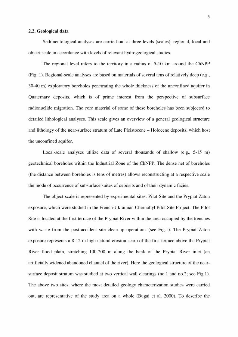
2.2. Geological data
Sedimentological analyses are carried out at three levels (scales): regional, local and
object-scale in accordance with levels of relevant hydrogeological studies.
The regional level refers to the territory in a radius of 5-10 km around the ChNPP
(Fig. 1). Regional-scale analyses are based on materials of several tens of relatively deep (e.g.,
30-40 m) exploratory boreholes penetrating the whole thickness of the unconfined aquifer in
Quaternary deposits, which is of prime interest from the perspective of subsurface
radionuclide migration. The core material of some of these boreholes has been subjected to
detailed lithological analyses. This scale gives an overview of a general geological structure
and lithology of the near-surface stratum of Late Pleistocene – Holocene deposits, which host
the unconfined aquifer.
Local-scale analyses utilize data of several thousands of shallow (e.g., 5-15 m)
geotechnical boreholes within the Industrial Zone of the ChNPP. The dense net of boreholes
(the distance between boreholes is tens of metres) allows reconstructing at a respective scale
the mode of occurrence of subsurface suites of deposits and of their dynamic facies.
The object-scale is represented by experimental sites: Pilot Site and the Prypiat Zaton
exposure, which were studied in the French-Ukrainian Chernobyl Pilot Site Project. The Pilot
Site is located at the first terrace of the Prypiat River within the area occupied by the trenches
with waste from the post-accident site clean-up operations (see Fig.1). The Prypiat Zaton
exposure represents a 8-12 m high natural erosion scarp of the first terrace above the Prypiat
River flood plain, stretching 100-200 m along the bank of the Prypiat River inlet (an
artificially widened abandoned channel of the river). Here the geological structure of the near-
surface deposit stratum was studied at two vertical wall clearings (no.1 and no.2; see Fig.1).
The above two sites, where the most detailed geology characterization studies were carried
out, are representative of the study area on a whole (Bugai et al. 2000). To describe the

6
object-scale geology data, we use also the geology information obtained during excavation of
foundation pits for the ChNPP main building (see Fig.1).
2.3. Sampling methods
As a rule, an auger drill was used to collect deposit samples for lithological studies. At
the Prypiat Zaton exposure, samples were taken by making continuous furrows on the wall of
a clearing according to sampling intervals, and then by mixing up the collected deposit.
Deposit sampling intervals depended upon a scale of research. The 1.0 m sampling interval in
vertical direction was normally used in deep boreholes for analyses at a regional scale. At the
Prypiat Zaton exposure (Clearing no.1) and for shallow boreholes within the Pilot Site the 0.5
m and 0.25 m vertical sampling intervals were utilized. At the Clearing no.2 of the Prypiat
Zaton exposure, where one of the research objectives was geo-statistical analysis of the
sediment hydraulic conductivity distribution (Dewiere et al. in press), the sampling interval in
vertical and horizontal direction was as small as 0.1 m.
2.4. Analytical methods
Particle-size distribution. Deposit samples were processed first by solution of
dispersant (Na4P2O7) for destruction of clay and fine silt coatings at sand particle surfaces.
Separation of coarse and sand fractions was carried out by means of sieves with subsequent
weighing (State standard… 1967). The original device for sounding of suspension density
(inventor's certificate of the USSR no. 1395996 by N.A.Partsevsky) was used for
differentiation and estimation of the percentage of a silt-clay fraction. Granulometric classes
and fractions of deposits were defined according to the classification generally adopted in the
former USSR and Ukraine (Table 1).
Soil porosity. First, the bulk density of dry soil was determined by the method of
volumetric weighting (State standard… 1978). Soil porosity was calculated using table values
of specific gravity of soil particles for different fractions.
7
Cation exchange capacity (CEC). The CEC was determined by measuring adsorption
of methylen blue dye from a water solution according to Kulchitsky (1960).
3. Results and discussion
3.1. Geological structure
In tectonic respect, the studied territory is located within the North-western slope of
the Ukrainian Shield. The indirect data indicate that a crystalline basement occurs at 20 to 80
m a.s.l., and the thickness of the sedimentary cover varies from 130 to 190 m. The
sedimentary cover consists of marine and continental rocks of Mesozoic and Cenozoic
erathems.
The Chernobyl NPP site occupies a part of the first terrace above the flood plain at the
right bank of the Prypiat River (Fig.1). The surface is mostly flat with an elevation ranging
from 111.5 to 115 m above sea level (a.s.l.). The unsaturated zone and the first from the
surface unconfined aquifer are composed of Pliocene and Pleistocene – Holocene deposits
(Matoshko 1995, 1996; Matoshko et al. 2002). Upper Pleistocene – Holocene deposits are
exposed at the surface. Below is located a non-stratified continental horizon of the Pliocene –
Middle Pleistocene age (Fig.2). The total thickness of Pliocene and Pleistocene – Holocene
deposits is about 30 m. The above sediments are sub-divided into aeolian and alluvial suites.
Sandy Pleistocene – Pliocene deposits are underlain by the aquitard layer of a regional extent
composed of dense marine carbonate silts and marls of the Kiev Suite of Eocene.
The thickness of the Upper Pleistocene alluvial suite is judged to be 9-12 m (Fig. 3).
Its lower boundary is not clearly seen in exposures and borehole sections. It consists of two
members: the channel facies, and the over-bank - abandoned-channel facies. The first member
is represented by homogeneous fine-medium sands, with inter-laminas of silt. There are often
up to 0.5 m thick lenses of peat in the uppermost part of the member. In many cases channel

8
deposits form the whole section of the alluvial suite, fixing the last location of channel before
withdrawal of the terrace from a river influence.
More often channel facies are overlain by the abandoned-channel and over-bank facies
with a distinct contact. The above facies can be distinguished only for locations, where they
are exposed or the core was analysed by lithological methods. On a whole, they are
represented by inter-bedded layers of sands and silts (Fig. 4). Thickness of lenses varies from
several centimetres to 1-2 m, and their extension changes from several to hundred and more
meters. In some places within the medium and lower part of the member there are lenses of
peaty sands.
In the Clearing no.2 of Prypiat Zaton exposure (Fig. 5) the upper part of section is
composed of wavy laminated sandy silts with few sub-layers of sands. These deposits are
interpreted as over-bank facies. There is a distinct ochre ferrite bed at the top of the member,
which is supposedly associated with a former active cryogenic layer. In the centre of the
clearing a narrow sub-vertical relic ice vein can be seen. Characteristic rims border the upper
wedge-shaped edge of the vein. The lower part of the vein is filled up by alluvial deposits,
and the upper widened part is in-filled by aeolian sands. Such structures are considered as a
reliable evidence of permafrost or at least of seasonally deep frost penetration in the Late
Pleistocene in conditions of mean annual air temperature between 0 and – 6oC (Murton et al.
2000). Several similar veins were found within the Clearing 2 at the 3.5-4.0 m intervals. All
of them have the same horizontal orientation (25-300 azimuth) which indicates the existence
of a relic polygonal net. As a rule, such nets occupy vast areas (Washborne 1979).
Aeolian deposits rest upon the alluvial suite (Fig. 3, 4). Their thickness varies from
several centimetres up to 5-7 m in dunes. They are homogeneous, fine sub-horizontally and
cross-bedded laminated sands. They include two facies (sheet and dune) distinguished by the
form of sedimentary structures and by vertical changes of particle-size distribution (Matoshko

9
1985). In some places immediately at the land surface the “man-made” deposits are
accumulated (the removed soil, vegetation remnants, concrete and asphalt debris, etc.). These
deposits have appeared during construction of the ChNPP and after the accident in 1986.
3.2. Main features of the Upper Pleistocene – Holocene sedimentation
To better understand structural and lithological features of deposits, it is important to
discuss their origin within the background of a general sedimentary evolution of the studied
territory. The Late Pleistocene Prypiat River valley has inherited the valleys of previous
epochs. Its formation began with the phase of incision in alluvium of the second terrace and in
more ancient alluvium lying below, followed by the lateral shift of the river and erosion,
which resulted in accumulation of a channel alluvium. The two-three-member structure of
alluvial suite (see section 3.1, Fig.3) is an evidence of a meandering type of riverbed
evolution. Wide spreading of abandoned channel facies and a very gentle shape of the line of
contact of the first terrace to the plateau is indicative of a very large (possibly > 1 km) width
of channels, and of a large radius of meanders. It can be hypothesised that the Industrial Zone
of the ChNPP is situated within one of the described above large meanders of abandoned
channels. Meandering of the river was accompanied by an intensive over-bank sheet
accumulation from suspension flows during floods.
During the final stages of formation of alluvial suite, the territory had gotten into
conditions of permafrost caused by a maximum fall of temperatures in Quaternary (Velichko
and Nechaev (1994) refer the maximum of the periglacial zone expansion to 20-16 ka BP).
This period was denoted by an evolution of ice veins, and by active layer deformations.
Gradual transition of riverbed to the subaerial conditions in the subsequent period has
given rise to aeolian processes. The layer of aeolian sands is the result of wind erosion of
channel deposits (the least coarse uppermost sands), with following transportation to short
distances. The beginning of aeolian processes probably took place in a permafrost conditions,

10
which is confirmed by in-filling of upper part of ice veins by aeolian sands (Fig.5).
Degradation of the permafrost has happened probably around 12-14 ka (Sidorchuk et al.
2001). The peak of aeolian activity after melting of the permafrost was marked by formation
of dunes. During the Holocene epoch the structure of alluvial and aeolian suites within the
first terrace probably has not undergone significant changes.
3.3. Lithological properties of deposits
Lithological investigations were aimed at obtaining systematic data on sedimentary
structures (see section 3.1), particle-size distribution, porosity, mineral composition, and
cation exchange capacity (CEC) of the two subsurface suites of deposits composing an
uppermost part of geologic section that is aeolian and alluvial deposits.
3.3.1. Particle-size distribution
Results of the reported studies, as well as conclusions from the previous work
(Matoshko 1995) have shown that different genetic types and facies of Quaternary deposits
within the study area can be distinguished by section-averaged data on particle-size
distribution of sediments, and/or by data on a definite regular changes (or stability) of
particle-size distribution along the geology section. Characteristic “lithological fingerprints”
of main genetic types and facies of deposits were developed.
Deposits of aeolian suite are characterised (based on particle-size analysis of 209
samples from Pilot Site and Prypiat Zaton) by predominance of fine and medium sand
fractions, by a lowest content of the clay fraction (less than 1%), and by best sorting, in
comparison with other deposit. Mean values of fine sand fraction content vary from 54 to
64%. Shapes of section-averaged particle-size distribution diagrams across the study area
(e.g., Pilot Site vs. Prypiat Zaton) are identical or very similar (Fig. 6, 7).
The composition of overbank facies of the alluvial suite (64 samples; Prypiat Zaton) is
characterised by predominant stable content of silt (62-64%) and clay (about 16%). At the
11
same time, a much higher variability of lithology of sediments is observed in the vertical
section on a small-scale. It is associated with separate few centimetres thick laminas, which
could differ even by a granulometric class. The particle-size distribution of abandoned
channel facies (15 samples; Prypiat Zaton) changes widely from a clayey silt to silty sands.
The relevant profile diagram has irregular pattern (Fig. 6). Both these facies are characterised
by unimodal flattened particle-size distribution curves (Fig. 7).
Channel facies (18 samples; Prypiat Zaton) differ from previous ones by a much better
sorting and by an essentially less content of silt and clay fractions (Fig. 6).
3.3.2. Porosity
Porosity of deposits composing the unsaturated zone and unconfined aquifer varies
from 33 to 42%. The over-bank and abandoned-channel facies have the highest values of
porosity, while aeolian deposits have the lowest (see Fig.6).
3.3.3. Mineralogy
According to literature data (Lukashev 1961; Kuznetsov 1973), which are supported
by results of chemical analyses carried out within the present study, alluvial sands of the
Prypiat basin are predominantly quartz with admixtures of the K-Na feldspar (5-9 %), and of
accessory heavy minerals (less than 0.5%). In aeolian sands the content of quartz reaches 98-
99% and the content of heavy minerals is 1-2%. The clay fraction (i.e. particles of a less than
0.01 mm size) of alluvial deposits is composed of hydromica with montmorillonite admixture,
as well as fine-dispersed calcite, quartz, and amorphous ferrous oxides. The clay fraction of
aeolian deposits is almost totally represented by a fine-dispersed quartz.
3.3.4. Cation-exchange capacity
Aeolian deposits have the least cation-exchange capacity (CEC) values, which are
usually less than 1 meq/100 g. This is due to a particle-size distribution with a low clay
content, and due to predominantly quartz mineralogy of clay fraction (see above).

12
The overbank and abandoned channel alluvial deposits have the CEC values of about
5-10 meq/100 g (see Fig.6). A strong correlation is observed between the sediment CEC and
the content of a clay fraction (Fig. 6). Clay-size particles are represented by weathered
minerals (hydromica, montmorillonite, see above), with a higher specific surface area, which
have a significant influence on the exchange capacity.
The content of organic matter (humic substances) may also substantially influence the
CEC. The humus content can be indirectly estimated from data on organic carbon (OC)
content in sediments. In alluvial deposits the OC varies from 0.02 to 0.05%. An essential
increase of OC content could be expected in lenses of peaty sands. On a whole, the
occurrence of organic matter in alluvium is very irregular, and therefore it is difficult to take
into account the possible content of OC during an a-priory assessment of adsorption capacity
of alluvial deposits.
3.4. Hydraulic and sorption properties of deposits
3.4.1. Hydraulic conductivity
Based on analyses of particle-size data and slug tests, hydraulic conductivity of
aeolian sands in Pilot Site and Prypiat Zaton is estimated at K=3-5 m/day. This estimate was
confirmed in the course of a 1 m-scale natural-gradient tracer tests conducted in the aquifer at
Pilot Site (Bugai et al. 2000).
Alluvial deposits of overbank - abandoned channel facies have the lowest hydraulic
conductivity among the considered deposit types. The specific feature is anisotropic filtration
properties of these deposits with on average a much lower permeability in vertical direction
(z) compared with the horizontal direction (x): Kx≈1 m/day, Kz≈0.02-0.05 m/day (Bugai et al.
2002). The filtration anisotropy of deposits of overbank - abandoned channel facies is
obviously related to the layered structure of these deposits: higher permeability horizontal
sub-layers in the overall relatively low permeability strata result in a higher horizontal Kx

13
compared with Kz. For example, hydraulic conductivity values of individual sub-layers at the
Clearing no.2 of the Pripyat Zaton differ by 2 orders of magnitude (in the range from n×0.01
to n×1 m/day) (Bugai et al. 2000).
The alluvial sediments of channel facies, comprising a large part of the unconfined
aquifer section below the elevation of 106-107 m a.s.l. (see Fig.3), are characterized by
highest values of hydraulic conductivity coefficients. Based on particle size analyses, pump-
tests and inverse modeling, section-averaged hydraulic conductivity for these deposits is
estimated at 5-15 m/day (Skalskyy and Kubko 2000).
3.4.2. Sorption distribution coefficients for strontium-90
The most mobile radioactive contaminant in subsurface environment of the Chernobyl
exclusion zone is strontium-90 (Bugai et al. 1996; Dzhepo and Skalskyy 2002). Therefore we
will consider strontium-90 (90
Sr) as an indicator radionuclide, when analyzing sorption barrier
properties of deposits. The main process governing the 90
Sr sorption on deposits is ion-
exchange, and the commonly used parameter for describing radiostrontium sorption on
deposits is distribution coefficient (Kd). As a consequence of the ion-exchange sorption
mechanism, the 90
Sr Kd is highly sensitive to concentration of competing cations (in
particular Ca) in groundwater solution (Patterson and Spoel 1981; Lefevre et al. 1996).
Laboratory batch experiment studies, in-situ field “groundwater – sediment” partition
tests and analyses of retardation of 90
Sr plume emerging from the trench with wastes (Bugai et
al. 2000, 2002), produce coherent estimates of 90
Sr distribution coefficients for aeolian sands
from the Pilot Site and Prypiat Zaton of 2 to 3 ml/g (these estimates correspond to Ca
concentration in test solution of about 25 ml/g).
The 90
Sr sorption on sediments of alluvial overbank and abandoned channel facies
from the Clearing no.2 of Pripyat Zaton was studied in laboratory batch experiments (Bugai et
al. 2000). While the majority of samples from the strata of silty sediments had rather high Kd

14
values of 20-50 ml/g, one sample from the inter-bedded sandy lens had a much lower Kd of 6
ml/g. The Ca concentration in the above tests was 25 ml/g. Series of “groundwater –
sediment” partition tests using alluvial sediments of same facies from Pilot Site have resulted
in generally lower Kd values in the range of 3 to 10 ml/g, with a mean value of 5-7 ml/g
(unpublished data of Sergey Zvaritch, Ukrainian Institute of Agricultural Radiology; the
chemistry of test solution in the last series of tests has not been characterized).
Data on direct determinations of 90
Sr sorption parameters for sediments of alluvial
channel facies are not available. However, 90
Sr Kd values (ml/g) for these sediments can be
inferred from data on cation-exchange capacity (Patterson and Spoel 1981):
1000][
][
Ca
CECKK
Sr
Cad =
where KSr
Ca is selectivity coefficient for Ca ↔ Sr exchange on sediment matrix (close to 1),
[Ca] is calcium concentration in solution (meq/l), [CEC] is cation exchange capacity of
sediment matrix (meq/g), and the numerical factor (1000) converts liters to milliliters. The
CEC of alluvial sediments of channel facies usually fall into the range of 0.5 –4 meq/100 g
with a mean value of about 1 meq/100 g (see Fig.6; Fig.2.3 in Dzhepo and Skalskyy 2002).
Therefore, we could expect that the 90
Sr Kd value for these sediments is relatively low, and is
similar to the Kd value of aeolian sands (i.e., 1-3 ml/g). The last estimate is in agreement with
data on 90
Sr retardation at the ChNPP cooling pond, where the aquifer is presumably
composed of alluvial sediments of channel facies, and calibrations of the radionuclide
transport model resulted in 90
Sr Kd values of 1-2 ml/g (Bugai et al. 1997). The summary
information on lithologic, hydraulic and sorption properties of the main genetic types of
deposits at the Chernobyl NPP site is summarized in Table 2.

15
3.5. Role of deposits of different genesis as barriers to radionuclide migration
Considering data of section 3.3 and 3.4, the following ranking scheme can be
proposed for main genetic types and facies of near-surface deposits at the Chernobyl NPP site
with respect to radionuclide migration retardation potential:
Aeolian < alluvial channel < alluvial over-bank < alluvial abandoned channel.
Field observations of radionuclide migration at Chernobyl site agree with the proposed
sediment ranking. For example, at Pilot Site a significant horizontal spreading in the aquifer
of the 90
Sr plume (emerging from the trench with waste) is observed in the aeolian sand layer,
while the further radionuclide migration in the alluvial sediments of over-bank / abandoned
channel facies is effectively retarded (Bugai et al. 2002). At the contaminated cooling pond of
the ChNPP alluvial sediments of channel facies, which compose local geo-environment, were
able to provide only minor retardation (retardation factor R≈5), and significant releases of 90
Sr
has occurred from the pond to the adjacent Prypiat River (Bugai et al. 1997).
Aeolian sediments appear to possess essentially similar lithological properties at a
scale of kilometers (e.g., features of aeolian sediments in the Pilot Site and Prypiat Zaton are
almost identical). On the contrary, alluvial sediment facies are characterized by much higher
spatial variability in lithological properties. For example, the stratum of alluvial sediments of
overbank and abandoned channel facies in the Pilot Site is essentially different compared with
similar sediment member in the Prypiat Zaton. Therefore care should be taken when
extrapolating specific hydraulic and transport parameters for these sediments from one
location to another location (though general features of sediments are similar on a qualitative
level). Sediment features of different facies discussed above agree with the conceptual
understanding of the sedimentation of the study area (see section 3.2).
To estimate the protective features of the geo-environment, the sedimentary cover at
the ChNPP site could be schematised into four main types of geological sections (Fig. 8)

16
which characterise two main zones of the first terrace of the Prypiat River: central and
peripheral (see Fig. 1). The section of the type “A” is typical for the central part of the ChNPP
site, including “Sarcophagus”, Industrial Zone, engineered waste repositories “Podlesny” and
“Kompleksny”, and “Red Forest” site. In many locations of the central part of the site the “B”
section (former channels overlain by aeolian sands) replaces the “A”, while the section “D”
occurs there locally. Sections of type “C” occupy the peripheral part of the first terrace, while
sections of type “D” are associated here with dunes.
The type of a geology section together with data on location of radioactive
contamination sources, on position of groundwater level, and on direction of groundwater
flow determine the principal hydrogeology conditions of radionuclide migration. Typical
geology sections at Fig.8 have different potentials for retardation of radionuclide migration
due to different hydraulic properties and adsorption capacities of composing sediment layers.
As discussed above, alluvial deposit of overbank and abandoned channel facies, deposits with
a higher content of organic matter and peat, as well as peaty layers within alluvial channel
facies could be considered as a medium, whereas aeolian sandy sediments and channel
alluvial deposits – as a low retardants of radionuclide migration. Accordingly, section types
“A” and “B” generally have higher retardation capacity compared with types “C” and “D”.
When considering protective features of alluvial sediments of overbank / abandoned
channel facies underlying aeolian sands (section “A”, Fig.8) consideration should be given to
possible presence of a relict cryogenic vein network in the upper strata of these deposits. Such
vertical veins with possible penetration depth of 1.5 – 3 m in-filled with a higher permeability
and lower adsorption capacity aeolian sand could provide a facilitated migration pathway to
deeper layers of geo-environment.
Schematisations based on sedimentological analyses of a type presented in Fig.8 could
provide useful information for prioritisation of historic contaminated sites for remediation

17
purposes, or for the site screening/selection process for new waste facilities. Other possible
applications, where described above information could be of essential value include:
development of preliminary conceptual groundwater flow and radionuclide migration models,
design of groundwater monitoring systems, and/or planning of site characterization programs
aimed at determination of hydraulic and geo-chemical properties of geo- environment.
4. Conclusions
The analysis of geological structure and lithological studies show that there are two
main genetic types of deposits composing the upper part of sedimentary cover at the
Chernobyl NPP site: aeolian and alluvial, including several dynamic facies (aeolian sheet and
dune, alluvial over-bank, abandoned-channel and channel). These depositional facies differ
essentially by lithological properties and respectively by hydraulic and sorption parameters.
Consideration of lithological properties leads to following ranking of the main genetic
sediments facies with respect to radionuclide migration retardation potential:
aeolian < alluvial channel < alluvial overbank < alluvial abandoned channel. The protective
features of the layer of sediments of alluvial overbank / abandoned channel facies underlying
aeolian sands could be reduced due to presence of relict cryogenic vein network providing
facilitated migration pathway to the deeper strata. The described above sedimentological
interpretations allow predicting at qualitative level of lithological and structural properties of
specific geology sediment layers and/or typical geologic sections at different scales, and could
provide useful information for understanding and assessment of the barrier role of deposits of
various genesis for the radioactive contaminant migration in the geo-environment.

18
Acknowledgements
The presented studies were supported by funding through the Chernobyl Pilot Site
Project, a collaborative French-Ukrainian program of the Institute for Radioprotection and
Safety (IRSN, France), as well as by research contracts no.4/6-95 and no.13/132-155H-98
from the Ministry of Emergency Situations and Chernobyl Affairs (Ukraine). We gratefully
acknowledge laboratory particle-size distribution analyses by Nikolai Partsevskyi, laboratory
sorption studies by Sergey Zvarich, and field hydrogeology works by Svyatoslav Kurilo and
Danyl Olegov. Comments and English editing work on this manuscript by an anonymous
reviewer is much appreciated.
References
Bugai DA, Waters RD, Dzhepo SP, Skalskyy AS (1996) Risks from Radionuclide Migration
to Groundwater in the Chernobyl 30-km Zone, Health Physics 71: 9-18
Bugai DA, Waters RD, Dzhepo SP, Skalskyy AS (1997) The cooling pond of the Chernobyl
nuclear power plant: A groundwater remediation case history. Water Resour Res 33 (4): 667-
688
Bugai DA, Guillou Ph, Dewiere L, et al. (2000) Study of radionuclide migration in geological
environment at experimental polygon Pilot Site in the area of the near-surface disposal of
radioactive wastes in the near-zone of Chernobyl NPP. In: Shestopalov V (ed) Water
Exchange and Chernobyl Accident. Vol.1. Ukrainian National Academy of Sciences, Kiev, pp
346-383 (in Russian)
Bugai D, Dewiere L, Kashparov V, Ahamdach N (2002) Strontium-90 transport parameters
from source term to aquifer in the Chernobyl Pilot Site. Radioprotection – Colloques 37-C1:
11-16

19
Dewiere L, Bugai D, Grenier C, Kashparov V, Ahamdach N. (in press) 90
Sr migration to the
geo-sphere from a waste burial in the Chernobyl exclusion zone. J Env Radioactivity
Dzhepo S, Skalskyy A (2002) Radioactive contamination of groundwater within the
Chernobyl Exclusion Zone. In Shestopalov V (ed) Chernobyl disaster and groundwater.
A.A.Balkema Publishers, pp 25-70
Goretsky GI (1970) Alluvial chronicle of the great pre-Dnieper. “Nauka” Publishers, Moscow
(in Russian)
Kulchitsky LI (1960) Establishment of the cation exchange capacity of clays by method of
adsorption of the methylen blue dye. Kora vyvetrivaniya 3: 61-72 (in Russian)
Kuznetcov VA (1973) Geochemistry of the alluvial lithogenesis. “Nauka i technika”
Publishers, Minsk
Lefevre F, Sardin M, Vitorge P (1996) Migration of 45
Ca and 90
Sr in a clayey and calcerous
sand: Calculation of distribution coefficients by ion exchange theory and validation by
column experiments. JContam Hydrology 21: 175-188
Lukashev VK (1961) Some data on genesis and lithology of aeolian deposits of the
Byelorussian Polesye. In: Lukashev KI (ed) Materials on genesis and lithology of Quaternary
deposits. Academy of Sciences of Beylorussia SSR , Minsk, pp 230-248 (in Russian)
Matoshko AV (1985) On periglacial above till formations of Polessiye. In: Kuznetcov VA,
Zinova RA, Shpakov ON (eds) Contribution of Academician P.A.Tutkovsky to study of
geological structure of Earth crust in Belorussia. “Nauka i technika” Publishers, Minsk, pp
54-65 (in Russian)
Matoshko AV (1995) Schematisation and zoning of sedimentary cover of the Chernobyl
exclusion zone for hydrogeological monitoring. Problems of the Chernobyl Exclusion Zone 4:
95-108 (in Russian)

20
Matoshko AV (1996) Map of the Quaternary deposits and zoning of the Quaternary strata
according to the types of geological sections. In: Shestopalov VM (ed.) Atlas of the
Chernobyl Exclusion Zone. NVP «Kartographiya» Publishers, Kiev, pp 16-17
Matoshko AV, Gozhik PF, Ivchenko AS (2002) The fluvial archive of the Middle and Lower
Dnieper (a review). Netherlands Journal of Geosciences, 81(3-4): 339-355
Murton JB, Worsley P, Gozdzik J (2000) Sand veins and wedges in cold aeolian
environments. Quaternary Science Reviews 19: 899-922
Patterson RJ, Spoel T (1981) Laboratory measurements of strontium distribution coefficient
Kd for sediments from a shallow sand aquifer. Water Resour Res 17 (3): 513-520
Shantser EV (1982) Genetic types of Quaternary deposits. In: Shantser EyV (ed) Stratigraphy
of the USSR. Quaternary System. “Nauka” Publishers, Moscow, pp 61-94 (in Russian)
Sidorchuk A, Borisova O, Panin A (2001) Fluvial response to the Late Valdai/Holocene
environmental change on the east European Plain. Global and Planetary Change 28: 303-318.
Skalskyy AS, Kubko YI (2000) Filtration models of the Chernobyl NPP site. In: Shestopalov
V (ed) Water Exchange and Chernobyl Accident. Vol.2. Ukrainian National Academy of
Sciences, Kiev, pp 448-481 (in Russian)
State standard 12536-67 (USSR) (1967) Soils. Methods of establishment of particle (grain) -
size distribution. State Committee of the USSR on Standards, Moscow (in Russian)
State standard 5182-78 (USSR) (1978) Soils. Laboratory method of volumetric weighting.
State Committee of the USSR on Standards, Moscow (in Russian)
Velichko AA, Nechaev VP (1994) Cryogenic processes and phenomena in the Late
Pleistocene periglacial zone of the Russian Plain and their reflection in the modern landscape.
In: Velichko AA, Starkel L (eds) Palaeogeographical basis of the modern landscape. Results
of the Russian-Polish research. “Nauka” Publishers, Moscow, pp 82-86 (in Russian)
Washborne AL (1979) Geocryology. “Edward Arnold”, London

21
Table 1. Main granulometric fractions and classes of deposits (according to classification
adopted in the former USSR and Ukraine).
Definition of granulometric fractions by size
Coarse material > 1.0 mm sand coarse 0.5-1.0 mm
Sand 0.1-1.0 mm medium 0.25-0.5 mm
Fines silt (aleurite) 0.01-0.1 mm fine 0.1-0.25 mm
clay <0.01 mm silt coarse 0.05-0.1 mm
fine 0.01-0.05 mm
Definition of granulometric classes of deposits by percentage of particle-size fractions
Sand Sand fraction is more than 50%
Silty sand Sand fraction is more than 50%, the silt fraction is
predominant among others
Silt Silt fraction is more than 50%
Sandy silt Silt fraction is more than 50%, the sand fraction is
predominant among others
Clayey silt Total content of clay and silt fractions is more than 50%, but
the content of silt is higher

Table 2. Representative values of lithological, hydraulic and sorption parameters for different genetic types and dynamic facies of deposits (Pilot
Site; Prypiat Zaton, Clearings 1 and 2).
Deposits, type, facies
(samples number)
Bulk density,
kg/dm3
Porosity,
%
Clay fraction (<0.01
mm) content, %
Hydraulic
conductivity (K),
m/day
CEC,
meq/100 g
90Sr Kd ,
ml/g
Aeoilan 1.72 34-36 1-2 3-5
(isotropic)
0.5-1.2 2-3
Alluvial, channel facies
1.67 37 2-8 5-15
(isotropic)
0.5-4 1-6
Alluvial ,overbank and
abandoned channel
facies
1.73
35
10-20 ≈ 1 (Kx)
≈ 0.01 (Kz)
(anisotropic)
5-10 10-50

FIGURE CAPTIONS
Figure1. Map of the study site with elements of geologic and geomorphologic structure,
hydrogeology conditions and radioactive waste sites.
Legend: 1 - geologic and geomorphologic boundaries, 2 –geologic and geomorphologic
regions and main landforms (numbered), 3 – boreholes (numbered) and geologic cross-section
line, 4 – clearing of an exposure and its number, 5 – sand pit, 6 – area covered by radioactive
waste dumps, 7 - near-surface engineered radioactive waste repositories,
8 - regional directions of groundwater flow, 9 – main buildings of the ChNPP, 10 – boundary
between two main zones of the different types of geology section (for the upper part of
sedimentary cover within the first terrace above flood plain), 11 – types of geology section.
Numbers in circles: 1 – Quaternary Plateau, 2 – first terrace above the flood plain, 3 – flood
plain, 4 – slope-wash apron, 5 – dunes.
Letters in rectangles: types of geologic sections - see Fig. 8 and explanation in section 3.5.
The letter in brackets means that given type of section occurs locally within the zone.
Figure 2. Regional geologic cross-section of the investigated territory.
Legend: 1 – sands, 2- silts, 3 – basal till, 4 – clay, 5 – marl, 6 – inter-bedding of sands and
silts, 7 – peat and peaty sand, 8 – boreholes (numbered), 9 – inferred fault, 10 – boundaries
between suites: supposed (upper) and established (lower), 11 - boundaries between
depositional facies, 12 – facial replacement, 13 – groundwater level (generalized).
Indices: Q4 - Holocene, Q3-4 - Upper Pleistocene - Holocene unstratified, Q3 - Upper
Pleistocene, Q1-2 - Lower Pleistocene - Middle Pleistocene unstratified, N2 - Pliocene, P2 –
Eocene.

24
Genetic types of deposits: a - alluvial, mw – melt-water, eol - aeolian, e - presumably waste
mantle, sw – slopewash.
Facies: ob – overbank, ch – channel, a-ch – abandoned channel. Position of the profile is
shown in Fig. 1. (Legend also applies to the Fig. 3)
Figure 3. Local geologic profile within the ChNPP Units 1-4 main buildings (before the plant
construction), including Sarcophagus site. (Legend is explained in Fig. 2. Position of the
ChNPP is shown at Fig. 1).
Figure 4. Rough inter-bedded sedimentary structures of the uppermost aeolian and alluvial
suits according to drawings of the ChNPP main buildings foundation pit in two dimensions.
(Unpublished data of “Atomenergoproect” institute, 1968).
Legend: 1 – sands, 2- silts, 3 - peaty sand. Indices: Q3-4 - Upper Pleistocene – Holocene
unstratified; Q3 - Upper Pleistocene;
Genetic type of deposits: a - alluvial, eol - aeolian; facies: sh - sheet, ob - a-ch - overbank –
abandoned-channel, ch - channel.
Figure 5. Composite cryogenic wedge in overbank alluvial deposits overlain by aeolian cover
sand at the Clearing 2 of the Prypiat Zaton.Two parts of the clearing (upper and lower) are
divided by a 1.5 m wide ledge. Delineation of sedimentary structures was made from a
photograph.
Legend and explanations: 1 - modern sod-podzolic soil (sedimentary structures are invisible),
2 - aeolian sand deposits, 3 - horizon of aeolian deposits transformed by cryogenic processes
(massive structure and local deformations), 4 – alluvial overbank silt deposits (sub-horizontal
and wavy lamination with small load casts); a – sheet facies (sub-horizontal lamination), b –

25
dune facies (inclined envelope and sub-horizontal lamination ), c - polygon rims, d - aeolian
deposits infill in the wedge (sand wedge), e - horizon of alluvial deposits transformed by
cryogenic processes - massive structure and gentle deformations (supposedly associated with
active layer), f - ferrite horizon, g - ice wedge (vein) with sub-vertical ‘lamination’, h – sand
lens.
Figure 6. Profile diagrams of lithological properties of sediment for the Clearing no.1 of
Prypiat Zaton.
Figure 7. Section-averaged particle-size distribution curves for different sediment facies:
(a) aeolian; (b) alluvial: ob –over-bank; ab – abandoned-channel; ch – channel.
Figure 8. Main types of geology sections at the ChNPP site (for the upper part of sedimentary
cover).

Figure 1

Figure 2

Figure 3

Figure 4

Figure 5

0% 20% 40% 60% 80% 100%
0.25
0.75
1.25
1.75
2.25
2.75
3.25
3.75
4.25
4.75
5.25
5.75
6.25
6.75
7.25
7.75
8.25
8.75
>0.5 mm 0.5-0.250.25-0.1 0.1-0.050.05-0.01 0.01-0.001< 0.001 mm
m 051015
CEC, meq/100 g
30354045
Porosity, %Grain-size distribution, %
Figure 6

0
10
20
30
40
50
60
70
%
0
10
20
30
40
50
60
%
(a)
0>0.5
mm
0.5-
0.25
0.25-
0.1
0.1-
0.05
0.05-
0.01
0.01-
0.001
< 0.001
mm
eol (Pr Zaton Clear 1) eol (Pr Zaton Clear 2)
eol (Pilot Site)
(b)
>0.5
mm
0.5-
0.25
0.25-
0.1
0.1-
0.05
0.05-
0.01
0.01-
0.001
< 0.001
mm
ob (Pr Zaton Clear 1) ob (Pr Zaton Clear 2)
ab (Pr Zaton Clear 1) ch (Pr Zaton Clear 1)
Figure 7

Figure 8