Seismicity of Morocco for the Period 1987–1994
14
Seismicity of Morocco for the Period 1987–1994 S. O. EL ALAMI 1 , B. TADILI 1 , L. AI ¨ T BRAHIM 2 , and I. MOUAYN 2 Abstract — A seismic data file of 3,740 earthquakes from January 1987 to December 1994 has been elaborated for Morocco and the border regions, with 10 main events registering magnitudes from 5 to 5.6. Such seismicity is particularly important for Morocco as the released seismic energy constitutes a considerable part of the total energy radiated during the 20th century. Relative seismicity maps confirm the persistence of the major features of the seismicity of Morocco. An important seismic activity is observed in the Alboran region continental crust, which absorbs the maximum deformation resulting from the convergence of the African and Iberian plates. However, in the longitude window 3.5°–6° W at depths of 25 to 50 km, a seismic gap zone seems to take place. An explanation of this phenomenon may be provided by the slab breakoff model. Even if the seismicity of Morocco remains moderate, heavy damage is observed when the magnitude of earthquakes exceeds 4.5, especially in the case of traditional buildings. Key words: Seismicity, hazard, gap, aftershocks, 87–94, Morocco. Introduction During its history Morocco has experienced destructive earthquakes. The first important one occurred in the 9th Century, and it was violently felt from Tangier to Tlemcen (Algeria). In 1045–1046, a violent earthquake caused the death of several people, and significant damage in Fes (EL MRABET et al., 1991). In 1522 Fes city was nearly destroyed by a violent earthquake, with damage observed in an area of 160 km 2 around Fes. In 1624, again in Fes city, an important earthquake (I ¼ VIII) caused 1500 to 2500 deaths, as reported by the chronicles. This earthquake caused significant material damage and touched several other localities, including Meknes and Baddis (EL MRABET et al., 1991). The Lisbon earthquake in 1755 is considered the most significant earthquake in human history. With its oceanic origin (area of the Corringe bank), it was felt over a vast part of North Africa and throughout western Europe (LEVRET, 1991). Damage in Morocco was considerable; there were several thousand deaths and partial destruction of many localities, among them Meknes (I ¼ VIII), Fes (I ¼ VII), and 1 Institut Scientifique, De´partement de Physique du Globe, BP 703, Rabat, Maroc. E-mails: [email protected], [email protected] 2 Faculte´ des Sciences, De´partement de Ge´ologie, Rabat, R.P., Maroc. E-mails: [email protected], [email protected] Pure appl. geophys. 161 (2004) 969–982 0033 – 4553/04/060969 – 14 DOI 10.1007/s00024-003-2503-0 Ó Birkha ¨ user Verlag, Basel, 2004 Pure and Applied Geophysics
Transcript of Seismicity of Morocco for the Period 1987–1994
Seismicity of Morocco for the Period 1987–1994
S. O. EL ALAMI1, B. TADILI
1, L. AIT BRAHIM2, and I. MOUAYN
2
Abstract—A seismic data file of 3,740 earthquakes from January 1987 to December 1994 has been
elaborated for Morocco and the border regions, with 10 main events registering magnitudes from 5 to 5.6.
Such seismicity is particularly important for Morocco as the released seismic energy constitutes a
considerable part of the total energy radiated during the 20th century. Relative seismicity maps confirm the
persistence of the major features of the seismicity of Morocco. An important seismic activity is observed in
the Alboran region continental crust, which absorbs the maximum deformation resulting from the
convergence of the African and Iberian plates. However, in the longitude window 3.5�– 6� W at depths of
25 to 50 km, a seismic gap zone seems to take place. An explanation of this phenomenon may be provided
by the slab breakoff model. Even if the seismicity of Morocco remains moderate, heavy damage is observed
when the magnitude of earthquakes exceeds 4.5, especially in the case of traditional buildings.
Key words: Seismicity, hazard, gap, aftershocks, 87–94, Morocco.
Introduction
During its history Morocco has experienced destructive earthquakes. The first
important one occurred in the 9th Century, and it was violently felt from Tangier to
Tlemcen (Algeria). In 1045–1046, a violent earthquake caused the death of several
people, and significant damage in Fes (EL MRABET et al., 1991). In 1522 Fes city was
nearly destroyed by a violent earthquake, with damage observed in an area of
160 km2 around Fes. In 1624, again in Fes city, an important earthquake (I ¼ VIII)
caused 1500 to 2500 deaths, as reported by the chronicles. This earthquake caused
significant material damage and touched several other localities, including Meknes
and Baddis (EL MRABET et al., 1991).
The Lisbon earthquake in 1755 is considered the most significant earthquake in
human history. With its oceanic origin (area of the Corringe bank), it was felt over a
vast part of North Africa and throughout western Europe (LEVRET, 1991). Damage
in Morocco was considerable; there were several thousand deaths and partial
destruction of many localities, among them Meknes (I ¼ VIII), Fes (I ¼ VII), and
1 Institut Scientifique, Departement de Physique du Globe, BP 703, Rabat, Maroc.
E-mails: [email protected], [email protected] Faculte des Sciences, Departement de Geologie, Rabat, R.P., Maroc. E-mails: [email protected],
Pure appl. geophys. 161 (2004) 969–9820033 – 4553/04/060969 – 14DOI 10.1007/s00024-003-2503-0
� Birkhauser Verlag, Basel, 2004
Pure and Applied Geophysics

Marrakech (I ¼ VII). All the localities on the Atlantic coast from Tangier (I ¼ VII to
VIII) to Agadir were seriously affected by the combined effect of the earthquake and
the tsunami (EL ALAMI and TINTI, 1991).
The most destructive earthquake in Morocco in the 20th century was the Agadir
earthquake of February 29, 1960, with magnitude mb ¼ 5.8, epicentral intensity
I0 ¼ X (MSK), and an estimated released energy of 1020 ergs. This is the equivalent
energy produced by the explosion of about 2500 tons of TNT. Loss of human life and
the amount of materials were catastrophic: more than 12000 deaths and about 290
million dollars in damage, with near destruction of some districts of the city. We
attribute this damage mainly to two factors:
1 — The focus of the earthquake was located at a depth of 1.3 to 3 km below the
city of Agadir (Rothe in DUFFAUD et al., 1962). CHERKAOUI and MEDINA (1988)
assigned a focal depth of 1.4 km after revision of the macroseismic data.
2 — Agadir is situated on plio-quaternary sediments 200 m thick called plain of
Souss, which caused a site amplification effect (BARD, 1985; CHERKAOUI and
MEDINA, 1988).
On February 28, 1969, an earthquake (M ¼ 7.3) located at the same zone as the
Lisbon earthquake was felt in Morocco. It caused the death of 6 people at Sale
situated in front of Rabat (I ¼ VI to VII). At Safi (I ¼ VI to VII) material damage
was observed (BEN SARI, 1978; CHERKAOUI, 1991).
The first studies of the seismicity of Morocco appeared in 1932 with HEE’s (1932)
works, and subsequently many catalogues were published (see Table 1). ROUX (1934)
Table 1
The main seismic catalogues concerning Morocco
Period Covered
region
Number
of events
Author
1911–1933 North Africa – HEE (1932)
1901–1933 (25�–45�) N , (5�E–20�W) – GALBIS (1932, 1940)
historical events
and 1901–1933
Morocco – ROUX (1934)
1904–1946 The World – GUTENBERG and
RICHTER (1954)
1901–1961 (35�–44�) N , (5�E–20�W) – MUNUERA (1963)
1901–1955 Europe and Mediterranean
basin
– KARNIK (1969)
1919–1967 (28�–37�) N , (0�–14�) W 360 DUVERGE (1969)
1901–1975 (28�–38�) N , (0�–19�) W 810 BENSARI (1978)
1972–1975 (30�–40�) N , (4�–12�) W – HATZFELD (1978)
1976–1978 (30�–40�) N , (4�–12�) W – FROGNEUX (1980)
1901–1984 (21�–38�) N , (0�–20�) W 4091 CHERKAOUI (1988)
1901–1989 (21�–38�) N , (0�–20�) W 5989 TADILI and RAMDANI
(1991)
1987–1994 (21�–38�) N , (0�–20�) W 3740 Our study
970 S. O. El Alami et al. Pure appl. geophys.,

elaborated the first catalogue pertaining to the past and contemporary seismicity of
Morocco (up to 1933), in which for the first time Arabic documents were used and
important informations regarding historical earthquakes (before 1900) was given.
The MUNUERA (1963) catalogue reported, for the first time, geographic coordinates
of epicentres, magnitudes, and empirical formulas used to calculate magnitudes from
intensities for seismic events. In the KARNIK (1969) catalogue, valid for some
countries in Europe and the Mediterranean basin, both instrumental and macrose-
ismic data were used to determine the epicentre locations, and to estimate
magnitudes. HATZFELD (1978) as well as BEN SARI (1978) used HYPO 71 program
for the determination of the epicentre locations. Magnitudes were computed either
using amplitudes or signal durations. For their studies on the seismic risk and
seismotectonics north of Morocco, TADILI and RAMDANI (1991) used a catalogue
with events from 1901 to 1989, essentially based on the Spanish Bulletin of the
National Geographic Institute (IGN, Madrid).
The first Moroccan seismic station (Fig. 1) was installed in 1937 by the scientific
Institute of Rabat. Three more stations were added between 1964 and 1968, after the
Agadir earthquake in 1960. Thereafter 12 additional stations were installed between
1971 and 1981. Since 1981, the PAMERAR project entitled ‘‘Project of Assessment and
Figure 1
Schematic tectonic map of Morocco and the south of Spain and Portugal, with the seismic national
network. Around Al Hoceima is shown the seismic network recording the aftershocks of the 26 May 1994
Al Hoceima earthquake, for 14 days.
Vol. 161, 2004 Seismicity of Morocca 971
Mitigation of Earthquake Risk in the Arab Region’’ contributed considerably to
extend the National seismological network. This network is run by the National
Centre of the Co-ordination and Planning of the Scientific and Technical Research,
and is currently composed of several types of stations: telemetered, portable, and
broadband seismic stations.
From January 1987 to December 1994, a seismic data file of 3740 earthquakes
was prepared for Morocco and the border regions, with 10 main events reaching
magnitudes 5 £ M £ 5.6. Seismicity in Morocco for this period is particularly relevant
as the released seismic energy constituted a considerable part of the total energy
radiated during the 20th century in Morocco.
Seismicity of Morocco over the Period 1987–1994
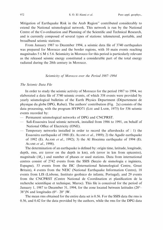
The Seismic Data File
In order to study the seismic activity of Morocco for the period 1987 to 1994, we
elaborated a data file of 3740 seismic events, of which 358 events were provided by
yearly seismological bulletins of the Earth Physics Department (Departement de
physique du globe DPG, Rabat). The authors’ contribution (Fig. 2a) consists of the
data processing, with the program HYPO71 (LEE and LAHR, 1975) for 536 seismic
events recorded by:
— Permanent seismological networks of DPG and CNCPRST.
— Safi-Essaouira local seismic network, installed from 1986 to 1991, on behalf of
National Office of Electricity (ONE).
— Temporary networks installed in order to record the aftershocks of : 1) the
Essaouira earthquake of 1988 (EL ALAMI et al., 1989); 2) the Agadir earthquake
of 1992 (EL ALAMI et al., 1992); 3) the Al Hoceima earthquake of 1994 (EL
ALAMI et al., 1998).
The determination of an earthquake is defined by: origin time, latitude, longitude,
depth, rms, erz (error on the depth in km), erh (error in km from epicentre),
magnitude (Md ) and number of phases or used stations. Data from international
centres consist of 2742 events from the SSIS (Seccio de sismologia e inginiera,
Espagne), 53 events from the ISC (International Seismological Centre, Great
Britain), 4 events from the NEIC (National Earthquake Information Centre), 18
events from LIS (Lisbone, Instituto geofisico do infante, Portugal), and 29 events
from the CNCPRST (Centre National de Coordination et planification de la
recherche scientifique et technique, Maroc). This file is conceived for the period of
January 1, 1987 to December 31, 1994, for the zone located between latitudes (20�–38�)N and longitudes (0�– 20� )W.
The mean rms obtained for the entire data set is 0.56. For the SSIS data the rms is
0.56, and 0.42 for the data provided by the authors, while the rms for the DPG data
972 S. O. El Alami et al. Pure appl. geophys.,
is near 1.0 (Fig. 2b). For all the sources of data used in this study, the mean number
of observations used is 16 (Fig. 2c). The mean error over the depth erz is about 3 km
for the entire data set (Fig.2d), 3.4 for the SSIS data and 1.7 for our contribution.
The mean erh is about 3 km for the entire data set.
Seismicity Maps of Morocco for the Period 1987–1994
The knowledge of geographical distribution of earthquakes in a given region is of
primary interest for studying seismicity. When correlated with geological structures,
this constitutes a basic work for developing a seismotectonic map (RAMDANI, 1991;
EL ALAMI, 1998), which can be used to elaborate a seismic hazard map (CHERKAOUI,
1991; TADILI, 1991). Thus, any territory development work at the national or
regional scale, must take into account the results of these studies.
The seismicity map of Morocco for the period of 1987–1994 is shown in Fig. 3.
3740 seismic events are reported without any restriction. We note the persistence of
Figure 2
Characteristics of seismic data file. a: Data Source distribution, b: data rms distribution, c: observation
mean number distribution, d: depth mean error distribution.
Vol. 161, 2004 Seismicity of Morocca 973
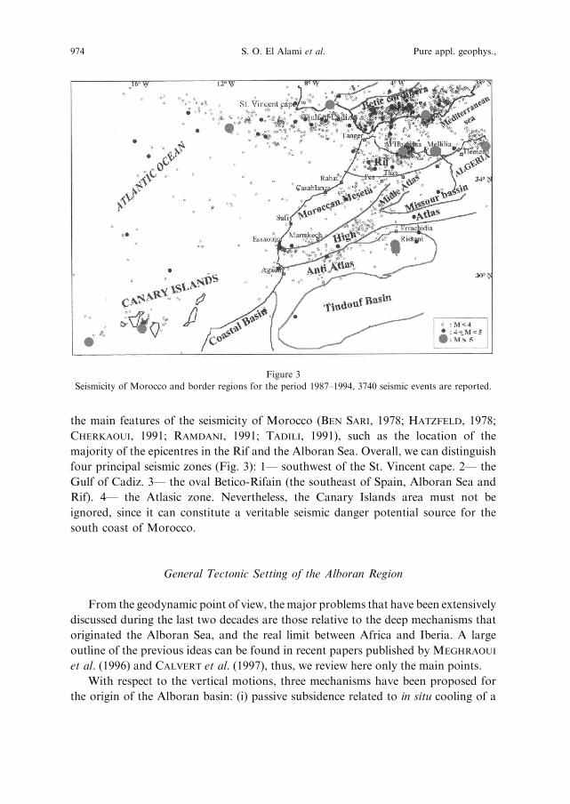
the main features of the seismicity of Morocco (BEN SARI, 1978; HATZFELD, 1978;
CHERKAOUI, 1991; RAMDANI, 1991; TADILI, 1991), such as the location of the
majority of the epicentres in the Rif and the Alboran Sea. Overall, we can distinguish
four principal seismic zones (Fig. 3): 1— southwest of the St. Vincent cape. 2— the
Gulf of Cadiz. 3— the oval Betico-Rifain (the southeast of Spain, Alboran Sea and
Rif). 4— the Atlasic zone. Nevertheless, the Canary Islands area must not be
ignored, since it can constitute a veritable seismic danger potential source for the
south coast of Morocco.
General Tectonic Setting of the Alboran Region
From the geodynamic point of view, themajor problems that have been extensively
discussed during the last two decades are those relative to the deep mechanisms that
originated the Alboran Sea, and the real limit between Africa and Iberia. A large
outline of the previous ideas can be found in recent papers published by MEGHRAOUI
et al. (1996) and CALVERT et al. (1997), thus, we review here only the main points.
With respect to the vertical motions, three mechanisms have been proposed for
the origin of the Alboran basin: (i) passive subsidence related to in situ cooling of a
Figure 3
Seismicity of Morocco and border regions for the period 1987–1994, 3740 seismic events are reported.
974 S. O. El Alami et al. Pure appl. geophys.,
thermal dome (e.g., WEIJERMAARS, 1988); (ii) delamination of a thickened
lithosphere (PLATT and WISSERS, 1989; MORLEY, 1992; SEBER, 1995), and (iii)
orogene collapse related to body forces (DEWEY, 1988). These vertical motions,
which can be quantified through a subsidence analysis (WATTS et al., 1992), do not
seem to be reflected by the actual seismicity, perhaps with the exception of the deep
earthquakes (600 km) recorded near Granada in southern Spain, which are thought
to reflect stress release within a fragment of subducted lithosphere (e.g., BUFORN
et al., 1991).
Similarly, different models were proposed to explain the tectonics of the area in
the context of the horizontal motions, i.e., the convergence between north-western
Africa and Iberia, to which the observed seismicity is strongly related.
Seismicity around the Alboran Sea
From the seismic data file of Morocco for the period of 1987– 1994, concerning
the geographical area located at (34� to 38� ) N and (0.5� to 11� ) W, we selected 1964
events which have rms £ 1, erz £ 5 km and erh £ 5 km (Fig. 4a). The analysis of the
seismicity of this region suggested many interesting observations:
— The 1964 event locations are projected on the latitude-depth plane (cross section
oriented NS) and represented in Figure 4b. This representation shows an
important seismic activity, mostly at depths lower than 30 km. This range of
depths corresponds to the continental crust which absorbs the maximum
deformation resulting from the convergence of the African and Iberian plates
(Fig. 5). We also observe a zone of intermediate-depth seismic activity from the
Betic coast to the Rif coast in the window latitude (35.5�– 37� ) N, which spans
into the upper mantle depths reaching a maximum of 120 km. This intermediate
depth seismic activity accounts for the majority of the sub crustal earthquakes in
this region (Fig. 4a). The Betic crust is characterized by a high seismic activity
within these latitudes (BUFORN et al., 1988; SEBER et al., 1996). This is an
argument for the existence of a previous subduction zone in which the African
plated plunged beneath the Iberian plate.
— A window of data in Figure 4a with longitudes of 3.5�– 6� W is represented in
Figure 4c. We can observe the existence of a seismic gap zone between the
Alboran Sea and the Gulf of Cadiz, at depths from 25 to 50 km, already studied
by SEBER (1996) and interpreted as the result of a lithospheric delamination
area. A detailed explanation of this seismic Gap zone is provided by the Slab
breakoff model given by MAURY et al. (2000). In this model, the lithospheric
delamination caused in the subduction period permitted the flow ascension of
asthenospheric material through the tear of the down going slab. This caused the
melting of the overlying lithospheric mantle in the subduction zone and thinning
of the lithosphere through thermal erosion. As the asthenospheric material
Vol. 161, 2004 Seismicity of Morocca 975
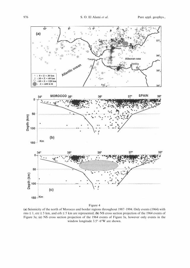
Figure 4
(a) Seismicity of the north of Morocco and border regions throughout 1987–1994. Only events (1964) with
rms £ 1, erz £ 5 km, and erh £ 5 km are represented; (b) NS cross section projection of the 1964 events of
Figure 3a; (c) NS cross section projection of the 1964 events of Figure 3a, however only events in the
window longitude 3.5�–6�W are shown.
976 S. O. El Alami et al. Pure appl. geophys.,
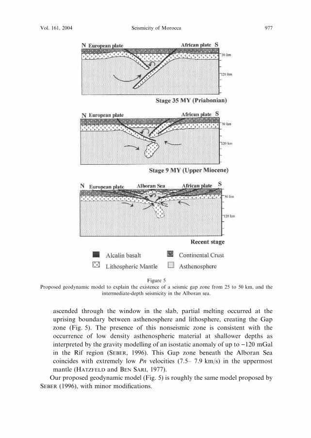
ascended through the window in the slab, partial melting occurred at the
uprising boundary between asthenosphere and lithosphere, creating the Gap
zone (Fig. 5). The presence of this nonseismic zone is consistent with the
occurrence of low density asthenospheric material at shallower depths as
interpreted by the gravity modelling of an isostatic anomaly of up to )120 mGal
in the Rif region (SEBER, 1996). This Gap zone beneath the Alboran Sea
coincides with extremely low Pn velocities (7.5– 7.9 km/s) in the uppermost
mantle (HATZFELD and BEN SARI, 1977).
Our proposed geodynamic model (Fig. 5) is roughly the same model proposed by
SEBER (1996), with minor modifications.
Figure 5
Proposed geodynamic model to explain the existence of a seismic gap zone from 25 to 50 km, and the
intermediate-depth seismicity in the Alboran sea.
Vol. 161, 2004 Seismicity of Morocca 977
Significant Earthquakes through 1987–1994
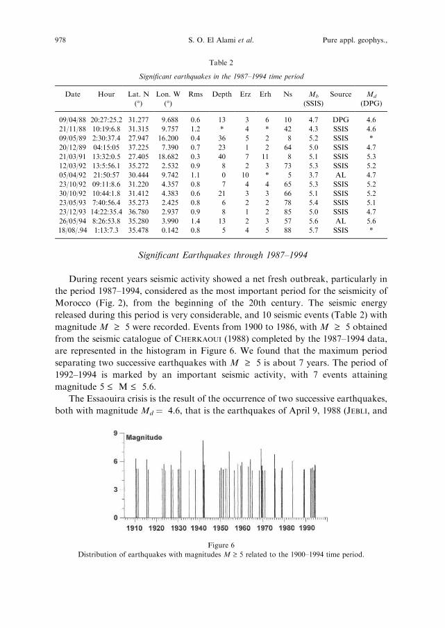
During recent years seismic activity showed a net fresh outbreak, particularly in
the period 1987–1994, considered as the most important period for the seismicity of
Morocco (Fig. 2), from the beginning of the 20th century. The seismic energy
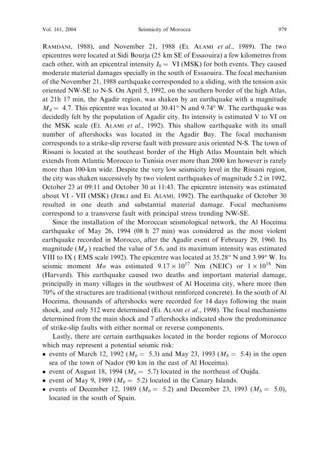
released during this period is very considerable, and 10 seismic events (Table 2) with
magnitude M ‡ 5 were recorded. Events from 1900 to 1986, with M ‡ 5 obtained
from the seismic catalogue of CHERKAOUI (1988) completed by the 1987–1994 data,
are represented in the histogram in Figure 6. We found that the maximum period
separating two successive earthquakes with M ‡ 5 is about 7 years. The period of
1992–1994 is marked by an important seismic activity, with 7 events attaining
magnitude 5 £ M £ 5.6.
The Essaouira crisis is the result of the occurrence of two successive earthquakes,
both with magnitude Md ¼ 4.6, that is the earthquakes of April 9, 1988 (JEBLI, and
Figure 6
Distribution of earthquakes with magnitudes M ‡ 5 related to the 1900–1994 time period.
Table 2
Significant earthquakes in the 1987–1994 time period
Date Hour Lat. N
(�)Lon. W
(�)Rms Depth Erz Erh Ns Mb
(SSIS)
Source Md
(DPG)
09/04/88 20:27:25.2 31.277 9.688 0.6 13 3 6 10 4.7 DPG 4.6
21/11/88 10:19:6.8 31.315 9.757 1.2 * 4 * 42 4.3 SSIS 4.6
09/05/89 2:30:37.4 27.947 16.200 0.4 36 5 2 8 5.2 SSIS *
20/12/89 04:15:05 37.225 7.390 0.7 23 1 2 64 5.0 SSIS 4.7
21/03/91 13:32:0.5 27.405 18.682 0.3 40 7 11 8 5.1 SSIS 5.3
12/03/92 13:5:56.1 35.272 2.532 0.9 8 2 3 73 5.3 SSIS 5.2
05/04/92 21:50:57 30.444 9.742 1.1 0 10 * 5 3.7 AL 4.7
23/10/92 09:11:8.6 31.220 4.357 0.8 7 4 4 65 5.3 SSIS 5.2
30/10/92 10:44:1.8 31.412 4.383 0.6 21 3 3 66 5.1 SSIS 5.2
23/05/93 7:40:56.4 35.273 2.425 0.8 6 2 2 78 5.4 SSIS 5.1
23/12/93 14:22:35.4 36.780 2.937 0.9 8 1 2 85 5.0 SSIS 4.7
26/05/94 8:26:53.8 35.280 3.990 1.4 13 2 3 57 5.6 AL 5.6
18/08/.94 1:13:7.3 35.478 0.142 0.8 5 4 5 88 5.7 SSIS *
978 S. O. El Alami et al. Pure appl. geophys.,
RAMDANI, 1988), and November 21, 1988 (EL ALAMI et al., 1989). The two
epicentres were located at Sidi Bourja (25 km SE of Essaouira) a few kilometres from
each other, with an epicentral intensity I0 ¼ VI (MSK) for both events. They caused
moderate material damages specially in the south of Essaouira. The focal mechanism
of the November 21, 1988 earthquake corresponded to a sliding, with the tension axis
oriented NW-SE to N-S. On April 5, 1992, on the southern border of the high Atlas,
at 21h 17 min, the Agadir region, was shaken by an earthquake with a magnitude
Md ¼ 4.7. This epicentre was located at 30.41� N and 9.74� W. The earthquake was
decidedly felt by the population of Agadir city. Its intensity is estimated V to VI on
the MSK scale (EL ALAMI et al., 1992). This shallow earthquake with its small
number of aftershocks was located in the Agadir Bay. The focal mechanism
corresponds to a strike-slip reverse fault with pressure axis oriented N-S. The town of
Rissani is located at the southeast border of the High Atlas Mountain belt which
extends from Atlantic Morocco to Tunisia over more than 2000 km however is rarely
more than 100-km wide. Despite the very low seismicity level in the Rissani region,
the city was shaken successively by two violent earthquakes of magnitude 5.2 in 1992,
October 23 at 09:11 and October 30 at 11:43. The epicentre intensity was estimated
about VI - VII (MSK) (JEBLI and EL ALAMI, 1992). The earthquake of October 30
resulted in one death and substantial material damage. Focal mechanisms
correspond to a transverse fault with principal stress trending NW-SE.
Since the installation of the Moroccan seismological network, the Al Hoceima
earthquake of May 26, 1994 (08 h 27 min) was considered as the most violent
earthquake recorded in Morocco, after the Agadir event of February 29, 1960. Its
magnitude (Md ) reached the value of 5.6, and its maximum intensity was estimated
VIII to IX ( EMS scale 1992). The epicentre was located at 35.28� N and 3.99� W. Its
seismic moment Mo was estimated 9.17 · 1017 Nm (NEIC) or 1 · 1018 Nm
(Harvard). This earthquake caused two deaths and important material damage,
principally in many villages in the southwest of Al Hoceima city, where more then
70% of the structures are traditional (without reinforced concrete). In the south of Al
Hoceima, thousands of aftershocks were recorded for 14 days following the main
shock, and only 512 were determined (EL ALAMI et al., 1998). The focal mechanisms
determined from the main shock and 7 aftershocks indicated show the predominance
of strike-slip faults with either normal or reverse components.
Lastly, there are certain earthquakes located in the border regions of Morocco
which may represent a potential seismic risk:
� events of March 12, 1992 (Mb ¼ 5.3) and May 23, 1993 (Mb ¼ 5.4) in the open
sea of the town of Nador (90 km in the east of Al Hoceima).
� event of August 18, 1994 (Mb ¼ 5.7) located in the northeast of Oujda.
� event of May 9, 1989 (Mb ¼ 5.2) located in the Canary Islands.
� events of December 12, 1989 (Mb ¼ 5.2) and December 23, 1993 (Mb ¼ 5.0),
located in the south of Spain.
Vol. 161, 2004 Seismicity of Morocca 979

Conclusion
In the context of the studies of seismicity of Morocco encompassing the 1987–
1994 time period, we elaborated a data file of 3740 seismic events with a mean rms of
0.56 and mean erz and erh of 3 km. The averaged number of observations used for
the epicentre determination is 16. The analysis of the obtained histograms and
seismicity maps suggests the following main results:
1) The persistence of the major features of the seismicity of Morocco as described
before (BEN SARI, 1978; HATZFELD, 1978; CHERKAOUI, 1991; RAMDANI, 1991;
TADILI, 1991). The majority of the epicentres is generally located in the Rif, and
the Alboran Sea. At least five important seismic zones can be distinguished: the
southwest of the St. Vincent Cape, the Gulf of Cadiz, the oval Betico-Rifain (the
southeast of Spain, Alboran Sea and Rif), the Atlasic domain, and the Canary
Islands region.
2) An important seismic activity is confined at depths from 0 to about 30 km. This
range of depths corresponds to the continental crust which absorbs the maximum
deformation resulting from the convergence of the African and Iberian plates.
Focuses at depth between 50 and 120 km were also observed in the window
latitude of 35.5�–37� N. This is an argument for the existence of a previous
subduction zone in which the African plate plunged beneath the Iberian plate.
Hypocentres at these depths occurred in a rectangular area trending NNE– SSW
with the majority of them in the European side.
3) In the window longitude of 3.5�– 6� W, we clearly observed the existence of a
seismic gap zone between the Alboran Sea and the Gulf of Cadiz, at depths
ranging from 25 to 50 km studied by SEBER (1996), and interpreted as the result of
a lithospheric delamination area. A detailed explanation of this seismic Gap zone
is provided by the Slab breakoff model given by MAURY et al. (2000).
4) 1987–1994 is a period that marked the seismicity of Morocco, with the occurrence
of 10 seismic events registering a magnitude M ‡ 5. After the Agadir earthquake
of 29 February, 1960, the Al Hoceima earthquake of 26 May, 1994 (Md ¼ 5.6,
I ¼ VIII to IX on EMS scale) is the most violent event recorded in Morocco.
5) The focal mechanisms determined for the significant earthquakes during the
period 1987–1994 show the predominance of stress trending NW-SE to N-S. This
is perfectly compatible with the actual compression N–S, related to the
convergence between the Africa and Iberian plates.
In general, moderate damage was observed when the magnitude exceeded 4.5,
however this depends also on the focal depth, the geological properties of the affected
sites, and especially on the application or non-application of the seismic building code.
Even ifMorocco is situated in amoderate seismicity zone, the seismic risk remains very
important because of the inferior quality of the majority of existing buildings. They
were not envisioned to resist even moderate earthquakes. In fact, 90% of earthquake
victims lived in such buildings. The Agadir earthquake is the best example.
980 S. O. El Alami et al. Pure appl. geophys.,

REFERENCES
BARD, P. Y., Les effets de site d’origine structurale: Principaux resultats experimentaux et methodes. In
Genie parasismique (ed. Davidovici, V.) (Presses de l’Ecole Nationale des Ponts et chaussees, Paris 1985)
pp. 223–238.
BEN SARI, D., Connaissance geophysique du Maroc (These de Doctorat es-sciences, Univ., Grenoble 1978).
BUFORN, E., UDIAS, A., MEZCUA, J. and MADARIAGA, R. (1991), A Deep Earthquake Under South Spain, 8
March 1990, Bull. Seismol. Soc. Am. 81, 4, 403–1407.
BUFORN , E., UDIAS , A., and MEZCUA (1988), Seismicity and Focal Mechanisms in South Spain, Bull.
Seismol. Soc. Am. 78, 2008–2224.
CALVERT , A., FRANSISCO , G., DOGAN , S., MUAWIA , B., NACER , J., AOMAR , I., and AHMED , D. (1997),
An Intergrated Geophysical Ivestigation of Recent Seismicity in the Al-Hoceima Region of North Morocco,
Bull. Seismol. Soc. Am. 87, 3, 637–651.
CHERKAOUI, T. E., Fichier des seismes du Maroc et des regions limitrophes: 1901–1984, (Trav. Inst. Scien.,
Rabat 1988).
CHERKAOUI, T. E. and MEDINA, F. (1988), Revision des donnees macrosismiques et du mecanisme au foyer
du seisme d’Agadir du 29 fevrier 1960, Revue de Geographie marocaine 12, Nouvelle Serie, 1, 51–62.
CHERKAOUI, T. E., Contribution a l’etude de l’alea sismique au Maroc (These d’Universite Joseph Fourier,
Grenoble 1991).
DEWEY , J. (1988), Extensional Collapse of Orogens , Tectonics 7, 1123–1139.
DUVERGE (1969)
DUFFAUD, F., ROTHE, J. P., DEBRACH, J., ERIMESCO, P., CHOUBERT, G., and FAURE-MURET, A., Le seisme
d’Agadir du 29 fevrier 1960. (Notes et Mem. 154 Serv. Geol., Maroc 1962) Duverge, J., La seismicite du
Maroc; Le seisme d’Agadir et la protection parasismique, (Dip. Ing. Geoph.; Inst. Phys. Globe, Univ.,
Strasbourg 1969).
EL ALAMI, S. O., RAMDANI, F., MEDINA, F., and JEBLI, H. (1989), Le seisme d’Essaouira du 21 nov 1988;
carte des isoseistes, etude des repliques et mecanisme au foyer, Bull. Inst. Sci. Rabat 13, 43–50.
EL ALAMI, S. O. and TINTI , S. (1991), A Preliminary Evaluation of the Tsunami Hazards in the Moroccan
Coasts, Inter. J. Tsunami Soc. 9, 1, 31–38.
EL ALAMI, S. O., MEDINA, F., and JEBLI , H. (1992), Etude du seisme d’Agadir du 5 avril 1992, GAIA,
Portugal 5, 1–5.
EL ALAMI, S. O., TADILI, B., CHERKAOUI, T. E., MEDINA, F., RAMDANI, M., AIT BRAHIM, L., and
HARNAFI, M. (1998), Al Hoceima Earthquake of May 26, 1994, and Its Aftershocks. Seismotectonic
Study, Annali di Geofisica 41, 4, 519–538.
EL MRABET, T., LEVRET, A., RAMDANI, M., and TADILI, B. ( 1991), Historical Seismicity in Morocco:
Methodological Aspect and Cases of Multidisciplinary Evaluation, in «Seismici, Seismotectonics and
Seismic Risk of the Ibero-Maghrebian Region», serie monografia, Publ. I.G.N. 8, 115– 129.
FROGNEUX, M., La sismicite marocaine de 1972 a 1978. Etude des parametres a la source des seismes proches
(These de 3eme cycle, Univ. Grenoble 1980).
GALBIS R J., Catalogo sismico de la zona comprendida entre los meridianos 5�E y 20�W de Greenwich y los
paralelos 45� y 25� (N I. Inst. Geogr. y Catastral, Madrid 1932)
GALBIS, R J., Catalogo sismico de la zona comprendida entre los meridianos 5�E y 20�W de Greenwich y los
paralelos 45� y 25� (N. II. Inst. Geogr. y Catastral, Madrid 1940).
GUTENBERG, B. and RICHTER, C. F., Seismicity of the Earth and Associate Phenomena (Princeton
University Press 2nd Ed. 1954).
HATZFELD, D. and BEN SARI D. (1977), Grands profils sismiques dans la region de l’arc de Gibraltar, Bull.
Soc. Geol. France 7, 749–756.
HATZFELD, D., Etude sismotectonique de la zone de collision ibero-maghrebine (These de Doctorat d’Etat,
Univ. Grenoble 1978).
HEE, A. (1932), La seismicite dans l’Afrique du Nord de 1911 a 1931, Materiaux pour l’etude des calamites,
Geneve, 28, 291–337.
JEBLI, H. and RAMDANI, F. (1988), Le tremblement de terre du 9 avril 1988 au Sud d’Essaouira : Etude
macrosismique, Bull. Inst. Sci. Rabat 12, 55–57.
Vol. 161, 2004 Seismicity of Morocca 981
JEBLI, H. and EL ALAMI, S. O., Le seisme de Rissani du 23 octobre 1992, etude macrosismique (Institut
Scientifique, Rabat 1992).
KARNIK , V., Seismicity of the European Area. Part I (Reidl Pub. Co., Dordrecht 1969).
LEE, W. H. and LAHR, J. E. (1975),HYPO71 a Computer Program for Determining Hypocenter, Magnitude
and First Motion Pattern of Local Earthquakes, U.S. Geol. Surv. Open-file report, 75– 331.
LEVRET, A., Macrosismisite historique et contemporaine du Maroc en vue de l’evaluation de l’alea sismique
sur le site de Sidi Boulebra in ‘‘etude de sites et de faisabilite d’une centrale electroncleaire au Maroc’’
(Office national de l’Electricite, Casablanca 1991)
MAURY, R. C., FOURCADE, S., COULON, C., EL AZZOUZI, M., BELLON, H., COUTELLE, A., OUABADI, A.,
SEMROUD, B., MEGARTSI, M., Cotton, J., BELANTEUR, O., LOUNI-HACINI, A., PIQUE, A., CAPDEVILA, R.,
HERNANDEZ, J., and REHAULT, J-P. (2000), Post-collisionnal neogene magmatism of the Mediterranean
Maghreb Margin: A consequence of slab breakoff (C.R. Acad. Sci. Paris, Earth and Planetary Sciences,)
331, 159–173.
MEGHRAOUI, M., MOREL, J. L., ANDRIEUX, J., and DAHMANI, M. (1996), Tectonique plio-quaternaire de la
chaıne tello-rifaine et de la mer d’Alboran. Une zone complexe de convergence continent-continent. Bull.
Soc. Geol. Fr. 167, 1, 141–157.
MUNUERA, J. M., Datos basicos para un estudio de sismisidad en el area de la peninsula iberica (Mem.
Geogr.Y Catastral, XXXII, Madrid 1963).
MORLEY , C. K. (1992), Notes on Neogene Basin History of the Western Alboran Sea and its Implications
for the Tectonic Evolution of the Rif-Betic Orogenic Belt, J. Struct. Geol. 14, 1, 57– 65.
PEATT, J. P. and WISSERS, R. L. M. (1989), Extensional Collapse of Thickened Continental Lithosphere: A
Working Hypothesis for the Alboran Sea and Gibraltar Arc, Geology 17, 540–543.
RAMDANI, M., Etude sismotectonique du Nord du Maroc (These de Doctorat es Sciences; Fac. des Sc., Univ.
Mohammed I, Oujda 1991).
ROUX, G. (1934), Notes sur les tremblements de terre ressentis au Maroc avant 1933, Mem. Soc. Scien. Nat.
Maroc XXXIX, 42–71.
SEBER, D., Lithospheric and Upper Mantle Structure beneath Northern Morocco and Central Syria (Ph. D.
Thesis, Cornell University 1995).
SEBER D., BARAZANGI, M., IBNBRAHIM, A., and DEMNATI, A. (1996), Geophysical Evidence for Lithospheric
Delamination beneath the Alboran Sea and Rif-Betic Mountains, Nature 379, 785–790.
TADILI, B., Etude du risque sismique au Nord du Maroc (These de Doctorat es Sciences; Fac. des Sc., Univ.
Mohammed I, Oujda 1991) .
TADILI, and RAMDANI, (1991)
WATTS et al. (1992)
WEIJERMAARS, R. (1988). Neogene Tectonics in the Western Mediterranean May Have Caused the
Messinian Salinity Crisis and an Associated Glacial Event, Tectonophysics 148, 211–219.
(Received December 12, 2001, accepted January 16, 2003)
To access this journal online:
http://www.birkhauser.ch
982 S. O. El Alami et al. Pure appl. geophys.,