Reappraisal of seismicity and seismotectonics in the north-eastern Algeria Part II: 20 th century...
22
Journal of Seismology 7: 115–136, 2003. © 2003 Kluwer Academic Publishers. Printed in the Netherlands. 115 Re-appraisal of seismicity and seismotectonics in the north-eastern Algeria Part I: Review of historical seismicity Assia Harbi 1 , Djilali Benouar 2 & Hadj Benhallou 3 1 Centre de Recherche en Astronomie, Astrophysique et G´ eophysique, Algiers, Algeria; 2 Facult´ e de G´ enie Civil- G´ enie M´ ecanique, University of Bab Ezzouar (USTHB), Algiers, Algeria; 3 Facult´ e des Sciences de la Terre, de la G´ eographie et de l’Am´ enagement du Territoire, University of Bab Ezzouar (USTHB), Algiers, Algeria Received 21 August; accepted in revised form 20 March 2002 Key words: Algeria, earthquake catalogue, historical seismicity, isoseismal maps, macroseismic parameters Abstract As large destructive seismic events are not frequent in Algeria, an exhaustive knowledge of the historical seismicity is required to have a realistic view of seismic hazard in this part of the world. This research work presents a critical reappraisal of seismicity in the north-eastern Algeria for seismotectonic and seismic hazard purposes. This part of work focuses on the seismicity of pre-1900 period for the area under consideration [33 ◦ N-38 ◦ N, 4 ◦ E-9.5 ◦ E]. By going back to the available documentary sources and evaluating and analysing the events in geographical, cultural and historical context, it has been possible to identify 111 events, from 1850–1899, which are not reported in the recent Algerian catalogue. Several spurious events, reported in standard listings, have been deleted and nine unknown events have been discovered. It is quite clear that macroseismic information derived from press reports and published documents in Algeria, under certain conditions, is very incomplete, even for destructive earthquakes, located in the countryside away from communication centres. One of the reasons for this is censorship, noticeable during the colonisation period. Critical analysis of newly collected information has allowed the determination and/or the improvement of the macroseismic parameters of each event, such as location, maximum epicentral intensity and magnitude to produce an earthquake catalogue as homogeneous and complete as the available data, for the zone under study. The criteria used in this research are explained and eight historical earthquakes have been the subject of retrospective macroseismic field construction. The investigation of historical earthquakes is one of the most important task in studying seismotectonic for seismic hazard evaluation purposes. Introduction This research work presents a synopsis of the seis- micity study carried out for the region [33 ◦ N-38 ◦ N, 4 ◦ E-9.5 ◦ E] shown in Figure 1, in the frame of the National Research Program untitled ‘Seismicity Ana- lysis and Macrozonation maps for northern Algeria’ (PNR, N. 03.01.02.01.28/97). The main objectives of this project consists in the review of the whole seismicity of the region under investigation and the homogenisation, completeness and updating of two recent Algerian catalogues (Benouar, 1993; Mokrane et al., 1994). Recently, two earthquake catalogues concerning the seismicity of Algeria were published. The first one covers the twentieth century, 1900–1990 (Benouar, 1993, 1994) and the second one deals with the period 1365–1992 (Mokrane et al., 1994). For practical purposes, this study has been separ- ated into two parts: the first one concerns the seismi- city and the macroseismic analysis of the most signi- ficant earthquakes of the pre-1900 period. The second part deals with seismicity of post-1900 period and the seismotectonic analysis. The research work was conducted with the following aims: 1) compilation of all seismic events occurred before 1900 from sources available in Algeria; 2) retrieval of the whole macro- seismic information covering this period (pre-1900); 3) critical analysis of the macroseismic information retrieved in order to construct retrospectively the mac-
-
Upload
independent -
Category
Documents
-
view
3 -
download
0
Transcript of Reappraisal of seismicity and seismotectonics in the north-eastern Algeria Part II: 20 th century...

Journal of Seismology 7: 115–136, 2003.© 2003 Kluwer Academic Publishers. Printed in the Netherlands.
115
Re-appraisal of seismicity and seismotectonics in the north-eastern AlgeriaPart I: Review of historical seismicity
Assia Harbi1, Djilali Benouar2 & Hadj Benhallou3
1 Centre de Recherche en Astronomie, Astrophysique et Geophysique, Algiers, Algeria; 2Faculte de Genie Civil-Genie Mecanique, University of Bab Ezzouar (USTHB), Algiers, Algeria; 3Faculte des Sciences de la Terre, de laGeographie et de l’Amenagement du Territoire, University of Bab Ezzouar (USTHB), Algiers, Algeria
Received 21 August; accepted in revised form 20 March 2002
Key words: Algeria, earthquake catalogue, historical seismicity, isoseismal maps, macroseismic parameters
Abstract
As large destructive seismic events are not frequent in Algeria, an exhaustive knowledge of the historical seismicityis required to have a realistic view of seismic hazard in this part of the world. This research work presents a criticalreappraisal of seismicity in the north-eastern Algeria for seismotectonic and seismic hazard purposes. This part ofwork focuses on the seismicity of pre-1900 period for the area under consideration [33◦N-38◦N, 4◦E-9.5◦E]. Bygoing back to the available documentary sources and evaluating and analysing the events in geographical, culturaland historical context, it has been possible to identify 111 events, from 1850–1899, which are not reported inthe recent Algerian catalogue. Several spurious events, reported in standard listings, have been deleted and nineunknown events have been discovered. It is quite clear that macroseismic information derived from press reportsand published documents in Algeria, under certain conditions, is very incomplete, even for destructive earthquakes,located in the countryside away from communication centres. One of the reasons for this is censorship, noticeableduring the colonisation period. Critical analysis of newly collected information has allowed the determinationand/or the improvement of the macroseismic parameters of each event, such as location, maximum epicentralintensity and magnitude to produce an earthquake catalogue as homogeneous and complete as the available data,for the zone under study. The criteria used in this research are explained and eight historical earthquakes have beenthe subject of retrospective macroseismic field construction. The investigation of historical earthquakes is one ofthe most important task in studying seismotectonic for seismic hazard evaluation purposes.
Introduction
This research work presents a synopsis of the seis-micity study carried out for the region [33◦N-38◦N,4◦E-9.5◦E] shown in Figure 1, in the frame of theNational Research Program untitled ‘Seismicity Ana-lysis and Macrozonation maps for northern Algeria’(PNR, N. 03.01.02.01.28/97). The main objectivesof this project consists in the review of the wholeseismicity of the region under investigation and thehomogenisation, completeness and updating of tworecent Algerian catalogues (Benouar, 1993; Mokraneet al., 1994). Recently, two earthquake cataloguesconcerning the seismicity of Algeria were published.The first one covers the twentieth century, 1900–1990
(Benouar, 1993, 1994) and the second one deals withthe period 1365–1992 (Mokrane et al., 1994).
For practical purposes, this study has been separ-ated into two parts: the first one concerns the seismi-city and the macroseismic analysis of the most signi-ficant earthquakes of the pre-1900 period. The secondpart deals with seismicity of post-1900 period andthe seismotectonic analysis. The research work wasconducted with the following aims: 1) compilation ofall seismic events occurred before 1900 from sourcesavailable in Algeria; 2) retrieval of the whole macro-seismic information covering this period (pre-1900);3) critical analysis of the macroseismic informationretrieved in order to construct retrospectively the mac-

116
Figure 1. (a) Geographical situation of the area of study; (b)Topographic map showing the principal cities and the differentmorphostructural units of the zone under study.
roseismic field of larger earthquakes of the regionunder study and to enrich the existing macroseismicdata set (Benhallou, 1985; Benouar, 1993; Mokrane etal., 1994); 4) comparison of the both Algerian cata-logues (Benouar, 1993; Mokrane et al., 1994) andchecking of each quoted earthquake by going backto sources used for the post-1900 period; 6) compil-ation and verification of the eventually omitted data ofthe post 1900 period from available sources; 7) bet-ter characterisation of the seismic events in terms ofhomogenisation and localisation (macroseismic or in-strumental), magnitude (Ms, Mb, ML, etc.), intensity(MM or MSK) etc.; 8) establishment of a fairly reli-able and as complete as possible earthquake cataloguefor the region studied to be used for different purposes(seismotectonics, paleoseismology, hazard evaluation,etc.); 9) analysis of the whole seismicity; 10) study ofthe neotectonics of the area considered on the basis ofbibliographical data; 11) elaboration of seismotectoniczonation by joining neotectonic data and seismicitydistribution.
The reason for choosing this area is to enhancethe knowledge of seismic activity in north-easternpart of Algeria. In fact, after the El Asnam earth-quake of 10.10.1980 (Ms = 7.3, I = X MSK), whichis the largest recorded seismic event in the country,most of seismicity studies were focused on the cent-ral part of Algeria. The recent Constantine earthquakeof 27.10.1985 (Ms = 6.0, I = VIII MSK) and the lastone of Béni Ouartilane of 10.11.2000 (Mw = 5.8, I =VIII MSK) reveal the level of seismic hazard and thus
the interest to be taken in enhancing the knowledge ofthe seismic activity in the region under investigation.Furthermore, this area has been the subject of a studyby Harbi et al. (1999) where a seismotectonic mapwas constructed on the basis of available cataloguesand listings without any critical handling of the dataquoting. The findings of this research work allowedthe correction and updating the seismotectonic mapconstructed by Harbi et al. (1999) by reporting onlythe earthquakes checked and confirmed (see part II).
Nowadays, the critical review of historical seismi-city is of fundamental importance since it contributesin the understanding of tectonic (faults, landslides,rockfall, liquefaction phenomena etc.) of a given re-gion and consequently to a more reliable seismic haz-ard assessment. Reconsidering this kind of seismicity,bearing in mind the geographical, historical, socio-economic and cultural aspects and especially the ho-mogenisation of all listings and earthquake cataloguescompiled earlier and used for microzoning, macro-zonation, seismotectonic or paleoseismology studiesis, as a matter of fact, to be emphasised. At present,very little is known about the seismicity of Algeriaprior to 1900. Most of existing listings or earthquakecatalogues covering this area in spite of their signi-ficant number (Harbi, 2001), are incomplete and nonhomogeneous. Although the information given for thepre-1900 seismic events is interesting and represents agreat contribution for seismic studies, it is fairly frag-mentary. Therefore, the data reported need thoroughrevision and re-interpretation.
In what follows, the results of this first invest-igation, since based solely on the sources availablein Algeria (earthquake catalogues, reports and pressarchives), are presented. At this first stage of thestudy, it seemed important to present, as argument, themethodology used in the re-appraisal of the historicalseismicity of this region1.
Sources of information
In this research work two types of information are con-sidered: 1) the earthquake catalogues and listings and2) the macroseismic information derived from docu-mentary sources. The sources used in the establish-ment of the earthquake data catalogue for the pre-1900period for the region under study [33◦N-38◦N, 4◦E-9.5◦E] are: (Rothé, 1950; Hée, 1950; Roussel, 1973;
1 The same research work is pursued for the central and westernAlgeria.

117
Figure 1. Continued.
Benhallou, 1985; USGS/NEIC catalogue, 1994 andMokrane et al., 1994). A brief description of thesecatalogues as well as the references used by their au-thors are presented in Appendix I. On the other hand,since the evaluation of the characteristics of historicalevents is one of the objectives of this research work,other previous studies or notes (Aucapitaine, 1856;Gaultier de Claubry, 1856; (De) Senarmont, 1857;Ollivier, 1870; Hée, 1950; Rothé, 1950; Ambraseys,1982, Benhallou, 1985, Mokrane et al., 1994) andpress reports (see Appendix II) available in Algeriaare also used. It is noteworthy that the knowledge ofthe seismicity in this region, prior to 1900 (and evenin the early years of the twentieth century), is mainlybased on press information. Indeed the proliferation of
local newspapers (Appendix II) contributes largely tosurvival of macroseismic information. Also, it is clearthat all the available documentary sources allowed theenriching of the macroseismic data set for the regionunder study.
Methodology
The first phase of this research work consists to makean inventory of all earthquake data reported in docu-mentary sources cited above. Hence, the earthquakecatalogue obtained comprises 245 seismic events forthe study region for the period 1357–1896. Certainlyuncritical handling of this material constitutes a hazard

118
since the inventoried data need thorough and more ac-curate revision as much as possible, which should takeinto account the historical, geographical and culturalbackground, and the building stock characteristics ofthe region under investigation. All available informa-tion was considered, particularly, the toponymy sincenumerous localities have the same name in Algeriaand the spatio-temporal location of the information.This latter factor generally involves the duplicationof events (i.e. the same earthquake at same time butoccurred in different places as it is the case in Hée’scatalogue (1950) or the right earthquake but in wronglocation). Each earthquake reported is checked outby confronting all available sources. It is clear thatgreat care must be taken in analysing the informa-tion retrieved in order to assess the seismicity of theregion under consideration with a certain degree of re-liability. Afterwards, an attempt is made to construct,retrospectively, the earthquakes of the period prior to1900, as far as the retrieved macroseismic informationallowed.
Geographical, historical and cultural context
From the geographical point of view, the region underconsideration may be divided into two principal parts:the Tellian Atlas in the north and the Saharan Atlasin the south. The Tell Atlas itself may be divided intoseveral geographical entities. From east to west, thereis (Figure 1): 1) the Guelma basin, 200–250 m high,which contains a series of narrow depressions. Itssouthern part is characterised by the Mahouna massif(1411 m); 2) the Constantine basin with its squeezedand deep valley; 3) the Babor ranges, which is a pro-longation of the Djurdjura chains, is constituted bynumerous mountains oriented in the NE-SW direc-tion. The highest relief of these mountains, constitutedby limestone rocks, is culminating at 2004 m; 4) theBiban ranges: southeast of the Babor ranges stretchthe Biban which extends up to the north of the city ofSétif. The chain spreads out to east of the Soumamvalley and raises to 1613 m in the Guergour massif; 5)the Hodna basin: it corresponds, in its majority, to theeastern portion, the lowest and the narrowest, of thehigh plains zone which constitute the limit betweenboth Algerian Atlas; 6) the Soummam valley is anelongated narrow basin whose the north part is in theNE-SW direction and the south part following a globalE-W direction. This basin is stuck between the Djurd-jura chains in the north and the Biban-Babors rangesin the south; 7) the Saharan Atlas: no distinct struc-
tural zone in the Saharan Atlas can be observed. Thisdomain is characterised by a broken and high relief,which may culminate at 2326 m as Djebel Chelia inthe Aures mountain chains.
As mentioned before, the findings of this researchwork regarding the study are mainly based on docu-mentary sources, available in Algerian libraries andarchive centres, going back no further than 1839,which corresponds to French colonisation period. Itshould be kept in mind several factors which consid-erably influence any macroseismic interpretation. Asalready reported by previous authors on the subject(Vogt, 1993; Benouar, 1994), macroseismic data camefrom European reporters which were more interestedin the damage of European quarters with an inclin-ation to exaggeration whereas they neglected effectsof any earthquake on native settlements. Thus, manyearthquakes are attributed to major cities of the region(Constantine, Philippeville, Djidjelli, Bougie, Sétifetc., Figure 1) and villages instead of the small oneswhere native Algerian lived.
Likewise, a particular attention is devoted to eventsoccurring in surroundings of towns, while that oc-curring in remote sites or outlying villages could beincomplete if not simply omitted. In fact the informa-tion is differently considered when it concerns nativesettlements. This is clearly evidenced by the follow-ing passage read in the press reports after the Guenzetearthquake of 9 February 1850: ‘The desolation is inZamora settlement where Arabs and Coulouglis (fam-ilies of Turkish father and native mother) live. Thisarea is well known for its good-quality shoes and sad-dlers and also for its burnous and haïks (local clothes)as beautiful as those produced in Béni Abbès andM’sila (major towns). In Guenzet, a village of theBéni Iala tribe, live a quite rich population. They evenpossess some single-storeyed houses. These differentcircumstances explain why the strong earthquake feltin the region have not been perceived with the usualindifference of the native population which live undertents or in the miserable gourbis’ (Akhbar, 14 Febru-ary, 1850). It is obvious that the characteristics of theinformation may seriously affect the estimation of anymacroseismic parameter. Another factor which maybias the information, is related to military situation.Thus, it has been difficult to check the seismic eventsof 1871 cited by Hée (1950). In fact this period coin-cides with the ‘Insurrection of El Mokrani’ and pressreports were naturally focused exclusively on this sub-ject which made earthquake events fall in second orthird position.

119
Figure 2. The characteristics of the buildings stock in the region under study in the 19th century, the illustrations (1) (2) and (3) are extractedfrom the journal L’Illustration of 1856 and 1847 and the last one from Anonymous (1970).
Building stock characteristics
The characteristics of the building stock are an im-portant factor to take into account while assessingintensity. In this study two categories of buildingsare to be distinguish: 1) official buildings, apartmentblocks, villas and public work constructions and 2)local traditional native housing. In the major cities, thetype of construction is as follows: public buildings aregenerally two stories high, built in masonry. Whereasin countryside and remote areas, the constructions areeither in adobe, stones or steel sheets. They are gen-erally built on the crest of hills and mountains, whichmake them vulnerable not only to earthquake loads butto rain. Generally, in native settlements the buildingstock exposed to the shaking was characterised by itslow and variable strength, and its extreme high vulner-ability to earthquakes hazard. The Kabylie and Auresregions are characterised by numerous douars (a ruralsettlement composed of a group of local traditionalhousing units called gourbis) with red tile roof in the
valleys or on the crest of the mountains. The typicalnative construction, prevailing at that time, consistedof mud-reed, mud-straw or stone bearing walls struc-tures with, generally, a heavy roofs which make thesedwellings highly vulnerable to earthquake loads. It isof importance to mention that most of these housessuffered considerable decay through ageing, heavyrain, neglect, improper repairs and earthquakes. Inthe oasis region as Biskra and its surroundings, dwell-ings are built using local materials as stones, adobeand palm tree elements to reinforce their structures(Figure 2).
Comparison of sources
Interpretation of macroseismic information is apainstaking process. Assessing of intensity, locatingof macroseismic epicentre and determining magnituderequire the comparison of sources particularly whenthe data are retrieved from a second or third handsource. The confrontation of documentary sources

120
gives much more credibility and then permits to im-prove the reliability of the data collected. A specialattention should be paid to press reports. Hence,the examination of information should be carried outduring several days (even several months for largerevents) after the earthquake occurred. Generally, thereis often a sort of rectification of what happened dur-ing and after an earthquake, in the latest days. Thismay be illustrated by two examples in the frame ofthis work. The first example concerns the earthquakeof 3 December 1885. Rothé (1950) and Hée (1950)cited the Bordj Bou Arreridj earthquake of 3 Decem-ber 1885. In the first days, the press printed: ‘TheBoussaada earthquake’ (La Vigie Algérienne, 5 and 7December) when the most damage and loss of liveshave been recorded and then reported (by press re-ports from 9 December onwards) in the city of M’sila.Furthermore, they include a list of names of injuredand dead people of M’sila douars (Le Moniteur del’Algérie, 16 December 1885).
The second example is related to the Constantineearthquake of 17 October 1865 described as strongearthquake in El Akhbar (20 October, 1865) whereasL’Africain (a local newspaper of Constantine) refutesthis information as depicted by the quite ironicalfollowing passage: ‘Constantine, the 17th, The Con-stantine inhabitants (at least those sleeping at anungodly hour) heard a strong detonation followed byan earthquake. The direction of oscillations was N-S.According to alarmists, the earthquake was terrible.The doors opened, the windows closed up. The pianosplayed themselves; in the cafés, glasses drunk withoutcustomers, in the grocer’s shop bottles embraced’. Insuch cases, it is necessary to decide whether someapproximate assessment of intensity can be made, orwhether the contradiction stated make the problem un-resolved. One faces a same problem when macroseis-mic information is limited to only one documentarysource.
Determination of macroseismic parameters
After the compilation of the available data and inlight of a careful analysis of the information col-lected, macroseismic parameters are determined. In-tensities are assessed (or re-assessed) by comparingthe recorded effects of earthquakes with Medvedev-Sponheuer-Karnik (MSK, 1981) scale. However andif necessary when the information collected is insuffi-cient, the Mercali Modified (MM) intensities given inprevious catalogues (Rothé, 1950; Hée, 1950; Rous-
sel, 1973; Mokrane et al., 1994) are changed to MSKscale by using the relation of the intensity ranges ofGrünthal (1993) (Figure 3). An intensity map, show-ing the local intensity in every zone where at leastone observation is made as well as zones where theearthquake was not felt to delimit the region of per-ceptibility or macroseismic area, is constructed. Alsoan isoseimal map, where the macroseismic epicentreis located, has been constructed whenever the qual-ity of data allowed. It is noteworthy to mention thatseveral macroseismic epicentres were re-estimated inlight of new retrieved information. The surface-wavemagnitude is calculated by using Benouar’s (1993)formula (see Appendix III).
Results
The results obtained are of two types: 1) those con-cerning earthquakes cited before by different authorsand confirmed here and 2) the new ones discoveredfrom historical documents and press reports. Theseresults depend on the availability of sources that are,unfortunately, quite limited despite their significance.Among all the earthquakes compiled, mainly fromprevious catalogues, only those dating from 1839 on-ward have been verified. Access to sources availableenable the confirmation of 64 earthquakes out of 146reported only in Hée’s catalogue (1950) and 2 eventsamong 42 reported only in USGS/NEIC catalogue(1994). Actually, the USGS/NEIC catalogue (1994)contains 19 earthquakes from 1357 to 1791 (Table 1),period for which the sources are rare. Retrieval andcareful analysis of the macroseismic information al-lowed the reconstruction of the macroseismic field of8 historical earthquakes (see the following paragraph)and the establishment of a fairly reliable earthquakelisting for the region under consideration.
On the other hand, when seeking the macroseismicinformation about earthquakes cited in previous cata-logues (Hée, 1950; Rothé, 1950; Mokrane et al., 1994and USGS/NEIC, 1994), it was possible to find outnine seismic events mentioned only in press reports.These earthquakes are, apparently, of low intensityas suggested by their small effects reported in pressreports. Some other earthquakes are mentioned in his-torical documents. In fact, the consulting of threehistory books (in arabic) allows to find out some earth-quakes that occurred in the zone under study. In hisbook ‘General history of Algeria’, Abderrahmane Al

121
Figure 3. Comparison of Medevedev-Sponheuer-Karnik and Mercali Modified macroseismic scales (modified after Grünthal, 1993).
Figure 4. Intensity distribution (in terms of MSK scale) of the Zamora-El Guenzet earthquake of the 9 February 1850.
Djilali (1983) reported that in the first Djoumada2 of1171 Hegira (January 1758), ‘a strong earthquakestruck the department of Constantine (the capital ofthe eastern Algeria) causing considerable damage andloss of lives’. According to the historian Ahmed Sahi,the author of ‘Scientists of Zwawa, Iguawawan’, ‘the27th September 1767 (1181 Hegira), houses have beendestroyed and rockfalls were observed in Tizbarbart-Chellata (region of Bejaia) mountains due to an earth-quake’. Finally, in his book untitled ‘Studies andResearch in history of Algeria’, and dealing with theOttoman epoch, Nasser Ed Din Seidni (1988) cited inthe chapter devoted to natural disasters and without
2 There are two months called Djoumada in hegirian calendar:first Djoumada and second Djoumada.
giving any details, the earthquakes of Annaba of 1723,1724 and 1810 and that of Constantine of 1837. Itis worthwhile to note that, firstly, these sources area sort of synthesis of previous work and secondly,the description of the effects of earthquakes are oftenbriefly related or simply omitted by the contemporaryaccounts since the earthquake was considered, in thepast, as a divine punishment.
Case histories
In what follows, the largest and most significant earth-quakes occurring during the period 1850–1899 overthe region shown in Figure 1 are briefly described.For these seismic events, an attempt is made insofar

122
Figure 5. Isoseismal map (in terms of MSK scale) of the Heliopolis earthquake of the 17 December 1850.
as possible, to re-evaluate or attribute the maximumintensity and to locate the macroseismic epicentre.Compilation and detailed analysis of the macroseismicinformation are inferred from contemporary accountsor from previous catalogues (Rothé, 1950; Hée, 1950,Roussel, 1973; Mokrane et al., 1994).
1850, February 9, Zamora-El Guenzet, Ms = 4.6,I0 = VII MSK
This earthquake occurred near to where a recentdestructive shock (Béni Ourtilane earthquake of10.11.2000) caused major damage. The main shockhit ‘Les Bibans’ mountains causing destruction ofhouses in Zamora and some damage in Bordj Bou Ar-réridj; it was felt as far as Algiers and Douéra (Rothé,
1950). According to Akhbar (1850), this earthquakecaused great panic among the Kabyle population liv-ing between Sétif and Bougie and destroyed houses(no indication on the number of destroyed houses isgiven in this press report) in the vicinity of DjebelBellout at Béni Iala tribe in Zammora and Guenzet;it is at the very most if they were able to save theirthings and cattle. The event was followed by strongaftershocks for six days felt mainly at Djebel Belloutin the Biban ranges (Akhbar, 1850).
The epicentral region is located at about 171 kmsouth-east of the capital Algiers. In the previouscatalogues, the macroseismic epicentre was reportedat Guenzet (36.30◦N, 4.80◦E) by Rothé (1950) andRoussel (1973) and at Tizi-Ouzou (36.70◦N, 4.00◦E)by USGS/NEIC data files (1994) and SSIS; maximum

123
Table 1. Unverified earthquakes from 1357 to 1791 period in the Northeastof Algeria as reported in USGS/NEIC catalogue (1994)
Date Location Intensity Site
Y M D Lat.◦N Lon.◦E (MM)
1357 05 14 37.50 5.00 8 N. Bougie
1466 02 10 37.40 5.60 8 N. Djidjelli
1494 01 – 36.73 4.40 8 Azzazga
1504 04 5 37.40 5.60 9 N. Djidjelli
1504 06 21 37.40 5.60 5 N. Djidjelli
1581 06 18 36.83 4.00 8 W. Tigzirt
1587 11 – 37.13 8.00 6 NE. Bone
1608 03 21 37.40 5.90 8 N. Djidjelli
1680 10 9 36.50 4.40 9 Michelet
1719 03 6 37.13 8.50 7 N. La Calle
1722 08 22 36.70 4.40 7 Azzazga
1722 11 27 37.08 7.60 10 NW. Bone
1724 02 27 37.40 5.90 8 N. Djidjelli
1748 09 22 37.40 6.00 7 N. Djidjelli
1750 05 9 37.20 7.00 7 N. Philippeville
1757 10 10 38.00 8.00 8 Mediterranean
1763 10 11 37.40 6.00 5 NE. Djidjelli
1767 07 16 36.80 4.40 7 Azzazga
1791 09 29 36.70 4.40 6 Azzazga
intensity was attributed at I0 = VIII-IX MM (Roussel,1973) and I0 = IX MM (SSIS in Mokrane et al., 1994).However, taking into account the building character-istics of the region at this period as cited above, it isunlikely that intensity IX was really reached. In factthe maximum intensity that may be attributed on thebasis of the sole information retrieved from Akhbar isI0 = VII+ MSK. The macroseismic epicentre adoptedis that given by Rothé (1950) since most of damagewas concentrated in Guenzet (Figure 4).
1850, December 17, Héliopolis, Ms = 4.2, I0 = (VI)MSK
At lunch-time, preceded by two slight shocks at 11h53m (local time), an earthquake lasting 15 s wasfelt in Philippeville (Akhbar, 1850). This shock wasmore violent in Jemmapes, 30-km distant, wherecracks in several houses were reported by Le Saf-Saf (1850). According to the newspaper Le Saf-Safand Hée (1950), this earthquake hit the town ofGuelma and its immediate vicinity (Héliopolis, Petit,Hammam Berda) causing cracks on walls in these loc-alities where it was strongly felt. The shaking was also
quiet strongly felt in Bône (Rothé, 1950) about 50 kmdistant.
The collected information allowed the re-locationof macroseismic epicentre from 36.5◦N, 7.4◦E (Rothé,1950) to 36.48◦N, 7.5◦E (Figure 5). The intensity ofthis shock may be VI MSK (the reason for which it isput in brackets).
1856, August, 22, Djidjelli, Ms = 5.7 (± 0.17), I0 =VIII MSK
This represents the strongest felt and recorded seis-mic event in the coastal zone of the region understudy. It is also the most well documented earthquakeof the region for the pre 1900 period (Aucapitaine,1856; Gaultier de Claubry, 1856; De Senarmont, 1857,Rothé, 1950; Ambraseys, 1982; contemporary press:Akhbar, Le Moniteur Algérien, L’illustration, La Sey-bousse, Le Courrier mercantile, La Gazette de Lyon,1856). The earthquake was widely felt in Algeria andin the Mediterranean basin. According to the contem-porary accounts, Rothé (1950) and Ambraseys (1982),the zone of shaking was limited to the east towardsLa Calle, to the south towards Batna, to the westtoward Algiers and to the north towards Genoa in
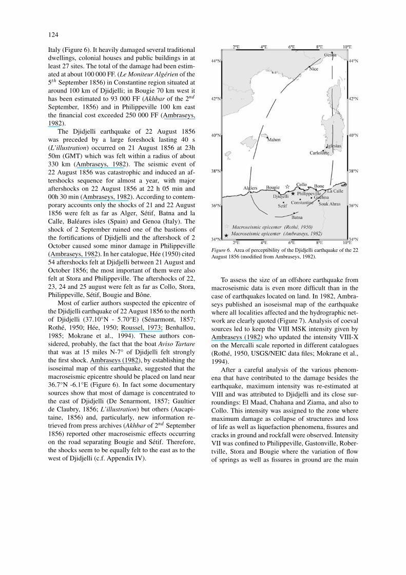
124
Italy (Figure 6). It heavily damaged several traditionaldwellings, colonial houses and public buildings in atleast 27 sites. The total of the damage had been estim-ated at about 100 000 FF. (Le Moniteur Algérien of the5th September 1856) in Constantine region situated ataround 100 km of Djidjelli; in Bougie 70 km west ithas been estimated to 93 000 FF (Akhbar of the 2nd
September, 1856) and in Philippeville 100 km eastthe financial cost exceeded 250 000 FF (Ambraseys,1982).
The Djidjelli earthquake of 22 August 1856was preceded by a large foreshock lasting 40 s(L’illustration) occurred on 21 August 1856 at 23h50m (GMT) which was felt within a radius of about330 km (Ambraseys, 1982). The seismic event of22 August 1856 was catastrophic and induced an af-tershocks sequence for almost a year, with majoraftershocks on 22 August 1856 at 22 h 05 min and00h 30 min (Ambraseys, 1982). According to contem-porary accounts only the shocks of 21 and 22 August1856 were felt as far as Alger, Sétif, Batna and laCalle, Baléares isles (Spain) and Genoa (Italy). Theshock of 2 September ruined one of the bastions ofthe fortifications of Djidjelli and the aftershock of 2October caused some minor damage in Philippeville(Ambraseys, 1982). In her catalogue, Hée (1950) cited54 aftershocks felt at Djidjelli between 21 August andOctober 1856; the most important of them were alsofelt at Stora and Philippeville. The aftershocks of 22,23, 24 and 25 august were felt as far as Collo, Stora,Philippeville, Sétif, Bougie and Bône.
Most of earlier authors suspected the epicentre ofthe Djidjelli earthquake of 22 August 1856 to the northof Djidjelli (37.10◦N - 5.70◦E) (Sénarmont, 1857;Rothé, 1950; Hée, 1950; Roussel, 1973; Benhallou,1985; Mokrane et al., 1994). These authors con-sidered, probably, the fact that the boat Aviso Tartarethat was at 15 miles N-7◦ of Djidjelli felt stronglythe first shock. Ambraseys (1982), by establishing theisoseimal map of this earthquake, suggested that themacroseismic epicentre should be placed on land near36.7◦N -6.1◦E (Figure 6). In fact some documentarysources show that most of damage is concentrated tothe east of Djidjelli (De Senarmont, 1857; Gaultierde Claubry, 1856; L’illustration) but others (Aucapi-taine, 1856) and, particularly, new information re-trieved from press archives (Akhbar of 2nd September1856) reported other macroseismic effects occurringon the road separating Bougie and Sétif. Therefore,the shocks seem to be equally felt to the east as to thewest of Djidjelli (c.f. Appendix IV).
Figure 6. Area of perceptibility of the Djidjelli earthquake of the 22August 1856 (modified from Ambraseys, 1982).
To assess the size of an offshore earthquake frommacroseismic data is even more difficult than in thecase of earthquakes located on land. In 1982, Ambra-seys published an isoseismal map of the earthquakewhere all localities affected and the hydrographic net-work are clearly quoted (Figure 7). Analysis of coevalsources led to keep the VIII MSK intensity given byAmbraseys (1982) who updated the intensity VIII-Xon the Mercalli scale reported in different catalogues(Rothé, 1950, USGS/NEIC data files; Mokrane et al.,1994).
After a careful analysis of the various phenom-ena that have contributed to the damage besides theearthquake, maximum intensity was re-estimated atVIII and was attributed to Djidjelli and its close sur-roundings: El Maad, Chahana and Ziama, and also toCollo. This intensity was assigned to the zone wheremaximum damage as collapse of structures and lossof life as well as liquefaction phenomena, fissures andcracks in ground and rockfall were observed. IntensityVII was confined to Philippeville, Gastonville, Rober-tville, Stora and Bougie where the variation of flowof springs as well as fissures in ground are the main

125
Figure 7. Isoseismal map (in terms of MSK scale) of the Djidjelli earthquake of the 22 August 1856 (after Ambraseys, 1982).
Figure 8. Isoseismal map (in terms of MSK scale) of the Djidjelli earthquake of the 22 August 1856.

126
features reported. Intensity VI was attributed to AinRoua, Amizour, Condé-Smendou and to Annaba, in-tensity (V) was attributed to Constantine and Sétif,intensity (IV) was allocated to Guelma where ringingof bells and minor cracks without casualties are mainlyreported. Intensity (III) was attributed solely on felteffect and on the evidence of absence of damage in LaCalle, Batna and as far as Algiers. From the intensitiesthus re-evaluated, an isoseimal map of the Djidjelliearthquake has been constructed and is shown in Fig-ure 8, on which are plotted the intensity assigned toeach site. The surface wave magnitude of the mainshock has been computed by using the magnitude-intensity relationship (1) derived by Benouar (1993)and presented in Appendix III.
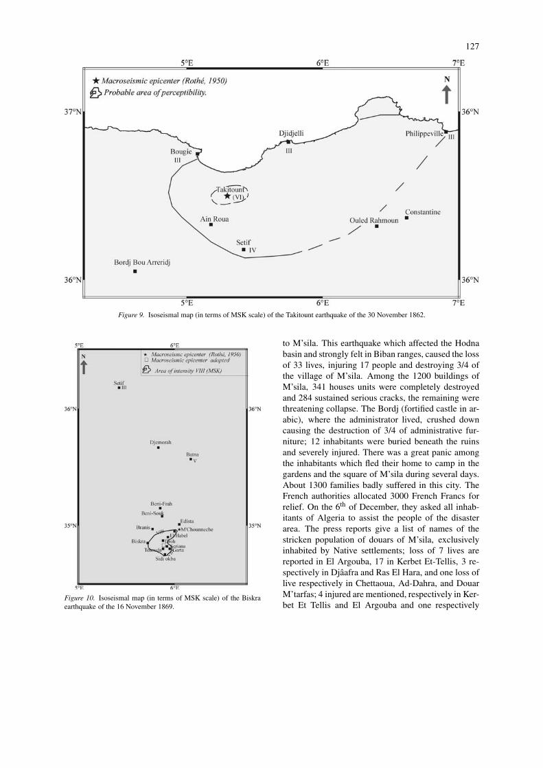
1862, November, 30, Takitount, Ms = 4.2, I0 = (VI)MSK
A moderate earthquake hit the village of Takitountand its surroundings. The main shock, which lastedabout 4 seconds, awoke the light sleeper but no cas-ualties or damages were declared apart from the factthat clocks stopped. This earthquake has been felt inBougie, Djidjelli and Philippeville but not in Con-stantine and Bordj Bou Arreridj. Damage no moreserious than cracks in walls of houses and fall ofchimneys was observed in Takitount in Babor ranges(L’Africain, L’écho de Sétif, 1862; Rothé, 1950).Slight aftershocks were reported in the zone com-prising Ain Roua, Takitount and Bougie (L’Africain,1862), (Figure 9).
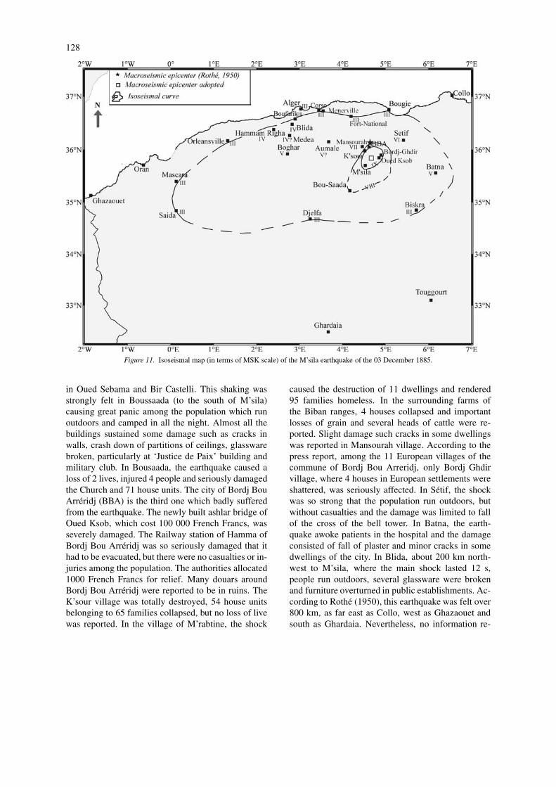
1869, November, 16, Biskra, Ms = 5.2, I0 = VIII MSK
A damaging earthquake struck the region of Biskra inthe oriental Saharan Atlas. It is of interest to studysuch event occurring in an area where seismicity isquite low. The main shock, which lasted about 7seconds (Ollivier, 1870), caused the loss of at least30 lives (Roussel, 1973), injured several and madenumerous homeless; it destroyed 200 houses unitswithin a radius of 30 km of the center of Biskra(Perrey, 1875). Considerable damage was sustainedby colonial structures. In Biskra, the shaking causedsevere damage, particularly to the military barracksand houses of the Caid and an European settler whereserious cracks were observed. At the oldest part ofBiskra, several buildings, mainly adobe dwellingswere totally shattered, but there were no causalitiesamong the population (Akhbar, 1869). In Sidi Okba,20 km distant, the damage consisted of collapse of 45
traditional houses; the earthquake caused the loss of 8lives and injured 3 people (Ollivier, 1870; Le MoniteurAlgérien, 1869; Akhbar, 1869). In fact most damageand casualties were found in immediate vicinities ofBiskra in the zone containing: Seriana where severaldwellings were razed to the ground and a woman waskilled by the fall of a section of wall; Garta wherethe earthquake caused a loss of 2 lives and injured8 people and where the third of building stock weredestroyed. Almost all the buildings of Tehouda, Droh,M’Chouneche and El Hebbal sustained serious dam-age as cracks and fissures in walls and collapse of,respectively, 3, 2, 4 and several houses units were re-corded. No evidence was found in reports about anysighting of ground deformation or liquefaction. How-ever the earthquake was associated with numerous andsignificant rockfall in El Hebbal and others obstruc-ted the road of M’Chouneche-Edista. The shakingwas strongly felt in the surroundings oasis of Branis,Djemorah, Beni-Souk and Beni Frah, but no damagewas reported. Also, it was slightly felt, to the north,as far as Sétif and more strongly felt in Batna where itcaused a great panic among the patients in the upperstoreys of the hospital; it caused more fear than harm.The main shock occurred without any premonitorysign but was followed by a series of aftershocks con-tinuing until 28 of November, with one strong enoughto add further damage, particularly in El Hebbal whereadditional rockfall were reported and in Batna whereit caused some cracks to walls in the districts of Sad-ouri and Souf. In fact, the aftershocks were widely feltin the surroundings oasis of Biskra (Ollivier, 1870;Le Moniteur Algérien, 1869; Akhbar, 1869). The re-view of macroseismic information, taking into accountthe sparsely populated region (as in Seriana, Tehouda,Droh and M’Chouneche), has improved the accuracylocation of the epicentral zone. The NE-SW directionof the isoseismal (Figure 10) is in agreement of that ofthe two first seismic events as reported by the journalAkhbar (1869).
1885, December, 3, M’sila, Ms = 5.9, I0 = IX MSK
This event is the first largest known shock of the regionunder consideration, unfortunately rather unappreci-ated in the previous studies. This earthquake is knownto have occurred in Bordj Bou Arréridj as reportedby previous authors (Rothé, 1950 and Hée, 1950).However, it is more precisely an earthquake of M’silaregion. Since the most intense damage was recordedin M’sila and surroundings, our investigation is aimed
127
Figure 9. Isoseismal map (in terms of MSK scale) of the Takitount earthquake of the 30 November 1862.
Figure 10. Isoseismal map (in terms of MSK scale) of the Biskraearthquake of the 16 November 1869.
to M’sila. This earthquake which affected the Hodnabasin and strongly felt in Biban ranges, caused the lossof 33 lives, injuring 17 people and destroying 3/4 ofthe village of M’sila. Among the 1200 buildings ofM’sila, 341 houses units were completely destroyedand 284 sustained serious cracks, the remaining werethreatening collapse. The Bordj (fortified castle in ar-abic), where the administrator lived, crushed downcausing the destruction of 3/4 of administrative fur-niture; 12 inhabitants were buried beneath the ruinsand severely injured. There was a great panic amongthe inhabitants which fled their home to camp in thegardens and the square of M’sila during several days.About 1300 families badly suffered in this city. TheFrench authorities allocated 3000 French Francs forrelief. On the 6th of December, they asked all inhab-itants of Algeria to assist the people of the disasterarea. The press reports give a list of names of thestricken population of douars of M’sila, exclusivelyinhabited by Native settlements; loss of 7 lives arereported in El Argouba, 17 in Kerbet Et-Tellis, 3 re-spectively in Djâafra and Ras El Hara, and one loss oflive respectively in Chettaoua, Ad-Dahra, and DouarM’tarfas; 4 injured are mentioned, respectively in Ker-bet Et Tellis and El Argouba and one respectively
128
Figure 11. Isoseismal map (in terms of MSK scale) of the M’sila earthquake of the 03 December 1885.
in Oued Sebama and Bir Castelli. This shaking wasstrongly felt in Boussaada (to the south of M’sila)causing great panic among the population which runoutdoors and camped in all the night. Almost all thebuildings sustained some damage such as cracks inwalls, crash down of partitions of ceilings, glasswarebroken, particularly at ‘Justice de Paix’ building andmilitary club. In Bousaada, the earthquake caused aloss of 2 lives, injured 4 people and seriously damagedthe Church and 71 house units. The city of Bordj BouArréridj (BBA) is the third one which badly sufferedfrom the earthquake. The newly built ashlar bridge ofOued Ksob, which cost 100 000 French Francs, wasseverely damaged. The Railway station of Hamma ofBordj Bou Arréridj was so seriously damaged that ithad to be evacuated, but there were no casualties or in-juries among the population. The authorities allocated1000 French Francs for relief. Many douars aroundBordj Bou Arréridj were reported to be in ruins. TheK’sour village was totally destroyed, 54 house unitsbelonging to 65 families collapsed, but no loss of livewas reported. In the village of M’rabtine, the shock
caused the destruction of 11 dwellings and rendered95 families homeless. In the surrounding farms ofthe Biban ranges, 4 houses collapsed and importantlosses of grain and several heads of cattle were re-ported. Slight damage such cracks in some dwellingswas reported in Mansourah village. According to thepress report, among the 11 European villages of thecommune of Bordj Bou Arreridj, only Bordj Ghdirvillage, where 4 houses in European settlements wereshattered, was seriously affected. In Sétif, the shockwas so strong that the population run outdoors, butwithout casualties and the damage was limited to fallof the cross of the bell tower. In Batna, the earth-quake awoke patients in the hospital and the damageconsisted of fall of plaster and minor cracks in somedwellings of the city. In Blida, about 200 km north-west to M’sila, where the main shock lasted 12 s,people run outdoors, several glassware were brokenand furniture overturned in public establishments. Ac-cording to Rothé (1950), this earthquake was felt over800 km, as far east as Collo, west as Ghazaouet andsouth as Ghardaia. Nevertheless, no information re-

129
Figure 12. Isoseismal map (in terms of MSK scale) of the Mansourah earthquake of the 08 January 1887.
lative to this event was found from these localities.In addition of the localities cited above, the pressreports cited Boghar, where many houses were des-troyed without casualties; Mascara, Saida, Djelfa,Algiers where the shaking was felt by few people;Medéa, Aumale, Orleansville, Fort-National, Bou-farik, Maison Carrée and then Touggourt and Biskrawhere it was slightly felt; Menerville, Corso, Bou-gie and Hammam Righa where people run outdoors.There was no evidence of any sign of ground de-formations or liquefaction, only some rockfall whichobstructed the road of M’sila-Bordj Bou Arreridj.The main shock was followed by a long sequence ofaftershocks. Rothé (1950) cited and Hée (1950) repor-ted respectively 40 and 52 aftershocks in Bordj BouArreridj. According to the press reports, the first af-tershocks, particularly that of 4th of December, werefelt in M’sila, Boussaada, Sétif, Djelfa, Bordj Bou Ar-
réridj, Algiers, Médéa, Blida, Aumale, Fort-National,Menerville, Biskra and Batna. The aftershocks of the7th of December were felt in M’sila and Bordj BouArréridj, and those of the 11th and 12th December werefelt in M’sila, Boussaada, Bordj Bou Arréridj, Sétifand Bougie. All the retrieved information is essentiallyderived from press reports archives that also publishedthe oficial report of the administrator of M’sila (La Vi-gie Algérienne, Le Moniteur de l’Algérie, Le Reveilde Sétif and Akhbar of 1885); Rothé (1950) whichreferred to Chesneau (1892) reported very few linesabout this earthquake. The analysis of macroseismicdata collected has allowed a better and more detailedre-assessment of the impact of the event (Figure 11);an intensity has been estimated (there is no estimationin previous catalogues) and surface-wave magnitudecalculated using the relationship derived by Benouar(1993) (relationship 2 in appendix III).

130
Figure 13. Intensity distribution (in terms of MSK scale) of the Fort National earthquake of the 23 October 1891.
1887, January, 8, Mansourah, Ms = 5.2, I0 = VIIIMSK
A destructive earthquake shook the Biban ranges inthe central part of the Tell Atlas, seriously affectinga relatively small area. The main shock, which wasviolent in Mansourah, caused a great panic amongthe european and native settlement which camped out-side all the night. Fourteen (40) gourbis (traditionaldwelling) were completely shattered and scores offacades of several houses were seriously cracked, fallof parts of ceilings was reported (Chesneau, 1892; Ladépêche Algérienne, Akhbar, La Vigie Algérienne, LePetit Colon, of 1887). Severe damage affected colonialbuildings such as civil court, the forestry house, can-tonnière house and Ponts et Chaussées building whichwere partially demolished. The railway station sus-tained some damage such as numerous cracks in walls.However, no casualties were declared (La dépêche Al-gérienne, Akhbar, Le Ralliement de Sétif of 1887).In Bordj Bou Arréridj (BBA), many cracked housesare reported; in El Achir, 10 km distant, sections ofwalls crushed down. In the surroundings of M’silaand Bordj Bou Arréridj, the earthquake caused no sig-nificant damages. The main shock was felt in BordjBou Arréridj (BBA), Sétif, M’sila, Aumale, Rebeval,Azzaga, Fort National and probably in Bougie (Ches-neau, 1892; La Vigie Algérienne, 1887) (Figure 12).The main shock was followed by many aftershocks
felt as well as in Mansourah and Bordj Bou Arreridj asin Sétif, M’sila, and Fort National (Chesneau, 1892).The aftershock of the 10th of January was strongerin Sétif where it awoke the population and was moreviolent in the surroundings of M’sila where it causedthe total destruction of 20 traditional dwellings (LePetit Colon, 1887). Also the aftershocks, continuinguntil October, were strongly felt in Ain Roua and AinAbessa than the main shock. In fact, the successionof aftershocks added more damage and caused someconcern among the population without any casualties.Moreover, this earthquake affected, in particular, thenative settlements. For this reason; the information re-ported is insufficient to reconstruct the seismic eventwith a certain degree of reliability. In his catalogueRothé (1950) estimated the intensity at VIII MM, theinformation derived from press archives is in favour ofVIII MSK.
1891, October, 23, Fort National, Ms = 4.6, I0 = (VII)MSK
Without any premonitory sign, a moderate earthquakestruck the Djurdjura ranges and damaged its villagesand douars. According to Hée (1950), the only authorthat cited this seismic event, the earthquake occurredthe 24th of October at 13h 40m (local time). The pressreports mentioned a main shock on the 23rd of Octoberbut at 20 h 40m (local time). The shaking was strong

131
Figure 14. Unverified earthquakes in the northeastern Algeria from 1357 to 1791 period (extracted from USGS/NEIC catalogue, 1994).
enough to cause panic among the population, whichrushed outdoors. A statement published in La DépêcheAlgérienne reported that ‘the earthquake and its nineaftershocks caused significant damage as cracks in allwalls in Michelet. Most of European and native set-tlers of the villages and douars of Djurdjura rangesfled their homes to camp outdoors. Furthermore, theshaking caused loss of lives in Ighil Ali’. It is importantto mention that the earthquake occurred in a region ex-clusively inhabited by native settlements. The effectsof the shaking reported by european press (Le Mon-iteur de l’Algérie, La Vigie Algérienne, La Dépêhe Al-gérienne of 1891) are disparate and make delicate theassignment of macroseismic parameters (Figure 13).Probable intensity of VII MSK is attributed.
Discussion and conclusion
This research work gives a re-appraisal of the histor-ical seismicity for the pre-1900 period. It is clear thatit was not possible to check all the seismic events re-ported in previous catalogues (particularly that of Hée,1950 and USGS/NEIC, 1994) due to the small amountof documentary sources available today. However forthe pre-1900 period and for the region considered, theresults obtained allowed the enriching of the earth-quake catalogue from 13 earthquakes, quoted in thelast Algerian catalogue (Mokrane et al., 1994), to 123earthquakes (including main shocks and aftershocks)for which macroseismic parameters (macroseismicepicentre, intensity etc. . .) are, insofar as possible, de-
termined3. In fact, in Mokrane et al. (1994) no seismicevent of this zone (pre-1900 period), apart that of 22August 1856, has been a subject of detailed studies.Among these events, that of 14 April 1839 localised bythe authors in Constantine is in reality an earthquakeof Algiers where it caused more damage as reported bypress reports (Le Moniteur Universel, Le Toulonnais,of 1839).
Regarding to the USGS/NEIC (1994) catalogue,even not including the non-confirmed events into thecompiled catalogue, they should be kept in mind forfuture research. Moreover, it is noteworthy that thespatial distribution of the quoted epicentres showsthat most of events are localised offshore (Figure 14).Would these earthquakes be considered as fake eventsor have they been, merely mislocated and displacedto the north, offshore the Algerian coast? It is prob-ably due to erroneous localisation. Such errors werefound during the verification of all seismic events.For instance, the USGS/NEIC catalogue (1994) lis-ted an earthquake occurring in Bone (according to thegiven coordinates) on the 12th January 1856 when thejournal L’Editeur (1856) reported at the same timean earthquake in Lisbon; the other press archives(L’Illustration, Akhbar Le Moniteur Algérien of 1856)gave no information about this event. This case re-curred for the Affreville earthquake of 14 March 1886(according to Le Petit Algérien, 1856), localised in
3 For the region under consideration, Mokrane et al. (1994) re-ported 13 earthquakes whose one is in reality an earthquake ofAlgiers (in central Algeria). In the frame of this study, 111 addi-tional seismic events are reported. Among these 123 earthquakesavailable in (Harbi, 2001), 9 were discovered in press reports andonly the strongest ones (8 events) are presented here.

132
USGS/NEIC catalogue (1994), at Tigzirt in the re-gion under study. They may be real earthquakes butmislocated. Similarly, the 16th of July 1767 seismicevent reported in USGS/NEIC catalogue (Table 1)could be another or the same event differently loc-alised that of Tizbarbart-Chellata of 27 September1767 cited by the historian Ahmed Sahi (see above).Anyway, these examples point out, once again, thathaphazard and uncritical handling of any earthquakedata may lead to some misinterpretation of seismotec-tonics. Moreover the lack of instrumental moderateoffshore events in the region, do not permit the calib-ration of these former earthquakes, seemingly of highintensity (Table 1).
The presented catalogue starts in 1850 even thoughthe Setifis earthquake of 419 (A.D) cited by Guido-boni (1994), which referred to St Augustin Sermons,may be verified in Mohammedi et al. (1991). Analys-ing an archeological site of Setifis, rebuilt at the endof the first quarter of V century, and referring to StAugustin’s sermons, the authors suggest the year of419 (A.D.) for the destruction of the site. On the otherhand, the endeavour made in the frame of this workto consult the historical documents (Al Djilali, 1983;Seidni, 1988, Sahi, no date) allow to discover earth-quakes occurring in 1722, 1724, 1758, 1767, 1810and 1837. However, it must be acknowledged thatverifying the occurrence of known earthquakes andcollecting their respective macroseismic informationis easier than the research of unknown ones. In reality,this long and fastidious process requires a close co-operation with historians who are more patient anddiligent in the harvest of historical information. Cer-tainly the incompleteness noticed in the catalogue isdue to a lack of information in ancient times ratherthan in seismicity data. In fact other investigations areto be devoted in prospecting ancient earthquakes inhistorical documentary sources.
Finally, it can be said that the first investigationscarried out, especially for seismotectonic purposes(see part II), improves the knowledge on past seismicactivity of the region and incites to pursue the researchin historical seismicity which is the prerequisite forefficient and sound research work.
Acknowledgements
This research activity is supported by CRAAG andthe National Research Program. Most of the macro-seismic information used in this work were obtained
from archives, the authors wish to thank all staff at theNational Library of Algiers. We express our gratitudeto A. Sebaï, F. Oussadou, A. Ayadi and M. Bezzeg-houd for providing some data and useful and preciousdocuments. Special thanks go to S. Maouche for thevaluable discussion of the results of this paper. M.Bezzeghoud and an anonymous referee reviewed themanuscript and we greatly appreciate their suggestionsand constructive comments.
References
Al Djilali, A., 1983, Tarikh El Djazair el aam (The History ofAlgeria), Dar Et Takafa, Beirut, Lebanon.
Ambraseys, N.N., 1982, The seismicity of North Africa: the earth-quake of 1856 at Jijeli, Algeria, Bollettino Di Geofisica a Teoricaed Applicata, XXIV(93), 31–37.
Anonymus, 1970, Bejaia silsilet al fen wa et thakafa (Bejaia: artand culture), SNED, pp. 115.
Aucapitaine, M., 1856, Note sur le tremblements de terre ressentien Algérie du 21 au 25 août 1856, C.R. Acad. Sc. Paris, tomeXLIII, 765.
Benhallou, H., 1985, Les Catastrophes Séismiques de la Ré-gion d’Echéliff dans le contexte de la Séismicité Historique del’Algérie, Thèse de Doctorat Es-Sciences, IST-USTHB, Alger,Algérie, 294 pp.
Benouar, D., 1993, The Seismicity of Algeria and Adjacent RegionsDuring the Twentieth Century, PhD Thesis, Imperial College,London, U.K, 712 pp.
Benouar, D., 1994, Materials for the investigation of the seismicityof Algeria and adjacent regions during the twentieth century,Annali Di Geofisica XXXVII(4), 459–860.
Chesneau, M., 1892, Note sur les tremblements de terre en Algérie,Mém. Ann. Des Mines, Série 9, t. I, Paris.
Gaultier de Claubry, M., 1856, Sur les effets du tremblement deterre du 21 et 22 août 1856 dans certaines parties de l’Algérie,C.R. Acad. Sc. Paris tome XLIII, 589–590.
Grünthal, G., 1993, European Macroseismic Scale 1992. Cahiers duCentre Européen de Géodynamique et de Séismologie, edited byGrünthal (Luxembourg), vol. 7.
Guidoboni, E., 1994, Catalogue of ancient earthquakes in the Medi-terranean area up to the 10th century, Instituto Nazionale diGeofisica Press, pp. 504.
Harbi, A., Maouche, S. and Ayadi, A., 1999, Neotectonics andassociate seismicity in the Eastern Tellian Atlas of Algeria, J.Seismol. 3, 95–104.
Harbi, Assia, 2001, Analyse de la sismicité et mise en évid-ence d’accidents actifs dans le Nord-Est Algérien, Thèse deMagistère, USTHB, Alger, 195 pp.
Hée, A., 1950, Catalogue des séismes algériens de 1850 à 1911,Ann. Inst. Phys. Globe, Strasbourg 6, 41–49.
Medvedev, S., Sponheuer, W. and Karnik, V., 1981, Report of thead-hoc panel meeting of experts on the updating of the MSK-64seismic intensity scale, Gerlands Beitr. Geophys. 90, 261–268.
Mohamedi, A., Benmansour, A., Amamra, A.A et Fentress, E.,1991, Fouilles de Sétif 1977–1984. 5ème supplément au Bulletind’Archéologie Algérienne, pp. 39.
Mokrane, A., Ait Messaoud, A., Sebai, A. Ayadi, A., Bezzeghoud,M. and Benhallou, H., 1994, Les séismes en Algérie de 1365à 1992. Publication du Centre de Recherche en Astronomie, As-
133
trophysique et Géophysique, Département Etudes et SurveillanceSismique, ESS, C.R.A.A.G, Alger-Bouzaréah, 277 pp.
Ollivier, M.E., 1870. Secousses de tremblements de terre à Biskra(Algérie du Sud), du 16 au 19 novembre inclusivement, C.R.Acad. Sc. Paris t.LXX, 48–51.
Perrey, A., 1875, Note sur les tremblements de terre en 1856, . . .
1871, Acad. Sci. VIII-XXIV, Bruxelles.Rothé, J.P., 1950, Les séismes de Kherrata et la séismicité de
l’Algérie, Bull. Serv. Cart. Geol. Algérie, 4 ème série, Géo-physique, N. 3, 40 pp.
Roussel, J., 1973, Les zones actives et la fréquence des séismesen Algérie 1716–1970, Bull. Soc; Hist. Natur. Afrique du Nord.64(3), 211–227.
Sahi, A., (no date), Aalam min Zwawa Igawewan (The Scientist ofthe Tribe Zwawa Igawawen), SNED, Alger.
Seidni, N.E., 1988, Dirassat wa abhat fi tarikh El Djazair (Studiesand Research in the History of Algeria), 2nd volume, ENAL,Alger.
Senarmont (De), M.H., 1857, Analyse des documents recueillis surles tremblements de terre ressentis en Algérie du 21 aout au 15octobre 1856, C.R. Acad. Sc. Paris XLIV, 586–594.
USGS/NEIC, 1994, Epic User’s Guide, Retrieval Software for theGlobal Hypocenter Data Base CD-ROM, Version 3.0.
Vogt, J., 1993, New macroseismic information and analysis of Al-gerian earthquakes, Letters of 2, 8 and 9 December 1993 (privatecommunications).
APPENDIX I: Catalogues and previous studiesused
For the region considered the references of the Rothé(1950) catalogue are Hée (1950); Aucapitaine (1856);Gaultier de Claubry (1856); Senarmont (1857); Per-rey (1859); Ollivier (1870) and Chesneau (1892). TheHée (1950) catalogue is thoroughly different of theclassical ones since the events reported are classifiedin geographical quadrangles. The methodology usedby this author, even though this catalogue is the mostcomplete for the region under study, involve the du-plication of seismic events. Hée (1950) referred toPerrey catalogues, Gonessiat listing for the 1871–1881period (which referred to press articles: Akhbar andLe Moniteur de L’Algérie and to Bulletin du Ser-vice Météorologique de l’Algérie of Bullard) and tothe Bulletin du Service Météorologique de l’Algérie(1889–1908). She quoted the origin time of the oc-currence of earthquake, the sites where it was feltand sometimes the intensity (Mercalli Modified Scale)and some macroseismic effects. The Roussel (1973)catalogue is the first one where the epicentral coordin-ates are estimated and, intensity and magnitude areassigned whenever it is possible. The references ofthis author are the same used by the previous ones.For all these authors, the first reported seismic event
of the zone under study dating from 1850. The Ben-hallou (1985) catalogue referring to those cited abovecontains some information about earthquakes of thisregion, although it concerned above all a seismicityof Echeliff area. The USGS/NEIC catalogue (1994)refers to the European Catalogue of 13 members ofthe European Community, Austria and Switzerland forthe period 479 BC to 1983. The data contained in thiscatalogue were compiled by J.M. Gils and reviewedby Dr Gunter Leydecker of the Federal Institute ofEarth Sciences and human resources (ex RFA). In thiscatalogue, 42 earthquakes for the region under studyfrom 1357 to 1896 are quoted. The Mokrane et al.,catalogue (1994) is the first Algerian catalogue thatcovers the pre-1900 period. The references of the au-thors are (for the region under study and for pre-1900seismic events) Seccion de Sismologica e IngenieraSismica, España (SSIS) and Rothé (1950). Concerningthe pre-1900 period and for the region under study,Mokrane et al. (1994) have made critical study onlyon the Djidjelli earthquake of 22 August 1856.
APPENDIX II: References of press reports
Press reports 1839: Le Moniteur Universel, LeToulonnaisPress reports 1850: Akhbar, Le Saf-SafPress reports 1855: AkhbarPress reports 1856: Akhbar, Le Moniteur Algerien, LeSeybousse, L’Illustration, Le Courrier Mercantile, LaGazette de Lyon, L’EditeurPress reports 1859: Akhbar, L’Algérie Nouvelle,L’AfricainPress reports 1860: L’Algérie Nouvelle, L’Indépendant,L’Africain, Le ZeramnaPress reports 1861: L’Indépendant, Le Seybousse,L’Echo de NumidiePress reports 1862: L’Indépendant, L’Africain, l’Echode Sétif;Press reports 1863: AkhbarPress reports 1864: Le Moniteur Algérien, Le Courrierde l’AlgériePress reports 1865: Akhbar, L’AfricainPress reports 1866: Le Moniteur Algérien, Le Courrierde l’AlgériePress reports 1867: Le Moniteur Algérien, Le Courrierde l’AlgériePress reports 1869: Akhbar, Le Moniteur Algérien, LeCourrier de l’AlgériePress reports 1870: Le Moniteur de l’Algérie

134
Press reports 1871: AkhbarPress reports 1874: La Vigie Algérienne, Akhbar, LeMoniteur de l’AlgériePress reports 1875: Akhbar, Le Moniteur de l’Algérie,La Vigie AlgériennePress reports 1876: Akhbar, Le Moniteur de l’Algérie,La Vigie AlgériennePress reports 1877: Le Réveil, Le Moniteur del’Algérie, La Vigie AlgériennePress reports 1879: Akhbar, Le Moniteur de l’Algérie,L’Algérie française, La Solidarité, Le Petit ColonPress reports 1880: Le Moniteur de l’AlgériePress reports 1881: Akhbar, Le Moniteur de l’Algérie,La Vigie Algérienne, Le Petit ColonPress reports 1883: Akhbar, Le Moniteur de l’Algérie,Le Petit Colon, La Seybousse, Le ZeramnaPress reports 1885: La Vigie Algérienne, Akhbar, LeMoniteur de l’Algérie, Le Petit Algérien, Le PetitColon, Le Réveil de SétifPress reports 1886: La Vigie Algérienne, Le Moniteurde l’Algérie, Le Petit Colon, La dépêche Algérienne,Le Petit AlgérienPress reports 1887: La Vigie Algérienne, Akhbar, LeMoniteur de l’Algérie, Le Petit Colon, La dépêche Al-gérienne, Le Ralliement de SetifPress reports 1890: Le Moniteur de l’Algérie, La VigieAlgérienne, AkhbarPress reports 1891: La Vigie Algérienne, Akhbar, LeMoniteur de l’Algérie, La dépêche AlgériennePress reports 1892: Le Moniteur de l’Algérie, Ladépêche AlgériennePress reports 1893: Le Moniteur de l’Algérie, Ladépêche AlgériennePress reports 1894: Le Moniteur de l’Algérie, Ladépêche Algérienne, La Vigie Algérienne
APPENDIX III: Relationships used in thedetermination of the surface wave magnitude Ms
The relationships used in the determination of Ms arethose derived by Benouar (1993) for Algeria. Theydepend on the availability of macroseismic data.
Ms = −0.09 + 1.03(MSC) (1)
with
Msc = −3.20 + 0.63j−1j∑
i
(Ii)
+0.0014j−1j∑
i
(Ri)
+3.12j−1j∑
i
log(Ri) ± 0.17P
and
Ri = [D2i + (5.64)2]1/2
where J ≥ 1 is the number of isoseismals available forthe determination of the mean value of the equivalentsurface-wave magnitude MSC which is the predictedmacroseismic magnitude, Ri is the focal disance, Diis the average epicentral radii and Ii the intensity ofisoseismal, 0.17 is the standard deviation and P takesa value of zero for 50 percent probability that the pre-dicted parameter will exceed the real value and one for84 percent probability.
Ms = −0.04 + 2.56log(r3) (2)
r3 corresponds to the mean epicentral distance ofan area within which the shaking was felt with anintensity III (MSK).
Ms = 0.47(I0) + 1.36 (3)
This formula depending on the epicentral intensity I0is used in the last resort for almost all seismic eventsof pre 1900 period.
APPENDIX IV: Macroseismic effects of theDjidjelli earthquakes of 21 and 22 August 1856
Part A: General description of the earthquake effects
1. Djidjelli and its surroundings: The town of Djid-jelli was described as an accumulation of ruins.The population was evacuated outside the townafter the first shock. But after the second shock,the town was seriously damaged, the mosque andthe Genoise tower collapsed despite the strengthof its masonry, only the military store-house andthe hospital constructed on the Rock survived theshock. Three quarters of the houses were des-troyed, and five people (three women and twochildren) were killed. Destruction extended in theregion of Oulad Abdallah, Béni Ider and BordjTahar was ruined. Houses collapsed at Bordj Chaa-hana and in the region of the Beni Maad. InJabel Haddid and Bet Aissa even light ‘gourbis’were thrown down (L’illustration, Akhbar, De Sen-armont, 1857; Chesneau, 1892; Rothé, 1950;Ambraseys, 1982).

135
2. Collo: 59 out of the 75 houses, the old mosqueand Janissary Barracks were ruined (Ambraseys,1982). Damage was equally serious in the regionbetween Djidjelli and Collo, in the mountains set-tlements of Oued El kebir, Oued Zhor and Gouffi,particularly in the Chefka plain of the Beni Ider. Inthe sea port of Collo all houses were damaged anda few collapsed without casualties (De Senarmont,1857; Chesneau, 1892; Ambraseys, 1982).
3. Philippeville: great panic among the populationwhich was evacuated outside the town after thefirst shock (Akhbar). The earthquake lasted about30 seconds. At Stora, in the region of Zeramna andto a lesser extent at Gastonville, almost all houseswere badly shaken and quite a few newly builtones in Robertville were seriously damaged aswell as in the Centres of The Saf-Saf valley, Dam-rémont and Saint Charles. At Condé Smendou anumber of old houses cracked. In the town of Phil-ippeville a number of European houses sufferedextensive nonstructural damage from the collapseof the chimneys on their tiled roofs. The domes ofthe church were also fissured and in the outskirtsthe abutments of a masonry bridge were damaged,the government building and the military hospitalwere fissured and the barracks were evacuated.In the district of Philippeville, no one was killedbut financial losses exceeded one quarter of a mil-lion French francs (Akhbar, 1856; L’Illustration,1856; De Senarmont, 1857; Chesneau, 1892; Am-braseys, 1982). In the eastern part of the townof Philippeville, the shock caused some concernbut no damage (Le Moniteur Algérien, 1856). Ac-cording to the journal Akhbar, all houses werecracked and others lost their lower partitions. ForL’Illustration (1856), it could be wrong that Phil-lipeville was destroyed as stated in earlier reportsbut Stora to the west of the town has suffered badly.
4. Bougie and surroundings: The shock caused someconcern but no damage. The ground movementslasted about 30 second and were relatively slowbut strong enough to cause slight damage to localhouses and slumping of wet ground (Ambraseys,1982). Few houses were fissured and the lightharbour was almost overturned (Le Moniteur Al-gérien, Akhbar, De Senarmont, 1857). Financiallosses to private houses at Bougie exceeded 90 000French francs (Akhbar).
5. Sétif: At Setif, the shocks was felt by all displacingsmall unstable articles and causing hanging objectsto swing (Ambraseys, 1982). After the first shock
people run outdoors and after the second they biv-ouacked on the place Barral but the hospital, thebarracks and the finances department were notevacuated (Akhbar). Few adobe houses cracked,the first shock caused slight damage to the hos-pital, barracks and to the public buildings (Akhbar,1856, De Senarmont, 1857, Ambraseys, 1982).On the road of Setif – Bougie, macroseismic ef-fects on different caravanserais, where the shockswere strongly felt, are reported in the journal Akh-bar. At Oued Amizour 20 km south of Bougie the‘Copello mill’ was almost demolished, its wallswere strongly cracked. At the ‘well constructed’caravanserai of Ain Roua, damage is restricted tocracks, variation of spring flow and partial land-slide of Bou Andas. To the north of Ain Rouaand when approaching near the coastline, damagebecome more and more serious and numerous atcaravanserais of Bou Abdallah and Draa El Arba(Akhbar).
6. Bone: At Bone, the first shock was not violent,but the second one caused the collapse of fewchimneys and set the clock of the hospital ringing;some families left the town (La Seybousse). In thelower part of Bone a derelict house collapsed andfew adobe houses were badly cracked. The theatrewas slightly damaged but the close surroundingsof the town didn’t suffer (Le Moniteur Algérien,De Sénarmont, 1857; Ambraseys, 1982).
7. Constantine: A few old houses cracked and apendulum recorded distinctly a ground motion ina NE-SW direction (Ambraseys, 1982). Housesdamaged or fissured without casualties (Le Mon-iteur Algérien, Akhbar; De Senarmont, 1857). AtConstantine and Mila (30 km distant), the shockwas felt by all, displacing small unstable articlesand causing hanging objects to swing. Ambraseys(1982).
8. Guelma: The slow movements of the ground setbells ringing and caused free standing walls tosway, some damage to few houses and barrackswithout casualties (La Seybousse; De Senarmont,1857; Ambraseys, 1982).
9. La Calle, Batna, Algiers: Felt but no damageobserved (Akhbar, La Seybousse, Le Moniteur Al-gérien; De Senarmont, 1857; Ambraseys, 1982).In the Eastern part, the earthquake was felt but notbeyond Souk Ahras (Ambraseys, 1982).

136
Part B: Description of seismological andhydrological effects
1. Djidjelli: Rockfall occurred in various places ofthe Djidjelli region. The valley sides of the OuedMissia were badly fractured, damage extending asfar as Bou-Siaba. To the Southeast of Djidjelli, thelow-lying parts of the Chefka valley, particularlyin the region of the beni Ider, liquefied. Some largefissures in ground are observed in many places,particularly in ‘La grotte des pigeons’ near theshore. Two long cracks opened in the ground run-ning through the town and parallel to the shore,which settled by 10 to 15 cm (Akhbar, 1856; LeMoniteur Algérien, 1856; De Senarmont, 1857;Ambraseys, 1982).
2. Philippeville region: In this region some hydro-logical and geological effects are observed. Tothe west, road cuttings were blocked by land-slides and rockfalls, particularly in the region ofZeramna, springs stopped and started. Liquefac-tion phenomenon was observed at the low lyingplain between the Oued Saf-Saf and Jabel El Haliawhere many mud volcanoes were formed and wa-ter was ejected for many minutes after the earth-quake (Gaultier de Claubry, 1856; Press; 1856;De Senarmont, 1857). According to Le MoniteurAlgérien, the river of Oued Saf-Saf slightly over-flowed and its level rose by 15 to 20 cm (DeSenarmont, 1857). Chesneau (1892) cited somecracks in ground in the vicinity of Philippeville.
3. Bougie and surroundings: In this region flow ofspring is affected, l’Oued (river in arabic) sahelwhich was almost dry started again to flow asignificant volume of water, particularly betweenSetif and bougie. In the vicinity of Bougie, somesmall cracks opened and immediately closed (DeSenarmont, 1857; Akhbar, 1856).
4. Sétif: Flow of few springs is affected (Akhbar,1856).
5. Constantine: The flow of springs rose considerably(Akhbar, 1856).
Part C: The sign of tsunami
1. Djidjelli: After the first shock, small seaport, builton the rocky peninsula, forming the extreme westpoint of the bay, was badly damaged (De Senar-mont, 1857; Ambraseys, 1982). This shock wasstrongly felt at sea by the aviso Tartar, 15 miles N-70◦ E of Djidjelli, on which the crew were almostthrown down on deck (Ambraseys, 1982). Themain shock triggered a sea-wave of 2 to 3 metrehigh that flooded the coast a number of times, thesea remained turbulent for almost three days (DeSenarmont, 1857; Ambraseys, 1982, Le MoniteurAlgérien, 1856).
2. At Mahon in Minorca, the first shock was followedby a rapid flooding of the harbour as a result ofwhich many boats broke their mooring (Akhbar,1856; De Senarmont, 1857; Ambraseys, 1982).
3. At Philipppeville, the sea level pulled down sud-denly by 0.60 m (De Senarmont, 1857).
4. At Bougie, the ground movements were accom-panied by a series of sea-waves that flooded thecoast, the sea level rose by five metres, floodingthe shore five to six times (De Senarmont, 1856;Ambraseys, 1982). The contemporary press repor-ted that the sea level rose by 3.75 m. A nail plantedin the lantern column at the landing stage attestedit. According to Aucapitaine (1856), the sea wasdeeply agitated, rose, moved back by 35 m andthen flooded the shore three times.
5. At Bone, the sea along the coast rose by about onemetre, flooding the parade grounds in a successionof waves that continued for twelve hours (De Sen-armont, 1857; Ambraseys, 1982). According to LaSeybousse, the ‘Islet of three brothers’ had almostdisappeared under the waves.