
Processing of Lake Baikal Marine Multichannel Seismic ...
60
Processing of Lake Baikal Marine Multichannel Seismic Reflection Data by D. R. Hutchinson 1 , M. W. Lee 2 , W. F. Agena2 , A. J. Golmshtok 3 , V. N. Moskalenko 3 , K. Karapetov 4, D. F. Coleman 1 , L. Akentiev3 HJ.S. Geological Survey, Woods Hole, MA 02543 2 U.S. Geological Survey, Denver, CO 80225 3 Southern Branch, Institute of Oceanology, Gelendzhik, Russia 4 Irkutskgeophysica, Irkutsk, Russia U. S. Geological Survey Open-File Report 92-243 February, 1992 This report is preliminary and has not been reviewed for conformity with U.S. Geological Survey editorial standards and stratigraphic nomenclature. Any use of trade names is for descriptive purposes only and does not imply endorsement by the U.S. Geological Survey.
-
Upload
khangminh22 -
Category
Documents
-
view
0 -
download
0
Transcript of Processing of Lake Baikal Marine Multichannel Seismic ...

Processing of Lake Baikal Marine Multichannel
Seismic Reflection Data
by
D. R. Hutchinson1 , M. W. Lee2 , W. F. Agena2 , A. J. Golmshtok3 , V. N. Moskalenko3 , K. Karapetov4 , D. F. Coleman1 , L. Akentiev3
HJ.S. Geological Survey, Woods Hole, MA 025432U.S. Geological Survey, Denver, CO 802253Southern Branch, Institute of Oceanology, Gelendzhik, Russia4Irkutskgeophysica, Irkutsk, Russia
U. S. Geological Survey
Open-File Report 92-243
February, 1992
This report is preliminary and has not been reviewed for conformity with U.S. Geological Survey editorial standards and stratigraphic nomenclature. Any use of trade names is for descriptive purposes only and does not imply endorsement by the U.S. Geological Survey.

CONTENTS
Introduction ........................ 1
Acknowledgements ...................... 1
Data Acquisition ...................... 2
Noise and Signal Characteristics .............. 2
Processing Strategy and Tests ............... 3
Processing Prior to Migration ............... 4
Post-stack Migration Processing .............. 5
Results and Discussion ................... 6
Conclusions ........................ 7
References Cited ...................... 8
Table 1: General Trackline Information ........... 9
Appendix 1: Navigation Control Points ........... 10
Appendix 2: Tape Archive Information - Demultiplexed Data . 15
Appendix 3: Tape Archive Information - Stacked Data .... 18
Appendix 4: Tape Archive Information - Migrated Data .... 20
Figures 1 - 18 .................... 22-57
Plate 1 caption ...................... 58
(Plate 1 is a loose insert attached to this report)

INTRODUCTION
In summer, 1989, the former U.S.S.R. Academy of Sciences collectedapproximately 1500 km of marine multichannel seismic reflection data inLake Baikal, south-central Siberia, as part of a multidisciplinary, international program of research to study the geodynamics, paleolimnology, and paleoclimatology of the lake. Lake Baikal is the deepest, largest by volume, and potentially the oldest of the Earth's fresh water lakes (Kozhov, 1963) . It is 650 km long and occupies approximately one third of the Baikal rift zone, an active continental rift. The lake is divided into three basins, South, Central, and North, by two bathymetric sills, Selenga Delta and Academician Ridge (Fig. 1). The seismic profiles provide data from each of the basins (16 dip lines)as well as an axial strike line. ii
Lake Baikal poses challenges to the acquisition of seismic data: the freshwater reduces the buoyancy of the streamer; the extremely cold water affects the smooth operation of air gun«; the deep water (in excess of 2 s two-way travel time) generates deep* water multiples; and the poorly charted bathymetry makes navigation a hazard in some of the regions of rapidly changing water depths along the eastern shore of the lake. Preliminary processing showed that the biggest problem affecting the seismic data was the low-frequency content and resulting poor signal- to-noise ratios associated with the use qf a single large air gun source. Low frequencies are often desiteable for maximizing the penetration of the seismic signal in the E^rth, at a cost of reduced resolution and signal quality.
outliningIn order to provide meaningful
interpretation, particularly for stratigraphic framework of the rift basins within a processing scheme that would optimize the s describes the acquisition parameters and maximize the resolution and quality of the
profiles for geological the structural and the lake, we developed
ignal quality. This report strategy we used to
multichannel data.processing
ACKNOWLEDGEMENTSi
The data acquisition was done entirely by the scientists of the former U.S.S.R. (now Russian) Academy of Sciences (Southern Branch of the Institute of Oceanology and Limnological Institute). We thank the Captain and crew of the R/V Balkhash for help during the acquisition phases. Special appreciation is extended to Dr. M. Grachev and V. Fialkov of the Limnological Institute for funding the ship time, obtaining the necessary permits to work in the lake and providing additional key personnel.
The processing was done at the U.S. Geological Survey by American and Russian scientists under a joint agreement of cooperative research between the respective scientific organizations. Processing was performed on a VAX 11/780 computer using Cogniseis DISCO software with additional programs developed by M.W. Lee of the U.S.G.S. We thank the Geophysics Group of the Branch of Petroleum Geology for their patience and expertise in accomodating busy schedules during the processing of these data.
We thank John Miller and Dave Foster this report.
for suggestions on improving

DATA ACQUISITION
The Lake Baikal multichannel data consist of 17 lines (Figure 1) that were collected in July and August, 1989, aboard the R/V Balkhash using equipment owned and operated by the Limnological Institute (Irkutsk, Russia) and the Southern Branch of the Institute of Oceanology (Gelendzhik, Russia). The energy source consisted of a single 17-liter air gun (about 1000 cubic inches) towed at 15-m depth and shot on time intervals of 1 - 2 minutes to yield nominal 50-m or 100-m shot spacing. Only the axial line in the North basin (lines 15-1A, 15-1B) was shot with 100-m shot spacing. The receiver was a 1200-m long hydrophone streamer containing 24 channels spaced at 50-m intervals. This configuration gives 12-fold multiplicity for 50-m shots and 6-fold multiplicity for 100-m shots. The near offset was typically 400 m, but was increased to 450 m for most of the axial profile (line 15) . The streamer, like the air gun, was towed at 15-m depth. For a distance of about 15 km on the axial line over Academician Ridge (line 15-1C), the streamer was not horizontal in the water: the tail end rose to the surface.
The data were recorded in on magnetic tape SEG-B format using a Soviet-built acquisition computer called a seismograph station. The record length was 7s with delays of 0 s, 1.024 s, and 2.048 s programmed according to water depth. The sample rate was 2 ms. The original field tapes were copied onto 185 1600-bpi tapes for shipment to the U.S. for processing. Minor data loss occurred during the copying. A summary of general information about the seismic lines is given in Table 1. Only one tape of line 4 could not be demultiplexed, resulting in a loss of 131 shots at the end of the line.
Navigation was by radar and dead reckoning, with fixes recorded about every 30 minutes. Figure 1 is a map of unannotated trackline locations. Plate 1 is a map of the track locations and navigation control points with shot points annotated. Appendix I is a list of the half-hour control points for the navigation. Intermediate shot points were determined by linear interpolation and extrapolation between the control points.
NOISE AND SIGNAL CHARACTERISTICS
Initial demultiplexing of the data revealed the cyclical, reverberative, and low-frequency character of the data. The unfiltered and filtered near traces of a portion of line 15-6 from the South basin are shown in Figure 2, and the amplitude spectrum of an individual trace from Figure 2 is shown in Figure 3. The dominant frequency is about 12.5 hz, and the spectrum is not flat. This frequency yields an effective quarter-wavelength resolution of 29 m for fresh water (1440 m/s). The quarter-wavelength resolution would be even worse for media with higher velocities (e.g., 80 m for 4000 m/s material). This is considered poor resolution for identifying small changes in stratigraphic thickness and depositional environment that one might expect to encounter in a large, closed basin such as Lake Baikal. One advantage of the low-frequency content of the signal is to allow the data to be resampled from 2 ms to 4 ms, thereby halving the volume of data to be processed.
A second problem with the data involved random static shifts of up to 20 ms for entire shot traces (Figure 4a). The typical shift was about 10 - 15 ms, i.e., more than a quarter wavelet shift for frequencies above 17 Hz. This shift therefore affects the range of frequencies of most interest in the data and could significantly degrade data quality

during stack of adjacent traces. Inspection of the data showed that the shifts almost always occurred when the £un firing delay was set to 1.024 s r suggesting that the firing circuit was somehow flawed when the 1.024-s delay was active. However, we canhot entirely eliminate the possibility that the cold water of the like adversely affected the mechanical firing of the gun. These shifts were manually corrected with completely satisfactory results (Figure 4b) .
Our third observation about the data involves the variable signal strength through the section, and in particular the strong multiple energy and the obvious loss of signal qualiity at the position of the first water-bottom multiple in deep water j (more than 700 m or 1 s) . Figure 5 is a brute stack of the data in whicth only a prestack automatic gain control (AGC) of 350 ms was applied prp.or to normal moveout, mute and stack. The dim spot or blanking at the ilevel of the first multiple (3.8 s) is typical of the signal in deep wa^er for all of the lines in this study. We cannot entirely rule out the possibility that the basin reflectivity coincidentally changes at the position of the first multiple, although we think such an occurrence is unlikely. A more likely explanation of the blanking is malfunction of the dynamic gain ranging in the recording system, causing the multiple energy to saturate the recording amplifiers.
Our final observation about the data is that the shape and duration of the source wavelet is quite consistent from shot to shot (Figure 6). We use this characteristic to justify performing wavelet deconvolution on the data in our processing strategy.
PROCESSING STRATEGY ANE TESTS
The observations noted above emphasise the need to design theprocessing to maximize the resolution of the ringiness, to eliminate random jitter, and toratios in the section beneath the first multiple (primarily in deepwater). Because the random jitter problem is step was performed as part of the routine demultiplexing. Our tests therefore focused and signal-quality issues.
data, i.e., to mimimize the bolster the signal-to-noise
a simple static shift, thisediting of the data afteron addressing the ringiness
Signal reverberation; One of the easiest methods of improving the resolution and high-frequency content of the data is to perform a statistical deconvolution. We applied a spiking deconvolution algorithm after a 350-ms AGC to collapse the reverberative signal into a single pulse (Figure 7). The deconvolution operator was designed using a single window that included the water bottom and the first water-bottom multiple. The resulting operator was appl-.ed to the entire section, followed by a band pass filter of 5 to 70 Hz. This processing sequence did an adequate job of collapsing the reverberation, but the signal quality in the deeper section (5 to 7 s) is still poor.
Next, we tested a wavelet deconvolutibn algorithm (variable norm deconvolution; Gray, 1979) to improve the signal. This is justified because of the good repeatability of the source signal (Figure 6). A representative source signature is extracted from the data, and then an inverse filter is calculated and applied to all of the shots in each line. Model studies have shown that a representative source signature can be applied to the entire profile rather than applying a separate deconvolution filter to each gather (Dragoset and others, 1987). We tested two filters, one using a 400-ms design window, the second using

a 700-ms design window. Figure 8 gives the extracted wavelet and spectra for the 400-ms (panels a and c) and 700-ms (panels b and d) design windows. Figure 9 gives the filtered trace and spectra after wavelet deconvolution for the two design windows. Note that the water bottom is the large negative peak on each example. Figure 10 illustrates the ungained and AGC-gained near traces after application of each of the wavelet decon filters. The water bottom is the negative (unfilled) wavelet at 1.95 s. Both of the AGC-gained sections show a low-frequency precursor prior to the water bottom arrival, but the precursor on the 700-ms design filter is much less pronounced. The differences between the two filters are subtle. We chose to use the 700-ms design window because of the more subdued precursor to the water bottom.
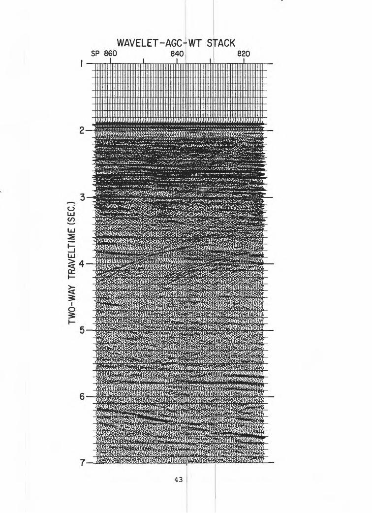
A test of the stack with the wavelet decon filter based on the 700- ms design window followed by a 350-ms AGC is shown in Figure 11. A comparison of Figure 11 with Figures 5 (brute stack) and 7 (no wavelet processing) shows that the wavelet processing has effectively collapsed the wavelet and significantly improved the appearance and resolution of both the shallow (2-4 s) and deeper (5-7 s) sections.
Multiple suppression; In order to deemphasize the multiple energy, we tested a prestack predictive deconvoultion and weighted stack (in which the far traces are weighted more than the near traces during the stack). Weighted stacks are effective in regions of strong multiples when there are differences in moveout between the primary and multiple energy at the furthest offsets (Yilmaz, 1987) . A section with predictive deconvolution but without weighted stack (Figure 12) can be compared to a similar section with weighted stack (Figure 13) . This comparison shows that the weighted stack suppresses the first order multiples (at 3.8 s) effectively and slightly improves the signal strength in the deeper section (5 - 7 s). Comparing figures 11 and 13, we can observe that the predictive deconvolution suppresses the dispersed multiple energy (around 5.8 s) more effectively. The predictive deconvolution has a prediction distance of the first zero crossing of the autocorrelation of the data.
The final test we performed was to determine the effectiveness of spectral whitening instead of the prestack predictive deconvolution in the processing stream (Lee, 1986). For this test, the wavelet processing was followed by a 1000-ms AGC, amplitude balancing, spectral whitening, and then the weighted stack (Figure 14) . Overall signal strength in this section is less than in Figure 13, due to the generally higher levels of background noise.
Our final strategy therefore follows the processing sequence used to generate Figure 13: prestack wavelet deconvolution followed by a moderate (350-ms) AGC, a predictive deconvolution with a short prediction distance, and a weighted stack. This strategy was most effective in collapsing the reverberative wavelet, improving the resolution of the data, and increasing the signal strength in the deeper portions of the profiles.
PROCESSING PRIOR TO MIGRATION
Figure 15 summarizes the steps used to process the Lake Baikal multichannel data. The initial editing proved to be tedious because of the need to manually pick and then apply the statics corrections for the shot jitter. Other editing involved deleting bad traces, applying the firing delay correction (0, 1.024, or 2.048 s), and renumbering shots due to miscounts in the demultiplexing procedure. Demultiplexed, edited data

are archived on 9-track magnetic tape in SEGrY format (Appendix 2).
The wavelet deconvolution was applied to 8 s of data, and hence all record lengths were standardized at 8 s. Th:.s involved loss of 1 s of data in the deep-water regions of the lake where the actual data recording had been 2.048 - 9.048 s. Inspection of the (unprocessed) near trace data showed no arrivals other than multiple energy at travel times greater than 8 s.
Three to five iterations of velocity analysis were performed to ensure smooth and realistic velocities. Initial velocities were chosen from analyses that used seven trial time-varying velocity functions, and displayed both NMO-corrected unstacked and stacked traces. These RMS velocities were smoothed using either a gridding and moving average technique (lines 8 and 10; Miller, 1991) or along reflecting horizons by comparison with and smoothing of interval velocities calculated from stacking velocities. The final RMS velocit.ies show no large lateral discontinuities, and interval velocities are also reasonably smooth (Figure 16), although they are not well constrained below about 2 s beneath the lake floor.
The RMS velocities were extremely low, generally from about 1390 to 1460 m/s at the lake floor, increasing to about 2000 m/s at 2 - 3 s subbottom in the deep sedimentary basins. Calculated interval velocities are also low within the resolved sedimentary section, generally less than 3.0 km/s. We estimate that the interval velocities are accurate to about 10 - 15 % at 3-4 s travel time in the deep basins.
theMute was applied after NMO and before lines were archived to tape after stack and of the archived tapes is given in Appendix 3
Post-stack processing: A predictive applied based on a prediction distance of the
weighting for stack. All before final display. A list
autocorrelation followed by a simple bandpass* filter of 10 to 40 Hz. No post-stack AGC was applied because this only served to amplify the multiple energy. The stacked sections were displayed on mylar film and are archived by U.S.Geological Survey, Woods Hole, and Southern Branch of the Institute of Oceanology, Gelendzhik, Russia.
deconvolution operator was second zero crossing of the
POST-STACK MIGRATION PRO
Migration of the data was warranted because of the large relief changes in the morphology of the lake, the highly faulted sedimentary section, and the rapid changes in the thickness of the sediments. Eight of the dip lines were migrated, representing one of each pair of lines, except for the northernmost pair in the North basin. Five portions of the axial line that showed complex structure or convincing arrivals at 5 - 7 s (the observed level of the basement) were also migrated. A summary of the archived migrated tapes is given in Appendix 4.
Figure 15 illustrates the post-stack processing steps. In preparation for migration, two adjacent traces were summed to halve the volume of data being migrated. A second-zero crossing predictive deconvolution was then applied.
:ESSING
The migration technique used is called and Beasley, 1987; Beasley and others, 1988) wavenumber migration was performed using either
cascaded migration (Larner First, a frequency-
a constant velocity, that

of fresh water (1440 m/s) , or a vertically varying velocity function having a low gradient. This served to effectively migrate the steep water-bottom arrivals, but the rest of the section was still undermigrated. It also served to eliminate most of the diffractions and occasional side-scattered noise in the profiles. In the second step, a finite-difference migration with small lateral and vertical residual velocity changes completed the migration of the sedimentary and basement section. Despite the numerically intensive calculations involved in migrating the data twice, this approach yields superior results because it combines the best features of both migrations: migrating steeply dipping events relatively fast (F-K migration) and accomodating lateral and vertical (residual) velocity variations at lower apparent dip (finite difference migration).
RESULTS AND DISCUSSION
Two lines illustrate the effectiveness and limitations of the data processing strategy: lines 8 and 6, both from the Central basin of Lake Baikal. Line 8 (Figure 17) is located along a north-south profile that begins at the south end of the North basin, crosses Academician Ridge, and continues across the Central basin just east of the deepest point in the lake. The data quality is considered to be excellent because inferred basement, the deepest identifiable reflector on any of the profiles, can be imaged almost continuously along the profile (Figure 17) . Within the sedimentary section, many continuous reflections, seismic unconformities, and fault offsets occur at travel times up to 2 s beneath the lake floor. As on many other lines, blanking occurs at travel times greater than the first multiple in deep water (SP 1200 - SP 1800) . The presence of a fairly strong basement reflection and occassional disrupted reflections within the deepest, blanked unit suggests that not all the source energy was overwhelmed by the multiple energy. That is, primary energy can be identified up to about 5 s beneath the lake floor. The distinct fading of reflections at the level of the first multiple indicated that our processing strategy did not entirely overcome this problem.
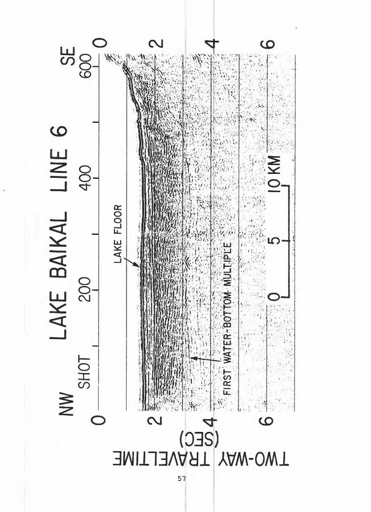
Line 6, from the north side of the Selenga Delta in the Central basin, shows an example of a profile where basement was not imaged anywhere on the profile, and short, disrupted reflector fragments with numerous diffractions characterize the sedimentary section (Figure 18). Blanking occurs at the level of the first multiple, and no primary reflection energy can be reliably identified beneath the first multiple, i.e., subbottom returns are limited to about 2 s beneath the lake floor. This same limited penetration phenomenon occurs on several strike and dip lines; it is always associated with short, disrupted reflections and diffractions within the sedimentary section. A possible interpretation of the much poorer signal quality on line 6 and these other lines is that the processing strategy did not work well. We prefer an alternative interpretation which is that the local geology is affecting the signal strength, and that the short, disrupted reflector segments originate from regions of sedimentary disruption and greater signal attenuation.
Although the overall quality of the multichannel data is good, the 1989 Baikal data contain some insurmountable limitations that the processing could not remedy. The source (single, large, air gun with a narrow spectral range) could be compensated for in the processing, but it inherently lacks the resolution of a more broadband source, such as arrays of smaller guns. The uncertainty in the dynamic range of the recording system is the most likely explanation for the blanking that

occurs at the level of the first multiple in |deep water. If this narrow dynamic range did occur, then no amount of processing will recover data that were not initially recorded. The large uncertainty in navigation fixes, resulting in the need for firing the air gun on time rather than distance, introduces a spatial smearing into the data. This problem does not appear to be serious, given the overall continuity of reflections and reflection packages such as those on line 8. A more serious limitation of the navigation is that the profiles can not be used for detailed mapping and correlation. However, given the large line spacing (10 - 60 km) between adjacent lines, the data are lj>est suited for a regional overview and interpretation.
The existing data image a wide range; of complex structure and stratigraphy, which indicate the need for a riiuch tighter grid of data to map fault geometry and depositional sequences.
CONCLUSIONS
(1) The major problems affecting tho processing of the Baikal multichannel data were the low-frequency revetrberative nature of the air- gun source signal, the random static shifts d>f up to 20 ms in the firing of the gun, and the blanking of the stacked data at the level of the first water-bottom multiple in deep water.
(2) Conventional processing, such as prestack AGC and spiking deconvolution, served to improve the resolution (i.e., increasedbandwidth and reduced reverberations) of the data but failed tosignificantly improve the signal-to-noise ratios in the deeper section. Conventional static shifts did, however, correct the random static shift problem.
(3) Special prestack processing, inj/olving the application of wavelet deconvolution followed by AGC anci predictive deconvolution, provided the optimum processing flow for improving the resolution and signal strength of the data. In general, th|e images of the sedimentary section on the 17 profiles in the lake are good to excellent, although blanking could not totally be removed in the processing.
(4) Post-stack processing focused on migrating the data to restore geometric relations between reflections. A two-step cascading migration in which the data were initially migrated witb an f-k algorithm using the velocity of water (or a vertically varying velocity function having a low gradient) followed by a finite differences algorithm using smoothed residual velocities, provided the most satisfactory migration of thesteep morphology and dipping layers in the lake. Because most of thelines were collected as pairs, only one of :ach pair was migrated.
(5) Additional limitations of the data inherent in the acquisition were the spatial smearing due to firing the lair gun on time rather than distance (a problem we judge to be relatively minor) and the navigational inaccuracy caused by half-hour radar and dead-reckoning fixes (a problem that most affects the interpretation of the data).

REFERENCES CITED
Beasley, C., Lynn, W., Lamer, K., and Nguyen, H., 1988, Cascaded f-k migration: removing the restrictions on depth varying velocities: Geophysics, v. 53, p. 881 - 893.
Dragoset, B., Hargreaves, N., and Larner, K., 1987, Air-gun source instabilities: Geophysics, v. 52, p. 1229 - 1251.
Gray, W.C., 1979, Variable norm deconvolution: Palo Alto, CA, Stanford University Ph.D. thesis.
Kozhov, M., 1963, Lake Baikal and its life: Dr. W. Junk Publishers, the Hague, 344 pp.
Larner, K., and Beasley, C., 1987, Cascaded migrations: improving the accuracy of finite-difference migration: Geophysics, v. 52, p. 618- 643.
Lee, M.W., 1986, Spectral whitening in the frequency domain: U.S. Geological Survey Open-file Report 86-108, 15 pp.
Miller, J.J., 1991, A VAX and MS-DOS computer program package for depth conversion of digitized line-drawing interpretations of seismic sections: U.S. Geological Survey Open-file Report 91-303A, 25 pp.
Yilmaz, 0., 1987, Seismic data processing: Society of Exploration Geophysicists Investigations in Geophysics, v. 2, 526 p.

TABLE 1: GENERAL TRACKLINE ^FORMATION
Line No.
1
2
3
4
5
6
7
8
9
10
11
12
13
14
15-1A
15-1B
15-1C
15-2
15-3
15-4
15-5
15-6
16
17
Shot Interval
50-m
50-m
50-m
50-m
50-m
50-m
50-m
50-m
50-m
50-m
50-m
50-m
50-m
50-m
100-m
50-m 100-m
50-m
50-m
50-m
50-m
50-m
50-m
50-m
50-m
TOTALS
First Shot
1
1
1
781
1
1
815
315
847
1
1
1
1
1
8152
7427 7440
6471
3332
2427
963
1
1
1
1
Last Shot
500
562
752
1372
541
626
2846
234C
2045 i
1314
1326
1310
661
59:
960(
743< 815:
7421
}
)
)
647^)
3331
2406
96:159:
81-
>
3
1
79$
Total Shots
500
562
749
469
541
626
2031
2025
1198
1314
1326
1310
661
593
1449
13 711
956
3139
905
1443
962
1593
814
798
26688
Total Km
25.00
28.10
37.45
23.45
27.05
31.30
101.55
101.25
59.90
65.70
66.30
65.50
33.05
29.65
144.90
.65 71.10
47.80
156.95
45.25
72.15
48.10
79.65
40.70
39.90
1442.40

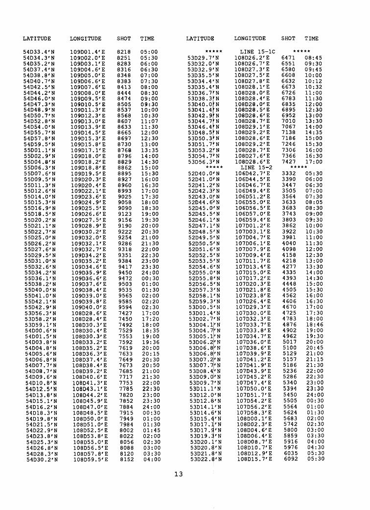
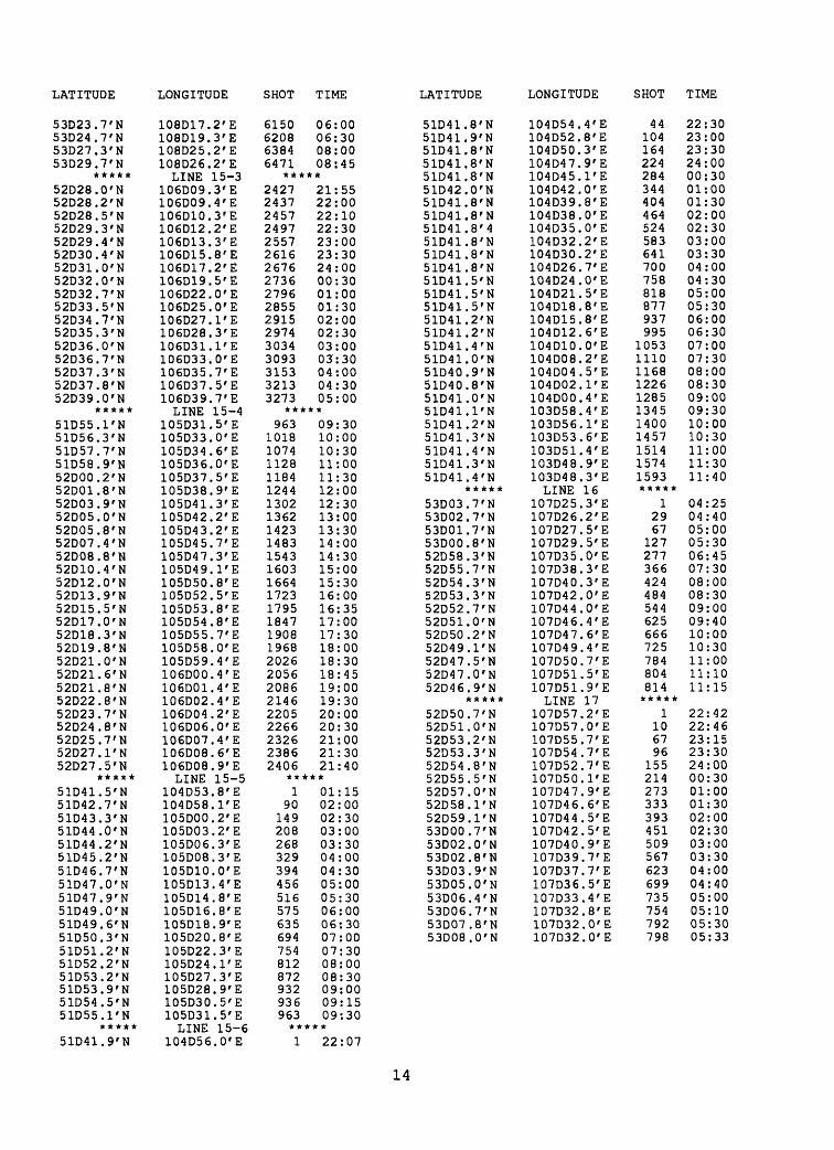
APPENDIX 1: Navigation Control Points
10

LATITUDE LONGITUDE SHOT TIME LATITUDE LONGITUDE SHOT TIME
*****
51D37.1'N51D37.5'N51D38.8'N51D40.4'N51D41.6'N51D43.1 f N51D44.2'N51D45.5'N51D46.7'N51D48.2'N
*****51D50.4'N51D49.0'N51D47.0'N51D46.0'N51D44.4'N51D42.0'N51D41.9'N51D40.2'N51D38.8'N51D37.5'N51D36.8'N
*****51D58.3'N51D58.2'N51D58.7'N52D04.8'N52D06.5'N52D07.8'N52D09.2'N52D10.5'N52D11.7'N52D13.1'N52014.1'N
*****52D14.6 f N52D14.0'N52D12.7'N52D12.0 f N52D10.2'N52D08.8'N52D07.8'N52D06.4 f N52D05.5 f N52D04.3'N52D02.8'N52D02.7'N
*****52D42.4'N52D41.5'N52D40.9 f N52D40.6'N52D39.3 f N52D36.7 f N52D36.4'N52D35.6'N52D34.2'N52D33.2'N52D31.6'N52D30.4 f N52D30.0'N
*****52D45.8'N52D45.7'N52D44.8 f N52D43.7'N52D42.7'N52D41.3'N52D40.0'N
LINE 1105D04.8'E105D04.3'E105D03.0 f E105D02.4'E105D01.6'E105000.1'E104D58.8 f E104D57.9'E104D56.4 f E104D55.3 f ELINE 2
105D01.4'E105D01.9'E105D02.4'E105D03.7 f E105D05.1'E105D05.5'E105D06.7'E105D08.7'E105D10.7'E105D11.9'E105D12.5'ELINE 3
106D02.0' E106D01.8'E105D59.6 f E105D50.0'E105D49.1'E105D47.1'E105D45.8 f E105D44.1'E105D42.1 f E105D41.7'E105D41.4'ELINE 4
105D43.5'E105D44.0'E105D45.8'E105D46.6'E105D47.7 f E105D48.8 f E105D51.5'E105D54.1'E105D56.0 f E105D59.5 f E106D02.0 f E106D02.1'ELINE 5
106D34.3'E106D35.0'E106D36.2' E106D38.0 f E106D39.8 f E106D41.5'E106D42.4'E106D43.6'E106D44.9'E106D47.0'E106D48.0'E106D49.4'E106D50.5'ELINE 6
106D38.1'E106D38.2'E106D39.2'E106D40.1'E106D43.0'E106D44.6'E106D45.5'E
*****1
2180
139199260320380439500
*****1
54115175244294353413473532562
*****13
45352410469529590650710752
*****781798856885946
1018107011301188130813701372*****
13261
120180241261302360420480511541
*****16
57116177237295
00:2000:3001:0001:3002:0002:3003:0003:3004:0004:30
14:0414:3015:0015:3016:0516:3017:0017:3018:0018:3018:45
20:0520:0620:2723:0023:3000:0000:3001:0001:3002:0002:21
02:3502:4503:1503:3004:0004:3505:0005:3006:0007:0007:3007:31
06:0006:1506:3007:0007:3008:0008:1008:3009:0009:3010:0010:1510:30
13:0213:0513:3014:0014:3015:0015:30
52D38.8rN52D36.2'N52D35.0'N52D34.0'N52D33.1'N
*****52D47.8'N52D48.552D49.852D51.052D52.552D54.752D56.752D58.253DOO.O53D01.2
'N'N'N'N'N'N'N'N'N
53D03.2|'N53D04.8'N53D06.2'N53D08.6|'N53D11.2l'N53D13.3'N53D14.5'N53D16.8'N53D18.2'N53D19.5'N53D21.0'N53D22.6'N53D24.8'N53D26.2'N53D27.5'N53D29.1'N53D30.8;'N53D32.2>N53D33.8'N53D35.9'N53D37.4|'N53D38.1'N53D40.2'N53D41.S'N53D44.2'N53D45.3/N
*****53D47.1'N53D46.1'N53D42.2'N53D39.6'N53D38.4'N53D37.2'N53D35.253D33.653D31.S53D29. 53D27.S53D26. 53D24. 53D23."53D22.553D21.1
'N'N'N 'NI'N'N
S'N'N
>'NL'N
53D19.3'N53D18.2'N53D16.9'N53D15.:53D13.<53D11.J53D09.'53D07.!53D06.'53D04.'53D03.!
J'N5'NJ'NI'N5'NI'N7'N2'N
106D47.3'E106D51.8'E106D53.5'E106D55.5'E106D57.3'E
LINE 7107D53.3'E107D53.4'E107D53.0'E107D53.0'E107D53.1'E107D53.5'E107D53.7'E107D53.8'E107D53.5' E107D53.8'E107D54.7'E107D54.6 f E107D54.1'E107D54.4'E107D54.5 f E107D55.2 f E107D55.5 f E107D56.2' E107D55.6'E107D55.5'E107D55.2 f E107D54.6'E107D54.2 f E107D54.0 f E107D53.9'E107D54.0 f E107D53.3'E107D53.2'E107D53.5'E107D52.3 f E107D52.7'E107D54.0'E107D53.8'E107D53.8 f E107D53.9 f E107D54.5 f E
LINE 8108D02.1'E108D02.3'E108D01.4'E108D01.2'E108D01.5'E108D01.4'E108D01.5'E108001.1'E108D00.6'E108001.1'E108D01.8'E108D00.7'E108001.0'E108D00.9'E108D00.3 f E108D01.5'E108D01.2'E108D01.4'E108D01.7'E108D01.4'E108D01.9'E108D02.3' E108D02.7'E108D02.8 f E108D02.6'E108D03.4'E108D03.7'E
348469541586626
*****815835875925984
1044110311621220127713361393145215131632168817471808186719261985204321012160221822782337239724572517257726362697275728162846
*****315361509608658718778838897957
10181078113711971256131413741433149315531613167317331792185219121972
16:0017:0017:3718:0018:20
11:3511:4512:0512:3013:0013:3014:0014:3015:0015:3016:0016:3017:0017:3018:3019:0019:3020:0020:3021:0021:3022:0022:3023:0023:3024:0000:3001:0001:3002:0002:3003:0003:3004:0004:3004:45
04:3805:0006:1507:0407:3008:0008:3009:0009:3010:0010:3011:0011:3012:0012:3013:0013:3014:0014:3015:0015:3016:0016:3017:0017:3018:0018:30
11

LATITUDE LONGITUDE SHOT TIME LATITUDE LONGITUDE SHOT TIME
53D01.5 r N52D59.7'N52D57.9'N52D56.4'N52D54.8'N52D53.3'N52D53.0'N
*****53d45.4'n53d45.2'n53d44.0'n53d40.8'n53d39.5,n53d38.2'n53d37.0'n53d35.4'n53d33.9'n53d31.7'n53d29.8'n53d26.8'n53d25.5'n53d25.0'n53d23.7'n53d22.2'n53d20.7'n53dl9.5'n53dl8.2'n53dl7.7'n53dl7.3'n
*****53D20.0'N53D20.3'N53D21.1'N53D22.2'N53D23.4'N53D24.4'N53D25.6'N53D26.7'N53D28.0'N53D29.7'N53D30.4'N53D31.8'N53D33.2'N53D35.0'N53D36.6'N53D37.5'N53D38.3'N53D39.3'N53D40.7'N53D41.9'N53D43.4'N53D44.2'N53D45.8'N53D47.2'N53D48.1'N53D48.7'N53D48.7'N
*****54D06.2'N54D06.4'N54D06.7'N54D06.9'N54D07.0'N54D07.5'N54D08.0'N54D08.8'N54D09.1'N54D09.8'N54D10.7'N54D10.9 f N54D11.3'N
108D03.6'E108D03.1'E108D02.5'E108D02.1'E108D02.0'E108D02.1'E108D02.1'ELINE 9
107d58.5'e107d58.6'e108d00.2'e108d01.3'e108d03.1'e108d05.5'e108d07.7'e108d09.4'elOSdll.O'e108dl2.5'e108dl5.0'e108dl6.6'e108dl8.4'e108d21.1'e108d21.8'e108d23.3'e108d25.3'e108d26.3'e108d28.6'e108d30.2'e108d31.4'eLINE 10
108D36.2'E108D35.8'E108D34.9'E108D34.0'E108D32.7'E108D31.2'E108D30.0'E108D28.6'E108D26.8'E108D24.8'E108D23.0'E108D21.5' E108D19.9'E108D18.5'E108D17.5'E108D17.4'E108D17.0'E108D15.1' E108D13.6'E108D12.6'E108D11.3'E108D09.5'E108D08.1'E108D06.5'E108D06.0'E108D04.8'E108D04.1'ELINE 11
109D27.1'E109D25.8'E109D24.8'E109D22.0'E109D19.0'E109D16.5'E109D14.1'E109D10.6'E109D10.0'E109D07.8'E109D05.0'E109D02.5'E108D59.5'E
2032209221522111227023302340*****847855912
103010901150121012701330139014501565162416841743180318601917197020162045*****
11171
131190240300358415470529590648722767808828886946
10061066112611851246127613051314*****
13161
121190240300359419479539599659
19:0019:3020:0020:3021:0021:3021:35
05:2605:3006:0007:0007:3008:0008:3009:0009:3010:0010:3011:0012:0012:3013:0013:3014:0014:3015:0015:2015:35
16:5517:0017:3018:0018:3019:0019:3020:0020:3021:0021:3022:0022:3023:0723:3023:5024:0000:3001:0001:3002:0002:3003:0003:3003:4504:0004:05
18:0018:1518:3019:0019:3520:0020:3021:0021:3022:0022:3023:0023:30
54D11.8'N54D12.5'N54D13.1'N54D13.6'N54D13.9'N54D14.5'N54D15.3'N54D15.5'N54D16.0'N54D16.5'N54D17.3'N54D17.4'N
*****54D21.7'N54D20.0'N54D19.5'N54D19.4'N54D18.5'N54D18.4'N54D18.0'N54D17.9'N54D17.9'N54D17.8'N54D17.1'N54D16.3'N54D15.5'N54D15.3'N54D13.8'N54D13.8'N54D12.4'N54D11.5'N54D11.4'N54D11.0'N54D11.2'N54D11.1'N54D10.6'N54D10.1'N54D09.7'N54D09.3'N
*****55D26.3'N55D26.5'N55D27.0'N55D27.6'N55D28.0'N55D28.6'N55D29.3'N55D29.3'N55D30.0'N55D31.3'N55D31.9'N55D32.3'N55D32.6'N55D32.8'N55D33.2'N
*****55D34.9'N55D34.6'N55D34.4'N55D34.2'N55D33.7'N55D32.7'N55D32.4'N55D31.8'N55D30.8'N55D30.5'N55D29.8'N55D29.2'N
*****54D30.2'N54D32.5'N
108D57.0'E108D54.6'E108D52.1'E108D49.1'E108D46.7'E108D44.5'E108D42.5'E108D39.8'E108D37.3'E108D34.6'E108D32.2'E108D31.9'ELINE 12
108D33.6'E108D37.7'E108D38.7'E108D41.4' E108D42.0'E108D43.4'E108D46.5'E108D49.7'E108D51.4'E108D53.6'E108D56.8'E108D59.5'E109D01.2'E109D03.6'E109D06.2'E109D08.5'E109D11.8' E109D12.7'E109D15.0'E109D16.4'E109D18.2'E109D20.0'E109D22.5'E109D25.8'E109D27.7'E109D29.7'ELINE 13
109D45.4'E109D45.0'E109D43.8'E109D41.5' E109D39.0'E109D36.5'E109D34.0'E109D34.0'E109D31.0' E109D26.5'E109D23.6'E109D21.7' E109D19.4'E109D18.1' E109D17.5'ELINE 14
109D22.8'E109D25.5'E109D26.6'E109D28.0'E109D31.1' E109D33.1'E109D36.1'E109D38.8'E109D40.8'E109D43.8'E109D46.0'E109D47.7'ELINE 15-1AB
108D59.5'E109DOO.O'E
719779839899959
1022107811381198125813181326*****
189
117177206234300350410470529589649709768827887917967
1007103710661096118712451310*****
11140
100159218278346398456528575628646661*****
16493
126187254320381442503553593
24:0000:3001:0001:3002:0002:3203:0003:3004:0004:3005:0005:04
05:3006:1506:3007:0007:1507:3008:0508:3009:0009:3010:0010:3011:0011:3012:0012:3013:0013:1513:4014:0014:1514:3015:0015:3016:0016:32
03:4003:4504:0004:3005:0005:3006:0006:3407:0007:3008:0608:3009:0009:1009:18
11:0011:3011:4512:0012:3013:0013:3014:0014:3015:0015:2515:45
*****81528185
04:0004:30
12
LATITUDE LONGITUDE SHOT TIME LATITUDE LONGITUDE SHOT TIME
54D33.4'N54D34.3'N54D35.2'N54D37.4'N54D38.8'N54D40.7'N54D42.5'N54D44.2'N54D46.0'N54D47.3'N54D48.9'N54D50.7'N54D52.8'N54D54.0'N54D55.7'N54D57.8'N54D59.5'N55D01.1'N55D02.9'N55D04.8'N55D06.3'N55D07.6'N55D09.5'N55D11.3'N55D12.6'N55D14.0'N55D15.3'N55D16.9'N55D18.5'N55D20.2'N55D21.1'N55D22.7'N55D25.0'N55D26.2'N55D27.6'N55D29.5'N55D31.0'N55D32.6'N55D34.2'N55D36.1'N55D38.2'N55D40.0'N55D41.0'N55D42.1'N55D42.9'N53D56.3'N53D58.2'N53D59.1'N54D00.6'N54D01.5'N54D03.8'N54D04.8'N54D05.6'N54D06.8'N54D07.7'N54D08.7'N54D09.6'N54D10.8'N54D12.5 f N54D13.8'N54D15.1'N54D16.2'N54D18.3'N54D19.8'N54D21.5'N54D22.9'N54D23.8'N54D25.3'N54D26.8'N54D28.3'N54D30.2'N
109D01.4' E109D02.0'E109D03.1'E109D04.6'E109D05.0'E109D06.6'E109D07.6'E109D08.0'E109D09.5'E109D10.5'E109D11.3'E109D12.3'E109D13.0'E109D13.9'E109D14.5'E109D15.3'E109D15.8'E109D17.1'E109D18.0'E109D18.2'E109D18.8'E109D19.5'E109D20.3'E109D20.4'E109D22.1'E109D23.6'E109D24.9'E109D25.5'E109D26.6'E109D27.5'E109D28.9'E109D30.2'E109D32.0'E109D32.1'E109D32.7'E109D34.2'E109D35.2'E109D34.6'E109D35.9'E109D36.6'E109D37.6'E109D38.4'E109D39.0'E109D39.8'E109D40.0'E108D28.6'E108D28.4'E108D30.3'E108D30.4'E108D30.3'E108D33.2'E108D35.2'E108D36.3'E108D37.4'E108D38.4'E108D39.2'E108D40.6'E108D41.3'E108D43.1'E108D44.2'E108D45.9'E108D47.0'E108D48.5' E108D50.0'E108D51.0'E108D52.5'E108D53.8'E108D55.0'E108D56.5'E108D57.8'E108D59.5'E
82188251828383168348838384138444847485058537856886078633866586978730876887968829886288958927896089939025905890909123915691909222925492869318935193849417945094729503953595659585959474277450749275297553759276197633764976737685111177537785782078527884791579497984800280228056808881208152
05:0005:3006:0006:3007:0007:3008:0008:3009:0009:3010:0010:3011:0711:3012:0012:3013:0013:3514:0014:3015:0015:3016:0016:3017:0017:3018:0018:3019:0019:3020:0020:3021:0021:3022:0022:3023:0023:3024:0000:3001:0001:3002:0002:2002:3017:0017:2018:0018:3519:0019:3620:0020:1520:3020:5021:0021:3022:0022:3023:0023:3024:0000:3001:0001:3001:4502:0002:3003:0003:3004:00
*****
53D29.7'N53D32.0'N53D32.9'N53D35.5'N53D34.4'N53D35.4'N53D36.7'N53D38.3 r N53D40.053D41.453D42.953D44.753D46.453D48.553D50.3
r Nr Nr Nr N'Nr Nr N
53D51.7'N53D53.2 r N53D54.7^N53D56.3'N
*****52D40.0'N52D41.0^N52D41.2'N52D42.3'N52D43.0rN52D44.6^N52D45.0^N52D45.5'N52D46.1'N52D47.PN52D48.5'N52D49.5'N52D50.5'N52D51.6'N52D52.5'N52D53.5'N52D54.6'N52D55.0'N52D55.8'N52D56.5'N52D57.3'N52D58.1'N52D59.3'N53D00.5'N53D01.4'N53D02.753D04.153D04.753D05.153D06.253D06.853D06.853D07.253D07.753D08.4
'N'N'N'N'N'N'N'N'N'N
53D09.0i'N53D09.7'N53D11.1'N53D12.0'N53D12.8'N53D14.1'N53D14.6'N53D15.453D17.153D17.953D19.353D20.153D20.853D21.853D22.6
'N'N'N'N'N'N'N'N
LINE 15-1C108D26.2 f E108D26.7 f E108D27.3 f E108D27.5'E108D27.8'E108D28.1'E108D28.0'E108D28.4'E108D28.0'E108D28.5'E108D28.6'E108D28.7'E108D29.1'E108D29.2'E108D28.6'E108D29.2'E108D28.7'E108D27.6'E108D28.6'ELINE 15-2
106D42.7'E106D44.5'E106D46.7'E106D49.4'E106D51.2'E106D55.0'E106D56.5'E106D57.0'E106D59.4'E107D01.2'E107D03.1'E107D04.7'E107D06.1'E107D07.9' E107D09.4' E107D11.7'E107D13.4'E107D15.0'E107D17.2'E107D20.3'E107D21.8'E107D23.8'E107D26.4'E107D29.3'E107D30.0'E107D32.3'E107D33.7'E107D33.8'E107D34.7'E107D36.0'E107D38.6'E107D39.9'E107D41.2'E107D41.9'E107D43.9'E107D45.2'E107D47.4'E107D50.0'E107D51.7'E107D54.2'E107D56.2'E107D58.3'ElOSDOO.l'E108D02.3'E108D04.6'E108D06.4'E108D08.7'E108D10.7'E108D12.9'E108D15.7'E
*****6471655165806608663266736726678368356895695270107067713871867246730673667427
08:4509:3009:4510:0010:1210:3211:0011:3012:0012:3013:0013:3014:0014:3515:0015:3016:0016:3017:00
*****33323390344735053564363336833743380338623922398140404098415842184277433543934448450545624606467047254783487649024962501751005129515751865236528653405394545055055564562456835742580058595916597660356092
05:3006:0006:3007:0007:3008:0508:3009:0009:3010:0010:3011:0011:3012:0012:3013:0013:3014:0014:3015:0015:3016:0016:3017:0017:3018:0018:4619:0019:3020:0020:4521:0021:1521:3022:0022:3023:0023:3024:0000:3001:0001:3002:0002:3003:0003:3004:0004:3005:3005:30
13
LATITUDE LONGITUDE SHOT TIME LATITUDE LONGITUDE SHOT TIME
53D23.7'N53D24.7'N53D27.3'N53D29.7'N
*****52D28.0'N52D28.2'N52D28.5'N52D29.3'N52D29.4'N52D30.4'N52D31.0'N52D32.0'N52D32.7'N52D33.5'N52D34.7'N52D35.3'N52D36.0'N52D36.7'N52D37.3'N52D37.8 f N52D39.0 f N
*****51D55.1 f N51D56.3'N51D57.7'N51D58.9'N52D00.2'N52D01.8'N52D03.9'N52D05.0 f N52D05.8'N52D07.4 f N52D08.8 f N52D10.4 f N52D12.0 f N52D13.9 f N52D15.5'N52D17.0'N52D18.3'N52D19.8 f N52D21.0'N52D21.6'N52D21.8'N52D22.8'N52D23.7'N52D24.8'N52D25.7'N52D27.1 f N52D27.5'N
*****51D41.5'N51D42.7'N51D43.3 f N51D44.0'N51D44.2 f N51D45.2 f N51D46.7'N51D47.0 f N51D47.9 f N51D49.0 f N51D49.6'N51D50.3'N51D51.2'N51D52.2'N51D53.2 f N51D53.9 f N51D54.5'N51D55.1'N
*****51D41.9'N
108D17.2 f E108D19.3 f E108D25.2 f E108D26.2 f ELINE 15-3
106D09.3 f E106D09.4 f E106D10.3'E106D12.2 f E106D13.3'E106D15.8'E106D17.2 f E106D19.5'E106D22.0 f E106D25.0 f E106D27.1'E106D28.3'E106D31.1'E106D33.0 f E106D35.7'E106D37.5 f E106D39.7'ELINE 15-4
105D31.5'E105D33.0 f E105D34.6 f E105D36.0'E105D37.5 f E105D38.9 f E105D41.3'E105D42.2 f E105D43.2 f E105D45.7'E105D47.3 f E105D49.1 f E105D50.8 f E105D52.5'E105D53.8 f E105D54.8 f E105D55.7'E!05D58.0 f E105D59.4'E106D00.4 f E106D01.4'E106D02.4 f E106D04.2' E106D06.0'E106D07.4'E106D08.6'E106D08.9 f ELINE 15-5
104D53.8'E104D58.1 f E105D00.2 f E105D03.2 f E105D06.3'E105D08.3 f E105D10.0 f E105Dl3.4 f E105D14.8 f E105D16.8 f E105D18.9 f E105D20.8 f E105D22.3 f E105D24.1'E105D27.3 f E105D28.9 f E105D30.5'E105D31.5'ELINE 15-6
104D56.0 f E
6150 06:006208 06:306384 08:006471 08:45
*****2427 21:552437 22:002457 22:102497 22:302557 23:002616 23:302676 24:002736 00:302796 01:002855 01:302915 02:002974 02:303034 03:003093 03:303153 04:003213 04:303273 05:00
*****963 09:30
1018 10:001074 10:301128 11:001184 11:301244 12:001302 12:301362 13:001423 13:301483 14:001543 14:301603 15:001664 15:301723 16:001795 16:351847 17:001908 17:301968 18:002026 18:302056 18:452086 19:002146 19:302205 20:002266 20:302326 21:002386 21:302406 21:40
*****1 01:15
90 02:00149 02:30208 03:00268 03:30329 04:00394 04:30456 05:00516 05:30575 06:00635 06:30694 07:00754 07:30812 08:00872 08:30932 09:00936 09:15963 09:30*****1 22:07
51D41.8'N51D41.9'N51D41.8'N51D41.8'N51D41.8'N51D42.0'N51D41.8'N51D41.8'N51D41.8M51D41.8'N51D41.8'N51D41.8'N51D41.5'N51D41.5'N51D41.5'N51D41.2'N51D41.2'N51D41.4'N51D41.0'N51D40.9'N51D40.8'N51D41.0'N51D41.1'N51D41.2'N51D41.3'N51D41.4'N51D41.3'N51D41.4'N
*****53D03.7'N53D02.7'N53D01.7'N53D00.8'N52D58.3'N52D55.7'N52D54.3'N52D53.3'N52D52.7'N52D51.0'N52D50.2'N52D49.1'N52D47.5'N52D47.0'N52D46.9'N
*****52D50.7'N52D51.0'N52D53.2'N52D53.3'N52D54.8'N52D55.5'N52D57.0'N52D58.1'N52D59.1'N53D00.7'N53D02.0'N53D02.8'N53D03.9'N53D05.0'N53D06.4'N53D06.7'N53D07.8'N53D08.0'N
104D54.4'E104D52.8'E104D50.3'E104D47.9'E104D45.1'E104D42.0'E104D39.8'E104D38.0'E104D35.0'E104D32.2'E104D30.2'E104D26.7'E104D24.0'E104D21.5'E104D18.8'E104D15.8'E104D12.6'E104D10.0'E104D08.2'E104D04.5'E104D02.1'E104D00.4'E103D58.4'E103D56.1 f E103D53.6'E103D51.4'E103D48.9 f E103D48.3 f ELINE 16
107D25.3'E107D26.2 f E107D27.5 f E107D29.5 f E107D35.0'E107D38.3' E107D40.3'E107D42.0'E!07D44.0 f E107D46.4'E107D47.6 f E107D49.4 f E107D50.7'E107D51.5'E107D51.9'ELINE 17
107D57.2'E107D57.0' E107D55.7'E107D54.7' E107D52.7'E107D50.1 f E107D47.9 f E107D46.6'E!07D44.5 f E107D42.5'E107D40.9'E107D39.7 f E107D37.7'E107D36.5 f E107D33.4'E107D32.8 f E107D32.0'E107D32.0'E
44104164224284344404464524583641700758818877937995
10531110116812261285134514001457151415741593*****
12967
127277366424484544625666725784804814*****
1106796
155214273333393451509567623699735754792798
22:3023:0023:3024:0000:3001:0001:3002:0002:3003:0003:3004:0004:3005:0005:3006:0006:3007:0007:3008:0008:3009:0009:3010:0010:3011:0011:3011:40
04:2504:4005:0005:3006:4507:3008:0008:3009:0009:4010:0010:3011:0011:1011:15
22:4222:4623:1523:3024:0000:3001:0001:3002:0002:3003:0003:3004:0004:4005:0005:1005:3005:33
14

APPENDIX 2: Tape Archive Information - Demultiplexed Data
Note: All archived data are in SEG-Y format. Shot ID is 2 bytes
long starting at byte 189 of the trace header. Slot number is the
U.S. Geological Survey identifier for the tape in the data base and
in the tape library.
15

LAKE BAIKAL MULTICHANNEL DEMULTIPLEXED DATA - ARCHIVED
LINE NO.
1
2
3
4
5
6
7
8
9
10
11
12
13
SLOT NO.
4160 4161
4162 4163
4164 4165
4166 4167
4168 4169
4188 4189
4329 4330 4331 4332 4333 4334
4170 4171 4172 4173 4174 4175
4335 4336 4337 4338
4176 4177 4178 4179 4180
6459 6460 6461 6462
6463 6464 6465 6466
6467 6468
REEL ID
BID-1 BID-2
B2D-1 B2D-2
B3D-1 B3D-2
B4D-1 B4D-2
B5D-1 B5D-2
B6D-1 B6D-2
B7D-1 B7D-2 B7D-3 B7D-4 B7D-5 B7D-6
B8D-1 B8D-2 B8D-3 B8D-4 B8D-5 B8D-6
B9D-1 B9D-2 B9D-3 B9D-4
B10D-1 B10D-2 B10D-3 B10D-4 B10D-5
BUD-1 B11D-2 B11D-3 BUD-4
B12D-1 B12D-2 B12D-3 B12D-4
B13D-1 B13D-2
START SHOT /TRACE
1/1 410/7
1/1 410/17
1/1 412/12
754/1 1181/15
1/1 432/16
1/1 408/5
815/1 1184/2 1550/21 1927/21 2297/20 2703/3
315/1 682/13
1055/18 1391/22 1755/16 2119/4
847/1 1212/3 1582/18 1954/17
3/1 28/6
392/19 760/13
1129/8
1/1 412/16 823/2
1232/21
1/1 409/13 817/23
1226/23
1/1 410/18
END SHOT /TRACE
410/6 502/24
410/16 548/24
412/11 752/24
1181/14 1242/24
432/15 564/24
408/4 626/24
1184/1 1550/20 1927/20 2297/19 2703/2 2846/24
682/12 1055/17 1391/21 1755/15 2119/3 2340/24
1212/2 1582/17 1954/16 2042/24
28/5 392/18 760/12 1129/7
1314/24
412/15 823/1
1232/20 1329/24
409/12 817/22
1226/22 1310/24
410/17 661/24
16

LINK NO.
14
15-1AB
15-1C
15-2
15-3
15-4
15-5
15-6
16
17
SLOT NO.
6469 6470
4291 4292 4293 4294 4295 4296
4297 4298 4299
4300 4301 4302 4303 4304 4305 4306 4307 4308
4309 4310 4311
4312 4313 4314 4315
7190 7191 7192
7193 7194 7195 7196
6471 6472 6473
4288 4289 4290
REEL ID
B14D-1 B14D-2
151ABD-1 151ABD-2 151ABD-3 151ABD-4 151ABD-5 151ABD-6
B151CD-1 B151CD-2 B151CD-3
B152D-1 B152D-2 B152D-3 B152D-4 B152D-5 B152D-6 B152D-7 B152D-8 B152D-9
B153D-1 B153D-2 B153D-3
B154D-1 B154D-2 B154D-3 B154D-4
B155D-1 B155D-2 B155D-3
B156D-1 B156D-2 B156D-3 B156D-4
B16D-1 B16D-2 B16D-3
B17D-1 B17D-2 B17D-3
START SH<pT/ TRACE
1/1 412/12
7427/1 7831/4 8235/1 8644/9 8985/13 9394/19
6391/1 6799/1 7199/11
3332/1 3701/8 4070/24 4440/10 4809/13 5183/18 5552/15 5915/13 6285/19
2277/1 2686/24 3101/7
987/1 1397/7 1799/10 2209/15
2/1 411/16 814/6
1/1 410/10 820/10
1229/14
1/1 369/17
; 732/12
1/1 369/23 738/16
END SHOT/ TRACE
412/11 593/24
7831/3 8234/24 8644/8 8985/12 9394/18 9586/24
6798/24 7199/10 7427/24
3701/7 4070/23 4440/9 4809/12 5183/17 5552/14 5915/12 6285/18 6528/24
2686/23 3101/6 3357/24
1397/6 1799/9 2209/14 2276/24
411/15 814/5 986/24
410/9 820/9
1229/13 1593/24
369/16 732/11 814/24
369/22 738/15 797/24
17

APPENDIX 3: Tape Archive Information - Stacked Data
NOTE: All data are in SEG-Y format. Shot ID is 2 bytes long
starting at byte 189 of the trace header. Slot number is the U.S.
Geological identifier for the tape in the data base and in the
library.
18

LAKE BAIKAL STACKED DATA - ARCHIVED
LINE NO.
1
2
3
4
5
6
7
8
9
10
11
12
13
14
15-1AB
15-1C
15-2
15-3
15-4
15-5
15-6
16
17
SLOT
13452
13453
13454
13455
13456
13457
13458
13459
13460
13461
13462
13463
13464
13465
13466
13457
13468
13469
13470
13471
13472
13473
13474
REEL ID
Bl-1
B2-1
B3-1
B4-1
B5-1
B6-1
B7-1
B8-1
B9-1
BIO-1
Bll-1
B12-1
B13-1
B14-1
B151AB-1
B151C-1
B152-1
B153-1
B154-1
B155-1
B156-1
B16-1
B17-1
SHOTS START /END
1 - 498
1 - 544
1 - 748
7541 - 1238
1 - 560
1 - 622
815 - 2828
315 - 2336
84] - 2041
1 - 1310
1 - 1325
1 - 1306
1 - 657
1 - 589
7427 - 9583
642^ - 7422
333^ - 6516
227"t - 3352
987 - 2271
1 - 981
1 - 1588
1 - 809
1 - 792
CDPS START/END
1 - 1026
1 - 1118
1 - 1526
1 - 2506
1 - 1150
1 - 1274
1 - 4058
1 - 4074
1 - 2420
1 - 2650
1 - 2680
1 - 2642
1 - 1344
1 - 1208
1 - 8634
1 - 2036
33 - 6434
885 - 3068
280 - 2881
3 - 1994
1 - 3208
1 - 1650
1 - 1614
19

APPENDIX 4: Tape Archive Information - Migrated Data
NOTE: All data are in SEG-Y format. Shot ID is 2 bytes long
starting at byte 189 of the trace header. Slot number is the U.S.
Geological Sruvey identifier for the tape in the data base and in
the tape library.
20

LAKE BAIKAL MIGRATED DATA - ARCHIVED
LINE NO.
1
2
3
4
5
6
7
8
9
10
11
12
13
14
15-1A
15-1B
15-1C
15-2
15-2
15-3
15-4
15-5
15-6
16
17
SLOT
13427
13428
13429
13430
13431
13432
13433
13434
13435
13436
13437
13438
13439
13440
13441
13442
13443
13444
13445
13446
13447
13448
13449
13450
13451
REEL ID
B1M-1
B2M-1
B3M-1
B4M-1
B5M-1
B6M-1
B7M-1
B8M-1
B9M-1
B10M-1
BUM-1
B12M-1
B13M-1
B14M-1
B15ABM-1
B151AB-2
B151CM-1
B152M-1
B152M-2
B153M-1
B154M-1
B155M-1
B156M-1
B16M-1
B17M-1
SHOTS ST ART /END
1 - 498
1 - 544
1 - 748
754 - 1238
8:
33
8^
1 - 560
1 - 622
.5 - 2828
.5 - 2336
:7 - 2041
X - 1310
1 - 1325
1 - 1306
1 - 657
1 - 589
7700 - 8000
9:6^
3;
JOO - 9583
121 - 7422
$32 - 4065
5500 - 6500
2p7 - 3352
9$7 - 2271
1 - 981
1 - 1588
1 - 809
1 - 792
CDPS START /END
1 - 1025
1 - 1117
1 - 1525
1507 - 2505
1 - 1149
1 - 1273
1 - 4057
1 - 4073
1 - 2419
1 - 2649
1 - 2679
1 - 2641
1 - 1343
1 - 1207
1100 - 2300
7500 - 8634
1 - 2035
33 - 1532
4401 - 6402
885 - 3067
280 - 2881
3 - 1993
1 - 3207
1 - 1649
1 - 1613
21

Figure 1: Map showing the bathymetry and locations of the multichannel seismic reflection profiles in Lake Baikal. An enlarged version of this map with shot-point annotations and navigation control points is shown in Plate 1.
22


Figure 2: Unfiltered (A) and filtered (B) displays of the near-trace from SP 815 - 865 of line 15-6 in the South basin. This display is after demultiplex, edit, and sort, so that the near trace consists of alternating traces of channel 24 and 23. Note the ringy, multicyclic nature of the energy, and the two water-bottom multiple returns that dominate the record at 3.9 and 5.8 s. SP 865 is the trace used for the analyses in figures 3, 8, and 9.
24
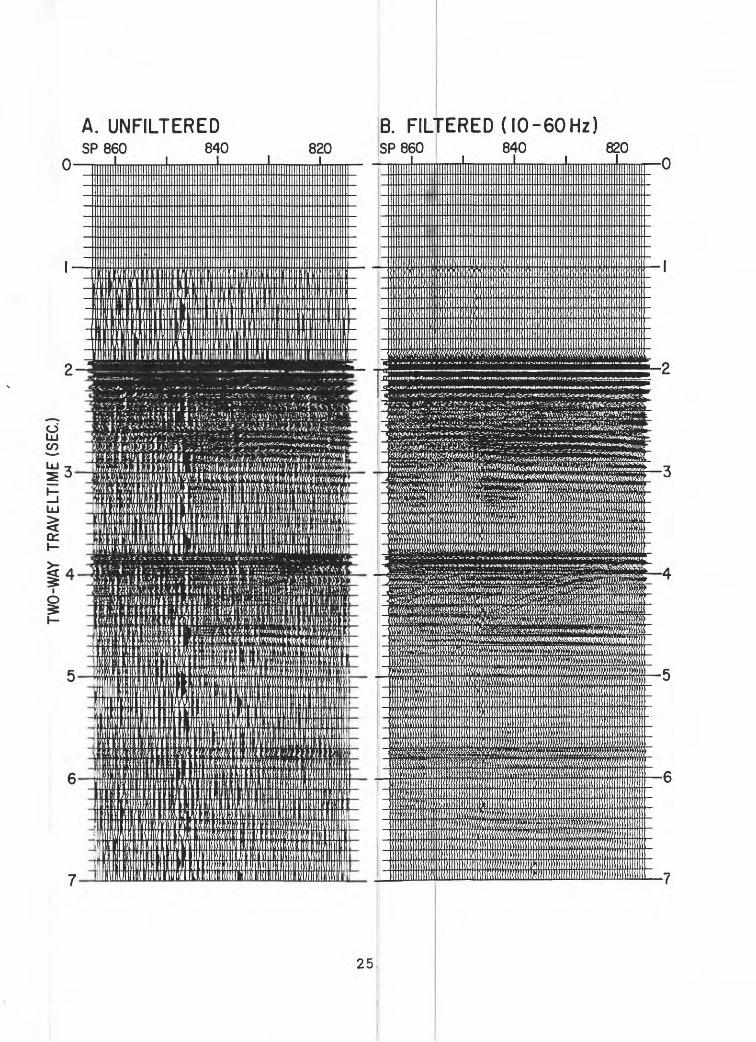
A. UNFILTEREDSP 860 840
B. FILTERED (IO-60Hz)820 SP860 840 820
oLU CO
mini in in II'IMI i1 fi in iimum w\ iiiiiuuuii mmu
;<.;> rt-f^^j^^^.
iQ^^SIII^^ S5£»£3SOTJ«IH!^ ^i«ffi*««M«HHB)^^r;^ ««fflwre^^
WMtMtMWmwawmm,1)1 mriUIIILilillll.!!! "llillililiMllllliHMIlii III 11! II liUlliillllJilliilli'Ttv.nt f.'iHuiM^ i ii .nmmmmiw\wwm\ mwm" ' ^!9!PPJ9PW«WS»^
-% vO'-r^v;^ *«> >'- " r*A*°Vr >-'J».^>^» »^->V.«>\»1>»»»»W*-V»-» * * *:.ViV.^.tvv-j>J*->>--»^*»
^iiiiiiii5^E^^^^L:i^TJSP?5SPi?5!3««*^^^^ei^'ai^^iMtiiii^e;^^^^^^i&^iH!«HJ5J»ft8»^lflS^^
25

Figure 3: Trace display (A) and spectrum analysis (B) of channel 24 from SP 865 (CDP 1750) from line 15-6.
26
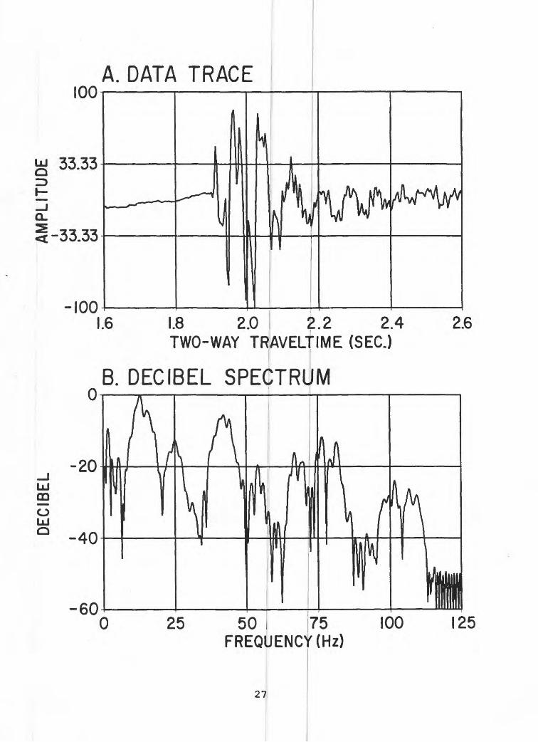
DE
CIB
EL
AM
PLI
TUD
E
ro _aJ_

Figure 4: Illustration of the effect of random shot jitter on the near trace of a portion of line 15-6 before (A) and after (B) static shifts to correct the problem. The jitter was caused by random misfirings of the gun that were almost always associated with a programmed firing delay of 1.024 s.
28

A. RANDOM SHOT JITTER IB. STATIC SHIFTED
0.7-SPIIOO
0.8-
1110 ins :SPIIOO 1110 1120-0.7
0.8
29
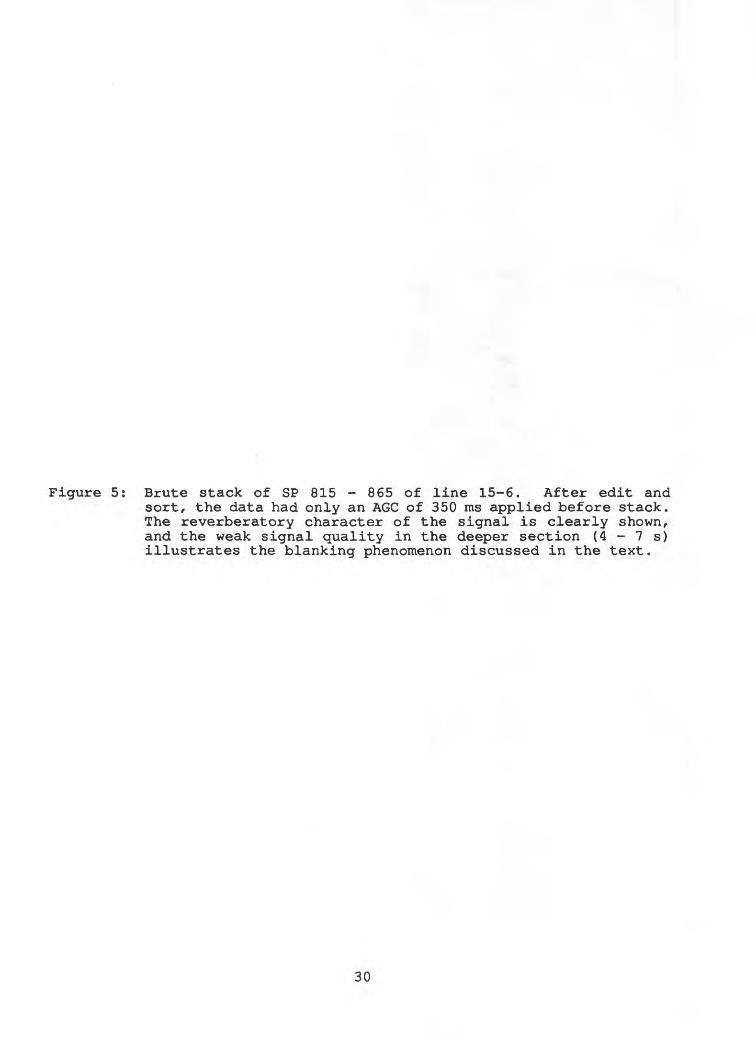
Figure 5: Brute stack of SP 815 - 865 of line 15-6. After edit and sort, the data had only an AGC of 350 ms applied before stack. The reverberatory character of the signal is clearly shown, and the weak signal quality in the deeper section (4 - 7 s) illustrates the blanking phenomenon discussed in the text.
30

SP 860AGC-STACK
840 I 820
<^^<\^tf*^^Z^^^
!<«C«^v<^\^<<\^^^!l?H^g&<!*!^^Bammm^
oLU CO
LU
<c
M]^ 22^^^S^^
&iZ^^
^ijjv:in>m«tmi^wm\vtMf^«!VK^iu^^^
^ Jiffi^^^
31

Figure 6: Enlargement of the near traces of SP 815 - 839 with a 350-ms AGC applied. The slight offset of adjacent traces reflects alternating channels 23 and 24 in the near-trace display. The signature shows an excellent degree of repeatability between adjacent traces.
32

NEAR TRACES-AGCSP 830 820
CO
LU
LU
or
1777

Figure 7: Test stack of SP 815 - 865 using a prestack AGC (350 ms) and a spiking deconvolution (bandpassed at 5 - 70 Hz). This processing shows improved resolution of the data at 2 - 4 s, but the signal quality is still low at 4 - 7 s.
34

AGC-SPIKE DECON-WT STACKSP 860 840 820
' I_ i"
LU C£)
LU
titi i
uuijiinim luumnninutiiHimnnnuiiiiiinnmmnuimnimHn
L;.i^--^fe<*^v>:-?-^--:^---^»ji-Jr--r;^^^
B«aJ!SS^SKflfe^lS!aiJr^^^^^
7-
35

Figure 8: Extracted wavelet from SP 815 - 865 using a 400-ms design window (A) and a 700-ms design window (B). The respective spectra of the traces are shown in panels C and D.
36

CO -o
A. D
ATA
TRAC
E -
400m
sB.
DAT
A T
RA
CE
-700
ms
00.
2 0.
4 0.
6 0.
8 TW
O-W
AY
TR
AV
ELT
IME
(SEC
.)
C." D
ECIB
EL
SP
EC
TRU
M-4
00m
s
0.4
0.8
1.2
1.6
TWO
-WA
Y T
RA
VE
LTIM
E (
SEC
.)
D. D
ECIB
EL S
PE
CTR
UM
-700
ms
UJ m
2.0
50
75
FRE
QU
EN
CY
(Hz)
50
75
FRE
QU
EN
CY
(Hz)

Figure 9: Trace from channel 24 of SP 865 after wavelet deconvolution using the filter designed from a 400-ms window (A) and from a 700-ms window (B) . The respective spectra are shown in panels C and D. Note the similarities in both resulting wavelets and their spectra. The strong negative signal at 1.96 s is the deconvolved water-bottom arrival.
38

co
A. D
ATA
TR
AC
E-4
00m
sB.
DAT
A T
RA
CE
-700
ms
1.6
1.8
2.0
2.2
2.4
TWO
-WA
Y
TRA
VE
LTIM
E (
SE
C.)
C. D
ECIB
EL
SP
EC
TRU
M-4
00m
s
1.8
2.0
2.2
2.4
TWO
-WA
Y TR
AVE
LTIM
E (S
EC.)
D. D
ECIB
EL
SPEC
TRU
M -7
00m
s
bJ m
o LJ o
50
75
FRE
QU
EN
CY
(H
z)50
75
FR
EQ
UE
NC
Y (H
z)
2.6
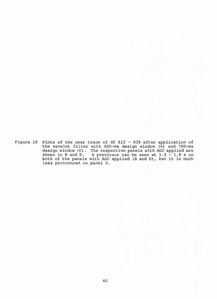
Figure 10 Plots of the near trace of SP 815 - 839 after application of the wavelet filter with 400-ms design window (A) and 700-ms design window (C) . The respective panels with AGC applied are shown in B and D. A precursor can be seen at 1.4 - 1.8 s on both of the panels with AGC applied (B and D) , but it is much less pronounced on panel D.
40

A. N
EAR
TR
AC
E-
400m
sSP
83
0 82
0
B. 4
00m
s +A
GC
SP
830
820
C.N
EA
R T
RA
CE
-70
0ms
SP
830
820
D. 7
00m
s +A
GC
SP
830
820
o LU
CO ct
LAKE
FL
OO
R

Figure 11 Stack of SP 815 - 865 using prestack wavelet deconvolution followed by an AGC of 350 ms and then stack.
42
WAVELET-AGC-WT STACKSP 860 840 820
^*^;tL*lttY^
oLU CO
LU
LU
^ cc
IIo
^^«^^
t^^2£%*^^
B»«»lWNa!«*IM^3*Wa^^ MW^*^^
%smj^^BMRM^^ %%%^^^HMy^ffiH^^ %yww^^^fei$^^^ g}j^i|^^£ift$4?&wi~\iyfi&gM£ifl&'*WI^S*i)3*ff^^^i]/«/tf3Vy/i^ttA<fe^^*.. "<*S'<«S
d&si&E&Sffl^^43

Figure 12 Stack of SP 815 - 865 using prestack wavelet deconvolution followed by an AGC of 350 ms and a predictive deconvolution, then stack. There is some loss of signal and multiples at 5 - 7 s in this processing scheme compared to that shown in
Figure 11, but the overall resolution in the section from 2 - 4 s is improved.
44

mmmmmmm^MwmMMtmmmm ?mmwm<mmmhmmmm(mmmm >m^^wMmmwmm\mmmim&m JBKKlHIBKg^^mmm^mmmmmm^;r^^^mm>mmm SWMMSBRBS^J^^ffi^iM^^3^HraBB^^m^«KUiW^S^^^^^MmraBEK^^Mtemmtix^^ iiHK^M!D^MiGf^^^
wmm&^wwassss^^
zKb«sib^^ »$&$^^^tf^^raBi^^sss^sssRBsnssas^^ KS^S*!^1®^^g?KK^rssr**ws^^ ^*«f«sa«^v^^#j8^
gfeisK^^ fS5S!WgS^?r«2g^^^ ^J^'n^--^g&1j!Wj|;g^^»?^^^^^^^
o
im
mc/J m o
-it038C*8 098 dS
-09V-1313AVM

Figure 13 Stack similar to that used in Figure 12, except that during the stack operation, the far traces are weighted more than the near traces (i.e., weighted stack). The weighted stack has increased the signal strength in the band from 4 - 6 s compared to that of Figure 12.
46

O LU CO
LU
UJ
$ cc
WAVELET-AGC-PDECON-WT STACKSP 860 840 . 820
UUUHHUlUWHUIl^.
^t.»««-.»*<Kj';v" ' * * * - " - « - i^«'-'---.Vi"V» r' "-"W<,.«, iiV^V-...;?- V.J.V- ^^':^$$2&*'-^'*
^^^^^
' '^*'^^^.V>^f.^<^^.^^S^^^^ l -- ' -,-^^^^^^'^^^~^^-^^f^^-,,^.^:^i.\ijr^?f»5^/!&^Ti«^Irkr!-l%V>^
|-**'*'^*^^^<<<f^'«l-^r*»***j»^3lftt.»<»WTVVVii^-''« '^^«^'- 1 ' ^ .?*i>V>i'«?w?.;
i^^^5^!^^^
«
SjIi^lilMfelS^^^ £^^^^p|^p^|^^^ iiS^«^ysl^^
7-
47

Figure 14 Test stack of SP 815 - 865 using prestack wavelet deconvolution, AGC (1000 ms), spectral whitening, and a weighted stack. Whereas the signal resolution is excellent in the shallow part of the section (2 - 4 s), the overall signal strength, particularly at 4 - 7 s, is less than in the processing using a prestack predictive deconvolution (Fig. 13) .
48

2^%M%M%^^ %^!^%^^^^^
^
5%S^%%%^
4%^BKS%M^ 3%(^^!k%K^a^!^^3^^
#%«*N»S^^ WHMKH^^^ MKR»mK%%^^ KS^eaQ^^#K^»»»»5MK^^
%»%M^?K^^^«l&a*^%^^6%^»^^M^R%P^^^ K^5KS^lM^%^% X^: %^r^^?^i^H^^S^^^J^^^^^w:^^^«^%a ?^^^^^^^^^<^^^^^^ : r^^^^&i*^^^^^^t2^^t^^^^/*^^!^^ ,^^^^^^^%! ^?%%J% J»K*%^»?^^^^^^ ^%^^!^1^'%^^^^^^
W3-s*vy*"-";1I-...r - - _ ~- ~'~- "*'-:'"..- .- ~'~ r='>^»-^^»i">C.l.ri-4r'>i:»'«"-«iX.lV;«j,
kT":*m "sr-i<vi-v«-»»»----V*i*».-»«»vvvji>* --* ----^-"»»-. . .r^^.,~> i. .- v;«;-^r,s*i'
028 ' Ot8 098 dS
XOV1S 1M-N31IHM-NIV9-D9V-1313AVM

Figure 15 Processing strategy used in the processing of the multichannel data from Lake Baikal.
50

PROCESSING FLOW
ITERATIVE VELOCITY ANALYSIS
i j!
I
SMOOTHING
I FILM DISPLAY
FILM DISPLAY
FIELD TAPES
DEMULTIPLEXI'
iMPLE1 . IEDIT
EDIT
SORT
1ARCHIVE SEGY
WAVELET DECONVOLUTIONI
AGC350ms
PREDICTIVE DECONVOLUTION |Prediction Distance: 1st zero crossing Operator Length: 71 points
NMO
[MUTE i
WEIGHTED STACK
ARCHIVE SEGY
PREDICTIVE DECONVOLUTIONPrediction Distance: 2nd zero crossing Operator Length: 55 points
[FILTER5/10 - 40/50 hz
VERTICAL SUM2:1 stack
I CASCADED MIGRATIONF-K (Water velocity)Finite Difference (residual vels.)
AMPLITUDE MODULATIONARCHIVE SEGY
JOURNAL DISPLAY
51

Figure 16 Example of the smoothed RMS (A) and calculated interval (B) velocities used in processing Line 14 from the North basin. Each dot in panel A shows a velocity pick. Regularly spaced dots at 4 - 8 s are the positions of assumed velocities and do not represent real reflectin horizons. Contours are in m/s. Contours are shown on the interval velocity section (B) rather than discrete velocity intervals, since the display would be too complicated. The interval velocities for the deeper (assumed) intervals are shown with arrows.
52

A. S
MO
OTH
ED
RMS
VELO
CIT
IES
B. S
MO
OTH
ED
INTE
RVA
L VE
LOC
ITIE
So-
OC
OP
2-
en
u>
a: I o
6-
8
500
I__
__
I__
__
I__
__
I10
00 1____I
OC
DP
500
5200
5300
5700
5600
Ii
1000 I
0 -2 8

Figure 17 Example of stacked and migrated data from line 8 in the Central basin of Lake Baikal. The signal quality is generally excellent and basement can be identified on the entire profile. Blanking still occurs beneath the level of the first water-bottom multiple, indicating the processing did not fully compensate for this problem.
54

N SHOT
50
0LA
KE
BA
IKA
L LI
NE
810
0015
00L_
__
I__
I.20
00
<ji
01gjg
^V'-.
-.:
. ;
I O
.
s=^.
(:..
: FIR
ST
XW
AT
ER
-/
BO
TTO
M
iMU
LtlP
L^B
ASE
MEN
T
0 5
10 K
ML
J^
_l
88

Figure 18 Example of stacked and migrated data from line 6 in the Central basin of Lake Baikal. The signal quality is not very good on this profile, and the first water-bottom multiple has created a zone of blanking in which no primary energy can be identified. Basement is not imaged anywhere on this profile.
56
(Jl
-0
UJ
LU
0
NW
L'
SHOT
i i
-\r\
L_
DH
irX
HL.
200 i
i
LII
ML
. O
400
1 1
SE60
0 i / 0
LAKE
FLO
OR
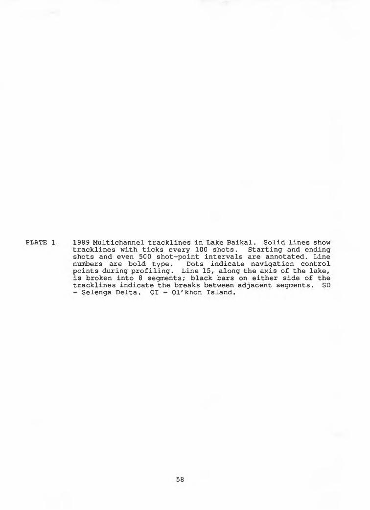
PLATE 1 1989 Multichannel tracklines in Lake Baikal. Solid lines show tracklines with ticks every 100 shots. Starting and ending shots and even 500 shot-point intervals are annotated. Line numbers are bold type. Dots indicate navigation control points during profiling. Line 15, along the axis of the lake, is broken into 8 segments; black bars on either side of the tracklines indicate the breaks between adjacent segments. SD - Selenga Delta. 01 - Ol'khon Island.
58