Buried and Submerged Greek Archaeological Coastal Structures and Artifacts as Gauges to Measure Late...
17
Research Article Buried and Submerged Greek Archaeological Coastal Structures and Artifacts as Gauges to Measure Late Holocene Seafloor Subsidence off Calabria, Italy Jean-Daniel Stanley 1, * and Maria Pia Bernasconi 2 1 Geoarchaeology Program, Department of Paleobiology, Smithsonian Institution, Washington, DC 2 Dipartimento di Scienze della Terra, Universit ` a della Calabria, Rende, (CS), Italy Correspondence *Corresponding author; E-mail: [email protected] Received 21 June 2011 Accepted 9 November 2011 Scientific editing by Jamie Woodward Published online in Wiley Online Library (wileyonlinelibrary.com). doi 10.1002/gea.21405 This synthesis integrates recently acquired archaeological and geological data with earlier documented observations to shed light on the subsidence of an- cient Greek coastal facilities in southern Italy. These are now positioned be- tween former shorelines and inner shelf sectors at five Calabrian margin local- ities. Submergence of coastal to inner shelf facilities has resulted in part from sea-level rise by about 2 m associated with glacio-hydro-isostatic factors since archaic to classic Greek time. This phenomenon alone, however, does not ex- plain the wide variation of measured subsidence rates from site-to-site. The marked lowering of coastal site substrates by seismo-tectonic activity (includ- ing extensional fault motion), stratal readjustments at depth, and compaction of underlying sediment sequences is significant. Four of the subsided facili- ties are positioned near emerged Calabrian areas where prevailing Holocene average annual land uplift rates range to ∼1.0 mm/yr; at the fifth, near Hip- ponion, terrains have risen by nearly 2 mm/yr. In marked contrast, submerged and/or buried structures record the following late Holocene long-term average rates of coastal margin subsidence: Sybaris-Thuri on the Taranto Gulf mar- gin (∼0.5–1.0 mm/yr); Hipponion-Vibo Valentia along the Tyrrhenian coast (∼0.8 to ∼3.2 mm/yr); and Locri-Epizefiri, Kaulonia, and Capo Colonna on Calabria’s Ionian margin (∼1.6, ∼1.6–2.4, and ∼4.0 mm/yr, respectively). C 2012 Wiley Periodicals, Inc. INTRODUCTION The ancient Greeks who colonized southern Italy (Magna Graecia) and established important settlements along coastal margins of Calabria actively pursued nautical activities, including aquaculture, commercial exchange, and maritime trade. To date, however, only a limited number of coastal facilities constructed there as ship land- ing sites, harbors, and shipyards have been discovered and detailed since some are now buried and others sub- merged offshore. Consequently, important aspects of the archaeological and historical records pertaining to this coastal region remain to be deciphered. The major purpose of the present synthesis is to provide an approach using archaeological features as geoarchae- ological proxies to help measure rates of late Holocene lowering of the coastal and seafloor surfaces in sectors between the present Calabrian coastline and inner shelf. These areas comprise integral parts of the highly ac- tive seismo-tectonic Calabrian arc. For such measure- ments, attention is paid to integrating new data with existing information available on Greek to early Roman archaeological structures and artifacts associated with the five coastal sites selected on the margin (Figure 1; cf. Schmiedt, 1975; Cerchiai, Jannelli, & Longo, 2004). One of these localities is presently buried by sediment land- ward of the coast (Sybaris-Thuri), while the four others are submerged near the coast or on the seafloor seaward of known ancient Greek sites (off Hipponion-Vibo Valen- tia, Locri-Epizefiri, Kaulonia, and Capo Colonna south of Crotone). Attention is paid here primarily to features of an estimated time span from about 2800 to 2300 yr B.P., that is, comprising Archaic to Hellenistic Greek and early Roman times. Rates of subsidence are mainly determined Geoarchaeology: An International Journal 27 (2012) 189–205 Copyright C 2012 Wiley Periodicals, Inc. 189
Transcript of Buried and Submerged Greek Archaeological Coastal Structures and Artifacts as Gauges to Measure Late...

Research Article
Buried and Submerged Greek Archaeological Coastal Structuresand Artifacts as Gauges to Measure Late Holocene SeafloorSubsidence off Calabria, ItalyJean-Daniel Stanley1,* and Maria Pia Bernasconi2
1Geoarchaeology Program, Department of Paleobiology, Smithsonian Institution, Washington, DC2Dipartimento di Scienze della Terra, Universita della Calabria, Rende, (CS), Italy
Correspondence*Corresponding author;
E-mail: [email protected]
Received21 June 2011
Accepted9 November 2011
Scientific editing by Jamie Woodward
Published online in Wiley Online Library
(wileyonlinelibrary.com).
doi 10.1002/gea.21405
This synthesis integrates recently acquired archaeological and geological datawith earlier documented observations to shed light on the subsidence of an-cient Greek coastal facilities in southern Italy. These are now positioned be-tween former shorelines and inner shelf sectors at five Calabrian margin local-ities. Submergence of coastal to inner shelf facilities has resulted in part fromsea-level rise by about 2 m associated with glacio-hydro-isostatic factors sincearchaic to classic Greek time. This phenomenon alone, however, does not ex-plain the wide variation of measured subsidence rates from site-to-site. Themarked lowering of coastal site substrates by seismo-tectonic activity (includ-ing extensional fault motion), stratal readjustments at depth, and compactionof underlying sediment sequences is significant. Four of the subsided facili-ties are positioned near emerged Calabrian areas where prevailing Holoceneaverage annual land uplift rates range to ∼1.0 mm/yr; at the fifth, near Hip-ponion, terrains have risen by nearly 2 mm/yr. In marked contrast, submergedand/or buried structures record the following late Holocene long-term averagerates of coastal margin subsidence: Sybaris-Thuri on the Taranto Gulf mar-gin (∼0.5–1.0 mm/yr); Hipponion-Vibo Valentia along the Tyrrhenian coast(∼0.8 to ∼3.2 mm/yr); and Locri-Epizefiri, Kaulonia, and Capo Colonna onCalabria’s Ionian margin (∼1.6, ∼1.6–2.4, and ∼4.0 mm/yr, respectively).C© 2012 Wiley Periodicals, Inc.
INTRODUCTION
The ancient Greeks who colonized southern Italy (MagnaGraecia) and established important settlements alongcoastal margins of Calabria actively pursued nauticalactivities, including aquaculture, commercial exchange,and maritime trade. To date, however, only a limitednumber of coastal facilities constructed there as ship land-ing sites, harbors, and shipyards have been discoveredand detailed since some are now buried and others sub-merged offshore. Consequently, important aspects of thearchaeological and historical records pertaining to thiscoastal region remain to be deciphered.
The major purpose of the present synthesis is to providean approach using archaeological features as geoarchae-ological proxies to help measure rates of late Holocenelowering of the coastal and seafloor surfaces in sectors
between the present Calabrian coastline and inner shelf.These areas comprise integral parts of the highly ac-tive seismo-tectonic Calabrian arc. For such measure-ments, attention is paid to integrating new data withexisting information available on Greek to early Romanarchaeological structures and artifacts associated with thefive coastal sites selected on the margin (Figure 1; cf.Schmiedt, 1975; Cerchiai, Jannelli, & Longo, 2004). Oneof these localities is presently buried by sediment land-ward of the coast (Sybaris-Thuri), while the four othersare submerged near the coast or on the seafloor seawardof known ancient Greek sites (off Hipponion-Vibo Valen-tia, Locri-Epizefiri, Kaulonia, and Capo Colonna south ofCrotone). Attention is paid here primarily to features ofan estimated time span from about 2800 to 2300 yr B.P.,that is, comprising Archaic to Hellenistic Greek and earlyRoman times. Rates of subsidence are mainly determined
Geoarchaeology: An International Journal 27 (2012) 189–205 Copyright C© 2012 Wiley Periodicals, Inc. 189

ARCHAEOLOGICAL STRUCTURES AND COASTAL SUBSIDENCE STANLEY AND BERNASCONI
Figure 1 Mapof the study area showing locationsof fivediscussedburied
and submerged coastal facilities off Calabria, southern Italy.
on the basis of a vestige’s depth and archaeologically es-timated age at each offshore locality examined. It is an-ticipated that the results of the investigation will assistarchaeologists and geographers in evaluating changes ofcoastal position and physiography over time and that, insome cases, likely altered the maritime activities of pop-ulations centered at the five settlements. In addition, thestudy will provide new data for geologists and engineersconducting coastal protection studies on presently evolv-ing shorelines in this geodynamically, highly mobile re-gion.
Hundreds of geological studies published during thepast century have described the stratigraphic frameworkand tectonic complexities of terrains that form the Cal-abrian land mass in southern Italy. The general consen-sus of these works is that strata forming emerged terrainsin this region constitute an integral part of the Calabrianarc, one of the Mediterranean’s highly active tectonic re-gions (Berkhemner & Hsu, 1982; Finetti, 1985; Livermore& Smith, 1985; Udias, 1985; Doglioni, 1991; Gvirtzmann& Nur, 1999; Wortel & Sparkman, 2000; Goes et al.,2004; Molin, Pazzaglia, & Dramis, 2004; Woodward,2009). Geological entities throughout this region havebeen subject to diverse forms of deformation, includinglarge-scale folding of strata, fault offset, and land upliftduring the Quaternary. Summaries of recent geological,geophysical, and seismological analyses document in ever
increasing detail the manner of how and to what extentterrains have risen, especially since the end of the earlyPleistocene until the present (Ferranti et al., 2006, 2009;Antonioli et al., 2009).
Deep penetration seismic surveys, other geophys-ical prospection, and coring for hydrocarbon explo-ration have also provided evidence of geologicallyrecent (Pliocene to Holocene) and diverse styles of struc-tural displacement offshore. Observations made seawardof Calabrian coasts in the Ionian and Tyrrhenian seas andGulf of Taranto record the presence of extensional, com-pressional, and some strike-slip fault offsets, with large-scale anticlinal and synclinal folds. Some are associatedwith mechanisms of active transpression of Middle Pleis-tocene and younger depositional sequences that formthe continental shelf (Ferranti et al., 2009). However, incontrast to work on land, there have been few actualmeasurements of late Holocene rates of seafloor mo-tion offshore, especially on the inner part of the Cal-abrian shelf. Thus, aspects of seafloor displacement in thisregion—be it by uplift, susbsidence, and/or lateral shifts—and rates of such motion during the recent short timespan of several thousand years since Greek colonizationremain, for the most part, poorly defined.
BACKGROUND CONSIDERATIONS
Interpretations of Calabrian land uplift and offshorestratal displacement at the five study areas are basedlargely on the results of detailed litho- and chronostrati-graphic, tectonic, and seismological analyses. Calculatedrates of land surface displacement have recently beenenhanced by more precise measurements of short-termelevation and sea-level changes obtained by Global Po-sitioning System (GPS) positioning and leveling, satel-lite altimeter data, and tide-gauge records (Antonioliet al., 2009; Calafat & Gomis, 2009). This entails im-proved lithological and fossil age dating techniques suchas optically stimulated luminescence, amino acid racem-ization, U/Th, and other (Cucci, 2004; Bianca et al.,2011). The progressively more robust databases serveto enhance an understanding of the effects of south-ern European-North African plate contact and associ-ated seismotectonically induced motion of variable scalein the Calabrian arc. These include regionally signifi-cant phenomena such as subduction and deep-seatedcrustal delamination that have affected the crust andoverlying to surficial strata in both Tyrrhenian and Io-nian sectors of Calabria (Westaway, 1993; Miyauchi,Dai Pra, & Labini, 1994; Giunchi et al., 1996; Ferrantiet al., 2006).
Useful for measuring geologically recent land uplift inproximity to Calabrian shorelines are distinct, superposed
190 Geoarchaeology: An International Journal 27 (2012) 189–205 Copyright C© 2012 Wiley Periodicals, Inc.

STANLEY AND BERNASCONI ARCHAEOLOGICAL STRUCTURES AND COASTAL SUBSIDENCE
coastal terraces of Quaternary age. These raised step-likestructures, that in some profiles are oriented perpendic-ular to the coast and resemble flights of stairs, are inter-preted as markers of raised former wave-cut backshore,beach, and marine shoreface sections. A number of dis-tinct terraces have been dated and traced laterally forconsiderable distances along Calabria’s landward margin.Of the numerous investigations focusing on such terraces,many have paid attention to one formed during the lastinterglacial period when global sea level rose to eleva-tions somewhat higher than at present. This terrace isusually designated as geochronological subunit MIS 5.5inferred to have formed when sea level was about 6 ±3 m above the present stand (Lambeck et al., 2004) andis dated to about 124 ka (Cucci & Cinti, 1998; Bianca etal., 2011). In Calabria, the MIS 5.5 terrace locally reacheselevations ∼100 m above mean sea level (msl) (Dumaset al., 1991, 1995; Ferranti et al., 2006). The elevationof this feature, determined by increasingly refined level-ing techniques and supplemented by an ever larger set ofdated coastal sections, has provided a means to more re-liably measure long-term (late Pleistocene to Holocene)average rates of uplift landward of the coast. Estimatedrates ranging to about 1.0 mm/yr are measured in north-east and southwest Calabria and, more locally, have attimes even reached uplift values of nearly 2.0 mm/yr atthe northern Strait of Sicily-Tyrrhenian margin (Ferrantiet al., 2006; Antonioli et al., 2009; Bianca et al., 2011).
In offshore sectors surrounding Calabria, the very nar-row width of the shelf platforms (commonly <3 km be-tween shore and shelf-edge), variable depths of the outershelf-to-slope break, and generally steep nature (>5◦)of upper continental slopes characterize the tectonicallymodified nature of the shelf margins. In addition, theupper part of deep penetration seismic reflection pro-files collected seaward of coasts record deformed strata ofPleistocene age (Ferranti et al., 2009). However, the res-olution of the uppermost seafloor strata on such seismicrecords is poor. The acoustic signal at the base of the wa-ter column-subbottom strata interface tends to mask andpreclude clear definition of late Holocene to on-going dis-placement affecting the upper seafloor surface.
There is, nevertheless, widespread evidence of distinctrecent to contemporary displacement of seafloor sur-faces as recorded by high-resolution, shallow penetra-tion seismic, and multibeam sonar profiles. These tech-niques clearly indicate the presence of numerous, sharplydefined, linear relief features on shelf platforms wheresuch surveys have been obtained around Calabria. Someof these young neotectonic structures closely resemblehorst-like ridges and graben depressions, while others de-pict near-vertical, low-relief, criss-crossed, and sharplyangular seafloor offsets of low relief (1 m or less) that
record several prevailing fault directions (Stanley et al.,2012). There have been relatively few attempts untilnow, however, to obtain actual measurements of lateHolocene rates of vertical seafloor motion offshore, in-cluding on the inner shelf. The amounts of displacement,whether by uplift or susbsidence and/or lateral motion,and rates at which these have occurred during this re-cent short time span, have remained mostly undefined.It has been generalized that among the fastest geody-namic movements affecting the Mediterranean shores,those that determine the emergence or subsidence ofcoastline stretches, are those that occur at rates of 1–2mm/yr vertically and at rates of 30–40 mm/yr horizon-tally (Milliman, 1992; Stewart & Morhange, 2009).
A series of geoarchaeological studies were initiatedby us in 2003 to measure vertical and lateral coastlinechanges during the past ∼3000 years at the five Greekcoastal localities on the Calabria margin, coded 1–5 inFigure 1. The focus has been on archaeological vestiges,those buried nearshore and facilities now submerged off-shore. The study areas are shown in Figures 2–6: Sybaris-Thuri (site 1) in northeastern Calabria on the Gulf ofTaranto margin; Hipponion-Vibo Valentia (site 2) alongthe Tyrrhenian coast of southwestern Calabria; and Locri-Epizefiri (site 3), Kaulonia (site 4), and off Capo Colonnasouth of Crotone (site 5) on southern Calabria’s IonianSea margin. The geology, physical geography, nearshoreoceanography, and coastal archaeology of features ateach sector, which have been discussed by other work-ers in earlier studies, are an integral part of the presentsynthesis.
Our investigations have primarily involved recovery ofdrill cores, radiocarbon dating, petrological and biologi-cal analyses of sediment core sections, subbottom surveysby high-resolution seismic profiling techniques, and ex-amination of the seafloor surface by multibeam sonar.Data from these studies are supplemented by direct ex-amination of submerged areas by diving archaeologists.Investigations in this region continue under auspices ofthe Cities Under the Sea Program (CUSP) at the U.S. Na-tional Museum of Natural History, Smithsonian Institu-tion in Washington, D.C., in close collaboration with theDepartment of Earth Sciences at the University of Cal-abria, Cosenza. This work has been coordinated with au-thorization, advice, and encouragement of the Soprinten-denza Archeologica della Calabria in Reggio Calabria andits staff at the five examined sites.
MEASUREMENT OF SUBSIDENCE
To measure the subsidence rate at each of the local-ities requires that the original elevation of a studied
Geoarchaeology: An International Journal 27 (2012) 189–205 Copyright C© 2012 Wiley Periodicals, Inc. 191

ARCHAEOLOGICAL STRUCTURES AND COASTAL SUBSIDENCE STANLEY AND BERNASCONI
Figure 2 (a, b) Sybaris-Thuri-Copia study area, including the Casa Bianca excavation, Sybaris archaeological park in NE Calabria, showing port and ship
slip facilities (P) and core sites CB1 and CB2. (c) Stratigraphic log of upper portion of core CB1 with its three buried archaeological levels (S, T, C). (d)
Sediment facies sequence fromW to E: delta alluvial plain, to wetland behind sandy coastal ridge, and to shallowmarine in the Gulf of Taranto (GT, shown
in inset a). Modified after Stanley and Bernasconi (2009) and Bernasconi, Stanley, and Caruso (2010).
anthropogenic feature, whether it be small (such as a ce-ramic or metal fragment) or large (seawall or port struc-ture), be determined relative to present msl stand. Theelevation of a part of the archaeological feature with re-spect to estimated msl at the time of its formation anduse is referred to as ”functional height” (Antonioli et al.,2009). In some cases, the functional height can be for-mer sea level such as at a ship-landing site along thecoast where structures and artifacts were originally po-sitioned close to or at a wetland shoreline margin (ex-ample at site 1). In others, the functional height is thetop of observed constructed feature or structure that wasoriginally positioned at least ∼1 m above sea level in or-der to be effective under the Mediterranean’s microtidalconditions. Examples of the latter include artifacts thatwere deposited at site 4 (near Kaulonia) that accumulatedon a once broad subaerially exposed coastline formed inpart of beachrock strata that are now submerged, and thetops of breakwaters at sites 2, 3, and 5 originally con-structed to an elevation positioned somewhat above sealevel. The materials at the five sites considered here are
of Greek to early Roman age. The original elevations attime of use are then compared to elevations on estimatedsea-level curves for the period 2800–2300 yr B.P. as com-piled by geophysical modeling for this Mediterranean re-gion. While several curves that comprise this time spanare available (Pirazzoli, 1991), herein we use the curvecompiled by Lambeck et al. (2004) as a measure of sea-level stands and their rise and change through mid- andlate Holocene time to the present (Figure 7).
As a hypothetical example, let us consider submergedarchaeological material such as the top of a linear break-water that now lies at a depth of 7 m below present sealevel. To the depth of 7 m, a value of 1 m is added toaccount for the elevation of the top of the original break-water that once, in order to function properly, was likelypositioned about 1 m above sea level. This provides a to-tal lowering amount of 8 m since time of construction.For this example, the date of the structure is estimatedat ∼2500 yr B.P. At that time, the elevation of sea levelon the selected curve was positioned at just under 2.0 mbelow the present sea-level stand (Figure 7). Thus, 2 m is
192 Geoarchaeology: An International Journal 27 (2012) 189–205 Copyright C© 2012 Wiley Periodicals, Inc.
STANLEY AND BERNASCONI ARCHAEOLOGICAL STRUCTURES AND COASTAL SUBSIDENCE
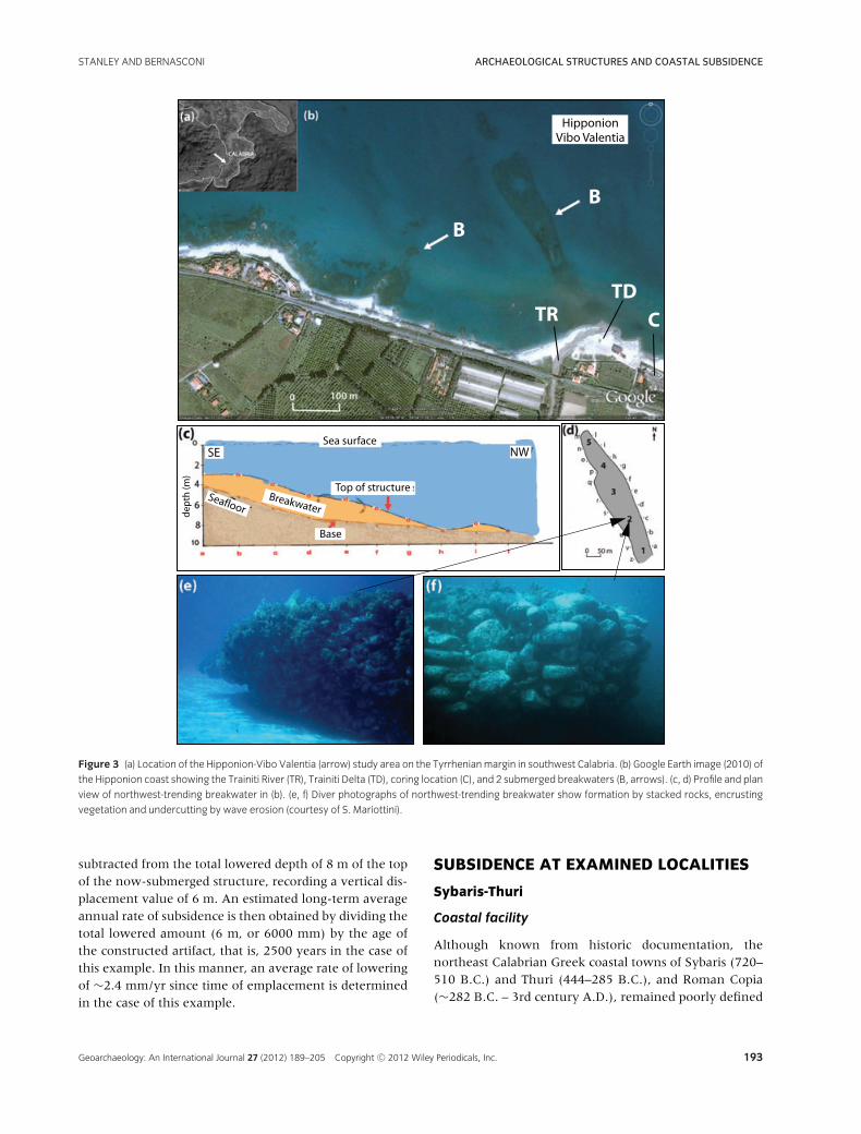
Figure 3 (a) Location of the Hipponion-Vibo Valentia (arrow) study area on the Tyrrhenianmargin in southwest Calabria. (b) Google Earth image (2010) of
the Hipponion coast showing the Trainiti River (TR), Trainiti Delta (TD), coring location (C), and 2 submerged breakwaters (B, arrows). (c, d) Profile and plan
view of northwest-trending breakwater in (b). (e, f) Diver photographs of northwest-trending breakwater show formation by stacked rocks, encrusting
vegetation and undercutting by wave erosion (courtesy of S. Mariottini).
subtracted from the total lowered depth of 8 m of the topof the now-submerged structure, recording a vertical dis-placement value of 6 m. An estimated long-term averageannual rate of subsidence is then obtained by dividing thetotal lowered amount (6 m, or 6000 mm) by the age ofthe constructed artifact, that is, 2500 years in the case ofthis example. In this manner, an average rate of loweringof ∼2.4 mm/yr since time of emplacement is determinedin the case of this example.
SUBSIDENCE AT EXAMINED LOCALITIES
Sybaris-Thuri
Coastal facility
Although known from historic documentation, thenortheast Calabrian Greek coastal towns of Sybaris (720–510 B.C.) and Thuri (444–285 B.C.), and Roman Copia(∼282 B.C. – 3rd century A.D.), remained poorly defined
Geoarchaeology: An International Journal 27 (2012) 189–205 Copyright C© 2012 Wiley Periodicals, Inc. 193

ARCHAEOLOGICAL STRUCTURES AND COASTAL SUBSIDENCE STANLEY AND BERNASCONI
Figure 4 (a) Map of the Locri-Epizifiri study area on southern Calabria’s Ionian margin indicates a coastal marine basin area adjacent to a hook-shaped
low rise (LR) that extends at an angle offshore. (b, c) Two high-resolution subbottom seismic reflection profiles (lines Locri 18 and 15, shown in a) that
cross the low-amplitude lens (LAL), are interpreted as a breakwater. Regionally important acoustic reflector J-horizon (JH) of Holocene age; water-bottom
multiple (M). Modified from Bernasconi and Stanley (2011).
until the mid-20th century (Figure 1, site 1). Much ofthis area was buried for nearly two millennia beneaththick sequences (to >4 m) of fluvio-deltaic plain depositsof the Crati and Sybaris (now known as Coscile) rivers(Figure 2a). After many decades of search, major break-throughs were made as to the geographic location andgeneral configuration of the cities when major system-atic exploratory efforts were undertaken in the 1960s(Rainey & Lerici, 1967; Guzzo, 1973, 1981). The perime-ters of Sybaris and the two partially superposed, youngertowns were at long-last determined primarily by usingan extensive sediment drill coring program (>1500 corescollected), and then focusing on cores that recovered ce-ramic fragments.
A set of much longer drill cores (to >100 m depth)were subsequently collected in the Crati Delta plain forradiocarbon dating and interpretation of the Holocenestratigraphy and geotechnical properties of the sedimentcover (Cherubini, Cotecchia, & Pagliarulo, 1994; Cotec-
chia, Cherubini, & Pagliarulo, 1994). As more core dataaccumulated, the Holocene history of the lower CratiDelta plain (core S18 and others in Figure 2a; Pagliaruloet al., 1995) and its contiguous coastal sector and offshoresubmarine fan in the Gulf of Taranto (Colella et al., 1984)became progressively better defined. From these and ad-ditional data sets, researchers (Cucci, 2005; Ferranti et al.,2011; and others) have indicated that the Sybaris archae-ological park area landward of the coast has been subsid-ing at variable rates during the late Holocene. Their mea-surements suggest a lowering in the range from ∼2.0 to2.8 mm/yr until ∼3500 yr B.P., and then a period of nearstability and/or even slight uplift of the Crati Delta plainfrom ∼3000 to 1300 yr B.P.
Subsequent information collected by us includes two20 m long drill cores in the eastern portion of the Sybarisarchaeological park at the seaward end of the Casa Biancaexcavation (Figure 2b; Stanley & Bernasconi, 2009). It isin this area that coastal port facilities are believed to have
194 Geoarchaeology: An International Journal 27 (2012) 189–205 Copyright C© 2012 Wiley Periodicals, Inc.

STANLEY AND BERNASCONI ARCHAEOLOGICAL STRUCTURES AND COASTAL SUBSIDENCE
Figure 5 (a) Map of the Kaulonia study area on southern Calabria’s Ionian margin showing archaeological material distributed offshore, cores on land
and positions of former and present coastlines. Note former shoreline (1) displaced seaward to coastline position (2) and then, readvancing landward at
(3) and (4). After Stanley et al. (2007). (b, c) Underwater photographs showing fluted Ionic column section and bollard. Modified after Iannelli (1997) and
Iannelli, Lena, and Mariottini (1993). (d, e) Diver above seafloor, which is partially covered by large angular slabs of beachrock, and close-up of inclined
sandstone stratification (arrow) beneath near-horizontal beachrock surface. Photos courtesy of S. Mariottini.
been emplaced (Zancani Montuoro, 1972–1973). Thecores (CB1 and CB2, Figure 2b) were recovered in prox-imity to the ship-landing coastal locality (Figure 2b, P)in the excavation (Bernasconi, Stanley, & Caruso, 2010)in order to obtain more radiocarbon dates and furtherdetail the litho- and biostratigraphy of the fluvio-deltaicsediment sections. Anthropogenic material in core CB1,consisting mostly of ceramic sherds and brick fragments,occur at three distinct stratigraphic elevations measuredbelow msl (from base to top, at −4.5 m, −3.0 m,and at −2.0 m); these are attributed to coastal Sybaris,Thuri, and Copia, respectively (Figure 2c; in core CB1,levels S, T, and C). In core CB2, only 130 m to the east(Figure 2b), there are two artifact-rich layers positionedbelow msl (−3.5 and −2.5 m) and these are associatedwith Thuri and Copia, while the level with Sybaris mate-rial is absent (Stanley & Bernasconi, 2009).
Measured subsidence rate
With the data obtained and applying the method pro-posed earlier, recovered archaeological material suggestsan average long-term subsidence rate of ∼1.0 mm/yrfor Sybaris in Archaic Greek time, and a decreased rateof no more than ∼0.5 mm/yr for the younger, above-positioned Greek Thuri horizon.
Controlling factors
Coastal locality 1 is presently positioned inland, unlikethree of the other sites discussed in the following sections(3–5; Figure 1). Its buried coastal structures are now po-sitioned about 2.5 km west of the present marine Gulfof Taranto margin. The Greek landing zone at the CasaBianca excavation (P in Figure 2b) was once positioned
Geoarchaeology: An International Journal 27 (2012) 189–205 Copyright C© 2012 Wiley Periodicals, Inc. 195

ARCHAEOLOGICAL STRUCTURES AND COASTAL SUBSIDENCE STANLEY AND BERNASCONI
Figure 6 (a) Geological map showingQuaternary formations prevailing landward of the coast, and Tertiary to Paleozoic terrains inland (modified after Dijk
et al., 2000; Spina et al., 2007; and other authors).Map emphasizes the complex of neotectonically active fault lines extending fromnorthern to central and
southern Calabria. (b) Map of Crotone peninsula south of the modern town of Crotone; hachured area depicts zone of uplifted Plio-Quaternary terraces
(T) south of Capo Colonna (modified from Mauz & Hassler, 2000; Zecchin et al., 2003; Mellere, Zecchin, & Perale, 2005). (c) Archaeological structures
AE/AF SW of Capo Colonna off the Crotone Peninsula viewed bymultibeam sonar; arrow depicts contact between sand and rock slabs on the seafloor. (d)
Multibeam sonar profile a to a’ across structure AE in (c); scales in meters. (e) Close-up plan view of structure AE shows continuous, curvilinear, stacked
rock structure. (f) Diver photographs of stacked, uncemented, calcarenite rocks encrusted by vegetation.
196 Geoarchaeology: An International Journal 27 (2012) 189–205 Copyright C© 2012 Wiley Periodicals, Inc.

STANLEY AND BERNASCONI ARCHAEOLOGICAL STRUCTURES AND COASTAL SUBSIDENCE
Figure 7 Synthesis of five submerged coastal facilities examined on the
Calabrian margin, showing their present depths beneath the sea-level
curve of Lambeck et al. (2004). Measured long-term average rates of
subsidence, in approximate mm/yr: (1) 0.5–1.0; (2) 0.8–3.2; (3) 1.6; (4)
1.6–2.4, and (5) 4.0.
along the Crati Delta’s coast (Figure 2d), and at themargin of a now-buried marine wetland system, perhapsa marsh-surrounded lagoon that could be reached byboat, either via canal and/or dredged fluvio-marine sys-tems (Stanley & Bernasconi, 2009; Bernasconi, Stanley,& Caruso, 2010). As indicated by the available chrono-,bio-, and lithostratigraphy, the Crati Delta coastline hasadvanced seaward by about 2.5 km since the time ofSybaris in the 7th to 6th century B.C. Sybaris and thetwo younger and overlapping settlements became land-locked by a pattern of progressive, but irregular, sedi-ment accretion seaward as affected by climatic fluctu-ations. The delta advanced (prograded) eastward at anaverage long-term rate of ∼1 m per year. In additionto effects of world sea-level rise of about 2 m sincethe founding of Sybaris (Figure 7) and climatic controls(deposition, erosion), geotechnical studies provide evi-dence of considerable sediment compaction that inducedlowering of the deltaic sequence at this site (Cherubini,Cotecchia, & Pagliarulo, 1994; Cotecchia, Cherubini, &Pagliarulo, 1994; Pagliarulo et al., 1995). Geological anal-ysis of the Crati plain region also records the role of recenttectonic modification of this coastal margin by deforma-tion and lowering of underlying deltaic, coastal, and off-shore substrates (Cucci, 2005; Ferranti et al., 2009, 2011).
Hipponion-Vibo Valentia
Coastal facility
The Greek city of Hipponion (Figure 1, site 2) is locatedshoreward of the Tyrrhenian coast, on the northeasternmargin of Calabria’s Capo Vaticano peninsula (Figure 3a).
This Greek center was founded toward the end of the7th century B.C. by a population that emigrated fromLocri-Epizifiri on the Ionian margin (Figure 1, site 3).Important vestiges of Greek and Roman settlements liewithin, and close to, the modern town of Vibo Valen-tia that overlooks the sea and is positioned on a raisedPleistocene terrace (Dumas et al., 1991) about 500 mabove msl. These remains are about 4 km south of thepresent shoreline, and southwest of the modern port ofVibo Marina. Hipponion’s port (or ports) and associatedcoastal facilities are believed to be located along severalnearshore sectors below the modern town, but remainpoorly defined (Schmiedt, 1966; Lena, 1989; Jannelli,Lena, & Givigliano, 1992). These, for the most part, arenow buried by base-of-slope alluvial sediments that coverthe elongate coastal plain and also its contiguous offshoreshelf (study in progress). It has been postulated that theprobable sector of former nautical activity lies betweenPunta Safo and the mouth of the Sant’Anna River, an ir-regularly shaped coastline stretch ∼4 km in length (Lena,1989; Jannelli, Lena, & Givigliano, 1992).
Core drilling, geophysical surveys, and archaeologi-cal excavation in the coastal plain at Bivona, 3 km tothe north of Vibo Valentia, have revealed buried struc-tures, including a wharf and other features of probableGreek and possibly older age (Cucarzi, Iannelli, & Rivolta,1995). Cores recovered in this plain area record some pre-existing marshy wetland settings under a younger alluvialsoil cover; these were separated from the open sea to thenorth by beach ridges and coastal dunes. South-to-northstratigraphic reconstructions based on cores collected atBivona indicate that the coastline prograded seaward inthe late Holocene (Cucarzi, Iannelli, & Rivolta, 1995).
It is probable that a harbor facility was also locatednear the mouth of the Trainiti River ∼3–4 km north ofVibo Valentia. We have recently recovered artifacts incores in the river’s small delta formed of sand and sandysilt strata. This area lies just landward of two very large,well-defined and now fully submerged linear structures(Figure 3b, B). These, formed of stacked large roundedrock boulders and some angular blocks, are interpretedas probable breakwaters (Figure 3e, 3f; Lena, 1989; Jan-nelli, Lena, & Givigliano, 1992). Although no firm dateshave as yet been determined, a review of historic doc-umentation by archaeologists suggests a pre-Roman agefor the uncemented rock structures (Figure 3e, 3f; cf.Lombardo, 1989; Cucarzi, Iannelli, & Rivolta, 1995). Thelonger of the two linear features extends seaward to-ward the northwest (N330◦W) from the present coastfor a distance of about 350 m (Figure 3d). The second,much shorter structure (∼100 m long), extends from thecoast toward the northeast. Immediately seaward of thepresent shoreline, the base of the longer breakwater is
Geoarchaeology: An International Journal 27 (2012) 189–205 Copyright C© 2012 Wiley Periodicals, Inc. 197

ARCHAEOLOGICAL STRUCTURES AND COASTAL SUBSIDENCE STANLEY AND BERNASCONI
buried by sand and silt at a depth of ∼4 m; its upper sur-face lies at a depth of −3 m (Figure 3c). The upper sur-face of this structure at its most distal (seaward) position,where it merges with the seafloor, rests at a depth of 9 mbelow present sea level.
It is likely that a coastal facility now lies buried be-neath the alluvial soil cover landward (to the south) ofthe Trainiti Delta and in the vicinity of the two largewharf-like construction features. This is suggested, albeitindirectly, by the two massive breakwaters that form asemi-enclosed, harbor-like configuration near the presentcoastline and mouth of the Trainiti River (Figure 3b). Thissector is presently under study by means of sediment coreanalysis, including petrologic examination, compositionalanalysis of clastic and biogenic content of sediment, andstudy of anthropogenic remains that have been recentlyrecovered. From preliminary study of cores in the TrainitiDelta just landward of the coast (Figure 3b, locality C),this area appears to have once occupied a nearshore sec-tor as indicated by a ∼1 m thick stratum rich in marinevegetal (Posidonia sp.) matter (R. Cozza, personal commu-nication, 2011). The vegetal-rich setting, indicating thepresence of a sea-grass cover, was positioned close to thecoast, probably after human occupation of a terrestrialzone in pre-Roman time.
Measured subsidence rate
The upper surface of the longer breakwater is used hereas a gauge for measuring subsidence of the Hipponioninner shelf. Assuming the structure was originally con-structed to an elevation of ∼1.0 m above former sea level(estimated functional height), the long-term average rateof subsidence of the coastal structure has ranged from∼0.8 mm/yr near the present coastline, to as much as∼3.2 mm/yr at a distance of about 300 m seaward of thepresent Trainiti River shore. To this can be added findingsof small (to 1.5 cm) fragments of ancient artifacts discov-ered at a depth from 9 to 10 m below msl in one of sev-eral cores collected in the Trainiti Delta a short distancelandward (∼30 m) from the coast (Figure 3b). The ar-chaeological material, if released at the shore and in situ,indicates an approximate long-term average subsidencerate to ∼2.6 to 2.8 mm/yr, that is, within the range of thebreakwater’s rate of submersion.
Controlling factors
The Capo Vaticano area is one of the most tectonicallyactive sectors of the Calabrian arc, with tilting of capeterrains seaward toward the northeast (Tortorici et al.,2003). Geological studies, both on land and offshore, pro-vide an ample record of Quaternary structural displace-
ment, including vigorous uplift rates (to nearly 2 mm/yr;Bianca et al., 2011), ongoing fault motion (Tortorici et al.,2003), and powerful earthquake activity, some producingtsunamis affecting the study area coast (Piatanesi & Tinti,2002; Anzidei et al., 2006; Cucci & Tertulliani, 2010).Examination of tectonic patterns indicates that terrainsunderlying the alluvial plain cover, between the base ofraised terraces and adjacent offshore sector, were dis-placed by still-active uplift motion and effects of associ-ated major normal faulting (Antonioli et al., 2009). Thesehave led to distentional and some rift-type dislocation inHolocene time (Cucci & Tertulliani, 2010; Bianca et al.,2011). In addition to seismo-tectonic effects, the role ofsediment compaction occurring beneath the large break-waters, due to their mass, cannot be excluded.
Locri-Epizefiri and Kaulonia
Coastal facilities
Archaeological features at two Greek settlements lo-cated on Calabria’s straight, northeast-southwest trend-ing Ionian margin are considered here: Locri-Epizefiri andKaulonia (Figure 1, sites 3 and 4). They are discussed to-gether in this section since both are positioned within theLocride geological province. Recent archaeological stud-ies of Locri-Epizefiri, settled in the late 8th or early 7thcentury B.C., include those by Costamagna and Sabbione(1990) and Barra Bagnasco (1999), the latter publishingnumerous research articles that pertain to this site formore than a quarter of a century. The walled town islocated along the coast between the Portigliola and Lu-cifero rivers, and about 3 km southwest of the moderntown of Locri (Figure 4a); it is backed by hills that rise to150 m within the boundary of the site. Kaulonia, foundedat about 700 B.C., is positioned along the coast ∼37 kmnortheast of Locri, and just to the north of the moderntown of Monasterace Marina. Terrains within the town’swalls rise from sea level to 70 m above msl; two majorlandmarks, the Assi River and Squillace Gulf, are locatedto the north of the site (Figure 5a). Archaeological ves-tiges on land at Kaulonia have been studied by Iannelli(1985, 1992, 2005) and Barello (1995), while abundantanthropogenic remains on the seafloor have been de-tailed by divers (Lena, 1997; Lena & Medaglia, 2002; Lena& Iannelli, 2003; S. Mariottini, personal communication,2003). Geoarchaeological analysis of the studied coastalsectors has been made by means of high-resolution sub-bottom seismic profiles obtained seaward of the two sites,and by cores (Figure 5a) recovered just landward of thecoast (Stanley et al., 2007; Bernasconi & Stanley, 2011).
The major anthropogenic feature recorded off the Locrisite is a massive, elongate (∼65 m long) buried structure
198 Geoarchaeology: An International Journal 27 (2012) 189–205 Copyright C© 2012 Wiley Periodicals, Inc.

STANLEY AND BERNASCONI ARCHAEOLOGICAL STRUCTURES AND COASTAL SUBSIDENCE
detected on several high-resolution subbottom seismicprofiles (Figure 4b, 4c). This feature is positioned ∼200 to250 m off the present Locri shoreline and seaward of theGreek stoa and coastal marine basin now on land (Figure4a). On seismic profiles, it appears as a near-transparent,poorly stratified lens with a thickness of at least 2 m (low-amplitude lens, in Figure 4b, 4c) and is interpreted as abreakwater (Tennent et al., 2009; Bernasconi & Stanley,2011). This feature lies buried by >1.5 m of stratified sed-iment, mostly sand, that forms the core of what in plan-view appears as a large, angular, hook-shaped mass ofsediment ∼450 m long with an average width of ∼200m. The sediment mass forms a low rise on the seafloorsurface and extends seaward, toward the NE, from thepresent coastline (Figure 4a). The top of the lens lies ata depth of about 5–6 m below msl, and the structure’supper surface is assumed to have been originally con-structed at ∼1 m above msl (its functional height).
The inner shelf area off the coast of Kaulonia is cov-ered by sand, coarse fluvial debris (cobbles and boulders;Figure 5b, 5c) derived from the Assi River, and massiveslabs of beachrock strata (Figure 5d, 5e). These, in turn,are littered with abundant large and widely dispersed ar-chaeological materials that cover an area of 200 by 300 mand are attributed a Greek age (Iannelli, 1997; Iannelli,Lena, & Mariottini, 1993; Parra, 2001; Medaglia, 2002).Archaeological debris includes numerous large sections ofGreek Ionic columns, diverse construction blocks, a bol-lard, and other anthropogenic materials that lie at waterdepths ranging mostly from 5 to 7 m below msl (Fig-ure 5b, 5c). These materials are dispersed to ∼300 moff the present coast on what has been interpreted asa broad arcuate headland that was subaerially exposedin the late Holocene (Stanley, 2007). The large debrisfield positioned over an extensive surface area, some of itformed by beachrock strata, has recently been interpretedas a now-submerged remnant of a Greek work area.This sector was once exposed landward of the shorelineand elevated to a functional height of at least 1 m, andpossibly more, above msl (Stanley, 2007; Stanley et al.,2007).
Measured subsidence rates
Off Locri, a total minimal lowering of 6 m is calculated forthe buried breakwater feature, and this is used to estimatea calculated long-term subsidence rate of ∼1.6 mm/yr.At Kaulonia, numerous archaeological features (columns,construction blocks, and other) resting on a work surfacein the beach area were lowered by 6–8 m since Greektime, and this surface subsided at an average rate rangingfrom ∼1.6 to ∼2.4 mm/yr.
Controlling factors
Submergence offshore at sites (3) and (4), as in the caseof previously discussed sites (1) and (2), is associated withcombined late Holocene sea-level rise and tectonic dis-placement of adjacent terrains, including long-term av-erage uplift to ∼1 mm/yr of terraces on land that backthe shore. Landward of both the Locri and Kaulonia set-tlements are strata of Pliocene to Quaternary age thathave been deformed and offset by faults (Gasparini et al.,1982; Sorriso Valvo, 1993; Dumas et al., 1995; Bordoni &Valensise, 1998; Ferranti et al., 2006). Seafloor loweringis likely associated with faulting and deformation of thesubstrate (Tennent et al., 2009). Geoarchaeological studyindicates that, as a result of these controlling parametersthat affected land and offshore terrains, both settlementsexperienced significant back-and-forth shifts of coast-line and changes of sea-level positions during the mid-and late Holocene to the present (Stanley, 2007; Stanleyet al., 2007; Bernasconi & Stanley, 2011).
Since the md-Holocene, shorelines at both sites ad-vanced landward, and then moved back seaward before,once again, shifting landward. While in some ways simi-lar, the back-and-forth coastline displacements were notsynchronous at the two localities, and Locri and Kauloniasettlements were affected in a somewhat different man-ner. At Locri, the Greeks built their city and coastal fa-cilities following a time of maximum shoreline advancelandward, while at Kaulonia construction occurred alongthe coast, partially on a beachrock surface (Figure 5a, 5d,5e), after the shoreline had already returned seaward byseveral hundred meters. The nonsynchronous timing ofcoastline migrations at Locri and Kaulonia likely resultedin part from different periods of accelerated Holocene up-lift of the terrains that underlie the two settlements (Stan-ley, 2010: Figure 2.5). Support for this hypothesis is pro-vided by the presence of several major faults that offsetand separate the two study localities positioned along thiscoastline during the Holocene.
Offshore Capo Colonna and Crotone Peninsula
Coastal facility
A conspicuous feature seaward of Calabria’s Crotonepeninsula is positioned southwest of the Capo Colonnaheadland (Figure 1, site 5); it is the deepest of the fivecoastal facilities examined in this study. The structure issubmerged ∼250 m from the Ionian coast, and its baselies in sand at a depth of −12.5 to −13 m; its upper sur-face rests at 11 m below present msl (structure AE inFigure 6c, 6d). This distinct, gently arcuate feature, witha marked relief of ∼1.5 m, was discovered in 2005 by
Geoarchaeology: An International Journal 27 (2012) 189–205 Copyright C© 2012 Wiley Periodicals, Inc. 199

ARCHAEOLOGICAL STRUCTURES AND COASTAL SUBSIDENCE STANLEY AND BERNASCONI
means of a multibeam sonar survey and interpreted as abreakwater of Greek age (Royal, 2008). In proximity aretwo large square rock-cut features (4 by 4 m, and 5 by5 m) lying about 30–35 m to the northeast of AE andinterpreted as probable pier structures (AF in Figure 6c).Another hypothesis was subsequently formulated as tothe elongate AE feature’s origin, one emphasizing pri-marily its considerable depth, length (∼42 m), and dis-tance from the coast. Based on these attributes, a naturalmarine beachrock origin, and not one of anthropogenicorigin, was proposed by Bartoli (2010). However, recentanalysis of reprocessed multibeam sonar and direct visualdiver and photographic data reaffirmed that the structurewas built of stacked calcarenite rocks by human emplace-ment (Stanley et al., 2012). These rocks, piled without ap-parent use of a binder or cement (Figure 6e, 6f), presenta triangular form in cross-section, with a near-consistentbasal width of 6 m (Figure 6d). Examination and pho-tographs of the seafloor, obtained by diving archaeol-ogists, further confirm the original hypothesis that thestructure is not a natural beachrock stratum but, rather,a breakwater (Stanley et al., 2012). It was originally con-structed at a position nearshore by the Greeks as part ofa harbor built along the coast, south of their major cityof Crotone and southwest of Capo Colonna (Figure 6b)close to the sanctuary of Hera (Juno) Lakinia (Osanna,1992; Cerchiai, Jannelli, & Longo, 2004).
Measured subsidence rate
A long-term minimal average subsidence rate of ∼4.0mm/yr is calculated on the basis of available data per-taining to the depth of the breakwater’s upper surface ofprobable Greek age.
Controlling factors
Moderate to large blocks of calcarenite concentrated onthe inner to mid-shelf surface of this area were derivedfrom strata that once formed the cliffs of the Crotonepeninsula coast. The cliffs were undercut by wave erosionresulting in large slabs toppling onto the adjacent beachand inner shelf. Some movement seaward of blocks ofvariable size was also triggered by gravity flows (cf. Mid-dleton & Hampton, 1976), including slides and slumps(Lena et al., 2003). The continuous elongate and un-broken configuration of the submerged stacked rock fea-ture examined here indicates that it has not been subjectto substantial lateral displacement by a turbulent slumpevent. The possibility of some lateral gravitative shiftsalong a near-horizontal slide plane at depth, however,cannot be excluded. The detailed multibeam sonar sur-vey of this feature and adjacent areas of the shelf-floor
surface provides information as to how such harbor fea-tures may have reached their current depth. Distinctivenatural structures include a tilted and broken floor off-set by sharp linear scarps, terraces, ridges, and graben-like depressions. It is of note that these features have afresh appearance and are delineated by distinct bound-aries. Many are not masked by sand in spite of strongwave-driven bottom currents that, at these depths in thisarea, have the capacity to readily transport the sand coverand bury small seafloor relief features. To the contrary,the observed distinct seafloor structures record variousstages of recent displacement of underlying consolidatedstrata as a result of tectonic deformation. Submergence ofthe coastal facilities off Capo Colonna is believed to haveoccurred by a number of modest tectonic pulses duringthe Holocene, perhaps some involving periodic loweringby extensional fault motion offshore.
It is recalled that this study area is located in one ofItaly’s most tectonically active regions, modified by pow-erful earthquake and seismic activity (Galli et al., 2006)and faulting (Zecchin et al., 2003), with rise, lower-ing, and/or some strike-slip motion of adjacent land ter-rains (Zecchin et al., 2010). Considerable attention hasbeen paid to the seismic framework, stratigraphy, andcomplex neotectonic structure of the Crotone geologicalbasin forming the adjacent landmass (Figure 6a; Van Dijk,1991; Zecchin et al., 2003; Mellere, Zecchin, & Perale,2005; Valenti, 2010). Displaced terrains on land, such asuplifted terraces (T in Figure 6b) and those of the sub-strate submerged offshore (Finetti & Morelli, 1973; Udias,1985; Pirazzoli et al., 1997; Antonioli et al., 2009), recordextensive regional, and local neotectonic responses tocontact of the African against the southern Europeanplate in this region.
SITE-TO-SITE SUBSIDENCE VARIABILITY
The observations summarized in the previous sectionsindicate that the positions of modern Calabrian shore-lines at four of the examined localities (sites 1, 3–5) dif-fer considerably from those that existed at the time ofGreek and early Roman populations. Coastlines at sites3–5 along the Ionian margin have advanced landward by200 m or more, submerging what were once subaeriallyexposed and settled coastal terrains. Each of these threenearshore localities was affected by the world sea-levelrise and seismo-tectonic lowering of former land surfacesin the late Holocene. Moreover, submergence at sites 2and 5 occurred by particularly rapid rates of relative sea-level rise during and following human occupation.
Subsidence has been relatively minor at some locali-ties (site 1), whereas submergence in others resulted from
200 Geoarchaeology: An International Journal 27 (2012) 189–205 Copyright C© 2012 Wiley Periodicals, Inc.

STANLEY AND BERNASCONI ARCHAEOLOGICAL STRUCTURES AND COASTAL SUBSIDENCE
stronger and more numerous tectonic pulses (site 5). Thesudden failure of sites in this region was also inducedby climatic triggering that affected sedimentation locally,such as deposition by fluvial flooding and by wave ero-sion and storm surges (site 1), and/or by tectonic mo-tion including earthquakes (among the strongest in Italy)and associated tsunamis (site 2). Each of the five local-ities has been modified by a different set of interactionsthat have involved two or more major controlling natu-ral parameters. It is this diverse interplay of natural fac-tors through time that has induced highly variable av-erage long-term rates of coastal subsidence from site tosite along the tectonically active Calabrian margin. As aresult, we find that, excluding world (eustatic) sea-levelrise, the role of subsidence during the past ∼3000 years inthe late Holocene has ranged from a modest ∼0.5 mm/yrto a remarkably high ∼4 mm/yr.
Since the time of Greek occupation, coastal marginsseaward of shorelines at the five sites have been mod-ified in several ways. In all cases, glacio-hydro-isostaticfactors and associated sea-level rise have had a role insubmergence of coastal margins. However, it is the inter-action of these factors with several other parameters thathas induced the large variability of coastal submergencerates recorded among the Calabrian sites examined in thelate Holocene. These other factors include (1) a high rateof sediment accumulation, (2) accelerated sediment ero-sion, (3) compaction of substrate sections, (4) role of massgravity failure leading to slides and slumps and displace-ment seaward of sediment and rock to greater depths,and (5) substrate lowering resulting from seismo-tectonicreadjustments and shifts of sediment sequences at vari-able (shallow to considerable) depths of the surface andsubsurface underlying former coastal facilities. In con-trast, geological studies conducted in this region duringthe past century recognized that much of the Calabrianland mass shoreward of the coast has been subject to up-lift, especially from the mid-Pleistocene to the Holocene.Thus, seismo-tectonic activity has induced both land up-lift and submergence of offshore margins by extensionalfracturing and increased vertical steepening of seafloorsurfaces (Gamberi, Rovere, & Marani, 2011)
As a result of the various interactions, archaeologi-cal materials at Sybaris-Thuri are now landlocked andburied at about 2.5 km landward of the present Gulfof Taranto shore, while those at Hipponion appear tohave been actively lowered in proximity to the Tyrrhe-nian coast. Moreover, as a function of shorelines thathave markedly shifted landward, coastal facilities at thethree Ionian margin sites (Locri-Epizefiri, Kaulonia, andoff Capo Colonna) are now submerged ∼200 to ∼300m from the present shoreline. The seafloor on whichanthropogenic structures and artifacts are positioned is
usually associated with recent tectonic deformation, in-cluding folds and faults. It is also noted that some sub-merged coastal facilities (Locri-Epizefiri, Kaulonia, CapoColonna) lie seaward of, but not distant from, upliftedterraces on land that have risen at long-term rates to∼1.0 mm/yr. Terraces at Hipponion-Vibo Valentia havebeen uplifted locally at a somewhat higher rate that has,at times, reached ∼2.0 mm/yr.
It is apparent that neither eustatic sea level rise nor cli-matic influences (such as thermal expansion of the wa-ter column) alone can account for the remarkably differ-ent rates of submergence and/or burial of Greek coastalfacilities along Calabria’s margin in late Holocene time.Rather, the variable displacement patterns of coastal fa-cilities on both the Ionian and Tyrrhenian margins are toa large extent a response to their position on one of theMediterranean’s most tectonically active sectors, the Cal-abrian arc, at the junction of the mobile North Africanand European plates.
CONCLUSIONS
This investigation records long-term average subsidencerates of coastal archaeological facilities at five Calabriansites that range from as low as ∼0.5 mm/yr to as high as∼4.0 mm/yr during the late Holocene (Figure 7). Thesevalues exclude the role of sea-level rise during this pe-riod. These observations lead us to expect that other sub-merged coastal harbor and landing sites, including thoseof Greek and perhaps earlier age, are yet to be discov-ered offshore of southern Italy. As has been noted alongdifferent Mediterranean margins, measurements of mod-erate to rapid submergence are not limited to highlytectonically active coasts. For example, in the WesternMediterranean where numerous coastal sites are docu-mented (cf. Flemming, 1969), many are submerged off-shore in areas of low to moderate tectonic activity. Alsoof special interest in respect to rapid lowering are sub-merged coastal sites that have subsided at rates from ∼0.9to ∼4.3 mm/yr on the relatively tectonically stable NileDelta margin (Stanley & Toscano, 2009). The range ofland lowering rates off the Egyptian coast, while surpris-ingly comparable to that of Calabrian margins, is largelya function of the interaction of factors other than thosethat dominate off southern Italy. In addition to hydro-glacio-isotatic parameters, these include the impact of cli-mate and generally high depositional rates, extensive sed-iment compaction of water saturated fluvio-deltaic sub-strate sequences of Holocene age, and remobilization anddisplacement of older strata at shallow to great depths be-neath the modern Nile Delta surface.
Geoarchaeology: An International Journal 27 (2012) 189–205 Copyright C© 2012 Wiley Periodicals, Inc. 201

ARCHAEOLOGICAL STRUCTURES AND COASTAL SUBSIDENCE STANLEY AND BERNASCONI
Increased geoarchaeological databases pertaining toMagna Graecia coastal facilities are deemed essential forupdating the study of early settlements where the pastpopulations were involved with nautical activities, espe-cially regional and long-distance trade. Extensive changesin relative sea level that we have identified here would al-most certainly have impacted such coastal activities dur-ing and following Greek time. To obtain more precisemeasurements with which to calculate subsidence ratesand relative sea-level rise and better evaluate their im-pacts, there is a continuing need to (1) more preciselydate ancient archaeological structures and materials dis-covered beneath and seaward of coasts and (2) to useupdated sea-level curves for the region as they becomeavailable. For example, it may eventually be determinedthat sea level ∼2500 years ago was −1 m and not −2m lower than present msl, and/or that the archaeologicalmaterials considered are actually younger than presentlyindicated. The recalculated average annual rates of subsi-dence using such revised databases will prove to be con-siderably higher than those estimated in this study. Inturn, such revised values will likely suggest even greaterrates of shoreline shifts and submergence of coastal facil-ities during this relatively short (<3000 years) time pe-riod.
In addition to fulfilling archaeological needs, measure-ment of reliable subsidence rates has direct practical im-plications for assisting present human populations liv-ing in rapidly evolving coastal settings such as thosein Calabria. Archaeological vestiges that provide infor-mation on land motion in times past will increasinglyserve as valuable gauges to more accurately predict fu-ture changes in relative sea level. It is thus anticipatedthat increasingly accurate measurements of land mo-tion based on dated past human activity can providecoastal engineers and managers with needed supplemen-tal databases. It will be useful to apply these gauges toassist in the planning, devising, and implementing of pro-tection measures for those Calabrian shoreline sectorsparticularly susceptible to coastal submergence and rapidrelative sea-level rise.
We express our special appreciation to Dr. Maria Teresa Iannelli,Soprintendenza Archaeologica della Calabria, Reggio Calabria,for her continued generous support of our research efforts onthe coastal margins of Calabria. We thank Dr. J.G. Royal, RPM-Nautical Foundation, Key West, Florida and G.A.J. Nickerson,Highland Geo Solutions, Taymouth, New Brunswick, Canada,for generously providing reprocessed multibeam sonar data setsfrom the Capo Colonna area and their assistance in interpretingthem. Engineer P. Cappa of the Protected Marine Area “CapoRizzuto,” Crotone, made available valuable background data inthe form of reports needed for our work on the margin seawardof the Crotone peninsula. Drs. C. Sabbione and M. Milanesio fa-cilitated our study on the marine basin site at and seaward of
the Locri-Epizefiri coastal margin, and Dr S. Luppino, Director ofthe Sybaris Museum and Archaeological Park, assisted us at theexcavated site of Casa Bianca. Dr. S. Mariottini, Kodros Asso-ciation, Mentana, Italy, generously shared photographic, videoand other information on the submerged sites off Kaulonia andHipponion-Vibo Valentia. Helpful reviews of earlier drafts of thisarticle were made by Profs. E. Le Pera and F. Scarciglia, Univer-sity of Calabria, Rende, Ms. K. Corwin, Smithsonian Institution,and two anonymous reviewers. Partial funding for this projectwas provided (to J.-D.S.) by research awards from the Depart-ment of Paleobiology and the ADRC Office, U.S. National Mu-seum of Natural History, Smithsonian Institution, Washington,D.C., and (to M.P.B.) by Universita della Calabria, Rende.
REFERENCES
Antonioli, F., Ferranti, L., Fontana, A., Amorosi, A.,
Bondesan, A., Braitenberg, C., Dutton, A., Fontolan, G.,
Furlani, S., Lambeck, K., Mastronuzzi, G., Monaco, C.,
Spada, G., & Stocchi, P. (2009). Holocene relative sea-level
changes and vertical movements along the Italian and
Istrian coastlines. Quaternary International, 206, 102–133.
Anzidei, M., Esposito, A., Antonioli, F., Benini, A., Tertulliani,
A., & del Grande, C. (2006). I movimenti verticali nell’area
di Briatico: Evidenze da indicatori archeologici marittimi
nell’area del terremoto del 1905. In I. Guerra & A. Savaglio
(Eds.). 8 Settembre 1905 Terremoto in Calabria
(pp.301–321). Castrovillari: Regione Calabria Assessorato
alla Cultura.
Barello, F. (1995). Architettura greca a Kaulonia. Edilizia
Monumentale e Decorazione: Architettura in una citta
della Magna Graecia. Torino: Casa Editrice Le Lettere.
Barra Bagnasco, M. (1999). Strutture esterne alle mura di
Locri Epizefiri e il problema del porto. In M. Barra
Bagnasco & M.C. Conti (Eds.), Studi di archeologia classica
dedicati a Giorgio Gullini per i quarant’anni di
insegnamento (pp.1–18). Alessandria, Italia: Edizioni
dell’Orso.
Bartoli, D.G. (2010). Ancient harbor structures in Crotone,
Italy: A reappraisal of the evidence. The International
Journal of Nautical Archaeology, 39, 399–406.
Berckhemer, H., & Hsu, K. (Eds.). (1982).
Alpine-mediterranean geodynamics. Washington, DC:
American Geophysical Union.
Bernasconi, M.P., & Stanley, J.-D. (2011). Coastal margin
evolution and postulated “Basin-Shipyard” area at ancient
Locri-Epizephiri, Calabria, Italy. Geoarchaeology, 26,
33–60.
Bernasconi, M.P., Stanley, J.-D., & Caruso, C. (2010).
Sybaris-Thuri-Copia deltaic settings in Calabria, Italy:
Molluscs, associated biogenic components, and
ecobiostratigraphy applied to archaeology. Journal of
Coastal Research, 26, 377–390.
Bianca, M., Catalano, S., De Guidi, G., Gueli, A.M., Monaco,
C., Ristuccia, G.M., Stella, G., Tortorici, G., Tortorici, L., &
Troja, S.O. (2011). Luminescence chronology of Pleistocene
202 Geoarchaeology: An International Journal 27 (2012) 189–205 Copyright C© 2012 Wiley Periodicals, Inc.

STANLEY AND BERNASCONI ARCHAEOLOGICAL STRUCTURES AND COASTAL SUBSIDENCE
marine terraces of Capo Vaticano peninsula (Calabria,
Southern Italy). Quaternary International, 232, 114–121.
Bordoni, P., & Valensise, G. (1998). Deformation of the 125
ka marine terrace in Italy: Tectonic implications. In I.S.
Stewart & C. Vita-Finzi (Eds.), Coastal tectonics, 41
(pp.71–110). London: Geological Society.
Calafat, F.M., & Gomis, D. (2009). Reconstruction of
Mediterranean sea level fields for the period 1945–2000.
Global and Planetary Change, 66, 225–234.
Cerchiai, L., Jannelli, L., & Longo, F. (Eds.). (2004). The
Greek cities of Magna Graecia and Sicily. Los Angeles: J.
Paul Getty Trust.
Cherubini, C., Cotecchia, V., & Pagliarulo, R. (1994).
Geological and geotechnical problems connected with the
disappearance of the ancient city of Sybaris. Science and
Technology for Cultural Heritage, 3, 95–112.
Colella, A., di Geronimo, I., d’Onofrio, S., Forlani, L., Lolli, F.,
& Casale, V. (1984). Sedimentologia, stratigrafia ed
ecologia dei depositi superficiali della conoide sottomarina
del Crati. Giornale di Geologia, Annali del Museo
Geologico di Bologna, 45, 251–284.
Costamagna, L., & Sabbione, C. (1990). Una citta in Magna
Grecia. Locri Epizefiri guida archeologica. Reggio Calabria,
Italia: Laruffa.
Cotecchia, V., Cherubini, C., & Pagliarulo, R. (1994).
Geotechnical characteristics of outcropping deposits in the
Sibari Plain. Proceedings of the Thirteenth International
Conference on Soil Mechanics and Foundation
Engineering, 1 (245–250). New Delhi, India.
Cucarzi, M., Iannelli, M.T., & Rivolta, A. (1995). The coastal
site of Bivona. Its detection and Its Environmental changes
through geoarchaeological explorations. Proceedings of the
International Conference “Geosciences and Archaeology in
the Mediterranean Countries” (Cairo, November
28–30,1993) (pp. 149–168). The Geological Survey of
Egypt.
Cucci, L. (2004). Raised marine terraces in the Northern
Calabrian Arc (Southern Italy): A ∼600 kyr-long geological
record of regional uplift. Annals of Geophysics, 47,
1391–1406.
Cucci, L. (2005). Geology versus myth: the Holocene
evolution of the Sybaris Plain. Annals of Geophysics, 48,
1017–1033.
Cucci, L., & Cinti, F.R. (1998). Regional uplift and local
tectonic deformation recorded by the Quaternary marine
terraces on the Ionian coast of northern Calabria (Southern
Italy). Tectonophysics, 292, 67–83.
Cucci, L., & Tertulliani, A. (2010). The Capo Vaticano
(Calabria) coastal terraces and the 1905 M7 earthquake:
The geomorphological signature of the regional uplift and
coseismic slip on southern Italy. Terra Nova, 22, 378–
389.
Doglioni, C. (1991). A proposal of kinematic modeling for
W-dipping subductions. Possible applications to the
Tyrrhenian-Apennines system. Terra Nova, 3, 423–434.
Dumas, B., Gueremy, P., Haong, C.T., Lhenaff, R., & Raffy, J.
(1991). Gisement et rivages tyrrheniens de Vibo Marina
(Italie du Sud): Datation 230TH/234U, soulevement
differentiel de la Calabre meridionale. Comptes Rendus
Academie des Sciences Paris, 312, 785–791.
Dumas, B., Gueremy, P., Lhenaff, R., & Raffy, J. (1995).
Reconstitution morphometrique d’un dispositive de
paleorivages souleves dans un relief de dissection en
Locride (Calabre Ionienne, Italie). Geodinamica Acta, 8,
185–198.
Ferranti, L., Antonioli, F., Mauz, B., Amorosi, A., Dai Pra, G.,
Mostronuzzi, G., Monaco, C., Orru, P., Pappalardo, M.,
Radtke, U., Renda, P., Romano, P., Sanso, P., & Verrubbi,
V. (2006). Markers of the last interglacial sea-level high
stand along the coast of Italy: Tectonic implications.
Quaternary International, 145–146, 30–54.
Ferranti, L., Santoro, E., Mazzella, M.E., & Morelli, D. (2009).
Active transpression in the northern Calabria Apennines,
southern Italy. Tectonophyiscs, 476, 226–251.
Ferranti, L., Pagliarulo, R., Antonioli, F., & Randisi, A. (2011).
Punishment for the Sinner: Holocene episodic subsidence
and steady tectonic motion of ancient Sybaris (Calabria,
southern Italy). Quaternary International, 232, 56–70.
Finetti, I. (1985). Structure and evolution of the central
Mediterranean (Pelagian and Ionian Seas). In J.-D. Stanley
& F.-C. Wezel (Eds.), Geological evolution of the
Mediterranean Basin (pp.215–230). New York:
Springer-Verlag.
Finetti, I., & Morelli, C. (1973). Geophysical exploration of
the Mediterranean Sea. Bollettino di Geofisica Teorica ed
Applicata, 15, 263–344.
Flemming, N.C. (1969). Archaeological evidence of eustatic
change of sea level and earth movements in the Western
Mediterranean during the last 2000 years. Boulder: The
Geological Society of America, Special Paper 109.
Galli, P., Ruga, A., Scionti, V., & Spadea, R. (2006).
Archaeoseismic evidence for a Late Roman earthquake in
the Crotone area (Ionian Calabria, Southern Italy):
Seismotectonic implications. Journal of Seismology, 10,
443–458.
Gamberi, F., Rovere, M., & Marani, M. (2011).
Mass-transport complex evolution in a tectonicall active
margin (Gioia Basin, Southeastern Tyrrhenian Sea).
Marine Geology, 279, 98–110.
Gasparini, C., Iannaccone, G., Scandone, P., & Scarpa, R.
(1982). Seismotectonics of the Calabrian Arc.
Tectonophysics, 84, 267–286.
Giunchi, C., Sabadini, R., Boschi, E., & Gasperini, P. (1996).
Dynamic models of subduction: Geophysical and geological
evidences in the Tyrrhenian. Geophysics Journal
International, 126, 555–578.
Goes, S., Giardini, D., Jenny, S., Hollenstein, C., Kahle, H.G.,
& Geiger, A. (2004). A recent tectonic reorganization in the
south-central Mediterranean. Earth and Planetary Sciences
Letters, 226, 335–345.
Geoarchaeology: An International Journal 27 (2012) 189–205 Copyright C© 2012 Wiley Periodicals, Inc. 203

ARCHAEOLOGICAL STRUCTURES AND COASTAL SUBSIDENCE STANLEY AND BERNASCONI
Guzzo, P.G. (1973). Testi e Monumentali. Parola del Passato,
28, 278–314.
Guzzo, P.G. (1981). Scavi a Sibari. Annali del Seminario di
Studi del Mondo Classico, Istituto Universitario Orientale,
Napoli, 15–29.
Gvirtzmann, Z., & Nur, A. (1999). Plate detachment,
asthenosphere upwelling, and topography across
subduction zones. Geology, 27, 563–566.
Iannelli, M.T. (1985). Kaulonia e l’organizzazione urbana
ellenica. In P. Spada Compagnoni Marefoschi (Ed.), Storia
degli Insediamenti ed Evoluzione Urbanistica (pp.28–51).
Roccella: Edizione Amministrazione Comunale di Roccella
Jonica.
Iannelli, M.T. (1992). Calabria-Monasterace: Il tempio di
Kaulonia. Archeologia Viva, 29, 68–80.
Iannelli, M.T. (1997). Il tempio sommerso di Caulonia. In F.
Costabile (Eds.), L’architettura samia di Occidente della
casa al tempio (pp.69–83). Siracusa, Locri, Caulonia:
Soveria Mannelli.
Iannelli, M.T. (2005). Caulonia: Note di topografia urbana. In
R. Belli Pasqua & R. Spadea (Eds.) Krotone e il suo
Territorio tra il VI e V Secolo a.C. Aggiornamenti e Nuove
Ricerche (pp.223–243). Crotone: Grafica Seriart.
Iannelli, M.T., Lena, G., & Mariottini, S. (1993).
Kaulonia-Rinvenimenti archeologici subacquei tra il
tempio dorico e il fiume Assi. Archeologia Subacquea.
Studi, Ricerche e Documenti, 1, 1–20. Roma: Instituto
Poligrafico e Zecca dello Stato.
Jannelli, M.T., Lena, G., & Givigliano, G.P. (1992). Indagini
subacquee nel tratto di costa tra Zambrone e Pizzo Calabro,
con particolare riferimento agli stabilimenti antichi per la
lavorazione del pesce. In Azienda Autonoma di Soggiorno
e Turismo Giardini (Ed.): V Rassegna di Archeologia
Subacquea, V Premio Franco Papo (pp. 9–43). Messina:
Edizioni P&M Associati s.r.l
Lambeck, K., Antonioli, F., Purcell, A., & Silenzi, S. (2004).
Sea-level change along the Italian coast for the past 10000
yrs. Quaternary Science Reviews, 23, 1567–1598.
Lena, G. (1989). Vibo Valentia. Geografia e morfologia della
fascia costiera e l’impianto del porto antico. Annali della
Scuola Normale Superiore di Pisa, Classe di Lettere e
Filosofia, serie III vol. 19(2) (pp.583–608). Pisa.
Lena, G. (1997). Variazione della linea di costa e il porto
dell’antica Kaulon. In F. Costabile (Ed.) L’Architettura
samia in Occidente. Dalla cava al tempio (pp.85–101).
Siracusa, Locri, Caulonia: Soveria Mannelli.
Lena, G., & Iannelli, M.T. (2003). Variazione della linea di
costa e il porto dell’antica Kaulon (Calabria meriodionale).
In C. Albore Livadie & F. Ortolani (Eds.), Variazioni
climatico-ambientali e impatto sull’uomo nell’area
circum-mediterranea durante l’Olocene (Territorio storico
e ambiente 3) (pp.329–338). Bari. Edipuglia.
Lena, G., & Medaglia, S. (2002). Variazioni della linea di costa
antica fra Monasterace Marina e la foce della fiumara Assi
(RC). Geologia dell’Ambiente, 4, 19–22.
Lena, G., Guzzi, R., Scerbo, E., Medaglia, S., & Cellini, E.
(2003). Subsidenza, erosione, condizioni
chimico-biologiche e attivita’ estrattiva metanifera. Studio
della Condizioni ambientali dell’ Area Marina Protetta
“Capo Rizzuto”. Italia: Provincia di Crotone.
Livermore, R.A., & Smith, A.G. (1985). Some boundary
conditions for the evolution of the Mediterranean region.
In J.-D. Stanley & F.-C. Wezel (Eds.), Geological evolution
of the Mediterranean Basin (pp.83–98). New York:
Springer-Verlag.
Lombardo, M. (1989). Fonti letterarie e problemi della storia
di Ipponio. Annali della Scuola Normale Superiore di Pisa,
Classe di Lettere e Filosofia, serie III vol. 19(2)
(pp.419–462). Pisa.
Mauz, B. & Hassler, U. (2000). Luminescence chronology of
Late Pleistocene raised beaches in southern Italy: New data
of relative sea-level changes. Marine Geology, 170,
187–203.
Medaglia, S. (2002). Materiali erratici dal mare di Kaulonia.
Archeologia Subacquea: Studi, Ricerche e Documenti, 3,
163–184.
Mellere, D., Zecchin, M., & Perale, C. (2005). Stratigraphy
and sedimentology of fault-controlled backstepping
shorefaces, middle Pliocene of Crotone Basin,
Southern Italy. Sedimentary Geology, 176, 281–
303.
Middleton, G.V., & Hampton, M.A. (1976). Subaqueous
sediment transport and deposition by sediment gravity
flows. In J.-D. Stanley & D.J.P. Swift (Eds.), Marine
sediment transport and environmental management
(pp.197–218). New York: John Wiley.
Milliman, J.D. (1992). Sea-level response to climate change
and tectonics in the Mediterranean Sea. In L. Jeftic (Ed.),
Climatic change and the Mediterranean.(pp. 45–57).
London: Edward Arnold.
Miyauchi, T., Dai Pra, G., & Labini, S. (1994). Geochronology
of Pleistocene marine terraces and regional tectonics in the
Tyrrhenian coast of Southern Calabria, Italy. Il
Quaternario, 7, 17–34.
Molin, P., Pazzaglia, F.J., & Dramis, F. (2004). Geomorphic
expression of active tectonics in a rapidly-deforming
forearc, Sila massif, Calabria, southern Italy. American
Journal of Science, 304, 559–589.
Osanna, M. (1992). Chorai Coloniali da Taranto a Locri:
Documentazione archeologica e ricostruzione storica.
Roma: Istituto Poligrafico e Zecca dello Stato, Libreria dello
Stato.
Pagliarulo, R., Cotecchia, F., Coop, M.R., & Cherubini, C.
(1995). Studio litostratigrafico e geotecnico della Piana di
Sibari con riferimento all’evoluzione morfologica e
ambientale del sito archaeologico. Geologia Applicata e
Idrogeologia, 30, 375–391.
Parra, M.C. (Ed.). (2001). Kaulonıa, Caulonia, Stilida (e
Oltre), Contributi Storici, Archeologici e Topografici I. Pisa:
Scuola Normale Superiore.
204 Geoarchaeology: An International Journal 27 (2012) 189–205 Copyright C© 2012 Wiley Periodicals, Inc.

STANLEY AND BERNASCONI ARCHAEOLOGICAL STRUCTURES AND COASTAL SUBSIDENCE
Piatanesi, A., & Tinti, S. (2002). Numerical modeling of the
September 8, 1905 Calabrian (southern Italy) tsunami.
Geophysics Journal International, 150, 271–284.
Pirazzoli, P. (1991). World atlas of Holocene sea-level
changes. Oceanographic series. Amsterdam: Elsevier.
Pirazzoli, P.A., Mastronuzzi, G., Saliefe, J.F., & Sanso, P.
(1997). Late Holocene emergence on Calabria, Italy.
Marine Geology, 141, 61–70.
Rainey, F.G., & Lerici, C.M. (1967). The search for Sybaris
1960–1965. Milan: Lerici Editori.
Royal, J.G. (2008). Discovery of ancient harbour structures in
Calabria, Italy, and implications for the interpretation of
nearby sites. The International Journal of Nautical
Archaeology, 37, 49–66.
Schmiedt, G. (1966). Antichi porti d’Italia. I porti delle colonie
greche. L’Universo, XLVI (pp.296–353).
Schmiedt, G. (1975). Antichi Porti d’Italia. Florence: Istituto
Geografico Miliare.
Sorriso Valvo, M. (1993). The geomorphology of Calabria: A
sketch. Geografia Fisica e Dinamica Quaternaria, 16, 75–80.
Spina, V., Galli, P., Tondi, E., Critelli, S., & Cello, G. (2007).
Kinematics and structural properties of an active fault zone
in the Sila Massif (Northern Calabria, Italy). Bollettino
della Societa Geologica Italiana, 126, 427–438.
Stanley, J.-D. (2007). Kaulonia, Southern Italy: Calabrian Arc
tectonics inducing Holocene transgressive and regressive
coastline shifts. Mediterranee, 108, 7–15.
Stanley, J.-D. (2010). Archaeological vestiges submerged off
Locri and Kaulonia, Italy, by tectonically-controlled
coastline displacement during and after Greek time. In L.
Lepore & P. Turi (Eds.), Caulonia tra Crotone e Locri
(pp.13–25), Florence: Florence University Press.
Stanley, J.-D., & Bernasconi, M.P. (2009).
Sybaris-Thuri-Copia trilogy: Three delta coastal sites
become land-locked. Mediterranee, 112, 75–86.
Stanley, J.-D, & Toscano, M.A. (2009). Ancient archaeological
sites buried and submerged along Egypt’s Nile Delta coast:
Gauges of Holocene delta margin subsidence. Journal of
Coastal Research, 25, 158–170.
Stanley, J.-D., Bernasconi, M.P., Toth, T., Mariotinni, S., &
Iannelli, M.T. (2007). Coast of ancient Kaulonia (Calabria,
Italy): Its submergence, lateral shifts and use as a major
source of construction material. Journal of Coastal
Research, 23, 15–32.
Stanley, J.-D., Nickerson, G.A.J., Bernasconi, M.P., Fischer,
S., McClure, N., Segal, T., & Royal, J.G. (2011). Multibeam
sonar technology and geology to interpret ancient harbor
subsidence off Crotone Peninsula, Italy. Mediterranee, No.
117, 125–141.
Stewart, I.S., & Morhange, C. (2009). Coastal geomorphology
and sea-level change. In J.C. Woodward (Ed.), The physical
geography of the Mediterranean (pp. 385–413). Oxford:
Oxford University Press.
Tennent, J.M., Stanley, J.-D. Hart, P.E., & Bernasconi, M.P.
(2009). Coastline shift and probable ship landing site
submerged off ancient Locri-Epizefiri, Southern Italy.
Journal of Coastal Research, 25, 488–499.
Tortorici, G., Bianca, M., De Guidi, G., Monaco, C., &
Tortorici, L. (2003). Fault activity and marine terracing in
the Capo Vaticano area (southern Calabria) during the
Middle-Late Quaternary. Quaternary International,
101–102, 269–278.
Udias, A. (1985). Seismicity of the Mediterranean Basin. In
J.-D. Stanley & F.-C. Wezel (Eds.), Geological evolution of
the Mediterranean Basin (pp.55–63). New York:
Springer-Verlag.
Valenti, V. (2010). Shallow structures at the outer Calabrian
accretionary wedge (NW Ionian Sea): New insights from
recently migrated reflection data. Terra Nova, 22, 453–462.
Van Dijk, J.P. (1991). Basin dynamics and sequence
stratigraphy in the Calabrian Arc Central Mediterranean
records and pathways of the Crotone Basin. Geologie en
Mijnbouw, 70, 187–201.
Van Dijk, J.P., Bello, M., Brancaleoni, G.P., Cantarella, G.,
Costa, V., Frixa, A., Golfetto, F., Merlini, S., Riva, M.,
Torricelli, S., Toscano, C., & Zerilli, A. (2000). A regional
structural model for the northern sector of the Calabrian
Arc (southern Italy). Tectonophysics, 324, 267–320.
Westaway, R. (1993). Quaternary uplift of southern Italy.
Journal of Geophysical Research, 98, 21741–21772.
Woodward, J.C. (Ed.) (2009). The physical geography of the
Mediterranean. Oxford: Oxford University Press.
Wortel, M.J.R., & Sparkman, W. (2000). Subduction and slab
detachment in the Mediterranean-Carpathian region.
Science, 290, 1910–1917.
Zancani Montuoro, P. (1972–1973). Uno scalo navale di
Thurii. In P. Zancani Montuoro & G. Pugliese Carratelli
(Eds.), Sibari; Thurii (pp. 76–79). Rome: Atti e Memorie
della Societa Magna Grecia, NS.
Zecchin, M., Massari, F., Mellere, D., & Prosser, G. (2003).
Architectural styles of prograding wedges in a tectonically
active setting, Crotone Basin, southern Italy. Journal of the
Geological Society, 160, 863–880.
Zecchin, M., Caffau, M., Tosi, L., Civile, D., Brancolini, G., &
Rizzetto, F. (2010). The impact of Late Quaternary
glacio-eustacy and tectonics on sequence development:
Evidence from both uplifting and subsiding settings in Italy.
Terra Nova, 22, 324–329.
Geoarchaeology: An International Journal 27 (2012) 189–205 Copyright C© 2012 Wiley Periodicals, Inc. 205