Geodetic data shed light on ongoing caldera subsidence at Askja, Iceland
Upload
khangminh22Category
view
2download
0
STOP LAND SUBSIDENCE IN PEAT MEADOW AREAS
SEPTEMBER 2020
THE ‘GREEN HEART’ AREA AS AN EXAMPLE

STOP LAND SUBSIDENCE IN PEAT MEADOW AREAS 2PRINT
About the Council for the Environment and Infrastructure
The Council for the Environment and Infrastructure (Raad voor de
leefomgeving en infrastructuur, Rli) advises the Dutch government and
Parliament on strategic issues concerning the sustainable development
of the living and working environment. The Council is independent, and
offers solicited and unsolicited advice on long-term issues of strategic
importance to the Netherlands. Through its integrated approach and
strategic advice, the Council strives to provide greater depth and
breadth to the political and social debate, and to improve the quality
of decision-making processes.
The Council for the Environment and Infrastructure (Rli)
Bezuidenhoutseweg 30
P.O. Box 20906
2500 EX The Hague
The Netherlands
www.rli.nl
Composition of the Council*
Jan Jaap de Graeff, Chair
Marjolein Demmers MBA
Prof. Pieter Hooimeijer
Prof. Niels Koeman
Jeroen Kok
Annemieke Nijhof MBA
Ellen Peper
Krijn Poppe
Prof. Co Verdaas
Em. Prof. André van der Zande
Junior members of the Council
Sybren Bosch MSc
Mart Lubben MSc
Ingrid Odegard MSc
* This advisory report was adopted by the Council prior to the change
in its composition on 1 August 2020.
General secretary
Ron Hillebrand PhD

3PRINTSTOP LAND SUBSIDENCE IN PEAT MEADOW AREAS | CONTENTS
CONTENTS
SUMMARY 4
1 INTRODUCTION 8
1.1 Continued drainage and land subsidence not an option 10
1.2 Why is continuing along the same lines not an option? 11
1.3 Goal and questions to be addressed in this advisory report 16
1.4 Demarcation 16
1.5 Reader’s guide 17
2 FINDINGS 18
2.1 From drainage to ‘rewetting’ 18
2.2 Farming on peat still possible, but changes needed 21
2.3 Insufficient national direction for tackling land subsidence 24
2.4 Implementation: top-down and bottom-up approach do not
reinforce each other 27
2.5 Funding: costs and benefits of land subsidence and the price
of CO2 30
2.6 Knowledge: shortage, fragmentation and excuse 35
3 RECOMMENDATIONS 37
3.1 Specific direction for reducing land subsidence based on
national policy framework 38
3.2 Area-based work on implementation (within national policy
framework) 43
3.3 Organise transparent financing based on CO2 pricing, among
other things 46
3.4 Provide a knowledge base, monitoring and information 50
BACKGROUND APPENDICES 52
A. Land subsidence: causes and key terms 52
B. Costs of CO2 emissions of peat meadows based on ETS price 54
C. Overview of some important programmes, publications and
initiatives relating to land subsidence and peat meadows 56
REFERENCES 58
APPENDICES 63
RESPONSIBILITY AND ACKNOWLEDGEMENT 63
OVERVIEW OF PUBLICATIONS 65

4PRINT
SUMMARYFor decades, the land in rural peat meadow areas has been subsiding.
The main cause is the systematic draining of the land to make it suitable
for agricultural use. This dewatering results in the peat drying out and
oxidising – or ‘burning’ – under the influence of oxygen, which causes
subsidence. Then, the water authorities lower the water level even further,
so that agriculture can continue.
In this advisory report, the Council for the Environment and Infrastructure
(Rli) (hereafter: the Council) argues that continuing on this downward spiral
is no longer acceptable, because:
a. drainage leads to reduced water quality, a deterioration in the quality of
the natural environment and greater safety risks. Locally it also leads to
salinisation and the uncontrolled upwelling of groundwater (hydraulic
soil failure)
b. drained peat produces relatively high CO2 emissions, while the Paris
Climate Agreement and the Dutch Climate Act stipulate that CO2
emissions must be drastically reduced over the next 30 years (for the
Netherlands by 95% compared with 1990 levels)
c. if policy remains unchanged, the costs of water management in peat
meadow areas will continue to rise.

5PRINTSTOP LAND SUBSIDENCE IN PEAT MEADOW AREAS | SUMMARY
In brief, continuing along the path of dewatering, resulting in continuous
land subsidence and CO2 emissions, is irresponsible in the long term,
from the point of view of the economy, ecology and society. In view of
our climate obligations, reducing land subsidence is actually unavoidable.
Although land subsidence cannot be completely eliminated (a minor part
of it is not caused by humans and is difficult to prevent), reducing it means
that the adverse effects will manifest themselves over a period of centuries
rather than decades, so that the damage and nuisance caused by land
subsidence can be better absorbed. This is why the Council is advocating
that the path of continually lowering water levels in peat meadow areas be
abandoned.
The need for a transition: from lowering water levels to raising them
To counter land subsidence in peat meadow areas, the groundwater
level needs to rise. This requires a different way of thinking, but such a
turnaround cannot be achieved overnight. Particularly for farmers in peat
meadow areas, a rise in the groundwater level can have far-reaching
consequences, as it leads to ‘rewetting’ of their land. In many cases they
will have to adapt their operations to the changed situation, for example
through extensification, with fewer head of livestock per hectare and more
land, and/or different crops. This is no small step. A number of tests have
shown that farming on peat is possible – in an adjusted form – with a
higher water level, and it is also necessary to preserve the culturally and
historically valuable peat meadow landscape. However, the prerequisites
have to be suitable for a profitable business, such as the availability of a
market (e.g. for regional products) and structural compensation for nature
conservation services, for example. In view of the major consequences
that stopping subsidence will have for farmers, the Council thinks that the
government should help this group – financially and in other ways – to
make the transition.
Work is already being carried out here and there, on the basis of inter-
administrative programmes and regional agreements, to bring about a
transition in peat meadow areas. However, large-scale implementation of
work to counter land subsidence is often still lacking. Those involved prefer
to put off far-reaching decisions and pilot projects are not scaled up. At the
local level, parties keep reinventing the wheel. The Council therefore urges
the national government to intervene as quickly as possible, to achieve a
substantial reduction in land subsidence in peat meadow areas.
Indicative target 70% less land subsidence in 2050; interim target 50%
in 2030
Effective direction to slow land subsidence requires clear objectives. The
Council advises the national government to draw up a national policy
framework with a specific target for reducing land subsidence in rural
peat meadow areas. The Council derives this target from the obligations
contained in the Dutch Climate Act: the starting point is therefore a 95%
CO2 reduction in peat meadow areas. This means that a 70% reduction
in land subsidence must be achieved by 2050. Because the possibilities
for profitable agricultural activity with high water levels (20 cm below
ground level) have not yet been established, this target of 70% should be
laid down as an indicative target in regulations based on the Environment

6PRINTSTOP LAND SUBSIDENCE IN PEAT MEADOW AREAS | SUMMARY
and Planning Act. In 2030, it will be possible to assess whether this goal
can be reached, in which case it can be laid down in legislation as a fixed
goal. In applying this indicative target, room must also be left to allow
for differences between localities. It is clear that in places where land
subsidence is limited (e.g. because the peat layer is thin), a 70% reduction
in subsidence would require a disproportionate effort. For this reason, the
target of 70% applies until land subsidence of a maximum of 3 mm per
year has been reached. The Council also advises laying down an interim
target of 50% as a fixed standard for the short term. This will make it clear
to all the stakeholders that they have to start preparing now. It is expected
that reaching the interim target will fulfil the requirement under the
National Climate Agreement of a one-megatonne per year reduction in CO2
emissions in peat meadow areas by 2030.
According to the Council, in addition to the national goals, the policy
framework must specify transition paths up to 2030 and 2050, so that
farmers and water authorities have time to prepare and to make changes.
The framework must also outline the perspective for land subsidence over
the long term, after 2050. Furthermore, the national government will have
to include in the policy framework the legend for zoning maps (to be drawn
up by the provinces), which indicate priorities in the approach by the areas.
Finally, the Council considers that, in order to monitor the achievement
of the national target for land subsidence reduction, a minister or state
secretary should be made responsible for land subsidence – a person who
can take decisions if this does not happen at regional level.
Regional, area-based approach to implementation
The Council advises that regional ‘implementation assemblies’ should
be used in tackling land subsidence. These should concentrate on areas
that are manageable for local parties (in the Green Heart, for example, the
Krimpenerwaard or the Alblasserwaard). Where possible, the composition
of the implementation assemblies should be aligned with existing
cooperation initiatives. Provinces and water authorities will of course also
be closely involved in implementation.
More clarity about costs and benefits, and financing the transition
The Council recommends that the costs and benefits of land subsidence
be identified and documented in greater detail. These are currently
insufficiently understood, especially from a quantitative perspective. In
addition, the Council advises the national government to set up a financing
system in which farmers can be paid, for example by companies, for
the reductions in CO2 emissions that they achieve beyond the current
climate agreements for peat meadow areas. The Council also advises the
government to make a conversion premium available to farmers and to
provide an implementation budget for restructuring peat meadow areas.
In 2030, it can be considered more closely whether the indicative target for
2050 requires adjustment and what instruments are needed for hitting that
target.
Investing in a knowledge base, monitoring and information
Finally, a solid knowledge base on land subsidence is essential. The Council
therefore advises the national government to continue investing in research

7PRINTSTOP LAND SUBSIDENCE IN PEAT MEADOW AREAS | SUMMARY
on land subsidence and to create a national information service. Besides
that, a national monitoring network is needed to monitor the national target
for reducing land subsidence. In addition, the Council thinks it is important
for the national government to set up an information centre where farmers
can obtain information and advice on adapting their business operations.
Acting quickly to limit damage and costs
The Council is aware that reducing land subsidence in peat meadow areas
in the way that is advocated here can have a considerable impact. All the
more because there are a number of other major tasks in the peat meadow
areas that require attention, such as improving water quality and the quality
of the natural environment, and reducing nitrogen emissions. Tackling
subsidence provides an opportunity to combine solutions to various
challenges. If action is taken quickly, it will lessen the economic damage to
entrepreneurs in the area and reduce the costs to society. This will make it
possible to limit the negative consequences of land subsidence.
Figure 1: Summary of recommendations
Recommendation 1 – to the national government: Provide clear direction on reducing land subsidence, set a 70% reduction in land subsidence in rural peatlands by 2050 as an indicative target, with an interim target of 50% by 2030, as part of a national policy framework on land subsidence.
Recommendation 3 – to the national government:Identify costs and benefits, use CO2 pricing, make a conversion premium available and fund restructuring of peat meadow areas.
Recommendation 2 – to regional parties:Work together in an area-based fashion on implementing efforts to tackle land subsidence, but do so within the national policy framework.
Recommendation 4 – to the national government:Ensure a solid knowledge base for land subsidence; monitor subsidence using a monitoring network and facilitate the provision of information to farmers.
Lay down in legislation the indicative target of a 70% reduction in land subsidence by 2050 and the interim target of a 50% land subsidence reduction by 2030.
Draw up a national policy framework for land subsidence that comprises: • transition paths to 2030 and 2050 • long-term perspectives • legend for zoning maps.
Make a minister or state secretary responsible for the national target for land subsidence.
Ensure maximum transparency regarding costs and benefits.
Use CO2 pricing, so that farmers are paid for CO2 reduction beyond climate agreements.
Make a conversion premium available to farmers.
Make implementation budget available for restructuring, with co-financing.
Work with regional implementation assemblies.
Provinces: establish implementation assemblies and adapt existing set of land policy instruments.
Water authorities: use expertise and anticipate a changing role.
Continue investing in research on land subsidence and create a national information service.
Develop a national monitoring network for land subsidence in order to monitor the achievement of targets.
Facilitate information to farmers.

Land subsidence is occurring in many parts of the Netherlands. This is
also the case in peat meadow areas, including in the Green Heart, an area
of open countryside situated between Holland’s four largest cities, which
serves as an example in this advisory report (see Figure 2). Land subsidence
in rural peatlands is principally caused by drainage, which is done to make
agriculture possible in these areas. This dewatering results in the peat
drying out (it is no longer saturated with water) and breaking down under
the influence of oxygen (peat oxidation). This causes the land to subside
(see Figure 3).
Figure 2: Clusters of peat meadow areas in the Netherlands
1 INTRODUCTION
8PRINT

9PRINTSTOP LAND SUBSIDENCE IN PEAT MEADOW AREAS | CHAPTER 1
This process has been going on for centuries, but it has accelerated over
the last 100 years due to improved pumping techniques that have been
applied to meet the increasingly high requirements of agriculture. In the
Green Heart, for example, the ground is currently subsiding by around
one centimetre a year. If policy remains unchanged, this subsidence will
continue (Deltares et al., 2018) and it will develop even faster if the climate
warms further. This is because higher temperatures cause peat to break
down more quickly (PBL, 2016; Royal HaskoningDHV, 2019a).
Figure 3: Process of water level reduction, peat oxidation and land
subsidence
Land subsidence causes numerous problems. For example, damage results
from subsidence of infrastructure and buildings; peat oxidation, which
causes carbon emissions; and the drying out of nature conservation areas.
These problems are also cumulative and build up over time, making them
harder to manage. In ever more places, high costs have to be incurred in
order to continue using the land for its current purposes.
Public authorities, research agencies and civil society organisations are
well aware of the fact that land subsidence has adverse consequences.
This has been a topic of discussion for at least 20 years. Many studies and
advisory reports have been published on the subject. Perspectives have
been developed for the future of peat meadow areas. Various pilots have
been set up to study how land subsidence could be slowed (see Appendix C
for an overview). In spite of all this, the practical implementation of tackling
land subsidence has long been neglected. In the meantime, the land has
continued to subside steadily.
Not all land subsidence in rural peatlands can be prevented, as some 10%
of subsidence is autonomous. However, it is preventable to a very great
extent.1 Work is now being carried out in various places on a transition to
counter land subsidence. For example, public authorities, water authorities
1 Land subsidence can result from autonomous, natural processes (such as geological settlement and tectonic plate movements) or from human activity (such as peat oxidation after dewatering). In rural peat meadow areas, the ground subsides by about 8 mm per year (Van den Akker et al., 2007). Only a limited part of this subsidence (less than 1 mm per year, or around 10%) is caused by unavoidable processes (Deltares, 2018). Around 0.3 mm of land subsidence is caused by geological settlement and some 0.7 mm by other natural processes (Kooi et al., 1998; Erkens et al., 2016; Deltares, 2018). Most subsidence (around 90%) in peat meadow areas is a consequence of preventable human action, specifically water level management. In urban areas, these proportions are different.
Water level reduction
Water level reduction
Peat oxidation
Peat oxidation
Land subsidence
Land subsidence
10PRINTSTOP LAND SUBSIDENCE IN PEAT MEADOW AREAS | CHAPTER 1
and other stakeholders are cooperating on the Regional Deal on Land
Subsidence in the Green Heart [Regiodeal Bodemdaling Groene Hart]; on
peat meadow projects in the Inter-Administrative Programme for a Living
Countryside [Interbestuurlijke Programma Vitaal Platteland]; and on the
development of regional peat meadow strategies. However, large-scale
implementation of work to counter land subsidence is often still lacking.
Those involved prefer to put off far-reaching decisions. Pilot projects are
not scaled up and remain stuck in the experimental phase. At the local level,
parties keep reinventing the wheel. Many interviewees for this advisory
report agree with these observations and experience the situation as a
general inability to take implementation one step further.
1.1 Continued drainage and land subsidence not an optionIt has to be asked whether it is a bad thing that the land is subsiding in rural
peat meadow areas. In the Netherlands, technology is so well-developed that
feet can be kept dry in any area, even if it has sunk considerably, for example
by means of higher and broader dykes, stronger pumps and a redevelopment
of the surface water system. If there is no reason to counter land subsidence
from a technical point of view, why not carry on in the same way?
The Council for the Environment and Infrastructure does not consider
this to be an option. This has to do with the consequences for rural areas
of further land subsidence. The steady process of land subsidence is
causing increasing damage to the quality of the natural environment and
water quality, salinisation, and the uncontrolled upwelling of groundwater
(hydraulic soil failure) in the very low-lying polders. At the same time, the
continued land subsidence brings a growing risk of flooding. In the coming
years, the costs of water management will therefore continue to rise and the
social costs for nature, water, safety, hydraulic soil failure and salinisation
will increase.
Although these consequences are far-reaching, they in no way persuade
everyone of the urgency of taking measures to reduce land subsidence.
This is in itself understandable. After all, land subsidence is a gradual,
almost stealthy process that has been going on for a long time. However,
it is urgent due to the challenge of climate change. Substantially reducing
CO2 emissions, including the emissions created by peat oxidation in peat
meadow areas, is an urgent task with specific targets for 2030 and 2050.
Continuing along the path of dewatering, resulting in continuous land
subsidence and CO2 emissions, is unsustainable in view of the climate
agreements, among other things. This is dealt with in greater detail in
Section 1.2.
Box 1: CO2 reduction targets in the Climate Act
The Dutch Climate Act stipulates that by 2030, greenhouse gas emissions
in the Netherlands must be reduced by 49% compared with 1990, and by
2050 they must be reduced by 95% (Bulletin of Acts, Orders and Decrees
[Staatsblad], 2019). How this is to be achieved is elaborated in the National
Climate Agreement 2030, which includes a target for the reduction of CO2
emissions in peat meadow areas by 1 megatonne per year by 2030. There
is currently no detailed plan for the period from 2030 to 2050.

11PRINTSTOP LAND SUBSIDENCE IN PEAT MEADOW AREAS | CHAPTER 1
CO2 emissions are not simply a problem; they can also help to break the
deadlock and make progress. The Council anticipates that reducing CO2
emissions will be worth money. Large polluting companies require CO2
emission rights to compensate for their CO2 emissions, and they will be
prepared to pay increasing amounts for those rights. It is possible that the
costs that farmers face as a consequence of rewetting could be partially
covered by selling ‘CO2 emission rights’ to companies, with a view to
accelerating the reduction of carbon emissions from peat. This could help
in dealing with the problem of land subsidence more quickly. Subsidy
schemes could also speed up the process.
Conversely, tackling land subsidence effectively could possibly provide
a solution to other urgent problems. Rural peat meadows, such as in
the Green Heart region, are areas where a lot will have to happen in the
near future. They face a number of major challenges. Apart from the
national and international targets for reductions in CO2 emissions, there
are also targets for water quality (the Framework Directive on Water) and
nitrogen reduction. Depending on the local situation, the issues of land for
residential construction, energy generation or nature and leisure activities
might require redevelopment. These challenges can be combined with
countering land subsidence.
The Council is aware that the advisory report has a substantial impact. It
involves a protracted transition for farmers and water authorities; it will
be expensive (but it will also avoid costs); it requires a shift in thinking
(from lowering water levels to raising them); there must be enough
water available; and it will require extensive technical interventions and
developments. For this reason, the Council urges that a strong reduction in
land subsidence be achieved as soon as possible by means of a regional
approach. By taking action now, it will be possible to anticipate necessary
changes. This will lessen the economic damage to entrepreneurs in the area
and reduce the costs for society. In this way, the negative consequences
of land subsidence can be limited. If the national government wishes to
achieve this, it will have to get to work with a sound vision, good policy
and sufficient funding and instruments to implement plans. That is the core
message of this advisory report. The details can be found in the rest of this
report.
1.2 Why is continuing along the same lines not an option? If there is no targeted approach to dealing with the continuing land
subsidence in peat meadow areas, this will have undesirable effects.
Ecological damage and loss of nature conservation areas
Firstly, further land subsidence through continuous downward adjustment
of water levels2 will have adverse effects on biodiversity, soil quality and
water quality. Biodiversity will decline due to the leaching of nutrients. This
leaching causes eutrophication in both ground and surface water: water is
enriched with nutrients, causing certain aquatic plants to grow excessively,
2 In this advisory report, the overarching term ‘water level’ is used for both the groundwater level and the surface water level. Of the two, the groundwater level is harder to influence than the surface level. This is because the groundwater level is the result of various factors, including precipitation, the height of the water in drainage channels and the extent of evaporation.

12PRINTSTOP LAND SUBSIDENCE IN PEAT MEADOW AREAS | CHAPTER 1
increased activity of specific micro-organisms and a drop in the oxygen
level. Soil and water quality, which are currently already under pressure,
decline further as a result (Rli advisory report ‘De bodem bereikt?!’ [Soils for
sustainability], 2020). Soil quality also declines due to salinisation (increase
in the salt content of ground and surface water) as a result of salt seepage.
In addition, it is becoming increasingly difficult to maintain nearby nature
conservation areas. For example, nature conservation areas in the Green
Heart, which make up around 10% of the surface area, are increasingly
struggling to keep the water level high, due to water ‘seeping’ to the lower-
lying surrounding area. At the same time, the nutrients that have leached
out elsewhere end up in these nature conservation areas, disrupting the
balance of nutrients. Increasingly large investments are needed in order to
meet national and international targets for soil and water quality.
Deterioration in safety
Another effect that arises with further land subsidence in peat meadow
areas concerns the likelihood of flooding. Due to the low-lying location of
peatlands, the risk of flooding in the west of the Netherlands is rising. If
land subsidence continues, large parts of an area such as the Green Heart
will be five or six metres below sea level in 100-200 years’ time (Deltares
et al., 2018). This will have consequences for safety. The safety risk will be
increased even further by the rise in sea level that is expected in the coming
decades (see Figure 4). The Royal Netherlands Meteorological Institute
(KNMI) forecasts a rise of 1.1 metres by 2100 compared with 1986-2005
(KNMI, 2019).
Figure 4: Sea level rise and land subsidence
Source: KNMI, 2019
Because increasing numbers of people and companies have established
themselves in the Green Heart, the consequences of any flood would be
greater, both in terms of victims and economic damage. There are technical
means for ensuring safety, but they are costly. For instance, increasing the
height of a dyke also involves widening it, which is often a major operation.
In addition, many of the current quays and secondary defences are on soft
soil and will need to be completely rebuilt from the ground up if they need
to be raised.
Salinisation and hydraulic soil failure
If peatlands continue to be drained in the same way, hardly any peat will
remain in the Green Heart, for example, in 100 to 200 years. The deepest
parts of the Green Heart will then be low-lying polders grappling with

13PRINTSTOP LAND SUBSIDENCE IN PEAT MEADOW AREAS | CHAPTER 1
problems of salinisation and hydraulic soil failure (Deltares et al., 2018; see
Box 2 for an explanation of hydraulic soil failure).
Box 2: What is hydraulic soil failure?
Hydraulic soil failure is the uncontrolled upwelling of groundwater from
deeper levels. The phenomenon is caused by the reduced pressure
(weight) of the soil, especially in the case of deep drainage. Peat layers
become thinner as a result of this dewatering and the subsequent peat
oxidation, making it more difficult for the soil to withstand the pressure
of groundwater. Hydraulic soil failure can be seen in the landscape in
meadows that feature pools (‘boils’). It currently occurs in deep polders
in the Province of Zuid-Holland and some polders around Mijdrecht in
the Province of Utrecht. With the continued lowering of the water level
and peat oxidation, there could be hydraulic soil failure in more places
in future (Deltares et al., 2018; Deltares, 2019; Provincie Utrecht, 2018;
Sweco & WEcR, 2017). It is virtually impossible to reverse the effects
of hydraulic soil failure. It is difficult to seal boils at ground level. Once
it has been created, there is a strong chance that a boil will continue to
exist for a long time, possibly forever. Due to the constant flow of water,
the boil will remain open (Deltares et al., 2018).
Polders where there is hydraulic soil failure can cause real headaches from
a hydrological point of view. Surface water management is hampered by
ditches that become silted up and the salinity of the water. Agricultural use
of the soil is made difficult by salinity in ground and surface water and by
the wet conditions of the soil as a result of rising water (seepage). In time,
the land may become unusable locally because (a) the soil at ground level
becomes unstable and the carrying capacity of the land deteriorates, and
(b) many agricultural crops cannot withstand brackish water (Deltares et al.,
2018; Deltares, 2019).
Peat as a source of CO2 emissions
As already mentioned, drained peat is an important source of CO2
emissions. The Dutch Climate Act stipulates that by 2030, greenhouse gas
emissions must be reduced by 49% compared with 1990, and by 2050 they
must be reduced by 95%. The National Climate Agreement details how the
2030 target is to be achieved. In the Agreement, the target is a reduction in
CO2 emissions from peat meadow areas of 1 megatonne per year by 2030.3
This goal for CO2 reduction is in practice also a goal for land subsidence.
Keeping the peatlands wetter and lowering the water level less will reduce
emissions of CO2 and will also mean less land subsidence. The target for
CO2 reduction therefore also has consequences for rural land subsidence,
although this link is not made in the National Climate Agreement. This is
3 For the same period, the Netherlands must also meet obligations under a 2018 European Regulation, the LULUCF 2021-2030. The abbreviations stands for Land Use, Land Use Change and Forestry. In the Regulation, it is agreed that every EU Member State will ensure that, over time, the LULUCF sector on its territory will not cause any net emissions according to the accounting rules (‘no net-debits rule’). The Regulation gives rise to an additional policy task involving some 2.7 megatonnes of CO2 equivalents. PBL Netherlands Environmental Assessment Agency anticipates that this can be achieved with the measures adopted in the National Climate Agreement (PBL, 2019). According to the Regulation, no net increase in emissions is permitted in this sector in relation to a reference level. If this does happen, compensation is possible, within the land use sector or with non-ETS sectors. For example, a drop in CO2 storage by forests can be compensated for by reducing drainage in peat meadow areas, or vice versa (PBL, 2016; PBL, 2019). Member States may also buy and sell net storage from and to other Member States (Öko-Institut, 2019, p. 8).

14PRINTSTOP LAND SUBSIDENCE IN PEAT MEADOW AREAS | CHAPTER 1
wrong, however, as in order to fulfil the climate agreements and reach the
targets contained in the Climate Act, it is essential to limit CO2 emissions
from peat meadow areas – and thus also limit land subsidence.
In theory, the Netherlands could opt to compensate elsewhere for CO2
emissions from peat, within the agriculture and land-use sector or outside
those sectors. According to the European rules, CO2 emissions from peat
can be compensated for by ensuring that more CO2 is stored by forests
(PBL, 2019). However, this would bring higher costs. Moreover, in that case,
the ongoing CO2 emissions from peat would make up a large share of the
emissions still permitted in 2050. CO2 emissions through peat oxidation
currently total between around 4 and nearly 7 megatonnes per year (PBL,
2016; CBS & WUR, 2017; Lof et al., 2017). Total national CO2 emissions
must be cut to 11 megatonnes by 2050. If nothing changes, in 2050 the peat
meadow areas will therefore account for nearly half or more of the total
CO2 emissions permitted for the Netherlands (see also Buro Sant en Co &
Fabrications, 2019). This would significantly reduce the scope for residual
emissions from other sectors. This makes it unavoidable that in peat
meadow areas, too, a contribution will have to be made to the necessary
task of reducing CO2 emissions.
Financial consequences
Countering the negative effects of land subsidence (ecological damage,
damage to the environment, deterioration in safety, hydraulic soil failure/
salinisation, and CO2 emissions) requires substantial investment. The level
of investment is currently known in part. For example, the costs of CO2
emissions from peat meadows based on the expected price development
of CO2 are estimated at more than €197 million per year (see Appendix
B). The costs for water management in rural peat meadow areas are also
increasing. This is because changes need to be made to the water system
to ensure that agriculture will continue to be possible. PBL Netherlands
Environmental Assessment Agency has made an estimate of a total of €200
million up to 2050 (PBL, 2016).4 This is on the low side: it is only an initial
overall estimate and not all the aspects have been included (see Box 3 and
Chapter 2). Furthermore, all the elements of the costs are not yet known
(e.g. the costs linked to the deterioration in the safety situation) or the costs
are hard to quantify.
4 Land subsidence also causes damage to foundations, roads and pipelines in rural areas. The costs of these types of damage are estimated at 1 to 2 billion euros up to 2050. However, these costs cannot be wholly avoided through a higher water level, because the damage involved is partly caused by settling (PBL, 2016).

15PRINTSTOP LAND SUBSIDENCE IN PEAT MEADOW AREAS | CHAPTER 1
Box 3: Water management costs due to land subsidence
PBL Netherlands Environmental Assessment Agency made an initial
estimate in 2016 of extra costs of water management as a consequence
of land subsidence. In response to this study, two water authorities
stated that the estimate of €200 million up to 2050 was too low and
that the real financial consequences would be greater (Dutch Water
Authorities, 2017). In order to enable a separation of functions, high-
water trench systems were constructed in the past, which will no longer
be sustainable and affordable in the future. Interviews for this advisory
project also confirmed that estimates of water management costs have
been low. These costs will rise, particularly in the long term, over 100
years. The complex water management system, with villages and ribbon
development, will then push up costs. In addition, there will then be
more ‘problem polders’. PBL does not cover this longer period in the
2016 study, but in an earlier study it does provide a look ahead to the
period 2050-2100 (see Figure 5). Based on expected land subsidence,
the costs for flood defences, weirs and pumps will become structurally
higher after 2050 (PBL, 2015).
Figure 5: Extra costs due to land subsidence in peat meadow area
(per hectare)
Source: PBL, 2015, p. 47
Sewage pipes
Utility cables
CO2
Pump costs Weirs Flood defences
HousesRoads
public authority costs
costs to private individuals2010 – 21002010 – 2050
€ 8 200
€ 15 000€ 28 000
€ 5 800
€ 5 800
€ 2 200
€ 5 000
€ 1 500€ 150€ 800€ 150
cumulative costs
€ 20 000
€ 1 100€ 50€ 250€ 50

16PRINTSTOP LAND SUBSIDENCE IN PEAT MEADOW AREAS | CHAPTER 1
In short, the further lowering of the water level that is needed to ensure that
peat meadow areas continue to be suitable for agriculture results in higher
costs for dealing with the consequences of land subsidence. Added to the
adverse impacts mentioned earlier in this section, this brings the Council to
the conclusion that continuing in the same way is not an option.
The Council notes furthermore that social discontent could develop
over time, regarding the way in which the costs of land subsidence are
distributed among residents. The water authorities in the Green Heart are
currently incurring costs for the agricultural user, while the bill for most of
these costs ends up outside the agricultural sector. This can reduce support
among urban inhabitants for lowering the water level. As the costs of
water management increase, greater account will need to be taken of the
likelihood of such reactions.
1.3 Goal and questions to be addressed in this advisory report The above clearly shows that countering land subsidence is an important
task, including in an area such as the Green Heart peat meadows. However,
as has already been noted, it is proving difficult to get the practical
implementation off the ground. With this advisory report, the Council
wishes to help break the deadlock.
The key questions in this advisory report are:
Which substantive and organisational choices have to be made in order to
counter the negative effects of land subsidence in the rural peat meadow
area, with the Green Heart as example? What is the relationship with other
challenges in peat meadow areas and what opportunities do they offer?
Who is responsible for making those choices and implementing them? And
what role does the national government have to play?
1.4 Demarcation
The Green Heart as an example
As shown in Figure 2, the Netherlands has three clusters of peat meadow
areas: the western peat meadow areas, the Noord-Holland peat meadow
areas and the peat meadow areas in the provinces of Friesland and
Overijssel. These clusters differ greatly. The differences include the
thickness of the peat layer, the exploitation history, the level of drainage and
the land parcelling pattern. There are also differences in the relationship
with other undertakings in the area, such as residential construction, energy
generation, nature conservation or leisure activities.
Land subsidence in peat meadow areas is discussed in this advisory report
with the Green Heart as an example. The Council has chosen this area
because the Green Heart faces various complex challenges. The location
of the Green Heart in three provinces also makes the area more complex
administratively than other peat meadow areas. However, many of the

17PRINTSTOP LAND SUBSIDENCE IN PEAT MEADOW AREAS | CHAPTER 1
findings and conclusions in the report can also be applied to peatlands
outside the Green Heart. This is because all peatlands face the same types
of problems, which only differ as to their urgency and relative importance.
For example, the pressure of urbanisation probably plays a greater role in
the Green Heart than in the peat meadow area of Friesland. Nevertheless,
the location of the Green Heart in proximity to large cities appears to have a
limited influence on countering land subsidence. The big cities make only a
marginal administrative contribution to finding solutions.
Focus on rural area
Land subsidence is a problem that also arises in urban areas. However,
this advisory report concentrates on rural peat meadow areas, with land
subsidence caused by peat oxidation. This demarcation has been chosen
because the issue of land subsidence is different in urban areas and rural
areas. In an urban area, increasing the water level has a limited effect
on land subsidence, because the subsidence there is caused mainly by
pressure from above (‘settling’). In consequence, the solution is also
different in urban areas: damage from subsidence in buildings and
infrastructure must be prevented as much as possible and where necessary,
foundations and sewers must be repaired. The challenge is mainly to find
a solution to the high costs. In rural areas, the policy choice to be made
is less clear. This advisory report concentrates on the problem in these
rural areas. The Council does include urban themes, insofar as they have
consequences for rural areas. One example is the pressure of urbanisation
on the Green Heart.
1.5 Structure of the advisory reportThis report is structured as follows. Chapter 2 contains the Council’s
findings and conclusions. It discusses the implications of a strategy in
which peat meadow areas are no longer drained, but are ‘rewetted’
instead. Various aspects of this possible policy choice are highlighted: the
relationship with CO2 emissions from peat; the possible consequences
for local farmers; the importance of national direction and oversight; the
conditions for proper implementation of the operation; the costs and
benefits; and the knowledge that is needed for a sound approach and
execution of the task relating to land subsidence. In Chapter 3, based on
its findings and conclusions, the Council formulates a number of specific
recommendations, some directed at the national government and some at
the regional parties involved in countering land subsidence in peat meadow
areas. Finally, the advisory report has three appendices, which explain and
examine in more detail some topics covered in the advisory report.

18PRINT
2 FINDINGS
Based on interviews with professionals, expert meetings, studies and desk
research, the Council for the Environment and Infrastructure has arrived at
the following findings and conclusions.
2.1 Fromdrainageto‘rewetting’
Contribution of rewetting to reduction in land subsidence and CO2
emissions
Land subsidence can be reduced through higher groundwater levels
(‘rewetting’). With rewetting, the peat soil no longer dries out and oxidises,
which at the same time reduces CO2 emissions. However, if water levels are
substantially higher, emissions of two other greenhouse gases – methane
and nitrous oxide – increase. A balance therefore has to be sought between
reducing CO2 emissions and causing methane and nitrous oxide emissions,
so that an optimum reduction in CO2 is achieved without methane and
nitrous oxide cancelling out the benefits. British and recent German
research shows that a groundwater level of around 20 cm below ground
level probably provides an optimum balance, with minimal emissions of
CO2 as well as methane and nitrous oxide (Evans et al., 2016; Tiemeyer et
al., 2020). These figures still have to be confirmed for the Netherlands, but it
is likely that the picture will be similar.

19PRINTSTOP LAND SUBSIDENCE IN PEAT MEADOW AREAS | CHAPTER 2
With a groundwater level of some 20 cm below ground level, peat
degradation will be greatly reduced, which will curb land subsidence. If
there is minimal peat degradation, subsidence in rural areas will decline by
70% (see Box 4). Land subsidence will then continue, but at a much slower
rate, so that the damage and other problems caused by subsidence will be
considerably reduced (see Figure 6). With careful water management and
optimum land use (among other things by reducing the load on the soil
caused by vehicles and livestock), land subsidence in rural peat meadow
areas could ultimately be cut by as much as 90%. That is the maximum that
can be achieved. The remaining 10% is unavoidable land subsidence in
rural peat meadow areas due to autonomous processes: geological settling
and movements in the Earth’s crust.
Box 4: Relationship between reducing land subsidence and reducing
CO2 emissions
If land subsidence in rural peat meadow areas decreases, CO2 emissions
also decline. The relationship between the two reduction processes is not
exactly one-to-one, but it is not far off. If there are minimal CO2 emissions
due to peat degradation, this means around 70% less land subsidence.
According to current data, over the long term, peat degradation resulting
from drainage is responsible for around 70% of land subsidence in rural
areas (Schothorst, 1977; Den Haan & Kruse, 2006; Erkens et al., 2016), so
substantially limiting peat degradation can reduce land subsidence by
approximately 70% in the longer term.
Figure 6: Cumulative land subsidence at different rates
Contribution to solving other problems
A groundwater level of around 20 cm below ground level not only slows
land subsidence and greenhouse gas emissions, but also helps in solving
other problems. For example, the risk of flooding in such an area will
decrease due to the lasting relatively high position; ecological damage
and the loss of nature conservation areas will be limited; and there will be
a significantly decreased risk of hydraulic soil failure and salinisation. If
the higher water level is accompanied by an extensification of agriculture,
with fewer cows per hectare, it can also contribute to reducing the nitrogen
0
0 10 20 30 40 50 60 70 10080
-800
-700
years
2.4 mm subsidence per year (70% land subsidence reduction)
0.8 mm subsidence per year (10% unavoidable land subsidence)
8 mm subsidence per year (average land subsidence in peat meadow areas in the Netherlands)
-600
-500
-400
-300
-200
-100
sub
sid
ence
in m
m

20PRINTSTOP LAND SUBSIDENCE IN PEAT MEADOW AREAS | CHAPTER 2
problem, although nitrogen emissions related to cows currently kept in
stalls are higher than those for grazing cattle. The risk of water damage to
grassland and crops during very rainy periods will increase somewhat.
Customisation and differentiation
Although a water level of around 20 cm below ground level is the optimal
level from the point of view of reducing greenhouse gas emissions, this
does not mean that such a level is necessary or achievable everywhere.
There must be room for differentiation, depending on the subsoil (e.g. soil
type, hydrology) and on the demands for space in an area (land use: nature,
agriculture, building, etc.). That will require customised solutions. For the
Green Heart, this could mean that a large part of the peat meadow area
will consist of wet grasslands, alongside a smaller share for crops suited
to wet conditions, natural areas, water, etc. In 2019, the Provincial Advisors
on Spatial Quality [Provinciaal Adviseurs Ruimtelijke Kwaliteit] (PARK) of
the three Green Heart provinces outlined a similar vision for the area: a
varied landscape with the best possible combinations of soil, water and
land use (Roncken et al., 2019). The Council believes that a certain degree of
rewetting forms the core of the strategy for dealing with land subsidence.5
5 Besides rewetting, there are other strategies for dealing with land subsidence in peatlands. For example, one could choose to let the subsidence continue until all the peat soil has disappeared. From the point of view of safety, ecology and water quality, and the risks of hydraulic soil failure, the Council believes that this is an undesirable strategy. If the Green Heart were ultimately transformed into a residential area, with many new lakes, the above-mentioned negative factors would have an impact in the intervening years and would result in high costs to society. The other extreme is a strategy that is focused on reversing land subsidence. This strategy concentrates on allowing peat to develop again, with the help of an increase in the water level. Peat growth is only possible with a water level that is above ground level (a water level of plus 10 cm is often cited). However, higher water levels can cause emissions of methane and nitrous oxide to increase. There are ways of dealing with this, but it is not easy.
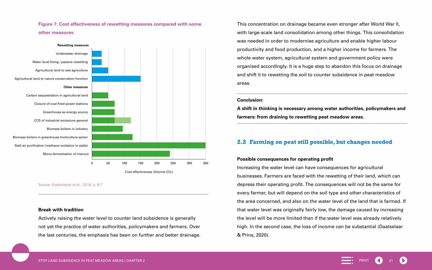
Cost-effectiveness
Opting for rewetting peat meadow areas as a strategy for reducing CO2
emissions, among other things, can only be justified if cost-effectiveness
is also considered. One must therefore answer the question of whether the
same CO2 reduction could not be achieved at a lower cost. Research shows
that in general, rewetting measures are significantly cheaper than many
other CO2-reducing measures (Koelemeijer et al., 2018; see also House of
Representatives [Tweede Kamer], 2019a). Figure 7 shows that measures for
fixing the water level, underwater drainage and adapting agricultural land
to wet agriculture cost less and are more effective (and are therefore more
cost-effective) than measures such as the capture and underground storage
of CO2 (CCS)6, biomass boilers in the greenhouse horticulture sector and
mono-fermentation of manure.
It should be noted that rewetting of peat meadow areas cannot take place
independently of the water authorities. This is because, in order to raise the
water level, it is necessary for water authorities to review the existing water
level decision in which the desired water level is laid down. An individual
may then deviate from the water level decision under certain conditions.
To this end, the individual has to apply to the relevant water authority for
a permit for increased or decreased drainage in relation to the water level
decision. Differences in the water level are therefore possible within one
water level area, which is an area in which the water authority tries to
maintain the same water level.
6 CCS stands for Carbon Capture and Storage.
21PRINTSTOP LAND SUBSIDENCE IN PEAT MEADOW AREAS | CHAPTER 2
Figure 7: Cost effectiveness of rewetting measures compared with some
other measures
Source: Koelemeijer et al., 2018, p. 6-7
Break with tradition
Actively raising the water level to counter land subsidence is generally
not yet the practice of water authorities, policymakers and farmers. Over
the last centuries, the emphasis has been on further and better drainage.
This concentration on drainage became even stronger after World War II,
with large-scale land consolidation among other things. This consolidation
was needed in order to modernise agriculture and enable higher labour
productivity and food production, and a higher income for farmers. The
whole water system, agricultural system and government policy were
organised accordingly. It is a huge step to abandon this focus on drainage
and shift it to rewetting the soil to counter subsidence in peat meadow
areas.
Conclusion:
A shift in thinking is necessary among water authorities, policymakers and
farmers: from draining to rewetting peat meadow areas.
2.2 Farming on peat still possible, but changes needed
Possible consequences for operating profit
Increasing the water level can have consequences for agricultural
businesses. Farmers are faced with the rewetting of their land, which can
depress their operating profit. The consequences will not be the same for
every farmer, but will depend on the soil type and other characteristics of
the area concerned, and also on the water level of the land that is farmed. If
that water level was originally fairly low, the damage caused by increasing
the level will be more limited than if the water level was already relatively
high. In the second case, the loss of income can be substantial (Daatselaar
& Prins, 2020).
0 50 100 150 200 250 300 350
Rewetting measures
Underwater drainage
Water level fixing / passive rewetting
Agricultural land to wet agriculture
Agricultural land to nature conservation function
Other measures
Carbon sequestration in agricultural land
Closure of coal-fired power stations
Greenhouse as energy source
CCS of industrial emissions general
Biomass boilers in industry
Biomass boilers in greenhouse horticulture sector
Stall air purification (methane oxidation in stalls)
Mono-fermentation of manure
Cost effectiveness (€/tonne CO2)

22PRINTSTOP LAND SUBSIDENCE IN PEAT MEADOW AREAS | CHAPTER 2
Box 5: Why does a higher water level bring extra costs for farmers?
When the water level is raised, dairy farmers on peat face higher costs
if their business operations are unchanged. These costs mainly relate to
the purchase of extra cattle feed, because the grass starts to grow later
and the cows have to remain indoors for longer. In autumn and in wet
weather, they also have to go indoors earlier. As the water level rises
further, the costs also go up.
With unchanged operations, an increase in the water level from -1 metre
to -80 cm does not cause extra costs; an increase from -80 cm to -60 cm
costs farmers €87 per hectare; and a further step to -40 cm costs €312 per
hectare, etc. (see Table 3 in Box 10). For an average-sized farm in the Green
Heart with 50 hectares and an annual income of €50,000, the cost of €312
per hectare means a loss of income of more than a quarter (€15,000 per
year). For dairy farmers who see their water level rise from -40 to -20 cm,
the associated additional cost of €470 per hectare will nearly halve their
income (Daatselaar & Prins, 2020).
Farming on peat on rewetted soil only feasible with adjustments
These figures call into question the possibility of farming on peat in the
future if the water level is increased in order to counter land subsidence.
It must, first of all, be emphasised that the alternative – peatlands without
agricultural activities – is not a real option, according to the Council for
the Environment and Infrastructure. Agriculture, and more specifically
dairy farming, continues to be necessary for managing the human-made
landscape. Transforming an area of land and managing it as a nature
conservation area is simply too expensive, as can be seen in Figure 7 in the
previous section (Koelemeijer et al., 2018). In addition, the peat meadow
landscape that currently exists in the Netherlands, with its characteristic
parcelling into grasslands, is highly valued internationally as a human-
made landscape.
According to the Council, maintaining dairy farming on peatlands is not
only desirable, but is also expected to be possible. Several ongoing pilots
and experiments point in that direction (see Box 6). However, it will not be
possible to continue farming on peat in the same way. Farmers will have
to make changes to their operations if they want to farm profitably with a
higher water level. One example is more extensive dairy farming with more
land. After all, peat soils are still suitable for growing grass, even with a
higher water level. However, farmers will need time to make the transition,
because of ongoing investments in buildings and the development of
alternative farming structures (extensification with more land, integration
with nature, wetland crops, and energy generation). The pilots will have
to indicate which business changes are the most profitable and in which
situation. Over the longer term, it will have to be considered whether it is
still profitable to farm with a water level of -20 cm with alternative business
operations, or whether a different solution will need to be sought. In
Chapter 3, the Council will argue that financial support for converting to
alternative business practices is essential (see recommendation 3).

23PRINTSTOP LAND SUBSIDENCE IN PEAT MEADOW AREAS | CHAPTER 2
Box 6: Pilot ‘Farming with high water’, KTC Zegveld
On the high-water farm of KTC Zegveld (Knowledge Transfer Centre
Zegveld), the groundwater level on a few plots has been raised to
20 cm below ground level, to see whether a profitable business model
with dairy cattle is possible under such circumstances. What are the
consequences for the soil, air and water? In addition to the water level,
the pilot is looking at a variety of business factors, such as the livestock
breed, the grazing system, nutrition and fertilising. Three breeds of cattle
are being considered in order to establish which type of cow is most
profitable with a high water level, and for one breed, the effect of the
water level on technical and economic performance is studied.
Required changes to business operations
As has already been stated, a higher water level, resulting in marshier
plots, requires changes to farming practices and investment in farming.
Possibilities are:
• working with lighter machines and lighter-weight cattle
• bringing in cattle feed from outside to compensate for the lower grass
yield
• extensification, with fewer cattle per hectare, possibly in combination
with the purchase of more land
• switching to a new business model (e.g. wetland crops, circular model)
• and/or switching to complementary activities to earn additional income
(leisure activities, healthcare provision, regional products, nature or
energy).
The extent to which business operations need to be changed depends
on factors such as the soil type, the water level prior to rewetting and the
proximity of nature conservation areas. Differentiation is necessary and
possible (see Section 3.1).
Box 7: Alternative business models on peat
In peat meadow areas, agricultural land consists mainly of grasslands.
In the Green Heart, for example, the share is 75% of agricultural land
(Buro Sant en Co & Fabrications, 2019). Various business models are
possible with an increase in the water level, from adapted dairy farming
to wetland crops, and/or income from solar farms, biomass production,
nature and leisure.
In two studies for the Green Heart and Friesland (Buro Sant en Co &
Fabrications, 2019; Countus, 2019), a number of alternative business
models were calculated (land-based, nature-inclusive, circular, and
‘green-blue’ combining nature and grazing areas with bodies of water).
These studies showed that there are various possible business models
that are promising from a commercial point of view. However, subsidies
are necessary for a profitable business model, as well as payment for
services that benefit society, such as reducing land subsidence or cutting
CO2 emissions.

24PRINTSTOP LAND SUBSIDENCE IN PEAT MEADOW AREAS | CHAPTER 2
Prerequisites for new earnings models
Different earnings models are needed for a transition to new business
models. The prerequisites for such earnings models will have to be
present, such as a sales market and the availability of compensation
payments. There is currently no structural sales market for alternative
crops (paludiculture, such as cranberries or rushes), and a sales market will
also have to be found for new regional products. In addition, studies for
the Green Heart and Friesland show that ‘new’ business models, such as
a circular or nature-inclusive business, can only be profitable if subsidies
are provided and if there is remuneration for services to society, such
as reducing land subsidence, CO2 reduction or storage, water retention,
improvements in water quality, and nature development (Buro Sant en
Co & Fabrications, 2019; Countus, 2019). It is important for there to be more
long-term certainty on these matters (see recommendation 3 in Chapter 3).
Conclusion:
It is possible to continue farming on peat with a higher water level,
but changes to business operations are necessary in order to do so. There
is uncertainty regarding the opportunities offered by new business models
for generating revenue. New business models can be profitable, but to
achieve this, subsidies and remuneration for new and existing services to
society are needed.
2.3 Insufficientnationaldirectionfortacklingland subsidence The national government is currently not providing comprehensive
direction for slowing land subsidence in peat meadow areas. The
‘Werkgroep Brede Heroverweging’ [Working Group for Broad-based
Review] also recently drew attention to this: “There is currently no
nationally coordinated approach to countering land subsidence.” (2020,
p. 9). This lack of a national approach is striking. After all, the Netherlands
is one of the lowest-lying areas in the world and the sea level is rising. It
is therefore disadvantageous for such a low-lying country to have to deal
with land subsidence. Other countries do have a national or regional policy
framework for land subsidence, such as Indonesia and areas of the United
States and China, but the Netherlands does not (see Box 8).
Box 8: National approach to land subsidence in other countries
Indonesia
Indonesia has large peatland areas. Over recent decades, these have
been reclaimed and drained on an increasingly large scale, which has
damaged the peatlands and caused the soil to subside there. The drained
– and therefore dryer – peat is also more flammable (Wösten, 2017).
Extensive peat fires in 2015, which destroyed 875,000 hectares of land,
prompted the government to take action. The reclamation of peatlands
was forbidden and a national agency was established, specifically for
maintaining and restoring the peatlands. This agency has developed a
step-by-step plan to bring the fires, greenhouse gas emissions and land

25PRINTSTOP LAND SUBSIDENCE IN PEAT MEADOW AREAS | CHAPTER 2
subsidence in peatlands under control (UN Environment Programme,
2019).
United States
Due to dyke construction and land drainage, the marsh areas of the US
state of Louisiana are drying out. This has resulted in land subsidence
in the delta. To counter this process, in 2005 the state established by
law the ‘Coastal Protection and Restoration Authority’ (CPRA). The
CPRA’s task is to draw up a ‘masterplan’ for the coast and to update it
every six years. The plan is supposed to ensure coastal restoration and
protection, including countering land subsidence, also looking ahead to
the anticipated rise in sea level (CPRA, 2019).
China
Shanghai, the largest city in China, is located in the Yangtze delta. The
region is facing serious land subsidence due to excessive groundwater
extraction for household and industrial use. In 2012, in order to control
land subsidence in the Yangtze delta, among other places, the Chinese
government established a national programme for the prevention and
management of land subsidence for 2011-2020. Within the programme,
targets have been set for reducing the speed of land subsidence in
critical areas, and networks are being created to monitor subsidence
(Ye et al., 2016).
National direction currently only addresses aspects of the problem
Although the national government is not providing comprehensive
direction for reducing land subsidence, there is government policy aimed
at aspects of the problem. Ministers take action based on their own policy
responsibilities (see letter to Parliament ‘Rijksbrede aanpak Bodemdaling’
[Government-wide approach to land subsidence], Tweede Kamer, 2019c).7
An important element is government policy focused on CO2 reduction,
which also implicitly contains a target for land subsidence reduction (see
Section 2.1).
The National Climate Agreement concluded by the Dutch public authorities,
the business community and civil society organisations in 2019 shows that
rewetting peat meadow areas is an important track that the Netherlands
is following in order to achieve a reduction in CO2 emissions. Elements
include underwater drainage, an increase in the summer water level for
the benefit of meadow birds, a transition to wetland crops and a switch
to agricultural nature, including sphagnum moss growth (Tweede Kamer,
2019b). In the case of rewetting peat meadow areas, the relationship with
other policy goals, including nature conservation goals, is also considered.
However, according to the Council, this comprehensive view of the
connection between tasks could and should be given greater emphasis,
also with a view to the long term. This is because once land subsidence
is brought under control, there will still be societal challenges that require
7 Contrary to common perception, land subsidence barely features in the national government’s Delta Programme (2019). Land subsidence is only addressed indirectly in the section on spatial adaptation, which mentions local stress tests and the aim of a climate-proof soil and surface water system.

26PRINTSTOP LAND SUBSIDENCE IN PEAT MEADOW AREAS | CHAPTER 2
attention. The water supply, for example, also needs to be regulated in
a structural manner, and flood protection, too, is a persistent cause of
concern.
Importance of having a long-term perspective
It is important for interested parties to have a clear picture of the
consequences of land subsidence and understand what the long-term
targets for countering subsidence could mean for them. Parties in peat
meadow areas often lack such a clear picture. For example, is it possible for
farmers to continue running their dairy farms in peat meadow areas without
any changes? Or will rewetting the area make this increasingly difficult and
expensive over the years? The uncertainty on this subject makes it almost
impossible for farmers to take investment decisions, even within one
generation.
Other parties in peatland areas, such as water authorities, also have an
interest in clarity regarding developments. In accordance with their legal
duty, water authorities make water level decisions, in which they take the
different activities in the area and the requirements of the water system
into consideration. In this process, water authorities have some room for
manoeuvre, but it is limited. They are subject to the spatial planning choices
of provincial policy. This can mean that water authorities will continue to
invest for years in infrastructure for lowering the water level, even though
this could later turn out to be an unprofitable investment. A national
policy framework could help local and regional authorities to legitimise
the necessary – and sometimes difficult – decisions on how to tackle land
subsidence. National targets for land subsidence and water management
give local and regional authorities ‘backing’ for their own policy changes
(De Putter, 2016).
Importance of connecting land subsidence reduction with other challenges
Solutions for dealing with land subsidence often coincide with solutions
to other challenges, such as tasks relating to the climate and the natural
environment. For example, the problem of nitrogen will in many cases be
improved when the problem of land subsidence is being dealt with, and
vice versa. Both tasks benefit from the extensification of agriculture. At the
same time, the natural environment also benefits from land subsidence
being countered through rewetting and extensification. Nature conservation
areas are then less affected by groundwater flowing away to lower-
lying polders. Biodiversity is also helped by wetter and more extensive
agriculture with less fertiliser and a different mowing system. In turn, nature
conservation subsidies, such as those for agricultural nature management,
can help facilitate the reduction of land subsidence. Other areas where
there are opportunities to combine approaches to challenges are energy
transition, water quality and flood protection.
Because of the lack of a government policy framework for land subsidence,
opportunities can be missed for such a cross-sector approach to tackling
land subsidence, which can benefit shared interests. Although an integrated
approach is not a goal in itself for the Council (it is not necessary for
everything to be linked to everything else, as this can sometimes actually
hamper implementation), an integrated perspective for land subsidence

27PRINTSTOP LAND SUBSIDENCE IN PEAT MEADOW AREAS | CHAPTER 2
does make it possible to identify these synergies (Rli, 2019a). Once synergies
between challenges and solutions have been identified at national level,
they can be elaborated into plans at regional and local level.
A transition takes time
It is not possible to reduce land subsidence in peat meadow areas from one
day to the next. This is because processes in the soil and the water system
move slowly, so that the effects of interventions can only be seen over the
long term. This has to be taken into account in the solutions. Moreover,
parties in the area need time to prepare and adapt. This applies to the
farmers in the area, but equally to the water authorities, which have to
adjust their policy and water level decisions. Working with ‘transition paths’
can be helpful for this purpose: a path that describes the changes in the
short term and a path for changes over the long term.
Conclusion:
There is a need for a national policy framework for ‘Land subsidence in peat
meadow areas’. This policy framework must not only focus on reducing
land subsidence, but must also be alert to its relationship with other
challenges. The policy framework should also contain ‘transition paths’ that
describe the changes over the short and long term. This provides parties
with clarity about the direction of developments in peat meadow areas and
gives backing to local and regional authorities in their policy decisions.
2.4 Implementation:top-downandbottom-upapproachdo not reinforce each other
Multitude of projects and pilots: competition for attention in policy and
funding
In the Green Heart there are countless ongoing projects and pilots
initiated by policy programmes and knowledge projects in the area of land
subsidence. Many of the initiatives focus on subareas or sectoral issues.
To give an impression of the ‘multitude’ of existing pilots and of their
sector-based character, the map provided shows the projects and pilots of
various government programmes, some of them involving different tiers of
government, in the Green Heart (see Figure 8). Ongoing pilots of provinces
or knowledge programmes are not included on the map.
The fact that many of the pilots focus on individual sectoral issues is
connected with the current fragmentation of administrative responsibility
for land subsidence across five departments.8 The multitude of pilots and
projects heightens complexity in the areas. The countless different pilots
compete with each other for attention from policymakers and financial
support.
8 These are: (1) the Ministry of Agriculture, Nature and Food Quality (LNV); (2) the Ministry of the Interior and Kingdom Relations (BZK); (3) the Ministry of Infrastructure and Water Management (IenW); (4) the Ministry of Education, Culture and Science (OCW); and (5) the Ministry of Economic Affairs and Climate Policy (EZK).

28PRINTSTOP LAND SUBSIDENCE IN PEAT MEADOW AREAS | CHAPTER 2
2020
2050ii
Info
€
Beslisboom
Juridische aanpakArrangementen
Green Circle Cheese
12 3
Inter-administrative Programme (IBP) Living Countryside: Holland-Utrecht Peat Meadow Area Focus on sustainable agriculture
Regional Deal land subsidence in the Green Heart Focus on land subsidence
Groot Wilnis Vinkeveen: future perspective in
the polder.
Panorama Krimpenerwaard: area dialogue for
approach to land subsidence, combined with
energy transition and landscape management.
Kagerplassen: countering land subsidence
with three strategies.
‘De Tol Toekomstbestendig’ (Kamerik):
climate-adaptive pumping area.
Herbaceous grassland and new water
management methods to counter land
subsidence [Groene Cirkel Kaas].
Calculate social costs and benefits of
measures aimed at biodiversity and land
subsidence.
Updating and extending Zegveld monitoring network.
Living lab farmers on high water, Zegveld.
Restveengebied (Residual peat area) Zuidplaspolder:
transition from agriculture to nature conservation area.
Veen, voer en verder II Zegveld [Peat, feed and further
II Zegveld]: field experiment wetland crops.
Peat Meadow Innovation Centre Zegveld.
Living lab Trots op de Krimpenerwaard [Proud of the
Krimpenerwaard].
Dialogue on transition task for area susceptible to land
subsidence.
Funding arrangement for rewetting peat.
Rush, certification for market opportunities.
Designing long-term perspective.
Peat farmers in movement: energy landscapes.
Various research projects for Nationaal Kennis-
programma Bodemdaling [National Knowledge
Programme for Land Subsidence].
Mapping land subsidence and looking into the soil.
Nationaal kennis- en belevingscentrum bodemdaling
[National knowledge and experience centre for land
subsidence].
Forecasting land subsidence and subsoil model Green
Heart.
Mobile information centre on land subsidence.
OUR Landscape Focus on landscape
Green Heart valuable landscape to be
protected in design-NOVI.
Boundaries of Green Heart.
Climate Agreement Focus on CO2 emissions
Impetus for dealing with peat meadows;
various pilots (raising water level, underwater
drainage and different crops); rollout of
measures (mix of measures); and
development of earnings models.
Agricultural nature and other nature
conservation measures related to Natura
2000 areas.
Regional Energy Strategy Focus on energy
RES areas.
CRa (Board of Government Advisors) agriculture pilots Focus: ruimte, ecologie & landbouw
Design-based research on agriculture that
gives space for nature and landscape in the
Krimpenerwaard.
Boundaries of Krimpenerwaard.
Source GIS data: TOP 10 NL, Geoservices Prov.
Zuid-Holland, Geodatabeheer Ministerie van
LNV and Rijksdienst voor het Cultureel Erfgoed.
N
2,50 5 km
1
2
3
4
5
6
7
8
9
10
11
12
13
14
15
16
17
18
19
20
21
22
Landscape units
Water
River area (with peat layer)
Lowland peat area
Reclaimed land
Woodland
Urban area
Levee/alluvial ridge
2
1
4
3
5
24
26 33
34
3225
7
11
10
12
923
23
23
23
23
8
23
24
25
26
27
28
29
30
31
32
33
34
Expansion and monitoring of trial plots on soft soil.
Improvement of foundation problem Tuinstraat
Hazerswoude-Dorp: approach.
Improvement of foundation problem 19th-century
Gouda ring: communication.
Improvement of foundation problem of De Stichtse
Rijnlanden Water Authority (HDSR):
communication.
Combining life-cycle costs approach
and land development in new building.
Floating construction 2.0.
Feasibility study mass stabilisation of infrastructure
on soft soil.
Service life EPS (polystyrene) for infrastructure on
soft soil.
Toolbox land subsidence historical towns.
18-22 13-17 27-316
Pilots and projects without indication of area
Figure 8: Government programmes for the Green Heart
29PRINTSTOP LAND SUBSIDENCE IN PEAT MEADOW AREAS | CHAPTER 2
Area-based tailored solutions essential
When implementing policy to counter land subsidence, tailored solutions
that focus on specific areas are of great importance. This is because there
are significant differences between peatlands, for example in their soil
composition, water management and land use. It is not surprising that
the Provincial Advisors for Spatial Quality have called for ‘twenty shades
of green’ (Roncken et al., 2019). The rich range of soil profiles requires
different individual measures and diverse forms of vegetation and land use.
For example, when the water level is lowered, a thick peat layer goes down
faster than soil consisting of a layer of clay on peat. Most knowledge about
this is available in the areas themselves. In addition, area-based tailored
solutions are important due to the various questions on spatial planning
and land use in the area – questions about what one wants to achieve with
regard to residential development, leisure activities, energy generation, and
agriculture. The issue is therefore not just one of dependence on the soil
type, but also the question of how the limited space in the area is to be used
in the best possible way for society.
Link between bottom-up and top-down direction lacking
Although it is important, area-based work alone is insufficient for
various reasons. In many cases, an area-based approach to tackling land
subsidence lacks a supraregional administrative assessment. Choices in
one area can have consequences and unwanted or unforeseen effects in
another area. Take, for example, the dilemma posed by the decision to slow
land subsidence in peatland, which can be damaging for nearby reclaimed
land (‘deep polders’). Raising the water level increases the pressure of the
groundwater in these polders, with all the associated risks of hydraulic soil
failure and boils (Deltares et al., 2018; Deltares, 2019). Or take the issue
of the water supply in a dryer climate. Rewetting peat meadow areas can
require a supply of fresh water from elsewhere to raise the water level. It
must be ensured that this does not cause problems in the – possibly drier –
area that is supplying the water. It therefore helps in solving geographical
problems such as land subsidence if supraregional bodies also consider the
matter from a spatial point of view. Top-down and bottom-up direction need
to reinforce each other, but this is currently often not the case.
In addition, there is the question of whether far-reaching choices can be
made at the local level. After all, a local community has strong bonds with
the existing situation, the existing landscape and existing interests. Major
differences in the perception of the problem and of the desired solution
bring the risk that people will fail to agree locally and that progress will
remain limited (Veerman, 2019). Where necessary, choices will have to be
made at a higher decision-making level (province, national government).
Local decision making about the future of an area can also be made more
complicated if the area concerned is very large and not well-connected
internally. In both situations, it is helpful if area-based tailored solutions are
facilitated by clear frameworks at a higher administrative level of scale. The
basic principle must be ‘local where possible, supralocal where necessary’.
Lack of coherent implementation apparatus
Reducing land subsidence in peat meadow areas also requires properly
functioning implementation capacity. In recent years, part of this capacity

30PRINTSTOP LAND SUBSIDENCE IN PEAT MEADOW AREAS | CHAPTER 2
for implementation has disappeared and another part has become
fragmented among various different bodies. The Rural Areas Department
(DLG) was dissolved in 2015 and its tasks were transferred to the provinces
and the Netherlands Enterprise Agency (RVO). DLG staff left for other
organisations, such as the provincial authorities and water authorities.
The DLG dealt with purchasing land, restructuring it, and advising on its
management and the transfer to organisations and farmers that manage
areas of land. These tasks are now the responsibility of the provinces
and the RVO, and have therefore become fragmented. A coherent
implementation apparatus is a key condition for starting effective efforts to
curb land subsidence in peat meadow areas.
Conclusion:
To achieve an effective reduction in land subsidence after the pilot phase,
an area-based approach is necessary, with supplementary supraregional
direction. It is additionally important for there to be a sound and coherent
implementation apparatus.
2.5 Funding:costsandbenefitsoflandsubsidenceandthe price of CO2
Cost flows: the elephant in the room
A major obstacle to implementing the approach to land subsidence is
the matter of cost. It is known in general what the costs will be, but it is
not known what they will look like in detail and what the costs will be, for
example, of the complete redevelopment project involving rewetting a peat
meadow area such as the Green Heart. In addition, little is known about
the composition of the current cost flows and who pays for what. In 2016,
research by the PBL provided a first indication of the expected costs of land
subsidence (PBL, 2016). This revealed enormous sums: around €2 billion
for damage to infrastructure and foundations in the rural area and as much
as €21 billion for the urban area up to 2050. The PBL estimated the extra
water management costs in rural areas of continuing land subsidence at
€200 million up to 2050. This last amount is a relatively cautious estimate.
Box 9 shows that the costs of raising the quays and flood defences could
rise sharply up to 2050.
Many of the professionals with whom the Council has spoken have pointed
out that the high (and still partially unknown) costs are an important reason
for the deadlock in which efforts to tackle land subsidence have been for
years. The high costs ensure that nobody wants to take the risk of tackling
land subsidence. Particularly at the national government level, there is a
fear of taking on the administrative responsibility. This hinders the actual
implementation of reductions in land subsidence.
Box 9: Estimate of increase in water management costs with continuing
land subsidence (2021-2050)
The committee that has compiled this advisory report did a ‘warm-up’
exercise to gain a clearer picture of water management costs in rural
peatlands. Based on key figures for increasing the height of quays and the
number of kilometres of secondary quays and flood defences in the rural

31PRINTSTOP LAND SUBSIDENCE IN PEAT MEADOW AREAS | CHAPTER 2
peatland area, it is possible to estimate the costs of raising the quays and
flood defences in water authority areas in a situation of continuing land
subsidence. There are thousands of kilometres of quays and secondary
flood defences in the rural peat meadow area.9 These quays and flood
defences are raised by 30 cm at a time, so that with land subsidence
of 1 cm per year, this will have to be done around once every 30 years.
Assuming that all quays and flood defences are raised once, it is possible to
calculate the costs of this work. If one assumes a cost of around €400,000
per kilometre to raise an unpaved quay by 30 cm, this gives a minimum
total cost of €1 billion for the coming 30 years.10 This is significantly higher
than the 200 million estimated by the PBL for the period to 2050. This rough
indicative result is grounds for follow-up research.
Components of the costs and benefits of land subsidence in rural peat
meadow areas
As previously mentioned, the approximate costs of land subsidence are
known to a certain extent, but the total picture of costs and benefits is still
incomplete. The Council has itself carried out a number of preparatory
exercises and has included the results in the report (see Box 8), but the
9 Starting from a rough estimate based on the total number of kilometres of regional flood defences in the Netherlands (Dutch Water Authorities et al., 2016) and the proportion of them that stand on peat or peaty soil. This is at least 2,500 kilometres (because there are comparatively more quays and flood defences on peat, this is expected to be the lower limit).
10 The figure of €400,000 per kilometre to be raised is used by Deltares in its own studies and comes from water authority practice. This figure is a lower limit: it largely concerns unpaved quays, without the use of sheet piling (which is sometimes necessary). A share of these costs comes under regular maintenance, but exactly what share still has to be determined.
picture is still not complete. However, the individual components of the
costs and benefits can be identified. Tables 1 and 2 below give an overview
of the key costs and benefits included in the various cost-benefit analyses
for peat meadow areas, for two strategies: continuing in the same way
(continuing current water level management) and slowing land subsidence
(rewetting the soil). What is striking is that in the strategy of ‘continuing in
the same way’, it is agriculture that mainly reaps the benefits. For ‘slowing
land subsidence’, the result is the exact opposite.
Table 1: Costs and benefits of continuing in the same way11
Costs Benefits
Damage to buildings and infrastructure- Foundation damage to homes- Settlement damage to roads, sewage pipes, cables and pipelines
Agriculture- Revenue livestock/crop- Land value
Water system- Construction (quays, dykes, weirs)- Management and maintenance
Greenhouse gas emissions (CO2, methane, nitrous oxide)
Decline in biodiversity/natural values
Decline in water quality
Amenity value, cultural heritage & archaeology
11 This table is based on various studies of costs and benefits of land subsidence in the peat meadow areas, for example: the study ‘Dalende bodems, stijgende kosten’ (PBL, 2016); the SCBA ‘Remming bodemdaling Friese veenweiden’ (Witteveen+Bos, 2019); study ‘Knikpunten watersysteem Restveengebied Zuidplaspolder’ (RoyalHaskoningDHV, 2014); and the SCBA ‘Reeuwijk West en Polder Middelburg en Tempelpolder’ (Hoogheemraadschap van Rijnland, 2016).

32PRINTSTOP LAND SUBSIDENCE IN PEAT MEADOW AREAS | CHAPTER 2
Table 2: Costs and benefits of slowing land subsidence12
Costs Benefits
Agriculture- Revenue loss livestock/crop- Land value- Costs of converting business
operations and/or technical measures such as drainage
Damage avoided to buildings and infrastructure- Foundation damage to homes- Settlement damage to roads, sewage pipes,
cables and pipelines13
Water system costs avoided- Construction (quays, dykes, weirs)- Management and maintenance
Costs of greenhouse gas emissions avoided
Biodiversity/natural values
Water quality
Amenity value, cultural heritage & archaeology14
Banks cautious about offering necessary prefinancing
To date, banks have had very little involvement in the problem of land
subsidence, barring rare exceptions. In practice, this is seen as a hindrance,
as pre-investment is needed for many measures aimed at countering
land subsidence. Banks are in no way always prepared to take on that
12 Ibid.13 However: see also footnote 4 in Chapter 1.14 Amenity value, cultural history and archaeology are on the benefits side of the ‘slowing land
subsidence’ strategy. This is in line with the way many cost-benefit studies of land subsidence deal with them. If the water level drops less, this has a positive effect on, among other things, the conservation of wooden and other archaeological objects in the soil and the preservation of farms that are historical monuments. It can lead to a different landscape, but it is not known whether it also leads to a different appreciation of the landscape.
prefinancing. This reluctance is based on the risk of capital destruction (due
to an uncertain return on investment) and of a fall in land value (e.g. due to
the switch to wetland crops). However, there are now pilots in which banks
are involved, such as the Green Circle in the Green Heart. In this pilot, a
bank gives farmers the opportunity to invest in equipment for precision
pumping in each plot (pumps and drainage).
CO2 emissions as problem and contribution to solution: CO2 emissions will
bring costs
As explained earlier in this report, peat oxidation is a source of CO2
emissions. Targets for the reduction of CO2 emissions were agreed in the
National Climate Agreement. The agreements concern not only emissions
from peat meadow areas, but also those from other sources (industry,
traffic, etc.). As a result of these agreements, emissions of CO2 have
become a cost item, including a cost to society. Particularly for polluting
industrial companies, there is a price tag attached to CO2 emissions. The
price they have to pay for their emissions is determined by the system for
trading CO2 emissions, or ETS system.15 In 2019 the CO2 price for industrial
companies in the ETS system was around €22 per tonne of CO2 equivalent.
CO2 rights are expected to be worth more in the future. Polluting companies
that are unable to reduce their emissions enough or quickly enough will be
prepared to pay increasing amounts for those emissions. The prognosis is
that the price will rise to around €50 in 2030 (PBL, 2019). Others consider
15 ETS stands for: emissions trading system.
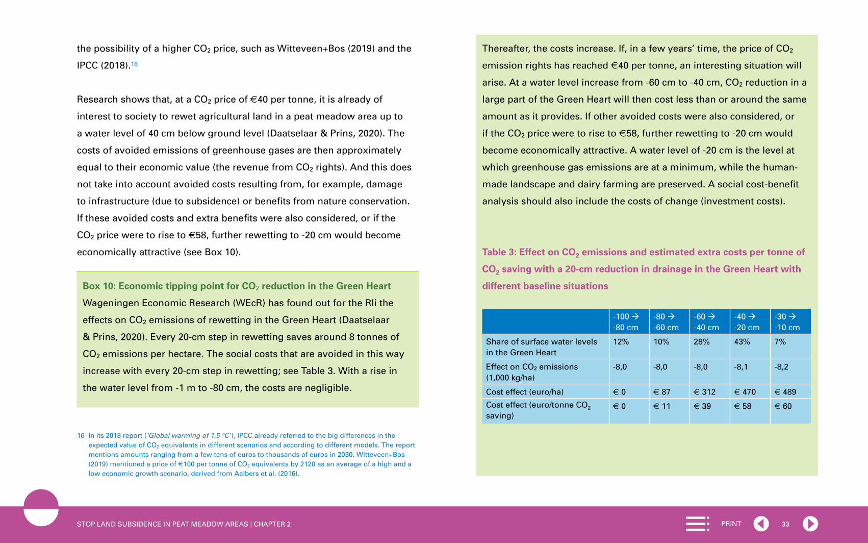
33PRINTSTOP LAND SUBSIDENCE IN PEAT MEADOW AREAS | CHAPTER 2
the possibility of a higher CO2 price, such as Witteveen+Bos (2019) and the
IPCC (2018).16
Research shows that, at a CO2 price of €40 per tonne, it is already of
interest to society to rewet agricultural land in a peat meadow area up to
a water level of 40 cm below ground level (Daatselaar & Prins, 2020). The
costs of avoided emissions of greenhouse gases are then approximately
equal to their economic value (the revenue from CO2 rights). And this does
not take into account avoided costs resulting from, for example, damage
to infrastructure (due to subsidence) or benefits from nature conservation.
If these avoided costs and extra benefits were also considered, or if the
CO2 price were to rise to €58, further rewetting to -20 cm would become
economically attractive (see Box 10).
Box 10: Economic tipping point for CO2 reduction in the Green Heart
Wageningen Economic Research (WEcR) has found out for the Rli the
effects on CO2 emissions of rewetting in the Green Heart (Daatselaar
& Prins, 2020). Every 20-cm step in rewetting saves around 8 tonnes of
CO2 emissions per hectare. The social costs that are avoided in this way
increase with every 20-cm step in rewetting; see Table 3. With a rise in
the water level from -1 m to -80 cm, the costs are negligible.
16 In its 2018 report (‘Global warming of 1.5 °C’ ), IPCC already referred to the big differences in the expected value of CO2 equivalents in different scenarios and according to different models. The report mentions amounts ranging from a few tens of euros to thousands of euros in 2030. Witteveen+Bos (2019) mentioned a price of €100 per tonne of CO2 equivalents by 2120 as an average of a high and a low economic growth scenario, derived from Aalbers et al. (2016).
Thereafter, the costs increase. If, in a few years’ time, the price of CO2
emission rights has reached €40 per tonne, an interesting situation will
arise. At a water level increase from -60 cm to -40 cm, CO2 reduction in a
large part of the Green Heart will then cost less than or around the same
amount as it provides. If other avoided costs were also considered, or
if the CO2 price were to rise to €58, further rewetting to -20 cm would
become economically attractive. A water level of -20 cm is the level at
which greenhouse gas emissions are at a minimum, while the human-
made landscape and dairy farming are preserved. A social cost-benefit
analysis should also include the costs of change (investment costs).
Table 3: Effect on CO2 emissions and estimated extra costs per tonne of
CO2 saving with a 20-cm reduction in drainage in the Green Heart with
different baseline situations
-100 -80 cm
-80 -60 cm
-60 -40 cm
-40 -20 cm
-30 -10 cm
Share of surface water levels in the Green Heart
12% 10% 28% 43% 7%
Effect on CO2 emissions (1,000 kg/ha)
-8,0 -8,0 -8,0 -8,1 -8,2
Cost effect (euro/ha) € 0 € 87 € 312 € 470 € 489
Cost effect (euro/tonne CO2 saving)
€ 0 € 11 € 39 € 58 € 60

34PRINTSTOP LAND SUBSIDENCE IN PEAT MEADOW AREAS | CHAPTER 2
Figure 9: Costs per tonne of CO2 saving with reduced drainage of 20 cm
with different baseline situations
Costs and benefits may be in equilibrium from the point of view of society,
but they are not yet balanced at the level of the actors. The benefits of
rewetting peat meadow areas, in the form of avoided CO2 emissions, come
to the government, and by extension to the taxpayer. The reduction in CO2
emissions achieved through rewetting contributes toward reaching the
goals of the National Climate Agreement and the Climate Act. The costs of
rewetting are for the account of the dairy farmer, who incurs higher costs
for his business operations and sees his income decline.
A follow-up question is therefore who is going to pay the costs: the farmers
themselves, the Ministry of Finance (i.e. the taxpayers) by means of a
subsidy, or polluting companies in industry by means of a trading system?
If farmers were paid for the reduction in CO2 emissions achieved through
the rewetting of farmland, CO2 reduction would become a financial resource
that could help in initiating change in the peat meadow areas.
According to the Council, it is obvious that not all of the reduction in CO2
emissions should be paid for, but only that part of CO2 reduction that is on
top of the existing reduction obligations of the agricultural sector under the
climate agreements. This is explained in greater detail in Chapter 3 of this
advisory report. A second question is how the funding of additional CO2
reduction can best be organised. This is also explained in Chapter 3.
Conclusion:
In order to implement an approach to land subsidence, it is essential to
have an understanding of the costs and benefits of land subsidence and
of who pays for what. Because CO2 emissions cause costs to society and
also come at a cost to polluting companies, CO2 can contribute toward
accelerating action against land subsidence.
reduction of drainage
costs/tonne CO2 saving
dra
inag
e (c
m)
cost
s (e
uro
s/to
nn
e C
O2 s
avin
g)
baseline situation drainage
very deep deep average high very high
soil until drainage
drainage in the baseline situation

35PRINTSTOP LAND SUBSIDENCE IN PEAT MEADOW AREAS | CHAPTER 2
2.6 Knowledge:shortage,fragmentationandexcuse
Lack of knowledge
For a long time, countering land subsidence did not feature on the political
agenda in the Netherlands. Attention was mainly directed at dewatering,
that is to say adapting to land subsidence (adaptation). Countering land
subsidence (mitigation) was much less in the spotlight. As a result, the
Netherlands is at a relative disadvantage with respect to knowledge about
land subsidence, both when compared with other topics (e.g. sea level rise
and climate adaptation), and with other countries (e.g. China). The lack
of knowledge mainly relates to the long-term effects of interventions that
reduce land subsidence and the interactions between those effects (for an
example, see Box 11). It is therefore important to acquire specific, relevant
knowledge.
Box 11: Underwater drainage disputed
Underwater drainage is a technical measure to curb land subsidence. In
underwater drainage, a system of pipes is installed below ground level.
In wetter periods, underwater drainage leads to better dewatering of
the land. In drier periods, water is infiltrated into the plot via the drains
to prevent the groundwater level from becoming too low. As a result,
the peat dries out less, CO2 emissions are reduced and agricultural
production is maintained. Constructing underwater drainage requires
investment. On the other hand, the expected yields are higher due to
longer grazing and less drought damage or wetting damage.
Science is still not clear about the effectiveness and the long-term effects
of the ‘underwater drainage’ measure. Underwater drainage can be a
relatively good measure to enable farming to continue in spite of a higher
water level. However, this intervention only postpones developments
and is not a definitive solution to the problem. Underwater drainage does
limit peat degradation (and therefore CO2 emissions), but it does not
completely stop land subsidence. After a few decades, the drainage pipes
will once again be lying close to the surface water level and will lose their
purpose. These systems therefore have a limited service life. Moreover,
it is not yet clear how effective underwater drainage is with different peat
depths, soil types and surface water levels, nor is it known by exactly
how much CO2 emissions are reduced (see, for example, Grootjans
et al., 2019; Smolders et al., 2019; Van den Akker et al., 2018; Middel
& Noordhoff, 2020). The PBL also recognises the existence of gaps in
knowledge about the effectiveness of underwater drainage (Hekkenberg
& Koelemeijer, 2018).
Knowledge fragmentation
In the Netherlands, most of the time knowledge about subsidence is being
developed in separate knowledge programmes, such as the knowledge
projects of the Regional Deal on land subsidence in the Green Heart, the
research of the Dutch National Research Agenda Living on Soft Soil (LOS),
Diep NL (about soil movement in Groningen), and knowledge projects
at the Peat Meadow Innovation Centre (VIC). This fragmentation brings
the risk of people reinventing the wheel over and over again because

36PRINTSTOP LAND SUBSIDENCE IN PEAT MEADOW AREAS | CHAPTER 2
of the multitude of local studies and pilots. Moreover, these are usually
short knowledge programmes of around three to five years, whereas
there is a need for an easily accessible, structural knowledge base. There
is already a National Knowledge Programme for Land Subsidence, but
it currently functions primarily as a network programme and does not
itself develop the necessary knowledge. A structural knowledge base is
also relevant in relation to what the post-2030 strategy should be, as the
Climate Agreement does not go much further than that year. The start of
the National Research Programme for Greenhouse Gases in Peatlands
[Nationaal Onderzoeksprogramma Broeikasgassen Veenweiden] (NOBV)
in 2019 was a good step towards a more structural knowledge base. This
national research programme, financed with climate funding, studies and
monitors the effectiveness of various measures against peat degradation at
five measuring points in peat meadow areas in the Netherlands.
Need for knowledge as an excuse
Because the consequences of reducing land subsidence are not fully
understood, it is difficult to make good policy choices. The response to
this is often to avoid taking far-reaching decisions on the best approach
by taking refuge in planning yet more research. It is important for the way
knowledge is dealt with to change over time and also for knowledge already
acquired to be more frequently applied and used.
Conclusion:
There is a need for more knowledge and for a structural and less
fragmented knowledge base. The way knowledge is dealt with is currently
not optimal. The reflex reaction of ‘taking refuge’ in the planning of extra
research should give way to applying and using knowledge.

37PRINT
Based on the findings and conclusions of the previous chapter, the Council
for the Environment and Infrastructure has formulated four specific
recommendations. Three of these are directed at the national government
and one at the regional parties involved in tackling land subsidence. The
recommendations relate successively to a national policy framework,
implementation, funding, and knowledge.
3 RECOMMENDATIONS

38PRINTSTOP LAND SUBSIDENCE IN PEAT MEADOW AREAS | CHAPTER 3
3.1 Specificdirectionforreducinglandsubsidencebased onnationalpolicyframework
Recommendation 1 – to the national government:
Provide clear direction on reducing land subsidence and set an indicative
target of 70% reduction in land subsidence in rural peatlands by 2050, with
an interim target of 50% by 2030, as part of a national policy framework on
land subsidence.
The Council believes that a national target for reducing land subsidence
is essential for all rural peat meadow areas, in order to provide clarity for
all the parties involved in land subsidence in peat meadow areas. Such a
target gives direction and ensures that stakeholders know where they stand.
Farmers can use this to select the investments to make in their business
operations and, if necessary, switch to a different business model in time.
Water authorities can work towards the new situation and adjust their
policy and investments accordingly. The same applies to provinces and
municipalities.
70% reduction in land subsidence by 2050, 50% subsidence reduction
by 2030
The Council advises the Dutch government to set a national goal for
reducing land subsidence in peat meadow areas: an indicative target
of 70% by 2050 and a mandatory interim target of 50% by 2030. These
targets should be laid down in regulations based on the Environment and
Planning Act.
In determining the level of ambition of the national goal for reducing
land subsidence in rural peat meadow areas, the Council seeks alignment
with the goals of the Dutch Climate Act. The Climate Act stipulates that
in 2050, greenhouse gas emissions must be 95% lower than in 1990. As
explained in Chapter 2, cutting CO2 emissions is inextricably linked to
reducing land subsidence. A 95% cut in CO2 by 2050 is more or less equal
to a reduction of around 70% in land subsidence in rural peat meadow
areas. In that situation, there is hardly any peat degradation anymore and
therefore virtually no CO2 emissions. The target of a 50% reduction in land
subsidence by 2030 is in line with targets for land subsidence reduction
that some water authorities and provinces in the Green Heart are already
Target - 70% 2050%TaTaTaTaTaTaTaTaTaTaTaTaTaTaTarrrget - 70% 50% 205
Appoint responsible minister or state secretary
Transition paths 2030, 2050 and long-term perspective
Lay down in law targets for reduction in land subsidence
Legend for a zoning map
Interim target - 50% in 2030

39PRINTSTOP LAND SUBSIDENCE IN PEAT MEADOW AREAS | CHAPTER 3
working with.17 It is expected that this will allow the Netherlands to meet
the requirement in the National Climate Agreement of a one-megatonne
reduction in CO2 emissions in peatlands by 2030.
According to current understanding, a 70% reduction in land subsidence
in peatlands by 2050 is achievable at a groundwater level of around 20
cm below ground level. However, there is still some uncertainty as to
the possibility of profitable agricultural business operations at such a
water level (see also Section 2.2). For this reason, the Council advocates
an indicative target to be aimed for in 2050.18 This gives time for further
research in the coming years to determine whether profitable farming
is possible at a water level of -20 cm, and whether structural additional
resources, such as subsidies, are needed. Over the next few years, the
development of dairy farming more generally will also become clearer.
Using this new information, it will then be possible in 2030 to lay down by
law the definitive target for the reduction in land subsidence by 2050.
If rewetting were complemented with optimum water level management
and optimum land use (among other things through a decreased load on
the soil from livestock and vehicles), it would even be possible to reduce
17 The target of a 50% reduction in land subsidence by 2030 corresponds to the target for a reduction in land subsidence of the Hoogheemraadschap De Stichtse Rijnlanden water authority (HDSR, 2019) and the Province of Utrecht (Provincie Utrecht, 2019).
18 The reference year or period in relation to which the target for land subsidence reduction applies still has to be considered. There are a number of options for this. For example, one could choose a reduction in land subsidence in relation to the current rate or in relation to the rate of subsidence in the 2005-2009 period. The latter is the reference period in the European LULUCF regulation for CO2 emissions in peatlands.
land subsidence by 90%. In this situation, emissions of greenhouse gases
(CO2, methane and nitrous oxide) would be as low as possible (see Box 4 in
Chapter 2). However, 90% is a tough challenge, which can only be achieved
with a great effort. On their own initiative, ambitious regions can drive up
their land subsidence reduction to 80 or 90% through optimum land use
and water level management.
The demanding goal of a reduction in land subsidence of at least 70% by
2050 means that the transition has to be completed within one generation
of farmers. The Council notes that this is a significant challenge. The use of
an interim target for 2030 clearly shows that parties have to start adapting
now and that the shift in thinking has to be made now. In this context, the
expectation that the CO2 price will rise over the coming years (see Section
2.5) is beneficial. It will make solutions for countering land subsidence
increasingly affordable.
The Council wishes to underline once again that the level of 70% for
a reduction in land subsidence by 2050 is directly derived from the
agreements in the Paris Climate Agreement and the goal of the Dutch
Climate Act. In the Council’s opinion, it is important to be explicit in making
this link – something that is still not done often enough. This clear message
highlights the scope and severity of the challenge of land subsidence.
Attention to local differences: land subsidence of a maximum 3 mm per year
To take account of local differences, because the land is not subsiding
as quickly everywhere, the Council advocates an addition to the national

40PRINTSTOP LAND SUBSIDENCE IN PEAT MEADOW AREAS | CHAPTER 3
target. In places where there is little land subsidence (e.g. due to a thin
layer of peat or a relatively high groundwater level), a 70% reduction in
land subsidence would require a disproportionate effort and investment.
In other words, a water level of -20 cm is not achievable or not necessary
everywhere. For this reason, the Council advocates adding a phrase to the
national target which does reflect local variation: a 70% reduction until land
subsidence of a maximum of 3 mm per year has been achieved. The target
is therefore not – or no longer – applicable once an area subsides by less
than 3 mm per year. Such an area will then have met the national target
for land subsidence. However, this does not preclude peat degradation
and greenhouse gas emissions needing to be reduced further in the long
term under the Climate Act. The Council sees land subsidence of 3 mm
per year as ‘acceptable land subsidence’ in rural peat meadow areas. This
represents 30 cm in 100 years. This is a manageable amount, meaning that
flood defences only need to be reinforced by 30 cm once every 100 years,
and that land subsidence is substantially less than the current average of
around 8 mm per year, or 80 cm per 100 years. The Council sees a target for
land subsidence of less than 1 mm per year as fairly unrealistic in any case.
This can be classified as unavoidable land subsidence.19 Moreover, land
subsidence of less than 1 mm per year is not measurable with the current
state of the art.
19 If average land subsidence in a rural peat meadow area is 8 mm per year, around 1 mm of that is unavoidable land subsidence. See also Chapter 1, Section 1.1.
National policy framework for land subsidence
According to the Council, the national target for reducing land subsidence
should be part of a national policy framework for land subsidence that
outlines the government’s perspective on subsidence. Such a policy
framework belongs to the updating of the National Strategy on Spatial
Planning and the Environment. The government framework needs to give
direction, not on the question of whether rewetting of peat has to take
place, but on the best way of facilitating it: in what way, how inclusively (the
extent to which costs are passed on), and in connection with which other
challenges (integrated approach). Because of its integrated perspective,
this national policy framework encompasses more than the Veenplan (Peat
Plan), which focuses primarily on reducing CO2 emissions. In addition,
the Veenplan, which will be sent to the House of Representatives before
summer 2020, is expected to have a short-term horizon of two years, while
the national policy framework for land subsidence presents a longer-term
outlook.20 In that respect, the Veenplan and the national policy framework
for land subsidence complement each other. According to the Council, in
addition to a quantitative target for land subsidence, the policy framework
should contain the following elements:
a) Transition paths to 2030 and 2050
Earlier in the advisory report, it was concluded that time is needed to
effect a transition. Change processes in the soil, water systems and – to
a lesser extent – infrastructure are slow and the solution has to take that
20 As far as is known at the time of writing.

41PRINTSTOP LAND SUBSIDENCE IN PEAT MEADOW AREAS | CHAPTER 3
into account. Parties in the area, such as farmers and water authorities,
need to be given time to prepare and adapt. Therefore, the targets for
land subsidence have to be achieved step by step.
There need to be two transition paths: one for 2030 and one for 2050.
Each of the two periods – from now to 2030 and from 2030 to 2050 –
focuses on a different type of measures. Up to 2030, no-regret measures
will be taken that can be achieved within the current agricultural business
structure, i.e. today’s dairy farm in its current location, which is faced
with rewetting. Examples are measures such as nature contracts for
pool and marshy areas (areas where there is standing water in lower-
lying parts; important for meadow birds); tapping a higher-value market
segment of milk and cheese, as is also done when switching to organic
farming; giving permission for solar farms; and partially converting from
agricultural use to nature conservation, leisure activities or residential
development where these are possible without land subsidence
problems. For public authorities, no-regret measures in this period are,
for example, financial incentives from the POP funds or provincial funds
for nature conservation.21 In the period to 2050, work will have to be done
on fundamental changes to agricultural business structures and water
systems. These measures are more far-reaching and more difficult to
reverse. Examples are establishing new spatial zoning plans; enshrining
rewetting in water level decisions; moving and ending businesses or
making fundamental shifts to other crops. Stakeholders must start
21 The POP funds come from the EU’s Rural Development Programme [Plattelandsontwikkelingsprogramma] (POP-3).
preparing for these changes in the period to 2030, because otherwise the
2050 target will no longer be achievable.
b) A look beyond 2050: long-term perspective
The national policy framework must include a look ahead to the period
after 2050, when the rewetted peat meadow area has been achieved.
What water management investments are needed to maintain the
rewetting? What does it mean for peat meadow areas if the Netherlands
faces drought more frequently as a result of the warmer climate?
Over this long period, a link can also be made with other major
delta challenges, such as sea level rise and salinisation. A long-term
perspective is also important to prevent peat meadow areas from having
to undergo a transition several times. The changes up to 2050 will be
far-reaching and themselves require a considerable effort from politicians
and residents.
c) Draw up zoning maps
Because the soil in peat meadow areas is not the same everywhere, the
approach to land subsidence requires customised work. In that context,
the Council advocates the creation of zoning maps (by the provinces).
Three things need to be shown on these maps:
1. the desired land uses over the longer term (in addition to farming,
zones for construction, nature, water storage, pool and marshy areas,
etc.)

42PRINTSTOP LAND SUBSIDENCE IN PEAT MEADOW AREAS | CHAPTER 3
2. target levels over the longer term (pool and marshy areas for nature
conservation, -20 cm for sustainable agriculture, unchanged drainage
of reclaimed land)
3. prioritising.
The third point involves dividing the areas into three types: (i) areas
where it is urgent to slow land subsidence (e.g. because there is a
thick peat layer or because of nearby nature conservation areas); (ii)
experimental areas where there is a little more time for reducing land
subsidence; and (iii) areas that can carry on as before and where little or
no extra effort is needed to counter land subsidence. This prioritisation
determines the order in which work will be done.
Drawing up zoning maps requires spatial planning decisions, for which
the provinces are responsible. They have considerable knowledge of
the area. They know the territory well, as do the water authorities and
other parties. For this reason, the Council proposes that the national
government should only provide the legend to the maps. The provinces
will subsequently develop the zoning maps for their territories, involving
the parties that will also work on implementing the approach to land
subsidence (the ‘implementation assemblies’, see Section 3.2), such
as water authorities, municipalities, residents and users. After this, the
provinces will adopt the zoning maps.
Finally: make a minister or state secretary responsible for the national
target for land subsidence
To ensure that the nationally approved target for limiting land subsidence is
achieved, the Council believes it is necessary for a minister or state secretary
to be given responsibility for land subsidence. This person will not only
have a management role, but on the basis of the Environment and Planning
Act, they will also be able to give instructions [aanwijzing] to provinces if an
approach to reducing land subsidence is lacking at regional level.
In the first instance, the responsible minister or state secretary should
encourage regional parties in the areas as much as possible to start work
quickly. This is an attractive proposition, because the regional parties
could then determine themselves how they want to achieve the target for
reducing land subsidence. If parties fail to put together an implementation
assembly within two years, the minister or state secretary can direct the
province to set one up (see also Section 3.2 below). This will prevent delays
caused by regional bottlenecks and differences of opinion in relation to the
desired solution or who will pay. In addition, the responsible minister or
state secretary will ensure the necessary coherence and balance between
challenges (integrated approach), the necessary knowledge building, and
preventing unwanted or unforeseen effects.
In view of the establishment of the policy framework for land subsidence in
the National Strategy on Spatial Planning and the Environment (NOVI) and
the desired connection with other tasks (see Section 2.3), it makes sense
that responsibility for the reduction in land subsidence should be entrusted

43PRINTSTOP LAND SUBSIDENCE IN PEAT MEADOW AREAS | CHAPTER 3
to the member of the government in charge of environmental policy. This is
currently the Minister of the Interior and Kingdom Relations. Sector-specific
issues can be allocated to the relevant ministers (agriculture, nature and
water). The Minister of Agriculture, Nature and Food Quality has a key role
regarding this portfolio due to her responsibility for the agriculture sector.
3.2 Area-basedworkonimplementation(withinnational policyframework)
Recommendation 2 – to regional parties:
Work together in an area-based fashion on implementing efforts to tackle
land subsidence, but do so within the national policy framework.
When working on reducing land subsidence, the bottom-up and top-down
approaches need to complement and strengthen each other. This is why
regional implementation assemblies are required in addition to the national
policy framework in order to achieve proper direction and implementation.
Furthermore, important partners have to be involved in implementation.
Examples are municipalities, land managers, nature conservation
organisations, and land users (in many cases farmers). The role of
provinces and water authorities will be explained in more detail.
Work with regional implementation assemblies
If the national government has established clear frameworks and
targets, and the province has translated these into provincial decisions
(e.g. provincial zoning maps, for which the regional parties have been
consulted; see Section 3.1), it is best if implementation is carried out in
and by the areas themselves. For the Green Heart, for example, the size
of the area as a whole is not suitable and it would be better to organise
implementation in a number of subareas (eight to nine), in line with
existing cooperation initiatives or regional divisions. With their knowledge
of the area, the subareas are best placed to deal with the complexity
of the local problem and ensure that the right parties bring their local
knowledge and expertise to the implementation assemblies. This allows
customised work to be delivered for and within an area (Roncken et al.,
2019). Working ‘from the bottom up’ in this way is also more likely to
create support, because stakeholder groups are involved from the outset
and can put forward solutions themselves. The parties that participate
in the implementation assemblies may differ from one area to another.
Work with regional implementation assemblies with a legal personality
Establish implementation assemblies and adapt existing land policy instruments
Use expertise and look ahead to a changing role
Municipalities
Farmers
Provinces
Nature conservation and environmental
organisations
Water authorities

44PRINTSTOP LAND SUBSIDENCE IN PEAT MEADOW AREAS | CHAPTER 3
Examples are water authorities, municipalities, provinces, nature
conservation and environmental organisations, and, for example, the Land-
en Tuinbouworganisatie Nederland LTO [Netherlands Agricultural and
Horticultural Association].
The Council proposes aligning as much as possible with existing
cooperative partnerships for the regional implementation assemblies. In
the Green Heart, for example, there are already cooperative partnerships
in the Krimpenerwaard, Alblasserwaard-Vijfheerenlanden, the area
around Alphen/Gouda/Woerden, the municipality De Ronde Venen,
the Kagerplassen, the Amstelscheg, and the Gooi and Vechtstreek.
Administrative boundaries should not be allowed to hinder the organisation
of the regional implementation assemblies: after all, the peat meadow area
does not stop at the edge of the Green Heart or at the border of a specific
municipality.
It is important that the regional implementation assemblies ensure
cohesion with the approach to other challenges. This distinguishes the
implementation assemblies from the national ‘veenweideregietafel’, or
peat meadow management partnership, which coordinates the efforts of
all peatland provinces to reduce CO2 emissions in line with the Climate
Agreement.
The regional implementation assemblies are not starting their work
from scratch. To begin with, there is the zoning map, showing land use,
target levels and priorities. It is obvious that areas with substantial land
subsidence (a thick peat layer, a relatively low water level) will be given
priority, in line with the zoning map. To be able to carry out implementation
properly, the implementation assemblies additionally need to have a legal
personality. They also have to have a sufficient budget for implementation
(see recommendation 3 below). And finally, implementation capacity
is important. Such capacity is available in the region, but currently it is
often organised separately for each sector. In this context, it is important
for the implementation activities of municipalities, water authorities, and
farming and nature conservation collectives to be coordinated with each
other in connection with the implementation assemblies. Where necessary,
the implementation assemblies can act as commissioning parties for
implementation.
Provinces: establish implementation assemblies and apply existing land
policy instruments
The provinces are involved in the approach to land subsidence due to their
responsibility for landscape and spatial planning. The transition in the peat
meadow area goes to the heart of a province’s spatial planning policy,
which is why the choices to be made and the management of this process
from the point of view of democratic legitimacy belong at the provincial
level. Provinces also play a crucial role in implementing the approach to
land subsidence, in view of the fact that the tasks of the former Rural Areas
Department have partly been assigned to the provinces. It is up to the
provinces to set up the implementation assemblies (with legal personality)
and to make sure that these get to work within two years. To this end,
the provinces ensure that the implementation assemblies have sufficient

45PRINTSTOP LAND SUBSIDENCE IN PEAT MEADOW AREAS | CHAPTER 3
authority, budget and implementation capacity. The provinces receive
government funding and then distribute it among the implementation
assemblies in each province. The basis for this is co-financing: the
national government invests and regional and local parties contribute.
Each province does this for its own implementation partnership(s). In the
western Netherlands, the Green Heart Administrative Platform (previously
the Green Heart Steering Committee), has an important function above
the implementation assemblies, relating to exchanging information and
monitoring. The Administrative Platform can be the central point for
monitoring whether all regional initiatives are good for the whole of the
Green Heart.
Provinces must actively use their existing set of land policy instruments
to support land subsidence policy. This will allow provinces to facilitate
farmers in making the necessary changes to land use. After all, rewetting
land means that farmers may face a decline in their earning capacity per
hectare. To compensate for that loss, farmers need more land or a different
business model. This can enable them to keep their family income steady
with a lower yield per hectare. Provinces can facilitate the changing land
use with the existing set of land policy instruments of the decentralised
Land Development Act. They can either purchase land to exchange, in order
to move farms to other locations, or buy land and then make it available
again for farm expansion. The land can temporarily be held in a provincial
land bank. The Council is aware that the active purchasing of land by a
public authority brings financial risks. It is nevertheless unavoidable in
order to achieve the target for reducing land subsidence.
Water authorities: use expertise and anticipate a changing role
Currently, water authorities are usually already administrative partners and
financial backers of projects related to land subsidence. They are therefore
more than just executors. The water authorities are conducting a variety
of interesting experiments in the area of water level increases, aimed at
reducing land subsidence. The water authorities generally have outstanding
expertise with respect to the workings of the water systems. This is
essential for good land subsidence policy. This expertise is still underused
and must be brought more prominently into the cooperation with provinces
and other parties. Moreover, water authorities also have sufficient powers
for dealing with land subsidence. However, they are facing new challenges.
For example, they will have to address land subsidence more explicitly in
their water level decisions. In many cases, this will mean fixing or raising
the water level. In addition, there is increasing emphasis on ensuring
a sufficient water supply, which is crucial for rewetting large areas of
peatland. For example, water has to be kept in the Green Heart (greater
water retention capacity), but also brought in from outside the Green Heart
(Roncken et al., 2019). Finally, with a higher water level, it will be necessary
over the long term to consider the arrangement of water level areas – areas
in which the water authority tries to maintain the same water level: does it
meet the new requirements for the water system?

46PRINTSTOP LAND SUBSIDENCE IN PEAT MEADOW AREAS | CHAPTER 3
3.3 OrganisetransparentfinancingbasedonCO2 pricing, among other things
Recommendation 3 – to the national government:
Identify costs and benefits, use CO2 pricing, make a conversion premium
available and fund restructuring of peat meadow areas.
In order to obtain support among the stakeholders, it is important to be
transparent about the costs and benefits of land subsidence. However,
more needs to be done. The Council thinks it is a good idea to offer farmers
compensation if, by rewetting their land, they achieve a reduction in CO2
emissions in excess of the climate agreements. In addition, the national
government should make a conversion premium available to farmers
who, following rewetting, want to continue their business with a different
business model. An implementation budget will also have to be made
available for restructuring peat meadow areas where the water level has
been increased.
Ensure maximum transparency regarding costs and benefits
It is important to address the elephant in the room and to be as transparent
towards all stakeholders about the costs and benefits of tackling land
subsidence (see also Tables 1 and 2 in Section 2.5). The experience of other
countries shows that land subsidence is always associated with high costs:
if nothing is done, costs rise due to damage (for an estimate, see Deltares
& Delta Alliance, 2019). There is a lack of knowledge and understanding
on this point. The costs will have to be identified at various levels of scale.
At national level, a realistic estimate will have to be made of the costs of
tackling land subsidence, set off against the costs of unchanged policy.
Costs must be defined much more specifically at regional level, in particular
to inform the regional implementation assemblies.
Use CO2 pricing, so that farmers are paid for CO2 reduction beyond climate
agreements
In the approach to land subsidence, farmers on peat are an important –
but also often cautious – party. This is not surprising, as they are directly
affected by the consequences of a higher water level. The previously
mentioned research by WEcR shows that raising water levels in the peat
meadow area in the Green Heart has adverse consequences for the vast
majority of dairy farmers (see Chapter 2, Section 2.2) (Daatselaar & Prins,
Implementation budget for restructuring
Pay farmers for extra CO2 reduction
Transparency regarding costs and benefits
Conversion premium for farmers

47PRINTSTOP LAND SUBSIDENCE IN PEAT MEADOW AREAS | CHAPTER 3
2020). Their caution is therefore completely understandable. As argued
in Chapter 2, CO2 pricing can contribute to change here. The national
government should ensure that the money produced by CO2 reduction ends
up with the parties that are disadvantaged by water level increases – the
farmers – whether or not through farmers’ collectives. This gives farmers
more certainty and can encourage them to take the plunge. If farmers
receive money for reducing CO2 emissions on their land, it is income they
can use to cover the costs of buying additional feed or to start on the
extensification of their business. In this way, a price for CO2 represents
a contribution towards an alternative earnings model for the farmer.
Furthermore, paying the farmer compensation for reduced CO2 emissions
is in accordance with the standpoint in the National Climate Agreement,
which states: “A financing system in which the farmers are paid for storing
CO2 is essential and must be developed” (Tweede Kamer, 2019b, p. 137).
In this advisory report, the Council assumes that farmers will only be
compensated for limiting CO2 emissions if there is a cut in CO2 beyond
the reduction that the farmers are already obliged to make in line with
the national climate agreements made for peatlands up to 2030 and the
agreements yet to be made for the subsequent period to 2050. This means
that farmers have no right to compensation for a reduction in CO2 if the
farmer has to comply with a new water level decision involving rewetting
in order to achieve the targets of the National Climate Agreement. The
agriculture sector has already signed up to this mandatory part of CO2
reduction in the National Climate Agreement. A farmer is entitled to
compensation if he or she goes to extra efforts to reduce CO2 emissions
on his or her own land through additional rewetting. Such compensation
can be paid individually or through a farmers’ collective. The farmer or the
collective will first have to apply to the water authority for a permit for extra
rewetting (see Section 2.1). For this reason, it seems most obvious to work
with farmers’ collectives.
Farms on peatland need compensation for extra CO2 reduction, because
rewetting causes them extra costs, specifically for buying additional feed
for their livestock (because livestock cannot graze outdoors for as long
on wet ground). Compensation for CO2 reduction can be an extra source
of income, on top of other additional income from leisure activities, for
example (see Chapter 2, Section 2.5). But in that case, the compensation
must significantly exceed the level of the costs incurred. A calculation based
on the data from the previously mentioned WEcR study (Daatselaar & Prins,
2020) shows that a CO2 price of €40 is not enough to compensate for the
costs. In this situation, it is not likely that farmers will go ahead with extra
rewetting of their land. For this purpose, the price has to be higher. If the
CO2 price rises further, it does become financially attractive for farmers to
carry out extra rewetting. The estimate of the Climate and Energy Report
[Klimaat- en Energieverkenning] (KEV) (PBL, 2019) already assumes a CO2
price of €47 per tonne of CO2 in 2030, which means that this higher price is
already expected in a fairly short time.
The existing subsidies for measures focused on nature conservation,
landscape, cultural history, leisure activities or water management – known
as green and blue services – will continue to be needed. This can give

48PRINTSTOP LAND SUBSIDENCE IN PEAT MEADOW AREAS | CHAPTER 3
farmers certainty that these services will also be rewarded in the long
term and that their business model is viable. Green and blue services are
funded from the budgets of the European agricultural policy (Common
Agricultural Policy). The national government must ensure that this funding
is guaranteed over the long term and is earmarked.
It will have to be decided in greater detail whether the compensation for
extra CO2 reduction is to be only a temporary additional source of income
for farmers or whether it will still apply after 2050. If the rewetting measures
mean that there is almost no peat degradation by 2050, there will by then
only be minimal scope for additional reductions in CO2. In any case, in the
transition phase up to 2050, compensation to farmers for reducing CO2
emissions will act as an incentive. By 2050, current investments in buildings
will probably have been written off and alternative business structures
(e.g. wetland crops, energy production) will have been set up. The Council
proposes that in 2030, when the target for 2050 is set, it should be decided
at the same time whether either remuneration or compensation for income
loss is still necessary for CO2 emissions reduction after 2050.
The national government must ensure that the extra reduction of CO2
emissions in peatlands is incorporated into a funding system. Work still
needs to be done to determine how best to design such a system. There are
several options:
• Inclusion in a trading system. A polluting company then pays for the
extra CO2 reduction that farmers achieve.
• Inclusion in a voluntary system. It could then be individuals or civil-
society organisations that reward farmers for the extra CO2 reduction.
‘Valuta voor Veen’ (Money for Peat) in Friesland is an example of such a
voluntary system.
• Inclusion in a subsidy scheme. In that case, the taxpayer will foot the bill
for the extra CO2 reduction by farmers.
The third option of setting up a subsidy scheme is not uncommon. In other
policy areas such as sustainable energy, for example, a subsidy scheme has
been introduced in order to accelerate the reduction of CO2 emissions. The
national government could also consider this option for land subsidence.
Make a conversion premium available to farmers
The Council thinks that the national government must make additional
money available to enable farmers to adapt their operations to the wetter
conditions that are required. Such a ‘conversion premium’ is specifically
aimed at farmers who have to extensify (fewer head of livestock per
hectare, working with lighter-weight livestock, different feed) or switch
to a dairy business that is nature-inclusive or circular. In some areas, a
completely different business model is needed, with wetland crops being
the most obvious choice. This depends on the zoning maps drawn up by
the province (see recommendation 1).
The conversion premium can be designed in a similar way to the existing
premium for converting to organic farming. Under this scheme, farmers
can receive a conversion premium for a maximum of two years for the

49PRINTSTOP LAND SUBSIDENCE IN PEAT MEADOW AREAS | CHAPTER 3
transition from a conventional to an organic business, to cover the period
when the family income has not yet returned to previous levels. Something
similar could also be applied to the conversion to a business model suitable
for rewetting the land. An example could be a conversion premium that
farmers are entitled to if, for example, they go from a water level of -60 cm
to one of -20 cm.
To fund the conversion premium, budgets can be used from the second
pillar of the European Union’s Common Agricultural Policy (CAP). The
money from this pillar is intended for innovation, but it currently goes
mainly to technological innovations such as air washers and high-tech
robots. The provinces should ensure that the money is earmarked for
the transition of farms in peatland areas. Furthermore, the Minister
of Agriculture, Nature and Food Quality can adjust the eco-schemes
in the first pillar of the coming CAP, by including in the requirements
for these eco-schemes critical performance indicators relating to land
subsidence (see Rli advisory report ‘Europees landbouwbeleid, inzetten
op kringlooplandbouw’ (2019b) [European Agricultural Policy: Working
Towards Circular Agriculture] for an explanation of critical performance
indicators).
Make implementation budget available for restructuring, with co-financing
Investment is necessary for the one-off restructuring of peat meadow areas,
when these are adapted to rewetting. An implementation budget is needed
for this (see also recommendation 2). This budget can be used for changing
the structure of the agricultural spatial structure, the water system22 and
infrastructure, including roads. In order to respond to the new situation
and the planned zoning, the agriculture sector needs land for exchanging
plots and relocating farms. A land bank can be used for this purpose, for
example. Funding the restructuring is an investment that can be recouped
over the long term, because various costs are avoided that would otherwise
have to be incurred in the future.
In some cases, compensation is needed for farmers in peat meadow areas
who have to deal with a decline in the value of their land as a consequence
of restructuring and a higher water level. There does not necessarily have
to be a drop in value. If after conversion to a different business model,
the income capacity per hectare stays the same (and more rather than
fewer hectares are needed per business), the land value will not decline.
But if restructuring does lead to a lower operating value, the ground will
lose in value. If restructuring plans are known far enough in advance,
compensation is not necessary. Agricultural entrepreneurs can then take the
plans into account long enough in advance and have their buildings and the
like written off by then. In the case of restructuring at fairly short notice, it
can be assumed that compensation will be needed.
In the event of a change in water level management, it will have to be
considered whether there are grounds to set up a scheme for compensation
for losses resulting from administrative acts for landowners and land
22 Additional investment in the water system is necessary because not only does the water level need to be adjusted, but space also has to be created for water retention.

50PRINTSTOP LAND SUBSIDENCE IN PEAT MEADOW AREAS | CHAPTER 3
users. The need for such a scheme depends on the scale of the damage;
the possibility of taking measures to prevent or reduce damage; the
period within which the increase in the water level will be implemented;
and the question of whether individual owners are disproportionately
disadvantaged.
An alternative solution that some provinces are currently exploring as part
of sustainable soil management, is for the province or a land management
organisation to purchase the land, accept the decline in value as a loss, and
sell or lease the land back with the legal constraint that it must be exploited
with the desired new business structure.
3.4 Provideaknowledgebase,monitoring and information
Recommendation 4 – to the national government:
Ensure a solid knowledge base for land subsidence; monitor subsidence
using a monitoring network and facilitate the provision of information to
farmers.
Continue investing in research on subsidence and create a national
information service
A good knowledge base is essential for countering land subsidence
effectively in peat meadow areas. Many aspects require further research
on understanding land subsidence; updating forecasting models for land
subsidence; estimating damage relating to land subsidence; governance in
relation to implementing measures; determining the effects of measures
against land subsidence; and monitoring and evaluating measures.
The national government bears system responsibility for knowledge
development in the area of land subsidence. The government can meet
its responsibility by investing in a ‘National Information Service for Land
Subsidence’, which will make data and information on land subsidence
available to public authorities, the business community and citizens.
Based on the available knowledge, regional governments can make well-
founded decisions about reducing land subsidence. Engineering firms and
consultancies can make use of the available knowledge when advising
regional governments, agricultural and other businesses, and individuals,
so that a shared level of knowledge is created. This knowledge base can
also prevent delays in decision-making due to a lack of knowledge, or
prevent a lack of knowledge being used as an excuse for failing to make
Facilitate knowledge and information
Continue to invest in research
National monitoring network

51PRINTSTOP LAND SUBSIDENCE IN PEAT MEADOW AREAS | CHAPTER 3
decisions. Information from local pilots and projects can be collected
together in the new knowledge structure. Valuable experience is currently
already being gained in these pilots and projects. The overview thus
acquired can also reveal gaps in knowledge and show where there is
overlap between pilots and projects.
Develop a national monitoring network for land subsidence in order to
monitor the achievement of targets
If a target is set at national level for reducing land subsidence, it is
important to have accurate data on the degree of subsidence. By how many
millimetres is the land currently subsiding in peatland? And what is needed
exactly in order to achieve a reduction in land subsidence of 50% by 2030
and 70% by 2050? A national monitoring system can show whether the
targets are being met.
A monitoring system for CO2 emissions is already being developed, with
five measuring points in peat meadow areas in the Netherlands: Friesland,
Noord-Holland, Zuid-Holland, Utrecht, and Overijssel. The monitoring
system has been set up in such a way that in future it will also monitor land
subsidence. According to the Council, this system should be expanded into
a national system for measuring land subsidence as well as greenhouse
gas emissions in peat meadow areas. It must be a system that can remain
operational for a number of decades. It will create the required insight
into the current extent of land subsidence in the Netherlands and the
contribution that peat degradation makes to it. Apart from monitoring the
achievement of the national targets, the system can also be used for reports
on meeting obligations at European level for limiting CO2 emissions from
soils (laid down in the European LULUCF regulation)23 and for fulfilling the
national obligations for reducing CO2 (laid down in the National Climate
Agreement and the Dutch Climate Act).
Facilitate information to farmers
Farmers on peat who are thinking about their future have a number of
options. They can move their business, farm less intensively (possibly with
compensation for loss of income), switch to other crops or voluntarily end
the business. If farmers on peat face such major choices about the future
of their business and are considering adapting their business operations, it
is important for them to be offered proper support. To this end, the Council
believes an information centre should be established that can help farmers
convert their operations. Initiatives of this type already exist, such as the
support that farmers can obtain in the search for appropriate ways of
farming on peat successfully and in a climate-smart manner. The Ministry
of Agriculture, Nature and Food Quality helps to fund the programme
‘Klimaatslim boeren op veen’ [Climate-smart farming on peat], which began
in 2019.
23 LULUCF stands for: Land use, land-use change and forestry.

BACKGROUND APPENDICES
A. LAND SUBSIDENCE: CAUSES AND KEY TERMS
Causes of land subsidence
Land subsidence has various causes (see Figure 10). It can be due to natural
processes such as ‘tectonics’ (movements or deformations of the Earth’s
crust), or to human actions such as water level management or dewatering.
Figure 10: Causes of land subsidence
Source: Stowa, 2020; Deltares, 2018
Among other things:
• Tectonics
• Isostasy
• Natural compaction, e.g. drying out
Among other things:
• Extracting gas, oil, salt
• Excavation of topsoil
• Groundwater extraction
• Water level management/ Dewatering
• Compaction through human actions, e.g. pressure on soft soil from above
Land subsidence
Natural processes Human actions
52PRINT

53PRINTSTOP LAND SUBSIDENCE IN PEAT MEADOW AREAS | BACKGROUND APPENDICES | APPENDIX A
Key terms for land subsidence
Compaction
Compaction is an umbrella term for increasing the density of the subsoil.
This increase in density has various causes, such as shrinkage due to drying
out or settling due to construction. In practice, there is no precise definition
of the term compaction – what comes under the term and what does not.
Isostasy
Isostasy is the equilibrium between the layers of rock of the Earth’s
crust and the somewhat liquid underlying mantle. Isostasy causes the
Netherlands to tilt slightly in a north-westerly direction. This makes the
ground rise in the east and south of the Netherlands, while it sinks in the
west and north.
Compression
This refers to the compression of the subsoil under the influence of its own
weight. Compression occurs if the groundwater level in peat is lowered,
so that upward pressure decreases. The consequence of this is that the
pressure of the topsoil (its own weight) increases and the subsoil is
compressed.
Shrinkage
Shrinkage occurs if drying causes the solid parts of the soil to be pressed
together. The opposite of shrinkage is swelling. This is the sponge effect of
peat: shrinkage and swelling is a natural process, which can make a good
10-centimetre difference in soil height in a year.
Tectonics
All the movements and deformations of the Earth’s tectonic plates, which
are caused by forces that the plates exert on each other. This leads to
fractures and folds of rock layers, and is accompanied by the lifting and
lowering of the Earth’s surface (Stowa, 2020).
Settling
Settling is the compression of the soil profile as a result of external loading
(from above) by, for example, buildings or raising the soil level.
Peat oxidation
Peat oxidation occurs above the groundwater level, where the oxygen
that enters the peat digests (‘burns’) the organic matter. Lowering the
groundwater level therefore ‘dries’ the peat. The peat reacts with oxygen
and is broken down. This is peat oxidation, which releases greenhouse
gases, specifically CO2 (Royal HaskoningDHV, 2019b).
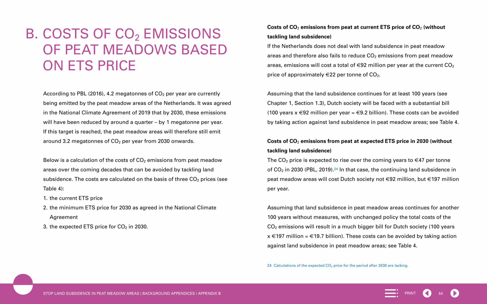
54PRINTSTOP LAND SUBSIDENCE IN PEAT MEADOW AREAS | BACKGROUND APPENDICES | APPENDIX B
According to PBL (2016), 4.2 megatonnes of CO2 per year are currently
being emitted by the peat meadow areas of the Netherlands. It was agreed
in the National Climate Agreement of 2019 that by 2030, these emissions
will have been reduced by around a quarter – by 1 megatonne per year.
If this target is reached, the peat meadow areas will therefore still emit
around 3.2 megatonnes of CO2 per year from 2030 onwards.
Below is a calculation of the costs of CO2 emissions from peat meadow
areas over the coming decades that can be avoided by tackling land
subsidence. The costs are calculated on the basis of three CO2 prices (see
Table 4):
1. the current ETS price
2. the minimum ETS price for 2030 as agreed in the National Climate
Agreement
3. the expected ETS price for CO2 in 2030.
B. COSTS OF CO2 EMISSIONS OF PEAT MEADOWS BASED ON ETS PRICE
Costs of CO2 emissions from peat at current ETS price of CO2 (without
tackling land subsidence)
If the Netherlands does not deal with land subsidence in peat meadow
areas and therefore also fails to reduce CO2 emissions from peat meadow
areas, emissions will cost a total of €92 million per year at the current CO2
price of approximately €22 per tonne of CO2.
Assuming that the land subsidence continues for at least 100 years (see
Chapter 1, Section 1.3), Dutch society will be faced with a substantial bill
(100 years x €92 million per year = €9.2 billion). These costs can be avoided
by taking action against land subsidence in peat meadow areas; see Table 4.
Costs of CO2 emissions from peat at expected ETS price in 2030 (without
tackling land subsidence)
The CO2 price is expected to rise over the coming years to €47 per tonne
of CO2 in 2030 (PBL, 2019).24 In that case, the continuing land subsidence in
peat meadow areas will cost Dutch society not €92 million, but €197 million
per year.
Assuming that land subsidence in peat meadow areas continues for another
100 years without measures, with unchanged policy the total costs of the
CO2 emissions will result in a much bigger bill for Dutch society (100 years
x €197 million = €19.7 billion). These costs can be avoided by taking action
against land subsidence in peat meadow areas; see Table 4.
24 Calculations of the expected CO2 price for the period after 2030 are lacking.

55PRINTSTOP LAND SUBSIDENCE IN PEAT MEADOW AREAS | BACKGROUND APPENDICES | APPENDIX B
Table 4: Avoidable costs of CO2 emissions from peat
Costs of CO2 emissions from peat meadows if emissions total 4.2 megatonnes* per year
Costs of CO2 emissions from peat meadows if emissions total 3.2 megatonnes per year (from 2030, if 2030 target of Climate Agreement is achieved)
Current ETS price of CO2 (€22)*
€92 million €70 million
ETS price in 2030 Agreed minimum price of CO2 in 2030 (€31.9)**
€134 million €102 million
Expected ETS price of CO2 in 2030 (€47)*
€197 million €150 million
* Source: PBL, 2019** Source: Tweede Kamer, 2019d

56PRINTSTOP LAND SUBSIDENCE IN PEAT MEADOW AREAS | BACKGROUND APPENDICES | APPENDIX C
Name Year Initiator(s) / author(s) Theme / goal
Establishing Soft Soil Platform [Platform Slappe Bodem]
2007 17 municipalities and water authorities Focused on integrated approach to problem of land subsidence
Peat Meadow Innovation Centre Zegveld [Veenweiden Innovatie Centrum]
2010 Commissioning parties: three provinces, six water authorities
Knowledge and innovation centre for western peat meadows, focused on sustainable agriculture in peat meadow areas by means of pilots
Friesian Peat Meadow Vision [Friese Veenweidevisie]
2015 Province of Friesland and Friesian water authority Call for slowing land subsidence in Friesian peat meadow area by limiting drainage
Peat meadows in the Dutch Delta metropolis
2016 Delta Metropolis Association [Vereniging Deltametropool]
One of the few studies from the perspective of the metropolis
National Knowledge Programme for Land Subsidence [Nationaal Kennisprogramma Bodemdaling]
2016 Initiative of STOWA; Province of Zuid-Holland; Soft Soil Platform; Rijkswaterstaat; and knowledge institutions
Focused on knowledge about countering land subsidence, with the themes: developing knowledge of innovative techniques, farming, data, governance
Green Heart Perspective 2040 [Perspectief Groene Hart 2040]
2017 Green Heart Steering Committee [Stuurgroep Groene Hart] (provinces, water authorities and municipalities)
Vision on future of the Green Heart, with the themes: strengthening landscape and identity, slowing land subsidence, energy transition, sustainable economy
Peat Innovation Programme [Innovatie-programma Veen]
2017 Agricultural nature management association Water, Land & Dykes [Agrarische natuurvereniging Water, Land & Dijken] and nature conservation organisation Landscape Noord-Holland [Landschap Noord-Holland]
Focused on experiments for countering land subsidence through profitable agriculture; with test sites; funded by province, water authority and ‘Low Holland’ area committee [gebiedscommissie Laag-Holland]
Places of Hope, workshop on the future of peat meadows in Friesland
2018 Curator Maarten Hajer, workshop leader Jandirk Hoekstra
Focused on developing future prospects for Friesian peat meadow area, in coop-eration with architects and landscape architects, experts and local professionals; funded by, among others, province, water authority and national government
Vision on Land Subsidence [Visie Bodemdaling]
2018 Province of Utrecht Building block for Provincial Strategy on Spatial Planning and the Environment [Provinciale Omgevingsvisie], aimed at slowing land subsidence in 2030 and 2050
Vision on land subsidence in western Netherlands [Visie bodemdaling West-Nederland]
2018 Netherlands Agricultural and Horticultural Association [Land- en Tuinbouworganisatie, LTO] North
Aimed at slowing land subsidence by at least 50% by 2050
C. OVERVIEW OF SOME IMPORTANT PROGRAMMES, PUBLICATIONS AND INITIATIVES RELATING TO LAND SUBSIDENCE AND PEAT MEADOWS IN THE NETHERLANDS

57PRINTSTOP LAND SUBSIDENCE IN PEAT MEADOW AREAS | BACKGROUND APPENDICES | APPENDIX C
Name Year Initiator(s) / author(s) Theme / goal
Inter-administrative Programme Living Countryside [Interbestuurlijk Programma Vitaal Platteland]
2018 National government, provinces, municipalities, water authorities and civil society organisations (varying by area)
Inter-administrative programme for, among others, Holland-Utrecht Peat Meadow Area, Friesian Peat Meadow, Amsterdam Wetlands; focused on working on economically vigorous, liveable and eco-friendly countryside through area-based approach in promising areas
Regional Deal Land Subsidence in the Green Heart [Regio Deal Bodemdaling Groene Hart]
2019 Ministry of Agriculture, Nature and Food Quality & subarea Green Heart
Focused on collaborating on an approach to dealing with land subsidence: public authorities, knowledge institutions, agriculture sector, residents and business community
Programme Climate-smart farming on peat
2019 Water Authority HDSR & agricultural collectives Focused on slowing land subsidence, increasing biodiversity and studying relationship between CO2 emissions and land subsidence; with subsidy from Ministry of Agriculture, Nature and Food Quality and under the direction of the provinces
Initiative policy document ‘Veen red je niet alleen’ (You cannot save peat on your own)
2019 House of Representatives, GroenLinks and D66 parties
Call for national government vision on peatlands
Draft National Strategy on Spatial Planning and the Environment
2019 Ministry of the Interior and Kingdom Relations In this document, the Green Heart is called an ‘important landscape to be protected’
National Climate Agreement 2019 Dutch Cabinet Aimed at reducing CO2 emissions in peat meadow areas, among others
Advisory report on new approach to peat meadows of the Green Heart
2019 Three Provincial Advisors on Spatial Quality (PARK)
Call for recognition of diversity of Green Heart and for work tailored to type of peat: soil type decisive for water level & function
Design-based research on Green Heart for PARKs
2019 Buro Sant en Co & Fabrications Background study to PARKs advisory report: soil and water as basis for land use, biodiversity and landscape quality in the Green Heart
Three design studies for regional details for PARKs
2019 Vista & Circular Landscapes
Flux Landscape
Bureau Peter de Ruyter
Regional design studies for Ronde Hoep, block polders Kamerik & Kockengen and Alblasserwaard
Advisory report on Land Subsidence in Noord-Holland
2019 C.P. Veerman Plea for prioritising in government policy the reduction of land subsidence in peat meadow areas, with approach for each area
Peat strategy ‘Stean for it fean’ 2019 Peter de Ruyter commissioned by nature conservation organisation It Fryske Gea
7-step plan for the future of Friesian peat meadow area
A New Deal between farmer and society: Krimpenerwaard pilot
2020 Board of Government Advisors [College van Rijksadviseurs] CRa
Future prospects for landscape-inclusive agriculture harnessing the power of design
Provincial peat meadow visions 2020 Provinces Input for National Peat Plan of the Ministry of Agriculture, Nature and Food Quality; to be drawn up in 2020
National Peat Plan Not yet known
Ministry of Agriculture, Nature and Food Quality together with the provinces
Outcome of vote in House of Representatives; plan yet to be drawn up for reduction of CO2 in peat meadow areas

REFERENCESAalbers, R., Renes, G. & Romijn, G. (2016). WLO-klimaatscenario’s en de
waardering van CO2-uitstoot in MKBA’s. Den Haag: CPB/PBL.
Acacia Water, Leven met Water & STOWA (2009). Leven met zout water:
overzicht huidige kennis omtrent interne verzilting. Geraadpleegd op
7 januari 2020 via https://edepot.wur.nl/50376
Akker, J.J.H. van den, Beuving, J., Hendriks, R.F.A. & Wolleswinkel, R.J.
(2007). Maaivelddaling, afbraak en CO2-emissie van Nederlandse veenge-
bieden. Leidraad bodembescherming, afl. 83. Den Haag: Sdu Uitgevers.
Akker, J. van den, Hoving, I., Hendriks, R. & Knotters, M. (2018).
Onderwaterdrains zijn effectief. Wageningen: Wageningen University &
Research.
Bureau Peter de Ruyter landschapsarchitectuur (2019). Stean foar it fean:
op weg naar een gezamenlijk handelingsperspectief voor het Friese
laagveen landschap, in opdracht van It Fryske Gea. Olterterp.
Buro Sant en Co & Fabrications (2019). Groene Hart: een adaptief en gedif-
ferentieerd landschap met de bodem als conditie, het watersysteem als
instrument en het landgebruik als resultante. Den Haag/Amsterdam.
CBS & WUR (2017). Bossen en bodems stoten meer CO2 uit dan ze
vastleggen. Geraadpleegd op 21 april 2020 via https://www.cbs.nl/nl-nl/
nieuws/2017/45/bossen-en-bodems-stoten-meer-co2-uit-dan-ze-vastleggen
Coastal Protection and Restoration Authority (2019). 2023 Coastal Master
Plan: new project development guidelines and criteria. Baton Rouge.
College van Rijksadviseurs (2019). Via Parijs: een ontwerpverkenning naar
een klimaatneutraal Nederland. Den Haag.
58PRINT

59PRINTSTOP LAND SUBSIDENCE IN PEAT MEADOW AREAS | REFERENCES
Countus (2019). Places of hope: bedrijfssystemen voor het veen in het Lage
Midden van Fryslân, rapport van bevindingen. Zwolle.
Daatselaar, C.H.G. & Prins, H. (2020). Vernatting Groene Hart: kostprijs melk
en CO2-prijs, onderzoek in opdracht van de Raad voor de leefomgeving
en infrastructuur (Rli). Wageningen: Wageningen Economic Research.
Deltares (2018). Verkenning bodemdaling in Midden-Delfland. Delft.
Deltares (2019). Huidig en toekomst opbarstrisico in de polder Middelburg
en Tempelpolder: bodemdaling, opbarsting en wellen. Delft.
Deltares, TNO & WEnR (2018). Huidig en toekomstig opbarstrisico in de
provincie Zuid-Holland. Delft/Den Haag/Wageningen.
Deltares & Delta Alliance (2019). Sinking cities II – example cases: a step-by-
step approach to address land subsidence in urbanising deltas. Delft.
Didde, R. (2016). Wat te doen tegen de alsmaar zakkende bodem? De
Volkskrant, 25 juni 2016.
Erkens, G., Meulen, J. van der & Middelkoop, H. (2016). Double trouble:
subsidence and CO2 respiration due to 1,000 years of Dutch coastal peat-
lands cultivation. Hydrogeology Journal, 24 (3), 551-568.
Erkens, G. & Stouthamer, E. (2020). The 6M approach to land subsidence.
Delft/Utrecht: Deltares/ Universiteit Utrecht.
Evans, C., Morrison, R., Burden, A., Williamson, J., Baird, A., Brown, E.,
Callaghan, N., Chapman, P., Cumming, A., Dean, H., Dixon, S., Dooling,
G., Evans, J., Gauci, V., Grayson, R., Haddaway, N., He, Y., Heppell, K.,
Holden, J., Hughes, S., Kaduk, J., Jones, D., Matthews, R., Menichino,
N., Misselbrook, T., Page, S., Pan, G., Peacock, M., Rayment, M., Ridley,
L., Robinson, I., Rylett, D., Scowen, M., Stanley, K. & Worrall, F. (2016).
Final report on project SP1210: Lowland peatland systems in England
and Wales – evaluating greenhouse gas fluxes and carbon balances.
Wallingford: Centre for Ecology and Hydrology.
Grootjans, A., Hullu, E. de & Sevink, J. (2019). Onderwaterdrainage in veen-
weidegebieden: is dat wel zo’n goed idee? Landschap, 36 (3), 142-149.
Haan, E.J. den & Kruse, G.A.M. (2006). Characterisation and engineering
properties of Dutch peats, chap 13. In K.K. Phoon, D.W. Hight & T.S.
Tan (Eds), Characterisation and engineering properties of natural soils
(p.2101-2133). London: Taylor and Francis.
Hekkenberg, M. & Koelemeijer, R. (2018). Analyse van het voorstel voor
hoofd lijnen van het Klimaatakkoord. Den Haag: PBL.
Hoogheemraadschap De Stichtse Rijnlanden (2019). Coalitieakkoord: verder
bouwen aan toekomstbestendig waterbeheer. Houten.
Hoogheemraadschap van Rijnland (2016). MKBA Reeuwijk-west en polder
Middelburg en Tempelpolder. Leiden.
Hotse Smit, P. (2018). Veenweiden laten massaal hun CO2 los, en dus ligt
daar een grote kans voor het klimaat. Maar wordt die wel gegrepen?
De Volkskrant, 30 juli 2018.
Innovatieprogramma Veen (2020). Meer voedsel voor weidevogels?
Geraadpleegd op 25 mei 2020 via http://www.innovatieprogrammaveen.
nl/meer-voedsel-voor-weidevogels/
IPCC (2018). Global warming of 1.5 °C. Geneva: United Nations.
Klijn, F., Hegnauer, M., Beersma, J. & Weiland, F.S. (2015). Samenvatting
van onderzoek met GRADE naar implicaties van nieuwe klimaatprojecties
voor rivierafvoeren. Delft/De Bilt: Deltares/KNMI.
KNMI (2019). Zeespiegelstijging nu en in de toekomst. KNMI Specials,
3 (03). De Bilt.

60PRINTSTOP LAND SUBSIDENCE IN PEAT MEADOW AREAS | REFERENCES
Koelemeijer, R., Daniëls, B., Koutstaal, P., Geilenkirchen, G., Ros, J., Boot,
P., Born, GJ. van den & Schijndel, M. (2018). Kosten energie- en klimaat-
transitie in 2030 – update 2018. Den Haag: PBL.
Kooi, H., Johnston, P., Lambeck, K., Smither, C. & Molendijk, R. (1998).
Geological causes of recent (~ 100 yr) vertical land movement in the
Netherlands. Tectonophysics, 299 (4), 297-316.
Lof, M., Schenau, S., Jong, R. de, Remme, R., Graveland, C. & Hein, L.
(2017). The SEEA EEA carbon account for the Netherlands. Wageningen/
Den Haag: Wageningen Economic Research/ Centraal Bureau voor de
Statistiek.
Meulenkamp, W., Bont, C. de, Hofman, P., Jong, O. de, Mulder, J., Olde
Loohuis, R. & Rienks, W. (2007). Veenweide: remmen of doorstarten?
Vanuit cultuur historie naar de toekomst. Wageningen: Alterra.
Middel, M. & Noordhoff, I. (2020). Klimaatwinst onderwaterdrainage is
lucht fietserij. Noorderbreedte, 44 (2), 20-26.
Ministerie van Binnenlandse Zaken en Koninkrijksrelaties (2019). Ontwerp
Nationale Omgevingsvisie (NOVI): duurzaam perspectief voor onze
samen leving. Den Haag.
Nichols, J.E. & Peteet, D.M. (2019). Rapid expansion of northern peatlands
and doubled estimate of carbon storage. Nature Geoscience, 12 (11),
917–921.
Öko-Institut (2019). EU LULUCF Regulation explained. Freiburg.
Planbureau voor de Leefomgeving (2015). Het Groene Hart in beeld.
Den Haag.
Planbureau voor de Leefomgeving (2016). Dalende bodems, stijgende
kosten. Den Haag.
Planbureau voor de Leefomgeving (2019). Klimaat- en Energieverkenning
2019. Den Haag.
Provincie Utrecht (2018). Visie bodemdaling. Utrecht.
Provincie Utrecht (2019). Coalitieakkoord 2019-2023: nieuwe energie voor
Utrecht. Utrecht.
Putter, P. de (2016). Juridisch advies bodemdaling en peilbeheer: juridisch
stappenplan. Advies aan Hoogheemraadschap de Stichtse Rijnlanden.
Leiden.
Raad voor de leefomgeving en infrastructuur (2019a). De som der delen:
verkenning samenvallende opgaven in de regio. Den Haag.
Raad voor de leefomgeving en infrastructuur (2019b). Europees landbouw-
beleid: inzetten op kringlooplandbouw. Den Haag.
Raad voor de leefomgeving en infrastructuur (2020). De bodem bereikt?!
Den Haag.
Roncken, P., Slabbers, S. & Veenenbos, H. (2019). Een nieuwe aanpak voor
de veenweiden van het Groene Hart: naar optimale combinaties van
bodem, water en landgebruik. Den Haag/Haarlem/Utrecht: Provinciale
Adviseurs Ruimtelijke Kwaliteit Zuid-Holland, Noord-Holland en Utrecht.
RoyalHaskoningDHV (2014). Onderzoek knikpunten watersysteem restveen-
gebied Zuidplaspolder. Rotterdam.
Royal HaskoningDHV (2019a). Milieueffectrapport Nationale
Omgevingsvisie (ontwerp-NOVI). Amersfoort.
Royal HaskoningDHV (2019b). De staat van de fysieke leefomgeving.
Achtergronddocument bij het milieueffectrapport voor de Nationale
Omgevingsvisie. Amersfoort.

61PRINTSTOP LAND SUBSIDENCE IN PEAT MEADOW AREAS | REFERENCES
Schothorst C.J. (1977). Subsidence of low moor peat soils in the western
Netherlands. Geoderma, 17 (4), 265-291.
Smolders, A.J.P., Riet, B.P. van de, Diggelen, J.M.H. van, Dijk, G. van,
Geurts, J.J.M. & Lamers, L.P.M. (2019). De toekomst van ons veenweide-
landschap: over vernatten, optoppen en veenmosteelt. Landschap, 36 (3),
133-141.
Staatsblad van het Koninkrijk der Nederlanden (2019). Wet van 2 juli 2019,
houdende een kader voor het ontwikkelen van beleid gericht op onom-
keerbaar en stapsgewijs terugdringen van de Nederlandse emissies van
broeikasgassen teneinde wereldwijde opwarming van de aarde en de
verandering van het klimaat te beperken (Klimaatwet). Staatsblad 2019,
253.
STOWA (2020). Deltafact Bodemdaling versie 3.1, februari 2020. Amersfoort.
Stuurgroep Groene Hart (2020). Introductie bodemdaling. Geraadpleegd op
25 mei 2020 via http://stuurgroepgroenehart.nl/perspectief/bodemdaling/
introductie-bodemdaling/
Sweco & WEcR (2017). Verkenning haalbaarheid bouwstenen voor toekomst
restveengebied. De Bilt/Wageningen.
Tiemeyer, B., Freibauer, A., Albiac Borraz, E., Augustin, J., Bechtold, M.,
Beetz, S., Beyer, C., Ebli, M., Eickenscheidt, T., Fiedler, S., Förster, C.,
Gensior, A., Giebels, M., Glatzel, S., Heinichen, J., Hoffmann, M., Höper,
H., Jurasinski, G., Laggner, A., Leiber-Sauheitl, K., Peichl-Brak, M. &
Drösler, M. (2020). A new methodology for organic soils in national
greenhouse gas inventories: Data synthesis, derivation and application.
Ecological Indicators, 20 (109), 1-14.
Timmermans, B. & Eekeren, N. van (2010). Uitmijnen van fosfaat op natuur-
percelen. Ekoland, 30 (12), 16-17.
Tweede Kamer (2019a). Veen red je niet alleen: initiatiefnota van de leden
Bromet en De Groot, van 12 februari 2019. Vergaderjaar 2018–2019, 35
141, nr. 2.
Tweede Kamer (2019b). Kabinetsaanpak Klimaatbeleid. Brief van de minister
van Economische Zaken en Klimaat aan de Tweede Kamer van 28 juni
2019. Bijlage Klimaatakkoord, hoofdstuk C. Landbouw en landgebruik.
Vergaderjaar 2018-2019, 32813, nr. 342.
Tweede Kamer (2019c). Vaststelling van de begrotingsstaat van het
Deltafonds voor het jaar 2019: kamerbrief over rijksbrede inzet op
bodemdaling. Brief van de minister van Infrastructuur en Waterstaat aan
de Tweede Kamer van 20 juni 2019. Vergaderjaar 2018-2019, 35000-J,
nr. 33.
Tweede Kamer (2019d). Wijziging van de Wet belastingen op milieu-
grondslag en de Wet milieubeheer voor de invoering van een
minimum CO2-prijs bij elektriciteitsopwekking (Wet minimum CO2-prijs
elektriciteitsopwekking). Wetsvoorstel van de staatssecretaris van
Financiën en de minister van Economische Zaken en Klimaat aan de
Tweede Kamer van 3 juni 2019. Vergaderjaar 2018–2019, 35 216, nr. 2.
Tweede Kamer (2019e). Kabinetsreactie Initiatiefnota van de leden Bromet
en De Groot: Veen red je niet alleen. Brief van de minister van Landbouw,
Natuur en Voedselkwaliteit aan de Tweede Kamer van 20 juni 2019.
Vergaderjaar 2018-2019, 35 141, nr. 3.

62PRINTSTOP LAND SUBSIDENCE IN PEAT MEADOW AREAS | REFERENCES
Tweede Kamer (2019f). Initiatiefnota van de leden De Groot en Bromet over
Droge voeten: voor een klimaatbestendig Nederland, van 12 februari
2019. Vergaderjaar 2018-2019, 35 140, nr. 2.
Tweede Kamer (2020). Regie en keuzes in het nationaal omgevingsbeleid.
Brief van de minister van Binnenlandse Zaken en Koninkrijksrelaties aan
de Tweede Kamer van 23 april 2020. Vergaderjaar 2019-2020, 34 682,
nr. 48.
UN Environment Programme (2019). Working as one: how Indonesia
came together for its peatlands and forests. Geraadpleegd op 27 maart
2020 via https://www.unenvironment.org/news-and-stories/story/
working-one-how-indonesia-came-together-its-peatlands-and-forests
Unie van Waterschappen, Interprovinciaal Overleg & Stowa (2016). Verder
bouwen op een goed fundament: visie op de regionale waterkeringen
2016. Den Haag/Amersfoort.
Unie van Waterschappen (2017). Slappe Bodem: rol en positie van de water-
schappen in de bodemdalingsproblematiek, Position Paper. Den Haag.
Valkema, P. & Mulders, K. (2019). Op weg naar Werelderfgoed Hollandse
Waterlinies. Utrecht.
Veerman, C. (2019). Haren kost geen tijd, zoeken naar draagvlak voor
bodem daling. Advies aan de provincie Noord-Holland. S.l.
Vogelbescherming Nederland (2016). Factsheet weidevogels & vernatting.
Zeist.
Werkgroep Brede Heroverweging (2020). Klaar voor klimaatverandering:
brede maatschappelijke heroverweging. Rapport Klimaatadaptatie.
Den Haag: Inspectie der Rijksfinanciën.
Witteveen+Bos (2019). MKBA remming bodemdaling in het Friese veen-
weidegebied, in opdracht van Provincie Fryslân. Deventer.
Wösten, H. (2017). Behoud veengrond in Indonesië is in ieders belang.
Geraadpleegd op 30 maart 2020 via https://weblog.wur.nl/uitgelicht/
behoud-veengronden-indonesie-is-ieders-belang/
Ye, S., Xue, Y., Wu, Y., Yan, X. & Yu, J. (2016). Progression and mitigation of
land subsidence in China. Hydrogeology Journal, 24 (3), 685-693.

APPENDICES RESPONSIBILITY AND ACKNOWLEDGEMENT
Advisory Committee
Ellen Peper, Council member and committee chair
Prof. Marcel Boogers, Professor of Innovation and Regional Governance,
University of Twente/BMC Advies
Gilles Erkens, PhD, geologist, Deltares/Utrecht University
Krijn Poppe, Council member
Em. Prof. André van der Zande, Council member
Project team
Lianne van Duinen, PhD, project leader
Dominique Blom, project officer
Anneke Koose-Verschoor, project assistant
Persons and organisations consulted
Charles Aangenendt, Ministry of the Interior and Kingdom Relations
Marijke Andela-Jaarsma, Ministry of Agriculture, Nature and Food Quality
Corine van den Berg, Regional Public Water Authority Amstel, Gooi en
Vecht / Waternet
Patricia Braaksma, Coordination Office Green Heart
63PRINT

64PRINTSTOP LAND SUBSIDENCE IN PEAT MEADOW AREAS | RESPONSIBILITY AND ACKNOWLEDGEMENT
Gert Jan van den Born, PBL Netherlands Environmental Assessment
Agency
Marlies Feringa, Province of Utrecht
Bert de Groot, De Stichtse Rijnlanden Water Authority
Peter Heij, Ministry of Infrastructure and Water Management
Marjan Holtman, De Stichtse Rijnlanden Water Authority
Erik Jansen, Peat Meadows Innovation Centre /National Knowledge
Programme for Land Subsidence
Jan Jansen, Ministry of Agriculture, Nature and Food Quality
Douwe Jonkers, Ministry of Infrastructure and Water Management
Chris Kalden, Green Heart Administrative Platform
Erik Jan van Kempen, Ministry of the Interior and Kingdom Relations
Andrea Klomp, Ministry of Education, Culture and Science
Olav Koop, Province of Zuid-Holland
Joost Kuggeleijn, Ministry of Education, Culture and Science
Angelique Nielen, Ministry of Agriculture, Nature and Food Quality
Johan Osinga, Ministry of Agriculture, Nature and Food Quality
Ingrid Post, Ministry of the Interior and Kingdom Relations
Emiel Reiding, Ministry of the Interior and Kingdom Relations
Peter de Ruyter, landscape architecture firm Bureau Peter de Ruyter
landschapsarchitectuur
Joke Schalk, Province of Zuid-Holland
Meeting of experts: 12 December 2019
Patricia Braaksma, Coordination Office Green Heart
Erik Jansen, Peat Meadows Innovation Centre
Rob Ligtenberg, Province of Zuid-Holland
Angelique Nielen, Ministry of Agriculture, Nature and Food Quality
Paul Roncken, Province of Utrecht
Teunis Jacob Slob, Municipality of Molenlanden / Dairy farm De Drie
Wedden
David van Zelm van Eldik, Ministry of the Interior and Kingdom Relations
External reviewers
Harm Veenenbos, Veenenbos and Bosch landscape architects
Pieter van Geel, Van Geel Consultancy / Louis Bolk Institute
Siem Jan Schenk, Hoogheemraadschap Hollands Noorderkwartier Water
Authority

65PRINTSTOP LAND SUBSIDENCE IN PEAT MEADOW AREAS | OVERVIEW OF PUBLICATIONS
OVERVIEW OF PUBLICATIONS
2020
Green Recovery. [‘Groen uit de crisis’]. July 2020 (Rli 2020/04)
Changing Tracks: Towards Better International Passenger Transport by
Train. [‘Verzet de wissel: naar beter internationaal reizigersvervoer per
trein’]. July 2020 (Rli 2020/03)
Soils for Sustainability. [‘De Bodem bereikt?!’]. June 2020 (Rli 2020/02)
A Grip on Hazardous Substances. [‘Greep op gevaarlijke stoffen’].
February 2020 (Rli 2020/01)
2019
Towards a Sustainable Economy: The Governance of Transitions. [‘Naar een
duurzame economie: overheidssturing op transities’]. November 2019
(Rli 2019/05).
Desirable Tourism: Capitalising on Opportunities in the Living Environment.
[‘Waardevol toerisme: onze leefomgeving verdient het’]. September 2019
(Rli 2019/04).
European Agricultural Policy: Working Towards Circular Agriculture.
[‘Europees Landbouwbeleid: inzetten op kringlooplandbouw’]. May 2019
(Rli 2019/03).
Aviation Policy: A New Approach Path. [‘Luchtvaartbeleid: een nieuwe
aanvliegroute’]. April 2019 (Rli 2019/02).
The Sum of the Parts: Converging National and Regional Challenges.
[‘De som der delen: verkenning samenvallende opgaven in de regio’].
March 2019 (Rli 2019/01).
2018
Warmly Recommended: Towards a Low-CO2 Heat Supply in the Built
Environment [‘Warm aanbevolen: CO2-arme verwarming van de gebouwde
omgeving’]. December 2018 (Rli 2018/07)
National Environment and Planning Strategy: Litmus Test for the
New Environmental and Planning Policy [‘Nationale omgevingsvisie:
lakmoesproef voor de Omgevingswet’]. November 2018 (Rli 2018/06)
Accelerating Housing Production, While Maintaining Quality [‘Versnellen
woningbouwproductie, met behoud van kwaliteit’]. June 2018 (Rli 2018/05)
Better and Different Mobility: Investing in Mobility for the Future
‘[Van B naar Anders: investeren in mobiliteit voor de toekomst’]. May 2018
(Rli 2018/04)

66PRINTSTOP LAND SUBSIDENCE IN PEAT MEADOW AREAS | OVERVIEW OF PUBLICATIONS
The Healthy City: Delivering Health Through Environmental and
Planning Policy [‘De stad als gezonde habitat: gezondheidswinst door
omgevingsbeleid’]. April 2018 (Rli 2018/03)
Sustainable and Healthy: Working Together Towards a Sustainable
Food System [‘Duurzaam en gezond: samen naar een houdbaar
voedselsysteem’]. March 2018 (Rli 2018/02)
Electricity Provision in the Face of Ongoing Digitalisation
[‘Stroomvoorziening onder digitale spanning’]. February 2018 (Rli 2018/01)
2017
A Broad View of Heritage: The Interactions Between Heritage and
Transitions in the Physical Environment [‘Brede blik op erfgoed: over de
wisselwerking tussen erfgoed en transities in de leefomgeving’].
December 2017 (Rli 2017/03)
Energietransitie en leefomgeving: kennisnotitie. December 2017 (Rli 2017)
[only available in Dutch]
Land for Development: Land Policy Instruments for an Enterprising Society
[‘Grond voor gebiedsontwikkeling: instrumenten voor grondbeleid in een
energieke samenleving’]. June 2017 (Rli 2017/02)
Assessing the Value of Technology: Guidance Document [‘Technologie op
waarde schatten: een handreiking’]. January 2017 (Rli 2017/01)
2016
Faster and Closer: Opportunities for Improving Accessibility in Urban
Regions [‘Dichterbij en sneller: kansen voor betere bereikbaarheid in
stedelijke regio’s’]. December 2016 (Rli 2016/05)
International Scan 2016: Emerging Issues in an International Context.
November 2016 (Rli/EEAC)
The Connecting Landscape [‘Verbindend landschap’]. November 2016
(Rli 2016/04)
Challenges for Sustainable Development: Main Focus Areas Identified in
Advisory Reports Published in the Past Four Years by the Council for the
Environment and Infrastructure [‘Opgaven voor duurzame ontwikkeling:
hoofdlijnen uit vier jaar advisering door de Raad voor de leefomgeving en
infrastructuur’]. July 2016 (Rli 2016/03)
Beyond Mainports [‘Mainports voorbij’]. July 2016 (Rli 2016/02)
Notitie Systeemverantwoordelijkheid in de fysieke Leefomgeving. May 2016
(Rli 2016/01) [only available in Dutch]
2015
Reform of Environmental Law: Realize your Ambitions [‘Vernieuwing
omgevingsrecht: maak de ambities waar’]. December 2015 (Rli 2015/07)

67PRINTSTOP LAND SUBSIDENCE IN PEAT MEADOW AREAS | OVERVIEW OF PUBLICATIONS
A Prosperous Nation Without CO2: Towards a Sustainable Energy Supply
by 2050 [‘Rijk zonder CO2: naar een duurzame energievoorziening in 2050’].
September 2015 (Rli 2015/06)
Room for the Regions in European Policy [‘Ruimte voor de regio in
Europees beleid’]. September 2015 (Rli 2015/05)
Changing Trends in Housing: Flexibility and Regionalisation Within Housing
Policy [‘Wonen in verandering: over flexibilisering en regionalisering in het
woonbeleid’]. June 2015 (Rli 2015/04)
Circular Economy: From Wish to Practice [‘Circulaire economie: van wens
naar uitvoering’]. June 2015 (Rli 2015/03)
Stelselherziening omgevingsrecht. May 2015 (Rli 2015/02) [only available in
Dutch]
Survey of Technological Innovations in the Living Environment [‘Verkenning
technologische innovaties in de leefomgeving’]. January 2015 (Rli 2015/01)
2014
Managing Surplus Government Real Estate: Balancing Public Interest
Against Financial Gain [‘Vrijkomend rijksvastgoed: over maatschappelijke
doelen en geld’]. December 2014 (Rli 2014/07)
Risks Assessed: Towards a Transparent and Adaptive Risk Policy [‘Risico’s
gewaardeerd: naar een transparant en adaptief risicobeleid’]. June 2014
(Rli 2014/06)
Recovering the Costs of Environmental Damage: Financial Indemnity
Requirements for High-Risk Companies [‘Milieuschade verhalen: advies
financiële zekerheidstelling milieuschade Brzo- en IPPC4-bedrijven’].
June 2014 (Rli 2014/05)
International Scan 2014. Emerging Issues in an International Context
[‘Internationale verkenning 2014. Signalen: de opkomende vraagstukken uit
het internationale veld’]. May 2014 (Rli 2014)
The Future of the City: The Power of New Connections [‘De toekomst van de
stad: de kracht van nieuwe verbindingen’]. April 2014 (Rli 2014/04)
Quality Without Growth: On the Future of the Built Environment [‘Kwaliteit
zonder groei: over de toekomst van de leefomgeving’]. April 2014
(Rli 2014/03)
Influencing Behaviour: More Effective Environmental Policy Through
Insight Into Human Behaviour [‘Doen en laten: effectiever milieubeleid door
mensenkennis’]. March 2014 (Rli 2014/02)

68PRINTSTOP LAND SUBSIDENCE IN PEAT MEADOW AREAS | OVERVIEW OF PUBLICATIONS
Living Independently for Longer, a Shared Responsibility of the Housing,
Health and Welfare Policy Domains [‘Langer zelfstandig, een gedeelde
opgave van wonen, zorg en welzijn’]. January 2014 (Rli 2014/01)
2013
Sustainable Choices in the Implementation of the Common Agricultural
Policy in the Netherlands [‘Duurzame keuzes bij de toepassing van het
Europese landbouwbeleid in Nederland’]. October 2013 (Rli 2013/06)
Pulling Together: Governance in the Schiphol/Amsterdam Metropolitan
Region [‘Sturen op samenhang: governance in de metropolitane regio
Schiphol/Amsterdam’]. September 2013 (Rli 2013/05)
Safety at Companies Subject to the Major Accidents Risks Decree:
Responsibility and Effective Action [‘Veiligheid bij Brzo-bedrijven:
verantwoordelijkheid en daadkracht’]. June 2013 (Rli 2013/04)
Dutch Logistics 2040: Designed to Last [‘Nederlandse logistiek 2040:
designed to last’]. June 2013 (Rli 2013/03)
Nature’s Imperative: Towards a Robust Nature Policy [‘Onbeperkt houdbaar:
naar een robuust natuurbeleid’]. May 2013 (Rli 2013/02)
Room for Sustainable Agriculture [‘Ruimte voor duurzame landbouw’].
March 2013 (Rli 2013/01)
2012
Keep Moving: Towards Sustainable Mobility. Edited by Bert van Wee.
October 2012 (Rli/EEAC)

69PRINTSTOP LAND SUBSIDENCE IN PEAT MEADOW AREAS
Original title
Stop bodemdaling in veenweidegebieden: het Groene Hart als voorbeeld
Text editing
Saskia van As, Tekstkantoor van As, Amsterdam, The Netherlands
Infographics
Frédérik Ruys, Vizualism, Utrecht, The Netherlands (pages 9, 38, 43, 46, 50)
MUST stedebouw, Amsterdam, The Netherlands (page 28)
Photo credits
Cover: Siebe Swart / Hollandse Hoogte
Page 4: Marco van Middelkoop / Hollandse Hoogte
Page 8: George Mollering / ANP
Page 18: Truus van Gog / Hollandse Hoogte
Page 36: Michiel Wijnbergh / Hollandse Hoogte
Page 37: Jilmer Postma / ANP
Graphic design
Jenneke Drupsteen Grafische vormgeving, The Hague, The Netherlands
Publication Rli 2020/05
September 2020
Translation
Livewords, Maastricht/Amstelveen, The Netherlands
Preferred citation
Council for the Environment and Infrastructure (2020). Stop Land
Subsidence in Peat Meadow Areas: the ‘Green Heart’ Area as an Example.
The Hague.
ISBN 978-90-77166-92-5
NUR 740
Copyright © 2022 FDOKUMEN