The Hammamet, Gabès and Chotts basins (Tunisia): a review of the subsidence history
22
The Hammamet, Gabe `s and Chotts basins (Tunisia): a review of the subsidence history Martin Patriat a , Nadine Ellouz a, * , Zied Dey b , Jean-Michel Gaulier a , Hatem Ben Kilani b a Institut Franc ßais du Pe ´trole, 1 –4 Avenue de Bois Pre ´au, 92852 Rueil-Malmaison cedex, France b Entreprise Tunisienne d’Activite ´s Pe ´trolie `res, BP 367, 1002 Tunis, Tunisia Received 20 October 1999; received in revised form 4 July 2001; accepted 19 July 2002 Abstract We modeled the subsidence of three Mesozoic basins in Tunisia by using well data, seismic lines and field data. The results are presented here with an attempt to relate the succession of events deduced from the subsidence evolution analysis to the geodynamic evolution of the northern African margin. The Mesozoic and Cenozoic geological history of Tunisia has been broken down into two major periods separated by a transition period. The first period from Trias to Aptian was characterized by a constant subsidence of variable intensity spread over most of Tunisia, and over all the studied basins. This period was dominated by extension accompanying the Tethyan rifting during Trias – Lias. The transition period during the upper Cretaceous was characterized by extension and by the weak effects of far-seated compressional events. It is coeval with the first appearance of salt mobilization. The last period, in Tertiary, marked the appearance of the major collisional events, mostly during Neogene. During this last period, basins were characterized by very different behaviour, depending on their location: East or West of the North–South axis and close or not to the Tellian nappes. Among the three basins we studied, we paid special attention to the southernmost Gabe `s basin located south of the present eastern margin of Tunisia. The first-order evolution of its subsidence is similar to that we infer for most of the Tunisian basins. We emphasize the role of the structuration of the Gabe `s basin in the partition of the subsidence through time. D 2002 Elsevier Science B.V. All rights reserved. Keywords: Tunisia; Maghreb; Atlas; Subsidence modeling; Tectonic controls; Paleostress field 1. Introduction The present-day margin of North Africa repre- sents the southern margin of the Miocene western Mediterranean basin. The original southern margin of the Tethyan Ocean, Triassic to Lower Jurassic in age, has been highly tectonized during Cenozoic. At present, the paleomargin is represented in the Atlas regions of the Maghreb. This paper aims to bring out elements about the geological history of the Tethyan margin by a study of its subsidence through time. It focuses on the evolution of Tunisian basins located on the ancient Tethyan margin. We used industrial wells, seismic 0037-0738/02/$ - see front matter D 2002 Elsevier Science B.V. All rights reserved. PII:S0037-0738(02)00290-7 * Corresponding author. Fax: +33-1-47-52-70-67. E-mail address: [email protected] (N. Ellouz). www.elsevier.com/locate/sedgeo Sedimentary Geology 156 (2003) 241 – 262
-
Upload
independent -
Category
Documents
-
view
1 -
download
0
Transcript of The Hammamet, Gabès and Chotts basins (Tunisia): a review of the subsidence history
The Hammamet, Gabes and Chotts basins (Tunisia):
a review of the subsidence history
Martin Patriata, Nadine Ellouza,*, Zied Deyb,Jean-Michel Gauliera, Hatem Ben Kilanib
a Institut Franc�ais du Petrole, 1–4 Avenue de Bois Preau, 92852 Rueil-Malmaison cedex, FrancebEntreprise Tunisienne d’Activites Petrolieres, BP 367, 1002 Tunis, Tunisia
Received 20 October 1999; received in revised form 4 July 2001; accepted 19 July 2002
Abstract
We modeled the subsidence of three Mesozoic basins in Tunisia by using well data, seismic lines and field data. The results
are presented here with an attempt to relate the succession of events deduced from the subsidence evolution analysis to the
geodynamic evolution of the northern African margin.
The Mesozoic and Cenozoic geological history of Tunisia has been broken down into two major periods separated by a
transition period. The first period from Trias to Aptian was characterized by a constant subsidence of variable intensity spread
over most of Tunisia, and over all the studied basins. This period was dominated by extension accompanying the Tethyan rifting
during Trias–Lias. The transition period during the upper Cretaceous was characterized by extension and by the weak effects of
far-seated compressional events. It is coeval with the first appearance of salt mobilization. The last period, in Tertiary, marked
the appearance of the major collisional events, mostly during Neogene. During this last period, basins were characterized by
very different behaviour, depending on their location: East or West of the North–South axis and close or not to the Tellian
nappes.
Among the three basins we studied, we paid special attention to the southernmost Gabes basin located south of the present
eastern margin of Tunisia. The first-order evolution of its subsidence is similar to that we infer for most of the Tunisian basins.
We emphasize the role of the structuration of the Gabes basin in the partition of the subsidence through time.
D 2002 Elsevier Science B.V. All rights reserved.
Keywords: Tunisia; Maghreb; Atlas; Subsidence modeling; Tectonic controls; Paleostress field
1. Introduction
The present-day margin of North Africa repre-
sents the southern margin of the Miocene western
Mediterranean basin. The original southern margin of
the Tethyan Ocean, Triassic to Lower Jurassic in age,
has been highly tectonized during Cenozoic. At
present, the paleomargin is represented in the Atlas
regions of the Maghreb.
This paper aims to bring out elements about the
geological history of the Tethyan margin by a study
of its subsidence through time. It focuses on the
evolution of Tunisian basins located on the ancient
Tethyan margin. We used industrial wells, seismic
0037-0738/02/$ - see front matter D 2002 Elsevier Science B.V. All rights reserved.
PII: S0037 -0738 (02 )00290 -7
* Corresponding author. Fax: +33-1-47-52-70-67.
E-mail address: [email protected] (N. Ellouz).
www.elsevier.com/locate/sedgeo
Sedimentary Geology 156 (2003) 241–262
lines and field data from the literature to reconstruct
the Meso- and Cenozoic subsidence of these basins.
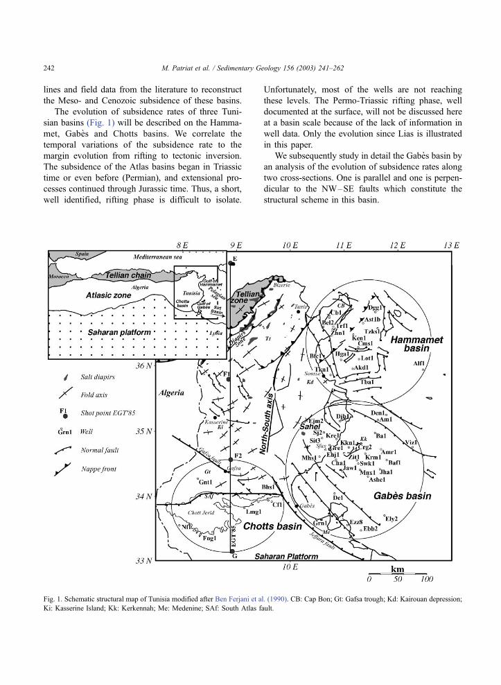
The evolution of subsidence rates of three Tuni-
sian basins (Fig. 1) will be described on the Hamma-
met, Gabes and Chotts basins. We correlate the
temporal variations of the subsidence rate to the
margin evolution from rifting to tectonic inversion.
The subsidence of the Atlas basins began in Triassic
time or even before (Permian), and extensional pro-
cesses continued through Jurassic time. Thus, a short,
well identified, rifting phase is difficult to isolate.
Unfortunately, most of the wells are not reaching
these levels. The Permo-Triassic rifting phase, well
documented at the surface, will not be discussed here
at a basin scale because of the lack of information in
well data. Only the evolution since Lias is illustrated
in this paper.
We subsequently study in detail the Gabes basin by
an analysis of the evolution of subsidence rates along
two cross-sections. One is parallel and one is perpen-
dicular to the NW–SE faults which constitute the
structural scheme in this basin.
Fig. 1. Schematic structural map of Tunisia modified after Ben Ferjani et al. (1990). CB: Cap Bon; Gt: Gafsa trough; Kd: Kairouan depression;
Ki: Kasserine Island; Kk: Kerkennah; Me: Medenine; SAf: South Atlas fault.
M. Patriat et al. / Sedimentary Geology 156 (2003) 241–262242
2. Geological setting
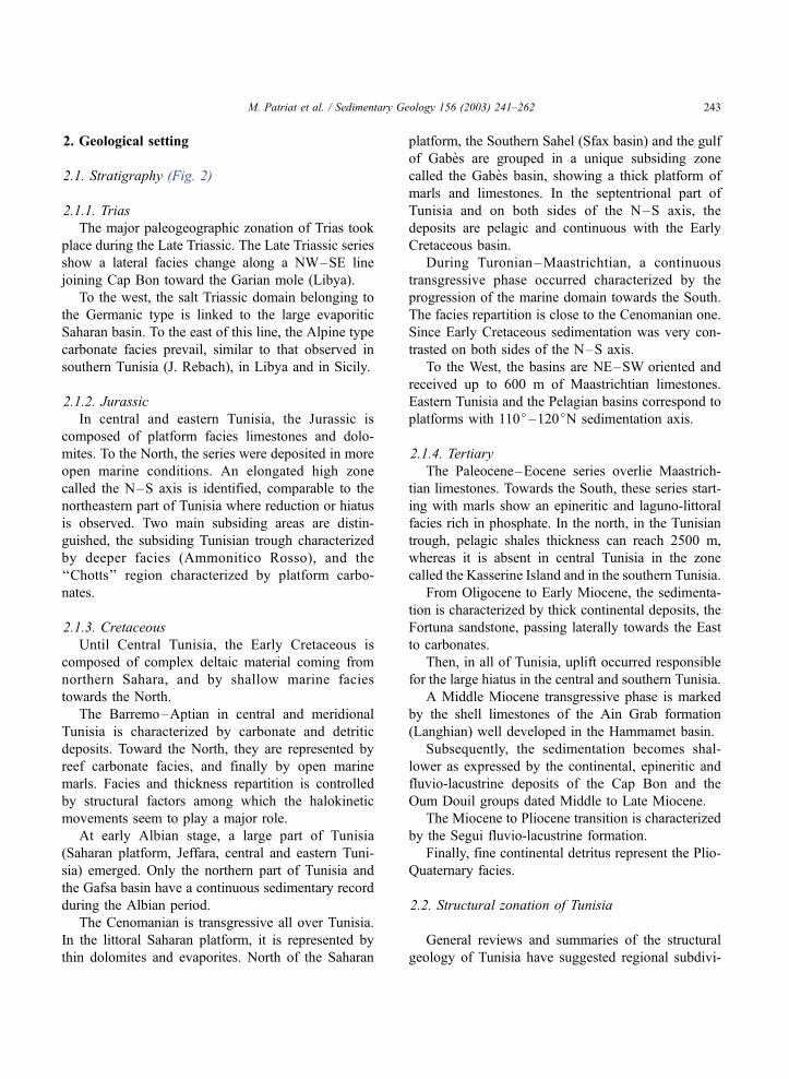
2.1. Stratigraphy (Fig. 2)
2.1.1. Trias
The major paleogeographic zonation of Trias took
place during the Late Triassic. The Late Triassic series
show a lateral facies change along a NW–SE line
joining Cap Bon toward the Garian mole (Libya).
To the west, the salt Triassic domain belonging to
the Germanic type is linked to the large evaporitic
Saharan basin. To the east of this line, the Alpine type
carbonate facies prevail, similar to that observed in
southern Tunisia (J. Rebach), in Libya and in Sicily.
2.1.2. Jurassic
In central and eastern Tunisia, the Jurassic is
composed of platform facies limestones and dolo-
mites. To the North, the series were deposited in more
open marine conditions. An elongated high zone
called the N–S axis is identified, comparable to the
northeastern part of Tunisia where reduction or hiatus
is observed. Two main subsiding areas are distin-
guished, the subsiding Tunisian trough characterized
by deeper facies (Ammonitico Rosso), and the
‘‘Chotts’’ region characterized by platform carbo-
nates.
2.1.3. Cretaceous
Until Central Tunisia, the Early Cretaceous is
composed of complex deltaic material coming from
northern Sahara, and by shallow marine facies
towards the North.
The Barremo–Aptian in central and meridional
Tunisia is characterized by carbonate and detritic
deposits. Toward the North, they are represented by
reef carbonate facies, and finally by open marine
marls. Facies and thickness repartition is controlled
by structural factors among which the halokinetic
movements seem to play a major role.
At early Albian stage, a large part of Tunisia
(Saharan platform, Jeffara, central and eastern Tuni-
sia) emerged. Only the northern part of Tunisia and
the Gafsa basin have a continuous sedimentary record
during the Albian period.
The Cenomanian is transgressive all over Tunisia.
In the littoral Saharan platform, it is represented by
thin dolomites and evaporites. North of the Saharan
platform, the Southern Sahel (Sfax basin) and the gulf
of Gabes are grouped in a unique subsiding zone
called the Gabes basin, showing a thick platform of
marls and limestones. In the septentrional part of
Tunisia and on both sides of the N–S axis, the
deposits are pelagic and continuous with the Early
Cretaceous basin.
During Turonian–Maastrichtian, a continuous
transgressive phase occurred characterized by the
progression of the marine domain towards the South.
The facies repartition is close to the Cenomanian one.
Since Early Cretaceous sedimentation was very con-
trasted on both sides of the N–S axis.
To the West, the basins are NE–SW oriented and
received up to 600 m of Maastrichtian limestones.
Eastern Tunisia and the Pelagian basins correspond to
platforms with 110j–120jN sedimentation axis.
2.1.4. Tertiary
The Paleocene–Eocene series overlie Maastrich-
tian limestones. Towards the South, these series start-
ing with marls show an epineritic and laguno-littoral
facies rich in phosphate. In the north, in the Tunisian
trough, pelagic shales thickness can reach 2500 m,
whereas it is absent in central Tunisia in the zone
called the Kasserine Island and in the southern Tunisia.
From Oligocene to Early Miocene, the sedimenta-
tion is characterized by thick continental deposits, the
Fortuna sandstone, passing laterally towards the East
to carbonates.
Then, in all of Tunisia, uplift occurred responsible
for the large hiatus in the central and southern Tunisia.
A Middle Miocene transgressive phase is marked
by the shell limestones of the Ain Grab formation
(Langhian) well developed in the Hammamet basin.
Subsequently, the sedimentation becomes shal-
lower as expressed by the continental, epineritic and
fluvio-lacustrine deposits of the Cap Bon and the
Oum Douil groups dated Middle to Late Miocene.
The Miocene to Pliocene transition is characterized
by the Segui fluvio-lacustrine formation.
Finally, fine continental detritus represent the Plio-
Quaternary facies.
2.2. Structural zonation of Tunisia
General reviews and summaries of the structural
geology of Tunisia have suggested regional subdivi-
M. Patriat et al. / Sedimentary Geology 156 (2003) 241–262 243
sions into various tectonic zones or provinces (e.g.
Castany, 1951; Kanes et al., 1979; Vila, 1980). The
main boundary elements are the nappe front, the
North–South axis and the south Atlas fault (Fig. 1).
The Burollet and Rouvier (1971) structural zona-
tion is generally accepted and is described from north
to south across Tunisia (Fig. 1).
2.2.1. Northern Tunisia
The northern Tunisia area constitutes the north-
eastern termination of the North Africa ‘‘Atlas’’ oro-
genic belt, which corresponds to the southern segment
of the ‘‘Alpine arc’’, extending westwards through
Algeria and Morocco and eastwards through the
Mediterranean sea and Sicily. From NW to SE, the
Northern Tunisia onshore area can be subdivided into
two major domains: the Tellian fold and thrust belt
whose major nappes setting is dated Middle Miocene,
bordered to the SE, by the foreland domain (Fig. 1).
At the front of the Tellian fold and thrust belt lies
the zone of diapirs. It is characterized by the surface
exposure of SW–NE salt diapirs, which coincide with
anticlines fold and thrust emergence. Despite the
presence of up to 1000 m of Triassic–Lower Jurassic
evaporites, the salt diapirs are not exposed at a similar
scale elsewhere in Tunisia.
2.2.2. The Tunisian Atlas
The Tunisian Atlas is a region of variable tectonic
styles in central Tunisia. It is essentially consisting of
NE–SW trending folds as in the Algerian Saharan
Atlas (Burollet and Rouvier, 1971). Several authors
considered the Tunisian Atlas as an example of thin-
skin tectonics mainly detached on Triassic and Creta-
ceous decollement levels mainly during Miocene to
Quaternary time (Frizon de Lamotte et al., 1998;
Outtani et al., 1995). It is bounded to the East by
the North–South axis and to the South by the South
Atlas fault, a possible location of basement reactiva-
tion (Pique et al., 1998).
The paleofeature known as ‘‘Kasserine Island’’
formed a stable block made of Late Cretaceous and
Tertiary shallow water deposits (Burollet and Rouvier,
1971). The Cretaceous carbonate facies of this zone
generally pass from a subcontinental domain in the
south to a marine domain in the north (Marie et al.,
1984). The Kerkennah high, located on the eastern
part of Tunisia, presents a similar evolution. The
anticlines developed in the northern part of the zone
(e.g. Selloum, Sidi Aich, Zaouia) are elongated in a
NE–SW direction, whereas their trend becomes east–
west to the south (e.g. Kebar, Meloussi, Orbata).
Large synclinal basins, generally filled up by Mio-
Pliocene deposits, separate these anticlines.
2.2.3. The eastern platform
The eastern platform onshore, which includes the
Cap Bon and Sahel areas, extends eastwards from the
North–South axis to the Pelagian Sea.
In contrast with the Atlas domain, the surface
expression of folding is very subdued east of the
North–South axis, consisting mainly of broad low-
amplitude arches along NE–SW axes or elongated
domes (Touati, 1985). In the northern part of the
Kairouan depression, close to the Gulf of Hammamet,
N–S trending folds developed, in which a complete
sequence from Lower Cretaceous is expressed at the
surface.
Offshore, this domain is represented by the Ham-
mamet and Gabes basins separated by a high area
centered on the Kerkennah islands (Fig. 1).
2.2.4. The Saharan platform
The South Atlas Fault marks the limit between the
Tunisian Atlas and the Saharan Platform. The area is
underlain by strongly deformed Precambrian base-
ment, but has been dominantly influenced by minor
rather than real compressional movements throughout
the Paleozoic to Cenozoic. A significant exception
occurs in the vicinity of Medenine where Lower
Cretaceous folding on axes orientated NW–SE and
E–W may reflect the pre-Turonian left lateral regime
of the Mediterranean region (Bouaziz et al., 1998).
2.3. Geodynamic evolution and timing of deformation
The rifting in Tunisia associated to the propagation
of the Tethys toward the West, began in Permian time
(Robertson Research International, 1983; Barrier et
al., 1993; Ben Ferjani et al., 1990). The Early Mes-
ozoic is characterized by extensional paleostress of
N–S orientation. After Jurassic time, the transition to
compression took place through a complex succession
of extensional phases during the whole Cretaceous
(Letouzey and Tremolieres, 1980; Barrier et al., 1993;
Bouaziz et al., 1994, 1996, 1998).
M. Patriat et al. / Sedimentary Geology 156 (2003) 241–262244

Fig. 2. Schematic stratigraphy of Tunisia after Anderson (1996); time scale is from Odin (1994).
M. Patriat et al. / Sedimentary Geology 156 (2003) 241–262 245
The first clearly identified folding phase in the
‘‘Atlas domain’’ took place during Eocene times. The
second main tectonic phase is Tortonian in age (Bur-
ollet and Rouvier 1971) and was followed by minor
phases until the last folding in the Plio-Pleistocene
(Villafranchian). Significant folding probably oc-
curred in the Late Cretaceous, which has been des-
cribed by Letouzey and Tremolieres (1980), and is
well known and documented on the seismics in
Algeria (Guiraud, 1990).
The Alpine belt corresponds to a fold and thrust
belt developed during the Alpine tectonic cycle,
composed of four principal compressional pulses
(Ben Ayed, 1986; ETAP, 1999). Evaporite layers,
mostly Triassic in age, play as a deep decollement
level. Additionally, the Triassic salt is remobilized in
diapirs (Fig. 2). They started to grow up during the
Aptian (Snoke et al., 1988) or even earlier (Bedir,
1995). Since that time, salt tectonics is considered
as dominant especially along and East of the
North–South axis explaining the individual evolu-
tion recorded by small isolated basins.
3. Methodology
3.1. Data
We had access to three types of data: industry wells
data, seismic reflection and field data from published
sources.
The wells, localized in Fig. 1, represent the major
contribution of this work. Thirty wells are localized in
the Gabes basin, 18 wells in the Hammamet and 6 in
the Chotts. All these 54 wells are located in eastern
and southern Tunisia.
Field data have been used to constrain datings,
facies, possible hiatus and tectonic phases, in addition
to wells and provide us a basis for this discussion.
The seismic lines used cover the offshore Gabes
and Hammamet basins.
Finally, synthetic wells have also been created,
based on seismic interpretation, and analysed.
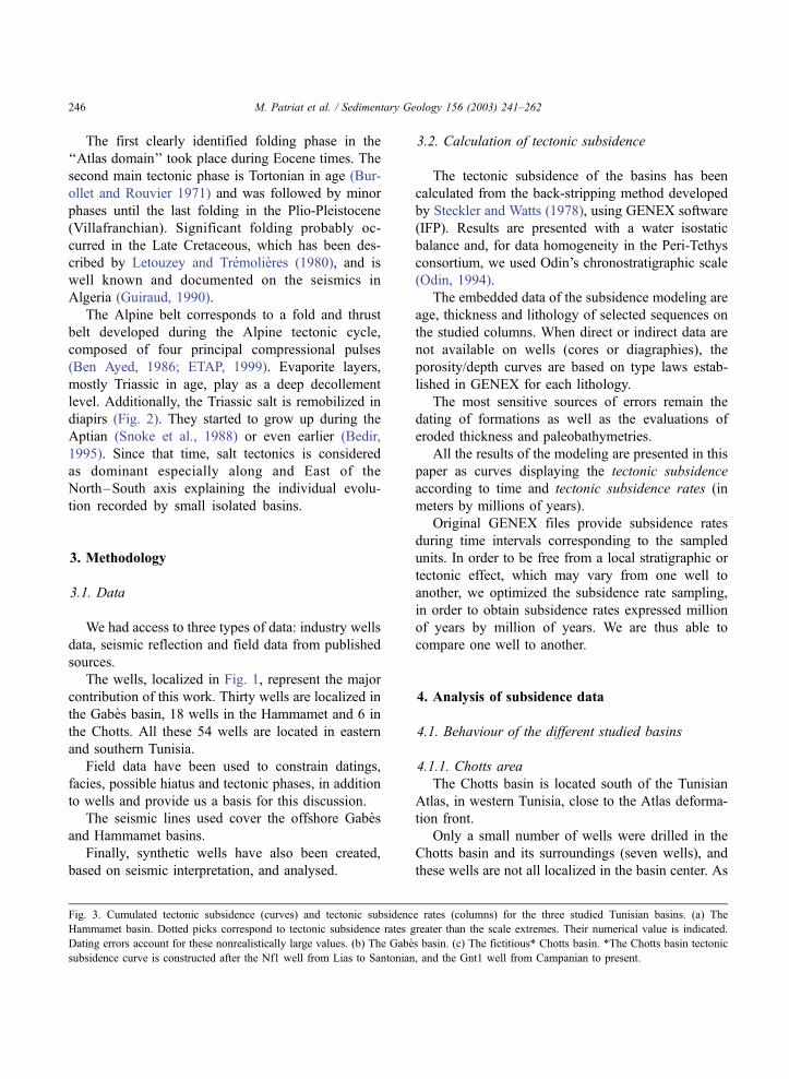
3.2. Calculation of tectonic subsidence
The tectonic subsidence of the basins has been
calculated from the back-stripping method developed
by Steckler and Watts (1978), using GENEX software
(IFP). Results are presented with a water isostatic
balance and, for data homogeneity in the Peri-Tethys
consortium, we used Odin’s chronostratigraphic scale
(Odin, 1994).
The embedded data of the subsidence modeling are
age, thickness and lithology of selected sequences on
the studied columns. When direct or indirect data are
not available on wells (cores or diagraphies), the
porosity/depth curves are based on type laws estab-
lished in GENEX for each lithology.
The most sensitive sources of errors remain the
dating of formations as well as the evaluations of
eroded thickness and paleobathymetries.
All the results of the modeling are presented in this
paper as curves displaying the tectonic subsidence
according to time and tectonic subsidence rates (in
meters by millions of years).
Original GENEX files provide subsidence rates
during time intervals corresponding to the sampled
units. In order to be free from a local stratigraphic or
tectonic effect, which may vary from one well to
another, we optimized the subsidence rate sampling,
in order to obtain subsidence rates expressed million
of years by million of years. We are thus able to
compare one well to another.
4. Analysis of subsidence data
4.1. Behaviour of the different studied basins
4.1.1. Chotts area
The Chotts basin is located south of the Tunisian
Atlas, in western Tunisia, close to the Atlas deforma-
tion front.
Only a small number of wells were drilled in the
Chotts basin and its surroundings (seven wells), and
these wells are not all localized in the basin center. As
Fig. 3. Cumulated tectonic subsidence (curves) and tectonic subsidence rates (columns) for the three studied Tunisian basins. (a) The
Hammamet basin. Dotted picks correspond to tectonic subsidence rates greater than the scale extremes. Their numerical value is indicated.
Dating errors account for these nonrealistically large values. (b) The Gabes basin. (c) The fictitious* Chotts basin. *The Chotts basin tectonic
subsidence curve is constructed after the Nf1 well from Lias to Santonian, and the Gnt1 well from Campanian to present.
M. Patriat et al. / Sedimentary Geology 156 (2003) 241–262246

M. Patriat et al. / Sedimentary Geology 156 (2003) 241–262 247
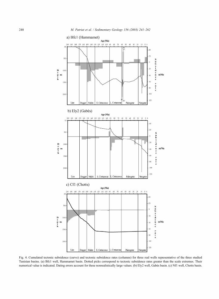
Fig. 4. Cumulated tectonic subsidence (curve) and tectonic subsidence rates (columns) for three real wells representative of the three studied
Tunisian basins. (a) Bfc1 well, Hammamet basin. Dotted picks correspond to tectonic subsidence rates greater than the scale extremes. Their
numerical value is indicated. Dating errors account for these nonrealistically large values. (b) Ely2 well, Gabes basin. (c) Nf1 well, Chotts basin.
M. Patriat et al. / Sedimentary Geology 156 (2003) 241–262248
a result, the representativity of the subsidence curve of
the basin is sometimes questionable. A composite
well has been constructed based on Cf1 (until the
Albian) and Gnt1 (from the Cenomanian) in order to
better represent the Chotts area evolution (Fig. 3c).
Gnt1 has been chosen because it is the only well
showing subsidence during Tertiary. Cf1 has been
chosen because it is located on the eastern side of
the Chotts basin paleodepocenter. Unfortunately, it did
not reach the Triassic. Based on the Cf2 well, we
extrapolated an additional Liassic thickness of 800 m
between the Cf1 well terminal depth (TD) and the
Triassic top.
During the whole Jurassic, subsidence was impor-
tant and constantly around 50 m/Ma (Figs. 3c and 4c).
However, datings are not reliable enough during
Jurassic to distinguish any particular phase.
In Cenomanian, after a period marked by a slowing
down of the subsidence rates (and locally by erosion),
the basin evolution was stopped (Fig. 4c). The tec-
tonic evolution during the Late Cretaceous and Cen-
ozoic is difficult to quantify due to the gap of
sedimentation (erosion or nondeposition?). Gnt1 is
the only well showing a continuous sedimentary
record in the Chotts region since the Cenomanian. It
is located north of the Chotts basin, in the Gafsa
trough. A very marked rise in subsidence rates char-
acterized the Late Cretaceous (Fig. 3c). This accel-
eration corresponds to the one observed on the
Saharan platform in western Atlas Tunisia and in the
Algerian Aures (Bracene et al., this volume).
We cannot consider the dating of Tertiary levels as
very precise in Gnt1 well. Thus, durations, localiza-
tions in time and therefore subsidence rates during
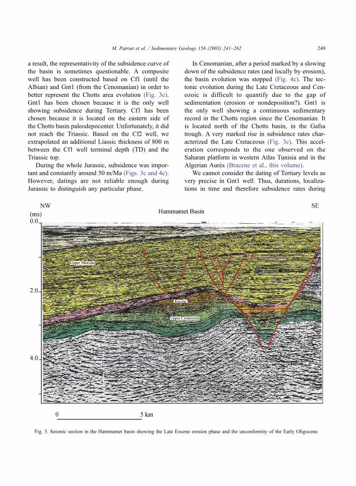
Fig. 5. Seismic section in the Hammamet basin showing the Late Eocene erosion phase and the unconformity of the Early Oligocene.
M. Patriat et al. / Sedimentary Geology 156 (2003) 241–262 249
Tertiary cannot be determined with great accuracy.
Nevertheless, subsidence variations show that the
Chotts area has been influenced by the Alpine colli-
sion episodes, especially during the Pliocene phase.
4.1.2. The Hammamet basin
The offshore Hammamet basin, northernmost
studied basin, is located on the present margin of
the Pelagian Sea in eastern Tunisia (Fig. 1).
Despite the few wells reaching older series than
Aptian, we considered the subsidence as constant and
very homogeneous during the Jurassic and Early
Cretaceous until the Aptian (Fig. 3a), though pre-Late
Cretaceous variations of the subsidence curve are
based on only few deep wells and are not necessarily
representative of the whole basin.
The Cretaceous period is characterized in the
Hammamet basin by a period of intense subsidence
identified during Aptian and by a period of moderate
subsidence during the Cenomano-Turonian (Fig. 3a).
The change due to the collision is prominent in the
Hammamet basin. At the end of Cretaceous to Paleo-
cene, the sedimentary signal showed a pronounced
oscillation. The amplitude of this oscillation is strongly
dependent on eroded thickness evaluations. The ampli-
tude of erosion has been estimated from seismic inter-
pretations. Even though it can be overestimated, an
episode of erosion and uplift, is clearly identified and
localized at the beginning of Paleogene (Figs. 5–6).
In Langhian, the trend of moderate subsidence or
local erosion (Figs. 3a and 4a) that was active since
Paleogene completely changed. The Hammamet basin
developed extensively with subsidence rates reaching
150 m/Ma. This very strong subsidence, synchronous
to the nappes emplacement to the North (Rouvier,
1977), could correspond to the formation of a flexural
depression in the front of these nappes (Burollet and
Ellouz, 1985).
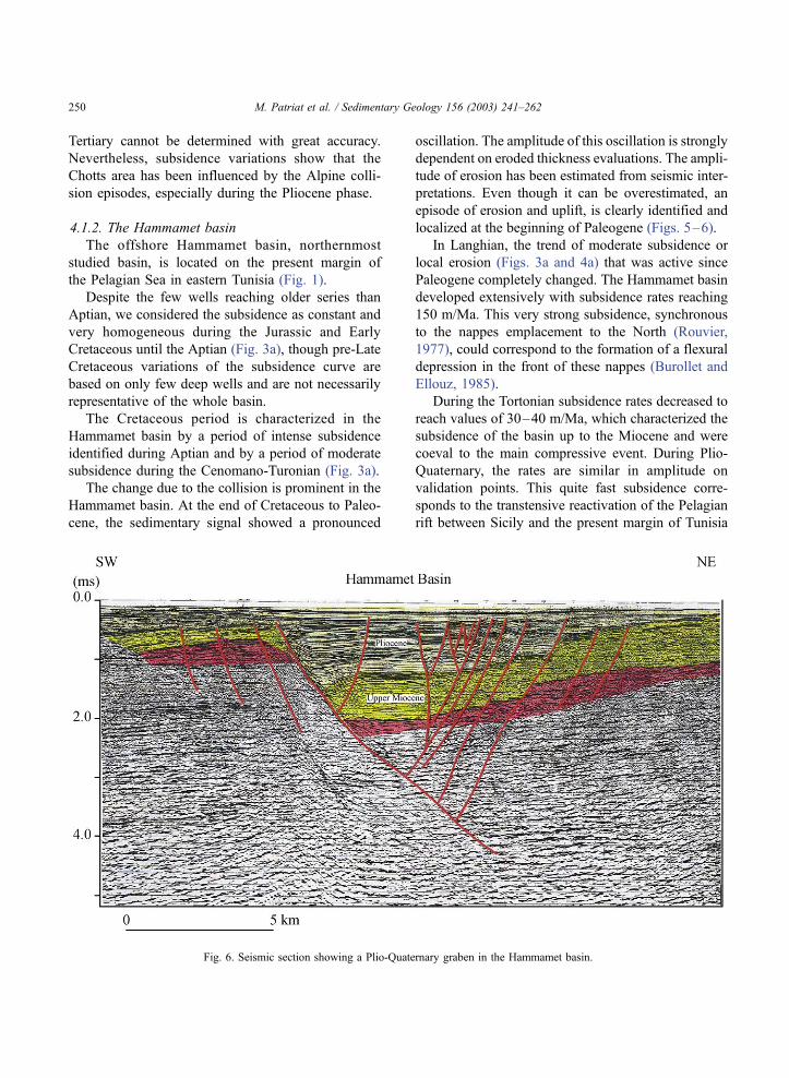
During the Tortonian subsidence rates decreased to
reach values of 30–40 m/Ma, which characterized the
subsidence of the basin up to the Miocene and were
coeval to the main compressive event. During Plio-
Quaternary, the rates are similar in amplitude on
validation points. This quite fast subsidence corre-
sponds to the transtensive reactivation of the Pelagian
rift between Sicily and the present margin of Tunisia
Fig. 6. Seismic section showing a Plio-Quaternary graben in the Hammamet basin.
M. Patriat et al. / Sedimentary Geology 156 (2003) 241–262250
(Figs. 5–6), to the east of the North–South axis
(Boccaletti et al., 1987, 1990).
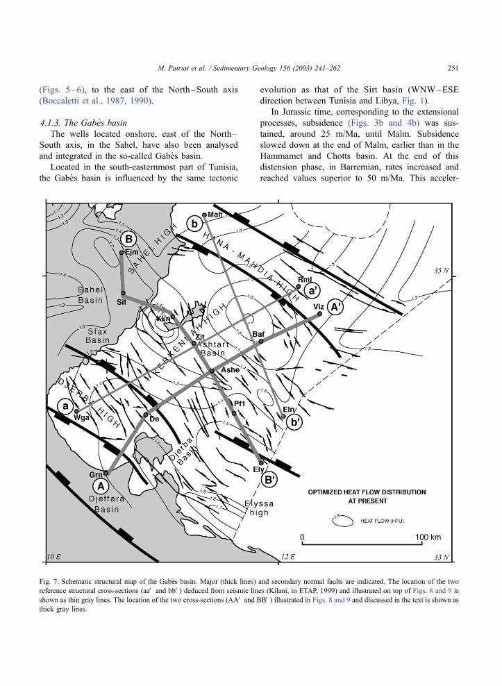
4.1.3. The Gabes basin
The wells located onshore, east of the North–
South axis, in the Sahel, have also been analysed
and integrated in the so-called Gabes basin.
Located in the south-easternmost part of Tunisia,
the Gabes basin is influenced by the same tectonic
evolution as that of the Sirt basin (WNW–ESE
direction between Tunisia and Libya, Fig. 1).
In Jurassic time, corresponding to the extensional
processes, subsidence (Figs. 3b and 4b) was sus-
tained, around 25 m/Ma, until Malm. Subsidence
slowed down at the end of Malm, earlier than in the
Hammamet and Chotts basin. At the end of this
distension phase, in Barremian, rates increased and
reached values superior to 50 m/Ma. This acceler-
Fig. 7. Schematic structural map of the Gabes basin. Major (thick lines) and secondary normal faults are indicated. The location of the two
reference structural cross-sections (aaV and bbV) deduced from seismic lines (Kilani, in ETAP, 1999) and illustrated on top of Figs. 8 and 9 is
shown as thin gray lines. The location of the two cross-sections (AAV and BBV) illustrated in Figs. 8 and 9 and discussed in the text is shown as
thick gray lines.
M. Patriat et al. / Sedimentary Geology 156 (2003) 241–262 251
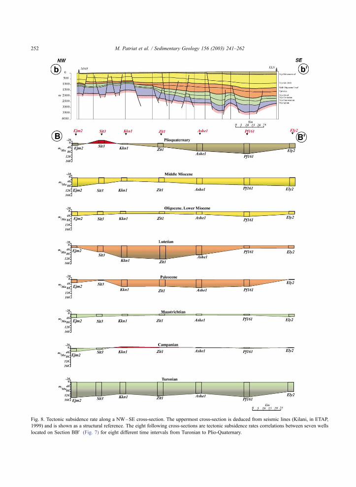
Fig. 8. Tectonic subsidence rate along a NW–SE cross-section. The uppermost cross-section is deduced from seismic lines (Kilani, in ETAP,
1999) and is shown as a structural reference. The eight following cross-sections are tectonic subsidence rates correlations between seven wells
located on Section BBV (Fig. 7) for eight different time intervals from Turonian to Plio-Quaternary.
M. Patriat et al. / Sedimentary Geology 156 (2003) 241–262252
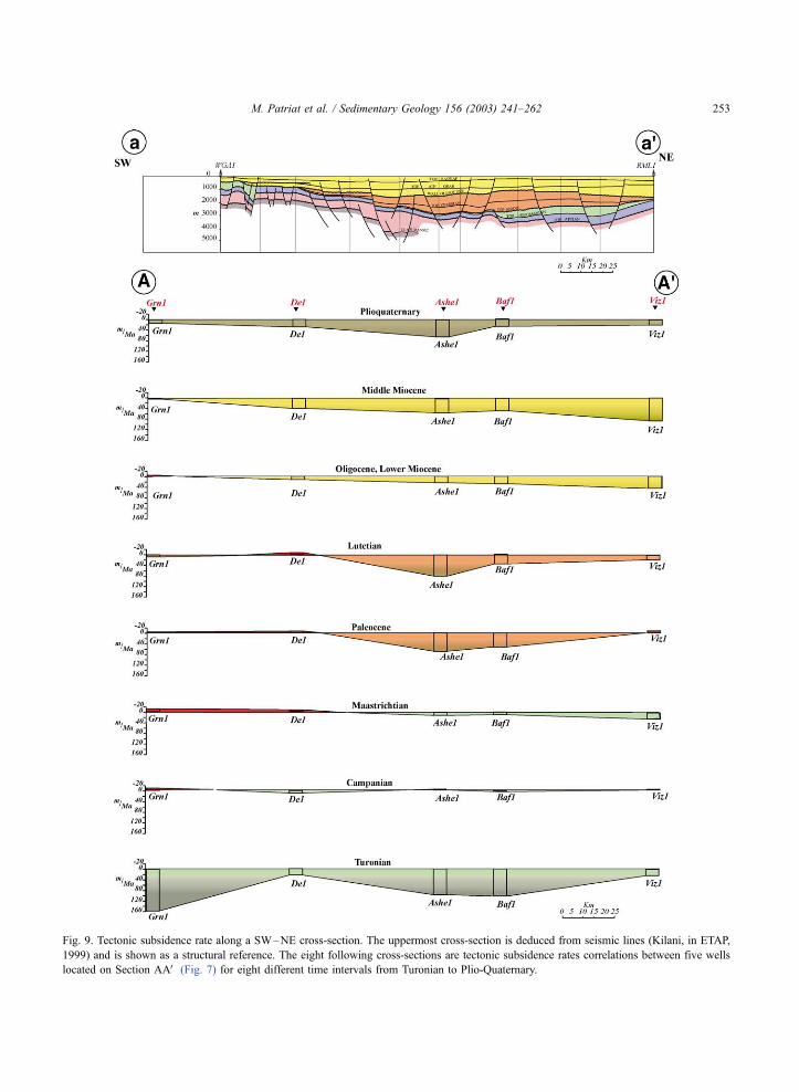
Fig. 9. Tectonic subsidence rate along a SW–NE cross-section. The uppermost cross-section is deduced from seismic lines (Kilani, in ETAP,
1999) and is shown as a structural reference. The eight following cross-sections are tectonic subsidence rates correlations between five wells
located on Section AAV (Fig. 7) for eight different time intervals from Turonian to Plio-Quaternary.
M. Patriat et al. / Sedimentary Geology 156 (2003) 241–262 253
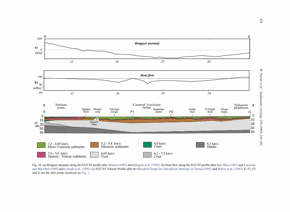
Fig. 10. (a) Bouguer anomaly along the EGT’85 profile after Midassi (1982) and Klingele et al. (1992). (b) Heat flow along the EGT’85 profile after Ben Dhia (1987) and Lucazeau
and Ben Dhia (1989) and Cermak et al., (1992). (c) EGT’85 Velocity Profile after the Research Group for Lithospheric Structure in Tunisia (1992) and Bobier et al., (1991). E, F1, F2
and G are the shot points localized on Fig. 1.
M.Patria
tet
al./Sedimentary
Geology156(2003)241–262
254
ation is synchronous to similar events observed in
eastern Tunisia and in Algeria but is not expressed in
the Hammamet basin. At a large scale, it is synchro-
nous to the opening of the central African rift and to
the inception of rifting in the Sirt basin (Guiraud and
Maurin, 1992; Guiraud, 1990). This event is coeval
to the deposit of a thick flysch series on distal
margin in the Tellian zone. We have to be cautious
about the Jurassic history. All the wells analysed in
the Gabes basin are located on apex of blocks and
probably do not reflect the real subsidence of the
Gabes basin itself.
The Cretaceous period is characterized by fast and
strong variations in subsidence during Aptian and
Albian, partly linked to the halokinetic movements,
followed by the large Cenomano-Turonian subsidence
characteristic of all Tunisian basins.
Except for two brief episodes of erosion, the
Cenozoic is characterized in the Gabes basin by
sustained subsidence, particularly in the central part
of the basin during the Middle Eocene (Ellouz, 1984).
This Paleogene evolution is similar to that known in
the Sirt basin (van Der Meer and Cloetingh, 1993).
Finally, the Plio-Quaternary subsidence corre-
sponds, like in the Hammamet basin, though
smoother, to the recent opening of the Pelagian Sea.
4.2. Structuration of the Gabes basin
For the Gabes basin, we worked out a finer
analysis of its structuration. Thanks to the paleoba-
thymetries well constrained in the Gabes basin and of
moderate amplitude, the analysis of the Gabes basin
subsidence can be detailed. It is consequently possible
to evaluate the importance of local structural control
on subsidence. The permanent role of salt tectonics in
the behaviour of the different blocks should be real-
ized. Halokinesis has been demonstrated to be active
since Aptian time in Tunisia (Perthuisot, 1981; Snoke
et al., 1988), but could be much older (Bedir, 1995) as
in Algeria (Bracene et al., 2003; Bracene and Frizon
de Lamotte, in press). In order to bypass the effects of
salt tectonic or local heterogeneities, synthetic wells
have been constructed and analysed.
The Gabes basin is structured mainly by faults of
NW–SE direction (Fig. 7) (Burollet and Ellouz, 1985;
Ben Ferjani et al., 1990). The behaviour of the basin is
illustrated from 11 wells situated on two cross-sec-
tions: one (Fig. 8) NW–SE parallel to structures
passing through seven wells, and another (Fig. 9)
SW–NE, perpendicular, passing through five wells.
Along the two cross-sections, mean subsidence rates
have been calculated for representative periods.
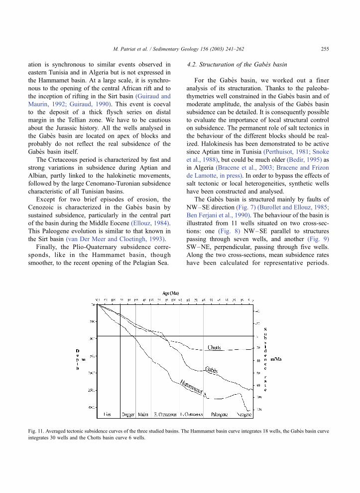
Fig. 11. Averaged tectonic subsidence curves of the three studied basins. The Hammamet basin curve integrates 18 wells, the Gabes basin curve
integrates 30 wells and the Chotts basin curve 6 wells.
M. Patriat et al. / Sedimentary Geology 156 (2003) 241–262 255
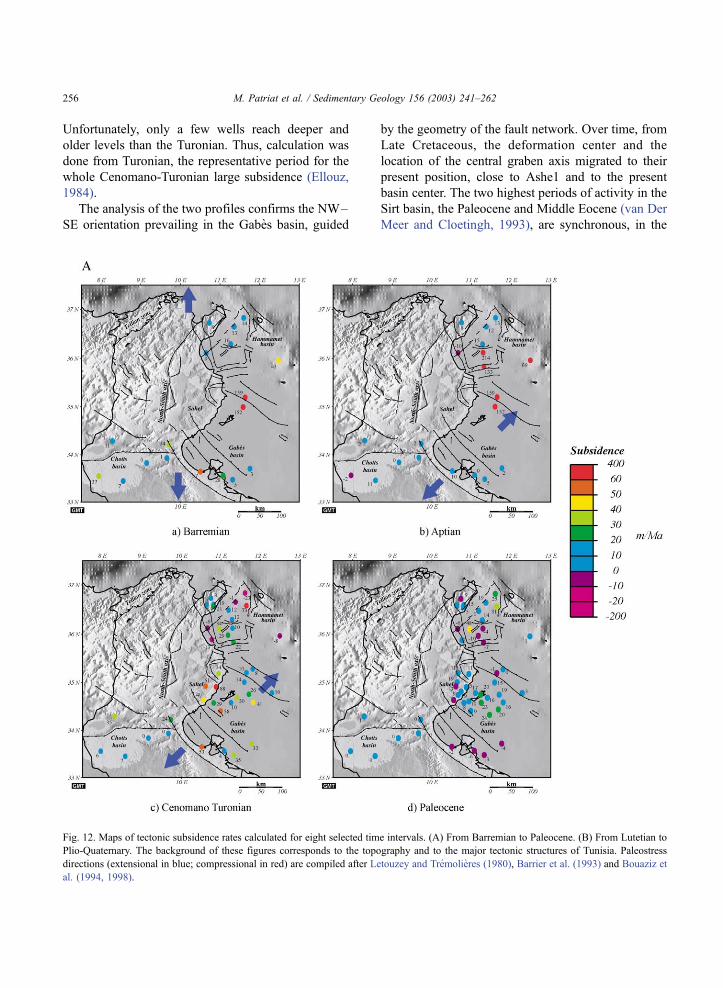
Unfortunately, only a few wells reach deeper and
older levels than the Turonian. Thus, calculation was
done from Turonian, the representative period for the
whole Cenomano-Turonian large subsidence (Ellouz,
1984).
The analysis of the two profiles confirms the NW–
SE orientation prevailing in the Gabes basin, guided
by the geometry of the fault network. Over time, from
Late Cretaceous, the deformation center and the
location of the central graben axis migrated to their
present position, close to Ashe1 and to the present
basin center. The two highest periods of activity in the
Sirt basin, the Paleocene and Middle Eocene (van Der
Meer and Cloetingh, 1993), are synchronous, in the
Fig. 12. Maps of tectonic subsidence rates calculated for eight selected time intervals. (A) From Barremian to Paleocene. (B) From Lutetian to
Plio-Quaternary. The background of these figures corresponds to the topography and to the major tectonic structures of Tunisia. Paleostress
directions (extensional in blue; compressional in red) are compiled after Letouzey and Tremolieres (1980), Barrier et al. (1993) and Bouaziz et
al. (1994, 1998).
M. Patriat et al. / Sedimentary Geology 156 (2003) 241–262256
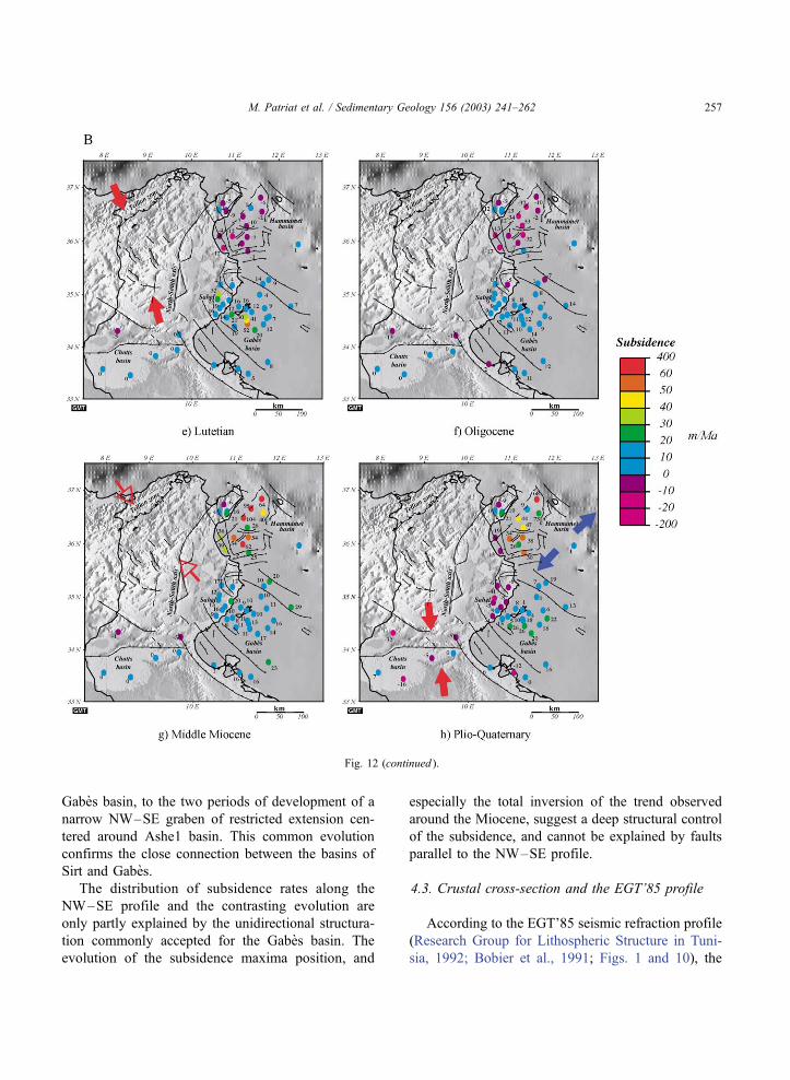
Gabes basin, to the two periods of development of a
narrow NW–SE graben of restricted extension cen-
tered around Ashe1 basin. This common evolution
confirms the close connection between the basins of
Sirt and Gabes.
The distribution of subsidence rates along the
NW–SE profile and the contrasting evolution are
only partly explained by the unidirectional structura-
tion commonly accepted for the Gabes basin. The
evolution of the subsidence maxima position, and
especially the total inversion of the trend observed
around the Miocene, suggest a deep structural control
of the subsidence, and cannot be explained by faults
parallel to the NW–SE profile.
4.3. Crustal cross-section and the EGT’85 profile
According to the EGT’85 seismic refraction profile
(Research Group for Lithospheric Structure in Tuni-
sia, 1992; Bobier et al., 1991; Figs. 1 and 10), the
Fig. 12 (continued ).
M. Patriat et al. / Sedimentary Geology 156 (2003) 241–262 257
thinnest part of the Tunisian crust is located in the
northern part of the profile, in the Tellian zone.
Toward the south, the crust thickens progressively
until the Saharan platform. Locally, in the Chotts
basin, a moderate thinning of the crust bordering the
Saharan platform reflects the strong individualization
of this basin, even at crustal scale. On this crustal
architecture, the sedimentary basins developed with a
maximum thickness on the Kasserine Island (con-
firmed by the negative Bouguer anomaly). On the
northern part of the profile, the heterogeneity of the
crust is marked by the positive anomaly above the
present Mediterranean margin, in the area of allochth-
onous stacked units at the surface.
From the three basins studied in this paper, only the
Chotts basin is located across the EGT profile. Accu-
mulated thickness of Meso- and Cenozoic sediments
are inversely proportional to those of Paleozoic sedi-
ments. The two Meso-Cenozoic subsident troughs
situated along the profile, the Tunisian trough, and
the Chotts basin are separated by the Kasserine Island,
a Meso-Cenozoic high whose position corresponds to
the Paleozoic depocenter.
The structure visible on the profile EGT’85 assimi-
lated to the Hairech ridge corresponds precisely to the
zone of diapirs where they pierce the surface. The
seismic arrivals have presumably been strongly influ-
enced by diapirs. We therefore will not draw any
conclusion from the shape and position of this ridge
(that does not correspond to any prominent feature in
the gravimetric or heat flow data).
4.4. Geodynamics and subsidence
Tunisia is framed by the Tethyan Ocean to the
north with its Pelagian branch to the east, and by the
Gulf of Sirt to the southeast. This hinge situation is
responsible for the development of fracture families of
various directions. This could be the origin to the
permanent segmentation and atypical subsidence
demonstrated in this study that affected Tunisia during
the whole Mesozoic (Fig. 11). This segmentation
continued more irregularly during the Cenozoic, east
of the N–S axis. It is therefore difficult to imply a
simple geodynamical concept to explain the geolog-
ical evolution of Tunisian basins. Because of this
strong heterogeneity in time and orientation, the geo-
logical stages cannot be described in terms of a single
succession of syn-rift and post-rift periods (Hlaiem et
al., 1997). Unfortunately, a quantitative approach of
the Triassic subsidence is not possible because of the
lack of data.
Due to the evolution of these subsidence rates and
to the geodynamic setting of Tunisia, we decomposed
the Meso-Cenozoic geological evolution of Tunisia in
three key periods. These periods are slightly different
to that commonly adopted for the single-phase evo-
lution of classical margins.
4.4.1. Main rifting period from Lias to Neocomian
(205–113 Ma; Fig. 12a)
In continuation with Triassic extension, this period
is characterized by extensional brittle deformation
(Bouaziz et al., 1994, 1996), subsidence rates during
the Jurassic and Cretaceous were not very high
compared to what is known in Algeria (Kuhnt and
Obert, 1991; Bracene et al., 2003). In Tunisia, the
tectonic subsidence is spread out over a very long
period of time when compared to the duration of the
Tethyan rifting.
4.4.2. Transition period, Aptian to Upper Cretaceous
(113–65 Ma; Fig. 12b–c)
This period is characterized by a strong variability of
subsidence owing to different geological reasons. Sev-
eral extensional pulses are coeval with (1) the first
halokinetic movements, (2) a compression phase prom-
inent in the Tellian zone in Algeria (Obert, 1974;Wildi,
1983), that is not clearly identified in Tunisia. Varia-
tions in subsidence rates described during Aptian are
followed by a discrete unconformity between Albian
and Aptian in central and southern Tunisia (Ben Ferjani
et al., 1990; Ouahchi et al., 1998).
During Cenomano-Turonian, an acceleration of the
subsidence rates is obvious like in the whole Magh-
reb. Part of the observed subsidence is influenced by
several parameters: (1) eustasy which reached a max-
imum amplitude of 200 m, but is only responsible for
a minor part of the subsidence acceleration; (2)
variations in the central Atlantic accretion rate, 3.8
cm/year during Cenomanian, whereas it decreased
during Coniacian linked to a drastic change in direc-
tion of the Africa/Eurasia relative movement (Olivet
et al., 1984).
In the Maghreb, this plates kinematic evolution
induced a change from a regime of sinistral trans-
M. Patriat et al. / Sedimentary Geology 156 (2003) 241–262258
tension between Africa and Eurasia (Iberia) to a regime
of dextral transtension between Africa and the Italo-
Dinaride block (Ziegler, 1988; Zouari et al., 1999).
During this transition period, the Triassic ductile salt
layer played very likely a major role in the behaviour of
some basins showing atypical subsidence rates.
4.4.3. Convergence phase (65–0 Ma; Fig. 12d–g)
The Cenozoic behaviour of Tunisian basins is
dominated by the inception of Europe/Africa collision.
Burollet and Ellouz (1985) outlined that the con-
vergence and associated compressional structure can
be expressed in a basin as a combination of uplifted
zones and subsiding areas (see also Cloetingh et al.,
1985). The passage to Tertiary is expressed as a
smooth surrection of the borders of the Gabes basin
and on the contrary as a brief but strong subsidence
acceleration in the Hammamet basin. This is probably
linked to the first collision phase in the northeast of
Tunisia. This phase is not well known in the field in
Tunisia (Letouzey and Tremolieres 1980), but some of
its effects are known west in the Maghreb, in Algeria
(Guiraud, 1990) and in the north of Africa in general
(van Der Meer and Cloetingh, 1993; Guiraud, 1998).
In Eocene, the first important manifestation of
uplift appeared in the north of Tunisia. It corresponds
to the first phases of the Alpine collision and is
illustrated by the seismic sections in the distal Ham-
mamet basin (Figs. 5 and 12).
To the Middle Miocene, the observed changes are
associated with the setting up of Tellian nappes to the
north of Tunisia, which have been emplaced during
Burdigalian–Langhian time (Rouvier, 1977). The
consequences of this event, and especially regional
isostatic equilibrium, are expressed differently accord-
ing to the geographical location of basins, and espe-
cially to their distance with regard to the nappe front.
5. Conclusions
Due to the peculiar location of Tunisia, at the
junction of western Mediterranean and eastern Medi-
terranean sea, the geodynamic evolution gave rise to
complex rifting processes which (1) was longer (cumu-
lating several pulses) than in the rest of the Maghreb,
and (2) registered different extension phase orienta-
tions inducing a strong segmentation of the basins.
By studying the subsidence of Tunisian basins, we
can emphasize the particular tectonic trends. From our
study, the Meso-Cenozoic geological history can be
broken down into three very different periods.
Triassic–Liassic rifting initiated a general episode
of tectonic subsidence of variable amplitude but
synchronous all over Tunisia. The first period (Liassic
to Neocomian) is dominated by extension. The sinis-
tral strike slip at Maghreb scale between Africa and
Eurasia was effective during this period and could
help to maintain a subsidence that spread over a
particularly long period in Tunisia but with low
subsidence rates.
Post-rift thermal subsidence started at the end of
Neocomian and was interrupted by several pulses
linked with new extensional events during the Creta-
ceous. From Aptian to Maastrichtian, Tunisia under-
went a change corresponding in time to that observed
in the global Maghreb kinematics from a sinistral
transtensive regime to a dextral regime. The very
brief accelerations in the subsidence could suggest
the existence of collision phases at the edges of the
studied region. The inception of diapirism is thought
to begin around Aptian time. It could thus explain
some of the features observed during this period.
Finally, the Tertiary was characterized by the
effects, uplift or subsidence, of the different stages
of the Alpine collision.
Most probably due to inherited structures and
depending on their position in Tunisia, the different
basins studied do not all have the same behaviour:
� West of the N–S axis: In the Chotts basin, the
subsidence stopped as early as in Campanian after
a period of strong subsidence during Jurassic time.
During Late Cretaceous, the singular evolution of
Gnt1 well, with much more subsidence than the
Chotts basin itself, has to be compared to that of
the Algerian Aures basin located very close to this
well (Bracene et al., 2003). A similar and amplified
evolution is known in the Tunisian Atlas (Ellouz,
1984). The post-Early Cretaceous subsidence was
greater in Gnt1 and the Aures basin, which are
supposed to be in the same structural position.� East of the N–S axis: During Jurassic time, as in the
Chotts region, the Gabes and Hammamet basins
showed strong subsidence. Yet, in this area, unlike
in the Chotts region, the subsidence evolution did
M. Patriat et al. / Sedimentary Geology 156 (2003) 241–262 259
not stop after the Jurassic episode, but remained
important during Cretaceous time. The Gabes basin
had an almost continuous evolution during this
period, more or less similar to the neighbouring Sirt
basin. From the Gabes and Hammamet basins, only
the latter (the closest to the Tellian nappes) shows an
evolution clearly influenced by the successive
collisions during the Cenozoic.� Mostly during Cenozoic, the effects of the different
collision phases depend mainly on the position with
respect to the Tellian nappe’s front. This is
corroborated by the structural and sedimentary
trends visible in Fig. 12: in the Hammamet basin,
the orientation of the basin axis is parallel to the
Tellian (SW–NE) front. This is particularly prom-
inent since the Neogene. On the opposite, the Gabes
basin exhibits a perpendicular NW–SE axis.
Subsidence evolution seems to be largely deter-
mined by the compression during the Cenozoic, but
this has to be locally modulated with the effects of salt
tectonics.
In the Gabes basin, we found evidence of a sub-
sidence segmentation that cannot be totally explained
by the structure of this basin. Among other things, the
translation of depocenters during the Miocene could be
more easily explained by the existence of deep-rooted
structural trends oblique to those known in the basin.
Acknowledgements
We are grateful to Mr. A. Gaaya, Mr. R. Ghenima
and Mr. H. El Heuchi from ETAP for their contribution
in this project and the permission to publish some
internal results and sections. We thank them for the
long talks and warm contacts which existed between
the two teams during the preparation of this paper. The
constructive criticisms of two anonymous reviewers
are acknowledged. Thanks also to M.-F. Brunet and S.
Cloetingh for their editorial work and help.
References
Anderson, J.E., 1996. The Neogene structural evolution of the west-
ern margin of the Pelagian Platform, central Tunisia. Journal of
Structural Geology 18, 819–833.
Barrier, E., Bouaziz, S., Angelier, J., Creuzot, G., Ouali, J., Tricart,
P., 1993. Mesozoic paleostress evolution in the Saharan platform
(southern Tunisia). Geodinamica Acta 6, 39–57.
Bedir, M., 1995. Mecanismes geodynamiques des bassins associes
aux couloirs de coulissements de la marge atlasique de la Tuni-
sie. Seismo-stratigraphie, seismo-tectonique et implications pet-
rolieres. Doctorate Dissertation, Univ. Tunis II, Tunisia (in
French).
Ben Ayed, N., 1986. Evolution tectonique de l’avant pays de la
chaıne alpine de Tunisie du debut du Mesozoıque a l’actuel.
Doctorate Dissertation, Univ. Paris Sud, Orsay, France (in
French).
Ben Dhia, H., 1987. The geothermal gradient map of central Tuni-
sia: comparison with structural, gravimetric and petroleum data.
Tectonophysics 142, 99–109.
Ben Ferjani, A., Burollet, P.F., Mejri, F., 1990. Petroleum Geology
of Tunisia. ETAP, Tunis. 194 pp.
Bobier, C., Viguier, C., Chaari, A., Chine, A., 1991. The post-
Triassic sedimentary cover of Tunisia: seismic sequence and
structure. Tectonophysics 195, 371–410.
Boccaletti, M., Cello, G., Tortorici, L., 1987. Transtensional tec-
tonics in the Sicily Channel. Journal of Structural Geology 9,
869–876.
Boccaletti, M., Cello, G., Tortorici, L., 1990. First order kinematic
element in Tunisia and the Pelagian block. Tectonophysics 176,
215–228.
Bouaziz, S., Barrier, E., Angelier, J., Turki, M.M., 1994. Paleostress
in the Southern Tunisian platform. In: Roure, F. (Ed.), Peri-
Tethyan Platforms. Technip, Paris, pp. 179–196.
Bouaziz, S., Turki, M.M., Zouari, H., Barrier, E., 1996. Tectonique
en extension et failles de transfert jurassiques dans la region du
Tebaga de Medenine (Tunisie meridionale). Annales de la Soci-
ete Geologique du Nord 4, 65–69 (in French).
Bouaziz, S., Barrier, E., Turki, M.M., Tricart, M., Angelier, J.,
1998. Tectonic evolution of the Southern Tethyan margin in
Southern Tunisia. In: Crasquin-Soleau, S., Barrier, E. (Eds.),
Peri-Tethys Memoir 3: Stratigraphy and Evolution of Peri-
Tethyan Platforms. Memoires du Museum national d’Histoire
naturelle, Paris 177, pp. 215–236.
Bracene, R., Frizon de Lamotte, D., 2002. Origin of intraplate
deformation in the system of the western and Central Algeria:
from Rifting to Cenozoic–Quaternary Inversion. In: Barrier, E.,
Bergerat, F., Angelier, J., Granath, J. (Eds.), Palaeostresses and
tectonics in the Peri-Tethyan margins. Tectonophysics, in press.
Bracene, R., Patriat, M., Ellouz, N., Gaulier, J.M., 2003. Subsi-
dence history in basins of northern Algeria. Sedimentary Geol-
ogy , this issue.
Burollet, P.F., Rouvier, H., 1971. La Tunisie. Tectonique de l’Afri-
que, Sciences de la Terre. UNESCO, Paris, pp. 91–100. In
French.
Burollet, P.F., Ellouz, N., 1985. L’evolution des bassins sedimen-
taires de la Tunisie centrale et occidentale. Bulletin des Centres
de Recherches Exploration–Production Elf-Aquitaine 10, 49–68
(in French, with English Abstr.).
Castany, G., 1951. Etude geologique de l’Atlas tunisien oriental.
Annales Minieres et Geologiques, Tunis 8, 1–632 (in French).
Cermak, V., Della Vedova, B., Lucazeau, F., Pasquale, V., Pellis, G.,
M. Patriat et al. / Sedimentary Geology 156 (2003) 241–262260
Schulz, R., Verdoya, M., 1992. Heat flow density. In: Blundell,
R., Freeman, R., Mueller, St. (Eds.), A Continent Revealed: The
European Geotraverse Database. Cambridge Univ. Press, Cam-
bridge, pp. 47–57. map 13.
Cloetingh, S., McQueen, H., Lambeck, K., 1985. On a tectonic
mechanism for regional sealevel variation. Earth and Planetary
Science Letters 75, 167–175.
Ellouz, N., 1984. Etude de la subsidence de la tunisie atlasique,
orientale et de la mer pelagienne. PhD Thesis, Univ. Paris VI,
France, 122 pp. (in French).
ETAP, 1999. Petroleum prospectivity of Northern Tunisian thrust
belt. International Report ETAP, Tunis, 1.
Frizon de Lamotte, D., Mercier, E., Outtani, F., Addoum, B.,
Ghandriche, H., Ouali, J., Bouaziz, S., Andrieux, J., 1998.
Structural inheritance and kinematics of folding and thrusting
along the front of the Eastern Atlas Mountains (Algeria and
Tunisia). In: Crasquin-Soleau, S., Barrier, E. (Eds.), Peri-Tethys
Memoir 3: Stratigraphy and Evolution of Peri-Tethyan Plat-
forms. Memoires du Museum national d’history naturelle, Paris
177, pp. 237–252.
Guiraud, R., 1990. Evolution post triasique de l’avant pays de la
chaıne alpine d’Algerie, d’apres l’etude du bassin du Hodna et
des regions voisines. Doctorate Dissertation, Univ. Nice, France,
270 pp. (in French).
Guiraud, R., 1998. Mesozoic rifting and basin inversion along the
northern African Tethyan margin: an overview. In: Macgregor,
D.S., Moody, T.T.J., Clark-Lowes, D.D. (Eds.), Geological
Society, London, Special Publications 132, pp. 217–229.
Guiraud, R., Maurin, J.C., 1992. Early Cretaceous Rifts of Western
and Central Africa: an overview. In: Ziegler, P.A. (Ed.), Geo-
dynamics of Rifting. Tectonophysics 213, pp. 227–234.
Hlaiem, A., Biju-Duval, B., Vially, R., Laatar, E., M’Rabet, A.,
1997. Burial and thermal history modelling of the Gafsa–Met-
laoui intracontinental basin (southern Tunisia): implications for
petroleum exploration. Journal of Petroleum Geology 20,
403–426.
Kanes, W.H., Lazreg, H., Ehrlich, R., 1979. Regional tectonics and
petroleum geology of Tunisia. Introduction and overview. Abstr.
AAPG-SEPM Annual Meeting Houston, USA. AAPG Bulletin
63, 477.
Klingele, E., Lahmeyer, B., Freeman, R., 1992. Bouguer gravity
data. In: Blundell, D., Freeman, R., Mueller, St. (Eds.), A Con-
tinent Revealed: The European Geotraverse Database. Cam-
bridge Univ. Press, Cambridge, pp. 27–30.
Kuhnt, W., Obert, D., 1991. Evolution cretacee de la marge tellienne.
Bulletin de la Societe Geologique de France 162, 515–522
(in French, with English Abstr.).
Letouzey, J., Tremolieres, P., 1980. Paleo-stress fields around the
Mediterranean since the Mesozoic derived from microtecto-
nics: comparison with plate tectonic data. In: Aubouin, J.,
Debelmas, J., Latreille, M. (Eds.), Geology of the Alpine
Chains Born of the Tethys. Memoire du BRGM, Orleans
115, pp. 261–273.
Lucazeau, F., Ben Dhia, H., 1989. Preliminary heat-flow density
data from Tunisia and the Pelagian Sea. Canadian Journal of
Earth Sciences 26, 993–1000.
Marie, J., Trouve, P., Desforges, G., Dufaure, P., 1984. Nouveaux
elements de Paleogeographie du Cretace de Tunisie. Notes et
Memoires CFP 19, 1–37 (in French).
Midassi, M.S., 1982. Regional gravity of Tunisia. MSc thesis, Univ.
Southern California. 125 pp.
Obert, D., 1974. Phases tectoniques mesozoıques d’age ante-ceno-
manien dans les Babors (Tell nord setifien, Algerie). Bulletin de
la Societe Geologique de France 7, 171–176 (in French, with
English Abstr.).
Odin, G.S., 1994. Geological time scale (1994). Comptes Rendus
de l’Academie des Sciences, Paris 318 (ser. II), 59–71.
Olivet, J.L., Bonnin, J., Beuzart, P., Auzende, J.M., 1984. Cinema-
tique de l’Atlantique nord et central. Rapports scientifiques et
techniques du Centre national pour l’exploitation des oceans,
Brest 54, 108 pp. (in French).
Ouahchi, A., M’Rabet, A., Lazreg, J., Massaoudi, F., Ouazaa, S.,
1998. Early Structuring, Paleo-emersion and Porosity Develop-
ment: A Key for Exploration of the Aptian Serdj Carbonate
Reservoir in Tunisia. Proceedings of the 6th Tunisian Petroleum
Exploration & Production Conference. ETAP’s Memoir Series
12. ETAP, Tunis, Tunisia, pp. 267–284.
Outtani, F., Addoum, B., Mercier, E., Frizon de Lamotte, D., An-
drieux, J., 1995. Geometry and kinematics of the South Atlas
Front, Algeria and Tunisia. Tectonophysics 249, 233–248.
Perthuisot, V., 1981. Diapirism in northern Tunisia. Journal of
Structural Geology 5, 231–235.
Pique, A., Aıt Brahim, L., Aıt Ouali, R., Amrhar, M., Charroud, M.,
Gourmelen, C., Laville, E., Rekhiss, F., Tricart, P., 1998. Evo-
lution structurale des domaines atlasiques du Maghreb au Meso-
Cenozoıque; le role des structures heritees dans la deformation
du domaine atlasique de l’Afrique du Nord. Bulletin de la So-
ciete Geologique de France 169, 797–810 (in French, with
English Abstr.).
Research Group for Lithospheric Structure in Tunisia, 1992. The
EGT’85 seismic experiment in Tunisia: a reconnaissance of the
deep structures. Tectonophysics 207, 245–267.
Robertson Research International, 1983. Structural and Tectonics of
Tunisia. ETAP, Tunis, confidential report.
Rouvier, H., 1977. Geologie de l’Extreme Nord tunisien: tectoni-
ques et Paleogeographies superposees a l’extremite orientale de
la chaıne nord maghrebine. Doctorate Dissertation, Univ. Pierre
and Marie Curie, Paris, France, 703 pp. (in French).
Snoke, A.W., Schamel, S., Karasek, R.M., 1988. Sructural evolu-
tion of Djebel Debadib Anticline: a clue to the regional tectonic
style of Tunisian Atlas. Tectonics 7, 497–516.
Steckler, M.S., Watts, A.B., 1978. Subsidence of the Atlantic type
continental margin off New York. Earth and Planetary Science
Letters 41, 1–13.
Touati, M.A., 1985. Etude geologique et geophysique de la con-
cession Sidi El Itayem en Tunisie orientale-Sahel de Sfax. Doc-
torate Dissertation, Univ. Pierre and Marie Curie, Paris VI,
France (in French).
van Der Meer, F., Cloetingh, S., 1993. Intraplate stresses and the
subsidence history of the Sirt Basin (Libya). Tectonophysics
226, 37–58.
Vila, J.M., 1980. La chaıne alpine d’Algerie orientale et des confins
algero-tunisiens. Doctorate Dissertation, Univ. Paris VI, France
(in French).
M. Patriat et al. / Sedimentary Geology 156 (2003) 241–262 261

Wildi, W., 1983. La chaıne tello-rifaine (Algerie, Maroc, Tunisie):
stratigraphie, structure et evolution du Trias au Miocene. Revue
de geologie dynamique et de geographie physique 24, 201–297
(in French).
Ziegler, P.A., 1988. Evolution of the Arctic–North Atlantic and the
Western Tethys American Association of Petroleum Geologists,
Tulsa, OK. Memoir 43, 198 pp.
Zouari, H., Turki, M.M., Delteil, J., Stephan, J.F., 1999. Tectonique
transtensive de la paleomarge tunisienne au cours de l’Aptien-
Campanien. Bulletin de la Societe Geologique de France 170,
295–301 (in French, with English Abstr.).
M. Patriat et al. / Sedimentary Geology 156 (2003) 241–262262