Archaeological excavations at Whitecastle iron age hillfort, East Lothian, Scotland
70
Rampart Scotland Project 001: The Hillforts of East Lothian Season 3 White Castle, Garvald, East Lothian Data Structure Report Murray Cook and David Connolly March 2013
Transcript of Archaeological excavations at Whitecastle iron age hillfort, East Lothian, Scotland
Rampart Scotland Project 001:
The Hillforts of East Lothian Season 3
White Castle, Garvald, East Lothian
Data Structure Report
Murray Cook and David Connolly
March 2013
White Castle, Garvald, East Lothian
Data Structure Report and Post Excavation Report
National Grid Reference (NGR): NGR NT 6135 6860 Rampart Scotland Project No: 001 Prepared by: Murray Cook and David Connolly Edited by: Margaret Struckmeier Illustration by: David Connolly Date of Fieldwork: July 2012 Date of Report: March 2013
Abstract
This report represents the results of Rampart Scotland’s
third season of archaeological evaluation at White Castle,
Garvald, East Lothian.
The programme of archaeological works comprised
topographic, erosion and geophysical survey along with the
excavation of seven trenches.
Excavation concentrated on the western side of the
monument and explored two hut platforms, the putative
south-western inner and middle rampart entrances, the
nature of the potential palisade at the edge of the side and
the impact of molehills on the underlying archaeological
sediments.
The excavation recovered charcoal and possible saddle
quern fragments and three radiocarbon dates were
obtained from the site. One further season of fieldwork is
proposed.
This work was carried out during July 2012.
Contents
1 INTRODUCTION ......................................................................................................... 1
2 PROJECT AIMS AND OBJECTIVES ................................................................................. 3
3 METHODOLOGY ........................................................................................................ 4
4 RESULTS ................................................................................................................... 8
5 POST EXCAVATION ASSESMENT ................................................................................ 32
6 INTERPRETATION AND DISCUSSION ........................................................................... 34
7 FURTHER WORK ...................................................................................................... 38
8 CONCLUSION .......................................................................................................... 39
9 ACKNOWLEDGMENTS .............................................................................................. 39
Figures
Figure 1: Location Plan 2
Figure 2: General site plan showing topographic survey with merged data from
Becker Geomatics Ltd, location of trenches and geophysical survey
7
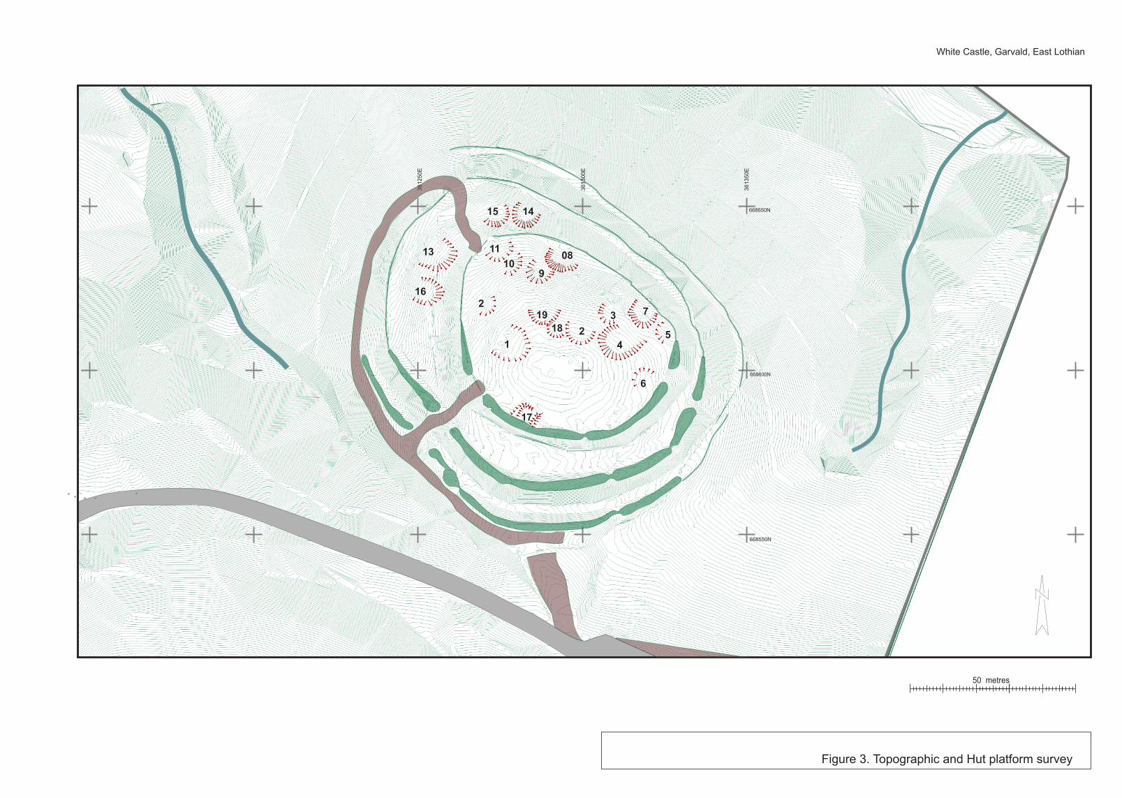
Figure 3: Topographic survey with locations of surveyed hut platforms 10
Figure 4: Erosion and vegetation survey overlaid on topographic survey 12
Figure 5: Geophysics overlay on topographic survey 13
Figure 6: Trenches 13 and 18 (season 2011) and Trench 29 (season 2012) 20
Figure 7: Trench 12 (season 2011 and Trenches 30 and 31 (season 2012) 23
Figure 8: Trench 32 plan and section 24
Figure 9: Trench 35 plan and section 28
Figure 10: Trench 36 plan and section 30
Figure 11: Interpretive plan of site with named features and location/date of C14 samples
36
Thumbnails: Image thumbnails relating to CD index 55
White Castle, East Lothian, Season 3, 2012
1 | P a g e
1 INTRODUCTION
1.1 Background
1.1.1 Rampart Scotland aims to increase the level of information known about Scotland’s
hillforts, through a combination of topographic survey, geophysical survey and key-hole
excavation to provide dating evidence. It is intended to begin this study by examining as
many previously unexcavated hillforts in East Lothian as access can be gained to. The
overarching aims and research background of the project are presented in Season 1
report (Connolly and Cook 2010).
1.1.2 At the time of writing Rampart Scotland are engaged in research on three East Lothian
sites: White Castle (ibid), The Chesters (Connolly & Cook 2010; 2011) and Sherrifside
(Connolly et al 2011; 2012). These three projects are known collectively as the East
Lothian Hillfort Project. This report deals specifically with the third season at White
Castle.
1.2 Location
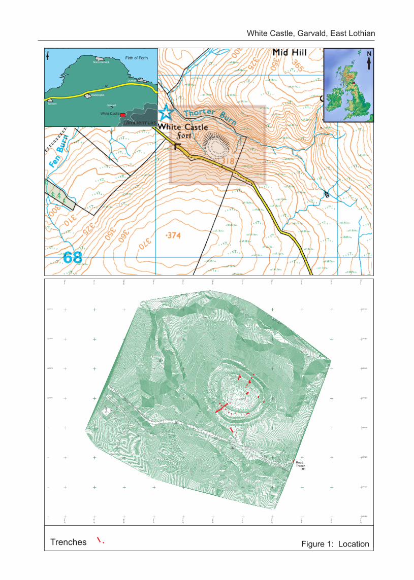
1.2.1 White Castle, Garvald, East Lothian (NGR NT 6135 6860) (Figure 1) is located
immediately to the north of an unnamed road that runs from Garvald, south through
the Lammermuirs. The site occupies a natural spur defined by water courses to three
sides (Figure 2), and is approached from the south across a natural causeway. The
vegetation cover on the site is a mixture of grass, heather, blaeberries and bracken and
is used by the landowners for rough grazing by cattle and sheep, although none were
present at the time of the project. The site has an impressive and commanding view
across the Lothians from the eastern edge of the Pentlands to Berwick Law, as well as
clear views to Fife.
1.3 Archaeological and historical background
1.3.1 White Castle (NMRS NT66NW 1) is a Scheduled Ancient Monument (SM no 756) and
Scheduled Monument Consent (SMC) was obtained in advance of fieldwork (ref AMH
756/1/1).
1.3.2 A detailed account of the site’s known history is presented in Cook and Connolly (2010)
and the results of the previous post-excavation works are presented in Cook and
Connolly (2011).
N
Haddington
North Berwick
Dunbar
GarvaldTranent
Firth of Forth
A1
N
Lammermuirs
White Castle
Figure 1: Location
White Castle, Garvald, East Lothian
RoadTrench
(29)
Trenches
White Castle, East Lothian, Season 3, 2012
3 | P a g e
2 PROJECT AIMS AND OBJECTIVES
2.1 Introduction
2.1.1 The aims of the East Lothian Hillfort Project are four fold:
1. To increase the currently available data-set for East Lothian hillforts by additional
survey;
2. To recover dating evidence of the sequence of enclosure, use and refurbishment of
as many hillforts in East Lothian as can be accessed;
3. To attempt to assess the volume of activity both within enclosures and external to
enclosures by test-pitting and quantification of the number of artefacts recovered;
4. To publish the individual results of each site excavation and after at least three sites
have been excavated, to publish a synthesis of the result.
2.2 Season three at White Castle, Garvald had the following specific objectives:
1. To enhance and renew the topographic and erosion survey of the site; 2. To explore the relationship between Hut-Platform 08 and the palisade, identified in Trench 12 in the 2011 Season;
3. To explore the relationship between the midden material and the palisade, identified in Trenches 13 and 18 in the 2011 Season;
4. To recover dating evidence from a second internal hut platform (04); 5. To explore the impact of burrowing moles on the site’s stratigraphy; 6. To carry out further geophysical work within the interior.
White Castle, East Lothian, Season 3, 2012
4 | P a g e
3 METHODOLOGY
3.1 Topographic and Vegetation Survey
3.1.1 The initial 20120 general land survey of the site and its immediate environs was carried
out by Becker Geomatics Ltd, with the results tied into the Ordnance Survey National
Grid. Two fixed points were created on the road to facilitate grid re-establishment. The
density of points was c. 10 m spacing, with top and bottom of slopes and road, fence and
feature points taken to establish a suitable base plan.
3.1.2 This survey was subsequently enhanced in 2010 and 2011 (Connolly and Cook 2010;
2011). During Season 3 additional close contour survey building upon the first two
season’s surveys was undertaken (Figure 2).
3.1.3 The Survey was conducted using a Leica TCR 805 series Total Station with internal data
logger. All points were processed through Leica Geo-Office software and attributed on
point-type. The survey was processed through Penmap software to produce a maximum
resolution contour plot of 10cm intervals.
3.1.3 During Season 3 further detailed walkover survey was undertaken of the interior to
identify any new internal features.
3.2 Erosion Survey
3.2.1 The erosion survey methodology was based upon that developed by the CFA, as outlined
in Historic Scotland’s Technical Advice Note 16: Burrowing Animal and Archaeology
(Dunwell & Trout 1999). The 2012 survey re-evaluated the results of Seasons 1 and 2
(Connolly & Cook 2010; 2011) including rabbit damage, sheep scrapes, cattle and visitor
tracks, areas of mole activity and water run-off damage (Figure 4).
3.2.2 All locations were marked on the scaled RCAHMS plan of the site, and measurements
were taken from fixed points within the area. Additional descriptive measurements were
taken accessing the width, height/breadth and depth of the damage. Individual
photographs were taken and cross-referenced with each area of damage.
White Castle, East Lothian, Season 3, 2012
5 | P a g e
3.3 Geophysical Survey: Resistivity
3.3.1 The resistivity survey was undertaken by the Edinburgh Archaeological Field Society
using TR/CIA area ground resistance measuring equipment. The equipment operates in
the 'twin' configuration with four probes: two of the probes are mounted on a portable
frame 0.5m apart and comprises one current input and one potential measurement
probe. The second two probes, again one for current input and one for potential
measurement, complete the two circuits; and are inserted about 1m apart and
positioned so that no reading is taken with the portable frame nearer than 15m to
them. All readings were taken at 1m intervals in lanes 1m wide in 20m by 20m survey
grids, giving a total of 400 measurements in each grid.
3.3.2 The unit on the frame generates the 137Hz signal current that flows through the ground
and the potential drop is detected by the measurement probes; the computer in the
unit converts this voltage reading into a ground resistance value in ohms. Within the
unit is the display, which indicates this resistance, together with the data store into
which the readings are dumped for later processing and printing. The data were down
loaded, to a computer and printer. The printout is in grey scale with the black and white
limits chosen based upon the highest and lowest ohms readings recorded. It is normal
practice to print high resistance (well drained areas and bedrock) as black and low
resistance (infilled ditches and damp areas) as white.
3.3.3 Continuing the 40x60m grid that had been carried out in 2010 a further 6 20m grids
were surveyed to the north and west, while additional partial grids were included to the
north (Figure 5).
3.3.4 Although some of the squares were taken on rampart and terrace slopes, there were no
locations where it was not possible to carry out the survey. The known geology of the
site is a greywacke, which has not affected any readings.
White Castle, East Lothian, Season 3, 2012
6 | P a g e
3.4 Excavation
3.4.1 All trenches were excavated by hand following the terms of SMC and in keeping with
Oxford Archaeology North’s standard methodology. Specifically this involved the
preparation of a close contour survey and a photographic record of the proposed trench
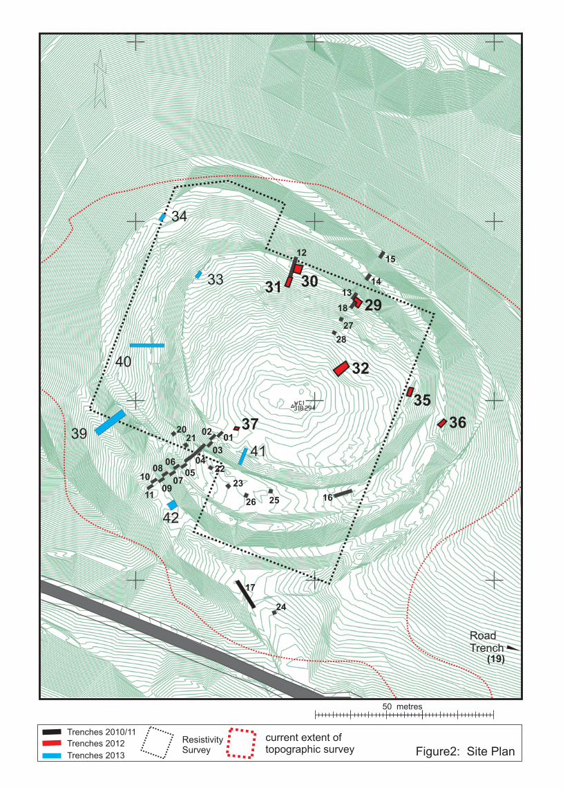
locations before and after the fieldwork. SMC was granted for thirteen trenches
(Trenches 29-42) over the 2012 and 2013 seasons. In the 2012 season Trenches 29, 30,
31, 35, 36 and 37 were excavated. The location of Trench 37, which was designed to
explore the impact of borrowing moles on the archaeological deposits was located
following an on-site meeting Deirdre Cameron of Historic Scotland. Following the results
obtained from Trench 37 there was no need to excavate Trench 38 (see Section 4.4.7).
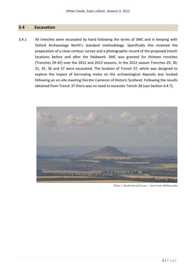
Plate 1: North Berwick Law – view from Whitecastle
Trenches 2010/11
Trenches 2012
Trenches 2013
ResistivitySurvey Figure2: Site Plan
current extent oftopographic survey
10
11
17
08
07
0605
0403
0201
37
31 30
29
32
35
36
09
RoadTrench
12
1314
15
18
27
28
2021
22
23
26 25
24
16
(19)
50 metres
33
39
40
41
42
34
White Castle, East Lothian, Season 3, 2012
8 | P a g e
4 RESULTS
4.1 Introduction
4.1.1 The archaeological excavation and surveys were undertaken between 9th to 20th July, in
a variety of conditions from torrential rain and gale force winds to warm and reasonably
dry weather conditions. The following should be read in conjunction with the data
presented in Appendices 1 to 8.
4.2 Topographic and Vegetation Survey
4.2.1 The topographic survey continued to enhance the site’s Data Terrain Model (DTM)
(Figures 3). In addition a number of internal features, potentially hut-platforms were
further identified and individually drawn during a detailed walkover and topographic
analysis (Figure 3), there are now 18 of these platforms (HP) with one rectangular
structure to the southwest (St 17).
4.2.2 The more detailed walkover has demonstrated that the 18 known platforms have a
chronological depth to their distribution as specific examples overlap others. HP 18 is cut
by HP 19 and HP 2 for example (Figure 3) and HPs 10 and 11 cannot be contemporary,
because again HP 10 is cut by HP 11. Merging the topographic data with the trial trench
evidence then other relationships become evidence such as HP 9 post dating HP 8 due to
the debris from the construction of HP 9 platform overlying HP 8 surfaces.
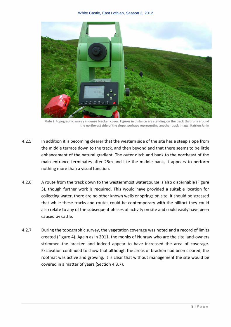
4.2.3 The topographic survey concentrated on the northwest and west of the site in areas of
heavy bracken, which slowed the process down considerably and relied on a greater
concentration of points in order to manufacture a reasonable contour model of the area.
4.2.4 The DTM survey continued to highlighted additional features such as the platforms and
possible tracks that have enhanced our understanding of the evolution and structure of
the site. The most important discovery from this season relates to the apparent
continuation of the ‘track’ from the main southwest entrance, as it curves around the
outer bank and follows the contours until it reaches the extreme northwest of the site
where it turns sharply to the southeast and in through the terraced banks to the interior
enclosure (Plate 1; Figure 3). The area to the northeast where the track turns into the
enclosure is banked with soil diving it from both the lower and middle terraces.
White Castle, East Lothian, Season 3, 2012
9 | P a g e
Plate 2: topographic survey in dense bracken cover. Figures in distance are standing on the track that runs around
the northwest side of the slope, perhaps representing another track Image: Katrien Janin
4.2.5 In addition it is becoming clearer that the western side of the site has a steep slope from
the middle terrace down to the track, and then beyond and that there seems to be little
enhancement of the natural gradient. The outer ditch and bank to the northeast of the
main entrance terminates after 25m and like the middle bank, it appears to perform
nothing more than a visual function.
4.2.6 A route from the track down to the westernmost watercourse is also discernable (Figure
3), though further work is required. This would have provided a suitable location for
collecting water, there are no other known wells or springs on site. It should be stressed
that while these tracks and routes could be contemporary with the hillfort they could
also relate to any of the subsequent phases of activity on site and could easily have been
caused by cattle.
4.2.7 During the topographic survey, the vegetation coverage was noted and a record of limits
created (Figure 4). Again as in 2011, the monks of Nunraw who are the site land-owners
strimmed the bracken and indeed appear to have increased the area of coverage.
Excavation continued to show that although the areas of bracken had been cleared, the
rootmat was active and growing. It is clear that without management the site would be
covered in a matter of years (Section 4.3.7).
White Castle, Garvald, East Lothian
36
12
50
E
36
13
00
E
36
13
50
E
668550N
668600N
668650N
Figure 3. Topographic and Hut platform survey
50 metres
17
6
5
7
4
3
218
1
2
10
1108
9
1415
13
16
19
White Castle, Garvald, East Lothian
36
12
50
E
36
13
00
E
36
13
50
E
668550N
668600N
668650N
50 metres
Bracken
BrackenExtent 2011
BrackenExtent 2012
BrackenExtent 2010
Bracken
04
07
1713
05
06
2019
18
16
15
14
28
29
27
01
03
11 12
25
0209
26
10
08
Tracks
Sheep scrapes
Rabbit damage
Mole damage
Bracken Extent 2010/2011/2012
Figure 4. Erosion Survey
10
11
17
08
07
0605
0403
0201
37
31 30
29
32
35
36
09
RoadTrench
12
1314
15
18
27
28
2021
22
23
26 25
24
16
(19)

White Castle, East Lothian, Season 3, 2012
12 | P a g e
4.3 Erosion Survey
4.3.1 As described in Section 3.2, six different types of erosion were recorded in 2010 and
2011 (Connolly and Cook 2010; 2011): rabbit damage, sheep scrapes, cattle and visitor
tracks, areas of mole activity and water run-off damage. In addition, a single spade cut
hole had been recorded (ID 24). The updated 2012 results of the survey are presented in
Table 1 and Figure 4, with the associated photographic record presented in Appendix 1.
Type 2010 2011 2012 Notes
1 Visitor track Active /
Intrusive No Change No Change
From layby to interior, crossing all ramparts
2 Water run
Active /
Intrusive
No Change No Change
Significant run-off channel leading to the
western river cut
3 Rabbit burrows Active /
Intrusive Worse No Change
No further comment
4 Visitor track Active /
Intrusive No Change No Change
From layby to interior, crossing ditch 3 and
Rampart 3
5 Water run Stabilised /
Intrusive No Change No Change
Channel cutting through Rampart 2
6 Rabbit burrows Old / Intrusive Improvement No Change No further comment
7 Rabbit burrows Old / Intrusive Improvement No Change No further comment
8 Rabbit burrows Old / Intrusive Improvement No Change Although burrows have now become inactive it
seems they have only become this way recently.
9 Track Old /
Superficial No Change No Change
No further comment
10 Stock Scrape Stabilised /
Intrusive No Change No Change
No further comment
11 Stock Scrape Stabilised /
Superficial No Change Improvement
Grassed over
12 Stock Scrape Stabilised /
Superficial No Change Improvement
Grassed over
13 Stock Scrape Stabilised /
Superficial No Change No Change
No further comment
14 Stock Scrape Old / Intrusive Improvement Improvement Grassed over
15 Stock Scrape Stabilised /
Superficial Improvement Improvement
Grassed over
16 Rabbit burrows Active /
Intrusive Improvement Improvement
The burrows have become inactive and the area
has seen some stabalizing.
17 Rabbit burrows Stabilised /
Intrusive Improvement Improvement
Grassed over
18 Rabbit burrows Stabilised /
Intrusive Improvement Improvement
Grassed over
19 Stock Scrape Stabilised /
Intrusive Improvement Improvement
Grassed over
20 Stock Scrape Stabilised /
Intrusive Improvement Improvement
Grassed over
21 Stock Scrape Stabilised /
Intrusive Improvement Improvement
It was virtually impossible to detect this scrape
now
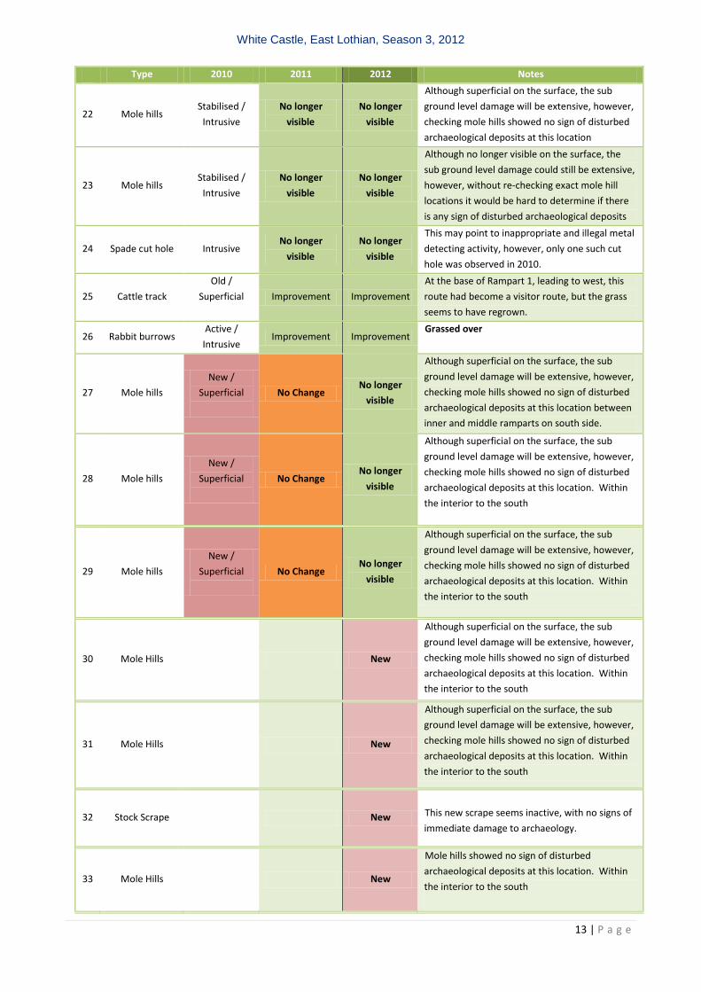
White Castle, East Lothian, Season 3, 2012
13 | P a g e
Type 2010 2011 2012 Notes
22 Mole hills Stabilised /
Intrusive
No longer
visible
No longer
visible
Although superficial on the surface, the sub
ground level damage will be extensive, however,
checking mole hills showed no sign of disturbed
archaeological deposits at this location
23 Mole hills Stabilised /
Intrusive
No longer
visible
No longer
visible
Although no longer visible on the surface, the
sub ground level damage could still be extensive,
however, without re-checking exact mole hill
locations it would be hard to determine if there
is any sign of disturbed archaeological deposits
24 Spade cut hole Intrusive No longer
visible
No longer
visible
This may point to inappropriate and illegal metal
detecting activity, however, only one such cut
hole was observed in 2010.
25 Cattle track
Old /
Superficial
Improvement Improvement
At the base of Rampart 1, leading to west, this
route had become a visitor route, but the grass
seems to have regrown.
26 Rabbit burrows Active /
Intrusive Improvement Improvement
Grassed over
27 Mole hills
New /
Superficial
No Change No longer
visible
Although superficial on the surface, the sub
ground level damage will be extensive, however,
checking mole hills showed no sign of disturbed
archaeological deposits at this location between
inner and middle ramparts on south side.
28 Mole hills
New /
Superficial
No Change No longer
visible
Although superficial on the surface, the sub
ground level damage will be extensive, however,
checking mole hills showed no sign of disturbed
archaeological deposits at this location. Within
the interior to the south
29 Mole hills
New /
Superficial
No Change No longer
visible
Although superficial on the surface, the sub
ground level damage will be extensive, however,
checking mole hills showed no sign of disturbed
archaeological deposits at this location. Within
the interior to the south
30 Mole Hills New
Although superficial on the surface, the sub
ground level damage will be extensive, however,
checking mole hills showed no sign of disturbed
archaeological deposits at this location. Within
the interior to the south
31 Mole Hills New
Although superficial on the surface, the sub
ground level damage will be extensive, however,
checking mole hills showed no sign of disturbed
archaeological deposits at this location. Within
the interior to the south
32 Stock Scrape New
This new scrape seems inactive, with no signs of
immediate damage to archaeology.
33 Mole Hills New
Mole hills showed no sign of disturbed
archaeological deposits at this location. Within
the interior to the south
White Castle, East Lothian, Season 3, 2012
14 | P a g e
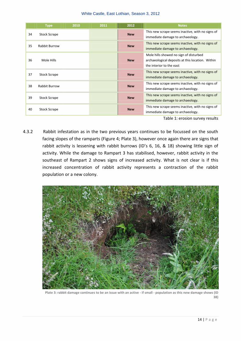
Type 2010 2011 2012 Notes
34 Stock Scrape New This new scrape seems inactive, with no signs of
immediate damage to archaeology.
35 Rabbit Burrow New This new scrape seems inactive, with no signs of
immediate damage to archaeology.
36 Mole Hills New
Mole hills showed no sign of disturbed
archaeological deposits at this location. Within
the interior to the east
37 Stock Scrape New This new scrape seems inactive, with no signs of
immediate damage to archaeology.
38 Rabbit Burrow New This new scrape seems inactive, with no signs of
immediate damage to archaeology.
39 Stock Scrape New This new scrape seems inactive, with no signs of
immediate damage to archaeology.
40 Stock Scrape New This new scrape seems inactive, with no signs of
immediate damage to archaeology.
Table 1: erosion survey results
4.3.2 Rabbit infestation as in the two previous years continues to be focussed on the south
facing slopes of the ramparts (Figure 4; Plate 3), however once again there are signs that
rabbit activity is lessening with rabbit burrows (ID’s 6, 16, & 18) showing little sign of
activity. While the damage to Rampart 3 has stabilised, however, rabbit activity in the
southeast of Rampart 2 shows signs of increased activity. What is not clear is if this
increased concentration of rabbit activity represents a contraction of the rabbit
population or a new colony.
Plate 3: rabbit damage continues to be an issue with an active - if small - population as this new damage shows (ID
38)
White Castle, East Lothian, Season 3, 2012
15 | P a g e
4.3.3 In previous seasons mole damage was focussed out with the hillfort to the south-east on
both the causeway and the visitor route (ID’s 22 & 23) however, mole mobility is
extensive and although previous damage is no longer visible new mole hills have
appeared within the interior enclosure (ID’s 28 & 29) along the south and also between
Ramparts 2 & 3 (ID 27). All that is clear from this new damage is that moles are still
active on the site and activity is confined to the south and south-east.
4.3.4 Investigation of mole hole demonstrated that mole activity is at worst superficial, with
tunnels in the topsoil only (Plate 4; Section 4.4.7).
Plate 4: Trench 37, Showing the excavated mole hills and tunnels, with very little sign of damage to underlying
archaeology, with no sign of mole activity beneath 200mm depth
4.3.5 Visitor pressure continues to be the main cause of sustained and ongoing damage. The
main route into the fort ensures that the location of visitor traffic remains constant on
this line (ID 4), cutting through Ramparts 2 and 3 before ascending up to the interior
over Rampart 1. Any alteration in the route would of course result in new damage and
so it may be best to regard this as a route that should not be altered, given that existing
damage is better than new damage.
4.3.6 With specific regard to erosion from visitor pressure it is worth noting that Trenches 35
and 36 (Sections 4.4.5 and 4.4.6), which examined putative entrances in the inner and
middle ramparts, clearly recovered evidence for erosion and soils movement. It is not
White Castle, East Lothian, Season 3, 2012
16 | P a g e
clear if this reflected the use of the entrances contemporary with the hillfort or
potentially subsequent use by stock.
Plate 5: stock scape (ID 37) showing the immediate damage to Rampart bank material
4.3.7 The majority of stock scrapes and animal tracks have continued to recover, but they do
represent irretrievable loss of information, as evidenced by excavation in 2010 (Section
4.5.3; Figure 4; Plate 7 (White Castle DSR 2010)). Once again, activity is focussed on the
south and south-east side of the monument, and in the stock scrapes where there is no
change (ID’s 11, 12, 13) rather than improvement (ID’s 10, 14, 15, 19, 20 & 21) there is
specific evidence for exposure of sub-surface deposits and some deflation of rampart
material, all of which is exacerbated by rain fall, which is continuing to cause issues with
erosion damage (ID 2). The damage is not considered significant and no alterations to
the current stocking pattern are recommended, indeed, there might be an argument for
the stocking level to increase in order to control the bracken on site (Section 4.1.7).
4.3.8 In 2011, sub-surface damage by bracken roots was present in all the trenches (Section
4.4 (2011 report)), even where there were no surface indications except for the upper
Trench 32, which may however have once been affected, given the initial homogeneous
nature of the upper layer. The underlying bracken roots penetrated to a depth of 250
mm and clearly homogenised the soil profiles in Trenches 30 and 31 as well as 35 and
36. In areas where bracken was established the depth of penetration was greater (up to
350mm ) as evidenced in Trenches 9-11 of the 2010 season. It is clear that damage to
sub-surface archaeological features and stratigraphy is swift and irreversible but the
creation of a root mat does seem to be depth limited. Where there is stratigraphy below
this horizon the layers are preserved, however in areas where there is only a thin soil
covering, the bracken roots have caused the effective destruction of the archaeological
record in these areas. There has been active bracken management since the 2011 field
season with brush cutting around the entire monument which has had the added benefit
of allowing topographic features to be clearly visible.
White Castle, East Lothian, Season 3, 2012
17 | P a g e
4.4 Geophysical Survey
4.4.1 The results of the geophysical survey 2012 greatly enhanced the previous extent of data,
covering the entire upper enclosed area and most of the banks and terraces, excluding
the northern slopes.
4.4.2 The resistivity clearly showed differential features across the interior and the enclosing
banks and terraces which may be of archaeological significance. The banked material
and underlying geology was clearly recognisable (Figure 5).
4.4.3 Within the interior it was originally unclear whether the pattern of high and low
resistance represented geological or anthropogenic features, however, there now does
seem to be a correlation between topographic features and these geophysical features.
4.4.4 This was possible by carefully plotting of each house platform and drawing to scale the
extent, orientation and location of each feature which then was added as a layer within
a GIS environment.
4.4.5 By comparing and superi mposing the topographic and geophysical data sets it is clear
that the hut-platforms were clearly visible in the resistivity, which was registering the
platform rubble. This is easy to discern in Plate 6 below. Re-examination of the resistivity
plots based on this understanding of the overlying topography and recognisable hut
platforms suggests further locations which are not directly visible on the surface. For
example the yellow highlighted area in Plate 6 may represent another hut platform
when compared with the geophysical image of known platforms. If this was the case,
then at least 5 further platforms may be located using this methodology (Figure 3).
Plate 63: a section to the northeast of the full resistivity survey (above) (see Figure 5) with the hut platform survey
superimposed (below). There is a clear correlation and the likelihood of further structures which are not apparent as topographic surface features
Figure 5. Geophysical Survey
White Castle, Garvald, East Lothian
50 metres
White Castle, East Lothian, Season 3, 2012
19 | P a g e
4.5 TRENCHES
4.5.1 Trench 29 (Figure 6)
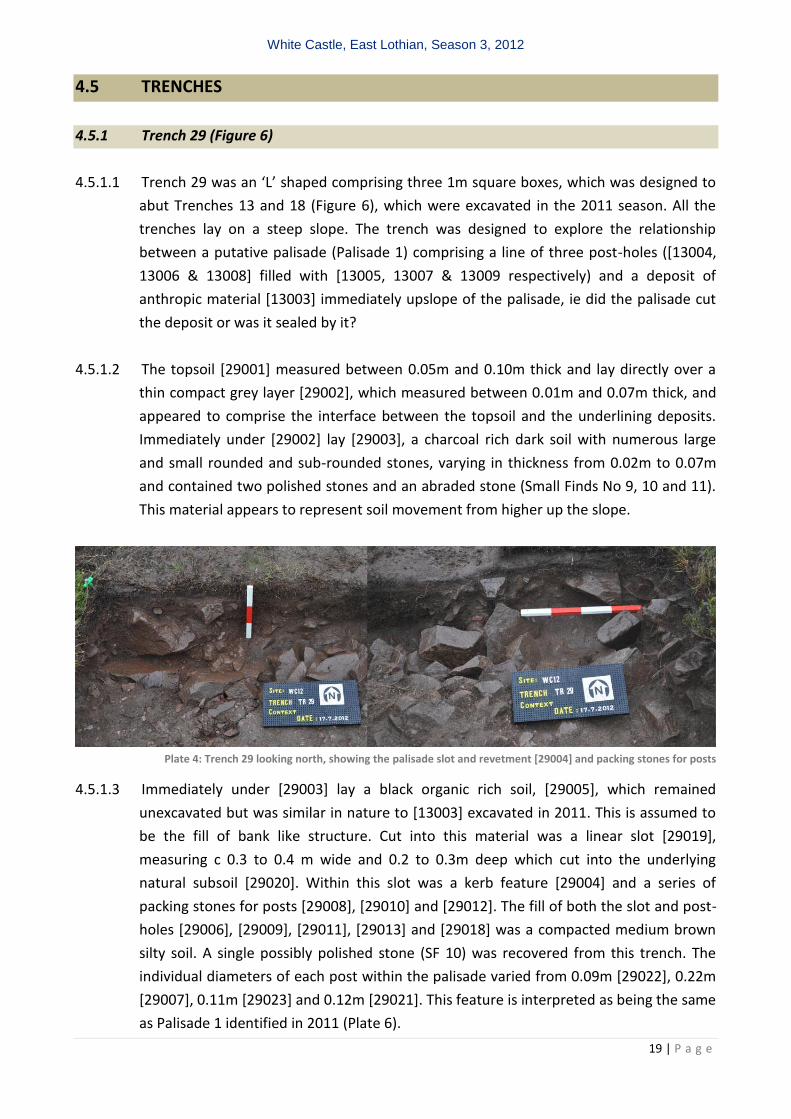
4.5.1.1 Trench 29 was an ‘L’ shaped comprising three 1m square boxes, which was designed to
abut Trenches 13 and 18 (Figure 6), which were excavated in the 2011 season. All the
trenches lay on a steep slope. The trench was designed to explore the relationship
between a putative palisade (Palisade 1) comprising a line of three post-holes ([13004,
13006 & 13008] filled with [13005, 13007 & 13009 respectively) and a deposit of
anthropic material [13003] immediately upslope of the palisade, ie did the palisade cut
the deposit or was it sealed by it?
4.5.1.2 The topsoil [29001] measured between 0.05m and 0.10m thick and lay directly over a
thin compact grey layer [29002], which measured between 0.01m and 0.07m thick, and
appeared to comprise the interface between the topsoil and the underlining deposits.
Immediately under [29002] lay [29003], a charcoal rich dark soil with numerous large
and small rounded and sub-rounded stones, varying in thickness from 0.02m to 0.07m
and contained two polished stones and an abraded stone (Small Finds No 9, 10 and 11).
This material appears to represent soil movement from higher up the slope.
Plate 4: Trench 29 looking north, showing the palisade slot and revetment [29004] and packing stones for posts
4.5.1.3 Immediately under [29003] lay a black organic rich soil, [29005], which remained
unexcavated but was similar in nature to [13003] excavated in 2011. This is assumed to
be the fill of bank like structure. Cut into this material was a linear slot [29019],
measuring c 0.3 to 0.4 m wide and 0.2 to 0.3m deep which cut into the underlying
natural subsoil [29020]. Within this slot was a kerb feature [29004] and a series of
packing stones for posts [29008], [29010] and [29012]. The fill of both the slot and post-
holes [29006], [29009], [29011], [29013] and [29018] was a compacted medium brown
silty soil. A single possibly polished stone (SF 10) was recovered from this trench. The
individual diameters of each post within the palisade varied from 0.09m [29022], 0.22m
[29007], 0.11m [29023] and 0.12m [29021]. This feature is interpreted as being the same
as Palisade 1 identified in 2011 (Plate 6).
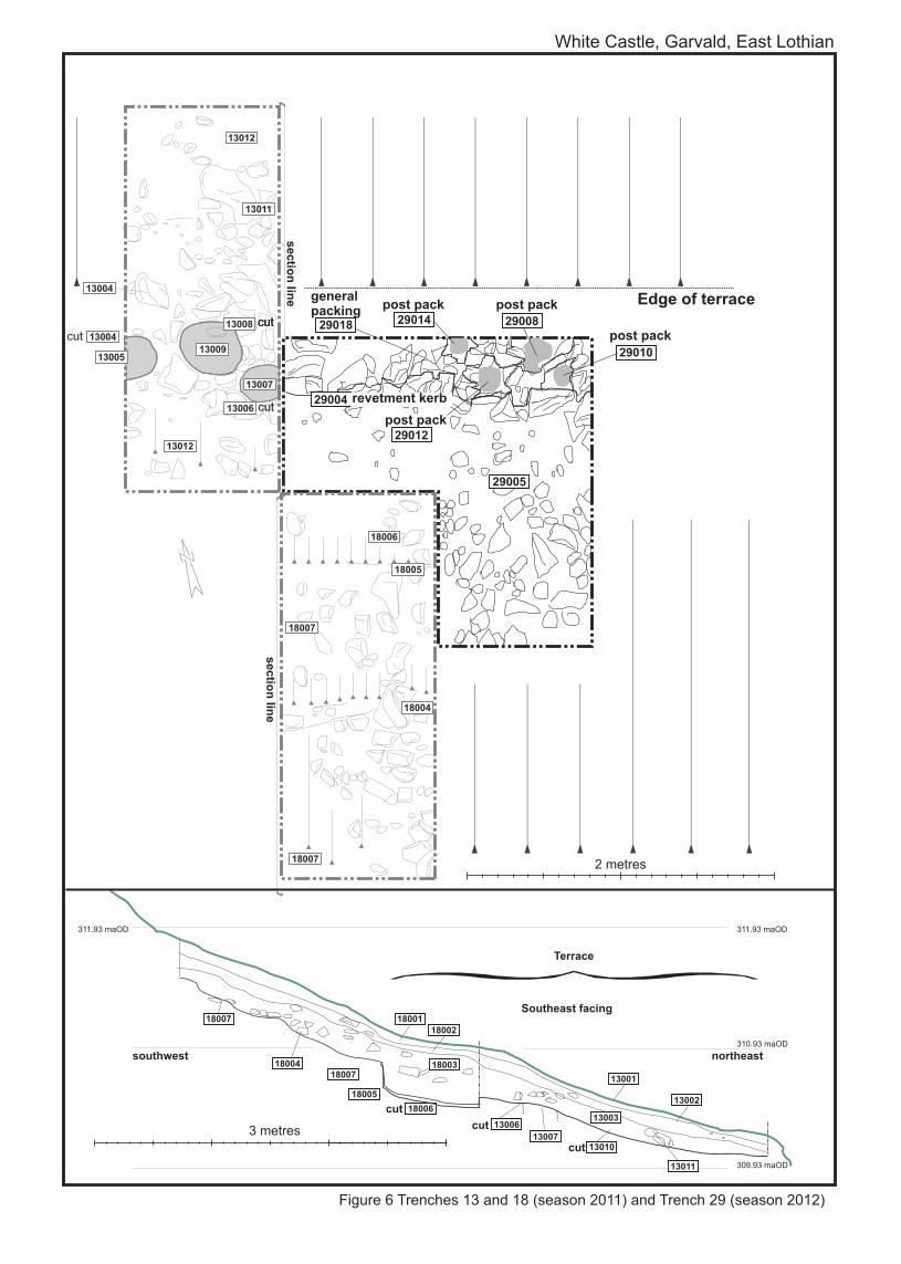
Figure 6 Trenches 13 and 18 (season 2011) and Trench 29 (season 2012)
White Castle, Garvald, East Lothian
Edge of terrace
3 metres
2 metres
1800418007
18005
1800218001
18003
18006
18007
311.93 maOD
310.93 maOD
309.93 maOD
311.93 maOD
cut
{ Terrace
13001
13010
13002
13011
1300313006
13007cut
cut
Southeast facing
southwest northeast
sectio
n lin
e
sectio
n lin
e
18006
18005
18007
18007
18004
13007
13006
13008
13009
13004
13005
13011
13012
13012
13004
cut
cutcutcut
29004
29005
29012
29018 2900829014
29010
post packgeneral packing post pack
post pack
post pack
revetment kerb
White Castle, East Lothian, Season 3, 2012
21 | P a g e
4.5.2 Trench 30 (Figure 7)
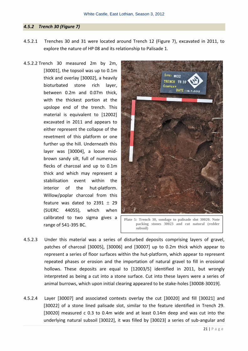
4.5.2.1 Trenches 30 and 31 were located around Trench 12 (Figure 7), excavated in 2011, to
explore the nature of HP 08 and its relationship to Palisade 1.
4.5.2.2 Trench 30 measured 2m by 2m,
[30001], the topsoil was up to 0.1m
thick and overlay [30002], a heavily
bioturbated stone rich layer,
between 0.2m and 0.07m thick,
with the thickest portion at the
upslope end of the trench. This
material is equivalent to [12002]
excavated in 2011 and appears to
either represent the collapse of the
revetment of this platform or one
further up the hill. Underneath this
layer was [30004], a loose mid-
brown sandy silt, full of numerous
flecks of charcoal and up to 0.1m
thick and which may represent a
stabilisation event within the
interior of the hut-platform.
Willow/poplar charcoal from this
feature was dated to 2391 29
(SUERC 44055), which when
calibrated to two sigma gives a
range of 541-395 BC.
4.5.2.3 Under this material was a series of disturbed deposits comprising layers of gravel,
patches of charcoal [30005], [30006] and [30007] up to 0.2m thick which appear to
represent a series of floor surfaces within the hut-platform, which appear to represent
repeated phases or erosion and the importation of natural gravel to fill in erosional
hollows. These deposits are equal to [12003/5] identified in 2011, but wrongly
interpreted as being a cut into a stone surface. Cut into these layers were a series of
animal burrows, which upon initial clearing appeared to be stake-holes [30008-30019].
4.5.2.4 Layer [30007] and associated contexts overlay the cut [30020] and fill [30021] and
[30022] of a stone lined palisade slot, similar to the feature identified in Trench 29.
[30020] measured c 0.3 to 0.4m wide and at least 0.14m deep and was cut into the
underlying natural subsoil [30022], it was filled by [30023] a series of sub-angular and
Plate 5: Trench 30, sondage to palisade slot 30020. Note
packing stones 30023 and cut natural (redder
subsoil)
White Castle, East Lothian, Season 3, 2012
22 | P a g e
angular packing packing stones, measuring on average 0.25m by 0.2m by 0.15m and
[30021] a yellowish brown silty sand.
4.5.2.5 Two undiagnostic flakes of struck flint were recovered from this trench: SFs 5 and 15.
4.5.2.6 The excavation of Trench 29 indicates that the Palisade 1, initially identified in 2011 in
Trenches 13 and 18 is a real feature and that it predates HP 08.
4.5.3 Trench 31 (Figure 7)
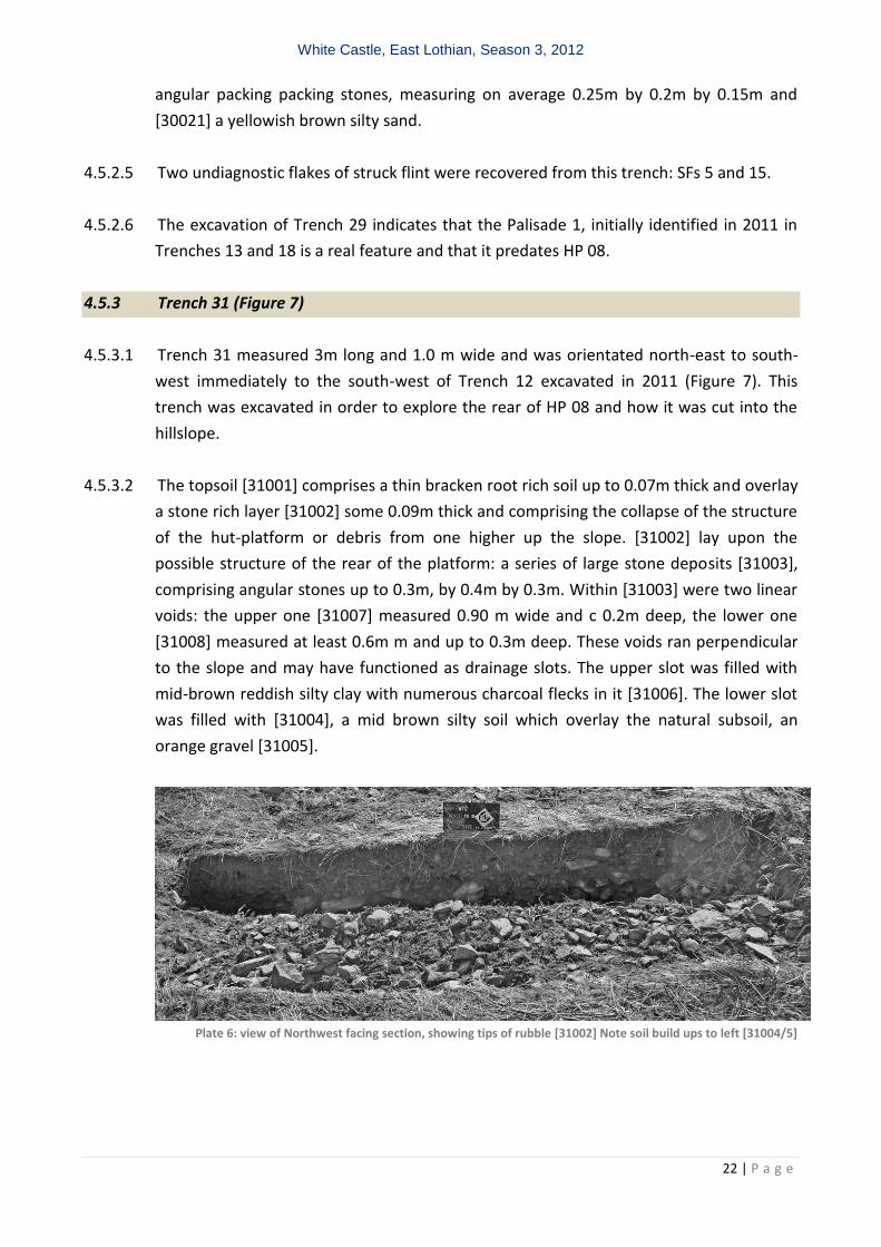
4.5.3.1 Trench 31 measured 3m long and 1.0 m wide and was orientated north-east to south-
west immediately to the south-west of Trench 12 excavated in 2011 (Figure 7). This
trench was excavated in order to explore the rear of HP 08 and how it was cut into the
hillslope.
4.5.3.2 The topsoil [31001] comprises a thin bracken root rich soil up to 0.07m thick and overlay
a stone rich layer [31002] some 0.09m thick and comprising the collapse of the structure
of the hut-platform or debris from one higher up the slope. [31002] lay upon the
possible structure of the rear of the platform: a series of large stone deposits [31003],
comprising angular stones up to 0.3m, by 0.4m by 0.3m. Within [31003] were two linear
voids: the upper one [31007] measured 0.90 m wide and c 0.2m deep, the lower one
[31008] measured at least 0.6m m and up to 0.3m deep. These voids ran perpendicular
to the slope and may have functioned as drainage slots. The upper slot was filled with
mid-brown reddish silty clay with numerous charcoal flecks in it [31006]. The lower slot
was filled with [31004], a mid brown silty soil which overlay the natural subsoil, an
orange gravel [31005].
Plate 6: view of Northwest facing section, showing tips of rubble [31002] Note soil build ups to left [31004/5]
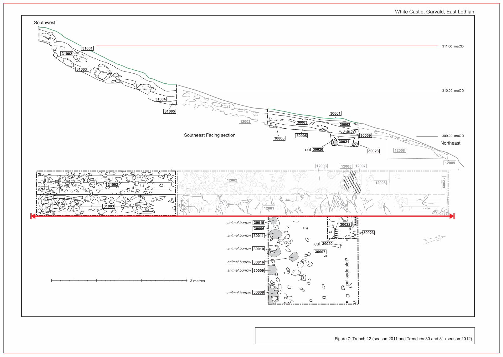
Figure 7: Trench 12 (season 2011 and Trenches 30 and 31 (season 2012)
3 metres
12002
12008
12009
310.00 maOD
309.00 maOD
311.00 maOD
12001
12002
12003 12007
12008
12
00
9
12005
cut
Southeast Facing section
Northeast
Southwest
White Castle, Garvald, East Lothian
cut
3000630005
30003
30001
30002
30009
3002330020
30021
30023
31005
31003
31002
31001
31004
30011
30010
30016
30009
30008
31002
31003
30019
30006
30007
30020
30022
palis
ade s
lot?
animal burrow
animal burrow
animal burrow
animal burrow
animal burrow
animal burrow
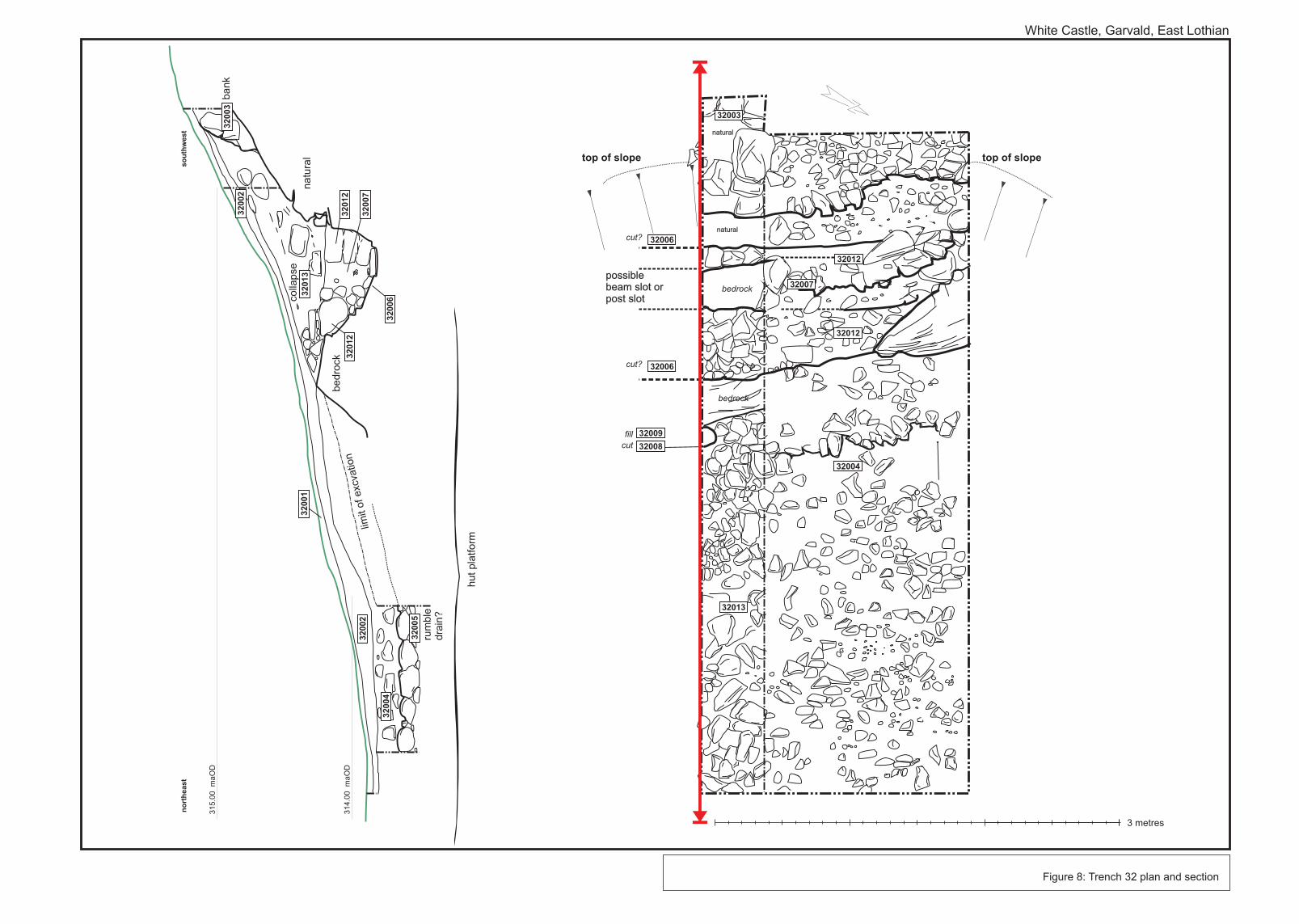
Figure 8: Trench 32 plan and section
White Castle, Garvald, East Lothian
natural
natural
possible beam slot or post slot
3 metres
32007
32012
32012
32004
32006
32006
32003
32008
32009
32013
bedrock
cut?
cut?
bedrock
cut
fill
top of slope top of slope
31
4.0
0
ma
OD
31
5.0
0
ma
OD
{n
ort
heast
so
uth
west
32
00
4
32
00
2
32
00
2
32
00
3
32
00
1
32
01
2
32
00
6
32
00
7
32
01
2
32
01
3
32
00
5
rum
ble
dra
in?
limit
of exc
vatio
nbedro
ck
na
tura
l
colla
pse
ba
nk
hut
pla
tform
White Castle, East Lothian, Season 3, 2012
25 | P a g e
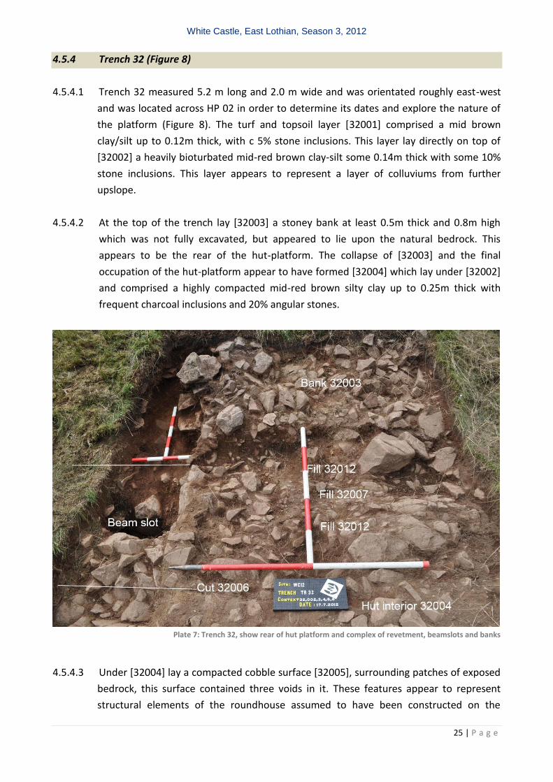
4.5.4 Trench 32 (Figure 8)
4.5.4.1 Trench 32 measured 5.2 m long and 2.0 m wide and was orientated roughly east-west
and was located across HP 02 in order to determine its dates and explore the nature of
the platform (Figure 8). The turf and topsoil layer [32001] comprised a mid brown
clay/silt up to 0.12m thick, with c 5% stone inclusions. This layer lay directly on top of
[32002] a heavily bioturbated mid-red brown clay-silt some 0.14m thick with some 10%
stone inclusions. This layer appears to represent a layer of colluviums from further
upslope.
4.5.4.2 At the top of the trench lay [32003] a stoney bank at least 0.5m thick and 0.8m high
which was not fully excavated, but appeared to lie upon the natural bedrock. This
appears to be the rear of the hut-platform. The collapse of [32003] and the final
occupation of the hut-platform appear to have formed [32004] which lay under [32002]
and comprised a highly compacted mid-red brown silty clay up to 0.25m thick with
frequent charcoal inclusions and 20% angular stones.
Plate 7: Trench 32, show rear of hut platform and complex of revetment, beamslots and banks
4.5.4.3 Under [32004] lay a compacted cobble surface [32005], surrounding patches of exposed
bedrock, this surface contained three voids in it. These features appear to represent
structural elements of the roundhouse assumed to have been constructed on the
White Castle, East Lothian, Season 3, 2012
26 | P a g e
platform. The first void [32006] was a linear slot cut into the underlying bedrock, that
ran roughly north south across the trench, the feature was up to 0.5m deep, 0.30m wide
and filled with two fills: [32012] a series of angular packing stones, measuring on
average 0.2m by 0.1m by 0.15m. At the core of the feature was a post-pipe 0.30 deep
and up to 0.25m wide [32007], comprising a mid-red brown silty clay. Alder Charcoal
from this feature was dated to 2195 26 BP (SUERC 4405), which when calibrated to
two sigma gives a range of 366-186 BC. The second void, [32010] was sub-circular in plan
and measured 0.35m by 0.20 and filled with a mid-brown soil [32011]. This appears to
be a post-hole feature within [32006]. The third void [32008] was also unexcavated but
measured 0.2m by 0.25m, but was filled with a dark grey brown soil [32009] and
appeared to represent an internal post-hole.
White Castle, East Lothian, Season 3, 2012
27 | P a g e
4.5.5 Trench 35 (Figure 9)
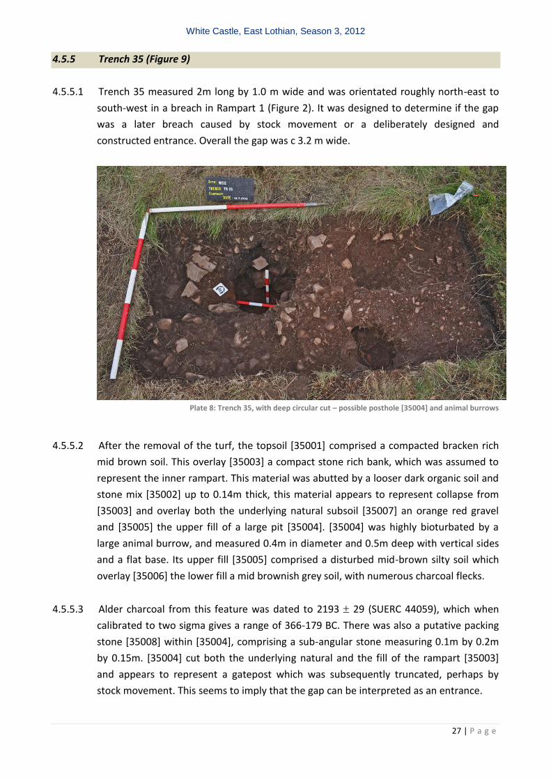
4.5.5.1 Trench 35 measured 2m long by 1.0 m wide and was orientated roughly north-east to
south-west in a breach in Rampart 1 (Figure 2). It was designed to determine if the gap
was a later breach caused by stock movement or a deliberately designed and
constructed entrance. Overall the gap was c 3.2 m wide.
Plate 8: Trench 35, with deep circular cut – possible posthole [35004] and animal burrows
4.5.5.2 After the removal of the turf, the topsoil [35001] comprised a compacted bracken rich
mid brown soil. This overlay [35003] a compact stone rich bank, which was assumed to
represent the inner rampart. This material was abutted by a looser dark organic soil and
stone mix [35002] up to 0.14m thick, this material appears to represent collapse from
[35003] and overlay both the underlying natural subsoil [35007] an orange red gravel
and [35005] the upper fill of a large pit [35004]. [35004] was highly bioturbated by a
large animal burrow, and measured 0.4m in diameter and 0.5m deep with vertical sides
and a flat base. Its upper fill [35005] comprised a disturbed mid-brown silty soil which
overlay [35006] the lower fill a mid brownish grey soil, with numerous charcoal flecks.
4.5.5.3 Alder charcoal from this feature was dated to 2193 29 (SUERC 44059), which when
calibrated to two sigma gives a range of 366-179 BC. There was also a putative packing
stone [35008] within [35004], comprising a sub-angular stone measuring 0.1m by 0.2m
by 0.15m. [35004] cut both the underlying natural and the fill of the rampart [35003]
and appears to represent a gatepost which was subsequently truncated, perhaps by
stock movement. This seems to imply that the gap can be interpreted as an entrance.
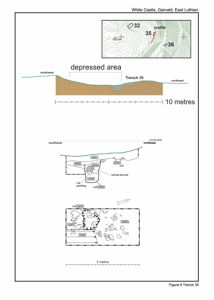
Figure 9 Trench 35Figure 9 Trench 35
White Castle, Garvald, East LothianWhite Castle, Garvald, East Lothian
profile
depressed area
Trench 35
2 metres
10 metres
314.33 maOD314.33 maOD
northeastnortheastsouthwest
northeast
southwest
1300235003
35004
35007
35002
35004
35006
35005
35001
35002 35003
cut
cut
cutpacking
cut
animal burrow

White Castle, East Lothian, Season 3, 2012
29 | P a g e
4.4.6 Trench 36 (Figure 9)
4.4.6.1 Trench 36 measured 2m long by 1.0 m wide
and was orientated roughly north-east to
south-west in a breach in Rampart 2 (Figure
2). It was designed to determine if the gap
was a later breach caused by stock movement
or a deliberately designed and constructed
entrance. Overall the gap was c 2m wide.
4.4.6.2 The removal of the turf from the trench
revealed the topsoil [36001] a dark brown
silty sand which was up to 0.1m thick. This
overlay [36004] a reddish brown stone rich
loose soil up to 0.3m thick. This material
appears to represent colluvium from upslope
erosion which has filled the void of the gap.
[36004] abutted [36002] and overlay [36003],
[36002] comprised a series of tightly packed
bank of sub-angular stones and represents
Rampart 2. This rampart had a single large
stone which might have comprised the
remains of kerb (Figure 9). [36003] consisted of a loose stone rich soil measuring up to
0.2m thick. This appears to represent the collapse of [36002] into the breach. [36002] lay
over [36006] another dark brown stone rich soil, this time associated with flecks of
charcoal and measuring up to 0.22m thick. This material appears to collapse from
upslope into the gap, in turn erosion caused by the use of the entrance appears to have
eroded it. [36006] overlay the natural subsoil a loose orange gravel.
4.4.6.3 The sequence of deposits within Trench 36 appears to represent repeated phases of
erosion and infill. The erosion may have been caused by periods of intense stock
movement which subsequently stabilised. The charcoal within [36006] presumably
represents erosion from upslope middens. However, it is not clear if the gap represents
an eroded entrance or a breach, on balance the presence of a definite entrance in the
inner rampart and the single possible kerb stone incline the authors to the former rather
than the latter.
Plate 9: Trench 36 showing ‘edge’ of opening
within Rampart 2 and possible
revetment stones. The bank lies over
the red-brown natural

Figure 10 Trench 36
White Castle, Garvald, East Lothian
profile
depressed area
Trench 36
2 metres
10 metres
northeastsouthwest
northeast
southwest
36006
36006
36004
36001 36002
3600336005
36004 36003
36002
natural
natural
311.16 maOD
White Castle, East Lothian, Season 3, 2012
31 | P a g e
4.4.7 Trench 37
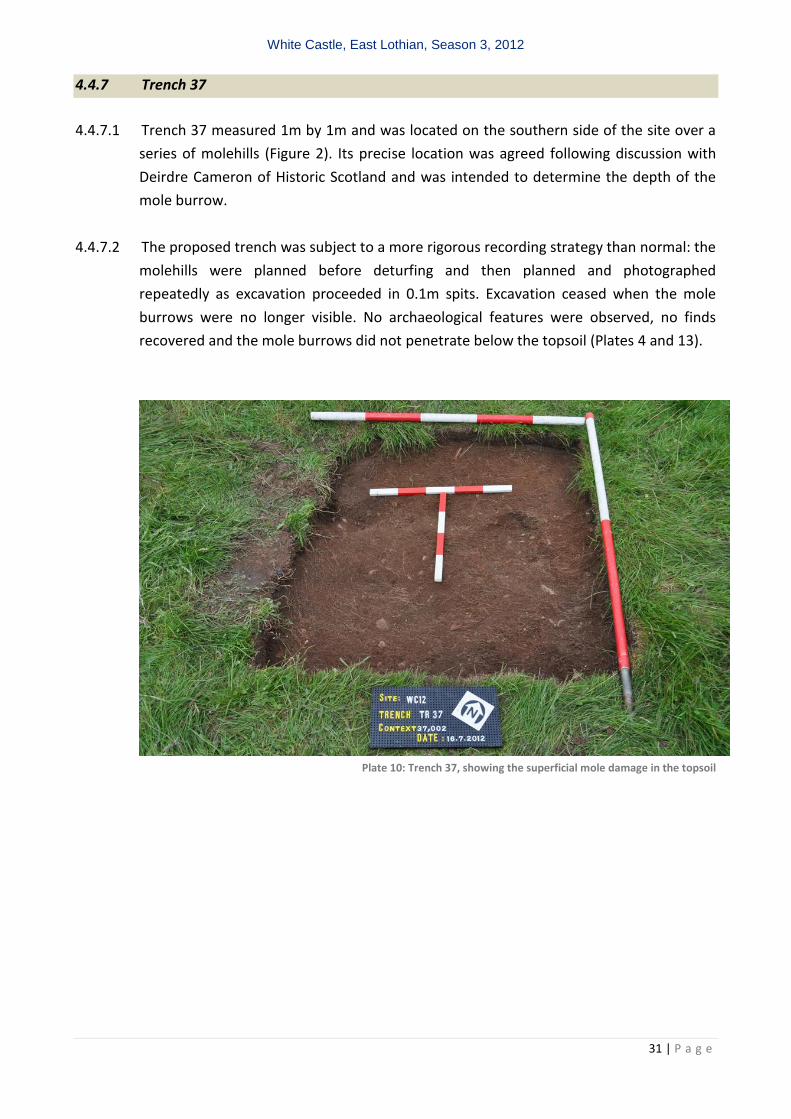
4.4.7.1 Trench 37 measured 1m by 1m and was located on the southern side of the site over a
series of molehills (Figure 2). Its precise location was agreed following discussion with
Deirdre Cameron of Historic Scotland and was intended to determine the depth of the
mole burrow.
4.4.7.2 The proposed trench was subject to a more rigorous recording strategy than normal: the
molehills were planned before deturfing and then planned and photographed
repeatedly as excavation proceeded in 0.1m spits. Excavation ceased when the mole
burrows were no longer visible. No archaeological features were observed, no finds
recovered and the mole burrows did not penetrate below the topsoil (Plates 4 and 13).
Plate 10: Trench 37, showing the superficial mole damage in the topsoil
White Castle, East Lothian, Season 3, 2012
32 | P a g e
5 POST EXCAVATION ASSESMENT
5.1 Following discussions with Historic Scotland it was agreed that the post-excavation
assessment could be undertaken in advance of submission of the Data Structure Report
and incorporated into it. This does not preclude further assessment and analysis works. As
might be expected the limited scope of the excavation produced only a small artefact and
ecofact assemblage, comprising lithics, coarse stone and charcoal.
5.2 Worked stone and other finds (C. Howard-Davis)
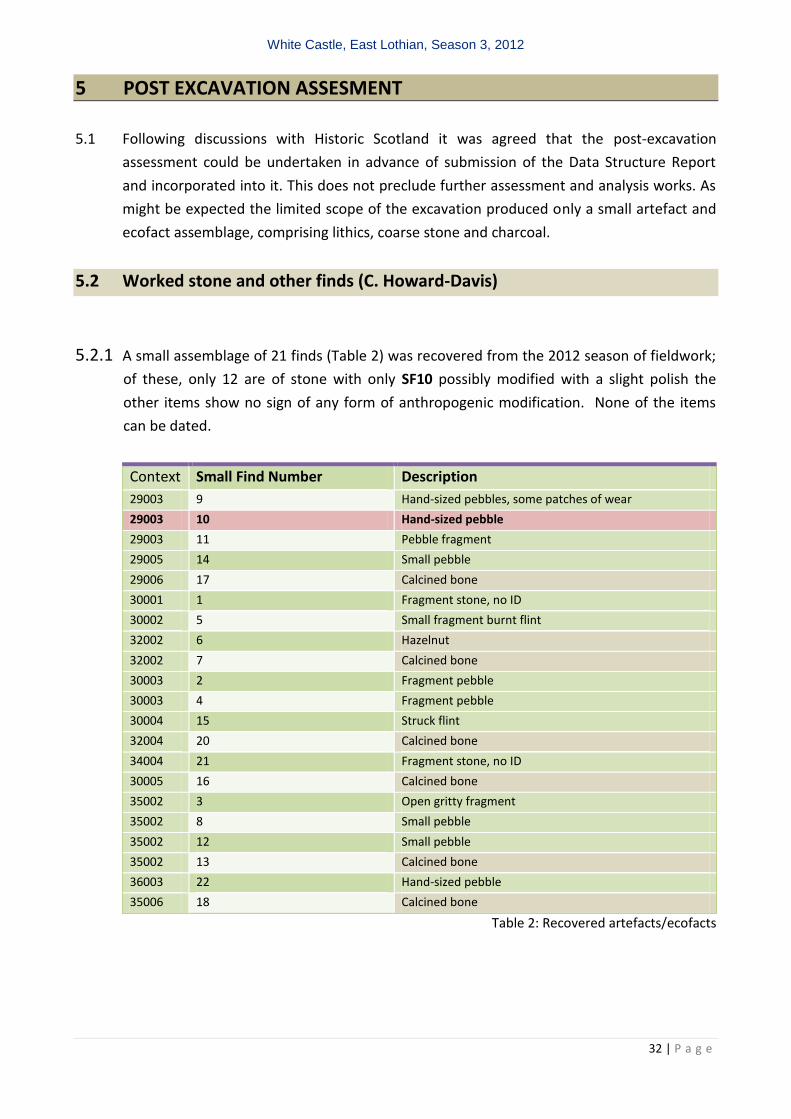
5.2.1 A small assemblage of 21 finds (Table 2) was recovered from the 2012 season of fieldwork;
of these, only 12 are of stone with only SF10 possibly modified with a slight polish the
other items show no sign of any form of anthropogenic modification. None of the items
can be dated.
Context Small Find Number Description
29003 9 Hand-sized pebbles, some patches of wear
29003 10 Hand-sized pebble
29003 11 Pebble fragment
29005 14 Small pebble
29006 17 Calcined bone
30001 1 Fragment stone, no ID
30002 5 Small fragment burnt flint
32002 6 Hazelnut
32002 7 Calcined bone
30003 2 Fragment pebble
30003 4 Fragment pebble
30004 15 Struck flint
32004 20 Calcined bone
34004 21 Fragment stone, no ID
30005 16 Calcined bone
35002 3 Open gritty fragment
35002 8 Small pebble
35002 12 Small pebble
35002 13 Calcined bone
36003 22 Hand-sized pebble
35006 18 Calcined bone
Table 2: Recovered artefacts/ecofacts
White Castle, East Lothian, Season 3, 2012
33 | P a g e
5.2.2 Charcoal and Charred Macroplant (Denise Druce and Sandra Bonsall)
5.2.2.1 Samples examined from material recovered during the 2012 season excavation of a pit
or possible post-hole in a gate in Rampart 1 [35006].
5.2.2.2 Samples from the fill [35006] of the post-hole/post-pipe [35004] were recovered and
examined. Both these samples were sieved and assessed for charred macroplant
remains but none were found to be present.
White Castle, East Lothian, Season 3, 2012
34 | P a g e
6 INTERPRETATION AND DISCUSSION
6.1 Management issues
6.1.1 The site and surrounding area has been impacted by a variety of sources: cattle, sheep,
rabbits, moles, bracken and visitors. It is also clear that some of these impacts have been
ongoing. There is growing evidence for a loss of information and impact on in situ deposits
from bracken root disturbance and rabbit burrowing. To a lesser extent sheep scrapes have
exposed rampart material to erosion. It is however, now clear that despite an obvious and
visible presence, there is no evidence that moles cause any damage to underlying
archaeological strata, although clearly other burrowing animals do (Section 4.4.2).
6.1.2 Visible surface indications of loss of information appears to be either limited in extent or
focussed in specific locations. The biggest cause of erosion to the site is visitors, accessing
the site through the existing breach (ID 4).
6.1.3 The precise extent of recent bracken growth has been mapped in addition to the damage it
is causing to the site (Figure 4). Examination of the damage within the excavated trenches
does show that the upper layers are being homogenised. It is interesting to note that
bracken roots and bracken root damage can recorded in every trench even where no
surface bracken is present.
6.2 Dating
6.2.1 The three radiocarbon dates from the 2012 season bring the total of absolute dates from
the site to 10 and they confirm the previous results that suggest of a core of later
prehistoric activity from c 500 to 300 BC. Although none of this material was recovered in
situ from a feature, the dates represent either termini post- or ante-quems for the
locations from which they were recovered. Within this broad range it is possible to identify
two statistically indistinguishable blocks c 500-400 cal BC and 400-300 cal BC.
6.2.2 The earlier dating block is associated with the construction of the outer two ramparts –
Ramparts 2 and 3 - and undefined activity within the interior that produced charcoal. This
material was re-used to construct Rampart 1 as well as Hut Platform 08.
6.2.3 Hut Platform 08 was also constructed over Palisade 1, which originally continued the line of
Rampart 1 on the north-western side of the site.
White Castle, East Lothian, Season 3, 2012
35 | P a g e
6.2.4 Charcoal from the fill of Ditch 1, and thus the assumed termination and deliberate slighting
of Rampart 1, as well as from the fill of a post-hole from Palisade 1 was dated to c 400-350
cal BC. These dates are statistically indistinguishable.
6.2.5 Charcoal from the fill of a post-hole associated with a gate in Rampart 1 was dated to c
366-186 cal BC. This date could be either contemporary with the other dates from Ditch 1
and Palisade 1 or later, although if Rampart 1 was slighted between 400-350 cal BC then it
seems more likely that this activity overlapped with the other dates from Rampart 1. Given
this and the overlap between the two sets of dates then it is possible to suggest that
Rampart 1 was constructed and destroyed with timber dating to between 366 and 350 cal
BC.
6.2.6 There was also charcoal recovered from midden material around the palisade that
provided a date of c400-100 BC, which means that this feature may be either
contemporary or later than Rampart 1.
6.2.7 The remaining date is from Hut Platform 02 and indicates that its use and construction
could either be contemporary with Rampart 1 or later.
6.2.8 The results indicate that the now dated internal upstanding structures post-date the outer
ramparts and potentially some of them also post-date the inner rampart too. There is
evidence for charcoal incorporated into the soil makeup of the outer ramparts, however
the nature of the events that produced it is unclear, this internal activity may even have
been destroyed or masked by successive settlement. The survival of the hut-platforms
dating to c 366-186 cal BC presumably indicates that there was no later intensive activity
after this date range.
6.2.9 The potential complexity of the integration of the stratigraphic sequence and the
radiocarbon dates indicates that detailed statistical analysis is required and following the
completion of the fourth and final season this will be undertaken.
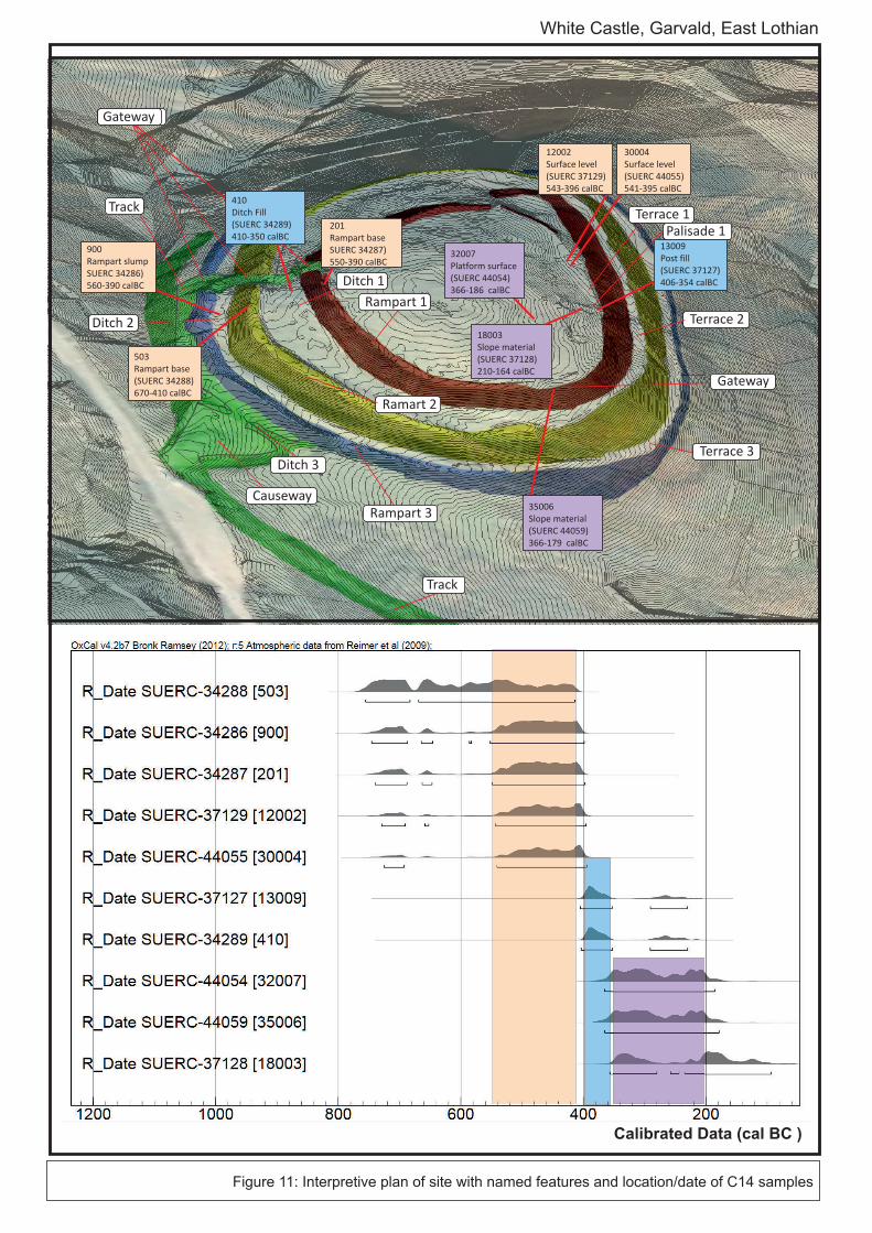
Figure 11: Interpretive plan of site with named features and location/date of C14 samples
White Castle, Garvald, East Lothian
18003
Slope material
(SUERC 37128)
210-164 calBC
12002
Surface level
(SUERC 37129)
543-396 calBC
30004
Surface level
(SUERC 44055)
541-395 calBC
13009
Post fill
(SUERC 37127)
406-354 calBC
201
Rampart base
SUERC 34287)
550-390 calBC
410
Ditch Fill
(SUERC 34289)
410-350 calBC
503
Rampart base
(SUERC 34288)
670-410 calBC
900
Rampart slump
SUERC 34286)
560-390 calBC
Terrace 1
Terrace 2
Rampart 1
Rampart 3
Ramart 2
Causeway
Gateway
Gateway
Terrace 3Ditch 3
Ditch 1
Ditch 2
Calibrated Data (cal BC )
Track
Palisade 1
Track
32007
Platform surface
(SUERC 44054)
366-186 calBC
35006
Slope material
(SUERC 44059)
366-179 calBC
White Castle, East Lothian, Season 3, 2012
37 | P a g e
6.3 Interpretation
6.3.1 The accumulation of data from White Castle continues to reveal the monument’s
complexity. There are at least two phases of rampart construction (the outer two and
inner) and none of them represent a complete circuit, perhaps undermining any defensive
function. In addition, some of the visible occupation structures appear to be linked to the
inner rampart, although some clearly post-date it. However, it is extremely likely that the
hut-platforms represent the final phase of occupation on the site, having been built over
and in the case of HP 08 with earlier occupation debris. Certainly, the 2011 season
identified a series of post-holes which could be the remains of an earlier truncated
structure (Trench 16).
6.3.2 It is also now also seems plausible that the rampart banks were penetrated by multiple
entrances and that the entrances in inner and outer banks were aligned to provide direct
access. This again undermines any defensive interpretation to the site given that defence
would rely of staggered entrances to slow down attack given that entrances are the most
vulnerable part of a defensive circuit.
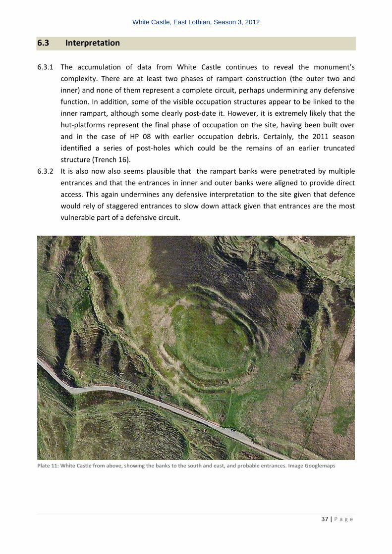
Plate 11: White Castle from above, showing the banks to the south and east, and probable entrances. Image Googlemaps
White Castle, East Lothian, Season 3, 2012
38 | P a g e
7 FURTHER WORK
7.1 Two types of further work are proposed: the first comprises further survey and the second
additional excavation subject of course to all formal permissions.
7.2 Survey
7.2.1 It is clear that with each new season of survey more nuanced detail is recorded. Therefore,
in the final season the topographic survey will be refined with more detail gathered across
the internal settlement, the western slopes and the location of the putative mounds. In
addition, the erosion and vegetation survey will be repeated to attempt to measure
change, though it is expected that a single year will be insufficient to generate measurable
change.
7.3 Fieldwork
7.3.1 The final season on the site in 2013 (Figure 2) proposes to undertake the following works, for which Scheduled Monument Consent has already been granted:
7.3.2 (Trenches 35 and 36) Two 2m by 1m trench at each of the gaps in the inner Ramparts at
the north of the site to confirm if they are entrances or breaches. 7.3.3 (Trench 39) A 2m by 10 m trench across the external ditch on the north-west side of the
site to characterise it and recover dating evidence. 7.3.4 (Trench 40) A 10m by 1m wide trench across an external hut platform (13) to characterise
any differences in architecture and to recover dating evidence; 7.3.5 (Trench 41) A 5m by 1m trench across the shieling structure to characterise its form and
recover dating evidence. 7.3.6 A final Trench (42) is proposed to be excavated across the putative mound in which a
possible cist was located and Scheduled Monument consent has not yet been granted for this work. This mound was either a discrete feature incorporated into the outer rampart or the product of differential erosion across the rampart creating the appearance of a mound. Specifically, as a kerb was found to the eastern edge of the ‘mound’ in 2011, it is proposed to excavate a small 1m wide and 2m long trench on the southern edge of the mound. If the kerb is present then its is likely that the feature is a barrow of some description subsequently incorporated into the rampart and no further work will be undertaken. If a kerb is not found then clearly whatever the putative cist cemetery represented. it had been built over by the outer rampart. While at this point the precise nature of the ‘cist’ cemetery is unclear it is not proposed to undertake any further work given the potential for complex features beyond the resources of the project team.
White Castle, East Lothian, Season 3, 2012
39 | P a g e
8 CONCLUSION
8.1 The work undertaken at White Castle has identified a remarkable stratified sequence with
a degree of complexity not apparent from the initial RCAHMS survey. It is hoped that the
work has demonstrated both the validity of the approach and the potential rich yields of
the Hillforts of East Lothian project and that further work will continue to yield such
details!
9 ACKNOWLEDGMENTS
9.1 The authors would like to thank the Monks from Sancta Maria Abbey for their kind
permission for letting us excavate on their land; the guidance of Deirdre Cameron of
Historic Scotland; the advice of the East Lothian Council's archaeological team; Becker
Geomatics Ltd for the baseline topographic survey; the Girl Guiding East Lothian for the use
of Alison Cargill House; and last but not least the volunteers who endured and enjoyed the
full gamut of an East Lothian Summer including all those who returned for a second season:
Amy Taylor, Ben Hosios , Katrien Janin, Catherine Evoy , Martin Welker, Lupe Gonzalez,
Michelle Lighton, Alexander Westra, Andy Sturdy, Maureen Cant, Jenny Meyer, Chelsea
Kennedy, Trevor Borg, Andrew Metzger, Brigitte Samson , Maddison de Varennes, Caroline
Prudhomme
White Castle, East Lothian, Season 3, 2012
40 | P a g e
BIBLIOGRAPHIC REFERENCES
Cook, M and Connolly, D 2010 Rampart Scotland Project 001: White Castle, Garvald, East Lothian,
Data Structure Report and Costed Post Excavation Research Design, unpub rep.
Cook, M and Connolly, D 2011 Rampart Scotland Project 001: White Castle, Garvald, East Lothian,
Season 2: Data Structure Report and Costed Post Excavation Research Design, unpub rep.
Connolly, D and Cook, M 2010 Rampart Scotland Project 2: Chesters, Drem, East Lothian
Topographic and Erosion Survey, unpublished Data Structure Report.
Connolly, D and Cook, M 2011 Rampart Scotland Project 2: Chesters, Drem, East Lothian
Topographic and Erosion Survey, Season 2: unpublished Data Structure Report.
Connolly, D and Cook, M, Dinning S, Druce D, & Rocks-Macqueen D.2011 Rampart Scotland Project 3: Sheriffside, Gifford, East Lothian , unpublished Data Structure Report.
Connolly, D and Cook, M, Dinning S, 2012 Rampart Scotland Project 3: Sheriffside, Gifford, East
Lothian , Season 2: unpublished Data Structure Report.
Dunwell, A and Trout, R 1999 Burrowing Animals and Archaeology, Edinburgh (=Historical Scotland
Technical Advice Note 16)
Harding, DW, 1974 The Iron Age in Lowland Britain, London
Ralston, I 1973 East Lothian, White Castle, Garvald, Iron Age fort, DES.
White Castle, East Lothian, Season 3, 2012
41 | P a g e
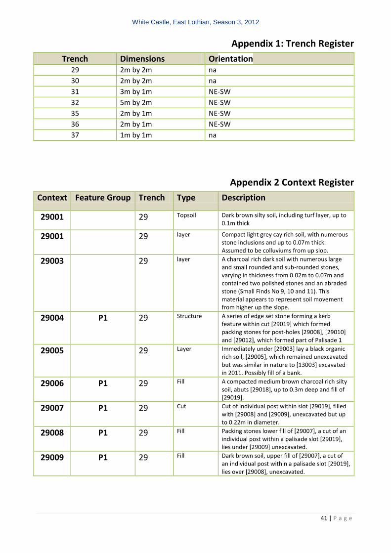
Appendix 1: Trench Register
Trench Dimensions Orientation
29 2m by 2m na
30 2m by 2m na
31 3m by 1m NE-SW
32 5m by 2m NE-SW
35 2m by 1m NE-SW
36 2m by 1m NE-SW
37 1m by 1m na
Appendix 2 Context Register
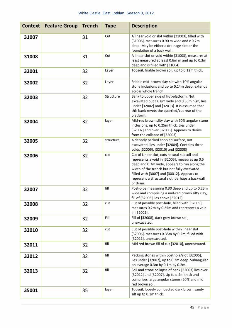
Context Feature Group Trench Type Description
29001 29 Topsoil Dark brown silty soil, including turf layer, up to 0.1m thick
29001 29 layer Compact light grey cay rich soil, with numerous stone inclusions and up to 0.07m thick. Assumed to be colluviums from up slop.
29003 29 layer A charcoal rich dark soil with numerous large and small rounded and sub-rounded stones, varying in thickness from 0.02m to 0.07m and contained two polished stones and an abraded stone (Small Finds No 9, 10 and 11). This material appears to represent soil movement from higher up the slope.
29004 P1 29 Structure A series of edge set stone forming a kerb feature within cut [29019] which formed packing stones for post-holes [29008], [29010] and [29012], which formed part of Palisade 1
29005 29 Layer Immediately under [29003] lay a black organic rich soil, [29005], which remained unexcavated but was similar in nature to [13003] excavated in 2011. Possibly fill of a bank.
29006 P1 29 Fill A compacted medium brown charcoal rich silty soil, abuts [29018], up to 0.3m deep and fill of [29019].
29007 P1 29 Cut Cut of individual post within slot [29019], filled with [29008] and [29009], unexcavated but up to 0.22m in diameter.
29008 P1 29 Fill Packing stones lower fill of [29007], a cut of an individual post within a palisade slot [29019], lies under [29009] unexcavated.
29009 P1 29 Fill Dark brown soil, upper fill of [29007], a cut of an individual post within a palisade slot [29019], lies over [29008], unexcavated.
White Castle, East Lothian, Season 3, 2012
42 | P a g e
Context Feature Group Trench Type Description
29010 P1 29 Fill Packing stones, lower fill of [29022], a cut of an individual post within a palisade slot [29019], lies under [29011]. The stone are angular to sub-angular and measure c 0.12m by 0.05 by 0.04.
29011 P1 29 Fill Dark brown soil, upper fill of [29022], a cut of an individual post within a palisade slot [29019], lies over [29010]. The soil is up to 0.2m deep.
29012 P1 29 Fill Packing stones lower fill of [29023], a cut of an individual post within a palisade slot [29019], lies under [29013]. The stone are angular and measure up to 0.20m by 0.10 by 0.06.
29013 P1 29 Fill Dark brown soil, upper fill of [29023], a cut of an individual post within a palisade slot [29019], lies over [29012]. The soil is up to 0.2m deep.
29014 P1 29 Fill Packing stones, lower fill of [29021], a cut of an individual post within a palisade slot [29019], lies under [29015]. The stones are angular and measure up to 0.20m by 0.10 by 0.06.
29015 P1 29 Fill Dark brown soil, upper fill of [29021], a cut of an individual post within a palisade slot [29019], lies over [29014]. The soil is up to 0.2m deep.
29016 Not assigned
29017 Not assigned
29018 P1 29 Fill A series of edge set stones, comprising packing for a palisade, abuts [29006], up to 0.3m deep and fill of [29019].
29019 P1 29 Cut Cut for palisade slot, cuts [2020] and [29019], filled with [29006] and [29018] as well as a series of post-holes. Measures c 0.3 to 0.4 m wide and 0.2 to 0.3m deep
29020 natural Natural orange subsoil.
29021 P1 29 Cut Individual cut within palisade slot [29019] filled [29014] and [29015], measures 0.12m in diameter and up to 0.2m deep with vertical sides and a flat base.
29022 P1 29 Cutlayer Individual cut within palisade slot [29019] filled [29010] and [29011], measures 0.09m in diameter and up to 0.2m deep with vertical sides and a flat base.
29023 P1 29 Cut Individual cut within palisade slot [29019] filled [29012] and [29013], measures 0.11m in diameter and up to 0.2m deep with vertical sides and a flat base.
30001 30 Layer Topsoil, dark brown sandy silt up to 0.1m thick
30002 30 Layer Heavily bioturbated stone rich layer (80%), between 0.2m and 0.07m thick, lies under [30001] and over [30004]. Appears to either represent the collapse of the revetment of this platform or one further up the hill.
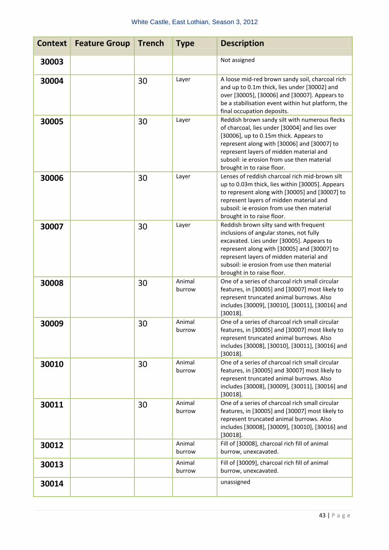
White Castle, East Lothian, Season 3, 2012
43 | P a g e
Context Feature Group Trench Type Description
30003 Not assigned
30004 30 Layer A loose mid-red brown sandy soil, charcoal rich and up to 0.1m thick, lies under [30002] and over [30005], [30006] and [30007]. Appears to be a stabilisation event within hut platform, the final occupation deposits.
30005 30 Layer Reddish brown sandy silt with numerous flecks of charcoal, lies under [30004] and lies over [30006], up to 0.15m thick. Appears to represent along with [30006] and [30007] to represent layers of midden material and subsoil: ie erosion from use then material brought in to raise floor.
30006 30 Layer Lenses of reddish charcoal rich mid-brown silt up to 0.03m thick, lies within [30005]. Appears to represent along with [30005] and [30007] to represent layers of midden material and subsoil: ie erosion from use then material brought in to raise floor.
30007 30 Layer Reddish brown silty sand with frequent inclusions of angular stones, not fully excavated. Lies under [30005]. Appears to represent along with [30005] and [30007] to represent layers of midden material and subsoil: ie erosion from use then material brought in to raise floor.
30008 30 Animal burrow
One of a series of charcoal rich small circular features, in [30005] and [30007] most likely to represent truncated animal burrows. Also includes [30009], [30010], [30011], [30016] and [30018].
30009 30 Animal burrow
One of a series of charcoal rich small circular features, in [30005] and [30007] most likely to represent truncated animal burrows. Also includes [30008], [30010], [30011], [30016] and [30018].
30010 30 Animal burrow
One of a series of charcoal rich small circular features, in [30005] and 30007] most likely to represent truncated animal burrows. Also includes [30008], [30009], [30011], [30016] and [30018].
30011 30 Animal burrow
One of a series of charcoal rich small circular features, in [30005] and [30007] most likely to represent truncated animal burrows. Also includes [30008], [30009], [30010], [30016] and [30018].
30012 Animal burrow
Fill of [30008], charcoal rich fill of animal burrow, unexcavated.
30013 Animal burrow
Fill of [30009], charcoal rich fill of animal burrow, unexcavated.
30014 unassigned
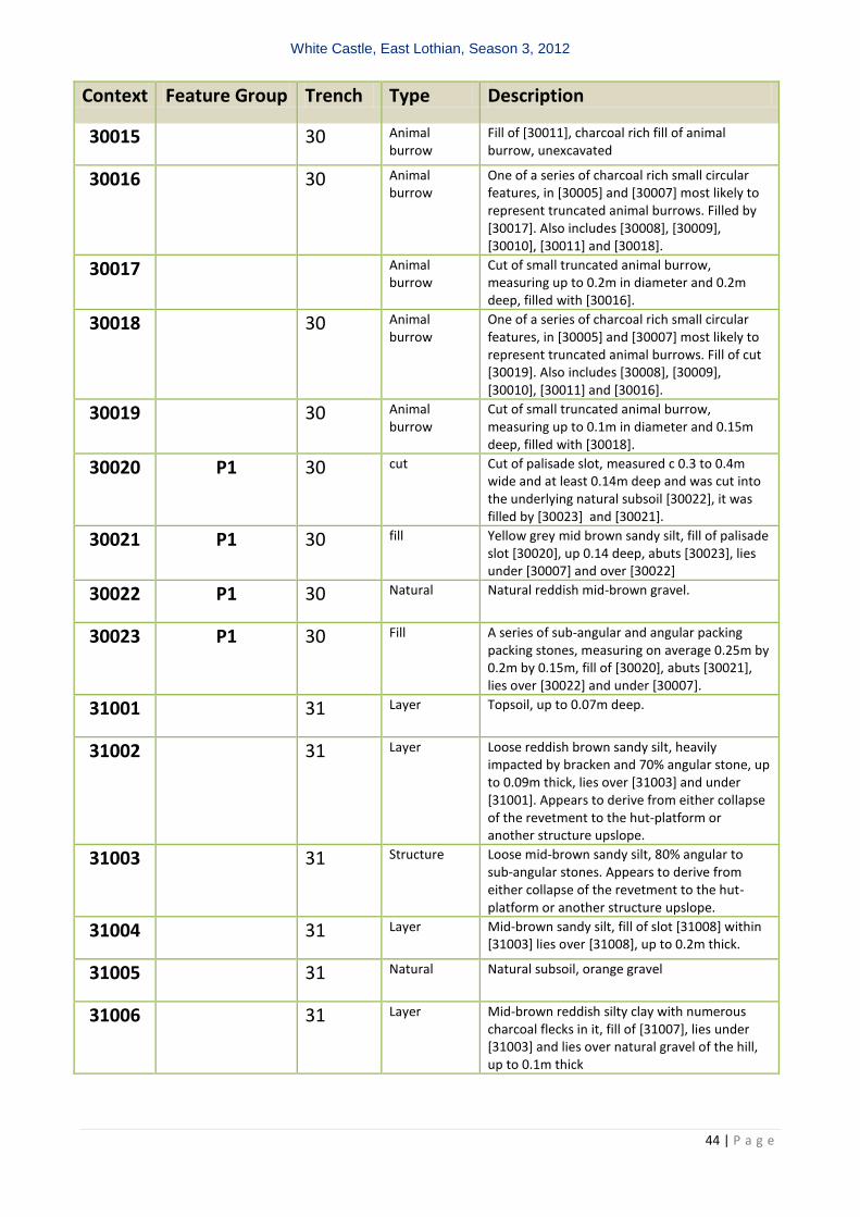
White Castle, East Lothian, Season 3, 2012
44 | P a g e
Context Feature Group Trench Type Description
30015 30 Animal burrow
Fill of [30011], charcoal rich fill of animal burrow, unexcavated
30016 30 Animal burrow
One of a series of charcoal rich small circular features, in [30005] and [30007] most likely to represent truncated animal burrows. Filled by [30017]. Also includes [30008], [30009], [30010], [30011] and [30018].
30017 Animal burrow
Cut of small truncated animal burrow, measuring up to 0.2m in diameter and 0.2m deep, filled with [30016].
30018 30 Animal burrow
One of a series of charcoal rich small circular features, in [30005] and [30007] most likely to represent truncated animal burrows. Fill of cut [30019]. Also includes [30008], [30009], [30010], [30011] and [30016].
30019 30 Animal burrow
Cut of small truncated animal burrow, measuring up to 0.1m in diameter and 0.15m deep, filled with [30018].
30020 P1 30 cut Cut of palisade slot, measured c 0.3 to 0.4m wide and at least 0.14m deep and was cut into the underlying natural subsoil [30022], it was filled by [30023] and [30021].
30021 P1 30 fill Yellow grey mid brown sandy silt, fill of palisade slot [30020], up 0.14 deep, abuts [30023], lies under [30007] and over [30022]
30022 P1 30 Natural Natural reddish mid-brown gravel.
30023 P1 30 Fill A series of sub-angular and angular packing packing stones, measuring on average 0.25m by 0.2m by 0.15m, fill of [30020], abuts [30021], lies over [30022] and under [30007].
31001 31 Layer Topsoil, up to 0.07m deep.
31002 31 Layer Loose reddish brown sandy silt, heavily impacted by bracken and 70% angular stone, up to 0.09m thick, lies over [31003] and under [31001]. Appears to derive from either collapse of the revetment to the hut-platform or another structure upslope.
31003 31 Structure Loose mid-brown sandy silt, 80% angular to sub-angular stones. Appears to derive from either collapse of the revetment to the hut-platform or another structure upslope.
31004 31 Layer Mid-brown sandy silt, fill of slot [31008] within [31003] lies over [31008], up to 0.2m thick.
31005 31 Natural Natural subsoil, orange gravel
31006 31 Layer Mid-brown reddish silty clay with numerous charcoal flecks in it, fill of [31007], lies under [31003] and lies over natural gravel of the hill, up to 0.1m thick
White Castle, East Lothian, Season 3, 2012
45 | P a g e
Context Feature Group Trench Type Description
31007 31 Cut A linear void or slot within [31003], filled with [31006], measures 0.90 m wide and c 0.2m deep. May be either a drainage slot or the foundation of a back wall.
31008 31 Cut A linear slot or void within [31003], measures at least measured at least 0.6m m and up to 0.3m deep and is filled with [31004].
32001 32 Layer Topsoil, friable brown soil, up to 0.12m thick.
32002 32 Layer Friable mid-brown clay-silt with 10% angular stone inclusions and up to 0.14m deep, extends across whole trench
32003 32 Structure Bank to upper side of hut-platform. Not excavated but c 0.8m wide and 0.55m high, lies under [32002] and [32013]. It is assumed that this bank revets the quarried/cut rear of the platform.
32004 32 layer Mid-red brown silty clay with 60% angular stone inclusions, up to 0.25m thick. Lies under [32002] and over [32005]. Appears to derive from the collapse of [32003]
32005 32 structure A densely packed cobbled surface, not excavated, lies under [32004]. Contains three voids [32006], [32010] and [32008]
32006 32 cut Cut of Linear slot, cuts natural subsoil and represents a void in [32005], measures up 0.5 deep and 0.3m wide, appears to run along the width of the trench but not fully excavated. Filled with [3007] and [30012]. Appears to represent a structural slot, perhaps a backwall or drain.
32007 32 fill Post-pipe measuring 0.30 deep and up to 0.25m wide and comprising a mid-red brown silty clay, fill of [32006] lies above [32012].
32008 32 cut Cut of possible post-hole, filled with [32009], measures 0.2m by 0.25m and represents a void in [32005].
32009 32 Fill Fill of [32008], dark grey brown soil, unexcavated.
32010 32 cut Cut of possible post-hole within linear slot [32006], measures 0.35m by 0.2m, filled with [32011], unexcavated.
32011 32 fill Mid red brown fill of cut [32010], unexcavated.
32012 32 fill Packing stones within posthole/slot [32006], lies under [32007], up to 0.3m deep. Subangular on average 0.3m by 0.1m by 0.2m.
32013 32 fill Soil and stone collapse of bank [32003] lies over [32012] and [32007]. Up to o.4m thick and comprises large angular stones (20%)and mid red brown soil.
35001 35 layer Topsoil, loosely compacted dark brown sandy silt up tp 0.1m thick.
White Castle, East Lothian, Season 3, 2012
46 | P a g e
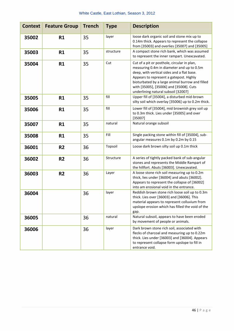
Context Feature Group Trench Type Description
35002 R1 35 layer loose dark organic soil and stone mix up to 0.14m thick. Appears to represent the collapse from [35003] and overlies [35007] and [35005]
35003 R1 35 structure A compact stone rich bank, which was assumed to represent the inner rampart. Unexcavated.
35004 R1 35 Cut Cut of a pit or posthole, circular in plan, measuring 0.4m in diameter and up to 0.5m deep, with vertical sides and a flat base. Appears to represent a gatepost. Highly bioturbated by a large animal burrow and filled with [35005], [35006] and [35008]. Cuts underlining natural subsoil [32007]
35005 R1 35 fill Upper fill of [35004], a disturbed mid-brown silty soil which overlay [35006] up to 0.2m thick.
35006 R1 35 fill Lower fill of [35004], mid brownish grey soil up to 0.3m thick. Lies under [35005] and over [35007]
35007 R1 35 natural Natural orange subsoil
35008 R1 35 Fill Single packing stone within fill of [35004], sub-angular measures 0.1m by 0.2m by 0.15
36001 R2 36 Topsoil Loose dark brown silty soil up 0.1m thick
36002 R2 36 Structure A series of tightly packed bank of sub-angular stones and represents the Middle Rampart of the hillfort. Abuts [36003]. Unexcavated.
36003 R2 36 Layer A loose stone rich soil measuring up to 0.2m thick, lies under [36004] and abuts [36002]. Appears to represent the collapse of [36002] into am erosional void in the entrance.
36004 36 layer Reddish brown stone rich loose soil up to 0.3m thick. Lies over [36003] and [36006]. This material appears to represent colluvium from upslope erosion which has filled the void of the gap.
36005 36 natural Natural subsoil, appears to have been eroded by movement of people or animals.
36006 36 layer Dark brown stone rich soil, associated with flecks of charcoal and measuring up to 0.22m thick. Lies under [36003] and [36004]. Appears to represent collapse form upslope to fill in entrance void.

White Castle, East Lothian, Season 3, 2012
47 | P a g e
Appendix 3 Drawing Register
Drawing Sheet Description Scale Pl/Sec Date
1 1 TR 29 Plan of [29002] and [29003] 1:20 P 12/07/2012
2 2 TR 30- Plan [30002] and [30003] 1:20 P 13/07/2012
3 3 TR 35 - Plan of trench post-ex 1:20 P 14/07/2011
4 2 TR 35 – Post-ex plan showing [35003] and [35002]
1:20 p 13/07/2012
5 5 Tr 32 after initial clean context [32002]
1:20 P 15/07/2012
6 6 TR 29 - Plan Post-EX contexts [29003], [29004] and [29006]
1:20 P 15/07/2012
7 6 Tr 37 surface mole hills 1:20 P 15/07/2012
8 7 TR 30 - Plan Post-Ex [30005] and [30006]
1:20 P 16/07/2012
9 8 TR 36 - Plan Post-Ex [36002] and [36002]
1:20 P
10 8 TR 37 – after deturfing 1:20 S 15/07/2012
11 8 Trench 37 after 0.1m excavation 1:20 P 16/07/2012
12 14 TR 31 – initial plan after excavation 1:20 P 16/07/2012
13 3 TR 35 - Plan Post-Ex 1:20 P 13/07/2012
14 11 TR 32 – post-ex plan [32003]-[320014] 1:20 S 17/07/2012
15 10 TR 29 - Plan Post-Ex [29005]- [29023] 1:20 P 18/07/2012
16 12 TR 31 – Plan of sondage 1:20 P 17/07/2012
17 3 TR 31 – Plan of sondage 1:20 P 17/07/2012
18 11 TR 32 – N facing section all contexts 1:20 S 18/07/2012
19 21 TR 30 - Plan mid-ex [30006] 1:20 P 17/07/2012
20 15 TR 31 - North Facing Section 1:20 S 18/07/2012
21 16 TR 35 – East facing section, [35001]-[35006]
1:20 P 19/07/2012
22 17 TR 36 – Post-ex section [35001]-[35006]
1:20 P 19/07/2012
23 18 TR 29 - section post-ex [29001]-[29006] and [29010] and [29019]
1:20 P 19/07/2012
24 19 TR 30 - Plan post-ex 1:20 P 19/07/2012
25 17 TR 36 – profile across entrance [36002], [36004] and[36005]
1:20 S 19/07/2012
26 17 TR 36 - Plan post-ex 1:20 P 13/07/2012
27 18 TR 37 – upper layer of underlying rubble
1:20 P 19/07/2012
28 16 TR 35 – detailed east facing section of [35004]
1:20 S 19/07/2012
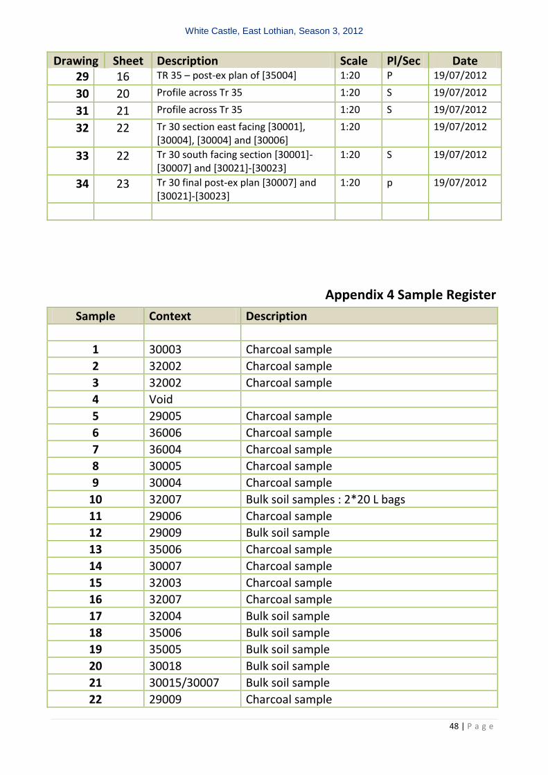
White Castle, East Lothian, Season 3, 2012
48 | P a g e
Drawing Sheet Description Scale Pl/Sec Date 29 16 TR 35 – post-ex plan of [35004] 1:20 P 19/07/2012
30 20 Profile across Tr 35 1:20 S 19/07/2012
31 21 Profile across Tr 35 1:20 S 19/07/2012
32 22 Tr 30 section east facing [30001], [30004], [30004] and [30006]
1:20 19/07/2012
33 22 Tr 30 south facing section [30001]-[30007] and [30021]-[30023]
1:20 S 19/07/2012
34 23 Tr 30 final post-ex plan [30007] and [30021]-[30023]
1:20 p 19/07/2012
Appendix 4 Sample Register
Sample Context Description
1 30003 Charcoal sample
2 32002 Charcoal sample
3 32002 Charcoal sample
4 Void
5 29005 Charcoal sample
6 36006 Charcoal sample
7 36004 Charcoal sample
8 30005 Charcoal sample
9 30004 Charcoal sample
10 32007 Bulk soil samples : 2*20 L bags
11 29006 Charcoal sample
12 29009 Bulk soil sample
13 35006 Charcoal sample
14 30007 Charcoal sample
15 32003 Charcoal sample
16 32007 Charcoal sample
17 32004 Bulk soil sample
18 35006 Bulk soil sample
19 35005 Bulk soil sample
20 30018 Bulk soil sample
21 30015/30007 Bulk soil sample
22 29009 Charcoal sample
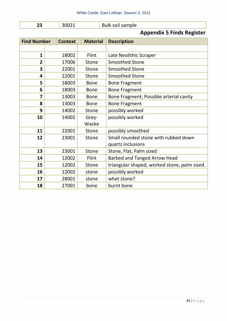
White Castle, East Lothian, Season 3, 2012
49 | P a g e
23 30021 Bulk soil sample
Appendix 5 Finds Register
Find Number Context Material Description
1 18002 Flint Late Neolithic Scraper
2 17006 Stone Smoothed Stone
3 22001 Stone Smoothed Stone
4 22001 Stone Smoothed Stone
5 18003 Bone Bone Fragment
6 18003 Bone Bone Fragment
7 13003 Bone Bone Fragment; Possible arterial cavity
8 13003 Bone Bone Fragment
9 14002 Stone possibly worked
10 14002 Grey-Wacke
possibly worked
11 22001 Stone possibly smoothed
12 23001 Stone Small rounded stone with rubbed down quartz inclusions
13 23001 Stone Stone, Flat, Palm sized
14 12002 Flint Barbed and Tanged Arrow Head
15 12002 Stone triangular shaped, worked stone, palm sized.
16 12002 stone possibly worked
17 28001 stone whet stone?
18 27001 bone burnt bone
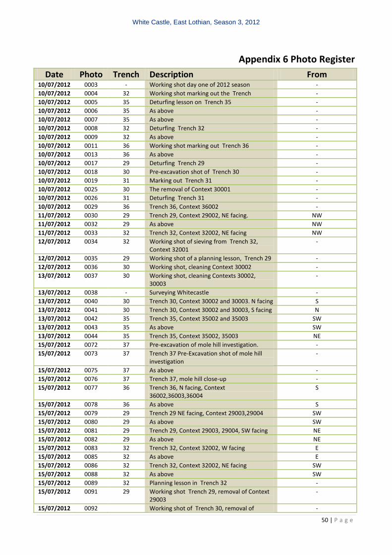
White Castle, East Lothian, Season 3, 2012
50 | P a g e
Appendix 6 Photo Register
Date Photo Trench Description From 10/07/2012 0003 - Working shot day one of 2012 season -
10/07/2012 0004 32 Working shot marking out the Trench -
10/07/2012 0005 35 Deturfing lesson on Trench 35 -
10/07/2012 0006 35 As above -
10/07/2012 0007 35 As above -
10/07/2012 0008 32 Deturfing Trench 32 -
10/07/2012 0009 32 As above -
10/07/2012 0011 36 Working shot marking out Trench 36 -
10/07/2012 0013 36 As above -
10/07/2012 0017 29 Deturfing Trench 29 -
10/07/2012 0018 30 Pre-excavation shot of Trench 30 -
10/07/2012 0019 31 Marking out Trench 31 -
10/07/2012 0025 30 The removal of Context 30001 -
10/07/2012 0026 31 Deturfing Trench 31 -
10/07/2012 0029 36 Trench 36, Context 36002 -
11/07/2012 0030 29 Trench 29, Context 29002, NE facing. NW
11/07/2012 0032 29 As above NW
11/07/2012 0033 32 Trench 32, Context 32002, NE facing NW
12/07/2012 0034 32 Working shot of sieving from Trench 32, Context 32001
-
12/07/2012 0035 29 Working shot of a planning lesson, Trench 29 -
12/07/2012 0036 30 Working shot, cleaning Context 30002 -
13/07/2012 0037 30 Working shot, cleaning Contexts 30002, 30003
-
13/07/2012 0038 - Surveying Whitecastle -
13/07/2012 0040 30 Trench 30, Context 30002 and 30003. N facing S
13/07/2012 0041 30 Trench 30, Context 30002 and 30003, S facing N
13/07/2012 0042 35 Trench 35, Context 35002 and 35003 SW
13/07/2012 0043 35 As above SW
13/07/2012 0044 35 Trench 35, Context 35002, 35003 NE
15/07/2012 0072 37 Pre-excavation of mole hill investigation. -
15/07/2012 0073 37 Trench 37 Pre-Excavation shot of mole hill investigation
-
15/07/2012 0075 37 As above -
15/07/2012 0076 37 Trench 37, mole hill close-up -
15/07/2012 0077 36 Trench 36, N facing, Context 36002,36003,36004
S
15/07/2012 0078 36 As above S
15/07/2012 0079 29 Trench 29 NE facing, Context 29003,29004 SW
15/07/2012 0080 29 As above SW
15/07/2012 0081 29 Trench 29, Context 29003, 29004, SW facing NE
15/07/2012 0082 29 As above NE
15/07/2012 0083 32 Trench 32, Context 32002, W facing E
15/07/2012 0085 32 As above E
15/07/2012 0086 32 Trench 32, Context 32002, NE facing SW
15/07/2012 0088 32 As above SW
15/07/2012 0089 32 Planning lesson in Trench 32 -
15/07/2012 0091 29 Working shot Trench 29, removal of Context 29003
-
15/07/2012 0092 Working shot of Trench 30, removal of -
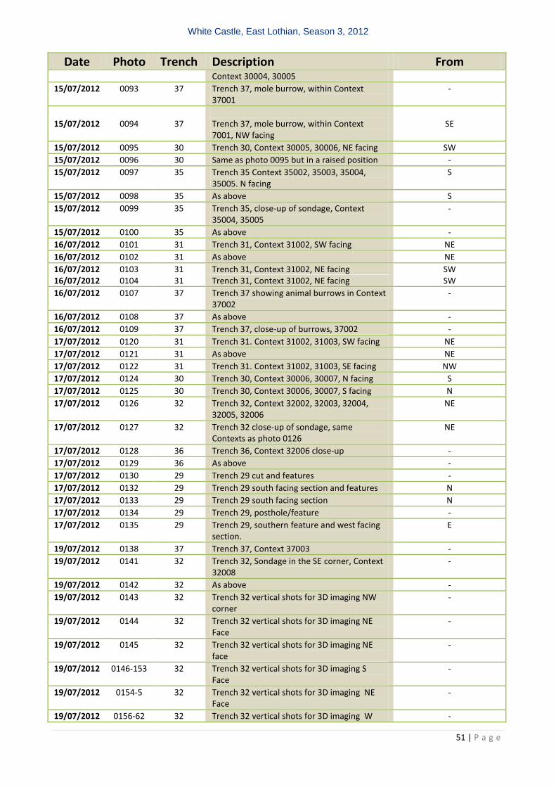
White Castle, East Lothian, Season 3, 2012
51 | P a g e
Date Photo Trench Description From Context 30004, 30005
15/07/2012 0093 37 Trench 37, mole burrow, within Context 37001
-
15/07/2012
0094
37
Trench 37, mole burrow, within Context 7001, NW facing
SE
15/07/2012 0095 30 Trench 30, Context 30005, 30006, NE facing SW
15/07/2012 0096 30 Same as photo 0095 but in a raised position -
15/07/2012 0097 35 Trench 35 Context 35002, 35003, 35004, 35005. N facing
S
15/07/2012 0098 35 As above S
15/07/2012 0099 35 Trench 35, close-up of sondage, Context 35004, 35005
-
15/07/2012 0100 35 As above -
16/07/2012 0101 31 Trench 31, Context 31002, SW facing NE
16/07/2012 0102 31 As above NE
16/07/2012 0103 31 Trench 31, Context 31002, NE facing SW 16/07/2012 0104 31 Trench 31, Context 31002, NE facing SW
16/07/2012 0107 37 Trench 37 showing animal burrows in Context 37002
-
16/07/2012 0108 37 As above -
16/07/2012 0109 37 Trench 37, close-up of burrows, 37002 -
17/07/2012 0120 31 Trench 31. Context 31002, 31003, SW facing NE
17/07/2012 0121 31 As above NE
17/07/2012 0122 31 Trench 31. Context 31002, 31003, SE facing NW
17/07/2012 0124 30 Trench 30, Context 30006, 30007, N facing S
17/07/2012 0125 30 Trench 30, Context 30006, 30007, S facing N
17/07/2012 0126 32 Trench 32, Context 32002, 32003, 32004, 32005, 32006
NE
17/07/2012 0127 32 Trench 32 close-up of sondage, same Contexts as photo 0126
NE
17/07/2012 0128 36 Trench 36, Context 32006 close-up -
17/07/2012 0129 36 As above -
17/07/2012 0130 29 Trench 29 cut and features -
17/07/2012 0132 29 Trench 29 south facing section and features N
17/07/2012 0133 29 Trench 29 south facing section N
17/07/2012 0134 29 Trench 29, posthole/feature -
17/07/2012 0135 29 Trench 29, southern feature and west facing section.
E
19/07/2012 0138 37 Trench 37, Context 37003 -
19/07/2012 0141 32 Trench 32, Sondage in the SE corner, Context 32008
-
19/07/2012 0142 32 As above -
19/07/2012 0143 32 Trench 32 vertical shots for 3D imaging NW corner
-
19/07/2012 0144 32 Trench 32 vertical shots for 3D imaging NE Face
-
19/07/2012 0145 32 Trench 32 vertical shots for 3D imaging NE face
-
19/07/2012 0146-153 32 Trench 32 vertical shots for 3D imaging S Face
-
19/07/2012 0154-5 32 Trench 32 vertical shots for 3D imaging NE Face
-
19/07/2012 0156-62 32 Trench 32 vertical shots for 3D imaging W -
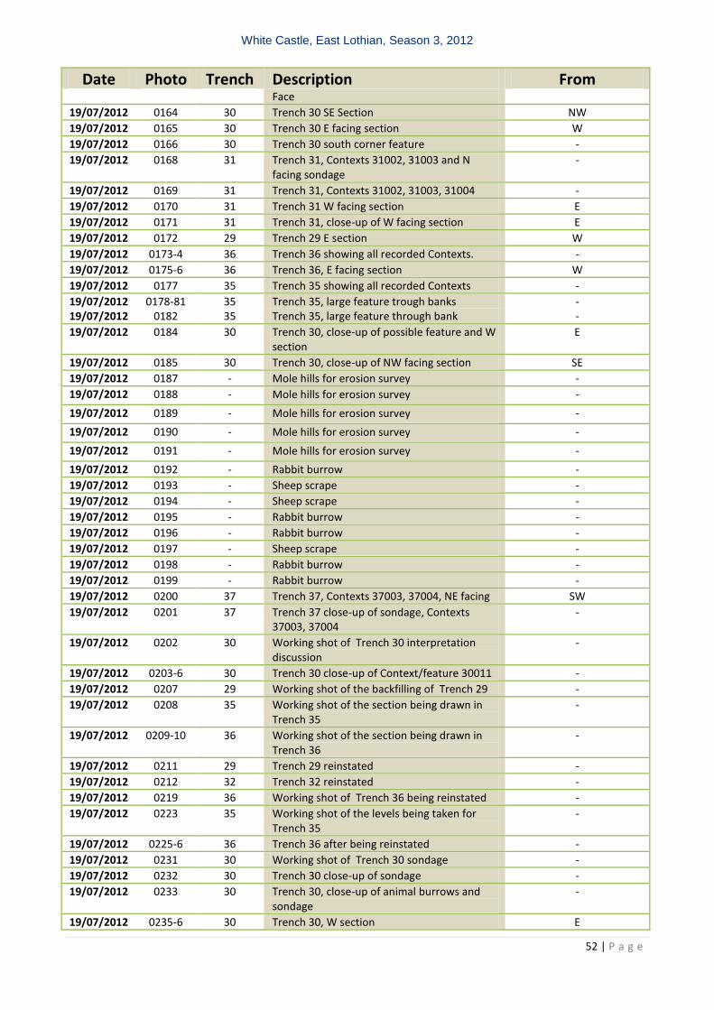
White Castle, East Lothian, Season 3, 2012
52 | P a g e
Date Photo Trench Description From Face
19/07/2012 0164 30 Trench 30 SE Section NW
19/07/2012 0165 30 Trench 30 E facing section W
19/07/2012 0166 30 Trench 30 south corner feature -
19/07/2012 0168 31 Trench 31, Contexts 31002, 31003 and N facing sondage
-
19/07/2012 0169 31 Trench 31, Contexts 31002, 31003, 31004 -
19/07/2012 0170 31 Trench 31 W facing section E
19/07/2012 0171 31 Trench 31, close-up of W facing section E
19/07/2012 0172 29 Trench 29 E section W
19/07/2012 0173-4 36 Trench 36 showing all recorded Contexts. -
19/07/2012 0175-6 36 Trench 36, E facing section W
19/07/2012 0177 35 Trench 35 showing all recorded Contexts -
19/07/2012 0178-81 35 Trench 35, large feature trough banks - 19/07/2012 0182 35 Trench 35, large feature through bank -
19/07/2012 0184 30 Trench 30, close-up of possible feature and W section
E
19/07/2012 0185 30 Trench 30, close-up of NW facing section SE
19/07/2012 0187 - Mole hills for erosion survey -
19/07/2012 0188 - Mole hills for erosion survey -
19/07/2012 0189 - Mole hills for erosion survey -
19/07/2012 0190 - Mole hills for erosion survey -
19/07/2012 0191 - Mole hills for erosion survey -
19/07/2012 0192 - Rabbit burrow -
19/07/2012 0193 - Sheep scrape -
19/07/2012 0194 - Sheep scrape -
19/07/2012 0195 - Rabbit burrow -
19/07/2012 0196 - Rabbit burrow -
19/07/2012 0197 - Sheep scrape -
19/07/2012 0198 - Rabbit burrow -
19/07/2012 0199 - Rabbit burrow -
19/07/2012 0200 37 Trench 37, Contexts 37003, 37004, NE facing SW
19/07/2012 0201 37 Trench 37 close-up of sondage, Contexts 37003, 37004
-
19/07/2012 0202 30 Working shot of Trench 30 interpretation discussion
-
19/07/2012 0203-6 30 Trench 30 close-up of Context/feature 30011 -
19/07/2012 0207 29 Working shot of the backfilling of Trench 29 -
19/07/2012 0208 35 Working shot of the section being drawn in Trench 35
-
19/07/2012 0209-10 36 Working shot of the section being drawn in Trench 36
-
19/07/2012 0211 29 Trench 29 reinstated -
19/07/2012 0212 32 Trench 32 reinstated -
19/07/2012 0219 36 Working shot of Trench 36 being reinstated -
19/07/2012 0223 35 Working shot of the levels being taken for Trench 35
-
19/07/2012 0225-6 36 Trench 36 after being reinstated -
19/07/2012 0231 30 Working shot of Trench 30 sondage -
19/07/2012 0232 30 Trench 30 close-up of sondage -
19/07/2012 0233 30 Trench 30, close-up of animal burrows and sondage
-
19/07/2012 0235-6 30 Trench 30, W section E

White Castle, East Lothian, Season 3, 2012
53 | P a g e
Date Photo Trench Description From 19/07/2012 0237 30 Trench 30 sondage and close-up of W section E
19/07/2012 0238 30 Trench 30, vertical shot of sondage -
19/07/2012 0239-40 35 Trench 35 after being reinstated -
19/07/2012 0245 30 Working shot of Trench 30 being reinstated -
19/07/2012 0246 30 Trench 30 after being reinstated -
19/07/2012 0247-8 31 Trench 31 after being reinstated -
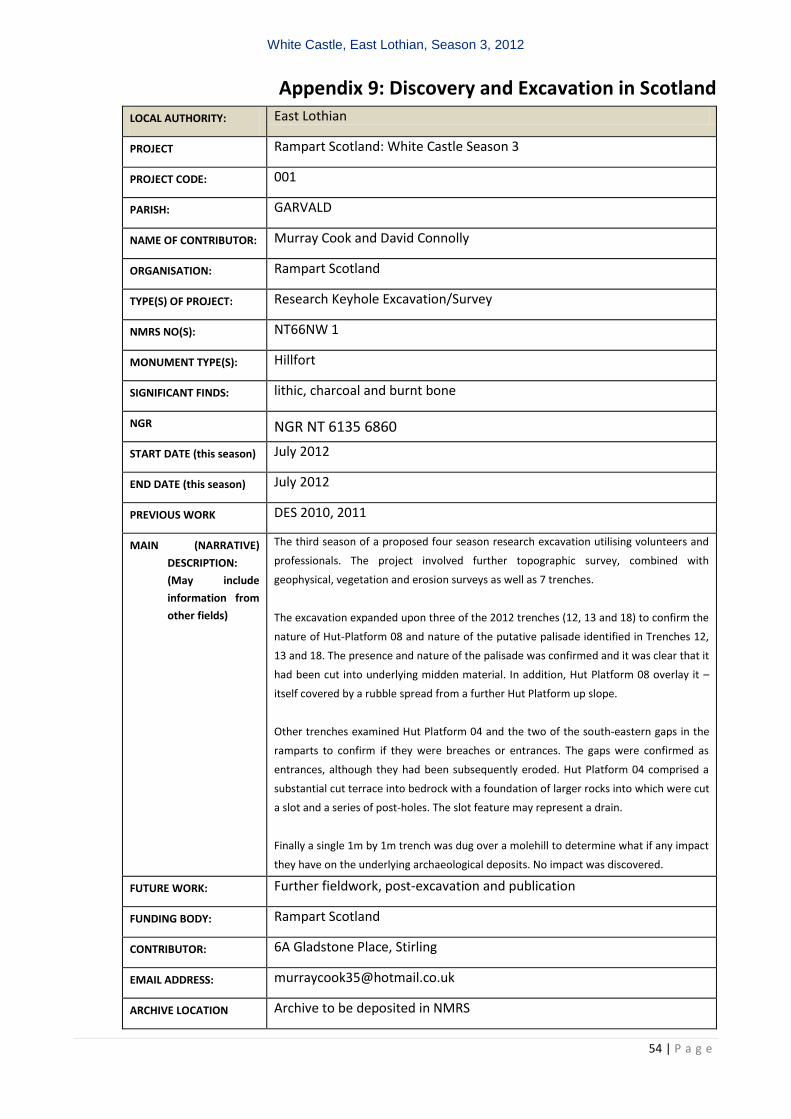
White Castle, East Lothian, Season 3, 2012
54 | P a g e
Appendix 9: Discovery and Excavation in Scotland
LOCAL AUTHORITY: East Lothian
PROJECT Rampart Scotland: White Castle Season 3
PROJECT CODE: 001
PARISH: GARVALD
NAME OF CONTRIBUTOR: Murray Cook and David Connolly
ORGANISATION: Rampart Scotland
TYPE(S) OF PROJECT: Research Keyhole Excavation/Survey
NMRS NO(S): NT66NW 1
MONUMENT TYPE(S): Hillfort
SIGNIFICANT FINDS: lithic, charcoal and burnt bone
NGR NGR NT 6135 6860
START DATE (this season) July 2012
END DATE (this season) July 2012
PREVIOUS WORK DES 2010, 2011
MAIN (NARRATIVE)
DESCRIPTION:
(May include
information from
other fields)
The third season of a proposed four season research excavation utilising volunteers and
professionals. The project involved further topographic survey, combined with
geophysical, vegetation and erosion surveys as well as 7 trenches.
The excavation expanded upon three of the 2012 trenches (12, 13 and 18) to confirm the
nature of Hut-Platform 08 and nature of the putative palisade identified in Trenches 12,
13 and 18. The presence and nature of the palisade was confirmed and it was clear that it
had been cut into underlying midden material. In addition, Hut Platform 08 overlay it –
itself covered by a rubble spread from a further Hut Platform up slope.
Other trenches examined Hut Platform 04 and the two of the south-eastern gaps in the
ramparts to confirm if they were breaches or entrances. The gaps were confirmed as
entrances, although they had been subsequently eroded. Hut Platform 04 comprised a
substantial cut terrace into bedrock with a foundation of larger rocks into which were cut
a slot and a series of post-holes. The slot feature may represent a drain.
Finally a single 1m by 1m trench was dug over a molehill to determine what if any impact
they have on the underlying archaeological deposits. No impact was discovered.
FUTURE WORK: Further fieldwork, post-excavation and publication
FUNDING BODY: Rampart Scotland
CONTRIBUTOR: 6A Gladstone Place, Stirling
EMAIL ADDRESS: [email protected]
ARCHIVE LOCATION Archive to be deposited in NMRS
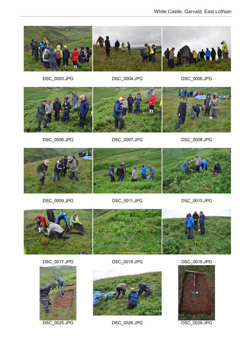
White Castle, Garvald, East Lothian
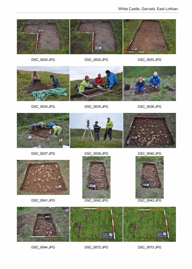
White Castle, Garvald, East Lothian
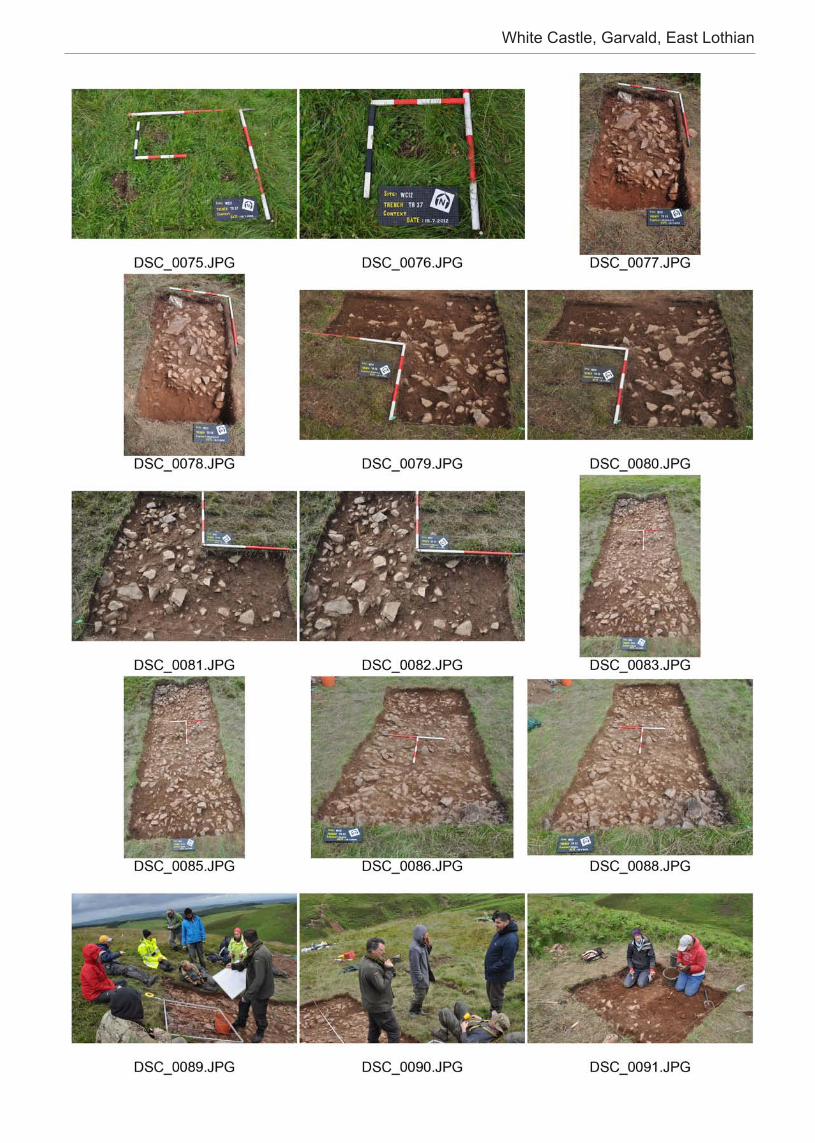
White Castle, Garvald, East Lothian
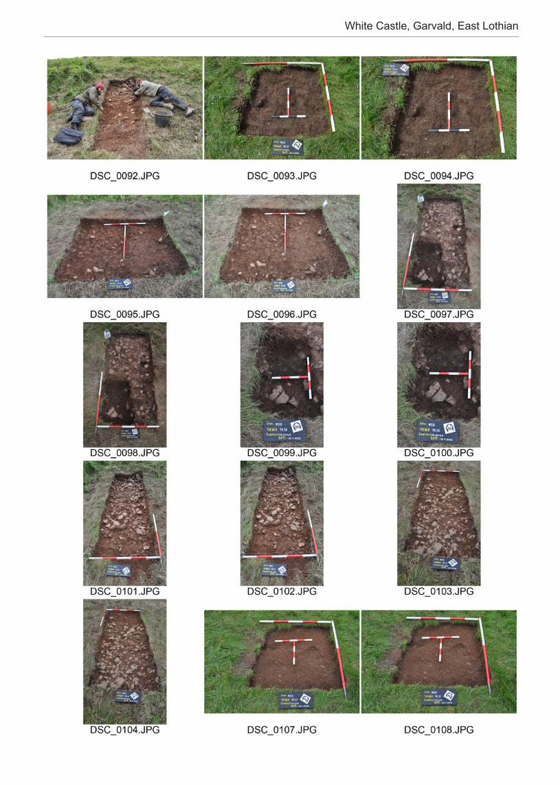
White Castle, Garvald, East Lothian
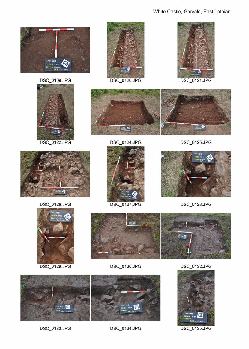
White Castle, Garvald, East Lothian
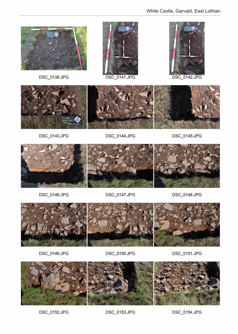
White Castle, Garvald, East Lothian
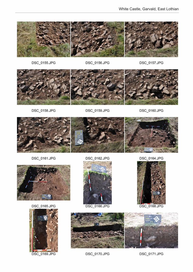
White Castle, Garvald, East Lothian
White Castle, Garvald, East Lothian
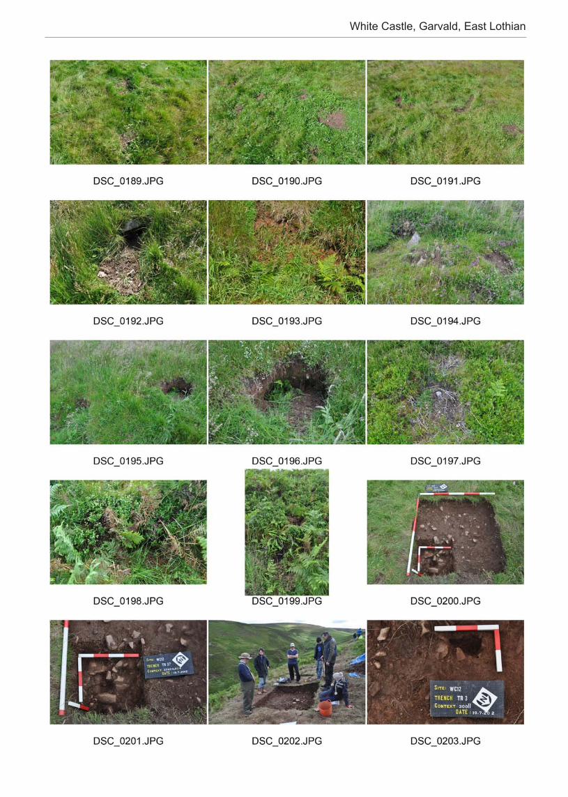
White Castle, Garvald, East Lothian
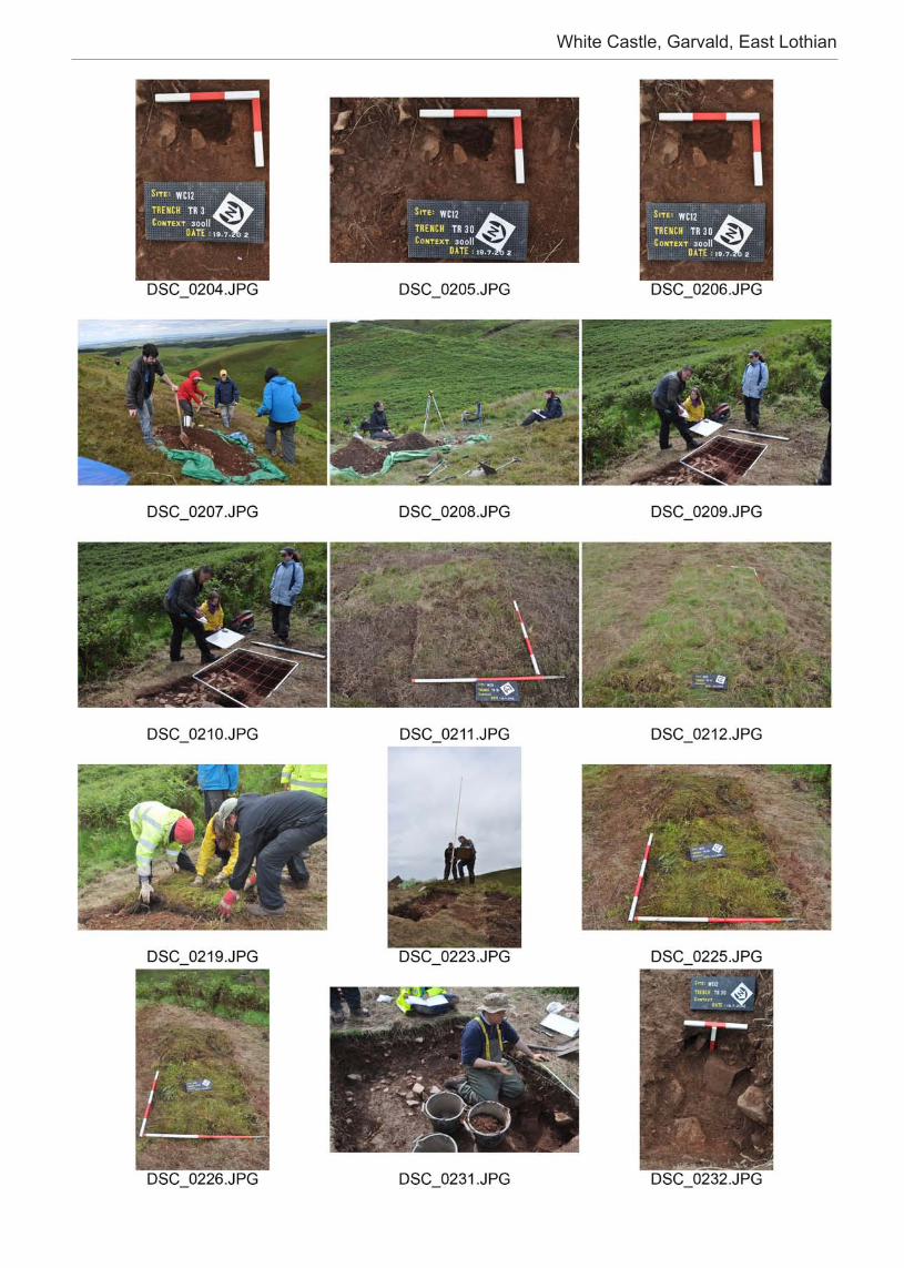
White Castle, Garvald, East Lothian
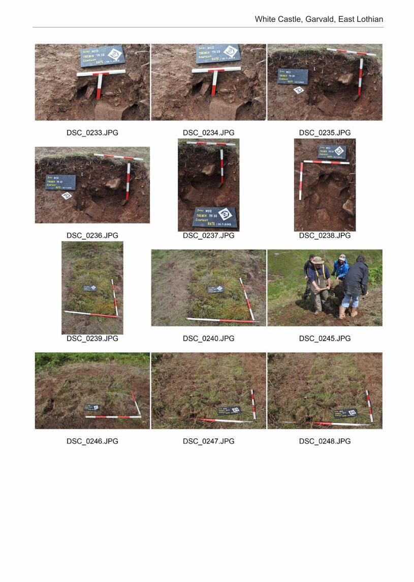
White Castle, Garvald, East Lothian

Fieldschool - Research - Training - DiscoveryA multi-disciplinary accessible investigation into Scotland’s Prehistoric archaeology
Learn more: www.rampartscotland.com