Excavations at Chislehampton House, Chislehampton, Oxfordshire
47
JOHN MOORE HERITAGE SERVICES AN ARCHAEOLOGICAL EXCAVATION AT CHISELHAMPTON HOUSE, CHISELHAMPTON, OXFORDSHIRE Su 5955 9906 On behalf of Mrs S Rowlands DECEMBER 2006
Transcript of Excavations at Chislehampton House, Chislehampton, Oxfordshire

JOHN MOOREHERITAGE SERVICES
AN ARCHAEOLOGICAL EXCAVATION
AT
CHISELHAMPTON HOUSE, CHISELHAMPTON, OXFORDSHIRE
Su 5955 9906
On behalf of
Mrs S Rowlands
DECEMBER 2006

John Moore HERITAGE SERVICES Chiselhampton House, Chiselhampton SDCH 06 An Archaeological Evaluation
REPORT FOR Mrs. S Rowlands Chiselhampton House, Chiselhampton Stadhampton Oxfordshire OX44 7XF PREPARED BY Gwilym Williams EDITED BY John Moore FIELDWORK May - June 2006 REPORT ISSUED 19 December 2006 ENQUIRES TO John Moore Heritage Services Hill View Woodperry Road Beckley Oxfordshire OX3 9UZ Tel/Fax 01865 358300 Site Code SDCH 06 JMHS Project No: 1625 Archive Location Oxfordshire County Museum Service Accession number OXCMS 2006.15

John Moore HERITAGE SERVICES Chiselhampton House, Chiselhampton SDCH 06 An Archaeological Evaluation
CONTENTS
Page SUMMARY 1 1 INTRODUCTION 1 1.1 Site Location 1.2 Planning Background 1.3 Archaeological Background 2 AIMS OF THE INVESTIGATION 3 3 STRATEGY 4 3.1 Research Design 3.2 Methodology 4 RESULTS 5 4.1 The Late Iron Age – Early Roman Field Systems 4.1.1 Phase 1 Field System 4.1.2 Phase 2 Field System (Figs 2, 3 & 4) 10 4.1.3 Undated Pre-medieval Features 12 4.1.4 Discussion of Late Iron Age and Early Roman Activity 13 4.2 The Medieval Archaeology 14 4.2.1 The Medieval Enclosure 4.2.2 The Ditch 16 4.2.3 Pits 16 4.2.4 Discussion of Medieval Activity 18 4.3 Post-Medieval Features 19 4.3.1 The First Phase (Blue) Garden 21 4.3.2 The Later Formal (Green) Garden 23 4.3.3 Kitchen Garden (Red) 4.3.4 Discussion of Garden Features 30 4.3.5 Post-Medieval Ditch and House 4.3.6 Early Modern Archaeology 34 4.3.7 Outer Court 5 FINDS 37 5.1 Prehistoric Pottery by Frances Raymond 5.2 Medieval Pottery by Paul Blinkhorn 38 6 CONCLUSIONS 42 7 BIBLIOGRAPHY 42

John Moore HERITAGE SERVICES Chiselhampton House, Chiselhampton SDCH 06 An Archaeological Evaluation
FIGURES Figure 1 Area location plan 2 Figure 2 Plan of the late Iron Age and early Roman features 6 Figure 3 Sections through later Iron Age and early Roman
features and plan of cremation pit 8 Figure 4 Sections through later Iron Age and early
Roman features 9 Figure 5 Plan and sections of medieval activity 15 Figure 6 Plan of Post-medieval features 20 Figure 7 Sections of Post-medieval features 22 Figure 8 Post-medieval Kitchen Garden Planting Beds 1-4 25 Figure 9 Post-medieval Kitchen Garden Planting Beds 5 and 6 27 Figure 10 Extract of 1743 map 31 Figure 11 Transcription of part of 1743 map onto excavation
Areas 32 Figure 12 Plan of Area A 35 Figure 13 Plan of Area B 36
John Moore HERITAGE SERVICES Chiselhampton House Chiselhampton, SDCH 06 An Archaeological Excavation
1 1
Summary Excavations revealed an archaeological sequence extending from the late Iron Age to the 19th century. Two field-systems spanning the late Iron Age and early Roman periods were the earliest dated features; medieval activity associated with the manor were excavated on the east side of the site; and overlying all were two phases of gardens, including in the later phase part of a formal and the kitchen gardens. The remains of a post-medieval building were also examined. In addition a watching brief was also undertaken during topsoil stripping associated with the main excavation which evidenced a building, a yard and field boundary to the north in the historic Church Close; additionally pipe-trenching revealed the remains of the ha-ha or pale ditch between the inner park and the outer park to the south of the site. 1 INTRODUCTION 1.1 Site Location (Fig. 1) The main excavation site was located in the grounds and southeast of Chiselhampton House, south of the walled garden and east of three lakes, centred on NGR SU 5955 9906. The underlying geology is river terrace gravels and Kimmeridge Clay. The site lies at approximately 60m OD. 1.2 Planning Background A condition of the planning consent was the undertaking of archaeological investigations as a part of the works for the creation of a new lake at Chiselhampton House. The work involved the mechanical excavation of the proposed lake area, followed by an appropriate sampling of the features in consultation with Paul Smith, County Archaeologist. This report is a summary of the results. 1.3 Archaeological Background Chiselhampton meaning ‘homestead or village on the gravel’ (Ekwall, 1960), is not mentioned in the Domesday Survey although it has been suggested that ‘Hunesworde’, a holding entered into the Dorchester Hundred as belonging to William Fitz Ansculf, Lord of Dudley, may refer to Chiselhampton. In ‘Hunesworde’ there were ‘5 hides, a mill and 20 acres of meadow; value £4’. A man named ‘Walter’ was sub-tenant. The first direct mention of Chiselhampton is in a Papal Bull of 1147, confirming the chapel of ‘Chiselentona’ as property of the Abbey of Dorchester. The Hundred Rolls evidence Chiselhampton to have been a knight’s fee belonging to the barony of Dudley. Robert Pugeys is named as holder of one knight’s fee from at least 1273 until at least 1322. Nonetheless, early details of the manor of Chiselhampton are confused largely owing to the fact that there appear to have been at least two (perhaps three) manors here in medieval times. Knox (1997) proposes that Chiselhampton House was first built around 1585-6 when John D’Oyly was High Sheriff of Oxfordshire. An estate map of ‘Chiselhampton’ of 1628 shows old Chiselhampton House close to the river with a dovecote and

Pump House
STADHAMPTON CP
Tennis
Court
5916
4803
5521
5728
5500
Pond
Drain
Drain
Pond
Pond
Pond
Pond
Drain
Drain
Crown Copyright. All rights reserved. Licence Number 100020449
0 100 m
596
595
594
990
991
992
993
2
John Moore HERITAGE SERVICES An Archaeological Excavation
Figure 1. Area location plan
Chiselhampton House Grounds, Stadhampton, Oxon. SDCH 06
AREA C
AREA B
AREA A
D

John Moore HERITAGE SERVICES Chiselhampton House Chiselhampton, SDCH 06 An Archaeological Excavation
3 3
outbuildings to the south. The church lay to the northwest in Chapel Close. To the north of the house were the ‘Outer Court’ and an orchard. A house lay to the southwest in ‘Farm Close’. A ‘Survey of the Mannour of Chiselhampton in Oxfordshire, the Estate of Sir John D’Oyly Baronet’, dated 1743 gives more detail (Fig. 10). Two large buildings are illustrated. The one closest to the river is more than likely the house in relation to the earlier map and the layout of the named enclosures; the other building was more than likely that of a senior member of staff, such as a steward or estate manager. Map regression places the house within the south part of the present walled garden (fig. 11). Gardens lay to the south of the house; these included both formal and kitchen gardens, part of which lie beneath the lake development. A further courtyard leading onto the ‘Broad Walk’ lay to the north. Buildings are visible on the north side of the field known as ‘Outer Court’ on the 1628 map. A further large building is indicated to the southwest of the house lying within the ‘Back Yard’ or ‘Farm Yard’ - the writing on the 1743 map is not clear. This building partly lay within the footprint of the proposed lake. The boundary of the property shown on the 1628 map is now the limit of the Inner Park, the Outer Park continues to the south. The estate was purchased from the D’Oyly family by Charles Peers in 1749. He rebuilt the church in it present location between 1761 and 1763 and had a new house built. This was completed around 1768 as indicated by that date on three rainwater heads on the house. During, or after, the completion of the new house the old Chiselhampton House was demolished and the walled kitchen garden laid out on its present site incorporating bricks from the building (Knox 1997). It is likely that the present parkland to the south of the house was established soon after the completion of the new house. An archaeological evaluation of the proposal area was carried out in March 2006. The work found that the proposal area lay over prehistoric features and part of the formal garden and part of the kitchen garden. Bedding trenches and pits for the two gardens were found. These types of features were found cut into an underlying old ploughsoil. A gravel path thought to relate to the kitchen garden was located immediately under the present topsoil and overlying the kitchen garden soil. In addition areas of clay extraction were located. These were thought to relate to the existing lakes situated in the named Kiln Close on the 1743 map. Part of the large building lying within ‘Back Yard’ was found; however it had been ploughed since demolition and the foundations were heavily disturbed (JMHS 2006). No medieval archaeology was observed during the evaluation, although this comprised a significant quantity of the field results and an important aspect of the present report. 2 AIMS OF THE INVESTIGATION The aims of the investigation as detailed in the Written Scheme of Investigation were to:
collect information on the layout and development of the parts of the two gardens within the lake’s footprint
collect in addition information on the prehistoric remains through dating
and characterising the activity
John Moore HERITAGE SERVICES Chiselhampton House Chiselhampton, SDCH 06 An Archaeological Excavation
4 4
make public the results of the investigation. 3 STRATEGY 3.1 Research Design In response to the Brief issued by Oxfordshire County Archaeological Service a scheme of investigation was designed by John Moore Heritage Services (JHMS) and agreed with the Oxfordshire County Archaeological Services and the applicant. The work was carried out by JMHS and involved the excavation of the proposed lake area under the conditions as described in the methodology. 3.2 Methodology The site work was planned to be undertaken in three stages, with all machining carried out by a 12 tonne excavator equipped with a 1.5m wide toothless bucket. Stage1. The southeast part of the lake where it lay within the kitchen garden was monitored during topsoil stripping to record the extent of a possible gravel path and any other features. In addition the topsoil stripping on the west side of the lake in the area of the ploughed building was also monitored. The building remains were cleaned and recorded. While the latter was carried out stripping of the rest of the topsoil was begun; archaeologists were on call to record any other features within the area of the formal garden; rain however prevented the Stage 2 works following the proposed timetable. Additionally, it became clear that the garden soils and the Iron Age levels were the same, and that the split strip was an inappropriate strategy. At this point, the first stage of a metal detector survey was also undertaken. As a consequence, the Stage 2 works were combined with those of Stage 3, and the garden soils were machine-excavated down to the lower ploughsoil under direct archaeological control. The garden remains were planned as were the rest of the archaeological features. A walkover metal detector survey was carried out over the rest of the excavation area once it had been fully stripped. Selected features were sample excavated in order to ascertain the depth of the features. Dateable artefacts were collected from the tops of un-excavated features where such remains occurred. Following discussion with Paul Smith (County Archaeologist), targeted excavation in the first instance prioritised the investigation of unexpected medieval pits and a pit group. Subsequently limited excavation was undertaken on the prehistoric ditches, which formed a sequence of enclosures. At the same time the garden features were individually cleaned and planned. Following planning these were machine excavated and recorded on the last day of site work. Standard John Moore Heritage Services site procedures were used for the investigation and recording of potential archaeological deposits and features as defined in the Written Scheme of Investigation. The work was carried out in accordance with the standards specified by the Institute of Field Archaeologists (1994/5).

John Moore HERITAGE SERVICES Chiselhampton House Chiselhampton, SDCH 06 An Archaeological Excavation
5 5
4 RESULTS Excavations revealed an archaeological sequence extending from prehistory through to the 19th century. Two field-systems from the late Iron Age and early Roman periods were the earliest dated features; medieval pits were excavated on the east side of the site; and overlying all were two phases of post-medieval formal gardens with in the later phase the kitchen gardens as well as the remains of a post-medieval building. In addition a watching brief was also undertaken during topsoil stripping associated with the main excavation which evidenced a building, a yard and field boundary to the north in the historic Church Close; additionally pipe-trenching revealed the remains of the ha-ha or pale ditch between the inner park and the outer park to the south of the site. In general square brackets are used to denote feature numbers, i.e. [25], such as pits, ditches planting beds and so forth; round brackets are used to indicate deposits, i.e. (24). However, where the record is the result of a walkover record, rather than an excavation record, and feature and deposit descriptions were carried out simultaneously only a single context number for both cut and fill was taken out, and in which case square brackets are used. 4.1 The Late Iron Age – Early Roman Field Systems (Figs 2, 3 & 4) 4.1.1 Phase 1 Field System The Phase 1 late Iron Age - early Roman field system was aligned roughly north/south and parallel to the river Thame, comprising ditches intersecting at right angles. The evidence was concentrated to the north side of the excavation – although ditches did extend into the southern part of the site. A network of broad ditches was recorded delimiting at least four, and possibly more, putative fields. Although no domestic or occupation activity as such was found, from the presence of pottery it may be adduced that a reasonably sized settlement existed in the vicinity. The Ditches The ditch system was observed across the north side of the central and western area of the excavation site. Truncation on the south side of the central area, and the edge of site to the east limits the extent of our understanding of the size and shape of the field system. Furthermore, extensive disturbance occurred in the past at the junction of ditches [67], [78], [79], [256] and [262]. The result of which is that it has been difficult to arrive at a sure conclusion as to how the ditches interacted to form fields and entrances to these fields. The field system comprised well preserved north-south ditches [79] and [115] with more truncated east-west ditches [67] and [262] – the ditch section [79] was clearly seen to swing from north-south to east-west, where it is numbered [262], before it was cut by the later post-medieval formal garden to the east, removing the relationship between [262] and [115]. In addition, further truncation occurred when the quarry pit [341] was excavated, with the result that it is unknown whether [115] continued to the south, beyond the remains of the formal garden. A short stub of east/west ditch extended from the north side of [262], terminating just to the east of [78].

230 E210 N
230 E200 N
230 E190 N
240 E210 N
240 E200 N
240 E190 N
220 E200 N
220 E220 N
220 E210 N
220 E230 N
230 E220 N
240 E220 N
240 E230 N
230 E230 N
285 E135 N
270 E140 N
290 E150 N
280 E180 N
250 E230 N
260 E230 N
270 E230 N
260 E220 N
270 E220 N
250 E210 N
260 E210 N
270 E210 N
210 E220 N
250 E220 N
260 E200 N
250 E200 N
6
John Moore HERITAGE SERVICES An Archaeological Evaluation
[316]
[313]
[154]
[35]
[51]
[31]
AREA OF DISTURBANCE
Figure 2. Plan of late Iron Age and early Roman Features
Chiselhampton House Grounds, Stadhampton, Oxon. SDCH 06
[241]
[222]
[221]
[72]
[225]
[230]
[315]
[319]
[56]
[78]
[78]
[79]
[250]
[262]
[115]
[256]
[257]
0 15 m
[80]
N
[95]
[113]
[215]
(5/15)
[67]
SOUTH POND
NORTH POND
[87][89]
[88]

John Moore HERITAGE SERVICES Chiselhampton House Chiselhampton, SDCH 06 An Archaeological Excavation
7 7
Ditch [79] is the final phase of a sequence of north/south oriented ditches. The earliest phase of this ditch sequence was a heavily truncated V-shaped ditch [286], observed in section during excavation (Fig. 3). This early ditch measured c. 0.45m wide and 0.35m deep. Its full north/south extent is unknown. It was truncated by a later ditch, which probably reused its original west edge, in which case the break of slope at the top was sharp, with a gentler break of slope at the base. The sides were straight at c. 45°; the base was reasonably flat. The ditch was filled with soft greyish orangey brown clay silt (287), with no inclusions. This earliest phase strongly resembled the early phase of [115] (see below). The earliest phase of the ditch was recut by a wider ditch, [284], which was also on the same alignment. The east edge of [284] was truncated by [79]. The ditch [284] was observed to be c. 0.7m wide and at least 0.5m deep. A rising water table impeded full excavation of the feature. A sharp break of slope was observed at the top of the west edge, which was at c. 45°, with a subsequent break of slope c. 0.2m below the machined surface. This less steep incline measured 0.6m east/west at c. 10° before sharply breaking slope again at c. 75° to its full depth. The ditch was filled with compact pale grey-brown clay silt (288) with c. 2% mixed gravels. The deeper part is probably the original cut of [79] that was later recut (ed). [284] may be a continuation of ditch [67]. Cutting the ditch [284] was the final phase ditch [79]. This north/south linear feature measured 1.3m wide and 0.55m deep; it was at least 21m long and is associated with ditch [262]. A sharp break of slope was observed at the top of the feature with straight sides at 45°to 60°. The ditch was not bottomed due to a rising water table. The fill (285) of the ditch was compact greenish brown to orangey brown silty clay, with a diffuse line of gravel from east to west, which may indicate a line of tipping. Due to time constraints it was only possible to machine through the junction of this ditch with the east/west ditches [262] and [67], which was located in the approximate centre of the excavation area. In these machine-dug slots through [79]/[262] and [67] the ditches appear to be more rounded – this is partly a consequence of their being excavated at an oblique angle across, rather than at a right angle. Additionally, this area was extremely disturbed both at ground level - it was badly churned up by the dumper which used this part of site to enter and leave the stripping area - and below ground by archaeological activity. Nonetheless it is apparent that the ditches evidence recutting and probable re-modelling of entrances between the various fields. The ditch [262] was the east/west-aligned section of [79]. This section of the ditch measured c. 1.3m wide and was observed for approximately 18m, before it was truncated by the later formal beds of the post-medieval garden. The fill was the same as for [79]. No recutting of the ditch was observed during excavation although the ditch as seen may have removed evidence for early cuts. On the north side of [262] a short 6m stub of ditch [256] measuring c. 1.2m wide was observed. This extended into the disturbed area at the intersection of the ditches. It was not sectioned, so that its profile is unknown, but it is earlier than the east/west ditches [67] and [262], as observed during the excavation, suggesting an earlier phase of [262]. The ditch [256] cut a short length of ditch [257] c. 0.5m long and c. 0.4m wide. This was not examined during the excavation, but predates the later phase of the ditched field system. It may be a continuation of [286] the earliest phase of [79]. The ditch [67] was an east/west-aligned feature, measuring c. 1.5m wide and c. 21m

[79]
(4)
(288)
(287)
[284]
[286](285)
E W
(123)(122)
[115]
(01)
(04) EW51.27
[95]
(153) [154]
E W 51.01
(121) [35]
51.27
(103) [51]
N S51.14
(152) [154]
E W50.90
[78]
[5/15]
NW SE
(80)[81]
[78][67]
E W
0 1 m
N
8
John Moore HERITAGE SERVICES An Archaeological Watching Brief
Chiselhampton House Grounds, Stadhampton, Oxon. SDCH 06
0 2 m
Figure 3. Sections through late Iron Age and early Roman features and plan of cremation pit
E W
0 2 m

9
S N
[79][67]
[68] [79]
W E
Figure 4. Sections through late Iron Age and early Roman features
Chiselhampton House Grounds, Stadhampton, Oxon. SDCH 06
John Moore HERITAGE SERVICES An Archaeological Watching Brief
0 2 m

John Moore HERITAGE SERVICES Chiselhampton House Chiselhampton, SDCH 06 An Archaeological Excavation
10 10
(as observed) long. Its depth is no less than 0.7m. A sharp break of slope was observed at the top of the north edge; the south edge was truncated by the ditch [79]/[262]. The break of slope was rounded with a rounded base, though as indicated above, this may be due to the oblique line cut through the ditch section (Fig. 4). The fill [67] was light greyish brown silty clay. It is possible that [67] was cut to the west as part of the same works which led to the laying out of [262], following on from [79] or perhaps [284], rather than the earliest V-shaped ditch [286]. It is also possible that the ditch [78] had an early form, which was cut into the east/west ditch [67]. The disturbance in this area impedes a full understanding of the relationships between the various ditches that make up the field system. To the east, and continuing the north/south axis of the field system were the ditch and recut [115]/[95]. Both these ditch sections evidenced V-shaped ditches (Fig. 3). The earlier ditch [115] measured 1.3m wide and c. 24m long. It was c. 0.75m deep. The fill of the ditch (123) was a soft mid grey-brown silty sand with less than 1% gravel through it. This was subsequently recut by the ditch [95], a narrower and shallower linear feature, measuring 0.7m wide and 0.5m deep. The fill (122) of this ditch was a friable pale brown silty sand with up to 30% mixed gravels. Both cuts had a sharp break of slope at the top with reasonably straight sides, culminating in a V-shape. The ditches [79]/[284]/[286], [67], [262] and [115]/[95] all form part of a co-axial field system. It is apparent that the cuts of the north/south axes [115]/[95] and [286] are similarly V-shaped and represent the earliest phase of the field system. The east/west ditches [262] and [67] seem to favour more rounded shapes to the ditches. The later cuts of the north/south section of [284]/[79] may indicate that these were recut at the same time as the east/west axes. The short ditch stub [256] appears to represent some form of an entrance between the fields. While ditch [78] was found to be later than ditch [67] it is possible that an early form of [78] existed north of [67] forming the west side of an enclosure/field defined by [115] and [262]. Whether this was so, it is clear that the field system was maintained, and that when the ditches had silted up sufficiently they were recut to enable ongoing use. Several of the undated gullies (see below) may belong to this phase, either as part of the field system or as sub-divisions within fields. The pottery from the ditches, which comprised a mere nine sherds, spanned the Late Iron Age through to the early Roman period. 4.1.2 Phase 2 Field System (Figs 2, 3 & 4) This later field system has been identified from stratigraphical relationships and the similar characteristics of several gullies/ditches. These belong to the early Roman period although the preceding phase also extends into this early Roman period. This field system consisted of a number of gullies parallel to one another [154], [313], [316] and [31]/[35] and two examples at right angles; [51], which is the east/west return to [31]/[35], and [87] which is truncated to the east and west by later features and which is filled with similar material as recorded in the other gullies. These gullies appeared to delimit a field system possibly associated with animal husbandry. Additionally the north/south ditch [78] to the west appears to form part of this system. It is possible that further Roman gullies were present on the north side of site, though these were very disturbed; equally, truncation by later features, such as the quarry [341] may have removed evidence from the south side of the site.

John Moore HERITAGE SERVICES Chiselhampton House Chiselhampton, SDCH 06 An Archaeological Excavation
11 11
Ditch [78] was a north/south oriented ditch located on the west side of the excavation area, which truncated ditch [67]. It measured c. 1.8m wide and over 40m in length. The full depth is unknown as it was not possible to excavate fully due to a rapidly rising water table, but it was dug to a depth of 0.5m. The ditch had a reasonably gentle break of slope at the top and straight sides at approximately 75°. The fill was a grey-brown clay silt which became more clayey in places this was frequently accompanied by orange mottling; slumping had occurred on occasion. A single sherd of late Iron Age/early Roman pot was recovered, which may be residual. Unlike some of the other ditch sections investigated, no evidence for recutting was observed. Nonetheless, it is possible that an early cut of the ditch, which was not observed in the section excavated, may have swung round to the west, taking in the east/west ditch [67]. Approximately 6.75m to the east of this large ditch was the first of a number of parallel gullies. Gully [316] was a north/south aligned feature measuring c. 0.7m wide and was observed for c. 6m between the edge of site and the heavy disturbance at the entrance to site. A further 13.5m (twice the distance between [78] and [316]) to the east was another north/south gully [313]; it was a U-shaped linear feature measuring more than 6m long, 0.42m wide and 0.23m deep. It was filled with orangey-brown clay silt (127), which produced a single sherd of Late Iron Age/early Roman pot. The gully was truncated to the south by the garden feature Bed 2, as well as the complex of features comprising Bed 5, which also truncated the earlier ditch [262]. As a consequence of the truncation in this area it is not possible to confidently assert the relation with the possibly earlier ditch [262], to its immediate south. Nor is it clear how either [154] or [31]/[35] to the east relate to the gully [31], apart from being parallel. Of note is the distance between [313] and [31]/[35], which again is 13.5m. As a result it is apparent that the gullies and the large ditch [78] form a single unit. The gullies [31]/[35], [51], [87] and [154] measured between 0.30m and 0.70m wide at the top, and were filled with grey-brown silty clay with much gravel. Their depths ranged from 0.18m to 0.24m. All the gullies had a sharp break of slope at the top, with near straight sides and rounded bases. Gullies [31]/[35] and [51] are the same feature. Gully [87] was parallel to [51], and was cut by the later features [89] to the west and [88] to the east. Gully [154] is on a similar north/south alignment as [31]/[35], although no direct relationship was observed. The section comprising the east/west gullies [87] and [51] and the north/south return [31]/[35] may have been laid out to as a small enclosure; part of a system that is only partially preserved. It is clear that it is related to the gully stubs [313] and [316] which may have formed a number of animal paddocks. The pottery recovered from the gullies [31] and [35] however does certainly point to a date after the Conquest, in the latter half of the first century AD or early second century AD. The pottery assemblage from the Late Iron Age and Roman features does not permit an easy phasing of the features as a certain amount of possibly both residual and possible intrusive material is apparent across the features. Nor is it clear, moreover, whether the ditch [78] was operative during the earlier phase when the ditched field system was active, or whether it is an entirely new part of the layout. It is certain that the ditch [78] cut the east/west ditch [67]. If the gullies are to be associated with [78], which the physical layout of the ditch and gullies suggests, then the ditched field system is earlier than that composed of gullies. Several of the undated gullies may

John Moore HERITAGE SERVICES Chiselhampton House Chiselhampton, SDCH 06 An Archaeological Excavation
12 12
belong to this phase. A coin from the latter half of the 4th century was recovered during the metal-detector survey carried out on site. This was found to the east of gully [154] in the subsoil (2). It is heavily worn, but appears to be an issue of either Constantine or Valentinian (Casey, 1980). This appears to be a later casual loss and not associated with the activity recorded on this site. There may have been a shift in settlement in the later Roman period to which this relates. 4.1.3 Undated Pre-Medieval Features The Cremation (Fig. 2 & 3) A small pit [80] measuring 0.34m (N-S) by 0.30m (E-W) and 0.11m deep was excavated after it was noted that calcined bone was present in the fill (81). The remains of a cremation had been laid in a shallow pit with no other accompanying material. The bone, much of which appeared to be skull fragments, lay in the top of the pit, and appeared to be of a youngish human. No pottery or other dating evidence was found. The cremation was located in the late Iron Age/ early Roman field bounded by [115], [262] and [78]; or alternatively within the area defined by the Roman gullies [313] and [316]. Undated gullies and ditches A single sherd was recovered during the evaluation from the fill of the gulley [5/15], (Fig. 3), a U-shaped linear feature measuring 2.75m long, 0.50m wide and 0.11m deep. This feature was not picked up during the excavation, though several other similar linear features were observed in the immediate area. The pot was characterized as indeterminate prehistoric, but is likely to be a part of the late Iron Age - early Roman field systems. There were indeed a number of undatable linear features observed during the course of the excavation that had a surface prehistoric character of pale greenish brown or greyish brown fills, which was in stark contrast to the later features. Such an example was [250] a short stub of east/west aligned ditch, 0.45m wide and c.1m long, truncated by the later enclosure ditches [78] and [79]. Further examples, within the enclosure defined by [115], [262] and [78], include [315] and [319]. The linear features [88] and [89], in the North Pond, post-dated the length of Roman gully [87]. The latter was filled with a dark greenish brown silty clay with mixed gravel. It has been interpreted as a later feature, possibly part of the garden. The former ditch, [88], was filled with a friable grey-brown clay silt with gravel through it. This fill strongly resembled the earlier Iron Age and Roman fills, and would appear to date to the pre-medieval phase of the excavation, although as it was only observed on the edge of the site it is impossible to draw any further conclusions from it. On the west side of the excavation area, apart from the short length of ditch [257], which is reported above, several other sections of ditches or gullies were observed. None of these can easily be tied into the two field systems described above; nonetheless they were characterised by fills which can be likened to those from late prehistory and the early Roman periods. These fills are characterised by being light to medium greyish brown silty clay, with up to 3% mixed gravels. The gully [241] measured at least 5m long and 0.5m wide, and is certainly aligned broadly east/west;

John Moore HERITAGE SERVICES Chiselhampton House Chiselhampton, SDCH 06 An Archaeological Excavation
13 13
it may be part of a similar enclosure as recorded in the North Pond or a division within a larger field. Too little was seen of the feature to be entirely certain as to whether this represents a western extension of the gullied field system. To the north of the gully [241] was a northeast/southwest-aligned linear feature [72], at least 6m long and c. 0.5m wide. The fill was typically of the pre-medieval fills; the northeast end was almost cruciform. North of [72] were a further two stubs of gully, [221] and [222], both truncated by the area of disturbance at the entrance to site. The earlier [222] measured c. 3m in length and c. 0.7m in width; it was cut by the later [221], which was c. 2m long and c. 0.7m wide. Both linear features represented terminals to gullies. Each was filled with typically pre-medieval light grey-brown silty clay fills. Gully [225] may be part of the post-medieval gardens or part of the late Iron Age/early Roman field system. Similarly other short lengths of gully [230] [215] and [113] may relate to either the gardens or the field systems. 4.1.4 Discussion of Late Iron Age and Early Roman Activity The pottery from the features was limited: a total of eleven sherds were recovered from the excavations, with a further two residual sherds coming from contexts elsewhere on site, as well as a single sherd of unstratified pottery of this date. A further sherd of indeterminate prehistoric pottery was recovered from a U-shaped gulley. Nonetheless some tentative conclusions can be drawn. The ditches evidence pottery spanning the late Iron Age, 1st century BC, through to the early second century AD. This is in sum three sherds. It comprises both the typical handmade fabrics as well as a sherd with a reduced fabric, indicating later, Roman pottery. By way of comparison, the gullies evidence six sherds of pottery. These span a similar date range, from the late Iron Age to the early second century AD. Nonetheless, a greater quantity of later material was present in the gullies, than in the ditches, indicating the possibility of a later date for these features. The stratigraphic relationship between [78] and [67] confirms that [78] is later than [67], and it is reasonable that [78] and the gullies associated with it post-date the ditched field system. In addition, the gullies evidence pottery that seems to point to a more solid Roman date, although that from [313] and [31] is identified as ‘native’ in contrast to the wheel-thrown Roman material. Some of the later pottery also came from the ditch [79], suggesting that the gullies and the ditches may have functioned together. There is no direct stratigraphic evidence for any relationship, but the sections through the ditches suggest that they were maintained over a period of time. The sooting on the post-Conquest rimsherd from [79] and the fresh condition of the pot sherds from [31] and [35] would certainly seem to indicate little or no curation prior to discard. To conclude, the late Iron Age/ early Roman field system appears to demonstrate a significant degree of overlap and co-existence and continuity of settlement from the first century AD from the late Iron Age into the early 2nd century. This all the while pointing to an earlier date for the ditches whereas the excavation of the gullies represents a subsequent phase of works. If this is so, then it is questionable as to the extent that these functioned, in the later phases, as fields for animals, or whether we must consider them as market or kitchen gardens. The absence of any structural remains, such as houses or pits, makes it difficult to fully assess the importance of the

John Moore HERITAGE SERVICES Chiselhampton House Chiselhampton, SDCH 06 An Archaeological Excavation
14 14
remains, although it is more than likely that the settlement associated with the ditches and gullies lies in close proximity to the site. The land rises gently to the northwest of the excavation area, where a plateau is visible overlooking the Thame, and the site of the present Walled Garden; this is an ideal potential location for such an occupation site. 4.2 The Medieval Archaeology (Fig. 5) Two sherds of Early/Middle Saxon Hand-Built Ware evidence a degree of pre-Conquest activity in the vicinity of the site, though no features were observed. One of these sherds was recovered from the watching brief area B to the northeast of the excavation area, the other was residual in a later post-medieval feature. A single residual sherd of Oxford Shelly Ware was also amongst the pre-Conquest fabrics recovered. Over a dozen features scattered largely on the east side of site evidence significant activity dated to the late 11th to early 13th century although no evidence was recovered for the buildings which might have accompanied this. The medieval features consist primarily of pits and a pit group, although part of an enclosure was found in the North Pond and a small length of ditch was recorded in the southwest corner of the South Pond. The features comprise the pits [32], [33], [39], [40], [41], [42] and [114], the enclosure gullies [43] and [45] and the irregular features [53] and [114] in or on the edge of the North Pond; in addition the ditch [160], the pit group [155], [185], [186], and the single pit [297], were located in the South Pond. Features [184] and [187], [188] and [189] are post-medieval garden features which truncate a pair of medieval pits. These features all appear to date to the mid 11th to early 13th century. Due to the tight grouping of the few features, especially the pits, it is suggested that the use of this area was relatively short-lived for small enclosures and the digging of pits. A pit is dated to the 13th century as is another sherd from a later cultivation soil. It is therefore likely that the activity dates from towards the later 12th to early 13th century. It would appear that notwithstanding the pottery recovered from feature tops and the ploughsoil, this area was not intensively used between the early 13th and 16th centuries when the post-medieval gardens were laid out. It is reasonable to assume that at this point, the lack of archaeological evidence indicates a period when the excavation area was used as pasture. 4.2.1 The Medieval Enclosure The northeast corner of the North pond appeared to have been largely empty of medieval features, within an enclosure area formed by the gullies, [43] and [45]. The enclosure consisted of the gullies meeting at right angles, with a small gap in the southwest corner. The gullies measured between 0.70m and 0.80m wide at the top and were between 0.22m and 0.34m deep; [45] measured more than 10m east-west, extending beyond the limits of excavation; [43], which was more than 9m long north/south, was truncated by the pit [53] and the late ditch [38] at its north end; it was also cut by pit [42], one of a number of relatively large medieval rubbish pits. In profile they were rounded V-shaped gullies. The excavated sections were both filled with greyish brown silty clay and gravel; the fill of [45], (102) was markedly

270 E140 N
290 E150 N
280 E180 N
260 E230 N
270 E230 N
260 E220 N
270 E220 N
260 E210 N
0 15 m
260 E200 N
[42]
[41][40]
[189]
[187]
[185]
[155]
[184]
[190]
[188]
S 26
[186]
[160 A]
S 25
[160]
[43]
[33]
[39]
[53]
[32]
[114]
[297]
[45]
15
John Moore HERITAGE SERVICES An Archaeological Evaluation
Chiselhampton House Grounds, Stadhampton, Oxon. SDCH 06
Figure 5. Plan and sections of medieval features
N
NORTH POND
SOUTH POND
51.20
(124)
(125)[40]
W E
(102)
[45]N S51.09
(101)W E
[43]
(191)
(193)(192)
[160]
NW SE50.88
(180)
(182)
[160]
(181)
NW SE
A
A
SW
(181) [160](180)
NEA
A
0 2 m
[38][53]
EW
S N
(131) [39] (132)[41]
S N51.15
N S
(151)[33]
51.22
S N
[42]
(85)[39]
S N51.15
(148)(149)
(147)
(150)
[32]
S N 51.24

John Moore HERITAGE SERVICES Chiselhampton House Chiselhampton, SDCH 06 An Archaeological Excavation
16 16
more gravelly with c. 20% at the top increasing to c. 70% at the bottom, whereas that of [43], (101) was c. 5%. Pottery from [43] yielded a date between the mid 11th and early 13th centuries. This enclosure could be interpreted as a paddock or other animal enclosure. The pottery from the gulley [43] locates it as broadly contemporary with the pits to the west and south, though obviously earlier than [42]. 4.2.2 The Ditch In the South Pond a large ditch [160] entered site from the east, curving round to the south where it terminated in the middle of the area without a corresponding terminal further to the south; the pits were all located to the north and west of the ditch. It was c.8m long, as observed, and c.2.50m wide; it was not bottomed due to depth of the pond excavation being less than that of the ditch. As a consequence only the top 0.55m was excavated. It was cut on the north side by the post-medieval planting bed [159]. The earliest deposit observed was a dark grey-brown silty clay (193), recorded as (182) at the terminus. This was sealed by a rather gravelly (>50%) deposit of greeny brown clay silt (192) – recorded as a gravel slump (181) at the terminal – which tipped south from the north. These deposits were sealed by (191) and (180) respectively, a fill similar to those from the rubbish pits – dark greyish brown silty clay with mixed gravels evenly spread throughout. This appeared to be thickest on the southeast side of the ditch. The fill (180) provided the sole dating evidence, from the late 11th century to early 13th. The shape of the ditch suggests an enclosure to the southeast although with no corresponding terminal observed to the southwest of [160]. The spread of gravel within [160], recorded as (192) and (181), could well be indicative of an external bank – the removal of it being used to backfill the partly silted ditch. If this is so, then the bank was located north of the ditch, and appears to have been external to the ditch. Indeed, the pits appear to be also outside the putative enclosure. The function of the ditch remains unidentified. The pottery recovered from the ditch points to a likely 12th to early 13th century for the final backfilling. 4.2.3 Pits Nearly a dozen pits were observed on the east side of the site, in both the South and North Ponds. These provided pottery with a date-range from the late 11th to early 13th centuries. As stated above the relatively few number and close grouping suggests a relatively short-lived period for this rubbish disposal. South Pond A number of medieval pits, including a small pit group, were observed in the South Pond. Truncation to the west, by post-medieval garden features, limits our interpretation of the activities. These pits, like those to the north, seem to indicate rubbish disposal. The pit [297], in the northeast corner of the South Pond, was an amorphous feature, which was machine-excavated on the last day of site to ascertain whether it was a post-medieval garden feature or a medieval rubbish pit. The lowest fill was a soft green brown silty clay with reddish mottling c. 0.2m thick. It contained a single sherd

John Moore HERITAGE SERVICES Chiselhampton House Chiselhampton, SDCH 06 An Archaeological Excavation
17 17
of pottery dating from after the 11th century and animal bone. It was overlain by a soft grey-brown clay silt, 0.15m thick and sealed by a mid grey-brown clay silt with mixed gravels, measuring 0.25m by c. 2m. To the west of the pit [297] was an area of heavy pitting, which consisted of two phases of activity: a medieval pit group of four features cut into by five post-medieval garden features. The post-medieval features are described below with the post-medieval archaeology. The earlier pits, [155], [185], [186] and [190] were sampled, though not fully, due to time constraints. Only features [155] and [185] yielded datable material. Of the other two features, [186] was not investigated, and [190] produced no datable finds. There were two early features in the pit group, [190] and [186]; the latter was only recorded at the surface. It was a sub rectangular to sub circular feature, oriented east/west, measuring c. 2.5m by 1.5m. The fill at the surface was brownish grey silty clay. No finds were recovered. The feature [190] was only partially excavated, it was a sub circular cut filled with mid brown sandy silt and gravels; the excavator suggest that it may have been prehistoric, though it is equally likely given its location that it was an earlier medieval rubbish pit. These features were cut by the partially excavated pit [185]. The lower of the two excavated fills, (280), a dark brown silty clay with much gravel (c. 10%), evidenced some bone as well as pot datable to after the 11th century; it was sealed by an equally gravelly brownish grey silty clay (279). The pit was sub circular, measuring c. 1.5m by 1.5m and deeper than 0.30m. The feature [155], which cut [185], was a sub rounded reasonably straight-sided pit, which was not bottomed due to being deeper than the excavation of the pond. It contained three excavated layers, (276), (277) and (278). The earliest deposit was a dark brown silty clay (278) containing pottery from the 12th century. This was overlain by a layer (277) of brown-brown silty gravel slumping or dumping. Such a deposit was observed elsewhere within these early medieval features, causing the excavator to wonder whether these gravel deposits were dumps to seal the features. The uppermost (276) was a light brown-brown silty clay with c.10% gravel, which during cleaning yielded a single sherd of 13th century pottery from the top [155]. North Pond In the North Pond further medieval features were investigated. These comprised both the gullies at right angles forming an enclosure, and a number of pits. Feature [39] was an east/west aligned rectangular feature 3.50m long and 0.55m wide, with a depth greater than 0.42m. It was filled with friable dark grey-brown silty sand and silty clay with charcoal and much gravel through it (131) and (85). The pottery, of which there were seven sherds – six of which were Medieval Oxford Ware – dates the pit to after the late 11th. Feature [33] was also an east/west aligned linear feature, measuring c. 1.7m east/west, c. 0.6m wide and 0.5m deep. The fill was dark greyish brown silty clay (151) with c. 5% gravel and contained bone as well as pottery dating it to after the late 11th century. The relationship with the pit [32] was not ascertained. Although the shape of these features is unusual for the period, the quantity of 12th-century pot in both [39] and [33] prevents an identification of the features as post-medieval planting beds. Otherwise, many of the early medieval features were largely round, or sub rounded pits. These pits [32]/(148) and (150), [33]/(151), [40]/(124), [41]/(132) and [42]/(126) were located to the west of [43], outside the putative enclosure. Only [42], cutting the

John Moore HERITAGE SERVICES Chiselhampton House Chiselhampton, SDCH 06 An Archaeological Excavation
18 18
gully [43], can be stratigraphically located in the sequence. These features had a diameter of 1.80m or even more, and ranged in depth from 0.40m to 0.80m deep. The sides were usually quite rounded, as were the bases. The fills were dark brown or dark grey-brown silty clay and contained pottery and bone, the latter included large bird bone, waste from table and gnawed bone. The pottery from these rubbish pits dates from the late 11th to early 13th century. All contained animal bone as well, much of which showed sign of butchery, splitting for marrow, and tooth marks – presumably of dog. In addition, (124) a fill of [40] contained one of the residual sherds of Iron Age/Roman pot. The pits are widely, indeed somewhat randomly, distributed and no apparent order could be discerned as to their layout, which might indicate other early medieval activities carried out at the site. The features [53] and [114] were much larger and somewhat amorphous in shape. The former was a sub circular pit truncated to the north by the post-medieval ditch [38]. The fill was dark brown clay silt with some gravel (140); pottery recovered from the fill was dated to the 12th century. The pit [53] was only dug to a depth of 0.45m as the water-table was rising very fast within the feature. It measured more than 2m north/south and c. 4.5m east/west. It is possible that it may have been a pit group like the complex recorded in the South Pond or a small quarry for gravel. To the west and slightly south of [53] a second amorphous feature was investigated, pit [114]. The pit measured 3.75m east/west by 2.25m north/south, it was not bottomed, excavated to a depth of c. 0.6m. The fill (345) was grey-brown sandy clay and gravel, typical of these medieval rubbish pits. The pottery again dated from the late 11th to early 13th century. 4.2.4 Discussion of Medieval Activity The early-middle Saxon pottery is of interest. A settlement has recently been found in the grounds of Newington House, 3km to the south-east on the other side of the river. It is probable that this settlement was exploiting the valley on both sides of the river. Overall the sealed contexts point to a relatively tight date-range over the course of the late 11th to early 13th century, for the medieval occupation in this part of Chiselhampton. Given the 13th century dating of one pit and a further sherd in a later residual context is would appear that this activity is likely to date to the later part of the 12th century and early 13th century. The early 13th century would appear to have been the cut-off point for the medieval activity on the excavation site. This may indicate a shift in the focus of occupation from the riverside elsewhere until the 16th century when the post-medieval gardens were laid out. However given that this was a manor site in the 16th century and the church is shown close by on an estate map of 1628 it is safe to assume that the medieval manor was in the same general location. Therefore it is likely that the excavation area was under pasture between the early 13th century and the 16th century. Disposal of rubbish and other activities would have been carried out in another part of the estate. It is impossible to accurately phase the pits, the ditch and the gullied enclosure. It is clear that the enclosure is earlier than some of the pits. It has not been possible however to determine the stratigraphic relationships between the pits. Generally, the pits are to the west of the gullied enclosure. The absence of pitting within the gullied enclosure suggests that the enclosure was in use while some of the pits were open and in use. How the ditch and the gullied enclosure relate is not at all clear. The main

John Moore HERITAGE SERVICES Chiselhampton House Chiselhampton, SDCH 06 An Archaeological Excavation
19 19
focus of activity would have been to the north, probably northwards from the south side of the present walled garden where the 16th – 17th century building was. The curving ditch is a curious feature. It lacked a discernable bank, although the gravel tipping from the north into it may well be the remains of such a bank. It is not a defensive structure as the internal diameter appears to have been only 13m, and, indeed, the bank appears to have been located on the outside. There was no evidence to the west or southwest of a corresponding terminal, and should such have existed, then it probably lies to the south of the excavation area. Such an entrance would have been more than 7.5m wide. The southwest corner of the gullied enclosure lies in the North Pond, with a small causeway dividing the two narrow gullies from one another to the southwest. The area within the enclosed space has no significant quantity of archaeology. While the gullies are relatively insubstantial coupled with a small bank and a hedge on top a barrier would be sufficient to keep animals inside or outside. The absence of features within the enclosure can be interpreted as evidence for a field, a paddock or other animal enclosure, rather than a farm or domestic building enclosure. The pits are all reasonably tightly contemporary, although in some cases do not respect the putative paddock. They contain an assemblage of pottery which revolves around Medieval Oxford Ware, by far the best represented of the fabrics, although the quantity of North-East Wiltshire and Cotswold-type wares was not insignificant. Medieval Oxford Ware has been associated with manorial sites, though too little work has been done to assess the full significance of that association (Mellor, 1994: 92). The ceramic networks may have been controlled by some of the manors located within the local administrative boundaries. The proximity of Watlington, an important local bi-annual fair, may have been a source for such goods, as might either Abingdon or indeed Oxford. The predominantly handmade North-east Wiltshire, Cotswold and St. Neots Type wares were also represented, which might indicate that Oxford was the source. The medieval remains indicate a moderately important degree of activity on the site. Although the pottery dates from the late 11th century, the time of use, curation and deposition may well give a mid-12th to early 13th century date to most of the features. Too little is known of the context of the site as a whole to give a full assessment of the occupation evidence, although it is around this time – 1147 – that the chapel of ‘Chiselentona’ is confirmed as being the property of the Abbey of Dorchester in a Papal Bull. The presumed proximity of the later 16th century manor house could well indicate a long sequence of occupation in the vicinity of the site. The date-range of the pottery predates all of the historical information available, and so forms an important backdrop to the subsequent medieval and post-medieval development of the site. While the excavation site clearly indicates a hiatus in activity between the late 12th or early 13th centuries until the late 16th century when the formal gardens are laid out it is probable that this part of the manorial estate was pasture at this time. 4.3 Post-Medieval Features (Figure 6) The creation of the formal gardens can be associated with the D’Oyly family following the purchase of the manor of Chiselhampton by John D’Oyly in 1551. If, as

[263]
BED 1
BED 2
BED 3
BED 4
BED 5
BED 6
BED 7
230 E210 N
230 E200 N
230 E190 N
240 E210 N
240 E200 N
240 E190 N
220 E200 N
220 E220 N
220E210 N
220 E230 N
230 E220 N
240 E230 N
230 E230 N
270 E140 N
290 E150 N
280 E180 N
250 E230 N
260 E230 N
270 E230 N
260 E220 N 270 E
220 N
250 E210 N
260 E210 N
210 E220 N
250 E220 N
260 E200 N
250 E200 N
[110]
[97]
[98]
[99]
(295)
[327]
[228]
[229]
[234]
[226]
[224]
[63]
[223]
[82]
[100]
[216]
[260]
[244]
[317]
[326]
[117]
[116]
[8][9]
[46]
[17]
[272]
[13]
[198]
[298]
[109]
[96]
[106][105]
[264]
[305][301]
[269]
[372]
[312]
[265]
[307]
[304]
[377]
[370]
[194]
[197
]
N
Figure 6. Plan of Post-medieval features
[199]
[264]
(2/09)
[260]
[333]
[332]
[270]
[350]
[320]
[323]
[271]
[335]
[212]
[210]
[207]
[205]
[120]
[30]
[14][52]
[15]
[12][10]
[24]
[23]
[83]
[37]
[21]
[70][68]
[231]
[173]
[203]
[318]
[36]
[328]
[298]
[261][253]
[252]
[349]
[255]
[258]
[259]
[336] [337]
[101]
[338]
[324]
[22][20]
[202]
[201][200]
[273]
[275][274]
[269]
[268]
[174]
[169]
[166]
[25]
[11] [16]
[47]
[48]
[49]
[50]
[2/14]
[75]
[208]
[306]
[379][306]
[110]
[99]
[2/17]
(2/15)
[2/13][2/05][2/02]
[238]
[245]
[246]
[239]
[240]
[237]
[247][73]
[242]
[77]
[249]
[248]
[254]
[330]
[331]
[60]
[308]
[305]
[156]
[235]
[234][236]
[84]
[243]
[179]
[178] [163]
[164][165]
[156]
[167][162]
[168]
[161]
[159]
[158][157]
[90] [91] [92]
[93][94]
[268]
[334]
[19]
[18]
[34]
[26]
[39][28]
[27]
[48]
[119]
[209]
[213]
[206]
[204]
[44]
[170]
[171][172]
[175]
[176]
[177]
[329]
[214]
[352]
0 15 m
[340]
[341]
20
John Moore HERITAGE SERVICES An Archaeological Excavation
Chiselhampton House Grounds, Stadhampton, Oxon. SDCH 06
[76]
[38]
AREA OF DISTURBANCE
[7]
(5)
[96][92]
[323]
[326]
[251]
QUARRY
[2/10]
[2/08][2/06]
[62]
[64]
[254][299]
[311] [300]
[63]
[187]
SOUTH POND
NORTH POND
DRAIN

John Moore HERITAGE SERVICES Chiselhampton House Chiselhampton, SDCH 06 An Archaeological Excavation
21 21
is proposed by Knox (1997), the first Chiselhampton House was built by his grandson John, the gardens may well date from around the 1580s, when he was High Sheriff of Oxfordshire. This house would have replaced or been an addition to the existing manor house. The post-medieval formal garden formed a major research goal of the excavation. A number of post-medieval features were observed and excavated which comprise parts of such formal gardens, of which there appears to have been two major phases. The first comprised a number of tree-lined avenues, evidenced by planting pits. The second phase appears to a split into a small formal garden and a large kitchen garden as shown on the 1743 map. What has been interpreted as the southern edge of the formal garden lay in the northern extent of the investigation area and was marked again by rows of planting pits. The remains of the kitchen garden comprise of rows of planting pits with planting beds with some areas. The combination of limited excavation time and later truncation of alignments means that not all the alignments were recovered in their entirety. Indeed, only a proportion of the features could be sampled, and only limited chasing of features and possible alignments could be carried out on site. As a result of not all the alignments being fully evidenced, a certain amount of inference and speculation to estimate their full historical extent has been necessary. In some cases apparently excessively large planting pits are comprised within an alignment, these may indicate a different species or a larger example of a species, which in turn point to an end or corner to a path or avenue, or could be merely the re-digging of a planting pit. As well as the gardens, the remains of a building were uncovered on the west side of the kitchen garden. These were the far side of a ditch, which may represent a hedgeline or similar screening of this building from the garden area. 4.3.1 The First Phase (Blue) Garden (Figs. 6 & 7) The ‘Blue’ Garden is defined by rows of planting pits. The post-medieval features identified as part of this garden were the less well evidenced than the later garden. No features yielded any pottery as evidence for their date. However, the horizontal stratigraphy points to this being an earlier phase to the garden layout. This early garden is represented by north/south and east/west rows of planting pits. They measured between 0.27m and 0.3m; occasionally the dimensions attained 0.4m. The features were sub circular, rather shallow and filled with greyish brown or orangey brown clay silt with up to 5% gravel. The planting pits included [2/09] [23] [10] [12] [15] [52] [320] [323] [207] [210] [212] [30] [120] [205] [332] [333] [270]. These planting pits do not follow quite the same alignment as those that are recorded for the later gardens. Rather the alignment of the Blue Garden seems to be a few degrees off that of the later arrangement, although occasionally it appears that the two putative gardens share features. It need not be so that they were mutually exclusive, but rather that certain trees and shrubs were extant in both phases, although this is speculation. Moreover it is clear that many alignments of planting pits illustrate truncation by later activities. It is certain that the traces, which we can observe of the formal garden, are only a very shadowy picture of the earliest phase.

22
N
[238]
S
[49]
NS
(129)
[223]
S NN S
(137)[16]
[96]E W
[75]
S N
[110]
EW WE
(138)[15]
NE SW
S N
(130) [47]
Figure 7. Sections of Post-medieval features
Chiselhampton House Grounds, Stadhampton, Oxon. SDCH 06
John Moore HERITAGE SERVICES An Archaeological Excavation
EW
(4)
[304]
[307]
(289)
BED 1
(4)
(4)[263]
N S
BED 6
0 2 m

John Moore HERITAGE SERVICES Chiselhampton House Chiselhampton, SDCH 06 An Archaeological Excavation
23 23
4.3.2 The Later Formal (Green) Garden (Figures 6 & 7) Again the garden is represented by rows of planting pits on north/south and east/west alignments. The pits measured approximately 0.55m in diameter, with up to 0.25m margin either way. Those pits excavated exercise a degree of heterogeneity which means that it is not possible to characterise them easily: some were straight-sided with vertical sides, others were round based with concave sides, and with a range of depths from 0.14m to 0.27m. Nonetheless, it is apparent from the plans that they were laid out to provide a garden consisting of avenues of trees probably mixed with grassed spaces, perhaps structures and planting beds. The southern edge of the formal garden appears to be represented by the east/west alignment [2/05] [2/06] [2/10] [2/13] [2/14] [2/15] [2/17] [208] [20] [22] [25] [11] and a north/south alignment [37] [36] [16] within the garden. Elements link this garden across to the kitchen garden to the south. These include [328], and possibly [323], and [9] and the row [47] [48] [49] and [50]. Pit [62] may also be linked to this intervening area. 4.3.3 Kitchen Garden (Red) (Figures 6 and 7) The north edge of the kitchen garden is represented by the planting pits [231] [326] [324] [379] [200]. Approximately 4.5m to the south is a further row [92] [96] [311] [299] [254] [97] while approximately 9m to the south is a further east/west row [68] [70] [349] [258] [259] [260] [306] [336] [337] [338] with the remains of a further similarly aligned row c. 9m further south [235] [238] [251] [275] with perhaps [83] being the remains of a similar spaced row further south. Various small north/south rows break up these major divisions into discrete blocks within the garden. The row [165] [166] [169] [173] [174] continues the alignment further north that links the formal garden through to the kitchen garden. A further row is immediately to the west: [164] [170] [172] [177]. Again [200-203] appear to continue a line further north [20] [9]. To the west is a row [99] [98] [97] [110] [330] and a further row [273-5] [268-9]. Further elements of rows to the west were present; [261] 298] and [255] 252-3]. Planting beds were placed within the discrete blocks. At the time of the excavation the excavator believed that the beds were dug later than the arrangement of planting pits, as occasionally alignments seem to disappear, apparently truncated by the later beds. However it is more probable that originally the beds were laid out at the same time as the rows of planting pits. The garden was not static and beds would have been extended and remodelled to reflect changes in planting fashion. The occasional tree or shrub would also have been removed in order that a bed could have been seen from a different direction. Some planting pits appear to have been probably incorporated into beds which may have been extended during re-modelling of individual beds. Others have been truncated by other clearly later features. A number of planting beds were present. There were seven beds recognised during excavation within the central excavation area along with a further two in the south-east corner. Some of these evidenced elements of various laying out schemes, and although it was hard to identify clearly all of them, it is apparent that elements of what we see in plan comprise both the heavily truncated remains of earlier arrangements as well as the final phase beds. The edges are not always regular due to disturbance from presumed root and animal action. In addition, the tops of the beds have been disturbed by ploughing when the later and present parkland was formed.

John Moore HERITAGE SERVICES Chiselhampton House Chiselhampton, SDCH 06 An Archaeological Excavation
24 24
An excavated example Bed 1 (307) was dug to a depth of 0.9m, triple-dug (Fig. 7). Others had not been dug to such a depth such as Bed 1 [304], which was only 0.35m deep and the south-east bed that was 0.5m. Time constraints did not permit further examples to be dug. The depth indicates re-digging of the beds for different planting arrangements and for the soil improvement; crushed limestone was seen in some beds. The beds in the central area with there various planting arrangements within some of the beds may have been used for a more decorative arrangement while those further south may have been for block planting of produce. Bed 1 (Figures 7 & 8) The contexts [307] and [304] constitute part of a single bed. The context [307] was roughly square and measured approximately 5m by 5m; it was 0.90m deep. The cut was filled with homogenous and well-mixed firm dark grey-brown silty clay with c. 10% gravel (290), towards the bottom of the feature the fill became more clay and slightly bluish with increasingly less gravel (289). The colour change may be related to the greater humidity and seasonal changes in the water-table. More gravelly areas were observed in plan, these represented areas of planting activities, and were not significantly deep – c. 0.10-0.15m. To the south, a smaller linear bed with rounded corners [304] was recorded. It measured 0.9m by 0.25m, and was filled with dark grey-brown silty clay with c. 5% gravel. Although [304] was not excavated it would appear to have formed part of the same feature. Bed 2 (Figure 8) Bed 2 comprised contexts [100], [104], [370] and [377] as well as eventually including bedding pits and trenches to the east, which will be addressed in summation with Bed 3, as these appear to form a conjoined feature. Beds [370] and [377] were parallel and may well have been in use simultaneously. Bed [370] was rectangular with relatively sharp corners, oriented east/west, measuring 2.5m by 2m. It was filled with green-brown clay silt and was quite gravelly, containing more than 10% small stone. It was cut by [104] to the west. The parallel bed [377] was sub rectangular with very rounded corners – though this may only reflect the surface fill and not the cut. It measured more than 2.25m east/west and c. 1.25m north/south. The fill was dark brown silty clay with c. 15% gravel. Bed [377] truncated the prehistoric gully [314]/[127]. To the west of these beds was the bed [104], which was a large sub circular feature measuring c. 3.75m by 2.75m. It was filled with dark orange brown sandy clay. An arc of gravel faced west, delimiting further planting activities within the bed. To the east of the rectangular beds was a bedding trench [100], which cut [377] and was a later linear feature c. 2m long, 0.3m wide filled with grey-brown silty clay. It is roughly parallel to the trenches and pits [96], [97], [98], [99] and [110], which appear to form an eastern limit to Beds 2 and 3, which will be described below. Bed 3 (Figure 8) Bed 3 comprised contexts [105], [106] and [197], which formed a rectangular bed with a diagonal gravel strip running from northeast to southwest. The western portion of the bed [105] was an irregular triangular cut with well-defined corners, the northwest corner being an approximate right angle, the corresponding angles of the

25
John Moore HERITAGE SERVICES An Archaeological Excavation
Chiselhampton House Grounds, Stadhampton, Oxon. SDCH 06
0 2 m
Figure 8. Post-medieval kitchen garden planting beds 1-4
[307]
[304]
[304]
[305]
BED 1
N
[106]
[197]
[194][105]
[196]
[195]
BED 3
N
[314]
[379]
[377]
[370]
250 E220 N
BED 2
[104][100]
N
[115]
[295]
[198]
[298]
[199]
BED 4
N

John Moore HERITAGE SERVICES Chiselhampton House Chiselhampton, SDCH 06 An Archaeological Excavation
26 26
hypotenuse being approximately 45°. The fill was brown-brown silty clay with 10% gravel. It was separated from the opposite triangular bed [106] by an orangey brown sandy gravel (>50%) strip [197] with chalky inclusions. The bed [106] was very similar to [105]. The feature as a whole measured c. 5m by 6m. The western portion, [105], was subsequently cut by a north-south aligned linear planting bed [194]. Planting pits and beds [97], [98], [99] and [110] (Fig. 8) were located to the east of Beds 2 and 3, and may have formed a border to the main beds. These features are aligned parallel to the eastern edge of the two beds and may indeed link into the Green Garden as they were at right angles to the east/west alignment of that phase and were in line with [337] and [298]. The planting pits [99] and [110] were filled with mid brown clay silt with occasional gravel present. The features were sub rectangular with rounded corners and measured 1.2m by 0.4m. Between these two large features were two smaller planting pits, [97] and [98], which were sub rounded and measured between 0.35m by 0.20m and 0.25m by 0.15m. They were all oriented north/south, parallel to Beds 2 and 3. Bed 4 (Figure 8) This bed comprised two contexts [198] and [199]. The context [199] was a straight-sided apparently rectangular cut oriented east/west. The western corners were at right angles, and a lozenge-shaped feature [198] was located within the fill of [199]. This fill was dark grey-brown silty clay with c. 10% gravel, which contrasted with the fill of the lozenge [198]. The fill of [198] was pale grey-brown silty clay tending to clay, also with c. 10% gravel. Patches of gravel and charcoal were observed in the fill. The feature [199] truncated the Iron Age ditch, and the feature as a whole was cut by the post-medieval quarry [295]. Bed 5 (Figure 9) Bed 5, the west of Bed 4, was the most complex.. After cleaning, and in contrast to the other beds, a mosaic of fills or deposits was observed in plan. It was extremely difficult to elucidate the patterning of the bed, although it was clear that phases of events occurred within the feature. At the east end of the bed context (354), green-grey-brown silty clay, and an irregular shaped deposit (262) of dark grey-brown silty clay with c. 10% gravel were located on the north side of the bed. These deposits were earlier than the group of contexts (355), (356) and (357), green/orange-brown silty gravels which the excavator suggested might be redeposited natural forming part of the bed. These deposits resembled those to the west, (369) and (370) although it was not possible to establish a stratigraphic relationship between them. At the east end of the bed context (359), dark grey-brown silty clay with c. 10% gravel, appears to form a corner bed. No corresponding features can be unequivocally asserted to have existed to the north or to the west, although (361) which is a similar fill may be a disturbed corresponding bed. The deposits (358), (359) and (360), which were later than the gravelly layers (355), (356) and (357), were dark grey to brown-black clay to silty clay. The shape of these three deposits might well indicate a shrub or single planting event, such as a planting pit within the bed. Contexts (363), (364), (365) and (366) were sub-triangular in shape and appear to have delimited a sub-rhomboid area around the gravelly deposits (369), (370) and

(262)
(360)
(357)
(361
(363)
(368)
(369)
(370)
(365)
(367) (366)
(263)
(354) (339)(359)
[332]
[333]
[334]
[273]
[274]
[335]
[336]
[306][372]
371
370[374]
[337]
(375)
[79]
[259]
[261]
364
355
356(358)
(356)210 N250 E
27
John Moore HERITAGE SERVICES An Archaeological Excavation
0 2 m
Chiselhampton House Grounds, Stadhampton, Oxon. SDCH 06
Figure 9. Post-medieval planting beds 5 and 6
N
BED 5BED 6

John Moore HERITAGE SERVICES Chiselhampton House Chiselhampton, SDCH 06 An Archaeological Excavation
28 28
(371). The four sub-triangular deposits were all composed of dark grey-brown silty clay with c. 10% gravel. In the middle of feature were two later deposits (367) and (368), which may be indicative of planting pits. Bed 6 (Figures 7 & 9) The deposit [263], which lay to the south of Bed 5, was a sub-rectangular feature measuring c. 4m by 3.5m. It appeared to ‘bleed’ into the south edge of Bed 5 (366), and on the north side of the feature, the gravel was ‘dirty’ raising a question in the post-excavation analysis of the features as to whether [263] was a corresponding bed to south of the west end of Bed 5. The deposits (262), (339), (354) – (361) and (363) – (372) within Bed 5 comprise a series of related contexts making up one of the formal garden beds. More than any of the other beds, this one in particular evidences the complex nature of post-medieval formal gardens. Successive recutting, whether over a period of weeks, months, seasons or indeed years, was observed. The nature of such beds combined with the impossibility of full excavation, means that it is difficult to assert incontrovertibly how the beds were laid out originally. The deposits (262), (339) and (354) to (361) evidence a complex sequence of bedding activities, not all of which are easily interpreted. By way of contrast, the deposits (363), (364), (366) and (365) appear to show an incomplete lozenge-shaped central bed, delimited by triangular beds in three of its corners. This typically renaissance bed appears to have been replanted prior to it becoming disused. The contexts (367) and (368) may indicate final phase replanting or equally small bushes or trees contemporary with the bed. Bed 7 (Figure 6) This [265] was located to the south of the other beds on the west side of the area in which the formal beds lay. It was an irregular square-shaped bed, which measured c. 5.5m, north-south, by 3.75m, east-west. It was filled with dark greyish brown silty clay. It was not excavated. South-east corner beds (Figure 6) The remains of further beds [295], truncated by the quarry pit [341] to the west, were observed to the southeast. Investigation of this feature was limited to two slots excavated with a digger. The first slot was an L-shaped trench dug from the east edge of the bed to a maximum depth of 0.20m, which was already below the required level of the pond base. The second slot afforded a slightly greater depth of 0.5m, though was also limited in respect of the data generated. Due to the limited opportunity for extensive examination of the features and deposits, a certain amount of the interpretation is speculative. An L-shaped trench, 0.5m wide, was excavated measuring 4.4m east/west by 2m north/south. The slot revealed two beds divided by a natural gravel baulk, c. 03m wide, which was encountered 2m west of the edge of the bed observed during machining. This baulk of gravel apparently defined a western edge to the eastern bed. Therefore, it also formed the eastern edge of the adjacent west bed. A sub-triangular gravel spread observed to the west of the slot may well be the back edge of the west bed. The beds contained dark humic deposits (293) and (294). The cut of the eastern bed was a straight north/south edge on the east side, with a return to the west on the south side. This appeared to be matched with the sub-

John Moore HERITAGE SERVICES Chiselhampton House Chiselhampton, SDCH 06 An Archaeological Excavation
29 29
triangular gravel spread to the west. The break of slope was sharp at the top, with a vertical side on what was observed of both the east and west edges of the feature. The base was not observed, as it exceeded the excavation level of the pond. The eastern deposit (293) was soft dark grey-brown sandy silt with c. 10% clay through it as well as mixed gravel and c. 1% charcoal. It was only observed in plan, but clearly was deeper. The western deposit was similar, with orange clay mottling present, as well as gravels and some tile. Pottery from this deposit was dated from the mid 16th century onwards. These deposits were sealed by a deposit (292) of cultivation soil. This soil was a grey-brown sandy silt with c. 10% clay through it, containing mixed gravel, and c. 0.15m thick. This deposit extended across the area, and is the same as (291) to the south where a further slot was excavated. The pottery from (292) dated from the 13th century, although clearly is residual, as pottery assigned to the cut [295] was also mid 16th century onwards. The second slot was located to the south and was excavated to a depth of 0.5m, the maximum depth to be excavated for the pond. This trench, fortuitously, clipped the top of the natural gravel. The trench was 1m wide and 3.5m long, oriented northeast/southwest. The deposit (291) was a gravelly grey-brown sandy silt with clay, which had lenses of more silty clay through it. The feature represents a cultivation soil associated with the Kitchen Garden. Although the bed [295] was only sampled to a small degree – largely because the depth of the pond was less than the depth of the possible sample fraction – it is clear that this bed differs from those beds to the northwest. They lack the very apparent geometric form visible in plan of those to the northwest. The planting pits [164], [170], [172] and [177] appear to respect the alignment of the east edge of the planting bed. These features are rounded to oval pits measuring between 0.5m and 0.9m in diameter. They are filled with greyish brown silty clay. To the south of the bed [295] further features, possibly representing planting pits were also observed. The pits [178], [176]/[175] and [163] form an east/west alignment that intersects with the north/south, perhaps forming an edging of either decorative or exploitable trees or shrubs. In the northeast corner of the South Pond a small number of post-medieval garden features were also observed, some of which cut the earlier medieval pit group. These comprise three shallow sub-rectangular beds. The most northerly [156] measured 1.2m north/south, 1.1m east/west and was 0.14m deep with sharp break of slope at the top and rounded at the base, which was irregular. The fill (348) was light brown-brown sandy silt and contained pottery dating from the mid 16th century. To the southwest of this planting bed were a further two beds dug into the medieval pit group, [187] and [183]. The planting bed [187] was a rectangular pit measuring c. 1m by 1m, as seen, and filled with light greyish brown silty clay. It was cut by the planting bed [183], which was also rectangular and measured 1.75m north/south and 1.1m east/west. The bed [183] was filled with two deposits, (282) and (281). The lower fill (282) was greenish brown silty gravel c. 0.10m, overlain by light brown-brown silty clay (281) containing c. 10% gravel.

John Moore HERITAGE SERVICES Chiselhampton House Chiselhampton, SDCH 06 An Archaeological Excavation
30 30
4.3.4 Discussion of Garden Features The Blue Garden was laid out first. It is not as well preserved as the later phases of the formal garden. As a result it is mainly visible on the north side of the excavation area, where it is frequently truncated by later features. Why the orientation was changed is unclear, though the fact that the Green Garden and the Kitchen Garden all respect the same alignment and seem to respect one another is suggestive of a wholesale re-planning of the garden. Only the south edge of the formal garden (Green) was within the investigation area and therefore little can be said about apart from that linear elements of the layout were projected through to the kitchen garden to the south. The garden as depicted on the 1743 plan shows the garden divided into four main elements surrounded and divided by tree-lined walkways (Fig. 10). The planting pits of the Kitchen Garden delimited allées containing planting beds. Some of the ‘blank’ areas may either have been grassed, surfaced with gravel or contained very shallow or even raised planting beds that have not survived later activity. Again the 1743 plan shows the Kitchen Garden divided into four main areas surrounded and divided by walkways. Within the northern two areas east/west rows of trees are shown, while within the other two areas the trees depicted are less formally arranged. Although transcribing the mapping of 1743 onto present mapping is not very precise (Fig. 11) it does appear that the south-east beds do lie within the southern part of the Kitchen Garden. This would mean that Bed 7 lies across the central walkway showing that the garden was not always divided into these four main elements. As expected the garden layout would have changed with fashion. The presence of part of the Kitchen Garden beyond the ditch [76] may well reflect a larger garden area, which underwent contraction over time (see below). As a result it is not at all unusual to have an extremely complex relationship of bedding areas to walks, avenues and allées. This is not at all untypical for the period, and engravings of gardens such as Denham Place, Bucks, Wilton House, Wilts or Rycote House, Oxon. all evidence laid and kitchen gardens which are juxtaposed (Anthony, 1991). Moreover, it is not at all uncommon to have formal garden areas surrounding kitchen gardens. Indeed while kitchen gardens are productive they were managed in such a way as to be pleasing to the eye. Historically the distinction between formal garden areas and working gardens did not arise, generally, until the latter part of the 17th and 18th centuries. It seems perfectly appropriate that the Kitchen garden should abut the formal gardens. Indeed the presence of tree planting pits to the east and south of the kitchen garden bed illustrates that it was perceived as more than a purely functional area, and was consequently furnished with shrubs as part of the garden’s parterre. 4.3.5 Post-Medieval Ditch and House (Figure 6) To the west of the formal and kitchen garden, in the area of the property indicated on the 1743 map as ‘Farm Yard’ (Fig. 10), and on the earlier 1628 map as ‘Farm Close’, the footings of a building (1/10)/(5) were observed. There is a building marked on the later 1743 map which is screened from the ‘Kitchen Garden’ to the east by trees and possibly a hedge line or boundary ditch. The footings were observed and recorded during the evaluation, the excavation and


AREA B
AREA C
AREA A
Pump House
STADHAMPTON CP
Tennis
Court
4803
5521
5728
Pond
Drain
Drain
Pond
Pond
Pond
Pond
Drain
Drain
Crown Copyright. All rights reserved. Licence Number 100020449
0 100 m
596
595
594
990
991
992
993
32
John Moore HERITAGE SERVICES An Archaeological Excavation
Figure 11. Transcription of part of 1743 map onto excavation areas
Chiselhampton House Grounds, Stadhampton, Oxon. SDCH 06
D
KITCHEN GARDEN
B
B
B B
HOUSE
FORMAL GARDEN
B= BUILDING

John Moore HERITAGE SERVICES Chiselhampton House Chiselhampton, SDCH 06 An Archaeological Excavation
33 33
the watching brief on the pipe trench to the west of the excavation area. The wall base comprised limestone rubble [5], which was spread over an area of at least 15m east/west and c. 15m north/south. The rubble spread, which was only a single course of stone thick, was mixed with animal bone. It appears to have been ploughed out, presumably immediately after demolition, in order to reduce the masonry footings to rubble when the parkland was laid out. None of the structure was sufficiently well-preserved to ascertain the internal layout of the house. Further to the north, where it overlies the edge of the quarry pit [1/14], the rubble is numbered as (6), as initially it was believed to be an external surface. Subsequent analysis confirms it to have been rubble from the demolition of the house. To the north of the rubble spread was an isolated chimneybreast (7). No further structure was observed in the vicinity of the chimneybreast, which was built on unfrogged brick foundations with mortared stone superstructure. It may well be that the chimneybreast was part of an external, light building, or that the stone foundations in the vicinity of the chimneybreast were better cleared when the building was demolished. The 1743 map certainly shows a house with a chimney, so it is unclear as to whether this represents artistic licence on the map, or more complete demolition in the area of the chimneybreast. Furthermore a large pit, containing some animal bone, was observed in section to the south of the house, which is not unexpected if the building were a Home Farm or other working building. In the area to the south of the ploughed out footings was a spread of gravel. This was very dense but easily seen in section in the sides of the evaluation trenches and side of the lake excavation. This seems to be a ploughed out yard surface. A post-medieval ditch [76] to the east appears to separate the gardens from this apparently modest house. The ditch was 0.75m wide, c. 30m long (north/south) and stopped in the middle of site with no corresponding ditch to the south. The pottery, recovered from the surface of the ditch, places it to after the mid 16th century; limestone lumps were also present in the top of the fill. Planting pits were observed, and may be indicative of the trees visible on the 1743 map. A particular problem relating to the ditch [76] is that some of the planting pits are present to the west of this feature. This may indicate that the ditch is a late feature, post-dating part of the kitchen garden area and giving the house to the west its own garden. It is clear from the map evidence that the house at the west end of the site – evidenced by the building rubble and the single hearth – was broadly contemporary with the garden. It is more than likely that this whole area was demolished and cleared at the time when the old house to the north of the site, beneath the present Walled Garden, was also razed. The pipe trench, which was excavated to the west of the excavation area, was 0.50m wide and c. 75m long. In addition to revealing traces of the rubble spread from the demolition of the house, it also revealed the remains of a boundary separating the Inner Park from the Outer Park. At the south end of the trench a course or two of wall was observed in section. This was hard by the current boundary ditch, and indicates that the line of the ditch was at some point revetted with stone walling. This may be a ha-ha or similar feature preventing livestock from entering the Inner Park around the house. No dating was recovered from the feature, but it is not unreasonable to assume it to have been contemporary with the current house, rather than an earlier building.

John Moore HERITAGE SERVICES Chiselhampton House Chiselhampton, SDCH 06 An Archaeological Excavation
34 34
4.3.6 Early Modern Archaeology (Figure 6) There was an extensive and reasonably thick – c. 0.5m - spread of clay (353) partly overlying the remains of the building on the west side of site. The clay was pale grey and largely free of inclusions and may well be the clay excavated from the ponds to the east and west of the house, believed to have been used in brick-making for the construction of the current Chiselhampton House. The quarry pit [341] at the east end of site may well be similar to the ponds to the west, but backfilled rather than left open as ponds. The fill was a dark grey-brown clay silt. A machine slot was excavated to confirm that this was only a quarry pit, and that it did not mask further post-medieval garden features. It remained otherwise unexamined due to time constraints. A further quarry pit [1/14] in Trench 1 was also observed. The relationship between the spread of rubble and the quarry pit was unclear as any possible structure associated with the chimneybreast had been removed in the past. As a consequence there was no evidence for the quarry pit cutting remains of the putative building. By way of contrast, however, the rubble (6) overlay the edge of the quarry pit cut. This may well be due to ploughing related to the demolition of the house. If the ponds that exist today to the west of the excavation area are indeed for the extraction of clay for brick for Chislehampton House, then it is very possible that the quarry areas to the east, and in the north-east corner of the excavation were similarly excavated. Unlike the ornamental ponds on the south edge of the Inner Park, these appear to have been backfilled reasonably swiftly. It is likely that the clay dump sealing the house is related to this brick-making. In the North Pond ditch [38] was part of an enclosed area to the south of the present walled garden and is shown on the 1St edition Ordnance Survey map of 1881. 4.3.7 Outer Court (Figures 12 &13) About 100m north of the lake excavation two areas were stripped of topsoil for the purpose of dumping material from the pond. The works exposed a number of archaeological features. The topsoil stripping comprised two areas referred to as A and B (Fig. 1). Area A was stripped first; on inspection it became clear that archaeological remains were present, machining was stopped and the area was planned and a walkover of the revealed remains was undertaken. As a consequence of this walkover it became apparent that the stripped area could not be used for dumping and a further area, Area B, west of this was subsequently stripped. Following topsoil stripping of the areas, house remains were observed and planned in Area A, while in Area B a putative yard area and perhaps the west wall to the field Church Close. Area A (Figure 12) On the east side of Area A, linear spreads of brick and demolition material were observed. The broadest, measuring c. 1.5m wide, was aligned north/south with narrower east-west alignments, c. 1m wide, at right angles to the main wall. Bottle glass, clay pipe and pottery, which are dated to after the 16th century onwards, were recovered from within the footprint of the building. This building is considered to be the west end of the long building on the south side of the Great Orchard that is depicted on the 1743 plan.

CBM spread
Gravel spread
0 10 m
N
35
John Moore HERITAGE SERVICES An Archaeological Excavation
CBM
LIMESTONE
GLASS
KEY
Chiselhampton House Grounds, Stadhampton, Oxon. SDCH 06
Figure 12. Area A
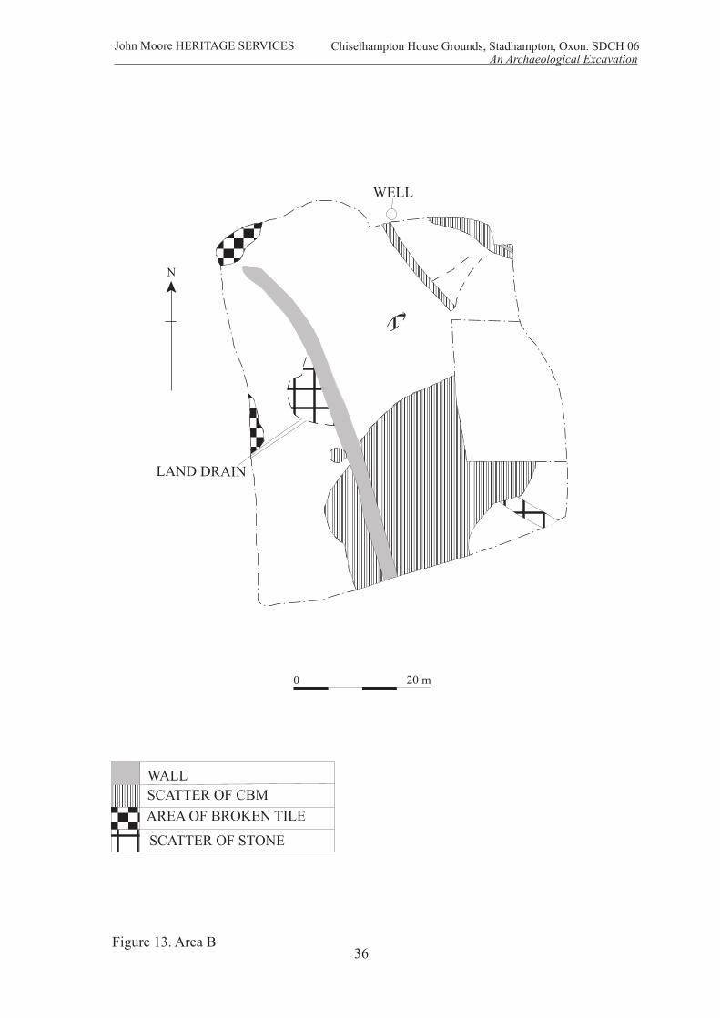
LAND DRAIN
WELL
0 20 m
36
John Moore HERITAGE SERVICES An Archaeological Excavation
Figure 13. Area B
AREA OF BROKEN TILE
SCATTER OF CBM
SCATTER OF STONE
WALL
Chiselhampton House Grounds, Stadhampton, Oxon. SDCH 06
N
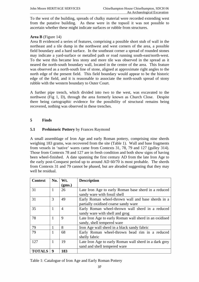
John Moore HERITAGE SERVICES Chiselhampton House Chiselhampton, SDCH 06 An Archaeological Excavation
37 37
To the west of the building, spreads of chalky material were recorded extending west from the putative building. As these were in the topsoil it was not possible to ascertain whether these might indicate surfaces or rubble from structures. Area B (Figure 14) Area B evidenced a series of features, comprising a possible short stub of wall in the northeast and a tile dump in the northwest and west corners of the area, a possible field boundary and a hard surface. In the southeast corner a spread of rounded stones may indicate a yard-surface or metalled path or road running south-east/north-west. To the west this became less stony and more tile was observed in the spread as it neared the north-south boundary wall, located in the centre of the area. This feature was observed as a north-south line of stone, aligned at approximate right angles to the north edge of the present field. This field boundary would appear to be the historic edge of the field, and it is reasonable to associate the north-south spread of stony rubble with the western boundary to Outer Court. A further pipe trench, which divided into two to the west, was excavated to the northwest (Fig 1, D), through the area formerly known as Church Close. Despite there being cartographic evidence for the possibility of structural remains being recovered, nothing was observed in these trenches. 5 Finds 5.1 Prehistoric Pottery by Frances Raymond A small assemblage of Iron Age and early Roman pottery, comprising nine sherds weighing 183 grams, was recovered from the site (Table 1). Wall and base fragments from vessels in ‘native’ wares came from Contexts 31, 78, 79 and 127 (gulley 314). Those from Contexts 78 and 127 are in fresh condition and both show signs of having been wheel-finished. A date spanning the first century AD from the late Iron Age to the early post-Conquest period up to around AD 60/70 is most probable. The sherds from Contexts 31 and 79 cannot be phased, but are abraded suggesting that they may well be residual. Context No. Wt.
(gms.) Description
31 1 26 Late Iron Age to early Roman base sherd in a reduced sandy ware with fossil shell
31 3 49 Early Roman wheel-thrown wall and base sherds in a partially oxidised coarse sandy ware
35 1 4 Early Roman wheel-thrown wall sherd in a reduced sandy ware with shell and grog
78 1 9 Late Iron Age to early Roman wall sherd in an oxidised sandy, shell tempered ware
79 1 8 Iron Age wall sherd in a black sandy fabric 79 1 68 Early Roman wheel-thrown bead rim in a reduced
shelly fabric 127 1 19 Late Iron Age to early Roman wall sherd in a dark grey
sand and shell tempered ware TOTALS 9 183
Table 1: Catalogue of Iron Age and Early Roman Pottery

John Moore HERITAGE SERVICES Chiselhampton House Chiselhampton, SDCH 06 An Archaeological Excavation
38 38
All four sherds are made from contrasting hard fabrics. The fragment from Context 31 is in a reduced ware containing common amounts of medium-sized rounded quartz sand (0.25 to 0.5 mm.) and a similar frequency of mixed shell and limestone (0.2 to 3.0 mm.). The sherd from Context 78 is in an oxidised ware with common quantities both of shell (<0.1 to 3.0 mm.) and fine angular quartz sand (0.125 to 0.25 mm.). The fragment from Context 79 is made from a fabric with a black exterior containing very common amounts of coarse rounded quartz sand together with rare mica (<0.06 mm.) and clay pellets (up to 3 mm.). The wall fragment from Context 127 is in a dark grey ware characterised by common quantities of medium to coarse rounded sand (0.25 to 1.0 mm.) and moderate shell, which has largely leached or been burnt out leaving a series of voids (0.1 to 3 mm.). The wheel-thrown sherds from Contexts 31, 35 and 79 are in hard, reduced or partially reduced kiln-fired fabrics that are most likely to post-date the Roman Conquest. A production date spanning the second half of the first century AD into the early second century AD is probable. All of this material is in fresh condition and the rim from Context 79 has traces of sooting on the exterior. It is derived from a jar with a closed triangular-sectioned bead rim and is made from a fabric tempered with very common shell (<0.1 to 3.0 mm.). The sherds from Context 31 are made from a single ware containing very common medium to coarse sand (0.25 to 1.0 mm.), composed of a mixture of rounded quartz and quartzite. The wall sherds have an unoxidised core and partially oxidised surfaces, while the base fragment is reduced. The ware used for the sherd from Context 35 incorporates common quantities of rounded medium sized quartz sand (0.25 to 0.5 mm.), sparse shell (1.0 mm.) and grog (0.5 to 2.0 mm.), and rare flint (up to 3.0 mm.). Context No. Wt.
(gms.) Comments
US 1 9 Most likely to be Iron Age 1/11 1 8 Certainly Iron Age, probably late Iron Age 5/15 1 3 Indeterminate prehistoric TOTALS 3 20
The spot-dating of the pottery from the evaluation generated dates which broadly agree with that which was recovered during the excavation. 5.2 Medieval Pottery by Paul Blinkhorn The pottery assemblage comprised 261 sherds with a total weight of 3,499g. The estimated vessel equivalent (EVE), by summation of surviving rimsherd circumference was 1.92. Other than two residual sherds of Romano-British wares, two redeposited sherds of early/middle Saxon hand-built pottery, and a single sherd of middle-late Saxon Oxfordshire Shelley ware, it was all Saxo-Norman or later, with the range of ware types present suggesting that the main period of activity was during the 11th – early 13th centuries, with no evidence of any later medieval deposits. It appears that the site was then re-occupied during the second half of the 16th century. Fabric The pottery was recorded utilizing the coding system and chronology of the Oxfordshire County type-series (Mellor 1984; 1994).

John Moore HERITAGE SERVICES Chiselhampton House Chiselhampton, SDCH 06 An Archaeological Excavation
39 39
OXB: Oxfordshire Shelly Ware, 9th – 11th C. 1 sherd, 4g, EVE = 0. OXR: St. Neots Ware type T1(1), AD850-1100. 4 sherds, 28g, EVE = 0. OXAC: Cotswold-type ware, AD975-1350. 32 sherds, 359g, EVE = 0.48. OXBF: North-East Wiltshire Ware, AD1050 – 1400. 32 sherds, 359g, EVE = 0.06. OXY: Medieval Oxford ware, AD1075 – 1350. 161 sherds, 1963g, EVE = 1.38. OXAM: Brill/Boarstall ware, AD1200 – 1600. 6 sherds, 45g, EVE = 0. OXST: Frechen Stoneware, AD1550 – 1700. 3 sherds, 175g, EVE = 0. OXDR: Red Earthenwares, 1550+. 13 sherds, 429g. OXFH: Border wares, 1550 - 1700. 3 sherds, 62g. WHEW: Mass-produced white earthenwares, 19th - 20th C. 2 sherd, 32g. The following, not covered by the Oxfordshire type-series, was also noted: E/MS: Early/Middle Saxon Hand-Built Ware. Dense chaff inclusions up to 5mm, no other visible inclusions apart from rare calcareous material and/or quartz up to 0.5mm. 2 sherds, 16g, EVE = 0. The pottery occurrence by number and weight of sherds per context by fabric type is shown in Table 1. Each date should be regarded as a terminus post quem. Discussion The range of fabric types is very typical of sites in the region. The sherds of early/middle Saxon hand-built ware indicates that there was pre-conquest activity at the site, as does the small sherd of Oxfordshire Shelly Ware (OXB), but the bulk of the assemblage dates from the mid-11th to the early 13th century. The small assemblage of St. Neots ware could be of pre-conquest date, but such pottery is known from post-conquest deposits, and the fabric of these sherds here appear to be Denham’s T1(2) type, which had a currency of AD1000-1200 (ibid. 1985). They are therefore likely to be contemporary rather than residual. It is of note that Brill/Boarstall ware (Oxford fabric OXAM) is represented by just six sherds, despite being extremely common in medieval contexts of the 13th century or later in the region. It is therefore highly unlikely that there was any medieval activity at this site after the early 13th century. It then appears that the site was fairly intensively occupied during the second half of the 16th century, as the bulk of the post-medieval assemblage dates to around that time. Again, the pottery from this period of activity is very much utilitarian. The assemblage is fairly well-preserved, and almost certainly entirely domestic in nature. It is dominated by jars (EVE = 1.46), with the rest of the vessel types being bowls (EVE = 0.30) and tripod pitchers (EVE = 0.16). This is a pattern entirely typical of earlier medieval domestic pottery assemblages. Some of the jar sherds were also heavily sooted, as would be expected from an assemblage of this type.

John Moore HERITAGE SERVICES Chiselhampton House, Chiselhapton SDCH 06 An Archaeological Excavation
Table 1: Pottery occurrence by number and weight (in g) of sherds per context by fabric type
RB E/MS OXB OXR OXAC OXBF OXY OXAM OXST OXDR OXFH WHEWCntxt No Wt No Wt No Wt No Wt No Wt No Wt No Wt No Wt No Wt No Wt No Wt No Wt Date
0 1 14 1 56 1 13 U/SB B 1 9 1 2 U/SB C 1 6 2 4 S 2 1 U/
2 3 19 13thC5 1 81 3 223 17thC6 1 80 2 23 M16thC
36 1 25 19thC38 1 7 19thC39 5 57 L11thC43 10 137 2 37 L11thC76 2 49 M16thC77 1 3 M11thC
114 1 3 1 4 8 48 L11thC124 1 40 5 70 11 127 L11thC125 1 19 11thC?126 3 27 7 48 20 255 L11thC131 1 4 6 136 L11thC132 1 1 12 101 1 12 84 806 L11thC140 3 30 2 13 2 9 L11thC144 1 4 1 2 L11thC148 1 22 2 28 11 301 L11thC150 1 19 2 46 L11thC151 1 20 2 15 2 18 L11thC155 1 13 13thC156 1 10 1 15 M16thC
40 40

John Moore HERITAGE SERVICES Chiselhampton House, Chiselhapton SDCH 06 An Archaeological Excavation
RB E/MS OXB OXR OXAC OXBF OXY OXAM OXST OXDR OXFH WHEW Cntxt No Wt No Wt No Wt No Wt No Wt No Wt No Wt No Wt No Wt No Wt No Wt No Wt Date 168 1 7 1 6 M11thC180 3 40 1 11 3 35 L11thC189 1 6 1 11 M16thC191 1 4 1 14 M11thC278 1 2 1 6 L11thC280 1 6 11thC292 1 13 13thC294 2 24 1 52 2 44 M16thC295 1 43 M16thC297 1 4 M11thC
Total 2 43 2 16 1 4 4 28 32 359 32 303 161 1963 6 55 3 175 13 429 3 62 2 32
41 41

John Moore HERITAGE SERVICES Chiselhampton House, Chiselhapton SDCH 06 An Archaeological Excavation
42 42
6 CONCLUSIONS The excavations carried out at Chiselhampton House evidence an area which was in use during the Late Iron Age / early Roman period, the medieval period (probably the later twelfth and early thirteenth centuries in the excavation area) and then over the course of the later 16th to 18th centuries. Following the end of the early Roman period the land probably reverted to pasture and possibly occasionally cultivated. The area was being exploited during the early/middle Saxon period. If the early manor house was on the same site then the area of the excavation for the lake was mostly under pasture. The lack of finds from the early thirteenth century to the sixteenth century also shows that this area had reverted totally to pasture. The Late Iron Age and early Roman field system appears to have been in use for a period of just over 100 hundred years. It is clear that it was maintained as the ditches of the field system evidenced at least two phases of activity. The gullies may have been used contemporaneously, although the absence of any direct stratigraphic link impedes an interpretation involving the succession of the ditched system by the gullies. No occupation evidence was recovered from the site, although it is probable that a settlement existed in the close vicinity. The enclosures may have been either for stock or for cultivation, but the full extent of the field system remains unknown. The archaeological evidence for the medieval occupation is limited. Given the later cartographic evidence for the site of the manor during the 16th and 17th centuries, it is reasonable to assume that the early medieval activity found is associated with the manor that was focused just to the north. The lack of material from the 13th until the 16th century suggests a shift in focus for rubbish disposal. The medieval village would have been to the west on the other side of the village green that is shown on the 1628 map. Despite the hiatus until the 16th century, the site in the Inner Park of Chiselhampton House was nonetheless an exploitable resource. The absence of material from between the early 13th and late 16th centuries indicates that the land was probably fallow, and only ever used for grazing. Indeed, map evidence is suggestive of such a use. Here on the 1628 map, located under the present ponds lying east/west from the road to the River Thame, was the historic village green until it was taken in as a whole as part of the western piece of the Inner Park. The area of excavation was part of Farm Close, an enclosed yard or pen attached to the farm building. The later sixteenth century manor was provided with an area of formal gardens, which had at least two phases. Furthermore, ancillary buildings existed to the north of the present walled garden, in addition to the house remains revealed during the excavation of the lake. Following the construction of the present house, the area of the excavation was landscaped to remove all trace of the house, as well as some of the quarry pits, revealed during the excavation, in order to create parkland around the house. 7 BIBLIOGRAPHY Anthony, J 1991 The Renaissance Garden in Britain Princes Risborough Shire Garden History

John Moore HERITAGE SERVICES Chiselhampton House, Chiselhapton SDCH 06 An Archaeological Excavation
43 43
Denham, V, 1985 The Pottery in JH Williams, M Shaw and V Denham Middle Saxon Palaces at Northampton Northampton Development Corporation Monog Ser 4, 46-64 Ekwall, E 1960 The Concise Oxford Dictionary of Place-Names 4th Ed. Oxford, University Press John Moore Heritage Services 2006 Chiselhampton House, Chiselhampton. Archaeological Field Evaluation. Summary report. Unpublished client report Johnson, M 1996 An Archaeology of Capitalism, Oxford, Blackwell Knox 1997 Chiselhampton House, Oxfordshire. A Historical Report. Unpublished client report. Mellor, M, 1984 A summary of the key assemblages. A study of pottery, clay pipes, glass and other finds from fourteen pits, dating from the 16th to the 19th century in TG Hassall et al, Excavations at St Ebbe's Oxoniensia 49, 181-219. Mellor, M, 1994 Oxford Pottery: A Synthesis of middle and late Saxon, medieval and early post-medieval pottery in the Oxford Region. Oxoniensia 59, 17-217 Taylor, C, 1983 The Archaeology of Gardens, Princes Risborough, Shire