1357. Yellow bullock, stump tail, MJC near ribs, M near rump ...
Upload
khangminh22Category
view
1download
0
Illus 1 Location maps, based upon Ordnance Survey maps. (Crown Copyright)

Excavations of cropmarks at Newbarns,near Inverkeilor, AngusCatherine McGillwith contributions by Mike Church and Mike Cressey
Tayside and Fife Archaeological Journal vol 10 2004, 94–118
Introduction
Two seasons of trial trenching were undertaken by theCentre for Field Archaeology (CFA) and the Departmentof Archaeology, University of Edinburgh, during Sep-tember 1998 and 1999, on a series of cropmarks atNewbarns, by Inverkeilor, Angus (NGR NO 680 503,centred). The project was sponsored by Historic Scot-land and the University of Edinburgh and then formedpart of the University of Edinburgh Department of Ar-chaeology Angus and South Aberdeenshire Field School(Finlayson et al 1999). Parts of the investigation areasare protected as Scheduled Ancient Monuments.
Newbarns is located on a raised beach forming an ex-tensive, low-lying plateau overlooking Lunan Bay (Illus1). The major part of this plateau is covered in a swatheof cropmarks representing activity from a variety of pe-riods. The extensive landscape of clear cropmarks re-vealed through aerial photography has led toconsiderable areas being scheduled. Historic Scotlandhas tended to schedule entire, or large sections of, fieldscontaining numerous clearly defined and/or morphologi-cally diagnostic features. The principal motive of theseexcavations was to compare the quality, quantity andrange of archaeological remains in adjoining scheduledand unscheduled areas, in order to provide informationrelevant to the future selection of cropmarks for sched-uling and the management of scheduled cropmark sites.
This report summarises the overall findings of the ex-cavations and presents the results only of the moresignificant archaeological discoveries. Details of all fea-tures excavated during the project are contained in thesite archive deposited with the National MonumentsRecord of Scotland (McGill 1998, 1999). The manage-ment-related findings of the results will be consideredelsewhere.
The site
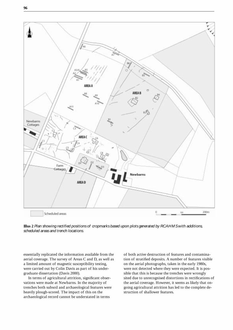
The area selected for the trial trenching programme liesimmediately to the west and north of Newbarns Farm(Illus 2). Two adjoining fields, each containing a suite ofclear cropmarks, have been partially scheduled by His-toric Scotland on the basis of the presence of apparentlyinteresting features in certain areas within them. Thecropmarks lying within the unscheduled areas (A and C)include several small ring-ditches, thought to be the re-mains of small Bronze Age round barrows and/or laterprehistoric houses, as well as many pit-like features,
occurring both in clusters and dispersed. Comparablefeatures were recorded in the scheduled areas (B and D),but there more unusual features appeared in addition.Within Area B (Illus 3) there are two large enclosures,one rectilinear (c 30m across) and one C-shaped (c 20macross). Photographs of Area D (Illus 4; plotted on Illus2) show at least two putative square barrows as well asa sub-rectangular enclosure or structure and a pit circle.The whole area is also covered in a network of irregularlinear cropmarks, some of which were produced by icewedges (cf Gemmell and Ralston 1984; 1985), althoughothers potentially constitute parts of a relict field sys-tem.
Summary
29 trenches were excavated, nine in the scheduled areasand the remainder in the unscheduled land (Illus 2). Acombination of strip trenches, intended to make a cur-sory examination of features and assess the survivingdepth of deposits, and area trenches were excavated.The latter targeted a selection of the more coherent andpotentially interesting cropmark features, allowing abetter assessment of archaeological andpalaeoenvironmental potential and, where possible,providing indications of date and function.
A large number of archaeological and natural fea-tures were excavated, with remains appearing in 23trenches. A representative sample of small features wasexcavated and several sections were dug through eachof the larger and more complex examples. In all but afew cases, no stratigraphic relationships survived be-tween any of the features within each trench and it wasnot possible to prove which co-existed.
In the strip trenches, a range of archaeological fea-tures was investigated. In Trench D3 (Illus 2) the V-shaped ditches of what is probably a square barrowsimilar to those at nearby Redcastle (Alexander forth-coming) were examined. Elsewhere a range of shallowpits, possible post-holes were detected (Illus 2, TrenchesA6, C5, C6), and linear features probably related to arelict, possibly prehistoric, field system (Illus 2,Trenches A2 and C1) were examined. All of these fea-tures proved to be heavily truncated and all lacked com-plex fills. Most features had two fills, a thin layer ofin-washed sand overlain by a dark organic fill similar tothe ploughsoil.
Resistivity surveys were carried out in the vicinityof Trench B1 and across all of Areas C and D. These
96
Illus 2 Plan showing rectified positions of cropmarks based upon plots generated by RCAHMS with additions,scheduled areas and trench locations.
essentially replicated the information available from theaerial coverage. The survey of Areas C and D, as well asa limited amount of magnetic susceptibility testing,were carried out by Colin Davis as part of his under-graduate dissertation (Davis 2000).
In terms of agricultural attrition, significant obser-vations were made at Newbarns. In the majority oftrenches both subsoil and archaeological features wereheavily plough-scored. The impact of this on thearchaeological record cannot be understated in terms
of both active destruction of features and contamina-tion of stratified deposits. A number of features visibleon the aerial photographs, taken in the early 1980s,were not detected where they were expected. It is pos-sible that this is because the trenches were wronglysited due to unrecognised distortions in rectifications ofthe aerial coverage. However, it seems as likely that on-going agricultural attrition has led to the complete de-struction of shallower features.

97Excavations of cropmarks at Newbarns, near Inverkeilor, Angus
Principal excavation results
Ring-ditch features
Ring-ditch 1 (Trench A3/4) Illus 5
This ring-ditch (cut A3429) was approximately 7.5m inmaximum external diameter. The circuit of the ditchwas unbroken and its surface width in plan was 2.4m tothe east and 1.8m to the west. A section was excavatedE–W across the ditch to give a complete profile. In bothsections, the ditch was steep-sided with a flat bottom.The western and eastern sections had maximum depthsof 0.6m and 0.8m respectively. The upper fills (A3406,A3407) were a dark brown, poorly-sorted silty sand,whilst the lower ones (A3420–A3428, A3430–3433,A3435) consisted of layers of re-deposited sands inter-
spersed with layers of material similar to the upper fills.In section 1, a block of light grey, slightly greasy sand(A3427), preliminarily identified as decayed turf, ap-peared to have collapsed into the open ring-ditch. Un-fortunately, Kubiena tin samples taken of this fillproved unsuitable for analysis. There was no indicationof any features in the space contained by the ring-ditch,which was 3.5–4m wide. The only finds were heat-cracked stones recovered from the upper fills in both ex-cavated sections.
Ring-ditch 2 (Trench B3) Illus 5 and 6
This scheduled feature (NMRS Ref: NO64NE 18) wasalmost identical in plan to Ring-ditch 1. It measured c6.7m in maximum external diameter, over an unbrokenditch 1.3–1.7m wide. A section was excavated across
Illus 3 Aerial photograph of Area B (scheduled). Crown Copyright: RCAHMS (ref AN/3230).

98
the feature to provide a profile, this time running NE–SW. The profile of this ring-ditch was similar to that ofRing-ditch 1, in that the sides of the ditch were fairlyvertical and the base flat. However, the depth of theditch was a maximum of only 0.45m, implying that ei-ther this ring-ditch was more truncated than the other,or it had been marginally shallower in its original form.This feature had a single fill, an homogenous darkbrown silty sand, unlike the more complex fills of Ring-ditch 1. Again, many heat-cracked stones were found inthe ditch fill.
Five possible post-holes post-dated the ring-ditch,cutting its upper fill. Approximately 20 other post-holesor pits and a ditch terminal were present outside thering-ditch. These features were not datable, and their
fills were identical to those of the ring-ditch. A largertrench would have been required to understand thepatterning of these other remains. Not all of thesesmaller features are been discernible on aerial coverage(eg Illus 3).
Rectilinear enclosure (Trench B2) Illus 7 and 8
A trench was opened over the east corner of a cropmarkrectilinear enclosure (NMRS Ref: NO64NE 17) measur-ing approximately 30m by 30m (Illus 2, 3). This enclo-sure was found to be defined by a U-shaped ditch up to1.35m wide and 0.5m deep (cuts B208, B214, B218). Ithad two distinct fills; an initial layer of in-washed sandoverlain by poorly sorted, dark brown silty sand. No
Illus 4 Aerial photograph of Areas C (unscheduled) and D (scheduled). (Crown Copyright: RCAHMS, ref AN/3521)

99Excavations of cropmarks at Newbarns, near Inverkeilor, Angus
Illus 5 Ring-ditches 1 and 2: plans and sections.

100
stone packing or postpipes were present to indicate thatthe enclosure had been palisaded. A line of stake-holes,initially difficult to discern, was recovered 1–2m fromthe inside edge of the ditch (cut of excavated example;B234). The presence of a fence or a retaining façade foran upcast bank formerly running inside the ditch linemight be implied. It is possible however that the stake-hole alignment continued south beyond the enclosureditch (as far as B232 on Illus 7), thereby suggesting thatthe two alignments related either to different phases ofactivity or even to entirely different structures. Thesestake-holes were infilled with light brown sand almostidentical to the subsoil and only became visiblefleetingly, under very particular weather conditions,rendering them difficult to excavate. The one excavatedexample was estimated at 0.25m in depth.
There was an apparent entrance, just over 3m wide,at the east corner of the enclosure. The ditch narrowedat each terminus and turned slightly inwards. At the en-trance, several small pits or post-holes were identified,each 0.25m in diameter and depth. One (cut B230) layin the centre of the entrance and three (excavated ex-ample: cut B232) were immediately outside the entranceby the southern terminus. As noted above, these couldform part of the stake-hole alignment, extendingbeyond the limits of the enclosure to the north-west.A resistivity survey was carried out over the unexcavat-ed portion of the enclosure (Illus 8). The survey clearlylocated the continuation of the enclosure and producedevidence for two further possible entrance causeways,
one by the southernmost corner and one half-wayalong the north-west side of the enclosure.
Two pits, of which one (B209) was excavated, appearto have been cut by the main ditch (Illus 7). The pri-mary cut (B209) was infilled with a homogenous mid-brown silty sand (B205), which was then re-cut by B210.The fills of B210 consisted of poorly sorted, organicand charcoal-stained sand. The in-filled pit was latercut by the enclosure ditch.
Inside the excavated part of the enclosure were twolarge pits measuring 1.5m by 1m, one of which (cutB212) was excavated. This proved to be 0.6m deep, witha homogenous dark silty sand fill.
Curvilinear ditch and pits (Trench B4) Illus 9
A trench was excavated over the northernmost part of aC-shaped cropmark ditch (NMRS ref. NO64NE 18)with a diameter of c 20m (Illus 2, 3). Internal featuresare visible on the photographs (Illus 3), but their formcannot be discerned in any detail. Within the excavatedarea, the ditch was found to lie in the vicinity of severalpits and post-holes or stake-holes. The ditch (cutsB407, B437) itself was 0.7m deep, with almost verticalsides and a flat base. It measured 2.2m in width whereit entered the trench, from which point it narrowedsteadily to just 0.5m at the terminus.
The fairly complex sequence of ditch fills, of whichall but the upper, dark brown organic fill (B413), ap-peared to have been wind-blown (B438), included many
Illus 6 Ring-ditch 2; photograph taken from the south.

101Excavations of cropmarks at Newbarns, near Inverkeilor, Angus
charcoal-stained seams. These were sampled, but unfor-tunately proved too degraded for analysis. Neither stonepacking nor post-holes were apparent within the surfaceof the ditch or the fragment of its base exposed. A sec-tion at the terminus revealed that the base of the ditchrose gently to the subsoil surface.
The only features in the trench to have comparablefills to the upper fill of the ditch were in the fills of twopairs of pits. Of these, two (excavated example; cutB405) were inside it and two (excavated example; cutB406) lay just beyond the terminus. The excavated pits
were both approximately 0.4m deep and were filled withpoorly sorted dark brown silty sand containing char-coal-stained lenses. Pit B405 contained three sherds ofpottery, of which one, a rim sherd, came from an elabo-rately decorated beaker. Two sherds were recovered fromB406. Although these were undecorated, they were in avery similar fabric to those from B405. A flint artefactfrom B406 was identified by Graeme Warren as beingLate Neolithic / Early Bronze Age in form. Both the pitsand the ditch contained heat-cracked stones in their up-per fills. A sample of Betula roundwood from the fill of
Illus 7 Rectilinear enclosure: plan and section.

102
Illus 8 Rectilinear enclosure, excavation: plan and resistivity survey results.
B406 was radiocarbon dated to 3645±85BP (AA-47749/GU-9753), which is calibrated to 2300–1700 BC at 2σ.
Post-hole ring and hollow (Trench B4) Illus 9
Immediately to the north of the terminus of the curvi-linear ditch was an oval hollow (cut B433) measuring4m (NE–SW) by 2.7m (SE–NW) and up to 0.35m deep.This feature had two fills, the lower of which (B421)seemed to line the hollow and was almost concrete-hard in consistency. The upper fill (B420) was mid-brown silty sand. A sample of carbonised heather stemfrom B420 was radiocarbon dated to 2350±50BP (AA-47750/GU-9754), calibrated to 800–200 BC at 2s. Asmall pit (cut B435) lay between the central hollow andthe curvilinear ditch, and predated both features.This hollow lay slightly off-centre within a sub-circularring of at least 10 post-holes, of which three were exca-vated (cuts B424, B426, B427) and were found to be onaverage 0.25m in diameter and 0.25–0.4m deep.A post-hole or stake-hole (cut B429) lying inside the
post-hole ring was cut by the curvilinear ditch (cutB407). The structural associations of this feature couldnot be established, and thus the stratigraphic relation-ship between B429 and curvilinear ditch does not dem-onstrate the order of construction of post-hole ring andcurvilinear ditch.
Ring-ditch structure (Trench C2) Illus 10
A trench targeted one of at least two possiblesouterrain or ring-ditch structures detected ascropmarks in the north-west part of Area C (Illus 2, 4).This example was selected as it appeared to have a clus-ter of pits or post-holes immediately to its south, possi-bly indicating the presence of either a souterrain withan associated post-built house or a ring-ditch housewith some surviving internal features. These featuresappeared as dark crescent-shaped marks, oriented ap-proximately the same way, with the open side facingsouth or south-east (Illus 2).

103Excavations of cropmarks at Newbarns, near Inverkeilor, Angus
Illus 9 Curvilinear ditch and pits, post-hole ring and hollow: plan and sections.

104
Illus 10 Ring-ditch structure: plan and sections.

105Excavations of cropmarks at Newbarns, near Inverkeilor, Angus
The excavation revealed a crescentic hollow (cutC204) and external groove (cuts C207, C219), as well asstake-holes and many pits and post-holes. No strati-graphic relationships between these different elementssurvived. Four sections were excavated in the crescentichollow, which was c 6.5m long and c 1.7m wide. Theprofile was deeper (maximum 0.3m) on the outer sideof the hollow, rising up to the inside (minimum 0.02m).Although no post-holes were identified in the ditch,oval depressions occurred intermittently along thedeepest part, underlying the mostly homogenous darkbrown fill (C211). Running just within the inside edgeof the hollow and sealed beneath C211 were up to threerows of stake-holes (eg C236). A single pit (C2111) cutthe fill of the hollow in section 1. Finds from the hollowcomprised two possibly worked pieces of local agateand several rounded quartz pebbles.
A groove or palisade slot began 1.5m to the north ofthe hollow. The main cut (C207) was up to 0.4m wideand 0.2m deep and ran from an apparent terminus atthe west to a point in the east of the trench where itnarrowed and faded away. It appeared to re-start 0.2mto the south of this point (C219), but this continuationwas so faint it proved impossible to trace or excavate insection. The main part of C207 was re-cut (C230). Insection, the fills of the two cuts were not distinguish-able, but a very thin (less than 0.01m thick) band ofsand appeared intermittently between the two fills dur-ing excavation, revealing their stratigraphic relation-ship. The groove contained no stone packing foruprights.
49 small pits or post-holes occurred within thetrench, of which 34 fell within the presumed floor areaof the structure. Two of these (cuts 253, 209) couldhave been heavily truncated remnants of a formerlymore extensive crescentic hollow, but this is not certainand they are equally likely to have been pits. A sampleof 12 other features, of which 8 were inside the struc-ture, was excavated, revealing a variety of depths andprofiles, but relatively homogenous fills and no stonepacking, much like the examples illustrated for House 5at Douglasmuir (Kendrick 1995, 52). Of the excavatedfeatures, C2104 was the deepest post-hole at 0.37m,whilst C291 had the greatest diameter, 0.45m.
The remains in this trench have structural affinitieswith later prehistoric ring-ditch houses. Reconstructionof the original ground plan of this structure is consid-ered separately below.
Sub-rectangular structure and adjacent pits(Trench D1) Illus 11 and 12
About three-quarters of a scheduled sub-rectangularstructure (defined by cut D176), straight-sided with anapsidal end and defined by a shallow ditch, was uncov-ered in Trench D1 (Illus 2, 4). The ditch appeared to beseverely truncated and its upper fills had been mixedwith the sand subsoil by plough action. 14 sectionswere excavated across the ditch, which had been ex-posed over an area c 12m NE–SW by 6m. This feature
had a maximum depth of 0.5m. Rectilinear and ovalslots of varying dimensions, cut marginally deeper thanthe main ditch and filled with well-sorted mid-brownsilty sand, appeared consistently in the bases of the ex-cavated sections of the ditch. The primary ditch fillconsisted of inwashed sand (D174) with occasionallenses of burnt material, comprising charcoal,carbonised hulled barley grains, chaff and seeds. Adark brown silty sand formed the upper fill (D171),which was demonstrated to be rich in ash by in situmagnetic susceptibility testing, carried out by ColinDavis.
Two apparent entrances were detected on the eastside of the building. The northernmost was 2m wide,and defined to either side by very shallow post-holeswith a rectangular ground plan (sections 12 and 13).Between the entrance post-holes and the ends of thewall slot (sections 5 and 10) were further rectangularpost settings, the northern example (section 14) offsetoutside the wall line (Illus 12) and the southern (section11) offset inside the wall line.
The southern entrance was not fully exposed, butwas at least 1m wide. A pronounced bulge at the southend of ditch section 9 may indicate the position of anentrance post, although this possibility was not testedby excavation.
Two other post-holes offset from the wall line oc-curred directly opposite the ends of the length of ditchbetween the two putative entrances. Section 7 lay out-side the wall line and directly opposed section 11,whereas section 8 lay inside the wall line and directlyopposed the putative entrance post at the south end ofsection 9. Several irregularities of surface plan occurredelsewhere around the ditch, which may represent addi-tional, poorly defined, offsets. All offset post-holes werevery shallow, surviving to a depth of less than 0.02m.Sections 7 and 8 were partially cut into the fill of theditch, demonstrating that these formedstratigraphically the latest phase in the construction ofthe building.
Only three features occurred in the floor area of thebuilding. These were two shallow, rectangular post-holes (cuts D109, D110) and a single unexcavated stake-hole.
Radiocarbon dates of 1100±50BP (AA-47747/GU-9751) and 1085±45BP (AA-47748/GU-9752) were ob-tained from charred grains recovered from fill D174 ofthe ditch. These calibrate at 2s respectively to AD 780–1030 and AD 870–1030, indicating a late first millen-nium AD date for this context.
The cropmarks of at least six pits apparently form-ing a circle 25m in diameter were identified immediatelyto the west of the sub-rectangular structure (Illus 4).The pits are evenly spaced at 8 to 10m apart. Two ofthese pits (cuts D112 and D132) fell within trench D1.These were similar in size and fills. Both had a deep pri-mary cut (maximum 0.8m) which in the case of D132appears to have been completely in-filled with a homog-enous brown silty sand (D122/123) and then re-cut(D133). This re-cut (D133) and the primary cut (D112)

106
Illus 11 Sub-rectangular structure and pit circle: plan and sections.

107Excavations of cropmarks at Newbarns, near Inverkeilor, Angus
were in-filled with bands of burnt turf and charcoal-rich material, including cereal grains of which oats andbarley predominated (Church, infra). In situ magneticsusceptibility testing by Colin Davis showed that thisplant material had not been burnt whilst in the pits.
Samples of barley from D123, the fill of the primarycut of D132, were radiocarbon dated to 1180±50BP(AA-47743/GU-9747; AD 710–990 at 2s calibration)and 1145±45BP (AA-47744/GU-9748; AD 770–990 at 2scalibration). Barley from D120 and D127, both fills ofthe secondary cut of D132, were dated to 1150±60 BP(AA-44741/GU-9745; AD 720–1020 at 2s calibration)and 1145±55BP (AA-47742/GU-9746; AD 770–1020 at2s calibration), and 1215±45BP (AA-47745/GU-9749;AD 680–950 at 2s calibration) and 1095±60BP (AA-47746/GU-9750, AD 770–1030 at 2s calibration) respec-tively, confirming that these features should beattributed to the late first millennium AD.
A third pit, D131, appeared loosely associated inplan with the above two, but differed in being shallow(0.35m maximum depth), with a sterile mid-brown ho-mogenous fill. It is unlikely that this feature formedpart of the pit circle.
Material recovered
Pottery Illus 13
The pottery assemblage consists of five sherds with atotal weight of c 72g. The sherds, which varied in sizebut were relatively unabraded, derive from two pits(B405 and B406), associated in plan with a curvilinearditch. Both pits were excavated in full and sieved. Thesingle diagnostic sherd, from pit B405, came from aBeaker. Two additional body sherds came from B405and two, of a slightly different fabric, from B406.
Fabric
The three sherds from B405 were constructed from ahard, sandy fabric, with a red exterior, dark grey coreand light grey interior. The temper consists of very wellsorted angular quartzite and basic dark igneous rock,less than 3mm in maximum extent. The profile of thefabric suggests the vessel has been reduced and cooledrapidly in air, rendering the core margins sharp. On theone diagnostic sherd, the fabric becomes marginallydarker where the vessel begins to thicken below thedecorated zone.The fabric constituting the two body sherds from B406is marginally different in that it has a red/brown exte-rior and is slightly darker in the core and the interior.The temper is also marginally less well-sorted. How-ever, the differences are not sufficient enough to implythe sherds derive from a different vessel.
Form, construction and decoration
The single rim sherd comes from a vessel with a diam-eter of 240mm. The decoration on the neck of the rimsherd has been applied using either a three-toothedcomb or a three- and a four-toothed comb. The combi-nation of motifs include parallel lines, lattices and par-allel zigzag lines. Each zone of decoration is delimited
Illus 12 Sub-rectangular structure: photograph ofsections 5, 14 and 13.
Illus 13 Beaker pottery.

108
by a single line and most zones had single intermediatelines between them. The motifs employed are compa-rable to those on Step 4 vessel 725 N4 1503 from UpperBoyndlie, Aberdeenshire (Clarke 1970 no 1503; Shep-herd 1986, 27).Prior to the application of decoration the vessel waswet-smoothed in and out. The rim partially in-fills theuppermost line of impressions, indicating that it wasformed or at least flattened after the application of thecomb impressions. The lowest line on the sherd has alsobeen partially in-filled prior to firing.
Discussion
The separation of the neck from the body by both thedistribution of motifs and the sharp neck bend fits withVan der Waal’s Step 4 of beaker development, whichShepherd (1989) demonstrated to be normally associ-ated with female burials, and with Shepherd’s (1986)late North-East Beaker. Such vessels are typically as-signed dates early in the second millennium BC (cal),although detailed work relating to absolute chronolo-gies of beakers has yet to be carried out in the area.This date is given support by the recovery of the B406sherds from a feature containing charcoal dated to2300–1700 cal BC at 2s (AA-47749), as well as a flintartefact which has been assigned a Late Neolithic /Early Bronze Age date (Graeme Warren, pers comm).
Carbonised plant macrofossilsMike Church and Mike Cressey
Introduction
This report analyses the carbonised plant macrofossilsrecovered from bulk samples taken from the excava-tions at Newbarns. Palaeoenvironmental sampling wasenvisaged as an integral research aim of the project(Finlayson et al 1999). 65 samples were submitted, ofwhich 26 produced carbonised remains included in thisanalysis.
A total sampling strategy was adopted (Jones 1991),meaning a sample was taken from every archaeologicalcontext, apart from deposits with clear bioturbation,modern contamination or those deposits that consistedof sterile redeposited sands and gravel. A 20% randomsample of this population obtained in the field was thentaken for wet sieving. This meant a statistically repre-sentative sample of all the archaeobotanical remainsfrom the site was retrieved (van der Veen and Fieller1982). All the samples from the structure in Trench C5and the post-ring in Trench B4 were wet-sieved as theserepresented the most coherent domestic structures onthe site. The bulk samples were processed using aflotation tank (Kenward et al 1980) with the residueheld by a 1.0mm net and the flot caught by 1.0mm and0.3mm sieves respectively.
All the flots were dried and checked using a low-powered stereo/binocular microscope at x15–x80magnification. An initial assessment was made of the
flots prior to identification. This involved scanning theflots using a semi-quantitative scaling system recordingthe relative frequencies of the main classes of archaeo-botanical remains. The full list and methodology of thisassessment has been lodged with the site archive.Samples with over 10 quantifiable components were cho-sen for further analysis. This arbitrary selection strategywas utilised in the regional study undertaken by van derVeen (1992), with the samples containing few plant re-mains seen as unreliable (ibid, 25). All macrofossilidentifications were checked against botanical literatureand modern reference material from collections in theDepartment of Archaeology, University of Edinburgh.Charcoal identifications were made on all material re-covered using a binocular microscope at magnificationsranging between x10–200, generally on transverse cross-sections on charcoal measuring between 4–6mm. Asym-metry and morphological characteristics were recorded(available in archive). Nomenclature follows Stace (1991)with ecological information taken from Schweingruber(1990), Clapham et al (1989) and Flora Europaea (RoyalBotanic Garden Edinburgh 1998).
Results
Table 1 presents the charcoal and the carbonised plantmacrofossils recovered from the bulk samples withgreater than 10 quantifiable components noted duringthe assessment. Following the assessment, the sampleswith greater than 10 quantifiable components camefrom two sets of deposits. The first set derived from asample from a fill of one of the post-holes in the struc-ture in Trench C5 and a sample from the top fill of thepit complex within the same structure. The second setcomprised the burnt lenses within the fills of the pitsD1/01 and D1/02. The charcoal from the other samplesand small finds were recovered from a variety of featuresacross the area. The full results form part of the sitearchive, and this report concentrates hereafter upon twoassemblages obtained from pits in Trench D1.
Taphonomy
Much of the carbonised material was concentrated inthe fills of the two pits in Trench D1 and mineral mag-netic profiles (Davis 2000) through the section of thefills demonstrated that the material had been dumpedinto the pit, rather than burnt in situ (cf Linford andCanti 2001). All these fills were rich in grain with pro-portionally small amounts of chaff, weed seeds andcharcoal and so probably reflect the discard of accidentsin the crop processing of the grain (cf Hillman 1981).The rest of carbonised plant material and possibly thecharcoal rich layer at the bottom of pit D1/01 (SampleD1/24) was likely to have been dumped into the variousnegative features incorporated with ash from householdfires. This taphonomic model is acknowledged as theprincipal charring mechanism in British archaeobotany(cf Hillman 1981; Jones 1984; van der Veen 1992; Jones1996).

109Excavations of cropmarks at Newbarns, near Inverkeilor, Angus
Illus 14 presents the preservation of the 1160 cerealgrains identified, following the preservation indicesoutlined by Hubbard and al Azm (1990). Class P1 rep-resents perfectly preserved grain through to class P6representing severely degraded grain precluding evengenus identification. Most of the grains came fromthe pit fills in Trench D1 and the range of preservationreflects the likely charring environment for a crop-pro-cessing accident. Over 40% of the total assemblagewas in the three best preservation classes, meaningsome chaff fragments and weed seeds usually lost inmore hostile carbonisation environments were pre-served (cf Boardman and Jones 1990). Hence, it isvalid to estimate the stage in the crop-processing cycleand it is likely that the grain rich deposits in the pitwere dumped from accidents in the latter stages(Hillman 1981).
Charcoal
The charcoal concentrations were very low and thefragments were generally of amorphous branchwoodor timber. The species included Ling heather (Callunavulgaris L. Vill), oak (Quercus sp.) hazel (Corylusavellana L.), birch (Betula sp.), alder (Alnus glutinosaL.) and willow (Salix sp.). The charcoal was too lowin frequency to infer whether a given species had beenselected in favour of another, though Ling heatherwas the dominant species in terms of weight andnumber of fragments. The timber could have beengathered from local woodland in a variety of habitatsand the heather from moorland or heath. Unfortu-nately, no pollen diagrams have been produced fromlowland Angus covering the later prehistoric and earlyhistoric periods, a function of the truncation and dis-appearance of suitable sites stemming from the inten-sive agriculture of the 19th and 20th centuries (Coleset al 1998).
Cultivated species
Most of the cereal remains were recovered from thefills of the two pits in Trench D1. It is likely that thedeposits relate to the same archaeological period judg-ing by the nature of the deposits and the similarities
in the archaeobotanical assemblages and so the remainswill be analysed as a single assemblage from each pit.
520 identifiable grains were recovered from Pit D1/02(D112; Samples D1/2–8) and of these 68% were barley(Hordeum sp.) and 32% oat (Avena sp.). 465identifiable grains were recovered from Pit D1/01 (D132;Samples D1/14–24), with 75% barley and 25% oat.Single grains of wheat (Triticum sp.) and rye (Secalecereale L.) were also recovered from two samples in PitD1/02, which were probably weeds of the barley andoat crop. The barley was almost all hulled in both pitsand only a few naked grains were identified. Thesecould have stemmed from very small-scale experimentsin growing the naked variety or represent what is in ef-fect weed contaminants of a few naked plants in thehulled crop. It may also represent a phenomenon notedby Hillman (quoted in Holden and Boardman 1998), bywhich a small proportion of hulled grain does not fuseto the enclosing lemmas and paleas when the growingseason has been shortened by early frost, drought or ex-cessive rain. This results in a small proportion of thegrain from the hulled crop resembling the naked variety.The few rachis internodes preserved in both pits wereof the six-row species so it seems probable that the bar-ley crop was almost exclusively of the six-row hulledvariety (Hordeum vulgare var. vulgare L.). This wasconfirmed by the ratio of symmetric: asymmetric hulledgrain being almost exactly 1:2 for both pits, the exactproportion expected in the six-row species (Zohary andHopf 1994). Species identification is not possible foroat on the basis of the grain morphology. However,judging by the limited number of fragile oat floret basesin Samples D1/5 and D1/24, Common oat (Avena sativaL.) was being cultivated with a little weed contamina-tion from Wild oat (Avena fatua L.). Two seeds of flax(Linum usitassitissimum L.) were also recovered fromPit D1/01. This may represent weeds of the barley croprather than cultivation of flax in its own right. The re-maining chaff consisted of a single fragment of awnand some culm nodes and culm bases of greater than2mm diameter that could have derived from cerealstraw. If this was the case, the presence of culm basesindicates harvesting by uprooting, a strategy thatmaximises the straw yield but can lead to soil erosion infriable soils. A mix of hulled six-row barley and someoat is common in assemblages dating from the Iron Ageonwards in Scotland (Boyd 1988; Dickson and Dickson2000), and so would be appropriate for the late firstmillennium AD contexts.
Wild species
The habitat for most of the wild components recoveredfrom both pits in Trench D1 is damp cultivated groundor wet grassland. The most frequent remains are thesmall culm bases / rhizomes of probably grasses andseeds of the Common spike-rush (Eleocharis palustris(L.) Roemer and Schultes) and Fat-hen (Chenopodiumalbum L.). Common spike rush was routinely associ-ated with damp cultivated ground prior to large-scale
Illus 14 Grain preservation from site assemblage.

110
key to Table 1
sub-sampling * 25% of grain identified so grain total multiplied by 4 for proportions of total assemblage
# 50% of grain identified so grain total multiplied by 2 for proportions of total assemblage
context pf pit fill
plant part
nb Charcoal fragments and weight are shown by number of fragments (total weight)
Table 1a Charcoal and the carbonised plant macrofossils recovered from the bulk samples with greater than10 quantifiable components (grain and chaff).
sample C5/9 C5/12 D1/2 D1/3 D1/4 D1/5* D1/8 D1/14 D1/18 D1/20 D1/24#
context C507 C527 D106 D105 D104 D105 D109 D118 D122 D124 D127
generic context type pf pf pf pf pf pf pf pf pf pf pf
volume (litres ) 7 5 5 5 5 5 2 4 2 3 2
charcoal
Betula sp (ch) 9F(0.4) 11F(0.6)
Calluna vulgaris (L) 1F(0.01) 1F(0.01) 10F(0.2) 50+F(4.5)
Hull (chr)
Corylus sp (ch) 1F(0.02) 1F(0.01) 3F(0.2) 5F(0.6)
Quercus sp (chr) 1F(0.03)
Quercus sp (ch) 1F(0.01)
Salix sp (ch) 1F(0.01)
indeterminate (ch) 1F(0.02)
grain
Hordeum sp (c) 4 7 50 22 55 14 25 5 6 51
H naked (c) 1 3 1
H naked asymmetric (c) 1
H hulled (c) 3 11 26 19 42 8 22 8 65
H hulled symmetric (c) 1 1 6 1 21 2 14 9 32
H hulled asymmetric (c) 3 8 3 44 5 26 3 21 60
Triticum sp (c) 1
Avena sp (c) 16 37 10 91 11 16 6 26 69
Secale cereale L (c) 1
Linum usitatissimum L (s) 2
cereal indeterminate (c) 1 1 16 46 14 44 7 15 4 19
grain total 9 1 56 173 69 1192 47 118 14 75 592
chaff
Hordeum sp (ri) 1
Hordeum vulgare L (ri) 1 4 1 7
Avena sp (fb) 2
Avena fatua L (fb) 1
Avena sativa L (fb) 6 7
awn fragment (af) 1
cereal /monocotyledon 4 3 2 7
(>2 mm.) (cn)
cereal /monocotyledon 3 2 4 2 20 6
(>2 mm.) (cb)
chaff total 3 0 2 5 0 20 2 24 0 0 28
a achene
af awn fragment
c caryopsis
cap capsule
cb culm base
ch charcoal fragment
chr charcoal
roundwood fragment
cn culm node
f fruit
fb floret base
n nutlet
ns nutshell fragment
qc quantifiable component
r rhizome
ri rachis internode
s seed

111Excavations of cropmarks at Newbarns, near Inverkeilor, Angus
Table 1b Charcoal and the carbonised plant macrofossils recovered from the bulk samples with greater than10 quantifiable components (wild components).
sample C5/9 C5/12 D1/2 D1/3 D1/4 D1/5* D1/8 D1/14 D1/18 D1/20 D1/24#
context C507 C527 D106 D105 D104 D105 D109 D118 D122 D124 D127
generic context type pf pf pf pf pf pf pf pf pf pf pf
volume (litres ) 7 5 5 5 5 5 2 4 2 3 2
wild species
Brassica rapa L (s) 1 2 10
Brassica /Sinapis spp (s) 1 1 2
Bromus spp (c) 1 1 8 3
Carex spp (trigonous) (n) 3
Chenopodium album L (s) 2 3 9 12 2 1 30
Chenopodium/Atriplex 2 1 1 2 1 1 8
spp. (s)
Chrysanthemum
segetum L (a) 4
Convolvulus arvensis L (f) 1 2
Eleocharis palustris (L)
Roemer and Schultes (n) 2 1 3 31 6 69 6 4 16 40
Galeopsis tetrahit L (n) 2 1 2
Persicaria lapathifolia (L) 12 8 15 3 3 6
Gray (n)
Persicaria maculosa 2 4 1 3 2
Gray (n)
Plantago lanceolata L (s) 1 1 1 1
Poa annua L (c) 1
Poaceae undiff (large) (c) 1 1
Poaceae undiff (medium) (c) 2 3 1 4 2
Poaceae undiff (small) (c) 1 1 1 1 2 2 3
Polygonum aviculare L (n) 1 2 1 5
Polygonum spp (n) 8 2 2
Ranunculus repens L (a) 1 1 1
Raphanus raphanistrum L (f) 1
Rumex acetosa L (n) 7
Rumex acetosella L (n) 3 2
Rumex obtusifolius/ 2 1 3
crispus L (n)
Rumex spp (n) 1 1 1
Spergula arvensis L (s) 1 2 2
Stachys palustris L (f) 1 1
Stellaria media L Vill (s) 1 1 1
Veronica hederifolia L (s) 5 2 1 1
Viola palustris L (s) 1
indeterminate (s/f) 3 2 13 3 10 2 4
indeterminate (trigonous) (s/f) 4
cereal/monocotyledon 2 1 6 2 1
(<2 mm) (cn) 2 1 6 2 1
cereal/monocotyledon 10 9 6 21 2 23 41 1 6
(<2 mm) (cb)
indeterminate (>2 mm) (r) 1 6 2 5
indeterminate (<2 mm) (r) 3 1 20 7 1 2
wild total 57 12 22 121 34 176 8 75 1 30 137
total qc 69 13 80 299 103 1388 57 217 15 105 757
qc/ litre 9.9 2.6 16.0 59.8 20.6 277.6 28.5 54.3 7.5 35.0 378.5
grain proportion (%) 13.0 7.7 70.0 57.9 67.0 85.9 82.5 54.4 93.3 71.4 78.2
chaff proportion (%) 4.3 0.0 2.5 1.7 0.0 1.4 3.5 11.1 0.0 0.0 3.7
wild species proportion (%) 82.6 92.3 27.5 40.5 33.0 12.7 14.0 34.6 6.7 28.6 18.1

112
Table 2 Radiocarbon dates from Newbarns.
lab no sample context material lab age lab error ± 2s range, cal BC/AD d13C (%)
AA-47741 D120 Hordeum sp 1150 60 AD 720–1020 -24.8
GU-9745
AA-47742 D120 Hordeum sp 1145 55 AD 770–1020 -21.3
GU-9746
AA-47741, AA-47742 D120 combine 1147 41 AD 770–990
AA-47743 D123 Hordeum sp 1180 50 AD 710–990 -23.7
GU-9747
AA-47744 D123 Hordeum sp 1145 45 AD 770–990 -23.4
GU-9748
AA-47745 D127 Hordeum sp 1215 45 AD 680–950 -22.7
GU-9749
AA-47746 D127 Hordeum sp 1095 60 AD 770–1030 -21.4
GU-9750
AA-47745, AA-47746 D127 combine 1172 36 AD 770–980
AA-47747 D174 Hordeum sp 1100 50 AD 780–1030 -20.7
GU-9751
AA-47748 D174 Hordeum sp 1085 45 AD 870–1030 -21.4
GU-9752
AA-47749 B402 Betula sp 3645 85 2300–1700BC -28.0
GU-9753
AA-47750 B420 Calluna vulgaris 2350 50 800–200BC -27.2
GU-9754
drainage of the 20th century (Long 1929) and many ofthe other wild species recovered prefer areas of dampcultivation or wet grassland. These include Wild turnip(Brassica rapa L.), Common hemp nettle (Galeopsistetrahit L.), Pale persicaria (Persicaria lapathifolia (L.)Gray), Creeping buttercup (Ranunculus repens L.),Wild radish (Raphanus raphanistrum L.) and Sheep’ssorrel (Rumex acetosella L.). Some of these speciescould also have been found in heaths and bogs indi-cated by the recovery of Ling heather charcoal (Callunavulgaris L. Hull) and seeds of sedges (Carex spp.),Marsh woundwort (Stachys palustris L.) and Marshviolet (Viola palustris L.). Other possible weeds of cul-tivated ground include Fat-hen (Chenopodium albumL.), Field bindweed (Convulvulus arvensis L.) Cornmarigold (Chrysanthemum segetum L.) Redshank(Persicaria maculosa Gray), Knotgrass (Polygonumaviculare L.), Common sorrel (Rumex acetosa L.),Broad leaved / Curled dock (Rumex obtusifolius /crispus L.), Ribwort plantain (Plantago lanceolata L.),Ivy-leaved speedwell (Veronica hederifolia L.) Cabbage/Mustard (Brassica/Sinapis spp.), and grasses (Poaceaeundiff.). The occasional seeds of Brome (Bromus spp.)and Corn-spurrey (Spergula arvensis L.) provide slightindications of drier soils.
Discussion
It seems likely that this assemblage represents a mix ofweed seeds of the barley and oat crop with a smallerproportion of material associated with the burntheather recovered from three of the samples. The
heather itself could have been part of heathy turf usedas fuel for the grain drying process or in householdfires. The burning of heathy turf could also have intro-duced a number of the wet-loving species, such as thesedges, as well as the small culm bases and rhizomes(Dickson 1998). However, the majority of the wildcomponents would have been weed contaminants of thecrop and so provide interesting insights into the condi-tions of the fields. The presence of a few seeds ofChickweed (Stellaria media L. Villars) in both pits mayindicate soil amendment with manure as Chickweed isnitrophilous. Also, the mix of species suggests dampand free-draining conditions existing in the same fieldor separate fields with differing soil conditions for thebarley and oat crop that were mixed in the crop-pro-cessing cycle. In either case, this corresponds to the pic-ture emerging from other archaeobotanical assemblagesin lowland Angus that suggests expansion into moremarginal areas was increasingly common from laterprehistory onwards compared to the earlier cultivationin the Neolithic that was generally confined to the bet-ter soils (cf Church 2002).
There are few direct chronologically comparablearchaeobotanical assemblages in the lowlands of theNorth East, with only the material at Easter Kinnearand Hawkhill near Leuchars, Fife dating to the mid tolate first millennium cal AD. Dickson (1997) identifiedcarbonised plant remains from both sites, noting thedominance of six-row hulled barley, the presence of asignificant number of oat grains and a few seeds of flaxfrom Easter Kinnear. Evidence for the gathering ofplants included carbonised seeds of Sand leek, bramble

113Excavations of cropmarks at Newbarns, near Inverkeilor, Angus
and raspberry as well as various types of material fromheathland, including crowberry and possible peaty turfsfor fuel. Smaller concentrations of material were recov-ered from Hawkhill, including grains of hulled six-rowbarley, emmer and bread wheat and evidence of variousspecies of wood charcoal and a few fragments of burntpeat. Assemblages of burnt grain have also been recov-ered from a few corn-drying kilns of slightly later date,including Capo in Aberdeenshire, Abercairny inPerthshire (Fairweather 1988) and Lhanbryde in Moray(Holden 1997). At Abercairny, approximately 60% ofthe grain recovered was six-row hulled barley, with theother 40% comprised of a mix of black and wild oat.The wild components, interpreted as weed contami-nants of the crop, pointed to a mix of well-drained andwetter land that could indicate separate areas for thecrop to grow or mixed soil conditions within the fields.Black oat dominated the remains at both Capo andLhanbryde and again a mixed ecological signal fromthe weed contaminants indicated a variety of soil con-ditions under which arable crops were grown. The as-semblage from Newbarns therefore fits into atransitional phase in North East Scotland between abarley-dominated arable economy and a more diversemulti-cropping economy dominated by barley and oatgrown within both optimum and marginal soil condi-tions.
Radiocarbon dating
Very few of the feature fills were securely sealed.Samples from only four of the feature groupings—thecurvilinear ditch and pits (Trench B4), the hollow andpost circle (Trench B4), the sub-rectangular structureand the pit circle (Trench D1)—were considered viableand submitted for radiocarbon dating. Ten radiocarbonaccelerator dates were obtained from samples ofcarbonised cereal grain, birch and heather stem. The re-sults are summarised below.
The samples were submitted to the Scottish Universi-ties Research and Reactor Centre (SURRC), and weremeasured at the University of Arizona AMS Facility.Table 2 lists the radiocarbon dates and 2s calibratedranges received from SURRC.
If the burnt deposits filling the secondary cut of pitD132 (contexts D120 and D127) represent single epi-sodes of contemporary dumped material, then it isjustifiable to combine the two dates within each contextto provide tighter calibrated date ranges (cf Ward andWilson 1978). The combined dates are included inTable 2 (using OxCal v. 3.5). At 95% confidence thecombined dates indicate that both fills were depositedbetween the late 8th and the late 10th centuries cal ADand are statistically indistinguishable.
Discussion and interpretation
Ring-ditch features
In the absence of radiocarbon or artefactual evidence,the interpretation of these features has to be based onmorphological parallels alone. There was no evidenceto suggest that these features were ring-ditch houses asthe ditches were too deep and there was a lack of asso-ciated features and no apparent entrance. They are alsoprobably too small to have been enclosures, whether fordomestic or ritual use. It seems more likely that theyrepresent the vestiges of barrows. Round barrows areknown in the vicinity, for example at Corbie Knowe(NMRS Ref: NO64NE 4) and are mentioned in the Sta-tistical Account of Scotland (Carnegie 1794) as havingbeen numerous in the area until the advent of more in-tensive cultivation. Many were investigated in the 18thcentury and were often found to contain beaker vesselsand cists, hence their frequent interpretation as LateNeolithic/Early to Middle Bronze Age funerary monu-ments. Although no internal feature was found associ-ated with the ring-ditch in Trench A3/4, as only the verylowest levels of the monument are preserved, it is con-ceivable that associated remains were located in either ashallow grave or an upcast mound whose remains havenow been entirely removed by ploughing.
However, the very small size of the area enclosedwithin the outer ditch would make the construction ofa round barrow impractical. An alternative interpreta-tion, which could explain the very small dimensions ofthe feature, is that it represents a type of monumentsimilar to the upstanding remains represented by TableRings Cairn, East Lothian (Strachan 1998, 33). Here, aring-ditch, similar but with a greater circumferencethan the present examples, surrounded a cairn. Theupcast was on the outside of the ditch rather than theinside. There is, however, no record of such site types inthe Newbarns area.
The presence of the heat-cracked stones in the upperfills of both features is unlikely to be of any greatsignificance. These occurred in the upper fills of thering-ditches (and indeed other investigated featuressuch as the curvilinear ditch in Area B), and probablyrelate to cooking activity occurring when the monu-ments in question were largely silted up, and had pre-sumably lost their primary significance.
Rectilinear enclosure
The appearance of the enclosure in plan is reminiscentof the square barrows common in the immediate area,such as at Redcastle (Alexander forthcoming). Breaksin the ditch at the corners are considered by Murrayand Ralston (1997) to be a diagnostic characteristic ofsquare barrows, and the Newbarns example is compa-rable in plan in this respect. Upstanding examples ofthis type of monument have external banks (eg Garbeg,Drumnadrochit, Highland; Wedderburn & Grime1984), and although no such feature was present at

114
Newbarns its obliteration as a result of plough trunca-tion can be countenanced.
However, there are other factors that suggest thatthis enclosure is not the remains of a square barrow. Atc 30m across the scale of the structure is well beyondthat normally recognised in that class of monument.Furthermore, if the line of internal stake-holes atNewbarns were to represent a revetment for a bank,this might suggest that this monument was of a differ-ent type. However, the stake-holes could equally repre-sent an element present in addition to an external bank,or they may relate to an earlier phase or even markingout phase of monument construction.
Other examples, all unexcavated, of similar monu-ments of a comparable size are found in the field imme-diately to the east of Area B (NMRS ref. NO64NE 51)and elsewhere along the Lunan Valley, and have beensuggested as potential medieval farm enclosures (Pol-lock 1985, 397). However, as no finds or datable materi-als were recovered from the Newbarns enclosure nofirm conclusions can be made about the structure’s dateor function.
Curvilinear ditch, pits, post-hole ringand working hollow
It is difficult to come to any conclusions as to the inter-relationships and functions of the features in Trench B4based purely on the excavated evidence, particularly asit was not possible to determine which features co-ex-isted. The radiocarbon date of 2300–1700 cal BC (AA-44749) from pit B406 provides an indication as to thedate by which activity was taking place within the im-mediate area. Whether this pit is associated with thecurvilinear ditch, as might be implied by the similaritiesin their upper fills, or whether the two are unconnected,cannot be decided on the evidence available.
The function of the curvilinear ditch, potentially theboundary of a site of funerary, agricultural or domesticcharacter, could not be established from the limited ar-eas exposed and excavated. The fills—seams of char-coal-stained sand interspersed with clean wind-blownsand—indicate it was left open for some time withoutvegetation covering it and without it being maintained,but these observations do not contribute to any possibleinterpretations. The surviving depth of the ditch sug-gests that the cropmark reflects the original extent ofthe feature, unless considerable localised variations indegree of agricultural attrition are proposed. On thisbasis the ditch had never formed a complete enclosure,unless it was used in conjunction with another type ofbarrier which has left no archaeological traces that canbe detected remotely.
If one presumes that the off-centre hollow (B433) isassociated with the putative post-hole ring, one couldenvisage a fairly flimsy structure or enclosure contain-ing a working hollow. The Early Iron Age radiocarbondate of 800–200 cal BC from B420 suggests that at leastthe final fill of the hollow post-dates significantly theBeaker / Early Bronze Age activity.
Ring-ditch structure
It is difficult to reconstruct a secure approximation ofthe original ground plan of the structure represented inTrench C2. There is no obvious pattern to the post-holes in plan and it is as easy to reconstruct linear ar-rangements of posts as it is post-rings from the tracesencountered. Morphologically, the structure is likely tobe later prehistoric and has affinities with ring-ditchstructures that occur widely in eastern Scotland. Thefact that the Newbarns example lacks many featurescommonly occurring in ring-ditch structures, such asthe ring-ditch encompassing all of the central floor areaexcept along the entrance passage, an internal post-ringor detectable entrance posts, may reflect its exception-ally truncated condition. Better-preserved structures ofring-ditch houses have been excavated in Angus atnearby Ironshill (Pollock 1997), Douglasmuir (Kendrick1995), Culhawk Hill (Rees 1998) and Auchlishie (Dick1996, 12–13). Dates from these sites range from the mid1st millennium cal BC for Douglasmuir to the early firstmillennium cal AD, although a Late Bronze Age ex-ample has recently been excavated at Deer’s Den,Kintore, Aberdeenshire (Alexander 2000).
Whether the hollow of the Newbarns structureforms a ring-ditch only partially preserved as a result ofplough truncation, or whether it perhaps reflects thecombined effects of plough truncation and the deliber-ate deepening of the north-west side of the ring-ditch,is unclear. Why the structure would have had deeperfoundations to the north-west, presumably directly op-posing the entrance, is not obvious. At DouglasmuirKendrick (1995, 54–6) identified three ‘crescent-shapedhollows’, each associated with pits and post-holespresent within a putative floor area, in addition to thesix more readily classifiable ring-ditch houses. She pro-posed that these structures, which resemble theNewbarns structure in ground plan, might be the re-mains of severely truncated ring-ditch houses. Thesame arguments could apply to the Newbarns struc-ture.
The profile of the hollow, its outer edge steep-sidedand its inner edge more gently sloping, are very similarto those of ring-ditch Houses 2 and 6 at Douglasmuir(Kendrick 1995, 48, 54). The elongate depressions in thebase of the crescentic hollow are difficult to interpret:similar depressions were present in most of the ring-ditch structures at Douglasmuir (Kendrick 1995), but atthat site the ring-ditches either contained or were cov-ered by the cobbled surface. The stake-holes groupedaround the inner edge of the hollow were a particularpoint of interest, perhaps representing the division ofinternal space by a wattle fence or screen.
There are three main possibilities for the function ofthe groove feature. Firstly, originally it may have contin-ued concentric to the hollow, having functioned as thefoundation slot of an outer wall to the ring-ditch struc-ture: Kendrick (1995, 61–2), however, argued that theDouglasmuir ring-ditch houses were built of turf andran immediately outside the ring-ditch. Second, it may

115Excavations of cropmarks at Newbarns, near Inverkeilor, Angus
have been part of an enclosure associated with thestructure. Finally, it may have been chronologicallyseparate from the house, and of unknown date or func-tion. The latter option seems unlikely as the curve ofthe groove at its easternmost end closely matches thatof the hollow. Whether the western terminus of thegroove feature was real, or simply reflected only thedeepest part escaping plough truncation, is not appar-ent. The most interesting aspect of this feature is thefact that it was re-cut, demonstrating some length ofoccupation.
The unenclosed settlement represented by the puta-tive row of three ring-ditch structures at Newbarns, ofwhich only this one was excavated, is seen as fairly typi-cal in Angus (Macinnes 1982), where no wholesalemove towards enclosure occurred in the 1st millenniumBC (ibid).
Sub-rectangular structure
Morphologically, this structure has broad similarities toNeolithic mortuary enclosures (eg Balfarg, Barclay andRussell-White 1993), Neolithic timber halls (egBalbridie, Fairweather and Ralston 1993; and ClaishFarm, Barclay et al 2002) and timber halls of Early His-toric type (eg Yeavering: Hope-Taylor 1977 andReynolds 1978; Dunbar, Perry 2000). Radiocarbondates of cal AD 780–1030 (AA-47747) and cal AD 870–1030 (AA-47748), obtained from charred grains recov-ered from the basal fill of its ditch, place the Newbarnsstructure broadly within the late first millennium calAD. Whilst it seems more likely that the dated depositrelates to the destruction and abandonment of thisbuilding rather than its construction, it is not possibleto be definitive.
The details of construction of the Newbarns struc-ture, particularly the rectangular offsets and sub-rect-angular slots, find good parallels in other Early Historicbuildings. Rectangular post- and plank-holes are a fre-quent occurrence on timber hall sites, such as DoonHill, East Lothian and the post-and-plank buildings atYeavering (Reynolds 1978). This latter site provides agood parallel for the appearance of slots at the base ofa foundation ditch and for offset posts, although in thiscase the offsets were supporting posts in deep post-holes. The 12th century hall at Courthill, Dalry, hadregularly-spaced rectangular posts, indicated by post-holes offset from the outside of the wall line; it wassuggested the posts had held up roof beams (Scott1989; although Barclay and Russell-White 1993, 180 citealternative interpretations of this structure as aNeolithic mortuary enclosure). Both Doon Hill hall Band Yeavering have doorways with extra rectangularpost-holes, although not in the same form as theNewbarns example. The two opposing sets of offsetrectangular post-holes at Newbarns may represent thevestiges of crucks, used as roof supports, althoughagain the roof could have been supported by obliter-ated post-holes or posts on post-pads. In North-EastScotland a good parallel for Newbarns can be seen in
the first millennium AD hall at Green Castle,Portknockie, a rectangular structure 4m wide and atleast 7m long with a rounded end and containing an in-ternal post-pad for a roof support (Ralston 1987). ThePitcarmick-type buildings of Perthshire (Ralston 1997)also point to the widespread occurrence of elongate ar-chitectural building forms within the Early Historicsettlement record.
It was hoped that a systematic magnetic susceptibil-ity survey might reveal the location of a hearth withinthe Newbarns building, but no indications of such afeature were found. It could be, however, that a hearthexisted at the unexcavated end of the structure, or thatthe fireplace was on a fairly thick bedding of stone slabswhich might prevent heat affecting the underlying sub-soil.
Possible pit circle
The functions of pit circles, which are recognised ascropmarks of considerable variability across Scotland,are not fully understood. The examples at RomancampGate, Fochabers, specifically excavated to address thisquestion, proved to be Iron Age houses (Barclay 1993).The scale of the Newbarns example is reminiscent ofthe timber ring lying within the ditches of the earlyBronze Age ceremonial feature at North Mains ofStrathallan, eastern Scotland (Barclay 1983). The radio-carbon dating indicates that the Newbarns feature ismore recent than both these examples. Moreover, thewide spacing between the pits, the large overall diam-eter of the circle, and the character of the pits them-selves all point away from the features at Newbarnshaving been the foundations for a post-built structure.
The carbonised plant remains dumped in the pitsmay represent the discarding of household and/or agri-cultural rubbish after the pits had ceased to fulfil theiroriginal function. It seems possible that these featureswere created not simply as rubbish pits, but weregrouped for example around a structure invisible onaerial coverage—the regularity of spacing suggests amore meaningful purpose than rubbish disposal. How-ever, it is a reasonable assumption, based upon radio-carbon dating evidence, that the pits were related to theadjacent timber structure.
Conclusions
A broad range of features and structures was examinedat Newbarns, demonstrating the range of domestic,funerary and ritual activities extending from at least the2nd millennium BC (as represented by the barrow fea-tures and the beaker sherd) to the Early Medieval pe-riod (square barrows, timber hall).
Souterrains are notable in their apparent absencefrom the study area. With the possible example inTrench C2 having been revealed as a probable ring-ditchhouse, there are no obvious souterrains on the aerialcoverage despite their apparent ubiquity in Anguscropmark landscapes, for example close by at Ironshill

116
East (McGill 2003) and Redcastle (Alexander, forth-coming). This might suggest that they occur in clustersrather than being evenly distributed throughout thecontemporary settlement landscape. Alternatively, itcould be an indication that the settlement vestigeswithin the study area do not date from the period whensouterrains were in widespread usage.
These excavations highlighted the difficulties pre-sented in excavating heavily truncated cropmark sites.With most features surviving less than 0.3m deep, therewas almost a complete lack of stratigraphy and datingevidence. It was exceptional to find datable materialthat was associated securely enough with contexts andfeatures to be worth presenting for radiocarbon dating.In many cases, the excavations did not reveal much in-formation in addition to that visible on the aerial cover-age. These excavations were primarily looking at thedepth and condition of deposits within the study area,rather than considering the monuments themselves ingreat detail. However, the survival of stratified depositsin these features, many of which were difficult to inter-pret on the basis of these limited excavations, suggestthere is potential for meaningful information to begleaned from at least some of them.
Acknowledgements
The author would particularly like to thank the farmer,Jim Duncan, for granting access to the site, and the ex-cavation team—student supervisors Tony Taylor, Gor-don Cherrington and Ishbel Campbell, and theEdinburgh University first year archaeology students of1997/98 and 1998/99. Valuable on-site and post-excava-tion advice was offered by Derek Alexander and An-drew Dunwell. Additional thanks are due to SarahGovan (Historic Scotland), Andrew Dunwell and IanRalston for their comments on drafts of this paper. Theillustrations accompanying this report are by KevinHicks. Final responsibility for the content of this paperrests with the author and CFA Archaeology Ltd.
References
Alexander, D 2000 ‘Excavation of Neolithic pits, laterprehistoric structures and a Roman TemporaryCamp along the line of the A96 Kintore andBlackburn Bypass’, Proc Soc Antiq Scot, 130, 11–75.
Alexander, D forthcoming ‘Redcastle, Lunan Bay,Angus: the excavation of an Iron Age timber-linedsouterrain and a Pictish barrow cemetery’.
Barclay, G J 1983 ‘Sites of the third millennium BC tothe first millennium AD at North Mains,Strathallan, Perthshire’, Proc Soc Antiq Scot, 113,122–281.
Barclay, G J 1993 ‘The excavation of pit-circles atRomancampgate, Fochabers, Moray, 1990’, Proc SocAntiq Scot, 123, 255–268.
Barclay G J, Brophy K and MacGregor G 2002 ‘Claish,Stirling: an early Neolithic structure and its context’,Proc Soc Antiq Scot, 132, 65–137.
Barclay, G J and Russell-White, C J 1993 ‘Excavationsat the ceremonial complex of the fourth to secondmillennium BC at Balfarg/Balbirnie, Glenrothes,Fife’, Proc Soc Antiq Scot, 123, 43–210.
Boardman, S J and Jones, G E M 1990 ‘Experiments onthe effects of charring on cereal plant components’,J Arch Sci, 17, 1–11.
Boyd, W E 1988 ‘Cereals in Scottish antiquity’, Circaea,5, 101–10.
Carnegie, J 1794 ‘The Parish of Inverkeilor (County ofForfar)’,’in Sinclair, J (ed) Statistical Account ofScotland 1791–1799, Vol. XIII Angus, 280–6.
Church, M J 2002 ‘Carbonised plant macrofossils’, inCameron, K ‘The excavation of Neolithic pits andIron Age souterrains at Dubton Farm, Brechin,Angus’, Tayside Fife Archaeol J, 8, 51–68.
Clapham, A R, Tutin, T G and Moore, D M 1989 Floraof the British Isles. 3rd Edition, Cambridge:Cambridge University Press.
Clarke, D L 1970 Beaker pottery in Great Britain andIreland. Cambridge.
Coles, G, Church, M J and Milburn, P 1998 Anassessment survey of the palaeoecological record ofthe Eastern Angus and adjacent South Aberdeen-shire Ploughlands. Unpublished, Centre for FieldArchaeology, University of Edinburgh, Report 448.
Davis, C 2000 An assessment of the effectiveness ofgeophysical survey on cropmark sites in Angus.Unpublished MA dissertation, Department ofArchaeology, University of Edinburgh.
Dick, A M 1996 ‘Auchlishie, Kirriemuir parish, Angus:Neolithic/Early Bronze Age pottery, Iron Agesettlement, ? souterrain’, Discovery Excav Scot 1996,12–13.
Dickson, C 1997 ‘Palaeobotanical analysis’, in Driscoll,S T ‘A Pictish settlement in north-east Fife: theScottish Field School of Archaeology excavations atEaster Kinnear’, Tayside Fife Archaeol J, 3, 107–111.
Dickson, C 1998 ‘Past uses of turf in the NorthernIsles’, in Mills, C and Coles, G (eds), On the edge:settlement in marginal areas, 105–109. Oxford:Oxbow.
Dickson, C and Dickson, J H 2000 Plants and people inancient Scotland. Stroud: Tempus Publishing.
Fairweather, A D 1988 ‘Carbonised grain’, in Gibson, A‘Medieval corn-drying kilns at Capo, Kincardine-shire and Abercairny, Perthshire’, Proc Soc AntiqScot, 118, 227–229.
Fairweather, A D and Ralston, I B M 1993 ‘TheNeolithic timber hall at Balbridie, GrampianRegion, Scotland: the building, the date, the plantmacrofossils’, Antiquity, 67, 313–323.
Finlayson, B, Coles, G, Dunwell, A and Ralston, I 1999‘The Angus and South Aberdeenshire Field Schoolof the Department of Archaeology, University ofEdinburgh—research design’, Tayside Fife ArchaeolJ, 5, 28–35.
117Excavations of cropmarks at Newbarns, near Inverkeilor, Angus
Gemmell, A M D and Ralston, I B M 1984 ‘Somerecent discoveries of ice-wedge cast networks inNorth-East Scotland’, Scott J Geol, 20 (1), 115–118.
Gemmell, A M D and Ralston, I B M 1985 ‘Ice wedgepolygons in North East Scotland: a reply’, Scott JGeol, 21 (1), 109–111.
Hillman, G C 1981 ‘Reconstructing crop husbandrypractices from charred remains’, in Mercer, R(ed)’Farming practice in British prehistory, 123–62.Edinburgh: Edinburgh Univ Press.
Holden, T G 1997 ‘The carbonised plant remains’, inAlexander, D ‘A medieval grain-drying kiln andearlier mill-lade at Lhanbryde, Moray’, Proc SocAntiq Scot, 127, 681–684.
Holden, T and Boardman, S 1998 ‘Resourceexploitation; crops’, in Sharples, N, Scalloway: abroch, Late Iron Age settlement and Medievalcemetery in Shetland, 99–106. Oxford: OxbowMonograph 82.
Hope-Taylor, B. K. 1977 Yeavering. An Anglo-Britishcentre of early Northumbria. London: DeptEnvironment Archaeol Rep 7.
Hubbard, R N L B and al Azm, A 1990 ‘Quantifyingpreservation and distortion in carbonised seeds, andinvestigating the history of frikÈ production’, JArch Sci, 16, 103–106.
Jones, G E M 1984 ‘Interpretation of archaeologicalplant remains: ethnographic models from Greece’,in van Zeist, W and Casparie, W A (eds) Plants andancient man, 43–61. Rotterdam: Balkema.
Jones, M 1991 ‘Sampling in palaeoethnobotany’, inZeist, W van, Wasylikowa, K, and Behre, K-E (eds)Progress in Old World Palaeoethnobotany, 53–62.Rotterdam.
Jones, M 1996 ‘Plant exploitation’, in Champion, T Cand Collis, J R (eds)’The Iron Age in Britain andIreland: Recent trends, 29–40. Sheffield: CollisPublications.
Kendrick, J 1995 ‘Excavation of a neolithic enclosureand Iron Age settlement at Douglasmuir, Angus’,Proc Soc Antiq Scot, 125, 29–67.
Kenward, H K, Hall, A R and Jones, A K G 1980 ‘Atested set of techniques for the extraction of plantand animal macrofossils from waterlogged archaeo-logical deposits’, Science and Archaeology, 22, 3–15.
Linford, N T and Canti, M G 2001 ‘Geophysicalevidence for fires in antiquity: preliminary resultsfrom an experimental study’, ArchaeologicalProspection, 8, 211–25.
Long, H C 1929 Weeds of arable land. London:HMSO.
Macinnes, L 1982 ‘Pattern and purpose: the settlementevidence’, in Harding, D W (ed) Later PrehistoricSettlement in South-East Scotland, 57–73.Edinburgh University Department of ArchaeologyOccasional Paper 8.
McGill, C 1998 Trial trenching programme atNewbarns, near Inverkeilor, Angus. Unpublishedreport, Centre for Field Archaeology, University ofEdinburgh, Report 442.
McGill, C 1999 Second season of trial trenchingprogramme at Newbarns, near Inverkeilor, Angus.Unpublished report, Centre for Field Archaeology,University of Edinburgh, Report 500.
McGill, C 2003 ‘Excavation of a palisaded enclosureand associated structures at Ironshill East, nearInverkeilor, Angus’, Tayside Fife Archaeol J, 9, 14–33.
Murray, D and Ralston, I 1997 ‘The excavation of asquare-ditched barrow and other cropmarks atBoysack Mills, Inverkeilor, Angus’, Proc Soc AntiqScot, 127, 359–86.
Perry, D. R. 2000 Castle Park Dunbar: two thousandyears on a fortified headland. Edinburgh: Soc AntiqScot Monogr Ser 16.
Pollock, D 1985 ‘The Lunan Valley Project: medievalrural settlement in Angus’, Proc Soc Antiq Scot, 115,357–99.
Pollock, D 1997 ‘The excavation of Iron Age buildingsat Ironshill, Inverkeilor, Angus’, Proc Soc AntiqScot, 127, 339–358.
Ralston, I B M 1987 ‘Portknockie: promontory fortsand Pictish settlement in the North-East’, in Small,A (ed) The Picts: a new look at old problems, 15–26.Dundee: University of Dundee.
Ralston, I B M 1997 ‘Pictish homes, in Henry, D (ed),The Worm, the Germ and the thorn: Pictish andrelated studies presented to Isabel Henderson, 18–34. Balneaves, Angus: The Pinkfoot Press.
Rees, T 1998 ‘Excavation of Culhawk Hill ring-ditchhouse, Kirriemuir, Angus’, Tayside Fife Archaeol J,4, 106–128.
Reynolds, N 1978 ‘Dark Age Timber Halls and theBackground to excavation at Balbridie’’ScottArchaeol Forum, 10, 41–60.
Royal Botanic Garden Edinburgh 1998 Flora Europaea(http://www.rbge.org.uk/forms/fe.html)
Schweingruber, F H 1990 Microscopic wood anatomy,3rd edition. Swiss Federal Institute for Forest, Snowand Landscape Research.
Scott, J G 1989 ‘The hall and motte at Courthill, Dalry,Ayrshire’, Proc Soc Antiq Scot, 119, 271–278.
Shepherd, A N 1989 ‘A note on the orientation ofbeaker burials in north-east Scotland’ in Greig, C etal, ‘A beaker cist from Chapelden, Banff andBuchan’, Proc Soc Antiq Scot, 119, 79–80.
Shepherd, I A G 1986 Powerful pots: Beakers in North-East Prehistory. Aberdeen: AnthropologicalMuseum, University of Aberdeen.
Stace, C 1991 New flora of the British Isles.Cambridge: Cambridge University Press.
Strachan, R 1998 ‘Table Rings cairn, Whittinghameparish, East Lothian’, Discovery Excav Scot 1998,33.
van der Veen, M and Fieller, N 1982 ‘Sampling seeds’, JArch Sci, 9, 287–298.
van der Veen, M 1992 Crop husbandry regimes: anarchaeobotanical study of farming in northernEngland, 1000 BC–AD 500. Sheffield: Collis Publi-cations, Sheffield Archaeological Monographs 3.

118
Ward, G K and Wilson, S R 1978 ‘Procedures forcomparing and combining radiocarbon agedeterminations: a critique’, Archaeometry, 20, 19–32.
Wedderburn, L M M and Grime, D M 1984 ‘The cairncemetery at Garbeg, Drumnnadrochit’, in Friell, J GP and Watson, W G (eds)’Pictish studies. settlement,burial and art in Dark Age Northern Britain, 151–68.Oxford: British Archaeol Rep, Brit Ser, 125.
Zohary, D and Hopf, M 1994 Domestication of plantsin the Old World. Oxford: Clarendon Press.
AbstractTrial excavations were carried out 1998 and 1999 on aseries of cropmarks at Newbarns, by Inverkeilor,Angus, as part of the University of Edinburgh’s Angusand South Aberdeenshire Field School, funded byHistoric Scotland and the University of Edinburgh. Theprincipal motive of these excavations was to comparethe quality, quantity and range of archaeologicalremains in adjoining scheduled and unscheduled areas.The excavations revealed plough-truncated remainsrelating to a range of domestic and funerary activitiesextending from at least the second millennium BC tothe later first millennium AD. Features sampledincluded Beaker-period pits, possibly associated withan enclosure; two possible Bronze Age barrows; an IronAge working hollow; a ring-ditch house; a rectilinearenclosure, possibly a Pictish square barrow or Medievalfarm enclosure; and an elongate rectilinear timberbuilding of broadly 8th–10th century AD date.
KeywordsNewbarnsRing-ditchBarrowBeakerTimber hall
This paper was published with the aid of a grant fromHistoric Scotland.
Copyright © 2022 FDOKUMEN