Production and Consumption at the Hillfort site of Mont Dardon, France: An Archeobotanical Analysis
199
Production and Consumption at the Hillfort site of Mont Dardon, France: An Archeobotanical Analysis Amanda Tickner A dissertation submitted to the faculty of the University of North Carolina at Chapel Hill in partial fulfillment of the requirements for the degree of Doctor of Philosophy in the Department of Anthropology Chapel Hill 2008 Approved by: C.M. Scarry Carole L. Crumley Donald Haggis Dale Hutchinson Scott Madry
Transcript of Production and Consumption at the Hillfort site of Mont Dardon, France: An Archeobotanical Analysis

Production and Consumption at the Hillfort site of Mont Dardon, France: An Archeobotanical Analysis
Amanda Tickner
A dissertation submitted to the faculty of the University of North Carolina at Chapel Hill in partial fulfillment of the requirements for the degree of Doctor of Philosophy in the Department
of Anthropology
Chapel Hill 2008
Approved by: C.M. Scarry
Carole L. Crumley Donald Haggis
Dale Hutchinson Scott Madry

UMI Number: 3352711
INFORMATION TO USERS
The quality of this reproduction is dependent upon the quality of the copy
submitted. Broken or indistinct print, colored or poor quality illustrations and
photographs, print bleed-through, substandard margins, and improper
alignment can adversely affect reproduction.
In the unlikely event that the author did not send a complete manuscript
and there are missing pages, these will be noted. Also, if unauthorized
copyright material had to be removed, a note will indicate the deletion.
______________________________________________________________
UMI Microform 3352711 Copyright 2009 by ProQuest LLC
All rights reserved. This microform edition is protected against unauthorized copying under Title 17, United States Code.
_______________________________________________________________
ProQuest LLC 789 East Eisenhower Parkway
P.O. Box 1346 Ann Arbor, MI 48106-1346

ABSTRACT
AMANDA TICKNER: Consumption and Production at the Hillfort Site of Mont Dardon: An Archeobotanical Analysis
(under the direction of C.M. Scarry)
There have been few archeobotanical studies conducted in the region of Burgundy,
France and few archeobotanical studies from hillforts in Europe. This dissertation presents
an analysis of archeobotanical remains from a hillfort site, Mont Dardon, located in
Burgundy, France (the commune of Uxeau). The analysis was conducted on materials from
the earliest Hallstatt period, the beginning of the La Tène 1 and and the final La Tène periods
of the Iron Age. Producer/consumer models, as well as those of labor and tribute are
discussed in relationship to the data. Cultural continuity is indicated in the data via the lack
of processing remains from all time periods, and this point is then related to the models of
production and consumption. Changes in response to shifts in climate are also identified in
this analysis, via weed seeds and shifts in crops grown.
ii

TABLE OF CONTENTS
List of Tables…………………………………………………………………………………vi List of Figures………………………………………………………………………………..vii Introduction……………………………………………………………………………………1
Theoretical orientation………………………………………………………...1
Summary of chapters………………………………………………………….3 Chapter
I. European Palynological and Archeobotanical Studies………………………..5
Introduction……………………………………………………………………5
Chronology and context: A brief summary of 2,000 years of European pre/history……………………………………………………………………..7
Palynological studies from the Iron Age and Gallo-Roman Periods………...14
Palynological studies from Britain…………………………………………...15
Palynological studies from France…………………………………………...18
Palynological studies from Germany………………………………………...22
Conclusion: Land use from the Iron Age through the Medieval Period……..26
Macrobotanical remains: crops, crop processing and weed ecology………...27
Grain species characteristics……………………………………..………..…31
Macrobotanical studies from Britain………………………………………...34
Macrobotanical studies from France…………………………………………41
Macrobotanical studies from Northern Europe………………………………48
Conclusion: Macrobotanical trends and change……………………………..56
iii

General conclusion: Expectations for Mont Dardon macrobotanical remains……………………………………………………...58
II. Regional and Site Archeology……………………………………………….60
Introduction…………………………………………………………………..60
Hillforts………………………………………………………………………60
Regional Archeology…………………………………………………….…..63
Regional Archeology: Local Surveys…………………………………….….64
Regional Archeology: Excavated sites............……………………………....69
The site of Mont Dardon…………………………………………….……….76
The chronology of Mont Dardon…………………………………….……....79
Conclusion……………………………………………………….…………..84 III. The Ecological Setting………………………………………….……………85
Introduction…………………………………………………….…………….85
Climate……………………………………………………….………………88
Geology (Soils)…………………………………………….………………...91
Plant Communities………………………………………….………………..94
Conclusion…………………………………………………………………...96 IV. Analysis………………………………………………….…………………...98
Summary of archeobotanical remains found at Mont Dardon…...…………100
Comparison with European trends……………………………………...…..109
Comparisons with the North of France………………………………..……112
Archeobotanical models of production and consumption…………….……115
Beer and Mead…………………………………………………….………..127
iv

Seasonal Planting and Maslins…………………………………….………..129
Environment and the remains………………………………………………133 Change and continuity in agriculture……………………………….………136
Conclusion………………………………………………………………….138
V. Future Directions….…………………………………………………….….140 Appendix 1………………………………………………………………………………….143 Appendix 2………………………………………………………………………………….175 Appendix 3………………………………………………………………………………….181 Bibliography………………………………………………………………………………..182
v

LIST OF TABLES Table
1. Summary of European chronology……………………………………………8
2. List of Common European Crops/Cultigens From the Iron Age Period and Beyond…………………………………………………………………….…29
3. Roman Introduced Cultigens……………………………………………...…29
4. A summary of plant remains found at Mont Dardon…………………….…101
vi

LIST OF FIGURES
Figure
1. Map of Bibracte, Mont Beuvray……………………………………….….…72
2. Location of Mont Dardon in France…………………………………….…...76 .
3. Map of French Project Excavations of Mont Dardon…………………….….78 4. The Chronology of Mont Dardon…………………………………………....80
5. Large Scale Regional Map…………………………………………………...86
6. Aerial photograph of Dardon taken in 1944 as part of WWII
surveillance…………………………………………………………………..87
7. Rainfall and Annual Temperatures for Burgundy, France…………………...89
8. Shifts in air masses corresponding to changes in climate regimes…………..91
9. Correspondence plot of grains over time…………………………………...104 10. Correspondence plot of weeds over time…………………………………...108 11. Change over time in agrarian remains shown by bar charts and a plot
comparing wild and cultivated species from sites within a region…………113 12. A comparison of numbers of cultivated and wild species found in the different
components at Mont Dardon………………………………………………..114 13. Triangular scatterplots comparing remains representing production and
consumption………………………………………………………………..117
14. Scatter plot of weeds versus grains and processing remains, weeds and grains for the Hallstatt……………………..………………………………..122
15. Scatter plot of weeds versus grains and processing remains, weeds and
grains for the La Tène 1………………………………………….…………123
vii

viii
16. Scatter plot of weeds versus grains, and processing remains, weeds and grains for the La Tène 3…………………………………………………………....124
17. La Tène 1 Scatter plots of barley versus wheat
within samples……………………………………………………………...132
18. La Tène 3 Scatter plots of barley versus wheat within samples……………………………………………………………...133
19. Ratios of low risk grains (millet/rye) to other grains……………………….135

INTRODUCTION
Mont Dardon in the Arroux river valley of Burgundy has been a significant place for
ritual and defensive purposes for over 2000 years-- from the Bronze Age continuing into the
present. Five years of excavations (1975-1979) at Mont Dardon revealed evidence for
habitation activities spanning the Iron Age, from the Hallstatt period through the early
medieval period (radio carbon dates indicate a range of occupation/activity from ca. 1200 BC
to AD 1400;Green, et al. 1987). In the course of the excavation archeobotanical samples
were taken and these samples provide that data I discuss in this dissertation.
Very few sites in the Burgundy region have had systematic archeobotanical analyses
applied. Furthermore, excavations of hillfort sites across Europe have not generally been
extensive (Ralston 2006). Hence research in these areas is of some significance and will
serve as an enduring dataset for others to use in the future.
Theoretical orientation
The theoretical orientation that guides my research is historical ecology. Historical
ecologists use all relevant data available to address the changing relationships between
humans and their biome through time (Crumley 1994, 2007). The work of historical ecology
is, then, inherently interdisciplinary (Balee 1998, 2006;Crumley 1994, 2007). Historical
ecology rejects explanations of human behavior based on adaptation alone (Balee 1998,
2006). Instead of an adaptationist approach, historical ecology takes a mutual transformation

perspective on human and environment relationships (Balee 1998, 2006;Crumley 1994,
2007). This approach allows a non-deterministic understanding of human-environment
relations and a view that defies the traditional “nature/culture” dichotomy. The dissolution of
the nature/culture dichotomy may appear to some to be circular and irresolvable (Ellen
1996), however, it is possible to resolve this opposition rather tangibly, in the form of
landscapes.
Landscapes are the major concern of historical ecology (Balee 2000;Crumley 1994,
2007). Landscapes represent the intersection of the biosphere and human activity materially
and can be studied as a tangible result of the human culture/biome relationship; “The
landscape is where people and the environment can be seen as a totality— that is, as a
multiscalar, diachronic, and holistic unit of study and analysis” (Balee 2006 p. 2). In spite of
its focus on landscapes, historical ecology’s approach to landscapes differs from that of
landscape ecology, due to the explicit inclusion of human activities/agency and from that of
human geography, due to the insistence on the need for a long term perspective (this
approach bears some similarities to the annales school of history, with its long duree;Braudel
1980;Balee 1998, 2006).
In the case of this work, historical ecology will not serve as a hypothesis to be tested
or as an explanation for the patterns within the data in and of itself. Rather it will provide a
useful framework that informs my outlook on the data and its setting. This can be viewed as
“cosmological approach” or a “lens” whereby the theoretical perspective provides a set of
understandings rather than an explicit set of principals to be proven or operationalized. The
reason it is important to point out that this is the perspective taken is that in some instances in
this archeobotanical analysis either the environment or culture could be seen as determining
2

agrarian practice exclusively. It is important to disavow determinism; historical ecology is
powerful because it does so by encompassing both biological and cultural influences in a
synergistic, dynamic fashion.
Additionally this analysis complements historical ecology in its subject matter and
methods. “Each major environment of the earth has a unique and often complex human
history embedded in the local and regional landscape. Understanding the human role in the
creation and maintenance of this uniqueness is a central goal of historical ecology.“ (Balee
2006 pg. 6). This dissertation contributes to this understanding of the unique Burgundian
agrarian past and thus is connected to the goals of historical ecology.
Summary of Chapters
The first three chapters provide background information relevant to the dataset.
Chapter 1 is a general chapter that summarizes both palynological data and archeobotanical
data from across Europe. These descriptions provide general patterns of land use and crops
cultivated across Europe during the period of Dardon’s occupation. Also, the studies
summarized show patterns that can be compared to the archeobotanical remains found at
Mont Dardon.
Chapter 2 provides regional archeological background and a summary of the
excavations at Dardon. This information is important for contextualizing and understanding
the source of the samples.
Chapter 3 gives basic environmental information on the landscape surrounding
Dardon. Information on climate, soils, and flora will further contextualize the dataset and
3

4
will give a basis for discussion of the agrarian landscape as it relates to the crops and weeds
represented in the samples.
An analysis of the samples is presented in Chapter 4. Summaries of methods, species
found and their changes over time, patterns of consumption/production based on common
models, speculation regarding agrarian practices of seasonal planting and maslins, as well as
environmental influences on agrarian practice will all be discussed in the course of this
chapter.
The conclusion considers potential for future research using this dataset, including
further site-oriented questions and well as regional comparisons based on excavations and
analysis that have not yet been completed.

CHAPTER 1 EUROPEAN PALYNOLOGICAL AND ARCHEOBOTANICAL STUDIES
Introduction
This chapter provides a background survey of pre-historic/historic agrarian land use
and arable agricultural practices in Europe based on archeobotanical studies. Palynological
and macrobotanical studies are summarized to provide an overview of trends and patterns in
agriculture from the Iron Age through the medieval period for Britain, France and Northern
Europe (Germany and countries in proximity to Germany).
Before presenting summaries and discussions of archeobotanical studies, I will give a
brief summary of important trends and a chronology for the period under consideration. This
discussion of chronology and setting is brief, but provides some context for the
archeobotanical discussion.
I summarize several palynological studies that illustrate general patterns of land
clearance and land use from each of the regions under consideration (Britain, France and
Northern Europe) during the Iron Age and Roman periods. The general pattern I have noted
in these studies is the expansion of land clearance during the Iron Age and either contraction
or continuation during the Roman period. These studies show the trends in specific regions,
and with a high level of detail. This means that they can illustrate patterns, but not
necessarily prove that they existed everywhere and under every circumstance; a general
pattern may exist but it is often superseded by regional variation. Because the area under

consideration in this chapter is so large, small-scale variation cannot be considered in full.
Rather, a few examples will serve to show possible trends.
Macrobotanical studies will provide more detailed evidence for species used and
trends over time based on information from archeological contexts. In the macrobotanical
section I will discuss the nature of macrobotanical evidence, by presenting information on
crop remains, processing remains, and weed seeds. Following this, I will summarize
macrobotanical studies in order to identify trends and patterns in the species used in arable
agricultural activities. The studies I summarize in the macrobotanical section represent the
geographic regions and the time periods of the Iron Age through the Medieval Period.
Studies were chosen to cover the entire period, and to give examples of both “compilation”
studies where multiple sites are considered and compared, and studies of single, particular
sites. Different geographic regions have different numbers of available studies and the need
for full coverage of the long time period under consideration influenced selection of studies
summarized.
After observing trends in land use and arable agriculture found in the palynological
and macrobotanical studies, I will conclude with a predictive section stating the possible
contents of the macrobotanical remains found at Mont Dardon based on the trends I have
highlighted from the studies discussed. This section provides a basis for looking for patterns
related to wider European practice in the data from Mont Dardon.
Archeobotany also includes the methodology of phytolith analysis. Phytoliths are
microscopic silica or calcium bodies found in the structural cells of plants. These phytoliths
are collected from soil samples in which the soil is chemically dissolved and analyzed under
a high power microscope. Phytolith studies are relatively new compared to palynology and
6

macrobotanical studies and unfortunately the systematics for identifying phytoliths and issues
of taphonomy have not yet been achieved in a fully complete and functional fashion (Piperno
2006). In Europe, this task of establishing systematics is especially difficult as the majority
of cultivated plants come from the same botanical family, Poaceae, and thus produce very
similar and somewhat indistinct phytoliths (Piperno 2006). This makes phytolith analysis
somewhat more difficult than in the tropics, where commonly cultivated species produce
more distinct phytoliths. In addition, preservation conditions in the tropics make phytolith
analysis a more attractive method for agrarian practice reconstruction (Piperno 2006). This is
not to say that phytolith studies do not exist in Europe, but that they are somewhat limited in
their scope and are generally in methodological infancy, so to speak. To find phytolith
studies across the time period and geographic range under consideration here is currently
impossible and they will not be considered here.
Chronology and context: A brief summary of 2,000 years of European pre/history
Table 1 summarizes periods for several regions and provides background for the
contextual discussion of European prehistory.
The Iron Age is the last truly “prehistoric” period of Europe, as the following period,
the Gallo-Roman (Roman) has abundant classical references providing the written
component. “Celtic” and Iron Age are often synonymous terms when referring to the culture
of Iron Age Europe. Oftentimes the designation “Celtic” is based on contemporary linguistic
affiliation, which places the range across Ireland, Britain, and Brittany only. However, in the
context of the discipline of archeology the designation is based on archeological evidence,
7

which widens the geographic range across which “Celtic” can be applied to central Europe,
Iberia, Britain and Ireland.
Table 1: Summary of European chronology
8

Many authors, such as Barry Cunliffe (1999;2005), John Collis (2003), Miranda
Greene (1995), and Simon James (2005) have provided excellent detailed summaries for
these time periods.
Prior to the Iron Age, the Neolithic, in which agriculture truly developed and the
subsequent Bronze Age, in which metal working and political organization expanded, set the
stage for the Iron Age and represented, in some ways, more radical transformations of culture
than the Iron Age period. The Iron Age is predominantly characterized by development of
new metal working techniques, specifically (and rather obviously, given its name) the
creation of iron implements. This new innovation allowed for some expansion of arable
agrarian activity and some expanded social differentiation and political organization.
The Iron Age is typically divided into two time periods, the Hallstatt and the La Tène.
The exact dates on these time periods vary across the continent and within Britain (see the
“comparison of chronologies” figure for precise dates).
The Hallstatt period is named after the salt mining village site of Hallstatt, located in
Austria. Generally, with some regional variation, this period covers approximately 800-500
BC High status graves associated with hilltop settlements frequently characterize the late
Hallstatt period in central Europe. A famous example of a Hallstatt grave site is found at the
site of Vix, located in France (excavated by R. Joffroy in 1953) and this grave in some ways
typifies the burial pattern of the period (if a bit dramatically). The excavation at Vix revealed
an enormous bronze krater standing 1.64 meters high, the largest krater that has been found
from this time period. There was also a finely wrought bronze vessel used for wine mixing
of a size probably indicating it was used in feasting activities. Mediterranean imports were
also present in the burial. More typical of the Hallstatt burial type was the ornate wagon on
9

which the Vix princess was placed. Hallstatt burials typically contain horse related items,
including wagons, wagon wheels, and horse tackle (bits, bridles, etc.). These burials also
indicate a possible “princely class” (although it is worth noting that settlement patterns do not
necessarily reflect this elite group).
The La Tène period is named after the lakeside site of La Tène, located in
Switzerland, excavated in 1857. La Tène is also the name of the swirling art style that
commonly features animal and plant themes that characterizes the period. Generally this
period extends from the end of the Hallstatt (approximately 450 BC) to the Roman period
(which begins at different times throughout Europe, but generally in the first century BC).
Some scholars place the division between Hallstatt and La Tène somewhat earlier, at 650 BC
There is no distinctive break (in the form of a new technology, for example, as is the case
between the Bronze and Iron Ages) between the Hallstatt and La Tène periods, and hence the
exact termination of one and the beginning of the other can be somewhat contentious. It is
during the La Tène that hillfort use reappears and these sites are often referred to as oppida.
Oppida (a name first given by Cesar) are large fortified settlements and are essentially large
hillforts. All oppida are fortified in some way, usually over 200 acres large and housed at
least several hundred people (Cunliffe 1997;Wells 1984). The size and density of
populations is a new development in the late La Tène period, nothing similar had existed
previously. Trading with the Mediterranean region also expands during this time period.
By 100 AD all territories in consideration in this chapter, Britain, France and portions
of Germany/Northern Europe (with the exception of the north above the Rhine) were under
Roman influence and rule, with the Gaulish (French) territories having been brought
thoroughly into the fold by 0 AD The Roman period is characterized by the spread of
10

Roman culture, termed “Romanization.” The concept of Romanization implies that the
Romans essentially transformed native Celts into “Proto-Romans.” Without getting into too
much detail, this concept is now frequently considered to be somewhat simplistic. This is not
to say that the Romans didn’t influence their territories, but there was considerable native
involvement in the response to Roman culture and Roman rule. The Roman strategy readily
used and integrated indigenous elites into the maintenance of empire. For example, for the
first half of Cesar’s conquests in Gaul (modern France) during the last century BC, the Aedui
polity was initially a Roman ally, but they changed their position by the end of the campaign.
This willing affiliation of the Aedui with Cesar serves to illustrate that some Gaulish elites
were attempting to take advantage of the Roman conquest. In addition to political agency,
indigenous cultural agency was being exhibited as well. One example (relatively local to
Mont Dardon) of indigenous culture persistence was that the inhabitants of Augustadunum
continued to use indigenous ceramic styles for some time after their move to the city rather
than assimilating Roman styles (Bon 1999). Also, there is considerable “hybridity” in
religious iconography, with mixtures of Roman and Celtic gods occurring (Cunliffe 1997).
None of this underestimates the influence of the Romans, however. The Roman armies alone
had significant impacts on economic activity, as they would have needed provisioning and
would have presumably influenced local production (Wells 1984).
Oppida/hillforts during the Roman period were generally abandoned in favor of
Roman built/organized cities. For example, in the case of Bibracte, an oppida located in the
Morvan mountains of France, the Romans encouraged (somewhat forcibly) the relocation of
its inhabitants to Augustadunum (now the city of Autun) which was a Roman ruled town
(Cunliffe 1997;Bon 1999). Roman towns were characterized by gridded streets and
11

generally had sanitation infrastructure, temples, bath houses and other amenities associated
with Mediterranean culture (Wells 1984;Burnham 1995). In addition to Roman cities, villas
were important to the process of Romanization. Villas were large household compounds built
in a similar fashion to one another, generally rectangular buildings with courtyards, mosaics,
and under floor heating. These villas may have been important agrarian economic centers of
production, elite status symbols, or both (Wells 1984;Burnham 1995).
The period of 250-700 AD was a tumultuous period within Europe. At time of the
fall of the Roman Empire, there were Germanic migrations southward, subsequent warfare,
and an expansion of Christianity. The Roman frontier was essentially abandoned in 260 AD
and following that local Roman representatives struggled to maintain their elite political
status without the support of Rome. In most cases, Roman influence collapsed under the
advancing Northern migrations, Rome’s internal problems and possibly a change in
European climate. Rome was sacked in 410 by the Visigoths, led by war leader/king Alaric,
after many years of raiding in Italy. The sacking of Rome is not significant in and of itself;
Rome persisted after its sacking. But the sacking was emblematic of the large extent of raids
and migrations taking place at the time. The sacking of Rome generally marks the end of the
Roman period and the beginning of the Medieval period in most chronologies.
The Medieval period is generally divided into designations ofEarly, High or Middle,
and Late and further subdivided by royal dynastic designations. During the Early Medieval
period the infrastructure (and in general, urbanism) of the Roman period fell away due to the
lack of an organized tax base and government to support it. The rule of the time was
“feudal” (this term is in quotes because it is somewhat problematic, but for this general
summary, sufficient). In a feudal governed society, lineages of charismatic/inherited leaders
12

(lords, kings, bishops etc.) exchanged land for tribute (usually in the form of agrarian
products) from vassals. This arrangement emphasized agrarian production, and as such the
economy did not much diversify (i.e. become mercantile) until the very Late Medieval
period. In spite of the decrease in centralized infrastructure, the Medieval period is highly
notable for the expansion of agrarian technology. Examples of these improvements include:
heavier wheeled plows, nailed iron horse shoes, an increase in water mills for grinding grain,
saw and cloth-fulling mills, rotation field systems (as opposed to their scattered and less
certain presence in earlier periods), and artesian wells. The expansion of technological
innovation is somewhat in contrast to the Roman period. During the Roman period the
majority of technological improvement was in the form of improved distribution and
centralized infrastructure (such as aqueducts and roads) as opposed to farming technologies.
This is in part perhaps because the Roman’s use of slaves mitigated the need for improved
productivity.
In general, my discussion will not parse out specific phases within the Iron Age or
Gallo-Roman periods (due to their variation across the wide ranging regions under
consideration) but will be more generalized (i.e. discussions will fall under the headings of
“Iron Age” and “Gallo-Roman”) with specific examples, such as evidence from sites, being
ascribed specific dates or date ranges. This emphasis on specific dates rather than a concern
for specific classification within chronologies follows the majority of archeobotanical and
other authors. The majority of archeobotanical studies treat the time periods very generally
using designations of “Late” or “Early” rather than more specific definitions. Peter Fowler’s
approach to agrarian activity sums up this approach, as he states: “My aim is to try to look at
agrarian history, consciously seeking neutrality in terms of periodisation and cultural
13

ascription” (2002 pxii). The time periods designated in the Mont Dardon excavation
themselves are unique so this attitude makes even more sense in the context of my study.
Palynological studies from the Iron Age and Gallo-Roman Periods
In the earliest period of European agriculture, the Neolithic, it is assumed that the
implements available would make working heavy soils prohibitively difficult. But by the
Iron Age it is assumed that most arable land could potentially be in use and frequently was,
given the effectiveness of iron plows. Certain land types, such as swamps and poor soils
were likely not targets of cultivation, but much of the rest of the landscape was certainly
valued and used. Rates and changes in proportions of pollen reflecting worked land versus
forest can serve as evidence for changes in the intensity of farming activity. The general
pattern (with significant regional variation) is that of slowly expanding land clearance from
the Neolithic through the Bronze Age with rapid expansion during the Iron Age and
maintenance of that expanded clearance during the Roman Period. After the Roman period
in the early Dark Ages there is typically a decline in cleared land or persistence of clearance,
with maintenance of land use continuing to the extent of the present day.
Evidence for land clearance (and to a lesser extent, use) is most effectively provided
by palynology. Palynological data can provide an overview of regional landscape
composition and indicate changes in overall land cover. Palynology is in some ways more
useful than macro-remains in landscape modeling as it can provide a larger range of
aggregate information. Macro-botanical data are more targeted and site specific (which itself
can be a useful factor in landscape reconstruction, see Ponel and Matterne (2000) for
discussion). Due to the long-range travel of much pollen, pollen can provide a wider ranging
and more aggregating source of information suited to discussing land clearance. Typically
14

land clearance events are spotted by looking at the proportions of grass to tree pollen and
shifts thereof that show changes in forest to open land proportions. While pollen can provide
evidence for land clearance that points to agrarian activity, it does not necessarily point to the
nature of that agrarian activity. Some forest removal was for arable (usually cereal)
agriculture and some was for pasture and the two co-varied over time. It is difficult with
current methodologies in palynology to characterize agrarian activity in a region based solely
on pollen; however, evidence such as increases in cereal pollen and pollen from common
pasture species such as heather may point to arable versus pastoral agrarian activity.
Having discussed the general nature of palynological data, I will now turn to
summaries of palynological studies that illustrate the general trend of the expansion of land
clearance during the Iron Age and either contraction or continuation during the Roman
period, bearing in mind there are always exceptions to these trends and regional variation
cannot be fully encompassed in such a broad geographic survey.
Palynological studies from Britain
An example of a palynology study not directly associated with specific archeological
sites but demonstrating regional variation and patterns in land use during the Iron Age and
Romano-British periods is the study of 3 pollen cores near the Anotonine Wall, in Scotland,
by Lisa Bumayne-Peaty (1998). Her study of column samples taken from 3 mires/bogs
(Letham Moss, Stirlingshire, Blairbech Bog, Dumbartonshire and Fannyside Muir,
Cumbernauld) shows patterns of clearance in the region. Throughout the Neolithic and
Bronze Ages there is evidence for modest clearance which Bumayne-Peaty says is typical in
comparison with other Scottish studies. However, the pollen remains show substantial
landscape clearance during the Iron Age, with a marked decrease in tree pollen and a rise in
15

pollen from trees that prefer a more open landscape. At the Letham Moss and Blairbech Bog
sites tree pollen decreased in the early Iron Age (radio-carbon dates place the change at 200
and 225 BC, respectively). At Fannyside Muir the expansion in land clearance occurred in
the late Iron Age (385 BC). Clearance during the Iron Age (especially in the case of
Blairbech Bog, where there is an oppida 8 km to the south) may be related to expanded
settlement in the region during the Iron Age. Activity during the Romano-British period
indicated by pollen remains shows some variation, with two sites showing continuity or
modest expansion of clearance, and one site (Blairbech Bog) showing reforestation. At
Letham Moss, preexisting clearance continued with some increases in cereal pollen during
the first part of the Roman occupation (which began in the region 79 AD) until Roman
abandonment about 300 AD. Fannyside Muir shows a similar pattern. Blairbech Bog shows
forest regeneration, and hence agricultural abandonment. Bumayne-Peaty speculates that this
is due to regional populations abandoning the region in advance of the Roman front. She
states that soil exhaustion does not seem to be a factor in the decline or maintenance of
agricultural activity across the region. During post Roman times, beginning approximately
400 AD with the abandonment of the Roman built Antonine wall, there was forest
regeneration, which continued until monastic times.
Another study of the Peak District (Northern England) conducted by Deborah J. Long
also shows strong evidence for an expansion of land clearance in the Iron Age (1998). In
contrast with the Bumayne-Peaty study, the pollen sources for this study are closely
associated with a farmstead site and its associated field boundaries. The palynological
remains used for this study have a chronology that begins at 2000 BC and ranges through the
1st millennium BC. At 2000 BC there is the beginnings of evidence for arable activity within
16

the pollen core in the form of expanded grass species pollen. A major arboreal decline began
at the radiocarbon-dated period of 373 BC (the La Tène period). The open environment
persists subsequent to this period. Evidence for human activity extends through the 1st
millennium BC. However, evidence for the expansion of arable agriculture does not continue
through the arboreal decline beginning at 373 BC. This may be due to the fact that clearance
could be associated with pastures; however, there is little heath or other pollen associated
with pastures in the cores to provide evidence for pastures. Long proposes that the reason for
the decline in both evidence for human activity and forests is actually the abandonment of
field systems and associated forest management or possibly climate change (specifically
increased wetness and lower temperatures associated with the period just prior to the arboreal
decline).
Sylvia Pelgar discusses land use around and in the town of Diss, in Norfolk Co.
eastern England for a period of 7,000 years based on 95 pollen samples taken from cores
pulled from the lake of Diss Mere, which the town of Diss borders (1993). The lake serves as
a highly localized catchment of pollen and it is assumed that pollen found in the cores
reflects pollen transported into the lake by local water runoff. During the Neolithic and
Bronze Age there was some forest clearance associated with early agriculture, however, the
town itself had not yet formed. Tilia sp. (lime) and Ulmus sp. (elm) declines were recorded
during these periods. Ilex aquifolium (English holly) pollen also expands in the late Bronze
Age, which may indicate expanded local grazing, as this tree species is grazing resistant.
Ruderals also expand their presence in the Bronze Age, and Hordeum sp. (barley) pollen also
spikes and reaches a peak in the sequence. However, the largest indicated land clearance is
associated with the early Iron Age, and it is during this period Pelgar characterizes the land
17

clearance as “complete” (p. 47). The cleared land never returns to full forestation following
the early Iron Age and clearance is seen to have been maintained. Grassland taxa pollen
expands its presence, indicating wet pastures. The early Iron Age clearance is connected
with “changes in technology” (pg 1) according to Pelgar (though she doesn’t really elaborate
on this hypothesis). Cereal pollen does not expand in conjunction with the decrease in forest
related pollen and thus the author states that the Iron Age/Roman clearance is at least initially
connected to expanded pastoral activity rather than arable agriculture. During the later
Roman period and early Medieval period, certain forest types (pine and beech) show modest
expansion. Pollen richness overall is very high, indicating a very diverse landscape.
Charcoal also expands in the column, indicating strong human activity. There is also an
increase in sand in the column, perhaps indicating stronger erosion surrounding the lake.
Pollen of Seacle sp. (rye) expands during the late Roman/early Medieval period and the
expansion of ruderals associated with arable agriculture (such as Plantago lanceolata)
indicates that there may be a conversion of pastures to arable agriculture. In the later
medieval period, pollen from weeds associated with fallow fields expands, perhaps indicating
new field rotation practices. Also in the later medieval period pollen from Rosaceae family
is more present than in other periods, which may indicate hedgerow development.
Palynological studies from France
The paleoenvironmental study of the Carquefou site in the Massif Amorican, France
(near the city of Nantes, on a tributary of the Loire) conducted by Anne-Laure Cyprien and
Lionel Visset (2001) shows patterns of land clearance from the Bronze Age (2028 BC) to the
Middle Ages (1181 AD). Palynological samples were taken from both the small La Tène site
of “Le Clouet” and nearby (within 50 m) bogs. Their samples show the very consistent
18

presence of Alnus sp. (alder) pollen, which is probably due to the damp conditions of the site
favoring the species. Though at times the Alnus sp. pollen disappears from the record and is
replaced with water species pollen, and it is proposed that at those times the water level
surrounding the site and within the bog rose, which is the case at the beginning of the
sequence and at its end. The stand of alder was also significantly reduced during the
beginning of the Iron Age when the settlement was active, and was cleared to make way for
pasture and hemp cultivation (given the expansion of meadow plants in general and hemp
pollen associated with the site- but not the bog- samples). During the Gallo-Roman period
pollen shows continuation of clearance, with the appearance of Calluna sp. (heather) pollen,
which is a species that shows up in developed meadow vegetation, in conjunction with the
continued presence of cereal pollen. At the end of the Gallo-Roman period there is evidence
for desertion of the land, as tree pollen expands. After a period of abandonment, at the
beginning of the early Middle Ages there is a renewal of agrarian activity, with the return of
meadow and cereal pollen.
A study of a bog in close proximity to the Carquefou site study is the Longné study,
conduced by Delphine Barbler and Lionel Visset (1997). This study cored a variety of spots
within the 120-hectare bog of Logné in the mountains of the Massif-Amorican in Western
France. The results of this study parallel those of the Carquefou site. The chronology of the
core covers the Neolithic through the Gallo-Roman period. Evidence for human activity
during the Neolithic was quite limited. During the Bronze Age, cereal pollen and the pollen
of ruderals appear in the column. Alder pollen also decreases in this period, to be replaced
by trees preferring a more open environment (such as willows). During the beginning of the
Iron Age, there is some evidence for woodland regeneration, in the form of a rebound in
19

prominence of alder. During the later Iron Age clearance continued, and during the Gallo-
Roman period there was a sharp drop in alder and an expansion of weed species of open
environments. By the Middle Ages, heather communities appear to have developed, which is
a sign of open environment communities of long duration (perhaps related to pastures used
over a long period).
Another study from France (which includes geoarcheological analysis) is the article
“Multi-disciplinary approach to changes in agro-pastoral activities since the Sub-Boreal in
the surroundings of “narse d’Espinasse” (within the French Massif Central) authored by Y.
Miras et al. (2004). This marshland is located in central France, in the Auvergne region near
the town of Randanne. The pollen for this study came from a marsh not specifically
associated with a particular archeological site. The study demonstrates a long chronology of
land use in the region, beginning with the Neolithic and leaving off with the High Middle
Ages (16th century). Neolithic sites are rare within the region, and in fact extensive human
activity is only documented beginning in the Gallo-Roman period for the vicinity. The first
serious indication of major land clearance comes from the period of transition from the
Neolithic to the Bronze Age (2000 BC). Prior to that, cereal pollen was present, however, in
spite of an increase in sedge community pollen, the authors of the study stress that the
majority of this pollen can be explained by typical succession activity, rather than by
anthropogenic related land clearance. The geomorphology component of the study also
shows a spike in “erosive events” at the beginning of the Bronze Age. The first major forest
clearance of the region (marked by a major shift in the ratio of tree to field species pollen)
occurred in the early La Tène. From the La Tène onwards there is no indication that there
were any significant reforestation events; agricultural activity and open spaces were
20

maintained. During the time of the La Tène to Gallo-Roman transition there was a marked
decrease in fir pollen (fir is an excellent building material) and geomorphology indicates the
potential for burning as a “land improvement” strategy. The only possible significant decline
in agriculture was indicated for the time period of the late Dark Ages (800-900 AD) as shown
by a decrease in cereal pollen and erosive activities.
A landscape reconstruction study with a different methodology from palynology is
the study by Phillipe Ponel et al.. entitled “La Tène and Gallo-Roman Natural Environments
and Human Impact at the Touffrèville Rural Stettlement, Reconstructed from Coleoptera and
Plant Macroremians (Calvados, France)” (2000). This is the first study in France to combine
analysis of water-logged macro-remains with the remains of insects (namely beetles from the
coleoptera order) in order to find signals of human activity. This is a more localized study
than pollen studies typically are, because macro-plant remains and insects do not have the
geographic range of most pollen. The study samples come from an archeological site, the
Touffréville site situated in a valley with varying soil fertility within the Department of
Calvados, Northern France. The site covers the late Hallstatt period to the 3rd century AD,
with several Iron Age enclosures and a Gallo-Roman farm. There is evidence from the
Gallo-Roman (1st century AD) period for several commercial kilns at the site. During the 3rd
century, occupation at the site became much more minimal. The activity at the site is
reflected in the ecological remains. During the Gallo-Roman period there is an expansion of
weeds associated with agriculture; however, the authors note “there is nothing in the
macrobotanical remains to indicate a flourishing agrarian economy” and they suspect that the
kilns were probably supporting the community. During the phase of abandonment there is an
abundance of water-loving insects rather than those species typically found in a domestic
21

context, indicating disuse of the site. Forest cover in the region is presumed to have been
consistently dense, based on “specific Coleopteran taxa,” furthering the hypothesis of limited
agrarian activity associated with the site and potentially within the region. Other regional
sites suggest this forest cover persisted well into the medieval period. This constant forest
cover is somewhat different than the majority of other studies summarized here that typically
indicate a period of deforestation at some point in the chronology.
Palynological studies from Germany
A long chronology of land use is presented in the study “Long-term human impact as
registered in an upland pollen profile from the southern Black Forest, south-western
Germany” by Manfred Rösch (2000). His study covers the pre-Neolithic through the late
Medieval period. Samples were taken from a raised bog (named Steerenmoos) in the upper
Rhine region of the Black Forest. The author characterizes the results of this study as
demonstrating “typical” forest composition and landscape use for the region when compared
with other studies. The first human activity represented in the profile comes from 5700-5600
BC when cereal pollen appears (this is also, the author notes, when the Linear-bandkeramik
culture begins in the region). After this human presence is indicated, fir trees replaced the
mixed oak forest, and there are decreases in several other species. However this is not seen
to be indicative of major deforestation, but rather sporadic minor events. A period of burning
is indicated in the early Neolithic. The presence of substantial amounts of Plantago
lanceolata (ribwort plantain, a common field weed) pollen, is a good indicator of human land
clearance activity. Increases in Plantago lanceolata pollen begin during the Bronze Age
(approximately 2000 BC) and persists in all periods following the Bronze Age and indicates
that forest grazing was likely common and maintained in post-Bronze Age periods. A strong
22

decrease in common tree pollen that occurs at 1900-1700 BC in the early Bronze Age, along
with the appearance of new types of cereal pollen, indicates forest clearance; this pattern
continues into the Hallstatt period. During the La Tène period (400-300 BC) there is a dip in
tree pollen once again. Human impact for the Roman period is not well recorded, but the
author suggests that the decrease in fir pollen during the late La Tène (fir providing solid
building wood) may be related to the expanding Roman influence. There is a strong
indication, as evidenced by burning of the bog and a dip in the dominant forest pollen (fir and
beech) that there was an abundance of human activity in the Carolingian period (8th century
AD). Following that disturbance, there is a strong disruption of bog growth lasting for a
1,000 years, reflective of strong human impact. An increase in Pinea sp. (pine) pollen during
the last phase of the bog chronology is also probably related to human clearance activities.
Rösch (2000; pg216) concludes his study by summarizing regional activity, “seasonal
farming seems to have always been practiced from the Bronze Age onwards but permanent
settlement and arable farming was probably scattered and limited in time and space.”
A palynological study by Susanne Jahns (2001) covers an area in the north-east of
Germany (specifically the portion of the Mecklenburg Lake district called Uckermärkisches
Hügelland or hill country). The samples for her study come from a mire and were collected
in conjunction with an archeological project (the Römisch-Germanische Kommission). The
area is home to many Neolithic sites, with fewer Bronze and Iron Age sites. Human impact
within the pollen results is demonstrated by expanded cereal and pulse pollens and by weedy
species (especially plantain). During the Neolithic there was steady human impact as
evidenced by the pollen. At around 1100 BC there is a significant decline in beech pollen,
probably a reflection of increasing arable agriculture, as beech typically grows on soils good
23

for farming. In the early Iron Age there was a period of decreased impact and return of some
early beech forests, Jahns points out that this is interesting, as it is in contrast to the
archeology of the region showing continued activity from the Bronze to Iron Age. In the
Iron Age and Roman periods evidence for further human activities on the landscape is
minimal. Medieval period pollen results were not found in this study.
Two studies of landscape and subsistence which use rather unusual methodologies are
“Evaluation of honey residues from Iron Age hill-top sites in south-western
Germanyimplications for local and regional land use and vegetation dynamics” by Manfred
Rösch (1999) and “Environmental reconstruction of a Roman Period settlement site in
Uitgeest (the Netherlands), with special reference to coprophilous fungi” by Bas van Geel et
al.. (2003). Both of these studies use pollen as part of their analysis, but they have unique
pollen sources that reflect more local rather than large-scale activity.
In the case of the honey study, contents of 5 bronze vessels from Iron Age burial sites
in southern Germany were analyzed for pollen contents. The burial sites are associated with
fortified hilltop sites (Heuneburg, Hochdorf and Glauberg). That these vessels contained
honey is indicated by the fact that the pollen found was non-wind blown, non-arboreal
pollen. There is also beeswax associated with the vessel residue. Environmental data
acquired from the honey residue indicates a high level of local biodiversity in flora (one of
the vessels produced evidence of over 180 species). The pollen was organized according to
ecological groups, which provided evidence for a wide variety of plant communities, arable
fields on acidic soils, arable fields on basic soils (more common than acidic soils in the
region), fertilized grasslands (indicating fallow land), ruderal communities, dry non-fertilized
grasslands/dry forest margins (not commonly indicated by lake or bog pollen diagrams),
24

flood plains containing wet grasslands (probably used as pastures), heath-land (indicating
prolonged grazing), and reed swamp. Rösch (1999) summarizes these data, “In short, the
assemblages appear to represent a well-developed agricultural landscape with rich ruderal
communities presumably associated with settlement areas, well developed arable weed
communities, pastures with scattered shrubs and trees, and a relatively high level of
deforestation” (p 7). Rösch (1999) links this pattern to other studies that indicate high levels
of forest clearance beginning in the La Tène period.
“Environmental reconstruction of a Roman Period settlement site in Uitgeest (the
Netherlands), with special reference to coprophilous fungi” by Bas van Geel et al.. (2003)
presents an environmental reconstruction of the landscape surrounding the site of the title
from the 1st century BC to the 3rd century AD based on pollen and fungal spores found in
mammal dung. Remains at the site point to an economy primarily based on animal
exploitation (animal bones are abundant and soils of the region are poor for arable
agriculture). Coins found at the site indicate long distance trade and the animals produced at
the site may have been associated with this trade. Pollen at the site indicates an open
landscape surrounding the site. There is cereal pollen, but the study’s authors point out that
this may not necessarily be related to the presence of arable fields, but rather the presence of
threshing activity (pg 875). Fungal spores indicate a large amount of animal dung was
present (and are an interesting indicator as they are strictly local in origin, as opposed to
pollen). The authors suggest that these types of spores may be helpful in discussing animal
usage when animal bones are not present, a new methodological technique. Organizing the
pollen by plant communities indicates damp to wet meadows and ruderal sites, with some
species favoring heavily trodden or grazed environments.
25

Conclusion: Land use from the Iron Age through the Medieval Period As I stated in the introduction to this section, we must be careful not to over
generalize regarding land use in Europe. Nonetheless, some general observations can be
made with little hesitation. By the end of the Iron Age most land was under human impact or
use in Europe and by the end of the Iron Age (or even from the Bronze Age, arguably) there
were no “frontiers” or unexploited/unoccupied areas. While areas may have been deserted
for a time, they would have been used or occupied for one purpose or another at some point.
Beyond the consistency of land use, the pattern that is demonstrated by these
summaries is expanded land clearance in the Iron Age (prior to Roman contact) with various
states of continuation of this land clearance and use in the following periods. Frequently
there is some evidence of agrarian disruption at the end of the Roman period (see Bumayne-
Peaty 1998). Nearly all the studies summarized support this pattern; however, it does not
always hold as the study in NE Germany by Jahns (2001) demonstrates and it reiterates the
cautionary note regarding over-generalization.
Most of the studies summarized do not provide explanations for expansions or
contractions in land use. The general emphasis is on the presentation of data, not on its
explication. But some general reasons given are: settlement expansion (reflecting a possible
population increase), out migration (leading to changing patterns), climate change, and
regional conditions (e.g., soil exhaustion leading to abandonment, though many authors also
make a point of dismissing this option), and technological change (this is also favored by
many of the macrobotanical studies which will be discussed in the following section).
The limitations of these palynological land use studies are varied, but two major
problems are that the exact nature of agriculture (whether it is arable or animal based
26

clearance, and the species used) cannot be easily determined and that there are non-
anthropogenic reasons for forest decline, such as disease, (as may be the case in the Ulmus
sp. (elm) decline of the Neolithic (Pelgar 1993). Macrobotanical studies can address these
gaps to a certain extent by providing corroborating evidence for agrarian intensity and
specificity with regards to landscape use.
Macrobotanical remains: crops, crop processing and weed ecology
In contrast to pollen, macrobotanical remains are site specific. Macrobotanical
remains are the actual grains, seeds, and remains of processing such as chaff and glume bases
of grain crops. Generally, these remains preserve by carbonization and are recovered by
flotation of soil samples collected during archaeological excavation. Water logging and
mineralization may also preserve macrobotanical remains. Macrobotanical remains can
provide evidence of site activities, including crops used, crop processing techniques, the diet
of the society from which they are found, and information about local weed ecology.
Systematic collection of macrobotanical remains in Europe has only become common in the
last 25 years. Macrobotanical collection has only become common in France and in the
Mediterranean since the early 1990’s (Matterne 2001). Despite of its relatively late growth in
comparison to other archeological methods, there are many examples of archeobotanical
analyses based on macrobotanical remains. After describing in general terms the different
aspects of the macrobotanical remains (crops, crop processing remains and weed seeds), I
briefly summarize some examples of macrobotanical remains found in sites in the regions
under consideration (Britain, France, and Northern Europe). My objective in these summaries
is to provide examples of trends in arable agriculture over the Iron Age through the Medieval
Period.
27

Table 2 provides a summary of plants commonly cultivated during the Iron Age and
beyond. By the time of the Iron Age most of the common crops of the pre-industrial era
were available to farmers in most cases (but perhaps not all). However, there is patterning
based on regional conditions, which will be mentioned in conjunction with the summaries of
work across Europe. There are also changes in crops used over time. The changes that occur
over time may be a result of changing conditions (such as climate change) and
technologies/practices (for example, the practice of planting crops together in the same field
as a maslin can influence crop choices). Also, some changes occurred due to new crops being
available, especially during the Roman period, during which time some fruit and nut trees,
spices, and vegetables were made available throughout the Roman Empire.
In order to utilize a grain crop as food or as seed, it must be processed. The activities
associated with processing leave behind remains. These processing remains can be helpful in
site interpretation (and in the case of emmer/spelt wheat, the glume bases can be more
illuminating as to the type of grain than the actual grains themselves). The most common
remains of processing activities are glume bases and spikelet forks, rachis fragments,
occasional awn pieces, denser straw nodes and culm bases, and weed seeds (Hillman 1981).
28

Table 2: List of Common European Crops/Cultigens From the Iron Age Period and Beyond Cereals Common name Oil and fiber plants Common name
Avena sativa Oats Brassica nigra Black mustard Hordeum vulgare Barley Camelina sativa Gold o' pleasure Hordeum vulgare nudum Naked Barley Cannibis sativa Hemp Panicum millaceum Millet Linum usitatissimum Linen Secale cereale Rye Triticum aestivum/durum Club wheat Tree Fruits and Nuts Triticum dicoccum Emmer wheat Vitis vinefera Grape Triticum monococcum Einkorn wheat Corylus sp. Hazel (wild but tended) Triticum spelta Spelt wheat Legumes Dye Plants Lathyrus sativus Grass pea Isatis tinctoria Woad Lens culinaris Lentil Polygonum tinctorum False Indigo Pisum sativum Garden pea Vicia ervilia Bitter vetch Vicia faba Broad bean Vicia sativa Common vetch Vigna melanophtalma Cultivated cow pea Spices and vegetables Lagenaria siceraria Calabash Malva sylvestris Mallow Origanum vulgare Oregeno Raphanus raphanistrum Radish Satureja hortensis Savory Valerianella locusta Mache (Chenopodium album - goosefoot and Polygonum lapathifolium - knotweed may have been cultivated, it is under contention)
Table 3: Roman Introduced Cultigens
Tree Fruits and Nuts Spices and vegetables Cornus mas Cornelian cherry Anethum graveolens Dill Ficus carica Fig Apium graveolens Celery Julgans regia Walnut Coriandrum sativum Corriander Malus domestica Apple Cucumis melo/sativus Melon Morus nigra Black mulberry Foeniciculum vulgare Fennel Pinus pinea Pine Prunus domestica institia European plum Prunus persica Peach Pyrus communis Pear
29
Gordon Hillman’s (1981) ethnographic study of grain processing in Turkey (he sited
his work in Turkey where ancient grain varieties were still used) was one of the first studies
conducted on processing in European archeobotany (another early study is that of Martin
Jones [1982]). In addition to simple observation, Hillman collected soil samples for flotation
in order to assess the possibility of archeological preservation of different parts of the
processing cycle. He determined that there were clearly activities related to processing that
could be seen archeologically, such as threshing, harvesting, and seasonality of harvest. Site
interpretation was also possible via the processing remains, as in his view it is possible to
determine a “producer” site (where grain is being harvested and processed) versus a
“consumer” site (such as a site with predominantly pastoral agrarian activity) which was
being supplied with grain from elsewhere. It is this portion of his model- site interpretation
via processing remains- that has been the most debated and reinterpreted (see Van der Veen
[1992] and Stevens [2003] for examples). Models of production and consumption, as well as
other models of labor and tribute based on processing remains, will be discussed in the
analysis chapter.
Seeds of weeds are generally found with macrobotanical remains of crops, as it is
impossible to completely remove weed seeds from a crop without exceptional diligence and
evidence for such diligence in the past is rare (Hillman 1981). In fact, many common weed
species are closely related to their domestic counter parts (Avena sp. for example) or are
grain-like (Bromus sp.) and may have been deliberately ignored as they would not have
affected the consumption of the grain (Marnival 1988). Weed species present indicate both
possible changes in crop regimes and field rotations and extant ecological conditions. For
example, the presence (or lack, at earlier periods) of the weed species Agrostemma githago
30

may point to Romanization of agriculture, as this is a weed species associated with Roman
crop types and may indicate expansion of winter crop cultivation (Wiethold 1996;Kreuz
1999). Weeds can also point to placement of fields, for example a collection of winter weed
taxa was used at a collection of Bronze Age sites around a lagoon in Languedoc as an
indication that winter fields were located on dry calcareous uplands, which is the weed
species preferred soil type (Bouby et al. 1996). Weed seeds can also indicate crop processing
and tilling regimes (Hillman 1981).
Grain species characteristics
Grain species and varieties may appear interchangeable to many people but in fact
they differ in nutrition, growth requirements and culinary/fodder characteristics. In the next
few paragraphs, I will briefly discuss how the key grains: wheat, barley, rye and oats differ in
nutrition and cooking characteristics and optimal growing conditions. Grain species also
differ in yield and in susceptibility to disease, but given that most varieties that are grown
today are not the same as those in the archeological past, it is difficult to address those
aspects.
Wheat has seven chromosomes and the differences in wheat species is based on
polyploidy between them. Triticum monoccum (Einkorn wheat), has the base seven
chromosomes and was the earliest variety cultivated. It caries one grain per spikelet fork,
and thus is the lowest yielding of the wheats. Triticum diococcum (Emmer wheat) is diploid
and has two grains per spikelet. T. spelta and T. aestivum (Spelt and bread wheat), the last
types to come into cultivation, carry 21 chromosomes and three grains per spikelet.
In terms of culinary applications, wheat is the only grain that contains substatial
amounts of gluten, which forms sticky strands when combined with water. This
31

characteristic is what allows bread to rise and become fluffy. Earlier forms of wheat, einkorn
and emmer, do not have enough gluten content to make light loaves. Bread and spelt are the
only ancient grains with high gluten, and combined with their higher yield than other
varieties, it makes them the only varieties still commercially cultivated (Langer and Hill
1991).
Wheat can tolerate a range of growing conditions and can be sown as a winter crop or
in spring. Mediterranean climate conditions are very good for spring sown wheat, with the
wet spring allowing for grains to start their growth and the sunny, dry conditions in summer
being a good preventive for disease and allowing for high levels of seed growth (seed growth
is related to high levels of photosynthesis [Langer and Hill 1991]).
Barley comes in hulled and non-hulled varieties, and in “three row” versus “six row”
varieties, with the six row containing six grains per spikelet, and three rowed with three
grains. The 6 row types have “twisted” grains because they are pushed against one another
as they grow. The hulled/six row varieties arrive/are developed after the three row type
during the late Bronze Age and gain favor over time, in spite of their need for additional
processing. This may be related to the increased defenses against insects afforded by the
hulls and by expanded yields.
Barley is somewhat less nutritionally sound than other grains (less protein and other
nutrients) but not extensively so. Both the grains and the hay make excellent animal fodder.
In modern times, malt is the main use for barley, and this malt is often used in beer
production, as it was in the earliest accounts of beer making in Mesapotamia.
Barley is fairly tolerant of a wide variety of growing conditions and challenges. It is
an autumn or spring sown species, tolerant of cool temperatures. It is also tolerant of poor
32

soils though amendments are helpful for it, so poor soil is not a requirement, merely within
its tolerance.
Rye probably was originally a weed species of wheat and barley that was adopted as a
crop. Its yield is average compared to other grains. Nutritionally it is high in the protein
lysine, but does not have as much overall protein as wheat. Rye is not suitable for animal
feed by itself as it gums up animals mouths (Langer and Hill 1991). It does not contain a lot
of gluten, if it is used in bread making by itself, pentosans bind with water creating what little
rise it gets. Traditional pumpernickel bread is a long cooking bread which is not very fluffy-
in America and other areas rye is mixed with wheat for a lighter loaf. Rye hay was preferred
for thatch and bedding. Rye also was and is used in alcohol production.
The major advantage to rye is that it is very tolerant of trying conditions. Rye prefers
to grow during the warm summers, but can be sown as a winter crop. It is drought resistant
and will happily grow on acidic and low fertility soils. Rye is probably the most rugged of
all the grains.
Oats, like rye, probably originated as a weed species, as wild oats are very difficult to
control; it is a pervasive weed with a short life cycle. Oats are very nutritious compared to
other grains, and this is also true of its hay. It has traditionally been considered good for
porridge and especially for fodder. But its yields are very low compared to other grains.
Oat is a rather picky species when it comes to its climate and growing requirements.
It demands cool, maritime climates. But it is not frost tolerant and prefers cool summer
conditions. Acidity in soils and low manganese are also problematic for high oat yield. The
specificity of its growing conditions explains why it is not more prominent in spite of its high
nutrients.
33

Having discussed the general form of macrobotanical plant remains, I will now turn
to summaries of macrobotanical studies from the regions (Northern Europe, France, and
Britain) that cover the time period (Iron Age through Medieval Period) under consideration
in this chapter.
Macrobotanical studies from Britain
There are many fine summaries of agrarian activity from Britain. Notably, Peter
Fowler’s (2002) book: “Farming in the First Millennium AD” as well as a nice summary in
Iron Age Communities in Britain by Cunliffe (2005). The Fowler book is too extensive to
summarize and the Cunliffe overview is very general (though it admirably covers regional
differences), hence I will not present them here, but they are very much worth mentioning as
excellent references. Also, the often cited work of Martin Jones (1981), “The Development
of Crop Husbandry” is a good, but very dated summary (it focuses mainly on the presentation
of species characteristics and I chose not to summarize it here). A study by van der Veen
(1992), “Crop Husbandry Regimes: An Archaeobotanical Study of Farming in northern
England 1000 BC – AD 500” provides a regional summary of Iron Age and Roman agrarian
activities. The Wavedon Gate study (Williams et al. 1996) is an example of archeobotanical
evidence from a site with a long chronology in the Iron Age and Roman periods. Danebury,
both the hillfort (Cunliffe 1983) and its environs (Campbell and Hamilton 2000) provides
interesting evidence of crop planting strategy change over time as evidenced by plant
remains. Francis Green (1994) has written numerous surveys of the Saxon period throughout
Europe, and one is summarized here to provide a medieval study example.
M. Van der Veen (1992) summarizes plant remains from nine sites spanning the late
Bronze age through the late Roman period located in the highland area of north east England.
34

Traditionally, it had been assumed that arable agriculture was barely practiced in the
highland region of Britain, and that the emphasis there had been on pastoral activities. Van
der Veen’s work aimed to refute this model to a degree, and also to investigate changes in
agriculture in the region during different time periods. Especially the period of Roman
occupation, as the bulk of Roman forces were stationed in the North and grain consumed by
the forces have been assumed to be imported (Van der Veen 1992).
Van der Veen (1992) found cereal remains of the following types in her samples:
emmer wheat, spelt wheat, bread/club wheat, six-row barley, rye, and flax. Barley is the only
grain found on all sites, and generally it is found in the same quantity as wheat. Spelt wheat
is found in Britain only after the Bronze Age, and replaces emmer wheat progressively after
its introduction. Van der Veen finds this pattern repeated in her study at three of the sites.
This is in contrast with other authors, such as M. Jones (1981) who propose that in the
highland zone, this transition did not occur and emmer maintained its presence. At several
other sites (three, all within Northumberland), emmer maintained dominance with spelt
wheat being present, however. The club/bread wheat she discovered is in most cases
problematic. This is because the remains are likely contaminated from the medieval or
modern periods (they are only partially charred) or in other cases a possible import (this is
the case of the Roman fort site). The small amount of rye found at only one site is typical of
the periods under consideration, as rye typically comes to prominence in the medieval period
after being first introduced during the Roman period. The weed species, Agrostemma githago
and Centaurea cf. cyganus were found with the introduction of rye and club/bread wheat,
which is typical as they are associated with Roman activity. Other weeds species found were
35

typical of arable fields. There were also many seeds from plants that thrived in damp
environments, indicating that the fields were probably not well drained.
The Wavendon Gate farmstead excavation included various subsistence and
environmental studies, including macrobotanical studies of both water logged and carbonized
materials (Williams et al. 1995). The site is a farmstead that existed from the late Iron Age
through the Roman period. The Iron Age activity occurs in two separate habitation events.
The first major occupation being at the end of the first century BC and the second is during
the first century AD (the “Belgic” phase) just prior to the Roman period. The first phase
consisted of a collection of round houses, with the second phase being a collection of more
organized rectilinear buildings (called “paddocks” by the excavators).
During the mid-first century AD the site shifted slightly to the south, and is
considered from that point on a Roman settlement. The majority of plant remains come from
this phase of the settlement. During this period the site is in proximity to a Roman town,
Magiovinium, which probably provided an economic center for trade with the site. The
settlement was partitioned with ditches, perhaps to separate work and habitation areas. Kilns
were recovered, and there was a new small cemetery to the north on the site of the earlier
settlement. After the first Roman period occupation, ditches silted up and were recut, with
some minor rebuilding episodes occurring at the beginning of the third century AD. During
the late third century and fourth century, the site occupation continued, but declined or
possibly moved to an unexcavated location. The site was abandoned after the fourth century,
with a minor (or highly disturbed- preventing recovery) occupation during the 6th century
Saxon period. Very few plant remains were recovered from the Saxon portion of the site.
36

Plant remains from the Iron Age period at the site include spelt wheat, bread wheat,
and barley. These remains were minimal, and thus little can be said about them beyond
noting (as the authors did) that they indicate probable cultivation on a range of soil types
around the site.
The Roman period was the most productive in terms of the plant remains recovered,
with both water logged and carbonized plant remains recovered. During the Roman period at
the site there was a general emphasis on arable agriculture (cereals), with this emphasis
declining in the later part of the phase as evidenced by expansion of zooarcheological
remains of cattle and a decrease in processing remains pointing to an expansion of cattle
rearing. The majority of the remains found in granaries was cleaned emmer wheat with some
barley also being present. A decrease in brome-type weed seeds may indicate that heavier
clay soils were being newly exploited. An increase in species (as compared to the Iron Age)
was found from waterlogged plant remains: seeds of black mustard, coriander, celery, caper,
spurge, and summer savory were present. These common Roman-type horticultural remains
are presumed to come from a garden near the waterlogged pit in which the remains were
found. This waterlogged pit is unusual, as it contained a wide range of cultivars, and yet was
not a deposit from sewage or a collection of refuse. Weed seeds and beetle remains also
support the idea of disturbed ground in proximity to the pit. The authors propose that the pit
may have acted as a cistern for garden irrigation. Prunus insitia (Bullace – a shrubby plum
type), plum and cherry remains were also found, indicating probable orchard activity
associated with the site during this period.
There was a brief Saxon occupation at the site, but few plant remains were recovered.
Those found included T. aestivum (bread wheat) and Hordeum vulgare (barley). The
37

zooarcheological remains also did not reveal any major shifts, with an only minor expansion
of pig remains (pig farming being more typical of the medieval period).
A macrobotanical analysis was conducted in conjunction with the Danebury project,
as described in “Danebury: Anatomy of an Iron Age Hillfort” by Barry Cunliffe (1983).
Danebury is a hillfort site in Southern Britian. The settlement within the hillfort was
extensive, and earthworks were transformed and intensified over period of 550-100 BC The
results of these excavations and investigations of the surrounding environment were prolific.
Faunal remains, agrarian remains, extensive settlement information, ancient crop patterns and
local environmental conditions were all available and investigated. M. Jones analyzed
agricultural remains mainly from storage contexts (Cunliffe 1983). Spelt wheat and six-row
barley were the most common remains found. There was some discussion of processing
within the analysis (helped along by the recovery of agricultural implements such as sickles
and querns) that argued for on site processing rather than a “provisioned” site. In order to
contextualize the Danebury remains, G. Campbell and J. Hamilton (2000) conducted an
analysis of seven sites dating from 470 BC to 50 AD containing various periods of
occupation and reoccupation. In general, at Danebury and the surrounding sites, the
economy was based on spelt wheat and six row-hulled barley with sheep and cattle as the
primary domestic animals. The remains from Danebury and the surrounding sites show
evidence for a change in arable agriculture planting regimes over time according to the two
authors (Campbell and J. Hamilton 2000). The two dominant species do not shift over time,
but the temporal organization of agriculture activity is shown to move from autumn sowing
to both autumn and spring sowing (which in turn is evidence of expanded production). The
evidence for this shift over time comes from both changes in the distribution of cereals, types
38

of crops grown and weed species. Barley and wheat were stored together in the first portion
of the sequence. This mixing is considered to be evidence of their being sown as a maslin
(i.e. together in the same field at the same time), which is a typical fall sowing strategy.
Later in time, barley and wheat typically appear separately in storage contexts. This would
be evidence for the possibility that the barley was sown in the spring, and wheat in the
autumn. Two new crops appear late in the Iron Age at Danebury and the other sites, Avena
sativa (oats) and Pisum sativum (peas) which are both spring sown crops. Weed species,
Avena sp. and Bromus sp. both expand their presence later in the sequence, and both of these
are related to specific seasonal sowing, with Bromus sp. being more common in fields
cultivated in the fall, and Avena sp. being more likely to reach maturity in spring sown fields.
Extending their comparisons to sites found to the North and the East the authors find
different agricultural regimes than in the environs of Danebury. Northern published sites
provide some evidence for consistent seasonal sowing in the spring throughout the Iron Age,
and in the East there is evidence for shifts similar to those that occurred around Danebury.
These shifts in agrarian practice, to the east and surrounding Danebury, were accompanied
by shifts in settlement, including the gradual abandonment of the hillfort with reoccupation
of surrounding sites. The authors do not propose a reason why these changes in settlement
and agrarian practice occurred.
There is some difficulty in creating summaries of archeobotanical materials from the
Saxon and Anglo-Saxon periods, as many studies have not been published and the grey
literature is substantial (this is actually true in general, but it is especially true of studies from
this period, according to F. Green [1994]). In addition, there is substantial historical
documentation from these periods that in some ways eclipses archeobotanical work, which is
39

why syntheses using both types of data such as Peter Fowler’s (2003) are so valuable. That
being said, there have been some summaries produced. One of these is a summary for the
Wessex region of southern England produced by F.J. Green (1994), based primarily on five
site reports she produced. She discusses the issue of variation and critiques over
generalization in her summary. As she points out, on the whole the trend based on raw
counts would suggest that rye gained significant importance over the course of the middle
ages, but in actuality the majority of the rye occurred at one site. In that instance she believes
that the rye was an experimental addition to the crop regime during a relatively short period-
less than a century (albeit an addition that occurred at the expense of barley, which is typical
in the general expansion of rye during the period). There is, among all of the sites, a large
presence of T. aestivum/compactum, which is typical in the medieval period. Fruit species
were recorded only in settings where they were preserved by mineralization, which is typical,
and this lack of preservation may cause under representation of these remains. The few fruit
remains from urban sites included: Prunus sp. (plums), Rubus sp. (blackberries), Fragaria
sp. (strawberries) and from rural sites: Sambucus nigra (elderberry), Prunus spinosa (sloe),
and Malus sp. (apples). Vitis (grape) is only recovered from rural settings; however, it is
suggested that the remains of viticulture are under represented due to preservation issues.
Vegetable species are under represented much in the same way fruit crops are, Daucus
carrota (carrot), Apium graveolens (celery), various Brassica sp. (cabbage, turnip and
mustard) have all been found, however, only in the form of mineralized seeds. Beets were
not found, which is considered to be a problem of preservation, as that species was
undoubtedly in cultivation during the period. Exotic species found are very few, with only
one, Ficus sp. (fig) being found. Plant remains pertaining to dye and fabric production were
40

not found, most likely due to preservation issues, again, not because they were not in use.
This study can be considered cautionary, as it suggests that earlier periods without historical
records contain significant gaps in species used due to preservation/recovery issues.
Macrobotanical studies from France
Marnival (1988) and Matterne (2000) both discuss selections of many French sites
covering the time period under consideration here and their studies and will be summarized
in this section. In addition, an example of a single site study from the Iron Age is also
provided by Matterne (1996). Julian Wiethold (2000) surveys Roman food production in
Burgundy that identifies many trends of change in the period, especially those of
arboriculture. A study of the plant remains from the Iron Age period at Lattes provides
unusual evidence for early viticulture (Capdevila 1996). Finally, M.P. Ruas (1992) presents
results from various excavations of the medieval period in northern France that show general
trends toward expanding species use.
P. Marnival (1988) surveys archeobotanical remains from 256 sites in his book
”L’alimentation végétale en France.” Of these sites, 67 are from the Iron Age, and located
throughout France (though mainly in the north central and south of France). All of these sites
were excavated before 1985, so his study represents an early archeobotanical work from
France. Marnival finds some generalized trends within the data, based primarily on
qualititative results (i.e. relative amounts and presence/absence data). Marnival records the
presence of all the grain species and the bulk of other species found in Table 1. He notes that
rye expands during the Iron Age compared to early periods, as does the presence of T.
aestivum in comparison to other wheat varieties. Grape and olive were only found from
Mediterranean sites. Vegetables and fruit remains (representing perennial culture) were
41

nearly non-existent; this may be again, due to issues of preservation or sampling.
Interestingly, unlike nearly all other authors summarized in my survey of literature, Marnival
finds extensive evidence for gathering activities within his data. Most other authors find
Corylus sp. (hazel) as the exclusivly gathered plant foodstuff. Marnival finds several species
that were probably gathered and consumed including: Polygonum sp, Rumex sp., Atriplex sp.,
Chenopodia sp. (all used for greens), and Quercus sp. (acorns). The acorns are particularly
notable, as the remains were found whole in caches. Marnival proposes that these could have
been used as either pig fodder (for which there is extensive historic and ethnographic
evidence) or as human food (for which there is less ethnographic evidence, but is also likely).
Acorns need to be processed before consumption by humans to remove tannins and shells,
and this can be done by boiling (to remove tannins) and toasting (to more easily remove
shells). The processing raises the odds that acorns will be carbonized and thus
archeologically preserved. Veronique Matterne (2000), in her summary of sites from the
Iron Age and Roman period, which I will now discuss, also finds evidence for acorn usage in
the French Iron Age.
Véronique Matterne (2000) conducted an extensive paleobotanical study of 78
settlements located in the Northern Paris basin (from the regions of Picardy, Ile-de-France,
Normandy, Nord-Pas-de-Calais, Champagne-Ardeme) and dating from the Iron Age through
the Gallo-Roman period. In the course of her study 232,000 plant remains were analyzed.
Nearly all the major crops found in Table 1 were recovered from the sites she analyzed.
Indications (similar to those found in Danebury environs study) were found for changes in
the intensity of agriculture in the course of the Iron Age. Maslins are less commonly found
(granaries begin to contain only a single grain type) and a decrease in the number of grain
42

species is seen as evidence for expanded monocropping during the course of the Iron Age.
Increases in remains of Iron Age fields during the middle La Téne also support the idea of
intensification of agriculture. Roman conquest did not extensively change this trend or other
agrarian activities. Bread wheat and rye both expand during the Roman period as emmer
declines, which is typical and linked to changes in taste (expanded consumption of bread and
new bakeries) as well as the need for fodder (in the case of rye). Pulses also expand in the
assemblage, as do remains associated with arboriculture during the Roman conquest.
An example of a study conducted and published on a single site by V. Matterne
(1998) is “A study of the carbonized seeds from a La Tène D1 rural settlement, “Le Camp du
Roi” excavation at Jaux (Oise), France.” This is a site with a chronology beginning in the
Hallstatt and ending in the Roman period; however, the plant remains are all from a single
period, the late La Tène. She mainly concentrates on site interpretation, as the plant remains
support the idea that certain buildings on the site served as granaries, based on the
abundance, concentration and state of processing of grain finds. Grains concentrated in
samples taken from ditches in proximity to the buildings represented 98% of all the remains.
T. dicoccum was by far the most abundant grain found, but Hordeum sp. and T. aestivum was
also found. Weed seeds were very scarce in comparison to grain remains, but those found
indicate human impacted soils.
Julian Wiethold summarizes some finds from recent Gallo-Roman period salvage
excavations in Burgundy (2003). The sources of the macrobotnaical remains he discusses are
mostly finds from cesspools and wells- features which have also typically provided
macrobotanical data from the Roman period in Germany (Kreuz 1999;Wiethold 2003). The
findings reflect some of the new species available, namely the large presence of remains
43

from fruit trees. Additional new species included Lupinus sp. (cultivated lupin), Lagenaria
siceraria sp. (calabash) and Prunus persica (peach). While remains of Olea sp. (olives) and
Piper nigrum (black pepper) are found, they weren’t cultivated in the region and probably
represent imports. Also, he reports an expansion of weed seeds in his Roman samples,
especially the highly undesirable corncockle, Agrostemma githgo. In his view, this weed
expansion may indicate less care given to the fields (which were possibly larger than in the
past, meaning it wasn’t possible to care for them as intently as before) that encouraged the
growth of weeds. It appears that another major shift was in oil plants, as there is very little
Camelina sativa (Gold of pleasure) a common Gaulish source of oil seeds. Wiethold does
not report any changes in grain composition in the samples he looked at; it appears that all
the same grain species were present in Roman times as were found in earlier Iron Age
contexts. I would suggest that the contexts he had available to him were not the best
indicators of grain agriculture, as he mostly had data from cesspools and fanum, versus more
applicable grain storage contexts. He characterizes this lack of change as a sign of continuity
and finds it likely that there was indigenous influence over agriculture. Further, he notes that
variation in grains found regionally across Burgundy may be due to microclimates and soils.
The site of Lattes, near Montpellier, provided plant remains for a study of possible
grape cultivation during the 4th century BC to the 1st century A.D by Ramon Capdevila
(1996). The site is a port city located on the bank of the river Lez that runs into the
Mediterranean Sea 7 kilometers away. Plant remains were collected from ditch fill, wells,
and road fill. The majority of the remains were carbonized, with some (predictably, given
the riverside location) water logged samples being present. A total of 61,164 items were
identified from 142 samples, of these identified items the vast bulk were grape related
44

(mostly seeds). Hulled barley and free-threshing wheat were common in all periods, but
especially in the 4th and 3rd century BC T. aestivum and a variety of T. compactum were
consistently common throughout the samples. The early adoption of these crops in
comparison to other areas is related to the fact that this is a Mediterranean site. Panicum
millaceum (millet) decreases at the site over time. Emmer wheat also decreases over time
with Einkorn being present in from 4th-3rd century BC Olive was found in the 4th and 3rd
century, and unlike other regions discussed, the remains could possibly be from indigenous
production. Legumes (Vicia faba, Pisum sativum, Vicia ervilia) were found in all time
periods except the 1st century BC and no explanation was given for this gap. Earlier studies
found a few nuts (hazel) and peach stones which may indicate wild plant collection and
orchards. The majority of the materials were grape pips. These pips are remarkably
homogenous in their dimensions, with some change over time to a larger size. The
dimensions indicate that these pip were from one variety of grape, and that grapes were
probably grown locally as imported grapes would not provide such homogenous pips. Tools
for viticulture have also been found on the site, in the form of curved pruning knives, which
also supports the idea that production was local. The expansion of grapes is linked with
pollen diagrams indicating the decline of oak forest, and is linked to the 3rd century BC
expansion at the site. Grapes may have been consumed as food, not necessarily as wine.
However, grape production at the site is associated with increases in “dolia” a type of pottery
vessel associated with wine making. Regionally, grape remains are also more common in the
4th and 3rd centuries BC and decrease after Roman contact. There is actually a decline in
grape remains as the Romans imposed restrictions on non-Italian grape production in order to
45

expand Roman wine exports. During the Roman period there is an expansion of horticulture,
as evidenced by the plant taxa found at the site.
M.P. Ruas (1992) summarizes results from 36 sites dating from the 6th-15th century
A.D about one fourth of France is represented, in a North/South axis across the Massif-
Central. Her study recorded the presence of 55 species of cultivated plants and 12 wild
species. She only states general trends, as the wide variety of reporting strategies, sampling
strategies and the problems of distribution of sites, varied collection techniques, and the
uneven types of contexts across sites all make subtle distinctions difficult. The majority of
the archeological contexts were dumps (pits/ditches) and storage (silos). Various contexts
provided different types of remains, with latrines/pits/wells containing the bulk of fruit/nut
remains (in water logged or mineralized form). Dumps provided the bulk of the dye plant
remains. Cereals and pulses were found mainly from storage contexts, and were generally
preserved by carbonization. Cereal remains were the most common type of cultivated plant
remains found (as is typical during all time periods). Generally, hulled barley decreases in
importance, but it still dominates other hulled cereals (oat, broomcorn millet, einkorn and
emmer) and rye until the 13th century. Rye, a free-threshing grain, shows large expansion at
the beginning of the Middle Ages compared to earlier periods, and in the late Middle Ages
rye overtakes barley in abundance. Oats expand in abundance during the early Middle Ages,
and henceforth consistently remains the fourth most abundant cereal. Oats expansion may be
a result of the expanded role of horses as traction animals, Ruas suggests. Millet is a minor
crop within the results, but this, Ruas points out, may be due to the problems of over sized
mesh used in collection at many sites. T. monococcum and T. diococcum are considered to
be “relic weeds” in this study, as they appear in such low number (even if they are found
46

from 25% of sites with cereal finds). T. spelta is much reduced in its presence compared to
earlier periods, Ruas suggests this is related to the rise of rye as a crop. Pisum sativum (peas)
replaced Lens culinaris (lentil) as the most common legume from the early Middle Ages
onward. In the Mediterranean region, Cicer arietinum (chick pea) replaces Pisum sp. (peas)
as most the most common legume, and it is very possible that this species failed to be
transported to the North. Vicia faba (celtic bean) is the principal pulse, related to expanded
irrigation, a wider soil tolerance than lentil, and higher cold tolerance. Polyculture
(agriculture based on a wide variety of crops) is evidenced from the late Iron Ages onward.
Vitis (grape) is most common from the 36 sites from the Late Middle Ages, most likely
consumed as “table fruit” according to Ruas. The low presence of grape may be due to issues
of preservation, and there are abundant historical documents showing the rise of viticulture,
hence it may be that historical sources are a bit better at tracking viticulture activity. Various
archeobotanical remains of fruits have only been found from the Medieval period (Ruas is
careful to point out “by available data” meaning this could change in the future), these
includeCastanea sativa (chestnut), Prunus oeconomica (a variety of plum), Mespilus
germanica (medlar – a fruit tree similar to apple), Morus nigra (black mulberry), Prunus
armeniaca (apricot), Cydonia oblonga (quince), Sorbus domestica (service berry) and Pyrus
communis (common pear). Fruits/nuts found at the sites in general (including those found in
earlier periods, such as Julgans regia, Prunus insititia, Malus domestica) show an increase
and diversification in production during the Early Middle Ages with a pronounced increase
during the Late Middle Ages. Other economic plants (dye and fabric plants) are generally
under represented in the remains due to lack of preservation.
47

Macrobotanical studies from Northern Europe
The studies summarized in this section are all from areas in Northern Europe, namely,
Germany and countries in proximity to it. This section summarizes the following studies:
Manfred Rosch’s (1998) study “The history of crops and crop weeds in south-western
Germany from the Neolithic period to modern times, as shown by archaeobotanical
evidence,” Otto Brinkkemper and Louise van Wijngaarden-Bakker’s (1999) study “All-round
farming: Food Production in the Bronze Age and the Iron Age in the Netherlands,” A.
Kreuz’s (1999) study “Becoming a Roman farmer: a preliminary report on environmental
evidence from the Romanization project,” Peter Wells’ (1983) report “Rural Economy in the
Iron Age: Excavations at Hascherkeller1978-1981”, Udelgard Korber-Grohne’s (1981) study
“Crop Husbandry and Environmental Change in the Coastal Area of the Feddersen Wierde,”
and Groenman-van Waateringe and L.H. van Wijngaarden-Bakker’s (1987) volume “Farm
Life in a Carolingian Village.”
Manfred Rosch (1998) has compiled the results of over 100 sites in south-west
Germany from the Neolithic period to modern times. This compilation revealed certain
trends in the plant remains. The general trends he points out are an increase in the number of
cultivated taxa present at the sites over time (with the significant period of increase being
during the Roman period), a decrease in emmer wheat over time, and a corresponding
expansion of spelt, rye and oats over time, and an expansion of open space/crop field weed
types over time (1998). Crop taxa generally shift only slightly in diversity over time,
however, orchard and garden crops expand greatly in Roman times, decrease the in the Early
Middle Ages and then expand again in the later Middle Ages. The expansion of garden and
orchard plants is what accounts for the increase in cultivated taxa over time. Oats and rye
48

generally only expand in abundance after the Roman Period. Leguminous crop varieties
(such as Pisum stavium and Lens culinaris) remain relatively constant throughout the
Neolithic to the Medieval period. Weed taxa expand in number over time, with the bulk of
new varieties coming from the south, and again, expand sharply during the Roman period.
Also, weed types preferring acidic soils expand over time, which may indicate progressive
soil exhaustion.
Brinkkemper and Winjngarrden-Baaker (2005) review data from different eco-
regions of the Netherlands (Riverine areas, Western dune and peat areas, and Northern salt
marshes) during the Bronze and Iron Ages. In the riverine areas, the flood plains were
denuded of hardwood forests (shown by playnological evidence) during the Iron Age period.
Soils were excellent in the riverine areas for pastures, cereal and horticultural cultivation.
However, there is little macrobotanical evidence from this region, which (the authors
suggest) is due to preservation issues rather than lack of activity. Other regions (sandy and
peat regions in the West and salt marches in the North) provided more challenging farming
opportunities. In the peat areas it is presumed, based on strong evidence for pastoral activity
and weak evidence (few macrobotanical remains) for arable agriculture, that people in these
regions were mainly raising animals for subsistence. Yield experiments were carried out in
the sandy dune/salt marsh regions and they were found to support most available Iron Age
crops and in fact Camelina sativa (gold of pleasure) grew quite well in these experiments.
Nearly all common Iron Age crops (emmer wheat, hulled barley, millet, linseed, gold of
pleasure, rape seed, and oats) were found across the western region with sandy soils, though
millet and linseed were generally found in very small quantities (which is somewhat
expected as these crops prefer warmer drier conditions than the region supplies). In the loess
49

areas, the authors highlighted the presence of Triticum aestivum (bread wheat) and Papaver
somniferum (poppy) at a few of the Iron Age sites. The presence of these crops is fairly
unusual for the Iron Age, with the expansion of Triticum aestivum usually being a Roman era
phenomena, and poppy, while a common crop of the Bronze Age, generally not returning to
prominence until the Roman period as well. In sum, the patterns the authors highlight are
based more on pastoral rather than arable agricultural. The regional variation is relatively
minimal, with the same general pattern of crops being grown across regions, but with
variation in proportions and preservation.
A. Kreuz (1999) reports on macrobotanical remains collected as part of the
“Romanization” project, a series of excavations in the Saarland region (valley of the Mosel),
Wetterau (valley of Lahn), Bavaria and in Thuringia. The study was based on
macrobotanical remains preserved in a variety of ways, by charring, water logging or
materialization. Her study loosely compares remains from German/Celtic sites and Roman
sites, though she gives minimal details regarding the German/Celtic sites. Crop remains
included cereals: Hordeum sp (barley), Triticum dicoccum (emmer), Triticum spelta (spelt),
Triticum durum or aestivum (naked wheat), Panicum miliaceum and Setaria italica (millet),
Triticum monococum (einkorn) and Secale cereale (rye). Non-cereal crop remains
includedVicia faba (celtic beans), Pisum sativum (pea), Lens culinaris (lentil), Linum
usitatissimum (linseed- probably used for fiber) and Camelina sativa (gold of pleasure),
Papaver samniferum (poppy) and Cannabis sativa (hemp- used for fiber). Fruit/nut trees and
garden plants were also common, including Prunus persica (peach), Prunus domestica
(plum), Julgans regia (walnut), Anethum graveolens (dill), Coriandrum sativum (coriander),
Beta vulgaris (beet), and Apium graveolens (celeriac). Wild foods, such as Corylus avellana
50

(hazel), Fragaria vesca (strawberry) Rubus idaeus (raspberry) and Rosa sp. (rose hips) were
also found. Phoenix dactylifera (date), Olea europea (olive), Pinus pinea (pine nut) and
Piper nigrum (pepper) were all found but were undoubtedly imports, as the regions’ climate
could not support their growth. Kreuz notes that the plant remains found on the Roman sites
were more varied and more abundant than on the earlier Celtic sites in her study region. She
also notes that a major difference between the cultivated plants of the two periods is the
relative lack of “garden” plants and tree crops in Celtic contexts. There is evidence in these
shifts for a change in diet preferences between the two periods (written sources also support
this). Kreuz also speculates that the “garden” and tree crops demand more attention in the
form of more fertilizer but also (in the case of tree crops) a large time investment as the trees
take time to bear fruit. These costs in labor and changes in agrarian knowledge necessitated
by an increased presence of horticultural activities would have been significant (Kruez 1991).
In terms of major shifts in cereal crops grown, there is no corresponding change in
concordance with the expansion of horticultural species. She states that Secale cereale is the
only new crop grown in Roman territories and this then indicates continuity in agricultural
practice. She points out, therefore, that the differences between the Iron Age and Roman
periods’ subsistence activities may not be visible merely by looking at changes in crop
species. It is only by quantifying results rather than looking at the presence or absence of a
species that difference between the two periods is shown.
The site of Hascherkeller in Lower Bavaria in Germany revealed some
macrobotanical remains (Wells 1983). The site dates to between 800-1000 BC and shows
evidence for activity during the late Bronze Age and Hallstatt B periods (though the duration
of occupation was probably no more than a century). The site was a collection of structures
51

enclosed by ditches and fences, including farmhouses and workshops (kilns and evidence for
weaving were found). The population at the site is not known, but there were multiple family
units (based on the presence of household compounds). The plant remains (analyzed by C.
Caroline Quillian) that were found in 60 floated soil samples collected from site features
included: Panicum millaceum (millet) Triticum sp. (wheat- not identified to species),
Hordeum sp. (barley, again not identified to species), Lens esculenta (lentil), Camelina sativa
(gold of pleasure), and Papaver sp. (poppy). These crops were found in samples from both
the late Bronze Age and Early Iron Age phases. It is likely, according to the principal
investigator of the site, that these recovered plant remains do not represent the full extent of
plants being cultivated and used at the site (as evidence for the cultivation of oats, beans and
peas has been found from nearby excavations carried out in the first half of the 20th century).
There is also evidence for gathering as well as farming, in the form of wild animal bones as
well as edible wild plants such as: Corylus sp (hazelnut), Prunus sp. (wild plum) Rumex sp.
(sorrel) and Chenopodium album (fat hen).
Abundant botanical remains were collected in a highly systematic fashion from the
late Roman era settlement site of Heeten, in the Neatherlands (Lauwrier et al. 1999). The site
was occupied from the late 2nd century through the 4th century AD, with the most intense
occupation occurring in the 4th century AD As a consequence, all of the plant remains
recovered came from the 4th century, as did the abundant animal remains. The site is located
in the province of Overijssel, in the central Netherlands in a damp area with fertile soils.
During the 4th century, the site was comprised of a palisade that enclosed several buildings
(including a large central building that was rebuilt several times), wells, and large granaries
with extensive foundations. There was a great deal of iron slag indicating iron production.
52

Plant remains were found in the sieved samples associated with the iron production
workshops on the site. Also, samples were collected across the site for flotation analysis
(with the exception of the water logged samples from well contexts). Over 100 samples were
collected and all samples contained plant remains. Crop remains included: Secale cereale
(rye), Hordeum vulgare (barley), Panicum miliaceum (millet), and Vicia faba (celtic bean).
Rye was by far the most abundant crop found at the site and it was concentrated in a specific
part of the site, possibly in association with a large granary. Tthe authors propose that it
would have been more than the site inhabitants needed for subsistence and may have served
as a depot. Rye is sporadically found prior to the Roman period, but during the Roman
period it becomes more common. In a survey of rye finds across the Netherlands, the authors
find links between high amounts of rye and Frankish (native) settlements. In contrast,
Roman sites (forts and the like) typically produce larger amounts of wheat, specifically T.
aestivum and T. dicoccum (bread and spelt wheat). The authors propose that the high amount
of rye at the site, along with certain architectural features such as the oversized foundations
on the granaries, reflects a Frankish cultural affiliation. Another aspect of the rye the authors
consider is the lack of rachis internodes associated with the first processing step (threshing).
This may indicate that the rye was imported from elsewhere. However, an alternative
explanation proposed is that the processing of rye, being a free threshing grain (no parching
needed), does not produce conditions that preserve the processing remains. In addition to
rye, a single grain of millet was found. Millet was a crop north of the boundary of the
Roman Empire and was consumed (the authors cite a find in the intestines of a Roman era
bog body as evidence for its consumption). In addition to the crop remains, weed remains
were found, which come from a suite of weed types that are generally found in open, sunny
53

environments. These weeds may indicate strong local deforestation related to agriculture and
iron production.
The site of Feddersen-Werde demonstrates that the suite of plants common across
Europe (see Table 2) was grown even in the harshest and most unlikely of circumstances
(Korber-Grohne 1981). The site of Feddersen-Werde is located near the coast of the Black Sea
(currently 6 km away), in proximity to the city of Hamburg, Germany. The site is a werde
(which is the same as the term “wurt”), a raised platform mound upon which domestic living
spaces were protected from flooding in a marsh setting. The site was occupied from the 1st
century BC until the 5th century AD and was a werde from the 1st century AD on. The site
was essentially a small village in the 3rd century when it reached its peak activity. The site
was abandoned in the 5th century, probably due to expanded flooding in the region. Despite
its difficult location, the typical set of crops was grown there, as is evidenced by both water
logged and carbonized remains. Remains included: Hordeum vulgare (barley-threshing
remains), Avena sativa (oats), Triticum sp (wheat- not identified to species), Panicum
miliaceum (millet), Vicia faba (horsebean), Linum usitatissimum (flax), Camelina sativa
(gold of pleasure), Brassica sp. (field cabbage) and Isatis tinctoria (woad- probably grown
on the werde itself). These remains were frequently found with processing remains, in some
cases (specifically in the case of gold of pleasure) with roots, stems and leaves intact. The
fact that there were abundant processing remains, along with the fact that weed seeds
reflecting non-local environments were not found in conjunction with the plant remains,
point to the fact that they were locally grown. Also, in order to test the hypothesis that local
sand dunes could support summer agriculture, modern planting of emmer wheat and other
54

crops was carried out. These tests provided evidence that the local area could support some
arable agriculture, though probably not without some risk and generally low yields.
The study “Farm Life in a Carolingian Village” is a relatively early example of a
multi-disciplinary project aimed at reconstructing farm ecology and economy during the
medieval period (Groenman-van Waateringe 1987). The excavation that provided the
evidence for the reconstruction was a farmstead site in the Netherlands, dating to 750-1000
AD in the Veluwe region (bordered by the Rhine). Excavations revealed several large boat-
shaped farmhouses, smaller domestic structures, storage facilities (mainly pits), wells, field
boundaries and fence rows. Evidence from the excavations (palynological, macrobotanical
and zooarcheological as well as expansion within the settlement) indicates that farming
expanded during this time period at the site, perhaps as a result of the innovation of sod-
manuring. Forests were also substantially denuded (probably as a result of a thriving Iron
industry) yielding some desertification. J.P. Pals analyzed Macrobotanical evidence
collected from the site (Groenman-van Waateringe 1987). The majority of the
macrobotanical remains were collected from wells and preserved by water logging
(carbonized grains were also found in the wells). Due to the lack of a systematic sampling
strategy early on in the site’s excavation, collection of carbonized macrobotanical remains
was seriously hampered; however, remains were collected from a ninth century house which
was destroyed by fire. Crop remains include: Avena sp (specifically Avena sativa based on
glume bases- oats), Hordeum sp. (barley), Seacle sp. (rye), Linum usitatissimum (flax), Vicia
faba (horse bean), and Camelia sativa (gold of pleasure). Other species found were Reseda
luteola (dyer’s rocket- a dye plant, it was found in several contexts) and Brassica rapa
(turnip). The most abundant of the grain remains was Avena sp. and the most ubiquitous
55

grain type was Secale sp. (rye). Rye was a common 10th century crop of the region, its
expanded role may have been due to its suitability to the drier climate regime that appeared
during the time period (rye is tolerant of dry conditions) or alternatively due to the fact that it
is a winter crop (which may have been favored as this would have been the wettest period).
Also, soils adjacent to the site were poor, and rye can tolerate poor soils. These factors may
have influenced its abundance. Weed seeds were also analyzed. Weed species indicating
dry, sandy soils were present, and perennial weed species (namely Artemisieta sp.) were
notably absent, indicating that fields were most likely in continuous cultivation and no
fallow/field rotation system was in place. Weeds associated with tillage and ruderals (plants
that lives on depleted and/or disturbed soil, typically associated with agrarian activity and
land clearance) including Plantago lanceolata were also common.
Conclusion: Macrobotanical trends and change There is remarkable homogeneity in the macrobotanical remains from Britain, France
and Northern Europe. Even in very marginal areas, such as the site of Feddersen Werde and
in the uplands of Britain, the grain varieties found are the same as those found in more
favorable areas (Korber-Grohne 1981;Van der Veen 1992). The grains and plants in Table 2
appear across Europe. It may be that the homogeneity is due in part to homogenous soils
which may have been present in prehistory, as erosion and long term agriculture would not
have reduced deep soils to the point where “the parent substrate” (bedrock) could have an
impact on the soil quality as Pelgar proposes (1993). Also, local economies were more
diversified in a time when long distance transportation was not easy and market economies
were in embryonic form at best. This may account for the lack of specialization between a
56

wide range of regions. Differences in specialization and crops found do appear between sites
within regions, however, as is found in the study of remains from Medieval Wessex among
others (Green 1994;Marnival 1988;Van der Veen 1992). Smaller regional studies comparing
several sites in a tightly focused area are important and will be needed to refine the future
over all understanding of pre-historic and early historic agriculture.
Within this homogeneity of crops, over time there is an expansion of species utilized by
farmers. This is probably due to greater communication and cultural sharing over time, and
also the development of new husbandry techniques. During Roman times, arboriculture
seems to expand greatly throughout the Empire (Wiethold 2003;Rosch 1998;Kruez
1999;Williams et al. 1995). This arboriculture expansion may not be as pronounced as the
expansion of macroremains may suggest, as differential preservation may obscure remains
from previous eras.
Other changes in crop types that are not related to expansion in crops utilized but rather
shifts in emphasis on various staple grains include changes in barley species used, changes in
wheat species used, and the inclusion of rye and oats in larger amounts within the staple
grains being cultivated.
The change from using non-hulled to hulled barley is initially mystifying, as the hulled
barley variety takes more effort to process and could be seen as a step backwards in terms of
productivity. However, it may be that a blight infected the hulless variety, or that pests and
disease became more prevalent and the hulled variety proved more resistant to these
problems. Also, changes in climate or soils used, specifically situations which created damp
conditions during the ripening period may have encouraged the use of hulled barley as it is
more resistant to fungus which proliferates in damp environments.
57

The shift from T. spelta (spelt) and T. monococcum (einkorn) to T. dicoccum (emmer
wheat) is probably related to emmer wheat’s ease of processing in comparison to spelt wheat.
Emmer is also tolerant of a wider variety of growing conditions, and especially of more acid
soils. The shift from the T. mono/dicoccum varieties of wheat to T. aestivum (bread wheat)
can be explained in terms of productivity and nutrition (bread wheat is higher in gluten
protein than other available varieties of wheat) and in terms of changes in taste. Bread wheat
is more suitable for milling and bread making, whereas emmer, spelt and einkorn wheat are
more suitable for making porridge and flat bread, which were the preferred means of wheat
consumption in the early Iron Age.
In sum, what can been seen in this survey of studies of archeobotanical macroremains is a
remarkable homogeneity in which there are some shifts over time towards greater number of
species utilized and changes in the amounts and varieties of staple grain crops which are
produced.
General conclusion: Expectations for Mont Dardon macrobotanical remains
Expectations can be drawn from these surveys and the trends they demonstrate in
regards to the archeobotanical remains found at Mont Dardon. The landscape would have
been clearly under human influence and control throughout the Mont Dardon occupation,
with possible areas of abandonment and re-colonization, judging by the trends found in the
palynological studies. There may have been expansion in agriculture during the early Iron
Age, although that intensification may be difficult to ascertain from the remains at Dardon.
Palynological studies are not present from the region. However, macrobotanical remains in
the form of homogeneous grain deposits in granary pits indicating single species sowing and
thus likely multiple seasons of crop sowing (rather than a single season in the case of a
58

59
maslin) could provide information regarding intensification. This circumstance of mixed
grains shifting to a single species found in granaries was present in the Danebury environs
study and the analysis of “Le Camp du Roi” excavation at Jaux (Oise), France (Campbell and
Hamilton 2000;Matterne 1996). The change in practices may indicate an expansion in the
intensity of agricultural activity.
It is likely that remains representing most of the crops in Table 2 would be found
during the sequence of Mont Dardon. Expectations regarding their placement in the
sequence can be made based on trends in the rest of Europe. Rye should appear late in the
site’s history, after Roman incursion. T. aestivum should become, over time, the most
common wheat found. Oats in larger amounts will probably appear later in the sequence. If
barley is found, the hulled variety should replace the non-hulled variety over time (though
without processing remains, determining varieties may be difficult). Generally, there should
be an expansion of the number of species over time. However, the major expansion of
garden and fruit crops may not be detected at the site, because the remains from Dardon are
carbonized only, and do not include cesspools or wells which tend to produce the remains of
fruit crops. Also, it is unlikely that many plants related to fabric production and dying will
be found, because, as with fruit and vegetable remains, these tend not to preserve via
carbonization.
These expectations for the contents of the Dardon macrobotanical assemblage will
provide a basis for placing the results of the analysis of the materials in the context of wider
European trends in agrarian practice.

CHAPTER TWO REGIONAL AND SITE ARCHEOLOGY
Introduction
This chapter gives archeological background information pertaining to Mont Dardon
and the region in which it is located. In the first section I discuss hillforts, the site type of
Mont Dardon. In the second section, several local surveys are presented to place Dardon in
its regional archeological context. Bibracte, a large hillfort/oppida 25 km away from Dardon,
is discussed as another example of a local hillfort. Finally, I talk in detail about the
excavations at Mont Dardon and the results thereof. The information presented in this
chapter is vital to the interpretation of the Mont Dardon archeobotanical remains.
Hillforts
Mont Dardon is a hillfort which was first fortified during the early Hallstatt.
Hillforts are a prominent site type across continental Europe and Britain. Hillforts have been
considered as evidence of hierarchy and its intensification, centers of redistribution, homes to
elites, territorial markers and as evidence of warfare, though all of these inferences can be
debated. This section discusses the definition of a hillfort, their range and duration of
prominence and their potential ritual significance as evidence for hierarchy in Iron Age
society.
Hillforts are typically defined by “a circuit of man made defenses” surrounding a
hilltop or other defensible location and are classified not by possible function, but by the

architecture of the ramparts (Ralston 1981). Ramparts are massive defensive walls
constructed with earth (often in the form of embankments), timber, and stone. These basic
building materials are used in conjunction with one another, or singly. In temperate Europe,
timber is commonly used in rampart construction (Ralston 1981). The type of rampart
construction is significant for several reasons. The defensive capabilities and durability of the
different types varies. The labor and resources necessary for construction also varies widely
depending on the type of rampart. Ramparts represent a cultural artifact as the dominant
style of rampart construction varies across regions and time periods. Ramparts are thus
significant enough that they can be used as a classifying element and to define a site type as a
hillfort. Hillforts throughout Europe have varied purposes: ritual centers, animal pens,
residential settlements and the obvious defensive centers are all functions hillforts have
served (Ralston 1995). Hence, the type of activity occurring within the hillfort does not
broadly define the site type, whereas temporality and the quality of having ramparts do
delineate the site type.
Hillforts were common beginning at the end of the Bronze Age and especially during
the early La Tene 3 period (prior to and at the beginning of Roman contact). Hillforts exist
from the early Iron Age/late Bronze Age period (1000 BC) through the first century BC (the
late Iron Age), after the Roman conquest hillfort building ceases. Generally most hillforts
have periods of abandonment and reuse in their chronologies (as is the case with Mont
Dardon; during the La Tene 2 period it was unused). The general progression through time is
that the hillforts become more “developed” (representing a larger labor and resource
commitment often with associated growth in settlements).
During the last part of the Iron Age hillforts are sometimes large fortified settlements
61

which housed hundreds of people (Cunliffe 1997;Wells 1984). The size and density of
populations is a new development in the late La Tène period, nothing similar had existed
previously.
Hillfort sites have been found throughout Europe, including on the Iberian Peninsula
(where they are called “castros”), Ireland, Britain and across continental through eastern
Europe. The best-studied hillforts are located in Britain and Ireland. In general, on the
continent, hillforts have not been as well studied or placed within a strong regional context.
Even within England, where hillforts have been the best studied, the state of excavations is
typically rather minimal with the ramparts and entrances being excavated, but little else
(Cunliffe 2005). The broad excavation of Mont Dardon is one of the things that makes the
site unique and worthy of further study.
Hillforts were clearly potentially highly symbolic places for Iron Age peoples.
Beyond their obvious placement in the landscape, there are several other features that point
to this. One line of evidence for the symbolic quality of hillforts is the “hidden/revealed”
aspect of hillfort construction and placement. The hillfort is clearly visible as a massive
structure upon a hilltop while the activity within it is hidden by ramparts and palisades. This
state of being both prominent and hidden has been compared to an amphitheater in quality
(Ralston 2006). It also bears some similarity to ritual sites in other cultures, such as mounds
and the buildings on top of them in the SE United States and elsewhere.
Direct evidence of ritual activity comes from animal burials, especially those in
conjunction with well-developed “showy” entrances (Ralston 2006). These burials are
assumed to be ritual in nature, as they have been found at more than one hillfort (hence there
is evidence for a repeated pattern of activity) and there is no practical explanation for the
62

activity. Animal burials have been found in former storage pits at Danebury (dog burials)
and at Blewstonbury (horse burials, which seem to have the horses oriented along east-west
axis) (Ralston 2006;Cunliffe 1984). These sorts of animal burials are not exclusive to hillfort
contexts within Bronze and Iron Age Europe; animal burials similar to hillfort burials are
quite common as a global ritual activity as represented in the ethnographic and archeological
record (Wilson 1999). It is difficult to ascertain the objectives and meanings in these ritual
burials. There have been arguments regarding both luck and fertility in conjunction with
these activities (Wilson 1999).
Hillforts have been considered as evidence for hierarchy in Iron Age society. This is
based primarily on assumptions of labor organization and control involved in the creation of
hillforts, the idea that those living in prominent places such as a hillfort must have an exalted
status, and that hillforts were involved in the collection and redistribution of foodstuffs.
However, these are all merely assumptions. While it is obvious that labor was organized and
mustered to build the hillforts, this does not necessarily translate into a “princely class” or
other permanent superior group. There is little evidence for differences in status within
hillforts, as the buildings and goods found with a hillfort resemble those outside the structure.
Furthermore, there is a drop off in status laden grave sites during the middle Iron Age, which
may argue against a high status group within Iron Age society. Thus, the question of whether
hillforts are a reflection of an “upper class” within Iron Age society is an open one.
Regional Archeology
As is the case throughout most of Europe, archeological sites abound in Burgundy,
and the area around Mont Dardon is no exception. There is evidence for nearly all time
63

periods in the sites within the region. However, compared to the rest of Europe, and
especially within France, this is a relatively unexcavated area. Many sites have been
identified near Mont Dardon via survey and have been given approximate dates. But only a
few of these sites have been excavated with any degree of thoroughness. Talented amateurs
have carried out most of the regional excavations and their activities are documented in
difficult-to-access gray literature, or often not published at all. Amateur archeology
dominated until the 1990’s, when the French government took a firmer hand and created a
strict permitting process. This permitting process has restricted excavation in the region, for
the most part limiting excavation to small, scattered, salvage operations and extensive
excavations at Bibracte (Mont Beuvray).
Regional Archeology: Local Surveys
This section discusses a few surveys that have been conducted in the region in an
attempt to provide some idea of the archeological setting in general. I will then describe
some sites in the regions, in an effort to give a sense of the regional activity during different
time periods in a more detailed fashion. The largest and most prominent local site, 30 km
away from Dardon, is Bibracte, and the bulk of this description will be focused on this site.
It is also the only other local site that has had systematic archeobotanical study, making it
doubly relevant to purposes of my dissertation.
Evidence for trade and connectivity in the region comes from a discussion and
analysis of road systems in the area surrounding Mont Dardon conducted by French Project
researcher Jason Dowdle (1987). His survey was conducted mainly using historical data,
observations on topographic maps, and specific evidence for trade between two places (the
64

assumption being, a road would by necessity connect the two places). Dowdle wisely
presents most of his work as being incomplete reconstructions, as there are major limitations
in the evidence available and assumptions made.
Gaulish roads are particularly difficult to map, as they were unpaved (the exception
being a possible main road running through Bibracte;Dowdle 1987). Aerial survey may be
helpful in discovering and verifying Gaulish roads in the future, but has not been tried for
this purpose in the region (Dowdle 1987).
However, in spite of the lack of direct archeological evidence, there was obviously a
Gaulish road network in place during the Iron Age period, and probably earlier. Large
Gaulish sites that were later connected by Roman roads give circumstantial but compelling
evidence for earlier roads that the Romans paved over, for example. River valley routes were
also important corridors of movement. Bibracte was undoubtedly connected by road to many
other major population centers of the Aedui, such as Cabillonum, Matisco, Decetia, and
Noviodunum, as well as outlying population centers (Dowdle 1987). The evidence for this
can be found in Caesar’s campaign memoirs, where he gives accounts of troop movements
(Dowdle 1987). The evidence for roads of great distance indicates that there was likely a
merchant class, or at least a great deal of trade activity, supported by the road network
(Dowdle 1987)
Dowdle astutely notes that drawing a clear line between pre-Roman and Roman
networks is a somewhat arbitrary endeavor, given that many of the Roman-era roads were in
fact developed from extant networks, rather than a complete novel transformation of trade
geography (Dowdle 1987). In his discussion of Roman roads, Dowdle found that the
majority of Roman built roads (i.e. paved) mentioned or implied in historical sources
65

probably replaced extant Gaulish roads (Dowdle 1987). This suggests that there was a
thoroughfare network already in place at the time of conquest, which the Romans could
expand upon (Dowdle 1987). Roman roads creating new routes were generally placed for
efficiency, creating new shorter or easier routes for travel, or integrated new Roman city
centers into the extant network (Dowdle 1987).
This road study is significant, as it implies a high level of community connectivity
already present in the Aedui territory prior to Roman activities. Though artifact evidence is
scarce for internal trade, it is likely trade was occurring using perishable agricultural
products, in Dowdle’s view (1987). This probable trade in agricultural materials presents a
possible avenue for future studies in paleoethnobotany, once a larger body of data has been
collected from both major and minor sites.
French Project researchers in conjunction with their excavations of Mont Dardon
conducted an extensive regional archeological survey (Crumley et al. 1987). The aim of this
survey was to study the relationships between smaller, rural sites and the larger (better
studied) hillforts of the region, and to place the site locations in relationship to environmental
factors (geology, elevation, etc.) in order to look for patterns of site distribution (Crumley et
al. 1987). Approximately 60 square kilometers was surveyed on foot (with territory being
divided into 10 sections;Crumley et al. 1987). The survey area was selected in relationship
to major hillfort sites of the region, rivers and a (presumed Celtic) road (Crumley et al.
1987). In addition to the foot survey, there was an aerial survey, as well as informant
interviews (Crumley et al. 1987). This survey produced evidence for 122 “localities” or
possible sites (Crumley et al. 1987). Fairly even component numbers from Iron Age, Roman,
and Medieval periods were found (Crumley et al. 1987). Patterns that were found within the
66

study include a greater number of Iron Age sites in areas of higher elevation, with Roman
site being more often located in the river valley bottom (Crumley et al. 1987). Explanations
for this change in land use may be found in either the removal of a perceived threat on the
part of the Romans by forcing the threatening highlanders to conform to lowland territories,
or alternatively a choice made by individuals to take advantage of easier trade routes and
Roman commerce opportunities (Crumley et al. 1987). Medieval activity was found in both
upland and lowland areas (Crumley et al. 1987).
This survey demonstrates that the area around Mont Dardon was an activity-laden
landscape throughout the site’s history. The activity may have been concentrated in higher
or lower elevations depending on the time period, however.
Lucien Oliver and Claude Rolley (2002), researchers associated with excavations at
Bibracte conducted a brief survey (via literature review) of the prehistoric sites of the
Morvan Mountain Preserve. Dardon is located in the foothills of the Morvan Mountains, and
thus is in proximity to the survey. Their survey was conducted mainly as a summary of
known sites that had been reported to the different departments (similar to states in the
United States) associated with the Morvan (Olivier and Rolley 2002). The survey was
hampered by a lack of good maps of the Morvan (Olivier and Rolley 2002). It concludes that
a lack of good-quality top soil in the Morvan may have hampered preservation of sites, as
well as potentially discouraging habitation (Olivier and Rolley 2002). Additionally, the
Morvan is forested and probably has been for millennia (Olivier and Rolley 2002). All of
these elements make finding, recording, and researching prehistoric activity in the Morvan
difficult.
The only finds within the Morvan from the late Bronze Age were a few menhirs
67

(man-made or manipulated ritual stone formations), and various scattered bronze objects
(Olivier and Rolley 2002). These do not constitute adequate evidence of occupation sites but
do imply activity in the region. There are several large sites in the foothills of the Morvan
(including Mont Dardon, which gets a mention as a late Bronze Age site) many of which
have better preservation due to more favorable climate and topsoil conditions in the foothills.
There are scattered Iron Age artifacts recovered in the Morvan; these include two
swords and a “curious” and “unique” vessel (Olivier and Rolley 2002). Again most of the
documented finds are from the edges of the Morvan, and even here they are quite sparse,
with only a few bronze objects being found in town of Avallon, and a statue from the period
being found in Autun. A general de-occupation of the region is suggested by the authors
during the middle of the Iron Age. This is consistent with general trends within continental
Europe, as this is considered a “migration period” (Olivier and Rolley 2002;Cunliffe 1997).
It is also consistent with evidence from Mont Dardon, which is abandoned during the middle
part of the Iron Age.
The final period of the Iron Age (La Tène final) represents the busiest period in the
Morvan. New ceramic production areas (Pont Charriot) appear, which continue into the
Roman period, as well as sites associated with springs (Les Sources de L’Yonne). In
Avallon, a town which comes into being in the early medieval period, there was a large
circular sanctuary constructed during the 1st century AD (Olivier and Rolley 2002 pg 273).
So while Bibracte dominated the Morvan landscape, it was not alone as an activity site
during the end of the Iron Age and the early Roman period.
These three surveys show a picture of activity surrounding Mont Dardon during its
period of use; the region was generally active, and Mont Dardon can be presumed to have
68

been a part of the networks of activity and trade present at all times during its occupation.
However, trade with within Morvan doesn’t seem to start until the later Iron Age, with the
expansion of Avallon and other sites, as well as the creation of Bibracte.
Regional Archeology: Excavated sites
Excavated sites in proximity to Dardon do not represent the end of the Bronze Age
and early Iron Age. There are no farmsteads or other small settlements (which would have
been typical for the period) that have been excavated. One would expect, based on other
sites excavated in central Europe and within France, that these farmsteads would consist of a
few houses (usually rectilinear) and families, with some palisade/ditch enclosure, and
occasionally some minimal evidence for long distance trade (and possibly defense, although
weaponry is generally preserved and recovered in ritual deposits and burials rather than in
former battle situations). Usually these households would be engaged in a mixed economy,
with both animal husbandry and agriculture being practiced.
This lack of excavation is in part a preservation issue, as farming and tilling through
the millennia have damaged many of the smaller, older sites in the region, or they are located
under farmland currently in use. Also, as was mentioned earlier, the current restriction on
excavation permits and previous preferences for richer sites on the part of amateurs may have
contributed to the lack of excavation of sites from this era.
However, there have been some investigations of tumuli nearby Dardon from the
early Iron Age, and tumuli sites make up a large portion of those that have been excavated in
the larger region.
Tumuli are grave mounds, usually with a chamber burial within the mound, and
69

occasionally with a shaft burial beneath the mound (in addition to the chamber). There is
also evidence for multiple burial events at some of the tumuli. They represent communal
labor, as they can be fairly large. This factor of labor, and the status that is implied by
differential burial, as well the occasional tumuli with rich grave goods has given rise to the
notion that the tumuli represent a Hallstatt “princely class” or incipient warrior elite. This
idea of a clear connection between tumuli and an obvious hierarchy is one that is receiving
some critique, as patterns in the burials seem to emphasize ritual rather than status, and also
more women seem to be found in the burials than men (undermining the notion of “princes”).
After the late Bronze Age/early Iron Age tumuli are replaced with necropolis, areas enclosed
by a rectilinear ditch and earth embankment (often with ritual deposits at the corners) where
bodies were laid out to decompose.
The local tumuli which has been investigated by French Project researchers is called
Le Taureu de l’Abime or La Revivre. It has been dated to the earliest portion of the Dardon
sequence, and can be considered a contemporary site to Dardon during the Hallstatt period.
The site is 3.5 km from Dardon, and presuming forest cover was not extensive over the site
(recovered pollen supports this supposition) it would have been visible from Dardon. The
site has been excavated and looted several times, and as such the center of the mound is now
missing. However, a profile was cleared from which pollen and Carbon-14 (C14) samples
were acquired. These samples provide evidence for the ritual use of mistletoe (specifically
burning large quantities of mistletoe), and this is a unique find within Europe (Crumley and
Meyer 2006). This site demonstrates the range of activity happening in the first portion of
Dardon’s sequence; particularly, its uses are not simply economic.
There is a lack of activity in the region (as detected by surveys and the abandonment
70

of Dardon) during the middle of the Iron Age, which means there are no sites representing
this period in proximity to Dardon. This is likely a reflection of the migratory period that
occurred across Europe, wherein large numbers of people and whole Celtic groups moved
about. It is not specifically known what the cause of this migration was, although over-
population is a prime suspect, with members of an overpopulated North and East moving
towards the Mediterranean (Cunliffe 1997). During a time of over-population, a “warrior
elite” (as evidenced by the armor and swords found as grave goods in tumuli and other
evidence of warfare as well as historical accounts) may have found long distance raiding a
valuable way to expand status in the face of increased competition (Cunliffe 1997). Climate
change (the start of the Roman Climate Optimum) may have played a role as a disruption,
further destabilizing populations.
A site in proximity to Dardon that falls at the end of the Iron Age and early Roman
contact period is Mont Beuvay, or Bibracte. Bibracte’s size, historical importance, and
excavation history make it the most prominent Iron Age site in proximity to Dardon.
Bibracte is located 25 km to the north of Mont Dardon on the mountaintop of Mont Beuvray
and its smallest enclosed area is approximately 135 hectares in size. A map of the site,
Figure 1, is below.
71

Figure 1: Map of Bibracte, Mont Beuvray (used under Creative Commons license 2)
The chronology of Bibracte is somewhat short, with minor amounts of activity
occurring before and after its existence as a hillfort/oppida, its major period of activity is
during the last two centuries BC. Bibracte has some activity occurring during the Neolithic,
when there were palisades at the site, however, activity was most intense during the late Iron
72

Age and very early Roman periods. There were several phases of rampart construction and
re-fortification as the site’s use expanded and intensified. Excavations at the Port du Rebout,
one of the entrances to the oppida showed several periods of construction and one of disuse,
ranging from Neolithic palisades, followed by non-maintenance of defenses, a complex
Murus Gallicus rampart, and the addition of a talus (slope) earth fortification (Ralston 2002).
There is excavated evidence for districts of artisans (metal workers and potters) at the site
during La Tène D2 and D3 which indicates specialization and a higher level of urbanization
than was there previously (Guillamet 2002). Bibracte was also a center of trade; evidence of
artisans inhabiting and working at the site and coinage from across Celtic territory are found
at the site. There were terraces within the rampart walls, which may have been used for
farming or grazing purposes. But these terraces would not have been sufficient to supply the
settlement, given the poor quality of the soils. Trade for agricultural products from the
lowlands is almost assured (Wiethold 1996). Bibracte appears in the historical record as the
capital of the Aedui (who were allied to Caesar), as Caesar completed writing his Gallic
Wars on the site itself and it was apparently the location of Vercingetorix’s election as the
Gaulish Celt’s coalition leader in their fight against Caesar. After the Roman take over of the
region, the inhabitants of the oppida either were moved by force or chose to relocate to the
large Roman city of Autun after an edict in 12 BC by Caesar Augustus ordered it (Crumley et
al. 1987).
There has been some archeobotanical work conducted at Bibracte, primarily by Julian
Wiethold. His study published in 1996 summarizes his findings from 2 portions of the site,
the La Terrasse sanctuary dating to late Celtic times and a Roman cellar found in the Pâture
du Couvent area of the site. His results may make for interesting comparisons with the
73

Dardon results. The different natures of the two hillfort sites and the time periods concerned
do not make for a one-to-one comparison.
The samples from the La Terrasse part of the site came from a rather interesting
object, a burned wooden box. The vast majority of the remains were of chaff and processing
remains rather than actual grains, and the vast bulk of the chaff was from wheat, specifically
Triticum diococcon, or emmer wheat. Other grain remains were found, from bread and club
wheat as well as six rowed hulled barley, but these remains were significantly less in number
than the emmer remains. Triticum spelta, or spelt wheat, was only represented by a few
processing remains. Two types of millet were present, which, small in quantity, is
nevertheless unusual due to the scarcity of millet during the time period (Weithold 1996),
making the finds of Setaria italica and Panicum millacum significant. They may be the first
finds of millet from the Late Celtic period found in France (Weithold 1996). Pulse crops,
hazel shell, and weed seeds were also found. The interpretations possible for the use of the
box are several, they may represent an offering (given that it was found in a sanctuary area),
packing material for an object shipped in the box or fodder.
The other samples considered were seven samples from Pature du Couvent, which
represent finds from a grain storage area. Identification of grain was difficult due to its being
burnt while germinating and otherwise damaged. The germination may have been deliberate
and related to the process of beer making (Weithold 1996). Composite grain categories, T.
diococcon/spelta and T. dioccon/aestivum were used to address this problem. T. diococcon
(emmer wheat) represented the majority of the finds, at 78%, with Hordeum vulgare vulgare
(six rowed barley) following at 13% and T. aestivum (bread wheat) at 4%. Panicum
millaceum was present, but in small quantity and may have been an incidental weed. Seacle
74

sp. (rye) and Avena fatua (oat) were also considered as weeds, given their small numbers and
the physiology of the oats. Two imported olive pits were also found. Pulse crops and wild
fruits were, as in the first area reviewed, scarce. Weed seeds such as Agrostemma githago
(corncockle) were indicative of Roman period agriculture. Also, seeds of Orlaya grandiflora
(white lace flower) may point to trade, as this weed does not grow on soils found around
Bibracte. Small weed seeds were not found, indicating threshing had already occurred.
After the Roman military success in the region the residents of Bibracte were ordered
to move to the city of Augustadunum (the modern city of Autun). This town was fairly
typical of a thriving Roman settlement, with a stadium, large Roman walls and arches which
are still extant today. Sarah Bon-Harper conducted a study of the foodways of the relocated
settlers based on ceramics found at the ceramics-manufacturing site of the Lycée Militaire
within Roman-era Autun (Bon 1999). She documents that the settlers had likely already
adopted Roman foodways before their transfer to the city. Celtic vessels are typically more
generalized and communal than Roman dining sets, and the Roman vessels tend to be used
for specific preparations (bread baking, frying, etc.) that were not part of Celtic foodways in
which there was less emphasis on grains. Celtic grain foodways emphasize porridge over
baking (Bon 1999). Even in the earliest phases there were high numbers of specific-use,
individual place setting, Roman-style vessels (Bon 1999). This is interesting as it implies a
high level of cultural contact prior to conquest and highlights the lack of a specific date that
can be assigned to a “break” with earlier purely Celtic tradition.
Mont Dardon clearly existed within a large, dynamic community of people who were
networked by roads and fairly populous. Surveys and excavation (though limited)
demonstrate this. Having discussed the regional archeology, details of the site of Mont
75

Dardon itself are now presented.
The site of Mont Dardon
The hillfort site of Mont Dardon is located in east central France (Burgundy), among
the foothills of the Morvan mountains in the Arroux River valley (see Figure 2 for a map of
its location). The site sits at an elevation of 505.4 meters and as the highest point within 25
km has an unobstructed view in all directions (Green et al.1984; Downer 1978). The site is
in a rural area approximately 7 kilometers away from the Arroux river (Downer 1978).
Figure 2: Location of Mont Dardon in France (used with kind permission, from Marquardt and Crumley1987)
The Arroux River valley runs roughly between the cities of Autun and Digoin and in the past
served as a trade route between those two cities. A village, Uxeau (the entire commune-
similar to a United States county- has a population of approximately 500) is located at the
base of the hill on which the site is situated. The commune of Uxeau can be described as a
“farming community” with cattle farming (of the white Charollais variety) being a dominant
76

local activity.
Amateur archeologists carried out the first excavations on Mont Dardon, with the first
recorded (though not documented in an extensive way excavation occurring in 1865)
(Downer 1978). This first excavation uncovered ceramics, house foundations, and tiles but
the relationship between these artifacts was left unclear, though a date was given for
activities on Mont Dardon based on them, 100 BC or late La Tène (Green et al.1984). The
well-respected amateur H. Parriat led the second excavation in the years 1965-69 (Green et
al.1984). Parriat’s excavations, consisting of several trenches running through the southern
ramparts, were aimed at testing the La Tène III date that had been assigned to the site. His
excavations revealed a much deeper time scale than was previously thought, with three
periods of occupation during the Neolithic (revised by the latest excavations), the Late
Bronze Age/Early Hallstatt and the La Tène III/Gallo-Roman periods. The Neolithic
occupation was identified by the presence of flake stone tools, though these may have been
the result of later activity during the Bronze Age, when metal was scarce (Downer 1978).
Parriat’s assumption of a Neolithic zone was made doubtful by further excavation, carried
out by the French Project (Green et al.1984;Downer 1978).
French Project excavators led by Dr. C Crumley carried out excavations on Mont
Dardon from 1975-79, with funding from the National Science Foundation. The aims of this
excavation were to: “1) to establish a chronological sequence for the local research area,
focusing on the Arroux river valley; 2) to discover the cultural functions of the mountain
over the millennia; and 3) to characterize artifact variability for each cultural period, thus
facilitating the interpretation of material recovered in the region” (Green et al. 1987). The
largest portion of the excavations was focused on a flat area just down from the summit of
77

Dardon (Area C) and on a medieval chapel on the summit (Area G). A map of the
excavation is provided below (Figure 3).
Figure 3: A map of the French Project Excavations of Mont Dardon
The French Project collected botanical samples from Mont Dardon from Area C.
Area C is near the rampart wall and consists of 12 contiguous 1 by 1 meter square units that
were dug in 5 cm arbitrary levels. Soil samples were collected from Area C from each level
using a “column” type strategy and from areas of possible features. The soil samples were
floated using an early SMAP–type water flotation system that was selected with help from
Patty Jo Watson (Crumley 1987). The use of a flotation machine at the early date of 1975 in
France was remarkable, and it may have been the first example of its use in France.
Five cultural zones of occupation were uncovered in Area C. I will discuss the
assignment of chronology in the next section followed by excavation data for Area C cultural
zones, as well as Area G located at the summit.
78

The Chronology of Mont Dardon
The chronology used in this summary of the results of the excavation of Area C
follows Green, et al.. (1987) and Crumley (2004, unpublished notes), who base their
temporal assessments on a combination of radiocarbon dates, artifacts and ceramic data.
Paul Green and Al Downer initially conducted ceramic analyses. Ceramics were not
commonly used to create chronologies, French archeology had historically given preference
to metal objects for chronology creation (Downer 1978). Also, comparative ceramic
materials from the region were scarce. The chronology could be improved by further radio
carbon dating of materials recovered in certain areas, as the technique has improved in the
years since the first dates were procured. Also, a reanalysis of ceramics is underway, using
improved comparative materials. Both of these activities could be helpful for further
understanding of the site. However, all the data currently available (including the
chronology by the first excavator to establish a site chronology, Parriat -- his assumption of a
Neolithic phase at the site notwithstanding) are in concurrence regarding the chronology,
which is remarkably consistent among investigators. The chronology is summarized in
Figure 4 below.
Zone 1 comprised the late Bronze Age through the Hallstatt period (1200 BC to 450
BC). Zone 1 was discontinuous across the units of Area C, which may indicate a small and
minimal occupation of only a few homesteads. Two features were found in this zone, a pit
(Feature 9) and an artifact concentration spreading across several excavation units (Feature
24;Green et al. 1987). The artifact concentration comprised large sherds, a block of unfired
clay, and a scattering of boulders and cobbles. There were also some circular charcoal stains
abutting Feature 24 (Green et al. 1987). These remains may represent a living area (Green et
79

al. 1987 ). Ceramics found in Zone 1 include mostly dark gray and black Dardon ware, with
one nearly complete vessel of red-yellow variety. The nearly complete vessel appears to be
very similar to Urnfield ware (Green et al. 1987). There was also a complete Urnfield vessel
in this zone, as well as a rim sherd (Green et al. 1987). These were the only Urnfield remains
found. Urnfield type vessels
Figure 4: The Chronology of Mont Dardon (from (Green et al. 1987) used with kind permission
can be found across a fairly broad region in Europe, including parts of Germany, Switzerland
and Eastern France. Typically Urnfield culture is associated with the end Bronze Age (1300
BC – 750 BC), and the presence of the vessel in a zone shows persistence of Bronze Age
80

culture at the site and a slow taking up of Hallstatt culture. The excavators gave the vessel a
date of 900 BC (Green et al. 1987).
There was probably a rampart present during Zone 1, just to the South of Area C as
well as a small settlement during the phase associated with Zone 1 (Green et al. 1987).
Zone 2 represented the La Tene 1 period (450-200 BC) and possibly earlier (Green et
al. 1987 p48). Features in Zone 2 include 3 probable pits and one artifact concentration
(Green et al. 1987). This is the only area of the site where intact animal remains were
recovered. Some teeth and mandibles of domestic Bos sp. (cattle) were identified from these
animal remains. Zone 2 was quite thick, and seems to indicate a more significant occupation
than found in Zone 1. Also, the average sherd size is larger than in Zones 3-5, which points
to less disturbance in this Zone. Ceramics found include Lassois ware (common in Eastern
France) and burnished Dardon ware. Lignite bracelet fragments were also found, similar to
those found in other regions of France (the Jura and Champagne), as well as two spindle
whorls. These remains and the depth of this zone indicate there was undoubtedly some sort
of settlement on Dardon during this period, but it may not have been located on the summit.
Area G did not produce many similar remains, and remains washed down from the slope in
Zones 3-5 also do not include similar ceramics (Green et al. 1987); settlement was probably
concentrated around rather than directly atop the summit during this period.
There was a period of abandonment between Zone 2 and Zone 3, which corresponds
to a wider abandonment of the valley which was typical in the middle Iron Age migration
period.
Zone 3 dates to the La Tene 3 period or Roman contact period (100-52 BC) via
ceramic analysis and is corroborated by the find of a coin dating to the 1st century BC from
81

Leuci (a polity to the North;Green et al. 1987). At the time of excavation, twenty-five years
ago, this zone did not produce any samples suitable for mid-1970s radio carbon dating
(Green et al. 1987). There were 9 features found in this zone, including several pit features.
Artifacts found include some bronze objects, such as beads and ornament pieces. There were
intrusions into the layer of Roman roof tiles, and medieval artifacts (mostly iron nails) in
parts of this zone. In the La Tene 3 period of the Iron Age, Dardon was within the polity of
the Aeduan tribe. An earth embankment rampart was constructed during this period, and it
may be that it was hastily constructed in response to events during the time period; there
were migrations of other tribes during this time, as well as conflicts between the “pan-
Gaullic” forces of Vercingetorix;Green et al. 1987). It is likely that the majority of La Tène
3 activity occurred on the summit (Area G) rather than being concentrated in Area C. A
portion of this zone was very close to, and later covered by the rampart. Zone 3 deposits are
slender as compared to zone 1, and the relative abundance of La Tène III tiles on Area G on
the summit all point to an activity center on the summit rather than in Area C.
During the period of Zones 2-3, Mont Dardon was a hillfort, as it had several circuits
of manmade defenses (ramparts). The architecture of the ramparts at Mont Dardon was
simple ditch and earth embankments, possibly supplemented in areas by wooden stockades
(Downer 1978). The first rampart enclosed approximately 10 hectares, the second
approximately 6 hectares, and a final set of stockades, another 900 square meters. Other
regional hillforts (most prominently Bibracte) have more elaborate timber laced (“Murus
Gallicus”) embankments. Hillforts throughout Europe have varied purposes: ritual centers,
animal pens, residential settlements and the obvious defensive centers are all functions
hillforts have served (Ralston 1995). Hence, the hillfort and its ramparts may not necessarily
82

have been used in warfare (Ralston 1981 p79).
In the case of Dardon, we can say that it was unlikely that its hillfort ramparts were
used in warfare. The only remains and activity that may point to warfare at the site during its
entire chronology is the destruction of the church on the summit during the medieval period
(10th century AD) long after the embankments were constructed and the site was active as a
hillfort. A wall of the church was collapsed, possibly allowing for use of the damaged
structure as battlements; this would be consistent with the general violent upheaval present
during that time period.
Zone 4 consists of both Gallo Roman and Medieval materials. There were upper and
lower sections to this zone, with the lower portion showing evidence of an 11-12 century AD
occupation (Green et al. 1987). Two pits in this lower portion (features 2 and 7) were found
to have many carbonized grains in them (Green et al. 1987). Tiles similar to Gallo Roman
tiles found on the summit are found in this zone, and provide an approximate lower
stratigraphic limit for the Roman period (mid-first century AD). Most remains in Zone 4
(with the exception of the pit features) may be eroded material shifted downwards from the
summit. Roman period remains were also disturbed in Zone 4 by medieval activity, as
evidenced by the medieval dated pits within the Zone 4 (Green et al. 1987). These
disturbances make samples collected from this area difficult to interpret. After zone 4 (1500
AD) there is no more evidence for human occupation on Dardon.
The majority of the remains of activity from the summit (Area G) are in the La Tene
III and later periods. Botanical samples were not taken from the summit area (due to a
decision by Walter Berry who led excavations beginning in 1977). Area G is a prominent
region at the site, and has significance in interpreting remains at Area C. Erosion heavily
83

84
disturbed the Bronze Age/Hallstatt and La Tene III remains on the summit (there were no La
Tene 1 or 2 remains;Green et al. 1987). There were fragments of fibulae and Gaulish coins
found dating to 50-0 BC but this is the limit of Celtic remains (Green et al. 1987). Roman
occupation on the summit left no structural remains, however, roof tiles, terra cotta figurines,
a bronze statue of Mercury, coins, glass vessel fragments and iron construction nails indicate
the presence of a rural temple on the summit area during the Roman period (Green et al.
1987). From the 4-7th centuries, there was a period of abandonment on the summit. There
was construction of a rectangular building (in the 9th century) and a chapel (in the 2nd half of
10th century;Green et al. 1987). The chapel consisted of an asped sanctuary, and a nave with
a tower. A lack of tiles indicates a thatched roof (Green et al. 1987). There was a children’s
cemetery discovered in the same period as the chapel. The chapel was destroyed sometime
in the 11th century. Traces of habitation were found from the 12th-15th centuries (including
earthen embankments) but evidence was scarce for this time period (Green et al. 1987).
Conclusion
Mont Dardon was located in a networked, well-populated landscape, and was
contemporaneous with sites of ritual significance. It was a contemporary of the large site of
Bibracte in its later phases and ritual sites such as the tumuli of La Revivre in its earliest
phases. It is likely, based on its site type of hillfort, that Mont Dardon had ritual significance
as well as represented communal activity (collective labor being necessary to create
ramparts) and some type of group organization (which may imply hierarchy). Its excavations
also reflect those assumptions, as throughout its chronology, it was likely a site of settlement
with communally built ramparts and/or religious buildings.

CHAPTER THREE THE ECOLOGICAL SETTING
Introduction
Burgundy, France is an ecologically diverse region; climatic regime, hydrology and
topography all produce wide variation across the region. This chapter provides a description
of the biophysical landscape surrounding and including Mont Dardon, with discussion of the
general geography, climate, soils, and plant communities. The diverse regional ecology of
Burgundy is a rich context by which to consider the archeobotanical remains from Mont
Dardon.
Figure 5 shows the regional topography, cities, and primary geological formations.
The scale of this figure is quite large; the region discussed in this chapter is somewhat
smaller, focusing on the river valley in the vicinity of Mont Dardon.
The geography of the immediate region surrounding Mont Dardon is hilly, as the site
rests in the foothills of the Morvan mountains. Mont Dardon is situated in the Arroux river
valley, and the Arroux river runs about 5 km away. There are no natural “zones” resting in
neat discrete bands as there might be in a relatively undeveloped area in North America. For
example, even small areas of forest that have been present for hundreds of years according to
historic maps have, upon survey, very different plant constituencies, and this is related to
management of those areas, not native ranges of plants (French Project in prep).

Figure 5: Large Scale Regional Map (used with kind permission, Crumley and Green 1987)
The area is a patchwork of climate and plant ecology, all under human influence
dating back much prior to the historical record. Agrarian activity contributes greatly to the
variegation of the landscape with few if any places not influenced by human activity in the
region (as was described in the palynology studies discussed in Chapter 1). Figure 6, an
aerial photograph taken in 1944 of Mont Dardon illustrates the patchy quality of the region.
86

Figure 6: Aerial photograph of Dardon taken in 1944 as part of WWII surveillance (from the collection of Scott Madry, used by permission)
In spite of the regions difficult-to-generalize geography, there are regional
biophysical qualities that can be described in general terms. This chapter will cover those
elements: climate, soils, and regional botanical information. These qualities are important
for agrarian activity in the region, and can be presumed to have impacts on the Dardon
archeobotanical remains, as they are a reflection of agrarian practice.
87

Climate
To discuss climate, one must define it, as it is easily misconstrued. Climate is the
aggregate of weather; one droughty summer or exceptionally cold winter does not define
climate, it is a longitudinal set of weather events that provides a mean and extremes during a
certain period. Fine-grained data are necessary to describe the outer limits of the set.
Generally, climate sets are constructed of periods of 30 years in modern times; however, in
the case of past climate reconstruction, this fine scale is not practical and there is flexibility
in defining a range (Lamb 1995).
This section is devoted to discussing climate in Burgundy during the period of Mont
Dardon’s habitation (approximately 800 BC to 1400 AD). My tactic for accomplishing this
will be to describe the modern climate and then to discuss the differences in various periods
under consideration. Our modern climate began with the end of the last Ice Age and the
beginning of the Holocene (which began ca.12,000 years ago). There has been some
variability in the climate in the Holocene, but generally it has remained fairly stable.
Burgundy rests at the juncture of several different climate regimes, oceanic and
continental influences from the North and mountainous and Mediterranean influences from
the South (Crumley and Green 1987;Crumley 1994a;Vaucoulon and Chiffaut 2004). All of
these climate regimes influence weather in Burgundy, though usually one of them dominates
at a time. Weather can vary widely from year to year in the region. Typically the last frost
date is around May 17th, the Advent of St.-Boniface (Wilson 1998). Summers are generally
dry, with most rainfall occurring in winter and spring. Strong storms often sweep in from the
Morvan mountains (from the southwest and the north;Crumley and Green 1987). Average
annual rainfall is about 28 inches (Wilson 1998). Typically there is considerable rainfall in
88

the region in early summer and late winter, and these heavy rains occasionally cause the
Arroux river to inundate lower lying fields (Crumley and Green 1987). Temperatures range
from around 0 C to 27 C overall, with peaks occurring in August and July, and lows
occurring in December and January (Wilson 1998). Figure 7 illustrates these patterns.
Figure 7: Rainfall and Annual Temperatures for Burgundy, France (based on figure in Wilson 1998)
The location of Mont Dardon in the Morvan foothills provides for an interesting array
of microclimate regimes. Microclimate is the term for a small area which differs in its
climate from the surrounding area. An example of microclimates around Dardon is the
phenomenon of rain shadows, which means one side of a hill may receive more rainfall than
another. These microclimates are features that provide variation in the crops and
(consequently) wines produced in the region through time.
The beginning of the Dardon occupation sequence, at around 1100 BC, followed the
end of the Holocene climax. The Holocene climax occurred 3,000 – 2,000 BC and was a
89

period of warmer, drier conditions than today, with a probable difference in temperatures
from present of plus 1-2 Celsius. The period following the climax was one of climate
instability, with colder and wetter conditions generally prevailing (Lamb 1995;Burroughs
2005).
Following the colder conditions, there was a shift to a more Mediterranean climate
regime. Roman Climate Optimum was a period (300 BC to AD 300) in which the
Mediterranean climate regime occurred far north of its current boundaries in Europe; past
Burgundy and at least 100 km north of its current position (although the effects presumably
extended beyond the “boundary”;Crumley 1994a). Figure 8 illustrates the shift in air masses
that created this climate change.
This shift would have meant warmer and more stable weather overall, with dry
summers and mild, wet winters rather than a more continental regime of highly variable
weather, cold dry winters and damp summers (Crumley 1994a). The stable Mediterranean
pattern could have encouraged the expansion of arable agriculture, as that climate type is
particularly good for the growing of grains, especially wheat.
The end of the Roman Climate Optimum at around 400 AD undoubtedly contributed
to the chaos surrounding the fall of the Roman Empire. It may have even sparked the fall, by
provoking the many migrations of peoples from the North and East, who then proceeded to
attack Rome and fight for territory (Burroughs 2005). There were many abandoned villas
during the 4th and 5th centuries and farming activity was seen to decrease in many areas; this
contraction of activity has been related to shifting climate (Cheyette 2008). Annual average
temperatures may have dropped as much as 1 C during the 4th century, and there is geological
evidence of increases in rainfall as well (Cheyette 2008).
90

Figure 8: Shifts in air masses corresponding to changes in climate regimes (Crumley 1994 used with kind permission)
Excessive rainfall can lead to crop failure, both from the flooding and drowning of seedlings
in the early part of the growing season and from rot during the end of the growing season.
This period of instability in climate and peoples coincides with a period of abandonment of
Dardon.
The period of instability in climate and culture continued until 900 AD, which
ushered in a period of warmer stable climate that was again highly favorable to agriculture.
This period of clement farming and stable climate ended in approximately 1400 AD with the
beginning of an exceptionally cold period, the Little Ice Age, the beginning of which
coincides (roughly) with Dardon’s abandonment.
Geology (Soils)
After climate, geology (representing soils, lithic structures and drainage) has the
largest impact on agrarian success and plant communities. Soils are formed by the
91

weathering of underlying rock (an effect of climate) and are composed of colloids (clay and
organic matter) and sands. The composition of particles within soils and their acidity change
the soil properties, both physical and chemical, which are critical for their nourishment of
plant life. Three elements, chemical composition, the ability to hold and release water (its
physical property), and the potential for soil amendment (the addition of fertilizer etc.) are all
critical for the interaction between soils and plants (Harpstead et al.. 1997;Ashman and Puri
2002).
There are three major geological regions associated with the larger region of
Burgundy, the Massif Central (igneous), the Paris Basin (sedimentary) and the Rhône Saone
valley (tectono-sedementary;Crumley and Green 1987;Vaucoulon and Chiffaut 2004).
Burgundy also contains watersheds of three major drainage basins, the Loire, Rhône-Saône
and the Seine (Crumley and Green 1987;Vaucoulon and Chiffaut 2004).
When one visualizes Burgundy, France, one may conjure images of endless expanses
of relatively flat vineyards, as this is the view often presented in coffee table books and travel
magazines. However, the foothills of the Morvan mountains and the mountain region itself
are different that the traditional wine regions which are located on limestone marls that
provide a substrate for basic soils (Wilson 1998). Basic soils such as those in the wine-
growing region favor viticulture and agriculture more than the more acidic granitic soils of
the foothills surrounding Dardon (in part because they hold moisture well, but also due to the
fact that grapes especially prefer slightly basic soils). A high water table in lower areas also
aids in providing water to crops in this region (Wilson 1998). As conditions across
Burgundy are not uniform, various areas will have different agrarian potential.
92

Mont Dardon sits in the Arroux River valley within Burgundy, in the foothills of the
Morvan Mountains. This highland/foothills area has a mixture of substrates, Precambrian
granites and Mesozoic sea sediments (Gunn et al. 2004). Soils in the immediate river valley
are generally granitic in nature, with high levels of acidity and low levels of humic content
(organic matter in the top layer of the soil;Crumley and Green 1987).
Granitic soils contain a wide range of silt, sand and clay particle sizes (Harpstead,
Sauer and Bennett 1997). However, with low levels of humic content, soils can easily
become compacted upon repeated tilling in spite of having adequate particle differentiation.
Humic content allows for the creation of aggregates (soil particles combined with humic
material). Well aggregated soil has the physical properties of allowing water into it, holding
the water for plants, and allowing for roots to move easily within the soil (Harpstead, Sauer
and Bennett 1997). Adding organic material to the soil can amend low humic content.
Plants generally prefer soils that are slightly acidic or moderately basic (with some
exceptions, certain species may prefer extreme conditions;Harpstead, Sauer and Bennett
1997). High acidity may have implications for the capacity of the soil to hold nutrients that
are important to plant growth, as well as plants’ ability to absorb nutrients and for the
presence of soil microbes. The highly acidic soils surrounding Dardon do not prevent growth
of crops but might have negative impacts on crop yield.
Soils close to the Arroux river are generally podsols (Straffin 2000). Podsols are
soils in which leaching by water has occurred on the upper soil profile, driving iron and other
minerals, as well as some clays, into lower horizons. Sometimes a layer of iron oxide appears
in the B horizon (Ashman and Puri 2002). This podzolization does not necessarily create
93

negative conditions for agriculture, but may again decrease yields, as nutrients are driven
lower into the soil where they cannot be used by plants.
The dynamic nature of soils makes generalization from present to past conditions
difficult. Because soils are the result of both cultural and environmental processes, and as
such activities of the past shape the soils we see in the present. The nature of soils is in part a
function of the underlying geological substrates but also a cultural artifact in that cultivating,
fertilizing and other cultural practices can alter soils substantially. Knowing something about
soil conditions can give some basic information about the potential quality for agriculture
and the difficulties that were faced in raising certain crops. But because of the changeable
nature of soils, it can be difficult to know how amending practices and other cultural
activities were changing conditions. There is little strong evidence for manuring in the Iron
Age, but it is likely that it was being practiced at least in some circumstances (Bakels 1994).
Amending practices begin to be used extensively in the Roman period and intensify again
during the medieval period. It is likely the basic soils were similar to the unamended soils we
can observe today, with their attendant challenges. Another alternative is that the soils were
significantly better than they are today, because at that point in time they would have been
less impacted by long-term agrarian activity and erosion.
Plant Communities
Information on plant communities in archeobotanical studies generally comes from
palynology. However, in the case of my study, I will include current plant ecology
information as few palynological studies have been conducted within close proximity to
Mont Dardon; modern plant communities may give some insight to past landscape ecology.
94

Because of varying climate regimes as well as the diverse topography, Burgundy has
a great deal of botanical diversity, with alpine, Mediterranean and middle European flora all
being found in the region (Crumley and Green 1987;Vaucoulon and Chiffaut 2004). The
bulk of the plant life falls into the mid-continental group.
In the past forests were highly productive areas in which pigs could acquire fodder in
the form of mast from beech and oaks, lumber could be harvested for fuel and building, and
wild foods could be collected. Forests also render areas of poor soils productive without
extra effort expended in amending the soils, though often some form of management
occurred, usually in the form of added drainage ditches. Historically, areas of managed
forests have been an important component in the diverse economy of the region.
Non-plantation forests of the modern region are mixed forest types that include both
coniferous and deciduous trees. Conifers dominate within the Morvan Mountains proper and
deciduous types are more prevalent at lower elevations. Beech and oak are the most common
trees, and as elevations increase beech is supplanted by hornbeam. The dominant oaks are
English oak and Sessile oak, with hybrids of the two being common. Maple, ash, chestnut
and some exotic introductions from the acacia family are also present. The understory of
most forests is generally comprised of bushes, such as boxwood, as well as saplings. In
gap/edge areas and hedgerows raspberry and blackberry bushes are common. Hazel in its
bush form is found in hedgerows, as are wild rose bushes.
The only palynology study completed in near to Mont Dardon is one that was
conducted on a soil column from the Tumulus of La Revivre. This is an unusual pollen
study, as it does not come from lake varves and contains non-wind borne pollen, some of
which (mistletoe) was probably the result of ritual activity. However, the study does contain
95

some information regarding the plant communities near to the tumulus, and by extension,
Dardon. The pollen record for the tumulus during its period of use (Late Bronze/Early Iron
Age) indicates a local oak forest that also supported a variety of other types of trees including
maple, alder, birch, members of the hazel family, willow, and possibly pine (Cummings and
Puseman 2005). The area around the tumulus is damp, and there may be a spring head
nearby. The ground surrounding the tumulus was damp during the extreme drought of 2003.
The damp quality of the area may be the reason for the slightly unusual alder and willow
trees, which are not extant today. Open areas supported grasses, members of the aster, pink,
barberry, and heath families (Cummings and Puseman 2005). Plantain, a ruderal, was found
and is probable evidence for fields. Ferns probably grew as part of the forest understory
(Cummings and Puseman 2005). Cereal pollen was recovered as well, and may reflect
nearby fields (Cumming and Puseman 2005).
Conclusion
The use of environmental information beyond contextualization of my dataset will be
speculative. Furthermore, it may be the case that environmental impact on agrarian practice
is very low. This possibility is hinted at by the fact that farmers throughout Europe grew
many of the same crops in much the same proportions despite even the harshest conditions.
This ubiquity of crops points to the possibility that culture is trumping environmental
considerations, as the farmers were determined despite all conditions and variation in
environment to pursue the cultivation of the same crops.
However, the environmental context is useful for envisioning the landscape in which
the agricultural remains at Mont Dardon were produced and in which Mont Dardon and other
96

97
sites existed. The information is also useful in considering which crops may be favored
(those that do best in acidic soils, for example). The diversity of the ecological conditions in
the region also indicates that there is a wide range of possibilities for agricultural activity,
and this may be reflected in the remains from Dardon. Also, the shifts in climate during the
occupation sequence at Dardon may have had impacts on agrarian practice. The analysis
chapter discusses these possibilities further.

CHAPTER FOUR ANALYSIS
This chapter begins with a discussion of the selection of the samples and methods of
lab analysis. Following that, a summary of results, a comparison to the rest of Europe, a
discussion of consumer/producer models, beer making, agrarian practice and environmental
influences are presented.
Samples were selected based on lack of previous analysis, provenance in zones
deemed relatively undisturbed, and definitive dating by layer (the Hallstatt, La Tène 1 and
the La Tène 3). This selection yielded a total of 114 samples. The methods of my lab
analysis follow standard procedures in the field of archeobotany (Pearsall 2000). The
samples were weighed as were all the plant remains found. I generally sub-sampled samples
weighing more than 10 grams using a soil splitter (a tool which allows for random and equal
selection of portions to be sorted and left unsorted). While this level of sub-sampling would
normally be rather extreme (for perspective, in the majority of analyses of archeobotanical
remains I have conducted, I would not consider sub-sampling until samples reached at least
50 grams or more), the samples from Mont Dardon are unusually rich in plant remains; sub-
sampling was utilized to cover the breadth of the dataset.
Archeobotanical samples coming from flotation processing are in two parts, a “heavy
fraction” (the portion of the sample which is heavier than water, which can contain denser,
carbonized material, such as nutshell) and a “light fraction” (the portion which floats).
Shortly after the excavations were complete, the heavy fractions of the samples from Dardon

were scanned by J.B. Newsom and found to contain no plant remains, and thus discarded
(Crumley 1987). Juilian Wiethold, an archeobotanist also working in the region, observed
that the lack of remains in the heavy fraction is consistent with other remains he has analyzed
from sites within Burgundy (Wiethold, personal communication 2003). Because the heavy
fractions have already been analyzed and discarded, my analysis was conducted on the light
fractions of the samples.
Plant materials were sorted and idedntified using a low power stereoscopic
microscope. I divided the samples using a geological sieve into fractions of 2.00 mm, 1.4
mm, .07 mm and bottom pan >.07 mm. I sorted the 2.00 mm fraction completely, and
scanned the rest of the fractions for non-wood charcoal (i.e. grains, grain constituents,
nutshell and seeds). In the .07 mm and dust (bottom pan) levels, I did not sort out grain
fragments as I deemed this unproductive (these fragments were too small to be identified to
type or even often definitively as grain fragments) and time consuming.
The samples have been left in their original chronological categories, which are
somewhat antiquated, as newer chronological schemes have been created in the interim (finer
grained designations “Hallstatt A, B, C, D” etc.). The old categories are adequate for a cross-
chronological comparison, however, which is an objective of this study. Replacing the
current chronology may be possible after a ceramic re-analysis is complete, or with further
radio carbon dating, but at this time, it would be problematic. The labels used to designate
the different Dardon site phases are the Hallstatt, the La Tène 1, and the La Tène 3. The
Hallstatt samples represent the earliest part of the Iron Age, the La Tène I samples represent
the beginning of the second half of the Iron Age, and the La Tène 3 samples represent the
end of the Iron Age, just prior to Roman contact.
99

Having described the sample selection, lab methods, and chronology in which the
samples have been ordered, the following section presents a summary of results.
Summary of archeobotanical remains found at Mont Dardon
Both cultivated and wild edible plant remains were found in all time periods. Table 4
summarizes these results (for a full list of samples and their contents, please see Appendix 1).
Tentative identifications are designated by cf. and the numbers of samples from each time
period are given at the top. For each time period, taxon counts are given in the first column,
followed by ubiquity values in the second collumn. Ubiquity measures the number of
samples within a group of samples in which a taxa appears. Ubiquity gives a sense of the
distribution of a species within the samples and can be used to compare assemblages from
different sites in order to look at change over time in resource use or to characterize groups
of samples from different periods as being similar in deposition to one another (for an
example see Popper 1988). Ubiquity can be useful in determining the usage of a taxon in a
way which is not biased by absolute quantities of that taxon within any sample (Pearsall
2000). For ubiquity to function properly samples must be assumed to be independent of one
another or the measure will be artificially skewed. For example, if a single feature is
represented by several samples, they all ought to have similar taxa present in them and may
inflate the ubiquity of a taxa within a collection of samples. In the case of my samples, an
analysis of ubiquity is problematic, as the independence of the samples in most cases cannot
be assured. However, in spite of the problem of sample independence, ubiquity is a useful
measure to compare species between the time periods at the site, as the majority of the
samples are likely independent from one another.
100

Table 4: A summary of plant remains found at Mont Dardon Phase Hallstatt La Tene 1 La Tene 3
Total number of samples= 21 64 29 Speices Count Ubiquity Count Ubiquity Count Ubiquity
Grain Barley 4 14.3% 179 56.3% 817 72.4%Barley fragment 0 0.0% 10 4.7% 58 17.2%Barley cf. 0 0.0% 2 3.1% 3 6.9%Barley - hulled 0 0.0% 5 4.7% 18 24.1%Barley - hulled cf. 0 0.0% 0 3.1% 8 6.9%Millet 71 90.5% 425 92.2% 350 69.0%Millet - fragment 1 4.8% 0 0.0% 0 0.0%Millet cf. 0 0.0% 7 1.6% 0 0.0%Oat 5 14.3% 87 23.4% 297 69.0%Oat - fragment 1 4.8% 4 3.1% 53 27.6%Oat cf. 0 0.0% 7 4.7% 0 0.0%Rye 0 0.0% 14 3.1% 32 20.7%Rye cf. 0 0.0% 13 7.8% 18 13.8%Wheat 13 33.3% 58 40.6% 147 24.1%Wheat - Fragment 2 4.8% 1 1.6% 19 13.8%Wheat cf. 0 0.0% 0 0.0% 1 3.4%Wheat - Bread 1 4.8% 27 17.2% 248 58.6%Wheat - Compact 0 0.0% 0 0.0% 1 3.4%Wheat - Einkorn 0 0.0% 1 1.6% 0 0.0%Wheat - Emmer 1 4.8% 5 6.3% 23 24.1%Wheat - Spelt 0 0.0% 9 6.3% 0 0.0%Immature grain 0 0.0% 1 1.6% 0 0.0%Immature grains cf. 0 0.0% 0 0.0% 4 3.4%Grain whole 3 4.8% 6 3.1% 76 31.0%Grain fragments 120 90.5% 2114 98.4% 6196 79.3%Processing remains Chaff 0 0.0% 0 0.0% 1 3.4%Glume base 0 0.0% 0 0.0% 2 6.9%Glume base fragment 0 0.0% 0 0.0% 1 3.4%Glume base cf. 0 0.0% 1 1.6% 0 0.0%Internode cf. 0 0.0% 0 0.0% 1 3.4%Fruit Cherry/plum 0 0.0% 0 0.0% 3 6.9%Cherry/plum cf. 0 0.0% 30 12.5% 0 0.0%Elderberry 0 0.0% 2 3.1% 0 0.0%Grape seed fragment 0 0.0% 2 1.6% 2 10.3%Grape seed fragment cf. 0 0.0% 0 0.0% 2 Raspberry/Blackberry 2 9.5% 11 9.4% 5 13.8%Pulses Celtic pea 0 0.0% 0.5 1.6% 0 0.0%Common vetch 0 0.0% 5 3.1% 11 20.7%Garden pea 0 0.0% 0 0.0% 22 31.0%Grass pea 0 0.0% 1.5 1.6% 23 20.7%Pea cf. 0 0.0% 0.5 1.6% 0 0.0%Pulse fragments 0 0.0% 6 3.1% 28 10.3%Vetch 2 11 4.7% 10
101

Phase Hallstatt La Tene 1 La Tene 3 Total number of samples= 21 64 29
Speices Count Ubiquity Count Ubiquity Count Ubiquity Mustard 0 0.0% 1 1.6% 2 6.9%Wild Edibles Fat Hen (Poss. Cultigen) 0 0.0% 3 3.1% 14 17.2%Hazel 1 4.8% 0 0.0% 0 0.0%Weeds Bedstraw 1 4.8% 2 3.1% 0 0.0%Bromus 0 0.0% 24 17.2% 1 3.4%Bullrush/spurge 1 4.8% 0 0.0% 0 0.0%Catchfly 1 4.8% 6 6.3% 0 0.0%Chenopodium 0 0.0% 30 25.0% 34 37.9%Corncockle 0 0.0% 0 0.0% 7 6.9%Corncockle cf. 0 0.0% 0 0.0% 7 6.9%Daisy cf. 1 4.8% 0 0.0% 0 0.0%Dock 4 14.3% 5 6.3% 5 10.3%Euphorb 0 0.0% 1 1.6% 0 0.0%Euphorb cf. 0 0.0% 1 1.6% 0 0.0%Fescue 0 0.0% 0 0.0% 38 10.3%Field Wood Rush 0 0.0% 1 1.6% 0 0.0%Glume base - weed 0 0.0% 1 1.6% 1 3.4%Grass 5 14.3% 66 37.5% 205 86.2%Grass - round 0 0.0% 1 1.6% 0 0.0%Grass - small 0 0.0% 3 1.6% 6 3.4%Grass - tiny 0 0.0% 2 1.6% 0 0.0%Grass - Quackgrass 0 0.0% 7 1.6% 16 10.3%Insect Gall 0 0.0% 0 0.0% 1 3.4%Knotweed 2 4.8% 0 0.0% 0 0.0%Legume 0 0.0% 12 3.1% 3 6.9%Lollium 7 23.8% 37 25.0% 49 41.4%Mallow 0 0.0% 5 3.1% 1 3.4%Needle grass 0 0.0% 1 1.6% 1 3.4%Organic Tar 7 4.8% 0 0.0% 5 10.3%Plantain 1 4.8% 1 1.6% 2 3.4%Polygonum 0 0.0% 20 20.3% 3 6.9%Purslane 0 0.0% 8 4.7% 0 6.9%Sedge 1 4.8% 1 1.6% 3 10.3%Sedge/dock 1 4.8% 2 1.6% 0 0.0%Violet 0 0.0% 0 0.0% 1 3.4%Wild Barley 0 0.0% 4 1.6% 0 0.0%Wild Oat 0 0.0% 0 0.0% 2 3.4%Wild Rye 0 0.0% 2 4.7% 0 0.0%Identifiable weeds 0 0.0% 2 1.6% 0 0.0%Unidentifiable weed 35 28.6% 230 71.9% 174 62.1%Unidentifiable Unidentifiable 79 42.9% 93 14.1% 20 17.2%
102

All of the grains commonly cultivated in Europe were found at Dardon. The
correspondence analysis plot given below (figure 2.5) illustrates the relationship between the
grains found and the phases in which they were found. Correspondence analysis (hereafter
referred to as CA) is an exploratory data analysis technique that is related to Principal
Components Analysis (hereafter referred to as PCA). CA, while related to PCA, is more
useful to archeobotanists than PCA because it works better with counts and with nominal
presence/absence data (Shennan 1997). Also, CA does not require a normal distribution of
data (Brinkkemper 1996). CA produces contingency plots that demonstrate graphically the
relationships between elements in a set of data. The relationships are represented in a
Euclidian fashion on a grid, whereby the distances between the points represent the
deviations from the average data on the whole (Shennan 1997). The mathematical basis for
this plot lies in converting the original dataset to “factors” by taking the counts and replacing
them with chi-square residuals and dividing by a constant (x… to the ½ power) (Stephonitis
unpublished note 2008). Most of the variance in the samples is carried by the first factor.
The factor loading tables for all correspondence plots are given in Appendix 2.
The correspondence analysis (as illustrated by Figure 9) demonstrates that there is
some difference in the grain assemblage composition between the phases, especially in
amounts of millet (more common in earlier phases) and in presence of rye and oats (more
common in the La Tène 3).
103

Figure 9: Correspondence plot of grains over time
Barley is consistently present in samples form all time periods. Proportionally, it
expands considerably in the La Tène 1 and La Tène 3 as compared to the Hallstatt and this is
reflected in its placement on the correspondence analysis plot. Its ubiquity also rises through
time, from 14.3%, to 56.3% to 72.4% respectively. During the Hallstatt, the ratio of barley to
wheat (the two dominant grains in all time periods) was .24, whereas in the two La Tène
phases the ratio is 1.94 and 1.95, so there are nearly two barley grains to each wheat grain by
the end of the chronological sequence. The number of obviously hulled barley grains also
expands in later periods, with none being found in the Hallstatt, the most being found in the
La Tène 1 (at a ratio of .06 hulled to naked), and some being found in the La Tène 3 (at a
104

ratio of .03 hulled to naked). Whether 3 row or 6 row was the dominant type is difficult to
tell without glume bases or large numbers of grains (from which the ratio of twisted to non-
twisted grains could be determined which would indicate the rows type).
The amount of barley found and its dominance over wheat in the later periods is
interesting, and puzzling. It may be that wheat was the summer crop, whereas barley was a
winter crop that tended to be more successful. It also may be related to use of barley in beer
production (though this is very speculative) and this will be discussed in a later section.
Without processing remains such as glume bases (absent in the samples except for
one or two battered examples) wheat species identifications must remain tentative. Thus, in
the correspondence analysis the wheat types have been collapsed into one general category,
“wheat.” And predictably enough, as a collapsed category it rests in the middle of the time
periods, which indicates that the large category of wheat does not vary significantly through
the time periods, its presence is largely constant. This makes sense, as wheat is generally a
highly desirable grain, as it has good amounts of protein in comparison to other grain species
and is a versatile cooking grain (it can be most easily ground and used for baking).
Oat and rye expand over time, and are significant in differentiating the La Tène 3 in
the correspondence analysis. Oat is a sensitive grain but highly valuable as fodder. Rye is
useful as a very dependable crop but cannot be used as a fodder grain by itself. These two
crops then, complement one another and this is reflected in the typical European crop pattern
of the medieval period, which is to sow wheat, oats and rye as a maslin. It is also reflected in
the Dardon remains, as the two types expand similarly in the remains. The ubiquity values of
oats and rye also expands, in the case of oat, 14.3%, 23.4% and 69% and in the case of rye,
0%, 3.1%, and 20.7%. This concurrent expansion of oat and rye does not necessarily
105

indicate that they are being sown together as a maslin, however. Maslins and seasonal
planting will be discussed in a subsequent section of this chapter.
Millet is a somewhat controversial as a crop due to its presence both as an incidental
weed and its being consistently labeled as a crop for “poor” people or only usable for fodder
amongst Europeans (Fuller 2007). This low reputation of the “small millets” (the varieties
found in Europe, as compared to Asian and African varieties which are the “large millets”)
combined with the fact they are rarely grown as crops in a modern context within Europe
may have contributed to their being overlooked as representing agrarian activity in
archeological remains (Fuller 2007).
In the Dardon samples, millet is fairly difficult to identify to species, as the palea and
lemma are missing from most examples, so I have collapsed all of the types into the category
of “millet.” Most of the seeds identified as millet are probably barnyard, broomcorn, and
green types (so all three small type species, Setaria, Panicum and Echinochloa) based on
overall shape and size and may or may not be cultivated. Millet has high ubiquity values
across the periods which is not the case for other weeds (though millet is very persistent and
tolerated as a weed). In the Hallstatt period millet was found in 90% of samples; in the La
Tène 1, 92%; and in the La Tène 3, 78%. This may argue for cultivation, as the only other
species that are comparably ubiquitous are cultivated grains. Millet is a quick growing crop,
drought resistant and could have been sown as a fast maturing emergency crop if other crops
failed (as was typically done in the medieval period). It is also has a relatively high amount
of protein and other vitamins compared to some other grains (such as rye).
“Grain” is a category used when specific identifications were not possible due to
damage and wear of the seeds. This category distinguishing the Hallstatt from the other
106

categories slightly in the correspondence analysis, as can be seen in the graph. This makes
sense, as in general the Hallstatt samples were smaller and more damaged than later samples.
Why this is the case is not clear, however, other than the fact that they are the oldest.
I suggested in chapter 1 that at Dardon the acidic soil and drainage conditions would
lower the odds of finding fruit crops considerably, as there are no waterlogged contexts
where fruit pits tend to concentrate. This proved to be fairly accurate, as there are very few
fruit remains from the site. All of the fruit remains that are present are from probable “wild”
species, raspberry/blackberry, cherry/plum, and some possible grape pip remains (which are
likely also from wild types). There is a low but consistent presence of fruit remains from all
time periods, with the raspberry/blackberry being found in every time period.
The cultivated remains that were not grain crops or wild species were Gold of
Pleasure, a crop cultivated for oil, (during the La Tène 1), Fat Hen for greens (this species
from the family chenopodium may or may not have been cultivated which is a contested
subject), Grass Pea and other legumes.
The samples contained a wide variety of weeds. This is especially interesting in light
of the lack of processing remains (which will be discussed later on in this chapter). The
weed seeds found may also have significance in reflecting environmental conditions, which
will also be discussed in a later section. A correspondence analysis (Figure 10) on the weed
species demonstrates that the significance of different species varies across the time periods,
as was the case for grains. Again, the factor table can be found in Appendix 2.
107

Figure 10: Correspondence plot of weeds over time
The majority of the weed species found have no functional uses. Catchfly (Silene sp.)
and daisy (Chrysanthemum leucanthemum) are examples of non-functional weeds, as are the
grasses. Agrostemma githago, corncockle, found in the La Tène 3 period is a persistent
annual which produces abundant seeds. It has no uses and is considered a drag on field
yields, and thus undesirable. This weed is associated with Roman contact as it is indigenous
to the Mediterranean and was spread by trade and armies (Weithold 2000). It is difficult to
make too many assumptions about the presence of this weed, as it may not correlate in a one-
to-one fashion with Roman incursion/contact.
108

Bullrush, sedge and dock are associated with the Hallstatt in the correspondence
analysis, however they are also found in other periods as well. These plants do have a
traditional use as thatching (Letts 1999). Wheat or rye straw and other miscellaneous weeds
(such as heather) are also traditional thatching materials (Letts 1999). In the Iron Age
(according to the reconstruction estimates of Letts) water reeds, miscellaneous items
(including sedge), and wheat straw were all equally abundant as principal thatching
components in England (Letts 1999). So it is possible that the seeds found from thatching
species relate to their use as such on Dardon. However, given the abundance of grain that
was also found, and the lack of internodes and straw in general, thatch is not contributing in
any large way to the overall composition of the plant assemblage at Dardon.
The next two sections compare the finds with those of the rest of Europe (the basis for
which was provided in chapter one) and with a large multi-site study in Northern France.
These comparisons add to the understanding of the Dardon remains by placing them within a
broad context to look for differences in patterns between the site and elsewhere.
Comparison with European trends
Overall, as was demonstrated in the first chapter, the remains found across Europe are
fairly homogenous. For the most part the Dardon remains fits with with the general
European trends. Comparing the table 2 with table 4 demonstrates that many of the most
common remains across Europe are found at Dardon and at the time periods one would
expect.
To restate from chapter 1: “Expectations regarding their [grains] placement in the
sequence can be made based on trends in the rest of Europe. Rye should appear late in the
109

sites history, after Roman incursion. Bread wheat (T. aestivum) should become, over time,
the most common wheat found. Oats in larger amounts will probably appear later in the
sequence. If barley is found, the hulled variety should replace the non-hulled variety over
time (though without processing remains, determining varieties may be difficult).”
Barley is found in all time periods, but does expand over time. The hulled variety
does appear in the La Tène I and III, which is consistent with the general European pattern.
Hulled barley does not become the dominant type, however. It will be interesting to see if
work is done from later periods in the region whether or not hulled barley becomes dominant
in the region as a whole.
Rye appears earlier than expected. This may be an artifact of contamination, as the
levels in which the La Tène 1 rye appears in La Tène 1 levels that abut the beginning of the
La Tène 3 levels, however, rye was domesticated in Europe by the La Tène 1 period. It is
possible that it was being cultivated during the La Tène 1. Also, historically, rye was
cultivated with great abundance in the immediate region in proximity to Dardon (this is
demonstrated in part by surveys conducted for tax purposes during the 1600s;Jones 2006).
This places the rye at Dardon within a tradition of use in the region. Additionally, rye is a
robust, dependable crop, which will perform when wheat might fail.
Without processing remains such as glume bases (absent in the samples) wheat
species identifications must remain tentative, as was mentioned in the first section. With that
caveat, the prediction that bread wheat proportionally increases in relation to other bread
types holds true for the Dardon samples. Of identified wheat varieties, in the Hallstatt bread
wheat comprises 50% (of a very small sample, 2 grains total), in the La Tène 1 it comprises
64%, and in the La Tène 3 it comprises 91%. This is consistent with patterns found
110

throughout Europe and reflects a general trend of intensification, as bread wheat is a higher
producing grain (but more risky as it is pickier about growth conditions) than other varieties.
Oat is present in all time periods. This is moderately unusual, as a general pattern oat
becomes more common in the medieval period and is rare in earlier time periods. It is not
unheard of to find oat in earlier time periods, however, so the Dardon finds are surprising but
not spectacular. Oats may be present at relatively high levels due to their qualities as fodder
(in support of a pastoralist economy), but to speculate about this further would require some
additional evidence pertaining to the intensity and expansion animal husbandry which is
generally lacking in the region (in large part due to the acidic soils which erode animal bone,
as mentioned earlier).
Millet is a mildly controversial crop. This may be due in part to bias and preservation
difficulties (Fuller 2007). Millet (panicum/setaria) initially spread east from eastern Europe,
where it has been found at 6,000-5,000 BC (Marnival 1992). It is first found in central
Europe around 4,000 BC in the Neolithic (Marnival 1992). During the Bronze Age, millet
enjoys a period of relative popularity and becomes fairly wide spread and common (Marnival
1992). It does take some time for panicum miliaceum to reach southern France (not until the
Iron Age) and as of 1992 there was a scarcity of millet finds generally in some regions-
though if this is due to lack of excavation is unclear (Marnival 1992). Given these general
trends, it is likely that millet was part of the cultivation regime at Dardon, as it was in other
parts of Europe.
Orchard activity is said to expand at the end of the Iron Age and during the Gallo-
Roman period. There is little evidence for expanded fruit crops in the Dardon remains,
111

which is in part to due to preservation. So the deviance from the general pattern is
unremarkable.
It was unlikely that many plants related to fabric production and dying would be
found, because, as with fruit and vegetable remains, these tend not to preserve via
carbonization as the samples from Mont Dardon bears evidence to. All of the non-grain crop
species appear after the Hallstatt, which reflects the growing diversity in species that was
predicted to occur over time based on broad European patterns.
Overall, the expectations based on general European-scale patterns were met. There
were no obvious anomalies or unusual patterns in the remains as compared to the rest of
Europe. This is, however, a highly general comparison. The next section will compare the
remains to other remains found in France, an agglomerate of sites in Northern France (which
was summarized in the chapter on European patterns).
Comparisons with the North of France
Véronique Matterne (2001) conducted an extensive archeobotanical study of 78
settlements located in the Northern Paris basin (from the regions of Picardy, Ile-de-France,
Normandy, Nord-Pas-de-Calais, Champagne-Ardeme) and dating from the Iron Age through
the Gallo-Roman period. This area is north of Dardon, and is some distance away-- a day’s
drive, by car -- in the past it probably would have taken at least a week of travel to reach the
region.
Nearly all the major crops recovered from Dardon (see Table 4) were also recovered
in the course of Matterne’s study (2001). Indications were found for changes in the intensity
of agriculture in the course of the Iron Age in the Paris Basin (Matterne 2001). Maslins are
112

not commonly found in Matterne’s study during the later phases (2001). This is evidence for
expanded monocropping and this shift occurred over the course of the Iron Age (as
evidenced by remains recovered from granaries/underground storage—a context not found at
Dardon;Matterne 2001). Evidence found in the Paris basin area for Iron Age agricultural
fields during the middle La Téne also supports the idea of intensification of agriculture
(Matterne 2001). The decrease in diversity of species may also be evidence for
intensification, in her view (Matterne 2001).
Figure 11 summarizes some of the information and changes over time Matterne found
in her data (2001). The Hallstatt D/La Tène A are roughly equivalent to the La Tène 1, and
the La Tène C/D1/D2 is roughly equivalent to La Tène 3, the earliest period at Dardon is not
represented in Matterne’s assemblege. These figures show that there are changes in the
number of species from the Hallstatt to the La Tène periods and similarities between the
general patterns in numbers of species between the North and the Dardon remains.
Figure 11: Change over time in agrarian remains: a plot comparing wild and cultivated species from sites within a region (redrawn from Matterne 2001)
0
1
2
3
4
5
6
7
Hallstatt D La Tène A La Tène C La Tène D1 La Tène D2
Cultivated species
Collected species
113

Figure 12: A comparison of numbers of cultivated and wild species found in the different components at Mont Dardon
0
2
4
6
8
10
12
Ha LT 1 LT 3
cultivated speciescollected species
Interestingly, Matterne finds millet (specifically common millet, Panicum millacium)
during all time periods at most sites (Matterne 2001). This is similar to the situation at
Dardon, where millet is also common. Millet may be more often used in pre-historic
agriculture than it has traditionally been given credit for, given this commonality. She also
found rye and oats during the early phases at her sites (Matterne 2001). This again is similar
to Dardon and may point to the use of these grains as being fairly widespread in earlier time
periods within France. She also found a significantly wider range of wild plants (including
acorns), especially during the earliest phase of her study, than were found at Dardon
(Matterne 2001). Plum/cherry was found during all the time periods, as is the case at
Dardon, and she considers them to be wild plants, not from orchards (Matterne 2001).
Legumes seem to have more variety and be better represented at her sites than was the case at
Dardon (Matterne 2001).
The differences between the archeobotanical remains found at Matterne’s sites and
Dardon are fairly minor, but the overall pattern of a decrease in the number of cultivated
114

species over time is not the case at Dardon, in spite of the similarities in individual grain
species found. The number of collected (wild) species does decrease in the last period at
Dardon and that is similar to the pattern found in the North. She does find evidence for
intensification of agriculture over time within her samples, which may also be the case at
Dardon (discussed in sections to follow).
With the summary of results and the comparison between the Dardon remains and
those found in Europe and Northern France, the remains found from the site have been
introduced. These next sections analyze the remains in more detail and provide information
regarding activity at the site itself, in regards to consumption/production/labor, possible
brewing activities, agrarian practice, and finally environmental influences.
Archeobotanical models of production and consumption
This section discusses the plant remains in relationship to several proposed models of
consumption/production and labor. Four different models are summarized, followed by
some critique, and then the Dardon remains are placed in the context of these models,
providing an interpretation of site activity.
The four models are the G. Hillman (1981), M. Jones (1985), C.J. Stevens (2003),
and Van der Veen and Jones (2006) models. The two historically dominant models
(formulated by British researchers), one created by G. Hillman (sometimes referred to as the
“Ethnographic Approach”) and the other by M. Jones (sometimes referred to as the
“Complementary Approach”) use plant remains to classify sites as “consumer” sites (those
that are receiving grain from elsewhere) or “producer” sites (those that are producing and
perhaps exporting grain). C.J. Stevens proposes an alternative to these models, suggesting
115

instead that the patterns they use are actually indicative of labor strategies rather than
consumption/production. Van der Veen and G. Jones propose another alternative model that
is especially applicable to Dardon because it is based on the study of hillfort sites (2006).
The models are summarized in the following paragraphs.
The Hillman (1981) or Ethnographic Approach is based on ethnographic studies. The
idea behind this model is that different stages of processing (identified ethnographically) will
leave different remains in the archeological record and only those sites with the earliest
phases of processing present are “producer sites,” whereas the “consumer” sites which
receive grain from elsewhere will only have remains from the later phases of processing (in
the case of glumed wheats, which generally only have the glumes removed before final
consumption), grains only (in the case of free threshing cereals) and primarily weed seeds
which are comparable in size to the grains (i.e.. those that typically remain at the last phase of
processing;Van der Veen and Jones 2006;Stevens 2003). Grain is assumed to have a greater
chance at preservation at producer sites, as toasting grains can be a step in processing (Van
der Veen and Jones 2006;Stevens 2003). According to this model, consumer sites will
generally only have abundant preserved grain on them if there is a fire in the storage area
(Van der Veen and Jones 2006;Stevens 2003).
The Jones (for Martin Jones), or “Complementary Approach” was developed based
on M. Jones’ (1985) careful observations and analysis of the context (site and environmental)
and contents of many archeobotanical collections from Late Iron Age/Romano-British sites
in the southern part of England. The basis of his classification is the idea that consumer sites
will be less wasteful, and consequently grain less abundant at these sites (as the grain is
assumed to be in smaller units, as well as more carefully controlled and valued). Thus the
116

overall amounts of preserved grain are assumed to be greater at producer sites than consumer
sites.
The basis for testing this model is the application of ratios of grains per litres of
sediment (i.e. standardized counts) and the comparison thereof. Also, like the Hillman
approach, this model considers weed seeds to be more likely at producer sites than consumer
sites. The Figure 13 illustrates the differences in data from a consumer versus a producer site
following this model (it is based on the figure from Van Der Veen [1992], but originally
from Jones [1985]). The triangular scatter plots depict the ratio of grain, chaff and weeds in
each sample.
Figure 13: Triangular scatterplots comparing remains representing production and consumption (redrawn from Van der Veen 1992 originally from M. Jones 1985)
There is a laundry list of problems with the consumer/producer models of Hillman
and Jones. Neither of them accounts for processing occurring off-site (either away from
household sites or away from the harvest site; processing sites can be a site type unto
themselves), which is a practice well documented ethno-historically (it is especially common
117

in dry climates, such as on Crete and in Egypt;Smith 2001;Bakels 2001). Most of Jones sites
were within pastoralist communities (as is documented by field reconstruction and site
details) and this may have made his model not as broadly relevant as it has been applied
(Smith 2001). Neither model accounts for the fact that the chaff is also a commodity (for
thatch and fodder) and may have been traded as well (Smith 2001;Bakels 2001). The models
have also been critiqued on the basis of their lack of specificity in regards to the plant
remains under consideration. Internodes, glumes etc. are all treated as one category and
furthermore are not quantified with enough specificity (i.e. the question of how many
internodes does it take to qualify as significant and how this varies by species is not
considered;Van der Veen 1998).
The fundamental critique of these models lies in their objectives, however (Smith
2001;Bakels 2001). Consumer and producer relationships labels may not be extant as
absolutes, or at all. Producers are inherently consumers as well, so the assumption of an
either/or label lacks nuance. As Wendy Smith states in her paper critiquing the
consumer/producer models: “both approaches inadequately account for the range of
archeological possibility” (2001: 290).
C.J. Stevens (2003) tested and rejected the consumer/producer model, and instead
deduced that the patterns being interpreted as differences in consumption versus production
were instead caused by differences in labor and timing of labor expenditures. The
assumption of differential labor being shown via the presence of processing remains is based
in part on ethno-archeological observations of grain processing as well as historical
documents that describe labor practice (Stevens 2003). In a nutshell, Steven’s (2003)
proposes that farmers using communal labor will store their grain cleaned, as the assembled
118

labor pool will make cleaning the grain immediately more efficient. Household only labor
dictates that there will be an advantage to spreading the labor of grain collection and
processing out across time (as it may not be possible to accomplish the time sensitive task of
harvesting and complete the process of threshing at once;Stevens 2003), hence in household
labor grain is stored in barely processed sheaves.
Using these assumptions regarding labor, Stevens suggested that labor patterns could
be detected using ratios of processing remains, grains and sizes of seeds (2003). The
presence of large seeds and many grains is evidence of communal labor as the larger seeds
reflect the final sieving stage of processing after the smaller weed seeds would have been
eliminated (Stevens 2003). When grain is processed on an “as needed” basis, there is less
likelihood that there will be large amounts of grain preserved at once (resulting in less grain
overall) and an increase in the variety of processing remains and the percentage of smaller
weed seeds (which reflects the on site processing;Stevens 2003).
G. Jones and M. Van der Veen (2006) have developed another model based on ratios
of weeds, grains and processing remains. Their model is based on observations from sites in
the south of England, and includes many hillfort sites (van der Veen and Jones 2006). The
explanation they propose for the ratios of processing remains, grains and weeds is still based
in consumption and labor, but they suggest that expansion of production, surplus grain (and
by implication its control) and feasting may be implied by the patterns they observed (van
der Veen and Jones 2006). They suggest that for the “elites” the control of surplus grain in
the later Iron Age replaced the community control of metal, as iron is more abundant in the
environment and less easily controlled (van der Veen and Jones 2006). The primary element
in the model is the amount of grain present- it is assumed that in large scale production and
119

consumption there would be more accidental charring of grain, whereas on a household level
there would be more care taken and less grain wastage (van der Veen and Jones 2006).
Consideration is also given to the kind of grain present- those that are free threshing and
those which are not also influence the ratios (in the case of Dardon and most of the sites they
discuss most grains are free threshing;van der Veen and Jones 2006). The implicit
assumption is that there was surplus grain present in Southern Britain during the Iron Age,
and that agrarian production was intensive enough to achieve this surplus (van der Veen and
Jones 2006). They also question the basic idea that most “grain pits” found at hillforts are for
seed corn storage- as the typical grain found in the pits was spelt, which being a typically fall
sown crop means that fields were harvested only a few months before planting (van der Veen
and Jones 2006). While their data includes storage pits and the Dardon materials do not
clearly come from storage contexts, the pattern at Dardon of many grains and only a few
processing remains is similar to the one they propose as being an indicator of possible
feasting and surplus production. These similarities between assemblages then point to
surplus grain, and its communal storage or “tribute” and possible feasting activity.
On the whole, the van der Veen and Jones model makes sense and is entirely
plausible in its assumptions. However, some aspects they imply regarding the nature of Iron
Age society deserve critique. Their model presents a one-dimensional notion of “elite” and
the role of said elites in the context of Iron Age society. While they do not discuss the
concept of elites extensively within their article, they do suggest that “elites” are controlling
a surplus provided by farmers. This notion of a coerced peasant population is problematic.
Firstly, it is possible that modern prejudiced notions of “dumb farmers” are at work, as
farmers’ status within modern societies is not indicative of their importance thereto. Also
120

images of peasant classes from a medieval context are possibly influential. These ideas
inform current notions of rural farmers in all periods, but especially when an “elite” is
introduced, become problematic in describing the relationships in a primarily agrarian
society. Elites may not be so elite, in the sense that they are given status at the pleasure of
the farmers who are providing the surpluses. Also, in the Iron Age, there are very few status
markers within society, houses are similar sizes with similar provisions, for example, and this
does not point to a strong elite class. Surpluses were likely not cohered and may not have
been limited in their use to only elites (in other words, many or all members of society may
have attended the feasts). That elites were using the surpluses to stage feasts for the purpose
of acquiring prestige in not necessarily a given- feasting may have a ritual community
building function as its purpose. There may be an element of civic duty in the surpluses,
whereby farmers gave those performing community duties other than farming (religious or
military) support in exchange for their service to the community. So, the van der Veen and
Jones model may not be flawed on the whole, but the assumptions they make about the role
of elites can be questioned.
Turning to the application of the models described and critiqued to Dardon,
classifying the Dardon remains within a “consumer/producer” model is tenuous, mainly
because of flaws within the models. The different time periods are compared within the
context of the models to discuss the site activity (consumer vs. producer) across time. This is
a relatively novel application of these models, as typically they are applied to a group of
contemporaneous sites. Prior to the discussion, scatterplots are presented (Figures 14-16) of
my data for comparison. The amount of processing remains in all time periods is very
minimal. This means that triangular scatterplots are not terribly informative. So rather than
121

just present triangular scatterplots, scatterplots showing the ratio of grains to weeds are also
included.
Figure 14: Scatter plot of weeds versus grains and processing remains, weeds and grains for the Hallstatt
122

Figure 15: Scatter plot of weeds versus grains and processing remains, weeds and grains for the La Tène 1
123

Figure 16: Scatter plot of weeds versus grains, and processing remains, weeds and grains for the La Tène 3
124

No absolute labels of consumer versus producer should be assigned on the basis of
these models, especially given their well-documented flaws. However, the ratios of
grain/processing remains/weeds as applied to the models can be used for interpretation, as
long as the labels they give are not taken as absolutes. Also, these models can be considered
together, and do not necessarily contradict one another. In other words, the label of a
“consumer” pattern at a site may be sympathetic with communal labor practices, and may
also be indicative of status and feasting, thus all of the models could be applicable under one
circumstance. The ratios they are using and the patterns they are detecting are not
necessarily in opposition; this is in spite of the fact that within the literature they have been
framed as supplanting one another.
125

An element demonstrated by the ratios of grain, processing remains, and weed seeds
at Dardon is the consistency of the data through time. All of the time periods under
consideration have similar ratios of grain, processing remains, and weeds. The percentages
of large seeds within the total weeds also remain nearly the same. This argues for similar
patterns and types of activities at the site over time.
One assumption that is possible based on the grain/chaff/weed ratios is that
processing occurred off site. On the other hand, in the ethnographic record, off site
processing tends to happen in dry environments. Mont Dardon is not in such a dry
environment, so it is likely that processing would have occurred on site. There is the caveat
that the whole of the site has not been excavated, and the contexts that provide the
archeobotanical samples are limited; thus it is difficult to ascertain where inhabitants were
storing and processing their grain definitively. Given the lack of granaries and the possible
ritual/special status of the site, it may be that this does, in fact (following Hillman and van
der Veen and Jones), indicate a more “consumer” than “producer” group of inhabitants.
Following Stevens’ (2003) ideas about labor practice, neither his communal labor nor
his household labor patterns fit the data perfectly. There are relatively high amounts of grain
in the samples, in proportion to other elements. And there are few processing remains. In
general, the remains fit the pattern of communal labor (high amounts of grain) over
household labor (low amounts of both grain and chaff, many smaller seeds). However, there
are still a fair number of small seeds within the samples, which lends ambiguity to the idea of
a strictly communal labor interpretation. The percentages of large weed seeds (larger
percentage equals greater likelihood of communal labor) at Dardon are similar in all time
periods, 34% in the Hallstatt, 41% in the La Téne 1 and 45% in the La Téne 3. This places
126

all of the phases right in the middle of the “communal labor” versus “household labor”
spectrum, according to Stevens range (2003).
If grain is stored cleaned in a communal labor situation it may be that the lack of
processing remains reflects a communally cleaned harvest that was processed off site
(though, again, processing off site is less likely in the relatively damp climate). This idea
that communal labor was used in production does not necessarily negate a “consumer”
pattern at the site, as it is possible the grain was processed by communal labor from
elsewhere and then given to site inhabitants (though Stevens rejects the “consumer” idea).
This again points to the idea that the models are not necessarily exclusive of one another.
The Van der Veen and G. Jones model (2006) suggests that the high amount of grain
and low amounts of processing remains found indicate that Dardon was the site of surplus
communally collected grain and possible feasting. This idea matches nicely with Dardon’s
status as a hillfort. However, there is a problem with van der Veen and Jones’ model, in my
view, which is the issue of the concept of elites using the surpluses as sources of prestige
(and, indeed, the whole concept of an “elite” class in a Late Iron Age context).
To sum, looking at all of the models together, it would appear that the materials at
Dardon reflect a consumer, communal labor, and grain surplus pattern. This makes sense in
the context of a hillfort site; hillforts are strongly related to group and communal efforts in
construction and maintenance (and possibly use).
Beer and Mead
It is interesting to speculate on possible beer making at Dardon, given the abundance
of barley and the possibility that it was the site of surplus grain collection and feasting (as
127

suggested by the model of van der Veen and Jones 2006). Barley is preferred for beer
making. Beer was quite common among the Gauls, and beer drinking is one thing that the
Romans looked down upon the “barbaric” Gauls for practicing (Nelson 2005). Beer in
prehistoric and medieval times was not the same as modern beer: our beer has a far greater
clarity (it is free of sediments- and hence less nutritious) and hops that are now ubiquitous in
beer making were not commonly used to flavor beers (Unger 2004).
The procedure for making beer typically involves malt. The process for malting
barley is as follows: placing the barley grains in water and leaving for around 24 hours until
sprouting, drying the grains and toasting them, roughly grinding them and soaking again,
separating the wort (the sugars and proteins which will provide the substrate for
fermentation) from the duff (the rough fiberous portion which is sometimes dried and used
for fodder), and finally mixing the wort with yeasts and flavorings (Unger 2004).
There were a wide variety of flavorings used; for example one mentioned in a
classical text is wild flower fleabane (Erigeron philadelphicus;Nelson 2005). From historical
records, we know that fruit has long been used as mead (known as “gruit”) and beer
flavoring. All of the fruit remains found at Dardon (plum/cherry, raspberry, wild grape) are
commonly used to flavor mead or beer.
The most obvious place where barley would be preserved in the beer making process
is in the toasting phase. At this point barley grains would have been sprouted. The barley
grain found at Dardon does not show evidence of sprouting. Nor are there amorphous
remains that may represent duff used for fodder, which is the other stage in which grain
preservation may occur.
128

Residue analysis conducted on vessel sherds found in Area C might be a good avenue
for further research, as it would detect if the vessels had contained alcohol. Residue analysis
would be a definitive way of identifying beer consumption on Dardon, as opposed to any
circumstantial evidence that plant remains may provide.
Seasonal Planting and Maslins
The practice of seasonal planting may also be detectable via the Dardon remains. G.
Campbell and J. Hamilton (2000) conducted an analysis of 7 sites dating from 470 BC to 50
AD containing various periods of occupation and reoccupation in proximity to the hillfort of
Danebury. In this study they use changes in storage practice and co-occurrence of grain and
weed species as evidence for changes within agrarian practice, specifically the seasonality of
planting. The temporal organization of agriculture activity was shown to move from autumn
sowing to both autumn and spring sowing (which in turn is evidence of expanded
production). The evidence for this change over time comes from changes in the distribution
of cereals, types of crops grown and weed species. Barley and wheat were stored together in
the first portion of the sequence. This mixing is considered to be evidence of their being
sown as a maslin or mixture of grains or other crops, which is typical of a fall sowing
strategy. Over time, barley and wheat appear separately in storage contexts in their study
(Campbell and Hamilton 2000). This is evidence for the possibility that the barley was sown
in the spring and wheat in the autumn. Weed species, wild oat (Avena sp). and bromus grass
(Bromus sp.) both expand their presence later in the sequence, and both of these are related to
specific seasonal sowing, with Bromus sp. being more common in fields cultivated in the fall,
and Avena sp. being more likely to reach maturity in spring sown fields.
129

Because the Dardon remains do not come from granaries, it is difficult to know if the
plant remains represent planting practice per se. Presuming the remains do speak to the crop
constituency, assumptions based on the Danebury study may hold true. Also, it is important
to note that nearly all determinations of seasonality based on plant remains may be
problematic due to the fact that seeds persist in the environment. Consquently, fall seeds
may show up with spring seeds merely because they were present in the environment, not
because they represent patterns. However, a study by Jones and Halstead (1995) looking at
current practice in Greece, found that seeds from fields in rotation did not leave signatures
based on previous rotations. This has two implications. One implication that Jones and
Halstead highlight is that field rotation cannot be determined by crop residues. But it also
implies that seed persistence may not be a strong taphonomic factor and thus determinations
of seasonality may not be flawed by seed persistence after all (at least in a field/grain
context).
Weed species and the number of weed species seeds found at Dardon are distinct in
the different time periods (as was discussed in the first section of this chapter).
Correspondence analysis on the weed species represented demonstrates that the weed
communities found in different time periods classify separately from one another. Bromus
sp. appears in the later phases La Tène 1 and La Tène 3 (though barely in the La Tène 3).
Lollium sp. expands considerably in these two phases. Other factors, such as the similar
ratios of wheat/barley during these phases also point towards a similarity of practice between
those two periods.
If the Danebury environs study is correct regarding weed seeds representing agrarian
practice, bromus is a fall species and the mixed remains of wheat and barley may point to a
130

fall planting (as maslins are typically sown in fall). The majority of the bromus weed finds
(24 seeds from 11 samples, compared to one seed in the La Tène III) occur in the La Tène I
and this indicates that fall planting was happening during this period, but not in the later La
Tène III. Wild oat, which matures in the spring, is present in the La Tène III but not in the
La Tène I, so there was a change of practice to spring planting in this period. Alternatively,
there may have been expanded intensity from the Hallstatt, whereby both fall and spring
planting was occurring in the later part of the Iron Age.
The advantage to using maslins as a risk abatement strategy is that in years of harsh
conditions a hardier crop (often barley, rye, or oat ) may perform well when the other crop
(usually wheat) sharing the field fails. Jones and Halstead (1995) in their ethnographic
studies found that farmers manipulated the proportions within maslins depending on the field
quality (as well as when they were preparing the grain for food, the lighter barley was
sometimes separated in good years for fodder rather than consumed) and only classified a
field as a non-maslin when one crop comprised 90% or more of the seed. This ethnographic
discovery likely holds true broadly across Europe and into the past and demonstrates that
there is no magic ratio that will demonstrate that a maslin is present.
There is a mixture of wheat and barley in the Dardon samples. Most individual
samples contain a mixture of wheat and barley, such that there is no evidence for segregation.
Figures 17 and 18 demonstrate this with the lack of clear separate groups or clusters along
the axis, but rather vague clouds following a trend lines. (Hallstatt samples did not have
abundant enough grain in the individual samples to make using a scatterplot practical). This
points to a maslin, but given that the context of the samples is not a granary but most likely
131

household waste, it is difficult to say if the there was a maslin strategy or not. However, the
mix of grains supports the idea of a maslin strategy.
Figure 17: La Tène 1 Scatter plot of Barley versus wheat within samples
132

Figure 18 La Tène 3 Scatter plots of Barley versus wheat within samples
Environment and the remains
There are two approaches that can be taken with macrobotanical remains in regards to
the environment. One is to use the macrobotanical remains to determine environmental
conditions at the time they were generated, and this is an especially common use for weed
seeds. The second approach is to discuss how crops are selected on the basis of constraints
or challenges of the environment.
Weeds may reflect climate and landscape use. The weed species found are
significantly different between the time periods. Correspondence analysis demonstrates this.
The differences in weed communities may reflect changes in local field conditions. The
bulrush, spurge, and dock that correspond strongly with the Hallstatt remains may indicate
damp fields, as these species favor damp conditions. The later periods have more significant
amounts of grasses, which may point to fields that were in use for a long period of time as
133

these species are fairly ruderal (they often occur in fields and open spaces). This notion that
the fields would have been in use for some time by the later Iron Age follows the summaries
of palynological studies discussed in Chapter 1 and the idea that in the second half of the Iron
Age agriculture had intensified over earlier periods, such that fields were not left fallow, but
rather kept in production.
Earlier periods, such as the Hallstatt period of Dardon (prior to Roman Climate
Optimum, described in the environmental background chapter) would have had damper
summers than in the later periods. The crop types appear relatively steady throughout the
time periods and do not radically shift in response to a change in climate. However, rye is
present early (which could be a response to challenges provided by local soils rather than
climate) and millet being consistently present could reflect challenges in the local conditions.
These two crops represent a possible risk aversion strategy, which in turn may be a reflection
of climate challenges. A comparison of ratios between “dependable/famine crops” (millet
and rye) to “other grains” (barley, oat and wheat) might be an indicator of change in the
strategies of risk mitigation over time. Looking at the change in ratios (Figure 19) it can be
seen that the dependable famine crops decrease in proportion to other crops over time, and
this in turn reflects a response to improved climate.
134

Figure 19: Ratios of low risk grains (millet/rye) to other grains
"Risk averse" grains/"Other" grains
0 0.5 1 1.5 2 2.5 3
La Tene 3
La Tene 1
Hallstatt
"Risk averse" grains/"Other"grains
Additionally, the possible change from a fall to spring planting from the La Tène 1 to
the La Tène 3 (as discussed in the prior maslin/seasonal planting section) again reflects the
improved climate of the Roman Climate Optimum as well increasing agrarian intensity
(regarding the improved climate of the RCO see Crumley [1994] as well as discussion in the
environmental chapter of this work).
There is some evidence for changes in weeds, crops and landscape use which reflect a
shift in climate in from the earliest period, the Hallstatt, to the later periods, the La Tène 1
and La Tène 3 which were under the influence of the improved conditions of the Roman
Climate Optimum. The influence of climate, and thus environmental factors, on the remains
is demonstrated by the abundance of damp loving weeds and the high ratio of risk averse
grain species to other types during the Hallstatt, in contrast to later periods.
135

Change and continuity in agriculture
There is a high level of static practice over time within Europe and at the site of
Dardon as represented by the Dardon samples. Species do not change radically over time,
and it would appear that intensification in central Europe was minimal until the late Iron Age
at the earliest. There are several reasons why this was the case.
Risk is a very large issue for the prehistoric farmer and change carries risk.
Experimentation is possible only with risk, as there is a chance of failure in untested methods
and species. Garden crops may be less risky to experiment with, as they do not provide the
majority of calories and fodder for animals (unless circumstances are dire), so it is likely that
more experimentation occurred in that area (though preservation is less likely for seeds of
vegetable crops and it is difficult to address this with macrobotanical remains).
Necessity is the mother of invention is a hackneyed phrase, but an accurate one in the
case of agricultural innovation. If a strategy is successful, why change? Without expansion
of population, hierarchy, or trade needs there may not be impetus for change. This idea
follows those of Ester Boserup (1965), who applied the ideas on exponential population
growth of Malthus as an explanation of change from slash and burn agriculture (small, non-
static plots) to field agriculture (intensive, larger scale plots with more time investment).
Also, compared to settings with wide ranging trade possibilities, pre-historic
Europeans did not have a trade network capable of providing adequate food during times of
crop failure. The trade that provides an emergency fallback in modern settings simply did
not exist in the past.
This lack of wide ranging tight networks also means that technology and species
migrate slowly; in addition to the disincentives inherent in changing strategies, new strategies
136

in the form of species and practice may not have presented themselves to farmers. Landraces
(locally developed varieties- as opposed to species- of crops) are easier to develop and they
have obvious returns with low risk. The changes in varieties of crop species are not easy to
track via macro-botanical remains (Jones 1998).
The fact that the crops are used for food is also a consideration in discussing change.
Our modern taste for novelty may not have been shared in the past. Celtic Iron Age peoples
typically used their grains in porridge. This is in contrast to Roman foodways, which placed
an emphasis on flour and bread. Changes in Celtic tastes are demonstrated in Sara Bon’s
study of Celts relocated to Autun during the early Roman period whereby presence of
ceramics demonstrate a change in eating practices (as was described in Chapter 2;Bon 1999).
The changes in taste undoubtedly play a role in shifts in agrarian practice after Roman
contact.
An example of the elements of trade, environment, and changes in taste producing
change is the development of vineyards at Lott, the French Mediterranean town site of long
chronology discussed in chapter 1. It is likely that grapes and wine were being produced at
the site. This change in subsistence, which is unusual for the region and France as a whole
was likely produced by contacts with Greece and other areas in the Mediterranean. Trade
contact occurred, conditions on the ground were favorable, and tastes changed; all of which
combined to create new agricultural practice.
Agrarian transformation of large shifts in species and practice does not seem to have
occurred at Dardon based on the plant remains analyzed here. This may be because
conditions and culture were relatively stable during the time periods they represent.
137

Conclusion
The plant remains from Mont Dardon and the practices they represent are not
radically dissimilar from the rest of Europe or from those found in the North of France. This
was an expected result. It is necessary to go beyond this comparison to illuminate site
activity, as this chapter has done, by looking at proportions of remains and specific weed
types provides information about site activity.
Changes that occur over the time periods at the site are generally related to climate
change. The earliest Hallstatt period has weeds that indicate damper fields. Additionally,
millet makes up a larger portion of the grain remains than in other time periods. This
indicates that a more conservative strategy, one that reflects the changeable weather
conditions typical in the region, was in place during this period.
In the later periods, there is a shift away from dependable crops such as millet and
rye. The decrease of millet and rye over time in proportion to wheat reflect the more
favorable weather conditions under the Roman Climate Optimum. Also, weed seeds point to
a shift from fall to spring planting over time. This may suggest an increase in intensity of
farming. The expansion of intensity may also be a response to improved and changed climate
conditions (the Roman Climate Optimum with its drier summers). An increase in farming
intensity is consistent with Matterne’s (2001) study to the North, and the ideas of Van der
Veen and Jones (2006) and thus may be a widespread phenomenon and a cultural one as well
as environmental, as surpluses may have had more cultural value as the Iron Age progressed.
Fitting the lack of processing remains and sizes of weed seed into the models of
consumer/producer patterns, labor, and tribute, a general pattern of activity in regards to plant
remains at Dardon is clear. Samples from in all the time periods lack processing remains and
138

139
are consistent in their weed sizes. This indicates consistency in how the grain was being
processed and consumed at the site. The general pattern at Dardon is one of intensification,
surplus, and the mustering of communal labor in regards to agrarian production; all of which
may have been assisted by steadily improving climate conditions. This does imply an elite
and a “subjugated” populace. One, however, could view hillfort activity as a civic activity,
whereby the community has made a choice to support a certain structure and engage in
communal eating/feasting, collection of grain, and surplus production. This is not the same
as a vulnerable agrarian populace being coerced by an “elite.” More discussion of this
problem is needed on a regional level using more data than the archeobotanical to clarify
power relationships in the Iron Age, and this is a direction for future research (among others
that are discussed in the final conclusion, following this chapter).

CHAPTER FIVE
FUTURE DIRECTIONS
This study has expanded the amount of information regarding hillforts and plant
remains. It has pointed to possible climate influences on activity in the region, and a culture
of feasting/provisioning on the hillfort. There is more work that can be done.
Here I focus on several possible avenues for additional research and further use of
this research. First, there is the potential for expanded work at the site of Mont Dardon
itself, in several directions. There is a re-analysis of the ceramics collected in the original
excavation underway. With the improved ceramic chronologies and collections in France,
and the region, this new analysis has the potential for expanding the understanding of site
activity at Mont Dardon and the conclusions of the archeobotanical analysis has the potential
to be refined and expanded. Additionally, if funds can be found, conducting residue analysis
on some of these ceramics (as was mentioned in the analysis) may be fruitful. Furthermore,
there is still a substantial amount of the hillfort that remains unexcavated. Further
excavations to recover comparative archeobotanical material from within the site are
possible, and would be a useful expansion of the current work. With additional materials
from the site, the chronology of the samples might be extended into the Roman and Medieval
periods, and there would be the advantage of comparison between site features/contexts that
is currently lacking. The question of processing on site might also be resolved in a more
definitive manner.

Within Burgundy, much work remains to create a body of systematically analyzed
archeobotanical remains that can be used to understand regional trends and changes over
time. This dissertation contributes to the beginnings of this future regional work. It is hoped
that in the future there will be more excavations from both the Roman period and from
farmstead contexts (especially) aiding the creation of a dataset which can then be contrasted
with the Dardon materials; this is vital for model building and looking at changes in
collections over time.
French project researchers are in the process of creating an innovative new GIS base
of historical landscape information. Historical maps, such as the 1764 Cassini map, and
cadastral maps as well as modern maps are being digitized and connected with one another to
look at changes over time. With the addition of the cadastral map parcel information, the
GIS will be able to demonstrate changes in agrarian practice over time and its location on the
landscape. This GIS and studies associated with it are creating new detailed understanding
of the historical agrarian landscape surrounding Mont Dardon. The GIS will be able to
provide information about crops grown in various time periods, in a quantitative way
(especially if supplemented by archival survey information). Ratios can be generated from
these data that demonstrate the proportions of grain and other crops grown in a fashion
similar to the ratios which archeobotanical data produces. It is possible then that the remains
from Dardon (and hopefully other sites in the future) will be able to be contextualized within
this new model. This combination of a GIS in discussion of archeobotanical data would be a
new method of analysis and model building and is a very exciting direction.
One of the most important aspects that this study has brought up, and one that needs
to be addressed with more lines of evidence , is the nature of hierarchy and tribute in Iron
141

142
Age society. Archeobotanical data alone is insufficient to address this question, but they can
produce data that can be used to discuss feasting and tribute, both considered important
elements in an Iron Age hierarchical system. I believe that with the expansion of the
information from the site of Mont Dardon, in form of new ceramic analysis and possible
further excavations more archeobotanical data collected on a regional level; and with fine
grained historical context, we will come to a more complete understanding of the research
uses of botanical materials and consequently a better understanding of hierarchy and ritual in
the hillfort, Mount Dardon, in the Burgundy region of France and in Europe as a whole.

APPENDIX ONE
PLANT DATA Table of summary of sample information, weights are in grams, with the exception of pre-float weight, which is in kilograms.
Pre-float(kg)Catalogue Unit Level Locus # Phase Depth Sample Subsample Wood Contam. Residue Plant
299 470E420 26 0 1 Hallstatt 139-144 5.85 3.96 0.44 1.24 2.19 0.02 374 470E420 24 2 - Hallstatt 129-134 unknown 2.9 0.24 0.32 2.27 0.07 355 470E420 24 0 1 Hallstatt 129-130 5.51 2.72 0.16 1.12 1.3 0.07 149 460E421 28 1 Hallstatt 149-154 2.33 0.41 0.04 0.08 0.27 >.01 104 470E420 22 0 1 Hallstatt - 4.22 2.18 0.21 0.34 1.47 0.07 294 470E420 26 0 2 Hallstatt 139-144 5.74 2.29 0.22 0.35 1.65 0.07 151 470E420 27 0 1 Hallstatt 144-149 5.72 1.56 0.08 0.28 1.14 0.02 298 470E420 25 0 1 Hallstatt 134-139 5.09 3.14 0.27 0.87 1.89 0.09 316 470E420 25 0 2 Hallstatt 134-139 5.26 2.32 0.17 0.65 1.38 0.11 170 470E420 23 0 1 Hallstatt 124-129 5.74 2.4 0.28 0.35 1.64 0.09 83 468E421 28 2 Hallstatt 149-154 unknown 2.38 0.33 0.18 1.73 0.14 157 469E420 28 1 2 Hallstatt 149-154 5.66 1.31 0.09 0.35 0.76 0.04 146 469E420 27 3 1 Hallstatt 144-149 4.46 1.01 0.08 0.09 1.34 0.06 97 469E420 27 1 1 Hallstatt 144-149 4.71 2.01 0.27 0.23 1.48 0.03 179 468E421 33 0 1 Hallstatt 174-179 6.21 1.08 0.11 0.46 0.55 >.01 297 468E421 28 0 1 Hallstatt 149-154 5.93 1.23 0.11 0.27 0.77 0.08 354 470E422 22 0 1 Hallstatt - unknown 0.26 0.02 0.04 0.2 >.01 385 470E422 24 Hallstatt 144-149 unknown 0.1 0.01 0.01 0.08 >.01 189 470E422 28 1 1 Hallstatt 149-154 5.21 0.68 0.06 0.13 0.48 0.01 348 470E422 22 0 1 Hallstatt 0.08 0.02 >.01 0.06 >.01 382 470E422 24 2 Hallstatt 144-149 unknown 0.24 0.06 0.04 0.14 >.01 110 471E420 19 0 1 La Tène 1 - unknown 3.51 0.27 0.66 2.43 0.05 132 471E420 18 0 2 La Tène 1 99-104 4.51 4.21 0.33 0.48 3.03 0.21 265 471E420 17 wall 1 La Tène 1 94-99 7.05 7.85 1.17 1.25 4.82 0.38
143

72 471E420 21 0 2 La Tène 1 4.39 5.1 0.28 0.34 4.31 0.07 10 471E420 20 0 1 La Tène 1 4.18 2.28 0.06 0.41 1.72 0.05 91 471E420 18 0 1 La Tène 1 99-104 5.01 5.78 0.24 2 3.29 0.11 353 470E421 24 1 2 La Tène 1 129-134 4.56 2.52 0.14 0.55 1.72 0.04 105 470E421 27 1 1 La Tène 1 6 4.5 0.32 0.78 3.24 0.05 197 470E421 27 1 1 La Tène 1 5.22 1.84 0.25 0.23 1.24 0.09 252 470E421 23 1 1 La Tène 1 124-129 4.7 4.9 0.31 1.06 3.34 0.11 335 470E422 21 2 La Tène 1 0.42 0.02 0.06 0.32 >.01 331 470E422 21 1 La Tène 1 0.29 0.02 0.09 0.16 >.01 267 470E422 20 1 1 La Tène 1 121-126 0.45 0.02 0.17 0.24 0.01 308 470E422 19 1 1 La Tène 1 116-121 0.65 0.05 0.24 0.38 0.01 301 470E422 19 1 1 La Tène 1 116-121 0.3 0.02 0.06 0.21 >.01 297 470E422 18 1 La Tène 1 0.29 0.03 0.05 0.19 0.01 280 470E422 20 1 La Tène 1 0.17 0 0.04 0.12 >.01 294 470E422 18 2 La Tène 1 SW 0.5 0.02 0.18 0.28 0.02 120 470E420 20 0 2 La Tène 1 109-114 3.66 0.39 0.23 2.9 0.13 118 470E420 18 0 1 La Tène 1 99-104 4.9 3.37 0.18 0.78 2.05 0.25 15 470E420 18 0 2 La Tène 1 99-104 5.72 7.86 0.28 1.7 5.3 0.33 85 470E420 19 1 La Tène 1 104-109 4.62 2.32 0.1 0.35 1.61 0.2 46 470E420 20 0 2 La Tène 1 109-114 5.08 3.88 0.41 0.76 2.71 0.13 47 470E420 20 0 1 La Tène 1 5.68 3.97 0.5 0.72 2.56 0.2 139 469E421 19 1 3 La Tène 1 104-109 5.48 7.51 0.36 0.77 5.78 0.41 152 469E421 26 1 1 La Tène 1 139-144 4.11 2.15 0.16 1.26 0.68 0.05 175 469E421 23 1 2 La Tène 1 124-129 2.17 0.22 0.26 1.69 0.11 365 469E421 25 1 1 La Tène 1 5.15 3.06 0.23 0.88 1.85 0.05 326 469E421 21 3 1 La Tène 1 114-119 0.53 1.05 0.12 0.06 0.38 0.49 357 469E421 23 1 1 La Tène 1 124-129 4.59 2.26 0.09 0.46 1.59 0.12 174 469E421 24 1 2 La Tène 1 129-134 4.94 1.79 0.22 0.23 1.24 0.06 192 469E421 22 1 2 La Tène 1 119-121 4.64 1.77 0.5 0.1 1.03 0.12 137 469E421 24 1 1 La Tène 1 5.04 1.83 0.14 0.45 1.15 0.07 167 468E420 26 2 1 La Tène 1 139-144 5.09 0.44 0.1 0.12 0.18 0.03 159 468E420 26 2 1 La Tène 1 139-144 5.4 2.65 0.25 0.13 2.12 0.08 317 468E420 26 2 2 La Tène 1 137-144 5.77 3.12 0.3 0.77 1.78 0.16
144

135 468E420 26 2 2 La Tène 1 139-144 5.25 2.65 0.3 0.27 1.98 0.05 144 468E420 26 1 2 La Tène 1 139-144 5.54 3.32 0.3 0.45 2.5 0.01 89 468E420 26 1 2 La Tène 1 135-144 4.95 2.54 0.42 0.22 1.75 0.07 356 468E420 26 1 1 La Tène 1 139-144 5.45 2.3 0.47 0.18 1.59 0.07 133 468E420 24 2 1 La Tène 1 129-134 2.67 0.4 0.03 0.02 0.34 0.01 153 468E420 24 2 2 La Tène 1 129-134 3.29 2.26 0.14 0.51 1.54 0.04 150 468E420 25 1 2 La Tène 1 1.06 0.14 0.12 0.74 0.04 154 468E420 23 0 1 La Tène 1 124-129 0.84 0.08 0.19 0.54 0.05 ? 468E420 25 2 1 La Tène 1 134-139 4.95 3.51 0.25 0.24 2.89 0.05 200 468E420 21 0 2 La Tène 1 4.65 2.96 0.23 0.52 2.04 0.11 251 - 115 468E420 20 0 1 and 2 La Tène 1 10.17 16.15 6.84 0.46 0.48 5.51 0.24 138 468E420 19 0 2 La Tène 1 4.04 0.29 0.21 3.23 0.21 140 468E420 19 0 1 La Tène 1 104-109 6.18 3.59 0.21 0.31 2.67 0.19 122 - 130 468E420 24 0 1 and 2 La Tène 1 129-134 9.06 10.31 0.89 0.87 8.3 0.12 372 469E420 20 1 2 La Tène 1 109-114 3.2 8.51 0.17 0.8 7.3 0.24 49 469E420 17 1 1 La Tène 1 94-99 4.24 11.3 1.75 0.69 6.66 1.93 169 469E420 20 0 1 La Tène 1 109-114 1.52 0.21 0.21 0.26 0.97 0.06 ? 469E420 22 0 1 La Tène 1 119-124 5.96 3.25 0.36 0.21 2.43 0.13 190 469E420 21 1 2 La Tène 1 5.74 3.29 0.35 0.4 2.34 0.11 131 469E420 23 1 2 La Tène 1 124-129 4.42 2.59 0.4 0.18 1.95 0.02 164 469E420 25 1 1 La Tène 1 134-139 5.84 2.54 0.44 0.2 1.81 0.07 172 469E420 23 1 1 La Tène 1 124-129 5.37 4.19 0.21 1.36 2.48 0.05 354 469E420 25 1 2 La Tène 1 134-139 4.98 3.89 0.44 0.6 2.68 0.14 124 469E420 24 1 2 La Tène 1 129-134 3.07 0.34 0.4 2.23 0.08 173 469E420 18 1 1 La Tène 1 99-104 4.64 4.44 0.44 0.69 2.5 0.65 171 469E420 24 1 1 La Tène 1 129-134 5.27 1.51 0.33 0.06 0.97 0.06 128 469E420 24 1 2 La Tène 1 132-134 4.91 2.49 0.43 0.21 1.78 0.05 143 469E420 19 0 2 La Tène 1 104-109 3.92 5.43 0.37 0.98 3.39 0.53 151 - 162 - 157 - 164 470E423 13 1 1, 2, 3, 4 La Tène 3 ? 2.9 0.42 0.28 1.4 0.71 149 - 139 470E423 12 1,2 La Tène 3 81-86 ? 6.16 1.12 0.11 2.95 1.71 133 - 136 470E423 11 1 1,2 La Tène 3 76-81 ? 2.04 0.42 0.1 1.07 0.38 153 - 165 470E423 13 2 1,2 La Tène 3 ? 2.94 0.47 0.06 1.14 1.15
145

134 - 129 470E423 10 0 1,2 La Tène 3 71-76 1.47 0.04 0.13 1.21 0.06 117 - 127 470E423 9 0 1,2 La Tène 3 66-71 0.7 0.02 0.1 0.54 0.01 58 - 82 - 67 468E420 16 0 1,2,3 La Tène 3 89-94 75.03 10.43 1.69 0.57 6.07 1.43 155 - 310 468E420 18 0 2,1 La Tène 3 99-104 9.27 1.24 0.61 6.2 0.96 51 468E420 15 0 1 La Tène 3 21.42 10.87 1.53 0.24 6.83 1.87 65 468E420 17 0 0 La Tène 3 94-99 22.38 10.87 2.25 0.35 6.01 1.91 201 470E422 16 1 La Tène 3 101-106 1.46 0.07 0.63 0.73 0.05 217 - 219 470E422 16 2 1 La Tène 3 101-106 5.02 0.07 2.89 1.84 0.17 154 - 161 470E422 15 La Tène 3 96-101 0.74 0.02 0.2 0.46 0.05 22 - 23 OR 72 - 73 470E422 14 2 1,2 La Tène 3 0.9 0.03 0.21 0.47 0.09 24 - 23 470E422 10 La Tène 3 71-76 0.8 0.07 0.1 0.31 0.11 227 470E422 17 1 La Tène 3 0.48 0.06 0.09 0.29 0.04 223 470E422 17 2 La Tène 3 0.43 0.02 0.2 0.2 >.01 22 470E422 12 La Tène 3 1.02 0.21 0.09 0.38 0.28 52 470E422 13 1 La Tène 3 9.8 0.84 0.38 6.26 1.73 23 470E420 14 1 La Tène 3 7.26 0.82 0.11 3.99 2.04 269 471E420 13 wall 1 La Tène 3 74-79 6.89 21.42 9.73 0.82 0.52 6.53 1.47 4 469E420 16 0 1 La Tène 3 89-94 26.17 12.84 1.86 0.26 7.06 3.06 103 469E420 15 0 1 La Tène 3 84-89 4.22 25.35 3.96 0.35 15.07 5.97 50 469E420 17 1 2 La Tène 3 94-99 4.17 4.14 0.64 0.1 2.63 0.58 94 469E420 16 2 0 La Tène 3 4.03 21.71 3.4 0.47 12.31 4.87 456 467E422 14-15 La Tène 3 1.18 0.16 0.04 0.71 0.23 473 467E422 16-17 La Tène 3 99-109 1.32 0.15 0.04 0.69 0.4 467 467E422 17-18 0 1 La Tène 3 99-109 0.89 0.09 0.04 0.49 0.22 481 467E422 19 1 La Tène 3 114-119 0.69 0.04 0.01 0.29 0.25
146
Table of species found organized by catalogue number (can be cross referenced with the table above for detailed provenience information) Catalogue # Unit Phase Plant weight Common Name Scientific Name Count Weight 299 470E420 Hallstatt 0.02 Millet Panicum sp. 5 >.01g

148 147
299 470E420 Hallstatt 0.02 Sedge Rumex sp. 1 >.01g 299 470E420 Hallstatt 0.02 Grain fragments Poaceae sp. 7 0.02 374 470E420 Hallstatt 0.07 Millet Panicum sp. 2 >.01 374 470E420 Hallstatt 0.07 Millet fragments Panicum sp. 1 >.01 374 470E420 Hallstatt 0.07 Bullrush/spurge Scirpus sp. 1 >.01 374 470E420 Hallstatt 0.07 Wheat Triticum sp. 2 0.03 374 470E420 Hallstatt 0.07 Grain fragments Poaceae sp. 7 0.03 374 470E420 Hallstatt 0.07 Vicia sp. Vicia sp. 1 0.01 355 470E420 Hallstatt 0.07 Millet Panicum sp. 1 >.01 355 470E420 Hallstatt 0.07 Grain fragments Poaceae sp. 9 0.04 355 470E420 Hallstatt 0.07 Wheat Triticum sp. 3 0.03 149 460E421 Hallstatt >.01 Millet Panicum sp. 2 >.01 149 460E421 Hallstatt >.01 Grain fragments Poaceae sp. 1 >.01 87 469E427 Hallstatt 0.07 Grain fragments Poaceae sp. 11 0.02 87 469E427 Hallstatt 0.07 Grass Poaceae sp. 1 >.01 87 469E427 Hallstatt 0.07 Millet Panicum sp. 9 0.01 87 469E427 Hallstatt 0.07 Wheat Triticum sp. 1 0.01 87 469E427 Hallstatt 0.07 Oat Avena sp. 1 0.01 104 470E420 Hallstatt 0.07 Grain fragments Poaceae sp. 10 0.06 104 470E420 Hallstatt 0.07 Wheat Triticum sp. 1 0.02 104 470E420 Hallstatt 0.07 Millet Panicum sp. 2 >.01 104 470E420 Hallstatt 0.07 Raspberry/Blackberry Rubus sp. 1 >.01 104 470E420 Hallstatt 0.07 Dock Rumex sp. 1 >.01 104 470E420 Hallstatt 0.07 Weed unidable Unidable 1 >.01 104 470E420 Hallstatt 0.07 Unidable Unidable 9 0.01 294 470E420 Hallstatt 0.07 Dock Rumex sp. 1 >.01 294 470E420 Hallstatt 0.07 Millet Panicum sp. 3 >.01 294 470E420 Hallstatt 0.07 Oat Avena sp. 2 0.02 294 470E420 Hallstatt 0.07 Grain fragments Poaceae sp. 6 0.01 294 470E420 Hallstatt 0.07 Unidable Unidable 12 0.01 294 470E420 Hallstatt 0.07 Vicia sp. Vicia sp. 1 0.03 151 470E420 Hallstatt 0.02 Vicia/Mustard Vicia/Sinapsis 1 >.01 151 470E420 Hallstatt 0.02 Millet Panicum sp. 1 >.01

151 470E420 Hallstatt 0.02 Grain fragments Poaceae sp. 8 0.02 298 470E420 Hallstatt 0.09 Sedge/dock Rumex sp. 1 >.01 298 470E420 Hallstatt 0.09 Millet Panicum sp. 7 0.01 298 470E420 Hallstatt 0.09 Organic Tar Unidable 7 0.01 298 470E420 Hallstatt 0.09 Lollium Lollium sp. 1 0.01 298 470E420 Hallstatt 0.09 Grain fragments Poaceae sp. 5 0.03 298 470E420 Hallstatt 0.09 Grain whole Poaceae sp. 2 0.03 316 470E420 Hallstatt 0.11 Grain fragments Poaceae sp. 5 0.02 316 470E420 Hallstatt 0.11 Unidable Unidable 8 0.03 316 470E420 Hallstatt 0.11 Millet Panicum sp. 5 0.01 316 470E420 Hallstatt 0.11 Wheat Triticum sp. 1 0.02 316 470E420 Hallstatt 0.11 Grass Poaceae sp. 1 0.01 316 470E420 Hallstatt 0.11 Lollium Lollium sp. 2 0.01 316 470E420 Hallstatt 0.11 Barley Hordeum 1 0.01 170 470E420 Hallstatt 0.09 Grain fragments Poaceae sp. 8 0.02 170 470E420 Hallstatt 0.09 Unidable Unidable 16 0.03 170 470E420 Hallstatt 0.09 Dock Rumex sp. 2 >.01 170 470E420 Hallstatt 0.09 Millet Panicum sp. 6 0.01 170 470E420 Hallstatt 0.09 Wheat - fragments Triticum sp. 2 0.02 170 470E420 Hallstatt 0.09 Lollium Lollium sp. 1 0.01 83 468E421 Hallstatt 0.14 Grain fragments Poaceae sp. 9 0.06 83 468E421 Hallstatt 0.14 Raspberry/Blackberry Rubus sp. 1 >.01 83 468E421 Hallstatt 0.14 Unidable Unidable 13 0.03 83 468E421 Hallstatt 0.14 Millet Panicum sp. 8 0.01 83 468E421 Hallstatt 0.14 Knotweed Polygonum sp. 2 >.01 83 468E421 Hallstatt 0.14 Unidable weed Unidable 4 >.01 83 468E421 Hallstatt 0.14 Wheat Triticum sp. 3 0.03 83 468E421 Hallstatt 0.14 Oat Avena sp. 2 0.02 83 468E421 Hallstatt 0.14 Grain - whole Unidable 1 >.01 157 469E420 Hallstatt 0.04 Millet Panicum sp. 3 >.01 157 469E420 Hallstatt 0.04 Unidentifiable weeds Weedy 3 >.01 157 469E420 Hallstatt 0.04 Grain fragments Poaceae sp. 5 0.01 157 469E420 Hallstatt 0.04 Oat - fragment Avena sp. 1 >.01
148

157 469E420 Hallstatt 0.04 Barley Hordeum nudem 2 0.01 157 469E420 Hallstatt 0.04 Wheat Triticum sp. 2 0.02 146 469E420 Hallstatt 0.06 Hazel Corylus sp. 1 0.01 146 469E420 Hallstatt 0.06 Millet Panicum sp. 6 >.01 146 469E420 Hallstatt 0.06 Bedstraw Gallium sp. 1 >.01 146 469E420 Hallstatt 0.06 Plantain Plantago sp. 1 >.01 146 469E420 Hallstatt 0.06 Unidable Unidable 7 0.01 146 469E420 Hallstatt 0.06 Barley Hordeum nudem 1 0.01 146 469E420 Hallstatt 0.06 Grain fragments Poaceae sp. 8 0.02 97 469E420 Hallstatt 0.03 Unidable weed Unidable 11 >.01 97 469E420 Hallstatt 0.03 Millet Panicum sp. 5 >.01 97 469E420 Hallstatt 0.03 Wheat - Emmer Triticum spelta 1 0.01 97 469E420 Hallstatt 0.03 Grain fragments Poaceae sp. 12 0.02 179 468E421 Hallstatt >.01 Daisy cf. Compositae family 1 >.01 179 468E421 Hallstatt >.01 Unidentifiable Unidentifiable 4 >.01 297 468E421 Hallstatt 0.08 Grain fragments Poaceae sp. 2 0.05 297 468E421 Hallstatt 0.08 Wheat - Bread Triticum aestivum 1 0.02 297 468E421 Hallstatt 0.08 Unidentifable weed Unidentifiable 11 >.01 297 468E421 Hallstatt 0.08 Millet Panicum sp. 1 >.01 297 468E421 Hallstatt 0.08 Lollium Lollium sp. 2 0.01 354 470E422 Hallstatt >.01 Millet Panicum sp. 2 >.01 354 470E422 Hallstatt >.01 Weed - Grass Poaceae sp. 3 >.01 385 470E422 Hallstatt >.01 Unidentifiable Unidentifiable 8 >.01 189 470E422 Hallstatt 0.01 Grain fragments Poaceae sp. 5 0.01 189 470E422 Hallstatt 0.01 Millet Panicum sp. 1 >.01 189 470E422 Hallstatt 0.01 Catchfly Silene sp. 1 >.01 189 470E422 Hallstatt 0.01 Lollium Lollium sp. 1 >.01 189 470E422 Hallstatt 0.01 Unidentifiable weeds Unidentifiable 5 >.01 348 470E422 Hallstatt >.01 Millet Panicum sp. 2 >.01 348 470E422 Hallstatt >.01 Unidentifiable Unidentifiable 2 >.01 382 470E422 Hallstatt >.01 Grain fragments Poaceae sp. 2 >.01 110 471E420 La Tène 1 0.05 Grain fragments Poaceae sp. 18 0.05 110 471E420 La Tène 1 0.05 Bedstraw Gallium sp. 1 >.01
149

110 471E420 La Tène 1 0.05 Millet Panicum sp. 3 >.01 110 471E420 La Tène 1 0.05 Unidentified weed Unknown 4 >.04 110 471E420 La Tène 1 0.05 Lollium Lollium sp. 1 >.01 132 471E420 La Tène 1 0.21 Grain fragments Poaceae sp. 45 0.13 132 471E420 La Tène 1 0.21 Vetch/Mustard Vicia/Brassicae sp. 1 0.01 132 471E420 La Tène 1 0.21 Oat Avena sp. 1 >.01 132 471E420 La Tène 1 0.21 Bromus Bromus sp. 1 >.01 132 471E420 La Tène 1 0.21 Wheat - Bread Triticum aestivum 2 0.02 132 471E420 La Tène 1 0.21 Wheat - Emmer Triticum diococcum 2 0.01 132 471E420 La Tène 1 0.21 Barley Hordeum nudem 7 0.04 132 471E420 La Tène 1 0.21 Millet Panicum sp. 3 >.01 132 471E420 La Tène 1 0.21 Unidentifiable weeds Unknown 3 >.01 265 471E420 La Tène 1 0.38 Grain fragments Poaceae sp. 110 0.23 265 471E420 La Tène 1 0.38 Barley Hordeum nudem 6 0.04 265 471E420 La Tène 1 0.38 Rye CF Seacle sp. 2 0.01 265 471E420 La Tène 1 0.38 Oat CF Avena sp. 2 0.02 265 471E420 La Tène 1 0.38 Lollium Lollium sp. 1 0.01 265 471E420 La Tène 1 0.38 Wheat - Bread Triticum aestivum 2 0.02 265 471E420 La Tène 1 0.38 Wheat Triticum sp. 2 0.02 265 471E420 La Tène 1 0.38 Raspberry/Blackberry Rubus sp. 1 >.01 265 471E420 La Tène 1 0.38 Millet Panicum sp. 6 >.01 265 471E420 La Tène 1 0.38 Field Wood Rush Luzula sp. 1 >.01 265 471E420 La Tène 1 0.38 Unidentified weed Unknown 5 >.01 265 471E420 La Tène 1 0.38 Vicia/Mustard Vicia/Brassicae sp. 2 >.01 265 471E420 La Tène 1 0.38 Legumous Fabaeceae sp. 2 0.02 72 471E420 La Tène 1 0.07 Grain fragments Poaceae sp. 19 0.07 72 471E420 La Tène 1 0.07 Millet Panicum sp. 10 >.01 72 471E420 La Tène 1 0.07 Unidentifiable weeds Unknown 7 >.01 72 471E420 La Tène 1 0.07 Sedge type Polygonum sp. 2 >.01 10 471E420 La Tène 1 0.05 Grain fragments Poaceae sp. 14 0.02 10 471E420 La Tène 1 0.05 Barley - fragment Hordeum nudem 1 0.01 10 471E420 La Tène 1 0.05 Bromus Bromus sp. 1 0.01 10 471E420 La Tène 1 0.05 Millet Panicum sp. 6 >.01
150

10 471E420 La Tène 1 0.05 Unidentified weed Unknown 13 >.01 91 471E420 La Tène 1 0.11 Grass Poa sp. 2 >.01 91 471E420 La Tène 1 0.11 Millet Panicum sp. 9 >.01 91 471E420 La Tène 1 0.11 Unidentifiable Unknown 28 >.01 91 471E420 La Tène 1 0.11 Chickweed Chenopodia sp. 1 >.01 91 471E420 La Tène 1 0.11 Grain fragments Poaceae sp. 31 0.05 91 471E420 La Tène 1 0.11 Wheat - Emmer Triticum diococcum 1 0.01 91 471E420 La Tène 1 0.11 Wheat - Bread Triticum aestivum 1 0.01 91 471E420 La Tène 1 0.11 Barley Hordeum nudem 7 0.04 91 471E420 La Tène 1 0.11 Wild Barley Hordeum sp. 1 >.01 91 471E420 La Tène 1 0.11 Lollium Lollium sp. 1 >.01 353 470E421 La Tène 1 0.04 Millet Panicum sp. 3 >.01 353 470E421 La Tène 1 0.04 Grain fragments Unknown 9 0.01 353 470E421 La Tène 1 0.04 Barley Hordeum nudem 3 0.01 353 470E421 La Tène 1 0.04 Sedge Polygonum sp. 1 >.01 353 470E421 La Tène 1 0.04 Chenopodium Chenopodia sp. 1 >.01 353 470E421 La Tène 1 0.04 Legumous Unknown 2 >.01 353 470E421 La Tène 1 0.04 Wheat - Spelt Triticum spelta 2 0.01 353 470E421 La Tène 1 0.04 Bromus Bromus sp. 1 0.01 353 470E421 La Tène 1 0.04 Unidentifiable weeds Unknown 4 >.01 105 470E421 La Tène 1 0.05 White mustard Sinapsis alba 1 0.01 105 470E421 La Tène 1 0.05 Grain fragments Poaceae sp. 13 0.04 105 470E421 La Tène 1 0.05 Lollium Lollium sp. 1 >.01 105 470E421 La Tène 1 0.05 Grass Poa sp. 1 >.01 105 470E421 La Tène 1 0.05 Millet Panicum sp. 3 >.01 105 470E421 La Tène 1 0.05 Unidentifiable weeds Unknown 6 >.01 197 470E421 La Tène 1 0.09 Wheat - Bread Triticum aestivum 2 0.02 197 470E421 La Tène 1 0.09 Barley Hordeum nudem 2 0.01 197 470E421 La Tène 1 0.09 Raspberry/Blackberry Rubus sp. 1 >.01 197 470E421 La Tène 1 0.09 Lollium Lollium sp. 1 >.01 197 470E421 La Tène 1 0.09 Barley - fragment Hordeum nudem 1 >.01 197 470E421 La Tène 1 0.09 Unidentified weed Unknown 4 >.01 197 470E421 La Tène 1 0.09 Millet Panicum sp. 5 0.01
151

197 470E421 La Tène 1 0.09 Grain fragments Poaceae sp. 14 0.04 252 470E421 La Tène 1 0.11 Grain fragments Poaceae sp. 21 0.06 252 470E421 La Tène 1 0.11 Millet Panicum sp. 4 0.01 252 470E421 La Tène 1 0.11 Chenopodium Chenopodia sp. 2 >.01 252 470E421 La Tène 1 0.11 Unidentified weed Unknown 4 0.01 252 470E421 La Tène 1 0.11 Barley Hordeum nudem 3 0.02 252 470E421 La Tène 1 0.11 Immature grain Poaceae sp. 1 >.01 252 470E421 La Tène 1 0.11 Wheat - Emmer Triticum diococcum 1 0.01 335 470E422 La Tène 1 >.01 Barley CF Hordeum nudem 1 >.01 335 470E422 La Tène 1 >.01 Millet Panicum sp. 1 >.01 335 470E422 La Tène 1 >.01 Unidentifiable Unknown 2 >.01 331 470E422 La Tène 1 >.01 Grain fragments Poaceae sp. 1 >.01 331 470E422 La Tène 1 >.01 Weed Polygonum sp. 1 >.01 267 470E422 La Tène 1 0.01 Grain fragments Poaceae sp. 2 0.01 267 470E422 La Tène 1 0.01 Millet Panicum sp. 2 >.01 308 470E422 La Tène 1 0.01 Grain fragments Poaceae sp. 4 0.01 301 470E422 La Tène 1 >.01 Grain fragments Poaceae sp. 1 >.01 301 470E422 La Tène 1 >.01 Unidentified weed Unknown 2 >.01 297 470E422 La Tène 1 0.01 Grain fragments Poaceae sp. 2 0.01 297 470E422 La Tène 1 0.01 Millet Panicum sp. 2 >.01 297 470E422 La Tène 1 0.01 Needle grass Stipa sp. 1 >.01 280 470E422 La Tène 1 >.01 Chickweed Chenopodium album 1 >.01 280 470E422 La Tène 1 >.01 Grain fragments Poaceae sp. 1 >.01 294 470E422 La Tène 1 0.02 Millet Panicum sp. 1 >.01 294 470E422 La Tène 1 0.02 Grass Poa sp. 1 >.01 294 470E422 La Tène 1 0.02 Grain fragments Poaceae sp. 13 0.02 120 470E420 La Tène 1 0.13 Millet Panicum sp. 9 0.01 120 470E420 La Tène 1 0.13 Barley Hordeum nudem 2 0.02 120 470E420 La Tène 1 0.13 Wheat Triticum sp. 1 0.02 120 470E420 La Tène 1 0.13 Cherry/plum CF Prunus sp. 1 0.01 120 470E420 La Tène 1 0.13 Grain fragments Poaceae sp. 7 0.01 120 470E420 La Tène 1 0.13 Undentifiable weeds Unknown 5 >.01 120 470E420 La Tène 1 0.13 Unidentifiable Unknown 1 >.01
152

120 470E420 La Tène 1 0.13 Chenopodium Chenopodium sp. 3 >.01 120 470E420 La Tène 1 0.13 Vetch/Mustard Vicia/Brassicae sp. 3 0.02 120 470E420 La Tène 1 0.13 Vetch Vicia sp. 1 0.02 118 470E420 La Tène 1 0.25 Grain fragments Poaceae sp. 82 0.11 118 470E420 La Tène 1 0.25 Millet Panicum sp. 6 >.01 118 470E420 La Tène 1 0.25 Lollium Lollium sp. 2 0.01 118 470E420 La Tène 1 0.25 Cherry/plum CF Prunus sp. 8 0.01 118 470E420 La Tène 1 0.25 Unidentifiable Unknown 6 >.01 118 470E420 La Tène 1 0.25 Wheat - Bread Triticum aestivum 2 0.02 118 470E420 La Tène 1 0.25 Barley Hordeum nudem 9 0.06 118 470E420 La Tène 1 0.25 Wild Barley Hordeum sp. 2 0.01 118 470E420 La Tène 1 0.25 Bromus Bromus sp. 2 0.01 118 470E420 La Tène 1 0.25 Wheat - Einkorn Triticum monococcum 1 0.01 118 470E420 La Tène 1 0.25 Grass pea Lathyrus sp. 1.5 0.01 118 470E420 La Tène 1 0.25 Pulse/legume Fabaeceae sp. 3 0.01 118 470E420 La Tène 1 0.25 Unidentified weed Unknown 2 0.01 15 470E420 La Tène 1 0.33 Grain fragments Poaceae sp. 112 0.2 15 470E420 La Tène 1 0.33 Millet Panicum sp. 12 0.02 15 470E420 La Tène 1 0.33 Gold of Pleasure Camelia satvia 1 0.01 15 470E420 La Tène 1 0.33 Barley Hordeum nudem 11 0.06 15 470E420 La Tène 1 0.33 Vetch/Mustard Vicia/Brassicae sp. 2 0.01 15 470E420 La Tène 1 0.33 Wheat - Bread Triticum aestivum 2 0.01 15 470E420 La Tène 1 0.33 Wheat - Spelt Triticum spelta 3 0.01 15 470E420 La Tène 1 0.33 Rye CF Seacle sp. 5 0.03 15 470E420 La Tène 1 0.33 Oats Avena sp. 8 0.04 15 470E420 La Tène 1 0.33 Bromus Bromus sp. 2 >.01 15 470E420 La Tène 1 0.33 Grass Poaceae sp. 1 >.01 15 470E420 La Tène 1 0.33 Chenopodium Chenopodium sp. 2 >.01 15 470E420 La Tène 1 0.33 Unidentified weed Unknown 3 >.01 15 470E420 La Tène 1 0.33 Purslane Portulaca sp. 1 >.01 85 470E420 La Tène 1 0.2 Grain fragments Poaceae sp. 68 0.12 85 470E420 La Tène 1 0.2 Millet Panicum sp. 5 >.01 85 470E420 La Tène 1 0.2 Wheat Triticum sp. 2 0.03
153

85 470E420 La Tène 1 0.2 Barley Hordeum sp. 3 0.02 85 470E420 La Tène 1 0.2 Grain whole Unknown 5 0.02 85 470E420 La Tène 1 0.2 Grass Poaceae sp. 2 >.01 85 470E420 La Tène 1 0.2 Vetch/Mustard Vicia/Brassicae sp. 7 0.02 85 470E420 La Tène 1 0.2 Unidentifiable weeds Unknown 2 >.01 46 470E420 La Tène 1 0.13 Grain fragments Poaceae sp. 22 0.06 46 470E420 La Tène 1 0.13 Lollium Lollium sp. 1 >.01 46 470E420 La Tène 1 0.13 Unidentifiable Unknown 18 0.01 46 470E420 La Tène 1 0.13 Pulse/legume Fabaeceae sp. 1 >.01 46 470E420 La Tène 1 0.13 Pea CF Pisum sativa 0.5 0.01 46 470E420 La Tène 1 0.13 Wild Barley Hordeum sp. 1 >.01 46 470E420 La Tène 1 0.13 Wheat Triticum sp. 2 0.01 46 470E420 La Tène 1 0.13 Oat - fragment Avena sp. 1 0.01 46 470E420 La Tène 1 0.13 Barley Hordeum nudem 3 0.03 47 470E420 La Tène 1 0.2 Wheat Triticum sp. 2 0.02 47 470E420 La Tène 1 0.2 Grain whole Poaceae sp. 1 0.01 47 470E420 La Tène 1 0.2 Grain fragments Poaceae sp. 20 0.16 47 470E420 La Tène 1 0.2 Oat CF Avena sp. 1 0.01 47 470E420 La Tène 1 0.2 Unidentified weed Unknown 19 >.01 139 469E421 La Tène 1 0.41 Grain fragments Poaceae sp. 94 0.24 139 469E421 La Tène 1 0.41 Unidentifiable Unknown 20 >.01 139 469E421 La Tène 1 0.41 Cherry/plum CF Prunus sp. 7 0.02 139 469E421 La Tène 1 0.41 Catchfly Silene sp. 1 >.01 139 469E421 La Tène 1 0.41 Euphorbia sp. Cf Euphorbia sp. 1 >.01 139 469E421 La Tène 1 0.41 Unidentifable weed Unknown 3 >.01 139 469E421 La Tène 1 0.41 Millet Panicum sp. 4 >.01 139 469E421 La Tène 1 0.41 Vetch Vicia sp. 1 0.01 139 469E421 La Tène 1 0.41 Lollium Lollium sp. 9 0.05 139 469E421 La Tène 1 0.41 Barley Hordeum nudem 5 0.03 139 469E421 La Tène 1 0.41 Wheat Triticum sp. 4 0.05 139 469E421 La Tène 1 0.41 Oat CF Avena sp. 4 0.01 152 469E421 La Tène 1 0.05 Millet Panicum sp. 2 >.01 152 469E421 La Tène 1 0.05 Grain fragments Poaceae sp. 9 0.02
154

152 469E421 La Tène 1 0.05 Unidentifiable weeds Unknown 2 >.01 152 469E421 La Tène 1 0.05 Barley Hordeum nudem 1 >.01 152 469E421 La Tène 1 0.05 Wheat Triticum 2 0.03 175 469E421 La Tène 1 0.11 Grain fragments Poaceae sp. 31 0.08 175 469E421 La Tène 1 0.11 Oat Avena sp. 1 0.01 175 469E421 La Tène 1 0.11 Wheat - Spelt Triticum spelta 2 0.02 175 469E421 La Tène 1 0.11 Weed glumes Unknown 2 >.01 175 469E421 La Tène 1 0.11 Millet Panicum sp. 8 >.01 175 469E421 La Tène 1 0.11 Vetch/Mustard Vicia/Brassicae sp. 1 >.01 175 469E421 La Tène 1 0.11 Chenopodium Chenopodium sp. 1 >.01 175 469E421 La Tène 1 0.11 Purslane Portulaca sp. 3 >.01 175 469E421 La Tène 1 0.11 Grass Poa sp. 2 >.01 175 469E421 La Tène 1 0.11 Unidentifiable weeds Unknown 6 >.01 365 469E421 La Tène 1 0.05 Plantain Plantago sp. 1 >.01 365 469E421 La Tène 1 0.05 Unidentifable weed Unknown 12 >.01 365 469E421 La Tène 1 0.05 Millet Panicum sp. 9 >.01 365 469E421 La Tène 1 0.05 Grain fragments Poaceae sp. 11 0.02 365 469E421 La Tène 1 0.05 Wheat Triticum 1 0.01 365 469E421 La Tène 1 0.05 Barley Hordeum sp. 1 0.02 365 469E421 La Tène 1 0.05 Unidentified weed Unknown 2 >.01 326 469E421 La Tène 1 0.49 Celtic pea Vicia faba 0.5 0.03 326 469E421 La Tène 1 0.49 Oat Avena sp. 24 0.13 326 469E421 La Tène 1 0.49 Rye CF Seacle sp. 2 0.02 326 469E421 La Tène 1 0.49 Barley Hordeum nudem 9 0.04 326 469E421 La Tène 1 0.49 Wheat - Bread Triticum aestivum 4 0.04 326 469E421 La Tène 1 0.49 Wheat - Spelt Triticum spelta 2 0.01 326 469E421 La Tène 1 0.49 Lollium Lollium sp. 1 0.01 326 469E421 La Tène 1 0.49 Catchfly Setaria sp. 3 0.01 326 469E421 La Tène 1 0.49 Grain fragments Poaceae sp. 49 0.19 326 469E421 La Tène 1 0.49 Millet Panicum sp. 5 0.02 326 469E421 La Tène 1 0.49 Unidentifiable weeds Unknown 4 >.01 357 469E421 La Tène 1 0.12 Grain fragments Poaceae sp. 21 0.06 357 469E421 La Tène 1 0.12 Barley Hordeum nudem 1 0.02
155

357 469E421 La Tène 1 0.12 Wheat Triticum sp. 1 0.02 357 469E421 La Tène 1 0.12 Lollium Lollium sp. 2 0.01 357 469E421 La Tène 1 0.12 Millet Panicum sp. 7 0.01 357 469E421 La Tène 1 0.12 Unidentified weed Unknown 1 >.01 357 469E421 La Tène 1 0.12 Chenopodium Chenopodia sp. 1 >.01 357 469E421 La Tène 1 0.12 Unidentifiable weeds Unknown 4 >.01 174 469E421 La Tène 1 0.06 Glume base cf. Poaceae sp. 1 >.01 174 469E421 La Tène 1 0.06 Grain fragments Poaceae sp. 15 0.05 174 469E421 La Tène 1 0.06 Grass Poaceae sp. 1 >.01 174 469E421 La Tène 1 0.06 Millet Panicum sp. 11 0.01 174 469E421 La Tène 1 0.06 Millet cf. Panicum sp. 7 >.01 192 469E421 La Tène 1 0.12 Wheat Triticum sp. 1 0.01 192 469E421 La Tène 1 0.12 Grain fragments Poaceae sp. 21 0.07 192 469E421 La Tène 1 0.12 Oat Avena sp. 1 0.01 192 469E421 La Tène 1 0.12 Wheat - Bread Triticum aestivum 1 0.02 192 469E421 La Tène 1 0.12 Lollium Lollium sp. 1 >.01 192 469E421 La Tène 1 0.12 Millet Panicum sp. 2 0.01 137 469E421 La Tène 1 0.07 Wheat Triticum sp. 1 0.02 137 469E421 La Tène 1 0.07 Grain fragments Poaceae sp. 13 0.03 137 469E421 La Tène 1 0.07 Legumous Fabaeceae sp. 1 0.01 137 469E421 La Tène 1 0.07 Millet Panicum sp. 5 >.01 137 469E421 La Tène 1 0.07 Vetch/Mustard Vicia/Brassicae sp. 2 >.01 137 469E421 La Tène 1 0.07 Wheat - fragments Triticum sp. 1 0.01 167 468E420 La Tène 1 0.03 Millet Panicum sp. 2 >.01 167 468E420 La Tène 1 0.03 Polyganum Polygonum sp. 2 >.01 167 468E420 La Tène 1 0.03 Elderberry Sambucus sp 1 >.01 167 468E420 La Tène 1 0.03 Grain fragments Poaceae sp. 9 0.03 159 468E420 La Tène 1 0.08 Grain fragments Poaceae sp. 16 0.04 159 468E420 La Tène 1 0.08 Hulled Barley Hordeum vulgare 2 0.03 159 468E420 La Tène 1 0.08 Grass - weeds Poaceae sp. 2 0.01 159 468E420 La Tène 1 0.08 Weeds - unidentified Unknown 6 >.01 159 468E420 La Tène 1 0.08 Polygonum sp. Polygonum sp. 2 >.01 159 468E420 La Tène 1 0.08 Millet Panicum sp. 11 >.01
156

317 468E420 La Tène 1 0.16 Grain fragments Poaceae sp. 27 0.13 317 468E420 La Tène 1 0.16 Barley Hordeum nudem 2 0.01 317 468E420 La Tène 1 0.16 Wheat Triticum sp. 2 0.02 317 468E420 La Tène 1 0.16 Millet Panicum sp. 7 >.01 317 468E420 La Tène 1 0.16 Grass - weeds Poaceae sp. 2 >.01 317 468E420 La Tène 1 0.16 Unidentified weed Unknown 3 >.01 135 468E420 La Tène 1 0.05 Millet Panicum sp. 5 >.01 135 468E420 La Tène 1 0.05 Polygonum sp. Polygonum sp. 2 >.01 135 468E420 La Tène 1 0.05 Raspberry/Blackberry Rubus sp. 1 >.01 135 468E420 La Tène 1 0.05 Barley Hordeum nudem 1 0.01 135 468E420 La Tène 1 0.05 Vetch Vicia sp. 1 0.01 135 468E420 La Tène 1 0.05 Grain fragments Poaceae sp. 8 0.03 135 468E420 La Tène 1 0.05 Weed - unidentifiable Unknown 7 >.01 144 468E420 La Tène 1 0.01 Grain fragments Poaceae sp. 5 0.01 144 468E420 La Tène 1 0.01 Millet Panicum sp. 2 >.01 144 468E420 La Tène 1 0.01 Mallow Malvaceae family 1 >.01 144 468E420 La Tène 1 0.01 Unidable weed Unknown 6 >.01 89 468E420 La Tène 1 0.07 Grain fragments Poaceae sp. 12 0.04 89 468E420 La Tène 1 0.07 Wheat Triticum sp. 2 0.02 89 468E420 La Tène 1 0.07 Grass - weeds Poaceae sp. 1 0.01 89 468E420 La Tène 1 0.07 Weed - unidentifiable Unknown 2 >.01 89 468E420 La Tène 1 0.07 Vetch Vicia sativa 1 >.01 89 468E420 La Tène 1 0.07 Cherry/plum CF Prunus sp. 1 >.01 89 468E420 La Tène 1 0.07 Millet Panicum sp. 9 >.01 356 468E420 La Tène 1 0.07 Grain fragments Poaceae sp. 10 0.04 356 468E420 La Tène 1 0.07 Millet Panicum sp. 11 0.01 356 468E420 La Tène 1 0.07 Vetch/Mustard Vicia/Sinapsis 1 >.01 356 468E420 La Tène 1 0.07 Lollium Lollium sp. 1 0.01 356 468E420 La Tène 1 0.07 Grass - weed Poaceae sp. 1 0.01 356 468E420 La Tène 1 0.07 Weeds - unidentifiable Unknown 5 >.01 356 468E420 La Tène 1 0.07 Polygonum sp. Polygonum sp. 1 >.01 133 468E420 La Tène 1 0.01 Grain fragments Poaceae sp. 2 0.01 133 468E420 La Tène 1 0.01 Millet Panicum sp. 2 >.01
157

153 468E420 La Tène 1 0.04 Grain fragments Poaceae sp. 7 0.02 153 468E420 La Tène 1 0.04 Wheat Triticum sp. 2 0.02 153 468E420 La Tène 1 0.04 Polygonum sp. Polygonum sp. 1 0.02 153 468E420 La Tène 1 0.04 Millet Panicum sp. 2 >.01 153 468E420 La Tène 1 0.04 Vetch Vicia sp. 1 >.01 150 468E420 La Tène 1 0.04 Wheat Triticum sp. 2 0.02 150 468E420 La Tène 1 0.04 Barley Hordeum nudem 1 >.01 150 468E420 La Tène 1 0.04 Grain fragments Poaceae sp. 6 0.02 150 468E420 La Tène 1 0.04 Raspberry/Blackberry Rubus sp. 6 0.02 150 468E420 La Tène 1 0.04 Millet Panicum sp. 3 >.01 150 468E420 La Tène 1 0.04 Polygonum sp. Polygonum sp. 1 >.01 150 468E420 La Tène 1 0.04 Weed - unidentifiable Unknown 8 >.01 154 468E420 La Tène 1 0.05 Grain fragments Poaceae sp. 12 0.02 154 468E420 La Tène 1 0.05 Barley Hordeum nudem 1 >.01 154 468E420 La Tène 1 0.05 Wheat Triticum sp. 3 0.03 154 468E420 La Tène 1 0.05 Grass - weed Poaceae sp. 1 >.01 154 468E420 La Tène 1 0.05 Chenopodium Chenopodia sp. 2 >.01 154 468E420 La Tène 1 0.05 Millet Panicum sp. 4 >.01 ? 468E420 La Tène 1 0.05 Grain fragments Poaceae sp. 12 0.04 ? 468E420 La Tène 1 0.05 Oat Avena sp. 2 0.01 ? 468E420 La Tène 1 0.05 Millet Panicum sp. 8 >.01 ? 468E420 La Tène 1 0.05 Chenopodium Chenopodia sp. 2 >.01 ? 468E420 La Tène 1 0.05 Unidentifiable weeds Unknown 9 >.01 200 468E420 La Tène 1 0.11 Grain fragments Poaceae sp. 30 0.08 200 468E420 La Tène 1 0.11 Oat Avena sp. 2 0.01 200 468E420 La Tène 1 0.11 Barley Hordeum nudem 2 0.02 200 468E420 La Tène 1 0.11 Millet Panicum sp. 3 >.01 200 468E420 La Tène 1 0.11 Cherry/plum CF Prunus sp. 6 >.01 200 468E420 La Tène 1 0.11 Chenopodium Chenopodia sp. 1 >.01 200 468E420 La Tène 1 0.11 Vetch Vicia sp. 2 >.01 200 468E420 La Tène 1 0.11 Unidentifiable Unknown 5 >.01 251 - 115 468E420 La Tène 1 0.24 Oat Avena sp. 4 0.02 251 - 115 468E420 La Tène 1 0.24 Barley Hordeum nudem 5 0.03
158

251 - 115 468E420 La Tène 1 0.24 Wheat Triticum sp. 2 0.02 251 - 115 468E420 La Tène 1 0.24 Grain fragments Poaceae sp. 51 0.14 251 - 115 468E420 La Tène 1 0.24 Millet Panicum sp. 5 >.01 251 - 115 468E420 La Tène 1 0.24 Chenopodium Chenopodia sp. 2 >.01 251 - 115 468E420 La Tène 1 0.24 Elderberry Sambucus sp 1 >.01 251 - 115 468E420 La Tène 1 0.24 Vetch Vicia sp. 3 0.02 251 - 115 468E420 La Tène 1 0.24 Lollium Lollium sp. 1 >.01 251 - 115 468E420 La Tène 1 0.24 Bromus Bromus sp. 1 0.01 251 - 115 468E420 La Tène 1 0.24 Cherry/plum CF Prunus sp. 1 0.01 251 - 115 468E420 La Tène 1 0.24 Unidentified weed Unknown 2 >.01 138 468E420 La Tène 1 0.21 Oat Avena sp. 6 0.03 138 468E420 La Tène 1 0.21 Rye CF Seacle sp. 1 >.01 138 468E420 La Tène 1 0.21 Barley Hordeum nudem 6 0.03 138 468E420 La Tène 1 0.21 Wheat Triticum sp. 3 0.03 138 468E420 La Tène 1 0.21 Lollium Lollium sp. 1 >.01 138 468E420 La Tène 1 0.21 Grape fragments Vitis sp. 2 >.01 138 468E420 La Tène 1 0.21 Grass - weeds Poaceae sp. 2 >.01 138 468E420 La Tène 1 0.21 Millet Panicum sp. 6 0.01 138 468E420 La Tène 1 0.21 Common vetch Vicia sativa 1 0.01 138 468E420 La Tène 1 0.21 Unidentifiable weeds Unknown 5 >.01 138 468E420 La Tène 1 0.21 Grain fragments Poaceae sp. 37 0.09 140 468E420 La Tène 1 0.19 Grain fragments Poaceae sp. 33 0.08 140 468E420 La Tène 1 0.19 Oat Avena sp. 5 0.03 140 468E420 La Tène 1 0.19 Barley Hordeum nudem 8 0.04 140 468E420 La Tène 1 0.19 Wheat Triticum aestivum 2 0.01 140 468E420 La Tène 1 0.19 Millet Panicum sp. 1 >.01 140 468E420 La Tène 1 0.19 Bromus Bromus sp. 1 0.01 140 468E420 La Tène 1 0.19 Grass - weed Poaceae sp. 2 >.01 140 468E420 La Tène 1 0.19 Common vetch Vicia sativa 1 0.01 140 468E420 La Tène 1 0.19 Cherry/plum CF Prunus sp. 1 >.01 140 468E420 La Tène 1 0.19 Unidentifiable weeds Unknown 3 >.01 122 - 130 468E420 La Tène 1 0.12 Oat Avena sp. 1 >.01 122 - 130 468E420 La Tène 1 0.12 Barley Hordeum nudem 2 0.01
159

122 - 130 468E420 La Tène 1 0.12 Barley Hordeum vulgare 1 0.01 122 - 130 468E420 La Tène 1 0.12 Wheat Triticum sp. 2 0.03 122 - 130 468E420 La Tène 1 0.12 Millet Panicum sp. 18 >.01 122 - 130 468E420 La Tène 1 0.12 Mallow Malvaceae family 4 >.01 122 - 130 468E420 La Tène 1 0.12 Grass - weed Poaceae sp. 3 >.01 122 - 130 468E420 La Tène 1 0.12 Unidentifiable Unknown 3 >.01 122 - 130 468E420 La Tène 1 0.12 Unidentifiable weeds Unknown 5 >.01 122 - 130 468E420 La Tène 1 0.12 Grain fragments Poaceae sp. 27 0.07 372 469E420 La Tène 1 0.24 Barley Hordeum nudem 6 0.04 372 469E420 La Tène 1 0.24 Oat Avena sp. 1 0.01 372 469E420 La Tène 1 0.24 Rye CF Seacle sp. 3 0.02 372 469E420 La Tène 1 0.24 Wheat - Bread Triticum aestivum 2 0.03 372 469E420 La Tène 1 0.24 Grain fragments Poaceae sp. 40 0.1 372 469E420 La Tène 1 0.24 Grass Poaceae sp. 6 0.03 372 469E420 La Tène 1 0.24 Millet Panicum sp. 4 >.01 372 469E420 La Tène 1 0.24 Dock Polygonum sp. 2 >.01 372 469E420 La Tène 1 0.24 Cherry/plum CF Prunus sp. 5 >.01 372 469E420 La Tène 1 0.24 Chenopodium Chenopodia sp. 1 >.01 372 469E420 La Tène 1 0.24 Quackgrass Poa sp. 1 >.01 372 469E420 La Tène 1 0.24 Legume fragments Fabaeceae sp. 6 0.01 372 469E420 La Tène 1 0.24 unidentifiable Unknown 4 >.01 49 469E420 La Tène 1 1.8 Raspberry/Blackberry Rubus sp. 1 >.01 49 469E420 La Tène 1 1.8 Chenopodium Chenopodia sp. 2 >.01 49 469E420 La Tène 1 1.8 Purslane Portulaca sp. 4 >.01 49 469E420 La Tène 1 1.8 Fat Hen Chenopodium album 1 >.01 49 469E420 La Tène 1 1.8 Rye Seacle sp. 13 0.07 49 469E420 La Tène 1 1.8 Oat Avena sp. 23 0.12 49 469E420 La Tène 1 1.8 Millet Panicum sp. 50 0.05 49 469E420 La Tène 1 1.8 Grain fragments Poaceae sp. 396 0.24 49 469E420 La Tène 1 1.8 Barley Hordeum nudem 32 0.24 49 469E420 La Tène 1 1.8 Barley hulled Hordeum vulgare 2 0.02 49 469E420 La Tène 1 1.8 Wheat Triticum sp. 15 0.15 49 469E420 La Tène 1 1.8 Common vetch Vicia sativa 1 0.12
160

49 469E420 La Tène 1 1.8 Vetch/Mustard Sinapsis/Vicia sp 6 0.02 49 469E420 La Tène 1 1.8 Lollium Lollium sp. 7 0.02 49 469E420 La Tène 1 1.8 Quackgrass Poaceae sp. 6 >.01 49 469E420 La Tène 1 1.8 Grass - round Poa sp. 1 >01 49 469E420 La Tène 1 1.8 Grass Poaceae sp. 23 0.07 49 469E420 La Tène 1 1.8 Identifiable weeds Unknown 2 >.01 49 469E420 La Tène 1 1.8 Unidentifiable weeds Unknown 12 0.01 169 469E420 La Tène 1 0.06 Millet Panicum sp. 9 0.01 169 469E420 La Tène 1 0.06 Barley Hordeum nudem 1 >.01 169 469E420 La Tène 1 0.06 Oat Avena sp. 1 0.01 169 469E420 La Tène 1 0.06 Grain fragments Poaceae sp. 13 0.03 169 469E420 La Tène 1 0.06 Polyganum Polygonum sp. 1 >.01 169 469E420 La Tène 1 0.06 Grass Poaceae sp. 2 0.01 ? 469E420 La Tène 1 0.13 Millet Panicum sp. 17 0.01 ? 469E420 La Tène 1 0.13 Polyganum Polygonum sp. 1 >.01 ? 469E420 La Tène 1 0.13 Unidentifiable weeds Unknown 2 >.01 ? 469E420 La Tène 1 0.13 Grain fragments Poaceae sp. 33 0.12 190 469E420 La Tène 1 0.11 Barley Hordeum nudem 5 0.02 190 469E420 La Tène 1 0.11 Wild Rye Poaceae sp. 2 0.01 190 469E420 La Tène 1 0.11 Millet Setaria sp. 6 0.01 190 469E420 La Tène 1 0.11 Grain fragments Poaceae sp. 30 0.07 190 469E420 La Tène 1 0.11 Chenopodium Chenopodium sp. 1 >.01 190 469E420 La Tène 1 0.11 Grass - small Poaceae sp. 1 >.01 190 469E420 La Tène 1 0.11 Unidentifiable weeds Unknown 6 >.01 131 469E420 La Tène 1 0.02 Grain fragments Poaceae sp. 6 0.02 131 469E420 La Tène 1 0.02 Millet Panicum sp. 9 >.01 131 469E420 La Tène 1 0.02 Bedstraw Gallium sp. 1 >.01 131 469E420 La Tène 1 0.02 Polyganum Polygonum sp. 1 >.01 131 469E420 La Tène 1 0.02 Unidentified weed Unknown 2 >.01 131 469E420 La Tène 1 0.02 Vetch Vicia sp. 1 >.01 164 469E420 La Tène 1 0.07 Grain fragments Poaceae sp. 8 0.06 164 469E420 La Tène 1 0.07 Millet Panicum sp. 10 0.01 164 469E420 La Tène 1 0.07 Dock Rumex sp. 1 >.01
161

164 469E420 La Tène 1 0.07 Polyganum Polygonum sp. 2 >.01 164 469E420 La Tène 1 0.07 Unidentified weed Unknown 4 >.01 172 469E420 La Tène 1 0.05 Barley CF Hordeum nudem 1 >.01 172 469E420 La Tène 1 0.05 Grain fragments Poaceae sp. 13 0.05 172 469E420 La Tène 1 0.05 Grass Poaceae sp. 1 >.01 172 469E420 La Tène 1 0.05 Dock Rumex sp. 1 >.01 172 469E420 La Tène 1 0.05 Polygonum sp. Polygonum sp. 1 >.01 172 469E420 La Tène 1 0.05 Millet Panicum sp. 6 >.01 172 469E420 La Tène 1 0.05 Unidentifiable Unknown 6 >.01 172 469E420 La Tène 1 0.05 Unidentifiable weeds Unknown 1 >.01 354 469E420 La Tène 1 0.14 Barley hulled Hordeum vulgare 1 0.01 354 469E420 La Tène 1 0.14 Barley Hordeum nudem 1 0.01 354 469E420 La Tène 1 0.14 Wheat Triticum sp. 1 0.01 354 469E420 La Tène 1 0.14 Grain fragments Poaceae sp. 26 0.11 354 469E420 La Tène 1 0.14 Millet Panicum sp. 14 >.01 354 469E420 La Tène 1 0.14 Polygonum sp. Polygonum sp. 2 ..01 354 469E420 La Tène 1 0.14 Grass Poaceae sp. 1 >.01 124 469E420 La Tène 1 0.08 Bromus Bromus lepidus 1 >.01 124 469E420 La Tène 1 0.08 Barley Hordeum nudem 1 0.01 124 469E420 La Tène 1 0.08 Grain fragments Poaceae sp. 9 0.07 124 469E420 La Tène 1 0.08 Millet Panicum sp. 4 >.01 124 469E420 La Tène 1 0.08 Polyganum Polygonum sp. 3 >.01 124 469E420 La Tène 1 0.08 Unidentifiable weeds Unknown 2 >.01 173 469E420 La Tène 1 0.65 Unidable weed Unknown 7 >.01 173 469E420 La Tène 1 0.65 Catchfly Silene sp. 1 >.01 173 469E420 La Tène 1 0.65 Euphorb Euphorbia exigua 1 >01 173 469E420 La Tène 1 0.65 Vetch/Mustard Sinapsis/Vicia sp 1.5 0.01 173 469E420 La Tène 1 0.65 Millet Panicum sp. 5 0.01 173 469E420 La Tène 1 0.65 Grain fragments Poaceae sp. 112 0.39 173 469E420 La Tène 1 0.65 Rye Seacle sp. 1 0.01 173 469E420 La Tène 1 0.65 Oat Avena sp. 5 0.03 173 469E420 La Tène 1 0.65 Barley Hordeum nudem 15 0.1 173 469E420 La Tène 1 0.65 Wheat Triticum sp. 2 0.02
162

173 469E420 La Tène 1 0.65 Wheat - Bread Triticum aestivum 3 0.02 173 469E420 La Tène 1 0.65 Chenopodium Chenopodium sp. 1 >.01 173 469E420 La Tène 1 0.65 Grass Fescua sp. 2 >.01 173 469E420 La Tène 1 0.65 Grass small Poaceae sp. 2 >.01 173 469E420 La Tène 1 0.65 Lollium Lollium sp. 6 0.02 173 469E420 La Tène 1 0.65 Grass Poaceae sp. 5 0.02 173 469E420 La Tène 1 0.65 Bromus Bromus sp. 4 0.02 171 469E420 La Tène 1 0.06 Millet Panicum sp. 16 0.01 171 469E420 La Tène 1 0.06 Grain fragments Poaceae sp. 15 0.05 171 469E420 La Tène 1 0.06 Dock Rumex sp. 1 >.01 128 469E420 La Tène 1 0.05 Barley Hordeum nudem 1 0.01 128 469E420 La Tène 1 0.05 Grain fragments Poaceae sp. 14 0.04 128 469E420 La Tène 1 0.05 Millet Panicum sp. 6 >.01 143 469E420 La Tène 1 0.53 Millet Panicum sp. 14 0.02 143 469E420 La Tène 1 0.53 Wheat - Emmer Triticum diococcum 1 0.01 143 469E420 La Tène 1 0.53 Barley Hordeum nudem 10 0.05 143 469E420 La Tène 1 0.53 Catchfly Silene sp. 1 >.01 143 469E420 La Tène 1 0.53 Raspberry/Blackberry Rubus sp. 1 >.01 143 469E420 La Tène 1 0.53 Oat - fragments Avena sp. 3 0.01 143 469E420 La Tène 1 0.53 Oat Avena sp. 2 0.01 143 469E420 La Tène 1 0.53 Grain fragments Poaceae sp. 101 0.31 143 469E420 La Tène 1 0.53 Common vetch Vicia sativa 2 0.03 143 469E420 La Tène 1 0.53 Vetch/Mustard Sinapsis/Vicia sp 8 0.01 143 469E420 La Tène 1 0.53 Wheat - Bread Triticum aestivum 6 0.06 143 469E420 La Tène 1 0.53 Chenopodium Chenopodium sp. 4 >.01 143 469E420 La Tène 1 0.53 Unidable weed Unknown 4 >.01 143 469E420 La Tène 1 0.53 Grass Fescua sp. 1 >01 143 469E420 La Tène 1 0.53 Bromus Bromus sp. 7 0.02 143 469E420 La Tène 1 0.53 Grass Poaceae sp. 1 >.01 136 469E420 La Tène 1 0.52 Millet Panicum sp. 13 0.02 136 469E420 La Tène 1 0.52 Grass - tiny Poaceae sp. 2 >.01 136 469E420 La Tène 1 0.52 Grain fragments Poaceae sp. 101 0.3 136 469E420 La Tène 1 0.52 Chenopodium Chenopodium sp. 4 >.01
163

136 469E420 La Tène 1 0.52 Unidentifiable weeds Unknown 11 >.01 136 469E420 La Tène 1 0.52 Bromus Bromus sp. 3 0.02 136 469E420 La Tène 1 0.52 Wheat Triticum sp. 1 0.01 136 469E420 La Tène 1 0.52 Barley fragments Hordeum nudem 8 0.04 136 469E420 La Tène 1 0.52 Barley Hordeum nudem 5 0.08 151 - 162 - 157 - 164 470E423 La Tène 3 0.71 Oat Avena sp. 1 >.01 151 - 162 - 157 - 164 470E423 La Tène 3 0.71 Rye Seacle sp. 3 0.02 151 - 162 - 157 - 164 470E423 La Tène 3 0.71 Barley - Hulled Hordeum vulgare 2 0.02 151 - 162 - 157 - 164 470E423 La Tène 3 0.71 Unidentifiable weed Unidentified weed 9 0.01 151 - 162 - 157 - 164 470E423 La Tène 3 0.71 Millet Panicum sp. 4 >.01 151 - 162 - 157 - 164 470E423 La Tène 3 0.71 Chenopodium Chenopodium sp. 1 >.01 151 - 162 - 157 - 164 470E423 La Tène 3 0.71 Grass Poaceae sp. 7 0.01 151 - 162 - 157 - 164 470E423 La Tène 3 0.71 Common vetch Vicia sativa 2 0.02 151 - 162 - 157 - 164 470E423 La Tène 3 0.71 Grain fragments Poaceae sp. 124 0.35 151 - 162 - 157 - 164 470E423 La Tène 3 0.71 Barley - Naked Hordeum nudem 21 0.14 151 - 162 - 157 - 164 470E423 La Tène 3 0.71 Wheat Triticum sp. 14 0.15 149 - 139 470E423 La Tène 3 1.71 Raspberry/Blackberry Rubus sp. 1 >.01 149 - 139 470E423 La Tène 3 1.71 Rye Seacle sp. 5 0.02 149 - 139 470E423 La Tène 3 1.71 Oat Avena sp. 10 0.04 149 - 139 470E423 La Tène 3 1.71 Barley - Hulled Hordeum vulgare 4 0.02 149 - 139 470E423 La Tène 3 1.71 Barley - Naked Hordeum nudem 49 0.35 149 - 139 470E423 La Tène 3 1.71 Grain fragments Poaceae sp. 225 0.78 149 - 139 470E423 La Tène 3 1.71 Millet Panicum sp. 11 0.01 149 - 139 470E423 La Tène 3 1.71 Grass pea Lathyrus sp. 2 0.02 149 - 139 470E423 La Tène 3 1.71 Mustard/Vetch Sinapsis/Vicia 7 0.02 149 - 139 470E423 La Tène 3 1.71 Lollium sp. Lollium sp. 2 >.01 149 - 139 470E423 La Tène 3 1.71 Wheat Triticum sp. 36 0.44 149 - 139 470E423 La Tène 3 1.71 Grass Poaceae sp. 9 0.01 149 - 139 470E423 La Tène 3 1.71 Corncockle CF Agrostemma githago CF 1 >.01 133 - 136 470E423 La Tène 3 0.38 Millet Panicum sp. 3 >.01 133 - 136 470E423 La Tène 3 0.38 Wheat Triticum sp. 5 0.05 133 - 136 470E423 La Tène 3 0.38 Barley - Naked Hordeum nudem 12 0.08 133 - 136 470E423 La Tène 3 0.38 Grain fragments Poaceae sp. 70 0.25
164

133 - 136 470E423 La Tène 3 0.38 Chickweed Chenopodium alba 1 >.01 133 - 136 470E423 La Tène 3 0.38 Vetch/Mustard Sinapsis/Vicia 2 >.01 133 - 136 470E423 La Tène 3 0.38 Lollium sp. Lollium sp. 1 >.01 133 - 136 470E423 La Tène 3 0.38 Grass Poaceae sp. 1 >.01 153 - 165 470E423 La Tène 3 1.15 Barley - Hulled Hordeum vulgare 4 0.02 153 - 165 470E423 La Tène 3 1.15 Rye Seacle sp. 6 0.04 153 - 165 470E423 La Tène 3 1.15 Oat Avena sp. 3 0.02 153 - 165 470E423 La Tène 3 1.15 Oat - fragment Avena sp. 1 0.01 153 - 165 470E423 La Tène 3 1.15 Grain fragments Poaceae sp. 116 0.34 153 - 165 470E423 La Tène 3 1.15 Millet Panicum sp. 4 >.01 153 - 165 470E423 La Tène 3 1.15 Vetch/Mustard Sinapsis/Vicia 10 0.04 153 - 165 470E423 La Tène 3 1.15 Barley - Naked Hordeum nudem 42 0.28 153 - 165 470E423 La Tène 3 1.15 Grass Poaceae sp. 15 0.02 153 - 165 470E423 La Tène 3 1.15 Unidentifiable weed Unidentified weed 5 0.01 153 - 165 470E423 La Tène 3 1.15 Wheat Triticum sp. 37 0.37 134 - 129 470E423 La Tène 3 0.06 Millet Panicum sp. 1 >.01 134 - 129 470E423 La Tène 3 0.06 Lollium sp. Lollium sp. 1 >.01 134 - 129 470E423 La Tène 3 0.06 Grass Poaceae sp. 1 >.01 134 - 129 470E423 La Tène 3 0.06 Grain fragments Poaceae sp. 13 0.03 134 - 129 470E423 La Tène 3 0.06 Wheat - fragments Triticum sp. 1 0.01 134 - 129 470E423 La Tène 3 0.06 Barley - Naked fragments Hordeum nudem 2 0.02 117 - 127 470E423 La Tène 3 0.01 Grain fragments Poaceae sp. 10 0.01 58 - 82 - 67 468E420 La Tène 3 1.43 Raspberry/Blackberry Rubus sp. 1 >.01 58 - 82 - 67 468E420 La Tène 3 1.43 Millet Panicum sp. 14 0.02 58 - 82 - 67 468E420 La Tène 3 1.43 Chenopodium Chenopodium sp. 1 >.01 58 - 82 - 67 468E420 La Tène 3 1.43 Grass Poaceae sp. 4 >.01 58 - 82 - 67 468E420 La Tène 3 1.43 Oat - fragment Avena sp. 4 0.01 58 - 82 - 67 468E420 La Tène 3 1.43 Oat Avena sp. 15 0.08 58 - 82 - 67 468E420 La Tène 3 1.43 Barley - naked Hordeum nudem 50 0.29 58 - 82 - 67 468E420 La Tène 3 1.43 Barley - hulled CF Hordeum vulgare CF 2 0.02 58 - 82 - 67 468E420 La Tène 3 1.43 Grain fragments Poaceae sp. 336 0.92 58 - 82 - 67 468E420 La Tène 3 1.43 Grass Poaceae sp. 30 0.09 58 - 82 - 67 468E420 La Tène 3 1.43 Wheat Triticum sp. 28 0.31
165

58 - 82 - 67 468E420 La Tène 3 1.43 Mustard Sinapsis alba 1 >.01 58 - 82 - 67 468E420 La Tène 3 1.43 Common vetch Vicia sativa 3 0.01 58 - 82 - 67 468E420 La Tène 3 1.43 Garden pea Pisum sativa 2 0.02 58 - 82 - 67 468E420 La Tène 3 1.43 Polyganum sp. Polyganum sp. 2 >.01 58 - 82 - 67 468E420 La Tène 3 1.43 Chickweed Chenopodium alba 2 >.01 58 - 82 - 67 468E420 La Tène 3 1.43 Corncockle CF Agrostemma githago CF 6 0.01 58 - 82 - 67 468E420 La Tène 3 1.43 Unidentifiable weed Unidentified weed 18 0.01 155 - 310 468E420 La Tène 3 0.96 Grain fragments Poaceae sp. 183 0.49 155 - 310 468E420 La Tène 3 0.96 Whole grain unidentifiable Poaceae sp. 4 0.03 155 - 310 468E420 La Tène 3 0.96 Oat - fragment Avena sp. 6 0.02 155 - 310 468E420 La Tène 3 0.96 Oat Avena sp. 13 0.08 155 - 310 468E420 La Tène 3 0.96 Barley - naked Hordeum nudem 16 0.11 155 - 310 468E420 La Tène 3 0.96 Millet Panicum sp. 24 0.04 155 - 310 468E420 La Tène 3 0.96 Raspberry/Blackberry Rubus sp. 1 >.01 155 - 310 468E420 La Tène 3 0.96 Common vetch Vicia sativa 1 0.02 155 - 310 468E420 La Tène 3 0.96 Grass pea Lathyrus sp. 2 0.03 155 - 310 468E420 La Tène 3 0.96 Wheat - emmer Triticum dioccocum 2 0.02 155 - 310 468E420 La Tène 3 0.96 Wheat - bread Triticum aestivum 10 0.08 155 - 310 468E420 La Tène 3 0.96 Chickweed Chenopodium alba 1 >.01 155 - 310 468E420 La Tène 3 0.96 Lollium sp. Lollium sp. 2 >.01 155 - 310 468E420 La Tène 3 0.96 Grass Poaceae sp. 6 0.01 155 - 310 468E420 La Tène 3 0.96 Grass - Quackgrass Poa sp. 1 >.01 155 - 310 468E420 La Tène 3 0.96 Vetch/Mustard Sinapsis/Vicia 3.5 0.02 155 - 310 468E420 La Tène 3 0.96 Dock Polyganum sp. 2 >.01 155 - 310 468E420 La Tène 3 0.96 Unidentifiable Unidentified 8 0.01 51 468E420 La Tène 3 1.87 Barley - hulled Hordeum vulgare 4 0.02 51 468E420 La Tène 3 1.87 Oat Avena sp. 17 0.07 51 468E420 La Tène 3 1.87 Barley - naked Hordeum nudem 49 0.29 51 468E420 La Tène 3 1.87 Grain fragments Poaceae sp. 435 1.21 51 468E420 La Tène 3 1.87 Garden pea Pisum sativa 5 0.06 51 468E420 La Tène 3 1.87 Millet Panicum sp. 18 0.01 51 468E420 La Tène 3 1.87 Lollium sp. Lollium sp. 2 0.01 51 468E420 La Tène 3 1.87 Grass Poaceae sp. 2 >.01
166
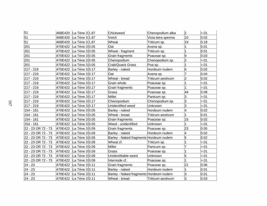
51 468E420 La Tène 3 1.87 Chickweed Chenopodium alba 2 >.01 51 468E420 La Tène 3 1.87 Vetch Vicia tetra sperma 10 0.02 51 468E420 La Tène 3 1.87 Wheat Triticum sp. 19 0.18 201 470E422 La Tène 3 0.05 Oat Avena sp. 1 0.01 201 470E422 La Tène 3 0.05 Wheat - fragment Triticum sp. 1 0.01 201 470E422 La Tène 3 0.05 Grain fragments Poaceae sp. 9 0.03 201 470E422 La Tène 3 0.05 Chenopodium Chenopodium sp. 2 >.01 201 470E422 La Tène 3 0.05 Crab/Quack Grass Poa sp. 1 >.01 217 - 219 470E422 La Tène 3 0.17 Barley - naked Hordeum nudem 6 0.02 217 - 219 470E422 La Tène 3 0.17 Oat Avena sp. 7 0.04 217 - 219 470E422 La Tène 3 0.17 Wheat - bread Triticum aestivum 2 0.02 217 - 219 470E422 La Tène 3 0.17 Grain whole Poaceae sp. 1 >.01 217 - 219 470E422 La Tène 3 0.17 Grain fragments Poaceae sp. 1 >.01 217 - 219 470E422 La Tène 3 0.17 Grass Poaceae sp. 44 0.08 217 - 219 470E422 La Tène 3 0.17 Millet Panicum sp. 3 >.01 217 - 219 470E422 La Tène 3 0.17 Chenopodium Chenopodium sp. 3 >.01 217 - 219 470E422 La Tène 3 0.17 Unidentified weed Unknown 3 >.01 154 - 161 470E422 La Tène 3 0.05 Barley - naked Hordeum nudem 4 0.02 154 - 161 470E422 La Tène 3 0.05 Wheat - bread Triticum aestivum 1 0.01 154 - 161 470E422 La Tène 3 0.05 Grain fragments Poaceae sp. 15 0.02 154 - 161 470E422 La Tène 3 0.05 Weed - unidentified Unknown 1 >.01 22 - 23 OR 72 - 73 470E422 La Tène 3 0.09 Grain fragments Poaceae sp. 23 0.05 22 - 23 OR 72 - 73 470E422 La Tène 3 0.09 Barley - naked Hordeum nudem 4 0.02 22 - 23 OR 72 - 73 470E422 La Tène 3 0.09 Barley - Naked fragments Hordeum nudem 5 0.02 22 - 23 OR 72 - 73 470E422 La Tène 3 0.09 Wheat cf. Triticum sp. 1 >.01 22 - 23 OR 72 - 73 470E422 La Tène 3 0.09 Millet Panicum sp. 7 >.01 22 - 23 OR 72 - 73 470E422 La Tène 3 0.09 Grass Poaceae sp. 1 >.01 22 - 23 OR 72 - 73 470E422 La Tène 3 0.09 Unidentifiable weed Unknown 5 >.01 22 - 23 OR 72 - 73 470E422 La Tène 3 0.09 Internode cf. Poaceae sp. 1 >.01 24 - 23 470E422 La Tène 3 0.11 Grain fragments Poaceae sp. 21 0.06 24 - 23 470E422 La Tène 3 0.11 Barley - naked Hordeum nudem 1 0.01 24 - 23 470E422 La Tène 3 0.11 Barley - Naked fragments Hordeum nudem 3 0.01 24 - 23 470E422 La Tène 3 0.11 Wheat - bread Triticum aestivum 3 0.03
167

24 - 23 470E422 La Tène 3 0.11 Poa sp. Poaceae sp. 3 >.01 24 - 23 470E422 La Tène 3 0.11 Vetch/Mustard Sinapsis/Vicia 2 >.01 24 - 23 470E422 La Tène 3 0.11 Chenopodium Chenopodium sp. 1 >.01 227 470E422 La Tène 3 0.04 Grain fragments Poaceae sp. 8 0.02 227 470E422 La Tène 3 0.04 Barley - naked CF Hordeum nudem 2 0.01 227 470E422 La Tène 3 0.04 Wheat - bread Triticum aestivum 1 0.01 223 470E422 La Tène 3 >.01 Grain fragments Poaceae sp. 1 >.01 223 470E422 La Tène 3 >.01 Poa sp. Poaceae sp. 2 >.01 22 470E422 La Tène 3 0.28 Wheat - emmer Triticum dioccocum 1 >.01 22 470E422 La Tène 3 0.28 Wheat - bread Triticum aestivum 4 0.02 22 470E422 La Tène 3 0.28 Barley - naked Hordeum nudem 10 0.05 22 470E422 La Tène 3 0.28 Rye Seacle sp. 2 0.01 22 470E422 La Tène 3 0.28 Oat Avena sp. 2 0.01 22 470E422 La Tène 3 0.28 Grain fragments Poaceae sp. 61 0.17 22 470E422 La Tène 3 0.28 Garden pea Pisum sativa 1 0.02 22 470E422 La Tène 3 0.28 Poa sp. Poaceae sp. 3 >.01 22 470E422 La Tène 3 0.28 Millet Panicum sp. 2 >.01 22 470E422 La Tène 3 0.28 Dock Carex sp. 2 >.01 22 470E422 La Tène 3 0.28 Unidentified weed Unknown 3 >.01 52 470E422 La Tène 3 1.73 Oat - fragment Avena sp. 7 0.03 52 470E422 La Tène 3 1.73 Oat Avena sp. 8 0.04 52 470E422 La Tène 3 1.73 Rye Seacle sp. 7 0.04 52 470E422 La Tène 3 1.73 Barley - hulled Hordeum vulgare 1 >.01 52 470E422 La Tène 3 1.73 Whole grain unidentifiable Poaceae sp. 10 0.06 52 470E422 La Tène 3 1.73 Chickweed Chenopodium alba 4 >.01 52 470E422 La Tène 3 1.73 Millet Panicum sp. 18 >.01 52 470E422 La Tène 3 1.73 Vetch/Mustard Sinapsis/Vicia 6 0.02 52 470E422 La Tène 3 1.73 Wheat - bread Triticum aestivum 19 0.21 52 470E422 La Tène 3 1.73 Chenopodium Chenopodium sp. 1 >.01 52 470E422 La Tène 3 1.73 Sedge Rumex sp. 1 >.01 52 470E422 La Tène 3 1.73 Lollium sp. Lollium sp. 1 >.01 52 470E422 La Tène 3 1.73 Grass Poaceae sp. 11 0.03 52 470E422 La Tène 3 1.73 Unidentified weed Unknown 20 0.03
168

52 470E422 La Tène 3 1.73 Poa sp. Poaceae sp. 6 0.03 52 470E422 La Tène 3 1.73 Grain fragments Poaceae sp. 339 0.97 23 470E420 La Tène 3 2.04 Grain fragments Poaceae sp. 428 1.05 23 470E420 La Tène 3 2.04 Millet Panicum sp. 28 0.03 23 470E420 La Tène 3 2.04 Wheat - bread Triticum aestivum 15 0.19 23 470E420 La Tène 3 2.04 Barley - naked Hordeum nudem 74 0.37 23 470E420 La Tène 3 2.04 Rye CF Seacle sp. 3 0.02 23 470E420 La Tène 3 2.04 Oat Avena sp. 15 0.09 23 470E420 La Tène 3 2.04 Oat fragments Avena sp. 8 0.04 23 470E420 La Tène 3 2.04 Whole grain unidentifiable Poaceae sp. 22 0.15 23 470E420 La Tène 3 2.04 Grape seed fragment Vitis vinifera 2 >.01 23 470E420 La Tène 3 2.04 Garden pea Pisum sativa 1 0.01 23 470E420 La Tène 3 2.04 Poa sp. Poaceae sp. 7 >.01 23 470E420 La Tène 3 2.04 Lollium sp. Lollium sp. 4 >.01 23 470E420 La Tène 3 2.04 Fescue Poa sp. 15 0.03 23 470E420 La Tène 3 2.04 Sedge Polyganum sp. 1 >.01 23 470E420 La Tène 3 2.04 Mallow Malvaceae family 1 >.01 23 470E420 La Tène 3 2.04 Corncockle Agrostemma githago 1 >.01 23 470E420 La Tène 3 2.04 Vetch/Mustard Sinapsis/Vicia 6 0.01 23 470E420 La Tène 3 2.04 Chenopodium Chenopodium sp. 4 >.01 23 470E420 La Tène 3 2.04 Weed - unidentified Unknown 13 >.01 23 470E420 La Tène 3 2.04 Grass pea Lathyrus sp. 13 >.01 269 471E420 La Tène 3 1.47 Millet Panicum sp. 12 0.02 269 471E420 La Tène 3 1.47 Wheat - compact Triticum compactum 1 0.01 269 471E420 La Tène 3 1.47 Wheat - emmer Triticum dioccocum 2 0.01 269 471E420 La Tène 3 1.47 Wheat - bread Triticum aestivum 11 0.11 269 471E420 La Tène 3 1.47 Rye CF Seacle sp. 4 0.03 269 471E420 La Tène 3 1.47 Oat Avena sp. 13 0.07 269 471E420 La Tène 3 1.47 Oat fragments Avena sp. 5 0.01 269 471E420 La Tène 3 1.47 Barley - naked Hordeum nudem 5 0.26 269 471E420 La Tène 3 1.47 Whole grain unidentifiable Poaceae sp. 7 0.05 269 471E420 La Tène 3 1.47 Grain fragments Poaceae sp. 300 0.77 269 471E420 La Tène 3 1.47 Garden pea Pisum sativa 1 0.02
169

269 471E420 La Tène 3 1.47 Vetch/Mustard Sinapsis/Vicia 4.5 0.02 269 471E420 La Tène 3 1.47 Lollium sp. Lollium sp. 5 0.02 269 471E420 La Tène 3 1.47 Fescue Poa sp. 17 0.06 269 471E420 La Tène 3 1.47 Sedge Rumex sp. 1 >.01 269 471E420 La Tène 3 1.47 Weed - unidentified Unknown 9 >.01 4 469E420 La Tène 3 3.06 Grain fragments Poaceae sp. 652 1.73 4 469E420 La Tène 3 3.06 Millet Panicum sp. 34 0.02 4 469E420 La Tène 3 3.06 Plum/Cherry pit fragment Prunus sp. 2 0.01 4 469E420 La Tène 3 3.06 Garden pea Pisum sativa 3 0.01 4 469E420 La Tène 3 3.06 Common vetch Vicia sativa 1 >.01 4 469E420 La Tène 3 3.06 Grass pea Lathyrus sp. 1 >.01 4 469E420 La Tène 3 3.06 Unidentifiable Unknown 1 >.01 4 469E420 La Tène 3 3.06 Vetch/Mustard 4 >.01 4 469E420 La Tène 3 3.06 Poa sp. Poa sp. 15 >.01 4 469E420 La Tène 3 3.06 Chenopodium Chenopodium sp. 4 >.01 4 469E420 La Tène 3 3.06 Unidentified weed Unknown 11 >.01 4 469E420 La Tène 3 3.06 Lollium sp. Lollium sp. 5 >.01 4 469E420 La Tène 3 3.06 Grass Poaceae sp. 6 >.01 4 469E420 La Tène 3 3.06 Oat Avena sp. 28 0.23 4 469E420 La Tène 3 3.06 Barley - hulled Hordeum vulgare 2 0.01 4 469E420 La Tène 3 3.06 Wheat - bread Triticum aestivum 39 0.35 4 469E420 La Tène 3 3.06 Rye CF Seacle sp. 9 0.05 4 469E420 La Tène 3 3.06 Whole grain unidentifiable Poaceae sp. 14 0.06 4 469E420 La Tène 3 3.06 Barley - naked Hordeum nudem 84 0.55 4 469E420 La Tène 3 3.06 Pulse fragments Fabaceae sp. 6 >.01 103 469E420 La Tène 3 5.97 Raspberry/Blackberry Rubus sp. 2 0.01 103 469E420 La Tène 3 5.97 Grain fragments Poaceae sp. 1100 2.86 103 469E420 La Tène 3 5.97 Millet Panicum sp. 67 0.08 103 469E420 La Tène 3 5.97 Insect Gall Insect Gall 1 >.01 103 469E420 La Tène 3 5.97 Vetch/Mustard Sinapsis/Vicia 34 0.1 103 469E420 La Tène 3 5.97 Barley Hordeum nudem 186 1.13 103 469E420 La Tène 3 5.97 Barley fragments Hordeum nudem 45 0.23 103 469E420 La Tène 3 5.97 Hulled barley cf. Hordeum vulgare 6 0.02
170

103 469E420 La Tène 3 5.97 Wheat - bread Triticum aestivum 49 0.5 103 469E420 La Tène 3 5.97 Wheat - fragments Triticum sp. 10 0.08 103 469E420 La Tène 3 5.97 Oat Avena sp. 48 0.25 103 469E420 La Tène 3 5.97 Oat - fragment Avena sp. 18 0.08 103 469E420 La Tène 3 5.97 Rye CF Seacle sp. 2 0.01 103 469E420 La Tène 3 5.97 Grain Unknown 11 0.08 103 469E420 La Tène 3 5.97 Garden pea Pisum sativa 6 0.1 103 469E420 La Tène 3 5.97 Legume fragments Fabaceae sp. 13 0.09 103 469E420 La Tène 3 5.97 Polyganum sp. Polyganum sp. 1 >.01 103 469E420 La Tène 3 5.97 Oraganic Tar Unknown 4 0.01 103 469E420 La Tène 3 5.97 Common vetch Vicia sativa 1 0.01 103 469E420 La Tène 3 5.97 Grass pea Lathyrus sp. 4 0.02 103 469E420 La Tène 3 5.97 Lollium sp. Lollium sp. 12 0.03 103 469E420 La Tène 3 5.97 Grass - Quackgrass Poaceae sp. 14 >.01 103 469E420 La Tène 3 5.97 Grass Poaceae sp. 37 0.12 103 469E420 La Tène 3 5.97 Chenopodium Chenopodium sp. 10 >.01 103 469E420 La Tène 3 5.97 Unidentifiable weeds Unknown 35 0.06 50 469E420 La Tène 3 0.58 Grain fragments Poaceae sp. 127 0.3 50 469E420 La Tène 3 0.58 Barley Hordeum nudem 14 0.08 50 469E420 La Tène 3 0.58 Barley fragments Hordeum nudem 3 0.02 50 469E420 La Tène 3 0.58 Immature grains cf. Poaceae sp. 4 0.02 50 469E420 La Tène 3 0.58 Grain Poaceae sp. 5 0.03 50 469E420 La Tène 3 0.58 Oat Avena sp. 5 0.03 50 469E420 La Tène 3 0.58 Wheat - emmer Triticum dioccocum 1 0.02 50 469E420 La Tène 3 0.58 Wheat - bread Triticum aestivum 2 0.02 50 469E420 La Tène 3 0.58 Wheat Triticum sp. 2 0.02 50 469E420 La Tène 3 0.58 Violet Viola sp. 1 >.01 50 469E420 La Tène 3 0.58 Weed - unidentified Unknown 13 >.01 50 469E420 La Tène 3 0.58 Millet Panicum sp. 11 0.01 50 469E420 La Tène 3 0.58 Plantain Plantago sp. 2 0.01 50 469E420 La Tène 3 0.58 Poa sp. Poaceae sp. 2 >.01 50 469E420 La Tène 3 0.58 Wild oat Avena fatua 2 0.01 50 469E420 La Tène 3 0.58 Fescue Festuca pratensis 6 0.02
171

50 469E420 La Tène 3 0.58 Vetch/Mustard Vicia/sinapsis 2 >.01 94 469E420 La Tène 3 4.87 Grain fragments Poaceae sp. 979 2.92 94 469E420 La Tène 3 4.87 Barley Hordeum nudem 113 0.77 94 469E420 La Tène 3 4.87 Oat Avena sp. 75 0.41 94 469E420 La Tène 3 4.87 Vetch/Mustard Sinapsis/Vicia 27.5 0.06 94 469E420 La Tène 3 4.87 Millet Panicum sp. 49 0.07 94 469E420 La Tène 3 4.87 Garden pea Pisum sativa 3 0.05 94 469E420 La Tène 3 4.87 Common vetch Vicia sativa 3 0.04 94 469E420 La Tène 3 4.87 Grass pea Lathyrus sp. 1 0.01 94 469E420 La Tène 3 4.87 Glume base Poaceae sp. 2 0.01 94 469E420 La Tène 3 4.87 Field poppy Agrostemma githago 6 0.02 94 469E420 La Tène 3 4.87 Chenopodium Chenopodium sp. 5 >.01 94 469E420 La Tène 3 4.87 Lollium Lollium sp. 11 0.03 94 469E420 La Tène 3 4.87 Grape seed fragment CF Vitis vinifera 1 >.01 94 469E420 La Tène 3 4.87 Needle grass Stipa sp. 1 >.01 94 469E420 La Tène 3 4.87 Grass Poaceae sp. 23 0.07 94 469E420 La Tène 3 4.87 Unidable Unknown 3 0.02 94 469E420 La Tène 3 4.87 Unidable weeds Unknown 16 0.01 94 469E420 La Tène 3 4.87 Wheat - bread Triticum aestivum 39 0.4 94 469E420 La Tène 3 4.87 Wheat - emmer Triticum dioccocum 12 0.12 456 467E422 La Tène 3 0.23 Grain fragments Poaceae sp. 41 0.13 456 467E422 La Tène 3 0.23 Barley Hordeum nudem 6 0.04 456 467E422 La Tène 3 0.23 Wheat - bread Triticum aestivum 1 0.01 456 467E422 La Tène 3 0.23 Oat Avena sp. 1 0.01 456 467E422 La Tène 3 0.23 Legume Unknown 3 0.03 456 467E422 La Tène 3 0.23 Unidentifiable Unknown 3 0.01 456 467E422 La Tène 3 0.23 Glume base - weed Unknown 1 >.01 473 467E422 La Tène 3 0.4 Grain fragments Poaceae sp. 66 0.13 473 467E422 La Tène 3 0.4 Barley Hordeum nudem 8 0.05 473 467E422 La Tène 3 0.4 Wheat Triticum sp. 6 0.05 473 467E422 La Tène 3 0.4 Wheat - emmer Triticum dioccocum 4 0.05 473 467E422 La Tène 3 0.4 Wheat - bread Triticum aestivum 2 0.02 473 467E422 La Tène 3 0.4 Oat Avena sp. 6 0.05
172

473 467E422 La Tène 3 0.4 Oat - fragment Avena sp. 4 0.02 473 467E422 La Tène 3 0.4 Barley cf. Hordeum nudem 1 0.01 473 467E422 La Tène 3 0.4 Grass Poaceae sp. 1 >.01 473 467E422 La Tène 3 0.4 Millet Panicum sp. 1 >.01 473 467E422 La Tène 3 0.4 Weed - unidentified Unknown 6 0.01 473 467E422 La Tène 3 0.4 Grain Poaceae sp. 2 0.01 467 467E422 La Tène 3 0.22 Grain fragments Poaceae sp. 37 0.11 467 467E422 La Tène 3 0.22 Barley Hordeum nudem 8 0.04 467 467E422 La Tène 3 0.22 Wheat fragments Triticum sp. 5 0.02 467 467E422 La Tène 3 0.22 Wheat - bread Triticum aestivum 21 0.02 467 467E422 La Tène 3 0.22 Oat Avena sp. 4 0.03 467 467E422 La Tène 3 0.22 Millet Panicum sp. 3 >.01 467 467E422 La Tène 3 0.22 Vetch/Mustard Sinapsis/Vicia 1 >.01 467 467E422 La Tène 3 0.22 Weed - unidentified Unknown 4 >.01 467 467E422 La Tène 3 0.22 Grass Unknown 3 >.01 481 467E422 La Tène 3 0.25 Grain fragments Poaceae sp. 84 0.16 481 467E422 La Tène 3 0.25 Legume fragments Fabaceae sp. 9 0.03 481 467E422 La Tène 3 0.25 Grass Poaceae sp. 1 >.01 481 467E422 La Tène 3 0.25 Barley Hordeum nudem 5 0.03 481 467E422 La Tène 3 0.25 Bromus sp. Bromus sp. 1 >.01 481 467E422 La Tène 3 0.25 Wheat fragments Triticum sp. 2 0.02 481 467E422 La Tène 3 0.25 Wheat - emmer Triticum dioccocum 1 0.01 481 467E422 La Tène 3 0.25 Millet Panicum sp. 1 >.01 481 467E422 La Tène 3 0.25 Undentifiable Unknown 1 >.01 65 468E420 La Tène 3 1.91 Millet Panicum sp. 35 0.04 65 468E420 La Tène 3 1.91 Rye Seacle sp. 9 0.04 65 468E420 La Tène 3 1.91 Oat Avena sp. 25 0.13 65 468E420 La Tène 3 1.91 Barley Hordeum nudem 50 0.28 65 468E420 La Tène 3 1.91 Grain fragments Poaceae sp. 392 1.13 65 468E420 La Tène 3 1.91 Chickweed Chenopodium sp. 4 >.01 65 468E420 La Tène 3 1.91 Grape fragment cf. Vitis vinifera 1 >.01 65 468E420 La Tène 3 1.91 Lollium Lollium sp. 3 >.01 65 468E420 La Tène 3 1.91 Grass Poaceae sp. 3 >.01
173

65 468E420 La Tène 3 1.91 Grass small Poaceae sp. 6 >.01 65 468E420 La Tène 3 1.91 Wheat bread Triticum aestivum 29 0.26 65 468E420 La Tène 3 1.91 Chaff Unknown 1 >.01 65 468E420 La Tène 3 1.91 Chenopodium Chenopodium sp. 2 >.01 65 468E420 La Tène 3 1.91 Vetch/Mustard Sinapsis/Vicia 7 0.03 65 468E420 La Tène 3 1.91 Mustard Sinapsis alba 1 >.01 65 468E420 La Tène 3 1.91 Glume base fragment Unknown 1 >.01 65 468E420 La Tène 3 1.91 Plum/Cherry pit fragment Prunus sp. 1 >.01 65 468E420 La Tène 3 1.91 Dock Rumex sp. 1 >.01 65 468E420 La Tène 3 1.91 Weed - unidentified Unknown 3 >.01 65 468E420 La Tène 3 1.91 Unidentifiable Unknown 4 >.01 65 468E420 La Tène 3 1.91 Oraganic Tar Unknown 1 >.01 65 468E420 La Tène 3 1.91 Barley - hulled Hordeum vulgare 1 >.01
174

APPENDIX 2
CORRESPONDENCE ANALYSIS FACTOR TABLES
Factor table etc. for grain correspondence analysis The categorical values encountered during processing are Variables Levels C1$ (3 levels) Hallstatt La Tene 1 La Tene 3 C2$ (8 levels) Barley Barley - hulled Grain Immature grainMillet Oat Rye Wheat
Simple Correspondence Analysis Chi-square : 40.025 df : 14.000 Probability : 0.000 Eigenvalues and Percent Inertia Factor Eigenvalue Percent Cumulative
Percent
1 0.077 91.041 91.041 ----------- --------------------------- ..
2 0.008 8.959 100.000 --- ..
Sum : 0.084 (Total Inertia) Row Variable Coordinates Name Mass Quality Inertia Factor 1Factor 2Hallstatt 0.120 1.000 0.034 -0.498 0.176 La Tene 1 0.511 1.000 0.010 -0.120 -0.076 La Tene 3 0.369 1.000 0.041 0.328 0.048
Row Variable Contributions to Factors Name Factor 1 Factor 2 Hallstatt 0.388 0.492 La Tene 1 0.096 0.394 La Tene 3 0.517 0.114
Row Variable Squared Correlations with Factors Name Factor 1 Factor 2 Hallstatt 0.889 0.111 La Tene 1 0.712 0.288 La Tene 3 0.979 0.021
175

Column Variable Coordinates Name Mass Quality Inertia Factor 1Factor 2Barley 0.156 1.000 0.009 0.167 -0.179 Barley - hulled 0.025 1.000 0.016 0.779 0.197 Grain 0.262 1.000 0.007 -0.157 0.029 Immature grain 0.004 1.000 0.001 0.375 -0.161 Millet 0.209 1.000 0.028 -0.365 0.012 Oat 0.112 1.000 0.012 0.318 0.098 Rye 0.036 1.000 0.010 0.518 -0.035 Wheat 0.196 1.000 0.001 0.081 0.020
Column Variable Contributions to Factors Name Factor 1 Factor 2 Barley 0.057 0.664 Barley - hulled 0.200 0.130 Grain 0.084 0.029 Immature grain 0.008 0.015 Millet 0.362 0.004 Oat 0.147 0.143 Rye 0.125 0.006 Wheat 0.017 0.010
Column Variable Squared Correlations with Factors Name Factor 1 Factor 2 Barley 0.465 0.535 Barley - hulled 0.940 0.060 Grain 0.967 0.033 Immature grain 0.844 0.156 Millet 0.999 0.001 Oat 0.913 0.087 Rye 0.995 0.005 Wheat 0.945 0.055
Factor tables etc. for weed correspondence analysis The categorical values encountered during processing are
176

Variables Levels C1$ (3 levels) Hallstatt La Tene 1 La Tene 3 C2$ (33 levels) Bedstraw Bromus Bullrush/spurgeCatchfly Chenopodium Corncockle Daisy Dock Euphorb Fescue Field Wood Rush Glume base -
weed Grass Knotweed Legume
Lollium Mallow Millet Needle grass Plantain Poa sp. Polygonum Pulse/legume Quackgrass Sedge Sedge/dock Unidentifiable
weed Vetch Vetch/MustardViolet
Wild Barley Wild Rye Wild oat
Simple Correspondence Analysis Chi-square : 123.766 df : 64.000 Probability : 0.000 Eigenvalues and Percent Inertia Factor Eigenvalue Percent Cumulative
Percent
1 0.235 53.896 53.896 ----------- ----------- ..
2 0.201 46.104 100.000 ----------- -------- ..
Sum : 0.436 (Total Inertia) Row Variable Coordinates Name Mass Quality Inertia Factor 1Factor 2Hallstatt 0.095 1.000 0.210 -1.427 0.414 La Tene 1 0.567 1.000 0.087 0.032 -0.391 La Tene 3 0.338 1.000 0.139 0.347 0.539
Row Variable Contributions to Factors Name Factor 1 Factor 2 Hallstatt 0.824 0.081 La Tene 1 0.003 0.431 La Tene 3 0.174 0.488
Row Variable Squared Correlations with Factors Name Factor 1 Factor 2 Hallstatt 0.922 0.078 La Tene 1 0.007 0.993 La Tene 3 0.293 0.707
Column Variable Coordinates Name Mass Quality InertiaFactor 1Factor 2
177

Column Variable Coordinates Name Mass Quality InertiaFactor 1Factor 2Bedstraw 0.007 1.000 0.015 -1.439 0.026 Bromus 0.039 1.000 0.019 0.126 -0.683 Bullrush/spurge 0.004 1.000 0.034 -2.944 0.923 Catchfly 0.018 1.000 0.010 -0.536 -0.513 Chenopodium 0.092 1.000 0.011 0.341 0.006 Corncockle 0.014 1.000 0.028 0.717 1.202 Daisy 0.004 1.000 0.034 -2.944 0.923 Dock 0.035 1.000 0.017 -0.642 0.289 Euphorb 0.007 1.000 0.005 0.066 -0.872 Fescue 0.011 1.000 0.021 0.717 1.202 Field Wood Rush 0.004 1.000 0.003 0.066 -0.872 Glume base - weed 0.004 1.000 0.007 0.717 1.202 Grass 0.180 1.000 0.004 0.144 0.047 Knotweed 0.004 1.000 0.034 -2.944 0.923 Legume 0.007 1.000 0.005 0.066 -0.872 Lollium 0.113 1.000 0.007 -0.160 0.186 Mallow 0.011 1.000 0.001 0.283 -0.180 Millet 0.004 1.000 0.007 0.717 1.202 Needle grass 0.007 1.000 0.001 0.391 0.165 Plantain 0.011 1.000 0.007 -0.720 0.418 Poa sp. 0.025 1.000 0.048 0.717 1.202 Polygonum 0.053 1.000 0.020 0.153 -0.595 Pulse/legume 0.007 1.000 0.005 0.066 -0.872 Quackgrass 0.018 1.000 0.006 0.456 0.373 Sedge 0.021 1.000 0.005 -0.110 0.464 Sedge/dock 0.004 1.000 0.034 -2.944 0.923 Unidentifiable weed 0.250 1.000 0.010 -0.023 -0.194 Vetch 0.021 1.000 0.015 -0.829 0.072 Vetch/Mustard 0.011 1.000 0.001 0.283 -0.180 Violet 0.004 1.000 0.007 0.717 1.202 Wild Barley 0.011 1.000 0.008 0.066 -0.872 Wild Rye 0.004 1.000 0.003 0.066 -0.872 Wild oat 0.004 1.000 0.007 0.717 1.202
Column Variable Contributions to Factors Name Factor 1 Factor 2 Bedstraw 0.062 0.000 Bromus 0.003 0.090 Bullrush/spurge 0.130 0.015 Catchfly 0.022 0.023 Chenopodium 0.045 0.000 Corncockle 0.031 0.101 Daisy 0.130 0.015 Dock 0.062 0.015 Euphorb 0.000 0.027 Fescue 0.023 0.076 Field Wood Rush 0.000 0.013
178

Column Variable Contributions to Factors Name Factor 1 Factor 2 Glume base - weed 0.008 0.025 Grass 0.016 0.002 Knotweed 0.130 0.015 Legume 0.000 0.027 Lollium 0.012 0.019 Mallow 0.004 0.002 Millet 0.008 0.025 Needle grass 0.005 0.001 Plantain 0.023 0.009 Poa sp. 0.054 0.177 Polygonum 0.005 0.093 Pulse/legume 0.000 0.027 Quackgrass 0.016 0.012 Sedge 0.001 0.023 Sedge/dock 0.130 0.015 Unidentifiable weed 0.001 0.047 Vetch 0.062 0.001 Vetch/Mustard 0.004 0.002 Violet 0.008 0.025 Wild Barley 0.000 0.040 Wild Rye 0.000 0.013 Wild oat 0.008 0.025
Column Variable Squared Correlations with Factors Name Factor 1 Factor 2 Bedstraw 1.000 0.000 Bromus 0.033 0.967 Bullrush/spurge 0.911 0.089 Catchfly 0.522 0.478 Chenopodium 1.000 0.000 Corncockle 0.262 0.738 Daisy 0.911 0.089 Dock 0.831 0.169 Euphorb 0.006 0.994 Fescue 0.262 0.738 Field Wood Rush 0.006 0.994 Glume base - weed 0.262 0.738 Grass 0.903 0.097 Knotweed 0.911 0.089 Legume 0.006 0.994 Lollium 0.425 0.575 Mallow 0.711 0.289 Millet 0.262 0.738 Needle grass 0.849 0.151 Plantain 0.748 0.252 Poa sp. 0.262 0.738
179

Column Variable Squared Correlations with Factors Name Factor 1 Factor 2 Polygonum 0.062 0.938 Pulse/legume 0.006 0.994 Quackgrass 0.600 0.400 Sedge 0.053 0.947 Sedge/dock 0.911 0.089 Unidentifiable weed 0.014 0.986 Vetch 0.992 0.008 Vetch/Mustard 0.711 0.289 Violet 0.262 0.738 Wild Barley 0.006 0.994 Wild Rye 0.006 0.994 Wild oat 0.262 0.738
180

APPENDIX 3
SOFTWARE PACKAGES USED The following software packages were used in this study: For graphics editing, Adobe Photoshop CS For data management, some statistics and writing, Microsoft Office 2000, 2003 (Access, Excel, and Word) For some statistics, Systat 12
181

BIBLIOGRAPHY Ashman, M. R. and and G. Puri 2002 Essential soil science : a clear and concise introduction to soil science Oxford ; Malden, MA : Blackwell Science Bakels, Corrie 2001 “Producers and consumers in archeobotany. A comment on “When method meets theory: the use and misuse of cereal producer/consumer models in archaeobotany.” Environmental Archaeology: Meaning and Purpose etd. Uberto Albarella Kluwer Academic Publishers : 2001 Balee, William L. 2006 Time and Complexity in Historical Ecology: Studies in the Neotropical Lowlands. New York, NY, USA: Columbia University Press 1998 Historical Ecology: Premises and Postulates Advances in Historical Ecology William Balee ed. 13-29 Columbia University Press : New York Barbler, Delphine and Lionel Visset 1997 Logn , a peat bog of European ecological interest in the Massif Armorican, western France: bog development, vegetation and land-use history Vegetation History Archaeobotany 6:69-77 Bon, Sara 1999 Common Wares: Approaches to a Gallo-Roman Ceramic Assemblage. PhD Dissertation submitted to UNC-CH Boserup, Ester 1965 The conditions of agricultural growth : the economics of agrarian change under population pressure. Aldine Publishing Co.: New York Braudel, Fernand 1980 “History and the Social Sciences: The Longue Duree” On History. pp25-54 University of Chicago Press : Chicago Brinkkemper, Otto 1996 Indirect Correspondence Analysis and Botanical Macroremains: a case study. Analecta Praehistorica Leidensia 26 Brinkkemper, Otto and Louise van Wijngaarden-Bakker 1999 All-round farming: Food Production in the Bronze Age and the Iron Age. In The Prehistory of the Netherlands Vol 2 etd L.P. Kooijmans et al. Amsterdam : Amsterdam University Press pp491-512 Bumayne-Peaty, Lisa
182

1998 Human Impact on the Environment during the Iron Age and Romano-British Times: Palynological Evidence from Three Sites near the Antonine Wall, Great Britain Journal of Archaeological Science 25: 203–214 Burroughs, William James 2005 Climate change in prehistory: the end of the reign of chaos. Cambridge, New York : Cambridge University Press Campbell, Gill and Julie Hamilton 2000 “Danebury Environs: agricultural change in the Iron Age” pp114-122 In Human Ecodynamics etd Geoff Bailey et al.. Oxford : Oxbow Books Capdevila, Ramon 1996 Evidence for vines and ancient cultivation from an urban area, Lattes (Hérault), southern France. Antiquity 70: 393-407 Cheyette, Frederik L. 2008 “The disappearance of the ancient landscape and the climatic anomaly of the early Middle Ages” Early Medieval Europe 16(2) Collis, John 2003 The Celts: Origins, Myths and Inventions. London : Tempus Crumley, Carole L. 1987 Historical Ecology. Regional Dynamics: Burgundian Landscapes in Historical Perspective, Carole L. Crumley and William H. Marquardt, eds., pp. 237-264. San Diego: Academic Press. 1994a Historical Ecology: A Multidimensional Ecological Orientation. Historical Ecology: Cultural Knowledge and Changing Landscapes, Carole L. Crumley, ed., pp. 183-201. Santa Fe: School of American Research. 1994 "The Ecology of Conquest: Contrasting Agropastoral and Agricultural Societies' Adaptation to Climatic Change" in Historical Ecology: Cultural Knowledge and Changing Landscapes etd. Carole L. Crumley School of American Research : Santa Fe 2007 “Historical Ecology: Integrated Thinking at Multiple Temporal and Spatial Scales” in The World System and the Earth System. Etd. Alf Hornborg and Carole Crumley Walnut Creek CA : Left Coast Press Crumley, Carole L. and Paul Green 1987 Environmental Setting. In Regional Dynamics: Burgundian Landscapes in Historical Perspectives ed C. Crumley and W. Marquart San Deigo : Academic Press pp19-40 Crumley, C.L. William Marquardt and Thomas Leatherman
183

1987 Certain Factors Influencing Settlement during the Later Iron Age and Gallo Roman periods: The Analysis of Intensive Survey Data in Regional Dynamics: Burgundian Landscapes in Historical Perspecitive etd. C.L. Crumley and William H. Marquardt Academic Press : US Crumley, Carole L. and William J. Meyer, Jr. 2006. Mettant la géographie des paysages en question: des liens entre Nord et Sud en Bourgogne. XXXe Colloque International de l'Association Française pour l'Etude de l'Age du Fer, Saint-Romain-en-Gal/Vienne (Rhône), Musée gallo-romain. 25?28 May. Cummings, Linda and Kathryn Puseman 2005 Pollen analysis, phytolith analysis, and radiocarbon dating of charcoal from tumulus sediments, La Revive, France. A report submitted to the Research Labs of Archeology Cunliffe, B 1983 Danebury, anatomy of an Iron Age hillfort. London : Batsford 1997 The Ancient Celts. London : Penguin 2005 Iron Age Communities in Britain. London : Routledge Cyprien, Anne-Laure and Lionel Visset 2001 Paleoenvironmental study of the Carquefou site (Massif Amoricain, France) from the end of the Sub-boreal. Vegetation History and Archaeobotany 10:139-149 Downer, Al 1978 Ceramic Chronology at the Mont Dardon site, France: A First Approximation M.A. Paper University of Missouri-Columbia Dowdle, Jason 1987 Road Networks and Exchange Systems in the Aeduan Civitas 300 BC- AD 300 in Regional Dynamics: Burgundian Landscapes in Historical Perspecitive etd. C.L. Crumley and William H. Marquardt Academic Press : US Ellen, Roy 1996 Introduction ecology, culture and domestication: redefining nature. Roy Ellen and Katsuyoshi Fukui eds. pp. 1-39 Berg : Oxford Fowler, P. J. 2002 Farming in the first millennium AD : British agriculture between Julius Caesar and William the Conqueror Cambridge ; New York : Cambridge University Press 393p Fuller, Dorian Q. and Stephen A. Weber 2007 “Millets and their role in early Agriculture” in Special Issue Pragdhara ed. Rakesh Tewari
184

Green, Francis 1994 “Cereals and plant food: a reassessment of the Saxon economic evidence from Wessex” In Environment and Economy in Anglo-Saxon England etd. James Rackham York : Council for British Archaeology Green, Paul with Walter Berry, V. Ann Tippitt 1987 Archeological investigations at Mont Dardon in Regional Dynamics: Burgundian Landscapes in Historical Perspecitive etd. C.L. Crumley and William H. Marquardt Academic Press : US Greene, Miranda 1995 The Celtic World. London : Routledge Guillmet, Jean-Paul, Mikail Szabo and Phillip Barral 2002 L’urbanisme à Bibracte in Les âges du Fer dans Nivernais, Bourbonnais, et Berry oriental Regards européens sur les âges du Fer en France. Etd Didier Maranski, Vincent Guichard. Glux-en-Glenne Collection Bibracte-6 Gunn, Joel and Carole L. Crumley and Elizabeth Jones and Bailey K. Young 2004 “A landscape analysis of Western Europe during the early Middle Ages” in The archaeology of global change: the impact of humans on their environment. edited by Charles L. Redman Washington : Smithsonian Books Harpstead, Milo I., Thomas J. Sauer, William F. Bennett 1997 Soil science simplified. 3rd ed. Imprint Ames Iowa State University Press Hillman, Gordon 1981 Reconstructing Crop Husbandry Practices from Charred Remains of Crops. In Farming Practice in Prehistory, etd. Roger Mercer Edinburgh : Edinburgh University Press Jahns, Susanne 2001 On the Late Pleistocene and Holocene history of vegetation and human impact on the Ucker vally, north-eastern Germany 10:97-104 James, Simon 2005 The World of the Celts. London : Thames and Hudson Jones, Elizabeth Anne 2006 Surviving the Little Ice Age : family strategies in the decade of the Great Famine of 1693-1694 as reconstructed through the parish registers and family reconstitution PhD dissertation : UNC-CH Jones, Glynis and Paul Halstead
185

1995 Maslins, Mixtures and Monocrops: on the Interpretation of Archaeobotanical Crop Samples of Heterogeneous Composition. Journal of Archaeological Science 22: 103-114 Jones, Glynis 1987 A Statistical Approach to the Archaeological Identification of Crop Processing. Journal of Archaeological Science 14: 311-323 1991 Numerical analysis in archaeobotany. In Progress in Old World Paleoethnobotany, Van Zeist etd. Balkema : Rotterdam pp 63-80 1998 Wheat Grain Identification – Why Bother? Environmental Archaeology 2, 29-34 Jones, Martin 1981 The Development of Crop Husbandry. In The Environment of Man: The Iron Age to the Anglo-Saxon period etd M. Jones and G. Dimbleby BAR 87 : London 1985 Archaeobotany beyond Subsistence Reconstruction. In Beyond Domestication in Prehistoric Europe : Investigations in Subsistence Archaeology and Social Complexity Ghraeme Barker etd. pp107-128 Academic Press : London Korber-Grohne, Udelgard 1981 Crop Husbandry and Environmental Change in the Coastal Area of the Feddersen Wierde. In The Environment of Man: Iron Age to the Anglo-Saxon period etd M. Jones and G. Dimbleby London : BAR 87 pp287-306 Kreuz, A. 1999 “Becoming a Roman farmer: preliminary report on environmental evidence from the Romanization project” In Roman Germany: Studies in Cultural Interaction etd. J.D. Creighton and R.J.A. Wilson Rhode Island : Journal of Roman Archaeology Supplementary Series Lamb, H. H. 1995 Climate, history and the modern world. London, New York : Routledge Letts, John 1999 Smoke Blacked Thatch. English Heritage : London Long, Deborah 1998 The Palaeoenvironment and the Vegetation History of a Later Prehistoric Field System at Stoke Flat on the Gritstone Uplands of the Peak District Journal of Archaeological Science 25, 505–519 Marinval, Philippe 1988 L’alimentation vététale en France du mésolithique jusqu’à l’âge du fer. Éditions du Centre National de la Recherche Scientifique : Paris
186

1992 Archaeobotanical data on millets (Panicum miliaceum and Setaria italica) in France Review of Palaeobotany and Palynology, 73 (1992): 259-270 Matterne, Veronique 2000 Evolution des productions agricoles Durant l’âge dur Fer dans le nord de la France. In Agriculture et al.imentation vegetale Durant l’age du Fer et l’epoque gallo-romaine en France septentrionale. Montagnac : Editions Monique Mergoil 1996 A study of the carbonized seeds from a La Tene D1 rural settlement, Le Camp du Roi excavation at Jaux (Oise) France. Vegetation History and Archaeobotany 5:99-104 Miller, Naomi F. 1988 Ratios in Paleoethnobotanical Analysis. In Current Paoleoethnobotany: Analystical methods and Cultural Interpretations of Archaeological Plant Remains, ed. Christine Hastorf and Virginia S. Popper pp119-144 Chicago : University of Chicago Press Miras, Y. F. Laggoun-Defarge, P. Guenet and H. Richard 2004 Multi-disciplinary approach to changes in agro-pastoral activities since the Sub-Boreal in the surroundings of the “narse d'Espinasse” (Puy de Dôme, French Massif Central) Vegetation History and Archaeobotany 13:91–103 Nelson, Max 2005 The Barbarian’s Beverage Routledge : New York and London Oliver, Lucien and Claude Rolley 2002 L’occupation du Morvan dans l’antiquité in Les âges du Fer dans Nivernais, Bourbonnais, et Berry oriental Regards européens sur les âges du Fer en France. Etd Didier Maranski, Vincent Guichard. Glux-en-Glenne Collection Bibracte-6 Pearsall, Deborah 2000 Chapter 3: Identification and Interpretation of Macroremains. In Paleoethnobotany: A Handbook of Procedures 2nd ed. Academic Press : San Deigo pp 99-247 Peglar, Sylvia M. 1993 “The development of the cultural landscape around Diss Mere, Norfolk, UK during the past 7,000 years” Review of Palaeobotany and Palynology 76: 1-47 Piperno, Delores R. 2006 Phytoliths : a comprehensive guide for archaeologists and paleoecologists Lanham, MD : AltaMira Press Ponel, Philippe
187

2000 La Téne and Gallo-Roman Natural Environments and Human Impact at the Touffréville Rural Settlement, Reconstructed from Coleoptera and Plant Macroremains (Calvados, France) Journal of Archaeological Science 27, 1055–1072 Popper, Virginia 1988 Selecting Quantitative Measurements in Paleoethnobotany. In Current Paoleoethnobotany: Analystical methods and Cultural Interpretations of Archaeological Plant Remains, ed. Christine Hastorf and Virginia S. Popper pp119-144 Chicago : University of Chicago Press Ralston, Ian 1981 The use of timber in hillfort defences in France. In Hill-Fort Studies: Essays for A.H.A Hogg. Etd. Graeme Guilbert Leicester University Press : Great Britain 2006 Celtic Fortifications. Tempus Publishing : Glouchester UK Ralston, Ian and Olivier Buchsenschutz 2002 Les fortifications du Mont Beuvray in Les âges du Fer dans Nivernais, Bourbonnais, et Berry oriental Regards européens sur les âges du Fer en France. Etd Didier Maranski, Vincent Guichard. Glux-en-Glenne Collection Bibracte-6 Rosch, Manfred 2000 Long-term human impact as registered in an upland pollen profile from the southern Black Forest, south-western Germany 9:215-218 1999 Evaluation of honey residues from Iron Age hill-top sites in south- western Germany: Implications for local and regional land use and vegetation dynamics Vegetation History and Archaeobotany 8:105-112 1998 The history of crops and crop weeds in south-western Germany from the Neolithic period to modern times, as shown by archaeobotanical evidence Vegetation History and Archaeobotany 7:109-125 Ruas, M-P 1992 “The archeobtoanical record of cultivated and collected plants of economic importance from medieval sites in France” Review of Palaeobotany and Playnology 73 pp301-314 Smith, Wendy 2001 “When method meets theory: The use of misuse of cereal producer/consumer models in archaeobotany.” Environmental Archaeology: Meaning and Purpose etd. Uberto Albarella Kluwer Academic Publishers : 2001 Shennan, Stephan 1997 Quantifying Archaeology Edinburgh University Press : Edinburgh
188

Stevens, Chris J. 2003 “An Investigation of Agricultural Consumption and Production Models for Prehistoric and Roman Britain” Environmental Archaeology 8:61-76 Unger, Richard W. 2004 Beer in the Middle Ages and the Renaissance University of Pennsylvania Press: Pennsylvania van der Veen, Marijke 1992 Crop Husbandry Regimes: An Archaeobotanical Study of Farming in northern England 1000 BC – AD 500 Sheffield Archaeological Monographs 3. Sheffield : JR Collis Publications van der Veen, Marijke and Glynis Jones 2006 “A re-analysis of agricultural production and consumption: implications for understanding the British Iron Age” Vegetation History and Archaeobotany 15:217-228 van Geel, Bas et al.. 2003 Environmental reconstruction of a Roman Period settlement site in Uitgeest (The Netherlands), with special reference to coprophilous fungi. Journal of Archaeological Science 30: 873–883 Vaucoulan, Patryck and Alain Chiffaut 2004 La Bourgogne: Paysages Naturels, faune et flore. Paris : Delachaux et Niestle Waateringe, Groenman-van and L.H. van Wijngaarden-Bakker 1987 Farm Life in a Carolingian Village Studies in Prae-en-Protohistorie 1 Van Gorcum : Maastrict Wells, Peter 1983 Rural Economy in the Iron Age: Excavations at Hascherkeller: 1978-1981 Bulletin 36 American School of Prehistoric Research Cambridge MA : Harvard University Wiethold, Julian 1996 Late Celtic and early Roman plant remains from the oppidum of Bibracte, Mont Beuvray (Burgundy, France). Vegetation History and Archaeobotany 5:105-116 2000 How to trace the “Romanization” of Central Gaule by Archaeobotanical Analaysis? in Actualite de la Recherche en Histoire et Archeologie agraires Besancon pp 269-282 Wilson, Bob
189

190
1999 Displayed or Concealed: Cross cultural evidence for symbolic and ritual activity depositing Iron Age bones. Oxford Journal of Archaeology 18(3) Blackwell Publishers : UK Wilson, James E. 1998 Terroir: The Role of Geology, Climate, and Culture in the Making of French Wines. University of California Press : Berkely Williams, R. J. 1996 Wavendon Gate: A Late Iron Age and Roman Settlement in Milton Keynes (Buckinghamshire Archaeological Society Monograph Series) London : Buckinghamshire Archaeological Society