Archaeological excavations at Whitecastle iron age hillfort, East Lothian, Scotland
195Arheološki vestnik 60, 2009, str. 195–206
Na sledi prazgodovinskega NavportaGradišče na hribu Tičnica na Vrhniki
Andrej GASPARI in René MASARYK
Izvleček
Prispevek predstavlja sledove prazgodovinske utrjene naselbine na hribu Tičnica na Vrhniki, ki so bili odkriti med terenskim pregledom aprila 2009. Gradišče sestavljajo nepravilno eliptično oblikovan osrednji del naselbine z več nivoji teras in vršnim platojem ter dva večja predprostora v skupni izmeri 4,5 ha. Ostanki obrambnih struktur obsegajo nasipe, ki so večinoma vidni kot oster prelom zunanjih teras v nižje ležeča pobočja. Posamične najdbe prostoročno izdelane keramike omogočajo okvirno datacijo gradišča v bronasto in starejšo železno dobo. Z naselbine, ki se dviga okoli 50 m nad okolico, je bilo mogoče nadzirati enega ključnih delov karavanske poti med severnim Jadranom in srednjo Evropo ter vodni promet po plovni Ljubljanici. Glede na lego in velikost gradišča, ki na vrhniškem koncu nima primerjave, gre skoraj brez dvoma za centralno naselbino na območju sporočenega prazgodovinskega predhodnika rimskega Navporta.
Ključne besede: Slovenija, Vrhnika, Nauportus, gradišča, bronasta doba, železna doba, rimska doba
Abstract
Traces of a prehistoric fortified settlement on Tičnica hill near Vrhnika, discovered during a field survey in April 2009, are presented in this contribution. The hillfort comprises an irregular elliptical central part of the settle-ment with several levels of terraces and a summit plateau, as well as two larger yards, all together measuring 4.5 ha. Remains of defence structures include ramparts, which are mostly seen as sharp breaks of the outer terraces into the lower slopes. Based on isolated finds of hand-made pottery, the site can be roughly dated to the Bronze and Early Iron Ages. From the settlement, which rises about 50 m above the surrounding area, one of the crucial parts of the caravan route between the northern Adriatic and Central Europe could be controlled, as well as traffic on the navigable Ljubljanica River. Based on the location and size of the hillfort, which has no comparison in the surroundings of Vrhnika, it is almost beyond doubt that it was the central settlement in the area of the reported prehistoric predecessor of the Roman Nauportus.
Keywords: Slovenia, Vrhnika, Nauportus, hillforts, Bronze Age, Iron Age, Roman period
UVOD
Vrhnika z okolico je zaradi pomembne geo-grafsko-prometne lege, izpostavljene tudi v na-vedbah antičnih avtorjev, in bogatih arheoloških ostalin tradicionalno deležna posebne pozorno-sti raziskovalcev. Podatke o znanih najdbah in najdiščih do konca osemdesetih let prejšnjega stoletja je zbrala in na novo ovrednotila Jana Horvat v delu Nauportus (Vrhnika), osnovni podatki o novejših odkritjih in raziskavah pa so
bili objavljeni v Varstvu spomenikov in drugih strokovnih revijah.1
Pričujoči prispevek se neposredno navezuje na morda najpomembnejše vprašanje vrhniške
1 Za posredovane podatke in mnenja se zahvaljujeva Jani Horvat, Barbari Nadbath, Sašu Poglajnu, Janezu Je-rebu in Tilnu Praprotniku. Posebno zahvalo namenjava Brini Škvor Jernejčič, Mihi Kunstlju in Davidu Badovincu za sodelovanje pri izmerah, fotografije in drugo pomoč. Janez Žitko je omogočil vpogled v zbirko starih razglednic Vrhnike in njihovo izposojo za reprodukcijo.

196 Andrej GASPARI, René MASARYK
arheologije, ki zadeva lokacijo predrimskega Navporta, tj. pri Strabonu omenjenega naselja keltskih Tavriskov (Geogr. VII 5, 2, C. 314)2 in njegovih predhodnikov. Značilnemu tipu poseli-tve iz mlajših obdobij prazgodovine bi ustrezala utrjena višinska naselbina kot sedež in središče vsakokratne politične in vojaške oblasti ter zato-čišče v primeru spopadov, medtem ko lahko vsaj gospodarsko-manipulativni prostor naselbine iščemo v ravnini ob stičišču vodne in kopenske poti. Geografsko najbližja analogija za nižinski tip naselbine ob reki v zavetju bližnjega gradišča bi bilo novoodkrito naselje iz časa med koncem bronaste dobe in poznim latenom na Prulah v Ljubljani.3 Ostanki lesenih objektov s tlakovanimi ulicami se širijo na zložnem pobočju med Ljubljanico in sedemdeset metrov višjim Grajskim gričem (376 m) z domnevno utrjeno naselbino, od koder so sporočene najdbe od zgodnje faze kulture žarnih grobišč naprej.4
Izvzemši dokaze za obljudenost vrhniškega konca v paleolitiku in mezolitiku lahko na pod-lagi posamičnih najdb odlomkov keramike ter orodij iz kamna, kosti in rogovine iz Ljubljanice med Verdom in Vrhniko5 in Ljubije pri zaselku Pritiska6 sklepamo, da je območje zaliva pozno-pleistocenskega in zgodnjeholocenskega jezera z obilico sveže vode iz kraških izvirov in drugimi naravnimi viri pritegnilo tudi bakrenodobno po-selitev. Reka se je približno v današnjem poteku domnevno ustalila šele v bronasti dobi, zato gre pri omenjenih najdbah najverjetneje za sledove odplavljenih naselbinskih plasti ali kontekstov, povezanih z gospodarskimi aktivnostmi. Med eneolitske najdbe pogojno uvrščamo tudi praskalo na odbitku, odkrito na njivi okoli 20 m vzhodno od brega Ljubljanice pri Verdu.7
V obdobju demografskega vzpona v srednji in mlajši bronasti dobi, povezanega z razvojem različnih gospodarskih dejavnosti v večini delov Evrope, je območje Ljubljanskega barja po zaslugi izrazito prehodnega značaja prostora ob komu-nikaciji med pokrajinami ob severnem Jadranu in osrednjo Slovenijo ter naravnega fenomena reke z okoliškim močvirjem, ki je dokazano
2 Šašel 1966.3 Hvalec et al. 2008.4 Vičič 1990, 178; Horvat M. 1991, 233.5 Horvat, Kocuvan, Logar 1986, 278; Horvat 1990, 58,
op. 3; Gaspari, Erič 2008b, 410, t. 5: 1–3.6 Gaspari, Erič 2007b, 231; Gaspari, Erič 2008b, sl.
1: 7–10.7 Gaspari, Erič 2007a, 239; Gaspari, Erič 2008b, 412.
pritegnil religiozno pozornost na nadregionalni ravni, doživelo enega od vrhuncev. V ta čas sodijo posamične najdbe kovinskega orožja8 in depo9 z ravnine severno in severozahodno od Vrhnike (sl. 1: 1–3), ki pomenijo prej kot ne sledove kultnega izražanja in nam pri lokalizaciji potencialnega prazgodovinskega naselbinskega jedra niso v zanesljivo oporo. Pri presoji tega vprašanja niso v pomoč niti razmeroma številne keramične najdbe stopenj Bd D/Ha A1 iz strug Ljubije pri ledini Zalog pri Verdu (sl. 1: 14)10 ter Ljubljanice pri sv. Antonu na Verdu (sl. 1: 15)11 in na odseku med sotočjem izvirnih krakov in cestnim mostom Vrhnika-Verd (sl. 1: 11–13). Glede na sestavo in relativno majhno stopnjo fragmentacije posod ni izključeno, da gre deloma za sledove alterna-tivne oblike pokopavanja z odlaganjem grobnih pridatkov v rečno vodo.12
Starejša železna doba je bila v širši okolici do nedavna zastopana le z osamljeno najdbo odlomka lonca iz Ljubljanice pri mostu za pešce med Vrhniko in Verdom (sl. 1: 12)13 in z železnima tulastima sekirama, sekiro na uho in bronasto kavljasto pasno spono iz struge pri Sinji Gorici (sl. 1: 4).14 Maja 2009 je bil med nadzorom obnovitvenih del pri križišču Stare ceste s Cesto gradenj odkrit odlo-mek dna lonca iz konca bronaste dobe ali starejše železne dobe, ki je ležal v koluvialnem sedimentu 0,7 m pod površjem (sl. 1: 10).15
Nenavadno skromni so dokazi za latensko fazo poselitve, saj izvirajo skoraj vsi znani keltski predmeti z levega in desnega brega Ljubljanice iz zgodnje-rimskih depozitov. Gre za keramiko, novce, fibule in fragmente orožja iz utrjene oskrbovalne baze in naselbine na Dolgih njivah (sl. 1: 5),16 ki je bila zgrajena ex novo v avgustejskem obdobju ali nekoliko prej,17 in keramiko in novce iz srednjeavgustejskih plasti na Kočevarjevem vrtu na Bregu (sl. 1: 7).18 Med najdbami latenske provenience z vrhniškega
8 Horvat 1990, 67 s, 70.9 Ib., 67, sl. 12; prim. Turk 2007, 215–217.10 Gaspari 2006.11 Gaspari, Erič 2008a; Gaspari, Erič 2008b, sl. 1: 1;
t. 1: 2–4.12 Gaspari, Erič 2008b, 410 s, t. 4; 5: 4–9; 6: 1–2.13 Gaspari, Erič 2008b, 411, t. 6: 8.14 Gaspari 2002, pril. 6; Turk, Gaspari 2009, kat. št.
29.15 Poseg Centra za preventivno arheologijo ZVKDS.16 Horvat 1990, t. 2: 8; 3: 14,16–17; 4: 11,14; 8: 2; 12;
15: 1, ...17 Horvat 1990; Mušič, Horvat 2007.18 Horvat, Peterle Udovič 2006.

197Na sledi prazgodovinskega Navporta
1 Stara železniška postaja: posamična najdba bronaste sulične osti – KŽG; 2 Breg, okolica Hruševce: depo – srednja Bd; 3 Opekarne: posamična najdba bronaste sekire – KŽG; 4 Ljubljanica pri Sinji Gorici: posamične kovinske najd-be – Ha; 5 Dolge njive: utrjena naselbina – zgodnjerimska doba; 6 Ljubljanica pri Dolgih njivah: posamične najdbe iz kamna, kosti in kovine – bakrena doba, mlajša Bd, LT; 7 Kočevarjev vrt na Bregu: naselbina – zgodnjerim.doba; 8 Vznožje Sv. Trojice: posamična najdba noriške tetra-drahme – LT; 9 Tičnica: gradišče – Bd in Ha; 10 Stara cesta: posamična najdba keramike – pozna Bd ali Ha; 11 Ljubljanica pri zadrževalniku na Verdu: posamične najdbe iz rogovine, kosti in keramike – bakrena doba, mlajša Bd, LT; 12 Ljubljanica pri mostu za pešce med Vrhniko in Verdom: posamične keramične najdbe – mlajša Bd, Ha, pozna LT; 13 Ljubljanica pri Verdu: koncentracija keramike – Bd; 14 Ljubija pri ledini Zalog pri Verdu: posamične najdbe keramike in odbitkov – mlajša Bd; 15 Ljubljanica pri Sv. Antonu na Verdu: posamične najdbe keramike – mlajša Bd; 16 Gradišče – Hrib: naselbina – zgodnjerim. doba; 17 Zaplana: gradišče – prazgodovina; 18 Strmica: gradišče – prazgodovina; 19 Zapolje: naselbina – srednja ali mlajša Bd; 20 Pusto polje: naselbina (?) – prazgodovina.
Sl. 1: Širše območje Vrhnike s prazgodovinskimi in zgodnjerimskimi najdišči, omenjenimi v besedilu. (Bd = bronasta doba; KŽG = žarnogrobiščna doba; Ha = halštatska doba; LT = latenska doba; zgodnjerim. doba = zgodnjerimska doba)Fig. 1: Wider surroundings of Vrhnika with prehistoric and Roman sites, mentioned in the text. (BA = Bronze Age; UC = Urnfield culture; Ha = Hallstatt period; LT = La Tène period).
1 Old railway station: isolated find of a bronze spear head – UC; 2 Breg, surroundings of Hruševca: hoard – Middle BA; 3 Brickworks: isolated find of a bronze axe – UC; 4 The Ljubljanica near Sinja Gorica: isolated metal finds – Ha; 5 Dolge njive: fortified settlement – Early Roman period; 6 The Ljubljanica near Dolge njive: isolated stone, bone and metal finds – Copper Age, Late BA, LT; 7 Kočevar garden at Breg: settlement – Early Roman period; 8 Sv. Trojica foothills: isolated find of a Norican Tet-radrachm – LT; 9 Tičnica: hillfort – BA and Ha; 10 Stara cesta: isolated find of pottery – Late BA or Ha; 11 The Ljubljanica near the reservoir at Verd: isolated horn, bone and pottery finds – Copper Age, Late BA, LT; 12 The Ljubljanica near the pedestrian bridge between Vrhnika and Verd: isolated pottery finds – Late BA, Ha, Late LT; 13 The Ljubljanica near Verd: pottery concentration – BA; 14 Ljubija at Zalog near Verd: isolated finds of pottery and flakes – Late BA; 15 The Ljubljanica near St. Anthony church in Verd: isolated finds of pottery – Late BA; 16 Gradišče – Hrib: settlement – Early Roman period; 17 Zaplana: hillfort – Prehistory; 18 Strmica: hillfort – Prehistory; 19 Zapolje: settlement – Middle or Late BA; 20 Pusto polje: settlement (?) – Prehistory.

198 Andrej GASPARI, René MASARYK
Sl. 2: Načrt gradišča na Tičnici (vir: aeroposnetek CAS 1975, © Geodetska uprava RS).Fig. 2: Plan of the hillfort at Tičnica (source: aerophotograph CAS 1975, © Surveying and Mapping Authority of the Republic of Slovenia).
konca so tudi odlomki posod, bronasta pasna spona s krilci in katera od sulic iz sosednjega odseka Lju-bljanice (sl. 1: 6)19 ter nepreverjena najdba noriške tetradrahme, ki naj bi bila po pripovedi najditelja odkrita v sredini osemdesetih let prejšnjega stoletja pri izkopu za temelje hiše »na vznožju hriba Sv. Trojice proti Stari Vrhniki« (sl. 1: 8).
Kot potencialne lokacije poselitve v mlajših obdobjih prazgodovine so na Vrhniki pritegovale pozornost zlasti okoliške vzpetine v bližini obeh prehodov v Logaško kotlino, in sicer Gradišče – Hrib (304 m) (sl. 1: 16)20 na samem začetku vzpona ter Sv. Trojica (350 m)21 in nižja Hru-ševca (311 m),22 ki ležita bliže zavoju Ljubljanice proti vzhodu. Z omenjenih lokacij ni sporočenih naselbinskih ali utrdbenih struktur, manjkajo tudi drobne najdbe prazgodovinskega izvora. V nadaljevanju so predstavljeni ostanki gradišča na hribu Tičnica (sl. 1: 9), ki so bili ugotovljeni in
19 Gaspari 2002, pril. 8; Gaspari, Erič 2009, t. 6: 9; 7: 1,2.
20 Horvat 1990, 74–77, 92; Bavec, Horvat 1996.21 Horvat 1990, 72.22 Ib., 68–70.
dokumentirani aprila 2009 na območju bivšega vojaškega kompleksa in jih dosedanja literatura ne omenja.
OPIS NAJDIŠČA
Med starim trškim jedrom Vrhnike, Kačjo vasjo in Staro Vrhniko leži širok in razmeroma nizek kraški greben iz jurskih apnencev, ki poteka približno v smeri jugovzhod-severozahod in ima dva vrhova (sl. 1: 8,9). Na vzhodnem koncu gre-bena se dviga kopasta Sv. Trojica (350 m), nekdaj imenovana Vijolna gora, zahodni del pa je obli-kovan v nekoliko višji zaobljen hrbet z imenom Tičnica (366 m). Vzpetini, ki ju loči okoli 20 m nižje sedlo z vrtačami, sta okoli 50 m dvignjeni nad okolico. Nevpadljiv greben z vrhovoma je v reliefu najizrazitejši, če se bližamo Vrhniki iz ljubljanske smeri. Proti severu in severozahodu se vleče delno zakrasel vegast teren z ledinskim imenom Košace, na nasprotni strani pa omejuje greben široko dno doline potoka Bela. Najbližja

199Na sledi prazgodovinskega Navporta
Sl. 3: Načrt gradišča na Tičnici (vir: DKN, © Geodetska uprava RS).Fig. 3: Plan of the hillfort at Tičnica (source: Digital Cadastre Plan, © Surveying and Mapping Authority of the Republic of Slovenia).
vira sveže vode sta Bečkajev in Primčev studenec pod južnim vznožjem Tičnice.23
Na nepravilno eliptično oblikovanem vrhu Tičnice so bili ugotovljeni ostanki prazgodovinske utrjene naselbine (sl. 2 in 3), ki obsegajo sledove obrambnih struktur, naselbinskih teras in najdbe fragmentov prostoročno izdelane keramike. Glede
23 Habič 1962.
Sl. 4: Prazgodovinska keramika iz vojaških vkopov na območju osrednjega dela gradišča (foto: David Badovinac).Fig. 4: Prehistoric pottery from military digs in the central part of the hillfort (photo: David Badovinac).
na fakturo in posamične določljive odlomke pitosa, loncev in svitkov (sl. 4) je bilo gradišče poseljeno v času srednje ali mlajše bronaste dobe in v sta-rejši železni dobi. Najdbe se pojavljajo v profilih številnih vojaških položajev, saj je bilo območje gradišča del vadbenega poligona bližnje kasarne (vojaški kompleks Tičnica). Poleg pehotnih po-ložajev so na gradišču tudi več obzidanih jam za oklepna vozila in betonski temelji dveh manjših
200 Andrej GASPARI, René MASARYK
objektov. Aktivnosti JLA in SV so mestoma precej poškodovale arheološke strukture, pri čemer velja izpostaviti povedno umeščanje strelskih položajev na linije prelomov terena, ki jih povezujemo z domnevnimi naselbinskimi strukturami. Posebej izstopa ujemanje prve obrambne črte z zunanjo mejo gradišča.
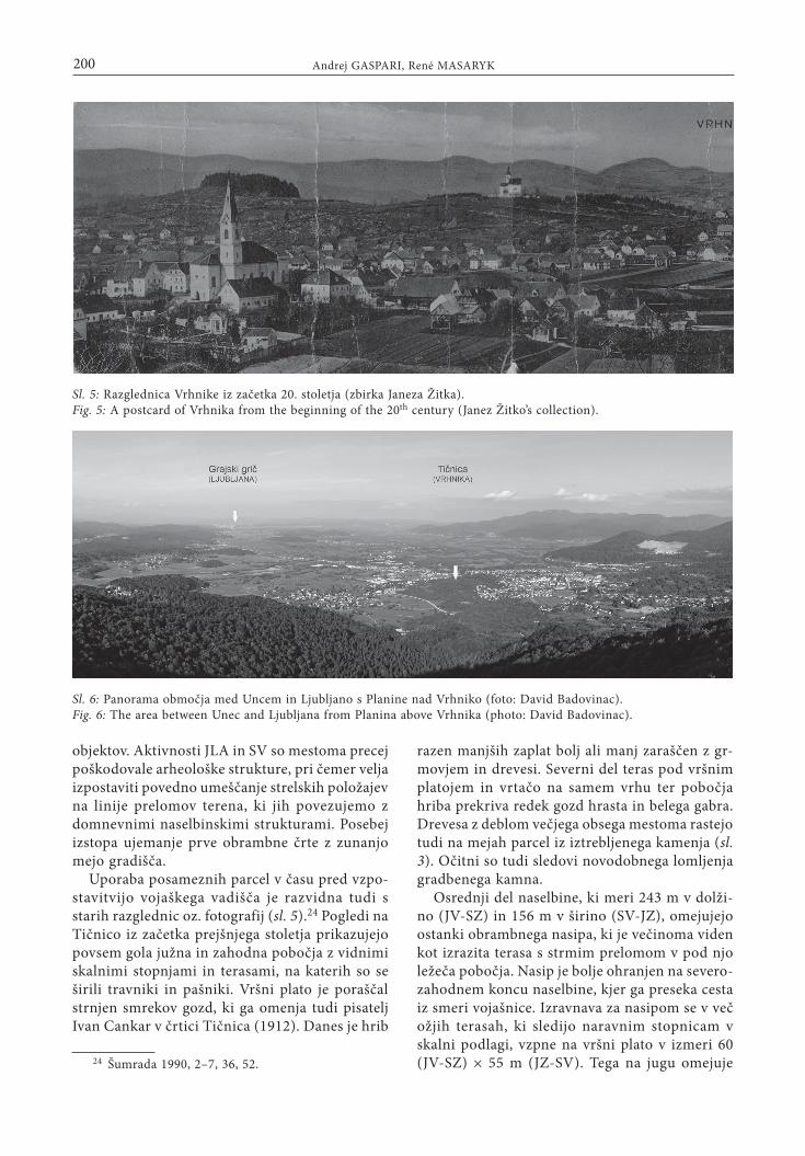
Uporaba posameznih parcel v času pred vzpo-stavitvijo vojaškega vadišča je razvidna tudi s starih razglednic oz. fotografij (sl. 5).24 Pogledi na Tičnico iz začetka prejšnjega stoletja prikazujejo povsem gola južna in zahodna pobočja z vidnimi skalnimi stopnjami in terasami, na katerih so se širili travniki in pašniki. Vršni plato je poraščal strnjen smrekov gozd, ki ga omenja tudi pisatelj Ivan Cankar v črtici Tičnica (1912). Danes je hrib
24 Šumrada 1990, 2–7, 36, 52.
razen manjših zaplat bolj ali manj zaraščen z gr-movjem in drevesi. Severni del teras pod vršnim platojem in vrtačo na samem vrhu ter pobočja hriba prekriva redek gozd hrasta in belega gabra. Drevesa z deblom večjega obsega mestoma rastejo tudi na mejah parcel iz iztrebljenega kamenja (sl. 3). Očitni so tudi sledovi novodobnega lomljenja gradbenega kamna.
Osrednji del naselbine, ki meri 243 m v dolži-no (JV-SZ) in 156 m v širino (SV-JZ), omejujejo ostanki obrambnega nasipa, ki je večinoma viden kot izrazita terasa s strmim prelomom v pod njo ležeča pobočja. Nasip je bolje ohranjen na severo-zahodnem koncu naselbine, kjer ga preseka cesta iz smeri vojašnice. Izravnava za nasipom se v več ožjih terasah, ki sledijo naravnim stopnicam v skalni podlagi, vzpne na vršni plato v izmeri 60 (JV-SZ) × 55 m (JZ-SV). Tega na jugu omejuje
Sl. 5: Razglednica Vrhnike iz začetka 20. stoletja (zbirka Janeza Žitka).Fig. 5: A postcard of Vrhnika from the beginning of the 20th century (Janez Žitko’s collection).
Sl. 6: Panorama območja med Uncem in Ljubljano s Planine nad Vrhniko (foto: David Badovinac).Fig. 6: The area between Unec and Ljubljana from Planina above Vrhnika (photo: David Badovinac).

201Na sledi prazgodovinskega Navporta
večja vrtača. Na jugovzhodu prehaja osrednji del naselbine v kotanjo s širokim dnom, vključeno v območje, obdano z notranjim nasipom. V nepo-sredni bližini domnevamo tudi vhod v osrednji del naselbine, kjer se po najožjem delu sedla na Tičnico še danes vzpenja ožji kolovoz iz smeri Sv. Trojice. Vstop na severni strani omejuje okoli 10 m dolg ostanek obrambnega nasipa, podaljšan v naselbino. Nasip je od izravnave nad zahodnim delom sedla oz. od njegovega najožjega dela ločen z umetnim jarkom z opaznimi sledovi lomljenja skalnih reber, ki ga na severu omejuje večja vrtača, na jugu pa (nasut?) del kolovoza. Jarek se je prvo-tno hipotetično nadaljeval proti jugu, kjer poteka onkraj dostopa v osrednji del gradišča v osi meje domnevanega predprostora naselbine.
Domnevo o južnem predprostoru v izmeri 112 (V-Z) × 56 m (S-J) utemeljuje potek njegove
zunanje meje, ki se logično navezuje na južni obod osrednjega dela naselbine. Bolje je ohranjen samo nasip, ki se na zahodu pripenja na glavni obrambni nasip naselbine, na preostalih delih pa je viden samo kot oster prehod terase v pobočje. Na južni rob predprostora se naslanjajo prve hiše modernega zaselka Tičnica.
Drugi predprostor naselbine z dimenzijami 86 (JV-SZ) × 95 m (JZ-SV) je bil ugotovljen na severozahodnih in zahodnih pobočjih, kjer so prazgodovinske strukture mestoma zabrisane s suhimi zidovi in grobljami, postavljenimi na parcelnih mejah. Na severnem delu se obrambni nasip v obliki izrazite terase v vzponu pripenja na plato osrednjega dela gradišča, na severozahodu pa so se pri njegovem umeščanju naslonili na prag v skalni podlagi. Zahodno od mesta, kjer ga prečka cesta, se predprostor razširi. Njegov zunanji obod

202 Andrej GASPARI, René MASARYK
domnevamo na robu večje, z redkim gozdom po-rasle terase, ki strmo prehaja v nekaj metrov nižje in zložnejše pobočje in jo na skrajnem zahodnem delu zamejuje vrtača. Zahodno od novodobnega dostopa ležijo tudi domnevni ostanki prvotnega vhoda, ki vključujejo ostanke manjšega pravoko-tnega objekta iz velikih blokov. Proti notranjosti je še več izrazitih teras in zidov iz večjih neobdelanih skal, ki verjetno izvirajo iz strme stopnje, ki se vleče po celotnem jugozahodnem pobočju hriba. Na to stopnjo se je naslonila tudi zunanja škarpa terase iz velikih blokov, ki ji pogojno pripisujemo prazgodovinski izvor. Terasa poteka okoli 5 m pod glavnim nasipom naselbine in se na jugu konča s prekinitvijo, kjer domnevamo nekdanji dostop.
Skupna površina gradišča znaša 4,49 ha, od česar odpade 2,93 ha na osrednji del, 0,56 ha na jugovzhodni predprostor, 1 ha pa na severoza-hodni predprostor. Območje opisanih struktur obsega parc. št. 2408 (del), 2412/2 (del), 2414, 2415, 2416, 2418/1, 2418/2, 2420/8 (del), 2862/9 (del), 2426 (del), 2428, 2433, 2434, 2441/2 (del), 2442/1 (del), 2447 (del), 2448, 2450, 2451, 2862/8 (del), k. o. Vrhnika in št. 2014 (del) k. o. Stara Vrhnika.
KOMENTAR
Glede na lego in velikost gradišča na Tičnici, ki na vrhniškem koncu nima primerjave, gre skoraj nedvomno za centralno naselbino seve-rozahodnega dela Ljubljanskega barja. Gradišče je omogočalo dober vizualni in praktični nadzor nad enim ključnih delov komunikacije čez Iliro-Italska oz. Postojnska vrata in vodnim prometom po Ljubljanici (sl. 6).
Od razcepa pod naselbino na Starem gradu nad Uncem25 je topografsko najugodnejša trasa vodila
25 Gaspari 2009.
ob vzhodnem robu Planinskega polja čez neizrazit gozdnat preval z gradiščem Brst (579 m)26 v Loga-ško kotlino. Ob njenem južnem robu leži v bližini razcepa proti dolini Idrijce utrjena naselbina na Velikih bukvah,27 prehod proti izvirom Ljubljanice čez prevala Cesarski vrh (486 m) ali Prezid (546 m) pa je obvladovalo gradišče na razgledni Strmici (626 m).28 Preferenčno uporabo omenjenih pre-valov v prazgodovini nakazujejo bronastodobno najdišče Zapolje in površinske najdbe keramike na Pustem polju pod Ostrim vrhom v severnem zatrepu Logaške kotline,29 medtem ko je strmejša trasa čez preval med Raskovcem in Ljubljanskim vrhom (okoli 450 m)30 verjetno postala aktualna šele v rimskem obdobju (sl. 1).
Navidezno nekoliko umaknjena lega Tičnice je omogočala optimalen pogled na iztek razmeroma zložnega spusta po pobočjih nad dolino Bele do začetka plovnega dela reke blizu vznožja Hriba, kot tudi na nadaljevanje kopenske poti proti Ljubljan-skim vratom. Horizont barjanske ravnine je kljub nizki relativni višini gradišča omogočal njegovo vizualno komunikacijo z naselbinama na Sv. Janezu nad Logom pri Brezovici (366 m) in Grajskem griču v Ljubljani, pa tudi z drugimi višinskimi naselji v regiji, npr. Gradiščem pri Bevkah (321 m), Žalostno goro pri Preserju (415 m), Sv. Ano nad Podpečjo (484 m) in Molnikom (582 m).31
Odkritje gradišča na Tičnici dopušča kljub pomanjkanju natančnejših podatkov o kronologiji naselbine in načinu gradnje utrdb doslej najvero-dostojnejšo lokalizacijo politično-vojaškega sedeža prazgodovinskega predhodnika Navporta.
26 Frelih 1988, 14; id. 1999, 10.27 Petru 1975a, 191; Frelih 1988; id. 1999, 8 s.28 Petru 1975b, 209; Frelih 1999, 10.29 ZVKDS OE Ljubljana.30 Horvat 1990, 39–41.31 Vuga 1980, 202–204, sl. 1.
BAVEC, U. in J. HORVAT 1996, Vrhnika. Gradišče 5. Uvodno poročilo o arheoloških izkopavanjih. – Vrhniški razgledi 1, 107–110.
FRELIH, M. 1988, Komunikacijski sistem v prazgodovini in antiki na primeru Logaške kotline. – V: Zbornik poročil raziskovalnih skupin, 10–51, Logatec.
FRELIH, M. 1999, Longaticum - Logatec. – Doktorsko delo, Odsjek za arheologiju, Filozofski fakultet Sveučilišta u Zagrebu, Zagreb.
GASPARI, A. 2002, Latenske in zgodnjerimske najdbe iz Ljubljanice. – Doktorsko delo, Oddelek za arheologijo Filozofske fakultete Univerze v Ljubljani, Ljubljana.
GASPARI, A. 2006, Bronastodobne najdbe iz potoka Ljubija pri Verdu / Bronze Age finds from the Ljubija stream near Verd. – V: A. Gaspari (ur.), Zalog pri Verdu, tabor kamenodobnih lovcev na zahodnem robu Ljubljanskega barja / Stone Age hunters’ camp at the western edge of

203Na sledi prazgodovinskega Navporta
the Ljubljansko barje, Opera Instituti Archaeologici Sloveniae 11, 205–221.
GASPARI, A. 2009, Some Iron Age and Early Roman finds from Stari grad above Unec (Notranjska, Slovenia). – V: G. Tiefengraber, B. Kavur, A. Gaspari (ur.), Keltske štu-dije / Studies in Celtic Archaeology 2. Papers in honour of Mitja Guštin, Protohistoire Européene 11, 315–329.
GASPARI, A. in M. ERIČ 2007a, Vrhnika. – Varstvo spo-menikov 43, 237–240.
GASPARI, A. in M. ERIČ 2007b, Verd. – Varstvo spome-nikov 43, 231–232.
GASPARI, A. in M. ERIČ 2008a, Verd. – Varstvo spome-nikov 44, 294–295.
GASPARI, A. in M. ERIČ 2008b, Arheološke raziskave struge Ljubljanice med Verdom in Vrhniko. – Annales. Series Historia et Sociologia 18/2, 407–430.
HABIČ, P. 1962, Vrhnika. Geografska monografija manjšega mesta. – Geografski zbornik 7, 5–66.
HORVAT, J. 1990, Nauportus (Vrhnika). – Dela 1. razreda SAZU 33.
HORVAT, J. 2009, Nauportus – naselje na začetku tran-sportne poti po Ljubljanici. – V: P. Turk, J. Istenič, T. Knific, T. Nabergoj (ur.), Ljubljanica – kulturna dediščina reke, 89–94, Ljubljana.
HORVAT, J., E. KOCUVAN in N. LOGAR 1986, Vrhnika-Dolge njive. – Varstvo spomenikov 28, 277–278.
HORVAT, J. in P. PETERLE UDOVIČ 2006, Vrhnika. – Varstvo spomenikov 42, 188–190.
HORVAT, M. 1991, Preliminarno poročilo o arheoloških raziskavah na Ljubljanskem gradu. – Varstvo spomenikov 33, 232–235.
HVALEC, S. et al. 2009, Gradbeni dnevnik. Utrip Tribune. Doživetja arheološkega vsakdana. – Ljubljana.
MUŠIČ, B. in J. HORVAT 2007, Nauportus – an Early Roman trading post at Dolge njive in Vrhnika / Nauportus – zgodnjerimska trgovska postojanka na Dolgih njivah na Vrhniki. – Arheološki vestnik 58, 219–283.
PETRU, P. 1975a, Gorenji Logatec. – V: Arheološka najdišča Slovenije, 191, Ljubljana.
PETRU, P. 1975b, Zaplana. – V: Arheološka najdišča Slo-venije, 209, Ljubljana.
ŠAŠEL, J. 1966, Keltisches portorium in den Ostalpen (zu Plin. n. h. III 128). – V: Corolla memoriae Erich Swoboda dedicata, Römischen Forschungen in Niederösterreich 5, 198–204 (= Opera selecta, Situla 30, 1992, 500–506).
ŠUMRADA, J. 1990, »Vrhnika, prečuden kraj«. Kraji v občini Vrhnika na starih razglednicah. – Vrhnika.
TURK, P. 2007, Bronasti polnoročajni meč iz Jabelj v osrednji Sloveniji / A Bronze Solid-Hilted Sword from Jablje in Central Slovenia. – V: M. Blečić et al. (ur.), Scripta praehistorica in honorem Biba Teržan, Situla 44, 209–229.
TURK, P. in A. GASPARI 2009, Darovi bogovom in pred-nikom. – V: P. Turk, J. Istenič, T. Knific, T. Nabergoj (ur.), Ljubljanica. Kulturna dediščina reke , 62–67, Ljubljana.
VIČIČ, B. 1990, Ljubljana, Ljubljanski grad. – Varstvo spomenikov 32, 178.
VUGA, D. 1980, Železnodobna najdišča v kotlini Ljubljan-skega barja. – Situla 20–21, 199–209.
INTRODUCTION
On account of its important transport-geographic po-sition, mentioned already by Roman and Greek authors, Vrhnika and its surroundings have traditionally received special interest of the researchers. Information about finds and sites known by the end of the 1980s was collected and reevaluated by Jana Horvat in her publication Nauportus (Vrhnika), while basic information about more recent discoveries and surveys has been published in Varstvo spomenikov (Journal for the Protection of Monuments) and other professional journals.1
1 The authors are grateful to Jana Horvat, Barbara Nadbath, Sašo Poglajen, Janez Jereb and Tilen Praprotnik for information and comments. Special acknowledgement to Brina Škvor Jernejčič, Miha Kunstelj and David Badovinac for their help with measurements, photographs and else-where. Janez Žitko showed us old postcards of Vrhnika and lent them to us in order to make reproductions.
Tracing the prehistoric NauportusThe hillfort on Tičnica hill near Vrhnika
Translation
This article directly concerns perhaps the most impor-tant issue of Vrhnika archaeology; the location of the Pre-Roman Nauportus, i.e. a settlement of the Celtic Taurisci mentioned by Strabo (Geogr. VII 5, 2, C. 314),2 and its predecessors. A fortified elevated settlement, functioning as the seat and centre of political and military government and as a place of refuge in case of military actions would correspond to the distinctive type of settlement of the later prehistoric periods. Meanwhile, at least the economic and manipulative part of the settlement can be sought in the plain near the junction of the water and land routes. Geographically the nearest analogy for a lowland type of settlement near a river, in the shelter of a nearby hillfort, would be the recently discovered settlement from the time between the end of the Bronze Age and the Late La Tène period at Prule in Ljubljana.3 Remains of wooden buildings and paved streets are spread there over the gentle slope
2 Šašel 1966.3 Hvalec et al. 2008.

204 Andrej GASPARI, René MASARYK
between the Ljubljanica and the seventy-metre higher Castle Hill (376 m) with a presumed fortified settlement and reported finds dating since the early phase of the Urnfield period.4
Leaving aside the evidence for the settlement of Vrhnika and its surroundings in the Paleolithic and Mesolithic pe-riods, we can conclude – on the basis of isolated finds of pottery fragments and tools made of stone, bone and horn from the Ljubljanica between Verd and Vrhnika5 and from the Ljubija near the village of Pritiska6 – that the area of the Late-Pleistocene and Early-Holocene lake bay with plenty of fresh water from karst springs and other natural resources was also attractive for Copper Age settlement. The river assumed its more or less present course no sooner than in the Bronze Age, therefore the above mentioned finds are probably remains of washed away settlement layers or contexts connected with economic activities. A scraper on flake could be conditionally also classified as one of the eneolithic finds. It was discovered in a field, about 20 m east from the bank of the Ljubljanica near Verd.7
During the period of population growth in the Middle and Late Bronze Age, which was closely linked with the development of several economic activities in most parts of Europe, the area of the Ljubljansko barje (Ljubljana Moor) reached one of its peaks, thanks to its distinctly transitional character along the route between the northern Adriatic regions and central Slovenia and also because of a natural phenomenon – the river and the surrounding marshes that have been proven to have attracted supra-regional ritual attention.
Isolated finds of metal weapons8 and a hoard9 from the plain north and northwest from Vrhnika (fig. 1: 1–3) belong to this period. More likely than not they represent traces of ritual expression and do not provide reliable support for the localisation of the potential prehistoric settlement core. Even the relatively numerous pottery finds from the Bd D/Ha A1 periods, found in the Ljubija near Zalog (fig. 1: 14)10 and in the Ljubljanica near the church of St. Anthony at Verd (fig. 1: 15)11 as well as in the section between the confluence of two sources of the river and the road bridge Vrhnika-Verd (fig. 1: 11–13), do not help with this issue. Considering the structure and the relatively low fragmentation of pots, it cannot be excluded that they might partly be traces of an alternative form of burial where grave goods were deposited into the river water.12
Until recently, the Early Iron Age in the broader sur-roundings was represented only by an isolated find of a pot
4 Vičič 1990, 178; Horvat M. 1991, 233.5 Horvat, Kocuvan, Logar 1986, 278; Horvat 1990, 174;
Gaspari, Erič 2008b, 410, pl. 5: 1–3.6 Gaspari, Erič 2007b, 231; Gaspari, Erič 2008b, fig.
1: 7–10.7 Gaspari, Erič 2007a, 239; Gaspari, Erič 2008b, 412.8 Horvat 1990, 179–182.9 Ibid., 67, fig. 12; see also Turk 2007, 215–217.10 Gaspari 2006.11 Gaspari, Erič 2008a; Gaspari, Erič 2008b, fig. 1: 1;
pl. 1: 2–4.12 Gaspari, Erič 2008b, 410–411, pl. 4; 5: 4–9; 6: 1–2.
fragment from the Ljubljanica near the pedestrian bridge between Vrhnika and Verd (fig. 1: 12)13 and by the two iron socketed axes, a shaft-hole axe and a bronze hooked belt buckle from the riverbed at Sinja Gorica (fig. 1: 4)14. However, during the supervision of renovation works at the crossroads of Stara cesta and Cesta gradenj in May 2009, a fragment of a pot bottom dating from the end of the Bronze Age to the Early Iron Age was discovered. It was found in colluvial sediment 0.7 m below the surface (fig. 1: 10).15
The evidence for the La Tène settlement is unusually scarce. Almost all known Celtic objects from the left and right banks of the Ljubljanica were found in early Roman deposits. They include pottery, coins, fibulae and weapon fragments from the fortified supply base and settlement at Dolge njive (sl. 1: 5),16 built ex novo in the Augustan period or a little earlier,17 as well as pottery and coins from the mid-Augustan layers at the Kočevar garden at Breg (sl. 1: 7).18 Among the La Tène finds from Vrhnika and its surroundings there are also pot fragments, a bronze belt buckle with wings and some of the spears from the nearby section of the Ljubljanica (fig. 1: 6)19 as well as the unverified find of a Norican Tetradrachm that was, accord-ing to its finder, discovered in the mid 1980s, during the excavation for the foundation of a house “at the Sv. Trojica foothills towards Stara Vrhnika” (fig. 1: 8).
Especially the rises, surrounding both passages towards the Logatec Basin, have attracted attention as potential locations for settlement in the later prehistoric periods at Vrhnika. Those are Gradišče – Hrib (304 m) (sl. 1: 16)20 at the very beginning of the ascent, Sv. Trojica21 and the lower Hruševca (311 m),22 the latter two lying closer to the river bend of the Ljubljanica towards the east. Presently, there are no known settlement or fortified structures from any of the above mentioned locations. Also missing are small finds of prehistoric origin. In the following, remains of the hillfort at Tičnica hill (sl. 1: 9), that were discovered and documented in April 2009 at the former military complex area and have so far not been mentioned in the literature, are represented.
SITE DESCRIPTION
13 Gaspari, Erič 2008b, 411, pl. 6: 8.14 Gaspari 2002, suppl. 6; Turk, Gaspari 2009, cat.
no. 29.15 Intervention by the Centre for preventive archaeo-
logy of the Institute for the protection of cultural heritage of Slovenia.
16 Horvat 1990, pl. 2: 8; 3: 14,16–17; 4: 11,14; 8: 2; 12; 15: 1, ...
17 Horvat 1990; Mušič, Horvat 2007.18 Horvat, Peterle Udovič 2006.19 Gaspari 2002, suppl. 8; Gaspari, Erič 2009, pl. 6:
9; 7: 1–2.20 Horvat 1990, 185–187, 195; Bavec, Horvat 1996.21 Horvat 1990, 182.22 Ibid., 180, 181.

205Na sledi prazgodovinskega Navporta
A broad and relatively low karst ridge of jurassic lime-stones lies between the old town centre of Vrhnika, Kačja vas and Stara Vrhnika. It runs approximately southeast-northwest and has two summits (fig. 1: 8,9). At the eastern end of the ridge rises Sv. Trojica (350 m), formerly known as Vijolna gora (350 m), while the western part is shaped in a slightly higher rounded ridge named Tičnica (366 m). The two rises, separated by an approximately 20 m lower saddle with circular dolines, ascend about 50 m above the surrounding area. The indistinctive two-summit ridge is most prominent if we approach Vrhnika from the direction of Ljubljana. Uneven, partly karsted terrain with the field name Košace extends towards the north and northwest, while on the other side, the ridge is bordered by the broad bottom of the Bela stream valley. The nearest freshwater sources are the Bečkaj and Primc springs at the southern foothills of Tičnica.23
Remains of a prehistoric fortified settlement (fig. 2 and 3), that comprise traces of defensive structures and settlement terraces as well as fragments of hand-made pottery were discovered at the irregular elliptical summit of Tičnica. According to the fabric and separate definable fragments of a pithos, pots and coils (fig. 4), the hillfort was occupied during the Middle or Late Bronze Age and in the Early Iron Age. The finds appear in the profiles of several military positions, since the hillfort area used to be part of the training ground of the nearby barracks (military complex Tičnica). In addition to the infantry positions, there are also several pits for armoured vehicles, partly surrounded by walls, as well as concrete foundations of two smaller buildings. Activities of the Yugoslav People’s Army and the Slovenian Armed Forces considerably dam-aged the archaeological structures. At this point it should be mentioned how the firing positions were located at the terrain break lines, connected with the presumed settle-ment structures. Especially prominent is the agreement between the first defence line and the outer boundary of the hillfort.
The use of isolated land parcels in the time before the establishment of the military training ground is evident from old postcards and photographs.24 Views of Tičnica from the beginning of the previous century depict almost entirely treeless southern and western slopes with visible rock steps and terraces with meadows and pastures (fig. 5). The top plateau was overgrown with dense spruce forest, described also by the writer Ivan Cankar in his short story Tičnica (1912). Nowadays, the hill is more or less overgrown with bushes and trees, except for some smaller patches. The northern part of the terraces under the summit plateau and under the doline at the summit itself as well as the hill-slopes are covered by thin oak and white beech forest. Trees with larger trunks sometimes also grow at the parcel boundaries made of stone (fig. 3). There are also obvious traces of modern building stone quarrying.
The central part of the settlement, measuring 243 m in length (SE-NW) and 156 m in width (NE-SW) is bordered by the remains of a defensive rampart, mostly visible as an evident terrace with a steep break into the underlying
23 Habič 1962.24 Šumrada 1990, 2–7, 36, 52.
slopes. The rampart is better preserved at the northwest part of the settlement where it is intersected by a road from the direction of the barracks. There is a level behind the rampart that ascends, in several narrower terraces that fol-low the natural steps in the rock foundation, to the summit plateau, which measures 60 (SE-NW) × 55 m (SW-NE). At the south, the plateau is bordered by a doline. At the southeast, the central part of the settlement proceeds into a depression with a broad bottom, included in the area surrounded by the interior rampart. The entrance into the central part of the settlement is also assumed to have been in the immediate surroundings, where a narrower cart track from the direction of Sv. Trojica still ascends to Tičnica over the narrowest part of the saddle. At the northern side, the entrance is limited by an approximately 10-m-long remain of a rampart, that extends into the set-tlement. The rampart is separated from the level above the western part of the saddle (its narrowest part) by an artificial moat with visible traces of quarrying rock features, which is bordered by a larger doline at the northern side and by a (metalled?) part of the cart track at the southern side. Hypothetically, the moat originally continued towards the south, where it runs on the other side of the approach to the central part of the hillfort in the axis of the supposed settlement yard boundary.
The hypothesis about the southern yard, measuring 112 (E-W) × 56 m (N-S), is grounded on the course of its outer boundary line, which is logically connected to the southern edge of the central part of the settlement. Better preserved is only the mound, attached to the main settlement rampart at the western side, while elsewhere it is only visible as a sharp transition of a terrace into the slope. The first houses of the modern Tičnica hamlet lean against the southern edge of the yard.
Another yard of the settlement, measuring 86 (SE-NW) × 95 m (SW-NE) was discovered on the north-western and western slopes, where prehistoric structures are occasionally obscured by dry walls and rubble at parcel boundaries. Shaped as a prominent terrace, the ascending rampart is at the northern side attached to the plateau of the central part of the hillfort. At the northwest, it was positioned with regard to the rise in the rock foundation. West from the location where it is crossed by the road, the yard becomes wider. Its outer rim is supposed to be at the edge of a larger terrace, overgrown with thin forest. At its western side, the terrace is bordered by a doline and proceeds steeply into some metres lower and more gently sloping incline. West from the modern access there are also the supposed remains of the original entrance, including the remains of a smaller rectangular building made of large blocks of stone. Towards the interior there are some more clearly visible terraces and walls made of larger unworked rocks, probably originating from the steep rise that runs along the entire south-western slope of the hill. Also the outer scarp of the terrace, made of big blocks, conditionally of prehistoric origin, leans against this rise. Running about 5 m below the main rampart of the settlement, the terrace ends at the southern side and is interrupted where the access is supposed to have been in the past.

206 Andrej GASPARI, René MASARYK
The entire hillfort covers 4.49 ha; the central part measures 2.93 ha, the south-eastern yard 0.56 ha and the northwestern yard 1 ha. The above described structures occupy land parcels no. 2408 (part), 2412/2 (part), 2414, 2415, 2416, 2418/1, 2418/2, 2420/8 (part), 2862/9 (part), 2426 (part), 2428, 2433, 2434, 2441/2 (part), 2442/1 (part), 2447 (part), 2448, 2450, 2451, 2862/8 (part), cadastral municipality Vrhnika, and no. 2014 (part) cadastral mu-nicipality Stara Vrhnika.
COMMENTARY
Considering the position and size of the Tičnica hillfort, which is unique in the surroundings of Vrhnika, this was almost certainly the central settlement of the north-western part of the Ljubljansko barje. The hillfort was able to con-trol both visually and practically one of the crucial parts of the route across the Illyro-Italic or Postojna Gate and the waterway transport on the Ljubljanica (fig. 6).
From the crossing under the settlement at Stari grad above Unec,25 the best route considering topography led along the eastern edge of the Planinsko polje and across the pass with the Brst hillfort (579 m)26 into the Logatec Basin. At its southern edge, near the turning towards the Idrijca valley, there is a fortified settlement at Velike bukve,27 while the passage towards the springs of the Ljubljanica across the passes of Cesarski vrh (486 m) or Prezid (546 m) was controlled by the hillfort at Strmica (626 m).28 Preferential use of the above mentioned passes in the prehistoric period is indicated by the Bronze Age site of Zapolje and by sur-face finds of pottery at Pusto polje below Ostri vrh in the northern pocket of the Logatec Basin,29 while the steeper route across the pass between Raskovec and Ljubljanski
25 Gaspari 2009.26 Frelih 1988, 14; id. 1999, 10.27 Petru 1975a, 191; Frelih 1988; id. 1999, 8–9.28 Petru 1975b, 209; Frelih 1999, 10.29 Institute for the protection of cultural heritage of
Slovenia. Regional unit Ljubljana.
vrh (ca. 450 m)30 probably became significant only in the Roman period (fig. 1).
Although the position of Tičnica seems somehow re-mote, it provided an optimal view over the end section of the relatively easy descent over the slopes above the Bela valley as far as the beginning of the navigable part of the river near the Hrib foothills, and also over the continuation of the land route towards the Ljubljana Gate. Despite the low relative height of the hillfort, the moor plain horizon enabled visual communication with the settlements at Sv. Janez above Log pri Brezovici (366 m) and on the Ljubljana Castle Hill, as well as with other elevated settlements in the region, e.g. Gradišče near Bevke (321 m), Žalostna gora near Preserje (415 m), Sv. Ana above Podpeč (484 m) and Molnik (582 m).31
Despite the lack of more accurate information on the chronology of the settlement and on how the fortifications were built, the discovery of the hillfort at Tičnica enables the so far most likely localisation of the political-military seat of the prehistoric predecessor of Nauportus.
Translation: Meta Osredkar
Andrej GaspariVojaški muzej Slovenske vojskeEngelsova 15SI-2111 [email protected]
René MASARYKArhej d. o. o.Drožanjska cesta 23SI-8290 [email protected]
30 Horvat 1990, 164, 195.31 Vuga 1980, 202–204, fig. 1.
Copyright © 2022 FDOKUMEN