Semi-Destructive and Non-Destructive Tests of Timber ... - MDPI
Upload
independentCategory
view
1download
0
Journal Of Earthquake Engineering, 00:1–23, 2008
Copyright � A.S. Elnashai & N.N. Ambraseys
ISSN: 1363-2469 print / 1559-808X online
DOI: 10.1080/13632460802212774
A 17th Century Destructive Seismic Crisisin the Gargano Area: Its Implications
on the Understanding of Local Seismicity
R. CAMASSI1, F. BERNARDINI1, V. CASTELLI1,5and C. MELETTI2
1Istituto Nazionale di Geofisica e Vulcanologia, Sezione di Bologna,
Bologna, Italy2Istituto Nazionale di Geofisica e Vulcanologia, Sezione di Milano,
Milano, Italy
10A significant and partly forgotten series of earthquakes located in the Gargano area (SouthernItaly) between 1646 and 1688 AD is critically revised, in the light of newly discovered historicalrecords derived from non local contemporary serial sources (early newspapers and diplomaticreports). The revision is conducted in the frame of a survey of the current state of knowledge onhistorical Gargano seismicity. Hypotheses on the seismotectonic effects of the evente and their
15influences on the evaluation of local seismic hazard are also proposed.
Keywords Historical Seismology; Earthquake Catalogs Completeness; Local Seismicity;Unknown Earthquakes
1. Introduction
This study is a spin-off from a wider ongoing investigation of 16th–18th centuries
20European newspapers and diplomatic sources. Early modern journalists and diplomats
routinely collected information on what was going on (in Europe and abroad) and
disseminated it via newspapers and confidential reports. As their interest did not stop at
man-engineered events, but extended to natural ones, their writings are a potential mine
of knowledge on historical earthquakes. The ongoing systematic perusal of early journal-
25istic and diplomatic sources has had encouraging results, useful for improving knowledge
on otherwise poorly known earthquakes and also for rediscovering ‘‘forgotten’’ earth-
quakes, i.e., ones whose occurrence has so far failed to recorded by the current catalogs
[Camassi and Castelli, 2004, 2005; Castelli and Camassi, 2005].
Among the journalistic and diplomatic evidence thus collected, there are several
30records of 17th–19th century earthquakes (Table 1) in the Gargano peninsula (SE Italy), a
seismically active offshoot of the Apennines, best visualized as ‘‘the spur on Italy’s
boot.’’ This article focuses on the records collected on 17th century Gargano earthquakes,
whose critical examination allows to draw a better picture of the strong but comparatively
poorly known earthquake of 1646, and also to reconstruct in some detail the seismic
35context in which it occurred. In the following chapters, new studies are provided for the
1646 earthquake, and for a ‘‘forgotten’’ earthquake (1647) and two ‘‘underestimated’’
Received 27 April 2007; accepted 3 March 2008.
Address correspondence to R. Camassi, Istituto Nazionale di Geofisica e Vulcanologia, Sezione di
Bologna, Via Donato Creti 12, Bologna, 40128, Italy; E-mail: [email protected]
1

TABLE 1 Informations available on poorly known or unknown earthquakes of the
Gargano area after this study (HD: Heavy Damage; SD: Slight Damage; D: Damage;
HF: Heavily Felt; SF: Slightly Felt). POS85 = [Postpischl, 1985]; CPTI04 = [CPTI
Working Group, 2004]
Date Locality/Area Lat Lon Is Remarks/sources
1223 Siponto 41.609 15.890 HD Known to POS85
and CPTI04.
Doubtful event
Vico del
Gargano
41.895 15.958 HD
Sfilzi 41.852 16.004 HD
Vieste 41.882 16.179 7/8
1294 Capitanata 0.000 0.000 HD Unknown
1414 Vieste 41.882 16.179 HD Known to POS85
and CPTI04.
Doubtful event
1656 10 17 Gargano 0.000 0.000 HF Known to POS85
1718 03 Foggia 41.460 15.553 5 Unknown
[Bologna, 1718a]
1718 09 Torremaggiore 41.689 15.292 5 Unknown
[Bologna, 1718b]
1739 02 13 Foggia 41.460 15.553 5/6 Known to POS85
and CPTI04
Puglia 0.000 0.000
Principato
Citra
0.000 0.000
Principato Ultra 0.000 0.000
Napoli 40.855 14.260 SF
1756 11 22 Manfredonia 41.623 15.908 6/7 Unknown
[Bologna, 1756]
1783 11 15 Torremaggiore 41.689 15.292 D Known to POS85
and CPTI04
1828 11 11 San Severo 41.685 15.381 5 Unknown [Giornale del
Regno delle
Due Sicilie, 1828]
Serracapriola 41.806 15.159 5
1829 07 03 Lesina 41.864 15.353 6 Unknown [Giornale del
Regno delle Due
Sicilie, 1829]
San Severo 41.685 15.381 5
1850 01 29 Monte Sant’
Angelo
41.706 15.959 5 Unknown [Perrey, 1851]
1850 02 27 Monte Sant’
Angelo
41.706 15.959 5 Unknown [Perrey, 1851]
1864 12 28 Sannicandro 41.835 15.567 7 Known to POS85
and CPTI04
(Continued )
2 R. Camassi et al.

ones (1656–1657, 1688). Finally, as the results of these studies lead to a global reassess-
ment of Gargano seismicity in the 17th century time-window, their possible
Q2
influence on
the understanding of local seismotectonics and the evaluation of local seismic hazard will
40be discussed.
2. Geological Setting
The main structural element of Southern Italy is the Southern Apenninic arc, a complex
of stacked nappes due to the progressive advance of the belt over the Apulian foreland
[Patacca and Scandone, 2007]. In Fig. 1, the dashed black line with triangles represents
45the most advanced position of the allochthonous rocks of the thrust-related folds. The
advancement of this front over the Apulian area stopped around 650,000 years ago
[Meletti et al., 2000] and the whole area is characterized by an uplifting that increases
from East to West.
The Gargano peninsula stretches out from the southern Adriatic coast of Italy with a
50roughly East-West trend. Although it lies out of the main Italian peninsula seismogenic
belt, which runs along the axis of the Apenninic range, the Gargano peninsula shows an
intense seismic activity. According to the current catalogs, considerable earthquakes
affected this area, at fairly regular intervals, at least from the 1200’s onward; but these
data could be incomplete, many authors believe. The present understanding of the
55regional tectonics and their relationship with the kinematic framework of the Central
Mediterranean sea is undoubtedly incomplete, as witnessed by the Mw 5.8 Molise
earthquake of October 31, 2002 [CPTI Working Group, 2004], which occurred in an
area where the available geological and historical information did not lead to expecting
an earthquake of that magnitude.
60From the seismotectonic point of view, the Gargano area is less satisfactorily known
than the Southern Apennines, a region that was extensively investigated due to occur-
rence of some of the strongest earthquakes in Italy (e.g., the Mw 6.9 Irpinia earthquake of
November 23, 1980 [CPTI Working Group, 2004]). The most relevant structural element
in the entire Gargano area is the so-called Mattinata Fault, a dominant feature affecting
TABLE 1 (Continued )
Date Locality/Area Lat Lon Is Remarks/sources
Lesina 41.864 15.353 3
Vieste 41.882 16.179 3
1866 10 13 Foggia 41.460 15.553 5 Unknown [Perrey, 1870]
1869 03 31 S. Giovanni
Rotondo
41.706 15.728 6/7 Known to POS85
and CPTI04
S. Marco in
Lamis
41.712 15.636 5/6
Sannicandro 41.835 15.567 F
1871 08 01 Torre Mileto 41.925 15.617 5 Known to POS85
and CPTI04
1941 08 20 San Severo 41.700 15.400 – Known to POS85
and CPTI04 No
macroseismic
informations.
xxxx 3
65the morphological structure of the southern side of the peninsula (Fig. 1). This strong
influence on the landscape enticed several past authors to analyze its geological and
kinematic structures. However, no consensus on the kinematic behavior of the fault, or its
present activity, has ever been reached, mainly on account of the difficulties in recogniz-
ing and dating kinematic indicators in the Mesozoic-Tertiary carbonates that constitute
70the Gargano promontory. A review of the different theories on this subject is given by
Patacca and Scandone [2004], among others.
A new interpretation of the kinematic active processes in the Gargano region is
presented in Meletti et al. [2008], in order to define the seismic source zones model to be
used for seismic hazard assessment in Italy.
753. Historical and Recent Seismicity According to the Current Catalogue
The current Italian parametric earthquake catalog [CPTI Working Group, 2004] lists
some 40 earthquakes (about half of which with magnitude � 4.8) that occurred in the
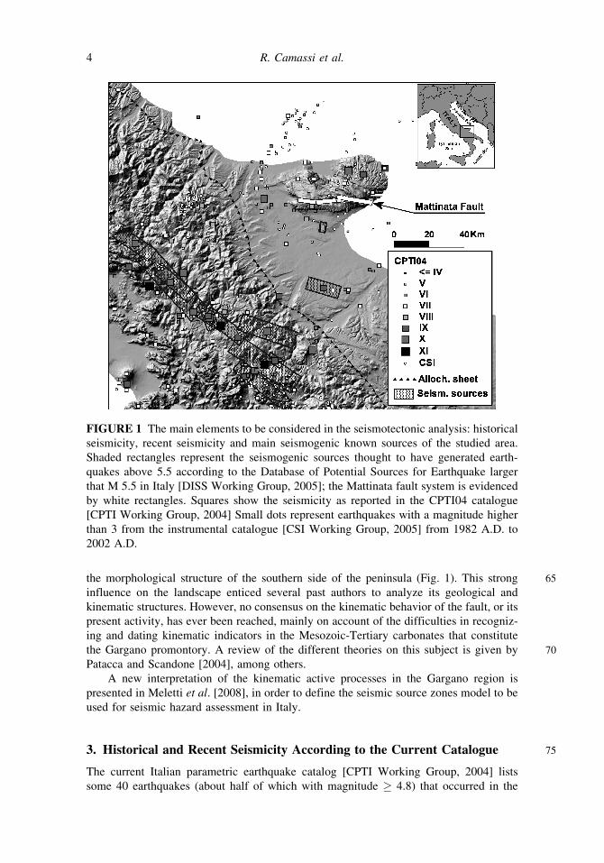
FIGURE 1 The main elements to be considered in the seismotectonic analysis: historical
seismicity, recent seismicity and main seismogenic known sources of the studied area.
Shaded rectangles represent the seismogenic sources thought to have generated earth-
quakes above 5.5 according to the Database of Potential Sources for Earthquake larger
that M 5.5 in Italy [DISS Working Group, 2005]; the Mattinata fault system is evidenced
by white rectangles. Squares show the seismicity as reported in the CPTI04 catalogue
[CPTI Working Group, 2004] Small dots represent earthquakes with a magnitude higher
than 3 from the instrumental catalogue [CSI Working Group, 2005] from 1982 A.D. to
2002 A.D.
4 R. Camassi et al.
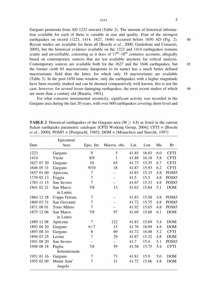
Gargano peninsula from AD 1223 onward (Table 2). The amount of historical informa-
tion available for each of them is variable in size and quality. Four of the strongest
80earthquakes on record (1223, 1414, 1627, 1646) occurred before 1650 AD (Fig. 2).
Recent studies are available for them all [Boschi et al., 2000; Guidoboni and Comastri,
2005], but the historical evidence available on the 1223 and 1414 earthquakes remains
scanty and unverifiable, consisting as it does of 17th–18th centuries accounts, allegedly
based on contemporary sources that are not available anymore for critical analysis.
85Contemporary sources are available both for the 1627 and the 1646 earthquakes, but
the former (with 65 macroseismic datapoints to its name) has a much better defined
macroseismic field than the latter, for which only 18 macroseismic are available
(Table 3). In the post-1650 time-window, only the earthquakes with a higher magnitude
have been recently studied and can be deemed comparatively well known; this is not the
90case, however, for several lesser damaging earthquakes, the most recent studies of which
are more than a century old [Baratta, 1901].
For what concerns instrumental seismicity, significant activity was recorded in the
Gargano area during the last 20 years, with over 600 earthquakes covering short-lived and
TABLE 2 Historical earthquakes of the Gargano area (M � 4.8) as listed in the current
Italian earthquake parametric catalogue [CPTI Working Group, 2004]; CFTI = [Boschi
et al., 2000]; POS85 = [Postpischl, 1985]; DOM = [Monachesi and Stucchi, 1997]
Date
Epicentral
Area Epic. Int. Macros. obs. Lat. Lon. Ma Rt
1223 Gargano 9 5 41.85 16.03 6.0 CFTI
1414 Vieste 8/9 1 41.88 16.18 5.8 CFTI
1627 07 30 Gargano 10 65 41.73 15.35 6.7 CFTI
1646 05 31 Gargano 9/10 18 41.87 15.93 6.2 CFTI
1657 01 00 Apricena 7 – 41.83 15.33 4.8 POS85
1739 02 13 Foggia 7 – 41.5 15.5 4.8 POS85
1783 11 15 San Severo 7 – 41.67 15.33 4.8 POS85
1841 02 21 San Marco
in Lamis
7/8 13 41.63 15.64 5.1 DOM
1864 12 28 Coppa Ferrata 7 – 41.83 15.58 4.8 POS85
1869 03 31 San Giovanni 7 – 41.72 15.75 4.8 POS85
1871 08 01 Torre Mileto 7 – 41.92 15.63 4.8 POS85
1875 12 06 San Marco
in Lamis
7/8 97 41.69 15.68 6.1 DOM
1889 12 08 Apricena 7 122 41.83 15.69 5.4 DOM
1892 04 20 Gargano 6 / 7 15 41.76 16.09 4.8 DOM
1893 08 10 Gargano 8 69 41.72 16.08 5.2 CFTI
1894 03 25 Lesina 7 29 41.87 15.32 4.8 DOM
1941 08 20 San Severo – – 41.7 15.4 5.1 POS85
1948 08 18 Puglia
Settentrionale
7/8 59 41.58 15.75 5.4 CFTI
1951 01 16 Gargano 7 73 41.81 15.9 5.0 DOM
1955 02 09 Monte Sant’
Angelo
7 31 41.72 15.86 4.8 DOM
xxxx 5
FIGURE 2 Sesmicity time distribution of the Gargano area [CPTI Working Group,
2004].
TABLE 3 Effects of the 1646 earthquake (MCS scale) according to Baratta [1901] and
Boschi et al. [2000] (EE = environmental effects; F = Felt)
Quoted locality Lat. Lon. Baratta, 1901
Boschi et al.
[2000]
Cagnano Varano 41.826 15.775 8 8/9
Carpino 41.843 15.857 EE 9/10
Ischitella 41.904 15.898 9/10 9/10
Manfredonia 41.623 15.908 8 8
Monte Sant’Angelo 41.706 15.959 8/9 9
Peschici 41.947 16.014 7/8 8
Rodi Garganico 41.929 15.884 8 8
San Giovanni Rotondo 41.706 15.728 7/8 F
Vico del Gargano 41.895 15.958 9 9
Vieste 41.882 16.179 9 9
Bari 41.106 16.846 – F
Cassano delle Murge 40.889 16.771 – F
Cremona 45.136 10.024 – F
Napoli 40.855 14.260 – F
Rignano Garganico 41.675 15.587 – F
San Marco in Lamis 41.712 15.636 – F
Sannicandro Garganico 41.835 15.567 – F
Lago di Varano 41.875 15.750 – EE
6 R. Camassi et al.
well-confined sequences [CSI Working Group, 2005]. The highest magnitude (ML 5.4)
95was reached by the first of a series of more than 100 events which affected the San
Giovanni Rotondo-Cagnano Varano area from September 30 to the end of December
1995.
4. A Methodological Approach with a Difference
Studying historical earthquakes is an intricated business always, as witnessed by a wealth
100of case-histories and methodological articles, set forth in the last decades by distinguished
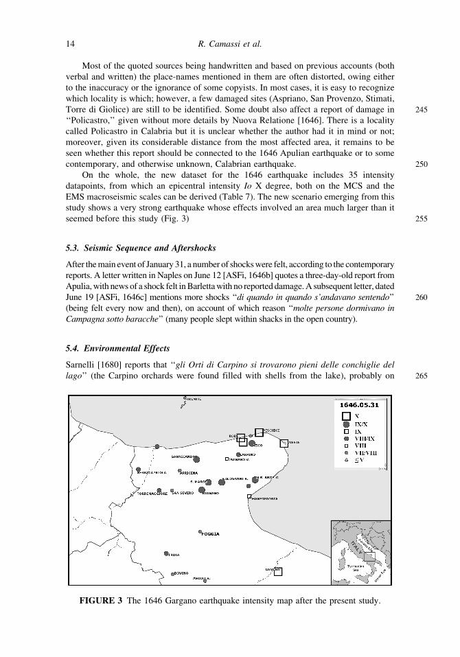
exponents of this discipline [Ambraseys and Finkel, 1991, 1993; Stucchi et al., 1991;
Guidoboni and Stucchi, 1993; Vogt, 1991, 1993; Musson, 1998; Guidoboni, 2000;
Ambraseys, 2001]. Not least among the difficulties besetting the student of early modern
earthquakes, is how to choose the potentially most rewarding items among the huge
105quantities of written sources produced in this period. Sizeable amounts of written records
from the 16th–18th centuries have been preserved — often almost or even totally
untouched by any previous research — in European repositories; choosing to favor one
over another can have its consequences, as the case of the 1646 Gargano earthquake
shows.
110Past studies of the 1646 Gargano earthquake favoured a ‘‘locally oriented approach’’
in selecting sources. The earliest such studies were by Mario Baratta, one of the founding
fathers of modern Italian seismology [Baratta, 1896, 1901]. Baratta relied on a handful of
mostly non contemporary, mostly locally produced sources [Sarnelli, 1680; Giuliani,
1768], which provided him with written accounts on the earthquake’s damaging effects
115in 10 sites of the Gargano peninsula. Guidoboni and Tinti [1989] and the studies included
in the Catalogue of Strong Italian Earthquakes [Boschi et al., 1995, 1997, 2000] followed
in Baratta’s footsteps, with a research strategy chiefly aimed at the analysis of local
church records and historiography and which steadily widened the exploited set of
sources. The intensity table of the latest such study [Boschi et al., 2000] includes 17
120intensity data points and (by showing the damage effects to be confined to the Gargano
peninsula) basically confirms Baratta’s view of the 1646 earthquake as a ‘‘garganic’’
event (Table 3).
This study adopts the opposite research strategy: its sources are strictly contemporary
but not at all local. They are derived from some of the longest-lived early European
125newspapers (several of which are now being systematically studied for seismological
purposes) and some of the most relevant bodies of diplomatic correspondence produced
by the old sovereign states of northern Italy. In the early modern period, each regional
capital of Italy was a storage point for miscellaneous information sent home by diplomats
who gleaned news not only personally and through their own spies, but also from
130‘‘avvisi’’ newsletters bought from professional journalists and routinely attached to
homebound diplomatic reports. The data used in this study are derived from three main
depositories: the Secretariate of State holdings at the Vatican Archives, and those of the
Granduchy of Tuscany and the Duchy of Ferrara-Modena-Reggio, respectively, preserved
at the State Archives of Florence and Modena. The Vatican Secretariate of State papers
135preserve the correspondence from the Nuncios (permanent representatives of the Pope to
the foreign courts), that were expected to write at least once a week to the Cardinal
Secretary of State, sending the latest news from their locations [Boyle, 1972]. The papers
of the Medici Grandukes of Tuscany and the Este Dukes of Ferrara-Modena-Reggio also
include files of letters by diplomatic representatives. The data hereby discussed were
140produced by the Neapolitan nunciature staff, and those of the Naples-based Tuscan
consulate and Ferrarese embassy.
xxxx 7

5. The 1646 Earthquake Sequence
5.1. The New Evidence
The earliest known mention of the 1646 earthquake is dated on June 2, 1646 [ASVat,
1451646a] and concerns its being felt in Naples. As several contemporary Neapolitan sources
attest (Table 4), shaking was felt on May 31 at 2:00 a.m., ‘‘verso le sette hore di notte’’
(around 7 hours of the night); it is reported to have lasted a very long time, as long as it
would have taken to recite some of the longest Catholic prayers (‘‘due Miserere’’, ‘‘tre
Credi’’), possibly about 20–30 s or more. Another source describes three separate shocks
150within 15 min [Nuova Relatione . . ., 1646].
On June 5, both the Papal Nuncio and the Florentine Consul in Naples were able
to send home the first accounts from Apulia, on the severe damage and numerous
victims which the earthquake had caused there [ASVat, 1646b; ASFi, 1646a]. On
June 9, a fuller description was forthcoming: ‘‘(ha) fatto cadere in piu di 20 luochi
155molte Case, Campanili, e grosse Muraglie di fortezza con morte di mille Persone’’
(in more than 20 localities it caused several churches, bell towers, and thick walls to
collapse with 1,000 fatalities) [ASVat, 1646c]. On June 19, one apprehends that
‘‘quasi tutte le case, che non erano cadute [. . .] la maggior parte erano rimaste
inhabitabili, et il danno fatto da terremoto si va ogni dı piu scoprendo maggiore
160tanto nella mortalita delli habitanti come delle case’’ (most of the houses that did not
collapse [. . .] are now uninhabitable, and day-by-day the earthquake damage shows
itself to be more and more both on account of the number of fatalities and the
affected buildings) [ASFi, 1646c]. The exact death toll remains vague, but it is likely
to be around several hundred (Table 5).
1655.2. Assessing Intensity from the New Evidence
Defining damage levels for the 1646 earthquake is a rather complex procedure. Most of
the contemporary accounts (compiled not later than a month after the earthquake) give
only a list of localities with a gross distinction between ‘‘damaged’’ and ‘‘severely
damaged’’ ones, which far from easy to interpret in terms of intensity levels. More
170detailed descriptions can be found in an extremely rare journalistic pamphlet [Nuova
Relatione. . ., 1646], printed in Trani, on the outskirts of the damaged area, a short time
after the earthquake. For the purpose of damage assessment, one can also rely on a
number of non contemporary sources, compiled from 30–120 years after the earthquake,
possibly from oral tales or lost written reports. Sarnelli [1680] lists the number of
175fatalities and describes damage to buildings in 6 localities. Giuliani [1768] quotes an
obituary listing 86 fatalities in Vieste (but Baratta [1896] reports 132 dead in Vieste,
quoting the parish registers).
The terms and standard descriptions provided by these sources can easily be inter-
preted as belonging to three main categories (Table 6): severe widespread damage, with
180complete or partial collapse of most buildings (a), widespread damage with collapse of
some buildings (b), and unspecified widespread damage (c). These definitions correspond
to the MCS macroseismic scale levels X (a), VIII-IX (b), and VII-VIII (c) and to the EMS
macroseismic scale levels X (a), VIII (b), and VII (c). The intensity levels have been
formulated using this matrix and its comparison with the information retrieved for each
185locality, especially when quantitative descriptions are available (Table 7). Interestingly
enough, the computed intensities agree with subsequent sources [Sarnelli, 1680; Giuliani,
1768; Baratta, 1896].
8 R. Camassi et al.
TA
BL
E4
Ch
ron
olo
gy
and
con
ten
tso
fth
e1
64
6ea
rth
qu
ake
new
sfe
atu
red
inth
eex
amin
edav
vis
ian
dg
azet
tes
So
urc
eD
ate
sen
tfr
om
sen
tto
Lo
cali
ties
/are
asq
uo
ted
AS
Vat
,1
64
6a
Jun
e2
Nap
oli
Ro
ma
Nap
oli
.
AS
FI,
16
46
aJu
ne
5N
apo
liF
iren
zeN
apo
li,
Pu
gli
a(3
0‘‘
pla
ces’
’),
Vie
ste,
Rig
nan
o,
S.
Mar
co,
San
nic
and
ro,
Ro
di,
Pes
chic
i,
Isch
itel
la,
Fo
gg
ia,
Fo
rto
re,
To
rrem
agg
iore
,T
roia
,S
erra
cap
rio
la,
Man
fred
on
ia,
Can
osa
,
Mo
nte
S.
An
gel
o.
AS
Mo
,1
64
6a
Jun
e5
Nap
oli
Mo
den
aN
apo
li,
Pu
gli
a,R
ign
ano
,S
ann
ican
dro
,V
iest
e,P
esch
ici,
Isch
itel
la,
Ro
di.
AS
Vat
,1
64
6b
Jun
e5
Nap
oli
Ro
ma
Nap
oli
,P
ug
lia,
Rig
nan
o,
S.
Mar
co,
San
nic
and
ro,
Vie
ste,
Isch
itel
la,
Ro
di.
BA
V,
16
46
aJu
ne
9R
om
a-
Pu
gli
a,1
0‘‘
pla
ces’
’.
AS
Vat
,1
64
6c
Jun
e9
Nap
oli
Ro
ma
Nap
oli
,P
ug
lia,
20
‘‘p
lace
s’’,
Mo
nte
S.
An
gel
o,
Vie
ste,
Ro
di,
Rig
nan
o,
Isch
itel
la,
San
nic
and
ro.
AS
FI,
16
46
bJu
ne
12
Nap
oli
Fir
enze
Bar
lett
a,M
on
teS
.A
ng
elo
,Is
chit
ella
,S
.G
iov
ann
iR
oto
nd
o,V
iest
e.
BA
V,
16
46
cJu
ne
16
Ro
ma
-P
rov
ince
so
fB
ari,
Pu
gli
aan
dC
apit
anat
a;M
on
teS
.A
ng
elo
,V
ico
,S
.G
iov
ann
iR
oto
nd
o,
San
nic
and
ro,
Rig
nan
o,
Cag
nan
o,
Car
pin
o,
Isch
itel
la,
Ro
di,
Bar
i,V
iest
e,M
anfr
edo
nia
,
Tro
ia,
Bo
vin
o,
Asc
oli
,S
anS
ever
o,
To
rrem
agg
iore
,F
og
gia
,P
oli
cast
ro,
S.
Pro
ven
zo,
Sti
mat
i.
BA
V,
16
46
cJu
ne
16
Ro
ma
-P
ug
lia,
Cap
itan
ata.
AS
Vat
,1
64
6d
Jun
e1
6R
om
a-
Nap
oli
,P
ug
lia,
Cap
itan
ata,
Vic
o,
Mo
nte
S.
An
gel
o,
Nic
astr
o,
S.
Gio
.R
oto
nd
o,
Rig
nan
o,
Cag
nan
o,
Car
pin
o,
Isch
itel
la,
Ro
di,
Pes
chic
i,V
iest
e,M
anfr
edo
nia
,T
roia
,B
ov
ino
,S
an
Sev
ero
,T
orr
emag
gio
re,
Bo
vin
o,
Ap
rice
na,
Tre
mit
i.
Gen
ov
a,1
64
6Ju
ne
16
Gen
ov
a-
Pu
gli
a,8
–1
0‘‘
pla
ces’
’.
AS
Mo
,1
64
6b
Jun
e1
9N
apo
liM
od
ena
Pu
gli
a.
AS
FI,
16
46
cJu
ne
19
Nap
oli
Fir
enze
Pu
gli
a[s
ame
tex
to
fA
SM
o.
16
46
b].
9
TA
BL
E5
Dis
trib
uti
on
of
fata
liti
esac
cord
ing
toth
em
ain
sou
rces
Lo
cali
tyH
isto
rica
lA
cco
un
tsN
um
ber
Ap
uli
aan
dT
erra
di
Lav
oro
(pro
vin
ces)
‘‘m
olt
em
igli
aia
di
per
son
e’’
(sev
eral
tho
usa
nd
peo
ple
)[S
etti
man
ni,
18
thc.
];‘‘
con
mo
rte
di
mil
eP
erso
ne’
’(a
tho
usa
nd
peo
ple
die
d)
[AS
Vat
,1
64
6c]
‘‘co
nsi
der
ab
ile
mo
rta
lita
di
gen
te’’
(co
nsi
der
able
dea
thto
ll)
[AS
Vat
,1
64
6b
];‘‘
con
mo
rta
lita
di
c.a
.8
00
per
son
e’’
(80
0p
eop
le
die
d)
[AS
Fi,
16
46
a].
circ
a1
00
0
Vie
ste
‘‘m
ort
ed
’in
fin
ite
per
son
e’’
(nu
mb
erle
ssd
ead
)[N
uo
va
rela
tio
ne
...,
16
46
];‘‘
rest
aro
no
esti
nte
84
per
son
e’’
(84
peo
ple
die
d)
[Giu
lian
i,1
76
8,
fro
man
insc
rip
tio
n];
‘‘il
nu
mer
oto
tale
del
le
vitt
ime
[...
]a
sces
ea
13
2’’
(th
en
um
ber
of
fata
liti
esro
seto
13
2)
[Bar
atta
,1
89
6,
fro
mp
aris
h
reg
iste
rs].
13
2
Isch
itel
la‘‘
no
nre
sta
ron
oin
pie
de,
che
ven
tica
se,
coll
am
ort
ed
i8
6p
erso
ne’
’(o
nly
20
ho
use
sre
mai
ned
stan
din
gan
d8
6p
eop
led
ied
)[G
iuli
ani,
17
68
];‘‘
op
pri
men
do
96
per
son
e,ch
evi
rest
aro
no
esti
nte
’’(w
ith
the
dea
tho
f9
6p
eop
le)
[Sar
nel
li,
16
80
];‘‘
no
nvi
eri
ma
sto
alt
roch
etr
enta
per
son
ee
tutt
est
rop
pia
ti’’
(on
ly3
0p
eop
lesu
rviv
ed,
all
inju
red
)[C
ard
assi
and
Car
das
si,
17
thc.
].
86
/96
‘‘m
any
’’
Vic
oG
arg
anic
o‘‘
esi
son
otr
ova
tem
ort
ed
ace
nto
cin
qu
an
tap
erso
ne’
’(s
om
e1
50
peo
ple
wer
efo
un
dd
ead
)
[Nu
ov
are
lati
on
e..
.,1
64
6];
‘‘q
ua
ran
tau
om
ini
mo
riro
no
sott
ole
pie
tre’
’(4
0p
eop
led
ied
un
der
the
rub
ble
)[S
arn
elli
,1
68
0;
Giu
lian
i,1
76
8].
40
/15
0
Ro
di
Gar
gan
ico
‘‘g
ran
dis
sim
am
ort
ali
tad
egli
ha
bit
an
tid
’ess
a[.
..]
dic
on
osi
ail
nu
mer
od
itr
ecen
toci
rca
’’
(ex
trem
ely
hig
hd
eath
toll
amo
ng
its
inh
abit
ants
,3
00
peo
ple
rep
ort
edd
ead
)[N
uo
va
rela
tio
ne
...,
16
46
]‘‘
seb
ben
eso
lta
nto
ne
mo
riss
ero
qu
att
ro’’
(on
ly4
peo
ple
die
d)
[Sar
nel
li,
16
80
;G
iuli
ani,
17
68
].
4/3
00
Mo
nte
San
t’A
ng
elo
‘‘sc
uo
ten
do
siil
Mo
nte
a7
ho
red
in
ott
e,&
inG
arg
an
od
ied
eil
cro
llo
ace
nto
case
,co
n
rest
arn
eso
lam
ente
cin
qu
eo
pp
ress
iso
tto
lero
vin
e’’
(th
em
ou
nta
insh
oo
kat
7in
the
nig
ht,
10
0b
uil
din
gs
coll
apse
din
Gar
gan
o,
wit
ho
nly
5p
eop
led
ead
un
der
the
rub
ble
)[S
arn
elli
,
16
80
].
5
Man
fred
on
ia‘‘
cin
qu
eh
ab
ita
tori
per
iro
no
’’(5
inh
abit
ants
die
d)
[Sar
nel
li,
16
80
].5
Fo
gg
ia‘‘
con
lam
ort
ed
id
ue
per
son
e’’
(2p
eop
led
ied
)[N
uo
va
rela
tio
ne
...,
16
46
].2
Can
osa
‘‘G
ran
dis
sim
am
ort
ali
tad
egli
ha
bit
an
ti’’
(av
ery
hig
hd
eath
toll
amo
ng
the
resi
den
ts)
[Nu
ov
a
rela
tio
ne
...,
16
46
].
‘‘m
any
’’
10

� Ischitella. Listed by contemporary accounts among the localities ‘‘rovinate e
atterrate’’ (damaged and leveled to the ground) with no further detail. According
190to Cardassi and Cardassi [17th century] ‘‘non vi e rimasto altro che trenta persone
e tutte stroppiati’’ (only 30 people survived, all of them injured). Sarnelli [1680]
reports that ‘‘In Ischitella non restarono in piu che ventisei case; le altre caddero
tutte opprimendo novantasei persone, che vi restarono estinte’’ (no more than 26
buildings remained standing, all the others collapsed killing 96 people).
195� Vico del Gargano. Contemporary accounts agree in reporting very severe damage
and more than 150 victims. Nuova Relatione. . . [1646] reports the collapse of the
Capuchin convent, a detail confirmed by local Capuchins annals [Girolamo da
Sorbo and Clemente da Napoli, 17th century; Bernardi, 17th century]. On the other
hand, Sarnelli [1680] reports around 100 collapsed buildings and only 40 victims.
200� Rodi Garganico. The most severely damaged locality according to all contempor-
ary reports. Nuova Relatione [1646] reports it to be ‘‘affatto spianata, con grand-
issima mortalita degli habitanti d’essa, de’ quali non si puo saper’il numero certo,
per esser luogo assai popolato; ma alcuni di quelli, che sono restati, dicono sia il
TABLE 6 Damage classification in journalistic sources and diplomatic correspondences
a – severe damage and collapses affecting over half of the buildings
‘‘rovinati piu della meta, ma quel poco che e restato in piedi, e in tal maniera aperto,
e minacciante rovina . . . ’’ (over half the buildings destroyed, and what was left is
severely damaged and about to collapse) [Nuova Relatione . . ., 1646].
‘‘haver patito [. . .] dicendosi essere caduta la maggior parte’’ (most buildings have
collapsed) [ASMo, 1646a].
‘‘cascato tutto [. . .] tutto rovinato a terra [. . .] spiantato a terra’’ (everything collapsed
[. . .] everything crashed to the ground [. . .] or levelled to the ground) [Cardassi and
Cardassi, 17th c.].
‘‘havevano piu patito [. . .] si che di tutte queste terre non ci restera in piede l’ottava
parte’’ (only the eighth part of the buildings must be still standing) [ASFi, 1646a].
b – severe damage, with undefined collapse
‘‘cadendo con mortalita di molte persone alcuni luoghi d’importanza’’ (some important
places ruining down with a high death toll) [Bonito 1691, from manuscript reports by
Torello].
‘‘rovinati, & atterrati’’ (destroyed and levelled to the ground) [Nuova Relatione . . .,
1646].
c – unspecified severe damage
‘‘particolarm.te rovinati’’ (particularly damaged) [BAV, 1646b].
‘‘luoghi che hanno patito piu di tutti’’ (most affected localities) [ASVat, 1646b].
‘‘havevano non poco patito le Citta di . . . con li luoghi’’ (suffered not a little damage)
[BAV, 1646b].
‘‘tutti rovinati’’ (general destruction) [Cardassi and Cardassi, 17th c.].
‘‘terre, e luoghi che avevano patito . . .’’ (localities and places that suffered) [ASVat,
1646d].
xxxx 11
TABLE 7 Intensities observed for the 1646 May 31 earthquake. References: (1) ASFi
[1646a]; (2) ASFi [1646b]; (3) ASMo [1646a]; (4) ASNa [1646]; (5) ASNa [1647];
(6) ASVat [1646a]; (7) ASVat [1646b]; (8) ASVat [1646c]; (9) ASVat [1646d]; (10)
BAV [1646c]; (11) Baratta [1896]; (12) Bernardi [17th c.]; (13) Bonito [1691];
(14) Cardassi and Cardassi [17th c.]; (15) Cavallini [2003]; (16) D’Alatri [1984]; (17)
Girolamo da Sorbo and Clemente da Napoli [17th c.]; (18) Giuliani [1768]; (19) Latiano
[1906]; (20) Nuova Relatione . . . [1646]; (21) Paoloni [1913]; (22) Sarnelli [1680]; (23)
Settimanni [18th c.]. (SB = Solitary Building; SS = Small Seattlement, HD = Heavy
Damage)
Locality Coordinates
Int.
MCS
Int.
EMS Ref.
Canosa di Puglia 41.223 16.066 10 10 1, 4, 20.
Ischitella 41.904 15.898 10 10 1, 2, 3, 7, 9, 10, 14,
18, 20, 22.
Peschici 41.947 16.014 10 10 1, 3, 9, 13, 14, 17, 20.
Rodi Garganico 41.929 15.884 10 10 1, 3, 7, 9, 10, 13, 14,
17, 18, 20, 22.
Vieste 41.882 16.179 10 10 1, 3, 5, 7, 9, 10, 11, 13,
14, 17, 18, 19, 20.
Monte Sant’Angelo 41.706 15.959 9/10 9 1, 2, 10, 14, 17, 20.
Rignano Garganico 41.675 15.587 9/10 9 1, 7, 9, 10, 14, 17, 20.
San Giovanni Rotondo 41.706 15.728 9/10 9 2, 9, 10, 13, 14, 17, 20.
San Marco in Lamis 41.712 15.636 9/10 9 1, 7, 14, 17.
Sannicandro Garganico 41.835 15.567 9/10 9 1, 3, 7, 9, 10, 17, 20.
Vico del Gargano 41.895 15.958 9/10 9 10, 12, 14, 16, 17, 18,
19, 20, 22.
Manfredonia 41.623 15.908 9 8/9 1, 9, 10, 20, 22.
Carpino 41.843 15.857 8/9 8 9, 10, 14, 17, 20, 22.
Serracapriola 41.806 15.159 8/9 8 1
Torre di Fortore [SS] 41.917 15.300 8/9 8 1
Torremaggiore 41.689 15.292 8/9 8 1, 9, 10.
Troia 41.361 15.309 8/9 8 1, 9, 10.
Aspriano 0.000 0.000 8/9 8 20.
Stimati 0.000 0.000 8/9 8 10.
Abbazia di S. Maria
di Pulsano [SS]
41.677 15.909 HD HD 15
Torre di Giolice [SB] 0.000 0.000 HD HD 14.
Cagnano Varano 41.826 15.775 8 7/8 9, 10, 13, 14, 17, 20, 22.
Apricena 41.784 15.444 7/8 7 9, 17.
Ascoli Satriano 41.205 15.561 7/8 7 10.
Bovino 41.251 15.342 7/8 7 9, 10
Foggia 41.460 15.553 7/8 7 1, 10, 20.
San Severo 41.685 15.381 7/8 7 9, 10.
Tremiti 42.156 15.520 7/8 7 9
Policastro 0.000 0.000 7/8 7 9, 10, 20.
S. Provenco 0.000 0.000 7/8 7 10.
(Continued )
12 R. Camassi et al.
numero di trecento circa [. . .] ma Vico, e Rodi bisogna ergerli di nuovo dalli
205fondamenti’’ (completely destroyed, with an extremely high death toll among the
residents, 300 dead according to the survivors [. . .] Vico and Rodi will have to be
rebuilt from the ground up).
� Vieste. Listed among the very severely damaged localities, but no accurate
accounts are available. Nuova Relatione [1646] reports it to be ‘‘rovinata affatto
210[. . .] con la morte d’infinite persone, delle quali non si sa il numero, per esser
rimasti sotto le pietre’’ (utterly ruined [. . .] with numberless casualties, impossible
to count as the bodies remain under the rubble). According to a contemporary
chronicler [Gabriele da Cerignola, 17th century, in Latiano, 1906], most of Vieste
fell down in the quake, the castle and the ‘‘Scoglio’’ tower included, but the
215Capuchin convent (built outside the town, as prescribed in the Order rules)
remained standing and the survivors found shelter there.
� Canosa di Puglia. According to Nuova Relatione [1646] ‘‘cadero [. . .] da cento
cinquanta Case, & il castello fu rovinato, e spiantato affatto, che non si scorge
altro’’ (some 150 houses collapsed, the castle was ruined and utterly uprooted,
220leaving no visible vestige). The Florentine Consul in Naples describes Canosa as
‘‘tutta spianata’’ (completely leveled to the ground) [ASFi, 1646a].
� Peschici. One of the most grievously damaged localities according to several
reports. According to contemporary memoirialists Girolamo da Sorbo and
Clemente da Napoli [17th century], ‘‘Peschise e cascato quasi tutto’’ (almost all
225fallen down).
Very severe damage did not stop at the Gargano peninsula but extended inland,
westward to the Daunian Appennines, southward to the flatlands of Capitanata and
eastward to the Tremiti Islands [ASVat, 1646d]. The contemporary accounts agree in
230listing Gargano sites (Manfredonia, Monte Sant’Angelo, Rignano Garganico, San
Giovanni Rotondo, San Marco in Lamis, Sannicandro Garganico) as ‘‘rovinate piu
della meta’’ (more than half ruined), but they also add that severe damage occurred in
the inland town of Torremaggiore as well (nearby Apricena and San Severo were less
grievously affected). In the province of Capitanata, Troia and Serracapriola suffered
235worse damage than Bovino and Ascoli (now Ascoli Satriano); in Foggia, the provincial
capital, ‘‘rovinarono sei Case, ma solamente con la morte di due persone’’ (six houses
collapsed, but only two people died) and the convent of the Capuchins was badly shaken.
As previously mentioned, the main shock was clearly felt in Naples (causing widespread
panic) and in the Montecassino area, as reported by Paoloni [1913] quoting the con-
240temporary diaries of the Benedictine abbey.
TABLE 7 (Continued )
Locality Coordinates
Int.
MCS
Int.
EMS Ref.
San Menaio Garganico
[Santo Minale]
41.934 15.951 7/8 7 14.
Bari 41.106 16.846 5 5 10, 14.
Napoli 40.855 14.260 5 5 6, 8, 17, 23.
Montecassino 41.490 13.814 4 4 21
San Germano 41.488 13.830 4 4 21
xxxx 13
Most of the quoted sources being handwritten and based on previous accounts (both
verbal and written) the place-names mentioned in them are often distorted, owing either
to the inaccuracy or the ignorance of some copyists. In most cases, it is easy to recognize
which locality is which; however, a few damaged sites (Aspriano, San Provenzo, Stimati,
245Torre di Giolice) are still to be identified. Some doubt also affect a report of damage in
‘‘Policastro,’’ given without more details by Nuova Relatione [1646]. There is a locality
called Policastro in Calabria but it is unclear whether the author had it in mind or not;
moreover, given its considerable distance from the most affected area, it remains to be
seen whether this report should be connected to the 1646 Apulian earthquake or to some
250contemporary, and otherwise unknown, Calabrian earthquake.
On the whole, the new dataset for the 1646 earthquake includes 35 intensity
datapoints, from which an epicentral intensity Io X degree, both on the MCS and the
EMS macroseismic scales can be derived (Table 7). The new scenario emerging from this
study shows a very strong earthquake whose effects involved an area much larger than it
255seemed before this study (Fig. 3)
5.3. Seismic Sequence and Aftershocks
After the main event of January 31, a number of shocks were felt, according to the contemporary
reports. A letter written in Naples on June 12 [ASFi, 1646b] quotes a three-day-old report from
Apulia, with news of a shock felt in Barletta with no reported damage. A subsequent letter, dated
260June 19 [ASFi, 1646c] mentions more shocks ‘‘di quando in quando s’andavano sentendo’’
(being felt every now and then), on account of which reason ‘‘molte persone dormivano in
Campagna sotto baracche’’ (many people slept within shacks in the open country).
5.4. Environmental Effects
Sarnelli [1680] reports that ‘‘gli Orti di Carpino si trovarono pieni delle conchiglie del
265lago’’ (the Carpino orchards were found filled with shells from the lake), probably on
FIGURE 3 The 1646 Gargano earthquake intensity map after the present study.
14 R. Camassi et al.
account of a shockwave that caused the nearby Lake Varano to overflow. According to
Cardassi and Cardassi [17th century], sailors reported that a sudden sea-roughness was felt
even by the larger boats. These accounts are not enough, however, to affirm that a
tsunami occurred; for this reason the 1646 earthquake was not included in the most
270recent Tinti and Maramai [1996] catalog of Italian tsunamis.
A letter written in Naples on June 12 [ASFi, 1646b] mentions the occurrence of wide
cracks in the ground, at Monte Sant’Angelo, Ischitella, and San Giovanni Rotondo.
Girolamo da Sorbo and Clemente da Napoli [17th century] mention the spilling of
water out of cisterns in Rodi Garganico.
2756. Minor Events Following the 1646 Earthquake
The ending of the 1646 earthquake did not bring quiet to the Gargano peninsula. Over the
next 40 years, there is evidence of at least 3 other locally damaging events, information
on which is hereby summarized.
6.1. 1647: A Forgotten Earthquake
280At the end of May 1647, the Bologna gazette [Bologna, 1647] reported on an earthquake
that — according to some recent letters from Apulia — had lately struck the Gargano
peninsula. On May 5 (at 12:30 a.m. GMT), two shocks (allegedly stronger than the
previous year’s ones) had severely damaged Vieste and Monte Sant’Angelo and, to a
lesser degree, some inland localities in the general direction of the Appennines
285(Serracapriola, Lucera and San Severo). ‘‘More details will be forthcoming with the
next reports’’ promised the Bologna gazette. In fact, no more details were to come; a
rebellion against the Spanish government (known as ‘‘ the revolt of Masaniello’’) was
about to break out in Naples causing a wave of minor riots, looting and bloodshed which
would engulf most of southern Italy, Apulia included. Over the next months, all news-
290papers would follow the developments of the rebellion, to the exclusion of everything
else. The Apulian earthquake slipped into oblivion and there remained until it was
recently brought to light by a systematic perusal of the Bologna gazette. Even if its
reported effects are likely to have been magnified by their almost exact superimposition
on those caused by the 1646 earthquake, a preliminary evaluation of the 1647 earthquake
295shows it to have been a sizeable event (Table 8, Fig. 4)
6.2. 1656–1657: A Barely Remembered Earthquake
A decade passed and the Gargano peninsula shook again. The authoritative earthquake
compilation by Baratta [1901] collected evidence of a damaging shock in San Severo, on
TABLE 8 Intensities observed for May 5, 1647 earthquake
Locality Coordinates Int. MCS Int. EMS Ref.
Vieste 41.882 16.179 7/8 7 Bologna [1647]
Monte Sant’Angelo 41.706 15.959 7/8 7 Bologna [1647]
Serracapriola 41.806 15.159 6/7 6 Bologna [1647]
Lucera 41.508 15.335 6/7 6 Bologna [1647]
San Severo 41.685 15.381 6/7 6 Bologna [1647]
xxxx 15
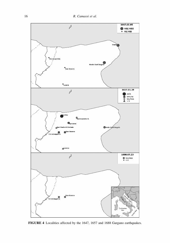
FIGURE 4 Localities affected by the 1647, 1657 and 1688 Gargano earthquakes.
16 R. Camassi et al.
October 17, 1656 (source: Sarnelli, 1680), and one in Lesina, in January 1657 (source:
300Corradi, 1865–1894). Both testimonies, Baratta suggests, could be related to a single
earthquake, whose likeliest date of occurrence he thought to be October 17, 1656. Only
partially heeding his advice, the Postpischl [1985] and CPTI Working Group [2004]
catalogs list a VII MCS earthquake in the vicinity of Lesina, on January 1657.
A careful study of Baratta’s sources brings to light an intricated situation. Sarnelli
305[1680] cites the event of October 17, 1656 in the context of a ‘‘miracle story’’; during that
year’s summer plague outbreak — he says — the Archbishop of Siponto had a vision of
St Michael Archangel, which inspired him to predict a forthcoming earthquake; on
October 17, that prophecy came true. A pious legend or there could be a grain of truth
in it? What’s certain is that Sarnelli [1680] cut down a longer tale related by his source
310(Cavalieri, 17th century, a history of the famed Garganic shrine of St Michael in Monte
Sant’Angelo). Actually, this source mentions not one but two earthquakes: a minor shock
on October 17, 1656 (presumably felt in Monte Sant’Angelo, no effects described), and a
major one ‘‘at night on the 1st of February [1657]’’; the latter was ‘‘felt as far as Naples
[and] struck, shook, disrupted and razed to the ground’’ several Garganic sites (Lesina,
315Lucera, San Nicandro, San Paolo, San Severo).
Let’s now consider Corradi [1865–1894], the other source quoted by Baratta [1901].
He cites ASFi [1657a], a diplomatic report written on January 30, 1657 by a Florentine
resident in Naples and describing ‘‘a mighty quake that frightened all the city’’ on the
night of January 29–30. This piece of news is — by the way — independently confirmed
320by another diplomatic report written on the same day [ASMo, 1657].
Had Corradi [1865–1894] delved farther into the Florentine records, he would have
found that a month after the previous letter, the Florentine resident had more to say on the
same topic: ‘‘That earthquake I wrote about, has turned out to have caused huge damage in
Apulia, particularly in San Severo, Torremaggiore, Casal Maggiore [now Apricena], Monte
325Sant’Angelo and above all in Lesina’’ [ASFi, 1657b]. This description fits well with the one
by Cavalieri [17th century], with only a slight difference in the date (January 29–30 according
to ASFi [1657a]; February 1 according to Cavalieri, 17th century). It seems reasonable to
identify the mainshock of the Apulian event with the one felt as far as Naples, and therefore
to accept the date given by ASFi [1657a]; the one given by Cavalieri [17th century] could be
330either a mistake or related to one of the aftershocks mentioned by ASFi [1657b].
For the time being, no more evidence is forthcoming on the 1657 earthquake, apart
from a brief reference to the damage it wrought in San Severo by a local contemporary
source [Fraccacreta, 17th century]; however, judging from the currently available original
sources, this earthquake was undoubtedly underestimated by previous catalogues
335(Table 9, Fig. 4). The main event occurred probably on January 29, 1657 (at 1:40 a.m.
GMT); it could have been preceded by a minor shock (October 17, 1656) and was
certainly followed by a few aftershocks (early February 1657); the NW side of the
Gargano peninsula seems to have been the most heavily affected area.
6.3. 1688: An Overlooked Earthquake
340In 1688 the Gargano peninsula was once more stricken by a ‘‘gran terremoto’’ (big
earthquake). This is not a ‘‘forgotten’’ earthquake but rather an overlooked one. Baratta
[1901] knew it, and the Postpischl [1985] catalog listed it with Io = VI MCS. The CPTI04
catalog [CPTI Working Group, 2004] does not list it anymore, probably because of the
declustering procedures adopted for its compilation. The main provider of data on this
345earthquake is a contemporary Neapolitan diary [Conforto, 17th century], according to
which it was felt in Apulia and Calabria on July 23, 1688 (at 8.00 a.m local time), causing
xxxx 17

minor damage in Sansevero, Torremaggiore and nearby towns (Table 10, Fig. 4). Bonito
[1691] affirms that these news were brought to Naples by ‘‘several letters’’, presumably
despatched from the affected areas. So far, no additional evidence for this earthquake was
350found, either in early newspapers or in local histories. A recently felt quake is mentioned in
an August 31 letter by the Papal Nuncio in Naples [ASVat, 1688], but it is unclear whether
this is a reference to the Apulian event or to an aftershock of the strong Neapolitan
Apennines earthquake of June 5 1688 (Mw = 6.7 [CPTI Working Group, 2004]). The
minor Apulian earthquake could have been ‘‘blanked out’’ by the larger one (on this subject
355see Camassi and Castelli, 2005); there is no reason to doubt of its occurrence, although no
very accurate assessment of its size can be made from the available evidence.
7. Discussion and Seismotectonic Implications: Evidence of anEarthquake Cluster ?
The epicentral parameters of the discussed 17th century earthquakes (Table 11 and
360Fig. 5) have been assessed with the standard Boxer code procedure, based on the
TABLE 9 Intensities observed for January 29, 1657 earthquake. References: (1) ASFi
[1657a]; (2) ASFi [1657b]; (3) ASMo [1657]; (4) Cavalieri [17th c.]; (5) Fraccacreta [17th c.]
Locality Coordinates Int. MCS Int. EMS Ref.
Lesina 41.864 15.353 9/10 9 2, 4.
San Severo 41.685 15.381 8/9 8 2, 4, 5.
Torremaggiore 41.689 15.292 8/9 8 2.
Apricena [Casal Maggiore] 41.784 15.444 8/9 8 2.
Monte Sant’Angelo 41.706 15.959 8/9 8 2.
Sannicandro Garganico 41.835 15.567 7/8 7 4.
San Paolo di Civitate 41.739 15.261 7/8 7 4.
Lucera 41.508 15.335 7/8 7 4.
Napoli 40.855 14.260 4/5 4/5 1, 2, 3, 4.
TABLE 10 Intensities observed for July 23, 1688 earthquake
Locality Coordinates Int. MCS Int. EMS Ref.
San Severo 41.685 15.381 7/8 7 Conforto [17th c.]
Torremaggiore 41.689 15.292 7/8 7 Conforto [17th c.]
Napoli 40.855 14.260 3? 3 ASVat [1688]
TABLE 11 New epicentral parameters of the four studied earthquakes
Date Time Epicentral Area Max. Int. Epic. Int. Om Lat Lon Mw
1646 05 31 02 00 Gargano 10 10 35 41.905 15.993 6.85
1647 05 05 12 30 Gargano 7/8 7/8 5 41.732 15.558 5.69
1657 01 29 01 40 Lesina 9/10 8/9 9 41.726 15.393 6.37
1688 07 23 03 00 San Severo 7/8 7/8 3 41.687 15.337 5.35
18 R. Camassi et al.
distribution of macroseismic observations [Gasperini et al., 1999], with the following
results.
1646: The dataset presented in Table 7 leads to assessing a macroseismic moment magni-
tude Mw of 6.9. This value is much higher than the macroseismic magnitude Me = 6.2
365estimated (with the same standard procedure) by Boschi et al. [2000]. Accepting it
would put the 1646 earthquake on the same level of the better-defined 1627 earthquake
(Mw = 6.7 [CPTI Working Group, 2004]), currently viewed as the strongest earthquake
on record in the Gargano-Capitanata area and one of the most relevant of Southern Italy
as well. Such a decision ought not be taken lightly and without first considering whether
370the data could be interpreted otherwise or the proposed assessment be questioned. For
instance, however reliable and consistent the available contemporary descriptions of the
severe damage wrought by the 1646 earthquake, it could be argued that it could have
been at least partly due to the heightened vulnerability of buildings that had been
affected by a very strong earthquake only 19 years before, in 1627. In fact, however, the
375latest available study of the 1627 earthquake [Boschi et al., 2000] points out that — also
thanks to a favorable economic conjuncture — the restoration process was quickly and
efficiently carried out and that most privately owned buildings and many of the Church-
owned ones were set to right within 10 years.
The criteria of the Boxer code procedure could also have contributed to enhancing the
380assessed magnitude value by attributing an excessive weight to the macroseismic data
point with the highest intensity and farther-removed from the others (Canosa di Puglia).
1647: From the dataset presented in Table 8, Mw = 5.9 and Io = VII-VIII MCS can be
assessed for this hitherto unknown earthquake.
1657: CPTI Working Group [2004] assesses M = 4.8 and Io = VII MCS for this earth-
385quake (Table 2), generically dated to January 1657. The dataset presented in Table 9
allows to pinpoint its date to January 29, 1657, at 1:40 a.m., with Mw = 6.4, Imax =
IX-X MCS and Io = VIII-IX MCS, consistent with the destructive level of its effects.
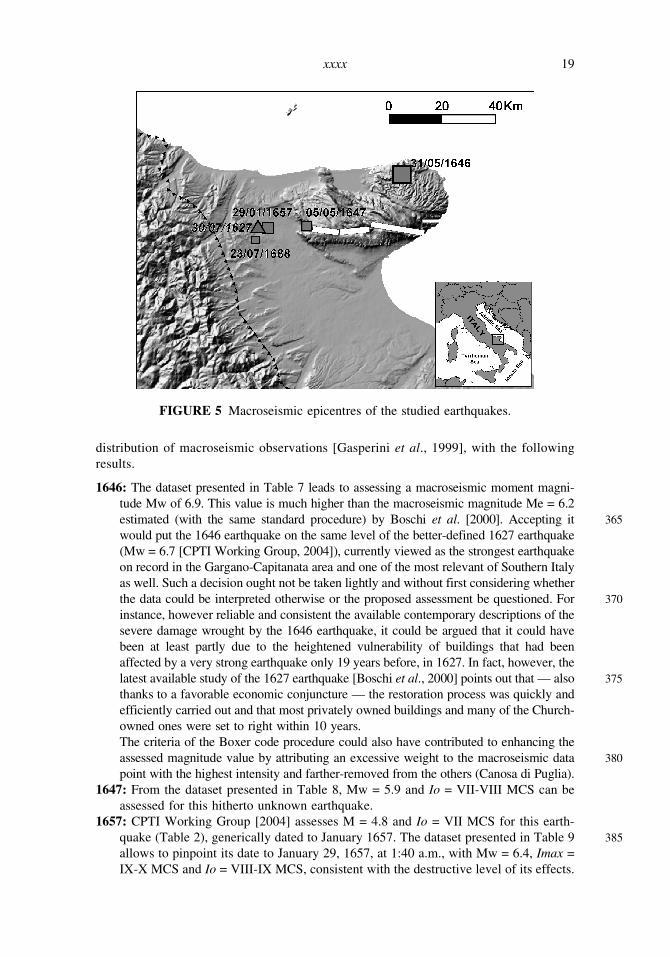
FIGURE 5 Macroseismic epicentres of the studied earthquakes.
xxxx 19
1688: Postpischl [1985] assesses M = 4.1, Io = VI MCS for this earthquake (Table 2); this
revision proposes Mw = 5.4 and Io = VII-VIII MCS.
390It is important to underline that the Boxer procedure [Gasperini et al., 1999] adopted
for determining the epicentral parameters is strongly dependent on the assigned intensi-
ties; of course the proposed magnitudes have an associated error, in this work evaluated
in ±0.5 as mean value; this high error is a sort of measure of the stability of the
determination.
395The four earthquakes reconstructed in this study define a 42-year-long period of high
seismic activity that affected the Gargano area in the 17th century and which had been
almost completely overlooked by the Italian seismological tradition. Up to until now,
instrumental observation had showed that Gargano earthquakes tend to cluster themselves
in time and space, but no historical evidence of this tendency was available. The results of
400this study seem to point out to the existence of at least one such case in the 17th century.
The distribution of the macroseismic epicenters (Fig. 5) shows—with the reduced
level of reliability inherent to the adopted methodology—an East to West spatial migra-
tion during a short time, which would appear to be in contrast with the distribution of the
damage reports here presented. Furthermore, the characteristics of the area make it
405unlikely that propagation events might follow this specific distribution.
It is therefore plausible that the distribution of the epicentres follows portions of the
Mattinata fault system, which have been activated in a sequential manner, probably
because of the huge amount of energy released and the general disturbance caused by
the 1627 earthquake.
410Of course, it is not the aim of this study to define the clustering property of the
seismicity in the studied area, nor to propose any quantitative analysis of fault-interaction
processes that can justify the studied 17th century seismic sequence. However, the
available evidence seems undoubtedly to converge in supporting the hypothesis of a
trigger of different segments of the Mattinata fault.
415This kind of observation is very important when the seismic hazard is assessed
adopting a time-dependent model, such as the one proposed by Faenza et al. [2003];
this approach is based on the clustering of earthquakes with M > 5.5 and it can evaluate
the increase of the probability of occurrence of an earthquake in a short time period after
a big event. Therefore, the results of this study point out that, when modeling possible
420seismic scenarios for the Gargano area, it should be advisable to analyse short term return
periods, in which the interaction amongst the adjacent fault segments could generate new
similar sequences in the wake of forthcoming severe earthquakes.
Acknowledgments
The authors wish to thank Piero Bellettini and his staff at the Biblioteca Comunale
425dell’Archiginnasio of Bologna, Fra’ Andrea Maggioli OFM Conv, Carlos Caracciolo,
Antonio Latino, Siro Martello, and Diego Molin for their advice and support during the
preparation of this article. They also would like to thank the reviewers of its preliminary
version for their thorough and thoughtful comments, by which they were greatly helped in
preparing this final version.
430References
Ambraseys, N. N. [2001] ‘‘The Earthquake of 1509 in the Sea of Marmara, Turkey, Revisited,’’
Bulletin of the Seismologic Society of America 91 (6), 1397–1416.
20 R. Camassi et al.
Ambraseys, N.N. and Finkel, C. [1991] ‘‘Long-term seismicity of Istanbul and of the Marmara Sea
region,’’ Terra Nova 3 (5), 527–539.
435Ambraseys, N.N. and Finkel, C. [1993] Material for the Investigation of the Seismicity of the
Eastern Mediterranean Region during the period 1690–1710. In: Stucchi, M. Ed. Materials of the
CEC project ‘‘Review of Historical Seismicity in Europe,’’ CNR, Milano, vol.1, 173–194.
ASFi (Archivio di Stato of Florence), [1646a] Mediceo del Principato Filza 4113, June 5.
ASFi [1646b] Mediceo del Principato Filza 4113, June 12.
440ASFi [1646c] Mediceo del Principato Filza 4113, June 19.
ASFi [1657a] Mediceo del Principato, filza 4117, January 30.
ASFi [1657b] Mediceo del Principato, filza 4117, March 6.
ASMo (Archivio di Stato of Modena), [1646a] Cancelleria Ducale, Avvisi e notizie dall’estero, b.
37, June 5.
445ASMo [1646b] Cancelleria Ducale, Avvisi e notizie dall’estero, b. 37, June 19.
ASMo [1657] Cancelleria Ducale, Avvisi e notizie dall’estero, b. 51, March 2.
ASNa (Archivio di Stato of Napoli), [1646] Consiglio Collaterale, Consiglio, Notamenti, vol. 52.
ASNa [1647] Vicere, Scritture diverse della Segreteria, fasc. 124 (11 maggio 1647- 5 giugno 1647).
ASVat [1646a] Segreteria di Stato Napoli 41 f. 269, June 2.
450ASVat [1646b] Segreteria di Stato Napoli 41 f. 274, June 5.
ASVat [1646c] Segreteria di Stato Napoli 41 f. 281, June 9.
ASVat [1646d] Segreteria di Stato Avvisi 98, June 16.
ASVat [1688] Segreteria di Stato, Napoli, 104 f. 158, August 31.
Baratta, M. [1896] ‘‘Sulla Attivita Sismica della Capitanata,’’ Annali Ufficio Centrale di
455Meteorologia e Geodinamica XVI, I (1894), 177–220.
Baratta, M. [1901] I Terremoti d’Italia. Saggio di Storia Geografia e Bibliografia Sismica Italiana
(Torino).
BAV (Biblioteca Apostolica Vaticana), [1646a] Urb.Lat. 1110 f. 180, June 9.
BAV [1646b] Urb. Lat. 1110 f. 187–188, June 16.
460BAV [1646c] Urb. Lat. 1110 f. 188, June 16.
Bernardi, F. [17th century] Relazione dello stato di tutti li conventi dei frati Cappuccini d’Italia (ms.
Archivio Provinciale dell’Ordine dei Frati Minori Cappuccini di Firenze).
Bologna [1647] May 28.
Bologna [1718a] April 12.
465Bologna [1718b] October 11.
Bologna [1756] December 30.
Bonito, M. [1691] Terra Tremante o Vero Continuatione de’ Terremoti dalla Creatione del Mondo
Fino al Tempo Presente (Napoli).
Boschi, E., Ferrari, G., Gasperini, P., Guidoboni, E., Smriglio, G., and Valensise, G. (Eds.) [1995]
470Catalogo Dei Forti Terremoti in Italia dal 461 a.C. al 1980 (ING-SGA, Bologna).
Boschi, E., Guidoboni, E., Ferrari, G., Gasperini, P. and Valensise, G. (Eds.) [1997] Catalogo Dei
Forti Terremoti in Italia dal 461 a.C. al 1990 (ING-SGA, Bologna).
Boschi, E., Guidoboni, M., Ferrari, G., Mariotti, D., Valensise, G., and Gasperini, P. (Eds) [2000]
‘‘Catalogue of Strong Italian Earthquakes from 461 B.C. to 1997.’’ Annals of Geophysics 43 (4),
475609–858.
Boyle, L. (OP), [1972] A Survey of the Vatican Archives and of its Medieval Holdings (Pontifical
Institute of Mediæval Studies, Toronto, Canada).
Camassi, R and Castelli, V. [2004] ‘‘Looking for ‘New’ Earthquake Data in the 17th-18th Century
European ‘Newssellers’ Network,’’ Journal of Earthquake Engineering 8(3), 335–359.
480Camassi, R. and Castelli, V. [2005] ‘‘Journalistic Communication in the 17th-18th Centuries and its
Influence on the Completeness of Seismic Catalogues,’’ Boll. Geof. Teor. Appl. 46, 99–110. Q1
Cardassi, S. and Cardassi, C. [17th century] Memorie (ms. Biblioteca Nazionale ‘‘Sagarriga
Visconti-Volpe’’ di Bari, Manoscritti, I/67).
Castelli, V. and Camassi, R. [2005] ‘‘The Shadow-Zone of Large Italian Earthquakes. Early
485Journalistic Sources and Their Perception of 17th-18th Centuries Seismicity,’’ Journal of
Earthquake Engineering 9, 333–348.
xxxx 21
Cavalieri, M. [17th century] Il pellegrino al Gargano ragguagliato della possanza beneficante di S.
Michele nella sua celeste basilica, dal padre F. Marcello Cavaglieri. . . Ristampato ad istanza del
signor Domenico Roberti (In Macerata, ed in Bassano, 1732).
490Cavallini, A. [2003] L’abbazia di Santa Maria di Pulsano sul Gargano. Guida storica ed artistica
(Monte Sant’Angelo).
Conforto, D. [17th century] Giornali di Napoli dal MDCLXXIX al MDCIC (Napoli, 1930).
Corradi, A. [1865–1894] Annali delle epidemie occorse in Italia dalle prime memorie fino al 1850 :
compilati con varie note e dichiarazioni. Volume IV Aggiunte e correzioni fino all’anno 1700
495(Bologna).
CPTI Working Group [2004] Catalogo Parametrico dei Terremoti Italiani, versione 2004 (INGV,
Bologna, InterNet: http://emidius.mi.ingv.it/CPTI/).
CSI Working Group [2005] CSI Catalogo della sismicita italiana 1981–2002, versione 1.0 (INGV-
CNT, Roma, InterNet: http://www.ingv.it/CSI).
500D’Alatri, M. [1984] I conventi cappuccini nell’inchiesta del 1650, II, L’Italia centrale (Roma).
DISS Working Group [2005] Database of Individual Seismogenic Sources (version 3.0.1): A
compilation of potential sources for earthquakes larger than M 5.5 in Italy and surrounding
areas (INGV, Roma, InterNet: 2http://www.ingv.it/banchedati/banche.html).
Faenza, L., Marzocchi, W., and Boschi, E. [2003] ‘‘A Non-Parametric Hazard Model to
505Characterize the Spatio-Temporal Occurrence of Large Earthquakes: An Application to the
Italian Catalogue,’’ Geophysics Journal International, 155(2), 521–531.
Fraccacreta, M. [17th century] Teatro topografico storico poetico della Capitanata e degli altri
luoghi piu memorabili e limitrofi della Puglia (Bologna, Napoli, 1828–1843).
Gabriele da Cerignola [17th century] Memoria della fondazione di questa nostra provincia dei
510Cappuccini di Sant’Angelo e di suoi luoghi con il catalogo di tutti li vicari seu ministri
provinciali, che l’hanno governata (ms. Biblioteca Provinciale dei Cappuccini di Foggia, s.s.)
Gasperini, P., Bernardini, F., Valensise, G. and Boschi, E. [1999] ‘‘Defining Seismogenic
Sources from Historical Felt Reports,’’ Bulletin of the Seismologic Society of America 89,
94–110.
515Genova, [1646] 16 June.
Giornale del Regno delle Due Sicilie, [1828] November 21.
Giornale del Regno delle Due Sicilie, [1829] August, 13.
Girolamo da Sorbo and Clemente da Napoli [17th century] Breve notamento de tutti li frati
Capuccini quali sono passati da questa vita presente in questa Provincia di Napoli 1563–1653.
520Zarrella P. (Ed.), Napoli 1995.
Giuliani, V. [1768] Memorie storiche politiche, ecclesiastiche della citta di Vieste (Napoli).
Guidoboni, E. [2000] Method of investigation, typology and taxonomy of the basic data: navigating
between seismic effects and historical contexts. In Catalogue of Strong Italian Earthquakes from
461 B.C. to 1997; Annals of Geophysics 43 (4), 621–266.
525Guidoboni, E. and Comastri, A. [2005] Catalogue of earthquakes and tsunamis in the Mediterranean
area from the 11th to the 15th century (INGV-SGA, Bologna).
Guidoboni, E. and Tinti, S. [1989] I maremoti garganici del Seicento. Atti del 6.o Convegno
nazionale GNGTS, Roma 14–16 dicembre 1987, 1, 491–504.
Guidoboni, E. and Stucchi, M. [1993] ‘‘The Contribution of Historical Records of Earthquakes to
530the Evaluation of Seismic Hazard,’’ Annals of Geophysics 36 (3–4), 201–215.
Latiano, B. [1906] Memorie storiche dei conventi e dei cappuccini della monastica provincia di S.
Angelo (Benevento).
Meletti, C., Patacca, E, and Scandone, P. [2000] ‘‘Construction of a Seismotectonic Model: The
Case of Italy,’’ Pure and Applied Geophysics 157, 11–35.
535Meletti, C., Galadini, F., Valensise, G., Stucchi, M., Basili, R., Barba, S., Vannucci, G., and Boschi,
E. [2008] ‘‘A Seismic Source Model for the Seismic Hazard Assessment of the Italian
Territory,’’ Tectonophysics (accepted).
Monachesi, G. and Stucchi, M. [1997]. DOM4.1, un database di osservazioni macrosismiche di
terremoti di area italiana al di sopra della soglia del danno, GNDT, Internal report, Milano-
540Macerata. 2http://emidius.mi.ingv.it/DOM/
22 R. Camassi et al.
Musson, R. M. W. [1998] ‘‘Intensity Assignments from Historical Earthquake Data: Issues of
Certainty and Quality.’’ Annals of Geophysics 41 (1), 79–91.
Nuova Relatione Del grande, e spaventoso Terremoto Successo nella Provincia della Puglia, e
molto luoghi della Calabria, Amatrice, & in Acumulo, Dove intenderete la desolatione di alcune
545Citta, Castelli, e Luoghi, con la morte di una gran moltitudine di persone; Descritta da Pietro Elli
da Pascheti. In Trani, in Chieti, in Spoleti, in Siena & in Bol., per Giacomo Monti, 1646.
Paoloni, B. [1913] ‘‘Cronistoria sismica cassinese,’’ Bollettino mensile dell’Osservatorio meteorico,
aerologico, geodinamico di Montecassino V (10), 15–16.
Patacca, E. and Scandone, P. [2004] ‘‘The 1627 Gargano Earthquake (Southern Italy): Identification
550and Characterization of the Causative Fault,’’ Journal of Seismology 8, 259–273.
Patacca, E. and Scandone, P. [2007] ‘‘Geology of Southern Apennines,’’ Boll. Q1Soc. Geol. It. (Italian
Journal Geoscience), Spec. Issue 7, 75–119.
Perrey, A. [1851] ‘‘Note sur les tremblemets de terre en 1850, avec supplements pour les annees
anterieures,’’ Extrait des Memories de l’Academie des Sciences, Arts et Belles-Lettres de Dijon,
5551851. Bull. Acad. R. Belgique, XVIII, 36 pp.
Perrey, A. [1870] ‘‘Note sur les tremblemets de terre en 1866 et 1867, avec supplements pour les
annees anterieures, de 1843 a 1865,’’ Mem. cour. et autres Mem. Acad. R. Belgique, XXI, 223 pp.
Postpischl, D. [1985] Catalogo dei terremoti italiani dall’anno 1000 al 1980 (Quaderni della
Ricerca Scientifica, 114 2B, Bologna).
560Sarnelli, P. [1680] Cronologia de’ vescovi et arcivescovi Sipontini (Manfredonia).
Settimanni, F. [18th century] Memorie fiorentine (ms. Archivio di Stato di Firenze, Manoscritti,
125–147, 18 voll).
Stucchi, M., Monachesi, G. and Mandrelli, F. M. [1991] ‘‘Investigation of 18th Century Seismicity
in Central Italy in the Light of the 1741 Fabriano Earthquake,’’ Tectonophysics 193, 65–82.
565Tinti, S. and Maramai, A. [1996] ‘‘Catalogue of Tsunamis Generated in Italy and in Cote d’Azur,
France: A Step Towards a Unified Catalogue of Tsunamis in Europe,’’ Annali di Geofisica 39
(6), 1253–1299.
Vogt, J. [1991] ‘‘Some Glimpses at Historical Seismology,’’ Tectonophysics 193, 1–7.
Vogt, J. [1993] ‘‘Historical Seismology. Some Notes on Sources for Seismologists.’’ In: Stucchi, M.
570ed. Materials of the CEC project ‘‘Review of Historical Seismicity in Europe’’, CNR, Milano,
vol.1, pp. 15–24.
xxxx 23
Copyright © 2022 FDOKUMEN