Urban planning, flood risk and public policy: The case of the Arno River, Firenze, Italy
14
Urban planning, flood risk and public policy: The case of the Arno River, Firenze, Italy Stefano Morelli a, * , Samuele Segoni a,1 , Goffredo Manzo a, b, 2 , Leonardo Ermini c, 3 , Filippo Catani a, 4 a Department of Earth Sciences, University of Firenze, Via La Pira n 4,50121 Firenze, Italy b Geodetic Division, Italian Military Geographic Institute, Ministry of Defence, via C. Battisti n 10, 50122 Firenze, Italy c Po Servizio Geologico e Progetti di Difesa Idrogeologica, Provincia di Firenze, via de’ Ginori n 10, 50123 Firenze, Italy Keywords: GPS GIS Geoid Geodatabase Dikes Hydraulic policy Hydrological risk abstract Urban planning and hydraulic risk management are a worldwide necessity which is best achieved when natural and artificial elements located closely to watercourses are known in great detail. A geodatabase is a practical tool to store and manage such information. When working at small scales, however, any well established methodology exists to map the position and the height of the various elements with cen- timetric accuracy. For this purpose we propose a methodology that we tested on the Arno river (Italy) and its most urbanized tributaries, a demonstrative case of hydrological risk around large fluvial systems. We surveyed 116 km of river traits to collect GPS measurements and information about all the natural and artificial elements connected to hydraulic risk and fluvial dynamics. The mapped elements include (but are not limited to) buildings, assets, bridges, hydraulic works, weirs, drainage outlets, dikes, river- banks, structural damages, fluvial bars and eroding banks. All these elements were mapped with high accuracy, in particular a local geoid model, related only to the study area, was developed to obtain orthometric heights affected with errors 0.05 m. Consequently a GIS geodatabase was built to visualize the spatial distribution of the mapped elements and to store a series of technical data, including the present preservation condition for man-made objects. The geodatabase provides an overview of the territories connected with the fluvial dynamics, highlighting that in the studied territory, the more is urbanized, the more it is exposed to hydraulic risk. In a similar context, the geodatabase itself represents a useful tool for the management of the hydrological risk and for hydraulic policy and urban planning. Ó 2011 Elsevier Ltd. All rights reserved. Introduction The natural dynamic evolution of a river and the adjacent morphological environment are particularly important for the communities that concentrate in these areas their socio-economic activities. In addition the anthropogenic pressure plays a funda- mental role in influencing the rate of the fluvial processes. The combination of both factors involves all the major rivers, so that today it is not easy to find long fluvial reaches free of human inter- vention (Rinaldi, 1995). Among the anthropic operations that have significantly influenced the river dynamics until today, the most important are the construction of dikes and dams, the realization of channeling and the excavation of sand and gravel. In some circum- stances all these alterations have also led to a lowering phase of the thalweg profile and consequently the instability of the riverbank have increased in most of the rivers around the world (Bravard et al., 1997; Darby & Simon, 1999; Keselm, 2003; Li, Lu, & Chen, 2007; Peiry, 1987; Steiger, James, & Gazelle, 1998; Steiger, Tabacchi, Dufour, Corenblit, & Peiry, 2005; Yamani, Goorabi, & Dowlati, 2011). Similar responses to river engineering and management, flow regulation and land-use modifications have also occurred in the Arno river (Agnelli, Billi, Canuti, & Rinaldi, 1998; Cencetti & Tacconi, 2005; Dapporto, 2003; Dapporto, Rinaldi, & Casagli, 2001; Dapporto, Rinaldi, Casagli, & Vannocci, 2003; Rinaldi, 2006; Rinaldi & Rodolfi, 1993; Rinaldi & Simon, 1998; Tacconi, Canuti, Cencetti, & Rinaldi, 1994) which is still considered the second Italian emergency (after the Vesuvius volcano) in terms of civil protection. Moreover, because of the above-mentioned historical interventions and its recurrent floods in highly urbanized areas directly facing the riverbed, the Arno river can be considered highly representative of other realities at risk in the world. * Corresponding author. Tel.: þ39 055 2055305; fax: þ39 055 2055317. E-mail addresses: stefano.morelli@unifi.it (S. Morelli), samuele.segoni@unifi.it (S. Segoni), [email protected] (G. Manzo), leonardo.ermini@ provincia.fi.it (L. Ermini), filippo.catani@unifi.it (F. Catani). 1 Tel.: þ39 055 2756343; fax: þ39 055 2756296. 2 Tel.: þ39 055 2732439; fax: þ39 055 4368429. 3 Tel.: þ39 055 2760092; fax: þ39 055 2760059. 4 Tel.: þ39 055 275 6223; fax: þ39 055 2756296. Contents lists available at SciVerse ScienceDirect Applied Geography journal homepage: www.elsevier.com/locate/apgeog 0143-6228/$ e see front matter Ó 2011 Elsevier Ltd. All rights reserved. doi:10.1016/j.apgeog.2011.10.020 Applied Geography 34 (2012) 205e218
Transcript of Urban planning, flood risk and public policy: The case of the Arno River, Firenze, Italy
at SciVerse ScienceDirect
Applied Geography 34 (2012) 205e218
Contents lists available
Applied Geography
journal homepage: www.elsevier .com/locate/apgeog
Urban planning, flood risk and public policy: The case of the Arno River, Firenze,Italy
Stefano Morelli a,*, Samuele Segoni a,1, Goffredo Manzo a,b,2, Leonardo Ermini c,3, Filippo Catani a,4
aDepartment of Earth Sciences, University of Firenze, Via La Pira n�4,50121 Firenze, ItalybGeodetic Division, Italian Military Geographic Institute, Ministry of Defence, via C. Battisti n�10, 50122 Firenze, Italyc Po Servizio Geologico e Progetti di Difesa Idrogeologica, Provincia di Firenze, via de’ Ginori n�10, 50123 Firenze, Italy
Keywords:GPSGISGeoidGeodatabaseDikesHydraulic policyHydrological risk
* Corresponding author. Tel.: þ39 055 2055305; faE-mail addresses: [email protected] (S. Mor
(S. Segoni), [email protected] (G.provincia.fi.it (L. Ermini), [email protected] (F. Cat
1 Tel.: þ39 055 2756343; fax: þ39 055 2756296.2 Tel.: þ39 055 2732439; fax: þ39 055 4368429.3 Tel.: þ39 055 2760092; fax: þ39 055 2760059.4 Tel.: þ39 055 275 6223; fax: þ39 055 2756296.
0143-6228/$ e see front matter � 2011 Elsevier Ltd.doi:10.1016/j.apgeog.2011.10.020
a b s t r a c t
Urban planning and hydraulic risk management are a worldwide necessity which is best achieved whennatural and artificial elements located closely to watercourses are known in great detail. A geodatabase isa practical tool to store and manage such information. When working at small scales, however, any wellestablished methodology exists to map the position and the height of the various elements with cen-timetric accuracy. For this purpose we propose a methodology that we tested on the Arno river (Italy)and its most urbanized tributaries, a demonstrative case of hydrological risk around large fluvial systems.
We surveyed 116 km of river traits to collect GPS measurements and information about all the naturaland artificial elements connected to hydraulic risk and fluvial dynamics. The mapped elements include(but are not limited to) buildings, assets, bridges, hydraulic works, weirs, drainage outlets, dikes, river-banks, structural damages, fluvial bars and eroding banks. All these elements were mapped with highaccuracy, in particular a local geoid model, related only to the study area, was developed to obtainorthometric heights affected with errors �0.05 m. Consequently a GIS geodatabase was built to visualizethe spatial distribution of the mapped elements and to store a series of technical data, including thepresent preservation condition for man-made objects. The geodatabase provides an overview of theterritories connected with the fluvial dynamics, highlighting that in the studied territory, the more isurbanized, the more it is exposed to hydraulic risk. In a similar context, the geodatabase itself representsa useful tool for the management of the hydrological risk and for hydraulic policy and urban planning.
� 2011 Elsevier Ltd. All rights reserved.
Introduction
The natural dynamic evolution of a river and the adjacentmorphological environment are particularly important for thecommunities that concentrate in these areas their socio-economicactivities. In addition the anthropogenic pressure plays a funda-mental role in influencing the rate of the fluvial processes. Thecombination of both factors involves all the major rivers, so thattoday it is not easy to find long fluvial reaches free of human inter-vention (Rinaldi, 1995). Among the anthropic operations that havesignificantly influenced the river dynamics until today, the most
x: þ39 055 2055317.elli), [email protected]), leonardo.ermini@
ani).
All rights reserved.
important are the construction of dikes and dams, the realization ofchanneling and the excavation of sand and gravel. In some circum-stances all these alterations have also led to a lowering phase of thethalweg profile and consequently the instability of the riverbankhave increased inmost of the rivers around theworld (Bravard et al.,1997; Darby & Simon, 1999; Keselm, 2003; Li, Lu, & Chen, 2007;Peiry, 1987; Steiger, James, & Gazelle, 1998; Steiger, Tabacchi,Dufour, Corenblit, & Peiry, 2005; Yamani, Goorabi, & Dowlati,2011). Similar responses to river engineering and management,flow regulation and land-use modifications have also occurred inthe Arno river (Agnelli, Billi, Canuti, & Rinaldi, 1998; Cencetti &Tacconi, 2005; Dapporto, 2003; Dapporto, Rinaldi, & Casagli, 2001;Dapporto, Rinaldi, Casagli, & Vannocci, 2003; Rinaldi, 2006;Rinaldi & Rodolfi, 1993; Rinaldi & Simon, 1998; Tacconi, Canuti,Cencetti, & Rinaldi, 1994) which is still considered the secondItalian emergency (after the Vesuvius volcano) in terms of civilprotection. Moreover, because of the above-mentioned historicalinterventions and its recurrent floods in highly urbanized areasdirectly facing the riverbed, the Arno river can be considered highlyrepresentative of other realities at risk in the world.
S. Morelli et al. / Applied Geography 34 (2012) 205e218206
So appropriate mitigation strategies become crucial for entirefluvial systems and the absolute need to minimize the risk offlooding is essential in those flood plains, which have experiencedurban growth and changes in land use (Merz, Hall, Disse, &Schumann, 2010). In order to plan a significant protection of theadjacent plain areas, it is therefore necessary to register and keepup to date the spatial distribution of their main natural and man-made elements using adequate Geographic Information Systems(GIS) linked with exhaustive (but not too sophisticated) databasesin which to record their complete description (position, size,constituent material, functionality, state of maintenance, likelyconnection between elements and so on) (Cornelius, Sear, Carver, &Heywood, 1994). This must be aimed at obtaining a set of usefulinformation to achieve an adequate vulnerability and efficiencyassessment of the classified objects in relation to the regular fluvialdynamics (normal development) and extraordinary events (flood-ing) (Cutter et al., 2008). Such deepened knowledge can also beused to evaluate a possible re-use of the functionally compromisedhydraulic works and, in case of high flooding risk, to convert themto a more suitable utilization (Agnelli et al., 1998). Simultaneouslywith the development of new analytical tools, rapid procedures forcollecting and cataloging high precision data in large areas havebeen conceptually proposed in the past (Argent & Grayson, 2001;Arvanitis, Ramachandran, Brackett, Rasol, & Du, 2000; Canuti,Casagli, Catani, & Fanti, 2000), but without indicating exactlypossible operational procedures that could be really effective in themanagement of flood areas. However, geodatabases are one of themost advanced data synthesis tools in this discipline as a result ofseveral implementations (e.g. Brierley, Fryirs, Cook, & Outhet, 2011and Patiño-Gomez, McKinney, & Maidment, 2007), but they muststill be improved in the harmonization between different sources,in the formation of well structured and interconnected informativedata of all the elements at risk (Gustavsson, Seijmonsbergen, &
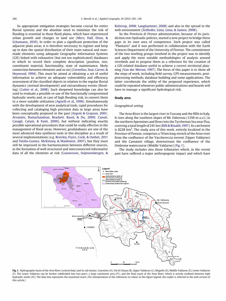
Fig. 1. Hydrographic basin of the Arno River (central Italy) and its sub-basins: Casentino (A),(F). The Lower Valdarno can be further subdivided into two parts: a large catchment areahydraulic works (F2). The blue line represents the examined reach. (For interpretation of ththis article.)
Kolstrup, 2008; Langhammer, 2008) and also in the spread in theweb environment (Zeilhofer, Lima, Lima, & Santos, 2008).
So the Provincia di Firenze administration, because of its juris-diction over hydraulic policies, started a new project to bridge thesegaps in its own area of competence. Such project was called“Plantario” and it was performed in collaboration with the EarthSciences Department of the University of Firenze. The commitmentof the two working groups involved in the project was to identifyand apply the most suitable methodologies of analysis aroundriverbeds and to propose them as a reference for the creation ofa GIS-related database useful to achieve a correct territorial plan-ning (Van der Merwe, 1997). The focus of this paper is to show allthe steps of work, including field survey, GPS measurements, post-processing methods, database building and some applications. Thelatter corroborate the utility of the proposed experience, whichcould be repeatedwhenever public administrations and boards willhave to manage a significant hydrological risk.
Study area
Geographical setting
The Arno River is the largest river in Tuscany and the fifth in Italy.It rises along the southern slopes of Mt. Falterona (1358 m a.s.l.) inthe northernApennines andflows into the Tyrrhenian Sea near Pisa,covering a total lengthof 241 km (Billi & Rinaldi,1997). Its catchmentis 8228 km2. The study area of this work, entirely localized in theProvince of Firenze, comprises a 74 km long stretch of the Arno riverfrom the confluence of the Vacchereccia torrent (Upper Valdarno)and the Camaioni village, downstream the confluence of theOmbrone watercourse (Middle Valdarno) (Fig. 1).
The study includes also those tributaries which, in the recentpast have suffered a major anthropogenic impact and which have
Val di Chiana (B), Upper Valdarno (C), Mugello (D), Middle Valdarno (E), Lower Valdarno(F1), and the final reach of the Arno River, which is strictly confined between high
e references to colour in this figure legend, the reader is referred to the web version of
S. Morelli et al. / Applied Geography 34 (2012) 205e218 207
been exposed to a high hydraulic risk. Just their final traits wereexamined, for a total length of 42 km; these reaches are generallyenclosed by a dense urbanization.
For each river or stream, the lateral extension of the investigatedarea spans from the riverbed to at least 10 m away from the lastelement of flood containment (riverbank line or dike) and corre-sponds to the area of absolute protection of rivers according toa regional decree.
Geomorphological setting
The Arno catchment is constituted by a series of intermontanebasins with Plio-Pleistocenic unconsolidated sediments (conglom-erates, sands and clays), alternated with bedrock-controlled gorge-like reaches (Canuti et al., 2006; Caporali, Rinaldi, & Casagli, 2005;Cencetti & Tacconi, 2005). Such geological configuration stronglyinfluenced the course of the Arno river in the studied area (Canuti,Cencetti, Rinaldi, & Tacconi, 1994). In some zones even the humanintervention, started since the Roman times, considerably controlsthe fluvial dynamics (Billi & Rinaldi, 1997; Rinaldi & Simon, 1998).
The river course can be subdivided into a sequence of reachescharacterized by a similar evolutionary trend and geomorpho-logical settings (Billi & Rinaldi, 1997; Canuti et al., 1994). In theupper Valdarno (11 km) the Arno has a low sinuosity and alter-nate bars, some of which are fixed by arboreous and shrubvegetation. The channel is larger than 100 m and the currentmorphological appearance of the floodplain is mainly the result ofthe anthropic actions during the last century, such as theextraction activities and the enlargement of the major urbanareas and transportation lifelines. Then the Arno crossesa predominantly incised reach for 3 km, developing a windingand embedded channel that is wide from 70 m up to 100 m. Thisarea is called “the threshold of Incisa” (Soglia dell’Incisa) since it ischaracterized by a compact rocky bed that limited altimetricmodifications in historic times. After this narrow way the riverruns into the Middle Valdarno, where it flows through thefloodplain of Rignano in south-north direction for almost 4 km,without modifying its cross section. Here the river’s current is notable to generate depositional forms as in the upstream alluvialreach. In the vicinity of the urban area of Rignano the riverbecomes confined for 7 km in rocky banks, since the bedrockemerges and starts predominating once more. After this point theArno River flows through the Pontassieve gorge which is a narrowalluvial plain with a river bed that is reduced in width(50e100 m) by the numerous outcrops of the bedrock, especiallyin the left river bank. On this side the steep rocky slopes,descending directly to the river bed, give rise to fluvial areas withstrong deposition of gravels and pebbles. Subsequently the riverencounters the Florentine flood plain and flows through it forabout 19 km. In the past this reach has been subject to numerousriverbed rectifications and other hydraulic works in order tocontrast lateral movements and to reduce flood risk and reclaimswamps: the first interventions in the urban area of Firenze dateback to Roman times: during the 12th century the whole trait wasradically transferred to the current position (Billi & Rinaldi, 1997;Hardie, 1965; Natoni, 1944). Because of all these interventions,today the Arno flow line is rectilinear and the cross section has anextremely reduced width (150 m) if compared to the one of pastcenturies (about 1000 m). Finally, the river crosses for 7 km therocky strait of the Gonfolina Gorge, mainly constituted by sand-stones, and it enters directly into the lower Valdarno.
The study site includes also the final reaches of the main Arnotributaries located in the surroundings of the Firenze urban area. Allof them flow through the Florentine flood plain, except for the lastreach of the Ombrone torrent.
- The Ombrone torrent (surveyed for 7.5 km) is embedded ina narrow and sinuous course on steep-sided hills and it ischaracterized by relevant autumnal discharges. For this reason,it was navigable for long periods of the year until theconstruction of heavy anthropogenic modification at thebeginning of the nineteenth century.
- The Bisenzio torrentwas studied for 13 km. In this stretch its bedis extremely narrow since thewater course is shaped into aman-made channelwithout anynatural feature. It receiveswater froma lot of small watercourses before flowing into the Arno River inthe densely urbanized area of Signa. Because of its torrentialregime, the Bisenzio has periodically caused flooding in thesurrounding plains (Westfall,1989). Just in the last century threecatastrophic events have occurred: in 1926, in 1966 and in 1991(Becchi, Caporali, Castellani, Palmisano, & Castelli, 1995).
- The Marina torrent is one of the most important tributary ofBisenzio and, likewise, it is highly channeled in the floodplainby walls, reinforced earth dikes and concrete thresholds alongthe thalweg. In this project the torrent was mapped andexamined for its last 3 km.
- The Greve torrent was investigated for 4 km from the conflu-ence up to the main town of Scandicci. Along its course norelevant anthropic intervention has never been realized withinthe riverbed except for some old weirs to exploit the hydraulichead in adjacent mills.
- The Mugnone torrent originates in the northeast hills of Fire-nze, crosses the city and gets into the Arno river at the westernlimit of the city. Overall, it was examined up to 6 km from theconfluence. Originally the Mugnone torrent used to flow intothe Arno, closed to the present old town and such confluencewas the first site selected for the foundation of the ancientRoman city. During historic times it was repeatedly divertedaccording to the necessity of the urbanization until the currentposition. Consequently, Mugnone is nowadays a water channelcompletely wedged into the urban fabric without any possi-bility of natural evolution. Since it is characterized bya torrential regime with an insidious fall flood, this river isassociated to a high hydraulic risk: autumnal heavy rainfallsrecurrently caused inundations in the past with extensivedamage to the surrounding neighborhoods (Becchi et al., 1995).
- The Terzolle torrent originally flowed straight into the ArnoRiver, but its last branch was artificially diverted in the XVIcentury and forced to flow into the Mugnone to give place tonew military settlements. It was studied for 1.5 km within themetropolitan area of Firenze from the confluence up to theintersection with a major railway.
- The Vingone torrent was examined for 7 km through thehomonymous and densely populated urban area. Long reachesof the torrent are characterized by a hanging river bed withdikes that are partially covered by concrete and delineatea completely artificial course.
Methodology
Field survey
The mapping of the morphologic and man-made elementslocated in such a wide study area requires the adoption of a meth-odology with the following characteristics: i) fast acquisition of theposition (i.e. absolute coordinates) of the elements; ii) possibility ofa full integration of the schematic representation of such elementsin a GIS; iii) unambiguous recognition of all the elements of interestand definition of their main characteristic and present use.
The survey procedures that currently best satisfy all the afore-mentioned requisites in fluvial environment are those related to
S. Morelli et al. / Applied Geography 34 (2012) 205e218208
geodetic GPS instruments in Real Time Kinematic (RTK) mode(Campana, 2006; Higgitt & Warburton, 1999; Kinzel, 2008; Peyret,Betaille, & Hintzy, 2000; Xiao, Wan, Wu, & Zhang, 2006) andterrestrial 3D laser scanner devices (Heritage & Hetherington,2005; Milan, Heritage, & Hetherington, 2007; Nasermoaddeli &Pasche, 2008; Seed et al., 2005). In order to find which method-ology better minimizes time and costs of operation a pilot site wasinvestigated using both instrumentations. In particular these wereemployed in a rectilinear trait of the right riverbank of the ArnoRiver, located immediately east of the city of Firenze, and theireffectiveness was compared. The length of this area is 0.850 km,approximately 1/200 of the total length of the riverbanks coveredby the survey.
The laser scanner allowed to obtain a very detailed 3D model ofthe entire riverbank including every positioned object:morphometry of the riverbank itself, trees, hydraulic works andvarious unnecessary objects, such as benches or street lamps.Unfortunately a shadow area prevented from the exact recon-struction of the geometry of one of the most interesting locations (adrainage outlet). That result was achieved with a single scanning(including the time for the positioning of the instrument andgeoreferencing of the target reflectors placed in the area) that tookup almost 1 h, while the post-processing needed more than 8 h. Adirect survey was anyhow necessary to recognize and select theelements of interest in correlation with the river dynamics and,above all, to retrieve qualitative information to store in the geo-database (e.g. material of construction or need for maintenanceworks). In addition, we have to consider that a single scanned sceneis of little help in our application, and the representation of thewhole Arno course would require the positioning of severalhundreds scenes with higher spatial accuracy. That required theacquisition of precise coordinates for a great number of targetpoints, so some accurate GPS measuring was needed anyhow.Furthermore, the cloud of points representing the whole Arno rivercourse would result quite clumsy to manage in a GIS and, providedthat the detail supplied is in the most cases unnecessary, it wouldresult more handy to simplify the geometry of every object justwith a shapefile of polygons, lines or points.
The fieldwork for the GPS survey was more rapid: the pilot sitewas surveyed in about 1 h allowing at the same time the directrecognition, interpretation and description of the elements ofinterest. This solution is the only possible when herbaceous andshrub vegetation or other hindrances prevents from identifying theobjects with remote sensing techniques.
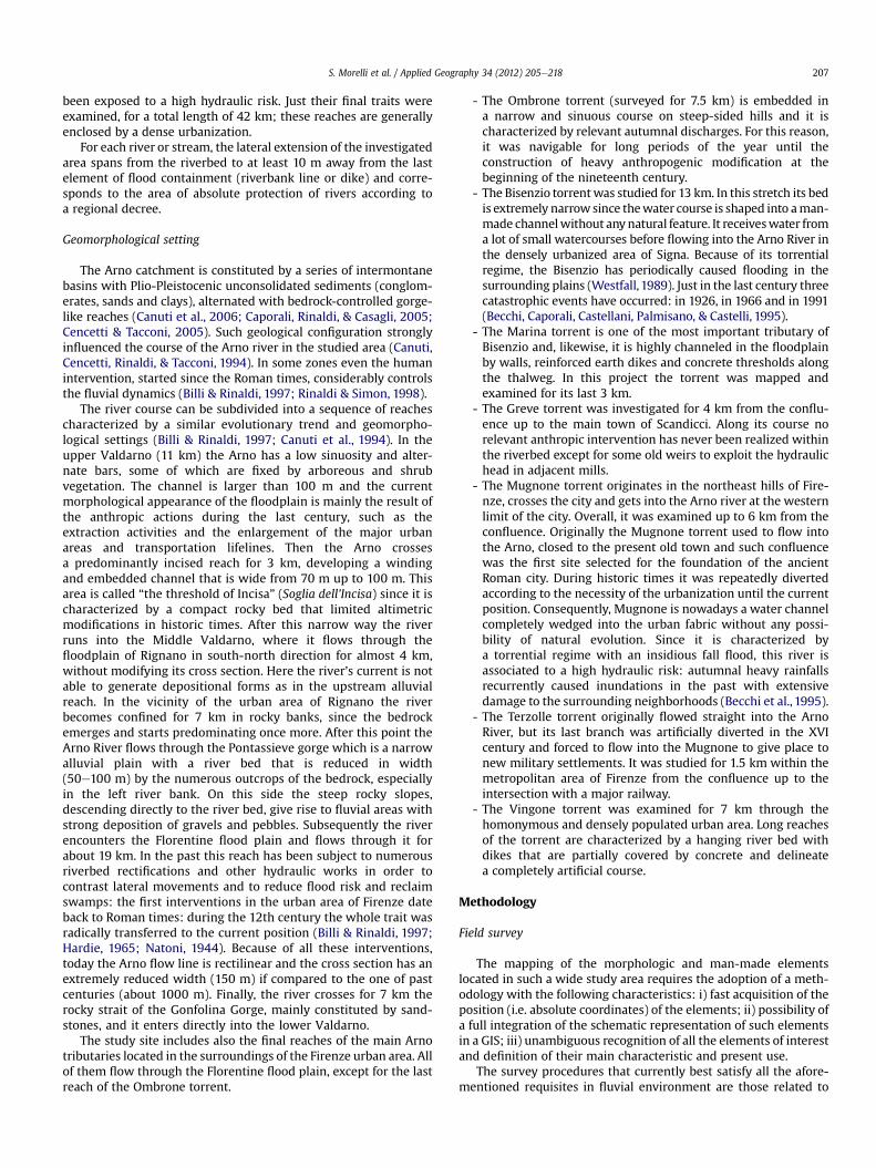
Fig. 2. GPS measurements of a collapsing bank (A); Schematic lo
For every element, it was necessary to acquire just a few pointsthat could schematically describe its shape, then the GPS pointswere easily imported in a GIS and used to build lines and polygonfeatures representing all the elements of interest. The very accurate(<5 cm) positioning of the points allows to correctly portray thelocation and the dimension of every object, which therefore can beefficiently visualized and managed by means of GIS applications.
Given these results, we chose to carry out an extensive GPSmapping to determine the shape and the spatial position of eachelement to be included in the geodatabase. Modern differential GPSdevices were used in RTK mode (Real Time Kinematic) (Fig. 2A).This methodology allows acquiring the position of a point inWGS84 coordinates in a few seconds and quickly move to the nextpoint to measure. In the present work, the pace between twoconsecutive points describing the same element ranged froma maximum of 25 m for rectilinear traits to a few centimetres whenit was necessary to describe with precision a curve or an irregularshape (Fig. 2B). The errors in the positioning of every GPS point arefar below the precision usually required in GIS applications (Cina,Manzino, & Roggero, 2003).
Unfortunately it has not always been possible to keep thisdegree of precision for the whole work: in some cases high build-ings or trees with large-leafed canopy prevented from obtainingthe 0.05 m accuracy because of the multipath effect (Counselman,1999) or because of the blockage of the satellite signal (Leick,2003). In case of points with a precision below 0.5 m the coordi-nates were acquired and used anyway; in case of higher errors theposition of the points was defined with the aid of regional technicalmaps or from georeferenced aerial photographs (both at the 1:2000scale). The elements defined using less accurate positioning can beeasily identified because of the source of the data, which isconstantly reported in the database.
Similar problems (fixed with similar solutions) where encoun-tered when it was impossible to physically reach the object tomeasure, because of the presence of hindrances of some sort. Themost common cases were the presence of private properties ortangled brambles. The occurrence of such situations is very rare andinsignificantly affected the fieldwork because the schedule of thelatter was planned in coordination with the periodic cut of vege-tation operated by the qualified authorities, which also releaseda specific documentation to ease the access and pass throughprivate properties.
The GPSmappingwas only a part of the field survey: at the sametime a geomorphologic characterization of the natural features was
cation of the GPS points marked on a trapezoidal dike (B).
S. Morelli et al. / Applied Geography 34 (2012) 205e218 209
carried out, and for every artificial element a descriptive form wasfilled out, in order to store administrative and technical informa-tion. In addition panoramic or focused photographs were collectedfor each mapped element (Fig. 3).
Post-processing and local geoid
Before entering the geodatabase, the coordinates (latitudeand longitude) acquired with the GPS instrumentation under-went a post-processing stage. First of all, each measured pointwas transformed from the original WGS84 coordinate system tothe Gauss-Boaga system (the most used among Italian publicadministrations offices). The accuracy of the transformations(performed using software purposely elaborated by the ItalianMilitary Geographic Institute) was subsequently verified in a GISsystem laying the points over aerial photographs and technicalmaps.
A separate processing was carried out for the vertical posi-tioning since each point is defined by the GPS in a geometricalsense (ellipsoidal height) which does not have a physical meaning.Therefore it cannot be directly used until after a conversion inorthometric height. In order to solve this problem a geoid modelwas applied to the measured data.
The definition of Geoid is one of the most important elementsthat have to be considered in engineering and surveying work. It iswell known that the geoid, which represents an equipotentialsurface of terrestrial gravity field is used as reference for terrestrialelevation systems such as orthometric heights. A height of a pointabove the geoid is expressed with the orthometric height: a phys-ical concept through which the vertical position of a point isuniquely defined (Torge, 2001). Therefore it is necessary to trans-form the ellipsoidal heights measured by the GPS to orthometricheights and this procedure is managed with the fundamentalmathematical relationship between the two elevation referencesystems.
Thanks to a bilateral agreement between the University of Milan(DIIAR-Politecnico di Milano) and the IGM (Italian MilitaryGeographic Institute) the data of the two main Italian GravimetricGeoid Models (ITALGEO99 and ITALGEO2005) have been recentlydeveloped (Barzaghi, Betti, Borghi, Sona, & Tornatore, 2002). Thetwo above mentioned geoids are aligned to the National LevelingNetwork through the GEOTRAV network (subset of IGM95network) characterized by a standard deviation, as regards the highprecision leveling lines, of respectively 0.16 and 0.07 m.
In the study area the Italian National Geoid Model does not havesufficient absolute accuracy, thus, in this case, the adopted solutionwas to determine a local accurate geoid model using more denselyspaced data.
To perform a local geoid model it is necessary to know, as betteras possible, the local geoid undulations. The geoid undulation can bedefined as the separation between the reference ellipsoid and thegeoid surface measured along the ellipsoidal normal (Torge, 2001).
The basic equation to calculate the geoid undulation is:
Np ¼ hp � Hp
Where:Hp ¼ orthometric height (normal to geoid)hp ¼ ellipsoidal height (WGS84)Np ¼ geoidal undulation above or below the WGS84 ellipsoidIn this study it would have been very onerous, in terms of time
and costs, to obtain the orthometric heights for all the GPS points(about 36.500) with a traditional leveling measurement technique;for this reason the method of geoid modeling (Denker & Wenzel,1987) can be considered the best solution.
The transformation from the ellipsoidic to the orthometric heightis usually performed by a form of “site calibration”, using knownorthometric elevations of fixed benchmarks height. The Site Cali-bration consists in estimating seven spatial parameters around X, Yand Z axes (3 translations e Tx, TY, TZ, 3 rotations e Rx, RY, RZ, 1 scalefactor e S). To calculate the spatial parameters we used the softwareVERTO3.0,which is commerciallydistributedby IGM(Pierozzi,1989).
In order to assess the achievable accuracy,11 points were chosenas input data set (Fig. 4). These points had a very high heightprecision both in the ellipsoidic and in orthometric height andwereuniformly distributed across the area (Fig. 4).
All the 11 points, measured and guaranteed by the IGM, are partof the IGM95-GEOTRAV National Network: the relative error in theellipsoidic vertical component is 0.018m (1s) (Surace,1997), and, asthese points are also part of the High Precision National LevelingNetwork, themean error of the orthometric height ism� 1mm/km(Muller, 1986). Using the software VERTO, the above mentionedpoints have been processed using the Spatial Helmert trans-formation (Späth, 2004), in order to obtain the seven spatialparameters (Table 1).
A new function of VERTO software performs the application ofthe 7 parameters to those points of which only the ellipsoidicheights are known, so to obtain a predicted orthometric height.
Geodatabase
After the post-processing phase, the GPS points were importedinto a geodatabase in a GIS environment. As the points wereimported in the geodatabase, they were assigned to separatedatasets according to the typology of the object they describe, andthen each dataset of points was used to draw the elementsmeasured during the field survey. The various elements have beenrepresented with different geometries: some are mapped as poly-gons (such as fluvial bars), others are represented by lines (e.g.riverbank lines) and others are approximated by points (e.g.drainage outlets). Point-shaped elements basically correspond toa single GPS point measured in the field. The lines and the polygonsdescribing the other elements were drawn using the GPS points asnodes and connecting them to a GIS system. In case of point shapedelements, the dimensions of the object they represent is specifiedin a descriptive field of the attribute table of the feature.
Various feature classes were organized and the geodatabasestructure is represented in Fig. 5. Each feature class is providedwitha peculiar attribute table, where useful information from the field-forms was reported.
To complete the Geodatabase, besides the elements mappedduring the GPS survey, many other features were included usingaerial photographs or technical/topographic maps.
They comprise entities of specific interest, but also portions ofobjects that could not be mapped directly and for which it was notimportant to know the exact value of elevation.
Basically the database contains all the elements that constitutethe active and passive hydraulic defenses within the area of abso-lute protection. In addition the database includes a mapping of theanthropic works that stabilize the natural slopes, the artificialreliefs and the handiworks and also those responsible for thecontrol of flows during both ordinary and extraordinary hydrologicregimes (APAT, 2004; Meinck & Möhle, 1977). Moreover the data-base contains information about handworks of public utility orprivate edifices that are partially or totally inside the study area,every reduction of hydraulic sections and all the natural and man-made drainage outlets. Finally each morphological element con-nected with the flood safety is included in the data set.
More specifically, during this phase special attention wasdevoted to dikes description, distinguishing their main
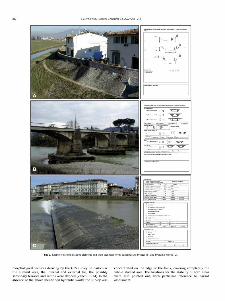
Fig. 3. Example of some mapped elements and their technical form: buildings (A), bridges (B) and hydraulic works (C).
S. Morelli et al. / Applied Geography 34 (2012) 205e218210
morphological features deriving by the GPS survey. In particularthe summit area, the internal and external toe, the possiblysecondary terraces and ramps were defined (Zanchi, 1934). In theabsence of the above mentioned hydraulic works the survey was
concentrated on the edge of the bank, covering completely thewhole studied area. The locations for the stability of both areaswere also pointed out, with particular reference to hazardassessment.

Fig. 4. Sketch of the 11 reference points used for the Helmert transformation.
S. Morelli et al. / Applied Geography 34 (2012) 205e218 211
As regards all the other less extensive hydraulic works, the spatialdistribution related to the watercourse (extended, longitudinal andtransversal), the type (revetment, gabion, sluice-gate, weir, array ofblocks, wall, etc.), the conservation status and, when feasible, thegeometry and the material used for the construction were specified.In case of non-hydraulic artifacts only the position of the river andbank/dikes was usually marked instead.
Even the engineering works which reduce the wet perimeter ofthe river were identified, mapped and described: bridges, crossingstructures, fords and different works of flows concentration whichclearly fix the river path in the original site and sometimes forced itunderground. In each case the percentage of the decrease of theflow section was specified and its maintenance activities werepointed out where needed. For natural riverbeds the state ofactivity was also reported (erosion, deposit or balance).
Then, in relation to the drainage outlets the database encloseessential information about their arrangement with respect to thewater flows, but also their shape, size, material construction, theirmaintenance status and presence of vegetation and type of flow (ifpresent).
Finally, concerning the most relevant morphological features(banks with active erosion, crown of landslides, river bars, etc.)
Table 1Seven Spatial Parameters originated from the Helmert transformation.
Start datum GRS80 6378137 0.003353Target datum GRS80 6378137 0.003353Parameters 7Tx �70.36833145 metersTy 100.9139854 metersTz 52.85284038 metersRx �9.90115E-06 radiansRy �1.3544E-05 radiansRz 1.26759E-05 radiansS �7.1023E-08
their distribution with respect to neighboring elements, their stateof activity and, in case, the need to intervene in stabilizing washighlighted.
Once completed, the database content was further revised forpublication on a WebGis platform. The aim was to produce a set ofdata, homogenized and integrated with other existing databasethat any public institutions can easily consult and improve. Thiscould be possible only through the development of an adequatefront-end system and a network interface on which interestedusers can develop different hazard scenarios. GoogleMaps was usedas a map server to test the data display and finally UMNMapServerwas chosen as the front-end system because of its high-performance.
Results
The Arno reach was described in detail starting from 18,179reference points variously distributed among the categories ofinterest. A comparable number of points was obtained for thetributaries instead (18,316), although their total length was abouthalf that of the Arno river course. This apparent contradiction is dueto some concomitant circumstances in the minor watercourses:reduced hydraulic sections, planimetrically fixed riverbeds anddikes and other flood defenses realized close to the running water.
The high-precision positioning of these points was ensured bythe application of a Local Geoid Model, which was created onpurpose and tested, about its quality, on 11 points belonging to theLeveling Regional Network. During the testing phase the difference(Delta) between the measured and the predicted heights producedthe following results: min: �0.014 m, max: 0.208 m, mean:0.062 m, standard deviation: 0.057 m (Table 2). This clearly indi-cates that the approach and technique adopted for transformingGPS ellipsoidal heights to orthometric heights achieved good andsignificant results, compatible with the accuracy required in the
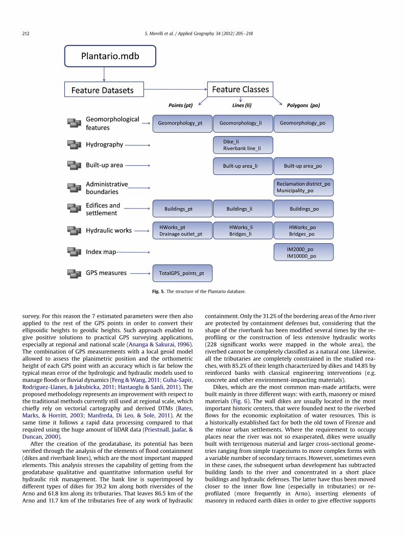
Fig. 5. The structure of the Plantario database.
S. Morelli et al. / Applied Geography 34 (2012) 205e218212
survey. For this reason the 7 estimated parameters were then alsoapplied to the rest of the GPS points in order to convert theirellipsoidic heights to geoidic heights. Such approach enabled togive positive solutions to practical GPS surveying applications,especially at regional and national scale (Ananga & Sakurai, 1996).The combination of GPS measurements with a local geoid modelallowed to assess the planimetric position and the orthometricheight of each GPS point with an accuracy which is far below thetypical mean error of the hydrologic and hydraulic models used tomanage floods or fluvial dynamics (Feng &Wang, 2011; Guha-Sapir,Rodriguez-Llanes, & Jakubicka, 2011; Hastaoglu & Sanli, 2011). Theproposed methodology represents an improvement with respect tothe traditional methods currently still used at regional scale, whichchiefly rely on vectorial cartography and derived DTMs (Bates,Marks, & Horritt, 2003; Manfreda, Di Leo, & Sole, 2011). At thesame time it follows a rapid data processing compared to thatrequired using the huge amount of liDAR data (Priestnall, Jaafar, &Duncan, 2000).
After the creation of the geodatabase, its potential has beenverified through the analysis of the elements of flood containment(dikes and riverbank lines), which are the most important mappedelements. This analysis stresses the capability of getting from thegeodatabase qualitative and quantitative information useful forhydraulic risk management. The bank line is superimposed bydifferent types of dikes for 39.2 km along both riversides of theArno and 61.8 km along its tributaries. That leaves 86.5 km of theArno and 11.7 km of the tributaries free of any work of hydraulic
containment. Only the 31.2% of the bordering areas of the Arno riverare protected by containment defenses but, considering that theshape of the riverbank has been modified several times by the re-profiling or the construction of less extensive hydraulic works(228 significant works were mapped in the whole area), theriverbed cannot be completely classified as a natural one. Likewise,all the tributaries are completely constrained in the studied rea-ches, with 85.2% of their length characterized by dikes and 14.8% byreinforced banks with classical engineering interventions (e.g.concrete and other environment-impacting materials).
Dikes, which are the most common man-made artifacts, werebuilt mainly in three different ways: with earth, masonry or mixedmaterials (Fig. 6). The wall dikes are usually located in the mostimportant historic centers, that were founded next to the riverbedflows for the economic exploitation of water resources. This isa historically established fact for both the old town of Firenze andthe minor urban settlements. Where the requirement to occupyplaces near the river was not so exasperated, dikes were usuallybuilt with terrigenous material and larger cross-sectional geome-tries ranging from simple trapeziums to more complex forms witha variable number of secondary terraces. However, sometimes evenin these cases, the subsequent urban development has subtractedbuilding lands to the river and concentrated in a short placebuildings and hydraulic defenses. The latter have thus been movedcloser to the inner flow line (especially in tributaries) or re-profilated (more frequently in Arno), inserting elements ofmasonry in reduced earth dikes in order to give effective supports
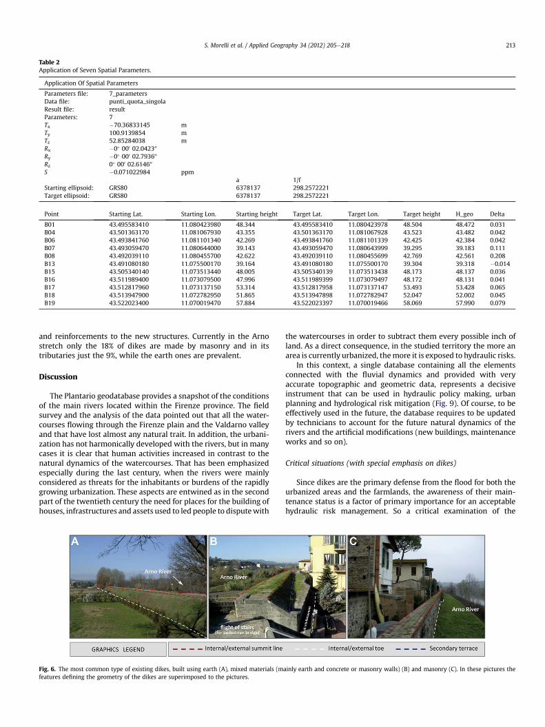
Table 2Application of Seven Spatial Parameters.
Application Of Spatial Parameters
Parameters file: 7_parametersData file: punti_quota_singolaResult file: resultParameters: 7Tx �70.36833145 mTy 100.9139854 mTz 52.85284038 mRx �0� 000 02.042300
Ry �0� 000 02.793600
Rz 0� 000 02.614600
S �0.071022984 ppma 1/f
Starting ellipsoid: GRS80 6378137 298.2572221Target ellipsoid: GRS80 6378137 298.2572221
Point Starting Lat. Starting Lon. Starting height Target Lat. Target Lon. Target height H_geo Delta
B01 43.495583410 11.080423980 48.344 43.495583410 11.080423978 48.504 48.472 0.031B04 43.501363170 11.081067930 43.355 43.501363170 11.081067928 43.523 43.482 0.042B06 43.493841760 11.081101340 42.269 43.493841760 11.081101339 42.425 42.384 0.042B07 43.493059470 11.080644000 39.143 43.493059470 11.080643999 39.295 39.183 0.111B08 43.492039110 11.080455700 42.622 43.492039110 11.080455699 42.769 42.561 0.208B13 43.491080180 11.075500170 39.164 43.491080180 11.075500170 39.304 39.318 �0.014B15 43.505340140 11.073513440 48.005 43.505340139 11.073513438 48.173 48.137 0.036B16 43.511989400 11.073079500 47.996 43.511989399 11.073079497 48.172 48.131 0.041B17 43.512817960 11.073137150 53.314 43.512817958 11.073137147 53.493 53.428 0.065B18 43.513947900 11.072782950 51.865 43.513947898 11.072782947 52.047 52.002 0.045B19 43.522023400 11.070019470 57.884 43.522023397 11.070019466 58.069 57.990 0.079
S. Morelli et al. / Applied Geography 34 (2012) 205e218 213
and reinforcements to the new structures. Currently in the Arnostretch only the 18% of dikes are made by masonry and in itstributaries just the 9%, while the earth ones are prevalent.
Discussion
The Plantario geodatabase provides a snapshot of the conditionsof the main rivers located within the Firenze province. The fieldsurvey and the analysis of the data pointed out that all the water-courses flowing through the Firenze plain and the Valdarno valleyand that have lost almost any natural trait. In addition, the urbani-zation has not harmonically developed with the rivers, but in manycases it is clear that human activities increased in contrast to thenatural dynamics of the watercourses. That has been emphasizedespecially during the last century, when the rivers were mainlyconsidered as threats for the inhabitants or burdens of the rapidlygrowing urbanization. These aspects are entwined as in the secondpart of the twentieth century the need for places for the building ofhouses, infrastructures and assets used to led people to disputewith
Fig. 6. The most common type of existing dikes, built using earth (A), mixed materials (mfeatures defining the geometry of the dikes are superimposed to the pictures.
the watercourses in order to subtract them every possible inch ofland. As a direct consequence, in the studied territory the more anarea is currently urbanized, themore it is exposed to hydraulic risks.
In this context, a single database containing all the elementsconnected with the fluvial dynamics and provided with veryaccurate topographic and geometric data, represents a decisiveinstrument that can be used in hydraulic policy making, urbanplanning and hydrological risk mitigation (Fig. 9). Of course, to beeffectively used in the future, the database requires to be updatedby technicians to account for the future natural dynamics of therivers and the artificial modifications (new buildings, maintenanceworks and so on).
Critical situations (with special emphasis on dikes)
Since dikes are the primary defense from the flood for both theurbanized areas and the farmlands, the awareness of their main-tenance status is a factor of primary importance for an acceptablehydraulic risk management. So a critical examination of the
ainly earth and concrete or masonry walls) (B) and masonry (C). In these pictures the
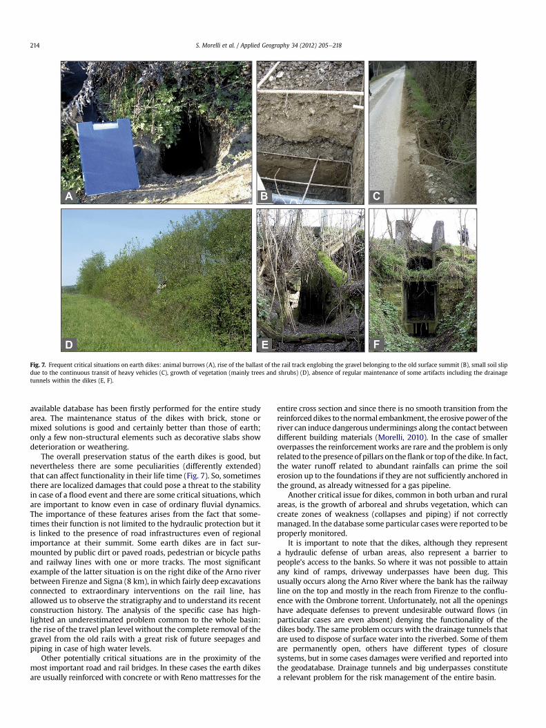
Fig. 7. Frequent critical situations on earth dikes: animal burrows (A), rise of the ballast of the rail track englobing the gravel belonging to the old surface summit (B), small soil slipdue to the continuous transit of heavy vehicles (C), growth of vegetation (mainly trees and shrubs) (D), absence of regular maintenance of some artifacts including the drainagetunnels within the dikes (E, F).
S. Morelli et al. / Applied Geography 34 (2012) 205e218214
available database has been firstly performed for the entire studyarea. The maintenance status of the dikes with brick, stone ormixed solutions is good and certainly better than those of earth;only a few non-structural elements such as decorative slabs showdeterioration or weathering.
The overall preservation status of the earth dikes is good, butnevertheless there are some peculiarities (differently extended)that can affect functionality in their life time (Fig. 7). So, sometimesthere are localized damages that could pose a threat to the stabilityin case of a flood event and there are some critical situations, whichare important to know even in case of ordinary fluvial dynamics.The importance of these features arises from the fact that some-times their function is not limited to the hydraulic protection but itis linked to the presence of road infrastructures even of regionalimportance at their summit. Some earth dikes are in fact sur-mounted by public dirt or paved roads, pedestrian or bicycle pathsand railway lines with one or more tracks. The most significantexample of the latter situation is on the right dike of the Arno riverbetween Firenze and Signa (8 km), in which fairly deep excavationsconnected to extraordinary interventions on the rail line, hasallowed us to observe the stratigraphy and to understand its recentconstruction history. The analysis of the specific case has high-lighted an underestimated problem common to the whole basin:the rise of the travel plan level without the complete removal of thegravel from the old rails with a great risk of future seepages andpiping in case of high water levels.
Other potentially critical situations are in the proximity of themost important road and rail bridges. In these cases the earth dikesare usually reinforced with concrete or with Reno mattresses for the
entire cross section and since there is no smooth transition from thereinforceddikes to thenormal embankment, the erosive power of theriver can induce dangerous underminings along the contact betweendifferent building materials (Morelli, 2010). In the case of smalleroverpasses the reinforcement works are rare and the problem is onlyrelated to the presence of pillars on theflank or top of the dike. In fact,the water runoff related to abundant rainfalls can prime the soilerosion up to the foundations if they are not sufficiently anchored inthe ground, as already witnessed for a gas pipeline.
Another critical issue for dikes, common in both urban and ruralareas, is the growth of arboreal and shrubs vegetation, which cancreate zones of weakness (collapses and piping) if not correctlymanaged. In the database some particular cases were reported to beproperly monitored.
It is important to note that the dikes, although they representa hydraulic defense of urban areas, also represent a barrier topeople’s access to the banks. So where it was not possible to attainany kind of ramps, driveway underpasses have been dug. Thisusually occurs along the Arno River where the bank has the railwayline on the top and mostly in the reach from Firenze to the conflu-ence with the Ombrone torrent. Unfortunately, not all the openingshave adequate defenses to prevent undesirable outward flows (inparticular cases are even absent) denying the functionality of thedikes body. The same problem occurs with the drainage tunnels thatare used to dispose of surface water into the riverbed. Some of themare permanently open, others have different types of closuresystems, but in some cases damages were verified and reported intothe geodatabase. Drainage tunnels and big underpasses constitutea relevant problem for the risk management of the entire basin.
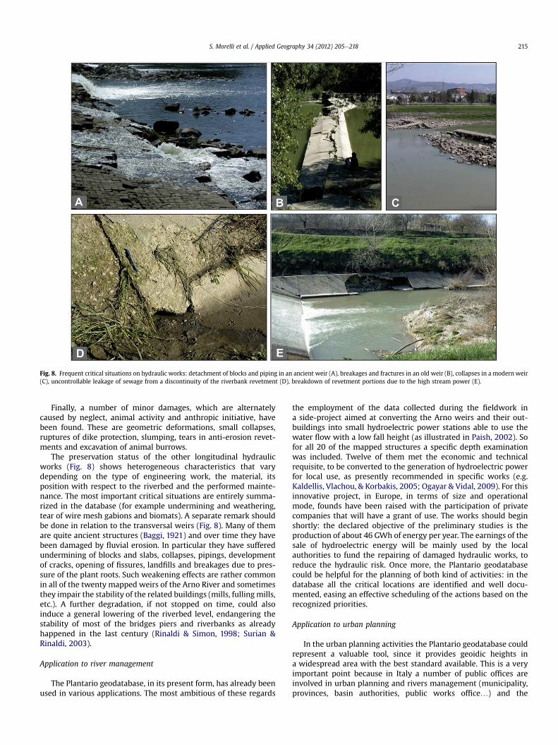
Fig. 8. Frequent critical situations on hydraulic works: detachment of blocks and piping in an ancient weir (A), breakages and fractures in an old weir (B), collapses in a modern weir(C), uncontrollable leakage of sewage from a discontinuity of the riverbank revetment (D), breakdown of revetment portions due to the high stream power (E).
S. Morelli et al. / Applied Geography 34 (2012) 205e218 215
Finally, a number of minor damages, which are alternatelycaused by neglect, animal activity and anthropic initiative, havebeen found. These are geometric deformations, small collapses,ruptures of dike protection, slumping, tears in anti-erosion revet-ments and excavation of animal burrows.
The preservation status of the other longitudinal hydraulicworks (Fig. 8) shows heterogeneous characteristics that varydepending on the type of engineering work, the material, itsposition with respect to the riverbed and the performed mainte-nance. The most important critical situations are entirely summa-rized in the database (for example undermining and weathering,tear of wire mesh gabions and biomats). A separate remark shouldbe done in relation to the transversal weirs (Fig. 8). Many of themare quite ancient structures (Baggi, 1921) and over time they havebeen damaged by fluvial erosion. In particular they have sufferedundermining of blocks and slabs, collapses, pipings, developmentof cracks, opening of fissures, landfills and breakages due to pres-sure of the plant roots. Such weakening effects are rather commonin all of the twenty mapped weirs of the Arno River and sometimesthey impair the stability of the related buildings (mills, fulling mills,etc.). A further degradation, if not stopped on time, could alsoinduce a general lowering of the riverbed level, endangering thestability of most of the bridges piers and riverbanks as alreadyhappened in the last century (Rinaldi & Simon, 1998; Surian &Rinaldi, 2003).
Application to river management
The Plantario geodatabase, in its present form, has already beenused in various applications. The most ambitious of these regards
the employment of the data collected during the fieldwork ina side-project aimed at converting the Arno weirs and their out-buildings into small hydroelectric power stations able to use thewater flow with a low fall height (as illustrated in Paish, 2002). Sofor all 20 of the mapped structures a specific depth examinationwas included. Twelve of them met the economic and technicalrequisite, to be converted to the generation of hydroelectric powerfor local use, as presently recommended in specific works (e.g.Kaldellis, Vlachou, & Korbakis, 2005; Ogayar & Vidal, 2009). For thisinnovative project, in Europe, in terms of size and operationalmode, founds have been raised with the participation of privatecompanies that will have a grant of use. The works should beginshortly: the declared objective of the preliminary studies is theproduction of about 46 GWh of energy per year. The earnings of thesale of hydroelectric energy will be mainly used by the localauthorities to fund the repairing of damaged hydraulic works, toreduce the hydraulic risk. Once more, the Plantario geodatabasecould be helpful for the planning of both kind of activities: in thedatabase all the critical locations are identified and well docu-mented, easing an effective scheduling of the actions based on therecognized priorities.
Application to urban planning
In the urban planning activities the Plantario geodatabase couldrepresent a valuable tool, since it provides geoidic heights ina widespread area with the best standard available. This is a veryimportant point because in Italy a number of public offices areinvolved in urban planning and rivers management (municipality,provinces, basin authorities, public works office.) and the
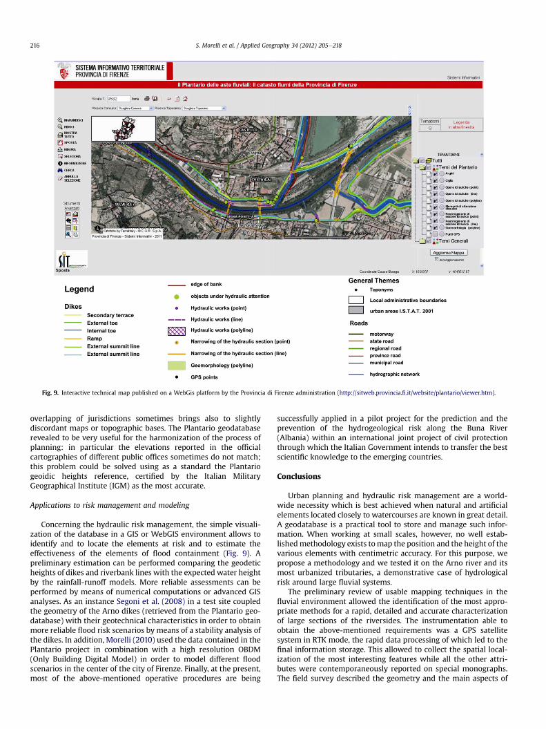
Fig. 9. Interactive technical map published on a WebGis platform by the Provincia di Firenze administration (http://sitweb.provincia.fi.it/website/plantario/viewer.htm).
S. Morelli et al. / Applied Geography 34 (2012) 205e218216
overlapping of jurisdictions sometimes brings also to slightlydiscordant maps or topographic bases. The Plantario geodatabaserevealed to be very useful for the harmonization of the process ofplanning: in particular the elevations reported in the officialcartographies of different public offices sometimes do not match;this problem could be solved using as a standard the Plantariogeoidic heights reference, certified by the Italian MilitaryGeographical Institute (IGM) as the most accurate.
Applications to risk management and modeling
Concerning the hydraulic risk management, the simple visuali-zation of the database in a GIS or WebGIS environment allows toidentify and to locate the elements at risk and to estimate theeffectiveness of the elements of flood containment (Fig. 9). Apreliminary estimation can be performed comparing the geodeticheights of dikes and riverbank lines with the expected water heightby the rainfall-runoff models. More reliable assessments can beperformed by means of numerical computations or advanced GISanalyses. As an instance Segoni et al. (2008) in a test site coupledthe geometry of the Arno dikes (retrieved from the Plantario geo-database) with their geotechnical characteristics in order to obtainmore reliable flood risk scenarios by means of a stability analysis ofthe dikes. In addition, Morelli (2010) used the data contained in thePlantario project in combination with a high resolution OBDM(Only Building Digital Model) in order to model different floodscenarios in the center of the city of Firenze. Finally, at the present,most of the above-mentioned operative procedures are being
successfully applied in a pilot project for the prediction and theprevention of the hydrogeological risk along the Buna River(Albania) within an international joint project of civil protectionthrough which the Italian Government intends to transfer the bestscientific knowledge to the emerging countries.
Conclusions
Urban planning and hydraulic risk management are a world-wide necessity which is best achieved when natural and artificialelements located closely to watercourses are known in great detail.A geodatabase is a practical tool to store and manage such infor-mation. When working at small scales, however, no well estab-lishedmethodology exists tomap the position and the height of thevarious elements with centimetric accuracy. For this purpose, wepropose a methodology and we tested it on the Arno river and itsmost urbanized tributaries, a demonstrative case of hydrologicalrisk around large fluvial systems.
The preliminary review of usable mapping techniques in thefluvial environment allowed the identification of the most appro-priate methods for a rapid, detailed and accurate characterizationof large sections of the riversides. The instrumentation able toobtain the above-mentioned requirements was a GPS satellitesystem in RTK mode, the rapid data processing of which led to thefinal information storage. This allowed to collect the spatial local-ization of the most interesting features while all the other attri-butes were contemporaneously reported on special monographs.The field survey described the geometry and the main aspects of
S. Morelli et al. / Applied Geography 34 (2012) 205e218 217
the hydraulic interest for both natural elements (edge of the banks,river bars, landslide zones) andman-made objects (dikes, hydraulicworks, settlement, bridges and discharges). The GPS measure-ments, which represented the major part of the work in the field,provided immediately usable planimetric coordinates with centi-meter accuracy. The ellipsoidal heights have instead been post-processed because it is essential to relate them to a local geoidmodel. For this reason, once checked for accuracy on the ellipsoidGRS80 (Geodetic Reference System 1980), they were referred to thesurface of the ITALGEO99 and ITALGEO2005 geoid models. Then,a conventional levelingmeasurement was performed in a restrictedarea to verify if the GPS marked points had the required accuracy.The differences between the resulting measured orthometricheights with those computed from the first geoid is on the average0.16 mwhile the difference with the second geoid heights is on theaverage 0.07 m. So, a local geoid was created on the entire inves-tigated territory using the landmarks of the province and of theItalian Military Geographic Institute. Thereby the altimetric errorbecame �0.05 m. Finally all the collected data were introduced ina flexible GIS-related geodatabase, created on purpose, andarranged for a WebGIS system.
As a result, a number of interesting information have beengleaned, such as general statistics or the preservation status of themost important hydraulic artifacts (dikes, bridges andwater works)and their level of resistance in relation to the ordinary and theextraordinary fluvial dynamics. For example it emerged that amongall the mapped hydraulic works the most damaged are undoubt-edly those transversal to the Arno river (weirs). Since a furtherdeterioration could affect the sediment transport and the riverbedmodeling, a more elaborated investigation was carried out. Theseresults were used to promote a draft project that suggest to recovertheweirs and their out-buildings for both the bed level stabilizationand the creation of a diffuse system of mini hydroelectric powerplants that exploit the water flow with a low fall height. However,at the present time there are many other applications that may bederived from the collected data and that can be adopted as modelsby the local administrations. In fact, for the first time, a new helpfultool is available to correctly and differently manage the urbanplanning, the hydrological risk and the hydraulic policy and it iscurrently being successfully applied in high-criticality water-courses of the world as along the Buna river (northern Albania), inwhich it is under experimentation in terms of quick tool for civilprotection.
Acknowledgments
The authors wish to acknowledge Francesco Del Vecchio,Gianluca Gioino, Luigi Di Paco and Andrea Morelli of the Provinciadi Firenze administration for their cooperation during the severalsurveys.
References
Agnelli, A., Billi, P., Canuti, P., & Rinaldi, M. (1998). Dinamica morfologica recentedell’alveo del fiume Arno. Publication CNReGNDCI n.1739, Pacini, Pisa.
Ananga, N., & Sakurai, S. (1996). The use of GPS data for improving local geoiddetermination. Survey Review, 33(259), 334e338.
APAT. (2004). Atlante delle opere di sistemazione fluviale. Manuali e linee guida, 27/2003. Roma: Dipartimento Difesa del Suolo.
Argent, R. M., & Grayson, R. B. (2001). Design of information systems for environ-mental managers: an example using interface prototyping. EnvironmentalModelling & Software, 16(5), 433e438.
Arvanitis, L. G., Ramachandran, B., Brackett, D. P., Rasol, H. A., & Du, X. (2000).Multiresource inventories incorporating GIS, GPS and database managementsystems: a conceptual model. Computers and Electronics in Agriculture, 28(2),89e100.
Baggi, V. (1921). Costruzioni idrauliche. Milano: Utet.
Barzaghi, R., Betti, B., Borghi, A., Sona, G., & Tornatore, V. (2002). The Italian quasi-geoid ITALGEO99. Bollettino di Geodesia e Scienze Affini, Anno LXI, 1, 33e51.
Bates, P. D., Marks, K. J., & Horritt, M. S. (2003). Optimal use of high-resolutiontopographic data in flood inundation models. Hydrological Processes, 17,537e557.
Becchi, I., Caporali, E., Castellani, L., Palmisano, E., & Castelli, F. (1995). Hydrologicalcontrol of flooding: Tuscany, October 1992. Surveys in Geophysics, 16, 227e252.
Billi, P., & Rinaldi, M. (1997). Human impact on sediment yield and channeldynamics in the Arno River basin (central Italy). In D. E. Walling, & J. L. Probst(Eds.), Human impact on erosion and sedimentation. Proceedings of RabatSymposium, IAHS Publications n. 245, Wallingford, 301e311.
Bravard, J. P., Amoros, C., Pautou, G., Bornette, G., Bournaud, M., Creuzé desChâtelliers, M. C., et al. (1997). River incision in south-east France: morpho-logical phenomena and ecological effects. Regulated Rivers: Research andManagement, 13, 75e90.
Brierley, G. J., Fryirs, K., Cook, N., & Outhet, D. (2011). Geomorphology in Action:linking policy with on-the-ground actions through applications of the RiverStyles framework. Applied Geography, 31, 1132e1143.
Campana, S. (2006). DGPS e mobile GIS per l’archeologia dei paesaggi. InS. Campana, & R. Francovich (Eds.), Laser scanner e GPS: paesaggi archeologici etecnologie digitali. Workshop Proceedings (pp. 201e225). Firenze: Edizioniall’Insegna del Giglio.
Canuti, P., Casagli, N., Catani, F., & Fanti, R. (2000). Hydrogeological hazard and riskin archaeological sites: some case studies in Italy. Journal of Cultural Heritage,1(2), 117e125.
Canuti, P., Casagli, N., Farina, P., Ferretti, A., Marks, F., & Menduni, G. (2006). Analisidei fenomeni di subsidenza nel bacino del fiume Arno mediante interferometriaradar. Giornale di Geologia Applicata, 4, 131e136.
Canuti, P., Cencetti, C., Rinaldi, M., & Tacconi, P. (1994). The fluvial dynamics of theArno River: 2. Historical evolution of the Arno river bed. In S. Moretti (Ed.), TheNorthern Apennines. Proceedings of the 76th summer meeting of the SocietàGeologica Italiana, part 3, Memorie della Società Geologica Italiana, Vol. XLVIII (pp.851e864). Roma: Società Geologica Italiana.
Caporali, E., Rinaldi, M., & Casagli, N. (2005). The Arno River floods. Giornale diGeologia Applicata, 1, 177e192.
Cencetti, C., & Tacconi, P. (2005). The fluvial dynamics of the Arno River. Giornale diGeologia Applicata, 1, 193e202.
Cina, A., Manzino, A. M., & Roggero, M. (2003). RTK positioning in cadastral GISupdating. International Archives of Photogrammetry and Remote Sensing, XXXIV,78e82.
Cornelius, S. C., Sear, D. A., Carver, S. J., & Heywood, D. I. (1994). GPS, GIS andgeomorphological fieldwork. Earth Surface Processes and Landforms, 19,777e787.
Counselman, C. C. (1999). Multipath-rejecting GPS Antenna. In Proceedings of theIEEE, 87(1), 86e91.
Cutter, S. L., Barnes, L., Berry, M., Burton, C., Evans, E., Tate, E., et al. (2008). A place-based model for understanding community resilience to natural disasters.Global Environmental Change, 18, 598e606.
Dapporto, S. (2003). Processi di erosione e meccanismi di instabilità di spondefluviali: monitoraggio, modellazione e analisi. Unpublished PhD thesis,Department of Earth Sciences, University of Firenze, Firenze, Italy, 182 pp.
Dapporto, S., Rinaldi, M., & Casagli, N. (2001). Failure mechanisms and pore waterpressure conditions: analysis of a riverbank along the Arno River (Central Italy).Engineering Geology, 61, 221e242.
Dapporto, S., Rinaldi, M., Casagli, N., & Vannocci, P. (2003). Mechanisms of riverbankfailure along the Arno River, Central Italy. Earth Surface Processes and Landforms,28(12), 1303e1323.
Darby, S. E., & Simon, A. (1999). Incised river channels: Processes, forms, engineeringand management. Chichester: John Wiley and Sons.
Denker, H., & Wenzel, H. G. (1987). Local geoid determination and comparison withGPS results. Bulletin Geodesique, 61, 349e366.
Feng, C. C., & Wang, Y. C. (2011). GIScience research challenges for emergencymanagement in Southeast Asia. Natural Hazards, 59(1), 597e616.
Guha-Sapir, D., Rodriguez-Llanes, J., & Jakubicka, T. (2011). Using disaster footprints,population databases and GIS to overcome persistent problems for humanimpact assessment in flood events. Natural Hazards, 58(3), 845e852.
Gustavsson, M., Seijmonsbergen, A. C., & Kolstrup, E. (2008). Structure and contentsof a new geomorphological GIS database linked to a geomorphological map d
with an example from Liden, central Sweden. Geomorphology, 95(3e4),335e349.
Hardie, C. (1965). The origin and plain of Roman Florence. Journal of Roman Studies,LV, 122e140.
Hastaoglu, K., & Sanli, D. (2011). Monitoring Koyulhisar landslide using rapid staticGPS: a strategy to remove biases from vertical velocities. Natural Hazards, 58(3),1275e1294.
Heritage, G. L., & Hetherington, D. (2005). The use of high-resolution field laserscanning for mapping surface topography in fluvial systems. InternationalAssociation of Hydrological Scientists Red Book Publication, 291, 278e284.
Higgitt, D. L., & Warburton, J. (1999). Applications of differential GPS in uplandfluvial geomorphology. Geomorphology, 29(1e2), 121e134.
Kaldellis, J. K., Vlachou, D. S., & Korbakis, G. (2005). Techno-economic evaluation ofsmall hydro power plants in Greece: a complete sensitivity analysis. EnergyPolicy, 33, 1969e1985.
Keselm, R. H. (2003). Human modifications to the sediment regime of the LowerMississippi River flood plain. Geomorphology, 56, 325e334.
S. Morelli et al. / Applied Geography 34 (2012) 205e218218
Kinzel, P. J. (2008). In River channel topographic surveys collected prior to andfollowing elevated flows in the central Platte River, Nebraska, spring 2008. DataSeries 380, . Reston, Virginia: U.S. Geological Survey.
Langhammer, J. (2008). Applicability of hydromorphological monitoring data tolocate flood risk reduction measures: Blanice river basin, Czech Republic.Environmental Monitoring and Assessment, 152(1e4), 379e392.
Leick, A. (2003). GPS satellite surveying. New York, NY: John Wiley & Sons.Li, L., Lu, X., & Chen, Z. (2007). River channel change during the last 50 years in the
middle Yangtze River, the Jianli reach. Geomorphology, 85(3e4), 185e196.Manfreda, S., Di Leo, M., & Sole, A. (2011). Detection of flood prone areas using
digital elevation models. Journal of Hydrologic Engineering, 16, 781e790.Meinck, F., & Möhle, K. (1977). Dictionary of water and sewage engineering (2nd ed.).
Amsterdam: Elsevier Scientific Pub. Co.Merz, B., Hall, J., Disse, M., & Schumann, A. (2010). Fluvial flood risk management in
a changing world. Natural Hazards and Earth System Sciences, 10, 509e527.Milan, D. J., Heritage, G. L., & Hetherington, D. (2007). Application of a 3D laser
scanner in the assessment of erosion and deposition Volumes and channelchange in a Proglacial River. Earth Surface Processes and Landforms, 32,1657e1674.
Morelli, S. (2010). Applicazione di tecniche di mappatura ad alta risoluzione deglialvei fluviali. Unpublished PhD thesis, Department of Earth Sciences, Universityof Firenze, Italy, 240 pp.
Muller, G. (1986). Appunti di Livellazione. Firenze, Italy: Collezione dei Testi Didatticidell’Istituto Geografico Militare.
Nasermoaddeli, M. H., & Pasche, E. (2008). Application of terrestrial 3D laser scannerin quantification of the riverbank erosion and deposition. In M. S. Altinakar,M. A. Kokpinar, I. Aydin, S. Cokgar, & S. Kirkgoz (Eds.), River flow 2008, Proceedingsof International Conference on fluvial Hydraulics, 3 Cesme, Turkey (pp. 2407e2416).
Natoni, E. (1944). Le piene dell’Arno e i provvedimenti di difesa. Firenze: Felice LeMonnier.
Ogayar, B., & Vidal, P. G. (2009). Cost determination of the electro-mechanicalequipment of a small hydro-power plant. Renewable Energy, 34, 6e13.
Paish, O. (2002). Small hydro power: technology and current status. Renewable andSustainable Energy Reviews, 6, 537e556.
Patiño-Gomez, C., McKinney, D. C., & Maidment, D. R. (2007). Sharing waterresources data in the Bi-National Rio Grande/Bravo Basin. Journal of WaterResources Planning and Management, 133(5), 416e426.
Peiry, J. L. (1987). Channel degradation in the middle Arve River, France. RegulatedRivers: Research and Management, 1, 183e188.
Peyret, F., Betaille, D., & Hintzy, G. (2000). High-precision application of GPS in the fieldof Real-Time equipment positioning. Automation in Construction, 9(3), 299e314.
Pierozzi, M. (1989). Alcune considerazioni sulla trasformazione dal sistema WGS84ad un sistema geodetico locale. Bollettino di Geodesia e Scienze Affini, Anno XLVIII,1, 45e55.
Priestnall, G., Jaafar, J., & Duncan, A. (2000). Extracting urban features from LiDARdigital surface models. Computers, Environment and Urban Systems, 24(2),65e78.
Rinaldi, M. (1995). Dinamica di un alveo fluviale antropizzato: il Fiume Sieve(Toscana). Unpublished PhD Thesis, University of Perugia, Italy, 223 pp.
Rinaldi, M., & Autorità di Bacino del Fiume Magra. (2006). La prospettiva geo-morfologica e le applicazioni nella gestione degli alvei fluviali. In Nuovi approcciper la comprensione dei processi fluviali e la gestione dei sedimenti. Applicazioninel bacino del Magra. Workshop Proceedings (pp. 39e58).
Rinaldi, M., & Rodolfi, G. (1993). Risultati della prima fase dello studio degli effettidella diga di Bilancino sull’alveo del Fiume Sieve e sul campo di moto delle faldeacquifere adiacenti. Quaderni di Idronomia Montana, 13, 85e128.
Rinaldi, M., & Simon, A. (1998). Bed level adjustment in the Arno River, central Italy.Geomorphology, 22(1), 57e71.
Seed, R. B., Nicholson, P.G., Dalrymple, R. A., Battjes, J. A., Bea, R. G., Boutwell, G. P., et al.(2005). In Preliminary report on the performance of the New Orleans Levee Systemsin Hurricane Katrina on August 29, 2005. Report No. UCB/CITRIS - 05/01, . Berkeley,CA: University of California at Berkeley and American Society of Civil Engineers.
Segoni, S., Morelli, S., Kukavicic, M., Camorani, A., Catani, F., & Ermini, L. (2008).Applicazione di tecniche di mappatura ad alta risoluzione nel fiume Arno(Firenze). Giornale di Geologia Applicata, 9(2), 215e225.
Späth, H. (2004). A numerical method for determining the spatial HELMERTtransformation in the case of different scale factors. Zeitschrift für Vermes-sungswesen, 129, 255e259.
Steiger, J., James, M., & Gazelle, F. (1998). Channelization and consequences onfloodplain system functioning on the Garonne River, SW France. RegulatedRivers: Research and Management, 14, 13e23.
Steiger, J., Tabacchi, E., Dufour, S., Corenblit, D., & Peiry, J. L. (2005). Hydro-geomorphic processes affecting riparian habitat within alluvial channel-floodplain river systems: a review for the temperate zone. River Research andApplications, 21(7), 719e737.
Surace, L. (1997). La nuova rete geodetica nazionale IGM95: risultati e prospettive diutilizzazione. Bollettino di Geodesia e Scienze Affini, Anno LVI, 3, 357e378.
Surian, N., & Rinaldi, M. (2003). Morphological response to river engineering andmanagement in alluvial channels in Italy. Geomorphology, 50, 307e326.
Tacconi, P., Canuti, P., Cencetti, C., & Rinaldi, M. (1994). The fluvial dynamics of theArno River. 3. Sedimentary characteristics of the Arno River bed. Memorie dellaSocietà Geologica Italiana, 48, 943e956.
Torge, W. (2001). Geodesy. Berlin-New York: W. de Gruyter.Van der Merwe, J. H. (1997). GIS-aided land evaluation and decision-making for
regulating urban expansion: a South African case study. GeoJournal, 43(2),135e151.
Westfall, R. S. (1989). Floods along the Bisenzio: science and technology in the Ageof Galileo. Technology and Culture, 30(4), 879e907.
Xiao, B., Wan, F., Wu, C., & Zhang, K. (2006). River cross-section surveying using RTKTechnology: the Yangtze River project case study. Coordinates: A MonthlyMagazine on Positioning, Navigation and Beyond, 2(12), 12e17.
Yamani, M., Goorabi, A., & Dowlati, J. (2011). The effect of human activities on riverbank stability (case study). American Journal of Environmental Sciences, 7(3),244e247.
Zanchi, O. (1934). Manuale pratico per le opere idraulico-fluviali. Pisa: Nistri-Lischi.Zeilhofer, P., Lima, G. A., Lima, E. B. R., & Santos, I. M. (2008). Development of a GIS-
based information system for watershed monitoring in Mato Grosso, CentralBrazil. Pesquisas em Geociências, 35, 23e37.