URBAN DEVELOPMENT AND INCREASED SOCIOSPATIAL INEQUALITIES IN FORTALEZA, BRAZIL: THE ROLE OF PLANNING
104
URBAN DEVELOPMENT AND INCREASED SOCIO- SPATIAL INEQUALITIES IN FORTALEZA, BRAZIL: THE ROLE OF PLANNING BY CLARISSA FIGUEIREDO SAMPAIO Architect, Federal University of Ceará, 1999 THESIS Submitted in partial fulfillment of the requirements for the degree of Master in Urban Planning in the Graduate College of the University of Illinois at Urbana-Champaign, 2003 Urbana, Illinois
Transcript of URBAN DEVELOPMENT AND INCREASED SOCIOSPATIAL INEQUALITIES IN FORTALEZA, BRAZIL: THE ROLE OF PLANNING

URBAN DEVELOPMENT AND INCREASED SOCIO-SPATIAL INEQUALITIES IN FORTALEZA, BRAZIL: THE
ROLE OF PLANNING
BY
CLARISSA FIGUEIREDO SAMPAIO
Architect, Federal University of Ceará, 1999
THESIS
Submitted in partial fulfillment of the requirements for the degree of Master in Urban Planning
in the Graduate College of the University of Illinois at Urbana-Champaign, 2003
Urbana, Illinois

iii
To my husband, Adriano

iv
Acknowledgements
This work would not have been possible without the support, critics and incentive of
many. My thesis adviser, Faranak Miraftab, encouraged me in pursuing the most meaningful
research problem of my life. For this, and for her commitment in helping me frame my
argument, making it meaningful to others, I will be always grateful. Many thanks to the two
members of my thesis committee for making me see the problem from different perspectives.
They are Daniel Schneider, who helped cleaning my imperfect writing and David Wilson, who
improved the theoretical accuracy of the work. Stacy Harwood also helped me more than she
realizes by being always available to discuss Planning with me, thank you. Finally, thanks to
Renato Pequeno who gave me the passion for studying my city. The University of Illinois at
Urbana-Champaign provided me the excellent environment to finish this research in the short
period of one academic semester. My Fellowship, sponsored by the Fulbright Commission in
partnership with the Federation of Industries of the State of Ceará in Brazil (FIEC), funded my
master program.

v
Table of Contents
Chapter 01 Overview 1 The Project of the Thesis 1 Research Problem 2 Research Question 3 Significance 4 Methodology 6 Structure of the Thesis 6
Chapter 02 Review of the Literature 8 Introduction 8 Early Theories of Urban Form 8 Influence in Planning: Modernist Planning Project 10 Radical Geography and Critical Urban Studies 11 Social and Political Planning 15 The Limits of Social Planning 17 Social Production of Space 18
Place Identities 20 Globalization, Neoliberalism and Cities 21 Socio- Spatial Theory 22
The Gap in the Planning Literature 23
Chapter 03 Fortaleza and the Rise of Socio-Spatial Inequalities 26 The Local Context 26 The Historical Process of Differentiating Space in Fortaleza 29
Early Settlements and Dunes 30 Rivers and Lowlands 33 Rise of Spatial Inequalities 34
Globalization in Fortaleza: Growth with Inequity 36 Industrialization 37 Tourism 38 Social Indicators 39
Searching for the Causes… 39
Chapter 04 Can Urban Development Produce Inequalities? 43 Case 01 – Abandoning the Center-Periphery Pattern 43
Spatial Requirements of Productive Sectors 44 Industries and Investments in the Outskirts 44 Tourism and Investments in Strategic Sites 45
The Political Component of Globalization: Neoliberalism 46 New Housing Policies 48 New Urban Planning Ideologies 50 Infrastructure Investments and Visibility 52
The Resulting Segregation Pattern 53

vi
The Influence of Space on Society 57 Case 02 – Transportation Corridors 59
Urban Structure and Roads 60 Differentiating the East Side 63 Expanding the Privileged City 66 An Example: the West Coast Avenue 69 Concluding Remarks 75
Chapter 05 The Possibility of Socio-Spatial Equity Planning 76 Official Planning 77
Planning Legal Instruments 77 Planning as Space Production 78 Planning Discourse: De-Politization of City-Building 80 The De-Territorialization of Social Planning 83
Insurgent Planning 85 Conclusion 88
References 91

1
Chapter 01 Overview
The Project of the Thesis
The current work exposes the social effects of planning - defined as a space production
activity – in the city of Fortaleza, one of the most socially unequal Brazilian metropolises. There
is a certain belief among the residents that the spatial reorganization of the city has served the
interests of privileged groups. I will explore how this spatial praxis has served the needs of
powerful sectors reinforcing existing social inequalities. Or, in Harvey’s words, “Why and by
what means, and in what sense do social beings individually and, more importantly, collectively
invest places (localities, regions, states, communities or whatever) with sufficient permanence to
become a locus of institutionalized social power and how and for what purpose is the power then
used?” (1996:320).
There are innumerous ways in which social actors are able to invest in places, producing
space and making them an instrument of social power. By defining routes of public
transportation, regulating private property, drawing administrative boundaries and even by
representing places in particular ways (i.e. promoting or stereotyping a neighborhood), private or
public actors shape the urban geography and actively affect previously existing social relations.
This thesis will focus on public decisions regarding the location infrastructure investments within
the urban territory of Fortaleza.
This work suggests that the placement of infrastructure strongly influences the access of
the urban poor to the opportunities offered by the city. In regards to infrastructure investments,
Fortaleza’s geography has been shaped according to the needs of productive capital and, for the
most part, with very limited social equity considerations. I’ll demonstrate how a renewed market

2
logic of urban development, associated with the influence of neoliberalism, has actually
contributed to the worsening of social inequalities, instead of addressing the urban needs of the
least advantaged urban populations. The fact that many social actors, including planners, have
been producing and modifying the city without regards to the social effects of changes in the
urban space severely restricts the possibility of a more just city.
Research Problem
Population in general - and public managers in particular - hardly acknowledges the
problem of reproducing urban inequalities through policies of urban development. While people
often explain persisting poverty as the outcome of power imbalances, historical conditions of
exploitation, insufficient economic development and lack of education or professional training,
few people recognize that the rationale behind city planning policies can indeed affect the
relative wealth of the residents.
In urbanized Third World countries, where this problem would be more visible due to
scarcity of urban investments, cities are said to be unplanned. In these places, planners are
powerless professionals hopelessly trying to organize the urban chaos. Following this line of
reasoning, it does not make any sense to point to urban planning as one of the factors for
persisting poverty.
Nevertheless this work contends that urban planning is an important cause of persisting
conditions of poverty in some urbanized societies irrespective of their location in developed or
underdeveloped countries. Planning is clearly not the only one, but it is certainly one of the many
factors contributing to such a complex social problem. By urban planning I refer to any
collective (often public) initiative able to shape the urban environment. Thus, even in the
“unplanned” Third World cities there is a rationale for modifying the urban geography that often

3
attends to the needs of the powerful sectors at the expense of the rest. In fact, cities in Third
World countries are particularly susceptible to the perverse social effects of urban development
precisely because of the belief that the cities are unplanned, which implies that nobody controls
the production of their spaces.
The perceived irrelevance of urban development practices comes from a widespread
notion that the urban space is merely the effect of complex social processes. Those who see
space as mere reflex of society equate questions of urban-justice to that of justice. This mode of
thinking – not unpopular among planners – implies that the best (and only) solution for the so-
called urban problems would be simply by solving the social problems. In an ideal situation
where the society itself is egalitarian, there would be no inequalities to be reflected in space.
Contradicting this familiar chain of causality, this work stresses the circumstances in
which socially created geographies actively influence social relations. I assert that, if planners
shaped the city with more awareness to the social effects of these changes, they could more
effectively contribute to more just cities, eventually contributing to more just societies. The
analysis of the empirical case of Fortaleza suggests that providing marginalized groups access to
the city is an indispensable component of the struggle for social justice in any unequal society.
The production of the urban space can eventually determine one’s life-chances.
Research Question
Changes in the urban geography are able to affect social relations in a myriad of ways. A
given segregation pattern can contribute to marginalizing ethical minority populations, or foster
integration and assimilation, for example. Cities designed with excessive emphasis on
automobile transportation can isolate those without access to cars, and even affect the health of
the residents. I’ll focus on the socio-economic effects of urban development specifically because
4
they have been the main urban contradiction in the empirical case of Fortaleza. Urban spatial
development has denied economically vulnerable families access to job opportunities brought by
local economic growth.
Based on this discussion, the central question of this research is the following:
How can urban spatial development influence the socio-economic life-chances of the
residents?
The case of Fortaleza will demonstrate that a new pattern of infrastructure investments in
specific strategic sites within the city has profoundly changed the local spatial structure, making
access to the city more difficult for the urban poor. The close connection of changes in the local
economy with politico-economic developments happening at the global scale often leads popular
wisdom to refer to “globalization” as the main factor of heightened socio-spatial inequalities that
Fortaleza has been experiencing. The current analysis will demonstrate how increased inequality
is not the result of abstract and unavoidable globalization forces, and how they are, instead,
contingent upon the attitudes of local actors in placing investments in the intra-urban space.
Significance
Since the beginning of the profession, planners have attempted to address the problem of
urban poverty with limited results. Certainly political unwillingness to implement social policies
is in great part responsible for this failure. It is, however, not unusual to find progressive
governments committed to the cause of the urban poor unable to efficiently address the urban
needs of underprivileged groups. That is, even when planners have the political opportunity to
implement more equitable urban policies, they may fail to do so. Moreover, planners’ knowledge
of “how cities work” might actually be able to shape political opportunities.

5
Thus planning’s failure in regards to social equity issues is certainly not limited to
political matters. I adopt Massey’s (1996) argument in order to support that planners can indeed
push for more socially just cities. For her, all academic progress in the understanding of socio-
spatial practices has not yet been able to influence the political process of city-making partly due
to the inability of academics to convey the message clearly enough to political actors.
This project is an attempt to bridge this gap between theory and actual practices, through
analyzing the ethnographical reality of Fortaleza. This empirical case is very useful because it is
closer to the rule than to the exception. Specifically, it is definitely not only in Fortaleza that a-
spatial social planning policies are struggling to minimize the effects - and not the causes - of
poverty, while urban spatial development further marginalizes powerless groups. This work
suggests that it is specifically by managing the urban space that planners can more efficiently
address the conditions of extreme urban poverty. Empirically demonstrating this argument is
significant because it directly challenges a prevalent model of urban development that has not
adequately addressed questions of social justice.
It is relevant to mention that the work has not intentions of offering apolitical absolute
truths. People, including urban residents and voters, have different notions of whether some
urban policies and their effects are just or not. The version exposed here is not immune of the
author’s particular values, and personal impressions. But the social effects of these policies have
to be exposed, in order to allow the reader to take a position. And this is a particular contribution
of this work: to problematize the urban question, leaving it open for debate. In other words, this
work intends to break the widespread consensus around projects of urban development that are
only consensual because their actual potential effects are not at the table for discussion.

6
Methodology
This project makes use of both qualitative and qualitative methods. The socio-spatial
changes of Fortaleza come from the longitudinal analysis of the intra-urban census data in the
years 1991 and 2000 mapped at the most disaggregated level of “setor censitário” (parallel of
U.S. census tracts). The sources on major public and private investments in the city are the files
and plans of both local Municipal and State governments, as well as newspaper articles and local
tourism promotional materials. The data on planning practices and discourses come primarily
from informal conversations with planners inside and outside the state apparatus, as well as
several media of public discourse such as magazines, local newspapers, official plans and
published interviews with community leaders. Some secondary data will come from published
books or unpublished dissertations and NGO’s reports. The municipality of Fortaleza generated
the spatial data (base map, street network, infrastructure, land use) utilized. The bulk of the data
collection was conducted during my fieldwork research in Fortaleza in January 2003.
Structure of the Thesis
This thesis has the following structure. Chapter two reviews the literature and traces the
development of the socio-spatial theory that informed urban development practices since the
outset of urban planning as a profession. It argues that current practices of producing the city still
rely on planning theories that describe urban geography as a mere reflex of social processes. This
is so, despite the convergence on the literature around the notion that changes in the urban space
affect social process in a myriad of ways.
That city-building professionals still see the city as the outcome of social relations is
confirmed in the third chapter, which introduces the empirical case of Fortaleza. The chapter
describes how public managers and local residents accept the recent rise in urban poverty in
7
Fortaleza as the result of non-spatialized factors such as rural-urban migration and the worsening
of local jobs conditions. In view of this, chapter four demonstrates that the increased indicators
of social inequality and increased squatters population (relative to the total population) are also
contingent upon the placement of urban investments within the urban territory. It offers two case
examples in Fortaleza that reveal how the influence of neoliberal ideologies in urban practices
has induced the increase in socio-spatial inequalities. The first case has a citywide perspective
arguing that the concentration of investments has shrunk the urban space, diminishing the supply
of available land and leading to new forms of urban poverty. The second case further advances
this argument focusing on the social effects of road opening projects. It offers the example of a
popular neighborhood in transition due to one of such projects.
Finally, the fifth chapter reveals how official planning policies actually contribute to
further differentiate the city of the rich and that of the poor residents. It confirms empirically
what I had earlier suggested in the literature review that social planning policies have not
addressed the important spatial dimension of urban inequalities. Insurgent planning initiatives
that have been able to warrant access to the city for disadvantaged groups are by and large found
out of the state planning apparatus. These initiatives have forced official planning to incorporate
their claims, and have been able to teach planners that they need to be aware of the effects of the
urban geographies resulting from their plans. I conclude with a call for planners concerned with
social justice to turn their attentions to the socio-spatial aspects of urban poverty.

8
Chapter 02 Review of the Literature
Introduction
The search for the structural roots of spatial inequalities has been a major issue in the
field of urban studies from its outset. Because of that, there has been significant development of
our understanding of the relations between social and spatial processes. Even though old theories
have not completely disappeared, they have often taken new forms.
This review will trace the progress of geographical theory and its influence on urban
planning practices at key points in time. Urban space has been described as (1) an active agent of
social processes although isolated from political content, (2) as a passive outcome of socio-
political relations, (3) as socially constructed and able to influence social processes. It seems that
this theoretical development has not sufficiently informed Planning’s understanding of the urban
space. While contemporary planning is not devoid of politics anymore, it has been missing a
spatial perspective adequate to efficiently address equity considerations. My work specifically
claims that without considering the role of the urban environment in shaping social relations,
planning has intervened in the city in a way that reinforces - rather than diminishes - social
inequities. Based on that, I call attention to the fact that space has been a powerful instrument of
the appropriation of wealth and power by privileged groups. That the urban geography has been
produced with little equity considerations is the main limitation of equity planning initiatives.
Early Theories of Urban Form
Early urban researchers viewed the city with a considerable degree of dissociation from
the social processes that created it. The influential work of the Chicago School of Urban Ecology

9
(see Burgess’ Model1) consisted basically in identifying the “natural” urbanization pattern that
would apply to any city in the world, even though the empirical work was based on the city of
Chicago. Its description as “natural” implied that humans had an inherited tendency to organize
their settlements according to a fixed model - namely, the center-periphery pattern.
Similarly, urban neoclassic economy also suggested a detachment between society and
space. In economic models however, it was the laws of the market - rather than natural processes
– that ruled the pattern of spatial organization of cities (See William Alonso’s Bid-rent Theory2).
Because both these theoretical traditions (urban economy and ecology) did not recognize
urban geography as the product of social relations they tended to undermine both social and
spatial inequalities existent in a given city. Urban Ecology and Economic theories overtly
described the city as an equilibrated entity implicitly denying the existence (and relevance) of
intra-urban differentials. According to these theories, it was only a matter of time for the market
to even out any existing urban imbalances. For instance, the Burgess Model defined the decaying
zone near downtown as a zone in transition, which would develop and increase its value as soon
as the urban core needed room to grow. By using the term “zone in transition” they implied that
poverty and decay of some neighborhoods was a temporary problem.
Reinforcing this notion of an equilibrated city, urban neoclassical economic studies,
claimed that external interference in the balance between supply and demand for land would
decrease efficiency and lead to non-optimal. Indeed, urban economics remains dominant in the
1 This model described neighborhoods as different organisms that compete with each other for their survival, in an apology to Darwin’s Evolutionary Theory, envisioning urban development as a natural process. Centralization and decentralization were the two main natural forces affecting geographical space.
2 William Alonso’s Bid-rent Theory in 1960, using neoclassical economic principle, argues that every type of land use competes for the urban core because of different reasons, increasing competition for some key-located places within the city. According to this theory, it is the supply and demand for land that ultimately shapes the city. The market is taken as given, and the role of public urban investments was not taken into account. (in 1960 in Knox 1994)

10
field of urban studies although contemporary research admits the possibility of State intervention
in the land market in cases of “market failures” or “externalities” (see, for instance, Brueckner,
19993). The fact that redistributive goals are put out of scope of these economic studies allows
them to rely on a notion of the city as a balanced entity.
Influence in Planning: Modernist Planning Project
For both theories it was either “nature” or “the market4” – two entities beyond reach of
human agency - that dictated how space is produced. They viewed the city as an object that has
its own inherent laws, which humans were supposed to identify, understand and fit in. This, of
course, is very in line with the modernist project of early planning practice. These theories were
products of positivist-modernist thought which suggested a comprehensive understanding of
society. They also strongly influenced urban policies of the time. Urban renewal programs of the
post war period in the United States (or early 19th century Europe), for example, intended to
correct the illness of urban society simply by eradicating the sources of the problems - that is, the
slums (Rosow, 1961). Slum removal programs aimed at eliminating the “culture of poverty”
supposedly reproduced in the overcrowded environment of slums, both in cities of developed and
developing world. We can thus logically conclude that, according to this point of view, the space
- the slums - produced social processes of violence, diseases and unemployment.
A second representative example of the belief that urban (territorial) planning would
ultimately determine social processes is the Modernist Planning utopia. The ideology behind the
3 Jan Brueckner’s (1999) work applies the microeconomics general equilibrium theory to urban development. He identifies the under pricing of infrastructure network expansion as one of many “market failures”, and suggests that, once these “market failures” are addressed, the economic general equilibrium would prevail.
4 Although the market is clearly not out of scope of human agency, the theories did not considered the possibility of intervention in the market forces taking “the market” an given.

11
construction of Brasilia intended to impose an egalitarian order in an unequal society by
providing ordered standardized residential neighborhoods for all its residents.
Still, the excessive reliance on the “power of space” has not disappeared from both
contemporary urban practices and theories. In the U.S specifically, the design-related planning
sub-fields tend to blindly trust the potential of the built environment to shape social processes.
The New Urbanism movement, for example, has clear intentions of fostering community life and
relationship among neighbors by providing public spaces in well-designed neighborhoods
(Talen, 1999). The political processes of creating these spaces, and particularly the often-
exclusionary qualities resulting from such design principles, are often overlooked.
Radical Geography and Critical Urban Studies
Despite the relative popularity of these recent design theories, the emergence of critical
urban studies in the late 1960s had the important impact of politicizing urban practices. Radical
geography, for example, fiercely refers to this reification of space as spatial fetishism, and
concentrates efforts in identifying the dominant interests being served by this ideology. The early
works of Marxist geographers such as Manuel Castells and David Harvey in the early 1970s are
often cited as responsible for the rapid decline in popularity of the “power of space” (Soja, 1980,
Gottdiener, 1985). They shifted attention away from the outcome – the city – to the process – the
urbanization (Harvey, 1996). For them, these inherent laws that were said to produce the city
were simply social constructs serving the interests of dominant classes. No city is balanced
precisely because no society is balanced. As Lefebvre noted,
“Space is not a scientific object removed from ideology and politics; it has always
been political and strategic. If space has an air of neutrality and indifference with regards
to its contents and this seem to be “purely” formal, the epitome of rational abstraction it

12
is precisely because it has been occupied and used and has already been the focus of past
processes whose traces are not always evident on the landscape. Space has been shaped
and molded from historical and natural elements, but this has been a political process.
Space is political and ideological. It is a product literally filled with ideology.” (Lefebvre
1976, quoted in Soja, 1980)
The urban space comes to be understood as the outcome of conflicting social interests.
Organized groups compete for public services and infrastructure, because they have different
spatial requirements. Homeowners, for example, may seek investments in their neighborhoods
while renters experience losses with valorization of their neighborhoods. Productive sectors also
have important role in shaping the urban environment.
A distinction between the production and social reproduction functions of the urban space
helps in explaining the question of spatial inequalities. On one hand, productive sectors such as
industries, commerce and real estate see the city mainly as an instrument of profit. Productive
activities may prefer one area to the other due to the availability of infrastructure proximity to
input goods and labor market. Residents, on the other hand, tend to think of spatial differentials
in terms of proximity to different services such as housing, leisure facilities and schools. For the
residents, although their houses have a monetary value, the prime function of the city is to
reproduce their social relations. This different function of the city leads to different definitions of
spatial inequalities: “First there are inequalities in terms of the dominant form of economic
activity; second there are inequalities in terms of the various indicators of social well–being”
(Massey, 1994).
David Harvey’s work tends to focus on the former aspect, the creation of spatial
inequalities between productive activities and non-productive ones. His work suggests that

13
productive sectors’ spatial agenda eventually ruled the placement of investments within the
urban space. Thus, for him, the city form is shaped by the spatial requirements of the prevalent
economic activities. He sees the logic of capitalist modes of production as the most powerful
force driving urbanization, and therefore as the main cause for geographical differentials. He
understands Marx’s “annihilation of space through time” as the successive efforts in reducing the
costs of transportation of goods and services, in an “endless search to maximize profits”. This is
met by the production of a series of “spatial fixes”, relatively fixed infrastructure networks that
are essential to serve the productive sectors of the economy. These productive activities need to
be inserted somewhere in the metropolitan territory, and the infrastructure logistic to support
them easily becomes a more important factor than the location itself. Therefore these complex
demands for investments determine the decision on where to place such networks (Harvey,
2000). The logic of capital accumulation is what ultimately rules the socio-spatial changes within
the city, albeit with the intervention of State (and urban planning) to facilitate economic growth.
This market-driven process does not work to fade inequalities but rather to use space to
perpetuate conditions of social inequalities.
Castells also suggest that the State uses urban planning to favor capitalist classes.
However for him, State does that by facilitating social reproduction of labor power, which
reproduces class relations. By providing instrument of collective consumption such as schools
and parks, or piped water and housing State takes up services not profitable to private sector.
While for Harvey productive sectors invariably have the power over non-productive ones,
Castells (1978) looks at distinct social reproduction interests. Castells tends to focus on the
pattern of segregation among different socio-economic groups and how power imbalances
among them cause collective services to concentrate in rich neighborhoods. He explained intra-

14
urban differentials as the outcome of a political struggle between urban residents, and he shifted
productive activities to the regional scale.
For Castells, urban social movements are formed according to the way in which different
groups consume space, which is not necessarily identical to class structure because residents of
similar class might differ in their utilization of urban services, or homeownership conditions for
instance. In this regard Gottdiener (1985) has a similar point. He is critical of “productionist”
perspectives (such as that of early Harvey’s work) because he identifies different fractions of
capital competing with each other for urban investments.
Castells’ focus on the power of a given group to determine the reorganization of the city
according to its interests is also in line with the literature on urban politics. Such literature
concentrates on unraveling the strategies that urban elites, for example, use to control the
developmental agenda of the entire city (Fainstein, 1999). The existence of the so-called pro-
growth coalitions – alliances between State and productive sectors, such as real estate, and
businesses – is suggested by studies on urban politics. Thus, it is not enough to identify the
ruling class, or the productive sectors’ interests in the city. It is also necessary to understand the
political strategies that they use to set the urban development scheme (Purcell, 1996), and the
means used by the grassroots to challenge them (Castells, 1983). These analyses of urban politics
suggest that for the most part the political struggle over urban space is based on matters of
collective consumption and neighborhoods concerns, although economic interests are never out-
of-sight.
Despite their different approaches, critical urban studies converge in identifying
conflicting interests in the evolution of the urban form. Such studies also established that the
wider social forces affect urban geography as well as internal political interests. They place

15
urban processes into the broader socio-economic context: “Any understanding of explanation of
the city needs to be set in a wider canvass, what goes in them needs to be interpreted in the
context of the wider context of things” (Massey, 1996:102).
For example, the reasons for urban problems such as poverty and unemployment, for
instance, are found on macro economic (national or increasingly international) context. Without
denying that urban policies are capable of diminishing the effects of their social problems, these
authors proved that interventions at the local scale would not reach the ultimate causes of their
local scale problems.
A second and very up-to-date example of wider forces affecting the city is that of
communications / transportation progress which is said to affect the city in a variety of ways.
While some contend that facilitated communication diminish the costs of displacement and thus
diminish the importance of space, the contrary is often the case. These technological innovations
create new infrastructure requirements that are placed in strategic locations within the urban
context thus increasing the discrepancies between different parts of the city and increasing the
value of space (Smith, 1984). Despite divergences, nobody questions the fact that technological
progress – a process of global reaching – does affect the city.
Social and Political Planning
Radical geography and its subsequent research brought to planners the perception that
they have acted as state representative facilitating a market-driven urbanization process, which
had perverse social consequences. In response to this perception, American urban planning
incorporated social goals in its policies during the early 1970s. The boundaries between urban
planning - a field derived from design-related disciplines such as architecture - and public
policies were blurred. The rising interest in the social aspects of the city triggered new political

16
planning strategies, such as equity planning and advocacy planning. These new policies
introduced equity concerns to planning. They aimed at the fair distribution of urban services and
infrastructures among different neighborhoods. They recognized the devastating effects of
modernist-comprehensive planning practices such as forced dislocation of the poor by urban
renewal programs, and absence of social services on neglected areas of the city (Davidoff 1965,
Krumholz, 1982).
However, as another consequence of theoretical development, the recognition that wider
forces were able to affect the cities entailed a dramatic reduction of planning’s scope. Slowly
planners understood that the city is not a self-contained entity and that their range of action
within the urban scale was limited. As a result, instead of changing society through the
construction of the ideal spatial form, the new strategy intended to correct the imbalances of the
economy, through attending marginalized groups. Therefore, social planning has had much more
success in attending fragmented local-scale demands than in acting upon the origins of the
problems of inequities because they were often located at regional or national scale.
Similarly in Third World cities, there was an increased recognition of the rights of the
urban poor for an adequate living environment. In Brazil, for example, National Social Welfare
policies expanded the urban infrastructure network of the major metropolitan areas and devised
affordable housing projects to meet the social demands of rapidly growing cities. Although these
policies have the same modernist intents of rationalizing the city, they (implicitly) acknowledged
that the urban poor were being marginalized and victimized by the economic system. It was
necessary to devise socially inclusive polices. Nevertheless, the political regime of dictatorship
existing up to the 1980s delayed the political and advocacy aspects of planning (Bonduki, 1998).

17
In Brazil, as in great part of Latin America, urban social policies resulted from top-down
approaches rather than direct demand of grassroots movements.
The Limits of Social Planning
Despite the positive effects of the increased concerns for equity in urban planning in the
1970s, planning practices tend to address social inequalities through non-spatialized policies. For
the most part, social planning is limited in challenging the real estate market logic that makes the
urban land an instrument of capital accumulation. The most spatially-bound planning
instruments, like zoning, development control and urban redevelopment programs continue to be
used with the prevalent objective of creating conditions for economic growth with very limited
social equity purposes. While social planning focused on solving the problems at the level of
neighborhoods or individual housing demands, physical planning shapes the pattern of spatial
inequalities. And all too often the criteria used to shape the city rely on a kind of trickle down
ideology where the urban economy has priority over social equity demands.
Hayden (1994) suggests that advocacy planners increased focus on the social causes of
the urban problems occurred at the same time as their attentions to the physical reorganization of
the city decreased. Because the urban physical space has intricate connections with society,
spatial rearrangements led to important social equity consequences that planners should not
overlook.
“By turning his back on Physical Planning, Davidoff weakened the concept of
advocacy in some significant ways. Today, after 40 years of sustained spatial, social and
economic reshaping of the U.S. urban landscape, planners and citizens alike can see that
economic inequality and racial segregation as well as profitable investment can flow from
physical reorganization of the urban realm” (Hayden, 1994: 160).

18
By affirming this, she is calling equity planners to identify whose interests are being
served by the physical reorganization of the city.
The discrepancy between the potential for equity in planning and its real
accomplishments is indeed more obvious in Third World planning. The literature on poverty
alleviation is well developed, and a literature about relative poverty (intra-urban socio-economic
differentials) does exist (Devas and Rakodi, 1993; Werna, 2000). Poverty alleviation strategies
often focus on the effects rather than the structural causes of the problems. As in equity
planning, they also have a strong focus on participatory practices whose decisions at stake do not
reach the structural roots of socio-spatial inequalities.
More recent studies center attention on urban management and urban services
redistributive effects. Their argument is that infrastructure investments are collective social
riches and should be used to diminish socio-economic distance between rich and poor (Werna
2000, Bond 2000, Silva 2000). But while the provision of urban services inevitably modifies the
patterns of spatial inequalities in a given city, the way that space reacts back upon society – as in
the case of infrastructure provision leading to gentrification – is not considered. In this sense, the
third world planning literature also overlooks the dialectical relation between space and social
processes. This was the shortcoming that critics of radical geography picked-up (Soja 1980;
Gottdiener, 1985).
Social Production of Space
With the development of critical urban studies the path-breaking works of radical
geography of the 1970s were viewed as too timid (Soja 1980; Gottdiener, 1985). Specifically
Soja saw orthodox Marxist concentrated efforts in shifting attentions from urban space to urban

19
processes resulted in an almost non-spatialized mode of thought. This literature on social
production of space emerged in order to avoid social determinism – space as the passive outcome
of social processes ( Soja, 1980; Harvey, 1996; Castells, 1982; Gottdiener, 1994; Massey, 1994).
The literature focused on explaining how urban space could influence the very same social
processes that shaped it. That is, although ruled by social processes, interventions in the urban
territory also transform social structure – by defining routes of public transportation, placing
public investments, regulating private property or the myriad of ways that private or public
actors modify spatial relations. This is the foundational claim of the socio-spatial dialectics (Soja
1980). “In seeking an alternative to both, spatial fetishism and social determinism, the production
of space perspective argues that spatial patterns and social processes are dialectically related
rather than being linked through cycles of cause and effect” (Purcell, 1996:687).
It is important to mention that the progress in understanding spatial and social processes
resulted from the academic discussion among the same radical geography authors rather than two
clearly opposing bodies of literature.
Two points of this new approach are particularly relevant for their practical implications
in planning. The first is the way in which representations are able to create “place identities”
which in turn, are ultimately crucial to the concentration of wealth and power. In Massey’s
words, “imaginations of space and place play an important role in the constitution and
legitimation of unequal material power” (1996:120). The second point is the recognition of a
dialectical relation between globalization social processes the re-shaping of the urban geography.

20
PPllaaccee IIddeennttiittiieess
Cases where representations of space end up shaping and modifying the urban landscape
abound. Harvey (1996) provides the example of the power of writers, journalists and
moviemakers to construct place identities and local traditions. They elect specific cultural traits
to be marketed – which is the so-called process of commodification of culture. This strongly
influences the choice of which areas of the city will receive public and private investments and
be “revitalized”. This process is widespread in Third World cities, particularly in order to
develop the tourism industry. A second example of the power of place identities is how the
depiction of a neighborhood as blighted and violent eventually contributes to its decay. The
image of a violent place induces disinvestments reducing economic opportunities for the
residents fulfilling the prophecy of a blighted area. Other authors have written extensively about
that (see Smith 1996, Villaça 1998, Caldeira, 1996).
As with the social construction of ethnic identities, place identities are not only
constituted (as we have seen) but also dynamic. This has been called the time/space dialectic
(Smith 1984; Harvey 1996; Massey 1994). Contradicting public wisdom, these authors have
shown that space is not the dimension of stasis while time is the one of movement and change.
Space has multiple and ever changing socially constituted identities. Space identities consist of
attempts to immobilize in a given point in time what is, by its very nature, dynamic. Harvey’s
description of construction of “permanences” is useful in explaining this:
“A “permanence” arises as a system of “extensive connection” out of processes.
Entities achieve relative stability in their bounding and their internal ordering of
processes creating space, for a time. Such permanences come to occupy a piece of space

21
in an exclusive way (for a time) and therefore define a place – their place – (for a time).
The process of place formation is a process of carving out “permanences”- no matter how
solid they may seem – are not eternal: they are always subject to time as “perpetual
perishing.” They are contingent on the processes that create, sustain and dissolve them.”
(1996:261)
GGlloobbaalliizzaattiioonn,, NNeeoolliibbeerraalliissmm aanndd CCiittiieess
The fact that these place permanences are dynamic and contingent upon processes that
created them leads us to the discussion of globalization and the restructuring of the intra-urban
space. Some authors (for instance Castells 1998, Sassen 1999, Marcuse 2000) are particularly
interested in how changes in the urban landscape are associated with the increase in social
inequalities of metropolises under the influence of new globalization processes. For them, the
urban space tends to both accommodate, and simultaneously foster the new politico-economic,
cultural and technological processes.
Generally, these authors describe a new spatial structure more complex than the well-
studied center-periphery pattern as the result of social processes of global reaching. This
complex and fragmented segregation pattern is the result of a global trend of greater symbiosis
between the formal and informal economic sectors.
However cities are not passive outcomes of global processes, but rather the urban space
has been a central element for the project of globalization. Following a neoliberal line of reason
urban administrations have engaged in the process of local economic growth using public
investments to produce spaces able to boost capital accumulation. This is a significant shift from
a previous position when local governments (through urban planning) was to provide the
minimum conditions of social reproduction, adopting more welfare-oriented policies aimed at

22
correcting the imbalances of the market system. A rather common strategy has been one of
investing in strategic site within the city, promoting its image to potential investors, holders of
footloose capital. (Sassen, 1999; Sandercock and Dovey, 2002) The trends to de-regulate and
diminish restriction to market forces push municipal governments to policies excessively
oriented toward economic development at expenses of the more vulnerable families, ultimately
leading to increase in social polarization. (Ribeiro and Lago, 19996; Smith 2002)
Although entrepreneurial urban administrations are found in both developed and
underdeveloped countries, the impact of globalization in Third World metropolises is not as clear
as it is in “global cities”. While some authors underline globalization’s perverse social effects in
Third world cities (Ribeiro and Lago, 1996), others challenge this assumption arguing that their
integration into the global economy might decrease their level of urban poverty. Thornley (2001,
31), for example, contends that places able to successfully capture external investments to further
develop their internal economy might not be experiencing increased social polarization. This
controversy will be revisited later, in the empirical case of Fortaleza. For now it is enough to
notice how the production of the urban space through placement of investments can be an active
instrument of modifying existing patterns of social inequalities.
SSoocciioo-- SSppaattiiaall TThheeoorryy
The majority of the authors that recognize a dialectical relation between space and society
build upon the work of Henri Lefebvre. It was Lefebvre who first introduced the expression
“production of space”, referring to the perception that instead of producing things in space,
society produces the space itself, molding the environment in order to facilitate its modes of
production and reproduction (Lefebvre, 1979). And this very socially created environment also
molds society. Lefebvre’s seashell metaphor brings up this dialectical relation:

23
“A seashell is the result of a living creature that has slowly secreted its structure.
Separate the creature from the form it’s given itself … and you’re left with something
soft, slimy and shapeless. The relationship between the animal and the shell is, therefore,
crucial for understanding both the shell and the animal” (Merrifield, 2002:81-82 my
emphasis).
Humans are the animals and cities are their habitats. One cannot understand one or the
other without understanding the relations among them.
“Lefebvre argued that the exercise of social hegemony is fundamentally a spatial project,
that the potential for power is realized through the transformation of space” (Purcell, 1997:687).
Thus, for him, the urban social struggle has space as a central element. It is important to notice
that the space Lefebvre refers to is not an object but the essential component of social relation.
The Gap in the Planning Literature
This discussion leads me to conclude that in order to address the equity question in an
efficient manner, the practice of urban planning needs to be understood as the social production
of urban space. The advantage in defining planning this way is that it places planning’s effect on
society at the center. Thus planning, as long as it affects the urban territory, affects the relative
wealth of the residents, for better or for worse. It is never neutral, serving an abstract public
interest.
If we are to devise planning policies that help to diminish conditions of extreme urban
poverty, the urban space has to be understood as a collective resource, whose production has to
include social equity considerations as well as economic growth criteria. I contend that the
difficulties of social planning in achieving more persistent effects lies precisely in its limited
concern with the effects of changes in the urban geography. Urban investments, for example are

24
able to shape the urban space, and thus define who will have access to the opportunities offered
by the city.
This definition opens up two very distinct possibilities for planning. It can be either an
instrument of social control or an instrument of social reform (Yiftachel, 1998). Lefebvre had
already opened these paths when he put space as the central element of any social process. If
space is a critical resource for political domination it is similarly crucial for any process of social
transformation.
Unfortunately this understanding has reached planning only in a tangential and very
limited way. Yiftachel (1998) exposes how planners have taken for granted the essential
reformist character of their activities. By assuming “planning as agent of positive change”
(1998:396), they underestimate the circumstances in which planning serves the “exercise of
social hegemony” (1998:396). For him, planning theory is heavily oriented toward producing
normative and prescriptive models rather than analytical explanations. Likewise, Holston (1998)
claims that planning has to focus on the ethnographic (as opposed to utopian) future, in order to
be effective. Sandercock (1998) has a similar point, particularly in relation to planning education
that tends to keep distance from analytical social sciences prioritizing instrumental rationality
and normative tools. The current stage of planning theory contributes little to the understanding
of how planning shapes our cities. Rather it produces a paralysis between academics’ “untenable
expectation to produce applicable theory” and practitioners misguided by “partial and misleading
theories about planning potential impacts on the built environment” (Yiftachel, 1998:404).
Communicative planning (Forester, 1999; Healey, 1996 Innes, 1998) is one example of
such of normative and prescriptive models. It concentrates efforts in amplifying the access to the
urban decision-making processes, and aims at fostering the ability of different groups to

25
communicate their needs on the city. According to this mode of planning, open inclusive
conversations would eventually lead to a fairer city.
Despite the usefulness of such inclusive practices, they tend to ignore the effects of the
actual resulting geographies of such political processes. Morris and Fondahl (2002) suggest that
we have to move from the “spaces of negotiation” to the “negotiated spaces”.
Planners need to understand the politics of place construction and the effects of the
resulting geographies in order to make urban planning an effective instrument of social equity.
Planners, as the managers of urban space, occupy a strategic position to use space as an
instrument of justice.
In this regard, a new body of knowledge is starting to emerge and tangentially influencing
the planning field. It is mainly concerned with the rights-to-the-city of the marginalized groups
(Sassen 1999, Holston and Appadurai 1999, Friedmann 2002, Sandercock1998, Purcell 2002,
Souza 2001). What these authors have in common is the understanding of social conflicts as
inherently spatial claims. Yet, there is still a long path for them to go, from a mere call for
inclusion of spatial claims by the powerless groups, to devising policies that take into account the
potential of the space in diminishing socio-economic inequalities. We must not underestimate the
political nature of such a project.
The case of Fortaleza in the next chapters demonstrates how state-led urban planning has
reinforced conditions of social inequalities. The conclusions also feed this insurgent planning
literature that attempt to address questions of social justice in planning through socio-spatial
processes.

26
Chapter 03 Fortaleza and the Rise of Socio-Spatial
Inequalities
The Local Context
Fortaleza Metropolitan Region is the fifth biggest urban agglomeration of Brazil, with 2.5
million inhabitants in the year 2000. Yet, among the big cities it presents the worst socio-
economic indicators. Its Human Development Index (PNUD/IPEA) in 1991 was 0.71 compared
to 0.78 for the average of the 9 biggest Brazilian Metro Areas. The percentage of population
under the poverty line in 1991 was 47.4% (Rocha, 1996) significantly higher than the 28.9% of
the average. This negative scenario is a product of the historical conditions of national
developmental strategies in which big disparities between the (still) more industrialized
southeastern Brazil and the underdeveloped Northeast persist. As a result, Brazilian Northeast
experienced a urbanization process much later compared to the more developed cities of São
Paulo and Rio de Janeiro – and to some extent Belo Horizonte - that received migratory influx
from the entire country (particularly from the Northeast) in the 1960s and 1970s. In the following
decades, while the national urban centers diminished their pace of population growth, regional
centers such as Fortaleza became big metropolises. Within the Northeast, Recife and Salvador
have always been the more dynamic centers, but the excessive migration toward Fortaleza
allowed it to outpace Recife in terms of population size.

27
Population of the biggest Brazilian municipalities by decade 1970 1980 1991 1996 2000Brasil 93,134,846 119,011,052 146,825,475 157,070,163 169,799,170Manaus - AM 311,622 633,383 1,011,501 1,157,357 1,405,835Belém - PA 633,374 933,280 1,244,689 1,144,312 1,280,614Fortaleza - CE 857,980 1,307,608 1,768,637 1,965,513 2,141,402Recife - PE 1,060,701 1,203,887 1,298,229 1,346,045 1,422,905Salvador - BA 1,007,195 1,502,013 2,075,273 2,211,539 2,443,107Belo Horizonte - MG 1,235,030 1,780,839 2,020,161 2,091,371 2,238,526Rio de Janeiro - RJ 4,251,918 5,090,723 5,480,768 5,551,538 5,857,904São Paulo - SP 5,924,612 8,493,217 9,646,185 9,839,066 10,434,252Curitiba - PR 609,026 1,024,980 1,315,035 1,476,253 1,587,315Porto Alegre - RS 885,545 1,125,478 1,263,403 1,288,879 1,360,590Brasília - DF 537,492 1,176,908 1,601,094 1,821,946 2,051,146
Source: IBGE - Censo Demográfico. www.ibge.gov.br
Twelve municipalities comprise the Metropolitan Region of Fortaleza. However 75% of
its total population lives in the central municipality of Fortaleza. Today, more than a quarter
century after the Metropolitan Region’s creation as a political territory, its outer boundaries
remain far larger than the main urban agglomeration, which I will hereafter refer to as the urban
Figure 2.1- Brazilian Metropolises with more than one million inhabitants in 2000 Source: IBGE 2002-c

28
continuum of Fortaleza5, and roughly matches the borders of the city if Fortaleza. The
conurbation between Fortaleza’s urban tissue and that of other municipalities is just recently
starting to occur. With the exception of Maracanaú and Caucaia, the peripheral cities are
relatively isolated from the main urban continuum. The fact that 86% of the industries, and 84%
of the commercial establishments of the entire region are located within the Fortaleza city limits
and that 84% of the region’s GDP is produced at the central city shows that this urban continuum
mainly coincides with the administrative boundaries of the municipality of Fortaleza. Although
the outlying municipalities are growing faster then Fortaleza, the central city still has 72% of the
total metropolitan population (2,984,689 inhabitants in 2000), as compared to 28% of the sum of
all other municipalities.
5 This is the definition adopted by Pequeno, 2001 following Villaça 2000 criteria to identify the boundaries of the intra-urban space. Among other criteria, these authors consider the movement of daily commute. Smith, 2002 also makes reference to this difference among the urban and the regional space making specific reference to the Third World urban context.
Figure 2.2- Fortaleza Metropolitan Region Source: IBGE 2002-c

29
The Historical Process of Differentiating Space in Fortaleza
The historical process of urban development in Fortaleza’s cannot be adequately
explained without accounting for the role of the natural barriers in shaping the city. Thus, in the
18th century, proximity to natural transportation routes and a landscape suitable for urban
development still conditioned urban prosperity in Northeast Brazil. Fortaleza’s natural site was
particularly appropriate for the city because of numerous sources of water, abundance of flat
land, and the existence of a natural harbor adequate for shipment of the agricultural goods
produced in the hinterland. In the early 19th century, early settlers occupied the plains not subject
to floods located relatively near to sources of drinkable water. From this point on, urban
development was a process of further differentiating an already differentiated surface.
The construction of the Port of Mucuripe in 1950, the installation of a railroad line and
the gradual consolidation of the regional road network converging on the city both explain and
are explained by Fortaleza’s economic supremacy in relation to the region. Population migration
from the countryside toward the city followed. In the last decade, after the city surpassed 2
millions inhabitants, state polices have attempted to dislocate industry and regional
transportation facilities outside of the central city, with limited success.
The regional spaces have been produced through the installation of these “spatial fixes”
that created locational advantages and led to urban prosperity today, the same way that natural
suitability to development did in the 19th century. The metropolitan region attracted more and
more investments increasing the developmental gap in relation to the rest of the State. This
regional process is relevant because it is intimately connected with the main object of analysis of
this work: the process of production of the intra-urban space.

30
EEaarrllyy SSeettttlleemmeennttss aanndd DDuunneess
The city was born as this regional transportation hub. Industries were located near to the
two main regional transportation facilities: the port at Mucuripe, and the Railroad Station on the
west, closer to the city. The formal city – houses and commerce - occupied the area close to the
Pajeú Stream where downtown is located today. The richest neighborhoods tended to expand
eastward due to the barrier of the railroad, and also because of the availability of relatively flat
areas. They kept distance from industries, but preserved the transportation link with them. The
distance between neighborhoods and industries can be explained because the land close to the
industrial districts consisted mainly of sand dunes, expensive to provide with infrastructure.
Infrastructures for productive activities on these relatively distant areas were made available, but
there was no immediate interest in developing these lands for residential use because of the high
cost. The dunes also limited the rush for waterfront development experienced in recent decades
by all Brazilian cities: the formal city appropriated a relatively small portion located in the
interval between the east and west coastal dunes. (See figure 03 and 04 below)
By “formal city” I refer to those settlements that resulted from State initiative in
transforming the natural environment to suit urban needs. Those who cannot afford these
expensive produced lands occupy the left over spaces, building the “informal city”. They create
extra-official settlements in hard-to-occupy lands, which have no immediate value for the formal
real estate market. People who lived in these places had a strikingly rural way of life until the
1980s. Before that, they had to carry water in buckets, wash clothes in the rivers, and live with
no bathrooms. They frequently had to abandon their houses because of the constant movement of

31
sand. Paved roads and collective urban services were not available. It is not difficult to find old
residents who can describe how life was there 25 years ago6.
Despite the “rural” way of life of their settlers, these settlements have always been an
intrinsic part of the city. Even without infrastructure, these settlements only existed because of
relative proximity to work, both in the industries, and in the service economy of the formal city.
In their struggle for a good location within the urban space, disadvantaged groups tended to
target all kinds of ecologically sensitive areas, before they had been “developed” 7.
6 Today a small portion of “Castelo Encantado” (the dunes settlement on the east) dwellers still make their living from fishing.
7 Portuguese has a term similar to urbanization (urbanização) that means land development for all kinds of urban uses. Dunes and rivers have been developed for dense residential uses (as in the case of favelas) or they have been simply provided with (mostly drainage) infrastructure and facilities to recreational uses.

32
West Coast Dunes
East Coast Dunes
´
0 1,250 2,500 3,750 5,000625Miles
squatter settlements in 2000
Downtown
West dunes informal settlements Mucuripe dunes
informal settlements
Mucuripe Harbor
Coco RiverMaranguapinho River
Figure 3.3 Intra-Urban Space of Fortaleza. (IBGE census 2002-b and Prefeitura Municipal de Fortaleza, 1991)
Figure 3.4 – Fortaleza Natural Environment ( www.cdbrasil.cnpm.embrapa.br and Prefeitura municipal de Fortaleza)

33
RRiivveerrss aanndd LLoowwllaannddss
Coastal dunes were regarded as obstacles for urban expansion. For the most part, the
formal city ended up surrounding them. The “development” of the dunes has happened
piecemeal, in a process of political bargaining common to squatter settlements in a lot of Third
World cities8. An analogous process happens with urban riverbanks and low lands. Figure 2.5
adequately describes the typical pattern of land development in Brazilian cities. Streets are often
located on dry areas, while lowlands and intermittent rivers are turned into leftover
environments, corridors of no-man’s land. They are sometimes sites of trash disposal, drug trade,
or simply sites that nobody cares about, and government does not have enough resources or
political will to maintain them. In fact, most of the urban riverbanks are publicly owned because
a national bill requires developers to leave a percentage of the property as green space to
municipal ownership.
Figure 2.5 – a typical pattern of production of space (Campos Filho, 1999).
In this pattern of space production where non-valuable fragile ecosystems are “donated”
to an absent public power, the concentration of squatter settlements at the coastal dunes and the
urban rivers is no coincidence. Figure 2.5 depicts how the street networks of new subdivisions
8 For a description of a similar case in the mountains on the outskirts of Mexico-city see Pezzoli, 1998
Transportation corridor located in dry areas.
Permanent or intermittent stream
Area ceded by developer as “green space”
Transportation corridor located in dry areas.

34
cling exclusively to the road and leave the river as a spatial barrier. Squatters rapidly occupy
these empty in-between spaces. In all instances the squatters are aware of the environmental risks
of catastrophic floods and landslides. Poor people continue to occupy these risky areas because
they are the only available spaces with reasonable accessibility to the formal city and
opportunities on the informal economy. Figure 2.6 reveals this process along the Maranguapinho
River in the west side of Fortaleza.
Figure 2.6 Occupation of Maranguapinho riverbanks. Source IBGE 2002-b (A- Concentration of poverty around the river) (B-Detail of street network)
RRiissee ooff SSppaattiiaall IInneeqquuaalliittiieess
Recently there has been an acute intensification of occupation of these leftover
environments far greater than the growth of the formal sector. In fact in Fortaleza, the term
favelas (the classical Portuguese word for urban informal settlements) has been substituted for
“areas-at risk” referring to environmental risks of landslides or floods for example. There is such
Income Per Capita < -0.5 Std. Dev.
-0.5 - 0.5 Std. Dev.
0.5 - 1.5 Std. Dev.
1.5 - 2.5 Std. Dev.
> 2.5 Std. Dev.
Formal settlement
Informal settlements
Formal settlement

35
a high incidence of occupation of environmental fragile areas that people are starting to think of
every favela as “areas-at-risk”. As misleading as this substitution might be, it depicts the
significance of the occupation of environmentally fragile to the dominant perception of the
problem. In this last annual rainy period (march-2003) local newspapers reported that the number
of “areas at risk” have grown 82% in the last five years9.
Because the new concept of areas-at-risk has become contentious and politically
manipulated, it might be more accurate to expose the rise of favelas in general. According to
different sources, in 1985, 27% of total residents lived in squatter settlements. In 1991 this
number increased to 30.8% and in 2000, 34.3% of urban inhabitants lived in illegal settlements10.
Despite the lack of systematic data collection, all sectors of society accept the recent astonishing
growth of the informal city as a fact.
So, this is the logic of producing intra urban space in Fortaleza: suitable land is occupied
by the formal city while hard-to-occupy lands are left for squatters. Certainly, this process is very
typical of many Third World cities. What seems to be most relevant to the Fortaleza case is the
fact that economic development has not been able to weaken this process. There is a common
perception that the more the city grows the fast urban informality grows. The big challenge is
how to explain this paradox?
9 O Povo April 1st, 2003 10 Bezerra, 2001 based on three distinct censuses of favelas, PROAFA in 1985, COHAB in 1991, CDPDH
in 2000.

36
Globalization in Fortaleza: Growth with Inequity
Despite its location in a very poor region of the country, Fortaleza has been experiencing
a period of great economic growth if compared with the rest of the country. The rise to State11
power in 1987 of a political group that describes itself as “the government of changes” is the
cornerstone of this development process. Public administrators and media often refer to this
development period as the insertion of the region into the era of globalization12. In fact, from a
mere administrative capital of the chronically poor State of Ceará, and a regional commercial
center of insignificant proportions for the national economy, the city became a profitable site for
external (but mainly national) investments raising its position in relation to other national urban
economies.
Fortaleza is clearly one of those places expected to benefit from the spatial rearrangement
of the production process resulting from economic globalization. It is regarded as a successful
city, and has received considerable international recognition13. Its developmental strategy has
been regarded as a model, and has been emulated by the neighboring metropolitan regions. The
development strategy consisted mainly of a pioneer State program of fiscal incentives, and
important infrastructure investments for both tourism and industrial sectors.
11 Although each city of the State has its own relatively independent municipal government, all of them took a position of relative passivity accepting the regional policies devised at the State’s tier of government.
12 A representative approach is that of this document entitled consolidation of the new state of Ceará, which is part of the plan for sustainable development of State Administration for the 1999-2002 period. In the section “International insertion: trends and risks of the global context” the document asserts that the administration has been doing great efforts to profit from the opportunities opened by the globalization process.
13 See Tendler (1997:9) for an account of the three-page description of the “remarkable accomplishments of the one of [Brazil’s] state’s government in that country’s poor Northeast region, Ceará”. See also her note 29, (Pp173) where she lists other “laudatory articles that appeared elsewhere in the international and Brazilian Press”. Those include, Newsweek (1992), The Washington Post (1992) New York Times (1993, 1994) among others.

37
IInndduussttrriiaalliizzaattiioonn
The city’s industrialization has intensified due to the search for low-paid labor by
industries from more developed regions. In addition to reduced labor costs, the State program of
fiscal incentives was also a significant factor attracting industries. These fiscal incentives
consisted in the reduction of State taxes requirement for incoming investments. They enabled the
inward movement of industries originally from the more developed South and Southeast regions.
Although the spatial dislocation of productive activities was not sufficient to alter the national
structure of regional inequalities, it certainly has had a significant positive impact to Ceará’s
Economy. The incoming industries are, for the most part, traditional sectors such as textiles,
shoes, and food, with very traditional production processes.
Fortaleza’s industrial development might not be the elites’ notion of inserting the city into
the global economy. There has certainly not been a breaking down of Fordist mode of production
and its related division of labor. However other indisputable aspects of globalization mark
Fortaleza’s industrial development – namely competitiveness and flexibilization of labor. Under
the label of flexibility, many of the industries make use of subcontracting of labor cooperatives14
that allows for escaping from the heavy labor benefits (Bernal, 2002). Not to mention the
strategy of “fiscal war”, that consists in competing for external investments with other regions
through diminishing fiscal taxes as much as possible.
14 The system of labor cooperative was initially set up to incentive community-based productive groups as a method of employment generation. Unfortunately industries have made used of this legal instrument to run away from the heavy labor benefits required by the national legislation. For a more detailed account on garment industries on Northeast Brazil see Lima, 1999

38
TToouurriissmm
The rise of Fortaleza’s tourism sector also increase the inflow of external investments.
Since 1994, the influx of tourists to the city has more than doubled15, with a similar increase in
the influx of external revenue. Because the isolated Northeast region has little attractiveness to
other economic activities that require heavy fiscal incentives, tourism has been described as a
“magic solution”. In fact, tourism development does not require a fierce competition with other
powerful Brazilian regions. The local weather of virtually permanent sunshine, along with the
natural beauties such as beaches and mountains are often cited as the region’s “natural”
economic vocation. Not to mention the reduced price of local tourist-related services if compared
to the more developed southern regions of Brazil.
It is exactly through tourism development that urban administrations see the city’s
insertion into the global economy. The rise in tourism economies worldwide is clearly tied to
increased mobility of people due to progress of transportation technology.
However, as in the case of industrial labor cooperatives and subcontracting, tourism has
also brought new social contradictions for Fortaleza. While some residents profit from tourist-
related activities, the social costs of some tourism developments – such as child prostitution and
displacement of native communities – are barely taken into account by cost-benefit analyses of
tourist projects. In addition, if the rise in industrial jobs was not able to decrease the level of
economic informality, the influx of tourists has directly contributed to its increase. Not only
because the tourists are considerable clientel of street vendors, but also because of the
seasonality of the activity (January and July being the most demanding periods) requiring
periodic hiring. The relative increase of the local informal economy is evident. Informal sector
15 www.turismo.ce.gov/

39
percentage of the total employment has gone from 42.5% in 1984 to 52.99% in 1998 (SINE/CE,
1998).
SSoocciiaall IInnddiiccaattoorrss
From 1985 to 1997, Ceará’s GDP grew 55.9% compared to 36.8% of the Brazilian
Northeast and 36.5% of the entire country, demonstrating the incontestable success of the local
economic polices. Unfortunately, Fortaleza’s development was followed by an increase in
regional imbalances. As a result, 1999’s
medium income of the Metro Area (the 12
municipalities) is more than twice that of
the rest of the State. The new mode of
development adopted was not able to
diminish the internal social disparities. On
the contrary, some claim that it has
directly contributed to reinforce economic gap among the inhabitants. In fact, the most dynamic
region (the metro area) has reached the level of income inequality of the State, known for
contrasts among rich landowners and poor peasants (Bernal, 2002; see graph).
Searching for the Causes…
The rise in social inequalities in a developmental period is a politically delicate issue. It
has received significant attention by the media, the academics and the political community,
particularly if compared to the less discussed – although more acute – rise of spatial inequalities
described earlier. Some of the more locally established explanations for the paradox of social
Gini Index (household income per capita) (Source Bernal, 2002)
0.560.570.580.590.6
0.610.620.630.640.65
Gin
i Ind
ex
RMF Ceará
RMF 0.579 0.61 0.61 0.621 0.615 0.612 0.628
Ceará 0.614 0.636 0.627 0.637 0.636 0.628 0.625
1992 1993 1995 1996 1997 1998 1999

40
inequalities and economic growth consist of non-spatial arguments, which tend to see the
changes in the urban geography as the mere reflex of social transformations.
Media and government sectors often explain the perpetuation of negative social indicators
by sharp regional imbalances between the prosperous city and the stagnated rural economy. The
fact that Fortaleza is the only dynamic economy in a stagnated and poor State contributes to the
increase in social inequalities. The excessive concentration of investments in the metropolitan
area has certainly not diminished the historically significant rural-urban population movement.
The possibility of jobs attracts poor populations from stagnated cities. Massive influx of migrants
continues to target the city, despite the national population trend of movement toward medium-
sized cities. Census data (2000) shows that the city is not diminishing the pace of growth at the
same rate as the other national urban centers.
According to this most widespread view, the situation of extreme imbalances between the
prosperous city and the poor rural areas is the ultimate culprit of the persisting social inequalities
in Fortaleza because it causes migration for the city. Concerns with this question of intra-State
developmental gap are demonstrated by governmental polices that offer greater tax abatements
for the industries that establish in isolated municipalities of the State. Reducing intra-state
imbalances is also the main goal of policies aimed at strengthening others urban centers in Ceará.
So far these policies have showed limited success.
Critics of governmental policies invariably point to the poor conditions of the new jobs.
For them increased urban poverty is not simply caused by the situation of intra-State imbalances,
but also by a misleading economic development strategy. In fact, Bernal’s analysis of the
composition of the local workforce reveals that the category defined as under-proletariat, which
comprises the poorest part of low-paid informal workers, rose significantly from 12.8% in 1988

41
to 17.1% in 1999. Her analysis argues that the processes of economic globalization in Fortaleza
led to impoverishment of the working class without middle-class shrinkage characteristic of
global cities in more developed countries. For her, the rise of the informal economy and
impoverishment of low middle-classes are ultimately responsible for the rise of the informal city.
The trend of pauperization of the working class results, in great part, from a national
economic situation of stagnation and recession. Local development was not immune to the
context of Brazilian economic stagnation, decreased security of jobs, and smaller wages16,
neither resistant to trend of flexibilization and pauperization of labor conditions of global
proportions. It is thus not possible to evaluate the local economic policies without considering
the national and global context into which Fortaleza is inserted, and this is not my intention. The
important point is that, whatever the cause (macroeconomic condition or failed state
development policies), the impoverishment of the working class has provided a second
explanation for the rise of both social and spatial inequalities. Recently, this explanation has
gained popularity as the migratory flow toward Fortaleza has been diminishing. Headlines such
as “poverty is also a determinant factor for urban problems”17 are not difficult to find in the local
newspapers.
This thesis will, hereafter, provide a third and more geographically based explanation for
the paradoxical recent intensification of socio-spatial inequities in Fortaleza. It calls attention to
the role that space plays in defining social inequalities. I argue that intra-state imbalances and
poor conditions of jobs are not enough for explaining the astonishing growth of the informal city
and increased occupation of environmentally fragile areas, precisely because the above
16 For an accurate description of the national economic impact on urban informality and employment conditions see Baltar, 1998. Baltar, Paulo. 1998. Emprego e Informalidade das ocupações urbanas do Brasil nos anos 90. In XI Encontro Nacional de Estudos populacionais.
17 Jornal O POVO. April 01, 2003.

42
mentioned explanations see space as a passive outcome of the social relations. I propose to shift
the familiar chain of causality reflected in these popular accounts of the causes of urban poverty,
which contend that the urban geography is passively determined by socio-economic factors such
as migration and job informality.
The next chapter will provide a closer look at the forces shaping the urban space and
expose how the appropriation of the city according to the interests of a few privileged sectors has
strongly influenced the worsening of socio-spatial differentials.

43
Chapter 04 Can Urban Development Produce Inequalities?
This chapter offers two cases in Fortaleza that reveal how increasing social inequalities
also depended on the spatial placement of investments within the urban space. Although both
cases have this same argument, they approach the question in significantly different ways.
The first case provides a spatial explanation for the rise in socio-spatial inequalities under
conditions of economic globalization described in the last chapter. It exposes the tendency for
increased complexity of the local segregation pattern, and contends that the new geography is
both a result and a necessary condition for the arrival of politico-economic globalization in
Fortaleza.
The second case shows the persistence of deeply rooted practices of using urban
development to privilege the already well-off sectors. It focuses on inequalities created by the
provision of accessibility through the opening of transportation corridors. Despite major roads
have always been placed to favor rich neighborhoods and open real estate frontiers, at the
expense of isolated popular settlements, there has been a shift in attitude recently. Neoliberal
urban investments have been using road projects to enable market led gentrification of poor
settlements located at strategic sites, that is, sites potentially profitable for private investments.
Case 01 – Abandoning the Center-Periphery Pattern
This case builds upon the literature on the impact of globalization on cities, focusing
particularly on the socio-spatial impact of neoliberal policies in Fortaleza. Earlier, I have
exposed Thorney’s (2001) premises that cities that have been able to successfully capture
44
external investments might not be experiencing increased social polarization. The fact that
Fortaleza benefited from increased competitiveness makes the city one of these successful cases.
Yet, we have seen that socio-inequalities did not diminish in Fortaleza confirming other more
negative assessments of Globalization in Third World cities (Ribeiro, 2000 for instance).
This case does not stop on the analysis of the impact of globalization on Fortaleza. It
takes a step further, and suggests that modifications on Fortaleza’s spatial structure have
significantly contributed to the worsening of inequality indicators. The analysis of changes in
Fortaleza residential segregation patterns suggests that the increased socio-economic inequalities
cannot be satisfactorily explained without accounting for the significant change in the logic of
production of the urban space.
Spatial Requirements of Productive Sectors
The last chapter exposed how economic development associated with globalization
arrived in Fortaleza in these last 15 years. The new economic development strategies required
significant changes in the local urban geography, confirming Massey’s assertion that
geographical inequalities respond to “changes in the geographical distribution of the
requirements of production”. (Massey, 1994:51) Thus, the new productive activities of Tourism
and Industries imposed new spatial demands on the city and significantly contributed to
changing the previously existing center-periphery segregation pattern.
IInndduussttrriieess aanndd IInnvveessttmmeennttss iinn tthhee OOuuttsskkiirrttss
In order to attract industries it was necessary to replace the old industrial sites, now
increasingly encroached by urban expansion, with modern industrial sites located at the
periphery of the Metropolitan Region and relatively far from the main urban continuum.

45
The metropolitan municipalities adjacent to the central city of Fortaleza received
extensive investments in urban infrastructure targeting new industries. As a consequence, they
experienced a great jump in population growth. Maracanaú is the best example of this process.
From a mere peripheral district of the municipality of Maranguape in the 1970s, it became the
second most populous municipality in the State in 1990. A second example is the municipality of
Caucaia, west of Fortaleza. In the last decade, the administration of the state of Ceará has been
implementing expensive industrial infrastructure improvement, including a new port, an energy
generator facility, and a petroleum refinery. These investments have created great expectations
for new jobs, although industrial development has not taken place yet. The main goal of these
kinds of investments is to create “agglomerations of scale” giving conditions for the firms to
relocate to these sites profitably. As a result, not only industrial infrastructure, but also a series of
transportation corridors were opened to connect these peripheral industrial poles with the urban
continuum of Fortaleza.
This increased regional connectivity has led to the end of the urban expansion frontier
characteristic of the older urban development logic. That is, “the periphery ceased to be an open
space […] whose growth logic led to the spread of home ownership for the least well-off”
(Ribeiro and Lago, 1996:379). Because of the transportation corridors, the new industrial poles
increased the relative proximity of land peripheral to the urban continuum, increasing the value
of peripheral land.
TToouurriissmm aanndd IInnvveessttmmeennttss iinn SSttrraatteeggiicc SSiitteess
While the industrial sector implied a trend of decentralization of the urban space, the
tourist sector required increased centralization of investments on the already produced city. For
the most part, tourism-led economic growth is often used as an excuse for excessive

46
centralization of investments in the relatively better off neighborhoods, particularly the east
portion of the urban continuum whose contrasts to the rest of the city have historically been very
sharp.
Another significant influence of tourism development on the urban space is the increased
importance of Fortaleza’s image. State-sponsored propaganda campaigns of the local natural
features in national and international media aim to attract visitors by building an image of a
coastal oasis. The waterfront became the site of numerous urban design contests and investments
in cultural facilities such as museums and cultural centers. In fact, in 1998 the State Secretary of
Tourism promoted a contest to create an icon for Fortaleza with overt references to Paris’ Eiffel
tower and New York City’s Statue of Liberty18.
The Political Component of Globalization: Neoliberalism
Perhaps, the local government’s shift in attitude from the role of regulator to the role of
facilitator of the market has more significant spatial consequences than the actual infrastructure
requirements of productive activities. The greater concern with the image of the city, and the
excessive search to capture external investments, are essential components of a dominant
neoliberal ideology. Neil Smith’s definition of “neoliberal urbanism” is one of disinvestments in
the needs of urban residents in lieu of an increased emphasis on productive sectors requirements.
For him “the shift from an urban scale defined according to the conditions of social reproduction
to one in which the investment of productive capital holds definitive precedence” (Smith,
2002:427) defines the new urban political era.
18 The contest was realized, but its construction required an amount of investments far beyond the economic reality of the city.

47
The national context of fiscal crisis has significantly diminished national transfers of
funds toward municipalities inducing local administrations to use pro-growth strategies in order
to generate their own resources. Local governments of all political backgrounds have adopted
pro-growth neoliberal urban policies using a commonplace argument of “there is no
alternative”19. This dominant political ideology shifts the burden of economic development from
the national to a more decentralized administrative level. Thus, the transfer of decision-making
toward a more local level also comes with the burden for greater responsibility for the economic
growth, which have justified reduced attention to the social reproduction needs of the urban
residents. According to this now dominant mode of thinking, social reproduction needs will
ultimately be addressed in the form of the new jobs brought by economic growth in a kind of
“trickle-down” ideology.
Both Industry and Tourism’s developmental policies have drawn on the rhetoric of urban
competitiveness to justify the incentives provided and the consequential reduction of social
service provision. The argument is that, because of the increased mobility of investments, if
Fortaleza does not offer the best deal for external investments other cities will. Tourist
investments and facilities are to be provided if the city is not to lose the opportunity for other
cities. Policies of industrial development use the same argument of competitiveness with other
cities. Fortaleza Metro Area competes for industrial investments not only by offering the best
infrastructure conditions, but also by abating taxes as much as possible. According to the
19 Harvey summarizes this way of thinking very clearly in his chapter of “possible urban worlds”. In his words: “The sixth myth is that social problems are curable only to the degree that decentralized forces of the market are given freer play to produce space, place, and nature in an urbanizing word” (1996:436)

48
Secretary of Industrial Development of the last State administration, tax abatement (and not
cheap labor) is the only reason for an outside investor to invest in the State20.
NNeeww HHoouussiinngg PPoolliicciieess
The clear mobilization on the part of local public managers to insert the city into the “era
of competitiveness” has important consequences to the urban structure. The socio-spatial effects
of this new entrepreneurial discourse are most evident in the new strategy of addressing the
housing problem. While the old public housing projects aimed at providing homeownership to
less favored groups, today fragmented interventions in existing favelas explicitly respond to
requirements of productive capital, such as the opening of a road, or beautification of the urban
space for tourists.
In the old logic of production of space, considerable national funds were channeled into
big peripheral public housing projects. They were constructed to house populations evicted from
centrally located favelas despite their inability to pay the monthly payments. It is relevant to
mention that the old policies started in times of political dictatorship whose administrators did
not tolerate illegal land invasion and whose policies aimed at imposing order to the urban space.
But notwithstanding the perversity of some of these large-scale evictions, these housing projects
had the positive effect of pushing the urban frontier outward. This diminished the pressure over
land through increasing the supply of cheap peripheral vacant land (Pequeno, 2001). The
Conjunto Palmeiras, Conjunto Ceará, and Conjunto Presidente José Walter are the main
examples of these expansionist projects.
20 Interview to O POVO newspaper, April 14, 2002. Entitled: Income concentration: it is Federal Government’s Fault.
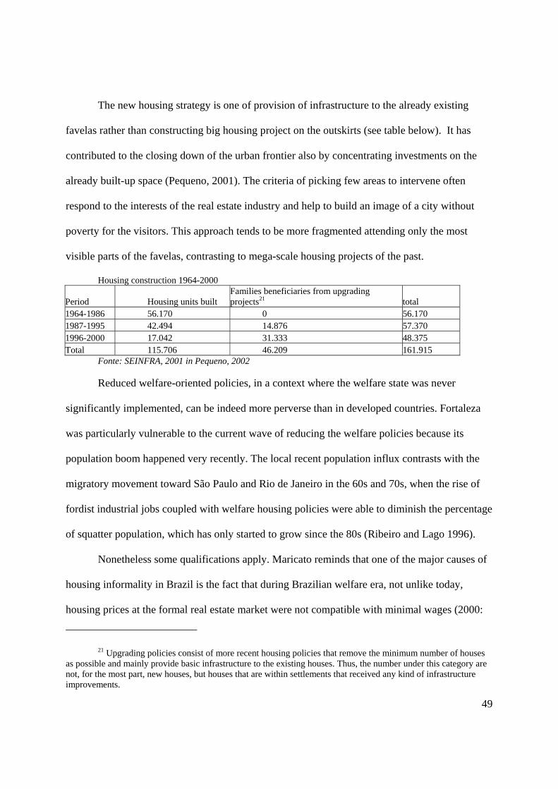
49
The new housing strategy is one of provision of infrastructure to the already existing
favelas rather than constructing big housing project on the outskirts (see table below). It has
contributed to the closing down of the urban frontier also by concentrating investments on the
already built-up space (Pequeno, 2001). The criteria of picking few areas to intervene often
respond to the interests of the real estate industry and help to build an image of a city without
poverty for the visitors. This approach tends to be more fragmented attending only the most
visible parts of the favelas, contrasting to mega-scale housing projects of the past.
Housing construction 1964-2000
Period Housing units built Families beneficiaries from upgrading projects21 total
1964-1986 56.170 0 56.170 1987-1995 42.494 14.876 57.370 1996-2000 17.042 31.333 48.375 Total 115.706 46.209 161.915
Fonte: SEINFRA, 2001 in Pequeno, 2002
Reduced welfare-oriented policies, in a context where the welfare state was never
significantly implemented, can be indeed more perverse than in developed countries. Fortaleza
was particularly vulnerable to the current wave of reducing the welfare policies because its
population boom happened very recently. The local recent population influx contrasts with the
migratory movement toward São Paulo and Rio de Janeiro in the 60s and 70s, when the rise of
fordist industrial jobs coupled with welfare housing policies were able to diminish the percentage
of squatter population, which has only started to grow since the 80s (Ribeiro and Lago 1996).
Nonetheless some qualifications apply. Maricato reminds that one of the major causes of
housing informality in Brazil is the fact that during Brazilian welfare era, not unlike today,
housing prices at the formal real estate market were not compatible with minimal wages (2000:
21 Upgrading policies consist of more recent housing policies that remove the minimum number of houses as possible and mainly provide basic infrastructure to the existing houses. Thus, the number under this category are not, for the most part, new houses, but houses that are within settlements that received any kind of infrastructure improvements.

50
155). She points out the disastrous social consequences of neoliberal urban policies without
romanticizing old urban development logic that did not address question of spatial justice. Cities
before neoliberalism excluded a considerable part of urban residents from the formal market as
well.
Clearly this new strategy of addressing the housing issue is due to a series of external
factors that go beyond neoliberal ideology. They include greater recognition of the favela-
dwellers’ rights to location and the perception of perverse effects of forced evictions. Today, a
considerable part of public opinion has more sympathy for the cause of squatter settlers than 40
years ago. For example, the 1960 Municipal Master Plan referred to squatters as “pariah” who
came to the capital city searching for charity and not jobs. This point of view, contrasts with the
public reaction to forced eviction of a group of families that occupied a publicly owned land in
2001. However competitiveness and entrepreuneuralism serve as ideological constructs to shift
both public attentions and public investments away from the social demands and toward the
spatial needs of privileged sectors.
NNeeww UUrrbbaann PPllaannnniinngg IIddeeoollooggiieess
Since the mid 1980s, the emergent political logic has seen planning as an important
instrument of capture of external investments. If old urban policies were not capable of
effectively meeting the needs of the poor, today there has been less emphasis on this goal and
attentions are focused on marketing the city for potential investments. In some Brazilian cities,
the Modernist-Comprehensive planning model is being replaced by a more fragmented approach
- Strategic Planning, which aims to publicize the strengths of the city rather than to solve its
social contradictions. This new logic relies on a kind of trickle-down effect where the increased

51
wealth brought by economic growth will ultimately benefit the poor in the form of jobs.
However it includes no mechanism to make sure the benefits will really reach the bottom. This
trust on market mechanisms as effective regulators of urban goods of collective consumption has
indeed been imposed by multilateral donors’ agencies22.
In Fortaleza’s urban plans the economic development project of elites contrasts sharply
with situations of extreme poverty. A very illustrative case, the PLANEFOR - the strategic plan
of Fortaleza Metropolitan Region - reinforces the excessive attention of economic development
strategies calling local residents for a cooperative effort toward a few well-designed goals. The
five main urban development strategies are as follows: (1) Consolidation of administrative
structure of the metropolitan region, (2) Promotion and consolidation of regional
competitiveness, (3) Human Development, (4) Participatory urban management and institutional
empowerment and (5) Culture Identity and Self-esteem.
It is possible to identify a great deal of contradictions between the goals of this new plan
and the actual residents’ needs. While the second strategy emphasizes the role of tourism and
refers to all locational advantages of the City for that activity, none of the strategies gives
attention to the mitigation of the well-known social consequences of tourism (at least in some
versions of tourism existent in the city) like child prostitution and drugs. According to the
document, tourism development will require a great deal of effort on the part of the population,
but the Strategy of Human Development will be achieved simply through the “maintenance and
expansion of well-experimented educational programs” as if the reduction of school evasion, or
juvenile delinquency, and the 50% illiteracy rate of some outlying metropolitan municipalities
22 The PROURB, a program that included the realization of master plans for the 44 biggest cities of the State of Ceará (including all municipalities of the metro area except Fortaleza) funded by the World Bank, had as one of the main objective the capture of external investments as a way to solve the social contradictions of these impoverished municipalities.

52
were not big challenges for the Plan. As it is a characteristic of such plans, the tactic is to
publicize local strengths and hide as much as possible the weaknesses. Thus, the plan does not
explore the fact that illegal settlements constitute almost half of the city. Nor does it explore the
deficiencies of public transportation system. For the plan, the solution to the problems of rising
urban violence and the poor conditions of public health systems require the participation of
community-based organizations. This can be interpreted as a transfer of responsibility from
public sector to the civil society, namely, community organizations and NGOs.
IInnffrraassttrruuccttuurree IInnvveessttmmeennttss aanndd VViissiibbiilliittyy
Yet, contradicting neoliberal developments in other Third World cities23, investments in
basic social and infrastructure services did not cease. With the exception of the telephone and the
power company, no public utility company was privatized during this developmental period,
despite privatization of basic services in some other Brazilian states. Nevertheless the
universalization24 of public services is "presented not as a goal in itself but as tool for
improvement of the condition of the city’s insertion in the world of competitiveness” (Oliveira25,
2000). That is, providing access to infrastructure has been used as a market tool to capture
external capital. This makes an enormous difference, because the decision on where to place
such services depends on the criteria of visibility. Poor isolated neighborhoods, located in places
tourists will never see, and that are not on the way to any “industrial pole”, are likely to receive
less services unless there is a powerful political movement able to make their needs visible.
23 see for example the case of South African Cities in Bond, 2000 24 Universalization is the local term (universalização) used to refer to expansion of these services for all
urban residents. 25 In this passage the author makes reference to the Agenda 21 program being developed by the United
Nations Development Program.

53
The Resulting Segregation Pattern
The mapping of census data26 by census tracts in 1991 and 2000 reveals an increased
complexity of the urban spatial structure that contrasts to the older more well-defined center-
periphery segregation pattern. This new pattern is the result of the shift in attitude on the part of
official strategies of producing the city, that have concentrated on capture external capital instead
of more welfare oriented old policies. The urban geography changed not only as a response to
new requirements of productive capital, but also (and more significantly) as a response to
neoliberal ideologies of entrepreuneuralism and pro-growth policies.
The changes in Fortaleza’s residential segregation patterns seem to confirm the two main
intra urban migratory movements also found in other Brazilian Metropolises (Ribeiro and Lago
1996): the out-migration of middle-classes and spread of poverty throughout the urban
landscape.
The middle class search for outlying land results from the access to the new regional
street network, and escape from high real-estate prices of the core. In addition, communication
technology such as fax and Internet might have influenced middle-class out-migration. It is
easily depicted in the map of average nominal income where the peripheral sectors in 2000
ceased to be almost homogeneously poor as in 1991. Old public housing projects, built far from
the urban core in inexpensive and disconnected cheap land, are now well placed in the urban
context. Indeed some empirical studies have shown that a kind of gentrification took place at
these neighborhoods and a great part of the original owners have already sold the houses to
families of higher income class, or lost the house due to inability to pay (Braga, 1996).
26 Except for the case of density, the variables were classified into 3 quantiles in order to provide differentials between the census tracts relative to the condition of the overall city in each two points in time. That explains why the categories of the 1991 maps differ from those on the 2000 maps: each category corresponds to one third of the tracts, the best, the medium and the worst third respectively.

54
Figure 4.1 Average Nominal Income of Head of Household (in Brazilian currency: Reais) Source: IBGE 2002 – a and IBGE 2002 -b
The mobility of the poor is more difficult to see in the income map because it is
composed by two opposing tendencies. A first tendency is one of inward mobility where poor
residents, in order to take advantage of job opportunities, move to popular central neighborhoods
or squatter settlements. Cases of families selling the “permission” to build a second (or third)
floor above their house to other recently arrived families demonstrate this inward movement. In
addition the density of central squatter settlements is raised dramatically by increased index of
co-habitation (families living together with the families of their sons and even grandsons). This
results in the so-called process of “verticalization” of Latin American favelas27. Since the
horizontal expansion of illegal settlements is constrained, the construction of a second and third
floor is the only strategy left. By doing this, favela dwellers are simply mirroring the logic of
formal real estate market that demolish single family homes to built high rise apartments in order
to take the maximum profit from increased land values. The density map demonstrates that the
overcrowded areas of the west coast favelas expanded. Similarly some richer neighborhood east
27Estadão 03/16/1998; Tachner and Bogus 2000; Agência de Notícias das Favelas http://www.anf.org.br/link.php?assunto=urbanismo&artigo=6

55
from downtown also increased its density (see remarks). The increase of dense sectors in the
periphery leads us to the second intra-urban movement of the urban poor.
Figure 4.2 Density (inhabitants per area) Source: IBGE 2002 – a and IBGE 2002 -b
A second tendency is one of outward movement of those who cannot afford to live in the center.
A great part of those at the very bottom of the socio-economic strata, if residing in centrally
located neighborhoods, find themselves forced to sell the entire house and move to more distant
areas in order to meet their immediate living needs. Third World planning literature refers to this
process as forced residential displacement, which is very similar to the gentrification phenomena.
Bezerra (1999) and Braga (1996) accurately describe this movement in the city of Fortaleza.
Thus housing upgrading polices often have very limited effect on the original beneficiaries
because public intervention raises the value of the property and the original owner often sells it
to a family with greater purchase power. The displaced residents are likely to move to the empty
spaces surrounding the old public housing projects, that were reserved for parks or social
facilities never implemented. The map of unemployment shows that there is a relative decrease
in unemployment in the central part of the city, except for the big favela on the west coast.

56
Figure 4.3 Percentage of households without income Source: IBGE 2002 – a and IBGE 2002 -b
The infrastructure map is perhaps the one that depicts the abandonment of the center-
periphery pattern most clearly. The clear shade at the center diminishes significantly in 2000.
While there has been an overall improvement in accessibility to urban infrastructure, the
relatively better connected places are not anymore located at the urban core, but are spread all
over the city. The old downtown presents in 2000 a relatively bad infrastructure access. This is
the combined effect of investments in infrastructure network at the outskirts, the vertical growth
of popular central neighborhoods with deficient services, and aging of infrastructure network in
the older downtown.

57
Figure 4.4 Infrastructure index (includes access to piped water, sewer and trash collection) Source: IBGE 2002 – a and IBGE 2002 -b
The Influence of Space on Society
As geographers remind us, “all battles over space and place are battles over spatialized
social power, and it is the nature, source and structured inequities of that power which must be
central to analysis and position-taking” (Massey, 1996:123). Thus, while proximity between rich
and poor might seem a fairer pattern than the clear class segregation that characterized the old
urban geography, we should not analyze the two snapshots of urban geography as distinct points
in time removed from the processes that produced them.
The new geography is the clear outcome of a myriad of different interests in the urban
space. It is important to mention that social process of increased recognition of the squatters’
cause28 reduced evictions and led to the infrastructure provision to illegal settlements, improving
their living conditions. On the other hand, new ideologies are shifting the power over urban
investments from public sector to requirements of the productive sectors. This new logic is not
the fairest mechanism of space production, particularly in a situation where over half of the
28These will be discussed in more details in chapter 05.

58
population is not adequately integrated into the formal economy and has no access to the formal
city.
A former goal of social integration of the urban poor through welfare-oriented policies
(i.e. subsidies to affordable housing) seems to be giving place to policies aimed at bolstering the
local economy. Productive investments are to have priorities over “non-productive” ones despite
all social costs. This philosophy has ultimately decreased access to the city for marginalized
populations. Rising numbers of squatter settlements and occupations in fragile ecosystems are
clear expressions of how unaffordable the city has become. This new politico-economic context
has shrunk the urban space decreasing the supply of vacant land and putting additional value on
centrally located land. Despite the fact that new roads increased the urban space, public
investments have not been able to create new centralities at the outlying municipalities. These
outlying cities are still bed communities whose inhabitants commute everyday to the proximities
of downtown Fortaleza, which increases the demand for central land. This demand is, however,
for rich produced spaces as well as for filthy over-dense settlements. In this process, both formal
and informal real estate has increasingly become an instrument of moneymaking, a fact that
increases the exchange value of land at the expenses of its use value.
This analysis of the changes in Fortaleza spatial structure allows me to affirm that the
decreased access to the city is an important factor in the pauperization of the majority of the
urban dwellers, contrasting with higher profits from real estate market transactions. The changed
logic of producing the city enabled new forms of socio-spatial inequalities, namely, dense
overpopulated settlements inhabited by an ever-increasing part of urban working-class. This new
urban logic also enabled the rise in occupation of unsuitable land such as riverbanks and steep
dunes, which are the few available leftover spaces that have a good location within the urban

59
context. The shortage of vacant spaces in the city helps in explaining the occupation of “areas at
risk” rather then a more suitable land, which is scarcer than before and thus less available.
Therefore in this case, the management of space contributed to increased socio-spatial
inequalities exposed in chapter 03. Neoliberal ideologies have justified the placement of public
investments in a way that widens the gap between poor and rich residents. The new geography is
not only the result of neoliberal urban policies but it has also actively contributed to the
neoliberal project of development, ultimately leading to the intensification of extreme conditions
socio-economic inequality.
Case 02 – Transportation Corridors
Paradoxically, this neoliberal spatial praxis has only confirmed an old logic of using
urban development to perpetuate the dominance of powerful sectors. According to the old urban
practices, the state was responsible for providing the instruments of collective consumption
necessary for the reproduction of class relations, strictly confirming Castells’ early work. At that
time, the urban state was visibly more concerned with the reproduction needs of the residents
than it is today. However it is also true that the spatial requirements of productive capital and
elites have never ceased to be priorities. If urban social movements were able to challenge old
policies that segregated the poor from the rich part of the city, neoliberalism brought new
political strategies to achieve the same goal of producing the city for a few privileged sectors.
The following case claims that Fortaleza’s elites have always effectively controlled the
production of the city through the placement of transportation corridors. Influenced by neoliberal
ideologies, opening new roads has become a convenient mechanism for opening new real estate
60
frontiers while, at the same time, addressing the housing needs of some of the poorest residents.
What this strategy conceals is that these projects have introduced an instrument of gentrification
and market-led evictions into “strategic” sites for investments that are currently occupied by the
urban poor. These new road-opening projects parallel, in some sense, the old segregationist
policies that evicted the poor from well located settlements.
Urban Structure and Roads
Villaça (1998) defines the urban structure as a totality contained by parts that have
intricate connections among one another. The alteration of one part (or of one connection) leads
to the alteration of all other parts (the entire urban structure). This implies that investments in a
given part of the city don’t simply improve that parcel, but they also alter the entire structure of
the city.
Therefore investments in space not only produce urban amenities, they also produce new
spatial relations. In other words, urban investments produce distinct “locations” within the
totality of the city (Villaça, 1998). Smith (1984, 1996) also stresses these spatial relations among
the different places. He defines production of space as the construction of relativeness. For him,
people produce space by altering the natural relations of proximity among distinct points creating
relative space, as opposed to absolute (inherited natural) space (Smith, 1984:87). The concept of
relative space refers to the human-led differentiation of territory within a given scale through the
construction of a series of spatial fixes (urban investments) that are able to modify a given
pattern of proximity.
Villaça groups these relatively fixed investments in the urban space in two categories.
The first comprises those urban investments that don’t require displacement on the part of the
consumer (the urban resident). The majority of infrastructure networks, like water, sewer and

61
trash disposal would fit in this category. Spatial inequalities are more commonly described in
terms of existence of these kinds of services and infrastructure. The second category of urban
investments includes the more complex concept of location, defined by the spatial relationship
among the distinct points within the city (1998).
Drawing on the work of Villaça and Smith, this case understands the struggle over access
to the city as a process of continuous competition for intra-urban locations, rather than as a mere
competition for urban investments. While the investments that do not require displacement are
important aspects of spatial inequalities, they are not crucial. For example, the garbage collection
does not alter the spatial structure of the city because it does not change the spatial relations
between the different parts of the city. On the other hand investments that require displacement
shape space creating locations and changing the degree of attractiveness of certain areas at
expenses of others. Following this line of reason, the opening of new roads is the public
investment most efficient in altering the intra-urban spatial structure because it modifies the
patterns of proximity among attractive locations.
At this point, it is necessary to mention that a critical distinction between First-World and
Third-World cities is that the latter have severe conditions of congestion, inaccessibility, and
lack of public transportation. Cities in underdeveloped countries have not arrived at a stage of
reasonable accessibility to all their parts. As a result, high commuting time is among the biggest
problems of these cities. Although transportation problems affect both rich and poor residents,
the poor bear a higher burden for long commutes. Three hours each way by bus is not an
uncommon estimate for big cities such as Fortaleza. A visible example of accessibility
inequalities in Brazilian cities is the fact that some squatter residents, in their commute to work,
keep their shoes in their bag and only wear them when they reach a paved road. For middle class,
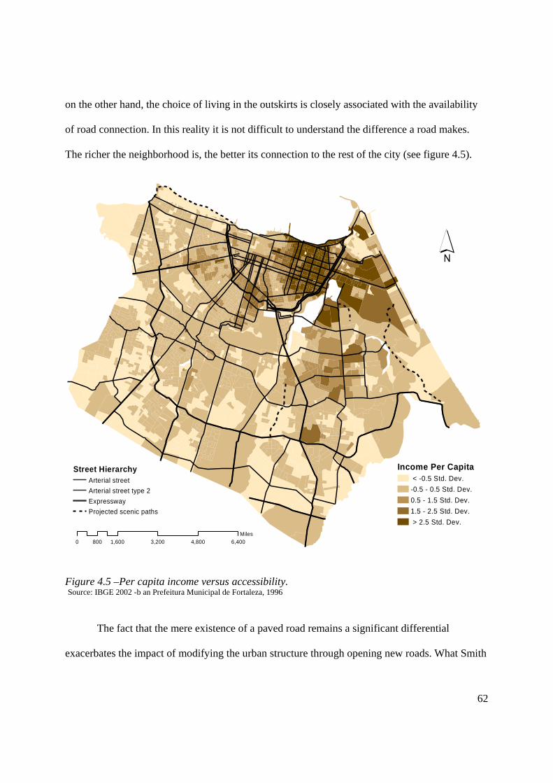
62
on the other hand, the choice of living in the outskirts is closely associated with the availability
of road connection. In this reality it is not difficult to understand the difference a road makes.
The richer the neighborhood is, the better its connection to the rest of the city (see figure 4.5).
´
0 1,600 3,200 4,800 6,400800Miles
Street HierarchyArterial streetArterial street type 2ExpresswayProjected scenic paths
Income Per Capita < -0.5 Std. Dev.-0.5 - 0.5 Std. Dev.0.5 - 1.5 Std. Dev.1.5 - 2.5 Std. Dev. > 2.5 Std. Dev.
Figure 4.5 –Per capita income versus accessibility. Source: IBGE 2002 -b an Prefeitura Municipal de Fortaleza, 1996
The fact that the mere existence of a paved road remains a significant differential
exacerbates the impact of modifying the urban structure through opening new roads. What Smith

63
termed “ribbon development” remains the prime mechanism of producing space and modifying
the urban structure of Third World cities:
“Ribbon development […] is precisely the case where new transportation routes
alter the pattern of accessibility and hence the local ground rent structure leading to new
development that clings exclusively to the new route. Without the new road, railway or
canal, development would not have occurred”. (Smith, 1996:81)
Differentiating the East Side
The creation of avenues linking the traditional downtown with the upper middle class
neighborhoods was an essential mechanism of the economic supremacy of the east over the west
side of Fortaleza. There are countless historical accounts of pro-growth coalitions among the
owners of these lands and the investments on their street network29. First, it was the Beira-mar
and Santos Dumont avenues which raised the values of the then-recent subdivisions of Meireles,
Aldeota and Papicú. More recently the Washington Soares Avenue was linked to the easternmost
regional transportation corridor leading to huge private real estate profits.
Transportation investments in Brazilian cities aim more at real estate gains than at
ameliorating the transport services for urban residents (Maricato 2000, Campos Filho 1999).
Roads are created to open new frontiers to the high-end real estate residential market, instead of
serving the transport needs of the majority. The fact that part of middle-classes, and not only elite
landowners, invest in urban land as a savings mechanism makes this “real-estate logic of
producing the city” extremely appealing.
29 For a short version of this process see the section “El este de Fortaleza como tablero de juego de atores locales” in Rosner and Vilsmaier 2001.

64
More than half a century of public and private disinvestments in the traditional downtown
transformed it into a popular commercial center, with a high index of vacant property because
the offices were transferred eastward. With the concentration of higher income residents and
easy accessibility, the eastern neighborhoods attracted a lot of economic activities, eventually
leading to the eastward migration of the traditional downtown commercial center. At first, high-
end commercial areas migrated contiguously along the Santos Dumont Avenue. But the
installation of many new urban facilities30 along the Washington Soares Avenue has been
pushing local economic development still farther from the traditional downtown. Today, a new
southeast centrality is now fairly well established. Thus, roads and public investments (such as
the forum, administrative center, and infrastructure) not only have brought the wealthy
neighborhoods closer to downtown but they have physically dislocated the commercial center as
well. As a result, the bigger dark shade on figure 4.6 has the high land price, high-density and
excessive concentration of private investments of all sorts.
Shopping Malls
Cultural activities (cinemas and museums)
!( Hotels
0 1 2 3 40.5Miles
´!(
!(
!(
!(
!(
!(!(
!(!(
!(
!(!(
!(!(
!(
!(!(!(!(
!(
!(!( !(
!(!( !(!( !(!(!(
!(
!(
!(
!( !(!(
!(!( !(
!(
!(!(
!(!( !(
!(!(
!(!(
!(
!(
!( !(!(
!(
!(
!(
!(!(
!(
!(
!(!(
!(
!(
!(
!(
!( !(!(
!(!(!(!(!( !(
!(!(!(!(
!(
!(!(!(
!(
!(
!(!(
!(!(!(
!(!(
!(
!(!(
!( !(!(
!(
!(
!(
!( !(!(
!(
!( !(
!(!(!( !(
!(
!(
!(!(!(!(!( !(
!(
!(!(
!(!(!(
!(!(
!(
!(
!(
!(
!(
!(!(
!(
!(
!(!(!(
!(
!(
!(!(
!(!(
!(
!(!(
!(
!(
!(
!(
!(
!(
!(!(
!(!(
!(!(!(
!(
!( !(
!(
!(
!(
!(!(
0 1 2 3 40.5Miles
Banks
´
Figure 4.6 A- Concentration of tourist activities B- Migration of centralities Source: Prefeitura Municipal de Fortaleza,1996 and www.zapt.com.br
30 The biggest shopping center of the city, the conventions center, the university, the judicial court and the state government administrative center
Old Downtown
New centrality
65
Not only the quantity but also the quality of public investments indicates the degree of
privilege of this area compared to the rest of the city. To cite but one example, this is the only
part of the city where dunes and rivers cannot be described as leftover, inaccessible and filthy
spaces. The powerful movements to preserve the dunes and rivers that are located either within
this rich area, or in its immediate developmental path, have achieved considerable success.
These are cases where the high demand for these rich produced spaces justifies the preservation
of their remaining nature. These fortunate ecosystems are the object of immeasurable
preservation efforts involving, for the most part, a great deal of public investments. Yet they are
clearly not reminiscent of “pristine ecosystems” as popular wisdom believes. A considerable
amount of resources in inspecting, cleaning, and controlling invasion are spent, making them
much more “produced” spaces than the filthy leftover ecosystems. This contrasts with the
environs of most urban ecosystems needs for basic infrastructure such as sewage and trash
collection and drainage.
We can, then, start to understand why good location and bad housing is still more valued
than adequate housing and bad location (Villaça, 1998). This situation is the result of the spatial
concentration of both economic opportunities and urban public investments, in a condition of
great scarcity of these two factors31.
31 As demonstrated in the last case, the opposing force of spatial deconcentration (industries located at, and roads leading to the outlying municipalities) has had negative socio-economic effects of increasing the value of well-located land. So far, these outlying investments have not been able to create new centralities able to compete with the southeast region (Pequeno, 2002). The lack of other centralities in the periphery comprises the so-called “macrocephaly” of the urban structure.

66
Expanding the Privileged City
Outside this differentiated and more accessible small part of Fortaleza, the social
transformation that even a small street effects is remarkable. Based on a statistical analysis of a
sample of Fortaleza’s poorest settlements, Bezerra (1999) concluded that street pavement is the
type of infrastructure more likely to cause forced displacement of squatters’ dwellers – the so-
called market evictions. In other words, the study attests that the pavement of a residential street
in popular settlements increases the value of a property more than the existence of piped water or
sewer collection services.
The mapping of information collected through interviews with residents of a squatter
settlement depicted in the following illustration further attests the economic value of road
connection. It suggests that the best socio-economic indicators are found at the houses located at
the roads on the edge of the settlements, as opposed to those located at narrow irregular streets
typical of the inner areas of such settlements. That is because the road helps to make their small
businesses more visible to middle class clients that pass by the road. Thus, the road helps
providing a source of income to the families located along it, an advantage that the other squatter
residents don’t have.

67
Figure 4.7 Typical socio-economic distribution of a squatter settlement Source: Bezerra, Ricardo Figueiredo et al. 2001. Habitation Précaire à Fortaleza – Brèsil. Analisys et Perspectifs
Extrapolating these findings to the larger metropolitan scale, Pequeno (2001) identified a
series of development and degradation corridors constituting the intra-urban structure of
Fortaleza. Not accidentally, all development corridors coincided with the major roads of the
metropolitan region. Although not all the major regional routes were able to attract the amount of
public and private investments that the southeast corridor did, the vicinity of such avenues
generally present better infrastructure and socio-economic indicators than their immediate
neighborhoods. On the other hand, Pequeno’s degradation corridors consist of the combination
of poverty and environmental decay along the majority of rivers and dunes, which I have been
calling leftover environments.

68
I have suggested earlier in the last chapter that when urban development goes in the
direction of some of these leftover environments they become strategic sites for investments. In
fact, my account of the occupation of Fortaleza’s natural environment showed that the poor
populations currently established in expensive land had settled prior to valorization of the land.
As the urban expansion (and thus accessibility) surrounded these areas, they were already so
densely populated that their forced eviction would be extremely costly, in both economic and
political terms. This situation created pockets of (relative) poverty located at the very core of the
privileged part of the city.
Figure 4.8 Development and degradation corridors Source: Pequeno, 2002

69
The arrival of the “formal city” in those areas starts by the opening of a road, clearing up
the necessary area from squatters. A delicate political negotiation process takes place between
state government and the settlements’ leadership. Only the houses on the way of the road are
“condemned”. The road cuts through the settlement and the houses left adjacent to the new road
rapidly incorporate commerce in their ground floor. The subhuman environments of inner houses
are untouched by State policies. The hidden places have, however, a tendency to increase their
density as an effect of the recent arrived economic opportunities nearby. More density means
worsening of their risky living conditions.
The access road of the new international airport precisely followed this process32, albeit
in parts hidden behind the walls hidden along the freeway that takes tourists to the new urban
centrality.
An Example: the West Coast Avenue
Currently, there are some social tensions resulting from the State’s declared intentions to
developing the east and west coastal corridors. The tensions come precisely from the fact that a
great part of Fortaleza’s seacoast consists of sand dunes occupied by squatters. Both the recently
built bridge over the mouth of the Ceará River and over the mouth of Cocó River intend to
expand the seacoast development. Because the east dunes have historically been adjacent to the
expensive neighborhoods, their occupation was limited, and not intense enough to prevent the
opening of a coastal avenue. On the west, however, the situation is the opposite. There, the
coastal connection between the rich part of the city and the recently built bridge requires the
32 This information is based on interviews with municipal officials and some displaced residents during my fieldwork for the report “Habitacion prècaire a Fortaleza”, 2001.

70
construction of a street more than 5 kilometers long as well as the displacement of at least ten
thousands persons33.
The project for the opening of the West Coast Avenue follows the same process of the
airport road. Here the situation is yet more complex because the avenue is projected as a scenery
path for the visitors to appreciate the nice view to the sea. However, the street path crosses the
favela of Pirambú, which is the oldest and biggest squatter settlement of the city, one of the
biggest of the entire country, with a history of resistance to forced evictions dating back to mid
60s. The “great Pirambú” comprises a combination of favelas, self-help housing, popular
neighborhood and public housing over the west sand dunes. According to the 2000 census data
the area has 116,684 inhabitants34, 62% of which are officially considered squatters35. Of all
Pirambú, the poorest settlements are located precisely at the coast, which confirms a settlement
pattern described earlier where lack of accessibility in hard to occupy lands concentrates the
worst living conditions (See Figure 4.9).
33 The project includes the construction of 2.5 thousands houses which is on average 10 thousand persons. However at this initial stage of construction, the state staff has already declared that the area has more families than they had initially estimated. Diário do Nordeste, August 26,2002, and January 8, 2003.
34 This data refer to the three officially designated neighborhoods that include the “great Pirambú”: Barra do Ceará, Cristo Redentor, e Pirambú.
35 Considering that the census definition of squatter settlement does not count isolated squatting houses, the squatter population is likely to be even higher in that area.

71
0 0.4 0.8 1.2 1.60.2Miles
´
Houses without bathroom0% - 2%
3% - 8%
9% - 25%
26% - 89%
90% - 100%
Perimeter of squater settlements
LayerArterial streetCollector streetExpresswayWest Coast Avenue
Figure 4.9 – Socio-economic indicators of Pirambú. Source: IBGE census 2002-b and Prefeitura Municipal de Fortaleza, 1996
Despite the absence of visible concern on the part of public managers, the passing of the
road will obviously lead to profound socio-spatial changes in the neighborhood. Of all these
changes, the market-led displacement of the more vulnerable residents is the one that might have
the deepest social inequity effects. Because the road will pass at the coast precisely where the
poorest families are, they will be the most directly affected. It is reasonable to expect that the
demand for coastal lands will rise rapidly and those not prepared to deal with the changes will be
driven out. Limiting the removal to the houses located in the way of the road leave the land
market to evict the remaining residents.
State government officials promote the West Coast Avenue as another road opening
project vital to Fortaleza’s progress. The project aims at raising the city’s competitiveness in
order to attract tourists. A reformed Coastal Promenade, a Cultural Center, several Downtown
Revitalization projects, and a new Convention Center located at an artificial landfill over the sea

72
are not enough for this task. According to a state government’s representative, there are no
vested real estate interests,36 even if it is clear that the increased accessibility to tourist attractions
and middle-class neighborhoods in the adjacent municipality of Caucaia at the other margins of
the river will raise the value of the land.
The locals who expect to profit from the development are glad that “development” is
finally coming to the area. For them, “Fortaleza” will be able to appreciate the natural wonders
of that place, as if Pirambú residents and the current popular users of the beach were not part of
Fortaleza. This is the version of the owners of popular restaurants on the beach is similar to that
of governmental agents. They argue that local residents will be able to profit from the movement
of wealthier visitors.
But the fact that a significant part of the community has some reservations about the way
that the project is being implemented raises some important questions. Does the provision of
adequate shelter to the displaced residents sufficiently respond to questions of equity? Do the
displaced residents and the restaurant’s owners represent the interest of the community? Will the
prospect of economic opportunity attract more residents and worsen the housing conditions of
the inner parts of Pirambú, repeating the case of intervention at the dunes of Mucuripe?
These concerns are not echoed in the local media. Public opinion in general is remarkably
more aware of the environmental impacts that the road might cause than the social impacts of the
road on the neighborhood. The National Department of Environmental Affairs has already
stopped the construction twice based on the ecological impacts that the opening of a road
between the dunes and the sea. The Department is also concerned with the safety of the new
36 Diario do nordeste, August, 26 2002 “Seinfra diz que projeto foi discutido com população”

73
street because the sea is advancing on the land of that area. These environmental impacts tend to
dominate the oppositional debates about the project.
Discussions of the social effects of the project in the community have been limited to the
displacement of the families under risky conditions. Understandably these families have agreed
to be removed. They are moving from a situation of landslides risk to houses built in “safe areas
nearby” 37. For the dominant public opinion, the transfer of the residents, which might take a
considerable percentage of the budget for the entire project, seems to be more than enough to
address questions of social justice. After all, not long ago, similar projects simply evicted
without compensating those perceived as illegal settlers perceived to be hindering urban
progress. However, even with so many new houses, the project is deficient from the perspective
of the residents of areas-at-risk in Pirambú. That is because not all the houses being displaced are
under risky conditions and only part of the huge amount of houses at-risk will be transferred.
Based on my newspaper research, few people have seriously considered the effects of the
investment on the lives of the great majority of the 116 thousand residents of Pirambú not living
immediately at the coast. Some of them, organized around neighborhood associations, have set
up public protests asking, “Development for whom?” They are concerned that the development
will not benefit the actual Pirambú residents. For the most part, current Pirambú inhabitants are
domestic servants, illiterate fishermen, and unskilled workers not prepared for the new economy
that the new road is expected to foster. Although they do not question the influx of investments,
they say that the road was not their priority. If development is to benefit them, they need schools
and technical skills first. Otherwise the opportunities will go to well-skilled newcomers who will
37 This expression of “safe areas nearby” can be found in several public declarations about the project. This seems to be in response to the fact that some technicians have been questioning that the new houses being built are really safe. They argue that the houses are not being built with inadequate construction material (Diário do Nordeste, August 26, 2002)

74
offer a good price for their houses displacing the most vulnerable residents. Not accidentally the
objectors to the project reside in inner areas, invisible from the coast, likely to receive no
benefits, but a lot of social costs of development.
It is meaningful to highlight at least three definitions of the area and the interests behind
its development. For the average newspaper’s readers, government is planning a disordered
unplanned settlement, and they may even suggest that government should have done this before.
The fact that middle class residents have no access to that beautiful part of Fortaleza’s seacoast is
unacceptable for a city aspiring to become a tourist attraction of global proportions. According to
this perspective, government is correctly eradicating 2.500 houses at risk. However, beyond this
most widespread version of the area as an uncontrolled settlement of wasted natural beauty, there
are at least two other definitions of the area. For the environmental groups this is a fragile
ecosystem that needs preservation. For the residents of Pirambú in general, it is a place that
might be able to bring them economic opportunities. If planning is about multiple constituencies
with multiple interests, planning’s projects have to accommodate all this points of view.
The example of the West Coast Avenue project does not intend to assess this planning
project completely. Rather it intends to reveal how urban investments are devised primarily with
economic objectives and how they tend to minimize the social impact of spatial changes. The
example illustrates the official approach of intervening in strategic in order to expand the
wealthy neighborhoods. There are some tourist destinations like hotels and restaurant as well as
middle class neighborhoods developed at the neighboring municipality of Caucaia across the
river, that need connection to the rich part of Fortaleza. And this connection seems to be all that
matters about the project.

75
Concluding Remarks
Before proceeding to analyze the equity effects of planning in the next chapter, it is
important to establish a causal connection between development of one part of the city and
underdevelopment of the others. At the neighborhood scale, the Pirambú case demonstrates that
development of its coastal area will increase the locational value of the few steep slides that
remain vacant, inducing uncontrolled increase in density of existing settlements. At the citywide
scale, the allocation of investments - even historically social investments such as housing -
according to economic criteria immediately implies that more needy areas will not be attended
to. This causal connection increases even further the difference between the city of the poor and
that of the rich residents. In all this, space is the fundamental aspect of urban inequalities that
planners seem to be missing. Their attitude of not accounting for the role of space has had
however, perverse inequity effects.

76
Chapter 05 The Possibility of Socio-Spatial Equity
Planning
The analysis of Fortaleza’s official practices of producing space in the last chapter
suggest that, for the most part, state intervention in urban space has been restricted to facilitate
conditions for the market to take over. With the rise of neoliberalism, today more than ever,
official urban (spatial) development process has produced a city for economically productive
activities at the expenses of the social reproduction needs the residents. Not only roads but any
major urban investments prioritize the economic development of the city without account for the
effects of the changes in the geography on the lives the residents.
This chapter assesses the position of planning in regards to the urban development
process described. It demonstrates how official planning has worked to marginalize the majority
by hindering their access to the city. It contends that while the urban space has been produced
without considering the social effects of changes in the urban geography, non-spatial social
policies have had limited effect in providing the urban poor access to the city.
I conclude, with a brief analysis of some insurgent (non-state) planning practices that
have been able to challenge some of the negative social outcomes of official planning. The
relative success of these popular movements reveals some potentially transformative planning
initiatives that have exposed the political nature of urban developments, opening the city for
debate.

77
Official Planning
PPllaannnniinngg LLeeggaall IInnssttrruummeennttss
Planning instruments have been reasonably effective in both controlling and producing a
privileged city. By protecting the rich neighborhoods while ignoring the rest, legal instruments of
developmental control have contributed to produce an exclusive and unaffordable city. The high
minimum building legal standards put the majority of the city (some speak of more than 90%) at
different degrees of illegality. The irregularities go from total illegal occupation (almost 50% of
the entire city) of land, to the mere lack of building permits. In fact building permits are, by and
large, irrelevant to the great part of the city. The situation of illegality implicitly removes
responsibility from the public sectors, which in turn concentrate planning efforts in protecting the
rich city from the “urban chaos”.
In the rich neighborhoods permits are costly, highly restrictive, and believed to contribute
to its unaffordability. Similarly, the zoning law is enforced in the rich part or in its expansion
path (i.e. the coast). The innovative instruments of “Zones of Social Interest”38 for example,
which have been used by other Brazilian municipalities to protect well-located favelas from
gentrifying, are here delimited in the cheap peripheral land. The current zoning law prohibits
popular residential subdivisions at high-priced locations and further decreases access to the city
by the poor.
Similarly, enforcement of private property rights is very effective in expensive areas,
more so if compared to its ineffectiveness in the rest of the city. Land invasion is overtly allowed
38 These zones propose more flexible building standards in order to include the part of the informal city into the official city. In some cases (as in the city of Recife) they propose a maximum instead of a minimum, building standard in pockets of poverty concentrated in gentrifying areas.

78
in poor areas while strictly forbidden in costly land. In the words of Maricato (2000), access to
land is permitted but not access to the city.
Two sets of standards in different parts of the city are evident in the case of legal
instruments aiming at preserving fragile ecosystems. While the city proudly publicizes that the
easternmost part of Cocó River is the first urban wetland ecosystem preserved in Latin America,
the Maranguapinho River, which crosses the neglected southwest neighborhoods, is not object of
a single environmental protection initiative. Instead, some claim that the municipality has been
promoting the occupation of the lowlands in the poor periphery (see the case of Conjunto
Barroso in Rosner and Vilsmaier, 2001).
Ironically, state planning does not hesitate to neglect environmental protection laws in
cases where fragile ecosystems are in the way of economic development. The West Coast
Avenue is case in point. Environmental specialists have fiercely questioned its environmental
impact assessment. But so far, this has not been enough to hinder the project development.
The inequity effects of selective regulation of the city is so widespread among Brazilian
researchers that they39 frequently use the term “urban despoiling”, coined by Kovarick in 1979,
to refer to this process. Indeed, the political obstacles to implement regulatory instruments able
to expand access to the city for the poor have been remarkable.
PPllaannnniinngg aass SSppaaccee PPrroodduuccttiioonn
My proposed definition of planning as production of space puts emphasis on how
planning practices transform space and modify the patterns of spatial inequalities. Legal
instruments of urban control do not, by themselves, have the power to modify the urban
39 See for example Ribeiro and Lago, 1996 and Ribeiro and Santos Jr., 2001.

79
structure. They can either work to maintain, or counteract a given tendency of differentiation.
Unfortunately in Fortaleza legal instruments have reinforced an exclusionary pattern of spatial
inequality by limiting their agenda to protection of the spatial interests of a few.
It is through placement of relatively fixed and scarce urban investments that state
planning has most effectively further differentiated the rich from the poor areas. The last chapter
demonstrated how the underlying principle of decisions about locating urban investments is
strengthening the urban economy. Official planning has not produced the city to solve socio-
spatial inequalities. While economic growth is a legitimate planning concern it has all too often
been abused.
The overconcentration of investments in the southeast region has brought diseconomies -
rather than growth – that can be attested by the current conditions of congestion and
extrapolation of infrastructure capacity. These investments could have made a difference in
disadvantaged parts of the city. For example, instead of a new convention adjacent to the
overcrowded Praia de Iracema, which requires a costly and “environment unfriendly” landfill, it
could be located in a peripheral site, helping to create new centralities on the monocentric urban
structure. Given the high demand for convention events in Fortaleza, it is hard to believe that a
less attractive site would lead to the decline of local tourist economy.
The diseconomies caused by excessive centralization of investments led to expansion of
transportation corridors. Roads have been a convenient strategy of public institutions to attend
impoverished settlements while facilitating demands of productive sectors. The West Coast
Avenue is not the first, and will certainly not be the last. There is already another avenue
projected at the margins of Maranguapinho River, expected to remove 2326 families (Pequeno,
2001). In this case though, the project is overtly designed to remove the families and prevent

80
further occupation of the river margins. As I have suggested earlier, these projects have
insufficiently focused on how these avenues alter the spatial relations of the affected
neighborhoods. The placement of these “spatial fixes” expulses those most in need of
development, either through formally removing the families, or through market mechanisms.
The narrow economic growth interest hinders a more viable development strategy. A
more careful attention to the social effects of the West Coast Avenue on Pirambú residents
would not obstruct the publicized economic development project of the city. It might however,
challenge entrenched habits of benefiting powerful sectors. While the avenue is indeed very
important to the urban economy as a whole, a lot more needs to be done in order to make this
economic development beneficial to the more vulnerable residents. Unfortunately, in these
projects, the urban poor usually represent an obstacle that has to be (physically) removed -
although with the least harm possible. This approach leaves no room for distribution
considerations.
PPllaannnniinngg DDiissccoouurrssee:: DDee--PPoolliittiizzaattiioonn ooff CCiittyy--BBuuiillddiinngg
State planning has, visibly, concentrated efforts on the urban conflicts perceived by the
minority who have politico-economic power. For this privileged group, the city needs to solve
the problems of reduced infrastructure for tourists, urban violence, and traffic congestion. These
are undoubtedly very legitimate conflicts. It is important to perceive how media, urban plans and
politicians represent these questions as the primary problems of the city - that is Fortaleza as a
whole. Such argument is, at best, controversial. The majority of urban residents would cite lack
of public transportation - instead of traffic congestion; inefficient drainage network – instead of a
“decaying” downtown; and lack of schools and day care centers in their neighborhoods - instead

81
of insufficient numbers of museums and convention centers for tourists. Urban violence is a
common problem in both “worlds”, although the poor tend to ask for more police on the streets
while the rich tend to use planning to build the exclusive city.
This divergence is clear if one compares the urban agenda of the local Slums Federation,
and the official urban plans. Yet, there might be a significant common ground if it was possible
to share both perspectives without prejudice. The understanding of the causal relations between
development of one region and underdevelopment of others is only possible with openness on
both sides. In order to foster such openness, it is necessary to de-construct negative
representations of urban conflicts and projects.
Taking the part as the whole – in this case the formal city as the entire city – has become
a commonplace strategy to justify investments on profitable sites of Brazilian cities. Villaça
(1998) has shown how newspaper articles in Rio de Janeiro and São Paulo refer to the best
neighborhoods as “the city” while they address other neighborhoods by their names or
geographical location (i.e. east side, west side). Fortaleza is no exception to this. What the
official plans often refer as the problems of “the city”, are in fact the problems of “the formal,
exclusive city”. This discourse deliberately ignores spatial differentiation as a political tool.
What seems to be particular to Fortaleza is the debate around representations of squatter
settlements. I’ve discussed earlier the popularity of the term area-at-risk, indicating the high
incidence of occupation of environmentally fragile areas. Yet, despite a certain appeal for
prioritizing those more in need, it is necessary to be aware that the widespread adoption of the
term has served to de-politicize the housing question. The word “risk” implies a greater technical
connotation for the problem. The concept of “areas-at-risk” entails that areas technically
unsuitable for development are being unduly occupied, and it begs for removal of the houses. It

82
both puts the environmentally conscious middle classes against the settlers and also brings back
the notion of modernist planning aimed at ordering the urban space. Since the settlers occupy
risky areas precisely because of the lack of suitable empty spaces nearby, programs of removal
of these settlements often have no alternative other than transfer the families to far-away sites. At
extreme cases, one state removal program offers money and bus tickets for the families to return
to their hometowns. All this is ostensibly justified because they were under risky conditions. If,
after removal of the residents, a developer safely prevents the steep from falling and constructs a
new high-rise apartment in the very same spot of the dune previously occupied by squatters, the
problem of risk is solved. After all, adequate infrastructure was provided. This has happened in
the dunes of Mucuripe in Fortaleza.
Another example of urban development as an apolitical technical matter comes from the
project of the West Coast Avenue. The state’s officers made clear that they were simply
constructing a road, and the project was not a project of construction of popular houses, which
has undeniable social (and thus political) connotations. Needless to say, 2.5 thousand new houses
are more than half of State Government annual affordable housing production40. However, by
choosing to represent the project as “the opening of a road” it becomes a technical matter. It is
thus technical issues, not the social consequences of the project, that dominate newspaper pages.
It is interesting to notice that political discussions about housing projects have finally
become a “social” issue, in spite of persistent attempts to de-politicize it (see the case of “areas-
at risk”). However provision of houses does not guarantee decent living conditions when the
residents do not have any sources of income, which is very common among squatters’ families.
40 This estimate is based on the housing production by state government of the period of 1996-2000 presented in the chapter 02.

83
This is demonstrated by the incredible re-incidence of land invasion by families that had received
a “safe” house and could not afford to pay the bills. They sell it and go to occupy another area.
The notion of housing as “social” project contrasts with one of roads and infrastructure as
technical matters. The production of the urban space through placement of these “spatial fixes”
(such as roads) still responds to the interests of an abstract notion of public interest found in the
expression “the city”. Indeed, in order to efficiently address social justice, infrastructure projects
too need to be understood as social projects. I take one step further and suggest that urban
spatial development is by its very nature a social project, confirming the socio-spatial dialectics
literature, which suggests that by modifying space we are indeed modifying society.
TThhee DDee--TTeerrrriittoorriiaalliizzaattiioonn ooff SSoocciiaall PPllaannnniinngg
The de-politization of urban development parallels a tendency to de-territorialize social
planning. By de-territorialization I refer to a dominant representation of the problem of urban
poverty that deliberately denies its spatial dimension. According to this view, it doesn’t make
sense to deal with poverty through urban development policies. Public planning agencies refer to
urban poverty as the product of wider macroeconomic forces that urban planning has little
responsibility for, if any. For them, the best planning can do is to produce a city that attends the
interests of those devoted to strengthening the urban economy, hoping for job creation. The case
of the construction of the West Coast Avenue demonstrates that this neoliberal logic of urban
development have marginalized the most vulnerable families.
Still, there is a strong presence of the “social discourse” in Brazil these days. The recent
election of the first left-wing president showed local politicians the importance of awareness for
the causes of the underprivileged. Unfortunately, urban social policies in Fortaleza are

84
completely disconnected with the logic of space production. This only confirms what I had
established earlier in the literature review. Social problems are addressed through non-spatial
instruments while the urban space is differentiated to boost economic development.
What the current planning discourse understands by “social policies” are programs of
income generation, construction of day care centers and community centers at needy areas. The
rationale behind deciding which area is the most disadvantaged has little to do with the changes
in the urban metropolitan structure. Social services are allocated primarily according to political
clientelist relations among aldermen and community leaders.41 This leaves little room for
coordination among “social policies” and urban spatial development42.
In addition, “social policies” do not have the metropolitan dimension of the urban
problems. Rather they tend to deal with urban poverty at a very limited scale. That is the case of
the innovative “Integrated Housing Interventions”. These projects provide not only housing and
infrastructure but also social services for the elderly and teaching of technical skills the young.
Unfortunately, such laudable initiatives have limited power to increase the access to the city of
their targeted population, because they do not change the reality that the poor lives in an
extremely unfavorable “locations” within the intra-urban context, a fact that severely limits their
job opportunities.
Similarly to the integrated housing policies, innumerable social project exists, most of
which are truly committed to the question of poverty and go beyond mere political marketing.
41 This assertion is based in an informal conversation with a planner responsible for the GIS department of Fortaleza’s municipal administration. He mentioned a case where an alderman asked for the socio economic data of a specific neighborhood to justify the construction of a school. Unsuccessfully, the planner tried to convince to build the school in the area adjacent to the one suggested by the aldermen, which had visibly worse socio-economic condition. The Aldermen’s refusal was based in the fact that the needy area did not have political relations with him.
42 The success of programs such as participatory budget in Porto Alegre is precisely because they provide public forums to decide the spatial distribution of urban investments. The forum has been successfully able to break this clientelist tradition, and connect social and spatial development (see Abers, 2000).

85
However any of such projects have a socio-spatial dimension relevant enough to address the
causes – and not only the effects – of urban poverty. As I have been arguing, an important and
often neglected cause of urban poverty, which planners have significant control over, is precisely
its spatial dimension. In other words, the relative isolation of these disadvantaged settlements is a
significant cause for the persisting poverty of their residents.
Therefore, accessibility can determine who will have access to the city. Poor residents do
not have economic opportunities because they live in far away neighborhoods. This specific
aspect of the spatial dimension of poverty has not been addressed by the strategies of combating
poverty that I have been calling “social policies”. Not to underestimate the importance of social
services like education and even housing, I contend that the production of the official city has not
been object of social equity considerations.
Official “technical” planning in Fortaleza has clearly denied the poor access to the city,
by facilitating market-led evictions. At the same time, official “social” planning has had only a
limited success specifically because it minimizes the role of spatial isolation in excluding the
poor from the city. These processes of de-spatialization and de-politization of urban policies are
not accidental. Rather they are ideological constructs to reduce obligations of justice to
underprivileged urban residents.
Insurgent Planning
In spite - or maybe because of – the socially perverse consequences of official planning,
non-state planning initiatives have achieved relevant success. Grassroots movements, mobilized
around their social reproduction needs, have been able to shape the city and confront official
planning practices. By making their needs visible they have challenged the political alliance
between state, capital and elites, leading to the incorporation of their need into official polices.

86
Over the course of few decades, there has been a significant expansion of the nature of
rights of the urban poor that have affected official urban planning practices in a variety of ways.
In Fortaleza, as briefly mentioned in my discussions on neoliberal housing policies, urban social
movements have been able to virtually stop forced evictions typical of the dictatorship period.
These movements have made the city accessible for those who live in the few pockets of poverty
with locational advantages such as Pirambú, which state planning policies are contributing to
remove. But these insurgent movements have also managed to transform the image of squatters
from a criminal, illegal population to needy people deserving some concessions.
In the 1960’s and 1970’s, the urban poor claimed access to decent housing conditions.
Later, there has been a perception that housing policies are useless if they do not offer adequate
urban infrastructure. The growing number of sites and services projects (upgrading projects) and
diminishing construction of public housing projects intends to address this demand. Still, houses
and infrastructure without a job to pay the bills have led to the displacement of those most in
need. Recently, as the project of the West Coast Avenue demonstrates, the residents’ main
claims are to have their share in the economic development project of the city. The political
obstacles for the realization of such claims are tremendous. However, in the 1960s, granting a
house in a good location with infrastructure to an illegal settler might have sounded just as
unlikely.
This recognition of the high degree of interdependence between housing, infrastructure,
and economic opportunities, is the outcome of a political struggle in which the urban poor was
able to make their spatial needs more visible. They were able to make their claims acceptable to
the public opinion and incorporated into official planning practices in a significant way. Thus, by

87
and large planning initiatives that led to increased access to the city have their sources outside
the state apparatus.
Here, the very definition of planning is at stake considering that social actors other than
the state are important agents of producing the city as well. It is debatable if such resistance
movements are planning initiatives, or are more adequately described as resistance to the official
planning practices. I adopt Sandercock’s (1998) notion of Insurgent Planning that refers to
planning initiatives of groups marginalized by official planning. However for her these insurgent
initiatives are not only opposition to a state-planning project seen as necessarily committed with
elites and productive capital. She suggests that:
“...we move beyond the simplistic dichotomies and begin to think about the
complementary as well as antagonistic relationship between state and civil society and
the possibility of a transformation as a result of the impact on State of mobilized groups
within civil society” (1998:102).
Although we have seen that, in Fortaleza, the state has used urban planning to build a city
that attends the spatial needs of a privileged minority confirming the Marxist conception of urban
planning, insurgent planning challenges the widespread connection between planning and the
state. It opens up a possibility of a politicised urban planning project not necessarily committed
to the state, although sometimes in alliance with it.
Therefore, in several occasions in Fortaleza, these insurgent planning initiatives have
been able to break this political coalition in which state monolithically represents the interest of
powerful sectors. They have legitimized their claims on the city by making visible their needs,
appealing to shared values of a more just city. Eventually they have incorporated their needs into
official practices of urban development.

88
In fact Sandercock’s Insurgent Planning follows Holston’s (1996) notion of Insurgent
Citizenships. Citizenship implies a sense of membership in the project of urban development,
which official planning in Fortaleza has systematically denied the urban poor. By categorizing
them as illegal residents, by not recognizing their social reproduction needs, and by planning
exclusively for the formal rich part of the city, planners have eroded the citizenship rights of the
urban poor. The insurgent strategy adopted by the urban poor, on the other hand, has been one of
contrasting the abstract notions of urban progress of the official discourse, with their concrete
situations of urban poverty. Their modest achievements have been able to expand, to a certain
degree, membership in the political planning process.
For Holston (1998) these grassroots initiatives are insurgent because they suggest an
ethnographically possible future, a new urban project based on the existing reality and its socio-
economic and political constraints. They have reminded us that we need to focus on the existing
conditions of the present – the geographies resulting from planning projects rather then their
publicized goals – in order to implement more equitable planning policies.
Conclusion
Through the case of Fortaleza, I intended to demonstrate how urban planning can indeed
affect the living conditions of the residents. State-led planning in Fortaleza has severely
contributed to widen the socio-economic gap between rich and poor residents because it has paid
scant attention to the social effects of interventions in the urban space. It is my contention that
not only roads, but also any major urban investment capable of inducing economic opportunities
has to have social equity considerations. It is clearly not enough to abstractly assume that
planning brings efficiency and equity. It is necessary to assess the geographies resulting from

89
planning practices, verify who has gained and who has lost, and learn the lessons that these cases
teach us.
The analysis of the local planning practices confirmed what I had earlier suggested in
theory, that, for the most part, planning policies still see the urban space as the mere outcome of
social processes. Specifically, for planners working within the state apparatus, squatter
settlements are the product of factors out of their control, such as economic hardship. There is
however one case when state-led planning sees the urban space as determinant of social
processes. This is when producing spaces is believed to actively foster economic development. It
is paradoxical that, following this dominant line of reasoning, space is able to boost the economy
- by attracting tourists for example - but has little power to directly tackle the issue of urban
poverty. What urban social movements have challenged, and the analysis of this thesis endorses,
is that poverty can also be addressed through socio-spatial planning.
However, clearly, the barriers to establish a socio-spatial equity planning go much
beyond the deficiencies in planning theory. They also include political barriers resulting from
conflicting interests in the city. In this regard it is important to pay close attention to the
ideological representations of the urban question. These ideological constructs have been able to
expand or limit the access to the city for the urban poor. It is precisely in the political realm that
underprivileged groups have been able to make their spatial needs visible.
While globalization and neoliberalism have brought new rationales for diminishing
concerns with questions of socio-spatial justice, they have also opened up opportunities for
grassroots movements to challenge this project. Largely outside the realm of “official planning”,
insurgent initiatives have been able to address social equity concerns much more effectively than
a planning project still confined to notions of technical rationality and non-spatial policies of

90
social equity. These initiatives teach us that planning can indeed effectively contribute to
diminish the socio-economic distance between rich and poor residents by engaging in a project
of socio-spatial development attentive to questions of social justice.
An important factor for the success of these grassroots initiatives is their capacity in
empirically demonstrating that neoliberal urban developments are actually worsening their
conditions of poverty. This will not be possible without scrutinizing the changes in the urban
geography and their social effects. Planners concerned with social justice have to be able to
establish these causal connections, which would allow them to have a clearer picture of who their
constituencies are. Without engaging in this inherently political project, planners and their plans
will invariably serve the interests of the powerful sectors.

91
References
Abers, Rebecca N. 2000. Inventing local democracy: grassroots politics in Brazil.
Boulder, Colorado: Lynne Rienner Publishers.
Agência de Notícias das Favelas, 2002. Final do século: nova expansão e urbanização
das favelas. Available at: http://www.anf.org.br/link.php?assunto=urbanismo&artigo=6
Bernal, Maria Cleide Carlos 2002 A Metrópole de Fortaleza neste Fim de Século:
Desigualdade e Fragmentação. In Ribeiro, L. C. Q. (org) “ Metrópole, Desigualdades
Socioespaciais e Governança Urbana” CNPQ/PRONEX.
Bezerra, Ricardo F. 1999 Residential Displacement Among Low Income Groups in
Fortaleza, Brazil. Unpublished PhD Dissertation. Institute of Planning Studies, University of
Nottingham, U.K.
Bezerra, Ricardo Figueiredo et al. 2001. Habitation Précaire à Fortaleza – Brèsil.
Analisys et Perspectifs. Foundation Abbé Pierre Pour le Longement des Défavorisés.
Bond, Patrick. 2000. Cities of Gold Townships of Coal. Trenton African World Press Inc.
Bonduki, Nabil 1998. Origens da Habitação Social no Brasil. Ed. Fapesp. São Paulo,
Brasil
Braga, Elza Maria Franco, 1995. Os Labirintos da Habitação Popular (conjuntura,
programas e atores). Fortaleza: Ed. Fundação Demócrito Rocha, Fortaleza, Brasil.
Brueckner Jan, 1999. Urban sprawl: diagnosis and remedies. Institute of Government and
Policies Affairs In Critical Issues Facing Illinois. www.igpa.uillinois.edu/publications/pdf/
sprawl.pdf
Caldeira, Tereza P. R. 1996. Building up walls: the new patterns of spatial segregation in
São Paulo. In International Social Science Journal Mar 1996. Pp 55-65.

92
Campos Filho, Cândido Malta, 1999 . Uma nova política de desenvolvimento intra-
urbano para o Brasil”. in Campos Filho, Cândido Malta. Cidades Brasileiras: seu Controle ou o
Caos. São Paulo: Studio Nobel.
Castells, Manuel, 1978. Collective Consumption and Urban Contradictions in Advanced
Capitalism. in Susser, Ida ed. 2002. The Castells reader on cities and social theory. Malden,
Mass.: Blackwell, 2002.
Castells, Manuel. 1998. Chapter 02 “The Rise of the Fourth World: Information
Capitalism, Poverty, and Social Exclusion” and “Conclusion: Making sense of our world” in End
of Millennium. Oxford: Blackwell Publishers. Pp.70-165 and 335-360.
Castells, Manuel. 1998. Chapter 02 “The Rise of the Fourth World: Information
Capitalism, Poverty, and Social Exclusion” and “Conclusion: Making sense of our world” in End
of Millennium. Oxford: Blackwell Publishers. Pp.70-165 and 335-360.
Cearah Periferia (org), 2002. Vivências, Lutas e Memorias: histórias de vida de
lideranças comunitárias em Fortaleza. Ed. Fundação Demócrito Rocha, Fortaleza, CE.
Davidoff, Paul 1965. "Advocacy and Pluralism in Planning," JAIP, Vol. 31, No. 4, pp.
331-337.
Devas, Nick and Rakodi, Carole. 1993. “The Urban Challenge”in Nick Devas and Carole
Radoki (eds.) Managing Fast Growing Cities: New Approaches to Urban Planning and
Management in the Developing World. New York: Jonh Wiley and Sons. Pp. 1-40.
Fainstein, Susan. 1999. Whose city is it? In The Urban Moment. Urban Affairs Annual
Review. Beauregard Body-Gendrot eds. Sage Publications Inc. California.
Forester, Jonh 1999. “On the Ethics of Planning” in The Deliberative Practitioner:
Encouraging Participatory Planning Processes. Cambridge: The MIT Press. Pp221-241
Friedmann, J. 2002 The Prospect of Cities. Univeristy of Minesota Press

93
Gottdiener, Mark 1994 (85) Social Production of Urban Space. University of Texas
Press, Austin.
Harvey, David 2000. Spaces of Hope. University of California Press, Berkeley and Los
Angeles.
Harvey, David. 1996. Justice Nature and the Geography of Difference. Blackwell
Publishers Inc Massachusetts, USA.
Harvey, David. 2000. Spaces of Hope. Edinburgh University Press, UK.
Hayden, Dolores 1994. “Who Plans The USA? A comment on Advocacy Pluralism and
Planning” Journal of the American Planning Association v60(2) Pp160-161
Healey, P. (1996) The communicative turn in planning theory and its implications for
spatial strategy formation. Environment and planning. B, Planning & design. 23, no. 2, (1996):
217
Holston, J. (1999) Spaces of insurgent citizenship. In J. Holston, ed. Cities and
citizenship. Durham: Duke University Press, pp. 155-173.
Holston, J. (2001) Urban Citizenship and Globalization. In Global City-Regions: Trends,
Theory, Policy, ed. AJ Scott, 325-348. Oxford University Press, Oxford.
Holston, J. and Appadurai, A. (1999) Introduction: cities and citizenship. In J. Holston,
ed. Cities and citizenship. Durham: Duke University Press, pp. 1-20.
IBGE 2002-a. Censo demográfico 1991 - Características da população e dos domicílios -
Resultados do universo : Agregados de setores censitários - Região Nordeste. IBGE, Rio de
Janeiro, Brazil.
IBGE 2002-b. Fortaleza - Base de informações por setor censitário - Censo demográfico
2000 - Resultados do universo 2304400. IBGE, Rio de Janeiro, Brazil.
IBGE 2002-c. Malha de setor censitário. Sede de Município do Brasil 2000. IBGE, Rio
de Janeiro, Brazil.
94
Innes, Judith1998. “Information in Communicative Planning” Journal of The American
Planning Association 64 (1):52-63.
Knox, Paul L. 1994. Urbanization: an introduction to Urban Geography. Prentice-Hall
Inc. New Jersey, USA.
Krumholz, Norman. 1982 A Retrospective View of Equity Planning Cleveland 1969-
1979 Journal of American Institute of Certified Planners Vol.48 1982
Lefebvre, Henri. 1979. Space: Social Product and Use Value. In J. W. Freiberg (ed.)
Critical Sociology: European Perspective. New York: Irvington. Pp. 285-295.
Lima, Jacob Carlos 1999. Novas formas, velhos conteúdos diversidade produtiva e
emprego precário. In (P & T ) Política e Trabalho (15) - set-1999. João Pessoa, Pb.
Marcuse, 2001. Urban impact of Globalization in Physical Reflections of Globalization.
Cities in a Globalizing World: In Global Report on Human Settlements 2001 / United Nations
Centre for Human Settlements (Habitat). Pp 31-38
Marcuse, P., van Kempen, R. 2000. Introduction In: Marcuse, P., van Kempen, R., eds,
Globalizing Cities: A New Spatial Order?, s. 1-21. Oxford: Blackwell.
Marcuse, Peter and van Kempen, Ronald ed. 2000. Globalizing cities : a new spatial
order? Oxford ; Malden, Mass. : Blackwell.
Maricato, Ermínia 2000. "As idéias fora do lugar e o lugar fora das idéias – planejamento
urbano no Brasil". In: A cidade do pensamento único. Petrópolis: Ed. Vozes.
Massey, Doreen B. 1994. Space, place, and gender / Doreen Massey. Minneapolis:
University of Minnesota Press.
Massey, Doreen B. 1994. Space, place, and gender / Doreen Massey. Minneapolis:
University of Minnesota Press.
Massey, Doreen B. 1996. Politicizing Space and Place. Scottish Geographical Magazine
vol 112 (2) Pp117-123.
95
Massey, Doreen B. 1996. Politicizing Space and Place. Scottish Geographical Magazine
vol 112 (2) Pp117-123.
Merrifield, A. 2002. Metromarxism: A Marxist Tale of the City. Routledge, NY.
Morris, Philip ; Fondahl, Gail (2002). Negotiating the production of space in Tl'azt'en
territory, Northern British Columbia The Canadian geographer. Géographe canadien. 46, no. 2,
(2002): 108 (18 pages)
Newspaper: Diario do Nordeste. www.diariodonordeste.com.br
Newspaper: O Povo. www.noolhar.com.br
Newspaper O Estado de Sào Paulo. 03/16/1998; Cidades/Fenômeno da verticalização
chega às favelas. Para aumentar renda, famílias constroem mais andares em seus barracos e os
alugam.
Oliveira, Fabrício Leal de 2000. Strategic Planning and Urban Competition: The Agenda
of Multilateral Agencies in Brazil. Planner’s Network Magazine, September/October 2000.
Available at: http://www.plannersnetwork.org/htm/pub/archives/143/oliveira.html
Pequeno Et Al. 2001. Avaliação Pós-Ocupação Projeto De Intervenção Da Área De
Risco no Bom Sucesso. Instituto Sertão: Fortaleza, CE
Pequeno, Luiz Renato Bezerra, 2002. Desenvolvimento e Degradação no espaço Intra-
Urbano de Fortaleza. Unpublished PhD Dissertation submitted to the University of São Paulo.
São Paulo, Brazil.
Planefor, 2001. Um processo conjunto envolvendo comunidade, governo e iniciativa
privada nas soluções dos problemas dos municípios, em Fortaleza. In Revista Cidades do Brasil
Julho/2001 available at: http://www.cidadesdobrasil.com.br/geral/geral22p3.htm
PNUD/IPEA IDH, 1991 Fundacao Joao Pinheiro/IPEA, Brasil

96
Prefeitura Municipal de Fortaleza, 1991. PDDU-FOR (1991) Plano Diretor de
Desenvolvimento Urbano de Fortaleza. Fortaleza: Instituto de Planejamento do Município –
IPLAM.
Prefeitura Municipal de Fortaleza,1996. Lei de uso e ocupação do solo. LEI Nº. 7.987 de
23 de dezembro de 1996.
Projeto FINEP/ PRONEX Metrópolis, Desigualdades Socioespaciais e Governança
Urbana: Rio de Janeiro, São Paulo e Belo Horizonte.
Prorenda - GTZ, 2000. Plano de desenvolvimento Local Integrado – Lagoa Seca.
Fortaleza, CE
Purcell, Mark 1996 Ruling Los Angeles: Neighborhood Movements, Urban Regimes, and
the Production of Space in Southern California Urban geography. 18, no. 8, (1997): 684 (21
pages)
Purcell, Mark 2002. Globalization, urban enfranchisement and the rights to the city:
Towards an urban politics of the inhabitant. www.giub.unibe.ch/sg/Rom/purcell.pdf
Ribeiro, L. C. Q. 2000. Cidade Desigual ou Cidade Partida? Tendências da Metrópole do
Rio de Janeiro. In Ribeiro, Luiz Cesar de Queiroz (org) O Fututro das Metrópoles: Desigualdade
e Governabilidade Pp. 63-98. Rio de Janeiro: Revan Fase 2000.
Ribeiro, L. C. Q. Lago, L. C. L. 1996. Luiz Cesar de Queiroz Ribeiro, and Luciana
Correa do Lago. 1995. "Restructuring in Large Brazilian Cities: The Centre/Periphery Model."
In International Journal of Urban and Regional Research. 19 Pp369-382.
Ribeiro, Luis Cezar de Queiroz (org) 2000. O Futuro da Metropoles. Desigualdade e
Governabilidade. Ed Revan. Rio de Janeiro,Brasil
Rocha, Sonia 1996. Metropolitan Poverty in Brazil: Economic Cycles, Labour Market
and Demographic trends. In International Journal of Urban and Regional Research 19 Pp383-
394.

97
Rosner, Waltraud and Vilsmaier, Ulli. 2001 Planificación Urbana versus autoregulación
la ciudad de Fortaleza (Brasil) como tablero de juego de diferentes agentes. In Scripta Nova.
Revista Eletrónica de Geografia y Ciencias Sociales Vol. 99. Universidad de Barcelona.
Rosow, Irving 1961 “The Social Effects of Physical Environment”. Journal of American
Institute of Certified Planners Vol.27 Pp 127-133
Sandercock, Leonie 1998 Introduction: Framing insurgent historiographies for Planning.
In Sandercock, Leonie: Making the invisible visible. University of California Press. Berkeley,
CA. Pp. 1:36
Sandercock, Leonie 1998 Toward Cosmopolis: Planning for multicultural cities. John
Wiley and Sons, England.
Sandercock, Leonie and Dovey, Kim 2002. Pleasure, Politics, and the “Public Interest”:
Melbourne’s Riverscape Revitalization. Journal of the American Planning Association V. 68(2)
Pp. 151-164
Sassen, Saskia. 1999. Globalization and the Formation of new Claims. ? In The Urban
Moment. Urban Affairs Annual Review. Beauregard Body-Gendrot eds. Sage Publications Inc.
California.
Sassen, Saskia. 1999. Globalization and the Formation of new Claims? In The Urban
Moment. Urban Affairs Annual Review. Beauregard Body-Gendrot eds. Sage Publications Inc.
California.Marcuse, 2001
Silva, Ricardo Toledo, 2000. “The connectivity of Infrastructure Networks and the Urban
Space of São Paulo in the 1990’s”. International Journal of Urban and Regional Research
24(1):139-164.
SINE/CE, 1998. Indicadores Médios Semestrais e Anuais do Mercado de Trabalho de
Fortaleza. Available at http://www.sine.ce.gov.br/sine.htm
Smith Neil. 1996. The new urban frontier : gentrification and the revanchist city / Neil
Smith. London ; New York : Routledge.

98
Smith, Neil 2002. New Globalism, New Urbanism: Gentrification as a Global Urban
Strategy. In Antipode (34 ) Pp. 427-449. Blackwell Publishers Ltd, Oxford, UK and Boston,
USA
Smith, Neil. 1984. Uneven Development: Nature, Capital and the Production of Space.
Basil Blackwell Inc. New York, USA.
Soja, Edward 1980, The socio-spatial dialectics. Annals of the Association of American
Geographers V. 70 (2) June, 1980
Souza, Marcelo Lopes de, 2001. Mudar a cidade: uma introdução crítica ao planejamento
e à gestão urbanos. Ed. Bertrand Brasil Rio de Janeiro, RJ.
Tachner, Suzana Pasternak and Bogus, Lucia M. M. 2000. A Cidade dos Anéis: São
Paulo. In Ribeiro, Luiz Cesar de Queiroz (org) O Fututro das Metrópoles: Desigualdade e
Governabilidade Pp247-284. Rio de Janeiro: Revan Fase 2000.
Talen, Emily 1999. Can Sense of Community be Built? An Assessment of the Social
Doctrine of New Urbanism. Urban Studies 36, 8: 1361-1379.
Tendler, Judith, 1997. Good Government in The Tropics. John Hopkins University Press.
Baltimore, U.S.A.
Thornley 2001. Globalization, Urban Planning and Democracy in Cities in a Globalizing
World: Global Report on Human Settlements 2001 / United Nations Centre for Human
Settlements (Habitat). Pp 26-31
Villaça, Flávio, 1998. Espaço Intra-Urbano no Brasil. Studio Nobel, São Paulo, Brasil.
Werna, Edmundo 2000, Combating urban inequalities: Challenges for Managing Cities in
the Developing World. Edward Elgar Publishing Inc. UK.
www.turismo.ce.gov/
Yiftachel, Oren 1998. Planning and Social Control: Exploring the Dark Side. Journal of
Planning Literature Vol. 12(4)

99
Young, Iris Marion, 2000 Inclusion and Democracy. Oxford University Press, Inc. New
York.