Title: Coal Bed Methane Primer New Source of Natural Gas ...
270
Title: Coal Bed Methane Primer New Source of Natural Gas—Environmental Implications Background and Development in the Rocky Mountain West Report Type: Final for Public Education Use Performance Period Dates: September 2002-February 2004 Principle Authors: Dan Arthur, P.E.; ALL Consulting Dr. Bruce Langhus, C.P.G.; ALL Consulting Jon Seekins, ALL Consulting Tom Richmond, Montana Board of Oil and Gas Conservation Jim Halvorson, Montana Board of Oil and Gas Conservation Report was Issued: February 2004 Department of Energy Award Number: DE-FG26-02NT15380 Submitting Organizations: ALL Consulting 1305 East 15 Street Suite 205 Tulsa, Oklahoma 74120 Montana Board of Oil and Gas Conservation 2535 St. Johns Avenue Billings, MT 59102
-
Upload
khangminh22 -
Category
Documents
-
view
0 -
download
0
Transcript of Title: Coal Bed Methane Primer New Source of Natural Gas ...

Title: Coal Bed Methane Primer New Source of Natural Gas—Environmental Implications Background and Development in the Rocky Mountain West
Report Type: Final for Public Education Use Performance Period Dates: September 2002-February 2004 Principle Authors:
Dan Arthur, P.E.; ALL Consulting Dr. Bruce Langhus, C.P.G.; ALL Consulting Jon Seekins, ALL Consulting Tom Richmond, Montana Board of Oil and Gas Conservation Jim Halvorson, Montana Board of Oil and Gas Conservation
Report was Issued: February 2004
Department of Energy Award Number: DE-FG26-02NT15380
Submitting Organizations:
ALL Consulting 1305 East 15 Street Suite 205 Tulsa, Oklahoma 74120
Montana Board of Oil and Gas Conservation
2535 St. Johns Avenue Billings, MT 59102

Disclaimer
This report was prepared as an account of work sponsored by an agency of the United States Government. Neither the United States Government nor any agency thereof, nor any of their employees, makes any warranty, express or implied, or assumes any legal liability or responsibility for the accuracy, completeness, or usefulness of any information, apparatus, product, or process disclosed, or represents that its use would not infringe privately owned rights. Reference herein to any specific commercial product, process, or service by trade name, trademark, manufacturer, or otherwise does not necessarily constitute or imply its endorsement, recommendation, or favoring by the United States Government or any agency thereof. The views and opinions of authors expressed herein do not necessarily state or reflect those of the United States Government or any agency thereof.

Abstract During the second half of the 1990’s Coal Bed Methane (CBM) production increased dramatically nationwide to represent a significant new source of income and natural gas for many independent and established producers. Matching these soaring production rates during this period was a heightened public awareness of environmental concerns. These concerns left unexplained and under-addressed have created a significant growth in public involvement generating literally thousands of unfocused project comments for various regional NEPA efforts resulting in the delayed development of public and fee lands. The accelerating interest in CBM development coupled to the growth in public involvement has prompted the conceptualization of this project for the development of a CBM Primer. The Primer is designed to serve as a summary document, which introduces and encapsulates information pertinent to the development of Coal Bed Methane (CBM), including focused discussions of coal deposits, methane as a natural formed gas, split mineral estates, development techniques, operational issues, producing methods, applicable regulatory frameworks, land and resource management, mitigation measures, preparation of project plans, data availability, Indian Trust issues and relevant environmental technologies. An important aspect of gaining access to federal, state, tribal, or fee lands involves education of a broad array of stakeholders, including land and mineral owners, regulators, conservationists, tribal governments, special interest groups, and numerous others that could be impacted by the development of coal bed methane. Perhaps the most crucial aspect of successfully developing CBM resources is stakeholder education. Currently, an inconsistent picture of CBM exists. There is a significant lack of understanding on the parts of nearly all stakeholders, including industry, government, special interest groups, and land owners. It is envisioned the Primer would being used by a variety of stakeholders to present a consistent and complete synopsis of the key issues involved with CBM. In light of the numerous CBM NEPA documents under development this Primer could be used to support various public scoping meetings and required public hearings throughout the Western States in the coming years.
Executive Summary During the second half of the 1990s Coal Bed Methane (CBM) production increased dramatically to represent a significant new source of natural gas for many Western states. Matching these soaring production rates during this period was a heightened public awareness of environmental concerns. These concerns have created a significant growth in public involvement, which has generated thousands of comments resulting in the inconsistent prioritization of concerns and resources protection efforts. The accelerating interest in CBM development coupled with growth in public involvement has prompted the creation of this CBM Primer.
The Primer is designed to serve as a summary document, which introduces and encapsulates information pertinent to the development of CBM. The discussions focus on coal deposits, methane as a naturally formed gas, split mineral ownership, development techniques, operational issues, producing methods, applicable regulatory frameworks, land and resource management, mitigation measures, preparation of project plans, data availability, Indian Trust issues and relevant environmental technologies.
An important aspect of this CBM Primer involves the sharing of information with a broad array of stakeholders, including land and mineral owners, regulators, conservationists, tribal governments, special interest groups, and numerous others that could be affected by the development of CBM within their vicinity. Perhaps the most crucial aspect of successfully developing CBM resources and instituting appropriate environmental protection measures is public awareness, information sharing, and acceptance.
The current image of CBM that exists is dependent on the stakeholders’ perspective of energy development versus environmental protection. There is significant diversity in the view points expressed by nearly all stakeholders, including industry, government, special interest groups, and land owners. The primer is designed to serve as an accessory to public discussions that will contribute to policy making decisions by examining the current CBM development practices throughout the Western U.S. and by discussing mitigation measures and more environmentally friendly development methods from various CBM areas.
The Primer sections focus on the following areas:
Section 1 – What is CBM? How is it formed? Where does it come from? How is it developed? This section provides the backdrop and circumstances for outlining the issues encompassing CBM formation and production, including coal seams and how they originate; the general location of CBM basins in the United States; the various development techniques, operational issues and production methods used based on regional conditions; and the position CBM serves in meeting our current and future national energy requirements.
Section 2 – Regulatory framework. This section addresses federal, state and local regulations governing the development of CBM across the west; analyzes existing regulations guiding CBM development, including regionally specific Plan of Development variances; identifies federal land and resource management practices, Indian Trust Issues, surface owner agreements and local land uses per region; and the state oil and gas programs including typical lease stipulations and field rules.
Section 3 – Best Management Practices and Mitigation. Section three identifies the typical environmental effects associated with CBM development in the west and the mitigation measures employed to address these effects. Focus is on the results of production and distribution affecting natural resources to local populations, and the tension between opposing land uses and land users. Vital to this discussion are the potential effects of CBM extraction on water quality and quantity, and the numerous mitigation measures employed to control and eliminate these effects.

Coal bed methane is a clean-burning energy source well suited as a fuel for production of electricity, residential and commercial heating, and as a vehicle fuel. CBM currently supplies approximately eight percent of the nation’s natural gas production, and is an important facet of the nation’s energy mix. United States CBM production grew by 13 percent in 2001 to 1.562 Trillion cubic feet (Tcf). (EIA 2001). CBM will become more important as the demand for natural gas increases, and the focus on domestic production is heightened due to the deregulation of electricity and the tension over international energy supplies. However, CBM production has the potential to significantly reduce this gap, if development can continue to increase at the rates observed between 1998 and 2001.
The extraordinarily dramatic growth of CBM development has created comprehensive challenges for communities throughout the Rocky Mountain region. The development of CBM infrastructure including construction of utility right-of-ways, pipelines, new roads, compressor stations, water conveyance and storage systems, and other facilities have affected rural communities.
Another issue responsible for many disputes is split estates - land owners who hold only surface rights may have government agencies such as the BLM or State Trust Land departments leasing the subsurface mineral rights to one or many development companies. CBM development plans can be opposed by many farmers, ranchers, hunting and fishing outfitters, environmentalists, recreational users, homeowners, and others who use the land for their specific purposes. Increases in exhaust gases and noise levels have also created strife between residents and the CBM industry.
Beyond the land use disputes and affecting nearly all Rocky Mountain citizens are the concerns associated with produced water from CBM development. CBM produced water has the potential to affect groundwater quantity and quality. Coal seam aquifers may have competing water rights and be diminished as CBM production increases. Surface water quality could be altered by mineral-laden discharge, and agricultural productivity of soils could be reduced by irrigating with altered surface water. Riparian ecosystems may be negatively affected by the release of large quantities of produced water. Some produced water, on the other hand, has the potential to be a prized source of fresh water in many arid regions.
The development of CBM throughout the Rocky Mountain Region is a major issue facing citizens, special interest groups, federal land management agencies, state governments, Tribal governments, county commissions, and energy companies. The major challenge is obtaining a balance between the development of this important resource and environmental protection while maintaining the local culture. This can be done by sharing the responsibilities for governing the development by federal, state, Tribal and local governments. These governments have varying and often competing interests and responsibilities for regulating CBM production. The coordination between these agencies will be essential to the balance and will ultimately influence the pace of development.
It is envisioned the Primer will be used by a variety of stakeholders to present a consistent and complete synopsis of the key issues involved with CBM. This primer is intended to add focus to the public discussion and policy making for CBM development by offering a comprehensive, user-friendly overview that clarifies what CBM is and how it is produced, analyzes and evaluates the knowledge gained from various CBM developments throughout the Rocky Mountains, provides options for addressing conflicts, and improves policies that regulate CBM development. This primer also recognizes lessons-learned from different basins and various environmental groups and producers that could resolve similar challenges posed by development in other areas.

Title: Coal Bed Natural Gas Handbook Resources for the preparation and review of project planning elements and environmental documents
Report Type: Final for Industry/Agency Assistance Performance Period Dates: September 2002-October 2004 Principle Authors:
Dan Arthur, P.E.; ALL Consulting Dr. Bruce Langhus, C.P.G.; ALL Consulting Brian Bohm, ALL Consulting Tom Richmond, Montana Board of Oil and Gas Conservation Jim Halvorson, Montana Board of Oil and Gas Conservation
Report was Issued: October 2004
Department of Energy Award Number: DE-FG26-02NT15380
Submitting Organizations:
ALL Consulting 1305 East 15 Street Suite 205 Tulsa, Oklahoma 74120
Montana Board of Oil and Gas Conservation
2535 St. Johns Avenue Billings, MT 59102

Disclaimer
This report was prepared as an account of work sponsored by an agency of the United States Government. Neither the United States Government nor any agency thereof, nor any of their employees, makes any warranty, express or implied, or assumes any legal liability or responsibility for the accuracy, completeness, or usefulness of any information, apparatus, product, or process disclosed, or represents that its use would not infringe privately owned rights. Reference herein to any specific commercial product, process, or service by trade name, trademark, manufacturer, or otherwise does not necessarily constitute or imply its endorsement, recommendation, or favoring by the United States Government or any agency thereof. The views and opinions of authors expressed herein do not necessarily state or reflect those of the United States Government or any agency thereof.
Abstract
With the rapid increase in Coal Bed Natural Gas (CBNG) development during the second half of the 1990’s has come an increasing concern from operators and government land managers over how to properly address the many issues, especially environmental issues, that are unique and singular to this development. It is important for operators, government land managers, and regulators to recognize that the operating parameters, production techniques, and environmental issues associated with CBNG are not only different from conventional oil and gas development, but that these elements can also vary, especially in the Western States, from state to state and basin to basin. The many differences associated with the development and production of CBNG, both from a regional aspect and as compared to conventional oil and gas, has created the need for a means to develop a consistent approach in addressing the complexities of CBNG development. This need for adopting a consistent approach in addressing the unique production and environmental aspects associated with CBNG is the basis of this project, the development of a comprehensive CBNG Handbook. This CBNG Handbook serves as the means for informing operators, government land managers, and regulators on issues that are not only unique to CBNG development, but are unique to a particular state, area of operation, or basin. The Handbook serves as an informational reference by providing summaries on such elements as environmental resources that are common in the Western States and by listing additional useful or vital sources of information that exist in the public domain, especially those sources that are available electronically and therefore most accessible.
This CBNG Handbook is to serve as guidance to stakeholders. Because of the differences and complexities associated with CBNG production, many states have adopted the requirement for a CBNG development plan or project plan. CBNG operations on federal lands and minerals may require that an Environmental Assessment (EA) be conducted. This comprehensive CBNG Handbook serves as both an informational and guidance document and perhaps most importantly it serves as an aid to stakeholders to help them focus limited environmental resources where they are most needed.

Executive Summary Coal bed natural gas and coal mine methane (CBNG) development are expanding into new geographic areas; some of these regions have traditional coal mining roots and/or conventional oil and gas development. CBNG has been produced as long ago as 1926 (Cardott, 1999) in Oklahoma, and 1951 in the San Juan Basin (Amoco, 1994). In recent years the expansion of this industry is at a high, and is becoming an important facet in today’s energy policy. This document has been developed as a technical resource tool to assist CBNG operators and regulatory agencies in the preparation and review of project planning documents and components. There are five sections within this document that present a variety of technical materials useful to operators and reviewers, these five sections include:
• Purpose and Objectives: The purpose of this document is to provide a technical resource for the development and review of CBNG project planning documents. The objective is the development of a document that compliments the existing regulatory guidance documents as well as provides insight into future regulations.
• Procedural Guidance and Pre-Project Planning Analysis: There are a number of procedural and regulatory arenas associated with the development of CBNG, this section of the document looks at the pre-project planning analyses CBNG operators should consider when developing projects in new areas. Some of these procedural elements include: mineral ownership, regulatory review, legislative review, environmental document review, public relations analysis, and baseline conditions analysis.
• Preparation of Project Planning Elements and Environmental Documents: The number of project planning elements required by a state or federal agency can vary from area to area, some regions like the Powder River Basin (PRB) require complete Plans of Development (PODs) while others may only require certain elements such as drilling plans or water management plans. This section of the document addresses the technical aspects associated with the development of these plans including applying Best Management Practices, Mitigation Measures, and Best Professional Judgments. Components that are common to these plans have been identified and described. In addition this section describes how development of certain aspects of CBNG falls outside of traditional National Environmental Policy Act (NEPA). Where as other aspects may require operators to perform NEPA analysis and develop NEPA documents such as Environmental Impact Statements (EIS) or Environmental Assessments (EA).
• Review of Project Planning elements and Environmental Documents: The rate of expanding CBNG development in many areas is outpacing the ability of regulatory agencies to process and review project planning and environmental documents. This has resulted in the expansion of regulatory staff at both the state and federal levels, these newly hired employees face a steep learning curve in developing an understanding of the CBNG industry and regulations. This section of the document is intended to be a companion to existing regulatory guidance and assist regulators in developing a consistent review process for project plans. In addition this section provides adaptive management strategies for the expansion of project plans as required during the expansion of project fields and as project plans are compiled into NEPA documents for the evaluation of environmental impacts.
Data and Information Resources: CBNG development and project plans include the evaluation of a variety of resource elements including: soils, surface water, groundwater, native vegetation, wildlife, and cultural resources. In addition to these resources, regulatory oversight varies from state to state. The role of the governing regulatory agencies varies. This section of the document

includes data sources for information on where to find Geographic Information System (GIS) and Best Management Practices (BMP) data resources, Pollution Prevention Technologies, as well as a listing of regulatory agencies for various states.

Prepared by: ALL Consulting Montana Board of Oil and Gas Conservation
CCOOAALL BBEEDD MMEETTHHAANNEE PPRRIIMMEERR New Source of Natural Gas–Environmental Implications
Background and Development in the Rocky Mountain West
February 2004
Prepared for: U.S. Department of Energy National Petroleum Technology Office

i CBM Primer February 2004
AACCKKNNOOWWLLEEDDGGEEMMEENNTTSS This project was funded by a U.S. Department of Energy (DOE) office of Fossil Energy Grant under the National Energy Technology Laboratory (NETL) program “Development of Technologies and Capabilities for Developing Coal, Oil, and Gas Energy Resources”. The project was developed under the Oil and Gas Environmental: Upstream Area-of-Interest. This study was conducted by ALL Consulting (ALL), and the Montana Board of Oil and Gas Conservation (MBOGC). The contractor’s effort was overseen by NETL’s, National Petroleum Technology Office located in Tulsa Oklahoma. The National Petroleum Technology Office project manager for this effort was Mr. John Ford. The Department also wishes to extends its appreciation to those companies operating in the Powder River, San Juan, Raton and Unita basins, and staff of the Department of the Interior, Environmental Protection Agency, and the Colorado, New Mexico, Montana, Utah and Wyoming State agencies who provided the technical input and assistance that enable DOE to improve the scope and quality of the analysis. We also wish to thank Ms. Viola Schatzinger for her detailed editorial review, comments, and suggestions on this document.
DDEE--FFGG2266--0022NNTT1155338800
ii CBM Primer February 2004
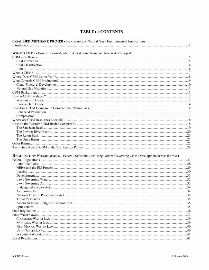
TTAABBLLEE OOFF CCOONNTTEENNTTSS
CCOOAALL BBEEDD MMEETTHHAANNEE PPRRIIMMEERR -- New Source of Natural Gas - Environmental Implications Introduction.........................................................................................................................................................................................1 WWHHAATT IISS CCBBMM?? -- How is it formed, where does it come from, and how is it developed? CBM - the Basics................................................................................................................................................................................5
Coal Formation ..............................................................................................................................................................................5 Coal Classification .........................................................................................................................................................................6 Rank ...............................................................................................................................................................................................6
What is CBM? ....................................................................................................................................................................................7 Where Does CBM Come from?..........................................................................................................................................................8 What Controls CBM Production? .......................................................................................................................................................9
Cleat (Fracture) Development......................................................................................................................................................10 Natural Gas Migration..................................................................................................................................................................11
CBM Background .............................................................................................................................................................................11 How is CBM Produced? ...................................................................................................................................................................12
Western Soft Coals.......................................................................................................................................................................12 Eastern Hard Coals.......................................................................................................................................................................14
How Does CBM Compare to Conventional Natural Gas?................................................................................................................14 Enhanced Production ...................................................................................................................................................................17 Compression.................................................................................................................................................................................17
Where are CBM Resources Located? ...............................................................................................................................................18 How do the Western CBM Basins Compare?...................................................................................................................................18
The San Juan Basin ......................................................................................................................................................................19 The Powder River Basin ..............................................................................................................................................................20 The Raton Basin...........................................................................................................................................................................21 The Unita Basin ...........................................................................................................................................................................21
Other Basins......................................................................................................................................................................................22 The Future Role of CBM in the U.S. Energy Policy.........................................................................................................................24 RREEGGUULLAATTOORRYY FFRRAAMMEEWWOORRKK -- Federal, State and Local Regulations Governing CBM Development across the West Federal Regulations ..........................................................................................................................................................................27
Land Use Plans.............................................................................................................................................................................28 NEPA and the EIS Process ..........................................................................................................................................................29 Leasing.........................................................................................................................................................................................30 Development ................................................................................................................................................................................31 Laws Governing Water ................................................................................................................................................................32 Laws Governing Air.....................................................................................................................................................................33 Endangered Species Act...............................................................................................................................................................34 Antiquities Act .............................................................................................................................................................................34 National Historic Preservation Act ..............................................................................................................................................35 Tribal Resources ..........................................................................................................................................................................35 American Indian Religious Freedom Act.....................................................................................................................................35 Split Estates..................................................................................................................................................................................35
State Regulations ..............................................................................................................................................................................36 State Water Laws ..............................................................................................................................................................................37
COLORADO WATER LAW ..............................................................................................................................................................39 MONTANA WATER LAW ...............................................................................................................................................................39 NEW MEXICO WATER LAW ..........................................................................................................................................................40 UTAH WATER LAW.......................................................................................................................................................................40 WYOMING WATER LAW ...............................................................................................................................................................41
Local Regulations .............................................................................................................................................................................41

iii CBM Primer February 2004
TTAABBLLEE OOFF CCOONNTTEENNTTSS (CONTINUED)
BBEESSTT MMAANNAAGGEEMMEENNTT PPRRAACCTTIICCEESS//MMIITTIIGGAATTIIOONN -- Typical Environmental Impacts vs Mitigation Measures Introduction ......................................................................................................................................................................................43 Beneficial Use...................................................................................................................................................................................44 Resources of Concern .......................................................................................................................................................................44
Air Quality ...................................................................................................................................................................................44 Cultural Resources and Paleontological Resources .....................................................................................................................46 Geology and Minerals..................................................................................................................................................................47 Hydrological Resources ...............................................................................................................................................................48 Lands and Realty..........................................................................................................................................................................49 Livestock Grazing........................................................................................................................................................................50 Recreation ....................................................................................................................................................................................50 Social and Economic Values........................................................................................................................................................51 Soils .............................................................................................................................................................................................51 Solid and Hazardous Wastes........................................................................................................................................................53 Visual Resource Management .....................................................................................................................................................53 Wilderness Study Areas ...............................................................................................................................................................54 Wildlife and Vegetation ...............................................................................................................................................................54 Noxious Weeds ............................................................................................................................................................................57 Aquatic Resources .......................................................................................................................................................................58
Project Planning................................................................................................................................................................................58 Conclusion ........................................................................................................................................................................................60
TTAABBLLEESS TABLE 1 – COAL RESERVES BY STATE ................................................................................................................................................ 8 TABLE 2 – COMPARISON OF PRODUCING CBM BASINS IN THE ROCKY MOUNTAIN REGION ............................................................. 19 TABLE 3 – SPLIT ESTATES ................................................................................................................................................................. 36
FFIIGGUURREESS Figure 1 - Major Coal Basins within the Conterminous United States by Coal Rank ........................................................................ 5 Figure 2 - Sedimentation and the formation of coal ........................................................................................................................... 6 Figure 3 - Composition Changes with Coal Rank .............................................................................................................................. 7 Figure 4 - Coal Bed Matrix illustrating gas surrounding the coal bound by water and rock .............................................................. 8 Figure 5 - Coal Maturation Chart........................................................................................................................................................ 9 Figure 6 - CBM Production Relationship to Hydrostatic Pressure ................................................................................................... 10 Figure 7 - Coal Cleat Orientation...................................................................................................................................................... 10 Figure 8 - Methane Migration Pathways........................................................................................................................................... 11 Figure 9 - CBM Wellbore Diagram.................................................................................................................................................. 12 Figure 10 - Production Plot, Powder River Basin - Production History ........................................................................................... 13 Figure 11 - CBM Drilling Example Vertical .................................................................................................................................... 14 Figure 12 - CBM Drilling Example Horizontal ................................................................................................................................ 15 Figure 13 - Typical CBM Well Construction Diagram .................................................................................................................... 16 Figure 14 - Production of Gas – Coal bed vs Conventional Reservoir ............................................................................................. 16 Figure 15 - Rocky Mountain Region Coal Basins and Estimated CBM Reserves ........................................................................... 18 Figure 16 - General location map and coal rank map of the San Juan Basin.................................................................................... 19 Figure 17 - General location map and coal rank map of the Powder River Basin ............................................................................ 20 Figure 18 - General location map and coal rank map of the Raton Basin ........................................................................................ 21 Figure 19 - General location map and coal rank map of the Uinta Basin ......................................................................................... 22 Figure 20 - General location map of eastern coal basins .................................................................................................................. 23 Figure 21 - Natural Gas Production, Consumption, and Imports...................................................................................................... 24 Figure 22 - BLM RMP Areas for the States of Montana, Wyoming, Utah, Colorado, and New Mexico ........................................ 28 Figure 23 - Class I Areas as designated by the CAA........................................................................................................................ 45
iv CBM Primer February 2004
AACCRROONNYYMMSS AANNDD AABBBBRREEVVIIAATTIIOONNSS
ACEC Area of Critical Environmental Concern APD Application for Permit to Drill ARM Administrative Rules of Montana BACT Best Available Control Technology BCF billion cubic feet bgs below ground surface BIA Bureau of Indian Affairs BLM U.S. Bureau of Land Management BMP Best Management Practice BTU British thermal unit CAA Clean Air Act CBM coal bed methane CEQ Council on Environmental Quality CFR Code of Federal Regulations CFS cubic feet per second CH4 methane
CO carbon monoxide CO2 carbon dioxide
COA Condition of Approval CWA Clean Water Act DEIS Draft Environmental Impact Statement DOE U.S. Department of Energy EA Environmental Assessment EIS Environmental Impact Statement EO Executive Order EPA U.S. Environmental Protection Agency ESA Endangered Species Act FEIS Final Environmental Impact Statement FERC Federal Energy Regulatory Commission FLM Federal land managers FLPMA Federal Land Policy and Management Act FR Federal Register FWS Fish and Wildlife Service (USDI) gpm gallons per minute MBOGC Montana Board of Oil & Gas Conservation MCA Montana Code Annotated MCF thousand cubic feet MOA Memorandum of Agreement MOU Memorandum of Understanding NAAQS National Ambient Air Quality Standards NEPA National Environmental Policy Act NHPA National Historic Preservation Act

v CBM Primer February 2004
AACCRROONNYYMMSS AANNDD AABBBBRREEVVIIAATTIIOONNSS (CONTINUED)
NO2 nitrogen dioxide NOX oxides of nitrogen NOA Notice of Availability NOI Notice of Intent NPDES National Pollutant Discharge Elimination System NPS National Park Service (USDI) NRHP National Register of Historic Places NSO no surface occupancy POD Plan of Development RCRA Resource Conservation and Recovery Act of 1976 RFFA Reasonably Foreseeable Future Actions RFD Reasonably Foreseeable Development RMP Resource Management Plan ROD Record of Decision ROW right-of-way SAR Sodium Adsorption Ratio SHPO State Historic Preservation Office SN Sundary Notice SO2 sulfer dioxide T&E Threatened and Endangered TCF trillion cubic feet TDS total dissolved solids UIC underground injection control U.S. United States U.S.C. United States Code USDI U.S. Department of the Interior USFS U.S. Forest Service (USDA) VRM visual resource management WMP Water Management Plan WQS water quality standards WSA Wilderness Study Area
AATTTTAACCHHMMEENNTTSS DDEEFFIINNIITTIIOONNSS..........................................................................................................................................................................................................................................................................................................................................................DD--11 RREEFFEERREENNCCEESS.......................................................................................................................................................................................................................................................................................................................................................... RR--11
vi CBM Primer February 2004

1 CBM Primer February 2004
CCOOAALL BBEEDD MMEETTHHAANNEE PPRRIIMMEERR New Source of Natural Gas - Environmental Implications
INTRODUCTION
uring the second half of the 1990s Coal Bed Methane (CBM) production increased dramatically to represent a significant new source of natural gas for many Western states. Matching these
soaring production rates during this period was a heightened public awareness of environmental concerns. These concerns have created a significant growth in public involvement, which has generated thousands of comments resulting in the inconsistent prioritization of concerns and resources protection efforts. The accelerating interest in CBM development coupled with growth in public involvement has prompted the creation of this CBM Primer.
The Primer is designed to serve as a summary document, which introduces and encapsulates information pertinent to the development of CBM. The discussions focus on coal deposits, methane as a naturally formed gas, split mineral ownership, development techniques, operational issues, producing methods, applicable regulatory frameworks, land and resource management, mitigation measures, preparation of project plans, data availability, Indian Trust issues and relevant environmental technologies.
An important aspect of this CBM Primer involves the sharing of information with a broad array of stakeholders, including land and mineral owners, regulators, conservationists, tribal governments, special interest groups, and numerous others that could be affected by the development of CBM within their vicinity. Perhaps the most crucial aspect of successfully developing CBM resources and instituting appropriate environmental protection measures is public awareness, information sharing, and acceptance.
The current image of CBM that exists is dependent on the stakeholders’ perspective of energy development versus environmental protection. There is significant diversity in the view points expressed by nearly all stakeholders, including industry, government, special interest groups, and land owners. The primer is designed to serve as an accessory to public discussions that will contribute to policy making decisions by examining the current CBM development practices throughout the Western U.S. and by discussing mitigation measures and more environmentally friendly development methods from various CBM areas.
D
“America must have an energy policy that
plans for the future, but meets the needs of
today. I believe we can
develop our natural resources and protect
our environment.” -President George W. Bush

2 CBM Primer February 2004
The Primer sections focus on the following areas:
Section 1 – What is CBM? How is it formed? Where does it come from? How is it developed? This section provides the backdrop and circumstances for outlining the issues encompassing CBM formation and production, including coal seams and how they originate; the general location of CBM basins in the United States; the various development techniques, operational issues and production methods used based on regional conditions; and the position CBM serves in meeting our current and future national energy requirements.
Section 2 – Regulatory framework. This section addresses federal, state and local regulations governing the development of CBM across the west; analyzes existing regulations guiding CBM development, including regionally specific Plan of Development variances; identifies federal land and resource management practices, Indian Trust Issues, surface owner agreements and local land uses per region; and the state oil and gas programs including typical lease stipulations and field rules.
Section 3 – Best Management Practices and Mitigation. Section three identifies the typical environmental effects associated with CBM development in the west and the mitigation measures employed to address these effects. Focus is on the results of production and distribution affecting natural resources to local populations, and the tension between opposing land uses and land users. Vital to this discussion are the potential effects of CBM extraction on water quality and quantity, and the numerous mitigation measures employed to control and eliminate these effects.
Coal bed methane is a clean-burning energy source well suited as a fuel for production of electricity, residential and commercial heating, and as a vehicle fuel. CBM currently supplies approximately eight percent of the nation’s natural gas production, and is an important facet of the nation’s energy mix. United States CBM production grew by 13 percent in 2001 to 1.562 Trillion cubic feet (Tcf). (EIA 2001). CBM will become more important as the demand for natural gas increases, and the focus on domestic production is heightened due to the deregulation of electricity and the tension over international energy supplies. As illustrated in the figure on the left, natural gas consumption is outpacing production. However, CBM production has the potential to significantly reduce this gap, if development can continue to increase at the rates observed between 1998 and 2001.
The extraordinarily dramatic growth of CBM development has created comprehensive challenges for communities

3 CBM Primer February 2004
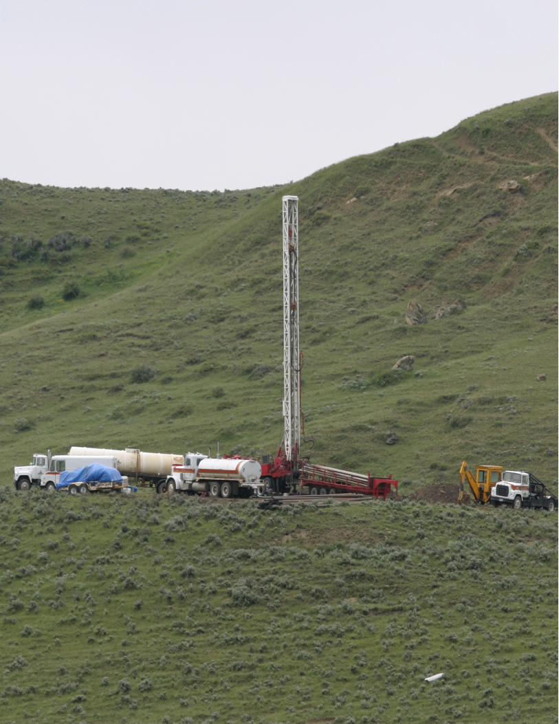
Agricultural irrigation in Wyoming
throughout the Rocky Mountain region. The development of CBM infrastructure including construction of utility right-of-ways, pipelines, new roads, compressor stations, water conveyance and storage systems, and other facilities have affected rural communities.
Another issue responsible for many disputes is split estates - land owners who hold only surface rights may have government agencies such as the BLM or State Trust Land departments leasing the subsurface mineral rights to one or many development companies. CBM development plans can be opposed by many farmers, ranchers, hunting and fishing outfitters, environmentalists, recreational users, homeowners, and others who use the land for their specific purposes. Increases in exhaust gases and noise levels have also created strife between residents and the CBM industry.
Beyond the land use disputes and affecting nearly all Rocky Mountain citizens are the concerns associated with produced water from CBM development. CBM produced water has the potential to affect groundwater quantity and quality. Coal seam aquifers may have competing water rights and be diminished as CBM production increases. Surface water quality could be altered by mineral-laden discharge, and agricultural productivity of soils could be reduced by irrigating with altered surface water. Riparian ecosystems may be negatively affected by the release of large quantities of produced water. Some produced water, on the other hand, has the potential to be a prized source of fresh water in many arid regions.
The development of CBM throughout the Rocky Mountain Region is a major issue facing citizens, special interest groups, federal land management agencies, state governments, Tribal governments, county commissions, and energy companies. The major challenge is obtaining a balance between the development of this important resource and environmental protection while maintaining the local culture. This can be done by sharing the responsibilities for governing the development by federal, state, Tribal and local governments. These governments have varying and often competing interests and responsibilities for regulating CBM production. The coordination between these agencies will be essential to the balance and will ultimately influence the pace of development.
It is envisioned the Primer will be used by a variety of stakeholders to present a consistent and complete synopsis of the key issues involved with CBM. This primer is intended to add focus to the public discussion and policy making for CBM development by offering a comprehensive, user-friendly overview that clarifies what CBM is and how it is produced, analyzes and evaluates the knowledge gained from various CBM developments throughout the Rocky Mountains, provides options for addressing conflicts, and improves policies that regulate CBM development. This primer also recognizes lessons-learned from different basins and various environmental groups and producers that could resolve similar challenges posed by development in other areas.
4 CBM Primer February 2004

5 CBM Primer February 2004
WWHHAATT IISS CCBBMM??
How is it formed, where does it come from, and how is it developed? CBM - THE BASICS
oal Bed Methane (CBM) is an important facet of the nation’s energy mix. While currently supplying approximately eight percent of the
nation’s natural gas, CBM is expected to increase in importance (EIA 2001). Natural gas is a clean-burning energy source well suited as a boiler fuel, vehicle fuel, and for heating residences as well as large structures. CBM is a non-conventional hydrocarbon resource that fundamentally differs in its accumulation processes and production technology when compared to conventional natural gas resources. The following paragraphs detail the formation of coal and CBM.
Coal Formation
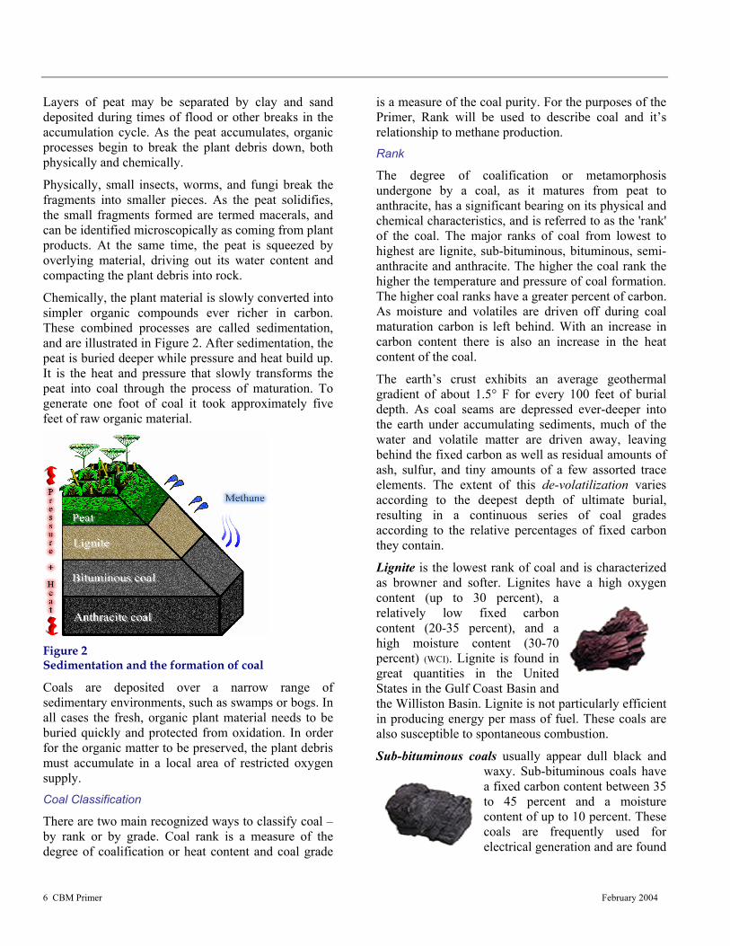
Coal is a sedimentary rock that had its origin on the surface of the earth as an accumulation of inorganic and organic debris. Major coal basins across the United States are depicted in Figure 1 below. Coal is predominantly made up of organic plant material, in particular ancient wood, leaves, stems, twigs, seeds, spores, pollen, and other parts of aquatic and land plants. When the debris first begins to pile up it is termed peat; the earth’s crust subsides, and more sediments are piled on top of the organic material, causing it to sink ever deeper into the sedimentary layer.
C
Figure 1 Major Coal Basins within the Contiguous United States by Coal Rank
6 CBM Primer February 2004
Layers of peat may be separated by clay and sand deposited during times of flood or other breaks in the accumulation cycle. As the peat accumulates, organic processes begin to break the plant debris down, both physically and chemically.
Physically, small insects, worms, and fungi break the fragments into smaller pieces. As the peat solidifies, the small fragments formed are termed macerals, and can be identified microscopically as coming from plant products. At the same time, the peat is squeezed by overlying material, driving out its water content and compacting the plant debris into rock.
Chemically, the plant material is slowly converted into simpler organic compounds ever richer in carbon. These combined processes are called sedimentation, and are illustrated in Figure 2. After sedimentation, the peat is buried deeper while pressure and heat build up. It is the heat and pressure that slowly transforms the peat into coal through the process of maturation. To generate one foot of coal it took approximately five feet of raw organic material.
Figure 2 Sedimentation and the formation of coal
Coals are deposited over a narrow range of sedimentary environments, such as swamps or bogs. In all cases the fresh, organic plant material needs to be buried quickly and protected from oxidation. In order for the organic matter to be preserved, the plant debris must accumulate in a local area of restricted oxygen supply. Coal Classification
There are two main recognized ways to classify coal – by rank or by grade. Coal rank is a measure of the degree of coalification or heat content and coal grade
is a measure of the coal purity. For the purposes of the Primer, Rank will be used to describe coal and it’s relationship to methane production. Rank
The degree of coalification or metamorphosis undergone by a coal, as it matures from peat to anthracite, has a significant bearing on its physical and chemical characteristics, and is referred to as the 'rank' of the coal. The major ranks of coal from lowest to highest are lignite, sub-bituminous, bituminous, semi-anthracite and anthracite. The higher the coal rank the higher the temperature and pressure of coal formation. The higher coal ranks have a greater percent of carbon. As moisture and volatiles are driven off during coal maturation carbon is left behind. With an increase in carbon content there is also an increase in the heat content of the coal.
The earth’s crust exhibits an average geothermal gradient of about 1.5° F for every 100 feet of burial depth. As coal seams are depressed ever-deeper into the earth under accumulating sediments, much of the water and volatile matter are driven away, leaving behind the fixed carbon as well as residual amounts of ash, sulfur, and tiny amounts of a few assorted trace elements. The extent of this de-volatilization varies according to the deepest depth of ultimate burial, resulting in a continuous series of coal grades according to the relative percentages of fixed carbon they contain.
Lignite is the lowest rank of coal and is characterized as browner and softer. Lignites have a high oxygen content (up to 30 percent), a relatively low fixed carbon content (20-35 percent), and a high moisture content (30-70 percent) (WCI). Lignite is found in great quantities in the United States in the Gulf Coast Basin and the Williston Basin. Lignite is not particularly efficient in producing energy per mass of fuel. These coals are also susceptible to spontaneous combustion.
Sub-bituminous coals usually appear dull black and waxy. Sub-bituminous coals have a fixed carbon content between 35 to 45 percent and a moisture content of up to 10 percent. These coals are frequently used for electrical generation and are found

7 CBM Primer February 2004
Figure 3 Composition Changes with Coal Rank
throughout the west in the Black Mesa, Bighorn, Denver, Greater Green River, North Central Montana, Powder River, San Juan and Wind River basins (WCI).
Bituminous coals are dense black solids, frequently containing bands with brilliant colors. The carbon content of these coals ranges from 45 to 80 percent and the water content from 1.5 to 7 percent (WCI). Major deposits of bituminous coals are found in the central United States in the Appalachian, Arkoma, Black Warrior, Cherokee, Forest City, Illinois, Maverick, Michigan, Raton and Southwestern basins. The coals are well suited for the production of metallurgical coke, power generation, cement making, and to provide heat and steam in industry.
Because of their higher fixed carbon content and lower moisture content, bituminous coals contain more energy per pound than sub-bituminous coals, which in turn contain more energy than lignite coal. In the U.S., this heat energy is typically expressed as BTU's (British Thermal Units) per pound. A typical pound of bituminous coal will yield about 10,500 to 12,000 BTU's of energy. Figure 3 illustrates the composition changes associated with coal rank.
Anthracite is dense, hard and shiny and defined as having more than 86% fixed carbon and less than 14% volatile matter on a dry, mineral-matter-free basis. The rank is divided into semi-anthracite, anthracite, and meta-anthracite groups on the basis of increasing fixed
carbon and decreasing volatile matter. Anthracite coals are relatively uncommon representing less than 1% of all world coal reserves. The high carbon and energy content coupled with being a relatively hard material and clean burning makes anthracite a desired product. The value-added anthracite products are used in carbon filtration water purification and space heating. Anthracite is also used as a reductant in metallurgical processing, pulverized coal injection for steel making, in cooking and heating briquettes, and as fuel used in the manufacture of cement and generation of electricity. WHAT IS CBM?
Coal Bed Methane is naturally occurring methane (CH4) with small amounts of other hydrocarbon and non-hydrocarbon gases contained in coal seams as a result of chemical and physical processes. It is often produced at shallow depths through a bore-hole that allows gas and large volumes of water with variable quality to be produced. Shallow aquifers, if present, need to be protected but in the Rocky Mountain Region, the producing coal bed is often a source of water for both livestock and human consumption. CBM resources represent valuable volumes of natural gas within and outside of areas of conventional oil & gas production. Many coal mining areas currently support CBM production; other areas containing coal resources are expected to produce significant volumes of natural gas in the near future.
CBM is intimately associated with coal seams that represent both the source and reservoir. Significant reserves of coal underlie approximately 13% of the U.S. landmass as shown in Figure 1. Coals have an immense amount of surface area and can hold enormous quantities of methane. Since coal seams have large internal surfaces, they can store on the order of six to seven times more gas than the equivalent volume of rock in a conventional gas reservoir (USGS 1997). CBM exists in the coal in three basic states: as free gas; as gas dissolved in the water in coal; and as gas “adsorped” on the solid surface of the coal.
Coal varies considerably in terms of its chemical composition, its permeability, and other characteristics. Some kinds of organic matter are more suited to produce CBM than are others. Permeability is a key characteristic, since the coal seam must allow the gas to move once the water pressure is reduced.
8 CBM Primer February 2004
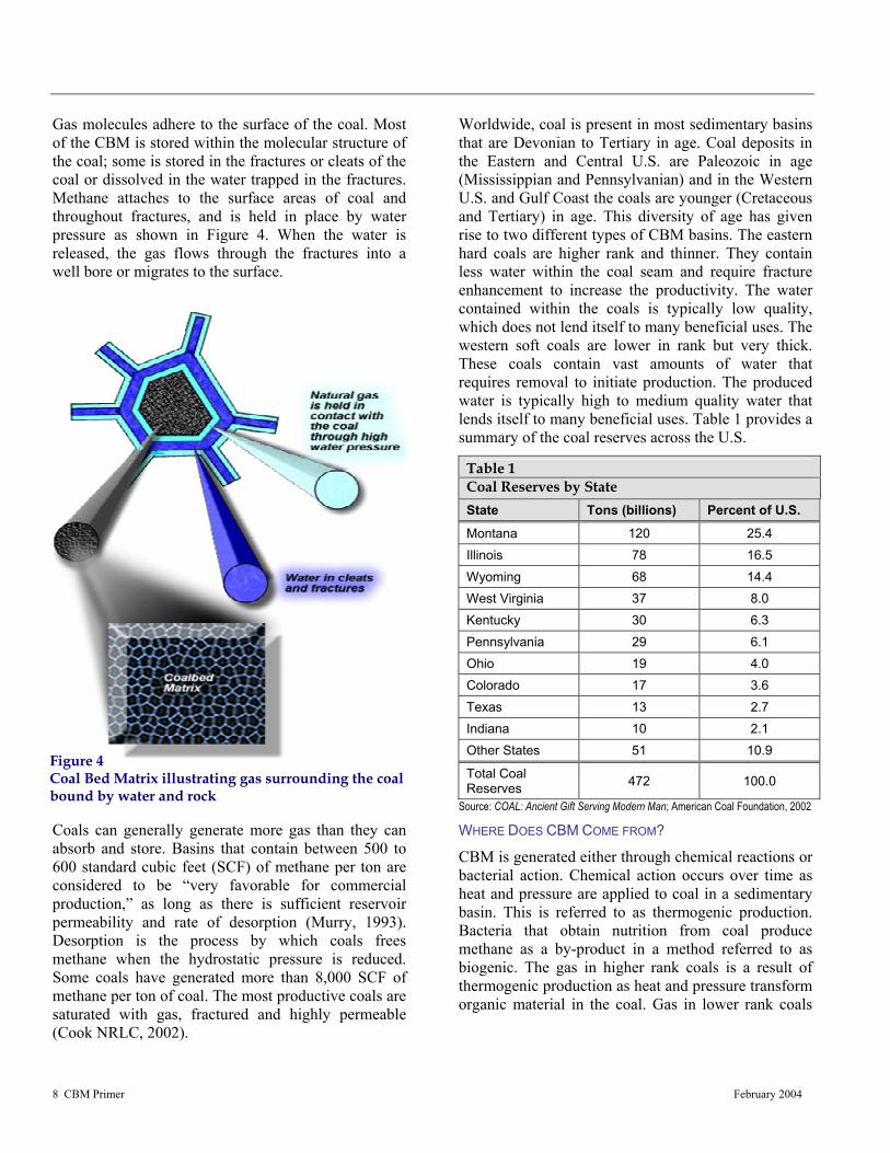
Figure 4 Coal Bed Matrix illustrating gas surrounding the coal bound by water and rock
Gas molecules adhere to the surface of the coal. Most of the CBM is stored within the molecular structure of the coal; some is stored in the fractures or cleats of the coal or dissolved in the water trapped in the fractures. Methane attaches to the surface areas of coal and throughout fractures, and is held in place by water pressure as shown in Figure 4. When the water is released, the gas flows through the fractures into a well bore or migrates to the surface.
Coals can generally generate more gas than they can absorb and store. Basins that contain between 500 to 600 standard cubic feet (SCF) of methane per ton are considered to be “very favorable for commercial production,” as long as there is sufficient reservoir permeability and rate of desorption (Murry, 1993). Desorption is the process by which coals frees methane when the hydrostatic pressure is reduced. Some coals have generated more than 8,000 SCF of methane per ton of coal. The most productive coals are saturated with gas, fractured and highly permeable (Cook NRLC, 2002).
Worldwide, coal is present in most sedimentary basins that are Devonian to Tertiary in age. Coal deposits in the Eastern and Central U.S. are Paleozoic in age (Mississippian and Pennsylvanian) and in the Western U.S. and Gulf Coast the coals are younger (Cretaceous and Tertiary) in age. This diversity of age has given rise to two different types of CBM basins. The eastern hard coals are higher rank and thinner. They contain less water within the coal seam and require fracture enhancement to increase the productivity. The water contained within the coals is typically low quality, which does not lend itself to many beneficial uses. The western soft coals are lower in rank but very thick. These coals contain vast amounts of water that requires removal to initiate production. The produced water is typically high to medium quality water that lends itself to many beneficial uses. Table 1 provides a summary of the coal reserves across the U.S.
Source: COAL: Ancient Gift Serving Modern Man; American Coal Foundation, 2002
WHERE DOES CBM COME FROM?
CBM is generated either through chemical reactions or bacterial action. Chemical action occurs over time as heat and pressure are applied to coal in a sedimentary basin. This is referred to as thermogenic production. Bacteria that obtain nutrition from coal produce methane as a by-product in a method referred to as biogenic. The gas in higher rank coals is a result of thermogenic production as heat and pressure transform organic material in the coal. Gas in lower rank coals
Table 1 Coal Reserves by State State Tons (billions) Percent of U.S.
Montana 120 25.4 Illinois 78 16.5 Wyoming 68 14.4 West Virginia 37 8.0 Kentucky 30 6.3 Pennsylvania 29 6.1 Ohio 19 4.0 Colorado 17 3.6 Texas 13 2.7 Indiana 10 2.1 Other States 51 10.9
Total Coal Reserves 472 100.0

9 CBM Primer February 2004
Peat
Lignite
Sub-Bituminous
High
Volatile
Bituminous
Med
Volatile
Bituminous
Low
Volatile
Bituminous
Semi-Anthracite
Anthracite
Ethane Plus
(C2 +)
BiogenicMethane (C1)
Thermogenic Methane (C1)
CO2
Nitrogen
Expelled Water
RO
0.40
0.50
2.0
1.50
1.10
Figure 5 Coal Maturation Chart
results from the decomposition of organic matter by bacteria.
Typically, the deeper the coal bed, the less the volume of water in the fractures, but the more saline the water becomes. The volume of gas typically increases; with coal rank, how far underground the coal bed is located, and the reservoir pressure (USGS 2000). Natural desorption occurs when the fracture system releases water, the adsorptive capacity of the coal is exceeded, pressure falls, and the gas trapped in the coal matrix begins to desorb and move to the empty spaces in the fracture system. The gas remains stored in the fracture system or in nearby non-coal reservoirs until it is extracted.
As coals mature from peat to anthracite, the associated fluids transform as well. Low rank peat and lignite have high porosities, high water content, and produce low temperature biogenic methane and few other fluids. As coals mature into bituminous types, water is expelled, porosity decreases, and biogenic methane formation decreases, because temperatures rise above the most favorable range for bacteria. At the same time, heat breaks down complex organic compounds to release methane and heavier hydrocarbons (ethane and higher). Inorganic gases may also be generated by the thermal breakdown of coals.
As the coal matures to anthracite, less methane is
generated and little porosity or water remains in the matrix. The chart below (Figure 5) lists the steps in the maturation of coal from peat to anthracite and the fluid generated and expelled during the maturation process. Peat, largely unaltered plant debris, and lignite (“brown coal”) can give rise to biogenic methane, produced by methanogenic bacteria. Minor production of CBM has been reported from lignite in North Dakota and Louisiana. CBM production in most of the Western U.S. comes from sub-bituminous and bituminous coals. CBM in the Eastern U.S. originates in higher rank coals. WHAT CONTROLS CBM PRODUCTION?
CBM production potential is a product of several factors that vary from basin to basin – fracture permeability, development, gas migration, coal maturation, coal distribution, geologic structure, CBM completion options, hydrostatic pressure and produced water management. In most areas, naturally developed fracture networks are the most sought after areas for CBM development. Areas where geologic structures and localized faulting have occurred tend to induce natural fracturing, which increases the production pathways within the coal seam. This natural fracturing reduces the cost of bringing the producing wells on line.
Most coals contain methane, but it cannot be economically produced without open fractures present to provide the pathways for the desorbed gas to migrate to the well. As long as the pressure exerted by the water table is greater than that of the coal the methane remains trapped in the coal bed matrix. Coal cleats and fractures are usually saturated with water, and therefore the hydrostatic pressure in the coal seam must be lowered before the gas will migrate.
Lowering the hydrostatic pressure in the coal seam accelerates the desorption process. CBM wells initially produce water primarily; gas production eventually increases, and as it does water production declines. Some wells do not produce any water and begin producing gas immediately, depending on the nature of the fracture system. Once the gas is
released, it is usually free of any impurities; is of

10 CBM Primer February 2004
Figure 7 Coal Cleat Orientation
Figure 6 CBM Production Relationship to Hydrostatic Pressure
sufficient quality and can be easily prepared for pipeline delivery.
Some coals may never produce methane if the hydrostatic pressure cannot be efficiently lowered. Some coal seams may produce gas, but are too deep to economically drill. CBM wells are typically no more than 5000’ in depth, although some deeper wells have been drilled. Figure 6 illustrates the relationship between hydrostatic pressure, coal seam depth and well location.
Cleat (Fracture) Development
Coal contains porosity but very little matrix permeability. In order for fluids to be produced out of coal seams into a well-bore, the coal must possess a system of secondary permeability such as fractures. Fractures allow water, and natural gas to migrate from matrix porosity toward the producing well. Cleat is the term used for the network of natural fractures that form in coal seams as part of the maturation of coal. Cleats form as the result of coal dehydration, local and regional stresses, and unloading of overburden. Cleats largely control the directional permeability of coals
and therefore are highly important for CBM exploitation through well placement and spacing.
Two orthogonal sets of cleats develop in coals perpendicular to bedding. The face cleats are the dominant set that are more continuous and more laterally extensive; face cleats form parallel to maximum compressive stress and perpendicular to fold axes of the coal bed. The butt cleats are secondary and can be seen to terminate against face cleats. Butt cleats are strain-release fractures that form parallel to
fold axes. Figure 7 shows the cleat orientation.
Cleat spacing is related to rank, bed thickness, maceral composition, and ash content. Coals with well-developed cleat sets are brittle reflecting fracture density. In general, cleats are more tightly spaced with increasing coal rank. Average cleat spacing values for three coal grades include: sub-bituminous (2-15 cm), high-volatile bituminous (0.3-2 cm), and medium- to low-volatile bituminous (<1 cm) (Cardott, 2001). Cleat spacing is tighter in thin coals, in vitrinite-rich coals, and in low-ash coals.

11 CBM Primer February 2004
Figure 8 Methane Migration Pathways
Natural Gas Migration
In coal seams, most gas is absorbed by the microscopic laminations and micropores within coal macerals. As hydrostatic pressure is decreased by water production, gas desorbs and moves into the cleat system where it begins to flow towards the producing well, as diagrammed in Figure 8.
Natural gas can also migrate through more wide-spread fracture sets related to faults and tectonic jointing. Faults can persist over several miles and are related to geologic movement and structure, and can enhance the migration pathways for the methane in the subsurface.
Coals can be analyzed for adsorbed gas content using standardized techniques that mechanically pulverize the core samples. The gas content figures range from several hundred standard cubic feet (scf) per ton to less than 50 scf per ton of coal. The test results cannot be directly equated with ultimate recoverable CBM reserves since not all the gas can be desorbed and produced from the coal. Methane content values in producing basins range from around 800 scf per ton in Oklahoma, to 450 scf per ton in the San Juan Basin, and to an average of 40 scf per ton in the Powder River Basin. CBM BACKGROUND
CBM development has its roots in the coal mining industry. Attempts to develop marketable CBM began in the United States in the 1970s, as a result of the U.S. Bureau of Mines’ efforts to improve mine safety by
extracting methane in advance of mining operations. As recently as 1982, CBM production in the United States was practically non-existent. In 1983, the Gas Research Institute commenced field investigations that motivated the expansion of CBM recovery. At the end of 1983, annual CBM production was nearly 6 Bcf (billion cubic feet) from about 165 wells. By 1994, it had grown to 85.1 Bcf from more than 6,000 wells, and by 1999, there were 14,000 wells producing roughly 1,252 Bcf.
In 1980, Congress enacted a tax credit to promote domestic production from alternative sources, including CBM. Known as the Section 29 tax credit (section 29 of the 1980 Crude Oil Windfall Profit Tax Act), the requirement has two limits: the gas needs to be sold to an unconnected group, and the tax credit can only be applied to wells brought on line before Dec 31, 1992. The credit, valued at $3 barrel of oil or Btu equivalent, ended on December 31, 2000, however the tax credit was modified and extended in both the House and Senate energy bills that the two chambers passed in 2001 and 2002, respectively. The greatest increase in development, however, didn’t begin until approximately 1988. This was due to the 1980 tax incentives being put in place by the Congress coupled with improved production techniques.
Currently, there are thousands of CBM wells in the United States, and active exploration, development, and/or production is being carried out in Alabama, Alaska, Arkansas, Arizona, Colorado, Illinois, Indiana, Kansas, Kentucky, Louisiana, Montana, Nebraska, New York, North Dakota, Oklahoma, Pennsylvania, Texas, Utah, Virginia, Washington, West Virginia and Wyoming. To date almost 88 percent of the United States total CBM production is from the Rocky Mountain region encompassing Colorado, Montana, New Mexico, Utah and Wyoming (EIA 2001)
The San Juan Basin in Northern New Mexico and Southern Colorado has contributed the most to CBM production and is the most extensively developed basin in the region. Exploration and development began in the late 1980s and quickly grew throughout the 1990s. Production is nearing its peak in the basin, but companies are trying to maintain recovery with new production enhancement methods and reduced well spacing.
The Powder River Basin in eastern Wyoming and southeastern Montana is currently the fastest growing

12 CBM Primer February 2004
Figure 9 CBM Wellbore Diagram--Open-hole Completion Example from Powder River Basin
basin for CBM development. In 1997 there were 360 wells producing 54 million cubic feet (MMcf) of gas/day, by the end of 2002, 935 MMcf/day was being produced from 10,991 wells. During the past 12 months an additional 5400 Applications for Permit to Drill (APDs) have been submitted (http://wdogcc.state.wy.us April 2003). Significant CBM resources in the Rocky Mountains have also been identified in the Raton Basin in central Colorado, the Piceance Basin in northwestern Colorado, the Unita Basin in Eastern Utah, Kaiparowits Plateau Basin in Southern Utah, Hanna-Carbon Basin in south-central Wyoming and the Greater Green River Basin in southwestern Wyoming.
It has been estimated that the Rocky Mountain basins contain as much as 595 Trillion cubic feet (Tcf) of CBM, (GTI 2000). The technically recoverable amount
may currently be less than one quarter of that volume, but with improved methods and enhanced recovery techniques CBM in the Rocky Mountains will remain an important source of natural gas.
CBM production continues to advance across North America as operators develop new techniques for drilling and producing coal seams of different rank and quality. It is anticipated that production will only increase as the demand for natural gas continues to increase. HOW IS CBM PRODUCED?
CBM wells are completed in several ways, depending upon the type of coal in the basin and fluid content. Each type of coal (sub-bituminous to bituminous) offers production options that are different due to the inherent natural fracturing and competency of the coal
seams. The sub-bituminous coals are softer and less competent than the higher rank low-volatile bituminous coals, and therefore are typically completed and produced using more conventional vertical well bores. The more competent higher rank coals lend themselves to completions using horizontal as well as vertical well bores. Western Soft Coals
The coals found mostly in the Western U.S. are frequently sub-bituminous in rank and although competent enough to be completed and produced open-hole, they are often too soft to allow the use of horizontal wellbores with any major success to date. Figure 9 provides a typical well completion for CBM production wells in the Western U.S. The well is drilled to the top of the target coal seam and production casing is set and cemented back to surface. The coal seam is then drilled-out and under-reamed to open up more coal face to production. The borehole and coal face are then cleaned with a slug of formation water pumped at a high rate (water-flush). In areas where the cleat or natural fracture system is not fully developed, the coal may be artificially fractured using a low-pressure water fracture treatment.
13 CBM Primer February 2004
Three CBM wells finished with surface enclosures in the Powder River Basin
These shallow wells are typically drilled with a small mobile rig mounted on a truck. For example, most wells in the Powder River basin are drilled in under a week and have a residual foot print of approximately ¼ acre. Spacing between wells is currently 80 acres in the Powder River Basin but can be as much as 320 acres (San Juan Basin) depending on the coal bed characteristics.
Once the well is completed, a submersible pump is run into the well on production tubing to pump the water from the coal seam. By removing the water from the coal seam the formation water pressure is reduced and the methane is desorbed (released) from the coal, thus initiating production. The methane flows up both the casing and tubing of the well and is sent via pipe to a gas/water separator at the compression station. The methane is then compressed for shipment to the sales
pipeline. In most western soft coal areas only one coal seam is produced in each well.
Attempts at producing more than one coal seam per well have been mostly unsuccessful due to the inherent problem of lowering the water level in each coal seam independent of each other. Size constraints of the production equipment and use of submersible pumps make the use of dual completion complicated and expensive. With CBM production wells typically being so shallow, it is less expensive and less complicated to drill wells into each coal seam independently than to use dual or triple completion well systems.
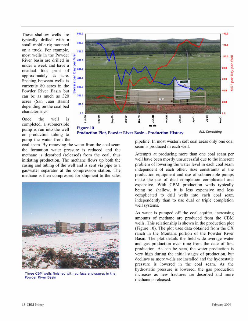
As water is pumped off the coal aquifer, increasing amounts of methane are produced from the CBM wells. This relationship is shown in the production plot (Figure 10). The plot uses data obtained from the CX ranch in the Montana portion of the Powder River Basin. The plot details the field-wide average water and gas production over time from the date of first production. As can be seen, the water production is very high during the initial stages of production, but declines as more wells are installed and the hydrostatic pressure is lowered in the coal seam. As the hydrostatic pressure is lowered, the gas production increases as new fractures are desorbed and more methane is released.
Figure 10 Production Plot, Powder River Basin - Production History

14 CBM Primer February 2004
Eastern Hard Coals
The coals found in the eastern portions of the U.S. are often higher rank medium to low volatile bituminous coals. While these coals are very competent and can be completed open hole, these coals are often drilled and cased to total depth. Wells are then perforated and stimulated to remove damage caused by drilling and to enhance fracturing near the wellbore. However, many of the eastern coals do not have significant water to be removed from the coal to initiate methane production. As such, several coal seams are often perforated in a single bore-hole. Figure 11 provides an example of vertical well bore completed in multiple coal seams.
Eastern hard coals are often exploited by way of horizontal drain-holes from a single bore-hole. Each individual well may have up to 3,500-feet of lateral extent within a single coal seam. Several laterals can be drilled from a single wellbore to exploit several seams or to take advantage of several cleat (fracture) trends. Each leg would not necessarily be horizontal but would closely follow the dip of the individual seam. Many of the coal seams are often less than five-feet thick, requiring the drilling contractor to exercise great care in steering the drill bit. Figure 12 illustrates an example of this method. Operators in Alabama, Arkansas, and Oklahoma have made use of horizontal laterals to enhance CBM production.
The production of CBM from eastern coals is similar to the western coals except for the use of horizontal well bores and the extensive use of fracturing to enhance production. With the coals being of higher rank, the methane content per ton of coal is typically higher, but requires in many areas additional enhancement to the natural fracture content to maximize production. Production rates of CBM depend upon local gas content of the coal, local permeability of the coals, hydrostatic pressure in the coal seam aquifer, completion techniques, and production techniques.
HOW DOES CBM COMPARE TO CONVENTIONAL NATURAL GAS?
Methane is the chief component of natural gas, and CBM can be used in very much the same way as conventional gas. Conventional gas is formed in limestone and shale formations; pressure and temperature unite to transform organic matter into hydrocarbons over time, similar to thermogenic production in deeper coals. Natural gas migrates upward until trapped by a geologic barrier or fault and remains in this reservoir until it is discovered and drilled, or released by some natural means. Conventional gas wells are typically 4,000 to 12,000
Figure 11 CBM Drilling Example Vertical Wellbore Example from Cherokee Basin, Kansas

15 CBM Primer February 2004
Figure 12 CBM Drilling Example Horizontal Wellbore Example from Arkoma Basin
feet deep and extract gas from sandstone and shale formations (PRCBMIC, 2002). The location and extent of conventional gas typically requires exploratory drilling since the location of reservoirs is not apparent from the surface (Cullicott et al., 2002). Coal bed wells are generally considered shallow and range from 400 to 1,500 feet in the Powder River basin but can be as deep as 5,000 feet in some basins.
CBM is occasionally compared to another unconventional gas—“tight” gas—which is found at deeper depths and in low permeability sandstones. Companies often use hydraulic fracturing, injecting fluid into the rock formation to cause cracking in anticipation of releasing gas from tight sands (Kelly, 2001). Fracturing is also used in some CBM seams to increase production, as previously explained. CBM differs from conventional natural gas in other
important ways. CBM is held in an adsorbed form on the surface of the coal; reservoir pressure must be reduced before CBM can be produced in significant quantities; and water is typically present in the reservoir and is usually co-produced with the CBM (Fidelity, 2002).
The economic feasibility of CBM compared to conventional natural gas is typically affected by four primary variables: the production cost, the rate of gas production, hub price, and economies of scale (Boyer, 1999).
Most CBM wells are shallow (less than 5,000 feet) and can be constructed in a short amount of time resulting in low to moderate well costs in comparison to conventional natural gas.
The volume and rate of gas production from CBM wells may fluctuate significantly unlike conventional gas, which is often more consistent once tapped. Minimum or low gas CBM producers yield about 50 thousand cubic feet (mcf) per day; high yield
wells produce as much as 5 MMcf per day (Williams, 2001).
The location of the CBM production field with respect to the regional or interstate transmission pipelines also affects the economics of CBM development. The gas hub price, minus production and transportation costs, equal the wellhead net back price. In some areas, the transportation costs may be as much as the wellhead net back price.
The economy of scale refers to the number of wells or field size that has to be reached in order for the company to make a profit. Costs affecting the economic viability of CBM developments include compression, gas treatment, geologic and engineering services, transmission of gas and field operations. The minimum number of wells or volume of gas produced for a feasible project therefore depends on a diversity of issues.
Conventional natural gas wells produce large volumes of gas initially and then taper off over time as water production steadily increases; the exact opposite is true
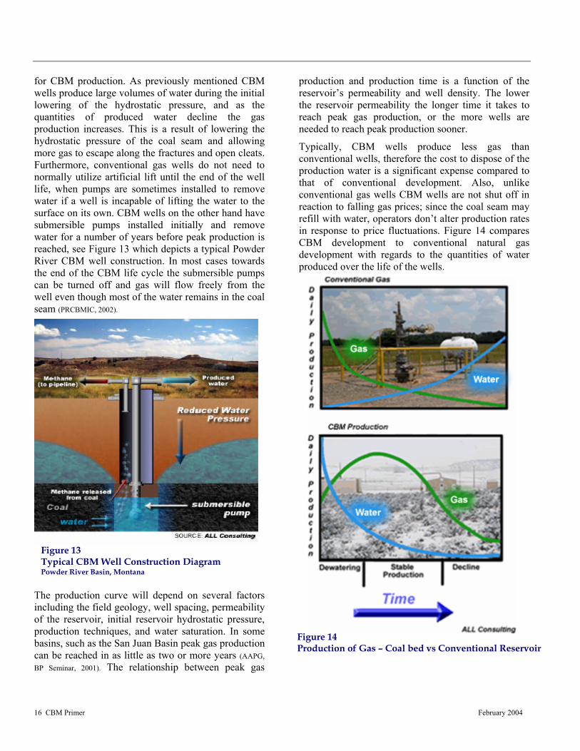
16 CBM Primer February 2004
Figure 13 Typical CBM Well Construction Diagram Powder River Basin, Montana
Figure 14 Production of Gas – Coal bed vs Conventional Reservoir
for CBM production. As previously mentioned CBM wells produce large volumes of water during the initial lowering of the hydrostatic pressure, and as the quantities of produced water decline the gas production increases. This is a result of lowering the hydrostatic pressure of the coal seam and allowing more gas to escape along the fractures and open cleats. Furthermore, conventional gas wells do not need to normally utilize artificial lift until the end of the well life, when pumps are sometimes installed to remove water if a well is incapable of lifting the water to the surface on its own. CBM wells on the other hand have submersible pumps installed initially and remove water for a number of years before peak production is reached, see Figure 13 which depicts a typical Powder River CBM well construction. In most cases towards the end of the CBM life cycle the submersible pumps can be turned off and gas will flow freely from the well even though most of the water remains in the coal seam (PRCBMIC, 2002).
The production curve will depend on several factors including the field geology, well spacing, permeability of the reservoir, initial reservoir hydrostatic pressure, production techniques, and water saturation. In some basins, such as the San Juan Basin peak gas production can be reached in as little as two or more years (AAPG, BP Seminar, 2001). The relationship between peak gas
production and production time is a function of the reservoir’s permeability and well density. The lower the reservoir permeability the longer time it takes to reach peak gas production, or the more wells are needed to reach peak production sooner.
Typically, CBM wells produce less gas than conventional wells, therefore the cost to dispose of the production water is a significant expense compared to that of conventional development. Also, unlike conventional gas wells CBM wells are not shut off in reaction to falling gas prices; since the coal seam may refill with water, operators don’t alter production rates in response to price fluctuations. Figure 14 compares CBM development to conventional natural gas development with regards to the quantities of water produced over the life of the wells.
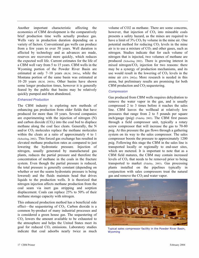
17 CBM Primer February 2004
Typical sales compressor facility in the Powder River Basin, Wyoming
Another important characteristic affecting the economics of CBM development is the comparatively brief production time wells actually produce gas. Wells vary in production duration depending on a variety of factors. Conventional gas wells can produce from a few years to over 50 years. Well duration is affected by technology and as advances are made, reserves are recovered more quickly, which reduces the expected well life. Current estimates for the life of a CBM well vary from 5 to 15 years. CBM wells in the Wyoming portion of the Powder River Basin are estimated at only 7–10 years (BLM, 2003a), while the Montana portion of the same basin was estimated at 10–20 years (BLM, 2003b). Other basins have shown some longer production times, however it is generally feared by the public that basins may be relatively quickly pumped and then abandoned. Enhanced Production
The CBM industry is exploring new methods of enhancing gas production from older fields that have produced for more than 10 years. Several companies are experimenting with the injection of nitrogen (N) and carbon dioxide (CO2) into the coal bed to displace methane along the coal face cleats. Generally, the N and/or CO2 molecules replace the methane molecules within the cleats at a ratio of approximately 4 to 1 (Schoeling, 2002). This forced gas exchange has resulted in elevated methane production rates as compared to just lowering the hydrostatic pressure. Injection of nitrogen, usually generated by manufactured gas plants, reduces the partial pressure and therefore the concentration of methane in the coals in the fracture system. Even though the partial pressure is reduced, the total pressure is generally constant (depending on whether or not the seams hydrostatic pressure is being lowered) and the fluids maintain head that drives liquids to the production wells. It is theorized that nitrogen injection affects methane production from the coal seam via inert gas stripping and sorption displacement. Coals can replace 25% to 50% of their methane storage capacity with nitrogen.
This enhanced production method has a beneficial side effect—the sequestering of CO2. Carbon dioxide is a common by-product of many industrial processes and is considered a green house gas. The sequestering of CO2 lowers the amount available to be exhausted to the atmosphere and helps the United States meet its goal for reduced CO2 emissions. Laboratory studies indicate that coal adsorbs nearly twice as much
volume of CO2 as methane. There are some concerns, however, that injection of CO2 into mineable coals presents a safety hazard, as the mines are required to have a limit of 3% CO2 by volume in the mine air. One potential method for reducing CO2 levels in the mine air is to use a mixture of CO2 and other gases, such as nitrogen. Studies indicate that for each volume of nitrogen that is injected, two volumes of methane are produced (Schoeling 2002). There is growing interest in mixed nitrogen/CO2 injection for two reasons: there may be a synergy of production mechanisms, and its use would result in the lowering of CO2 levels in the mine air (EPA 2002a). More research is needed in this arena, but preliminary results are promising for both CBM production and CO2 sequestering. Compression
Gas produced from CBM wells requires dehydration to remove the water vapor in the gas, and is usually compressed 2 to 3 times before it reaches the sales line. CBM leaves the wellhead at relatively low pressures that range from 2 to 5 pounds per square inch/gauge (psig) (Fidelity 2003). The CBM first passes through a field compressor unit, typically a rotary screw compressor that will increase the gas to 70-80 psig. At this pressure the gas flows through a gathering system on its way to the sales compressor. The sales compressor boosts the pressure to approximately 1200 psig. Following this stage the CBM in the sales line is transported locally or regionally to end-user sites, which are metered. It is important to note that as a CBM field matures, the CBM may contain increased levels of CO2 that needs to be removed prior to being transported to market (Fidelity, 2003). Gas processing plants installed on the pipelines typically in conjunction with sales compressors treat the natural gas and remove the CO2 and water vapor.
18 CBM Primer February 2004
Figure 15 Rocky Mountain Region Coal Basins and Estimated CBM Reserves Source: Nelson 2000
WHERE ARE CBM RESOURCES LOCATED?
The majority of CBM development has been conducted in the West, South, and, to a smaller degree, the Midwest. Figure 15 identifies the major CBM basins in the Rocky Mountain region.
To date approximately 56 percent of CBM production in the United States has come from the Rocky Mountain region. The four principal basins responsible for this include the Powder River, Raton, San Juan, and Uinta. Potential development is being considered for the Piceance and Denver basins in Colorado and for the Greater Green River basin in Wyoming. These basins may contain as much as 200 Tcf of recoverable
CBM, representing approximately 50 to 80 percent of the estimated recoverable CBM in the United States. In addition to those basins another 1,000 Tcf of methane may also be located in Alaska (Lang 2000). It’s important to recognize that estimates differ greatly, based on conflicting hypothesis’s and differences between proven reserves and those that are economically or technically recoverable. HOW DO THE WESTERN CBM BASINS COMPARE?
The major producing CBM basins in the Rocky Mountain region include the San Juan, Raton, Uinta, and the Powder River Basin. Potential or initial development is being considered for the Piceance,
Green River, and Denver basins.
Each coal basin is different and poses its own unique set of development criteria and exploration challenges. Due to these differences, developments in various basins cause distinct changes to the surrounding communities and ecosystems. Some basins have been produced for many years and are nearing their peak while others are in the initial stages of development and some have still yet to be considered. Some basins produce good quality water that can be used for a variety of beneficial uses including irrigation, dust control, livestock watering, wetlands construction, wildlife source ponds, and even human consumption (ALL 2003), while other basins have poor quality water that must be managed for proper disposal. The common factor among CBM basins in the Rocky Mountains is that they each have unique characteristics. Operators take a long hard look at the various basins regional geology, coal types and characteristics, existing infrastructure, surrounding ecosystems and production potential before any investments are contemplated. New technologies are being advanced each year, which make some seemingly non-profitable basins more economic as differences are evaluated time and again. Table 2 summarizes the key characteristics of producing CBM
basins in the Rocky Mountain Region of the United States.

19 CBM Primer February 2004
Figure 16 General location map and coal rank map of the San Juan Basin
The San Juan Basin
The San Juan Basin covers an area of about 7,500 square miles located near the Four Corners region of Colorado, New Mexico, Arizona and Utah (Figure 16). The basin measures roughly 100 miles in length in the north-south direction and 90 miles in width.
The foremost coal-bearing unit in the basin is known as the Fruitland formation. CBM production occurs predominantly in coals of the Fruitland Formation, however, some CBM is held in the underlying and adjacent Pictured Cliffs sandstone, and numerous wells are completed in both zones. Individual coalbeds of the Fruitland Formation average from 20 to over 40 feet thick. The total net thickness of the coal beds ranges from 20 to over 80 feet across the basin.
The waters in parts of the Fruitland Formation usually contains less than 10,000 mg/L TDS. In the northern half of the formation, most water contains less than 3,000 mg/L, and wells near the outcrop produce water that contains less than 500 mg/L.
Typical CBM wells in the San Juan Basin range from 550 to 4,000 feet in depth, and about 2,550 such wells are currently operating (COGCC and NM OCD, 2001). The San Juan Basin is the most productive CBM basin in North America. CBM production in the basin averages about 800 Mscf per day per well (Stevens et al., 1996).
Table 2 Comparison of Producing CBM Basins in the Rocky Mountain Region
Basin San Juan Raton Uinta Powder River State Location NM, CO NM, CO UT WY, MT Drilling Method Air Percussion Air Percussion Air Percussion Air-Water
Completion Methods Cased Hole Perforate/Multistage
Cased Hole Perforate/Multistage
N2 Foam/Sand
Cased Hole Perforate/Multistage
X-Link/Sand
Open-hole Under-ream
Producing Wells 2,550 694 558 10,358 Primary Water Disposal Methods Injection Deep Injection Deep Injection Surface Discharge,
Beneficial Use
Water Lift Method Rod Pump Progressive Cavity and Rod Pump Rod Pump Electric Pump
Average water Production per well 25 Bbl/day 266 Bbl/day 215 Bbl/Day 400 Bbl/day
Coal Rank Sub-bituminous high-volatile bituminous high-volatile bituminous Sub-bituminous Well Depth (feet) 550-4000 bsl 400-4000 bsl 2000-7000 bsl 200-2500 bsl Net Coal Thickness 20-80 feet 10-40 feet 10-40 feet 75 feet Gas Content 350-450 scf/ton 50-400 scf/ton 250-400 scf/ton 30 scf/ton Well Spacing 320-160 acres 160 acres 160 acres 80 acres Average Well Cost $275,000 $330,000 $375,000 $75,000 Average Well Reserves 10 Bcf 1.8 Bcf 1.5 Bcf 0.4 Bcf Average Well Gas Production Rate 800 Mscf/day 300 Mscf/day 625 Mscf/day 180 Mscf/day
Bbl, Barrel (42 gallons), bsl – below surface level Sources: PTTC Rockies 2000, GTI 2000, EPA 2002, USGS 2000, CO, NM, WY, MT Oil and Gas Commissions, Williams 2001,

20 CBM Primer February 2004
Figure 17 General location map and coal rank map of the Powder River Basin
Production began in the late 1980s and rapidly expanded through the 1990s but is no longer increasing. Companies are attempting to maintain production by focusing on enlarging gathering facilities, upgrading production equipment, installing pumping units and wellhead compression, recavitating producing wells, experimenting with secondary recovery efforts, and downspacing from 320-acre units to 160 acre spacing.
In 2000, the San Juan Basin produced 0.78 Tcf of gas, representing 4% of total U.S. natural gas production and 80% of the nation’s CBM production. The BLM’s recently completed EIS predicts that 12,500 new oil, gas, and CBM wells will be drilled in the San Juan Basin over the next 20 years. Infill drilling—drilling wells on reduced spacing requirements, at every 160 acres rather than 320 acres—has already begun. The Powder River Basin
The Powder River Basin is located in northeastern Wyoming and southeastern Montana (Figure 17). The basin covers an area of approximately 25,800 square miles, of which approximately 75% is in Wyoming. Fifty percent of the Powder River basin is believed to have the potential for CBM production.
Coal beds in this region intermingle at varying depths with sandstones and shale. The majority of the productive coal zones range from 150 feet to 1,850 feet below ground (Randall, 1991). The uppermost formation is the Wasatch Formation, extending from land surface to 1,000 feet deep. Most of the coal seams in the Wasatch Formation are continuous, but thin (six feet or less). The Fort Union Formation lies directly below the Wasatch Formation and can be as thick as 3,000 feet. The coal beds in Fort Union formation are usually more plentiful in the upper portion, named the Tongue River member. This member is normally 1,500 to 1,800 feet thick, of which a net total of 350 feet of coal can be found in various seams. The thickest of the individual coal seams is over 150 feet thick. CBM production is primarily from the Fort Union rather than the overlying Wasatch.
The Fort Union Formation supplies municipal water to the city of Gillette, WY and is the same formation that contains the coals that are developed for CBM. The coal beds contain and transmit more water than the sandstones. The sandstones and coal beds are both used for the production of water and the production of CBM. Total Dissolved Solids (TDS) levels in the
water produced from these coal beds meet the water quality criteria for drinking water.
The Powder River Basin is the fastest growing CBM area in the United States. The huge coal deposits contain enormous amounts of methane gas due to their unusual thickness as evident in the amount of coal produced from this region. The low gas content per ton and low pressure were initially seen as barriers to development. The first wells drilled and completed produced massive volumes of water but little gas. As companies altered their drilling to more shallow wells, production increased. The low drilling costs, the short completion time and the relatively good quality of water coupled with inexpensive water management i.e. surface discharge encouraged development.
The BLM in Montana and Wyoming issued their Final EISs for the Powder River Basin in January 2003, and they anticipate combined activity of upwards of

21 CBM Primer February 2004
Figure 18 General location map and coal rank map of the Raton Basin
60,000 new wells and accompanying roads, pipelines, and electrical utilities, and compressors in the basin. Currently, there are approximately 14,000 producing wells in the Powder River Basin, mainly in the Wyoming portion. The Raton Basin
The Raton Basin is the southern most Laramide basin in the Rockies and covers about 2,200 square miles along the Colorado-New Mexico border (Figure 18). The basin extends 80 miles north to south and as much as 50 miles east to west (Stevens et al., 1992). It is an elongate asymmetric syncline, 20,000 to 25,000 feet thick in the deepest part.
Coal beds occur in the Upper Cretaceous Vermejo and Paleocene Raton formations at depths from outcrop to more than 4,000 ft. Vermejo coal beds are lenticular and fairly continuous, with net coal thickness of 10 to 40 ft. Raton coals generally are thinner and less continuous. Most of the coal in the basin is high-volatile bituminous in rank. Measured gas contents range from less than 50 scf/ton to more than 400 scf/ton.
The coal seams of the Vermejo and Raton formations developed for methane production also contain water that meets the federal water quality criteria for drinking water. The underlying Trinidad Sandstone and other sandstone beds within the Vermejo and Raton formations, as well as intrusive dikes and sills, also contain water of sufficient quality to meet the drinking water quality criteria.
Methane resources for the basin have been estimated at approximately 10.2 Tcf contained in the Vermejo and Raton formations (Stevens et al., 1992). It was reported recently that the average CBM production rate of wells in the Raton Basin was close to 300 Mcf per day, and annual production in 2000 was 30.8 Bcf (GTI, 2002). The Unita Basin
The majority of the Uinta Basin is contained within Utah, with a small segment of the basin lying in northwestern Colorado (Figure 19). The basin covers approximately 14,450 square miles (Quarterly Review, August 1993). Stratigraphically the Uinta Basin is adjacent to the Piceance Basin of Colorado, but is structurally separated from it by the Douglas Creek
Arch, an uplift near the state line. It is bordered on the West by the San Rafael Swell and Uncompahgre Uplift and on the north by the Uinta Mountains.
Significant down-warping of the basin occurred during the Late Creatceous and Eocene (Laramide) timeframe. Coal beds in the Uinta Basin occur in the Mesaverde Group, however the majority of development activity targets the high-volatile bituminous coals in the Ferron Sandstone member of the Mancos Shale. A 80-mile-long, 12-mile-wide, “Corridor” paralleling the thickest development (10 to 40 ft) of Ferron coal seams has been identified by the Utah Geological Survey. (UGS 1997)
Sandstone is interbedded with the Ferron coals and forms a segment of clastic sediment 150 to 750 feet thick. The Ferron Sandstone coals range in depth from 1,000 to over 7,000 feet below surface level (Garrison et al., 1997). The
Blackhawk Formation comprises coal seams interbedded with sandstone in combination with shale and siltstone. Wells drilled in the Blackhawk

22 CBM Primer February 2004
Figure 19 General location map and coal rank map of the Uinta Basin
Formation coals are finished at 4,200 to 4,400 feet below the surface (Gloyn and Sommer, 1993).
The Blackhawk Formation and the Ferron coals of the Uinta Basin have water that meets the National Primary Drinking Water (NPDW) criteria. Groundwater from the Blackhawk Formation taken at the Castlegate Field contains a TDS level below the federal drinking water standard of 10,000 mg/L. Castlegate Field coal beds have published TDS levels of 5,000 mg/L in production waters indicating that the methane gas wells in this portion of the basin are located in an aquifer that meets the NPDW standard (EPA 2002b).
Full scale exploration within the Uinta Basin began in the 1990s (Quarterly Review, 1993). The CBM potential of the Uinta Basin was estimated by the Utah Geological Survey in the early 1990s to be between 8 Tcf and 10 Tcf (Gloyn and Sommer, 1993). Total production was 75.7 Bcf in 2000 (GTI, 2002). The Ferron coals at the north end of the corridor, primarily in River Gas Utah’s Drunkards Wash Unit, have produced more than 200 Bcf of methane with daily production of 260 MMcfd from 470 wells (EPA 2002b).
OTHER BASINS
The other major basins in the Rocky Mountain region which have tremendous potential to produce vast amounts of CBM are the Denver, Greater Green River, and Piceance basins. These basins are currently being investigated by numerous development companies and it is anticipated that several federal EISs will be conducted in the next few years (DOI 2003).
The majority of the Denver Basin lies in the east central region of Colorado and contains an estimated 2 Tcf of CBM (Figure 15). Development has been delayed by a deficiency in the data regarding the extent of the CBM resource and the disposition of the
gas reservoirs. The two main coal formations are enclosed by four Denver basin aquifers, presenting concerns about the degree to which the aquifers and coals are linked hydraulically and to what extent CBM development would have on the groundwater resources (Wray & Koening, 2001).
CBM resources in the Greater Green River Basin of Colorado and Wyoming have been estimated at upwards of 314 Tcf (GTI 2001). A sizable portion of CBM resource is located at depths less than 6,000 feet. (Kaiser et al., 1995). Some exploration and limited development of CBM occurred in the late 1980s and early 1990s. Colorado Oil and Gas Commission records indicate that approximately 31 Bcf of CBM was produced in Moffat County during 1995 (COGCC web site, 2001). There appears to be no commercial production at present. Development of CBM in the basin has lagged due to the current limited economic viability. The degree to which the
lowering of the hydrostatic pressure is required in most wells has been the chief restraining factor, compounded by the depth of the coal zone and the relatively low CBM recovery potential. Recently, permits for new gas wells have been issued indicating that there may be some continued interest in this area (COGCC, web site 2001).
The Piceance Basin is located within the state of Colorado in the northwest corner of the state (Figure 15). The depth to the CBM bearing coal zone (Cameo-Wheeler-Fairfield) is about 6,000 feet. Two-thirds of the CBM occurs in coals deeper than 5,000 feet making the Piceance Basin one of the deepest CBM areas in the U.S. (Quarterly Review, August 1993). Due to the depth of the coals the permeability is reduced, thereby

23 CBM Primer February 2004
Figure 20 General location map of eastern coal basins Source: Nelson 2000
increasing the difficulty of extraction. This has hindered CBM development in the basin. However, the Cameo-Wheeler-Fairfield coal zone in the basin is estimated to contain between 80 and 136 Tcf of CBM (Tyler et al., 1998). Total CBM production was 1.2 Bcf in 2000 (GTI, 2002).
Basins of interest outside the Rockies (Figure 20) include Black Warrior Basin in Alabama; the Central Appalachian Coal Basin located across parts of Kentucky, Tennessee, Virginia, and West Virginia; the Northern Appalachian Coal Basin in Pennsylvania, West Virginia, Ohio, Kentucky, and Maryland; the Western Interior Coal Region which encompasses the areas of six states Arkansas, Oklahoma, Kansas, Missouri, Nebraska, and Iowa; and coal basins in Alaska.
Of these the Black Warrior Basin has been the most productive. To date there has been nearly 4,000 wells permitted in Alabama (GTI, 2002). These wells produce an average of about 300 Mcf per day per well (Hewitt, 1984; McFall et al., 1986; Schraufnagel, 1993). It has been estimated that the Black Warrior Basin produces roughly 100 Bcf of gas annually, which is about 20 percent of Alabama’s gas production from all methods (Pashin and Hinkle 1997).
The Central Appalachian basin has seen recent development in the Nora Field in southwestern Virginia. The Nora Field had over 250 CBM wells drilled in 2000. Approximately 2,500 new CBM wells were drilled last year within Buchanan County, southwestern Virginia (Wilson, 2001). The State of Virginia reportedly produced 72 Bcf of CBM in 2000 (Wilson, 2001). The Gas Technology Institute reports that
basin-wide CBM production stood at 52.9 Bcf in 2000 (GTI, 2002).
CBM has been produced in commercial quantities from the Pittsburgh coal bed of the Northern Appalachian Coal Basin since 1932 (Lyons, 1997). As of 1993 at least 20 wells have been in continuous production in southern Indiana County, Pennsylvania (Quarterly Review, 1993). CBM production development in the Northern Appalachian Basin has lagged, however, due to insufficient reservoir knowledge, inadequate well completion techniques, and CBM ownership issues revolving around whether the gas is owned by the mineral owner or the oil and gas owner (Zebrowitz et al., 1991). This issue is discussed in
detail in the Regulatory Framework section. Discharge of produced waters has also proven to be problematic (Lyons, 1997) for current and would-be CBM field operators in the Northern Appalachian Coal Basin. Total CBM production stood at 1.41 Bcf in 2000 (GTI, 2002).
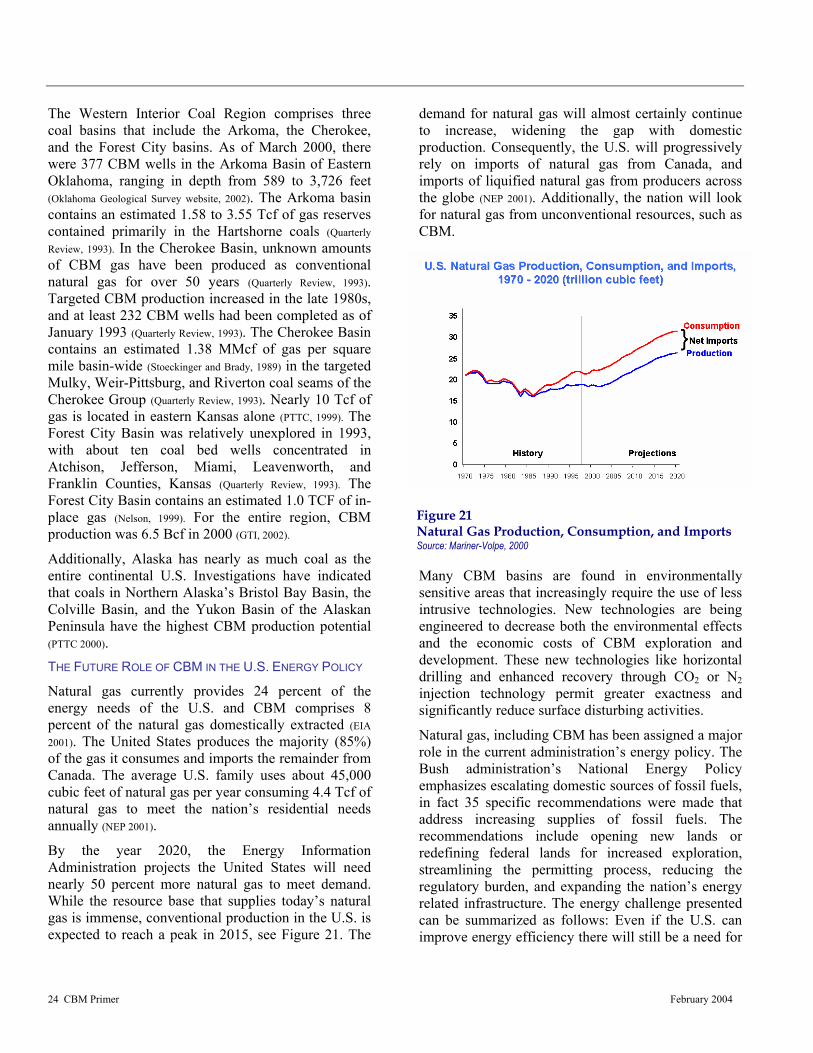
24 CBM Primer February 2004
Figure 21 Natural Gas Production, Consumption, and Imports Source: Mariner-Volpe, 2000
The Western Interior Coal Region comprises three coal basins that include the Arkoma, the Cherokee, and the Forest City basins. As of March 2000, there were 377 CBM wells in the Arkoma Basin of Eastern Oklahoma, ranging in depth from 589 to 3,726 feet (Oklahoma Geological Survey website, 2002). The Arkoma basin contains an estimated 1.58 to 3.55 Tcf of gas reserves contained primarily in the Hartshorne coals (Quarterly Review, 1993). In the Cherokee Basin, unknown amounts of CBM gas have been produced as conventional natural gas for over 50 years (Quarterly Review, 1993). Targeted CBM production increased in the late 1980s, and at least 232 CBM wells had been completed as of January 1993 (Quarterly Review, 1993). The Cherokee Basin contains an estimated 1.38 MMcf of gas per square mile basin-wide (Stoeckinger and Brady, 1989) in the targeted Mulky, Weir-Pittsburg, and Riverton coal seams of the Cherokee Group (Quarterly Review, 1993). Nearly 10 Tcf of gas is located in eastern Kansas alone (PTTC, 1999). The Forest City Basin was relatively unexplored in 1993, with about ten coal bed wells concentrated in Atchison, Jefferson, Miami, Leavenworth, and Franklin Counties, Kansas (Quarterly Review, 1993). The Forest City Basin contains an estimated 1.0 TCF of in-place gas (Nelson, 1999). For the entire region, CBM production was 6.5 Bcf in 2000 (GTI, 2002).
Additionally, Alaska has nearly as much coal as the entire continental U.S. Investigations have indicated that coals in Northern Alaska’s Bristol Bay Basin, the Colville Basin, and the Yukon Basin of the Alaskan Peninsula have the highest CBM production potential (PTTC 2000). THE FUTURE ROLE OF CBM IN THE U.S. ENERGY POLICY
Natural gas currently provides 24 percent of the energy needs of the U.S. and CBM comprises 8 percent of the natural gas domestically extracted (EIA 2001). The United States produces the majority (85%) of the gas it consumes and imports the remainder from Canada. The average U.S. family uses about 45,000 cubic feet of natural gas per year consuming 4.4 Tcf of natural gas to meet the nation’s residential needs annually (NEP 2001).
By the year 2020, the Energy Information Administration projects the United States will need nearly 50 percent more natural gas to meet demand. While the resource base that supplies today’s natural gas is immense, conventional production in the U.S. is expected to reach a peak in 2015, see Figure 21. The
demand for natural gas will almost certainly continue to increase, widening the gap with domestic production. Consequently, the U.S. will progressively rely on imports of natural gas from Canada, and imports of liquified natural gas from producers across the globe (NEP 2001). Additionally, the nation will look for natural gas from unconventional resources, such as CBM.
Many CBM basins are found in environmentally sensitive areas that increasingly require the use of less intrusive technologies. New technologies are being engineered to decrease both the environmental effects and the economic costs of CBM exploration and development. These new technologies like horizontal drilling and enhanced recovery through CO2 or N2 injection technology permit greater exactness and significantly reduce surface disturbing activities.
Natural gas, including CBM has been assigned a major role in the current administration’s energy policy. The Bush administration’s National Energy Policy emphasizes escalating domestic sources of fossil fuels, in fact 35 specific recommendations were made that address increasing supplies of fossil fuels. The recommendations include opening new lands or redefining federal lands for increased exploration, streamlining the permitting process, reducing the regulatory burden, and expanding the nation’s energy related infrastructure. The energy challenge presented can be summarized as follows: Even if the U.S. can improve energy efficiency there will still be a need for
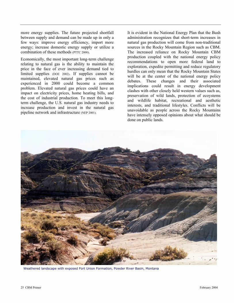
25 CBM Primer February 2004
more energy supplies. The future projected shortfall between supply and demand can be made up in only a few ways: improve energy efficiency, import more energy; increase domestic energy supply or utilize a combination of these methods (PTTC 2000).
Economically, the most important long-term challenge relating to natural gas is the ability to maintain the price in the face of ever increasing demand tied to limited supplies (DOE 2002). If supplies cannot be maintained, elevated natural gas prices such as experienced in 2000 could become a common problem. Elevated natural gas prices could have an impact on electricity prices, home heating bills, and the cost of industrial production. To meet this long-term challenge, the U.S. natural gas industry needs to increase production and invest in the natural gas pipeline network and infrastructure (NEP 2001).
It is evident in the National Energy Plan that the Bush administration recognizes that short-term increases in natural gas production will come from non-traditional sources in the Rocky Mountain Region such as CBM. The increased reliance on Rocky Mountain CBM production coupled with the national energy policy recommendations to open more federal land to exploration, expedite permitting and reduce regulatory hurdles can only mean that the Rocky Mountain States will be at the center of the national energy policy debates. These changes and their associated implications could result in energy development clashes with other closely held western values such as, preservation of wild lands, protection of ecoystems and wildlife habitat, recreational and aesthetic interests, and traditional lifestyles. Conflicts will be unavoidable as people across the Rocky Mountains have intensely opposed opinions about what should be done on public lands.
Weathered landscape with exposed Fort Union Formation, Powder River Basin, Montana

26 CBM Primer February 2004

27 CBM Primer February 2004
RREEGGUULLAATTOORRYY FFRRAAMMEEWWOORRKK Federal, State and Local Regulations Governing CBM Development across the West
umerous regulations designed to control conventional natural gas development can and do apply to CBM exploration and production.
However, due to the differences in produced water volumes and quality, well spacing, and utility infrastructure, specific CBM regulations have been drafted by federal, state and local agencies to meet various concerns. This section provides an overview of the current regulations and discusses some case histories regarding CBM development. FEDERAL REGULATIONS
CBM ownership has been a point of contention since the early 1900s; questions regarding its status as part of the coal estate or as part of the natural gas resource is still under debate in some Eastern states. However, CBM originating in federally held coal deposits may be explored for and extracted under either a fee or Federal oil and gas lease, depending on the non-coal minerals ownership. This determination was made by the Department of the Interior’s (DOI) solicitor, after examining the relevant Federal statutes. The determination states that U.S. reservations of coal do not include the CBM. However, Federal reservations of gas do include the CBM found in coal deposits. The CBM is therefore disposable as a gas under Section 17 of the Mineral Leasing Act (DOI 1981). As a result where the coal and oil and gas are federally owned, Federal oil and gas lease regulations cover the CBM. CBM operations and production under a Federal lease are subject to the regulations governing conventional oil and gas drilling and production operations (Cohen et. al. 1984).
The Mineral Leasing Act (MLA) of 1920 was determined in 1981 by the DOI solicitor to refer only to gas or natural gas, without excluding CBM (DOI 1981). Additionally, the standard Federal oil and gas lease allows the lessee to drill for, extract, and dispose of any oil and gas, except helium. Therefore, since 1981 CBM gas has been developed under the oil and gas leasing provisions of the Mineral Leasing Act.
The DOI Solicitor also concluded that the coal leasing requirements of the MLA do not grant the coal lessee the right to extract minerals associated with coal (Kemp and Peterson 1988). The Solicitor clarified that the requirements do not authorize a coal lessee to extract CBM, other than the venting of gas required to maintain a safe working atmosphere. It was also pointed out in the determination that the oil and gas lease holder does not have the right to extract the CBM utilizing a method that would harm the coal deposit or generate hazardous conditions for later coal mining operations. In conclusion, the Solicitor affirmed that the rights of an oil and gas lessee would be restricted to the rights not previously granted to the coal lessee (Kemp and Peterson 1988).
Since this determination was made the MLA has provided the framework for authorization and management of CBM operations on federal lands. The MLA serves as the umbrella regulation for all Federal agency policies regarding fluid minerals development. BLM and U.S. Forest Service managed lands and other lands owned by the U.S. are available for CBM production under the MLA. BLM manages the majority of the federal mineral estate and is the primary agency responsible for developing and implementing land management plans. BLM’s management of federal lands is also governed by the Federal Land Policy and Management Act (FLPMA). The National Environmental Policy Act (NEPA) addresses the procedures required to evaluate impacts on federal lands. Activity in national forests follows the National Forest Management Act (NFMA), which guides development operations. However, before drilling can take place on fee or federal lands numerous documents must be drafted and decisions made, including revisions to land use plans, leasing determinations, Environmental Assessments or Impact Statements, Surface Owner Agreements, Plans of Development (POD), and Applications for Permit to Drill (APD). Several of these steps require public involvement and have provisions for public feedback.
N
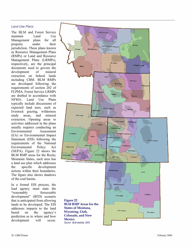
28 CBM Primer February 2004
Figure 22 BLM RMP Areas for the States of Montana, Wyoming, Utah, Colorado, and New Mexico Source: BLM website, 2003
Land Use Plans
The BLM and Forest Service maintain Land Use Management plans for all property under their jurisdiction. These plans known as Resource Management Plans (RMPs) or Land and Resource Management Plans (LRMPs), respectively, are the principal documents used to govern the development of mineral extraction on federal lands including CBM. BLM RMPs are developed following the requirements of section 202 of FLPMA. Forest Service LRMPs are drafted in accordance with NFMA. Land Use Plans typically include discussions of expected land uses, such as livestock grazing, wilderness study areas, and mineral extraction. Opening areas to activities addressed in the plans usually requires conducting an Environmental Assessment (EA) or Environmental Impact Statement (EIS) following the requirements of the National Environmental Policy Act (NEPA). Figure 22 shows the BLM RMP areas for the Rocky Mountain States, each area has a land use plan which addresses the specific development actions within their boundaries. The figure also shows shadows of the coal basins.
In a formal EIS process, the lead agency must state the “reasonably foreseeable development” (RFD) scenario that is anticipated from allowing lands to be developed. The EIS addresses impacts to the land based on the agency’s prediction as to where and how development will occur.

29 CBM Primer February 2004
Photograph of typical CBM well head in Wyoming with pronghorn antilope (Antilocapra Americana)
Typically, agencies provide alternatives, which can be compared with one another to assess the impact potential of various approaches. CBM development has been very rapid in the Rocky Mountain region and most existing RMPs/LRMPs did not foresee or address the impacts from this level of CBM development. Recent EISs have been completed for the Southern Ute Tribe in the San Juan Basin and for the States of Montana and Wyoming. Additionally, several CBM related EISs and/or RMP/LRMP updates are planned for USFS and BLM areas throughout the Rockies in the coming year. NEPA and the EIS Process
The National Environmental Policy Act of 1969 requires all federal agencies to conduct an EA or EIS when proposed actions may have an impact on man’s environment. EIS’ have recently been conducted for actions such as CBM development throughout a RMP area or when lands are opened to previously unconsidered oil and gas leasing activities. EAs are conducted for new development scenarios proposed within areas covered by an EIS, unless the proposed action was not adequately addressed in the original EIS or land use plan. NEPA affects leasing decisions, although it is often contested whether an EIS or an environmental assessment is appropriate. Federal courts have issued contradictory rulings on the issue.
The EIS process considers the proposed action whether it is leasing or development, and attempts to quantify the impacts under various alternatives for several natural resources. A typical EIS may address impacts to the following: air quality, cultural resources, environmental justice issues, geology and minerals, hydrology (surface- and ground-water), Indian Trust assets, lands and realty, livestock grazing,
noise, paleontological resources, recreational opportunities, social and economic values, soils, vegetation, visual quality, wilderness study areas, and wildlife. Mitigation is then applied via standard lease stipulations or other measures such as agency guidelines or by imposing new mitigation measures to the alternative approaches. It is important to note that the EIS process is not designed to eliminate all impacts from the proposed action but to quantify the residual impacts so a balanced decision can be made with regards to the proposed action.
Following the impact analysis a comparison of the alternatives is conducted using residual impacts (impacts after mitigation). By comparing residual impacts from various different alternatives, decision makers can assess the various components of each alternative and either choose one or develop a different approach based on portions of the analyzed alternatives. When a decision is made it is drafted in a document referred to as the Record of Decision
(ROD), which is used to update the RMP/LRMP with the addressed changes (CEQ 2002).
During the EIS process the public is provided several opportunities to state their concerns and help design the scope of the impact analysis. Usually, the lead federal agency will hold public scoping meetings throughout the area that will be affected by the proposed action. The public scoping meetings are the first opportunity for citizens to express their concerns with the proposed action and to request impact analysis for various resources. This is also the appropriate time for citizens and special interest groups to provide the lead federal agency with data and special reports to be included in the impact analysis. The purpose of these meetings is to gather information regarding issues the public is particularly

30 CBM Primer February 2004
Photograph of CBM well cluster CX Ranch Montana
concerned with, and to exchange information with the public for project clarification. After all the scoping meetings are held the public scoping comments are entered into a database where they can be grouped by topic and analyzed. A scoping report detailing the public concerns is typically issued and the impact analysis is designed to encompass all the applicable concerns.
It is possible for some concerns to be outside the scope of the intended EIS and therefore not considered in the analysis. For example, if the proposed action addresses a resource development scenario i.e. gas, and the public comment requests that a particular area be excluded from leasing, this may not be possible to analyze under the current development EIS. Typically, a leasing EIS is conducted prior to determining which lands will be developed for which resources or multiple resources. If a leasing EIS has been conducted and a particular area was designed for gas development it would not be appropriate to revisit that determination when a gas development action is proposed.
The next opportunity the public has to comment is typically at the Draft EIS stage, unless supporting technical reports have been conducted. Supporting technical reports are issued in draft form and the
public is provided an opportunity to review the findings and submit comments. Regarding the Draft EIS, there is a 90-day public review period built in for EIS’ which will result in a management plan amendment. Anyone who requests a copy of the Draft EIS is provided one, and has until the deadline to submit comments. These comments are grouped by topic, and similar comments are paraphrased into a public concern statement (PCS). A PCS can cause various actions to be taken, the most common of which is a reanalysis of a portion of the EIS; a clarification added to a specific section; an explanation regarding where information can be found or why the PCS is not relevant to the analysis. In either case, all PCSs are specifically addressed in the Final EIS and all citizens who submitted comments are typically listed.
Once the Draft EIS has been modified based on public feedback a Final EIS is issued. A 30-day protest period is generally incorporated into this process to allow the public a final opportunity to express their concerns with the proposed action. Following the protest period a ROD is issued, effectively changing the land use plan and adopting the preferred alternative or a combination of actions derived from the various alternatives.
Leasing
Leases issued on federal land are competitively bid in accordance with the Federal Onshore Oil and Gas Leasing Reform Act (FOOGLRA) of 1987. Federal environmental laws are generally incorporated into standard lease terms. However, lease terms may be augmented with additional mitigation measures to minimize specific foreseen impacts (FOOGLRA 1987). These added mitigation measures can include special or supplemental stipulations suggested by State or local
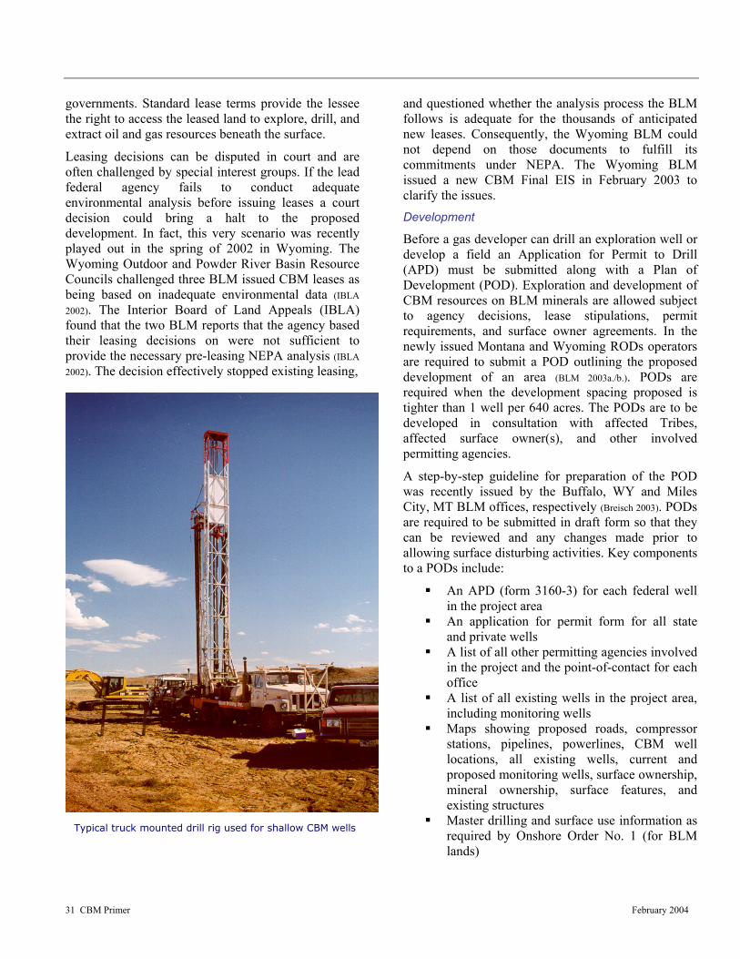
31 CBM Primer February 2004
Typical truck mounted drill rig used for shallow CBM wells
governments. Standard lease terms provide the lessee the right to access the leased land to explore, drill, and extract oil and gas resources beneath the surface.
Leasing decisions can be disputed in court and are often challenged by special interest groups. If the lead federal agency fails to conduct adequate environmental analysis before issuing leases a court decision could bring a halt to the proposed development. In fact, this very scenario was recently played out in the spring of 2002 in Wyoming. The Wyoming Outdoor and Powder River Basin Resource Councils challenged three BLM issued CBM leases as being based on inadequate environmental data (IBLA 2002). The Interior Board of Land Appeals (IBLA) found that the two BLM reports that the agency based their leasing decisions on were not sufficient to provide the necessary pre-leasing NEPA analysis (IBLA 2002). The decision effectively stopped existing leasing,
and questioned whether the analysis process the BLM follows is adequate for the thousands of anticipated new leases. Consequently, the Wyoming BLM could not depend on those documents to fulfill its commitments under NEPA. The Wyoming BLM issued a new CBM Final EIS in February 2003 to clarify the issues. Development
Before a gas developer can drill an exploration well or develop a field an Application for Permit to Drill (APD) must be submitted along with a Plan of Development (POD). Exploration and development of CBM resources on BLM minerals are allowed subject to agency decisions, lease stipulations, permit requirements, and surface owner agreements. In the newly issued Montana and Wyoming RODs operators are required to submit a POD outlining the proposed development of an area (BLM 2003a./b.). PODs are required when the development spacing proposed is tighter than 1 well per 640 acres. The PODs are to be developed in consultation with affected Tribes, affected surface owner(s), and other involved permitting agencies.
A step-by-step guideline for preparation of the POD was recently issued by the Buffalo, WY and Miles City, MT BLM offices, respectively (Breisch 2003). PODs are required to be submitted in draft form so that they can be reviewed and any changes made prior to allowing surface disturbing activities. Key components to a PODs include:
An APD (form 3160-3) for each federal well in the project area
An application for permit form for all state and private wells
A list of all other permitting agencies involved in the project and the point-of-contact for each office
A list of all existing wells in the project area, including monitoring wells
Maps showing proposed roads, compressor stations, pipelines, powerlines, CBM well locations, all existing wells, current and proposed monitoring wells, surface ownership, mineral ownership, surface features, and existing structures
Master drilling and surface use information as required by Onshore Order No. 1 (for BLM lands)
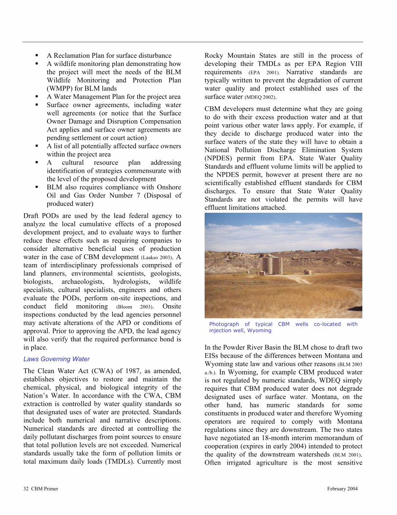
32 CBM Primer February 2004
Photograph of typical CBM wells co-located with injection well, Wyoming
A Reclamation Plan for surface disturbance A wildlife monitoring plan demonstrating how
the project will meet the needs of the BLM Wildlife Monitoring and Protection Plan (WMPP) for BLM lands
A Water Management Plan for the project area Surface owner agreements, including water
well agreements (or notice that the Surface Owner Damage and Disruption Compensation Act applies and surface owner agreements are pending settlement or court action)
A list of all potentially affected surface owners within the project area
A cultural resource plan addressing identification of strategies commensurate with the level of the proposed development
BLM also requires compliance with Onshore Oil and Gas Order Number 7 (Disposal of produced water)
Draft PODs are used by the lead federal agency to analyze the local cumulative effects of a proposed development project, and to evaluate ways to further reduce these effects such as requiring companies to consider alternative beneficial uses of production water in the case of CBM development (Laakso 2003). A team of interdisciplinary professionals comprised of land planners, environmental scientists, geologists, biologists, archaeologists, hydrologists, wildlife specialists, cultural specialists, engineers and others evaluate the PODs, perform on-site inspections, and conduct field monitoring (Bloom 2003). Onsite inspections conducted by the lead agencies personnel may activate alterations of the APD or conditions of approval. Prior to approving the APD, the lead agency will also verify that the required performance bond is in place. Laws Governing Water
The Clean Water Act (CWA) of 1987, as amended, establishes objectives to restore and maintain the chemical, physical, and biological integrity of the Nation’s Water. In accordance with the CWA, CBM extraction is controlled by water quality standards so that designated uses of water are protected. Standards include both numerical and narrative descriptions. Numerical standards are directed at controlling the daily pollutant discharges from point sources to ensure that total pollution levels are not exceeded. Numerical standards usually take the form of pollution limits or total maximum daily loads (TMDLs). Currently most
Rocky Mountain States are still in the process of developing their TMDLs as per EPA Region VIII requirements (EPA 2001). Narrative standards are typically written to prevent the degradation of current water quality and protect established uses of the surface water (MDEQ 2002).
CBM developers must determine what they are going to do with their excess production water and at that point various other water laws apply. For example, if they decide to discharge produced water into the surface waters of the state they will have to obtain a National Pollution Discharge Elimination System (NPDES) permit from EPA. State Water Quality Standards and effluent volume limits will be applied to the NPDES permit, however at present there are no scientifically established effluent standards for CBM discharges. To ensure that State Water Quality Standards are not violated the permits will have effluent limitations attached.
In the Powder River Basin the BLM chose to draft two EISs because of the differences between Montana and Wyoming state law and various other reasons (BLM 2003 a./b.). In Wyoming, for example CBM produced water is not regulated by numeric standards, WDEQ simply requires that CBM produced water does not degrade designated uses of surface water. Montana, on the other hand, has numeric standards for some constituents in produced water and therefore Wyoming operators are required to comply with Montana regulations since they are downstream. The two states have negotiated an 18-month interim memorandum of cooperation (expires in early 2004) intended to protect the quality of the downstream watersheds (BLM 2001). Often irrigated agriculture is the most sensitive

33 CBM Primer February 2004
beneficial use for surface waters and therefore downstream water quality standards are based on vegetation changes.
The Clean Water Act requires applicants to obtain a certification stating that their activities will comply with the Clean Water Act. The certificate is issued from the state where the discharge originates. Requirements initiated by the state become part of the federal permit and are enforced by either the BLM or Forest Service. Additionally, operators must receive a 404 permit the Corps of Engineers anytime they dispose of or deposit fill into the waters of the U.S.
The Federal Water Pollution Control Act requires federal land managers to comply with all Federal, State, and Local requirements, administrative authorities, process, and sanctions regarding the control and abatement of water pollution in the same manner and to the same extent as any nongovernmental entity. The BLM requires all operators to obtain appropriate water handling, discharge and injection permits prior to submitting their Application for Permit to Drill (APD).
The Safe Drinking Water Act (SDWA) is designed to make the nation’s waters “drinkable” as well as “swimmable”. Amendments in 1996 established a direct connection between safe drinking water and watershed protection and management. The SDWA regulates the re-injection of produced water from CBM production. Underground injection is permitted under various well classes depending on the quality of the injectate and the zone where the fluid is injected: Part C of the SDWA attempts to protect underground sources of drinking water by requiring permits for all underground injection of liquids. There are five classes of injection wells under these regulations, the majority of CBM produced water is injected via Class II wells. Class II wells handle liquids that are produced as a by-product of oil and gas operations or are used in enhanced recovery.
The EPA conducted a study of the environmental risks to underground sources of drinking water (USDWs) when hydraulic fracturing is used to enhance CBM recovery. The study was prompted by complaints that CBM development has altered water quality in some drinking wells. The goal of EPA’s nationwide hydraulic fracturing study was to determine if a threat exists to public health, as a result of aquifer contamination from the narrow practice of hydraulic
fracturing, as it relates to CBM wells, and if so, is high enough to warrant further study (EPA 2002b). The process of hydraulic fracturing involves forcing fluids under pressure into subsurface cracks utilizing the wellbore tubulars, treated fluids and surface pumps to form pathways for the natural gas and water to reach the well.
EPA’s final report published in October 2002 states that they reviewed claimed incidents of drinking water well contamination and found no confirmed cases, despite the thousands of fracturing events that have been conducted on CBM wells during the past decade. EPA also assessed the theoretical potential for hydraulic fracturing to contaminate drinking water wells. Two potential scenarios by which hydraulic fracturing may effect aquifer water quality were evaluated: (1) the injection of fracturing fluids directly into a aquifer, and (2) the creation of a hydraulic communication through a confining layer between the target coal bed formation and adjacent aquifer. EPA’s determination is that the threat of contaminating drinking water supplies by CBM hydraulic fracturing activities is low. Studies have found no observed breach of confining layers from hydraulically-created fractures, consistent with theoretical understanding of fracturing behavior (EPA 2002b). Laws Governing Air
The Clean Air Act (CAA) of 1990, as amended, requires Federal agencies to comply with all Federal, state, and local requirements regarding the control and abatement of air pollution. This includes abiding by requirements of the State Implementation Plans. Potential changes in ambient air quality from CBM activities, such as reduced visibility, air quality emissions, dust emissions, harmful gases, and changes in climate are evaluated in the BLM EISs.
Photograph of typical CBM field compressor station
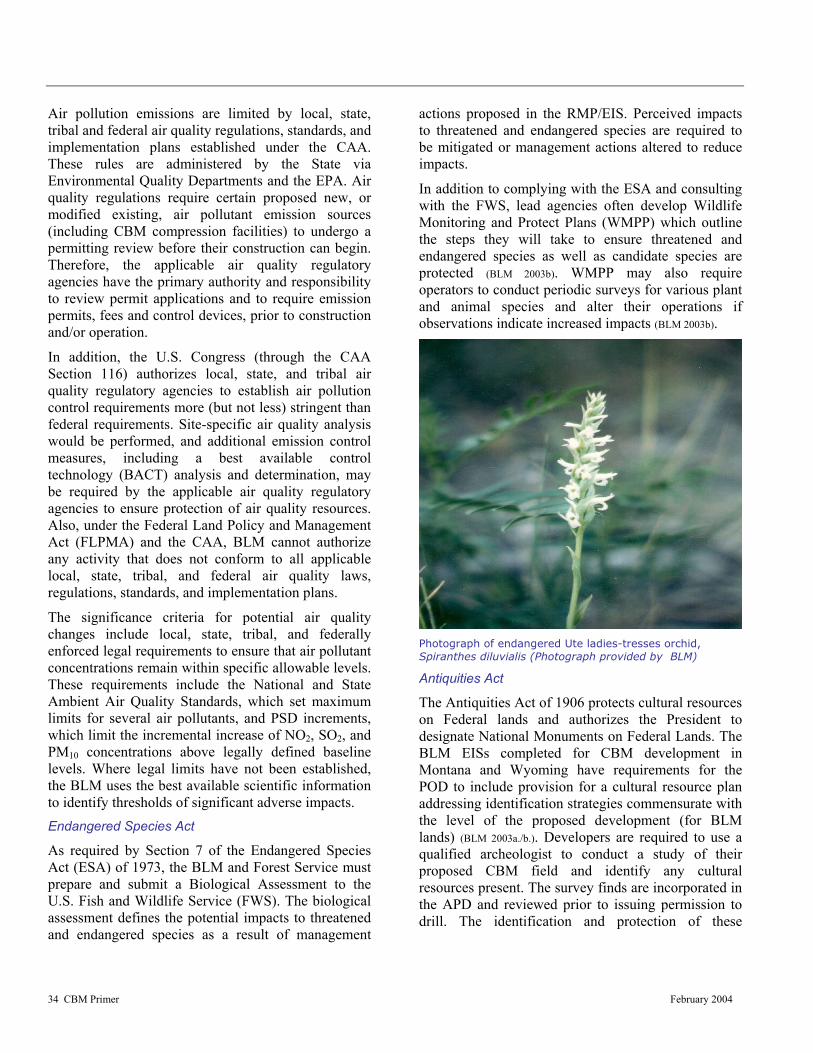
34 CBM Primer February 2004
Air pollution emissions are limited by local, state, tribal and federal air quality regulations, standards, and implementation plans established under the CAA. These rules are administered by the State via Environmental Quality Departments and the EPA. Air quality regulations require certain proposed new, or modified existing, air pollutant emission sources (including CBM compression facilities) to undergo a permitting review before their construction can begin. Therefore, the applicable air quality regulatory agencies have the primary authority and responsibility to review permit applications and to require emission permits, fees and control devices, prior to construction and/or operation.
In addition, the U.S. Congress (through the CAA Section 116) authorizes local, state, and tribal air quality regulatory agencies to establish air pollution control requirements more (but not less) stringent than federal requirements. Site-specific air quality analysis would be performed, and additional emission control measures, including a best available control technology (BACT) analysis and determination, may be required by the applicable air quality regulatory agencies to ensure protection of air quality resources. Also, under the Federal Land Policy and Management Act (FLPMA) and the CAA, BLM cannot authorize any activity that does not conform to all applicable local, state, tribal, and federal air quality laws, regulations, standards, and implementation plans.
The significance criteria for potential air quality changes include local, state, tribal, and federally enforced legal requirements to ensure that air pollutant concentrations remain within specific allowable levels. These requirements include the National and State Ambient Air Quality Standards, which set maximum limits for several air pollutants, and PSD increments, which limit the incremental increase of NO2, SO2, and PM10 concentrations above legally defined baseline levels. Where legal limits have not been established, the BLM uses the best available scientific information to identify thresholds of significant adverse impacts. Endangered Species Act
As required by Section 7 of the Endangered Species Act (ESA) of 1973, the BLM and Forest Service must prepare and submit a Biological Assessment to the U.S. Fish and Wildlife Service (FWS). The biological assessment defines the potential impacts to threatened and endangered species as a result of management
actions proposed in the RMP/EIS. Perceived impacts to threatened and endangered species are required to be mitigated or management actions altered to reduce impacts.
In addition to complying with the ESA and consulting with the FWS, lead agencies often develop Wildlife Monitoring and Protect Plans (WMPP) which outline the steps they will take to ensure threatened and endangered species as well as candidate species are protected (BLM 2003b). WMPP may also require operators to conduct periodic surveys for various plant and animal species and alter their operations if observations indicate increased impacts (BLM 2003b).
Photograph of endangered Ute ladies-tresses orchid, Spiranthes diluvialis (Photograph provided by BLM)
Antiquities Act
The Antiquities Act of 1906 protects cultural resources on Federal lands and authorizes the President to designate National Monuments on Federal Lands. The BLM EISs completed for CBM development in Montana and Wyoming have requirements for the POD to include provision for a cultural resource plan addressing identification strategies commensurate with the level of the proposed development (for BLM lands) (BLM 2003a./b.). Developers are required to use a qualified archeologist to conduct a study of their proposed CBM field and identify any cultural resources present. The survey finds are incorporated in the APD and reviewed prior to issuing permission to drill. The identification and protection of these

35 CBM Primer February 2004
Rock art near Blackleaf Canyon, Montana
important sites meets the requirements of the Antiquities Act. National Historic Preservation Act
Lead federal agencies must complete the process for considering the effects of the development action on historic properties as required by Section 106 of the National Historic Preservation Act (NHPA). The area of potential effect has to be reviewed and all existing inventory data scrutinized, historic properties identified also need to be reviewed, and interested parties consulted. Consultation under Section 106 of the NHPA for CBM development is usually required with the State Historic Preservation Office (SHPO), the Advisory Council on Historic Preservation (ACHP), affected Tribes and other interested parties (Federal Register, 1983).
BLM has a National Programmatic Agreement in place with most Western state SHPOs and the ACHP. The agreement states that there would be no new disturbance of historic properties not previously considered, and outlines survey procedures to be followed for all new oil and gas developments. Tribal Resources
The Indian Mineral Leasing Act of 1938 and the Indian Mineral Development Act of 1982 govern the development of CBM on tribal lands. A dual legal system of federal and tribal laws control energy development on tribal lands. The Bureau of Indian Affairs (BIA) is required under these acts to authorize energy leases. NEPA regulations also apply to any energy development decisions made for Tribe lands. Under certain federal laws such as the CWA and CAA, qualifying tribes can obtain states status and
draft more stringent environmental laws. The Tribes are also responsible for enforcement and may regulate their lands in areas not covered by federal laws or programs (BOR 1994).
Indian lands can also be owned by individual Indians pursuant to Federal statute or treaty providing for the distribution of tribal property in severalty or pursuant to the General Allotment Act of 1887. An allotted parcel of land may be owned by the United States in trust for an individual Indian (trust allotment) or owned by the individual subject to certain restrictions. Allotted Indian lands may be leased for the development of oil and gas (25 CFR 214.2 – 212.6) and other minerals pursuant to the Indian Leasing Act of 1909 or the Indian Mineral Development Act of 1982. American Indian Religious Freedom Act
The American Indian Religious Freedom Act (AIRFA) was passed as a joint resolution of Congress. The resolution states that it shall be the policy of the United States to protect and preserve for the American Indian the inherent right of freedom to believe, express and exercise their traditional religions, to use sacred objects and to worship through ceremonies and ritual. Federal agencies comply with this Act by consulting with and considering the views of American Indians when proposed land uses might conflict with traditional American Indian religious beliefs or practices. The Act does not require that land uses be denied, if it conflicts with such religious beliefs or practices. Split Estates
Many federally administered minerals, including oil and gas rights, underlie privately owned surface. In addition, in many Western states, federally administered surface lands greatly exceed private and state lands. Furthermore, Western states, recognize separate ownership of surface and subsurface (or mineral) estates and the unique private property rights connected with each. Often, different parties own the surface and the subsurface. This is commonly referred to as “split estate” or "severed minerals". The ownership differences are commonly the result of the U.S. government reserving minerals when the lands were originally patented, or may be the outcome of a decision by a previous landowner to separately sell or lease the subsurface mineral interest. In the area of emphasis in the Western U.S., the federal government
36 CBM Primer February 2004
frequently withheld mineral interests on homestead land, which resulted in large areas of CBM plays in split estate.
A mineral estate provides property rights to selected natural resources lying on or below the earth's surface. A transfer of the mineral estate may be accomplished without transfer of the surface estate. For example, a landowner may sell or lease the rights to natural gas or oil found under the surface to an oil company. Later, the same landowner can sell the surface to a purchaser and reserve the rights to all coal that may be found under the land. After these transactions, three parties have ownership interests in this piece of real estate: (1) the oil company owns the oil and gas; (2) the seller owns the coal; and (3) the purchaser owns the surface.
An easement is a property interest that one party has in land owned by another, entitling the holder of the easement to use the other's land. Easements are typically in writing, usually in the form of a separate document or by a reservation in a deed. Thus, an easement is an interest in land rather than a mere contractual agreement. When easements are properly created and recorded they are transferred with a land sale and remain in effect.
A right-of-way is a type of easement conveying the right or privilege, acquired through accepted usage or by contract, to pass over, through or under a designated portion of the property of another. A right-of-way may be either private, as in an access easement given a neighbor, or public, as in the right of the public to use the highways. For example, a gas company might send its agents to meet with landowners and negotiate the purchase of rights-of-ways or easements for a pipeline. Under Federal law, the mineral estate is dominant (Straube and Holland, 2003), therefore surface owners cannot deny access to developers, but may demand compensation for that access. In many states
the oil and gas or CBM operator is required to obtain a Surface Use and Damage Agreement with the land owner or owners. Due to the senior estate, the holder of CBM interests can obtain access to the property by way of court action if the CBM operator has shown good faith in attempting to make an agreement with the land owner and been denied. Surface access may include drilling site, pits, roads, and pipelines.
Split ownership is a common phenomenon. Fifty-eight million acres of privately owned property are split estates where the federal government owns some or all
of the mineral estate. That is 6 million more acres than are contained in the State of Kansas and represents 1/8 of all privately owned land in the U.S. The federal government owns mineral rights to 744 million acres, equivalent to 29 percent of all the land of the U.S. Most of the split estates are located in the Western U.S. and many overlap prime CBM locations, see table 3. STATE REGULATIONS
State oil and gas commissions and boards were created out of conservation statutes and were intended to oversee oil and gas operations by establishing drilling units and providing well permit regulations. Oil and Gas
commissions/boards were commonly established to maintain a level playing field for all owners to pursue oil and gas production, to prevent the waste of oil and gas resources, and to prevent the drilling of unnecessary wells. The responsibilities of the boards have changed as production has matured to include the regulation of drilling, casing, plugging and abandonment of wells and in some States the administration of the Underground Injection Control Program. Additionally, some boards may be tasked with protecting the rights of surface owners. The different Rocky Mountain state boards involved in overseeing CBM development are charged with varying statutory provisions:
Tables 3
SPLIT ESTATES -The BLM manages (controls) subsurface acreage of privately owned land as follows:
State Acreage Arkansas 1 in 9 acres
California 1 in 19 acres Colorado 1 in 6 acres Idaho 1 in 4 acres
Montana 1 in 5 acres New Mexico 1 in 4 acres North Dakota 1 in 8 acres Oregon 1 in 14 acres South Dakota 1 in 24 acres Utah 1 in 11 acres Wyoming 1 in 2 ¼ acres AK, NE, NV, OK, WA and Eastern states AL, FL, IL, IN, IO, KS, LA, MI, MN, MS, MO, OH, WI. Split estates total 920,000 acres, representing small to very small fractions of privately owned land. Source: http://www.blm.gov/natacq/pls02/pls1-3_02.pdf
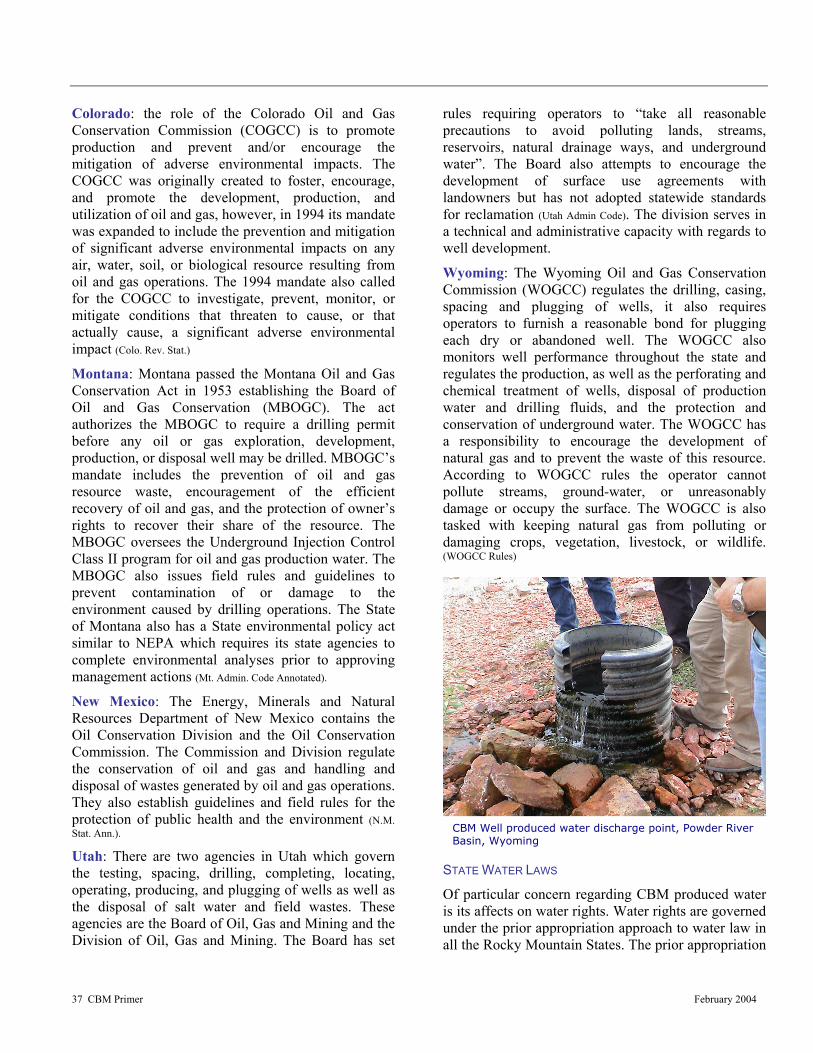
37 CBM Primer February 2004
CBM Well produced water discharge point, Powder River Basin, Wyoming
Colorado: the role of the Colorado Oil and Gas Conservation Commission (COGCC) is to promote production and prevent and/or encourage the mitigation of adverse environmental impacts. The COGCC was originally created to foster, encourage, and promote the development, production, and utilization of oil and gas, however, in 1994 its mandate was expanded to include the prevention and mitigation of significant adverse environmental impacts on any air, water, soil, or biological resource resulting from oil and gas operations. The 1994 mandate also called for the COGCC to investigate, prevent, monitor, or mitigate conditions that threaten to cause, or that actually cause, a significant adverse environmental impact (Colo. Rev. Stat.)
Montana: Montana passed the Montana Oil and Gas Conservation Act in 1953 establishing the Board of Oil and Gas Conservation (MBOGC). The act authorizes the MBOGC to require a drilling permit before any oil or gas exploration, development, production, or disposal well may be drilled. MBOGC’s mandate includes the prevention of oil and gas resource waste, encouragement of the efficient recovery of oil and gas, and the protection of owner’s rights to recover their share of the resource. The MBOGC oversees the Underground Injection Control Class II program for oil and gas production water. The MBOGC also issues field rules and guidelines to prevent contamination of or damage to the environment caused by drilling operations. The State of Montana also has a State environmental policy act similar to NEPA which requires its state agencies to complete environmental analyses prior to approving management actions (Mt. Admin. Code Annotated).
New Mexico: The Energy, Minerals and Natural Resources Department of New Mexico contains the Oil Conservation Division and the Oil Conservation Commission. The Commission and Division regulate the conservation of oil and gas and handling and disposal of wastes generated by oil and gas operations. They also establish guidelines and field rules for the protection of public health and the environment (N.M. Stat. Ann.).
Utah: There are two agencies in Utah which govern the testing, spacing, drilling, completing, locating, operating, producing, and plugging of wells as well as the disposal of salt water and field wastes. These agencies are the Board of Oil, Gas and Mining and the Division of Oil, Gas and Mining. The Board has set
rules requiring operators to “take all reasonable precautions to avoid polluting lands, streams, reservoirs, natural drainage ways, and underground water”. The Board also attempts to encourage the development of surface use agreements with landowners but has not adopted statewide standards for reclamation (Utah Admin Code). The division serves in a technical and administrative capacity with regards to well development.
Wyoming: The Wyoming Oil and Gas Conservation Commission (WOGCC) regulates the drilling, casing, spacing and plugging of wells, it also requires operators to furnish a reasonable bond for plugging each dry or abandoned well. The WOGCC also monitors well performance throughout the state and regulates the production, as well as the perforating and chemical treatment of wells, disposal of production water and drilling fluids, and the protection and conservation of underground water. The WOGCC has a responsibility to encourage the development of natural gas and to prevent the waste of this resource. According to WOGCC rules the operator cannot pollute streams, ground-water, or unreasonably damage or occupy the surface. The WOGCC is also tasked with keeping natural gas from polluting or damaging crops, vegetation, livestock, or wildlife. (WOGCC Rules)
STATE WATER LAWS
Of particular concern regarding CBM produced water is its affects on water rights. Water rights are governed under the prior appropriation approach to water law in all the Rocky Mountain States. The prior appropriation
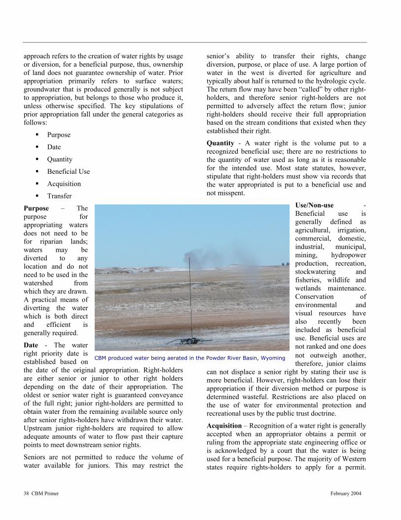
38 CBM Primer February 2004
CBM produced water being aerated in the Powder River Basin, Wyoming
approach refers to the creation of water rights by usage or diversion, for a beneficial purpose, thus, ownership of land does not guarantee ownership of water. Prior appropriation primarily refers to surface waters; groundwater that is produced generally is not subject to appropriation, but belongs to those who produce it, unless otherwise specified. The key stipulations of prior appropriation fall under the general categories as follows:
Purpose
Date
Quantity
Beneficial Use
Acquisition
Transfer
Purpose – The purpose for appropriating waters does not need to be for riparian lands; waters may be diverted to any location and do not need to be used in the watershed from which they are drawn. A practical means of diverting the water which is both direct and efficient is generally required.
Date - The water right priority date is established based on the date of the original appropriation. Right-holders are either senior or junior to other right holders depending on the date of their appropriation. The oldest or senior water right is guaranteed conveyance of the full right; junior right-holders are permitted to obtain water from the remaining available source only after senior rights-holders have withdrawn their water. Upstream junior right-holders are required to allow adequate amounts of water to flow past their capture points to meet downstream senior rights.
Seniors are not permitted to reduce the volume of water available for juniors. This may restrict the
senior’s ability to transfer their rights, change diversion, purpose, or place of use. A large portion of water in the west is diverted for agriculture and typically about half is returned to the hydrologic cycle. The return flow may have been “called” by other right-holders, and therefore senior right-holders are not permitted to adversely affect the return flow; junior right-holders should receive their full appropriation based on the stream conditions that existed when they established their right.
Quantity - A water right is the volume put to a recognized beneficial use; there are no restrictions to the quantity of water used as long as it is reasonable for the intended use. Most state statutes, however, stipulate that right-holders must show via records that the water appropriated is put to a beneficial use and not misspent.
Use/Non-use - Beneficial use is generally defined as agricultural, irrigation, commercial, domestic, industrial, municipal, mining, hydropower production, recreation, stockwatering and fisheries, wildlife and wetlands maintenance. Conservation of environmental and visual resources have also recently been included as beneficial use. Beneficial uses are not ranked and one does not outweigh another, therefore, junior claims
can not displace a senior right by stating their use is more beneficial. However, right-holders can lose their appropriation if their diversion method or purpose is determined wasteful. Restrictions are also placed on the use of water for environmental protection and recreational uses by the public trust doctrine.
Acquisition – Recognition of a water right is generally accepted when an appropriator obtains a permit or ruling from the appropriate state engineering office or is acknowledged by a court that the water is being used for a beneficial purpose. The majority of Western states require rights-holders to apply for a permit.

39 CBM Primer February 2004
Unlined water retention/infiltration pond being filled, Powder River Basin, Wyoming Unlined water retention/infiltration pond being filled, Powder River Basin, Wyoming
Generally the appropriator must notify all affected parties, construct a diversion facility within a specified time period, and put the water to beneficial use. If these requirements are met a hearing is held to review the criteria and establish the right.
Colorado uses a water court system to decide rights, instead of issuing permits. Seniority is recognized when the appropriator puts the water to beneficial use, and makes a physical demonstration of the intent to divert the water.
Colorado also allows water to be reserved for future use under a “conditional decree”. The right is established on the date of the decree, however, appropriators need to prove that there is a significant likelihood that the project will be finished within a evenhanded timeframe. The court must also, decide if there is enough water available for the proposed diversion.
Water rights obtained through use, may be forfeited by non-use. Forfeiture can occur when there is non-use for a specific time-period or if the diversion is not constructed in time, but in either case does not require the appropriator to intentionally abandon the water right. Abandonment, on the other hand, can be initiated by the right-holder if they intend to surrender the water right.
Transfer - Water rights can be transferred to new land owners when land is sold, but does not have to be if the right-holder specifically reserves those rights. Furthermore, water rights may be transferred separately from the land if allowed by state law. COLORADO WATER LAW
Colorado water law does not require operators to obtain a permit from the state engineer’s office when producing or withdrawing non-tributary water except when that water is intended for beneficial use. If produced water is going to be used for a beneficial purpose, the state engineer needs to ascertain whether the use will cause a “material injury to the vested water rights of others” (Co. Rev. Stat.). If material injury is anticipated, the permit needs to include mitigation measures to protect the other right holders. It is important to note that a lowering of the hydrostatic pressure in an aquifer or reduction in groundwater level is not deemed a material injury. (Colo. Rev. Stat.)
Produced water falls under the Colorado Oil and Gas Conservation Commission’s (COGCC) definition of
“exploration and production waste.” The COGCC jurisdiction over produced water is covered in Rule 907 which addresses the management and disposal of “E&P” waste. The rule includes various disposal options such as evaporation, infiltration, reinjection, commercial disposal, reuse and discharge into state waters. Evaporation and infiltration must take place in a permitted pit either lined or unlined and the produced water needs to be treated prior to reaching the pit to eliminate crude oil and condensate. Reinjection needs to be accomplished via a permitted Class II well. Commercial disposal may include dust control through road-spreading. Reuse generally refers to enhanced recovery or drilling but in both cases it must meet the water quality standards. Permits are required for all of these options. Additionally, the rule includes a provision which allows the surface owner to use the water as an alternative domestic water supply that cannot be traded or sold. MONTANA WATER LAW
The Montana statutes directly address CBM wells and specifically protects groundwater from being wasted. However, under certain scenarios, including management, discharge, or reinjection of CBM water, the production and use of groundwater is not considered a waste. Currently CBM operators are given three choices for produced water management; (1) beneficial use, such as irrigation, stock water, dust control, wetlands protection, etc., (2) reinject via a permitted Class II injection well, or (3) discharge into surface waters of the state provided a NPDES permit is obtained. CBM operators are required to have a Water Management Plan for their project area, surface owner agreements, including water well agreements and a list

40 CBM Primer February 2004
CBM well head equipped with radio monitoring system and field irrigation in background, Wyoming
of all potentially affected surface owners within the project area. Under the water well agreements the operators must replace any affected wells or offer other mitigation measures to avoid impacts to existing groundwater users (Mt. Admin. Code Annotated).
Montana law also recognizes the designation of controlled groundwater areas; areas where groundwater withdrawals exceed or are likely to exceed the recharge rate of the aquifers. Operators in these areas must obtain a permit in order to withdraw and appropriate water. The permit application needs to demonstrate that the water withdrawn is available, that existing uses will not be impacted, and that all produced water will be beneficially used. NEW MEXICO WATER LAW
Waters used for drilling, mining, or prospecting operations intended to discover or develop natural resources in the state are classified as beneficial. Under certain circumstances mine operators need to obtain permits to withdraw these waters. Aquifers at 2,500 feet below ground surface that contain non-potable water are outside the jurisdiction of the state engineer and do not require a permit to be produced. Most CBM wells in New Mexico are completed below 2,500 feet in non-potable aquifers, and therefore are not required to be permitted by the state engineer. Water produced or used in connection with drilling for or production of oil and gas falls under the authority of the Oil Conservation Division of the Energy, Minerals and Natural Resources Department. The division
regulates the subsurface and surface discharge of producted water with the intention of protecting fresh water sources. All groundwater with a background concentration of 10,000 mg/l or less of Total Dissolved Solids (TDS) is protected and reserved for beneficial use. The injection of produced water into subsurface reservoirs is also regulated by the Division.
New Mexico law also has requirements fashioned to safeguard existing water rights during mineral development throughout the state. Under New Mexico’s Mine Dewatering Act, any operator who desires to acquire water for a beneficial use or to dewater a mine has the opportunity to replace the waters of existing users which may be impacted (N.M. ST. ANN a. The cost to restore the water is solely the operators’ liability, who must submit an application with the state engineer to replace water. Although, an operator may make an appropriation of water under this act, merely dewatering a mine does not create water rights for the applicant. The state engineer may only approve an application under this statute if he is satisfied that the water restoration plan will provide sufficient waters to the affected parties. Before the water restoration plan is approved the state engineer considers the following issues; characteristics of the aquifer, present withdrawals on the aquifer and their collective effects on water levels and water quality, the impact of the mine dewatering on the aquifer, and the present and future withdrawal from, recharge to and storage of water in the aquifer (N.M. ST. ANN b).
UTAH WATER LAW
The Utah Board and Division of Oil, Gas and Mining has jurisdiction over byproduct water even though there is a groundwater appropriations system in place the state. The state engineer may under certain circumstances issue a temporary water right to put byproduct water resulting from mining development to a beneficial use. However, this can only happen after the water has been diverted from its original underground source. An assortment of rules has been developed by the Division to control the disposal of “salt water and oil field wastes,” (Utah Admin. Code a) this includes CBM water. Produced water can be placed in lined pits, or unlined pits provided it does not

41 CBM Primer February 2004
have a TDS content higher than the groundwater, that could be affected or contain other unacceptable components such as oil, grease, heavy metals, chlorides, sulfates, aromatic hydrocarbons or pH outside of an acceptable range (Utah Admin. Code b). If all, or a considerable part of the produced water is being used for beneficial purposes unlined pits may be used provided an analysis of the water has been preformed and indicates that it can be used for those purposes. Finally, unlined pits may also be used when the quantity of produced water is less than five barrels per day. Operators may also choose to inject the produced water into Class II injection wells under the state UIC program (Utah Admin. Code c). WYOMING WATER LAW
Wyoming water regulations address byproduct water appropriations; however they do not apply to CBM produced water. The state engineer has jurisdiction over CBM produced water, and operators therefore are required to obtain a permit for groundwater appropriation. The Wyoming water law states that applications to acquire groundwater “shall be granted as a matter of purpose, if the proposed use is beneficial and, if the state engineer finds that the proposed means of diversion and construction are adequate” (WY. Stat. a). If the state engineer finds that the application would not be in the public’s best water interest he may deny it (WY. Stat. b). Wyoming water law outlines beneficial uses by preference.
The importance assigned to putting appropriated groundwater to a beneficial use and preventing waste created problems for the initial CBM applicants. On the early versions of “Application for Permit to Appropriate Ground Water” (WY. Stat. c) forms, applicants were required to identify which beneficial use would be used. CBM operators routinely checked the “miscellaneous” box and explained that the water was used to produce CBM. Revised forms now have a box for CBM produced water. The Wyoming State Engineer has determined that a beneficial use is the production of water in conjunction with the production of the CBM. LOCAL REGULATIONS
CBM development has been subject to county regulation in some areas while it has been contested in others. Some counties have placed regulations on operations which require special use, building, and road permits; establish visual requirements and
address noxious weeds. La Plata and Las Animas Counties in Colorado have ratified regulations that restrict noise levels, establish air and water quality standards, address vibration and odor levels, institute access requirements, define visual impacts, require fire protection, and attempt to mitigate impacts to wildlife and public safety. Disagreements have transpired between the county and state officials and between the county and developers.
La Plata County was the first to adopt regulations regarding CBM development in 1991. These regulations were contested by several gas companies claiming that they were superceded by state and/or federal laws. The county was sued by the industry and the court upheld the county’s authority. The county then issued new regulations in 1995, stating that surface owners must be given an opportunity to determine the specific sites where drilling and road construction could take place. The county was again sued, and this time the court found in favor of industry and struck down the regulations (Bryner, 2002). County officials explained that their objective is to tackle the impacts of CBM development on local communities and not to inhibit production.
Counties in other states may have broad regulations that effect CBM development, but have not developed specific regulations for CBM development. In Montana, local regulations are permitted if they guarantee actual use of resources. In New Mexico, counties can adopt regulations provided they address traditional issues currently within the jurisdiction of county government. In Utah, counties are prohibited from drafting regulations relating to state law, especially where the oil and gas board has exclusive authority. However it is foreseeable that Utah counties can regulate noise, appearance, traffic, and compatibility with surrounding activity.
In Wyoming, counties can not prevent the use of land for the extraction or production of mineral resources. Five Wyoming counties along with the State and two conservation districts have signed a Memorandum of Understanding (MOU) designed to coordinate the flow of information and provide consistency between agencies. These counties have hired a CBM coordinator to help resolve any problems. The coordinator has attempted to maintain regulatory consistency across the Powder River Basin.

42 CBM Primer February 2004

43 CBM Primer February 2004
BBEESSTT MMAANNAAGGEEMMEENNTT PPRRAACCTTIICCEESS//MMIITTIIGGAATTIIOONN Typical Environmental Impacts vs Mitigation Measures
his section addresses the typical environmental effects associated with CBM development in the west and the mitigation measures employed
to address these effects. Focus is on the influences from production and distribution affecting natural resources and local populations and the tension between opposing land uses and users. Vital to this discussion are the potential affects of CBM extraction on water quality and quantity, and the numerous mitigation measures employed to control and eliminate these concerns. INTRODUCTION
Environmental resources altered from present-day conditions by CBM production practices have caused concern for federal, state, and local regulatory agencies; land and resource managers; industry; landowners; and the general public. Along with rising public awareness and more stringent regulations, increased pressure has been placed on those involved in the CBM industry to develop methodologies to accurately define specific areas of environmental risk as well as develop Best Management Practices (BMPs) and mitigation strategies to aid in minimizing and alleviating these risks. As a result, development of fundamentally sound BMP’s and mitigation strategies that facilitate resource development in an effective, timely, and environmentally sensitive manner, have become increasingly important.
BMPs are defined as techniques, procedures, and sustainable strategic plans which are generally site specific, economically feasible, and are used to guide, or may be applied to, management actions to aid in achieving desired outcomes. Implementation of BMPs can be used to reduce adverse environmental effects or enhance beneficial effects resulting from CBM operations. Typically, available management options for BMPs are dictated by site-specific characteristics such as, land and mineral ownership, geologic and hydrologic conditions (including depth of coal seams),
soil types, local and regional wildlife issues, etc., and project objectives and applicable regulations. In any case, effective use of BMPs can assure at a minimum, a basic level of maintainable environmental protection in a cost efficient manner. Although BMPs are often derived from Federal, State, or local standards, BMPs by definition do not constitute regulations and therefore, should only be considered as a guidance tool for protecting foreseeable affects to resources.
Mitigation measures are closely associated with BMPs and are best described as techniques, procedures, and sustainable strategic practices which are implemented upon formulation of environmentally sound BMPs. Mitigation measures, in all cases, are site specific and will vary depending on the type of disturbance, the degree of the disturbance, and the requirements of landowners or other involved parties. These practices are often implemented in phases or in a practical chronological order to ensure that the disturbances of a specific phase of a project is linked with the appropriate measures so as to maximize the efficiency and effectiveness of the mitigation (EPA, 2002c). As with BMPs, the objective(s) of mitigation measures are to aid or alleviate the consequence to various resources resulting from CBM project operations.
Effective use of BMPs necessitates careful planning and coordination with federal and state agencies, as well as between operators and landowners. From a functional perspective, successful mitigation are development of preventative or beneficial plans, that when implemented, maximize the number and magnitude of protected resources. As an example, immediately reseeding bare soils during construction activities or after a project’s completion can help minimize erosion events that may occur during seasonal flooding. This practice can also aid in the reclamation of native vegetation, help prevent infestation of noxious weeds, reduce dust control issues, provide additional lands for livestock grazing,
T

44 CBM Primer February 2004
provide suitable habitat and food resources for certain wildlife species, and control sediment run-off to nearby water systems. With this cost effective and flexible approach, the quantity and quality of protected resources can be enhanced to meet or exceed expectations of affected landowners, resource managers, or public agencies.
To further augment the effectiveness of BMPs, many employers are now providing mitigation specific training to employees. The training opportunities assure that employees are proficient in contemporary, as well as traditional techniques, which include; dust and noise control, hazardous waste reduction, seeding, and construction “footprint” minimization. With this approach and minimal investment employers can help protect vulnerable resources while at the same time, maintain a high level of project efficiency.
There are many aspects of CBM exploration and development that present unique challenges to resource managers, landowners, and State and Federal agencies. BMPs and mitigation measures specific to the CBM industry have been developed, as an example, by the Bureau of Land Management (BLM), the Montana Board of Oil & Gas Conservation (MBOGC), and others to identify resource issues, provide guidance for potential mitigation strategies, and to further enhance related beneficial uses. Within these documents implementations of measures to mitigate effects are generally presented as a procedure that is based on industry or activity related issues specific to the CBM industry that may negatively affect or potentially enhance individual resources.
The discussion below redirects this approach by focusing on resource specific issues, as well as resource-specific mitigation strategies that can or are required to be implemented to minimize disturbances to these resources. It is hoped this approach will help better define and clarify CBM related resource issues in a manner that will benefit landowners, operators, and federal or state agencies. This concise discussion should not be considered exhaustive since additional measures may also be identified during CBM development or in the NEPA process. BENEFICIAL USE
During the production of CBM, groundwater is extracted from coal seam aquifers to facilitate the release of methane gas trapped under hydrostatic pressure. Development of new CBM fields typically
generate large volumes of water that may represent an opportunity for operators to provide themselves, the landowner, and nearby industry with water that does not result in the waste of this resource. The ability of a CBM operator to provide CBM produced water for uses by industry, landowners, or other parties, can provide unique and substantial benefits.
The water produced from CBM wells varies from very high quality (meeting state and federal drinking water standards) to low quality, essentially unusable (with Total Dissolved Solids [TDS] concentration up to 180,000 parts per million). Currently, the management of CBM produced water is conducted using various water management practices depending on the quality of the produced water. In areas where the produced water is relatively fresh, the produced water is handled by a wide range of activities including direct discharge, storage in impoundments, livestock watering, irrigation, and dust control. In areas where the water quality is not suitable for direct use, operators use various treatments prior to discharge, and/or injection wells to dispose of the fluids.
The use of CBM produced water for beneficial use represents a flexible and valuable approach to utilizing an important resource by providing benefits to operators, land owners, and in some cases the general public. The quality of the produced water, the surrounding environmental setting, operator and landowner needs, and pertinent regulations, will often dictate the water’s designated use. In most cases certain aspects of development can benefit either by practical resolution or by satisfying public requests or needs. Beneficial uses for CBM produced water have been integrated into the resource discussion, when applicable, to provide the reader with a practical understanding of this mitigation approach. For more information on beneficial uses for CBM produced water refer to: CBM Produced Water: Management and Beneficial Use Alternatives, GWPRF, 2003, in cooperation with BLM and the Department of Energy (http://www.all-llc.com/CBM/BU/index.htm). RESOURCES OF CONCERN
Air Quality
The 1990 Clean Air Act is a federal law that establishes nationwide limits on how much of a pollutant can be in the air. This ensures that all Americans have the same basic health and environmental protection with respect to the air they

45 CBM Primer February 2004
Figure 23 Class I Areas in the Rocky Mountain region as designated by the CAA
breathe. Under this Act, states are responsible for implementing the law; since pollution control problems often require special understanding of local industries, geography, housing patterns, etc. The law allows individual states to require more stringent pollution controls, but does not allow for weaker pollution regulations. Figure 23 shows the Class I areas in the Rocky Mountain region as designated by the Clean Air Act. Class I areas are generally major parks and wilderness areas over 6,000 acres, where pristine air quality and scenic vistas are integral features.
Excessive air emissions resulting from CBM development will vary for any region since pollutant transport is affected by the magnitude and distribution of pollutant emissions, as well as local topography and meteorology. Although air quality changes from the CBM industry can be localized and short-term in duration, appropriate mitigation could eliminate potential long-term air quality affects and conciliate concerns raised by involved parties. Fugitive dust and exhaust from construction activities, along with air pollutants emitted during operation, (compression) may be expected to cause some air quality changes.
Dust from construction activities and standard travel of personnel and equipment over unpaved roads has the potential to alter air quality and create a nuisance to those traveling or living in these areas. The use of high quality CBM produced water (low SAR) for dust control offers multiple benefits from an environmental viewpoint, including the prevention of air quality concerns and the loss of surface soils. Possible applications of produced water for dust control include use on lease roads, other unpaved roads in the development area, and various construction sites where surface
disturbances due to CBM development exist.

46 CBM Primer February 2004
Native American Petroglyphs, Utah
Applying seed or re-vegetating bare soil areas is another successful measure that is used to minimize dust emissions, as well as to protect soils, and reduce erosion. The benefit of re-seeding bare areas far out ways management and monitoring costs and should be looked on as a necessity, rather than an option. This measure not only aids in the reduction of fugitive dust emissions, but facilitates the health and abundance of native vegetation, helps prevent the infestation of noxious weeds, may provide additional lands for livestock grazing and wildlife habitat and, can control sediment run-off to nearby water systems resulting from erosion.
Compressor engine emissions are another source of air pollution commonly associate with CBM development. Emissions from compressor engines would have an appropriate level of control determined by the applicable air quality regulatory agencies during a mandatory preconstruction permit process. Some of the measure employed to control emissions may include, limiting the number of field compressors, requiring the use of electric-powered compressors or the use of Best Available Control Technology to reduce the NOx emission rate.
As with any BMP, site specific conditions will dictate which BMP strategy is best suited to address and mitigate potential air quality changes. Common practices that could be applied to a BMP program to control air quality issues are listed below.
• Avoidance of surface construction on soils susceptible to wind erosion
• Use of dust inhibitors as necessary on unpaved collector, local, and resource roads to minimize fugitive dust emissions
• Install pollution control equipment on field and sales compressors
• Install catalytic converters on heavy machinery to minimize air pollutants
• Avoid specific geographic locations susceptible to excessive winds
• Use soil erosion control techniques when bare ground is temporarily or permanently exposed
• Enclose painting operations, consistent with local air quality operations
• Properly store materials that are normally used in repair such as paints and solvents.
Cultural Resources and Paleontological Resources
Cultural resources are best described as material remains of, or the locations of past human activities, including sites of traditional cultural importance to both past and contemporary Native American communities. The existence of cultural resources within a specific location is determined through examination of existing records, field surveys, and subsurface testing of areas that are proposed for disturbance on federal and state lands. Section 106 of the National Historic Preservation Act (NHPA) requires an inventory of cultural resources if federal involvement is present either in terms of surface or mineral estate, federal funds, federal grant, or federal license. The BLM has also identified survey standards that must include approved plans for avoidance when resources are discovered. In addition, State Historical Preservation Offices (SHPO) maintain a register of all identified sites, as well as all sites that are listed or eligible for listing on the National Register of Historic
Places (NRHP).
Unidentified cultural resources could potentially be affected by surface and subsurface activities that involve the use of heavy equipment (road construction, well drilling, pad construction, pipeline and utility placement, etc.) that ultimately change the natural landscape of an area. As such, the most sensible and preventative measure to protect this resource is to properly identify historic or pre-historic locations and more importantly, to avoid or relocate project facilities

47 CBM Primer February 2004
Aquatic fossils Photograph provided by The Fossil Conservancy
in these areas when feasible a point which is enforced by Federal mandate. Federal and state laws require the performance of surveys prior to the commencement of construction or other surface disturbing activities as well as prohibit land usage when an area is designated for conservation use, public use, or sociocultural use.
In the rare event when exploratory or development procedures unearth previously undiscovered resources, enforceable mitigation would require that work be stopped in the area of discovery until an evaluation can be preformed. If appropriate, consultations would be conducted with the SHPO, tribal historic preservation officer and/or Advisory Council on Historic Preservation. Appropriate and responsible action would be determined by these agencies and coordinated with operators and/or landowners.
In most cases, instruction on procedures to follow in case previously unknown archeological resources are uncovered during construction would constitute an important element of the BMP. This may include; informing operators of the penalties for illegally collecting artifacts or intentionally damaging archeological sites or historic properties, instruction on rehabilitation of buildings or structures, minimizing equipment traffic, and restricting placement of equipment and material staging areas near known archeological resources (National Park Service, 2002).
Paleontologic resources consist of fossil-bearing rock formations containing information that can be interpreted to provide a further understanding about any given location’s past.
Surface occupancy is prohibited within paleontological sites on BLM project lands unless it can be demonstrated that the paleontological resource values can be protected, or undesirable disturbances can be mitigated. BLM provides guidelines for notifying and mitigating damage to paleontological resources discovered during oil and gas construction activities. Limitations include restricted use of explosives for geophysical exploration, monitoring requirements, and work stoppages for discovered damaged resources. As with Cultural Resources, investigative surveys to identify this resources and/or avoidance are typically considered the most effective mitigation to prevent damage. Geology and Minerals
As stated earlier in this document, it is important to recognize that geology and mineral resources are directly associated with coal deposits. CBM gas is generated within the coal deposits under both thermogenic (heat-driven) and biogenic (microbe-driven) conditions. The magnitude of the CBM resource is determined by coal type and volume; and the location of coal seams, which coincide with the location of CBM resources. Existing BLM regulations allow for the production of CBM, but dictate that development be conducted in a manner that conserves these other resources present so they are not wasted.
The selection of an appropriate BMP to minimize alterations to these resources will depend greatly on local site conditions, but will usually consist of a collection of practices. Well spacing and field rules are established to maintain the integrity of surface formations while at the same time aiding in the efficient production of hydrocarbons. Drilling and completion practices, such as steel casing and cementing, stabilize the well bore dramatically and reduce the opportunity for hydrocarbon migration. In addition, certain operator practices can reduce surface disturbances as well. Sharing access roads, flowline routes, and utility line routes minimize surface disturbances and in certain circumstances, constructing multiple well pads and production facilities on the same pad can be implemented to consolidate work disturbing operations.
BMPs with a hydrologic component (e.g., storage ponds or impoundments) can directly affect geologic resources and require planning. When designed properly, however, they can be utilized to help control

48 CBM Primer February 2004
soil erosion and sedimentation ocurring from rainfall events, as well as provide benificial use. State engineering offices or related agencies often provide specific construction guidelines for impoundments. These guidelines can dictate preventative elements in their design that may include topographic restrictions (slope), water rights permitting requirements, and specific benificial use limitations. As an example of benefical use, the Montana Department of Environmental Quality considers CBM produced water to be unaltered State water and therefore; does not require permitting if the water meets certain water quality standards. Under a current proposal, this high quality water could be used specifically for livestock or wildlife watering and would have minimum impact to geological or mineral resources.
Reclamation practices to re-establish local landscapes are considered an integral (and BLM required) BMP component during the production and abandonment phases of CBM development. In most cases operators, along with landowners should discuss development and reclamation plans to reach a common agreement. This process ensures that acceptable guidelines and objectives are met to satisfy regulatory stipulations, as well as provide suitable guarantees for the landowner. From a functional and aesthetic perspective, re-seeding disturbed areas, such as well pad locations or road systems, restores the visual appearance of any disturbed location, and resolves or prevents local erosion and climatic, i.e., dust control issues. “No Surface Occupancy” stipulations could also be utilized on new oil and gas leases, which are issued for lands that have existing coal leases to prevent additional disturbance. Hydrological Resources
CBM production can produce large volumes of water that can affect both ground and surface water when the quality of the water is low. Generally, water quality in a certain watershed will vary, but in many cases is dependent on the volume and season. During times of high flow, streams receive large volumes of runoff water; while during times of base-flow, streams receive little runoff and are supplied primarily by groundwater. High-flow periods correspond to the seasonal influx of relatively high-quality, low-Sodium Absorption Ratio (SAR) surface water typically associated with spring snow-melt and early summer rains. Base-flow periods correspond to periods of scarce surface water during the winter when streams
are fed only by the influx of lower quality, high-SAR groundwater from shallow aquifers.
When groundcover is broken it exposes soil to wind and water erosion, leading to suspended sediment being deposited in bodies of surface water. Artificial impoundments can cause water infiltration into the soil and migration into surface water, and accidental releases of wastes can migrate into water bodies. These issues are of particular importance to residents. As a result, implementation of water management alternatives is in the forefront of CBM development.
Current protection of hydrological resources primarily focus on maintaining beneficial uses for the produced water; although water well, and spring mitigation agreements are often used to facilitate the replacement of groundwater lost to drawdown.
New technologies or strategies for CBM produced water are continually being developed and are responsible for reshaping the way landowners and operators think about beneficial use and resource protection. Current water management strategies include using the water for certain job specific needs, such as dust control, or to supplement other water related activities, including irrigation, impoundments, livestock watering, industrial use, and in some cases, potable water use.
In areas where there are distinct wet and dry seasons, during the wet seasons water is abundant in both surface streams and groundwater supplies. However, water supplies are often depleted during the dry season
CBM Supplied Impoundment, Powder River Basin, Montana
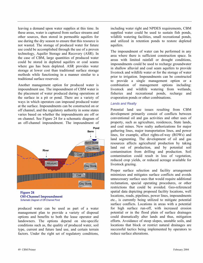
49 CBM Primer February 2004
Alluvium
Clay Stone
Clay Stone
Sand Stone
River
BermPond
Coal
Coal
Clay Stone
Figure 24 Off-Channel Impoundment Schematic Diagram of Off-Channel Pond
leaving a demand upon water supplies at this time. In these areas, water is captured from surface streams and other sources, then stored in permeable aquifers for use during the dry season to ensure that this resource is not wasted. The storage of produced water for future use could be accomplished through the use of a proven technology, Aquifer Storage and Recovery (ASR). In the case of CBM, large quantities of produced water could be stored in depleted aquifers or coal seams where gas has been depleted. ASR provides water storage at lower cost than traditional surface storage methods while functioning in a manner similar to a traditional surface reservoir.
Another management option for produced water is impoundment use. The impoundment of CBM water is the placement of water produced during operations at the surface in a pit or pond. There are a variety of ways in which operators can impound produced water at the surface. Impoundments can be constructed on or off channel, and the regulatory authority in some states varies based on whether the impoundments are off or on channel. See Figure 24 for a schematic diagram of an off-channel impoundment. The impoundment of
produced water can be used as part of a water management plan to provide a variety of disposal options and benefits to both the lease operator and landowners. The options depend on site-specific conditions such as, the quality of produced water, soil type, current and future land use, and certain terrain factors. Under the right set of regulatory conditions,
including water right and NPDES requirements, CBM supplied water could be used to sustain fish ponds, wildlife watering facilities, small recreational ponds, and utilized in retention ponds to restore depleted aquifers.
The impoundment of water can be performed in any area where there is sufficient construction space. In areas with limited rainfall or drought conditions, impoundments could be used to recharge groundwater in shallow alluvial and coal seam aquifers to provide livestock and wildlife water or for the storage of water prior to irrigation. Impoundments can be constructed to provide a single management option or a combination of management options including: livestock and wildlife watering from wetlands, fisheries and recreational ponds, recharge and evaporation ponds or other combinations. Lands and Realty
Potential land use issues resulting from CBM development primarily consist of conflicts between conventional oil and gas activities and other uses of property, such as agriculture, residences, State lands, and coal mines. New realty authorizations for major gathering lines, major transportation lines, and power lines, for example, affect rights-of-way (ROWs) and land segmenting. The development of oil and gas resources affects agricultural production by taking land out of production, and by potential soil contamination from drilling and production. Soil contamination could result in loss of vegetation, reduced crop yields, or reduced acreage available for livestock grazing.
Proper surface selection and facility arrangement minimizes and mitigates surface conflicts and avoids unnecessary surface uses that would require additional reclamation, special operating procedures, or other restrictions that could be avoided. Geo-referenced spatial data depicting proposed facility locations, well locations, roads, pipelines, power lines, impoundments etc., is currently being utilized to mitigate potential surface conflicts. Locations in areas with a potential for high surface run-off, with increased erosion potential or in the flood plain of surface drainages could dramatically alter lands and thus, mitigation efforts. Avoidance of steep slopes, unstable soils, and locations that block or restrict natural drainages are successful tactics being implemented by operators to reduce surface alterations.

50 CBM Primer February 2004
Recycled Tire Stock Tank, Designed for Livestock Use
Another surface related issue involves removal of native vegetation, particularly in those areas where vegetation will be difficult to re-establish. Bare soils are susceptible to erosion and as a consequence, can lead to sediment build-up in local water systems, or result in negative alteration to the pre-existing topography. In situations where vegetative removal is necessary, reseeding should be performed immediately after development or when possible, during operations, to aid in the reclamation process and halt future surface disturbances. BLM provides seeding guidance when disturbances of this nature occur on federal lands (see Wildlife and Vegetation). Livestock Grazing
CBM development only requires a small area for equipment, i.e., well pads and compressor stations, and therefore is relatively compatible with the foraging characteristics of livestock. Some changes to rangeland are expected however, and can be compensated for by appropriate mitigation. Loss of vegetation for livestock grazing, the disruption to livestock management practices, and loss of grazing capacity from construction of well pads and roads are some of the expected disruptions. Mitigation strategies that affect livestock grazing are often the result of coordination between the landowner and operator and serve to provide basic, sustainable practices which can help protect cattle, sheep, horses, and associated structures, such as watering ponds or fences.
The availability of produced water from CBM activities would allow for, especially in arid regions, additional lands that could be utilized for grazing. There are estimates that, on average, cattle consume
11.5 gallons of water per day. Governmental standards for livestock water are less restrictive than potable water and would allow for the use of lesser quality CBM water for this purpose. Early coordination and cooperation between area CBM operators, landowners, and local ranchers on the potential uses of produced water could prove beneficial for involved parties. This practice is currently being implemented in portions of Montana through the use of stock tanks made from old heavy equipment tires such as the one depicted in the photo here. In some cases, ranchers would be responsible for obtaining water rights for such use of produced water.
The following list provides additional BMPs that can help protect livestock and their rangeland:
• Repair or replace damaged or displaced facilities such as fences or gates according to landowner requirements.
• Minimize project-related construction equipment and vehicle movement except on specific access roads to avoid disturbance of grazing land.
• Clearly define stipulations and responsibility for fence, gate, and cattle guard maintenance and for noxious weed control and incorporate into the planning process.
• Develop a reclamation plan for all areas that have been disturbed during production, and specify techniques for reclamation of well pads, pipeline rights-of-way, and roads.
• Locate facilities to avoid or minimize changes to livestock waters.
Recreation
Recreational areas are a vital component for communities nationwide and require close management to assure their protection. CBM related surface disturbances involving the use of heavy equipment for road construction or well drilling constitute a potential risk to this resource by changing the natural landscape. These types of construction activities could affect hiking, fishing, hunting, etc, as well as infringe on the solitude and rural characteristics of the area. Other activities such as increased travel, and vandalism resulting from access improvements, wildlife displacement, and increased erosion could also potentially affect recreational areas.
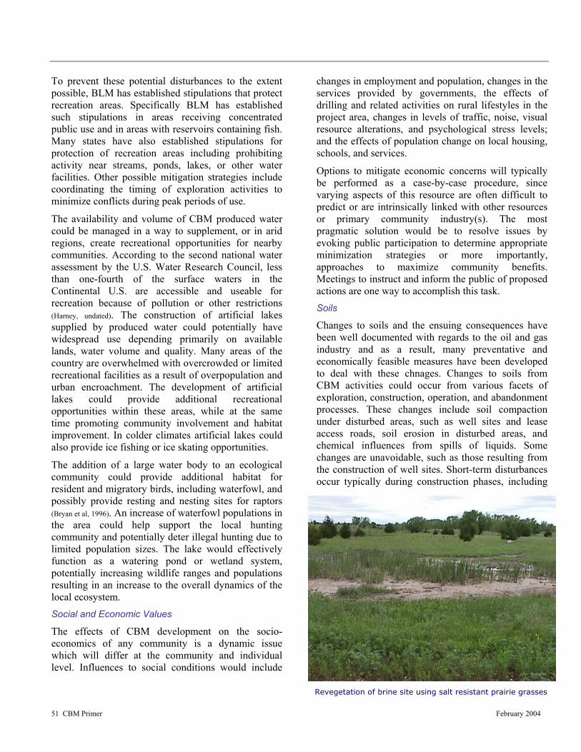
51 CBM Primer February 2004
Revegetation of brine site using salt resistant prairie grasses
To prevent these potential disturbances to the extent possible, BLM has established stipulations that protect recreation areas. Specifically BLM has established such stipulations in areas receiving concentrated public use and in areas with reservoirs containing fish. Many states have also established stipulations for protection of recreation areas including prohibiting activity near streams, ponds, lakes, or other water facilities. Other possible mitigation strategies include coordinating the timing of exploration activities to minimize conflicts during peak periods of use.
The availability and volume of CBM produced water could be managed in a way to supplement, or in arid regions, create recreational opportunities for nearby communities. According to the second national water assessment by the U.S. Water Research Council, less than one-fourth of the surface waters in the Continental U.S. are accessible and useable for recreation because of pollution or other restrictions (Harney, undated). The construction of artificial lakes supplied by produced water could potentially have widespread use depending primarily on available lands, water volume and quality. Many areas of the country are overwhelmed with overcrowded or limited recreational facilities as a result of overpopulation and urban encroachment. The development of artificial lakes could provide additional recreational opportunities within these areas, while at the same time promoting community involvement and habitat improvement. In colder climates artificial lakes could also provide ice fishing or ice skating opportunities.
The addition of a large water body to an ecological community could provide additional habitat for resident and migratory birds, including waterfowl, and possibly provide resting and nesting sites for raptors (Bryan et al, 1996). An increase of waterfowl populations in the area could help support the local hunting community and potentially deter illegal hunting due to limited population sizes. The lake would effectively function as a watering pond or wetland system, potentially increasing wildlife ranges and populations resulting in an increase to the overall dynamics of the local ecosystem. Social and Economic Values
The effects of CBM development on the socio-economics of any community is a dynamic issue which will differ at the community and individual level. Influences to social conditions would include
changes in employment and population, changes in the services provided by governments, the effects of drilling and related activities on rural lifestyles in the project area, changes in levels of traffic, noise, visual resource alterations, and psychological stress levels; and the effects of population change on local housing, schools, and services.
Options to mitigate economic concerns will typically be performed as a case-by-case procedure, since varying aspects of this resource are often difficult to predict or are intrinsically linked with other resources or primary community industry(s). The most pragmatic solution would be to resolve issues by evoking public participation to determine appropriate minimization strategies or more importantly, approaches to maximize community benefits. Meetings to instruct and inform the public of proposed actions are one way to accomplish this task. Soils
Changes to soils and the ensuing consequences have been well documented with regards to the oil and gas industry and as a result, many preventative and economically feasible measures have been developed to deal with these chnages. Changes to soils from CBM activities could occur from various facets of exploration, construction, operation, and abandonment processes. These changes include soil compaction under disturbed areas, such as well sites and lease access roads, soil erosion in disturbed areas, and chemical influences from spills of liquids. Some changes are unavoidable, such as those resulting from the construction of well sites. Short-term disturbances occur typically during construction phases, including

52 CBM Primer February 2004
A road decommissioned by ripping, mulching, and seeding. Mulching as Best Management Practice to reduce soil erosion and control the infestation of noxious weeds. Photograph provided by BLM, Coos Bay District
reclamation of construction sites.
A healthy soil can absorb storm water, filter sediment, and reduce irrigation and fertilizer needs (Field and Engel, 2003). Changes to soils resulting from CBM related practices can affect multiple resources and as such, justifies serious consideration when devising appropriate management practices. In general, soil erosion is a gradual process that occurs when the actions of water, wind, and other factors deteriorate the land into an unproductive and in some cases, hazardous state. Application of BMPs to control such problems is dependent on proper evaluation and planning, and may include considerations such as, organic matter content and nutrient levels, mulching, topography, soil testing, and native plantings.
An example of an effective BMP to control erosion is to keep water from accumulating on road surfaces. Fast-moving water can easily erode soil from road surfaces and ditches, but can be controlled by dispersing runoff into vegetation and ground litter (Iowa Department of Natural Resources, undated). Roads can be designed to keep the surface dry, while at the same time maintaining a certain level of structural integrity. In-sloped roads should contain adequate drainage, whereas out-sloped roads, which are less expensive to construct and maintain, should be designed for moderate gradients and stable soils (Iowa Department of Natural Resources, undated).
Soil changes have been well documented allowing for development of many preventative measures. The list below provides some of these measures.
• Vegetation will be removed only when necessary
• Drill seeds into the ground
• Reduce timber cutting
• Control increases in turbidity and suspended sediments to the maximum extent practical by using berms, dykes or impoundments
• Areas with steep topography will be developed in accordance with the BLM Gold Book (USDI and USDA 1989) requirements
• Federal leases with slopes in excess of 30 percent will be required to obtain approval for occupancy from the BLM based on mitigation of erosion, surface productivity after remediation, and mitigation to surface water quality
• Riparian zones will be protected by federal lease stipulations and permit mitigation measures
• In areas of construction, topsoil will be stockpiled separately from other material, and be reused in reclamation of the disturbed areas
• Surface owners or surface lessee will be consulted regarding the location of new roads and facilities related to oil and gas lease operations
• Unused portions of the drill location will have topsoil spread over it and reseeded
• Construction activities will be restricted during wet or muddy conditions
• If groundwater is encountered in shallow or near shallow surface materials during drilling, all onsite fluid pits will be lined
• During road and utility construction, surface soils will be stockpiled adjacent to the sides of the cuts and fills
• Stream crossings will be designed to minimize soil disturbances and impede stream flow
• Erosion control measures will be maintained and continued until adequate vegetation cover is re-established.

53 CBM Primer February 2004
Visual Resource Management Class I Area near Bozeman, Montana
Solid and Hazardous Wastes
In general, hazardous waste is a material or combination of hazardous materials that are no longer useable and are regulated by the Resource Conservation and Recovery Act of 1976 (RCRA). RCRA hazardous materials programs are designed to protect public health and environmental resources from improper disposal or releases of regulated materials. These programs assure future hazardous substance risks, costs, and liabilities on public lands are minimized. On Federal lands BLM is responsible for all releases of hazardous materials and requires notification of all hazardous materials to be used or transported on public land. Typical solid waste generated by drilling related procedures are considered RCRA-exempt waste and can be disposed of in local landfills. The largest volume of exempt waste generated from drilling activities are drilling mud and cuttings. Classified RCRA waste, such as paints would be disposed of in accordance with applicable regulations.
Waste minimization on CBM development sites is limited because waste volumes are primarily a function of activity, age, and state of depletion of a producing site (American Petroleum Industry, 1989). Nevertheless, mitigation planning will include proven practices to reduce waste to the extent practical. The mitigation of solid and hazardous waste consists primarily of disposing of all wastes according to federal and state regulations. Other mitigation activities include leak detection or monitoring system for hydraulic and lubricating systems, construction of secondary containments, and drilling mud retention ponds. The mitigation of accidental spills and releases involves the clean up and reporting of all spills in accordance with an approved Spill Prevention Control and Countermeasures Plan and any applicable state regulations. In addition site clearance surveys should be conducted prior to surface disturbance commencement.
Visual Resource Management
Visual resources are visual features that include landform, water, vegetation, color, adjacent scenery, uniqueness or rarity, structures, and other man-made features. Alterations resulting from oil and gas exploration and production activities occur locally on a case-by-case basis as native vegetation is disturbed and small structures are erected. Exploration may involve minor visual changes from clearing operations for access to exploratory sites. The majority of these changes result from access road construction, site construction, drill rig operations, and on-site generator use. Short-term visual changes occur where construction and drilling equipment are visually evident to observers. Long-term alterations may occur from construction of roads and pads, installation of facilities and equipment, vegetation removal, and change in vegetation communities. These could produce changes in landscape line, form, color, and texture.
The USDA Forest Service recognizes special management zones surrounding riparian resources. For example, the Superior National Forest in Minnesota designates a 200- to 300-foot forest buffer, which is managed to optimize riparian resource values (Jaakko Pöyry Consulting, Inc., 1993). This management option can easily be applied to visual resources and in specific situations, coupled together with riparian or

54 CBM Primer February 2004
recreational resources to consolidate management efforts. Retaining a visual timber buffer could help isolate CBM-specific visual impairments such as, compressor stations or well pads, from local communities, highway travelers, and nearby recreational areas. Proper identification of timberlands play an important role in implementing this strategy. Due to the associated low costs and the flexibility of this strategy, successful implementation is often feasible.
Federally authorized projects undergo a visual assessment to comply with aesthetic requirements. Typically, sensitive areas include residential areas, recreation sites, historical sites, significant landmarks or topographic features, or any areas where existing visual quality is valued. Measures to minimize disturbance include designing compressor stations to blend into the background, landscaping options, and painting to camouflage the above ground equipment. Power lines and pipelines can be placed underground and wellheads camouflaged with landscaping or vegetation. Facilities on BLM lands require ample screening from highways or camouflage to retain basic elements of form, line, color and texture of the landscape. Wilderness Study Areas
To the extent practical, BLM leasing restrictions are designed to protect Wilderness Study Areas (WSA). As such, the most reasonable practices to minimize disturbance is avoidance. BLM has implemented this type of strategy by identifying WSA policies that prohibit leasing of these lands for resource extraction. Such policies can be supplemented by collaborative partnerships among federal and state government agencies, local governments, business communities, volunteers, user groups, educational institutions, and individuals in the private sector to achieve management objectives and implement these guidelines (BLM, 2000). Wildlife and Vegetation
Stipulations to perform wildlife surveys to assure responsible actions are taken to protect listed species associated with lands owned by the federal government and/or with projects which involve federal participation is an important element of any wildlife BMP. These stipulations are mandatory for federally owned (split-estates) or federally funded projects. (It should be noted that management practices, as well as
identification of stipulations, for split-estates are the responsibility of the BLM.) If development practices occur on private lands, landowners, along with operators, are not bound by these same stipulations from a legal perspective even though they are still considered accountable for actions affecting state or federally listed species. Wildlife regulations are complex and will vary depending on geographic location, state and federal involvement, land-usage, and species distribution. In any case, wildlife surveys are a critical component of any mitigation strategy as they help identify listed species and alert operators and landowners of areas or habitats which should be avoided.
Wildlife surveys and inventories are used to identify fish and/or wildlife populations, their habitats, and other associated parameters such as home ranges, biodiversity values, and habitat usage. The inventory and monitoring of the abundance and distribution of wildlife species are essential in addressing development disturbances that pose threats to the effective and sustained management for protected, as well as common species. Monitoring programs provide the basis for formulation of adaptive wildlife management plans that document mitigation objectives and outline how each is to be implemented. Management issues relating to degree of human disturbance, conservation, management constraints, local communities’ interests, and development are influenced by the resource availability and abundance over time.
A comprehensive biota database ensures that the full ranges of species utilizing the project area are identified as well as the time of year in which they are most likely present. This information can then be
Black-footed Ferret Mustela nigripes (Photograph provided by BLM)
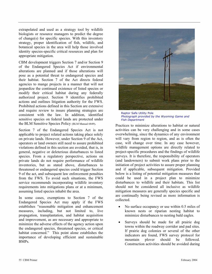
55 CBM Primer February 2004
Raptor Safe Utility Pole Photograph provided by the Wyoming Game and Fish Department
extrapolated and used as a strategy tool by wildlife biologists or resource managers to predict the degree of change(s) for specific species. With this inventory strategy, proper identification of fish, wildlife, and botanical species in the area will help those involved identity species-specific critical resources and plan for appropriate mitigation.
CBM development triggers Section 7 and/or Section 9 of the Endangered Species Act if environmental alterations are planned and if those alterations will pose as a potential threat to endangered species and their habitat. Section 7 of the Act directs federal agencies to mange projects in a manner that will not jeopardize the continued existence of listed species or modify their critical habitat during any federally authorized project. Section 9 identifies prohibited actions and outlines litigation authority for the FWS. Prohibited actions defined in this Section are extensive and require review to insure planning strategies are consistent with the law. In addition, identified sensitive species on federal lands are protected under the BLM Sensitive Species Policy (BLM Manual 6849).
Section 7 of the Endangered Species Act is not applicable to project related actions taking place solely on private lands. However, under Section 9 of the Act, operators or land owners still need to assure prohibited violations defined in this section are avoided, that is, in general, negative or deleterious disturbances to listed species. From a regulatory perspective, actions on private lands do not require performance of wildlife inventories, but as stated above, disturbances to threatened or endangered species could trigger Section 9 of the act, and subsequent law enforcement penalties from the FWS. To avoid such situations, the FWS service recommends incorporating wildlife inventory requirements into mitigations plans or at a minimum, assuming listed species inhabit the area.
In some cases, exemptions to Section 7 of the Endangered Species Act may apply if the FWS establishes “reasonable mitigation and enhancement measures, including, but not limited to, live propagation, transplantation, and habitat acquisition and improvement, as are necessary and appropriate to minimize the adverse effects of the agency action upon the endangered species, threatened species, or critical habitat concerned.” This point alone establishes the importance of developing efficient and sustainable BMPs.
Practices to minimize alterations to habitat or natural activities can be very challenging and in some cases overwhelming, since the dynamics of any environment will vary from region to region, and as is often the case, will change over time. In any case however, wildlife management options are directly related to project-specific procedures and the findings of wildlife surveys. It is therefore, the responsibility of operators (and landowners) to submit work plans prior to the initiation of project activities to assure proper planning and if applicable, subsequent mitigation. Provided below is a listing of potential mitigation measures that could be used in a project plan to minimize disturbances to wildlife and their habitats. This list should not be considered all inclusive as wildlife mitigation measures are generally species specific and are continually being revised as more information is collected.
• No surface occupancy or use within 0.5 miles of known nests or riparian nesting habitat to minimize disturbances to nesting bald eagles.
• Surveys should be made for all prairie dog towns within the roadway corridor and pad sites. If prairie dog colonies or several of the other indicators are found, FWS survey protocol for mountain plover should be followed. Construction activities should be avoided during

56 CBM Primer February 2004
Wetland system initial planting, June 2000, Marathon Oil Company, Powder River Basin, Wyoming
Same planting area as above, August 2001, Marathon Oil Company, Powder River Basin, Wyoming
breeding periods to allow nesting mountain plovers to establish territories.
• Surface occupancy and use is prohibited within 1/4 mile of wetlands used by nesting interior least tern during exploration. This stipulation would minimize disturbances to interior least tern.
• Construction of facilities or roadways that will disturb migration routes of terrestrial wildlife species should be avoided, unless construction activities can be scheduled in a manner to minimize disturbance.
• Overhead electric lines can threaten birds such as raptors or waterfowl and may impair visual resources. Buried electric lines can prevent such incidents and be as cost effective as pole-mounted lines when utility corridors are utilized. In situations where pole-mounted lines are the only feasible or best option, the use of raptor safe poles should be incorporated into the mitigation strategy.
• Remote monitoring of field data can help reduce traffic volume and the possibility of wildlife collisions. This type of monitoring will also decrease habitat defragmentation and sediment load to nearby water systems resulting from erosion.
• Use existing water structures including, reservoirs, impoundments, or stock ponds to dispose of water. This action will help avoid unnecessary disturbances to other areas, while possibly benefiting landowners or wildlife. Impoundments could be used as wildlife watering ponds or used for recreational or fish ponds by the local landowner.
• Construction of roadways in natural settings can affect multiple resources including wildlife. Reclamation of roads to pre-existing conditions upon completion of the project should be clearly defined within the project plan.
As a beneficial use, non-treated CBM produced water is currently being used to sustain privately owned fishponds in some states, including Wyoming. Water quality levels have been sufficient to support healthy populations of rainbow trout, blue gill, small-mouth bass, etc. The State of Wyoming discontinued fish
stocking programs in certain ponds due to a general lack of available water needed to sustain the system. CBM produced waters are now being beneficially used to supplement these ponds, allowing for continuation of the State’s stocking program.
Disturbances to native vegetation resulting from CBM activities will require a case by case evaluation to determine strategies to minimize the effected area. In general, pockets of vegetation will be lost to roads and drill sites, as well as other construction related procedures. Proper mitigation strategies will be based on area vegetative inventories to determine the presence of threatened, endangered, and regional sensitive species.
As directed by BLM or survey findings, operator plans should be adjusted as appropriate to avoid disturbances to federally listed species or state species of concern.
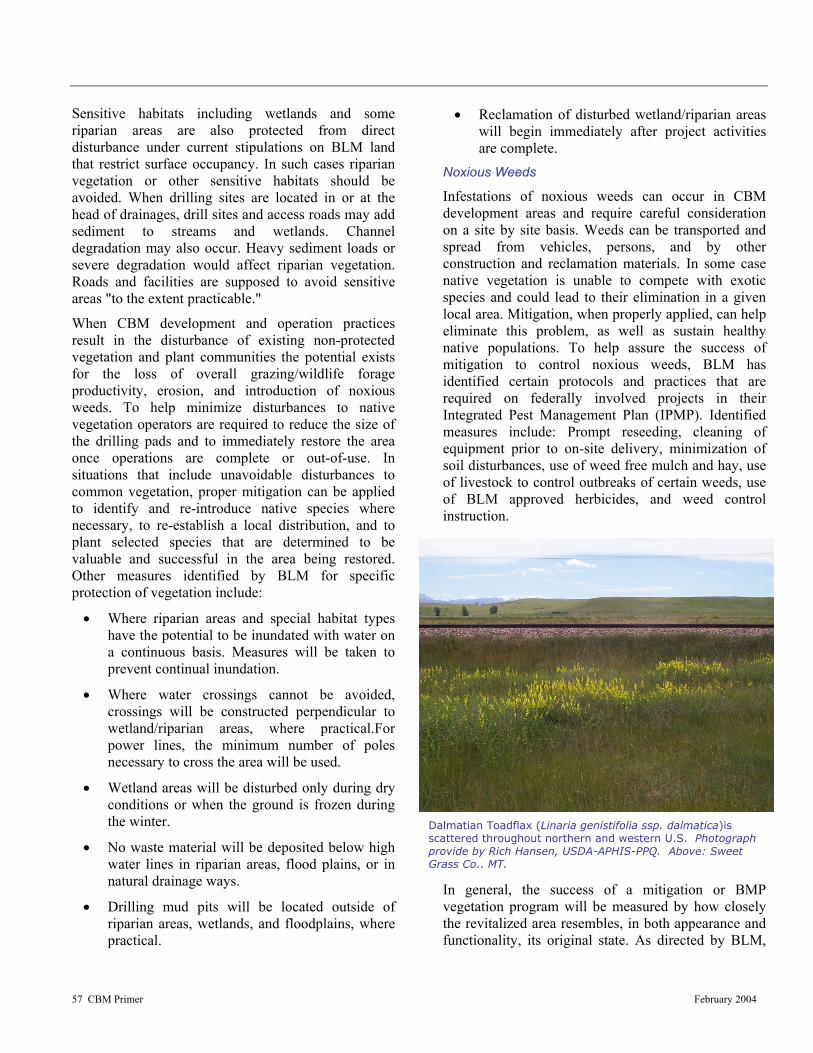
57 CBM Primer February 2004
Dalmatian Toadflax (Linaria genistifolia ssp. dalmatica)is scattered throughout northern and western U.S. Photograph provide by Rich Hansen, USDA-APHIS-PPQ. Above: Sweet Grass Co., MT.
Sensitive habitats including wetlands and some riparian areas are also protected from direct disturbance under current stipulations on BLM land that restrict surface occupancy. In such cases riparian vegetation or other sensitive habitats should be avoided. When drilling sites are located in or at the head of drainages, drill sites and access roads may add sediment to streams and wetlands. Channel degradation may also occur. Heavy sediment loads or severe degradation would affect riparian vegetation. Roads and facilities are supposed to avoid sensitive areas "to the extent practicable."
When CBM development and operation practices result in the disturbance of existing non-protected vegetation and plant communities the potential exists for the loss of overall grazing/wildlife forage productivity, erosion, and introduction of noxious weeds. To help minimize disturbances to native vegetation operators are required to reduce the size of the drilling pads and to immediately restore the area once operations are complete or out-of-use. In situations that include unavoidable disturbances to common vegetation, proper mitigation can be applied to identify and re-introduce native species where necessary, to re-establish a local distribution, and to plant selected species that are determined to be valuable and successful in the area being restored. Other measures identified by BLM for specific protection of vegetation include:
• Where riparian areas and special habitat types have the potential to be inundated with water on a continuous basis. Measures will be taken to prevent continual inundation.
• Where water crossings cannot be avoided, crossings will be constructed perpendicular to wetland/riparian areas, where practical.For power lines, the minimum number of poles necessary to cross the area will be used.
• Wetland areas will be disturbed only during dry conditions or when the ground is frozen during the winter.
• No waste material will be deposited below high water lines in riparian areas, flood plains, or in natural drainage ways.
• Drilling mud pits will be located outside of riparian areas, wetlands, and floodplains, where practical.
• Reclamation of disturbed wetland/riparian areas will begin immediately after project activities are complete.
Noxious Weeds
Infestations of noxious weeds can occur in CBM development areas and require careful consideration on a site by site basis. Weeds can be transported and spread from vehicles, persons, and by other construction and reclamation materials. In some case native vegetation is unable to compete with exotic species and could lead to their elimination in a given local area. Mitigation, when properly applied, can help eliminate this problem, as well as sustain healthy native populations. To help assure the success of mitigation to control noxious weeds, BLM has identified certain protocols and practices that are required on federally involved projects in their Integrated Pest Management Plan (IPMP). Identified measures include: Prompt reseeding, cleaning of equipment prior to on-site delivery, minimization of soil disturbances, use of weed free mulch and hay, use of livestock to control outbreaks of certain weeds, use of BLM approved herbicides, and weed control instruction.
In general, the success of a mitigation or BMP vegetation program will be measured by how closely the revitalized area resembles, in both appearance and functionality, its original state. As directed by BLM,
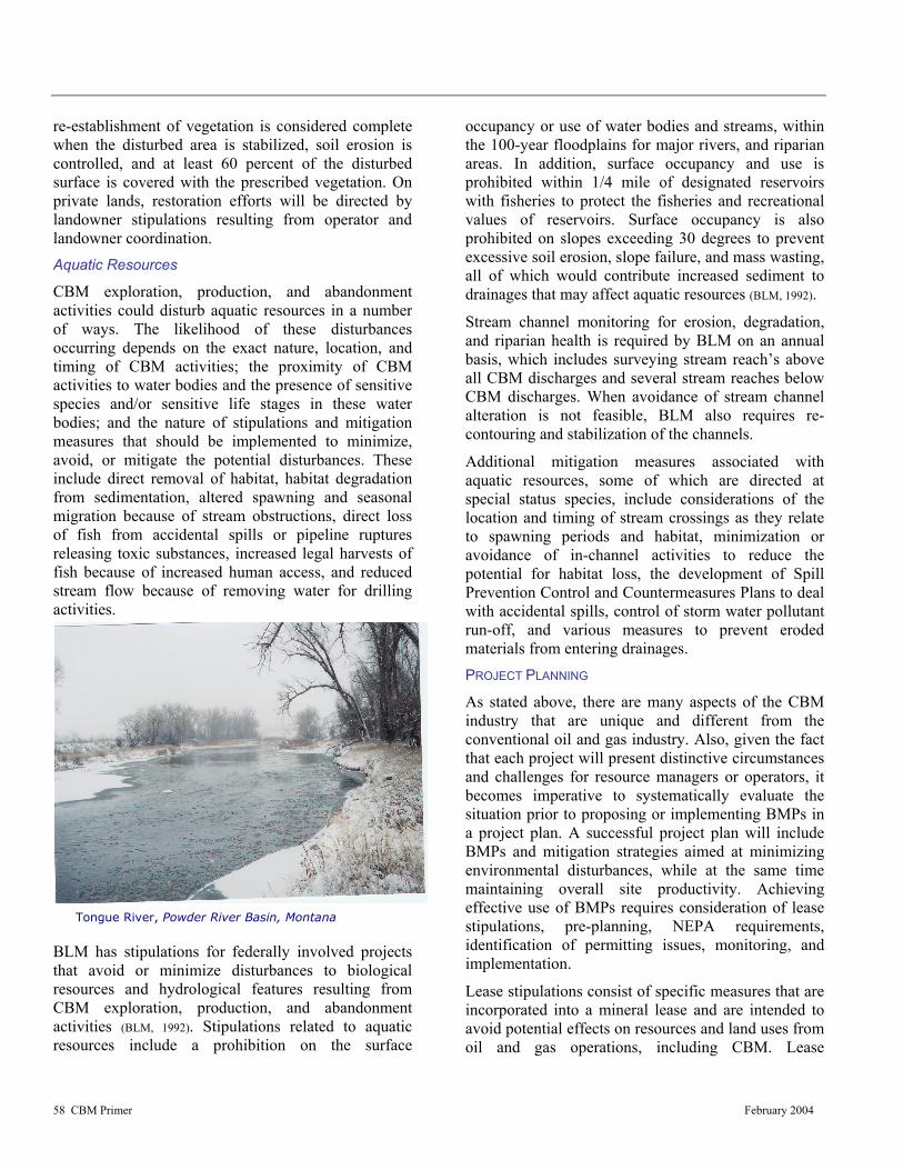
58 CBM Primer February 2004
Tongue River, Powder River Basin, Montana
re-establishment of vegetation is considered complete when the disturbed area is stabilized, soil erosion is controlled, and at least 60 percent of the disturbed surface is covered with the prescribed vegetation. On private lands, restoration efforts will be directed by landowner stipulations resulting from operator and landowner coordination. Aquatic Resources
CBM exploration, production, and abandonment activities could disturb aquatic resources in a number of ways. The likelihood of these disturbances occurring depends on the exact nature, location, and timing of CBM activities; the proximity of CBM activities to water bodies and the presence of sensitive species and/or sensitive life stages in these water bodies; and the nature of stipulations and mitigation measures that should be implemented to minimize, avoid, or mitigate the potential disturbances. These include direct removal of habitat, habitat degradation from sedimentation, altered spawning and seasonal migration because of stream obstructions, direct loss of fish from accidental spills or pipeline ruptures releasing toxic substances, increased legal harvests of fish because of increased human access, and reduced stream flow because of removing water for drilling activities.
BLM has stipulations for federally involved projects that avoid or minimize disturbances to biological resources and hydrological features resulting from CBM exploration, production, and abandonment activities (BLM, 1992). Stipulations related to aquatic resources include a prohibition on the surface
occupancy or use of water bodies and streams, within the 100-year floodplains for major rivers, and riparian areas. In addition, surface occupancy and use is prohibited within 1/4 mile of designated reservoirs with fisheries to protect the fisheries and recreational values of reservoirs. Surface occupancy is also prohibited on slopes exceeding 30 degrees to prevent excessive soil erosion, slope failure, and mass wasting, all of which would contribute increased sediment to drainages that may affect aquatic resources (BLM, 1992).
Stream channel monitoring for erosion, degradation, and riparian health is required by BLM on an annual basis, which includes surveying stream reach’s above all CBM discharges and several stream reaches below CBM discharges. When avoidance of stream channel alteration is not feasible, BLM also requires re-contouring and stabilization of the channels.
Additional mitigation measures associated with aquatic resources, some of which are directed at special status species, include considerations of the location and timing of stream crossings as they relate to spawning periods and habitat, minimization or avoidance of in-channel activities to reduce the potential for habitat loss, the development of Spill Prevention Control and Countermeasures Plans to deal with accidental spills, control of storm water pollutant run-off, and various measures to prevent eroded materials from entering drainages. PROJECT PLANNING
As stated above, there are many aspects of the CBM industry that are unique and different from the conventional oil and gas industry. Also, given the fact that each project will present distinctive circumstances and challenges for resource managers or operators, it becomes imperative to systematically evaluate the situation prior to proposing or implementing BMPs in a project plan. A successful project plan will include BMPs and mitigation strategies aimed at minimizing environmental disturbances, while at the same time maintaining overall site productivity. Achieving effective use of BMPs requires consideration of lease stipulations, pre-planning, NEPA requirements, identification of permitting issues, monitoring, and implementation.
Lease stipulations consist of specific measures that are incorporated into a mineral lease and are intended to avoid potential effects on resources and land uses from oil and gas operations, including CBM. Lease

59 CBM Primer February 2004
stipulations can include provisions for, and constraints on, such things as site clearances, occupancy, and timing restrictions. Lease stipulations should be identified and agreed upon at the time of the lease signing before conducting exploration, production, and abandonment activities.
Depending on the situation, pre-planning for BMPs may occur before, during, or after CBM exploration activities. The success (or lack there of) of exploratory “findings” in many cases would contribute to the scheduling or initiation of a pre-planning program. In either case however, good planning is the best tool for effective implementation of BMPs. The pre-planning process should consider BMPs or mitigation strategies that are flexible, enforceable, have a preventative ability, and as stated earlier, can be implemented in phases.
Phase implementation for a particular aspect of the project should assure specific operations are paired up with the appropriate mitigation measures so as to maximize the effectiveness of any specific mitigation (EPA, 2002). This type of planning strategy should also ensure smooth implementation of the subsequent phases of work. Considering that the primary purpose of a BMP or mitigation measure is not only to resolve problems which may arise upon project initiation, but to prevent environmental problems before they occur, successful BMPs should be readily adapted to changes resulting from unforeseeable changes to a particular project (EPA, 2002). A flexible strategy can also prevent unnecessary delay due to further changes in the work environment. Lastly, a successful BMP should be easily enforceable. Operators should ask such questions as; What type of measure will be used? Where will the measure be implemented? and Why is the measure necessary? Sound and practical answers to these questions will aid operators in reducing concerns from the regulatory community, landowners, and citizens groups.
Planning efforts should begin with a thorough evaluation of the surface proposed for CBM development. Selection of the proper surface may help minimize and mitigate surface conflicts and avoid unnecessary surface uses that could require additional reclamation, special operating procedures, or other restrictions that could be avoided. At this time consideration also needs to be given to the proximity to schools, residences and other public areas, visual alterations, erosion potential, wildlife habit, and the
improvements and structures of the landowner/surface lessee.
In addition operators should consider avoiding surfaces with steep slopes, unstable soils, and locations that block or restrict natural drainages during the pre-planning phase. Care should also be taken to disturb the minimum amount of native vegetation as possible, particularly in those areas where vegetation will be difficult to re-establish. Locations in areas with a potential for high surface run-off, with increased erosion potential or in the flood plain of surface drainages could dramatically increase maintenance costs and mitigation efforts, as well as create additional safety concerns. An exploration site that has a low slope, soils with low erosion potential, and a site that can be readily re-vegetated benefits the operator by reducing the costs of compliance with storm water discharge permits and associated well and road site remediation.
Section 102 of the National Environmental Policy Act requires Federal agencies to incorporate environmental considerations in their planning and decision-making process through a systematic interdisciplinary approach. Specifically, Federal agencies are to assess the environmental effects of, and alternatives to major federal actions significantly affecting the environment. Actions are classified into one of three categories and include: Categorically Excluded, Finding of No Significant Impact (as identified by an Environmental Assessment), and Finding of Significant Impact (as identified in an Environmental Impact Statement and Record of Decision).
Under this Act, Environmental Impact Statements (EIS) are developed to identify and evaluate the severity of project specific environmental disturbances that may result from CBM development practices. Identification of existing environmental conditions and potential disturbances will help those involved identify appropriate mitigation for site-specific impacts. Typically, resources evaluated in the EIS include:
• Environmental quality, including air, water, soils
• Social and socioeconomic conditions • Natural resources, including fish, wildlife, and
plants • Endangered and threatened species
60 CBM Primer February 2004
• Historical and cultural resources, including archeological materials
• Initial assessment for any hazardous, toxic, or radiological wastes
The number and complexity of applicable permit requirements and water right issues that can apply to CBM operations can be overwhelming, but are critical to the successful implementation of BMPs and mitigation strategies. Permit requirements can and will vary for any given state or region. Coupled with the discretionary practices agencies can exercise when applying their programs, it becomes essential for operators and landowners to have a thorough understanding of these requirements to allow for informed decisions as they relate to identifying and implementing site specific BMPs. Operators, landowners, or other entities involved in the CBM industry should contact their appropriate state authority for additional information. It should also be noted that permitting requirements within the CBM industry are continually being modified or new requirements are being drafted. CONCLUSION
Not all BMPs or mitigation measures will be appropriate for any given resource and proper implementation will vary by the region, topography, climate, reclamation objectives, landowner stipulations, applicable regulations, and development characteristics. Established mitigation plans will require amendment when there are significant changes in design, construction, and operation or maintenance practices. Since operational and development conditions will likely change over time, developing monitoring plans for these changes will help faciltitae necessary adjustments to BMP programs.
The focus of many monitoring plans is to conduct an overall evaluation of the potential effects of CBM development and to track the changes that occur as CBM fields mature, and gas production declines and eventually ends. The end result of monitoring will allow those involved to determine if measures are achieving their intended environmental objectives, as well as to identify any further disturbances caused by the mitigation measures themselves (EPA, 2002). Effective monitoring can also provide a means for developing improved analytical procedures for future analysis and improving mitigation measures. Standards for monitoring resources such as air quality,
water, wildlife, and surface disturbances historically have been well documented, and serve as a baseline for monitoring.
BMPs should not be thought of as a rigid set of guidelines that are mandatory for reduction of disturbances, but as an adaptive and concise management tool which can facilitate enhancement, as well as protection, for multiple resource use. Unfortunately, there is no one measure with a “fix all” quality. Rather, BMPs represent an intricate web of methodologies and practices resulting from careful planning and coordination that are used to accomplish pre-determined objectives. BMPs must be incorporated into the final design plan for any CBM construction project to help assure the success of the project, as well as the protection of the environment.

DEFINITIONS
D-1
DEFINITIONS
AIR QUALITY. Air quality is based on the amount of pollutants emitted into the atmosphere and the dispersion potential of an area to dilute those pollutants.
ALKALINITY. The quantity and kinds of compounds present in water that collectively shift the pH to the alkaline side of neutrality. See salinity.
ALLUVIUM. General term for debris deposited by streams on river beds, floodplains, and alluvial fans, especially deposits brought down during a flood. Applies to stream deposits of recent time. Does not include below water sediments of seas and lakes.
ANNULUS OR ANNULAR SPACE. The space around a pipe in a wellbore, the outer wall of which may be the wall of either the borehole or the casing.
AQUIFER. A body of rock that is sufficiently permeable to conduct groundwater and to yield economically significant quantities of water to wells and springs.
APPLICATION FOR PERMIT TO DRILL, DEEPEN OR PLUG BACK (APD). The Department of Interior application permit form to authorize oil and gas drilling activities on federal land or the state application form for similar purposes.
AREA OF CRITICAL ENVIRONMENTAL CONCERN. An area that needs special management attention to preserve historic, cultural, or scenic values; to protect fish and wildlife resources or other natural systems or processes; or to protect life and provide safety from natural hazards.
ARTESIAN. Groundwater with sufficient pressure to flow without pumping.
BASIN. A closed geologic structure in which the beds dip toward the center; the youngest rocks are at the center of a basin and are partly or completely ringed by progressively older rocks.
BEDROCK. The solid, unweathered rock underlying soils.
BEST AVAILABLE CONTROL TECHNOLOGY (BACT). The best available air pollution control technology for a given emission source, considering environmental benefits, economic and energy costs, as defined by the applicable air quality regulatory authority.
BIOGENIC. Produced by living organisms or biological processes.
BITUMINOUS. The most abundant rank of coal (synonymous with soft coal). It is dark brown to black and burns with a smoky flame.
BRACKISH WATER. Water that contains relatively moderate concentrations of any soluble salts. Brackish water is saltier than fresh water but not as salty as salt water or brine water.
BRINE. Water containing relatively large concentrations of dissolved salts, particularly sodium chloride. Brine has higher salt concentrations than ordinary ocean water.
BUFFER ZONE.
1. An area between two different land uses that is intended to resist, absorb or otherwise preclude developments or intrusions between the two use areas.
2. A strip of undisturbed vegetation that retards the flow of runoff water, causing deposition of transported sediment and reducing sedimentation in the receiving stream.
CASING. Steel pipe placed in a well and cemented in place to prevent the earth from collapsing and to isolate water, gas and oil from the original formations.
CAVITATION. The formation of an undercut in a mineral formation by means of mechanical forces, such as those resulting from rotation of a special drill bit at the base of a well.
CHANNEL INTEGRITY (STABILITY). A relative term describing erosion or movement of the channel walls or bottom because of water flow.
CLAYEY. A soil containing more than 35 percent clay. The textural classes are sandy clay, silty clay, clay, clay loam, and silty clay loam.
CLEAN AIR ACT. Public Law 84-159, established July 14, 1955, and amended numerous times since. The Clean Air Act: establishes federal standards for air pollutants emitted from stationary and mobile sources; authorizes states, tribes and local agencies to regulate polluting emissions; requires those agencies to improve air quality in areas of the country which do not meet federal standards; and to prevent significant deterioration in areas where air quality is cleaner than those standards. The Act also requires that all federal activities (either direct or authorized) comply with applicable local, state, tribal and federal air quality laws, statutes, regulations, standards and implementation plans. In addition, before these activities can take place in non-attainment or maintenance areas, the

DEFINITIONS
D-2
federal agencies must conduct a Conformity Analysis (and possible Determination) demonstrating the proposed activity will comply with all applicable air quality requirements.
CLOSED MUD SYSTEM. A drill mud system that reuses or reclaims all the drilling fluid used. Oil-based mud systems are often closed mud systems.
COAL BED METHANE. A clean-burning natural gas found deep inside and around coal seams. The gas has an affinity to coal and is held in place by pressure from groundwater. Coalbed methane is produced by drilling a wellbore into the coal seam(s), pumping out large volumes of groundwater to reduce the hydrostatic pressure and allow the gas to flow.
COALIFICATION. Compression and hardening over long periods of time, the processes by which coal is formed from plant materials.
COLLUVIAL. Loose, incoherent geological deposits at the bottom of a slope or cliff, having fallen from above.
COMMUNITIZATION. The pooling of mineral acreages based on the spacing for a well or wells set by the state or BLM.
COMPACTION. The process of packing firmly and closely together; the state of being so packed; for example, mechanical compaction of soil by livestock or vehicular activity. Soil compaction results from particles being pressed together so that the volume of the soil is reduced. It is influenced by the physical properties of the soil, moisture content, and the type and amount of compactive effort.
COMPLETION. The activities and methods to prepare a well for production. Includes installation of equipment for production from a gas well.
CONDITION OF APPROVAL (COA). Conditions or provisions (requirements) under which an Application for a Permit to Drill or a Sundry Notice is approved.
CONTROLLED SURFACE USE (CSU). Use or occupancy is allowed (unless restricted by another stipulation), but identified resource values require special operational constraints that may modify the lease rights. CSU is used for operating guidance, not as a substitute for the NSO or Timing stipulations.
CONVEYANCE LOSS. The percentage reduction in water volume between the time it is discharged to the surface and the time it reaches a perennial stream. This reduction in volume is due to the processes of infiltration and evaporation.
CORRIDOR. A strip of land through which one or more existing or potential facilities may be located.
CRUCIAL WINTER RANGE. That portion of the winter range on which a wildlife species is dependent for survival during periods of heaviest snow cover.
CULTURAL RESOURCE. A term that includes items of historical, archaeological, or architectural items; a remnant of human activity.
CUMULATIVE IMPACT. The impact on the environment that results from the positive or negative impacts of an action when added to other past, present, and reasonable foreseeable future actions, regardless of what agency or person performed such action(s).
DEEPER COAL SEAM. Designates a coal seam that is deep enough that it can be drilled to at a directional angle from a well pad in one spacing unit to another spacing unit. This avoids the need for constructing additional roads and well pads. The exact depth that the term “deeper” applies to is relative and will vary according to field spacing requirements and local geology.
DEVELOPMENT WELL. A well drilled in proven territory (usually within 1 mile of an existing production well).
DESORBED. To remove (an absorbed or adsorbed substance) from.
DISPOSAL WELL. A well into which produced water from other wells is injected into an underground formation for disposal.
DRAINAGE (GEOMORPHIC). A collective term for all the water bodies by which a region is drained; or, all the water features shown on a map.
DRAINAGE (OIL AND GAS). The uncompensated loss of hydrocarbons from Federal, Indian tribal or Indian-allotted mineral lands from wells on adjacent non-jurisdictional lands or jurisdictional lands with lower participation, allocation, royalty rate, or distribution of funds, resulting in revenue losses to the Federal or Indian lessors.
DRILL DIRECTIONALLY. The technique of drilling at an angle from a location at the surface to a different subsurface location at a specific target depth.
DRILL RIG. The mast, drawworks, and attendant surface equipment of a drilling or workover unit.
DRY HOLE. Any well incapable of producing oil or gas in commercial quantities. A dry hole may produce water, gas or even oil, but not enough to justify production.
ECOSYSTEM. A biological community, together with its nonliving environment, forming an interacting system inhabiting an identifiable space.
DEFINITIONS
D-3
ELECTRICAL CONDUCTIVITY. A measure of the ability of a formation and the fluids present in it to conduct an electrical current. For shallow formations and coals, the conductivity is generally related to the soluble salts present in the formation fluid.
EMISSION. Air pollution discharge into the atmosphere, usually specified by mass per unit time.
ENDANGERED SPECIES. Those species of plants or animals classified by the Secretary of the Interior or the Secretary of Commerce as endangered pursuant to Section 4 of the Endangered Species Act of 1973, as amended. See also Threatened and Endangered Species.
ENHANCED RECOVERY. The use of artificial means to increase the amount of hydrocarbons that can be recovered from a reservoir. A reservoir depleted by normal extraction practices usually can be restored to production by secondary or tertiary methods of enhanced recovery.
EXPLORATION. The process of identifying a potential subsurface geologic target and the active drilling of a borehole designed to assess the coalbed methane potential. See also development.
EXPLORATION WELL. A well drilled in an area where there is no oil or gas production. Same as a “wildcat” well.
FAULT. A fracture surface in rocks along which movement of rock on one side has occurred relative to rock on the other side.
FLOODPLAIN. The relatively flat area or lowlands adjoining a body of standing or flowing water that has been or might be covered by floodwater.
FLOW LINE. A small diameter pipeline that generally connects a well to the initial processing facility.
FORMATION (GEOLOGIC). A rock body distinguishable from other rock bodies and useful for mapping or description. Formations may be combined into groups or subdivided into members.
FUGITIVE DUST. Airborne particles emitted from any source other than through a controllable stack or vent.
GEOMORPHIC. Pertaining to the form of the earth or its surface features.
GROUND COVER. Vegetation, mulch, litter, or rocks.
GROUNDWATER. Subsurface water that is in the zone of saturation. The top surface of the groundwater is the “water table.” Source of water for wells, seepage, and springs.
HABITAT. In wildlife management, the major elements of habitat are considered to be food, water, cover, and living space.
HAZARDOUS WASTE. (A) Any substance designated pursuant to section 311(b)(2)(A) of the Federal Water Pollution Control Act. (B) Any element, compound, mixture, solution, or substance designated pursuant to section 102 of this Act. (C) Any hazardous waste having the characteristics identified under or listed pursuant to section 3001 of the Solid Waste Disposal Act (but not including any waste the regulation of which under the Solid Waste Disposal Act has been suspended by Act of Congress.) (D) Any toxic pollutant listed under section 307(a) of the Federal Water Pollution Control Act. (E) Any hazardous air pollutant listed under section 112 of the Clean Air Act. (F) Any imminently hazardous chemical substance or mixture with respect to which the Administrator has taken action pursuant to section 7 of the Toxic Substances Control Act. The term does not include petroleum, including crude oil or any fraction thereof which is not otherwise specifically listed or designated as a hazardous substance under subparagraphs (A) through (F) of this paragraph, and the term does not include natural gas, natural gas liquids, liquefied natural gas, or synthetic gas usable for fuel (or mixtures of natural gas and such synthetic gas).
HYDROSTATIC PRESSURE. relating to fluids at rest or to the pressures they exert or transmit; "hydrostatic pressure"
INFILTRATION. The flow of a fluid into a solid substance through pores or small openings; specifically, the movement of water into soil or porous rock.
INJECTION WELL. A well used to inject fluids into an underground formation either for enhanced recovery or disposal.
INTERMITTENT STREAM. A stream that flows most of the time but occasionally is dry or reduced to pool stage when losses from evaporation or seepage exceed the available streamflow.
LAND AND WATER CONSERVATION FUNDS. Federal revenues generated by a tax on federal off-shore oil and gas development through the Land and Water Conservation Fund Act; used to acquire highly desirable lands for the United States by the various governmental agencies.
LEASABLE MINERALS. Federal minerals subject to lease under the Mineral Leasing Act of 1920, as amended, and supplemented. Includes minerals, such as oil, gas, coal, geothermal, tar sands, oil shale, potassium, phosphate, sodium, asphaltic materials.
LEASE.
1. A legal document that conveys to an operator the right to drill for oil and gas.

DEFINITIONS
D-4
2. The tract of land, on which a lease has been obtained, where producing wells and production equipment are located.
LEASE NOTICE. Provides more detailed information concerning limitations that already exist in law, lease terms, regulations, or operational orders. A lease notice also addresses special items the lessee should consider when planning operations, but does not impose new or additional restrictions. Lease notices attached to leases should not be confused with NTLs (Notices to Lessees).
LEK. A traditional breeding area for grouse species where territorial males display and establish dominance.
LIGNITE. A brownish-black coal that is intermediate between peat and subbituminous coal.
LOAMY. Soil that is intermediate in texture and properties between sandy and clayey soils. Textural classes are sandy loam, fine sandy loam, very fine sandy loam, loam, silt loam, sandy clay loam, and clay loam with clay content between 18 and 35 percent.
LOCALITY. The area where paleontologic material is discovered.
LOCATABLE MINERALS. Minerals or materials subject to disposal and development through the Mining Law of 1872 (as amended). Generally includes metallic minerals such as gold and silver and other materials not subject to lease or sale.
MACERALS. the small fragments formed in peat and coal, and can be identified microscopically as coming from plant products.
MINERAL MATERIALS. Widespread deposits of common clay, sand, gravel, or stone that are not subject to disposal under the 1872 Mining Law, as amended.
MITIGATION MEASURES. Methods or procedures developed for the purpose of reducing or lessening the impacts of an action.
MONITORING. Specific studies that evaluate the effectiveness of actions taken toward achieving management objectives.
NATIONAL AMBIENT AIR QUALITY STANDARDS OR NAAQS. The allowable concentrations of air pollutants in the air specified by the federal government. The air quality standards are divided into primary standards (based on air quality criteria and allowing an adequate margin of safety requisite to protect the public health) and secondary standards (based on air quality criteria and allowing an adequate margin of safety to protect the public welfare from any unknown or expected adverse effects of air pollutants).
NO SURFACE OCCUPANCY. Use or occupancy of the land surface for fluid mineral exploration or development is prohibited to protect identified resource values.
NOTICE TO LESSEES (NTL). The NTL is a written notice issued by the Authorized Officer. NTLs implement regulations and operating orders, and serve as instructions on specific item(s) of importance within a State, District, or Area.
PARTICULATE MATTER. A particle of soil or liquid matter (e.g., soot, dust, aerosols, fumes and mist).
PERENNIAL STREAM. A permanent stream that flows 9 months or more out of the year.
PERMEABILITY. The ease with which gases, liquids or plant roots pass through a layer of soil. Accepted as a measure of this property is the rate at which soil transmits water while saturated, and may imply how well water passes through the least permeable soil layer.
PERFORATING. Penetrating the well casing to open the reservoir to the surface.
pH. A measure of acidity or alkalinity. A solution with a pH of 7 is neutral, pH greater than 7 (to 14) is alkaline, and a pH less than 7 (to 0) is acidic.
PARTS PER MILLION (PPM). A measurement to identify the amount of particulates in air or water.
POD. Describes the general location of a series of wells that tap individual coal seams within a single spacing unit. For example, within the Powder River Basin, three coal seams are layered beneath the surface. On the surface, an operator may drill three separate wells to different depths to tap these individual seams. The wells may be located within 20 feet of each other, representing a pod of wells.
POROSITY. The ratio of the volume of all the pores in a material to the volume of the whole.
PREVENTION OF SIGNIFICANT DETERIORATION OR PSD. A regulatory program under the Clean Air Act (Public Law 84-159, as amended) to limit air quality degradation in areas currently achieving the National Ambient Air Quality Standards. The PSD program established air quality classes in which differing amounts of additional air pollution is allowed above a legally defined baseline level. Almost any additional air pollution would be considered significant in PSD Class I areas (certain large national parks and wilderness areas in existence on August 7, 1977, and specific Tribal lands redesignated since then). PSD Class II areas allow that deterioration associated with moderate, well-controlled growth (most of the country).
Class I. An area that allows only minimal degradation above “baseline.” The Clean Air Act designated
DEFINITIONS
D-5
existing national parks over 6,000 acres and national wilderness areas over 5,000 acres in existence on August 7, 1977, as mandatory Federal Class I Areas. These areas also have special visibility protection. In addition, four tribal governments have redesignated their lands as Class I Areas.
Class II. An area that allows moderate degradation above “baseline.” Most of the United States (outside nonattainment areas) is Class II.
Class III. Any area that allows the maximum amount of degradation above “baseline.” Although the U.S. Congress allows air quality regulatory agencies to redesignate Class II lands to Class III, none have been designated.
PRODUCED WATER. Water produced from oil and gas wells.
RAPTOR. Bird of prey with sharp talons and strongly curved beaks (hawks, falcons, owls, and eagles).
RECLAMATION. Rehabilitation of a disturbed area to make it acceptable for designated uses. This normally involves regrading, replacement of topsoil, revegetation, and other work necessary to restore it for use.
RESERVE PIT.
1. Usually an excavated pit that may be lined with plastic, that holds drill cuttings and waste mud.
2. Term for the pit that holds the drilling mud.
RIGHT-OF-WAY GRANT. A document authorizing a nonpossessory, nonexclusive right to use federal lands for the limited purpose of construction, operation, maintenance, and termination of a pipeline, road, or powerline.
RILL. Small, conspicuous water channel or rivulet that concentrates runoff; usually less than 6 inches deep.
RIPARIAN/WETLAND AREA. An area of land directly influenced by permanent water. It has visible vegetation or physical characteristics reflective of permanent water influence. Lakeshores, streams and permanent springs are typical riparian areas. Excluded are such sites as ephemeral streams or washes that do not exhibit the presence of vegetation dependent upon free water in the soil.
ROAD. A vehicle route that has either been improved and maintained by mechanical means to ensure relatively regular and continuous use, or been established where vehicle travel has created two parallel tracks lacking vegetation.
SALINITY. A measure of the salts dissolved in water. See alkalinity.
SEDIMENT. Soil, rock particles and organic or other debris carried from one place to another by wind, water, gravity, ice, or other geologic agent.
SEDIMENTARY ROCK. A layered rock resulting from the consolidation of sediment, such as shale, sandstone, and limestone.
SEISMIC OPERATIONS. Use of explosive or mechanical thumpers to generate shock waves that can be read by special equipment to give clues to subsurface conditions.
SHALLOW COAL SEAM. Those coal seams that are too shallow to drill to directionally given the area geology and spacing limitations.
SHUT IN. To close the valves on a well so it ceases production.
SODIUM ABSORPTION RATIO. An expression of relative activity of sodium ions in exchange reactions with soil, indicating the sodium or alkali hazard to soil. It is a particularly important measure in waters used for irrigation purposes.
SODIUM-AFFECTED SOIL. A nontechnical term for sodic soil (also called alkali soil) that contains sufficient sodium to interfere with the growth of most crop plants and in which the exchangeable sodium percentage is 15 or higher. It is also a generic way of describing nonsaline-alkali soil or saline-alkali soil.
SOLID WASTE. Any solid, semi-solid, liquid, or contained gaseous material that is intended for disposal.
SPACING UNIT. The number of acres that one oil or gas well will efficiently drain. The state oil and gas commissions typically establish the size of spacing units for each oil and gas field.
SPECIES OF SPECIAL INTEREST OR CONCERN. Animals not yet listed as endangered or threatened but that are undergoing status review by a federal or state agency. This may include animals whose populations could become extinct by any major habitat change. A species that is particularly sensitive to some external disturbance factors.
SPLIT ESTATE. Surface and minerals of a given area in different ownerships. Frequently, the surface is privately-owned while the minerals are federally or state-owned.
STIPULATION. A condition or requirement attached to a lease or contract, usually dealing with protection of the environment, or recovery of a mineral.
SUBBITUMINOUS. A black coal, intermediate in rank between lignite and bituminous coal. Distinguished from lignite by higher carbon and lower moisture content.
DEFINITIONS
D-6
SULFUR DIOXIDE OR SO2. A colorless gas formed when sulfur oxidizes, often as a result of burning trace amounts of sulfur in fossil fuels.
THERMOGENIC. Generation or production of heat, especially by physiological processes.
TOTAL DISSOLVED SOLIDS (TDS). The dry weight of dissolved material, organic and inorganic, contained in water and usually expressed as parts per million (ppm).
TRANSMISSION LINE. A large diameter pipeline through which oil or gas moves off lease after being sold.
TURBIDITY. An interference to the passage of light through water due to insoluble particles of soil, organic material, micro-organisms, and other materials.
UNDERGROUND INJECTION CONTROL PROGRAM. A program administered by the Environmental Protection Agency, primacy State, or Indian Tribe under the Safe Drinking Act to ensure that subsurface emplacement of fluids does not endanger underground sources of drinking water.
UNITIZATION. Pooling of mineral acreages proposed by a company to facilitate the efficient development of a reservoir based on geology and reservoir characteristics of a producing formation or formations.
VIEWSHED. Landscape that can be directly seen under favorable atmospheric conditions, from a viewpoint or along a transportation corridor.
VITRINITE. A kind of naturally occurring glass which is very hard.
WATER QUALITY. The chemical, physical, and biological characteristics of water with respect to its suitability for a particular use.
WATERSHED. All lands which are enclosed by a continuous hydrologic drainage divide and lie upslope from a specified point on a stream.
WELL COMPLETION. See completion.
WELL LIFE. For the purposes of this plan the well life is defined as from the time the well is drilled until the final abandonment of the well is approved.
WETLANDS. Permanently wet or intermittently flooded areas where the water table (fresh, saline, or brackish) is at, near, or above the soil surface for extended intervals; where hydric wet soil conditions are normally exhibited, and where water depths generally do not exceed two meters.
WILDERNESS STUDY AREA (WSA). An area deter-mined to have wilderness characteristics. WSAs are submitted to the President and Congress for wilderness
designation. These areas are an interim designation, valid until either designated as wilderness or released to multiple-use management.
WORKOVER. To perform one or more remedial operations on a producing or injection well to increase production. Deepening, plugging back, pulling, and resetting the liner are examples of workover operations.

REFERENCES
R-1
REFERENCES ALL
2001a. Soils Technical Report, Montana statewide oil and gas environmental impact statement and amendment of the Powder River and Billings resource management plans. Prepared for the U.S. Department of the Interior, Bureau of Land Management, Miles City Field Office. ALL Consulting, Tulsa, OK.
ALL 2001b. Water Resources Technical Report, Montana
statewide oil and gas environmental impact statement and amendment of the Powder River and Billings resource management plans. Prepared for the U.S. Department of the Interior, Bureau of Land Management, Miles City Field Office. ALL Consulting, Tulsa, OK.
ALL 2003. Handbook on Coal Bed Methane Produced
Water: Management and Beneficial Use Alternatives, Prepared for the U.S. Department of Energy, National Petroleum Technology Office. ALL Consulting, Tulsa, OK.
American Petroleum Industry. 1989. API Environmental Guidance Document:
Onshore Solid Waste Management in Exploration and Production Operations. First Edition, Jan. 15, 1989.
Applied Hydrology Associates 2001. Cumulative Impacts of Coal Bed Methane
Development on Water Quality in the Powder and Little Powder Rivers. August 16, 2001.
BIA See U.S. Bureau of Indian Affairs.
BLM See USDI Bureau of Land Management.
Bloom, M. 2003. Personal communication between Jon W.
Seekins and Ms. Bloom of the Miles City BLM Field Office, April 2003.
Boyer, Charles M. II, and A. Kuusraa, 1999. “Economic and Parametric Analysis of
Coalbed Methane” AAPG.
Breisch, D. 2003. Personal communication between Jon W.
Seekins and Mr. Breisch of the Miles City BLM Field Office, April 2003.
Bryan, A.L., Jr., T.M. Murphy, K.L. Bildstein, I.L. Brosbin, Jr., and J.J. Mayer.
1996. Use of Reservoirs and Other Artificial Impoundments by Bald Eagles in South Carolina. In Raptors in Human Landscapes, edited by D.M. Bird, D.E. Varland, and J.J. Negro. London Academic Press. P. 287-298.
Bryner, Gary, 2002. Coalbed Methane Development in the
Intermountain West: Primer, Natural Resources Law Center, University of Colorado School of Law
Campen, E. and J. R. Gruber 1991. Coal and Coalbed Methane Resources of
Montana, Rocky Mountain Association of Geologists.
Cardott, B.J., 2001. Open-File Report 2-2001, Oklahoma coalbed-
methane workshop 2001: Introduction to Coal as Gas Source Rock and Reservoir: p. 1-27.
Coal Bed Methane Coordination Group 2000. CMS Energy Presentation, Coal Bed Methane
Coordination Group, October 18, 2000.
Cohen, Farnell and Thompson, 1984. Legal and Regulatory Aspects of Coal-bed Gas
Development, University of Alabama School of Mines and Energy Development, July.
COGCC - Colorado Oil and Gas Conservation
Commission 2001. Webpage database for production http://oil-
gas.state.Co.us
COGCC Rules, Exploration and Waste Management, § 907(c)(1)., § 907(c)(2)., § 907(c)(3)., § 907(c)(4)
Colorado Revised Statutes § 34-60-103(4.5)., § 34-60-106(2)(d)., § 34-
60-124(4)., § 37-90-137(7)(a)., § 37-90-137(7)(b).,:
Cook, Lance
2002. “Geology of CBM in Wyoming,” NRLC CBM conference, April 4–5, 2002.

REFERENCES
R-2
Council on Environmental Quality (CEQ) 2002. CEQ NEPAnet: Guidance for preparing
documents under the National Environmental Policy Act. http://ceq.eh.doe.gov/ nepa/ nepanet.htm. Executive Office of the President, Washington, D.C. <September 10, 2002>.
Cullicott, C., C. Dunmire, J. Brown, C. Calwell,
2002. Ecos Consulting, Coalbed Methane in the San Juan Basin of Colorado and New Mexico.
DOI See U.S. Department of Interior
Energy Information Administration 2001. U.S. Crude Oil, Natural Gas, and Natural Gas
Liquids Reserves 2001 Annual Report,
EPA See U.S. Environmental Protection Agency
FOOGLRA
1987. Federal Ohshore Oil and Gas Leasing Reform Act, 36 CFR 228.107.
Federal Register
1983. Volume 48, Number 41, Department of Interior Part III. National Registry of Natural Landmarks, National Park Service, Public Notice. pp-8682-8704. March 1, 1983.
Fidelity 2002. Personal Communication with Mr. Bruce
Williams of Fidelity Exploration and Production Company, Regarding CBM production and the use of CBM produced water, August 2002.
Fidelity 2003. Personal Communication with Mr. Bruce
Williams of Fidelity Exploration and Production Company, Regarding CBM compression in the PRB, May 2003.
Field, Libby, Y., and Benard A Engel.
2003. Best Management Practices for Soil Erosion. Agricultural Engineering. Purdue University. HTML Translation by David Koller. http://abe.www.ecn.purdue.edu/~agen521/epadir/erosion/main_menu.html
FWS See USDI, Fish and Wildlife Service.
Garrison, J. R., Jr., T. C. V. van den Bergh, C. E. Barker, D. E. Tabet,
1997. Depositional sequence stratigraphy and architecture of the Cretaceous Ferron Sandstone; implications for coal and coalbed methane resources; a field excursion.
Gloyn, R. W. and S. N. Sommer, 1993. Exploration for coalbed methane gains
momentum in Uinta Basin. Utah Geological Survey, Oil & Gas Journal, Exploration, pp. 73-76, May 31, 1993.
GRI (Gas Research Institute). 2000. Coalbed Methane Potential of the U.S. Rocky
Mountain Region, 3pp. http://www.gri.org/pub/content/nov/20001109/144821/gtfall2000-art01.htm
GTI - Gas Technology Institute. 2001. E&P Services, Coalbed Methane Alert,
Monthly Newsletter, April
GTI - Gas Technology Institute. 2002. Website - Drilling and Production Statistics for
Major US Coalbed Methane and Gas Shale Reservoirs. http://www.gastechnology.org
Harney, A.L. Undated. US Department of Commerce. Reviving
the Urban Waterfront.
Hewitt, J.L. 1984. Geologic overview, coal, and coalbed methane
resources of the Warrior Basin, Alabama and Mississippi; Coalbed methane resources of the United States. AAPG Studies in Geology No. 17, pp.73-104.
Interior Board of Land Appeals 2002. The Department of Interior Board of Land
Appeals (IBLA), Preliminary Decision, Appeal filed by the Wyoming Outdoor Council (WOC) and the Powder River Basin Resource Council (PRBRC), October.
Iowa Department of Natural Resources. Undated. Forestry Best Management Practices.
Appendix C: Woodland Roads. Bureau of Forestry. http://www.state.ia.us/forestry/bmps12.htm.
Jaakko Pöyry Consulting, Inc., 1993. Recreation and Aesthetic Resources. A
Technical Paper for a Generic Environmental Impact Statement on Timber Harvesting and Forest Management in Minnesota. Prepared for, the Minnesota Environmental Quality Board.

REFERENCES
R-3
Kaiser W. R., Tyler, R., Scott A. R., Hamilton D. S., and Ambrose W. A.,
1995. Geologic and Hydrologic Assessment of Natural Gas from Coal; Greater Green River, Piceance, Powder River, and Raton basins, Western United States. Report of Investigations, Bureau of Economic Geology, University of Texas at Austin.
Kelly, Andrew 2001. “Rockies Seen as Key to U.S. Natural Gas
Growth,” Reuters (October 25, 2001)
Kemp J. H. and Peterson K.M. 1988. Coal-Bed Gas Development in the San Juan
Basin: A Primer for the Lawyer and Landman, Geology and Coalbed Methane Resources: Northern San Juan Basin 257-280, (8) 1988, Rocky Mountain Association of Geologists.
Laakso, C. 2003. Personal communication between Jon W.
Seekins and Mr. Laakso of the Miles City BLM Field Office, April 2003.
Lang, K., 2000. “Coalbed Methane Trends”, Hart Energy
Publications, excerpts in the PTTC Network news, 2nd Quarter 2000.
Lyons, P. C. 1997. Central-Northern Appalachian Coalbed
Methane Flow Grows. Oil & Gas July 7, 1997, pp. 76-79.
MBOGC See Montana Board of Oil and Gas
Conservation.
McFall, K.S., D. E. Wicks, and V. A. Kuuskraa, 1986. A geological assessment of natural gas from
coal seams in the Warrior Basin, Alabama. Washington, D.C., Lewin and Associates, Gas Research Institute Report 5084-214-1066.
Montana Board of Oil and Gas Conservation 1999. Montana Board of Oil and Gas Annual
Review, Oil and Gas Conservation Division, Department of Natural Resources and Conservation.
Montana Board of Oil and Gas Conservation 2000. Activity review—annual review for the year
1999, Montana Bureau of Oil and Gas Conservation.
Montana Board of Oil and Gas Conservation 2001a. Montana Bureau of Oil and Gas Database,
April 2001.
Montana Board of Oil and Gas Conservation 2001b. CX Ranch second quarter production records,
June 2001.
Montana Board of Oil and Gas Conservation. 2002. Montana Board of Oil and Gas Conservation
database, June 2002.
Montana Administrative Code Annotated § 75-1-201., § 82-11-101., § 85-2-505(e)., § 85-2-506., § 85-2-508., § 85-2-521.
Montana Department of Environmental Quality 2001c. Water Quality White Paper, Powder River
Basin Water Quality Criteria, October, 2001.
National Energy Policy 2001. Reliable, Affordable, Environmentally Sound
Energy for America’s Future, Web site www.whitehouse.gov/energy, May
National Park Service.
2002. Resources Building Environmental Assessment. U.S. Department of the Interior. Olympic National Park-Washington.
Nelson, C. R. 1999. Changing perceptions regarding the size and
production potential of coalbed methane resources. Gas Research Institute, June 1999.
Nelson, C. R. 2000. “Coalbed methane potential of the U.S. Rocky
Mountain Region.” GasTips. Fall 200. 6(3)4-12.
New Mexico Statutes Annotated § 70-2-12., § 72-12-1., §72-12A-2., §72-12A-4., §72-12A-5A., § 72-12A-7C., § 72-12A-8., § 72-12-25.
NMOCD – New Mexico Oil Conservation Division 2001. New Mexico Energy, Minerals and Natural
Resources Department – OCD Webpage, Development RBDMS http://www.emnrd.state.nm.us/ocd/
Oklahoma Geological Survey 2001. Website http://www.ou.edu/special/ogs-pttc
Pashin, J.C. and Hinkle, F. 1997. Coalbed Methane in Alabama. Geological
Survey of Alabama Circular 192, 71pp.
PRCBMIC – Powder River CBM Information Council 2002. Coalbed Methane Development Information,
Brochure

REFERENCES
R-4
PTTC 1999. Coal bed methane potential in Eastern Kansas,
PTTC Newsletter, Web site - http://www.kgs.ukans.edu/ERC/PTTC/98News/q99-1-2.html
PTTC 2000. Coal bed methane strategraphic traps in the
ferron coals of east-central Utah, PTTC Rocky Mountain Newsletter, September.
Quarterly Review. 1993. Coalbed methane – state of the industry.
Methane from Coal Seams Technology, August, 1993.
Randall, A.G. 1991. Shallow tertiary gas production, Powder River
Basin, Wyoming. The Coalbed Methane, May 13-16, 1991.
Schoeling, L., and M.McGovern 2002. CO2-Enhanced Coalbed Methane Recovery in
the Allison Unit, San Juan Basin, Kinder Morgan CO2 Company, LP. and, Burlington Resources Inc.
Schraufnagel, R.A. 1993. Coalbed methane production. Chapter 15 of
AAPG Studies in Geology 38, pp. 341-361.
Stevens, S., T.E. Lombardi, B.S. Kelso and J.M. Coates, 1992. A geologic assessment of natural gas from
coal seams in the Raton and Vermejo Formations, Raton Basin. GRI Topical Report 92/0345, 84 pp.
Stevens, S., Kuuskraa, J.A., and Schraufnagel, R.A. 1996. Technology spurs growth of U.S. coalbed
methane. Oil and Gas Journal, pp. 56-63 (January).
Stoeckenger and Brady. 1989. Coalbed methane potential in eastern Kansas.
http://www.kgs.ukans.edu/ERC/PTTC/98News/q99-102.html (2001).
Straube, M. and M. Holland, 2003. “A Conflict Assessment of Split Estate Issues
and a Model Agreement Approach to Resolving Conflicts Over Coalbed Methane Development in the Powder River Basin”, U.S. Institute for Environmental Conflict Resolution, March 14, 2003.
Tyler, R., Scott, A. R. and Kaiser, W. R. 1998. Defining coalbed methane exploration
fairways: An example from the Piceance Basin, Rocky Mountain Foreland. Western United States, Conference Document, March
23-25. http://georef.cos.com/cgi-bin/getRec?un=2001-012340
UGS – Utah Geological Survey 1997. Ferron Sandstone Project Moves to Reservoir
Simulation Stage.
U.S. Bureau of Reclamation 1994. Indian Trust Asset Policy and NEPA
Implementing Procedures, Questions and Answers about the Policy and Procedures. U.S. Department of the Interior, Bureau of Reclamation. August 31, 1994.
U.S. Department of the Interior 2003. Website – Environmental Impact Statements
pending updates and reviews, http://www.ideasec.nbc.gov
U.S. Department of the Interior 1981. Ownership of and Right to Extract Coal-bed
Gas in Federal Coal Deposits (M-36935) (Memorandum of the Solicitor to the Secretary of the Department of the Interior) (May 12, 1981) 88 I.D. 538.
U.S. Department of Interior and U.S. Department of Agriculture
1989. Surface Operating Standards for Oil and Gas Exploration and Development, USDOI BLM and USDA Forest Service, Third Edition, January 1989
USDI Bureau of Land Management. 1992. Final Oil and Gas RMP/EIS Amendment for
the Billings, Powder River and South Dakota Resource Areas. U.S. Department of the Interior, Bureau of Land Management, Miles City District.
USDI Bureau of Land Management. 2000. Coos Bay District Record of Decision and
Resource Management Plan. U.S. Department of the Interior.
USDI Bureau of Land Management 2001. Montana and Wyoming Powder River Interim
Water Quality Criteria Memorandum of Cooperation, September.
USDI Bureau of Land Management 2003a. Final Powder River Basin Oil and Gas Project
Environmental Impact Statement and Proposed Amendment of the Powder River and Billings Resource Management Plans. Miles City Field Office. Miles City, MT., January 2003
REFERENCES
R-5
USDI Bureau of Land Management 2003b. Montana Final Statewide Oil and Gas
Environmental Impact Statement and Proposed Plan Amendment. Buffalo Field Office. Buffalo, WY., January 2003
U.S. Environmental Protection Agency 2001. Assessing the TMDL Approach to Water
Quality Management, Region VIII Total Maximum Daily Load.
U.S. Environmental Protection Agency 2002a. Enhanced CBM Recovery - Advanced
Resources International under Contract 68-W-00-094.
U.S. Environmental Protection Agency 2002b. DRAFT Evaluation of Impacts to
Underground Sources of Drinking Water by Hydraulic Fracturing of Coalbed Methane Reservoirs, Office of Water, EPA 816-D-02-006, August
U.S. Environmental Protection Agency 2002c. Flexibility and Enforceability of Mitigation
Measures Proposed in an Environmental Impact Assessment Report. Environmental Impact Assessment Ordinance, Cap.499 Guidance Note. EIAO Guidance Note No. 3/2002.
U.S. Geological Survey 1997. Energy Resource Surveys Program, USGS
Fact sheet FS-019-97, “Coalbed Methane—An Untapped EnergyResources and an Environmental Concern”.
U.S. Geological Survey 2000. Coal bed methane: potential and concerns,
USGS Fact Sheet, FS-123-00, October.
USGS See U.S. Geological Survey.
Utah Administrative Code R649-5-2., R649-9-1.1., R649-9-3.1 to 3.2., R649-9-4.2. to 4.4.
Williams, B. 2001. Personal communication between
Mr. Williams/ V.P., Redstone and Dr. Langhus/ ALL-LLC. March 23, 2001.
Wilson, R. 2001. Director, Virginia Division of Gas & Oil,
Department of Mines, Minerals, and Energy, Personal Communication with Dr. Langhus, February
WOGCC 2003. Coal Bed Methane Production Statistics,
WOGCC web site <<http://wogcc.state.wy.us/>>, April, 2003.
WCI - World Coal Institute 2001. Coal-Power for ProgressA
Wray, L. L., and Koening, N. V. 2001. The Coalbed Methane Potential in the Upper
Cretaceous to Early Tertiary Laramie and Denver Formations, Denver Basin, Colorado. Colorado Geological Survey, Open-File Report 01/17, 2001.
Wyoming Statutes § 41-3-102(b), § 41-3-903, 41-3-904, § 41-3-905, 41-3-906, § 41-3-931.
Zebrowitz, M. J., J. R. Kelafant, and C. M. Boyer, 1991. Reservoir characterization and production
potential of the coal seams in Northern and Central Appalachian Basins. Proceedings of the 1991 Coalbed Methane Symposium, The University of Alabama/Tuscaloosa, May 13-16, 1991.
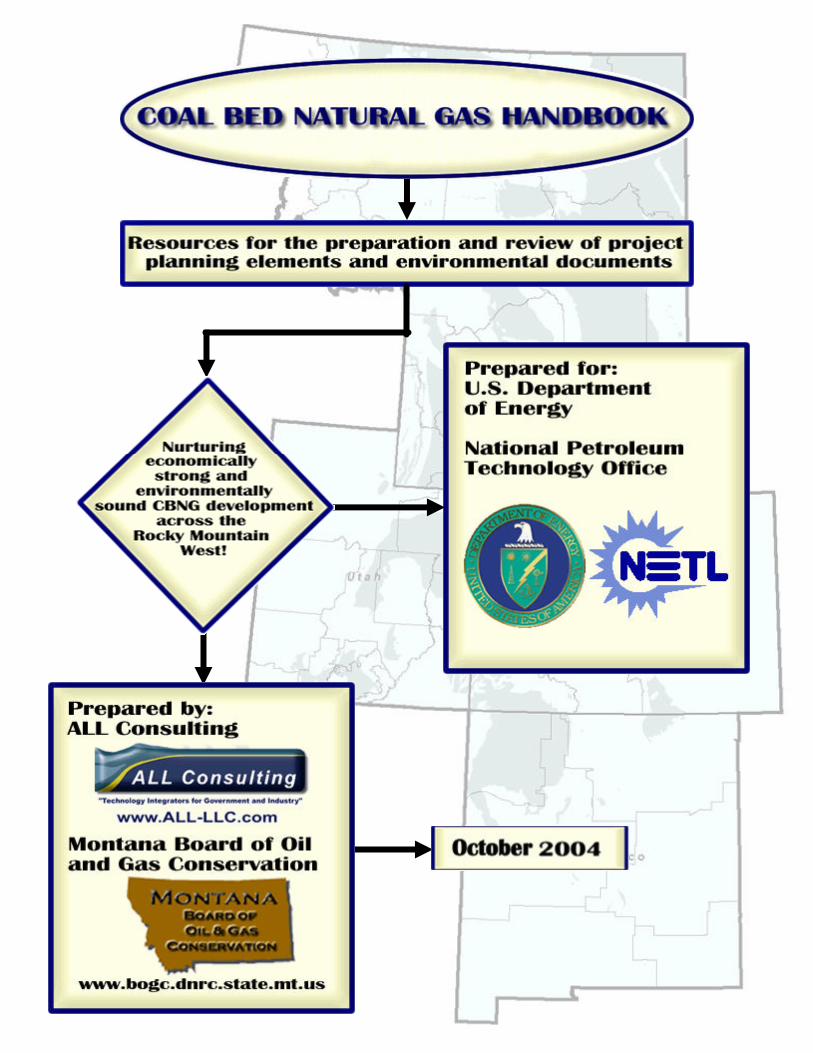
i
Abstract
With the rapid increase in Coal Bed Natural Gas (CBNG) development during the second half of the 1990’s has come an increasing concern from operators and government land managers over how to properly address the many issues, especially environmental issues, that are unique and singular to this development. It is important for operators, government land managers, and regulators to recognize that the operating parameters, production techniques, and environmental issues associated with CBNG are not only different from conventional oil and gas development, but that these elements can also vary, especially in the Western States, from state to state and basin to basin. The many differences associated with the development and production of CBNG, both from a regional aspect and as compared to conventional oil and gas, has created the need for a means to develop a consistent approach in addressing the complexities of CBNG development. This need for adopting a consistent approach in addressing the unique production and environmental aspects associated with CBNG is the basis of this project, the development of a comprehensive CBNG Handbook. This CBNG Handbook serves as the means for informing operators, government land managers, and regulators on issues that are not only unique to CBNG development, but are unique to a particular state, area of operation, or basin. The Handbook serves as an informational reference by providing summaries on such elements as environmental resources that are common in the Western States and by listing additional useful or vital sources of information that exist in the public domain, especially those sources that are available electronically and therefore most accessible.
This CBNG Handbook is to serve as guidance to stakeholders. Because of the differences and complexities associated with CBNG production, many states have adopted the requirement for a CBNG development plan or project plan. CBNG operations on federal lands and minerals may require that an Environmental Assessment (EA) be conducted. This comprehensive CBNG Handbook serves as both an informational and guidance document and perhaps most importantly it serves as an aid to stakeholders to help them focus limited environmental resources where they are most needed.
ii
Acknowledgements
This project was funded by a U.S. Department of Energy (DOE) office of Fossil Energy Grant under the National Energy Technology Laboratory (NETL) program “Development of Technologies and Capabilities for Developing Coal, Oil, and Gas Energy Resources”. The project was developed under the Oil and Gas Environmental: Upstream Area-of-Interest. This study was conducted by ALL Consulting (ALL), and the Montana Board of Oil and Gas Conservation (MBOGC). The contractor’s effort was overseen by NETL’s, National Petroleum Technology Office located in Tulsa Oklahoma. The National Petroleum Technology Office project manager for this effort was Mr. John Ford. The Department also wishes to extends its appreciation to those companies operating in the Powder River, San Juan, Raton and Unita basins, and staff of the Department of the Interior, Environmental Protection Agency, and the Colorado, New Mexico, Montana, Utah and Wyoming State agencies who provided the technical input and assistance that enable DOE to improve the scope and quality of the analysis.
iii
Table of Contents Abstract .................................................................................................................................i Acknowledgements ............................................................................................................. ii Table of Contents............................................................................................................... iii Executive Summary......................................................................................................... viii 1 Purpose and Objective .............................................................................................1-1
1.1 What is Coal Bed Natural Gas? .......................................................................1-2 1.2 Western State Environmental Setting ..............................................................1-4 1.3 CBNG Regulatory and Planning Considerations.............................................1-6 1.4 Purpose.............................................................................................................1-7 1.5 Objectives.........................................................................................................1-8
2 Pre-Project Planning Analysis .................................................................................2-1 2.1 Mineral Ownership and Split Estates...............................................................2-2
2.1.1 Split Estates..............................................................................................2-3 2.2 Regulatory Framework ....................................................................................2-4
2.2.1 Federal Regulations ..................................................................................2-5 2.2.1.1 Land Use Plans .....................................................................................2-6 2.2.1.2 NEPA and the EIS Process ..................................................................2-6 2.2.1.3 Leasing .................................................................................................2-8 2.2.1.4 Laws Governing Water ........................................................................2-8 2.2.1.5 Laws Governing Air ...........................................................................2-10 2.2.1.6 Endangered Species Act.....................................................................2-11 2.2.1.7 Antiquities Act ...................................................................................2-11 2.2.1.8 National Historic Preservation Act ....................................................2-11 2.2.1.9 Tribal Resources ................................................................................2-11 2.2.1.10 American Indian Religious Freedom Act ......................................2-12
2.2.2 State Regulations ....................................................................................2-12 2.2.2.1 State Oil and Gas Agencies................................................................2-12 2.2.2.2 State Water Laws ...............................................................................2-14
2.2.3 Location Regulations .............................................................................2-16 2.3 Existing Environmental Document Review...................................................2-17 2.4 Public Relations Analysis ..............................................................................2-23
2.4.1 Public Relations .....................................................................................2-24 2.4.2 Disputes..................................................................................................2-25 2.4.3 Split-Estates ...........................................................................................2-26 2.4.4 Resource Impacts ...................................................................................2-26 2.4.5 Land Use Restrictions ............................................................................2-26 2.4.6 Special Interest Groups ..........................................................................2-27 2.4.7 Beneficial Uses ......................................................................................2-27
2.5 Site Specific Review and Baseline Analysis .................................................2-27 2.5.1 Surface Water.........................................................................................2-28 2.5.2 Groundwater...........................................................................................2-28 2.5.3 Soils/Topography...................................................................................2-29 2.5.4 Native Vegetation ..................................................................................2-29 2.5.5 Air ..........................................................................................................2-29

iv
2.5.6 Noise ......................................................................................................2-30 2.5.7 Visual .....................................................................................................2-30 2.5.8 Present Land Use ...................................................................................2-30 2.5.9 Roads/Traffic/Utilities ...........................................................................2-31
3 Best Management Practices .....................................................................................3-1 3.1 Beneficial Use ..................................................................................................3-2 3.2 Common Resources .........................................................................................3-3
3.2.1 Air Quality ...............................................................................................3-3 3.2.2 Cultural Resources and Paleontological Resources .................................3-5 3.2.3 Geology and Minerals ..............................................................................3-6 3.2.4 Hydrological Resources ...........................................................................3-7 3.2.5 Lands and Realty......................................................................................3-9 3.2.6 Livestock Grazing ....................................................................................3-9 3.2.7 Recreation ..............................................................................................3-10 3.2.8 Social and Economic Values..................................................................3-11 3.2.9 Soils........................................................................................................3-12 3.2.10 Solid and Hazardous Wastes..................................................................3-13 3.2.11 Visual Resource Management ...............................................................3-14 3.2.12 Wilderness Study Areas.........................................................................3-14 3.2.13 Wildlife and Vegetation.........................................................................3-15
3.2.13.1 Noxious Weeds ..............................................................................3-18 3.2.13.2 Aquatic Resources..........................................................................3-19
3.2.14 Project Planning .....................................................................................3-19 3.3 Conclusion .....................................................................................................3-21
4 Preparation of Project Planning Components and Environmental Documents .......4-1 4.1 Drilling Plans ...................................................................................................4-3
4.1.1 Rationale ..................................................................................................4-3 4.1.2 Contents ...................................................................................................4-3 4.1.3 Regulatory Requirements.........................................................................4-4 4.1.4 Technical Options ....................................................................................4-6
4.1.4.1 Drilling Technology.............................................................................4-6 4.1.4.2 Phased Drilling and Well Patterning..................................................4-10 4.1.4.3 Hybrid Logs, Tests, and Cores to Characterize the Reservoirs .........4-11 4.1.4.4 Completion Technologies ..................................................................4-12 4.1.4.5 Reservoir Modeling............................................................................4-12 4.1.4.6 In-fill Drilling.....................................................................................4-13 4.1.4.7 Secondary Enhancement ....................................................................4-13 4.1.4.8 Water Management ............................................................................4-14 4.1.4.9 Production Management ....................................................................4-14
4.2 Surface Use Plans ...........................................................................................4-15 4.2.1 Rationale ................................................................................................4-15 4.2.2 Contents .................................................................................................4-15 4.2.3 Regulatory Requirements.......................................................................4-17 4.2.4 Technical Options ..................................................................................4-20
4.2.4.1 Well Completion................................................................................4-21 4.2.4.2 Utility Placement ................................................................................4-22
v
4.2.4.3 Gas Gathering, Compression Facilities, and Sales Stations ..............4-23 4.2.4.4 Water Management ............................................................................4-24 4.2.4.5 Access Routes ....................................................................................4-26
4.3 Landowner/Surface Use Agreements.............................................................4-27 4.3.1 Rationale ................................................................................................4-27 4.3.2 Contents .................................................................................................4-27 4.3.3 Regulatory Requirements.......................................................................4-27 4.3.4 Technical Options ..................................................................................4-29
4.4 Unitization, Pooling, and Communitization Agreements ..............................4-30 4.4.1 Rationale ................................................................................................4-30 4.4.2 Contents .................................................................................................4-30 4.4.3 Communitization....................................................................................4-30 4.4.4 Unitization..............................................................................................4-32 4.4.5 Regulatory Requirements.......................................................................4-33
4.4.5.1 Pooling and Communitization ...........................................................4-33 4.4.5.2 Unitization..........................................................................................4-33
4.5 Drainage Plans ...............................................................................................4-37 4.5.1 Rationale ................................................................................................4-37 4.5.2 Contents .................................................................................................4-37 4.5.3 Regulatory Requirements.......................................................................4-38 4.5.4 Technological Options ...........................................................................4-38
4.5.4.1 Periodic Pressure Mapping ................................................................4-38 4.5.4.2 Reservoir Modeling............................................................................4-38
4.6 Cultural Resource Inventories........................................................................4-40 4.6.1 Rationale ................................................................................................4-40 4.6.2 Contents .................................................................................................4-40 4.6.3 Regulatory Approach.............................................................................4-40 4.6.4 Planning Considerations ........................................................................4-44
4.7 Wildlife Inventories .......................................................................................4-46 4.7.1 Rationale ................................................................................................4-46 4.7.2 Contents .................................................................................................4-47 4.7.3 Regulatory Approach.............................................................................4-47
4.7.3.1 Lease Stipulations ..............................................................................4-49 4.7.3.2 Wildlife and Botanical Survey Procedures ........................................4-49
4.8 Produced Water Management ........................................................................4-50 4.8.1 Rationale ................................................................................................4-50 4.8.2 Contents .................................................................................................4-50 4.8.3 Regulatory Requirements.......................................................................4-52 4.8.4 Technical Options ..................................................................................4-54
4.8.4.1 Phased Development and Well Patterning.........................................4-54 4.8.4.2 Water Storage Technologies ..............................................................4-55 4.8.4.3 Disposal and Beneficial Use Technologies........................................4-56
4.8.4.3.1 Injection .......................................................................................4-57 4.8.4.3.2 Surface Application/Irrigation .....................................................4-58 4.8.4.3.3 Surface Water Discharge .............................................................4-58 4.8.4.3.4 Evaporation/Infiltration Impoundments.......................................4-59

vi
4.8.4.3.5 Beneficial Use Options ................................................................4-61 4.8.4.3.6 Treatment Technologies...............................................................4-62
4.9 Monitoring Plans............................................................................................4-65 4.9.1 Rationale ................................................................................................4-65 4.9.2 Contents .................................................................................................4-65 4.9.3 Regulatory Requirements.......................................................................4-66 4.9.4 Technical Options ..................................................................................4-66
4.9.4.1 Air Monitoring ...................................................................................4-66 4.9.4.2 Surface Water Monitoring .................................................................4-67 4.9.4.3 Groundwater Monitoring ...................................................................4-68
4.10 Waste Minimization Plans .............................................................................4-71 4.10.1 Rationale ................................................................................................4-71 4.10.2 Contents .................................................................................................4-72 4.10.3 Regulatory Requirements.......................................................................4-72
4.10.3.1 Additional Regulations and Voluntary Programs ..........................4-74 4.10.3.2 Planning Considerations ................................................................4-75
4.10.4 Technical Options ..................................................................................4-75 4.10.4.1 Minimizing Produced Water ..........................................................4-76 4.10.4.2 Minimizing Drilling Wastes ..........................................................4-76 4.10.4.3 Minimizing Stimulation Wastes ....................................................4-77 4.10.4.4 Minimizing Industrial Wastes ........................................................4-78 4.10.4.5 Minimizing NORM Wastes ...........................................................4-78
4.11 Water Well and Spring Mitigation Agreements and Plans ............................4-80 4.11.1 Rationale ................................................................................................4-80 4.11.2 Contents .................................................................................................4-80 4.11.3 Regulatory Requirements.......................................................................4-80 4.11.4 Technical Options ..................................................................................4-82
4.11.4.1 Directly Supplied CBNG Water ....................................................4-82 4.11.4.2 Treating and Supplying CBNG Water...........................................4-83 4.11.4.3 Production Scheduling ...................................................................4-83 4.11.4.4 Recompleting Existing Wells or Drilling New Wells....................4-83 4.11.4.5 Municipal or Rural Water Supply..................................................4-84
4.12 Plugging, Abandonment, Mitigation..............................................................4-85 4.12.1 Rationale ................................................................................................4-85 4.12.2 Contents .................................................................................................4-85 4.12.3 Regulatory Requirements.......................................................................4-86 4.12.4 Technical Options ..................................................................................4-87
4.12.4.1 Hydro-mulching and Hydro-sprigging ..........................................4-87 4.12.4.2 Halophyte Remediation..................................................................4-87
4.13 Combining Documents ..................................................................................4-89 5 Review of Planning Components and Environmental Documents ..........................5-1
5.1 Regulatory Requirements.................................................................................5-1 5.1.1 Surface Owner Agreements .....................................................................5-2 5.1.2 Appropriate Sign-Offs..............................................................................5-2 5.1.3 Notice and Publication.............................................................................5-2 5.1.4 Best Management Practices or Similar ....................................................5-2

vii
5.1.5 Consistencies Between Jurisdictions .......................................................5-2 6 Resources for Developing Project Plans ..................................................................6-1
6.1 GIS Data Sources.............................................................................................6-1 6.1.1 Data sources for map themes in APD/POD Development ......................6-1
6.2 BMP Data Sources...........................................................................................6-4 6.3 Regulatory Agency Contact Listings ...............................................................6-5
6.3.1 Colorado...................................................................................................6-5 6.3.1.1 Federal Agencies..................................................................................6-5 6.3.1.2 State Agencies......................................................................................6-6
6.3.2 Montana ...................................................................................................6-7 6.3.2.1 Federal Agencies..................................................................................6-7 6.3.2.2 State Agencies......................................................................................6-8
6.3.3 New Mexico .............................................................................................6-9 6.3.3.1 Federal Agencies..................................................................................6-9 6.3.3.2 State Agencies....................................................................................6-10 6.3.3.3 New Mexico Bureau of Geology & Mineral Resources ....................6-10 6.3.3.4 Main Office ........................................................................................6-10
6.3.4 Utah........................................................................................................6-11 6.3.4.1 Federal Agencies................................................................................6-11 6.3.4.2 State Agencies....................................................................................6-12
6.3.5 Wyoming................................................................................................6-13 6.3.5.1 Federal Agencies................................................................................6-13 6.3.5.2 State Agencies....................................................................................6-13
6.3.6 National Offices .....................................................................................6-14 7 References ................................................................................................................7-1

viii
Executive Summary Coal bed natural gas and coal mine methane (CBNG) development are expanding into new geographic areas; some of these regions have traditional coal mining roots and/or conventional oil and gas development. CBNG has been produced as long ago as 1926 (Cardott, 1999) in Oklahoma, and 1951 in the San Juan Basin (Amoco, 1994). In recent years the expansion of this industry is at a high, and is becoming an important facet in today’s energy policy. This document has been developed as a technical resource tool to assist CBNG operators and regulatory agencies in the preparation and review of project planning documents and components. There are five sections within this document that present a variety of technical materials useful to operators and reviewers, these five sections include:
• Purpose and Objectives: The purpose of this document is to provide a technical resource for the development and review of CBNG project planning documents. The objective is the development of a document that compliments the existing regulatory guidance documents as well as provides insight into future regulations.
• Procedural Guidance and Pre-Project Planning Analysis: There are a number of procedural and regulatory arenas associated with the development of CBNG, this section of the document looks at the pre-project planning analyses CBNG operators should consider when developing projects in new areas. Some of these procedural elements include: mineral ownership, regulatory review, legislative review, environmental document review, public relations analysis, and baseline conditions analysis.
• Preparation of Project Planning Elements and Environmental Documents: The number of project planning elements required by a state or federal agency can vary from area to area, some regions like the Powder River Basin (PRB) require complete Plans of Development (PODs) while others may only require certain elements such as drilling plans or water management plans. This section of the document addresses the technical aspects associated with the development of these plans including applying Best Management Practices, Mitigation Measures, and Best Professional Judgments. Components that are common to these plans have been identified and described. In addition this section describes how development of certain aspects of CBNG falls outside of traditional National Environmental Policy Act (NEPA). Where as other aspects may require operators to perform NEPA analysis and develop NEPA documents such as Environmental Impact Statements (EIS) or Environmental Assessments (EA).
• Review of Project Planning elements and Environmental Documents: The rate of expanding CBNG development in many areas is outpacing the ability of regulatory agencies to process and review project planning and environmental documents. This has resulted in the expansion of regulatory staff at both the state and federal levels, these newly hired employees face a steep learning curve in developing an understanding of the CBNG industry and regulations. This section of the document is intended to be a companion to existing regulatory guidance and assist regulators in developing a consistent review process for project plans.
ix
In addition this section provides adaptive management strategies for the expansion of project plans as required during the expansion of project fields and as project plans are compiled into NEPA documents for the evaluation of environmental impacts.
• Data and Information Resources: CBNG development and project plans include the evaluation of a variety of resource elements including: soils, surface water, groundwater, native vegetation, wildlife, and cultural resources. In addition to these resources, regulatory oversight varies from state to state. The role of the governing regulatory agencies varies. This section of the document includes data sources for information on where to find Geographic Information System (GIS) and Best Management Practices (BMP) data resources, Pollution Prevention Technologies, as well as a listing of regulatory agencies for various states.
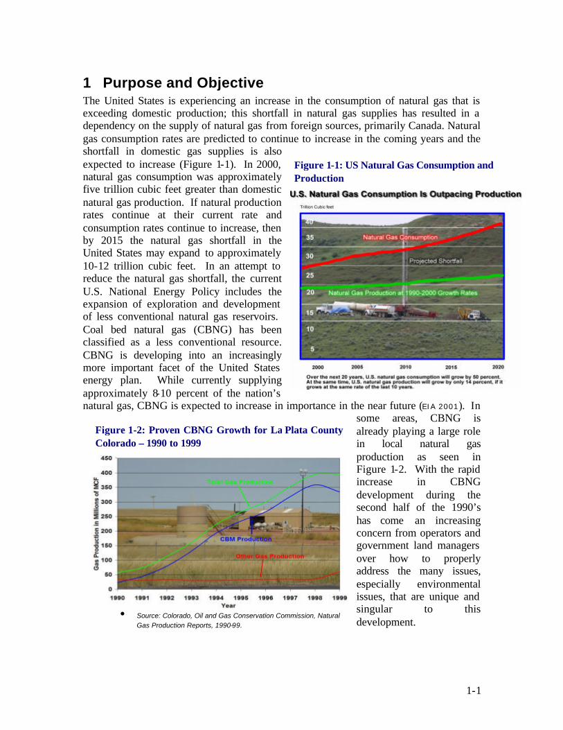
1-1
1 Purpose and Objective The United States is experiencing an increase in the consumption of natural gas that is exceeding domestic production; this shortfall in natural gas supplies has resulted in a dependency on the supply of natural gas from foreign sources, primarily Canada. Natural gas consumption rates are predicted to continue to increase in the coming years and the shortfall in domestic gas supplies is also expected to increase (Figure 1-1). In 2000, natural gas consumption was approximately five trillion cubic feet greater than domestic natural gas production. If natural production rates continue at their current rate and consumption rates continue to increase, then by 2015 the natural gas shortfall in the United States may expand to approximately 10-12 trillion cubic feet. In an attempt to reduce the natural gas shortfall, the current U.S. National Energy Policy includes the expansion of exploration and development of less conventional natural gas reservoirs. Coal bed natural gas (CBNG) has been classified as a less conventional resource. CBNG is developing into an increasingly more important facet of the United States energy plan. While currently supplying approximately 8-10 percent of the nation’s natural gas, CBNG is expected to increase in importance in the near future (EIA 2001). In
some areas, CBNG is already playing a large role in local natural gas production as seen in Figure 1-2. With the rapid increase in CBNG development during the second half of the 1990’s has come an increasing concern from operators and government land managers over how to properly address the many issues, especially environmental issues, that are unique and singular to this development.
Figure 1-2: Proven CBNG Growth for La Plata County Colorado – 1990 to 1999
• Source: Colorado, Oil and Gas Conservation Commission, Natural Gas Production Reports, 1990-99.
Figure 1-1: US Natural Gas Consumption and Production

1-2
1.1 WHAT IS COAL BED NATURAL GAS? CBNG is a gaseous hydrocarbon similar in composition to conventional natural gas that is produced from porous sandstones and carbonates. Figure 1-3 depicts a generalized conceptual comparison of the differences between CBNG and conventional natural gas. The generation and trapping mechanisms of CBNG accumulations are shared with other kinds of natural gas reservoirs such as Devonian shale gas, Upper Cretaceous biogenic gas of the Northern Great Plains, and gas in the Niobrara chalk. The following is a brief introduction into the formation of CBNG and the technologies being used to produce this natural gas from underground coal seams.
CBNG is naturally occurring methane (CH4) with small amounts of other naturally occurring hydrocarbon and non-hydrocarbon gases (e.g., Carbon Dioxide, etc.) that are contained in coal seams as a result of chemical and physical processes. CBNG is often produced at shallow depths and is often produced with large volumes of water. CBNG resources represent valuable volumes of natural gas within and outside of areas of conventional oil and gas production.
CBNG has been produced as long ago as 1926 (Cardott, 1999) in Oklahoma, and 1951 in the San Juan Basin (Amoco, 1994). The greatest increase in development, however, began in approximately 1988. The 1988 increase was due in part to tax incentives that were put in place by Congress to boost domestic exploration into alternative energy sources. CBNG production continues to advance across North America as operators develop new techniques for drilling and producing methane from coal seams of different rank and quality and the demand for natural gas continues to increase.
Wells used to extract CBNG are completed in several ways, depending upon the type of coal in the basin and fluid (water) content. Each type of coal (i.e., sub-bituminous to low-volatile bituminous) offers different completion and production options due to the inherent differences between the types. These differences can include natural fracturing and competency of the coal seams. The coals found mostly in the Western United States are frequently sub-bituminous in rank and competent enough to be completed and produced using open-hole well completion techniques, they are often too soft to allow for the use of horizontal wellbores. Harder coals that are typical of the Eastern United States, although not unknown to occur in the Western United States, are often higher rank medium to low volatile bituminous coals. The eastern coals are typically very competent and are often drilled and cased to total depth then perforated to allow efficient wellbore management.
Figure 1-3: Comparison of CBNG and Conventional Natural Gas Methane and Water Production

1-3
Whether in hard or soft coals, water production is typically associated with the early stages of CBNG production. This early stage water production that decreases over time can be one of the differences between CBNG and conventional natural gas reservoirs. Conventional natural gas reservoirs although capable of producing water through out the wells producing life, typically produce larger volumes of natural gas in the initial stages and have less initial water production. For conventional gas wells and some non-conventional gas wells, as the volume of gas in the reservoir decreases, water migrates up into the available pore space within the reservoir and is produced at greater volumes. This progression from natural gas production to water production is a result of depth, pressure, and the permeability of a conventional natural gas reservoir. The pressure within the reservoir (closely associated with depth below land surface) and variation of permeability within a conventional natural gas reservoir combine to trap the natural gas above the water.
Underground coal seams bearing natural gas are typically shallower than conventional natural gas reservoirs and thus not under as much pressure. Coal seams may also have lower permeabilities than conventional natural gas sandstone or carbonate reservoirs. However, cleat space within a coal seam generally contains water that is under sufficient pressure to keep methane gas bound to the coal’s surface and within the coal’s natural porosity. During CBNG production, water is usually removed to depressurize the coal seam and allow the methane gas to “desorb” from the coal surface and then be produced. The act of desorbtion is a process were the gas that is bound to the coal surface is released with the reduction of pressure in the coal seam. As depicted in Figure 1-3a, there is typically a phase in early CBNG production dominated by the production of water during which the coal seam is depressurized. Usually this depressurization is required to facilitate the production of methane gas from a coal bed reservoir. Once the reservoir pressure has been reduced to a certain site-specific level, the methane gas is released/desorbed from the surface of the coal and can be produced at the well head. Ideally, water production begins to decrease early and gas production rises eventually reaching a peak before a slow decline as the gas resource is depleted from the coal seam. Water production typically continues to decrease or may even stop as the amount of water within the reservoir is reduced. Gas production can continue even after water production has ceased.
Another observed difference in CBNG reservoirs and conventional natural gas reservoirs can include the density of well development. Although conditions vary for each field due to site-specific conditions, CBNG fields typically require closer spaced well intervals
Figure 1-3a: CBNG Methane and Water Production

1-4
than conventional natural gas fields. This is typically due to need to reduce reservoir pressure by the removal of water within the coal seam to release the gas for efficient gas removal and effective reservoir management. Even in CBNG basins such as the San Juan Basin where horizontal completions can be used to drain larger areas, the well spacing is typically tighter than conventional natural gas basins. Also when multiple producible coal seams are present they are completed individually (as seen in the Powder River Basin WY) the well density can be as high as 8 to 16 wells per section.
1.2 WESTERN STATE ENVIRONMENTAL SETTING The research and study area used in the preparation of this document include current and potential CBNG development areas of the Western United States. Emphasis has been placed on five western states, located in the Rocky Mountain region stretching from New Mexico northward to Montana (Figure 1-4). These states include New Mexico, Wyoming, Montana, Colorado, and Utah. A particular emphasis has also been placed on the Powder River Basin of Wyoming and Montana as the Bureau of Land Management (BLM) has developed CBNG project planning development documents for these areas. Common identified resources with in the five states have the potential to be affected by CBNG development. These resources include:
Groundwater: Shallow surficial aquifers are relatively common throughout most of the five state region. These aquifers are usually unconfined systems that receive recharge from infiltration of rainwater and snowmelt, or from influent streams. Because of the seasonal nature of recharge in the arid climate, these aquifers exhibit considerable changes in water level elevations and water quality over the course of a year. During times of heavy rainfall and snowmelt, these aquifers are recharged with higher quality water that infiltrates through the soil into the water table. For the remainder of the year, these aquifers lose water to effluent streams and other withdrawals which decreases the water quantity. The water quality also decreases as the water in these aquifers interacts with the surrounding soil and rock matrix were the water dissolves soluble salts resulting in increased concentrations of these compounds in the water. The seasonal differences are often further compounded by extended periods of drought such as been the case for the last several years in the Western United States.
Surface Water: Typically the surface water in the five state region is sourced from the hills and mountains in and around the Rocky Mountain Front and are supplied by snowmelt and rainfall. These streams are affected by seasonal variations that cause
Figure 1-4: CBNG Emphasis Area

1-5
changes in water quality and stream flow. In addition to these seasonal changes, activities and industry along the streams affect the water quality and quantity. Stream flow for various uses is often diverted. These uses can include irrigation, industrial use, coal mine dust suppression, and municipal supply water.
Land Use: Much of the land within the five state region is undeveloped federal lands that may be used for ranching, farming, recreation and federally managed landscapes. Rural homes and urban development account for approximately 1% of the land usage. Although CBNG development may occur near urban areas, due to the small percentage of utilized lands most is expected to occur in the open undeveloped lands, near farms, ranches, and federally managed landscapes. These lands are often unsegregated properties without roads, utilities, and water sources that only experience occasion traffic associated with activities of farming, ranching, or recreation uses.
Soils: Soils in the selected western states vary considerably, but have similar potential to be affected by CBNG development dependent upon the water management plans put into place. The soils in these areas have characteristics that are specific to the arid climatic conditions and are easily eroded, compacted, and poorly drained. Due to the arid nature of much of this region, a soil profile that can be changed by chemical and physical interactions from CBNG produced water and regular vehicular traffic can be found.
Vegetation: The native vegetation in these areas have adapted to the existing soil and climatic conditions. These plants have adapted to seasonal changes and survive under the
current conditions. Changes to the soil moisture and soil chemistry that may result from CBNG development water management plans could cause these native species to struggle for survival against other species and noxious weeds that are more suited to increased soil moisture.
Wildlife: The five state area supports a variety of species specific to the ecology of the area and the isolation from human activities. These species include threaten and endangered species that have specific habitat needs and whose nesting and breeding habits may be influenced by changes such as habitat segregation, noise,
and other CBNG development related activities.
Air Quality: A majority of the five state area is undeveloped landscape with no large metropolitan areas or industrial development. This in part results in these areas having better air quality than the more densely developed areas of the Eastern United States. The potential exists for the degradation of this air quality from CBNG related activities including dust from roadways, methane venting, and vehicle and equipment emissions.
Aesthetics: The five state area has a diverse landscape with visually appealing areas. As a sensory resource, personal opinion plays a role in identifying an object or viewscape as

1-6
visually superior to another. However, the natural aesthetic beauty of the deserts of New Mexico, the Four Corners region, and the mountain ranges of the five states are typically considered to be visual appealing to many people. The aesthetic value of these areas has the potential to be degraded by the inclusion of CBNG development.
1.3 CBNG REGULATORY AND PLANNING CONSIDERATIONS Currently there are a variety of issues facing CBNG development. Many of these issues are expected to expand as development grows and the number of areas and wells within those areas increase. Issues include, but are not limited to, inconsistencies in the preparation and reviewing of project plans and Applications for Permit to Drill (APD) evolving technical considerations and environmental issues associated with development. These issues can be subdivided into two groups, issues facing new and existing CBNG areas and issues facing newly developing CBNG areas.
Issues identified that new and existing CBNG development areas presently deal with include: expanding deve lopment and production, regional inconsistencies, evolving technical considerations, and diverse ecosystems. The number of CBNG wells in the Western United States is rapidly growing, most existing and potential development areas are expanding quickly, however regulatory approval of permits and the number of drilling rigs available in these areas has limited the pace.
CBNG operators are also experiencing varying issues associated with developing the resource in multiple areas of the country. With the presence of coal and the potential for CBNG development across much of the United States, operators that have or are considering multiple developments in different regions often have to evaluate each operation independently because of the numerous differences between regions. These differences can include drilling techniques (i.e., hard vs. soft coals), water management plans, lease stipulations, landowner issues, environmental concerns,
and regulatory issues. For example, in the Black Warrior Basin of Alabama, produced water is discharged into local surface waters, while in the San Juan Basin produced water of similar quality is injected into disposal wells. In addition to the regulatory differences, technical considerations vary and are continuing to evo lve as new areas are explored. Drilling practices and well completion methods for CBNG wells vary from area to area, horizontal drilling techniques of coals are evolving, numerous innovations are being applied at the well head, and produced water treatment technologies are continuously being evaluated and tested. Other regional differences include the vast array of ecosystems that are present near the existing and potential CBNG development areas. The ecosystems present in the CBNG areas of West Virginia are vastly different from those in Illinois as well as those of the arid western states.
CBNG Drilling near Sheridan, WY.

1-7
The rapid pace at which CBNG operations are expanding into new areas can also be an issue for developers and regulators; one example of this is the rapid development of CBNG in the Powder River Basin of Wyoming and Montana. Greater than 12,000 wells currently exist in this area and as many as 60,000 to 80,000 wells are expected to be drilled in the next 20 years. In addition to the resources necessary for drilling that many wells, there are regulatory hurdles associated with approving the various permits and project plans by the governing regulatory agencies. This rapid expansion is expected to require the addition of regulatory staff (many of whom may be unfamiliar with CBNG). This could lead to a steep learning curve to accommodate the expanding development. This is further complicated by the lack of technical and scientific information related to CBNG development available for review.
To help address the regulatory resources issue, BLM has been tasked by the most recent National Energy Implementation Plan to “identify ways to improve the process for reviewing and approving APDs”. As part of the efforts to improve the APD process, the BLM Washington Office has issued several Instructional Memorandums (IM) to the field offices on ways to “more efficiently and effectively process APDs”. The instructional memorandums issued so far have related to revising Onshore Order No. 1, revising the Oil and Gas Gold Book, generating more consistency in the Conditions of Approval for APDs, speeding up the processing of Cultural Resource Surveys while avoiding and minimizing impacts to cultural resources, and develop strategies for improving the APD approval process including Multiple APD Packages. In this last IM, the Washington Office recommends field offices consider the use of multiple APD planning documents (POD type) to improve the efficiency and effectiveness in approving the number of APDs (including CBNG APDs).
In addition to these issues, development of CBNG is bringing about changes to the regulatory environment. Many newly developing areas do not have existing regulations that apply specifically to CBNG development. The absence of regulations which address CBNG are affecting both state and federal agencies, as these agencies are drafting or updating rules and regulations to address the development of CBNG in their area. One purpose of this document is to augment the available information addressing these issues as they relate to CBNG development and project planning elements.
1.4 PURPOSE The purpose of this handbook is to provide a technical resource for operators, government land managers, and regulators that can assist them in the development and review of CBNG project planning documents. Because CBNG project plans include many potential elements, some common to most if not all regions and lease types (e.g., APDs and drilling plans) and others (e.g., cultural resource and wildlife inventories or landowner agreements) applicable only in certain regions or lease types, this handbook provides the information and materials needed to complete project planning documents for regional considerations as well as national elements. It also provides available technical options in exploring and producing CBNG and how these options can affect regulatory compliance and the preparation of CBNG project planning documents. In addition, it illustrates how some of the complexities can be addressed in the pre-project planning analysis. These include developing an understanding of mineral ownership,
1-8
regional regulations, existing environmental documents, public perception and public relations, and site-specific information, including baseline analysis. The intent of this handbook is to compliment existing regulatory guidance documents and provide insight into successful preparation of project planning documents.
1.5 OBJECTIVES The following are the principle objectives of the Handbook:
• Augment existing regulatory guidance documents published by federal and state agencies to highlight those aspects key to CBNG development plans.
• Help operators locate and assemble environmental data relevant to the various dimensions of CBNG project plans.
• Foster regulatory consistency across the Western United States CBNG Province (i.e., between state, tribal, and federal agencies).
• Highlight environmental differences (e.g., CBNG water quality, endangered species, etc.) that exist between basins in the Province. These differences exert strong influences over environmental impacts due to CBNG production.
• Encourage broad stakeholder input to highlight the dimensions of key environmental concerns. This input may be invaluable for the political dialogue that is often a part of CBNG developments in the Western United States.
2-1
2 Pre-Project Planning Analysis CBNG extraction can encompass environmental and mineral resource issues in new and existing development regions. Many of these issues can be addressed during pre-project planning analysis. This section provides an introduction to some of the complexities associated with the rules and regulations governing CBNG and how site specific issues can affect development decisions.
In addition this section tries to assist in identifying potential obstacles that may be encountered when developing project planning elements from the following areas: mineral ownership, federal, state and local regulations, existing environmental documents, public relations, and site specific or baseline conditions. These elements can affect a CBNG development project in variety ways including: delaying the permitting of project development plans, adding environmental protection requirements, and altering produced water handling practices. The following is a summary of how these elements can be addressed through pre-planning analysis.
Mineral Ownership: Mineral ownership can affect CBNG project plans as regulatory authority and regulations vary based on minerals right ownership. The requirements and regulations on federal lands are typically greater than those on state leases or fee leases. CBNG operators should evaluate their regulatory requirements based on mineral ownership considerations prior to developing project plans to foster an understanding of the differing rules and regulations and how they can affect planning components including water management plans, surface use plans, landowner agreements, and cultural resource and wildlife inventory requirements.
Regulatory and Legislative Review: As CBNG development expands to new areas, regulatory and legislative authority adapt as political climates evolve, and new rules and regulations are established. Some identified regulatory and legislative concerns include: CBNG developments are being regulated by agencies who traditionally are not involved with Oil and Gas development, new regulatory personnel are being hired to meet the needs of expanding development, CBNG development projects are not always covered simply by existing regulatory “boilerplate” language and are being evaluated against potential regulatory changes.
Existing Environmental Document Review: In addition to updating regulations and hiring new employees, many environmental documents (NEPA EISs and EAs) are being updated due to the expanding potential for CBNG development in many areas of the Western United States. Operators who are planning new CBNG development projects need to be aware of recent updates or upcoming revisions to existing environmental documents. Project planning elements and lease stipulations may be defined or revised in these documents.
Public Relations Analysis: One aspect of project planning is getting a feeling for how the local community feels about development in their area. This has become an important issue in environmentally active communities. Some communities such as Bozeman, Montana and Delta County, Colorado have taken measures to curtail or prevent CBNG development in their areas. Operators preparing projects in new areas may prefer to gauge the local atmosphere or use public relations consultants to assist

2-2
with issues related to the public perception of CBNG development. In addition, operators may also want to assess landowner perception on issues such as groundwater resources, noise, or split mineral estates.
Site Specific Reviews and Baseline Analysis: Additional investigation into site specific conditions and issues may assist operators with project planning components as each development area is unique. Pre-planning analysis of site-specific conditions such as environmental and community concerns may prevent future problems during the operational, closure, and mitigation stages of CBNG projects.
2.1 MINERAL OWNERSHIP AND SPLIT ESTATES There are a variety of potential mineral owners from which CBNG rights can be leased. In many regions especially the Western United States, mineral rights and surface land rights are not always owned by the same party. Mineral rights are generally owned by either the federal government, state government (state trust lands), Native American Tribal governments, or private ownership other than surface ownership. Understanding the relationship between mineral ownership and the requirements for CBNG development planning and practices are critical to a successful CBNG operation.
• For mineral rights held by the states, CBNG developers adhere to state regulatory requirements for oil and gas development and state lease stipulations. State regulations for oil and gas are still evolving in many basins to reflect the differences between CBNG development and conventiona l oil and gas development. State regulatory agencies who previously had little or no involvement in oil and gas development now oversee aspects related to the managing and disposal of CBNG produced water. These managerial aspects can have bearing on the success of a project. CBNG leases on state lands are typically accompanied by a series or set of lease stipulations related to how the land surface can be utilized, restrictions on disturbances to certain areas, mitigation and restoration measures, and other development related conditions. Additionally, there are differences in what is required or enforceable in different states. For instance, the State of Montana has its own Environmental Policy Act (MEPA), and gives state agencies the ability, through the EIS process, to include development planning requirements, mitigation measures, and Best Management Practices (BMPs) into the Record of Decision (ROD) for CBNG development.
• For mineral rights federally owned, CBNG developers adhere to the state regulatory requirements as well as any additional requirements established under the CBNG lease from the relevant federal management office such as BLM or the United States Forest Service (USFS). As part of the EIS process, federal land management offices are incorporating development planning requirements, mitigation measures, and BMPs into the ROD for federal Resource Management Plans. These measures are incorporated in an effort to reduce the impacts associated with CBNG development on federally management lands. Additionally, federal requirements can extend beyond the federal mineral lease if the gas or water produced on a federal mineral lease is transported off the lease. In this situation, federal requirements for the handling and disposal of the water are to be met for water
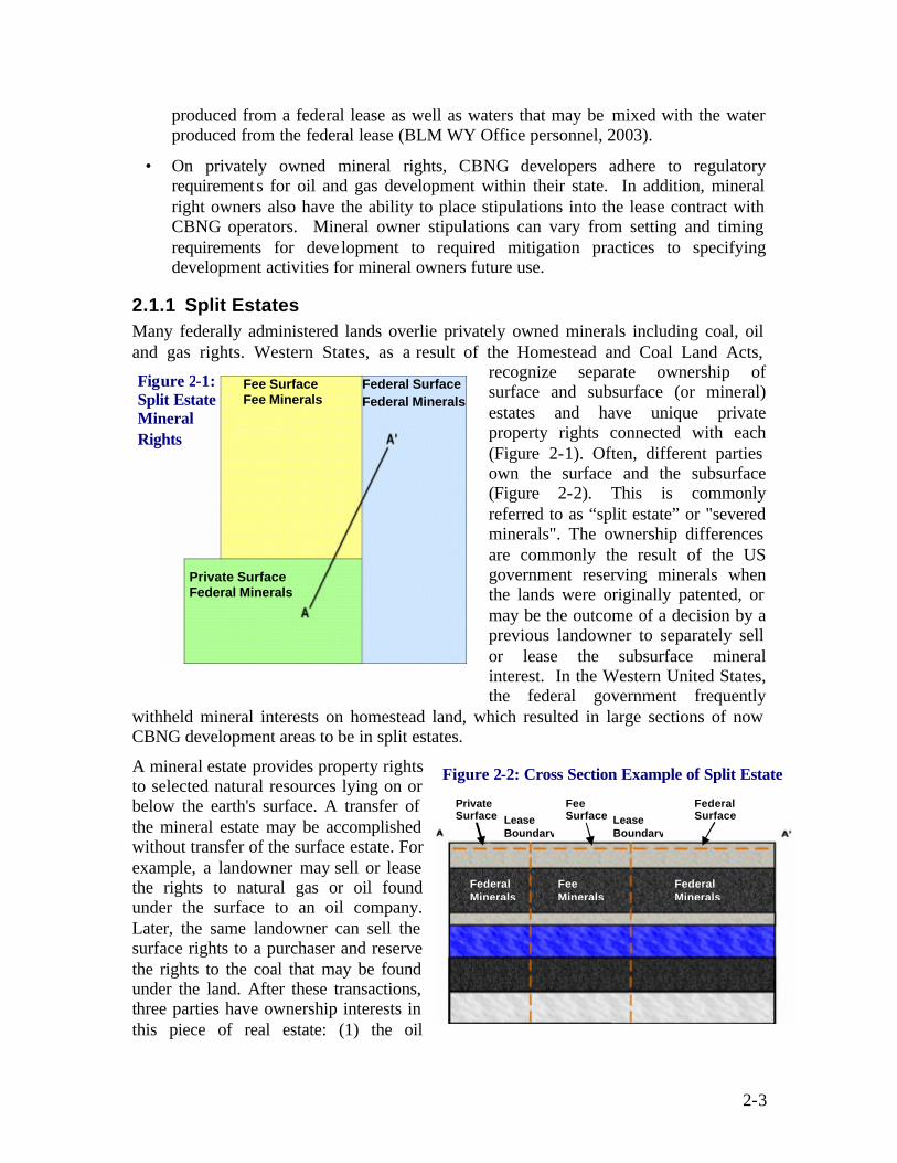
2-3
produced from a federal lease as well as waters that may be mixed with the water produced from the federal lease (BLM WY Office personnel, 2003).
• On privately owned mineral rights, CBNG developers adhere to regulatory requirements for oil and gas development within their state. In addition, mineral right owners also have the ability to place stipulations into the lease contract with CBNG operators. Mineral owner stipulations can vary from setting and timing requirements for deve lopment to required mitigation practices to specifying development activities for mineral owners future use.
2.1.1 Split Estates Many federally administered lands overlie privately owned minerals including coal, oil and gas rights. Western States, as a result of the Homestead and Coal Land Acts,
recognize separate ownership of surface and subsurface (or mineral) estates and have unique private property rights connected with each (Figure 2-1). Often, different parties own the surface and the subsurface (Figure 2-2). This is commonly referred to as “split estate” or "severed minerals". The ownership differences are commonly the result of the US government reserving minerals when the lands were originally patented, or may be the outcome of a decision by a previous landowner to separately sell or lease the subsurface mineral interest. In the Western United States, the federal government frequently
withheld mineral interests on homestead land, which resulted in large sections of now CBNG development areas to be in split estates.
A mineral estate provides property rights to selected natural resources lying on or below the earth's surface. A transfer of the mineral estate may be accomplished without transfer of the surface estate. For example, a landowner may sell or lease the rights to natural gas or oil found under the surface to an oil company. Later, the same landowner can sell the surface rights to a purchaser and reserve the rights to the coal that may be found under the land. After these transactions, three parties have ownership interests in this piece of real estate: (1) the oil
Private Surface
Fee Surface
Federal Surface
Federal Minerals
Fee Minerals
Federal Minerals
Lease Boundary
Lease Boundary
Figure 2-2: Cross Section Example of Split Estate
Fee Surface Fee Minerals
Federal Surface Federal Minerals
Private Surface Federal Minerals
Figure 2-1: Split Estate Mineral Rights
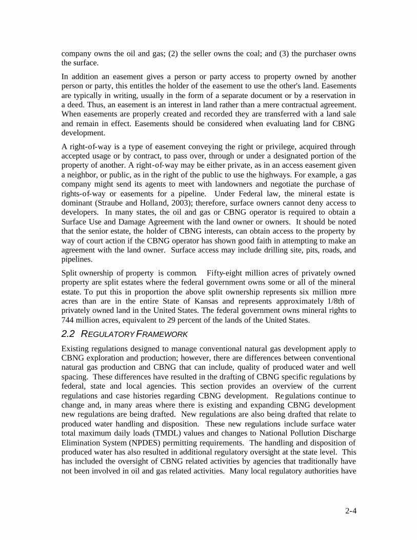
2-4
company owns the oil and gas; (2) the seller owns the coal; and (3) the purchaser owns the surface.
In addition an easement gives a person or party access to property owned by another person or party, this entitles the holder of the easement to use the other's land. Easements are typically in writing, usually in the form of a separate document or by a reservation in a deed. Thus, an easement is an interest in land rather than a mere contractual agreement. When easements are properly created and recorded they are transferred with a land sale and remain in effect. Easements should be considered when evaluating land for CBNG development.
A right-of-way is a type of easement conveying the right or privilege, acquired through accepted usage or by contract, to pass over, through or under a designated portion of the property of another. A right-of-way may be either private, as in an access easement given a neighbor, or public, as in the right of the public to use the highways. For example, a gas company might send its agents to meet with landowners and negotiate the purchase of rights-of-way or easements for a pipeline. Under Federal law, the mineral estate is dominant (Straube and Holland, 2003); therefore, surface owners cannot deny access to developers. In many states, the oil and gas or CBNG operator is required to obtain a Surface Use and Damage Agreement with the land owner or owners. It should be noted that the senior estate, the holder of CBNG interests, can obtain access to the property by way of court action if the CBNG operator has shown good faith in attempting to make an agreement with the land owner. Surface access may include drilling site, pits, roads, and pipelines.
Split ownership of property is common. Fifty-eight million acres of privately owned property are split estates where the federal government owns some or all of the mineral estate. To put this in proportion the above split ownership represents six million more acres than are in the entire State of Kansas and represents approximately 1/8th of privately owned land in the United States. The federal government owns mineral rights to 744 million acres, equivalent to 29 percent of the lands of the United States.
2.2 REGULATORY FRAMEWORK Existing regulations designed to manage conventional natural gas development apply to CBNG exploration and production; however, there are differences between conventional natural gas production and CBNG that can include, quality of produced water and well spacing. These differences have resulted in the drafting of CBNG specific regulations by federal, state and local agencies. This section provides an overview of the current regulations and case histories regarding CBNG development. Regulations continue to change and, in many areas where there is existing and expanding CBNG development new regulations are being drafted. New regulations are also being drafted that relate to produced water handling and disposition. These new regulations include surface water total maximum daily loads (TMDL) values and changes to National Pollution Discharge Elimination System (NPDES) permitting requirements. The handling and disposition of produced water has also resulted in additional regulatory oversight at the state level. This has included the oversight of CBNG related activities by agencies that traditionally have not been involved in oil and gas related activities. Many local regulatory authorities have

2-5
adopted zoning restrictions to regulate development of CBNG in their region, including attempts to restrict or limit CBNG production in their area.
2.2.1 Federal Regulations CBNG ownership has been a point of contention since the early 1900s; questions regarding its status as part of the coal estate or as part of the natural gas resource is still under debate in some Eastern States. However, CBNG originating in federally held coal deposits may be explored for and extracted under either a fee or Federal oil and gas lease, depending on the non-coal minerals ownership (i.e., oil and gas mineral ownership). This determination was made by the Department of the Interior’s (DOI) solicitor, after examining the relevant Federal statutes. The determination states that the federal reservations of coal do not include CBNG and that federal reservations of gas do include CBNG found in coal deposits. Therefore, CBNG is disposable as a gas under Section 17 of the Mineral Leasing Act (DOI 1981). As a result where the coal and oil and gas mineral rights are federally owned, federal oil and gas lease regulations cover CBNG. CBNG operations and production under a federal lease are subject to the regulations governing conventional oil and gas drilling and production operations (Cohen et. al. 1984).
The Mineral Leasing Act (MLA) of 1920 was determined in 1981 by the DOI solicitor to refer only to gas or natural gas, without excluding CBNG (DOI 1981). Additionally, the standard federal oil and gas lease allows the lessee to drill for, extract, and dispose of any oil and gas, except helium. Therefore, since 1981 CBNG gas has been developed under the oil and gas leasing provisions of the MLA.
The DOI Solicitor also concluded that the coal leasing requirements of the MLA do not grant the coal lessee the right to extract minerals associated with coal (Kemp and Peterson 1988). The Solicitor clarified that the requirements do not authorize a coal lessee to extract CBNG, other than the venting of gas required to maintain a safe working atmosphere. It was also pointed out in the determination that the oil and gas lease holder does not have the right to extract the CBNG utilizing a method that would harm the coal deposit or generate hazardous conditions for later coal mining operations. In conclusion, the Solicitor affirmed that the rights of an oil and gas lessee would be restricted to the rights not previously granted to the coal lessee (Kemp and Peterson 1988).
Since this determination was made the MLA has provided the framework for authorization and management of CBNG operations on federal lands. The MLA serves as the umbrella regulation for federal agency policies regarding fluid minerals development. BLM and United States Forest Service managed lands and other lands owned by the United States are available for CBNG production under the MLA. BLM manages the majority of the federal mineral estate and is the primary agency responsible for developing and implementing land management plans. BLM’s management of federal lands is also governed by the Federal Land Policy and Management Act (FLPMA). The National Environmental Policy Act (NEPA) addresses the procedures required to evaluate impacts on federal lands. Activity in national forests follows the National Forest Management Act (NFMA), which guides development operations. However, before drilling can take place on fee or federal lands numerous documents should be drafted and decisions made, including revisions to land use plans, leasing determinations,

2-6
Environmental Assessments or Impact Statements, Surface Owner Agreements, Plans of Development (POD), and Applications for Permit to Drill (APD). Several of these steps require public and state involvement and have provisions for public feedback.
2.2.1.1 Land Use Plans
The BLM and Forest Service maintain Land Use Management plans for property under their jurisdiction. These plans known as Resource Management Plans (RMPs) or Land and Resource Management Plans (LRMPs), respectively, are the principal documents used to govern the development of mineral extraction on federal lands including CBNG. BLM RMPs are developed following the requirements of Section 202 of FLPMA. Forest Service LRMPs are drafted in accordance with NFMA. Land Use Plans typically include discussions of expected land uses, such as livestock grazing, wilderness study areas, and mineral ext raction. Opening areas to activities addressed in the plans usually requires conducting an Environmental Assessment (EA) or Environmental Impact Statement (EIS) following the requirements of NEPA.
In a formal EIS process, the lead agency identifies the “reasonably foreseeable development” (RFD) scenario that is anticipated from allowing lands to be developed. The EIS addresses impacts to the land based on the agency’s prediction as to where and how development is to occur. Typically, agencies provide alternatives, which can be compared with one another to assess the impact potential of various approaches. CBNG development has been very rapid in the Rocky Mountain region and most existing RMPs/LRMPs did not foresee or address the impacts from this level of CBNG development. Recent EISs have been completed for the Southern Ute Tribe in the San Juan Basin and for the States of Montana and Wyoming. Additionally, several CBNG related EISs and/or RMP/LRMP updates are planned for USFS and BLM areas throughout the Rockies in the coming year.
2.2.1.2 NEPA and the EIS Process
The National Environmental Policy Act of 1969 requires federal agencies to conduct an EA or EIS when proposed actions may have an impact on man’s environment. EIS’ have recently been conducted for actions such as CBNG development throughout a RMP area or when lands are opened to previously unconsidered oil and gas leasing activities. EAs are conducted for new development scenarios proposed within areas covered by an EIS, unless the proposed action was not adequately addressed in the original EIS or land use plan. NEPA affects leasing decisions, although it is often contested whether an EIS or an EA is appropriate. Federal courts have issued contradictory rulings on the issue.
The EIS process considers the proposed action whether it is leasing or development, and attempts to quantify the impacts under various alternatives for several natural resources. A typical EIS may address impacts to the following: air quality, cultural resources, environmental justice issues, geology and minerals, hydrology (surface- and ground-water), Indian Trust assets, lands and realty, livestock grazing, noise, paleontological resources, recreational opportunities, social and economic values, soils, vegetation, visual quality, wilderness study areas, and wildlife. Mitigation is then applied via standard lease stipulations or other measures such as agency guidelines or by imposing new mitigation measures to the alternative approaches. It is important to note that the EIS process is not
2-7
designed to eliminate impacts from the proposed action but to quantify the residual impacts so a balanced decision can be made with regards to the proposed action.
Following the impact analysis a comparison of the alternatives is conducted using residual impacts (impacts after mitigation). By comparing residual impacts from various different alternatives, decision makers can assess the various components of each alternative and either choose one alternative or develop a different approach based on parts from the analyzed alternatives. When a decision is made it is drafted in a document referred to as the Record of Decision (ROD), which is used to update the RMP/LRMP with the addressed changes (CEQ 2002).
During the EIS process the public is provided several opportunities to state their concerns and help design the scope of the impact analysis. Usually, the lead federal agency holds public scoping meetings throughout the area that is to be affected by the proposed action. The public scoping meetings are the first opportunity for citizens to express their concerns with the proposed action and to request impact analysis for various resources. This is also the appropriate time for citizens and special interest groups to provide the lead federal agency with data and special reports to be included in the impact analysis. The purpose of these meetings is to gather information regarding issues the public is particularly concerned with, and to exchange information with the public for project clarification. After the scoping meetings are held the public scoping comments are entered into a database where they can be grouped by topic and analyzed. A scoping report detailing the public concerns is typically issued and the impact analysis is designed to encompass the applicable concerns.
It is possible for some concerns to be outside the scope of the intended EIS and therefore not considered in the analysis. For example, if the proposed action addresses a resource development scenario i.e. gas, and the public comment requests that a particular area be excluded from leasing, this may not be possible to analyze under the current development EIS. Typically, a leasing EIS is conducted prior to determining which lands may be developed for which resources or multiple resources. If a leasing EIS has been conducted and a particular area was designed for gas development it would not be appropriate to revisit that determination when a gas development action is proposed.
The next opportunity the public has to comment is typically at the Draft EIS stage, unless supporting technical reports have been conducted. Supporting technical reports are issued in draft form and the public is provided an opportunity to review the findings and submit comments. Regarding the Draft EIS, there is a 90-day public review period built into an EIS which may result in a management plan amendment. Anyone who requests a copy of the Draft EIS is provided one, and has until the deadline to submit comments. These comments are grouped by topic, and similar comments are paraphrased into a public concern statement (PCS). A PCS can cause various actions to be taken, the most common of which is a reanalysis of a portion of the EIS; a clarification added to a specific section; an explanation regarding where information can be found or why the PCS is not relevant to the analysis. In either case, PCSs are specifically addressed in the Final EIS and citizens who submitted comments are typically listed.
Once the Draft EIS has been modified based on public feedback a Final EIS is issued. A 30-day protest period is generally incorporated into this process to allow the public a final

2-8
opportunity to express their concerns with the proposed action. Following the protest period a ROD is issued, effectively changing the land use plan and adopting the preferred alternative or a combination of actions derived from the various alternatives.
2.2.1.3 Leasing
Leases issued on federal land are competitively bid in accordance with the Federal Onshore Oil and Gas Leasing Reform Act (FOOGLRA) of 1987. Federal environmental laws are generally incorporated into standard lease terms. However, lease terms may be augmented with additional mitigation measures to minimize specific foreseen impacts (FOOGLRA 1987). These added mitigation measures can include special or supplemental stipulations suggested by State or local governments. Standard lease terms provide the lessee the right to access the leased land to explore, drill, and extract oil and gas resources beneath the surface.
Leasing decisions can be disputed in court and are often challenged by special interest groups. If the lead federal agency fails to conduct adequate environmental analysis before issuing leases a court decision could bring a halt to the proposed development. In fact, this very scenario was recently played out in the spring of 2002 in Wyoming. The Wyoming Outdoor and Powder River Basin Resource Councils challenged three BLM issued CBNG leases as being based on inadequate environmental data (IBLA 2002). The Interior Board of Land Appeals (IBLA) found that the two BLM reports that the agency based their leasing decisions on were not sufficient to provide the necessary pre-leasing NEPA analysis (IBLA 2002). The decision effectively stopped existing leasing, and questioned whether the ana lysis process the BLM follows is adequate for the thousands of anticipated new leases. Consequently, the Wyoming BLM could not depend on those documents to fulfill its commitments under NEPA. The Wyoming BLM issued a new CBNG Final EIS in February 2003 to clarify the issues.
2.2.1.4 Laws Governing Water
The Clean Water Act (CWA) of 1987, as amended, establishes objectives to restore and maintain the chemical, physical, and biological integrity of the Nation’s Water. In accordance with the CWA, CBNG extraction is controlled by water quality standards so that designated uses of water are protected. Standards include both numerical and narrative descriptions. Numerical standards are directed at controlling the daily pollutant discharges from point sources to ensure that total pollution levels are not exceeded. Numerical standards usually take the form of pollution limits or TMDLs. Currently most Rocky Mountain States are still in the process of developing their TMDLs as per the United States Environmental Protection Agency (EPA) Region VIII requirements (EPA 2001). Narrative standards are typically written to prevent the degradation of current water quality and protect established uses of the surface water (MDEQ 2002).
CBNG developers determine what they are going to do with their excess produced water and at that point various other water laws apply. For example, if they decide to discharge produced water into the surface waters of the state they should have obtained a NPDES permit from the EPA. State Water Quality Standards and effluent volume limits may be applied to the NPDES permit, however at present there are no scientifically established effluent standards for CBNG discharges. To ensure that State Water Quality Standards are not violated the permits may have effluent limitations attached.
2-9
In the Powder River Basin the BLM chose to draft two EIS’ due to differences between Montana and Wyoming state law and other reasons (BLM 2003 a./b.). In Wyoming, for example, CBNG produced water is not regulated by numeric standards, agencies simply require that CBNG produced water does not degrade designated uses of surface water. Montana, on the other hand, has numeric standards for some constituents in produced water and therefore Wyoming operators are required to comply with Montana regulations in watersheds which are upstream of Montana waters. The two states have negotiated an 18-month interim memorandum of cooperation (expires in early 2004) intended to protect the quality of the downstream watersheds (BLM 2001). Often irrigated agriculture is the most sensitive beneficial use for surface waters and therefore downstream water quality standards are based on the potential to result in vegetation changes or decreased plant production.
The Clean Water Act requires applicants to obtain a certification stating that their activities comply with the Clean Water Act. The certificate is issued from the state where the discharge originates. Requirements initiated by the state become part of the federal permit and are enforced by either the BLM or Forest Service. Additionally, operators should receive a 404 permit from the United States Army Corps of Engineers anytime they dispose of or deposit fill into the waters of the United States.
The Federal Water Pollution Control Act requires federal land managers to comply with Federal, State, and Local requirements, administrative authorities, process, and sanctions regarding the control and abatement of water pollution in the same manner and to the same extent as any nongovernmental entity. The BLM requires operators to obtain appropriate water handling, discharge and injection permits prior to submitting their Application for Permit to Drill (APD).
The Safe Drinking Water Act (SDWA) is designed to make the nation’s waters “drinkable” as well as “swimable”. Amendments in 1996 established a direct connection between safe drinking water and watershed protection/management. The SDWA regulates the re- injection of produced water from CBNG production. Underground injection is permitted under various well classes depending on the quality of the injectate and the zone where the fluid is injected: Part C of the SDWA attempts to protect underground sources of drinking water by requiring permits for underground injection of liquids. There are five classes of injection wells under these regulations, the majority of CBNG produced water is injected via Class II wells. Class II wells handle liquids that are produced as a by-product of oil and gas operations or are used in enhanced recovery.
The EPA conducted a study of the environmental risks to underground sources of drinking water (USDWs) when hydraulic fracturing is used to enhance CBNG recovery. The study was prompted by complaints that CBNG development has altered water quality in some drinking wells. The goal of EPA’s nationwide hydraulic fracturing study was to determine if a threat to public health, as a result of aquifer contamination from the narrow practice of hydraulic fracturing, as it relates to CBNG wells, exists, and if so, is it high enough to warrant further study (EPA 2002b). The process of hydraulic fracturing involves forcing fluids under pressure into subsurface cracks utilizing the wellbore tubulars, this process is to provide pathways for the natural gas and reservoir water to reach the well.

2-10
EPA’s final report published in October 2002 states that they reviewed claimed incidents of drinking water well contamination and found no confirmed cases, despite the thousands of fracturing events that have been conducted on CBNG wells during the past decade. EPA also assessed the theoretical potential for hydraulic fracturing to contaminate drinking water wells. Two potential scenarios by which hydraulic fracturing may effect aquifer water quality were evaluated: (1) the injection of fracturing fluids directly into an aquifer, and (2) the creation of a hydraulic communication through a confining layer between the target coal bed formation and adjacent aquifer. EPA’s determination is that the threat of contaminating drinking water supplies by CBNG hydraulic fracturing activities is low. Studies have found no observed breach of confining layers from hydraulically-created fractures, consistent with theoretical understanding of fracturing behavior (EPA 2002b).
2.2.1.5 Laws Governing Air
The Clean Air Act (CAA) of 1990, as amended, requires Federal agencies to comply with Federal, state, and local requirements regarding the control and abatement of air pollution. This includes abiding by requirements of the State Implementation Plans. Potential changes in ambient air quality from CBNG activities, such as reduced visibility, air quality emissions, dust emissions, harmful gases, and changes in climate are evaluated in the BLM EISs.
Air pollution emissions are limited by local, state, tribal and federal air quality regulations, standards, and implementation plans established under the CAA. These rules are administered by the State via Environmental Quality Departments and the EPA. Air quality regulations require certain proposed new, or modified existing, air pollutant emission sources (including CBNG compression facilities) to undergo a permitting review before their construction can begin. Therefore, the applicable air quality regulatory agencies have the primary authority and responsibility to review permit applications and to require emission permits, fees and control devices, prior to construction and/or operation.
In addition, the United States Congress (through the CAA Section 116) authorizes local, state, and tribal air quality regulatory agencies to establish air pollution control requirements more (but not less) stringent than federal requirements. Site-specific air quality analysis would be performed, and additional emission control measures, including a best available control technology (BACT) analysis and determination, may be required by the applicable air quality regulatory agencies to ensure protection of air quality resources. Under the Federal Land Policy and Management Act (FLPMA) and the CAA, BLM cannot authorize any activity that does not conform to applicable local, state, tribal, and federal air quality laws, regulations, standards, and implementation plans.
The criteria for potential air quality changes include local, state, tribal, and federally enforced legal requirements to ensure that air pollutant concentrations remain within specific allowable levels. These requirements include the National and State Ambient Air Quality Standards, which set maximum limits for several air pollutants, and Prevention of Significant Degradation increments, which limit the incremental increase of NO2, SO2, and PM10 concentrations above legally defined baseline levels. Where legal limits have

2-11
not been established, the BLM uses the best available scientific information to identify thresholds of adverse impacts.
2.2.1.6 Endangered Species Act
As required by Section 7 of the Endangered Species Act (ESA) of 1973, the BLM and Forest Service should prepare and submit a Biological Assessment to the United States Fish and Wildlife Service (FWS). The biological assessment defines the potential impacts to threatened and endangered species as a result of management actions proposed in the RMP/EIS. Perceived impacts to threatened and endangered species are required to be mitigated or management actions altered to reduce impacts.
In addition to complying with the ESA and consulting with the FWS, lead agencies often develop Wildlife Monitoring and Protect Plans (WMPP) which outline the steps they take to ensure threatened and endangered species as well as candidate species are protected (BLM 2003b). WMPP may also require operators to conduct periodic surveys for various plant and animal species and alter their operations if observations indicate increased impacts (BLM 2003b).
2.2.1.7 Antiquities Act
The Antiquities Act of 1906 protects cultural resources on Federal lands and authorizes the President to designate National Monuments on Federal Lands. The BLM EISs completed for CBNG development in Montana and Wyoming have requirements for the Plan of Development to include provision for a cultural resource plan addressing identification strategies commensurate with the level of the proposed development on BLM lands (BLM 2003a./b.). Developers are required to use a qualified archeologist to conduct a study of their proposed CBNG field and identify any cultural resources present. The survey finds are incorporated in the APD and reviewed prior to issuing permission to drill. The identification and protection of these important sites meets the requirements of the Antiquities Act. 2.2.1.8 National Historic Preservation Act
Lead federal agencies complete the process for considering the effects of the development action on historic properties as required by Section 106 of the National Historic Preservation Act (NHPA). The area of potential effect has to be reviewed and existing inventory data scrutinized, historic properties identified also need to be reviewed, and interested parties consulted. Consultation under Section 106 of the NHPA for CBNG development is usually required with the State Historic Preservation Office (SHPO), the Advisory Council on Historic Preservation (ACHP), affected Tribes and other interested parties (Federal Register, 1983).
BLM has a National Programmatic Agreement in place with most western state SHPOs and the ACHP. The agreement states that there would be no new disturbance of historic properties not previously considered, and outlines survey procedures to be followed for new oil and gas developments.
2.2.1.9 Tribal Resources
The Indian Mineral Leasing Act of 1938 and the Indian Mineral Development Act of 1982 govern the development of CBNG on tribal lands. A dual legal system of federal

2-12
and tribal laws control energy development on tribal lands. The Bureau of Indian Affairs (BIA) is required under these acts to authorize energy leases. NEPA regulations also apply to any energy development decisions made for Tribe lands. Under certain federal laws such as the CWA and CAA, qualifying tribes can obtain states status and draft more stringent environmental laws. The Tribes are also responsible for enforcement and may regulate their lands in areas not covered by federal laws or programs (BOR 1994).
Indian lands can also be owned by individual Indians pursuant to Federal statute or treaty providing for the distribution of tribal property in severalty or pursuant to the General Allotment Act of 1887. An allotted parcel of land may be owned by the United States in trust for an individual Indian (trust allotment) or owned by the individual subject to certain restrictions. Allotted Indian lands may be leased for the development of oil and gas (25 CFR 214.2 – 212.6) and other minerals pursuant to the Indian Leasing Act of 1909 or the Indian Mineral Development Act of 1982.
2.2.1.10 American Indian Religious Freedom Act
The American Indian Religious Freedom Act (AIRFA) was passed as a joint resolution of Congress. The resolution states that it shall be the policy of the United States to protect and preserve for the American Indian the inherent right of freedom to believe, express and exercise their traditional religions, to use sacred objects and to worship through ceremonies and ritual. Federal agencies comply with this Act by consulting with and considering the views of American Indians when a proposed land uses might conflict with traditional American Indian religious beliefs or practices. The Act does not require that land uses be denied, if it conflicts with such religious beliefs or practices.
2.2.2 State Regulations In addition to federal regulations that govern various aspects of CBNG development, state regulatory agencies have adopted or promulgated rules that are to be addressed as well.
2.2.2.1 State Oil and Gas Agencies
State oil and gas commissions and boards were created out of conservation statutes and were intended to oversee oil and gas operations by establishing drilling units and providing well permit regulations. Oil and Gas commissions/boards were commonly established to maintain a level playing field for owners to pursue oil and gas production, to prevent the waste of oil and gas resources, and to prevent the drilling of unnecessary wells. The different Rocky Mountain state regulatory agencies involved in overseeing CBNG development are charged with varying statutory provisions:
Colorado : The role of the Colorado Oil and Gas Conservation Commission (COGCC) is to promote production and prevent and/or encourage the mitigation of adverse environmental impacts. The COGCC was originally created to foster, encourage, and promote the development, production and utilization of oil and gas; however, in 1994 its mandate was expanded to include the prevention and mitigation of adverse environmental impacts on any air, water, soil, or biological resource resulting from oil and gas operations. The 1994 mandate also called for the COGCC to investigate, prevent, monitor, or mitigate conditions that threaten to cause, or that actually cause, an adverse environmental impact (Colo. Rev. Stat.)

2-13
Montana : Montana passed the Montana Oil and Gas Conservation Act in 1953 establishing the Board of Oil and Gas Conservation (MBOGC). The act authorizes the MBOGC to require a drilling permit before any oil or gas exploration, development, production, or disposal well may be drilled. MBOGC’s mandate includes the prevention of oil and gas resource waste, encouragement of the efficient recovery of oil and gas, and the protection of owner’s rights to recover their share of the resource. The MBOGC also oversees the Underground Injection Control Class II program for oil and gas production water. In addition, the MBOGC issues field rules and guidelines to prevent contamination of, or damage to the environment caused by drilling operations. The State of Montana has a State environmental policy act similar to NEPA that requires State agencies to complete environmental analyses prior to approving management actions (Mt. Admin. Code Annotated).
New Mexico: The Energy, Minerals and Natural Resources Department of New Mexico consist of the Oil Conservation Division and the Oil Conservation Commission. The Commission and Division regulate the conservation of oil and gas and handling and disposal of wastes generated by oil and gas operations. These agencies also establish guidelines and field rules for the protection of public health and the environment (N.M. Admin. Code).
Utah: The Board of Oil, Gas and Mining and the Division of Oil, Gas and Mining govern the testing, spacing, drilling, completing, locating, operating, producing, and plugging of wells as well as the disposal of salt water and field wastes. Board rules require operators to “take all reasonable precautions to avoid polluting lands, streams, reservoirs, natural drainage ways and underground water”. The Board also encourages the development of surface use agreements with landowners, but has not adopted statewide standards for reclamation (Utah Admin Code).
Wyoming : The Wyoming Oil and Gas Conservation Commission (WOGCC) regulates the drilling, casing, spacing and plugging of wells. The Commission also requires operators to furnish a reasonable bond for plugging each dry or abandoned well. The WOGCC monitors well performance throughout the state and regulates the production, as well as the perforating and chemical treatment of wells, disposal of production water and drilling fluids and the protection and conservation of underground water. In addition, the WOGCC has a responsibility to encourage the
development of natural gas and to prevent its waste. According to WOGCC rules the operator cannot pollute streams, ground-water, or unreasonably damage or occupy the surface. The WOGCC is also tasked with keeping na tural gas from polluting or damaging crops, vegetation, livestock, or wildlife. (WOGCC Rules).

2-14
2.2.2.2 State Water Laws
CBNG rules principally focus on maintaining acceptable water quality standards; however, there are many questions concerning how CBNG development affects water rights. The Rocky Mountain States have adopted the “prior appropriation” approach to water law. Under prior appropriation, ownership of land does not result in ownership of water; however, water rights are created when water is diverted and used or appropriated for a beneficial purpose. Main provisions of prior appropriation are summarized as follows:
Purpose: Appropriated waters need not be used on riparian lands; they may be used any place and need not remain in the originating watershed. The water right is the amount of water put to a beneficial use; there are no limits to the quantity used such as reasonable use, but state statutes typically require right-holders to show that the water is beneficially used and not wasted.
Date: The date of the original appropriation establishes the water right priority date; the holder of the oldest or most senior priority right is entitled to delivery of the full right; junior right-holders are entitled to whatever water is available after senior rights-holders have withdrawn their water.
Quantity: A water right is the volume assigned to a recognized beneficial use; there are no restrictions to the quantity of water used as long as it is reasonable for the intended use. Water rights are “perfected” when an applicant receives a certificate or decree from the state water engineer or court recognizing that the water is being put to beneficial use and belongs to the applicant.
Use/Non-use: Beneficial use is generally defined as agricultural, commercial, domestic, industrial, municipal, mining, hydropower production, recreation, stockwatering and fisheries; wildlife and wetlands maintenance, and conservation of environmental and visual resources. Beneficial uses are not ranked and one does not outweigh another. Therefore, junior claims can not displace a senior right by stating their beneficial use is more beneficial.
Acquisition: Recognition of a water right is generally accepted when an appropriator obtains a permit or ruling from the appropriate state engineering office or is acknowledged by a court that the water is being used for a beneficial purpose.
Transfer: Water rights can be transferred to new land owners when land is sold, but can be withheld if the right-holder specifically reserves those rights. Fur thermore, water rights may be transferred separately from the land if allowed by state law.
In Colorado, Utah, New Mexico and Montana, water produced from CBNG operation is generally defined as byproduct water. Wyoming exempts byproduct water from traditional oil and gas operations but has decreed that CBNG water does not fall into the exemption, thus operators should obtain a groundwater permit from the state engineer and put the byproduct water to a beneficial use. Additional discussion on produced water and how it is treated in the different Rocky Mountain States is summarized below:
• Under Colorado law, operators are not required to apply for a permit from the state engineer when withdrawing non-tributary water unless that water is to be put to a

2-15
beneficial use. If the produced water is put to a beneficial use, the state engineer should ensure that it may not cause “material injury to the vested water rights of others.” Produced water falls under the Colorado Oil and Gas Conservation Commission’s (COGCC) definition of “exploration and production waste.” The COGCC jurisdiction over produced water is covered in Rule 907 that addresses the management and disposal of “E&P” waste. The rule includes various disposal options such as evaporation, infiltration, reinjection, commercial disposal, reuse and discharge into state waters.
• Montana is the only western state that directly addresses coal bed natural gas wells in its statutes. Under Montana law, groundwater may not be wasted, although in certain situations that include the management, discharge, or reinjection of CBNG water, the withdrawal and use of groundwater is not considered waste. CBNG well operators have three management options for the groundwater that is produced from wells. These are: (1) use the water for irrigation, stock water or other beneficial uses, (2) re-inject the water into an “acceptable subsurface strata or aquifer” according to the applicable laws, or (3) discharge the water to surface waters or the surface upon obtaining an NPDES permit. Montana law also provides for the designation of a controlled groundwater area. These areas are where groundwater withdrawals exceed the recharge rate of the aquifers or are likely to exceed the recharge rate in the future. In order to withdraw and appropriate water from designated groundwater areas, one has to obtain a permit showing that the withdrawal may take water that is available (i.e., that existing uses and rights should be protected) and that the water is to be put to a beneficial use. For example, the Powder River Basin was designated as a controlled groundwater area in 1999, meaning that CBNG operators are required to obtain permits to withdraw water from the basin.
• New Mexico law classifies water used in the “prospecting, mining or drilling operations designed to discover or develop the natural resources of the state” as a beneficial use of the water, and in certain instances, mine operators are to obtain permits to withdraw water from the state engineer. However, the state engineer does not have authority over aquifers found at 2,500 feet or further below the ground surface that contain non-potable water, but does have authority of those aquifers containing potable water. In most instances, coalbed methane wells operating in New Mexico fall under this provision (greater than 2,500 ft and containing non-potable water) and thus, are not required to be permitted by the state engineer. The Oil Conservation Division of the Energy, Minerals and Natural Resources Department has jurisdiction over “water produced or used in connection with the drilling for or production of oil and gas.” The division regulates surface and subsurface disposal of the water in such a manner as to protect fresh water sources.
• While Utah also has a groundwater appropriations system, jurisdiction over byproduct water from the exploration and production of oil and gas rests with the Utah Board and Division of Oil, Gas and Mining. However, in certain circumstances, the state engineer may issue a temporary water right to put byproduct water resulting from mining development to a beneficial use. This only occurs however, once the water has been diverted from its underground source. The
2-16
Division has developed various rules that pertain to the disposal of “salt water and oil field wastes,” which include CBNG water.
• Although Wyoming water law contains provisions that deal with byproduct water appropriations, they do not apply to CBNG produced water. Instead, the state engineer retains jurisdiction over produced water from CBNG wells, and as such, requires operators to obtain groundwater appropriation permits. According to Wyoming water law, applications to appropriate groundwater “shall be granted as a matter of purpose, if the proposed use is beneficial and, if the state engineer finds that the proposed means of diversion and construction are adequate.” Beneficial uses of water are outlined in Wyoming water law, and are ranked according to preferences.
2.2.3 Location Regulations CBNG development has been subject to county regulation in some areas including some Colorado counties and development activities have been contested in other areas including Bozeman, Montana. Some counties have placed regulations on operations which require special use, building, and road permits; establish visual requir ements and address noxious weeds. La Plata and Las Animas Counties in Colorado have ratified regulations that restrict noise levels, establish air and water quality standards, address vibration and odor levels, institute access requirements, define visual impacts, require fire protection, and attempt to mitigate impacts to wildlife and public safety. Disagreements have transpired between the county and state officials and between the county and developers.
La Plata County Colorado was the first to adopt regulations regarding CBNG development in 1991. These regulations were contested by several gas companies claiming that they were superceded by state and/or federal laws. The county was sued by the industry and the court upheld the county’s authority. The county then issued new regulations in 1995, stating that surface owners should be given an opportunity to determine the specific sites where drilling and road construction could take place. The county was again sued, and this time the court found in favor of industry and struck down the regulations (Bryner, 2002). County officials explained that their objective is to avert the impacts of CBNG development on local communities and not to inhibit production.
Counties in other states may have broad regulations that affect CBNG development, but have not developed specific regulations for CBNG development. In Montana, local regulations are permitted if they guarantee actual use of resources. In New Mexico, counties can adopt regulations provided they address traditional issues currently within the jurisdiction of county government. In Utah, counties are prohibited from drafting regulations relating to state law, especially where the oil and gas board has exclusive authority. However it is foreseeable that Utah counties can regulate noise, appearance, traffic, and compatibility with surrounding activity.
In Wyoming, counties can not prevent the use of land for the extraction or production of mineral resources. Five Wyoming counties along with the State and two conservation districts have signed a Memorandum of Understanding (MOU) designed to coordinate the flow of information and provide consistency between agencies. These counties have
2-17
hired a CBNG coordinator to help resolve any problems. The coordinator has attempted to maintain regulatory consistency across the Powder River Basin.
2.3 EXISTING ENVIRONMENTAL DOCUMENT REVIEW BLM Resource Management Plans and Forest Service Land and Resource Management Plans dictate the development of CBNG and other mineral recovery activities on federal lands. BLM Land Use Plans or Resource Management Plans (RMPs) are drafted in accordance with section 202 of the Federal Land Policy and Management Act (FLPMA). Forest Service Land and Resource Management Plans (LRMPs) are issued pursuant to the National Forest Management Act (NFMA). RMPs or LRMPs are plans which describes broad, multiple-use guidance for managing public lands and mineral estates. The FLPMA and the NFMA directs the BLM and Forest Service to develop, maintain, and when necessary, revise land use plans to provide for the appropriate use of public lands. The plan highlights goals and objectives for resource management and establishes measures needed to achieve those goals and objectives. The plan also identifies what public and commercial uses are appropriate, where they are appropriate, and under what conditions. Sections within the plans on anticipated land uses include mineral extraction.
The FLPMA and the NFMA plans are developed with public involvement where impact(s) of each plan are analyzed in an Environmental Impact Statement (EIS), as required under the National Environmental Policy Act of 1969. In the EIS, sponsoring agencies is to forecast the Reasonably Foreseeable Development (RFD) scenario that may result from opening lands to mineral development. Furthermore, land use plans typically reflect the agency’s determination as to where and how development may occur. This planning process is guided by regulations found in Title 43 of the Code of Federal Regulations, Part 1600 (43 CFR 1600) and regulations prepared by the Council on Environmental Quality in 40 CFR 1500. The normal life of a Resource Management Plan is ten to twenty years.
Due to the rapid and recent development of CBNG, most land use plans did not anticipate or address the impacts to the environment from the increasing level of CBNG development. Therefore, this increase has triggered the revision or updating of numerous plans across the Western United States.
The BLM is organized by state, and by state field office’s within the state who are responsible for a particular resource areas. Figure 2-3 shows the five states in the emphasis area and their BLM designated resource management areas. This figure also indicates the general location of the prominent coal basins. The BLM has a total of 48 resource management areas throughout Colorado, Montana, New Mexico, Utah and Wyoming. The development in each of these resource areas is governed by a RMP which may or may not address CBNG development.
Table 2-1 shows the states in the emphasis area and their respective BLM field offices, current RMP and status of the RMP’s specific to CBNG. There has been several EIS’s completed in the past five years which address the development of CBNG on federal, state and Tribal lands. These are as follows:
• Wyodak Coalbed Methane Project Final Environmental Impact Statement, 1999
2-18
• Final Environmental Impact Statement, Continental Divide/Wamsutter II Natural Gas Project, Sweetwater and Carbon Counties, 1999
• Oil and Gas Development on the Southern Ute Indian reservation, Environmental Impact Statement, 2000
• Montana Final Statewide Oil and Gas EIS and Proposed Amendment of the Powder River and Billings Resource Management Plans, 2003
• Final Environmental Impact Statement and Proposed Plan Amendment for the Powder River Basin Oil and Gas Project, 2003
• Farmington Proposed Resource Management Plan and Final Environmental Impact Statement.

2-19
Figure 2-3: BLM Resource Areas in 5 State Emphasis Area.
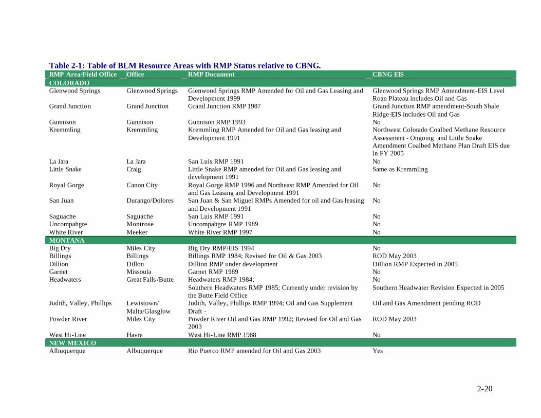
2-20
Table 2-1: Table of BLM Resource Areas with RMP Status relative to CBNG. RMP Area/Field Office Office RMP Document CBNG EIS COLORADO Glenwood Springs Glenwood Springs Glenwood Springs RMP Amended for Oil and Gas Leasing and
Development 1999 Glenwood Springs RMP Amendment-EIS Level Roan Plateau includes Oil and Gas
Grand Junction Grand Junction Grand Junction RMP 1987 Grand Junction RMP amendment-South Shale Ridge-EIS includes Oil and Gas
Gunnison Gunnison Gunnison RMP 1993 No Kremmling Kremmling Kremmling RMP Amended for Oil and Gas leasing and
Development 1991 Northwest Colorado Coalbed Methane Resource Assessment - Ongoing and Little Snake Amendment Coalbed Methane Plan Draft EIS due in FY 2005
La Jara La Jara San Luis RMP 1991 No Little Snake Craig Little Snake RMP amended for Oil and Gas leasing and
development 1991 Same as Kremmling
Royal Gorge Canon City Royal Gorge RMP 1996 and Northeast RMP Amended for Oil and Gas Leasing and Development 1991
No
San Juan Durango/Dolores San Juan & San Miguel RMPs Amended for oil and Gas leasing and Development 1991
No
Saguache Saguache San Luis RMP 1991 No Uncompahgre Montrose Uncompahgre RMP 1989 No White River Meeker White River RMP 1997 No MONTANA Big Dry Miles City Big Dry RMP/EIS 1994 No Billings Billings Billings RMP 1984; Revised for Oil & Gas 2003 ROD May 2003 Dillion Dillon Dillion RMP under development Dillion RMP Expected in 2005 Garnet Missoula Garnet RMP 1989 No Headwaters Great Falls /Butte Headwaters RMP 1984;
Southern Headwaters RMP 1985; Currently under revision by the Butte Field Office
No Southern Headwater Revision Expected in 2005
Judith, Valley, Phillips Lewistown/ Malta/Glasglow
Judith, Valley, Phillips RMP 1994; Oil and Gas Supplement Draft -
Oil and Gas Amendment pending ROD
Powder River Miles City Powder River Oil and Gas RMP 1992; Revised for Oil and Gas 2003
ROD May 2003
West Hi-Line Havre West Hi-Line RMP 1988 No NEW MEXICO Albuquerque Albuquerque Rio Puerco RMP amended for Oil and Gas 2003 Yes

2-21
RMP Area/Field Office Office RMP Document CBNG EIS Carlsbad Carlsbad RMP 1988, Amended for Oil and Gas 1997 No Farmington Farmington Farmington Proposed RMP and Final EIS, 2003 Yes, EIS/RMP September 2003 Las Cruces Las Cruces Draft RMP Amendment and EIS for Federal Fluid Minerals
Leasing and Development in Sierra and Otero Counties, 2000; Mimbref RMP, 1993
No
Roswell Roswell Roswell RMP 1997 No Socorro Socorro Socorro RMP Revision 2004 Expected 2004 Taos Taos Taos RMP, Oil and Gas Amendment 1991 No UTAH Cedar City Cedar City Pinyon MFP, 1983
Cedar Beaver Garfield Antimony PRMP/FEIS 1984, ROD 1986 No
Fillmore Fillmore Warm Springs RA PRMP/FEIS 1986, ROD 1987 House Range RA ARMP/ROD & RPS, 1987
No
Kanab Kanab Vermillion MFP, 1981 Zion MFP, 1981 Parla MFP, 1981
No New RMP to be initiated for Mineral Development in 2004
Moab Moab Grand Resources Area PRMP/FEIS 1983, ROD 1985 No, New Moab RMP currently being developed Monticello Monticello San Juan RMP, MSA 1985; San Juan PRMP/FEIS 1987; San
Juan Reissued PRMP 1989; San Juan ARMP/ROD & RPS 1991 No
Monument Kanab Escalante MFP, 1981 Escalante PRMP/FEIS, 1999 ROD 1999
No
Price Price Price MFP, 1982 San Rafael RA PRMP/EIS, 1989 ROD 1991
Castle Gate 1992, River Gas 1997, Ferron 1999
Richfield Richfield Mountain Vallet MFP, 1982 San Rafael RA PRMP/EIS, 1989 ROD 1991
No
St. George St. George Virgin River MFP, 1977 Dixie RA PRMP/FEIS, 1998 St. George (Formerly Dixie) ARMP/ROD 1999
No
Salt Lake Salt Lake Park City MFP, 1975; Iso-tract MFP, 1985 Randolph MFP, 1980 Box Elder PRMP/FEIS, 1985 ROD 1986 Pony Express PRMP/FEIS 1988, ROD 1990
No
Vernal Vernal Diamond Mountain 1994 & Book Cliffs 1985, New Vernal Draft Update due October 2003
No
WYOMING Buffalo Buffalo Buffalo RMP, 1985; Revised for CBNG 2003 Yes, ROD & RMP Amendments for the Powder

2-22
RMP Area/Field Office Office RMP Document CBNG EIS River Basin Oil and Gas Project, 2003
Casper Casper Platt River RMP/ROD 1985; Revised for CBNG 2003 Yes, ROD & RMP PRB Oil and Gas Project 2003 Cody Cody Cody RMP, 1990 Revised ROD 1999 No Kemmerer Kemmerer Kemmerer PRMP/FEIS, ROD 1986 No, New Plan revise currently under way Lander Lander Lander RMP 1987 No Newcastle Newcastle Newcastle RMP/ROD, 2000 No Pinedale Pinedale Pindale RMP, 1988 Amended for Oil and Gas 2000
Snake River PRMP/FEIS, 2003 No
Rawlins Rawlins Great Divide RAMP/FEIS 1998 No Rock Springs Rock Springs Green River RMP/ROD 1997 No Worland Worland Grass Creek PRMP/FEIS, ROD 1998
Washakie RMP, 1988 No

2-23
2.4 PUBLIC RELATIONS ANALYSIS From the viewpoint of many government officials, energy companies and some landowners, CBNG development is a great success. It is a source of jobs, income, corporate profits, tax revenues, royalty payments, and other benefits. The majority of companies and community members are satisfied with the way CBNG development has unfolded, and the implementation of existing public policies.
The strong statements of concern often expressed in the media, are, however, compelling evidence that some problems have occurred. Given the great number of energy companies developing CBNG resources, it is likely that some companies are better than others in resolving problems and conflicts. The current pace of CBNG development has resulted in some unwanted impacts on and divisions between communities and local residents with the CBNG industry. In addition, ranchers, land owners, and outdoor-enthusiasts in some cases disagree with energy companies regarding the foreseen uses of the same land. CBNG operators and Natural Resource Councils disagree that road- less areas and wild lands remain untouched by oil and gas exploration. Nevertheless, there are several common observations that contribute to the public perceptions surrounding CBNG development. These common observations include the following:
• The demand for natural gas in the United States is going to continue to grow. • CBNG is an important source of income and jobs in the Western United States
and is a source of revenue for local, state, and federal governments. • The rapid development of CBNG has created a series of challenges for
communities, surface owners and governments. Over a very short time period involved parties are forced to address many development related issues including disposal of produced water, surface-owner conflicts, development impacts, and demands for governmental and regulatory services.
• There have been conflicts between land owners and energy companies over the impacts of development that include, other uses of the land, noise and decreased property values. These conflicts are usually the result of split estates, surface land and underlying mineral resource ownership divisions, the lack in some cases of adequate surface use agreements, development impacts on adjacent landowners that are not addressed by agreements, royalty disputes and other differences.
• CBNG development poses many challenges for local communities such as increased traffic, noise, air pollution, housing demands, strained public services and other growth related consequences. Impact fees, property taxes, royalties, and other financial resources can help communities cope with growth, but the consequences of growth often come much faster than the eventual flow of funds.
• The brunt of dealing with the consequences of growth falls directly on local governments that frequently lack the resources and authority to address them effectively. Depending on state law, local governments may or may not benefit directly from royalties or severance taxes derived from development.
• Natural resources, watersheds, and ecosystems associated with energy development do not take into account state and other governmental boundaries. Rivers and their associated ecosystems cross state boundaries, geologic formations are not bound by state divisions or lines of landownership. Aquifers,
2-24
CBNG producing coal seams and other natural systems do not typically abruptly end or change at a regulatory boundary
• Governance is particularly complex in the West with large areas of public lands and reservations that add additional layers of sovereignty and governmental authority. Federal, state, and local governments have some level of regulatory authority over CBNG development. A major challenge for CBNG companies, landowners, and other concerned citizens is navigating this complex structure of jurisdictions whose policy making efforts are often uncoordinated and incompatible.
• Most agencies lack the staff and finances to address the demands placed on them for prompt processing of applications, appropriate assessment of environmental impacts, monitoring and enforcement of agreements, and long-term planning.
• Given the dryness of the West and the recent drought over the past several years’ impacts of CBNG development on water is a tremendous concern. While there is considerable differences between CBNG produced water quality, many residents are convinced that CBNG development results in a waste of this valuable resource or at a minimum, exacerbates the problems regarding groundwater availability. Water is so valuable and scarce that any activity that seems to waste it is easily viewed by the public as problematic.
Despite the progress some CBNG development companies have made with addressing these common public perceptions, conflicts and pressures are likely to continue as the density of development increases and new lands are opened to development. In some areas, CBNG companies and communities may be able to achieve a balance between competing goals such as, CBNG extraction and grazing, economic incentives for development and impact fees and taxes, government regulation and market forces, and produced water disposal and beneficial uses. In other areas, CBNG companies may need to concede development in wilderness study and road- less areas when development is out weighted by commitments to ecological/recreational values. Major issues facing CBNG expansion include, identification of lands that may not be available for lease or, examination of how CBNG development can be promoted and still provide for other land uses. In addition the formulation of analytic tools and frameworks for assisting decision makers to clarify and make appropriate choices is needed. This discussion is to provide the reader with some accepted options that are currently employed to gain public.
2.4.1 Public Relations During the pre-planning process the public is usually afforded an opportunity to express their opinions and concerns with the appropriate regulatory agency and operator(s) to facilitate an atmosphere of cooperation. By involving and providing responses to concerns of the public, project proponents can foster the image of responsibility that focuses on the interest of the community while building a rapport with individuals (Dole, undated). Initiating public involvement and comment is typically conducted by public meeting or forum. This venue can be used to clarify issues of concern by describing management practices scheduled for implementation that are aimed at reducing,
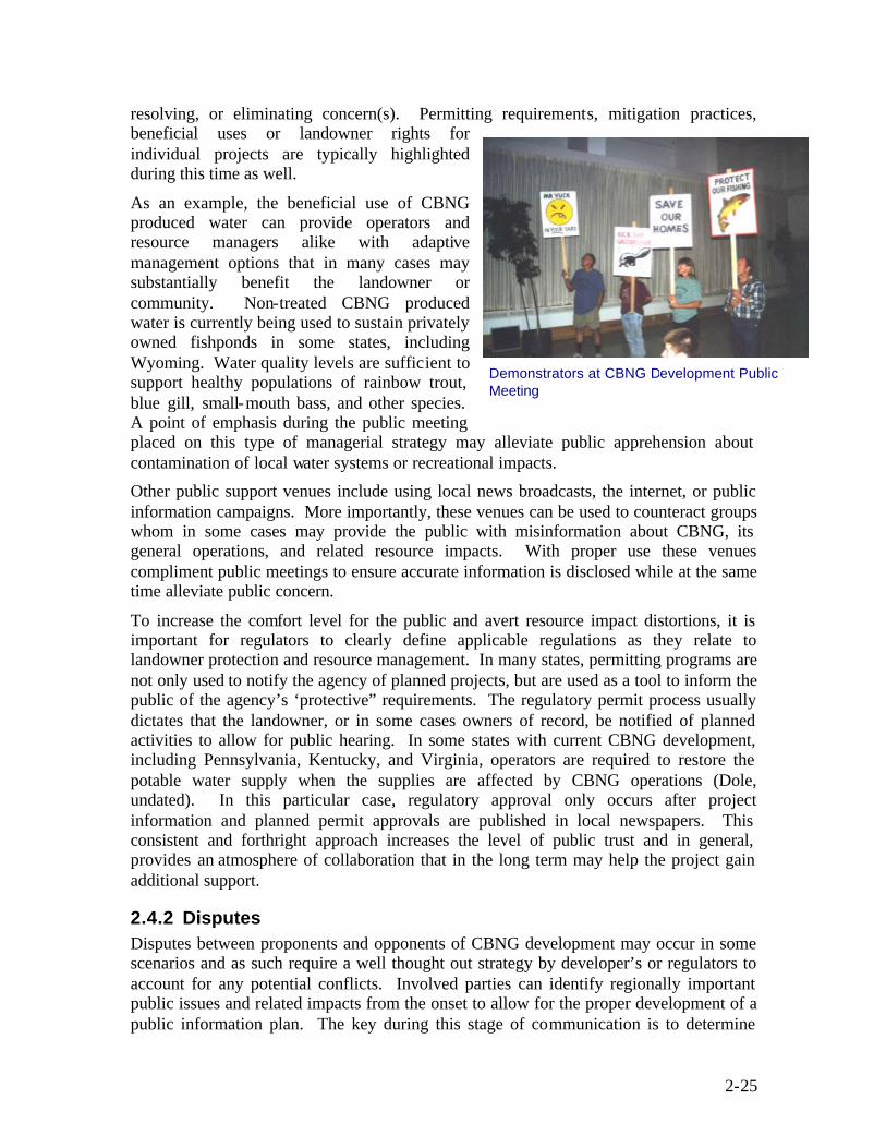
2-25
resolving, or eliminating concern(s). Permitting requirements, mitigation practices, beneficial uses or landowner rights for individual projects are typically highlighted during this time as well.
As an example, the beneficial use of CBNG produced water can provide operators and resource managers alike with adaptive management options that in many cases may substantially benefit the landowner or community. Non-treated CBNG produced water is currently being used to sustain privately owned fishponds in some states, including Wyoming. Water quality levels are sufficient to support healthy populations of rainbow trout, blue gill, small-mouth bass, and other species. A point of emphasis during the public meeting placed on this type of managerial strategy may alleviate public apprehension about contamination of local water systems or recreational impacts.
Other public support venues include using local news broadcasts, the internet, or public information campaigns. More importantly, these venues can be used to counteract groups whom in some cases may provide the public with misinformation about CBNG, its general operations, and related resource impacts. With proper use these venues compliment public meetings to ensure accurate information is disclosed while at the same time alleviate public concern.
To increase the comfort level for the public and avert resource impact distortions, it is important for regulators to clearly define applicable regulations as they relate to landowner protection and resource management. In many states, permitting programs are not only used to notify the agency of planned projects, but are used as a tool to inform the public of the agency’s ‘protective” requirements. The regulatory permit process usually dictates that the landowner, or in some cases owners of record, be notified of planned activities to allow for public hearing. In some states with current CBNG development, including Pennsylvania, Kentucky, and Virginia, operators are required to restore the potable water supply when the supplies are affected by CBNG operations (Dole, undated). In this particular case, regulatory approval only occurs after project information and planned permit approvals are published in local newspapers. This consistent and forthright approach increases the level of public trust and in general, provides an atmosphere of collaboration that in the long term may help the project gain additional support.
2.4.2 Disputes Disputes between proponents and opponents of CBNG development may occur in some scenarios and as such require a well thought out strategy by developer’s or regulators to account for any potential conflicts. Involved parties can identify regionally important public issues and related impacts from the onset to allow for the proper development of a public information plan. The key during this stage of communication is to determine
Demonstrators at CBNG Development Public Meeting

2-26
who the opposing sides are, what are their major concerns, and recognition of proponent actions or information that may be used to alleviate such concerns. To help with this process States have promulgated procedures to allow hearings of dispute and resolution before a sanctioned public commission (Dole, undated). In most CBNG cases, the State appointed Oil and Gas Commission/Board provides the final decision in public meetings.
2.4.3 Split-Estates The concerns that may exist for private landowners who do not have legal ownership of underlying minerals is a central issue as the potential for such landowners to oppose and/or to support public citizen groups is understandable. Motivation may come from the fact that surface land agreements do not typically include provisions for royalties or profit sharing. In such situations, it becomes vital that the operator or mineral right owner create an open line of communication with the landowner to describe the legal aspects of CBNG development, regional and state benefits associated with the project, pertinent resource management strategies, and damage compensation allocations. Such discussions held on a person to person basis may aid in creating a mutual working environment and in the end, help alleviate owner antipathy.
2.4.4 Resource Impacts Private landowners are acutely aware that CBNG development can affect common resources and are concerned that such affects may limit land uses, disturb the visual appearance of the area, and might decrease the value of the land. Resource managers and operators can address such concerns by developing appropriate adaptive management plans aimed at minimizing resource impacts. Best Management Practices (BMPs) and mitigation strategies are formulated by involved parties during the pre-planning process to account for expected impacts. From a public relations perspective, operators then can relate and discuss these strategies with the landowner to impart to them that preventative actions are being developed in a conscientious and environmentally safe manner.
Discussion with landowners may also include a concise description of the planned reclamation process for post-CBNG production activities. How will wells be abandoned? Will utilities be removed or used for some other purpose? How will roadways be re-seeded or returned to a natural condition? Does the owner want constructed impoundments to remain in place for personal use? Would he/she prefer to have roadways remain for access to previously inaccessible areas? It is also important to identify specific owner stipulations or requests. Genuine efforts by operators and regulators alike to work with the owner to address and discuss issues promote an image of understanding and competence for the developers.
2.4.5 Land Use Restrictions Land use restrictions can be a consequence resulting from rapid CBNG development and is a concern for many landowners as well. Interaction between landowners and operators can help develop acceptable methods and surface locations that minimize such restrictions. For example, roadways can be reseeded so that grazing land is not interrupted by roadways. Operators can work with the landowner to determine reasonable produced water disposal options that work best for both parties. This may include re-injection, retention ponds, treatment, or beneficial use including stock water

2-27
tanks. In any case, landowner lease stipulations or surface use agreements that address these issues can be negotiated prior to development to assure satisfactory conditions are met for each party.
2.4.6 Special Interest Groups Individuals within a special interest group are typically diverse, but when acting together signify common goals, concerns, and practices. Many special interest groups have the ability to sway landowner and community thoughts in one direction or another. For this reason, interest groups have the opportunity to impress their concerns and viewpoints as they relate to CBNG project issues on local communities.
Open dialogue between proponents of a project (i.e., CBNG companies) and interested outside parties has proved valuable in the past (European Commission, 2002). A formal consultation process with interested special interest groups is used to clarify proposed actions and potential mitigation. More importantly open dialogue helps to create an atmosphere of trust for those groups who typically believe that the environment or human welfare is of no consequence to the developer.
2.4.7 Beneficial Uses The heightened public awareness of CBNG production has largely triggered concerns related to water, ranging from the basic framework of CBNG development that requires the withdrawal of groundwater from targeted coal seams, to the potential wasting of high-quality water resources. With the volumes of produced water from underground coal seams expected to grow as CBNG development increases, effectively managing produced water in an environmentally sound manner is essential to gain public acceptance.
The beneficial use of CBNG produced water represents a diverse water management option, that when properly managed, can facilitate public support by providing additional land uses. Recreational opportunity can be expanded by construction of fish ponds or artificial lakes. Wetlands and wildlife watering facilities designed to enhance local ecosystems are possible when suitable water is available. Options that best suit the landowner or community vary for any given situation and is a planning step that should be emphasized to the public not only to resolve concern, but as a viable option to enhance the project area.
2.5 SITE SPECIFIC REVIEW AND BASELINE ANALYSIS Site specific reviews and baseline analysis of the CBNG project area allow a producer to identify existing conditions at a site prior to changes brought about by activities related to CBNG development. Baseline analysis of existing conditions allows operators to categorize the original state of the site, as well as facilitate the development of project plans for surface use, water management, mitigation and monitoring plans, and cultural resource and wildlife inventories. In addition to helping with the development of the plans, establishing a baseline condition can benefit the operator later during mitigation actions when the area is to be restored upon abandonment of the CBNG project. Other factors to consider when evaluating site specific conditions can include expanding the analysis beyond the immediate leased area and evaluating the local community and its needs. In expanding the analysis, options for project planning may be identified such as

2-28
providing produced water to off lease ranchers or to a local community municipal water system.
A baseline analysis may include classification of the following parameters: surface water, groundwater, soils, native vegetation, air, noise, roadways/traffic, visual resources, present land use and utilities. The identification of the existing conditions for these parameters benefit operators during monitoring that occurs during the life of the project, at the time of field abandonment and restoration. A discussion of some of the potential analysis associated with background studies for these parameters is discussed below.
2.5.1 Surface Water The analysis of surface waters near a project area is typically important for a variety of project planning aspects including: produced water management plans, surface use plans, monitoring plans and surface use agreements. The analysis of both the quality and quantity of the surface water can provide important data that could potentially impact different aspects of a CBNG project. Surface water quality measurements can provide operators with information to determine the potential for discharging CBNG produced water into surface streams while assuring TDML regulations or other local requirements for discharge are satisfied. Surface water quantity data can serve as a critical component to determine the assimilative capacity of receiving streams, as well as the affects of increased flow rates on downstream conditions.
There are a number of surface water quality parameters that can be measured to determine the receiving capacity of a surface water stream. The parameters vary from watershed to watershed, as surface water quality issues typically differ from stream to stream. For instance, in the Rocky Mountain region there are surface water streams that are sourced by snow melt from the mountains and foothills. These streams are quite pure (low Total Dissolved Solids [TDS] and Electrical Conductivity [EC]) and are diverted to provide additional water to areas for activities such as irrigation water to rangeland. Parameters such as TDS, EC, Sodium Absorption Ratio (SAR), and sodium are important to quantify for this use. Other streams and rivers in the area may have critical fishing and recreation concerns and parameters such as metals, temperature, pH, dissolved oxygen, and TDS may be of more importance to quantify. In the Central and Eastern United States, surface water’s are typically lower in quality relative to the Western United States and because of this, other parameters such as pH, DO, turbidity, and nutrients become more important for TDML considerations.
2.5.2 Groundwater The water that is produced in association with CBNG production has the potential to interact with other groundwater sources. CBNG produced water that is extracted from coal seams may have different concentrations of constituents relative to shallow surface groundwater. In some CBNG areas the water from coal seams may be considerably lower in water quality than local shallow drinking water aquifers, especially when the coals are located at depth (i.e., >1,000 ft ). In other CBNG areas such as portions of PRB in MT and WY, the coal seam from which CBNG is being extracted is of equal or greater quality than shallow drinking water quality and may supply the local drinking water aquifers. CBNG produced water can interact with local aquifers in a couple of ways, for

2-29
instance: water from surface impoundments can infiltrate into shallow groundwater, and water discharged into ephemeral drainages can infiltrate into shallow groundwater. In addition, if the coal seam aquifers are shallow and semi-confined, withdrawals from the coal seams may drawdown hydrologically connected shallow aquifer levels. The quality of both the produced water and the water in the shallow aquifer determines if these interactions result in increases or decreases to the water quality overall.
Determining the water quality of the local shallow aquifers, determination of water levels and potentiometric surface conditions can benefit CBNG operators. The potential exists in some regions for a hydrological connection between shallow subsurface groundwater and coal seam aquifers. The hydrologic connection between these two aquifers is unlikely within the immediate area of CBNG production however, as the potential for the methane trap is reduced in this situation. Yet a hydrologic connection may exist within the drawdown cone of influence of a large scale CBNG production operation, and groundwater levels in the shallow aquifer system could be impacted by the production of water associated with CBNG extraction. Determining the regional potentiometric surface elevations in the area of a CBNG development can allow operators to monitor this groundwater for drawdown impacts that may be related to CBNG extraction.
2.5.3 Soils/Topography Understanding the local soil types and the surface topography are also important for CBNG developers and may aid operators in making project planning decisions related to surface use planning, produced water management and development of monitoring plans. Soil type and surface topography can affect the decision process for surface use plans. Highly erodeable soils and steep topographies can limit the number of options available to CBNG operators for the construction of roads and facilities and add additional costs associated with minimizing erosion. High clay soils can limit the discharge of produced water or the ability to irrigate crops with CBNG produced water on these soil types. Soils analysis that include soil salinity, soil K-factors, textures, slope, and permeability can assist operators to determine the areas most suited for water management options and identification of areas within the project that are least susceptible to erosiona l processes.
2.5.4 Native Vegetation Identification and classification of existing vegetation (i.e. native, introduced, invasive, and noxious) within the project area is beneficial to project development and restoration planning. Lease stipulations on federal leases often require that any disturbed surfaces be restored to pre-existing conditions with a limited number of noxious weed intrusions. The identification of pre-existing conditions allows operators to mitigate impacts that are derived from CBNG changes as opposed to previously unidentified existing conditions. The identification of native vegetation may also help identify species that are tolerant to irrigation that is supplied with CBNG produced water and subsequently, allow for a more wide spread use of water management options.
2.5.5 Air The collection of air samples to establish baseline conditions may include the analysis of particulate or dust and emissions of green house gases such as, methane, carbon monoxide, carbon dioxide, nitrogen oxides, and sulfur dioxide. This baseline analysis
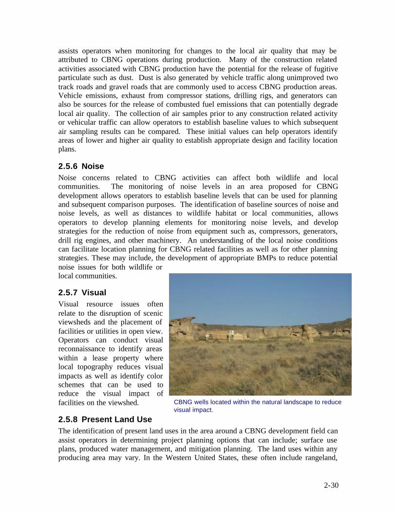
2-30
assists operators when monitoring for changes to the local air quality that may be attributed to CBNG operations during production. Many of the construction related activities associated with CBNG production have the potential for the release of fugitive particulate such as dust. Dust is also generated by vehicle traffic along unimproved two track roads and gravel roads that are commonly used to access CBNG production areas. Vehicle emissions, exhaust from compressor stations, drilling rigs, and generators can also be sources for the release of combusted fuel emissions that can potentially degrade local air quality. The collection of air samples prior to any construction related activity or vehicular traffic can allow operators to establish baseline values to which subsequent air sampling results can be compared. These initial values can help operators identify areas of lower and higher air quality to establish appropriate design and facility location plans.
2.5.6 Noise Noise concerns related to CBNG activities can affect both wildlife and local communities. The monitoring of noise levels in an area proposed for CBNG development allows operators to establish baseline levels that can be used for planning and subsequent comparison purposes. The identification of baseline sources of noise and noise levels, as well as distances to wildlife habitat or local communities, allows operators to develop planning elements for monitoring noise levels, and develop strategies for the reduction of noise from equipment such as, compressors, generators, drill rig engines, and other machinery. An understanding of the local noise conditions can facilitate location planning for CBNG related facilities as well as for other planning strategies. These may include, the development of appropriate BMPs to reduce potential noise issues for both wildlife or local communities.
2.5.7 Visual Visual resource issues often relate to the disruption of scenic viewsheds and the placement of facilities or utilities in open view. Operators can conduct visual reconnaissance to identify areas within a lease property where local topography reduces visual impacts as well as identify color schemes that can be used to reduce the visual impact of facilities on the viewshed.
2.5.8 Present Land Use The identification of present land uses in the area around a CBNG development field can assist operators in determining project planning options that can include; surface use plans, produced water management, and mitigation planning. The land uses within any producing area may vary. In the Western United States, these often include rangeland,
CBNG wells located within the natural landscape to reduce visual impact.

2-31
forest preserves, residential communities and farmland. Each of these different land uses can require operators to vary their planning approach for development of CBNG facilities and can provide opportunities for the beneficial use of produced water. In some instances, existing land uses may require operators to vary production practices to avoid impacts to existing land uses. The earlier these conditions are identified and subsequent modifications are incorporated into the project plans, the more cost effective these changes can be. For instance, rangeland and farmland provide considerable opportunities for CBNG operators to supply high quality CBNG produced water if available for irrigation and livestock watering. In addition residential areas and forest preserves can cause operators to change the type of pumps that are used for CBNG extraction or may alter plans for the construction of roadway and utility corridors in a single disturbance passage.
2.5.9 Roads/Traffic/Utilities The identification of existing access roadways and utilities can facilitate project planning and help to reduce surface disturbances. Identifying local traffic patterns, speed limits, and roadway weight restrictions can be used in the development of surface use plans, assist in identifying areas for avoidance and identify roads or highways that may require enhancement or redesign to accommodate CBNG traffic. In addition identifying utility locations can help reduce surface disturbances and costs associated with installing these utilities for CBNG facilities.

3-1
3 Best Management Practices Environmental conditions altered by CBNG production practices have caused concern for federal, state, and local regulatory agencies; land and resource managers; industry; landowners; and the general public. Rising public awareness and more stringent regulations has increased pressure on those involved in the CBNG industry to develop methodologies to accurately define specific areas of environmental risk, develop Best Management Practices (BMPs), and mitigation strategies to aid in minimizing and alleviating identified risks. As a result, development of sound BMP’s and mitigation strategies that facilitate resource development in an effective, timely, and environmentally sensitive manner, have become increasingly important.
BMPs are defined as techniques, procedures, and sustainable strategic plans which are generally site specific, economically feasible, and used to guide management actions in achieving desired outcomes. Implementation of BMPs can be used to reduce adverse environmental effects or enhance beneficial effects resulting from CBNG operations. Typically, available management options for BMPs are dictated by site-specific characteristics (i.e., land and mineral ownership, geologic and hydrologic conditions [including depth of coal seams], soil types, local and regional wildlife issues, etc.), project objectives, and applicable regulations. In any case, effective use of BMPs can assure at a minimum, a basic level of maintainable environmental protection in a cost efficient manner. Although BMPs are often derived from Federal, State, or local standards, BMPs by definition do not constitute regulations and therefore, should only be considered as a guidance tool for protecting foreseeable changes to resources.
Mitigation measures are closely associated with BMPs and are best described as techniques, procedures, and sustainable strategic practices which are implemented upon formulation of environmentally sound BMPs. Mitigation measures are site specific and may vary depending on the type of disturbance, the degree of the disturbance, and the requirements of landowners or other involved parties. These practices are often implemented in phases or in a practical chronological order to ensure that the disturbances of a specific phase of a project is linked with the appropriate measures to maximize the efficiency and effectiveness of the mitigation (EPA, 2002c). As with BMPs, the objective(s) of mitigation measures are to aid or alleviate the consequence to various resources resulting from CBNG project operations.
Effective use of BMPs necessitates careful planning and coordination with federal and state agencies, as well as between operators and landowners. From a functional perspective, successful mitigation measures are the development of preventative or beneficial plans, that when implemented, maximize the number and magnitude of protected resources. As an example, immediately reseeding bare soils during construction activities or after a project’s completion can help minimize erosion events that may occur during seasonal flooding. This practice can also aid in the reclamation of native vegetation, he lp prevent infestation of noxious weeds, reduce dust control issues, provide additional lands for livestock grazing, provide suitable habitat and food resources for certain wildlife species, and control sediment run-off to nearby water systems. With this cost effective and flexible approach, the quantity and quality of protected resources can

3-2
be enhanced to meet or exceed expectations of affected landowners, resource managers, and public agencies.
To further augment the effectiveness of BMPs, many employers are now providing mitigation specific training to employees. The training opportunities assure that employees are proficient in contemporary, as well as traditional techniques, which include; dust and noise control, hazardous waste reduction, seeding, and construction “footprint” minimization. With this approach and minimal investment employers can help protect vulnerable resources while at the same time, maintain a high level of project efficiency.
There are many aspects of CBNG exploration and development that present unique challenges to resource managers, landowners, and State and Federal agencies. BMPs and mitigation measures specific to the CBNG industry have been developed, as an example, by the Bureau of Land Management (BLM), the Montana Board of Oil & Gas Conservation (MBOGC), and others to identify resource issues, provide guidance for potential mitigation strategies, and to further enhance related beneficial uses. Within these documents implementations of measures to mitigate effects are generally presented as procedures based on industry or activity related issues specific to the CBNG production. The activities have the potential to both negatively affect or enhance individual resources.
The discussion below redirects this approach by focusing on resource specific issues, as well as resource-specific mitigation strategies that can or are required to be implemented to minimize disturbances to the resource. It is hoped this approach can help better define and clarify CBNG related resource issues in a manner that benefits landowners, operators, and federal or state agencies. This concise discussion should not be considered exhaustive since additional measures may also be identified during CBNG development or in a NEPA process.
3.1 BENEFICIAL USE During the production of CBNG, groundwater is extracted from coal seam aquifers to facilitate the release of methane gas trapped under hydrostatic pressure. Development of new CBNG fields typically generate large volumes of water that may represent an opportunity for operators to provide themselves, the landowner, and nearby industry with water that does not result in the waste of this resource. The ability of a CBNG operator to provide CBNG produced water can provide unique and substantial benefits.
The water produced from CBNG wells varies from very high quality (meeting state and federal drinking water standards) to low quality, essentially unusable (i.e., TDS concentration up to 180,000 parts per million). Currently, the management of CBNG produced water is conducted using various water management practices depending on the quality of the produced water. In areas where the produced water is relatively fresh, the produced water is handled by a wide range of activities including direct discharge, storage in impoundments, livestock watering, irrigation, and dust control. In areas where the water quality is not suitable for direct use, operators use various treatments prior to discharge, and/or injection wells to dispose of the fluids.

3-3
The use of CBNG produced water for beneficial use represents a flexible and valuable approach to utilizing an important resource by providing benefits to operators, land owners, and in some cases the general public. The quality of the produced water, the surrounding environmental setting, operator and landowner needs, and pertinent regulations, often dictate the water’s designated use. In most cases certain aspects of development can benefit either by practical resolution or by satisfying public requests or needs. Potential beneficial uses for CBNG high quality produced water has been integrated into the following resource discussion, when applicable, to provide the reader with a practical understanding of this mitigation approach. For more information on beneficial uses for CBNG produced water refer to: CBNG Produced Water: Management and Beneficial Use Alternatives, GWPRF, 2003, in cooperation with BLM and the Department of Energy (http://www.all- llc.com/CBNG/BU/index.htm).
3.2 COMMON RESOURCES
3.2.1 Air Quality The 1990 Clean Air Act is a federal law that establishes nationwide limits on how much of a pollutant can be in the air. This act is to ensure that Americans have the same basic health and environmental protection with respect to the air they breathe. Under this Act, states are responsible for implementing the law; since pollution control problems often require special understanding of local industries, geography, housing patterns, etc. The law allows individual states to require more stringent pollution controls, but does not allow for weaker pollution regulations. Figure 3-1 shows the Class I areas in the Rocky Mountain region as designated by the Clean Air Act. Class I areas are generally major parks and wilderness areas over 6,000 acres, where pristine air quality and scenic vistas are integral features.
Excessive air emissions resulting from CBNG development vary for any region since pollutant transport is affected by the magnitude and distribution of pollutant emissions, as well as local topography and meteorology. Although air quality changes from the CBNG industry can be localized and short-term in duration, appropriate mitigation could eliminate potential long-term air quality affects and conciliate concerns raised by involved parties. Exhaust from construction activities, along with air pollutants emitted during operation (i.e., compression) may be expected to cause some air quality changes.
Dust from construction activities and standard travel of personnel and equipment over unpaved roads has the potential to alter air quality and create a nuisance to those traveling or living in these areas. The use of high quality CBNG produced water (low SAR) for dust control offers multiple benefits from an environmental viewpoint, including the prevention of air quality concerns and the loss of surface soils. Possible applications of produced water for dust control include use on lease roads, other unpaved roads in the development area, and various construction sites where surface disturbances due to CBNG development exist.
Applying seed or re-vegetating bare soil areas is another successful measure that is used to minimize dust emissions, as well as to protect soils, and reduce erosion. The benefit of re-seeding bare areas far out ways management and monitoring costs and should be looked on as a necessity, rather than an option. This measure not only aids in the
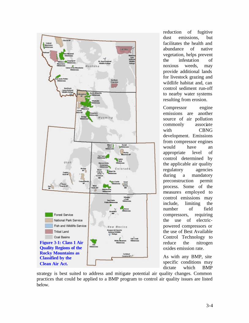
3-4
Figure 3-1: Class 1 Air Quality Regions of the Rocky Mountains as Classified by the Clean Air Act.
reduction of fugitive dust emissions, but facilitates the health and abundance of native vegetation, helps prevent the infestation of noxious weeds, may provide additional lands for livestock grazing and wildlife habitat and, can control sediment run-off to nearby water systems resulting from erosion.
Compressor engine emissions are another source of air pollution commonly associate with CBNG development. Emissions from compressor engines would have an appropriate level of control determined by the applicable air quality regulatory agencies during a mandatory preconstruction permit process. Some of the measures employed to control emissions may include, limiting the number of field compressors, requiring the use of electric-powered compressors or the use of Best Available Control Technology to reduce the nitrogen oxides emission rate.
As with any BMP, site specific conditions may dictate which BMP
strategy is best suited to address and mitigate potential air quality changes. Common practices that could be applied to a BMP program to control air quality issues are listed below.
3-5
• Avoidance of surface construction on soils susceptible to wind erosion
• Use of dust inhibitors as necessary on unpaved collector, local, and resource roads to minimize fugitive dust emissions
• Avoid specific geographic locations susceptible to excessive winds
• Use soil erosion control techniques when bare ground is temporarily or permanently exposed
• Install pollution control equipment on field and sales compressors
• Install catalytic converters on heavy machinery to minimize air pollutants
• Enclose painting operations, consistent with local air quality operations
• Properly store materials that are normally used in repair such as paints and solvents
3.2.2 Cultural Resources and Paleontological Resources Cultural resources are best described as material remains of, or the locations of past human activities, including sites of traditional cultural importance to both past and contemporary Native American communities. The existence of cultural resources within a specific location is determined through examination of existing records, field surveys, and subsurface testing of areas that are proposed for disturbance on federal and state lands. Section 106 of the National Historic Preservation Act (NHPA) requires an inventory of cultural resources if federal involvement is present either in terms of surface or mineral estate, federal funds, federal grant, or federal license. The BLM has also identified survey standards that should include approved plans for avoidance when resources are discovered. In addition, State Historical Preservation Offices (SHPO) maintain a register of identified sites, as well as sites that are listed or eligible for listing on the National Register of Historic Places (NRHP).
Unidentified cultural resources could potentially be affected by surface and subsurface activities that involve the use of heavy equipment (road construction, well drilling, pad construction, pipeline and utility placement, etc.) that ultimately change the natural landscape of an area. As such, the most sensible and preventative measure to protect this resource is to properly identify historic or pre-historic locations and more importantly avoid or relocate project facilities in these areas when feasible. This point is enforced by Federal mandate. Federal and state laws require the performance of surveys prior to the commencement of construction or other surface disturbing activities as well as prohibit land usage when an area is designated for conservation use, public use, or sociocultural use.
In the rare event when exploratory or development procedures unearth previously undiscovered resources, enforceable mitigation would require that work be stopped in the area of discovery until an evaluation can be preformed. When appropriate, consultations would be conducted with the SHPO, tribal historic preservation officer and/or Advisory Council on Historic Preservation. Appropriate and responsible action would be determined by these agencies and coordinated with operators and/or landowners.

3-6
In most cases, instruc tion on procedures to follow incase previously unknown archeological resources are uncovered during construction would constitute an important element of the BMP. This may include; informing operators of the penalties for illegally collecting artifacts or intentionally damaging archeological sites or historic properties, instruction on rehabilitation of buildings or structures, minimizing equipment traffic, and restricting placement of equipment and material staging areas near known archeological resources (National Park Service, 2002).
Paleontologic resources consist of fossil-bearing rock formations containing information that can be interpreted to provide a further understanding about any given location’s past.
Surface occupancy is prohibited within paleontological sites on BLM project lands unless it can be demonstrated that the paleontological resource values can be protected, or undesirable disturbances can be mitigated. BLM provides guidelines for notifying and mitigating damage to paleontological resources discovered during oil and gas construction activities. Limitations include restricted use of explosives for geophysical exploration, monitoring requirements, and work stoppages for discovered damaged resources. As with Cultural Resources, investigative surveys to identify this resources and/or avoidance are typically considered the most effective mitigation to prevent damage.
3.2.3 Geology and Minerals As stated earlier in this document, it is important to recognize that geology and mineral resources are directly associated with coal deposits. CBNG gas is generated within the coal deposits under both thermogenic (heat-driven) and biogenic (microbe-driven) conditions. The magnitude of the CBNG resource is determined by coal type and volume; and the location of coal seams, which coincide with the location of CBNG resources. Existing BLM regulations allow for the production of CBNG, but dictate that development be conducted in a manner that conserves these other resources present so they are not wasted.
The selection of an appropriate BMP to minimize alterations to these resources depends greatly on local site conditions and usually consists of a collection of practices. Well spacing and field rules are established to maintain the integrity of surface formations while at the same time aiding in the efficient production of hydrocarbons. Drilling and completion practices, such as steel casing and cementing, stabilize the well bore dramatically and reduce the opportunity for hydrocarbon migration. In addition, certain operator practices can reduce surface disturbances as well. Sharing access roads, flowline routes, and utility line routes minimize surface disturbances and in certain circumstances, constructing multiple well pads and production facilities on the same pad can be implemented to consolidate work disturbing operations.
BMPs with a hydrologic component (e.g., storage ponds or impoundments) can directly effect geologic resources and require planning. When designed properly, however, they can be utilized to help control soil erosion and sedimentation ocurring from rainfall events, as well as provide benificial use. State engineering offices or related agencies often provide specific construction guidelines for impoundments. These guidelines can dictate preventative elements in their design that may include topgraphic restrictions (slope), water right permitting requirements, and specific benificial use limitations. As an

3-7
CBNG Supplied Impoundment, Powder River Basin, Montana
example of benefical use, the Montana Department of Environmental Quality considers CBNG produced water to be unaltered State water and therefore; does not require permitting if the water meets certain water quality standards. Under a current proposal, this high quality water could be used specifically for livestock or wildlife watering and would have minimum impact to geological or mineral resources.
Reclamation practices to re-establish local landscapes are considered an integral BMP component during the production and abandonment phases of CBNG development. They are also required by the BLM. In most cases operators, along with landowners should discuss development and reclamation plans to reach a common agreement. This process ensures that acceptable guidelines and objectives are established to satisfy regulatory stipulations, as well as provide suitable guarantees for the landowner. From a functional and aesthetic perspective, re-seeding disturbed areas, such as well pad locations or road systems, restores the visual appearance of any disturbed location, and resolves or prevents local erosion and climatic (i.e., dust control) issues. “No Surface Occupancy” stipulations could also be utilized on new oil and gas leases, which are issued for lands that have existing coal leases to prevent additional disturbance.
3.2.4 Hydrological Resources CBNG production can produce large volumes of water that can affect both ground and surface water when the quality of the water is low. Generally, water quality in a certain watershed varies, but in many cases is dependent on the volume of water present and the season. During times of high flow, streams receive large volumes of runoff water; while during times of base-flow, streams receive little runoff and are supplied primarily by groundwater. High-flow periods correspond to the seasonal influx of relatively high-quality, low-SAR surface water typically associated with spring snow-melt and early summer rains. Base-flow periods correspond to periods of scarce surface water during the winter when streams are fed only by the influx of lower quality, high-SAR groundwater from shallow aquifers.
When groundcover is broken it exposes soil to wind and water erosion, leading to suspended sediment being deposited in bodies of surface water. Artificial impoundments can cause water infiltration into the soil and migration into surface water, and accidental releases of wastes can migrate into water bodies. These issues are of particular importance to residents. As a result, implementation of water management alternatives is in the forefront of CBNG development.

3-8
Figure 3-2: Off-Channel Impoundment Schematic Diagram of Off-Channel Pond
Alluvium
Clay Stone
Clay Stone
Sand Stone
River
BermPond
Coal
Coal
Clay Stone
Current protection of hydrological resources primarily focus on maintaining beneficial uses for the produced water; although water well, and spring mitigation agreements are often used to facilitate the replacement of groundwater lost to drawdown.
New technologies or strategies for CBNG produced water are continually being developed and are responsible for reshaping the way landowners and operators think about beneficial use and resource protection. Current water management strategies include using the water for certain job specific needs (e.g., dust control) or to supplement other water related activities (i.e., irrigation, impoundments, livestock watering, industrial use, and in some cases, potable water use).
In areas where there are distinct wet and dry seasons BMPs may vary during the seasons. During the wet seasons water is abundant and available in both surface streams and groundwater supplies. During the dry season water supplies are often depleted leaving a demand upon available water supplies. In these areas, water is captured from surface streams and other sources, and then stored in permeable aquifers for use during the dry season to ensure that this resource is not wasted. The storage of produced water for future use could be accomplished through the use of Aquifer Storage and Recovery (ASR), a proven technology. In the case of CBNG, large quantities of produced water could be stored in depleted aquifers or coal seams where the gas resource has been depleted. ASR provides water storage at lower cost than traditional surface storage methods while functioning in a manner similar to a traditional surface reservoir. Another management option for produced water is impoundment use. The impoundment of CBNG water is the placement of water produced during operations at the surface in a pit or pond. There are a variety of ways in which operators can impound produced water at the surface. Impoundments can be constructed on or off channel, and the regulatory authority in some states varies based on whether the impoundments are off or on channel. On channel impoundments are typically more strictly regula ted based on the potential for point and non-point source discharges to surface waters. Figure 3-2 is a schematic diagram representing an off-channel impoundment. The impoundment of produced water can be used as part of a water management plan to provide a variety of disposal options and benefits to both the lease operator and landowners. The options depend on site-specific conditions such as, the quality of produced water, soil type, current and future land use, and certain terrain factors. Under the right set of regulatory conditions, including water right or NPDES requirements, CBNG supplied water could be used to sustain fish ponds, wildlife watering facilities, small recreational ponds, and utilized in retention ponds to restore depleted aquifers.

3-9
The impoundment of water can be performed in any area where there is sufficient construction space. In areas with limited rainfall or drought conditions, impoundments could be used to recharge groundwater in shallow alluvial and coal seam aquifers to provide livestock and wildlife water or for the storage of water prior to irrigation. Impoundments can be constructed to provide a single management option or a combination of management options including: livestock and wildlife watering from wetlands, fisheries and recreational ponds, recharge and evaporation ponds or other combinations.
3.2.5 Lands and Realty Potential land use issues resulting from CBNG development primarily consist of conflicts between conventional oil and gas activities and other uses of property, such as agriculture, residences, and coal mines. New realty authorizations for major gathering lines, major transportation lines, and power lines, for example, affect rights-of-way (ROWs) and land segmenting. The development of oil and gas resources affects agricultural production by taking land out of production, and by potential soil contamination from drilling and production. Soil contamination could result in loss of vegetation, reduced crop yields, or reduced acreage available for livestock grazing.
Proper surface selection and facility arrangement minimizes and mitigates surface conflicts and avoids unnecessary surface uses that would require additional reclamation, special operating procedures, or other restrictions that could be avoided. Geo-referenced spatial data depicting proposed facility locations, well locations, roads, pipelines, power lines, impoundments etc., is currently being utilized to mitigate potential surface conflicts. Locations in areas with a potential for high surface run-off, with increased erosion potential or in the flood plain of surface drainages could dramatically alter lands and thus, mitigation efforts. Avoidance of steep slopes, unstable soils, and locations that block or restrict natural drainages are successful tactics being implemented by operators to reduce surface alterations.
Another surface related issue involves removal of native vegetation, particularly in those areas where vegetation may be difficult to re-establish. Bare soils are susceptible to erosion and as a consequence, can lead to sediment build-up in local water systems, or result in negative alteration to the pre-existing topography. In situations where vegetative removal is necessary, reseeding should be performed immediately after development or as soon as possible during operations. This may aid in the reclamation process and halt future surface disturbances. BLM provides seeding guidance when disturbances of this nature occur on federal lands (see Wildlife and Vegetation later in this section).
3.2.6 Livestock Grazing CBNG development only requires a small area for equipment (i.e., lands for well pads and compressor stations) and therefore is relatively compatible with the foraging characteristics of livestock. Some changes to rangeland are expected however, and can be compensated for by appropriate mitigation. Loss of vegetation for livestock grazing, the disruption to livestock management practices, and loss of grazing capacity from construction of well pads and roads are some of the expected disruptions. Mitigation strategies that affect livestock grazing are often the result of coordination between the

3-10
Figure 3-3: Recycled Tire Stock Tank, Designed for Livestock Use
landowner and operator and serve to provide basic, sustainable practices which can help protect cattle, sheep, horses, and associated structures, such as watering ponds or fences.
The availability of produced water from CBNG activities could generate additional lands available for grazing, especially in arid regions. There are estimates that, on average, cattle consume 11.5 gallons of water per day. Governmental standards for livestock water are less restrictive than potable water and would allow for the use of lesser quality CBNG water for this purpose. Early coordination and cooperation between area CBNG operators, landowners, and local ranchers on the potent ial uses of produced water could prove beneficial for involved parties. This practice is currently being implemented in portions of Montana through the use of stock tanks made from old heavy equipment tires such as the one depicted in the photo in Figure 3-3. In some cases, ranchers would be responsible for obtaining water rights for the use of produced water.
The following list provides additional BMPs that can help protect livestock and their rangeland:
• Repair or replace damaged or displaced facilities such as fences or gates according to landowner requirements.
• Minimize project-related construction equipment and vehicle movement except on specific access roads to avoid disturbance of grazing land.
• Clearly define stipulations and responsibility for fence, gate, and cattle guard maintenance and for noxious weed control and incorporate into the planning process.
• Develop a reclamation plan for areas that have been disturbed during production, and specify techniques for reclamation of well pads, pipeline rights-of-way, and roads.
• Locate facilities to avoid or minimize changes to livestock waters.
3.2.7 Recreation Recreational areas are a vital component for communities nationwide and require close management to assure their protection. CBNG related surface disturbances involving the use of heavy equipment for road construction or well drilling constitute a potential risk to this resource by changing the natural landscape. These types of construction activities could affect hiking, fishing, hunting, etc, as well as infringe on the solitude and rural characteristics of the area. Other activities such as increased travel, and vandalism resulting from access improvements, wildlife displacement, and increased erosion could also potentially affect recreational areas.

3-11
To prevent these potential disturbances to the extent possible, BLM has established stipulations that protect recreation areas. Specifically BLM has established such stipulations in areas receiving concentrated public use and in areas with reservoirs containing fish. Many states have also established stipulations for protection of recreation areas including prohibiting activity near streams, ponds, lakes, or other water facilities. Other possible mitigation strategies include coordinating the timing of exploration activities to minimize conflicts during peak periods of use.
The availability and volume of CBNG produced water could be managed in a way to supplement, or in arid regions, create recreational opportunities for nearby communities. According to the second national water assessment by the United States Water Research Council, less than one-fourth of the surface waters in the Continental United Stats are accessible and useable for recreation because of pollution or other restrictions (Harney, undated). The construction of artificial lakes supplied by produced water could potentially have widespread use depending primarily on available lands, water volume and quality. Many areas of the country are overwhelmed with overcrowded or limited recreational facilities as a result of overpopulation and urban encroachment. The development of artificial lakes could provide additional recreational opportunities within these areas, while at the same time promoting community involvement and habitat improvement.
The addition of a large water body to an ecological community could provide additional habitat for resident and migratory birds, including waterfowl, and possibly provide resting and nesting sites for raptors (Bryan et al, 1996). An increase of waterfowl populations in the area could help support the local hunting community and potentially deter illegal hunting due to limited population sizes. The lake would effectively function as a watering pond or wetland system, potentially increasing wildlife ranges and populations as a result on an increase to the overall dynamics observed by the local ecosystem.
3.2.8 Social and Economic Values The effects of CBNG development on the socio-economics of any community is a dynamic issue which differs at the community and individual level. Influences to social conditions would include changes in employment and population, changes in the services provided by governments, the effects of drilling and related activities on rural lifestyles in the project area, changes in levels of traffic, noise, visual resource alterations, and psychological stress levels; and the effects of population change on local housing, schools, and services.
Options to mitigate socioeconomic concerns can typically be performed as a case-by-case procedure, since varying aspects of this resource are often difficult to predict or are intrinsically linked with other resources or primary community industry(s). The most pragmatic solution would be to resolve issues by evoking public participation to determine appropriate mitigation strategies or more importantly, approaches to maximize community benefits. Meetings to instruct and inform the public of proposed actions are one way to accomplish this task.

3-12
3.2.9 Soils Changes to soils and the ensuing consequences have been well documented with regards to the oil and gas industry and as a result, many preventative and economically feasible measures have been developed to deal with these changes. Changes to soils from CBNG activities could occur from various facets of exploration, construction, operation, and abandonment processes. These changes include soil compaction under disturbed areas, such as well sites and lease access roads, soil erosion in disturbed areas, and chemical influences from spills of liquids. Some changes are unavoidable, such as those resulting from the construction of well sites. Reclamation of construction activity disturbances should proceed soon after the completion of construction.
A healthy soil can absorb storm water, filter sediment, and reduce irrigation and fertilizer needs (Field and Engel, 2003). Changes to soils resulting from CBNG related practices can affect multiple resources and as such, justifies serious consideration when devising appropriate management practices. In general, soil erosion is a gradua l process that occurs when the actions of water, wind, and other factors deteriorate the land into an unproductive and in some cases, hazardous state. Application of BMPs to control such problems is dependent on proper evaluation and planning, and may include considerations such as, organic matter content and nutrient levels, mulching, topography, soil testing, and native plantings.
An example of an effective BMP to control erosion is to keep water from accumulating on road surfaces. Fast-moving water can easily erode soil from road surfaces and ditches, but can be controlled by dispersing runoff into vegetation and ground litter (Iowa Department of Natural Resources, undated). Roads can be designed to keep the surface dry, while at the same time maintaining a certain level of structural integrity. In-sloped roads should contain adequate drainage, whereas out-sloped roads, which are less expensive to construct and maintain, should be designed for moderate gradients and stable soils (Iowa Department of Natural Resources, undated).
Soil changes have been well documented allowing for development of many preventative measures. The list below provides some of these measures.
• Vegetation should only be removed when necessary
• Drill seeds into the ground
• Reduce timber cutting
• Control increases in turbidity and suspended sediments to the maximum extent practical by using berms, dykes or impoundments
• Areas with steep topography should be developed in accordance with the BLM Gold Book (USDI and USDA 1989) requirements
• Federal leases with slopes in excess of 30 percent may be required to obtain approval for occupancy from the BLM based on mitigation of erosion, surface productivity after remediation, and mitigation to surface water quality
• Riparian zones should be protected by federal lease stipulations and permit mitigation measures

3-13
• In areas of construction, topsoil may be stockpiled separately from other material, and be reused in reclamation of the disturbed areas
• Surface owners or surface lessee should be consulted regarding the location of new roads and facilities related to oil and gas lease operations
• Unused portions of the drill location may have topsoil spread over it and reseeded
• Construction activities may be restricted during wet or muddy conditions
• If groundwater is encountered in shallow or near shallow surface materials during drilling, onsite fluid pits should be lined
• During road and utility construction, surface soils can be stockpiled adjacent to the sides of the cuts and fills
• Stream crossings should be designed to minimize soil disturbances and to minimize impedances of stream flow
• Erosion control measures are to be maintained and continued until adequate vegetation cover is re-established.
3.2.10 Solid and Hazardous Wastes In general, hazardous waste is a material or combination of hazardous materials that are no longer useable and are regulated by the Resource Conservation and Recovery Act of 1976 (RCRA). RCRA hazardous materials programs are designed to protect public health and environmental resources from improper disposal or releases of regulated materials. These programs assure future hazardous substance risks, costs, and liabilities on public lands are minimized. On Federal lands BLM is responsible for releases of hazardous materials and requires notification of hazardous materials to be used or transported on public land. Typical solid wastes generated by drilling related procedures are considered RCRA-exempt waste and can be disposed of in local landfills. The largest volumes of exempt waste generated from drilling activities are drilling mud and cuttings. Classified RCRA waste, such as paints would be disposed of in accordance with applicable regulations.
Waste minimization on CBNG development sites is limited because waste volumes are primarily a function of activity, age, and state of depletion of a producing site (American Petroleum Industry, 1989). Nevertheless, mitigation planning should include proven practices to reduce waste to the extent practical. The mitigation of solid and hazardous waste consists primarily of disposing of wastes according to federal and state regulations. Other mitigation activities include leak detection or monitoring system for hydraulic and lubricating systems, construction of secondary containments, and drilling mud retention ponds. The mitigation of accidental spills and releases involves the clean up and reporting of spills in accordance with an approved Spill Prevention Control and Countermeasures Plan and any applicable state regulations. In addition site clearance surveys should be conducted prior to surface disturbance commencement.

3-14
3.2.11 Visual Resource Management Visual resources are visual features that include landform, water, vegetation, color, adjacent scenery, uniqueness or rarity, structures, and other man-made features. Alterations resulting from oil and gas exploration and production activities occur locally on a case-by-case basis as native vegetation is disturbed and small structures are erected. Exploration may involve minor visual changes from clearing operations for access to exploratory sites. The majority of these changes result from access road construction, site construction, drill rig operations, and on-site generator use. Short-term visual changes occur where construction and drilling equipment are visually evident to observers. Long-term alterations may occur from construction of roads and pads, installation of facilities and equipment, vegetation removal, and change in vegetation communities. These could produce changes in landscape line, form, color, and texture.
The USDA Forest Service recognizes special management zones surrounding riparian resources. For example, the Superior National Forest in Minnesota designates a 200- to 300-foot forest buffer, which is managed to optimize riparian resource values (Jaakko Pöyry Consulting, Inc., 1993). This management option can easily be applied to visual resources and in specific situations, coupled together with riparian or recreational resources to consolidate management efforts. Retaining a visual timber buffer could help isolate CBNG-specific visual impairments such as, compressor stations or well pads, from local communities, highway travelers, and nearby recreational areas. Proper identification of timberlands play an important role in implementing this strategy. Due to the associated low costs and the flexibility of this strategy, successful implementation is often feasible.
Federally authorized projects are recommended to undergo a visual assessment to comply with aesthetic requirements (BLM 2003a/b). Typically, sensitive areas include residential areas, recreation sites, historical sites, landmarks or topographic features, or any areas where existing visual quality is valued. Measures to minimize disturbance include designing compressor stations to blend into the background, landscaping options, and painting to camouflage the above ground equipment. Power lines and pipelines can be placed underground and wellheads camouflaged with landscaping or vegetation. Facilities on BLM lands require ample screening from highways or camouflage to retain basic elements of form, line, color and texture of the landscape (BLM 2003a/b).
3.2.12 Wilderness Study Areas To the extent practical, BLM leasing restrictions are designed to protect Wilderness Study Areas (WSA). As such, the most reasonable practices to minimize disturbance is avoidance. BLM has implemented this type of strategy by identifying WSA policies that prohibit leasing of these lands for resource extraction. Such policies can be supplemented by collaborative partnerships among federal and state government agencies, local governments, business communities, volunteers, user groups, educational institutions, and individuals in the private sector to achieve management objectives and implement these guidelines (BLM, 2000).

3-15
3.2.13 Wildlife and Vegetation Stipulations to perform wildlife surveys to assure responsible actions are taken to protect listed species associated with lands owned by the federal government and/or with projects which involve federal participation is an important element of any wildlife BMP. These stipulations are mandatory for federally owned (including federal split-estates) or federally funded projects (BLM 2003a/b). The management practices and identification of stipulations, for split-estates, are the responsibility of the BLM. If development practices occur on private lands, landowners, along with operators, are not bound by these same stipulations from a legal perspective even though they are still considered accountable for actions affecting state or federally listed species. Wildlife regulations are complex and vary depending on geographic location, state and federal involvement, land-usage, and species distribution. In any case, wildlife surveys are a critical component of any mitigation strategy as they help identify listed species and alert operators and landowners of areas or habitats which should be avoided.
Wildlife surveys and inventories are used to identify fish and/or wildlife populations, their habitats, and other associated parameters such as home ranges, biodiversity values, and habitat usage. The inventory and monitoring of the abundance and distribution of wildlife species are essential in addressing development disturbances that pose threats to the effective and sustained management for protected, as well as common species. Monitoring programs provide the basis for formulation of adaptive wildlife management plans that document mitigation objectives and outline how each is to be implemented. Management issues relating to degree of human disturbance, conservation, management constraints, local communities’ interests, and development are influenced by the resource availability and abundance over time.
A comprehensive biota database ensures that the full ranges of species utilizing the project area are identified as well as the time of year in which they are most likely present. This information can then be extrapolated and used as a strategy tool by wildlife biologists or resource managers to predict the degree of change(s) for specific species. With this inventory strategy, proper identification of fish, wildlife, and botanical species in the area helps those involved identity species-specific critical resources and plan for appropriate mitigation.
CBNG development triggers Section 7 and/or Section 9 of the Endangered Species Act if environmental alterations are planned and if those alterations pose a potential threat to endangered species and their habitat. Section 7 of the Act directs federal agencies to manage projects in a manner that does not jeopardize the continued existence of listed species or modify their critical habitat during any federally authorized project. Section 9 identifies prohibited actions and outlines litigation authority for the FWS. Prohibited actions defined in this Section are extensive and require review to insure planning strategies are consistent with the law. In addition, identified sensitive species on federal lands are protected under the BLM Sensitive Species Policy (BLM Manual 6849).
Section 7 of the Endangered Species Act is not applicable to project related actions taking place solely on private lands. However, under Section 9 of the Act, operators or land owners still need to assure prohibited violations are avoided (i.e., negative or deleterious disturbances to listed species is prohibited). From a regulatory perspective, actions on
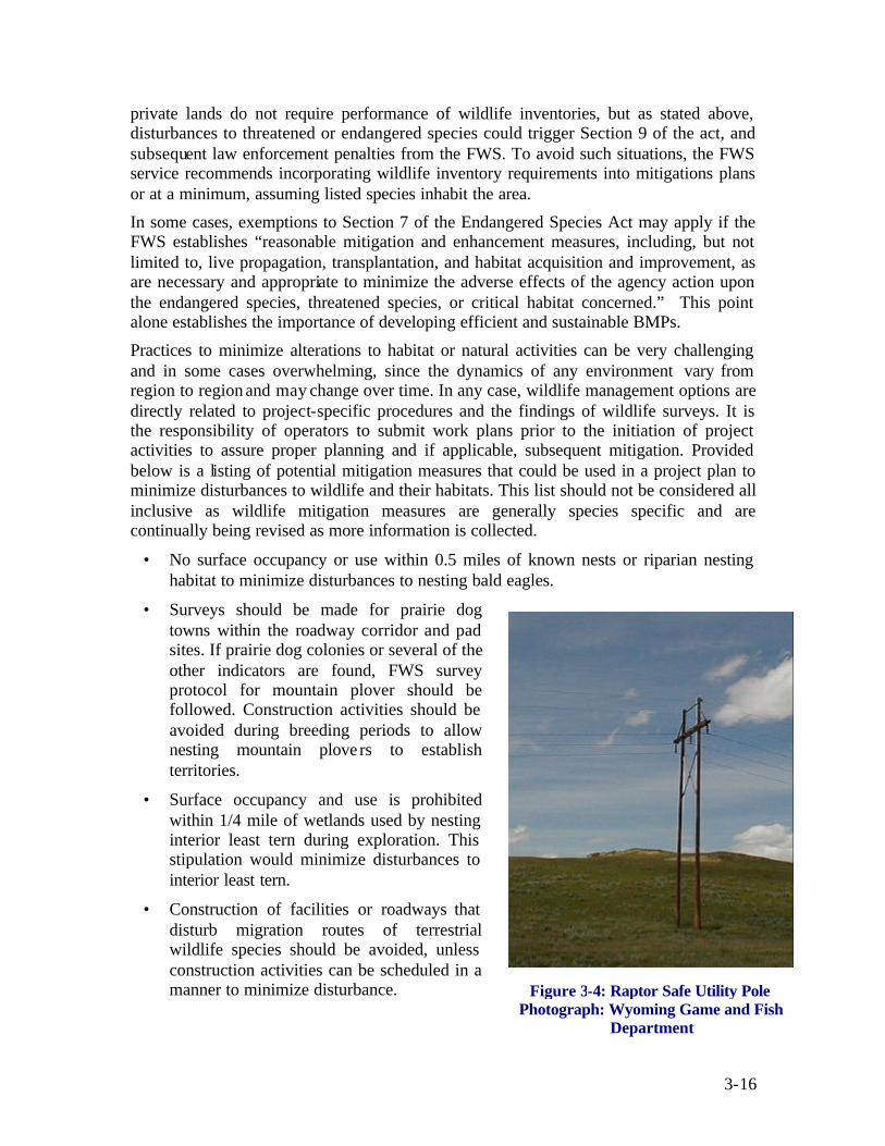
3-16
private lands do not require performance of wildlife inventories, but as stated above, disturbances to threatened or endangered species could trigger Section 9 of the act, and subsequent law enforcement penalties from the FWS. To avoid such situations, the FWS service recommends incorporating wildlife inventory requirements into mitigations plans or at a minimum, assuming listed species inhabit the area.
In some cases, exemptions to Section 7 of the Endangered Species Act may apply if the FWS establishes “reasonable mitigation and enhancement measures, including, but not limited to, live propagation, transplantation, and habitat acquisition and improvement, as are necessary and appropriate to minimize the adverse effects of the agency action upon the endangered species, threatened species, or critical habitat concerned.” This point alone establishes the importance of developing efficient and sustainable BMPs.
Practices to minimize alterations to habitat or natural activities can be very challenging and in some cases overwhelming, since the dynamics of any environment vary from region to region and may change over time. In any case, wildlife management options are directly related to project-specific procedures and the findings of wildlife surveys. It is the responsibility of operators to submit work plans prior to the initiation of project activities to assure proper planning and if applicable, subsequent mitigation. Provided below is a listing of potential mitigation measures that could be used in a project plan to minimize disturbances to wildlife and their habitats. This list should not be considered all inclusive as wildlife mitigation measures are generally species specific and are continually being revised as more information is collected.
• No surface occupancy or use within 0.5 miles of known nests or riparian nesting habitat to minimize disturbances to nesting bald eagles.
• Surveys should be made for prairie dog towns within the roadway corridor and pad sites. If prairie dog colonies or several of the other indicators are found, FWS survey protocol for mountain plover should be followed. Construction activities should be avoided during breeding periods to allow nesting mountain plove rs to establish territories.
• Surface occupancy and use is prohibited within 1/4 mile of wetlands used by nesting interior least tern during exploration. This stipulation would minimize disturbances to interior least tern.
• Construction of facilities or roadways that disturb migration routes of terrestrial wildlife species should be avoided, unless construction activities can be scheduled in a manner to minimize disturbance. Figure 3-4: Raptor Safe Utility Pole
Photograph: Wyoming Game and Fish Department
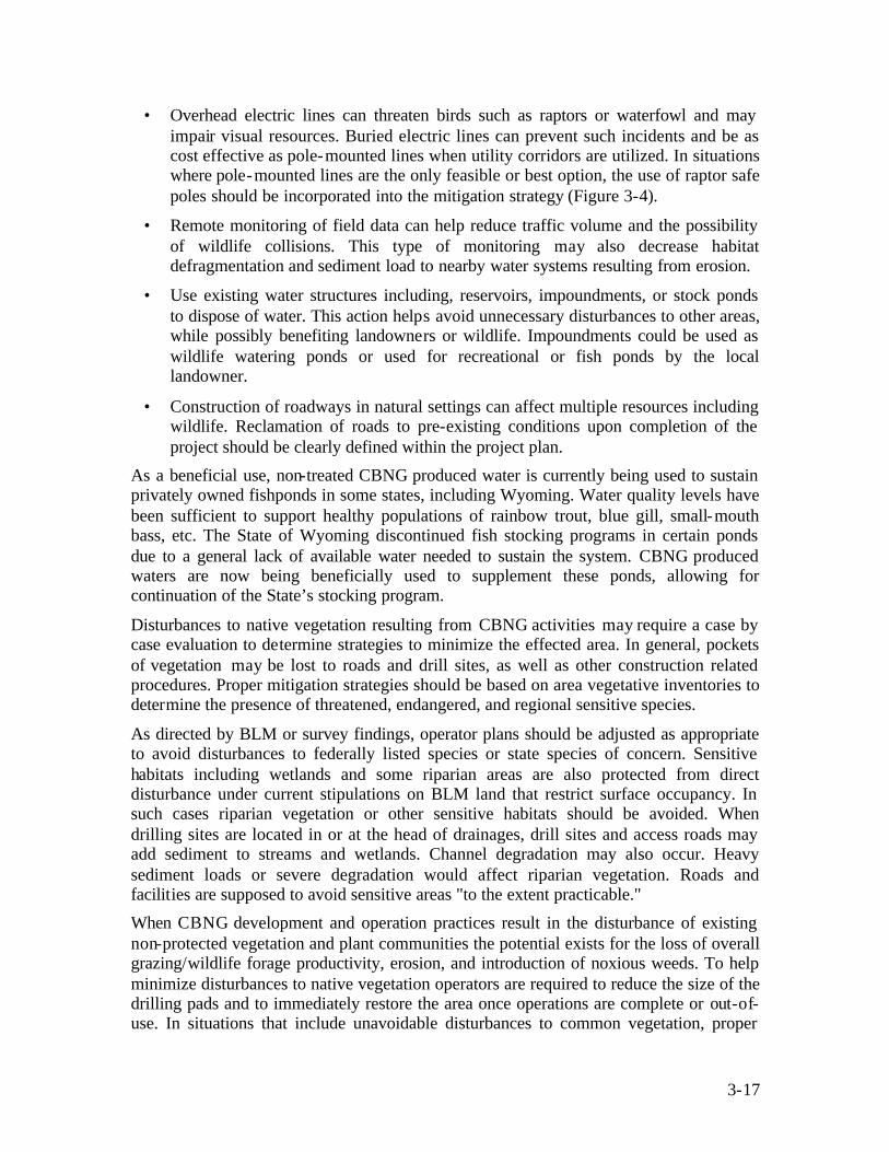
3-17
• Overhead electric lines can threaten birds such as raptors or waterfowl and may impair visual resources. Buried electric lines can prevent such incidents and be as cost effective as pole-mounted lines when utility corridors are utilized. In situations where pole-mounted lines are the only feasible or best option, the use of raptor safe poles should be incorporated into the mitigation strategy (Figure 3-4).
• Remote monitoring of field data can help reduce traffic volume and the possibility of wildlife collisions. This type of monitoring may also decrease habitat defragmentation and sediment load to nearby water systems resulting from erosion.
• Use existing water structures including, reservoirs, impoundments, or stock ponds to dispose of water. This action helps avoid unnecessary disturbances to other areas, while possibly benefiting landowners or wildlife. Impoundments could be used as wildlife watering ponds or used for recreational or fish ponds by the local landowner.
• Construction of roadways in natural settings can affect multiple resources including wildlife. Reclamation of roads to pre-existing conditions upon completion of the project should be clearly defined within the project plan.
As a beneficial use, non-treated CBNG produced water is currently being used to sustain privately owned fishponds in some states, including Wyoming. Water quality levels have been sufficient to support healthy populations of rainbow trout, blue gill, small-mouth bass, etc. The State of Wyoming discontinued fish stocking programs in certain ponds due to a general lack of available water needed to sustain the system. CBNG produced waters are now being beneficially used to supplement these ponds, allowing for continuation of the State’s stocking program.
Disturbances to native vegetation resulting from CBNG activities may require a case by case evaluation to determine strategies to minimize the effected area. In general, pockets of vegetation may be lost to roads and drill sites, as well as other construction related procedures. Proper mitigation strategies should be based on area vegetative inventories to determine the presence of threatened, endangered, and regional sensitive species.
As directed by BLM or survey findings, operator plans should be adjusted as appropriate to avoid disturbances to federally listed species or state species of concern. Sensitive habitats including wetlands and some riparian areas are also protected from direct disturbance under current stipulations on BLM land that restrict surface occupancy. In such cases riparian vegetation or other sensitive habitats should be avoided. When drilling sites are located in or at the head of drainages, drill sites and access roads may add sediment to streams and wetlands. Channel degradation may also occur. Heavy sediment loads or severe degradation would affect riparian vegetation. Roads and facilities are supposed to avoid sensitive areas "to the extent practicable."
When CBNG development and operation practices result in the disturbance of existing non-protected vegetation and plant communities the potential exists for the loss of overall grazing/wildlife forage productivity, erosion, and introduction of noxious weeds. To help minimize disturbances to native vegetation operators are required to reduce the size of the drilling pads and to immediately restore the area once operations are complete or out-of-use. In situations that include unavoidable disturbances to common vegetation, proper

3-18
Tongue River, Powder River Basin, Montana
mitigation can be applied to identify and re-introduce native species where necessary, to re-establish a local distribution, and to plant selected species that are determined to be valuable and successful in the area being restored. Other measures identified by BLM for specific protection of vegetation include:
• Where riparian areas and special habitat types have the potential to be inundated with water on a continuous basis. Measures should be taken to prevent continual inundation.
• Where water crossings cannot be avoided, crossings may be constructed perpendicular to wetland/riparian areas, where practical. For power lines, the minimum number of poles necessary to cross the area should be used.
• Wetland areas should only be disturbed during dry conditions or when the ground is frozen during the winter.
• No waste material should be deposited below high water lines in riparian areas, flood plains, or in natural drainage ways.
• Drilling mud pits are to be located outside of riparian areas, wetlands, and floodplains, where practical.
• Reclamation of disturbed wetland/riparian areas should begin immediately after project activities are complete.
3.2.13.1 Noxious Weeds
Infestations of noxious weeds can occur in CBNG development areas and require careful consideration on a site by site basis. Relative to CBNG development weeds can be transported and spread from vehicles, persons, and by other construction and reclamation materials. In some case native vegetation is unable to compete with exotic species and could lead to their elimination in a given local area. Mitigation can help to eliminate this problem and sustain healthy native populations. To help assure the success of mitigation to control noxious weeds, the BLM has identified certain protocols and practices that are required on federally involved projects in their Integrated Pest Management Plan (IPMP). Identified measures include: prompt reseeding, cleaning of equipment prior to on-site delivery, minimization of soil disturbances, use of weed free mulch and hay, use of livestock to control outbreaks of certain weeds, use of BLM approved herbicides, and weed control instruction.
The success of a mitigation or BMP vegetation program is measured by how closely the revitalized area resembles, in both appearance and functionality, its original state. As directed by BLM, re-establishment of vegetation is considered complete when the disturbed area is stabilized, soil erosion is controlled, and at least 60 percent of the disturbed surface is

3-19
covered with the prescribed vegetation. On private lands, restoration efforts should be directed by landowner stipulations resulting from operator and landowner coordination.
3.2.13.2 Aquatic Resources
CBNG exploration, production, and abandonment activities can disturb aquatic resources in a number of ways. The likelihood of these disturbances occurring depends on the exact nature, location, and timing of CBNG activities. In addition the proximity of CBNG activities to water bodies and the presence of sensitive species and/or sensitive life stages in these water bodies should be categorized. This helps to define the nature of stipulations and mitigation measures to be implemented so as to minimize, avoid, or mitigate the potential disturbances. These disturbances can include direct removal of habitat, habitat degradation from sedimentation, and altered spawning or seasonal migration. In addition stream obstructions, direct loss of fish from accidental spills or pipeline ruptures releasing toxic substances, increased legal harvests of fish due of increased human access, and reduced stream flow because of removing water for drilling activities can also have an affect on the aquatic resources.
BLM has stipulations for federally involved projects that avoid or minimize disturbances to biological resources and hydrological features resulting from CBNG exploration, production, and abandonment activities (BLM, 1992). Stipulations related to aquatic resources include a prohibition on the surface occupancy or use of water bodies and streams, within the 100-year floodplains for major rivers, and riparian areas. In addition, surface occupancy and use is prohibited within 1/4 mile of designated reservoirs with fisheries to protect the fisheries and recreational values of reservoirs. Surface occupancy is also prohibited on slopes exceeding 30 degrees to prevent excessive soil erosion, slope failure, and mass wasting, which could contribute increased sediment to drainages that may affect aquatic resources (BLM, 1992).
Stream channel monitoring for erosion, degradation, and riparian health is required by BLM on an annual basis. Surveying includes stream reaches above CBNG discharges and several stream reaches below CBNG discharges. When avoidance of stream channel alteration is not feasible, BLM also requires re-contouring and stabilization of the channels.
Additional mitigation measures associated with aquatic resources, include considerations of the location and timing of stream crossings as they relate to spawning periods and habitat, minimization or avoidance of in-channel activities to reduce the potential for habitat loss, the development of Spill Prevention Control and Countermeasures Plans to deal with accidental spills, control of storm water pollutant run-off, and various measures to prevent eroded materials from entering drainages. Some of these measures may be directed at special status species.
3.2.14 Project Planning As stated above, there are many aspects of the CBNG industry that are unique and different from the conventional oil and gas industry. Given the fact that each project may present distinctive circumstances and challenges for resource managers or operators, it becomes imperative to systematically evaluate the situation prior to proposing or implementing BMPs in a project plan. Successful project plans include BMPs and
3-20
mitigation strategies aimed at minimizing environmental disturbances, at the same time maintaining overall site productivity. Achieving effective use of BMPs requires consideration of lease stipulations, pre-planning, NEPA requirements, identification of permitting issues, monitoring, and implementation.
Lease stipulations consist of specific measures that are incorporated into a mineral lease and are intended to avoid potential effects on resources and land uses from oil and gas operations, including CBNG development. Lease stipulations can include provisions and constraints on such things as site clearances, occupancy, and timing restrictions. Lease stipulations should be identified and agreed upon at the time of the lease signing prior to conducting exploration, production, and abandonment activities.
Depending on the situation, pre-planning for BMPs may occur before, during, or after CBNG exploration activities. The success of exploratory “findings” contribute to the scheduling or initiation of a pre-planning program. Good planning is the best tool for effective implementation of BMPs. The pre-planning process should consider BMPs or mitigation strategies that are flexible, enforceable, have a preventative ability, and as stated earlier, can be implemented in phases.
Phase implementation for a particular aspect of the project should assure specific operations are paired up with the appropriate mitigation measures so as to maximize the effectiveness of any specific mitigation (EPA, 2002). This type of planning strategy should also ensure smooth implementation of the subsequent phases of work. Considering that the primary purpose of a BMP or mitigation measure is not only to resolve problems, which may arise upon project initiation, but to prevent environmental problems before they occur, successful BMPs should be readily adapted to changes resulting from unforeseeable changes to a particular project (EPA, 2002). A flexible strategy can also prevent unnecessary delay due to further changes in the work environment. Lastly, a successful BMP should be easily enforceable. Operators should ask such questions as; what type of measure will be used? Where will the measure be implemented? and Why is the measure necessary? Sound and practical answers to these questions can aid operators in reducing concerns from the regulatory community, landowners, and citizens groups.
Planning efforts should begin with a thorough evaluation of the surface proposed for CBNG development. Selection of the proper surface may help minimize and mitigate surface conflicts and avoid unnecessary surface uses that could require additional reclamation, special operating procedures, or other restrictions that could be avoided. At this time consideration needs to be given to the proximity to schools, residences and other public areas, visual alterations, erosion potential, wildlife habit, and the improvements and structures of the landowner/surface lessee.
In addition operators should consider avoiding surfaces with steep slopes, unstable soils, and locations that block or restrict natural drainages during the pre-planning phase. Care should also be taken to disturb the minimum amount of native vegetation as possible, particularly in those areas where vegetation can be difficult to re-establish. Locations in areas with a potential for high surface run-off, with increased erosion potential or in the flood plain of surface drainages could dramatically increase maintenance costs and mitigation efforts, as well as create additional safety concerns. An exploration site that
3-21
has a low slope, soils with low erosion potential, and a site that can be readily re-vegetated benefits the operator by reducing the costs of compliance with storm water discharge permits and associated well and road site remediation.
Section 102 of the National Environmental Policy Act requires Federal agencies to incorporate environmental considerations in their planning and decision-making process through a systematic interdisciplinary approach. Specifically, Federal agencies are to assess the environmental effects of, and alternatives to major federal actions affecting the environment. Actions are classified into one of three categories and include: Categorically Excluded, Finding of No Significant Impact (as identified by an Environmental Assessment), and Finding of Significant Impact (as identified in an Environmental Impact Statement and Record of Decision).
Under this Act, Environmental Impact Statements (EIS) are developed to identify and evaluate the severity of project specific environmental disturbances that may result from CBNG development practices. Identification of existing environmental conditions and potential disturbances may help those involved identify appropriate mitigation for site-specific impacts. Typically, resources evaluated in the EIS include:
• Environmental quality, including air, water, soils; • Social and socioeconomic conditions; • Natural resources, including fish, wildlife, and plants; • Endangered and threatened species; • Historical and cultural resources, including archeological materials; and • Initial assessment for any hazardous, toxic, or radiological wastes.
The number and complexity of applicable permit requirements and water right issues that can apply to CBNG operations can be overwhelming. Yet these stipulations are critical to the successful implementation of BMPs and mitigation strategies. Permit requirements can vary for any given state or region. Coupled with the discretionary practices agencies can exercise when applying their programs, it becomes essential for operators and landowners to have a thorough understanding of these requirements to allow for informed decisions as they relate to identifying and implementing site specific BMPs. Operators, landowners, or other entities involved in the CBNG industry should contact their appropriate state authority for additional information. It should also be noted that permitting requirements within the CBNG industry are continually being modified and new requirements are being drafted.
3.3 CONCLUSION Not all BMPs or mitigation measures are appropriate for any given resource. Proper implementation may vary by the region, topography, climate, reclamation objectives, landowner stipulations, applicable regulations, and development characteristics. Established mitigation plans may require amendment when there are changes in design, construction, and operation or maintenance practices. Since operational and development conditions are likely to change over time, developing monitoring plans for these changes helps faciltitae necessary adjustments to BMP programs.
3-22
The focus of many monitoring plans is to conduct an overall evaluation of the potential effects of CBNG development and to track the changes that occur as CBNG fields mature, and gas production declines and eventually ends. The end result of monitoring allows those involved to determine if measures are achieving their intended environmental objectives, as well as to identify any further disturbances caused by the mitigation measures themselves (EPA, 2002). Effective monitoring can also provide a means for developing improved analytical procedures for future analysis and improving mitigation measures. Standards for monitoring resources such as air quality, water, wildlife, and surface disturbances have been well documented, and serve as a baseline for monitoring.
BMPs should not be thought of as a rigid set of guidelines that are mandatory for reduction of disturbances, but as an adaptive and concise management tool which can facilitate enhancement and protection of multiple resources. Unfortunately, there is no one measure with a “fix all” quality. Rather, BMPs represent an intricate web of methodologies and practices resulting from careful planning and coordination that are used to accomplish pre-determined objectives. BMPs are to be incorporated into the final design plan for any CBNG construction project to help assure the success of the project and the protection of the environment.

4-1
4 Preparation of Project Planning Components and Environmental Documents
CBNG project plans or project planning components may be required by various regulatory agencies prior to drilling of CBNG wells or any related construction of CBNG facilities. Some areas such as the PRB of Montana and Wyoming require complete project plans while other areas may only require certain components such as, drilling plans, water management plans, and surface use plans (Figure 4-1). Although the required plans can vary from area to area, the information required within these plans are often the same or similar. Also the available information for preparing project plan components may be limited. Some areas (e.g., WY and MT for the PRB) have guideline books of plan content requirements while other areas have very little guidance information available. These guidebook documents provide reasonable technical components for the preparation of project planning elements that includes; methods for applying adaptive management strategies, BMPs, mitigation measures, Best Professional Judgment’s (BPJ’s), current industrial practices and standards, and regulator preferred subcontractors. This section should provide operators and regulators with technical information that can assist operators with the development of their project planning documents in a consistent manner and allow for the plan’s components to be reviewed by regulators also in a consistent manner.
There are many project planning components which may be required for a CBNG development. These components may include, drilling plans, surface use plans, landowner agreements, unitization plans, well drainage plans, cultural resource and wildlife inventories, produced water management plans, monitoring plans, waste minimization plans, water well mitigation agreements and plugging and abandonment plans (Figure 4-1). These documents are to be generated by CBNG operators and used by regulators to develop impact assessments for NEPA analysis and documents (e.g., EAs, etc.). When developing these plans, CBNG operators need to consider methods to provide the best technical information while making these documents easily reviewable and applicable to NEPA analysis.
Figure 4-1 is an example flow chart showing the decision path a CBNG developer may undergo in determining what aspects may be necessary to include in the POD. The flow chart also details some of the pre-planning analysis that leads into the development of the project plan. Because there are regulatory differences and inherent variables to each development project, some planning decision shown in this flow chart may not be applicable to each situation.
As there are a limited number of resources available during CBNG development for BMPs, mitigation measures, BPJ’s and current industrial practices, these practices as applied to development projects and described in project planning, can demonstrate to regulators and landowners how an operator intends to reduce the environmental impact associated with a project. Some of these practices are outlined in the individual plan discussions below, along with information on requirements in some areas based on existing environmental documents.
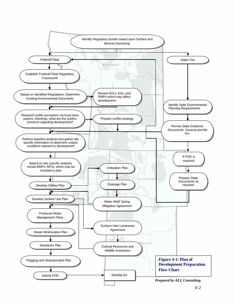
4-2
Identify Regulatory burden based upon Surface and Mineral Ownership
Federal/Tribal
Establish Federal/Tribal Regulatory Framework
Develop Drilling Plan
Develop Surface Use Plan
Produced Water Management Plans
Waste Minimization Plan
Monitoring Plan
Drainage Plan
State/ Fee
Identify State Environmental Planning Requirements
If POD is required
Prepare State Documents as
required
Develop EA
Plugging and Abandonment Plan
Submit POD
Unitization Plan
Water Well/ Spring Mitigation Agreement
Surface Use/ Landowner Agreement
Cultural Resources and Wildlife Inventories
Prepare conflict strategy
Review EIS’s, EAs, and RMPs which may affect development.
Review State Guidance Documents, General permits
etc.
Based on site specific analysis, review BMPs, BPJs, which may be
included in plan
Perform baseline analysis and gather site specific information to determine unique
conditions relevant to development
Research public perception via local news papers, meetings, what are the publics
concerns regarding development?
Based on Identified Regulations, Determine Existing Environmental Documents
Figure 4-1: Plan of Development Preparation Flow Chart
Prepared by ALL Consulting

4-3
4.1 DRILLING PLANS
4.1.1 Rationale Drilling practices have the power to affect the environment throughout a CBNG project. The drilling of CBNG wells involves a number of technical options that have implications for many environmental resources. These resources can include soil, air, water, wildlife, and aesthetics. A Drilling Plan describes these technologies and their potential to reduce environmental impacts. The plan can be used to communicate successful components of a particular CBNG program that takes advantage of innovative technology to protect important environmental resources.
A Drilling Plan can be an excellent vehicle that communicates the operator’s choices for drilling and completion to regulators, landowners and other interested parties. For example, in many CBNG basins, the operator can complete a well into a single coal seam or across several coals in a sequence. The operator’s choice of completion techniques may have implications for economics, environmental impacts, regulatory compliance, and public acceptance. As an example, following the single completion option may require multiple wells at one location to effectively produce the resource. Using this completion option can have environmental implications to a visual setting, disturbance to wildlife and associated habitat, disturbance to sensitive vegetation or riparian areas, and dust and noise within the CBNG field.
4.1.2 Contents A CBNG Drilling Plan may contain information required by regulators (e.g., BLM’s “8-point program”) that can include maps of planned wells, geological prospects, expected distribution of fluids, drilling and casing projections, pressure control, and a testing program. The Plan can also describe development options that use innovative technologies to lower costs and the potential for environmental impacts. A list of key drilling technologies may include the following:
• Drilling Technologies (vertical, horizontal, multi- lateral, etc.)
• Phased Drilling and Well Patterning
• Hybrid Logs, Tests, and Cores to Characterize the Reservoirs
• Reservoir Modeling
• Completion Technologies (perforations, open-hole, hydro-fracturing, etc.)
• In-fill Drilling
• Secondary Enhancement
• Water Management
• Production Management
These powerful technologies have the potential to improve project economics and simultaneously reduce or even eliminate some environmental impacts.

4-4
4.1.3 Regulatory Requirements On Federal mineral leases, a comprehensive Drilling Plan is to be included with the BLM’s Application for Permit to Drill (APD), as spelled out in the Bureau of Land Management Onshore Order No. 1, in 43 CFR Subpart 3160 and published in the Federal Register, Vol. 48, No. 205. This order requires sufficient drilling information be included to allow BLM staff to evaluate the APD and Plan of Development (POD). Onshore Oil and Gas Order No. 1 establishes the “8 – Point Program” contents of an APD/POD. The eight aspects to be addressed for each CBNG application and for each well in the plan includes:
1. Formation Tops: Important stratigraphic markers including the estimated tops and bottoms of prospective coal seams are to be listed for wells covered by the plan. In addition to prospective CBNG pay zones, water-bearing aquifers are also listed; these might include alluvial aquifers and/or deeper sands. In order to avoid confusion, anticipated tops and bottoms are listed by depth (i.e., below ground surface) and log-depth (i.e., below Kelly-bushing).
2. Prospective Water, Oil, and Gas Zones: The operator should list those formations expected to contain fluids other than salt water, primarily CBNG and fresh water (i.e., less than 10,000 mg/L Total Dissolved Solids). The operator should also include a table listing each well in the POD along with expected tops and bottoms of the porous zones and their expected contents, whether CBNG or fresh water or both.
3. Pressure Control: Surface control of subsurface pressure on Federal minerals is required by Onshore Order #2 as detailed in 43 CFR Subpart 3162.3-1. This order requires drilling to be done through a blow-out preventor (BOP) and associated equipment. CBNG reservoirs, however, are often at low virgin pressures, with the gas being contained in the coal seam reservoir by formation water under hydrostatic pressure. Drilling CBNG wells normally do not lead to pressures at the surface in excess of that exerted by the mud column. Because of this operators can obtain a variance to Order #2 by demonstrating that safety and environmental protection may be better served through the use of a diverter drilling head instead of a BOP. The management of liquids and solids flowing through the diverter would need to be laid out in the plan. The application for variance to Order #2 would need to be included with the Drilling Plan.
4. Drilling, Casing, and Cementing Programs: Placement of casing strings may be required by state or federal regulation. Operators may describe the drilling, casing, and cementing prognosis with a table, similar to Table 4-1, listing the steps of hole size, depths, casing size and weight, and cement types and expected volumes.
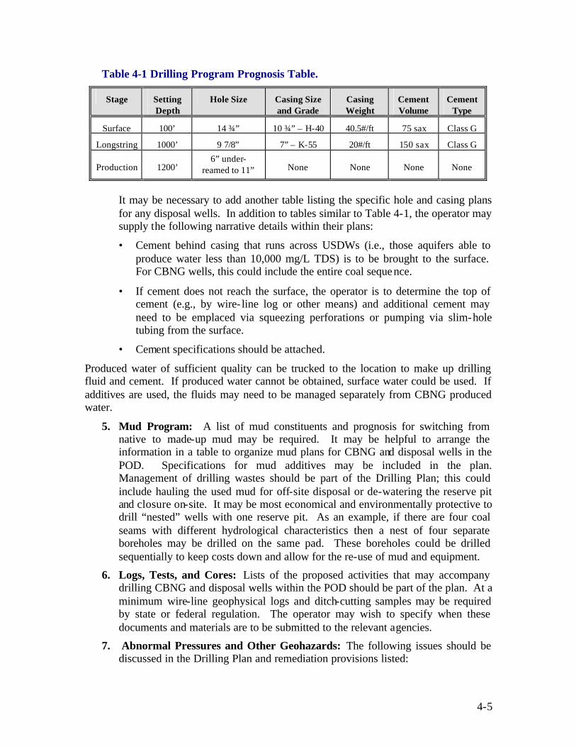
4-5
Table 4-1 Drilling Program Prognosis Table.
Stage Setting Depth
Hole Size Casing Size and Grade
Casing Weight
Cement Volume
Cement Type
Surface 100’ 14 ¾” 10 ¾” – H-40 40.5#/ft 75 sax Class G
Longstring 1000’ 9 7/8” 7” – K-55 20#/ft 150 sax Class G
Production 1200’ 6” under-
reamed to 11” None None None None
It may be necessary to add another table listing the specific hole and casing plans for any disposal wells. In addition to tables similar to Table 4-1, the operator may supply the following narrative details within their plans:
• Cement behind casing that runs across USDWs (i.e., those aquifers able to produce water less than 10,000 mg/L TDS) is to be brought to the surface. For CBNG wells, this could include the entire coal sequence.
• If cement does not reach the surface, the operator is to determine the top of cement (e.g., by wire- line log or other means) and additional cement may need to be emplaced via squeezing perforations or pumping via slim-hole tubing from the surface.
• Cement specifications should be attached.
Produced water of sufficient quality can be trucked to the location to make up drilling fluid and cement. If produced water cannot be obtained, surface water could be used. If additives are used, the fluids may need to be managed separately from CBNG produced water.
5. Mud Program: A list of mud constituents and prognosis for switching from native to made-up mud may be required. It may be helpful to arrange the information in a table to organize mud plans for CBNG and disposal wells in the POD. Specifications for mud additives may be included in the plan. Management of drilling wastes should be part of the Drilling Plan; this could include hauling the used mud for off-site disposal or de-watering the reserve pit and closure on-site. It may be most economical and environmentally protective to drill “nested” wells with one reserve pit. As an example, if there are four coal seams with different hydrological characteristics then a nest of four separate boreholes may be drilled on the same pad. These boreholes could be drilled sequentially to keep costs down and allow for the re-use of mud and equipment.
6. Logs, Tests, and Cores: Lists of the proposed activities that may accompany drilling CBNG and disposal wells within the POD should be part of the plan. At a minimum wire-line geophysical logs and ditch-cutting samples may be required by state or federal regulation. The operator may wish to specify when these documents and materials are to be submitted to the relevant agencies.
7. Abnormal Pressures and Other Geohazards: The following issues should be discussed in the Drilling Plan and remediation provisions listed:
4-6
• Higher than normal pressures may be encountered, as discussed above under point number 3.
• Noxious constituents such as Carbon Dioxide (CO2) and Hydrogen Sulfide (H2S) can be present in CBNG reservoirs. Alarms and evacuation plans may need to be specified in areas prone to these problems.
• Zones of lost circulation may be present within the coal sequence or above the disposal zone. Contingency plans may be detailed in the Drilling Plan for coping with the lost circulation including lost circulation materials (LCM) to be used and/or Nitrogen and compressed air for foaming the mud.
8. Other Important Facets of the Drilling Plan: Scheduling, notification, and monitoring details relevant to the Drilling Plan may be discussed in this section.
• Schedule: A list the anticipated spud dates for the initial wells and the approximate schedule for subsequent drilling and development. As development progresses this may change and need to be updated via a notice to the relevant regulatory agency.
• Notice: Specify that notice is to be given to the relevant State, Tribal, and Federal offices prior to spudding and other activities.
• Monitoring: Describe the measurement and monitoring facilities planned for the development; these might include automated natural gas and water flow metering as well as automated alarms for water tank levels and flow-line pressure.
For certain states, while drilling on state or fee minerals, requirements are less comprehensive (e.g., in Montana, Colorado, New Mexico, and Wyoming, only a well plat, geological prognosis, and drilling prognosis are needed). The State of Utah requires a Drilling Plan identical with the BLM. Other activities such as commingling, pit construction, and water supply may also need permits from various Federal, State and local agencies. It should also be noted that these requirements are subject to change.
4.1.4 Technical Options CBNG exploration and production can be done using many different technologies. The technologies expected to be used and their environmental implications need to be reflected in the Drilling Plan. The actions of the Drilling Plan may determine the course of the entire Plan of Development. Figure 4-2 shows a process flow chart for some of the technical options that may affect a drilling plan and how this decision process may result in a final drilling plan. The following section discusses some key technologies and their possible effects on the BLM 8-Point Program.
4.1.4.1 Drilling Technology
The technology of oil and gas drilling is continually changing and as CBNG resources become an important source of natural gas new drilling technologies are being applied. Technologies such as vertical bore-holes with multiple completions (i.e., perforated into several zones), and precise multi- lateral horizontals are not only feasible but, economically profitable. These techniques have helped to reduce the number of well-

4-7
NO
YES
YES
NO
YES
NO
NO
YES
NO
YES
YES
Identify the location where drilling
operations will occur.
Are multiple coal seams with CBNG potentially present?
Are multiple perforations
feasible?
Will disposal wells or
monitoring wells be drilled as part of the project?
Are Horizontal
Completions feasible?
Will all zones be produced
simultaneously?
Well “cluster” (multiple wells in same foot print)
Single well - lateral completion
Are Multi-lateral
completions feasible?
Single cased well with multiple perforations
Multi-lateral well completion
Drilling Plan
Prepared by ALL Consulting
Figure 4-2: Drilling Technical Options Flow Chart

4-8
sites and other facilities that disturb the surface. Fewer well-sites mean fewer roads, fewer pipelines, and reduced surface disturbance. However, only a limited number of these techniques may be appropriate in a CBNG basin, and site specific conditions determine which techniques are best to be applied at a particular location.
Western coal basins have features that set them apart from other coal basins of North America and need to be considered when applying drilling technology. The western basins are typically broad alluvial valleys with shallow, low-rank coal seams. These features have an important influence on the drilling options, especially the setting of surface casing and the potential for multi-seam completions.
The surface casing option often depends on the presence or absence of shallow alluvial aquifers at the well-site location. When alluvial aquifers are present, they are often locally important sources of drinking water. Extensive alluvial deposits are typically good local aquifers used to supply ranches and farms; these aquifers may need to be
protected from the impacts of drilling oil, gas, and CBNG wells by the use of adequate surface casing. In general the installation of surface casing is performed for most CBNG wells whether alluvium is expected to be encountered at the drill-site or not. Figure 4-3 represents the typical construction of a CBNG well in the PRB. or modifying it.
Western coals have a range of lithologies, rank, and depths; as such they can be drilled using a variety of technologies. For example, in the San Juan Basin, high rank coals can be accessed through multiple perforations and can be produced through un-cased horizontal
boreholes. However, in the Powder River Basin, coals are lower rank and typically do not support a horizontal borehole or cementing the casing over the coal. For low rank coals perforating the coal may not produce a clean coal- face needed for methane
Figure 4-3: CBM Wellbore Diagram in PRBFigure 4-3: CBM Wellbore Diagram in PRB

4-9
production. Figure 4-4 shows a schematic drawing for a variety of the drilling options that can be utilized when installing CBNG wells in the coals of the Western United
States. Differing drilling options can affect the following portions of the Drilling Plan and may have an influence on potent ial environmental impacts:
Drilling, Casing, and Cementing Programs: Vertical completions can be either single zone completions or multi-zone completions. Typically multi-zone completions require that some of the coal seams be cemented and later perforated. This completion technique can be used to isolate production for each zone and not commingle the production. It should be noted that if single well completions are used to develop a field when four distinct coal seams are present, then on a 640-acre lease, 64 single-completion
wells would need to be drilled compared to 16 multi-zone wells being drilled on the same 40-acre spacing. Through the use of a multi-zone well completion option the surface disturbance at a project has the potential to be greatly decreased.
Horizontal completions either single or with multi- laterals, can also reduce the surface disturbance impacts from drilling. When developing a large tract – for example a single 640-acre lease-block – the entire block could be drilled from a single well-pad with several multi- lateral boreholes. This technology could also reduce impacts from surface facilities. In addition, the use of multi- laterals could allow better control of individual laterals with dedicated pressure sensors and flow controllers allowing for careful aquifer maintenance of each coal seam throughout the lease-block.
Downhole gas/water separators and pressure sensors are additional technologies available to GBNG operators. CBNG operators have used downhole gas/water separation to pump away water into deeper disposal zones so that aquifer pressure is reduced but produced water does not reach the surface (Phelps, 2002). Although downhole pressure sensors have not as yet been used, the technology is available off the shelf (Moffat and Craig, 2000). When a deep disposal zone is available, these technologies have the potential to closely manage aquifer pressure and economically deal with produced water that does may not have an added beneficial use. The importance of this technology can be large in that the high cost of managing produced water at the surface can be eliminated and the environmental liabilities associated with low quality produced water at the land surface may be prevented. Impoundments, surface discharge points, irrigation, and other management technologies may not be needed for a CBNG well so equipped.
Figure 4-4: CBNG Drilling Options

4-10
Mud Program: The circulating media used in CBNG drilling often consists of native mud made with produced water. Additionally clays such as bentonite can be added to adjust viscosity. Circulating media are selected to best control site-specific drilling aspects such as the presence of swelling shale. After drilling, the drilling mud is often allowed to de-water in the reserve pit and it is then buried in place. Deep disposal wells generally need to be drilled with bentonite mud to control water- loss and pressures. In some cases, operators may choose to use an oil-based mud. The size of the reserve pit used during drilling depends upon the depth of the well. A 600-foot CBNG well may require a small pit, while a 6000-foot disposal well may require a large, segregated pit to manage the mud supply. In some sensitive locations, such as floodplains of active rivers, operators are constrained from having on-site earthen pits. This requires the mud to be contained in steel tanks. This provides additional options for handling such as re-use of the mud, disposal of it in an off-site location, or even spreading the mud onto the surface for disposal.
4.1.4.2 Phased Drilling and Well Patterning
CBNG projects are typically drilled in one of two ways; drilling every spaced location (whether that’s 160 acres or 40 acres) at one time with the available drilling rigs or by breaking the project area into several phases so that, for example, the first 50 wells can be drilled and put into production (Figure 4-5). The results of the initial phase are then used to modify subsequent drilling tracts within the project area. Phased drilling can influence the initial Drilling Plan as some well-sites may not need to be drilled in subsequent tracts and drilling can be spread over several years.
A phased approach to development can influence other environmental impacts. An operator can often use the information gained in the initial phase of drilling to adjust development into adjacent lands so that some unpromising well-sites may not be drilled and the land surface may not be disturbed. In addition, phased production can distribute high water production rates over several years so that the peak water production rate for the project is potentially
reduced and spread over several years. This process can allow for water management facilities to cause less impact and be utilized for a longer time, therefore typically increasing their usefulness and economic benefit.
Figure 4-5: Phased Drilling of a CBNG Unit

4-11
4.1.4.3 Hybrid Logs, Tests, and Cores to Characterize the Reservoirs
A number of wire- line logs and tests are available from industry vendors for the purpose of characterizing CBNG reservoirs. These technologies are aimed at identifying coal seam thickness (Figure 4-6), quantifying improved fracturing and methane liberation rates, coal integrity, integrity of the intervening strata, and quality of potential disposal zones. The information from the tests, cores, and logs can be used to steer subsequent step-out or in-fill drilling of the reservoir. Log and test options can affect the following
portions of the Drilling Plan:
• Drilling, Casing, and Cementing Programs: The extent and position of full-hole cores may be listed in this part of the Drilling Plan. Cutting cores may extend the time taken to drill a CBNG well but should not affect the magnitude or frequency of potential environmental impacts.
• Side-wall coreing: Side-wall cores while useful for some information, may not provide the full suite of information needed for CBNG well/reservoir evaluation.
• Mud Program: Cutting cores may require changes to the mud program. These changes should be noted in this section of the Drilling Plan. In addition, logging and testing time may be extended and mud conditioning time may need to be built into the plan.
• Logs, Tests, and Cores: The characterization program can be detailed in this section of the Drilling Plan.
• Other Important Facets of the Drilling Plan: Notifications to the BLM, the state agency, and other interested parties can be added to this portion of the plan. In particular, the state agency may plan to send a field inspector to observe cores or drill-stem tests.
Figure 4-6: CBNG Well schematic with Porosity Index Log

4-12
4.1.4.4 Completion Technologies
Completion technologies depend on the preferences of the CBNG developer and site conditions. Coal seams can be completed as either open-hole completions or by perforating casing set and cemented to depth. In CBNG operations hard coals are typically completed by drilling through the coal, setting and cementing long-string casing across the coals, and finally perforating the casing. In soft coals operators may choose to drill to the top of the coal, set casing, and then drill the thickness of the coal seam and produce using an open-hole completion. Industry practice in the Powder River Basin involves open-hole completions by under-reaming long string casing to achieve a clean and scoured face with unimpeded permeability. Operators in other basins such as the Piceance and San Juan Basin typically use through-casing completions.
CBNG completions either by open-hole or through perforations often are stimulated by large volumes of produced water to prepare the coal seam. The water is then produced back to the surface and if it contains no additives, it is typically handled as produced water. In addition some operators use sand mixed with the treatment water to scour the coal face and to prop open any fractures that are formed during the treatment.
Completion options can affect Drilling Plans in the following aspects:
• Drilling, Casing, and Cementing Programs: Casing may either be run through the CBNG coal seams or stop at the top of the target coal seam. Cementing operations are commensurate with the setting of the long-string casing.
• Completion Techniques: Cleaning out the well prior to production should also be outlined in this section. Some operators may choose to begin producing formation water to bring debris and coal fines up out of the bore-hole. Other operators may choose to pump large quantities of produced water into the bore and rapidly produce it back to the surface to clean out the bore-hole.
• Mud Program: Operators who drill out from under casing and expose a coal seam to the open hole often do not drill out with mud but with produced water. Other options include drilling the coal seam with air or foam. Operators should describe the preferred completion technique in the Drilling Plan.
4.1.4.5 Reservoir Modeling
Numerical modeling can be performed for a CBNG project as soon as the wildcat drilling has been completed. The model is typically refined as more reservoir data is available. In this way later phases of drilling and subsequent in-fill drilling can be focused into those areas of the project that can benefit from additional wells providing added production. Reservoir modeling can impact the Drilling Plan in the following areas:
• Drilling, Casing, and Cementing Programs: Modeling can help locate later phases of development drilling and pinpoint areas of in-fill drilling. Modeling can drive the location of drill-sites and the development of the coal seams in the project.
• Logs, Tests, and Cores: Modeling can be an iterative process between hybrid wire- line logs and reservoir tests used to gather information for the model.

4-13
Addit ional tests such as Repeat Formation Tests or interference pump-tests may need to be scheduled to provide necessary modeling input parameters.
4.1.4.6 In-fill Drilling
After producing wells have been drilled on initial spacing unit well-sites, reservoir monitoring and modeling may point the operator toward those locations that may benefit from in-fill drilling. For example, if the spacing is set at 160-acre spacing and wells on that spacing are drilled, reservoir modeling can highlight locations that may enhance “free-gas” production or identify those areas that need additional dewatering. In-fill drilling may not be done until several years after initial CBNG production in the project. Operators may plan for in-fill drilling and include it in the Drilling Plan. In-fill development may impact the Drilling Plan in the following manner:
• Drilling, Casing, and Cementing Programs: In-fill drilling can add wells that may not have been locatable when the Drilling Plan was written but, an estimation of the number of additional CBNG wells can be made at the time of the plan. An additional 10% to 20% of the total well number may be needed to complete the project. It should be noted that not all coal seams may benefit from in-fill drilling in a given project.
• Mud Program: Completion techniques may point the CBNG operator toward re-drilling/in-fill drilling of some locations to use a specific drilling technique. For example, the historical practice and changes in completion techniques may show that a coal seam produces an average of three times as much gas from air-drilled holes as mud-drilled holes. An outcome such as this can impact mud programs.
• Logs, Tests, and Cores: In-fill drilling models may require specialized tests for essential data.
4.1.4.7 Secondary Enhancement
Once CBNG production reaches a stable stage, operators evaluate the potential for a secondary enhancement project such as nitrogen or CO2 floods. Injection of these gases can increase the recovery of the natural gas resource from the reservoir. Injection of these gases may impact the following parts of the Drilling Plan:
• Drilling, Casing, and Cementing Programs: Additional wells may need to be drilled to emplace the nitrogen or CO2. In-fill wells drilled after the installation of the nitrogen or CO2 flood may need a gas detector to be used during drilling to insure crew safety.
• Abnormal Pressures and Other Geohazards: The addition of nitrogen and CO2 to the reservoir can represent a geohazard. Additional monitoring may need to be written into the POD. CO2 in particular can pool in low spaces and should be monitored for if there is a release at the well-head or pipeline. Monitoring, and perhaps automatic alarms, may need to be installed at wellheads, manifolds, compressor stations and other collection points. Sensitive locations such as schools adjacent to CBNG facilities may also need to be monitored and fitted with alarms.

4-14
Automated Supervisory Control and Data Acquisition (SCADA) System
4.1.4.8 Water Management
Water management takes many forms and is often dependent upon a number of CBNG water quality parameters and localized water needs. Certain management options could impact Drilling Plans in the following sections:
• Pressure Control: Deep disposal wells may require enhanced pressure control equipment in comparison to CBNG wells. These wells may require BOP equipment whereas CBNG wells may qualify for variances.
• Drilling, Casing, and Cementing Programs: Deep injection of produced water may necessitate either drilling new disposal wells or re-entering and modifying existing bore-holes. Disposal wells may be much deeper than CBNG wells in the project and may require very different drilling parameters. Also shallow water disposal wells such as aquifer recharge wells would need to be described in the Drilling Plan.
• Logs, Tests, and Cores: Water disposal wells, either deep or shallow, would require additional tests such as injectivity and injection reservoir compatibility with CBNG produced water.
4.1.4.9 Production Management
Production of both water and CBNG may be tracked manually with direct gauging by the field personnel or by automated Supervisory Control and Data Acquisition (SCADA) systems that transmit data back to a field office. The CBNG SCADA system may have incorporated alarms and automatic shut-down features. The management systems may impinge on Drilling Plans in the following manner:
o Other Facets of the Drilling Plan: Operators may include SCADA designs into the Drilling Plan as a way of demonstrating on-going compliance with leak monitoring regulations. Automatic monitoring can include close control of water flow-lines through the use of multiple pressure gauges on the lines to pin-point unusual pressure fluctuations or dedicated detector wires buried beneath water-lines that will respond to locate even small produced water leaks.

4-15
4.2 SURFACE USE PLANS
4.2.1 Rationale A well developed surface use plan can have a role in the public acceptance of CBNG development while collectively, tying certain planning aspects of CBNG development together. Landowners, special interest groups, and regulators identify with changes to the landscape more readily than other aspects of CBNG development such as, the use of submersible electric pumps, or discharge rates for produced water. Aesthetic concerns are often the source of conflicts associated with CBNG development between operators and landowners but, can often be resolved during the planning phase by recognition of mutual benefits.
Surface use planning represents an opportunity for CBNG developers to work in cooperation with landowners to establish scientifically sound and economically profitable development while maintaining existing land uses and facilitating future land use opportunities. For example, the location of ponds, roadways, and multi-well pads can allow for the continuation of current land uses while providing improvements to the landscape that could be beneficial to future uses. In addition, surface use planning can alleviate concerns that CBNG development may impact cultural and wildlife resources through the outlining of avoidance practices and noise reduction technologies. Surface use plans are a mechanism by which operators combine planning elements of CBNG development such as, well completion options, water management options, wildlife impacts and cultural planning. These components are integrated into a surface use plan and reflect the planning considerations for the project. Figure 4-7 is a flow chart of some of the decision processes that can occur during the development of a surface use plan. Applicable processes vary for each development situation; however, similar thought processes to those illustrated in Figure 4-7 can be used for most CBNG Surface Use Plans.
4.2.2 Contents Typical surface use plans include maps, written narratives, and design drawings that show the location and describe the condition of existing and proposed CBNG facilities. Surface use plans can show how CBNG developers intend to reduce environmental impacts by locating facilities away from sensitive habitats; on stable landscapes in areas where all-season access is possible; by using construction materials that reduce aesthetic concerns; and by maintaining facilities to control dust and noxious weeds. CBNG facilities should be detailed in surface use plans and some of the technical options for these facilities are included below:
• Well completions – Completion design for existing and proposed CBNG wells, injection wells and monitoring wells should be provided. Options such as multi-zone wells and well pods can be used to minimize the surface area disturbed.
• Roadways – The condition and type of existing roads and the design plans of proposed roads should be outlined. Design plans can detail constructed culverts or low water crossings, all-season materials, and the location of proposed roads to avoid unstable slopes, special habitats and cultural resources.

4-16
Define Project Area
Locate new wells, pipelines, tanks batteries
Locate new waste management facilities
including ponds, pits, and disposal wells
Locate new utilities including pipelines and power lines and
roads.
Identify surface reclamation activities for post- construction and ongoing remediation
Figure 4-7: Surface Use Planning Flow Chart
Locate existing roads, trails, water sources , ponds, etc.
Locate existing utility rights of ways. Are corridors feasible?
Well plugging and adornment
Surface Use and Damage Agreement.
Water Management plan
Drilling plan
Prepared by ALL Consulting
Identify existing conditions and land usage inside the
project area

4-17
• Utilities – Identification of existing utilities such as electric, gas and water pipelines should be performed. Use of above-ground raptor-safe poles or below-ground combined utility corridors, and the installation of new utilities along existing disturbances such as gas pipelines.
• Production facilities – Location of proposed gathering/metering facilities, sales stations, and compressor stations should be identified. Facilities can be constructed of materials which have sound reducing insulation, and designed/painted to blend into the visual landscape.
• Water management facilities – Development of proposed ponds and pits, storage tanks, and discharge points for water management should be outlined. On-channel and off-channel ponds constructed for wildlife and livestock watering or fishing, and low profile storage tanks within areas of other disturbances are options that should be considered.
The discussion below details some of the regulatory requirements for these facilities, as well as a more detailed discussion of technical considerations that may affect facility location or function.
4.2.3 Regulatory Requirements On federal mineral leases or any mineral lease track that includes federal minerals, a surface use plan is to be submitted with an APD or POD. Sundry Notices submitted after APD or POD approval that includes additional surface disturbances may also require a surface use plan. The BLM’s state offices in Wyoming and Montana have developed a guidance document for their 13-point surface use plans. Under this document surface use plans may only include information on elements that are necessary for the proposed project. The 13-point surface use plan is broken down into the following components:
1.) Existing Roads – Location maps and narrative descriptions of the existing roads that are proposed for accessing well locations and facilities. Descriptions may include road conditions and a summary of maintenance issues or upgrades that may be needed.
2.) Newly Constructed or Modified Access Roads – Location maps, and narrative for plans on upgrading or maintaining roads in #1, as well as new roads. Details should be sufficient and conform to the BLM Standards as defined in the Gold Book and BLM Manual Section 9113. New roadways are to be differentiated between two-track roads and resource (all-season) roads. For new and modified roadways the following information should be included: length and width of road, areas needing improvement, and type of improvements . If major safety or environmental concerns exist detailed engineering designs may be required to be reviewed and approved by a BLM Civil Engineer.
3.) Existing Well Locations – Location maps and legal descriptions for existing wells within one-mile of the proposed CBNG related well should be included. This well list should include: drinking and livestock watering wells, injection/disposal wells,
4-18
monitoring, CBNG producing, Oil/Gas producing wells, temporarily abandoned, abandoned, orphan, or drilling wells. Legal descriptions should include the type of well, legal description/location, owner’s name, well name, depth, completion interval, distance to proposed CBNG well and other relevant information.
4.) Existing and Proposed Facility Locations – Location maps and narrative for existing and proposed wells and facilities including:
a. Central gas metering/ gathering facilities
b. Gas, water pipelines, and electric utilities
c. Monitoring wells
d. Water management facilities, discharge points, ponds, and other water control structures such as culverts, water crossings, and erosion control sites.
Similar to #2 enough information on new construction should be included to allow a BLM Civil Engineer to review and approve the facility. This may include information related to construction materials, design specifications, and measuring/monitoring equipment for gas and water.
5.) Water Supply – Location maps and narrative description of the source of water, water transportation method, and water quantities needed for drilling should be supplied. Information should be included on water quality as well (BLM recommends using water ≤ 10,000 mg/l TDS).
6.) Construction Materials – Narrative description of the types of materials to be used in construction activities, including source and intended use of items, should be specified. Federally owned materials may require the operator to contact a BLM Authorized Officer to acquire these items.
7.) Waste Disposal and Handling – Waste management plans are discussed as a separate project planning element in this document.
8.) Ancillary Facilities – Although not typically required for CBNG operations, any ancillary facilities that are being proposed should be described similar to #4 above.
9.) New Well Sites – Location maps and narrative descriptions of newly proposed wells sites should be included. The BLM would prefers CBNG operators to locate well sites where pad construction is not necessary. This is in order to minimize surface disturbances. When well pads are not necessary, the following information should be submitted:
a. Stake locating the center of proposed reserve pits.
b. Two 100-ft direction stakes from the well stake.
c. A narrative description on the pit dimensions and plans for fencing, top soil removal, and pit reclamation procedures.
When a well pad is to be constructed, the following information should be submitted:
i. A plat map to scale (i.e., no less than 1in = 50ft, North Arrow Orientation) which includes:

4-19
CBNG Production Facilities
1. Surveyed cross sections of the proposed pad with identified well staking, cut and fill areas, pit location, topsoil stockpiles, access roads, 200-ft two directional reference stakes, and contour lines.
2. Drill pad and reserve pit dimensions specified in the units of feet.
3. Cuts and fills for pad corners and reserve pit specified in the units of feet.
4. When drilling multi-well pod the expected distance between wells specified in feet on the pad should be given.
ii. Calculations for proposed dirt work (i.e., area and volume to be excavated and stockpiled) should be supplied with sufficient information for the BLM to verify:
1. Sound construction techniques are being utilized for cuts and fills.
2. The proposed reserve pit is of sufficient size and capacity for proposed drilling operations.
3. Reclamation of the pit is feasible.
iii. Other considerations include:
1. Slope staking for sites that include steep slopes, rough topography or other environmental concerns.
2. The center of the reserve pit should be 30 ft from the well-bore for blooie line placement.
3. Well site plat maps that have not been surveyed, designed and drawn by licensed or qualified surveyors/engineers are not generally accepted by BLM.
10.) Surface Reclamation – A specific reclamation plan is to be included to address the stabilization and reclamation of surface disturbances associated with CBNG wells and facilities. Detailed requirements for these plans are discussed under a separate heading in this document.
11.) Surface Ownership – Information related to the surface ownership of the following land should be included:
1. Well site location
2. Project POD area including facilities, etc.
3. Roadways used to access wells, PODS, and facilities.

4-20
4. Surface owner agreements should also be submitted as discussed under a separate header in this document.
12.) Other Information – Information related to other plans detailed in this document may be required by the BLM to be submitted as a sub-section of a surface use document.
13.) Maps, Drawings, and Design Diagrams – The following requirements have been identified by the BLM for map submissions, it is preferred that maps be submitted as a paper copy and GIS format (on CD):
1. 1:24,000 scale topographic background.
2. Maps should be submitted in themes including:
i. Boundaries – Boundary maps should include: project boundary, lease boundaries, and surface ownership divisions.
ii. Roadways – Roadway maps should include: existing county roads, existing & proposed two-track roads (to BLM temporary road standards), spot upgrade areas, all-season roads existing & proposed (to BLM Resource road standards), and right of way corridors.
iii. Road Structures – Road structure maps should include existing and proposed: culverts, cattle-guards, gates, and low water crossings.
iv. Wells – Well maps should include: proposed CBNG wells, existing CBNG, oil and gas wells, existing water wells and springs, injection wells, monitoring wells, and Plugged and Abandoned (P&A) wells.
v. Water Management Structures – Water Management Structures (WMS) maps should include: watershed boundaries, project boundaries, discharge points, transportation pipelines, erosion stabilization features, ponds and impoundments, livestock watering tanks, land application areas, and any other water management facilities.
vi. Project Facilities – Project facilities maps should include: gas gathering and water pipelines, above or below ground electric lines, gas gathering/metering buildings, compressor and generator stations/buildings, and utility right of way corridors.
4.2.4 Technical Options CBNG well sites and facilities can be designed and constructed using many different technologies; these options and their environmental implications need to be reflected in the surface use plan. The surface use plan affects the course of the entire POD. The following section discusses some key technologies and potentially related effects on the BLM 13-Point Surface Use Plan.

4-21
4.2.4.1 Well Completion
The type of well completion, as well as the technology present at the wellhead, can have a direct affect on the level of surface disturbance at the well site. CBNG wells can have a variety of completion options, both below and aboveground. CBNG drilling technologies such as, vertical bore-holes with multi-zone completions, multi-well with multi-zone well pads, horizontal boreholes and multi- lateral horizontals, can reduce the total surface disturbance for a CBNG project when compared to individual well pad sites. With each of these technologies, the surface disturbance per area of well gas drainage is less than what is associated with individual well pads. Thus, the total surface area impacted under the project is reduced. Many well completion technologies, including those described above, allow for surface disturbance impacts of multiple wells to be combined so, that instead of having 3 or 4 single well pads with associated roadways, utilities, etc. per spacing unit, there is one area of disturbance with one roadway, utility right of way, etc. per spacing unit. Figure 4-8 shows typical depth and well completion techniques for some of the active basins in the 5 state focus area.
CBNG completion technologies are limited to some extent by the nature and condition of the reservoir being developed. In the case of the shallow, thin coal seams typical of the PRB of MT/WY, down hole electrical pumps and low profile well housings can be used to reduce the amount of surface disturbance at the wellhead. When deeper coal seams such as, those of the San Juan Basin of CO and NM are being developed, pump jacks or cavitation pumps may be necessary to produce both water and gas to the surface. The
result is a greater surface disturbance at the wellhead when compared to with downhole electrical pumps.
In most of the existing CBNG basins, above ground gas-water separation is the industry standard. However, the technological advances of downhole gas-water separators combined with the presence of local injection reservoirs has allowed CBNG operators to avoid or reduce produced surface water. In addition, the use of
Figure 4-8: Typical Well Depth and Completions for CBNG Wells in the 5 State Focus Area.
San Juan Basin CBM WellSan Juan Basin CBM Well

4-22
downhole gas-water separation can reduce the surface disturbance at the wellhead and reduce/eliminate surface disturbances from water storage facilities and impoundments.
Completion options can affect surface use plans in a similar manner; first, by changing the amount of surface disturbance at the wellhead and secondly; by reducing the need for additional roadways, utilities, and in some instances, facility buildings and water storage areas. The size of the surface disturbance for the multi-well pod, horizontal borehole or multi-zone completion may be larger than for a single well but, by reducing the number of well sites, the area of surface disturbance for the entire project is reduced. Well completion technologies can affect the following portions of the BLM’s 13-point Surface Use Plan and may have an influence on potential environmental impacts:
2.) Newly Constructed Roadways: Utilizing any of the above mentioned completion technologies can reduce the number of new roadways that would be required for the CBNG development. New roadways can then be constructed of higher quality materials, as all-season roads are, rather than constructed to BLM temporary road standards.
4.) Existing and Proposed Facilities: By utilizing the completion technologies outlined, the location and number of proposed facilities can be affected. The reduced number of new well site locations can reduce the number and length of gas, water and electric utilities that may need to be installed and may affect the proposed facility design layout to accommodate the locations of the well sites.
6.) Construction Materials : By a reduction in the number of well sites and facilities that are needed, the type of materials that are used for the construction of roadways, well pads and other facilities may be affected. Locating several wells within a pod can allow for higher quality materials to be used in road construction since fewer roads would be needed. In addition, utilities may need to be upgraded to account for the increased burden from the multi-zone well sites, and gas and water pipelines can be combined to manage produced gas and water.
9.) Well Site Layout: The use of multi-well or multi-seam completion techniques discussed above can result in the need to construct well pads to accommodate additional wellbores, drilling equipment, and other surface equipment. In situations where these techniques require constructed well pads, the additional information required under the BLM’s 13 point surface use plan may also be required in the plan.
10.) Surface Reclamation: The use of these completion technologies can reduce the amount of surface disturbance which in turn reduces the level of surface reclamation that may be needed.
4.2.4.2 Utility Placement
Utilities used in CBNG development can either be pole-mounted or placed in below ground trenches. CBNG developers normally use the method that is more cost effective or when feasible, utilize existing onsite utilities. Typical utility placements Utility Right of Way Corridor Gillette, WY

4-23
for current CBNG operations include the use of utility right of ways or corridors, above ground raptor safe electric lines, and individual utility placement. Utility right of ways can reduce the level of surface disturbance in a surface use plan by combining the disturbances of the utilities and roadways into a single disturbance. Above ground raptor safe electric lines and above ground gas and water pipelines are typically used when one or more utility exists onsite. When there is an existing above ground gas pipeline, CBNG operators may choose to route water pipelines and electric lines along the same route to reduce the level of additional sur face disturbance.
By combining utility disturbances the following sections of the surface use plan may be affected:
2.) Newly Constructed Roadways : Utility right of ways may affect the design of new roadways when the disturbances are combined. Additional construction efforts may be needed for new roadway construction when gas and water pipelines are placed in trenches beneath the new roads.
4.) Existing and Proposed Facilities: The location of utilities relative to facility placement should be addressed in this section of the surface use plan. In addition, the choice between the use of right of way corridors and above ground utility placements along existing disturbances affect the locations for proposed facilities.
6.) Construction Materials: The materials used in the construction of roadways and for utility placement vary depending upon the technology used. Construction materials for underground utility right of ways typically differ for the utilities and roadways if they are placed in the same disturbance.
4.2.4.3 Gas Gathering, Compression Facilities, and Sales Stations
There are a variety of equipment options that can affect the operation of CBNG facilities. These can include power supplies for compressors and generators, location of facilities, and noise control options. Power generation for gas compressors can affect a surface use plan in a different manner, but typically generation is derived from electric, gas or diesel motors. Location can be critical in surface use planning as the landscape can assist in reducing noise and visual impacts. In addition, centralizing CBNG facilities can reduce the length and number of pipelines needed to transport gas and water from the site.
Noise reduction technology and facility location can reduce aesthetic impacts from nuisance noise and visual impairment. Facilities located out of sight or in local areas exhibiting low natural topography can help reduce noises from reaching nearby residences. CBNG operators can equip compressors and generators with mufflers and insulate buildings to reduce noise when natural barriers are not present. Operators can also locate noise-generating facilities such as compressors or generators away from rural homes. Sales compressors can be located in industrial settings or in areas where other noise is generated.
When using these different facility options, the following sections of the Surface Use Plan may be affected:
4.) Existing and Proposed Facilities: Centralizing facilities to the CBNG development typically reduces the length of pipelines needed, the number of facilities and equipment necessary to service the project. The type of fuel used to generate power, operate

4-24
compressors, and engines also affect the equipment described in this section of the surface use plan. CBNG operators can develop in their surface use plan, how landscape is being utilized to reduce noise and visual impacts to nearby communities.
6.) Construction Materials : Centralizing the facilities to the project development may reduce the materials needed to construct CBNG facilities. The surface use plan includes a description of materials used to construct buildings which reduce noise, paints that camouflage buildings with the existing environment, and maintenance of equipment including mufflers and other noise control equipment.
4.2.4.4 Water Management
Water management is detailed in the Water Management Plan section of this Handbook. Three kinds of technology are especially important for land use plans – water storage, water treatment, and deep injection. These technologies can affect land use in a number of ways.
Water Storage: State regulations and the storage amount needed at any one time during the project has an affect on the water storage options used for CBNG produced water. CBNG developers in the PRB of Wyoming are discovering that the anticipated volume of storage for many of their development projects was greater than what is needed. This overestimate of storage is in part due to the fact that the rate of decline for many of the wells in the PRB has been sharper than what had been estimated. For most CBNG operations in which produced water storage is needed, there are two principle options, impoundments and storage tanks.
Storage tanks are typically used in early stages of testing and deve lopment of CBNG wells when water quality is being determined, when produced water quality is very poor (i.e., >10,000 TDS), and when storage volumes are low due to disposal rates meeting or exceeding production rates. Truck mounted storage tank units can be utilized for early stage testing at various well sites, especially where produced water volumes are small and mobility from location to location is important. Once the wells begin to produce larger quantities of water and other facilities are constructed, more permanent storage tanks are generally constructed onsite.
Impoundments are typically used when large volumes of water are expected to be produced and when disposal options are unable to accommodate the volumes of water produced. These impoundments may also be constructed in a manner to allow for some loss through evaporation and/or infiltration. Two general types of impoundments, on and off channel, are regulated differently in CBNG regions based on the potential for channel ponds to impact downs tream water rights. Off channel impoundments are generally designed to contain produced water when concerns for downstream water rights are prevalent.
These water storage options discussed above affect the following surface use plan options:
4.) Existing and Proposed Facilities: Pond and tank location can affect the layout of a CBNG development. The location of impoundments can be dependent upon a variety of conditions including slope, topography, and soil type.
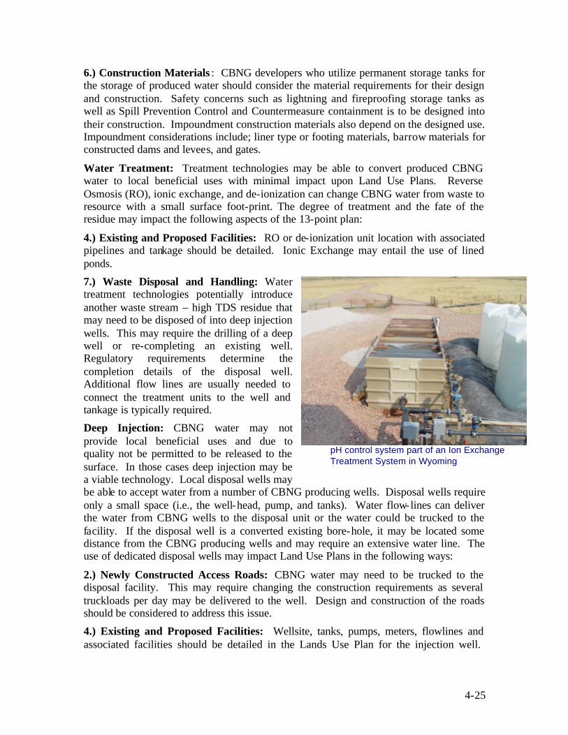
4-25
6.) Construction Materials : CBNG developers who utilize permanent storage tanks for the storage of produced water should consider the material requirements for their design and construction. Safety concerns such as lightning and fireproofing storage tanks as well as Spill Prevention Control and Countermeasure containment is to be designed into their construction. Impoundment construction materials also depend on the designed use. Impoundment considerations include; liner type or footing materials, barrow materials for constructed dams and levees, and gates.
Water Treatment: Treatment technologies may be able to convert produced CBNG water to local beneficial uses with minimal impact upon Land Use Plans. Reverse Osmosis (RO), ionic exchange, and de-ionization can change CBNG water from waste to resource with a small surface foot-print. The degree of treatment and the fate of the residue may impact the following aspects of the 13-point plan:
4.) Existing and Proposed Facilities: RO or de-ionization unit location with associated pipelines and tankage should be detailed. Ionic Exchange may entail the use of lined ponds.
7.) Waste Disposal and Handling: Water treatment technologies potentially introduce another waste stream – high TDS residue that may need to be disposed of into deep injection wells. This may require the drilling of a deep well or re-completing an existing well. Regulatory requirements determine the completion details of the disposal well. Additional flow lines are usually needed to connect the treatment units to the well and tankage is typically required.
Deep Injection: CBNG water may not provide local beneficial uses and due to quality not be permitted to be released to the surface. In those cases deep injection may be a viable technology. Local disposal wells may be able to accept water from a number of CBNG producing wells. Disposal wells require only a small space (i.e., the well-head, pump, and tanks). Water flow-lines can deliver the water from CBNG wells to the disposal unit or the water could be trucked to the facility. If the disposal well is a converted existing bore-hole, it may be located some distance from the CBNG producing wells and may require an extensive water line. The use of dedicated disposal wells may impact Land Use Plans in the following ways:
2.) Newly Constructed Access Roads: CBNG water may need to be trucked to the disposal facility. This may require changing the construction requirements as several truckloads per day may be delivered to the well. Design and construction of the roads should be considered to address this issue.
4.) Existing and Proposed Facilities: Wellsite, tanks, pumps, meters, flowlines and associated facilities should be detailed in the Lands Use Plan for the injection well.
pH control system part of an Ion Exchange Treatment System in Wyoming
4-26
Automated alarms and shut-off equipment on the flow-lines and at the well-head may be included.
9.) New Well Sites: If the disposal well or wells are newly drilled, their locations should be include in the plan. Completion details of the wells should also be included on the drilling plan. If the wells are deeper than the surrounding CBNG wells, the construction details between the types of wells may be different. Deep wells may require a larger rig, larger well-site, larger reserve pit, and other additions to the Land Use Plan.
4.2.4.5 Access Routes
CBNG developers have several technical options for access routes to CBNG facilities. In addition to the previously discussed combined roadway/utility corridor, other considerations for access roads include designing facilities with one-way- in/out roads, watering gravel roads for dust control, require carpooling, and posting speed limits on roadways. CBNG operators may also consider the location of existing roads in relation to the proposed development in order to identify the shortest routes for new access roadways. One-way-in/out roads are used as both ingress and egress routes to compressor stations, well sites and other CBNG related facilities. In/out roads are not always feasible for heavily traveled routes to busy facilities. This approach is used to reduce the amount of surface disturbance and allow operators to construct higher quality roads.
4-27
4.3 LANDOWNER/SURFACE USE AGREEMENTS
4.3.1 Rationale The working relationship that is developed between a CBNG developer and owner of the surface rights can determine how efficiently CBNG development is accomplished. Landowners, especially on split mineral estates, are concerned about their rights and the potential for CBNG development to impact their existing land uses, property values, and the aesthetic value of their property. Landowners who feel CBNG developers are unconcerned with their rights can cause delay or complication of development operations by legal or other available actions. Operators use Landowner Agreements to closely define expected uses, access, and determine appropriate reimbursements for expected and unexpected damages. In the face of apprehension by landowners, Landowner Agreements can instill a sense of trust in the operator if the landowner understands that unexpected problems are accounted for.
4.3.2 Contents General information relating to private, Tribal, and public landowners is typically included in the agreement. This information can include surface owner or manager’s name, contact address and telephone number, and alternate contact information. For individual landowner on the agreement the following information is typically included:
• An executed access agreement signed by the surface owner
• Or a waiver of the agreement with the surface owner
• Compensation agreement for damages and/or a bond of adequate value to address potential or proposed damages.
Additional information may be included in the agreements to address issues such as where landowners prefer the location of development, landowner requests (stock ponds, no traffic at certain times of the day, etc.), or the type of materials used for construction of roads and buildings.
4.3.3 Regulatory Requirements The BLM encourages CBNG developers to attempt to enter into a surface use agreement with landowners on split mineral estates prior to the start of drilling operations. If the development is to occur on a federal mineral lease and the operator is unable to obtain an agreement with the landowner after showing a good faith effort, a bond can be submitted of a sufficient amount to compensate the landowner for damages from the proposed development. If the development is on fee land and the operator is unable to obtain a signed Landowner Agreement, the operator can pursue an agreement through a state apparatus.
This memo provides and example how states accomplish this agreement:

4-28
MEMORANDUM
TO: Members of the Interim Committee to Study the Regulation of Oil and Gas Production in Colorado
FROM: The Office of Legislative Legal Services
SUBJECT: Overview of Surface Damages Acts in other states DATE: August 23, 1999 In the August 3rd meeting of the Oil and Gas Interim Committee, a question was raised regarding surface damages legislation that has been enacted in other states providing for compensation for surface owners when damages result from mineral operations. The surface damages acts of most of these states, developers of mineral interests are generally required to attempt negotiations for damage settlements before commencing operations on extracting minerals. If the developer and the surface owner cannot reach agreement, then the developer generally has the right to proceed with development plans; however, damages will generally be resolved through litigation or arbitration.
SURFACE DAMAGES STATUTES
North Dakota
Requires mineral developers to pay the surface owner a sum of money equal to the damages for loss of agricultural production and income, lost land value, lost use of and access to land, and lost value of improvements caused by drilling operations. The amount of damages may be determined by any formula mutually agreeable between the developer and surface owner. If a surface owner seeking compensation rejects the offer of the mineral developer, such person can bring an action in court, and, if the amount awarded by the court is greater than the offer by the developer, the court shall award reasonable attorney fees, costs, and interest to the surface owner. Mineral developers are also responsible for damages to the domestic, livestock, or irrigation water supply of any person who owns an interest in real property within one-half mile of drilling operations.(2)
Montana Requires mineral developers to pay the surface owner a sum of money equal to the damages for loss of agricultural production and income, lost land value, and lost value of improvements caused by drilling operations. The amount of damages may be determined by any formula mutually agreeable between the developer and surface owner, and consideration shall be given to the period of time during which the loss occurs. Payments only cover land directly affected by drilling operations and production.(3)
Oklahoma Requires a mineral owner to negotiate a written contract with the surface owner for the payment of any damages which may be caused by a drilling operation prior to entering the site with heavy equipment. If agreement is not reached or all parties are not contacted, the district court shall appoint an appraiser to make recommendations to the parties and to the district court concerning the amount of damages. Provides that the courts may award treble damages where:
• the mineral owner willfully and knowingly commences drilling without giving notice of entry or without the agreement of the surface owner; or
• the operator willfully and knowingly fails to keep posted the required bond.(4)
South Dakota
Requires mineral developers to pay the surface owner a sum of money equal to the damages for loss of agricultural production, lost land value, and lost value of improvements caused by drilling operations. The amount of damages may be determined by any formula mutually agreeable between the developer and surface owner. Mineral developers are responsible for all damages to property resulting from the lack of ordinary care by the mineral developer. To

4-29
receive compensation under the surface damage statutes, the surface owner must notify the mineral developer of damages within two years after the injury becomes apparent or should have become apparent to a reasonable man.(5)
Tennessee Obligates oil and gas developers to pay surface owners for (1) lost income or expenses incurred as a result of being unable to dedicate land or for drilling operations which prohibit access to the land for a preexisting dedicated use; (2) the market value of crops destroyed, damaged, or prevented from reaching market; (3) damage to water supply; (4) cost of repair of personal property; and (5) the diminution of value after completion of the surface disturbance. To receive compensation under the surface damage statutes, the surface owner must notify the oil and gas developer of the damages within three years after the injury occurs. The person seeking compensation may bring an action in court or can request that compensation be determined by binding arbitration.(6)
Texas Leases issued for unsold school land must include a provision requiring the compensation for damages from the use of the surface in prospecting for, exploring, developing, or producing the leased minerals.(7)
1. This legal memorandum results from a request made to the Office of Legislative Legal Services (OLLS), a staff agency of the General Assembly. OLLS legal memoranda do not represent an official legal position of the General Assembly or the State of Colorado and do not bind the members of the General Assembly. They are intended for use in the legislative process and as information to assist the members in the performance of their legislative duties. Consistent with the OLLS' position as a staff agency of the General Assembly, OLLS legal memoranda generally resolve doubts about whether the General Assembly has authority to enact a particular piece of legislation in favor of the General Assembly's plenary power.
2. ND CODE § 38-11.1-01 to 10. 3. MT ST 82-10-501 to 511. 4. OK ST T. 52 § 318.1 to 318.9. 5. SD ST § 45-5A-1 to 11. 6. TN ST § 60-1-601 to 608. 7. TX NAT RES § 52.297 and 53.155.
4.3.4 Technical Options Landowner agreements are typically divided into two categories; executed agreements and waived agreements. Executed agreements represent the situation where CBNG developer and landowner were able to negotiate and reach an understanding of how surface development is to occur. Waived agreements represent a situation where the CBNG developer and the landowner were unable to come to terms and the developer proceeds with development by ensuring that adequate bonding is in place to compensate the landowner for any damages suffered.
Ideally, CBNG developers are able to execute agreements with surface owners that are mutually beneficial for both parties. CBNG operators and landowners who work together in developing an agreement can identify methods in which CBNG operations can benefit the land and landowner. In many cases these situations have resulted in a mutually beneficial relationship between landowner and operator. Some examples of how CBNG operations have helped landowners include; the supply of produced water for land application on grazing lands, providing livestock water, and the design and construction of road and utility corridors for future landowner uses.
4-30
4.4 UNITIZATION, POOLING, AND COMMUNITIZATION AGREEMENTS The efficient drilling and production of CBNG resources often demand contractual agreements between mineral interest owners. Pooling or communitization agreements can be used to facilitate initial drilling. Unitization agreements can be used to make the drilling of production wells more efficient. The following is a discussion of when each of these agreements might best be applied to the exploration and production of CBNG.
4.4.1 Rationale Efficient drilling and producing of CBNG resources often demand contractual modifications to lease agreements between mineral interest owners and operators. Two common and useful contract vehicles are unitization and communitization. Unitization is a useful tool for managing mineral leases before and during field development. Unitization agreements can be used to make the drilling of production wells more efficient by using reservoir conditions to direct drilling decisions. Unitization allows operators the flexibility to carry out site-specific drilling patterns without regard for lease issues and leases are maintained as “held” by the operator, regardless of drilling locations within the unit. In addition, unitization allows operators to avoid problems from Federal oil and gas acreage limits.
Pooling or communitization agreements can be used to facilitate initial drilling. CBNG as well as conventional oil and gas are developed by way of wells drilled on a site-specific pattern whose density and orientation are determined by local geology as well as regulatory requirements. Initial “wildcat” CBNG wells are often drilled on standard well patterns of one gas well per 640 acres; if production of payable quantities of gas is established, then the project area is defined and site-specific drilling density is determined by geological and engineering tests. It is these drilling density requirements that encourage the use of communitization for initial drilling and unitization for drilling production wells.
4.4.2 Contents Contractual agreements can take several forms depending upon the ownership of minerals within the CBNG project area. Several different types of agreements are commonly used (i.e., pooling or communitization, exploratory unitizations, and unitizations).
4.4.3 Communitization Wildcat wells drilled for natural gas such as CBNG are frequently spaced by the regulatory agency at one well per 640 acres. If the CBNG operator has leased all the mineral interests in the section, the process is simple; if however, several individuals or companies own interests, picking a drill-site, dividing drilling costs, and dividing proceeds may be difficult. Prior to drilling the initial well, the owners of CBNG interests may decide to combine their leases into a single, 640-acre drillable tract. Such a community lease occurs when several landowners of adjacent tracts sign a single lease granting mineral rights to a single lessee; “the CBNG operator”. Signing the community lease is treated as an agreement to pool and each lessor is entitled to share in production. When a community lease is executed, there is a cross-conveyance whereby each

4-31
landowner signing the lease conveys a fraction of his or her royalty interest to the other lessors, receiving in return, a conveyance of a partial interest in the other lessors royalty rights. The community lease action is termed communitization or pooling.
The BLM provides model Communitization Agreements applicable to Federal and Indian interests. Fee and state minerals are pooled according to relevant state procedures. The pooled or communitized tract is to be defined both geographically and geologically; the pooling is done prior to an evaluation well being drilled. The pooling is carried out on one drilling/spacing unit, although several adjacent poolings may be done at one time. Pooling results in a single drilling unit that is treated as a single lease with interests shared according to mineral ownership and lease holdings.
Communitization can be accomplished voluntarily or it can be enforced by an action of the state regulatory agency. The forced pooling action only applies to state and fee minerals, not to Indian or Federal minerals. CBNG communitizations or poolings typically form one initial 640-acre drilling unit involving the entire coal sequence. Interest owners are able to join the unit, share the drilling costs, share in production proceeds, and share the information derived from drilling. Figure 4-9 illustrates a pooled 640-acre spacing unit. Having accomplished the pooling, the operator can drill anywhere
in the section provided it is within the minimum set-backs required by state regulation. In a pooled unit as presented in Figure 4-9, the mineral owners share equitably in the proceeds from the well, regardless of the location of the well.
The pooling may involve tracts embracing a single section or may join tracts from several sections into a drilling unit determined by specific reservoir conditions. Bounding faults, for example, may determine that the optimum drilling location is a
full 640 acres but located at the intersection of four sections; the resulting pooled unit leaves four surrounding L-shaped drilling units each 480 acres in size. Such a pooling needs to be documented by persuasive geological and geophysical data prior to being approved by regulatory agencies.
After drilling, the pooling agreement either dissolves if the well is a dry-hole or it can become part of the creation of a producing unit. If no drilling happens during the pooling period or if the bore-hole turns out to be a dry-hole, the pooled unit dissolves and the individual interests become drillable in another drilling/spacing unit for the same or different stratigraphic interval. If paying quantities of hydrocarbons are found, the communitized unit can become part of a unitized exploration or secondary recovery project. If the pooled acres are to be totally committed to the unit, the pooling can be
Figure 4-9: A typical pooled unit set up for an initial wildcat well. Section 8 is
covered by four separate leases. In order to drill the initial well on a 640-acre spacing unit, the mineral owners are asked to sign a community lease so that the mineral owners share in proceeds no matter where the initial well is drilled.
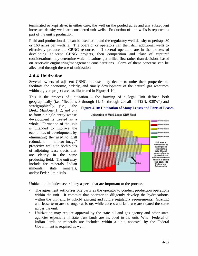
4-32
terminated or kept alive, in either case, the well on the pooled acres and any subsequent increased density wells are considered unit wells. Production of unit wells is reported as part of the unit’s production.
Field and production data can be used to amend the regulatory well density to perhaps 80 or 160 acres per wellsite. The operator or operators can then drill additional wells to effectively produce the CBNG resource. If several operators are in the process of developing adjacent CBNG projects, then competition and “law of capture” considerations may determine which locations get drilled first rather than decisions based on reservoir engineering/management considerations. Some of these concerns can be alleviated through the use of unitization.
4.4.4 Unitization Several owners of adjacent CBNG interests may decide to unite their properties to facilitate the economic, orderly, and timely development of the natural gas resources within a given project area as illustrated in Figure 4-10.
This is the process of unitization – the forming of a legal Unit defined both geographically (i.e., “Sections 3 through 11, 14 through 20; all in T12N, R30W”) and stratigraphically (i.e., “the Dietz Members 1, 2, and 3”) to form a single entity whose development is treated as a whole. Formation of the unit is intended to improve the economics of development by eliminating the need to drill redundant “mirror- image” protective wells on both sides of adjoining lease tracts that are clearly in the same producing field. The unit may include fee minerals, Indian minerals, state minerals, and/or Federal minerals.
Unitization includes several key aspects that are important to the process:
• The agreement authorizes one party as the operator to conduct production operations within the unit. It commits that operator to diligently develop the hydrocarbons within the unit and to uphold existing and future regulatory requirements. Spacing and lease term are no longer at issue, while access and land use are treated the same across the unit.
• Unitization may require approval by the state oil and gas agency and other state agencies especially if state trust lands are included in the unit. When Federal or Indian lands or minerals are included within a unit, approval by the Federal Government is required as well.
Figure 4-10: Unitization of Many Leases and Parts of Leases.

4-33
• After initial production in a Federal Unit is established, a Paying Well Determination (PWD) is performed to establish the initial dimensions of a Participating Area (PA). The PA is used to compute an assignment of proceeds to the individual leases that comprise the unit. Only those leases that fall within the PA share in the proceeds. Lease within the Unit boundary but outside the PA do not share in the proceeds.
• The PA can be updated as drilling advances; therefore ownership in the PA can change after new step-out wells are drilled. The PA is revised through the completion of PWDs after step-out wells have established production.
• Agency approval of the unitization plan does not authorize or permit on-the-ground activities; such activities are permitted on a case-by-case basis through the Application for Permit to Drill (APD), injection well permits, Sundry Notices (see 43 CFR Part 3160 and the Oil and Gas Onshore Orders), and other application devises.
4.4.5 Regulatory Requirements 4.4.5.1 Pooling and Communitization
Pooling, either voluntary or forced, requires the operator to define the drilling/spacing unit in stratigraphic and geographic terms. States may require a certain percentage of minerals to voluntarily join a pooling before the rest can be forced to join. Fee and state minerals can be forced to join the pooling while Federal and Tribal minerals cannot be forced to join. Pooling actions exist for a limited time unless hydrocarbons in paying quantities are discovered; a paying well extends the pooling until the well ceases to be profitable or until the pooling is unitized. Unitization can exempt Federal leases from chargeability under the statutory acreage limitation on holdings by an individual operator.
4.4.5.2 Unitization
Unitization can be performed under state regulatory authority when the mineral interests are owned privately or by the states. Unitization processes and procedures vary between the states. If 10% or more of the mineral interests are Federally owned, then the provisions of 43 CFR Subpart 3180 and others should be followed.
The Federal unitization process is detailed in BLM Unitization Manual Section 3180 and Unitization Handbook H-3180. The BLM website has standardized application forms for unitizations on Federal and Indian minerals. If Indian minerals are involved, the BLM unitization form may need to be revised and the approval of the Bureau of Indian Affairs may be required. Owners of mineral interests (both royalty interests and working interests) have to be afforded an ample opportunity to join the unit; private interests may be forced into the unit by judicial or quasi- judicial agency decision. Mineral interests are to be allocated to the unit by an allocation formula detailed in the unitization agreement. The allocation formula assigns precise working, royalty, and over-riding interests to each tract in the proposed unit and to each owner in the unit.
Unitizations can be either exploratory or secondary recovery units. Exploratory units are usually obtained for unproven areas and those areas primarily productive of natural gas. Secondary recovery units typically apply to oil fields under waterflood or other secondary recovery operations. CBNG operations are generally best suited to the standard

4-34
exploratory unit. CBNG unitizations may apply to the coals in an area (e.g., “Fort Union Coals”) or may be restricted to a part of the coal sequence (e.g., “Big George Coal”). In either case, the section to be unitized should be closely defined (i.e., “Fort Union Coals as seen in the Shell State #1 well, SW-SE Section 14, T43N, R33W, between 624’ and 1450’ log depth”). In addition, unit boundaries should be precisely described in terms of geographical coordinates so that each mineral tract can be seen to be wholly or partially inside or outside the unit.
Unitization applications applicable to conventional oil and gas or CBNG submitted to the state agency, the Bureau of Indian Affairs (BIA), and the BLM should include at a minimum the following data:
• A map drawn on a Section-Township-Range base showing the proposed unit boundary, with detailed structural and stratigraphic settings pertinent to the proposed unit area. CBNG maps might include a structure map on a common marker and net or gross coal isopachous map for the proposed unit area and surrounding adjacent area. The map should also show the status, depth, and lowest formation penetrated by each well drilled in the unit area and the immediate vicinity. For CBNG projects, it is particularly important to highlight those existing wells that have logged the shallow coals.
• CBNG unit applications should provide detailed stratigraphic columns listing local coal names as well as regional equivalencies for other named coals. Log or sample cross sections should also be provided to describe coal pinch-outs or merging coal seams and approximate limits of any sand-dominated channels cut through the coals. In addition the locations of proposed wells with their expected depths should be provided.
• Appropriate and necessary seismic and other geophysical information if available should be provided with the application. CBNG projects may include remotely sensed fracture analyses and regionally mapped, through-going faults.
• Discussion of the specific geologic basis used in delineating the boundary of the proposed unit area, such as cleat orientation, structural contour, bounding fault, sub-crops, or stratigraphic pinch-out needs to be included. CBNG units may be defined by fracture density, net coal isopach, gas desorption data, or clinker distribution.
Unitized CBNG interests can become part of a single producing field. Individual owners (e.g., private individuals, state agencies, Indian tribes, and Federal agencies such as the BLM) earn proceeds from the unit regardless of where the gas actually comes from. The proceeds, operating costs, taxes, and royalties are assigned to individual tracts and owners by way of the allocation formula, as described in the unitization agreement. The allocation formula is generally devised by the operator in coordination with other mineral owners in the unit. Once paying quantities of hydrocarbons have been established, a POD is usually submitted to the BLM if Federal minerals are involved. The unit’s operator proposes and performs necessary operations within the unit to establish and maintain CBNG production. These operations may include drilling and completing wells, installing utilities and roads, and managing produced water. The costs of installing and operating this infra-structure are borne by the mineral interests in the unit. Production of CBNG is totaled for the unit and proceeds divided according to the allocation formula.

4-35
The formula can change as interests are bought and sold and the formula is to be maintained and updated by the designated operator.
A successful pooling or unitization action extends the life of any leased minerals until after the dissolution of the unit or until paying amounts of CBNG are no longer produced. Leases that are partly within and partly outside the unit are segregated into unitized and un-unitized portions. The un-unitized portion is not held by unit production and that portion of the lease expires after the primary term unless hydrocarbons of paying quantity
have been established on it.
For Federal minerals in a Federal unit, only those lands under the PA receive proceeds. An example relationship of a PA to a unit boundary is shown in Figure 4-11.
A PA is defined as those areas reasonably proven to be productive of hydrocarbons in
paying quantities. The proof is accomplished by a PWD which compares the time-weighted value of the projected recovered hydrocarbon product versus the cost of installing the well. Paying well determination is described in 43 CFR 3183.4, as well as the BLM Unitization Handbook and Manual. The projected recovery is calculated from a decline analysis and compared to a locally reasonable drainage factor and volume to be drained. A PWD can extend the PA boundary to include the area being drained by the paying well as calculated by accepted engineering methods. Figure 4-12 illustrates the revision of the PA boundary after the inclusion of a new unit well drilled near the PA boundary. As drilling proceeds, the PA may be extended to include other paying wells. PWD is normally completed for each well in the Federal Unit after 12 months of production and, if necessary, application is made to extend the PA.
Figure 4-12: Drainage radius calculated from projected production leads to revised Participating Area determination.

4-36
Extension of the PA boundary may lead to the drilling of extra wells that were not included in the original POD; in that case the operator may file an amendment to the POD listing additional wells to be drilled. Normally after five years of development, the unit boundary reverts to the PA boundary unless the exploratory term is extended.

4-37
4.5 DRAINAGE PLANS
4.5.1 Rationale Comprehensive well drainage plans can help insure that the development of CBNG occurs in a manner designed to optimize the recovery of the natural gas resource. CBNG developers and regulators want to ensure that CBNG resource development occurs in a manner to optimize the gas resource while developers on surrounding leases want to ensure their gas is not lost to off- lease CBNG development. Drainage works to the benefit of the producer by drawing water and methane toward each producing well; however, drainage can work against the producer by drawing fluids from acreage under his control toward other operator’s wells. To provide scale to the drainage phenomenon, the BLM has determined that CBNG drainage can occur three miles or more beyond the edge of production after only 18 months of production (BLM, 2000).
Well drainage plans address issues related to the extraction of natural gas, the removal of water to reduce the hydraulic head within the coal seam, and methods to prevent the drainage of the gas under a lease by off- lease development. Well drainage plans allow CBNG developers to present a schedule for draining the CBNG resource under lease; this may include ident ifying well spacing/densities that are based on reservoir models or the need to create a hydrologic barrier to prevent a neighboring lease holder from draining their lease. In some instances, drainage planning may require the development of unitization or communitization plans to ensure that the interests of CBNG development parties are protected.
4.5.2 Contents Typical CBNG well drainage plans can include information related to the reduction of hydrostatic pressure in the coal seams, the extraction of natural gas, and the prevention of drainage from neighboring leases:
1.) Water Drainage Wells: The nature of CBNG often requires the extraction of water to reduce the hydraulic head prior to natural gas production. The optimum location of wells to reduce the hydraulic head of the coal seam is a critical element to ensure maximum CBNG production. Water drainage from the coal seams can impact local water wells and springs.
2.) Gas Drainage Wells: In order to maximize the extraction of the CBNG gas resource, the schedule on which CBNG wells are drilled and developed can affect the amount of gas that is extracted. Gas drainage can impact CBNG resources beyond the project boundaries.
3.) Well Spacing/Density: Additional consideration may be needed to adjust from the standard spacing unit to a site-specific reservoir spacing unit that can optimize gas production.
4.) Prevention of Off-lease Drainage: Plans for the placement of hydraulic barriers and sentinel wells to monitor and prevent off- lease drainage should be included in the drainage plan.

4-38
4.5.3 Regulatory Requirements The BLM has determined that an operator of a federal lease is liable for drainage of Federal or Tribal Trust minerals that he does not control. In addition, the operator of a Federal lease is responsible for protecting those leased minerals from drainage by outside wells (BLM 2001). While these specific requirements do not apply to operators of state or fee minerals, these operators still have a responsibility to protect fee and state minerals from drainage. If off- lease drainage occurs mineral owners can have recourse through courts of law to obtain compensation for the lost resource.
4.5.4 Technological Options Throughout the life of a CBNG project, the operator should be charting the behavior of the field. This charting may include a geographic distribution of production. Production data is an excellent indication of the extent and efficiency of drainage. Technological developments for portraying and predicting production trends can be utilized to describe drainage within and outside the lease block or unit.
4.5.4.1 Periodic Pressure Mapping
Coal seams in the Western United States often contain water as well as CBNG. The pressure in the aquifer (i.e., the “head” in wells) within the CBNG project area is drawn-down by production. The rate and amount of draw-down is important to monitor for CBNG production, as well as for water production. Pressure and head data from producing wells and monitoring wells can be used to map the individual coal seam aquifers in the neighborhood of the CBNG project. The pressure map may supply valuable information about the connection or isolation of the coal seams across the project area and highlight coals that are not being de-pressured and not having its CBNG resource produced.
Pressure mapping may also be able to predict in- fill drilling, impacts to private water wells and springs in the vicinity of the project, and CBNG drainage of off- lease tracts. Hydrostatic pressures should be closely monitored by CBNG operators as a means to optimize production rates within the productive coals in the project. For example, if four coal seams are productive over the project, it behooves the operator to map aquifer pressures in the four coals to insure that the CBNG resource is being produced efficiently in each. In addition, data from monitoring wells should be included in the pressure maps to track de-pressurization of off- lease aquifers and predict off- lease drainage by the CBNG project.
4.5.4.2 Reservoir Modeling
Operators may keep track of CBNG producing reservoirs by way of numerical models designed to describe in map and cross-section form, the distribution of porosity, permeability, and reservoir pressure. Such models can determine the connections between coal aquifers and identify those that are clearly isolated both vertically and horizontally. The models can be used to identify those aquifer segments that may not be fully drained by current operations and those that require additional in-fill drilling. The models can also be used to identify off- lease areas that might be drained by current operations.

4-39
Models of a CBNG reservoir are defined by monitoring reservoir pressure and production rates from producing and monitoring wells in the vicinity of the producing project. Numerical models have the ability to visualize current conditions and project these conditions into the future. These projections can be used to detect areas within the project area that may be by-passed or areas outside the project that may be drained. The projections of the model can also be used by the operator to direct production efforts so that extra producing wells can be placed in areas to produce by passed resources and other wells can be curtailed so that leases outside the project area are protected from drainage.
Modeling can be done throughout the development of the project to track initial de-pressurization efforts, in- fill drilling, pumping programs, plugging schedules, and aquifer recharge. Modeling can also be utilized to interpret sentinel well data on off-setting leases and the operation of mirror- location production wells on off-setting leases to monitor and control drainage. Lastly the modeling results can be used to calculate compensatory royalty payments to off-setting mineral and royalty owners that have had their leases drained.

4-40
4.6 CULTURAL RESOURCE INVENTORIES
4.6.1 Rationale Lands proposed for CBNG development can potentially be located in areas that contain pre-historic and/or historically important components (i.e., cultural resources). From a public relations and regulatory perspective, operators, as well as landowners, are accountable for any cultural resource disturbance that may occur as a result of development. The general public, private citizen groups and tribal communities are concerned that the widespread development of undisturbed lands may affect this resource in a manner that is not conducive to its conservation and protection. Many of these public entities have an integral role in the establishment of public perception towards CBNG development due to concerns for cultural resources. As such, operators can use this opportunity to work with concerned parties to develop appropriate planning strategies, due diligence, and mitigation strategies, when necessary.
Cultural resources are susceptible to surface and subsurface operations that require the use of heavy equipment (e.g., road construction, well drilling, pad construction, pipeline and utility placement, etc.). This type of construction results in changes to the natural landscape. Other activities that include, increased travel and vandalism resulting from access improvements or increased erosion resulting from surface alterations, can also impact this resource. Collectively, these activities can also produce indirect impacts from fires; and to rock art sites from gas emissions, abrasive dust, and vibrations from drilling equipment. In addition, noise, activity, traffic, and smells can affect the quality and continued use of traditional cultural sites.
4.6.2 Contents Laws and regulations established for cultural resources were written to preserve and minimize and mitigate unforeseeable resource alterations. Federal and state laws require the performance of a survey prior to the commencement of construction or other surface disturbing activities. If land is designated for conservation use, public use, or socio-cultural use it might prohibit its usage. Cultural resource inventories focus on the discovery of archeological components prior to development activities, to ensure that appropriate planning amendments for development are considered. Industry practices to insure historical and pre-historical components are protected include, surveying locations within a project’s footprint and when feasible, implementing realistic avoidance or facility relocation practices.
4.6.3 Regulatory Approach The existence of cultural resources within a specific location are determined through examination of existing records, field surveys, and subsurface testing of areas that are proposed for disturbance on federal and state lands. The flow chart in Figure 4-13 shows a decision pathway for the development of a cultural resource plan. Section 106 of the National Historic Preservation Act (NHPA) requires an inventory of cultural resources if federal involvement is present either in terms of surface or mineral estate, federal grant, or federal license. The BLM has promulgated guidance standards that include approved plans for avoidance when resources are discovered.

4-41
Identity Project Area
State Lands
Monitoring plan
Tribal Lands
Develop contingency plan for Cultural Resources discovered
Submit to SHPO and other authorities with mitigation
Perform Cultural Resource survey based on appropriate
and relevant regulations
Identify list of sites, buildings, etc. listed or proposed for listing on MRHP or other SHPO referenced sites
Consult with SHPO and review Existing NEPA
documents (if available)
Federal Lands
Determine ownership
disposition
Consult BLM or other Cultural
Resource Official
Consult with Tribal Cultural Resource
Official
Fee Minerals and
Fee Surface
Prepared by ALL Consulting
Figure 4-13: Cultural Resources Flow Chart
4-42
In recent years BLM has implemented a national Programmatic Agreement with the Advisory Council on Historic Preservation and the National Conference of State Historic Preservation Officers. This Programmatic Agreement enables BLM to expedite Section 106 reviews under guidance from the board in a more proactive manner (Winthrop, 2002). In addition, BLM has entered into agreements with various private citizen groups and local and tribal communities to help preserve cultural resources on BLM lands. In addition to the BLM, State Historical Preservation Offices (SHPO) has a role in cultural resource conservation. SHPO maintains a register of listed or eligible sites for listing on the National Register of Historic Places (NRHP) and typically stipulate additional non-BLM requirements. SHPO is responsible to inform property owners and local officials of the intent to nominate discovered sites while at the same time provide for public comment. This allows involved parties the opportunity to concur in or object to the nomination. If the owner of a private property, or the majority of private property owners for a property or district with multiple owners, objects to the nomination, the historic property cannot be listed in the National Register (National Park Service, 2003).
Development plans submitted to BLM are to meet cultural resource requirements as identified in the BLM handbook H-8110: Guidelines for Identifying Cultural Resources prior to the PODS approval. These requirements include conformance with minimal BLM Class III survey standards and qualifications for contracting archaeologist (i.e., archeologist should hold a permit with the sponsoring BLM field office). The following information summarizes BLM Class III survey standards as described in the Coal Bed Natural Gas Well Applications for Permit to Drill and Plan of Development Preparation Guide, Buffalo Field Office (BLM, 2003).
BLM Class III Survey Standards:
• Well pads are to be surveyed in 10-acre minimum units, unless a block survey strategy is in place for the project. The corners of the 10 acre block are to be recorded with a GPS unit. This is to ensure that the survey can be replicated by BLM Cultural Resource Personnel, if necessary.
• Unimproved two-tracks (both existing and proposed) and new improved, all-
season access roads are to be inventoried using a minimum of a single inventory transect with a 100-foot centerline survey (i.e., 50‘ on both sides from the center of disturbance).
• Central gathering/metering facilities should be inventoried in 10-acre survey
blocks, though they can be appended or attached to other well pad surveys. Corners of these facilities should be recorded the same as 10 acre well inventories.
• Federal project pipelines are to be surveyed to the point where they connect to an
existing fee pipeline and/or road corridor, fee central gathering/metering facility, or other previously disturbed area. Water pipelines are to be surveyed from the well to the discharge point or disposal facility. BLM requires that buried infrastructure serving federal wells within a Project POD be inventoried. Third-

4-43
party pipelines, which are constructed and operated by someone other than the federal leaseholder(s) and do not link federal wells within the Project POD, are not federal undertakings and therefore do not require cultural survey unless federal surface is crossed. Cultural clearance is required for rights-of-way across federal surface. A 100 foot centerline survey is required.
• Area disturbed by new overhead and buried power line routes serving federal
wells within a project area are to be inventoried for cultural resources. Where the lines are not covered by a block inventory, the minimum corridor to be inventoried is 100 feet. BLM may require additional areas to be inventoried depending on the size of the power- line.
• Water discharge points and a BLM defined 10 acre area should be surveyed for
cultural resources.
• New reservoirs constructed as part of the CBNG project should have a minimum of 10 acres surveyed including dam site, the water impoundment area, the fill or barrow area, the overflow channels, and immediate downstream drainage. Cultural resource information should be reviewed for existing reservoirs and an inventory covering the proposed action would be required if necessary. If the size of an existing reservoir is to be greatly expanded, it may be regarded as new construction and require cultural resource inventory as previously stated.
State regulations related to practices which govern cultural resources vary to a certain degree from state to state in code or language, but collectively, support the federal mandate or provide more stringent standards. The policy summary below, for the states focused on in this study, is intended to provide the reader with a general “sense” concerning the viewpoint s and regulatory perspective for each State. It is recommended that regulatory requirements be obtained and reviewed by contacting the appropriate authorized agency prior to developing a project plan.
Colorado: “Reserves title for the state to all historical, prehistorical and archeological resources in all lands, rivers, lakes, reservoirs and other areas owned by the state or any county, city and county, city, town, district or other political subdivision, to include all deposits, structures or objects which provide information pertaining to the historical or prehistorical culture of people within the boundaries of the state, as well as rights-of-way access on state-owned land from a maintained public road for the exploration, protection, preservation, interpretation and enhancement of the site or deposit proper.” “Requires any person who discovers or knowingly disturbs suspected human skeletal remains on any land in the state, except in regard to anthropological investigations under §24-80-1303, to notify the coroner in the county where the remains are located. Directs the coroner to notify the state archeologist if the coroner determines such remains to be of no forensic value.” (Colorado Revised Statutes: §24-80- 1302)
Montana: “Prohibits a person from excavating, removing or restoring any heritage property or paleontological remains on lands owned by the state without first obtaining an antiquities permit from the historic preservation officer.” “Requires a person who by archeological excavation or by agricultural, mining, construction or other ground-

4-44
disturbing activity discovers human skeletal remains, a burial site or burial material to notify the county coroner immediately and to cease such activities until the coroner has determined, within two days of notification, whether a forensic examination under the coroner's jurisdiction is necessary.” (Montana Code: §22-3- 805)
New Mexico: “Discourages field archeology on privately owned lands except in accordance with the provisions and spirit of the Cultural Properties Act, and encourages persons having knowledge of the location of archeological sites to inform the Cultural Properties Review Committee. Declares it to be an act of trespass for a person to remove, injure or destroy registered cultural properties situated on private lands or controlled by a private owner without the owner's prior permission.” “Requires a person who discovers an unmarked burial to cease any activity that may disturb the burial or any object associated with that burial and to notify the local law enforcement agency, which shall notify the state medical investigator and the state historic preservation officer.” (New Mexico Statutes 1978: §18- 6-11.2)
Utah: “Requires a person who discovers any archeological resources on lands owned by the state or its subdivisions or on privately owned land to report the discovery promptly to the Division of State History. Discourages field investigations except in accordance with Part 3 (§9-8-301 through §9-8-308) and Part 4 (§9-8-401 through §9-8-405). Declares that nothing in this section may be construed to authorize a person to survey or excavate for archeological resources.” (Utah Code Sec 9-8-307)
Wyoming: “Before any excavation on any prehistoric ruins, pictographs, hieroglyphics or any other ancient markings, or writing or archaeological and paleontological deposits in the state of Wyoming on any public lands, either state or federal, shall be undertaken, a permit shall first be obtained.” (Wyoming Code §36-1-114)
4.6.4 Planning Considerations As mentioned above surface disturbances related to CBNG development can potentially alter cultural resources if land management and planning strategies are not properly identified and/or implemented. During the initial stages of planning, operators may consider project location and principal land disturbing actives that may lead to disturbance(s). In order to determine areas deemed “safe” for development, existing record searches may be performed in cooperation with SHPO so as to ascertain any land avoidance areas, as well as proposed areas for avoidance. During this phase of planning the operator should also identify other authorizing agencies (e.g. BLM, etc.) to establish agency specific regulatory requirements, subjects of concern, and other related issues relative to cultural resources.
As part of the project plan, regions or lands not covered under existing NEPA documents may require the performance of a cultural resources survey to identify historical sites, buildings, areas of visual importance, etc. Upon completion of the survey, findings are to be submitted to SHPO, as well as other authorized agencies, for review. When necessary the development of mitigation options should be implemented. The project plan should clearly identify and state intended actions to occur when cultural resources are identified. Coordination with SHPO, and in many cases BLM, to identify such actions is critical to facilitate plan approval.
4-45
Specific plans for avoidance and methods or alternatives to minimize direct or indirect disturbances are included as part of the project plan for historic properties within the areas of potential effect of proposed project activities (BLM, 2003). Such plans as developed by BLM can include, but are not limited to, the following constraints, stipulations, or actions (BLM, 2003):
• Relocation, redesign, or constraint of project facilities and infrastructure to avoid or minimize earth disturbance.
• Relocation, redesign, or constraint of project facilities and infrastructure to avoid
or minimize visual intrusion.
• Stabilization of sediments, bedrock, or structures that could be destabilized, or could deteriorate, as a result of nearby project activities and identification of an appropriate buffer zone.
• Restriction or prevention of access to sensitive areas.
• Rehabilitation of buildings or structures, or protective screening of art work to
minimize deterioration.
• Detailed documentation, possibly including archival photo documentation, of contributing structures, landscape features, or aspects of historic setting that cannot feasibly be avoided. In some cases it may be feasible to restore some of these contributing features after construction has been completed.
• Detailed recordation or data recovery of the essential contributing elements of a
historic property that cannot be avoided or protected. In the rare event when exploratory or development procedures unearth previously undiscovered resources, enforceable mitigation may require that work be stopped in the area of discovery until after consultation with relevant state historic preservation officer, tribal historic preservation officer, and/or the Advisory Council on Historic Preservation. Appropriate and responsible actions relative to the discovered resource may be determined by these agencies and coordinated with operators and/or landowners. Instruction on procedures to follow in this particular situation can constitute an important element during the planning process. This may include informing operators of the penalties for illegally collecting artifacts; intentionally damaging archeological sites or historic properties; instruction on rehabilitation of buildings or structures; minimizing equipment traffic; and restricting placement of equipment and material staging areas near known archeological resources (National Park Service, 2002).
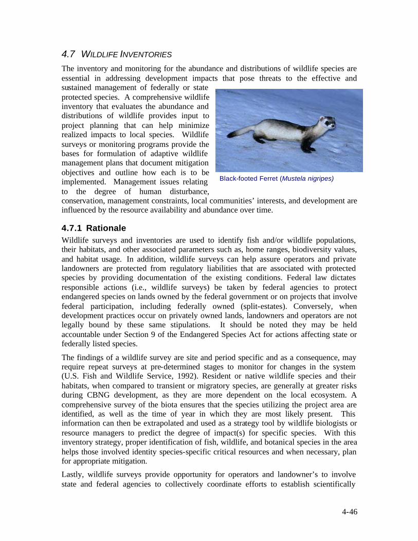
4-46
4.7 WILDLIFE INVENTORIES The inventory and monitoring for the abundance and distributions of wildlife species are essential in addressing development impacts that pose threats to the effective and sustained management of federally or state protected species. A comprehensive wildlife inventory that evaluates the abundance and distributions of wildlife provides input to project planning that can help minimize realized impacts to local species. Wildlife surveys or monitoring programs provide the bases for formulation of adaptive wildlife management plans that document mitigation objectives and outline how each is to be implemented. Management issues relating to the degree of human disturbance, conservation, management constraints, local communities’ interests, and development are influenced by the resource availability and abundance over time.
4.7.1 Rationale Wildlife surveys and inventories are used to identify fish and/or wildlife populations, their habitats, and other associated parameters such as, home ranges, biodiversity values, and habitat usage. In addition, wildlife surveys can help assure operators and private landowners are protected from regulatory liabilities that are associated with protected species by providing documentation of the existing conditions. Federal law dictates responsible actions (i.e., wildlife surveys) be taken by federal agencies to protect endangered species on lands owned by the federal government or on projects that involve federal participation, including federally owned (split-estates). Conversely, when development practices occur on privately owned lands, landowners and operators are not legally bound by these same stipulations. It should be noted they may be held accountable under Section 9 of the Endangered Species Act for actions affecting state or federally listed species.
The findings of a wildlife survey are site and period specific and as a consequence, may require repeat surveys at pre-determined stages to monitor for changes in the system (U.S. Fish and Wildlife Service, 1992). Resident or native wildlife species and their habitats, when compared to transient or migratory species, are generally at greater risks during CBNG development, as they are more dependent on the local ecosystem. A comprehensive survey of the biota ensures that the species utilizing the project area are identified, as well as the time of year in which they are most likely present. This information can then be extrapolated and used as a strategy tool by wildlife biologists or resource managers to predict the degree of impact(s) for specific species. With this inventory strategy, proper identification of fish, wildlife, and botanical species in the area helps those involved identity species-specific critical resources and when necessary, plan for appropriate mitigation.
Lastly, wildlife surveys provide opportunity for operators and landowner’s to involve state and federal agencies to collectively coordinate efforts to establish scientifically
Black-footed Ferret (Mustela nigripes)
4-47
sound survey protocol, as well as determine the level of risks for certain species for work-specific actions.
Upon completion, a comprehensive wildlife inventory can allow involved parties to plan accordingly so as to maximize the efficiency and effectiveness of planned mitigation, while at the same time maximize a project’s production and overall profit (EPA, 2002).
4.7.2 Contents Due to the wide use and variance associated with wildlife surveys, describing step-by-step procedures that can be utilized by professionals to effectively and accurately plan such an action is difficult. Coupled together with differences in regional regulatory demands and interpretation, a specific step-by-step approach becomes increasingly less viable. Wildlife regulations are complex and vary depending on state and federal involvement, land-usage, and specie distribution. As such, a working knowledge of applicable regulations has proven critical for effectively planning wildlife inventory surveys and with aiding in the overall implementation of a project plan. The discussion below is intended to inform the reader of applicable wildlife regulations and define general survey protocol and decision guidelines that can aid involved parties during the planning process.
4.7.3 Regulatory Approach Congress passed the Endangered Species Preservation Act in 1966, which granted limited protection for native animal species only. This newly promulgated law required the Departments of Interior, Agriculture, and Defense to actively protect listed species and their habitats and authorized land acquisition to help achieve necessary levels of protection. The Endangered Species Conservation Act of 1969 was then passed to provide additional protection to species in danger of "worldwide extinction". Import of such species was prohibited, as was their subsequent sale within the United States. A 1973 conference in Washington led to the signing of the Convention on International Trade in Endangered Species of Wild Fauna and Flora (CITES), which restricted international commerce in plant and animal species believed to be actually or potentially harmed by trade. The now known Endangered Species Act of 1973 was passed later that year, which combined and considerably strengthened the provisions of its predecessors (EPA, 2002). The Endangered Species Act is currently enforced by the United States Fish and Wildlife Service (FWS).
The FWS and the BLM reached an interagency agreement in 1996 (Section 506, FW 3, exhibit 1) to promote effective cooperation in resource management in a manner that recognizes existing cooperative relationships with the States. Under this agreement BLM has the statutory responsibility for cadastral survey, inventory, planning, and multiple-use management of the public lands and public land resources that include fish and wildlife. BLM can include and enforce appropriate measures during the site-specific plan approval stage and assure that fish and wildlife resources are effectively considered in each stage of its land management programs and activities.
The FWS has principal statutory-responsibility and authority for migratory birds, threatened and endangered (T/E) species, certain marine mammals, international resources within the continental United States, and all fish and wildlife on lands under
4-48
Service control and as described in the Fish and Wildlife Act of 1956 (.16 U.S.C. 742(a)-754). FWS and BLM have general responsibilities to conduct research and to compile information on the status of fish, wildlife, and plant resources and those factors affecting them in their respective areas of responsibility. These general FWS assessments for wildlife and vegetative conditions and trends may at times extend to areas within the public lands under BLM administration in response to statutory, Presidential, or Secretarial direction. In addition, both agencies have fish and wildlife advocacy roles within their statutory-authorities or other assigned functions.
Under Section 522 of the FWS Manual, which includes guidance for wildlife survey procedures, states are required to evaluate survey projects of an ongoing nature to provide state managers with a critical review of the continuing need for the data; its sufficiency in meeting management objectives of the agency; and the reliability and efficiency of the methods used to collect the data (U.S. Fish and Wildlife Service, 1992). The evaluation by the state ensures the validity of collected field data and helps surveyors develop plans that also satisfy state regulations or procedures. Proper planning with assistance by the state also helps ensure proper coordination between Federal authorities and over the course of the project may help to avoid unnecessary project delays and costs.
CBNG development may trigger Section 7 and/or Section 9 of the Endangered Species Act if environmental alterations are planned and if those alterations pose a potential threat to listed species and their habitat. Section 7 of the Act primarily insures federal agencies do not jeopardize the continued existence of listed species or modify their critical habitat during any federally authorized project. Section 9 discusses prohibited actions and outlines litigation authority for the FWS. Prohibited actions defined in this Section are extensive and should be reviewed to insure planning strategies are consistent with the law.
Split-estate lands with federally owned mineral rights, affords BLM the authorization or responsibility under Section 7 of the Endangered Species Act, to furtherance the purposes of the act “by carrying out programs for the conservation of endangered species and threatened species” (U.S. Fish and Wildlife Service, 1992). In this situation permit applications may not be approved without prior wildlife inventory investigations, unless threatened or endangered species are assumed to inhabit the permitted area. The FWS provides interagency support during this process and can invoke penalties for prohibited actions outlined under Section 9 of the Act.
Section 7 of the Endangered Species Act is not applicable to project related actions taking place solely on private lands. However, under Section 9 of the Act, operators or land owners still need to assure prohibited violations defined are avoided. From a regulatory perspective, actions on private lands may not require performance of wildlife inventories, but as stated above, impacts to threatened or endangered species would trigger Section 9 of the act, and subsequent law enforcement penalties from the FWS. To avoid such situations, the FWS service recommends incorporating wildlife inventory requirements into project plans or at a minimum, assume federal and state listed species inhabit the area.
Working with endangered or threatened species requires a Federal Fish and Wildlife Permit, as described in the general conditions of Title 50 CFR, part 13. Issues or actions

4-49
related to taking, possessing, transporting, selling, purchasing, etc., of any Federally listed species, including plants, falls under jurisdiction of this permit.
4.7.3.1 Lease Stipulations
Many states do not have the authority or requirement to perform wildlife inventories when projects are scheduled to take place on private lands. An accepted practice consisting of proper diligence by notifying the appropriate State authority to ascertain their specific requirements is recommended. In addition, development projects taking place on State Trust Lands are typically required by associated management groups to include lease stipulations for wildlife surveys.
Private landowners do have the authority to implement wildlife specific lease stipulations and may do so if they are concerned about a particular species or habitat. As stated above, these stipulations can always be included in the lease agreement to avoid penalty under Section 9 of the Endangered and Species Act. These stipulations are typically outlined and defined during the pre-planning phase of the project.
4.7.3.2 Wildlife and Botanical Survey Procedures
As with many project planning elements associated with CBNG development, geographic location, available resources, and proposed development operations dictate the inventory requirements necessary to satisfy regulatory, landowner, and public office requirements. In any case, the overall objectives of a wildlife survey are to aid or alleviate impacts observed by wildlife species by developing mitigation specific to each action and affected species.
In general, a wildlife survey begins by reviewing ranges and natural histories of protected species. In addition, identification of proposed development objectives to determine potential risks to applicable species is carried out early in the survey process. Coordination with federal and state offices to ascertain survey requirements and approval, as well as any requirements established by land owners, is considered the next practical step. The flow chart in Figure 4-14 is designed to assist in the decision making process during the pre-plan development phase. Specific project requirements, objectives, and available data can alter the appropriate pathway as described and it is recommended that appropriated authorities be contacted during the pre-plan development phase.
The FWS provides specific guidelines and regulations for conducting wildlife inventories in the Fish and Wildlife Service Manual, Section 522, FW 12, when projects entail federal involvement. The "Handbook on Research and Surveys, Federal Aid in Fish and Wildlife Restoration" and "Tactical Planning in Fish and Wildlife Management and Research" are also available from the FWS and provide more detailed information on this subject. These manuals and handbooks are available from Federal Aid Regional Offices.
Survey practices very greatly for any given species or habitat and require interested parties to coordinate efforts with local federal or state authorities to determine the recommended and most current survey practices. Deviations from FWS or state guidelines without prior approval typically results in permit rejection. In addition, individuals performing the survey on federally involved projects may require pre-approval by the lead federal agency.

4-50
Determine areas where surface disturbance will occur as part of
Project Development.
Develop Plan for Wildlife Inventory/ Botanical Evaluation based on Identified Protocols.
Identify landowner lease stipulations.
Identify lease stipulations relative to
Wildlife Inventory procedures for State
Trust Lands.
Use Existing Plan
Identify additional requirements for
Botanical Assessments
Protocol or Indian Minerals.
Determine who the authorized Federal Agency is that
approves a plan. Identify requirements of Bio evaluation
for this federal agency.
Will the area of disturbance
occur on Federal or
Indian Lands?
Is there an existing Wildlife
Inventory for the Federal
land?
Will the development
occur on State Trust Lands?
Will the landowner have lease
stipulations for wildlife
inventories?
Are Indian minerals
included in the lease?
YES YES
NO
NO
YES
NO
YES
NO
NO
YES
Figure 4-14: Pre -Plan Development Biological Evaluation Flowchart
Prepared by ALL Consulting

4-51
Development of survey objectives are established in the project plan to assure survey criteria and procedures are approved. The plan should also include potential project related wildlife impacts to assure proper field evaluations are considered and performed. Questions to consider when developing a wildlife survey plan may include:
• Are federally listed species known to occur in the area? If so what is their range and distribution?
• Are the species in question resident or migratory?
• When is their breeding period?
• How long is the maternity period and when does, if applicable, migration occur?
• Is the species territorial and how large is the home range?
• Is the species adaptable or is it vulnerable to environmental changes?
• How does project conditions affect this species or its habitat? (including water systems)
• Is suitable habitat for temporary re- location available?
• When is the species most active?
• What is considered critical habitat for the species?
• Can the project be re- located?
• Would mitigation measures effectively protect local wildlife resources?
In general surveys focus on endangered or threatened species, but may include other regionally sensitive species (i.e. National Forest Service listed species). In situations where federal or state endangered or threatened species are identified, local FWS or BLM offices should be contacted prior to taking further action. In these cases the FWS typically requires the performance of a biological assessment of the discovered specie(s) to determine an appropriate response that may include, mitigation or impact reduction strategies. With any development project, data resulting from the survey should be concise, but easily interpreted so as to formulate proper avoidance or mitigation.
Figure 4-15 outlines a decision pathway that can be incorporated into a project plan to determine the correct course for proper implementation of a wildlife survey.
West Slope Cutthroat Trout Oncorhynchus clarki lewisi
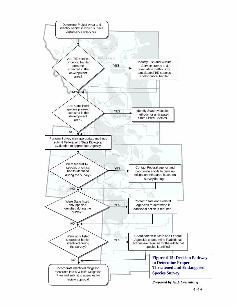
4-49
Perform Survey with appropriate methods submit Federal and State Biological Evaluation to appropriate Agency.
Are State listed species present/ expected in the development
area?
NO
NO
Identify State evaluation methods for anticipated State Listed Species.
YES
Contact Federal agency and coordinate efforts to develop
mitigation measures based on survey findings.
Coordinate with State and Federal Agencies to determine if additional
actions are required for the additional species identified.
Were federal T&E species or critical habits identified
during the survey?
YES
Were State listed only species
identified during the survey?
YES
NO
Were non- listed species or habitat identified during
the survey? YES
Incorporate identified mitigation measures into a Wildlife Mitigation Plan and submit to agencies for
review approval.
NO
NO
Figure 4-15: Decision Pathway to Determine Proper Threatened and Endangered Species Survey
Are T/E species or critical habitat
present/ expected in the development
area?
Contact State and Federal Agencies to determine if
additional action is required.
YES Identify Fish and Wildlife
Service survey and evaluation methods for anticipated T/E species and/or critical habitat.
Prepared by ALL Consulting
Determine Project Area and identify habitat in which surface
disturbance will occur.

4-50
4.8 PRODUCED WATER MANAGEMENT
4.8.1 Rationale In the Western United States, the viability of CBNG projects is often determined by the economics of managing produced water. Furthermore, landowners, irrigators, fishermen, and regulators are concerned with the potential impacts to surface water and groundwater from CBNG produced water. High quality water that is produced in some CBNG regions can have a dual nature being of sufficient quality for livestock watering but, at the same time pose a risk to soils, crops, groundwater, and surface water if not properly managed. CBNG development can become uneconomical if large volumes of poor quality water are produced that can only be managed via deep injection or by expensive treatment options prior to beneficial use or surface discharge.
Water management plans are the means by which CBNG developers demonstrate to regulators, landowners, and other interest groups that produced water is being managed in an environmentally conservative manner. CBNG produced water can be managed by a variety of means and may even be developed into an asset for the arid Western United States since much of the west is experiencing population growth and droughts that are depleting groundwater and surface water supplies. Although the quality of CBNG produced water can vary by basin, by coal seam within a basin, and over the lifetime of a well, there are management options to properly handle water types while protecting or possibly improving local surface water and groundwater. CBNG produced water can be used to supply local industry such as farms, ranches, fisheries, and coal mines by supplying water for irrigation, livestock watering, fish hatchery ponds, and dust control. The flow chart in Figure 4-16 shows an example decision pathway for determining how produced water for a Wyoming CBNG field could be managed. Water management plans address how operators intend to manage water that is produced during testing and development of the CBNG project. The decision pathway in Figure 4-16 shows that one water management plan may contain a variety of management options in order to handle the produced water.
4.8.2 Contents A water management plan details how a CBNG developer may handle, transport and dispose of water that is produced from the wells contained within the plan. Typical water management plans include:
• Maps: Maps can be used to show the location of existing water wells, springs, surface water bodies and proposed CBNG facilities (i.e., wells, proposed pipelines, manifolds, irrigated fields, discharge points, and reservoirs).
• Design Plans: Design plans for erosion control structures, impoundments, and channel crossings may be necessary with different levels of engineering design based on the local regulatory authority. In some areas generalized design plans for impoundments may be sufficient while other states may require detailed plans for each individual structure.

4-51
Discharge permitted volumes of water V.1
Discharge permitted volumes of water V.2
Permit with SEO or appropriate agency
V.5
Obtain BLM or State Permit V.6
Sub-surface Injection, i.e. ABR, EOR, Deep V.7
Obtain NPDES permit or similar permits
Treat and obtain permit to discharge
Consult with landowner and local industries to determine
needs
Is produced water of sufficient quality to
discharge?
Can produced water be treated to
meet discharged
criteria?
Is produced water of sufficient quality for
beneficial or Industrial use?
Are surface impoundments
an option?
Will pond be on-
channel?
Is pond 20 ac-ft or larger or
have Dam height >20 ft?
Determine Quantity and Quality of Produced Water
Permit with DEQ or appropriate agency V.4
Figure 4-16: Produced Water Management Flow Chart Wyoming
Prepared by ALL Consulting
YES
NO
YES
NO YES
NO
NO
YES
NO
YES
YES
NO
Produced Water Volume = V1+V2+V3+V4+V5+V6+V7
Supply appropriate volumes of water for desired use V.3
4-52
• Projected water production rates: CBNG wells generally produce water at high initial rates and gradually decline to a stable rate. The project Drilling Plan should have already detailed the drilling schedule and phased production plans. Expected per well and total project water projections can then be made for the life of the project and at points of time during the project. Water rates dictate the size of handling facilities, discharge permits, treatment facilities, and impoundments.
• Water quality analysis: Water quality analyses from each producing zone allow regulators to determine if the proposed water management approaches meet regulatory guidance. Producers also use water analyses to drive treatment options and irrigation projects. Subsequent water quality analysis may need to be submitted as part of monitoring programs.
• Regulatory permits : Permits for injection wells, discharge points (NPDES or State required), water rights and other relevant water management practices are submitted with the water management plans when applicable.
• Management methods : The management plan should provide a breakdown of how the water volumes are to be disposed (i.e., deep- injected, used in irrigation, etc.) Details of proposed beneficial uses and disposal methods for the project including discharge or application rates, storage volumes, and potential downstream concerns allow regulators to determine compliance with appropriate and relevant regulations.
4.8.3 Regulatory Requirements On Federal mineral leases, a comprehensive Water Management Plan (WMP) is to be included with the APD’s to BLM and it is to comply with Onshore Order No. 7. Onshore Order No. 7 requires water produced from federal minerals, including, water that is transported onto Non-Federal minerals, to comply with the Order. Additionally, state oil and gas programs have rules and regulations for the management of produced water associated with oil and gas including CBNG development. Montana’s ROD for CBNG projects require CBNG developers to include a WMP as part of the POD.
The following information is required by the BLM for a WMP:
1) Statement of Compliance : CBNG operators are required to include in their WMP a statement that their CBNG development be conducted in a manner which complies with BLM, EPA, United States Corps of Engineers, State and Local Authority laws, standards, and rules for the handling and disposal of produced water.
2) Water Management Map: CBNG operators are required to submit a water management map which includes watershed boundaries, discharge points, impoundments, land application areas, water pipelines, spring and water well locations, low water crossings, erosional features, and other relevant water management information.
3) Water Quality Analysis: Representative water quality analysis is required to be submitted with a WMP; the parameters that are to be submitted vary based on

4-53
local or state concerns. For example, in Wyoming a representative water sample is obtained from the first well to produce in a target coal seam within 30 to 60 days of initial water production. Montana prefers the sample to be obtained prior to the commencement of drilling from the closest nearby source (i.e., within 6 miles). The sample needs to be collected from the same formation at approximately the same depth interval as the proposed CBNG well production.
4) Erosion Control and Stabilization: Design plans for erosion control measures, including maintenance schedules, for channels and drainages with discharges should be incorporated into the plans.
5) CBNG Operator’s Representative and Certification: CBNG developers should also present in their WMP a statement certifying that they along with their subcontractors agree to conform to the plan and terms or conditions set upon the plan.
6) Hydrologic Watershed Field Analysis: The BLM has developed watershed field evaluation sheets that should be submitted for each individual watershed within the project development area. For each watershed the following information is expected:
a) Watershed Area
b) Average Slope of the Watershed
c) Existing conditions of the Channel
i) Average slope
ii) Width and depth
iii) Mean annual flow (calculated)
d) Peak Flow Analysis – minimum of 2, 10, and 25 year return intervals.
e) Destination – watershed is a tributary of what water system.
f) Description of Existing Watershed Uses and Conditions.
i) Existing Wells (location, depth, etc.)
ii) Existing Impoundments (location, size, etc.)
iii) Road Crossings (type, condition)
iv) Potential Down Stream Concerns and Mitigation Plans if Impacted (on channel impoundments, irrigation, etc.)
7) Existing Watershed Uses: Included within the plan should be a listing of registered wells, natural springs, and other water management facilities within 1-mile of the project area. Included with each item should be the following; legal locations, withdrawal or discharge rates, and water quality analysis.
8) Proposed Water Management Actions : The types of management options and volume of produced water expected is to be provided. For each management option, the following should also be included:

4-54
a) Location
b) List of wells contributing flow
c) Proposed discharge/disposal rate or storage capacity
d) Permit information: NPDES, UIC, State/Federal Impoundment permit or permit application.
9) Downstream Concerns : A listing of potential downstream concerns that have been identified and their proposed mitigation actions.
10) Monitoring and Abandonment: Monitoring and abandonment/reclamation plans are required and addressed under a separate heading in this document. Reclamation of water management facilities is typically required when the facility is no longer necessary.
11) Pre-Approval Data Collection: Some water management plans may require data collection prior to final approval; any data collection activities which require surface disturbance are to be approved by the BLM.
12) Bonding : Bonding is typically required for off-channel impoundments. Bond amounts are required to be estimated and supplied by the CBNG developer using a professional engineer with experience in impoundment reclamation. Bonds should be in place prior to the discharge of any produced water.
4.8.4 Technical Options CBNG production can be performed using a variety of technologies. The options used by CBNG developers for the extraction of CBNG and handling of produced water have different environmental implications and may affect water management planning. The methods described in the water management plan can have a large impact on the economics of a CBNG development. The following section discusses some of the technologies for CBNG production and produced water management and their possible effects on CBNG water management planning.
4.8.4.1 Phased Development and Well Patterning
CBNG development is typically performed in one of two ways; by developing every well location with as many drilling rigs as possible or by sectioning the project area into multiple development phases so that development is spread over several years. A phased development allows CBNG developers to modify future development plans within the project area based on production knowledge gathered during earlier phases. Phased drilling can also affect water management planning as some well sites may have already been affected by earlier de-pressurization efforts (i.e., earlier development sites have reduced the hydrostatic head within the coal seam at new development sites).
The monitoring of gas and water production from the initial wells can facilitate the location of infill wells into the field in areas where gas production is greatest due to initial dewatering. In many instances additional de-watering may be needed to continue gas production levels. Staggered or phased production of a CBNG development can spread the produced water volumes over longer periods of time. This spreading of water production over longer periods of time reduces the size of water management facilities

4-55
needed at an early stage, versus what would be needed if development was to occur in a single area as fast as drill rigs become available. Figure 4-17 shows a theoretical example of how phased drilling can affect peak water production for a CBNG development field. For each of the examples presented, a CBNG development field of 200 wells is shown (i.e., for the rapid development 50 wells per year are installed over 4 years, in the phased development, 10 wells per year are installed over 20 years). As shown in the figure phasing CBNG development projects over several years reduces the peak water production rate but could extend higher water production over additional years.
In reducing the peak production rate and extending the water production over the additional years, phased development changes the planning for water management plans in several ways:
• The number of storage facilities and volume of produced water that has to be stored and disposed of can be reduced. In this case, fewer and smaller impoundments may need to be constructed.
• Storage and disposal facilities can have a longer life span. CBNG developers can plan for
longer term more consistent water management operations instead of large short-term operations.
4.8.4.2 Water Storage Technologies
The storage of CBNG produced water is typically handled by two methods: storage tanks or impoundments. CBNG developers determine based on produced water volume, water quality, rates of disposal, and available land, which of these methods to use for managing produced water. Storage tanks are typically used when small volumes of water or short-term storage is needed (i.e., usually during testing or in basins with limited water production). While impoundments are used for large quantities or long durations of water storage. Water quality can also affect when storage tanks are used as opposed to impoundments.
Storage tanks are used by CBNG operators for storage of water during initial production testing, storage during production, and storage prior to disposal. Storage tanks are typically used in producing areas where water quality is unknown or poor (>10,000 TDS). CBNG injection well facilities have storage tanks onsite for the handling of water prior to injection since this water should be filtered and may require some form of treatment prior to being injected into the receiving reservoir. Injection storage tanks are typically designed to hold several thousand gallons of water near the injection well.
Figure 4-17: Phased vs. Rapid CBNG Water Production
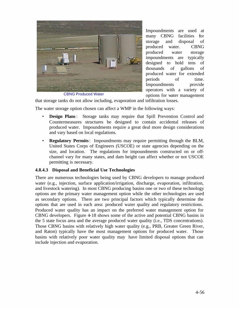
4-56
Impoundments are used at many CBNG facilities for storage and disposal of produced water. CBNG produced water storage impoundments are typically designed to hold tens of thousands of gallons of produced water for extended periods of time. Impoundments provide operators with a variety of options for water management
that storage tanks do not allow including, evaporation and infiltration losses.
The water storage option chosen can affect a WMP in the following ways:
• Design Plans : Storage tanks may require that Spill Prevention Control and Countermeasures structures be designed to contain accidental releases of produced water. Impoundments require a great deal more design considerations and vary based on local regulations.
• Regulatory Permits : Impoundments may require permitting through the BLM, United States Corps of Engineers (USCOE) or state agencies depending on the size, and location. The regulations for impoundments constructed on or off-channel vary for many states, and dam height can affect whether or not USCOE permitting is necessary.
4.8.4.3 Disposal and Beneficial Use Technologies
There are numerous technologies being used by CBNG developers to manage produced water (e.g., injection, surface application/irrigation, discharge, evaporation, infiltration, and livestock watering). In most CBNG producing basins one or two of these technology options are the primary water management option while the other technologies are used as secondary options. There are two principal factors which typically determine the options that are used in each area: produced water quality and regulatory restrictions. Produced water quality has an impact on the preferred water management option for CBNG developers. Figure 4-18 shows some of the active and potential CBNG basins in the 5 state focus area and the average produced water quality (i.e., TDS concentrations). Those CBNG basins with relatively high water quality (e.g., PRB, Greater Green River, and Raton) typically have the most management options for produced water. Those basins with relatively poor water quality may have limited disposal options that can include injection and evaporation.
CBNG Produced Water Storage Tanks

4-57
4.8.4.3.1 Injection The injection of CBNG produced water is typically separated into two categories based on the EPA Underground Injection Control (UIC) programs classification of injection wells. The first type of injection is Class II, which is the injection of oil and gas brine. Class II injection usually has two purposes: injection for the enhanced recovery of oil and
Figure 4-18: Produced water quality within the five state focus area.

4-58
gas or injection for the disposal of the brine. Class II injection for CBNG produced water disposal is common in basins with produced water quality greater than 10,000 mg/l TDS (e.g., San Juan, Uinta, and Piceance Basins). Within the CBNG industry, produced water injection is not typically performed for enhanced recovery, as injection into coal seam aquifers is counter productive to CBNG resource recovery. However, in basins with both CBNG development and conventional oil and gas wells, CBNG water can be supplied to the conventional oil and gas operators for enhanced recovery operations. Injection into coal seam aquifers is typically not performed until after CBNG production has ceased and aquifer restoration procedures have begun.
The second type of injection for CBNG produced water is into Class V wells and is another classification from the EPA UIC program. Class V injection relative to CBNG is the injection of produced water into drinking water quality aquifers to facilitate aquifer recharge or for aquifer storage and recovery. Class V injection is being used in some of the higher water quality producing CBNG basins (i.e., the PRB in Wyoming). This technical option is limited however, to those regions where suitable receiving formations exist and by the capacity these formations are capable of receiving. 4.8.4.3.2 Surface Application/Irrigation Another technical option for the management of produced water is surface application/irrigation. CBNG developments with high quality water can supply this water to suitable landowners for the irrigation of crop and grazing lands. Typically, coal seam produced waters have elevated sodium to calcium/magnesium ratios, usually presented as a SAR. A high SAR requires additional management of the water being used for land application, as high SAR to EC ratios can have detrimental effects to the soils being irrigated. If the CBNG produced water has a high SAR to EC ratio, calcium amendments can be added to the water or soil to reduce the damage to the soil structure. Land application can be performed with a variety of equipment that inc ludes big gun sprayers, center pivots, flood irrigation, and side roll irrigation.
4.8.4.3.3 Surface Water Discharge Surface water discharge is being utilized in CBNG basins for various water qualities. The conditions for which this option is being used vary based on local regulation and site specific issues. In some basins, such as the PRB, produced water is of relatively high quality but, may not be discharged because of the regulatory limits established in the TMDL program for the waterways of Montana. This even affects the surface discharge of produced water in Wyoming to stay within the Montana limits. In other basins, produced water quality is of poorer quality but, because the existing stream water quality is not high, discharge can be permitted without degradation of the existing stream water.
Surface water discharge is currently being performed under a variety of technical applications that include, direct discharge into the receiving stream, discharge into ephemeral drainages or discharge onto the land surface. Direct discharge to a receiving stream requires that CBNG produced water be piped to an outlet structure near the receiving surface water body. Direct discharge prevents the infiltration of produced water into the shallow groundwater aquifers of the drainage channels by ensuring that water is discharged directly into the receiving surface water body. Direct discharge requires monitoring of upstream and downstream conditions and suitable produced water quality to ensure regulatory compliance of NPDES permits.

4-59
Off-Channel Impoundment
Discharges to ephemeral drainages and land surface can result in infiltration losses to the discharge flow as the water moves down the drainage. The losses reduce the amount of water that reaches the receiving stream through percolation into the shallow groundwater and soil vadose zones along the drainage way.
4.8.4.3.4 Evaporation/Infiltration Impoundments Impoundments have long been a technology utilized by the oil and gas industry for the management and disposal of produced water. Based upon an EPA national impoundment survey, which characterized over 180,000 impoundments, the oil and gas industry is considered one of the largest users of this technology. A breakdown of applied impoundment uses by this industry includes, storage (29%), disposal (67%), and treatment (4%) (EPA, 1991). Disposal impoundments are designed by the oil and gas industry to dispose of produced water in two ways: infiltration and evaporation.
CBNG developers are using impoundments in many active western basins for evaporative disposal of produced water as the arid nature of the Western United States promotes the evaporative management of CBNG produced water. By allowing natural evaporative processes to reduce the volume of CBNG produced water, developers can concentrate the constituents found in the water. Thus creating smaller volume, more concentrated brines that can be disposed of with other methods such as injection.
The natural evaporation rates of much of the 5 state focus region are greater than 50” per year, with some regions exceeding 80” per year (Figure 4-19). Impoundments that are planned for evaporation can be designed to limit losses of produced water only to evaporation, through the use of liners, and by building the impoundments off-channel.
The other type of disposal impoundment uses infiltration of water into the shallow groundwater aquifers. Infiltration allows for CBNG produced water to be returned to the local groundwater system and result in a potential benefit to the arid regions of the Western United States. Infiltration is a natural process by which water moves down through the soils. During infiltration soil particle interaction is possible and through chemical reaction both the soil and the water can be changed. In some areas, infiltration reactions can result in improvements to the water quality as the water moves vertically downward through the soil.

4-60
Figure 4-19: Annual Lake Evaporation Rates for Five State Focus Area.
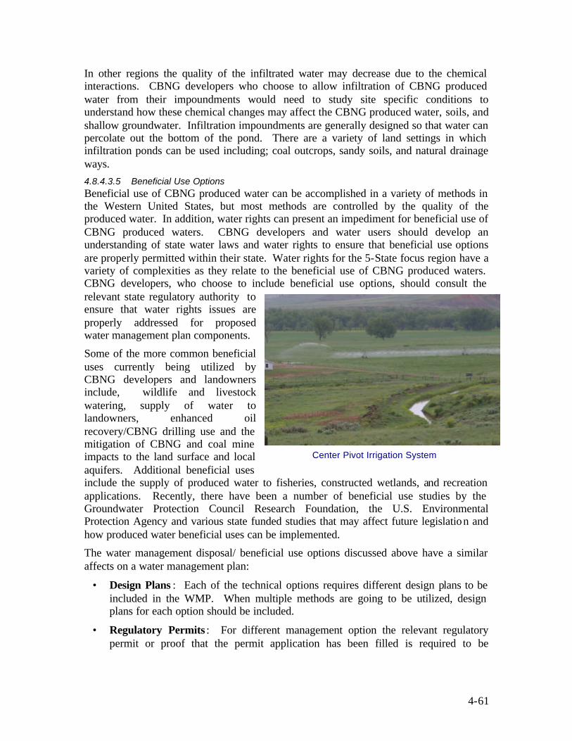
4-61
In other regions the quality of the infiltrated water may decrease due to the chemical interactions. CBNG developers who choose to allow infiltration of CBNG produced water from their impoundments would need to study site specific conditions to understand how these chemical changes may affect the CBNG produced water, soils, and shallow groundwater. Infiltration impoundments are generally designed so that water can percolate out the bottom of the pond. There are a variety of land settings in which infiltration ponds can be used including; coal outcrops, sandy soils, and natural drainage ways. 4.8.4.3.5 Beneficial Use Options Beneficial use of CBNG produced water can be accomplished in a variety of methods in the Western United States, but most methods are controlled by the quality of the produced water. In addition, water rights can present an impediment for beneficial use of CBNG produced waters. CBNG developers and water users should develop an understanding of state water laws and water rights to ensure that beneficial use options are properly permitted within their state. Water rights for the 5-State focus region have a variety of complexities as they relate to the beneficial use of CBNG produced waters. CBNG developers, who choose to include beneficial use options, should consult the relevant state regulatory authority to ensure that water rights issues are properly addressed for proposed water management plan components.
Some of the more common beneficial uses currently being utilized by CBNG developers and landowners include, wildlife and livestock watering, supply of water to landowners, enhanced oil recovery/CBNG drilling use and the mitigation of CBNG and coal mine impacts to the land surface and local aquifers. Additional beneficial uses include the supply of produced water to fisheries, constructed wetlands, and recreation applications. Recently, there have been a number of beneficial use studies by the Groundwater Protection Council Research Foundation, the U.S. Environmental Protection Agency and various state funded studies that may affect future legislation and how produced water beneficial uses can be implemented.
The water management disposal/ beneficial use options discussed above have a similar affects on a water management plan:
• Design Plans : Each of the technical options requires different design plans to be included in the WMP. When multiple methods are going to be utilized, design plans for each option should be included.
• Regulatory Permits : For different management option the relevant regulatory permit or proof that the permit application has been filled is required to be
Center Pivot Irrigation System
4-62
submitted whether it is a UIC, NPDES, or other state permit required for that option.
• Management Methods : A description of each management method proposed for the plan needs to be described as well as how each option may affect downstream users. Although each option can have different impacts, these discussions are necessary for each option.
4.8.4.3.6 Treatment Technologies As has been previously stated, the quality of CBNG produced water varies from basin to basin, within a particular basin, and potentially over the lifetime of a CBNG well. There are a variety of potential beneficial uses and disposal options for CBNG produced water that can be implemented by CBNG developers to manage produced water. However, the quality of the produced water is typically the limiting factor for what options are available. The potential exists for this water to be treated by a variety of technologies to improve the quality of this water and allow for increased beneficial use and alternative disposal methods. The following discussion presents some of the more common treatment options that are currently being utilized by operators.
• Freeze-Thaw/Evaporation: The Freeze-Thaw/Evaporation (FTE) process involves lowering the freeze point of water containing salts or other constituents below the freezing point of pure water (320F). Partial freezing of the solution results in the formation of higher quality ice crystals than the water from which it was derived and a concentration of the higher density dissolved solids and other constituents in the unfrozen liquid. The ice crystals can then be collected and thawed, providing a source of high quality water with more management options, or in appropriate regions, the crystals can be allowed to evaporate. This process can be repeated until the more concentrated effluent is of a manageable volume. The smaller volume of effluent, though more concentrated, can be more easily managed by one of the previously mention disposal options typically, deep injection.
• Reverse Osmosis: Reverse Osmosis (RO) is a proven treatment process for the removal of Total Dissolved Solids (TDS) and other constituents including metals such as arsenic. RO water treatment is used extensively to convert brackish water/seawater or brine to drinking water, reclaim wastewater, and recover dissolved salts from various industrial processes. The RO treatment process separates dissolved solids or other constituents from water by passing the water solution through a semi-permeable cellophane- like membrane. As some of the solution passes through the membrane, the remaining fluid is removed from the membrane without passing through it allowing for more fluid to pass through. This process is repeated and the remaining fluid becomes a more concentrated effluent, which can be more easily managed and disposed of.
• Ultraviolet Sterilization: Ultraviolet (UV) sterilization is a proven technology for the treatment of water containing unwanted free-floating organic constituents. UV energy absorbed by bacteria, viruses, fungi, algae, and protozoa disrupts nucleic acids found in their cells preventing the cell’s ability to multiply and thus destroys the organisms (Muskoka-Parry South Health Unit, 2002).

4-63
• Chlorination: Chlorination effectively removes disease-causing bacteria, viruses, protozoa, and other organisms, and can be used to oxidize iron, manganese and hydrogen sulfide so that these minerals can be filtered from the water. Other treatment technologies, such as UV light and RO, are often used in tandem with the chlorination process.
• Ion Exchange: Ion exchange is used to deionize water by replacing ions, such as conductive salts (desalination), with H+ and OH- when extremely pure water is required. The ion exchange process works by charging resins with the replacement ions (i.e., H+ or OH-). Ions in the water are attracted to a resin and attach themselves to the resin, replacing the ions that are already attached. Once the replacement ions are exhausted, the resin is regenerated with a concentrated solution of the replacement ions. This process removes the ions concentrated in the water and effectively regenerates the resin (Osmonics, 2002).
• Electrodialysis: Electrodialysis treatment of water is used to desalt brackish water to produce higher quality water (Damien (Solarweb), 1998). The basic principles of this treatment process are similar to ion exchange in that ions dissolve in water and posses either a positive charge (cation) or negative charge (anion) and are attracted to electrodes of an opposite electrical charge. Electrodialysis differs from a normal ion exchange process by utilizing both cation and anion selective membranes to segregate charged ions from a water solution (AWWA, 1996). These membranes are arranged alternatively (cation and anion) to selectively collect charged ions. The arrangement of two membranes creates spaces of concentrated and diluted solutions and collectively is referred to as a cell (Shuler and Kargi, 1992).
• Distillation: The distillation process is commonly used to remove nitrates, bacteria, sodium, hardness, dissolved solids, many organics, heavy metals, and in some cases, radioneucleides. Distillation involves boiling water into steam, which is then passed through a cooling chamber and subsequently, condensed into a purified form. The boiling process segregates water impurities from the purified product for collection and disposal. Constituents having similar boiling points of water are not effectively removed during the distillation process. Such impurities include many volatile organic contaminates, certain pesticides and volatile solvents (Derickson, Bergsrud, and Seelig, 1992).
• Wetland: Wetland treatment systems reproduce the natural filtering aspects observed in wetland settings by removal of organic matter (carbon, nitrogen, and phosphorus), suspended matter, and certain pathogenic elements. Traditionally, artificial wetland systems are constructed based on two natural water filter principles: vertical flow or horizontal flow. The vertical system is an aerobic process used primarily to remove Biological Oxygen Demand (BOD), phosphorus, and to oxidize nitrogen. The horizontal wetland system is a facultative aerobic or anaerobic process, depending on the time and frequency of inundation, where water flows from one side of the system to the other. This type of constructed system is typically used to remove BOD, to disinfect, to filter finely and remove specifically by precipitation, ionic exchange, and/or adsorption.

4-64
Water treatment technologies are generally limited to treating specific water constituent types, and depending on the eventual use of the water and desired constituent concentrations, treatment processes are often coupled together (i.e., RO and Chlorination). It is important to understand that the relative effectiveness for each treatment process varies depending on the produced water’s initial water quality and associated beneficial use.

4-65
4.9 MONITORING PLANS
4.9.1 Rationale Monitoring changes to the natural and human environment allows operators to address regulatory compliance concerns. CBNG development can result in the alteration of the existing environment. The changes can include changes to land use, surface water flow and quality, segregation of wildlife habitat, local air quality and coal seam aquifer drawdown. However, natural systems exhibit changes such as water flowing past a single point in a stream can change over the course of a day, vary by time of the year depending upon run-off volume and can vary due to climatic cycles as reflected in flood or drought years. Properly designed, monitoring plans can assist with the difficulties CBNG operators have in separating CBNG specific alterations from natural changes or other climatic cycles.
Landowners, regulators, and special interest groups are concerned about potential long-term CBNG related impacts and the degree to which these impacts are mitigated. Conversely, CBNG developers are concerned that non-CBNG related changes to the physical environment may be erroneously attributed to them, resulting in developer liability for any subsequent mitigation. Well-planned environmental monitoring can provide operators with the necessary information to track changes that occur during CBNG development, as well as allow regulators to determine the extent that operators could be held liable for these documented changes.
Monitoring plans can be developed by operators in cooperation with regulators to document changes to the existing environment by periodic sampling of resources such as, groundwater, surface water, air quality, gas drainage, gas seepage and vegetation. Monitoring plans are driving mechanisms for differentiating impacts due to CBNG development from the evolution of the natural environment or impacts brought about by other human activity.
4.9.2 Contents Monitoring plans may contain a variety of sample design plans that are required based on local regulations for different resources, as well as additional monitoring that is requested by landowners. Monitoring plans can include:
• Types of samples collected: Regulatory guidelines frequently dictate the type of samples to be collected. These may include, air samples (e.g., CO2, Particulates, etc.), groundwater elevations, surface water flow and quality, fish and wildlife visual or trap samples and gas drainage/seepage.
• Interval of monitoring: Sampling intervals may vary depending on permit requirements or regulatory design.
• Type of analysis to be performed: Type of analysis may vary for the different monitoring programs and be dependant on local conditions and concerns.
• Resulting documentation: Analytical results for regulatory or permit sampling programs may require reporting while others may only require onsite records.

4-66
Figure 4-20: Class I Areas in the Rocky Mountain region as designated by the Clean Air Act
4.9.3 Regulatory Requirements Regulatory agencies may require monitoring under site-specific conditions. For example, if a CBNG project is directly adjacent to Indian Tribal Land, the BLM may require that water level monitors be installed in wells in close proximity to the Tribal lease boundaries. In this way drainage of Indian lands is anticipated, and efforts can be made to prevent these impacts. Other monitoring activity may not be required by regulation but, may be considered a preventative measure by the CBNG operator.
4.9.4 Technical Options Monitoring in aid of CBNG development may involve air, surface water, ground water, and noise, as well as other site-specific media. These aspects of the environment can be successfully measured and recorded if there is a need for monitoring and if the data have value.
4.9.4.1 Air Monitoring
Specific locales within the focus area have been identified as being high quality air sheds. Figure 4- 20 shows the class one air sheds within the five state focus area, and the corresponding land management agency or group. These areas are extensively monitored when CBNG development occurs near or within their boundaries. Monitoring air for specific constituents may fall into two categories – ambient air and methane seeps.
• Ambient air can be impacted by stationary engines, leaky fittings at manifolds, and dust. CBNG projects may release air pollutants such as, NOx, CO2, H2S, particulates, and methane and heavier hydrocarbons. Normally, compressors are run by natural gas
4-67
engines, which reduce emissions over diesel engines. In addition while some CBNG contains small amounts of CO2 and H2S, the volume is less than is typically encountered with dry natural gas from other geological arenas.
Dust can be a problem around CBNG projects, emitted from vehicular traffic on dirt roads built through the project area and generated by drilling and other activities. Where truck traffic is heavy and where local soil is especially prone to wind-erosion, dust can be a problem to neighbors. Dust can be mitigated to some extent by application of chemicals, but besides mitigation, the operator may wish to document the extent of dust in the air by way of air monitoring and sampling.
Air monitoring can be planned to coincide with conditions conducive to air impacts such as, during periods of peak travel on lease roads or during periods of high wind-speeds or other factors. Monitoring devices may be triggered manually by an operator when conditions are appropriate or the device may be programmed to operate independently. The device may simply display the results of the latest analysis for recording by the operator or it may record several days’ worth of monitoring data.
Some remote monitoring devices are able to operate and transmit real-time environmental data for up to 25,000 hrs without service (Ecotech, 2003). Air samplers can be programmed to analyze dust or other constituents such as CO2 or hydrocarbons. In any case, the data may be recorded and stored for future use or for periodic reporting to relevant agencies.
• Methane seeps may occur within the project area or on adjacent lands and can be related to environmental factors (Riese, et al, 2003). Not all CBNG producing areas contain methane seeps and not all methane seeps are sourced from CBNG. None-the-less, methane seeps are commonly documented in areas of CBNG interest, especially where no natural cap-rock exists above the coal seams. Methane is quite common in the near-surface environment as a result from both deep gas reservoirs and biogenic activities. Monitoring around active seeps can be used to determine what factors of CBNG development may be affecting the seeps. In order to correlate methane seeps with their sources, actual samples of seep gas may need to be captured and analyzed for stable Carbon isotopes to “finger-print” the methane as being more nearly bacterial or more nearly thermogenic.
Air monitoring plans may include the location of ambient air samplers, the schedule for ambient air sampling, constituents to be analyzed and where and when to sample methane seeps on and near the project. The plan may also specify the frequency with which the monitoring results are to be reported to the relevant agencies.
4.9.4.2 Surface Water Monitoring
Surface water monitoring is especially important to the CBNG industry when surface discharge of produced water is being practiced. CBNG operators monitor surface water flow rate and quality as a way of demonstrating compliance with NPDES permits or as a way of demonstrating a lack of impact from infiltration impoundments within a specific watershed. Watersheds are defined geographically by reference to stream divides; a drop
4-68
of precipitation that lands near the watershed boundary is directed by the slope, running downhill to either of two adjacent watersheds. Surface water can be distributed in temporary, intermittent, or permanent streams. Operators, citizens, and regulators should be interested in the quality and quantity of water within streams.
Surface water flow can be more or less constant over time or can be highly variable with strong influences from snow-melt and rainfall run-off. Superimposed upon this seasonal variation are the extended climate cycles that are determined by multi-year fluctuations of solar radiation and atmospheric circulations. Such cycles may influence a region as large as a watershed or even as large as a continent.
Stream water is frequently a mixture of surface run-off and groundwater released into the stream; these two water volumes may be of very different quality. Since surface water flow rates often influence stream water quality, wet/drought cycles are also important for the interpretation of surface water quality.
Operators of CBNG projects in the Western United States may want to define multi-year drought cycles when interpreting surface water flow data and surface water quality information. Multi-year cycles may not be discernable on stream data derived during the life of the CBNG project but, can be retrieved from long-term monitoring data supplied by state environmental agencies or federal agencies such as, the United States Geological Survey (USGS).
Stream flow monitoring can be done manually, by automatic gauging, or by relying on existing gauges such as those maintained by the USGS. New gauging stations can be installed easily within close proximity to the specific surface stream. It is best to connect to the stream level by way of an open U-tube; this arrangement keeps the pressure monitor safe and out of the way of debris and ice that is occasionally swept downstream.
The water- level indicator can be connected to an automated data recorder that stores periodic water- level readings and with additional equipment the data can be transmitted to a remote location. It is possible for the operator to calibrate water-level in the stream with stream flow rate in terms of cubic feet per second. Water- level readings taken at shorter intervals are especially valuable to the CBNG producer who is managing produced water under an NPDES or similar flow-based discharge permit – discharges can be directly tied to flow-rate in the stream.
Surface water monitoring plans may include, the location of stream gauges, schedule for recording stream-level data, water sampling locations, analytes, analytical protocols and sampling frequency. Plans can also specify the schedule of reporting stream data to the relevant agencies.
4.9.4.3 Groundwater Monitoring
CBNG production has the ability to impact coal seam aquifers and adjacent aquifers that are not being developed. Groundwater monitoring is especially important to CBNG producers who have executed water well mitigation agreements that require replacement of impacted groundwater. Groundwater monitoring can be planned to give early warning of any impacts to nearby water wells or springs. This type of monitoring requires placement of bore-holes into the specific aquifers of interest. Bore-holes might be dedicated monitoring wells, shut- in CBNG wells, private water-wells, or other water

4-69
Multiple – Aquifer Monitoring Well
Figure 4-22: Monitoring Well Completed into Multiple Aquifers
wells. The bore-holes may be existing wells that are part of an existing monitoring network. Like CBNG producing wells, monitoring wells can be completed in a number of ways. A monitoring well may be completed in only one aquifer, as shown in Figure 4-21.
A monitoring well may also be completed into a number of aquifers with a sensor dedicated to each aquifer as shown in Figure 4-22 below:
Savings can be realized through the use of a multi-zone monitoring wells, rather than nested single-zone wells. A single bore-hole is drilled through the aquifers at a monitoring site. The bottom-hole assembly is made up of isolating packers (either permanent or temporary) and ports with dedicated transducers wired to the surface. This methodology reduces the number of monitoring wells while allowing continuous monitoring of aquifers above and below the target coals. A multi-zone monitoring well can save drilling and completion costs and can conserve environmental resources by avoiding the installation of additional roads and well-pads at
the surface. The multi-zone well may carry the same environmental footprint as a single-aquifer monitoring well and may enable the operator to avoid drilling several other monitoring wells at the same location. The use of removable packers can allow the operator to change the configuration of the monitored aquifers if, for example, one zone does not supply sufficient volumes of water.
Monitoring wells can be measured by hand during periodic visits for those which require only rare sampling. Or the wells can be measured and recorded automatically without
human intervention, except at infrequent intervals. Water wells that need to be frequently sampled include, wells within a number of wells only recently put on pump when water-levels change rapidly or, monitoring wells acting as sentinel wells between CBNG producing wells and a sensitive well- field or series of springs, perhaps on Tribal Lands.
Groundwater quality may also need to be monitored if impact from CBNG development is suspected. Water quality monitoring may be useful to producers who are operating aquifer recharge and storage facilities to manage produced water. In order to demonstrate process integrity, monitoring can document non-degradation of water resources. For
Single - Aquifer Monitoring Well
Overburden
Aquitard
Aquifer
Aquitard
Cables to sensor
Bore-hole through Aquifer
Well casing cemented into
bore-hole
Port
Figure 4-21: Monitoring Well Completed into a Single Aquifer

4-70
example, if CBNG water is planned for injection into non-productive coal aquifers, computerized reservoir modeling may project the resulting water quality in the aquifer as injection continues. Water quality monitoring can be designed to corroborate the modeled effects, as well as highlight key constituents for analyses. In most cases water quality can be measured for a small number of key constituents, as determined by agreement between the operator and the regulatory agency. Sampling may best be done by hand at the frequency agreed upon.
Groundwater Monitoring Plans can detail the location of monitoring points, the frequency of gauging water- levels, and the frequency and analytical protocols for groundwater samples. Plans may also specify the frequency with which monitoring data is to be submitted to the relevant regulatory agency.

4-71
4.10 WASTE MINIMIZATION PLANS Properly managing general refuse and various hazardous materials is a major concern for industry, regulators, landowners, and public citizen groups, since most waste streams continue to increase. The generation of waste streams is a two-fold problem as excessive financial burden on involved individuals or companies and/or impacts too many facets of the environment may result. Industry approaches to reduce generated waste are in the forefront of regulatory, public and technology discussions and forums and thus, necessitate vigilant consideration during the project planning phase.
Implementing waste minimization practices, (i.e., waste prevention or source reduction), as a management option include, reduction practices that diminish or eliminate the generation of waste at the source and/or implementation of proven recycling practices when source reduction methods are not environmentally or economically feasible (EPA, 2003). Source reduction typically includes practices to reduce the toxicity or quantity of pollutants entering a waste stream by modifying work practices, utilizing scientifically sound reduction technologies, purchasing replacement constituents or materials, and reformulation or redesign of products. Recycling a product or material, as defined in the EPA’s Waste Minimization Program, includes the reuse of a product in its original form and/or reclamation of waste materials or residuals for other appropriate use (EPA, 1993).
4.10.1 Rationale Generated waste that has resulted from CBNG development can be managed either onsite or at distant facilities when the project is located in rural areas. Therefore, to reduce disposal and management burden, it is clearly in the interests of CBNG operators to minimize project wastes.
Waste minimization can be accomplished by adhering to four general principals:
• Substituting with less toxic materials
• Re-cycling or re-using materials
• Treating wastes to remove toxics
• Disposing residue wastes
Minimization practices are the first step that allows operators to safely manage CBNG wastes. Landowners adjacent to CBNG production and citizens who are aware of regional and national CBNG plans, are concerned that wastes generated during the development of CBNG may be improperly managed over the long-term. As a consequence to mismanagement damage to local resources or long- lived hazards for future land uses may occur. CBNG developers can clearly address waste contents, plans for active waste minimization, and plans for handling, transporting and disposing the wastes. Developers can work with private landowners and regulators to ensure that public concerns are properly addressed and that compliance levels are clearly defined.
The EPA characterizes the improper management of hazardous waste as lost raw material, lost product, and lost profit (EPA, 1992). For these reasons, minimizing the volume of generated or released waste should be considered a vital component of any project plan, rather than an optional one. Effective application of minimizing practices
4-72
can present operators with sound business and environmental strategies that may aid in reducing operating costs, improve the safety conditions for the worker, and decrease long-term liability issues.
With proper implementation of such practices, costs savings in the CBNG industry is likely to be realized by reducing disposal costs, as well as potential improvements to operating efficiency resulting from the use of recycled materials or products. The reduction or elimination of toxic substance use can also improve the safety of the work environment by decreasing the risks of worker exposure to leaks, spills and releases (Ohio Environmental Protection Agency, 1993; EPA, 2003). This in turn can lead to lower worker compensation cases and subsequently, lower insurance costs. In addition, waste prevention may reduce regulatory exposure and, under certain circumstances, eliminate the need for permits, manifesting, monitoring and reporting, and overall, reduce compliance costs (Ohio Environmental Protection Agency, 1993). The environmental benefits gained from source reduction results as a consequence of increased resource efficiency to perform the same objective and the decreased volume of waste material disposed of in landfills.
4.10.2 Contents Waste minimization plans are inherently technical in nature. The plans should specifically discuss issues such as the following:
• What is the waste streams associated with CBNG development?
• Are the waste constituents toxic?
• How are these wastes to be managed?
• Can the wastes be recycled or re-used?
• How can wastes be treated or further minimized?
• After recycling, re-use, and minimization, how are the remaining wastes disposed?
The flow chart in Figure 4-23 shows how these questions can be incorporated into a decision tree and developed into a waste minimization plan. Waste minimization plans are the ideal forum available to the operator to educate the public about specific CBNG wastes, how wastes are handled, how they are recycled, and how the remainder is disposed of. CBNG operators can use waste minimization plans as a showcase for the quality of their particular development program.
4.10.3 Regulatory Requirements Under 40 CFR Section 261, specific hazardous wastes generated from the exploratory and production activities of the oil and gas industry are exempt from RCRA Subtitle C regulation by the EPA if the waste does not pose as a threat to human health or the environment. Specifically excluded are point source discharges subject to NPDES permits under the Clean Water Act (API, 1989). RCRA regulations do however; contain a “mixture rule” that defines an exempt waste as a hazardous waste if the exempt waste is mixed with a listed hazardous waste. For example, a produced water retaining pit is

4-73
Identify all waste streams
Will RCRA non-exempt waste be produced, stored or used on-site?
Identify exempt waste stream
Establish containment requirements (SPCC Planning)
Identify Recycling/Reuse Options
Identify Disposal Options
Develop Waste Minimization Plan for Federal/State approval
Identify less toxic alternatives
Design Waste minimization and Waste Management
Training
Figure 4-23: Waste Minimization Plan Flow Chart
NO
YES Identify non-exempt waste stream
Require vendors to retain un-used chemicals
Identify recycling alternatives
Maintain non-exempt waste records and
cost accounting
Design employee waste minimization and waste handling training?
Including record keeping, MSDS sheets and Emergency Plans.
Prepared by ALL Consulting
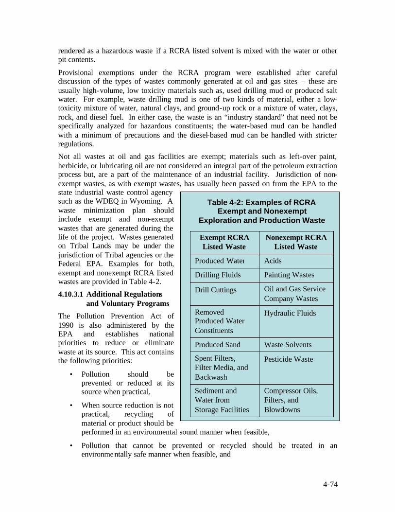
4-74
rendered as a hazardous waste if a RCRA listed solvent is mixed with the water or other pit contents.
Provisional exemptions under the RCRA program were established after careful discussion of the types of wastes commonly generated at oil and gas sites – these are usually high-volume, low toxicity materials such as, used drilling mud or produced salt water. For example, waste drilling mud is one of two kinds of material, either a low-toxicity mixture of water, natural clays, and ground-up rock or a mixture of water, clays, rock, and diesel fuel. In either case, the waste is an “industry standard” that need not be specifically analyzed for hazardous constituents; the water-based mud can be handled with a minimum of precautions and the diesel-based mud can be handled with stricter regulations.
Not all wastes at oil and gas facilities are exempt; materials such as left-over paint, herbicide, or lubricating oil are not considered an integral part of the petroleum extraction process but, are a part of the maintenance of an industrial facility. Jurisdiction of non-exempt wastes, as with exempt wastes, has usually been passed on from the EPA to the state industrial waste control agency such as the WDEQ in Wyoming. A waste minimization plan should include exempt and non-exempt wastes that are generated during the life of the project. Wastes generated on Tribal Lands may be under the jurisdiction of Tribal agencies or the Federal EPA. Examples for both, exempt and nonexempt RCRA listed wastes are provided in Table 4-2.
4.10.3.1 Additional Regulations and Voluntary Programs
The Pollution Prevention Act of 1990 is also administered by the EPA and establishes national priorities to reduce or eliminate waste at its source. This act contains the following priorities:
• Pollution should be prevented or reduced at its source when practical,
• When source reduction is not practical, recycling of material or product should be performed in an environmental sound manner when feasible,
• Pollution that cannot be prevented or recycled should be treated in an environmentally safe manner when feasible, and
Table 4-2: Examples of RCRA Exempt and Nonexempt
Exploration and Production Waste
Compressor Oils, Filters, and Blowdowns
Sediment and Water from Storage Facilities
Pesticide Waste Spent Filters, Filter Media, and Backwash
Waste Solvents Produced Sand
Hydraulic Fluids Removed Produced Water Constituents
Oil and Gas Service Company Wastes
Drill Cuttings Painting Wastes Drilling Fluids Acids Produced Water
Nonexempt RCRA Listed Waste
Exempt RCRA Listed Waste

4-75
• Disposal or other release into the environment should be employed as a last resort and in an environmentally safe manner when feasible.
The Bureau of Land Management has recently promulgated regulations (Section 1703 of the BLM Manual) specific to hazardous waste management. Under these regulations, BLM is required to “reduce hazardous waste produced by BLM activities and from authorized uses of public lands through waste minimization programs that include, recycling, reuse, substitution and other innovative, safe and cost effective methods of pollution prevention” (BLM, 1994). Section 1703 does not apply to activities taking place on non-Federal lands.
4.10.3.2 Planning Considerations
Opportunities to achieve waste volume reduction in CBNG exploration and production are limited as the generation of waste is relatively low, and waste volumes that are produced are primarily a function of activity level and the age of the well (API, 1989). However, a properly managed waste minimization program can potentially provide some economic and environmental relief. The minimization program can include, identifying waste streams and their intended use, as well as their future use (i.e., stored on-site, recycled, source reduction, etc.).
As stated earlier, source reduction for hazardous waste prevents waste at its source, and when properly managed, can be used as an effective tool during any step of the planning phase to reduce operating costs and protect environmental resources. The basic premise behind this concept is waste that is not created, does not require future management (EPA, 2003). Taking this concept one step further, less waste signifies decreased opportunity for resource impact. When considering available options to reduce waste, companies, along with regulators, can prioritize minimization practices based on the volume and toxicity level for any given waste and the related impacts observed by potentially impacted resources such as, soils, water, or vegetation. Required coordination with landowners can also ensure specific concerns are addressed, as well as to satisfy any lease stipulations.
Core elements of a waste minimization program vary to a certain degree for any CBNG development site and may require specific evaluation of existing conditions and potential impacts to local resources. Project parameters to consider may include financial constraints related to technology use and/or disposal costs, and federal and state regulations. A waste minimization program involves developing and implementing a long term strategy to address facility-specific generated wastes and procedures for prioritizing and systematically reducing these waste. The plan is a management tool that is used to clearly define waste reducing activities and monitor the progress of the program. Modifications to the program are likely as principle changes occur to a facilities objectives or output. As such, the program should be developed in a flexible manner to allow for future project amendments.
4.10.4 Technical Options Innovative technologies exist for substituting low-toxicity materials, for treating and de-toxifying wastes, for re-cycling or re-using wastes, and for disposing of wastes. New
4-76
technologies are available to minimize the following CBNG waste streams listed in order of relative volumes:
• Produced water
• Drilling wastes
• Stimulation and fracturing wastes
• Industrial wastes
• NORM wastes
This section discusses some of these options and how they can impact a waste minimization plan.
4.10.4.1 Minimizing Produced Water
Water co-produced with CBNG is the number one waste stream by volume; actual volumes produced per well generally vary by age of the well and coal seam. The section of this Handbook on Water Management Plans thoroughly describes technical options for treatment, re-use, and disposal of produced water as a waste.
Another waste stream associated with the management of produced water is the highly saline rejectate generated in the reverse osmosis (RO) process. This waste can be a high percentage of the produced water volume and can have high salinity content suitable only for deep injection. Water treatment residue may be determined to be a non-exempt industrial waste by the regulatory authority; in that case the residue may need to be injected into a Class I disposal well. Oil and gas operators and CBNG operators should avoid Class I injection if possible to hold down costs and limit liabilities. Historically if RO wastes have been determined to be non-exempt wastes, the operator has avoided RO treatment of produced water.
4.10.4.2 Minimizing Drilling Wastes
As described above, drilling media can be of several types, each has its own technical fixes:
• Air-drilling: This technique uses air or foam for drilling and bringing cuttings to the surface. Cuttings are typically clean when arriving at the surface. CBNG cuttings may be relatively inert and may be safely buried in an earthen pit. Cuttings from deeper wells may contain evaporate minerals that could sterilize surface soil and such wastes would require special handling.
• Water-based mud: This circulating medium consists of produced water mixed with drill-cuttings and additives to make a thick mud. Economics usually argue against re-using water-based mud but sometimes thermal driers can be used to fire the mud into a low-density aggregate used for road construction or concrete mix. Water-based mud is sometimes applied to the land surface as a soil amendment to allow excessively sandy soils to retain moisture (i.e., land spreading or road spreading.) Used mud can be disposed of in an onsite pit which may be lined or unlined, sent to an offsite pit, or pumped under pressure into the annular space behind the long-string casing of an oil and gas borehole.

4-77
• Oil-based mud: Oil based mud contain diesel oil in their composition. It is often economic to re-cycle the mud by removing the cuttings from the used mud, thereby reducing the waste volume. Used mud or cuttings can be disposed of in lined surface pits, by land-spreading, or by pumping into the annular space.
• Segregated Pits: Operators can use several small reserve pits to segregate different types of mud so that mixing does not occur and more toxic kinds of mud (e.g., high-chloride or oil-based) maintain lower volumes. Properly segregating waste is critical because of EPA’s “Mixture Rule”. An exempt waste stream contaminated by nonexempt waste could substantially increase disposal or recovery costs, as well as affect ground and surface waters, soils, vegetation, and owner land uses. Therefore, it is usually in the best interest of the operator and regulators to ensure wastes are defined and separated accordingly. This practice could include isolating paints, solvents, and other fluids from drilling mud retention impoundments, and filtering equipment. Storage locations and Material Safety Data Sheets for each material used on site would be identified and incorporated into the minimization program.
• Substitution: Non-hydrocarbon fluids can be substituted for the diesel in oil-based drilling mud. This is often prohibitively expensive except under special circumstances.
While these technical options are available to the CBNG operators, they may not all be applicable in each project. Shallow CBNG wells do not usually require toxic mud nor do they require large volumes of mud. Deeper CBNG wells, horizontal wells, and deep disposal wells may, however, require other forms of mud.
4.10.4.3 Minimizing Stimulation Wastes
CBNG wells are sometimes treated or stimulated to help them produce gas and water. During stimulation, fluids are pumped into the coal seam under pressure and when the pressure is released, the fluid is produced back to the surface. The process is intended to increase permeability in the vicinity of the bore-hole.
Often the fluid being used for stimulation is produced CBNG water that when brought to the surface, can be mingled with the main produced water stream. The stimulation process typically does not change the salinity or chemical constituents in the water.
In other cases, the stimulation fluid may contain acids, gels, and surfactants to aid in the stimulation and when this fluid is produced back to the surface, it should be handled in a reasonable manner. Oil and gas operators often produce the stimulation fluid into a frac-tank to contain solids and fluids, allowing produced gases to be flared during the process. This frequently means pumping into an oil and gas disposal well after filtering and treating.
If the treatment contractor delivers excess stimulation fluid to the well site, the leftover fluid is a waste since it usually cannot be stored for future use. Furthermore, it may not an exempt waste since it has not been used in treating an oil and gas well, therefore, the waste may need to be disposed into a Class I disposal well. Some operators and vendors control surplus stimulation or treatment fluid wastes by mixing the fluid “on the fly” in the injection stream rather than mixing a predicted volume of fluid in the truck tank.

4-78
Therefore the materials delivered to the site do not become a waste as they have not been mixed.
4.10.4.4 Minimizing Industrial Wastes
Wastes that commonly accumulate at CBNG well-sites but are not essential to the exploration and production of oil and gas may include the following:
• Paint waste
• Herbicide and pesticide wastes
• Lubricating oil waste
• Engine coolant waste
• Unused anti-scale, anti-corrosion chemicals
• Empty drums
• Part-cleaning solvent waste
• Waste filters
• Construction debris
CBNG operators can minimize these wastes in the same manner as other industries – the most effective manner is by centralizing operations such as, equipment maintenance and painting or recycling their use or returning them to the manufacture for reprocessing, disposal, or incineration. Under this plan, for example, the operator can use the same contractor or employee to change lubricating oil on the stationary engines in the entire area, not just those in one project. The mechanic may then have a sufficient volume to justify the use of an oil-cleaner to re-cycle the oil. Likewise empty drums may not be an issue if the drums remain the property of the chemical supplier who then re-furbishes and re-fills the drums.
Operators having occasional industrial wastes use can contract waste handlers to dispose of non-exempt materials. Waste minimization plans should describe these contractors and list the materials they are permitted to manage and dispose of.
4.10.4.5 Minimizing NORM Wastes
Naturally Occurring Radioactive Material (NORM) accumulates in oilfield tubulars, pumps, and lines as scale containing Uranium, Potassium, and other radioactive isotopes. Not all petroleum or CBNG reservoir waters contain radioactive elements but, some do. The consistent use of anti-scaling chemicals helps to control the formation of NORM scale to some extent. Once scale is found, for example in used tubing, the only management alternative is to dispose of the material as protectively as possible. NORM regulation can be the jurisdiction of the state’s oil and gas agency or the state’s environmental agency. NORM determinations are usually made at the time of well abandonment, not during the operational life of the well or pipeline. NORM contamination is usually determined in reference to local background radiation level, which varies with near-surface geology across the Western United States.
4-79
NORM contaminated equipment can be de-contaminated, removed by a waste contractor, or disposed of by the operator himself. Equipment can be de-scaled by power washing to remove the NORM; the water and associated scale is then contained and disposed of as appropriate while the equipment can be re-used as appropriate. As an alternative, equipment can be shipped as is to low-level radioactive waste disposal sites. Used tubulars such as casing and tubing can be cemented into oil and gas bore-holes that are being plugged and abandoned as part of the E&P process. Radioactive scale can also be cemented into P&A wells by sealing the scale into lengths of PVC tubing and placing them into the well. Not all states allow entombment technology but, instead require disposal into specially permitted waste facilities. If NORM wastes are expected in the CBNG project, management options can be spelled out in the waste management plan.
4-80
4.11 WATER WELL AND SPRING MITIGATION AGREEMENTS AND PLANS
4.11.1 Rationale Western soft coals, whether they produce CBNG or not, are permeable and capable aquifers that often contain potable water. Coal seams in many Western United States CBNG basins are important local and regional aquifers that supply drinking, livestock, and irrigation water to wells or springs. The drawdown of coal seam aquifers and changes in surficial aquifer water quality as a result of CBNG development, are an important public relations issue for CBNG developers. Landowners, farmers, ranchers, and regulators are concerned about the potential threat to their water supplies by CBNG development activities, especially initial water production engineered to depressurize coal seams. Water well mitigation agreements are intended to detail how a developer proposes to replace these water supplies, if CBNG development is the cause of the loss. Mitigation agreements are required of CBNG operators by several states. When used in conjunction with baseline studies and monitoring plans, mitigation agreements can be a valuable vehicle for managing groundwater pressures in a new CBNG project area.
4.11.2 Contents Water well and spring mitigation agreements detail how developers are to compensate landowners whose wells or springs lie within the predicted cone of influence for the proposed CBNG production wells and if they are affected. A viable mitigation plan includes adequate baseline information of water- levels for existing water wells and gauged flow of existing springs. Water levels in wells and flow from springs can be extremely variable due to seasonal effects and droughts. Some springs only flow when runoff rates are near their peak and shallow aquifer water levels can be variable by season. A mitigation agreement often contains enough information to distinguish seasonal changes from bona fide drawdown impacts. Replacement options are often written to allow maximum flexibility to site-specific conditions so that landowner needs are fully met and the CBNG producer can choose options that fit with his operations. A flow chart with a decision tree for the mitigation options that may be offered to a landowner is presented as Figure 4-24. Some options can include, drilling a replacement well, supplying drinking water quality CBNG produced water, or connection to a municipal or rural water supply.
4.11.3 Regulatory Requirements There are varying regulatory requirements across CBNG basins when dealing with water well and spring mitigation. The BLM office in WY requires that CBNG developers notify landowners who have permitted water wells or springs within the aquifer area of influence (AOI) to offer water well mitigation agreements to these landowners. The Montana portion of the PRB is designated as a controlled groundwater area under MBOGC Order No. 99-99, which requires CBNG developers to offer water mitigation agreements to existing water users within one mile of CBNG development. If CBNG operators are unable to reach an agreement with a landowner, the operators may be required to post a bond sufficient to meet the mitigation costs or to mitigate the affected well through the relevant state’s water law system.

4-81
Identify cone of influence (COI) for CBNG
Contact state and identify supply wells/springs with the COI
Develop monitoring protocol for wells/springs identified with the COI
Determine if regulations require expansion of
monitoring beyond COI
Continue monitoring protocol for wells/springs
Post required bond with state to cover mitigation
costs for wells
Discuss with well owner technic al options for the mitigation of water supply
Consult with water supply Company to construct pipeline
etc for land owner
Re-complete or drill new water supply well
Supply CBNG produced water to
well owner
Are wells /springs
influenced by CBNG
development?
Will affected well/ spring
owners agree to a mitigation agreement?
Is CBNG produced water
of sufficient quality to supply to well owners?
Will production schedule provide
sufficient water to meet supply
demands?
Can the produced water
be treated to sufficient quality to supply to well
owner?
Evaluate other alternatives bottled water, etc.
Are there other aquifers which
may be of sufficient quality and quantity?
Can municipal or rural water be supplied to well owner?
YES
NO
Figure 4-24: Water Well and Spring Mitigation Agreement Flow Chart
Treat water to sufficient quality to supply to well
owner and provide water
Prepared by ALL Consulting
YES
YES
YES
YES
NO
NO
NO
NO
NO
NO
YES
YES

4-82
The following presents the manners in which the AOI is determined in the states of Wyoming and Montana. In Wyoming the AOI for a CBNG project is first determined and then mitigation agreements are obtained from landowners within the AOI. If a well is determined to suffer loss of quantity and/or quality sufficient to support existing well uses as a result of CBNG production, the AOI is extended 1/8 of a mile around the impacted well. The AOI is extended in this fashion until there are no wells experiencing sufficient drawdown to affect the existing well uses. In Montana the initial AOI for CBNG wells is established under the regulations for Controlled Groundwater Area for the PRB. In Montana, the initial AOI is a one-mile radius from CBNG wells. If any wells within this one-mile radius are determined to be impacted by CBNG development, the AOI is extended by ½ mile until there is no evidence of a well being sufficiently impacted by CBNG development to affect existing well uses.
Both Wyoming and Montana require operators to provide and/or make available water of similar quantity, quality, and location for the existing uses that have been impaired including, domestic use, irrigation, and livestock watering. Neither state specifies the manner in which this water should be available. However, time frames are specified so that impairments should be mitigated within 60 days and last until the lease period has ended or the last CBNG well under the agreement is plugged and abandoned (BLM WY 2003).
4.11.4 Technical Options CBNG production generally requires the drawdown of coal seam aquifers to facilitate the production of natural gas. Once brought to the surface this produced water has to be properly handled and disposed of. Both the production and disposal of produced water have the potential to affect nearby water wells that supply water for rural homes, irrigation, and livestock watering. The mitigation of these impacts when they can be attributed to CBNG production is detailed in water well mitigation agreements. There are three general methods of mitigating these losses; supplying CBNG produced water, modifying the existing water well or installing new water well and/or providing the connection of the household to a municipal or rural water supply system. The following section discusses these technical options for the mitigation of water well impacts and how these options can affect water well mitigation agreements.
4.11.4.1 Directly Supplied CBNG Water
Coal seam aquifers that are being utilized for drinking, irrigation, or livestock watering wells have the greatest potential to be affected by CBNG development. CBNG developers may find these wells the easiest to mitigate. If the water produced in CBNG wells is being extracted from the same aquifers that were supporting these other uses, developers may choose to supply the produced water to landowners to replace their losses. CBNG developers have several considerations to account for when supplying CBNG water to landowners: Will some form of treatment be necessary? Will the quantity of water needed to mitigate the lost wells be available for the end of production? CBNG produced water may require simple treatment prior to being used for drinking that may include, a gas/water separation process (to ensure that natural gas is removed from the water and not entering the home) and chlorination to kill noxious organisms.

4-83
The mitigation of impacted water wells by supplying CBNG produced water may require additional information to be included in the water well mitigation agreement. CBNG developers and landowners may need to include the following in the agreement:
• Type of treatment processes that produced water is to undergo prior to the water being piped to the landowner. Including monitoring protocol for natural gas and water quality parameters.
• Alternative mitigation measures if the production of water ceases before the end of CBNG production.
4.11.4.2 Treating and Supplying CBNG Water
Impacts to water wells and springs by CBNG production implies direct, hydraulic connection between the water well or spring and the CBNG aquifer. The phenomenon usually involves water wells containing water with the same chemistry as the produced water. If the produced water quality is lower or different than the quality of the impacted well or spring, a lack of hydraulic connection is implied and the operator may look for other explanations for the impacts. If thorough research shows the impacted water wells or springs are indeed due to CBNG production, then the produced water may need to be treated through a process such as RO or de-ionization. Unlike pre-discharge treatment, water supply treatment can proceed on small volumes of water delivered directly to one or more residents whose wells or springs have been impacted.
4.11.4.3 Production Scheduling
An important aspect of supplying CBNG produced water to local users is the anticipated production schedule for the project. CBNG operators need to determine if a sufficient volume of water is going to be produced throughout the life of the entire project to adequately compensate the landowner. Water modeling before and during project life describes two aspects of the water well mitigation problem – is water production going to remain sufficient and are coal seam aquifers expected to remain in a de-pressurized state? Often CBNG water production rates fall precipitously after initial high rates. Unless new areas of the project are brought on- line, produced water volumes may be insufficient to service commitments to local ranches, homes, and businesses. Numerical models help to budget produced water that may be needed to mitigate impacted wells and springs.
4.11.4.4 Recompleting Existing Wells or Drilling New Wells
Another option CBNG developers may consider for the mitigation of water wells impacted by CBNG production is the recompletion of an existing well or drilling a new well to a new source aquifer. CBNG developers and landowners may agree it is more cost effective and beneficial for both parties to find an alternate aquifer to supply the water to mitigate the landowner’s loss. Alternate aquifers may be site specific and may exist as shallower surficial aquifers or zones deeper than the coal seams aquifers impacted by CBNG development. CBNG operators need to determine the quantity and quality of water needed by the landowner to determine if there is an adequate local source for replacement water.
The following additional information may be needed in a water well mitigation agreement if this option is chosen:

4-84
• Information on local aquifers that have been identified as possible sources for water supplies to be used to mitigate landowner’s losses relative to depth, water quality and seasonal productive capacity. Consideration should also be given to the fact that surface aquifers are especially prone to seasonal changes in water level and productivity.
• Pump size and power requirements should be considered when planning a replacement water system. A seasonal residence may require only a small pump, perhaps powered by solar power while a large ranch may require a large pump and 3-phase power that may not currently be available in the area.
4.11.4.5 Municipal or Rural Water Supply
The connection of a household impacted by CBNG development to a rural or municipal supply well may be the only technical option available in some situations. This option can be most viable when insufficient quality or quantity of CBNG produced water is available, when the landowner is unwilling to accept CBNG produced water, when no other viable aquifer sources are available to support replacement wells, or when the rural or municipal supply connection is readily available to the home.
The following additional information may be needed in a water well mitigation agreement if this option is chosen:
• Connecting a household to the water supply system may require additional information such as maintenance and connection fees to be included in the water well mitigation agreement.
• The CBNG operator may also be required to extend the time of the mitigation agreement or provide additional funds to support the cost of service beyond the lifetime of the CBNG project.
• By extending trunk lines in a rural water system, the operator may be eligible for federal or state cost-sharing. This provision may make this option attractive.

4-85
4.12 PLUGGING, ABANDONMENT, MITIGATION
4.12.1 Rationale CBNG wells may be plugged throughout the life of the project, as well as at the project’s completion. Federal land managers, local ranch owners and other residents are justifiably concerned about how their lands are left once CBNG production and operations are over. Will lease roads be left for the resident’s use? Will any CBNG ponds be left for the rancher’s use? Will water wells be made available? Will land now holding well-sites, compressors, and other CBNG facilities ever be able to support cash crops or pasture forage? These and similar questions may need to be answered for land managers and residents. A plugging and abandonment plan is the best vehicle for tying together parts of a drilling plan and land use plan into a recipe for returning land in the CBNG project to original use in a way that is acceptable for the land manager and owner.
4.12.2 Contents By closely coordinating a plugging plan with a drilling plan, CBNG operators can outline measures that isolate CBNG zones and protect Underground Sources of Drinking Water (USDWs). In some basins the coals are shallow and the bore-holes are cemented from top to bottom, making the plugging process simple (Figure 4-25). In other basins, however, coals are deep and long-string casing is cemented across shallow aquifers and over the target coals; in these cases supplementary cement may need to be emplaced during plugging. Plugging plans may include a projected plugging schedule, as well as local stratigraphic issues such as, wash-out zones and zones of lost circulation that can potentially pose problems during plugging.
Local ranchers or farmers may want to use bore-holes as water wells when the CBNG project is abandoned. This may entail water rights applications and regulatory permit hurdles for the new owner of the bore-hole. Liability
Cement
Figure 4-25: Example of Plugged CBNG Well.
Plugging Process
•Tubing and pump removed
•Hole filled with oilfield cement as required
•Casing cut off below plow depth
•Plate welded to casing as required
4-86
and control of the bore-hole(s) should be spelled out prior to turning the hole over to the land owner or lessee. Likewise, lease roads may be offered to the land owner for his use after abandonment. This may not require any additional permits but, maintenance agreements are needed to be worked out prior to transfer.
In addition the plugging plan can contain abandonment and mitigations objectives for the project; in particular the fate of lease roads, utilities, impoundments and other structures. Details of surface mitigation may also be listed and include actions to return the land to its original contours, as well as reseeding requirements.
4.12.3 Regulatory Requirements State and federal requirements exist for the proper plugging of oil and gas and CBNG wells as well as injection/disposal wells, if any have been installed on the project. Plugging regulations are designed to eliminate cross-flow between CBNG reservoirs and other oil, gas, or drinkable water zones. Approval of the plugging prognosis should be received from the relevant agency either through the BLM’s Notice of Intent to Abandon (NIA) or a similar agency form such as, the Colorado Oil and Gas Conservation Commission Form 6 – Well Abandonment Report. The NIA or similar notice lists the cement plugs to be placed in the well and the expected schedule. Agency staff then is able to review the oil, gas, and drinkable water zones in the specific well and concur with or revise the NIA.
Plugging and Abandonment Plans may address at a minimum the following issues:
• Abandonment Plan Approval: Operators need to give agencies enough time to review and approve plans prior to the plugging activity. In addition, agencies frequently require 24 hours notice prior to the actual plugging process so that an inspector can witness the plugs.
• Wellsite Reclamation: Operators should return stockpiled soil onto the site, return the approximate land contour, and relieve compaction on roadways at the wellsite.
• Pit Closure and Reclamation: Reserve and flow-back pits should be filled and mounded; local regulations frequently require this operation to be done within 12 months of the end of drilling. Produced water storage ponds may also be closed or retained for the use of the landowner.
• Surface Revegetation: Disturbed surface area should be re-vegetated with appropriate grasses and other seeds. Some BLM offices have adopted an approved seeding mix.
• Visual Resources Reclamation: Site-specific regulations by the BLM or other Federal Land Managers may exist to require operators to return land to original contour and groundcover.
• Pipeline and Flowline Reclamation: Whether or not pipe is retrieved or buried in place, surface disturbance should be reclaimed and re-seeded.
4-87
• Lease Road Reclamation: Roads can be reclaimed or turned over to the land owner in support of local business. Roads on Federal surface are to be abandoned according to guidelines and requirements.
• Water Well Conversion: A CBNG well that can be used as a water well may be turned over to the management agency or surface land owner. In this case, the new owner needs to apply for the necessary rights, permits, and registrations.
• Final Abandonment Approval: After a well plugging, the operator is to file a Federal Subsequent Report of Abandonment (SRA) and after surface reclamation the operator should file the Final Abandonment Notice (FAN) on BLM land. On other lands the operator may file a similar state form such as the Colorado Oil and Gas Conservation Commission Form 6 - Well Abandonment Report.
4.12.4 Technical Options Several innovative technologies have been developed to help the reclamation process; these technologies may impact the plugging plan in the ways outlined below.
4.12.4.1 Hydro-mulching and Hydro-sprigging
Seeds or sprigs can be applied to the surface along with growth amendments such as, fertilizer and organic mulch, and combined together with a “tackifier” to lightly hold the material to the surface. This methodology is especially useful when the surface is sloping. Organic mulch contained in the material retains moisture for a longer time than arid western soils, supporting stronger growth of the sprigs or better germination of the seeds. Hydro-mulching can impact the following sections of the Plugging Plan:
• Surface Revegetation: Hydro-mulching can allow revegetation of highly sloping soils at the same time making these soils more stable and less vulnerable to erosion. Less dirt-moving may be needed before reclamation is complete.
4.12.4.2 Halophyte Remediation
Certain plants (i.e., Halophytes) are able to tolerate high salinity soil and water. Research has found that thousands of species of plants have elevated tolerance for salinity (Aronson, 1989). While many species live in hot climates, some of these plants are native to and grow in climates that exist in Montana, Wyoming, and other arid western states as identified by Phelps and Bauder in 2003. The following, taken from this research, illustrates some of the most tolerant species and their functions.
Ion accumulators and ion extractors lower soil TDS by removing selected constituents. Salinity removal can be more effective if grass is harvested by machine or by livestock. Other plants (i.e., Sorghum and Bermuda grass) are very effective at increasing the vertical permeability of soils, especially clayey soils. These grasses allow meteoric water to percolate down through the soil layer carrying salts into the deep sub-soil below most crop roots. The combined effects of salt-tolerant plants can reduce the salinity of a surface soil. This may prove valuable, for example, near produced water hand ling facilities. In addition halophytes can be used to amend plugging and abandonment plans in the following ways:
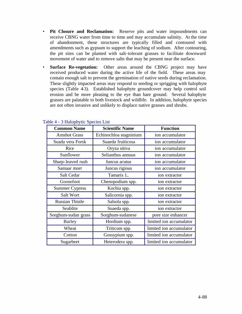
4-88
• Pit Closure and Reclamation: Reserve pits and water impoundments can receive CBNG water from time to time and may accumulate salinity. At the time of abandonment, these structures are typically filled and contoured with amendments such as gypsum to support the leaching of sodium. After contouring, the pit sites can be planted with salt-tolerant grasses to facilitate downward movement of water and to remove salts that may be present near the surface.
• Surface Re-vegetation: Other areas around the CBNG project may have received produced water during the active life of the field. These areas may contain enough salt to prevent the germination of native seeds during reclamation. These slightly impacted areas may respond to seeding or sprigging with halophyte species (Table 4-3). Established halophyte groundcover may help control soil erosion and be more pleasing to the eye than bare ground. Several halophyte grasses are palatable to both livestock and wildlife. In addition, halophyte species are not often invasive and unlikely to displace native grasses and shrubs.
Table 4 - 3 Halophytic Species List
Common Name Scientific Name Function Amshot Grass Echinochloa stagninium ion accumulator
Suada vera Forsk Suaeda fruiticosa ion accumulator Rice Oryza sitiva ion accumulator
Sunflower Selianthus annuus ion accumulator Sharp- leaved rush Juncus acutus ion accumulator
Samaar morr Juncus rigious ion accumulator Salt Cedar Tamarix L. ion extractor Goosefoot Chenopodium spp. ion extractor
Summer Cypress Kochia spp. ion extractor Salt Wort Salicornia spp. ion extractor
Russian Thistle Salsola spp. ion extractor Seablite Suaeda spp. ion extractor
Sorghum-sudan grass Sorghum-sudanese pore size enhancer Barley Hordium spp. limited ion accumalator Wheat Triticum spp. limited ion accumulator Cotton Gossypium spp. limited ion accumulator
Sugarbeet Heterodera spp. limited ion accumulator

4-89
4.13 COMBINING DOCUMENTS The regulatory requirements for the preparation of project planning documents vary greatly from region to region, and between the various lease types. The individual project planning components detailed earlier in this section, in part reflect the more stringent requirements of BLM managed mineral leases. Many of these components are separated into individual plans to help clarify the technical options that are available for CBNG developers per plan type. In some instances, the full POD detailed here is more inclusive then what is required for a particular mineral lease, especially on fee or state mineral estates.
In some instances, the individual planning components are integrated into one or two master plans. For some CBNG development areas, two master plans (e.g., drilling and surface use plans) are what is required; elements of the other CBNG development plans are incorporated into these master plans. A master drilling plan may incorporate elements found in other plans and include: drainage plan, communitization/unitization plan and plugging plans. A master surface use plan may include elements found in the following plans: produced water management plan, cultural resource inventories, wildlife inventories, mitigation plans, waste minimization plans, and surface use agreements.
Two examples of other project planning approaches include: geographic area development plans and standard operating practice agreements. A geographic area development plan is a comprehensive development plan for a proposed or defined oil and gas field, or a limited geographic area. A geographic area development plan may include; items which are addressed in a drilling plan and surface use plan. However, a geographic area development plan is more of a guide document for a development area based on an area of substantial development, in which other submissions are based upon.
A standard operating practice agreement is established between a regulatory agency (e.g., BLM) and one or more operators. The standard operating practice agreement details the procedures that are to be utilized in the drilling plan, surface use plan and during CBNG production. Based on the practices described within the document, APDs are submitted, which reference the activities described within the standard operating practice agreement. The agreement is generally a negotiated document in which the regulator and operator identify standard procedures and is approved through the Sundry Notice Process.
Standard operating practice agreements are typically standardize best practices that can be applied to numerous wells within an area containing similar producing zone, subsurface geology, surface resources, environmental issues, or other criteria that can be used to define a conditional boundary. These agreements are best suited for areas of existing development where infilling of wells is occurring instead of new development areas where substantial data is not available to support the identification of the boundary conditions.

5-1
5 Review of Planning Components and Environmental Documents
This Handbook is not only intended to help the CBNG operator prepare a Plan of Development (POD) for a new CBNG project but, also to help the regulator or government land manager evaluate the completeness and appropriateness of the POD. The land manager or regulator can make use of this Handbook to gauge the applicability of the various CBNG regulations to the proposed project. This Handbook discusses a number of issues that may be applicable in some cases but, perhaps are not applicable for every single CBNG project. Regulatory requirements vary from state to state, Resource Management Plan area to RMP area. In addition the vulnerability of the local environmental resources to changes that result from CBNG development also varies.
The reviewer of the POD should consider the site specific vulnerability of each resource during the evaluation of the POD. The disposition of cultural resources illustrates this concept; portions of Tribal Land embrace high concentrations of important cultural resources and intrusion onto those lands requires careful reconnaissance prior to earth-work. On the other hand, private lands often contain a very small concentration of cultural resource material and most states only require notification of authorities when actual or suspected human remains are found during excavation work. Depending upon the location, a range of stipulations may be in order for a POD related to cultural resources.
The United States appears to be in a time of decreased natural gas supplies just as citizens and industry having converted many facilities from burning fuel oil and coal to cleaner burning natural gas. The reviewer is under pressure from every side to quickly review PODs and at the same time, provide maximum protection for other natural resources; the following section describes certain elements of that review process.
5.1 REGULATORY REQUIREMENTS Depending upon the mineral ownership, local, state, Tribal, and federal regulations may be involved in a new CBNG development. The following presents some primary considerations regulators should use to evaluate PODs: Does the Plan fulfill regulatory requirements (i.e. are required elements in place)? Has the operator/applicant successfully employed exemptions or variances to achieve completeness and compliance? Because of the vast array of regulatory agencies involved in approving CBNG development, the timing of permit approval does not always coincide with the review of PODs. CBNG operators may submit PODs with various permits still in the review process. Reviewers of PODs may have to implement adaptive management practices to the review process in order to prevent the bottlenecking of PODs while waiting for approvals from other agencies. Conditional approval of PODs based on the acceptance or issuance of permits from other regulatory agencies is an adaptive management strategy that may become necessary to facilitate the development of the CBNG resource. Regulators who choose to implement this adaptive management strategy or a similar approach should to maintain contact with CBNG operators and other regulatory agencies to monitor permit approvals and determine if permit applications are being properly submitted.
5-2
5.1.1 Surface Owner Agreements In order to occupy the land in some lease situations, an operator maybe required to obtain the surface owner’s approval. It is not always possible for operators and landowners to reach an agreement. In lieu of an agreement, the operator needs an adjudicated surface damage agreement that includes sufficient bonding. Regulators have the opportunity to ensure that CBNG operators have negotiated or attempted to negotiate surface use agreements with landowners.
5.1.2 Appropriate Sign-Offs When reviewing project planning documents, regulators should consider not only the proposed work but, the qualifications of those who have designed the work to be performed. In some regulatory jurisdictions the signature and seal of a registered professional engineer or surveyor is required for earth work related design plans, maps and other facility drawings. By requiring the sign off, regulators are ensuring that registered professionals within their field of expertise are providing oversight of the proposed work.
5.1.3 Notice and Publication Some states and some actions require public notice and others require individually mailed notification, and others may require direct service of the parties. As appropriate, the applicant may need to demonstrate notification.
5.1.4 Best Management Practices or Similar In some regulatory jurisdictions operators are required to use BMPs or similar strategies for waste management, mitigation, or remediation. When reviewing these plans, regulators can consider: How were strategies chosen? Are these strategies appropriate for the site-specific conditions? It is important to understand that BMPs and similar practices are not always suited to the site specific conditions and operators may need to provide background information to illustrate how these practices apply to their local circumstances. A standard operating practice agreement can be used on Federal ownership to identify BMPs that can be utilized for a development area.
5.1.5 Consistencies Between Jurisdictions Agency evaluations can be made with regional or even national guidelines such as the BLM’s 8-point Drilling Program or 13-point Surface Use Program. While consistency is to be pursued between offices, local peculiarities in environmental resources or CBNG production conditions need to be kept in mind by the regulatory or management agencies. This is so that the maximum flexibility can be accorded to the operator for production efficiencies and economical water management options. Localized conditions can represent an opportunity for the CBNG operator to utilize innovative technologies to enhance project economics; regulations need to be flexible enough to consider these technologies.

5-3
Local NEPA Requirements Some RMPs have identified stipulations specific to their development areas and to CBNG development. RMPs in the 5 state focus area with CBNG-specific requirements and stipulations are listed in Table 2-1.

6-1
6 Resources for Developing Project Plans When developing project plans, a variety of information is incorporated into the documents to address the regulatory requirements and site specific issues. This data can be acquired from a variety of resources both internal and external to the development company. The following section addresses some of the sources for this data including Geographic Information Systems (GIS) data sources, BMP data sources, regulatory agency contact information and other internet data sources which may be useful in developing plans.
6.1 GIS DATA SOURCES Data for GIS is available in a wide range of proprietary and standard maps and graphic file formats, images, CAD files, spreadsheets, relational databases and many more sources. Many times data is free but, can be fee-based and come from commercial, nonprofit, educational, and state and federal government sources.
Fee-based data typically comes from commercial sources and varies greatly in pricing structures. Many commercial sources offer data that have been processed and enhanced (i.e., “value-added data”), along with raw data obtained from governmental sources.
Most governmental data is available free of charge, but may include a charge to offset costs associated with reproducing and distributing the data. Many states have formal GIS agencies that warehouse and maintain GIS data, while others have allocated the responsibility to existing State Library and/or Land Information Offices. Within the states that manage their data from a central location, many non-related agencies choose not to provide their data directly to the central repository and therefore, provide data independently. To date, there is no central repository that exists for federal governmental GIS data. Each layer should be obtained from the individual federal agency responsible for the production of that data.
This great variability in data sources can make it difficult for users to collect and analyze data. GIS data is unique in that the single best source for this type of data is the World-Wide-Web. Few agencies maintain data that is not available over the internet. If an agency can not provide a directly downloadable file, then many times the most recent index and contact information is available through that agencies website, allowing the user to contact the agency directly and order the data over the phone.
6.1.1 Data sources for map themes in APD/POD Development The following is a listing of typical data sources and agencies for different map themes required in the development of APD/PODs. Many of these layers are not available publicly and may have to be created by the operator preparing the APD/POD. Some of these layers have increased availability, meaning that as time progresses these themes are being created for most areas and are becoming more widely available. This list is not to be considered comprehensive and thus, only used as a general guide for the types of themes required.

6-2
Boundaries POD project boundary Not publicly available. Operator generated. Lease boundaries Increased availability. Some State Oil &
Gas Agencies maintain this data. BLM maintains limited BLM lease data.
Unit Boundaries (State) Available in hardcopy and/or electronically Pooled Units (State) Available in hardcopy and/or electronically Exploartory Unit Boundaries (BLM) Available in hardcopy and/or electronically Communitized Unit Boundaries (BLM) Available in hardcopy and/or electronically Participating Area (PA) Boundaries (BLM) Available in hardcopy and/or electronically Surface ownership Increased availability. State Land offices,
along with some local county courthouses. BLM maintains limited BLM surface ownership data.
Geographic Features Rivers USGS Togo Map Data Permanent Streams USGS Togo Map Data Intermittent Streams USGS Togo Map Data Lakes USGS Togo Map Data Wet Lands USGS Togo Map Data Springs USGS Togo Map Data Caves USGS Togo Map Data Dikes USGS Togo Map Data Dams USGS Togo Map Data Mines USGS Togo Map Data Roads Existing County Roads Wide availability from multiple sources.
State GIS agencies, State Libraries, USGS, and BLM typically maintain extensive county road data.
Two-track (existing) Not publicly available. Operator generated. Two-track (proposed) Not publicly available. Operator generated. Spot upgrade areas Not publicly available. Operator generated. All-season improved (existing) Limited availability. BLM maintains
limited existing all-season improved road data.
All-season improved (proposed) Not publicly available. Operator generated. Disturbance Corridor Not publicly available. Operator generated. Road Structures Culverts Not publicly available. Operator generated. Cattleguards Not publicly available. Operator generated. Gates Not publicly available. Operator generated. Low Water Crossings Not publicly available. Operator generated. Wells Proposed CBNG wells

6-3
Existing CBNG wells Wide availability from State Oil & Gas Agencies.
Existing oil and gas wells Wide availability from State Oil & Gas Agencies.
Existing water wells Wide availability from multiple sources. Most states require water well registration through an existing agency.
P&A wells Wide availability from State Oil & Gas Agencies.
Injection wells Wide availability from State Oil & Gas Agencies.
Monitor wells Increased availability. Many State DEQ offices, along with State water well registration agencies maintain this data.
CBNG Production Data State and/or Federal offices may have per well production data but may not have wells classified as CBNG wells
CBNG Water Production Data State and/or Federal offices may have per well production data but may not have wells classified as CBNG wells
Injection Well Data UIC data is available on a per well basis from state agencies or EPA offices
POD Facilities Gas gathering pipelines Not publicly available. Operator generated. Gas trunk lines Not publicly available. Operator generated. Water pipelines Not publicly available. Operator generated. Buried electric lines Not publicly available. Operator generated. Overhead power lines Not publicly available. Operator generated. Power Generators Not publicly available. Operator generated. Central gas gathering/metering buildings Not publicly available. Operator generated. Compressor Stations Not publicly available. Operator generated. Corridor Not publicly available. Operator generated. Water Management Structures Discharge points Not publicly available. Operator generated. Water pipelines Not publicly available. Operator generated. Head cuts, erosion features, erosion control and stabilization measures
Not publicly available. Operator generated.
Produced water containment structures (reservoirs, pits, stock/wildlife water tanks, etc.)
Not publicly available. Operator generated.
Land application disposal areas Not publicly available. Operator generated. Watershed boundary(s) Wide availability from multiple sources.
State GIS agencies, State Libraries, State DWQ offices and USGS typically maintain watershed boundaries.
POD boundary Not publicly available. Operator generated.

6-4
Low water crossings and culverts Not publicly available. Operator generated. Any other features necessary to evaluate the WMP (e.g. spring locations, monitoring/reference points, etc.)
Not publicly available. Operator generated.
6.2 BMP DATA SOURCES The following list of references provides Best Management Practices, Best Professional Judgments and Best Technical references for CBNG development. This list is not all inclusive as much research is still being performed on CBNG and documents such as these continue to be developed. BMPs for Public Land Management.
United States Department of the Interior Bureau of Land Management New Mexico State Office. November 3, 1998.
Erosion and Sediment Control Manual.
URS Corp. May 2002. Developed for the Gas Resource Institute. Des Plaines, Illinois.
Final Oil and Gas RMP/EIS Amendment for the Billings, Powder River and South Dakota Resource Areas.
U.S. Department of the Interior, Bureau of Land Management, Miles City District. 1992.
Final Environmental Impact Statement and Planning Amendment for the Powder River Basin Oil and Gas Project.
U.S. Department of the Interior, Bureau of Land Management, Buffalo Field Office. January 2003.
Handbook on Coal Bed Methane Produced Water: Management and Beneficial Use Alternatives
ALL Consulting, July 2003. Prepared for: Groundwater Protection Research Foundation; U.S. Department of Energy; National Petroleum Technical Office; Bureau of Land Management.
Handbook on Best Management Practices and Mitigation Strategies for Coal Bed Methane in the Montana Portion of the Powder River Basin.
Lead Researcher: ALL Consulting Tulsa, Oklahoma. April 2002 Co-Researcher: Montana Board of Oil & Gas Conservation Billings, Montana. Prepared for: U.S. Department of Energy National Petroleum Technology Office -National Energy Technology Laboratory Tulsa, Oklahoma.
Horizontal Directional Drilling Best Management Practices Manual.
ENSR Corp. May 2002. Developed for the Gas Resource Institute. Des Plaines, Illinois.

6-5
Oil and Gas Development: Best Management Practices in the Oil Patch. U.S. Department of the Interior, Bureau of Land Management, Online Resource, http://www.blm.gov/nhp/300/wo310/oil_patch/
Record of Decision and Resource Management Plan Amendments for the Powder River Basin Oil and Gas Project.
U.S. Department of the Interior, Bureau of Land Management, Buffalo Field Office. April 2003
Record of Decision: Statewide Coal Bed Methane Exploration and Development.
Montana Department of Natural Resources and Conservation Board of Oil & Gas Conservation. March 26, 2003
Surface Operating Standards for Oil and Gas Exploration and Development.
U.S. Department of the Interior Bureau of Land Management and the United States Department of Agriculture Forest Service. 1989. (AKA The Gold Book) 3rd Ed.
Standard Practices, Best Management Practices, and Guidelines for Surface Disturbing Activities.
Wyoming Bureau of Land Management. 2000.
6.3 REGULATORY AGENCY CONTACT LISTINGS The following is a list of regulatory agencies that play a role in overseeing some aspect of CBNG project planning. The list includes general contact information by state for these agencies but does not list specific representatives due to the potential for personnel changes to occur.
6.3.1 Colorado 6.3.1.1 Federal Agencies
Bureau of Land Management Colorado State Office 2850 Youngfield, Lakewood, CO 80215 (303) 239-3600 BLM Durango Public Lands Center 15 Burnett Court Durango, CO 81301 (970) 247-4874 TDD: (970) 385-1257 FAX:(970) 385-1243 Environmental Protection Agency Region VIII

6-6
999 18 Street, Suite 500 Denver, CO 80202-2466 Phone: 303-312-6312 (800) 227-8917 (Region 8 states only) National Park Service 12795 West Alameda Parkway Lakewood, CO 80228 Phone: 303-969-2000 U.S. Forest Service P.O. Box 25127 Lakewood, CO 80225 Phone: 303-275-5350 USGS Central Region Energy Resources Team Box 25046, MS 939 Denver Federal Center Denver, CO 80225 Phone: 303-236-5730 Fax: 303-236-0459 6.3.1.2 State Agencies
Colorado Department of Natural Resources 1313 Sherman St., Rm. 718 Denver, CO 80203 Phone: 303-866-3311 Fax: 303-866-2115 Colorado Division of Water Resources 1313 Sherman St., Rm. 818 Denver, CO 80203 Phone: 303-866-3581 Fax: 303-866-3589 Colorado Division of Wildlife 6060 Broadway Denver, Colorado, 80216 Phone: (303) 297-1192 Colorado Geological Survey 1313 Sherman St., Rm. 715 Denver, CO 80203 Phone: 303-866-2611 Fax: 303-866-2461 Colorado Oil and Gas Conservation Commission

6-7
1120 Lincoln Street, Suite 801 Denver, Colorado 80203 Phone: 303-894-2100 Fax: 303-894-2109
6.3.2 Montana 6.3.2.1 Federal Agencies
Army Corps of Engineers Billings Regulatory Office 1629 Avenue D Billings, MT 59102 Phone: 406-657-5910 Army Corps of Engineers Helena Regulatory Office 301 South Park, Drawer 10014 Helena, MT 59626-0014 Phone: 406-441-1371 Fax: 406-441-1380 Bureau of Land Management (BLM) Miles City Field Office 111 Garryowen Road Miles City, MT 59301 Phone: 406-233-3649 Fax: 406-233-2921 BLM, Billings Field Office P.O. Box 36800 5001 Southgate Drive Billings, MT 59101 Phone: 406-896-5245 Fax: 406-896-5281 Bureau of Indian Affairs (BIA) Rocky Mountain Regional Office 316 North 26th Street Billings, MT 59101 Phone: 406-247-7911 Fax: 406-247-7976 Environmental Protection Agency - Montana Operations Office Federal Building 10 West 15th Street, Suite 3200 Helena, MT 59626
6-8
Phone: 406-457-5000 Toll-Free: 866-457-5000 Also see Region VIII listing under Colorado Fish and Wildlife Service (FWS), Billings Suboffice Ecological Services 2900 4th Avenue N, #301 Billings, MT 59101 Phone: 406-247-7366 Fax: 406-247-7364 Forest Service Custer National Forest Beartooth Ranger District HC49, Box 3420 Red Lodge, MT 59068 Phone: 406-446-2103 Fax: 406-446-3918 Geological Survey (USGS) Helena Office 3162 Bozeman Avenue Helena, MT 59601 Phone: 406-457-5902 Fax: 406-457-5990 Also see USGS listing under Colorado 6.3.2.2 State Agencies
Montana Department of Environmental Quality (DEQ) P.O. Box 200901 Helena, MT 59620-0901 Phone: (406) 444-2544 Montana Board of Oil and Gas Conservation (BOGC) 2535 St. John's Avenue Billings, MT 59102 Phone: 406-656-0040 Fax: 406-657-1604 Montana Bureau of Mines and Geology (MBMG) 1300 North 27th Street Billings, MT 59101 Phone: 406-657-2938 Fax: 406-657-2633

6-9
Montana Department of Fish, Wildlife, and Parks (FWP) P.O. Box 200701 Helena, MT 59620-0701 Phone: 406-444-2535 Fax: 406-444-4952 Montana Dept. of Natural Resources and Conservation, (DNRC) P.O. Box 201601 Helena, MT 59620-1601 Phone: (406) 444-2074 Fax: (406) 444-2684 Montana Tech of the University of Montana Groundwater Information Center (GWIC) 1300 West Park Street 322 Main Hall Butte, MT 59701 Phone: 406-496-4153 Fax: 406-496-4343
6.3.3 New Mexico
6.3.3.1 Federal Agencies
Army Corps of Engineers Albuquerque District Public Affairs Office: 4101 Jefferson Plaza NE Albuquerque, NM 87109-3435 Phone:(505)342-3171 Bureau of Indian Affairs Albuquerque Area Office P.O. Box 26567 Albuquerque, NM 87125 P: 505/766-3754 F: 505/766-1964 Bureau of Land Management New Mexico State Office 1474 Rodeo Road Santa Fe, NM 87505 (505) 438-7400 (505) 438-7435 FAX Bureau of Land Management Farmington Field Office 1235 La Plata Highway, Suite A Farmington, NM 87401

6-10
(505) 599-8900 (505) 599-8998 FAX Bureau of Land Management Albuquerque Field Office 435 Montano Road, NE Albuquerque, NM 87107-4935 (505) 761-8700 (505) 761-8911 FAX Environmental Protection Agecy EPA Region 6 Main Office 1445 Ross Avenue Suite 1200 Dallas, Texas 75202 (214) 665-6444 USDA Forest Service 333 Broadway SE Albuquerque, NM 87102 (505) 842-3192 U.S. Geological Survey New Mexico District Office 5338 Montgomery NE Suite 400 Albuquerque, New Mexico 87109 (505) 830-7900 6.3.3.2 State Agencies
6.3.3.3 New Mexico Bureau of Geology & Mineral Resources 6.3.3.4 Main Office 801 Leroy Place New Mexico Tech Socorro NM 87801-4796 (505) 835-5420 information (505) 835-6333 fax New Mexico Department of Game & Fish P.O. Box 25112, Santa Fe, NM 87507 (800) 862-9310 New Mexico Energy, Minerals and Natural Resources Department 1220 S. St. Francis Drive Santa Fe, NM 87505 (505)476-3200
6-11
(505) 476-3220 fax New Mexico Environmental Department P.O. BOX 26110 1190 St. Francis Drive, N4050 Santa Fe, New Mexico USA 87502-0110 (800) 219-6157 New Mexico Office of the State Engineer 130 South Capitol Street NEA Building PO Box 25102 Santa Fe, NM 87504-5102 (505) 827-6175 (505) 827-6188
6.3.4 Utah
6.3.4.1 Federal Agencies
U.S. Army Engineer District, Sacramento 1325 J Street Sacramento, CA 95814-2922 (916) 557-7490 Fax: 916-557-7859 Bureau of Indian Affairs PO Box 10 Phoenix, AZ 85001 (602)-379-6600 Fax: 602-679-4413 Bureau of Land Management Utah State Office PO Box 45155 324 South State Street Salt Lake City, Utah 84145-0155 (801) 539-4001 Fax: (801) 539-4013 BLM – Price Field Office 125 South 600 West Price, Utah 84501 (435) 636-3600 BLM – Vernal Field Office 170 South 500 East,

6-12
Vernal, Utah 84078 (435) 781-4400 Environmental Protection Agency see Region VIII listing under Colorado U.S. Forest Service, Intermountain Region 324 25th Street Ogden, Utah 84401 (801)-625-5306 USGS Utah District 2329 Orton Circle West Valley City, Utah 84119-2047 (801) 908-5000 Fax: (801) 908-5001 6.3.4.2 State Agencies
Utah Division of Oil, Gas and Mining 1594 West North Temple Salt Lake City, Utah (801) 538-5257 (801) 359-3940 Utah Department of Environmental Quality 150 North 1950 West Salt Lake City, UT 84116 (801) 536-4400 (801) 536-0061 Fax Utah Geological Survey 1594 W. North Temple, PO 146100 Salt Lake City, UT 84114-6100 (801) 537-3300 Fax (801)537-3400 Utah Division of Water Resources 1594 West North Temple Ste. 310 PO Box 146201 SLC, Utah 84114-6201 Phone: 801-538-7230 Utah Division of Wildlife Resources 1594 W. North Temple Salt Lake City, Utah 84114

6-13
(801) 538-4700 Fax: (801) 538-4745 6.3.5 Wyoming
6.3.5.1 Federal Agencies
Army Corps of Engineers WY Regulatory Office 2232 Dell Range Blvd Suite 210 Cheyenne, WY 82009 Phone: 307-772-2300 Fax: 307-772-2920 Bureau of Land Management Wyoming 5353 Yellowstone Road Cheyenne, Wyoming 82009 Phone: 307.775.6256 Fax: 307.775.6129 Bureau of Land Management Buffalo Field Office 1425 Fort Street Buffalo, WY 82834 Phone: 307-684-1100 Fax: 307-684-1122 Environmental Protection Agency See listing for Region VIII under Colorado Fish and Wildlife Service 170 North First St. Lander, WY 82520 USGS Regional See USGS listing under Colorado 6.3.5.2 State Agencies Wyoming Department of Environmental Quality Herschler Building 122 West 25th Street Cheyenne, WY 82002 Phone: 307-777-7781 Fax: 307-777-5973 Wyoming Game and Fish Department 5400 Bishop Boulevard Cheyenne, WY 82006 Phone: 307-777-4600
6-14
Wyoming Geological Survey Wyoming Office P.O. Box 3008 Laramie, WY 82071 Phone: 307 766-2286 Fax: 307 766-2605 Wyoming Oil and Gas Conservation Commission P.O. Box 2640 Casper, WY 82602-2640 Phone: 307-234-7147 Fax: 307-234-5306 Wyoming State Engineer's Office Herschler Building Fish and Wildlife Service 170 North First St. Lander, WY 825204th Floor East Cheyenne, WY 82002 Phone: 307-777-6150 Fax: 307-777-5451
6.3.6 National Offices Environmental Protection Agency (EPA) Coalbed Methane Outreach Program 6202J Ariel Rios Building 1200 Pennsylvania Ave NW Washington, DC 20460 Phone: 202-564-9468 Fax: 202-565-2077 U.S. Geological Survey Energy Resources Program 12201 Sunrise Valley Drive 915-A National Center Reston, VA 20192 Telefax: (703) 648-5464

7-1
7 References American Petroleum Industry.
1989. API Environmental Guidance Document: Onshore Soild Waste Management in Exploration and Production Operations. First Edition, Jan. 15, 1989.
Aronson, James A.
1989. HALOPH, a Database of Salt Tolerant Plants of the World. Office of Arid Land Studies, Univ. of Arizona, Tucson.
Bryan, A.L., Jr., T.M. Murphy, K.L. Bildstein, I.L. Brosbin, Jr., and J.J. Mayer.
1996. Use of Reservoirs and Other Artificial Impoundments by Bald Eagles in South Carolina. In Raptors in Human Landscapes, edited by D.M. Bird, D.E. Varland, and J.J. Negro. London Academic Press. P. 287-298.
Bureau of Land Management.
1992. Final Oil and Gas RMP/EIS Amendment for the Billings, Powder River and South Dakota Resource Areas. U.S. Department of the Interior, Bureau of Land Management, Miles City District.
Bureau of Land Management.
2000. Coos Bay District Record of Decision and Resource Management Plan. U.S. Department of the Interior.
Bureau of Land Management.
2000. Interim Drainage Report on Coalbed Methane Development in T. 43-52 N., R. 70-75 W., Campbell County, Wyoming. Feb 29, 2000.
Bureau of Land Management, 2001. Final Rule: Oil and Gas Leasing: Onshore Oil and Gas Operations, Update to 43 CFR parts 3100, 3106, 3108, 3130, and 3160.
Environmental Protection Agency.
2002. Flexibility and Enforceability of Mitigation Measures Proposed in an Environmental Impact Assessment Report. Environmental Impact Assessment Ordinance, Cap.499 Guidance Note. EIAO Guidance Note No. 3/2002.
Field, Libby, Y., and Benard A Engel.
2003. Best Management Practices for Soil Erosion. Agricultural Engineering. Purdue University. HTML Translation by David Koller. http://abe.www.ecn.purdue.edu/~agen521/epadir/erosion/main_menu.html
Harney, A.L. Undated. US Department of Commerce. Reviving the Urban Waterfront.

7-2
Iowa Department of Natural Resources. Undated. Forestry Best Management Practices. Appendix C: Woodland Roads. Bureau of Forestry. http://www.state.ia.us/forestry/bmps12.htm.
Jaakko Pöyry Consulting, Inc.,
1993. Recreation and Aesthetic Resources. A Technical Paper for a Generic Environmental Impact Statement on Timber Harvesting and Forest Management in Minnesota. Prepared for, the Minnesota Environmental Quality Board.
National Park Service.
2002. Resources Building Environmental Assessment. U.S. Department of the Interior. Olympic National Park-Washington.
Moffatt, Terry and Doug Craig.
2002. Innovative Real-Time Well Monitoring Systems (ESP Applications), SPE Paper 65987.
Phelps, C.; 2002. "Down-hole Gas/Water Separation with Re-injection in Coal-Bed Methane Plays," SRI Conference on CBNG Water Management Strategies, Durango, CO., February.
Phelps, S.D. and James Bauder 2003. The Role of Plants in the Bioremediation of Coal Bed Methane Product Water, Montana State Dept. of Land Resources and Environmental Sciences. MSU Extension Service website: http://waterquality.montana.edu/