
Herpetofauna of gunung panti forest reserve, johor, peninsular malaysia
Upload
independentCategory
view
2download
0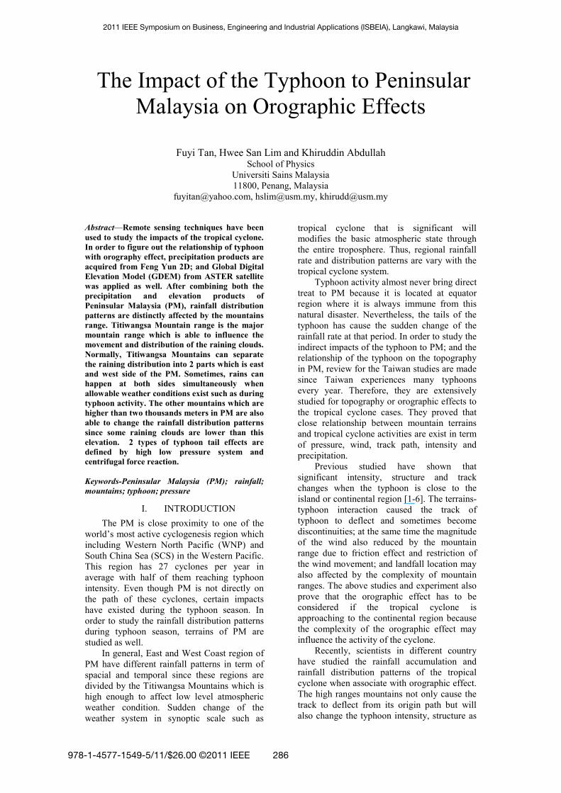
The Impact of the Typhoon to Peninsular
Malaysia on Orographic Effects
Fuyi Tan, Hwee San Lim and Khiruddin Abdullah School of Physics
Universiti Sains Malaysia
11800, Penang, Malaysia
[email protected], [email protected], [email protected]
Abstract—Remote sensing techniques have been
used to study the impacts of the tropical cyclone.
In order to figure out the relationship of typhoon
with orography effect, precipitation products are
acquired from Feng Yun 2D; and Global Digital
Elevation Model (GDEM) from ASTER satellite
was applied as well. After combining both the
precipitation and elevation products of
Peninsular Malaysia (PM), rainfall distribution
patterns are distinctly affected by the mountains
range. Titiwangsa Mountain range is the major
mountain range which is able to influence the
movement and distribution of the raining clouds.
Normally, Titiwangsa Mountains can separate
the raining distribution into 2 parts which is east
and west side of the PM. Sometimes, rains can
happen at both sides simultaneously when
allowable weather conditions exist such as during
typhoon activity. The other mountains which are
higher than two thousands meters in PM are also
able to change the rainfall distribution patterns
since some raining clouds are lower than this
elevation. 2 types of typhoon tail effects are
defined by high low pressure system and
centrifugal force reaction.
Keywords-Peninsular Malaysia (PM); rainfall;
mountains; typhoon; pressure
I. INTRODUCTION
The PM is close proximity to one of the
world’s most active cyclogenesis region which
including Western North Pacific (WNP) and
South China Sea (SCS) in the Western Pacific.
This region has 27 cyclones per year in
average with half of them reaching typhoon
intensity. Even though PM is not directly on
the path of these cyclones, certain impacts
have existed during the typhoon season. In
order to study the rainfall distribution patterns
during typhoon season, terrains of PM are
studied as well.
In general, East and West Coast region of
PM have different rainfall patterns in term of
spacial and temporal since these regions are
divided by the Titiwangsa Mountains which is
high enough to affect low level atmospheric
weather condition. Sudden change of the
weather system in synoptic scale such as
tropical cyclone that is significant will
modifies the basic atmospheric state through
the entire troposphere. Thus, regional rainfall
rate and distribution patterns are vary with the
tropical cyclone system.
Typhoon activity almost never bring direct
treat to PM because it is located at equator
region where it is always immune from this
natural disaster. Nevertheless, the tails of the
typhoon has cause the sudden change of the
rainfall rate at that period. In order to study the
indirect impacts of the typhoon to PM; and the
relationship of the typhoon on the topography
in PM, review for the Taiwan studies are made
since Taiwan experiences many typhoons
every year. Therefore, they are extensively
studied for topography or orographic effects to
the tropical cyclone cases. They proved that
close relationship between mountain terrains
and tropical cyclone activities are exist in term
of pressure, wind, track path, intensity and
precipitation.
Previous studied have shown that
significant intensity, structure and track
changes when the typhoon is close to the
island or continental region [1-6]. The terrains-
typhoon interaction caused the track of
typhoon to deflect and sometimes become
discontinuities; at the same time the magnitude
of the wind also reduced by the mountain
range due to friction effect and restriction of
the wind movement; and landfall location may
also affected by the complexity of mountain
ranges. The above studies and experiment also
prove that the orographic effect has to be
considered if the tropical cyclone is
approaching to the continental region because
the complexity of the orographic effect may
influence the activity of the cyclone.
Recently, scientists in different country
have studied the rainfall accumulation and
rainfall distribution patterns of the tropical
cyclone when associate with orographic effect.
The high ranges mountains not only cause the
track to deflect from its origin path but will
also change the typhoon intensity, structure as
2011 IEEE Symposium on Business, Engineering and Industrial Applications (ISBEIA), Langkawi, Malaysia
978-1-4577-1549-5/11/$26.00 ©2011 IEEE 286
well as the rainfall patterns[7]. Even though
Colón-Pagán (2009) has studied the orographic
effects on rainfall induced by the passage of
tropical cyclones over mountainous islands
(focus on the landfall case but not the tail
effect of the typhoon), he found that the
rainfall is maximum in the higher mountain
regions [8].
Besides that, the mountains play an
important role in bringing heavy rainfall by
blocking and convecting warm moist air to the
top of the mountains [9]. In worst case, the
orographic effect will cause flood over the
region in the low plain area due to longer
period of rainfall. Cheung (2008) also suggest
that the orographic effect is one of the
important factor to vary the amount of rain rate
and distribution of rainfall patterns [10]. The
rainfall distribution patterns of the approaching
tropical cyclone will be modified by the
mountains range to a certain degree. The above
studied were related to the case of landfalling
of the tropical cyclone or very near to the
continental region. However, in this study we
were investigating the tail effect of the
typhoon when associated with the mountains
range.
Even though typhoon never makes
landfall into PM, the tails of the typhoon may
also bring certain impacts (heavy rain, strong
wind or even cause to flooding) to PM.
However, the track of typhoon Ketsana in
2009 was not direct influenced by the
orography of PM because of the great distance
between them, so the track and pressure of the
typhoon will not discuss in this study but only
focused on the tail effect of the typhoon in
term of precipitation. Thus, we are using the
FY-2D satellite data and the ASTER satellite
data to determine the relationship of the
orographic effect with the impact tail effect of
the typhoon in PM in term of elevation and
rainfall distribution pattern respectively.
II. STUDY AREA
PM is divided into East and West Coast
region by a mountain range. This mountain
range is called Banjaran Titiwangsa or
Banjaran Besar by locals since this is the main
mountain range that forms the backbone of the
Peninsula Malaysia. The length of this
mountain range is about 480km starts from
Phuket mountain range in Southern Thailand
and ends in the south near Jelebu, Negeri
Sembilan, Malaysia. The highest peak in
Titiwangsa Mountains is Gunung Korbu
2183m (7162ft), the second highest in
Titiwangsa Mountain is Mount Yong Belar
(2181m) and followed by Mount Gayang
(2173m). However the highest peak in
Peninsular Malaysia is Mount Tahan (2187m)
which located at Tahan Range which have
shown in Table 1. The fifth highest in PM is
located at Kelantan (2171m). In addition, 10th
highest mountain in PM is Mount Benum
which is one of the study locations.
Digital Elevation Model of Southeast Asia
with latitude and longitude are edited whereas
PM with latitude 0-8°N and longitude 99-
105°E are focused in this study (refer to Fig.
1). From this figure, topography of the PM is
seen clearly in different height with different
colours.
TABLE I. ELEVATION AND POSITION OF THE MOUNTAINS IN PENINSUALR MALAYSIA
Mountain State Elevation
(m)
Latitude
(N)
Longitude
(E)
Mount
Tahan
Pahang 2187 4°38΄ 102°14΄
Mount Korbu
Perak 2183 4°41΄ 101°18΄
Mount
Yong
Belar
Perak 2181 4°44΄ 101°20΄
Mount Gayang
Perak 2173 4°46΄ 101°22΄
Mount
Chamah
Penang-
Kelantan
2171 5°8΄ 101°20΄
Mount
Benum
Pahang 2107 3°50΄ 102°06΄
Figure 1. The Digital Elevation Model of Southeast Asia with latitude and longitude are edited whereas Peninsular
Malaysia with latitude 0-8°N and longitude 99-105°E are
focused in this study. Triangle areas are the mountains listed at Table 1.
III. METHODOLOGY
The main study is to figure out the
relationship of the typhoon impacts with the
287
orographic effects in PM. Mountains
information can be obtained from website
http://www.peakware.com/peaks.html?choice=
AsE. Moreover, according to the Advanced
Spaceborne Thermal Emission and Reflection
Radiometer (ASTER) data
http://asterweb.jpl.nasa.gov/gdem-wist.asp,
global digital elevation model v001 (ASTER
GDEM) have been downloaded and edited by
PCI Geomatics software to produce an
elevation map.
Typhoon Ketsana is one of the most
popular typhoons in year 2009. Thus, satellite
data at this typhoon periods for cloud and
precipitation variation is obtained from
http://satellite.cma.gov.cn/arssen. These
satellite images are analyzed and correlation is
made for rainfall with the mountains region in
PM.
IV. RESULTS AND DISCUSSION
Atmospheric’s circulation change during
tropical cyclone activity. Tropical cyclone
activity varies the weather in PM if the tropical
cyclone track is near the PM region. Basically
the typhoon tail will bring more rainfall and
stronger wind when the typhoon is more
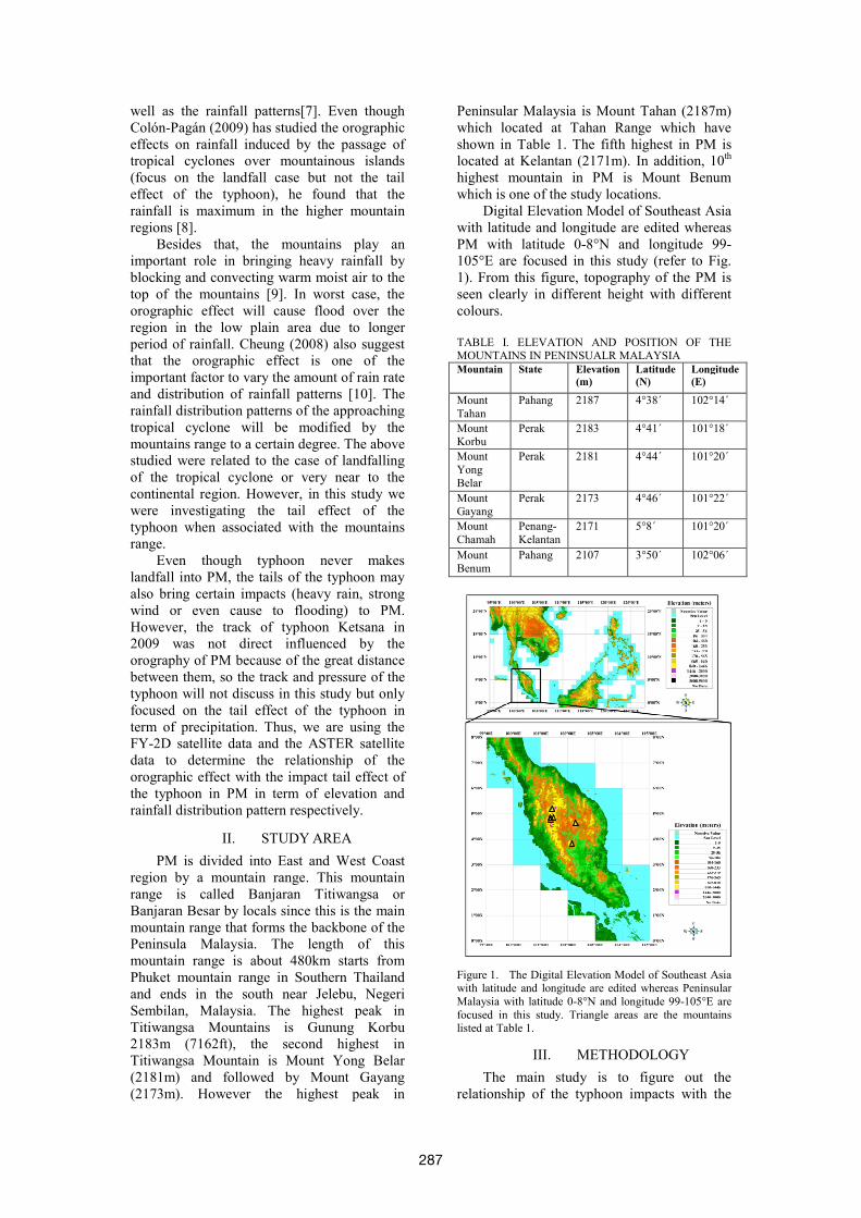
intense and closer to PM. Elsner (2003) stated
that the straight-moving typhoon is significant
threat to Southeast Asia [11]. Thus, typhoon
Ketsana case is chosen in this study because
this typhoon is in reasonable distance and
intensity with stable track (refer to Fig. 2). Fig.
2 shown the typhoon Ketsana almost has
straight line movement. This typhoon activity
provides much information for low level
atmospheric circulation such as changes of
cloud structure, wind variation and
precipitation distribution patterns. This is
because typhoon activity has a strong influence
on the entire tropospheric circulation and
weather of the surrounding regions. Therefore,
one of the impacts of the typhoon Ketsana in
PM region was being studied by using
geostationary satellite and the results is in Fig.
3.
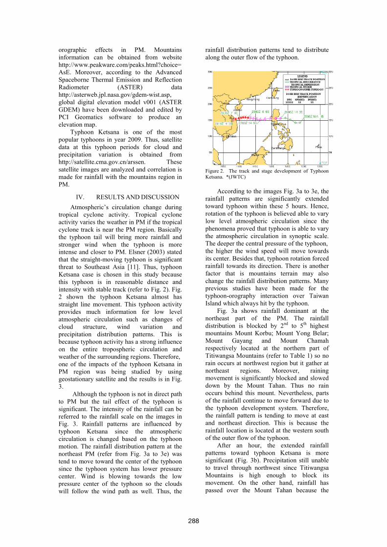
Although the typhoon is not in direct path
to PM but the tail effect of the typhoon is
significant. The intensity of the rainfall can be
referred to the rainfall scale on the images in
Fig. 3. Rainfall patterns are influenced by
typhoon Ketsana since the atmospheric
circulation is changed based on the typhoon
motion. The rainfall distribution pattern at the
northeast PM (refer from Fig. 3a to 3e) was
tend to move toward the center of the typhoon
since the typhoon system has lower pressure
center. Wind is blowing towards the low
pressure center of the typhoon so the clouds
will follow the wind path as well. Thus, the
rainfall distribution patterns tend to distribute
along the outer flow of the typhoon.
Figure 2. The track and stage development of Typhoon Ketsana. *(JWTC)
According to the images Fig. 3a to 3e, the
rainfall patterns are significantly extended
toward typhoon within these 5 hours. Hence,
rotation of the typhoon is believed able to vary
low level atmospheric circulation since the
phenomena proved that typhoon is able to vary
the atmospheric circulation in synoptic scale.
The deeper the central pressure of the typhoon,
the higher the wind speed will move towards
its center. Besides that, typhoon rotation forced
rainfall towards its direction. There is another
factor that is mountains terrain may also
change the rainfall distribution patterns. Many
previous studies have been made for the
typhoon-orography interaction over Taiwan
Island which always hit by the typhoon.
Fig. 3a shows rainfall dominant at the
northeast part of the PM. The rainfall
distribution is blocked by 2nd
to 5th
highest
mountains Mount Korbu; Mount Yong Belar;
Mount Gayang and Mount Chamah
respectively located at the northern part of
Titiwangsa Mountains (refer to Table 1) so no
rain occurs at northwest region but it gather at
northeast regions. Moreover, raining
movement is significantly blocked and slowed
down by the Mount Tahan. Thus no rain
occurs behind this mount. Nevertheless, parts
of the rainfall continue to move forward due to
the typhoon development system. Therefore,
the rainfall pattern is tending to move at east
and northeast direction. This is because the
rainfall location is located at the western south
of the outer flow of the typhoon.
After an hour, the extended rainfall
patterns toward typhoon Ketsana is more
significant (Fig. 3b). Precipitation still unable
to travel through northwest since Titiwangsa
Mountains is high enough to block its
movement. On the other hand, rainfall has
passed over the Mount Tahan because the
288
typhoon system forces the cloud move towards
it and then passed over the mount. At this
moment, the rainfall distribution is gathering at
the northeast of PM from higher terrains to
coastal regions. In the following hour (Fig. 3c),
raining patterns is not much different with the
previous hour. The only different at 0215UTC
is the precipitation move forward a bit so rain
stopped over northern part of Kelantan region.
The raining cloud is further extending to
typhoon system.
a) FY2D_PRE_001_OTG_20090927_0015
b) FY2D_PRE_001_OTG_20090927_0115
c) FY2D_PRE_001_OTG_20090927_0215
d) FY2D_PRE_001_OTG_20090927_0315
e) FY2D_PRE_001_OTG_20090927_0415
Figure 3. There are 5 selected FY2D satellite images a) to e) in rainfall distribution patterns study at 27 Sep 2009.
These rainfall images have been correlated with GDEM.
The relationship of hourly rainfall variations (unit in millimeter/mm) on the terrain of Peninsular Malaysia is
shown. At the same time, the impacts of the typhoon
Ketsana is distinct at the northern part of the Peninsular Malaysia where it is full of mountains.
289

Rains had cover through the Titiwangsa
Mountains and move towards northwest part of
PM which can be view in Fig. 3d. At the same
time, raining cloud from the northwest side
also travel to the Titiwangsa Mountains and
meet with the opposite raining cloud at the
northeast side. From the image, the rainfall is
distinct occur at 2nd
to 5th
highest mountains
over the Titiwangsa Mountains (refer to Table
1). Another rainfall event move to south of the
PM had been stuck by the Mount Benum at
Pahang state (near to middle of the PM). The
raining activity is slowed down by Mount
Benum. The other rainfall area over the South
China Sea continues to move forward to
typhoon system.
At 0415 UTC on 27 Sep, most raining
event happened at the center and east side of
PM which are Pahang and Terengganu (refer
to Fig. 3e). Nevertheless, rainfall rate around
this region is also increasing. This rainfall
activity seems like stuck in the lower elevation
area surrounded by higher topography or
mountains terrain. The raining cloud over the
South China Sea is distinctly going to join with
the typhoon system due to the high low
pressure system. In addition, the rainfall rate is
increasing and its coverage becomes wider and
wider when the raining cloud is close to the
typhoon system.
This interaction of typhoon impacts with
orographic effects are supported by [12].
Kodama shows orographic effects dominate
the local weather regime such as significant
impacts on wind flow, temporal and spatial
rainfall distribution patterns. By using Froude
number (Fr = U/NH), where U is the
undisturbed up stream wind speed, N is the
Brunt–Väisälä Frequency, and H is the
obstacle height, airflows will move around the
landmass if Fr is about 0.1 to 0.3. When
airflow encounters high terrain, it will be
stagnated and then deflected and accelerated
around the topography. Generally winds are
able to move over the island if average Fr is
more than 1.0. Studies by [13-15] also have
similar results with [12] even though their
focus regions and techniques are different.
Based on studies of [12-15], precipitation
distribution patterns are directly cause by
airflow conditions with the terrains effect
which is able to affect the movement of the
cloud and raining cloud as well. Hence, in
different typhoon cases will have different
stage of impacts due to different intensity and
different track of the typhoon. This implies
that in different typhoon will have different
rainfall distribution patterns and it is more
complicated when orographic effects are
included. Besides that, I believe the existence
of 2 type of typhoon tail effect in term of
precipitation. One of it is the raining clouds are
separated from the typhoon system and
distribute to the outer region of the typhoon
due to the centrifugal force; and another one is
the raining cloud form rapidly at surrounding
typhoon environment and then moving into the
typhoon system due to the attractive force
which cause by the high low pressure system.
Normally, this tail effect of the typhoon will
not bring heavy rain to the PM region (in this
case the rainfall rate is less than 10mm per
hour) since the typhoon track occur at least in
latitude ≥5°N and always travel in between 10-
15°N. So, PM which located below 8°N is
usually less affected by the typhoon.
V. CONCLUSION
Titiwangsa range and other mountains in PM
(especially northern part) will affect the
rainfall distribution patterns during the impacts
of the typhoon. Low level raining clouds will
be blocked by the high mountains in PM
especially Titiwangsa Mountains which can
divide or separate the rainfall distribution in
western and/or eastern part of PM. When
rainfall clouds encounter the high mountains
region, the low cloud will move along with the
mountains shape and or else may travel
through the top and then only pass over the
mountain due to the wind flow which pushed
the clouds up. Rainfall mostly will occur
around the mountains region due to the raining
clouds are stuck by the mountains in PM.
These high terrain regions also receive higher
rainfall rate due to the longer time of the
rainfall event. Hence, we believe that the high
terrain region of the northern PM will receive
more rain rate during the typhoon season (if
only the typhoon nearby or moves in straight-
moving path which has a reasonable distance
between them). However, further study must
be continued since interactions of the typhoon
with complex terrains are ever-changing.
ACKNOWLEDGEMENT
First of all, I would like thank to my supervisor
and co-supervisor Dr. Lim Hwee San and Prof.
Khirrudin in assisting my work. I also very
appreciate to NASA by providing free ASTER
GDEM data. One cannot be forgotten their
contribution is National Satellite
Meteorological Center (NSMC) from China
Meteorological Administration (CMA) who
providing the free satellite data for this study.
Malaysia Meteorological Department (MMD)
also provided the general climate information
of Malaysia. Joint Warning Typhoon Center
(JWTC) also provided typhoon report for
2009.
290
REFERENCES
1. Brand, S., Blelloch J W, Changes in
the Characteristics of Typhoons
Crossing the Island of Taiwan.
Monthly Weather Review, 1974.
102(10): p. 708.
2. Chang, S.W.M., R. V., The
Orographic Effects Induced by an
island Mountain Range on
Propagrating Tropical Cyclones.
Monthly Weather Review, 1982(110):
p. 1255-1270.
3. Morris A. Bender, R.E.T.A.Y.K., A
Numerical Study of The Effect of
Island Terrain on Tropical Cyclones.
Monthly Weather Review, 1987. 115.
4. Yeh, T.C.E., Russell L, Interaction of
Typhoons with the Taiwan
Orography. Part I: Upstream Track
Deflections. Monthly Weather
Review, 1993. 121(12): p. 3193.
5. Yeh, T.C.E., Russell L, Interaction of
Typhoons with the Taiwan
Orography. Part II: Continuous and
Discontinuous Tracks across the
Island. Monthly Weather Review,
1993. 121(12): p. 3213.
6. Morris A. Bender, R.E.T.A.Y.K., A
Numerical Study of the Effect of a
Mountain Range on a Landfalling
Tropical Cyclone. Monthly Weather
Review, 1984. 113(4): p. 567-582.
7. HUANG, Y.-H., C.-C. WU, and Y.
WANG, The Influence of Island
Topography on Typhoon Track
Deflection. Mon. Wea. Rev., 2011.
139.
8. Colón-Pagán, I.C., Orographic
Effects on Rainfall Induced by the
Passage of Tropical Cyclones over
Mountainous Islands: Part I: The
Effect of Cloud Microphysics Colón-
Pagán, SOARS 2009 2009: p. 1-25.
9. Tanaka, K., et al., Orographical
Effects of Heavy Rainfall by Typhoon
0514 (NABI). NATURAL
HAZARDS REVIEW, 2008: p. 190-
198.
10. Cheung, K.K.W., L.-R. Huang, and
C.-S. Lee, Characteristics of rainfall
during tropical cyclone periods in
Taiwan. Nat. Hazards Earth Syst.
Sci., 2008. 8: p. 1463–1474.
11. Elsner, J.B. and K.B. Liu, Examining
the ENSO-typhoon hypothesis.
Climate Research, 2003. 25(1): p. 43-
54.
12. Kodama, K.R., Weather and
Forecasting Challenges in the Pacific
Region pf the National Weather
Service. Weather and Forecasting,
1998. 13: p. 523-546.
13. Wang, S.-T., Prediction of the
movement and strength of typhoons in
Taiwan and its vicinity (in Chinese).
National Science Council Research
Rep., 108, Taipei, Taiwan, 100 pp,
1980.
14. Wang, S.-T., The characteristics of
typhoon wind field and methods of
gust wind prediction in Taiwan.
Taiwan National Science Council
Tech. Rep. 77-58, Taipei, Taiwan, 94
pp., 1989.
15. Sen Chiao, Y.-L.L., Numerical
Modeling of an Orographically
Enhanced Precipitation Event
Associated with Tropical Storm
Rachel over Taiwan. Weather and
Forecasting, 2003. 18: p. 325-344.
291
Copyright © 2022 FDOKUMEN