Annual Review - Typhoon Committee
301
Annual Review 2009 ESCAP/WMO Typhoon Committee KUJIRAI CHAN-HOM LINFA NANGKA SOUDELOR MOLAVE GONI MORAKOT ETAU VAMCO KROVANH DUJUAN MUJIGAE CHOI-WAN KOPPU KETSANA PARMA MELOR NEPARTAK LUPIT MIRINAE NIDA ESCAP/WMO Typhoon Committee
-
Upload
khangminh22 -
Category
Documents
-
view
0 -
download
0
Transcript of Annual Review - Typhoon Committee

Annual Review2009
ESCAP/WMOTyphoon Committee
KUJIRAICHAN-HOMLINFANANGKASOUDELORMOLAVEGONIMORAKOTETAUVAMCOKROVANHDUJUANMUJIGAECHOI-WANKOPPUKETSANAPARMAMELORNEPARTAKLUPITMIRINAENIDA
ESCAP/WMOTyphoon Committee

2
ESCAP/WMO Typhoon Committee Annual Review 2009
Chapter 1 TC ACTIVITIES 2009
Chapter 2 TROPICAL CYCLONES 2009
On the Cover:
MTSAT-1R VS imagery of NIDA (0922) at 18UTC, 25 November 2009. (By courtesy of Japan Meteorological Agency)

20
09TCAR
Contents
3
CONTENTS
ESCAP, WMO and the ESCAP/WMO Typhoon Committee
Typhoon Committee (2007-2008)
ESCAP/WMO Typhoon Committee Annual Review 2009
Foreword
Introduction
Chapter 1 TC ACTIVITIES 2009
Chapter 2 TROPICAL CYCLONES 2009
1.1.Summary of Member’s Key Result Areas
1.2 Typhoon Committee Secretariat (TCS)
15
153
KUJIRAI (0901) CHAN-HOM (0902)LINFA (0903) NANGKA (0904) SOUDELOR (0905) MOLAVE (0906) GONI (0907) MORAKOT (0908) ETAU (0909) VAMCO (0910) KROVANH (0911) DUJUAN (0912) MUJIGAE (0913) CHOI-WAN (0914) KOPPU (0915) KETSANA (0916) PARMA (0917) MELOR (0918) NEPARTAK (0919) LUPIT (0920) MIRINAE (0921) NIDA (0922)
164165166167168169170171172173174175176177178179180181182183184185
7
9
9
11
13

4
ESCAP/WMO Typhoon Committee Annual Review 2009
Chapter 3 CONTRIBUTED PAPERS Chapter 4 WMO TC NEWS
Chapter 5 RESEARCH FELLOWSHIP TECHNICAL REPORT1. Application of Satellite Rain Rate Estimates to the Prediction of Tropical Cyclone Fall Chan Sai-tick, Scientific-Officer, HKO
2. Improved Error Diagnostics for Model Verification Tieh-Yong KOH, Assistant Professor, School of Physical & Mathematical Science, Singapore
3. Flood and Storm Surge Monitoring, Forecasting and Warning System LEONG Weng Kun, Meteorologist, SMG, Macao, China
4. International Best Tracks Archive for Climate Stewardship (IBTrACS) David LEVINSON, NOAA’s National Climatic Data Center (NCDC)
5. Recent Challenges for Reducing Sediment-related Disaster Risk by Utilizing Hazard Map And Early Warning System with Community in Japan Hisashi HOSHINO, Director, Research and Quality Control Division, Rokko Sabo Office, Kinki Regional Development Bureau, MLIT
6. Precipitation Analysis and Numerical Simulation of MORAKOT QIAN Chuanhai, National Meteorological Centre of CMA, China
7. An introduction on WMO Landfall Typhoon Forecast Demonstration Project YU Hui, Shanghai Typhoon Institute of CMA, China
8. Wind-related disaster risk and reduction Yukio TAMURA, President of International Association for Wind Engineering; Director, Global COE Program “New Frontier of Education and Research in Wind Engineering”; President of International Association of Wind EngineSering-Tokyo Polytechnic University
9. THORPEX Activities Relevant to Typhoon Committee Tetsuo NAKAZAWA - WMO/WWRP THORPEX
10. Re-analysis and Prediction of Typhoon Vera (5915) - The Most Destructive Typhoon Hitting Japan 50 Years Ago Mitsuhiko HATORI, Director-General of Forecast Department, JMA
11. Predictability of Western North Pacific Tropical Cyclone Events on Intraseasonal Timescales with the ECMWF Monthly Forecast Model Elsberry Russ, Chair of Tropical Cyclone Panel of WWRP/WMO
12. Community Weather Station & Warning Dissemination Hilda Lam, Hong Kong Observatory

20
09
5
TCAR ESCAP, WMO and the ESCAP/WMO Typhoon Committee
Chapter 4 WMO TC NEWS
Chapter 5 RESEARCH FELLOWSHIP TECHNICAL REPORT
Use of the JMA Ensemble Prediction System for Tropical Cyclone Intensity ForecastingChen Pei-yan and Chan Sai-tick
269

6
ESCAP/WMO Typhoon Committee Annual Review 2009

20
09
7
TCAR ESCAP, WMO and the ESCAP/WMO Typhoon Committee
ECONOMIC AND SOCIAL COMMISSION FOR ASIA AND THE PACIFIC (ESCAP)
The Economic and Social Commission for Asia and the Pacific (ESCAP) aims to initiate and participate in measures for concerted action towards the development of Asia and the Pacific, including the social aspects of such development, with a view to raising the level of economic activity and standards of living and maintaining and strengthening the economic relations of countries and territories in the region, both among themselves and with other countries in the world. The Commission also:
• provides substantive services, secretariats and documentation for the Commission and its subsidiary bodies;
• undertakes studies, investigations and other activities within the Commission’s terms of reference;
• provides advisory services to Governments at their request;
• contributes to the planning and organization of programmes of technical cooperation and acts as executing agency for those regional projects decentralized to it.
WORLD METEOROLOGICAL ORGANIZATION (WMO)
The World Meteorological Organization (WMO), a specialized agency of the United Nations, serves:
• to facilitate international cooperation in the establishment of networks of stations and centres to provide meteorological and hydrological services and observations;
• to promote the establishment and maintenance of systems for rapid exchange of meteorological and related information;
• to promote standardization of meteorological and related observations and ensure the uniform publication of observations and statistics;
• to further the application of meteorology to aviation, shipping, water problems, agriculture and other human activities;
• to promote activities in operational hydrology and to further close cooperation between Meteorological and Hydrological Services;
• to encourage research and training in meteorology and, as appropriate, in related fields.
ESCAP/WMO TYPHOON COMMITTEE (TC)
Under the auspices of ESCAP and WMO, the Typhoon Committee was constituted with a view to promoting and coordinating efforts for minimizing tropical cyclone damage in the ESCAP region. The incipient stage of the Typhoon Committee dated back to 1964 when the United Nations Economic Commission for Asia and the Far East (ECAFE) 11 at its twentieth session recommended that the Secretariat, in cooperation with WMO, should study the practical means of initiating a joint programme of investigations of tropical cyclones in the ECAFE region. Accordingly, a meeting of the Working Group of Experts on Typhoon was organized by ECAFE and WMO with financial assistance from the United Nations Development Programme (UNDP) in Manila in December 1965.
Noting the extensive damage caused by tropical cyclones in the region, the meeting recommended that a Preparatory Mission on Typhoons be organized to visit the countries in the ECAFE region and neighbouring countries affected by tropical cyclones, in order to formulate an action programme to mitigate tropical cyclone damage. It also recommended that a second meeting of experts be convened to examine the report of the Mission. Consequently, the ECAFE/WMO Preparatory Mission on Typhoons was organized during the period from December 1966 to February 1967, with financial assistance from UNDP. Broadly, the report of the Mission provided recommendations to improve meteorological observing networks, telecommunication facilities, tropical cyclone forecasting and arrangements for warnings. It also described requirements for the improvement or establishment of new pilot flood forecasting and warning systems on a key river basin in each of the countries visited.
The establishment of a Regional Typhoon Centre was also dealt with in the report. The second meeting of the Working Group of Experts on Typhoon was held in Bangkok in October 1967 and the meeting endorsed the report of the Preparatory Mission and reiterated the need for early action to mitigate tropical cyclone damage as a means of speeding economic development in the region. It also re-affirmed that national as well as joint efforts were necessary to combat effectively the detrimental effect of tropical cyclones.Accordingly, the meeting recommended that a

8
ESCAP/WMO Typhoon Committee Annual Review 2009
Typhoon Committee with a Regional Typhoon Centre as its executive body be established under the auspices of ECAFE in cooperation with WMO; and the ECAFE and WMO secretariats were requested to draft jointly the statute and rules of procedure of the proposed Typhoon Committee and to convene an ad hoc meeting of government representatives to consider and finalize the drafts. The ad hoc meeting on the statute of the Typhoon Committee was held in Bangkok from 29 February to 2 March 1968. The meeting, besides finalizing and adopting the statute and rules of procedure of the Typhoon Committee, recommended that the statute of the Typhoon Committee be submitted to the twenty-fourth session of ECAFE and the appropriate body of WMO for consideration. It also recommended that ECAFE and WMO should provide a small staff to undertake the preparatory work required for the implementation of the programme recommended by the Mission.
At its twenty-fourth session in April 1968, ECAFE endorsed the establishment of the Typhoon Committee in accordance with the statute as adopted by the ad hoc meeting. In a parallel action, the WMO Executive Committee, at its twentieth session in 1968, endorsed the establishment of the Typhoon Committee. The inaugural session of the Typhoon Committee was convened in Bangkok in December 1968. The functions of the Committee are to:
• review regularly the progress made in the various fields of tropical cyclone damage prevention;
• recommend to the participating Government plans and measures for the improvement of meteorological and hydrological facilities needed for tropical cyclone damage prevention;
• recommend to the participating Government plans and measures for the improvement of community preparedness and disaster prevention;
• promote the establishment of programmes and facilities for training personnel from countries of the region in tropical cyclone forecasting and warning, flood hydrology and control within the region and arrange for training outside the region, as necessary;
• promote, prepare and submit to participating Governments and other interested organizations plans for coordination of research programmes and activities concerning tropical cyclones;
• consider, upon request, possible sources of financial and technical support for such plans and programmes;
• prepare and submit, at the request and on behalf of the participating Governments, requests for technical, financial and other assistance offered under the UNDP and by other organizations and contributors.
In carrying out these functions, the Typhoon Committee maintains and implements action programmes under the five components, namely meteorology, hydrology, disaster prevention and preparedness, training, and research with contributions and cooperation from its Members and assistance by the UNDP, ESCAP, WMO and other agencies. The Typhoon Committee is currently composed of 14 Members: Cambodia, China, Democratic People’s Republic of Korea (DPRK), Hong Kong-China, Japan, Lao PDR, Macau-China, Malaysia, the Philippines, Republic of Korea, Singapore, Thailand, Viet Nam and the United States of America.

20
09
9
TCAR ESCAP, WMO and the ESCAP/WMO Typhoon Committee
TYPHOON COMMITTEE (2009)
ChairmanMr. Thosakdi Vanichkajorn (Thailand)
Typhoon Committee Secretariat
SecretaryMr. Olavo Rasquinho
Meteorologist Mr. Derek Leong
Hydrologist Mr. Liu Jinping
Administrative Staff Ms. Denise LauMs. Lisa Kou
ESCAP/WMO TYPHOONCOMMITTEE ANNUAL REVIEW
2009
Chief EditorMr. Olavo Rasquinho
(Typhoon Committee Secretariat)
National Editors
Ms. Seth Vannareth (Cambodia)
Mr. Zhang Guocai (China)
Dr. Kang Bom Jin (Democratic People’s Republic of Korea)
Mr. Leung Wing-Mo (Hong Kong, China)
Mr . Noritake Nishide (Japan)
Mrs. Souvanny Phonevilay (Lao People’s Democratic
Republic)
Ms. Leong Ka Cheng, Florence (Macao, China)
Mr. Subramaniam Moten (Malaysia)
Mr. Roberto T. Rivera (Philippines)
Dr. Eun-Jeong Cha (Republic of Korea)
Ms. Wong Chin Ling(Singapore)
Ms. Pham Thi Thanh Nga (Socialist Republic of Viet Nam)
Mr. Sampan Thaikruawan (Thailand)
Ms. Genevieve C. Miller (United States of America)

10
ESCAP/WMO Typhoon Committee Annual Review 2009

20
09
11
TCAR Foreword
FOREWORD
The ESCAP/WMO Typhoon Committee (TC) has accomplished 41 years in 2009. Created in 1968 under the auspices of ESCAP1 and WMO, the Committee has been ameliorating its performance. The TC has improved its action program, now called strategic plan,
with a view to better collaborate in meeting the challenges that humanity is facing, particularly in relation to climate change.
The activities of the Committee in 2009 covered a wide range of issues and significant improvements were achieved in the three main components of the TC: Meteorology, Hydrology and Disaster Risk Reduction (DRR)2.
For the fourth time, an integrated workshop was held, involving meteorologists, hydrologists and DRR experts. Professionals from these three areas had again the opportunity to discuss matters of common interest. The workshop was held in Cebu, the Philippines, and the main theme was “Building Sustainability and Resilience in High Risk Areas of the Typhoon Committee: Assessment and Action”. It provided a great opportunity to exchange information, to review progress in the implementation of the Annual Operating Plan for 2009 and to identify priority and strategic needs of the TC Members for 2010 and beyond.
In the meteorological component, special attention was given to the assessment on change of frequency and intensity of tropical cyclones, the progress of information and processing systems, early warning systems, storm surge models in use by Members and Web-based forum on discussions and exchanging information of tropical cyclone among forecasters.
1At that time called ECAFE- Economic Commission for Asia and the Far East.
2 It was decided at the 42nd TC Session (Singapore, 25-29 January 2010) to change the name of Working Group on Disaster Prevention and Preparedness (WGDPP) to Working Group on Disaster Risk Reduction (WGDRR) in order to enhance the Typhoon Committee’s cooperation with the United Nations organizations especially WMO and use a common name.
As regards the hydrological component, progress has been made in ongoing projects, such as those related to the establishment of flood disaster preparedness indices, hazard mapping, debris and landslides warning systems, urban flood risk management, socio-economic impacts of water-related disasters and training.
In respect to disaster risk reduction component, good progress has been made in the development of the Web GIS based Typhoon Committee Disaster Information System (WGTCDIS), a system for sharing disaster related information among members to reduce damage from tropical cyclones.
The Training and Research Coordinating Group (TRCG) conducted two important events, the 8th Roving Seminar and the first TRCG Technical Forum. The Seminar was held in Nanjing with the collaboration of the Working Group on Meteorology (WGM), WMO and the China Meteorological Administration through the Regional Meteorological Training Center of Nanjing. It focused mainly on “Analysis and forecasting of high-impact weather associated with tropical cyclones”, “Formulation and compilation of tropical cyclone warning messages” and “Communication and broadcasting of tropical cyclone warning messages through the mass media”. The Forum was held in Jeju, Republic of Korea, and focused mainly on the exchange of experience on information and processing systems and lectures on ensemble prediction system (EPS). WGM, WMO and the Korea Meteorological Administration (KMA) collaborated to organise this forum.
With invitations from various international institutions, staff of the TC Secretariat had the opportunity to give presentations in some international meetings, namely “First Meeting of the Committee on Disaster Risk Reduction-DRR” (Bangkok, 25-27 March 2009); “Expert Group Meeting on Innovative Strategies towards Flood Resilient Cities in Asia-Pacific” (Bangkok, Thailand, 21-23 July 2009); “AOGS 6th Annual Meeting”(Singapore, 11-15 August, 2009); “Second WMO International Workshop on Tropical Cyclone Landfall Processes - IWTCLP-Il” (Shanghai, China, 19-23 October 2009); “First International Conference on Policy and Research for Global Disaster Management” (Seoul, Republic of Korea, 11-13 November 2009).
The 2009 typhoon season was characterized by some

12
ESCAP/WMO Typhoon Committee Annual Review 2009
very active tropical storms and typhoons that deeply affected some Members, where floods, landslides and mudslides occurred, causing a significant death toll. In the Philippines, tropical storm Ketsana unleashed the heaviest rains in more than four decades on Manila and surrounding areas, resulting in the declaration of state of calamity thatencompassed most of Luzon. In Taiwan, typhoon Morakot was nearly stationary for several days over the island, causing torrential rain never recorded before in that region. The torrential rain caused severe mudslides with catastrophic consequences.
I would like to conclude this foreword by paying tribute to Dr. Chow Kok Kee, who passed away very peacefully on the 9th August, 2009. He was well-loved by family, friends and colleagues; and respected by all. He was strongly linked to the activities of the Typhoon Committee, either as Director of the Malaysian Meteorological Department, or as Chairman of TC, elected at the thirty-sixth annual session (December 2003), or as Chairman of the Advisory Working Group for the period between the 37th and 38thSessions (2005).
Mr. Foong Chee Leong,Chairman of Typhoon Committee(January 2010-January 2011)

20
09
13
TCAR Introduction
Introduction
The Typhoon Committee Annual Review (TCAR) has been published since 1985. From 1985 to 1994, the Royal Observatory of Hong Kong provided a chief editor for the preparation and publication of the annual review. In 1995, the Typhoon Committee Secretariat (TCS) took over the task of the publication of TCAR. The Typhoon Committee, in its 39th Session held in Manila, Philippines, from 4 to 9 December 2006, appointed the Typhoon Committee Secretary as the Chief Editor.
Chapter 1 provides an overview of the activities of the Typhoon Committee in 2009. It contains detailed information of its Members’ respective national programmes and activities related to meteorology, hydrology, disaster prevention and preparedness, training and research, as well as the achievements of ESCAP and WMO related to water resources management and disaster prevention and preparedness. It also includes summary of the activities of TCS undertaken in 2009.
Chapter 2 includes a summary of the 22 tropical cyclones with tropical storm intensity or higher, in 2009. A new method of assigning Asian names to tropical cyclones in the Western North Pacific and South China Sea was implemented on 1 January 2000. Each tropical cyclone is identified by a four-digit code assigned by the Japan Meteorological Agency (JMA). In accordance with the WMO Guide to Marine Meteorological Sciences (WMO No. 471) and WMO Manual on Marine Meteorological Services (WMO-No. 558), the intensity of a tropical cyclone is classified following the table below.
As the classification of tropical cyclones is not the same in all TC Members, a table1 comparing this classification in several Members, which also includes the USA classification in North Atlantic, is also presented below.
This chapter also includes the narrative accounts of tropical cyclones in 2009 based on post analyses submitted by Members. Each report includes an account of the movement and intensity change of the tropical cyclone. The extent of damage caused
1This table is the Annex I to the “Assessment Report on impacts of Climate Change on Tropical Cyclone Frequency and Intensity in the Typhoon Committee Region” to be published by Typhoon Committee in 2010.
by the tropical cyclone is documented as accurately as possible utilizing available data supplied by the national editors.
Sustained winds as referred to are wind speeds averaged over a period of 10 minutes. The velocity unit of kilometers per hour (kph) is used for wind speed as well as speed of movement of tropical cyclones and other weather systems. The SI unit of hectopascal (hPa) is used for atmospheric pressure. Reference times used in this Chapter are primarily in Coordinated Universal Time (UTC). Whenever possible, station names and numbers contained in WMO Weather Reporting-Observing Stations (WMO-No. 9, Volume A) are used for geographical references. Composite tracks and satellite images of the tropical cyclones are provided as well. Are also provided 00 UTC Sea Level Synoptic Analysis Charts on the day, a day before and a day after peak intensity was attained and upper air charts referring to the day when maximum strength was reached.
Chapter 3 consists of 12 contributed papers, which were presented at the 42nd TCSession by Hong Kong, China; Singapore; Macao, China; USA; Japan; China; International Association for Wind Engineering; WMO/WWRP THORPEX; JMA; Tropical Cyclone Panel of WWRP/WMO. Chapter 4 provides the 2009 activities of the WMO Tropical Cyclone Programme. The final chapter consist of one Research Fellowship Technical Report.
The TCAR has been published through the joint support of ESCAP and WMO. It would have not been made possible without the contributions of the National Editors of Members of the Typhoon Committee.
Special thanks to TCS staff Mr. Leong Kai Hong (Derek), meteorologist, Mr. Liu Jinping, hydrologist , Ms. Denise Lau, senior administrative secretary and Ms. Lisa Kou senior finance clerk , for assisting in the editorial work and layout.
Chief EditorNovember 2010, Macao

14
ESCAP/WMO Typhoon Committee Annual Review 2009
CLASSIFICATION MAXIMUM SUSTAINED WINDS
Mps Knots Kph
(a) Tropical Depression up to 17.2 Up to 34 up to 62 (b) Tropical Storm 17.2 - 24.4 34 – 47 62 – 88 (c) Severe Tropical Storm 24.5 - 32.6 48 – 63 89 – 117 (d) Typhoon 32.7 or more 64 or more 118 or more
CLASSIFICATION MAXIMUM SUSTAINED WINDS
Comparison of the Tropical Cyclone Classification
Not
e : t
he c
onve
rsio
n be
twee
n kt
s to
km
/h a
nd k
ts to
m/s
may
var
y sl
ight
ly s
ubje
ct to
roun
ding
pra
ctic
es a
nd c
onve
rsio
n fa
ctor
dec
imal
pla
ces.
Acr
onym
s

20
09
15
TCAR CHAPTER 1 - TYPHOON COMMITTEE ACTIVITIES
TC ACTIVITIES 2009
I.I. Summary of progress in Key Result Area
Cambodia
METEOROLOGICAL ASSESSMENT
Meteorological services in Cambodia had not properly established before the independence in 1954, although there had been some minimal activities before Cambodia had became a member of the World Meteorological Organization (WMO) on November 08, 1955.
In 1964 the meteorological network consisted of 10 synoptic and climatological stations and more than 100 rain gauges across the country. There was the National Forecasting Center at Pochentong International Airport, located at southwest of Phnom Penh, the Capital of Cambodia.
In 1971, WMO had introduced some programs for further strengthening the Cambodia National Meteorological Services (CNMS). The project, funned by the United Nations Development Programme (UNDP) and planned fro 1972-1977 was discontinued in 1975 due to political upheavals in Cambodia. Between 1975 and 1979 the CNMS was abandoned, resulting in a complete disruption of entire meteorological network.
After 1979, with the assistance of Russia, some services for the aviation purposes have been restored. Since 1982 some out-of-date Russia instruments and about 33 rain gauges were brought in and installed at selected five synoptic stations.
However in 1992, all the supports from Russia assistance finished and the Meteorological services have many difficulties.
The Department of Agriculture Hydraulic and Hydro-Meteorology (DAHHM) has become the General Directorate of Irrigation, Meteorology and Hydrology (GDIMH) on September 30, 1996.
The General Directorate of Irrigation Meteorology and Hydrology has then become the Ministry of Water
Resources and Meteorology (MOWRAM) on November 30, 1998. At the present, all meteorological activities in Cambodia are conducted by the Department of Meteorology (DOM), under the umbrella of Ministry of Water Resources and Meteorology.
The Department of Meteorology has the following responsibilities in Cambodia:
-Prepare the short, medium and long term plan for rehabilitation and development the meteorology throughout the country.-Construction and manage the meteorological stations-Observe the weather condition on both surface and atmosphere for the purpose to serve for all concerned sector.-Collect and exchange the meteorological data in external and internal.-Do forecast for the period short and long for the need of various organizations and inform in advance the natural disaster which may be happened and to have the protective procedure on time.-Exchange and search the recent the technologies in the meteorology throughout national and international.-Prepared the annual report on the situation of meteorology in the Kingdom of Cambodia and other reports, which are necessary for the Royal Government of Cambodia in the fulfilling the obligation and responsibilities, which concern with the international agreement.-Manage and co-ordinate the collaboration on Cambodia meteorology with United Nation agencies, Meteorological organizations of difference countries on behalf of the permanence representative of World Meteorological Organization to Cambodia.-Strengthen and broaden national and international cooperation on Meteorology.
PRESENT SITUATION OF METEOROLOGICAL NETWORK:
There are 24 synoptic stations observing stations and 200 rainfall reporting station equipped only with rain gauges only.

16
ESCAP/WMO Typhoon Committee Annual Review 2009
From 1996, synoptic stations report maximum and minimum temperatures and daily rainfall amounts once daily to the Department of Meteorology Phnom Penh. None of rainfall reporting stations provide their readings to Department of Meteorology Phnom Penh on the same day of observation. Data are only available in a delayed mode in paper form.
Some stations do not have any cup anemometers. Autographic instruments for rainfall, temperature, humidity and pressure are mostly defunct at present.
Department of Meteorology Phnom Penh maintains contact with the synoptic stations via SSB radios. However, these radios are also old and reaching the end of their useful life. The data at the synoptic stations are also sent to Department of Meteorology headquarters in paper form several months after observation time.
GTS telecommunication means exist for Department of Meteorology Phnom Penh. Data from these station are recorded in paper form. These centers dispatch the colleted data to Phnom Penh when the opportunity arises, which could occasionally mean a year or even after the event.
National Future Plan of Meteorological Network
Strategic Plan:
A. Short-time plan
• To renovate and install equipment for observation in the 14 existing provincial meteorological stations.
• To improve and monitor the existing 124 rain-gauges stations in all provinces and cities.
• To construct 1 new agro-meteorological station and install their observation equipment.
• To increase the technical meteorological staff in the provinces and cities.
• To strengthen and extend the technical collaboration with the World Meteorological Organization and donor communities.
• To establish the meteorological radar in Phnom Penh at Meteorological station.
B. Medium term plan
• To construct 11 new meteorological stations and rainfall then observations equipment.
• To construct 5 new agro-meteorological station and install their observation equipment.
• To establish the GTS and equip additional forecasting instruments.
• To establish the meteorological radar in Siem Reap provincial meteorological station.
• To install 100 rain-gauges stations in some provinces and cities.
• To train the meteorological staff up to the degree of post-graduate.
• To strengthen and extend the technical collaboration with the World Meteorological Organization and donor communities.
• To research and analyze for a precise meteorological information in order to better serve Cambodia and other countries in the region.
C. Long-term plan
• To improve and install additional equipment in the meteorological stations and rain gauges stations to be built in all provinces and cities.
• To install the automatic observation instruments in 4 meteorological stations.
• To install 200 rain-gauges stations in some provinces and cities
• To establish the meteorological radar in Ratanakiri province.
• To install forecasting instruments and broadcasting directly visa the TV.
• To equip the broadcasting emergency help system in all cases of disaster phenomenal.
• To collect and exchange on time the meteorological data from the meteorological stations and rainfall stations at national and international level.
• To strengthen the technical collaboration with the World Meteorological Organization and donor communities.
• To research and analyze in order to create precisemeteorological information to better serve Cambodia and the World.

20
09
17
TCAR CHAPTER 1 - TYPHOON COMMITTEE ACTIVITIES
Table of Comparison data reported from all provinces
No. STATION Numberof Station
2008/DecemberNumber of data (Reported)
2009/DecemberNumber of data(Reported) Remarks
Rain Tmax Tmin Rain Tmax Tmin1 Pochentong 991 Synoptic Synoptic 1time/day2 Svay Rieng 998 30 30 30 30 30 30 1time/day3 Prey Veng 997 30 30 30 30 30 30 1time/day4 Kompong Cham 995 30 30 30 30 30 30 1time/day5 Kratie 970 30 30 30 30 30 30 1time/day6 Stung Treng 972 30 30 30 30 30 30 1time/day7 Pursat 968 30 30 30 30 30 30 1time/day8 Battambang 962 30 30 30 30 30 30 1time/day9 Siem Reap 966 30 30 30 30 30 30 1time/day10 Sihanouk ville 983 30 30 30 30 30 30 1time/day11 Kampot 985 30 30 30 30 30 30 1time/day12 Bonteay Mean Chey 963 30 30 30 30 30 30 1time/day13 Kompong Thom 965 30 - - 30 - - 1time/day14 Ratanakiri 975 30 30 30 30 30 30 1time/day15 Oudor Mean Chey 961 30 30 30 30 30 30 1time/day16 Pailin 963 30 30 30 30 30 30 1time/day17 Preah Vihear 965 30 30 30 30 30 30 1time/day18 Kompong Chhnang 967 30 - - 30 - - 1time/day19 Kep 984 30 - - 30 - - 1time/day20 Takeo 993 30 - - 30 - - 1time/day21 Koh Kong 986 30 30 30 30 30 30 1time/day22 Modulkiri 971 30 - - 30 - - 1time/day23 Kandal 990 30 - - 30 - - 1time/day24 Kompong Spoeu 992 30 - - 30 - - 1time/day
Frequency of Tropical Cyclone in Cambodia(1991-2008)
0
5
10
15
20
25
Jan Feb Mar Apr May Jun Jul Aug Sep Oct Nov Dec
Months
No
of T
Cs
No of TCsMax
CHARACTERISTIC OF TROPICAL BEST TRACKS OVER CAMBODIA
Frequency of Tropical Cyclones landfall over Cambodia in the past 30 years 1991- 2008.
On an average about 3.4 Tropical Cyclones of various intensities make landfallandover Cambodia per annum. In the past 30 years the total annual frequency of the tropical cyclones best tracks over Cambodia observed less than 9 tropical cyclones, which equivalence about 8.82 % from the past period before from1991 to 2008.
Figure 1. Shows the comparison of monthly frequency of tropical best tracks over Cambodia from 1911- 2008.

18
ESCAP/WMO Typhoon Committee Annual Review 2009
The highest monthly frequency of tropical best tracks over Cambodia country observed during July to September. Almost The monthly frequency of tropical best tracks over Cambodia from 1991-2008.
Before landfall the distribution of rainfall mostly observed less than 50 mm and 200 – 300 mm (28.57%).The impact by TCs and associated with heavy monsoon rainfall such as: storm winds, torrential rains, landslide and causing damages to national infrastructures, agriculture production, and human settlements, and results in losses to livestock and human lives.
During landfall over landfall over Cambodia, mostly the total rainfall caused by TCs observed about 100 – 200 mm and 400 – 500 mm. Some time about 550 – 750 mm. When the Tropical Cyclones landfall and over Cambodia, the speed of movement is rapidly decreasing and steady in low Pressure areas about two consecutive days over Cambodia territory. This weather disastrous phenomenon is associated with strong southwest monsoon prevailed over the country and with Iter-Tropical Convergence Zone (ITCZ) lies over south China Sea and approach Indochina Peninsula. As a resulted heavy rain in to two consecutive days observed in radii of expanded of Tropical Cyclones. Storm winds, torrential rains phenomenon cause damage to property and result in loses to livestock and human lives. Cambodia is located in the areas where in the most amount of rainfall in Indochina Peninsula including the Mekong basin, especially in the mountainous areas in the northern and central parts of the country receive more than 3000 mm of annual rainfall. Therefore the accurate of Tropical Cyclone Forecast and Warning at DoM of Cambodia is a great importance to assist the government and public users to take prevention activities when a tropical cyclone is approaching or landing over Indochina peninsula.
TROPICAL CYLONE MONITORING AND WARNINGSERVICESATTHE DEPARTMENT OF METEOROLOGY
The Department of Meteorology is considered as a technical Department directly under Ministry of Water Resources and Meteorology with it function to provide:
The weather forecasts for short, medium and long range.
The Tropical Cyclone Warnings.Issue the Forecasts and warnings to public.The Tropical cyclone warnings in Cambodia usually commence during rainy season, which period from June or July to October of the year.
Meteorological Network :
- Main synoptic station = 24 stations- Secondary synoptic station = 15 stations (monthly data recording only) - Rain gauges = 200 stations.
Data collection at DoM
At national level: Public telephone that used for domestic data collection. International level:DoM in Phnom Penh is connected to Bangkok by GTS. The satellite MTSAT receiving station.
Tropical Cyclone monitoring in Cambodia
When the Tropical cyclone activity in the area near Indochina Peninsula,DoM is monitored 24 hours a day by:
- Meteorological observation network- Satellite images- Weather maps- Guidance from RSMC Tokyo, Hong Kong, Bangkok and ADPC trough Globaltelecommunication system and Internet.
Utilization of Numerical Weather prediction for Tropical Cyclone monitoring.
- JMA Tokyo Rainfall prediction and other parameters by Internet.- From European Weather forecast center model and Navy USA Center. The products consist:>MSLP, Z500 and T850 charts (Forecast for 24, 48, 72 and 96 hrs).> Upper air Charts 850 and 200 Mb (Forecast for24, 48 and 72 hrs).
Sample of Tropical Cyclone and Thunderstorm Warnings/Weather ForecastWarning issued by DoMat: 10:00 am
Weather condition expected:

20
09
19
TCAR CHAPTER 1 - TYPHOON COMMITTEE ACTIVITIES
- Heavy rain with speed winds 10-15 mps at areas.- Light rain with thunders over Cambodia. Therefore inhabitants within these above mentioned areas are advised to be aware of damages which may be caused by flash flood and flood.- Please follow next warning for the necessary action taking
Forecasts and Tropical Cyclone Warnings Dissemination.
The Public telephone, Facsimile and E-Mail are used for delivering the weather and flood forecasts and Tropical Cyclone Warnings to public.
DoM releases the massage to public trough TV, Radio and News papers.Report the massage to Ministry Water Resources and Meteorology.
In case Urgent warning:
- DoM make interview to Mass – media.- DoM provides an announcement warning and send to MOWRAM, after that MOWRAM reports to Prime minister.- Ministry of Water Resources and Meteorology releases the warning message to Public through TV, Radio and News papers (present in to TV studio by minister of MOWRAM or Directorof DoM).- At the same time DoM send the warning to NCDM and Mass-media.- National and Municipality Radio Stations is frequently broadcaster in to many programs of the day.
Natural Disasters 1) FloodsIn Cambodia there two main types of floods: flash flood and river flood. They frequently occur during the rainy season (South-East Asian monsoon). The country is rarely hit by coastal floods. The floods are mainly caused by deforestation, erosion of river banks causing the river to become shallower. Cambodia has so far lack of building and engineering codes, lack of appropriate irrigation systems and the domestic rainfall is heavy in mountainous areas, North and West of Phnom Penh Capital. 2) DroughtThe imbalance in the distribution of monsoon rainfall over recent years has resulted in drought condition
in some parts of Cambodia. During the rainy season from May-November, a dry spell of 10-20 days can give rise to extensive drought and damage to paddy field. Some areas in Cambodia have been affected by prolonged drought from 1997 to 1998. Cambodian people would face food shortage and poverty if this disaster continued to exist. 3) Forest FireThis disaster is very rare in Cambodia. In 1997 there was a forest fire occurred in Kirirum mountain, but it was a small scale disaster which lasted for a few days. Frequently, Cambodia is affected by house fire, especially in the big cities, and the fire fighting engines are not sufficient for the whole country and could not access to the building on fire due to the lack of laws and legislation relating to construction. 4) LandslideIn 1997 the flow of Mekong River has caused landslide in Kandal, Kampong Chain, Prey Veng provinces and in Phnom Penh city. The current of water has carried along with it houses, fruit trees. Cambodian people living on the river bank are facing hazards of landslide and they are not equipped with appropriate measures of prevention and reduction. 5) StormsSome provinces of Cambodia are also hit by storms and Typhoon. By the end of 1997, Linda Typhoon hit Pou lo wei island causing wreckage of 81 fishing boats and hundred of victims. In 1999, 2 cyclones hit one district of Phnom Penh city and another district of Kandal province causing destruction of nearly 500 houses.
DISASTER 2009
Two time flooding:1. On 1-4 August was flooding by Mekong River at Stung Treng, Kroties and Kompong Cham. There are 17 person died. 2. On 4-10 September was flooding by heavy rain at Preah Vihear, Ratanakiri, Modulkiri, Kroties, Kompong Thom, Kompot, Preah Sihanouk and Koh Kong. Infratructure and7 dams were destroyed. And 13 person died and 15,729 families affected. Drought from mid-July to end of August at 13 provinces: Takeo, Prey Veng, Kompong Thom, Svay Reng, Kompong Chnang, Kompong Spoeu, Kandal,

20
ESCAP/WMO Typhoon Committee Annual Review 2009
Battambang, Pursat, Bantey Mean Chey, Kompong Cham and Siem Reap.
From April to October was affected by 6 low pressure, 2 tropical depression, ITCZ effected as rainfall depression almost in the whole country.
TY KETSANA affected to 12 provinces: Preah Vihear, Oudor Mean Chey, Rattanakiri, Modukiri, Stung Treng, Kroties, Kompong Cham, Kompong Thom, Siem Reap, Kompong Chnang, Bantey Mean Chey and Battambang.43 person died and 76 person injured. Infrastructure and Yield was destroyed.
140 person died by lightning/thunder, 59 injured and 38 Cow/Buffalo killed.
The NCDM has been established as well as responsible on Disaster management in Cambodia.
The NCDM consists of representatives from 6 ministries and 3 Agencies:
NCDM consists of the following:-Prime Minister: President -Minister of Interior: vice President -Minister of National Defence: vice President -Minister in charge of the council of Ministers: member -Minister of Economy and finance: member -Minister of Foreign Affairs and International Co-operation: member -Minister of Water Resources and Meteorology:member -Secretary of State for Civil Aviation:member -Higher Commander of RCAF: member NCDM has a General Secretariat to act as Executive Board headed by one Secretary General and 1 Deputy Secretary General. The General Secretariat of NCDM consists of 4 Departments:Department of Emergency Co-ordination and Rehabilitation (ECR)Department of Emergency Preparedness and Training (EPT)Department of Administration and Finance (AdF)Department of Search and Rescue (SAR) The Sub-national structure of NCDM consists of Provincial Committee for Disaster Management
(PCDM) and District Committee for Disaster Management (DCDM). National StrategyThe strategy of NCDM has been identified to meet its responsibilities as follows: - An institutional philosophy based on understanding and using the terms of hazards analysis, vulnerability analysis, emergency management and disaster reduction.- Emphasis on linking emergency management to the national development strategy- Promotion of support for and implementation of the IDNDR Yokohama Strategy and Plan of Action for a Safer World.- Emphasis on the co-ordination function of NCDM.- Adoption of a partnership approach with other actors in the field, including government Ministers, Departments, Authorities and Agencies, technical and academic institutions (local and international), inter-governmental bodies, donors, local and international NGOs and UN agencies.-Intensification of collaborating relations between CRC and NCDM in terms of disaster reduction and emergency response operation.- Development of network of collaborating academic center.- Focus on key issues as identified by the members of NCDM.- Adoption of a role for NCDM in general safety promotion.- Adoption of a role for NCDM in advocacy for the protection of victims, emergency response personnel and infrastructure in emergency situations.- Promotion and encouragement of a spirit of self-reliance and mutual benefit in government agencies and local communities.
IMPROVEMENT OF NATURAL DISASTER MANAGEMENT CAPACITY IN COMMUNITIES AND LOCAL SOCIETIES
Sub-National Strategy The following elements have been identified as defining the NCDM strategy for working at sub-national level:Work primarily through the Provincial and Municipal CDM.Ensure that the provision of emergency and humanitarian relief is timely, relevant and well co-ordinate.

20
09
21
TCAR CHAPTER 1 - TYPHOON COMMITTEE ACTIVITIES
Co-operate with local community organizations,Encourage national programmers for emergency management to support local initiatives,Ensure that emergency response can be used to promote long-term development,Provide support for rehabilitating damaged infrastructure,Use all available resources in the local area before asking for assistance from higher authority,Broaden activities to include sectors other than government m disaster reduction activities,Assess and analyses vulnerability of communities, their environment and their infrastructure to specific hazards,Strengthen and streamline procurement, supply and personal procedures,Promote local purchasing and employment of local expertise.
CONCLUSION
The strong SW monsoon heavy rainfall from Bay Bengal is associated with Tropical disturbances caused frequently severe flooding and flash flood in Cambodia.
For today not real-time of meteorological data for analyzing and monitoring the weather situation on the Cambodia region.Means of Meteorological networks, communication as well as upper air observation needs to establish.
Improvement of forecasting capacity in the near feature:
Installation of Automatic Weather Station, Data transmission system. Improvement of tropical cyclone monitoring capability.
Improvement of precision of rainfall monitoring.
Upgrade of forecasts and warnings during severe weather conditions.
CHINA
1. Progress on Key Result Area 1: Reduced Loss of Life from Typhoon-related Disasters.(List progress on the Strategic Goals and Associated Activities in the Strategic Plan and progress on the 2009 Typhoon Committee Annual Operating Plan goals)
a. Meteorological Achievements/Results
Improvement in Typhoon Warning SystemIn 2009, Meteorological establishments servicing 5 provinces issued 234 typhoon warnings and 127 typhoon alarm signals on their potential impacts during the typhoon season. Additionally, 1926 TC warning messages (SMS) were disseminated via mobile phone networks to about 466 million people. The other means of dissemination include TV, radio, electronic display screens, newspapers, dedicated telephone (phone number 12121),,weather websites, community-targeted broadcasts & SMS, marine radio, DAB alarm radios and meteorological information delivery by volunteers etc. Improvement in TC warning and advisoriesIn order to improve the time validity of the operational typhoon forecasts and early warnings, National Meteorological Centre (NMC) began to issue official forecasts for 96-hour TC tracks in 2009, and it conducted operational experiment on 120-hour TC track forecasting. NMC will issue operational 120-hour TC track forecasts starting from the next year.Revision of Typhoon Operation StandardIn order to meet the refined services and demands of national agencies and general public for TC-induced disaster prevention and preparedness, CMA revised typhoon operation standard in 2009 and it plans to put into operation in the next typhoon season. The revised contents mainly include:The TC warning zone has been enlarged, including the whole South China Sea, waters east of Taiwan, China and the sea east of the Luzon Island.The forecasts for all depressions developed over the Western North Pacific and the South China Sea will be issued starting from the next year.Intensive upper observations during any emergency.
b. Hydrological Achievements/Results
To enhance flood alert and prediction capacity, the Hydrological Bureau under the Ministry of Water Resources upgraded existing operational

22
ESCAP/WMO Typhoon Committee Annual Review 2009
flood forecasting system in 2009. The upgraded system is able to simulate floods in areas where neither monitoring stations nor data are available. The capability has been enhanced in breaking flood forecasting during such emergencies as the earthquake in Sichuan in 2008 and the landslides in Tibet. Emergency flood prediction module has been developed which facilitate decision-making for addressing any breaking water events. Moreover, the Hydrological Bureaus at all levels, in coordination with river basin management authorities,revised the flood forecast scheme for key sections in major rivers so as to improve forecast accuracy and to extend the lead time of the forecasts. In 2009, the Ministry of Water Resources prepared and released the technical the Guidelines for Mapping Flood Risks (on trial basis), which greatly promoted the applications of flood risk mapping technique in China.
c. Disaster Prevention and Preparedness Achievements/Results
Emergency response and typhoon-induced disasters reliefIn 2009, the Ministry of Civil Affairs (MCA) further improved emergency disasters management mechanisms, and improved the warning mechanism in response to typhoon disasters focusing on the characteristics of the work in addressing typhoon-induced disasters. In 2009, nine tropical cyclones landed on China. The National Committee for Disaster Reduction (NCDR) and MCA initiated 9 emergency response actions, and overall measures & deployments regarding personnel coordination, supply of goods and clothes, information delivery and emergency commanding to prevent, mitigate and relieve typhoon disasters. Due to accurate and timely forecasts/warning and effective measures, notable success was achieved in response to typhoon “Morakot”, NCDR together with MCA initiated category-IV emergency response plan in Fujian, Zhejiang, Jiangxi and Anhui provinces, and 4 working groups were dispatched to the disaster area to guide disaster relief work. 6 provinces including Zhejiang, Fujian, Jiangsu, Anhui and others moved more than 1.5 million people urgently to safety, which minimized possible casualties. Local governments initiated contingency plans at once and got rescue & relief teams ready when called on. The proven experiences and knowledge in combating typhoons from those at the grass-roots levels including community residents proved to be useful to avoid human casualties and
building damages by strong wind associated with typhoons, which reduced houses ruins and properties substantively.Emergency standard of living of disaster victimsBoth NCDR and MCA continued to enhance emergency goods supply mechanism to ensure daily life of the affected population, to improve their living quality. For those who were evacuated in emergency typhoon responses, the local Civil Affairs Bureaus at various levels followed the people-centreed policy and mandates of delivering “food to eat, clothes to wear, places to live, clean water to drink, timely health caret “, and they mobilized human material and financial resources in time to help overcome temporary difficulties for the displaced population. MCA also urged its local establishments to strengthen their efforts in reserving relief goods and materials. At present, 10 warehouses of disaster rescue & relief goods have been established by Central and, local governments, each having their own storages, including tents, clothes and other goods needed by affected people in the disaster zones. Local governments have agreement with supermarkets and other institutions for food supply to disaster victims. In order to ensure safety of local residents who are exposed to typhoon threats, the provincial Bureaus of Civil Affairs in Zhejiang and Fujian have set up emergency disaster response networks to ensure every community has a certified shelter safe enough to avoid secondary causalities therein.
d. Research, Training, and Other Achievements/Results - Shanghai Typhoon Institute, Chinese Academy of Meteorological Sciences, and National Meteorological Centre,N/A
e. Regional Cooperation Achievements/Results International Training Courses and Academic meetingThe international training courses on early warning of natural disasters were held in Nanjing, China in June 2009. It was organized by Nanjing University of Information and Technology This event provided training and experience on new knowledge and techniques on forecasts and warnings of natural disasters, including tropical cyclones.
f. Identified Opportunities/Challenges for Future Achievements/Results N/A

20
09
23
TCAR CHAPTER 1 - TYPHOON COMMITTEE ACTIVITIES
2. Progress on Key Result Area 2: Minimized Typhoon-related Social and Economic Impacts.(List progress on the Strategic Goals and Associated Activities in the Strategic Plan and progress on the 2009 Typhoon Committee Annual Operating Plan goals)
a. Meteorological Achievements/Results
The climate prediction in relation to the frequency of tropical cyclone (TC) released in Early April 2009 was as follows: It was estimated total TC number would be within 25 ~ 27 in 2009 in the Northwest Pacific and the South China Sea, which would be less than normal compared to the climatology (27 for 1971-2000 on average), while more than that in 2008 (22). The numbers of landing TCs on China would be 7 to 9, slightly more than normal (7). The initial landing date would be earlier than normal (June 29) and the last landing time would be near normal (October 7). In fact, the total number of TC was 21 over the Northwest Pacific and the South China Sea up to mid-November, 2009, which was less than normal. The number of landing TC was above normal (9). The initial landing time of TC on China was June 21, which was earlier than normal.The correct predictors can be analyzed as follows: According to the interannual and decadal TC variations, the number of TCs in 2009 fall in the less-than-normal phase, while number of landing TCs is in its above-normal phase. The initial landing time is in the earlier phase, and the final landing time is in the later phase. The summer troposphere vertical wind shear index (weaker) and 850hPa vorticity by the dynamic model indicates the numbers of TC would be less than normal in 2009. Considering the relationship between the landing TC numbers and SLP in previous winter, the numbers of landing TC would be more than normal in 2009. According to statistical analysis, when the Northwest Pacific Subtropical High is stronger in summer, the landing TCs tend to be more than normal.
b. Hydrological Achievements/Results
During the 41st meeting of the Typhoon Committee held in 19-24 Jan. 2009 in Chiang Mai, Thailand, the Typhoon Committee approved the new project proposal from the hydrological working panel and launched the new project led by China, i.e., Urban
Flood Risk Management for Members of the Typhoon Committee. The project aims to exchange and share experiences in urban flood management among Members, including urban flood monitoring, prediction and warning technologies, and ultimately improve the capacity for urban flood control in the region.In 2009 China has completed a survey in Phase 1 as planned, which is to understand current practices for Member in managing urban floods and urgent problems to be addressed in urban flood control. In March 2009, the Hydrological Bureau of China prepared a questionnaire and disseminated it to Members through the Typhoon Committee. 5 countries (regions) have provided feedbacks, including Hong Kong, China, Japan, the Philippines, Vietnam and China. Based on the feedbacks, the Hydrological Bureau prepared an investigation report, summarizing the current status and key issues to be attended, and proposing a work plan for next phase.
c. Disaster Prevention and Preparedness Achievements/Results N/A
d. Research, Training, and Other Achievements/Results
In 2009, to meet the needs for the seasonal TC predictions over the Northwest Pacific, the National Climate Centre studied the relationship between TC tracks, intensity, frequency and genesis location and large-scale atmospheric circulations. Furthermore, a seasonal ensemble prediction system was developed for Northwest Pacific TC modeling with WRF.
e. Regional Cooperation Achievements/Results
Since 2005, the seasonal TC forecasts for the Western Pacific and the South China Sea were discussed at the Forum on Regional Climate Monitoring, Assessment and Prediction for Asia (FOCRAII) with the experts from Hadley Centre, IRI, Korea, China and other countries/regions. The meeting addressed the seasonal scale circulations in relation to quantification of TC tracks, intensity, genesis and frequency
f. Identified Opportunities/Challenges for Future Achievements/Results N/A

24
ESCAP/WMO Typhoon Committee Annual Review 2009
3. Progress on Key Result Area 3: Enhanced Beneficial Typhoon-related Effects for the Betterment of Quality of life. (List progress on the Strategic Goals and Associated Activities in the Strategic Plan and progress on the 2009 Typhoon Committee Annual Operating Plan goals)
a. Meteorological Achievements/Results N/A
b. Hydrological Achievements/Results
In 2009, altogether 9 TCs landed on China. To do a better job in disaster prevention and mitigation in this connection, the Ministry of Water Resources enhanced flood-control through video consultations or conferences, during which hydrological predictions were provided targeting to the areas under possible impacts of a typhoon. The prediction not only helped reduce loss caused by typhoons, but also effectively guided local authorities to take advantage of the typhoon-induced rainfall for drought relief and water storage in reservoirs. For example, large reservoirs in Hainan and Guangxi increased water retention in major reservoirs following the landfall of Typhoon Parma (No. 17). Compared to that prior to the typhoon landing, the total volume in 6 large reservoirs in Hainan alone was increased by 340 million m3, and that in 28 major reservoirs in Guangxi AR was increased by 160 million m3.
c. Disaster Prevention and Preparedness Achievements/ResultsN/A
d. Research, Training, and Other Achievements/Results N/A
e. Regional Cooperation Achievements/Results N/A
f. Identified Opportunities/Challenges for Future Achievements/Results N/A
4. Progress on Key Result Area 4: Improved Typhoon-related Disaster Risk Management in Various Sectors. (List progress on the Strategic Goals and Associated Activities in the Strategic Plan and progress on the 2009 Typhoon Committee Annual Operating Plan goals)
a. Meteorological Achievements/Results
Meteorological departments strengthened the management of typhoon risks. For the high-risk areas under typhoon threats, such as Guangdong, Guangxi, Fujian, Zhejiang and Hainan, The, pre-assessments on and early warning of typhoon risks were provided to enhance typhoon risk management, to reduce the typhoon impact on the urban population, agriculture, transportation, electricity supply, dam safety, etc. Based on different risk areas and typhoon risk rating, disaster prevention and mitigation measures were proposed for the governments at various levels in managing typhoon emergencies, and to mitigate the impact of typhoon disasters, as useful information for decision-making process.
Technical specification for typhoon disaster impact assessmentA composite index for calculating typhoon damages (TDCI) was developed based on damage data collected in 1984-2008, which was used to analyze the characteristics of inter-annual disasters in terms of deaths and missing, affected crop area, ruined houses, and immediate economic loss by using EOF method. Typhoon disaster impact rating and classification criteria at national and provincial levels were also defined. The meteorological standard - “Technical Specification for Typhoon Disaster Impact Assessment” was prepared and submitted for approval.
The improvement in typhoon damage assessment systemThe typhoon damage assessment system has been improved for quasi-operational use. Main improvements of system are as follows: adding a pre-assessment module for TCs over seas; adding a processing module for TCs with time being numbered is less than 24 hours before the initial prediction time; and improved module to process incorrect surface data. The quasi-operational typhoon damage assessment system is started at 9:00 AM each day. It provides 9 pre-assessment damage information, including possible ruined houses, affected crop areas, immediate economic loss/rate, disaster index (TDCI), and severity categories. There are 4 options in pre-assessment scenarios such as using model precipitation or not, and overlapping damages calculated at national level with individual provincial data or not, etc. Outputs of all models are timely displayed in diagrams (histogram and 2-D pattern)

20
09
25
TCAR CHAPTER 1 - TYPHOON COMMITTEE ACTIVITIES
on web. The module outcomes are still under further improvements.
TC activities and its impactsClimatology and interannual variation in TC intensity, track and locations of landfall on China from the Northwest Pacific (WNP) are statistically analyzed, using 28 years (1979—2006) TC dataset from the U.S. Joint Typhoon Warming Centre. The results indicate that landing TCs are mostly originated in the western part of the WNP and the mid-northern part of the South China Sea. The landing locations of TCs in coastal China show a trend of northeastward shift, leading to the increase of landed TC number to the north of Xiamen (Fujian province) and the decrease in south of Xiamen.TC activities have greater impacts on other rainfall-producing weather systems. A statistical analysis is used investigate the relationship between typhoon in the western North Pacific and meiyu in the Yangtze and Huaihe valleys from 1949 to 2005. It is found that there is an obvious negative correlation between plum rainfall (called meiyu in China, baiu or tsuyu in Japan or jangma in Korea) and typhoon frequency both annually and in typhoon season. It could be attributed to the different positions of monsoon trough, and the changes in intensity and locations of subtropical high. Typhoon tends to be inactive in the year when meiyu rainfall is abundant, and vice versa (i.e. number of typhoons landed on China would be doubled when meiyu rainfall is short).
b. Hydrological Achievements/Results
In 2009, for establishing a Flood Disaster Preparedness Index,- a project under the Working Group on Hydrology, the Ministry of Water Resources actively collected and compiled relevant data, prepared an questionnaire for a survey, and submitted to Japan.
c. Disaster Prevention and Preparedness Achievements/Results
Typhoon disasters monitoring, warning and information managementMaking decisions in emergency disaster management rely on disaster information. In 2009, MCA further improved typhoon monitoring, warning and evaluation mechanism. Firstly, it improved disaster monitoring mechanism in 24 hours to collect real-time warning and forecasts on typhoons from meteorological and oceanic agencies, to track and monitor typhoon-
induced disasters nationwide. Secondly, it launched typhoon monitoring, warning and assessments on typhoon risks by tracking typhoon motions, evaluating possible losses, preparing and delivering typhoon impact and disaster situation information & products. In 2009, NDRCC/MCA issued 20 typhoon risk monitoring products and 12 risk early warning & assessment reports. Thirdly, MCA enhanced cooperation with agencies under coordination of the National Committee for Disaster Reduction, Each day, it delivered information about disaster situation, rescue & relief work through its bulletins like Disaster Situation Yesterday, Disasters Express, Emergence Response Report in support to decision making by central government. Fourthly, it set up information delivery system and associated certification system for recruiting qualified staff. Under these systems, professional disaster information delivery teams have been set up across the country, which provide a solid basis for further enhancing and improving management in disaster information delivery.
d. Research, Training, and Other Achievements/ResultsN/A
e. Regional Cooperation Achievements/Results
International cooperation on typhoon disasters reductionIn 2009, the Ministry of Civil Affairs (MCA) enhanced the international cooperation and exchanges in the field of disasters reduction with UN agencies in China, emergency disaster management institutions in other countries, international entities for disaster risk management, which also promoted the technological R&D. In August, at the request of United Nation agencies in China, in cooperation with the Ministry of Commerce, MCA organized an assessment on impacts of typhoon “Morakot” in disaster areas for humanitarian aid. An assessment working group was set up with 4 experts from OCHA and UNDP. During investigations, the UN working group would know the specific needs for humanitarian aid to the affected population and urgent technique problems to be addressed after disasters. Related authorities in Zhejiang and Fujian provided some specific requirements for the ongoing rescue & relief work. At the same time, they also provided the Working Group with some successful experiences and practices. In September, NDRCC of MCA negotiated with U.S RMS Company, they planed to jointly develop disaster

26
ESCAP/WMO Typhoon Committee Annual Review 2009
pre-assessment techniques used for typhoon risk management, which will improve the typhoon-induced warning and assessment techniques in China.
f. Identified Opportunities/Challenges for Future Achievements/Results - National Meteorological Centre, CMA Training Centre, Shanghai Typhoon Institute, Guangzhou Institute of Tropical and Oceanic Meteorology, and Chinese Academy of Meteorological Sciences.N/A
5. Progress on Key Result Area 5:Strengthened Resilience of Communities to Typhoon-related Disasters.(List progress on the Strategic Goals and Associated Activities in the Strategic Plan and progress on the 2009 Typhoon Committee Annual Operating Plan goals)
a. Meteorological Achievements/Results
Establishment of Shanghai Typhoon Warning CentreAs a component of the Multiple Hazard Early Warning System (MHEWS), the Shanghai Typhoon Warning Centre was established in May 2009. This centre is jointly supported by Shanghai Typhoon Institute, Shanghai Meteorological Centre, Shanghai Satellite Remote Sensing and Monitoring Application Centre, to more effectively use the available resources for improving typhoon forecasting and warning services.
b. Hydrological Achievements/Results
In recent years, China has enhanced research on flash flood early warning system. In December 2007, the Hydrological Bureau of MWR launched a dedicated research project of Monitoring and Prediction Technology Research for Flash Flood in Medium and Small-sized River Basins which was funded by MWR for public good. The project results provided a basis for developing a GIS-based Central Rivers Flash Flood Prediction and Warning Prototype. Currently the System can be used for automatic prediction of flash flood and warning with 4 functions, i.e., static critical rainfall flash flood warning, soil moisture-based dynamic and rainfall-induced critical flash flood warning, flash flood warning based on distributed hydrological model outputs, and flash flood warning based on simple forecast practices.
c. Disaster Prevention and Preparedness Achievements/Results
Disaster prevention and reduction in communitiesCombined with the efforts in building up civilized communities in urban areas and new villages in rural areas, Ministry of Civil Affairs (MCA) vigorously promoted disasters reduction activities in communities, schools and villages. Billboards, showcases, plates and pamphlets (e.g. handout for self-relief measures in prevention of risks and disasters) were put up or made available in residential blocks for public outreach in the social communities and for increasing public awareness to avoid risks and dangers. During the “Disasters Reduction Month”, “International day for Disasters Reduction”, and the “Disaster Prevention and Reduction Day”, in order to enhance public capabilities to handle emergencies, organized public outreach activities and drills. To ensure emergency safety of community residents, MCA promoted the set-ups of local emergency response network for disaster prevention in cities and countryside, to enable every community to provide a safe and reliable public shelter, in which emergency necessities must be prepared to secure their daily life. In response to national emergency action plans for natural disasters at all levels, MCA establishments at all levels mobilized urban and rural communities to set up contingency plans in case of natural disasters and to enhance management of disaster prevention and relief activities. Through public outreach for preventative measures in prevention and reduction of disasters, in conjunction with network-buildup and community-oriented early warning system, the urban and rural residents especially those who live in the areas frequently hit by typhoons have increased capacities to combat typhoons, with casualties and property losses being decreased sharply.
d. Research, Training, and Other Achievements/ResultsN/A
e. Regional Cooperation Achievements/Results N/A
f. Identified Opportunities/Challenges for Future Achievements/Results N/A
6. Progress on Key Result Area 6:Improved Capacity to Generate and Provide Accurate, Timely, and understandable Information on Typhoon-related Threats.(List progress on the Strategic Goals and Associated Activities in the

20
09
27
TCAR CHAPTER 1 - TYPHOON COMMITTEE ACTIVITIES
Strategic Plan and progress on the 2009 Typhoon Committee Annual Operating Plan goals)
a. Meteorological Achievements/Results
Improvement in Marine Observation SystemBy the end of 2009, 191 Shore-based stations and 84 island AWSs had been set up. Recently, 17 buoys, 2 storm surge stations, 6 oil drilling platform-based stations and 4 ship stations are under construction, out of which the 6 buoy stations become operational.
Improvement in Upper Air Observing SystemIn 2009, 27 upper air stations were up-graded by L-band radar-based upper air observing systems.
Improvement in Radar Observing System156 Doppler weather radars have been already installed in China for observing precipitation, rainstorms and typhoons by 2009. They further improved the capability in monitoring typhoons along the Chinese southeast coasts, among others.In 2009, a plan for installing additional 58 new-generation Doppler weather radars has been approved by government to improve monitoring, forecasting and warning of severe weather events. According to the latest plan, 8 CINRAD radars will be set up in 2010.
Improvement in Satellite Observing SystemThe FY-2E satellite of the FY-2 geostationary meteorological satellite series has been delivered to the China Meteorological Administration (CMA) from the State Administration of Science, Technology and Industry for National Defense on 19 May 2009. FY-2E is the third satellite of the FY-2 series and is the successor of FY-2C and FY-2D. FY-2E has been successfully launched in Xichang Satellite Launch Centre on 23 December 2008 and located at 123.5ºE in the orbit on 27 December 2008. The satellite has such features as follows:• Observation ability: satellite-borne scanning
radiometer.• Able to obtain a panoramic picture an hour in the
none-flooding season and a picture half an hour in the flooding season covered about 1/3 earth.
• Data collection ability: various ground data collection platform deliver meteorology, hydrology, ocean and environment data et al, then digitize all kinds of obtained data, modulate UHF frequency and send to application system via FY-2E satellite. Receive and demodulate data in the CDAS, then deliver them to the data processing centre.
• Production distribution ability: application system applies the stretching and section pictures, quantitative product and platform data produced by the satellite observation data to the user via broadcasting-satellite channel and other means of communication.
• Stretched picture broadcasting ability: stretching picture broadcasting is generated by the application system while the satellite scanning and observing the earth. The application system processes the observation data and then produces original resolution figure information that can be used by the user.
• Low-velocity data broadcasting ability: low-velocity data broadcasting deliver figures and data production processed by the DPC to the users via satellite low-velocity data broadcasting channel.
During the flooding season of this year, in order to satisfy the demands of TCs’ analysis, NSMC switches on the multi-temporal twin-satellite observational mode as usual i.e., 96 pictures can be obtained (one quarter an hour) everyday from the FY-2C and FY-2D satellites. Through the higher temporal resolution satellite data, we can be better to catch the characteristic of TCs, such as their occurrences, developments and evolutions. NMC and meteorological observatories in coastal areas give a high evaluation to the twin-satellite data according to there behavior in monitoring and forecasting TCs in this flood-prone season.
Improvement of Tele-communication SystemCMA’s DVB-S data broadcasting system extended its receiving stations from 430 to 649 in 2009. And, the satellite-based data transmission services were switched from AsiaSat-2 to AsiaSat-5 successfully, which greatly increases the received S/N ratio. At present, the total broadcasting rate for the new system is 8.5Mbps, and the daily broadcasting data volume is over 36GB. The new data which is available via CMA’s DVB-S includes CMA’s NWP products generated by T639 model, FY-3 satellite observations and products, etc.To support the typhoon-related services, CMA has made the following data and products available in its real-time database, and established the quality control system for the automatic precipitation observations obtained from regional stations. Automatic quality control and manually checked are being made for precipitation observations in real-time to ensure the high reliability for the data.

28
ESCAP/WMO Typhoon Committee Annual Review 2009
• Automatic weather station sunshine observations • AMDAR data in BUFR codes• Automatic soil moisture observations• FY3A L1C products• Hourly precipitation observations with quality
information obtained from regional automatic stations in flood season
• Dropsound and Dripsound data• Lightning location dataCMA’s video conference system has strengthened the backup function, several sub-meeting rooms such as the CAAC venue is constructed, and standardization work is also improved significantly.The design and manufacture of the dual-band emergency vehicle for meteorological service delivery were completed, and the construction of portable stations was accomplished, which improved CMA’s emergency response capabilities.CMA has upgraded its metadata from WMO profile version 0.2 to version 1.1, and it developed the OAI-PMH based metadata synchronization, DAR and data subscription in its WIS/GISC system. Operational Run of Guangzhou Tropical Cyclone Model A next-generation NWP system for the South China Sea area (Guangzhou Tropical Cyclone Model, referred to as “GZTCM”), was developed by the Guangzhou Institute of Tropical and Oceanic Meteorology, and it was put into operational run in 2009. The GZTCM’s resolution was increased to 0.36º and the forecast period extended to 120 hours. Bogus and typhoon re-positioning were used for the initialization of GZTCM and 3-dimensional variational assimilation (of GRAPES_3D-Var) was adopted to further improve the pattern of water vapor advection program and re-adjust the physics schemes. Thus, GZTCM has improved the forecasts of TC tracks and intensities and it is also capable to forecast TC formation process to some extent.
A mesoscale reanalysis system was established during the intensive observation period (IOP)Based on the operational GRAPES model, a system was set up for hourly cycle and assimilation, which assimilated conventional surface, upper air, radar, aircraft data, cloud-derived wind, satellite-based thickness, etc. Figures 12 and 13 show TS Goni (0907) and TY Koppu (0915) in the hourly field of assimilation and analysis, respectively. Figures 12 (a) (b) (c) shows Goni 10 hours before, during and 26 hours after landing overlapped with 850hPa wind field and radar echoes, which relatively well captured TC wind
field structure and precipitation. Figures 13 (a) (b) (c) shows 850hPa wind field plus radar echoes of TS Goni 11 hours before, during landing and 7 hours after landing, which gave good description of TC wind field
structure and precipitation.Fig. 12: 850hPa Wind and Radar Echo (shade) of Goni (0907) through Assimilation Analysis (a)10 hours before landing , (b)landing, (c)26 hours after landing.

20
09
29
TCAR CHAPTER 1 - TYPHOON COMMITTEE ACTIVITIES
Fig. 13: 850hPa Wind and Radar Echo (shade) of Koppu (0915) through Assimilation Analysis (a)11 hours before landing; (b)landing; (c)7 hours after landing.
A field observation experimentAn outfield observation experiment was launched in 2008 and 2009 and tropical cyclones Kammuri, Nuri, and Hagupit in 2008 as well as Goni and Koppu in 2009 were obtained regarding their motions. Observational data was acquired at the Maoming scientific experiment base. Field experiments were conducted and observational data were collected, and other
cooperators assisted in selecting observation sites and conducting observations. Main field observation equipment used in the 2008 field experiments included a wind profiler, a microwave radiometer, and a mobile microwave radiometer at Beishan station, in Maoming base. Main outfield observation equipment used in the 2009 experiments consisted of 4 fixed wind profilers (Beishan of Maoming, Zhuhai and Shenzhen), a mobile observing system (including a mobile wind profiler and ultrasonic pulse instrument), and a GPS sounding set.Figure 4 shows that the mobile wind profiler at Taishan, Guangdong province, captured the TS Goni as it passed the observation site and the wind speed decreased and then increased, indicating that the centre of the typhoon was going through the site and began to tilt at 2,500 m level.
Fig. 14: The Vertical Wind Profile of TS Goni (0907) by Mobile Radar Wind ProfilerFigure 5 shows, under the impact of Koppu, the mobile observation system on Hailing Island of Yangjiang recorded significant deflection in wind direction without showing any TC-eye structure, at the observation point.
Fig. 15:Vertical Wind Profile of TS Koppu (0915) from mobile radar wind profilerShanghai Typhoon Institute, CMA carried out the field experiment on typhoon “Morakot “ that landed in

30
ESCAP/WMO Typhoon Committee Annual Review 2009
southern China at 21:10, August 6 2009 and at 7:46 on August 10 2009. The mobile radar observation was made at Sports Centre in Ningde City of Fujian Province (119.3295° E, 26.3975° N). A variety of weather information about typhoon “Morakot” (August 6-10) and the atmospheric boundary layer before and after landing were obtained, including GPS data observed about every 3 hours, as long as 80 hours or more consecutive wind profiler radar, ultrasonic anemometer-thermometer system, automatic weather stations, laser raindrop spectrometer, as well as multi-channel microwave radiometer observations.b. Hydrological Achievements/Results - Ministry of Water Resources (MWR)To improve capacity of hydrological service, the Hydrological Bureau, MWR upgraded its comprehensive operational hydrological systems across the country and organized Phase 2 project for establishing a National Flood Control and Drought Relief Database. Breaking events monitoring display and teleconference functions were added to address urgent water-related public events. The function of flash flood warning and feedback module was improved to achieve automatic retrieval of warning information and automatic feedbacks. GIS functionality was upgraded and improved to enhance inquiry efficiency in flood control. Rainfall distribution mapping system suitable for PDA devices was developed, which provides new functions for accessing rainfall.. Warning information access was also enabled, while existing geographic information and data were improved.Moreover, the Hydrological Bureau organized and held workshops and seminars on hydrological information prediction at different levels and for different practitioners aimed at enhancing local hydrological service capabilities. For example, Hydrological Prediction Training Course for Tibetans was held in September 2009 in Linzhi, Tibet AR. Over 30 local hydrological staff attended it. In October, a National Hydrological Information Prediction Capacity Workshop was held in Xining, Qinghai Province, and representatives from hydrological establishments in 31 provinces, river basin authorities and Xinjiang Production and Construction Corps attended it.
c. Disaster Prevention and Preparedness Achievements/Results N/A
d. Research, Training, and Other Achievements/Results
Research progress on typhoon mechanismsUnusual Variation of Landing Tropical Cyclone Behavior and Associated Physical Mechanism - A National Basic Research Program of China (2009 - 2013)A 5-year project entitled “Unusual Variation of Landing Tropical Cyclone Behavior and Associated Physical Mechanism” is funded by the Chinese National Basic Research Program in2009, aiming to improve the forecast ability of landing TCs by studying the mechanism of unusual change of landing TC behaviors, including track, intensity, high wind and heavy precipitation. Leading institute of the project is Shanghai Typhoon Institute/CMA in collaboration with the Chinese Academy of Meteorological Sciences, National Meteorological Centre, Institute of Tropical and Marine Meteorology under CMA, Institute of Atmospheric Physics/CAS, Nanjing University, Beijing University and Nanjing Information Science and Technology University. The main goals are to: (1) reveal the ocean-land-atmosphere interaction characteristics during TC landing process; (2) understand the role of ocean-land-atmosphere interaction that leads to unusual change of landing TC behavior including the its track, intensity and torrential rain; (3) develop an ocean-land-atmosphere coupled TC model and ensemble TC prediction system; (4) improve the theory and models for landing TC prediction, including the landing point, intensity change, high-wind and heavy precipitation and related disasters; (5) set up a high resolution four dimensional analyses system for the fine structure of landing TC and provide high-quality re-analyses datasets for typical landing TCs.
Research progress on rain bands associated with tropical cyclonesFine-scale spiral rain bands at a length ranging from 10 to nearly 100 km with a band width varying from 5 to 15 km have been simulated in the inner-core region of a typhoon using a high-resolution model. The fine-scale rain bands have two types: one intersecting the eyewall and causing damaging wind streaks, and the other distributed azimuthally along the inner edge of the eyewall with a relatively short lifetime. The formation of the high-velocity wind streaks results from the interaction of the azimuthal flow with the banded vertical vorticity structure triggered by tilting of the horizontal vorticity. The vertical advection of azimuthal momentum also leads to acceleration of tangential flow at a relatively high altitude. Further investigation suggests that the boundary inflection

20
09
31
TCAR CHAPTER 1 - TYPHOON COMMITTEE ACTIVITIES
points are related tightly to the development of the fine-scale rain bands. In particular, the presence of the level of inflow reversal in the boundary layer is a crucial factor controlling the formation of these bands. The near-surface wavy peaks of vertical vorticity always follow the inflection points in radial flow. The mesoscale vortices and associated convective updrafts in the eyewall are believed to strengthen the activity of fine-scale bands, and the updrafts can trigger the formation of the bands as they reside in the environment with inflow reversal in the boundary layer.
Research progress on inner-dynamic core evolution of tropical cyclonesEyewall contraction, breakdown, and reformation of a typhoon are successfully simulated by a high-resolution numerical model. The eyewall accordantly shrinks through the whole troposphere prior to landfall, while it presents different changes in the lower and upper troposphere, respectively, after landing. It is found that the dry air advected into the storm inner core through a low-θe channel, the reduced surface latent heat transfer, and the increased inflows in the coastal region are associated with the eyewall contraction. Accompanied with the high-to-low wavenumber change in the vortex Rossby waves, the initial polygonal eyewall transforms to an elliptical one. Such a wavenumber change is likely associated with the change of interaction between the rain bands and the eyewall. A corresponding tangential wind budget indicates that a strong acceleration due to the total contribution of the eddy and mean circulation is located in the lower layer in the eyewall during pre-landfall, and the mean contributions to the change in the tendency of the azimuthally averaged tangential wind counteract the eddy contributions.By analyzing the results of a high-resolution numerical simulation, it is found that the meso- vortices form only in the lower troposphere in the eyewall in the presence of the non-unidirectional vertical shear. Both closed and unclosed circulations associated with these vortices are observed. In addition, some of the meso-vortices are accompanied by small-scale updrafts, while no updrafts are found in the other vortices. If the environmental inflow meets the outflow of the vortex circulations, or if the vortices themselves act as obstacles to prevent the inflow, small-scale updrafts associated with the mesovortices occur. The mesovortices and corresponding updrafts move cyclonically along the eyewall, characterized by the behavior of vortex Rossby waves. When moving in
the down-shear direction, the convective updrafts strengthen, so that the associated mesovortices also become stronger by stretching the vorticity tubes. By contrast, the updrafts weaken as they proceed towards the upshear direction. At the middle and upper levels of the eyewall, there are no meso-vortices and the strongest convection with the small-scale intense updrafts is concentrated on the southeastern side of the eyewall. The updrafts > 1 and 2 m/s occupy only 14% and 7% of the eyewall region, respectively. However, the updrafts >1 m/s contribute to 30% of the mass transport in the eyewall. This indicates that, although these small-scale intense updrafts occupy relative smaller areas in the eyewall, they play an important role in the mass transport in the eyewall. It is further found that the active updrafts may appear positively buoyant. In addition, the locations of the buoyancy of large magnitude are superposed with the strongest upward motions, a further indicative of the significant role of the small-scale intensive updrafts.An observational analysis of satellite blackbody temperature data and radar images suggests that the mesoscale vortex generation and merging process appeared to be essential for a tropical-depression (TD)-related heavy rain in Shanghai, China. A numerical simulation reproduced the observed mesoscale vortex generation and merging process and the corresponding rain pattern, and then the model outputs were used to study the related dynamics through diagnosing the potential vorticity (PV) equation. The TD was found to weaken firstly at the lower levels and then at the upper levels due to negative horizontal PV advection and diabatic heating effects. The meso-vortices developed gradually also from the lower to the upper levels as a result of positive horizontal PV advection and diabatic heating effects on the left downshear quadrant of the TD. One of these newly-generated vortices replaced the TD ultimately, while others merged due to the horizontal PV advection process. This triggered the very heavy rain in Shanghai.A new parameterization scheme of sea surface momentum roughness length for all wind regimes including high winds under tropical cyclone conditions is constructed based on measurements from Global Positioning System dropsondes. It reproduces the observed regime transition, namely, an increase of the drag coefficient with the increase of wind speed up to 40 ms-1followed by a decrease with further increase of wind speed. The effect of this parameterization on the structure and intensity of tropical cyclones is evaluated using TCM4. The results show that the final

32
ESCAP/WMO Typhoon Committee Annual Review 2009
intensity is increased by 10.5% (8.9%) in the maximum surface wind speed and by 8.1 hPa (5.9 hPa) increase in the minimum sea surface pressure drop with (without) dissipative heating. This intensity increase is found to be mainly due to the reduced frictional dissipation in the surface layer and with little to do with either the surface enthalpy flux or latent heat release in the eyewall convection. The effect of the new parameterization on the storm structure is found insignificant and occur only in the inner core region with the increase in tangential winds in the eyewall and the increase in temperature anomalies in the eye. This is because the difference in drag coefficient appears only in a small area under the eyewall.Impact of large-scale environments on tropical cyclone activityBased on the 1°×1°NCEP reanalysis data, the track and intensity of typhoon Neoguri (2008) were analyzed. The results indicate that the change of the track of Neoguri was closely related to the change of the subtropical high. Besides the inner-core structure, environmental flow, and surface influences, the vortex scale contributed to the intensity change. The abnormally northward ridge line of the subtropical high and the abnormally high SST in the South China Sea caused by the former La Nina event were the main reasons for the formation and development of typhoon Noguri. Additionally, using the 1°×1°NCEP reanalysis data, 2.5°×2.5°NECP reanalysis data, and 1°×1° NOAA SST data, we find that, the movement of Fengshen was associated with the subtropical high. The intensity change was not only related to its asymmetric structure and environment flow, but also to the invasion of cold air at the low levels from south, which weakened Typhoon Fengshen.
Research progress on wind and precipitation structure associated with tropical cyclonesThrough analyzing hourly rainfall dataset from raingauge observations and radar-derived rainfall, it was found that typhoon Saomai (2006) had dual concentric eyewalls before its landfall, and during the period, the inner and outer eyewalls as well as its rain band were dominated with heavy rainfall, and rainfall rate increased with time, the mean rainfall rate in the outer-eyewall region was higher than that in the inner-eyewall region, but the rainfall rate did not decrease as the radius of outer eye-wall became smaller. However, the rainfall rate of the outer rain band changed little with time, although it was slightly reduced. The mean rainfall rate in the inner-core region abruptly increased about three hours before
Saomai’s landfall, and then it was weakened, with its rainfall rate being rapidly decreased after landing. The precipitation of typhoon Saomai was in an asymmetric structure. Before landing, the maximum rainfall occurred in the right quadrant relative to its track. After landing, heaviest precipitation appeared in the rear quadrant of the inner- and outer eye-walls.Based on the results of a high-resolution simulation with the finest grid size of 600 meters, the evolution of the energy cascade between different scales and the circulation structure in landfall was examined. The helicity on different scales is also investigated, accompanied with diagnostic analysis of vertical shear, convective available potential energy, and potential vorticity. A boundary dynamic and thermodynamic mechanism for heavy rainfall induced by landing tropical cyclones and an associated conceptual model are provided.The thermodynamic and dynamic structure of a landing tropical depression (TD) was analyzed based on high-resolution model output. It was found that contours of generalized equivalent potential temperature (q*) near the TD centre were almost vertical to the horizontal surface. Then, a new vector, namely the generalized convective vorticity vector (CVV*), was used to diagnose the rainfall process associated with the landing TD. Since CVV* could reflect both the secondary circulation and the variation of horizontal moist baroclinicity, it was found that the vertical integration of CVV* can reflect the rainfall areas better, with high values corresponding to heavy rain areas. By carrying out a sensitivity numerical experiment of removing the HangzhouBay, it was also found that the CVV* was weaker than the control experiment, corresponding with the decrease of rainfall. Further analyses showed that the HangzhouBayprovides good water vapor channel and flux of latent heat and sensible heat to the TD system and therefore, it created a favourable condition for the genesis and development of meso-scale cloud clusters around the TD and its rainfall.Through investigating the temporal and spatial variations of precipitation structure within 300 km in radius of the typhoon centre by using reflectivity data taken from Doppler radars located at Wenzhou and Taiwan, six typhoons landed on southeast coast of China in 2004~2007 were selected to examine the change of precipitation distributions about 18 h before landfall and 6 h after landfall. The axial-symmetric component of typhoon rainfall, represented by the radial distribution of azimuthal mean reflectivity, revealed that the maximum rainfall occurred in the

20
09
33
TCAR CHAPTER 1 - TYPHOON COMMITTEE ACTIVITIES
eyewall and that the next maximum rainfall took place in the outer rain bands about 9-18 hours before landing. With increasing storm intensity, the maximum rainfall rate increased, while its radius from the typhoon centre decreased. When typhoons are approaching the coast, the mean rainfall rate in the inner-core region increases abruptly, accompanied with the rapid contraction of the precipitation toward the typhoon centre. The highest strengthening rate of the mean rain rate in the inner core of the six typhoons reaches to 3.2. The precipitation of the peripheral rain bands concentrates to the typhoon centre simultaneously, and the rate of contraction decrease with the intensification of storms. After landing, the eye is filled by rain, thus the intensity decreases quickly and the precipitation shrinks continuously. As a result, the amount of rainfall in the inner core attenuates gradually. Finally, a model was proposed to fit the observed precipitation curve before TC landfall. This model can be used to quantitatively describe the outline of azimuthal mean rain of typhoons, and gives out the characteristics of two-peak profiles of the outline. The maximum of the RMSE between the observed curves and the fitnesses was 5.3 mm/h, while the minimum was only 0.46 mm/h, thus the model can fit the real profile of typhoon precipitation.Water vapor, cloud, and surface rainfall budgets associated with the landing Typhoon Krosa (2007) were analyzed based on a two-dimensional cloud-resolving model simulation. The simulation data that were validated with observations were examined to study physical causes associated with surface rainfall processes during the landfall. The time- and domain-mean analysis showed that when Krosa approached the eastern coast of China, the water vapor convergence over land caused a local atmospheric moistening and a net condensation that further produced surface rainfall and an increase of cloud hydrometeor concentration. Meanwhile, latent heating was balanced by advective cooling and local atmospheric warming. One day later, the enhancement of net condensation led to an increase of surface rainfall and local atmospheric drying, while the water vapor convergence weakened as a result of the landfall-induced deprivation of water vapor flux. At the same time, the latent heating is mainly compensated by the advective cooling. Further weakening of vapor convergence enhanced the local atmospheric drying, while the net condensation and associated surface rainfall was maintained. The latent heating was ballanced by advective cooling and a local atmospheric cooling.
Landing TC intensity changeSome typhoons become intensified rapidly when they approach the land, which is a big challenge to forecasting. Typhoon Saomei (0608) was a typical case. A dynamic analysis was made on its abrupt intensification. The results showed that the total kinetic energy in the lower troposphere increased suddenly, mainly depending on the increasing rotational kinetic energy. Meanwhile, these two energies in the upper levels significantly decrease while the divergent kinetic energy rises. The downward transport of the upper tropospheric kinetic energy is a major reason behind a rapid intensification.After TC landfall, the intensity could be changed with the variation of the underlying features such as lakes. Statistical study was carried on TC activity from 1949 to 2001. Results demonstrate that a total of 36 TCs moved deep into land and passed through lakes in this 53 years, and all occur in June-September. These TCs have long duration over land and are usually strong during landfall. The lakes tends to delay the intensity reduction, in other words, when passing through inland lakes, most of them maintain or decrease their central pressure while increasing wind speed. However, this is just the statistics based on observations, and the mechanism of this phenomenon needs further studies.
TC mesoscale structure and rainstormThe development of models provides a good platform for meso-scale TC researches. The characteristics of quasi-balanced and unbalanced vertical circulations are diagnosed by applying the PV-w equation system to a high-resolution simulation of Typhoon Nari (0116) in order to gain insight into their relative roles in organizing process of deep moist convection in tropical storms. Results show that quasi-balanced flows represent well the organized circulations in the storm. The spatial and temporal distributions of short waves indicate that the unbalance flow is nonstationary and associated with the dispersion of gravity-inertia1 wave. It is found that when the low-level weak updrafts caused by the quasi-balanced dynamic forcing are intense enough, the release of latent heat results in the superimposition of quasi-balanced and unbalanced updrafts, which form the strong updrafts in the eyewall. This process, together with the compensating and adjusting processes of unbalanced flows, plays important roles in creating deep moist convection in tropical storms. Based on modeling of Typhoon Aere (0418), using band-pass filter and numerical modeling to separate

34
ESCAP/WMO Typhoon Committee Annual Review 2009
the large- and meso-scale system, a vorticity equation was derived, which includes interactions mechanism of various scales to diagnose and analyze the main factors for the development of meso-scale systems and the interaction mechanism of the large- and meso-scale systems. Results indicate that the interactions are an important mechanism for development and intensification. When the meso-scale systems develop to the certain stage, divergence and twisting terms dominated by the allocation of the divergence, vorticity and vertical velocity fields of the meso-scale systems may cause the dissipation of the meso-scales. The inner adjusting mechanism determines the meso-scale character of the heavy rain from temporal prospective.The study on the local heavy rainfall caused by meso-scale convective system (MCS) was a focus of attention in the past. High resolution satellite data showed that MCS associated with heavy rainfall caused by Typhoon Bilis (0604) developed quickly and kept active, but distributed asymmetrically. After Bilis landfall, structure transfered into asymmetric baroclinic gradually impacted by the mid-latitude baroclinic atmosphere. Thermal wind deviation force, induced by dynamic and thermodynamic unbalance, produced a secondary circulation, in which triggered the development of MCS in unstable stratification. Sensitivity experiments are performed in simulating Bilis (0604). Results indicated that the influence of environmental vertical wind shear on wave number-1 asymmetric rainfall structure of Bilis was significantly more important than the terrain, underlying surface properties during landfall, and storm speeds. But the factors that have impacts on convection pattern may vary from one to another. For instance, the stronger convection was located in the eastern and northern quadrants for both TCs Chanchu (0601) and Prapiroon (0606). But the former is mainly associated with the influences of a strong environmental vertical wind shear and low-level horizontal wind shear, while the latter is influenced by low-level convergence and divergence.
Oceanic effectsStatistical characteristics of the multi-year variation of the frequency of TCs activity in 1949-2003 over the Northwest Pacific and the relationship with sea surface temperature (SST) were studied, and it was found that they had good correlation. The negative SST anomaly in equatorial eastern Pacific would result in early positive anomaly of TCs over West Pacific at later stage, which was related to
abnormality in atmospheric circulation. However, SST of the Northwest Pacific had a lag-correlation with TC frequency. By analyzing the effective vertical diffusion and temperature abnormality induced by cyclone, it was found that this phenomena was caused by stirring and mixing processes in the upper layer. The SST pattern not only affects TC frequency, but also their tracks, intensity, etc... Sensitivity modeling experiments for Typhoons Chanchu (0601) demonstrated that decreasing SST could change a TC track in a complicated way and the lowest TC pressure would change about 16hPa when SST varies in about 1°C. The wind field of Typhoon Dujuan (0313) was very sensitive to SST, strong wind could be induced rapidly by high SST. Both studies suggested that the influence of different SST on TC was mainly done by the changing sensible heat flux and latent heat flux between the sea and the atmosphere. The closer it is to a TC centre, the more evident the effect would be.Progress on typhoon prediction techniquesError analysis of operational forecasting of typhoon tracksThrough the detailed analysis of the subjective forecasts issued by CMA, JMA, and JTWC, the operational TC track forecasts had been largely improved in the last 12 years (1997-2008). Much improvement was made in 48-h forecast than the 24-h forecast. However, most improvement in TC track forecast was noted in early 21st century (2000-2004), little progress was made in recent years (2005-2008). Further analysis shows that the 24h TC track forecast error of weak typhoons is 40-50 km, which is larger than that of the stronger typhoons, and the TC track forecasts over the Yellow Sea and the ocean east to Japan is found less reliable than those made for the other regions. For the typhoons over the South China Sea, the 24-hour TC track forecasts issued by CMA and JTWC seem to more accurate than those from JMA, and JTWC forecasts are better in the 48 hour forecasts.
Dynamic Similitude Scheme for TC Quantitative Precipitation ForecastsA prediction scheme based on the dynamic similarity was proposed for TC quantitative precipitation forecasts. The scheme adopts initial TC parameters, initial and historical weather patterns, physical fields and other NWP products, to provide an objective and multivariate similarity criteria for judging current large-scale atmospheric environments, and their future trends. A similarity index is set up by using a successive dynamic method, which is nonlinear in nature and can quantitatively describe

20
09
35
TCAR CHAPTER 1 - TYPHOON COMMITTEE ACTIVITIES
the degree of similarity. According to this index, several historical tropical cyclones were identified as the samples similar to the predicted ones. 6-48 precipitation predictions were made at each station using the weighted similarity index from historical precipitation records. Tests demonstrated that this technique showed a certain prediction skill in terms of quantitative precipitation at specific sites, compared with the climatology and persistency method.Vortex Cycle Assimilation in GRAPES-TCM Based on MC-3DVAR approach (Liang et al., 2007a, b), vortex cycle assimilation was implemented on the IBM supercomputer for the initialization of GRAPES-TCM. The real time verification on the new scheme, in comparison with the original operational vortex relocation scheme, showed that the new scheme improved the 24-48h TC track forecasts in 2009 to some extent. Advances of Physics Parameterization Schemes for GRAPES-TCMAn improved Kain-Fritsch scheme (Ma and Tan, 2009) was implanted in GRAPES-TCM. In addition, in an effort to improve the TC intensity prediction, the original roughness drag parameterization scheme in GRAPES-TCM was improved according to a number of recent observational and numerical studies (Powell et al. 2003; Moon et al. 2007).
Tropical Cyclone Initialization based on UWPBL Model A new approach was proposed to improve the initialization of regional TC prediction model. This approach first modified the roughness according to the TC-induced high wind in the planetary boundary layer model. Then the QuikSCAT sea surface winds were used to satisfy the related gradient winds, and wind pressure fields controlled by the secondary circulations and thermal stratification in the boundary layer. Finally, the 3DVAR was used to assimilate the wind fields in the meso-scale model, to improve initialization of TC circulation and prediction. . The numerical sensitivity experiments on two typical typhoons suggested that this approach improved TC initial wind fields and intensity at sea level while maintaining the non-geostrophic equilibrium between TC wind fields and the steering flow.
Development on Regional Ocean-Atmosphere Coupled ModelA Regional Ocean-Land-Atmosphere Coupled Model was preliminary developed in combination with an advanced ocean model, GRAPES-TCM,
and a numerical coupler for dynamical and energy transition. Numerical experiments on this coupled model showed promising results.
TC Ensemble prediction The sensitivity of TC rainfall and intensity prediction to physics parameterization was preliminary investigated. Results provided a basis for upgrading the Shanghai Typhoon Ensemble Prediction System.Research was carried out to apply dropwindsondes and intensive sounding data in typhoon forecasting models.
Fig. 16:The Track of Typhoon Morakot (0908) (Red curve: assimilation tests; blue curve: control test; black curve: observations)
For the control test (i.e., in the operational model), the typhoon track prediction was satisfactory for 72 h. For the 06-24 h forecasts, the largest error was 91 km. The maximum error appeared in 30 h (137 km). For the forecast from then on to 72-h, the error was less than 80 km, suggesting that GZTCM was relatively accurate in forecasting the tracks of Typhoon Morakot. Compared with the control test, the assimilation test was more than 30 km larger in the 66-h forecast error but smaller in the other time periods than those in the control test. Clearly, with the assimilation of dropwindsondes, the typhoon path was forecasted much better within 72 hours. For typhoon intensity prediction, the two tests were weaker than observation for the time within 54 hours but stronger than it beyond 54 hours, as shown in Figure 12. Within 72 hours, except for being a bit poorer in 24-36 hours in the assimilation test than in the control, the forecast was closer to reality at other times.
Progress on short-term climate prediction in relation to typhoon activityNew schemes for seasonal prediction of frequencies

36
ESCAP/WMO Typhoon Committee Annual Review 2009
of TCs affecting China, South China and East China, which are determined by the CMA’s specialized wind and precipitation observational dataset for Tropical Cyclones, have been developed and put into quasi-operational run in Shanghai Typhoon Institute of CMA.
Progress in storm surges and sea wavesA numerical forecast system for storm surges in the coastal area of China was established by the Shanghai Typhoon Institute based on the 3-D baroclinic ocean circulation model POM. The typhoon model wind field was constructed considering asymmetry of wind fields and it adopted a more reliable equation for sea surface wind stress under strong wind. Many storm surges over past years were well re-represented and the model showed good performance in real time forecast. Apart from graphic displays of prediction outputs, other displays in MICAPS (Meteorological Information Comprehensive Analysis and Process System) format was also used to meet the needs for the operational platform.The operational wave forecast system was established based on the third generation wave model of WAVEWATCH III (WW3). And the SWAN nesting with WaveWatch was used for wave forecast in coastal seas.
Training Course on Meteorological Satellite data application in the weather analysis and forecastFrom January to October, 2009, a training course was held in CMATC on Meteorological Satellite data application in the weather analysis and forecast for 62 participants. The training mainly includes fundamental principle of satellite meteorology; application of multi-channel observation to weather and climate analysis and forecasting; satellite monitoring and application of mesoscale system; creation and application of TOVS data; derived gust products from geostationary meteorological satellite; typhoon location and intensity estimation with satellite images; precipitation estimation techniques with satellite data; analysis application of water vapor imagery; analysis application of TBB; generation and application of OLR data; FY-2 satellite cloud product introduction; FY-2 satellite sand storm monitoring principle and product introduction; large scale cloud system analysis; FY-2 satellite dense fog monitoring principle and product introduction; FY-2 satellite image interpretation in the nowcasting; the operational use of FY-2 satellite data in South China weather forecasting.
Distance Training on Basic Meteorological Satellite data analysis and application From January to October, 2009, CMATC held one distance training course on basic meteorological satellite data analysis and application. Course mainly covered development and detection principle of meteorological satellite; image classification and their major characters; methods for identifying satellite image; common cloud types and cloud system characteristics identification in cloud imagery in mid and high latitudes; tropical cyclone and other tropical weather cloud system; rainfall analysis and forecasting with satellite image; analysis and forecasting of heavy rain and strong convection; satellite monitoring and products application of mesoscale system; TBB data in the application of typhoon and other tropical system; large scale cloud system analysis method; satellite data analysis to sustained torrential rainfall caused by severe tropical storm Bilis; Satellite picture analysis in summer in Huaihe river basin; mesoscale analysis on Jinan; excessively heavy rainfall in “7.18 case”; a preliminary analysis of features and causes of the snow storm over southern China in January 2008.
Training course on the application of new generation Doppler weather radar From January to October in 2009, the CMATC organized two training courses on the application of new generation Doppler weather radar for 95 trainees, the training courses mainly covered:the principle of Doppler radar, identification of velocity chart, quality control of radar data, the characteristics of radar echo in convective storm, radar products and algorithms, nowcasting in strong convective weather.A distance training course on the application of new generation weather radar data on meteorological operationsFrom January to October in 2009, the CMATC organized a distance training course on the application of new generation weather radar data to meteorological operations. The training course mainly covered: introduction of the principles of new generation weather radar and operation application; character and significance of the speed echo data, analysis and application of speed echo in large-scale precipitation; features of speed echo in meso and micro-scale strong convective weather; characteristics of Doppler velocity of typhoons; analysis and applications of spectral width data; analysis of radar reflectivity and Secondary products.

20
09
37
TCAR CHAPTER 1 - TYPHOON COMMITTEE ACTIVITIES
Advanced training seminar on theory and method of meteorological data assimilation From January to October in 2009, the CMATC organized an advanced training seminar on theory and method of meteorological data assimilation for 60 participants, the training mainly included mathematical interpolation and meteorological interpolation; the noise filtering and mathematical methods; optimal estimation theory and application in statistics; variational theory and application in calculus; optimization theory, methods and applications; the definition, development and application of the adjoint model; different data assimilation methods and their approximate assumptions; characteristics of GPS occultation data and its assimilation method; characteristics of satellite radiation data and its assimilation methods; purposes, methods and cases of quality control.
Advance Training course on Sea-land-atmosphere interaction, assess interaction and assessment techniques From January to October in 2009, the CMATC organized an advanced training course on Sea-land-atmosphere interaction, assess interaction and assessment techniques for 40 participants, the training mainly included the prior knowledge of sea-land-atmosphere interaction; feedback process and its effect on tropical sea - atmosphere interaction; climate noise and its effects on local sea - atmosphere interaction with comprehensive feedback process of the sea–land system.
e. Regional Cooperation Achievements/Results - National Meteorological Centre, National Climate Centre, National Satellite Meteorological Centre, CMA Training Centre, Shanghai Typhoon Institute, Guangzhou Institute of Tropical and Oceanic Meteorology, and Chinese Academy of Meteorological Sciences.Improvement in GTSThe Beijing-Hanoi link was upgraded from 75baud ASYNC circuit to 64kbps IP link in November, 2009. The upgrade of Beijing-Ulan Bator GTS circuit is ongoing. RTH Beijing backup connections via internet for exchanging GTS data with NMC Hanoi and NMC Ulan Bator.The Second International Workshop on TC Landing Processes (IWTCLP-II) WMO IWTCLP-II was held in Shanghai China from 10 to 19 October 2009. The purpose of this meeting is to assess the recent findings and forecast advances
since last session and to improve forecast and early warning on landing TCs. This event was also a forum to transfer new science and technology to National Meteorological and Hydrological Services in TC landing countries in the world. The workshop focused on reduction of disaster risks through improved forecast of landing TCs.
f. Identified Opportunities/Challenges for Future Achievements/Results N/A
7. Progress on Key Result Area 7: Enhanced Typhoon Committee’s Effectiveness and International Collaboration. (List progress on the Strategic Goals and Associated Activities in the Strategic Plan and progress on the 2009 Typhoon Committee Annual Operating Plan goals)
a. Meteorological Achievements/ResultsN/A
b. Hydrological Achievements/Results
Entrusted by ESCAP TC /WMO, the Hydrological Bureau of the Pearl River Water Resources Commission collaborated with the Department of Geography Planning of the Sun Yat-Sen University for a workshop and training program oriented at Thai Meteorological Department (TMD) from July 20- 26, 2009. Over 20 representatives from secretariat of TC, TMD Hydrologic and Meteorological Research Centre, the Bureau of Hydrology and the Foreign Affairs Office of the Pearl River Water Resources Commission, the Sun Yat-Sen University attended the event. Experts of the University and the Pearl River Water Resources Commission gave lectures to TMD representatives on prediction technique, made field tour along the mainstream of Xijiang River, and visited local hydrological departments in Guangxi AR and Guangdong province.

38
ESCAP/WMO Typhoon Committee Annual Review 2009
Fig. 17: The training workshop held at Thai Meteorological Department (TMD) hosted by the Pearl River Water Resources Commission collaborated with the Department of Geography Planning of the Sun Yat-Sen University
To further promote the flood prediction technology of China, the Bureau of Hydrology of the Ministry of Water Resources of China completed the joint project of OFFSIA and provided at free software, technical report and instruction for users (English versions) to TC secretariat who publicized the documents on its website for its member countries/cities to download and use. China will continue to provide technical support for use of China Flood Forecasting System by TC members. In 2009, the Hydrological Bureau under the Ministry of Water Resources sent 2 professionals to the OJB training program held in Malaysia.
c. Disaster Prevention and Preparedness Achievements/Results N/A
d. Research, Training, and Other Achievements/Results N/A
e. Regional Cooperation Achievements/Results
Assessment of the impact of climate change on TC frequency and intensityA scientist of the Shanghai Typhoon Institute (STI) participated in the ‘Assessment of the impact of climate change on TC frequency and intensity’ as a member of the expert group. Up to now, literature references and recent related progress in China have been provided to the coordinator, as well as suggestions on data differences and correct usage of statistical parameters and methods in assessment.
Typhoon ForumThe Typhoon Forum, which is oriented to Members of the Typhoon Committee, was officially set up in July 2009. It is open to all nominated users and the Shanghai Typhoon Institute (STI) has appointed a coordinator for it. The objectives of the forum are to provide a real-time communication platform for forecasters and researchers within the Asia and Pacific Typhoon committee, to exchange information about ongoing TC track, associated wind & rainfall, forecasts and impacts, to share and access data, to make on-line
discussions on TC related scientific issues, all aimed at improving the TC forecast accuracy andreducing the potential damage by TCs. The forum is divided into 3 sections, i.e. ‘TC real time information and forecast’, ‘History cases’ and ‘Forecast verification’. So far, it has 38 registered users in the Typhoon Forum, coming from 11 Members of Typhoon Committee.Workshop on Typhoon Information Processing System (TIPS)A STI scientist participated in the workshop on TIPS held in Jeju Island, Republic of Korea in April 2009 and he took this opportunity to introduce to the Typhoon Committee Members the Typhoon Forecast Tool - a module of MICAPS3 (Meteorological Information Comprehensive Analysis and Process System).
f. Identified Opportunities/Challenges for Future Achievements/Results N/A
III. Resource Mobilization ActivitiesN/A
IV. Update of Members’ Working Groups representatives1. Working Group on MeteorologyDr. LEI XiaotuDirector of the Shanghai Typhoon Institute, CMATel: +86 21 54896415E-mail: [email protected]
2. Working Group on HydrologyDr. LIU ZhiyuDeputy Division DirectorBureau of Hydrology, Ministry of Water Resources2 Lane 2, Baiguang Road, Beijing 100053, ChinaTel:(86-10) 63204513 (Office)Fax:(86-10) 63202471Email:[email protected]
3. Working Group on Disaster Prevention and PreparednessDr. XU MingShanghai Typhoon Institute, CMA4. Training and Research Coordinating GroupMr. QIAN ChuanhaiDirector of Typhoon and Marine Meteorological Forecast Centre, CMATel:(86-10) 68409321 (Office)Fax:(86-10) 62172956Email:[email protected] 5. Resource Mobilization Group

20
09
39
TCAR CHAPTER 1 - TYPHOON COMMITTEE ACTIVITIES
HONG KONG, CHINA
1. Progress on Key Result Area 1: Reduced Loss of Life from Typhoon-related Disasters.(List progress on the Strategic Goals and Associated Activities in the Strategic Plan and progress on the 2008 Typhoon Committee Annual Operating Plan goals)
a. Meteorological Achievements/Results
A web-based application for automatic Dvorak analysis of tropical cyclones over the northwest Pacific and South China Sea was developed and on trial use as additional tools for forecasters in the operational analysis of tropical cyclones intensity.The Tropical Cyclone Information Display and Processing System (TIPS) was enhanced:
i) to support the construction of multi-model ensemble forecast track using the ‘Motion Vector Consensus’ method as an alternative to position-based consensus to cater for incomplete forecasts from individual ensemble members;
ii) to incorporate the ensemble mean track predictions by the Typhoon Ensemble Prediction System (EPS) of JMA; and
iii) to allow the overlay of tropical cyclone strike probability information derived from the JMA One-week EPS, in addition to ECMWF EPS, to facilitate the formulation of the subjective warning track.
Figure 10An overlay of the tropical cyclone strike probability map derived from the JMA One-week EPS on Hong Kong Observatory’s warning track
Tropical cyclone predictions from CMA EPS
encoded in CXML format and made available under the THORPEX GIFS-TIGGE project were routinely acquired and processed.Retrieval of EPS tropical cyclone products from other centres, such as NCEP and KMA, was underway and would be incorporated into TIPS to support tropical cyclone operations.
With dual wind sensors put in place at all the reference anemometer stations for operation of the local tropical cyclone warning system, a composite data stream for each site was derived and presented to the forecasting office in a reliably and timely fashion.The Integrated Weather Monitoring Panel (IWMP) was also enhanced to assimilate the combined data stream for tropical cyclone monitoring.
b. Hydrological Achievements/Results
Since 1997, about HK$8 billion worth of major river-training works and flood-control projects had been completed in the New Territories over the northern part of Hong Kong. As a result, the flooding situation in the New Territories had improved significantly.
To alleviate flooding in low-lying villages, the Government completed 27 village flood pumping stations to protect 35 villages where river-training works could not be effectively undertaken due to topography.
For the rural areas, the construction of 26 km of drainage channels and 5 km of stormwater drains were in progress. Major flood prevention works under planning and design included 14 km of drainage channels.
For the urban area in West Kowloon, 43 km of stormwater drains and 2 km of drainage tunnel had been completed.Plan was also in hand to construct another 3 km of drainage tunnel.
For other urban areas, the construction of 32 km of stormwater drains and 11 km of drainage tunnel were underway.Further major flood prevention works under planning and design included 5 km of stormwater drains.
Data from rain gauges operated by the Drainage Service Departmentand Geotechnical Engineering Office were relayed to the Observatory to support the operation of the Rainstorm Warning System, the Special Announcement on Flooding in the northern

40
ESCAP/WMO Typhoon Committee Annual Review 2009
New Territories and the Landslip Warning System.Savings in operational cost were achieved by using the government data network instead of commercial leased lines.General Packet Radio Services (GPRS) mobile networks and solar panels were used for data acquisition in some out-stations where land-based telemetry and electricity supply were unreliable.Over 80 automated gauging stations were installed at major river channels in the territory to provide round-the-clock real-time monitoring of water depth, rainfall and video surveillance.
Over 2,000 km of drains, engineered channels, culverts and watercourses were inspected and maintained in 2008 (2009 figure to be available after the end of the year).At locations where flooding might cause high risks to local residents, local flood warning systems were installed to monitor the flooding situations and to alert them about the arrival of floodwater.To effectively and precisely alert the residents and shop-keepers in a local low-lying urban district on Hong Kong Island for possible flooding due to coincidence of high tide and heavy rainstorm, an automated flooding information dissemination system had been implemented since the 2006 wet season.When the forecast or recorded hydrological data reach the triggering criteria, advisory flood alerts would be sent to registered users via mobile phone Short Message Service (SMS) messages or pre-recorded voice phone calls.A list of flooding blackspots was also compiled to facilitate the deployment of resources to carry out immediate relief measures during adverse weather situations.(Key Result Areas 2, 4) To enhance typhoon rainfall forecast, a new forecast tool “QMORPH Tropical Cyclone Rainfall Forecast”
was developed and launched for operational use in the 2009 typhoon season.The tool provides rainfall predictions up to 3 days ahead by extrapolating the microwave satellite rain rate estimate “QMORPH” from NOAA Climate Prediction Center along the subjective forecast track.
Figure 11 Forecast rainfall accumulation for day 3 ending 12 UTC, 9 July 2009 output by the QMORPH Tropical Cyclone Rainfall Forecast tool during Tropical Storm Soudelor (0905).
c. Disaster Prevention and Preparedness Achievements/Results
Talks and booth displays on disaster prevention and preparedness were conducted by the Hong Kong Observatory for students and the general public. d. Research, Training, and Other Achievements/Results
A training course on radar meteorology was provided to 10 meteorologists from 10 WMO Members by Hong Kong Observatory during 30 November to 4 December 2009 covering, amongst other topics, applications of weather radar in tropical cyclone monitoring.
An inter-comparison of WRF and an adapted version of the NHM from JMA was conducted for a number of tropical cyclone cases that affected Hong Kong in 2008.Preliminary results revealed that the forecast skill of both models, in terms of the track and intensity of tropical cyclone, were in general comparable.Nevertheless, WRF was found to be computationally more efficient than NHM.
Significant eastward biases were registered with nearly all the global models in the forecast track of Fengshen (0806).In a numerical study using WRF, with the introduction of a suitably constructed tropical cyclone bogus, the bias was largely corrected.The results highlighted the importance of proper initialization of tropical cyclone in NWP models to track predictions.
(a)

20
09
41
TCAR CHAPTER 1 - TYPHOON COMMITTEE ACTIVITIES
(b)
Figure 12Hong Kong Observatory best track of Fengshen (blue) during 00 UTC 23 June 2008 to 00 UTC 26 June 2008 and the corresponding forecast tracks by (a) JMA GSM; and (b) WRF, both initialized at 00 UTC 23 June 2008.
A study was conducted to examine the potential application of EPS tropical cyclone track information for probability forecast of heavy rain using QMORPH.Results showed that the EPS tracks could provide some hints on the uncertainty of the rainfall predictions but a gross over-confidence was apparent in the probability forecasts thus generated.
A meteorologist of the Observatory served as a resource person for the Typhoon Committee Roving Seminar 2009 held in Nanjing, China from 16-19 November 2009 to share with the participants his expertise and experience in the analysis and forecasting of high-impact weather associated with tropical cyclones.
A multiple regression model to correlate tropical
cyclone wind structure parameters including strong/gale/storm/hurricane wind radii in different quadrants to the tropical cyclone intensity, latitudinal position, 6-hour speed of movement and the radius of maximum wind was developed based on the multi-platform satellite surface wind analysis data generated by the National Oceanic and Atmospheric Administration (NOAA) for tropical cyclones over the western North Pacific and the South China Sea during 2006-2008.Coupled with the tropical cyclone forecast track and intensity as well as surface characteristics information, the model could help generate wind forecasts at specific locations during the passage of the tropical cyclone.Its performance in forecasting surface wind at the Hong Kong International Airport was evaluated using tropical cyclone datasets for 2008 and 2009. Verification results showed that the mean RMS error for 24-hour forecast was about 13 km/h (7 knots).This tool would be put into operational trial in 2010. e. Regional Cooperation Achievements/Results
Attachments to the Hong Kong Observatory were arranged for meteorologists from Vietnam and Malaysia. (Key Result Area 2)
f. Identified Opportunities/Challenges for Future Achievements/Results Efforts would be expended by the Hong Kong Observatory to further improve the forecast of tropical cyclone intensity.
2. Progress on Key Result Area 2:Minimized Typhoon-related Social and Economic Impacts.(List progress on the Strategic Goals and Associated Activities in the Strategic Plan and progress on the 2008 Typhoon Committee Annual Operating Plan goals)
a. Meteorological Achievements/Results
Early notification of issuance of tropical cyclone signal for increasing gale force winds was communicated to the major transport operators.Regular signal change assessment was also relayed to the container terminal to facilitate their operational planning.An enhanced level of preparedness in the transport and logistics infrastructure ensured an orderly response to the threats of tropical cyclones and facilitated more efficient traffic management to minimize the potential

42
ESCAP/WMO Typhoon Committee Annual Review 2009
societal and economic impact.
b. Hydrological Achievements/Results
Please refer to Key Result Area 1(b).
c. Disaster Prevention and Preparedness Achievements/Results
The Drainage Service Department was provided with the probability of Amber Rainstorm Warning (widespread and persistent heavy rain with hourly rainfall at 30 mm or higher) in the next couple of hours to facilitate their flood control operations.
Rainfall and wind information on a district by district basis were provided to the Home Affairs Department through specialized web pages to allow them to prepare for relief operations in their districts.
As a continuing effort to promote awareness and preparedness of natural disasters, courses, lectures, briefings and visits to the Observatory were held for the general public, government departments, various stakeholders and private organizations such as transport operators, container terminal operators, insurance sectors to promote the effective use of the weather forecasting and warning services provided by the Observatory.
d. Research, Training, and Other Achievements/Results
e. A series of public talks on “Weather and Everyday Life” was held at various districts in Hong Kong between 25 May and 9 June 2009. The talks elaborated on weather phenomena affecting the daily life and the precautionary measures to be taken during tropical cyclones and severe weather. (Key Result Areas 4, 5)
f. Regional Cooperation Achievements/Results
Please refer to Key Result Area 1(e).
g. Identified Opportunities/Challenges for Future Achievements/Results Nil.
3. Progress on Key Result Area 3:Enhanced Beneficial Typhoon-related Effects for the Betterment of Quality of life.(List progress on the Strategic Goals and Associated Activities in the
Strategic Plan and progress on the 2008 Typhoon Committee Annual Operating Plan goals)
a. Meteorological Achievements/Results Nil.
b. Hydrological Achievements/ResultsNil.
c. Disaster Prevention and Preparedness Achievements/Results Nil.
d. Research, Training, and Other Achievements/ResultsNil.
e. Regional Cooperation Achievements/Results Nil.
f. Identified Opportunities/Challenges for Future Achievements/ResultsNil.
4. Progress on Key Result Area 4:Improved Typhoon-related Disaster Risk Management in Various Sectors.(List progress on the Strategic Goals and Associated Activities in the Strategic Plan and progress on the 2008 Typhoon Committee Annual Operating Plan goals)
a. Meteorological Achievements/Results Nil.
b. Hydrological Achievements/Results
The Drainage Service Department liaised closely with other relevant Government departments and persons in charge of construction sites to avoid flooding due to blockage of roadside gullies, drains or watercourses by rubbish or construction waste.Television announcements were broadcast from time to time soliciting the support of the public to keep the drainage system from blockage.
The Drainage Service Department provided a 24-hour hotline to facilitate reception of flooding complaints and to mobilize their labour force and contractors.Complaints received by the department were recorded by a computerized Drainage Complaints Information System so that data could be retrieved

20
09
43
TCAR CHAPTER 1 - TYPHOON COMMITTEE ACTIVITIES
and analyzed later.When the situation warranted, an Emergency Control Centre under the charge of senior professionals would be activated.
c. Disaster Prevention and Preparedness Achievements/ResultsNil.
d. Research, Training, and Other Achievements/Results
An officer of the Hong Kong Observatory attended the Training Course on “Multi-hazard Early Warning” held in Nanjing, China, on 8 – 26 June 2009. (Key Result Area 7)
Please also refer to Key Result Area 2 (d).
e. Regional Cooperation Achievements/Results
The WMO Commission for Aeronautical Meteorology (CAeM) pilot project on "Aviation Weather Disaster Risk Reduction" (ADRR) in RA II, established in its 13th session in 2006 and with a focus on tropical cyclone hazards, was making steady progress.
In 2009, the dedicated website (http://adrr.weather.gov.hk) developed by the Hong Kong Observatory for the pilot project was further enhanced to include tropical cyclone strike probability maps generated from NWP ensemble prediction system of the China Meteorological Administration (CMA), in addition to that of ECMWF.The geographical coverage of the tropical cyclone forecast on the website was also extended eastward from 125°E to 140°E to cover a larger part of the Pacific Ocean in response to feedback from aviation users.
Figure 13Strike probability of tropical cyclone Lupit (from CMA) shown on the ADRR pilot project website.
f. Identified Opportunities/Challenges for Future Achievements/ResultsNil.
5. Progress on Key Result Area 5:Strengthened Resilience of Communities to Typhoon-related Disasters.(List progress on the Strategic Goals and Associated Activities in the Strategic Plan and progress on the 2008 Typhoon Committee Annual Operating Plan goals)
a. Meteorological Achievements/Results
A sensitivity analysis was conducted by the Hong Kong Observatory on the magnitude of storm surge as a result of a change of tropical cyclone track.
b. Hydrological Achievements/Results
Staff of the Drainage Service Department attended various training classes, workshops and conferences (both local and overseas) to acquire the latest knowledge on advanced technology relating to flood prevention, including flooding caused by tropical cyclones.Overseas experts were also invited to Hong Kong to provide in-house training to staff of the department on advanced hydraulic modelling techniques for the drainage systems.
c. Disaster Prevention and Preparedness Achievements/Results
A local alert system on storm surge flooding for a small village community on Lantau Island in Hong Kong, operated in collaboration with other key government departments and emergency response units, was implemented.The village was severely flooded during the passage of Typhoon Hagupit in 2008.Early alerts with lead time of a few hours were communicated to key operational personnel as well as to the community leaders using SMS.The early alert system proved very effective in its first season of operation and favourable feedback was received from users and residents.

44
ESCAP/WMO Typhoon Committee Annual Review 2009
Fig. 14Hong Kong Observatory staff, in collaboration with other key government departments and emergency response units, gave a media briefing on the alert system on storm surge flooding.
Fig. 15A large-scale drill on the alert system on storm surge flooding was conducted in collaboration with other key government departments and emergency response units.
A pamphlet on Storm Surge was published in 2009 providing information on the cause and effect on storm surge, monitoring and forecasting of storm surge and the precautions to take.
d. Research, Training, and Other Achievements/Results
Please refer to Key Result Area 2(d).
e. Regional Cooperation Achievements/Results
Enhancements to the “Aviation Weather Disaster Risk Reduction” pilot website, to extend coverage of tropical cyclone forecasts to Indian Ocean as well as evaluation of tropical cyclone strike probability forecasts would be considered for implementation in the coming year.
f. Identified Opportunities/Challenges for Future Achievements/Results Nil.
6. Progress on Key Result Area 6:Improved Capacity to Generate and Provide Accurate, Timely, and understandable Information on Typhoon-related Threats.(List progress on the Strategic Goals and Associated Activities in the Strategic Plan and progress on the 2008 Typhoon
Committee Annual Operating Plan goals)
a. Meteorological Achievements/Results
To enhance public awareness on the potential threats of intense typhoons, as well as for the documentation and analysis of tropical cyclone long-term intensity trends in the face of climate change, typhoons were sub-divided into three intensity categories, namely: typhoon, severe typhoon and super typhoon.The new intensity classification, as shown in the table below, incorporating such changes was launched in the 2009 tropical cyclone season.
Classification of Tropical Cyclones
M a x i m u m sustained wind speed near the centre(km/h)
Tropical Depression 41 - 62Tropical Storm 63 – 87Severe Tropical Storm 88 – 117Typhoon 118 – 149
Severe Typhoon* 150 – 184Super Typhoon* 185 or above
* New categories starting 2009
A recent analysis of tropical cyclone activity in western North Pacific and South China Sea reveals that the annual total number of tropical cyclones decreased from about 35 in the 1960s to about 27 after 2000.Closer to Hong Kong, the annual number of tropical cyclones making landfall along the south China coast within 300 km of the Observatory Headquarters in the past 40 years or so (1961–2008) had decreased from about 3 tropical cyclones in the 1960s to about 2.5 between 1990 and 2008, but the rate of change is not statistically significant.The total number of typhoons, severe typhoons and super typhoons making landfall within 300 kilometers of Hong Kong remained unchanged at around one per year during the period 1961-2008.
b. Hydrological Achievements/Results
The Observatory provided support to the Drainage Service Department in their review of the Drainage Master Plans in Yuen Long & North Districts and feasibility study of applying integrated water resources management system in real-time flood forecasting.Results showed that direct output from SWIRLS (Short-range Warning of Intense Rainstorms

20
09
45
TCAR CHAPTER 1 - TYPHOON COMMITTEE ACTIVITIES
in Localized Systems) nowcasting system agreed reasonably well with the measurement at the nearest rain gauge but did not serve as a good predictor of flooding over a small catchment due to spatial variation and time fluctuation.Further studies would be conducted to establish a better correlation between actual rainfall over the catchment area and flooding.Rainfall nowcast data would be usedas an input later.
The Observatory provided the Drainage Service Department with a forecast guidance on the likelihood of having rainstorms (widespread and persistent heavy rain with hourly rainfall at 30 mm or higher) in Hong Kong in the next couple of hours to facilitate their flood control operations.It was presented in iconic form, with intuitive graphical content flipping between two possible states: “(80%” or “<80%” (meaning high chance or not).The probability guidance was based on the rainfall forecasts generated by the SWIRLS (Short-range Warning of Intense Rainstorms in Localized Systems) nowcasting system and historical rainstorm data.
Dynamic hydrological and hydraulic computer models for the drainage systems in Hong Kong managed by the Drainage Service Department were developed to provide quantitative information on the risk of flooding, impacts of development and the performance of various flood loss mitigation options.In particular, all the trunk and major branch river channels in the most flood-prone river basins in the northern part of Hong Kong had been digitized into the MIKE11 model which was used for the review of the hydrological criteria for the release of basin-wide flood warning in the region.A computerized stormwater drainage asset inventory and maintenance system had been developed.In the past year, the Drainage Service Department had completed several research studies including a review on the triggering criteria for the Special Announcement on Flooding in the northern New Territories, a sensitivity analysis of the hydraulic effect of mangrove growth in river estuary, an analysis of effects of climate change on stormwater drainage system, the use of local rainfall forecasts to mobilize maintenance staff to deal with flooding, and a study to identify the critical input parameters of the MIKE11 model and to quantify their uncertainties and sensitivities on the flood risk assessment.
A study to estimate extreme rainfall intensities for various locations over the whole territory using a regional frequency analysis approach was being
planned and would be completed in early 2012. c. Disaster Prevention and Preparedness Achievements/Results A network camera with Pan-Tilt-Zoom capability was installed at a popular beach in Hong Kong in June 2008. Making use of recent communication and web technology, real-time weather photos were made available to forecasters for remote monitoring of the weather and sea conditions at the site. This had demonstrated its usefulness, in particular during the approach of tropical cyclones in 2009. Installation of cameras at other coastal areas which are commonly affected by high waves and swells is being planned.
d. Research, Training, and Other Achievements/Results
Drills and exercises on operational procedures during severe weather and tropical cyclone situations were conducted to reinforce the Observatory forecasters’ competence in carrying out relevant forecasting duties.
An officer of the Observatory attended the RA IV Workshop on Hurricane Forecasting and Warning held in Miami, Florida, USA, from 23 March to 3 April 2009.
e. Regional Cooperation Achievements/Results
An officer of the Hong Kong Observatory served as a member in the Typhoon Committee’s Expert Team on the Assessment of Change of Frequency and Intensity of Tropical Cyclones in the Typhoon Committee Region.Hong Kong Observatory’s input of providing reference material and assessments had been communicated to the focal point of the Expert Team.
The Severe Weather Information Centre (SWIC) website, operated by Hong Kong, China for WMO, continued to serve as a major and authoritative channel for dissemination of real-time tropical cyclone warnings and information worldwide.The total page view exceeded 13 million in the 12-month period since October 2008.
f. Identified Opportunities/Challenges for Future Achievements/Results
The weather wizard gadget provided to the public

46
ESCAP/WMO Typhoon Committee Annual Review 2009
for monitoring and displaying the latest hourly temperature/relative humidity readings and weather warnings from the Observatory’s website was very popular.The Observatory proposed to adapt this gadget in providing weather warnings to the public worldwide through the SWIC platform based on the warning data from WMO Members.To begin with, a pilot project among Hong Kong, China; Macau, China; and Guam was under testing in 2009.
7. Progress on Key Result Area 7:Enhanced Typhoon Committee’s Effectiveness and International Collaboration.(List progress on the Strategic Goals and Associated Activities in the Strategic Plan and progress on the 2008 Typhoon Committee Annual Operating Plan goals)
a. Meteorological Achievements/Results Please refer to Key Result Area 1(e).
b. Hydrological Achievements/ResultsNil.
c. Disaster Prevention and Preparedness Achievements/ResultsNil.
d. Research, Training, and Other Achievements/Results
Two technical papers summarizing the project findings of the Typhoon Committee Research Fellowship Scheme in 2006 and 2007 respectively were finalized and submitted to the Typhoon Committee Annual Review for publication. Please also refer to Key Result Area 4 (d).
e. Regional Cooperation Achievements/Results
The WMO RA II Pilot Project on the Provision of City-Specific Numerical Weather Prediction (NWP) Products to Developing Countries was making steady progress.18 RA II Members, 4 of which were Typhoon Committee Members, participated in the project.Forecast time series for a total of 160 cities were being provided to 13 participating Members. Based on numerical experiments of several tropical cyclone cases in 2008, it was found that NHM showed promising results in simulating the structure of intense tropical cyclones like Typhoon Hagupit. A
new scheme of surface flux exchange coefficients and roughness length over sea surface was developed. It was demonstrated that the scheme had positive impact on the forecast of wind distribution of tropical cyclones.
A meteorologist from the China Meteorological Administration was attached to the Observatory under the TCRFS from 29 October to 28 December 2009 to study the tropical cyclone bogus in NHM and its impact on forecast track and intensity.
f. Identified Opportunities/Challenges for Future Achievements/Results Nil.
g. Resource Mobilization ActivitiesNil.
8. Update of Members’ Working Groups representatives
1. Working Group on Meteorology– Mr. H.G. Wai – email: [email protected]: 852 23119448Telephone: 852 29268232
2. Working Group on Hydrology – Mr. H.Y. Mok – email: [email protected]:852 23119448Telephone: 852 29268451
3. Working Group on Disaster Prevention and Preparedness –Ms. Hilda Lam- email: [email protected]:852 23119448Telephone: 852 29268222
4. Training and Research Coordinating Group –Mr. Edwin S.T. Lai - email: [email protected]:852 23119448Telephone: 852 29268371
5. Resource Mobilization GroupNil.

20
09
47
TCAR CHAPTER 1 - TYPHOON COMMITTEE ACTIVITIES
JAPAN
1. Progress on Key Result Area 1: Reduced Loss of Life from Typhoon-related Disasters.
a. Meteorological Achievements/Results
b. Hydrological Achievements/Results
c. Disaster Prevention and Preparedness Achievements/Results
c-1. Major Disaster and Response Measures since January 2009 In 2009, Japan suffered from a number of bouts of torrential rain. In particular, heavy rain from 19 to 21 July 2009 caused 31 deaths, and resulted in 2,191 houses with inundation above floor level. Typhoon No.9 (ETAU) also caused 25 deaths, and resulted in 962 houses with inundation above floor level. The national government’s response included early warning reports from the Japan Meteorology Agency (JMA), inter-ministerial meetings for response coordination, and same-day dispatching of governmental on-site damage survey teams, headed by the Minister of State for Disaster Management. c-2. Technical Investigation on Large-Scale Flood Countermeasures There has been a large reduction in the total area inundated by flood disasters thanks to weather forecasting system improvement and the promotion of land conservation and flood control projects over many years. However, in terms of general assets, the amount of damage in flooded areas has greatly increased in recent years (Figure 3). Additionally, the frequency of downpours depositing more than 100 mm of rain per hour has seen an increasing trend throughout the country over the last 30 years (Figures 4, 5). This increasing trend necessitates the strengthening of countermeasures for quick and smooth evacuation and relief activities in the event of large-scale flooding. The Central Disaster Management Council is working on analysis of anticipated situations and reviewing measures against large-scale flood disasters that are expected to cause immense damage to the capital region. The Central Disaster Management Council, chaired by the Prime Minister and manned by other Ministers of State, focuses on the promotion of comprehensive disaster countermeasures. The
Cabinet Office of the Japanese Government initiated an expert study for analysis of possible large-scale flood damage in Japan. The trigger for this investigation was Hurricane Katrina, which caused devastating damage in the U.S. in August 2005. Another reason was the fact that there have been no incidents of such devastating typhoons or floods in Japan for as long as 50 years (since Typhoon Ise-wan in 1959), meaning that the majority of the population is unaware of the possibility of such a catastrophe. The study was started in 2006 and is still under way, but some interesting analysis has already been conducted. One such example is the simulation of a potential flood area in the Tone River basin (the largest river basin in Tokyo). A map of the flood area was simulated, assuming river dike bleach caused by hypothetical deadly rainfall with a once-in-200-year likelihood. In the worst-case scenario, more than two million people could be affected by the flood, and nearly a million houses could be damaged. Although this is only a simulation, it is important that the potential magnitude of related damage is properly understood by the government and residents alike. (Figure 6)
amount of damage amount of damage per flooded area
1986〜’901991〜’951996〜’002001〜’05
Figure 3 Amount of damage to general assets in flooded areas
0
100
200
300
400
0
10
20
30
40
50
60
amou
nt o
f dam
age
per
flood
ed a
rea
(mill
ion
yen
amount of dam
age (billion yen)
0
5
10
average:5. 1times 1987〜1996
average:2.4times 1977〜1986
average:2.2times
(times/year)
1997〜2006
100 mm/hr
Figure 4 Tendency of downpours (over 100 mm/hr) ’05 2000 ’95 ’90 ’85 ’80 1977

48
ESCAP/WMO Typhoon Committee Annual Review 2009
Flooded area (hectares) 53,000
Affected population 2,300,000
Flooding above floor level 690,000 houses
Flooding below floor level 170,000 houses
Figure 6 Flood area simulation for the Tone River in Tokyo
d. Research, Training, and Other Achievements/Results
d-1. Technical Emergency Control Force for Disaster Assistance Established in 2008, the Technical Emergency Control Force (TEC-FORCE) consists of teams of experts for different purposes formed by different agencies within the Ministry of Land, Infrastructure, Transport and Tourism (MLIT), such as the River Bureau, the National Institute for Land and Infrastructure Management, the Japan Meteorological Agency, the Geographical Survey Institute and regional branch bureaus. When a large-scale disaster occurs or is likely to occur due to a typhoon or earthquake, TEC-FORCE teams are dispatched to provide technical assistance by swiftly assessing disaster situations and working to prevent and contain damage. They assist in early recovery and smooth, swift implementation of emergency measures required by municipalities in affected areas. Immediately after the occurrence of a large-scale disaster, damage to infrastructure supporting local lifelines such as roads often interrupts life-saving activities and the stable daily lives of residents. However, municipalities originally responsible for such infrastructure are very likely to be overwhelmed in responding to residents’ emergency needs, meaning
that they cannot fully perform the tasks needed to confirm infrastructure damage and start recovery efforts. Composed of national government employees with expertise in infrastructure management and experience in disaster response, TEC-FORCE is designed to provide professional support to assist municipalities across Japan in the event of such circumstances. In 2009, TEC-FORCE teams were dispatched to the Chugoku region and northern Kyushu due to heavy rainfall from July 19 to 26. Other teams were also sent to areas affected by Typhoon No.9 from August 8 to 11 and the earthquake of August 11 centered in Surugawan Bay. In these three disasters, a total of 1,287 personnel, including TEC-FORCE members and other experts, participated in damage assessment by helicopter and on the ground. A TEC-FORCE team also provided assistance in quick recovery by giving advice on recovery work. Their efforts were greatly appreciated by the municipalities involved, and in some cases the dispatched teams received letters of appreciation.
Figure 7 Damage assessment on the ground
Figure 8 Damage assessment by helicopter

20
09
49
TCAR CHAPTER 1 - TYPHOON COMMITTEE ACTIVITIES
Figure 9 Technical assistance team
(advising on recovery works) (KRA2, 4)
e. Regional Cooperation Achievements/Results e-1. Projects for the Debris Flow and Landslide Warning System and Hazard Mapping for Sediment-related Disasters Japan has taken the initiative in the Project for the Debris Flow and Landslide Warning System since 2002 up until this year through activities of the Typhoon Committee (TC). To start with, we proposed the Japanese method for setting the base rainfall used to trigger warnings and evacuations as a criterion to release sediment-related disaster warning information. Since then, individual TC member countries have selected model sites and worked to put the method into domestic operation by modifying it based on their own needs and conditions. The final project report published this fiscal year reported progress in several member countries including China, Malaysia, Vietnam, the Philippines, Thailand, the United States and Japan. In light of increased technical understanding regarding the issuance of warning information among these countries, the next project, Hazard Mapping for Sediment-related Disasters, was launched in 2009 for the purpose of identifying areas at high risk of sediment-related disasters. Each participating country is currently selecting a model site for hazard mapping. In Japan, a heavy rainfall event caused large-scale, simultaneous sediment-related disasters in July 2009 in Yamaguchi Prefecture’s Hofu City, resulting in 14 deaths including 7 elderly people who were killed when debris flow directly hit their nursing home. Under Japan’s Sediment-Related Disaster Prevention Law, local municipalities are responsible for the development of warning and evacuation systems in areas deemed to have a certain level of
disaster risk. The nursing home was located in such an area. In this fatal incident, human lives were lost because of problems with information communication despite sediment-related disaster warning information having been issued before the actual debris flow occurred. The incident demonstrated that forecasting and warnings alone will not always be adequate as countermeasures for sediment-related disasters, and reminded us that hazard mapping for such disasters can be an effective countermeasure to prevent damage by designating high-risk areas and promoting precautions.

50
ESCAP/WMO Typhoon Committee Annual Review 2009f. Identified Opportunities/Challenges for Future Achievements/Results
2. Progress on Key Result Area 2: Minimized Typhoon-related Social and Economic Impacts.
a. Meteorological Achievements/Results
a-1. JMA’s Five-day Track Forecasts As of 22 April 2009, the RSMC Tokyo - Typhoon Center of the Japan Meteorological Agency (JMA) started issuing five-day track forecasts every six hours in addition to the existing three-day track and intensity forecasts. The new reports include center positions and radii of probability circles* for the fourth and fifth forecast days, which contribute to improving early warning activities against tropical cyclones (TCs). These five-day track forecasts have been realized mainly as a result of recent improvements in numerical weather prediction, including the development of the Typhoon Ensemble Prediction System (TEPS).
* Probability circle: a circular range in which a TC is expected to be located with a probability of 70% at each forecast time, indicating the uncertainty of the forecast
Figure 12 Examples of a five-day track forecast, tropical cyclone Melor (0918) (KRA1, 4, 5, 6)
b. Hydrological Achievements/Results b-1. Enhancement of Countermeasures for Large-scale Sediment-related Disasters Involving Landslide Dams Based on the understanding that it is the national
government’s essential responsibility to protect the lives and property of the country’s citizens from earthquakes, floods and other disasters, the Ministry of Land, Infrastructure, Transport and Tourism (MLIT) organizes and dispatches Technical Emergency Control Force (TEC-FORCE) teams to affected areas to quickly assess damage status as part of efforts to better respond to natural disasters, which have been increasingly frequent in recent years. As local governments have little experience in coping with major natural disasters, they lack the technical expertise needed to respond to them. In March 2009, MLIT amended a Ministerial Ordinance to allow the national government to initiate countermeasures for sediment-related emergencies in the event of a large-scale natural disaster, regardless of the responsibilities and jurisdiction of the local governments that usually lead such efforts. The revised ordinance was soon applied to the July 2009 disaster in Yamaguchi Prefecture’s Hofu City for the first time, and countermeasures for sediment-related disasters were directly conducted by a local MLIT branch office. In the face of a large-scale natural disaster, it is essential for the national government to step in and take direct countermeasures based on experience and knowledge gained by coping with a variety of natural disasters in the past. Heavy rainfall events and earthquakes have resulted in the formation of as many as 82 landslide dams throughout Japan in the past 200 years. A landslide dam is created when a landslide blocks a river channel, and can result in large-scale disaster once the river breaches it and causes debris flow. In 2008 when an inland earthquake affected parts of Iwate and Miyagi Prefectures, 15 landslide dams formed in a limited area within a 20-km radius. The affected area is basically under the jurisdiction of the local government, but since it required a high level of technical expertise to implement measures against landslide dams breach, we directly implemented countermeasure work such as pump drainage and construction of an interim diversion to lower water levels, thereby coping with 9 urgent major landslide dams among the 15 in response to requests from local governors. Based on the case of Iwate and Miyagi, MLIT set up a research committee on risk management for large-scale landslide dams. The committee has made recommendations for such management and contributed to further progress in the field.

20
09
51
TCAR CHAPTER 1 - TYPHOON COMMITTEE ACTIVITIES
Figure 13 Removal process of a landslide dam
(KRA1, 4, 5)
A landslide dam is formed by a landslide
Pumps are used to drain water while a drainage channel is constructed
The trapped water drains through the drainage channel
c. Disaster Prevention and Preparedness Achievements/Results
d. Research, Training, and Other Achievements/Results e. Regional Cooperation Achievements/Results e-1. Publication of “Practical Guideline on Strategic Climate Change Adaptation Planning – Water-related Disasters –” Severer floods due to climate change occur on a global scale and are common issues facing the international community, although the degree of impact varies by region. Located in the Asian Monsoon region, some Asia-Pacific countries have climatic and geological conditions similar to those of Japan, and their areas of production and inhabitation are based mostly on
alluvial plains. The guideline prepared by experts in the Ministry of Land, Infrastructure, Transport and Tourism (MLIT) describes a framework for procedures to develop adaptation measures against severer flood disasters due to climate change based on experiences, strategies and technologies accumulated in Japan. The publication mainly targets countries facing conditions such as: 1) expected socio-economic development and urbanization due to population growth; 2) a basis of living and production situated on alluvial plains; and 3) underdeveloped flood control measures (e.g., countries in the Asia-Pacific region and others). Compared with existing guidelines on flood management, the importance of estimating future meteorological external forces such as precipitation is higher in the development of climate change adaptation measures. Accordingly, the publication contains a full account outlining the setting of meteorological external forces. In order to make an international contribution by implementing technical support to concrete climate change adaptation planning in the Asia-Pacific region, MLIT established “Advisory board on promotion of international contribution regarding climate change adaptation measures”, which consists of academic experts (chaired by Prof. Toshio KOIKE of Tokyo University) in June 2009.Based on suggestions from the advisory board, the guideline will be further improved. MLIT hopes to contribute to the promotion of effective adaptation measures in the Asia-Pacific region by utilizing the guideline through various activities such as Climate Change and Adaptation Knowledge Hubs in Asia Pacific Water Forum (APWF), bilateral
cooperation by JICA, and so on.
(http://www.ml i t . go . j p /river/basic_info/english/climate.html)
(KRA1,5 ,7)

52
ESCAP/WMO Typhoon Committee Annual Review 2009
f. Identified Opportunities/Challenges for Future Achievements/Results
3. Progress on Key Result Area 3: Enhanced Beneficial Typhoon-related Effects for the Betterment of Quality of life.
a. Meteorological Achievements/Results
b. Hydrological Achievements/Results
c. Disaster Prevention and Preparedness Achievements/Results
d. Research, Training, and Other Achievements/Results
e. Regional Cooperation Achievements/Results f. Identified Opportunities/Challenges for Future Achievements/Results
4. Progress on Key Result Area 4: Improved Typhoon-related Disaster Risk Management in Various Sectors.
a. Meteorological Achievements/Results
a-1. JMA’s Climate Change Monitoring Report JMA describes inter-annual variability and long-term trends regarding typhoon activity in its “Climate Change Monitoring Report” every year. This is distributed to the Japanese public as well as to NHMSs via the Tokyo Climate Center’s website (http://ds.data.jma.go.jp/gmd/tcc/tcc/products/gwp/gwp.html).
Figure 16 The number of tropical cyclones (TS or higher) forming in the western North Pacific (top), those that approached Japan (middle) and those that hit Japan (bottom). The thin, solid and dashed lines represent annual/five-year running means and
normal values (1971–2000 averages), respectively. (KRA1, 2, 5, 6,)
b. Hydrological Achievements/Results
c. Disaster Prevention and Preparedness Achievements/Results
c-1. Visiting Researchers from ADRC Member Countries
The ADRC receives visiting researchers from member countries; 44 officials from participatingnations have so far taken part in this program. A list of visiting researchers is provided below.

20
09
53
TCAR CHAPTER 1 - TYPHOON COMMITTEE ACTIVITIES
Name Country Term at the ADRC
1 Shim Kee-Oh Republic of Korea 1999/07/23 −1999/10/11
2 Ngo Van Sinh Vietnam 1999/12/10 −2000/03/17
3 Lek Nath Pokharel Nepal 2000/01/12 −2000/05/07
4 Nimal D. Hettiarachchi Sri Lanka 2000/04/13 −2000/10/12
5 M. Babul Aknter Bangladesh 2000/05/12 −2000/11/16
6 W. A. Chulananda Perera Sri Lanka 2000/11/13 −2001/04/05
7 Hiripsime Vardanyan Armenia 2001/03/09 −2001/06/04
8 Philomena Miria Papua New Guinea 2001/06/04 −2001/12/03
9 So Ban Heang Cambodia 2001/06/04 −2001/12/04
10 Md. Atikuzzaman Bangladesh 2002/01/09 −2002/06/30
11 Tigran Sayiyan Armenia 2002/02/23 −2002/08/22
12 Khun Sokha Cambodia 2002/07/29 −2002/12/25
13 V. P. Pasrija India 2002/10/05 −2002/12/25
14 Dilli Pd. Shiwakoti Nepal 2003/01/08 −2003/07/02
15 Bolormaa Borkhuu Mongolia 2003/01/08 −2003/07/05
16 Vilayphong Sisomvang Lao PDR 2003/07/08 −2003/12/25
17 Rachman Sobarna Indonesia 2003/07/09 −2003/09/30
18 Om Prakash India 2003/10/08 −2003/12/24
19 Rahmonov Suhrobsho Tajikistan 2004/01/14 −2004/06/10
20 Nguyen Thanh Phuong Vietnam 2004/01/27 −2004/06/29
21 Yuan Yi China 2004/07/19 −2004/10/15
22 Bouasy Thammasack Lao PDR 2004/07/21 −2004/12/24
23 Shyam Sunder India 2005/10/02 −2005/12/25
24 Ross Sovann Cambodia 2005/01/23 −2006/06/30
25 Bal Bahadur Malla Nepal 2005/01/30 −2006/06/29
26 Maria Matilde Limpahan Go Philippines 2005/07/13 −2005/12/27
27 Diloro Mirzovatanovna Mirova Tajikistan 2005/07/15 −2005/12/21
28 Lyudmila Harutyunyan Armenia 2006/01/11 −2006/04/10
29 G.M.J.K. Gunawardana Sri Lanka 2006/03/01 −2006/06/30
30 San-Hyeok Kang Republic of Korea 2006/07/01 −2006/12/15
31 Altanchimeg Shaazan Mongolia 2007/01/09 −2007/06/30
32 Arun Pinta Thailand 2007/01/14 −2007/06/30
33 Nwet Yin Aye Myanmar 2007/07/06 −2007/12/31
34 Karybai uulu Kanat Kyrgyz Republic 2007/07/04 −2007/12/31
35 Zhang Yunxia China 2008/01/01 −2008/05/28
36 Zafar Waqar Taj Pakistan 2008/02/23 −2008/06/24
37 Vu Thanh Liem Viet Nam 2008/07/11 −2008/12/17
38 Shambhu Prasad Marasini Nepal 2008/07/11 −2008/12/19
39 Muhammad Khalil Bin Aziz Malaysia 2009/1/15 −2009/06/24
40 Areerat Wijitpatchraphon Thailand 2009/1/15 −2009/06/24
41 Predeep Kodippili Sri Lanka 2009/8/6 −2009/10/17
42 PorcilJosefinaTan Philippines 2009/8/5 −
43 Mishra Sagar Nepal 2009/8/6 −
44 Shahid Hussain Malik Pakistan 2009/8/7 −

54
ESCAP/WMO Typhoon Committee Annual Review 2009
d. Research, Training, and Other Achievements/Results
d-1. Disaster Management Policy Program: Water-related Risk Management Course To cope with the growing threat of water-related disasters, there is an urgent need to build an active network of experts and professionals to deal with the issues involved, particularly in developing countries that have proven to be more vulnerable to natural disasters. Such experts are expected to acquire a broad understanding of all aspects of disaster management. In response to this need, ICHARM offers a master’s degree program called the Water-related Risk Management Course in Disaster Management Policy Program, which started in October 2007. This is a one-year program jointly organized by ICHARM and the National Graduate Institute for Policy Studies (GRIPS) with the support of the Japan International Cooperation Agency (JICA). As of the beginning of 2010, 13 master’s course students were enrolled in the course, 4 of whom were from the TC region (Japan, China, Thailand and Philippines).
d-2. Implementation of JICA’s Comprehensive Management of Rivers and Dams Group Training Program The River Bureau of the Ministry of Land, Infrastructure, Transport and Tourism(MLIT), the National Institute for Land and Infrastructure Management, PWRI and JICA have served as implementing agencies for the JICA Comprehensive Management of Rivers and Dams group training program that began in 1973. These organizations have provided engineers working on flood control administration and water resources development plans worldwide to give lectures on the Japanese Government’s flood management measures. They have also conducted exercises related to hydrological statistics and runoff analysis, lectures
Figure 17 Management course students for the year 2009-2010
(KRA1, 2, 5, 7)
and exercises on dam design and construction, and on-the-spot visits to relevant facilities. As of 2009, engineers had been invited from China, Indonesia, Iraq, the Philippines, Myanmar, Syria and Pakistan during the period from September to December for the training. Figure 18 Trainees of the program
(KRA1, 2, 5, 7)
e. Regional Cooperation Achievements/Results
e-1. Project for the Development of Flood Disaster Preparedness Indices Strengthening disaster preparedness and identifying, assessing and monitoring disaster risk are issues highlighted in the Five Priorities for Action under the Hyogo Framework for Action adopted in Jan. 2005. In many countries, however, assistance from the central government is often insufficient and slow when disasters occur. In such cases, raising the disaster preparedness level of communities/local governments is an essential part of disaster management. However, there are no widely recognized indicators that can be used for periodical self-assessment in localities. To fill this gap, this project was proposed and adopted for implementation with the objective of improving disaster preparedness in local governments and communities. In order to create a well-organized set of indicators, it was agreed that these would be developed according to the disaster management cycle enriched based on feedback from TC members. To this end, ICHARM developed a crude set of indicators for model trial/evaluation and launched a new website exclusively for this purpose (www.fdpi.info) in Jan. 2010. TC members are currently encouraged to select several model communities and model-test the proposed set of indicators using a questionnaire-based approach.

20
09
55
TCAR CHAPTER 1 - TYPHOON COMMITTEE ACTIVITIES
Reporting on intermediate results is expected at the 42ndTC annual session.
Figure 19 Disaster management cycle (KRA1, 2, 5, 6, 7) f. Identified Opportunities/Challenges for Future Achievements/Results 5. Progress on Key Result Area 5: Strengthened Resilience of Communities to Typhoon-related Disasters.
a. Meteorological Achievements/Results
a-1. JMA Mobile Observation Team In October 2008, JMA named its disaster survey team the Mobile Observation Team (JMA-MOT). Survey teams from JMA carry out field surveys to ascertain actual conditions and provide scientific explanations of events after natural disasters such as severe storms, earthquakes, tsunamis, volcanic eruptions and storm surges. JMA gave a unified name to the survey team to familiarize the public with its activities and contribute to the reinforcement of community resilience and risk management authorities after disasters. Once a disaster occurs, the relevant local meteorological observatory organizes and dispatches the Mobile Observation Team based on agreement with the local government. Another mission of this Team involves public relations; the local meteorological observatory issues an official announcement on the dispatch of JMA-MOT just after the decision to send them out, and releases the field survey report as soon as possible, which is expected to reduce anxiety among the public.(KRA4, 6)
b. Hydrological Achievements/Results
c. Disaster Prevention and Preparedness Achievements/Results
d. Research, Training, and Other Achievements/Results d-1. Training Course on Local Disaster Management Planning with Flood Hazard Maps
ICHARM ran the Flood Hazard Map Training Course from 2004 to 2008, representing a significant contribution to promoting the TC project of the same name. To build on past achievements and further promote the establishment of solid local disaster management plans in developing countries, this new training course was launched and conducted for a period of three weeks in Nov. 2009 in collaboration with JICA. The Overall Goal is to reduce flood damage in participants’ countries by making local disaster management plans that combine flood hazard maps and flood forecasting/warning systems and by strengthening local resilience against floods. The program’s objective is to help trainees develop the direction and scheduling of local disaster management plans combined with flood hazard maps and flood forecasting/warning systems. The first year of training on this three-year systematic course was successfully implemented for eight trainees, two of whom were from the TC region (Lao PDR and Thailand).
Figure 20 Training course opening ceremony attendees (KRA1, 2, 6, 7)
e. Regional Cooperation Achievements/Results e-1. Flood Hazard Mapping Project In the Flood Hazard Mapping Project, Typhoon Committee member countries are called on to make efforts to reduce damage, particularly that related to humans, caused by flood disasters resulting from typhoons. To this end, it is essential that flood forecasts and warnings and evacuation advisories and directives be made as functional and effective as possible. Accordingly, improving the accuracy and dissemination of flood forecasts and warnings is of extreme importance, as is the creation of flood hazard maps providing knowledge of flood risks and

56
ESCAP/WMO Typhoon Committee Annual Review 2009
clarifying the point at which evacuation is required. The synergetic effects of these efforts are expected to lead to voluntary and rapid evacuation when necessary. The year 2009 marks the final part of a three-year extension of these efforts. The WS, which was held in Cebu in the Philippines as a pre-meeting on September 13 and as a WHG workshop from September 14 to 18, confirmed the related activities undertaken over the past eight years and also discussed the draft final report for the whole project. First, Japan, which has provided leadership in the FHM project, outlined the activities of member countries and highlighted the key achievements of the project. In response, China, the Philippines, Vietnam and other members made comments to reflect latest efforts of each country. After the workshop, each country confirmed the content of the final report, and participating members presented knowledge and obtained know-how from each other. The achievements of the FHM project include actual recommendations for water-related disaster prevention.
The lessons learned from the project were summarized as follows in the final report:
I. Effectiveness of FHM 1) FHM is an essential countermeasure to reduce flood damage at national/local/individual level. 2) FHM can be effective within shorter-period of time, while structural measures such as embankment or dams need a longtime to be constructed. 3) The most suitable FHM for a certain area can be built-up, combining topographic map, past flood investigation, inundation analysis and required data.
II. Role of the central government 1) To reduce human/economic losses, FHM should acquire a primary position in national disaster prevention policy. 2) Through the FHM project, a right perception on supposed disaster and facilities’ capacity shall be recognized in local society. 3) For popularization of FHM, the central government is expected to set up a legal regulation, immediate target and technical domestic support system.
III. Action in local community 1) Local government/NGO shall connect flood fighting services and residents by FHM, and brush it up by
referring to many activities in other regions. 2) Residential collaborative action of information/experience sharing is a key factor of FHM to ensure the local livelihood sustainability. 3) FHM work may become a culture to live in flood-prone area through identification of area-specific dangers, resources and warning messages.
(KRA1, 2, 6, 7)
f. Identified Opportunities/Challenges for Future Achievements/Results
6. Progress on Key Result Area 6: Improved Capacity to Generate and Provide Accurate, Timely and understandable Information on Typhoon-related Threats.
a. Meteorological Achievements/Results
a-1. Improvement of Observation Systems Radar observation Five Conventional Radars Replaced with Doppler Radars by JMA JMA operates 20 weather radars that are designed to collectively cover the whole areas around Japan to observe the development of precipitation systems three dimensionally, and in 2006 JMA began replacements of conventional radars with new Doppler radars. By April 2010, 5 conventional radars, those at Sapporo, Fukui, Osaka, Hiroshima and Ishigakijima, will be newly replaced with Doppler radars in addition to the existing 11 Doppler radars that are already operating. After April 2010, the network of those 16 Doppler radars will contribute to disaster prevention through the provision of detailed meteorological information about strong wind and through the incorporation of the data into Numerical Weather Prediction to give more accurate products.
Interval of Weather Radar Observation Shortened In response to the extensive damage caused by a series of local heavy rains in many parts of Japan during the summer of 2008, JMA shortened the observing interval of weather radars from 10 to 5 minutes in July 2009 with the aim of early detection of developing precipitation cells which may bring local heavy rainfall. This shortening was made possible after we reorganized the scan sequence of each of the 20 countrywide weather radars, and as a result we can produce the nationwide radar-echo composite maps every 5 minutes. Those maps are used in real-time by

20
09
57
TCAR CHAPTER 1 - TYPHOON COMMITTEE ACTIVITIES
JMA for issuing weather warnings and also provided to the general public through the JMA website.
Upper-air observation Change in the Wind-finding Method of Radiosondes in Japan Upper-air observation by radiosondes in Japan is now carried out through two different wind-finding methods – one involving radio theodolites and the other involving GPS (Global Positioning System) using satellites. JMA is planning to introduce the GPS wind-finding method to all 16 of its observation sites by March 2010 to improve data acquisition and accuracy. The Agency will also install an integrated system that gathers all data at its headquarters in order implement quality control more effectively for advanced use of the data.
Satellite observation Switchover of Meteorological Mission from MTSAT-1R to MTSAT-2 Since 1977, JMA has been operating a series of geostationary meteorological satellites Himawari (meaning “sunflower” in Japanese). The imagery data they produce are used for observing and forecasting weather and contributing to disaster prevention, and are particularly crucial in typhoon analysis. At present, JMA operates an imaging function on Multi-functional Transport Satellite-1R (MTSAT-1R, also known as Himawari-6), which has been in geostationary orbit at 140 degrees east since 28 June 2005. The satellite observes the Northern Hemisphere every 30 minutes and the Southern Hemisphere on an hourly basis. After the imager on board MTSAT-1R reaches the end of its operational life, JMA plans to switch its imaging function to MTSAT-2 (also known as Himawari-7), which is placed in geostationary orbit at 145 degrees east and is now on stand-by, on 1 July 2010. The geostationary orbiting positions of MTSAT-1R and -2 will not change, and cloud imagery will be acquired from 145 degrees east after the switchover. MTSAT-2’s imager carries one visible and four infrared channels in the same way as MTSAT-1R. The spectral characteristics of both satellites’ imagers are almost identical, and their spatial and quantization resolutions are the same. As the observation timetable of MTSAT-2 will be also the same as that of MTSAT-1R, it will continuously provide similar information on typhoon observation. Regarding the HRIT/LRIT image dissemination
service for MDUS/SDUS provided by the satellite, MTSAT-1R will deliver MTSAT-2’s images after the switchover, meaning that MDUS and SDUS users will not need to reposition receiving antennas. After the switchover, full-disk visible images will be additionally disseminated on LRIT. (KRA1, 2, 4, 5)
a-2. Improvement of the Global Telecommunication System Three regional and interregional circuits connected with RTH Tokyo migrated from Frame Relay services to an MPLS-based IP-VPN in March 2009 in order to avoid interruption of GTS operation due to the discontinuation of the Frame Relay service. The migration plan was coordinated by RTH Tokyo in cooperation with RTH Bangkok and NMCs Hong Kong and Manila. In addition, two Main Telecommunication Network (MTN) circuits connecting RTH Tokyo with WMCs Washington and Melbourne also migrated to the RA-VI Regional Meteorological Data Communication Network (RMDCN), which is operated over an MPLS based IP-VPN, in September and November 2009, respectively. (KRA1, 2, 4, 5, 7)
a-3. Upgrade of the Operational Mesoscale 4D-Var System On 7 April 2009, the operational mesoscale analysis system was upgraded. The previous version was a four-dimensional variational data assimilation system (Meso 4D-Var) based on a hydrostatic spectral model that used to act as a forecast tool for the Meso Scale Model (MSM). The forecast model was upgraded from this hydrostatic spectral model to a nonhydrostatic grid model (NHM) in September 2004, since which time there had been a need to develop a new 4D-Var based on JMA-NHM. This new 4D-Var, named JNoVA, was introduced to replace the Meso 4D-Var system. This upgrade also includes enhancement of the analysis resolution from 10 km to 5 km horizontally and from 40 to 50 layers vertically. Twin month-long experiments both in summer and in winter showed that quantitative precipitation forecasts (QPFs) were improved significantly by initializing the NHM with JNoVA rather than with Meso 4D-Var (Fig. 21). In the case of Typhoon Wukong in 2006, the improved typhoon track forecast led to better forecasting of precipitation patterns (Fig. 22). The upgrade of the analysis system is expected to contribute significantly to enhancing the accuracy of meteorological advisories/warnings and aviation forecasts.

58
ESCAP/WMO Typhoon Committee Annual Review 2009
Figure 21 Equitable threat scores of three-hourly accumulated precipitation forecasts in summer (right) and winter (left). The red and green lines show the results of JNoVA (Test) and Meso 4D-Var (CTRL), respectively. The horizontal axis represents the threshold values of the rainfall amount.
Figure 22 Three-hourly accumulated precipitation of 24-hour forecasts from the 15 UTC initial time on 17 Aug. 2006. From the left, analyzed precipitation, the forecast of JNoVA and that of Meso 4D-Var are shown. (KRA1, 2, 4, 5, 7)
a-4. Improvements to JMA’s Typhoon Ensemble Prediction System (TEPS) In June 2009, the Japan Meteorological Agency (JMA) upgraded the forecast model used for its Typhoon Ensemble Prediction System (TEPS). This model is a low-resolution version (TL319L60,

20
09
59
TCAR CHAPTER 1 - TYPHOON COMMITTEE ACTIVITIES
approximately 60 km horizontally and 60 layers up to 0.1 hPa) of JMA’s Global Spectral Model (GSM). In this upgrade, a new dynamical core and a number of calculation modifications were introduced into the low-resolution GSM. The core uses a reduced Gaussian grid and is being used in JMA operational high resolution GSM. The impact of the upgrade was investigated through forecast experiments from 20 August to 9 October 2008. The ensemble mean track forecast error of tropical cyclones (TCs) in RSMC Tokyo’s area of responsibility was reduced as a result of the enhancement (Figure 23). The TEPS upgrade is expected to contribute to improving the accuracy of TC forecasts.
Figure 23 Ensemble mean track forecast error (km) of TCs in RSMC Tokyo’s are of responsibility from 20 August to 9 October 2008. The blue and red lines show the error of TEPS with the old dynamical core (a standard Gaussian grid) and that with the new dynamical core (a reduced Gaussian grid), respectively. The black dots denote the number of verification samples.
(KRA1, 2, 4, 5, 7)
a-5. Weekly report on extreme climate events JMA issues the weekly reports on extreme climate events around the world, including extremely heavy precipitation and/or weather-related disasters caused by tropical cyclones. These reports are distributed to NMHSs via the TCC website in near-real time (http://ds.data.jma.go.jp/gmd/tcc/tcc/products/climate/).
Figure 24 Distribution of global extreme climate events (7 Oct 2009 - 13 Oct 2009); The figure indicates areas where extreme climate events were identified from SYNOP messages, and also shows the tracks of tropical cyclones based on preliminary data from Tropical Cyclone Centers worldwide.
(KRA1, 2, 4, 5, 7)
b. Hydrological Achievements/Results
b-1. Approach of the International Flood Network (IFNet) and the Global Flood Alert System (GFAS)
(1) IFNet and GFAS IFNet operates the Global Flood Alert System (GFAS) - a project offering the information needed to rank the risk of flood occurrence utilizing satellite observation of rainfall amounts. GFAS began automatic distribution of information in June 2006, and uses IFNet to suply rainfall information and flood occurrence probability (flood possibility) statistics based on global rainfall data observed every three hours by multiple earth observation satellites. This is considered to provide valuable information for flood forecasting and warnings in areas along large rivers, where it takes several days for data on rainfall in upstream areas to reach downstream regions where telemeter systems have not been developed, or in international rivers where it is difficult to transmit information on upstream areas to downstream regions. GFAS offers two types of services - one providing basic information and the other providing customized information.
(2) The 5th IFNet General Meeting The 5th IFNet General Meeting was held on Thursday, 19 March in Istanbul, Turkey, in conjunction with the 5th World Water Forum. Following a complimentary address by Mr. Hiroaki

60
ESCAP/WMO Typhoon Committee Annual Review 2009
Taniguchi, Vice Minister for Engineering Affairs at the Japanese Government’s Ministry of Land, Infrastructure, Transport and Tourism (MLIT), the meeting itself was chaired by Mr. Avinash C. Tyagi, Director of WMO’s Climate and Water Department. The event was closed by Vice Chairperson Mr. Toshiyuki Adachi, Director of the River Planning Division at MLIT. At this meeting, IFNet members discussed the following three matters:
1) A report of activities following the Asia-Pacific Water Summit in December 2007 in Beppu, Japan 2) Introduction of the Global Flood Alert System utilizing satellite-based rainfall data to mitigate flood damage 3) The activities of the Typhoon Committee Working Group on Hydrology
Figure 25 Discussion at the meeting
(3) GFAS Validation Workshop IFNet and the International Centre for Water Hazard and Risk Managemen (ICHARM) ran the International Workshop on Application and Validation of GFAS from August 3 to 7, 2009. Six participants in charge of water-related disaster
prevention in their countries (Bangladesh, India, Indonesia, Lao PDR, Nepal and Vietnam) gathered at ICHARM in Tsukuba, Japan. Information necessary for GFAS was provided in a series of intensive lectures:
- Flood Forecasts and Hydrological Observation in Japan, by Mr. Fukami, ICHARM - Applicability of Satellite Rainfall Data, by Dr. Oki and Dr. Kachi, JAXA - Introduction of GFAS and IFNet, by Mr. Matsuki: IDI - Result of Comparison between Satellite and Ground-based Rainfall Data, by Mr. Ito, IDI - Presentations on water-related disaster prevention, by all participants - Introduction of IFAS, by Mr. Sugiura, ICHARM - Introduction of Modification Method of Satellite-based Rainfall, by Mr. Ozawa, ICHARM - Introduction of GIS data, by Dr. Magome, ICHARM - Example of IFAS Operation in Japan and its Validation Result, by Mr. Sugiura, ICHARM - IFAS Training using Example Data, by Mr. Sugiura, ICHARM - Introduction of IFAS (BTOP model), by Dr. Magome, ICHARM A field trip in the Tokyo area was also conducted. The workshop resulted in enhanced GFAS/IFAS operation know-how among all participants, who confirmed their commitment to helping with GFAS/IFAS upgrade work in the future.
Figure 26 Workshop participants (KRA1, 2, 4, 5)

20
09
61
TCAR CHAPTER 1 - TYPHOON COMMITTEE ACTIVITIES
b-2. Promotion of Countermeasures for Localized Heavy Rainfall and Extremely Intensified Rainfall
-Introduction of X-band MP Radars- In recent years, serious disasters caused by localized heavy rainfall and extremely intensified rainfall have become increasingly frequent throughout Japan. To strengthen real-time monitoring of these types of rainfall, the Ministry of Land, Infrastructure, Transport and Tourism has started a project to implement more detailed, frequent monitoring by introducing X-band MP (multi-parameter) radars. This new type is capable of observing rainfall with higher frequency, finer resolution and improved accuracy, and can also observe 3D distribution of rainfall and wind. The radars are expected to improve accuracy in observation and forecasting of localized heavy rainfall, which is often found difficult to observe with traditional C-band radars.
X-band MP radars enable observation of wind and even the shape of raindrops. This sophisticated capability leads to technological research and development for observation and forecasting of thundercloud development and rainfall-area movement as well as for improved flood forecasting and simulation. With these technological improvements, more accurate and timely information can beprovided to the relevant municipalities and local residents, which will contribute to the reduction of damage caused by localized heavy rainfall or extremely intensified rainfall. Under the current plan, a total of 11 X-band radar stations will be implemented in three metropolitan areas and other regions (Kanto, Chubu, Kinki and Hokuriku) by the end of fiscal 2009, and in the regions of Chugoku and Kyushu in the near future. Test operation is scheduled to start in fiscal 2010 before full operation in 2013.
Figure 27 Rainfall observation by X-band radars

62
ESCAP/WMO Typhoon Committee Annual Review 2009
Radar type C-band radar (conventional type)
X-band MP radar (new type)
Frequency band, wavelength 4 – 8 GHz, 5 cm 8 – 12 GHz, 3 cm
Observational purpose Real-time rainfall monitoring for river management (over a wide area)
- Real-time rainfall monitoring for river management (over a limited area for detailed data) - Observa-tion of rainfall area development and movement
Observational period 5 minutes 1 minute (target duration) Time-lag to information release 5 – 10 minutes 1 – 2 minutes (target time-lag)
Resolution of data 1 km 250 – 500 m Doppler observation (wind observation) Partially conducted Fully conducted
Scanning method 2D scanning 3D scanning (observation of raindrop formation process)
Dual polarization (observation of raindrop shape) Partially conducted Fully conducted
(KRA1, 2, 4) Table 2 Specifics of C-band and X-band radars
b-3. Establishment of “Forecasting Centers for Water-related Disasters” In recent years, water-related disasters have become more frequent, including storm surge and flooding events caused by record heavy rainfall and localized intensive deluges. This situation requires river administrators and municipal offices to provide faster and more precise disaster response. Efforts should also be made to achieve the goal of ensuring
zero disaster victims by analyzing, assessing and appropriately incorporating the impacts of external forces intensified by climate change due to global warming into structural and non-structural measures. Accordingly, “Forecasting Centers for Water-related Disasters” were established in April 2009, and have since been in operation at the eight MLIT Regional Development Bureaus across Japan. The Centers provide the following services:
Figure 28 Forecasting Centers for Water-related Disasters (KRA1, 2, 4)

20
09
63
TCAR CHAPTER 1 - TYPHOON COMMITTEE ACTIVITIES
1. Monitoring and forecasting of water-related disasters and improvement of these functions 2. Collection and dissemination of information on monitoring, forecasting, forecasts and warnings, and water levels 3. Analysis and assessment of the impacts of climate change on water-related disasters 4. Assistance for prefectural river administrators and flood-fighting administrators
c. Disaster Prevention and Preparedness Achievements/Results
d. Research, Training, and Other Achievements/Results
d-1. Training Seminar on Climate Information and Forecasting A Training Seminar on Climate Information and Forecasting was held at JMA Headquarters in Tokyo from 4 to 6 November 2008. The event was attended by 13 participants from 12 countries and regions engaged in operational long-range forecasting at NMHSs in East and Southeast Asia, including 8 members of the Typhoon Committee. Through lectures and exercises using PCs, the participants learned how to use the data and products available on the TCC website for long-range forecasting. Presentation files used in the seminar are also available on the site, which can be found at http://ds.data.jma.go.jp/tcc/tcc/library/library2008.html.
(KRA1, 2, 4, 5)
d-2. Reanalysis Project for Typhoon Vera (1959): ReVera 1. Introduction Fifty years ago, Typhoon Vera (1959) made landfall on Japan’s Kii Peninsula at around 1800 JST(0900 UTC) on 26 September 1959. It brought tremendous damage to the country’s islands – especially around the Ise Bay area – and was the most tragic meteorological
Figure 29 Training seminar participants
disaster in post-war Japan with a casualty toll exceeding 5,000. The massive damage it caused to society means that Vera is well remembered in Japan, and people recall it as the Isewan (Ise Bay) Typhoon. At the time, the one-day track forecast for Vera was accurate, but the forecast for its speed of movement suggested that it would be much slower than it actually was. In addition, the forecast of storm surge around Ise Bay was 100 to 150 cm at most – much lower than the actually recorded value of 389 cm. Recent advances in objective numerical reanalysis systems have enabled us to obtain long-term reanalysis data. JMA has started the JRA-55 project (a long-term reanalysis initiative targeting the period from 1958 to 2012), which is the successor of the JRA-25 project for the period from 1979 to 2004. Using the reanalysis dataset and sophisticated numerical models, we can simulate past remarkable meteorological phenomena such as typhoons. Accordingly, we performed numerical prediction experiments for Vera to validate its predictability using the latest forecast techniques together with the primary outcome from JRA-55 as initial conditions for track, intensity and storm surge predictions.
2. Track forecast experiment
We performed track predictions using the global model
Figure 30 Track forecast results from the global ensemble model with 11 members. The line with the dots shows the best track. The green line is a control run, and the yellow lines are derived from the ensemble members.

64
ESCAP/WMO Typhoon Committee Annual Review 2009
with a horizontal grid spacing of 60 km and different initial conditions every 12 hours starting from 4 days before Vera made landfall. In all the simulated cases, Vera was predicted to make landfall in Japan. Among the forecasts, the one with an initial time of 0900 JST on 24 September 1959 showed the outcome closest to the best track. Then, ensemble forecasts with 11 members were performed by perturbing the initial conditions using the same time. The results (Figure 30) indicate that all the members predicted realistic tracks making landfall in Japan, with the locations of landfall widely distributed across southern coastal areas of the country. However, the tracks were less varied and stayed close to the best track until Vera passed the 30°N point.
3. Intensity and storm surge experiment To predict the intensity of Vera and the associated storm surge more accurately, a high-resolution mesoscale model was needed to make the initial conditions as realistic as possible. For this purpose, JNoVA (JMA’s Non-hydrostatic model Variational data Assimilation system) was used to implement mesoscale analysis for a period of 24 hours from 0900 JST on 25 September 1959 with a 3-hour assimilation window. We also assimilated dropsonde data for Vera obtained through US military aircraft reconnaissance and archived at JMA. We performed 36-hour forecast experiments using the results of this analysis and the non-hydrostatic model with a grid spacing of 5 km from 0900 JST on 26 September, 1959 (9 hour before the landfall). Figure 31 shows the results of the numerical experiment; it indicates that Vera makes landfall on the Kii Peninsula, and the amount of precipitation was successfully simulated. In addition, the time difference of landfall between the simulation and the analysis based on the best track is less than an hour. Figure 32 shows a pseudo-satellite image artificially produced from the output of the numerical simulation. Such realistic imagery was not available 50 years ago because the first geostationary meteorological satellite (GMS) over the western Pacific was launched in 1977.
Figure 31 Intensity forecast for Vera created using JMA’s non-hydrostatic model at 17 JST on 26 Sep., 1959. The colors represent three-hourly cumulative rainfall values, and the contours indicate surface pressure.
Figure 32 Pseudo-satellite image of Vera simulated by JMA’s non-hydrostatic model
After the numerical simulation using the mesoscale model, storm surge predictions were performed using the Princeton Ocean Model and the output from the numerical simulation as atmospheric forcing. The predicted sea-level height at the port of Nagoya was very close to the observed value (Figure 33).

20
09
65
TCAR CHAPTER 1 - TYPHOON COMMITTEE ACTIVITIES
Figure 33 Storm surge observation and forecast for the port of Nagoya. The red line shows the forecast results, the blue line indicates the astronomical tide level, and black line with dots plots the observed values.
4. Summary From these experiments, it is deemed possible to obtain highly accurate predictions for Vera using the latest forecast techniques. An important consideration of this outcome is that the numerical model used in the present experiments is based on the operational version at JMA, suggesting high potential to predict the tracks and intensity of large typhoons such as Vera using the current operational prediction system. (KRA1, 2, 4, 5)
e. Regional Cooperation Achievements/Results
f. Identified Opportunities/Challenges for Future Achievements/Results
7. Progress on Key Result Area 7: Enhanced Typhoon Committee’s Effectiveness and International Collaboration.
a. Meteorological Achievements/Results
a-1. Designation of TCC as a WMO Regional Climate Center JMA’s Tokyo Climate Center (TCC) was established with the aim of promoting the application of climate information in various fields, including the prevention of disasters due to extreme climate events, agricultural production planning and water resource management in the Asia-Pacific Region. TCC provides National Meteorological and Hydrological Services (NMHSs) in this region with basic climate data and products through its website; these include
long-range forecast products, El Niño monitoring and outlook reports, world climate monitoring, climate system monitoring and global warming projection. The Center also provides capacity-building activities through seminars and hands-on training to assist NMHSs with climate information services. In recognition of its contribution to climate services in the region, TCC was designated as one of the first WMO Regional Climate Centers (RCCs) together with the China Meteorological Administration’s Beijing Climate Center. (KRA1, 2, 4, 5)
a-2. TCC News TCC issues a quarterly newsletter called TCC News, which is available on the TCC website. It covers various climate-related topics including the El Niño outlook, JMA’s seasonal numerical prediction for the coming summer/winter, summaries of Asian summer/winter monsoons, reports on extreme climate events around the world, and introductions to new TCC new services. The latest issue, TCC News No. 18, covers a topic on heavy precipitation caused by two tropical cyclones in the Philippines from late September to early October (http://ds.data.jma.go.jp/tcc/tcc/news/tccnews18.pdf).
Figure 34 TCC News
(KRA1, 2, 4, 5)

66
ESCAP/WMO Typhoon Committee Annual Review 2009
b. Hydrological Achievements/Results
b-1. Japan-China-ROK Trilateral Joint Announcement on Water Management Cooperation The ministers responsible for water resources of Japan, the People’s Republic of China and the Republic of Korea shared their views on the importance of promoting trilateral cooperation in the field of water management at the 5th World Water Forum held in Istanbul, Turkey in March 2009. In the second Japan-China-ROK Trilateral summit meeting on 10 October 2009 in Beijing China, the heads of the government agreed to establish a mechanism for meeting of ministers responsible for water resources in due course, focusing on integrated river management and water resources management adapting to climate change.
c. Disaster Prevention and Preparedness Achievements/Results
c-1. First Japan-China-Korea Trilateral Heads of Government Agency Meeting on Disaster ManagementThe heads of government agencies dealing with disaster management in Japan, the People’s Republic of China and the Republic of Korea held the first commemorative Trilateral Meeting on Disaster Management in Kobe, Japan on 31st October 2009 to strengthen cooperation on disaster management among the three countries. At the meeting, the participating nations confirmed the need to continue related efforts and to strengthen trilateral cooperation on disaster management. They restated their mutual intent to share information on the areas outlined below with cooperation from the relevant government agencies in each country. The three nations also affirmed the need to collectively promote research and other efforts on specific areas in which they reached consensus through the process of sharing information.
(1) Sharing information and technology on the countermeasures to the disasters which are expected to increase due to climate change, and deepening discussion on future technological developments and their utilization among the three countries; (2) Discussing the future cooperation to promote earthquake-proofing of buildings in the three countries by sharing information on the current efforts and other information on earthquake-proofing of buildings; (3) Promoting the information sharing on the current
efforts by the three countries to utilize satellite technologies for disaster management, and, from the viewpoint of humanitarian concern in the wake of disasters, discussing the possibility of cooperation for more efficient and effective operations of utilizing satellite images. The member nations also reaffirmed their intent to discuss ways to promote further information sharing regarding knowledge, experience and lessons learned from past disasters in the three countries. The participants additionally exchanged views on further trilateral efforts for disaster management in the following areas with cooperation among the relevant government agencies of each country:(1) Holding expert-level seminars on the training for human resources of disaster management and sharing expertise in this field including training curricula, in light of the importance of human resources development in disaster management; (2) Strengthening cooperation with international disaster management organizations located in the three countries and in international disaster management conferences to be held in the three countries. These agreements were enshrined in the Trilateral Joint Statement on Disaster Management Cooperation, which was signed by the heads of the government agencies in charge of disaster management in the three countries.
c-2. Urban Search-and-Rescue Training in Singapore as an ADRC Disaster Mitigation Activity The Singaporean government holds a training course every year for search-and-rescue officers. The course has been receiving trainees from outside Singapore for the past eight years and providing training on search-and-rescue expertise required in urban disaster situations. The training facility complex of the Civil Defence Academy (CDA) inder the Singapore Civil Defence Force (SCDF) is among the best of its kind in Asia, and as part of efforts to utilize its expertise and facilities, the Asian Disaster Reduction Center (ADRC) has been inviting relevant officers from member countries to the training course since 2001. Officers from the Kingdom of Bhutan, the Republic of Kazakhstan, Mongolia, and the Kingdom of Thailand participated in this year’s course from 5 to 16 January 2009 (two weeks).
d. Research, Training, and Other Achievements/Results Figure 35 Urban search-and-rescue training in

20
09
67
TCAR CHAPTER 1 - TYPHOON COMMITTEE ACTIVITIES
Singapore
d-1. Ninth Typhoon Committee Training Seminar at the RSMC Tokyo - Typhoon Center The RSMC Tokyo - Typhoon Center assumes the responsibility of assisting members of the ESCAP/WMO Typhoon Committee with typhoon forecasting services. One of the activities of the Center is to hold on-the-job training on typhoon operations for forecasters in the region to improve analysis and forecast skills by exchanging views and sharing experiences in the field. This year, two forecasters – Ms. Huang Bin from China (China Meteorological Administration) and Ms. Marcella James J. from Malaysia (Malaysia Meteorological Department) – visited the Japan Meteorological Agency (JMA) from 22 to 31 July 2009 to participate in the ninth Typhoon Committee Training Seminar at the RSMC Tokyo - Typhoon Center. Through the course, the two forecasters learned about tropical cyclone analysis and forecasting, and in particular about analysis using SATAID software (a satellite viewer program).
Figure 36 Ninth Typhoon Committee
Training Seminar
(KRA1, 2, 4, 5, 6)
d-2. The Reinforcement of Meteorological Services group training course JMA conducted the Reinforcement of Meteorological Services group training course as one of the Training and Dialogue Programmes of the Japan International Cooperation Agency (JICA) from 24 September to 14 December 2009. The session was one of a series of JICA group training courses in meteorology that have been provided since 1973 to support capacity building among National Meteorological Services. On the course, eight participants from eight countries (including Cambodia and Myanmar from among the TC members) acquired skills in the utilization of satellite data including nephanalysis and tropical-cyclone analysis, and learned about the application of numerical weather prediction products and radar data. The course also included technical tours to private weather companies, airlines and mass media in charge of disaster prevention/mitigation and risk management to highlight state-of-the-art application and communication of meteorological information. (KRA1, 2, 4, 5, 6)
d-3. The Capacity Development for Adaptation to Climate Change in Asia group training course JMA’s Meteorological Research Institute (MRI) implemented the Capacity Development for Adaptation to Climate Change in Asia group training course as one of the Training and Dialogue Programmes of the Japan International Cooperation Agency (JICA) from 22 May to 16 June 2009. On this course, five meteorologists (including staff members from the meteorological services of the Philippines, Thailand and Vietnam from among the TC members) worked on the analysis of 20-km mesh MRI/JMA Atmospheric

68
ESCAP/WMO Typhoon Committee Annual Review 2009
General Circulation Model (AGCM) results obtained using the Earth Simulator in order to investigate the current issues of climate change projection in their respective countries. (KRA1, 2, 4, 5, 6)
d-4. International Centre for Water Hazard and Risk Management (ICHARM) under the auspices of UNESCO ICHARM, established on 3 March 2006 under an agreement by the Japanese government, UNESCO and the Public Works Research Institute, actively promotes various activities toward better management for water-related disasters. Although ICHARM’s scope is global, many of its activities target the Asia-Pacific region, including TC members. ICHARM initially places priority on risk management in relation to flood-related disasters, including those induced by typhoons. Training, research and information networking are the three pillars of ICHARM activities to produce the best practicable strategies for diverse localities worldwide and assist in their implementation. Below are some notable ICHARM activities during the past year. Update on ICHARM’s progresses
1) Training i) One-year master’s course program on Water-related Disaster Risk Reduction (in collaboration with GRIPS and JICA since Oct. 2007) ii) Local Disaster Management with Flood Hazard Maps training course (launched in 2009 in collaboration with JICA)
2) Research i) Development of IFAS (Integrated Flood Analysis System) ii) Research on global trends of water-related disasters
3) Information Networking i) Fulfillment of role as secretariat of the International Flood Initiative (IFI) - a joint initiative of UNESCO, WMO, UN/ISDR and UNU ii) Contribution to enrichment of the disaster management chapter of WWAP (the World Water Assessment Programme) launched in March 2009 iii) Fulfillment of role as topic coordinator for the “Managing Disasters” topic at the 5th World Water Forum held in March 2009 in Istanbul. iv) Extension of technical assistance to selected Asian countries in collaboration with ADB (launched in Nov. 2009) Many of the above activities contribute to the
enhancement of social, economic, environmental and institutional aspects of disaster risk reduction in the TC region. ICHARM also provides related information on its website at http://www.icharm.pwri.go.jp/. (KRA1, 2, 3, 4, 5, 6) e. Regional Cooperation Achievements/Results
e-1. Expert services of the Japan Meteorological Agency (JMA) - Two JMA experts visited the Hong Kong Observatory in February 2009, to give lectures at the numerical weather prediction/nowcasting workshop. The workshop was attended by participants from China, Viet Nam and Macau. - Two JMA experts visited the Malaysian Meteorological Department in June 2009, as trainers for the workshop on marine forecasting models for storm surge, wave and oil spill. - Two JMA experts visited the Korea Meteorological Administration in September 2009 for sharing experience on radar operation systems to help improve the systems in the Republic of Korea.
e-2. Technical visits to JMA - A numerical weather prediction expert from the Malaysian Meteorological Department visited JMA for technical exchange on JMA’s non-hydrostatic model in September 2009. - A numerical weather prediction expert from the Hong Kong Observatory visited JMA for technical exchange on JMA’s non-hydrostatic model and its 3D variational data assimilation system in January 2010.
f. Identified Opportunities/Challenges for Future Achievements/Results
III. Resource Mobilization Activities 1. A basic design study for the project to upgrade the radar system in the Philippines The government of Japan has exchanged a letter with the government of Philippines about an agreement on the project named Improvement of the Meteorological Radar System in the Philippines. This is a project for sponsorship by Japan’s Grant Aid program, and is implemented by The Japan International Cooperation Agency (JICA) to support the upgrading of the radar observation system run by the Philippine Atmospheric, Geophysical and Astronomical Services Administration (PAGASA). In this project, three Doppler radars and VSAT system will be installed.

20
09
69
TCAR CHAPTER 1 - TYPHOON COMMITTEE ACTIVITIES
Since some of power distribution boxes in low-lyin g areas emitted smoke or on fire due to immerse in flooding, the power company is now gradually kicking off improvement works, including further uplifting the positions of those boxes and replacing some old cables, to avoid the similar occurrences in the future.
d. Research, Training, and Other Achievements/Results Two woman forecasters received five-day on-job tr aining at the Central Forecasting Office of Hong Kong Observatory in October 2009, covering the area of tropical cyclone forecasts and warnings. One forecaster participated in the TC Roving Semi nar held in Nanjing, China on 16-19 September 2009, focusing on topics of analysis and forecasting of high-impact weather associated with tropical cyclones, formulation and compilation of tropical cyclone warning messages, and communication and broadcasting of warning messages. Twenty-one meteorological personnel completed a f ive-day training course provided by the EEC radar company.
e. Regional Cooperation Achievements/Results The Cooperation Arrangement between Macao Meteorol ogical and Geophysical Bureau (SMG) and Zhuhai Meteorological Bureau was signed on 6 June 2009, highlighting meteorological data exchange and co-weather-briefing especially during the passage of tropical cyclones.
f. Identified Opportunities/Challenges for Future Achievements/Results Closer cooperation with Zhuhai Meteorological Bureau, as well as other meteorological organizations in the Pearl River Delta region, is aimed and needed to carry out.
2. Progress on Key Result Area 2: Minimized Typhoon-related Social and Economic Impacts. (List progress on the Strategic Goals and Associated Activities in the Strategic Plan and progress on the 2008 Typhoon Committee Annual Operating Plan goals) a. Meteorological Achievements/Results Please refer to Key Result Area 1(a). To enhance the efficiency of information dispatch during severe weather, especially tropical cyclones, among SMG and different
MACAO, CHINA
1. Progress on Key Result Area 1: Reduced Loss of Life from Typhoon-related Disasters. (List progress on the Strategic Goals and Associated Activities in the Strategic Plan and progress on the 2009 Typhoon Committee Annual Operating Plan goals)
a. Meteorological Achievements/Results A new EEC dual-polarization X-band Doppler radar was purchased. It is still under testing, after the installation in the end of 2009, and is expected to put into operation before the rainstorm and typhoon seasons of 2010.
b. Hydrological Achievements/Results Cooperation among different government organizatio ns for the establishment of an automatic water level monitoring system has completed and the Storm Surge Warning was launched on 7 April 2009.
c. Disaster Prevention and Preparedness Achievements/Results In respect of reducing loss of life from typhoon- related disasters, the Slope Safety Group, formed by relevant departments and organizations from the Government or private sector, has inspected all the 183 slopes and classified them into 3 categories, namely Low, Medium or High Risk Slope. Maintenance and reinforcement works are being carried out and prioritized in terms of risk. In order not to cause any of casualties by the fal len objects such as trees or billboards due to the strong winds of typhoon, a government department, named Civic Municipal Affairs (IACM), enhanced its inspections and has given proper treatment to those risky trees and billboards.

70
ESCAP/WMO Typhoon Committee Annual Review 2009
organizations within Civil Protection Framework and under the Secretary for Transport and Public Works, a restricted page was constructed on Informac, the government intranet, for decision makers so as to promote better awareness and preparedness.
b. Hydrological Achievements/Results Please refer to Key Result Area 1(b).
c. Disaster Prevention and Preparedness Achievements/Results Flooding taking place at coastal and low lying ar eas is one of the major impacts of typhoon, inducing causing to the residents and shops in these areas loss of property and certain inconvenience. For this reason, Macao Government plans to expand the pumping station in Taipa and build a new station in the Inner Habour to upgrade the capacity of pumping out storm water during typhoons. In addition, the government has also made efforts to strengthen the capability of storm water drainage by implementing a phased improvement work on the drainage network these years.
The IACM has worked closely with the franchise co mpany for fighting floods by clearing up the drainage before and immediately after typhoon, and disposing promptly all wastes brought to the streets by floods and strong winds, to ensure the water discharge and get the entire operation of the city back to normal earlier.
Clearance of sewers Source: IACM

20
09
71
TCAR CHAPTER 1 - TYPHOON COMMITTEE ACTIVITIES
The power company continued to improve the power networks to better cope with flooding in the future and reduce its impact on the society and also citizens’ losses. Since telecommunications services failure had tak en place during the typhoon in the past, in this regard, the telecommunication company was requested to improve their services by any means and establish some relevant emergency contingency plans to reduce the impact on their users and also avoid any postponement of rescue works due to an unexpected networks failure.
d. Research, Training, and Other Achievements/Results Although group visits had been suspended for several months due to HINI, 627 students and citizens were recorded visiting SMG headquarters in 2009, to have better understanding of our operation and the meaning of different warnings hoisted/issued.
e. Regional Cooperation Achievements/Results Please refer to Key Result Area 1(e).
f. Identified Opportunities/Challenges for Future Achievements/Results Please refer to Key Result Area 1(f).
3. Progress on Key Result Area 3: Enhanced Beneficial Typhoon-related Effects for the Betterment of Quality of life. (List progress on the Strategic Goals and Associated Activities in the Strategic Plan and progress on the 2009 Typhoon Committee Annual Operating Plan goals)
a. Meteorological Achievements/Results Nil.
b. Hydrological Achievements/Results Nil.
c. Disaster Prevention and Preparedness Achievements/Resul Please refer to Key Result Areas 1(c) and 2 (c). Macao Government continued to improve Macao’s soc ial services and facilities, including establishment of a complementary center for victims of disaster, improvement of all centers’ facilities, food and other related services for victims.
d. Research, Training, and Other Achievements/
Results Nil.
e. Regional Cooperation Achievements/Results Nil.
f. Identified Opportunities/Challenges for Future Achievements/Results Nil.
4. Progress on Key Result Area 4: Improved Typhoon-related Disaster Risk Management in Various Sectors. (List progress on the Strategic Goals and Associated Activities in the Strategic Plan and progress on the 2009 Typhoon Committee Annual Operating Plan goals)
a. Meteorological Achievements/Results Nil.
b. Hydrological Achievements/Results Nil.
c. Disaster Prevention and Preparedness Achievements/Results To enhance the members’ disaster response capabili ties in Civil Protection System and improve the communications and cooperation between members, the Macao Security Forces Coordination Office continued to carry out the following prevention activities prior to the coming of the typhoon season:
- Reviews on all emergency contingency plans and update of any necessary information. - A large-scale joint exercise with all members involved in Civil Protection System was conducted, so as to test the operation procedures of the Typhoon Emergency Plan and draw out any weaknesses for amendment. - An annual conference with all members involved to review all typhoon- related mechanisms and measures, and seek solutions to the problems found in the join exercise stated above, was held. - The promotion works on typhoon prevention by distribution of the typhoon-related brochures or booklets, and advertising on TV and Radio, were continuously carried out. - The importance of establishing any necessary emergency contingency measure in various fields in advance is recognized. In this regards, jointly with the

72
ESCAP/WMO Typhoon Committee Annual Review 2009
power company and some other relevant government departments, the Office is now establishing a measure entitled “Emergency Power Rationing Procedure”, to ensure reliable power supply and cope with all occurrences of large-scale blackout in any circumstances.
Apart from the activities stated above, a series o f other works were taken by the Security Forces Coordination Office in collaboration with the members in the Civil Protection System for enhancing the effectiveness of the system as well as improving the smoothness of its operation. For examples: - A newly set-up department, namely “Traffic Affairs Bureau”, has been included into the Civil Protection System, to facilitate the operation of the system by coordinating and helping all related issues and measures, and reporting all update news about
the traffic, particularly during the typhoon. - Meetings were held with relevant government departments and the power company. Discussions on the emergency plans relating to the power supply and the solutions to the blackouts caused by flooding were made. - Measures, which are useful to the works on disposal of fallen objects, mainly trees and billboards, were reviewed, and methodologies for flood improvement were also discussed. - An additional meeting to review the typhoon “Koppu” and seek improvement on the Civil Protection System and all related mechanisms was held with all members concerned. - The further improvement on the mechanism for dissemination of typhoon- related news and reports on related incidents was discussed with the Government Information Bureau. - For the comprehensive development of the Civil Protection System, a study on the possibility of including a newly formed government department, namely Environmental Protection Bureau, into the system, has started.
d. Research, Training, and Other Achievements/Results Nil.
e. Regional Cooperation Achievements/Results Nil. f. Identified Opportunities/Challenges for Future Achievements/Results Nil.
5. Progress on Key Result Area 5: Strengthened Resilience of Communities to Typhoon-related Disasters. (List progress on the Strategic Goals and Associated Activities in the Strategic Plan and progress on the 2009 Typhoon Committee Annual Operating Plan goals)
a. Meteorological Achievements/Results Nil.
b. Hydrological Achievements/Results Nil.
c. Disaster Prevention and Preparedness Achievements/Results Government officials and representatives of

20
09
73
TCAR CHAPTER 1 - TYPHOON COMMITTEE ACTIVITIES
community associations visited the affected districts to collect opinions and facts on the impact of Koppu and typhoons in general, aiming at enhancing communications between the government and the communities.
d. Research, Training, and Other Achievements/Results Nil.
e. Regional Cooperation Achievements/Results Nil.
f. Identified Opportunities/Challenges for Future Achievements/Results Nil.
6. Progress on Key Result Area 6: Improved Capacity to Generate and Provide Accurate, Timely, and understandable Information on Typhoon-related Threats. (List progress on the Strategic Goals and Associated Activities in the Strategic Plan and progress on the 2009 Typhoon Committee Annual Operating Plan goals)
a. Meteorological Achievements/Results Please refer to Key Result Area 1(a). Internal working procedures during tropical cyclones approaching at the Meteorological Watch Centre of SMG was revised annually in early year and resulted in more frequent and timely information of tropical cyclones and their warnings released to the public through television, radio, mobile phones, etc.
b. Hydrological Achievements/Results Please refer to Key Result Area 1(b). The Storm Surge Warning provided information of effective period, maximum height of water level predicted and affected districts expected, that should be announced at least 6 -12 hours ahead. Display of water data from the automatic water lev el monitoring system is still under development with the aim of providing legible products to all users.
Visits to the flooding affected districts Source: IACM
c. Disaster Prevention and Preparedness Achievements/Results Dissemination of all real time typhoon-related information has been continuously carried out via such means as newspaper, TV, radio and cell phone. Besides, the information has also been shown on the display screens/LED information boards installing in various immigration checkpoints, and widely expanding in most of major avenues or government departments. In order to let the public get easier access to an d understand much more about the information on the civil protection related issues and relative impacts on the society, Macao Security Forces Coordination Office has started the construction of a relative website.
Creating of a platform for exchanging any timely emergency incidents in pre-defined scale with relevant government departments or agencies of Guangdong Province and Macao, and sharing with each others all related information, including the information on natural disasters and relevant emergency mechanisms, is now being undertaken.
d. Research, Training, and Other Achievements/Results Please refer to Key Result Area 1(d). The public weather server (PWS) had been set up to provide unique and timely meteorological data, especially tropical cyclone information, easily accessed and downloaded both by the government organizations and mass media themselves. All the mobile phone users can apply for the
A draft layout of the website

74
ESCAP/WMO Typhoon Committee Annual Review 2009
tropi cal cyclone warnings through SMS free of charge, after a revised arrangement made between SMG and the four mobile phone companies in Macao. RSS, e-ME (e-mails to registered users) and InfoMet (a software run on top of Microsoft Windows System) were first open to internet users to obtain timely tropical cyclones and severe weather warnings. The new meteorological office at Macao-Hong Kong Ferry Terminal for easy access of ship companies and tourists, especially during tropical cyclone signals hoisted, was officially open on 10 December 2009.
e. Regional Cooperation Achievements/Results Please refer to Key Result Area 1(e).
f. Identified Opportunities/Challenges for Future Achievements/Results Please refer to Key Result Area 1(f). The present SMG website (http://www.smg.gov.mo) and the Informac will be enriched with more tropical cyclone information open to the public, especially the radar and satellite imagery in 2010. 7. Progress on Key Result Area 7: Enhanced Typhoon Committee’s Effectiveness and International Collaboration. (List progress on the Strategic Goals and Associated Activities in the Strategic Plan and progress on the 2009 Typhoon Committee Annual Operating Plan goals)
a. Meteorological Achievements/Results SMG has continued supporting the Typhoon Committee research project of “Assessment of impacts of climate change on tropical cyclone frequency and intensity in the Typhoon Committee region”. An expert meeting was held in Macao, on 14-15 December 2009. SMG participated in the 1stTRCG Technical Forum held in Jeju, Republic of Korea on 12-15 May 2009; the Integrated Workshop of Building Sustainability and Resilience in High Risk Areas of the Typhoon Committee: Assessment and Action, in Cebu, the Philippines, on 14-18 September 2009; and the AWG small meeting in Macao, on 16-17 December 2009.
b. Hydrological Achievements/Results Please refer to Key Result Area 7(a).
c. Disaster Prevention and Preparedness Achievements/Results In order to share typhoon-related information with members and learn from them, the Security Forces Coordination Office continued to join actively in the meetings organized by the Typhoon Committee as well as the Working Groups of TC. The following are the meetings in which the representatives of the office participated over the year. - 19 to 24 January 2009, 41stSession of Typhoon Committee - 28 to 29 April 2009, 4thDDP Meeting - 14 to 18 September 2009, Integrated Workshop - Building Sustainability and Resilience in High Risk Areas of the Typhoon Committee: Assessment and Action
The Security Forces Coordination Office also conti nued to support to the WGDPP as well as its activities by contributing Macao’s reports on typhoons “Hagupit” and “Koppu” to the working group for making a publication of typhoon-related impacts and measures taken to combat the related disasters in TC member counties or regions.
d. Research, Training, and Other Achievements/Results Nil.
e. Regional Cooperation Achievements/Results Nil.

20
09
75
TCAR CHAPTER 1 - TYPHOON COMMITTEE ACTIVITIES
f. Identified Opportunities/Challenges for Future Achievements/Results Macao continues contributing the Endowment Fund
to support the operation of Typhoon Committee Secretary for another 4 years.
III. Resource Mobilization Activities Nil.
IV. Update of Members’ Working Groups representatives 1. Working Group on Meteorology Mr. Tong Tin Ngai Chief of Meteorological Watch Centre Macao Meteorological and Geophysical Bureau Rampa do Observat rio, Taipa Grande Caxia Postal No 93, Macau Tel: (853) 88986270 Fax: (853) 28850557 E-mail: [email protected] 2. Working Group on Hydrology Ms. Leong Ka Cheng Chief of Meteorological Division Macao Meteorological and Geophysical Bureau Rampa do Observat rio, Taipa Grande Caxia Postal No 93, Macau Tel: (853) 88986218 Fax: (853) 28850557 E-mail: [email protected] 3. Working Group on Disaster Prevention and Preparedness Mr. Lei Sai Cheong Superintendent Macao Security Forces Coordination Office Calçada dos Quarteis, Edifício da DSFSM

76
ESCAP/WMO Typhoon Committee Annual Review 2009
MALAYSIA
2.0 Summary of progress in Key Result Areas
2.1 Reduced Loss of Life from Typhoon-related Disasters.
2.1.1 Meteorological Achievements/Results JMA-MMD Storm Surge Model Many improvements have been made in the Storm Surge Modelling at the Malaysian Meteorological Department (MMD). A new version of the storm surge model presently used at the MMD has been available from the Japan Meteorological Agency (JMA). The resolution of the new storm surge model is 1’. Other modifications have also been done such as usage of the “continuous calculation” methodology to calculate sea level rise and time series display for selected locations. Presently only wind barb images are being used. Recently MMD has managed to modify the JMA – MRI version 3 wave model and made it operational. Outputs such as significant wave height, swell and wind waves have been simulated for up to a period of 180 hours. Presently surface pressure and wind data from NOGAPS and NCEP are being used as initial conditions. Verification is done using reanalyzed data from NCEP, ERA40 data and JRA-25 data. MMD is trying to increase the area for the coarse mesh region so as to obtain more accurate boundary values for the fine mesh.
2.1.2 Hydrological Achievements/Results Improvement of Facilities The Department of Irrigation and Drainage (DID) to date has installed and operated about 525 telemetric stations in 38 river basins. In addition, 670 manual river gauges, 1013 stick gauges and 182 flood warning boards have been set up in flood prone areas so as to provide additional information during the flood season. As part of the local flood warning system, about 395 automatic flood-warning sirens are being operated. An Integrated Flood Forecasting and Warning System (iFFRM) for the Klang Valley are being developed. For this system, 88 new telemetric stations and infrastructure networks will be installed together with a flood modelling system that include both hydrometeorology and hydrodynamic. To date, about 99.5% of physical works on the infrastructure
networks have been completed, while the progress for modelling has only reached 20%. As reported previously, Kuala Lumpur Stormwater Management and Road Tunnel Project (SMART) had been completed in July 2007. Since then, SMART had successfully diverted floodwater from entering Kuala Lumpur City Center. During these periods, there were at least 35 major storm events where the diversion of excess floodwater by the SMART system had saved Kuala Lumpur city center from the worst impact of flooding.
2.1.3 Research, Training, and Other Achievements/Results Atmospheric Model-Based Rainfall & Flood Forecasting System (AMRFF) To improve the efficiency of flood forecasting in Malaysia, DID has embarked on the Atmospheric Model-Based Rainfall & Flood Forecasting System (AMRFF) project. This project is to be completed by November 2010. At present; the progress of the project is 25%. This project has two objectives: 1. To develop real-time flood forecasting based on Atmospheric Model-based Rainfall and Flood forecasting (AMRFF) System for providing a real-time flood warning and emergency responses in a convenient lead-time to the Pahang, Kelantan and Johor River Basins. 2. To develop radar rainfall analyzer and integrator for Malaysia (RAIM) to estimate rainfall distribution and the rainfall forecast magnitude in the Pahang, Kelantan and Johor River Basins.
On The Job Training (OJT) The third OJT was held from 21 July until 23 August 2009 at DID office (Hydrology and Water Resources Division), Kuala Lumpur, Malaysia. The programme was arranged for 23 days to cover all the modules that have been planned by the Department. The on-the job training program is to enable participants to: Gain knowledge, appreciation and experience on use of the Tank Model for flood forecasting Configure a flood forecasting model based on the Tank Model for a selected catchments in the participant’s country
Calibrate the Tank Model and preparing the model for operational use in the participant’s respective organization Develop an error correction module for the Tank Model to enhance forecast accuracy

20
09
77
TCAR CHAPTER 1 - TYPHOON COMMITTEE ACTIVITIES
National Slope Master Plan Study The Public Works Department (PWD) has completed a study on National Slope Master Plan with the aim of providing a comprehensive documentation for slope management and disaster risk reduction strategy for landslides. At the First World Landslide Forum in Japan in November 2008, the United Nations International Strategy chose the Department as one of the Ten World Center of Excellence for disaster risk reduction for Disaster Reduction (UNISDR).
2.2 Minimized Typhoon-related Social and Economic Impacts.
Develop expertise in writing simple macros (MSExcel) to automate model computations – a skill which can be used to customize the model and further enhance the model in the future The third OJT was attended by 19 participants, comprising of 16 DID Engineers and one each from the Thai Meteorological Department, Water Resources and Environment Administration, Laos and Pearl River Commission, Ministry of Water Resources, China.This program consists of 11 elements as shown in the Table 4 below.
Table 4: The OJT programme schedule
No Training Programme Type Date Week No.
of days
1 Flood forecasting using the tank model
Lecture 21 July 2009 1
1
2 MSExcel Macros Lecture 2
3 Configuring the Tank Model OJT 2
4 Data quality checking and processing OJT 28 July 2009 2
2
5 Catchments parameters – calibration of model (1)
OJT 2
6 Development of Excel macros for au-tomating model computations OJT
3 August 2009
3 5
7 Fine tuning model – adjustment of flood simulation to improve forecasts – calibration of model (2)
OJT 10
August 2009
4 2
8 Site visit to SMART Tunnel Site Visit 12
August 2009
4 1
9
Lecture on telemetry and SCADA, Integrating with SCADA/Telemetry System and preparing the model for real-time flood forecasting, dissemina-tion of flood forecast
OJT 13
August 2009
4 1
10 Enhancements to model – adapting model to changes and additional mod-ules (Fill-in Matrix/Rating Curve)
Lecture 17
August 2009
5 2
11 Reports/Discussion - 19
August 2009
5 3
Total No. of Days 23

78
ESCAP/WMO Typhoon Committee Annual Review 2009
2.2.1 Meteorological Achievements/Results PRECIS (Providing Regional Climates for Impacts Studies) The Providing Regional Climates for Impacts Studies (PRECIS) regional climate model is being run at the Malaysian Meteorological Department (MMD) and the National University of Malaysia to study the impacts of various climate change scenarios for the 21stcentury over the South East Asian region. Lateral boundary data of future projection scenarios used are the HadCM3 ocean-atmospheric coupled projection (A1B scenario) and the HadAM3P atmospheric only (B2 and A2 scenarios) projection. The simulations were done for the South East Asian region at a horizontal resolution of 50 kilometers. Modifications were done to PRECIS in order to accommodate ECHAM5 lateral boundary data from the Max Planck Institute of Germany. The present version has also been configured to be able to run parallel on a Linux cluster at the Malaysian Meteorological Department. With the parallel run capability, the simulation period is expected to be drastically reduced and the simulations can be conducted at a higher horizontal resolution of 25 kilometers. The simulations output produced by using PRECIS at the MMD and other organisations such as the National University of Malaysia and the Vietnam Institute of Meteorology, Hydrology and Environment (IMHEN) are stored in a server at the MMD and can be accessed by researchers interested to use the data.
2.2.2 Hydrological Achievements/Results Flood Forecasting and Warning (Operation) Flood forecasting operations were carried out during the flood seasons by the respective DID state offices with technical assistance from the National Flood Forecasting Center at DID Headquarter. The river basins, which have been provided with forecasting models, are summarized in Table 5. Some of the flood forecasting models have been revised in order to improve their performance. Flood forecasting models for Johor River, Muar River and Batu Pahat River are currently being revised using the real time computerized HEC-HMS.
Table 5 The river basins with forecasting models.
River Basin
Catch-ments
Area (km2)
Number of Forecasting
Point
Fore casting Model
1. Muda River 4,300 2 Stage Regression
2. Perak River 14,700 3 Stage Regression
3. Muar River 6,600 2 Linear Transfer
Function 4. Batu Pa-hat River 2,600 2 Stage Correlation
5. Johor River 3,250 2 Regression Model
6. Pahang River 29,300 3 Linear Transfer
Function and Stage Regression (back-up)
7. Kuantan River 2,025 1 Tank Model
8. Besut River 1,240 1 Stage Regression
2.2.3 Disaster Prevention and Preparedness Achievements/Results Rapid development, unplanned urbanization, climate change and environmental degradation have caused worse and more frequent occurrence of flash floods especially in urban areas. Apart from conventional Flood Mitigation Projects, the Stormwater Management and Road Tunnel (SMART) was constructed as an innovative solution to alleviate the problem of flash flood in the Kuala Lumpur city center. The 9.7 km tunnel integrates both storm water management and motorway with the same infrastructure. The SMART system diverts large volumes of floodwater from entering this critical stretch of traffic at the city center via a holding pond, bypass tunnel and storage reservoir, preventing spillover during heavy downpours.
2.2.4 Research, Training, and Other Achievements/Results The ASEAN Regional Workshop on PRECIS (Providing Regional Climates for Impacts Studies) was conducted at the Malaysian Meteorological Department in October this year. The objectives of the workshop are for the Southeast Asian PRECIS users to verify their output and exchange experiences among the users, especially on how these outputs can be used to formulate adaptation strategies for the countries concerned and as input to the national communication to the UNFCCC. It also discusses the application of analysis tools, and suitable and reliable manner of using the simulation output.

20
09
79
TCAR CHAPTER 1 - TYPHOON COMMITTEE ACTIVITIES
2.3 Improved Typhoon-related Disaster Risk Management in Various Sectors 2.3.1 Disaster Prevention and Preparedness Achievements/Results Disaster Management Application System The Disaster Management Application System has been introduced to establish a central system for collecting, storing, processing, analyzing, and disseminating value-added data and information to support the relevant agencies in the mitigation and relief activities of disaster management in the country. It enables all government agencies to be well prepared in handling disasters as it provides important data and information about natural disasters. Beside, it also emphasizes on the utilization of remote sensing technologies, Geographical Information System (GIS) and Global Positioning System (GPS) technologies to provide up-to-date and reliable data to support the three components of disaster management, that are, (i) early warning, (ii) detection and monitoring, and (iii) mitigation and relief for pre, during and post disaster management activities coordinated by the National Security Council (NSC) and implemented by relevant authorities.
“999” 999 is the Dedicated Emergency Line of Customer Assistance Service (CAS) by Telekom Malaysia Berhad (TM) to improve the efficiency of public safety agencies in Malaysia. It provides reliable “on-line/real-time” information database of any or all public safety/security activities, records and/or incidents. 999 Response Centre receives the call in 10 seconds, and determines correct Problem Nature and priority. The call will be transferred to the related agencies for immediate response.
Guidelines for Development Projects The Department of Irrigation and Drainage and the Federal Department of Town and Country Planning produced several guidelines for development projects, namely the Urban Stormwater Management Manual (MSMA) in 2000 and Land Use Planning Appraisal For Risk Areas (LUPAr) in 2005. Local authorities in the assesment and execution of physical developments implement these guidelines.
Reviewing the Directive No. 20 of the National Security Council (NSC) The National Security Council Directive No. 20 (NSC
No. 20) or The Policy and Mechanism for National Disaster and Relief Management is the main guideline for disaster management in Malaysia. This directive prescribes the mechanism on management of disasters including the responsibilities and functions of related agencies under an integrated emergency management system. This is achieved through the establishment of The Disaster Management and Relief Committee at three different levels pending the severity of the disaster. The three levels mentioned are the federal, state and district. At the Federal level, the Minister appointed by the Prime Minister chairs this committee. The directive is supported by other Standard Operating Procedures which outline the mechanism as well as roles and responsibility of various agencies for specific disasters, such as floods, open burning, forest fire, haze, industrial disasters etc. The National Security Directive No. 20 issued by The National Security Council, Prime Minister Department encompasses the policy and mechanism on national relief and disaster assistance. Disaster management through effective coordination and integrated approach towards building a culture of prevention and civil protection is the objective of the policies and mechanisms in line with the directive. The Department of Social Welfare has 4 main tasks as stipulated in the
Standard Operational Procedures (SOP) under the Directive as follows: i. Management of evacuation centers; ii. Assistance in the form of food, clothing and other necessities including family disaster kit; iii. Registration of victim; and iv. Guidance and counseling On top of that the Department of Social Welfare will also continue to assist the families who are seriously affected by disaster in order to help them to return to their normal daily life. This is considered as a long-term intervention or management process. 2.3.2 Regional Cooperation Achievements/Results Regional Cooperation Malaysia was appointed as the Chairman of the ASEAN Committee on Disaster Management (ACDM) during the 11th Meeting of the ADCM on 17-29 March 2008 in Kota Kinabalu, Sabah, Malaysia. The ACDM was established in early 2003 for coordinating regional cooperation in disaster management to minimise the

80
ESCAP/WMO Typhoon Committee Annual Review 2009
adverse impact of disasters on the economic and social development of Member Countries. The ACDM continues to function as a significant platform to foster mutual support and assistance in disaster management among Member Countries through capacity building programs, coordination and multilateral cooperation. The ACDM also played an important role during the Cyclone Nargis event in Myanmar particularly in response and recovery activities conducted by the ASEAN Emergency Rapid Assessment Team (ERAT) and ASEAN Humanitarian Task Force (AHTF) for cyclone victims. In addition to the efforts taken above, Malaysia had also sent a Medical Team to Myanmar from 25 June until 9 July 2008, comprising 25 experts from the Ministry of Health, the Malaysian Armed Forces and non-government organisations (NGOs). Prior to the deployment of the team, Malaysia has also sent relief items and medical supplies to the people of Myanmar. In regard to the disastrous Typhoons Ketsana and Parma that struck parts of the Philippines on September and October 2009, Malaysia had already sent 42 tones of relief items on 16 October, 18 October and 19 October 2009 to the Republic of Philippines. Malaysia has been tasked to lead the Sub-Committee for the development of ASEAN Standard Operating Procedure for Regional Standby Arrangements and Coordination of Joint Disaster Relief and Emergency Response Operations (SASOP) together with the Philippines, Thailand, Singapore and ASEAN Secretariat. During the 11th ACDM Meeting in Kota Kinabalu Sabah, Sections I to Section V of the ASEAN SASOP were adopted for implementation.
2.4 Strengthened Resilience of Communities to Typhoon-related Disasters. 2.4.1 Hydrological Achievements/Results Technical Advancement The InfoBanjir website (http://infobanjir.water.gov.my) continues to be enhanced and improved in terms of technology, hardware, procurement and network expansion as well as its contents to meet the customer’s requirement. It has recently included rainfall isohyet maps where users can monitor and assess the severity of rainfall of the previous events. It has also included the improvement of on-line flood reporting in order to expedite the dissemination of the flood reports to the top management.
2.4.2 Disaster Prevention and Preparedness
Achievements/Results National Disaster Relief Trust Fund (NDRF) The Government has established the National Disaster Relief Fund to provide financial assistance to disaster victims. Building on the experience of the widespread monsoon flood in 2006, the Government through the Central Bank of Malaysia has allocated RM500 million worth of special relief guarantee facility (SRGF) to be administered by all commercial banks, Bank Perusahaan Kecil & Sederhana Malaysia Berhad, Bank Kerjasama Rakyat Malaysia Berhad and Bank Pertanian Malaysia aimed at recovering businesses and rebuilding damaged infrastructure in areas affected by disasters. The response to the facility was very encouraging with 4,641 applications being approved, amounting to approximately RM472 million. This facility is an example of public-private-partnership in which the commercial banks provide the financing with 2.5% interest to the borrower whilst the Central Bank covers an additional 2.45% of interest and 80% guarantee of the financing obtained.
Cooperative Establishment The establishment of a cooperative in the form of Amanah Ikhtiar Malaysia (The Endeavor Trust of Malaysia) in 1987 has improved the resilience of communities previously vulnerable to disasters. Currently, Amanah Ikhtiar Malaysia provides service to more than 180,000 families in Malaysia. Services provided include micro financing, compulsory savings and welfare funds for the poor and marginalized.
2.4.3 Research, Training, and Other Achievements/Results Enhancement of Public Education and Awareness To instill disaster risk reduction awareness among the public, various initiatives were introduced. These include awareness programs for disasters such as landslides, tsunami, and floods by the Public Works Department, the Malaysian Meteorological Department, the Ministry of Education and National University of Malaysia under the Southeast Asia Disaster Prevention Institute. Several programs have been implemented to improve the resilience of schools and hospitals against disasters. The Ministry of Education in collaboration with civil societies and UNICEF has put forward initiatives such as the School Watching Program and SMART Support Team in schools. The Ministry of Health celebrated National Health Day by adopting

20
09
81
TCAR CHAPTER 1 - TYPHOON COMMITTEE ACTIVITIES
the theme of the World Health Day on “Save Lives - Make Hospitals Safe in Emergencies”. In addition, the Southeast Asia Disaster Prevention Institute of the National University of Malaysia held a national forum on “Hospitals Safe from Disaster” in conjunction with the World Health Day. Trainings, seminars and drills are constantly organized by Government agencies to enhance their skills and expertise in disaster management as well as to implement community-based disaster reduction programs and awareness for vulnerable groups. In our effort to establish a sustainable and resilient environment for local communities, the Government has encouraged the participation and involvement of non-governmental organizations (NGO) in disaster risk reduction programs. NGOs and civil societies play a profound role in exploring a more proactive function in enhancing public awareness in disaster risk prevention, mitigation and preparedness. Malaysia also declared 26 December as the disaster awareness day since 2005. In 2008, the theme chosen was “Disaster Risk Reduction on Highland Development” aimed at promoting disaster risk reduction measures in development planning. Safety Guideline in Disaster and Crisis Situation has been developed and distributed to schools and community leaders in order to provide awareness and guideline to the public to response accordingly to disaster and crisis situation.
2.4.4 Regional Cooperation Achievements/Results Regional and International Platform Malaysia was succesfully organised The Third Asian Ministerial Conference on Disaster Risk Reduction (AMCDRR) on 2-4 December 2008 in Kuala Lumpur, Malaysia in collaboration with United Nations International Strategy for Disaster Reduction (UNISDR) and other partners. The main outcome of the Conference, the Kuala Lumpur Declaration highlighted the importance of Multi-stakeholder Partnership for Disaster Risk Reduction with special emphasis on public-private-partnership for disaster risk reduction and community-based disaster risk reduction actions. The Conference was attended by Ministers and government officials from 43 countries as well as representatives from relevant international and regional organisations. Malaysia also involves with international and regional platforms organised by the Asian Disaster Reduction Centre (ADRC), Asian Disaster Preparedness Center (ADPC), Typhoon Commitee (TC), United Nations Office for the Coordination of
Humanitarian Affairs (UNOCHA), and its subsidiary bodies, the United Nations Disaster Assessment and Coordination (UNDAC) and International Search and Rescue Advisory Group (INSARAG) as well as Asia Pacific Economic Cooperation (APEC).
2.5 Improved Capacity to Generate and Provide Accurate, Timely, and understandable Information on Typhoon-related Threats.
2.5.1 Meteorological Achievements/Results Hardware and Software Upgrade Hardware upgrades are being done to the data storage system of the Numerical Weather Prediction system at the Malaysian Meteorological Department. The size of the storage is to increase by 4 terabytes and the data storage of all three operational numerical weather systems (Two Shared Memory Processor SGI 64 blade with each blade having 2 dual core Intel Itanium processors and a Linux cluster with two head nodes and nine compute nodes whereby each node is having four single core AMD Opteron processors) are to be shared together using an additional server via a gigabit ethernet switch.
2.5.2 Research, Training, and Other Achievements/Results Research and Training Current on-going research activities at MMD include “Heavy Rainfall Episodes During The Northeast Monsoon Season”, “The Impact of Tropical Cyclones in the Bay of Bengal On the Rainfall in Malaysia”, “Verification of the MMD-WAM Significant Wave Height Gridded Output using In Situ Measurement and Satellite Derived Data”, “Case Studies of Northeast Monsoon Surges”, “ Climate Extremes Projection for Malaysia” and “Preliminary studies of Ensemble Forecasting at the Malaysian Meteorological Department”. The objectives of the “Heavy Rainfall Episodes During The Northeast Monsoon Season” and “Case Studies of Northeast Monsoon Surges” studies are to examine the precursors and maintenance of heavy rainfall episodes over the east coast of Peninsular Malaysia and Sarawak during the Northeast Monsoon season from November to February. Rainfall records of local meteorological stations from 1951 to 2008, reanalysis gridded NCEP data, ERA40 data from ECMWF and JRA data from JMA are analyzed to study the evolution of vorticity,

82
ESCAP/WMO Typhoon Committee Annual Review 2009
divergence, vertical motion and potential vorticity fields as well as the equatorward propagation of the cold surges in triggering monsoon disturbances over the South China Sea and subsequently causing heavy rainfall especially over the coastal areas of east coast of Peninsular Malaysia and Sarawak. Research work on ensemble forecasting related to numerical weather modeling and verification of the operational wave model is part of an effort to obtain more accurate and reliable numerical forecasts. The research work on climate extremes is an effort to investigate the behavior of extreme phenomena related to the Malaysian climate using A1B, A2 and B2 scenario outputs. There is very little work done thus far to look at the impacts of tropical cyclones in the Bay of Bengal upon the weather in Malaysia. This work will definitely gives very useful information on how the tropical cyclones in the Bay of Bengal influence the weather over Malaysia, especially Peninsular Malaysia. Two officers from the MMD had attended the numerical weather modeling related training at the Korea Meteorological Administration (KMA) and the Japan Meteorological Agency (JMA). The training session at KMA was related to data assimilation processes involved in using WRF-VAR. Meanwhile the training session at JMA was to introduce the operational numerical weather model at JMA and to impart technical know how regarding methodology of using initial conditions from the JMA numerical weather model. Four scientists from the Chinese Meteorological Administration (CMA) were also invited to MMD to introduce the concepts of Typhoon Bogussing, verification of numerical weather prediction output and ensemble technique to MMD officers. Courses related to flood and hydrology organized by the Department of Drainage and Irrigation (DID) during this year are as follows: i. “Basic Hydrology for Engineers”, Kuala Lumpur, 5 – 7 May 2009. ii. “Applied Hydrology for Engineers”, Kuala Lumpur, 17 - 19 Feb 2009. iii. “Hydraulics and Catchment Modelling”, Kuala Lumpur, 23 – 26 Mac 2009. iv. “Hydraulics and Flood Mapping Modelling”, Kuala Lumpur, 4 – 6 August 2009. v. “3rdOn The Job Training (OJT)”, DID, Kuala Lumpur, 21 July – 23 August 2009.
Information and Communication Technology (ICT) In this age of information, the media plays a crucial role in inculcating a culture of safety and resilience.
The mass media is an effective platform to raise awareness among the public on risk reduction and disaster preparedness measures. Realizing the importance of the media in disaster risk reduction, the Ministry of Information, Communication and Culture has established a Disaster Unit in the Department of Broadcasting Malaysia. ICT is also an essential medium to promote awareness and disseminate warnings to the community. In this respect, a Fixed-Line Disaster Alert System (FLAS) is put in place to disseminate disaster alert from the authorities to the public. A separate system known as the Government Integrated Radio Network (GIRN) on the other hand provides radio communication between responders during emergency or disaster. Disaster reporting by affected civilians is now more efficient via the Malaysia Emergency Response System (MERS) emergency hotline, 999. Early warning information for disasters are disseminated via sirens, short messaging system (SMS), telephone, telefax, webpage, mass media broadcasting system and public announcement. The dissemination of information in a timely manner is crucial to ensure that the vulnerable communities and responders are promptly informed to enable them to take necessary actions. Towards the end of last year and early this year, communication lines at the MMD headquarters and Regional Forecast Offices had been upgraded. At the headquarters, the LAN lines have been upgraded from 3 Mbytes to 8 Mbytes. At the Regional Forecast Offices, the LAN lines have been upgraded from 512 Kbytes to 2 Mbytes. The Short Messaging System Meteorological Information System (SMSMIS) was operationalized at the end of last year. Dissemination of critical weather information and warnings with minimal hindrances and at a faster speed has been achieved using the upgraded LAN lines.
3.0 Resource Mobilization Activities Department of Social Welfare Annually, before the advent of the Northeast Monsoon, the Department of Social Welfare together with other government agencies do the necessary preparations to give the best possible aid to victims in the face of severe weather related disasters such as flooding and landslides. Among the measures that have been adapted are: i. Identification of 4744 relief or evacuation centers that can handle up to 3 million victims at any one time if required; ii. 402 ration storage centers have been set up at

20
09
83
TCAR CHAPTER 1 - TYPHOON COMMITTEE ACTIVITIES
strategic locations to enable emergency supplies of food, clothing and personal hygiene necessities. Five (5) large depots at different regions of the regularly affected areas have also been established this year to improve the relief actions, which are to be undertaken; iii. 31 localized training activities were organized at national and state levels. 1750 officers from the Department of Social Welfare and 1689 local volunteers were participated in these various training exercises. Disaster management measures and methodology were discussed in detail using the framework of the Standard Operational Procedure (SOP) during these various training sessions. The training modules were inclusive of multi disciplinary disaster management such as technical management of impending disasters and rehabilitation. iv. Relief centers will be managed by Social Welfare Officers and assisted by volunteers from the National Welfare Brigade. During their stay, the disaster victims will be registered and those with emotional problems due to the disasters will be handled by trained and able councilors.
Establishment of Central Store To ensure that all the necesary resources are mobilised during the occurrence of disaster, the Deputy Prime Minister with his capacity as the chairman of National Disaster Management Committee, on 28 November 2007 had approved for the establishment of central store to accomodate all the assets for disaster relief and operation. Among the assets are rescuer bots, trucks, portable toilets, tents, mobile kitchens, mobile hospitals etc. For the meantime, Ministry of Defence Depot in Sungai Buloh, Selangor has been appointed to accomodate the assets until the permanent central store is completed on 2010.
ASEAN Standard Operating Procedure For Regional Standby Arrangements and Coordination of Joint Disaster Relief and Emergency Response Operations (SASOP) ASEAN Member States signed the ASEAN Agreement on Disaster Management and Emergency Response (AADMER) on 26 July 2005 in Vientiane, Lao PDR. The agreement requires for the development of standard operating procedures to guide the actions among member countries for the mobilization of regional standby arrangements for disaster relief and emergency response, the utilization of military and civilian assets and
capacities and coordination of joint disaster relief and emergency response operations. Malaysia has been tasked to lead the Sub-Committee for the development of ASEAN Standard Operating Procedure for Regional Standby Arrangements and Coordination of Joint Disaster Relief and Emergency Response Operations (SASOP) together with the Philippines, Thailand, Singapore and ASEAN Secretariat. SASOP will be finalised in the 14th of ACDM Meeting in Jakarta, Indonesia on 31 November-1 December 2009.
4.0 Update of Members’ Working Groups representatives i. Working Group on Meteorology Ms. Che Gayah Ismail Deputy Director-General Malaysian Meteorological Department Jalan Sultan 46667 Petaling Jaya, Selangor Malaysia Email: [email protected] ii. Working Group on Hydrology Mr. Hj. Azmi Md. Jafri Deputy Director Hydrology and Water Resources Division Department of Irrigation & Drainage Km. 7, Jalan Ampang 68000 Ampang Kuala Lumpur Malaysia Email: [email protected] iii. Working Group on Disaster Prevention and Preparedness Mr Ogu Salim bin Omar Under Secretary Disaster and Crisis Management Division National Security Council Aras G, Blok Barat Bangunan Perdana Putra 62502 Putrajaya Malaysia Email: [email protected] iv. Training and Research Coordinating Group Dr. Wan Azli Wan Hassan Director, Technical Development Division Malaysian Meteorological Department Jalan Sultan 46667 Petaling Jaya, Selangor Malaysia Email: [email protected]

84
ESCAP/WMO Typhoon Committee Annual Review 2009
PHILIPPINES
Summary of progress in Key Result Areas (For achievements/results which apply to more than one Key Result Area, please describe them under the most applicable Key Result Area. Then, at the end of the description, place in parentheses ( ) the other applicable Key Result Areas)
1. Progress on Key Result Area 1: Reduced Loss of Life from Typhoon-related Disasters. (List progress on the Strategic Goals and Associated Activities in the Strategic Plan and progress on the 2009 Typhoon Committee Annual Operating Plan goals)
a. Meteorological Achievements/Results
PAGASA has already installed 38 automatic weather stations all throughout the country. The location of which are on the flood prone areas, 15 for mainland Luzon, 2 for Palawan, 6 for the Visayas and 15 for Mindanao. Some of them are already operational and the rest are being calibrated.
a. Hydrological Achievements/Results
· Improvement of the Flood Forecasting and Warning System (FFWS) in the Pampanga and Agno River Basins under the JICA Grant.
Phase 1 of the project covering the Pampanga river basin has been completed and inaugurated by the Her Excellency President Gloria Macapagal-Arroyo on 18 March 2009.
The construction of the new FFWS Center in Pampanga province will facilitate the provision of timely forecasts while the newly upgraded FFWS will enhance the accuracy of flood forecasts in the Pampanga river basin and thereby improving the services of PAGASA in flood forecasting and warning. The project also provided the MIKE-11 software which is now being calibrated.
· Establishment of Early Warning System for Disaster Mitigation in the Philippines under the KOICA Grant
A network of telemetered rainfall, water level and automatic weather stations are now in place in the Jalaur river basin in Iloilo province, Agus-Lake Lanao catchment in Lanao provinces and in the Aurora and allied river basins in Aurora province. During the flood season of CY2009, that is, from May to October 2009, the said flood early warning system were utilized and were proven useful and effective, particularly during the passages of tropical cyclones Ketsana and Parma in the province of Aurora. Due to the provision of flood advisories based on the observed data, at risk communities in Aurora province were evacuated and no casualties were reported.
The FEWS in the KOICA project adapts the community based approach in the in the analysis and issuance of flood advisories and warnings.
· The Strengthening of Flood Forecasting and Warning System for Dam Operation (FFWSDO)
This project recently took off with the dispatched of four (4) JICA Experts. Preliminary surveys and site
Figure II.1.b.1 Inauguration of the new Pampanga River Basin Flood Forecasting and Warning Center; Shown in the figure are: The Philippine President, DOST Secretary, Japanese Ambassador, JICA Chief Representative and PAGASA Administrator

20
09
85
TCAR CHAPTER 1 - TYPHOON COMMITTEE ACTIVITIES
visits to the project sites were undertaken including the setting up of meetings with four (4) Working Groups, namely, Flood Modeling, Data management, meteorology and hydrology and telecommunication.
b. Disaster Prevention and Preparedness Achievements/Results
The UNDP Ready project has sustained the implementation of the various components in hazard mapping, early warning system and IEC programs.
Figure II.1.c.1 IEC component of the Ready project Figure II.1.c.2 Damaged school grounds in
Botolan, Zambales due to the passage of Typhoon Emong (Chan-hom)
It is to be noted that some of the project sites of the Ready project that includes the provinces of Ilocos Sur, Laguna and Zambales were hardly hit by the impacts of a series of tropical disturbances in 2009 (Figure 1.c.2). However, based on the post flood investigations conducted in the said provinces, there were no casualties recorded. The communities reported that they were able to use the flood early warning facilities in warning and evacuation activities.
c. Research, Training, and Other Achievements/Results
13 Hydrologists and 34 Telecom engineers & technicians were trained in connection with the Phase 1 of the JICA Grant project on Improvement of the Flood Forecasting and Warning System (FFWS) in the Pampanga and Agno River Basins by JICA Experts.
d. Regional Cooperation Achievements/Results
Nil.
e. Identified Opportunities/Challenges for Future Achievements/Results
· The Exchange of Note (E/N) on the JICA Grant project: Enabling Communities for the Adaptation of Disaster Prevention and Preparedness Measures for Areas Prone to Floods and Rain-induced Landslides was signed by the Ambassador of the Embassy of

86
ESCAP/WMO Typhoon Committee Annual Review 2009
Japan and the Philippine Secretary of Foreign Affairs in October 2009 while the Grant Agreement for the Detailed Design was signed in early November 2009.
·The project Enhancement of Tropical Cyclone Early Warning System funded by the Australia’s Bureau of Meteorology (BOM) geared to improve PAGASA-DOST’s forecasting capacity by 15% has been completed and inaugurated on 30 October 2009. The TC module is now used operationally.
· The feasibility study grant provided by the U.S. Trade and Development Agency (USTDA) on the Upgrading of the Telecommunication Network of PAGASA’s Meteorological and Hydrological Services has been completed and the implementation or plan is being finalized.
·The Grant Agreement of the project: Improvement of Flood Forecasting & Warning System (FFWS) for Magat Dam & Downstream Communities funded by the Norwegian Agency for Development Cooperation (Norad) has been signed on 20 November 2009. The project which aims to address the issues and concerns on the issuance of a timely and accurate flood forecasts and warnings in the Cagayan River Basin and the effective operation of the Magat dam for the safety of the communities in the downstream area will be implemented in CY2010 to 2012.
Figure II.1.f.1 PAGASA Administrator Dr. P. D. Nilo, with DOST Secretary Alabastro, His Excellency Ambassador Mr. Knut Solem of
Norwat and Mr. Kim Johannessen Lande SN Power during the signing ceremony.
·The Memorandum of Agreement between the PAGASA and National Grid Corporation of the Philippines’ (NGCP) collaborative undertaking for the sharing of weather and data services was signed at the PAGASA Amihan Conference Room in Quezon City on November 24, 2009.
Figure II.1.f.2 Dr. Prisco D. Nilo, PAGASA Administrator, Mr. Walter Brown,
President of NGCP, together with PAGASA and
NGCP officials
This involves enabling NGCP’s subscription to the weather and hydro meteorological data to support NGCP’s Integrated Action Plan (ITAP) that includes the project entitled: Storm Tracking Alert and Relay System (STARS). The system is expected to pave way for the quick implementation of contingency plans and activities that will help prepare for and mitigate the adverse effects of weather disturbances on both transmission facilities and the power customers.
2. Progress on Key Result Area 2: Minimized Typhoon-related Social and Economic Impacts. (List progress on the Strategic Goals and Associated Activities in the Strategic Plan and progress on the 2009 Typhoon Committee Annual Operating Plan goals)
a. Meteorological Achievements/Results Please refer to Key Result Area 1(a).
b. Hydrological Achievements/Results Please refer to Key Result Area 1(b). c. Disaster Prevention and Preparedness Achievements/Results

20
09
87
TCAR CHAPTER 1 - TYPHOON COMMITTEE ACTIVITIES
Please refer to Key Result Area 1(c).
d. Research, Training, and Other Achievements/Results
For 2009, more than 5000 students, teachers, government personnel, local government units, media, etc. were benefitted from the lectures on hydro-meteorological hazards, climatic trends and climate change by PAGASA personnel and officials.
Under the UNDP Ready project, IEC on how to read and interpret multi-hazard maps (hydro-meteorological and geological) was conducted in the provinces of Northern Samar, Eastern Samar, Iloilo, Ilocos Sur and Zambales. In addition, IEC on community based flood early warning system was also undertaken in the provinces of Ilocos Sur, Cavite, Aurora, Iloilo and Northern Samar.
e. Regional Cooperation Achievements/Results Nil.
f. Identified Opportunities/Challenges for Future Achievements/ResultsNil.
3. Progress on Key Result Area 3: Enhanced Beneficial Typhoon-related Effects for the Betterment of Quality of life. (List progress on the Strategic Goals and Associated Activities in the Strategic Plan and progress on the 2009 Typhoon Committee Annual Operating Plan goals)
a. Meteorological Achievements/Results Nil.
b. Hydrological Achievements/Results
·The Joint Operation and Management Committee (JOMC) of the FFWSDO, an interagency committee that oversees the operational and maintenance activities of monitored major river basins and reservoirs in the Philippines conducted 2 regular meetings. The Sub-Committee on Hydrology convened its members 4 times.
The JOMC also had one (1) special meeting with the experts from NORAD during the preliminary assessment made on the Cagayan and Magat FFWS project.
· Establishment of flood forecasting and warning system in the Caliraya-Botokan-Kalayaan (CBK) river basin in the province of Laguna has been completed and will be made operational in 2010. The FFWSDO will operate similar to the existing FFWSDOs.
c. Disaster Prevention and Preparedness Achievements/ResultsNil.
d. Research, Training, and Other Achievements/ResultsNil.
e. Regional Cooperation Achievements/ResultsNil.
f. Identified Opportunities/Challenges for Future Achievements/ResultsNil.
4. Progress on Key Result Area 4: Improved Typhoon-related Disaster Risk Management in Various Sectors. (List progress on the Strategic Goals and Associated Activities in the Strategic Plan and progress on the 2009 Typhoon Committee Annual Operating Plan goals)
a. Meteorological Achievements/Results
·The PAGASA Special Tropical Weather Disturbance Reconnaissance, Information Dissemination and Damage Evaluation (STRIDE) or the PAGASA Quick Response Team was dispatched to assess and conduct filed investigation and extend assistance in the mitigation of meteorological hazards and disaster reduction in areas affected by several tropical cyclones namely, TY Kujira, TS Ketsana, TY Parma, TY Lupit and TS Mirinae.
In parallel to these activities, other members of

88
ESCAP/WMO Typhoon Committee Annual Review 2009
the STRIDE team were assigned at the NDCC office to brief concerned officials and the media on the status of tropical cyclone.
·Aside from the regularly press conferences/briefings during the occurrence of a tropical cyclone inside PAR, simultaneously these warning bulletins and advisories are being sent to the different sectors of the society either through SMS or emails particularly to the affected areas.
b. Hydrological Achievements/Results
·Flood hazard mapping activities
For CY 2009, flood hazard maps in the provinces of Benguet and Rizal and Zambales and storm surge hazard maps were completed. The hazard maps are provided to concerned local government units (LGUs) as inputs in updating their comprehensive land use plans (CLUPs).
·Post flood investigations were conducted in the provinces of Zambales, Cagayan de Oro, Agusan del Sur, Cagayan, Pampanga, Nueva Ecija, Pangasinan, Metro Manila, Ilocos Norte, Ilocos Sur, La Union and Laguna.
c. Disaster Prevention and Preparedness Achievements/ResultsPlease refer to Key Result Area 1(c).
d. Research, Training, and Other Achievements/ResultsPlease refer to Key Result Area 1(d).
e. Regional Cooperation Achievements/Results
On 17 – 19 February 2009, the Philippines hosted the East and Southeast Asia Regional Flood Hazard Mapping Seminar aimed to strengthen the capacity of professionals who have acquired trainings in Japan and an avenue to share experiences on flood hazard mapping techniques and flood disaster management tools. The seminar was sponsored by the International Centre for Water Hazard and Risk Assessment (ICHARM), Public Works Research Institute (PWRI), JICA in coordination with the
Government of the Philippines.
Figure 4.e.1 Participants and guests in the East and Southeast Asia Regional Flood Hazard Mapping Seminar held in Manila on 17-19
February 2009
Eight (8) countries from East and Southeast Asia participated in the seminar as follows: Bangladesh, China, Indonesia, Malaysia, Vietnam, Cambodia Laos and the Philippines. Representatives from the Typhoon Committee and the Infrastructure Development Institute (IDI) of Japan attended the seminar.
f. Identified Opportunities/Challenges for Future Achievements/Results
The National Grid Corporation of the Philippines (NGCP) or the power grid operator got a significant boost when PAGASA agreed to share its real-time weather information through a memorandum of agreement signed on 24 November 2009. Such information will be utilized during emergencies caused by severe weather conditions. The system is expected to pave the way for the quick implementation of contingency plans and activities that will help prepare for and mitigate the adverse effects of weather disturbances on both transmission facilities and the power customers as part of NGCP’s Storm Tracking Alert and Relay System (STARS). NGCP’s subscription to the weather and hydrometeorological data to support NGCP’s Integrated Typhoon Action Plan (ITAP).
NGCP, on the other hand, will be providing back-up communication link to the PAGASA data center so as to transmit real-time hydro-meteorological data from flood prone-areas,

20
09
89
TCAR CHAPTER 1 - TYPHOON COMMITTEE ACTIVITIES
particularly in the Magat River Basin and Bicol areas. The contract and partnership between NGCP and PAGASA is a giant step towards more enhanced and responsive contingency measures for both companies which in the end will benefit many people and may even help save lives and properties
5. Progress on Key Result Area 5: Strengthened Resilience of Communities to Typhoon-related Disasters. (List progress on the Strategic Goals and Associated Activities in the Strategic Plan and progress on the 2008 Typhoon Committee Annual Operating Plan goals)
a. Meteorological Achievements/Results ·The PAGASA-DOST has implemented the conduct of press conferences/briefing every issuance of a Weather Bulletin and Warning four (4) times a day, every 5AM, 11AM, 5PM and 11PM. ·Weather Forecasters/Meteorologist also joined the PAGASA IEC group as regular lecturers to the communities concerning hydro-meteorological hazards.
b. Hydrological Achievements/Results
· The PAGASA continues to provide technical assistance to non-government organizations (NGOs and CARE-ACCORD) in Dingalan, Aurora, Calabanga, Camarines Sur, Iriga City and the local government units (LGUs) in San Jose del Monte, Bulacan in the installation of rainfall and water level gauges for the CBFEWS. · For CY2009, the PAGASA also signed MOUs with 3 NGOs, namely Christian AID and Oxfam in the conduct of flood and storm surge hazard mapping activities in small islands of Jomalig in Quezon province, Rapu-Rapu in Albay and Boac in Marinduque and Plan Philippines in the establishment of CBFEWS in pilot areas in Eastern Samar.
c. Disaster Prevention and Preparedness Achievements/Results
·The PAGASA in coordination with the Office of Civil Defense organized dry runs/pilot testing on the operation of CBFEWS as well as flood drills in areas where the 1:10K flood hazard map has been prepared. In the dry run or flood drill, the evacuation protocols of the community are integrated into the operation of the CBFEWS
using the derived flood hazard map.
d. Research, Training, and Other Achievements/Results Please also refer to Key Result Area 2(d).
e. Regional Cooperation Achievements/Results
From 26-31 October 2009, 2 representatives from Practical Action Nepal, an international NGO visited the areas where the community based flood early warning system such as: Quezon City, Bulacan and Olongapo City. The major purpose of the visit is to learn, gain experience and ideas from the successful model of community based early warning system in Philippines and to incorporate those learning during scale up of early warning system in Nepal. Practical Action Nepal is currently implementing a DIPECHO V project entitled SEWIN – Scaling up Early Warning Systems in Nepal.
f. Identified Opportunities/Challenges for Future Achievements/Results
Nil.
6. Progress on Key Result Area 6: Improved Capacity to Generate and Provide Accurate, Timely, and understandable Information on Typhoon-related Threats. (List progress on the Strategic Goals and Associated Activities in the Strategic Plan and progress on the 2008 Typhoon Committee Annual Operating Plan goals)
a. Meteorological Achievements/Results
·Recently the 2 conventional radar system of PAGASA (Baler and Baguio Radars) was upgraded to Doppler capability of which all the radar images coming from these two (2) systems are being transfer remotely to the Weather and Flood Forecasting Center of PAGASA Central Office for analysis and serve as an special inputs in weather and flood forecasting warnings and advisories.

90
ESCAP/WMO Typhoon Committee Annual Review 2009
· In the later part of the 3rd quarter, the Tropical Cyclone (TC) Module was installed to improve tropical cyclone forecasts. The software was developed by Australian expert from Bureau of Meteorology (BoM) which is capable of doing consensus forecasting to all the typhoon models over the northwest Pacific area.
Figure 6.a.1 Output of the TC Module software showing the track of TS RAMIL
(MIRINAE); color codes indicate the storm signals raised over a specific locality
(red – signal # 3, Violet or purple - # 2 and yellow - # 1).
·The detailed design for the acquisition of three (3) Doppler radars by JICA has been completed.
Figure 6.a.2 Buildings where the 3 Doppler radars to be provided
by the Japanese Grant will be housed.
·For the other radars that are locally funded, the upgrade of the Baguio and Baler Doppler radars have been completed and are now on experimental modes while the construction of
civil works for Tagaytay, Subic, Cebu, Tampacan and Hinatuan radars are on-going.
b. Hydrological Achievements/Results Please refer to Key Result Area 1(b).
c. Disaster Prevention and Preparedness Achievements/Results Please refer to Key Result Area 1(c).
d. Research, Training, and Other Achievements/ResultsPlease refer to Key Result Area 1(d).
e. Regional Cooperation Achievements/ResultsNil.
f. Identified Opportunities/Challenges for Future Achievements/Results
·The Technical Cooperation Project (TCP) under JICA to improve the existing FFWS for monitored major reservoirs of Angat, Pantabangan, Binga/Ambuklao and Magat commenced through a kick-off meeting in November 2009.
·As result of the spillway operation of San Roque dam during the passage of Typhoon Parma in October 2009, Ad Hoc Technical Working Groups in the upper and lower Houses (Senate and Congress) were created to come up with recommendations in the revision of the flood operation protocol for San Roque dam. The series of meetings of both working groups were attended by representatives from concerned technical government agencies and politicians.
7. Progress on Key Result Area 7: Enhanced Typhoon Committee’s Effectiveness and International Collaboration. (List progress on the Strategic Goals and Associated Activities in the Strategic Plan and progress on the 2009 Typhoon Committee Annual Operating Plan goals)
a. Meteorological Achievements/Results Nil.

20
09
91
TCAR CHAPTER 1 - TYPHOON COMMITTEE ACTIVITIES
b. Hydrological Achievements/Results Nil.
c. Disaster Prevention and Preparedness Achievements/ResultsNil.
d. Research, Training, and Other Achievements/ResultsRelated training in meteorology:
·2 Personnel attended the Forty-first Session of the Typhoon Committee On 19 to 24 January in Chiang-Mai, Thailand by the Philippine Government and the typhoon committee Foundation, Inc. (TCFI) & the Philippine Science Journalists Association, Inc. (PSciJourn)· 1 personnel attended the Annual Meeting of the American Meteorological Society and the Forum of Meteorological Societies/11-15 January 2009/Phoenix, Arizona, USA· 1 personnel attended the 31st Meeting of the South East Asian nations (ASEAN) Sub-Committee in Meteorology & Geophysics on 08 to 10 April in Thailand· 1 personnel attended the RA V Technical Conference on 20 to 24 April in Malaysia by World Meteorological Organization (WMO)· 1 personnel attended the 9th Group on Earth Capacity Building Committee Meeting (GEO) on 27 – 28 April in Athens, Greece by the European Committee· 1 personnel attended the 2nd Bilateral Working Group Meeting on 09 to 12 May in Korea by the Korea Met Administration· 1 personnel attended the 57th Meeting of the ASEAN COST and other related meetings on 25 to 27 May in Bali, Indonesia·24 officials and personnel attended the 5-day factory visit on the EEC radar plant on 22 – 26 June and13 to 17 July in Alabama, U. S. A. by the Enterprise Electronics Corporation & Construction, Inc.· 1 personnel attended the Ocean Observation & Hydrographer Survey on 06 to 25 July in Korea by KOICA· 1 personnel attended the 13TH Session of the Intergovernmental Consultative Committee (ICC) on the Regional Space Applications Programme for Sustainable Development (RESAP)-cum
Expert Group Meeting on 20 to 22 July in Bangkok, Thailand by UNESCAP· 1 personnel attended the Pre-meeting for the 2nd Joint Science & Technology Cooperation on 31 Aug – 02 September in Taiwan by the National Science Council·24 officials and personnel attended the TC Integrated Workshop in Cebu, Philippines on 15-18 September 2009· 1 personnel attended the ASEAN COST Sub-Committee Meeting on 01 to 02 November in Singapore· 1 personnel attended the International Symposium on Radar and Modeling Studies of the atmosphere on 10 to 13 November in Japan by the Research Institute for Sustainable Humanosphere (RISH)· 1 personnel attended the Regional Association V (RA V)Sub-Group on Global Telecommunication System-Information and Services System (GTS-ISS) on 02 to 05 December in Hawaii by WMO· 1 personnel attended the 5th Meeting of the Global Earth Observation System of Systems (GEOSS) Asia Water Cycle Initiative (AWCI) International Coordination Group (ICP) on 15 to 17 December in Thailand by the APN (the Asia-Pacific Network for Global Change Research· 1 personnel attended the Satellite data Training Course and Workshop on 17 to 18 December in Japan by the WMO·8 personnel attended the Training on Doppler Radar Operation, Maintenance and Interpretation on 06 December 2009 to 04 January 2010 in Taiwan
Related training in Hydrology:
· 1 personnel attended the Wilton Pak Conference on Responding to Flooding – Improving the Preparation and Response/26-28 January 2009/ Sussex, UK· 13 Hydrologists & 34 Telecom & technicians trained under Phase 1of the JICA Grant project Improvement of the FFWS in the Pampanga and Agno river basins by JICA Experts in January to March 2009.· 1 personnel attended the Training Course on Integrated Water Resource Management (IWRM) on 08 to 14 November in Daejun, Korea by KWater· 1 personnel attended the Regional Learning

92
ESCAP/WMO Typhoon Committee Annual Review 2009
Workshop on Early Warning Systems on 26 to 30 July in Dhaka, Bangladesh by ADPC· 1 personnel attended the The Expert Group Meeting on Innovative Strategies towards Flood Resilient Cities in Asia-Pacific was organized by the United Nations Economic and Social Commission for Asia and the Pacific (ESCAP) at the United Nations Conference Centre, Bangkok, from 21 to 23 July 2009· 1 personnel attended the ICHARM Quick Report on Floods 2009/10-11 December2009/ Tsukuba, Japan· 1 personnel attended the 7th Session of the Regional Association V (Southwest Pacific) Working Group on Hydrology, Regional Training Course on Low Flow Manual and the SEA-HYCOS Planning Meeting/ 14-18 December 2009/ Bandung, Indonesia· 1 personnel attended the Small group meeting of the Working Group on Hydrology (WGH) of the Typhoon Committee (TC) in Macao, China – 16-17 December 2009 Related training in climate change:
· 1 personnel attended the 3rd GEOSS Asia Pacific Symposium and 4th Meeting of the GEOSS Asia Water Cycle Initiative (AWCI) International Coordination Group (ICG) in 04 to 07 February (successively) both in Kyoto, Japan by the Asia Pacific Network for Global Change Research·2 personnel attended the Capacity-building activities of the Tokyo Climate Center of the Japan Meteorological Agency on 09 to 27 February in Tokyo, Japan by the Ministry of Land, Infrastructure, Transport and Tourism of Japan·2 personnel attended the South East Asian Regional Workshop on Climate Change Scenario in 16 March, Hanoi, Vietnam by the Japan International Cooperation Agency (JICA) and the Ministry of Natural Resources and Environment of Vietnam·4 personnel attended the Final workshop of the Australian Center for International Agricultural Research (ACIAR) on 15 to 17 May in Australia by the ACIAR project entitled “ Bridging the Gap Between Seasonal Climate Forecasts in the Philippines and Australia·4 personnel attended the World Meteorological Organization (WMO) Workshop on the Content,
Communication and Use of Weather and Climate Products and Services for Sustainable Agriculture on 18 to 20 May in Australia by the ACIAR Project·2 personnel attended the High resolution climate modeling of climate change over the Indonesian Region workshop on 16 – 31 May in Australia by the Spanish Government·2 personnel attended the One-week visit to the CSIRO Marine and Atmospheric Research (CMAR) Aspendale for the summary workshop on climate change on 25 to 31 May In Australia by the Spanish Government· 1 personnel attended the Capacity Development for Adaptation to Climate Change in Asia – Climate Change Analysis on 20 May to June 20 in Japan by JICA·2 personnel attended the Training Workshop on Climate Variability and Prediction for South Asia and Eastern Southeastern Africa On 22 to 29 June in Hanoi, Vietnam by the University Corporation for Atmospheric Research (UCAR) · 1 personnel attended the Workshop on Climate Change & Disaster Risk Reduction on 01 to 15 August in Nathiagali, Abbottabad, Pakistan by the ADPC· 1 personnel attended the Workshop on “High Resolution Climate Modeling On 10 to 14 August in Trieste, Italy by the International Centre for Theoretical Physics (ICTP)· 1 personnel attended the Training Workshop on Climate Applications in Association of Southeast Asian Nations (ASEAN) On 05 to 09 October in Malaysia by the Japan – ASEAN ·2 personnel attended the ASEAN Regional Workshop on Providing Regional Climates for Impacts Studies (PRECIS) On 12 to 15 October in Kuala Lumpur, Malaysia by the British Government and Spanish Government· 1 personnel attended the International Workshop on “Futures of Low Carbon Society: Scenarios for Asia Pacific On 02 to 04 November in Phuket, Thailand by the Thai Government· 1 personnel attended the Inter-regional Workshop on Indices and Early Warning Systems for Drought On 08 to 11 December in Nebraska, USA by WMO· 1 personnel visited the Meteorological Research Institute (MRI) on 07 to 10 December by JICA· 1 personnel attended the Training Seminar on

20
09
93
TCAR CHAPTER 1 - TYPHOON COMMITTEE ACTIVITIES
Climate Analysis Using Reanalysis Data on 01 to 04 December by JMA
Related training in Disaster Risk Reduction · 1 official attended the First Session of the Committee on Disaster Risk Reduction on 25 to 27 March in Thailand· 1 personnel attended the Global Disaster Alert and Coordination system (GDACS) Global Stakeholders Meeting on 28 – 29 April in Switzerland by the Emergency Relief Coordination Center
e. Regional Cooperation Achievements/Results
·On 28 July 2008, a Vietnamese delegation headed by an official from the Ministry of Natural Resources and Environment (MONRE) and the Deputy Director of the Department of Meteorology in Vietnam visited PAGASA to discuss an MOU that would facilitate the:- Exchange of information on Sea level, Storm, and other weather-related natural disasters occurring in the South China Sea;- Research and application of forecast models on water circulation, oil slick and typhoon trajectory in the South China Sea; and- Training of personnel.
· In October 2009, an MOU between PAGASA and JAMSTEC for the collaborative research on extreme rainfall events
f. Identified Opportunities/Challenges for Future Achievements/Results
·The disaster brought about by the passage of TS Ketsana served as an opportunity for the national government as well as foreign donors to prioritize early warning activities as important component in total disaster risk management. In response to the requests from foreign donors, the PAGASA came up with a Master Plan for Flood Disaster Risk Mitigation for Metro Manila. Among the components prioritized is the project: Establishment of Early Warning and Response System for Disaster Mitigation in Metro Manila
(Pasig-Marikina River Basin) by the KOICA. This project is being proposed as a collaborative undertaking between the three (3) Working Groups of the Typhoon Committee namely, WGM, WGH and WGDPP.
·The Australian Agency for International Development (AusAID) through the UNDP has also came up with the project: Enhancing Metro Manila’s Capacities for Effective Disaster/Climate Change Risk Management towards Sustainable Development. The project objectives are: to assess the risks and vulnerabilities faced by Metro Manila to multi-hazards, including those brought on by climate change; initiate/implement mitigating measures such as community-based early warning systems (CBEWS) and integrated contingency planning; improve the capacities of local governments and critical partners (e.g. academe) to mainstream disaster/climate risk management into their comprehensive land use and local development plans, programming & regulatory processes; improve the capacities of the concerned risk management agencies to provide timely and accurate forecasts and advisories for timely and effective decision making by local authorities and other stakeholders; and raise the general level of awareness and competencies of vulnerable communities to deal with disaster and climate change risks.
g. Resource Mobilization Activities
Nil.

94
ESCAP/WMO Typhoon Committee Annual Review 2009
IV. Update of Members’ Working Groups representatives
1. Working Group on Meteorology
Mr. Robert S. Sawi: Email: [email protected] Facsimile: 632 - 9271335Telephone:632 - 9271541
2. Working Group on Hydrology
Dr. Susan R. Espinueva: Email [email protected]@yahoo.com Facsimile: 632 - 9287731 Telephone:632 - 9294065
3. Working Group on Disaster Prevention and Preparedness Ms. Lennie D. Alegre: Email: [email protected] Facsimile: 632-9125979 Telephone:632-9115062
4. Training and Research Coordinating Group Dr. Carina G. Lao: Email:[email protected] Facsimile: 632-4342675 Telephone:632-4343843
5. Resource Mobilization Group Dr. Cynthia Celebre: Email: [email protected] Facsimile: 632-9294570 Telephone:632-9294570
Note: Dr. Malano is on oficial study leave for one (1) year.
REPUBLIC OF KOREA
1. Progress on Key Result Area 1: Reduced Loss of Life from Typhoon-related Disasters. (List progress on the Strategic Goals and Associated Activities in the Strategic Plan and progress on the 2009 Typhoon Committee Annual Operating Plan goals)
a. Meteorological Achievements/Results - N.A.
b. Hydrological Achievements/Results Urban Flood Disaster Management Research As a consequence of increased urbanization, industrialization and population in urban areas, it has become even more important to establish relevant policies and response strategies to manage risks and impacts caused by floods in a more flexible and efficient manner. Environmental and economic adaptation to urban flood risks is particularly necessary, given the increased frequency and intensity of water-related disasters such as typhoons associated with climate change. As in other countries, flood damage has shown a rapid increase in urban areas in recent years. An example is Typhoon Nari in 2007, which inflicted damage on Jeju Island with flooding and landslides brought about by heavy rainfall. The damage and loss was exacerbated even further due to poorly paved roads and shallow river banks. Korea’s recovery budget amounted to 1.3 billion USD every year in the last decade, with as much as 2.7 billion USD in 2005. In Korea, comparing between the property loss cost and rehabilitation budget, the amount of rehabilitation budget is 1.6 times more than the property loss cost for the last 10 years (1996 to 2005). Approximately 50% of the loss was due to urban flooding.
Fig. 9. Flood damage in urban areas

20
09
95
TCAR CHAPTER 1 - TYPHOON COMMITTEE ACTIVITIES
Fig. 9. Flood damage in urban areas Fig. 9. Flood damage in urban areas
In response, the ‘Urban Flood Disaster Management Research Center’ was established under the Ministry of Land, Transport and Maritimes Affairs (MLTM). The center initiated a project entitled ‘Urban Flood Disaster Management Research’ in 2003.The vision and goals of this project, which ended in 2008, are as follows: - Analysis of urban flood disasters and development of design techniques; - Development of techniques for a disaster prevention system that includes flood forecasting and early warning for urban rivers; - Development of design techniques for defensive
facilities and infrastructures against urban floods; - Establishment of comprehensive flood control plans and strategies in urban areas with advanced techniques for practical management and operation. Project efforts led to the development of urban flood disaster management techniques and the construction of disaster prevention systems in urban areas. Another outcome was the implementation of the ‘Flood-free City’ project, which aims to strengthen capacity for responding to flood risks and improve resilience to water-related urban disasters. As shown in Fig. 10, the project was decomposed into four components, and advanced urban flood adaptation techniques were developed as sub-tasks. The results included the following: - Regional rainfall frequency analysis program (Fig. 11); · Estimation of rainfall probability using regional frequency analysis; · Database utilization for water infrastructure design and planning; · Establishment of proper flood forecasting and warning systems using regional frequency analysis for urban watersheds.
Fig. 10. Project structure

96
ESCAP/WMO Typhoon Committee Annual Review 2009
- Urban runoff and quality analysis model (Fig. 12) · Analysis of pollutant conduction with urban surface runoff, channel and sewer runoff, and initial overflow; · Practical model for estimating urban and rural flood discharge and designing pipe networks. - Two-dimensional model for computing vegetative channel in urban rivers (Fig. 13) · Two-dimensional numerical model for computing vegetated open channel flow characteristics; · Feature for estimating longitudinal and lateral flow characteristics at vegetated open channels; · Feature for assessing water facilities with vegetation effects in flood plain planning and utilization. - Operation of rainfall pumping station program (Fig. 14) · Prediction of variation in the real-time internal drainage stage and detention basin stage using rainfall and geographic parameters; · Operating model(automatic) for the rainfall pumping station; · Enables selection of pump operation rules according to the detention basin area, pump capacity, watershed area, basin slope, etc. - Short-time rainfall prediction model with weather radar (Fig. 15) · Predicts short-time rainfall variation by computing cloud migration direction and velocity; · Complements short-time rainfall prediction with numerical weather prediction; · Uses input data for rainfall runoff analysis. - Urban basin rainfall forecasting model (Fig. 15) · Rainfall forecast at 30-minute intervals with up to a 4-hour lead time using weather radar reflectance and radar precipitation; · Detects local heavy rain and migration of rainfall that is hard to observe by point rainfall station, using high-resolution weather radar data and space-time analysis capacity; · Urban flood forecasting and warning and basic rainfall analysis data using flood discharge estimation.
Fig. 11. Regional Rainfall Frequency Analysis
Fig. 12. Urban runoff and quality analysis

20
09
97
TCAR CHAPTER 1 - TYPHOON COMMITTEE ACTIVITIES
Although the ‘Urban Flood Disaster Management Research’ already brought about the development of various techniques and strategies during the 5 years (2003-2008) of its implementation, the project is still relevant. Efforts are under way to implement the outcomes developed as part of this project for practical use. The outcomes are used to create a system for hydrological and hydraulic analysis of urban flooding and urban flood forecasting that takes into account structural and nonstructural measures. The project is expected to help establish comprehensive flood control measures for urban river basins and an
Fig. 15. Urban basin rainfall forecasting model (left: Precipitation calculation with radar;
Fig. 13. Establishment of user-tailored vegetated areas
Fig. 14. Real-time pumping station control graph
right: Application to urban areas)
urban flood defense system, which in turn will help reduce casualties and economic loss, and eventually establish the ‘Flood-free City’ project in each Member country in the region. Four Major Rivers Restoration Project The ‘Four Major Rivers Restoration Project’ is currently one of the Korean government’s key agenda items. The fundamental objective of the project is to prepare more efficient measures to respond to floods and droughts caused by climate change. The project will help produce more secure river spaces with diverse usages through

98
ESCAP/WMO Typhoon Committee Annual Review 2009
riverbank reinforcement, riverside reservoir redevelopment and ecosystem restoration. The need for fundamental flood control measures is increasingly felt in Korea as a result of repeated and frequent flood damage. The average yearly precipitation in Korea is 1,245mm, with two thirds falling in the summer. Therefore, preparations against summertime heavy rainfall, floods and typhoons are very important. Rivers in Korea are generally short and highly sloped, exhibiting large fluctuations in river discharge. As a result, the possibility of floods is significantly high in Korea. Yearly flood damage is 2.3 billion USD, and rehabilitations cost 3.5 billion USD. Korea government is increasing investment for projects, research, infrastructure and technologies to strengthen flood control and
plans with a view to maximizing investment efficiency through prioritizing. It has also been developing flood control measures for each river basin and devising ways to implement these measures. The ‘Four Major Rivers Restoration Project’ bears a close relation to these policies and strategies. Ultimately, the project aims to prepare rivers so that they may withstand floods and water-related disasters for 200 years. Existing levees will be fortified and mega-scale levees will be constructed as safeguards against flooding. Furthermore, small- and mid-sized dams and retention areas will be established to enhance flood control within river basins, and excessive deposits will be dredged to identify possible floodways.
Upon completion of this project, damage (2.7 trillion KRW per year) and restoration costs (4.2 trillion KRW per year) due to flooding are expected to decline, thanks to the reinforced riverbanks, small- and medium-sized dams, and flood control
Fig. 16. Illustration of waterfront improvement
areas. The following are the master plans for each of the four major rivers—Han River, Geum River, Nakdong River, and Yeongsan River—as regards flood control and water-related disaster prevention: - Han River · Lower flood level (0.4~3.9m) by dredging deposits; · Increase flood control capacity by creating riverside flood control spaces and reservoirs; · Reinforce old riverbanks to improve flood control safety (131km). - Geum River · Flood countermeasures: Increase flood control capacity to 100 million m3 - Nakdong River · Establish 8 levees to strengthen water storage
capacity; · Improve locks to lower water level. - Yeongsan River · Flood countermeasures: Increase flood control capacity to 120 million m3 In addition to providing enhanced flood control capacity, the project is expected to enable storage of abundant water resources, to create eco-friendly spaces for better lives, to restore the ecosystem and environment in rivers and to develop rural communities and areas. The project, which was launched this year, is scheduled for completion in early 2012 (Sources: www.4rivers.go.kr; www.mltm.go.kr).

20
09
99
TCAR CHAPTER 1 - TYPHOON COMMITTEE ACTIVITIES
Fig. 17. Map of the Four Rivers Project
Fig. 18. Project work on the Nakdong River (Before and After)
c. Disaster Prevention and Preparedness Achievements/Results
Development of interactive methodology for CCTV operation Korea’s National Emergency Management Agency (NEMA) established interactive methodology
to integrate disaster-related information such as rainfall, water surface elevation, discharge, snow depth, and CCTV data collected by various related organizations and local governments of cities and districts. CCTVs are an especially important tool given their locations in key areas, although most of their application so far has been in law enforcement rather than disaster management. NEMA has developed an integrated operation system to connect all disaster-related information and represent them on GIS maps for real-time linking of monitoring meteorological and hydrological data, including CCTV images. The system is equipped with an advanced monitoring function, facilitated by color- and shape-coding. These integrated measurements on GIS maps will significantly contribute to decision-making for managing extreme events on a local scale.
- Information from local measuring station · Information from the local measuring stations such as water surface elevation, discharge, rainfall, snow depth, and CCTV data; · Natural disaster information such as CCTV images of inundation, landslides, flooding, debris flow, and damage collected by the local measuring stations; · Natural disaster information such as CCTV images of fire, wild fires, collapses, and explosions from the local measuring stations; · Update of information on automatic local measuring stations through continuous video capture. - Information from related organizations · Water surface elevation, rainfall, snow depth, and CCTV data collected by KWater (Korea Water
Fig.19. Integrated Measurement Information System
15

100
ESCAP/WMO Typhoon Committee Annual Review 2009
Resources Corporation) measuring stations; · AWS information and 3-hour weather information from KMA (Korea Meteorological Administration) - GIS-based integrated measurement information system · CCTVs are classified according to their use and grouped by region or specific disasters on GIS maps; · Information including CCTV images are displayed according to specific parameters—view of the river, typhoon trajectory, selected region(s), etc.; · CCTV images are displayed with a warning when disasters occur. The National Institute for Disaster Prevention (NIDP) developed an automatic damage detecting system for disaster management, which detects damage by comparing before and after images of a given site and issues warnings to decision-makers. For example, color changes in a specific area may indicate a wild fire, while geological information helps identify landslides, and water surface elevation over the warning line indicates flooding. The system may also help decision-making for managing extreme events on a local scale.
Development of decision-making system for disaster response or management NEMA established a decision-making system to effectively respond to expected extreme events based on analyzed results from monitoring, modeling, and statistical analysis of meteorological elements and rainfall runoff. The system facilitates accurate and fast analysis by flagging areas vulnerable to flooding and landslides, displaying all the relevant information on GIS maps for decision-makers. The system is equipped with the following decision-making
Fig. 20. Related organizations information system
16
support functions using GIS-based observational information: - Link of the observational information · The system links water surface elevation, rainfall, snow depth, and CCTV data collected by related organizations. - Decision-making support · Function for analyzing disaster-related information with information on consequences and damage; · Establishment of warning and notification system to communicate disaster information and development of countermeasures based on collected information; · Reference function for watershed or administrative information; · Function for decision-making to reduce inundation damage with inundation maps developed using inundation data from 1995 to 2007; · Distributed rainfall runoff model to represent expected inundation areas using expected rainfall data.
Fig. 21. Decision-making system main page
Fig.22. MAPLE data analysis system

20
09
101
TCAR CHAPTER 1 - TYPHOON COMMITTEE ACTIVITIES
Development of System for Disaster Situation Analysis and Decision Making The National Institute for Disaster Prevention (NIDP) developed a system called System for Disaster Situation Analysis and Decision Making for rapid disaster response such as evacuation and traffic cutoff. The system seeks to improve upon the existing disaster management system using general analysis of vulnerable zones based on historic damage information. This development project consists of the following key features: - Estimate typhoon trajectories using reports from the Korea Meteorological Administration (KMA), the Joint Typhoon Warning Center (JTWC), the Regional Specialized Meteorological Center (RSMC), and the Hong Kong Observatory (HKO), as well as vulnerability analysis based on historic damage information, soil moisture content, shape of the basin, and
degree of soil saturation; - Establish systems for monitoring water levels of the major rivers, collecting information on tide levels, dam management, river management, and digital forecasting; - Support monitoring-based decision-making for disaster management in vulnerable zones. The system will mainly concentrate on the following: - Preliminary characteristic analysis of administrative districts divided by GIS information (digital map, land cover map, land use map, soil type map) and meteorological information; - Vulnerability analysis by linking meteorological information and hydrological information (runoff coefficient, running water direction, soil moisture content); - Preliminary forecasting and warning on vulnerable zones to support disaster management decisions.
Fig. 24. Disaster Monitoring System
Fig. 23. Disaster Information Sharing System

102
ESCAP/WMO Typhoon Committee Annual Review 2009
Fig. 25. Disaster Risk Analysis System
d. Research, Training, and Other Achievements/Results
Policy & Research for Global Disaster Management (PR4GDM) The National Emergency Management Agency (NEMA) organized the Policy & Research for Global Disaster Management (PR4GDM) so as to create a new environment for research and development activities that seek to address climate change and reinforce future disaster management capabilities. Fifty-two experts from universities, government and public research institutes in the U.S.A, Japan, Canada, China, Norway, the UN and Korea attended PR4GDM in Seoul from 11 to 13 November. The keynote speeches covered areas such as major R&D policies, future disaster prospects and international cooperation. Six additional presentations were given on i) Green Growth and climate change, ii) firefighting and emergency rescue, iii) education and training, iv) firefighting and natural disaster prevention technologies, v) firefighting and public safety and vi) IT and spatial information. The meeting also consisted of in-depth discussion on the science of disaster management and explored development schemes, helping worldwide promotion of R&D
for disaster prevention, technological cooperation, and the basis of a national disaster prevention network to cope with climate issues.
Fig. 26. Policy & Research for Global Disaster Management
d. Regional Cooperation Achievements/Results - N.A.
f. Identified Opportunities/Challenges for Future Achievements/Results - N.A.

20
09
103
TCAR CHAPTER 1 - TYPHOON COMMITTEE ACTIVITIES
2. Progress on Key Result Area 2: Minimized Typhoon-related Social and Economic Impacts. (List progress on the Strategic Goals and Associated Activities in the Strategic Plan and progress on the 2009 Typhoon Committee Annual Operating Plan goals)
a. Meteorological Achievements/Results
b. Hydrological Achievements/Results Development of Flood Control Measure Assessment System The frequency and intensity typhoons and floods in the region, including Southeast Asia, has recently increased due to accelerating urbanization, industrial activity, highly dense land use, heavy construction of infrastructure, and especially, climate change impact. This threat extends not only to human lives but is also causing significant economic loss, which is gradually increasing. In view of such a threat, it is necessary to develop and secure more advanced and standardized methods to assess the efficiency of flood control plans, and
to establish a comprehensive and integrated system to identify optimal flood control measures by eliminating uncertainties of socio-economic impacts. Economic damage attributable to floods in Korea is steadily increasing, with an increase of close to 11 times in three decades. Even more alarming is the fact that this trend is also seen around the world. A project entitled ‘Flood Control Measure Assessment System’ was launched in 2008 under the leadership of Korea’s Ministry of Land, Transport and Maritime Affairs (MLTM). This long-term project will be completed in 2012 with the yearly targets shown in Fig. 27. There is now clear recognition of the importance of basin-unit flood control measures. To reduce loss and damage caused by floods, it is necessary to develop basin-unit flood control measures, instead of mere 1-dimensional river-unit flood measures for long-term general use. Basin-unit flood control measures are nonetheless free from weaknesses, some of which include the following:
Fig. 27. Annual task targets (2008-2012)

104
ESCAP/WMO Typhoon Committee Annual Review 2009
- Deduction and selection of flood control measures that rely on the experience of experts; - Absence of a unified procedure or system; - Estimation of the economical efficiency of flood control measures based solely on structural damage. Moreover, criteria for selecting certain flood control measures over others are unclear, giving rise to considerable vagueness and confusion. Although basin-unit flood control has been attracting more attention since the launch of the integrated basin flood control project, an integrated process or system is yet to be developed for assessing and preparing basin-unit flood control plans. The eventual objective of this research is to establish a standardized and integrated assessment system for flood control measures,
so that these measures can ultimately find practical use in Member countries of the TC community to reduce socio-economic damage caused by typhoons and floods in the region. The assessment system may make it possible to implement pre-assessment steps to select economically optimal flood control measures, which would then enable Member countries to develop their own capacity against floods while also strengthening international cooperation among Members. - Proposal of a scheme for an integrated assessment system of flood control measures; - Establishment of a scheme to select economically optimal flood control measures; - Construction of a viable assessment system for Typhoon Committee Members. Since its inception, the project has surveyed and analyzed the current status of flood control measures in Korea and Member countries including several developed countries. To understand the weaknesses of each existing assessment system or framework, information was collected on flood response measures
- Construction of a reasonable and integrated flood control measure assessment system; - Utilization as a future pre-assessment system; - Enhancement of international cooperation among Members in the region.
from major related organizations. It was also necessary to analyze each flood control measure assessment system implemented by developed countries and Members. Analysis was conducted of each Member’s needs and expectations regarding such an assessment system, as well as technical information and data required to build such a system to help design a preliminary assessment system. This was followed by constructing a database to manage inputs/outputs of each assessment factor. Finally, a basic design for the assessment system was developed upon which to devise a master plan for a flood control measure assessment system that will eventually satisfy the identified goals and requirements. As mentioned above and shown in Fig. 28, the goal of this project is not only to evaluate
structural measures, but also to propose a process and methodology to properly determine flood discharge in basins and river channels and non-structural measures such as gradation of protection levels according to flood control regions and allocation of flood discharge. Research and analysis are currently under way on hydrological results and socio-economic impacts caused by each existing flood measure. HAZUS-MH, a standardized system for quantified analysis and data developed by the US FEMA, serves as a model of the prospective assessment system and key reference for this project. HAZUS-MH enables integrated assessment of flood damage and unifies operational procedures and systems. At the same time, HAZUS-MH is equipped with a general-purpose database structure. By implementing an analysis of each module, the assessment system that this project seeks to realize is being refined. The project will be completed in 2012 with an integrated and comprehensive flood control measure assessment system that will help minimize socio-economic damage caused by floods. Ultimately, the final assessment system

20
09
105
TCAR CHAPTER 1 - TYPHOON COMMITTEE ACTIVITIES
will be used to establish more efficient flood control measures, and at an international level, to strengthen technical and information-oriented cooperation among Members in the region.
Fig. 28. Preliminary design of measure classification system
c. Disaster Prevention and Preparedness Achievements/Results Foundation of promotion corps to reinforce vulnerable zones Korea’s National Emergency Management Agency (NEMA) founded a promotion corps on 28 October 2009 to reinforce vulnerable zones and energize the regional economies of these zones. Government support will include a budget of 888 million USD for Year 2010 to strengthen disaster prevention in disaster-prone regions, rural streams, and construction sites. The promotion corps composed a technical support team consisting of government officers of NIDP and university researchers to help minimize budget waste and prepare countermeasures for vulnerable zones. If the budget for disaster prevention projects is invested appropriately according to plan, improvement projects for 791 disaster-vulnerable zones will be completed, bringing capacity up to date by 5 years. Improvement projects will also be implemented for 14 disaster prevention facilities including the Nohak drain pump in Sokcho, Gangwon-do, showing an upgrading for 3 years compared to its pre-project status.
d. Research, Training, and Other Achievements/Results - N.A.
e. Regional Cooperation Achievements/Results - N.A.
f. Identified Opportunities/Challenges for Future Achievements/Results - N.A.
3. Progress on Key Result Area 3: Enhanced Beneficial Typhoon-related Effects for the Betterment ofQuality of life. (List progress on the Strategic Goals and Associated Activities in the Strategic Plan and progress on the 2009 Typhoon Committee Annual Operating Plan goals)
a. Meteorological Achievements/Results - N.A.
b. Hydrological Achievements/Results - N.A.
c. Disaster Prevention and Preparedness Achievements/Results - N.A.
d. Research, Training, and Other Achievements/Results - N.A.
e. Regional Cooperation Achievements/Results - N.A.
f. Identified Opportunities/Challenges for Future Achievements/Results - N.A. 4. Progress on Key Result Area 4: Improved Typhoon-related Disaster Risk Management in Various Sectors. (List progress on the Strategic Goals and Associated Activities in the Strategic Plan and progress on the 2009 Typhoon Committee Annual Operating Plan goals) a. Meteorological Achievements/Results - N.A.
b. Hydrological Achievements/Results - N.A.

106
ESCAP/WMO Typhoon Committee Annual Review 2009
c. Disaster Prevention and Preparedness Achievements/Results
Enhanced WEB GIS Based Typhoon Committee Disaster Information System The National Institute for Disaster Prevention (NIDP) officially launched the WEB GIS Based Typhoon Committee Disaster Management System (WGTCDIS), which enables sharing of Typhoon Committee Members’ disaster information including typhoon damage, disaster management system, and early warning system. The system provides a variety of additional services including tracking of similar typhoons, retrieval of damage information on multiple disasters, meteorological information, and regional weather risk analysis.
NIDP-led efforts to promote the WEB GIS based TCDIS (WGTCDIS) to TC Members will continue in 2010. TC Members such as the Philippines, Lao PDR and Thailand are to provide GIS, meteorological and disaster information for WGTCDIS by end of 2009 and NIDP will provide expert missions to set up WGTCDIS for TC Members and improve WGTCDIS usage. NEMA-led efforts will also continue in 2010 to enhance WGTCDIS and establish a methodology to assess socio-economic impacts of disasters. TC Members such as the Philippines, Lao PDR, Malaysia, Hong Kong, Macao, Cambodia, the USA, Viet Nam, the Republic of Korea, and Thailand will submit disaster information on one to two cases of typhoon damage in their countries. NIDP will compile this information into a report
Fig. 29. Main features of WEB GIS based TCDIS
27
for presentation at the 5th WGDPP meeting in Seoul, Korea. 2010 will furthermore see the continued review of the WGTCDIS progress and activities to enhance TC’s effectiveness and efficiency in meeting its mandate as stated in the Statute of the Typhoon Committee. WGDPP will participate in a focused, integrated WGM, WGH, WGDPP, TRCG, and AWG Workshop with specific deliverables defined, in addition to evaluating the progress of the WGTCDIS project and future WGDPP activities. To ensure continued relevance of the WGTCDIS project, it is necessary to validate Viet Nam’s WGTCDIS and to secure typhoon and damage-related data from new Members. Viet Nam will identify joint activities and inform Members for validation of its WGTCDIS. Thailand, Lao PDR

20
09
107
TCAR CHAPTER 1 - TYPHOON COMMITTEE ACTIVITIES
(5 years), the Philippines, and Hong Kong (5 years) will prepare data for developing their own WGTCDIS. Once WGTCDIS for these four Members has been constructed, expert missions to these members will be conducted to provide information on the system and its application. These expert teams, which will be organized at the TC Sessions, will be implemented once the Member completes installation of its WGTCDIS. In 2010, WGTCDIS will see improved user convenience and accessibility through integration of the two above-mentioned services and a wealth of contents for Members. WGTCDIS will be applied to three additional members during this year—Lao PDR, Thailand, and the Philippines.
d. Research, Training, and Other Achievements/Results Expert missions In 2005, NEMA’s National Institute for Disaster Prevention (NIDP) started developing TCDIS, the first project of TC’s Working Group on Disaster Prevention and Preparedness (WGDPP). The first version of TCDIS was made available to the public in 2006, with a revised version launched in 2007. TCDIS is a system for sharing typhoon information of TC Members, including their disaster management system, early warning system, disaster statistics, disaster reports, and WGDPP activities. Since active assistance from TC Members is vital to the successful completion of the project, expert missions were provided to encourage voluntary support from Members. The first expert mission was dispatched to four members—Lao PDR, Viet Nam, Thailand, and the Philippines on 11-20 May 2008. The executive secretary and the chairman of WGDPP participated in the first expert mission, whose smooth progress was facilitated by active assistance from the four Members. The 2nd expert mission was implemented to introduce the new system and provide instructions on usage and data input into WGTCDIS. The expert mission to Viet Nam, decided at the 41st TC Session in Chiang Mai, assisted Members with data collection and promoted TCDIS by demonstrating how TCDIS can help Members prepare timely and efficient response to typhoons and related disasters. TCDIS can also be used as a platform for information exchange to reduce
damage from typhoon-related disasters, and as a source of information on essential typhoon-related disasters for decision-makers. NIDP, a member of the Typhoon Committee Working Group for Disaster Prevention and Preparedness (TCWGDPP), developed the WEB-GIS based TCDIS as the second project for the Working Group. The new WEB-GIS based TCDIS saw significant aesthetic improvements, adopting the style of the WMO website. Features for estimating similar typhoon trajectories and typhoon damage were also upgraded with Member data. The 2008 expert mission contributed data for TCDIS such as GIS, weather station data, and typhoon-related damage. The WEB-GIS based TCDIS for Viet Nam was developed based on the information collected from Viet Nam. The main objectives of the expert missions are to: i) promote the usage and benefits of the WEB-GIS based TCDIS to the governmental agencies of Viet Nam; ii) identify needs and gaps of participating Members in relation to the implementation of the WEB GIS Based TCDIS as an early warning system and acquisition of the necessary information for the WEB GIS Based TCDIS, and; iii) explore whether there is a need for public outreach initatives in relation to EWS, disaster prevention and preparedness in participating Members. - Expert mission plan · Dates: 2 March (Mon) – 7 March (Sat) · Participating Member(s): Viet Nam 0 · Expert team: Dr. Yi (Chair of WGDPP), Dr. Tae Sung Cheong (NIDP), Dr. Eun-Mi Chang (KSIC)
e. Regional Cooperation Achievements/Results - N.A.
f. Identified Opportunities/Challenges for Future Achievements/Results - N.A.

108
ESCAP/WMO Typhoon Committee Annual Review 2009
- Program
- Schedule
Country Date Contents Presenters
Ha Noi,
Viet Nam 2 Mar. (Mon)
· Flight to Hanoi from Incheon · 15:00-15:30 Briefing on ex-pert mission · 15:30-16:20 Briefing on WEB-GIS based TCDIS · 16:30-19:00 Demonstration and discussion
Chair (Dr. Yi) Dr. Chang Dr. Cheong
Da Nang, Viet Nam
3 Mar. (Tue) · Flight to Da Nang from Hanoi · 14:00-14:30 Opening cer-emony · 14:30-15:30 Briefing on expert mission · 16:00-18:00 Briefing on WEB-GIS based TCDIS
Host Chair (Dr. Yi) Dr. Chang
Da Nang, Viet Nam
4 Mar. (Wed) · 09:00-10:00 Briefing and discussion of disaster maps · 11:00-18:00 Demonstration and discussion (TCDIS, dMap)
Dr. Cheong All
Da Nang, Viet Nam
5 Mar. (Thu) · 09:00-10:30 Decision support system for inundation damage reduction · 10:30-12:00 Disaster management system of Viet Nam · Flight to Ho Chi Min from Da Nang
Dr. Cheong
Nguyen Viet Tien
Hochi Minh,
Viet Nam
6 Mar. (Fri)
· 09:00-09:30 Opening ceremony · 09:30-10:00 Briefing on ex-pert mission · 10:20-12:00 Briefing on WEB-GIS based TCDIS · 14:00-15:40 Briefing and discussion of disaster maps · 16:00-18:00 Demonstration and discussion (TCDIS, dMap)
Host Chair (Dr. Yi) Dr. Chang Dr. Cheong All
Hochi Minh,
Viet Nam
7 Mar. (Sat) · 09:00-12:00 Demonstration and discussion (TCDIS, dMap) · Flight to Incheon from Hanoi
All Date From To Details Person in Charge
2 Mar. (Mon)
Incheon Ha Noi KE5683, Departure: 10:15; Arrival: 13:15
Dr. Yi, Dr. Chang, Dr. Cheong
3 Mar. (Tue)
Ha Noi Da Nang VN0315, Departure: 10:10; Arrival: 11:25
Dr. Yi, Dr. Chang, Dr. Cheong
5 Mar. (Thu)
Da Nang Hochi Minh KE5683, Departure: 17:40; Arrival: 18:50
Dr. Yi, Dr. Chang, Dr. Cheong
7 Mar. (Sat) Hochi Minh Incheon KE0682,
Departure: 23:50; Arrival: 06:50 Dr. Yi, Dr. Chang, Dr. Cheong
Fig. 30. Expert mission in Ha Noi
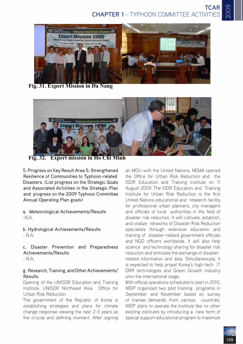
20
09
109
TCAR CHAPTER 1 - TYPHOON COMMITTEE ACTIVITIES
Fig. 31. Expert Mission in Da Nang
Fig. 32. Expert mission in Ho Chi Minh
5. Progress on Key Result Area 5: Strengthened Resilience of Communities to Typhoon-related Disasters. (List progress on the Strategic Goals and Associated Activities in the Strategic Plan and progress on the 2009 Typhoon Committee Annual Operating Plan goals)
a. Meteorological Achievements/Results -N.A.
b. Hydrological Achievements/Results - N.A.
c. Disaster Prevention and Preparedness Achievements/Results - N.A.
g. Research, Training, and Other Achievements/Results Opening of the UNISDR Education and Training Institute, UNISDR Northeast Asia Office for Urban Risk Reduction The government of the Republic of Korea is establishing strategies and plans for climate change response viewing the next 2-3 years as the crucial and defining moment. After signing
an MOU with the United Nations, NEMA opened the Office for Urban Risk Reduction and the ISDR Education and Training Institute on 11 August 2009. The ISDR Education and Training Institute for Urban Risk Reduction is the first United Nations educational and research facility for professional urban planners, city managers and officials of local authorities in the field of disaster risk reduction. It will cultivate, establish, and vitalize networks of Disaster Risk Reduction specialists through extensive education and training of disaster-related government officials and NGO officers worldwide. It will also help science and technology sharing for disaster risk reduction and stimulate the exchange of disaster-related information and data. Simultaneously, it is expected to help propel Korea’s high-tech IT DRR technologies and Green Growth industry onto the international stage. With official operations scheduled to start in 2010, NIDP organized two pilot training programs in September and November based on survey of trainee demands from various countries. NIDP plans to operate the Institute like no other existing institutes by introducing a new form of special support educational program to maximize

110
ESCAP/WMO Typhoon Committee Annual Review 2009
the practical value of all training offered at the institute. The program was developed to provide close-proximity training on Korea’s policies in the area of disaster prevention and mitigation as well as situation management by showcasing model policies, technologies, and systems. The main topics included the following: Establishment of DRR planning for urban areas; Regional safety diagnosis systems; Comprehensive Meteo-hydrological disaster reduction plans; Disaster insurance programs; Region autonomous risk reduction; Situation analysis/decision systems; and Early warning systems. Disaster management officials from 10 Members of the Association of South East Asian Nations (ASEAN) and 8 Members of the South Asian Association for Regional Cooperation (SAARC) participated in the 1st pilot training. Disaster management officials from Northeast Asia and the Middle East participated in the 2nd pilot raining. Guided by the Hyogo Framework for Action (HFA), the UNISDR Office will provide technical assistance to the ISDR Education and Training Institute for Urban Risk Reduction. The ISDR Education and Training Institute will assist in providing good international practices in the forecast of and response to common disasters such as typhoons, Asian Dust, earthquakes, and droughts, cooperation in and sharing of technologies for forecast and observation for risk reduction, and support of DRR programs.
Disaster Management Education and Training Programs NEMA’s NIDP invites high-ranking officials from Bangladesh to its disaster management education training program. NEMA and the Korea International Cooperation Agency (KOICA) organize the education program, where participants can benefit from Korea’s experience in national disaster control by studying Korea’s national disaster information system and prediction and prevention system. The ten Bangladeshi delegates will also be exposed to traditional Korean culture during the three-week program. Bangladesh, which sustains tremendous damage from floods every year, decided to dispatch ten high-ranking public officers in charge of the country’s disaster management overseas to gain insights from industrialized countries in advancing the country’s disaster control system. NIDP also provided a disaster management education program to government officials from Paraguay in May 2008. It plans to further expand cooperation with other countries by offering disaster management education to public officers from ten countries, including China, Nicaragua and Indonesia, in the second half of this year.
e. Regional Cooperation Achievements/Results - N.A.
f. Identified Opportunities/Challenges for Future Achievements/Results - N.A.
6. Progress on Key Result Area 6: Improved Capacity to Generate and Provide Accurate, Timely, and understandable Information on Typhoon-related Threats. (List progress on the Strategic Goals and Associated Activities in the Strategic Plan and progress on the 2009 Typhoon Committee Annual Operating Plan goals) a. Meteorological Achievements/Results Update of Operational Tropical Cyclone Analysis System KMA has been operating a typhoon analysis system based on MTSAT-1R satellite data since 2005. This typhoon analysis system utilizes the
Fig. 33. Opening ceremony of the UNISDR Education and Training Institute, UNISDR Northeast Asia Office for Urban Risk Reduction
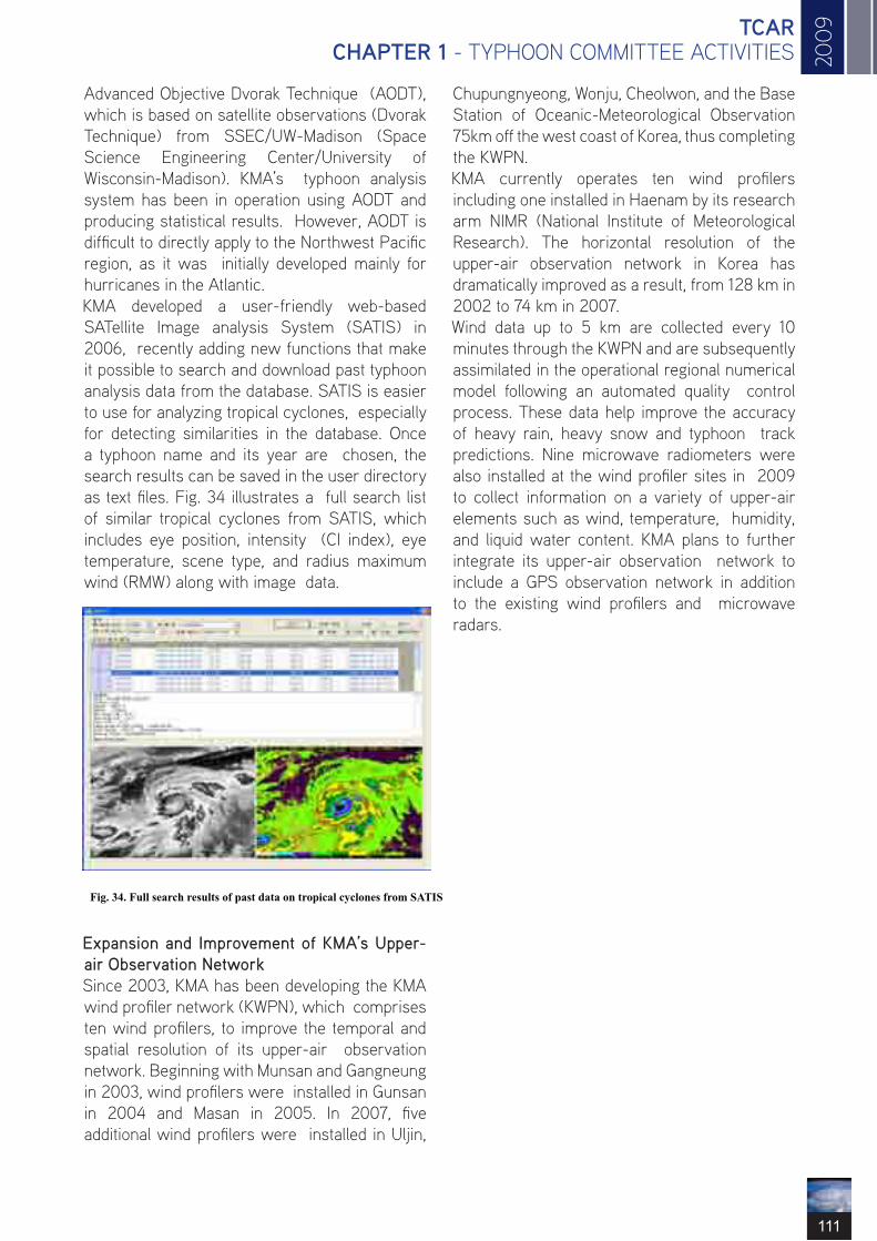
20
09
111
TCAR CHAPTER 1 - TYPHOON COMMITTEE ACTIVITIES
Advanced Objective Dvorak Technique (AODT), which is based on satellite observations (Dvorak Technique) from SSEC/UW-Madison (Space Science Engineering Center/University of Wisconsin-Madison). KMA’s typhoon analysis system has been in operation using AODT and producing statistical results. However, AODT is difficult to directly apply to the Northwest Pacific region, as it was initially developed mainly for hurricanes in the Atlantic. KMA developed a user-friendly web-based SATellite Image analysis System (SATIS) in 2006, recently adding new functions that make it possible to search and download past typhoon analysis data from the database. SATIS is easier to use for analyzing tropical cyclones, especially for detecting similarities in the database. Once a typhoon name and its year are chosen, the search results can be saved in the user directory as text files. Fig. 34 illustrates a full search list of similar tropical cyclones from SATIS, which includes eye position, intensity (CI index), eye temperature, scene type, and radius maximum wind (RMW) along with image data.
Expansion and Improvement of KMA’s Upper-air Observation Network Since 2003, KMA has been developing the KMA wind profiler network (KWPN), which comprises ten wind profilers, to improve the temporal and spatial resolution of its upper-air observation network. Beginning with Munsan and Gangneung in 2003, wind profilers were installed in Gunsan in 2004 and Masan in 2005. In 2007, five additional wind profilers were installed in Uljin,
Fig. 34. Full search results of past data on tropical cyclones from SATIS
Chupungnyeong, Wonju, Cheolwon, and the Base Station of Oceanic-Meteorological Observation 75km off the west coast of Korea, thus completing the KWPN. KMA currently operates ten wind profilers including one installed in Haenam by its research arm NIMR (National Institute of Meteorological Research). The horizontal resolution of the upper-air observation network in Korea has dramatically improved as a result, from 128 km in 2002 to 74 km in 2007. Wind data up to 5 km are collected every 10 minutes through the KWPN and are subsequently assimilated in the operational regional numerical model following an automated quality control process. These data help improve the accuracy of heavy rain, heavy snow and typhoon track predictions. Nine microwave radiometers were also installed at the wind profiler sites in 2009 to collect information on a variety of upper-air elements such as wind, temperature, humidity, and liquid water content. KMA plans to further integrate its upper-air observation network to include a GPS observation network in addition to the existing wind profilers and microwave radars.

112
ESCAP/WMO Typhoon Committee Annual Review 2009
Fig. 35. KMA’s upper-air observation network and wind profiler sites
Establishment of K-ROC (Korea Radar Operations Center) and Radar Replacement The Korea Meteorological Administration (KMA) installed its first radar in Seoul (Mt. Gwanak) in 1969. Since then, KMA has built a radar network consisting of 10 radars that provide nationwide coverage. KMA plans to establish K-ROC (Korea Radar Operations Center) in 2010. The Center will enhance the efficiency of KMA’s radar operations by enabling integrated operations of KMA’s weather radar observation network and the establishment of standard
Establishment of K-ROC (Korea Radar Operations Center) and Radar Replacement The Korea Meteorological Administration (KMA) installed its first radar in Seoul (Mt. Gwanak) in 1969. Since then, KMA has built a radar network consisting of 10 radars that provide nationwide coverage. KMA plans to establish K-ROC (Korea Radar Operations Center) in 2010. The Center will enhance the efficiency of KMA’s radar operations by enabling integrated operations of KMA’s weather radar observation network and the establishment of standard
operations procedures. It is also expected to help raise the quality of radar products, develop application techniques, and improve observation accuracy, thereby enabling maximum use of these products. In addition, KMA plans to relocate the Donghae radar to Gangneung and replace outdated equipment with the state-of-the-art radar, with operations scheduled to start in the first half of 2010. These measures will provide a solution to the observational blind spot in the northern part of the Gangwon region.
Fig. 36. Working process of K-ROC (Korea Radar Operations Center)

20
09
113
TCAR CHAPTER 1 - TYPHOON COMMITTEE ACTIVITIES
Adoption of 4DVAR Based on KMA’s strategic plans, the current operational NWP system will be replaced with the UK’s Met Office Unified Model (UM) in 2010 and the data assimilation method will be upgraded to 4DVAR. With help from the Australian Bureau of Meteorology, the UM’s MetDB (Meteorological Data Bank) will be replaced with the ODB (Observation Data Base) to maximize portability and scalability of its OPS (Observation Processing System). Since April 2009, KMA has been running 4DVAR every 6 hours with a 6-hour window on the locally received observations in parallel with the existing operational NWP system so as evaluate the performance of the UM prior to full operation. The performance of the UM has so far proven promising with support from the large volume of data assimilated in 4DVAR. The volume of satellite data has considerably increased with the adoption of 4DVAR. Satellite data is needed to fill data void areas such as the ocean where typhoons may linger. More AMV data from GOES, MTSAT and METEOSAT have been used in 4DVAR on the UM compared with the existing operational NWP system. The quantity of ATOVS and MODIS data has also increased considerably. SSMI, AIRS, and ASCAT data, which were not used in the existing operational NWP system, were newly assimilated with 4DVAR. Fig. 38 illustrates the horizontal distribution of the observations received through GTS and ftp for a day in October. Data coverage over the ocean is greatly
a) (b) Fig. 37. (a) KMA’s weather radar network; (b) Gangneung weather radar site
36 enhanced by satellite observations and the reliability of typhoon forecast is expected to improve significantly as well. The data quantity used in one cycle of 4DVAR is listed in table 1. Recently, IASI (Infrared Atmospheric Sounding Interferometer) data were assimilated into the UM and their impact was evaluated. The RMSE of 5-day forecast GPH is reduced 1-5% with the IASI data. The improvement is large in the tropics where typhoons form.

114
ESCAP/WMO Typhoon Committee Annual Review 2009
Fig. 38. Horizontal distribution of observations received through GTS and ftp.
5day fcst 500H rmse over
0
2
4
6
8
10
12
14
09/9/
13
09/9/
15
09/9/
18
09/9/
20
09/9/
23
09/9/
25
09/9/
27
09/9/
29
09/10
/3
09/10
/7
09/10
/9
09/10/11Date
10.00
8.00 6.00 4.00 2.00
0.00 -2.00
12.00
Table 4. Quantity of received and assimilated data in the UM at 00UTC on the same day as in Fig. 38

20
09
115
TCAR CHAPTER 1 - TYPHOON COMMITTEE ACTIVITIES
Fig. 39. Impact of IASI data in tropical areas in KMA UMS 4DVAR (KO_CYCLG: Without IASI; KO_CYCLG (w/ IASI): With IASI).
In 2010, GPSRO and SSMIS will be assimilated in 4DVAR for global application of the UM. Direct readout satellite data such as ATOVS and AIRS will be assimilated in the regional application of the UM with the least latency time. High temporal and spatial resolution AMV data retrieved from COMS (Communication, Ocean, and Meteorological Satellite), scheduled for launch in early 2010, will be evaluated with 4DVAR in the UM to produce better typhoon location and intensity forecasts.
Adoption of the Unified Model as KMA’s Next-generation NWP System KMA decided to adopt the Unified Model (UM) of the UK Met Office, and has been developing a new next-generation NWP system based on the UM since 2008. A preliminary global UM suite using initial conditions from the UK Met Office started operations in June 2008. Results are provided to forecasters, who use them as auxiliary material to help produce weather products such as accurate and timely typhoon forecasts. Recently, a global 4DVAR data assimilation system was added to the global UM suite along with observation pre-processing procedures for various observations to produce more accurate and consistent numerical weather predictions. KMA conducted a UM re-run project for the past 3 years (2006-2008). Although the main objective of the project was to produce UM-based forecast guidance using MOS (Model Output Statistics), the results are expected to prove useful for various purposes such as model performance assessment in the East Asian region, etc. In a preliminary analysis, forecast fields were verified relative to tropical cyclone (typhoon) tracks issued in the Northwest Pacific region. The UM system shows improved typhoon track forecast skill compared to the operational global (GDAPS) prediction. The 3-day (5-day) typhoon position prediction error of the UM is 360 km (420 km) on average (50% of cumulative frequency), which is far smaller than errors of GDAPS (490 km and 510 km for 3- and 5-day forecasts, respectively). In fact, the 5-day
typhoon position prediction of the UM is better than the 3-day prediction of GDAPS. The global UM-4DVAR suite is slated to become KMA’s next-generation NWP system, replacing the existing GDAPS system in 2010.
Typhoon Distance Error Comparision (GDPS vs UM)
Typhoon Distance Error [Km] Fig. 40. A comparison of typhoon track forecast errors of the operational global model (GDAPS; red lines) and UM (black lines) for 72-hour (solid lines) and 120-hour (dashed lines) forecasts. The selected tropical cyclones are those observed in the Northwest Pacific during the period 2006- 2008.
KMA’s 3rd Super computer System KMA will install its 3rd supercomputer system in three stages in 2009 and 2010. The 3rd supercomputer system is a CRAY XT5 Baker, consisting of AMD multi-core processors. The CRAY XT5 was installed as the interim system in November 2009. The CRAY XT5 will be installed as the initial system in the first quarter of 2010, with the CRAY Baker installed as the final system in the last quarter of 2010. The peak performances of each system are over 14 Tflops, 27 Tflops and 680 Tflops respectively. Baker, the final system, will consist of two clusters, each of which will in turn comprise over 40,000 AMD multi-core processors. The 3rd supercomputer system will be installed at the National Supercomputer Center for Meteorology, located 100 km south of the KMA headquarters. The 3rd supercomputer system will be connected to the KMA headquarters via high-performance 4-gigabit dedicated leased lines. From 2010, the KMA will start to run its next-
0 100 200 300 400 500 600 700 800 900 0
10
20
30
40
50
60
70
80
90
100
GDPS( +72Hr) GDP S(+120Hr) UM(+72Hr) UM(+120Hr)
lti

116
ESCAP/WMO Typhoon Committee Annual Review 2009
generation NWP system based on the UK Met Office Unified Model N320L50 as the operational model on the 3rd supercomputer system. From the last quarter of the 2010, the KMA will run the higher-resolution Unified Model N512L76 as the operational model for better weather forecasting.
b. Hydrological Achievements/Results Construction of National Quality Control System for Hydrological Data at Geum River This project seeks to develop standards on quality control of hydrological data and to initiate the creation of a national quality control system for hydrological data for the Han River water system in 2007, expanding this system to the Nakdong, Geum and Yeongsan rivers by 2011. 2009 saw the development of quality control standards for hydrological data for the Geum River water system, as well as the construction and reinforcement of the national quality control system for hydrological data for the Geum River water system. The project aims first to strengthen the existing hydrological data management system by developing and adopting a quality control system
Fig. 42. National Supercomputer Center for Meteorology.
Fig. 41. KMA’s 3rd supercomputer system
Component Installation 2010.12 System Cray Baker Peak Performance 682.9Tflops Memory 119.8TB Disk 2,073TB VTL 507TB
Tape 4PB
for national hydrological data for the Geum River, and second, to secure data reliability. These objectives were set to address the current situation in the country, where data handling standards, methods, and data publishing formats differ from one hydrological data measurement
organization to another, and to facilitate the third phase of the project, whose goal is to build a system which can easily be used in the field. Quality control methods according to hydrological data and observation methods of rainfall and water level, which are continuous time-series hydrological data, can be largely classified into the three following categories: - Inspection of hydrological observatories and management of checked results (Field quality control); - Automatic review and handling of hydrological data (Automatic quality control); - Manual review and handling of hydrological data (Manual quality control) It is difficult to realize a fully automated computer-based system to control the quality of hydrological data, and furthermore such a system may give rise to undesirable results. Therefore, a manual

20
09
117
TCAR CHAPTER 1 - TYPHOON COMMITTEE ACTIVITIES
review and handling process is necessary for all data, with outlier determination rules and treatment procedures and methods determined in advance. Fig. 43 illustrates the general quality control procedures, data management method for time-series hydrological data, which were applied to the Geum River system. To build the quality control system for the Geum River area in 2009, the research committee assessed the quality control status of the Geum River Flood Control Center, and analyzed the function and status of the data management system in use. The committee determined a quality control method for water flux volume data with rainfall volume and water level data, which
was then used to modify/complement the quality control system. To enhance the viability of the quality control task, the committee encouraged on-demand education for the staff in charge, and suggested a modification/supplementation method and improvement plan for the system and standard inspection based on evaluations of the system’s operation results. By establishing guidelines for daily quality control tasks, the committee put forth a framework for systematization. It also facilitated continued adjustments to the system by proposing a sustainable management plan to ensure superior hydrological data quality.
(a) Status of basins (b) Water level data at each forecasting point
Fig. 43. Quality control procedure of time-series rainfall volume and water level data
(c) Revision of water level TM data (d) Water level change graph
Fig. 44. Screenshots of the quality control system.
42

118
ESCAP/WMO Typhoon Committee Annual Review 2009
The project will help build a consensus among the experts regarding the importance of hydrological observations, and hydrological data management and quality control through continued implementation of tasks that contribute to higher-quality national hydrological data. A number of national initiatives will be promoted alongside to guarantee the essentials of a quality life through active management of water resources and information campaigns to raise public awareness about the importance of national water resources, which are expected to play a significant role in changing public perception regarding water resources activities for the better. Ultimately, the newly created quality control system for hydrological data, which will enable quality control that takes into account field characteristics and hydrological data for each observation point, will lay the groundwork for improving the overall reliability of national hydrological data and minimizing loss of hydrological data.
c. Disaster Prevention and Preparedness Achievements/Results -N.A.
d. Research, Training, and Other Achievements/Results - N.A.
e. Regional Cooperation Achievements/Results - N.A.
f. Identified Opportunities/Challenges for Future Achievements/Results - N.A.
7. Progress on Key Result Area 7: Enhanced Typhoon Committee’s Effectiveness and International Collaboration. (List progress on the Strategic Goals and Associated Activities in the Strategic Plan and progress on the 2009 Typhoon Committee Annual Operating Plan goals)
a. Meteorological Achievements/Results Education and Training Activities The Course on Information and Communication
Technologies for Meteorological Services was organized by the Korea Meteorological Administration (KMA) with sponsorship from the Korea International Cooperation Agency (KOICA) from 24 May to 27 June 2009. The course attracted 13 participants from 12 countries, which included ESCAP/WMO Typhoon Committee Members. This training course was designed to help the participants improve their IT-related capacity in meteorological services by broadening their knowledge of both basic and state-of-the-art ICT used in WMO IT Programmes and meteorological services in NMHSs. The curriculum includes: 1) Meteorological Information and Communication - Basic Linux, Network basics, Network security, Internet protocol, FTP server, Data management, WMO Information System (WIS) 2) Meteorological Information Service - PC-clustering and its application, Introduction to the Forecaster’s Analysis System, Meteorological service using web technology, Introduction to the Combined Meteorological Information System (COMIS), Use of KMA NWP products 3) IT Applications in Agrometeorology - Introduction to WAMIS (AgroMeteorological Information Service), Operational technology of agrometeorological models, Application of GIS to agrometeorology 4) Study Visits and Field Trip - Supercomputer Center, Korea Aerospace Research Institute, Radar Observation Station, Samsung Electronics, Hyundai Motors 5) Presentations and Discussion - Participants’ presentation of country reports; group discussion
Fig. 45. Course on ICT for Meteorological Services, 24 May–27 June 2008, Seoul, Korea
44

20
09
119
TCAR CHAPTER 1 - TYPHOON COMMITTEE ACTIVITIES
One of the most important training courses conducted by KMA is the Digital Forecasting Course and Disaster Prevention Forecasting Course for forecasting staff. The objective is to train the next generation of expert forecasters to acquire theoretical and operational knowledge of meteorology, and to strengthen prediction skills for severe weather such as typhoons, torrential rain, and heavy snow. The curriculum includes the latest meteorological theories, weather forecasting and warning issuance, case studies of disasters caused by severe weather, etc.
The First TRCG/TC Technical Forum, 12-15 May 2009, Jeju, Korea The Korea Meteorological Administration (KMA) hosted the first Technical Forum of Training and Research Coordination Group (TRCG) / Typhoon Committee (TC) on 12-15 May 2009, Jeju, Korea.
Fig. 46. Participants in the 1st Technical Forum of TRCG/TC, 12-15 May 2009, Jeju, Korea
45
Participants from 13 countries participated in this event co-sponsored by WMO, TC and KMA. The Forum opened with opening and welcome messages from KMA administrator Dr. Byung-Seong Chun, PAGASA administrator Dr. Prisco D. Nilo, TCP/WMO chief Mr. Kuroiwa Koji, and TC Secretary Mr. Olavo Rasquinho. Two invited experts, Professor Russel Elseberry from the Naval Postgraduate School, USA, and Mr. Takuya Komori from the Japan Meteorological Agency, Japan, delivered special lectures on TC deterministic consensus forecasts and the TC Ensemble Prediction System respectively. Mr. Roger Edson gave a presentation about the use of microwave and scatterometer data in TC. Also notable was a tutorial session on the typhoon forecasting system of each country, and KMA’s live demonstration of the Typhoon Analysis and Prediction System at the National Typhoon Center.

120
ESCAP/WMO Typhoon Committee Annual Review 2009The 2nd China-Korea Joint Workshop on Tropical Cyclones, 19-23 Dec., Shanghai, China The Korea Meteorological Administration (KMA) and China Meteorological Administration (CMA) hosted the second joint workshop on tropical cyclones, which was held on 19-23 December 2009, in Shanghai, China. Almost 50 experts in typhoons and related fields participated from National Typhoon Center/KMA, Korea Meteorological Satellite Center/KMA, National Institute of Meteorological Research/KMA, Shanghai Typhoon Institute (STI)/CMA, Nanjing University, Nanjing University of Information Sciences and Technology, the University of Maryland and the University of Utah. 26 papers were presented at the workshop on a wide range of topics such as typhoon-related disasters, the climate and typhoons, typhoon forecasting technology, typhoon genesis, and structure changes in the development and decay stages. KMA and CMA agreed that the third workshop will be held in 2010 in Korea with more experts from other countries, and affirmed their commitment to future cooperation in typhoon research, forecast and related areas.
b. Hydrological Achievements/Results Participation in the Integrated Workshop of TC in Cebu, the Philippines From 13 to 18 September 2009, ‘Integrated Workshop Building Sustainability & Resilience in High Risk Areas of the Typhoon Committee: Assessment & Action’ was held in Cebu, the Philippines. Approximately 100 experts and researchers from 14 Member countries in the region attended the workshop to share advanced knowledge and to discuss typhoon-related issues in the region. From the Republic of Korea, experts from 6 organizations took part in this workshop to share developed techniques and strategies relevant to water-related disasters caused by typhoons with other Members, especially developing countries. As shown in Table 5, each organization represented is a specialized and professional water-sector organization in Korea.
Fig. 47. Participants in the 2nd China-Korea Joint Workshop on Tropical Cyclones, 19-23 Dec. 2009, Shanghai, China

20
09
121
TCAR CHAPTER 1 - TYPHOON COMMITTEE ACTIVITIES
Participants from Korea gave the following presentations, designed to introduce advanced information and knowledge implemented by Korea since the last workshop of the Typhoon Committee: - Flood Control Measure Assessment System · To share outcomes from the project and provide advanced techniques to reduce socio-economic damage caused by floods - Korea’s Policy on Water Resources · To introduce water resources policies to control floods and adapt to typhoons and water- related disasters, and give an overview of the newly launched ‘Four Major Rivers
Organization Abbr. Activities Ministry of Land, Transport and Maritime Affairs
MLTM Managing water resources generally and establishing policies and strategies for the public and the nation
Korea Institute of Construction Technology
KICT Implementing studies and research on contemporary water issues
Korea Water Resources Cooperation
K-water Supporting capacity building and implementing joint projects
Korea Meteorological Administration
KMA Producing data and information on meteorology including climate change
National Institute for Disaster Prevention NIDP Establishing strategies and frameworks for disaster
response
Korea Water Forum KWF Building international networks for closer coopera-tion in the water sector
Table 5. Overview of Korea’s water sector organizations
Fig. 48. TC Integrated Workshop in Cebu, the Philippines, September 2009
Restoration Project’ - Outcomes of ‘High Level Expert Panel on Water and Disaster/ UNSGAB’ · To understand the seriousness of water-related disasters and underscore the importance of establishing adaptation frameworks Of these, the project ‘Flood Control Measure Assessment System’ was initiated in 2008, and will continue through 2012. Korea is acting as one of the leading countries in the Working Group on Hydrology (WGH) of the Typhoon Committee. Outcomes and expected results from this project will be leveraged to strengthen the capacity of each Member.

122
ESCAP/WMO Typhoon Committee Annual Review 2009
b. Disaster Prevention and Preparedness Achievements/Results -N.A.
d. Research, Training, and Other Achievements/Results - N.A.
f. Regional Cooperation Achievements/Results - N.A.
g. Identified Opportunities/Challenges for Future Achievements/Results - N.A.
III. Resource Mobilization Activities -N.A.
IV. Update of Member’s Working Groups representatives 1. Working Group on Meteorology Dr. Won-Tae Yun Director, International Cooperation Division, Korea Meteorological Administration 45, Gisangcheong-gil Dongjak-gu, Seoul,156-720, Republic of Korea Tel : +82-2-2181-0372 Fax : +82-2-836-2386 E-mail: [email protected] 2. Working Group on Hydrology Dr. Hong Il-Pyo (Vice-Chair) Senior Researcher, Water Resources Research Department, Korea Institute of Construction Technology 2311, Daehwa, ilsan, Goyang City, Gyeonggi, Republic of Korea Tel : +82-31-910-0264 Fax : +82-31-910-0251 E-mail: [email protected] 3. Working Group on Disaster Prevention and Preparedness Dr. Waon-Ho Yi Director, National Institute for Disaster Prevention 253-42, Gongdeok-2Dong, Mapo-Gu, Seoul, 121-719, Republic of Korea Tel : +82-2-3271-3201 Fax : +82-2-3271-3209 E-mail: [email protected] 4. Training and Research Coordinating Group Dr. KiRyong Kang Senior Researcher, National Typhoon Center, Korea Meteorological Administration 76-2, Hannam-ri, Namwon-eup, Seogwipo, Jeju, 699-942, Republic of Korea Tel : +82-64-801-0224
Fax : +82-64-805-0366 E-mail: [email protected] 5. Resource Mobilization Group Dr. Hee-Dong Yoo (Chairperson) Director, Numerical Model Development Division, Korea Meteorological Administration 45, Gisangcheong-gil, Dongjak-gu, Seoul, 156-720, Republic of Korea Tel : +82-2-2181-0672 Fax : +82-2-2181-0689 E-mail: [email protected]

20
09
123
TCAR CHAPTER 1 - TYPHOON COMMITTEE ACTIVITIES
SINGAPORE
II. Summary of progress in Key Result Areas (For achievements/results which apply to more thanone Key Result Area, please describe them under the most applicable Key Result Area. Then, at the end of the description, place in parentheses ( ) the other applicable Key Result Areas) 1. Progress on Key Result Area 1: Reduced Loss of Life from Typhoon-related Disasters. (List progress on the Strategic Goals and Associated Activities in the Strategic Plan and progress on the 2008 Typhoon Committee Annual Operating Plan goals)
a. Meteorological Achievements/Results (i) Singapore will be installing a new 2.4m X/L-band satellite reception system to receive not just the NOAA and EOS MODIS data, but also from new satellites – METOP(EUMETSAT), FY3 and NPP (NASA-NOAA). The new system will be commissioned in 2010. (ii) To help alleviate the impact of storms such as squalls, or tropical cyclones, Singapore provides heavy rain and strong winds advisory and warning to various government agencies for enhancing preparedness for expected heavy rain and strong winds. The warnings are also issued to the public via the media.
b. Hydrological Achievements/Results Over the past decades, Singapore has been improving the drainage infrastructure. The flood-prone areas have been reduced from 3200 ha in the 1970s to about 79ha in 2009. Singapore continuously reviews and upgrades her drainage infrastructure to ensure an effective drainage network for flood alleviation and prevention.
c. Disaster Prevention and Preparedness Achievements/Results Singapore continued to enhance the national Tsunami Early Warning System (TEWS) with the addition of 2 new seismic sensors in 2009, completing the seismic network of a total of 8 sensors distributed over the island. Data
from the seismic stations are transmitted to the central processing system in MSD and integrate with seismic data from regional seismic monitoring networks such as Malaysia, Indonesia and Australia for the automatic and continuous monitoring of seismic activities in the region. Data from seismic stations located over a much wider area enables MSD to enhance the accuracy and speed of detecting earthquakes in the region. Singapore provides water rescue and evacuation operations in the event of floods, resulting from typhoons and sustained rainfall and alerts the general public through the Public Warning System on the dangers of an impending flood.
d. Regional Cooperation Achievements/Results As in (c) above. Singapore’s Civil Defense Force provided assistance to Manila, Philippines between Sep and Oct 2009 to mitigate and reduce the consequences of typhoon-related floods and increase the survivability of the people. e. Identified Opportunities/Challenges for Future Achievements/Results - 2. Progress on Key Result Area 2: Minimized Typhoon-related Social and Economic Impacts. (List progress on the Strategic Goals and Associated Activities in the Strategic Plan and progress on the 2008 Typhoon Committee Annual Operating Plan goals)
a. Meteorological Achievements/Results As in KRA 1(a)
b. Hydrological Achievements/Results - c. Disaster Prevention and Preparedness Achievements/Results As in KRA 1(c).
d. Research, Training, and Other Achievements/Results Singapore’s Civil Defense Academy provides disaster rescue and mitigation courses to the international community. e. Regional Cooperation Achievements/Results Under the ambit of the United Nations

124
ESCAP/WMO Typhoon Committee Annual Review 2009
Environment Programme/Office for the Coordination of Humanitarian Affairs (UNEP/OCHA) Joint Environment Unit (JEU)), Singapore provides international assistance for Hazardous Materials emergencies (HazMat) that may arise from typhoon-related incidents. f. Identified Opportunities/Challenges for Future Achievements/Results -
3. Progress on Key Result Area 3: Enhanced Beneficial Typhoon-related Effects for the Betterment of Quality of life. (List progress on the Strategic Goals and Associated Activities in the Strategic Plan and progress on the 2008 Typhoon Committee Annual Operating Plan goals)
a. Meteorological Achievements/Results -
b. Hydrological Achievements/Results -
c. Disaster Prevention and Preparedness Achievements/Results -
d. Research, Training, and Other Achievements/Results (i) Singapore participated in training workshops/conferences/meetings during the year. Some were sponsored/organized by the Typhoon Committee. Singapore would like to express her thanks and appreciation to the Typhoon Committee for giving us the opportunity to participate in the workshops which our officers have found very useful and beneficial in their course of work. The list of relevant workshops/conferences are as follows: - Remote Sensing for Disaster Management in SE Asia, 4 – 6 Feb 09, Bangkok, Thailand - ICG/IOTWS-VI Meeting, 4 – 9 April 2009, Hyderabad, India - 1st Training and Research Coordination Group (TRCG), 12 – 15 May 09, Jeju, Korea - Tokyo Climate Conference: Better Climate
Information for a Safe & Sustainable Society, 6 – 8 July 2009, Tokyo, Japan - ESCAP/WMO Typhoon Committee Integrated Workshop “Building Sustainability and Resilience in High Risk Areas of the Typhoon Committee:Assessment & Action”, 14 – 18 Sept 2009, Cebu, Philippines - Training Workshop on Climate Applications in ASEAN, 2 – 9 October 2009, Kuala Lumpur, Malaysia (ii) Singapore hosted the 5th APEC Climate Symposium on 12 - 15 July 2009 in conjunction with the 5thAPEC Climate Center (APCC) Working Group Meeting and the 5thAPCC Science Advisory Committee Meeting. The sympo sium also included a tutorial session on empirical downscaling for regional adaptation and a hands-on session using the Climate Information Kit. The event was attended by 60 participants from 21 National Meteorological and Hydrological Services (NMHSs) and institutions, including the APEC Secretariat and the co-chair of the Task Force on Emergency Preparedness (TFEP) also attended the event.
e. Regional Cooperation Achievements/Results As in KRA 3(d)
f. Identified Opportunities/Challenges for Future Achievements/Results -
4. Progress on Key Result Area 4: Improved Typhoon-related Disaster Risk Management in Various Sectors. (List progress on the Strategic Goals and Associated Activities in the Strategic Plan and progress on the 2008 Typhoon Committee Annual Operating Plan goals)
a. Meteorological Achievements/Results As in KRA 1(a) and KRA 6(a)
b. Hydrological Achievements/Results -
c. Disaster Prevention and Preparedness Achievements/Results As in KRA 1(c).

20
09
125
TCAR CHAPTER 1 - TYPHOON COMMITTEE ACTIVITIES
d. Research, Training, and Other Achievements/Results -
e. Regional Cooperation Achievements/Results -
f. Identified Opportunities/Challenges for Future Achievements/Results As in KRA 2(e).
5. Progress on Key Result Area 5: Strengthened Resilience of Communities to Typhoon-related Disasters. (List progress on the Strategic Goals and Associated Activities in the Strategic Plan and progress on the 2008 Typhoon Committee Annual Operating Plan goals)
a. Meteorological Achievements/Results -
b. Hydrological Achievements/Results -
c. Disaster Prevention and Preparedness Achievements/Results -
d. Research, Training and Other Achievements/Results -
e. Regional Cooperation Achievements/Results Singapore joined 17 other countries around the Indian Ocean Rim to test the effectiveness of its tsunami warning system for the first time during Exercise Indian Ocean Wave 2009 (IOWave09) which took place on 14 October 2009. The Meteorological Services Division of NEA, as the tsunami watch centre of Singapore, coordinated with the other government agencies during the exercise to test their operational lines of communications. This exercise was also part of an on-going effort to test the national tsunami early warning system.
f. Identified Opportunities/Challenges for Future Achievements/Results -
6. Progress on Key Result Area 6: Improved Capacity to Generate and Provide Accurate, Timely, and understandable Information on Typhoon-related Threats. (List progress on the Strategic Goals and Associated Activities in the Strategic Plan and progress on the 2008 Typhoon Committee Annual Operating Plan goals) a. Meteorological Achievements/Results (i) Replacement of Weather Radar The existing S-band Doppler weather radar at Meteorological Services Division (MSD), Singapore is an indispensable tool used for real-time surveillance of extreme weather conditions (such as storms and wind shear) which can adversely affect the safety of airline and shipping operations as well as activities of the general public. The existing radar is in the process of being replaced with a new S-band dual-polarization radar. The new radar is expected to be installed and be operational by 2Q of 2010. (ii) Message Switching System The Message Switching System which handles the reception of information via GTS/AFTN (including TC advisories etc) is being replaced with a new system to enhance its reliability and capability. The international links to RTH-Melbourne, RTH-Bangkok, NMC-Kuala Lumpur, NMC-Jakarta and NMC-Manila (as part of the GTS) are also in the process of being migrated from Frame Relay to MPLS.
b. Hydrological Achievements/Results -
c. Disaster Prevention and Preparedness Achievements/Results As in KRA 1(c)
d. Research, Training, and Other Achievements/Results -
e. Regional Cooperation Achievements/Results -
f. Identified Opportunities/Challenges for Future Achievements/Results

126
ESCAP/WMO Typhoon Committee Annual Review 2009
7. Progress on Key Result Area 7: Enhanced Typhoon Committee’s Effectiveness and International Collaboration. (List progress on the Strategic Goals and Associated Activities in the Strategic Plan and progress on the 2008 Typhoon Committee Annual Operating Plan goals)
a. Meteorological Achievements/Results -
b. Hydrological Achievements/Results -
c. Disaster Prevention and Preparedness Achievements/Results As in KRA 2(e).
d. Research, Training, and Other Achievements/Results -
e. Regional Cooperation Achievements/Results -
f. Identified Opportunities/Challenges for Future Achievements/Results -
III. Resource Mobilization Activities -
IV. Update of Members’ Working Groups representatives 1. Working Group on Meteorology Ms Patricia Ee Chief Meteorological Officer Operational Services Department Meteorological Services Division National Environment Agency Singapore Email: [email protected]
2. Working Group on Hydrology Mr Mah King Kheong Head, Climatology and Marine Meteorological Section Technical and Services Department Meteorological Services Division National Environment Agency Singapore
Email: [email protected]
3. Working Group on Disaster Prevention and Preparedness Ms Lim Lay Eng Senior Meteorological Officer Main Meteorological Office Operational Services Department Meteorological Services Division National Environment Agency Singapore Email: [email protected]
4. Training and Research Coordinating Group Mr Tham Chien Wan Senior Meteorological Officer Research and Development Section Technical and Services Department Meteorological Services Division National Environment Agency Singapore Email: [email protected]
5. Resource Mobilization Group -

20
09
127
TCAR CHAPTER 1 - TYPHOON COMMITTEE ACTIVITIES
THAILAND
1 Progress on Key Result Area 1: Reduced Loss of Life from Typhoon-related Disasters. (List progress on the Strategic Goals and Associated Activities in the Strategic Plan and progress on the 2009 Typhoon Committee Annual Operating Plan goals)
a Meteorological Achievements/ Results
1. Improvement of Radar network:
To strengthen severe weather observations and monitoring networks, and nowcasting of the country, the following two C-band Doppler Radars which started the installations in the North of Thailand in 2009 have been completely finished and have been in operations: (1). C -band Doppler Radar in Lumphun, (2). C- band Doppler Radar in Petchaboon.
Additionally, three C -band Doppler Radars are being installed as follows, and all are expected to be completed in 2010:(1). C -band Doppler Radar in Songkhla,(2). C -band Doppler Radar in Samui, (3). C -band Doppler Radar in Surin.
Totally, there are 25 weather radars in the TMD‘s precipitation monitoring network.
2. Improvement of the telemetering system in Thailand
In 2009, TMD installed 820 automatic rain gauges in the major river basins in Northern, Northeastern, Central and Eastern Thailand, increasing the total number of automatic rain gauges to 930. Totally there are 1,093 automatic rain gauges in the network, and 111 of those are river-level automatic observations. With the dense, real-time observations in the TMD’ s telemetering system, it is expected that severe flood warning will be issued promptly and effectively.
3. Improvement of satellite receiving station
Recognizing the importance of using remote sensing data particularly the satellite data, TMD has extended the implementation of satellite receiving stations both for the GEO-stationary and Polar orbit as shown in the table 1. below:
Table 1.Satellite
Platform
Current
status
Future plan Remarks
GEO-
stationary
1 MTSAT MTSAT, FY2 Under
implementation,
expected to finish
in 2011
Polar orbit 1 NOAA NOAA,
TIROS,
MODIS,
METOP, FY3,
METEOSAT
4. Improvement of storm surge forecasting
To be prepared for effective warning of storm surges that might be occur in the coastal areas in the Gulf of Thailand and the Andaman Sea during the typhoon season, the IIT Storm Surge Model was introduced to TMD. It is under the experimental and proper adjustment process before using as the storm surges forecasting tool of the country. However, TMD will also appreciate to accept and introduce the RSMC Storm Surge Model into the operation.
5. Implementation of Automatic Weather Station
In 2009, TMD has completed the installation of Automatic Weather Station(AWS) consisting of 87 stations across the country. All meteorological elements will be automatically reported in the real-time manner, additionally the critical index of severe weather-associated events such as the abnormal strong wind and precipitation are also set up for the system to give alarm signals to issue warning to people promptly.
6.Improvement of Global Telecommunication Circuits(GTS):
For meteorological data to be disseminated effectively in the global telecommunication lines and to be prepared for the WMO Information System(WIS), GTS circuits of the TMD‘s RTH

128
ESCAP/WMO Typhoon Committee Annual Review 2009
have been consistently updated. The current status of the TMD’ s GTS is shown in the table 2. below:Table 2.Circuit Speed Protocol Type
Bangkok-Tokyo 128 Kbps IPVPN MPIS Rx/Tx
Bangkok-Kuala
Lumpure
64 Kbps IPVPN MPIS Rx/Tx
Bangkok-
Singapore
64 Kbps IPVPN MPIS Rx/Tx
Bangkok-Beijing 64 Kbps IPLC Rx/Tx
Bangkok-New
Delhi
64 Kbps IPLC Rx/Tx
Bangkok-
Vientiane
64 Kbps DDN Rx/Tx
Bangkok-
Phnom Penh
Internet VPN Client Rx/Tx
Bangkok-
Yangon
Internet TCP Socket Rx/Tx
Bangkok-Hanoi 1200 bps Asynchronous Rx/Tx
b. Hydrological Achievements/Results
Royal Irrigation Department(RID)’s strategic goal has been set up in the aspect of mitigating the water disaster from flood or drought. Office of Hydrology and Water Management which is directly responsible for taking care of such strategy in the aspect of supporting the hydrological data or research benefit for water management, has also set the strategic plan accordingly with the item of the achievement of Water Crisis Situation Announcement.
Actually, Office of Hydrology and Water Management, Hydrology Section has the responsibility of meteorological and hydrological data in the criteria of processing the data for studying or forecasting for the purpose of the water resources development and water management that is the Royal Irrigation Department (RID) mission.
Following such responsibility, Hydrology Section has got strategic goal relating to the Department Strategy in the achievement of Water Crisis Situation Announcement. The indicators for the achievement can be seen in the critical situations
in 2009 as follow:
1. “KETSANA” was a prominent cyclone effecting the northeastern Thailand from September 29, 2009 to October 3, 2009.2. “PARMA” was another one effecting the northern Thailand from October 5 to 15, 20093. Frontal Rain still effected the major part of Thailand particularly in lower north, lower northeast, central and east from October 16 to 27, 20094. Low Pressure Center in southern part of Thailand from September 7 to 27, 2009
The details of the origins, impacts and measures for risk mitigation can be seen in the following Table 3 below.
To mitigate and reduce the risk of 2009 floods, the flood warning system is carefully managed in the following process.
First, telemetering system is used as a method for flood forecasting in different river basins covering nearly the whole country. Only Royal Irrigation Department has already got the system for monitoring 12 river basins from 25 in the criteria of real-time hydrological data.
Second, the forecasting situation is then announced to public with different ways like website or radio broadcasting or networks. For network mentioned above means regional offices which take part in communicating in the local areas with other methods or media.
Third, after flooding situation, pumping for water drainage has to be prepared in order to reduce the height of water level or inundated areas.
c. Disaster Prevention and Preparedness Achievements/Results
SG 1: To enhance cooperation among TC Members to reduce the number of death by typhoon-related disasters by half (using the decade 1990-99 as the base line compared to the decade 2006-2015).

20
09
129
TCAR CHAPTER 1 - TYPHOON COMMITTEE ACTIVITIES
1) Identify Members’ key agencies and sectors working on disaster preparedness and protection of vulnerable communities against typhoon-related disasters and encourage establishment of linkages, networking, and exchange of information among them· Disaster Prevention and Mitigation Committee
The National Disaster Prevention and Mitigation Committee (NDPMC), under the Disaster Prevention and Mitigation Act B.E 2550(2007), will be appointed to be the disaster management policy mechanism of the country. The committee is comprise of Prime Minister or designated Deputy Prime Minister as chairperson, Ministry of Interior as first vice chairperson, Permanent Secretary to Ministry of Interior as second vice chairperson and the membership from the national government organizations concerned. Director – General of Department of Disaster Prevention and Mitigation is designed as member and secretariat of the committee.The main functions of NDPMC are to determine the policy for formulating the national disaster prevention and mitigation plan, to integrate the development on disaster prevention and mitigation mechanism among government and local administration agencies including other relevant private sectors, and to issue the regulations on the payment of remuneration, compensation and other expenditures relevant to disaster prevention and mitigation activities under the regulation of Ministry of Finance.
· Department of Disaster Prevention and Mitigation
After the bureaucratic reform in 2002, the Department of Disaster Prevention and Mitigation (DDPM) has been set up under the Ministry of Interior to serve the national disaster management system so as to sustain Thailand’s habitability and safety. When the current Disaster Prevention and Mitigation Act B.E.2550 was issued and forced in November 2007, the Department of Disaster Prevention and Mitigation (DDPM) has been designed as the national government organization and operating agency on national disaster prevention and mitigation activities. Moreover, DDPM can establish the Disaster Prevention
and Mitigation Regional Centers and the Disaster Prevention and Mitigation Provincial Offices to carry out the efficient disaster management.
Nowadays, DDPM has set up 18 Disaster Prevention and Mitigation Regional Centers and 75 Disaster Prevention and Mitigation Provincial Offices over the country. DDPM Regional Centers and Provincial offices will be the front line unit to carry out the disaster prevention and mitigation. DDPM will cooperate with the relevant organizations both government and private sector and local agencies to perform the task. To mobilize the technology and know-how, exchange and share experience and information, DDPM has cooperated with various international organizations such as ADRC, ADPC, JICA, GTZ, UNDP UNISDR, UNOCHA, UNEP, etc.
2) Assist as request Member’s policy development and strategic planning on disaster risk management with special emphasis on densely populated areas and vulnerable communities
· Strategic Action Plan (SNAP) for Disaster Risk Reduction for Thailand
Thailand recognized that the strategic plan on disaster risk reduction is essential to minimize the incidents, consequently, DDPM cooperated with United Nations International Strategy for Disaster Reduction (UNISDR) and Asian Disaster Preparedness Centre (ADPC) to formulate Strategic Action Plan (SNAP) for Disaster Risk Reduction for Thailand and set up a working group which is composed of the representatives of the government agencies concerned, private sector and experts to draft SNAP. The draft plan is on process to submit to Cabinet for approval.
3) Provide an effective framework for integrating early warning systems for vulnerable communities into development process.
The early warning system in Thailand could divide into 2 levels. In the national level, there are many organizations to take responsibility for the task relevant disaster warning. Thai Meteorological Department, Royal Irrigation Department,

130
ESCAP/WMO Typhoon Committee Annual Review 2009
Department of Water Resources and Disaster Forecasting and Warning of Electricity Generating Authority of Thailand (EGAT) Public Co. Ltd are the main agencies to forecast the disaster warning on their own function. Therefore, Thailand’s Early Warning Information from these agencies will be transferred to the people via mass media and agencies concerned and Department of Disaster Prevention and Mitigation (DDPM) will transmit the information through mechanism of Ministry of Interior to provinces, districts and local organizations.
After Tsunami disaster triggered the 6 southern provinces of Thailand on 26 December 2004, the government reviewed disaster early warning system to develop the system more efficiency and to make more confidence in safety in the country. In 2005, the cabinet appointed the Committee on Early Warning System Development which comprise the representatives of the departments concerned, will be responsible for making the decision as to when a warning should be issued. The National Early Warning Center has been set up to carry out the early warning system.In the local level, the rain gauge and manual disaster siren have been installed in the flood prone areas. This device is employed for observing and notifying of local flood conditions, forecasts and warnings. The rain gauge is extremely low cost and very simple to use. The villagers will be trained to measure, record and read the daily amount of rainfall. Whenever the amount of rainfall exceeds the predefined normal level, the villager in charge of surveillance signal the warning by using the manual siren device to notify the village headman to disseminate the warning through the village news broadcast center.
d. Research, Training, and Other Achievements/Results Research :
In 2009, TMD carried out researches on the following topics:
· The analysis of seasonal temperature and rainfall variation
In this study, the variation trends of the mean maximum temperature, the mean minimum temperature, and the amount of rainfall were evaluated for the summer, winter and rainy seasons in Thailand. Data from year 1951 to 2006 from 45 meteorological stations were analyzed using statistical methods. The results reveal that mean of maximum and minimum temperature tend to have significant during both winter and summer, especially the mean minimum temperature demonstrated an extremely significant change, with an increasing temperature of 0.03 0C per year in winter and summer, and 0.018 0C per year in rainy season. Whereas, the mean maximum temperature increased 0.015 0C in winter, 0.010C in summer and 0.020C per year in rainy season. The analysis of rainfall over a period showed a decrease of 0.925 mm. per year in winter and 1.084 mm. per year in rainy season. While in summer the rainfall increase 0.015 mm. per year. The seasonal rainfall, however, did not show a statistically significant tendency. Therefore it can be concluded that weather in Thailand is becoming warmer all seasons. · Application of PRECIS for climate change Predictability in Thailand
The regional climate model PRECIS has been implemented on OpenSUSE 10.3 LINUX to investigate the climate projection for the period 1961-2100 with initial and boundary condition of ECHAM 4 for scenario A2 with low resolution 2.8x2.8 degrees. The model showed daily, monthly, yearly, seasonally and decadal projections of rainfall and temperature. The model can perform well in the yearly average of minimum temperature projection of the selected stations in Thailand. However, the difference of observed yearly average of maximum temperature and model is high at about 3.5 0C. And the observed rainfall is also much higher than those obtained from the model.
· Application of ECPC G-RSM for monthly to seasonal prediction in Thailand
The ECPC-G RSM is used for global and regional weather forecasting and data assimilation in Thailand, and is applied for long range weather

20
09
131
TCAR CHAPTER 1 - TYPHOON COMMITTEE ACTIVITIES
forecast on 64 bits LINUX parallel system with the initial and boundary condition of GFS model and NCEP center. The minimum temperature of the model showed good agreement with the observed data, especially at the stations located at long distance away from coastal areas such as Chiang Mai and Ubon Ratchathani
· Climate variability during pre-southeast monsoon
The study of climate variability in Thailand during the pre-southwest monsoon using the record data of 45 stations from 1951-2008 to statically analyze its variability. The results showed that the pattern of rainfall in all parts of Thailand is increasing, except in the southwest part where it showed decreasing in its tendency, while both the maximum and minimum temperature showed significantly increase in all parts of the country. ENSO, IOD and MJO are also investigated to explain the relations to rainfall in the pre-southwest monsoon of Thailand
· Suitable Monsoon Indices Investigation for Thailand
Thailand monsoon indices are calculated from the differences of the 850 hPa U-wind of the selected area. The areas selected for indices investigation are 40-80 0E, 5-15 0N, and 90-110 0E, 20-30 0N referred as TMI1, and 80-100 0E, 5-15 0N and 90-1100 0E, 20-30 0N referred as TMI2. The results showed that indices from TMI2 played more significant role ,with R2 at 0.5-0.8, on monthly average rainfall change than those of TMI1 where R2 at 0.4-0.6 , particularly in upper Thailand.
Training: In 2009, TMD received WMO/ TCTF/ TCS support to attend the training courses in the TC as follows:
Table 4.
No. Course Title (s) Duration Country No. of
participant(s)
1. The 1st Training
and Research
Coordination
Group (TRCG)
Technical Forum
12 - 15 May
2009
Republic of
Korea
3
2. Training on
Hydrological
Observation and
Flood Forecasting
Method and
System
20 - 26 July
2009
China 4
3. The 3rd On-the-
job Training of
Flood Forecasting
System Based on
the Tank Model
(OJT)
21 July -
23 August
2009
Malaysia 1
4. The Integrated
Workshop
on Building
Sustainability
and Resilience in
High Risk Areas
of the Typhoon
Committee:
Assessment and
Action
14 - 18
September
2009
Philippines 3 (TMD),
1 (RID),
2 (DDPM)
5. Typhoon roving
seminar
16-19
November
2009
China 2
6. The Second
WMO
International
Workshop on
tropical cyclone
landfall process
19-23
October
2009
China 1
Sensing an
e. Regional Cooperation Achievements/Results
Please refer to Regional Cooperation Assessment
f. Identified Opportunities/Challenges for Future Achievements/ Results
· Participation in the TIPs workshop at Jeiju,

132
ESCAP/WMO Typhoon Committee Annual Review 2009
ROK will be first step of TIPS implemention in TMD· Research fellowships given to TMD on Typhoon Vortex initialization will lead to the improvement of Typhoon forecasting in Thailand.
1. Progress on Key Result Area 2: Minimized Typhoon-related Social and Economic Impacts. (List progress on the Strategic Goals and Associated Activities in the Strategic Plan and progress on the 2008 Typhoon Committee Annual Operating Plan goals) a. Meteorological Achievements/Results Please refer to KRA 1ab. Hydrological Achievements/Results Please refer to KRA 1bc. Disaster Prevention and Preparedness Achievements/ResultsNild. Research, Training, and Other Achievements/ResultsPlease refer to KRA 1de. Regional Cooperation Achievements/Results Please refer to Regional Cooperation Assessmentf. Identified Opportunities/Challenges for Future Achievements/ Results Please refer to KRA 1f
2. Progress on Key Result Area 3: Enhanced Beneficial Typhoon-related Effects for the Betterment of Quality of life. (List progress on the Strategic Goals and Associated Activities in the Strategic Plan and progress on the 2008 Typhoon Committee Annual Operating Plan goals)
a. Meteorological Achievements/ResultsNilb. Hydrological Achievements/ResultsNilc. Disaster Prevention and Preparedness Achievements/ResultsNild. Research, Training, and Other Achievements/Results Please refer to KRA 1d
e. Regional Cooperation Achievements/Results Nilf. Identified Opportunities/Challenges for Future Achievements/ Results Nil
3. Progress on Key Result Area 4: Improved Typhoon-related Disaster Risk Management in Various Sectors. (List progress on the Strategic Goals and Associated Activities in the Strategic Plan and progress on the 2008 Typhoon Committee Annual Operating Plan goals)
a. Meteorological Achievements/ResultsPlease refer to KRA 1ab. Hydrological Achievements/ResultsPlease refer to KRA 1bc. Disaster Prevention and Preparedness Achievements/Results
SG4a: To provide reliable typhoon-related disaster information for effective policy making in risk management in various sectors
DPP related:1) Survey and document Members’ legal framework for disaster Prevention and Preparedness policy, plan, and governance structure for priority sectors for sharing among Members
· Structure of Disaster Management System
The structure of disaster prevention and mitigation system in Thailand was divided into 3 levels as follows1. Policy Level: The National Disaster Prevention and Mitigation Committee is the policy maker body. The national disaster prevention and mitigation plan will be the tool to drive the disaster management.
2. Command Level: Minister of Interior as Commander in Chief has authority to control and supervise the situation throughout the country, however, in the catastrophe event, Prime Minister or Designate Prime Minister will be Chief of Commander. The Department of Disaster Prevention and Mitigation is the national government

20
09
133
TCAR CHAPTER 1 - TYPHOON COMMITTEE ACTIVITIES
organization to operate the disaster prevention and mitigation all over the country3. Operation Level:DDPM Director General as Central Director has the duties to prevent and mitigate disaster throughout the country and supervise the Provincial and Local Director, staffs and civil defence volunteers.Provincial Governor as Provincial Director has the duties to copes with the disaster prevention and mitigation in the province. Chief of District as District Director has the duties to carry out the disaster prevention and mitigation in the district.Head of Local Administration Agencies as the Local Director have the duties to carry out the disaster prevention and mitigation in their local areas.Bangkok Metropolitan Administration (BMA) Governor as BMA Director has the duties to carry out the disaster prevention and mitigation in Bangkok.
· National Prevention and Mitigation Plan
In 2007, Thailand repealed the Civil Defence Act 1979 that was issued since 1979 and enacted the Disaster Prevention and Mitigation Act 2007 to increase capacity of the disaster management. This act has significantly changed the Thailand’s disaster management system particularly on the structure of the national disaster management. As mentioned in SG1, under the present Act, the Disaster Prevention and Mitigation Committee is responsible for formulating the national disaster prevention and mitigation plan. The substantial of the national plan shall comprise as fellows:
1) Guideline, measures and adequate budget to contribute systemically and continuously the disaster prevention and mitigation
2) Guideline and method to assist the victims in short and long term, evacuate the effected people, provide the public health and solve the communication and public utility problems
3) Relevant government and local agencies have the duty to operate all tasks under 1) and 2)
4) Guideline on the resources and asset preparedness and operation system including to
building capacity of staffs and people.
5) Guideline on reconstruction, recovery and rehabilitation to the effected people.
Nevertheless, DDPM has cooperated with the organizations concerned to formulate the master plan of the various disaster types such as Master Plan on Flood, Windstorm and Landslide Disaster Prevention and Mitigation, Master Plan on Tsunami Disaster Prevention and Mitigation, Master Plan on Earthquake and Building Collapse Disaster Prevention and Mitigation.
SG4b: To strengthen capacity of the Members in typhoon-related disaster risk management in various sectorsDPP related: · Focus on disaster preparedness and prevention: Thai disaster management has been shifted its focus from “assistance” or “relief” to “preparedness and prevention”. This approach was accepted to reduce the damage and impact substantially. Several projects, both the construction and non construction measures, have launched for disaster risk reduction for example Community Base Risk Reduction Project, Mr. Warning Project, Early Warning System Installation in the risk areas. · Develop database: Thailand develops the disaster database by using the high technology, GIS will be applied in the disaster risk assessment. · Enhance public awareness: The training course, training material are organized to educate and increase knowledge in the disaster field meanwhile the disaster prevention and mitigation manual on specific disaster type are produced and disseminate to the public· Exercise or evacuation drill: Due to the Disaster Prevention and Mitigation Act 2007, BMA, Provinces, Districts have to organize the exercise or evacuation drill at least 2 time per year. DDPM will contribute the budget to operate it. The exercise aim at testing the efficiency of the plan and well prepare to people in confront with disaster occurrence.
SG4c: To enhance international and regional cooperation and assistance in the field of disaster risk reduction

134
ESCAP/WMO Typhoon Committee Annual Review 2009
Thailand has adopted Hyogo Framework for Action (HFA) since 2005 and has initiated various projects to minimize disaster risk. The technical, experts, know-how and information sharing from the international organizations and developed countries have been transferred to the related organizations for increasing disaster management capacity. Moreover, in the disaster regional committees meeting, Thai representatives from department concerned are the national focal point in regional committee such as TMD Director–General as the national focal point of Typhoon Committee, DDPM Director–General as the national focal point of ASEAN Committee on Disaster Management.
d. Research, Training, and Other Achievements/Results
e. Regional Cooperation Achievements/Results f. Identified Opportunities/Challenges for Future Achievements/ Results Nil
4. Progress on Key Result Area 5: Strengthened Resilience of Communities to Typhoon-related Disasters. (List progress on the Strategic Goals and Associated Activities in the Strategic Plan and progress on the 2008 Typhoon Committee Annual Operating Plan goals)
a. Meteorological Achievements/Results
Disaster Awareness Outreach Program
To support the country in disasters mitigation and preparedness, TMD has continued its implementation on the Disaster Awareness Outreach Program to educate children and people in the disaster-risk area to be prepared to confront and cope with disasters, about 60,000 people participated in 2009. b. Hydrological Achievements/Results Please refer to KRA 1b
c. Disaster Prevention and Preparedness Achievements/Results
SG 5a: To promote and enhance culture of community-based disaster risk management among the Member Community Based Disaster Risk Management (CBDRM) ApproachThailand has realized that it is essential to improve public safety for every sector of the people, particularly those who are in the risk areas. “Community Based Disaster Risk Management (CBDRM)” approach is to reduce vulnerabilities and to strengthen people capacity to cope with the disaster risk. Therefore, CBDRM has been applied to generate the awareness and to implant the culture of safety for the people in disaster prone areas.Thailand by DDPM has cooperated with the local agencies such as Thai Red Cross, Local Authority Department and International Agencies; Asian Disaster Preparedness Centre (ADPC), GTZ, Asian Disaster Reduction Center(ADRC), Japanese International Cooperation Agencies(JICA) to generate the awareness of the general public CBDRM approach. It has attracted the intervention of the people in every community to participate in holistic disaster management. Since 2003-2008, DDPM has continuously launched CBDRM training, at present, more than 30,000 persons in 3,354 villages 75 provinces which are the risk communities have been trained on CBDRM approach. In this year, DDPM has initiated the new project to strengthen the community which has been trained on CBDRM. The 18 communities which were selected from all over the country will be retrained to be sustainable community on disaster prevention.
Mr. Warning Project Thailand is the flood prone areas. Therefore, DDPM initiated the Flashflood and Mudslide Warning Program to enhance capacity of the local in risk assessment and early warning. Under this program, DDPM has collaborated with Department of Provincial Administration, Department of Local Administration, The Meteorological Department, National Park Wildlife and Plant Conservation Department, and National Disaster Warning

20
09
135
TCAR CHAPTER 1 - TYPHOON COMMITTEE ACTIVITIES
Centre to design “Mr. Disaster Warning” training course. This course aims at creating disaster warning network particularly in flashflood and mudslide prone village. “Mr. Disaster Warning” is the village volunteer who has been selected and trained to function as a vigilant, a forewarner and a coordinator. Nowadays, the 7,817 people in the flood prone areas to be trained in this programme.
SG 5b: To promote education, training and public awareness of typhoon-related disasters among the MembersDPP relate: Provide training and outreach activities to and face – to- face meetings with the people at the last kilometer/ mile and the local first responders.
· Disaster Prevention and Mitigation AcademyDepartment of Disaster Prevention and Mitigation has set up Disaster Prevention and Mitigation Academy (DPMA) in October 2004 to be the national training center in the field of disaster management. DPMA has coordinated with the agencies and developed countries including international organizations to develop curricula and mobilize the technology and know-how for standardize training. The courses will be organized to serve the capacity of the government officers, local administration officers and private sector who are in charge of the disaster management including civil defence volunteers. Nowadays, DPMA has extended to 6 campuses in upcountry. The standard curricula have consisted of the Fire Fighting, Building Collapse (Search and Rescue), Hazmat Emergency Management, Civil Defense Volunteer and Disaster Management.
· One Tambon One Search and Rescue Team Project (OTOS)Thailand has recognized the immediate need to establish a range of search and rescue capacities at national, provincial and particularly in local levels. In 2004, Thailand by DDPM has launched the “One Tambon(sub-district) One Search and Rescue Team (OTOS) Programme” which will resulted in the establishment, training and long- term maintenance of specially trained search and rescue team in every tambon community.
DDPM, has incorporated various government agencies and NGO such as Department of Local Administration, Health Insurance Office, Office of Health Promotion and Support Fund, and Thai Red Cross, to achieve the OTOS objectives which the OTOS objectives are (i) to ensure the safety of life, and the rapid and efficient search and rescue operation; (ii) to establish efficient search and rescue team at every provinces, district and tambon in the country; (iii) to enhance capacity and efficient search and rescue team through technical training and drilling; and (iv) to provide first aid treatment and rapid transfer to the appropriate medical establishment. As of November 2009, OTOS program is 85% completed with 6,615 SAR teams (10 members) based in each tambon or local administration offices throughout the country and more than 68,000 volunteers trained.
· Building Capacity of Civil Defense Volunteer ProgramThe disaster management role in Thailand, apart from the government organizations and private sector, the other important resource in the operation level is Civil Defense Volunteer. Pursuant to the Disaster Prevention and Mitigation Act 2007 and Ministry of Interior’s Civil Defense Regulations 2005; civil defence volunteers will be recruited from local residents with age over 18 years and will be trained on Civil Defense Volunteer course for 5-days. Their function is to holistically assist the government official’s operation of all type of disaster. Currently, there are approximately 1 million Civil Defense Volunteers (As of 31 October 2009, there are around 1,146,140 Civil Defense Volunteers in the country) DDPM provides the training courses for Civil Defense Volunteers to increase their capacity on disaster prevention and support their various activities. The training courses for Civil Defense Volunteer will be more intensive so as to equip them with know-how on various disaster management activities including search and rescue. After their training, these volunteers will be officially organized and based at their local communities and can be summoned to assist the officials in managing the emergencies anytime.

136
ESCAP/WMO Typhoon Committee Annual Review 2009
d. Research, Training, and Other Achievements/Results Please refer to KRA 5c/SG4b
e. Regional Cooperation Achievements/Results Nilf. Identified Opportunities/Challenges for Future Achievements/Results Nil
5. Progress on Key Result Area 6: Improved Capacity to Generate and Provide Accurate, Timely, and understandable Information on Typhoon-related Threats. (List progress on the Strategic Goals and Associated Activities in the Strategic Plan and progress on the 2008 Typhoon Committee Annual Operating Plan goals)
a. Meteorological Achievements/Results Please refer to KRA 1ab. Hydrological Achievements/Results Please refer to KRA 1b,
c. Disaster Prevention and Preparedness Achievements/Results Nild. Research, Training, and Other Achievements/Results Please refer to KRA 1,5c
e. Regional Cooperation Achievements/Results Nilf. Identified Opportunities/Challenges for Future Achievements/ Results Nil
6. Progress on Key Result Area 7: Enhanced Typhoon Committee’s Effectiveness and International Collaboration. (List progress on the Strategic Goals and Associated Activities in the Strategic Plan and progress on the 2008 Typhoon Committee Annual Operating Plan goals)
a. Meteorological Achievements/Results
Publicizing the WMO activities on the occasion
of the WMO Day and TMD Day by organizing seminars for both public and TMD. b. Hydrological Achievements/Results Nilc. Disaster Prevention and Preparedness Achievements/ResultsNild. Research, Training, and Other Achievements/Results Nile. Regional Cooperation Achievements/Results Nil
f. Identified Opportunities/Challenges for Future Achievements/ Results NilIII.Resource Mobilization Activities Nil
IV. Update of Members’ Working Groups representatives Nil

20
09
137
TCAR CHAPTER 1 - TYPHOON COMMITTEE ACTIVITIES
USA
II. Summary of Progress in Key Result Areas 1. Progress on Key Result Area 1: Reduced Loss of Life from Typhoon-related Disasters.
a. Meteorological - Achievements/Results· Active coordination between RSMC Honolulu forecasters, NOAA Marine Fisheries, NOAA Office of Marine and Aviation Operations, the U.S. Coast Guard, and the U.S. Fish and Wildlife Service resulted in the successful evacuation of three remote islets in the Papahanaumokuakea National Monument (NW Hawaiian Islands) in advance of Hurricane Neki. A total of 17 people were safely evacuated.·b. Hydrological – Achievements/Results
c. Disaster Prevention and Preparedness - Achievements/Results
d. Training, Research, and Other – Achievement/Results· RSMC Honolulu hosted a three-day class for 19 Emergency Managers and First Responders on 14-16 April. The three-day pilot course was a specialized training opportunity to build the capacity of the civil defense/emergency manager to understand hurricanes and make effective protective action decisions during a hurricane threat. Through hands-on and interactive instruction with specialists at RSMC Honolulu, the course provided participants with an intensive instruction on all aspects of tropical cyclone forecasts and products, along with local National Weather Service forecast office products.e. Regional Cooperation – Achievement/Results
f. Identified Opportunities/Challenges for Future - Achievements/Results
2. Progress on Key Result Area 2: Minimized Typhoon-related Social and Economic Impacts. a. Meteorological - Achievements/Results
b. Hydrological – Achievements/Results
c. Disaster Prevention and Preparedness - Achievements/Results· FM Radio Station on Chuuk, FSM. An FM Weather Radio station was installed at the Chuuk, FSM Weather Service Office (WSO) in 2007 and gave the island the capability of reaching 75 percent of its population. In 2008, a repeater was installed on Weno that gave the broadcast an even greater coverage. However, in 2009, the FM station was severely affected by the frequent power outages on the island. To better cope with this, a heavy duty power supply was purchased. A similar FM radio station installed at the Majuro WSO in March 2008 will also be upgraded to maintain its service time. Because of the remoteness of the many atolls/islands in this region, broadcasting weather information on FM radios provides vital weather information and warnings to a population that is limited in its communication systems and is a step toward achieving an early warning system for these islands. ·d. Training, Research, and Other – Achievement/Results
e. Regional Cooperation – Achievement/Results
f. Identified Opportunities/Challenges for Future - Achievements/Results
3. Progress on Key Result Area 3: Enhanced Beneficial Typhoon-related Effects for the Betterment of Quality of life. a. Meteorological - Achievements/Resultsb. Hydrological – Achievements/Resultsc. Disaster Prevention and Preparedness - Achievements/Resultsd. Training, Research, and Other – Achievement/Resultse. Regional Cooperation – Achievement/Resultsf. Identified Opportunities/Challenges for Future - Achievements/Results
4. Progress on Key Result Area 4: Improved Typhoon-related Disaster Risk Management

138
ESCAP/WMO Typhoon Committee Annual Review 2009
in Various Sectors. a. Meteorological - Achievements/Results· New Tropical Cyclone Products. RSMC Honolulu implemented several new tropical cyclone products and changes to current products for the 2009 Central Pacific Hurricane Season. The first was the addition of a three-tiered and color-coded scheme to describe the probability of development for areas described in the graphical Tropical Weather Outlook. The second was the tropical cyclone Wind Field Graphic which displays the areas affected by tropical storm and hurricane force winds. A graphical display of Tropical Cyclone SIGMETS was also added to the RSMC product suite. Finally, the Maximum Wind Speed Probability Wind Table was extended from 72 hours to 120 hours.· WFO Guam worked with the University of Guam’s (UOG’s) Water and Environmental Research Institute (WERI) to produce up-to-date tropical cyclone risk and return period charts and climatologies for each of the 37 islands for which WFO Guam issues Tropical Cyclone Watches and Warnings. These new station climatology materials have been distributed to many of the Micronesian islands.b. Hydrological – Achievements/Resultsc. Disaster Prevention and Preparedness - Achievements/Results· Hawaii State Hazard Mitigation Forum. The Hawaii State Hazard Mitigation Forum, of which RSMC Honolulu is a member, is tasked with maintaining and updating the Hawaii State Hazard Mitigation Plan. Forum members met regularly and to discuss hazard threat, risk assessment, and actions which can be taken to mitigate the hazard risk to protect lives and property from loss and destruction during a natural hazard. · RSMC Honolulu is a member of the Hawaii Emergency Preparedness Executive Consortium (HEPEC). HEPEC is comprised of emergency managers and disaster mitigation personnel from local, state, and federal agencies. HEPEC meets quarterly to provide updates on current and outstanding threats, both natural and manmade, to the State of Hawaii. The RSMC Honolulu Director provided a hurricane presentation to the group during the June 2009 meeting.· RSMC Honolulu staff was a contributing member in the development of the Hawaii Catastrophic Hurricane Readiness Response Plan. The catastrophic event was a strong Category 4 hurricane making landfall near Ewa Beach on the island of Oahu. The Operations Plan provides specific and detailed
strategies to execute a joint State, local, Federal, Non-Governmental Organizations, and Private sector preparation and response in this situation. (See section 6d).d. Training, Research, and Other – Achievement/Results· Exercise Pakyo. A two-day exercise sponsored by the Department of Homeland Security/Federal Emergency Management Agency (FEMA) was held on Guam on 9 to 10 June. WFO Guam participated in this exercise and was responsible for devising the scenario of the exercise. The scenario consisted of an intensifying Category 5 typhoon (super typhoon) moving directly over Guam. Local and Federal government agencies and several representatives of the private sector plus international observers from the Philippines participated in the exercise.· Makani Pahili Hurricane Exercise. The annual Makani Pahili Hurricane Exercise, coordinated by Hawaii State Civil Defense (CD) in partnership with the National Weather Service (NWS) Forecast Office in Honolulu was held from 26 May to 4 June. This year’s exercise was the culmination of a year-long effort to develop, exercise, and validates the Hawaii Catastrophic Hurricane Readiness Response Plan. RSMC Honolulu exercised coordination procedures with civil defense and military partners around Hawaii during the event.e. Regional Cooperation – Achievement/Resultsf. Identified Opportunities/Challenges for Future - Achievements/Results
Progress on Key Result Area 5: Strengthened Resilience of Communities to Typhoon-related Disasters. a. Meteorological - Achievements/Results· Monthly Pacific ENSO Discussion. Each month, WFO Guam Warning Coordination Meteorologist (WCM) provides a written discussion on the status of the El Nino-Southern Oscillation (ENSO) and its effects on Micronesia. This discussion is relayed to weather officials, emergency managers, US ambassadors and other agencies in Micronesia. These discussions not only entail the trend of the ENSO but provide information on hydrological and sea level conditions associated with it. · Hurricane Presentation to City and County

20
09
139
TCAR CHAPTER 1 - TYPHOON COMMITTEE ACTIVITIES
of Honolulu Hawaii and Cabinet. The Director of RSMC Honolulu provided a presentation on hurricane risk and preparedness to the City and County of Honolulu Mayor and his cabinet at their monthly staff meeting. Mayor, Honolulu Police Department, Department of Emergency Management and others expressed appreciation for WFO Honolulu’s great partnership and service. b. Hydrological – Achievements/Resultsc. Disaster Prevention and Preparedness - Achievements/Results· Rota StormReady/TsunamiReady Recognition. The island of Rota, CNMI, was recognized as StormReady/TsunamiReady on 17 March. StormReady and TsunamiReady are two prestigious NOAA programs that recognize locations as being highly prepared to respond to and recover from severe storms and tsunamis. In addition, the island of Guam successfully renewed their recognition as StormReady/TsunamiReady for another three years. · Annual Tropical Cyclone and Disaster Preparedness Workshop. These two-day workshops are designed for decision makers in the local and state governments and agencies cover various topics such as: tropical cyclone behavior, structure and hazards; WFO Guam tropical cyclone program, products and timing of products; tsunamis and volcanoes; rip currents, currents, and tides; tropical cyclone plotting and speed-distance-time computations; climate variability and climate change; typhoon risk and vulnerability; a scale that relates tropical cyclone wind speed to damage and storm surge; El Nino/La Nina and their effects, impacts and status; and tropical cyclone decision making for individual islands/states. WFO Guam conducted workshops at Pohnpei and Chuuk in the FSM, and at Saipan, CNMI and on Guam. · National Disaster Preparedness Month. September was declared National Disaster Preparedness Month for 2009. The Emergency Management Offices on Guam and in the CNMI took the lead and arranged the events. On Guam, several events and numerous activities such as school presentations and a Grand Finale event at a major shopping center showcased the Preparedness Month. WFO Guam participated in the proclamation signing by the Governor of Guam, several awareness activities with over
500 contacts, the Grand Finale Display at the local Shopping Center with more than 150 contacts. · RSMC Honolulu Press Conference for the 2009 Central Pacific Hurricane Season. RSMC Honolulu hosted a press conference to announce the 2009 Central Pacific Hurricane Season Outlook on 20 May. Following opening remarks from the RSMC Honolulu Director, guest speaker Fire Chief Kenneth Silva of the Honolulu Fire Department spoke on the role of first responders in a disaster and keynote speaker Mufi Hanneman, Mayor of the City and County of Honolulu touched on personal responsibility for emergency preparedness. Theme of the week was “Hawaii’s First Responders are Prepared, Are You?” All four local television stations and the two state-wide newspapers attended the press conference and featured stories that evening and/or the next day on hurricane preparedness and the forecast for an 80 percent chance of a near to below normal season and a 20 percent chance of an above normal season depending on the development of El Nino in the Pacific.· Hurricane Preparedness Workshops. RSMC Honolulu personnel conducted 17 hurricane related workshops including the annual CPHC Press Conference and staffed booths at 5 emergency fairs. Overall, RSMC Honolulu participated in a total of 111 educational or outreach events to internal partners and external customers at all levels. These included Hawaii Fishing and Seafood Festival (15,000 people attended); Waianae Elementary School Career Day (300); as judges at the Hawaii State Science and Engineering Fair (500); University of Hawaii School of Earth and Ocean Science and Technology Open House (4,000 students).· Two RSMC Honolulu Hurricane Specialists were interviewed by The Weather Channel for a special documentary on Hurricane Iniki which devastated the island of Kauai, Hawaii, USA in 1992. The documentary, which aired in late 2009, served as a stark reminder Hawaii is very vulnerable to tropical cyclones in the Pacific, even though they have not experienced a direct hit in nearly 20 years.d. Training, Research, and Other – Achievement/Results· Aviation Workshop. An Aviation Workshop was held on Guam on 27 August and included

140
ESCAP/WMO Typhoon Committee Annual Review 2009
presentations on the basic weather in the west Pacific, typhoons and outlook for 2009, thunderstorms, wind shear, ENSO update for aviators, and local aviation issues. · University of Guam lectures. Environmental Biology classes at the University of Guam participated in lecture series at the WFO Guam during the spring and fall semesters. WFO Guam WCM gave the 2-hour presentation on basic weather plus hazards such as tropical cyclones, volcanic eruptions and tsunamis. · Summer Science Programs. RSMC Honolulu participated in three summer science programs for elementary and high school students. One was for students from the “How to be a Weather Wiz Kid” class at Kamehameha Schools to learn about tropical cyclones and severe weather and the second were students from the “Discovering Science through Aerospace” class at Mid Pacific Institute to learn about tropical cyclones and climate in Hawaii. The third was the Sky and Space Class taught at the University of Hawaii Lab School.e. Regional Cooperation – Achievement/Resultsf. Identified Opportunities/Challenges for Future - Achievements/Results
Progress on Key Result Area 6: Improved Capacity to Generate and Provide Accurate, Timely, and understandable Information on Typhoon-related Threats. a. Meteorological - Achievements/Results· RSMC Honolulu coordinated the deployment of Air Force Reserve WC-130 and NOAA Gulf Stream hurricane reconnaissance aircraft as Hurricane Felicia headed toward the main Hawaiian Islands. The flights provided crucial data which greatly assisted RSMC forecasters.· RSMC Honolulu extended the lead time of tropical storm/hurricane watches from 36 hours to 48 hours and the lead time of tropical storm/hurricane warnings from 24 hours to 36 hours.b. Hydrological – Achievements/Results· Hawaii Rain Gage Collection Network Replacement. NOAA NWS Pacific Region received funding to implement the second year phase to replace the entire rain gage collection network system in the state of Hawaii. The new system is replacing the aging rain gages with
new technology and will use HF radio line of sight communication system rather than land or cell phone lines. The project commenced in January 2009 to install the communication infrastructure. Eighteen new gages have been installed to date.c. Disaster Prevention and Preparedness - Achievements/Results· The Hawaii State CD installed video teleconference (VTC) equipment at RSMC Honolulu on a dedicated circuit. The equipment provides a valuable communication tool to effectively provide coordination during severe weather events. The equipment complements a VTC system installed by the FEMA in 2007 which is now kept as a backup.· WFO Guam WCM participated in the 2009 UNESCAP/TCP Roving Seminar held in Nanjing, China from 16-19 November, 2009. His participation included a discussion of the requirements for and content of tropical cyclone warning messages. In this training, the WCM included background and review of the needs of a strong National disaster preparedness program and provided a large selection of tools that could improve tropical cyclone warnings. Finally, a hands-on assessment of warnings of each of the eight participating countries was conducted.· RSMC Honolulu served on the national HazCollect Implementation Team. HazCollect is a system which allows Emergency Managers to send Civil Emergency Messages directly to NOAA Weather Radio for broadcast in regions of the USA or throughout the entire USA. WFO Honolulu and Hawaii State CD jointly participated in the initial alpha testing starting in late 2008 and was one of the first offices to implement HazCollect operationally in 2009. Guam also implemented HazCollect, which extended the capabilities to the Guam and CNMI Governors and Emergency Managers.· On two occasions, RSMC Honolulu hosted Forecasters and Typhoon Duty Officers from the Naval Maritime Forecast Center (NMFC) and Joint Typhoon Warning Center (JTWC). The visits were to familiarize NMFC and JTWC staff with RSMC Honolulu operations and forecast software packages and to increase collaboration amongst the two agencies.d. Training, Research, and Other – Achievement/Results

20
09
141
TCAR CHAPTER 1 - TYPHOON COMMITTEE ACTIVITIES
· In-house seminars. WFO Guam held two seminars for local forecasters and military components on island. The QuikSCAT seminar provided by the WFO Guam Science and Operations Office (SOO), was held on 6 and 14 April. Those in attendance walked away with an understanding of the processes behind QuikSCAT and its strengths and weaknesses. The second seminar was an introduction to the Dvorak Analysis Technique by the SOO and the Guam WCM.· Tropical Cyclone Conference. Commander in Chief US Pacific Fleet (CINPACFLT) held a Tropical Cyclone Conference and the METSAT Conference from 27 April to 1 May at Pearl Harbor, Hawaii. Some highlights from the conference included a discussion on the Automated Meteorological Observing System (AMOS) network, the potential loss of Scatterometer and ocean wave altimetry data, and the civilianization of the JTWC Director and three forecasters to improve continuity and experience. JTWC also celebrated it 50th Anniversary, inviting past JTWC Directors and Navy Commanders to attend the ceremony. · Mr. Richard Grumm, Science and Operations Officer, NWS State College, Pennsylvania, presented a detailed three-day seminar, 9 to 11 September to WFO Guam personnel on the use of NWP ensemble techniques for improving forecasts in the tropics. His presentations were well received and greatly enhanced all participants’ appreciation for the latest NWP techniques, especially in better understanding the degree of uncertainty and probabilities associated with tropical cyclone track predictions.· WFO Guam SOO participated in a community white paper presented at the OceanObs’09 symposium, Venice, Italy 21-25 September on the satellite-derived surface winds component of the observing system, with applications for operations and for climate prediction. · From 1 January to 31 October, the Pacific International Desk Training Programme, RSMC Honolulu, Hawaii Islands, USA trained 6 forecasters from 6 different members of WMO Regional Association (RA) V regions, including Samoa, Vanuatu, New Guinea, Philippines, Solomon Islands, and Tonga. Since its inception in 2001, 52 people from 15 Members of WMO RA V and 2 Members from the Typhoon Committee
have attended this programme. The USA government, through NOAA NWS funded the training programme.· FEMA and the Hawaii State CD Catastrophic Disaster Event Planning. FEMA, Hawaii State CD, the University of Hawaii, Pacific Disaster Center, and RSMC Honolulu completed the development, exercise, and validation of the Hawaii Catastrophic Hurricane Readiness Response Plan in 2009. The plan features a strong Category 4 hurricane hitting the most populated area of Honolulu, Hawaii. As part of this planning, the University of Hawaii developed a very sophisticated Storm Inundation model for island communities with coral reefs. RSMC Honolulu developed 12 hurricane tracks with varying tracks, speed of movement, intensity, and size. FEMA executes part 1b of the plan with a hurricane in the central Pacific approaching Hawaii, and 1c either when a watch is issued for the islands or the probability of hurricane force winds are between 10 and 20 percent for any place on the islands. At stage 1b, FEMA expends significant funds by pre-locating people and resources, because of the isolated nature of the Hawaiian Islands.· As part of the Hollings Scholar program, a student from Florida State University spent 9 weeks at RSMC Honolulu. This scholar along with the Deputy Director of RSMC Honolulu conducted studies of probabilistic tropical cyclone genesis in the central Pacific. All available data on tropical cyclones were used with Dvorak fixes as one of the major data sources. This research continues and in the future may involve RSMC Miami and the Atlantic Ocean.· RSMC Honolulu continues to advocate for real time ocean vector winds for the future. The Deputy Director is part of the Operations Team associated with the planning, development, and coordination with NASA, Japan, and others on replacements to Quikscat winds.· Wind probabilities for tropical storm and hurricane force winds out to 120 hours play an important part in the ability of RSMC Honolulu to communicate risks to emergency managers and other decision makers. RSMC Honolulu is working with RSMC Miami on a Joint Hurricane Testbed project to continue to improve the beneficial use of these probabilistic winds.· Hurricane Specialists and Hurricane

142
ESCAP/WMO Typhoon Committee Annual Review 2009
Forecasters at RSMC Honolulu completed their annual hurricane and Dvorak technique training.· WFO Guam worked with the Pacific ENSO Applications Center (PEAC) to issue quarterly newsletters that included 1-year predictions of tropical cyclone activity, rainfall and sea level fluctuation. In coordination with the US Climate Prediction Center, the WFO Guam WCM also produced and issued 1-page Monthly Pacific ENSO Discussions for the Micronesian islands and American Samoa in RA-V.e. Regional Cooperation – Achievement/Results· RSMC Honolulu Deputy Director attended two meetings with the Japan Aerospace Agency to collaborate on their next generation of satellites which will provide ocean surface wind vector data similar to current Quikscat data used to assess the strength and structure of tropical cyclones.· RSMC Honolulu participated in an international test of Tropical Cyclone SIGMET dissemination which was coordinated by the WMO. RSMC Honolulu issued a test Tropical Cyclone Advisory followed by a test Tropical Cyclone SIGMET.f. Identified Opportunities/Challenges for Future - Achievements/Results
7. Progress on Key Result Area 7: Enhanced Typhoon Committee’s Effectiveness and International Collaboration.a. Meteorological - Achievements/Resultsb. Hydrological – Achievements/Results· USA participated in the Typhoon Committee Integrated Workshop “Building sustainability and Resilience in High-Risk Areas of the Typhoon Committee” in Cebu, Philippines from 14 to 18 September. Technical studies and regional cooperation opportunities concerning flood hazard mapping and debris flows in Micronesia were discussed.c. Disaster Prevention and Preparedness - Achievements/Results· The US Member of the Typhoon Committee Working Group on Disaster Prevention and Preparedness (WGDPP) participated in 4th annual meeting of the WGDPP in Seoul, Korea on 28 to 29 April. As a result, USA will participate in the Hong Kong pilot project called “Weather Wizard”. d. Training, Research, and Other – Achievement/Results
· The US Member of the Training and Research Coordinating Group (TRCG) participated in a one-week Technical Workshop sponsored by the TRCG and held at the new Typhoon Forecast Center, Korea Meteorological Administration (KMA), Jeju Island, South Korea, 12 to 15 May. The emphasis was on ensemble forecasting techniques (the US member helped select the speaker, Dr Russ Elsberry, for this portion of the workshop) and on Typhoon Information Processing Systems (TIPS). The US member also presented a lecture on the use of current satellite-based microwave data techniques to forecast and detect tropical cyclones to the workshop.e. Regional Cooperation – Achievement/Resultsf. Identified Opportunities/Challenges for Future - Achievements/Results
III. Resource Mobilization Activities
IV. Update of Members’ Working Groups representatives 1. Working Group on Meteorology · Mr. Bill WardPacific Guardian Center737 Bishop Street, Suite 2200Honolulu, HI 96813-3213Phone: 808-532-6415Facsimile: [email protected]
2. Working Group on Hydrology · Mr. Michael Ziobro3232 Hueneme RoadBarrigada, GU 96913Phone: 671-472-0950Facsimile: [email protected]
3. Working Group on Disaster Prevention and Preparedness · Ms. Genevieve Miller3232 Hueneme RoadBarrigada, GU 96913Phone: 671-472-0944Facsimile: [email protected]
4. Training and Research Coordinating Group

20
09
143
TCAR CHAPTER 1 - TYPHOON COMMITTEE ACTIVITIES
· Mr. Roger Edson3232 Hueneme RoadBarrigada, GU 96913Phone: 671-472-0950Facsimile: [email protected]
5. Resource Mobilization Group · Mr. James Weyman2525 Correa Road, Suite 250Honolulu, HI 96822-2219Phone: 808-973-5272Facsimile: [email protected]
I. Summary of progress in Key Result Areas (For achievements/results which apply to more than one Key Result Area, please describe them under the most applicable Key Result Area. Then, at the end of the description, place in parentheses ( ) the other applicable Key Result Areas)
1. Progress on Key Result Area 1: Reduced Loss of Life from Typhoon-related Disasters. (List progress on the Strategic Goals and Associated Activities in the Strategic Plan and progress on the 2008 Typhoon Committee Annual Operating Plan goals)
a. Meteorological Achievements/Resultsb. Hydrological Achievements/Results· Established the flash flood warning system with 8 automatic rainfall gauges in Lao Cai province· Established the flood warning system with 2 automatic rainfall gauges in Kon Tum province. · Established the flood warning system with 10 automatic rainfall gauges in Thua Thien Hue province on frame of MAHASRI’s near-realtime rainfall data in Central Vietnam.c. Disaster Prevention and Preparedness Achievements/Resultsd. Regional Cooperation Achievements/Results Nil.e. Identified Opportunities/Challenges for Future Achievements/Results Nil.
2. Progress on Key Result Area 2: Minimized Typhoon-related Social and Economic Impacts. (List progress on the Strategic Goals and Associated Activities in the Strategic Plan and progress on the 2008 Typhoon Committee Annual Operating Plan goals)
a. Meteorological Achievements/ResultsNil.
b. Hydrological Achievements/ResultsNil.
c. Disaster Prevention and Preparedness Achievements/Results· The Disaster Relief Fund for the Central

144
ESCAP/WMO Typhoon Committee Annual Review 2009
Region was established to support the post-disaster recovery in the region· The Program on reinforcement of sea dyke system from Quang Ngai to Kien Giang was approved by the Prime Minister in May 2009. This program includes 3 phases: 2009 – 2012; 2013 – 2016; and 2017 – 2020.
· The Program on reinforcement of river dyke system was approved by the Prime Minister in December 2009. This program from 2009 to 2020.· The National Report on the implementation of the Hyogo Action 2008 was developed by the Ministry of Agriculture and Rural Development.d. Research, Training, and Other Achievements/Results· In October, 2009, Asian Disaster Preparedness Center in cooperation with the Ministry of Education and Training and Tien Giang province to organize a workshop on “Provincial Partnership for implementing and maintaining the School Flood Safety Program in Flood area” in Tien Giang. More than 60 people from the Ministry of Education and Training, The Mekong River Commission Secretariat (MRCS), Vietnam National Mekong River Commission, Department of Dyke Management – Flood and Storm Control, provincial line agencies, teachers and students of project provinces, neighbour provinces such as Ben Tre, An Giang and Dong Thap participated in the meeting.
The purpose of the workshop was to consolidate the experiences and lesson learnt from the School Flood Safety Program since 2007 in the Mekong Delta and to activate the existing provincial partnership to further conduct child safety awareness programs in the schools by the teachers as part of regular activity of the school in the long term.
The School Flood Safety Program (SFSP) in Mekong Delta, which is implemented by The Asian Disaster Preparedness Center (ADPC) through The Mekong River Commission Secretariat (MRCS) with the funding support from the German Government development agency GTZ and European Commission Humanitarian Aid department (ECHO), is an innovative public awareness program involving the Primary and
Secondary School teachers and the students to reduce the impact of the annual flooding due to Mekong River· Regional training course on “Methods to assess the damage and loss” in Bangkok, Thailand, 6-9/1/2009· The first session of Committee for Disaster Risk Mitigation in Bangkok, Thailand, 24-28/3/09· Workshop “ cooperation for response capacity enhancing to Disaster in Tu Xuyen, China, 27-30/5/09· Global forum on disaster mitigation in Switzerland, 16-19/6/09· ASEAN Regional Forum on Natural Disaster Mitigation (ARF-ISM) held in Hawaii, United States, 15-20/9· Forum ARDEX-09 in Philippine, 22-29/10/2009· National forum and activities in the Hyogo framework of the European countries, held in London, UK, 11-13/11/09e. Regional Cooperation Achievements/Results Nil.
f. Identified Opportunities/Challenges for Future Achievements/Results Nil.
3. Progress on Key Result Area 3: Enhanced Beneficial Typhoon-related Effects for the Betterment of Quality of life. (List progress on the Strategic Goals and Associated Activities in the Strategic Plan and progress on the 2009 Typhoon Committee Annual Operating Plan goals)
a. Meteorological Achievements/Results
b. Hydrological Achievements/ResultsNil.
c. Disaster Prevention and Preparedness Achievements/ResultsNil.
d. Research, Training, and Other Achievements/Results Nil.

20
09
145
TCAR CHAPTER 1 - TYPHOON COMMITTEE ACTIVITIES
e. Regional Cooperation Achievements/Results Nil.
f. Identified Opportunities/Challenges for Future Achievements/Results Nil.
4. Progress on Key Result Area 4: Improved Typhoon-related Disaster Risk Management in Various Sectors. (List progress on the Strategic Goals and Associated Activities in the Strategic Plan and progress on the 2009 Typhoon Committee Annual Operating Plan goals)
a. Meteorological Achievements/Results
b. Hydrological Achievements/Results
c. Disaster Prevention and Preparedness Achievements/Results· The 2009 conference on the national storm and flood prevention and response, and search and rescue was expedited online, chaired by the Deputy Prime Minister Hoang Trung Hai.
· The 2009 workshop on dyke management and maintenance, and flood and storm control operations for the Northern, Central and Highland provinces with dykes was organized in April in Danang, Central Region.· The Government’s Decree on the responsibilities and duties of the CCFSC and the committees at lower levels was amended· The Program on Community Based on Disaster Reduction Management until 2020 was approved by the Prime Minister in July 2009. The program includes 3 phases: 2009 – 2010; 2011 – 2015; and 2016 – 2020. This project is expectedly implemented for 12 years (2009-2020) for over 6,000 villages and communes frequently affected by natural disasters. The total budget for the project is approximately VND 988.7 billions, with 55% being contributed by the state budget, 5% public contribution and 40% ODAs with no obligations to repay granted by international organizations.
· In March 2009, National Disaster Mitigation
Partnership (NDMP) and Disaster Management Centre (DMC) jointly organized and facilitate a Workshop on Planning for the Future of Natural Disaster Mitigation Partnership and the Disaster Management Model. The second half of this workshop focused on discussions of the current model or structure for disaster management in Vietnam, the major issues and challenges, and both needs and ideas for the future.
· In May 2009, Standing Office of Central Committe for Flood and Storm Control (Standing Office of CCFSC) and CARE in the facilitation of a Workshop on Initiating the Process for Development of Legislation on Disaster Management in Vietnam under the DIPECHO funded JANI project. This workshop sought to develop a roadmap for the development and approval of disaster management legislation, in line with the legislative approval procedures of the Government of Vietnam.
· In June 2009, Standing Office of CCFSC organise and run a consultation workshop in southern Vietnam. The purpose of the workshop was to get provincial feedback on Government plans to revise the decree outlining the functions, duties and organizational structures of the CCFSC. The workshop was broadened to include consultation with representatives from lower levels of Government, the academic community and civil society.
· In June 2009, CCFSC held a major workshop on International Disaster Management Models. The workshop, focusing on all disaster management, decentralized disaster management and institutional systems for disaster management, was considered extremely successful with a large amount of interest and involvement, particularly from Government participants. International guest speakers from Australia, Japan and ADPC gave presentations and lead discussions on disaster management approaches and arrangements in other countries. A senior Government official responsible for national security capability development in Australia came to Vietnam for the workshop. In the course of his visit initial informal discussions were also held regarding the possibility of establishing an ongoing relationship between Vietnamese and Australian disaster management institutions. It is

146
ESCAP/WMO Typhoon Committee Annual Review 2009
hoped these discussions will be followed up in the near future.
d. Research, Training, and Other Achievements/Results· Provincial flood and storm control planning capacity building in Mekong river delta
Learning workshop and training for flood and storm control planning capacity building was conducted for 4 days, 9 – 12 June, 2009 in Ben Tre province. It was co-organized by Ben Tre Committee for Flood and Storm Control, Mekong River Commission and the Asia Disaster Prevention Centre. This workshop is one of the activities under the 6th action plan of DIPECHO funded by the European Humanitarian Committee.
Ben Tre is one of the Southern provinces in the Mekong river delta having prepared the provincial action plan for disaster management to implement the National Strategy for Natural disaster prevention, response and mitigation and annual flood and storm control plan for 2008 – 2009. This shows that the provincial flood and storm control committee has been well prepared and ready for responses to disaster at any time.
The workshop focused on consulting members of the provincial flood and storm control committee on action planning, capacity building for annual flood and storm control plan development and implementation, and inter-sectoral coordination for implementing the National Strategy to 2020 under the instruction of the Central Committee for Flood and Storm Control.
The workshop was attended by 73 participants who are representatives of Ben Tre province and 9 districts in the province, the Department of Dyke management and Flood and Storm control, the International Mekong river commission, the Asia Disaster Prevention Centre, and the neighbouring provinces such as Tien Giang, Dong Thap, and An Giang.· 2nd conference of ACDM: training programs and sense of community in Vientiane, Laos, 21-22/1/2009· 13th annual meeting of ACDM, 16-21/2/2009· Workshop “Sharing information about damages caused by storm in Seoul, Korea.”, 27-30/4/09
· Training Course on ASEAN Disaster Risk Management in Yango , Myanmar, 27-31/7/09· Meeting on next activities of the 3rd Asia Ministerial Conference prepared for the Ministerial Conference of the 4th Asian Disaster Risk Mitigation held in South Korea., 9-15/8/09· Annual meeting of the 14th ACDM in Indonesia, 30/11-1/12/09
e. Regional Cooperation Achievements/Results
f. Identified Opportunities/Challenges for Future Achievements/Results
5. Progress on Key Result Area 5: Strengthened Resilience of Communities to Typhoon-related Disasters. (List progress on the Strategic Goals and Associated Activities in the Strategic Plan and progress on the 2008 Typhoon Committee Annual Operating Plan goals)
a. Meteorological Achievements/Results· Special arrangements are made with the
national television channels to improve weather programs. Forecasted parameters and fields
are automatically sent to the TV by a reserved server. In the case of extreme weathers such as tropical cyclone, additional briefings are provided
to the TV weather interpreters so that the weather situations can be better explained to the public. As a result, the weather forecasts as well as tropical cyclone warnings have become more
popular and understandable to the people.
· A link has been established from NCHMF to the office of Emergency Rescues for a quick dissemination of meteorological information (satellite images, observations, weather bulletins and TC warnings)
b. Hydrological Achievements/Results
c. Disaster Prevention and Preparedness Achievements/Results
d. Research, Training, and Other Achievements/Results
e. Regional Cooperation Achievements/Results

20
09
147
TCAR CHAPTER 1 - TYPHOON COMMITTEE ACTIVITIES
f. Identified Opportunities/Challenges for Future Achievements/Results
6. Progress on Key Result Area 6: Improved Capacity to Generate and Provide Accurate, Timely, and understandable Information on Typhoon-related Threats. (List progress on the Strategic Goals and Associated Activities in the Strategic Plan and progress on the 2008 Typhoon Committee Annual Operating Plan goals)
a. Meteorological Achievements/Results
a.1 Observation network
a.2 Technical advancement· A new receiving station of FY satellite has been installed sine November 2007 for getting geostationary satellite images, which provide additional information from satellite observations to forecasters.· DVORAK technique is adopted to estimate the intensity of tropical cyclones in operational forecasting.
a.3 Numerical Weather Prediction· The High Resolution Model (HRM) is operationally running 4 times per day with the increased horizontal resolution of 14km x 14km with different initial and boundary conditions interpolated not only from the DWD’s global model GME, but also from the Japanese GSM model· The ETA model has been put into the operational running twice per day for the Vietnamese region.· The storm surge model adopted from Japanese version has been used semi-operationally when a typhoon is predicted to affect our region. The input data are taken from either the forecast fields from Japanese GSM model, HRM outputs or the predicted tracks. Additionally, the wave model (WAM) has been studied for running on the parallel computer.· Short-range ensemble forecast system (SREFS) with 20 members from 5 global models (GEM, GFS, GME, GSM and NOGAPS) for 4 regional models (BoLAM, ETA, HRM, WRF-NMM) was developed and under testing for operational application.
a.4 Software
· The GEMPAK/N-AWIPS package from UNIDATA/UCAR has been installed, studied and undergone the adaptation to be used with the data feed from local sources at NCHMF. · An interactive software for assisting tropical cyclone forecasting (“TCAid”) has been used operationally by forecasters in producing TC subjective guidance. This software was developed in 2007 as a new version of “TCInfo” using Microsoft SQL Server 2000 database. Inheriting all the advantages of “TCInfo” and applying the advanced IT technology, “TCAid” has many other convenient functions to meet forecaster’s requirements in operational work and it has been used for the 2009 typhoon season.· “HMSTyph” software was developed for displaying TYPH observations at hourly intervals during the TS approaching coastal areas of Vietnam.
b. Hydrological Achievements/Results · Improvements of software in data processing and analysis: Continued to develop the software for the preservation of hydro-meteorological database, for hydrological data collection, processing and timely transmitting hydrological information and forecasts to end-users.
· Employ the MARINE and FIRR models to forecast flow in upstream area of Da, Thao, Lo rivers, Reservoir Flood Routing model for reservoir’s regulation in Da river and create the input for the Hydraulic model TL2 in lower stream of Red river.

148
ESCAP/WMO Typhoon Committee Annual Review 2009
Hydrological forecasting
· Developing the TANK Model for flood forecasting with lead time 120h and time step of 6h since flood season of 2005
for flood forecasting with lead time 120h
· Developing MIKE-11 Model for flow forecasting with lead time 48h in the lower Red river.
· Developing the HydroGIS model for flood forecasting with lead time 5 days in lower Mekong River.

20
09
149
TCAR CHAPTER 1 - TYPHOON COMMITTEE ACTIVITIES
· Developing the distributed hydrologic model WETSPA and hydraulic model HECRAS for flood forecasting with lead time 24 – 36 hours in Vu Gia – Thu Bon river system
· Assessing impacts of reservoir systems in Da and Lo rivers on dry season flow in downstream of Hong river system and proposing solutions for ensuring water resources for the downstream.
c. Disaster Prevention and Preparedness Achievements/Results
d. Research, Training, and Other Achievements/Results
d1. Research:· On-going Ministry Project: Study and experiment on quantitative rainfall forecasting by using statistical methods on HRM and GSM models· On-going Ministry Project: Development and application of forecasting system on meteorological factors using statistical methods on HRM model· Study and application of ETA model and products of global model GFS on operational weather forecasting. · Development of software to display surface-meteorological data on AERO· Development of Hydro-meteorological database system to serve operational forecasting and research in NCHMF· On-going Ministry Project: Development of method of estimating quantitative rainfall base on geostationary satellite images MTSAT· On-going Ministry Project: Development
of short-term weather ensemble forecasting system in Vietnam · Experiment and application of satellite data FY-2 on hydro-meteorological operational forecasting · Application NAWIPS software to analysis and display weather maps on computer· Study of data assimilation on WRF model to serve weather and typhoon forecasting· Study using weather radar DWSR 2500C at Nha Be station to serve warning and observing rainfall.· On-going Ministry Project: Investigating, surveying, zoning and warning possibility of occurring flash flood in mountainous area of Vietnam· On-going Ministry Project: Application of climate information and climate prediction to serve social-economic industries and disaster preparedness in Vietnam· ODA Project: Sea level scenarios and possibility of minimizing natural disaster-related hazards· ODA Project: Impacts of climate change on water resources and adapting methods
· 2 projects are continuous executing:
- Flash flood mapping Project with purposes: drawing up of flash flood map and establishing flash flood warning system in the North Viet Nam (the first phase 2006-2008 in Ha Giang provinces with more than 70 automatically rainfall stations)
- Establish the alarm system of water level in Vietnam.
· On-going National Project: Development and application of the American NWSRFS Model for Flood and inundation forecasting and warning in Hong – Thai Binh river system.
· On-going Ministry Project: Development of flood prediction and inundation warning technology in Ve – Tra Khuc river system, the technological experiment and transfer.
· On-going Ministry Project: Development of 5-day flow prediction technology to large reservoirs in Da and Lo river system.
Tool bar Main menus
Hydrometeorologicalstations
Popup menu
Tool bar Main menus
Hydrometeorologicalstations
Popup menu

150
ESCAP/WMO Typhoon Committee Annual Review 2009
d2. Training:
· Training course on “Mekong river commission’s flash flood guidance (MRCFFG) system” in hydrologic research center, USA, from 8 to 22 June 2009· In depth regional Training course and hands - on operations “the Mekong river commission’s flash flood guidance (MRCFFG) system” in SiemReap, Cambodia, from 19 to 23 October 2009· Vietnam Training course on “Mekong river commission’s flash flood guidance (MRCFFG) system” in Hanoi, Vietnam from 16 to 18 December 2009· Training course on “Advanced analysis of COMS data” in Koica, Korea from 3 September 2009 to 24 September 2009.· Training course on “Building Sustainability and resilience in high risk areas of the typhoon committee: Assessment and action” in Cebu, Philippines from14 to 18 September 2009.· Training workshop on “Application and verification of Global Flood warning system (GFAS)” in Tshukuba (Japan) from 3 to 7 August 2009.· The 4th International Coordination Group (ICG) metting of the GEOSS Asian Water Cycle Initiative (AWCI) held at the Kyoto Research Park, Kyoto, Japan, 6-7 February, 2009· The 5th metting of the GEOSS Asian water Cycle Initiative (AWCI) international Coordination Group (ICG) held on the University of Tokyo campus in Tokyo, Japan on 15-17 December 2009, with a sattilite data training course and workshop on 17-18 December at the same venue.· Vietnamese-Japanese workshop on “the Hue Wateralong community” held on the University of Tokyo campus in Tokyo, Japan on 11-12 January 2010.
e. Regional Cooperation Achievements/Results (Nill)
f. Identified Opportunities/Challenges for Future Achievements/Results
(Nill)
7. Progress on Key Result Area 7: Enhanced Typhoon Committee’s Effectiveness and International Collaboration. (List progress on the Strategic Goals and Associated Activities in the Strategic Plan and progress on the 2009 Typhoon Committee Annual Operating Plan goals)
a. Meteorological Achievements/Results (Nill)
b. Hydrological Achievements/Results (Nill)
c. Disaster Prevention and Preparedness Achievements/Results (Nill)
d. Research, Training, and Other Achievements/Results (Nill)
e. Regional Cooperation Achievements/Results (Nill)
f. Identified Opportunities/Challenges for Future Achievements/Results (Nill)
II. Resource Mobilization Activities
III. Update of Members’ Working Groups representatives
1. Working Group on MeteorologyThanh Nga Pham Dr Deputy chief of Apllied Research Division of National Center for Hydro-Meteorological Forecasting No. 4 Dang Thai Than Str.Hanoi, Vietnam. Tel: (84-4) 3 933 3130, Fax: (+84-4) 9 330 259, Mobile: (+84) 0985 290 972 Email: [email protected] 2. Working Group on Hydrology
Lan Chau Nguyen Dr Deputy director of National Center for Hydro-Meteorological Forecasting No. 4 Dang Thai Than Str.Hanoi, Vietnam.

20
09
151
TCAR CHAPTER 1 - TYPHOON COMMITTEE ACTIVITIES
Tel: (84-4) 3 8 256 278, Fax: (+84-4) 9 330 259, Mobile: (+84) 912 750 895 Email: [email protected] or [email protected]
3. Working Group on Disaster Prevention and PreparednessNguyen Quang MinhDirector of Management Center for Flood and Storm Control, Departmenr of Dike Management, Central Committee for Flood and Storm Control, Ministry of Agriculture and Rural Development, Vietnam.A4 Building, No. 4 Ngoc Ha Str., Ba Dinh, Hanoi, Vietnam.Fax: 84-4-7335701 e-mail: [email protected] number:Office: 84-4-7335695 Home: 84-4-9840742
4. Training and Research Coordinating GroupNGUYEN DAI KHANHDirector of Science- Technology and International Coopertation Department of National Hydro-Meteorological Service of Viet Nam
N4, Dang Thai Than Street, Ha Noi, Viet NamFax: 844 3 8260779/ 3 8257740 e-mail: [email protected] number: Office: 844 38244120 Home: 844 3 8251059
5. Resource Mobilization Group Nil

152
ESCAP/WMO Typhoon Committee Annual Review 2009

20
09
153
TCAR CHAPTER 1 - TYPHOON COMMITTEE ACTIVITIES
1.2 TYPHOON COMMITTEE SECRETARIAT (TCS)
MAIN ACTIVITIES OF TCS IN 2010
PARTICIPATION OF TCS REPRESENTATIVES IN INTERNATIONAL MEETINGS
Since the 42nd Session of TC, held in Singapore, 25-29 January 2010, the Typhoon Committee Secretariat was represented in the following events:
· 66th Session of ESCAP - Senior Officials segment - Incheon, Republic of Korea, 13-19 May 2010
The Secretary of TC, Mr. Olavo Rasquinho, attended the Senior Officials segment, from 13 up to 15 May, of the 66th Session of ESCAP which was held in Incheon, Republic of Korea, on 13-19 May. The Secretary informed the Commission about the recent activities covering meteorology, hydrology and disaster risk reduction, including those to reduce urban flood risk in a changing climate. He also expressed his appreciation to the Government of Macao, China for continuing to host the Typhoon Committee Secretariat until 2014, and the Republic of Korea to host the 43rd TC Session, in January 2011.
· Meeting on Urban Flood Risk Management (UFRM) Project, in Bangkok, 19-20 July 2010
The Secretary, the Hydrologist (Mr. Jinping Liu) and the Meteorologist (Mr. Leong Kai Hong, Derek) of TCS participated in a meeting on Urban Flood Risk Management (UFRM) Project, in Bangkok, 19-20 July. More than 30 participants took part in the meeting, including representatives from TC Members, ICHARM, JAXA, UNDP, UN/ISDR, UNOCHA, ADPC, ESCAP, WMO and TCS.
· Asia-Pacific Water Minister’s Forum (APWMF) and Singapore International Water Week (SIWW) – Singapore, 28 June - 1 July 2010
Mr. Liu Jinping participated, on 28 June, in the Asia-Pacific Water Minister’s Forum (APWMF) and in the Singapore International Water Week (SIWW) from June 29 to July 1. These participations were helpful to promote TC’s visibility, and also to get information on the progresses and achievements in water area in the Asia-Pacific region.
· Expert Group Meeting and Stakeholder Meeting on Mechanism on Drought Monitoring and Early Warning - Nanjing, China, 14-16 September 2010
The Secretary participated in the Expert Group Meeting on Mechanism on Drought Monitoring and Early Warning, (Nanjing, China – 14-15 September) and in the Stakeholder Meeting on the same issue (Nanjing, 16 September). The Expert Group Meeting was supposed to discuss the creation of a regional mechanism on Drought Monitoring and Early Warning, but the field of action was enlarged for also covering other natural weather-related disasters, such as typhoons and floods. The Executive Secretary of ESCAP, Dr. Noeleen Heyzer officially launched the Regional Cooperative Mechanism on Disaster Monitoring and Early Warning, Particularly Drought (the Mechanism) at the meeting, with the statement read by Mr. Xuan Zengpei, Chief of the Information and Communications Technology and Disaster Risk Reduction Division of ESCAP. The Secretary of TC, corresponding to a request from ESCAP to the representatives of countries and international organizations, offered the services of TCS to facilitate the first steps of the Secretariat of the Mechanism, upon authorization by the Committee.
· Regional Workshop on ICT Applications for

154
ESCAP/WMO Typhoon Committee Annual Review 2009
Disaster Risk Reduction and Sustainable Economic Development – Astana, Kazakhstan, 28-30 September 2010
Mr. Jinping LIU, hydrologist of TCS participated in the Regional Workshop on ICT Application for Disaster Risk Reduction and Sustainable Economic Development which was held in Astana, Kazakhstan from 28-30 September 2010. At the Workshop, Mr. Liu introduced the TC Strategy on Flood Disaster Risk Reduction. The workshop expressed appreciation to Typhoon Committee for offering their support to this initiative on sub-regional network for flood risk reduction in Central Asia and neighboring countries. Mr. Liu was appointed temporarily the contact person of this network in TC.
· First Anniversary and Workshop of AHMRI of NUIST - Nanjing, China, 15-16 October 2010
Mr. Jinping LIU, taking the opportunity of being invited by WMO to participate at the 3rd WMO International Conference on QPE/PQF and Hydrology, also participated at celebration of the first anniversary and attended a workshop of the Applied Hydrometeorological Research Institute (AHMRI) of the Nanjing University of Information Science & Technology (NUIST), on 15-16 October 2010.
· 3rd WMO International Conference on QPE/PQF and Hydrology, Nanjing, China, 18-22 October 2010
The Meteorologist and Hydrologist of TCS, respectively Mr. Leong Kai Hong (Derek) and Mr. Jinping LIU, participated at the “Third WMO International Conference on Quantitative Precipitation Estimation (QPE) and Quantitative Precipitation Forecasting (QPF) and Hydrology” which was held in Nanjing, China, 18-22 October 2010. Mr. Jinping Liu was appointed to be a member of International Organizing Committee (IOC) of the conference and invited to give a presentation on “Hydrological Perspective on QPE/QPF”. He convened the session of Hydrologic Prediction and Coupled Hydrology-Atmosphere-Land Models, jointly with Dr. Zhiyu LIU, and he prepared the session summary report for the conference.
· 5th WGDRR Working Group Meeting, Incheon, Republic of Korea, 24-25 October 2010
Mr. Olavo Rasquinho, Mr. Leong Kai Hong (Derek), Mr. Jinping Liu and Ms. Denise Lau, senior administrative secretary of TCS, participated at the 5th DRR Working Group meeting, which was held in Incheon, Republic
of Korea, on 24-25 October 2010, under invitation and support of NIDP-NEMA. The Secretary, on behalf of TC, gave a speech at the Opening Ceremony and chaired the session on “How to Cope with Strengthening Typhoons and Cyclones” and Mr. Liu gave a presentation on TC Urban Flood Risk Management project. The representatives of TCS also attended the opening ceremony of 4th AMCDRR.
· Regional High-Level Expert Group Meeting to Reduce Flood Disaster Risks in Pakistan - Islamabad, Pakistan, 9 -10 November 2010
The Secretary participated in the Regional High-Level Expert Group Meeting to Reduce Flood Disaster Risks in Pakistan, which was jointly organized by ESCAP, United Nations Country Team (UNCT) and the Government of Pakistan, on 9 and 10 November 2010, in Islamabad, Pakistan. The Secretary and the representative of UNICEF, Mr. Gary Ovington, were presenters at Session 5 - Education and Public Awareness. The Secretary, following a request from the organizers to all participants for actively cooperate with Pakistan regarding reducing flood risk, informed that Typhoon Committee is willing to share its experience on urban flood risk management and on other fields related to meteorology, hydrology and disaster risk reduction. Some participants were invited to visit the headquarters of the Pakistan Meteorological Department.
Visit to the Pakistan Meteorological Department – 10 November 2010
· Seventh WMO International Workshop On Tropical Cyclones-IWTC-VII, La Réunion, France, 15-20 November 2010
Mr. Jinping LIU, hydrologist of TCS participated in the

20
09
155
TCAR CHAPTER 1 - TYPHOON COMMITTEE ACTIVITIES
Seventh International Workshop on Tropical Cyclones (IWTC-VII) which was held in La Réunion, France, on 15 - 20 November 2010. As one of Rapporteurs of Keynote 3 – “TC precipitation (QPE/QPF) and related inland flood modeling”, he contributed to the part of the report related to hydrological modeling using QPE/QPF and presented the progresses and challenges on QPE/QPF utilization in hydrology at the workshop.
· Meeting of WMO RA-II (Asia) Working Group on Hydrology (WGH), Seoul, Republic of Korea, 23-26 November 2010
Mr. Jinping LIU participated in the meeting of WMO RA-II (Asia) Working Group on Hydrology (WGH), held in Seoul, Republic of Korea, from 23 to 26 November 2010. Mr. Liu compiled the Report of UN ESCAP/WMO Typhoon Committee (TC) WGH Activities in 2010 and presented the activities that are being undertaken by TC WGH. Reviewing the work areas of both working groups, and based on his presentation, the RA II WGH agreed to cooperate in joint activities to the benefit of the Members of RA II and the Typhoon Committee.
· Workshop on Space Application to Reduce Water-related Disaster Risk in Asia Bangkok, Thailand, 7-9 December 2010 The Secretary, the Meteorologist and the Hydrologist of TCS participated in the Workshop on Space Application to Reduce Water-related Disaster Risk in Asia, held in Bangkok, Thailand, on 7-9 December 2010, which was co-organized by ESCAP and the International Centre for Water Hazard and Risk Management (ICHARM), in partnership with the WMO and Typhoon Committee. It was supported by the Japan Aerospace Exploration Agency (JAXA) and the Asian Development Bank (ADB). The workshop was attended by experts not only from the TC Members but also from Bangladesh, Indonesia and Pakistan. It was also attended by experts from the Asian Disaster Reduction Centre (ADRC), Asian Institute of Technology (AIT), JAXA, Remote Sensing Technology Centre of Japan (RESTEC), Mekong River Commission (MRC), WMO, ICHARM, and Typhoon Committee.
· Expert group meeting on Regional Cooperation Mechanisms on Space Applications for Disaster Management and Sustainable Development - Manila, Philippines, 15-16 December 2010.
The Secretary of TC has taken part of this meeting by invitation of ESCAP. The main objectives consisted of reviewing and developing strategies for building regional cooperative mechanisms on effective access to and applications of space-based products and
services for disaster management and sustainable development in the region and reviewing the terms of reference of the Mechanism (TOR). The TOR were discussed in detail so that they could be submitted to the Intergovernmental Consultative Committee (ICC) on the Regional Space Applications Programme for Sustainable Development.
· 14th Session of the Intergovernmental Consultative Committee (ICC) on the Regional Space Applications Programme for Sustainable Development (RESAP), Manila, Philippines, 16-17 December
The Intergovernmental Consultative Committee (ICC) approved the Terms of Reference of the “Regional Cooperative Mechanism on Disaster Monitoring and Early Warning, Particularly Drought” (“the Mechanism”) and discussed the hosting of the Secretariat of the Mechanism. There were the following offers from the participants for hosting the Secretariat: Asia Pacific Space Cooperation Organization (APSCO); Bangladesh; Philippines; Macao, China; Space & Upper Atmosphere Research Commission (SUPARCO) and HE (Pacific Islands Telecommunications Association (PITA). APSCO was selected for hosting the Secretariat of the Mechanism.
· Visit to Pilot Cities of the UFRM Project (Hat Yai, Manila, Hanoi), 12-19 December 2010
Mr. Jinping LIU, as representative of TC Task Force (TF) of the cross cutting Project on Urban Flood Risk Management (UFRM), participated in the TF Mission from December 12 to 19, 2010 with the project consultant Prof. Xiaotao CHENG contracted by UN ESCAP. The TF Mission had discussions with representatives from departments of meteorology, hydrology and disaster risk reduction (DRR) at various levels and conducted field surveys in 3 pilot cities: Hat Yai, Thailand; Manila, Philippines and Hanoi, Vietnam. .· Meeting on Best Track Consolidation, Hong Kong, China, 13-14 December 2010
The Meteorologist of TCS, Mr. Leong Kai Hong (Derek), participated at the meeting on Best Track Consolidation, in Hong Kong, China, on 13-14 December, which was also attended by representatives from HKO, RSMC Tokyo, JTWC, Shanghai Typhoon Institute and WMO. The methodology and procedures of the determination of best track were presented by the representatives of the attending organizations. Among other recommendations it was advised that communications amongst tropical cyclone centers

156
ESCAP/WMO Typhoon Committee Annual Review 2009
should be enhanced and that all centers should make their best endeavor to exchange relevant information and data to facilitate the determination of operational and post analysis best tracks.
COORDINATION OF INTERNATIONAL ON-THE-JOB TRAINING COURSES AND WORKSHOPS
TCS, together with the Working Groups, ESCAP and WMO, coordinated the preparation of the following events:
· Forth On-the-job Training of Flood Forecasting - Kuala Lumpur, Malaysia, 12 July- 6 August 2010
The 4th On-the-Job training on Flood Forecasting with the title “Configuring an Operational Flood Forecasting System based on the Tank Model”, was held in Kuala Lumpur, Malaysia from 12 July to 6 August 2010.
· Field Training on Hazard mapping of Sediment-Related Disasters - Zhuhai, China - 5 September 2010
The TCS has coordinated, together with SMG, the realization of the field training in Zhuhai, Chinese neighbor city of Macao, under the project “Hazard Mapping of Sediment-Related Disasters. The Hydrologist of TCS participated in this field training.
· ESCAP/WMO Typhoon Committee Integrated Workshop on “Urban Flood Risk Management in a Changing Climate: Sustainable and Adaptation Challenges” - Macao, China, 06-10 September 2010
The workshop was held in Macao, China, on 6-10 September 2010, in cooperation with ESCAP, WMO, Macao Meteorological and Geophysical Bureau (SMG), KICT and IDI and was attended by 78 participants: 67 from Typhoon Committee Members, 2 representatives from ESCAP, 1 from WMO, 1 from JAXA, 1 from Kyoto University, 1 from University of Philippines and 5 from TCS. All the TC Members were represented.
· TRCG Roving Seminar 2010 - Ubon Ratchathani, Thailand, 30 November - 3 December 2010
The Roving Seminar 2010 was held in Ubon Ratchathani, Thailand on 30 Nov - 3 Dec, with the support of the Thai Meteorological Department and the
Typhoon Committee Trust Fund, and It was attended, besides 15 local participants from Thailand, by 10 participants from Cambodia; Hong Kong, China; Lao PDR; Macao, China; Malaysia, Philippines, Singapore and Viet Nam. The general theme was on tropical cyclone genesis and large scale interaction.
COORDINATION OF FELLOWSHIP SCHEME
For the year 2010, Typhoon Committee received three research fellowships offered by China Meteorological Administration, Hong Kong Observatory and Korea Meteorological Administration with the duration of the research activities ranged from 2 months to 3 months in the second half of the year. One meteorologist from Viet Nam and one from Thailand were accepted by CMA with the research topic on “TIPS Development”. One meteorologist from CMA attended the fellowship offered by HKO with the research topic on “Can the extreme rainfall associated with Typhoon Morakot (0908) happen in Hong Kong?” and one meteorologist from Viet Nam and other one from Thailand were accepted by KMA with the research topic on “Improvement of typhoon analysis and forecast system with KMA’s typhoon analysis and prediction system (TAPS)”.

20
09
157
TCAR CHAPTER 2 - TROPICAL CYCLONES 2008
2.1 REPORT ON INDIVIDUAL TROPICAL CYCLONES WHICH AFFECTEDMEMBERS OF THE TYPHOON COMMITTEE
2.1 Overview
This is a summary of the tropical cyclones that developed over the western North Pacific and the adjacent seas bounded by the Equator, 45oN, 100oE and 180oE. In 2009, a total number of 22 tropical cyclones (TCs) with tropical storm (TS) intensity or higher formed in the western North Pacific and the South China Sea, of which 13 reached typhoon (TY) intensity, 3 at severe tropical storm (STS) intensity and 6 at tropical storm (TS) intensity. The total number of tropical cyclones with tropical storm intensity or higher is less than the 30 year average (1971 – 2000) of 26.7.
There were no tropical cyclones developed over the western North Pacific and South China Sea from January to April. The first tropical cyclone for the year 2009 occurred in May with the formation of Kujira. The most intense cyclone was Nida (0922) which had an estimated wind of 213 km/h and a minimum sea-level pressure of about 905 hPa when it was located over the western North Pacific about 370 km west of Guam. Typhoon Lupit (0920) was the tropical cyclone with the longest life span in 2009 which lasted for 16.5 days.
In 2009, nine tropical cyclones made landfall over coastal area of China, two crossed Taiwan, five affected Japan, twelve affected the Philippines and five made landfall over Vietnam.
KUJIRA (0901) formed as a tropical depression off the south-eastern coast of Luzon on 1 May and moved generally northeastwards. It intensified into a tropical storm and then further intensified into a sever tropical storm on 3 May. Keeping its northeastwards track, it was upgraded into a typhoon the next day. It weakened into a severe tropical storm on 7 May and then a tropical storm on that afternoon. Kujira became an extra-tropical cyclone to the east of Japan later.
CHAN-HOM (0902) formed as a tropical depression over the central part of South China Sea on 2 May and moved slowly northeastwards and intensified
TROPICAL CYCLONES IN 2009
into a tropical storm on 3 May. Moving slowly northwards, Chan-hom further intensified into a severe tropical storm the next day. It turned to move east-northeastwards on 6 May and was upgraded into a typhoon. Chan-hom crossed Luzon Island soon after being downgraded into a sever tropical storm. It weakened into a tropical storm and further into a tropical depression over the sea east of the Philippines on 9 May, then turned to move to the north. Keeping its northerly track, it dissipated south of Okinawa on 13 May.
LINFA (0903) formed as a tropical depression over the northern part of South China Sea on 17 June and moved slowly. It intensified into a tropical storm the next day. Moving northwards, Linfa intensified into a severe tropical storm over the same waters on 19 June. While moving northeastwards along the coast of southern China, it was weakening into a tropical depression on 22 June. It further weakened into an extra-tropical cyclone over the East China Sea on 23 June.
NANGKA(0904) formed as a tropical depression over the sea east of the Philippines on 22 June. Moving west-northwestwards, it intensified into a tropical storm the next day. Nangka crossed the central Philippines and entered the South China on 24 June. Continuing its north-northwesterly trajectory, Nangka made landfall over the coastal area east of Hong Kong and weakened into a tropical depression on 26 June and then dissipated later over southern China.
SOUDELOR (0905) formed as a tropical depression off the northern coast of Luzon on 9 July and moved west-northwestwards across the northern part of South China Sea. It intensified into a tropical storm on 11 July. Continuing to move west-northwestwards, Soudelor crossed the northern tip of Leizhou Peninsula and weakened into a tropical depression on 12 July. It made landfall over the coast of northern Viet Nam and then dissipated the next day.
MOLAVE (0906) formed as a tropical depression over the sea east of the Philippines on 15 July and moved generally northwestwards. It intensified into a tropical storm the next day. While crossing the Luzon Strait on 17 July, it further intensified into a severe tropical storm and then a typhoon. Keeping its west-northwestwards track, it made landfall over Shenzhen in the late hour on 18 July. Molave

158
ESCAP/WMO Typhoon Committee Annual Review 2009
weakened rapidly into a tropical depression on 19 July and then dissipated over southern China later the day.
GONI (0907) formed as a tropical depression over the sea east of the Philippines on 1 August, and moved generally westwards crossing the Luzon Island and entered the South China Sea the next morning, Then it turned to move northwestwards and intensified into a tropical storm on 3 August. Goni landed on the coast of Guangdong Province on 5 August and weakened into a tropical depression the next day. After crossing the Leizhou Peninsula, it gradually turned southwestwards and entered the Beibu Gulf where it intensified again into a tropical storm on 7 August. While weakening into a tropical depression on 8 August, it turned southwestwards and gradually to move northeastwards. Later it dissipated over the northwestern part of the South China Sea on 10 August.
Morakot (0908) formed as a tropical depression over the western North Pacific on 2 August and initially moved eastwards. It soon intensified into a tropical cyclone on 3 August. It then turned to move westwards and intensified into severe tropical cyclone on 4 August and reached the typhoon intensity the next day. Morakot crossed Taiwan on 7 August and then weakened into a severe tropical storm. It gradually turned to move northwards and made landfall in Fujian Province on 9 August. It weakened further into a tropical storm and moved northwards across eastern China. Then it further weakened into a tropical depression the next day. Turning to move northeastwards, it passed over the Yellow Sea and transformed into an extra-tropical cyclone on 11 August.
ETAU (0909) formed as a tropical depression over the western North Pacific southwest of Iwoto Island on 8 August and moved northwestwards. It intensified into a tropical storm the next day. It was gradually turning to move northeastwards on 10 August then eastwards and weakened into a tropical depression on 13 August after turning northwards. It then moved generally to the east and became an extra-tropical cyclone to the east of Japan.
VAMCO (0910) formed as a tropical depression over the western North Pacific west of the Marshall Islands on 16 August and moved generally north-northwestwards. It intensified first into a tropical storm and then a severe tropical storm on 18 August, and reached typhoon intensity the next day. It turned to move northwards on 23 August and then north-northeastwards. Vamco weakened into a severe
tropical storm on 25 August and then became an extra-tropical cyclone over the western North Pacific to the east of Kamchatka Peninsula on 26 August.
KROVANH (0911) formed as a tropical depression to the east of Mariana Islands on 28 August. Moving northwards, it intensified into a tropical storm that evening. Krovanh turned to move northwestwards and further intensified into a severe tropical storm on 30 August. Gradually turning to move northeastwards, Krovanh traversed the eastern coast of Japan on 31 August. Continuing its northeasterly trajectory, it weakened into a tropical storm and became an extra-tropical cyclone to the east of Hokkaido on 1 September.
DUJIAN (0912) formed as a tropical depression over the sea east of the Luzon on 2 September. At first it started to move westwards, it later turned to move eastwards and intensified into a tropical storm on 3 September. Turning to move northeastwards, it intensified further into a severe tropical storm on 5 September. Dujian moved east-northeastwards across the western North Pacific to the south of Japan. It became an extra-tropical cyclone overt the western North Pacific to the east of Japan on 10 Sept.
MUJIGAE (0913) formed as a tropical depression over the sea east of Luzon Island on 9 September and moved west-northwestwards. It intensified into a tropical storm over the northern part of South China Sea to the south of Hong Kong on 10 September. It turned to move westwards crossing the northern part of Hainan Island. Keeping its westerly track, Mujigae weakened into a tropical depression on 12 September after it made landfall over northern Viet Nam. It further weakened into an area of low pressure over northern Viet Nam.
CHOI-WAN (0914) formed as tropical depression over the western North Pacific to the east of Guam on 12 September and moved west-northwestwards. It intensified into a tropical storm later at that day. It rapidly intensified into severe tropical storm then typhoon on 14 September after turning to move westwards. Choi-wan continued to move west-northwestwards and gradually turning to move northeastwards. It weakened into a severe tropical storm, then rapidly transformed into an extra-tropical cyclone to the east of Japan on 20 September.
KOPPU (0915) formed as a tropical depression off the northern coast of Luzon Island on 13 September and moved at first westwards. It intensified into a tropical storm as it turned to move west-northwestwards

20
09
159
TCAR CHAPTER 2 - TROPICAL CYCLONES 2008
on that day. Koppu intensified into severe tropical storm then typhoon rapidly the next day. It made landfall over western Guangdong on 15 September and weakened into a severe tropical storm and was rapidly downgraded to tropical depression intensity before dissipating over Guangxi later.
KETSANA (0916) formed as a tropical depression over the western North Pacific east of the Philippines on 25 September and moved generally westwards. It intensified into a tropical storm the next day. After crossing the Philippines, Ketsana entered the South China later on that day. Ketsana intensified into a severe tropical storm and then further into a typhoon on 28 September. It made landfall on Viet Nam soon afterwards, then weakened into a severe tropical storm. It was rapidly downgraded into tropical depression intensity on 30 September and later on dissipated in Viet Nam. PARMA (0917) formed as a tropical depression over the western North Pacific south of Guam ON 27 September and moved west-southwestwards. It intensified into a tropical storm and a severe tropical storm on 29 September as it turned to move west-northwestwards. Maintaining its northwesterly track, it was upgraded into a typhoon on 30 September over the sea east of the Philippines. Parma crossed the northern part of Luzon on 3 October and remained lingering around this area for the following 6 days while diminishing its intensity. Parma weakened into a tropical depression over the South China Sea on 10 October. While moving westwards, it re-intensified to tropical storm the next day. Turning to move west-northwestwards, Parma crossed the Hainan Island and weakened into a tropical depression on 14 October and dissipated later over Beibu Wan.
MELOR (0918) formed as a tropical depression west of the Marshall Islands on 29 September and moved generally west-northwestwards. It intensified into tropical storm and a severe tropical storm the next day, then rapidly into a typhoon on 1 October. Maintaining its typhoon intensity and northwesterly track, Melor was gradually turning to move in the northeast direction. Melor made landfall over Honshu on 7 October with typhoon intensity, then it moved across the southern part of Honshu and transformed into an extra-tropical cyclone over the sea east of Hohshu on 8 October. It dissipated on 11 October.
NEPARTAK (0919) formed as a tropical depression west of Saipan on 8 October and moved north-northwestward. It intensified into a tropical storm the next day and turned to move northeastwards.
Continuing its northeasterly track with accelerated speed, it became an extra-tropical cyclone on 14 October.
LUPIT (0920) formed as a tropical depression over the western North Pacific to the southeast of Guam on 14 October and moved west-northwestwards. It intensified into a tropical storm on 15 September and severe tropical storm then typhoon on 16 September. Lupit gradually turned to move slowly from northwards to generally westwards and weakened into a severe tropical storm on 23 October off the northeastern coast of Luzon. It then turned to move northeastward traversing the sea to the south of Japan. While accelerating along the northeasterly track, it became an extra-tropical cyclone on 27 October and dissipated in the area north of Aleutian Islands on 31 October.
MIRINAE (0921) formed as a tropical depression over the western North Pacific east of Guam on 25 October and moved west-northwestwards while intensifying into tropical storm and severe tropical storm on 27 October. It intensified further to a typhoon over the sea to the east of Luzon on 28 October. Mirinae crossed Luzon soon after weakening into a severe tropical storm on 30 October, and subsequently entered the central part of South China Sea. Moving westwards across the South China Sea, Mirinae weakened into a tropical storm and made landfall over the Viet Nam on 2 November, subsequently weakened further into a tropical depression and then dissipated.
NIDA (0922) formed as a tropical depression over the western North Pacific to the southeast of Guam on 21 November and was moving slowly northwards. Turning to move northwestwards, Nida intensified into tropical storm on 23 November and a severe tropical storm on 24 November. Continuing its northwesterly track, Nida rapidly intensified into a typhoon. Nida was moving slowly again on 28 and 29 November. Then it moved west-northwestwards while weakening into a severe tropical storm on 1 December, a tropical storm on 2 December. It further weakened into a tropical depression on 3 December and dissipated over the western North Pacific northwest of Okinotorishima Islands.
Of the 14 tropical cyclones affecting the Members of Typhoon Committee in 2009, disastrous events occurred in China, the Philippines and Vietnam. In China, there were totally 9 tropical cyclones landed on China. From the perspective of regional impacts, typhoon Morokot was most severe for its disastrous impacts in Taiwan with death toll more than 600 people. It was reported that nearly 24 million people

160
ESCAP/WMO Typhoon Committee Annual Review 2009
were affected in China and the total direct economic loss was up to 3.3 billion US dollars. In the Philippines, more than 2.5 million families or 12 million people were affected, and 1148 died. The two most significant tropical cyclones in terms of amount of damages and number of causalities were Ketsana and Parma where a total number of 956 people died and economic damages reached 4.3 billion US dollars. In Viet Nam, 308 people died and more than 1,300 injured and the total economic loss was up to 1.12 billion US dollars.
There were no disastrous events due to the tropical cyclones were reported in the remaining Members of the Typhoon Committee in year 2009. List of tropical cyclones affecting the Members is shown on table 2.1.2, and list of casualties and damage sustained by Members due to tropical cyclone is shown on table 2.1.3.

20
09
161
TCAR CHAPTER 2 - TROPICAL CYCLONES 2008

162
ESCAP/WMO Typhoon Committee Annual Review 2009
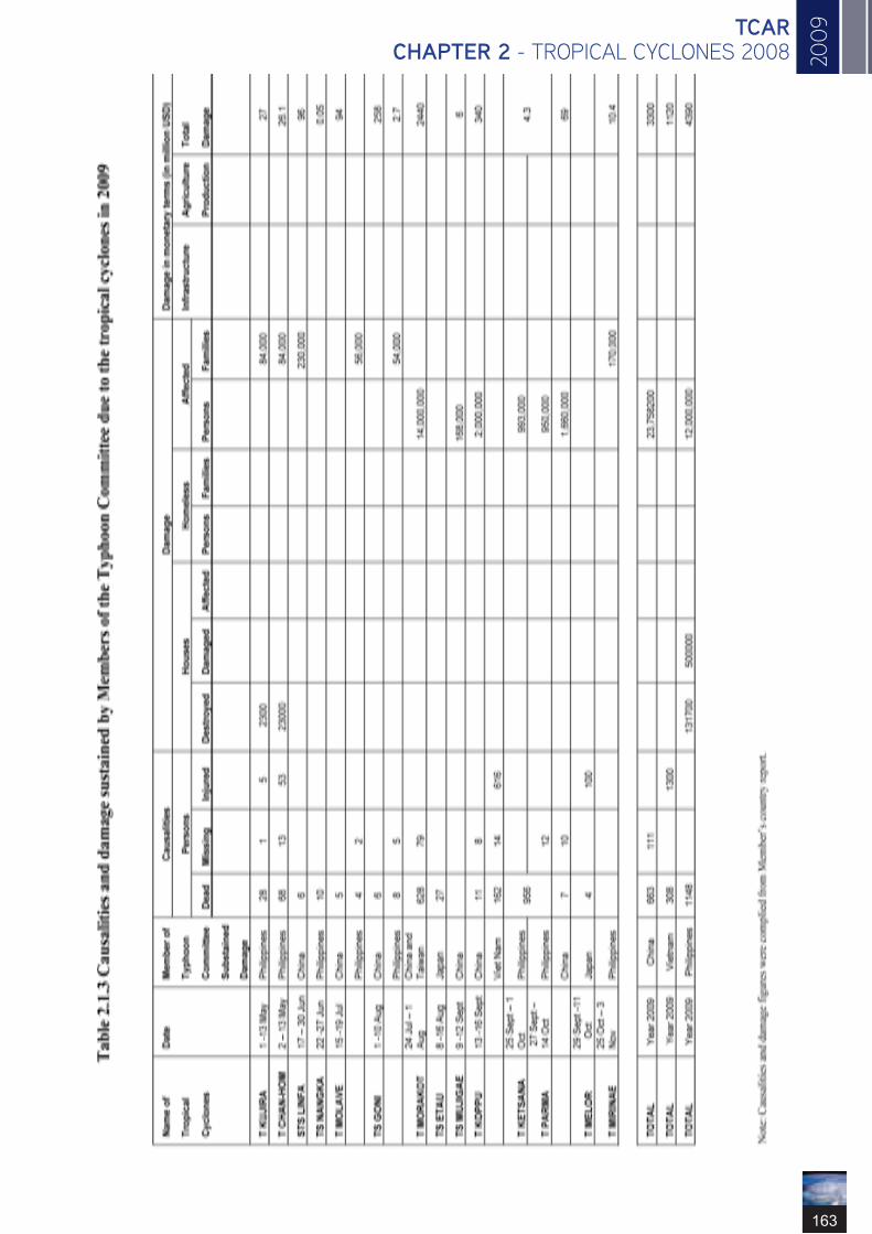
20
09
163
TCAR CHAPTER 2 - TROPICAL CYCLONES 2008

164
ESCAP/WMO Typhoon Committee Annual Review 2009
2.2. NARRATIVE REPORTS OF INDIVIDUAL TROPICAL CYCLONES WHICH AFFECTED MEMBERS OF THE TYPHOON COMMITTEE
2.2.1 KUJIRA (0901)1 May – 13 May
KUJIRA (0901) formed as a tropical depression off the south-eastern coast of Luzon at 12 UTC on 1 May and moved generally northeastwards. It intensified into a tropical storm at 18 UTC on 2 May and then further intensified into a severe tropical storm at 12 UTC on 3 May. Keeping its northeastwards track, it was upgraded into a typhoon at 00 UTC the next day. Kujira attained the peak strength with maximum sustained wind of 157 km/h and central pressure of 940 hPa at 18 UTC on 4 May. It weakened into a severe tropical storm on at 00 UTC 7 May and then a tropical storm at 06 UTC on 7 May. Kujira became an extra-tropical cyclone at 18 UTC the same day over the sea east of Japan.
While in the area proximate to the coast of Luzon, it was reported that Kujira caused the death of 28 people, one missing and 5 injured. About 84,000 families were affected and 2300 houses were destroyed and the economic damage worth about 27 million US dollars.

20
09
165
TCAR CHAPTER 2 - TROPICAL CYCLONES 2008
2.2.2CHAN-HOM (0902)2 – 13 June
CHAN-HOM (0902) formed as a tropical depression over the central part of South China Sea at 18 UTC on 2 May and moved slowly northeastwards and intensified into a tropical storm at 12 UTC on 3 May. Moving slowly northwards, Chan-hom further intensified into a severe tropical storm the next day at 18 UTC. It turned to move east-northeastwards and was upgraded into a typhoon at 18 UTC on 6 May reaching its peak strength with maximum sustained wind of 120 km/h with a central pressure of 975 hPa. Chan-hom crossed Luzon Island soon after being downgraded into a sever tropical storm at 12 UTC on 7 May. It weakened into a tropical storm at 06 UTC on 8 May and further into a tropical depression over the sea east of the Philippines at 00 UTC on 9 May, then turned to move to the north. Keeping its northerly track, it dissipated over the area south of Okinawa at 06 UTC on 13 May.
During the passage of Chan-hom over the Philippines, it was reported that Chan-hom caused the death of 60 people, 53 injured and 13 missing. About 84,000 families were affected and 23,000 houses were totally destroyed. The economic loss was estimated around 26.1 million US dollars.

166
ESCAP/WMO Typhoon Committee Annual Review 2009
2.2.3LINFA (0903)17 – 30 June
LINFA (0903) formed as a tropical depression over the northern part of South China Sea at 06 UTC on 17 June and moved slowly. It intensified into a tropical storm at 00 UTC the next day. Moving northwards, Linfa intensified into a severe tropical storm over the same waters at 12 UTC on 19 June. It reached its peak strength with maximum sustained wind of111 km/h with a central pressure of 975 hPa at 06UTC on 20 May. While moving northeastwards along the coast of southern China, it was weakening into a tropical depression at 06 UTC on 22 June. It further weakened into an extra-tropical cyclone over the East China Sea at 06UTC on 23 June. Linfa passed along the southern coast of Japan while continuing to move east-northeastwards, then it dissipated at 18 UTC on 30 June.While traversing the coast of Fujian province, Linfa caused 6 people died, affected 230,000 people and the economic loss was estimated about 96 million US dollars.

20
09
167
TCAR CHAPTER 2 - TROPICAL CYCLONES 2008
2.2.4NANGKA (0904)22 – 27 June
NANGKA(0904) formed as a tropical depression over the sea east of the Philippines at 12 UTC on 22 June. Moving west-northwestwards, it intensified into a tropical storm at 06 UTC on 23 June attaining its peak intensity with maximum sustained wind of 74 km/h with a central pressure of 994 hPa at 12 UTC on the same day . Nangka crossed the central Philippines and entered the South China on 24 June. Continuing its north-northwesterly trajectory, Nangka made landfall over the coastal area east of Hong Kong and weakened into a tropical depression at 18 UTC on 26 June and then dissipated over southern China at 00 UTC on 27 June. 10 people were killed during the passage of Nangka in the Philippines and the economic loss was estimated around 54,000 US dollars.

168
ESCAP/WMO Typhoon Committee Annual Review 2009
2.2.5SOUDELOR (0905)9 July – 13 July
SOUDELOR (0905) formed as a tropical depression off the northern coast of Luzon at 18 UTC on 9 July and moved west-northwestwards across the northern part of South China Sea. It intensified into a tropical storm at 00 UTC on 11 July and attained its peak intensity with maximum sustained wind of 65 km/h with a central pressure of 992hPa at 06 UTC on the same day. Continuing to move west-northwestwards, Soudelor crossed the northern tip of Leizhou Peninsula and weakened into a tropical depression at 00 UTC on 12 July. It made landfall over the coast of northern Viet Nam and then dissipated at 00 UTC the next day. No significant damages were reported.

20
09
169
TCAR CHAPTER 2 - TROPICAL CYCLONES 2008
2.2.6MOLAVE (0906)15 July – 19 July
MOLAVE (0906) formed as a tropical depression over the sea east of the Philippines at 00 UTC on 15 July and moved generally northwestwards. It intensified into a tropical storm at 06 UTC on 16 July. While crossing the Luzon Strait on 17 July, it further intensified into a severe tropical storm at 06 UTC on 17 July and then a typhoon at 18 UTC on the same day while reaching its peak intensity with maximum sustained wind of 120 km/h and a central pressure of 975 hPa. Keeping its west-northwestwards track, it made landfall over Shenzhen in the late hour on 18 July. Molave weakened rapidly into a sever tropical storm at 18 UTC on 18 July, a tropical storm 6 hours later and a tropical depression at 06 UTC on 19 July. It then dissipated over southern China at 12 UTC that day. In China, the direct economic loss was estimated about 94 million US dollars and 5 people were reported dead. In the Philippines, it was reported that 4 people died and 2 missing and about 56,000 families were affected due to the passage of Molave close to Luzon.

170
ESCAP/WMO Typhoon Committee Annual Review 2009
2.2.7GONI (0907)1 August – 10 August
GONI (0907) formed as a tropical depression over the sea east of the Philippines on at 06 UTC on 1 August, and moved generally westwards, crossing the Luzon Island and entered the South China Sea the next morning, Then it turned to move northwestwards and intensified into a tropical storm 12 UTC on 3 August. It reached its peak intensity with maximum sustained wind of 74 km/h and a central pressure of 990 hPa at 06UTC on 17 July on 4 August. Goni landed on the coast of Guangdong Province on 5 August and weakened into a tropical depression at 06 UTC the next day. After crossing the Leizhou Peninsula, it gradually turned southwestwards and entered the Beibu Gulf where it intensified again into a tropical storm at 06 UTC on 7 August. While weakening into a tropical depression at 06 UTC on 8 August, it turned southwestwards and gradually to move northeastwards. Later it dissipated over the northwestern part of the South China Sea at 06 UTC on 10 August.Goni caused the death of 6 people and economic damage of 258 million US dollars in China. While in the Philippines, the economic loss was estimated about 2.7 million US dollars, more than 54,000 families were affected. 8 people died and 5 missing in the Philippines was also reported.

20
09
171
TCAR CHAPTER 2 - TROPICAL CYCLONES 2008
2.2.8MORAKOT (0908)24 July - 01 August
Morakot (0908) formed as a tropical depression over the western North Pacific at 18 UTC on 2 August and initially moved eastwards. It soon intensified into a tropical cyclone at 00 UTC on 3 August. It then turned to move westwards and intensified into severe tropical cyclone at 12 UTC on 4 August and reached the typhoon intensity at 18 UTC on 5 August. It attained its peak intensity with maximum sustained wind of 139 km/h and a central pressure of 945 hPa at 15 UTC on 6 August. Morakot crossed Taiwan on 7 August and then weakened into a severe tropical storm at 00 UTC on 8 August. It gradually turned to move northwards and made landfall in Fujian Province on 9 August, while weakening further into a tropical storm at 18 UTC on the same day. It then moved northwards across eastern China and further weakened into a tropical depression at 18 UTC on 10 August. Turning to move northeastwards, it passed over the Yellow Sea and transformed into an extra-tropical cyclone at 18 UTC and dissipated at 06 UTC on 11 August.More than 600 people were killed due to the enormous mudslides and severe flooding caused by the extreme rainfall associated with Morakot. The total economic damages in China and Taiwan was estimated about 2.44 billion US dollars and more than 1.4 million people were affected

172
ESCAP/WMO Typhoon Committee Annual Review 2009
2.2.9ETAU (0909)8 August - 16 August
ETAU (0909) formed as a tropical depression over the western North Pacific southwest of Iwoto Island at 00 UTC on 8 August and moved northwestwards. It intensified into a tropical storm at 06 UTC the next day. Etau reached its peak intensity with maximum sustained wind of 74 km/h with a central pressure of 992 hPa at 00 UTC on 10 August and was gradually turning to move northeastwards. It then turned eastwards and weakened into a tropical depression at 00 UTC on 13 August after turning northwards. It then moved generally to the east and became an extra-tropical cyclone at 12 UTC on 14 August. It was reported 27 were killed or unaccounted in Japan.

20
09
173
TCAR CHAPTER 2 - TROPICAL CYCLONES 2008
2.2.10VAMCO (0910)16 August - 26 August
VAMCO (0910) formed as a tropical depression over the western North Pacific west of the Marshall Islands at 12 UTC on 16 August and moved generally north-northwestwards. It intensified first into a tropical storm at 18 UTC on 17 August, and then a severe tropical storm at 12 UTC on 18 August, and reached typhoon intensity at 00 UTC on 19 August. Vamco attained its peak intensity with maximum sustained wind of 167 km/h and a central pressure of 945 hPa at 00 UTC on 20 August. It turned to move northwards on 23 August and then north-northeastwards. Vamco weakened into a severe tropical storm at 12 UTC on 25 August and then became an extra-tropical cyclone over the western North Pacific to the east of Kamchatka Peninsula at 00 UTC on 26 August. No significant damages were reported.

174
ESCAP/WMO Typhoon Committee Annual Review 2009
2.2.11KROVANH (0911)28 August - 2 September
KROVANH (0911) formed as a tropical depression to the east of Mariana Islands at 00 UTC on 28 August. Moving northwards, it intensified into a tropical storm at 12 UTC that day. Krovanh turned to move northwestwards and further intensified into a severe tropical storm at 18 UTC on 29 August. It attained its peak intensity with maximum wind of 111 km/h and a central pressure of 975 hPa at 18 UTC on 30 Augus. Gradually turning to move northeastwards, Krovanh traversed the eastern coast of Japan on 31 August. Continuing its northeasterly trajectory, it weakened into a tropical storm at 21 UTC on 31 August and became an extra-tropical cyclone to the east of Hokkaido 1 September on 1 September. No significant damages were reportred.

20
09
175
TCAR CHAPTER 2 - TROPICAL CYCLONES 2008
2.2.12DUJUAN (0912)2 September – 11 September
DUJIAN (0912) formed as a tropical depression over the sea east of the Luzon at 18 UTC on 2 September. At first it started to move westwards, it later turned to move eastwards and intensified into a tropical storm at 18 UTC on 3 September. Turning to move northeastwards, it intensified further into a severe tropical storm at 00 UTC on 5 September and attained its peak intensity with maximum sustained wind of 93 km/h and a central pressure of 980 hPa . Dujian moved east-northeastwards across the western North Pacific to the south of Japan. It became an extra-tropical cyclone overt the western North Pacific to the east of Japan at 06 UTC on 10 Sept. No significant damages were reported.

176
ESCAP/WMO Typhoon Committee Annual Review 2009
2.2.13MUJIGAE (0913)9 – 12 September
MUJIGAE (0913) formed as a tropical depression over the sea east of Luzon Island at 00 UTC on 9 September and moved west-northwestwards. It intensified into a tropical storm over the northern part of South China Sea to the south of Hong Kong at 00 UTC on 10 September while attaining its peak intensity with maximum wind of 74 km/h and a central pressure of 994 hPa at 00 UTC on 11 September. It turned to move westwards crossing the northern part of Hainan Island. Keeping its westerly track, Mujigae weakened into a tropical depression at 00 UTC on 12 September after it made landfall over northern Viet Nam. It further weakened into an area of low pressure over northern Viet Nam. The direct economic loss in China was estimated about 6 million US dollars.

20
09
177
TCAR CHAPTER 2 - TROPICAL CYCLONES 2008
2.2.14CHOI-WAN (0914)12 – 21 September
CHOI-WAN (0914) formed as tropical depression over the western North Pacific to the east of Guam at 00 UTC on 12 September and moved west-northwestwards. It intensified into a tropical storm at 18 UTC that day. It rapidly intensified into severe tropical storm at 06 UTC on 13 September then typhoon at 00 UTC on 14 September after turning to move westwards. It attained its peak intensity with maximum wind of 194 km/h and a central pressure of 915 hPa at 12 UTC on 15 September. Choi-wan continued to move west-northwestwards and gradually turning to move northeastwards. It weakened into a severe tropical storm at 06 UTC on 20 September, then rapidly transformed into an extra-tropical cyclone to the east of Japan at 12 UTC on 20 September. It dissipated at 00 UTC on 21 September. No significant damages were reported.

178
ESCAP/WMO Typhoon Committee Annual Review 2009
2.2.15KOPPU (0915)13 – 16 September
KOPPU (0915) formed as a tropical depression off the northern coast of Luzon Island at 00 UTC on 13 September and moved at first westwards. It intensified into a tropical storm at 18 UTC that day as it turned to move west-northwestwards. Koppu intensified into severe tropical storm at 06 UTC then typhoon at 18 UTC on 14 September while attaining its peak intensity with maximum sustained wind of 120 km/h and a central pressure of 975 hPa. It made landfall over western Guangdong on 15 September and weakened into a severe tropical storm at 00 UTC, a tropical storm at 06 UTC and a tropical depression at 12 UTC on 15 September. Koppu dissipated over Guangxi at 00 UTC on 16 September.
In China, it was reported the direct economic loss was estimated about 340 million US dollars and 11 people died.

20
09
179
TCAR CHAPTER 2 - TROPICAL CYCLONES 2008
2.2.16KETSANA (0916)25 September– 1 October
KETSANA (0916) formed as a tropical depression over the western North Pacific east of the Philippines at 00 UTC on 25 September and moved generally westwards. It intensified into a tropical storm at 00 UTC the next day. After crossing the Philippines, Ketsana entered the South China later on that day. Ketsana intensified into a severe tropical storm at 00 UTC on 27 September and then further into a typhoon at 06 UTC on 28 September while attaining its peak intensity with maximum sustained wind of 130 km/h and a central pressure of 960 hPa. It made landfall on Viet Nam soon afterwards, then weakened into a severe tropical storm at 12 UTC on 29 September and a tropical storm 6 hours later. It was further downgraded into tropical depression intensity at 06 UTC on 30 September and dissipated in Viet Nam at 00 UTC on 1 October.
It was reported in Viet Nam, 162 people died, 14 missing and 616 injured. While in the Philippines, Ketsana caused significant causalities and economic damages and about 993,000 families were affected.

180
ESCAP/WMO Typhoon Committee Annual Review 2009
2.2.17PARMA (0917)
27 September – 14 October
PARMA (0917) formed as a tropical depression over the western North Pacific south of Guam at 18 UTC on 27 September and moved west-southwestwards. It intensified into a tropical storm at 06 UTC and a severe tropical storm at 18 UTC on 29 September as it turned to move west-northwestwards. Maintaining its northwesterly track, it was upgraded into a typhoon at 06 UTC on 30 September over the sea east of the Philippines and attained its peak intensity with maximum sustained wind of 185 km/h and a central pressure of 930 hPa at 00 UTC on 1 October. Parma crossed the northern part of Luzon on 3 October and remained lingering around this area for the following 6 days while diminishing its intensity. Parma weakened into a severe tropical storm at 18 UTC on 3 October, a tropical storm at 18 UTC on 6 October and a tropical depression over the South China Sea at 00 UTC on 10 October. While moving westwards, it re-intensified to tropical storm at 00 UTC the next day. Turning to move west-northwestwards, Parma crossed the Hainan Island and weakened into a tropical depression at 00 UTC on 14 October and dissipated later over Beibu Wan at 18 UTC.
There were more than 23 million people were affected in China and 7 people died and 10 missing. The economic loss was about 69 million US dollars. In the Philippines more than 950,000 families were affected. The combined economic loss due to Ketsana and Parma was estimated about 4.3 billion US dollars.

20
09
181
TCAR CHAPTER 2 - TROPICAL CYCLONES 2008
2.2.18MELOR (0918)29 September – 11 October
MELOR (0918) formed as a tropical depression west of the Marshall Islands at 06 UTC on 29 September and moved generally west-northwestwards. It intensified into tropical storm at 00 UTC and a severe tropical storm at 18 UTC the next day, then rapidly into a typhoon at 00 UTC on 1 October. Melor attained its peak intensity with maximum sustained wind of 204 km/h and a central pressure of 910 hPa at 06 UTC on 4 October Maintaining its typhoon intensity and northwesterly track, Melor was gradually recurving to move in the northeast direction. Melor made landfall over Honshu on 7 October with typhoon intensity, then it moved across the southern part of Honshu and weakened into a sever tropical storm at 00 UTC on 8 October. It became an extra-tropical cyclone over the sea east of Hohshu at 12 UTC on 8 October and dissipated on at 06 UTC 11 October. It was reported that 4 people were killed and more than 100 injured in Japan.

182
ESCAP/WMO Typhoon Committee Annual Review 2009
2.2.19NEPARTAK (0919)8 – 15 October
NEPARTAK (0919) formed as a tropical depression west of Saipan at 00 UTC on 8 October and moved north-northwestward. It intensified into a tropical storm at 06 UTC the next day and turned to move northeastwards. Nepartak attained its peak intensity with maximum sustained wind of 83 km/h and a central pressure of 992 hPa at 00UTC on 12 October. Continuing its northeasterly track with accelerated speed, it became an extra-tropical cyclone at 00 UTC on 14 October. No significant damages were reported.

20
09
183
TCAR CHAPTER 2 - TROPICAL CYCLONES 2008
2.2.20LUPIT (0920)14 – 31 October
LUPIT (0920) formed as a tropical depression over the western North Pacific southeast of Guam at 12 UTC on 14 October and moved west-northwestwards. It intensified into a tropical storm at 12 UTC on 15 October and severe tropical storm at 06 UTC then typhoon at 18 UTC on 16 octoberr. It attained its peak intensity with maximum wind of 176 km/h and a central pressure of 930 hPa at 18 UTC on 18 October. Lupit gradually turned to move slowly from northwards to generally westwards and weakened into a severe tropical storm at 06 UTC on 23 October off the northeastern coast of Luzon. It then turned to move northeastward traversing the sea to the south of Japan. While accelerating along the northeasterly track, it became an extra-tropical cyclone at 00 UTC on 27 October and dissipated in the area north of Aleutian Islands at 00 UTC on 31 October. No significant damages were reported.

184
ESCAP/WMO Typhoon Committee Annual Review 2009
2.2.21MIRINAE (0921)
25 October – 3 November
MIRINAE (0921) formed as a tropical depression over the western North Pacific east of Guam at 18 UTC on 25 October and moved west-northwestwards while intensifying into a tropical storm at 06 UTC and a severe tropical storm at 18 UTC on 27 October. It intensified further to a typhoon over the sea to the east of Luzon at 00UTC on 28 October and attained its peak intensity with maximum sustained wind of 148 km/h and a central pressure of 955 hPa at 12 UTC on 28 October. Mirinae crossed Luzon soon after weakening into a severe tropical storm at 12 UTC on 30 October, and subsequently entered the central part of South China Sea. Moving westwards across the South China Sea, Mirinae weakened into a tropical storm 12 UTC on 31 October and made landfall over the Viet Nam on 2 November. It subsequently weakened further into a tropical depression at 18 UTC on 2 November and then dissipated at 00 UTC next day.
In the Philippines more than 170,000 families were affected. The economic loss due to the passage of Mirinae was estimated about 10.4 million US dollars.

20
09
185
TCAR CHAPTER 2 - TROPICAL CYCLONES 2008
2.2.22NIDA (0922)21 November – 3 December
NIDA (0922) formed as a tropical depression over the western North Pacific to the southeast of Guam at 18 UTC on 21 November and was moving slowly northwards. Turning to move northwestwards, Nida intensified into tropical storm at 12 UTC on 23 November and a severe tropical storm at 00 UTC on 24 November. Continuing its northwesterly track, Nida rapidly intensified into a typhoon 6 hours later and attained its peak intensity with the maximum sustained wind of 213 km/h and central pressure of 905 hPa at 18 UTC on 25 November. Nida was moving slowly again on 28 and 29 November. Then it moved west-northwestwards while weakening into a severe tropical storm at 18 UTC on 1 December, a tropical storm at 12 UTC on 2 December. It further weakened into a tropical depression at 00 UTC on 3 December and dissipated over the western North Pacific northwest of Okinotorishima Islands at 18 UTC that day. No significant damages were reported.

186
ESCAP/WMO Typhoon Committee Annual Review 2009

20
09
187
TCAR CHAPTER 3 - CONTRIBUTED PAPERS
CONTRIBUTED PAPERS

188
ESCAP/WMO Typhoon Committee Annual Review 2009

20
09
189
TCAR CHAPTER 3 - CONTRIBUTED PAPERS

190
ESCAP/WMO Typhoon Committee Annual Review 2009

20
09
191
TCAR CHAPTER 3 - CONTRIBUTED PAPERS

192
ESCAP/WMO Typhoon Committee Annual Review 2009

20
09
193
TCAR CHAPTER 3 - CONTRIBUTED PAPERS

194
ESCAP/WMO Typhoon Committee Annual Review 2009

20
09
195
TCAR CHAPTER 3 - CONTRIBUTED PAPERS

196
ESCAP/WMO Typhoon Committee Annual Review 2009

20
09
197
TCAR CHAPTER 3 - CONTRIBUTED PAPERS

198
ESCAP/WMO Typhoon Committee Annual Review 2009

20
09
199
TCAR CHAPTER 3 - CONTRIBUTED PAPERS

200
ESCAP/WMO Typhoon Committee Annual Review 2009

20
09
201
TCAR CHAPTER 3 - CONTRIBUTED PAPERS

202
ESCAP/WMO Typhoon Committee Annual Review 2009

20
09
203
TCAR CHAPTER 3 - CONTRIBUTED PAPERS

204
ESCAP/WMO Typhoon Committee Annual Review 2009

20
09
205
TCAR CHAPTER 3 - CONTRIBUTED PAPERS

206
ESCAP/WMO Typhoon Committee Annual Review 2009

20
09
207
TCAR CHAPTER 3 - CONTRIBUTED PAPERS

208
ESCAP/WMO Typhoon Committee Annual Review 2009

20
09
209
TCAR CHAPTER 3 - CONTRIBUTED PAPERS

210
ESCAP/WMO Typhoon Committee Annual Review 2009

20
09
211
TCAR CHAPTER 3 - CONTRIBUTED PAPERS

212
ESCAP/WMO Typhoon Committee Annual Review 2009

20
09
213
TCAR CHAPTER 3 - CONTRIBUTED PAPERS
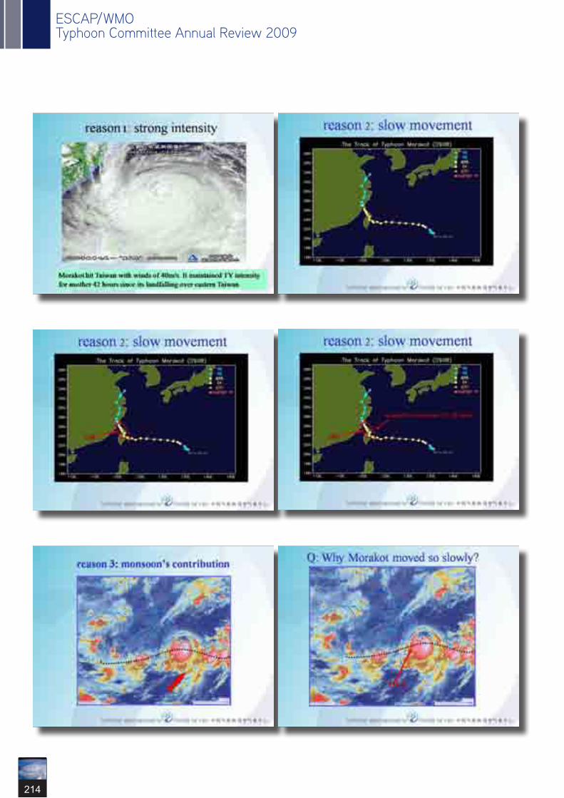
214
ESCAP/WMO Typhoon Committee Annual Review 2009

20
09
215
TCAR CHAPTER 3 - CONTRIBUTED PAPERS

216
ESCAP/WMO Typhoon Committee Annual Review 2009

20
09
217
TCAR CHAPTER 3 - CONTRIBUTED PAPERS

218
ESCAP/WMO Typhoon Committee Annual Review 2009

20
09
219
TCAR CHAPTER 3 - CONTRIBUTED PAPERS

220
ESCAP/WMO Typhoon Committee Annual Review 2009

20
09
221
TCAR CHAPTER 3 - CONTRIBUTED PAPERS

222
ESCAP/WMO Typhoon Committee Annual Review 2009

20
09
223
TCAR CHAPTER 3 - CONTRIBUTED PAPERS

224
ESCAP/WMO Typhoon Committee Annual Review 2009

20
09
225
TCAR CHAPTER 3 - CONTRIBUTED PAPERS

226
ESCAP/WMO Typhoon Committee Annual Review 2009

20
09
227
TCAR CHAPTER 3 - CONTRIBUTED PAPERS

228
ESCAP/WMO Typhoon Committee Annual Review 2009

20
09
229
TCAR CHAPTER 3 - CONTRIBUTED PAPERS

230
ESCAP/WMO Typhoon Committee Annual Review 2009

20
09
231
TCAR CHAPTER 3 - CONTRIBUTED PAPERS

232
ESCAP/WMO Typhoon Committee Annual Review 2009

20
09
233
TCAR CHAPTER 3 - CONTRIBUTED PAPERS

234
ESCAP/WMO Typhoon Committee Annual Review 2009

20
09
235
TCAR CHAPTER 3 - CONTRIBUTED PAPERS

236
ESCAP/WMO Typhoon Committee Annual Review 2009

20
09
237
TCAR CHAPTER 3 - CONTRIBUTED PAPERS

238
ESCAP/WMO Typhoon Committee Annual Review 2009

20
09
239
TCAR CHAPTER 3 - CONTRIBUTED PAPERS

240
ESCAP/WMO Typhoon Committee Annual Review 2009

20
09
241
TCAR CHAPTER 3 - CONTRIBUTED PAPERS

242
ESCAP/WMO Typhoon Committee Annual Review 2009

20
09
243
TCAR CHAPTER 3 - CONTRIBUTED PAPERS

244
ESCAP/WMO Typhoon Committee Annual Review 2009

20
09
245
TCAR CHAPTER 3 - CONTRIBUTED PAPERS

246
ESCAP/WMO Typhoon Committee Annual Review 2009

20
09
247
TCAR CHAPTER 3 - CONTRIBUTED PAPERS

248
ESCAP/WMO Typhoon Committee Annual Review 2009

20
09
249
TCAR CHAPTER 3 - CONTRIBUTED PAPERS

250
ESCAP/WMO Typhoon Committee Annual Review 2009

20
09
251
TCAR CHAPTER 3 - CONTRIBUTED PAPERS

252
ESCAP/WMO Typhoon Committee Annual Review 2009

20
09
253
TCAR CHAPTER 3 - CONTRIBUTED PAPERS

254
ESCAP/WMO Typhoon Committee Annual Review 2009

20
09
255
TCAR CHAPTER 3 - CONTRIBUTED PAPERS

256
ESCAP/WMO Typhoon Committee Annual Review 2009

20
09
257
TCAR CHAPTER 3 - CONTRIBUTED PAPERS

258
ESCAP/WMO Typhoon Committee Annual Review 2009

20
09
259
TCAR CHAPTER 3 - CONTRIBUTED PAPERS

260
ESCAP/WMO Typhoon Committee Annual Review 2009

20
09
261
TCAR CHAPTER 4 - WMO TROPICAL CYCLONE NEWS
WMO TROPICAL CYCLONES NEWS 2009
4.1 Introduction
The WMO Tropical Cyclone Programme carries out its activities in accordance with the guidance given by the Members through WMO Congress (Cg) and Executive Council (EC) to achieve the goals of the WMO Strategic Plan. The resolutions and decisions at the EC session in the reference year with particular relevance to the Programme are highlighted in the following.The sixty-first session of EC (EC-LXI, Geneva, June 2009) discussed implementation of the Tropical Cyclone Programme and provided guidance under the Expected Results 1, 6 and 9 of the WMO Strategic Plan.With reference to advances in operational weather forecasts and warnings, EC-LXI reaffirmed the use of ensemble techniques including multi-model consensus forecasting by the national and regional tropical cyclone warning centres to further improve the application of NWP to tropical cyclone forecasting. It also underlined the dissemination of ensemble-based probabilistic guidance to improve the representation of forecast uncertainty which will be especially useful for disaster risk management in threatened areas. In this regard, the Council noted with satisfaction that the Technical Forum for EPS and the operational system for data processing and display was held in the Republic of Korea for the forecasters of Typhoon Committee members in May 2009. The Council recognized that such training workshops facilitate the use of ensemble-based products in forecaster- and user-friendly forms through a systematic and optimized approach. The Council therefore requested the Secretary-General to give high priority to the organization of such workshops in other regions for the best use of those products.As regards improving forecast of tropical cyclones and their impacts, the Council noted that the working environment of tropical cyclone forecasters has been changing rapidly in many NMHSs with increased availability of data from new observational systems as well as forecast
products, including EPS from major NWP centres. In the meantime, demands are increasing in diverse user communities for the tropical cyclone warning service that could be more compliant to their disaster risk management activities. Given those circumstances, the Council recognized the need to enhance support measures for the forecasters to optimize the efficiency of warning services and develop operational strategies to meet the growing demands from the users. Accordingly, the Council requested the Secretary-General to revise and update the Global Guide to Tropical Cyclone Forecasting as early as possible with due consideration for the newly emerging requirements. It also underlined that the new Global Guide be linked to the Tropical Cyclone Forecaster’s website which will allow the operational forecasters for easier access to the up-to-date tools and reference materials for monitoring and forecasting of tropical cyclone track and intensity. Improvements of operational tropical cyclone forecasting and warning should be based on advances in research and technical developments on tropical cyclones. In this connection, the Council recognized that, while tropical cyclone forecasts have attained increasing accuracies in the track forecasting, they still rely heavily on the research and technology developments for improvement of forecasting tropical cyclone intensities, associated heavy rainfall and storm surge, as well as seasonal frequency of tropical cyclones. The Council therefore reiterated that high priority be continuously given to transferring from R&D into operational use aspects of forecasting of rapid changes of track and intensity of tropical cyclones and the impact of associated hazards during tropical cyclone landfall due to its significance for disaster prevention. To focus R&D activities and facilitate the transfer to operations, the Council encouraged active interaction between operational forecasters and researchers as a key to success. Noting that the research workshops and projects organized by TCP and WWRP provide excellent opportunities

262
ESCAP/WMO Typhoon Committee Annual Review 2009
in this regard, the Council urged the Secretary-General to take necessary actions to promote the involvement of operational forecasters in those events particularly the Seventh International Workshop on Tropical Cyclones (IWTC) (November 2010) and the Second International Workshop on Tropical Cyclone Landfall Processes (October 2009). In reference to its request to the Secretary-General to facilitate in consultation with UNESCO-IOC the development of storm surge watch schemes (SSWS), the Council was pleased to note that through collaborative efforts of JCOMM and TCP, immediate actions were taken by the five TCP regional bodies to assist their Members by establishing regionally coordinated frameworks for enhancing their capabilities to access and understand existing wave and storm surge products worldwide, and to make use of them for operational forecast and warning services. The Council requested the Secretary-General: (i) to keep Members informed of the developments and to continue; (ii) to give high priority to these activities, including facilitating and supporting the regional associations concerned in the development of SSWS; and (iii) to continue capacity-building activities related to use of SSWS guidance information. The Council urged Members concerned to take appropriate actions to improve storm surge and wave forecast and warning services within their areas of responsibility. In recognition of the impacts of the TCP/JCOMM training workshop series on storm surge and wave forecasting, the Council requested the Secretary-General to continue to support such training workshops in the future. With regard to the capacity building, the Council recognized that the developing countries, especially Small Island Developing States (SIDS) and the Least Developed Countries (LDCs) are increasingly more vulnerable to tropical cyclone impacts due to lack of human resources and a high degree of economic vulnerability. The Council reaffirmed the need for sustainable training efforts especially for SIDS and LDCs to allow them to achieve skills and competencies required for effective operational tropical cyclone forecasting and warnings for minimizing tropical cyclone disaster risks. In this regard, the Council
noted that the continuing collaboration between the Tropical Cyclone Programme (TCP) and the Public Weather Services Programme has proved its effectiveness in integrated training of tropical cyclone forecasters in Regions I, II, IV and V. The Council also underlined the importance of the transfer of practical techniques to the forecasters through the attachment trainings at TC RSMCs. The Council requested the Secretariat to include forecasters from all affected regions in future training of this nature.
4.2 Activities of TCP since TCAR-2008
The TCP comprises two components: a general component concerned with methodology and transfer of technology and a regional component devoted to the activities of five regional tropical cyclone bodies. The updated lists of the Members of these bodies are shown in Appendix I.
4.2.1 TCP events in the past yearFor the period from 1 December 2008, the following events were organized or co-sponsored under the Programme:- The 5th TCP/JCOMM Workshop on Storm Surge and Wave Forecasting (Melbourne, Australia, 1 - 5 December 2008); - ESCAP/WMO Typhoon Committee, 41st session (Chiang Mai, Thailand; 19 – 24 January 2009);- Tropical Cyclone Operational Forecasting Training at RSMC New Delhi – Tropical Cyclone Centre (New Delhi, India, 9 to 20 February 2009);- WMO/ESCAP Panel on Tropical Cyclones High Policy Working Group, the First Meeting (Muscat, Oman; 27 – 28 February 2009);- WMO/ESCAP Panel on Tropical Cyclones, 36th session (Muscat, Oman; 2 – 6 March 2009);- The First International Conference on Indian Ocean Tropical Cyclones and Climate Change (Muscat, Oman; 8 – 11 March 2009);- RA IV Workshop on Hurricane Forecasting and Warning and Public Weather Services (Miami, USA; 23 March to 3 April, 2009); - RA IV Hurricane Committee 31st session (Nassau, Bahamas, 20 – 24 April 2009);- The First ESCAR/WMO Typhoon Committee TRCG Technical Forum on EPS, Probabilistic Forecast and TIPS (Jeju Island, Republic of Korea; 12 – 15 May 2009);

20
09
263
TCAR CHAPTER 4 - WMO TROPICAL CYCLONE NEWS
- Attachment of Typhoon Forecasters from China and Malaysia for Typhoon Operational Forecasting Training at RSMC Tokyo-Typhoon Center (Tokyo, Japan, 22-31 July 2009);- The ESCAP/WMO Typhoon Committee Integrated Workshop on Building Sustainability and Resilience in High Risk Area of the Typhoon Committee: Assessment and Action (Cebu, Philippines, 14-18 September 2009);- The Eighth Southern Hemisphere Training Course on Tropical Cyclones (Melbourne, Australia, 29 September - 9 October 2009);- Storm Surge Attachment Training at IIT (Delhi, India, 28 September - 10 October 2009);- The Second International Workshop on Tropical Cyclone Landfall Processes (Shanghai, China, 19-23 October 2009);- The Sixth Tropical Cyclone RSMCs/TCWCs Technical Coordination Meeting (Brisbane, Australia, 2-6 November 2009);- Attachment of two forecasters from Cook Islands and Samoa for the on-the-job training on operational analysis and forecasting of tropical cyclone at the RSMC Nadi Tropical Cyclone Centre (Fiji, 23 November – 4 December 2009).
4.2.2 Activities under the general component
The main activities under the general component continued to be directed towards the publication of manuals and reports, which provide information and guidance to Members to assist them in the increased application of scientific knowledge and technology for the improvement of warning and disaster prevention and preparedness systems corresponding Expected Results I and VI on enhanced capabilities of forecasting and warning service delivery and disaster risk reduction. Under this component, attention was also given to the broader aspects of training under the TCP.Priorities were given to capacity building to address the issue of sustainable development with emphases particularly on attachments of forecasters from developing countries at the different Regional Specialized Meteorological Centres (RSMCs) during the cyclone season and storm surge/wave experts at the Indian Institute of Technology in Kharagpur, India, a number of workshops and a joint training event in cooperation with the Public Weather Service Programme, and a number of Working Group (Committee)
sessions co-joint with Disaster Risk Reduction Programme. These activities are in accordance with the programme’s objective to facilitate the transfer of knowledge and technology to improve the institutional efficiency of the NMHSs leading to the provision of better tropical cyclone track and intensity forecasts and associated flood and storm surge forecasts, and coordinated actions towards tropical cyclone disaster risk reduction. The TCP home page within the WMO Web site http://www.wmo.int/pages/prog/www/tcp/index_en.html is continuously being updated. In addition, the TCP Forecaster’s website has started to develop for purpose of technology transfer under changing environment.WMO continued to be engaged in the services of Systems Engineering Australlia Pty Ltd (SEA) to undertake reviews and assessments that would lead to the recommendation of suitable conversion factors between the WMO 10-minute standard average wind and 1-minute, 2-minute and 3-minute “sustained” winds. The SEA submitted to the final report in January 2009, with one page executive summary for the final review at this meeting. This undertaking is trying to determine the conversion factors connecting the various wind averaging periods and its subsequent inclusion into the Global Guide to Tropical Cyclone Forecasting and the Operational Plans/Manual of the TC regional bodies. Tropical cyclone news for the WMO news website http://www.wmo.int/pages/mediacentre/news/index_en.html will be continuously provided for facilitating media outreach.The Global Guide to Tropical Cyclone Forecasting has been undertaking updating, and is expected to have the first reviewed version in January 2010. After completion, it will be posted to the TCP Forecaster’s website for widespread access by forecasters and researchers around the globe.
4.2.3 Activities under the regional component
Many activities of the TCP were carried out under the regional component with a view to minimizing tropical cyclone disasters through close regional cooperation and coordination. Major emphasis was placed on improvement in the accuracy of the forecasts, provision of timely early warnings and on the establishment of necessary disaster preparedness measures. Each of the tropical

264
ESCAP/WMO Typhoon Committee Annual Review 2009
cyclone regional bodies has in place a formally adopted tropical cyclone operational plan or manual, aimed at ensuring the most effective tropical cyclone forecasting and warning system with existing facilities, through cooperative agreement on sharing of responsibilities and on coordinated activities within the respective region. Each of these bodies was giving attention to the implementation of their technical plan for future development of services to meet regional needs for upgrading forecasting and warning facilities and services for tropical cyclones and associated floods and storm surges, as well as for related disaster risk reduction measures and supporting activities in training and research.The detailed activities of regional bodies are described as below.
4.2.3.1 ESCAP/WMO Typhoon Committee
· The Forty-first Session of the Committee was held in Chiang Mai, Thailand; 19 – 24 January 2009. It was attended by 102 participants from 12 out of 14 Members of the Typhoon Committee, namely: Cambodia; China; Hong Kong, China; Japan; Macao, China; Malaysia; Philippines; Republic of Korea; Singapore; Thailand; the Socialist Republic of Viet Nam; and the United States of America (USA) and 6 observers from the United Nations International Strategy for Disaster Reduction Secretariat (UN/ISDR), the Federal Service for Hydrometeorology and Environmental Monitoring (ROSHHYDROMET) of the Russian Federation, the United Nations Development Programme (UNDP), the Commission of Atmospheric Sciences of WMO (CAS/WMO), the Joint Typhoon Warning Center of USA and the International Civil Aviation Organization (ICAO). Representatives from the Economic and Social Commission for Asia and the Pacific (ESCAP), the World Meteorological Organization (WMO) and Typhoon Committee Secretariat (TCS) also attended the session. · Decisions by the ESCAP/WMO Typhoon Committee at its 41st session can be found in its final report which will be available in WMO/TCP website. · The First ESCAR/WMO Typhoon Committee TRCG Technical Forum on EPS, Probabilistic Forecast and TIPS (Jeju Island, Republic of Korea; 12 – 15 May 2009).
· The Japan Meteorological Agency (JMA) organized the “Attachment Training” at the RSMC Tokyo-Typhoon Center from 22 to 31 July 2009 which was attended by two female forecasters from China and Malaysia.· The ESCAP/WMO Typhoon Committee Integrated Workshop on Building Sustainability and Resilience in High Risk Area of the Typhoon Committee: Assessment and Action was organized in Cebu, Philippines, from 14 to 18 September 2009.· The Typhoon Committee Roving Seminar 2009 was held in the WMO Regional Training Centre in the Nanjing University of Science and Technology from 16 to 19 November 2009.· Publications: the 2008 Typhoon Committee Annual Review (TCAR) was published in December 2009 and disseminated to the Members, ESCAP and WMO in electronic (CD-ROM) format.
4.2.3.2 WMO/ESCAP Panel on Tropical Cyclones
· The thirty-sixth session of the WMO/ESCAP Panel on Tropical Cyclones was held in Muscat, Oman from 2 to 6 March 2009 in conjunction with the first meeting of the Panel’s High Policy Working Group (27 - 28 February 2009). The session was attended by 54 participants from eight Members of the Panel on Tropical Cyclones. It was also attended by observers from China, Islamic Republic of Iran, Saudi Arabia, IIT Delhi, UNEP, UNICEF, ICAO, EUMETSAT and representatives from WMO, ESCAP and TSU. · Decisions by the WMO/ESCAP Panel on Tropical Cyclones at its 36th session can be found in its final report which is available in WMO/TCP website.· Attachment of two forecasters from Bangladesh and Maldives was arranged by WMO and the RSMC New Delhi from 9 to 20 February 2009 for the on-the-job training at the RSMC on operational analysis and forecasting of tropical cyclone. Also, attachment trainings for storm surge experts were organized in IIT from 28 September – 10 October 2009 at the IIT Delhi in the implementation and running of a PC-based high-resolution storm surge model. · The First International Conference on Indian Ocean Tropical Cyclones and Climate Change was held in Muscat, Oman, from 8 – 11 March 2009.

20
09
265
TCAR CHAPTER 4 - WMO TROPICAL CYCLONE NEWS
It was attended by more than 50 international scientists from all over the globe. · Also, attachment trainings for storm surge experts were organized in IIT, from 28 September to 10 October 2009, at the IIT Delhi in the implementation and running of a PC-based high-resolution storm surge model.
4.2.3.3 RA I Tropical Cyclone Committee
· The Eighth Southern Hemisphere Training Course on Tropical Cyclones was held in Melbourne, Australia, from 29 September to 9 October 2009. Four participants from the region attended the workshop.
4.2.3.4 RA IV Hurricane Committee
· The Government of the USA hosted an RA IV Workshop on Hurricane Forecasting and Warning, and Public Weather Services in Miami, 23 March to 3 April, 2009. It was organized by the NWS/NOAA Tropical Prediction Center/National Hurricane Center in cooperation with WMO (TCP Division and PWS Division). The workshop was conducted in English, and attended by 23 participants from twelve Members of RA IV and three Members of RA II . And the next is in preparation, and plan to be held in Miami, USA, from 15 - 26 March 2010. · The thirty-first session of the Hurricane Committee was held in Nassau, Bahamas, from 20 – 24 April 2009. The session was held back to back with the RA IV 15th session. It was attended by members of the RA IV Hurricane Committee and some regional and international organizations. · Decisions by the RA IV Hurricane Committee at its 30th session can be found in its final report which is available in WMO/TCP website.
4.2.3.5 RA V Tropical Cyclone Committee
· The Eighth Southern Hemisphere Training Course on Tropical Cyclones was held in Melbourne, Australia, from 29 September to 9 October 2009. Eight participants from the region attended the workshop.· Attachment training of two forecasters from Cook Islands and Samoa was arranged by WMO and the RSMC Nadi Tropical Cyclone Centre, from
23 November to 4 December 2009, for the on-the-job training at the RSMC Nadi on operational analysis and forecasting of tropical cyclones.
4.2.3 Cooperation with other organizations
There has been close cooperation and collaboration with the Economic and Social Commission for Asia and the Pacific (ESCAP), the International Strategy for Disaster Reduction (ISDR) Secretariat, the Asian Disaster Reduction Center (ADRC), the International Federation of Red Cross and Red Crescent Societies (IFRC), the Joint WMO/IOC Technical Commission for Oceanography and Marine Meteorology (JCOMM), SOPAC and SPREP and other organizations, on a variety of matters of common concern. The main items include ESCAP’s co-sponsorship of the Typhoon Committee and the Panel on Tropical Cyclones, as well as the ISDR Secretariat and the ADRC’s involvement in the disaster risk reduction component of the TCP, in particular in the context of the ISDR. As part of the cooperation between WMO and the International Civil Aviation Organization (ICAO), TC RSMCs and one Tropical Cyclone Warning Centre (TCWC) are designated as ICAO Tropical Cyclone Advisory Centres (TCAC) by ICAO Regional Air Navigation Agreements. Those TCACs listed below provide specialized tropical cyclone warning services for the aviation community:
TCAC Area(s) of responsibility
Darwin (Australia)
South-eastern Indian Ocean, South-western Pacific Ocean
Honolulu (USA)
Central North Pacific
La Réunion (France)
South-western Indian Ocean
Miami (USA)North Atlantic, Caribbean, Eastern North Pacific
Nadi (Fiji) Southern Pacific
New Delhi (India)
Bay of Bengal and the Arabian Sea
Tokyo (Japan)Western North Pacific, including the South China Sea
During the period from 2 to 31 March 2009, all the TCACs participated in a coordination session with

266
ESCAP/WMO Typhoon Committee Annual Review 2009
World Area Forecast Centres (WAFCs), which was conducted four times a day via internet, in response to the request from the World Area Forecast System Operations Group (WAFSOPSG) of ICAO. This session was aimed to ensure that there is no discrepancy in tropical cyclone information between WAFS SIGWX forecasts and TCAC advisories. it was also expected to promote the collaborative relationship between WMO/TCP and ICAO/WAFS. On a regional basis, WMO, through its Tropical Cyclone Programme, has fostered and maintained close collaboration and fruitful coordination with regional bodies concerned with disaster risk reduction issues, in particular with the Asian Disaster Preparedness Center (ADPC), the Asian Disaster Reduction Center (ADRC), the Caribbean Disaster Emergency Response Agency (CDERA), and the South Pacific Regional Environment Programme (SPREP), and UN-ISDR Africa and Central America.
4.2.4 Action programme for 2010 and beyond
The TCP covers a wide range of activities which are of a continuing and long-term nature. Preceding sections of this report contain an overview of several of the ongoing activities and, in some instances, indications have been given of the plans for the period ahead. The main parts of the 2010 programme are set out below in summary form:
General component
(a) Follow-up activities on the WMO Strategic Plan;(b) Updating of the TCP home page within the WMO Web site, and the Tropical Cyclone Forecaster web site which will serve as a source for tropical cyclone forecasters to obtain forecasting and analytical tools and techniques for tropical cyclone development, motion, intensification, and wind distribution, and so on;(c) Attachment of forecasters to all six TC RSMCs during the cyclone season; (d) Continued support and coordination to update the Global Guide on Tropical Cyclone Forecasting in response to recommendation from the IWTCs. The web version of the Guide is due to be completed in November 2010;
(e) Coordination of the services and activities of six TC RSMCs (Miami, Tokyo, Honolulu, New Delhi, La Réunion and Nadi) and TCWCs (Darwin, Perth, Brisbane, Wellington, Port Moresby and Jakarta) with a view to improving regional services of the centers. Review of the global standards in forecasting techniques and warning services including those for data exchange and forecasts verification.(f) Outreach to media and general public by posting tropical cyclone information to the WMO news website, and responding by email to inquiries related to tropical cyclones around the globe.(g) Development and establishment of a Storm Surge Watch Scheme in each of the tropical cyclone regional bodies.(h) Implementation of the Typhoon Landfall Forecast Demonstration Project in East China, which was recommended to establish during the WMO Second International Workshop on Tropical Cyclone Landfall Processes (IWTCLP-II) in Shanghai, China, 19-23 October 2009, and adopted at the Fifteenth Session of the Commission for Atmospheric Sciences (CAS XV) in Incheon, Republic of Korea, 18-25 November 2009.
Regional component
Under the regional component, TCP will be mainly concerned with the activities undertaken by the five regional tropical cyclone bodies and the implementation of the decisions they make. A provisional schedule for the period from 1 December 2009 to 30 November 2010 of meetings and training events within or related to the TCP, is given below:- ESCAP/WMO Typhoon Committee Small Meeting of Chairs of the Working Groups of Meteorology, Hydrology and Disaster Prevention (Macao, China; 14 –16 December 2009); - Training on Operational Tropical Cyclone Forecasting at RSMC Tropical Cyclone – New Delhi (RSMC New Delhi, India, from 1 to 12 February 2010);- ESCAP/WMO Typhoon Committee, the Forty-second Session (Singapore, 25 – 29 January 2010);- WMO/ESCAP Panel on Tropical Cyclones, the thirty-seventh session (Phuket, Thailand; 15 – 19 February 2010);

20
09
267
TCAR CHAPTER 4 - WMO TROPICAL CYCLONE NEWS
- RA IV Hurricane Committee, Thirty-second session (Hamilton, Bermuda, 8 to 12 March 2010);- The RA IV Workshop on Hurricane Forecasting and Warning and Public Weather Services (Miami, Florida, USA; 15 – 26 March 2010); - RA V Tropical Cyclone Committee 13th Session (Bali, Indonesia; April 2010);- The 7th International Workshop on Tropical Cyclones (La Reunion, France; November 2010); - RA I Tropical Cyclone Committee, Nineteenth Session (Nairobi, Kenya, 20 – 24 September 2010);- The Seventh International Workshop on Tropical Cyclones (La Réunion, France, 15 – 20 November 2010);- RA I Training Course on Tropical Cyclones (La Réunion, France, 2 – 13 November 2010).Other Important inter-sessional activities will include:- As appropriate, preparation, editing, updating, publication and distribution of new editions or supplements to the Tropical Cyclone Operational Plans for the Bay of Bengal and Arabian Sea (English only), the South-West Indian Ocean (English and French), the South Pacific and the South-East Indian Ocean (English and French), the Hurricane Committee Region (English and Spanish) and the Operational Manual for the Typhoon Committee Area (English only);- Distribution of updated technical plans for further development of the Regional Cooperation Programmes of the five regional tropical cyclone bodies;- Publication and distribution of the “GUIDELINES FOR CONVERTING BETWEEN VARIOUS WIND AVERAGING PERIODS IN TROPICAL CYCLONE CONDITIONS” that was adopted at the Sixth Tropical Cyclone RSMCs/TCWCs Technical Coordination Meeting was held in Brisbane, Australia, from 2 to 6 November 2009; - Publication in hardcopy with limited quantity and in web format with free access of the “Global Guide to Tropical Cyclone Forecasting;”- Preparation and publication of the Typhoon Committee Annual Review for 2009 and Newsletter of 2009;- Preparation and publication of Panel on
Tropical Cyclones Annual Review for 20010 and Panel News. and, in more general terms:- Activities for the implementation of of the Tropical Cyclone Programme section of the WMO Strategic Plan;- Implementation of activities within the framework of the International Strategy for Disaster Reduction (ISDR);- Continued activities for the implementation of the Regional Cooperation Programmes, Technical Plans and other work programmes of the regional tropical cyclone bodies;- Work of study groups, sub-groups and rapporteurs established by the regional tropical cyclone bodies, e.g. training and research activities in the meteorological component of the Typhoon Committee’s programme under the leadership of the Coordinator, typhoon Training and Research Coordinating Group (TRCG), and the rapporteur on updating of the Typhoon Committee Operational Manual, the Working Group on the Panel on Tropical Cyclones Coordinated Technical Plan, the implementation of satellite based telecommunications regional networks, and on regional activities on storm surges- action on further proposals made by the Fifteenth WMO Congress, the Executive Council, the Regional Associations concerned and the regional tropical cyclone bodies.
______________________

268
ESCAP/WMO Typhoon Committee Annual Review 2009
ESC
AP/
WM
O T
YPH
OO
N
CO
MM
ITTE
EW
MO
/ESC
AP
PAN
ELO
N T
RO
PIC
AL
CYC
LON
ESR
A I T
RO
PIC
AL
CYC
LON
E C
OM
MIT
TEE
FOR
TH
E S.
W. I
ND
IAN
OC
EAN
RA
IV H
UR
RIC
AN
E C
OM
MIT
TEE
RA
V TR
OPI
CA
L C
YCLO
NE
CO
MM
ITTE
E FO
R T
HE
S. P
AC
IFIC
A
ND
S.E
. IN
DIA
N O
CEA
N(1
4 M
embe
rs)
CA
MB
OD
IAC
HIN
AD
EM
. PE
OP
LE’S
RE
P. O
F K
OR
EA
HO
NG
KO
NG
, CH
INA
*JA
PAN
@
LAO
PD
RM
AC
AO
, CH
INA
*M
ALA
YS
IAP
HIL
IPP
INE
SR
EP
UB
LIC
OF
KO
RE
AS
ING
AP
OR
ETH
AIL
AN
DU
SA
VIE
T N
AM
, SO
CIA
LIS
T R
EP
UB
LIC
OF
@R
SM
C T
okyo
- Ty
phoo
n C
ente
r
(8 M
embe
rs)
BA
NG
LAD
ES
HIN
DIA
@
MA
LDIV
ES
MYA
NM
AR
OM
AN
PAK
ISTA
NS
RI L
AN
KA
THA
ILA
ND
@ R
SM
C-T
ropi
cal C
yclo
nes-
New
Del
hi
(15
Mem
bers
)
BO
TSW
AN
AC
OM
OR
OS
FRA
NC
E@
KE
NYA
LES
OTH
OM
AD
AG
AS
CA
RM
ALA
WI
MA
UR
ITIU
SM
OZA
MB
IQU
EN
AM
IBIA
RE
P. O
F S
OU
TH A
FRIC
AS
EY
CH
ELL
ES
SW
AZI
LAN
DU
NIT
ED
RE
PU
BLI
C O
F TA
NZA
NIA
ZIM
BA
BW
E
@ R
SM
C L
a R
éuni
on -
Trop
ical
Cyc
lone
C
entre
(26
Mem
bers
)
AN
TIG
UA
& B
AR
BU
DA
BA
HA
MA
SB
AR
BA
DO
SB
ELI
ZEB
RIT
ISH
CA
RIB
BE
AN
TE
RR
ITO
RIE
S*
CA
NA
DA
CO
LOM
BIA
CO
STA
RIC
AC
UB
AD
OM
INIC
AD
OM
INIC
AN
RE
PU
BLI
CE
L S
ALV
AD
OR
FRA
NC
EG
UAT
EM
ALA
HA
ITI
HO
ND
UR
AS
JAM
AIC
AM
EX
ICO
NE
TH. A
NTI
LLE
S A
ND
AR
UB
A*
NIC
AR
AG
UA
PAN
AM
AS
T. L
UC
IATR
INID
AD
AN
D T
OB
AG
OU
KU
SA
@
VE
NE
ZUE
LA
@ R
SM
C M
iam
i - H
urric
ane
Cen
tre
(17
Mem
bers
)
AU
STR
ALI
AC
OO
K IS
LAN
DS
FIJI
@
FRE
NC
H P
OLY
NE
SIA
*IN
DO
NE
SIA
KIR
IBAT
IM
ICR
ON
ES
IAN
EW
CA
LED
ON
IA*
NE
W Z
EA
LAN
DN
IUE
PAP
UA
NE
W G
UIN
EA
SA
MO
AS
OLO
MO
N IS
LAN
DS
TON
GA
UN
ITE
D K
ING
DO
MU
SA
#
VAN
UAT
U
Non
-Mem
bers
of W
MO
(6):
- EA
ST
TIM
OR
- MA
RS
HA
LL IS
LAN
DS
- NA
UR
U- P
ALA
U- T
OK
ELA
U- T
UVA
LU
@ R
SM
C N
adi -
Tro
pica
l Cyc
lone
Cen
tre#
RS
MC
Hon
olul
u - H
urric
ane
Cen
tre
* M
embe
r Te
rrito
ry
APP
EN
DIX
ITC
P R
EGIO
NA
L B
OD
IES

20
09
269
TCAR CHAPTER 5 - RESEARCH FELLOWSHIP TECHNICAL REPORT
RESEARCH FELLOWSHIP TECHNICAL REPORT
Abstract
In studying the performance of the Japan Meteorological Agency (JMA)’s ensemble prediction system (EPS) in the prediction of tropical cyclone (TC) intensity, it was found that the simple ensemble mean forecasts demonstrated skills in both short and medium range.However, the extent of intensity change as predicted by the EPS was in general smaller than observed.
A procedure based on an artificial neural network (ANN) to calibrate the simple ensemble mean of EPS forecasts is presented in this paper.The procedure successfully reduced TC intensity forecast error in the first 120 hours by more than 50% and 20% respectively in terms of the root mean square errors of minimum pressure and maximum wind at the TC centre.
Another procedure to post-process the probability forecast of TC intensity category, based on the rank histogram calibration method, is also presented.Results showed that the procedure could improve both the resolution and reliability of the forecasts.However, its benefit when compared with forecasts derived directly from the ANN-calibrated intensities was found to be only marginal.
1. Introduction
The prediction of tropical cyclone (TC) intensity remains a challenge despite advances in numerical weather prediction (NWP) capability.Currently, the key methods in use are statistical models based primarily on climatology, persistence, and synoptic-environmental parameters (DeMaria and Kaplan,
Use of the JMA Ensemble Prediction System for Tropical Cyclone Intensity Forecasting
Chen Pei-yan 1 and Chan Sai-tick 2
Shanghai Typhoon Institute, Shanghai, ChinaHong Kong Observatory, Hong Kong, China
1994, 1999; Fitzpatrick, 1997; DeMaria et al., 2005; Knaff et al., 2003, 2005).
For more effective applications of NWP-based guidance in operational weather forecasting, the ensemble technique is becoming increasingly popular such as in the prediction of precipitation and temperature.However, in terms of TC forecasting, the focus is still very much on track and motion prediction.So far, only Weber (2005) has presented a probabilistic prediction of TC intensity using a multi-model ensemble approach.
In this study, we assess the performance of TC intensity forecasts obtained from the One-week Ensemble Prediction System (EPS) operated by the Japan Meteorological Agency (JMA), and develop procedures to calibrate the deterministic and probability forecasts derived from the system.In summary, the JMA EPS is a low-resolution version of the JMA’s Global Spectral Model (GSM) bearing the same dynamical framework and physical processes as GSM except for the horizontal resolution.It runs up to 9 days ahead for medium-range forecasting.The ensemble size including the control run is 25 (expanded to 51 in 2006). The system specifications are as shown Table 1.More details can be found in Japan Meteorological Agency (2002).Under a cooperative research arrangement set up in 2004, the Hong Kong Observatory (HKO) started receiving on a regular basis from JMA the TC position and intensity predictions from all members of the EPS to study their utilization and performance.
Table 1 -Specifications of JMA’s One-week EPS
EPS model JMA global spectral model

270
ESCAP/WMO Typhoon Committee Annual Review 2009
Frequency of operation
Once every day at 12 UTC
Forecast range 216 hours
Ensemble size 25
Integration domain Global from surface to 0.4 hPa
Horizontal resolution T106, about 1.125 degree Guassian grid
Vertical levels 40
Perturbation generator
Breeding of Growing Modes (BGM) method
Perturbed area The Northern Hemisphere and the tropics (20S-90N)
Section 2 of this paper introduces the datasets used in the study.In Section 3, the performance of the EPS intensity forecasts is discussed.Calibration of the deterministic forecasts derived from the EPS is presented in Section 4; while the probabilistic approach is explored in Section 5.Final conclusions and discussion are given in Section 6.
2. Dataset
JMA EPS TC data used in this study runs from 2003 to 2005.The datasets contain forecasts of TC intensity, i.e. minimum pressure (in hPa) and maximum wind speed (in knots, or kt), at the TC centre from each of the 25 ensemble members.The EPS runs were initialized at 12 UTC, with the forecast data output at 6 hourly intervals up to a maximum range of 216 hours.The number of samples in the JMA EPS TC datasets are shown in Fig. 1.
0
50
100
150
200
250
300
0 24 48 72 96 120 144 168 192 216
For ecas t Range ( hour )
Numb
er o
f Sa
mple
s 2003- 2004 ( Tr ai ni ng)
2005 ( I ndependent )
Fig. 1 - Number of samples in the JMA EPS TC datasets in 2003-2005
For the purpose of evaluating the JMA EPS performance in TC intensity forecasts in Section 3, HKO’s best track (BT) intensity data are taken as the “ground truth” in the verification process.For the
purpose of calibrating the intensity forecasts using an artificial neural network (ANN) in Section 4, the samples in 2003-2004 are used as the training data, and the samples in 2005 are used as an independent dataset.
3. Performance of model intensity forecasts
Since the ensemble mean forecast tends to filter out the components of the forecast that are uncertain, in general it performs better than the control or individual member forecasts.Here we take the ensemble mean intensity (EMI), comprising the ensemble mean maximum wind speed (EMW) and ensemble mean minimum pressure (EMP), as the deterministic forecasts derived from the EPS.Table 2 summarizes the root mean square errors (RMSE) of EMW and EMP:
Table 2 -RMSE of EMW and EMP for various forecast hours during 2003-2004 and 2005 (in parentheses).
RMSE for EMW (kt)2003-2004 (2005)
RMSE for EMP (hPa)2003-2004 (2005)
T+24 hour 19.2 (23.4) 35.0 (38.4)T+48 hour 22.7 (27.0) 39.1 (41.6)T+72 hour 25.7 (28.9) 42.6 (43.3)T+96 hour 26.6 (29.2) 43.7 (43.0)T+120 hour 26.3 (25.1) 42.5 (38.3)
As evident in the mean error plot in Fig. 5, the EPS significantly under-estimated the TC intensity across the whole forecast range.The EMI errors can be attributed to two factors: initialization error and forecast error.
a. Initialization error
Given the sparse observations over the oceans, TC structure cannot be adequately resolved in global models.Many NWP centers employ a “bogussing” scheme to force a tropical cyclone vortex into the numerical analysis.For JMA, a TC bogus is constructed from a standard axisymmetric vortex for well-developed tropical cyclones based on several manually-analyzed parameters such as cyclone position, central pressure and radius of gale force wind (Ueno, 1995).Fig.2 shows the error of EMI at analysis time for the 2003-2005 dataset.In general,

20
09
271
TCAR CHAPTER 5 - RESEARCH FELLOWSHIP TECHNICAL REPORT
the more intense the cyclone (x-axis), the larger are the initial EMI errors both in terms of wind and pressure (y-axis).The initial EMI minimum pressure is predominantly higher than the BT-analyzed minimum pressure for the whole range of TC intensities.For maximum wind, the EMI wind speeds in most cases are larger than the BT-analyzed values for TC of sub-typhoon strength, but are smaller than the BT-analyzed values for most typhoon cases.
Fig. 2 - Initial errors of the ensemble mean intensity of the JMA EPS TC datasets in 2003-2005
b. Forecast error
Scatter diagrams of BT intensity changes and EMI intensity changes for all samples during 2003-2005 are shown in Fig. 3.JMA EPS predictions demonstrate skills in forecasting the trend of TC intensity changes.Nevertheless, as shown by the bold line of linear regression against the perfect diagonal, the extent of changes has generally been under-predicted by the EPS, particularly for TC cases with significant weakening or intensification.
(a) (b)
Fig. 3 - Scatter diagram of BT intensity changes and EPS forecast intensity changes for all samples during 2003-2005: (a) minimum pressure; (b) maximum wind.
4. Calibration of deterministic forecasts
If the initialization errors are corrected, the RMSE of EMW for 2005 at T+24, T+48, T+72, T+96, and T+120 hour forecasts would become 16.5, 23.7, 27.9, 31.8, and 32.4 kt respectively.As shown in Fig. 4(c), removing the initialization errors could reduce the EMW errors in the first 78 hours, whereas error reduction in EMP can be achieved all the way up to T+120 hour.
To cater for the non-linearity of the forecast errors and the correlated nature of the two intensity parameters (minimum pressure and maximum wind speed), a commercially available statistical software with a radial basis function artificial neural network (ANN) (Broomhead and Lowe, 1988; Haykin, 1994) was used to devise a calibration mapping.Radial basis function networks consist of three layers: one for the inputs, one for the outputs, and a single hidden layer in between.Each unit in the hidden layer is represented by a radial basis function.The output units then complete the computation based on a weighted sum of results generated by all hidden units.The excellent approximation capabilities of radial basis function networks have been demonstrated by Park and Sandberg (1991), Poggio and Girosi (1990).
In the construction of the ANN for TC intensity change, the following input parameters are used: (a) forecast hour; (b) initial BT minimum pressure; (c) initial BT maximum wind speed; (d) change of EMP during the forecast period concerned; and (e) change of EMW during the forecast period concerned.The BT initial intensity is used in order to remove the initialization errors.There are two output nodes in the ANN, namely BT-analysed change in minimum pressure and that in maximum wind speed.
(a)(b)

272
ESCAP/WMO Typhoon Committee Annual Review 2009
(c)
Fig. 4 - Verification results of EPS ensemble mean intensity forecasts calibrated with a radial basis function neural network for TCs in 2005: (a) change
in BT minimum pressure vs. ANN-calibrated change in minimum pressure; (b) change in BT maximum wind speed vs. ANN-calibrated change in maximum wind speed; (c) RMSE of direct EPS output (EMW and EMP), calibrated intensity after removing theinitialization errors (MIEW and MIEP) from the direct EPS output, and calibrated ensemble mean intensity using ANN (ANNW and ANNP); and (d) percentage reduction in RMSE of the calibrated ensemble mean intensity using ANN.
The verification results are given in Fig. 4.The ANN successfully reduced both the mean errors of EMP and EMW, especially in the short to medium-range where the bias reductions reached 36 hPa and 15 kt respectively (not shown).This successful bias reduction led to significant improvement in the RMSE as depicted in Fig. 4(c) and (d).The improvements in the first 120 hours exceeded 50% in terms of the RMSE of minimum pressure and over 20% in terms of the RMSE of maximum wind speed.
By comparison, the performance of ANN at longer forecast range was far less satisfactory.The decrease in the skill of the underlying model could be one reason; the other reason could be due to insufficient training data

20
09
273
TCAR CHAPTER 5 - RESEARCH FELLOWSHIP TECHNICAL REPORT
as the number of samples dropped rapidly at longer forecast range (Fig. 1).
Besides, the calibrated intensity forecasts were still not quite able to forecast the rapid change of TC intensity (both deepening or weakening) as evident in Fig. 4(a) and (b).This could be attributed to model limitations in adequately resolving the TC structure with a coarse grid spacing of 1.125 degrees (i.e. around 120 km).
5. Probabilistic approach
A suite of methods have since been developed for calibrating probability forecasts derived from ensemble systems, such as multiple implementation of single-integration MOS equations (Erickson, 1996), ensemble dressing (Roulston and Smith, 2003) and logistic regression methods (Hamill et al. 2004).Hamill and Colucci (1997, 1998) described a rank histogram calibration based on the reliability of past forecasts.This method has been applied to temperature and precipitation forecasting.In this study, the same approach was tested to post-process the probability forecast of TC intensity category, according to the following classification:
• Low system (LOW) – maximum wind < 22 kt• Tropical Depression (TD) – 22 kt ≤ maximum
wind < 34 kt• Tropical Storm (TS) – 34 kt ≤ maximum wind <
48 kt• Severe Tropical Storm (STS) – 48 kt ≤ maximum
wind < 64 kt• Typhoon (TY) – 64 kt ≤ maximum wind
In view of the lack of samples and relatively unsatisfactory performance of the calibrated intensity forecasts in the longer forecast range as discussed in Section 4, probability forecasts as explored in this study will be confined to the first 120 hours.
a. Methodology The rank histogram calibration method can be divided into two steps: bias correction and calibration.
1) Bias correction
Before constructing the rank histogram, each member forecast was first de-biased to remove any systematic errors in the maximum wind forecasts.Two different
methods have been tested.The first method was simple bias removal.The correction (corr) to be made was determined as follows:
……………….(1)
where i is the forecast range (6, 12, ......, 120-h), n the number of samples, OBSW the BT maximum wind speed and EMW the ensemble mean of the maximum wind speed.
Another method was to correct all member forecasts using the ANN
approach described in Section 4.The mean errors of the direct EPS outputs and the corrected member forecasts in 2005 are plotted in Fig. 5.
The mean errors after correction using both methods described above are much reduced, falling within -5 to +5 kt for the whole forecast range.
Fig. 5 - The mean errors of the maximum wind speed forecasts in 2005.DMO: the maximum wind speed as derived from the direct EPS outputs; ANN: correction by ANN described in Section 4; and SBR: correction by simple bias removal.
2)CalibrationThe bias correction described above effectively removed the systematic biases but the corrected probability forecasts might still not be reliable.Following Hamill and Colucci (1997), the probability distribution was calibrated using the verification rank histogram.The rank histogram consisting of 24 bins de-limited by the 25 members’ forecasts of maximum wind were sorted in numerical order, with two
€
corri = (OBSWi, j − EMWi, j )j=1
n
∑

274
ESCAP/WMO Typhoon Committee Annual Review 2009
outlier bins placed at both ends.It was constructed by counting the number of verifying observations falling within each bin.The relative frequency in each bin was then used as the weight to calibrate the probability forecasts.
Unlike temperature or precipitation forecasts in which each EPS member would always output a forecast, some members would not provide any forecast if the TC was forecast to dissipate.Besides, the verifying BT dataset from HKO did not contain any information for LOW (i.e. systems with maximum wind less than 22 kt).For cases when both forecast and observation were not available (i.e. EPS members correctly forecast the dissipation of the TC), the following procedures were adopted to assign the frequency: if there were m members in total not outputting a forecast, i.e. each of the first m bins represent a correct forecast, the frequency count will be equally assigned to these m bins.In other words, 1/m will be assigned to each of the m bins.
Data from 2003-2004 were used to construct the rank histograms at various forecast range and the weights obtained were applied to calibrate the forecasts in 2005.The rank histograms for T+24, T+72 and T+120 hours forecasts are shown in Fig. 6.In general, the two outlier bins were most populated, and such tendency was much more prominent at shorter forecast range when the EPS spread was usually less.
With the rank histograms constructed above, the probability of forecasts was calibrated according to the following procedures.
Suppose V is the verifying TC intensity and W={w1,
w2, …, w26} represent the verification rank histogram distribution, i.e. the relative frequency for the first, second, …, and the 26th bin.For a forecast quantity q that are bounded by the ensemble (Smith 2001), the calibrated probability would be:
……………(2)
Here the tildes denote the de-biased ensemble members, and the parenthetical subscripts indicate ranking of the ensemble members in ascending order (i.e., x(i) ≤ x(i+1) ≤ x(i+2), etc.).
For q larger or smaller than all 25 ensemble members, the probability represented in the outlier bins of the rank histogram (i.e., in w1 and w26) must be extrapolated in
some way.Some assumptions are made here.First, the rank histogram probability is uniformly distributed between the lowest ensemble member and zero.The lower tail is then fitted by (Hamill and Colucci, 1997):
…..……..(3)
For the upper tail, we assume that the probability beyond the largest ensemble member follows the shape of Gaussian distribution fitted to the ensemble data: …………..(4)
where Z indicates standardization by subtraction of the (de-biased) ensemble mean and dividing by the ensemble standard deviation, and represents the
Gaussian cumulative distribution function.
The probability of a TC reaching a certain TC intensity category can then be obtained by replacing q in Eqn
(2) – (4) with the maximum wind thresholds of the respective TC intensity category.
Fig. 6 - Rank histogram for the maximum wind forecasts based on samples in 2003 and 2004.Left column: bias correction by simple bias removal; right column: bias correction by ANN. b. Verification The Brier score, BS, (Wilks, 1995) verifies the probability forecast Y against the event observation

20
09
275
TCAR CHAPTER 5 - RESEARCH FELLOWSHIP TECHNICAL REPORT
O (O = 1 if the event occurs, O = 0 if the event fails to occur)with BS ranging between 0 (perfect forecasts) and 1(completely wrong forecasts).
Fig. 7 compares the BS for direct model (EPS) output (DMO), forecasts after simple bias correction and calibration (CAL), forecasts after ANN bias correction only (ANN), and forecasts after ANN bias correction and calibration (ANN+CAL).Improvement in the probability forecast as a result of ANN+CAL was most prominent in the TS, STS and TY categories,
especially in the first 72 hours for the TY category as the model initialization
errors were successfully corrected through ANN.For the LOW and TD categories, the advantage of applying ANN+CAL was not obvious, with BS even poorer than CAL in the longer range beyond T+72 hour.This could be attributed to the tendency of ANN in under-estimating TC weakening (see Fig. 4(b)).In such cases, the systematic errors could have been more effectively removed through the simple bias removal procedure in CAL.As for comparison between ANN and ANN+CAL, the latter in general
achieved marginally better BS for most categories except for the STS cases.
Fig. 7 - Brier score of the probability forecasts of TC intensity in 2005: (a) LOW, (b) TD, (c) TS, (d) STS, (e) TY.DMO: direct EPS output; CAL: forecast after simple bias correction and calibration; ANN: forecast after bias correction by ANN only; ANN+CAL: forecast after bias correction by ANN and calibration.
The BS can be decomposed into three components, namely reliability, resolution and uncertainty (Wilks, 1995).Uncertainty depends only on the variability

276
ESCAP/WMO Typhoon Committee Annual Review 2009
of the observations and is therefore unrelated to the forecasts. The calibration procedures, however, should lead to better BS by improving the reliability or the resolution of the forecasts.As shown in the reliability diagrams at various forecast ranges for the TY category (Fig. 8), DMO had minimal resolution with the outcome of the high probabilities forecast not quite differentiable from the outcome of the low probabilities.On the other hand, ANN and ANN+CAL significantly improved the BS by increasing (i) the resolution, as illustrated in the deeper slopes of the calibrated curves (left panel) and the increased number of forecasts of higher probabilities (right panel); and (ii) the reliability of the probability forecasts, with the points of the calibrated curves on the left panel falling closer to the diagonal line, especially at the T+24 hour range.
Fig. 8 - Reliability diagram of TC intensity probability forecasts based on TY category samples in 2005 (left panels): (a) T+24 hour; (c) T+48 hour; (e) T+72 hour.Number of samples in each probability class (right panels): (b) T+24 hour; (d) T+48 hour; (f) T+72 hour.DMO: direct EPS output; CAL: forecast after simple bias correction and calibration; ANN: forecast after ANN bias correction only; ANN+CAL: forecast after ANN bias correction and calibration.
6. Conclusion

20
09
277
TCAR CHAPTER 5 - RESEARCH FELLOWSHIP TECHNICAL REPORT
In studying the performance of JMA EPS in TC intensity forecasts, model initialization errors were found to be highly correlated with the initial intensity of the TC.The initial maximum wind speeds from direct EPS outputs were larger than the BT intensity values for most TCs of sub-typhoon strength, but became generally smaller than BT intensity values for typhoons.Although JMA EPS demonstrated skills in forecasting the trend of intensity changes, the extent of changes predicted was far less than actual.
A procedure to calibrate the simple ensemble mean forecasts of JMA EPS using an ANN was developed.The procedure successfully reduced the forecast errors in the first 120 hours to a level with useful operational value.At the Hong Kong Observatory, the ANN calibration procedure has since been put into
operational use in 2007.
A further step to post-process the JMA EPS forecasts to generate more reliable probability forecasts of TC intensity category has also been explored.The Brier score analysis showed that the rank histogram calibration procedure could bring about noticeable improvements to the predicted intensity categorization of TS, STS and TY by enhancing both the resolution and reliability of the probability forecasts.While ANN+CAL was marginally the best performer in the independent verification based on 2005 data, forecasts derived directly from the ANN-calibrated intensities delivered a comparable level of improvement in terms of forecast skill.
Acknowledgments.We are most grateful to JMA for

278
ESCAP/WMO Typhoon Committee Annual Review 2009
providing the EPS data used in this study.
References
• Broomhead, D. S., and D. Lowe, 1988: Multivariable Functional Interpolation and Adaptive Networks. Complex System, (2): 321–355.
• DeMaria, M., and J. Kaplan, 1994: A Statistical Hurricane Intensity Prediction Scheme (SHIPS) for the Atlantic Basin, Weather and Forecasting, 9(2): 209–220.
• DeMaria, M., and J. Kaplan, 1999: An Updated Statistical Hurricane Intensity Prediction Scheme (SHIPS) for the Atlantic and Eastern North Pacific Basins, Weather and Forecasting, 14(3): 326–337.
• DeMaria, M., M. Mainelli, L.K. Shay, J. A. Knaff, and J. Kaplan, 2005: Further Improvements to the Statistical Hurricane Intensity Prediction Scheme (SHIPS), Weather and Forecasting, 20(4): 531–543.
• Erickson, M. C., 1996: Medium-range prediction of PoP and max/min in the era of ensemble model outputs.Preprints, 15th Conference on Weather and Forecasting, Norfolk VA.Amer. Meteorol. Soc. J35-J38.
• Fitzpatrick, P., J., 1997: Understanding and Forecasting Tropical Cyclone Intensity Change with the Typhoon Intensity Prediction Scheme (TIPS), Weather and Forecasting, 12(4): 826–846.
• Hamill, T. M., and S. J. Colucci, 1997: Verification of Eta-RSM short-range ensembles forecasts. Mon. Wea. Rev., 125: 1312-1327.
• Hamill, T. M., and S. J. Colucci, 1998: Evaluation of Eta-RSM ensemble probabilistic precipitation forecasts. Mon. Wea. Rev., 126: 711-724.
• Hamill, T. M., J. S. Whitaker, and X. Wei, 2004: Ensemble reforecasting: Improving medium-range forecast skill using retrospective forecasts. Mon. Wea. Rev., 132: 1434-1447.
• Haykin, S., 1994: Neural Networks. Macmillan College Publishing Company, Inc, New York.
• Japan Meteorological Agency, 2002: Outline of the Operational Numerical Weather Prediction at the Japan Meteorological Agency, Japan Meteorological Agency, Tokyo.
• Knaff, J., A., M. DeMaria, C. R. Sampson, and J. M. Gross, 2003: Statistical, 5-Day Tropical Cyclone Intensity Forecasts Derived from Climatology and Persistence, Weather and Forecasting, 18 (1): 80–92.
• Knaff, J., A., C. R. Sampson, and M. DeMaria,
2005: An Operational Statistical Typhoon Intensity Prediction Scheme for the Western North Pacific, Weather and Forecasting, 20(4): 688–699.
• Park. J., and J. W. Sandberg, 1991: Universal approximation using radial basis functions network, Neural Computation, 3: 246-257.
• Poggio, T., and F. Girosi, 1990: Networks for approximation and learning, Proc, IEEE, 78(9): 1481-1497.
• Roulston, M. S., and L. A. Smith, 2003: Combing dynamical and statistical ensembles. Tellus, 55A: 16-30.
• Smith, L. A., 2001: Disentangling uncertainty and error: on the predictability of nonlinear systerms. In: A. I. MEES (ed.). Nonlinear Dynamics and Statistics, Brikhauser, 31-64.
• Ueno, M., 1995:A study on the impact of asymmetric components around tropical cyclone center on the accuracy of bogus data and the track forecast, Meteorology and Atmospheric Physics, 56, 125 – 134.
• Weber, H. C., 2005: Probabilistic prediction of tropical cyclones. Part II: intensity. Mon. Wea. Rev., 133, 1853-1864.
• Wilks, D., 1995: Statistical Methods in the Atmospheric Science. Academic Press.

20
09
279
TCAR CHAPTER 5 - RESEARCH FELLOWSHIP TECHNICAL REPORT
Study on Improvements in CMA’s Typhoon Track Prediction Model
with Vortex Initialization Scheme
Chatchai Chaiyasaen 1 and Nguyen Thi Minh Phuong 2
1. Thai Meteorological Department (TMD)4353 Sukhumvit Road, Bangna, Bangkok 10260, ThailandTel : 662-7445442, Fax : 662-7445441Mobile : 081 6461381Email : [email protected]
2. National Center for Hydrometeorological Forecast of Vietnam (VNCHMF)No 4 DANG THAI THAN, HANOI, VIETNAM.Email : [email protected], [email protected]
Abstract
In China Meteorological Administration (CMA) a limited area operational numerical typhoon track prediction model (LTCM) with axisymmetric vortex bogus scheme was developed in 1992 and run operationally since 1996 . Model forecast results served as guidances for forecasters in issuing official typhoon track forecasts. Forecast verification for 1996 – 2002 showed that the mean position errors are approximately 180 km and above 350 km for +24h and +48h forecasts, respectively.
Since that time both model and vortex initialization scheme are improved continuously for providing more accurate track forecasts. In 2004 in CMA the global spectral model (GSM) at T213 resolution with 31 vertical levels (T213L31) named GMTTP (Global Model for TC Track Prediction) had been run operationally in paralell with LTCM. The new forecast system included a number of improvements in both model and bogus vortex initialization scheme with vortex asymmetric component that provided significant improvements in tropical storm (TS) track prediction accuracy. The performance of GMTTP for 2004 – 2005 is better than those of LTCM in 14.7%, 14.0%, 16.2% and 23.5% for +12h, +24h, +36h and +48h
forecasts respectively. This TS prediction system GMTTP was put on operational use in 2004 to replace LTCM. Next improvement in CMA’s TS prediction system is improving vortex initialization by vortex modification and data simulation system upgrading (the OI system was replaced by the SSI 3-Dvar system). The track forecast verification for 2006 showed that the improved forecast system reduced average track errors of 12 - 23% in +12h to 120h forecast periods. The last system had been put into operational work in 2007 sofar.
This study aimed firstly to analyze some model’s typhoon track results for typhoons of complicated tracks in Western North Pacific (WNPAC) during 2006 – 2009 to consider model forecast skills and to find model’s systematic errors and bias, then conducting numerical experiments for typhoon (TY) PARMA (0917) and TY FENGSHEN (0806) by using CMA’s global spectral model and vortex initialization scheme with last improvements and modifications.
1. Introduction
Since 1992 in China Meteorological Administration (CMA) a limited area operational numerical typhoon track prediction model (LTCM) with axisymmetric vortex bogus scheme was

280
ESCAP/WMO Typhoon Committee Annual Review 2009
developed and run operationally since 1996. Model track forecast results served as reliable guidances for forecasters in issuing official typhoon track forecasts.
At the same time both model and vortex initialization scheme are improved continuously for providing more accurate track forecasts.
The second generation TS track prediction system that included both significant improvements in model physics, model parameterization and resolution as well as in vortex initialization scheme with vortex asymmetric component named GMTTP had been put into operation use since 2004. Optimum interpolation (OI) is used for data assimilation scheme. GMTTP provided encouraging improvements in average track errors for 2006 and 2007.
In the CMA’s third generation TS track prediction system the vortex modification is made in vortex initialization scheme that corrects TC intensity by empirical sea level pressure distribution formula and gradient wind relation so that TS in initial data is similar to the observed one in term of maximum sustained wind and central minimum pressure. 3DVAR technique is used for data assimilation scheme. The third generation GTCMA was put into operation in parallel since 2007 and showed surprisingly improvements in track forecasts.
This study was carried out for analysing CMA’s TS track results for TYs of complicated tracks in WNPAC during 2006 – 2009 to find model’s forecast skill, systematic errors and bias, then conducting numerical experiments for TY PARMA (0917) and TY FENGSHEN (0806) by using model and vortex initialization scheme with last improvements and modifications.
This paper is constructed as follows. Section 2 gives brief description of CMA’s global spectral model and its characteristics. In section 3 vortex initialization scheme, which plays very important role in TS track forecast is described with its improvements during different periods. In section 4 analysis of model track forecasts for TYs of complicated tracks in WNPAC during 2006 – 2009 was carried out to find model’s systematic
errors and bias. Then, numerical experiments conducted for TY PARMA (0917) and TY FENGSHEN (0806) by using model and vortex initialization scheme with last improvements and modifications are presented in section 5. Finally, discussions, comments and conclusion are given in last section.
2. Model description
Recently, CMA’s numerical TY track prediction model is global spectral model of version T213L31, data assimilation scheme is 3DVAR with resolution of 60 km at equator. This global model runs 4 times per day when TS occurs in WNPAC and track forecasts are issued upto +120h with time intervals of 6 hours.
3. Vortex initialization scheme
To provide accurate TS track forecasts is very difficult task of hydrometeorological forecast centers. One of difficulties in TS track prediction is that TSs form and move in oceans where observation network is very sparse. Lack of observations leads to inaccuracy in TS performance in meteorological initial fields. One of the approaches to overcome this difficulty is to apply vortex initialization scheme to insert a bogus vortex into initial fields. Based on theoretical research and observational results on TS structure and motion during two previous decades vortex initialization scheme had been improved significantly. Many operational forecast centers used vortex initialization scheme successfully in TS prediction systems that provided surprisingly improvement in TS track forecasts, for example : the United Kingdom Meteorological Office (Heming and Radford, 1998), the Japan Meteorological Agency (JMA) (Ueno, 1989, 1995), the National Center for Environmental Prediction (Surgi et la, 1998), the Australian Bureau of Meteorology (BOM) (Davidson et la, 1993, Davidson and Weber, 2000), especially the Geophysical Fluid Dynamics Laboratory (GFDL) (Kurihara et la, 1993, 1995, 1998).
In National Center for Hydro Meteorological Forecast of Vietnam (VNCHMF) since 2000 a barotropic TS prediction model with vortex

20
09
281
TCAR CHAPTER 5 - RESEARCH FELLOWSHIP TECHNICAL REPORT
initialization scheme is used to predict TS track and landfall when a TS occurs in the South China Sea. Bogus vortex including both symmetric and asymmetric components is constructed based on the assumption that the storm motion is equal to the vector sum of the large scale environmental flow plus the vortex asymmetry (Smith and Ulrich, 1990; Smith, 1991; Smith and Weber, 1993; Weber and Smith, 1995; Davidson and Weber, 2000). Numerical experiments have been conducted to select appropriate parameters in vortex initialization scheme for correctly presenting environmental flow, and the assumed vortex structure in the South China Sea. Experiments indicated that a scale of approximately 4 times the radius of outermost closed isobar is appropriate to preserve key components of the environmental flow. Also, systematic northwest bias in forecasted TC tracks caused by asymmetric component of bogus vortex is corrected. Above mentioned modifications brought significant improvement in accuracy of TC (TC) track forecasts near Vietnam coastline (Nguyen T. M. Phuong, 2003, 2004, 2005, 2006).
In CMA the limited area operational TS prediction system had been used since 1996. In this system the vortex initialization is similar to that developed by Iwasaki et la (1987), i.e the bogus vortex is an axi-symmetric, constructed by empirical methods (Ma et la, 2007).
Since 2002 the second generation TS prediction system, named GMTTP had been used operationally. This is global spectral model version T213L31 that is more advanced in both dynamics and physics contents in comparison with the limited area operational TS prediction system (LTCM). Also, the vortex bogus scheme had been improved by including asymmetric component in the initial TC vortex. In new vortex initialization scheme the bogus vortex consists of axisymmetric component and asymmetric component. The first is constructed as above mentioned ( similar to Iwasaki et la 1987). The second is generated from the analysis field around the TC that is similar to the method described in Kurihara et la (1993, 1995). The implementation of this bogus scheme is as followings : (i) the axisymmetric vortex is removed from T213L31 analysis field,
(ii) the axisymmetric vortex component is generated, (iii) the asymmetric vortex component is constructed, (iv) the axisymmetric and the asymmetric components are added to form asymmetric TC bogus vortex and (v) the bogus vortex is inserted back to analysis field. The flowchart of the second generation TS prediction system is given in Fig.1. This asymmetric vortex bogus scheme significantly improved accuracy of CMA’s model TS track forecasts, especially in the short ranges upto 72h. However, there exist two kinds of systematic errors in the second generation TS track prediction system : the first is the westward deflection when a TS moved to NE and the second is the N deflection when a TS moved to W or NW due to many different factors (Ma et la 2007).
Schematic depiction of the TC prediction system at NMC/China
Fig . 1 . Flowchart of of the CMA’s second generation TS prediction system (GTCMA) (Qu. et la, 2009)
In 2006 in the CMA’s third generation TS track prediction system a new TS initialization scheme is build. This new scheme includes 3 procedures
(1) When TC occurs at first time, inserting an appropriate vortex in the first guess fields, it is called vortex formation.The appropriate vortex

282
ESCAP/WMO Typhoon Committee Annual Review 2009
is spinned up by the global model with the force of a bogus data. And then the first guess field including TC vortex is introduced into global data assimilation system-which generates analysis data that contains TC vortex as the model initial field. The flowchart of vortex formation is described in Fig.2.
Fig.2. Flowchart of vortex formation
In the next global forecast time, there must exist a vortex circulation in the first guess (that is the global model 6-hourly forecasts at the first time). Usually, the vortex is misplaced and weak against the analyzed TC data by forecasters, but its structure and circulation is “perfect” compared to bogus vortex. Two procedures need to be done for the weak and misplaced vortex in the first guess as follows:
(2) Separate vortex from its environmental field, and move vortex to the correct position. It is called vortex relocation ( from NCEP) .
(3) Correct the TC vortex intensity by empirical SLP distribution formula and gradient wind relation in order that the TC vortex in first guess is close to the observational TC data (such as central pressure, maximum sustained wind). It is called vortex modification.
The flowchart of vortex relocation and modification is depicted in Fig.3.
Fig.3. Flowchart of vortex relocation and modification
In the next third, fourth, fifth … global forecast time, there always exist a TC vortex in the first guess. So vortex relocation and modification procedures as the same as step 2 and 3 are repeated for the TC vortex in the first guess till TC is death (Qu et la, 2009).
The flowchart of the CMA’s whole TS prediction system is given in Fig.4.

20
09
283
TCAR CHAPTER 5 - RESEARCH FELLOWSHIP TECHNICAL REPORT
Fig.4. Flowchart of the CMA’s recent TS prediction system
The new vortex initialization scheme has following advantages :
• Model generated vortex is more consistent with model dynamics, and less adjustment needed once forecast starts
• Dynamic structures of vortex in the first guess will be maintained in relocation procedure.
• The procedure of TC initialization is finished before the analysis assimilation, So the first guess field is more consistent with observation data, and less data are rejected around TC.
This new TS prediction system had been tested for 506 cases of 23 TSs with various intensities in WNPAC of 2006 to compare with the previous one. Track forecast verification indicated very encouraging improvement in accuracy of track forecasts issued by new system : there is a decrease in the average track error of 12-23% in the 12 to 120 hour time period. Fig. 5. showed the experiment results for 23 TSs in 2006.
First
0
100
200
300
400
500
600
700
800
6 12 18 24 30 36 42 48 54 60 66 72 78 84 90 96 102 108 114 120
Forecast Time (hour)
Mean Track Error (km)
bogus
new
Fig.5. Experiment results for 23 TSs in 2006. (Qu et la, 2009)
The new TC prediction system was put into parallel operation in 2007 TS season.
4. Analysis of CMA typhoon model forecast results
10 TYs with complicated tracks from 2006-2009 are selected for analysing and the results are shown as followings :
4.1. TY 0608 SAOMAI
SAOMAI formed as tropical depression (TD) in sea water southeast of Guam on 00 UTC 05/08/2006. It moved westnorthwestward and

284
ESCAP/WMO Typhoon Committee Annual Review 2009
upgraded into TS in 12 hours later. Maintaining WNW motion SAOMAI strengthened into TY on 06 UTC 07/08/2006 and reached its peak intensity with center minimum pressure (Pmin) of 925 hPa and maximum sustained wind (Vmax) of 105 kts at 12 UTC 09/08/2010. On the next day 10/08/2006, SAOMAI made landfall in central China with TY intensity. Keeping the same track it weakened into TD and dissipated on 11/08/2006 and 12/08/2006. During its occurrence in WNPAC there were other two TCs (MARIA (0607) and BOPHA (0609)) that led to complicated interaction between 3 TCs.
Track of TY SAOMAI (0608) and forecasts of CMA’s typhoon track prediction model were given in Fig.6 and verification for track forecasts of TY SAOMAI (0608) (position errors, km) was shown in Tab.1.
As can be seen from the Fig.6 and Tab.1 although TY SAOMAI ‘s track maintained WNW direction persistently a number of model track forecasts has serious errors for all forecasting ranges from +12h to +72h, especially for model forecasts starting from initial time 2006080512 to 2006080618. As for the latter initial times model track forecasts were improved for +12h and +24h periods. Overally, the northward bias in model forecasts is very obvious.
Fig.6 . Track of TY SAOMAI (0608) and forecasts of CMA’s typhoon track prediction model. Red line is for observed track and green lines are for track
forecasts at various initial times.
Table 1. Verification for track forecasts of TY SAOMAI (0608) ( position errors, km)

20
09
285
TCAR CHAPTER 5 - RESEARCH FELLOWSHIP TECHNICAL REPORT
Date and time
00+12h +24h +36h +48h +60h +72h
2006080512 0.0 133.9 238.7 353.1 497.4 633.0 781.6 2006080518 0.0 164.6 201.7 318.2 431.1 513.0 628.1 2006080600 10.8 177.2 234.0 349.8 492.1 668.5 889.32006080606 10.7 98.2 207.3 324.5 475.6 568.8 698.6 2006080612 0.0 100.4 176.1 304.3 409.7 516.2 537.9 2006080618 0.0 107.1 227.6 347.9 441.6 596.2 678.8 2006080700 15.4 74.2 91.2 128.7 180.4 241.8 348.9 2006080706 33.5 109.4 126.4 130.6 206.6 290.4 378.5 2006080712 0.0 66.1 75.3 101.7 189.5 230.2 306.62006080718 10.4 22.2 39.1 48.8 63.9 104.4 107.9 2006080800 11.1 76.0 112.2 111.7 163.2 250.7 303.0 2006080806 0.0 33.4 80.4 101.9 171.9 222.4 212.0 2006080812 11.1 92.9 165.2 249.0 399.6 474.2 523.3 2006080818 42.4 69.1 140.7 216.3 318.9 328.9 286.0 2006080900 15.1 80.4 144.9 182.2 260.3 144.5 -2006080906 0.0 60.0 91.1 125.8 169.8 101.7 -2006080912 10.0 91.1 155.7 233.7 156.0 - -2006080918 0.0 122.3 176.8 208.4 168.2 - -2006081000 11.1 89.2 140.1 101.2 - - -2006081006 0.0 54.0 87.0 141.7 - - -2006081012 0.0 77.3 87.5 - - - -2006081018 14.8 101.9 - - - - -2006081100 14.8 45.5 - - - - -2006081106 11.1 34.7 - - - - -2006081112 31.1 - - - - - -2006081118 58.6 - - - - - -
FCST TIMES 26 24 21 20 18 1614
Average (km)
12.0 86.7 142.8 204.0 288.7 367.8 367.8
Min (km) 0.0 22.2 39.1 48.8 63.9 101.7 107.9Max (km) 58.6 177.2 238.7 353.1 497.4 668.5 889.3
4.2. TY 0622 DURIAN
DURIAN formed as TD on 06 UTC 25/11/2006 in sea water near Caroline Island. During its motion to west it gained intensity of TS at 12 UTC 26/11/2006. Its intensity continuously increased upto TY at 18 UTC 28/11/2006 when its track changed to WNW. When DURIAN reached Philippines Island it obtained the peak intensity with Vmax of 105 kts and central Pmin of 915 hPa at 12 UTC 29/11/2006. It kept moving westward when passing Philippines Islands and going into the SCS in the same direction. On 03/12/2006 DURIAN turned to SW and made landfall near HOCHIMINH City on 05/11/2006 with intensity of STS. During DURIAN’s occurrence it firstly moved WNW, then turned to W and SW. It was a special TY as formed in late time of TS season and reached super typhoon intensity and moving to SW direction to lower latitudes that was very rare.
As can be seen from Fig.7 and Tab.2 model track forecasts from initial times from 2006112606 to 2006112700 had strong north bias with large errors in +12h , +24h, +36h and +48h. Model track forecasts from latter innitial times had better performance in all forecast periods from +12h upto +72h.

286
ESCAP/WMO Typhoon Committee Annual Review 2009
Fig.7. Track of TY DURIAN (0622) and forecasts of CMA’s typhoon track prediction model. Other explanations are similar to those in Fig.6
Date and time 00 +12h +24h +36h +48h +60h +72h
2006112606 70.8 135.3 202.7 342.8 331.6 307.1 324.1 2006112612 0.0 142.4 289.8 304.5 282.2 245.4 289.9 2006112618 11.1 109.0 264.6 275.5 259.9 237.2 228.8 2006112700 15.6 215.5 279.6 293.9 260.0 247.9 247.6 2006112706 24.8 190.7 190.2 184.8 173.5 162.5 212.6 2006112712 24.8 148.5 195.6 168.6 119.5 101.3 156.0 2006112718 11.1 48.9 101.2 103.0 85.5 87.2 55.2 2006112800 11.1 77.8 116.6 129.9 136.2 226.5 278.2 2006112806 22.2 49.5 67.6 35.1 102.4 200.4 279.9 2006112812 11.1 59.7 48.7 72.9 162.6 250.6 294.8 2006112818 10.9 24.7 24.3 100.7 150.8 177.9 320.7 2006112900 33.4 24.7 66.7 210.3 299.1 415.1 583.5 2006112906 15.5 46.5 148.3 320.8 412.8 463.4 557.6 2006112912 10.8 44.6 116.7 178.5 198.6 274.8 278.3 2006112918 0.0 39.7 89.0 108.5 154.9 177.9 189.2 2006113000 0.0 39.7 100.8 180.3 248.7 224.8 255.7 2006113006 0.0 74.2 119.3 189.3 192.9 156.9 149.6 2006113012 10.8 24.7 84.3 78.6 34.2 93.9 133.3 2006113018 15.5 49.4 67.6 97.1 139.6 242.4 344.2 2006120100 10.8 58.5 92.7 89.2 68.5 68.6 34.3 2006120106 0.0 130.1 108.0 117.9 63.5 64.4 39.8 2006120112 0.0 84.3 39.3 24.3 45.8 62.1 69.1 2006120118 0.0 58.4 113.3 129.8 208.0 163.6 154.8 2006120200 0.0 24.7 15.5 77.8 110.3 93.5 153.2 2006120206 0.0 48.6 76.4 89.1 49.5 59.0 -2006120212 11.1 24.7 93.1 109.1 69.1 49.1 -2006120218 21.6 34.3 119.4 120.3 221.2 - -2006120300 0.0 74.2 78.6 22.2 99.1 - -2006120306 15.5 78.6 35.1 49.1 - - -2006120312 11.1 39.4 10.9 31.2 - - -2006120318 15.5 70.3 120.8 - - - -2006120400 11.1 56.7 143.2 - - - -2006120406 11.1 110.0 - - - - -2006120412 10.9 118.0 - - - - -
Table 2. Verification for track forecasts of TY DURIAN (0622) ( position errors, km)

20
09
287
TCAR CHAPTER 5 - RESEARCH FELLOWSHIP TECHNICAL REPORT
2006120418 0.0 21.9 - - - - -2006120500 0.0 - - - - - -FCST TIMES 36 34 32 30 28 26 24
Average (km) 11.6 75.2 113.1 141.2 167.1 186.7 236.2 Min (km) 0.0 21.9 10.9 22.2 34.2 49.1 34.3Max (km) 70.8 215.5 289.8 342.8 412.8 463.4 583.5
4.3. TY 0722 PEIPAH
PEIPAH formed as TD on sea water east of Philippines on 18 UTC 01/11/2007. Moving westward it upgraded into a TS at 12 UTC 03/11/2007. Keeping westward motion it gained intensity of STS on 00 UTC 04/11/2007. It hit Luzon Island on the same day. Passing Philippines it slowded down and strengthened into a TY then reached its peak intensity of Vmax of 70 kts and central Pmin of 970 hPa at 12 UTC 06/11/2007. Then it accelerated and turned to SW. Further PEIPAH weakened gradually when moving SW and dissipated as TD over water near the coastline of southern part of Vietnam. During 05/11/2007 and 06/11/2010 PEIPAH moved very slowly.
Overally, model forecasts for PEIPAH are good exept forecasts from initial times of 2007110418 to 2007110518 when it moved very slowly.
Fig.8. Track of TY PEIPAH (0722) and forecasts of CMA’s typhoon track prediction model. Other explanations are similar to those in Fig.6.
Table 3. Verification for track forecasts of TY PEIPAH (0722) ( position errors, km)

288
ESCAP/WMO Typhoon Committee Annual Review 2009
Date and time 00 +12h +24h +36h +48h +60h +72h2007110312 0.0 79.1 122.8 88.6 54.6 47.8 180.7 2007110318 10.6 91.5 73.9 63.4 33.7 148.0 250.3 2007110400 15.4 66.7 49.3 22.2 67.2 176.1 265.1 2007110406 10.6 11.1 15.3 64.5 122.8 176.8 217.6 2007110412 11.1 24.6 89.0 57.3 130.1 229.6 -2007110418 10.6 31.7 175.0 229.1 358.8 495.8 -2007110500 15.4 47.9 101.3 218.5 299.3 - -2007110506 11.1 110.9 153.4 262.3 307.4 - -2007110512 0.0 70.0 185.6 243.0 - - -2007110518 0.0 111.2 201.8 284.8 - - -2007110600 0.0 102.3 146.4 - - -2007110606 11.1 76.7 193.8 - - - -2007110612 15.3 87.3 - - - - -2007110618 11.1 154.4 - - - - -2007110700 11.1 - - -2007110706 15.3 - - - -2007110806 0.0 102.3 159.0 - - - -
2007110812 0.0 100.6 - - - - -
2007110818 11.1 281.3 - - - - -2007110900 0.0 -FCST TIMES 20 17 14 10 8 6 4Average (km) 8.0 91.2 128.2 153.4 171.7 171.7 228.4 Min (km) 0.0 11.1 15.3 22.2 33.3 47.8 180.7Max (km) 15.4 281.3 201.8 284.8 358.3 495.8 265.1
4.4. TY 0725 HAGIBIS
HAGIBIS formed as TD at 18 UTC 18/11/2007. Moving westward it crossed southern part of Philippines into the South China Sea and reached TS intensity at 18 UTC 20/11/2007. Turning to WNW it strengthened into a TY and reached peak intensity with Vmax of 70 kts and central Pmin of 970 hPa at 06 UTC 22/11/2007. Approaching the Southern Vietnam coastline HAGIBIS slowed down its speed and was stationary near the coast line for one day. Then it abruptly turned back eastward of Vietnam coastline on 23/11/2007 then weakened into a TS and hit Mindoro Island. It continuously weakened into TD and dissipated on water. This TC had unusual track : firstly it moved westward along southern periphery of subtropical high pressure ridge, then remained stationary near Vietnam coastline , after that it suddenly moved back to the east along the Northern periphery of equatorial high pressure ridge.
CMA typhoon model issued forecasts from 18 UTC 20/11/2007. Overally, model forecasts are
good upto +48h exept the forecast starting from 00 UTC 24/11/2007 (see Tab. 4)
Fig.9. Track of TY HAGIBIS (0725) and forecasts of CMA’s typhoon track prediction model. Line with TS symbols is observed track, other lines are CMA’s model forecasts.
Table 4. Verification for track forecasts of TY HAGIBIS (0725) ( position errors, km)

20
09
289
TCAR CHAPTER 5 - RESEARCH FELLOWSHIP TECHNICAL REPORT
Date and time 00 +12h +24h +36h +48h +60h +72h
2007112018 65.8 45.8 80.9 143.8 159.2 230.2 280.5
2007112100 0.0 89.6 79.8 127.9 197.3 276.0 293.7 2007112106 11.0 101.8 35.1 65.4 186.6 290.3 404.0 2007112112 0.0 21.9 10.9 69.1 166.5 179.1 318.1
2007112118 0.0 15.6 34.6 109.5 166.5 259.6 397.2
2007112200 10.9 88.4 86.1 62.2 87.0 89.8 245.8 2007112206 0.0 85.8 89.2 101.6 86.0 279.7 508.0
2007112212 0.0 10.9 22.2 34.5 166.6 305.0 381.3 2007112218 0.0 24.5 22.2 119.6 232.9 327.5 337.9
2007112300 15.6 31.1 54.8 87.0 163.8 185.2 231.3 2007112306 11.1 24.4 24.4 94.3 154.1 87.9 270.1
2007112312 0.0 39.5 79.0 65.4 39.5 77.1 54.9
2007112318 24.8 101.6 155.7 121.9 90.0 197.4 235.6
2007112400 10.9 180.9 299.6 349.6 429.2 453.3 598.9 2007112406 10.9 79.0 171.3 129.1 216.3 246.2 465.2 2007112412 0.0 87.8 83.3 104.4 105.3 125.2 -
2007112418 10.9 89.9 31.1 132.8 116.9 229.6 -
2007112500 0.0 70.2 117.3 95.0 256.7 - -
2007112506 0.0 39.6 186.2 276.1 470.1 - -
2007112512 0.0 79.1 115.9 211.1 - - -
2007112518 10.9 176.7 294.0 494.1 - - -
2007112600 0.0 77.8 197.8 - - - -
2007112606 15.6 79.1 249.0 - - - -
2007112612 21.8 165.7 - - - - -
2007112618 0.0 159.3 - - - - -
2007112700 10.9 - - - - - -
2007112706 24.7 - - - - - -
FCST TIMES 27 26 25 24 23 22 21Average (km) 9.5 78.6 109.6 142.6 183.7 225.8 334.8
Min (km) 0.0 10.9 10.9 34.5 39.5 77.1 54.9
Max (km) 65.8 180.9 299.6 494.1 470.1 453.3 598.9
4.5. TY 0806 FENGSHEN
FENGSHEN formed in sea water as TD at 18 UTC 17/06/2008. Moving WNW it intensified into a TS at 00 UTC 19/06/2008. Keeping WNW motion it rapidly gained intensity of TY on the same day . During passage through Philippines FENGSHEN turned to NW and reached the peak intensity with Vmax of 90 kts and center pressure of 945 hPa at 00 UTC 21/06/2008. It turned to NNW direction on 00 UTC 23/06/2008 and hit Hongkong on 00 UTC 25/06/2008. After being downgraded to TD it turned to NE and dissipated over southern China land at 06 UTC 27/06/2008. This TY moved firstly WNW at the beginning of its occurrence then turned to NW for the rest
of its life. Surprisingly, model forecasts and official forecasts from different forecast centers, including CMA for this TY had very large errors and very strong NE bias.

290
ESCAP/WMO Typhoon Committee Annual Review 2009
Fig.10. Track of TY FENGSHEN (0806) and forecasts of CMA’s typhoon track prediction model. Other explanations are similar to those in Fig.6
Table 5. Verification for track forecasts of TY FENGSHEN (0806) ( position errors, km)
4.6. TY 0816 MEKKHALA
MEKKHALA formed as TD on 18 UTC 27/09/2008 in SCS. Moving NW it gained intensity of TS on 00 UTC 29/09/2008. It reached the peak intensity with Vmax of 45 kts and center pressure of 900 hPa at 18 UTC 29/09/2008. Early on 30/09/2008 MEKKHALA hit Central Vietnam coastline . Then it turned to WNW and weakened into a TD and moved to Laos dissipating at 18 UTC 30/09/2008. This TS moved fast.
As can be seen from Fig. 11 and Tab.6 the errors are large for forecast period +24h. Also, one model forecast had NW bias. Forecasts from different forecast centers failed to catch its fast motion.
Date and time
00 +12h +24h +36h +48h +60h +72h
2008061900 24.6 22.2 122.4 218.6 313.0 326.3 278.9 2008061906 0.0 62.4 180.0 261.9 330.2 359.3 389.8 2008061912 15.6 100.7 130.5 219.0 217.3 262.4 345.7 2008061918 11.1 32.7 108.9 193.2 185.8 135.3 308.1 2008062000 24.8 94.3 155.9 139.7 135.7 177.8 263.2 2008062006 0.0 39.5 128.8 131.1 150.5 305.3 299.2 2008062012 24.4 144.0 190.7 123.0 15.4 182.4 271.9 2008062018 44.9 94.9 77.5 32.1 277.1 300.9 432.2 2008062100 48.9 80.8 10.8 75.7 274.2 331.5 389.4 2008062106 39.4 202.0 225.3 400.7 561.0 659.9 718.3 2008062112 34.4 87.5 119.7 230.0 276.4 346.7 494.3 2008062118 10.8 75.8 323.1 301.0 389.1 492.1 -2008062200 10.8 164.4 299.0 376.7 497.6 745.0 -2008062206 0.0 285.2 365.6 507.2 686.4 992.5 -2008062212 34.0 224.1 435.7 - - - -2008062218 10.7 105.2 312.7 401.4 - - -2008062300 0.0 101.1 168.6 290.7 452.1 - -2008062306 0.0 64.2 125.6 290.9 470.4 - -2008062312 0.0 33.3 136.1 308.1 386.5 - -2008062318 11.1 33.4 112.4 225.0 284.4 - -2008062400 0.0 56.4 133.7 204.5 - - -2008062406 11.1 95.5 133.0 203.7 - - -2008062412 0.0 83.7 40.8 - - - -2008062418 15.2 107.7 143.2 - - - -2008062500 0.0 111.7 - - - - -2008062506 22.2 75.3 - - - - -2008062512 22.2 - - - - - -2008062518 11.1 - - - - - -FCST TIMES 28 26 24 21 18 16 11Average (km) 15.3 99.1 174.2 244.5 327.9 419.8 381.0 Min (km) 0.0 22.2 10.8 32.1 15.4 135.3 263.2Max (km) 48.9 285.2 435.7 507.2 686.4 992.5 718.3

20
09
291
TCAR CHAPTER 5 - RESEARCH FELLOWSHIP TECHNICAL REPORT
Fig.11. Track of TY MEKKHALA (0816) and forecasts of CMA’s typhoon track prediction model. Other explanations are similar to those in Fig.6.
Table 6. Verification for track forecasts of TY MEKKHALA (0816) ( position errors, km)
Date and time 00 +12h +24h +36h +48h +60h +72h2008092900 39.0 76.9 149.0 421.1 - - -2008092906 10.7 137.9 245.3 - - - -2008092912 33.4 43.8 288.3 - - - -2008092918 0.0 108.1 - - - - -2008093000 15.4 273.1 2008093006 23.9 - - - - - -2008093012 133.0 - - - - - -FCST TIMES 7 5 3 1 - - -Average (km) 36.5 128.0 227.5 421.1 - - -Min (km) 0.0 43.8 149.0 421.1 - - -Max (km) 133.0 273.1 288.3 421.1 - - -
4.7. TY 0819 MAYSAK
MAYSAK formed as TD at 12 UTC 05/11/2008. It moved NW and crossed Philippines. It was upgraded to TS at 06 UTC 07/11/2008. Turning gradually to the North it gained peak intensity with Vmax of 50 kts and center pressure of 985 hPa at 12 UTC 08/11/2008. Turning in clockwise direction it weakend into a TD on 12 UTC 09/11/2008. After keeping southward track until around 00 UTC 12/11/2008 it turned sharply to the west and dissipated over sea near Vietnam coastline at 00 UTC 14/11/2008.
MAYSAK had complicated track and slow motion
that led to large forecast errors since initial time 2008110900 when it started moving to the South.
Fig.12. Track of TY MAYSAK (0819) and forecasts of CMA’s typhoon track prediction model. Other explanations are similar to those in Fig.6.
Table 7. Verification for track forecasts of TY MAYSAK (0819) ( position errors, km)

292
ESCAP/WMO Typhoon Committee Annual Review 2009
Date and time 00 +12h +24h +36h +48h +60h +72h
2008110712 0.0 88.6 74.6 202.2 170.4 164.8 277.3
2008110718 15.5 79.2 164.4 278.0 223.5 292.7 388.9
2008110800 15.4 45.7 169.1 101.3 123.3 279.8 -
2008110806 11.1 35.0 54.6 108.7 400.9 557.5 -
2008110812 35.0 131.2 77.6 169.4 339.7 - -
2008110818 24.6 92.1 84.6 252.9 380.6 - -
2008110900 15.4 73.9 202.1 317.9 - - -
2008110906 10.6 102.3 217.9 333.8 - - -
2008110912 10.6 107.9 228.9 - - - -
2008110918 11.1 169.9 349.8 - - - -
2008111000 0.0 190.3 - - - - -
2008111006 0.0 259.4 - - - - -
2008111012 10.8 - - - - - -
2008111018 24.7 - - - - - -
FCST TIMES 14 12 10 8 6 4 2
Average (km) 13.2 114.6 162.4 220.5 273.1 323.7 333.1
Min (km) 0.0 35.0 54.6 101.3 123.3 164.8 277.3
Max (km) 35.0 259.4 349.8 333.8 400.9 557.5 388.9
4.8. TS 0821 NOUL
NOUL formed as TD near Philippines at 18 UTC 14/11/2008. It moved WNW and obtained TS intensity at 12 UTC 16/11/2008. Maintaning WNW motion it reached peak intensity with Vmax of 40 kts and center pressure of 994 hPa at 00 UTC 17/11/2008. After hitting southern coastline of Vietnam it downgraded into a TD and dissipated on the same day 17/11/2008.
As can be seen from Fig.13. and Tab.8 the model forecasts are good. However, official forecasts of different forecast centers failed to predict its soon landfall on 17/11/2008 when predicting it to move SW and go along coastline.
Fig.13. Track of TS NOUL (0821) and forecasts of CMA’s typhoon track prediction model. Other explanations are similar to those in Fig.6.
Table 8. Verification for track forecasts of TS NOUL (0821) ( position errors, km)4.9. TY 0916 KETSANA

20
09
293
TCAR CHAPTER 5 - RESEARCH FELLOWSHIP TECHNICAL REPORT
KETSANA formed as TD at 00 UTC 25/09/2009 and moved mainly westward for the whole of its existence. It strengthened into TS intensity at 00 UTC 26/09/2009 and crossed Luzon Island to the South China Sea. Maintaining westward motion in the South China Sea it was upgraded into TY at 06 UTC 28/09/2009 , reaching its maximum intensity with Vmax of 70 kts and central minimum of 960 hPa. Turning to SW direction KETSANA hit Central Vietnam almost with its maximum intensity on 29/09/2009 then weakened rapidly into a TD at 06 30/09/2009.
As can be seen from Fig. 14 and Tab.9 the CMA’s track forecasts also had NW bias and forecasts from 2009092800 toward the landfall had large errors when TY KETSANA suddenly turned to SW then made landfall.
Fig. 14. Track of TY KETSANA (0916) and forecasts of CMA’s typhoon track prediction model. Other explanations are similar to those in Fig.6.
Table 9. Verification for track forecasts of TY KETSANA (0916) ( position errors, km)
4.10. TY 0917 PARMA
PARMA formed as TD south of Guam at 06 UTC 27/09/2009. At 06 UTC 29/09/2009 it gained intensity of TS. It move WNW and further intensified into TY and reached its maximum intensity with Vmax of 100 kts and central pressure of 930 hPa in 18 hours later. It moved NW and hit Northern Luzon Island on 03/10/2009 and remained in this area moving slowly back and forth for 6 days and weakened into TD. However, PARMA intensified again into a TS when moving westward into the South China Sea at 00 UTC 10/10/2009. Moving WNW and crossing Hainan Island it suddenly gained rapid intensification with Vmax of 70 kts in the Gulf of Tonkin then it moved SW and weakened into a TD in sea water. This TS had very complicated track, intensification change and lasted for long time (about 2 weeks).
Model track forecasts in Fig. 15 indicated obvious north bias for almost whole life time of TY PARMA, especially for the period before and after hitting Philippines Island. Two first forecasts starting from 2009092900 and 2009092906 had large errors for +12h and +24h forecasts
Date and time 00 +12h +24h +36h +48h +60h +72h2009092518 24.7 162.6 210.9 171.3 156.0 111.2 125.8 2009092600 11.1 194.6 108.2 46.3 61.7 67.9 132.3 2009092606 92.2 162.2 147.3 167.1 111.7 92.6 88.8 2009092612 35.0 86.4 78.1 86.2 181.6 320.7 431.9 2009092618 15.4 54.8 39.6 39.0 72.2 193.8 305.8 2009092700 15.4 11.1 46.3 86.9 242.2 325.3 414.8 2009092706 15.4 63.0 44.5 35.0 143.4 175.1 -2009092712 22.2 64.2 30.8 154.1 196.4 274.4 -2009092718 10.7 54.6 92.5 162.5 178.2 - -2009092800 22.2 39.6 123.4 169.8 303.2 - -2009092806 0.0 81.9 207.1 310.6 - - -2009092812 15.4 135.3 208.0 310.6 - - -2009092818 11.1 100.6 239.4 - - - -2009092900 24.7 172.9 301.6 - - - -2009092906 0.0 284.0 - - - - -2009092912 53.6 259.7 - - - - -2009092918 39.1 - - - - - -2009093000 99.1 - - - - - -FCST TIMES 18 16 14 12 10 8 6Average (km) 29.1 120.5 134.1 145.0 164.7 195.1 249.9Min (km) 0.0 11.1 30.8 35.0 72.2 67.9 88.8Max (km) 99.1 284.0 301.6 310.6 303.2 325.3 431.9

294
ESCAP/WMO Typhoon Committee Annual Review 2009
with 137.4 km and 224.7 km for the first initial time and 148.3 km and 200.4 km for the latter initial time respectively. Furthermore, in Tab. 10 it can be seen that starting from 2009100406 to 2009100500 when TY PARMA hit Philippines and slowed down its motion moving back and forth the model forecasts had large errors for time periods from +36h to +72h. When PARMA started to move into the Southern China Sea on 2009101012 the track forecasts also had big errors for forecast time +24h to +72h.
Fig.15. Track of TY PARMA (0917) and forecasts of CMA’s typhoon track prediction model. Other explanations are similar to those in Fig.6.
Table 10. Verification for track forecasts of TY PARMA (0917) ( position errors, km)
Date and time 00 +12h +24h +36h +48h +60h +72h2009092900 34.8 137.4 224.7 238.9 272.1 275.0 239.8 2009092906 11.1 148.3 200.4 234.5 267.1 200.4 200.4 2009092912 11.0 74.4 153.7 150.9 143.8 139.5 115.7 2009092918 11.1 69.4 83.3 136.7 151.4 177.4 192.3 2009093000 24.8 69.2 94.3 124.6 109.8 57.9 108.6 2009093006 11.1 24.5 101.1 54.5 70.2 91.5 139.9 2009093012 0.0 49.5 85.5 72.6 88.3 47.9 104.9 2009093018 11.1 56.6 39.7 98.8 94.5 87.6 116.0 2009100100 11.1 39.4 39.7 56.6 100.6 92.0 11.1 2009100106 11.1 24.7 74.1 94.3 133.2 42.1 84.7 2009100112 10.8 55.0 92.5 155.1 163.7 210.1 213.5 2009100118 0.0 61.8 100.7 131.0 97.3 136.4 154.0 2009100200 11.1 35.0 115.6 73.8 129.7 160.6 297.2 2009100206 10.7 55.6 109.2 23.8 66.7 149.9 276.6 2009100212 0.0 113.2 94.4 45.9 135.9 253.4 379.9 2009100218 0.0 15.4 90.6 23.8 24.6 80.3 274.1 2009100300 0.0 107.6 71.3 38.5 63.7 160.3 180.4 2009100306 10.6 64.1 94.9 125.4 148.0 216.8 265.2 2009100312 11.1 78.5 80.6 132.9 175.8 209.7 206.9 2009100318 0.0 102.2 63.8 55.6 59.4 102.2 133.4 2009100400 15.3 62.7 76.2 44.5 106.9 153.9 283.1 2009100406 11.1 53.4 149.8 265.0 425.0 636.5 870.2 2009100412 10.5 89.0 147.9 227.2 252.0 434.3 532.1 2009100418 0.0 91.4 167.7 284.6 352.1 527.6 634.8 2009100500 10.4 38.4 151.6 275.8 476.9 629.9 694.0 2009100506 0.0 11.1 76.9 154.7 237.9 240.6 11.1 2009100512 0.0 33.4 84.3 64.6 95.8 181.6 406.8 2009100518 15.3 15.3 45.7 54.7 164.5 159.3 369.1 2009100600 0.0 33.5 180.6 175.5 10.6 139.9 107.7 2009100606 11.1 39.5 54.2 56.6 131.5 271.8 317.1 2009100612 0.0 63.6 44.5 107.5 207.2 231.1 243.8 2009100618 10.6 62.7 119.0 70.0 115.3 131.2 161.0 2009100700 23.9 39.5 94.5 187.1 197.1 184.0 270.6 2009100706 11.1 45.7 138.2 277.6 299.0 354.9 300.4 2009100712 0.0 30.7 140.0 157.1 115.8 222.0 84.0 2009100718 11.1 76.8 119.0 152.7 146.4 108.6 214.3 2009100800 22.2 44.0 115.3 131.4 115.7 62.4 139.9 2009100806 11.1 194.4 266.6 299.5 131.1 197.8 348.4 2009100812 15.4 57.7 118.8 161.8 52.8 220.0 281.9 2009100818 24.0 75.2 121.4 57.3 116.7 273.5 238.0 2009100900 24.7 77.5 182.5 49.2 154.7 214.4 217.2 2009100906 0.0 77.6 0.0 38.7 114.8 116.6 147.5 2009100912 15.4 128.1 31.7 167.0 201.2 189.2 230.5 2009100918 10.6 47.8 31.7 200.1 191.1 241.6 294.7

20
09
295
TCAR CHAPTER 5 - RESEARCH FELLOWSHIP TECHNICAL REPORT
2009101000 0.0 123.1 139.2 214.9 212.7 283.9 294.7 2009101006 0.0 54.0 202.3 195.2 210.9 242.0 220.4 2009101012 11.1 133.9 226.0 278.5 346.2 387.7 406.7 2009101018 0.0 110.2 158.3 230.9 251.2 219.4 156.9 2009101100 15.3 69.9 105.8 136.6 158.4 203.3 146.7 2009101106 15.4 49.2 76.7 54.4 30.5 59.4 78.5 2009101112 10.6 24.6 15.3 91.6 126.3 83.9 137.1 2009101118 10.6 22.2 41.9 11.1 44.5 34.9 - 2009101200 11.1 63.8 55.6 78.6 91.4 103.7 -2009101206 15.3 45.8 24.6 11.1 23.6 - -2009101212 0.0 43.2 73.8 61.9 153.7 - -2009101218 0.0 24.6 56.6 45.7 - - - 2009101300 0.0 24.6 63.6 146.1 - - -2009101306 0.0 56.7 98.3 - - - -2009101312 0.0 100.0 - - - - -2009101318 0.0 89.0 - - - - - 2009101400 0.0 113.1 - - - - -2009101406 11.1 - - - - - -2009101412 44.5 - - - - - -FCST TIMES 63 61 58 57 55 53 51Average (km) 9.4 65.9 103.6 127.8 155.6 200.6 245.8Min (km) 0.0 11.1 0.0 11.1 10.6 34.9 11.1Max (km) 44.5 194.4 226.0 299.5 476.9 636.5 694.0
5. Numerical experiments for TY FENGSHEN (0806) and TY PARMA (0917)
In this section some attemps to improve the model forecasts for TY FENGSHEN and TY PARMA had been conducted by modifying vortex modification step in vortex initialization scheme.
5.1. TY FENGSHEN (0806)
As mentioned in 4.5 track forecasts for TY FENGSHEN from many forecasting centers, including CMA’s model and official forecasts were not accurate with large position errors and strong NE bias. Fig. 16 showed forecasts from different forecast centers and models.
Fig.16a. CMA’s official forecasts for TY
FENGSHEN
Fig.16b. Forecasts of Global Spectrum Model (GSM, JMA) for TY FENGSHEN
Fig.16c. GUAM’s Official forecasts for TY FENGSHEN

296
ESCAP/WMO Typhoon Committee Annual Review 2009
Fig.16d. JMA’s Official forecasts for TY FENGSHEN
(as Fig. 10) Forecasts of CMA’s typhoon model for TY FENGSHEN
Fig.16e. JTWC’s consensus forecasts for TY FENGSHEN
Fig.16f. JTWC’s official forecasts for TY FENGSHEN
There are many reasons caused the fail of TY FENGSHEN’s track prediction such as failing to predict the large scale environmental flow, TS vortex was incorrectly presented in vortex initialization scheme., etc.
Referring to the importance of vortex initialization scheme in CMA’s TS prediction system experiments were conducted in modifying intensity scheme - partly removing shallow vortex+bogus vortex in vortex relocation (Ma and Qu, 2009) to see the effect of vortex intensity presentation in TY FENGSHEN’s track prediction.
Fig. 17 showed the initial Sea Level Pressure minimum at 00h for all the forecasts (19-24 Jun 2008)
960
970
980
990
1000
1010
00/19
12/19
00/20
12/20
00/21
12/21
00/22
12/22
00/23
12/23
00/24
12/24
Date
SLPmin
EXP1
OBS
Fig. 17 . Initial Sea Level Pressure minimum at 00h for all the forecasts (19-24 Jun 2008)

20
09
297
TCAR CHAPTER 5 - RESEARCH FELLOWSHIP TECHNICAL REPORT
As can be seen from Fig.17, the bogus vortex is very weakly presented in initial field in comparison with the observed vortex.
Configuration of experiments is as followings :
(i) Experiment 1 : Operational system (GMTTP) BOGUS vortex relocation
(ii) Experiment 2 : Bogus vortex relocation Partly removing shallow vortex + bogus vortex
Fig. 18 showed the initial sea level pressure minimum at 00h for EXP 1 and EXP 2. It can be seen that the EXP 2 initial sea level pressure minimum is closer to that of observed vortex.
960
970
980
990
1000
1010
00/1
9
12/1
9
00/2
0
12/2
0
00/2
1
12/2
1
00/2
2
12/2
2
00/2
3
12/2
3
00/2
4
12/2
4
Date
SLPm
in
EXP1OBSEXP2
Fig. 18 . Initial Sea Level Pressure minimum at 00h for EXP 1 and EXP 2 (19-24 Jun.)
There were 10 track forecasts starting from 00 UTC 20/06/2008 conducted for experiments. Fig. 19a showed the track forecasts for EXP 1 and EXP 2 , Fig.19b showed the mean track errors for EXP 1 and EXP 2.
0
100
200
300
400
500
600
mean track errors (km)
24(10) 48(7) 72(4) 96(3)
Time (h)
NWP
Bogus
Fig.19a. Mean track errors for EXP 1 and EXP 2.
Fig. 19b. The track forecasts for EXP 1 and EXP 2
As can be seen from Fig.19 better presenting TC bogus intensity in vortex initialization scheme brought positive effect on TY FENGSHEN’s track forecasts that led to decreasing the prediction errors and reducing NE bias (Ma and Qu, 2009).
One of reasons causing inaccurate track forecasts of TY FENGSHEN is that models and official forecasts failed to predicted the development and intensity of subtropical high pressure ridge which is the large scale environmental flow.
As mentioned in section 3 TS track forecasts could be improved if in vortex initialization scheme the environmental flow and the vortex structure were presented appropriatelly through selecting correct parameters (Nguyen T. M. Phuong, 2004). Fig.20 showed the TY FENGSHEN track forecasts issued in operational run by above mentioned barotropic model in VNCHMF.

298
ESCAP/WMO Typhoon Committee Annual Review 2009
Fig. 20. TY FENGSHEN track forecasts issued in operational run by a barotropic model with modified vortex initialization scheme (Nguyen T. M. Phuong, 2004) . Bold line with TS symbol is the observed track, other lines are track forecasts.
Overally, vortex initialization plays important role in improving the accuracy of TS track prediction .
5.2. TY PARMA (0917)
In 2009 TY PARMA is also unusual TS in WNPAC. As mentioned in 4.10 this TS occurred in WNPAC for two weeks. During its life time its motion direction and intensity changed several times. CMA’s track forecasts and verification were shown in 4.10.
To investigate the role of vortex initialization scheme on this TS track prediction an experiment was carried out on selecting TS bogus vortex size RB that is included in different formulas in vortex modification step.
The experiments were conducted as followings :
EXP 3 : recent operational TS prediction system with TS bogus vortex size RB equal to 1.2R15 in vortex modification, where R15 is the radius of 15m/s wind speed ring.
EXP 4 : the TS bogus vortex size RB is calculated from the conservation law of absolute angular momentum at the latitude :
152/1
15
15 ]21[ RfRVRB +=
(1)
where RB is TS bogus vortex size (km), V15 is wind speed (m/s), R15 is the radius of 15m/s wind speed ring (km), f is Coriolis parameter.
As can be seen from the formula (1) RB in EXP 4 is larger then that in EXP 3.
Fig. 22a and Fig. 22b showed TS bogus vortex in sea level pressure field in EXP 3 and EXP 4 for initial time 12 UTC 02/10/2009. It is obvious that TS bogus vortex in EXP 4 is significantly larger than that in EXP 3 in size . Also the TS bogus vortex’s central pressure in EXP 4 was lower than that in EXP 3.
Fig.22a. TS bogus vortex in sea level pressure field in EXP 3 at initial time 12 UTC 02/10/2009 for TS PARMA.
Fig.22b. TS bogus vortex in sea level pressure field in EXP 4 at initial time 12 UTC 02/10/2009 for TS PARMA.

20
09
299
TCAR CHAPTER 5 - RESEARCH FELLOWSHIP TECHNICAL REPORT
Fig. 21. Track of TY PARMA (0917) and forecasts of CMA’s typhoon track prediction model with modification in vortex initialization scheme. The thick line with TS symbols is the observed track. Other lines are forecast tracks.
Tab. 11. Verification for TY PARMA track forecasts issued CMA’s typhoon track prediction model with modification in vortex initialization scheme (position errors, km).
In comparison with EXP 3’s results the attemp to select TS bogus vortex size using formula (1) for vortex modification step in vortex initialization scheme failed to improve the accuracy of TY PARMA track forecasts . This could be explained as firstly TY PARMA’s track was very complicated and secondly the TS bogus vortex size defined as (1) is not appropriate in term of presenting TS structure and surrounding environmental flow.
Date and time 00 +12h +24h +36h +48h +60h +72h2009092900 0.0 108.6 190.4 235.1 256.7 234.5 145.0 2009092906 15.6 189.9 258.7 324.5 351.9 318.5 285.8 2009092912 11.1 95.2 187.3 248.6 240.1 204.6 172.5 2009092918 11.0 76.7 201.1 292.2 270.0 272.2 288.0 2009093000 31.3 34.6 101.6 133.7 85.7 24.1 67.5 2009093006 24.6 54.5 170.8 123.8 143.5 84.7 63.6 2009093012 15.6 34.5 110.1 111.6 145.8 238.1 303.1 2009093018 11.1 15.5 64.3 138.2 194.6 198.4 128.3 2009100100 10.9 21.7 68.3 70.1 122.3 110.1 43.5 2009100106 10.9 122.8 78.4 121.8 176.7 109.7 97.0 2009100112 15.5 163.6 221.1 330.2 403.6 429.1 377.5 2009100118 15.5 82.3 122.0 233.2 273.7 230.9 222.7 2009100200 10.8 57.9 134.9 281.9 365.3 414.2 467.1 2009100206 10.7 70.0 178.6 227.6 270.2 271.8 250.0 2009100212 0.0 64.1 69.0 107.5 109.4 130.5 206.2 2009100218 10.7 56.6 89.0 35.0 122.2 167.8 229.7 2009100300 0.0 85.3 84.9 148.1 158.4 218.9 301.2 2009100306 15.4 39.5 73.5 161.0 208.4 270.7 356.3 2009100312 15.3 39.4 84.4 119.8 167.8 252.2 330.1 2009100318 0.0 68.7 198.5 253.1 331.7 454.8 603.9 2009100400 10.5 91.8 163.0 137.0 212.3 286.7 492.9 2009100406 0.0 113.4 261.9 442.2 634.2 919.3 1231.5 2009100412 0.0 98.9 195.7 367.8 549.5 785.0 969.4 2009100418 15.3 116.9 282.6 442.4 607.1 831.6 933.1 2009100500 0.0 52.2 178.4 277.9 455.7 607.5 703.4 2009100506 0.0 62.1 152.3 269.3 367.5 408.7 393.0 2009100512 10.4 33.4 61.3 129.2 76.9 49.3 178.5 2009100518 11.1 104.7 191.4 250.3 207.4 63.7 116.0 2009100600 11.1 43.6 106.5 77.7 24.0 143.1 128.1 2009100606 15.3 38.7 15.4 73.9 143.7 326.0 337.0 2009100612 10.5 43.8 54.7 15.4 134.6 164.3 137.9 2009100618 11.1 108.5 199.7 148.7 46.2 73.9 98.5 2009100700 23.9 43.8 85.2 100.6 150.7 184.0 270.6 2009100706 11.1 23.9 157.1 251.1 299.7 368.4 385.4 2009100712 0.0 91.4 135.1 185.6 177.2 236.2 185.1 2009100718 33.4 118.9 100.6 182.9 179.2 191.6 234.2 2009100800 33.4 48.0 118.6 69.2 115.7 23.8 123.1 2009100806 15.4 207.0 276.5 281.9 97.7 190.4 343.3 2009100812 30.8 150.6 244.9 185.4 77.2 203.5 236.3 2009100818 24.0 108.6 139.7 77.3 127.3 208.5 200.5 2009100900 35.0 54.0 139.8 33.5 183.7 152.5 130.4 2009100906 24.0 54.2 39.5 62.5 96.0 100.7 157.8 2009100912 21.2 118.6 63.3 190.8 174.6 128.2 157.1 2009100918 21.2 24.6 84.5 205.6 154.1 125.9 74.1 2009101000 0.0 124.1 128.8 161.8 138.4 128.1 139.0 2009101006 0.0 84.5 170.8 247.0 323.7 362.3 359.3 2009101012 15.3 91.0 141.4 202.7 252.5 231.1 236.4 2009101018 11.1 54.0 122.8 218.8 188.7 106.6 67.5 2009101100 11.1 49.3 133.5 180.9 157.1 123.2 106.8 2009101106 10.6 47.7 115.8 80.6 61.0 33.4 55.6 2009101112 10.6 23.8 15.3 61.9 49.1 59.4 111.7 2009101118 11.1 57.0 69.9 113.3 147.6 220.0 - 2009101200 11.1 47.4 43.2 45.7 73.7 60.9 -2009101206 15.3 10.5 11.1 41.7 85.6 - -2009101212 15.3 15.3 24.6 53.4 104.9 - -2009101218 15.3 53.4 129.6 208.6 - - -FCST TIMES 56 56 56 56 55 53 51Average (km) 13.1 73.1 129.3 174.5 204.9 240.3 279.1 Min (km) 0.0 10.5 11.1 15.4 24.0 23.8 43.5Max (km) 35.0 207.0 282.6 442.4 634.2 919.3 1,231.5

300
ESCAP/WMO Typhoon Committee Annual Review 2009
6. Comments and conclusion
This study considered TS track forecast skill of the CMA’s TS track prediction system including the global model version T213L31 and vortex initialization scheme by analysing model forecasts for 10 TSs of complicated tracks during 2006 – 2009 in WNPAC to find model’s systematic errors and bias, then conducting numerical experiments for TY PARMA (0917) and TY FENGSHEN (0806) by using CMA’s global spectral model and vortex initialization scheme with last improvements and modifications.
Overally, the statistic showed that the CMA’s TS track prediction system had good forecast skill performance in term of mean track errors for majority of TSs with complicated tracks considered in this study for +24h, +48h and +72h forecast periods. However, it is obvious that in many track forecasts there is northward bias. Also, the track forecast errors are large when TS changes its motion direction or speed. This could be explained by many different factors including limitation in model physics, model resolution, physical parameterizations and initial conditions.
To overcome the sparity of observations in ocean vortex initialization schemes are used for presenting TS bogus vortex in initial conditions to be similar to the observed TS based on the theoretical research and observational results. This approach brought very encouraging improvement in TS track forecasts accuracy. The improvement in CMA’s model track forecast accuracy for TY FENGSHEN in EXP 2 by better representing sea level pressure for TS bogus vortex in vortex modification step one again emphasied the important role of vortex initialization scheme in TS track forecast system. However, how to select appropriate parameters for correctly representing TS structure and surrounding environmental flow structure, their intensity, their size, their interaction in vortex initialization scheme so that this will contribute to further improvement in model track forecast accuracy overally and in case of TS complicated track is still a big challenge for reseach and experiments as results of EXP 4 for TY PARMA showed. Further serious research should be
conducted in this aspect.
Acknowledgements
This research was financially supported by China Meteorological Administration (CMA) in TRCG Fellowship Scheme 2009 of WMO/ESCAP Typhoon Committee and was carried out in Typhoon and Marine Meteorological Forecast Centre, National Meteorological Center (NMC) of CMA . The authors would like to express special thanks to Shuhong Ma, Qu Anxiang, Zhang Jin and other staffs in NMC for providing CMA’s typhoon model forecasts, materials, references and very valuable supporting. Also, we are very grateful to Hydrometeorological Service of SR Vietnam (VHMS) and Thailand Meteorological Department (TMD) for nominating us to CMA.
References
Davidson, N.E., J. Wadley, K. Puri, K.Kurihara and M. Ueno, 1993 : Implementation of JMA typhoon bogus in the BMRC tropical prediction system. J. Meteor. Soc., Japan, 71, 437-467
Davidson, N.E. and H.C. Weber ,2000 :The BMRC high resolution TC prediction system:TCLAPS. Mon.Wea.Rev.,128, 1245-1265
Heming, J.T., and A. M. Radford, 1998 : The performance of the United Kingdom Meteorological Office global model in predicting the tracks of Atlantic TCs in 1995. Mon.Wea.Rev.,126, 1323-1331
Iwasaki, T., H. Nakano, and M. Sugi, 1987 : The performance of a typhoon track prediction model with cumulus parameterization. J.Meteor.Soc.Japan, 65, 555-570.
Kurihara, Y., M.A. Bender and R.J.Ross, 1993 : An initialization scheme of hurricane models by vortex specification. Mon.Wea.Rev., 121, 2030-2045.
Kurihara, Y., M.A. Bender, R.E. Tuleya and R.J.Ross, 1995 : Improvement in the GDFL hurricane prediction system. Mon.Wea.Rev.,123, 2791-2801.
Kurihara, Y., R.E. Tuleya, and M. A. Bender, 1998 : The GFLD hurricane prediction system and its performance in the 1995 hurricane

20
09
301
TCAR CHAPTER 5 - RESEARCH FELLOWSHIP TECHNICAL REPORT
season. Mon.Wea.Rev.,126, 1306-1322Ma, S., A. Qu and Y.Wang, 2007 : The performance
of the new TC track prediction system of the China National Meteorological Center. Meteorol Atmos Phys., 97, 29-39
Ma, S., and A. Qu, 2009 : The effects of the vortex intensity on the track forecasts of typhoon FENGSHEN (2008). Presentation on Typhoon Committee’s Roving Seminar 2009, Shanghai, Oct 2009.
Nguyen Thi Minh Phuong, 2003 : Selection of a parameter for initialization of vortex in barotropic model for prediction of typhoon on Bien Dong Sea. Journal of Meteorology and Hydrorology, No12(516), 2003, pp. 13-22 (in Vietnamese)
Nguyen Thi Minh Phuong, 2004 : Using a barotropic model to predict TC motion near Vietnam. Preprint of WMO/AMOS International Conference on Storms, Brisbane (Australia), 5 - 9 July 2004
Nguyen Thi Minh Phuong, 2005 : A correction to the formula for calculating the vortex asymmetric component in vortex initialization scheme. Journal of Meteorology and Hydrorology, No1(529), 2005, pp. 35-45 (in Vietnamese)
Nguyen Thi Minh Phuong, 2006 : A study on effects of deep layer mean (DLM) with different thichnesses on TC motion in the BienDong sea. Journal of Science (Natural Sciences & Technology), Vietnam National University, HaNoi, T.XXII, No2B AP – 2006, ISSN 0866 –8612, pp. 108 – 121 (in Vietnamese)
Qu, A. and S.Ma, 2009a : The initialization of TCs in the NMC global model. Part I : Design. (submitted to Acta Meteorologica Sinica, in Chinese)
Qu, A. and S.Ma, 2009b : The initialization of TCs in the NMC global model. Part II : Implementation . (submitted to Acta Meteorologica Sinica, in Chinese).
Smith, R.K., 1991 : An analytic theory of TC motion in a barotropic shear flow. Quart..J. Roy. Met. Soc., 117, 685-714.
Smith, R. K. and W. Ulrich, 1990 : An analytic theory of TC motion using a barotropic model. J. Atmos. Sci., 47, 1973-1986.
Smith, R.K. and H. C. Weber, 1993 : An extended
analytic theory of TC motion in a barotropic shear flow. Quart.J. Roy. Met. Soc., 119,1149-1166.
Surgi, N., H.-L. Pan and S.J. Lord, 1998 : Improvement of the NCEP global model over the Tropics : An evaluation of model performance during the 1995 hurricane season. Mon.Wea.Rev.,126, 1287-1305
Ueno, M., 1989 : Operational bogusing and numerical prediction of typhoon in JMA. JMA/NPD Technical Report No.28, 48pp.
Ueno, M., 1995 : A study on the impact of asymmetric components around TC center on the accuracy of bogus data and the track forecast. Meteorol Atmos Phys., 56, 125-134
Weber, H. C. and R. K. Smith, 1995 : Data sparsity and the TC analysis and prediction problem :Some simulation experiments with a barotropic numerical model. Quart. J. Roy. Met. Soc, 121, 631-65