MEMBER REPORT - Typhoon Committee
30
MEMBER REPORT Philippines ESCAP/WMO Typhoon Committee 13th Integrated Workshop Chiang Mai, Thailand 5-9 November 2018
-
Upload
khangminh22 -
Category
Documents
-
view
1 -
download
0
Transcript of MEMBER REPORT - Typhoon Committee

MEMBER REPORT
Philippines
ESCAP/WMO Typhoon Committee
13th Integrated Workshop
Chiang Mai, Thailand
5-9 November 2018

CONTENTS
I. Overview of tropical cyclones which have affected/impacted Member’s area in 2018 1. Meteorological Assessment (highlighting forecasting issues/impacts) 2. Hydrological Assessment (highlighting water-related issues/impact) 3. Socio - Economic Assessment (highlighting socio-economic and DRR issues/impacts) 4. Regional Cooperation Assessment (highlighting regional cooperation successes and challenges)
II. Summary of Progress in Key Result Areas(1) Radar and HFDR Observations of Tropical Cyclones and Marine Observations (KRA 1, 6)(2) Information and Educational Campaign to Strengthen the Readiness and Resilience of Communities to Typhoon-related Disasters (KRA 1, 2, 4, 5)(3) Continual Capacity Building Through Various Trainings (KRA 6)

I. Overview of tropical cyclones which have affected/impacted Member’s area in 2017
• Meteorological Assessment (highlighting forecasting issues/impacts)
In 2018 only 18 tropical cyclones entered and developed inside the Philippine Area of Responsibility(PAR), five (5) were Tropical Depression, five (5) Tropical Storm (TS), two (2) Severe Tropical Storm(STS) and three (3) typhoon. From the 15 tropical cyclones shown in Figure 1, only five (5) madelandfall and these were TS Bolaven (Agaton), TS Sanba (Basyang) that weakened into a Low PressureArea (LPA) , TD (Henry), TD (Josie) and Typhoon Mangkhut (Ompong). Most of the TC’s does notaffect the Philippines, like TS Jelawat (Caloy), STS Maliksi (Domeng), TD (Ester), STS Prapiroon(Florita), Typ Maria (Gardo), TD (Henry), STS Ampil (Inday), TD (Josie), TS Yagi (Karding), TD(Luis), Typ Jebi (Maymay), TD (Neneng) and Typ Mangkhut (Ompong), Typ Trami (Paeng) and TypKong-Rey (Quennie).
1. TS BOLAVEN (1801)
The LPA had entered the PAR on December 31st. At 4:00 PM (local time) on January 1st, the LPAdeveloped into a tropical depression (TD) and was named locally as “Agaton” (max winds / gust= 55 / 65 kph). This prompted the issuance of the 1st Severe Weather Bulletin and the raising ofTropical Cyclone Warning Signals (TCWS) at 5:00 PM. TD“Agaton” made six landfalls duringits passage and intensified into a Tropical Storm (TS) at 10:00 AM on January 3 over the WestPhil. Sea and was named “Bolaven” by RSMC Tokyo, with maximum winds/gust of 65/80 kph,after traversing northeastern Mindanao and southern Visayas. A total of Php 554,724,551 wasincurred from damages in infrastructure, Agriculture and private properties and affected 236,449families in four regions of the country. There were 4 casualties and 9 injured due to flooding andlandslides. (NDRRMC Final Report).
Figure 1. Tracks of Tropical cyclones that entered and developed inside the PAR in 2017

Figure 2. Track of TS AgatonFigure 3. Spatial distribution of 24-hour rainfall during the
passage of “Agaton” on January 1 - 3, 2018
Figure 4. Bolaven brings heavy rains that caused flooding over the province of Biliran.
Figure 5. Iligan City reeled from floods and landslide after the onslaught of the country’s first 2018 storm.
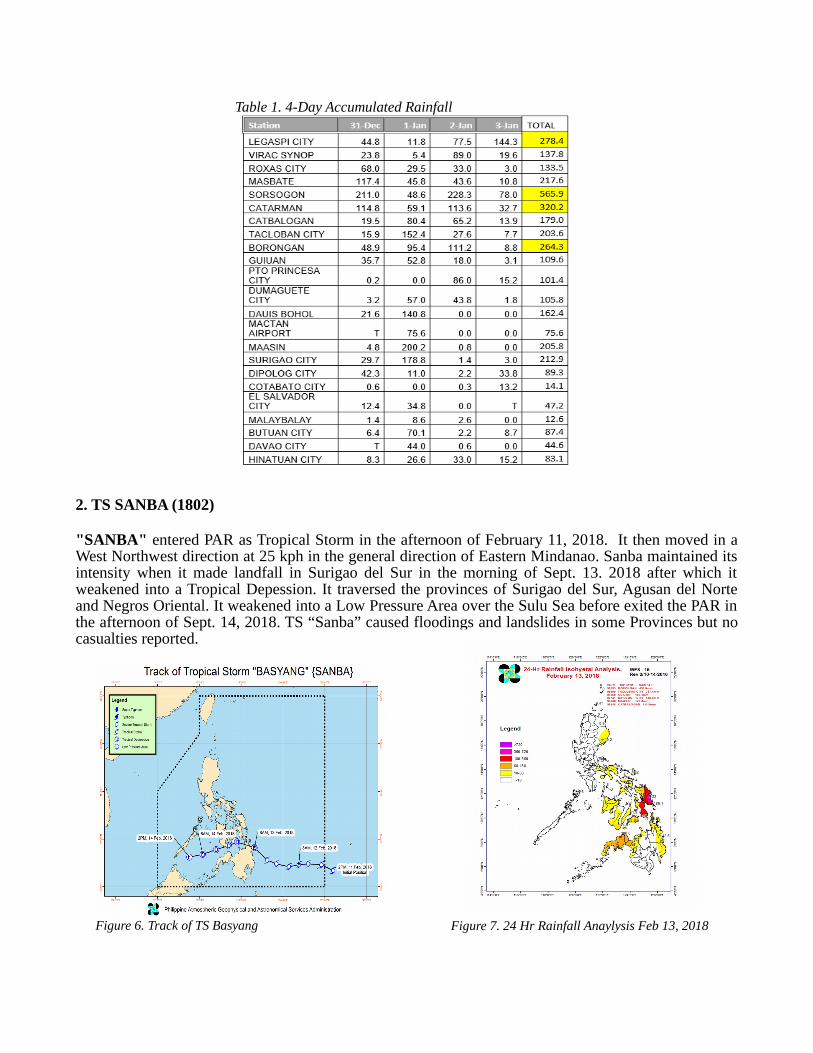
2. TS SANBA (1802)
"SANBA" entered PAR as Tropical Storm in the afternoon of February 11, 2018. It then moved in aWest Northwest direction at 25 kph in the general direction of Eastern Mindanao. Sanba maintained itsintensity when it made landfall in Surigao del Sur in the morning of Sept. 13. 2018 after which itweakened into a Tropical Depession. It traversed the provinces of Surigao del Sur, Agusan del Norteand Negros Oriental. It weakened into a Low Pressure Area over the Sulu Sea before exited the PAR inthe afternoon of Sept. 14, 2018. TS “Sanba” caused floodings and landslides in some Provinces but nocasualties reported.
Table 1. 4-Day Accumulated Rainfall
Figure 6. Track of TS Basyang Figure 7. 24 Hr Rainfall Anaylysis Feb 13, 2018

3. TS SON-TINH (HENRY)
A TD developed inside PAR from a larger circulation to the east of Luzon, called a MonsoonDepression, on 15 July 2018. It maintained a westward track towards extreme Northern Luzon where itmade landfall in Camiguin, Fuga and Dalupiri Islands (Babuyan group of Islands, Cagayan) at 9:00 PMon 16 July, 1:00 AM and 1:30 AM on 17 July respectively. It intensified into a tropical storm at 8:00AM on 17 July just before exiting the PAR.
The tropical storm occurred during a very active southwest monsoon episode such that its enhancementthereof resulted in widespread and persistent heavy rains and flash floods across much of westernLuzon. No casualties reported.
4. TD (JOSIE)
Figure 8. 24 Hr Rainfall on Feb 13-14, 2018
Figure 9. Accumulated Rainfall for TS Henry July 15-17,2018
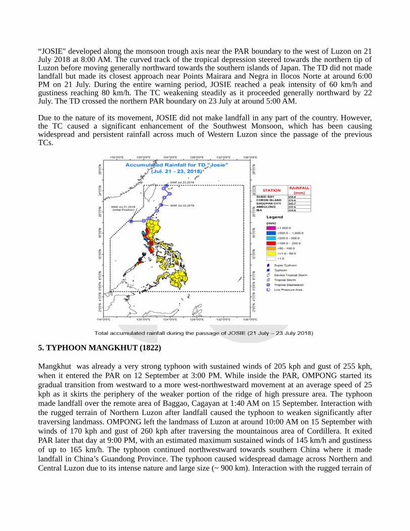
“JOSIE" developed along the monsoon trough axis near the PAR boundary to the west of Luzon on 21July 2018 at 8:00 AM. The curved track of the tropical depression steered towards the northern tip ofLuzon before moving generally northward towards the southern islands of Japan. The TD did not madelandfall but made its closest approach near Points Mairara and Negra in Ilocos Norte at around 6:00PM on 21 July. During the entire warning period, JOSIE reached a peak intensity of 60 km/h andgustiness reaching 80 km/h. The TC weakening steadily as it proceeded generally northward by 22July. The TD crossed the northern PAR boundary on 23 July at around 5:00 AM.
Due to the nature of its movement, JOSIE did not make landfall in any part of the country. However,the TC caused a significant enhancement of the Southwest Monsoon, which has been causingwidespread and persistent rainfall across much of Western Luzon since the passage of the previousTCs.
5. TYPHOON MANGKHUT (1822)
Mangkhut was already a very strong typhoon with sustained winds of 205 kph and gust of 255 kph,when it entered the PAR on 12 September at 3:00 PM. While inside the PAR, OMPONG started itsgradual transition from westward to a more west-northwestward movement at an average speed of 25kph as it skirts the periphery of the weaker portion of the ridge of high pressure area. The typhoonmade landfall over the remote area of Baggao, Cagayan at 1:40 AM on 15 September. Interaction withthe rugged terrain of Northern Luzon after landfall caused the typhoon to weaken significantly aftertraversing landmass. OMPONG left the landmass of Luzon at around 10:00 AM on 15 September withwinds of 170 kph and gust of 260 kph after traversing the mountainous area of Cordillera. It exitedPAR later that day at 9:00 PM, with an estimated maximum sustained winds of 145 km/h and gustinessof up to 165 km/h. The typhoon continued northwestward towards southern China where it madelandfall in China’s Guandong Province. The typhoon caused widespread damage across Northern andCentral Luzon due to its intense nature and large size (~ 900 km). Interaction with the rugged terrain of

Northern Luzon have aggravated the nature of rainfall, which caused flooding and landslides especiallyin the mountainous Cordillera Administrative Region (CAR).
Table 2. Significant Meteorological ObservationsSTATION Gustiness (m/s) Gustiness (km/h)
Aparri 49 176
Basco 38 140
Tuguegarao 44 160
Casiguran 25 90
Baler 42 150
Calayan 32 115
Laoag 35 125
Baguio 20 75
Dagupan 22 80
* Lowest recorded pressure (Tuguegarao) : 949.0 hPa
* Highest recorded Max sustained winds (Aparri): 30 m/s (108 km/h)
* No direct observations prior to landfall
Figure 11. Track of TY Ompong

Figure 12. Tuguegarao City Microbarograph
949.0 hPa
Figure 13. Rainfall Distribution during the passageof TY OMPONG (12 -15 September 2018)
Figure 14. Daily Rainfall during the passage of TY OMPONG (12 -15 September 2018)

TY OMPONG MADE LANDFALL OVER BAGGAO, CAGAYAN AT 1:40 AM (SEPTEMBER 15, 2018)
Figure 15. 10PM (Sept14), Latest on DAET Doppler Radar
Figure 16. APARRI DOPPLER RADAR ANIMATION

Warning Information• 23 Severe Weather Bulletins (SWB) 4 Tropical Cyclone Advisories (TCA)• 14 International Warning for Shipping (IWS)• The first TCA was issued on 10 Sept at 11:00PM and the first SWB was issued on 12 Sept. at
5:00PM. • 37 provinces were placed under Tropical Cyclone Warning Signals (TCWS) during the passage
of Typhoon Mangkhut.
Damage Statistics• 82 casualties, 138 injured and 2 are missing• A total of 681, 144 families were affected.• Total cost of damages to infrastructure and agriculture was P33.6B in Regions 1,2,3 and the
Cordillera Administrative Region (CAR). Site Rep. #48Reported by the National Disaster Risk Reduction and Management Council (NDRRMC) as of 29September 2018.
Effects of Typhoon Mangkhut
A deadly landslide in Barangay Loacan, Itogon, Benguet
All gone after losing his house to ferocious winds unleashed by Typ Mangkhut
Tuguegarao City after after the passage of Typ Mangkhut

2. Hydrological Assessment (highlighting water-related issues/impact)
Of the 17 tropical cyclones that impacted Philippines, only TS Bolaven and Typhoon Mangkhutcaused severe damages to properties and agriculture due to flooding and landslides. There were 138casualties caused by drowning and buried due to landslides.
PAGASA issued Flood Bulletins for telemetered River Basin and Flood Advisories for Non-Telemetered River Basin in Luzon and some regions in Visayas and Mindanao during the passage ofthese tropical cyclones.
Figure 17. Flooding caused by TS Bolaven

Figure 18. DOST-PAGASA – HIMAWARI ENHANCED- INFRARED (E-IR) 2 JANUARY 2018 TUESDAY
Effects of Typhoon Mangkhut
Flooding and flasfloods
Issued Warning
For 2018, a total of 485 General Flood Advisories were issued to different regions that served aswarnings for possible flooding due to tropical cyclones and other heavy rain carrying system. RegionsIII, IVA and IVB, were issued most number of advisories since the location of these are prone to theeffect of southwest monsoon especially if it is enhanced by tropical cyclones.
TD A
GATON (B
olav
en)
TS B
ASYA
NG (San
ba)
TS C
ALOY
(Jelaw
at)
TS D
OMEN
G (Maliks
i)
TD E
STER (G
aem
i)
STS
FLORIT
A
TY G
ARDO (M
aria)
TS H
ENRY (S
on-Ti
nh)
STS
INDAY
(Am
pil)
TD JO
SIE
TD K
ARDIN
G (Yag
i)
TD LUIS
TY M
AYMAY
(Jeb
i)
TD N
ENENG
TY O
MPO
NG (Man
gkhut)
TY PAEN
G (Tra
mi)
4955
0
85
16 0 16
32 29 30
44
7 100
54
10
GFA Issued per Tropical Cyclone
Figure 19. Total General Flood Advisories issued per region for 2018(as of October 2018)
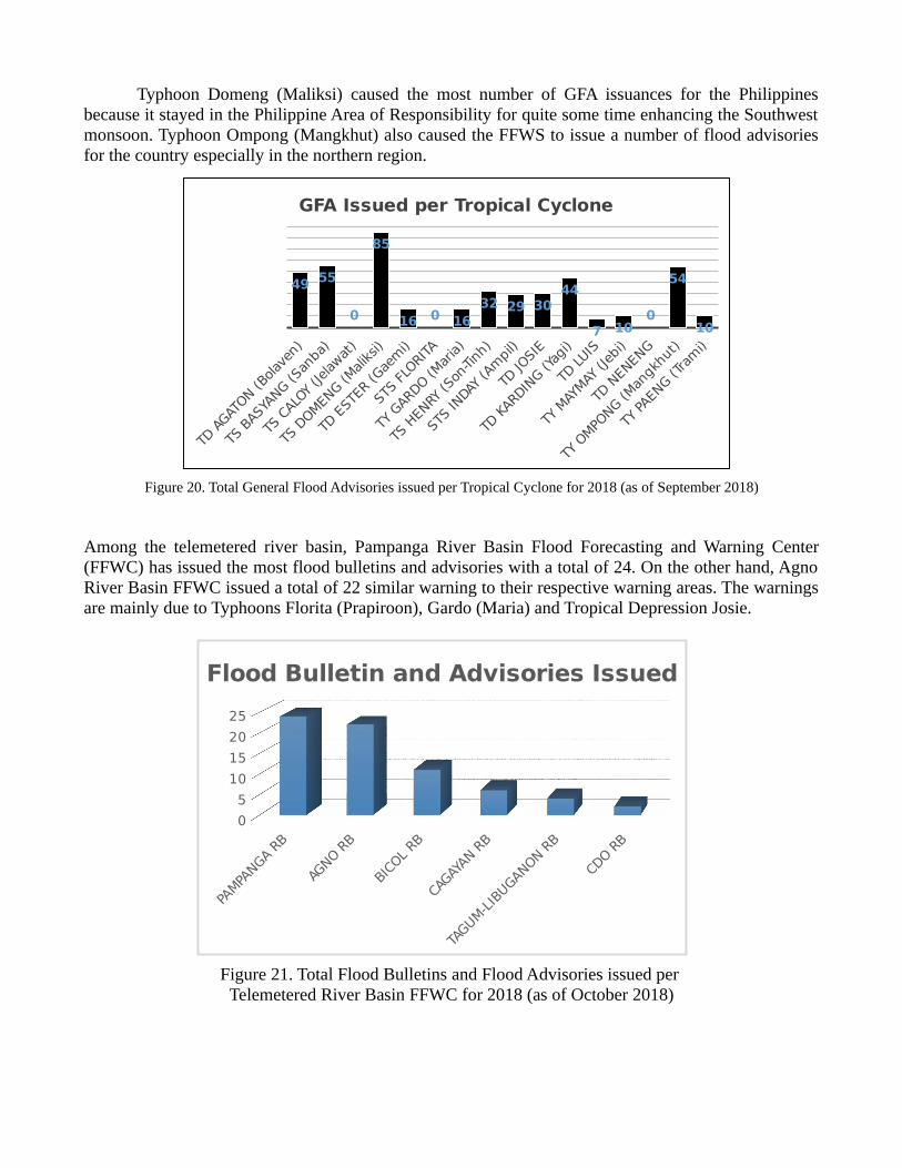
Typhoon Domeng (Maliksi) caused the most number of GFA issuances for the Philippinesbecause it stayed in the Philippine Area of Responsibility for quite some time enhancing the Southwestmonsoon. Typhoon Ompong (Mangkhut) also caused the FFWS to issue a number of flood advisoriesfor the country especially in the northern region.
Figure 20. Total General Flood Advisories issued per Tropical Cyclone for 2018 (as of September 2018)
Among the telemetered river basin, Pampanga River Basin Flood Forecasting and Warning Center(FFWC) has issued the most flood bulletins and advisories with a total of 24. On the other hand, AgnoRiver Basin FFWC issued a total of 22 similar warning to their respective warning areas. The warningsare mainly due to Typhoons Florita (Prapiroon), Gardo (Maria) and Tropical Depression Josie.
Figure 21. Total Flood Bulletins and Flood Advisories issued per Telemetered River Basin FFWC for 2018 (as of October 2018)
PAMPA
NGA RB
AGNO R
B
BICO
L RB
CAGAY
AN RB
TAGUM-L
IBUGANON R
B
CDO R
B
0
5
10
15
20
25
Flood Bulletin and Advisories Issued
TD A
GATON (B
olav
en)
TS B
ASYA
NG (San
ba)
TS C
ALOY
(Jelaw
at)
TS D
OMEN
G (Maliksi)
TD E
STER
(Gae
mi)
STS
FLORIT
A
TY G
ARDO (M
aria)
TS H
ENRY
(Son
-Tinh
)
STS
INDAY
(Am
pil)
TD JO
SIE
TD K
ARDIN
G (Yag
i)
TD LUIS
TY M
AYMAY
(Jeb
i)
TD N
ENENG
TY O
MPO
NG (Man
gkhut)
TY PAEN
G (Tra
mi)
49 55
0
85
16 0 1632 29 30
44
7 100
54
10
GFA Issued per Tropical Cyclone

Because of the Tropical Cyclones that passed the areas in Luzon either enhanced or not bysouthwest monsoon, major dams located within different major river basins had undergone dischargeoperations since their elevations reaches the normal high. The table shows their scheduled waterreleases that prompt the FFWS to issue flood warnings to the target areas in the river downstream.
Table 3. Dam Discharge Operation
DAM
SOUTHWEST MONSOON
SOUTHWEST MONSOON/ LPA/ TD KARDING(Yagi)
SOUTHWEST MONSOON
TY OMPONG (Mangkhut)
Ambuklao 21/7 - 01/8 03-05/8 21/7 - 01/8 12-27/9Binga 20/7 - 02/8 09/8 – 05/8 13-27/9San Roque 15-27/9Magat 29/7 - 01/8 08 -17/8 13-20/9
TC Members’ Report
Summary of Progress in KRAs
Title of item (1):Reduced Loss of Life from Typhoon Related Disasters
1. Doppler Radar for Tropical Cyclone and Marine Observations
A new C-band and S-band Doppler Radar installation were ongoing in Agno, Bohol, Samar andMasbate. These Radars will be operational late this year or early next year. The radars would be used inmonitoring tropical cyclones when the TC is over inland in any part of the country and over offshore aslong as it is within the range. These radars will also cover the blind areas of the existing radars. Thiswill also be used in rainfall monitoring and warning by the PAGASA Regional Services Divisionthroughout the country.

FIG 22. RADAR STATIONS
BascoBaguio
SubicTagaytay
Quezon, Palawan
Iloilo
Aparri
LAOANG
Daet
Virac
Guiuan
Mactan
Hinatuan
Tampakan
Iloilo
4 New Doppler Weather Radars (On-going)
4 Doppler Weather Radars (Under repair)
MASBATE
ZAMBOANGA TAMPAKAN
HINATUANQUEZON
BUSUANGA
TAGAYTAY
BASCO
APARRIBAGUIO
AGNO
SUBIC BALER
DAETVIRAC
Iloilo GUIUAN
MACTAN
BOHOL
Radar Network

SITE BAND TRANSMITTER PEAKPOWER
SITEELEV.
BLDG.HEIGHT
MAXRANGE(KM)
VOLUMERANGE(KM)
FREQUENCY
Existing Site
1. SUBIC S Magnetron 850 kW 516 m 40 m 480 km 240 km 2800 MHz
2. HINATUAN S Magnetron 850 kW 3 m 34 m 480 km 240 km 2705 MHz
3. TAGAYTAY C (Dual Pol)
Magnetron 250 KW 752 m 30 m 480 km 240 km 5612 MHz
4. MACTAN C (Dual Pol)
Magnetron 250 KW 25 m 21 m 480 km 240 km 5610 MHz
5. TAMPAKAN S Magnetron 850 kW 1044 m 23 m 480 km 240 km 2750 MHz
6. JARO, ILOILO S Magnetron 250 kW 10 m 21 m 480 km 240 km 2870 MHz
7. APARRI, CAGAYAN
S Solid State 10 kW 2 m 34 m 440 km 200 km 2850 MHz
8. VIRAC, CATANDUANES
S Solid State 10 kW 228 m 33.5 m 440 km 200 km 2850 MHz
9. GUIUAN, SAMAR
S Solid State 10 kW 56 m 25 m 440 km 200 km 2850 MHz
10. BAGUIO C Magnetron 500 kW 2256 m 15 m 480 km 240 km 5640 MHz
11. DAET (under repair)
S Magnetron 1 MW 9 m 21 m 480 km 240 km 2850 MHz
12. BALER (underrepair)
S Magnetron 1 MW 176 m 6 m 480 km 240 km 2830 MHz
13, BASCO (under repair)
C Magnetron 250 kW 166 m 6 m 500 km 250 km 5600 MHz
14. QUEZON, PALAWAN
Magnetron 250 kW 17 m 21 m 500 km 250 km 5600 MHz
15. ZAMBOANGA Magnetron 250 kW 7 m 24.6 m 500 km 250 km 5600 MHz
16. BUSUANGA, PALAWAN (under repair)
Magnetron 250 kW 220 m 18.6 m 500 km 250 km 5600 MHz
New (On-Going Site)
1. AGNO, PANGASINAN
S Magnetron
2. BOHOL S Magnetron
3. LAOANG, SAMAR
C Solid State
4. MASBATE C Solid State
Table 4. Existing and Under Construction Radars

Identified opportunities/challenges, if any, for further development or collaboration:
As of now, we find it very difficult to identify tornado in Radar images, we need enhancementtraining on Radar images analysis specially on tornado and hailstorm formation within the severethunderstorm cells. It is still a problem to us to forecast this kind of weather phenomena. 2. High Frequency Doppler Radar (Coastal Radar) PAGASA has installed High Frequency Doppler Radar (Coastal Radar) along the nauticalhighway that connect the three main islands, Luzon, Visayas and Mindanao and in the inter-islandshipping lanes where many Ferry Boats and small Sea Vessels are plying. These Coastal Radars areused to monitor the wind speed and direction, wave height and ocean current which can be used in theissuance of Gale Warning for small sea vessels and to monitor oil spill if sea accident happen. This canalso be used to monitor and track weaker TC’s.
Identified opportunities/challenges, if any, for further development or collaboration:
As of now, construction is still going on for some areas and for those already completed, we arein the process of validating the data.
PAGASA HIGH FREQUENCY DOPPLER RADAR UPDATE (COASTAL RADAR)

THIRD PAIR LOCATION:
SAN RICARDO, SOUTHERN LEYTEFREQ: 16MHZ, ANTENNA ELEMENT: 12 FOR RX, 4 FOR TXSAN FRANCISCO, SURIGAO DEL NORTEFREQ: 26MHZ, ANTENNA ELEMENT: 8 FOR RX, 4 FOR TX
Figure 23. SAMPLE DATA DISPLAY
Figure 24. SAN RICARDO, SOUTHERN LEYTE
Figure 25. SAN FRANCISCO, SURIGAO DEL NORTE

ESTABLISHMENT OF FLOOD FORECASTING AND WARNING SYSTEM FOR 13 MAJORRIVER BASINS
PAGASA as the National Meteorological and Hydrological Service (NMHS) of the Philippinesis mandated to provide hydro-meteorological warnings for public safety. One of the main service ofPAGASA is to provide flood warnings and information.
On these aspect, PAGASA has already established flood forecasting and warning systems forfive (5) major river basins. The Philippines has a total number of eighteen (18) major river basins.PAGASA is currently undergoing an Automation and Modernization Programs on its services and oneof the priority project under these programs is the further improvement of its flood forecasting andwarning services. Below are tables showing the updates of the said project. Table 1 shows the updateof the flood forecasting and warning centers. Of the thirteen major river basins, ten (10) centers are tobe constructed. The Jalaur River Basin Flood Forecasting and Warning Center will be co-located withthe Iloilo RADAR while the Cagayan de Oro and Tagoloan River Basin will be using only one (1)center. The status of the construction of the centers are shown in column number three (3). Table 2shows the update on the installation of hydrological monitoring equipment in the thirteen major riverbasins.
Table 5: Update on the construction of the Flood Forecasting and Warning Centers
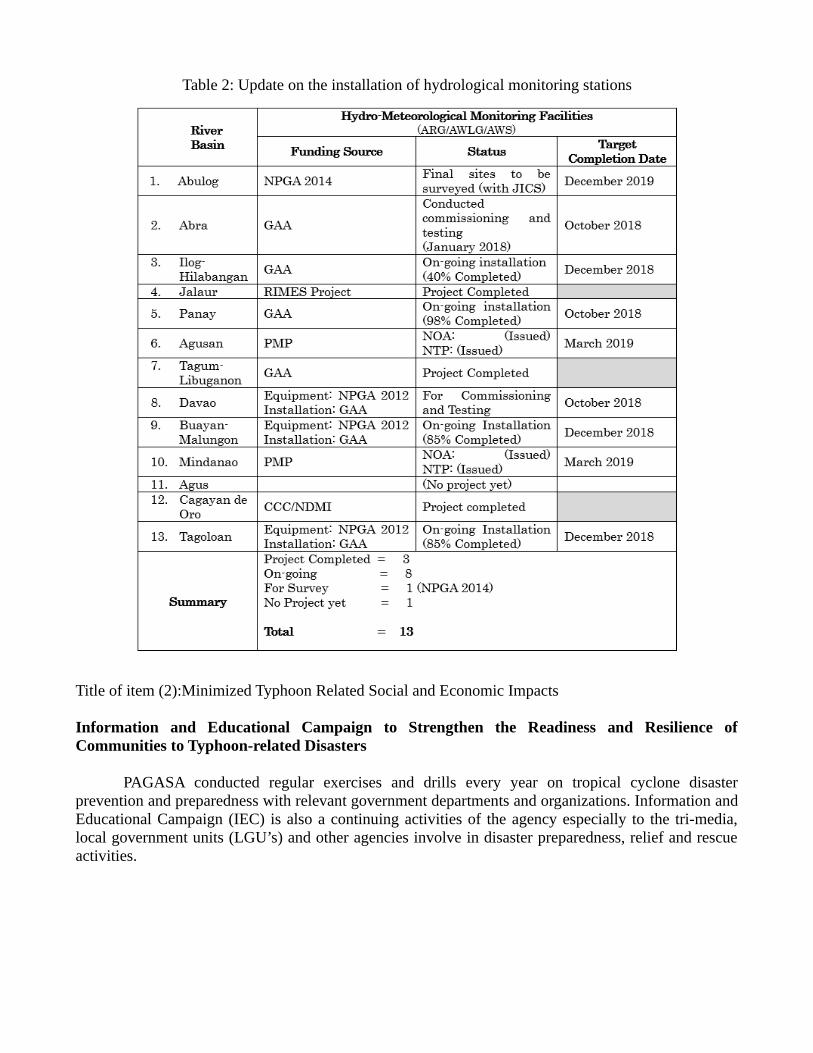
Table 2: Update on the installation of hydrological monitoring stations
Title of item (2):Minimized Typhoon Related Social and Economic Impacts
Information and Educational Campaign to Strengthen the Readiness and Resilience ofCommunities to Typhoon-related Disasters
PAGASA conducted regular exercises and drills every year on tropical cyclone disasterprevention and preparedness with relevant government departments and organizations. Information andEducational Campaign (IEC) is also a continuing activities of the agency especially to the tri-media,local government units (LGU’s) and other agencies involve in disaster preparedness, relief and rescueactivities.

Title of item (5):
Continual Capacity Building Through Various Trainings and Workshops
PAGASA also conducted regular workshops and trainings to PAGASA personnel tocapacitate and enhanced their knowledge of the new technology used and to familiarize them with theproducts/information and warning that we issued during the occurrence of inclement weather.
Seminar/Workshop on Rainfall Warning System for Personnel of PRSDs
04–06 April 2018
Operational JMA Wave Modeling Training
WMO/RTC Training Room 209-13 April 2018
Figure 26. Information, Education and Communication Campaign for LGU Figure 27. Flood Drill

PAGASA Forecasters Training on the Use of Convective Scale Models (1st Batch)
23-27 April 2018
PAGASA Forecasters Training on the Use of Convective Scale Models (2nd Batch)
30 April – 04 May 2018
Training Workshop on Tropical Cyclone Forecasting and Analyses for Operation
and Research04-05 September 2018
Southeastern Asia-Oceania Flash Flood Guidance System (SAOFFGS) – In-Region Operations Training
Workshop (Step 4) 11-15 September 2018
Meteorologists Training Course (MTC)23 October 2017 – 10 October 2018

OVERVIEW OF TROPICAL CYCLONES WHICH HAVEAFFECTED/IMPACTED MEMBER’S AREA IN 2018 (Highlighting socio-economic and DRR issues/impacts)
Of the 17 tropical cyclones that impacted Philippines for 2018, with eleven (11)affecting population in the various regions, resulting to casualties, and causing damages toagricultural and infrastructure properties.
A. Affected Population
The table below shows the total number of families, persons, barangays, andmunicipalities/cities affected by the 11 Tropical Cyclones.
Table 6: PopulationAFFECTED POPULATION
1,829,874Families
7,572,577Persons
10,459Barangays
1,071Municipalities/Cities
Of which, reflected in Table 2 are families and persons served inside and outsidethe evacuation centers.
Table 7: Population inside and outside 239 evacuation centersINSIDE OUTSIDE
14,097Families
57,209Persons
89,700Families
396,376Persons

Table 8: Comparative Analysis of Typhoons recorded from January to October 2018
NAMEAREAS
AFFECTEDNO. OF
AFFECTEDPOP AFFECTED
POP DISPLACED
ECsSERVED INSIDE SERVED OUTSIDE
REG MUN BRGY FAM PERS FAM PERS FAM PERS
TD "AGATON"01-03 January
MIMAROPA,VI, VII, VIII,X, CARAGA,
ARMM
69 260 18,537 83,908 10 303 1,198 86 280
TS "BASYANG"11-14 February
MIMAROPA,VI, VII, VIII,
XIII103 545 60,686 254,859 0 0 0 0 0
TS "CALOY" (I.N. JELAWAT)27 March
NO EFFECTS
TY "DOMENG"05-10 June
TD “ESTER”14-15 June
I, III,MIMAROPA,
CAR11 11 3,599 13,477 0 0 0 0 0
TS "FLORITA" (I.N. PRAPIROON)29 June - 01 July
NO EFFECTS
TY "GARDO" (I.N. MARIA)9-10 July
III, ARMM 5 0 24 87 1 5 18 0 0
TD "HENRY"15-17 July
TS "INDAY" (I.N. AMPIL)18-21 July
TD "JOSIE" 21-23 July
I, II, III,CALABARZO
N,MIMAROPA,VI, VII, CAR,
NCR
185 1,835 532,066 2,231,101 98 10,528 43,694 77,603 339,302

NAMEAREAS
AFFECTEDNO. OF
AFFECTEDPOP AFFECTED
POP DISPLACED
ECsSERVED INSIDE SERVED OUTSIDE
REG MUN BRGY FAM PERS FAM PERS FAM PERSTD "KARDING" (I.N. YAGI)7-11 August
I, II, III,CALABARZON, CAR, NCR
151 1,280 422,653 1,709,511 101 2,916 11,118 7,995 39,102
TD "LUIS"23-24 August I, CAR 68 611 61,713 250,572 2 2 5 966 4,116
TY "MAYMAY"2-3 September NO EFFECTS
TD "NENENG"10-11 September NO EFFECTS
TY "OMPONG" (I.N. MANGKHUT)12-16 September
I, II, III,CALABARZO
N,MIMAROPA,V, VI, CAR,
NCR
479 5,917 730,596 3,029,062 27 343 1,176 3,050 13,576
TY "PAENG" (I.N. TRAMI)23-29 September NO EFFECTS
TY "QUEENIE" (I.N. KONG-REY)1-4 October
NO EFFECTS
NOTE: All figures are still subject to change as reports are yet to be finalized

B. CasualtiesFrom 9 Typhoons that entered the Philippines, a total of 107 dead, 151
injured, and 6 missing were reported.
Table 9: CasualtiesNAME
DEAD INJURED MISSING
TD "AGATON"01-03 January
4 9 0
TS "BASYANG"11-14 February
0 0 0
TY "DOMENG"05-10 June
TD “ESTER”14-15 June
3 3 0
TD "HENRY"15-17 July
TS "INDAY" (I.N. AMPIL)18-21 July
TD "JOSIE" 21-23 July
16 1 1
TD "KARDING" (I.N. YAGI)7-11 August
2 0 3
TY "OMPONG" (I.N. MANGKHUT)12-16 September
82 138 2
TOTAL 107 151 6 NOTE: All figures are still subject to change as reports are yet to be finalized
C. Damage to PropertiesA total of ₱40,310,026,155.00 ($745,377,702.57) worth of damages to
agriculture and infrastructures were incurred from 7 Typhoons that entered thecountry. Of this, damages to Agriculture amounted to ₱30,788,268,951.00($569,309,706.93) while damages to infrastructure amounted to Infrastructure₱9,521,757,204.00 ($176,067,995.64).

NAMEAGRI INFRA TOTAL
TD "AGATON"01-03 January
527,244,551 27,480,000 554,724,551
TS "BASYANG"11-14 February
167,955,031 - 167,955,031
TD "HENRY"15-17 July
TS "INDAY" (I.N. AMPIL)18-21 July
TD "JOSIE" 21-23 July
3,279,640,112 1,380,971,123 4,660,611,235
TD "KARDING" (I.N. YAGI)7-11 August
43,711,273 952,290,000 996,001,273
TY "OMPONG" (I.N. MANGKHUT)12-16 September
26,769,717,984 7,161,016,081 33,930,734,065
TOTAL 30,788,268,951 9,521,757,204 40,310,026,155NOTES:
* All figures are still subject to change as reports are yet to be finalized* Bangko Sentral ng Pilipinas, Dollar Exchange Rate as of 15 October 2018
($1 = 54.08)
D. Challenges1. Information Dissemination
Quick dissemination of alert and warning information
2. Information ManagementTools to capture and shared data/information within the organization and otherstakeholders.
E. Technological Interventions (Project Status)1. Alert and Warning
a. Emergency Warning Broadcast System (EWBS) Through IntegratedServices Digital Broadcast Terrestrial (ISDB-T)
With the sustained interest of Filipinos to consume informationthrough TV there are various initiatives of the Philippine government todevelop improved ICTs to cater its citizens’ needs to be informed, especiallycritical in times of impending disasters. An essential component in DisasterPreparedness, with the Philippines’ geographically situated along the Pacific

Ring of Fire and Typhoon Belt, EWBS enables the ISDB-T system to sendearly warnings for decision-support, as well as to disseminate advisories andguidance on evacuation, food provisions, and medical assistance, amongmany others.
In the event of an impending emergency such as tropical cyclones,tsunami, floods, earthquake, and volcanic eruptions, DTTB Broadcasters aredirected to send out early warning and/or alert messages at regular intervalsas required by the National Disaster Risk Reduction and ManagementCouncil (NDRRMC), and other relevant agencies.
PAGASA and PHIVOLCS shall be the primary source of emergencyalert(s) and/or warning message(s), which shall be submitted to NDRRMCfor validation and approval for transmission by all DTTB Broadcasters.
b. Emergency Cell Broadcast System (ECBS) The National Disaster Risk Reduction and Management Council
(NDRRMC) and telecommunication company Smart Communicationslaunched a cell broadcast system (CBS) to enable the quick transmission ofwarnings to the public in times of calamities.
The development of the emergency cell broadcast system (ECBS)boosts government confidence in its ability to provide timely, hazard-specific, and location-specific warnings to people.
This is the telecom company’s compliance with Republic Act No.10639 or the Free Mobile Disaster Alerts Act, which mandates all TelCos toimplement free mobile alerts to the public in the event of calamities.
2. Information Managementa. National Loss and Damage Registry
The National Loss and Damage Registry (NLDR) provides asystematic valuation, validation, reporting, accounting, and database oflosses and damages from the impact of natural hazards, including extremeweather events and sea-level rise attributed to climate change, as well ashuman-induced incidents. The NLDR supports the implementation ofcomprehensive disaster risk reduction and management, the integration ofrisk information systems, the development of risk financing, risk transferand insurance mechanisms, and the strengthening of multi-hazard earlywarning systems and services at the national and local government levels.
The project aims to build and establish a scalable disaster loss anddamage system and registry to be operated by the Office of Civil Defensefor the NDRRMC. The NLDR is envisioned to be used for evaluation,validation, reporting, accounting, and databases of losses and damages dueto natural and human-induced disasters.
b. IT-based PDNA Application DevelopmentThis activity aims to (1) discuss alignment of Philippine PDNA
process with global standards and Disaster Recovery Framework (DRF);
and (2) discuss the development of a PDNA tablet or mobile-basedapplication.
c. Data preparedness and VisualizationOne of the priorities of Office of Civil Defense Operation Service
Division was to improve the presentation and analysis of information for abetter understanding of situation during emergencies. OCHA incoordination with the OCD Operations Service Division and with fundingassistance from UNICEF
To come-up with database template for emergency response Todevelop dashboard template to visualize data during emergency Betterunderstanding on how to utilize MS Excel to hasten data compilation andprocessing
d. Disaster Risk Reduction & Management Information System (DRRMIS)DICT has partnered with the Office of Civil Defense (OCD), the
implementing arm of the National Disaster Risk Reduction andManagement Council (NDRRMC), in the development and implementationof strategic and systematic approaches to address the four thematic areas ofthe NDRRM Plan (NDRRMP): (1) Prevention and Mitigation, (2) DisasterPreparedness, (3) Disaster Response, and (4) Rehabilitation and Recovery.The four distinct yet mutually reinforcing thematic areas lead to theattainment of the country’s overall DRRM vision: “safer, adaptive anddisaster-resilient Filipino communities toward sustainable development.” Inachieving this, there have been various steps needed to establish andimprove the end-to-end monitoring (monitoring and response), forecasting,and early warning systems. As the executive arm and secretariat ofNDRRMC, the OCD has experienced difficulties and challenges in datagathering and consolidation of reports.
To address this, NDRRMC has identified the need for an informationsystem to expedite the monitoring, analysis, and dissemination of reportsand information, especially during emergency situations. The system shallbe named Disaster Risk Reduction and Management Information System orDRRMIS. The information system shall be used by DRRM officers to inputdata and shall be a single source of truth (SSOT) for Filipino communities,wherein the concerned NDRRMC member agencies will be the ones toconfirm which datasets are needed.
The primary objective of the DRRMIS is to be able to provideNDRRMC member agencies, especially the OCD, a web-based applicationsystem with high-availability and high-scalability to be used for themonitoring, submission, and consolidation of DRRM-related reports, whichwill be posted into the NDRRMC website.