The generating mechanisms of the August 17, 1999 İzmit bay (Turkey) tsunami: Regional (tectonic)...
20
The generating mechanisms of the August 17, 1999 I ˙ zmit bay (Turkey) tsunami: Regional (tectonic) and local (mass instabilities) causes Stefano Tinti a, * , Alberto Armigliato a , Anna Manucci a , Gianluca Pagnoni a , Filippo Zaniboni a , Ahmet Cevdet Yalc ¸iner b , Yildiz Altinok c a Universita ` di Bologna, Dipartimento di Fisica, Settore di Geofisica, Viale Carlo Berti Pichat, 8, 40127 Bologna, Italy b Middle East Technical University, Department of Civil Engineering, Ocean Engineering Research Center, 06531, Ankara, Turkey c Istanbul University, Department of Geophysical Engineering, Division of Seismology, 34850, Avcilar, Istanbul, Turkey Received 23 November 2004; received in revised form 22 August 2005; accepted 2 September 2005 Abstract The M W =7.4 earthquake that affected the northwestern part of Turkey on August 17, 1999, and in particular the gulf of I ˙ zmit, had dramatic consequences also as regards tsunami generation. The main cause of the earthquake was a dextral strike-slip rupture that took place along different segments of the western part of the North Anatolian Fault (WNAF). The rupture process involved not only a number of distinct strike-slip fault segments, but also dip-slip ancillary faults, connecting the main transcurrent segments. The general picture was further complicated by the occurrence of subsidence and liquefaction phenomena, especially along the coasts of the I ˙ zmit bay and in the Sapanca Lake. Tsunami effects were observed and measured during post-event surveys in several places along both the northern and the southern coasts of the bay. The run-up heights in most places were reported to lie in the interval 1–3 m: but in the small town of Deg ˘irmendere, where a local slump occurred carrying underwater buildings and gardens of the waterfront sector, eyewitnesses reported water waves higher than 15 m. The purpose of this work is to investigate on the causes of the tsunami by means of numerical simulations of the water waves. We show that the tsunami was a complex event consisting at least of the combination of a regional event due to tectonic causes and of a local event associated with the mass failure. As to the first, we are able to demonstrate that the observed tsunami cannot be explained only in terms of the sea bottom dislocation produced by the main right-lateral dislocation, but that the prominent contribution comes from the displacement associated with the secondary shallow normal faults. Furthermore, the large waves and effects seen in Deg ˘irmendere can be explained as the consequence of the slump. By means of a stability analysis based on an original method making use of the limit equilibrium concept, we show that the slump was highly stable before the earthquake and that it was triggered by seismic waves. Simulation of the tsunami induced by the slump was carried out by a two-step numerical code that computes the landslide motion first, and then the generated water wave propagation. It is shown that the computed local tsunami matches the experimental data. D 2005 Elsevier B.V. All rights reserved. Keywords: 1999 Kocaeli earthquake; tsunami modeling; earthquake-induced tsunami; slump-induced tsunami 0025-3227/$ - see front matter D 2005 Elsevier B.V. All rights reserved. doi:10.1016/j.margeo.2005.09.010 * Corresponding author. Tel.: +39 051 2095025; fax: +39 051 2095058. E-mail address: [email protected] (S. Tinti). Marine Geology 225 (2006) 311 – 330 www.elsevier.com/locate/margeo
-
Upload
independent -
Category
Documents
-
view
0 -
download
0
Transcript of The generating mechanisms of the August 17, 1999 İzmit bay (Turkey) tsunami: Regional (tectonic)...

www.elsevier.com/locate/margeo
Marine Geology 225
The generating mechanisms of the August 17, 1999 Izmit bay
(Turkey) tsunami: Regional (tectonic) and local
(mass instabilities) causes
Stefano Tinti a,*, Alberto Armigliato a, Anna Manucci a, Gianluca Pagnoni a,
Filippo Zaniboni a, Ahmet Cevdet Yalciner b, Yildiz Altinok c
a Universita di Bologna, Dipartimento di Fisica, Settore di Geofisica, Viale Carlo Berti Pichat, 8, 40127 Bologna, Italyb Middle East Technical University, Department of Civil Engineering, Ocean Engineering Research Center, 06531, Ankara, Turkey
c Istanbul University, Department of Geophysical Engineering, Division of Seismology, 34850, Avcilar, Istanbul, Turkey
Received 23 November 2004; received in revised form 22 August 2005; accepted 2 September 2005
Abstract
The MW=7.4 earthquake that affected the northwestern part of Turkey on August 17, 1999, and in particular the gulf of Izmit,
had dramatic consequences also as regards tsunami generation. The main cause of the earthquake was a dextral strike-slip rupture
that took place along different segments of the western part of the North Anatolian Fault (WNAF). The rupture process involved
not only a number of distinct strike-slip fault segments, but also dip-slip ancillary faults, connecting the main transcurrent
segments. The general picture was further complicated by the occurrence of subsidence and liquefaction phenomena, especially
along the coasts of the Izmit bay and in the Sapanca Lake. Tsunami effects were observed and measured during post-event surveys
in several places along both the northern and the southern coasts of the bay. The run-up heights in most places were reported to lie
in the interval 1–3 m: but in the small town of Degirmendere, where a local slump occurred carrying underwater buildings and
gardens of the waterfront sector, eyewitnesses reported water waves higher than 15 m.
The purpose of this work is to investigate on the causes of the tsunami by means of numerical simulations of the water waves.
We show that the tsunami was a complex event consisting at least of the combination of a regional event due to tectonic causes and
of a local event associated with the mass failure. As to the first, we are able to demonstrate that the observed tsunami cannot be
explained only in terms of the sea bottom dislocation produced by the main right-lateral dislocation, but that the prominent
contribution comes from the displacement associated with the secondary shallow normal faults. Furthermore, the large waves and
effects seen in Degirmendere can be explained as the consequence of the slump. By means of a stability analysis based on an
original method making use of the limit equilibrium concept, we show that the slump was highly stable before the earthquake and
that it was triggered by seismic waves. Simulation of the tsunami induced by the slump was carried out by a two-step numerical
code that computes the landslide motion first, and then the generated water wave propagation. It is shown that the computed local
tsunami matches the experimental data.
D 2005 Elsevier B.V. All rights reserved.
Keywords: 1999 Kocaeli earthquake; tsunami modeling; earthquake-induced tsunami; slump-induced tsunami
0025-3227/$ - s
doi:10.1016/j.m
* Correspondi
E-mail addr
(2006) 311–330
ee front matter D 2005 Elsevier B.V. All rights reserved.
argeo.2005.09.010
ng author. Tel.: +39 051 2095025; fax: +39 051 2095058.
ess: [email protected] (S. Tinti).

S. Tinti et al. / Marine Geology 225 (2006) 311–330312
1. Introduction
1.1. Tectonic setting and earthquakes
The Anatolian peninsula is one of the most seismi-
cally active areas in the world. The 1999 Kocaeli
earthquake and the associated Izmit bay tsunami are
Fig. 1. Upper panel: Sketch of the Marmara Sea crossed by the Western se
three branches: northern, middle and southern branch. TB, Tekirdag Basin; C
Kapidag Peninsula; GP, Gelibolu Peninsula. Lower Panel: The WNAF is
dynamics. KJ, KarlVova Junction; NB, Niksar Basin; TEB, Tasova-Erbaa B
the last catastrophic occurrences of a long series of
disastrous and lethal natural events that hit this region.
Here earthquake generation is governed chiefly by three
main tectonic structures: the East Anatolian Fault
(EAF), the North Anatolian Fault (NAF) and the Hel-
lenic Arc (Fig. 1). The left-lateral EAF is circa 550 km
long and represents the border between the Anatolian
ction of the North Anatolian Fault (WNAF) system, which splits into
MB, Central Marmara Basin; CB, Cinarcik Basin; IB, Izmit Bay; KP,
part of the complex fault pattern resulting from the Anatolian Plate
asin; HLB, Havza-Ladik Basin.

S. Tinti et al. / Marine Geology 225 (2006) 311–330 313
block and the Arabian plate. The NAF is a dextral
system of faults forming the broad arc boundary be-
tween the Eurasian plate and the Anatolian block. It
extends for about 1500 km from the northern Aegean
Sea, through the Marmara Sea up to the easternmost
part of Turkey where it connects to the EAF at the
Karliova triple junction. Its western section, denoted
hereafter as WNAF, splays into two branches (Fig. 1),
approximately in correspondence of the Mudurnu Val-
ley fault, east to Akyazi (Barka and Kadinsky-Cade,
1988; Barka, 1992; Gulen et al., 2002). The northern
one starts from the North Aegean Sea, trending NE
along the gulf of Saros; then it crosses west–east the
central and northern section of the Marmara Sea where
it broadens in a wide complex of strike-slip and dip-slip
faults; next, it penetrates in the Izmit bay, whence it
continues towards the Sapanca Lake, further joining the
main NAF system (Barka and Kadinsky-Cade, 1988).
A number of large historical earthquakes are associated
with this branch. For example, fault rupture migrated
from east to west in the 18th century involving pro-
gressively all this system of faults from Izmit to Sarkoy,
first with the 1719 (Izmit, MS 7.4), and then with the
1754 (eastern Marmara, MS 6.8) and with the May
(eastern Marmara, MS 7.1) and August (Ganos, MS
7.4) 1766 shocks (Ambraseys and Finkel, 1995;
Ambraseys, 2002a). Notice that westward migration
of seismicity has been identified in several sequences
of earthquakes also along the main section of the NAF
and may be related to the basic long-term tectonic
processes of inter-plate interaction going on here
(Barka, 1992; Armijo et al., 1999; Hubert-Ferrari et
al., 2002). Later, major quakes that are attributed to
segments of this branch occurred in 1878, in 1894 (MS
7.3) and in 1912 (MS 7.4) (Ambraseys and Finkel,
1991; Ambraseys, 2002a). The most recent occurrences
are the 1943 (MS 6.4) Hedek-Adapazari earthquake and
the 1963 (MS 6.4) Cinarcik earthquake. This is also the
genetic place of the Kocaeli earthquake that is at the
centre of our attention here, being the cause of the 1999
Izmit tsunami.
The southern branch splits in turn into two further
strands east to the Iznik Lake (Fig. 1), which makes
that the total number of the WNAF branches can be
considered to be three: these further subsystems can
be called the middle and the southern branch of the
WNAF. The middle runs NE-ward from the Aegean
Sea, south of the Dardanelles Straits, and intersects the
southern coast of the Marmara Sea around BandVrma.
From here it parallels the coastline up to the Gemlik
bay, south of the Armutlu peninsula. The WNAF
southern branch trends almost parallel to the middle,
some tens of kilometers to the south, passing through
the Manyas and the Uluabat lakes and through the
area of Bursa (Gulen et al., 2002). Historical earth-
quake activity seems to be more intense on the south-
ern than on the middle branch of the WNAF. Several
large earthquakes are known to have occurred here in
the last three centuries. The most recent sequence of
major quakes manifested as an eastward migration of
rupture starting with the October 6, 1944 (MS 6.8)
Edremit-Ayvalik earthquake, with epicentre of
26.568E, 39.488N (earthquake database of Bosphorus
University, Kandilli Observatory, and Earthquake Re-
search Institute (KOERI), available at http://www.
koeri.boun.edu.tr/jeofizik/defaulteng.htm), and con-
tinuing with the March 18, 1953 (MS 7.2) Yenice-
Gonen quake with epicentre of 27.368E, 39.998N(KOERI database), probably occurring on the middle
branch, and with the October, 06, 1964 (MS 6.9)
Manyas-region shock: epicentre 26.238E, 40.308N(KOERI database). Hence the sequence affected the
overall sector from the Aegean Sea up to the Uluabat
Lake (Hubert-Ferrari et al., 2000; Ambraseys, 2002a;
Barka et al., 2002).
1.2. Transtensional tectonics and pull-apart basins
Due to the collision between the Arabian and Eur-
asian plates, the Anatolian plate is squeezed and pushed
westward moving along the NAF and EAF. The tec-
tonic style is predominantly transcurrent along the NAF
system, where slip occurs along a series of faults tens of
kilometers long with prevailing EW trend. But at the
junction of several of such segments, due to their
relative offset and overstepping, extensional tectonics
occurs with the consequent formation of a sequence of
pull-apart basins, such as the prominent depressions of
the Niksar, of the Tasova-Erbaa and of the Havza-Ladik
basins that one finds in the central portion of the NAF
(Barka et al., 2000). In the WNAF, step-over depres-
sions on land are often associated with lakes (e.g. the
Sapanca Lake in the northern branch of the WNAF, the
Iznik Lake in the middle strand and the Uluabat and the
Manyas lakes in the southern branch). Transtension and
vertical movements are believed to be of foremost
importance especially on the northern branch of the
WNAF. Indeed the genesis of the Marmara Sea itself
is attributed to pull-apart processes (Hubert-Ferrari et
al., 2002). More specifically, overstepping may be ad-
vocated to explain the formation of the three main inner
basins characterising the Marmara Sea (see Armijo et
al., 2002; Flerit et al., 2003) that from west to east are
the Tekirdag basin, the Central basin and the Cinarcik
S. Tinti et al. / Marine Geology 225 (2006) 311–330314
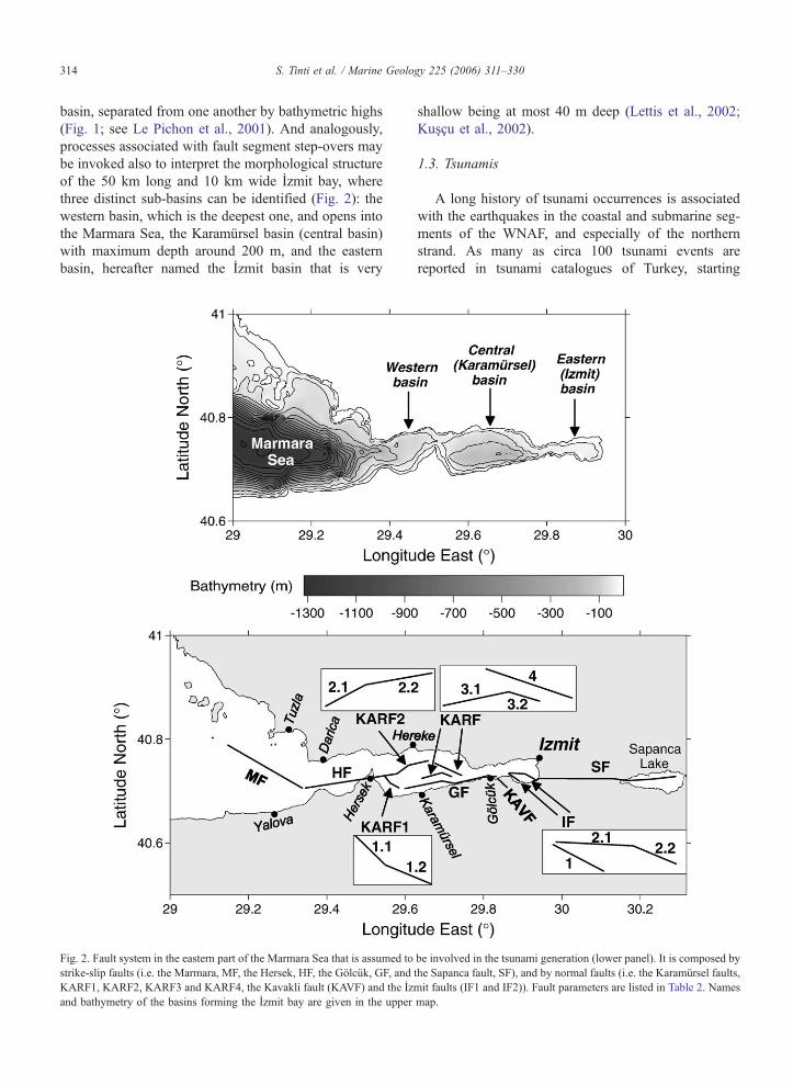
basin, separated from one another by bathymetric highs
(Fig. 1; see Le Pichon et al., 2001). And analogously,
processes associated with fault segment step-overs may
be invoked also to interpret the morphological structure
of the 50 km long and 10 km wide Izmit bay, where
three distinct sub-basins can be identified (Fig. 2): the
western basin, which is the deepest one, and opens into
the Marmara Sea, the Karamursel basin (central basin)
with maximum depth around 200 m, and the eastern
basin, hereafter named the Izmit basin that is very
Fig. 2. Fault system in the eastern part of the Marmara Sea that is assumed to
strike-slip faults (i.e. the Marmara, MF, the Hersek, HF, the Golcuk, GF, and
KARF1, KARF2, KARF3 and KARF4, the Kavakli fault (KAVF) and the Iz
and bathymetry of the basins forming the Izmit bay are given in the upper
shallow being at most 40 m deep (Lettis et al., 2002;
Kuscu et al., 2002).
1.3. Tsunamis
A long history of tsunami occurrences is associated
with the earthquakes in the coastal and submarine seg-
ments of the WNAF, and especially of the northern
strand. As many as circa 100 tsunami events are
reported in tsunami catalogues of Turkey, starting
be involved in the tsunami generation (lower panel). It is composed by
the Sapanca fault, SF), and by normal faults (i.e. the Karamursel faults,
mit faults (IF1 and IF2)). Fault parameters are listed in Table 2. Names
map.

S. Tinti et al. / Marine Geology 225 (2006) 311–330 315
from the Minoan Santorini explosion tsunami in the
Aegean Sea until the recent 1999 Kocaeli-earthquake
tsunami that is treated here (see Altinok and Ersoy,
2000; Papadopoulos, 2001; see also Ambraseys,
1962; Kuran and Yalciner, 1993). Practically, according
to historical records, all the Turkish coasts were affect-
ed: the Black Sea coastline to the north (Yalciner et al.,
2004), the Aegean coast to the west and the eastern
Mediterranean coasts (Yalciner et al., 2001a,b), but one
of the largest concentration of cases is found in the
Marmara Sea and in the Izmit bay. Historical informa-
tion on tsunamis in Turkey, as in all the other European
countries and in many other countries in the world, is
generally insufficient for a statistical analysis of the
tsunami hazard and for a proper characterisation of
the tsunami effects. Reports are mostly sporadic and
detailed descriptions are available only for a restricted
number of cases. Moreover, the reliability of the his-
torical sources is not always sound. In a recent study on
the Marmara Sea tsunamis, Ambraseys (2002b) con-
cluded that about 50% of the cases found in the liter-
ature are to be ruled out as spurious events.
Nonetheless, this region remains one of the European
areas with the highest tsunami activity, and most vul-
nerable to tsunami attacks. Interest for the evaluation of
the tsunami risk in the whole region of the Marmara
Sea has increased after the occurrence of the 1999
Kocaeli earthquake and tsunami, and after the specula-
tion based on stress-transfer theory that its occurrence
has highly favoured the condition for the next WNAF
rupture to take place in the submarine section of the
northern strand (Hubert-Ferrari et al., 2000; Parsons et
al., 2000; Parsons, 2004). A possible future earthquake
occurring in the Marmara Sea has a direct tsunamigenic
potential, and, furthermore, may set in motion subma-
rine masses (landslides or slumps), with additional
possibility to produce tsunamis. Signatures of past
mass failures have been identified in several places by
specific and very detailed marine geological surveys in
several places of the sea of Marmara (see e.g. Altinok et
al., 1999; Alpar and Yaltirak, 2002; Yuksel et al., 2002),
and scenarios of tsunamis induced by earthquake-trig-
gered underwater slides have been analysed by Yalciner
et al. (2002), with the conclusion that risk associated
with tsunami occurrence is a very serious issue espe-
cially in the Istanbul area.
2. The Kocaeli earthquake and its genetic fault
system
The Kocaeli earthquake struck in the night of Au-
gust 17, 1999 at 3:02 AM and affected a very vast
region from the Eften Lake, east of Karadere, to the
whole Izmit bay. The areas with the largest toll of
destruction and damage were the district of Adapazari
and the belt around the eastern and southeastern coast
of the Izmit bay, but the earthquake was damaging also
west of Istanbul where severe effects were observed in
the coastal towns of Buyukcekmece and Kucukcek-
mece in the district of Avcilar. The earthquake was
lethal, killing more than 17,000 people. The number
of injuries exceeded 43,000, and as many as about
250,000 people remained homeless, implying property
losses in the range of $6.5 billion (USGS Report,
2000). The magnitude was estimated to be MW=7.4
by Kandilli Observatory and the epicentre was located
at 40.88N and 308E (with hypocentre around 17 km
depth) near the eastern end of the Izmit bay (Barka et
al., 2002). Shaking lasted about 45 s and was recorded
by several strong motion sensors placed around and
very near to the source (managed by the Earthquake
Research Department of General Directory of Disaster
Affairs of Turkey). The highest recorded ground accel-
eration was 0.45 g at the station of Sakarya, to the east
of the Sapanca Lake. The earthquake ruptured at least
five segments of the northern branch of the NAF, each
with length in the range of 20–35 km that from east to
west are the Karadere segment, the Sapanca-Akyazi
segment (to the east of the Sapanca Lake), the Sapanca
segment (to the west of the lake), the Golcuk segment
and the Hersek segment (Barka et al., 2002; Lettis et
al., 2002). The tsunamigenic fault segments are
sketched in Fig. 2. Aftershock distribution and SAR
data analysis possibly suggest that rupture took place
also on a further segment in the Marmara Sea to the
east of the Izmit bay entrance (Gulen et al., 2002; Cakir
et al., 2003). The areas connecting the fault segments
have been recognised as distinct right-releasing step-
over regions, whose width goes from 1 to 2 km for the
Sapanca Lake and the Golcuk step-overs up to 4–5 km
for the Karamursel step-over (Lettis et al., 2002). Slip
distribution deduced from seismological records and
from field surveys of the surface breaks shows that
slip was highly heterogeneous along the fault and that
the maximum values of dextral displacement have to be
assigned to the Sapanca-Akyazi segment (5–6 m) and
to the Golcuk segment (4–5 m) (Barka et al., 2002;
Lettis et al., 2002), a picture that is basically further
confirmed by inversion of GPS and satellite data (Feigl
et al., 2002; see also Delouis et al., 2002, whose study
identifies a third area of increased slip in the western-
most sector of the Izmit bay) as well as by combining
tectonic observations and SAR data (Cakir et al.,
2003).

S. Tinti et al. / Marine Geology 225 (2006) 311–330316
The multiple-rupture main shock was dominated
by the right-lateral strike-slip component in agree-
ment with the dominant tectonic style of the region.
Consistently, observed ground movement was typical-
ly horizontal. However, also vertical ground move-
ments were identified in several places in a narrow
belt along the main fault-segments zone. Coastal
subsidence was observed in the southern coast of
the Sapanca Lake and in the southeastern coast of
the Izmit bay, and caused extensive flooding and
permanent retreat of the shoreline by tens to hundreds
of meters. The observed vertical displacements can be
accounted for only partially by the strike-slip source
model, and require a different explanation, namely
liquefaction and normal faulting. Ground sinking
due to widespread liquefaction phenomena was ascer-
tained to have occurred in Adapazari where several
hundreds of buildings were affected (USGS Report,
2000). Liquefaction was also observed in Sapanca as
well as in the delta fan east of Golcuk (Sucuoglu et
al., 2000).
Ancillary normal faults with dominant vertical com-
ponent in addition to a smaller right-lateral slip were
mapped in several places. The most relevant one was
seen east of Golcuk in the locality known as Kavakli,
and was the main cause of the subsidence that affected
Golcuk (Rothaus et al., 2004). The fault, trending NW–
SE, can be traced for a 3.5 km inland, intersects the
coastline, and probably continues offshore. The scarp
shows a vertical offset of about 2 m and a typical
dextral offset of 0.40–0.60 m that were measured by
several surveying teams (Barka et al., 2002; Lettis et al.,
2002), one of which was a joint Italian-Turkish (IT)
team and included four of the authors of the present
paper (namely Tinti, Armigliato, Yalciner and Altinok).
The role of surface normal faulting was probably minor
in determining the major catastrophic ground shaking
that is to be attributed more appropriately to the rup-
tures along the long dextral fault segments. But the
point of this paper is that these faults were essential
in the genesis of the tsunami. Seismic profiles taken
after the occurrence of the Kocaeli earthquake show the
clear signature of the main fault zone that disturbed the
underwater sediments (Alpar, 1999). However, beyond
the main fault system, offshore normal faults were
identified by means of bathymetric and shallow seismic
data in the central (Karamursel) and in the eastern parts
of the Izmit bay (Sengor et al., 1999; Alpar and Yal-
tirak, 2002; Lettis et al., 2001, 2002), and their trend
and position is consistent with the vertical dynamics
that is associated with the formation of these step-over
basins.
3. Tsunami observations
The 1999 Kocaeli earthquake caused a tsunami that
was observed in the entire Izmit bay. Unfortunately no
tide-gauge records are available for the tsunami either
in the source region or in the Marmara Sea. Post-event
field surveys and interview of eyewitnesses conducted
soon after the tsunami occurrence by several teams
enabled to determine the coastal areas of major wave
impact and to quantify the run-up heights and the sea
penetration lengths in all the affected places. The tsu-
nami was observed soon after the main shock. Almost
in all places the tsunami was seen to cause the sea to
withdraw first and then to overcome the usual shoreline
and inundate land. The observed tsunami run-up
heights were modest and typically in the range of 1–3
m. The tsunami was damaging, but not catastrophic. In
some places it was strong enough to carry boats and
vessels on land. One example comes from Yenikoy, east
of Kavakli, where a large floating platform, 60 m long
and 12 m wide that was used as a pier, was moved and
transported about 100 m on land over a grassy stretch of
coast (Altinok et al., 2001; Rothaus et al., 2004). A
detailed description of the tsunami observations can be
found in the works by Yalciner et al. (2000, 2001a,b,c)
and by Altinok et al. (2001), and has been integrated in
a recent study by Rothaus et al. (2004) that focuses on
the effects in the southern coast of the Izmit bay. Table
1 summarises the observations on first arrival, water
penetration and run-up heights that can be found in the
aforementioned papers, and complements the data set
by adding new observations, so far unpublished that
were collected during the IT post-event field survey.
The tsunami was exceptionally violent only in the
town of Degirmendere. Here measured wave run-ups
exceeded 4 m, but several eyewitnesses state that the
wave reached the second floor of the buildings in the
waterfront (IT), and some other estimate a height of
about 15 m (Rothaus et al., 2004). Ships moored in the
port of Degirmendere were severely affected by the
waves and seamen told that the attacking wave was
probably larger than 10 m (Altinok et al., 2001). Per-
haps the same large wave struck ships moored in the
next town of Kavakli, east of Golcuk: here the tsunami
came over a ship reaching a height of more than 15 m,
according to witnesses rough evaluation (Rothaus et al.,
2004). The anomalous violence of the tsunami in the
limited area around Degirmendere is the consequence
of an additional local tsunamigenic source that was
identified in a slump. A stretch of coast about 300 m
long (parallel to shoreline) and 75 m wide (perpendic-
ular to shoreline), where a recreational area called

Table 1
Post-tsunami field survey observations
Locality Locality
codeaSurvey First
arrival
Penetration
length
(m)
Observed
run-up
height
(m)
DarVca 1 AL 4 N1
Eskihisar 2 AL 15 N1
Dilovasi 3 AL � 2
TavsancVl 4 AL � 25–30 1.5
IT � 25 1.7–2.5
Hereke 5 AL 30 1.8
IT 2.25–2.9
Sirinyali 6 AL 15 N2
Kirazliyali 7 AL 2.5
YarVmca 8 AL � N60
IT � 3.2
Korfez AL 100
Tupras
(Kiler Point)
9 AL 20 2.5
Derince Port 10 AL � 2–2.5
Cene Suyu 11 AL � 60 2?
Izmit,
Marina
12 AL � 25
Seymen
(Yenikoy)
13 AL 50
IT 50 2
RO N200
Kavakli 14 AL 300?
Golcuk 15 RO 15–20b
Degirmendere 16 AL � 35? 2.5
IT � 2.4
RO � 80 4.4 (15b)
Halidere 17 AL � 60 0.8
IT � 47–92 1.5
Ulasli 18 AL � N5 2
Eregli-
Guzelyali
19 AL + 4 1.25
Defne
Mahallesi
20 AL 4 1.5
Karamursel 21 AL �Kaytazdere 22 AL 15?
Hersek 23 AL N30
RO 15
Havuzdere AL
Topcular 24 AL � 2?
Offshore
Topcular
AL 30? 30?
AL: survey by Altinok et al. (2001); IT: survey by Italian-Turkish
team composed by Altinok Y., Armigliato A., Bortolucci E., Guidi C.,
Tinti S., Yalciner A.C.; RO: survey by Rothaus et al. (2004).a Localities are numbered as in Fig. 3.b Not run-up height value, but wave height offshore reported by
eyewitnesses.
S. Tinti et al. / Marine Geology 225 (2006) 311–330 317
Cinarlik Park was located, slid into the sea, carrying a
multi-storing hotel, owned by the municipality, a cafe
and a restaurant and 14 park trees (Arel and Kiper,
2000; Altinok et al., 2001; Cetin et al., 2004). Modeling
of both the tectonic tsunami and the local tsunami
induced by the coastal mass failure is the main aim of
this work and will be tackled with the appropriate
attention in the following.
4. Simulations of the earthquake-induced tsunami
Tsunami simulations are based on a finite-element
model solving the non-linear shallow water equations
that has been developed specifically for tsunami anal-
ysis by the University of Bologna, Italy, and has been
extensively used to study near-field propagation of
tsunamis generated by near-shore earthquakes (Tinti
et al., 1994; among the applications, see Piatanesi and
Tinti, 1998, 2002; Tinti and Armigliato, 2003). The
Izmit bay and the easternmost part of the Marmara
Sea facing the bay have been covered by a grid con-
sisting of 11,006 nodes and 20,197 triangles, having a
space resolution variable from place to place (coarser in
deep water and finer in shallow coastal areas). The grid
that is portrayed in Fig. 3 was created through a mesh
building code optimised for tsunami simulations that is
suited to basins with complex bathymetries and irregu-
lar coastlines and that tends to produce triangles with
the highest index of isotropy (typically equilateral) and
a uniform crossing time (Tinti and Bortolucci, 1999).
The coastal boundary is delimited by vertical walls
causing total reflection of the water waves. Technically,
this means that the tsunami model does not compute the
tsunami run-up heights, but only the maximum water
elevation (MWE) at the vertical coast. However, this is
not a significant limitation for the purpose of this paper,
since MWEs are known to be a reasonable approxima-
tion of run-up heights for most coastal morphologies.
The depth data set has been assembled by digitising
nautical maps of the Marmara Sea (1:300,000) and of
the Izmit bay (1:50,000) published by the Hydrographic
and Oceanographic Service of Turkey and by digitising
maps from Lettis et al. (2002) that are based on recent
data gathered by the Turkish Navy and by Guneysu
(1999). This bathymetry data set has been further inte-
grated with depth data collected in the course of the
post-tsunami survey by the IT team. Fig. 2 provides a
map with the bathymetry and Fig. 3 shows the grid and
localities where tsunami observations were made and/or
tsunami time histories and maximum water elevations
have been calculated.
The faults used to generate the numerical tsunami
are listed in Table 2. As regards the main strike-slip
faults, we consider only those fault segments that are
found close enough to the water basin to cause defor-
mation of the sea bottom. Therefore neither the Kara-
dere segment nor the Sapanca-Akyazi segment are

Fig. 3. Grid used for the numerical simulation of the earthquake-induced tsunami, consisting of 11,006 nodes and of 20,197 triangles. Numbers refer
to places where tsunami observations of the post-event surveys were made (see Table 1): (1) Darica, (2) Eskihisar, (3) Dilovasi, (4) Tavsancil, (5)
Hereke, (6) Sirinyali, (7) Kirazliyali, (8) Yarimca, (9) Tupras, (10) Derince, (11) Cene Suyu, (12) Izmit, (13) Seymen, (14) Kavakli, (15) Golcuk,
(16) Degirmendere, (17) Halidere, (18) Ulasli, (19) Eregli, (20) Defne, (21) Karamursel, (22) Kaytazdere, (23) Hersek, (24) Topcular.
S. Tinti et al. / Marine Geology 225 (2006) 311–330318
taken into account. The faults supposed to contribute to
the tsunami are from east to west the Sapanca fault
(SF), the Golcuk fault (GF) and the Hersek fault (HF).
We also add the Marmara fault (MF) that is totally
submarine and that, according to some studies (Gulen
et al., 2002; Cakir et al., 2003), represents the western-
Table 2
Parameters for the tsunamigenic strike-slip (grey background cells) and nor
Slip amount, length and width of all strike-slip faults are taken from Gulen
most rupturing segment of the Kocaeli earthquake,
although this point of view is not unanimously agreed
upon. Fault parameters are derived from the literature,
which is properly acknowledged in the caption of Table
2. Some of these faults are subdivided in a number of
rectangular uniform-slip sub-faults to approximate bet-
mal faults
et al. (2002).

S. Tinti et al. / Marine Geology 225 (2006) 311–330 319
ter the along-fault variable strike. The slip varies in a
range of 1.0 m to 5.30 m, increasing from west to east.
The dip-slip faults taken into account in our study
are the Kavakli fault (KAVF) and all the faults
corresponding to the step-over regions of the Karamur-
sel (KARF) and of the Izmit (IF) sub-basins (see Table
2). The only inland fault is the Kavakli fault: for this
fault, strike, length and slip values come from measure-
ments taken in the field (Barka et al., 2002; Lettis et al.,
2002, and IT team observations), and there is clear
evidence that it ruptured during the Kocaeli earthquake.
The submarine normal faults are determined on the
basis of bathymetric and shallow seismic surveys (Sen-
gor et al., 1999; Lettis et al., 2001, 2002), but there is
no certainty that they were active during the main
quake. Here we assume that all these faults have dip
of 608 and are very shallow (fault width is supposed to
be 3 km), being surface expression of the stress accom-
modation processes associated with the step-overs. We
assume further that they were involved in the main
shock process with a slip amount comparable with the
Kavakli fault (see Table 2).
The initial tsunami energy is assumed to be only
potential with water elevation field taken to be equal to
the coseismic vertical displacement field of the seafloor,
which is usual in simulations of tsunamis induced by
earthquakes. Surface coseismic deformations are calcu-
lated through Okada’s (1992) formulas, holding for
rectangular faults buried in a homogeneous elastic
half-space. Since Okada’s model is based on elastic
linear theory, the displacements produced by multiple
rectangular sources can be superposed in order to obtain
the total coseismic ground displacement and, conse-
quently, the initial seawater elevation condition.
Our study intends to demonstrate that the tsunami
data cannot be explained only by the strike-slip fault
sources that were responsible for the catastrophic main
ground shaking, and that additional sources are needed
in order to justify the observations. We suggest that
these additional sources may be found in the set of
coastal and submarine normal faults listed in Table 2.
To this purpose we analyse the tsunamigenic effects of
the strike-slip fault system first, and then we add the
further contribution of the normal faults. As to the
right-lateral fault tsunami, we run two different experi-
ments, one with the sources involving the Izmit bay,
namely the three fault segments HF, GF and SF, and
the other with the supplementary addition of the Mar-
mara fault (MF), whose role is not unanimously recog-
nised. Fig. 4A exhibits the curves of the MWE
computed along the coastal nodes of the basin for
the strike-slip tsunami sources. The starting point is
the coastal node in the upper left corner of the mesh
(Fig. 3), corresponding to the westernmost position on
the northern coast. The coastline is run clockwise,
reaching the lower left corner. Relevant localities are
all within the Izmit bay and are identified with numb-
ers in the grid map given in Fig. 3 that are repeated in
Fig. 4 to help the reader. The results of the two
simulations, with and without MF, are very similar,
with a slight difference that can be noted only for the
coastal nodes that are found outside the Izmit bay
(plotted at the initial and ending part of the graph),
which means that the tsunamigenic effect of MF is not
relevant. Therefore, it will not be considered any
longer in our analysis. The most important outcome
of the tsunami simulation is that the calculated MWE
are very low along the entire coast of the bay with
values that are typically less than 30 cm and occa-
sional peaks around 50–70 cm. This is at odd with the
run-up height observations and is a very strong ele-
ment proving our thesis that the dextral fault system of
the Kocaeli earthquake is not able to generate a sig-
nificant tsunami.
In the second stage of the analysis we invoke the
contribution of the normal faults given in Table 2. The
MWE corresponding to the case of the sole normal-
fault system and to the case of the ensemble of all the
active faults (strike-slip and normal) with the excep-
tion of MF are plotted in Fig. 4B. Furthermore, also
the observed run-up heights are added to the graph.
The two curves are found to differ insignificantly from
one another, which shows that the contribution of the
normal-fault sources is highly predominant in deter-
mining the resulting MWE values. Most importantly,
the comparison between the calculated curves and the
measured run-up heights shows that the agreement is
acceptable, though not yet perfect. Though there are
some zones of marked overestimation (e.g. the peak
around point 20 corresponding to Defne Mahallesi), a
general underestimation of the experimental data can
be noted, which is however mild and can be probably
reduced or even eliminated by tuning the sources. The
only town where the computed wave elevations are
largely inconsistent with observations is Deðirmen-
dere, where the tsunami has to be explained as the
effect of the coastal slump, as will be shown in detail
in the next section. Fig. 5 depicts some of the tide-
gauge records computed both on the northern and on
the southern coast of the bay for the case of the
combined normal and strike-slip faults. The curves
are identified by numbers that correspond to the lo-
cality numbers shown in the map of Fig. 3 and also
given in Table 1. Records either show a negative first

Fig. 4. Maximum water elevation computed for the coastal nodes calculated for the tsunamis induced by different set of sources. (A) All strike-slip
sources either including the Marmara Fault (S+M) or excluding it (S). (B) All dip-slip faults (D) and dip-slip together with strike-slip faults (D+S).
Faults are listed in Table 2 and graphed in Fig. 2. Distances on the horizontal axis are measured along the coast from the upper left corner of the grid
given in Fig. 3 and numbers correspond to the localities on the same figure. Solid circles in panel (B) are the observed run-up heights given in Table
1. Maximum values reported in Degirmendere (15 m) go out of scale.
S. Tinti et al. / Marine Geology 225 (2006) 311–330320
arrival or a very small positive arrival that is followed
by a much larger sea level lowering, which is in
agreement with most accounts of eyewitnesses who
observed a sea retreat first (the idea is that the initial
sea rise was so small that passed unobserved to peo-
ple). In most places the largest oscillations occur in
the first 5–10 min after the shock with dominant
period of 3–4 min, and are later followed by a long
train of small slow-decay oscillations also with longer
period. The complex structure of the marigrams

Fig. 5. Computed tide-gauge records for the tsunami induced by all
faults, but the Marmara fault (case D+S of Fig. 4) for the localities
identified by the numbers on the right.
S. Tinti et al. / Marine Geology 225 (2006) 311–330 321
reflects the complexity of the sources and of the basin
morphology, which favours the onset and persistence
of transverse mode of oscillations, corresponding to
waves crossing the bay in north–south direction. Re-
cord 24 corresponds to Topcular that is found in the
outer Izmit bay basin and is far from the normal-fault
sources considered here. The tsunami is here quite
weak, which shows that the energy tends to remain
trapped within the inner basins of the bay with modest
outward radiation. Marigram 16 is computed at Degir-
mendere. The main comment is that the calculated
oscillations here are small amplitude, and generally
negative in the first post-earthquake 10-min window,
during half of which the sea remains below the normal
level by about 1–1.5 m. This is a detail that may have
some relevance for the stability of the local coastal
slope, as will be discussed in the next section.
5. The slump at Degirmendere
Degirmendere is a village located in the southern
coast of the Karamursel pull-apart basin (point 16 in
Fig. 3). A segment of coast about 300 m long and 75 m
wide slid into the sea carrying a multi-storey hotel and
two adjacent buildings, and produced a completely new
shoreline (Rathje et al., 2002, 2004; Cetin et al., 2004).
A more violent tsunami was testified by witnesses and
observed by post-event surveys in this area. It started at
the same time of the main shock, or with some minutes
delay according to only a single account, and mani-
fested first with a seawater withdrawal (Altinok et al.,
2001; Rothaus et al., 2004; IT team). In this work,
based on data taken from the literature and on data
collected by the IT team, first we analyse the stability
of the mass involved in the failure, and then we simu-
late its motion and compute the induced tsunami.
Bathymetric data were collected by a boat survey
undertaken around the coast of Degirmendere on Oc-
tober 1999, after the slide, by the IT team. We recon-
struct the post-event bathymetry also with the aid of
data extrapolated from the article by Cetin et al. (2004).
The pre-event bathymetry is derived from the nautical
map of the Izmit bay in conjunction with data from
Cetin et al. (2004). Pre- and post-failure positions of the
coastline are deduced also by making use of the maps
by Rathje et al. (2002, 2004). We evaluated the volume
of the slump by comparing pre- and post-event bathy-
metric data in the detachment area, obtaining the figure
of 5.18�106 m3.
Post-failure analyses of on-land cracks and geo-
technical investigations (borings, as well as in situ
SPT, CPT and CPTU tests) carried out in the vicinity
of the failed area are available at the web site http://
peer.berkeley.edu/turkey/adapazari (Cetin et al., 2004).
The analyses show the presence of distinct layers, the
surface one (down to a 0.5–1 m depth) consisting of
artificial fill of gravely sand and of silty clay. Deeper,
one meets a sequence of thicker layers of silty sand,
sand and sandy silt with occasional presence of gravel,
the underlying bedrock being generally found deeper
than 12–15 m (Cetin et al., 2004).
6. Stability analysis
The stability study of the Degirmendere slump is
carried out here through an original method, hereafter
designed as TM method, that is based on the limit
equilibrium theory (Tinti and Manucci, in press), but
that differs from the classical limit equilibrium meth-
ods. Since the method applied is new, we consider it
useful for the reader to highlight briefly the main
characteristics of this approach. The stability is ana-
lysed along 2D cross-sections. As in the classical limit
equilibrium methods, the 2D section is partitioned into
slices by means of vertical cuts. Imposing the condition
of the static equilibrium to all the slices results in a set
of three equations (see Fig. 6): two for the horizontal
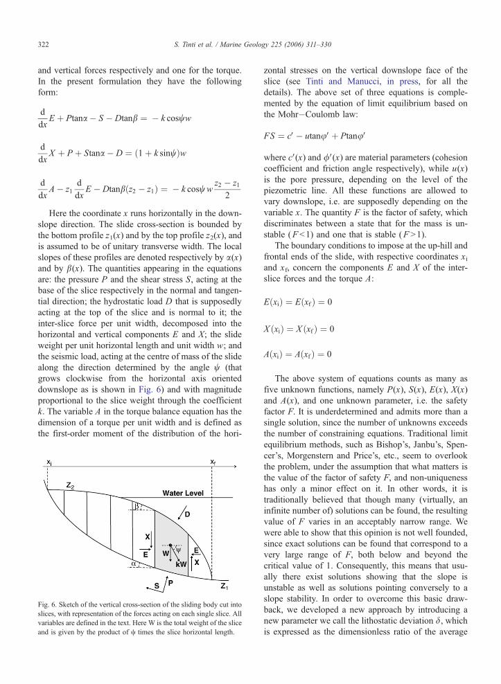
S. Tinti et al. / Marine Geology 225 (2006) 311–330322
and vertical forces respectively and one for the torque.
In the present formulation they have the following
form:
d
dxE þ Ptana � S � Dtanb ¼ � k cosww
d
dxX þ P þ Stana � D ¼ 1þ k sinwð Þw
d
dxA� z1
d
dxE � Dtanb z2 � z1ð Þ ¼ � k cosww
z2 � z1
2
Here the coordinate x runs horizontally in the down-
slope direction. The slide cross-section is bounded by
the bottom profile z1(x) and by the top profile z2(x), and
is assumed to be of unitary transverse width. The local
slopes of these profiles are denoted respectively by a(x)and by b(x). The quantities appearing in the equations
are: the pressure P and the shear stress S, acting at the
base of the slice respectively in the normal and tangen-
tial direction; the hydrostatic load D that is supposedly
acting at the top of the slice and is normal to it; the
inter-slice force per unit width, decomposed into the
horizontal and vertical components E and X; the slide
weight per unit horizontal length and unit width w; and
the seismic load, acting at the centre of mass of the slide
along the direction determined by the angle w (that
grows clockwise from the horizontal axis oriented
downslope as is shown in Fig. 6) and with magnitude
proportional to the slice weight through the coefficient
k. The variable A in the torque balance equation has the
dimension of a torque per unit width and is defined as
the first-order moment of the distribution of the hori-
Fig. 6. Sketch of the vertical cross-section of the sliding body cut into
slices, with representation of the forces acting on each single slice. All
variables are defined in the text. Here W is the total weight of the slice
and is given by the product of c times the slice horizontal length.
zontal stresses on the vertical downslope face of the
slice (see Tinti and Manucci, in press, for all the
details). The above set of three equations is comple-
mented by the equation of limit equilibrium based on
the Mohr�Coulomb law:
FS ¼ cV� utanuVþ PtanuV
where cV(x) and /V(x) are material parameters (cohesion
coefficient and friction angle respectively), while u(x)
is the pore pressure, depending on the level of the
piezometric line. All these functions are allowed to
vary downslope, i.e. are supposedly depending on the
variable x. The quantity F is the factor of safety, which
discriminates between a state that for the mass is un-
stable (F b1) and one that is stable (F N1).
The boundary conditions to impose at the up-hill and
frontal ends of the slide, with respective coordinates xiand xf, concern the components E and X of the inter-
slice forces and the torque A:
E xið Þ ¼ E xfð Þ ¼ 0
X xið Þ ¼ X xfð Þ ¼ 0
A xið Þ ¼ A xfð Þ ¼ 0
The above system of equations counts as many as
five unknown functions, namely P(x), S(x), E(x), X(x)
and A(x), and one unknown parameter, i.e. the safety
factor F. It is underdetermined and admits more than a
single solution, since the number of unknowns exceeds
the number of constraining equations. Traditional limit
equilibrium methods, such as Bishop’s, Janbu’s, Spen-
cer’s, Morgenstern and Price’s, etc., seem to overlook
the problem, under the assumption that what matters is
the value of the factor of safety F, and non-uniqueness
has only a minor effect on it. In other words, it is
traditionally believed that though many (virtually, an
infinite number of) solutions can be found, the resulting
value of F varies in an acceptably narrow range. We
were able to show that this opinion is not well founded,
since exact solutions can be found that correspond to a
very large range of F, both below and beyond the
critical value of 1. Consequently, this means that usu-
ally there exist solutions showing that the slope is
unstable as well as solutions pointing conversely to a
slope stability. In order to overcome this basic draw-
back, we developed a new approach by introducing a
new parameter we call the lithostatic deviation d, whichis expressed as the dimensionless ratio of the average

Fig. 7. Reconstruction of the pre- and post-slump coastline (Rathje et
al., 2002, 2004; Cetin et al., 2004). The footprint of the failing mass
(dashed line) and profiles A and B (solid lines) of the analysed
vertical cross-sections are also shown.
S. Tinti et al. / Marine Geology 225 (2006) 311–330 323
magnitude of the inter-slice forces to the weight of the
slide:
d ¼ W�1 1
xf � xið Þ
Z xf
xi
E xð Þ2 þ X xð Þ2� �
dx
� �1=2
W ¼Z xf
xi
wdx
and by further adopting the principle of Minimum
Lithostatic Deviation (MLD). It asserts that the state
of limit equilibrium of the body is the state that satisfies
Fig. 8. Reconstructed vertical cross-sections of the slump body taken along
circular and plotted as a dashed line. In the stability analysis the material is
all the five equations given above together with the six
boundary conditions and that, in addition, minimises
the lithostatic deviation d.The new approach changes drastically the way the
solution can be searched for. The stability factor is not
treated as an unknown parameter anymore, but it is
taken as a given parameter that can vary within a
specified range including the critical value 1. The
method we use consists in expressing the unknown
function X into a truncated Fourier expansion, and
then to find the ensemble of exact solutions to the
stability problem corresponding to any pre-given
value of F. For each solution, the lithostatic deviation
is computed, and, according to the MLD criterion, one
picks up the value of F that is associated with the
solution corresponding to the minimum value of d(Tinti and Manucci, in press).
To study the Degirmendere slump the TM method
was applied together with various traditional limit equi-
librium methods. We selected two profiles along the
body that are aligned with the direction of sliding.
These are given in Fig. 7 where the reconstructed
footprint of the failing mass is portrayed. The two
cross-sections, denoted by A and B, are taken along
the average direction of sliding motion and are given in
Fig. 8: the top curve has an average slope of about 158.To perform the stability analysis the bottom boundary is
approximated by an arc-like curve. Notice that this is
not a requirement imposed by our approach, for it can
be applied to slip boundaries with arbitrary shape, but
rather it is a convention adopted by the traditional
methods, and we adhere to it to allow comparison.
We have studied the stability of the body in three
different situations: in the pre-earthquake condition,
during the shock, and also in the course of the first
transects A and B shown in Fig. 7. The assumed basal slip surface is
taken to be cohesionless (cV=0) and with angle of friction /V=298.
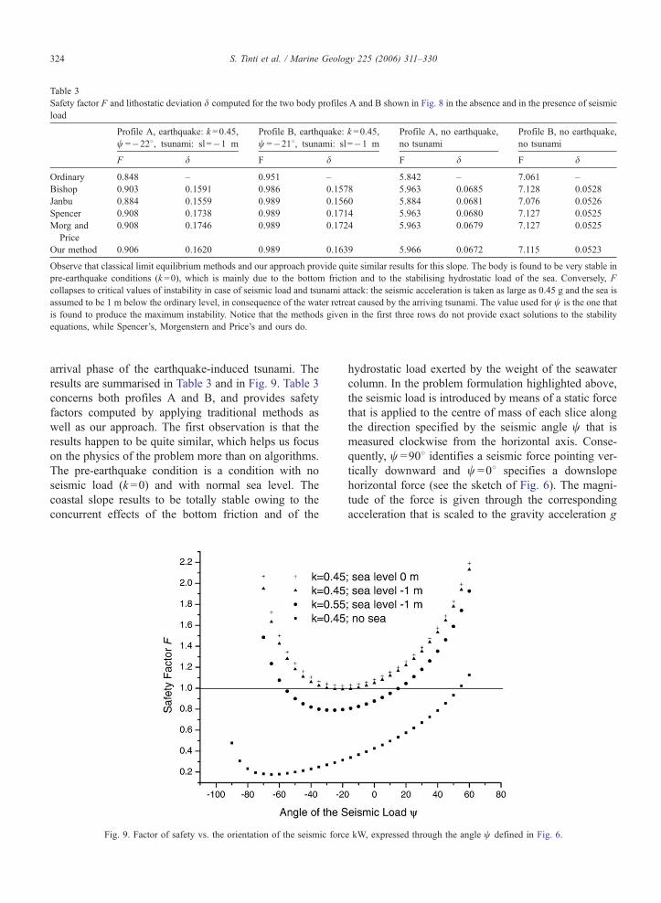
Table 3
Safety factor F and lithostatic deviation d computed for the two body profiles A and B shown in Fig. 8 in the absence and in the presence of seismic
load
Profile A, earthquake: k =0.45,
w =�228, tsunami: sl=�1 m
Profile B, earthquake: k =0.45,
w =�218, tsunami: sl=�1 m
Profile A, no earthquake,
no tsunami
Profile B, no earthquake,
no tsunami
F d F d F d F d
Ordinary 0.848 – 0.951 – 5.842 – 7.061 –
Bishop 0.903 0.1591 0.986 0.1578 5.963 0.0685 7.128 0.0528
Janbu 0.884 0.1559 0.989 0.1560 5.884 0.0681 7.076 0.0526
Spencer 0.908 0.1738 0.989 0.1714 5.963 0.0680 7.127 0.0525
Morg and
Price
0.908 0.1746 0.989 0.1724 5.963 0.0679 7.127 0.0525
Our method 0.906 0.1620 0.989 0.1639 5.966 0.0672 7.115 0.0523
Observe that classical limit equilibrium methods and our approach provide quite similar results for this slope. The body is found to be very stable in
pre-earthquake conditions (k =0), which is mainly due to the bottom friction and to the stabilising hydrostatic load of the sea. Conversely, F
collapses to critical values of instability in case of seismic load and tsunami attack: the seismic acceleration is taken as large as 0.45 g and the sea is
assumed to be 1 m below the ordinary level, in consequence of the water retreat caused by the arriving tsunami. The value used for w is the one that
is found to produce the maximum instability. Notice that the methods given in the first three rows do not provide exact solutions to the stability
equations, while Spencer’s, Morgenstern and Price’s and ours do.
S. Tinti et al. / Marine Geology 225 (2006) 311–330324
arrival phase of the earthquake-induced tsunami. The
results are summarised in Table 3 and in Fig. 9. Table 3
concerns both profiles A and B, and provides safety
factors computed by applying traditional methods as
well as our approach. The first observation is that the
results happen to be quite similar, which helps us focus
on the physics of the problem more than on algorithms.
The pre-earthquake condition is a condition with no
seismic load (k =0) and with normal sea level. The
coastal slope results to be totally stable owing to the
concurrent effects of the bottom friction and of the
Fig. 9. Factor of safety vs. the orientation of the seismic forc
hydrostatic load exerted by the weight of the seawater
column. In the problem formulation highlighted above,
the seismic load is introduced by means of a static force
that is applied to the centre of mass of each slice along
the direction specified by the seismic angle w that is
measured clockwise from the horizontal axis. Conse-
quently, w =908 identifies a seismic force pointing ver-
tically downward and w =08 specifies a downslope
horizontal force (see the sketch of Fig. 6). The magni-
tude of the force is given through the corresponding
acceleration that is scaled to the gravity acceleration g
e kW, expressed through the angle w defined in Fig. 6.

S. Tinti et al. / Marine Geology 225 (2006) 311–330 325
by means of the factor k. In our computations we have
assumed values for k as large as 0.45 and 0.55, which
are quite reasonable in view of the experimental data set
of recorded peak ground accelerations (Barka et al.,
2002; Cetin et al., 2004) and of acceleration modeling
(Yagi and Kikuchi, 2000). The first arrival of the tsu-
nami that was induced by the earthquake caused the sea
to retreat from the usual shoreline almost along the
entire coast of the Izmit bay, and Degirmendere was
no exception. Hence, as regards the stability analysis,
the condition of the tsunami attack is represented by
lowering the sea level by 1 m, which implies a reduc-
tion of the hydrostatic load on the submarine slope.
Columns 1 and 2 of Table 3 show results of compu-
tations with both loads applied: calculations refer to the
value of w that is found to be the one producing the
most unstable condition for a given profile. The depen-
dence of F from the angle w is explored in detail in Fig.
9, where all computations are performed by means of
our approach on the profile B. The various curves
plotted here serve to show the effect of changing the
hydrostatic and the seismic load on the resulting factor
of safety. All curves are quite regular and display a well
defined minimum, corresponding to negative values of
w, and show that the most destabilising seismic load
has both a downslope and an upward component.
Increasing the seismic force magnitude from k =0.45
to k=0.55 reduces the safety factor by 0.1–0.2 and
widens sensibly the interval of angles that may give
rise to instability. Conversely, increasing the hydrostatic
load has the effect of making the slope more stable.
This is clearly seen by comparing the three curves
corresponding to the same seismic load (k =0.45), but
with different assumed value of water level. The case of
no sea load is added in the figure only to prove that this
Fig. 10. Absolute value of the velocities of the blocks forming the slump
term cannot be neglected in computing F, since this
would lead to unacceptable underestimation. Observe
that varying the water level by 1 m implies differences
in the order of 0.05 in the resulting values of the factor
of safety. These are not large, but are sufficient to
support the idea that the tsunami may have contributed
to destabilising the slope, though it could be hardly
seen as the main cause of the failure.
7. Simulations of the slump and of the induced
tsunami
Tsunami simulations showed a satisfactory agree-
ment with real data, assuming the whole set of the
strike- and dip-slip faults as the triggering cause, except
in the Degirmendere area, where observations are great-
ly underestimated. In this section we investigate the
motion of the slump and the characteristics of the
generated tsunami, by means of a numerical simulation
method that is based on a double simulation code, one
for the slump and one for the tsunami.
The computation of the slump dynamics makes use
of a numerical Lagrangian model that divides the slump
into a 2D matrix of deformable blocks (24 in the
present case) with quadrilateral basis and calculates
the motion of each block taking into account all the
relevant forces, namely gravity, buoyancy, the basal
surface friction, the seawater drag on the frontal and
upper body surfaces, as well as the interaction with the
next neighbours (see Tinti et al., in press for a more
detailed description). Fig. 10 displays the curves of the
absolute value of the computed block velocities vs.
time, as well as the speed of the slump centre of mass
that is obtained as the weighted average of the blocks
speed. Blocks move with rather different velocities in
vs. time. The mean velocity is plotted as a continuous black line.

Fig. 11. 3D view of the trajectories of the 24 blocks forming the slide computed by means of the numerical model.
S. Tinti et al. / Marine Geology 225 (2006) 311–330326
the initial phase of strong acceleration, and then, during
the subsequent deceleration phase, they tend to move
more uniformly, with the consequence that the entire
mass advances almost like a rigid body. The slide is
rather slow, attaining the maximum speed of about 9 m/
s, and comes to a rest in slightly more than 2 min.
Consequently, the computed run-out is short, about 500
m. The block trajectories, depicted in the 3D perspec-
tive of Fig. 11, run along the maximum bathymetric
gradient (first northwestward and then westward), end-
ing at about 45–50 m depth.
Fig. 12. Finer grid used in the slump-induced tsunami simulation. Notice tha
where the tsunami is generated and propagates first.
The induced tsunami is simulated through a shallow-
water code based on the finite-element technique that
solves the non-linear Navier-Stokes equations for invis-
cid incompressible fluid. The model accounts for the
wave forcing due to the mass movement by means of an
excitation term that depends on the rate of vertical
displacement of the sea bottom Bth, modified through
a suitable filtering function depending on the local
depth and on the lateral size of the slide. Here
h(x,y,t)=H(x,y)+Hs(x,y,t) represents the sea bottom
as the sum of the time-independent bathymetry function
t the grid has very high resolution in the Degirmendere-Tupras region

Fig. 14. Water maxima and minima along the coast. Observe the fast decay of the tsunami away from the source: f.i. see that in the Izmit area the
tsunami is very weak. The distance is measured along the coast starting from the node that is in the northwestern corner of the grid of Fig. 12. We
remark that the vertical peaks computed in Degirmendere go out of scale and exceed 8 m.
Fig. 13. Snapshots of the calculated water elevation fields in the source area at different times after the slide initiation.
S. Tinti et al. / Marine Geology 225 (2006) 311–330 327

S. Tinti et al. / Marine Geology 225 (2006) 311–330328
H(x,y) and the landslide term Hs(x,y,t), which is the
instantaneous thickness of the body seen in the point
(x,y) at the time t. Further details on the model and on
the filtering function are omitted here and may be found
in previous papers addressing analogous problems of
tsunamis induced by landslides (see Tinti et al., 1999, in
press). The finite-element grid, consisting of 7451
nodes and 13,563 triangles, is built with high-resolution
in the source region where the typical element size is
less than 20 m, and covers the central and eastern part
of the Izmit bay, as may be seen from Fig. 12. Snap-
shots of the tsunami wave field are portrayed in Fig. 13,
from which we can notice how the wave propagates
from Degirmendere and, after reaching the opposite
coast, travels eastward (slower) and westward (faster)
with different speeds owing to the different water depth
of the basins. Fig. 14 displays the maxima and the
minima of the water elevation computed in the coastal
nodes. It can be seen that the tsunami is very strong at
the source with a peak–peak height exceeding 12 m, but
it drops drastically as soon as one moves some kilo-
meters away. At Tupras, that is found on the opposite
side of the bay, the maximum amplitude of the wave is
around 3 m, and less for the other towns. Synthetic tide-
gauge records for some grid nodes corresponding to
Degirmendere and Tupras are shown in Fig. 15. Ob-
serve that in the source the waves are high-amplitude
Fig. 15. Time histories computed in coastal nodes in the source region
(Degirmendere) and in Tupras on the opposite coast of the bay.
and short-period, with a clear sea retreat occurring first.
The largest disastrous wave series, composed of a few
(two–three) waves, attacks the Deðirmendere coast
within the first minute and the wave energy is concen-
trated in a short time window less than 100 s. From Fig.
13 one learns that the tsunami arrives at the opposite
coast in less than 2 min, and from the marigrams of Fig.
15 one sees that Tupras is reached soon after by longer
period waves with a positive leading front.
8. Conclusions
The study conducted in this paper has shown that the
tsunami that was observed in the Izmit bay in the night
of August 17, 1999 can be explained only as the
combined effect of several sources: tectonic coseismic
displacements and local mass failure. One relevant
result is that the sea bottom displacements computed
by means of the classical elastic models, such as Oka-
da’s, from the set of the five right-lateral faults, that
were the chief responsible for the disastrous seismic
waves (see Table 2), are not sufficient to produce a
sizeable tsunami. And this irrespective of the fact that
the main rupture zone of the Kocaeli earthquake is or is
not assumed to extend with an additional fault into the
eastern part of the Marmara Sea, since the tsunamigenic
contribution of the Marmara fault is negligible. In order
to explain the main features of the regional tsunami
affecting the Izmit bay, dip-slip faults have to be in-
voked capable to produce significant offset of the sea-
floor in the bay. In this paper we have assumed that
such faults may be found in the system of normal faults
that are associated with the step-over zones marking the
transition from one strike-slip fault segment to the next
(see Fig. 2). In particular, we have considered the
graben-like fault systems in the central (Karamursel)
and eastern (Izmit) basins of the bay. The selected fault
parameters match the idea that these are very shallow
ancillary faults that contributed only marginally to the
catastrophic seismic shaking of the main earthquake.
They are however important enough to induce relevant
vertical movement in the sea bottom. The computer
simulation of the tsunami shows that only with the
inclusion of these additional sources the run-up heights
that were observed or assessed by the post-tsunami field
surveys and that fall in the interval 1–3.5 m can be
reproduced reasonably. The exception of Degirmendere
that was attacked by waves several meters high accord-
ing both to eyewitnesses and to post-event observations
is due to a local slump. The stability analysis carried out
on the basis of geotechnical data (defining the material
property of the failing mass) and of bathymetric surveys

S. Tinti et al. / Marine Geology 225 (2006) 311–330 329
(capable of detailing the sliding surface and the run-out
distance) shows that the body was mainly destabilised
by the seismic load, but it also suggests that the tsunami
may have had a triggering role. In fact the first mani-
festation of the regional tsunami was here, like in most
other coastal segments, a sea withdrawal, and a sea
level lowering with the corresponding decrease of hy-
drostatic load on the slope was shown to have the effect
of decreasing the safety factor of the slide. The simu-
lation of the slump motion was carried out by a suitable
landslide evolution model that shows that the slump
moves rather slow, attaining speed at most less than 10
m/s. The outcome of the slide model was used to
compute the forcing term in the hydrodynamic equa-
tions governing the tsunami generation and propaga-
tion. Computer tsunami simulations via a finite-element
model have shown that the slump generation mecha-
nism is capable of producing very large short-period
waves that are very local and match the tsunami obser-
vations in Degirmendere.
Acknowledgements
The research has been funded partly by INGV (Isti-
tuto Nazionale di Geofisica e Vulcanologia, Rome,
Italy) and partly by MIUR (Ministero dell’Istruzione,
dell’Universita e della Ricerca) to study tsunami gen-
erated by earthquakes and by underwater mass move-
ments. This work was partly supported by the Research
Fund University under the Project Number: UDP-328/
03062004 allocated to Y. Altinok.
References
Alpar, B., 1999. Underwater signatures of the Kocaeli earthquake
(August 17th 1999). Turk. J. Mar. Sci. 5, 111–130.
Alpar, B., Yaltirak, C., 2002. Characteristic features of the North
Anatolian Fault in the eastern Marmara Region and its tectonic
evolution. Mar. Geol. 190, 329–350.
Altinok, Y., Ersoy, S., 2000. Tsunamis observed on and near the
Turkish coast. Nat. Hazards 21, 185–205.
Altinok, Y., Alpar, B., Ersoy, S., Yalciner, A.C., 1999. Tsunami
generation of the Kocaeli Earthquake (August 17th 1999) in the
Izmit Bay: coastal observations, bathymetry and seismic data.
Turk. J. Mar. Sci. 5, 131–148.
Altinok, Y., Tinti, S., Alpar, B., Yalciner, A.C., Ersoy, S., Bortolucci,
E., Armigliato, A., 2001. The Tsunami of August 17, 1999 in
Izmit Bay, Turkey. Nat. Hazards 24, 133–146.
Ambraseys, N.N., 1962. Data for the investigation of the seismic sea-
waves in the Eastern Mediterranean. Bull. Seismol. Soc. Am. 52,
895–913.
Ambraseys, N.N., 2002a. The seismic activity of the Marmara Sea
region in the last 2000 years. Bull. Seismol. Soc. Am. 92, 1–18.
Ambraseys, N.N., 2002b. Seismic sea-waves in the Marmara Sea
region during the last 20 centuries. J. Seismol. 6, 571–578.
Ambraseys, N.N., Finkel, C.F., 1991. Long term seismicity of Istan-
bul and of the Marmara Sea region. Terra Nova 3, 527–539.
Ambraseys, N.N., Finkel, C.F., 1995. The Seismicity of Turkey and
Adjacent Areas. A Historical Review 1500–1800. Eren Yayinlari,
Istanbul. 240 pp.
Arel, E., Kiper, B., 2000. The coastal landslide occurred by August
17, 1999 earthquake at Degirmendere (Kocaeli). Proceedings of
Coastal Engineering 3rd National Symposium, October 5–7,
2000. Canakkale, Turkey, pp. 45–55. (in Turkish).
Armijo, R., Meyer, B., Hubert, A., Barka, A., 1999. Westward
propagation of the North Anatolian fault into the Northern Aege-
an: timing and kinematics. Geology 27, 267–270.
Armijo, R., Meyer, B., Navarro, S., King, G., Barka, A., 2002.
Asymmetric slip partitioning in the Sea of Marmara pull-apart: a
clue to propagation processes of the North Anatolian Fault? Terra
Nova 14, 80–86.
Barka, A., 1992. The North Anatolian fault zone. Ann. Tecton. VI,
164–195. (Suppl.).
Barka, A., Kadinsky-Cade, K., 1988. Strike-slip fault geometry in
Turkey and its influence on earthquake activity. Tectonics 7,
663–684.
Barka, A., Akyuz, H.S., Cohen, H.A., Watchorn, F., 2000. Tectonic
evolution of the Niksar and Tasova-Erbaa pull-apart basins, North
Anatolian Fault Zone: their significance for the motion of the
Anatolian block. Tectonophysics 322, 243–264.
Barka, A., Akyuz, H.S., Altunel, E., Sunal, G., Cakir, Z., Dikbas, A.,
Yerli, B., Armijo, R., Meyer, B., Chabaler, J.B, Rockwell, T.,
Hartleb, J., Dawson, T., Christofferson, S., Tucker, A., Fumal, T.,
Langridge, R., Stenner, H., Lettis, W., Bachhuber, J., Page, W.,
2002. The surface rupture and slip distribution of the 17 August
1999 Izmit earthquake (M 7.4) North Anatolian Fault. Bull.
Seismol. Soc. Am. 92, 43–60.
Cakir, Z., de Chabalier, J.B., Armijo, R., Meyer, B., Barka, A.,
Peltzer, G., 2003. Coseismic and early post-seismic slip associated
with the 1999 Izmit earthquake (Turkey), from SAR interferom-
etry and tectonic field observations. Geophys. J. Int. 155, 93–110.
Cetin, K.O., Isik, N., Unutmaz, B., 2004. Seismically induced land-
slide at Degirmendere Nose, Izmit bay during Kocaeli (Izmit)-
Turkey earthquake. Soil Dyn. Earthqu. Eng. 24, 189–197.
Delouis, B., Giardini, D., Lundgren, P., Salichon, J., 2002. Joint
inversion of InSAR, GPS, teleseismic, and strong-motion data
for the spatial and temporal distribution of earthquake slip: Ap-
plication to the 1999 Izmit mainshock. Bull. Seismol. Soc. Am.
92, 278–299.
Feigl, K.L., Sarti, F., Vadon, H., McClusky, S., Ergintav, S., Durand,
P., Burgmann, R., Rigo, A., Massonet, D., Reilinger, R., 2002.
Estimating slip distribution for the Izmit mainshock from coseis-
mic GPS, ERS-1, RADARSAT, and SPOT measurements. Bull.
Seismol. Soc. Am. 92, 138–160.
Flerit, F., Armijo, R., King, G.C.P., Meyer, B., Barka, A., 2003. Slip
partitioning in the Sea of Marmara pull-apart determined from
GPS velocity vectors. Geophys. J. Int. 154, 1–7.
Gulen, L., Pinar, A., Kalafat, D., Ozel, N., Horasan, G., Yilmazer, M.,
Isikara, A.M., 2002. Surface fault breaks, aftershocks distribution,
and rupture process of the 17 August 1999 Izmit, Turkey, earth-
quake. Bull. Seismol. Soc. Am. 92, 230–244.
Guneysu, A.C., 1999. The bathymetry of the Izmit bay. Turkish. J.
Mar. Sci. 5, 167–169.
Hubert-Ferrari, A., Barka, A., Jacques, E., Nalbant, S.S., Meyer, B.,
Armijo, R., Tapponier, P., King, G.C.P., 2000. Seismic hazard in
the Marmara Sea region following the 17 August 1999 Izmit
earthquake. Nature 404, 269–273.

S. Tinti et al. / Marine Geology 225 (2006) 311–330330
Hubert-Ferrari, A., Armijo, R., King, G., Meyer, B., Barka, A., 2002.
Morphology, displacement, and slip rates along the North Anato-
lian Fault, Turkey. J. Geophys. Res. 107 (B10), 2235. doi:10.
1029/2001JB000393.
Kuran, U., Yalciner, A.C., 1993. Crack propagations earthquakes and
tsunamis in the vicinity of Anatolia. In: Tinti, S. (Ed.), Tsunamis
in the World. Kluwer Academic Publishers, pp. 159–175.
Kuscu, I., Okamura, M., Matsuoka, H., Awata, Y., 2002. Active faults
in the gulf of Izmit on the North Anatolian fault, NW Turkey: a
high resolution shallow seismic study. Mar. Geol. 190, 421–443.
Le Pichon, X., Sengor, A.M.C., Demirbag, E., Ranging, C., Imren, C.,
Armijo, R., Gorur, N., Cagatay, N., Mercier de Lepinay, B.,
Meyer, B., SaatcVlar, R., Tok, B., 2001. The active main Marmara
fault. Earth Planet. Sci. Lett. 192, 595–616.
Lettis, W., Bachhuber, J., Barka, A., Witter, R., Brankman, C.,
2001. Surface fault rupture and segmentation during the Kocaeli
earthquake. In: Barka, A., Kozaci, I., Akyuz, S., Altunel, E.
(Eds.), The 1999 Izmit and Duzce earthquakes: Preliminary
Results. Istanbul Technical University, Istanbul, Turkey, ISBN:
975-561-182-7 pp. 31–54.
Lettis, W., Bachhuber, J., Witter, R., Brankman, C., Randolph, C.E.,
Barka, A., Page, W.D., Kaya, A., 2002. Influence of releasing
step-overs on surface fault rupture and fault segmentation: exam-
ples from the 17 August 1999 Izmit earthquake on the North
Anatolian Fault, Turkey. Bull. Seismol. Soc. Am. 92, 19–42.
Okada, Y., 1992. Internal deformation due to shear and tensile faults
in a half-space. Bull. Seismol. Soc. Am. 82, 1018–1040.
Papadopoulos, G.A., 2001. Tsunamis in the Eastern Mediterranean: a
catalogue for the area of Greece and adjacent seas. Proceedings of
the Joint IOC–IUGG International Workshop: Tsunami Risk As-
sessment Beyond 2000: Theory, Practice and Plans, Moscow,
Russia, June 14–16, 2000, pp. 34–43.
Parsons, T., 2004. Recalculated probability of Mz7 earthquakes
beneath the Sea of Marmara, Turkey. J. Geophys. Res. 109
(B05304). doi:10.1029/2003JB002667.
Parsons, T., Toda, S., Stein, R.S., Barka, A., Dieterich, J., 2000.
Heightened odds of large earthquakes near Istanbul: an interac-
tion-based probability calculation. Science 288, 661–665.
Piatanesi, A., Tinti, S., 1998. A revision of the 1693 eastern Sicily
earthquake and tsunami. J. Geophys. Res. 103, 2749–2758.
Piatanesi, A., Tinti, S., 2002. Numerical modeling of the September 8,
1905 Calabrian (southern Italy) tsunami. Geophys. J. Int. 150,
271–284.
Rathje, E.M., Wright, S.G., Bachhuber, J., 2002. Evaluation of inte-
grated seismic hazards and ground failure in pull-apart basin
during 1999 Kocaeli earthquake, Turkey. Report to United States
Geological Survey, Earthquake Hazard Reduction Program (avail-
able online at: http://erp-web.er.usgs.gov/reports/annsum/vol43/
pt/g0043.pdf).
Rathje, E.M., Karatas, I., Wright, S.G., Bachhuber, J., 2004. Coastal
failures during the 1999 Kocaeli earthquake in Turkey. Soil Dyn.
Earthqu. Eng. 24, 699–712.
Rothaus, R., Reinhardt, E., Noller, J., 2004. Regional considerations
of coastline change, tsunami damage and recovery along the
southern coast of the Bay of Izmit (The Kocaeli (Turkey) earth-
quake of 17 August 1999). Nat. Hazards 31, 233–252.
Sengor, A.M.C., Demirbag, E., Tuysuz, E., Kurt, H., Gorur, N.,
Kuscu, I., 1999. A preliminary note on the structure of the Gulf
of Izmit: implications for the westerly prolongation of the North
Anatolian fault. In: Karaka, M., Ural, D. (Eds.), ITU-IHAS Inter-
national Conference on the Kocaeli Earthquake, 17 August 1999,
ITU Publication, pp. 25–38.
Sucuoglu, H., Gulkan, P., BakVr, B.S., Ozcebe, G., Tankut, T., YVlmaz,
C., Ersoy, U., Erberik, A., Akkar, S., Gur, T., 2000. Kocaeli and
Duzce earthquakes: Engineering Report, Joint report of the Turk-
ish Chamber of Civil Engineers and the Middle East Technical
University, Ankara, 174 pp., (in Turkish).
Tinti, S., Armigliato, A., 2003. The use of scenarios to evaluate
tsunami impact in South Italy. Mar. Geol. 199, 221–243.
Tinti, S., Bortolucci, E., 1999. Strategies of optimal grid generation
for finite-element tsunami models. Proc. International Conference
on Tsunamis, Paris, 26–28 May 1998, pp. 269–294.
Tinti, S., Manucci, A., in press. Gravitational stability computed
through the limit equilibrium method revisited. Geophys. J. Int.
Tinti, S., Gavagni, I., Piatanesi, A., 1994. A finite-element numerical
approach for modelling tsunamis. Ann. Geophys. 37, 1009–1026.
Tinti, S., Bortolucci, E., Armigliato, A., 1999. Numerical simulation
of the landslide-induced tsunami of 1988 in Vulcano island, Italy.
Bull. Volcanol. 61, 121–137.
Tinti, S., Pagnoni, G., Zaniboni, F., in press. The landslides and
tsunamis of 30th December 2002 in Stromboli analysed through
numerical simulations. Bull. Volcanol.
US Geological Survey, 2000. Implications for earthquake risk reduc-
tion in the United States from the Kokaeli, Turkey, earthquake of
August 17, 1999. USGS Circular 1193, p. 65. Available online at:
http://geology.cr.usgs.gov/pub/circulars/c1193/index.html.
Yagi, Y., Kikuchi, M., 2000. Source rupture process of the Kocaeli,
Turkey, earthquake of August 17, 1999, obtained by joint inver-
sion of near-field data and teleseismic data. Geophys. Res. Lett.
27, 1969–1972.
Yalciner, A.C., Altinok, Y., Synolakis, C.E., 2000. Tsunami Waves in
Izmit Bay after the Kocaeli Earthquake. Earthquake Spectra,
Kocaeli, Turkey Earthquake of August 17, 1999 Reconnaissance
Report, Special Issue Supplement to Professional Journal of
Earthquake Engineering Research Institute vol. 16, pp. 55–62.
Yalciner, A.C., Imamura, F., Kuran, U., Cakiroglu, Y., Ozbay, I.,
Erdinc, E., Durmusoglu, O., Altinok, Y., Alpar, B., 2001a. An
integrated model on the generation and propagation of tsunamis in
the surrounding seas around Anatolia, Turkiye cevresi denizlerde
tsunami dalgasi hareketi icin bilesik model olusturulmasi, . Final
Report of Basic Research Project No: TUBITAK-YDABCAG-60,
November 2001, pp. 147 (in Turkish).
Yalciner, A.C., Kuran, U., Altinok, Y., Alpar, B., Ersoy, S., 2001b.
Historical earthquakes and associated tsunamis in the Aegean
Sea, Turkiye kiyilarinda tarihsel depremler ve onlara iliskin
tsunamlerin izlerinin arastirilmasi. Final Report of Basic Re-
search Project No: TUBITAK-INTAG-827, September 2001,
pp. 74 (in Turkish).
Yalciner, A.C., Synolakis, C.E., Alpar, B., Borrero, J., Altinok, Y.,
Imamura, F., Tinti, S., Ersoy, S., Kuran, U., Pamukcu, S., Kano-
glu, U., 2001c. Field surveys and modeling of the 1999 Izmit
Tsunami. Proceedings of the International Tsunami Symposium,
August 7–10, 2001, Seattle, Washington, USA, pp. 557–564.
Yalciner, A.C., Alpar, B., Altinok, Y., Ozbay, I., Imamura, F., 2002.
Tsunami in the sea of Marmara, historical documents for the past,
models for the future. Mar. Geol. 190, 445–463.
Yalciner, A.C., Pelinovsky, E., Talipova, T., Kurkin, A., Kozelkov, A.,
Zaitsev, A., 2004. Tsunamis in the Black sea: comparison of the
historical, instrumental and numerical data. J. Geophys. Res. 109,
C12023. doi:10.1029/2003JC002113.
Yuksel, Y., Alpar, B., Yalciner, A.C., Cevik, E., Ozguven, O.,
Celikoglu, Y., 2002. Effects of the eastern Marmara Earthquake
on marine structures and coastal areas. Water Marit. Eng. 156,
147–163.