Control of seafloor aging on the migration of the Izu–Bonin–Mariana trench

Author's personal copy
Shallow seep-related seafloor features along the Malta plateau(Sicily channel – Mediterranean Sea): Morphologies andgeo-environmental control of their distribution
A. Savini a,*, E. Malinverno a, G. Etiope b, C. Tessarolo a, C. Corselli a
a Dip. Scienze Geologiche e Geotecnologie, Universita di Milano-Bicocca, P.za della Scienza 4, 20126 Milano, Italyb Istituto Nazionale di Geofisica e Vulcanologia, Via Vigna Murata 605, 00143 Roma, Italy
a r t i c l e i n f o
Article history:Received 24 April 2008Received in revised form6 April 2009Accepted 7 April 2009Available online 22 April 2009
Keywords:Methane seepsMud extrusionSeismicBackscatteringSeafloor morphologyMalta plateauSicily channel
a b s t r a c t
Between 140 and 170 m water depth, more than 100 small-scale domes and peculiar ridges were mappeda few miles offshore of south-eastern Sicily along the Malta plateau (eastern Mediterranean Sea), Swathbathymetric data along with a dense grid of side scan sonar and seismic profiles were acquired in an areaextending over 100 km2. Gravity cores, water samples and video observations were also collected atselected sites. Mapped domes were found from 50 to 200 m wide and no more than 5 m high occurringon the seafloor, isolated or arranged in clusters. Ridges consisted of large tabular sub-elongated struc-tures, elevated from 5 to 10 m from the surrounding seafloor, and had flat tops on which numerous close-set, small cones occurred, appearing in video observation as carbonate buildings strongly colonized bygorgonians. Characteristic acoustic signatures (i.e. blank areas and/or turbidity zones and enhancedreflections in seismic records), measured gas anomalies in seawater samples and detected plumes onechosounder profiles suggest that both the domes and ridges are influenced by active seeps. In addition,their spatial distribution reflected patterns of tectonic lineaments produced by the late Miocene topresent-day geo-dynamic evolution of the Malta plateau, which is also an important hydrocarbonprovince. Results from gravity cores suggest that mud extrusion seems to be the main process respon-sible for the origin of the domes, which are formed by gray mud with only a few centimeters of biogenicsand at the top, indicating that recent bioclastic material is not a major contributor to mound building.However, at present, active degassing appears to be the main process that controls the morphologicaland sedimentological expression of both the domes and ridges. Therefore, a quiescent or intermittentactive stage for mud extrusion is considered.
� 2009 Elsevier Ltd. All rights reserved.
1. Introduction
Gases within marine sediments can be significant in shapingthe morphology of continental margins. A considerable number ofstudies have shown that different types of seabed morphologiesresult from gas seepages (Hovland and Judd, 1988) and fluid-rich,fine-grained sediment extrusion (Kopf, 2002). Gases withinmarine sediments can also influence geotechnical properties andlead to sediment instability promoting slope failures (e.g. Priorand Coleman, 1984; Orange et al., 2001). Gas expulsion in near-surface sediments is the main process leading to the formation ofseafloor depressions such as pockmarks (Hovland and Judd, 1988).In contrast, mud extrusion, due to deeper overpressurization inthe sediment column, has long been recognized as the process
that promotes the formation of mud volcanoes (Brown, 1990;Kopf, 2002).
Mud volcanoes are often described as positive dome-shapedseafloor morphologies (e.g. Henry et al., 1990; Le Pichon et al., 1990;Neurauter and Bryant,1990; Ginsburg and Soloviev,1994; Neurauterand Roberts, 1994; Fusi and Kenyon, 1996; Ivanov et al., 1996; Vogtet al., 1999; Kopf, 2002; Hovland et al., 2005) and have generallybeen described in the literature as ‘‘mud-cones’’, ‘‘mud lumps’’,‘‘outcrop or cratered mounds’’, ‘‘mud diapirs’’, ‘‘mud pies’’, etc. Theextruded material (Mud Breccia) is mainly responsible for theirshapes and is characterised by isometric or elongated positiveseafloor morphologies of different sizes and dimensions (Milkov,2000; Dimitrov, 2002; Kopf, 2002).
Deep submarine mud volcanism has been well documented formany parts of the Mediterranean Sea (Camerlenghi and Pini, 2009)including the eastern Mediterranean ridge (Cita et al., 1996), theAlboran Sea (Sautkin et al., 2003), the Nile delta (Loncke and Mascle,2004) and the Ionian Sea (Ceramicola et al., 2007). Shallow-sea mud
* Corresponding author. Tel.: þ39 2 6448 2087; fax: þ39 2 6448 2073.E-mail address: [email protected] (A. Savini).
Contents lists available at ScienceDirect
Marine and Petroleum Geology
journal homepage: www.elsevier .com/locate/marpetgeo
0264-8172/$ – see front matter � 2009 Elsevier Ltd. All rights reserved.doi:10.1016/j.marpetgeo.2009.04.003
Marine and Petroleum Geology 26 (2009) 1831–1848

Author's personal copy
volcanoes were recently reported along the continental shelf of theMalta plateau (Fig. 1) offshore of Sicily (Holland et al., 2003). Whilethese dome-shaped structures, discovered in 2002 by Holland et al.(2003), were interpreted as mud volcanoes no core data for ground-truthing were available. In the study by Holland et al. (2003), gas wasreported to vent from most of the structures. Methane anomalies inseawater, with concentrations above 200 nmol/l (i.e. two orders ofmagnitude above standard air saturated seawater), were subse-quently documented by Holland et al. (2006). The discoveries ofHolland et al. (2003, 2006) prompted the Italian national multidis-ciplinary program MESC (Mud volcanoes Ecosystem study – SicilyChannel), initiated to provide a detailed acoustic mapping of thearea (Savini et al., 2007), complemented by water and sedimentsampling. Oceanographic expeditions, in May 2006, February 2007and July 2007 during the project, provided SingleBeam Echo-Sounder data, high-resolution seismic profiles, side scan sonarmosaics, MultiBeam Echo-Sounder coverage, sparker profiles, videoobservations, seawater samples and gravity core data (Fig. 2). In thisstudy, we combine this data in order to provide an exhaustivemorphological description for all of the mapped structures andevidence that the origins of the domes in this area can be ascribed tothe mud-volcanism process. Nevertheless, a dormant stage for mudextrusion is considered here, since the interplay between the slow-flux rate of active degassing and bottom currents appears to be themain controlling factor for the evolution and present-day aspects ofall of the seep-related seafloor features identified along the Maltaplateau.
2. Study area
The study area included the outer shelf of the western Maltaplateau, which is the seaward extension of the Hyblean plateau ofmainland Sicily (Fig. 1). The Malta plateau is mainly composed ofcarbonate sequences with an intercalation of volcanic rocks thatspan from the upper Triassic to the Quaternary (Barberi et al., 1974;Patacca et al., 1979). NW–SE extensional faults (with a smallcomponent of oblique-slip movement) were active on the plateau
in the late Miocene to mid-Pliocene period, and were formed inassociation with the initial collision between the African and theEurasian plates along the Maghrebian thrust front (Gardiner et al.,1995). On the western part of the Malta plateau, an array ofENE–WSW and NW–SE trending normal faults were formed orreactivated in the late Pliocene to Quaternary periods. NW–SEstructural lineaments are common in southern Sicily, where theyare accompanied by active faulting and deformation (Gardineret al., 1993). NE and NNE-trending faults are associated with a mid-Pliocene uplift outlined by a NE-trending structural high, markedby the thickness of Top Miocene sequences (Fig. 3 of Gardiner et al.,1995 – Fig. 2), that separate the Gela Basin and the North Maltabasin. The study area discussed here is located along such a regionalNE-trending structural high (Fig. 2).
Exploration wells on the Malta plateau, close to the Vega Oilfield, show thick carbonate platform sequences spanning from theLower Jurassic to the Oligocene (>860 mbsf) that are overlain byLanghian–Tortonian marls and shales (580/860 mbsf), Messiniangypsum (325/580 mbsf) and Pliocene–Pleistocene marls and siltyclays (0/325 mbsf) (Schramm and Livraga, 1986). Stacked pro-gradational deposits of Quaternary age on the western portion ofthe Malta plateau show reduced thickness and appear separated byclosely spaced unconformities suggesting low subsidence rates(Gardiner et al., 1993; Max et al., 1993). During glacial periods, sea-level lowering caused a strong decrease in the width of the conti-nental shelf. Vai and Cantelli (2004) suggested that the edge of theplateau was, at the time of the last-glacial maximum, the seashore.Max et al. (1993) suggested the presence of deltaic and ‘lagoon-like’structures in deeper sediment layers and observed the occurrenceof shallow gas and seabed pockmarks on the Malta plateau,although they also reported that no enhanced acoustic anomalies,characteristic of gas-charged sediments, were present in theirseismic data. Along the outer shelf, present-day sedimentation isreported to be dominated by bioclastic material mainly derivedfrom a modern fauna of bryozoa (together with sparse bivalve andechinoid fragments), with clay and silty clay winnowed by currents(Butler, 1997).
Fig. 1. Map of the Sicily channel (eastern Mediterranean Sea) showing the main physiographic features of the Hyblean–Malta plateau and the Gela Nappe. Bathymetric contourintervals are 200 m (from the GEBCO data base). The square inset indicates the area shown in Fig. 2. White arrows indicate the main flows of Intermediate Levantine Water (LIW).
A. Savini et al. / Marine and Petroleum Geology 26 (2009) 1831–18481832

Author's personal copy
Circulation in the Sicily Strait forms meanders and eddies ofvariable strength, size and shape that appear to be controlled bytopographic features; and shifts in position reflecting thermohalineboundary forcing. Between Adventure Bank and the Malta plateau,Levantine Intermediate Water forms a pair of subsurface eddies(one cyclonic, one anticyclonic) along the western flank of theMalta plateau reaching velocities greater than 13 cm s�1
(Lermusiaux and Robinson, 2001 – Fig. 1).
3. Material and methods
The dataset discussed in this manuscript was collected duringthree cruises, carried out in 2006 and 2007, by R/V Universitatisusing the following five acoustic systems: 1) the hull-mountedRESON SEABAT 8160 MultiBeam Echo-Sounder (MBES) – whichprovided total coverage of a portion of the outer south-easternSicilian continental shelf, ranging from 140 m down to 170 m waterdepth, for a total of 100 km2; 2) the hull-mounted SIMRAD EA400SingleBeam Echo-Sounder (SBES) – which recorded at least 800 kmof digital echographs at a 27 kHz frequency; 3) the hull-mountedGEOACOUSTIC CHIRP II Sub-Bottom Profiler (SBP) – which recorded900 km of high-resolution seismic profiles in high-resolutionmode; 4) the towed APPLIED GEOACOUSTIC multi-tip Sparker –which recorded five seismic profiles; and 5) the towed dualfrequency (100 and 500 kHz) KLEIN3000 Side Scan Sonar (SSS)system – which collected 105 profiles for a total of 207 km,
providing geo-referenced mosaics along two main sub-areas (Westzone and East zone) at 1 m resolution (Figs. 3 and 4). Bathymetricmaps (at a 20 m grid resolution) and SSS mosaics were plotted andoverlain in UTM projection (Zone 33N – WGS84). Using the ENVIsoftware, SSS mosaics were then draped over the Digital TerrainModel (DTM) to extrapolate quantitative information regardingmorphologies and spatial patterns for the different identifiedbackscatters.
Ground-truthing of sonographed seabed features were deter-mined using two different underwater video-recording systems:the light Pluto ROV and the underwater SEACORDER videocamera(Tritech International Limited, Aberdeen, UK). Four short gravitycores were collected at the tops of some of the investigatedmorphologies (the MV02, MV03, and MV04 stations – see Fig. 3 forlocations). Speditive analyses of calcareous nannofossils were per-formed on selected samples from the cores to define speciescomposition and their degree of preservation. Smear slides wereprepared following the standard techniques (Perch-Nielsen, 1985)and observed under a polarized light microscope at a magnificationof 1250�.
Three water samples were collected using Niskin bottles within5 m from the seabed at the MV04, MV05, and MV06 stations(Fig. 3), providing the first qualitative reconnaissance of gasanomalies at the seafloor. Gas dissolved in seawater samples wasanalyzed by gas chromatography (Carle AGC 100-400 TCD-FID GC)at Isotech Labs Inc. (Illinois, USA).
Fig. 2. Regional isopach map of the present surface to the top of the Miocene between Malta and south-eastern Sicily. The regional NE-trending structural high is highlighted (fromGardiner et al., 1995, modified). The rotated square inset indicates the working area (shown in Fig. 3) where acoustic mapping and sediment/water samples were obtained.
A. Savini et al. / Marine and Petroleum Geology 26 (2009) 1831–1848 1833

Author's personal copy
4. Results
4.1. General aspect of the investigated part of the Malta plateau
The DTM provided by MBES surveys, showed the occurrence ofmore than 100 distinct morphological features less than 10 m inheight accompanied by distinct backscatters in SSS data (Figs. 4and 5). Identified structures occurred in two main varieties of shapeand size, varying from sub-conical, dome-like features (I) to tabularelongated, larger, and more complex shapes (II) in the form of flatridges (Fig. 5).
Domes were found to be abundant in the western sector, iso-lated or in clusters. The domes in this area are no more than 200 mwide and 5 m high. In some cases they are partly surrounded byseafloor depressions (moats). Ridges characterise the eastern sectorat 140 m depth. Structures in this sector can be up to 10 m high orlarger. The largest one reaches 2000 m at its long axis and 500 m atits short axis (Fig. 4).
The Chirp sonar and sparker profiles presented in Fig. 6(crossing the investigated area from NE to SW) allowed us todetermine the main significant erosional unconformities thatcaused the general depositional geometry recorded on the inves-tigated outer shelf of the Hyblean plateau. Overall a distinctivecharacter from north-east (toward the coastline) to south-west(toward the open slope of the Gela basin) was found as follows:
a. Towards the south-west, seismic facies are characterised byclinoforms with different seaward dipping angles according tothe various seismic sequences in which they occur. Thesequences are outlined by erosional unconformities and (forthe upper sequence) correlative conformities on the outershelf. The reflectors are continuous, parallel and have moderateamplitude forming seismic sequences that are up to 40 msthick.
b. Towards the shelf, most of the identified facies are chaoticmaking it difficult to discern and correlate (in all sections)distinct, well-defined deposits, even though, in some cases,cross-bedding stratifications (typical of sand ridge deposits)were noted. Chaotic bodies are bounded at the top by distincterosional surfaces that have irregular geometries similar tomass-wasting deposits. Chaotic bodies thin landward andoverlay an older, more deformed unit in all of the seismicsections. Strongly dipping strata characterise an acousticbasement that is often masked by turbidity or blank areas andthat is deformed by small-scale folding. Also occurring arefrequent narrow vertical sections of reduced reflectivity anddiscontinuity, in some cases that resemble faults.
Sequence boundaries identified on our seismic profiles wereconsistently correlated and mapped in all of the seismic recordsacross the investigated area. The depositional sequence corre-sponding to the present-day sedimentation, that originated sincemodern sea level was attained (approximately 5.5 kyrBP), wasdetermined for most of the shelf area as a thin horizon<5 ms thick,draping a marked unconformity, referred to as U01 (Fig. 6).
4.1.1. Dome-like features: morphology, backscattering,and seismic data
More than 100 dome-like features were observed on the DTMprovided by the MBES survey. The features are 50–200 m wide,1–5 m high and randomly widespread along the study area,occurring isolated or in clusters (Fig. 5). On the SSS mosaic, domesappear as sub-circular areas with distinct backscatter intensitiesand patterns in their elevated sectors. Homogeneous backscat-tering intensities, varying from low to markedly moderate andhigh, define most parts of the structures. Several spots of complexacoustic fabric with small-scale shadows are often seen at theirtops, indicating the presence of hard/firm substrata (Figs. 7 and 8).
Fig. 3. Swath bathymetry maps (20 m grid – artificial sun angle from NW) acquired during the 2006 and 2007 MESC cruises. Presented are the track lines of the MBES, Chirp sonarand sparker profiles acquired along the study area. Polygons indicate the areas covered by SSS mapping. Dots indicate water and sediment sampling stations. Track lines of seismicprofiles (shown in the following figures) are indicated by the number of the associated figures.
A. Savini et al. / Marine and Petroleum Geology 26 (2009) 1831–18481834

Author's personal copy
Fig. 4. Side Scan Sonar (SSS) mosaics acquired along the investigated area (see location in Fig. 3). The rectangular insets drawn on the enlarged selected areas indicate the SSS datashown in the following figures.
Fig. 5. Prospective 3D view of the digital terrain model of the study area (depth values in gray scale are indicated to the right). White arrows indicate some of the isolated dome-shaped seafloor features. Black and white circles indicate the main composite dome-shaped seafloor features. Black arrows indicate the ridges. Details from the 3D seafloor view foreach type of identified seabed features are shown on the bottom.
A. Savini et al. / Marine and Petroleum Geology 26 (2009) 1831–1848 1835

Author's personal copy
A rim of low backscatter often surrounds most of the observedfeatures (Figs. 7 and 8), close to their base.
All of the features mapped by the SSS mosaic were counted andmeasured. The frequency distribution of measured parameters isshown in Fig. 9. The results indicate that most of the domes are lessthan 1 m in height and no more than 200 m wide, with an averagevalue of 140 m. Domes are more developed in height (up to 5 m) tothe east, where they form distinct shadows in the associated SSSsonographs (Fig. 7) and are accompanied by marked moats. In thisarea they generally display an asymmetric cross-section witha steeper north-east side-wall (Fig. 7). The rim of lower backscatterson SSS data is not associated with moats on the DTM, so they are
not related to weak diffraction due to depressions, but rather todifferent (probably more fine-grained) material (Fig. 8).
Two isolated domes were crossed by seismic lines. Fig. 10 showstheir distinctive seismic acoustic pattern, characterised by lowamplitude acoustic anomalies. In Fig. 11 this seismic path can easilybe observed. Low amplitude anomalies under the domes wereevident (not only along the vertical direction) and a buried struc-ture was detected (Fig. 11). From high-resolution seismic images, nointernal organization was observed within the structures, anda blank area and acoustic turbidity often occurred below them(Figs. 6 and 10). The thin horizon formed during the present high-stand period mantles all of the investigated seafloor, except the
Fig. 6. Sparker and Chirp sonar profiles acquired along the investigated area. The location is shown in Fig. 2. A: Sparker profile. B: Chirp sonar profile. The unconformity U01 isshown. C: Sparker profile shown in A with select interpreted features. Major unconformities are drawn. The more evident amplitude anomalies are also indicated as enhancedreflections, blank areas (BA) and vertical discontinuities (narrow black lines). The letter C indicates chaotic deposits. The location of the MV04 station (on one of the compositedome-shaped structures) is also reported in B and C.
A. Savini et al. / Marine and Petroleum Geology 26 (2009) 1831–18481836

Author's personal copy
recognized domes, which are found where the U01 unconformity isexposed at the seafloor. Where moats surrounding these featuresare present (eastern sector – at the shallowest depths), recentsediments at the seafloor base are scoured (Fig. 7).
In the westernmost sector of the area the domes are arranged intwo main clusters (Fig. 5). The northernmost cluster was imagedentirely by MBES and SSS mapping, while the southernmost onewas not completely covered by acoustic mapping and seems to befurther extended to the south-west (Fig. 5). Within the former, all ofthe domes appear as single or composite sub-circular areas on theSSS mosaic (Fig. 12). The features occur over approximately 5 km2
and are from 50 to 200 m wide and <3 m high. Only the largeststructure, which appeared as a composite one, reached 4 m inheight. This structure was sampled by a gravity corer at the top andat its base (MV04 station – Figs. 3 and 12). In the sparker record(Fig. 6), such a cluster of domes is closely correlated to a weakdiscontinuity within the underlying sedimentary succession. The
discontinuity, here referred as the F1 fault zone, is associated withthe termination of a clinoform depositional sequence, lying abovechaotic deposits (perhaps mass movements) that cover the acousticbasement. The mapped domes often show a strong NNW–SSEtrending in their distribution, especially when they are close toeach other or when they form composite features, as occurs in thewestern sector. SBES data showed strong plumes at the tops of mostof the crossed features (Figs. 8 and 12), although during the threedifferent cruises lower intensities of plumes were also detected atthe same sites.
4.1.2. Ridge-like features: morphology, backscatteringand seismic data
In the eastern part of the study area, along the 140 m isobath, atleast five peculiar ridges were identified on the MBES bathymetricmap (Fig. 5). They are elevated at 5–10 m from the surroundingseafloor. The largest ridge has an irregular shape, elongated for at
Fig. 7. Details of the acoustic data collected crossing the top of two isolated dome-shaped structures located in the north-eastern sector of the investigated area. See Fig. 4 forlocation. A: 3D surface view of the structures; note the pronounced moat at the bottom of the NE flank of the largest structure. B: Raw 27 kHz echosounder data collected whilecrossing the top of the largest structure represented in the figure. C: Chirp sonar data collected along the same track line of the echosounder data shown in B. D: Raw 100 kHz SSSdata, black indicates high backscattering. E: Geo-referenced image of the SSS data shown in D. Correspondences between mud volcanoes mapped by the SSS and theirmorphological expressions are indicated by white arrows.
A. Savini et al. / Marine and Petroleum Geology 26 (2009) 1831–1848 1837

Author's personal copy
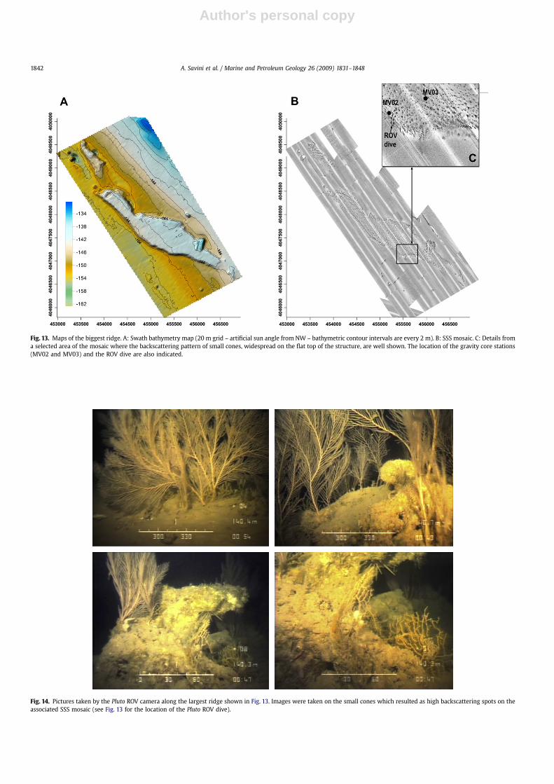
least 2000 m along the NNW–SSE direction and <500 m wide(Fig. 13). All ridges show pronounced sub-vertical flanks and flattops almost 1 m more depressed than their boundaries. The flattops consisted of a matrix of low backscattering, densely spotted bysmall-scale, sub-circular cones with strong acoustic backscattering(Fig. 13) and are no more than 10 m in diameter and less than 1 mhigh. Sediment samples were collected at the flat top and close tothe western flank of the biggest structure (MV02 and MV03stations, see Figs. 3 and 13 for location).
A very strong and prolonged echo surface reflector, with no sub-bottom echoes, marked the observed ridges on chirp records(Fig. 10). Present-day sediments onlap the base of ridges along theirwestern flanks, whereas marked moats occur on the eastern sideagainst the elongated flanks. Rising plumes were observed at theirboundaries or at their tops on SBES digital echographs. Also overthe ridges, the intensities of the plumes were different through thethree different oceanographic cruises.
The sparker profiles indicated chaotic reflectors at the base ofthe ridges, ranging in thickness from 20 to 40 ms. Under them, anacoustic basement occurs and shows evidence of small-scalefolding and vertical discontinuities. Blank areas and enhancedreflections are also present (Fig. 10).
4.2. Video observations
Seabed-video observations were performed by means of thelight Pluto ROV along the western side of the largest ridge. TheSeaCorder camera was employed to collect video observations atthe MV04, MV05, and MV06 sites. There, soft, fine and coarsegrained sediment were imaged and the occurrence of crust andslabs of hard-substrata were documented at their tops. Images
from the Pluto ROV were acquired at the top of the seawardsteep flank of the largest ridge and clearly showed that most ofthe ridge area was covered by carbonates (Fig. 14). In particular,the flat top of the elevated structure appeared spotted byseveral, close-set, small-scale reliefs, whose dimension andsedimentary nature agreed with the sizes and acoustic facies ofthe highly backscattered spots that characterised the SSS mosaic.The highly backscattered spots proved to be no more than 1 mhigh and a few meters in diameter. The most striking featureilluminated by the Pluto ROV was the rich occurrence of benthicfauna in hard-substrata, in particular the abundance of thegorgonian Callogorgia verticillata (Fig. 14). The irregular shapes ofthe small-scale reliefs investigated and the presence of cavesgives us reason to speculate that they are carbonate cementedbuild-ups.
4.3. Coring
Four cores were collected in the area. Two cores were collectedin the western sector (MV04 station, Figs. 3 and 12) and two coreswere collected at two locations on the largest ridge (MV02 andMV03, Figs. 3 and 13). In the main area where a big cluster of domeswas mapped (MV04 station), two cores were collected – one at thetop of a dome (GC04) and one at its base (GC03) (Fig. 15). Both ofthese cores revealed a sequence of reduced mud with lenses ofbiogenic remains and/or cemented clasts (Fig. 15). Cores collectedon the largest ridge (GC01, GC02 – Fig. 16) revealed a lithologydominated by coarse grained sediments followed by a consistentdevelopment of rodolith facies and a subsequent layer of finesediment containing bioclasts. A brief description of the cores isshown in Figs. 15 and 16.
Fig. 8. Details of the acoustic data collected along the top of one of the isolated dome-shaped structures located in the eastern sector of the area investigated. See Fig. 4 for location.A: Raw 100 kHz SSS data, black indicates high backscattering. The arrow indicates a possible point for venting gas detected within the water column. B: Geo-referenced image of theSSS data shown in A. C: 3D view of the structure shown in B; note the rim of low backscattering at the base of the elevated part of the structure. D: Raw 27 kHz echosounder datacollected while crossing the structure shown in A, B, and C; note the pronounced plume rising towards the sea surface up to 20 m from the bottom.
A. Savini et al. / Marine and Petroleum Geology 26 (2009) 1831–18481838

Author's personal copy
As summarized in Table 1, the nannofossil assemblage compo-sitions of the two cores collected at the base and the top at theMV04 site (Fig. 15), showed (below an upper 20 cm of recentmaterial with common (GC03) or little (GC04) reworking) signifi-cant mixing, with the contemporaneous occurrence of species ofdifferent ages. The preservation of calcareous nannofossils wasgood throughout core GC04. In contrast, in core GC03 preservationwas good only in the upper 20 cm and ranged from good tomoderate throughout the rest of the core. Additional samples fromtwo nodules and one interval of hardened sediment from GC03contained very few nannofossils, with very poor preservation,showing evidence of strong re-crystallization.
In both cores collected on the ridge (Fig. 16 – Table 1), the upper,fine-grained sediment was characterised by present-day calcareousnannofossil assemblages, with rare Pleistocene, common Neogene,and rare Cretaceous reworked species. The lower interval, charac-terised by bioconcretions, showed a depleted nannofossil assem-blage composition dominated by Emiliania huxleyi and smallGephyrocapsa, with common reworked species, showing poor
preservation. In the lowest interval, characterised by the presenceof lithoclasts (only reached in GC01) small Gephyrocapsa becomedominant over E. huxleyi (Table 1).
4.4. Gas dissolved in seawater
All three seawater samples collected at the MV04, MV05, andMV06 stations (see Fig. 3 for locations) showed anomalousconcentrations of methane in the extracted gas phase, well aboveatmospheric equilibrium, despite contamination from atmo-spheric air (as can occur when Niskin bottles are utilized). Thehighest headspace methane concentration, 0.17% v/v, wasobtained at site MV05, where the sample was collected 5 m overbottom, close to the top of one isolated dome. The other twosamples, from sites MV04 and MV06, showed gas-phaseconcentrations of 0.05% v/v; for both, water was sampled alongthe flank of the investigated structures more than 15 m awayfrom their tops. All of the other heavier alkanes analyzed werebelow the detection limit (10 ppmv).
Fig. 9. Graphs showing the frequency distribution of some of the measured parameters of all of the investigated dome-shaped seafloor structures. The height is shown on the topand the length of the major axis is shown on the bottom.
A. Savini et al. / Marine and Petroleum Geology 26 (2009) 1831–1848 1839

Author's personal copy
5. Discussion
The seismo-stratigraphic comparison of our data to thosereported by Max et al. (1993), Osler and Algan (1999) and Minisiniet al. (2007) led to the identification of the U01 unconformity,which is a pronounced erosional surface that originated during thelast-glacial sea-level low-stand and that truncates olderprogradational deposits seaward (Figs. 6 and 10). Therefore, unitsabove the U01 unconformity include a combination of trans-gressive and high-stand marine deposits (Max et al., 1993; Oslerand Algan, 1999; Minisini et al., 2007). All of the described seabedfeatures (the domes and ridges) occur where such unconformitydomes up at the seafloor, so that, according to their stratigraphicpath, they can be interpreted as erosional remnants formed duringthe last sea-level low-stand, or structures grown through either insitu carbonate production or material expulsion from depth,formed before or during the time of the last transgression.
However, a combination of all of the above processes should not bedismissed to explain their nature and recent evolution.
5.1. The domes: are they mud volcanoes?
The present-day aspect of the domes, as determined fromseismic data (Figs. 6 and 10), strongly resemble those previouslydescribed for coral-topped mounds of the Darwin province locatedin the Northern Rockall Trough (Northeast Atlantic – Masson et al.,2003). Mound-like morphologies in this area are attributed to geo-fluids venting from the seafloor, even if the corals growing at theirtops affect their external morphologies and seafloor acoustic paths.For the Malta plateau, plumes in the water column detected byechosounder devices, anomalous concentrations of methane in theextracted gas phase from water samples and the occurrence ofcarbonate heterogeneous crust and blocks may be interpreted asmethane-derived, carbonate build-ups associated with seepage
Fig. 10. Sparker and Chirp sonar profiles acquired along the same track line. The location is shown in Fig. 2. The unconformity, U01, which formed during the last sea-level low, isshown. Top: Chirp sonar profile crossing two dome-shaped structures and the main ridge. A and B indicate details of the acoustic paths of two dome-shaped structures; note theburied feature in A. Bottom: Some of the major acoustic anomalies indicating the presence of gas within the sediments in the sparker profile. The rectangular inset on the left sideindicates the seismic detail shown in Fig. 11.
A. Savini et al. / Marine and Petroleum Geology 26 (2009) 1831–18481840

Author's personal copy
sites. Such an assumption is also consistent with recent results fromisotopic analyses for authigenic carbonates sampled in the samearea for which a strong 13C depletion (down to �31&), indicatingmethane as the major source for carbonate carbon, was reported(Cangemi et al., 2008). However, nannofossil assemblage compo-sitions from sediment samples (Fig. 14 – Table 1) identified (belowthe upper 20 cm) a significant mixing, with the contemporaneousoccurrence of species of different ages and very rare to absentrecent (late Pleistocene–Holocene) species. Recent work (Incarbonaet al., 2008) has shown that reworked nannofossil species can makea significant contribution to present-day sedimentation south ofSicily, with values up to 50% near-coastal sites, in correspondence toriver mouths, due to the erosion of sediment outcrops on land.According to the map provided by Incarbona et al. (2008), reworkedspecimens represent 20–30% of the nannofossil assemblages in ourstudy area, although values <10% are reported for the nearby ODPSite 963, located at a similar setting (Sprovieri et al., 2003).However, old nannofossil species in samples from GC03 and GC04show good preservation with no evidence of the etching that istypical of reworking from older outcrops. Old nannofossil speciesare well preserved and in some cases display evidence of over-growth, reflecting the characteristics of the in situ diageneticenvironment. These findings, combined with a lack of bioclasticmaterial from benthic communities in sediments, suggest the mudbuilding of mounds expelled from depth.
Fig. 11. Detail of the sparker line shown in Fig. 10. Note the buried structure outlinedby amplitude anomalies on the left.
Fig. 12. Details of the acoustic data collected along a big cluster of dome-shaped structures located in the western sector (see Fig. 4 for location). A: Part of the 100 kHz SSS mosaicobtained along the western sector where the largest cluster of composite dome-shaped structures is located (see Fig. 3 for location). B: 3D surface view of the investigated seafloorfeatures. C: 100 kHz SSS detail showing the location of the MV04 station. D: 3D view of the detail shown in C. E: Raw 27 kHz echosounder data collected while crossing the MV04station; note the pronounced plumes, which rise toward the sea surface up to 15 m from the bottom, along the different crossed cones (see inset C for the location of theechosounder track line).
A. Savini et al. / Marine and Petroleum Geology 26 (2009) 1831–1848 1841
Author's personal copy
Fig. 13. Maps of the biggest ridge. A: Swath bathymetry map (20 m grid – artificial sun angle from NW – bathymetric contour intervals are every 2 m). B: SSS mosaic. C: Details froma selected area of the mosaic where the backscattering pattern of small cones, widespread on the flat top of the structure, are well shown. The location of the gravity core stations(MV02 and MV03) and the ROV dive are also indicated.
Fig. 14. Pictures taken by the Pluto ROV camera along the largest ridge shown in Fig. 13. Images were taken on the small cones which resulted as high backscattering spots on theassociated SSS mosaic (see Fig. 13 for the location of the Pluto ROV dive).
A. Savini et al. / Marine and Petroleum Geology 26 (2009) 1831–18481842

Author's personal copy
The domes of the Malta plateau (Figs. 5, 7, 8, and 12), theirseismic path, the muddy nature of the sediment (Fig. 15) and theoccurrence of nannofossil assemblages in core samples withsignificant age mixing indicate that they are fine-grained sedimentextrusions like those forming mud volcanoes.
Present mud extrusion was not evident on the SSS images. Even ifthe structures are mainly composed of mud, we did not find low-backscattering features clearly resembling fresh mud flows close tothe top of the structures or in lobate shapes overlying the structures.Low-backscattering acoustic patterns are only evident at the base ofstructures, forming distinct rims where the structures begin toelevate from the surrounding seafloor (Figs. 8 and 12). An importantbut overlooked issue concerning the terminology adopted todescribe and classify mud volcanoes is a distinction between theactive and dormant stages of their activity (Planke et al., 2003;Mazzini et al., 2008). Many mud volcanoes can be quiet during theirdormant stages and have different degrees of seep activity (Plankeet al., 2003). According to Roberts et al. (2006), slow-flux seeps arecharacterised at the seafloor by hard-grounds and the formation ofauthigenic carbonates and do not support well-populated chemo-synthetic communities. These observations may be consistent withthe occurrence of carbonate heterogeneous crusts and blocks at the
top of the investigated domes, and the presence of enriched benthicfauna not related to chemosynthetic activity.
Incidentally, the episodic occurrence of an acoustic plumesuggests that vigorous seepage activity is not continuous. Althoughseawater sampling was done in a quiescent period (in the absenceof gas plumes) methane concentrations appeared to be quite high(up to 0.17% v/v in the extracted gas phase) suggesting activedegassing anyway. So, the domes presented here may have formedas mud volcanoes, but at present they may be characterised bya dormant stage with a slow flux that leads to the formation ofcarbonate crusts at their tops.
5.2. Elevated gas-charged ridges
One of the most intriguing features revealed by the bottomsurface morphology and associated SSS backscattering informationwere ridges that developed along the �140 m isobath contour line(Figs. 5 and 13). The associated seismic facies on one sparker profilethat crossed these structures displayed acoustic masks (Fig. 10) andwas bound at the top by a distinct erosion surface (U01 unconfor-mity, see Figs. 6 and 10). Observed changes in core lithology (GC01,GC02 – Fig. 16) suggest that these features experienced
Fig. 15. Photographs, colors, graphic lithologies, and descriptions of the cores collected at the MV04 station (see Figs. 2 and 9 for locations). The SSS backscattering patternassociated with each sampling site is shown to the right.
A. Savini et al. / Marine and Petroleum Geology 26 (2009) 1831–1848 1843

Author's personal copy
a progressive deepening relating to the associated depositionalenvironment. The reduced thickness of changing sedimentaryfacies suggests long periods of erosion or non-deposition. Althoughnannofossil assemblages restrict the core sequence to the last 50 ky(E. huxleyi acme zone, i.e. Sprovieri et al., 1998), thus far we do nothave absolute dating to accurately define the timing of depositionfor the different units. However, combined evidence from changesin the relative abundance of different nannofossil species, such asthe decrease in E. huxleyi, the increase in small Gephyrocapsa
(Castradori, 1993) and the increase in the cold water speciesCoccolithus pelagicus and reworked species (Sprovieri et al., 2003)suggests the last-glacial age for the lower section of the core.Therefore, the entire core sequence may indicate a recent cycle ofshoreline retrogradation (Fig. 16). Vai and Cantelli (2004) suggestedthat the edge of the plateau was the position of relative sea levelduring the last-glacial maximum. Therefore, the present location ofthe ridges could be referred to as the deltaic/coastal environmentthat developed during the low-stand (Max et al., 1993).
Fig. 16. Photographs, colors, graphic lithologies, and descriptions of the cores collected at the MV02 and MV03 stations (see Figs. 2 and 13 for locations). The SSS backscatteringpattern associated with each sampling site is shown on the bottom.
A. Savini et al. / Marine and Petroleum Geology 26 (2009) 1831–18481844

Author's personal copy
Close-set, small-scale mounds, found along the flat top of allridges and well mapped on the SSS mosaics (Fig. 13), were visuallyobserved with the light Pluto ROV. The mounds corresponded tosmall scale, hard carbonate build-ups that host living fauna,dominated by the presence of the gorgonian C. verticillata (Fig. 14).The peculiar distribution of these mounds, at the top of elevatedstructures, speaks to a close relationship between the present-daybenthic environment and the potential of gas rising from deeperstrata.
The potential of gas rising from deeper strata is supported by thefollowing observations:
a. The oldest seismic unit is distinctively deformed by faults andfolds and positioned approximately 20–40 ms under the ridges,where there is evidence of gas escape structures and enhancedreflections (Figs. 6 and 10).
b. The mounds appear as ‘‘growing features’’ where cementedcarbonate formed, but where seismic data does not revealparticular evidence of their growth pattern within the associ-ated seismo-stratigraphic sequence (Figs. 6 and 10). Therefore,their origin can be reasonably assigned as subsequent inrespect to the formation of ridges.
c. Different intensities of rising plumes were detected by the SBESalong the flanks of ridges and in some cases at the top.
d. Carbonate crusts sampled on the biggest structure showedstrong 13C depletion (Cangemi et al., 2008), such that theirorigin can be attributed to that of authigenic carbonates, widelyreported as primary deposits at seep sites.
e. Within the inter-mounds area, sedimentary facies are morestrictly related to esogenic environmental controls that
occurred during phases of drowning of the continental shelf,driven by post-glacial sea-level rise (Fig. 16).
Due to the items listed above, our proposed hypothesis is thatpresent-day ambient epifauna settled on a solid substrate thatformed as a consequence of venting, triggering authigeniccarbonate production, and providing a widespread nucleus forsmall-scale carbonate mound growth. Obviously more data arenecessary to confirm these assumptions including sedimentolog-ical and mineralogical analyses on carbonate samples; absolutedating; accurate analyses of sedimentary facies; and new cores thatcan provide chronology, lithofacies distribution and more detailedinformation regarding depositional environments.
The spatial match of small-scale carbonate mounds could pointto diffusely rising gas along these structures, as ‘‘preferred paths’’.We assume that coarse and sandy facies (like those deposited inshallow marine environments) are permeable to seepage due totheir porosity, while clay sediments are often caps where gas canonly rise along vertical and distinct discontinuities. The ridges,therefore, seem to be depositional features along which the gas caneasily rise and diffuse, likely due to their sedimentary nature.
5.3. Geo-environmental control on the distribution of the mappedseabed morphologies
The Malta plateau is known to be an important hydrocarbonreservoir and the study area addressed in this manuscript is locatedclose to the Vega oil field. This site represents one of the largestnatural gas systems offshore Italy, where the Triassic Gela and theJurassic Siracusa Formations produce mostly heavy, high-sulphur
Table 1Summary of occurrence of calcareous nannofossil species throughout the investigated cores. Occurrence is defined as RR ¼ very rare (1–2 specimens in >10 fields of view),R ¼ rare (1–2 specimens in 2–10 fields of view), C ¼ common (1–2 specimens in each field of view), A ¼ abundant (2–20 specimens in each field of view), AA ¼ very abundant(>20 specimens in each field of view). Preservation is defined as G ¼ good (no evidence of dissolution), M ¼ moderate (evidence of etching and/or re-crystallization) orP ¼ poor (severe dissolution and/or re-crystallization).
Species samples GC01, GC02upper
GC01, GC02bioconcretions
GC01lithoclasts
GC030–20 cm
GC040–20 cm
GC03, GC04> 20 cm
GC03nodules
Recent Preservation G M/P G G G G PBraarudosphaera bigelowii R RCoccolithus pelagicus C C CCalcidiscus leptoporus C C C REmiliania huxleyi AA A C AA AA RRFlorisphaera profunda A A AGephyrocapsa oceanica C C C C AA RHelicosphaera carteri C C C RRhabdosphaera clavigera A C A ASyracosphaera spp. A C A AUmbilicosphaera sibogae A A A
Pleistocene Gephyrocapsa caribbeanica R C AAGephyrocapsa sp. small A AA AA RGephyrocapsa parallela RRPseudoemiliania lacunosa R R RReticulofenestra asanoi R R
Neogene Calcidiscus macintyrei R RR RRDictyococcites perplexus R R C CDictyococcites productus C CDiscoaster spp. R RReticulofenestra pseudoumbilicus R R R C CSphenolithus spp. R R R
Paleogene Cyclicargolithus floridanus RR RReticulofenestra bisecta RRReticulofenestra umbilicus RR
Late Cretaceous Watznaueria spp. RR RR RR RR RRetecapsa spp. RRMicula decussata RR RREiffellithus spp. RR
A. Savini et al. / Marine and Petroleum Geology 26 (2009) 1831–1848 1845

Author's personal copy
oil (Matavalli and Novelli, 1990). Holland et al. (2003) proposeda potential role for fluid migration to the Oligocene reservoirthrough locally faulted Messinian evaporites. At present, no dataare available concerning the origin of rising geo-fluids within thestudy area.
Evident in our data is that the distribution of both domes andridges mostly follows an NNW–SSE trend. We know that thelocation of mud volcanoes and seep sites is often determined bystructurally weak zones (e.g. faults) that provide the main paths forthe migration of geo-fluids from deeper hydrocarbon reservoirs(Etiope et al., 2008). Therefore, it is interesting that the domes onthe Malta plateau are less than 10 km in distance from the Vega oilfield, and that the main paths for seeps along the area seem to beprovided by NW–SE structural lineaments, that are likely reac-tivated, dating back to the recent Miocene–mid-Pliocene periods(Gardiner et al., 1995). A hypothesis of this nature is consistent withthe occurrence of the recorded acoustic basement (the top of whichis Miocene in age; Max et al., 1993; Osler and Algan, 1999) that isdensely faulted and strongly affected by blank areas and geophys-ical signatures usually associated with the presence of gas (Figs. 6and 10, Sager et al., 2003, and references therein). Within thissector of the western Malta plateau, the Miocene forms a regionalNE-trending structural high (Pedley, 1989; Gardiner et al., 1995 –Fig. 2) that deepens to the SW. The lowering of such a structuralhigh to the south-east, through the NNW–SSE oriented faults, isdocumented in our seismic data from the F1 fault zone (Figs. 6 and10). The F1 fault zone is seen along parallel seismic profiles, so itsNNW–SSE orientation can be traced along the investigated area(Fig. 17).
We thus interpret the acoustic basement as the top of theMiocene structural high, from which the upward migration of gas/fluid is related to: (1) the formation of domes, where vertical seepescape structures have been found along the Plio-Quaternaryclinoforms seaward; and (2) the formation, along flat ridges, ofclose-set and small-scale cemented carbonate build-ups likely
associated with the slow-flux rate of seeps within such ridges(Fig. 17). We interpreted the different morphological and sedi-mentological expressions of these two main types of seep-relatedseafloor features as linked to the different sedimentary nature ofthe lithological succession along which the seeps occurred (Fig. 17).
Detailed examples of SSS images from the domes of the westernMalta plateau seafloor are shown in Figs. 7, 8, and 12. Spots of highbackscattering at dome tops often correspond to carbonate crustswhich, in some sites, host enriched benthic fauna, as documentedby video observations (Holland et al., 2006). Spots such as these aremore pronounced in domes mapped in the eastern sector. To theeast, isolated domes are also higher than the ones found alongthe western sector (Fig. 18) and distinct shadows characterise theassociated SSS images. The shadows may suggest that moreelevated mounds in the north-east sector have a denser benthicfauna covering than less elevated mounds to the west (compareshadows on Figs. 7 and 12). In addition, we observed that to the eastthese domes are often surrounded by moats. The details of seismicdata from chirp sonar profiles in Fig. 7 show a lack of a natural onlapfor present sedimentation against domes to the NE, associated withdepressions, whereas this onlap is well established on the westernflank. Although these depressions could be interpreted as pock-marks (Hovland and Judd, 1988), their seismic path is moreconsistent with the hypothesis that they could be the result ofa scouring effect due to the increase of near-bed current speed bytopographic irregularities, since they also occur along all theeastern flank of the ridges. The occurrence of more elevatedfeatures to the east, coupled with the presence of marked moatsand a shallower setting in the eastern sector, may therefore reflectthe action of stronger bottom currents than for the west (Fig. 18).Stronger bottom currents may in fact promote further elevation ofisolated small-scale domes from the surrounding seafloor, due toa feedback mechanism where benthic fauna take advantage of fluidseepage, as also observed in similar situations (Masson et al., 2003;Yin et al., 2003). According to the results from sediment samples,
Fig. 17. Block diagram schematically illustrating the general depositional geometry recorded on the investigated outer shelf of the Malta plateau and the relationships with theoccurrence of the mapped features. The gray sequence represents the gas-charged acoustic basement which was correlated with the Miocene structural high.
A. Savini et al. / Marine and Petroleum Geology 26 (2009) 1831–18481846

Author's personal copy
the moderate homogeneous backscattering pattern associated withmost of the domes may be associated with the first centimeters ofcoarse grained biogenic material sampled in both the GC03 and theGC04 cores (Fig. 15). Coarse biogenic sediments may be related tothe carbonate debris of the benthic fauna presently settled on thetops of the domes.
6. Conclusions
The outer shelf of the western margin of the Malta plateau ischaracterised by peculiar seep-related seabed morphologies, in theform of:
a. Domes for which core lithology and the analyses of calcareousnannofossil assemblages provide evidence for an origin relatedto mud-volcanism processes.
b. Close-set and small-scale cemented carbonate build-upsestablished at the tops of flat ridges.
All of the described seabed morphologies show an NNW–SSEtrending in their distribution. The vertical pathway of fluid/gasmigrations from the underlying deformed and faulted, older(Miocene) sediments, therefore seems to be provided by NW–SEstructural lineaments.
The domes prevalently formed (probably just before or duringthe time of the last transgression) at the top of the Plio-Quaternaryclinoforms that determine the general seaward depositionalgeometry of the Malta plateau, whereas the origin of the ridgesseems to be associated with the evolution of the coastal faciesduring sea-level lowering stages and low-stand periods of the Plio-Quaternary.
Present mud extrusion at the domes is not evident, thereforea dormant stage of mud extrusion is proposed. The occurrence ofauthigenic carbonates in the form of indurated-sediment/crustsand bioherms (on domes and ridges, respectively) and the absenceof chemosynthetic communities, suggests a slow-flux rate of seepactivity at the present time. This finding is also consistent with themethane anomalies measured in seawater.
Present-day oceanographic conditions in the western shelf edgeof the Malta plateau (where meanders and subsurface eddies in
Levantine Intermediate Water occur) may also play a significantrole in fostering the present exposure of domes at the seafloor.Biogenic processes, such as in situ carbonate production, promotethe growth of domes, making them topographic obstacles tobottom currents. The scouring effect at their boundaries, inducedby bottom current interactions, is particularly evident on theeastern sector, where the domes are higher.
Future detailed explorations and in particular an accuratechronological framework for sediments, are required to betterexplain paleo-environmental controls on the formation andevolution of both the domes and the ridges in relation to glacio-eustatic, climatic, and tectonic factors.
Acknowledgments
This study benefited from funding and ship-time through the2006–2007 Italian PRIN ‘MESC’ program, funded by the ItalianMinistry of Research and Technology (MIUR). We are grateful toCaptains, Crew, and Colleagues onboard R/V Universitatis during theMESC cruises (2006–2007). Special thanks go to Charles Holland forvaluable discussions and his guidelines for locating seafloorfeatures. We are also grateful to two anonymous reviewers thatgreatly improved the manuscript.
References
Barberi, F., Civetta, L., Gasparini, P., Innocenti, F., Scandone, R., Villari, L., 1974.Evolution of a section of the Africa–Europe plate boundary; paleomagnetic andvolcanological evidence from Sicily. Earth Planetary Science Letters 22 (2),123–132.
Brown, K.M., 1990. Nature and hydrogeologic significance of mud diapirs anddiatremes for accretionary systems. Journal of Geophysical Research 95,8969–8982.
Butler, R.W.H., 1997. Depositional patterns and their tectonic controls within thePlio-Quaternary carbonate sand and muds of onshore and offshore SE Sicily(Italy). Marine and Petroleum Geology 14 (7/8), 879–892.
Camerlenghi, A., Pini, G.A., 2009. Mud volcanoes, olistostromes and Argille scagliosein the Mediterranean region. Sedimentology 56, 319–365.
Cangemi, M., Bellanca, A., Neri, R., Scopelliti, G., 2008. Biomineralization events inRecent volcanic and sedimentary settings: textural features and isotopesignatures. In: 33rd International Geology Congress, Oslo 2008.
Castradori, D., 1993. Calcareous nannofossil biostratigraphy and biochronology ineastern Mediterranean deep-sea cores. Rivista Italiana di Paleontologia eStratigrafia 99 (1), 107–126.
Fig. 18. Some examples of SSS and the high-resolution seismic data of the three domes located at increasing distance and depth from the land, from right to left. The pictureschematically illustrates the occurrence of more elevated features to the east, associated with the presence of marked moats, more developed high backscattering spots, anda shallower setting.
A. Savini et al. / Marine and Petroleum Geology 26 (2009) 1831–1848 1847

Author's personal copy
Ceramicola, S., Praeg, D., Wardell, N., Unnithan, V., 2007. Seismic imaging of mudvolcanoes on the Calabrian Arc accretionary prism, central Mediterranean Sea.Eos, Transactions, American Geophysical Union 88 (52) SUPPL., Abstract V22C-05, Dec 2007.
Cita, M.B., Ivanov, M.K., Woodside, J.M., 1996. The Mediterranean Ridge Diapiric Belt.Marine Geology 132, 1–6.
Dimitrov, L.I., 2002. Mud volcanoes - the most important pathway for degassingdeeply buried sediments. Earth-Science Review 59, 49–76.
Etiope, G., Feyzullayev, A., Baciu, C.L., 2008. Terrestrial methane seeps and mudvolcanoes: a global perspective of gas origin. Marine and Petroleum Geology 26(3), 333–344.
Fusi, N., Kenyon, N.H., 1996. Distribution of mud diapirism and other geologicalstructures from long range sidescan sonar (GLORIA) data, in the EasternMediterranean Sea. Marine Geology 132, 21–38.
Gardiner, W., Grasso, M., Sedgeley, D., 1993. Plio-Pleistocene stratigraphy and faultmovement of the Malta platform. In: Max, M.D., Colantoni, P. (Eds.), UNESCOTechical Reports in Marine Science, vol. 58, pp. 111–116.
Gardiner, W., Grasso, M., Sedgeley, D., 1995. Plio-Pleistocene fault movement asevidence for megablock kinematics within the Hyblean–Malta Plateau, centralMediterranean. Journal Geodynamics 19 (1), 35–51.
Ginsburg, G.D., Soloviev, V.A., 1994. Mud volcano gas hydrates in the Caspian Sea.Bulletin of the Geological Society of Denmark 41, 95–100.
Henry, P., Le Pichon, X., Lallemant, S., Foucher, J.-P., Westbrook, G., Hobart, M.,1990. Mud volcano field seaward of the Barbados accretionary complex:a deep-towed side scan sonar survey. Journal of Geophysical Research 95,8917–8929.
Holland, C.W., Etiope, G., Milkov, A.V., Michelozzi, E., Favali, P., 2003. Mud volcanoesdiscovered offshore Sicily. Marine Geology 199, 1–6.
Holland, C.W., Weber, T.C., Etiope, G., 2006. Acoustic scattering from mud volcanoesand carbonate mounds. Journal Acoustical Society of America 120 (6),3553–3565.
Hovland, M., Svensen, H., Forsberg, C.F., Johansen, H., Fichler, C., Fossa, J.H.,Jonsson, R., Rueslatten, H., 2005. Complex pockmarks with carbonate-ridges offmid-Norway: products of sediment degassing. Marine Geology 218 (1–4),191–206.
Hovland, M., Judd, A.G., 1988. Seabed Pockmarks and Seepages: Impact on Geology,Biology and Marine Environment. Graham and Trotman, London, 293 pp.
Incarbona, A., Bonomo, S., Di Stefano, E., Zgozi, S., Essarbout, N., Talha, M.,Tranchida, G., Bonanno, A., Patti, B., Placenti, F., Buscaino, G., Cuttitta, A.,Basilone, G., Bahri, T., Massa, F., Censi, P., Mazzola, S., 2008. Calcareous nan-nofossil surface sediment assemblages from the Sicily Channel (central Medi-terranean Sea): paleoceanographic implications. Marine Micropaleontology 67,255–273.
Ivanov, M.K., Limonov, A.F., van Weering, Tj.C.E., 1996. Comparative characteristicsof the Black Sea and Mediterranean ridge mud volcanoes. Marine Geology 132,253–271.
Kopf, A.J., 2002. Significance of mud volcanism. Reviews of Geophysics 40 (2), 1–52.Le Pichon, X., Foucher, J.-P., Boulegue, J., Henry, P., Lallemant, S., Benedetti, M.,
Avedik, F., Mariotti, A., 1990. Mud volcano field seaward of the Barbadosaccretionary complex: a submersible survey. Journal of Geophysical Research95, 8931–8943.
Lermusiaux, P.F.J., Robinson, A.R., 2001. Features of dominant mesoscale variability,circulation patterns and dynamics in the Strait of Sicily. Deep-Sea Research IOceanographic Research Paper 48 (9), 1953–1997.
Loncke, L., Mascle, J., and the Fanil Scientific Party, 2004. Mud volcanoes, gaschimneys, pock-marks and mounds in the Nile deep-sea fan (EasternMediterranean): geophysical evidences. Marine and Petroleum Geology 21,669–689.
Masson, D.G., Bett, B.J., Billett, D.S.M., Jacobs, C.L., Wheeler, A.J., Wynn, R.B., 2003.The origin of deep-water, coral-topped mounds in the northern Rockall Trough,Northeast Atlantic. Marine Geology 194, 159–180.
Matavalli, L., Novelli, L., 1990. Geochemistry and habitat of the oils of Italy. AAPGBulletin 74, 1623–1639.
Max, M.D., Kristensen, A., Michelozzi, E., 1993. Small scale Plio-Quaternary sequencestratigraphy and shallow geology of the west-central Malta Plateau. In:Max, M.D., Colantoni, P. (Eds.), UNESCO Techical Reports in Marine Science, vol.58, pp. 117–122. Italy.
Mazzini, A., Svensen, H., Planke, S., Guliyev, I., Akhmanov, G.G., Fallik, T., Banks, D.,2008. When mud volcanoes sleep: insight from seep geochemistry at theDashgil mud volcano, Azerbaijan. Marine and Petroleum Geology. doi:10.1016/j.marpetgeo.2008.11.003.
Milkov, A.V., 2000. Worldwide distribution of submarine mud volcanoes andassociated gas hydrates. Marine Geology 167, 29–42.
Minisini, D., Trincardi, F., Asioli, A., Canuz, M., Foglini, F., 2007. Morphologic vari-ability of exposed mass-transport deposits on the eastern slope of Gela Basin(Sicily channel). Basin Research 19, 217–240.
Neurauter, T.W., Bryant, W.R., 1990. Seismic expression of sedimentary volcanismon the continental slope, Northern Gulf of Mexico. Geo-Marine Letters 10,225–231.
Neurauter, T.W., Roberts, H.H., 1994. Three generation of mud volcanoes on theLouisiana continental slope. Geo-Marine Letters 14, 120–125.
Orange, D., Hovland, M., Greene, H.G., 2001. The implications of hydrocarbonseepage, gas migration and fluid overpressures to both exploration and geo-hazards – from Frontier exploration to slope failure risk assessment. In: AAPGHedberg Conference ‘‘Near-Surface Hydrocarbon Migration: Mechanisms andSeepage Rates’’, September 16–19, 2001, Vancouver, BC, Canada.
Osler, J., Algan, O., 1999. A High Resolution Seismic Sequence Analysis of the MaltaPlateau. Saclantcen Report serial no. SR-311.
Patacca, E., Scandone, P., Giunta, G., Liguori, V.,1979. Mesozoic paleotectonic evolutionof the Ragusa zone (Southeastern Sicily). Geologia Romana 18, 331–369.
Pedley, H.M., 1989. Syndepositional tectonics affecting Cenozoic and Mesozoicdeposition in the Malta and SE Sicily areas (Central Mediterranean) and theirbearing on Mesozoic reservoir development in the N Malta offshore region.Marine and Petroleum Geology 7, 171–180.
Perch-Nielsen, K., 1985. Cenozoic calcareous nannofossils. In: Bolli, H.M.,Saunders, J.B., Perch-Nielsen, K. (Eds.), Plankton Stratigraphy. CambridgeUniversity Press, Cambridge, pp. 427–554.
Planke, S., Svensen, H., Hovland, M., Banks, D., Jamtveit, B., 2003. Mud and fluidmigration in active mud volcanoes in Azerbaijan. Geo-Marine Letters 23, 258–268.
Prior, D.B., Coleman, J.M., 1984. Submarine slope instability. In: Brunsden, D.,Prior, D.B. (Eds.), Slope Instability. Wiley, New York, pp. 419–455.
Roberts, H.H., Hardage, B.A., Shedd, W.W., Hunt, J.J., 2006. Seafloor reflectivitydanimportant seismic property for interpreting fluid/gas expulsion geology and thepresence of gas hydrate. Leading Edge (Tulsa, OK) 25 (5), 620–628.
Sager, W.W., Macdonald, I.R., Hour, R., 2003. Geophysical signatures of mud moundsat hydrocarbon seeps on the Louisiana continental slope, northern Gulf ofMexico. Marine Geology 198 (1–2), 97–132.
Sautkin, A., Talukder, A.R., Comas, M.C., Soto, J.I., Alekseev, A., 2003. Mud volcanoesin the Alboran Sea: evidence from micropaleontological and geophysical data.Marine Geology 195, 237–261.
Savini, A., Corselli, C., Tessarolo, C., Daffonchio, D., Bellanca, A., Danovaro, R., Etiope,G., 2007. Seafloor mapping and acoustic geophysical data of a shallow likelymud-volcanoes province offshore Sicily (eastern Sicily Channel – Hyblean–Malta plateau). 38 CIESM Congress, 09–13 April 2007, Istanbul.
Schramm, M.V., Livraga, G., 1986. Vega field and the potential of Ragusa basin,offshore Sicily. In: Halbouty, M.T. (Ed.), Future Petroleum Provinces of theWorld, Memoir 40. American Association of Petroleum Geologists, pp. 560–566.
Sprovieri, R., Di Stefano, E., Howell, M., Sakamoto, T., Di Stefano, A., Marino, M., 1998.Integrated calcareous plankton biostratigraphy and ciclostratigraphy at Site964. In: Robertson, A.H.F., Emeis, K.C., Richter, C., Camerlenghi, A. (Eds.),Proceedings of the Ocean Drilling Program, Scientific Results, vol. 160, pp. 155–165. College Station, Texas.
Sprovieri, R., Di Stefano, E., Incarbona, A., Gargano, M.E., 2003. A high-resolutionrecord of the last deglaciation in the Sicily Channel based on foraminifera andcalcareous nannofossils quantitative distribution. Paleogeography, Paleoclima-tology, Palaeoecology 202, 119–142.
Vai, G.B., Cantelli, L. (Eds.), 2004. Litho-palaeoenvironmental maps of Italy duringthe last two climatic extremes. Map. 1 – Last Glacial Maximum; Map. 2 –Holocene climatic optimum, 1:1.000.000 scale. 32nd I.G.C. Florence.
Vogt, P.R., Gardner, J., Crane, K., 1999. The Norwegian-Barents-Svalbard (NBS)continental margin: introducing a natural laboratory of mass wasting, hydrates,and ascent of sediment, pore water, and methane. Geo-Marine Letters 19, 2–21.
Yin, A., Berne, S., Loubrieu, B., Liu, Z., 2003. Mud volcanoes at the shelf margin of theEast China Sea. Marine Geology 194, 135–149.
A. Savini et al. / Marine and Petroleum Geology 26 (2009) 1831–18481848
Copyright © 2022 FDOKUMEN