Estimating seafloor pressure from trawls and dredges based ...

Geomorphology 226 (2014) 202–216
Contents lists available at ScienceDirect
Geomorphology
j ourna l homepage: www.e lsev ie r .com/ locate /geomorph
Seafloor morphology of the Montenegro/N. Albania Continental Margin(Adriatic Sea—Central Mediterranean)
Fabrizio Del Bianco a, Luca Gasperini a,⁎, Federico Giglio a, Giovanni Bortoluzzi a,Zoran Kljajic b, Mariangela Ravaioli a
a Istituto di Scienze Marine, ISMAR CNR, Bologna, Italyb Institute of Marine Biology, Kotor, Montenegro
⁎ Corresponding author at: Luca Gasperini, Area della RiTel.: +39 051 6398901.
E-mail address: [email protected] (L. Gasperi
http://dx.doi.org/10.1016/j.geomorph.2014.08.0060169-555X/© 2014 Elsevier B.V. All rights reserved.
a b s t r a c t
a r t i c l e i n f oArticle history:Received 11 February 2014Received in revised form 1 August 2014Accepted 4 August 2014Available online 13 August 2014
Keywords:Montenegro/Northern Albanian ContinentalMarginSE Adriatic shelfBuna/Bojana mid-shelf lowstand deltaLGM paleogeography
High-resolutionmultibeammorpho-bathymetricmaps and a dense grid of seismic reflection profiles show relictand palimpsest geomorphologic features along the Montenegro/Northern Albanian Continental Margin. Thissector of the Eastern Adriatic shelf, at the external front of the Dinarides Chain, is characterized by highly variableseafloor patterns and depositional styles, and shows a peculiar alternation of large-scale troughs and ridges, prob-ably caused by tectonic compressive deformations. These tectonically controlled morphologies are overprintedby the result of sedimentary processes, such as progradation at river outflows, erosion, and reworking of sedi-ments by longshore currents, as well as gravity-driven process caused by sediment loading and seismic shaking.Physiographic domains along this shelf–slope margin include (i) an inner and an outer shelf, separated by twomajor topographic highs, the Kotor and the Bar ridges; (ii) a drowned lobate delta formed during the lastphase of sea level fall, likely fed by the Buna/Bojana drainage basin; and (iii) a continental slope affected bygravity-driven faulting and mass-wasting processes. Seafloor reflectivity maps, ground-truthed by grain-sizeanalysis of bottom sediments, reveal that fine-grained deposits accumulate in the inner shelf, while other sectorsappear starved. The effects of the last sea-level rise is testified by the presence of seabed forms diagnostic oferosion or depositional processes, such us large dunes, sediment ridges and sedimentwaves, whichwere studiedto infer the effect of bottom currents under the present-day oceanographic regime and in the recent past. Thispaper presents a first description of geomorphologic features observed along the Montenegro/NorthernAlbanian Continental Margin, in the context of Late Quaternary sea-level changes.
© 2014 Elsevier B.V. All rights reserved.
1. Introduction
Anumber of processes, including longshore currents, seismic shaking,sediment overloading, and tectonic deformation can control depositionand/or reworking of sediments at the seafloor. Each of such processescan produce characteristic morphologies that have the potential to giveinformation about geological processes and the present condition of de-positional environments. The first step in geological/geomorphologicalstudies of continental margins is to characterize incipient or active pro-cesses that control their physiography. This is generally achieved usinghigh-resolution morpho-bathymetric maps, highlighting the occurrenceof active, relict or palimpsest deposits (Swift et al., 1972; Harris, 2012,and references therein), and high-resolution seismic reflection profiles,which image the internal architecture of sedimentary bodies, includingreflectivity and acoustic facies. These geophysical “indirect” data shouldbe subsequently ground-truthed by direct sampling of the seafloor.
cerca CNR, Bologna 40129, Italy.
ni).
Geomorphological processes acting on shelves are the physical linkbetween the continental terrestrial and oceanic marine realms of theworld (Cohen and Lobo, 2013). For this reason, they might record theinterplay between global processes, such as eustasy, and local effectsrepresented by variations in sediment supply and tectonic deforma-tions. This is the case of the southeastern Adriatic Sea, where theMontenegro/Albanian Continental Margin (hereafter called MACM) islocated.
The Adriatic Sea is a shallow epicontinental basin, where low topo-graphic gradients cause broad horizontal shifts of coastal environmentsas a consequence of relative sea-level changes. These shifts, in turn, arerecorded by the formation ofmorphological featureswhose distributionalso reflects changes in sediment input and current regime. Relict oractive current-related sedimentary features are widely described inshelves worldwide, and include sediment wave fields, sediment drifts,and moats particularly developed where the seafloor gradient changesoccur (e.g. Roberts and Kidd, 1979; Cavaleri and Stefanon, 1980;Kenyon, 1986; Faugeres and Stow, 1993; Howe et al., 1994; Howe andHumphrey, 1995; Correggiari et al., 1996; Stoker, 1998; Masson et al.,2002; Reeder et al., 2002; Viana, 2002; Verdicchio et al., 2007). In most

203F. Del Bianco et al. / Geomorphology 226 (2014) 202–216
of these studies, the presence of diagnostic morphologies at the sea-floor allowed the inference of natural process and reconstruction ofpaleoceanographic evolution, identifying phases of intensification andrelaxation of the bottom-hugging contour-parallel currents (Maraniet al., 1993; Roveri, 2002; Verdicchio and Trincardi, 2008).
We present a first geomorphological study of the MACM (Fig. 1)based on recently collected multibeam bathymetric maps and high-resolution seismic reflection profiles, together with a preliminary analy-sis of sampled seafloor sediments. These data are new for the region, ifwe exclude a very preliminary report by Del Bianco et al. (2010). Infact, while the western Adriatic shelves are covered by a densely-spaced grid of marine geological/geophysical data, which includesswath-bathymetric maps, sediment samples and sub-bottom profiles,the eastern sector remains almost unknown to date. The aim of thiswork is to describe the geomorphological features observed along theMACM in the context of the Late Quaternary sea-level changes.
2. Geological and oceanographic setting
The MACM is located in the southeastern Adriatic Sea, a semi-enclosed basin elongated in the NW–SE direction over an 800 km by200 km surface area and showing a remarkable variability in continentalshelf and slope morphologies. While the Northern Adriatic is flat andshallow (average depth 70m), the Southern Adriatic is morphologicallymore complex and deeper. The deepest part reachingdown to 1200m isthe South Adriatic Depression (Fig. 1), between the Apulian Platformand the Montenegro/Albanian Continental Margin (MACM). Along theMACM, prevailing longshore current directions are from S to N(Fig. 1), as suggested by Poulain (2001) based on the analysis of drifterdata. Marini et al. (2010) introduce the South Eastern Shelf CoastalCurrent (SESC), which characterizes the oceanographic regime of thisregion. The SESC detaches from the coast in correspondence of theBuna/Bojana outflow and forms coastal eddies expanding offshore,resulting in a locally complex circulation, both at the surface and closeto the seafloor, whichmay result in adjacent areas of erosion and depo-sition within short distances (20–30 km). As shown by circulationvectors of Fig. 1, areas where deposition of sediments is favored shouldcoincide with the centers of local eddies, i.e., Gjiri-Rodonit Bay, and theinner shelf between Budva and Bar. Average current speeds of surfacecurrents shown in Fig. 1 are between 20 and 30 cm/s (Poulain, 2001).Unfortunately, neither measurements nor estimates of bottom currentspeed are available for the area.
The MACM encompasses the external front of the Dinarides/Albanides fold-and-thrust belt (Aliaj, 1999; 2000)whose active tectonicdevelopment affects the shelf and continental slope. Tectonic structuresforming the external boundary of the NE convergent Adria microplateshow a NW–SE orientation, parallel to the coastline, although strike-slip transcurrent faults are alsopresent (Fig. 1). Thismargin is character-ized by intense seismic activity and has been site of large (Mw N 6)historical earthquakes (Pondrelli et al., 2006).
3. Methods
Marine geophysical data and sediment samples were collectedduring six oceanographic expeditions onboard R/V Dallaporta,(Star08), R/V Urania, (ADR02_08, 2008; MNG01_09, 2009; MNG03_1,2010; MNG04_10, 2010) and R/V Mariagrazia (MNG02_09). Technicalreports of these cruises are available on the WEB (http://www.ismar.cnr.it/prodotti/reports-campagne). Swath bathymetry data werecollected using a Reson 8160 multibeam echo sounder on ADR02_08(R/V Urania); a Kongsberg EM-710 (R/V Urania) and a KongsbergEM3002 double head multibeam (R/V Mariagrazia). High-resolutionseismic reflection profileswere collected using a hullmounted 16 trans-ducer Benthos Chirp II sub-bottom profiler (2–7 kHz frequency) and atowed Sparker system, a Geo-Source 200 (200 tip electrode modules)operated with Geo-Spark 1000 J solid state pulsed power supply.
Positioning was corrected for offsets between DGPS antenna and thetransducers using gyro-compass and CMG data, and provides a locationaccuracy of b1 m.
Swath-bathymetric maps do not cover the entire shelf, because ofthe relatively limited shiptime compared to the extent of the area.Swath widths of multibeam echosounders were relatively narrow dueto the shallow-water depths. However, we focused our acquisition onthose areas characterized by complex seafloor morphologies, possiblydiagnostic of relevant (incipient or fossil) sedimentary processes.
Reflectivity information of the seafloorwas obtained by chirp profileanalysis using the open software package SeisPrho (Gasperini andStanghellini, 2009). This parameter was used in conjunction with aqualitative analysis of acoustic facies following the approach proposedby Damuth (1980), and “ground-truthed” by grain-size determinationsof seafloor samples. Processing and interpretation of seismic reflectionprofiles, as well as reflector correlation, and estimates of sedimentthickness, were carried out using SeisPrho. Most maps were createdusing the GMT software package (Wessel and Smith, 1998), whichwas also employed for spatial data gridding. Acquisition of seismic pro-files wasmainly guided by the necessity of performing amultibeam fullcoverage, thus mostly parallel to the isobaths, although some profileswere collected across the margin.
A 40 cm diameter box-corer was used to collect bottom sedimentsamples at 80 stations (Table 1), which were subsequently sub-sampled using short liners. Sediment samples collected in differentsectors of the MACS were analyzed for grain-size (Table 1), classifiedbased on contents of clay, silt and sand, according to the Shepard Classifi-cation (Shepard, 1954), and plotted in form of color-coded circles (Fig. 2).
Because previous studies of sediment distribution along the MACMwere lacking, the positions of the box-coring stations were initiallyplanned to cover the shelf with a regularly spaced grid. However, a pre-liminary interpretation of geophysical data was used to sample the sea-floor over particular features. Grain size analyses were performed afterpre-treatment with H2O2 to remove organic matter, dried at 60 °C,and subsequent wet sieved to separate silty-clay fraction from sand(N63 g). The former was further subdivided in silt and clay fractionsby using data from a Micrometrics RX-5000D sedigraph. Sand fractionswere sieved every half phi.
4. Results
We used high-resolution morpho-bathymetric data and seafloor re-flectivity maps, compiled after the analysis of chirp-sonar sub-bottomprofiles, to describe seabed morphology and acoustic patterns alongthe MACM, which appeared quite variable at a variety of spatial scales.The high-resolution morpho-bathymetric seafloor images do not coverthewhole extent of the shelfmargin (Fig. 3). Some sectors, only partiallycovered bymultibeamdata, were analyzed using high-resolution chirp-sonar profiles, which give only partial information regarding seafloormorphologies. The chirp signal penetrated to varied extents into thebeds, due to the variable distribution of unconsolidated sediments,and to the presence of outcropping high-reflectivity deposits. Analysisof morpho-bathymetric maps and acoustic facies of the uppermostdeposits penetrated by seismic reflection profiles were combined toclassify different sectors of the MACM.
4.1. Acoustic seafloor characterization
The high repeatability of the chirp-signal source enabled us toevaluate seafloor reflectivity patterns along shelf and upper slope.Reflectivity maps were compiled taking into account the analysis ofacoustic facies observed in chirp-sonar profiles, following the approachproposed by Damuth (1980). Four seafloor types were recognized(Fig. 2), each corresponding to a characteristic reflectivity/acousticfacies pattern.

204 F. Del Bianco et al. / Geomorphology 226 (2014) 202–216
1. Low reflectivity: maximum penetration of the signal within the trans-parent substratum, smooth topography, and well defined internalreflectors with an overall parallel stratification related to the upper-most seismic unit; sediment sample analysis indicate the presence offine grained sediments at the seafloor (silty clay and clayey silt). Inthe inner shelf, we found two distinct areas showing these characters,i.e., off Kotor and the Buna/Bojana River outflow (Fig. 2).We observe asimilar pattern of reflectivity/acoustic facies along the upper slope,where penetration of the signal progressively increases basinward.
2. Medium reflectivity and rough sea floor: medium to low penetrationbelow the seafloor, highlighting complex internal geometries andangular unconformities of the uppermost seismic unit. This patterncharacterizes three sectors of the margin: 1) the offshore of Boka-Kotorska; 2) the inner shelf of the central sector between the coast-line and the system of ridges parallel to the shore; and 3) the outershelf of the central sector. While in the northern sector we observecomplex internal geometries diagnostic of erosion at the seafloor,towards south we observe medium reflectivity; the uneven mor-phology seems related tomass-wasting processes such as submarinesliding, debris flows and, possibly, creep.
3. Medium to high reflectivity: rough and irregular seafloormorphology,low penetration of the signal in the substratum, probably constitutedby over-consolidated sediments. In the northern sector, we find thistype of bottom along the inner scarp, in a narrow sector located land-ward of the Kotor Ridge,while in the southern region it characterizesmost of the external inner shelf.
Fig. 1.Geological and oceanographic setting of the SouthAdriatic Sea,with location of external thBlue and white vectors indicate the direction and intensity of regional and local current fieMontenegro/N. Albanian Continental Margin (MACM).
4. High reflectivity: very rough and irregular sea floor, with outcrops ofrocks or diagenetically altered sediments. Deep erosional featuresare common, andwe observe minimum or no penetration of the sig-nal in the substratum; for this reason, internal geometries are not vis-ible. This pattern is found to correspond with the structural highs(Kotor and Bar ridges) and occurs in the southeastern sector closeto the Drini River outflow (Fig. 2).
Themap shown in Fig. 2 combines geophysical and sedimentologicalinformation from the seafloor of the MACM. These types of data repre-sentation enable us to extend local information of sediment samplesfrom the seafloor to the wide area of the entire shelf using geophysical“indirect” information such as reflectivity and seismic facies. In thisway, we are able to discriminate between sectors characterized by dif-ferent seafloor character, which could correspond to different sedimen-tary processes. Two main sectors characterized by low-reflectivity andassociated smooth topography are observed offshore Kotor and theBuna/Bojana outflow, in the northern and southern portions of thestudy area, respectively (yellow sectors in Fig. 2). A good match isfound between the low-reflectivity areas and the occurrence of silty-clay/clayey-silt on the seafloor (red and blue circles) and particularlyin the prodelta area located in front of the Bojana River. This prodeltaarea passes gradually into coarser sediments (sand and silt) closer tothe coastline. We observe a similar pattern in the northern area, off-shore Kotor, where, however, only one analysis of seafloor sediment isavailable to validate geophysical observations.
rust of theAdriamicroplate (FromCadet et al., 2004;Vlahovic et al., 2005; Billi et al., 2007).lds, from Marini et al. (2010) and Poulain (2001), respectively. Black box indicates the
205F. Del Bianco et al. / Geomorphology 226 (2014) 202–216
The shelf is characterized by two major morphological domains: aninner scarp, at depths between 100 and 130 m, and an outer scarp,between 220 and 230 m of water depth (Figs. 2, 3). These features sep-arate the shelf into two relatively flat areas, an inner and an outer shelf,characterized by different patterns of seafloor morphology (Figs. 2, 3).Seaward of the outer shelf, along the continental slope, topographicgradients increase progressively, and we observe gullies and canyonsperpendicular to the margin from −420 m, sloping down to the−1200m of the South Adriatic Depression. Our data image only the up-permost part of the slope, landward of the canyon heads, and we-referto this sector as the upper slope.
In the northern sector (Figs. 2, 3), the inner scarp runs parallel to thecoastline and bounds a narrow shelf that reaches near its minimumwidth (12–17 km). It has an average gradient of about 4.5° and runs par-allel to the coast. About 30 km towards the southeast, its morphologicalexpression progressively decreases, until it gradually disappearsbecoming flat (Figs. 2, 3). Moving further towards the SE, the innerscarp starts running N–S, almost perpendicular to the margin, and be-comes the N side of a lobate feature that occupies the southern innershelf and reaches its maximum extent (about 45 km) where it has itsmaximum width (Figs. 2, 3). Here, the seafloor is rough and displays asuite of different morphologies that will be analyzed in more detailbelow. The outer scarp is interpreted as the shelf-break. In the northernsector the outer scarp is rectilinear ad continuous, although it isintersected by a series of extensional fractures/faults oriented WNW–
ESE (Figs. 2, 3), while towards the S it becomes arc-shaped and runs par-allel to the inner scarp lobe, becoming gradually steeper. From about41°20′ towards the south, it disappears in a rough seafloor.
The inner shelf shows alternating flat and rough morphologies,developing in a generally flat area with low topographic gradientsranging from 0.1° in the N, to 1.3° towards the S (Figs. 2, 3). In theNW sector, the inner shelf is concave-upward, forming a broadthrough. Here we observe a complex morphology made of alternat-ing ridges and troughs oriented N–S and another set of elongatedmounds parallel to coast (Fig. 4). Towards the south, there is evidenceof sediment-wave fields and erosional scars (see detailed descriptionin Section 4.4).
The outer shelf, between the inner and the outer scarps, shows a flattopography gently dipping towards the sea, with average slopesbetween 0.3 and 0.6° and depths ranging from 220 to 230 m. The sea-floor is rather flat, except for the southern sectors, where there isevidence of gravity-driven processes (see following section).
The upper slope is characterized by a variety of morphologicalfeatures. As the topographic gradients exceed 1–1.3°, we observe an in-creasing seafloor complexity due to the presence of a system of exten-sional faults offsetting the outer scarp (Figs. 2, 3). Starting from thenorth, we observe two different patterns: 1) extensional faults andtrenches parallel to the isobaths; and 2) a systemof arc-shaped trenchescutting through the outer scarp and displacing the seafloor by severalmeters. Here, two major steps oriented ENE–WSW offset the seaflooralong the continental slope by about 10 m (see Section 3.5 for moredetails). We focused our observations in four sectors of the MACM:two inner shelf areas, offshore Boka-Kotorska and Bar (Fig. 4), a sectorof the southern outer shelf/upper slope characterized by “Mediumreflectivity sea floor” (Figs. 2, 3); a wedge shaped lobate feature, occu-pying a large portion of the southern sector (Fig. 3).
4.2. The Boka-Kotorska offshore
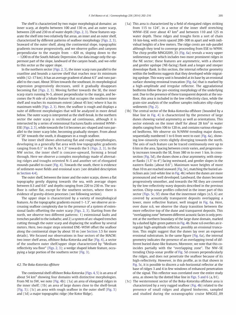
The continental shelf offshore Boka-Kotorska (Figs. 4, 5) is an area ofabout 54 km2 showing four domains with distinctive morphologies.From NE to SW, we note (Fig. 4b): (1a) an area of elongated ridges inthe inner shelf; (1b) an area of large dunes close to the shelf-break(Fig. 5); (1c) an area with rough seafloor in the outer shelf (Fig. 5)and (1d) a major topographic ridge (the Kotor Ridge).
(1a) This area is characterized by a field of elongated ridges strikingfrom 115 to 124°, in a sector of the inner shelf stretchingWNW–ESE over about 47 km2 and between 110 and 125 mwater depth. These ridges and troughs form a sort of chain16 km-long, with crests spaced 200–300 m apart and with indi-vidual heights of a few meters. The ridge crests are sub-parallelalthough they tend to converge proceeding from ESE to WNW.The chirp profile MNG0209_33 (Fig. 6a) reveals a wavy uppersedimentary unit which includes two more prominent ridges inthe NE sector; these features are asymmetric, with a shorterand gentler upslope (NE-facing) flank and a longer and steeperdownslope flank. In this section, the internal reflector geometrywithin the bedforms suggests that they developed while migrat-ing upslope. Thiswavy unit is bounded at its base by an erosionalsurface showing erosional truncation (Fig. 6a) that is marked bya high-amplitude and irregular reflector. The aggradationalbedforms follow the pre-existing morphology of the underlyingunit. Due to the presence of these transparent deposits at the sea-floor, this area is included in the low reflectivity class, while thegrain-size analysis of the seafloor samples indicates silty-clayeysediments (Fig. 2).
(1b) The central sector of the Boka-Kotorska offshore (bounded by ablue line in Fig. 4) is characterized by the presence of largedunes showing varied asymmetry as well as orientations. Thissector extends on the inner shelf for about 28 km2 in waterdepths ranging from 106 to 120m, and contains various elongat-ed bedforms. We observe six N/NNW-trending major dunes,sequentially numbered 1 to 6 from west to east (Fig. 4a), show-ing low-sinuosity crests slightly diverging towards the north.The axis of such feature can be traced continuously over up to6 km in the area. Spacing between crests varies, and progressive-ly increases towards the SE, from 380 m to over 1 km. In cross-section (Fig. 5d), the dunes show a clear asymmetry, with steep-er flanks (1.5° to 4°) facing westward, and gentler slopes in theeastern flanks (about 0.6°). Maximum wave heights of morethan10mare reached seaward (Fig. 5e),matching theburied an-ticlines axis (red-white line in Fig. 4b)where the dunes aremorepronounced and well developed. Landward, the dunes becomeprogressively smoother, and towards the NE they are coveredby the low-reflectivity wavy deposits described in the previoussection. Chirp-sonar profiles collected in the inner part of thissector (Figs. 5c, 5f) show that the innermost ridges (n.5, 6) arecovered by acoustically transparent deposits overlapping alower, more reflective feature, well imaged in Fig. 6a. Here,over dune n.6, we observe the sharp transition between themore reflective top of the dune and transparent deposits. This“overlapping zone” between different acoustic facies is only pres-ent at the northern boundary of the large dune domain, markedby a dashed light-green pattern in Fig. 4b. Dune n.6 overlies an ir-regular high-amplitude reflector, possibly an erosional trunca-tion. This might suggest that the dunes lay over an exposederosional substratum. In the same figure (Fig. 6a), the internalgeometry indicates the presence of an overlapping trend of dif-ferent buried dune-like features. Moreover, we note that this co-incides partially with the “overlapping zone”. The NW–SEtrending Chirp-sonar profile of Fig. 5d crosses perpendicularlythe ridges, and does not penetrate the seafloor because of itshigh-reflectivity. However, in this profile, as in that shown inFig. 5c, it is possible to discern a sub-horizontal reflector at thebase of ridges 3 and 4 in few windows of enhanced penetrationof the signal. This reflector was correlated over the entire studyarea, as shown by the dotted blue line in Figs. 5 and 6 (a, b1).
(1c) The westernmost sector of the Boka-Kotorska offshore area ischaracterized by a very rugged seafloor (Fig. 4b) related to thepresence of small ridges and aligned bioherms, sampledand studied during the oceanographic cruise MNG02_09

Table 1Location and grain-size analysis of seafloor sediment samples collected along the MACM.
Sample Name Longitude (deg E) Latitude (deg N) Sand (%) Silt (%) Clay (%) Cruise
Gr1 19.3087933 41.8605050 28.03 52.74 19.22 Adr02-08Gr2 19.2267167 41.9055333 92.28 6.25 1.47 Adr02-08Gr3 19.1401667 ″41.9661333 47.09 36.86 16.05 Adr02-08Gr4 19.0480067 42.0944550 1.90 48.18 49.74 Adr02-08Gr5 18.5479983 42.3953500 54.83 20.97 24.20 Adr02-08Gr6 18.7603817 42.4346517 10.20 33.59 56.21 Adr02-08Gr7 18.7211767 42.4799217 60.30 10.81 28.89 Adr02-08Gr8 18.6465083 42.4442417 11.58 33.40 55.02 Adr02-08Gr9 19.4169200 41.8155117 2.11 45.16 52.73 Adr02-08Gr10 19.3269883 41.5462583 5.04 49.00 45.96 Adr02-08Gr11 19.3270267 41.5455283 47.26 21.95 30.79 Adr02-08Bj1 19.3812833 41.8152999 5.74 42.92 51.61 Star08Bj2 19.3167000 41.8323666 2.28 48.66 49.06 Star08Bj3 19.2002667 41.8358832 9.66 24.03 66.31 Star08Bj4 19.1144500 41.8914832 1.00 28.31 70.68 Star08Bj5 19.0366833 41.9389499 4.01 24.38 71.61 Star08Bj6 18.9498500 41.9945499 64.15 8.75 27.10 Star08Bj7 18.8308500 42.0673166 58.79 11.25 29.96 Star08Bj8 18.6676833 42.1671332 6.54 19.35 74.12 Star08Bj9 19.3156333 41.7640999 0.40 27.79 71.82 Star08Bj10 19.4544000 41.7821999 0.6 26.44 72.96 Star08Bj11 19.5236000 41.6656832 2.21 34.13 63.66 Star08Bc01 19.2554833 41.7562500 0.44 33.22 66.34 MNG01-09Bc02 19.2898667 41.7943667 0.36 37.14 62.50 MNG01-09Bc03 19.3145667 41.8236000 0.85 49.43 49.73 MNG01-09Bc04 18.9721500 41.9283500 4.17 29.30 66.53 MNG01-09Bc05 19.0317000 41.9686667 0.52 35.59 63.89 MNG01-09Bc06 19.0772667 42.0021500 0.33 50.59 49.08 MNG01-09Bc07 18.8638667 42.0266167 84.07 5.36 10.57 MNG01-09Bc08 18.8755667 42.0268000 27.93 22.77 49.13 MNG01-09Bc06 18.7487567 42.4674083 3.72 25.51 70.77 MNG02_09Bc07 18.7595917 42.4842683 5.90 28.08 66.02 MNG02_09Bc08 18.7150050 42.4807283 6.09 24.42 69.49 MNG02_09Bc12 18.6765267 42.5021667 7.12 36.46 56.42 MNG02_09Bc13 18.6852400 42.4840500 3.42 25.53 71.04 MNG02_09Bc14 18.6614550 42.4325950 16.47 27.18 56.35 MNG02_09Bc15 18.6883167 42.4221750 1.54 33.71 64.75 MNG02_09Bc16 18.7019017 42.4150100 3.29 38.29 58.42 MNG02_09Bc17 18.6858450 42.4068683 3.98 32.85 63.17 MNG02_09Bc18 18.5212533 42.4458400 1.23 69.84 28.93 MNG02_09Bc19 18.5475850 42.4348783 2.02 40.40 57.58 MNG02_09Bc20 18.5567683 42.4471017 6.53 47.79 45.68 MNG02_09Bc21 18.5423917 42.4301100 1.14 41.32 57.55 MNG02_09Bc25 18.6470350 42.4160400 9.13 34.58 56.29 MNG02_09BC28 18.6636883 42.3283617 39.20 24.95 35.85 MNG02_09BC29 18.5840817 42.2357483 70.78 8.20 21.02 MNG02_09BC30 18.5121717 42.1493867 17.08 26.55 56.37 MNG02_09BC31 18.5747933 42.2129367 70.87 8.36 20.77 MNG02_09BC32 18.9182533 42.1600417 31.18 23.96 44.85 MNG02_09BC33 18.7313450 42.0160050 51.01 14.89 34.10 MNG02_09BC38 19.1012367 41.8576050 0.43 32.62 66.95 MNG02_09BC39 19.2263983 41.8640817 0.15 45.83 54.02 MNG02_09BC42 19.2709533 41.7080183 0.22 34.60 65.17 MNG02_09BC43 19.3452567 41.8252117 1.66 56.91 41.43 MNG02_09BC45 19.3523450 41.8309667 3.07 61.86 35.07 MNG02_09BC46 19.3484567 41.8284217 3.73 66.19 30.09 MNG02_09BC47 19.3423067 41.8231967 0.93 51.67 47.39 MNG02_09BC48 19.3378667 41.8196017 0.89 51.02 48.09 MNG02_09Bc01 18.5204167 42.3437000 36.55 23.03 40.42 MNG04_11Bc02 18.4640000 42.2394167 22.95 25.19 51.86 MNG04_11Bc03 19.3220500 41.8590000 50.60 34.73 14.67 MNG04_11Bc04 19.2815167 41.8264667 0.30 34.30 65.40 MNG04_11Bc05 19.2372000 41.7840000 4.14 38.35 57.52 MNG04_11Bc06 19.1793167 41.7307500 0.46 31.24 68.30 MNG04_11Bc07 19.1207667 41.6792500 4.92 32.04 63.04 MNG04_11Bc09 19.2064333 41.8827333 0.11 51.45 48.44 MNG04_11Bc11 19.0815000 41.9821667 0.20 47.89 51.91 MNG04_11A 48 17.8 63.6 ALTROA49B 67.7 19.7 ALTROA49T 38.7 44.6 ALTRO5.4 19.5516333 41.7438500 4.2 53.44 42.36 Marini et al., 2012HN 18.5491500 42.4437833 0.12 47.48 52.4 MARIN I20124.5 19.1221333 41.6818500 1.28 42.68 56.04 MARIN I20126.5 19.2181167 41.6296500 0.00 39.52 60.24 MARIN I2012
206 F. Del Bianco et al. / Geomorphology 226 (2014) 202–216
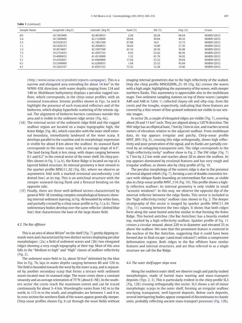
Table 1 (continued)
Sample Name Longitude (deg E) Latitude (deg N) Sand (%) Silt (%) Clay (%) Cruise
KO 18.7403000 42.4818833 2.68 28.28 68.64 MARIN I20122.4 18.7469000 42.1126000 20.64 30.04 49.32 MARIN I20123.5 18.9328333 41.7861500 47.88 18.4 33.72 MARIN I20121.1 18.5420333 42.3960833 58.64 14.00 27.36 MARIN I20121.2 18.4974667 42.3587500 43.16 20.36 36.48 MARIN I20127.3 19.2752833 41.4507333 0.92 52.42 46.56 MARIN I20127.1 19.4089833 41.4510000 1.32 61.76 36.92 MARIN I20125.1 19.4182667 41.8469000 17.64 53.32 29.04 MARIN I20126.1 19.5300000 41.6289833 1.64 25.52 45.84 MARIN I20124.1 19.3262167 41.8597333 73.32 12.28 14.40 MARIN I2012
207F. Del Bianco et al. / Geomorphology 226 (2014) 202–216
(http://www.ismar.cnr.it/prodotti/reports-campagne). This is anarrow and elongated area extending for about 14 km2 in theWNW–ESE direction, with water depths ranging from 124 and140 m. Multibeam bathymetry displays a peculiar rugged sea-floor, which corresponds, in the chirp-sonar profiles, with anerosional truncation. Seismic profiles shown in Figs. 5a and bhighlight the presence of such truncated reflectors and of thebioherms, which display hyperbolic scattering of the seismic sig-nal. The alignment of bioherm barriers continues outside thisarea and is visible in the sediment ridge sector (Fig. 4a).
(1d) The external sector of the sediment ridge field and the ruggedseafloor region are located on a major topographic high, theKotor Ridge (Fig. 4b), which coincides with the inner shelf exter-nal boundary, immediately landward of the inner scarp. Itdevelops parallel to the coastline and itsmorphologic expressionis visible for about 8 km above the seafloor. Its seaward flankcorresponds to the inner scarp, with an average slope of 4.5°.The land-facing flank is less steep, with slopes ranging between0.1 and 0.2° in the central sector of the inner shelf. On chirp pro-files shown in Fig. 5 (a, b), the Kotor Ridge is located on top of alayered folded structure. Its internal geometry is best viewed inthe sparker profile MNG11_02 (Fig. 6b), where we observe anasymmetric fold with a marked erosional unconformity (reddotted line) at its top. This is an anticlinal structure with thesteeper seaward-facing flank and a flexural bending on theopposite side.
(1f) Finally, there are three well-defined sectors characterized bygeneral NW–SE trending complexmorphological features show-ing internal sediment layering, in Fig. 4b bounded bywhite lines,and partially crossed by a chirp sonar profile in Fig. 5 (a, b). Thesesedimentary bodies develop over the same reflector (dotted blueline) that characterizes the base of the large dunes field.
4.3. The Bar offshore
This is an area of about 80 km2 on the shelf (Fig. 7) gently dipping to-wardswest and characterized by two distinct sectors displayingpeculiarmorphologies: (2a) a field of sediment waves and (2b) two elongatedridges showing a very rough topography at their top. Most of this areafalls in the “Medium to high” and “High” classes of seafloor reflectivity(Fig. 2).
The sediment wave field in 2a, about 50 km2 delimited by the blueline in Fig. 7b, lays in water depths ranging between 80 and 120 m.Thefield is bounded towards thewest by the inner scarp, and is separat-ed by another secondary scarp that forms a terrace with sedimentwaves located near its seaward edge. The wave crests show a constantsinuosity and anaverage orientation of 75°N (about E–NE). In the south-ern sector the crests reach the maximum extent and can be tracedcontinuously for about 3–4 km. Wavelengths varies from 142 m to thenorth, to 115 m to the south, and amplitudes are between 1 and 4 m.In cross section thenorthernflank of thewaves appear generally steeper.Chirp sonar profiles shown Fig. 8 cut through the wave fields without
imaging internal geometries due to the high reflectivity of the seabed.Only the chirp profile MNG0209b_21-10 (Fig. 8a) crosses the waveswith a high angle, highlighting the asymmetry of thewaves,with steepernorthern flanks. This asymmetry is appreciable also in the multibeammaps. Two sediment sampling stations on top of these waves (samplesA49 and A48 in Table 1) collected clayey-silt and silty-clay, from thecrests and the troughs, respectively, indicating that these features arecovered by a thin veneer of fine-grained sediment not visible in our seis-mic images.
In sector 2b, a couple of elongated ridges are visible (Fig. 7), coveringabout 20 and 11 km2 each. They are aligned along a 120°N direction. TheNWridge has an elliptical base, 7 kmby3 km in size, and reaches severalmeters of elevation relative to the adjacent seafloor. From multibeamdata, its top appears irregular and patchy. Chirp-sonar profileMNT_095 (Fig. 9), crossing this ridge orthogonally, shows high reflec-tivity and poor penetration of the signal, and its flanks are partially cov-ered by an onlapping transparent unit. The ridge corresponds to the“high-reflectivity/rocky” seafloor show in Fig. 2. The SW ridge (Fig. 7)is 7 km by 2.2 km wide and reaches about 20 m above the seafloor. Itstop appears dominated by erosional features and has very rough andirregular seafloor, as shown also by chirp profile of Fig. 10.
The peculiar morphology of the eastern ridge is due to the presenceof several aligned reliefs (Fig. 7), forming a sort of double concentric ter-race with oblique flanks bounding an intermediate flat zone, as visiblealso in chirp-sonar profileMNT_114 (Fig. 10). This profile shows a high-ly reflective seafloor; its internal geometry is only visible in small“acoustic windows”. In this way, we observe the opposite dip of theinternal reflector between the ridge flanks. This sector is included inthe “high reflectivity/rocky” seafloor class shown in Fig. 2. The deeperstratigraphy of this sector is imaged by sparker profile MNG11_04(Fig. 11) running between the two ridges. It shows that both ridgesform along the same buried anticline similar to that forming the KotorRidge. This buried anticline (the Bar Anticline) has a heavily erodedtop, marked by a high reflectivity seafloor. Sparker profile of Fig. 11crosses a circular mound, about 220 m in diameter and elevated 25 mabove the seafloor. We note that this prominent feature is centered inthe nucleus of the Bar Anticline, suggesting that it could have beenformed due to fluid escape (sand/mud volcano?) within a compressivedeformation regime. Both ridges in the Bar offshore have similarfeatures and internal structures, and are thus referred to as a singlestructure we call the Bar Ridge.
4.4. The outer shelf/upper slope area
Along the southern outer shelf, we observe rough and patchy seabedmorphologies, made of buried mass wasting and mass-transportdeposits (Figs. 2, 3). This is particularly evident in the chirp profile SL3(Fig. 12b) crossing orthogonally this sector. SL3 shows a set of minormorphologic scarps in the outer shelf, forming an irregular seaflooroverlying transparent, well-layered deposits. Below such deposits,several interlayering bodies appear composed of discontinuous to chaoticunits, probably reflecting ancient mass-transport processes (Fig. 12b).
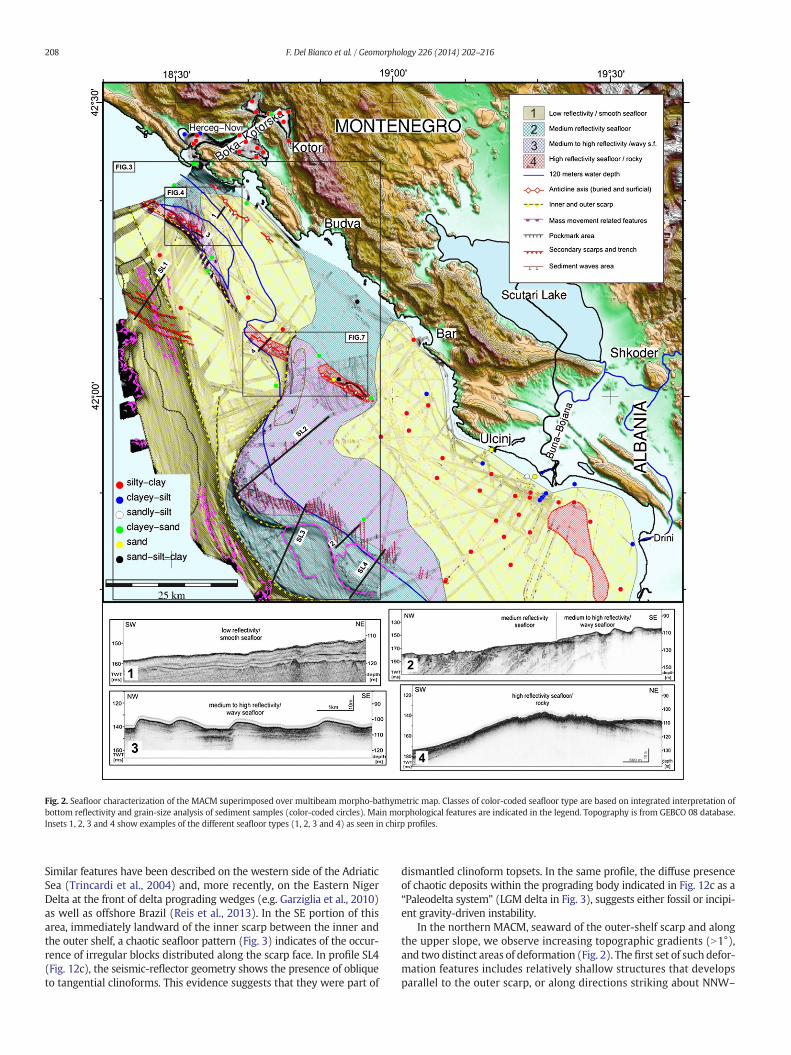
Fig. 2. Seafloor characterization of the MACM superimposed over multibeam morpho-bathymetric map. Classes of color-coded seafloor type are based on integrated interpretation ofbottom reflectivity and grain-size analysis of sediment samples (color-coded circles). Main morphological features are indicated in the legend. Topography is from GEBCO 08 database.Insets 1, 2, 3 and 4 show examples of the different seafloor types (1, 2, 3 and 4) as seen in chirp profiles.
208 F. Del Bianco et al. / Geomorphology 226 (2014) 202–216
Similar features have been described on the western side of the AdriaticSea (Trincardi et al., 2004) and, more recently, on the Eastern NigerDelta at the front of delta prograding wedges (e.g. Garziglia et al., 2010)as well as offshore Brazil (Reis et al., 2013). In the SE portion of thisarea, immediately landward of the inner scarp between the inner andthe outer shelf, a chaotic seafloor pattern (Fig. 3) indicates of the occur-rence of irregular blocks distributed along the scarp face. In profile SL4(Fig. 12c), the seismic-reflector geometry shows the presence of obliqueto tangential clinoforms. This evidence suggests that they were part of
dismantled clinoform topsets. In the same profile, the diffuse presenceof chaotic deposits within the prograding body indicated in Fig. 12c as a“Paleodelta system” (LGM delta in Fig. 3), suggests either fossil or incipi-ent gravity-driven instability.
In the northern MACM, seaward of the outer-shelf scarp and alongthe upper slope, we observe increasing topographic gradients (N1°),and two distinct areas of deformation (Fig. 2). The first set of such defor-mation features includes relatively shallow structures that developsparallel to the outer scarp, or along directions striking about NNW–
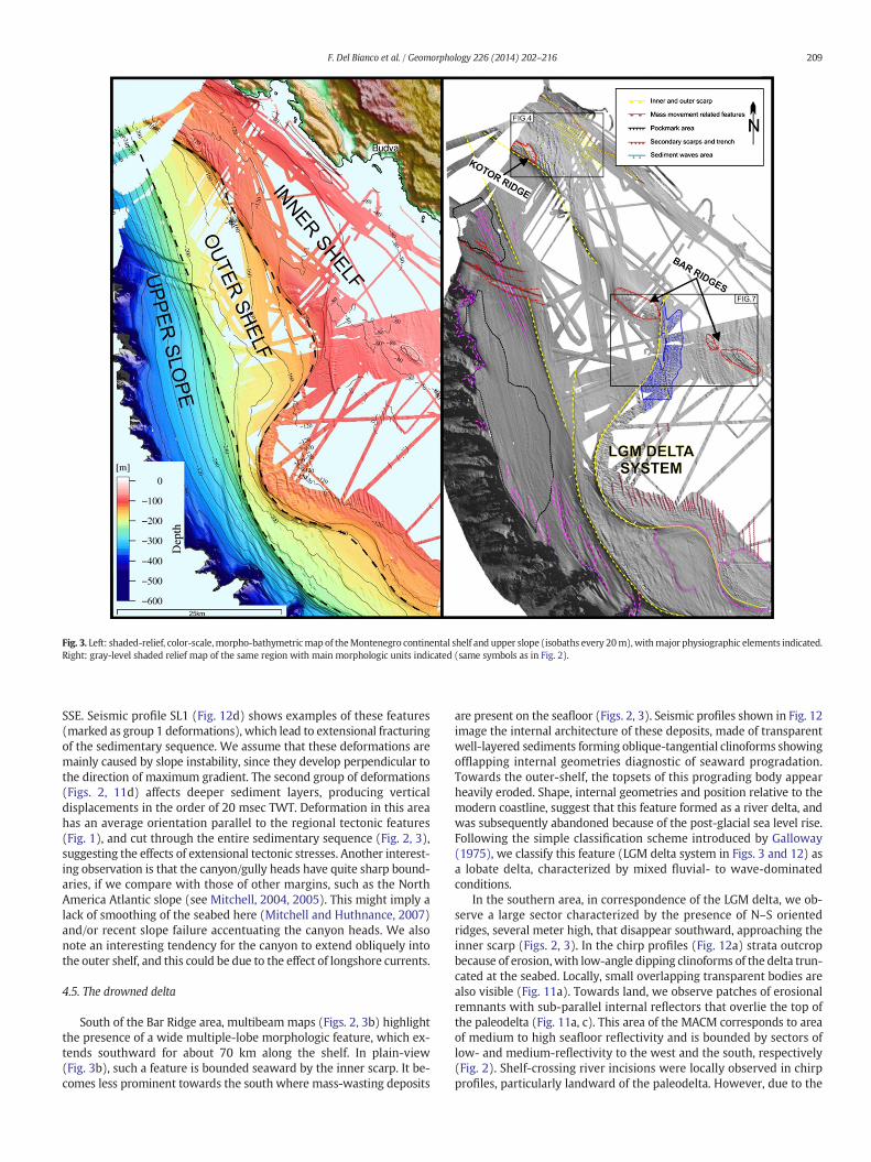
Fig. 3. Left: shaded-relief, color-scale,morpho-bathymetricmap of theMontenegro continental shelf and upper slope (isobaths every 20m),withmajor physiographic elements indicated.Right: gray-level shaded relief map of the same region with main morphologic units indicated (same symbols as in Fig. 2).
209F. Del Bianco et al. / Geomorphology 226 (2014) 202–216
SSE. Seismic profile SL1 (Fig. 12d) shows examples of these features(marked as group 1 deformations), which lead to extensional fracturingof the sedimentary sequence. We assume that these deformations aremainly caused by slope instability, since they develop perpendicular tothe direction of maximum gradient. The second group of deformations(Figs. 2, 11d) affects deeper sediment layers, producing verticaldisplacements in the order of 20 msec TWT. Deformation in this areahas an average orientation parallel to the regional tectonic features(Fig. 1), and cut through the entire sedimentary sequence (Fig. 2, 3),suggesting the effects of extensional tectonic stresses. Another interest-ing observation is that the canyon/gully heads have quite sharp bound-aries, if we compare with those of other margins, such as the NorthAmerica Atlantic slope (see Mitchell, 2004, 2005). This might imply alack of smoothing of the seabed here (Mitchell and Huthnance, 2007)and/or recent slope failure accentuating the canyon heads. We alsonote an interesting tendency for the canyon to extend obliquely intothe outer shelf, and this could be due to the effect of longshore currents.
4.5. The drowned delta
South of the Bar Ridge area, multibeam maps (Figs. 2, 3b) highlightthe presence of a wide multiple-lobe morphologic feature, which ex-tends southward for about 70 km along the shelf. In plain-view(Fig. 3b), such a feature is bounded seaward by the inner scarp. It be-comes less prominent towards the south where mass-wasting deposits
are present on the seafloor (Figs. 2, 3). Seismic profiles shown in Fig. 12image the internal architecture of these deposits, made of transparentwell-layered sediments forming oblique-tangential clinoforms showingofflapping internal geometries diagnostic of seaward progradation.Towards the outer-shelf, the topsets of this prograding body appearheavily eroded. Shape, internal geometries and position relative to themodern coastline, suggest that this feature formed as a river delta, andwas subsequently abandoned because of the post-glacial sea level rise.Following the simple classification scheme introduced by Galloway(1975), we classify this feature (LGM delta system in Figs. 3 and 12) asa lobate delta, characterized by mixed fluvial- to wave-dominatedconditions.
In the southern area, in correspondence of the LGM delta, we ob-serve a large sector characterized by the presence of N–S orientedridges, several meter high, that disappear southward, approaching theinner scarp (Figs. 2, 3). In the chirp profiles (Fig. 12a) strata outcropbecause of erosion,with low-angle dipping clinoforms of the delta trun-cated at the seabed. Locally, small overlapping transparent bodies arealso visible (Fig. 11a). Towards land, we observe patches of erosionalremnants with sub-parallel internal reflectors that overlie the top ofthe paleodelta (Fig. 11a, c). This area of the MACM corresponds to areaof medium to high seafloor reflectivity and is bounded by sectors oflow- and medium-reflectivity to the west and the south, respectively(Fig. 2). Shelf-crossing river incisions were locally observed in chirpprofiles, particularly landward of the paleodelta. However, due to the

Fig. 4.Detailedmorpho-bathymetricmaps of the Boka-Kotorska offshore. a: shaded-relief color-scalemapwith sixmajor ridges (numbered from 1 to 6) indicated, aswell as tracks of sub-bottom profiles displayed in Fig. 5. b: gray-scale shaded relief-map of the same area, displaying the four morphologic domains described in the text (elongated ridges in the inner shelf;large dunes close to the shelf-break; rough seafloor in the outer shelf; a major topographic ridge, i.e., the Kotor Ridge).
210 F. Del Bianco et al. / Geomorphology 226 (2014) 202–216
relatively low-density of seismic lines, and (most probably) to the lowdegree of preservation during the transgression, it has been impossibleto map such features in the inner shelf.
5. Discussion
A composite pattern of relic, palimpsest and active bedforms charac-terizes the seafloor on the shelf and the upper slope along the MACM.These features originated either throughmodern sedimentary processes,or from processes that were active during the last sea level lowstandsome 20,000 years BP (Lambeck and Bard, 2000). In particular, a field ofElongated Ridges (Fig. 4b) is visible in the northern sector, encompassingdeposits of a well-defined, transparent seismo-stratigraphic unit. Inagreement with its class of low reflectivity (Fig. 2) and internally well-
stratified and parallel-to-wavy reflectors, this unit is made-up of fine-grained deposits, which we assumed to represent the Holocene mudwedge. As to the observed contour-parallel seafloor undulations, theyare similar to correlative features in Late Holocenemudwedges observedin the W Adriatic shelf and in relatively shallow-waters by Correggiariet al. (2001) andCattaneo et al. (2004), aswell as in deeper environmentssuch as the Bay of Biscay (Faugeres et al., 2002). These authorsinterpreted such features as being caused by the interaction betweendeposition, bottom-hugging currents and gravity deformation processes,such as localized syn-depositional deformation at different scales. Theycould be considered a sort of “multi-process” sediment wave, relativelycommon on the continental margin (Faugeres et al., 2002). Consideringthat the wavy geometry refers to the entire unit reaching the seafloor,we considered these features to be presently active.

Fig. 5. Seismic reflection profiles (location in Fig. 4) from the northern Boka-Kotorska offshore area. a, b, c, d and e are chirp-sonar profiles showing different stratigraphic and morphologicalfeatures.
211F. Del Bianco et al. / Geomorphology 226 (2014) 202–216
The Large Dune area. Although available high-resolution seismicdata do not allow for accurate 3-D reconstructions of the sediment bod-ies and seafloor sampling is very limited, an interpretation of the originof these dunes should consider that their base is marked by a continu-ous high-amplitude and irregular reflector, marking an erosionalsurface, which outcrops the seafloor along the −120 m isobaths(Figs. 5a–c, 6). This depth falls in the interval of minimum eustaticlevel reached during the LGM (Shackleton, 1977; Lambeck and Bard,2000; Lea et al., 2002). We could infer that the base of the dunes wasexposed to sub-aerial erosion until about 20 ky (Rohling et al., 1998),and most probably the dune field was formed soon after the LGM. Theoverlapping Holocene mud wedge, which represents the most recentdeposit in the area, provides another chronostratigraphic time con-straint. Consequently, this large field of bedforms formed possibly ascoastal dunes partially reworked by marine processes and buried bytransgressive deposits in a time interval from the LGM to the succeedingsea-level rise. After the last transgression, these depositswere colonizedby bioherms. This reconstruction is similar to the formation and drown-ing of the elongated dunes observed on the North Adriatic shelf in 24 mwater depth, offshore the Venice Lagoon (Correggiari et al., 1996).
The Kotor and Bar ridges are prominent morphological unitsobserved along the MACM (Fig. 3). From the analysis of chirp sub-bottom and sparker profiles (Figs. 5, 8, 9, 10) they overlie anticlines ofthe Dinarides front. Although the fold axis is not visible due to erosionat the seafloor, the overall geometry and the opposite dip internalreflectors suggests that it could be a fault-propagation fold (Suppe,1985). Consequently, we can assume that the Kotor and the Bar ridgesconstitute the surficial expression of a buried, deep-seated compressivetectonic feature, as suggested byDel Bianco et al. (2010) on the basis of apreliminary analysis. Moreover, these features are aligned, and showsimilar morphologies relative to the system of alternating ridges andtroughs that marks the 15 chain front onshore (Fig. 2). For this reason,such ridges could be considered the offshore counterparts of theseonland tectonic structures, which show evidence of ongoing compres-sive deformations.
Another important morphologic element of the shelf along theMACM is a drowned Paleodelta system, identified in the southeasternsector. The shelf-break in this sector corresponds to the delta front. Inseismic profiles (Figs. 11, 12) it is marked by the clinoform breakpoint,located between 110 and 130 m water depth. Because this depth
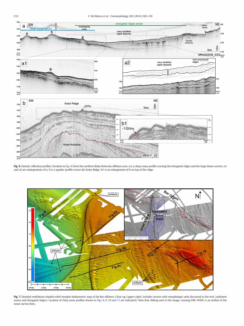
Fig. 6. Seismic reflection profiles (location in Fig. 4) from the northern Boka-Kotorska offshore area. a is a chirp-sonar profile crossing the elongated ridges and the large dunes sectors; a1and a2 are enlargements of a; b is a sparker profile across the Kotor Ridge; b1 is an enlargement of b on top of the ridge.
Fig. 7. Detailed multibeam shaded-relief morpho-bathymetric map of the Bar offshore. Close-up (upper-right) includes sectors with morphologic units discussed in the text (sedimentwaves and elongated ridges). Location of chirp sonar profiles shown in Figs. 8, 9, 10 and 11 are indicated). Note that ribbing seen in the image, running ENE–WSW, is an artifact of thesonar survey lines.
212 F. Del Bianco et al. / Geomorphology 226 (2014) 202–216

Fig. 8. Chirp sonar profiles crossing thewave fields: a)MNG0209b_21_10; b)MNT_103; c) ALTRO_290. High seafloor reflectivity hampers penetration of seismic signal in the sub-seafloorand imaging of internal geometries (location in Fig. 7).
213F. Del Bianco et al. / Geomorphology 226 (2014) 202–216
interval was reached by global sea-level about 1815 kyr (Fleming et al,1998), we might assume that the paleodelta formed during Marine Iso-topic Stage (MIS) 2. In this case, the clinoform breakpoint could give anapproximate indication of the LGM paleoshoreline, depending on thewave climate at that time and the kind of sediment. For example, inMitchell et al. (2012) modern sandy clinoforms were found in sometens meters of water depth, in agreement with measured wave heights.
Fig. 9. Chirp sonar profile MNT_095 crossing the Bar Ridge in its northernmost outcrop (locatioshown.
Within this approximation, a sketch map (Fig. 12e) might be com-piled, where a simplified coastal physiography of the LGM time isshown. In Fig. 12e, we note that the LGM shoreline was about 45 kmseaward relative to its present-day position, the delta plain extendedup to the present-day inner scarp, and the shelf break was located incorrespondence with the modern outer scarp (Section 3.2). Followingthe classification described in Porebski and Steel (2003, 2006), this
n in Fig. 7). A line drawing showing the main stratigraphic and morphological features is
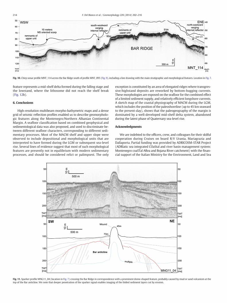
Fig. 10. Chirp sonar profile MNT_114 across the Bar Ridge south of profile MNT_095 (Fig. 9), including a line drawingwith themain stratigraphic andmorphological features. Location in Fig. 7.
214 F. Del Bianco et al. / Geomorphology 226 (2014) 202–216
feature represents a mid-shelf delta formed during the falling stage andthe lowstand, where the lithosome did not reach the shelf break(Fig. 12b).
6. Conclusions
High-resolution multibeammorpho-bathymetric maps and a densegrid of seismic reflection profiles enabled us to describe geomorpholo-gic features along the Montenegro/Northern Albanian ContinentalMargin. A seafloor classification based on combined geophysical andsedimentological data was also proposed, and used to discriminate be-tween different seafloor characters, corresponding to different sedi-mentary processes. Most of the MACM shelf and upper slope wereobserved to include depositional and morphological units that areinterpreted to have formed during the LGM or subsequent sea-levelrise. Several lines of evidence suggest that most of such morphologicalfeatures are presently not in equilibrium with modern sedimentaryprocesses, and should be considered relict or palimpsest. The only
Fig. 11. Sparker profileMNG11_04 (location in Fig. 7) crossing the Bar Ridge in correspondencetop of the Bar anticline. We note that deeper penetration of the sparker signal enables imaging
exception is constituted by an area of elongated ridgeswhere transgres-sive/highstand deposits are reworked by bottom-hugging currents.Thesemorphologies are exposed on the seafloor for the combined effectof a limited sediment supply, and relatively efficient longshore currents.A sketch map of the coastal physiography of MACM during the LGM,which includes the position of the paleoshoreline (up to 45 km seawardto the present-day), shows that the paleogeography of the margin isdominated by a well-developed mid-shelf delta system, abandonedduring the latest phase of Quaternary sea-level rise.
Acknowledgments
We are indebted to the officers, crew, and colleagues for their skilfulcooperation during Cruises on board R/V Urania, Mariagrazia andDallaporta. Partial funding was provided by ADRICOSM-STAR Project(ADRIatic sea integrated COaStal and river basin management system:Montenegro coaSTal ARea and Bojana River catchment) with the finan-cial support of the Italian Ministry for the Environment, Land and Sea
with a prominent dome-shaped feature, probably caused bymud or sand volcanism at theof the folded sediment layers cut by erosion.
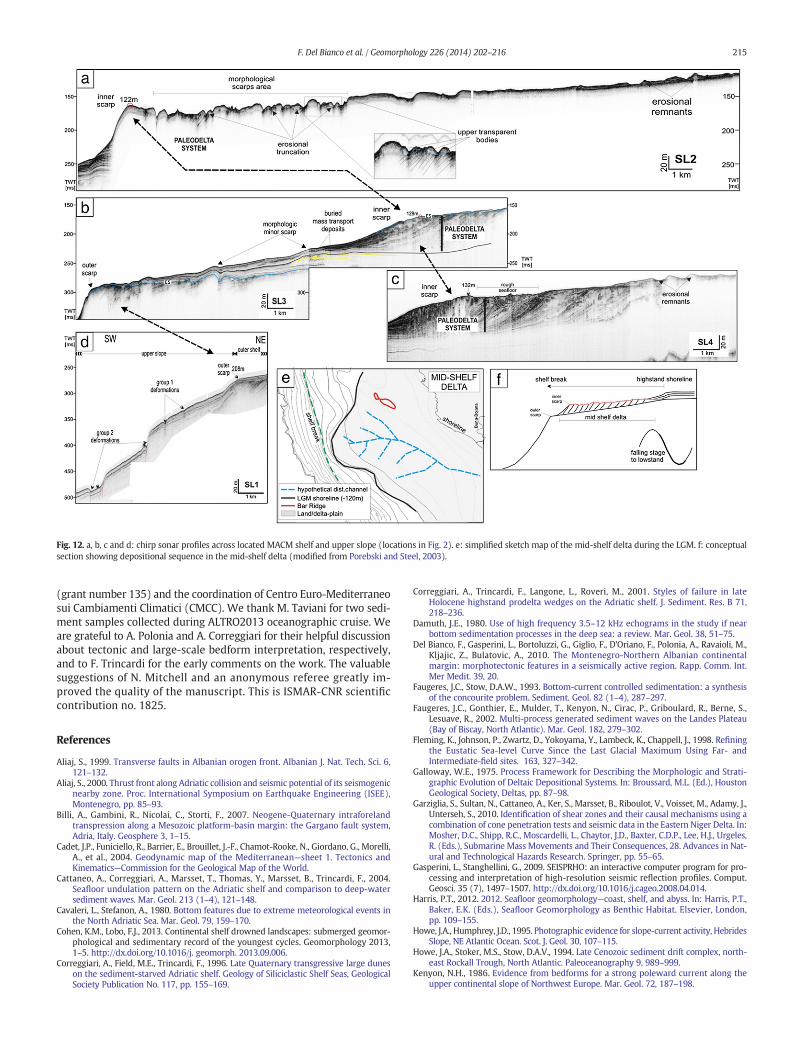
Fig. 12. a, b, c and d: chirp sonar profiles across located MACM shelf and upper slope (locations in Fig. 2). e: simplified sketch map of the mid-shelf delta during the LGM. f: conceptualsection showing depositional sequence in the mid-shelf delta (modified from Porebski and Steel, 2003).
215F. Del Bianco et al. / Geomorphology 226 (2014) 202–216
(grant number 135) and the coordination of Centro Euro-Mediterraneosui Cambiamenti Climatici (CMCC). We thank M. Taviani for two sedi-ment samples collected during ALTRO2013 oceanographic cruise. Weare grateful to A. Polonia and A. Correggiari for their helpful discussionabout tectonic and large-scale bedform interpretation, respectively,and to F. Trincardi for the early comments on the work. The valuablesuggestions of N. Mitchell and an anonymous referee greatly im-proved the quality of the manuscript. This is ISMAR-CNR scientificcontribution no. 1825.
References
Aliaj, S., 1999. Transverse faults in Albanian orogen front. Albanian J. Nat. Tech. Sci. 6,121–132.
Aliaj, S., 2000. Thrust front along Adriatic collision and seismic potential of its seismogenicnearby zone. Proc. International Symposium on Earthquake Engineering (ISEE),Montenegro, pp. 85–93.
Billi, A., Gambini, R., Nicolai, C., Storti, F., 2007. Neogene-Quaternary intraforelandtranspression along a Mesozoic platform-basin margin: the Gargano fault system,Adria, Italy. Geosphere 3, 1–15.
Cadet, J.P., Funiciello, R., Barrier, E., Brouillet, J.-F., Chamot-Rooke, N., Giordano, G., Morelli,A., et al., 2004. Geodynamic map of the Mediterranean—sheet 1. Tectonics andKinematics—Commission for the Geological Map of the World.
Cattaneo, A., Correggiari, A., Marsset, T., Thomas, Y., Marsset, B., Trincardi, F., 2004.Seafloor undulation pattern on the Adriatic shelf and comparison to deep-watersediment waves. Mar. Geol. 213 (1–4), 121–148.
Cavaleri, L., Stefanon, A., 1980. Bottom features due to extreme meteorological events inthe North Adriatic Sea. Mar. Geol. 79, 159–170.
Cohen, K.M., Lobo, F.J., 2013. Continental shelf drowned landscapes: submerged geomor-phological and sedimentary record of the youngest cycles. Geomorphology 2013,1–5. http://dx.doi.org/10.1016/j. geomorph. 2013.09.006.
Correggiari, A., Field, M.E., Trincardi, F., 1996. Late Quaternary transgressive large duneson the sediment-starved Adriatic shelf. Geology of Siliciclastic Shelf Seas, GeologicalSociety Publication No. 117, pp. 155–169.
Correggiari, A., Trincardi, F., Langone, L., Roveri, M., 2001. Styles of failure in lateHolocene highstand prodelta wedges on the Adriatic shelf. J. Sediment. Res. B 71,218–236.
Damuth, J.E., 1980. Use of high frequency 3.5–12 kHz echograms in the study if nearbottom sedimentation processes in the deep sea: a review. Mar. Geol. 38, 51–75.
Del Bianco, F., Gasperini, L., Bortoluzzi, G., Giglio, F., D'Oriano, F., Polonia, A., Ravaioli, M.,Kljajic, Z., Bulatovic, A., 2010. The Montenegro-Northern Albanian continentalmargin: morphotectonic features in a seismically active region. Rapp. Comm. Int.Mer Medit. 39, 20.
Faugeres, J.C., Stow, D.A.W., 1993. Bottom-current controlled sedimentation: a synthesisof the concourite problem. Sediment. Geol. 82 (1–4), 287–297.
Faugeres, J.C., Gonthier, E., Mulder, T., Kenyon, N., Cirac, P., Griboulard, R., Berne, S.,Lesuave, R., 2002. Multi-process generated sediment waves on the Landes Plateau(Bay of Biscay, North Atlantic). Mar. Geol. 182, 279–302.
Fleming, K., Johnson, P., Zwartz, D., Yokoyama, Y., Lambeck, K., Chappell, J., 1998. Refiningthe Eustatic Sea-level Curve Since the Last Glacial Maximum Using Far- andIntermediate-field sites. 163, 327–342.
Galloway, W.E., 1975. Process Framework for Describing the Morphologic and Strati-graphic Evolution of Deltaic Depositional Systems. In: Broussard, M.L. (Ed.), HoustonGeological Society, Deltas, pp. 87–98.
Garziglia, S., Sultan, N., Cattaneo, A., Ker, S., Marsset, B., Riboulot, V., Voisset, M., Adamy, J.,Unterseh, S., 2010. Identification of shear zones and their causal mechanisms using acombination of cone penetration tests and seismic data in the Eastern Niger Delta. In:Mosher, D.C., Shipp, R.C., Moscardelli, L., Chaytor, J.D., Baxter, C.D.P., Lee, H.J., Urgeles,R. (Eds.), Submarine Mass Movements and Their Consequences, 28. Advances in Nat-ural and Technological Hazards Research. Springer, pp. 55–65.
Gasperini, L., Stanghellini, G., 2009. SEISPRHO: an interactive computer program for pro-cessing and interpretation of high-resolution seismic reflection profiles. Comput.Geosci. 35 (7), 1497–1507. http://dx.doi.org/10.1016/j.cageo.2008.04.014.
Harris, P.T., 2012. 2012. Seafloor geomorphology—coast, shelf, and abyss. In: Harris, P.T.,Baker, E.K. (Eds.), Seafloor Geomorphology as Benthic Habitat. Elsevier, London,pp. 109–155.
Howe, J.A., Humphrey, J.D., 1995. Photographic evidence for slope-current activity, HebridesSlope, NE Atlantic Ocean. Scot. J. Geol. 30, 107–115.
Howe, J.A., Stoker, M.S., Stow, D.A.V., 1994. Late Cenozoic sediment drift complex, north-east Rockall Trough, North Atlantic. Paleoceanography 9, 989–999.
Kenyon, N.H., 1986. Evidence from bedforms for a strong poleward current along theupper continental slope of Northwest Europe. Mar. Geol. 72, 187–198.

216 F. Del Bianco et al. / Geomorphology 226 (2014) 202–216
Lambeck, K., Bard, E., 2000. Sealevel changes along the FrenchMediterranean coast for thepast 30,000 years. Earth Planet. Sci. Lett. 175, 203–222.
Lea, D.W., Martin, P.A., Pak, D.K., Spero, H.J., 2002. Reconstructing a 350 ky history of sealevel using planktonic Mg/Ca and oxygen isotope records from a Cocos Ridge core.Quat. Sci. Rev. 21, 283–293.
Marani, M., Argnani, A., Roveri, M., Trincardi, F., 1993. Sediment drifts and erosionalsurfaces in the central Mediterranean: seismic evidence of bottom-current activity.Sediment. Geol. 82, 207–220.
Marini, M., Grilli, F., Guarnieri, A., Jones, B.H., Klajic, Z., Pinardi, N., Sanxhaku, M., 2010. Isthe southeastern Adriatic Sea coastal strip an eutrophic area? Estuar. Coast. Shelf Sci.88 (3), 395–406. http://dx.doi.org/10.1016/j.ecss.2010.04.020.
Marini, M., Betti, M., Grati, F., Marconi, V., Mastrogiacomo, A.R., Polidori, P., Sanxhaku, M.,2012. Evaluation of lindane diffusion along the southeastern Adriatic coastal strip(Mediterranean Sea): a case study in an Albanian industrial area. Marine pollutionbulletin 64 (3), 472–478. http://dx.doi.org/10.1016/j.marpolbul.2012.01.022.
Masson, D.G., Howe, J.A., Stoker, M.S., 2002. Bottom-current sediment waves, sedimentdrifts and contourites in the northern Rockall Trough. Mar. Geol. 192, 215–237.
Mitchell, N.C., 2004. Form of submarine erosion from confluences in Atlantic USA conti-nental slope canyons. Am. J. Sci. 304, 590–611.
Mitchell, N.C., 2005. Interpreting long-profiles of canyons in the USA Atlantic continentalslope. Mar. Geol. 214, 75–99.
Mitchell, N.C., Huthnance, J.M., 2007. Oceanographic currents and the convexity of theuppermost continental slope. J. Sediment. Res. 78, 29–44.
Mitchell, N.C., Masselink, G., Huthnance, J.M., Fernandez-Salas, L.M., Lobo, F.J., 2012.Depths of modern coastal clinoforms. J. Sed. Res. 82, 469–481.
Pondrelli, S., Salimbeni, S., Ekstrom, G., Morelli, A., Gasperini, P., Vannucci, G., 2006. TheItalian CMT dataset from 1977 to the present. Phys. Earth Planet. Inter. 159/3-4,286–303. http://dx.doi.org/10.1016/j.pepi. 2006.07.008.
Porebski, S.J., Steel, R.J., 2003. Shelf-margin deltas: their stratigraphic significance and re-lation to deepwater sands. Earth Sci. Rev. 62 (3-4), 283–326. http://dx.doi.org/10.1016/S0012-8252(02)00161-7.
Porebski, S.J., Steel, R.J., 2006. Deltas and sea-level change. J. Sediment. Res. 76 (3),390–403. http://dx.doi.org/10.2110/jsr.2006.034.
Poulain, P.M., 2001. Adriatic Sea surface circulation as derived from drifter data between1990 and 1999. J. Mar. Syst. 29, 3–32.
Reeder, M.S., Rothwell, G., Stow, D.A.V., 2002. The Sicilian gateway: anatomy of deep-water connection between east and west Mediterrranean basins. In: Stow, D.A.V.,Pudsey, C.J., Howe, J.A., Faugeres, J.C., Viana, A.R. (Eds.), Deep-water contouritesystems. Modern Drift and Ancient Series, Seismic and Sedimentary Characteristics.Geological Society, London, Memoirs. 22, pp. 171–189.
Reis, A.T., Maia, R.M.C., Silva, C.G., Rabineau, M., Guerra, J.V., Gorini, C., Ayres, A., Arantes-Oliveira, R., Benabdellouahed, M., Simoes, I., Tardin, R., 2013. Origin of step-like and
lobate sea floor features along the continental shelf off Rio de Janeiro State, Santosbasin-Brazil. Geomorphology 203, 25–45. http://dx.doi.org/10.1016/j.geomorph.2013.04.037.
Roberts, D.G., Kidd, R.B., 1979. Abyssal sediment wave fields on Feni Ridge, RockallTrough: long-range sonar studies. Mar. Geol. 33, 175–191.
Rohling, E.J., Fenton, M., Jorissen, F.J., Bertrand, P., Ganssen, G., Caulet, J.P., 1998. Magni-tudes of sea-level lowstands of the past 500,000 years. Nature 394, 162–165.
Roveri, M., 2002. Sediment drifts of the Corsica Channel, northern Tyrrhenian Sea. In:Stow, D.A.V., Pudsey, C.J., Howe, J.H., Faugeres, J.C., Viana, A.R. (Eds.), Deep-watercontourite systems: modern drifts and ancient series, seismic and sedimentarycharacteristics. Geol Soc Lond Mem. 22, pp. 191–208.
Shackleton, N.J., 1977. The oxygen isotope stratigraphic record of the Late Pleistocene.Philos. Trans. R. Soc. Lond. B 280, 169–182.
Shepard, F.P., 1954. Nomenclature based on sand–silt–clay ratios. J. Sediment. Petrol. 24,151.
Stoker, M.S., 1998. Sediment drift development on the Rockall continental margin, off NWBritain. In: Stoker, M.S., Evans, D., Cramp, A. (Eds.), Geological processes on continen-tal margins: sedimentation, mass-wasting and stability. Geological Society, London,Special Publications. 129, pp. 229–254.
Suppe, J., 1985. Principles of Structural Geology. Prentice-Hall, Englewood Cliffs, NJ.Swift, D.J.P., Kofoed, J.W., Saulsbury, F.B., Sears, P.C., 1972. Holocene evolution of the shelf
surface, central and southern Atlantic shelf of North America. In: Swift, D.J.P., Duane,D.B., Pilkey, O.H. (Eds.), Shelf sediment transport: process and patternStroudsburg.Pennsylvania. Dowden Hutchinson & Ross, Stroundsburg, PA, pp. 499–574.
Trincardi, F., Cattaneo, A., Correggiari, A., Ridente, D., 2004. Evidence of soft sediment de-formation, fluid escape, sediment failure and regional weak layers within the lateQuaternary mud deposits of the Adriatic Sea. Marine Geology 213 (1–4), 91–119.http://dx.doi.org/10.1016/j.margeo.2004.10.003.
Verdicchio, G., Trincardi, F., 2008. Mediterranean shelf-edge muddy contourites: examplefromGela and South Adriatic Basins. Geo-Mar. Lett. 28, 137–151. http://dx.doi.org/10.1007/s00367-007- 0096651 9.
Verdicchio, G., Trincardi, F., Asioli, A., 2007. Mediterranean bottom-current deposits: anexample from the Southwestern Adriatic Margin. Geol. Soc. Lond. Spec. Publ. 276,199–224.
Viana, A., 2002. Seismic expression of shallow- to deep-water contourites along thesouth-eastern Brazilian margin. Mar. Geophys. Res. 22, 509–521.
Vlahovic, I., Tisljar, J., Velic, I., Maticec, D., 2005. Evolution of the Adriatic carbonate plat-form: palaeogeography, main events and depositional dynamics. Palaeogeogr.Palaeoclimatol. Palaeoecol. 220 (3–4), 333–360. http://dx.doi.org/10.1016/j.palaeo.2005.01.011.
Wessel, P., Smith,W.H.F., 1998. New, improved version of generic mapping tools released.EOS Trans. Am. Geophys. Union 79 (47), 579.
Copyright © 2022 FDOKUMEN