THE VEGETATION OF THE BUNA RIVER PROTECTED LANDSCAPE (ALBANIA)
46
1 Abstract The vegetation of Buna River Protected Landscape is described. The area comprises both the alluvial plain of the lower course of the Buna river that marks the boundary between Montenegro and Albania, and a carbon- atic range. The vegetation is characterized by a high β-diversity (27 alliances and 46 associations), especially in wetlands and dry grasslands. In the area it is possible to distinguish 1 dunal and 4 hygro-sequences in the alluvial plain and 3 xeroseries in the carbonatic range. Associations Clematido viticellae-Punicetum granati and Periploco graecae-Alnetum glutinosae are described as new. Key words: aquatic vegetation, Albania, Buna River, alluvial forests, dry grasslands, marshlands, shrublands, xerothermophilous forests. Izvleček V članku je opisana vegetacija v zavarovanem območju ob reki Buna. Območje obsega aluvialno ravnino ob spodnjem teku reke Buna, ki predstavlja mejo med Črno goro in Albanijo in karbonatnim hribovjem. Za vegetacijo je značilna viskoa β diverziteta (27 zvez in 46 asociacij), še posebej pa mokrišča in suha travišča. V območju smo izločili 1 sekvenco na sipinah, 4 higro sekvence na aluvialni ravnici in 3 ksero serije na karbonat- nem masivu. Asociaciji Clematido viticellae-Punicetum granati in Periploco graecae-Alnetum glutinosae sta opisani na novo. Ključne besede: vodna vegetacija, Albanija, reka Buna, poplavni gozdovi, suha travišča, močvirja, grmišča, kserotermofilni gozdovi. THE VEGETATION OF THE BUNA RIVER PROTECTED LANDSCAPE (ALBANIA) Giuliano FANELLI1, Michele DE SANCTIS2, * , ERMELINDA GJETA3, ALFRED MULLAJ4 & FABIO ATTORRE2 1 Department of Biology, Tor Vergata University of Rome, 00133 Roma, Italy. 2 Department of Environmental Biology, Sapienza University of Rome, 00185 Roma, Italy. 3 Department of biology, University “Aleksander Xhuvani", Elbasan, Albania. 4 Flora and Fauna Research Center, Faculty of Nature Science, University of Tirana, Tirana, Albania. * Corresponding author, e-mail: [email protected] DOI: 10.1515/hacq-2015-0008 HACQUETIA 15/1 1. INTRODUCTION The Buna River Protected Landscape extends for about 20000 ha and is located between the last 15 km of the northern Albanian coast and the Buna river, which here forms the border with Montene- gro (Figure 1). The Buna river is the outflow of the Skadar Lake and has the Drin River, the long- est river in Albania, as main tributary. The strong river flow created one of the most important wet- land systems in Albania providing important habitats for many animal and plant species. The sediments of Buna have an important role for the morphology of the coastline, which is subject to strong erosion. According to old descriptions (Reiser & Fuhrer 1896; Kárpáti & Kárpáti 1961; Kárpáti 1962), the Buna Landscape was an im- pressive wilderness area. However, likewise other Mediterranean wetland areas it has been strongly transformed during the last decades. Between 1947 and 1980 about 36 km 2 of agricultural lands were reclaimed, extending the only 2 km 2 agri- cultural land that existed before. In the early ‘70s a system of hydrovors was installed functional to the new drainage-irrigation canal system. In the ‘80s three dams and a huge hydropower reservoir
Transcript of THE VEGETATION OF THE BUNA RIVER PROTECTED LANDSCAPE (ALBANIA)

1
AbstractThe vegetation of Buna River Protected Landscape is described. The area comprises both the alluvial plain of the lower course of the Buna river that marks the boundary between Montenegro and Albania, and a carbon-atic range. The vegetation is characterized by a high β-diversity (27 alliances and 46 associations), especially in wetlands and dry grasslands. In the area it is possible to distinguish 1 dunal and 4 hygro-sequences in the alluvial plain and 3 xeroseries in the carbonatic range. Associations Clematido viticellae-Punicetum granati and Periploco graecae-Alnetum glutinosae are described as new. Key words: aquatic vegetation, Albania, Buna River, alluvial forests, dry grasslands, marshlands, shrublands, xerothermophilous forests.
IzvlečekV članku je opisana vegetacija v zavarovanem območju ob reki Buna. Območje obsega aluvialno ravnino ob spodnjem teku reke Buna, ki predstavlja mejo med Črno goro in Albanijo in karbonatnim hribovjem. Za vegetacijo je značilna viskoa β diverziteta (27 zvez in 46 asociacij), še posebej pa mokrišča in suha travišča. V območju smo izločili 1 sekvenco na sipinah, 4 higro sekvence na aluvialni ravnici in 3 ksero serije na karbonat-nem masivu. Asociaciji Clematido viticellae-Punicetum granati in Periploco graecae-Alnetum glutinosae sta opisani na novo.Ključne besede: vodna vegetacija, Albanija, reka Buna, poplavni gozdovi, suha travišča, močvirja, grmišča, kserotermofilni gozdovi.
THE VEGETATION OF THE BUNA RIVER PROTECTED LANDSCAPE (ALBANIA)
Giuliano FANELLI1, Michele DE SANCTIS2,*, ERMELINDA GJETA3, ALFRED MULLAJ4 & FABIO ATTORRE2
1 Department of Biology, Tor Vergata University of Rome, 00133 Roma, Italy.2 Department of Environmental Biology, Sapienza University of Rome, 00185 Roma, Italy.3 Department of biology, University “Aleksander Xhuvani", Elbasan, Albania.4 Flora and Fauna Research Center, Faculty of Nature Science, University of Tirana, Tirana, Albania.* Corresponding author, e-mail: [email protected]
DOI: 10.1515/hacq-2015-0008
HACQUETIA 15/1
1. INTRODUCTION
The Buna River Protected Landscape extends for about 20000 ha and is located between the last 15 km of the northern Albanian coast and the Buna river, which here forms the border with Montene-gro (Figure 1). The Buna river is the outflow of the Skadar Lake and has the Drin River, the long-est river in Albania, as main tributary. The strong river flow created one of the most important wet-land systems in Albania providing important habitats for many animal and plant species. The sediments of Buna have an important role for the
morphology of the coastline, which is subject to strong erosion. According to old descriptions (Reiser & Fuhrer 1896; Kárpáti & Kárpáti 1961; Kárpáti 1962), the Buna Landscape was an im-pressive wilderness area. However, likewise other Mediterranean wetland areas it has been strongly transformed during the last decades. Between 1947 and 1980 about 36 km2 of agricultural lands were reclaimed, extending the only 2 km2 agri-cultural land that existed before. In the early ‘70s a system of hydrovors was installed functional to the new drainage-irrigation canal system. In the ‘80s three dams and a huge hydropower reservoir

Hacquetia 15/1
2
were built along the Drin River. These works have deeply changed the hydrogeological system and the land-use of the area: the Buna flooding and the amount of water greatly decreased and much of the inner land was converted into agricultural use. However, as in some other Albanian border areas, the area was under military protection un-till 1991, and due to this status, was effectively protected. In 1991, the status of the area changed, and a rapid development of touristic infrastruc-tures began especially along the coast.
Despite these changes the Buna river area still hosts a great diversity of important habitats and species deserving careful conservation poli-cies. For this purpose the Albanian government in 2005 decided to establish the Buna River Pro-tected Landscape for which an integrated and systemic management plan is in preparation (Guillet et al. 2012). The analysis of the plant communities represents important information for the elaboration of such plan. However, exist-ing literature about vegetation is rather sparse and heterogeneous with few phytosociological studies (Kárpáti & Kárpáti 1961; Kárpáti 1962; Mullaj 1986; Mullaj et al. 2000). The study of the vegetation of Albania begun, apart from a few pioneering works (Markgraaf 1932), in the late ‘80s (e.g. Buzo 1990). However, only recently Al-banian authors adopted the Zürich-Montpellier method (e.g. Kalajnxhiu et al. 2011) and a first synthesis based on this approach can be found in Dring et al. (2002). Nonetheless the phytosociol-ogy of Albania is still imperfectly known and this study represents a significant contribution to the knowledge of the vegetation of this country.
2. METHODS
Study area
The Buna River Protected Landscape includes the area along the Buna river, after the conflu-ence with the Drin near the Skadar Lake, its delta on the Adriatic Sea and the area around the Vi-luni lagoon (Figure 1).
The protected area includes three main land unit systems:1) an alluvial plain composed of holocenic loams
deposited by the Buna river (Frasheri et al. 2006) with marshlands, alluvial and riverine forests, and lagoons;
2) a carbonatic outcrop with arid Mediterranean
vegetation. The carbonatic range extends in SE–NW direction and is composed of upper Cretaceous-Paleocenic limestones and dolo-mites; at the base there are layers of upper Oli-gocene flysch with intercalations of clays. The range reaches 500 m of altitude in the Black Peak (Maja e Zezë);
3) a coastal holocenic dune system, composed of sands deposited by the Buna river.
The climate is Mediterranean, characterized by dry-hot summers and mild-wet winters. The wind of murrlan, which is very characteristic of the area, makes the winters harsh; whereas in the summer the wind of Shiroku brings humid-ity. Mean annual rainfall and temperature are 1075 mm and 15,3 °C respectively. Precipitation is concentrated in the period from November to April (70–80% of total annual). In January mean temperature is between 5 and 8 °C while in July it can range between 24 and 26 °C (PHARE 2002).
Figure 1: Location of the Buna River Protected Landscape. 1: Buna River; 2: Domni marsh; 3: Black Peak (Maja e Zezë); 4: Viluni lagoon; 5: Rjolla Beach (Backs Rrjolli); 6: Velipojë Reserve; a: Black Peak; b: Mount Nikgionih (Mali i Nikgjonit); c: Campo di Marina (Kampi veror).Slika 1: Lokacija zavarovanega območja ob reki Buna. 1: reka Buna; 2: močvirje Domni; 3: Črni vrh (Maja e Zezë); 4: la-guna Viluni; 5: plaža Rjolla Beach (Backs Rrjolli); 6: rezervat Velipojë; a: Črni vrh; b: gora Nikgionih (Mali i Nikgjonit); c: Campo di Marina (Kampi veror).

Giuliano Fanelli et al.: The vegetation of the Buna river protected landscape (Albania)
3
Data collection and analysis
Phytosociological investigation was performed according to Braun-Blanquet (1964) and West-hoff & van der Maarel (1978). Data on vegetation were obtained through 188 relevés (for a total of 389 vascular plant taxa) carried out in June–July and September 2012–2013. At each site the rel-evés were selected in relation to the homogene-ity of physical features and vegetation structure. Plot sizes ranged from 150 m2 to 1 m2 (Table 4) depending on the plant community. Cover/abun-dance data for all vascular plants were recorded in the field using a modified Braun-Blanquet scale (Barkman et al. 1964).
Vascular plants were identified using the ‘‘Flora e Shqipërisë’’ (Paparisto et al. 1988; Qos-ja et al. 1992, 1996; Vangjeli et al. 2000), “Flora ekskursioniste e Shqipërisë” (Demiri 1983) and “Flora Europaea” (Tutin et al. 1964–80, 1993); taxon nomenclature follows the latter, except for Asphodelus (Diaz-Lifante & Valdés 1996), Bu-pleurum (Snogerup & Snogerup 2001), Salicornia (Kadereit et al. 2007; Kadereit et al. 2012) and Bolboschoenus (Hroudová et al. 2007).
A database was created in TURBOVEG (Hen-nekens & Schaminée 2001) and data were then exported as percentages for further analyses.
The names of identified syntaxa have been choosed according the nomenclatural rules codi-fied in the Third Edition of the International Code of Phytosociological Nomenclature (We-ber et al. 2000) and the syntaxonomic scheme has been formulated according the current knowl-edge about Albanian vegetation and that of neighboring regions.
The data collected were used to create a plots-vs-species matrix. Plant communities of marhs-lands, acquatic vegetation and sand dunes which are characterized by mono-or paucispecific com-position were identified only according to expert knowledge and scientific literature. Conversely two classification procedures were perfomed on ecologically homogeneous aspects such as the alluvial forests and the vegetation of the car-bonatic outcrop. Using the program Syn-Tax v. 5.0 (Podani 2001) a hierarchical agglomerative clustering was used, with Euclidean distance as the similarity coefficient and complete linkage as the method for grouping the formation. Data were log transformed (base 10) in order to reduce skewness and kurtosis (e.g. Johnson & Wichern 2007). Since the syntaxonomy of Albanian veg-
etation is still to be completely defined, in order to support the phytosociological interpretation of the plant communities of the Buna Landscape we identified diagnostic species also using the fi-delity coefficient of Tichý & Chytrý (2006) with a simultaneous calculation of Fisher’s exact test in the JUICE program with P < 0.001. To avoid phi coefficient being dependent on the size of the target site group, group size was standardized to equal the average size of all groups present in the entire data set (Tichý & Chytrý 2006).
3. RESULTS AND DISCUSSION
Through the analysis of the relevés 46 plant com-munities have been identified and classified in 27 alliances, 23 orders and 17 classes. They are dis-tributed in 1 dunal and 4 hygro-sequences in the alluvial plain and 3 xeroseries in the carbonatic range. Below these communities and the vegeta-tion sequences are described and discussed in the same order of the syntaxonomical scheme.
Brackish and halophilous vegetation
Ruppietum cirrhosae Iversen 1934 (Table 1)= ass. Ruppia maritima Hocquette 1927, Ruppi-etum spiralis Hocquette 1927 corr. Iversen 1934
In the Viluni lagoon the vegetation of the shallow waters is represented mainly by dense populations of Ruppia cirrhosa together with un-determined filamentous algae. The association is abundant close to the mouth of the Lagoon where there is an inflow of salt water, and rarer on the northern coast, where waters are less brackish.
The community is widespread in European la-goons (e.g. Schaminée et al. 1996; Rivas-Martin-ez et al. 2001) and has been reported for Albania by Mullaj (1989) and Ruci et al. (1995).
Salicornietum venetae Pignatti 1966 (Table 2)= Salicornietum emerici O. de Bolòs ex Brullo & Furnari 1976
On the shores of the Viluni lagoon, in particu-lar near the mouth that connects the lagoon to the sea, there are mud-flats with extensive, almost monospecific populations of Salicornia. Closer to the water, where the inundation is prolonged, the dominant species is the tetraploid Salicornia procumbens (= S. emerici, S. dolichostachya, S. ven-eta, S. stricta). Beyond this belt, where inundation
Hacquetia 15/1
4
is shorter, the dominant species is the diploid Salicornia perennans (= S. patula, S. prostrata). The two vegetation belts are particularly evident in October-November, when Salicornia procumbens becomes brilliant red, whereas Salicornia peren-nans remains dirty green.
The vegetation of Salicornia procumbens is represented by dense populations 20–30 cm tall. They usually are monospecific (rel. 100), but it is often possible to observe a transitional belt with Limonium vulgare subsp. serotinum.
The taxonomy of annual Salicornia is notori-ously difficult, and this complicates the syntax-onomy of the annual halophilous vegetation, based largely on the distinction between the many microspecies (Loidi et al. 1999). Recently, molecular phylogenetics has greatly clarified the taxonomical problems of Salicornia (Kadereit et al. 2007, 2012). Although a few problems remain, the classification proposed by these authors is much simpler than earlier attempts (e.g. Ball & Akeroy 1993; Iberite 1996), recognizing only one tetraploid taxon, Salicornia procumbens, and two diploid taxa in Europe, Salicornia europaea in the Atlantic coasts and Salicornia perennans in the Mediterranean basin and in East Europe. The many tetraploid species recognized so far (Salicornia veneta, Salicornia dolichostachya) are only growth forms of a single species and, in fact, they are morphologically and ecologically similar (Teege et al. 2011). This fact has important conse-quences for the syntaxonomy, since it means that many associations are probably synonyms.
In study area, Salicornietum venetae, consid-ered endemic of the Venice Lagoon (Géhu et al. 1984b; Géhu & Biondi 1996), is in fact a synonym of Salicornietum emerici, widespread in the Medi-terranean basin (Bolòs 1962, 1967; Brullo et al. 1988; Lloidi et al. 1999; Frondoni & Iberite 2002). Salicornia veneta is a luxuriant growth-form of Salicornia procumbens, but the poor floristic com-position is similar in the two associations. In the future it will be advisable to mutate the name ac-cording to modern taxonomy, but for the time being we refrain from proposing a nomen muta-tum, first because Art. 45 dictates that a nomen mutatum should be proposed only if the name of taxon on which the association is based is no longer in use for at least 20 years (Weber et al. 2000); second because adopting the name Sali-cornia procumbens for all tetraploid species will cause Salicornietum venetae to fall in synonymy with Salicornietum dolichostachyae Géhu & Géhu-
Franck 1984, widespread on the Atlantic coasts in intertidal mud flats and therefore with a different ecology (Ellenberg 1996).
The Association Limonium vulgare + Salicornia europaea (Buzo 1990), described from Poro, Se-man and Divjaket (Southern Albania) in retro-dunal depressions, is with all probability identi-cal to our community even if it is not possible to identify with certainty which annual Salicornia is reported in the table.
Suaedo spicatae-Salicornietum patulae (Brullo & Furnari 1976) Géhu & Géhu-Franck 1984. corr. Alcaraz, Ríos, De la Torre, Delgado & Inocencio 1998 = Salicornietum patulae Brullo & Furnari 1976 non Christiansen 1955, Suaedo vulgaris-Salicornietum patulae (Brullo & Furnari) Géhu & Géhu-Franck 1984; Suaedo maritimae-Salicornietum patulae Brul-lo & Furnari ex Géhu & Géhu-Franck 1984 corr. Rivas-Martínez 1990
Salicornia perennans vegetation is not wide-spread in the Velipoje area. It occurs oanly in the Viluni lagoon in sites with shorter inundation than those of Salicornietum venetae and in Cam-po di Marina (Kampi veror) lagoon. We did not carry out relevés of these monospecific stands, but they can be referred to rather fragmentary as-pects of Suaedo spicatae-Salicornietum patulae.
Puccinellio festuciformi-Aeluropetum litoralis (Corb 1968) Géhu & Costa 1984 (Table 3)
This community refers to a low scrub vegeta-tion with grasses and succulent chenopods that develops extensively on saline muds surrounding the Viluni lagoon. These perennials occupy a belt back of the annual Salicornia stands near the wa-ter. The community is absent in Campo di Marina (Kampi veror), where the zonation of the shore vegetation is otherwise similar to that of the Vilu-ni lagoon. Floristically this community is charac-terized by the co-occurrence of Aeluropus littoralis, Halimione portulacoides and Suaeda maritima.
Among the many associations that have been described in the Mediterranean basin, often on the base of subtle differences (Brullo et al. 1988; Rivas-Martinez et al. 2001) and in the Danube delta and Black Sea (summarized in Tzonev et al. 2008), our relevés are more similar to the Puccinellio-Aeluropetum litoralis, although Pucci-nellia festuciformis is lacking, and particularly to the relevés 1–5 in Table 21 in Géhu et al. (1984a) from Ferrara (Italy).

Giuliano Fanelli et al.: The vegetation of the Buna river protected landscape (Albania)
5
Juncetum maritimo-acuti Horvatić 1934 (Table 4)
This association grows on muds on the shores of the Viluni lagoon and on smaller brackish ponds not far from the sea. It is characterized by the dominance of Juncus acutus and Juncus maritimus, among which succulents grow such as Halimione portulacoides, Artemisia coerulescens and Limonium vulgare subsp. serotinum. The floristic composition matches in some way the Limonio-Artemisietum coer-ulescentis Horvatić (1933) 1934 corr. Géhu & Bion-di 1996, the only distinction being the presence of an upper layer dominated by Juncus acutus.
Juncus acutus and Juncus maritimus communi-ties are widespread in the Mediterranean basin and along the Southern Atlantic coasts (Molinier & Tallon 1965), with a rather constant composi-tion. We can refer without any doubt our asso-ciation to Juncetum maritimo-acuti, that has been described from Dalmatia (Horvatić 1934, 1963), but also reported with similar aspects in Italy both along the Adriatic coast (Pignatti 1966 sub Juncetum maritimi Pignatti 1953; Brullo et al. 1988; Poldini 1989; Pirone 1995a sub Juncetum acuti Molinier & Tallon 1970) and in the central Tyrrhenian coast (Frondoni & Iberite 2002). In Albania it has been already reported for Lalzi Bay near Durres (Imeri et al. 2010a).
Juncus maritimus and Lippia nodiflora com-munity (Table 5)
This community develops on the shores south of the Viluni lagoon, in retrodunal depressions characterized by moderately brackish waters. This community is dominated by Juncus acutus and Juncus maritimus, but the coverage is lower than that of Juncetum maritimo-acuti and the flo-ristic composition characterized by species such as Lippia nodiflora and Inula viscosa. The retro-dunal depressions where this community occurs have been partly dismantled by erosion, so that there is an ingression of elements from sand-dunes (Euphorbia paralias, Elymus farctus). Other halophytes are Crypsis aculeata, Sonchus mariti-mus, Artemisia coerulescens and Plantago crassifo-lia, suggesting a synclassification in Plantaginion crassifoliae. This community shows many similari-ties with Juncetum acuti Molinier & Tallon 1970 from Camargue in France, (Molinier & Tallon 1970), but there Lippia nodiflora is lacking.
The community is strongly disturbed by ero-sion and grazing by cattle, and therefore we re-frain from a formal description.
Psammophilous vegetation
Cakilo-Xanthietum italicae Pignatti 1953 (Table 6)= Salsolo kali-Cakiletum maritimae xanthietosum (Pignatti 1953) Géhu & Scoppola 1984 in Géhu et al. 1984
This community develops on the foredunes near the shore in correspondence with the mouth of the Buna River. Structurally, it is a sparse grassland, 20–30 cm tall, dominated by succu-lent species. The floristic composition is typical, with Cakile maritima, Salsola kali, Polygonum mari-timum, Xanthium orientale subsp. italicum, and a few species from Ammophiletalia such as Spo-robolus pungens and Echinophora spinosa.
This association was described for the Ven-ice Lagoon (Pignatti 1953) and is distinct from other Cakiletea associations mainly by the pres-ence of Xanthium orientale subsp. italicum. Cakilo-Xanthietum is present on the Adriatic and Ionian coasts of Italy (e.g. Biondi et al. 1989; Corbetta et al. 1989 sub Salsolo-Cakiletum aegyptiacae Costa et Manzanet 1981 subass xanthietosum Géhu et Scoppola 1984) and Greece (Sykora et al. 2003); it seems to be lacking in France and on the Tyr-rhenian coasts of Italy (Braun-Blanquet et al. 1952). The association is reported from Albania by Imeri et al. (2010a) with the incorrect name of Cakilo-Xanthietum strumarii (Beg. 1941) Pign. 1958 and under the name Salsola kali-Xanthium strumarium association by Buzo (1990).
In our relevés two subspecies of Salsola kali occur together in equal proportions, Salsola kali subsp. kali and Salsola kali subsp. tragus. Subspe-cies of S. kali are rarely reported in the phytoso-ciological literature, being rather difficult to dis-tinguish, but they are probably ecologically quite distinct.
Freshwater aquatic vegetation
Hydrocharitetum morsus-ranae van Langen-donck 1935 (Table 8)
This community occurs in several canals and ditches near Velipoje with clear, slowly flowing water. It is characterized by the dominance of Hydrocharis morsus-ranae, a species classified as vulnerable in Albania (Vangjeli et al. 1995).
The association is widespread in Europe, in mesotrophic slowly flowing waters (Šumberová 2011a).

Hacquetia 15/1
6
Nymphaeetum albae Vollmar 1947 (Table 9)The community mainly occurs along the drain-
age canals in very slow-flowing waters about 1 meter deep. It is dominated by Nymphaea alba and a few other species. Nymphaeetum albae is charac-teristic of mesotrophic waters and has a strong capacity of filling of the water-bodies due to the high biomass production (Šumberová 2011b).
This community was probably much more widespread in the past. The description in Kárpá-ti (1962) seems to indicate that Nymphaeion com-munities were very frequent on the floodplain of the Buna. The terrestrialization of the floodplain may be related to natural phenomena of succes-sion, but also to the lowering of the water table due to the artificial drainage.
Trapetum natantis Kárpáti 1963 (Table 10) This community occurs in a canal of the Dom-
ni marsh. It is characterized by the dominance of Trapa natans, which covers completely the water, and is accompanied by a few other species. This association has already been reported for the Bu-na river near the Shkodra Lake and is very rare in Albania (Schneider-Jacoby et al. 2006).
Potamogetonetum denso-nodosi O. de Bolòs 1957 (Table 11)= Potametum nodosi (Soó 1960) Segal 1964
This community develops in the Buna River, close to the shore where the water is 60 cm deep. From a floristic point of view, as a community of submerged hydrophytes, it is rather rich with many Potamogeton species dominated by Pota-mogeton nodosus; this richness is probably due to low turbidity of the waters of the Buna.
The community is typical of rivers and other habitats with flowing waters, and is generally widespread but rarer in southern Europe (Bolòs 1962; Šumberová 2011b).
Potamogetonetum pectinati Carstensen ex Hilbig 1971 (Table 12)
This community is widespread in the Buna river. It occurs in relatively deep water (1–3 m), where it forms extensive populations, but also close to the shore where the slope of the river bank is steep. The floristic composition is domi-nated by Potamogeton pectinatus, with low fre-quency of other Potamogeton (P. crispus, P. nodo-sus, P. perfoliatus).
This association has a rather broad ecologi-cal range, but usually occurs in mesotrophic to
eutrophic waters (Testi et al. 2009; Šumberová & Chythrý 2011).
Elodeetum canadensis Nedelcu 1967 (Table 13)Elodea canadensis community can be found
along the Buna river , where this species forms a dense population. The community substitutes the Potametum denso-nodosi in disturbed areas. In Albania the association has been also reported for the Ohrid lake (Imeri et al. 2010b).
Swamp vegetation of fresh and brackish waters dominated by graminoids and sedges
Typhetum angustifoliae Pignatti 1953 (Table 14)This community is one of the most striking
physiognomies of the study area. It occurs in Domni marsh and in other sites of the alluvial plain where populations of Typha angustifolia form dense swards about 2 m tall. The community is more or less monospecific, and develops on soils inundat-ed in winter, but that dry out in summer, leaving a thin veil of water on the damp ground. The vegeta-tion is subjected to fires set on by farmers to open the vegetation for grazing, but this practice does not seem to negatively affect Typha angustifolia but, on the contrary, to increase its cover.
The wide diffusion of Typha angustifolia is probably related to the draining of the marsh-land. Typha angustifolia typically grows in deeper still waters, particularly in lakes and closed ditch-es (Pignatti 1953; Šumberová & Chytrý 2011).
Typhetum latifoliae Nowiński 1930 (Table 15)= Typhetum latifoliae Soó 1927 nom. nudum, Typhe-tum latifoliae Lang 1973
This vegetation is characterized by a dense reed-bed, 150–160 cm tall. It grows on the banks of the Buna river where the water depth is about 10–20 cm. The community develops in an inter-mediate belt between the Phragmites australis and Bolboschoenus maritimus communities.
The community is widespread in Europe, in particular, in eutrophic waters in ditches and along river banks (e.g. Chytrý et al. 2011).
Phragmitetum australis Savič 1926 nom. mut. prop. (Table 16)
This vegetation occurs along the Buna river in particular where the flow is slow, but also on the shores of the Viluni lagoon, where the water

Giuliano Fanelli et al.: The vegetation of the Buna river protected landscape (Albania)
7
is less brackish; in fact Phragmites australis is only weakly halotolerant (Pignatti 1952, 1953). The species needs almost constant inundation and rather deep waters (50–100 cm).
This community is a dense reed-bed 1.7–3 m tall, characterized by the dominance of Phrag-mites australis, which is accompanied by a few species (Bolboschoenus maritimus, Iris pseudacorus and Rumex hydrolapathum). In many stretches, the community is monospecific.
The community is very widespread (Šumbe-rová & Chytrý 2011) and in the Mediterranean basin has been referred to a different association, Typho angustifoliae-Phragmitetum australis (Tüxen & Preising 1942) Rivas-Martínez, Báscones, T.E. Díaz, Fernández-González & Loidi 1991 = Scirpo-Phragmitetum mediterraneum Tüxen & Preising 1942 (Braun-Blaqnuet et al. 1952; Rivas-Martinez et al. 2001). However the floristic composition is so poor that it is difficult to make distinctions, although ecological differences certainly exist between water bodies in temperate and Mediter-ranean Europe.
Scirpetum lacustris Chouard 1924 (Table 17)= Schoenoplectetum lacustris Chouard 1924 nom. mutatum prop.
This community is restricted to the Buna river, near the banks, in the first helophytic belt at a wa-ter depth of 0.3–0.5 m, where it forms tall, dense stands. The association is usually mesotrophic to slightly eutrophic (Šumberová & Chytrý 2011).
The association is widespread, but usually referred to a facies of Scirpo-Phragmitetum Koch 1926 and therefore its distribution is imperfectly known.
Glycerio-Sparganietum neglecti Koch 1926 (Table 18)
This plant community is generally found in the alluvial plain near Velipoje, in clear, slowly flowing waters, 30–40 cm deep. The community forms a dense reed-bed 120–130 cm tall. Sparga-nium erectum is dominant, but other helophytes are frequent. The association is floristically in-teresting, in particular for the presence of two species rare in Albania, Butomus umbellatus and Hydrocharis morsus-ranae (Ruci et al. 2000).
This association is widespread in Europe (e.g. Schaminée et al. 1996), where is often reported under the pseudonyms Sparganietum ramosi Roll 1938 or Sparganietum erecti Zutshi 1975. (Dengler et al. 2004; Šumberová & Chytrý 2011) and has
been reported for Albania in the Ohrid lake (Im-eri et al. 2010b).
Scirpetum maritimo-litoralis (Br.-Bl. in Br.-Bl., Roussine & Nègre 1952) O. de Bolòs 1962 (Table 19)= Scirpetum maritimo-litoralis Br.-Bl. 1931 nomen nudum, Scirpetum compacto-litoralis (Br.-Bl. in Br.-Bl., Roussine & Nègre 1952) O. de Bolòs 1962 corr. Rivas-Martínez, Costa, Castroviejo & E. Valdés 1980
This association is a relatively sparse reed-bed, 100–170 cm tall, that grows in the brackish water on the northern side of the Viluni lagoon and at the mouth of the Buna river. It occupies an intermediate belt between the Phragmites australis and the Scirpus litoralis communities in water with a depth between 15 and 20 cm.
The floristic composition is poor, and is char-acterized by the dominance of Bolboschoenus mar-itimus, often associated with Phragmites australis.
A number of associations with Bolboschoenus maritimus have been described around the Medi-terranean basin and in continental Europe (e.g. Rivas-Martinez et al. 2001). These are usually flo-ristically poor, and their interpretation is there-fore difficult. Probably different aspects, related to different ecological conditions occur.
Our relevés are very similar to those from Provence (Braun-Blanquet et al. 1952), Catalonia (Bolòs 1962) and the coasts of Croatia (Horvatić 1963). They are instead quite different from those of the association Scirpetum maritimi Tuxen 1937, described for the Venice lagoon (Pignatti 1966), that after Géhu & Biondi (1996) should be re-ferred to a different association.
This association is reported for Albania (Mul-laj et al. 2000; Imeri et al. 2010a;) under the pseudonym Bolboschoenetum maritimi Eggler 1933 = Bolboschoenetum yagarae Eggler 1933 corr. Hrou-dova et al. 2009, which instead corresponds to a different freshwater vegetation (Hroudová et al. 2009).
The taxonomy of Bolboschoenus has been re-cently reviewed (Hroudová et al. 2009) and Scir-pus compactus has fallen in synonymy with Bol-boschoenus maritimus. This makes superfluos the correction of Rivas-Martinez et al. (2001) of Scir-petum maritimo-litoralis (Br.-Bl. in Br.-Bl., Rouss-ine & Nègre 1952) O. de Bolòs 1962 into Scirpe-tum compacto-litoralis (Br.-Bl. in Br.-Bl., Roussine & Nègre 1952) O. de Bolòs 1962 corr. Rivas-Martínez, Costa, Castroviejo & E. Valdés 1980.

Hacquetia 15/1
8
Scirpetum litoralis Pignatti 1953 (Table 20)This community has been found in the north
of the Viluni lagoon, where waters are less saline, and forms a rather sparse reed-bed dominated by Scirpus litoralis, in deeper waters than the back-standing Scirpetum maritimo-litoralis.
The association is reported for the Venice lagoon, Southern Italy and Tunisia, in slightly brackish, almost still waters (Pignatti 1966).
Meadows and pastures of moister soils
Schoeno-Erianthetum ravennae Pignatti 1953 (Table 21)
This community grows in depressions north of the Viluni lagoon, and in fragmentary as-pects in retrodunal depressions near the sea. It is characterized by large tufts of Erianthus raven-nae that can be up to 1,7 m tall. A lower layer is dominated by Schoenus nigricans, and these two dominant species are accompanied by a number of species of wetlands characterized by a long drought period (Pulicaria vulgaris, Carex punctata and Centaurium spicatum). Also a few subruderal and ruderal subhygrophilous species are present (Aster squamatus, Lotus tenuis).
The association was described for the Venice lagoon, and is widespread along the Italian coasts (Lucchese & Pignatti 1990; Géhu & Biondi 1996). In Albania it has been reported for the Lalzi bay (Imeri et al. 2010a).
Paspalo-Agrostidetum Br.-Bl. 1936 (1952) (Table 22)
This community has been recorded in the Domni marshland, in an intermediate position between Typhetum angustifoliae and Trifolio-Cyno-dontetum, in correspondence with conditions al-most as wet as those favouring Typha angustifolia but in heavily disturbed areas.
The community of Velipoje is poorer in species
than that of Provence where it has been original-ly described (Braun-Blanquet et al. 1952), domi-nated by Paspalum paspalodes accompanied with ruderal species such as Plantago major and Rumex conglomeratus. It is also present in the urban area of Rome with even poorer, almost monospecific aspects (Fanelli 2002).
Trifolio fragiferi-Cynodontetum Br.-Bl. & O. de Bolòs 1957 (Table 23)
In the alluvial plain of the Domni marsh, the dense reed beds of Typha angustifolia leave place in some spots to a heavily grazed lawn. This lawn is 2–4 cm tall and formed by dense mats of the creeping rhizomatous Trifolium fragiferum and Cy-nodon dactylon accompanied by Mentha pulegium and Plantago lanceolata. The lawn develops where the soil is relatively dry. This condition is less suit-able for Typha angustifolia, which becomes vulner-able to disturbance and is replaced by the lawn species. This community is highly productive and favoured by cattle, since the nitrogen-fixing Trifo-lium allows a high production of proteins.
This association has been described from Provence, on the floodplain along large rivers (Braun-Blanquet et al. 1952; Bolòs 1962, 1967), but has been reported also from the Danube Plain in Bulgaria (Tzonev 2009). The association is poorly characterized and probably is more widespread than the scanty reports in literature may suggest.
VEGETATION OF THE CARBONATIC OUTCROP
The hierarchical classification identified twelve groups (Figure 2). They include dry grasslands and xerothermophilous forests and shrubs de-scribed hereafter. One crevice and one ruderal
Figure 2: Dendrogram of the carbonatic range vegetation. The capital letters indicate cluster membership. Slika 2: Dendrogram vegetacije na karbonatnem hribovju. Velike črke predstavljajo uvrstitev v klaster. A: Rhamno-Paliuretum; B: Querco-Carpinetum orientalis; C: Seslerio-Ostryetum carpinifoliae; D: Acer monspessulanum community; E: Salvio-Phlomidetum fruticosae; F: Brachypo-dio-Cymbopogonetum hirti; G: Clematido viticellae-Punicetum granati; H: Quercetum trojanae; I: Seslerio-Putorietum calabri-cae; L: Asphodelo-Chrysopogonetum grylli; Asphodelus ramo-sus community; N: Stipo-Salvietum officinalis.

Giuliano Fanelli et al.: The vegetation of the Buna river protected landscape (Albania)
9
community have been also identified and dis-cussed in their specific section.
Crevice vegetation of limestone fissures
Seslerio-Putorietum calabricae Horvatić 1963 (Table 7; Figure 2, Cluster I)
This single relevé has been carried out on an almost vertical slope of rather friable carbonates, with southern aspect. Putoria calabrica was abun-dant nearby, but on the less steep parts of the slope. The vegetation was rather sparse, with low cover, characterized by the presence of Sesleria ro-busta subsp. skanderbeggii and Moltkia petraea.
This community can be referred to Seslerio-Putorietum calabricae (Horvatić 1963), a coastal association described from Dubrovnik. Moltkia petraea has been indicated from a number of as-sociations under different orders and alliances (Lakušić 1968; Georgiou et al. 2000).
Perennial grasslands of the Mediterranean region
Stipo-Salvietum officinalis Horvatić 1958 (Table 24; Figure 2, Cluster N)
This community occurs on steep slopes (20–30°) usually with a W–SW aspect. Soil is very stony (20–80 % rocks and stones) and shallow. It is a grassland relatively sparse and rather tall (on average 80 cm) and dominated by Stipa bromoides and Asphodelus ramosus. These two species are ac-companied by many chamaephytes (Micromeria juliana, Satureja montana, Teucrium polium subsp. capitatum). Therophytes are also abundant, in particular the illyric Bupleurum veronense. Other therophytes (Avena barbata, Dasypyrum villosum, Carthamus lanatus) are related to the enrichment of nutrients probably by sheep and goats.
Relevés 62 and 71 represent a transitional as-pect with Bromo-Chrysopogonetum grylli, since the floristic composition is similar to Stipo-Salvietum, but the dominant species is Chrysopogon gryllus. This aspect occurs on gentler slopes than typical Stipo-Salvietum, on a northern aspect, but again in the lower belt. A few species of Festuca-Brom-etea are restricted to this aspect (Koeleria splen-dens, Leontodon crispus); these species indicate a tendency toward cooler conditions.
The association is widespread, in an almost identical aspect, in Dalmatia (Horvatić 1963).
Asphodelo-Chrysopogonetum grylli Horvatić (1936) 1958 (Table 25; Figure 2, Cluster L)
This community is characterized by the domi-nance of Chrysopogon gryllus that is accompanied by relatively few species of dry grasslands, in particular Galium lucidum, Helianthemum apen-ninum, Stachys recta, Onosma arenaria, Agropyron elongatum, Scabiosa triniifolia and Satureja mon-tana, often with low cover or frequency. Salvia officinalis is sometimes rather abundant, whereas therophytes are relatively poorly represented.
This community occurs on slopes steeper than those of Stipo-Salvietum (20–40°), usually with a S–W aspect. Stones and rocks have on average a cover of about 30–40%. It occupies an upper belt with respect to Stipo-Salvietum (see chapter on zonation).
The association is described from Dalmatia (Horvatić 1958, 1963), and is reported as wide-spread in Albania by Buzo (1990) (under associa-tion Asphodelus ramosus + Chrysopogon gryllus).
Brachypodio-Cymbopogonetum hirti Horvatić 1961 (Table 26; Figure 2, Cluster F)
This association is characterized by the domi-nance of Hyparrhenia hirta together with perenni-al species of Mediterranean dry grasslands, such as Convolvulus elegantissimus and Carlina coym-bosa. A few suffruticose species, probably related to fire, such as Teucrium polium subsp. capitatum, Micromeria juliana, Petrorhagia saxifraga are in common with Stipetum, but more abundant here.
This association develops on moderate slopes (10–15°) on S or W aspects; bare rock has a very high cover (70–90%) and this community is more stony than any other community of grasslands or garrigues in the study area.
The association can be referred to Brachy-podio-Cymbopogonetum hirti, described for the southern Dalmatia (Korčula, Hvar, Pag, in Horvatić 1962, 1963). A few associations with Hyparrhenia hirta have been described for Cata-lunya and Italy (Bolòs 1962; Biondi et al. 1988; Fanelli 2002). The community of Velipoje is actu-ally easily distinguished by species with a more or less eastern barycentre of distribution, such as Convolvulus elegantissimus and Micromeria juliana, but it is ecologically, structurally and floristically very closely related to the communities present in Italy. Buzo (1990) describes for Sarandes an association with Hyparrhenia hirta + Dasypyrum villosum that seems different.

Hacquetia 15/1
10
Salvio-Phlomidetum fruticosae Barbagallo, Brullo & Fagotto 1979 (Table 27; Figure 2, Cluster E)
The floristic composition of this community is characterized by the dominance of Phlomis fru-ticosa, accompanied by a few species of stony dry grasslands, in particular Stipa bromoides and Mel-ica ciliata, which also occurr in Stipetum. Other species are typical of garrigues and probably re-lated to fire: Micromeria juliana, Petrorhagia saxi-fraga and Teucrium polium subsp. capitatum.
This community presents two aspects. The first one is more floristically interesting, present-ing species such as the subendemic Ballota mac-edonica, Satureja calamintha, Geranium pusillum and Osyris alba together with therophytes such as Sideritis romana (in a transitional form between subsp. romana and subsp. purpurea) and Catapo-dium rigidum. The other aspect presents many suffruticose species that are in common with Cym-bopogonetum: Salvia officinalis, Teucrium chamae-drys, Satureja montana, and a few species of stony dry grasslands: Orlaya grandiflora, Cephalaria transylvanica, Allium sphaerocephalon. Stones and rocks have a higher cover in the latter aspect, that is identical to Salvio-Phlomidetum fruticosae (Bar-bagallo et al. 1989) described for Eastern Sicily in the surrounding of Siracusa. Phlomis fruticosa communities are present also in the Apennines (Pirone 1995b) and in Greece (Raus 1979), but they are quite distinct, with a more pronounced nitrophilous character, a higher number of thero-phytes and few suffruticose species. Moreover, they usually grow in deeper and less rocky soils.
The association is widespread in Albania on dry, calcareous hills along the coasts and on the southern mountains (Buzo 1990; Hoda & Mers-inllari 2000). Buzo (1990) reports a number of as-sociations (Phlomis fruticosa + Asphodelus ramosus, Phlomis fruticosa-Psilurus incurvus, Phlomis fru-ticosa-Urginea maritima, Phlomis fruticosa-Salvia officinalis) that are distinguished only by the co-dominant species.
Xerothermophilous forests and scrubs of eastern sub-Mediterranean regions
Rhamno-Paliuretum Trinajstić 1996 (Table 28, Figure 2, Cluster A)=Paliuretum adriaticum Horvatić 1963 nom. illeg., Rhamno-Paliuretum (Horvatić) Brullo, Minissale, Spampinato 1997
Paliurus spina-christi shrubs are widespread in the carbonatic range, but are usually quite frag-mented. Paliurus spina-christi is accompanied by a few Quercetea ilicis species such as Phillyrea lati-folia, Euphorbia characias and Clematis flammula, and many species of submediterranean fringes such as Bupleurum praealtum.
A number of associations with Paliurus spina-christi have been described for Italy, Catalunya, Anatolia and the former Yugoslavia (Horvatić 1963; Géhu & Uslu 1989; Biondi 1999; Blasi & Di Pietro 2001). Our relevés can be referred to the dalmatic Rhamno-Paliuretum (Horvatić 1963)
Clematido viticellae-Punicetum granati ass. nova hoc loco (Table 29; Figure 2, Cluster G)
Holotypus Table 34, rel. 27.This community is widespread in the study
site, in particular in the lower part of the carbon-atic range, where limestone is in contact with the alluvial plain. It is characterized by the domi-nance of Punica granatum, which forms a thick bush on average 3m tall, with many lianas (Rosa sempervirens, Clematis flammula, C. viticella) with Crataegus monogyna and Paliurus spina-christi as shrubs, and an herb layer not very developed but rich in relatively mesophilous species typical of fringes such as Viola odorata and Geum urbanum.
This community is syngenetically very inter-esting: Punica granatum is a Tertiary relict, with a distribution from former Yugoslavia to Afghani-stan (Meusel & Jäger 1992), but other relictual species are present, in particular Clematis viticella.
The community is well characterized and was provisionally proposed in Dring et al. (2002). We therefore proceed to a formal decription.
Querco-Carpinetum orientalis Horvatić 1939 (Table 30; Figure 2, Cluster B)
This community is characterized by the domi-nance of Carpinus orientalis. Acer campestre, Celtis australis, Quercus pubescens and Fraxinus ornus are particularly important among trees and shrubs. Rel. 19 presents a few rather mesophilous species: Tilia cordata, Corylus avellana, Cornus mas. It was carried out in a ravine, and is probably transitional to a mesophilous community that is not fully de-veloped in the study area. The herb layer is poor.
This community develops usually on rather steep slopes (15–40°); the structure is a thick bushland 3–4 m tall. It develops mainly on the southern slope of the carbonatic range, at lower altitudes than Quercetum trojanae and the commu-

Giuliano Fanelli et al.: The vegetation of the Buna river protected landscape (Albania)
11
nity with Acer monspessulanum; nonetheless often these three associations are in contact and form a complex mosaic that is difficult to tease apart.
A number of communities with Carpinus ori-entalis have been described from former Yugo-slavia, mainly with illegitimate names (Blečić & Lakušić 1967; Horvat et al. 1974; Poldini 1988) as well as in central Italy (Blasi et al. 2001). How-ever, the variability is poorly known mainly be-cause this vegetation is usually heavily degraded. This community presents also some affinity with Phillyreo-Carpinetum (Bergmeier & Dimopoulos 2008), that is more mediterranean.
Acer monspessulanum community (Table 31; Figure 2, Cluster D)
This community is close to the preceding one, but is floristically poorer. It is character-ized by the dominance of Acer monspessulanum with a shrub layer of Paliurus spina-christi. This community grows on the northern slopes of the carbonatic range, a few meters higher in altitude than Carpinetum orientalis. It forms a mosaic with Rhamno-Paliuretum.
Acer monspessulanum is generally indicated as a species typical of woodlands dominated by Carpi-nus orientalis (Horvat et al. 1974; Bergmeier & Di-mopoulos 2008), but in our analysis Acer monspes-sulanum community is clearly distinct from them; the situation is similar in Italy. The herb layer is nonetheless very poor so as it is very difficult to characterize this heavily disturbed community from a phytosociological point of view.
Quercetum trojanae Em 1958 (Table 32; Fig-ure 2, Cluster H)
Quercus trojana is present in two distinct physi-ognomic and ecological aspects in the carbonatic range. On the steep southern slopes of the range, toward the sea, it is represented by large, sparse trees, often centuries old but not taller than 15–18 m. The shrubland layer is absent, and under the trees the herb layer is represented by grasses such as Chrysopogon gryllus and Stipa bromoides so as to have a savannah-like structure. On the north-eastern, gentler slopes of the range, trees are much younger, thinner and smaller, usually no more than 15 m, but they form a rather dense degraded forest. In this forest both species of the evergreen forest (Asparagus acutifolius, Phillyrea latifolia, Clematis flammula) and species of the deciduous woodlands (Quercus petraea, Quercus pubescens, Fraxinus ornus, Brachypodium sylvati-
cum, Oenanthe pimpinelloides, Dactylis polygama) occur. The presence of Quercus petraea, so close to the sea, is particularly noticeable. This forest is protected from grazing with fences realized with the branches of Paliurus spina-christi, which rep-resents an important source of wood for fire.
The ecology of this eastern Mediterranean oak species, therefore, is in some way analogous to the western Mediterranean Quercus suber that occurs both in “dehesa” or “montado” open formations and in dense forests together with mesophilous species (Testi & Lucattini 1994). Both species are relictual, being evolved probably in the Tertiary in a climate warmer and moister than today.
Three associations with Quercus trojana have been described in the Balkans and Italy: Querce-tum trojanae Em 1958 for Macedonia, Euphorbio apii-Quercetum trojanae Bianco, Brullo, Minissale, Signorello & Spampinato 1998 and Teucrio siculi-Quercetum trojanae Biondi, Casavecchia, Guerra, Medagli, Beccarisi & Zuccarello 2004 for Apulia in Italy (Horvat et al. 1974; Bianco et al. 1998; Bi-ondi et al. 2004). Euphorbio apii-Quercetum trojanae seems to be a degradative or ecotonal stage, where-as Teucrio-Quercetum trojanae is very similar to our association, in particular for the presence of Carpi-nus orientalis, Quercus pubescens s.l. and Oenanthe pimpinelloides together with species of Quercetea ili-cis. Nonetheless, Quercus petraea is lacking and spe-cies of Quercus cerris woodlands, such as Teucrium siculum are present. Quercetum trojanae is described for Macedonia, where it is present in aspects clear-ly more mesophile than our relevés. Our commu-nity is therefore intermediate between Quercetum trojanae and Teucrio-Quercetum trojanae and prob-ably deserves further investigation. The main di-agnostic character is the co-occurrence of Quercus pubescens, Quercus petraea and Quercus trojana. We refrain from a formal description because the area that we have studied is too small to quantify the variability of the community. Moreover, albeit woodlands with Quercus trojana are widespread in Albania (Proko 1997), but with heavily degraded aspects, a comprehensive analysis is still lacking.
Seslerio autumnalis-Ostryetum carpinifoliae Horvat & Horvatić ex Horvat et al. 1974 (Table 33; Figure 2, Cluster C)
On the top of the Black Peak, above about 400 m a.s.l., a woodland occurs that is dominated by Ostrya carpinifolia, Quercus cerris, Fraxinus ornus and occasionally by Quercus trojana. The herb layer is characterized mainly by Sesleria autum-

Hacquetia 15/1
12
nalis and other species such as Ornithogalum pyr-enaicum, Viola odorata, Geum urbanum and Poa sylvicola. This woodland is heavily coppiced, but nemoral species nonetheless predominate. It can be referred to Seslerio-Ostryetum, a community widespread in Dalmatia at intermediate altitudes (400–800 m) near the coast (Horvat et al. 1974). The species variability of this association is poor-ly known; in the north it is rich in Illyrian species such as Mercurialis ovata and Spiraea chamaedrifo-lia that lack in our southern relevés.
Riparian and floodplain forests
Hierachical classification identified four groups of alluvial forests discussed hereafter (Figure 3).
Junco-Fraxinetum parvifoliae I. Kárpáti & V. Kárpáti 1961 (Table 34; Figure 3, Cluster D)
This association grows in depressions of the Velipoje Reserve subjected to long inundation. Physiognomically, it is characterized by the do-minance of Fraxinus angustifolia subsp. oxy carpa, with a herb layer dominated by Juncus maritimus and other wetland species: Apium nodi florum, Iris pseudacorus, Samolus valerandi and others. The association has been reported for alluvial areas close to the sea in Northern Albania including Velipoje by Kárpáti & Kárpáti (1961) and Kárpá-ti (1962). These authors emphasize the presence of species such as Juncus maritimus and Samolus valerandi that they interpret as halophytes. Con-versely these can be considered as halotolerant species, that, although preferring moderate levels of salinity, are generally related to strong fluctua-tions of the water level, from completely dried out to completely inundated. These strong fluctua-tions are characteristic of the climate of Albania, where winter and autumn rainfall are very high, as already noticed by Kárpáti (1962).
Kárpáti & Kárpáti (1961) and Kárpáti (1962) also report a different community with dominant Fraxinus oxycarpa from the Buna river area: Echi-nodoro-Fraxinetum parvifoliae I. Kárpáti & V. Kár-páti 1961. The association occupied depressions where water is present all the year round, and is characterized by species typical of ponds and lakes, such as Baldellia ranunculoides, Iris pseuda-corus and Nymphaea alba.
After a careful investigation, we could not find this association. It has probably disappeared because of the lowering of the water table after
the drainage of the marshlands. In Horvat et al. (1974) a picture is reported that shows a physi-ognomy no more present in the area, with huge Fraxinus angustifolia subsp. oxycarpa among abun-dant Iris pseudacorus.
Populetum albae Br.-Bl. ex Tchou 1948 (Table 35; Figure 2, Cluster C)
The association is present along the Buna riv-er, but is heavily disturbed. The floristic composi-tion is poor, with many species that are transgres-sive from other communities (Fraxinus angustifolia subsp. oxycarpa, Periploca graeca) or indicators of disturbance (Carduus acanthoides). The commu-nity is highly invaded by Amorpha fruticosa.
The association has been already reported for the area under the name Populetum albae balcani-cum (Kárpáti 1962), however, it is difficult to dis-tinguish it from the typical Populetum albae Tchou 1948 described for Southern France (Tchou 1948; Braun-Blanquet et al. 1952).
Quercus robur and Carpinus betulus community (Table 36; Figure 2, Cluster A)= Querco roboris-Carpinetum betuli submediterrane-um Bertovič ex Horvat 1974 nom. illeg.
This forest develops locally in small fragments near the mouth of the Buna river delta where it grows in the drier areas of the forest.
The species composition is characterized by the dominance of Carpinus betulus and Quercus robur, this last being present with an allegedly
Figure 3: Dendrogram of alluvial forest vegetation. The capital letters indicate the cluster membership of each rele vé. Slika 3: Dendrogram poplavnih gozdov. Velike črke predstav-ljajo uvrstitev posameznega popisa v klaster.A: Quercus robur and Carpinus betulus community; B: Peri-ploco graecae-Alnetum glutinosae; C: Populetum albae; D: Junco-Fraxinetum parvifoliae.

Giuliano Fanelli et al.: The vegetation of the Buna river protected landscape (Albania)
13
endemic variety scutariensis. The composition is typical of mesophile forests: Viola reichenbachiana, Aristolochia pallida, Arum italicum. Hygrophile trees such as Fraxinus angustifolia subsp. oxycarpa and Populus alba are related to catenal contacts.
This community represents a Mediterranean outpost of planitial forests, widespread in central Europe, that in the Mediterranean basin retreats near rivers and occurs relictually in the drier parts of alluvial plains (Dierschke 1980). In these ex-trazonal sites, the floristic composition changes, showing a transitional character between Querco-Fagetea and Populetea albae, leading to the defini-tion of a separate alliance, Alno-Quercion roboris (Horvat 1938; Kárpáti 1962). Many syntaxa have been referred to this alliance, in particular in the former Yugoslavia (Raus 1993; Raus & Vukelić 1993), but the alliance is imperfectly known (see the synthesis in Brullo & Spampinato 1999), and the classification of our relevés is provisional.
Periploco graecae-Alnetum glutinosae Rudski in Horvat et al. ex Fanelli, De Sanctis, Gjeta, Mullaj, Attore ass. nova hoc loco (Table 31; Figure 2, Cluster B)= validation of Periploco-Alnetum Rudski in Hor-vat et al. 1974 nom. nudum (art. 3b Horvat et al. 1974: p. 174)
Holotypus Table 31, rel. 55This community develops in the alluvial
plains along the coast, from the mouth of the Buna river southwards. It is present also in the floodplain east of the Viluni lagoon, where no relevé has been carried out. This forest is rather dense, but the trees are not very tall, up to 12 m. The floristic composition is characterized by a large number of lianas: Periploca graeca, Cynan-chum acutum, Humulus lupulus. Beside Alnus glu-tinosa the most important trees and shrubs are Ulmus minor, Cornus mas, Ligustrum vulgare and Ficus carica, while the herb layer is rather scarce.
Periploca graeca, Cynanchum acutum and Ficus carica are species with subtropical affinity, and indicate to the possible relictual character of this alluvial forest. This hypothesis is also supported by the abundance of lianas. The presence of Peri-ploca graeca seems to differentiate this black alder association from any other.
Kárpáti & Kárpáti (1961) report three relevés similar to our association from the west bank of the Shkodra lake under the name Alno-Frax-inetum parvifoliae Tchou 1949; the first of these three relevés being the holotype of Aristolochio ro-
tundae-Alnetum glutinosae (Brullo & Spampinato 1999). The latter name must be corrected since the Aristolochia is undoubtably Aristolochia pallida (Aristolochio pallidae-Alnetum glutinosae Brullo & Spampinato 1999 corr. hoc loco). This associa-tion is different from the black alder forests of the mouth of the Buna and seems intermediated be-tween Periploco-Alnetum and Querco-Carpinetum. It is possible that the relevés are heterogeneous, including different belts, but, given the accuracy of the Hungarian authors, it is more probable that a lowering of the water-table led to a change to the zonation of vegetation along the Buna River.
Rudski (in Horvat et al. 1974, pag. 174) de-scribes a Periploco-Alnetum nom. nud. for Mac-edonia that is very similar in the composition of lianas (Hedera helix, Periploca graeca) but quite different in the herb layer, probably because it develops on more acidic granites.
The “association” with Alnus glutinosa, Peri-ploca graeca and Hedera helix described in Mers-inllari & Hoda (1985) from the surroundings of Durres is identical to this association.
Tamarisk schrublands of moist places
Vitici-Tamaricetum africanae Horvatić 1960 (Table 38)
This community develops on the shores of the Viluni lagoon and in other brackish ponds in particular in Campo di Marina (Kampi veror) and in the Velipoje Reserve. The vegetation is dominated by Tamarix africana that forms stands 2–5 m tall. Vitex agnus-castus is present when the vegetation is less dense. Species of the herb layer are mainly characteristic of Juncetalia maritimae.
The community forms a large belt between the Juncetum maritimo-acuti and the mud flats with succulent chenopods near the water.
The association Vitici-Tamaricetum aftricanae has been described in Dalmatia (Horvatić 1963), and also reported for Albania (Dring et al. 2002).
Ruderal and sub-ruderal herbaceous vegetation
Bromo villosi-Haynaldietum villosae Pignatti 1953 (Table 39)
This community occurs on retrodunal sands in the Rjolla beach (Backs Rrjolli) in disturbed sites among settlements. It is a rather sparse grassland,

Hacquetia 15/1
14
about 50 cm tall. The composition is rich in spe-cies of Brometalia rubenti-tectorum (Dasypyrum vil-losum, Bromus madritensis, Avena barbata) Hordeion (Lepidium graminifolium, Sisymbrium officinale, Carduus pycnocephalus) and Brachypodietalia dis-tachyae (Trifolium scabrum, Medicago minima). It is very close to Laguro-Dasypyretum villosi Fanelli 1998 (Fanelli 1998) widespread along the coasts of the Italian Peninsula, but is distinguished by the lack of the characteristic species of the asso-ciations and the presence of a few rather conti-nental species such as Kochia prostrata. Moreover, instead of the Western Mediterranean Vicia pseu-docracca, Vicia villosa subsp. eriocarpa is present.
Centaureetum calcitrapae Fanelli & Menegoni 1997 (Table 40)= Centaureo calcitrapae-Lolietum perennis Blasi et al. 2009
At the conjuction between the carbonatic range and the alluvial plain, in abandoned sheep pens, a vegetation develops that is dominated by Centaurea calcitrapa or Scolymus hispanicus, spiny Asteraceae typical of heavily grazed and nitrophile sites in the Mediterranean basin. The vegetation is about 90 cm tall, very dense with a relatively rich floristic composition: Rumex pulcher, Cichorium in-tybus, Bromus hordeaceus, Avena barbata and others. Soils are loamy and compacted by trampling.
This vegetation can be referred to Centauree-tum calcitrapae described from the surroundings of Rome (Fanelli & Menegoni 1997; Fanelli 2002; Blasi et al. 2009), although a few continental spe-cies are present such as Anthemis austriaca.
Asphodelus ramosus community (Table 41; Figure 2; Cluster M)
This community develops on gentle north-western slopes of the carbonatic range. It forms a mosaic with Paliuretum, and is dominated by As-phodelus ramosus with many ruderal and subrud-eral therophytes: Carthamus lanatus, Dasypyrum villosum, Catapodium rigidum and Nigella arvensis. It is an open community growing on a stony soil and subjected to heavy grazing.
The syntaxonomy of this community is dif-ficult to be defined. It shows similarities with Carthametalia lanatae described for the ruderal communities on clays in Sicily (Brullo & Marcenò 1985). The associations described for this order are rather different, and this is probably related to the different lithology (clays instead of limestone) and to the imperfect knowledge of the order.
Carduetum acanthoidis Felföldy 1942 (Table 42)
This community is widespread in the Domni marshland and in the fields near Velipoje, on raised terrains of the alluvial plain and shuffled carbonat-ic soils. It is characterized by the dominance of tall thistles such as Carduus acanthoides, Cirsium vulgare and Cirsium italicum, together with other ruderal perennial species as Agrostis stolonfiera, Galega of-ficinalis and Potentilla reptans. The vegetation is tall (1.7–1.8 m) and presents a high cover.
This association can be referred to Carduetum acanthoidis, reported for Germany, Slovakia and Romania. This community is considered a ba-sal community by Jarolimek et al. (1997), since Carduus acanthoides occurs with high frequency in other communities of Dauco-Melilotion and On-opordion acanthi. In the study area it seems well characterized.
VEGETATION SERIES AND SEQUENCES
Dunes
The alluvial plain of the area is fringed seawards by a wide system of dunes that today are heavily degradated by strong erosion and the building of touristic settlements. As a consequence, natural vegetation is fragmented and localized, in par-ticular at the mouth of the Buna river.
What remains of the dune vegetation can be ordered in the following sequence (R1):
• on the foredunes near the sea the Cakilo-Xan-thietum italici can be found. This association is present today only in the Velipoje Reserve, near the mouth of the Buna river, where is rather well developed;
• back of the foredunes there are strongly eroded embryonic dunes, with fragments of psammo-philous communities with Euphorbia paralias or Elytrigia juncea, too degraded to be described. The embryonic dunes are scarcely developed and rise only a few dm above the sea;
• back of the embryonic dunes, sand-dunes with Ammophila are lacking and interdunal depres-sions develop instead. The vegetation of these interdunal depressions is heavily affected by human impact, and is represented by frag-ments of populations of Juncus acutus and Vi-tex agnus-castus, that derive respectively from

Giuliano Fanelli et al.: The vegetation of the Buna river protected landscape (Albania)
15
Juncetum maritimo-acuti and the Vitici-Tam-aricetum associations that are well developed around the lagoons. These fragments, in par-ticular the populations of Vitex agnus-castus, often occur directly on the shore, where the erosion has destroyed the foredunes and em-bryonic dunes;
• back of the interdunal depressions a few fragments of retrodunal vegetation still ex-ist, in particular secondary vegetation with Dasypyrum villosum and Aegilops triuncialis, two ruderal species typical of sandy or gravel-ly habitats. This vegetation is represented on-ly by small patches among the recently built touristic settlements.
Before the retrodunal depression there is a large plantation of Pinus pinea, which probably replaces a belt with Ammophila.
Buzo (1990) and Mersinllari & Hoda (1985) describe a similar zonation respectively for south-ern Albania and Durres.
Brackish waters
Brackish waters are extensively present in Velipo-je. The most important water body is the Viluni lagoon, but many smaller, sometimes temporary ponds are also occurring.
The vegetation of this unit is diverse and com-plex. Nonetheless, patterns are highly repetitive and recurrent, and it is possible to reconstruct a sequence, with a variant, along an environmen-tal gradient determined by increasing time of in-undation and salinity, more or less complete or truncated.
LagoonsHereafter a few case studies are described.
Campo di Marina (Kampi veror)This is a large temporary pond, with saline
waters, near the Buna river. The zonation of the vegetation is in form of concentric belts. Outside the pond, Alnus glutinosa woody patches exten-sively develop. The first outer belt of the pond is represented by rather sparse treelets of Tamarix dalamatica. Then a vegetation belt dominated by Juncus acutus, Juncus maritimus, with many halo-phytes such as Limonium vulgare subsp. serotinum and Inula crithmoides appears, often interrupted because of the grazing by cattle. In the centre of the pond there is a large population of Salicornia perennans.
Small ponds in the Velipoje ReserveThe brackish ponds in the Velipoje Reserve
are important for wildlife, especially migrating birds. Close to the Buna river there is a large belt of Phragmitetum. This is followed by a narrower belt of Scirpetum compacto-litoralis, and then by an interrupted belt of Tamarix; mixed with Tama-rix, but extending further inward, there are large populations of Juncus acutus with Amorpha fruti-cosa. In this case the water is only slightly brack-ish, and the halophile character increases in the drier areas, due to intense evaporation that con-centrates the salts.
Viluni lagoonThe Viluni lagoon is rather large, and tends to
be more brackish near the sea, where there is an in-flow of sea water, and less brackish inwards, where there are many channels bringing fresh water.
Table 43: Vegetation sequences of the lagoons.Tabela 43: Vegetacijske sekvence v laguni.
Series H1 H1aI Fraxinus angustifolia subsp. oxycarpa Alnus glutinosa
↓ Salin
ity
Inun
datio
n
II Phragmites australis Phragmites australisIII Typha latifolia Scirpus litoralis (inflow of freshwater)IV Bolboschoenus maritimusV Juncus maritimus-Juncus acutusVI Tamarix africana-Vitex agnus-castusVII Halimione portulacoides-Aeluropus litoralisVIII Salicornia perennansIX Salicornia procumbensX Ruppia cirrhosa

Hacquetia 15/1
16
In the part near the sea, the shores are char-acterized by mud colonized by halophytes: close to the shore there is a vegetation belt with locally large stands of Salicornia procumbens, followed by a vegetation dominated by Salicornia perennans. Inward a belt with Halimione portulacoides and Aeluropus littoralis can be found preceding stands of Juncus maritimus.
In the drier parts, seaward, there are also pop-ulations of Euphorbia paralias or Elytrigia juncea and other dunal species that indicate the pres-ence of embryo sand dunes.
The water body is colonized by a dense popu-lation of submerged Ruppia cirrhosa, together with many filamentous algae.
In the intermediate part, between the mud-flats and the water there is a belt with Tamarix africana.
In the inner part of the lagoon the zonation is rather different. The mud-flats are lacking, and from the shores to the water it is possible to ob-serve three belts: first Phragmitetum, than Scirpe-tum maritimo-litoralis, and finally Scirpetum litora-lis. Behind the lagoon, in the north, there is a plain with damp soils where extensive populations of Juncus maritimus develop, fringed by woodlands with dominant Alnus glutinosa. In areas with more water, Phragmites australis appears again.
Part of this plain has been reclaimed and des-tined to agriculture, while in the few areas where there is still natural vegetation, interesting exam-ples of Schoeno-Erianthetum ravennae are present.
Freshwaters
The zonation of freshwaters is more complex than that of brackish waters. It is possible, in fact,
to distinguish three sequences and a variant, ac-cording to a gradient from still to flowing waters.Domni marsh
The Domni marsh is characterized by a tall reed-bed dominated by Typha angustifolia and Phragmites australis forming monospecific large stands. This dominant vegetation types is prob-ably the result of the drainage of a natural marsh. In fact, where pits have been excavated, the veg-etation is dominated by Nymphaea alba and Pota-mogeton spp. that probably represent relics of for-merly deeper still waters.
Where Typha angustifolia is not present, mainly because it has been destroyed for providing pas-ture for cattle, secondary vegetation appears with Paspalum paspalodes in moister sites and Trifolio-Cynodontetum in dryer sites. On artificial risings of the ground level along unpaved roads, a rich ruderal vegetation dominated by Carduus acan-thoides grows.
Buna River
The vegetation along the water course of the Buna river is still rather well preserved. It is possible to observe the typical sequence of river banks (H2), that begins with two belts of floating submerged macrophytes, an outer belt on deep waters with dominant Potamogeton pectinatus and an inner belt in less deep waters with dominant Potamoge-ton nodosus, and locally, in disturbed sites, Elodea canadensis. More close to river bank four belts of helophytes develop: in deeper waters the rather sparse Scirpus lacustris, then Iris pseudacorus, Ty-pha angustifolia and finally Phragmites australis.
Table 44: Vegetation sequences of the freshwaters.Tabela 44: Vegetacijske sekvence v celinski vodi.
Series H2 H3 H4 H4bFlowing waters Slowly flowing channels Still water Disturbed
I Carduus acanthoides
↓
Wat
er d
epth
II Populus alba Quercus robur-Carpinus betulus
Trifolium fragiferum-Cynodon dactylon
III Phragmites australis Paspalum distichumIV Typha angustifolia Typha angustifolia Typha angustifoliaV Iris pseudacorus Sparganium erectumVI Schoenoplectus lacustrisVII Potamogeton nodosus-
crispus (Elodea)Hydrocharis morsus-
ranaeNymphaea alba
VIII Potamogeton pectinatus (Trapa natans)

Giuliano Fanelli et al.: The vegetation of the Buna river protected landscape (Albania)
17
These belts are often lacking or intermixed, due to the changing profile of the river bank; when the profile is steep, the sequence is less developed with respect to areas with a gentler profile. In some areas populations of Bolboschoenus mariti-mus are present, probably indicating some mix-ing with seawaters.
Beyond the helophytic belts, the remnant of an alluvial forest vegetation can be found, that has attracted the attention of botanists since a long time (Kárpáti & Kárpáti 1961; Kárpáti 1962).
Woodland vegetation of the Buna river alluvial plain
The zonation of the vegetation of the alluvial forest is rather simple, with the different associa-tions ordered along a single gradient of increas-ing moisture from the Querco-Carpinetum, that grows in relatively dry soils, to the Alnetum that is influenced by the high water table but is rarely inundated, to the Populetum that develops close to the river and is often subjected to flooding, to Fraxinetum that grows in areas with permanent or prolonged inundation. A similar zonation is described by Mersinllari & Hoda (1985) for ar-eas near Durres. The spatial distribution of these associations is highly fragmented with frequent ecotonal belts due to the complex dynamism of the delta of the Buna river in the Holocene. This in turn determined a complex morphology, with depressions and risings, and a variable water ta-ble level creating the “catenas” indicated in the rows of Table 6.
Kárpáti & Kárpáti (1961) describe the suc-cession at the mouth of the Buna river as leading from Nymphaeion albae to Echinodoro-Fraxinetum up to Alno-Fraxinetum. We could not find exam-ples of the latter two associations. This probably means that the water table has been lowered, with the disappearance of an entire sequence.
Spatial distribution of the sequences of the alluvial plain
When the sequences of the alluvial plain are mapped, an interesting coincidence with the geological map appears (Figure 4). Series H1 of brackish waters is related to the “marshland de-posits” near the sea; series H1a of less brackish waters to “marshland deposits” farther from the sea, series H3 of slowly flowing waters is related with “lagoon deposits”, and series H4 of still wa-
ters with “alluvial-marshland deposits”. These four belts are parallel to the sea, and probably are related the progression of the delta of the Bu-na river in the Holocene: belts farther from the sea are older while belts near the sea are younger. The advancement of the delta of the Buna created a mosaic of environments (brackish and freshwa-ters, still and flowing waters) that enhances the great complexity of this landscape.
Carbonatic range
Forest vegetationIt is difficult to reconstruct the zonation of the
forest and shrub vegetation, given the present state of heavy degradation. In the vegetation below 400 m a.s.l., at the base of the carbonatic range, there are three physiognomic units: 1) a lower belt of Punica granatum; 2) on the steep southern slopes
Figure 4: Map of the vegetation series and sequences of the Buna river Protected Landscape. H1: series of brackish and halophilous vegetation related to the “marshland deposits”; H1a: series of less brackish waters farther from the sea; H3: series of slowly flowing waters related with “lagoon deposits”; H4: series of still waters related with “alluvial-marshland de-posits”; X1: moister carbonatic series of Carpinetum orientalis at the base of the south-western slope; X2: dryer carbonatic series on north-east slopes; X3: carbonatic series of the upper, steep slopes of the Black Peack (Maja e Zezë).Slika 4: Karta vegetacijskih serij in sekvenc v zavarovanem območju ob reki Buna. H1: serija brakične in halofilne veg-etacije na “močvirnih naplavinah”; H1a: serija manj brakičnih voda oddaljenih od morja; H3: serija počasi tekočih voda na “naplavinah lagune”; H4: serija stoječih voda na “aluvialno-močvirnih naplavinah”; X1: vlažna karbonatna serija Carpi-netum orientalis ob vznožju jugozahodnega pobočja; X2: suha karbonatna serija na severovzhodnem pobočju; X3: karbo-natna serija na zgornjem, strmem pobočju Črnega vrha (Maja e Zezë).

Hacquetia 15/1
18
a sparse savanoid woodland with Quercus trojana, that at lower altitudes and on gentler slopes pre-sents an heavily grazed undergrowth of Carpinus orientalis; 3) on north-eastern slopes a mixed, heavily degraded woodland with Carpinus ori-entalis, Quercus pubescens, Celtis australis, Pistacia terebinthus, Paliurus spina-christi, Phillyrea latifolia, and, locally, Quercus trojana and Quercus petraea.
These physiognomic units are nonetheless the result of a long history of disturbance, in particu-lar grazing, coppicing and fire. The areas with more developed vegetation are protected from grazing with fences made with branches of Pa-liurus spina-christi, probably to preserve a source of wood for charcoal; in the other sites pigs and goats are allowed to graze everywhere.
The phytosociological analysis of the table of relevés reveals a different situation, with three woodland and two shrub associations. Such a high β-diversity suggests that more than one series of vegetation is present, today homogenized and partly destroyed by the human impacts. Probably, two series were present: a moister series (X1), in particular at the base of the south-western slope, and a dryer series (X2) on north-east slopes:
Series X1: Carpinetum orientalis → Punicetum gra-natae → Asphodelus ramosus
Series X2: Quercetum trojanae → Acer monspessu-lanum → Paliuretum → Salvio-Phlomidetum → Stipo-Salvietum officinalis.
On the upper, steep slopes of the Black Peak there is a different woodland type, Seslerio-Ostrye-tum carpinifoliae, belonging to a third series:
Series X3: Seslerio-Ostryetum carpinifoliae → Aspho-delo-Chrysopogonetum grylli.
In order to support such an interpretation few hints can be presented:1) in Carpinetum orientalis a few mesophile spe-
cies occur: Tilia cordata, Acer campestre;2) a few species of Quercetalia pubscentis occur
both in Carpinetum orientalis and Punicetum but not in both Quercetum trojanae and in the community with Acer monspessulanum: Cratae-gus monogyna Lithospermum purpureo-coerule-um, Viola odorata;
3) spiny species such as Asparagus acutifolius, Pa-liurus spina-crhisti are more frequent in Acer monspessulanum and Quercetum trojanae than in Carpinetum orientalis.
The distinction between the two series is prob-ably related to differences in the soils. The legend of the geologic map (Halili 1985) shows that both dolomites and limestones are present in the car-bonatic range. However, there is no information on the distribution of these two lithotypes, but our direct observations seem to show that limestones are prevalent at the base of the range, whereas do-lomites are prevalent at higher altitudes, above 90–100 m on the northern slope, above 150 m on the southern slope. This is suggested by the rather brisk break of slope at these altitudes. Significantly, in correspondence with this slope break Carpinus ori-entalis disappears or becomes less abundant. This observation is particularly evident on the southern slopes of the Black Peak near Blacs-Rjolli. The as-sociations of series X1 develop at lower altitudes than the associations of the series X2, so it is proba-ble that the former develops on limestones, the lat-ter on dolomites. Limestone is calcium carbonate, whereas dolomite contains also magnesium, and this leads to different chemical and pedological properties of soils. This topic is little studied from a vegetational and ecophysiological point of view, but it is well known. For instance, many Mediter-ranean pines grow mainly on dolomites (Barbero et al. 1998), whereas a few grassland types are re-stricted to this rock, for instance in the Causses, in Southern France, where on dolomites develops even an endemic alliance, Armerion junceae Br.-Bl. in Br.-Bl., Roussine & Nègre 1952 (Braun-Blanquet et al. 1952). It is possible that dolomites induce a sort of xerophytism in the vegetation that develops on soils derived from this rock.
Grasslands
The carbonatic range is 561 m in altitude with rather steep slopes on the southwest side, and gentler on the eastern side. There is a clear zona-tion of the grassland vegetation related to altitude and variation in steepness. As an example, the south-western slope of the Black Peak is rather gentle at the beginning, than becomes steeper up to the top where the steepness can be up to 50°. The flora is structured in four belts (Figure 5). At the base, where the slopes are about 20°, there is a belt dominated by Stipa bromoides; other spe-cies are Linum nodiflorum, Lolium rigidum subsp. lepturoides, Stachys recta, Aurinia petraea and Cam-panula lingulata. Higher up, there is a transitional belt, and thereafter, where the slopes are about

Giuliano Fanelli et al.: The vegetation of the Buna river protected landscape (Albania)
19
30–40°, a belt where Chrysopogon gryllus becomes dominant. Here a few, relatively rare species are abundant: Centaurea salonitana, Onosma arenaria and Scabiosa triniifolia. Near the top the slope is very steep, and also small vertical cliffs are pre-sent. Here the dominant species is Achnatherum calamagrostis, usually in monospecific stands, and on the slopes Putoria calabrica, Moltkia pet-raea and Sesleria robusta subsp. skanderbegii occur.
Northwards, on the southern slopes of Mount Nikgionih, the slope is very steep at the base (about 40°) and gentler higher up (10–25°). On the steeper belt the dominance of Hyparrhenia hirta can be observed, whereas on gentler slopes it is possible to observe the dominance of Stipa bro-moides. The northern slope is gentle (15–30°) and a transitional belt with the dominance of Chrys-opogon gryllus occurs, but with dominated species similar to Stipo-Salvietum officinalis (Figure 6).
In summary it is possible to observe the follow-ing sequence according to an increasing steepness:
Asphodelus microcarpus → Stipo-Salvietum offici-nalis → Stipo-Salvietum officinalis with Chrysopogon gryllus → Asphodelo-Chrysopogonetum gryllus → Achantherum calamagrostis → Brachypodio-Cymbo-pogonetum hirti→ Seslerio-Putorietum calabricae
Steepness is the distal ecological factor; it co-varies with soil thickness and rockiness, and in-directly with water and nutrient availability. In fact, there is an interaction with aspect. Typical Stipo-Salvietum occurs at the base of the southern slope, whereas higher up Chrysopogonetum de-velops; the transitional facies of Stipo-Salvietum with dominant Chrysopogon gryllus occurs at the
Figure 5: Vegetation belts of Black Peak (Maja e Zezë).Slika 5: Vegetacijski pasovi na Črnem vrhu (Maja e Zezë).
Figure 5: Vegetation belts of Black Peak (Maja e Zezë).Slika 5: Vegetacijski pasovi na Črnem vrhu (Maja e Zezë).
base of the moister, cooler north-eastern slopes. In Croatia, the two associations are strongly dif-ferentiated: Stipo-Salvietum grows on thin soils on stony hills; Chrysopogonetum grows in plain on deep soils (Horvat 1962; Horvat et al. 1974).
Moreover, it is possible that the break of slope is related also to lithotype, since both dolomites and limestones are present in the carbonatic range. Dolomite is less erodible, and can form very steep slopes, like in the eponym range of Dolomites, whereas limestones are more erodible and tend to form gentler slopes. Unfortunately, information on the detailed distribution of litho-types is lacking.
4. CONCLUSIONS
Although strongly modified by human activities, the Buna River Protected Landscape is still char-acterized by a high diversity of community types classified in 46 associations, 27 alliances, 23 or-ders and 17 classes.
This diversity is related not to the richness of the flora, that is not exceptional for a Mediterra-nean area, but to a complex interaction between morphological and geological features. In turn, this complexity determined the presence of 1 dunal and 4 hygro-sequences, related to the age of deposits of Buna River, in relationship to the advancement of the delta in the Holocene, and of 3 xeroseries in the carbonatic range, related to lithological differences and altitudinal gradient.
The vegetation is very interesting, with many

Hacquetia 15/1
20
communities with a probably relictual charac-ter, as shown by species such as Periploca graeca, Clematis viticella, Punica granatum, Ficus carica, Laurus nobilis.
Despite the heavy environmental modifica-tions caused by the land reclamation works of the second half of the last century, the conservation status of the remnant vegetation is still relatively good. Nonetheless, the area is subjected to a pro-cess of increasing human impact that is particu-larly evident when comparing the present alluvial vegetation with the description made by Kárpáti & Kárpáti (1961) and Kárpáti (1962); a few types have disappeared or are nowadays rare, in par-ticular those related to permanent freshwaters.
More recently, the touristic development is threatening the coastal environments. The Rjolla beach (Backs Rrjolli) presented, probably not far ago, interesting examples of dunal vegetation that have today almost completely disappeared.
5. ACKNOWLEDGMENTS
We would like to thank the personnel of the For-est District Service Eduard Gajtani, Tonin Ma-caj, Elvin Shala, Zequir Ujca and Edoardo Scepi, Francesconi Fabio for their support during the field work. A special thank to Nadia Abdelahd, Emanuela Congestri, Emanuela Viaggiu for the determination of algae, to Andrasz Čarni, Mauro Iberite, Gianfranco Pirone and Roberto Venan-zoni for providing valuable scientific references and to Sandro Pignatti for making available his phytosociological library.
This study was carried out within the frame-work of the IUCN Project “Institutional Support to the Albanian Ministry of Environment, Forest and Water Administration (MoEFWA) for Sustainable Biodiversity Conservation and Use in Protected Ar-eas and the Management of Waste” funded by the DGCS (Italian Development Conservation).
Syntaxonomic list
RUPPIETEA MARITIMAE J. Tüxen. ex Den Hartog & Segal 1964RUPPIETALIA J. Tüxen ex Den Hartog & Segal 1964
Ruppion maritimae Br.-Bl. ex Westhoff in Bennema, Sissingh & Westhoff 1943Ruppietum cirrhosae Iversen 1934
THERO-SALICORNIETEA STRICTAE Tüxen in Tüxen & Oberdorfer 1958THERO-SALICORNIETALIA STRICTAE Pignatti 1952
Thero-Salicornion strictae Br.-Bl. 1933Salicornietum venetae Pignatti 1966Suaedo spicatae-Salicornietum patulae (Brullo & Furnari 1976) Géhu & Géhu-Franck 1984. corr. Alcaraz, Ríos, De la Torre, Delgado & Inocencio 1998
JUNCETEA MARITIMI Br.-Bl. in Br.-Bl., Roussine & Nègre 1952JUNCETALIA MARITIMI Br.-Bl. ex Horvatić 1934
Agropyro-Artemision coerulescentis Pignatti 1953Puccinellio festuciformis-Aeluropetum litoralis (Corb. 1968) Géhu & Costa 1984
Juncion maritimi Br.-Bl. ex Horvatić 1934Juncetum maritimo-acuti Horvatić 1934
Plantaginion crassifoliae Br.-Bl. in Br.-Bl., Roussine & Nègre 1952Juncus maritimus and Lippia nodiflora community
CAKILETEA MARITIMAE Tüxen & Presing ex Br.-Bl. & Tüxen 1952EUPHORBIETALIA PEPLIDIS Tüxen ex Oberdorfer 1949
Euphorbion peplis Tüxen ex Oberdorfer 1952Cakilo-Xanthietum italicae Pignatti 1953
LEMNETEA O. de Bolòs & Masclans 1955LEMNETALIA MINORIS Tüxen ex O. de Bolòs & Masclans 1955
Hydrocharition morsus-ranae (Passarge 1964) Westhoff & den Held 1969 = Lemno minoris-Hydrocharition morsus-ranae Rivas-Martínez, Fernández-González & Loidi 1999, [Hydrocharition morsus-ranae Passarge 1996, non Rübel 1933]
Hydrocharitetum morsus-ranae van Langendonck 1935
Giuliano Fanelli et al.: The vegetation of the Buna river protected landscape (Albania)
21
POTAMOGETONETEA Klika in Klika & Novak 1941POTAMOGETONETALIA W. Koch 1926
Nymphaeion albae Oberdorfer 1957Nymphaeetum albae Vollmar 1947Trapetum natantis Kárpáti 1963.
Potamogetonion Miljan 1933 = Magnopotamion (Vollmar 1947) den Hartog & Segal 1964, Parvopotamion (Vollmar 1947) den Hartog & Segal 1964; Potamion pectinati (Koch 1926) Görs 1977
Potamogetonetum denso-nodosi O. de Bolòs 1957Potamogetonetum pectinati Carstensen ex Hilbig 1971Elodeetum canadensis Nedelcu 1967
PHRAGMITI-MAGNOCARICETEA Klika in Klika & Novak 1941PHRAGMITETALIA COMMUNIS W. Koch 1926
Phragmition communis W. Koch 1926Typhetum angustifoliae Pignatti 1953Typhetum latifoliae Nowiński 1930Phragmitetum australis Savič 1926 nom. mut. prop.Scirpetum lacustris Chouard 1924Glycerio-Sparganietum neglecti Koch 1926
SCIRPETALIA MARITIMI Heijný in Holub, Heijný, Moravec & Neuhäusl 1967Scirpion maritimi Dahl & Hadač 1941
Scirpetum maritimo-litoralis (Br.-Bl. in Br.-Bl., Roussine & Nègre 1952) O. de Bolòs 1962Scirpetum litoralis Pignatti 1953
MOLINIO-ARRHENATHERETEA Tüxen 1937HOLOSCHOENETALIA Br.-Bl. ex Tchou 1948
Molinio-Holoschoenion Br.-Bl. ex Tchou 1948Schoeno-Erianthetum ravennae Pignatti 1953
PASPALO-HELEOCHLOETALIA Br.-Bl. in Br.-Bl. et al. 1952Paspalo-Agrostidion Br.-Bl. in Br.-Bl. et al. 1952
Paspalo-Agrostidetum Br.-Bl. 1936 (1952)Trifolio-Cynodontion Br.-Bl. & O. de Bolòs 1957
Trifolio fragiferi-Cynodontetum Br.-Bl. & O. de Bolòs 1957
ASPLENIETEA TRICHOMANIS (Br.-Bl. in Meier & Br.-Bl. 1934) Oberdorfer 1977MOLTKIETALIA PETREAE Lakušić 1968
Seslerion tenuifoliae Horvat 1930Seslerio-Putorietum calabricae Horvatić 1963
FESTUCO-BROMETEA Br.-Bl. & Tüxen ex Klika & Hadeč 1944SCORZONERO-CHRYSOPOGONETALIA Horvatić & Horvat in Horvatić 1963
Chrysopogono-Saturejion Horvat & Horvatić in Horvatić 1934Stipo-Salvietum officinalis Horvatić 1958Asphodelo-Chrysopogonetum grylli Horvatić (1936) 1958
THERO-BRACHYPODIETEA RAMOSI Br.-Bl. ex A. et O. de Bolòs 1950 (= Lygeo-Stipetea tenacissimae Rivas-Mart. 1978 nom cons. prop.)
CYMBOPOGONO HIRTI-BRACHYPODIETALIA RAMOSI Horvatić 1958Cymbopogono hirti-Brachypodion ramosi Horvatić 1958
Brachypodio-Cymbopogonetum hirti Horvatić 1961
CISTO-MICROMERIETEA JULIANAE Oberdorfer 1954CISTO-ERICETALIA Horvatić 1958
Cisto-Ericion manipuliflorae Horvatić 1958Salvio-Phlomidetum fruticosae Barbagallo, Brullo & Fagotto 1979

Hacquetia 15/1
22
QUERCETEA PUBESCENTIS Doing-Kraft ex Scamoni et Passarge 1959FRAXINO ORNI-COTINETALIA Jakucs 1960
Paliuro-Carpinion orientalis Crisurean & Ţeculescu 1968Rhamno-Paliuretum Trinajstić 1996Clematido viticellae-Punicetum granati ass. nova hoc loco
QUERCETALIA PUBESCENTI-PETREAE Klika 1933Carpinion orientalis Horvat 1954
Querco-Carpinetum orientalis Horvatić 1939Acer monspessulanum communityQuercetum trojanae Em 1958Seslerio autumnalis-Ostryetum carpinifoliae Horvat & Horvatić ex Horvat et al. 1974
POPULETEA ALBAE Br.-Bl. 1962FRAXINETALIA Scamoni & Passarge 1959
Lauro-Fraxinion angustifoliae I. Kárpáti et V. Kárpáti 1961 = Fraxinion angustifoliae Pedrotti 1970 nom. prov.
Junco-Fraxinetum parvifoliae I. Kárpáti & V. Kárpáti 1961POPULETALIA ALBAE Br.-Bl. ex Tchou Yen-Tcheng 1948
Populion albae Br.-Bl. ex Tchou Yen-Tcheng 1948Populetum albae Br.-Bl. ex Tchou 1948
Alno-Quercion roboris Horvat 1938Quercus robur and Carpinus betulus communityPeriploco graecae-Alnetum glutinosae Rudski in Horvat et al. ex Fanelli, De Sanctis, Gjeta, Mullaj, Attore ass. nova hoc loco
NERIO-TAMARICETEA Br.-Bl. & O. de Bolòs 1958 TAMARICETALIA AFRICANAE Br.-Bl. & O. de Bolòs 1958
Tamaricion africanae Br.-Bl. & O. de Bolòs 1958Vitici-Tamaricetum africanae Horvatić 1960
STELLARIETEA MEDIAE Tüxen Lohmeyer et Preising in Tüxen ex von Rochow 1951BROMETALIA RUBENTI-TECTORUM Rivas Mart. & Izco 1977 = Thero-Brometalia annuae (Rivas Go-day & Rivas Mart. ex Esteve 1973) O. de Bolòs 1975
Laguro ovati-Bromion rigidi Géhu & Géhu-Franck 1985 nom. nud. Bromo villosi-Haynaldietum villosae Pignatti 1953
SISYMBRIETALIA OFFICINALIS J. Tüxen ex W. Matuszkiewicz 1962Hordeion murini Br.-Bl. in Br.-Bl., Gajewski, Wraber & Walas 1936
Centaureetum calcitrapae Fanelli & Menegoni 1997CARTHAMETALIA LANATAE Brullo in Brullo & Marcenò 1985
Asphodelus ramosus community
ARTEMISIETEA VULGARIS Lohmeyer, Preising & Tüxen ex von Rochow 1951ONOPORDETALIA ACANTHII Br.-Bl. & Tüxen ex Klika & Hadač 1944
Dauco-Melilotion Görs 1966 ex Rostański & Gutte 1971Carduetum acanthoidis Felföldy 1942

Giuliano Fanelli et al.: The vegetation of the Buna river protected landscape (Albania)
23
6. REFERENCES
Ball, P.W. & Akeroy, J.R. 1993: Salicornia. In: Tutin, T.G., Burges, N.A., Chater, A.O., Edmondson, J.R, Heywood, V.H., Moore, D.M., Valetine, D.H., Walters, S.M. & Webb D.A. (eds.): Flora Europaea 2nd edn., vol. 1. Cambridge University Press, Cambridge, pp. 121–123.
Barbagallo, C., Brullo, S. & Fagotto, F. 1989: Boschi di Quercus ilex L. nel territorio di Sira-cusa e principali aspetti di degradazione. Pub-blicazioni Istituto Botanico, Catania.
Barbero, M., Loisel, R., Quezel, P., Richardson, D.M. & Romane, F. 1998: Pines of the Mediterranean Basin. In: Richardson, D.M. (ed.): Ecology and Biogeography of Pinus. Cambridge University Press, Cambridge, pp. 153–170.
Barkman, J.J., Doing, H. & Segal, S. 1964: Kriti-sche Bemerkungen und Vorschläge zur quan-titativen Vegetationsanalyse. Acta Botanica Neerlandica 13: 394–419.
Bergmeier, E. & Dimopoulos, P. 2008: Identifying plant communities of thermophilous decidu-ous forest in Greece: species composition, dis-tribution, ecology and syntaxonomy. Plant Biosystems 142: 228–254.
Bianco, P., Brullo, S., Minissale, P., Signorello, P. & Smpampinato, G. 1998: Studio fitosociolo-gico delle garighe a Erica manipulifliora del Sa-lento (puglia meridionale). Archivio Botanico Biogeografico Italiano 62: 201–214.
Biondi, E. 1999: La vegetazione a Paliurus spina-christi Miller: studio delle formazioni adriati-che e revisione sintassonomica. Documents Phytosociologique 19: 433–438.
Biondi, E., Allegrezza, M. & Manzi, A. 1988: In-quadramento fitosociologico di formazioni a Juniperus oxycedrus L. subsp. macrocarpa (Sibth & Sm.) Ball e a Cymbopogon hirtus (L.) Thomson rinvenute nel bacino idrografico del Fiume Sangro. Giornale Botanico Italiano 122: 179–188.
Biondi, E., Brugiapaglia, E., Allegrezza, M. & Ballelli, S. 1989: La vegetazione del litorale marchigiano (Adriatico Centro-Settentriona-le). Colloques Phytosociologique 19: 429–460.
Biondi, E., Casavecchia, S., Guerrra, V., Medagli, P, Beccarini, L. & Zuccarello, V., 2004: A con-tribution towards the knowledge of semide-ciduous and evergreen woods of Apulia (Southeastern Italy). Fitosociologia 41: 3–28.
Blasi, C. & Di Pietro, R. 2001: Sulla presenza di una nuova associazione a Paliurus spina-christi L. nel Lazio meridionale. Informatore Botani-co Italiano 33: 407–415.
Blasi, C., Burrascano, S., Del Vico, E.; Di Pietro, R., Iocchi, M. & Rosati, L. 2009: Cynosurion cristati grasslands in the central Apennines (Tyrrhenian sector): A phytosociological sur-vey in the Lepini and Prenestini mountains. Plant Biosystem 143: 69–77.
Blasi, C., Di Pietro, R., Filesi, L. & Fortini, P. 2001: Syntaxonomy, chorology and dynamics of Carpinus orientalis communities in Central Italy. Phytocoenologia 31: 33–62.
Blečić, V. & Lakušić, R. 1967: Niederwald und Buschwald der orientalischen Hainbuche in Montenegro. Glasnik bot. zavoda i bašte Uni-verziteta u Beogradu. Tom II 1–4: 81–94.
Bolòs, O. 1962: El paisaje vegetal barcelonés. Fac. Filosofia y Letras. Catedra Ciudad de Barcelo-na, Barcelona, 192 pp.
Bolòs, O. 1967: Comunidades vegetales de las co-marcas proximas al litoral situadas entre los rios Llobregat y Segura. Memorias de la Real Academia de Ciencias y Artes de Barcelona 38: 1–269.
Bolòs, O., 1975: Contribution a l’etude du Bro- mo-Oryzopsion miliaceae. Phytocoenologia 2: 141-145.
Braun-Blanquet, J. 1964: Pflanzensoziologie. Grundzüge der Vegetationskunde, 3rd edn. Springer, Vienna, 865 pp.
Braun-Blanquet, J., Roussine, F. & Nègre, M. 1952: Les groupement végétaux de la France Méditérranéenne. CNRS, Montpellier, 297 pp.
Brullo, S. & Marceno, C. 1985: Contributo alla co-noscenza della vegetazione nitrofila della Sici-lia. Colloques Phytosociologique 12: 23–148.
Brullo, S. & Spampinato, G. 1999: Syntaxonomy of hygrophilous woods of the Alno-Quercion ro-boris. Annali di Botanica (Roma) 47: 133–146.
Brullo, S., De Santis, C., Furnari, F., Longhitano, N. & Ronsisvalle, A.G. 1988: La vegetazione dell’Oasi della Foce del Simeto (Sicilia orien-tale). Braun-Blanquetia 2: 165–188.
Buzo, K. 1990: Bimësia e kullotave dhe e livad-gheve natyrore të Shqqiperisë (Shoqërimet bi-more krysesore). Shtëp Bot. e librit Universi-tar. Fak. I Shkencave Natyrore.
Christiansen, W. 1955: Salicornietum. Mitteilung-hen floristischen-soziologischen arbeitzghe-meinschaft 5: 64–65.
Chytrý, M., Šumberová, K., Hájková, P., Hájek,

Hacquetia 15/1
24
M., Hroudová, Z., Navrátilová, J., Čtvrtlíková, M., Sádlo, J., Lososová, Z., Hrivnák, R., Ryd-lo, J., Oťaheová, H., Bauer, P., Hanáková, P., Ekrt, L., Ekrtová, E., Michalcová, D., Žáková, K., Danihelka, J., Králová, Š., Karimová, K., Tichý, L., Hájek, O. & Kočí, M. 2011: Vege tace České republiky 3. Vodní amokřadní vegeta-ce. Academia, Praha, 827 pp.
Corbetta, F., Gratani, L., Moriconi, M. & Pirone, G. 1989: Lineamenti vegetazionali e caratteriz-zazione ecologica delle spiagge dell’arco joni-co da Taranto alla foce del Sinni. Colloques Phytosociologique 12: 461–521.
Demiri, M. 1983: Flora ekskursioniste e Shqiperi-se. SHBLU, Tirana, 986 pp.
Dengler, J., Koska, I., Timmermann, T., Berg, C., Clausnitzer, U. Isermann, M., Linke, C., Pä-zolt, J., Polte, T. & Spangenberg, A. 2004: New descriptions and typifications of syntaxa with-in the project ‘Plant communities of Mecklen-burg-Vorpommern and their vulnerability’ –Part II. Feddes Repertorium 115: 343–392.
Diaz-Lifante, Z. & Valdés, B. 1996: Revisión del género Asphodelus L. (Asphodelaceae) en el Me-diterráneo Occidental. Boissiera 52: 1–189.
Dierschke, H. 1980. Zur syntaxonomischen Stel-lung und Gliederung der Ufer- und Auen-wälder Südeuropas. Colloques Phytosocio-logique 9: 115–129.
Dring, J., Hoda, P., Mersinillari, M., Mullaj, A., Pignatti, S. & Rodwell, J. 2002: Plant commu-nities of Albania a preliminary overview. An-nali di Botanica (Roma) 2: 7–30.
Ellenberg, H. 1996: Vegetation Mitteleuropas mit den Alpen in ökologischen, dynamischen und historischen Sicht. 5th edn., Ulmer, Stuttgart, 1096 pp.
Fanelli, G. & Menegoni, P. 1997: Le praterie della riserva naturale Monterano (Lazio settentri-onale). Archivio Geobotanico 3: 51–64.
Fanelli, G. 1998: Dasypyrum villosum vegetation in the territory of Roma. Atti Accademia Nazio-nale dei Lincei, Rendiconti Scienze Fisiche e Naturali 9: 155–176.
Fanelli, G. 2002: Analisi fitosociologica dell’area metropolitana di Roma. Braun-Blanquetia 27, 269 pp.
Frasheri, N., Pano, N., Frasheri, A. & Bushati, S. 2006: Outlook on seawaters dynamics and geological setting factors for the Albanian Adriatic Coastline developments. Polytechnic University, Tirana, 20 pp.
Frondoni, S. & Iberite, M. 2002: The halophile
vegetation of the sedimentary coast of Lazio (central Thyrrenian district, Italy). Plant Bio-system 136: 49–68.
Géhu, J.M. & Biondi, E. 1996: Synoptique des as-sociations végétales du littoral adriatiques ita-lien. Giornale Botanico Italiano 130: 257–270.
Géhu, J. M. & Uslu, T. 1989: Données sur la végétation littorale de la Turquie du Nord- Ouest. Phytocoenologia 17: 449–505.
Géhu, J.M., Costa, M., Scoppola, A., Biondi, E., Marchiodi, S., Peris, J.B., Franck, J., Caniglia, G. & Veri, L. 1984a: Essai synsystematique et synchorologique sur le végétations littorales italiennes dans un but conservatoire. I Dunes et vases salées. Documents phytosociologi-ques 8: 393–474.
Géhu, J.M., Scoppola, A., Caniglia, G., Marchio-ri, S. & Géhu-Franck, J. 1984b: Les systèmes végétaux de la côte Nord-Adriatique Italien-ne. Leur originalité à l’échelle Européenne. Documents phytosociologiques 8: 485–558.
Georgiou, O., Dimitrellos, G. & Georgiadis, T. 2000: Moltkia petraea (Boraginacae) in Greece. Phyton 40: 57–69.
Guillet, A., Malatesta, L., Falcetta, M. & Attorre, F. 2012: Systemic Spatial Decision Support Systems: an integrated, computer-aided tool for biodiversity conservation. Plant Biosys-tems 146: 814–826.
Halili, R. 1985: Harta Gjeologjike. Plansheti K-34-75-B-d (Velipoje) Ministria e economisë, tregtisë dhe energetjitikës: Sherbimi gjeologjik shquiptar. Tiranë.
Hennekens, S.M. & Schaminée, J.H.J. 2001: TURBOVEG a comprehensive data base man-agement system for vegetation data. Journal of Vegetation Science 12: 589–591.
Hoda, P. & Mersinllari, M. 2000: Dati sulla vege-tazione dell’isola di Saseno Cahiers. Options Méditerranéennes 53: 91–113.
Horvat, I. 1938: Biljnosociološka istraživanja šuma u Hrvatskoj. Glasnik za šumske poskuse 6: 127–256.
Horvat, I. 1962: Vegetacija planina zapadne Hr-vatske sa 4 karte biljnih zajednica sekcije Su-šak. Jugoslavenska akademija znanosti i umjetno-sti, Odjel za prirodne nauke, Zagreb, 179 pp.
Horvat, I., Glavać, V. & Ellenberg, H. 1974: Vege-tation Südosteuropas. Geobotanica Selecta 3. Fischer Verlag, Stuttgrat, 768 pp.
Horvatić, S. 1934: Flora I vegetacija otoka Paga. Prirodslovna istraživanja 19: 116–372.
Horvatić, S. 1958: Tipološko rašćlanjenje pri-

Giuliano Fanelli et al.: The vegetation of the Buna river protected landscape (Albania)
25
morske vegetacije gariga i borovih šuma. Acta Botanica Croatica 17: 7–98.
Horvatić, S. 1962: Novi prilog poznavanju primor-ke vegetacjie gariga i kamenjarskih pašnjaka. Acta Botanica Croatica 20–21: 243–259.
Horvatić, S. 1963: Vegetacjska karta otoka Paga s općim pregledom vegetacijskih jedinica hrvat-skog primorja. Prirodoslovna istražvanja 33: 1–187.
Hroudová, Z., Hrivnák, R. & Chythrý, M. 2009: Classification of inland Bolboschoenus-domi-nated vegetation in Central Europe. Phyto-coenologia 39: 205–215.
Hroudová, Z., Zákravský, P., Duchaček, M. & Marhold, K. 2007: Taxonomy, distribution and ecology of Bolboschoenus in Europe. An-nales Botanici Fennici 44: 81–102.
Iberite, M. 1996: Contribution to the knowledge of the genus Salicornia L. (Chenopodiaceae) in Italy. Annali di Botanica (Roma) 65: 145–154.
Imeri, A. 2008: Flora and vegetation of the Lalzi Bay. PhD thesis, Tirana.
Imeri, A., Mullaj, A., Dodona, E. & Kupe, L. 2010a: Costal vegetation of the Lalzi bay (Al-bania). Botanica Serbica 34: 99–105.
Imeri, A., Mullaj, A., Gjeta, E., Kalajnxhiu, A., Kupe, L., Shehu, J. & Dodona, E. 2010b: Pre-liminary results from the study of flora and vegetation of Ohrid lake. Natura Montenegri-na 9: 253–264.
Jarolimek, I., Zaliberová, M., Mucina, L. & Mochnacký S. 1997: Rastlinné spolocenstvá Slovenska. 2 Synantropná vegetácia. Veda, Bratislava, 416 pp.
Johnson, R.A. & Wichern, D.W. 2007: Applied multivariate statistical analysis, 6th edn. Pren-tice-Hall, New York.
Kadereit, G., Ball, P., Beer, S., Mucina, L., Soko-loff, D., Teege, P., Yaprak, A.E. & Freitag H. 2007: A taxonomic nightmare comes true: phylogeny and biogeography of glassworts (Salicornia L., Chenopodiaceae). Taxon 56: 1143–1170.
Kadereit, G., Piirainen, M., Lambinon, J. & Van-derpoorten, A. 2012: Cryptic taxa should have names: Reflections in the glasswort genus Sali-cornia (Amaranthaceae). Taxon 61: 1227–1239.
Kalajnxhiu, A., Tsiripidis, I. & Bergmeier, E. 2011: The diversity of woodland vegetation in Central Albania along an altitudinal gradient of 1300 m. Plant Biosystems 146: 954–969.
Kárpáti, I. & Kárpáti, V. 1961: Die zönologischen verhältnisse der Auenwälder Albaniens. Acta
Bot. Academiae Scientiarum Hungaricae 7: 235–301.
Kárpáti, I. 1962: Überblick der zönologischen und ökologischen Verhältnisse der Auenwäl-der des Westbalkans. Mitt. Ostalp.-Din. Pflan-zensoz. Arbeit. 2: 101–106.
Lakušić, R. 1968: Planinska vegetacija juogistoč-nih Dinarida. Glasnik rep. zavoda za zaštitu prirode i prirodnjačke zbirke u Titogradu 1: 9–75.
Loidi, J., Herrera, M., Biurrum, E. & García-Mi-jangos, I. 1999: Relationships between syntax-onomy of Thero-Salicornietea and taxonomy of the genera Salicornia and Suaeda in the Iberina Peninsula. Folia Geobotanica 34: 97–114.
Lucchese, F. & Pignatti, S. 1990: Sguardo sulla ve-getazione del Lazio marittimo. Ricerche eco-logiche, floristiche e faunistiche sulla fascia costiera mediotirrenica italiana II. Accademia nazionale dei Lincei, 264: 7–48.
Markgraf, E. 1932: Pflanzengeographie von Alba-nien. Stuttgart 105: 1–130.
Mersinllari, M. & Hoda, P. 1985: Vështrim gjeo-botanik i bimësisë bregdetare të zonës Brushkullit. Kepi i Radonit. Buletin Shkenkor, Shkencat Natyrore 1: 103–115.
Meusel, H. & Jäger, E. 1992: Vergleichende Cho-rologie der zentraleuropäischen Flora – Kar-ten, Band III, Veb Gustav Fischer Verlag, Je-na, 689 pp.
Molinier, R. & Tallon, F. 1970: Prodrome des unités phytosociologiques observées en Ca-margue. Bulletin Museum d’Histoire Naturel-le de Marseille 30: 5–110.
Molinier, R. & Tallon, G. 1965: La Camargue pays de dunes. Etudes botaniques en Camar-gue. La Terre et la Vie: 1–122.
Mullaj, A. 1986: Preliminary data about Coastal Vegetation of Albania. Works of the Biological Research Center 4: 251–267.
Mullaj, A. 1989: The Coastal Vegetation of Alba-nia. PhD thesis, Tirana.
Mullaj, A., Vangjeli, J. & Ruci, B. 2000: Flora e vegetazione costiera in Albania. Options Me-diterraneennes 53: 77–84.
Paparisto, K., Demiri, M., Mitrushi, I. & Qosja, Xh. 1988: Flora e Shqipërisë. Vol. I. Akademia e Shkencave e Republikës së Shqipërisë, Ti-ranë, 457 pp.
PHARE, 2002: PHARE Programme Albania. Strategy for Albanian Lagoon Management. Government of Albania, European Commis-sion, Final Report.

Hacquetia 15/1
26
Pignatti, S. 1952: Introduzione allo studio fitoso-ciologico della pianura veneta orientale con particolare riguardo alla vegetazione litora-nea. Archivio Botanico Biogeografico Italiano 28: 265–329.
Pignatti, S. 1953: Introduzione allo studio fitoso-ciologico della pianura veneta orientale con particolare riguardo alla vegetazione litora-nea. Archivio Botanico Biogeografico Italiano 29: 1–25; 65–98; 129–174.
Pignatti, S. 1966: La vegetazione alofila della La-guna Veneta. Istituto Veneto Scienze Lettere ed Arti 33: 3–174.
Pirone, G. 1995a: La vegetazione alofila della co-sta abruzzese (Adriatico Centrale). Fitosocio-logia 30: 233–255.
Pirone, G. 1995b: Una nuova associazione vege-tale di gariga a Phlomis fruticosa L. nella Marsi-ca (Abruzzo, Italia). Micologia e Vegetazione Mediterranea 10: 147–158.
Podani, J. 2001: SYN-TAX 2000. Computer pro-grams for data analysis in ecology and system-atics. User’s manual. Scientia, Budapest, HU .
Poldini, L. 1988: Übersicht des Verbandes Ostryo-Carpinion orientalis (Quercetalia pubescentis) in SO-Europa. Phytocoenologia 16: 125–143.
Poldini, L. 1989: La vegetazione del Carso isonti-no e triestino. Edizioni LINT, Trieste, 313 pp.
Proko, A. 1997: Végétation forestière et sylvicul-ture. In: Lerin, F. & Civici, A. (eds.): L‘Alba-nie, une agriculture en transition. Options Méditérranéennes, Sér. B 15: 125–142.
Qosja, Xh., Paparisto, K., Demiri, M., Vangjeli, J. & Balza, E. 1992: Flora e Shqipërisë. Vol. II. Akademia e Shkencave e Republikës së Shqi-përisë, Tiranë, 446 pp.
Qosja, Xh., Paparisto, K., Vangjeli, J., Ruci, B. & Mullaj, A. 1996: Flora e Shqipërisë. Vol. III. Akademia e Shkencave e Republikës së Shqi-përisë, Tiranë, 333 pp.
Raus, D. & Vukelić, J. 1993: Šumska vegetacija u području utjecaja HE “Novo virje”. Glasnik za šumske pokuse 29: 335–364.
Raus, D. 1993: Fitocenološka osnova i vegeta-cijska karta nizinskih šuma srednje Hrvatske. Glasnik za šumske pokuse 4: 391–404.
Raus, T. 1979: Die Vegetation Ostthessaliens (Griechenland) II. Quercetea ilicis und Cisto-Micromerietea. Bot. Jahrb. Syst. 101: 17–82.
Reiser, O. & von Fuhrer, L. 1896: Materialien zu einer Ornis balcanica. IV. Montenegro. Bos.-Herc. Landesmuseum in Sarajevo, Carl Ge-rold’s Sohn, Wien.
Rivas-Martínez, S., Fernández-González, F., Loi-di, J., Lousã, M. & Penas, A. 2001: Syntaxo-nomical checklist of vascular plant communi-ties of Spain and Portugal to association level. Itinera Geobotanica 14: 5–341.
Ruci, B., Mullaj, A. & Vangjeli, J. 1995: Data on vegetation of the Karavasta Lagoon and near-by area. Works of the Biological Research In-stitute 10: 12–21.
Ruci, B., Vangjeli, J. & Mullaj, A. 2000: Specie vegetali e habitat rari e minacciati in Albania. Cahiers Options Mediterraneennes 53:179–190.
Schaminée, J.H.J., Stortelder, A.H.F. & Weeda, E.J. 1996: De Vegetatie van Nederland. Deel 3. Plantengemeenschappen van Graslanden, Zo-men en Droge Heiden. Opulus Press, Uppsa-la, 356 pp.
Schneider-Jacoby, M., Schwarz, U., Sackl, P., Dhora, D., Saveljic, D. & Stumberger, B., 2006: Rapid assessment of the Ecological Val-ue of the Bojana - Buna Delta (Albania / Mon-tenegro). Euronatur, Radolfzell, 102 pp.
Snogerup, S. & Snogerup, B. 2001: Bupleurum L. (Umbelliferae) in Europe – 1. The annuals, B. sect. Bupleurum and sect. Aristata. Willdenow-ia 31: 205–308.
Šumberová, K. & Chytrý, M. 2011: Phragmito-Magno-Caricetea Klika in Klika et Novák 1941. In: Chytrý, M. (ed.): Vegetace České republiky. 3. Vodní a mokřadní vegetace Academia, Praha, pp. 386–391.
Šumberová, K. 2007: Thero-Salicornietea strictae Tüxen in Tüxen et Oberdorfer 1958. In: Chyt-rý, M. (ed.): Vegetace České republiky. 1. Travinná a keříčková vegetace [Vegetation of the Czech Re-public. 1. Grassland and Heathland Vegetation]: Academia, Praha, pp. 143–145.
Šumberová, K. 2011a: Lemnetea de Bolós et Mas-clans 1955. In: Chytrý, M. (ed.): Vegetace České republiky. 3. Vodní a mokřadní vegetace: Aca-demia, Praha, pp. 43–46.
Šumberová, K., 2011b: Potametea Klika in Klika et Novák 1941. In: Chytrý, M. (ed.): Vegetace České republiky. 3. Vodní a mokřadní vegetace: Academia, Praha, pp. 101–105.
Sykora, K.V., Babalonas, D. & Papastergiadou, E.S. 2003: Strandline and sand-dune vegeta-tion of coasts of Greece and dome other Ae-gean countries. Phytocoenologia 33: 409–446.
Tchou, Y. 1948: Etudes écologiques et phytoso-ciologiques sur les forêts riveraines du Bas-Languedoc. Vegetatio: 2–28; 93–128; 217–257; 347–384.

Giuliano Fanelli et al.: The vegetation of the Buna river protected landscape (Albania)
27
Teege, P., Kadereit, J.W. & Kadereit, G. 2011: Tet-raploid European Salicornia species are best interpreted as ecotypes of multiple origin. Flora 206: 910–920.
Testi, A. & Lucattini, C. 1994: Contribution to the syntaxonomic knowledge of Quercus suber L. woodlands of Latium. Rendiconti Lincei 5: 247–259.
Testi, A., Guidotti, S., Bisceglie, S. & Fanelli, G. 2009: Detecting river environmental quality through plant and macroinvertebrate indica-tors in the Aniene River (Central Italy). Aquat-ic Ecology 43: 477–486.
Tichý, L. & Chytrý, M. 2006: Statistical determi-nation of diagnostic species for site groups of unequal size. Journal of Vegetation Science 17: 809–818.
Trinajstić, L. 1996: Syntaxonomisch-Nomenkla-torische Revision der ostadriatischen Vegeta-tion mit Paliurus (Rhamno-Paliurion Trinajstić nom nov.). Annali Museo Civico di Rovereto 11: 209–215.
Tutin, T.G., Burges, N.A., Chater, A.O., Edmond-son, G.R., Heywood, W.H., Moore, D.M., Val-entine, D.H., Walters, S.M. & Webb, D.A. (eds.) 1993: Flora Europaea 1, 2 nd edition. Cambridge University Press, Cambridge.
Tutin, T.G., Burges, N.A., Valentine, D.H., Wal-ters, S.M. & Webb, D.A. (eds.) 1964–80: Flora Europaea 1–5. Cambridge University Press, Cambridge.
Tzonev, R. 2009: Sytnaxonomy of the natura and semi-natural vegetation of the Middle Danube Plain in Bulgaria. Biotechnology & Biotech-nological Equipment 23: 354–358.
Tzonev, R., Lysenko, T., Gussev, C. & Zhelev, P. 2008: The Halophytic Vegetation in South-East Bulgaria and along the Black Sea Coast. Hacquetia 7: 95–121.
Vangjeli, J., Mullaj, A. & Ruci, B. 1995: Red Book. Threatened and rare plant species of Albania. Institute of Biological Research, Tirana, 169 pp.
Vangjeli, J., Ruci, B., Mullaj, A., Qosja, Xh. & Pa-paristo, K. 2000: Flora e Shqipërisë. Vol. IV. Akademia e Shkencave e Republikës së Shq-ipërisë, Tiranë, 502 pp.
Weber, H.E., Moravec, J. & Theurillat, J.P. 2000: International Code of Phytosociological No-menclature. 3rd edition. Journal of Vegetation Science 11: 739–768.
Westhoff, V. & van der Maarel, E. 1978: The Braun-Blanquet approach. In: Whittaker, R.H. (ed.): Classification of plant communities. Junk, The Hague, 287–399 pp.
Received: 18.11.2014Revision received: 20.1.2015
Accepted: 2.2.2015
7. APPENDIX
Coordinates and date of vegetation relevés
Rel. 01: N 4635488.67, E 366422.98, 26/06/2012;rel. 02: N 4635473.54, E 366393.02, 26/06/2012;rel. 03: N 4634077.49, E 365346.05, 26/06/2012;rel. 06: N 4642898.92, E 370341.97, 27/06/2012;rel. 07: N 4642893.37, E 370344.94, 27/06/2012;rel. 08: N 4642902.13, E 370359.14, 27/06/2012;rel. 09: N 4642895.72, E 370365.44, 27/06/2012;rel. 10: N 4642808.34, E 370130.74, 27/06/2012;rel. 11: N 4642816.46, E 370126.72, 27/06/2012;rel. 12: N 4642666.76, E 369951.83, 27/06/2012;rel. 13: N 4642673.23, E 369972.34, 27/06/2012;rel. 14: N 4642882.30, E 370238.04, 27/06/2012;rel. 15: N 4641417.10, E 370660.76, 27/06/2012;rel. 16: N 4641529.20, E 370802.94, 27/06/2012;rel. 17: N 4641107.57, E 370661.49, 27/06/2012;
rel. 18: N 4641126.37, E 370654.22, 27/06/2012;rel. 19: N 4640378.36, E 370214.78, 27/06/2012;rel. 20: N 4639576.28, E 370903.21, 27/06/2012;rel. 21: N 4639597.16, E 370910.26, 27/06/2012;rel. 22: N 4639155.30, E 371246.68, 27/06/2012;rel. 23: N 4635139.35, E 373019.20, 27/06/2012;rel. 24: N 4642309.22, E 366473.43, 27/06/2012;rel. 25: N 4642305.37, E 366448.69, 27/06/2012;rel. 26: N 4642259.85, E 366543.43, 27/06/2012;rel. 27: N 4642278.14, E 366134.45, 27/06/2012;rel. 28: N 4642220.81, E 366056.24, 27/06/2012;rel. 29: N 4635920.60, E 373983.00, 28/05/2012;rel. 30: N 4636193.31, E 373833.74, 28/05/2012;rel. 31: N 4636378.04, E 373827.81, 28/05/2012;rel. 32: N 4636472.10, E 373541.50, 28/05/2012;

Hacquetia 15/1
28
rel. 33: N 4636464.87, E 373994.27, 28/05/2012;rel. 34: N 4636370.87, E 373807.33, 28/05/2012;rel. 35: - - 29/06/2012;rel. 36: N 4636366.50, E 371284.85, 29/06/2012;rel. 37: N 4636366.50, E 371284.85, 29/06/2012;rel. 38: N 4636347.03, E 371271.28, 29/06/2012;rel. 39: N 4636454.70, E 370814.40, 29/06/2012;rel. 40: N 4636440.40, E 370811.10, 29/06/2012;rel. 41: N 4636426.80, E 370800.80, 29/06/2012;rel. 42: N 4636388.18, E 370778.28, 29/06/2012;rel. 43: N 4637838.35, E 370047.42, 29/06/2012;rel. 44: N 4637826.00, E 370037.00, 29/06/2012;rel. 45: N 4636311.00, E 371991.00, 29/06/2012;rel. 49: N 4635697.75, E 370295.07, 29/06/2012;rel. 50: - - 29/06/2012;rel. 51: N 4637191.54, E 366339.67, 30/06/2012;rel. 52: N 4637042.60, E 365242.73, 30/06/2012;rel. 53: N 4637115.69, E 365235.47, 30/06/2012;rel. 54: N 4636741.52, E 365263.08, 30/06/2012;rel. 55: N 4636702.67, E 365200.76, 30/06/2012;rel. 56: N 4636666.45, E 365258.20, 30/06/2012;rel. 57: N 4636381.74, E 365371.10, 30/06/2012;rel. 58: N 4641317.03, E 368621.14, 30/06/2012;rel. 59: N 4641311.14, E 368626.88, 30/06/2012;rel. 60: N 4640129.00, E 370502.37, 30/06/2012;rel. 61: N 4640149.92, E 370534.19, 30/06/2012;rel. 62: N 4639444.30, E 372834.80, 30/06/2012;rel. 63: N 4640791.94, E 371404.37, 30/06/2012;rel. 64: N 4640810.13, E 371380.06, 30/06/2012;rel. 65: N 4639599.13, E 370860.37, 01/06/2012;rel. 66: N 4639497.74, E 371020.20, 01/06/2012;rel. 67: N 4639475.42, E 371135.57, 01/06/2012;rel. 68: N 4639405.50, E 371252.20, 01/06/2012;rel. 69: N 4639431.82, E 371247.81, 01/06/2012;rel. 70: N 4639460.15, E 371283.49, 01/06/2012;rel. 71: N 4639462.22, E 371278.88, 01/06/2012;rel. 72: N 4639084.33, E 371483.04, 01/06/2012;rel. 73: N 4638900.54, E 371552.59, 01/06/2012;rel. 74: N 4636001.00, E 372136.00, 29/06/2012;rel. 75: N 4634582.60, E 365044.77, 03/07/2012;rel. 76: N 4634823.80, E 365055.90, 03/07/2012;rel. 77: N 4634823.90, E 365055.80, 03/07/2012;rel. 78: N 4635090.30, E 365064.80, 03/07/2012;rel. 79: N 4635090.30, E 365064.80, 03/07/2012;rel. 80: N 4635753.79, E 365204.34, 03/07/2012;rel. 81: N 4635751.08, E 365203.80, 03/07/2012;rel. 83: N 4636633.65, E 365198.34, 03/07/2012;rel. 84: N 4637057.70, E 365220.82, 03/07/2012;rel. 85: N 4637300.67, E 365313.44, 03/07/2012;rel. 86: N 4637606.19, E 365489.48, 03/07/2012;rel. 87: N 4638060.75, E 365774.91, 03/07/2012;rel. 88: N 4638220.60, E 365793.40, 03/07/2012;rel. 89: N 4638220.66, E 365793.48, 03/07/2012;
rel. 90: N 4634938.15, E 372709.73, 18/09/2012;rel. 91: N 4634994.58, E 372619.28, 18/09/2012;rel. 93: N 4635036.88, E 372420.82, 18/09/2012;rel. 94: N 4635160.30, E 4635160.70, 18/09/2012;rel. 95: N 4635088.09, E 371968.39, 18/09/2012;rel. 96: N 4635217.47, E 371931.44, 18/09/2012;rel. 97: N 4634755.69, E 373358.84, 18/09/2012;rel. 99: N 4634457.28, E 374230.51, 18/09/2012;rel. 100: N 4635735.99, E 372005.49, 18/09/2012;rel. 101: N 4635734.31, E 372003.98, 18/09/2012;rel. 102: N 4640124.05, E 369212.97, 19/09/2012;rel. 103: N 4637992.86, E 369830.38, 19/09/2012;rel. 104: N 4637962.73, E 369814.57, 19/09/2012;rel. 105: N 4637932.77, E 369878.97, 19/09/2012;rel. 106: N 4637932.70, E 369878.97, 19/09/2012;rel. 107: N 4637569.69, E 369610.53, 19/09/2012;rel. 108: N 4637055.47, E 369950.47, 19/09/2012;rel. 109: N 4635581.45, E 366086.18, 22/09/2012;rel. 110: N 4635436.49, E 365921.77, 22/09/2012;rel. 111: N 4636351.31, E 365334.50, 22/09/2012;rel. 112: N 4635436.40, E 365921.70, 22/09/2012;rel. 113: N 4636534.83, E 365453.40, 22/09/2012;rel. 151: N 4636118.90, E 374899.70, 28/06/2012;rel. 152: N 4636389.70, E 374431.30, 28/06/2012;rel. 168: - - 31/05/2013;rel. 169: - - 29/05/2013;rel. 170: - - 29/05/2013;rel. 191: N 4637196.00, E 366401.00, 16/06/2013;rel. 192: N 4637125.00, E 366290.00, 16/06/2013;rel. 193: N 4637185.00, E 3660258.00, 16/06/2013;rel. 194: N 4637212.00, E 366183.00, 16/06/2013;rel. 195: N 4637170.00, E 366522.00, 16/06/2013;rel. 196: N 4637200.00, E 366427.00, 16/06/2013;rel. 197: N 4637239.00, E 366490.00, 16/06/2013;rel. 199: N 4637231.00, E 365283.40, 16/06/2013;rel. 200: N 4636863.00, E 365232.00, 16/06/2013;rel. 201: N 4636750.00, E 365237.00, 16/06/2013;rel. 202: N 4636667.00, E 365256.00, 16/06/2013;rel. 203: N 4635455.00, E 365165.00, 16/06/2013;rel. 204: N 4635451.00, E 365191.00, 16/06/2013;rel. 207: N 4637031.00, E 373434.00, 18/06/2013;rel. 208: N 4637136.00, E 373704.00, 18/06/2013;rel. 209: N 4636777.00, E 374273.00, 18/06/2013;rel. 210: N 4636755.00, E 373781.00, 18/06/2013;rel. 211: N 4635451.00, E 365191.00, 16/06/2013;rel. 212: N 4641725.00, E 370694.00, 17/06/2013;rel. 213: N 4641725.00, E 370696.00, 17/06/2013;rel. 214: N 4642016.00, E 370738.00, 17/06/2013;rel. 215: N 4643138.00, E 370706.00, 17/06/2013;rel. 216: N 4643038.00, E 370529.00, 17/06/2013;rel. 217: N 4642873.50, E 370264.00, 17/06/2013;rel. 218: N 4642890.00, E 370336.00, 17/06/2013;rel. 219: N 4642890.00, E 370336.00, 17/06/2013;

Giuliano Fanelli et al.: The vegetation of the Buna river protected landscape (Albania)
29
rel. 220: N 4642843.00, E 370219.00, 17/06/2013;rel. 221: N 4642843.00, E 370014.00, 17/06/2013;rel. 223: N 4642634.00, E 369849.00, 17/06/2013;rel. 224: N 4642388.00, E 369512.00, 17/06/2013;rel. 225: N 4642388.00, E 369512.00, 17/06/2013;rel. 227: N 4642987.00, E 369511.00, 17/06/2013;rel. 228: N 4642349.00, E 369460.00, 17/06/2013;rel. 230: N 4639113.00, E 371126.00, 17/06/2013;rel. 231: N 4639151.00, E 371092.00, 17/06/2013;rel. 232: N 4637372.00, E 371818.00, 17/06/2013;rel. 233: N 4635759.00, E 366776.00, 19/06/2013;rel. 234: N 4635897.00, E 366712.00, 19/06/2013;rel. 235: N 4635867.20, E 366741.60, 19/06/2013;rel. 236: N 4635783.00, E 366207.00, 19/06/2013;rel. 237: N 4635783.00, E 366207.00, 19/06/2013;rel. 238: N 4635616.00, E 365893.00, 19/06/2013;rel. 240: N 4635609.00, E 365858.00, 19/06/2013;rel. 241: N 4635244.00, E 365210.00, 19/06/2013;
rel. 242: N 4634222.00, E 365468.00, 19/06/2013;rel. 243: N 4634182.00, E 365390.00, 19/06/2013;rel. 244: N 4634184.00, E 365359.00, 19/06/2013;rel. 245: N 4634183.40, E 365365.90, 19/06/2013;rel. 246: N 4634177.00, E 365366.00, 19/06/2013;rel. 479: - - 19/06/2013;rel. 480: - - 19/06/2013;rel. 481: - - 19/06/2013;rel. 482: - - 19/06/2013;rel. 485: - - 29/06/2013;rel. 486: - - 29/06/2013;rel. 487: - - 30/06/2013;rel. 488: - - 17/06/2013;rel. 489: - - 17/06/2013;rel. 490: - - 17/06/2013;rel. 491: N 4641529.20, E 370802.94, 27/06/2013;rel. 492: - - 27/06/2013;rel. 493: - - 01/06/2013.
Table 1 (Tabela 1): Ruppietum cirrhosae Iversen 1934
Relevé number 35 45Relevé area (m2) 20 5Cover total (%) 20 100Water depth (cm) 50 100
Char. And diff. species of the ass.Ruppia cirrhosa 2b 5
Table 2 (Tabela 2): Salicornietum venetae Pignatti 1966
Relevé number 36 37 74 94 100Relevé area (m2) 5 3 5 300 80Cover herb layer (%) 80 80 60 100 90
Char. and diff. species of the ass.Salicornia procumbens 2b 4 3 5 5Other speciesHalimione portulacoides 4 + . . .Juncus maritimus + + . + .Aeluropus littoralis 2a + . . .Limonium vulgare subsp. serotinum + + 2a + .Salsola soda . . . + .
Table 3 (Tabela 3): Puccinellio festucaeformi-Aelurope-tum litoralis (Corb 1968) Géhu & Costa 1984
Relevé number 39 111 485 486Relevé area (m2) 3 20 5 7Cover herb layer (%) 100 75 80 80
Char. and diff. species of the ass.Aeluropus littoralis 5 2m 3 3Other speciesHalimione portulacoides + . + .Salicornia patula . 3 1 .Suaeda maritima . + + .Limonium vulgare subsp. serotinum . + . .Salsola soda . . . +Artemisia caerulescens . . . +

Hacquetia 15/1
30
Relevé number 2 91 93 97 99Relevé area (m2) 60 80 30 35 45Cover herb layer (%) 90 90 100 60 85
Char. and diff. species of the ass.Juncus maritimus . 2a 3 . 3Lippia nodiflora . + . + +Inula viscosa . 2b . + +Other speciesPotentilla reptans + . . . .Amorpha fruticosa 2a + . . .Periploca graeca 2a . . . .Cynanchum acutum 1 . . . .Juncus acutus 4 4 3 3 2bAgrostis stolonifera + . . . .Phragmites australis + . . . .Elymus athericus + . . . .
Table 4 (Tabela 4): Juncetum maritimo-acuti Horvatić 1934
Relevé number 38 41 42 57 90 96 101 103 108 113Relevé area (m2) 25 30 60 15 120 30 25 40 25 20Cover herb layer (%) 90 100 90 90 100 95 100 100 0 100
Char. and diff. species of the ass.Juncus acutus . 4 3 . + . 4 . + 5Juncus maritimus 5 . + 4 5 5 2b 5 3 +Other speciesHalimione portulacoides 1 + . . . + + . . .Limonium vulgare subsp. serotinum 1 3 3 2b 2b 1 + 1 5 2bAsparagus maritimus . r + . . . . . . .Phragmites australis . + . . . . . + . +Aeluropus littoralis . + . + . . . . . .Elymus athericus . + 2b . . . . . . .Aster tripolium . . + + . . . 2m . .Scirpus maritimus . . + . . . . . . .Juncus gerardi . . + . . . . . . .Lotus tenuis . . + . . . . . . .Bolboschoenus maritimus . . . 1 . . . + . .Salicornia patula . . . . + . . . . +Artemisia caerulescens . . . . + . + . + .Salicornia procumbens . . . . . 2b 2b . . .Salsola soda . . . . . + + . . .Atriplex latifolia . . . . . . + + + +Elymus farctus . . . . . . + + + 1Sonchus maritimus . . . . . . . . + .Juncus subulatus . . . . . . . . . +Crypsis aculeata . . . . . . . . . +
Relevé number 2 91 93 97 99
Euphorbia paralias . + . + .Plantago crassifolia . + . . .Sonchus maritimus . + + . .Aeluropus littoralis . + . . .Cynodon dactylon . + . . .Artemisia caerulescens . + 2m . .Elymus farctus . + + . +Arthrocnemum perenne . . + . .Inula crithmoides . . + . .Limonium vulgare subsp. serotinum . . 2m . .Bolboschoenus maritimus . . + . .Polypogon monspeliensis . . . + .Crypsis aculeata . . . + 2mDittrichia graveolens . . . + .Scirpoides holoschoenus . . . + .
Table 5: Juncus maritimus and Lippia nodiflora community Tabela 5: Združba z vrstama Juncus maritimus in Lippia nodiflora
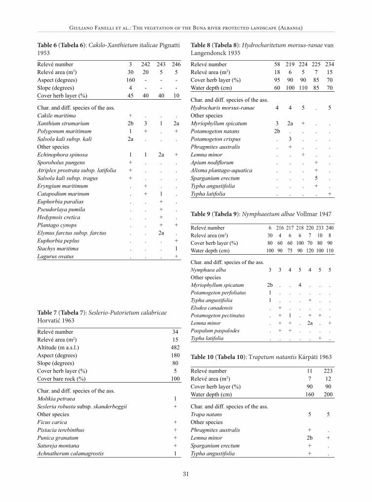
Giuliano Fanelli et al.: The vegetation of the Buna river protected landscape (Albania)
31
Table 6 (Tabela 6): Cakilo-Xanthietum italicae Pignatti 1953
Relevé number 3 242 243 246Relevé area (m2) 30 20 5 5Aspect (degrees) 160 - - -Slope (degrees) 4 - - -Cover herb layer (%) 45 40 40 10
Char. and diff. species of the ass.Cakile maritima + . . .Xanthium strumarium 2b 3 1 2aPolygonum maritimum 1 + . +Salsola kali subsp. kali 2a . . .Other speciesEchinophora spinosa 1 1 2a +Sporobolus pungens + . . .Atriplex prostrata subsp. latifolia + . . .Salsola kali subsp. tragus + . . .Eryngium maritimum . + . .Catapodium marinum . + 1 .Euphorbia paralias . . + .Pseudorlaya pumila . . + .Hedypnois cretica . . + .Plantago cynops . . + +Elymus farctus subsp. farctus . . 2a .Euphorbia peplus . . . +Stachys maritima . . . 1Lagurus ovatus . . . +
Table 7 (Tabela 7): Seslerio-Putorietum calabricae Horvatić 1963
Relevé number 34Relevé area (m2) 15Altitude (m a.s.l.) 482Aspect (degrees) 180Slope (degrees) 80Cover herb layer (%) 5Cover bare rock (%) 100
Char. and diff. species of the ass.Moltkia petraea 1Sesleria robusta subsp. skanderbeggii +Other speciesFicus carica +Pistacia terebinthus +Punica granatum +Satureja montana +Achnatherum calamagrostis 1
Table 8 (Tabela 8): Hydrocharitetum morsus-ranae van Langendonck 1935
Relevé number 58 219 224 225 234Relevé area (m2) 18 6 5 7 15Cover herb layer (%) 95 90 90 85 70Water depth (cm) 60 100 110 85 70
Char. and diff. species of the ass.Hydrocharis morsus-ranae 4 4 5 . 5Other speciesMyriophyllum spicatum 3 2a + . .Potamogeton natans 2b . . . .Potamogeton crispus . 3 . . .Phragmites australis . + . . .Lemna minor . . + . .Apium nodiflorum . . . + .Alisma plantago-aquatica . . . + .Sparganium erectum . . . 5 .Typha angustifolia . . . + .Typha latifolia . . . . +
Table 10 (Tabela 10): Trapetum natantis Kárpáti 1963
Relevé number 11 223Relevé area (m2) 7 12Cover herb layer (%) 90 90Water depth (cm) 160 200
Char. and diff. species of the ass.Trapa natans 5 5Other speciesPhragmites australis + .Lemna minor 2b +Sparganium erectum + .Typha angustifolia + .
Table 9 (Tabela 9): Nymphaeetum albae Vollmar 1947
Relevé number 6 216 217 218 220 233 240Relevé area (m2) 30 4 6 6 7 10 8Cover herb layer (%) 80 60 60 100 70 80 90Water depth (cm) 100 90 75 90 120 100 110
Char. and diff. species of the ass.Nymphaea alba 3 3 4 5 4 5 5Other speciesMyriophyllum spicatum 2b . . 4 . . .Potamogeton perfoliatus 1 . . . . . .Typha angustifolia 1 . . . + . .Elodea canadensis . + . . . . .Potamogeton pectinatus . + 1 . + + .Lemna minor . + + . 2a . +Paspalum paspalodes . + + . . . .Typha latifolia . . . . . + .

Hacquetia 15/1
32
Table 11 (Tabela 11): Potamogetonetum denso-nodosi O. de Bolòs 1957
Relevé number 84 488 489Relevé area (m2) 4 8 6Cover herb layer (%) 100 100 100Water depth (cm) 60 80 100
Char. and diff. species of the ass.Potamogeton nodosus 5 4 4Other speciesPotamogeton perfoliatus 1 + .Potamogeton crispus + . .Typha latifolia + . .Potamogeton natans . . +
Table 12 (Tabela 12): Potamogetonetum pectinati Carstensen ex Hilbig 1971
Relevé number 53 78 80 83 88 89 199Relevé area (m2) 10 15 4 5 7 30 10Cover herb layer (%) 100 100 100 100 100 100 100Water depth (cm) 100 150 200 100 300 200 150
Char. and diff. species of the ass.Potamogeton pectinatus 5 3 5 5 5 5 4Other speciesPotamogeton nodosus r . . . . . .Myriophyllum spicatum . + . . . 1 .Potamogeton perfoliatus + r 2a . . . .Potamogeton crispus . + . + . . .Elodea canadensis . . . + . . 2b
Table 13 (Tabela 13): Elodeetum canadensis Nedelcu 1967
Relevé number 87 487Relevé area (m2) 10 8Cover herb layer (%) 100 100Water depth (cm) 100 80
Char. and diff. species of the ass.Elodea canadensis 5 5Other speciesPotamogeton crispus 1 +Potamogeton natans . +
Table 14 (Tabela 14): Typhetum angustifoliae Pignatti 1953
Relevé number 8 13 221 479 480Relevé area (m2) 30 40 5 10 15Cover herb layer (%) 100 100 100 100 100
Char. and diff. species of the ass.Typha angustifolia 5 5 5 5 5Other speciesAlisma plantago-aquatica + 1 + . +Paspalum paspalodes 3 . . . .Sparganium erectum . 1 2a . .Phragmites australis . . + . .Butomus umbellatus . . . + .
Table 15 (Tabela 15): Typhetum latifoliae Nowinski 1930
Relevé number 105 109 235 244Relevé area (m2) 30 25 4 13Cover herb layer (%) 70 100 85 80
Char. and diff. species of the ass.Typha latifolia 3 5 5 5Other speciesPhragmites australis + + + .Bolboschoenus maritimus . . . +Scrophularia nodosa . . + .Baldellia ranunculoides . . + .Alisma plantago-aquatica . . + .Myriophyllum spicatum . . . +Elymus farctus subsp. farctus + . . .Tamarix africana + . . .Atriplex prostrata subsp. latifolia 2m . . .
Table 16 (Tabela 16): Phragmitetum australis Savic 1926 nom. mut. prop.
Relevé number 75 236 245 85 227 110Relevé area (m2) 15 10 10 5 6 20Cover herb layer (%) 100 100 100 95 95 100Water depth (cm) 100 50 70 40 30 80
Char. and diff. species of the ass.Phragmites australis 5 5 5 1 5 5Other speciesIris pseudacorus . . . 5 . .Scirpus lacustris . . . . . 1Bolboschoenus maritimus . . . . . +Rumex hydrolapathum . . + . . .Eupatorium cannabinum . . + . . .

Giuliano Fanelli et al.: The vegetation of the Buna river protected landscape (Albania)
33
Table 17 (Tabela 17): Scirpetum lacustris Chouard 1924
Relevé number 79 81 86Relevé area (m2) 15 6 5Cover herb layer (%) 100 100 100Water depth (cm) 50 50 30
Char. and diff. species of the ass.Scirpus lacustris 5 5 1Other speciesTypha latifolia . + .Bolboschoenus maritimus . + +Iris pseudacorus . . 5
Table 18 (Tabela 18): Glycerio-Sparganietum neglecti Koch 1926
Relevé number 59 215 228Relevé area (m2) 10 2 6Cover herb layer (%) 100 90 95Water depth (cm) 35 40 25
Char. and diff. species of the ass.Sparganium erectum 5 5 4Other speciesAlisma plantago-aquatica . + +Phragmites australis . + +Butomus umbellatus + . .Hydrocharis morsus-ranae + . .Potamogeton natans + . .Typha angustifolia + . .Scirpus lacustris + . .Oenanthe fistulosa . + .Pulicaria odora . + .Lemna minor . + .Apium nodiflorum . . 2b
Table 19 (Tabela 19): Scirpetum maritimo-litoralis (Br.-Bl. in Br.-Bl., Roussine & Nègre 1952) O. Bolòs 1962
Relevé number 1 43 237 106Relevé area (m2) 3 0 15 10Cover herb layer (%) 90 80 100 100Water depth (cm) 20 15 25 20
Char. and diff. species of the ass.Bolboschoenus maritimus 4 4 5 5Other speciesPhragmites australis + 2b . +Typha angustifolia 2a . + .Scirpus lacustris + . . .Paspalum paspalodes + . . .Alisma plantago-aquatica . . + .Agrostis stolonifera + . . .
Table 20 (Tabela 20): Scirpetum litoralis Pignatti 1953
Relevé number 481 482 44Relevé area (m2) 15 7 10Cover herb layer (%) 80 75 70
Char. and diff. species of the ass.Scirpus litoralis 4 5 4Other speciesPhragmites australis + . .Scirpus lacustris . + .
Table 21 (Tabela 21): Schoeno-Erianthetum ravennae Pignatti 1953
Relevé number 102 107 95Relevé area (m2) 40 30 30Cover herb layer (%) 90 100 100
Char. and diff. species of the ass.Erianthus ravennae 5 3 3Schoenus nigricans + + .Char. Species of upper syntaxaScirpus holoschoenus 1 . 1Sonchus maritimus . + .Aster squamatus + + +Lotus tenuis + + .Other speciesLythrum salicaria + + +Carex punctata + 3 1Inula viscosa + 1 +Centaurium spicatum . + +Pulicaria vulgaris + . +Phragmites australis + + +Juncus acutus 2m + .Amorpha fruticosa + . .Bromus hordeaceus + . .Clematis flammula . . +Cynanchum acutum . + .Equisetum arvense + . .Euphorbia paralias . . +Juncus maritimus . + .Mentha aquatica + . +Petroselinum segetum . + +Populus alba + . .Rubus ulmifolius . . +Samolus valerandi . + .Sporobolus pungens . . +Trifolium repens + . .Vulpia membranacea . . +

Hacquetia 15/1
34
Table 22 (Tabela 22): Paspalo-Agrostidetum Br.-Bl. 1936 (1952)
Relevé number 9 12 214Relevé area (m2) 5 5 5Cover herb layer (%) 100 100 90
Char. and diff. species of the ass.Paspalum paspalodes 5 5 5Other speciesPlantago major . . +Rumex conglomeratus + . .Alisma plantago-aquatica + . .Trifolium repens . . +Eleocharis palustris . . +Juncus species . . +
Table 23 (Tabela 23): Trifolio fragiferi-Cynodontetum Br.-Bl. et O. de Bolòs 1957
Relevé number 7 212 213Relevé area (m2) 2 2 2Cover herb layer (%) 98 100 100
Char. and diff. species of the ass.Trifolium fragiferum 3 2a 3Cynodon dactylon 3 5 3Other speciesMentha pulegium + + 2aPlantago lanceolata . + 1Oenanthe fistulosa + . .Matricaria chamomilla + . .Paspalum paspalodes 2a . .Plantago macrorhiza . + .Setaria viridis . + .Juncus species . + .Rumex conglomeratus . . +Potentilla reptans . . +Cirsium vulgare . . +
Table 24: Stipo-Salvietum officinalis Horvatić 1958. Spe-cies with phi-value above 0.50 (only species with a statis-tically significant affinity to a cluster according to Fish-er’s exact test with P <0.001 are included) are in bold.Tabela 24: Stipo-Salvietum officinalis Horvatić 1958. Krepko so označene vrste z phi>0,50 (vključene so sa-mo vrste, ki so statistično značilno navezane na klaster glede na Fisherjev eksaktni test, p <0,001).
Relevé number 29 73 72 62 71Relevé area (m2) 60 10 15 10 4Altitude (m a.s.l.) 144 152 138 83 125Aspect (degrees) 110 90 100 330 140Slope (degrees) 20 32 20 15 18Cover herb layer (%) 80 75 80 100 100Cover bare rock (%) 0 5 20 90 70Cover stones (%) 80 45 30 0 0
Char. and diff. species of the ass.Bupleurum veronense + + 1 + +Asperula aristata subsp. scabra + . + + +Satureja montana + . + 2a +Salvia officinalis 2b 2a + . .Convolvulus elegantissimus + + + . .Koeleria splendens . . . 2a +Leontodon crispus . . . + +Other species . . . . .Dasypyrum villosum . . + r 2mAsphodelus ramosus . 3 + 2b +Stipa bromoides + 3 4 . 2aChrysopogon gryllus + . + 3 5Micromeria juliana 1 . 1 + +Teucrium polium subsp. capitatum + . + 2a 1Avena barbata . + . + +Brachypodium distachyon 2m . . + +Petrorhagia saxifraga subsp. saxifraga + . + . +Teucrium chamaedrys + + + . .Bromus erectus + + . . .
Relevé number 29 73 72 62 71
Briza maxima . + . + .Carlina corymbosa . + 2b . .Catapodium rigidum + + . . .Eryngium amethystinum . + . 1 .Melica ciliata . + + . .Quercus trojana + . + . .Aegilops geniculata . . . + .Aethionema saxatile . + . . .Allium guttatum subsp. guttatum . . + . .Bituminaria bituminosa + . . . .Carthamus lanatus . . . . +Centaurea alba subsp. deusta . . . r .Cynosurus echinatus . + . . .Dactylis glomerata subsp. glomerata . . + . .Dactylis glomerata subsp. hispanica . + . . .Dorycnium hirsutum . . + . .Echium plantagineum 2m . . . .Erysimum repandum . + . . .Euphorbia spinosa . . . + .Festuca rupicola . . . . +Helichrysum italicum subsp. italicum . . . . +Hyparrhenia hirta . . + . .Hypericum humifusum . + . . .Hypericum perforatum subsp. veronense . . . + .Inula viscosa + . . . .Linum trigynum . . . + .Orlaya grandiflora . . . + .

Giuliano Fanelli et al.: The vegetation of the Buna river protected landscape (Albania)
35
Table 25: Asphodelo-Chrysopogonetum grylli Horva-tić 1957. Species with phi-value above 0.50 (only spe-cies with a statistically significant affinity to a cluster according to Fisher’s exact test with P <0.001 are in-cluded) are in bold.Tabela 25: Asphodelo-Chrysopogonetum grylli Horva-tić 1957. Krepko so označene vrste z phi>0,50 (vključe-ne so samo vrste, ki so statistično značilno navezane na klaster glede na Fisherjev eksaktni test, p <0,001).
Relevé number 31 30 32 33Relevé area (m2) 25 30 8 20Altitude (m a.s.l.) 353 277 483 484Aspect (degrees) 200 120 150 140Slope (degrees) 23 40 25 25Cover herb layer (%) 80 60 95 95Cover bare rock (%) 0 30 0 35Cover stones (%) 20 40 30 40
Char. and diff. species of the ass.Chrysopogon gryllus 3 3 5 4Galium lucidum + . + +Linum trigynum + + . +Helianthemum apenninum . . + +Coronilla scorpioides + . . +Other speciesTeucrium polium subsp. capitatum + . . +Stachys recta subsp. labiosa + . . .Anthemis austriaca + + . +Onosma arenaria . + . .Salvia officinalis . 2a + +Bituminaria bituminosa + . + .Brachypodium distachyon 2b + . .Convolvulus elegantissimus + . . +Dactylis glomerata subsp. glomerata + . + .Satureja montana . 1 . +Sideritis romana + . . +Stipa bromoides 1 . + .
Relevé number 31 30 32 33Aethionema saxatile + . . .Elymus elongatus . + . .Althaea hirsuta . . . +Bromus erectus + . . .Carlina corymbosa . . . +Catapodium rigidum . + . .Dorycnium herbaceum . + . .Eryngium amethystinum . + . .Linum nodiflorum . + . .Pistacia terebinthus . + . .Quercus trojana . . + .Micromeria juliana 1 . . .Scabiosa triniifolia . . + .Teucrium montanum . + . .Verbascum phlomoides + . . .
Table 26: Brachypodio-Cymbopogonetum hirti Horvatić 1961. Species with phi-value above 0.50 (only species with a statistically significant affinity to a cluster ac-cording to Fisher’s exact test with P <0.001 are includ-ed) are in bold.Tabela 26: Brachypodio-Cymbopogonetum hirti Horva-tić 1961. Krepko so označene vrste z phi>0,50 (vključe-ne so samo vrste, ki so statistično značilno navezane na klaster glede na Fisherjev eksaktni test, p <0,001).
Relevé number 67 493 69Relevé area (m2) 5 15 3Altitude (m a.s.l.) 70 90 102Aspect (degrees) 50 50 180Slope (degrees) 15 15 10Cover herb layer (%) 50 70 95Cover bare rock (%) 70 70 90Cover stones (%) 30 25 15
Char. and diff. species of the ass.Hyparrhenia hirta 2b 3 4Aethionema saxatile + + +Crupina vulgaris + +Sherardia arvensis + +Hypericum perforatum subsp. veronense + +Other speciesConvolvulus elegantissimus + +Carlina corymbosa + +Teucrium polium subsp. capitatum 2b + 1Petrorhagia saxifraga subsp. saxifraga + + +Micromeria juliana + + 2aCynosurus echinatus + +Arenaria leptoclados + +Brachypodium distachyon 2a +Anthemis austriaca +Asphodelus ramosus 1Avena barbata + + +Bromus intermedius +
Relevé number 29 73 72 62 71Paliurus spina-christi + . . . .Pistacia terebinthus + . . . .Potentilla aurea . . . . +Potentilla recta . . . + .Prunus spinosa + . . . .Sanguisorba minor subsp. muricata . . . + .Securigera cretica . . + . .Silene vulgaris subsp. vulgaris . + . . .Teucrium montanum 2m . . . .Thesium divaricatum . . . + .Tragopogon pratensis . . . + .Trifolium angustifolium . . + . .Trifolium campestre . . + . .Urospermum picroides . . . . +Verbascum phlomoides + . . . .

Hacquetia 15/1
36
Relevé number 67 493 69Bupleurum veronense +Chrysopogon gryllus +Dasypyrum villosum +Euphorbia spinosa +Phlomis fruticosa +Quercus trojana +Satureja montana +Sedum rupestre +Sideritis romana +Stachys recta subsp. recta +Thesium divaricatum +
Table 27: Salvio-Phlomidetum fruticosae Barbagallo, Brullo & Fagotto 1979. Species with phi-value above 0.50 (only species with a statistically significant affinity to a cluster according to Fisher’s exact test with P <0.001 are included) are in bold. Table 27: Salvio-Phlomidetum fruticosae Barbagallo, Brullo & Fagotto 1979. Krepko so označene vrste z phi>0,50 (vključene so samo vrste, ki so statistično značilno navezane na klaster glede na Fisherjev eksaktni test, p <0,001).
Relevé number 68 65 21 66 60 61Relevé area (m2) 20 50 50 20 70 30Altitude (m a.s.l.) 91 - - 44 -Aspect (degrees) 120 150 135 130 160 140Slope (degrees) 25 15 25 20 15 40Cover herb layer (%) 70 70 75 95 60 80Cover bare rock (%) 10 95 0 10 70 100Cover stones (%) 0 0 70 75 50 0
Char. and diff. species of the ass.Phlomis fruticosa 4 4 3 4 2b 4Stipa bromoides + + 2b + + 1Melica ciliata + . 1 . + +Micromeria juliana + . + + + .Petrorhagia saxifraga subsp. saxifraga . + + + + .Other speciesTeucrium polium subsp. capitatum . . 1 + + .Ballota macedonica + 1 . . . .Satureja calamintha . 1 . . . .Geranium pusillum + . . . . .Sideritis romana . . + 1 . .Osyris alba . . + + . .Catapodium rigidum . . + + . .Salvia officinalis . . . + + +Teucrium chamaedrys . . + + + +Satureja montana . . + . 2a +Orlaya grandiflora . . . . + +Cephalaria transylvanica . . . . + .Allium sphaerocephalon . . . . . +Brachypodium distachyon + . + + + .Aethionema saxatile . . . + + .Anthemis austriaca . . . . + +
Relevé number 68 65 21 66 60 61Briza maxima . . + . + .Dactylis glomerata subsp. glom-erata + . + . . .Phillyrea latifolia . . 1 . . +Punica granatum + . . + . .Rhus coriaria . . . . 2b +Arenaria leptoclados . . . . + .Asparagus acutifolius . . . . . +Asperula aristata subsp. scabra . . . . . +Asphodelus ramosus . + . . . .Avena barbata . . . . + .Bituminaria bituminosa . . . . . +Carex hallerana . . . . + .Carlina corymbosa + . . . . .Carthamus lanatus . . + . . .Convolvulus cantabrica . . . . . +Convolvulus elegantissimus . . . + . .Cynosurus echinatus . . + . . .Filago germanica . . . + . .Fraxinus ornus . . . . + +Linum trigynum . . . . . +Origanum vulgare . . . . . 2aPaliurus spina-christi . . + . . .Phillyrea latifolia . . . + . .Pistacia terebinthus . . . . + 1Sedum rupestre . . . . + .Sherardia arvensis . . + . . .Urospermum picroides + . . . . .
Table 28: Rhamno-Paliuretum Trinajstić 1996. Species with phi-value above 0.50 (only species with a statisti-cally significant affinity to a cluster according to Fisher’s exact test with P <0.001 are included) are in bold.Tabela 28: Rhamno-Paliuretum Trinajstić 1996. Krepko so označene vrste z phi>0,50 (vključene so samo vrste, ki so statistično značilno navezane na klaster glede na Fisherjev eksaktni test, p <0,001).
Relevé number 16 491 169Relevé area (m2) 50 15 20Altitude (m a.s.l.) 50 32 25Aspect (degrees) 20 30 -Slope (degrees) 10 5 -Cover shrub layer (%) 100 100 100Cover herb layer (%) 5 5 35Height (highest) shrubs (m) 3 3 4Height lowest shrubs (m) 1 1 1,5
Char. and diff. species of the ass.Paliurus spina-christi 5 4 3Phillyrea latifolia + 3 5Euphorbia characias + + +Clematis flammula + + +

Giuliano Fanelli et al.: The vegetation of the Buna river protected landscape (Albania)
37
Table 29: Clematido viticellae-Punicetum granatae ass. nova hoc loco. Species with phi-value above 0.50 (only species with a statistically significant affinity to a cluster according to Fisher’s exact test with P <0.001 are included) are in bold. Tabela 29: Clematido viticellae-Punicetum granatae ass. nova hoc loco. Krepko so označene vrste z phi>0,50 (vključene so samo vrste, ki so statistično značilno navezane na klaster glede na Fisherjev eksaktni test, p <0,001).
Relevé number 20 27* 28 22Relevé area (m2) 80 60 50 60Altitude (m a.s.l.) 13 - 25 18Aspect (degrees) 180 - - 120Slope (degrees) 15 - - 15Cover shrub layer (%) 90 100 100 100Cover herb layer (%) 10 20 5 60Height (highest) shrubs (m) 17 35 30 40Cover stones (%) 0 0 0 10
Char. and diff. species of the ass.Punica granatum 5 5 4 5Clematis viticella + + + .Rosa sempervirens 1 + + .Asplenium onopteris . + + +Geum urbanum + + + .Other speciesPaliurus spina-christi + 1 2b .Ruscus aculeatus . 1 1 .Viola odorata . 2a . 2bClematis flammula + + . .Carex distachya + . . +Crataegus monogyna . + 1 .Carpinus orientalis . . 2a .Catapodium rigidum + . . .Consolida ajacis . . . +Dactylis glomerata subsp. glomerata . . . 2b
Relevé number 16 491 169Bupleurum praealtum + + .Other speciesAsparagus acutifolius + + +Pistacia terebinthus . 2a 2bCarthamus lanatus + + .Rubus ulmifolius 2b 1 .Rhus coriaria . 1 +Ruscus aculeatus + . 3Scolymus hispanicus + + .Dactylis glomerata subsp. glomerata + . +Carpinus orientalis 1 . .Crataegus monogyna . . +Oenanthe pimpinelloides + . .Quercus trojana . . +
Relevé number 20 27* 28 22Hedera helix . . . +Lathyrus aphaca . . . +Buglossoides purpurocaerulea . 2a . .Phillyrea latifolia 1 . . .Phlomis fruticosa + . . .Stipa bromoides + . . .Torilis arvensis subsp. arvensis . . . +Torilis nodosa + . . .Brachypodium retusum + . . .Brachypodium sylvaticum . . . 3Bupleurum praealtum . + . .
Table 30: Carpinetum orientalis Horvat 1939. Species with phi-value above 0.50 (only species with a statistically sig-nificant affinity to a cluster according to Fisher’s exact test with P <0.001 are included) are in bold.Tabela 30: Carpinetum orientalis Horvat 1939. Krepko so označene vrste z phi>0,50 (vključene so samo vrste, ki so statistično značilno navezane na klaster glede na Fisherjev eksaktni test, p <0,001).
Relevé number 18 19 192Relevé area (m2) 80 50 100Altitude (m a.s.l.) 24 - -Aspect (degrees) - 180 -Slope (degrees) - 15 -Cover tree layer (%) 80 100 80Cover shrub layer (%) 2 90 2Cover herb layer (%) 3 10 10Cover bare rock (%) 5 0 0Height (highest) trees (m) 6 8 7Height lowest trees (m) 3 4 6Height (highest) shrubs (m) 2 2 3
Char. and diff. species of the ass.Carpinus orientalis 4 5 4Ruscus aculeatus + 2b 2bFraxinus ornus + 2a +Quercus pubescens + + .Crataegus monogyna + + .Acer campestre 2b . 2aCeltis australis + + .Other speciesHedera helix . + +Asparagus acutifolius . + +Clematis vitalba + . .Vitis vinifera subsp. sylvestris + . .Phillyrea latifolia + . .Buglossoides purpurocaerulea . + .Asplenium onopteris . + .Corylus avellana . + .Clematis flammula . + .

Hacquetia 15/1
38
Table 31: Acer monspessulanum community. Tabela 31: Združba z vrsto Acer monspessulanum.
Relevé number 26 17Relevé area (m2) 80 50Altitude (m a.s.l.) 12 16Cover tree layer (%) 50 30Cover shrub layer (%) 15 50Cover herb layer (%) 20 10Cover bare rock (%) 5 50Height (highest) trees (m) 6 5Height (highest) shrubs (m) 2,5 3
Char. and diff. species of the ass.Acer monspessulanum 3 2bPaliurus spina-christi 2a 2bPhillyrea latifolia + 2bAsparagus acutifolius + +Other speciesQuercus pubescens . 2aCarpinus orientalis 2a .Rosa sempervirens 1 .Celtis australis + .Clematis flammula + .Cruciata glabra + .Dactylis glomerata subsp. glomerata . 2bFraxinus ornus . 2aPunica granatum . +Ruscus aculeatus 2b +Salix caprea 1 .
Table 32: Quercetum trojanae Em 1958. Species with phi-value above 0.50 (only species with a statistically significant affinity to a cluster according to Fisher’s ex-act test with P <0.001 are included) are in bold.Tabela 32: Quercetum trojanae Em 1958. Krepko so označene vrste z phi>0,50 (vključene so samo vrste, ki so statistično značilno navezane na klaster glede na Fisherjev eksaktni test, p <0,001).
Relevé number 63 64 170 208Relevé area (m2) 80 20 50 90Altitude (m a.s.l.) 53 55 100 362Cover tree layer (%) 100 100 100 100Cover shrub layer (%) 3 50 0 0Cover herb layer (%) 15 60 50 70Height (highest) trees (m) 6 10 12 13Height lowest trees (m) 0 6 10 5Height (highest) shrubs (m) 4 2 3 2Height lowest shrubs (m) 1 1 0,5 0
Char. and diff. species of the ass.Quercus trojana 3 4 2a 2bQuercus petraea . 2b 4 2aDactylis glomerata subsp. aschersoniana + 2b . +Cornus sanguinea + . + +Other speciesCarpinus orientalis 4 2b 5 2bAsparagus acutifolius + 3 + .Clematis flammula + 1 + .Ruscus aculeatus 2b + 3 .Fraxinus ornus . . + 3Hedera helix . 2b 2a .Paliurus spina-christi + 1 . .Quercus pubescens + 1 . .Phillyrea latifolia . 1 . .Brachypodium sylvaticum + . . .Oenanthe pimpinelloides . + . .Dactylis glomerata subsp. glomerata . . . +Acer monspessulanum . . . +Aremonia agrimonoides . . . +Aristolochia pallida . . . +Aristolochia rotunda . . . +Buglossoides purpurocaerulea . . . 2bFestuca heterophylla . . . +Lathyrus montanus . . . +Ligustrum vulgare . . 1 .Milium effusum . . . +Origanum vulgare . . . +Pistacia terebinthus . + . .Potentilla species . . . +Quercus cerris . . 2a .Rosa sempervirens . . + .Sesleria autumnalis . . . 3Stachys scardica . . . +
Relevé number 18 19 192Acer campestre . 2a .Paliurus spina-christi . + .Tilia cordata . + .Punica granatum . + .Cornus mas . + .Fraxinus ornus . 4 .Dactylis polygama . + .Carpinus orientalis . . +Ulmus minor . . +Aristolochia pallida . . +Anemone apennina . . +Ranunculus lanuginosus . . +Rosa canina . . +Crataegus monogyna . . +Vicia tetrasperma . . +Geranium purpureum . . +Viola odorata . . 1Cornus mas . . 2bLigustrum vulgare . . 1Tamus communis . . +Luzula forsteri . . +Chaerophyllum temulentum . . +

Giuliano Fanelli et al.: The vegetation of the Buna river protected landscape (Albania)
39
Relevé number 63 64 170 208Teucrium chamaedrys . . . +Thymus pulegioides . . . +Vincetoxicum hirundinaria . . . +Viola odorata . . . 2a
Table 33: Seslerio-Ostryetum carpinifoliae Horvat & Horvatić 1950. Species with phi-value above 0.50 (only species with a statistically significant affinity to a cluster according to Fisher’s exact test with P <0.001 are included) are in bold.Tabela 33: Seslerio-Ostryetum carpinifoliae Horvat & Horvatić 1950. Krepko so označene vrste z phi>0,50 (vključene so samo vrste, ki so statistično značilno navezane na klaster glede na Fisherjev eksaktni test, p <0,001).
Relevé number 151 152 207 209 210Relevé area (m2) 100 80 100 90 90Altitude (m a.s.l.) 514 520 432 483 468Aspect (degrees) - - - 30 30Slope (degrees) - - - 4 4Cover tree layer (%) 90 80 60 90 90Cover shrub layer (%) 30 25 35 5 5Cover herb layer (%) 10 60 50 80 60Cover bare rock (%) 0 35 0 0 90Height (highest) trees (m) 9 12 12 10 12Height lowest trees (m) 8 8 8 6 10Height (highest) shrubs (m) 2 2 4 2 4Height lowest shrubs (m) 1 0,5 2 0,5 1
Char. and diff. species of the ass.Ostrya carpinifolia 5 2b 2a 5 5Sesleria autumnalis . 2a 1 4 2bViola odorata 1 2b 1 + +Ornithogalum pyrenaicum + + . + +Geum urbanum 1 2a . . +Poa trivialis subsp. sylvicola + . + . .Other speciesDactylis glomerata subsp. glomerata + 2a + + +Fraxinus ornus 2a 3 2b 2a 2bGeranium purpureum + . + + +Quercus trojana + 3 2b . +Acer monspessulanum + + . . .Cornus sanguinea . . + . +Fragaria vesca . . 2a . +Hieracium piloselloides . . . + +Melica arrecta . + + . .Milium effusum . . + . +Mycelis muralis . . + . +Poa nemoralis + 2a . . .Teucrium chamaedrys . . + + .Quercus cerris + . . . .Agrimonia eupatoria . + . . .Aremonia agrimonoides . . + . .Aristolochia pallida . . 2a . .Brachypodium sylvaticum . . 1 . .Campanula rapunculus + . . . .Carex spicata + . . . .Carpinus orientalis . . 2a . .

Hacquetia 15/1
40
Table 34: Junco-Fraxinetum angustifoliae Kárpáti I. & Kárpáti V. 1961. Species with phi-value above 0.50 (only species with a statistically significant affinity to a cluster according to Fisher’s exact test with P <0.001 are included) are in bold.Table 34: Junco-Fraxinetum angustifoliae Kárpáti I. & Kárpáti V. 1961. Krepko so označene vrste z phi>0,50 (vključene so samo vrste, ki so statistično značilno navezane na klaster glede na Fisherjev eksaktni test, p <0,001).
Relevé number 76 77 168 193 197 204 211 238Relevé area (m2) 80 70 80 90 90 110 80 100Cover tree layer (%) 90 95 75 95 95 80 90 95Cover shrub layer (%) 15 3 0 0 0 5 5 0Cover herb layer (%) 70 15 40 10 10 60 60 95Height (highest) trees (m) 14 17 10 11 11 15 15 13Height lowest trees (m) 12 13 4 5 5 4 13 4Height (highest) shrubs (m) 2 2 0 0 0 3 6 2Height lowest shrubs (m) 1 1 0 0 0 1 4 1
Char. and diff. species of the ass.Fraxinus angustifolia subsp. oxycarpa 4 5 5 5 5 5 5 5Juncus acutus + + 2b . + + + 4Iris pseudacorus + + . + + 1 1 +Carex remota 2b + . 1 + . . .Oenanthe fistulosa . . . . . + + +Other speciesAgrostis stolonifera + + . . . 3 3 2bCarex otrubae . + 2b + + . . +Mentha aquatica . + + . . + + .Samolus valerandi 1 + . . . + + .Alnus glutinosa 1 . . . . + + .Oenanthe pimpinelloides + . + . . . . +Ulmus minor . + + . . . . +Aegopodium podagraria . . . . . 2a 2a .
Relevé number 151 152 207 209 210Carya species . . + . .Clematis vitalba + . . . .Clinopodium vulgare . 2a . . .Cornus mas . + . . .Cornus sanguinea . . . . +Geranium columbinum . . + . .Hedera helix . . . . +Hieracium murorum . . . . +Platanthera bifolia . . . . +Potentilla recta . + . . .Quercus petraea . . . + .Ranunculus bulbosus . . + . .Rubus hirtus + . . . .Satureja montana . + . . .Stachys officinalis . + . . .Stachys scardica . . . + .Thalictrum aquilegifolium . . . + .Torilis arvensis subsp. arvensis . . + . .Trifolium ochroleucon . + . . .Trifolium pignantii . . . + .Veronica spicata . . 2a . .Vincetoxicum hirundinaria + . . . .

Giuliano Fanelli et al.: The vegetation of the Buna river protected landscape (Albania)
41
Relevé number 76 77 168 193 197 204 211 238Callitriche stagnalis . . . . . + + .Circaea lutetiana . . . + + . . .Cornus sanguinea . . . 2a 2b . . .Crataegus monogyna . . . 2a 2a . . .Cynanchum acutum . . . + + . . .Galium species . . . . . + + .Lycopus europaeus . . + . . . . +Lysimachia nummularia . . . + + . . .Periploca graeca . . . + + . . .Polygonum hydropiper . . . + + . . .Populus alba + . . + . . . .Potentilla reptans . . . + + . . .Ranunculus flammula . . . . . + + .Rubus ulmifolius 2b + . . . . . .Ulmus minor . . . . . + + .Veronica anagallis-aquatica . . . . . + + .Acer campestre . . . . 1 . . .Ajuga reptans + . . . . . . .Amorpha fruticosa . . . . . . . +Apium nodiflorum + . . . . . . .Berberis vulgaris . . . + . . . .Bidens tripartita . + . . . . . .Blackstonia perfoliata + . . . . . . .Carex distans . . . . . . . +Carex sylvatica . . . . + . . .Carpinus betulus . . . . + . . .Cornus sanguinea + . . + . . . .Crataegus monogyna . . . . + . . .Eupatorium cannabinum + . . . . . . .Fraxinus ornus . . . . . + . .Galium elongatum . . . . . . . +Galium rotundifolium . + . . . . . .Inula viscosa . . . . . . . +Juncus bufonius + . . . . . . .Ligustrum vulgare . . . . + . . .Limonium vulgare subsp. serotinum . . + . . . . .Lotus species . . . . . . . +Periploca graeca . + . . . . . .Polygonum hydropiper + . . . . . . .Plantago major . . . . . . . +Prunella vulgaris . + . . . . . .Prunus spinosa . . . + . . . .Pulicaria dysenterica . . . . . . . +Ranunculus arvensis . . + . . . . .Rubus ulmifolius . . + . . + 1 .Sparganium erectum . . . + . . . .Tamarix africana . . 3 . . . . .Tamus communis . . . . . . . +Ulmus minor 2b 1 + . . . . .Vincetoxicum hirundinaria . . . . . . . +Viola reichenbachiana . . . . + . . .Vitex agnus-castus . . + . . . . .Alisma plantago-aquatica . + + . . 2a 2a +
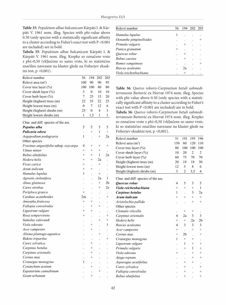
Hacquetia 15/1
42
Table 35: Populetum albae balcanicum Kárpáti I. & Kár-páti V. 1961 nom. illeg. Species with phi-value above 0.50 (only species with a statistically significant affinity to a cluster according to Fisher’s exact test with P <0.001 are included) are in bold. Tabela 35: Populetum albae balcanicum Kárpáti I. & Kárpáti V. 1961 nom. illeg. Krepko so označene vrste z phi>0,50 (vključene so samo vrste, ki so statistično značilno navezane na klaster glede na Fisherjev eksak-tni test, p <0,001).
Relevé number 56 194 202 203Relevé area (m2) 100 90 90 95Cover tree layer (%) 100 100 80 80Cover shrub layer (%) 3 0 10 10Cover herb layer (%) 7 25 15 20Height (highest) trees (m) 22 35 22 25Height lowest trees (m) 0 7 12 6Height (highest) shrubs (m) 25 0 4 3Height lowest shrubs (m) 1 1,5 1 1
Char. and diff. species of the ass.Populus alba 5 5 5 5Pulicaria odora . + 1 +Aegopodium podagraria 1 . + 2aOther speciesFraxinus angustifolia subsp. oxycarpa 4 + + +Ulmus minor + + + .Rubus ulmifolius + + 1 2aHedera helix + + 2a .Ficus carica + . + .Arum italicum + + . .Humulus lupulus 1 . + .Agrostis stolonifera . . 2a 1Alnus glutinosa . . + 2bCarex otrubae . . + 2aPeriploca graeca + . . .Carduus acanthoides 2m . . +Amorpha fruticosa + + . .Fallopia convolvulus . + + .Ligustrum vulgare + + . .Rosa sempervirens + . . +Samolus valerandi . . + +Viola odorata . + . 1Acer campestre . + . .Alisma plantago-aquatica . . + .Bidens tripartita . . . +Carex sylvatica . + . .Carpinus betulus . + . .Carpinus orientalis . + . .Cornus mas . + . .Crataegus monogyna 1 . . .Cynanchum acutum . + . .Eupatorium cannabinum . . + .Geum urbanum . + . .
Relevé number 56 194 202 203
Humulus lupulus 1 . . .Oenanthe pimpinelloides . . . +Primula vulgaris . + . .Punica granatum + . . .Quercus robur . + . .Rubus caesius . + . .Rumex sanguineus . . . +Ruscus aculeatus . 2a . .Viola reichenbachiana . + . .
Table 36: Querco roboris-Carpinetum betuli submedi-terraneum Bertović ex Horvat 1974 nom. illeg. Species with phi-value above 0.50 (only species with a statisti-cally significant affinity to a cluster according to Fisher’s exact test with P <0.001 are included) are in bold. Tabela 36: Querco roboris-Carpinetum betuli submedi-terraneum Bertović ex Horvat 1974 nom. illeg. Krepko so označene vrste z phi>0,50 (vključene so samo vrste, ki so statistično značilno navezane na klaster glede na Fisherjev eksaktni test, p <0,001).
Relevé number 51 191 195 196Relevé area (m2) 150 60 120 110Cover tree layer (%) 80 100 100 100Cover shrub layer (%) 10 20 2 2Cover herb layer (%) 60 75 70 70Height (highest) trees (m) 20 18 18 30Height lowest trees (m) 12 5 8 6Height (highest) shrubs (m) 3 2 3,5 4
Char. and diff. species of the ass.Quercus robur 4 5 3 5Viola reichenbachiana + + + 1Carpinus betulus 1 . 3 2aArum italicum + + + +Aristolochia pallida . . + +Other speciesClematis viticella . + + .Carpinus orientalis 4 2a 3 3Hedera helix + + 2a 2bRuscus aculeatus 4 3 3 3Acer campestre + . + +Cornus mas + 2b . +Crataegus monogyna 1 + + .Ligustrum vulgare . 1 + +Primula vulgaris . + 1 +Viola odorata + . + +Ajuga reptans . . + +Asparagus acutifolius . + + .Carex sylvatica . + . +Fallopia convolvulus . + . +Rubus ulmifolius . + . +

Giuliano Fanelli et al.: The vegetation of the Buna river protected landscape (Albania)
43
Relevé number 51 191 195 196Acer monspessulanum . + . .Fraxinus angustifolia subsp. oxycarpa + . . .Populus alba 2b . . .Ulmus minor . . . 1Aristolochia lutea + . . .Brachypodium sylvaticum . . + .Carex depauperata . . + .
Relevé number 51 191 195 196Carex distans + . . .Carpinus orientalis 4 . . .Clematis vitalba . . . +Dactylis glomerata . . + .Geranium purpureum . . . +Tamus communis . . . +
Table 37: Periploco graecae-Alnetum glutinosae Rudski in Horvat et al. ex Fanelli, De Sanctis, Gjeta, Mullaj, Attore ass. nova hoc loco. Species with phi-value above 0.50 (only species with a statistically significant affinity to a cluster according to Fisher’s exact test with P <0.001 are included) are in bold. Tabela 37: Periploco graecae-Alnetum glutinosae Rudski in Horvat et al. ex Fanelli, De Sanctis, Gjeta, Mullaj, At-tore ass. nova hoc loco. Krepko so označene vrste z phi>0,50 (vključene so samo vrste, ki so statistično značilno navezane na klaster glede na Fisherjev eksaktni test, p <0,001).
Relevé number 52 54 55* 200 201 230 231 232 241Relevé area (m2) 50 50 60 105 110 150 90 120 95Cover tree layer (%) 100 95 98 85 95 95 95 95 95Cover shrub layer (%) 15 10 15 60 40 10 10 2 2Cover herb layer (%) 1 35 5 5 15 50 35 3 15Height (highest) trees (m) 8 12 12 12 10 12 12 13 13Height lowest trees (m) 4 3 6 10 8 9 9 8 10Height (highest) shrubs (m) 3 3 2 3 5 2 2 0 0Height lowest shrubs (m) 1,5 2 1 1 1 1,5 1,5 0,8 1,3
Char. and diff. species of the ass.Alnus glutinosa 5 5 5 5 5 5 5 5 5Periploca graeca + + + + 2m + 1 . .Circaea lutetiana . + . + . + + . .Humulus lupulus 2m 2m + + + . . . +Cornus sanguinea . 2a 2m + 2a + + . .Ficus carica . 1 + + + . . . 2aCynanchum acutum + + . . + . . . +Other speciesRubus ulmifolius 2b 2a + 3 . 2a 2a + +Fraxinus angustifolia subsp. oxycarpa . + + + . + 2a 2a .Ulmus minor + + + . + . . + 2aBidens tripartita + . . + 1 1 2a . .Hedera helix . 2a 1 + 2a . . . +Ligustrum vulgare . + + 2a 2a . . . +Iris pseudacorus . . . + . + + + .Crataegus monogyna . 2a + + 2a . . . .Lycopus europaeus . + . . + 1 + . .Quercus robur . + + . + . . . .Mentha aquatica . . . . . + + . +Oenanthe pimpinelloides . . . . + + 2a . .Rumex sanguineus . . . . . + + + .Carex remota . . . . . . . + 2aAgrostis stolonifera . . . . 1 . + . .Alisma plantago-aquatica . . . . . + . + .Amorpha fruticosa 1 . . + . . . . .Apium nodiflorum . . . . . + 1 . .

Hacquetia 15/1
44
Relevé number 52 54 55* 200 201 230 231 232 241Carex spicata . . . . . + + . .Carex distans . + . . + . . . .Carex otrubae . . . . . 3 . + .Carex species . . . + . . + . .Fallopia convolvulus . . . + + . . . .Galium elongatum . . . . . + + . .Polygonum hydropiper . . . . . + + . .Salix alba . + . + . . . . .Vitis vinifera . . . . . + + . .Arum italicum . . . . + . . . .Carduus acanthoides . . + . . . . . .Carex sylvatica . . . . . . . . +Clematis vitalba . + . . . . . . .Clematis viticella . . . . 1 . . . .Cornus mas . . . . . . . . +Cynanchum acutum . . . . + . . . .Galium debile . . . . + . . . .Geum urbanum . 2a . . . . . . .Buglossoides purpurocaerulea . + . . . . . . .Lysimachia nummularia . . . . . + . . .Poa nemoralis . . . . . + . . .Potentilla reptans . . . . . . + . .Prunella vulgaris . . . . . + . . .Rosa sempervirens . . . . + . . . .Samolus valerandi . . . . . . . + .Vincetoxicum canescens . . . . . + . . .Vincetoxicum hirundinaria . . . . . . + . .Viola reichenbachiana . + . . . . . . .
Table 38 (Tabela 38): Vitici-Tamaricetum africanae Horvatić 1960.
Relevé number 23 40 104 112Relevé area (m2) 80 15 25 30Cover shrub layer (%) 75 95 90 75Cover herb layer (%) 75 2 0 45Height (highest) shrubs (m) 5 3 5 3Height lowest shrubs (m) 2 0 0 2
Char. and diff. species of the ass.Tamarix africana 4 5 5 4Vitex agnus-chastus + . . +Atriplex prostrata subsp. latifolia + + . +Other speciesAster tripolium + . . .Juncus acutus 4 . . +Phragmites australis + . + .Cladonia portentosa + . . .Elymus athericus + . . .Limonium vulgare subsp. serotinum . + . 3Salsola soda . . . +Polypogon monspeliensis . . . +
Table 39 (Tabela 39): Bromo villosi-Haynaldietum villosae Pignatti 1953.
Relevé number 49 50Relevé area (m2) 8 3Altitude (m a.s.l.) 330 -Slope (degrees) 5 -Cover herb layer (%) 60 80
Char. and diff. species of the ass.Dasypyrum villosum 1 4Bromus madritensis + +Vulpia membranacea + +Vulpia myuros 2a +Kochia prostrata + +Aegilops triuncialis 1 +
Relevé number 23 40 104 112Crypsis aculeata . . . 1Suaeda species . . . +Elymus farctus subsp. farctus . . . +Bolboschoenus maritimus . . . +

Giuliano Fanelli et al.: The vegetation of the Buna river protected landscape (Albania)
45
Table 40 (Tabela 40): Centaureetum calcitrapae Fanelli & Menegoni 1997.
Relevé number 24 25 490Relevé area (m2) 80 0 10Altitude (m a.s.l.) - - -Cover herb layer (%) 100 100 90
Char. and diff. species of the ass.Centaurea calcitrapa 5 . 4Scolymus hispanicus 2a 5 1Rumex pulcher + . +Other speciesBromus hordeaceus + + .Avena barbata . + +Anthemis austriaca 2m . +Filago germanica 2m . +Matricaria disciformis 2m . +Vicia villosa subsp. eriocarpa . + +Cichorium intybus . + .Carduus acanthoides + . .Vulpia ciliata + . +Hordeum hystrix + . .Cynodon dactylon + . .Trifolium campestre . . +Trifolium scabrum . . +Agrostis stolonifera . . +
Relevé number 49 50Other speciesMedicago minima 1 2aLagurus ovatus + 1Lepidium graminifolium . +Sisymbrium officinale . +Carduus pycnocephalus . +Vicia villosa subsp. eriocarpa + .Avena barbata + .Trifolium scabrum 1 1Daucus carota 2b .Lolium perenne + +Briza maxima + +Bromus rigidus + .Bromus tectorum + .Salsola soda . +Verbascum banaticum . +Scolymus hispanicus . +Bromus hordeaceus . +Cynodon dactylon . +
Table 41: Asphodelus ramosus community. Tabela 41: Združba z vrsto Asphodelus ramosus.
Relevé number 15 70 492Relevé area (m2) 5 2 8Altitude (m a.s.l.) - 125 50Aspect (degrees) 40 60 50Slope (degrees) 3 10 5Cover herb layer (%) 90 70 60Cover bare rock (%) 0 35 0Cover stones (%) 40 70 40
Char. and diff. species of the ass.Asphodelus ramosus 4 3 3Carthamus lanatus + + .Catapodium rigidum + + +Nigella arvensis . + +Other speciesTeucrium polium subsp. capitatum 2b 2b 2aSideritis romana + + +Petrorhagia saxifraga subsp. saxifraga 1 + +Crepis zacintha + + .Arenaria leptoclados 2m . 1Sedum hispanicum + . +Bupleurum veronense 1 + .Medicago praecox + . +Trifolium scabrum 1 . +Daucus aureus 1 . +Centaurea solstitialis 1 . 1Crepis foetida + . +Aegilops geniculata + . .Avena barbata + . +Filago gallica + . +Melica ciliata . + +Brachypodium distachyon . + +Dasypyrum villosum . 1 +Carex distachya . + +Micromeria juliana . + +Asperula aristata subsp. condensata 1 . .Anthemis austriaca + . .Carlina corymbosa + . .Rostraria cristata + . .Bothriochloa ischaemum + . .Medicago minima . + .Trifolium campestre . + .Eryngium amethystinum . + .Satureja montana . + .Helichrysum italicum subsp. italicum . + .Dactylis glomerata subsp. glomerata . + .Gastridium ventricosum . + .Chrysopogon gryllus . + .Sanguisorba minor subsp. muricata . + .Plantago bellardii . + .Carya cordiformis . . +Sanguisorba minor subsp. muricata . . +Trifolium campestre . . +

Hacquetia 15/1
46
Table 42 (Tabela 42): Carduetum acanthoidis Felföldy 1942.
Relevé number 10 14Relevé area (m2) 15 20Cover herb layer (%) 100 100
Char. and diff. species of the ass.Carduus acanthoides 5 4Cirsium italicum + 2bCirsium vulgare + +Other speciesCirsium vulgare + +Galega officinalis + +Medicago lupulina + +Rumex conglomeratus + +Convolvulus arvensis + +Agrostis stolonifera + +Potentilla reptans + .Euphorbia platyphyllos + .Daucus carota + .Galium elongatum + .Scolymus hispanicus + .Phragmites australis + .Satureja calamintha + .Paspalum paspalodes + .Atriplex patula . +Prunella vulgaris . +