Rock Art, Landscape and Prehistoric Settlement at the High Atlas (Morocco)
8
Transcript of Rock Art, Landscape and Prehistoric Settlement at the High Atlas (Morocco)


CAA2010
Fusion of Cultures
Proceedings of the 38th Annual Conference on Computer Applications and Quantitative Methods in Archaeology,
Granada, Spain, April 2010
Edited by
F. ContrerasM. Farjas
F. J. Melero
BAR International Series 2494
2013
Published by
Archaeopress
Publishers of Briish Archaeological ReportsGordon House
276 Banbury RoadOxford OX2 7ED
www.archaeopress.com
BAR S2494
CAA2010: Fusion of Cultures. Proceedings of the 38th Annual Conference on Computer Applicaions and Quanitaive Methods in Archaeology, Granada, Spain, April 2010
© Archaeopress and the individual authors 2013
ISBN 978 1 4073 1108 1
Printed in England by CMP (UK) Ltd
All BAR itles are available from:
Hadrian Books Ltd122 Banbury RoadOxford
OX2 7BP
Englandwww.hadrianbooks.co.uk
The current BAR catalogue with details of all itles in print, prices and means of payment is available free from Hadrian Books or may be downloaded from www.archaeopress.com
Proceedings of the 38th Annual Conference on Computer Applications and Quantitative Methods in Archaeology, CAA2010 F. Contreras, M. Farjas and F.J. Melero (eds.)
Rock Art, Landscape and Prehistoric Settlement
at the High Atlas (Morocco)
Ruiz-Gálvez, M.1, Bokbot, Y.
2, Collado, H.
3, ElGraoui, M.4, Farjas, M.5, Galán, E.6, Lemjidi, A.2,
Nieto, C.1, de la Presa, P.5, de Torres, J.1, Señoran, J.M.7
1 Facultad de Geografía e Historia. Departamento de Prehistoria. Universidad Complutense de Madrid2 INSAP, Rabat
3 Council of Extremadura’s Heritage, Mérida4 Centre National du Art Rupestre, Marrakech
5 E.T.S.I. Topografía, Geodesia y Cartografía. Universidad Politécnica de Madrid6 Archaeological National Museum, Madrid
7 Incipit. CSIC. Santiago de Compostela
[email protected], [email protected], [email protected], [email protected], [email protected],
[email protected], [email protected], [email protected], [email protected]
This project focuses on the rock art area of Oukaïmeden, at the High Atlas (Morocco), under the scope of the so-
called Landscape Archaeology. From an archaeological perspective, landscapes are composed of a number of per
ceptible and measurable elements, among which there are a number of relationships. In this project we aim to un
derstand the way these elements are connected and the way by which human beings inscribe their own culture on it.
To this end we rely on Geographical Information System methodologies. With these methodologies, land cover, mo
bility between the valleys, pathways, cost surface, visibilities, sunstroke etc. will be analyzed to find out whether
there are relevant connections between art and critical resources of the territory, as pasturages, water, routes of ac
cess, etc.
Keywords: Landscape archaeology, Rock Art, GIS, Pathways, Cost Surface, Visibility
1. Introduction
Landscape Archaeology aims to study the perception,
not only physical but emotional, that human beings have
regarding the space they are moving in and the way
they inscribe on it their own culture and experiences of
being in the World in a phenomenological sense
(HEIDEGGER, 2003). Therefore we can say that there
are as many landscapes as socioeconomic organizations,
and they differ from each other depending on the pattern
of economy, social structure, and material and mental
(rational) control of their physical surroundings.
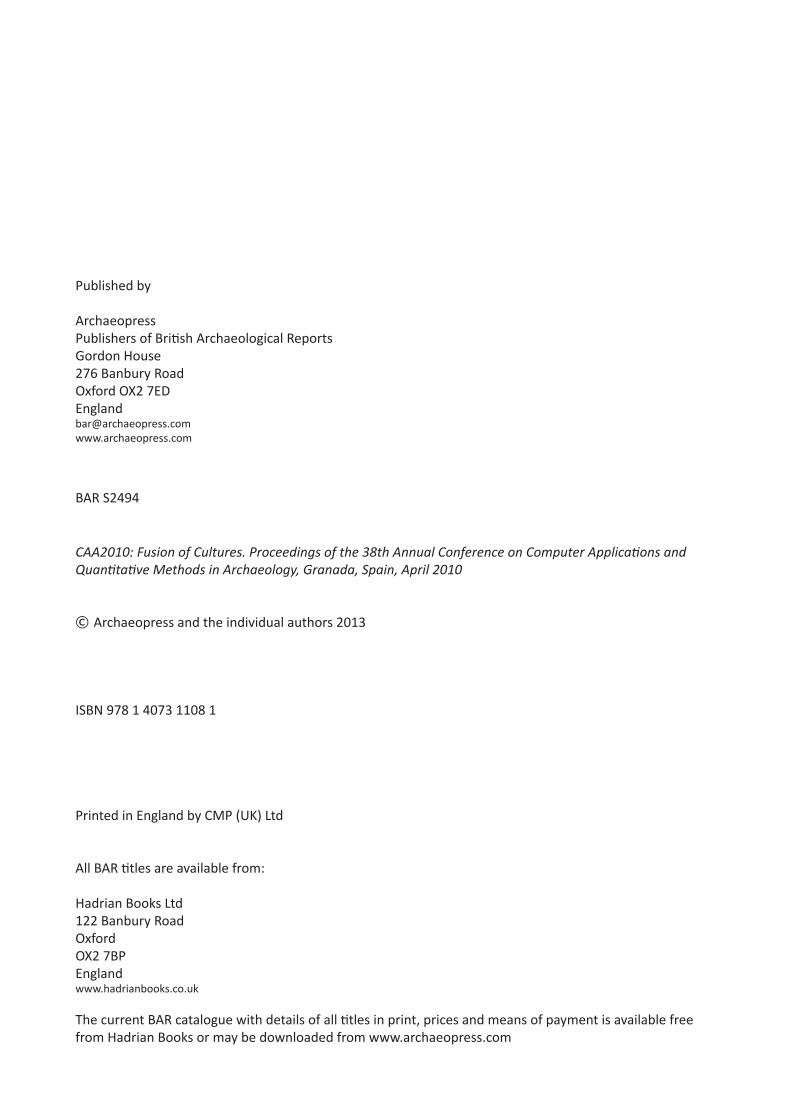
This project focuses on the rock art in the area of
Oukaïmeden, a high valley 80 km south of Marrakech,
located at 2630 m. above sea level (Figure 1).
Historical records from 16th century AD onwards
describe the exploitation of the previously mentioned
area as summer pasturage exclusively by two tribes
proceeding from the villages of the Rerhaya valley to the
West and the Ourika valley to the East (MAHDI, 1999;
FRANCHI, 2005). The hypothesis we want to test is that
the prehistoric rock art of the area is connected with a
seasonal but regular occupation of the valley that started
in the Middle Holocene period (Sub boreal), i.e. 6000
BP, when the climatic conditions of seasonality started
and differences in climate and vegetative growth
justified the periodic movements between the valley and
the mountain (see ALIFRIQUI, 2002). In that sense, the
rock art could have served as a kind of mental map,
conveying information both on sacred and profane
matters, as entrances, resources, rights of access and/or
prohibitions.
To test ours ideas we are developing a field study
including GPS positioning of archaeological and rock
art sites, digging, 14C, and archeobotanical sampling
and landscape modelling by means of GIS.
We offer to discuss some first results on the GIS
appliance devoted to modelling the Oukaïmeden rock art
landscape.
GIS Application (Short Paper)
Figure 1: View of the study area.
287
M. Ruíz Gálvez et al. / Rock Art, Landscape and Prehistoric Settlement at the High Atlas (Morocco)
2. Background of archaeological knowledge in
the High Atlas region
Research on Oukaïmeden rock art started in 1949 and
since then works continued on and off until a general
Corpus was produced by Malhome in 1959. Nowadays
the Centre National de Patrimoine Rupestre (SALIH et
al., 1998) is in charge of the research, being responsible
for testing pits in the area. At the moment it has only
provided one 14C dating result for the rock art area,
dated to the beginning of the first millennium B. C.
(GRAOUI et al., 2008).
3. Getting Data
To carry out our analysis we needed several kinds of
cartography, in order to generate a DEM (Digital
Elevation Model), and archaeological data. The first
problem we encountered was the absolute lack of
cartographic information; there was no cartography of
the area studied. So, how to get the topographical
information needed? We examined all the possibilities
and finally found in the Global DEM the solution to this.
By examining and studying all the Global DEM
available, we concluded that the most appropriate
method for our investigation was the ASTER-GDEM.
Which has 1 arc-second (30 m) grid of elevation
postings.
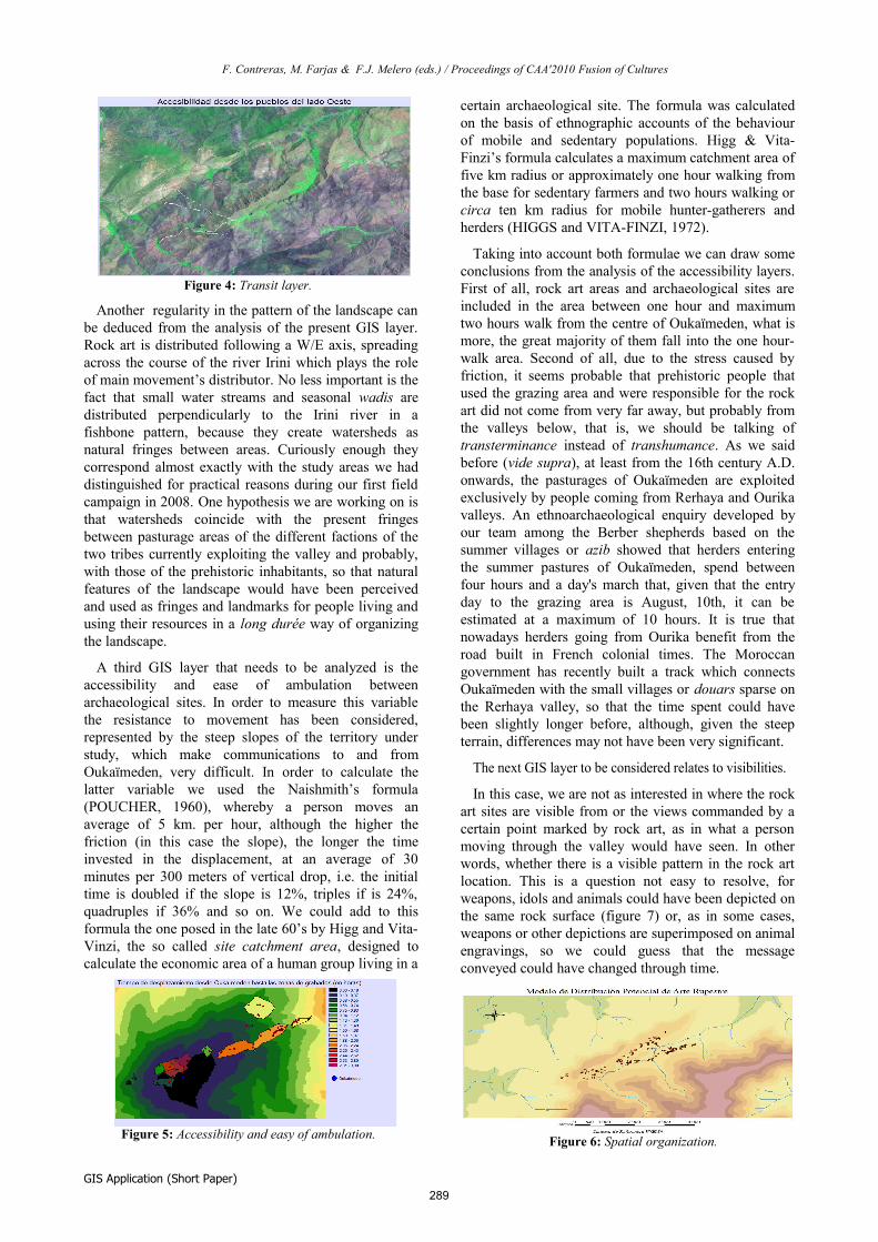
To acquire thematic cartography regarding the land
cover, we used the Classification of Remotely Sensed
Imagery. And we worked with Thematic Mapper
images. Our team used GPS to place the location of
archaeological sites and rock art stations and developed
a database (Figure 2).
4. Analysis
Accessibility
To study the mobility patterns, we first developed a
friction surface based on the strong slopes which
represent the resistance to travelling from one pixel to
its nearest neighbor. In order to create a magnitude of
friction surface it was required to assign friction values
to slope values through an empirically derived equation.
Then we calculated a cost surface using an anisotropic
function based on the direction of the movement and the
friction surface. Those frictions that vary in strength
depending on the direction of movement are known as
anisotropic frictions.
Pathway
Once a cost surface has been created using an
anisotropic function, a pathway tool determined the
least-cost route between any designated cell or group of
cells.
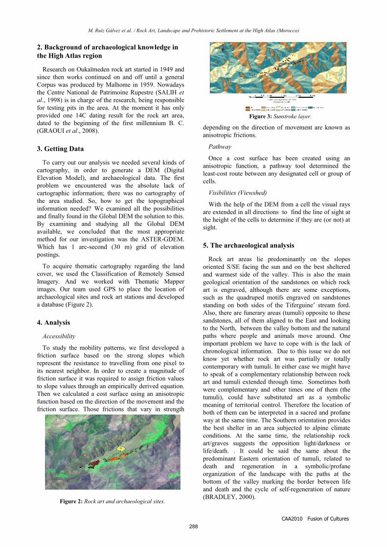
Visibilities (Viewshed)
With the help of the DEM from a cell the visual rays
are extended in all directions to find the line of sight at
the height of the cells to determine if they are (or not) at
sight.
5. The archaeological analysis
Rock art areas lie predominantly on the slopes
oriented S/SE facing the sun and on the best sheltered
and warmest side of the valley. This is also the main
geological orientation of the sandstones on which rock
art is engraved, although there are some exceptions,
such as the quadruped motifs engraved on sandstones
standing on both sides of the Tiferguine’ stream ford.
Also, there are funerary areas (tumuli) opposite to these
sandstones, all of them aligned to the East and looking
to the North, between the valley bottom and the natural
paths where people and animals move around. One
important problem we have to cope with is the lack of
chronological information. Due to this issue we do not
know yet whether rock art was partially or totally
contemporary with tumuli. In either case we might have
to speak of a complementary relationship between rock
art and tumuli extended through time. Sometimes both
were complementary and other times one of them (the
tumuli), could have substituted art as a symbolic
meaning of territorial control. Therefore the location of
both of them can be interpreted in a sacred and profane
way at the same time. The Southern orientation provides
the best shelter in an area subjected to alpine climate
conditions. At the same time, the relationship rock
art/graves suggests the opposition light/darkness or
life/death. . It could be said the same about the
predominant Eastern orientation of tumuli, related to
death and regeneration in a symbolic/profane
organization of the landscape with the paths at the
bottom of the valley marking the border between life
and death and the cycle of self-regeneration of nature
(BRADLEY, 2000).
CAA2010 Fusion of Cultures
Figure 3: Sunstroke layer.
Figure 2: Rock art and archaeological sites.
288
F. Contreras, M. Farjas & F.J. Melero (eds.) / Proceedings of CAA'2010 Fusion of Cultures
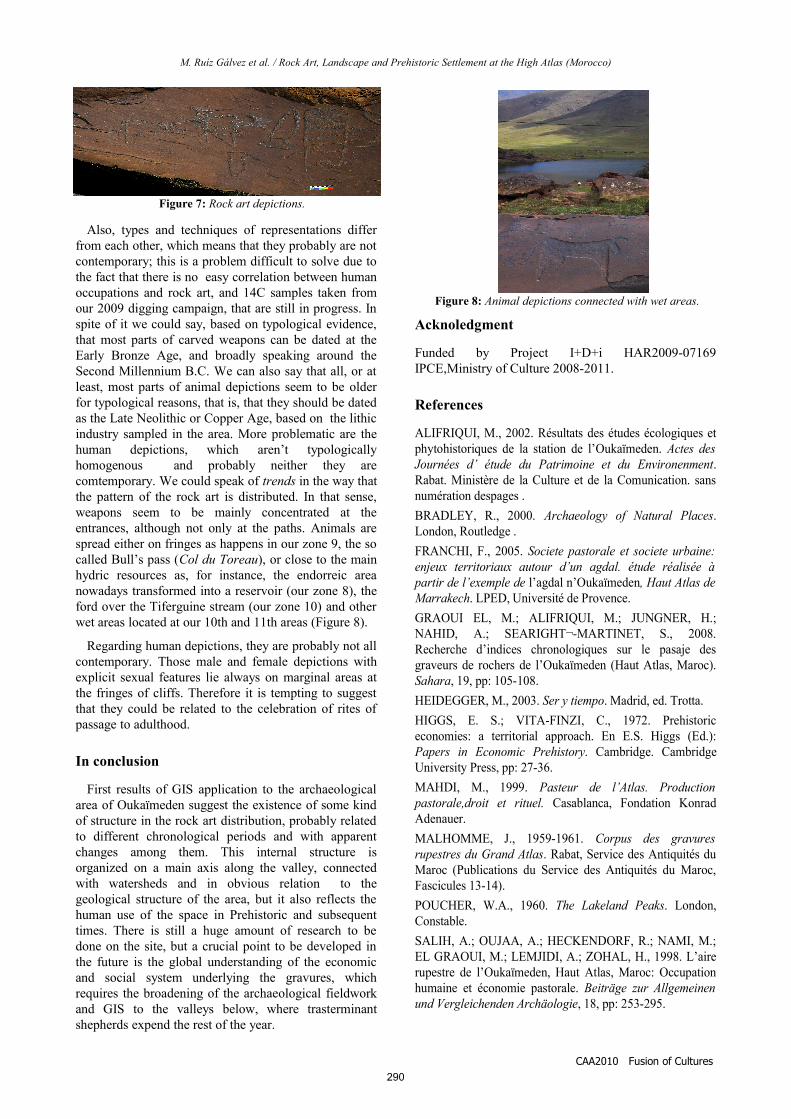
Another regularity in the pattern of the landscape can
be deduced from the analysis of the present GIS layer.
Rock art is distributed following a W/E axis, spreading
across the course of the river Irini which plays the role
of main movement’s distributor. No less important is the
fact that small water streams and seasonal wadis are
distributed perpendicularly to the Irini river in a
fishbone pattern, because they create watersheds as
natural fringes between areas. Curiously enough they
correspond almost exactly with the study areas we had
distinguished for practical reasons during our first field
campaign in 2008. One hypothesis we are working on is
that watersheds coincide with the present fringes
between pasturage areas of the different factions of the
two tribes currently exploiting the valley and probably,
with those of the prehistoric inhabitants, so that natural
features of the landscape would have been perceived
and used as fringes and landmarks for people living and
using their resources in a long durée way of organizing
the landscape.
A third GIS layer that needs to be analyzed is the
accessibility and ease of ambulation between
archaeological sites. In order to measure this variable
the resistance to movement has been considered,
represented by the steep slopes of the territory under
study, which make communications to and from
Oukaïmeden, very difficult. In order to calculate the
latter variable we used the Naishmith’s formula
(POUCHER, 1960), whereby a person moves an
average of 5 km. per hour, although the higher the
friction (in this case the slope), the longer the time
invested in the displacement, at an average of 30
minutes per 300 meters of vertical drop, i.e. the initial
time is doubled if the slope is 12%, triples if is 24%,
quadruples if 36% and so on. We could add to this
formula the one posed in the late 60’s by Higg and Vita-
Vinzi, the so called site catchment area, designed to
calculate the economic area of a human group living in a
certain archaeological site. The formula was calculated
on the basis of ethnographic accounts of the behaviour
of mobile and sedentary populations. Higg & Vita-
Finzi’s formula calculates a maximum catchment area of
five km radius or approximately one hour walking from
the base for sedentary farmers and two hours walking or
circa ten km radius for mobile hunter-gatherers and
herders (HIGGS and VITA-FINZI, 1972).
Taking into account both formulae we can draw some
conclusions from the analysis of the accessibility layers.
First of all, rock art areas and archaeological sites are
included in the area between one hour and maximum
two hours walk from the centre of Oukaïmeden, what is
more, the great majority of them fall into the one hour-
walk area. Second of all, due to the stress caused by
friction, it seems probable that prehistoric people that
used the grazing area and were responsible for the rock
art did not come from very far away, but probably from
the valleys below, that is, we should be talking of
transterminance instead of transhumance. As we said
before (vide supra), at least from the 16th century A.D.
onwards, the pasturages of Oukaïmeden are exploited
exclusively by people coming from Rerhaya and Ourika
valleys. An ethnoarchaeological enquiry developed by
our team among the Berber shepherds based on the
summer villages or azib showed that herders entering
the summer pastures of Oukaïmeden, spend between
four hours and a day's march that, given that the entry
day to the grazing area is August, 10th, it can be
estimated at a maximum of 10 hours. It is true that
nowadays herders going from Ourika benefit from the
road built in French colonial times. The Moroccan
government has recently built a track which connects
Oukaïmeden with the small villages or douars sparse on
the Rerhaya valley, so that the time spent could have
been slightly longer before, although, given the steep
terrain, differences may not have been very significant.
The next GIS layer to be considered relates to visibilities.
In this case, we are not as interested in where the rock
art sites are visible from or the views commanded by a
certain point marked by rock art, as in what a person
moving through the valley would have seen. In other
words, whether there is a visible pattern in the rock art
location. This is a question not easy to resolve, for
weapons, idols and animals could have been depicted on
the same rock surface (figure 7) or, as in some cases,
weapons or other depictions are superimposed on animal
engravings, so we could guess that the message
conveyed could have changed through time.
GIS Application (Short Paper)
Figure 6: Spatial organization.
Figure 4: Transit layer.
Figure 5: Accessibility and easy of ambulation.
289
M. Ruíz Gálvez et al. / Rock Art, Landscape and Prehistoric Settlement at the High Atlas (Morocco)
Also, types and techniques of representations differ
from each other, which means that they probably are not
contemporary; this is a problem difficult to solve due to
the fact that there is no easy correlation between human
occupations and rock art, and 14C samples taken from
our 2009 digging campaign, that are still in progress. In
spite of it we could say, based on typological evidence,
that most parts of carved weapons can be dated at the
Early Bronze Age, and broadly speaking around the
Second Millennium B.C. We can also say that all, or at
least, most parts of animal depictions seem to be older
for typological reasons, that is, that they should be dated
as the Late Neolithic or Copper Age, based on the lithic
industry sampled in the area. More problematic are the
human depictions, which aren’t typologically
homogenous and probably neither they are
comtemporary. We could speak of trends in the way that
the pattern of the rock art is distributed. In that sense,
weapons seem to be mainly concentrated at the
entrances, although not only at the paths. Animals are
spread either on fringes as happens in our zone 9, the so
called Bull’s pass (Col du Toreau), or close to the main
hydric resources as, for instance, the endorreic area
nowadays transformed into a reservoir (our zone 8), the
ford over the Tiferguine stream (our zone 10) and other
wet areas located at our 10th and 11th areas (Figure 8).
Regarding human depictions, they are probably not all
contemporary. Those male and female depictions with
explicit sexual features lie always on marginal areas at
the fringes of cliffs. Therefore it is tempting to suggest
that they could be related to the celebration of rites of
passage to adulthood.
In conclusion
First results of GIS application to the archaeological
area of Oukaïmeden suggest the existence of some kind
of structure in the rock art distribution, probably related
to different chronological periods and with apparent
changes among them. This internal structure is
organized on a main axis along the valley, connected
with watersheds and in obvious relation to the
geological structure of the area, but it also reflects the
human use of the space in Prehistoric and subsequent
times. There is still a huge amount of research to be
done on the site, but a crucial point to be developed in
the future is the global understanding of the economic
and social system underlying the gravures, which
requires the broadening of the archaeological fieldwork
and GIS to the valleys below, where trasterminant
shepherds expend the rest of the year.
Acknoledgment
Funded by Project I+D+i HAR2009-07169
IPCE,Ministry of Culture 2008-2011.
References
ALIFRIQUI, M., 2002. Résultats des études écologiques et
phytohistoriques de la station de l’Oukaïmeden. Actes des
Journées d’ étude du Patrimoine et du Environenment.
Rabat. Ministère de la Culture et de la Comunication. sans
numération despages .
BRADLEY, R., 2000. Archaeology of Natural Places.
London, Routledge .
FRANCHI, F., 2005. Societe pastorale et societe urbaine:
enjeux territoriaux autour d’un agdal. étude réalisée à
partir de l’exemple de l’agdal n’Oukaïmeden, Haut Atlas de
Marrakech. LPED, Université de Provence.
GRAOUI EL, M.; ALIFRIQUI, M.; JUNGNER, H.;
NAHID, A.; SEARIGHT¬-MARTINET, S., 2008.
Recherche d’indices chronologiques sur le pasaje des
graveurs de rochers de l’Oukaïmeden (Haut Atlas, Maroc).
Sahara, 19, pp: 105-108.
HEIDEGGER, M., 2003. Ser y tiempo. Madrid, ed. Trotta.
HIGGS, E. S.; VITA-FINZI, C., 1972. Prehistoric
economies: a territorial approach. En E.S. Higgs (Ed.):
Papers in Economic Prehistory. Cambridge. Cambridge
University Press, pp: 27-36.
MAHDI, M., 1999. Pasteur de l’Atlas. Production
pastorale,droit et rituel. Casablanca, Fondation Konrad
Adenauer.
MALHOMME, J., 1959-1961. Corpus des gravures
rupestres du Grand Atlas. Rabat, Service des Antiquités du
Maroc (Publications du Service des Antiquités du Maroc,
Fascicules 13-14).
POUCHER, W.A., 1960. The Lakeland Peaks. London,
Constable.
SALIH, A.; OUJAA, A.; HECKENDORF, R.; NAMI, M.;
EL GRAOUI, M.; LEMJIDI, A.; ZOHAL, H., 1998. L’aire
rupestre de l’Oukaïmeden, Haut Atlas, Maroc: Occupation
humaine et économie pastorale. Beiträge zur Allgemeinen
und Vergleichenden Archäologie, 18, pp: 253-295.
CAA2010 Fusion of Cultures
Figure 7: Rock art depictions.
Figure 8: Animal depictions connected with wet areas.
290


![[Prehistoric America] - ScienceViews.com](https://static.fdokumen.com/doc/165x107/6333b0f7a6138719eb0abae5/prehistoric-america-scienceviewscom.jpg)