mapping of prehistoric sites
29
GIS 1 * 2 3 4 1 - 2 - 3 - 4 - 8 / 3 / 91 25 / 9 / 91 123 . GIS SPSS Excel . ) 500 4500 . ) ( ) ( . : GIS . * Email: [email protected]
Transcript of mapping of prehistoric sites

GIS
1* 2 3 4
1- 2- 3- 4-
: 8/3/91 : 25/9/91
123
. GIS SPSS Excel
.
) (
500 4500 .
) (
) (
.
: GIS.
: * Email: [email protected]
_________________________ ...
110
1 -
.
) 1388: 19( .
.
.
.
.
.
123 )
1383: 31( . - -

- ____________________ 4 1391
111
1 2
3
) 1380: 202(
.
.
)(Schmidt et al., 2009; Gilmore et al., 2011; Maghsoudi et al., 2012. 4 )2011: 583(
.
.
500 -1000 .
.
.
1 . Demorgan 2. Schmidt 3. Broun 4. Schmidt

_________________________ ...
112
)Gillmore
et al., 2011: 285.(
1
.
: 1 -
)8 ( -
)3 ( 2 -
3 - .
123 ) 1383 :197.( 2 )2009: 49(
.
.
14
. )2011: 22(
-
.
1. Luminescence 2. Gillmore

- ____________________ 4 1391
113
.
. 1383
.
)31 2006: Fazeli & Schmidt,(.
2 - 1 :
.
50 49 53 12
35 17 36 31
16291 )1.(
) 1.(
.
.
1 .
.

_________________________ ...
114
) 1365: 6( .
.
.
250 ) 1385:
176(.
) 1385: 169.(
:
245 ) 1376: 388.(
140
.
) 1311: 321(.
.
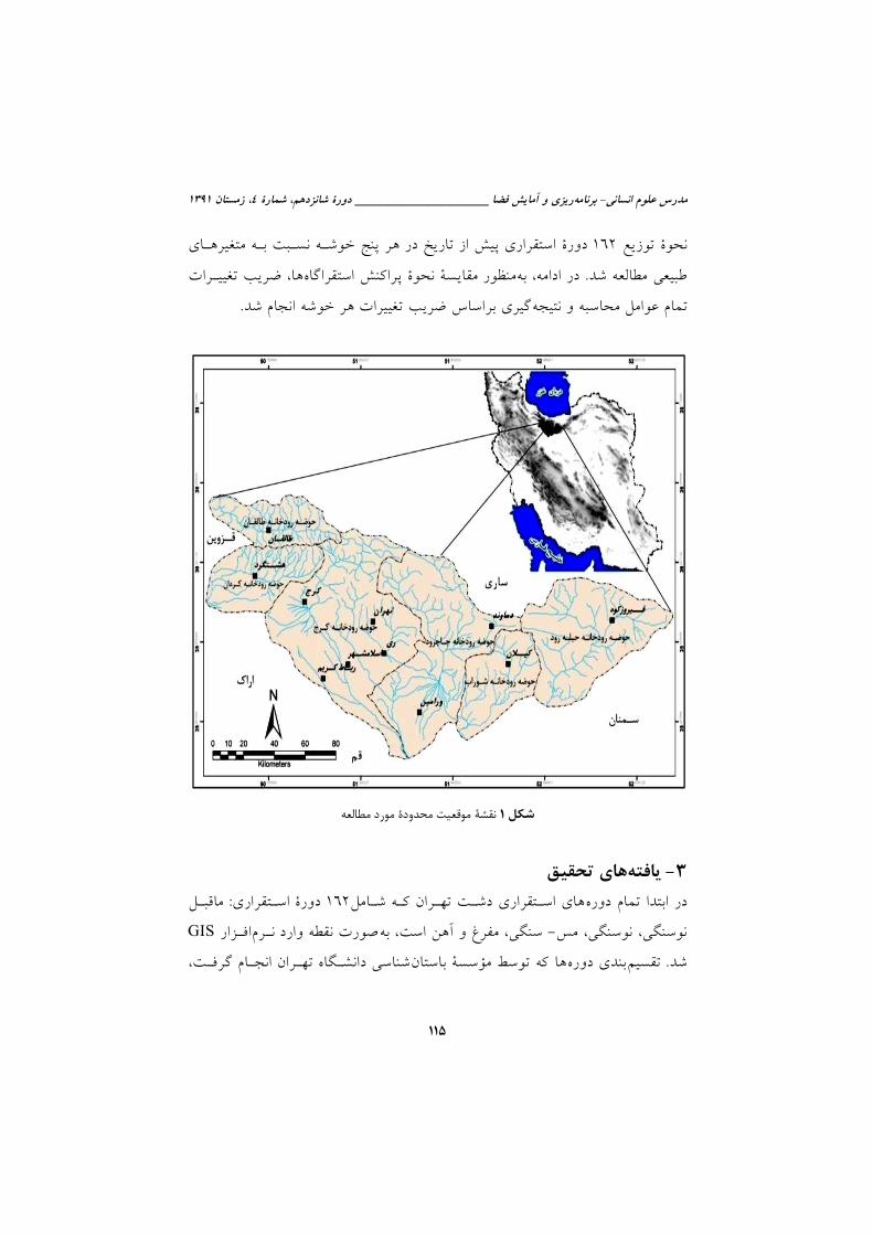
162
- .
GIS. -
)
(
.
.
SPSS . GIS
- ____________________ 4 1391
115
162
.
.
1
3- 162 :
- GIS
.

_________________________ ...
116
.
) ( .
1:25000
.
.
89
162 -
. .1
:
1 - :
.
250 ) 1385: 176(.
) 1385: 169( .
) 1377: 9(.
1.
.

- ____________________ 4 1391
117
) 1385 .(
59.9 16
7 6
4.9 4.8 0.62
.
)2(.
2

_________________________ ...
118
2- :
. ) 98
60 (
)1384 :122( .
( ) - -
) .
( .
.
.
) 1387 :39(.
7.41
.6.8
.

- ____________________ 4 1391
119
6.4
4.93 .
2
.
3- :
-
.
) 1387: 56.(
.
35.8 0- 500 18.5
500- 1000 10.49 1000- 1500 9.87
2000- 25000 8.6 2500- 3000 6.8
4500 5.55 1500- 2000 2.47 4000- 4500
1.23 3500- 4000 1 3000- 3500
) 3.(

_________________________ ...
120
3
4- :
.
) 1365: 6( .
10 .
79.6 0- 5 11.7 5- 10
5.56 10- 15
2 ) 1.(

- ____________________ 4 1391
121
1
...
0_5 23 77 4 40 2 12.5 27 96.4 3 50 70 97.22 129 79.62
5_10 7 23 4 40 4 25 1 3.57 2 33 1 1.4 19 11.72
10_15 0 0 1 10 7 43.8 0 0 1 17 0 0 9 5.55
15_20 0 0 0 0 2 12.5 0 0 0 0 0 0 2 1.23
20_25 0 0 0 0 1 6.25 0 0 0 0 0 0 1 0.61
25_30 0 0 1 10 0 0 0 0 0 0 0 0 1 0.61
30-35 0 0 0 0 0 0 0 0 0 0 0 0 0 0
35_40 0 0 0 0 0 0 0 0 0 0 1 0 1 0.61
40_45 0 0 0 0 0 0 0 0 0 0 0 0 0 0
> 45 0 0 0 0 0 0 0 0 0 0 0 0 0 0
30 100 10 100 16 100 28 100 6 100 72 100 162 100
5- :
800 4500 .
- -
. 53.7
1000- 1500 17.9
796- 1000 14.19 1500- 2000 11.72
2000- 2500 3 2500- 3000
3 ) 4.(

_________________________ ...
122
4
6 - : .
.
. 40 .
)
1369: 47( . 58.6
19.8
78
) 5(.

- ____________________ 4 1391
123
5
7 - :
.
.
56 91
30.2 49 8.1
3.1 1.9
) 6.(

_________________________ ...
124
6
4-
. ) (
.
.
.
162

- ____________________ 4 1391
125
.
.
.
) 1384: 553.(
:
: :1 0 -)2(1 -)2(3 -5 -7 -13 -15 -17 -
24 -26 -30 -31 -)2(32 -33 -)2(34 -)2(36 -40 -42- )2(43 -44 -46 -47)2( - )2(49- )2(50 -)2(52 -53 - )2(54 -55 -)2(56 - 57 -)2(58 - )2(66 - )2(69 - )2(70 - )2(71 - 72 - 78 -)2(83 -)2(85 -90 -)2(91 -92 -93 -)2(97 -)2(101 -102 -)2(104 -108 -112 -113 -)2(114 -119 -
120 -121 - 127 - 129. 79 48.76
.
0.93 .
)7(. 25
26 39.2
) 4.(
) (
.
) 2002: 8.(
1 . .

_________________________ ...
126
796 -1500
0 -5 .
.
.
.
: 7 -11 -)2(14 -25 -28 -35 -37 -45 -51 -60 -76 -77 -86 -)2(94 -)2(96 -98 -109 - )2(111 -)2(115 -)2(116 -117 -125 -131 . 29
17.9 .1.24
.
.
.
10.34 6.9 - 13.8
65.2 .
)4.( 1000 -2000 .
0 -10
.
.
. 500 1500
.

- ____________________ 4 1391
127
: 2 -6 -18 -19 -20 -21 -23 -48 -64 -110 .
10 6.17 .
1.64
) (
- )4(.
2500 1000
15 -25 .
.
.
500 1000
1000 .
: )2(8 -10 -)2(12 -)2(22 -29 -38 -39 -)2(61 -65 -67 -73-)2(74 -81 -)2(89 -99 -105 -)2(106 -107 -122 . 26
16.04 .1.39
. 30.77
11.5 - 46.15
. 15 25
2000 -2500 .
.

_________________________ ...
128
.
.
: 4 -9 -16 -27 -42 -62 -63 -68 -75 -79 -82 -87 -88 -
95 -100 -103 -118 -126 . 18 11.11
.1.21
.
15 -35 .
.
) 2002 :8( .
.
)
1387: 86.(
) 1370: 126(.
2000 -3500 .
.
.
.

- ____________________ 4 1391
129
1000
500 .
7
162
.
Excel .
.
.
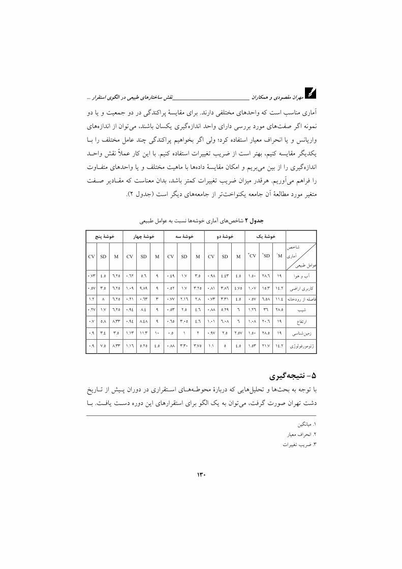
. )C.V (
.
_________________________ ...
130
.
.
.
) 2.(
2
M1 SD2 CV3 M SD CV M SD CV M SD CV M SD CV
19 28.6 1.50 4.5 4.43 0.98 3.5 1.7 0.49 9 5.6 0.62 6.25 4.5 0.73
14.2 15.3 1.07 4.75 3.86 0.81 3.25 1.7 0.52 9 9.89 1.09 6.25 3.5 0.57
11.4 6.58 0.57 4.5 3.31 0.73 2.8 2.16 0.77 3 0.63 0.21 6.25 8 1.2
28.5 36 1.26 6 5.29 0.88 4.6 2.5 0.53 9 8.4 0.94 6.25 1.7 0.27
19 20.6 1.08 6 6.08 1.01 4.6 3.05 0.65 9 8.48 0.94 8.33 5.8 0.7
19 28.5 1.50 2.57 2.5 0.97 2 1 0.5 10 11.3 1.13 3.5 3.4 0.9
14.2 21.7 1.53 4.5 5 1.1 3.75 3.30 0.88 4.5 5.25 1.16 8.33 7.5 0.9
5-
.
1 .
2 .
3 .

- ____________________ 4 1391
131
.
:
.
) (
.
)
(
500 4500
.
.
.

_________________________ ...
132
- -
500
.
. -
-
- -
.
6- :
1369.
2 1376.
» «
503 90-111 1389.
»
« 76 176
1385 .
1 2 : 1384.
» «
1388.
1385.

- ____________________ 4 1391
133
» 1380«
1-20 1380.
» 1383«
1 2 31-44 1383.
» «
197-215 1380.
] :[ 1384.
: 1370.
] : [ 1311.
-
1377 1 : 1377.
1387. Bakhtiari, S., Complete Atlas of Tehran, Gitashenasi Geographical &
Cartographic Institute, Tehran, 2006.
Fazeli & Schmidt, Tape Ghabristan: Geophysical Survey Report, J.
Humanities, Vol. 13(3), Pp. 31-49, 2006.
Fazeli, H., R.E. Donahue & R.A.E. Coningham, "Stone Tool Production,
Distribution and use during the late Neolithic and Chalcolithic on the
Tehran plain, Iran", IRAN 40, Pp. 1-14, 2002.
Gillmore, G.K., T. Stevens, J.P. Buylaert, R.A.E. Coninghamm, C. Batt,
H. Fazeli, R. Young & M. Maghsoudi, "Geoarchaeology and the Value of
Multidisciplinary Palaeoenvironmental Approaches: A case Study from
the Tehran Plaine, Iran", Geoarchaeology and Multidisciplinarity, Pp. 49-
67, 2011.

_________________________ ...
134
Gillmore, G.K., R.A.E. Coningham, H. Fazeli, R.L. Young, M.
Magshoudi, C.M. Batt, G. Rushworth, "Irrigation on the Tehran Plain,
Iran: Tepe Pardis- The Site of a Possible Neolithic Irrigation Feature?",
Catena, Vol. 78, Pp. 280- 300, 2009.
Gillmore, G.K., R.A.E. Coningham, R. Young, H. Fazeli, G. Rushworth,
R. Donahue And C.M. Batt, Holocene Alluvial Sediments Of the Tehran
Plain: Sedimentation and Archaeological Site Visibility, Chapter Tree, Pp.
37-68, 2004.
Quigley, M., M. Fattahi, R. Sohbati, A. Schmidt, "Palaeoseismicity and
Pottery: Investigating Earthquake and Archaeological Chronologies on
the Hajiarab Alluvial fan, Iran", Quaternary International 242, Pp. 185-
195, 2011.
Schmidt, A., M. Quigley, M. Fattahi, G. Azizi, M. Maghsoudi, R. Sohbati
& H. Fazeli, "Holocene Settlement Shifts and Palaeoenvironments on the
Central Iranian Plateau: Investigating Linked Systems", The Holocene,
Vol. 21(4), Pp. 583-595, 2001.
Schmidt, A. & H. Fazeli, "Tape Ghabristan: A Chacolithic Tell Buried in
Alluvium", Archaeological Prospection, 14, Pp. 38-46, 2007.

- ____________________ 4 1391
135
Introduction The studied area is Tehran Plain. This area include 123 prehistoric ancient sites .Although a lot of archaeological research in Tehran plain is but in the case of physical structures and natural sight settlement, researches have been little. This research intends to consider impact any physical factor on the location of settlement. Materials and Methods The data in this study consist of 162 periods of prehistoric settlements belongs to the period: the Pre-Neolithic, Neolithic, Chalcolithic,
Bronze and Iron. Method used in this research is cluster analysis methods, via SPSS software and irying to understand the distribution pattern of these ancient area to physical factor as:height, climate, distance from the river, slope, land use and geology. also to understand how the distribution settlements to physical structure ,by Excel software coefficient of variation is calculated. Result and Discussion Study area using topographic maps and the mountain ridge was divided into six catchment and try to be closed basin where the majority of settlements in its place. After investigation it was found that the greatest period settlements is owned by the Karaj river basin and After the Jajrod, Kordan, Taleghan, Firuzkoh and Shoorab, are next in category, also from all the settlement periods of highest settlements belong to the Iron Age settlement period with 89 of total 162 then after are the Neolithic, Chalcolithic and Bronze. Settlement pre-Neolithic are also included only two cases in the Tehran Plain. Also, by dividing the area into 5 clusters , it was found that sites divided into five groups were heterogeneous in terms of mathematical, because of that it is different environmental conditions in the study area. Cluster one (plain areas) make up the largest group in number .After that, the clusters tow are which is foothills region and Semi-mountainous and mountainous areas there are a few site and coefficient of variation for each cluster are different because physical conditions.
Conclusion. Distribution of ancient sites to physical structure obtained by calculating the coefficient of variation and led to the following conclusions:
However, water resources, with the favorable conditions, settlements have been caused on your side but low coefficient of variation sites than the distance from the river showed that the sites have not focused on a specific distance from the river and according to the high the dense located sites on

_________________________ ...
136
the alluvial fan that it is shown by the high coefficient of variation this hypothesis is strength: Although water resources are major factors in the development of settlement but, the water channels on the alluvial fans are and the most important their characteristics has been movement and mobility because of flood or earthquake. So settlements pattern is determined by fans.So that they repeatedly change direction and because of their constant movement on the surface of the alluvial fan cause successive settlements have been. Also, the study cluster 5, which are located in mountainous areas shows that: Many sites at distances less than 500 meters from the river formed linearly. This is shown by the high coefficient of variation of the distance from the river. Important factor in establishing settlements in these areas is suitable slope.
keywords: Keywords: Physical structure, settlement pattern, prehistory, Tehran Plain, GIS

- ____________________ 4 1391
137
Study on the role of physical structures in the settlement pattern of prehistoric sites of Tehran Plain Using GIS
M.Maghsoudi11, M.Zamanzadeh2, H.Fazeli3, S.Chezgheh4
1- Associate professor of physical geography., University of Tehran,
Tehran, Iran 2- Assistant professor of physical geography., University of Tehran,
Tehran, Iran 3- Associate professor of Archeology , University of Tehran, Tehran,
Iran 4- M.Sc. student of geomorphology, University of Tehran, Tehran, Iran
Abstract: There are more than 123 ancient sites in Tehran Plain. This research
intends to via metod cluster analysis and calculation coefficient of variation (C.V) also by GIS, SPSS and Excel softwares studied to distribution pattern of ancient sites to the physical structures of the zone including: height, weather, distance from the river, slope, geology, land use and geomorphology factores.The analysis clear that at lower parts of the case study includes areas of plains and foothills (clusters one and two), the lowest coefficient of variation (C.V) is belongs to the distance from the river, In other words, the high concentration sites is not at any distance from the river, and many sites at different distances from the river have been switching places. also geomorphology factor of the coefficient of variation (C.V) is high, indicating a high concentration of sites on the fan alluvial and this shows that the pattern of settlements, are more influenced fans because fans are everywhere, the focus settlements is too, and settlements have formed radially and move to the upper basin ancient sites formed linearly at distances closer to the river (as the cluster five and four) and suitable slope factores in these areas is cause settlement.
Keywords: natural structure, settlement pattern, prehistory, Tehran Plain, GIS
1Corresponding Author's E- mail: [email protected]


![[Prehistoric America] - ScienceViews.com](https://static.fdokumen.com/doc/165x107/6333b0f7a6138719eb0abae5/prehistoric-america-scienceviewscom.jpg)