Remote Sensing Technology Institute
192
-
Upload
khangminh22 -
Category
Documents
-
view
0 -
download
0
Transcript of Remote Sensing Technology Institute


II
Remote Sensing Technology Institute
Institut für Methodik der Fernerkundung
Status Report 2007 – 2013
III
Remote Sensing Technology Institute
Institut für Methodik der Fernerkundung
Status Report 2007 – 2013
IV
Bilder über „Kopf- und Fußzeile „hin-terlegen“
Foreword
Earth Observation Center Mission and Expertise ...................................................................................... 2 Allocation of Tasks ........................................................................................... 4 User Services .................................................................................................... 5 Program........................................................................................................... 5 Locations and Structure ................................................................................... 5
National and International Context .................................................................. 6
National ........................................................................................................... 6 Europe ............................................................................................................. 7 International .................................................................................................... 7
Important Earth Observation Missions ............................................................. 9
National and DLR Missions ............................................................................... 9 ESA and EUMETSAT Missions ........................................................................ 15 International Missions .................................................................................... 21
System Developments ...................................................................................... 26
SAR-Lab/GENESIS – Processing SAR Data ....................................................... 26 CATENA – Processing Optical Data ................................................................ 26 UPAS – Processing Atmospheric Data ............................................................ 27 GCAPS – Processing Atmospheric Sensor Data .............................................. 27 DIMS – Data and Information Management .................................................. 28 GeoFarm – Processing Infrastructure .............................................................. 28 UKis – Environmental and Crisis Information Systems .................................... 29 Software Engineering .................................................................................... 29
User Services ..................................................................................................... 31
Center for Satellite Based Crisis Information (ZKI) .......................................... 31 World Data Center for Remote Sensing of the Atmosphere (WDC-RSAT) ...... 31 German Satellite Data Archive (D-SDA) .......................................................... 32 Optical Airborne Remote Sensing and Calibration Home Base (OpAiRS) ........ 33
Central Services ................................................................................................. 34
IT Management ............................................................................................. 34 Quality Management ..................................................................................... 35 Controlling .................................................................................................... 35 Science Visualization ...................................................................................... 36 Web Services ................................................................................................. 36
Content
Remote Sensing Technology Institute Introduction ...................................................................................................... 40
IMF Overview ................................................................................................. 40 Structure of this Report ................................................................................. 43
Synthetic Aperture Radar Missions and Sensors ....................................................................................... 46
TerraSAR-X .................................................................................................... 46 TanDEM-X ..................................................................................................... 46 TerraSAR-X Follow-on and Tandem-L ............................................................ 49
Generic Processing Systems ............................................................................. 49
SAR-Lab/GENESIS .......................................................................................... 49
Methods and Applications ............................................................................... 50
SAR Processing .............................................................................................. 51 SAR Interferometry ........................................................................................ 52 SAR Tomography ........................................................................................... 54 High Resolution SAR Simulation .................................................................... 56 Bistatic InSAR Methods for TanDEM-X Processing .......................................... 57 Glacier Dynamics from TerraSAR-X and TanDEM-X Data ............................... 59 Geohazards ................................................................................................... 59 Imaging Geodesy ........................................................................................... 62 Traffic Measurement with TerraSAR-X and TanDEM-X ................................... 63 Maritime SAR Applications ............................................................................ 64 Image Information Mining ............................................................................. 66
Optical Imaging Missions, Sensors and Systems ....................................................................... 70
EnMAP .......................................................................................................... 70 ALOS-PRISM, -AVNIR ..................................................................................... 72 Cartosat-1 (IRS-P5) ........................................................................................ 72 Hyperspectral Camera HySpex ....................................................................... 73 ‘3K‘ Real-time Camera System ....................................................................... 73 Infrared Wildlife Finder .................................................................................. 74
V
Bilder über „Kopf- und Fußzeile „hin-terlegen“
Foreword
Earth Observation Center Mission and Expertise ...................................................................................... 2 Allocation of Tasks ........................................................................................... 4 User Services .................................................................................................... 5 Program........................................................................................................... 5 Locations and Structure ................................................................................... 5
National and International Context .................................................................. 6
National ........................................................................................................... 6 Europe ............................................................................................................. 7 International .................................................................................................... 7
Important Earth Observation Missions ............................................................. 9
National and DLR Missions ............................................................................... 9 ESA and EUMETSAT Missions ........................................................................ 15 International Missions .................................................................................... 21
System Developments ...................................................................................... 26
SAR-Lab/GENESIS – Processing SAR Data ....................................................... 26 CATENA – Processing Optical Data ................................................................ 26 UPAS – Processing Atmospheric Data ............................................................ 27 GCAPS – Processing Atmospheric Sensor Data .............................................. 27 DIMS – Data and Information Management .................................................. 28 GeoFarm – Processing Infrastructure .............................................................. 28 UKis – Environmental and Crisis Information Systems .................................... 29 Software Engineering .................................................................................... 29
User Services ..................................................................................................... 31
Center for Satellite Based Crisis Information (ZKI) .......................................... 31 World Data Center for Remote Sensing of the Atmosphere (WDC-RSAT) ...... 31 German Satellite Data Archive (D-SDA) .......................................................... 32 Optical Airborne Remote Sensing and Calibration Home Base (OpAiRS) ........ 33
Central Services ................................................................................................. 34
IT Management ............................................................................................. 34 Quality Management ..................................................................................... 35 Controlling .................................................................................................... 35 Science Visualization ...................................................................................... 36 Web Services ................................................................................................. 36
Content
Remote Sensing Technology Institute Introduction ...................................................................................................... 40
IMF Overview ................................................................................................. 40 Structure of this Report ................................................................................. 43
Synthetic Aperture Radar Missions and Sensors ....................................................................................... 46
TerraSAR-X .................................................................................................... 46 TanDEM-X ..................................................................................................... 46 TerraSAR-X Follow-on and Tandem-L ............................................................ 49
Generic Processing Systems ............................................................................. 49
SAR-Lab/GENESIS .......................................................................................... 49
Methods and Applications ............................................................................... 50
SAR Processing .............................................................................................. 51 SAR Interferometry ........................................................................................ 52 SAR Tomography ........................................................................................... 54 High Resolution SAR Simulation .................................................................... 56 Bistatic InSAR Methods for TanDEM-X Processing .......................................... 57 Glacier Dynamics from TerraSAR-X and TanDEM-X Data ............................... 59 Geohazards ................................................................................................... 59 Imaging Geodesy ........................................................................................... 62 Traffic Measurement with TerraSAR-X and TanDEM-X ................................... 63 Maritime SAR Applications ............................................................................ 64 Image Information Mining ............................................................................. 66
Optical Imaging Missions, Sensors and Systems ....................................................................... 70
EnMAP .......................................................................................................... 70 ALOS-PRISM, -AVNIR ..................................................................................... 72 Cartosat-1 (IRS-P5) ........................................................................................ 72 Hyperspectral Camera HySpex ....................................................................... 73 ‘3K‘ Real-time Camera System ....................................................................... 73 Infrared Wildlife Finder .................................................................................. 74
VI
Generic Processing Systems ............................................................................. 75
XDibias .......................................................................................................... 75 CATENA ........................................................................................................ 75
Methods and Applications ............................................................................... 77
Calibration Methods ...................................................................................... 77 Orthorectification .......................................................................................... 79 DSM Generation ............................................................................................ 79 Hyperspectral Methods .................................................................................. 84 Optic/SAR Data Fusion ................................................................................... 85 Optical Water Remote Sensing ...................................................................... 86 Real-time Airborne Remote Sensing ............................................................... 88 Infrared Scene Simulation .............................................................................. 90
Spectrometric Sounding of the Atmosphere Missions and Sensors ....................................................................................... 92
ENVISAT/SCIAMACHY ................................................................................... 92 ERS-2/GOME ................................................................................................. 95 MetOp/GOME-2 ............................................................................................ 95 Sentinel-5 Precursor ....................................................................................... 95 Sentinel-4 and -5, CarbonSat ......................................................................... 96 ADM-Aeolus .................................................................................................. 97 MERLIN .......................................................................................................... 97 ENVISAT/MIPAS ............................................................................................. 98 TELIS .............................................................................................................. 98
Generic Processing Systems ............................................................................. 99
Universal Processor for Atmospheric Sensors – UPAS ..................................... 99 Generic Calibration Processing System – GCAPS .......................................... 100
Methods and Applications ............................................................................. 101
Sensor Calibration Algorithms ..................................................................... 101 Radiative Transfer ........................................................................................ 102 Inversion and Retrieval ................................................................................. 104 Electromagnetic Scattering .......................................................................... 106 Spectroscopic References ............................................................................. 107 Long-term Observation of Ozone ................................................................. 108 Volcanic Sulphur Dioxide from Space ........................................................... 109 Tropospheric Nitrogen Dioxide and Air Quality ............................................ 110 Atmospheres of Exoplanets ......................................................................... 112
Documentation Teaching and Education ................................................................................. 116
Lectures at Technische Universität München (TUM) ..................................... 116 Lectures at other Universities ....................................................................... 119 Non University Courses and Tutorials ........................................................... 120 Internal Seminar Series ................................................................................ 121 In-House Interns and Trainees ...................................................................... 121
Academic Degrees .......................................................................................... 122
Professorship Appointments ........................................................................ 122 Habilitations and Venia Legendi ................................................................... 122 Doctoral Theses ........................................................................................... 122 Diploma/Master/Bachelor Theses ................................................................. 128
Scientific Exchange ......................................................................................... 134
Guest Scientists ........................................................................................... 134 Professional Leaves ...................................................................................... 135
Conferences ..................................................................................................... 136
Patents ............................................................................................................. 137
Filed Patent Applications .............................................................................. 137 Granted Patents .......................................................................................... 138
Awards ............................................................................................................ 140
Publications ..................................................................................................... 143
Publications in ISI or Scopus Journals ........................................................... 143 Other Publications with Full Paper Review .................................................... 153 Books .......................................................................................................... 156 Book Contributions ..................................................................................... 157 Other Publications ....................................................................................... 159
Acronyms and Abbreviations ........................................................................ 176
VII
Generic Processing Systems ............................................................................. 75
XDibias .......................................................................................................... 75 CATENA ........................................................................................................ 75
Methods and Applications ............................................................................... 77
Calibration Methods ...................................................................................... 77 Orthorectification .......................................................................................... 79 DSM Generation ............................................................................................ 79 Hyperspectral Methods .................................................................................. 84 Optic/SAR Data Fusion ................................................................................... 85 Optical Water Remote Sensing ...................................................................... 86 Real-time Airborne Remote Sensing ............................................................... 88 Infrared Scene Simulation .............................................................................. 90
Spectrometric Sounding of the Atmosphere Missions and Sensors ....................................................................................... 92
ENVISAT/SCIAMACHY ................................................................................... 92 ERS-2/GOME ................................................................................................. 95 MetOp/GOME-2 ............................................................................................ 95 Sentinel-5 Precursor ....................................................................................... 95 Sentinel-4 and -5, CarbonSat ......................................................................... 96 ADM-Aeolus .................................................................................................. 97 MERLIN .......................................................................................................... 97 ENVISAT/MIPAS ............................................................................................. 98 TELIS .............................................................................................................. 98
Generic Processing Systems ............................................................................. 99
Universal Processor for Atmospheric Sensors – UPAS ..................................... 99 Generic Calibration Processing System – GCAPS .......................................... 100
Methods and Applications ............................................................................. 101
Sensor Calibration Algorithms ..................................................................... 101 Radiative Transfer ........................................................................................ 102 Inversion and Retrieval ................................................................................. 104 Electromagnetic Scattering .......................................................................... 106 Spectroscopic References ............................................................................. 107 Long-term Observation of Ozone ................................................................. 108 Volcanic Sulphur Dioxide from Space ........................................................... 109 Tropospheric Nitrogen Dioxide and Air Quality ............................................ 110 Atmospheres of Exoplanets ......................................................................... 112
Documentation Teaching and Education ................................................................................. 116
Lectures at Technische Universität München (TUM) ..................................... 116 Lectures at other Universities ....................................................................... 119 Non University Courses and Tutorials ........................................................... 120 Internal Seminar Series ................................................................................ 121 In-House Interns and Trainees ...................................................................... 121
Academic Degrees .......................................................................................... 122
Professorship Appointments ........................................................................ 122 Habilitations and Venia Legendi ................................................................... 122 Doctoral Theses ........................................................................................... 122 Diploma/Master/Bachelor Theses ................................................................. 128
Scientific Exchange ......................................................................................... 134
Guest Scientists ........................................................................................... 134 Professional Leaves ...................................................................................... 135
Conferences ..................................................................................................... 136
Patents ............................................................................................................. 137
Filed Patent Applications .............................................................................. 137 Granted Patents .......................................................................................... 138
Awards ............................................................................................................ 140
Publications ..................................................................................................... 143
Publications in ISI or Scopus Journals ........................................................... 143 Other Publications with Full Paper Review .................................................... 153 Books .......................................................................................................... 156 Book Contributions ..................................................................................... 157 Other Publications ....................................................................................... 159
Acronyms and Abbreviations ........................................................................ 176

VIII
Bilder über „Kopf- und Fußzeile „hinterlegen“
The Remote Sensing Technology Institute (IMF) was founded in 2000. Together with the German Remote Sensing Data Center (DFD) it forms DLR’s Earth Obser-vation Center (EOC), the largest German institution devoted to Earth remote sens-ing. This IMF status report has been writ-ten in preparation for the second evalua-tion of EOC. It details for the scientific and engineering achievements of the in-stitute in the period from 2007 until mid-2013. Many of the projects described have been jointly executed by IMF and DFD employing efficient task sharing.
In the almost seven years reporting peri-od remote sensing has undergone a dy-namic development. National satellite missions have been and are being im-plemented together with industry; new mission concepts have been conceived (e.g. Tandem-L). Services for a wide user community have been developed within the framework of the European Coperni-cus program; with the first satellites of its Sentinel fleet soon to be launched.
Our mission is the extraction of geo-physical variables, geoinformation and knowledge from remote sensing data for scientific, commercial, societal and politi-cal users – but also for our own scientific projects. To this goal we develop algo-rithms and operational processing sys-tems.
IMF’s scientists and engineers have con-tributed to many missions that were at the forefront of remote sensing technol-ogy. They developed and are developing processing algorithms and systems for TerraSAR-X, TanDEM-X, EnMAP, ENVISAT/SCIAMACHY, MetOp/GOME-2, ADM-Aeolus and Cartosat – to name just a few. Their expertise in information re-trieval from radar, optical, spectrometric and lidar data as well as their dedication to professional system implementation are widely appreciated. Today our portfo-lio is characterized by our involvement in almost every national and many Europe-an and international missions – an excit-ing perspective for the next decade.
The results presented in this report have been achieved by IMF scientists and en-gineers, supported by technical and ad-ministrative staff, to all of whom I express my sincere gratitude. Many have contrib-uted to the preparation of this docu-ment. I am particularly indebted to the editorial core team, Dr. Peter Haschberger, Dr. Ramon Brcic, Dr. Manfred Gottwald, Sandra Hilbig, Nils Sparwasser and our Controlling depart-ment. Finally, I would like to thank all of our partners, customers and funding or-ganizations for their cooperation and support during the last seven years.
This report is structured as follows: The next chapter (identical in the IMF and the DFD reports) provides a brief introduction to EOC together with a description of EO missions and system developments that are relevant to both IMF and DFD. The main part of the report focuses to the achievements of IMF.
Enjoy reading this report!
Oberpfaffenhofen, September 2013
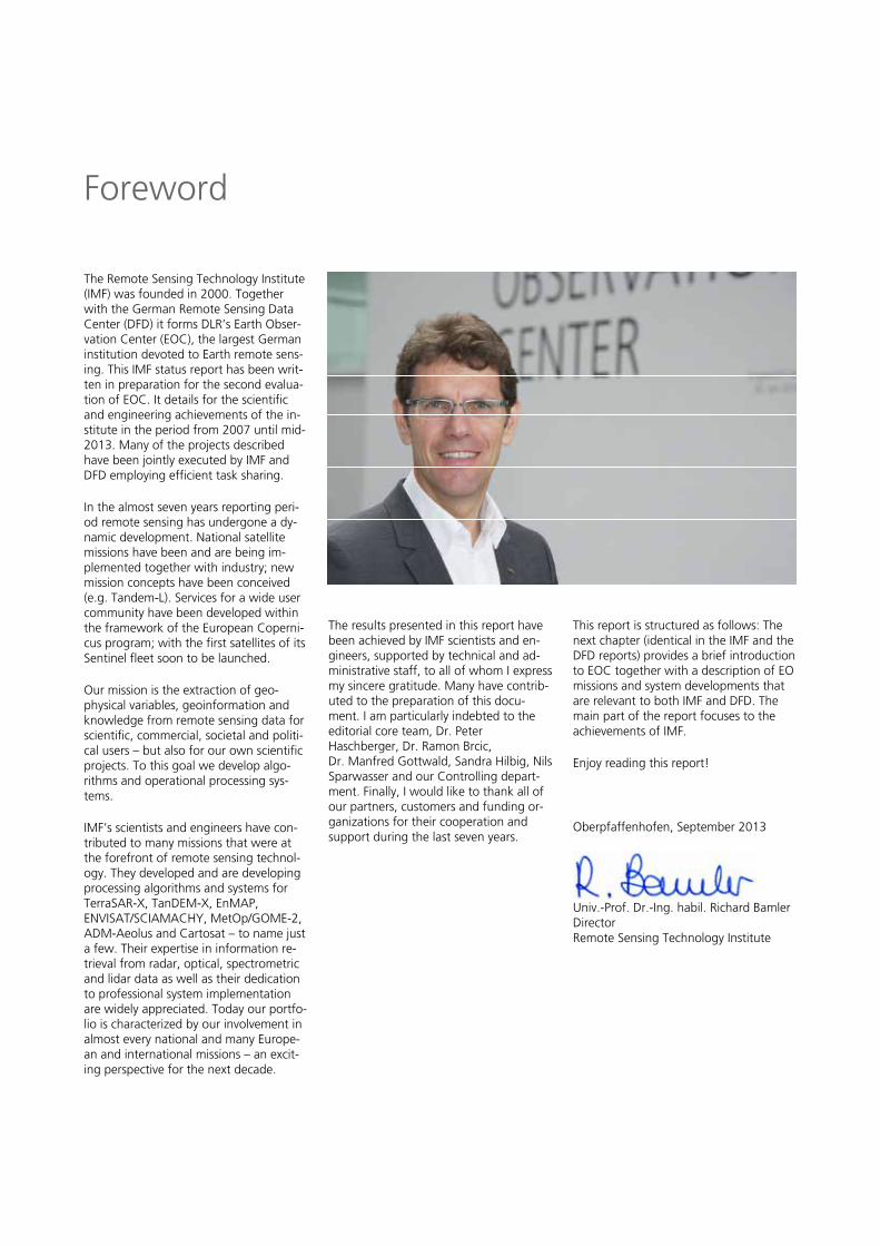
Univ.-Prof. Dr.-Ing. habil. Richard Bamler Director Remote Sensing Technology Institute
Foreword
IX
Bilder über „Kopf- und Fußzeile „hinterlegen“
The Remote Sensing Technology Institute (IMF) was founded in 2000. Together with the German Remote Sensing Data Center (DFD) it forms DLR’s Earth Obser-vation Center (EOC), the largest German institution devoted to Earth remote sens-ing. This IMF status report has been writ-ten in preparation for the second evalua-tion of EOC. It details for the scientific and engineering achievements of the in-stitute in the period from 2007 until mid-2013. Many of the projects described have been jointly executed by IMF and DFD employing efficient task sharing.
In the almost seven years reporting peri-od remote sensing has undergone a dy-namic development. National satellite missions have been and are being im-plemented together with industry; new mission concepts have been conceived (e.g. Tandem-L). Services for a wide user community have been developed within the framework of the European Coperni-cus program; with the first satellites of its Sentinel fleet soon to be launched.
Our mission is the extraction of geo-physical variables, geoinformation and knowledge from remote sensing data for scientific, commercial, societal and politi-cal users – but also for our own scientific projects. To this goal we develop algo-rithms and operational processing sys-tems.
IMF’s scientists and engineers have con-tributed to many missions that were at the forefront of remote sensing technol-ogy. They developed and are developing processing algorithms and systems for TerraSAR-X, TanDEM-X, EnMAP, ENVISAT/SCIAMACHY, MetOp/GOME-2, ADM-Aeolus and Cartosat – to name just a few. Their expertise in information re-trieval from radar, optical, spectrometric and lidar data as well as their dedication to professional system implementation are widely appreciated. Today our portfo-lio is characterized by our involvement in almost every national and many Europe-an and international missions – an excit-ing perspective for the next decade.
The results presented in this report have been achieved by IMF scientists and en-gineers, supported by technical and ad-ministrative staff, to all of whom I express my sincere gratitude. Many have contrib-uted to the preparation of this docu-ment. I am particularly indebted to the editorial core team, Dr. Peter Haschberger, Dr. Ramon Brcic, Dr. Manfred Gottwald, Sandra Hilbig, Nils Sparwasser and our Controlling depart-ment. Finally, I would like to thank all of our partners, customers and funding or-ganizations for their cooperation and support during the last seven years.
This report is structured as follows: The next chapter (identical in the IMF and the DFD reports) provides a brief introduction to EOC together with a description of EO missions and system developments that are relevant to both IMF and DFD. The main part of the report focuses to the achievements of IMF.
Enjoy reading this report!
Oberpfaffenhofen, September 2013
Univ.-Prof. Dr.-Ing. habil. Richard Bamler Director Remote Sensing Technology Institute
Foreword


Earth Observation
Center
Our central strength is the ability to de-sign, engineer, build, and operate end-to-end systems for EO-based demands and missions. EOC drives and participates in almost all state-of-the-art developments in the field of remote sensing. This covers the entire scientific and engineering port-folio from sensor-based signal processing and parameter retrieval to time-series analysis for gaining geophysical or biophysical quantities to integration with relevant geoinformation layers from other sources within dedicated geoinformation systems to user-specific solutions and services.
Mission and Expertise
The mission of EOC is to establish remote sensing as an indispensable tool for ob-taining geoinformation relevant to global change and environment, planning, and civil security, in order to meet scientific, social, economic, and national needs.
We devote our research activities, devel-opment efforts and services to this goal since we are convinced that remote sens-ing from space can competently satisfy the continually growing global demand for objective and reliable geoinformation. The research and development activities of EOC therefore focus on socially rele-vant issues like:
- environment
- global change and climate monitoring
- sustainable development
- well-being and security of the popu-lation
- specific information requirements of our project partners and customers in science, the public sector, industry, and government.
DLR’s Earth Observation Center (EOC) was established at the beginning of 2000 as the major result of an extensive external review of two DLR research fields, ‘Earth Observation’ and ‘Communication and Navigation.’ Since then it is composed of the Remote Sensing Technology Institute (IMF) and the German Remote Sens-ing Data Center (DFD), supported by a joint financial controlling unit.
Until 2010, EOC was operated under the Name ‘Cluster for Applied Remote Sensing.‘ The entitlement to continue its activities as DLR´s Earth Observation Center reflects its gain in importance within DLR as the core institution to transfer EO data into geoinformation, operate the payload ground segment facilities and run dedicated user services. EOC supports many DLR, national and international missions and research proj-ects in the geosciences and atmospheric sciences by processing and making available the data and information which are a prerequisite to knowledge gain. To fulfill this interdisciplinary challenge, EOC puts to work its expertise in physics, geosciences, mathematics, information technology, and engineering, as well as its technical know-how.
EOC is embedded in a wide range of in-ternational activities. Just to name a few: we are developing and will operate one of ESA’s Processing and Archiving Centers as part of Europe’s Copernicus program. We are a partner in EUMETSAT’s Satellite Application Facilities and operate a World Data Center on behalf of the International Council for Science and the World Meteorological Organization. We perform ground segment functions for European and international customers and deploy remote-sensing-based project solutions in many countries around the world. Finally, we are responsible for all operational duties in the framework of DLR’s membership in the International Charter Space and Major Disasters.
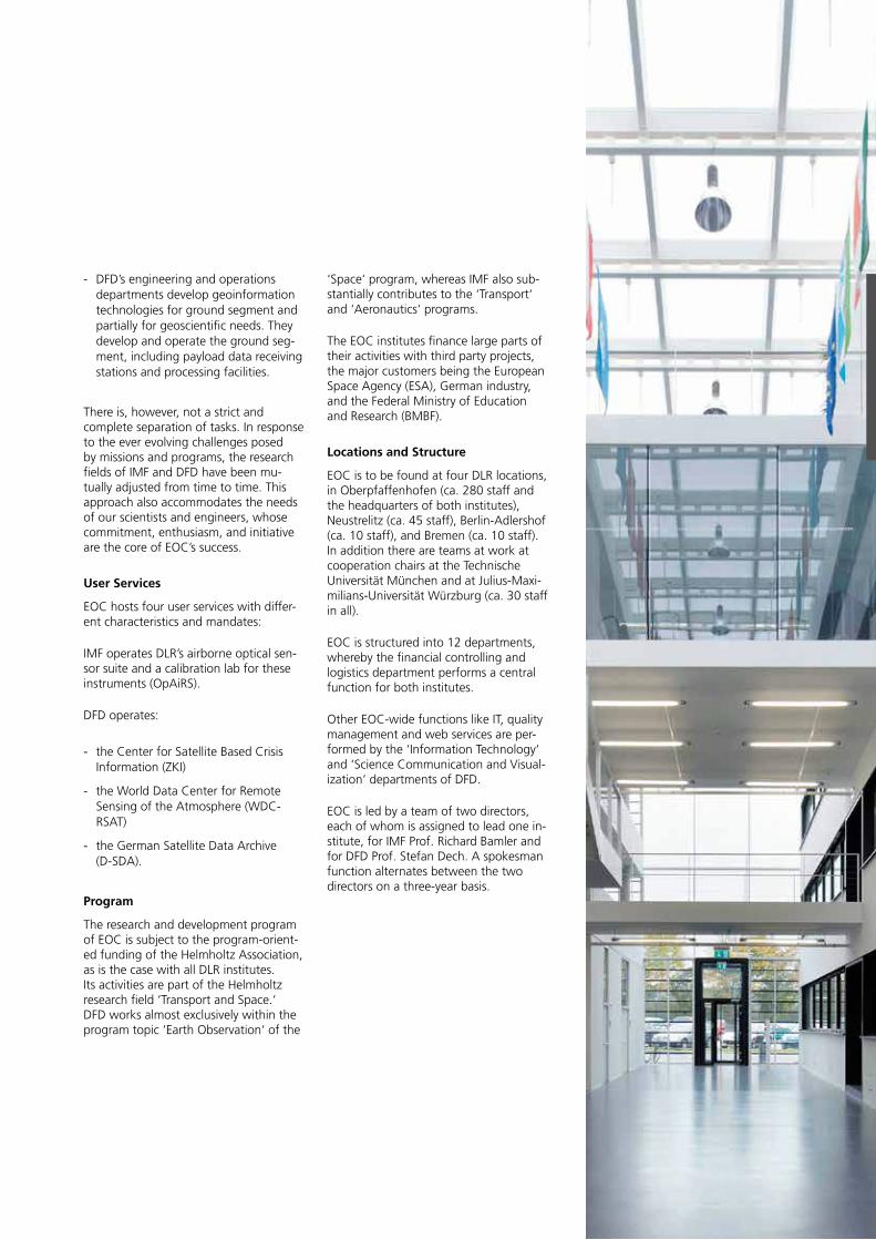
Earth Observation Center
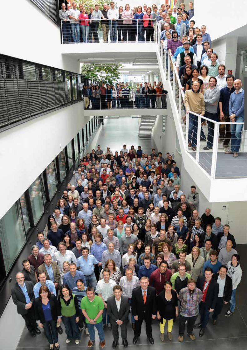
DFD and IMF staff in May 2013 in the atrium of the common EOC building in Oberpfaffen-hofen
2
EOC’s major fields of expertise are:
- basic research on remote sensing principles and the relevant physical, mathematical and information-theory problems
- developing algorithms for information retrieval from remote sensing data and implementing them in operational processing systems
- developing generic components for the configuration of dedicated geoinfor-mation systems with optional decision support solutions
- processor development, system inte-gration and operational mass process-ing of remote sensing data, as well as development of the information tech-nology required to manage extensive data inventories
- defining and generating value-added geoinformation products for environ-mental research and the associated management tasks
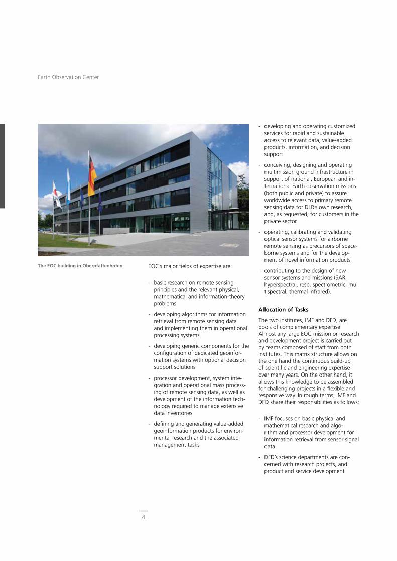
The EOC building in Oberpfaffenhofen
- developing and operating customized services for rapid and sustainable access to relevant data, value-added products, information, and decision support
- conceiving, designing and operating multimission ground infrastructure in support of national, European and in-ternational Earth observation missions (both public and private) to assure worldwide access to primary remote sensing data for DLR’s own research, and, as requested, for customers in the private sector
- operating, calibrating and validating optical sensor systems for airborne remote sensing as precursors of space-borne systems and for the develop-ment of novel information products
- contributing to the design of new sensor systems and missions (SAR, hyperspectral, resp. spectrometric, mul-tispectral, thermal infrared).
Allocation of Tasks
The two institutes, IMF and DFD, are pools of complementary expertise. Almost any large EOC mission or research and development project is carried out by teams composed of staff from both institutes. This matrix structure allows on the one hand the continuous build-up of scientific and engineering expertise over many years. On the other hand, it allows this knowledge to be assembled for challenging projects in a flexible and responsive way. In rough terms, IMF and DFD share their responsibilities as follows:
- IMF focuses on basic physical and mathematical research and algo-rithm and processor development for information retrieval from sensor signal data
- DFD’s science departments are con-cerned with research projects, and product and service development
4
Earth Observation Center
‘Space‘ program, whereas IMF also sub-stantially contributes to the ‘Transport‘ and ‘Aeronautics‘ programs.
The EOC institutes finance large parts of their activities with third party projects, the major customers being the European Space Agency (ESA), German industry, and the Federal Ministry of Education and Research (BMBF).
Locations and Structure
EOC is to be found at four DLR locations, in Oberpfaffenhofen (ca. 280 staff and the headquarters of both institutes), Neustrelitz (ca. 45 staff), Berlin-Adlershof (ca. 10 staff), and Bremen (ca. 10 staff). In addition there are teams at work at cooperation chairs at the Technische Universität München and at Julius-Maxi-milians-Universität Würzburg (ca. 30 staff in all).
EOC is structured into 12 departments, whereby the financial controlling and logistics department performs a central function for both institutes.
Other EOC-wide functions like IT, quality management and web services are per-formed by the ‘Information Technology‘ and ‘Science Communication and Visual-ization‘ departments of DFD.
EOC is led by a team of two directors, each of whom is assigned to lead one in-stitute, for IMF Prof. Richard Bamler and for DFD Prof. Stefan Dech. A spokesman function alternates between the two directors on a three-year basis.
- DFD’s engineering and operations departments develop geoinformation technologies for ground segment and partially for geoscientific needs. They develop and operate the ground seg-ment, including payload data receiving stations and processing facilities.
There is, however, not a strict and complete separation of tasks. In response to the ever evolving challenges posed by missions and programs, the research fields of IMF and DFD have been mu-tually adjusted from time to time. This approach also accommodates the needs of our scientists and engineers, whose commitment, enthusiasm, and initiative are the core of EOC’s success.
User Services
EOC hosts four user services with differ-ent characteristics and mandates:
IMF operates DLR’s airborne optical sen-sor suite and a calibration lab for these instruments (OpAiRS).
DFD operates:
- the Center for Satellite Based Crisis Information (ZKI)
- the World Data Center for Remote Sensing of the Atmosphere (WDC-RSAT)
- the German Satellite Data Archive (D-SDA).
Program
The research and development program of EOC is subject to the program-orient-ed funding of the Helmholtz Association, as is the case with all DLR institutes. Its activities are part of the Helmholtz research field ‘Transport and Space.‘ DFD works almost exclusively within the program topic ‘Earth Observation‘ of the
Further federal ministries are interested in benefiting from the Earth observation expertise and services of EOC. For exam-ple, the capability of rapid crisis mapping as implemented in the ZKI has been mandated as a service by the Ministry of the Interior (BMI) since the beginning of 2013.
Several governmental agencies in charge of maritime and coastal security are demonstrating the use of EOC-generated near-real-time SAR based products in their work. EOC’s research and demon-stration efforts related to maritime security are funded by the Federal Ministry of Economics and Technology and by the Federal Ministry of Education and Research (BMBF). One result was the establishment in 2012 of maritime safety and security labs in and Neustrelitz. Maritime security applications are also one of the major EOC contributions to the Copernicus collaborative services.
In order to strengthen the role of German contributors to Copernicus, DLR and the state of Bavaria, complemented by activi-ties in the state of Mecklenburg-Western Pomerania, initiated in 2010 the concept of a GMES Center (later Copernicus Center). This center will focus on sharing with external partners, including industry, the technical capabilities and expertise of DLR both in the Copernicus ground segment and in the processing of Earth observation data. The first part of the concept supports the setting up of Copernicus ground segment functions (such as. ESA Processing and Archiving Centers, or PACs) in order to grant access to primary Sentinel data. The second part contributes to the setting up of com-puting and pre-processing facilities and interfaces to industrial partners in order to give them easy access to Copernicus data and quality products.
National and International ContextSatellite Earth observation covers national territories as well as global land and oceans areas. Earth observation science, technologies and satellites therefore form an important asset for national devel-opment, industrial policy and national security as well as international relations. With its capabilities in Earth observa-tion science, technologies and ground segments, EOC is in this context an important player on national, European and international levels.
National
The German national space program calls for an integration of space tech-nologies by nearly all domains of public life. Specifically, Earth observation based information should be used by govern-ment agencies and commercial entities to improve the management of the envi-ronment, public health and civil security. The national space program supports European initiatives such as Copernicus (formerly GMES, Global Monitoring for Environment and Security).
EOC is challenged by this national strat-egy for Earth observation at all levels of skills, expertise and infrastructure in its institutes IMF and DFD.
EOC’s institutional funding is provided via the Earth observation section of the Helmholtz research program ‘Space‘. We also use instruments of the Helmholtz Ini-tiating and Networking Fund, such as the PostDoc program, Young Investigators Groups, and Helmholtz Alliances.
Substantial funding also comes from several BMBF programs. EOC conducted projects e.g. with BMBF support, such as WASCAL, WISDOM, Exupéry and GITEWS.
6
Earth Observation Center
EEA
Europe
The treaty of Lisbon put the European Commission in charge of defining the strategy for space science research and major European projects. Next to the independent navigation system Galileo, the European Commission has defined its strategy on Earth observation within the Copernicus program. Therein the Commission, supported by its agencies, is in charge of implementing the Coper-nicus services. Complemented by ESA programs and national contributions, ESA has the responsibility to build and operate the space and ground segments for Copernicus. From the very beginning, EOC contributed to the development of Copernicus services in the domains of land, ocean, atmosphere, disaster map-ping, civil security and global change. Most of these projects were and are funded by ESA and European research framework programs. As to Copernicus operations, ESA has selected EOC to set up and operate the PACs for Sentinel-1, Sentinel-3 (OLCI part), and for the Sen-tinel-5 precursor mission, as well as to handle Sentinel processor development. These PACs will be established at EOC in Oberpfaffenhofen and will continue the series of our duties in the processor development, setting up and operation of data centers under contract to ESA, which started in 1991 with ERS-1, ERS-2 and ENVISAT. Work is also progressing on the Copernicus ‘collaborative ground segment,‘ where national facilities add further capabilities, products and services to the core ground segment.
Besides the focus on Copernicus, other work with ESA is progressing on the de-velopment of new algorithms, processing and data management, for example, in the framework of the Climate Change Initiative and long term data preserva-tion. Cooperation with EUMETSAT to provide global ozone maps as part of the ‘Satellite Application Facilities‘ continued during the reporting period. Improved products have been developed in particu-lar in conjunction with the new EUMET-
SAT polar orbiting MetOp missions. We are also collaborating with other Europe-an actors from academia, large research labs and the space industry, as well as with such European agencies as ECMWF, EEA, EUSC and EMSA.
International
The number of Earth observation missions has dramatically increased. New nations as well as new industrial entrepreneurs with their own national or commercial space systems are entering the space arena. Amongst other drivers, global security challenges are nourishing the demand for very high resolution optical and radar surveillance.
EOC is contributing to the operation of these missions with its international data acquisition stations, established in science cooperation schemes with the host coun-tries Canada (Inuvik), Mexico (Chetumal) and Chile (O’Higgins).
International organizations such as the Group on Earth Observation (GEO) are aiming to manage the ideas, concepts and access channels relating to global change data. EOC participates in many working groups of the GEO societal ben-efit areas. This often results in projects in which EOC researchers contribute to
7
National and International Context
EMSA
UNITED NATIONSO�ce for Outer Space A�airs
Earth observation applications and envi-ronmental monitoring systems in other countries. Mostly funded by German ministries, these projects range from cooperative work with Mexico to delivery of environmental information in West and South Africa to water systems moni-toring in Central and Southeast Asia. An EOC flagship project was work on the development of the German-Indonesian Tsunami Early Warning System (GITEWS), now in operation.
The capabilities of Earth observation missions to deliver a fast overview of areas affected by disasters were recog-nized by space agencies in creating the International Charter Space and Major Disasters in 2000. With TerraSAR-X and the DFD Center for Satellite Based Crisis Information ZKI, DLR became an official member of the Charter in 2010. In the same direction, DLR has actively support-ed UN-SPIDER (United Nations Platform for Space-based Information for Disaster Management and Emergency Response) with the secondment of personnel to the
UN office in Bonn. In 2009, the World Meteorological Organization (WMO) assigned the EOC-based Data Center for Remote Sensing of the Atmosphere a role within the WMO World Data Center net-work. This role complements the World Data Center function DFD gained from the International Council for Science in 2003. These activities undertaken togeth-er with international agencies are sup-plemented by the engagement of EOC in international science organizations. EOC staff is actively involved in chairing technical working groups, commissions and conferences in science and engineer-ing organizations such as EARSEL, ICSU, ISPRS, IEEE and IAF.
8
Earth Observation Center
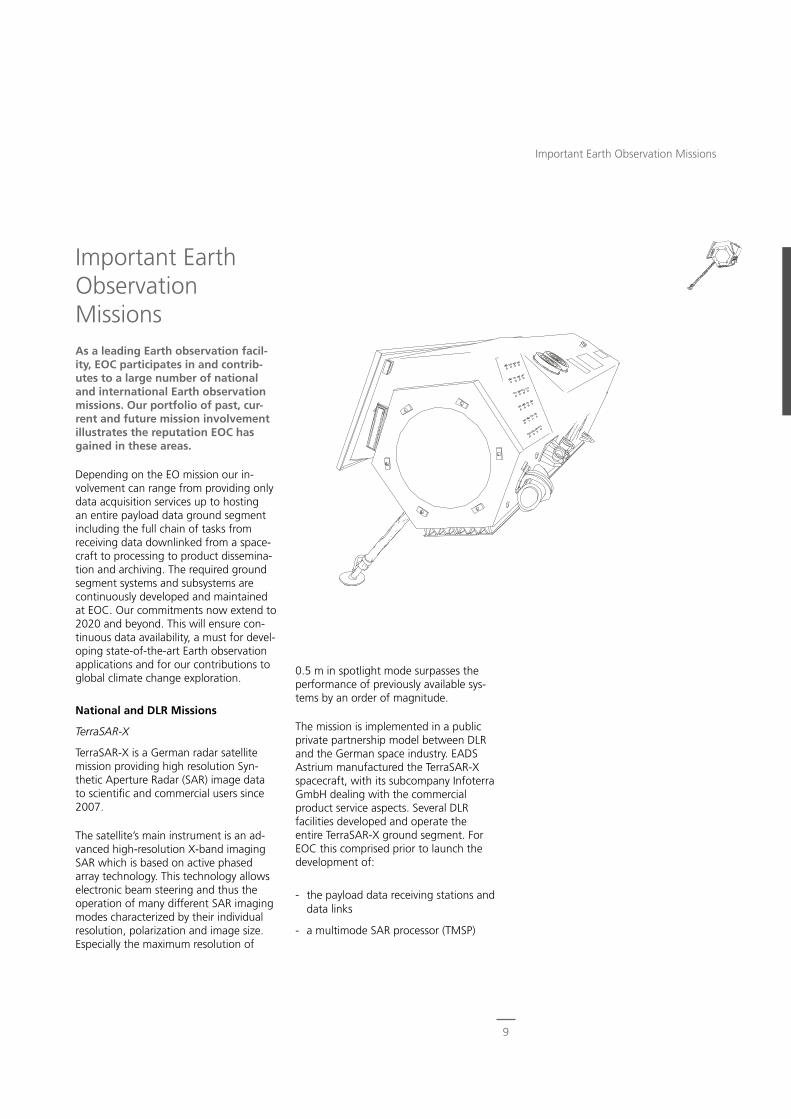
0.5 m in spotlight mode surpasses the performance of previously available sys-tems by an order of magnitude.
The mission is implemented in a public private partnership model between DLR and the German space industry. EADS Astrium manufactured the TerraSAR-X spacecraft, with its subcompany Infoterra GmbH dealing with the commercial product service aspects. Several DLR facilities developed and operate the entire TerraSAR-X ground segment. For EOC this comprised prior to launch the development of:
- the payload data receiving stations and data links
- a multimode SAR processor (TMSP)
Important Earth Observation MissionsAs a leading Earth observation facil-ity, EOC participates in and contrib-utes to a large number of national and international Earth observation missions. Our portfolio of past, cur-rent and future mission involvement illustrates the reputation EOC has gained in these areas.
Depending on the EO mission our in-volvement can range from providing only data acquisition services up to hosting an entire payload data ground segment including the full chain of tasks from receiving data downlinked from a space-craft to processing to product dissemina-tion and archiving. The required ground segment systems and subsystems are continuously developed and maintained at EOC. Our commitments now extend to 2020 and beyond. This will ensure con-tinuous data availability, a must for devel-oping state-of-the-art Earth observation applications and for our contributions to global climate change exploration.
National and DLR Missions
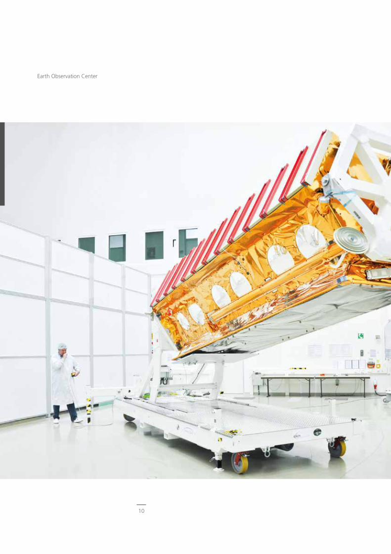
TerraSAR-X
TerraSAR-X is a German radar satellite mission providing high resolution Syn-thetic Aperture Radar (SAR) image data to scientific and commercial users since 2007.
The satellite’s main instrument is an ad-vanced high-resolution X-band imaging SAR which is based on active phased array technology. This technology allows electronic beam steering and thus the operation of many different SAR imaging modes characterized by their individual resolution, polarization and image size. Especially the maximum resolution of
9
Important Earth Observation Missions
10
Earth Observation Center
- the complete SAR data payload ground segment
- a service segment for scientific users.
During the in-orbit mission phase, we are now responsible for all major elements, such as:
- product ordering
- high rate satellite data reception
- SAR processing
- product archiving and dissemination.
Furthermore, we coordinate the scientific use of the SAR data. More than 800 sci-ence data proposals with applications in geology, georisks, hydrology, glaciology and other fields are being handled. The ever increasing use of TerraSAR-X data is reflected at international conferences and in publications in remote sensing journals.
The success accomplished so far has provided EOC with the opportunity to contribute to future missions such as the Spanish PAZ, which is based on Astrium’s TerraSAR-X platform and our SAR pro-cessor, and TerraSAR-X HD, a commercial follow-on mission with even higher resolution and performance.
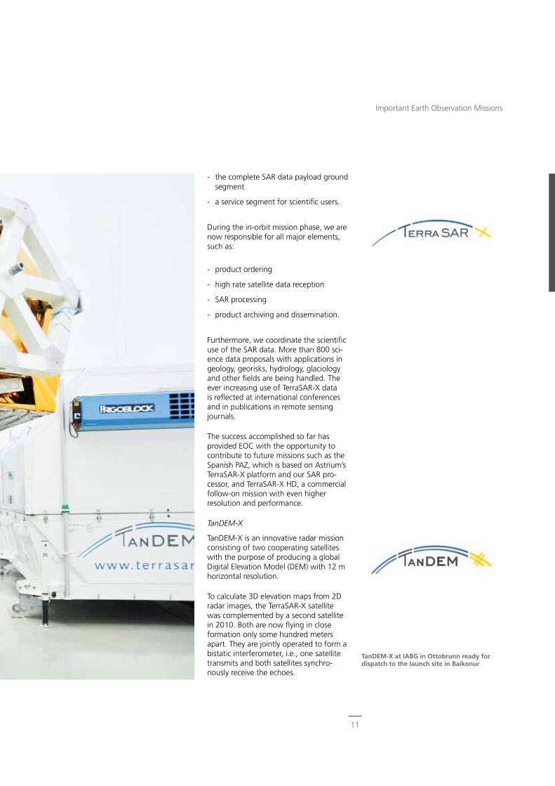
TanDEM-X
TanDEM-X is an innovative radar mission consisting of two cooperating satellites with the purpose of producing a global Digital Elevation Model (DEM) with 12 m horizontal resolution.
To calculate 3D elevation maps from 2D radar images, the TerraSAR-X satellite was complemented by a second satellite in 2010. Both are now flying in close formation only some hundred meters apart. They are jointly operated to form a bistatic interferometer, i.e., one satellite transmits and both satellites synchro-nously receive the echoes.
TanDEM-X at IABG in Ottobrunn ready for dispatch to the launch site in Baikonur
11
Important Earth Observation Missions
gether with its operations while Germany develops the lidar instrument and takes care of all aspects of the payload.
MERLIN has successfully passed the mis-sion definition (pre-phase A) and prelimi-nary readiness (phase A) reviews. Phase B started in April 2013. It is planned to launch the satellite in 2016 for a mission duration of at least three years.
Our development responsibilities for MERLIN include:
- operational data processors for level 0-1a and level 1a-1b
- long-term instrument performance monitoring
- short-term instrument health and safety monitoring
- payload command and control facilities
- host interface structures for data pro-cessing, data archiving and a data user interface via WDC-RSAT.
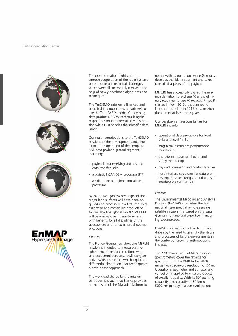
EnMAP
The Environmental Mapping and Analysis Program (EnMAP) establishes the first national hyperspectral remote sensing satellite mission. It is based on the long German heritage and expertise in imag-ing spectroscopy.
EnMAP is a scientific pathfinder mission, driven by the need to quantify the status and processes of Earth’s environments in the context of growing anthropogenic impacts.
The 228 channels of EnMAP’s imaging spectrometers cover the reflectance spectrum from the VNIR to the SWIR range with geometric resolution of 30 m. Operational geometric and atmospheric correction is applied to ensure products of excellent quality. With its 30° pointing capability and capacity of 30 km × 5000 km per day in a sun-synchronous
The close formation flight and the smooth cooperation of the radar systems posed numerous technical challenges which were all successfully met with the help of newly developed algorithms and techniques.
The TanDEM-X mission is financed and operated in a public private partnership like the TerraSAR-X model. Concerning data products, EADS Infoterra is again responsible for commercial DEM distribu-tion while DLR handles the scientific data usage.
Our major contributions to the TanDEM-X mission are the development and, since launch, the operation of the complete SAR data payload ground segment, including:
- payload data receiving stations and data transfer links
- a bistatic InSAR DEM processor (ITP)
- a calibration and global mosaicking processor.
By 2013, two gapless coverages of the major land surfaces will have been ac-quired and processed in a first step, with calibrated and mosaicked products to follow. The final global TanDEM-X DEM will be a milestone in remote sensing with benefits for all disciplines of the geosciences and for commercial geo-ap-plications.
MERLIN
The Franco-German collaborative MERLIN mission is intended to measure atmo-spheric methane concentrations with unprecedented accuracy. It will carry an active SWIR instrument which exploits a differential-absorption lidar technique as a novel sensor approach.
The workload shared by the mission participants is such that France provides an extension of the Myriade platform to-
12
Earth Observation Center
Tandem-L
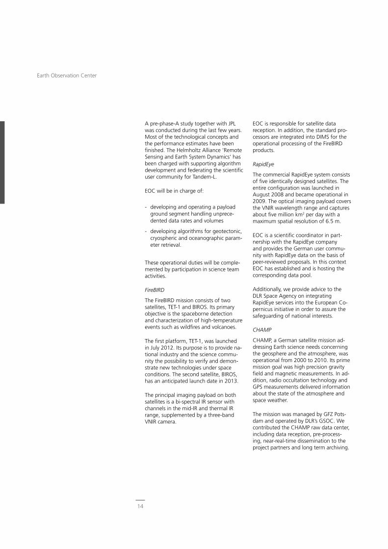
Tandem-L is a DLR scientific SAR mission proposal to monitor dynamic processes in the bio-, litho-, cryo- and hydro-sphere. The variables to be assessed–among them seven essential climate variables–include biomass, tectonic and volcanic activity, soil moisture, ice extent and ice dynamics. The mission employs two fully polarimetric L-band SAR systems flying in formation and operating in either bistatic Pol-InSAR (for forest profiling) or repeat-pass InSAR (for deformation measurements) modes. An innovative digital beam-forming concept provides a mapping capacity two orders of magni-tude better than TanDEM-X: mapping of Earth’s entire land mass is achieved twice in eight days.
orbit, EnMAP will permit frequent and global acquisitions. Currently, only air-borne sensors such as EOC’s HySpex are capable of delivering products reflecting similar performance.
The EnMAP mission, managed by the DLR Space Agency, assigned to EOC responsibility for the complete mission ground segment, which is realized in a collaborative effort with DLR’s GSOC. Our role comprises:
- project management of the complete ground segment for all mission phases
- instrument pre-flight simulations and in-flight calibration
- X-band data reception
- processor development and operation with data quality control
- long-term data archiving
- web-based acquisition and product request handling using EOC’s multimis-sion infrastructures.
EnMAP has an anticipated launch date in late 2017.
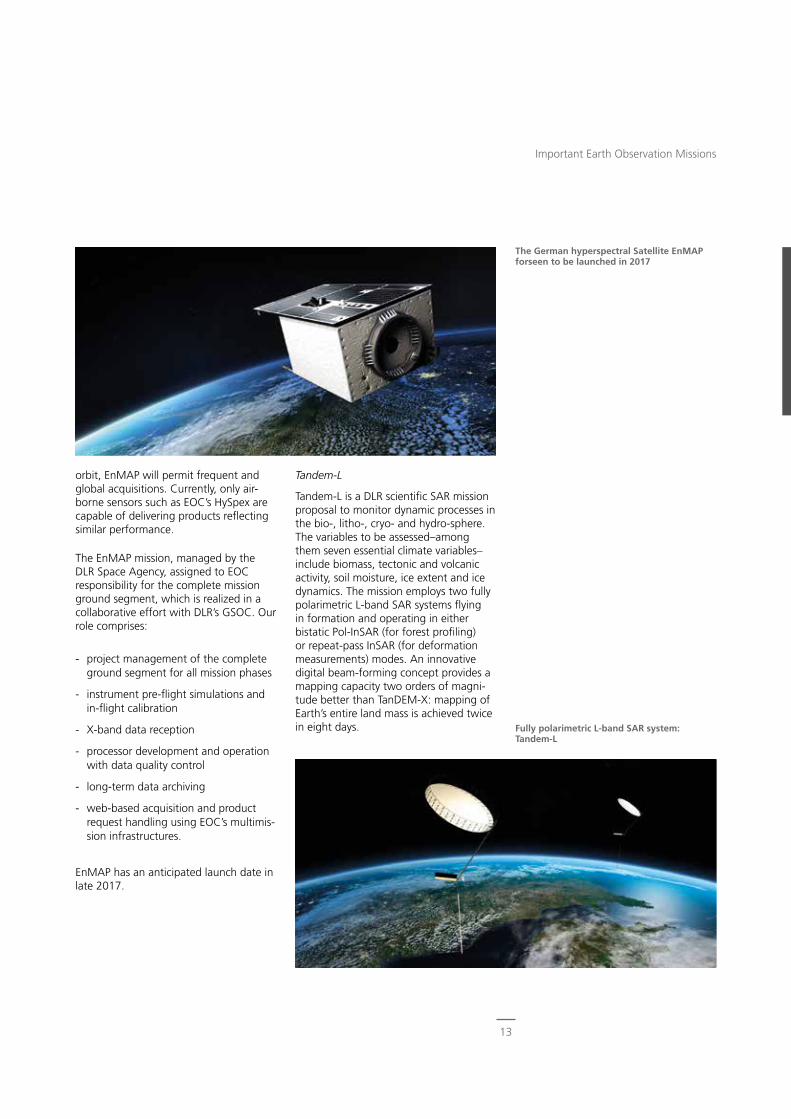
The German hyperspectral Satellite EnMAP forseen to be launched in 2017
Fully polarimetric L-band SAR system: Tandem-L
13
Important Earth Observation Missions
EOC is responsible for satellite data reception. In addition, the standard pro-cessors are integrated into DIMS for the operational processing of the FireBIRD products.
RapidEye
The commercial RapidEye system consists of five identically designed satellites. The entire configuration was launched in August 2008 and became operational in 2009. The optical imaging payload covers the VNIR wavelength range and captures about five million km2 per day with a maximum spatial resolution of 6.5 m.
EOC is a scientific coordinator in part-nership with the RapidEye company and provides the German user commu-nity with RapidEye data on the basis of peer-reviewed proposals. In this context EOC has established and is hosting the corresponding data pool.
Additionally, we provide advice to the DLR Space Agency on integrating RapidEye services into the European Co-pernicus initiative in order to assure the safeguarding of national interests.
CHAMP
CHAMP, a German satellite mission ad-dressing Earth science needs concerning the geosphere and the atmosphere, was operational from 2000 to 2010. Its prime mission goal was high precision gravity field and magnetic measurements. In ad-dition, radio occultation technology and GPS measurements delivered information about the state of the atmosphere and space weather.
The mission was managed by GFZ Pots-dam and operated by DLR’s GSOC. We contributed the CHAMP raw data center, including data reception, pre-process-ing, near-real-time dissemination to the project partners and long term archiving.
A pre-phase-A study together with JPL was conducted during the last few years. Most of the technological concepts and the performance estimates have been finished. The Helmholtz Alliance ‘Remote Sensing and Earth System Dynamics‘ has been charged with supporting algorithm development and federating the scientific user community for Tandem-L.
EOC will be in charge of:
- developing and operating a payload ground segment handling unprece-dented data rates and volumes
- developing algorithms for geotectonic, cryospheric and oceanographic param-eter retrieval.
These operational duties will be comple-mented by participation in science team activities.
FireBIRD
The FireBIRD mission consists of two satellites, TET-1 and BIROS. Its primary objective is the spaceborne detection and characterization of high-temperature events such as wildfires and volcanoes.
The first platform, TET-1, was launched in July 2012. Its purpose is to provide na-tional industry and the science commu-nity the possibility to verify and demon-strate new technologies under space conditions. The second satellite, BIROS, has an anticipated launch date in 2013.
The principal imaging payload on both satellites is a bi-spectral IR sensor with channels in the mid-IR and thermal IR range, supplemented by a three-band VNIR camera.
14
Earth Observation Center
- on-request processing and dissemina-tion of products to users.
For GOME, we developed the required algorithms for trace gas retrieval and implemented the resulting processor in D-PAF. D-PAF’s role for GOME included:
- acquisition, reception, and archival of the entire level 0 data repository
GRACE
Since 2002 the twin satellite mission GRACE continues the CHAMP mission goals to generate a global high-resolu-tion model of Earth’s gravity field with unprecedented accuracy. Its secondary mission is to provide globally distributed status profiles of the ionosphere and atmosphere using limb sounding.
GRACE is a joint effort between DLR and NASA/JPL, with GSOC handling space-craft operations and GFZ functioning as one of the science centers. As for CHAMP, EOC hosts the raw data center for data processing, archiving and dis-semination to the mission control center and to the scientific centers.
ESA and EUMETSAT Missions
ERS-1 and ERS-2
ERS-1 was Europe’s first Earth observa-tion mission, operated between 1991 and 2000. The platform carried a payload suite of active and passive sensors, including an imaging SAR and a wind scatterometer.
In 1995, ESA launched ERS-2, the suc-cessor to ERS-1. It was decommissioned after 16 successful years of in-orbit ser-vice. In a short-track development, ERS-2 was equipped with GOME to carry out atmospheric measurements, particularly ozone and chemical composition, for the first time from a European spaceborne platform. The rest of the payload was identical to ERS-1.
On behalf of ESA, both for ERS-1 and ERS-2, we hosted the German Processing and Archiving Facility D-PAF. For the SAR instrument the tasks assigned to the D-PAF included:
- acquisition and archival of level 0 data, particularly from our acquisition stations located on the Antarctic pen-insula and in Chetumal, Mexico
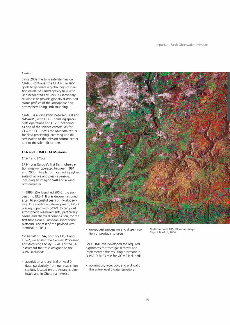
Multitemporal ERS 1/2 radar image, City of Madrid, 2004
15
Important Earth Observation Missions
ments suitable for studying the entire Earth system from polar orbit. Seven instruments of the payload complement had the status of an ESA-developed in-strument. SCIAMACHY, AATSR and DO-RIS were Announcement of Opportunity instruments. They were provided by na-tional agencies, with tasks in instrument operation and data processing shared by ESA and the instrument providers.
EOC was tasked by ESA and DLR to be one of the major facilities in the ENVISAT ground segments for the atmospheric science instruments SCIAMACHY, MIPAS and GOMOS, together with the radar sensor ASAR and the imaging spectrom-eter MERIS.
For SCIAMACHY, jointly provided by Ger-many and the Netherlands, both flight operations and data processing functions
- systematic near-real-time and offline processing and dissemination services for level 1 radiances and level 2 total column products
- repeated reprocessing campaigns using continuously improved versions of the GOME processors.
The work successfully accomplished in the framework of D-PAF formed the basis for our manifold involvement in other ESA and EUMETSAT Earth observation missions.
ENVISAT
ENVISAT was ESA’s Earth observation flagship mission in the first decade of the 21st century. Launched on March 1, 2002 the mission operated until April 8, 2012. It carried a payload of ten instru-
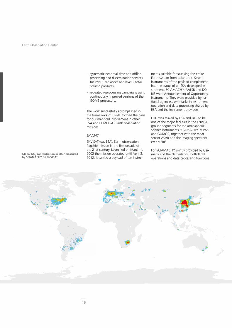
Global NO2 concentration in 2007 measured by SCIAMACHY on ENVISAT
16
Earth Observation Center
MetOp
The series of three MetOp satellites defines EUMETSAT’s polar Earth obser-vation system. With MetOp-A launched in October 2006 and MetOp-B launched in September 2012 two components are presently operational. Lifting MetOp-C into orbit is currently envisaged for 2018. One of the prime goals of MetOp is to provide unique operational data products for Copernicus until at least 2020.
The MetOp payload includes the GOME-2 instrument, an advanced version of GOME which was successfully flown on ESA’s ERS-2 mission from 1995 to 2011. With MetOp, remote sensing of atmo-spheric composition was successfully transferred to the domain of operational meteorology.
The Satellite Application Facility on Ozone and Atmospheric Chemistry Monitoring (O3M-SAF) is responsible for providing the operational atmospheric products based on MetOp data. EOC plays a prominent role in the O3M-SAF that is hosted by the Finnish Meteo-rological Institute but implemented as a decentralized facility in cooperation with a Europe-wide network of research organizations.
At EOC the O3M-SAF project builds on the experience gained over almost two decades in algorithm development and systematic operational processing of data from atmospheric sensors. The share of responsibilities at EOC includes:
- development of retrieval algorithms and operational processors for MetOp/GOME-2 total column products
- operational data processing and data dissemination in the distributed O3M-SAF payload data ground segment.
were hosted by EOC. In cooperation with IUP-IFE, University of Bremen, we were responsible for instrument operations comprising mission planning, instrument configuration control and performance monitoring. In the data processing domain, algorithm development for instrument calibration (level 0-1) and at-mospheric parameter retrieval (level 1-2) was pursued as part of a Europe-wide quality working group. The algorithms finally selected formed the basis of the operational data processors that had been implemented in the framework of the German D-PAC, a de-centralized ESA facility in the ENVISAT payload data segment. EOC operated the D-PAC on behalf of ESA not only throughout the now completed in-orbit phase, but also continues its operation in the current post-mission phase for the purpose of product generation, archiving and dissemination.
For the other payload instruments, D-PAC’s role comprised:
- MIPAS: externally developed processors were implemented for the generation and subsequent storage and dissem-ination of operational level 1 and level 2 data products
- GOMOS: hosting all level 1 and 2 products for the complete mission
- ASAR: all production steps, as well as archiving and disseminating products derived from data when the instrument operated in high rate mode, were assigned to D-PAC. This was comple-mented by systematic dissemination of wave-mode data
- MERIS: archiving all level 0 data which had been acquired at EOC’s Neustrelitz station together with the correspond-ing level 1 and 2 processing under national auspices.
17
Important Earth Observation Missions
EOC was selected to host a PAC for Sen-tinel-1. The data will also be received at the EOC data acquisition stations and via the European Data Relay Satellite System, primarily for use in a national maritime security project.
Sentinel-2
The pair of Sentinel-2 satellites (Sen-tinel-2a being launched in 2014 with Sentinel-2b following about one year later) will routinely deliver high resolution optical information on all land masses of Earth. It complements other systems such as the Landsat series. The two satellites will have a revisit time of 2-3 days at mid-latitudes, which increases to 5 days at the equator.
Sentinel-2 will carry an optical payload for the VNIR-SWIR range with 13 spec-tral bands providing a maximum spatial resolution 10 m. The Sentinel-2 products will be used for land cover mapping, ag-riculture, vegetation and ecologic change monitoring.
EOC plans to acquire, process and use Sentinel-2 data as part of the national collaborative Copernicus ground segment and initiatives such as the Bavarian Co-pernicus Center.
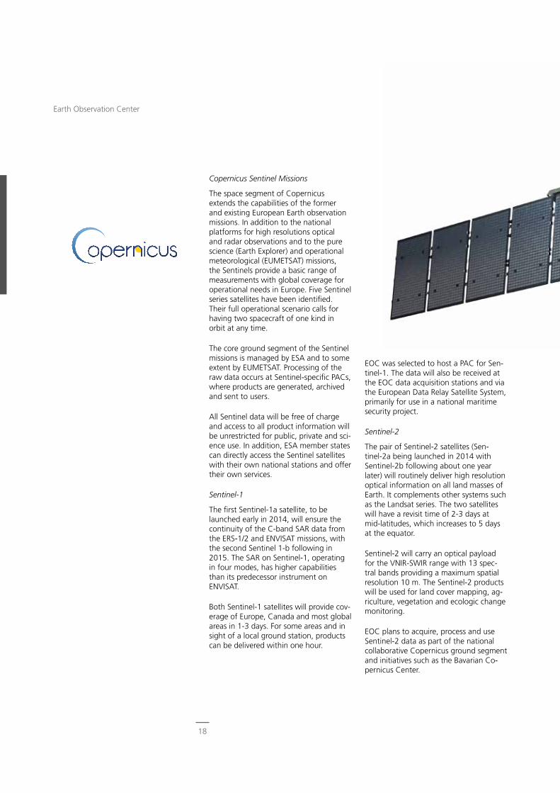
Copernicus Sentinel Missions
The space segment of Copernicus extends the capabilities of the former and existing European Earth observation missions. In addition to the national platforms for high resolutions optical and radar observations and to the pure science (Earth Explorer) and operational meteorological (EUMETSAT) missions, the Sentinels provide a basic range of measurements with global coverage for operational needs in Europe. Five Sentinel series satellites have been identified. Their full operational scenario calls for having two spacecraft of one kind in orbit at any time.
The core ground segment of the Sentinel missions is managed by ESA and to some extent by EUMETSAT. Processing of the raw data occurs at Sentinel-specific PACs, where products are generated, archived and sent to users.
All Sentinel data will be free of charge and access to all product information will be unrestricted for public, private and sci-ence use. In addition, ESA member states can directly access the Sentinel satellites with their own national stations and offer their own services.
Sentinel-1
The first Sentinel-1a satellite, to be launched early in 2014, will ensure the continuity of the C-band SAR data from the ERS-1/2 and ENVISAT missions, with the second Sentinel 1-b following in 2015. The SAR on Sentinel-1, operating in four modes, has higher capabilities than its predecessor instrument on ENVISAT.
Both Sentinel-1 satellites will provide cov-erage of Europe, Canada and most global areas in 1-3 days. For some areas and in sight of a local ground station, products can be delivered within one hour.
18
Earth Observation Center
Sentinel-4 and Sentinel-5
Both Sentinels focus on the state of Earth’s atmosphere and its chemical composition. Their payloads will be implemented on operational EUMETSAT missions.
Sentinel-4, on board MTG-1, carries a UV-VNIR spectrometer into geostation-ary orbit for frequently monitoring the northern hemisphere over Europe. It will be launched in 2019, with the second spacecraft following in 2026.
Sentinel-5 will operate on the MetOp Second Generation platform. The pay-load complement includes a UV-VNIR-SWIR spectrometer. Sentinel-5 is targeted for launch in 2020.
Currently, in the early phases of instru-ment design, EOC is involved in develop-ing algorithms for the instrument calibra-tion of both sensors and for specification of level 0-1 processing.
Sentinel-3
The goal of the Sentinel-3 mission is derivation of sea and land surface param-eters with high accuracy and reliability in support of ocean forecasting systems and for environmental and climate monitor-ing. Its products will contain information about the state of the sea and the land surface.
Owing to the wide range of objectives, the extensive Sentinel-3 payload includes a multitude of sensors of ENVISAT or Cryosat heritage. Of particular impor-tance is the Ocean and Land Colour Instrument (OLCI), which is based on ENVISAT’s MERIS. It will permit the retrieval of parameters related to sea surface temperature, water quality, water pollution and marine ecosystems.
EOC has been selected to set up and operate the PAC responsible for Senti-nel-3 OLCI data. In addition, Sentinel-3 data is also planned to be received and used in the national collaborative ground segment.
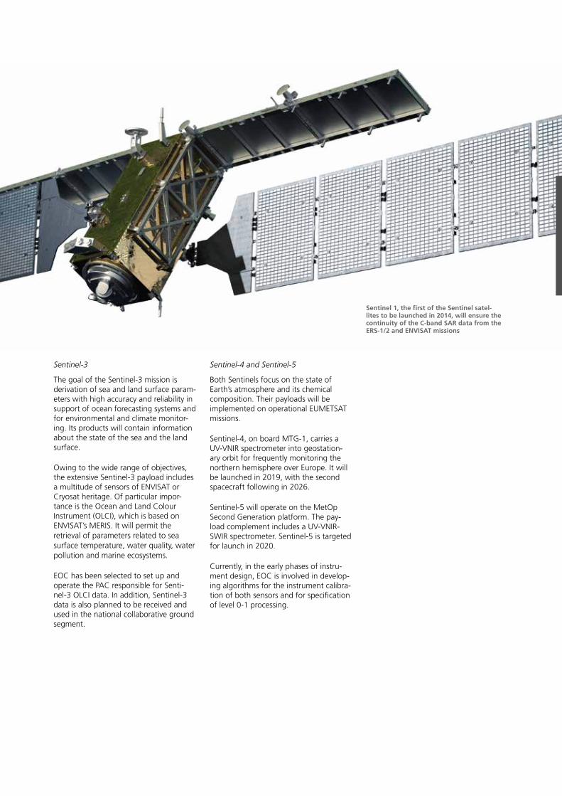
Sentinel 1, the first of the Sentinel satel-lites to be launched in 2014, will ensure the continuity of the C-band SAR data from the ERS-1/2 and ENVISAT missions
Sentinel-5 Precursor
The Sentinel-5 Precursor (S5p) spacecraft, also part of Copernicus, will deliver a key set of atmospheric composition, cloud and aerosol data products for air quality and climate applications. The UV-VNIR-SWIR imaging spectrometer TROPOMI together with the operational level 1 and level 2 processors will achieve a signif-icant improvement in the precision as well as temporal and spatial resolution of derived atmospheric constituents. S5p is planned for launch in 2015.
ESA has overall responsibility for the de-velopment of S5p. The TROPOMI sensor is jointly developed by The Netherlands and ESA. In the ground segment domain we have been assigned major tasks in the key areas of the payload data ground segment and algorithm and processor development.
For the payload data ground segment, the whole chain of on-ground payload data handling, including data reception, processing, archiving, and near-real-time and offline delivery to end users, will be developed and hosted by EOC. In the algorithms and processors domain we
develop, in cooperation with partner institutes, the tools for the retrieval of key atmospheric trace gases and cloud products.
Thus S5p continues our strong heritage relating to atmospheric missions that started with GOME, SCIAMACHY and GOME-2. The work on S5p will, in addi-tion, prepare for EOC involvement in the Sentinel-4 and Sentinel-5 missions.
ADM-Aeolus
The primary aim of the ESA Earth Ex-plorer mission ADM-Aeolus is to provide global data on vertical wind profiles to improve numerical weather forecast and climate modeling. The launch of the mission is planned for 2015.
The ADM-Aeolus atmospheric instrument ALADIN is based on a direct detection Doppler lidar operating in continuous mode in the UV. It is a novel design and provides an enormous challenge not only for its development but also for operat-ing the sensor during the in-orbit phase. The instrument measures the backscat-tered Doppler shifted signal emitted by the laser for retrieving profiles of the line-of-sight velocity in the troposphere and parts of the stratosphere.
Our responsibilities include:
- development of new instrument mod-els and their implementation in the ADM-Aeolus end-to-end simulator
- elaboration of the codes for the operational level 0-1b and level 1b-2a processors
- maintenance of the ADM-Aeolus mis-sion long-term archive.
All EOC tasks in support of the ADM mission are carried out in close collabora-tion with DLR’s Institute of Atmospheric Physics.
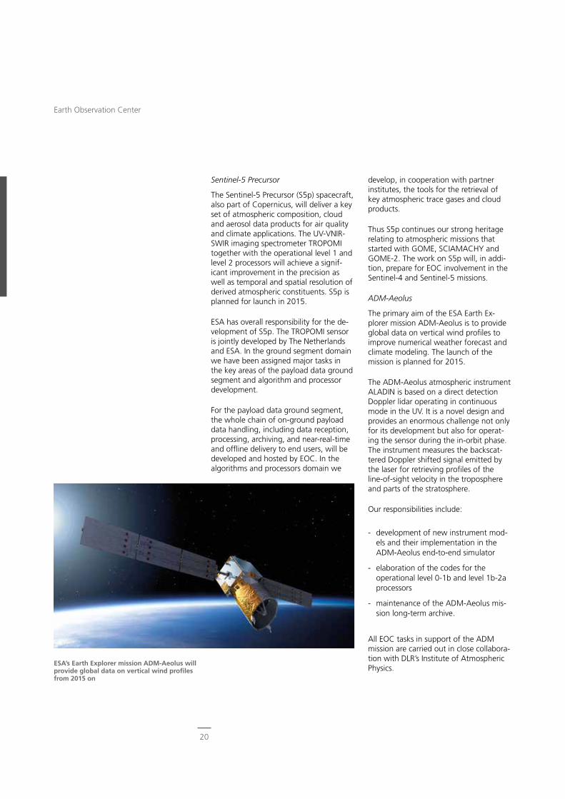
ESA’s Earth Explorer mission ADM-Aeolus will provide global data on vertical wind profiles from 2015 on
20
Earth Observation Center
CarbonSat
CarbonSat is a proposed mission in the framework of the ESA Earth Explorer program with the goal to measure global concentrations of carbon dioxide and methane.
These are the two most important green-house gases with partially anthropogenic origin. The CarbonSat mission is intended to lead to a better understanding of the cycles of both gases in the context of climate change and global warming, in-cluding the identification of their sources and sinks. Crucial for successfully accom-plishing these objectives is measuring the atmospheric concentrations of carbon di-oxide and methane with very high spatial resolution and unprecedented accuracy.
In the present phase, CarbonSat com-petes with another mission proposal for the role of Earth Explorer 8. The mission is currently in phase A/B1 with feasibility studies of the different subsystems being performed on the way to constituting a fully qualified Earth observation mission.
ESA has tasked EOC with the definition of level 0-1 processing and with studies on the spectral calibration of the instru-ment.
International Missions
NOAA, Terra and Aqua
These missions are relevant because of the on-board AVHRR and MODIS sensors. The AVHRR sensor constitutes one of the most frequently used data sources in Earth observation. It is part of the payload complement of several NOAA missions dating back to 1978 and is now also installed on EUMETSAT’s MetOp sat-ellites. MODIS flies on NASA’s Terra (since 1999) and Aqua (since 2002) platforms. Both instruments provide medium resolu-tion optical imagery data from the VNIR and thermal IR ranges.
EOC began to receive such data in the early 1980s and continued direct reception until 2011. Meanwhile, AVHRR data from MetOp is also being received. Similarly, MODIS data are received at the EOC facilities in Oberpfaffenhofen and Neustrelitz.
The entire data archive of AVHRR and MODIS data at EOC covers more than 30 years. Parameters like temperatures of water and land surfaces or vegetation indices are derived on a regular basis. Furthermore, an automated value adding processing chain harvests this data repository.
The resulting products are made available for various applications including near-real-time services for fire detection.
Landsat
Landsat is the longest running space-borne Earth imagery program, a coop-erative effort between NASA, NOAA and USGS together with a private data vendor. Started in 1972 it has meanwhile seen the successful launch of eight sat-ellites.
The Landsat program supports a wide range of user communities worldwide. The applications addressed by analyzing the data acquired from the VIS-NIR-SWIR
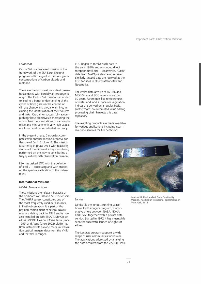
Landsat-8, the Landsat Data Continuity Mission, has begun its normal operations on May 30th, 2013
21
Important Earth Observation Missions
and thermal IR bands cover areas such as global change research, agriculture, forestry, geology, resource management, mapping, water quality and oceanogra-phy.
In the past, Landsat-5 and Landsat-7 were the platforms providing the data. Currently, the Landsat Data Continuity Mission, now known as Landsat-8, has begun its operational in-orbit lifetime with enhanced imagery capabilities.
EOC’s international ground station net-work supported local data reception for Landsat-5 and Landsat-7. In addition, our Neustrelitz ground station is a European acquisition node in the ESA third party mission network for acquiring Landsat data. In preparation for receiving data for Landsat-8, joint tests with two other Eu-ropean ground stations in that network, Kiruna and Matera, have been successful-ly carried out.
Ikonos-2 and WorldView-2
The Ikonos-2 spacecraft, launched in 1999, provided for the first time civilian access on a commercial basis to optical very high resolution satellite data of 1 m panchromatic and 4 m multispectral resolution. Even higher resolution is now available: 0.5 m panchromatic and 2 m multispectral with WorldView-2, which was sent into orbit in 2009. Both satel-lites can acquire imagery on either side of the ground track. They permit local regional tasking, which can be performed and optimized up to about one hour before the satellite passes occur.
DLR established a partnership with European Space Imaging EUSI, Munich, to exploit the data from both satellites. While EUSI handles all commercial aspects, DLR contributes its EOC ground segment facilities and engineering know-how. In exchange, the acquired data can be used for research purposes and in the framework of the Center for Satellite Based Crisis Information.
EOC operates and maintains, at least partially, the Earth terminal for both satel-lites. These functions include:
- direct tasking
- payload commanding
- payload data reception, processing and archiving.
In order not to be hampered by clouds, we developed and implemented a con-cept for efficient cloud-free tasking that uses up-to-date weather information in the planning process. Until 2009 this was implemented at the German regional op-erations center for the Ikonos satellite. In 2010 it was replaced by the direct access facility for WorldView-2, featuring nearly identical functionality.
ALOS
The Japanese Advanced Land Observing Satellite was operated between 2006 and 2011. It carried the L-band radar PALSAR and two optical remote sensing instruments. One was PRISM, providing a geometric resolution of 2.5 m for digital elevation model production. The other was the four-band radiometer AVNIR-2 with a geometric resolution of 10 m for disaster monitoring and precise land coverage observation.
On behalf of ESA, we assumed tasks for processing ALOS data, including the establishment of:
- operational processors for high-preci-sion orthorectification of optical data starting from level 1 products
- prototype processors for systematic, radiometric, geometric corrections, quality improvements for PRISM, and atmospheric correction for AVNIR-2 starting from level 0 products
WorldView-2 with its 1100 mm aperture allows for the differentiation of details in the sub-meter range
22
Earth Observation Center
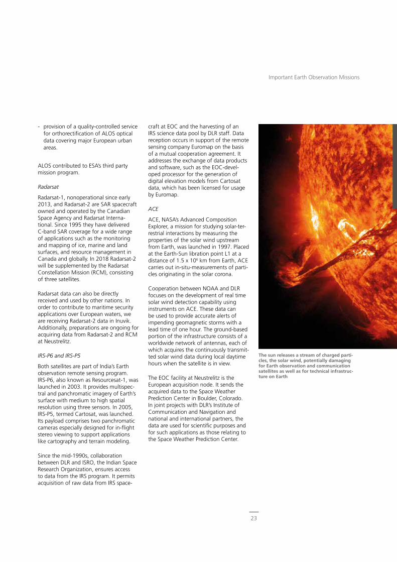
- provision of a quality-controlled service for orthorectification of ALOS optical data covering major European urban areas.
ALOS contributed to ESA’s third party mission program.
Radarsat
Radarsat-1, nonoperational since early 2013, and Radarsat-2 are SAR spacecraft owned and operated by the Canadian Space Agency and Radarsat Interna-tional. Since 1995 they have delivered C-band SAR coverage for a wide range of applications such as the monitoring and mapping of ice, marine and land surfaces, and resource management in Canada and globally. In 2018 Radarsat-2 will be supplemented by the Radarsat Constellation Mission (RCM), consisting of three satellites.
Radarsat data can also be directly received and used by other nations. In order to contribute to maritime security applications over European waters, we are receiving Radarsat-2 data in Inuvik. Additionally, preparations are ongoing for acquiring data from Radarsat-2 and RCM at Neustrelitz.
IRS-P6 and IRS-P5
Both satellites are part of India’s Earth observation remote sensing program. IRS-P6, also known as Resourcesat-1, was launched in 2003. It provides multispec-tral and panchromatic imagery of Earth’s surface with medium to high spatial resolution using three sensors. In 2005, IRS-P5, termed Cartosat, was launched. Its payload comprises two panchromatic cameras especially designed for in-flight stereo viewing to support applications like cartography and terrain modeling.
Since the mid-1990s, collaboration between DLR and ISRO, the Indian Space Research Organization, ensures access to data from the IRS program. It permits acquisition of raw data from IRS space-
craft at EOC and the harvesting of an IRS science data pool by DLR staff. Data reception occurs in support of the remote sensing company Euromap on the basis of a mutual cooperation agreement. It addresses the exchange of data products and software, such as the EOC-devel-oped processor for the generation of digital elevation models from Cartosat data, which has been licensed for usage by Euromap.
ACE
ACE, NASA’s Advanced Composition Explorer, a mission for studying solar-ter-restrial interactions by measuring the properties of the solar wind upstream from Earth, was launched in 1997. Placed at the Earth-Sun libration point L1 at a distance of 1.5 x 10⁶ km from Earth, ACE carries out in-situ-measurements of parti-cles originating in the solar corona.
Cooperation between NOAA and DLR focuses on the development of real time solar wind detection capability using instruments on ACE. These data can be used to provide accurate alerts of impending geomagnetic storms with a lead time of one hour. The ground-based portion of the infrastructure consists of a worldwide network of antennas, each of which acquires the continuously transmit-ted solar wind data during local daytime hours when the satellite is in view.
The EOC facility at Neustrelitz is the European acquisition node. It sends the acquired data to the Space Weather Prediction Center in Boulder, Colorado. In joint projects with DLR’s Institute of Communication and Navigation and national and international partners, the data are used for scientific purposes and for such applications as those relating to the Space Weather Prediction Center.
The sun releases a stream of charged parti-cles, the solar wind, potentially damaging for Earth observation and communication satellites as well as for technical infrastruc-ture on Earth
23
Important Earth Observation Missions
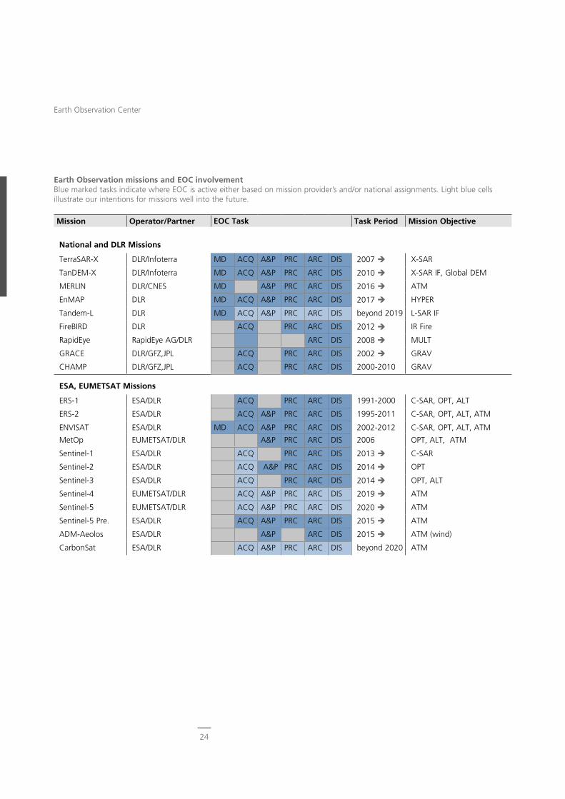
Earth Observation missions and EOC involvementBlue marked tasks indicate where EOC is active either based on mission provider’s and/or national assignments. Light blue cells illustrate our intentions for missions well into the future.
Mission Operator/Partner EOC Task Task Period Mission Objective
National and DLR Missions
TerraSAR-X DLR/Infoterra MD ACQ A&P PRC ARC DIS 2007 X-SAR
TanDEM-X DLR/Infoterra MD ACQ A&P PRC ARC DIS 2010 X-SAR IF, Global DEM
MERLIN DLR/CNES MD A&P PRC ARC DIS 2016 ATM
EnMAP DLR MD ACQ A&P PRC ARC DIS 2017 HYPER
Tandem-L DLR MD ACQ A&P PRC ARC DIS beyond 2019 L-SAR IF
FireBIRD DLR ACQ PRC ARC DIS 2012 IR Fire
RapidEye RapidEye AG/DLR ARC DIS 2008 MULT
GRACE DLR/GFZ,JPL ACQ PRC ARC DIS 2002 GRAV
CHAMP DLR/GFZ,JPL ACQ PRC ARC DIS 2000-2010 GRAV
ESA, EUMETSAT Missions
ERS-1 ESA/DLR ACQ PRC ARC DIS 1991-2000 C-SAR, OPT, ALT
ERS-2 ESA/DLR ACQ A&P PRC ARC DIS 1995-2011 C-SAR, OPT, ALT, ATM
ENVISAT ESA/DLR MD ACQ A&P PRC ARC DIS 2002-2012 C-SAR, OPT, ALT, ATM
MetOp EUMETSAT/DLR A&P PRC ARC DIS 2006 OPT, ALT, ATM
Sentinel-1 ESA/DLR ACQ PRC ARC DIS 2013 C-SAR
Sentinel-2 ESA/DLR ACQ A&P PRC ARC DIS 2014 OPT
Sentinel-3 ESA/DLR ACQ PRC ARC DIS 2014 OPT, ALT
Sentinel-4 EUMETSAT/DLR ACQ A&P PRC ARC DIS 2019 ATM
Sentinel-5 EUMETSAT/DLR ACQ A&P PRC ARC DIS 2020 ATM
Sentinel-5 Pre. ESA/DLR ACQ A&P PRC ARC DIS 2015 ATM
ADM-Aeolos ESA/DLR A&P ARC DIS 2015 ATM (wind)
CarbonSat ESA/DLR ACQ A&P PRC ARC DIS beyond 2020 ATM
24
Earth Observation Center
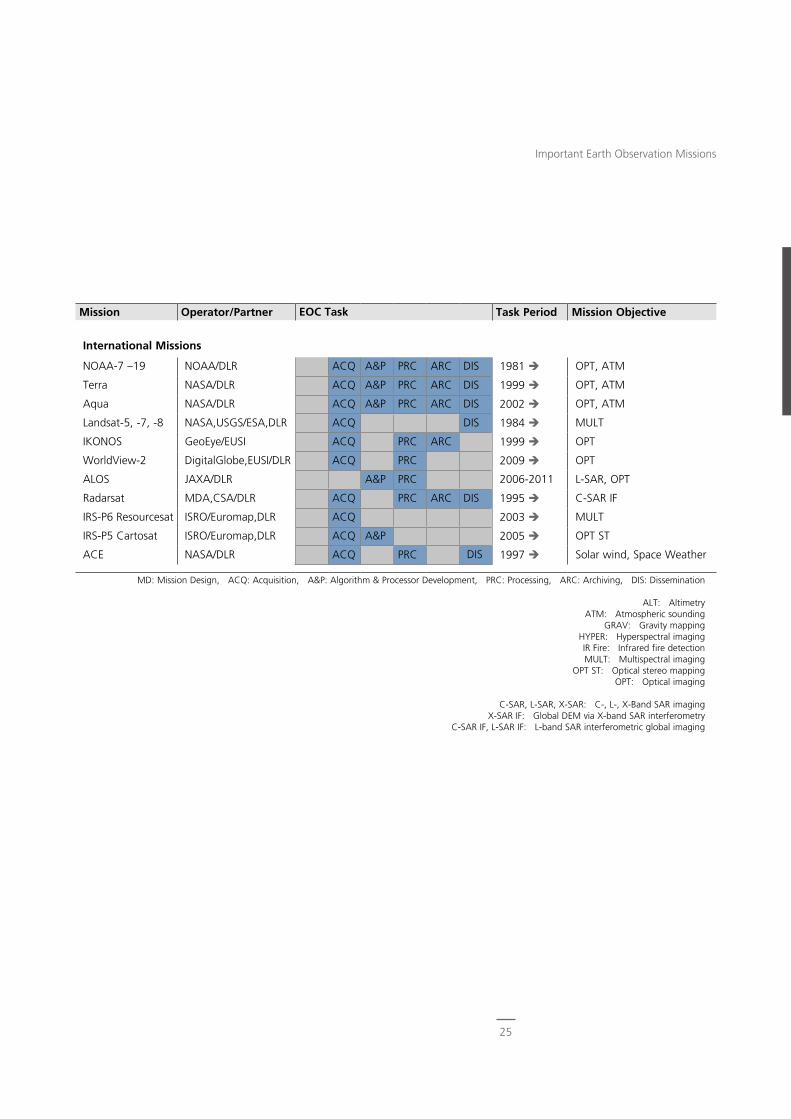
Mission Operator/Partner EOC Task Task Period Mission Objective
International Missions
NOAA-7 –19 NOAA/DLR ACQ A&P PRC ARC DIS 1981 OPT, ATM
Terra NASA/DLR ACQ A&P PRC ARC DIS 1999 OPT, ATM
Aqua NASA/DLR ACQ A&P PRC ARC DIS 2002 OPT, ATM
Landsat-5, -7, -8 NASA,USGS/ESA,DLR ACQ DIS 1984 MULT
IKONOS GeoEye/EUSI ACQ PRC ARC 1999 OPT
WorldView-2 DigitalGlobe,EUSI/DLR ACQ PRC 2009 OPT
ALOS JAXA/DLR A&P PRC 2006-2011 L-SAR, OPT
Radarsat MDA,CSA/DLR ACQ PRC ARC DIS 1995 C-SAR IF
IRS-P6 Resourcesat ISRO/Euromap,DLR ACQ 2003 MULT
IRS-P5 Cartosat ISRO/Euromap,DLR ACQ A&P 2005 OPT ST
ACE NASA/DLR ACQ PRC DIS 1997 Solar wind, Space Weather
MD: Mission Design, ACQ: Acquisition, A&P: Algorithm & Processor Development, PRC: Processing, ARC: Archiving, DIS: Dissemination
ALT: AltimetryATM: Atmospheric sounding
GRAV: Gravity mappingHYPER: Hyperspectral imagingIR Fire: Infrared fire detectionMULT: Multispectral imaging
OPT ST: Optical stereo mappingOPT: Optical imaging
C-SAR, L-SAR, X-SAR: C-, L-, X-Band SAR imagingX-SAR IF: Global DEM via X-band SAR interferometry
C-SAR IF, L-SAR IF: L-band SAR interferometric global imaging
25
Important Earth Observation Missions
CATENA – automatic processing of optical remote sensing data
SAR-Lab/GENESIS – Processing SAR Data
Processing spaceborne synthetic aperture radar data has been a principal EOC business for decades. Because each evolutionary step of SAR sensors (ERS-1, X-SAR, ASAR, SRTM, TerraSAR-X, TanDEM-X …) posed new challenges for algorithms and processing power, we have established a generic SAR software development environment and software library–the SAR-Lab–which has been maintained and improved for 25 years. The library has powerful features for version management and automatic documentation and hosts a large number of ready-to-use subroutines, such as for signal processing or orbit interpolation. This environment is used both to develop new research prototypes and to create operational end-to-end high performance processing chains. By design, a SAR processor is typically highly specialized, complementing a specific sensor, while the subsequent interferometric (InSAR) processor GENESIS is largely sensor inde-pendent. Both the SAR and InSAR proces-sors are coded in C++ and decomposed into functional modules, each taking full advantage of multiprocessor computers to provide the enormous throughput required by modern Earth observation ground segments such as TanDEM-X.
CATENA – Processing Optical Data
Fully automatic processing of optical re-mote sensing data is still a big challenge, and also a necessity for coping with the ever increasing number of images and user demands. EOC has developed the CATENA software system to process high resolution optical satellite data from SPOT, IRS, RapidEye, Worldview, and many other sources. It consists of three main components: image processing modules, processing chains, and a frame-work for task scheduling and execution. Due to the wide variety of optical sensor systems, CATENA has been constructed in a very generic and effective way to
System Developments End-to-end system capabilities are re-quired for the continuous derivation of information describing changes to Planet Earth. For the key technology areas in this context, EOC has es-tablished system development lines in order to safeguard the essential expertise beyond the limited lifetime of single projects.
This approach enables us to maintain generic solutions, advance their function-ality, and at the same time increase their level of maturity. Common standards and operational stability can be achieved and enhanced in this way.
On a technical level, the abstraction of requirements, scenarios and system archi-tectures is necessary, resulting in system components that are modular, scalable and configurable for different project applications. Step by step, the pool of well tested, configuration controlled and quality assured building blocks is enlarged, which gives upcoming projects a favorable starting point.
Sustainable system developments require a structured approach, staying power and effective collaboration in order to reach a common scientific and technical view-point–one basis for the success of EOC.
26
Earth Observation Center
allow the pre-processing (for example, orthorectification or atmospheric correc-tion) of all relevant sensor data using the same software components. Higher level thematic processing to generate specific products like DEM or soil sealing maps has been integrated into the processing workflow. Processing can be performed in a local computer grid or in the DIMS environment and allows thousands of scenes to be processed fully automatically in a short time frame (1500 SPOT and IRS data sets within one day, for example). A new development at EOC is the CATENA Timeline system, which extends the cur-rent system to medium resolution data, like AVHRR and MODIS data, and to the processing of image time series.
UPAS – Processing Atmospheric Measurement Data
Operational processing of atmospheric composition satellite data is a core activ-ity of EOC. It started in the early 1990s with the GOME sensor on board ERS-2, with continuation ensured for the forth-coming missions extending well beyond 2020. The development of a generic mul-timission system for the retrieval of trace gases and cloud properties, called UPAS (Universal Processor for Atmospheric UV/VIS/NIR Sensors), was initiated in 2002, with the first version of UPAS being ready in 2004. It became the processor of choice for the generation of operational near-real-time, offline, and reprocessed GOME products. Key design features of UPAS are the flexibility to incorporate new state-of-the-art retrieval algorithms and easy adaptability to different sensors. UPAS is presently used to reprocess SCIAMACHY nadir measurements and for the operational processing of GOME-2 data available since 2007 and 2013, respectively. A second UPAS generation is currently being developed to cope with the huge amount of data expected from the future atmospheric composition missions Sentinel 5 Precursor, Sentinel 4 and Sentinel 5.
GCAPS – Processing Atmospheric Sensor Data
The processing of raw instrument data (Level 0) to calibrated data (Level 1), usually radiances, is the first step in the chain for finally deriving geophysical parameters of the atmosphere. In the past two decades EOC had developed Level 0-1 processors for GOME and SCIAMACHY. Both relied on instrument specific approaches. However, with sever-al new atmospheric composition missions becoming operational in the near future, another concept was required to be able to accommodate the needs of advanced instrument designs. This led to the devel-opment of GCAPS, the Generic Calibra-tion Processing System. It is compliant with:
- instrument independency
- configurability of calibration chains
- independency from input/output data formats
- usage of standard libraries
- capability of multithreading.
The generic processing is realized as a configurable framework, to which calibration as well as input/output plugins can be added. The first implementation of GCAPS occurs for SCIAMACHY after it has been decided that its new operation-al Level 0-1 processor shall be developed according to this concept.
27
System Developments
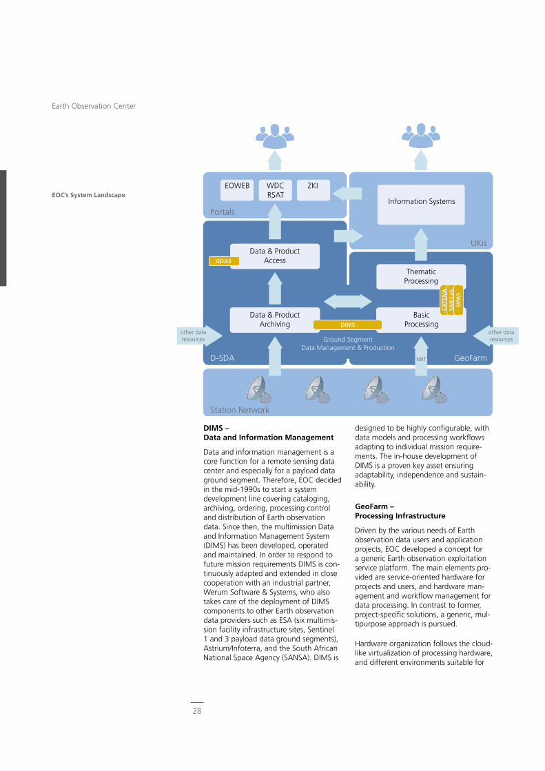
EOC’s System Landscape
designed to be highly configurable, with data models and processing workflows adapting to individual mission require-ments. The in-house development of DIMS is a proven key asset ensuring adaptability, independence and sustain-ability.
GeoFarm – Processing Infrastructure
Driven by the various needs of Earth observation data users and application projects, EOC developed a concept for a generic Earth observation exploitation service platform. The main elements pro-vided are service-oriented hardware for projects and users, and hardware man-agement and workflow management for data processing. In contrast to former, project-specific solutions, a generic, mul-tipurpose approach is pursued.
Hardware organization follows the cloud-like virtualization of processing hardware, and different environments suitable for
DIMS – Data and Information Management
Data and information management is a core function for a remote sensing data center and especially for a payload data ground segment. Therefore, EOC decided in the mid-1990s to start a system development line covering cataloging, archiving, ordering, processing control and distribution of Earth observation data. Since then, the multimission Data and Information Management System (DIMS) has been developed, operated and maintained. In order to respond to future mission requirements DIMS is con-tinuously adapted and extended in close cooperation with an industrial partner, Werum Software & Systems, who also takes care of the deployment of DIMS components to other Earth observation data providers such as ESA (six multimis-sion facility infrastructure sites, Sentinel 1 and 3 payload data ground segments), Astrium/Infoterra, and the South African National Space Agency (SANSA). DIMS is
other data resources
NRT
other data resources
D-SDA
Portals
ThematicProcessing
Information Systems
BasicProcessingDIMS
UKis
CA
TEN
ASA
R-L
abU
PAS
GeoFarm
GDAS
Station Network
EOWEB WDCRSAT
ZKI
Data & ProductAccess
Data & ProductArchiving
Ground SegmentData Management & Production
28
Earth Observation Center
is also of high in-house value: algorithms developed for specific projects are trans-ferred to generic modules and thus made available for both internal and external future use.
Software Engineering
The development of software is of major importance at EOC. High software quality and our capabilities to further tailor software contribute to a large extent to our own expertise and to internationally acknowledged results. Our in-house developments are also increasingly used in projects with partners outside DLR. In some cases this involves technology transfer to industrial partners.
Our own major developments are conducted and maintained in autono-mous product development lines. They originally filled requirements originating in concrete projects, but were con-sciously evolve to meet additional future requirements. Toward this end, appropri-ately qualified teams were supplied with dedicated resources and well defined procedures. Powerful tools for require-ments analysis, source code manage-ment, testing, release and documentation management as well as troubleshooting are the result.
The resulting software systems are configured for use in concrete projects, applications and missions, with the goal of efficient and reliable services with uniform operating and system interfaces and proven and robust components. System integration and software systems operation are organized separately from the development activity; the transfer to operations and software maintenance is performed according to defined pro-cedures. Many in-house developments apply highly-rated standards for software and system engineering, not only the DLR basis standard for software engineering but also those issued by the European Committee for Space Standardization.
most scientific algorithm implementa-tions can be provided. Hardware can be individually allocated to different users, and for the time being this is accom-plished with an operator-based configu-ration. Further development to achieve dynamic, automated hardware allocation will be necessary. The software realizing the workflow management for Earth ob-servation data processing follows the ge-neric methodology previously developed and used at EOC, but significant further evolution is foreseen and has been initiated, for example, to support bulk processing. Thanks to initial investments, the current system already supports a number of users and projects.
UKIS – Environmental and Crisis Information Systems
Information derived from Earth observa-tion data is invaluable as crisis informa-tion or for environmental management. High-level information not restricted to remote sensing specialists can be made available through dedicated information systems.
In 2012, EOC therefore started a project called UKIS to answer the need for user-specific crisis and environmental information. The concept foresees the development of a system framework that is able to combine modular and generic components for monitoring, decision support and early warning in the fields of environment, planning, atmosphere and civil security. The solution com-pletes the end-to-end system chain in the sense that data received by the EOC station network and processed to higher level products can finally be integrated into user-specific analyses and models and assessed together with data from other sources. The results can be used to answer specific questions in the context of crisis and environmental management and are displayed in an easily under-standable way, even by those who are not remote sensing specialists. Apart from the benefits for external users, UKIS
29
System Developments
ZKI Service fürBundesbehörden(ZKI-DE)
Center for Satellite Based Crisis Information
ZKI services provide information products for the various disaster management phases, in other words, before, during, and after a disaster. Each phase places different demands on the satellite infor-mation products. ZKI delivers information in rush-mode during the emergency relief phase, but also products for rehabilitation and recovery actions as well as for early warning and disaster prevention. Crisis maps are generated immediately after an event with specific information about the extent of the disaster (for example, the area flooded) and the estimated damage (the affected houses, infrastructure, etc.) in order to assist decision making in situ-ation centers and during relief actions in the field. Further analysis and monitoring of the disaster situation is performed to support reconstruction activities. More-over, dedicated risk mapping is carried out to support disaster preparedness and mitigation efforts.
ZKI services are offered in three focus areas:
- service provision for German users (ZKI-DE) under contract to the Federal Ministry of the Interior (BMI) since January 2013
- contributions to the European Copernicus program
- international involvement, for example in the ‘International Charter Space and Major Disasters.‘
Since its establishment in 2004 the ZKI service has been activated more than 140 times and over 800 products have been generated and delivered to users.
World Data Center for Remote Sens-ing of the Atmosphere (WDC-RSAT)
EOC hosts and operates WDC-RSAT un-der the auspices of the nongovernmental International Council of Science (ICSU). In line with ICSU regulations, WDC-RSAT’s mission is to help support both basic and
User Services User services are EOC’s link to its customers in science, industry, government and the public sector. They target different user groups to accommodate their specific commu-nity needs and diverging levels of knowledge about Earth observation data. Therefore, the user services offer different types of information, from air- and space-borne Earth observation image data to highly sophisticated information products.
All user services at EOC have in common that users can access data and services through a single point of contact or web portal. Further, there are no structural elements, but rather EOC-wide functions. The motivation behind their establish-ment is that users and customers of Earth observation products and services are not a priori remote sensing specialists. All user services are supplied by EOC as a whole, but coordinated and hosted by one of the two institutes.
In the following, the four current user services are described in more detail.
Center for Satellite Based Crisis Infor-mation (ZKI)
The Center for Satellite Based Crisis Information (ZKI) provides a 24/7 service for the rapid delivery, processing and analysis of satellite imagery during natural and environmental disasters, for humanitarian relief activities and civil security issues worldwide. The resulting information products are provided to relief organizations and public authorities and are also freely available on the ZKI website. According to user requirements, the information products are delivered as thematic maps, GIS-ready geodata or dossiers. The latter are used to sup-port disaster management operations, humanitarian relief activities or civil security efforts.
31
User Services
German Satellite Data Archive (D-SDA)
The German Satellite Data Archive (D-SDA) provides Earth observation data management, archiving and access services to EOC’s internal and external customers.
D-SDA data management services are based on components of the Data and Information Management System (DIMS), an in-house development. They are a key element of national and third party Earth observation mission ground segments, examples being the national radar mis-sions TerraSAR-X and TanDEM-X and the Copernicus mission Sentinel-5 Precursor. Internal projects also use the services provided by D-SDA for large volume data archiving and retrieval and to provide customized data access by a specific user community.
In data archiving D-SDA focuses on providing long-term data preservation (LTDP). In line with international pro-cedures and guidelines LTDP provides sustainable archiving and ensures the usability of the data and products by future generations.
Users can access D-SDA data by selecting from several discovery and data retrieval options. Systematic data dissemination on a subscription basis is supported as well as interactive acquisition tasking, data discovery, and ordering via the main D-SDA data portal EOWEB®-NG.
In order to ensure the interoperability of data discovery and access systems, D-SDA observes the standards set forth by the Heterogeneous Mission Accessi-bility initiative and the Open Geospatial Consortium (OGC).
In line with these developments D-SDA has recently introduced the EOC Geo-service to supplement existing services with convenient, state-of-the-art data discovery, visualization, and direct download functionality. Through the
applied scientific research by providing atmosphere related and satellite based data, information products and services. These are offered free of charge through a simplified, standardized and sustainable access channel. Its users are mainly of scientific, administrative, and industrial background.
In 2009 WDC-RSAT received the man-date from the UN World Meteorological Organization, WMO, to also serve as a WMO World Data Center. In accord with WMO’s Global Atmosphere Watch Program, WDC-RSAT has been included into the architecture of the new WMO Information System, WIS, being enrolled as a Data Collection and Processing Cen-ter. WDC-RSAT’s data sets can thus be discovered and retrieved from anywhere within WIS, and vice versa.
Supporting proper data citing in order to advance progress toward open data usage, WDC-RSAT received in 2011 a mandate to operate as a Data Publication Agent on behalf of the Technische Infor-mationsbibliothek Hannover. Data sets can be registered through WDC-RSAT by assigning to them a permanent and searchable DOI (Digital Object Identifier).
Following CEOS recommendations, WDC-RSAT together with NASA estab-lished a portal for satellite-based atmo-spheric composition data to better serve the Global Earth Observation System of Systems (GEOSS).
Contributing to the UN World Climate Research Program, WDC-RSAT hosts and manages the data and information platform of the international Network for the Detection of Mesospheric Change, NDMC.
32
Earth Observation Center
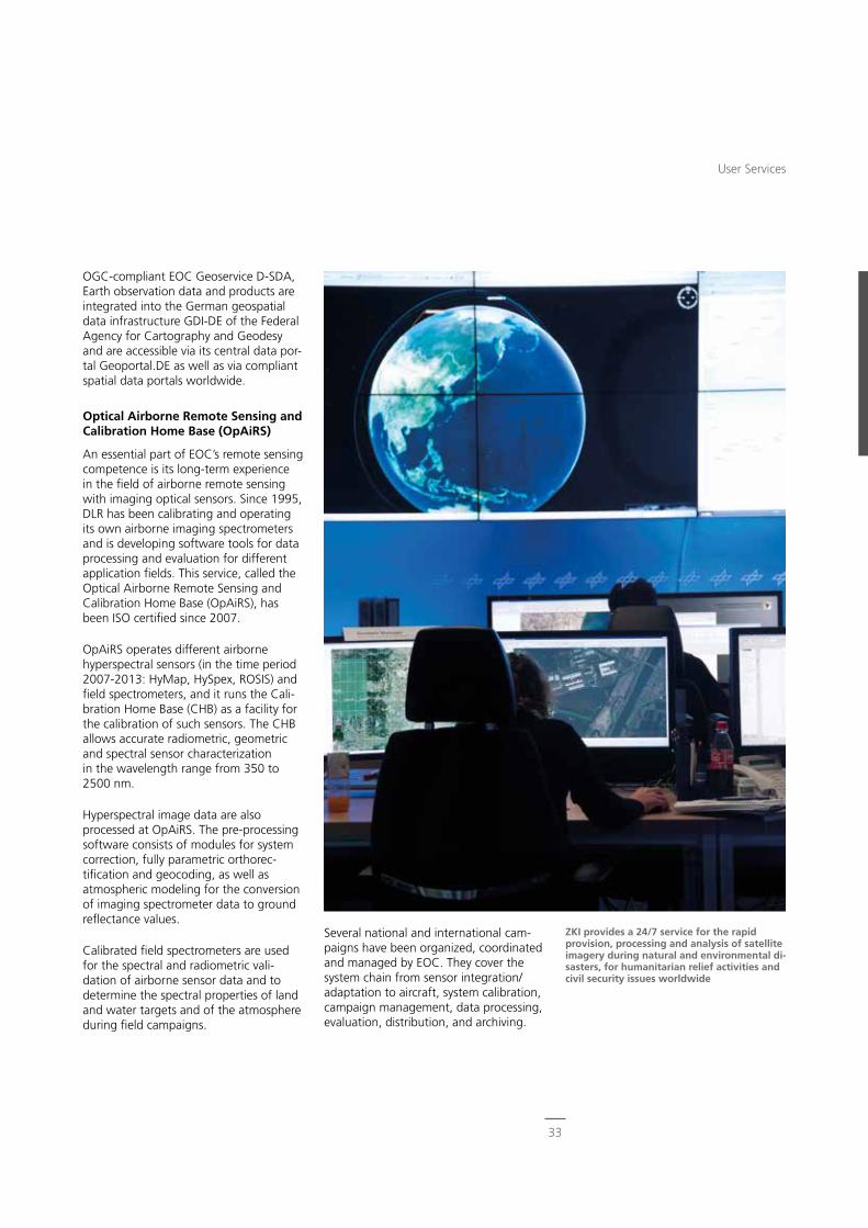
ZKI provides a 24/7 service for the rapid provision, processing and analysis of satellite imagery during natural and environmental di-sasters, for humanitarian relief activities and civil security issues worldwide
OGC-compliant EOC Geoservice D-SDA, Earth observation data and products are integrated into the German geospatial data infrastructure GDI-DE of the Federal Agency for Cartography and Geodesy and are accessible via its central data por-tal Geoportal.DE as well as via compliant spatial data portals worldwide.
Optical Airborne Remote Sensing and Calibration Home Base (OpAiRS)
An essential part of EOC’s remote sensing competence is its long-term experience in the field of airborne remote sensing with imaging optical sensors. Since 1995, DLR has been calibrating and operating its own airborne imaging spectrometers and is developing software tools for data processing and evaluation for different application fields. This service, called the Optical Airborne Remote Sensing and Calibration Home Base (OpAiRS), has been ISO certified since 2007.
OpAiRS operates different airborne hyperspectral sensors (in the time period 2007-2013: HyMap, HySpex, ROSIS) and field spectrometers, and it runs the Cali-bration Home Base (CHB) as a facility for the calibration of such sensors. The CHB allows accurate radiometric, geometric and spectral sensor characterization in the wavelength range from 350 to 2500 nm.
Hyperspectral image data are also processed at OpAiRS. The pre-processing software consists of modules for system correction, fully parametric orthorec-tification and geocoding, as well as atmospheric modeling for the conversion of imaging spectrometer data to ground reflectance values.
Calibrated field spectrometers are used for the spectral and radiometric vali-dation of airborne sensor data and to determine the spectral properties of land and water targets and of the atmosphere during field campaigns.
Several national and international cam-paigns have been organized, coordinated and managed by EOC. They cover the system chain from sensor integration/adaptation to aircraft, system calibration, campaign management, data processing, evaluation, distribution, and archiving.
33
User Services
The EOC office, research and opera-tional environments require a number of IT infrastructure elements, the most important being:
- LAN and WAN
- computer rooms including air condi-tioning and an Uninterruptable Power Supply
- servers, blade centers and virtual machines
- disk storage and a Storage Area Net-work (SAN)
- long term archiving elements (robot libraries and tape drives)
- personal computers
- central services (home service, backup service, print service, license service)
- communication systems (phones, video conference systems).
IT core elements such as servers and stor-age systems are installed and operated by EOC personnel. Standard adminis-trative tasks such as installing personal computers or installing and operating office communication infrastructure are procured from the DLR IT service provider.
Every five years the IT management is reviewed by a team of external experts. The last IT audit was performed in 2012 when the IT management was declared to be of high standard.
Central Services EOC greatly profits from the syner-gies rsulting from the close collabo-ration of its two institutes. Central services like IT management, con-trolling, quality management, science visualization and web services are jointly financed, used, and further developed.
This makes available an extensive range of services that could not be realized to this extent by each insti-tute alone.
IT Management
The IT management is responsible for EOC’s IT infrastructure.
Especially EOC’s numerous operational tasks in connection with reception, pro-cessing, archiving and distributing remote sensing data impose special require-ments. Data integrity, data security, data throughput, data transfer over WAN, near-real-time response, and availability are key factors.
Several tasks performed by EOC use infrastructure provided by partners, examples being the processing and archiving center for ESA’s Sentinels or the reception and processing equipment for WorldView-2. This equipment is usually located in a separate network environ-ment with separate WAN access and therefore increases the complexity of IT management.
A further complexity arises from our infrastructure located across the globe. Four receiving stations, inter alia in the Arctic and Antarctica, and four sites in Germany require communication over WAN, including satellite links.
34
Earth Observation Center
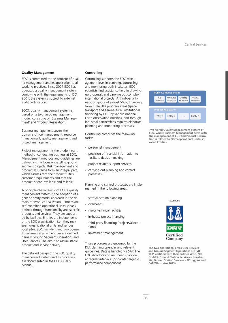
TopManagement
Entity 1 Entity 2 · · · Entity n
Business Management
Product Realization
ResourceManagement
QualityManagement
QualityManagement
ProjectManagement
Controlling
Controlling supports the EOC man-agement level in planning, controlling and monitoring both institutes. EOC scientists find assistance here in drawing up proposals and carrying out complex international projects. A third-party fi-nancing quota of almost 50%, financing from three DLR program areas (space, transport and aeronautics), institutional financing by HGF, by various national Earth observation missions, and through industrial partnerships requires elaborate planning and monitoring processes.
Controlling comprises the following tasks:
- personnel management
- provision of financial information to facilitate decision making
- project-related support services
- carrying out planning and control processes.
Planning and control processes are imple-mented in the following areas:
- staff allocation planning
- overheads
- major technical facilities
- in-house project financing
- third-party financing (projects/alloca-tions)
- investment management.
These processes are governed by the DLR planning calendar and relevant guidelines. Data is handled via SAP. The EOC directors and unit heads provide at regular intervals up-to-date target vs. performance comparisons.
Quality Management
EOC is committed to the concept of qual-ity management and its application to all working practices. Since 2007 EOC has operated a quality management system complying with the requirements of ISO 9001; the system is subject to external audit certification.
EOC’s quality management system is based on a two-tiered management model, consisting of ‘Business Manage-ment’ and ‘Product Realization’.
Business management covers the domains of top management, resource management, quality management and project management.
Project management is the predominant method of conducting business at EOC. Management methods and guidelines are defined with a focus on satellite ground segment projects. Risk management and product assurance form an integral part, which assures that the product fulfills customer requirements and that the product is safe, available and reliable.
A principle characteristic of EOC’s quality management system is the adoption of a generic entity model approach in the do-main of ‘Product Realization.’ Entities are self-contained operational units, clearly defined through functionality and specific products and services. They are support-ed by facilities. Entities are independent of the EOC organization, i.e., they may span organizational units and various local sites. EOC has identified two opera-tional areas in which entities are defined, namely Ground Segment Operations and User Services. The aim is to assure stable product and service delivery.
The detailed design of the EOC quality management system and its processes are documented in the EOC Quality Manual.
Two-tiered Quality Management System of EOC, where Business Management deals with the management of EOC and Product Realiza-tion is related to EOC’s operational units, so called Entities
The two operational areas User Services and Ground Segment Operations are ISO 9001 certified with their entities WDC, ZKI, OpAiRS, Ground Station Services – Neustre-litz, Ground Station Services – O’ Higgins and CATENA (status 2013)
35
Central Services
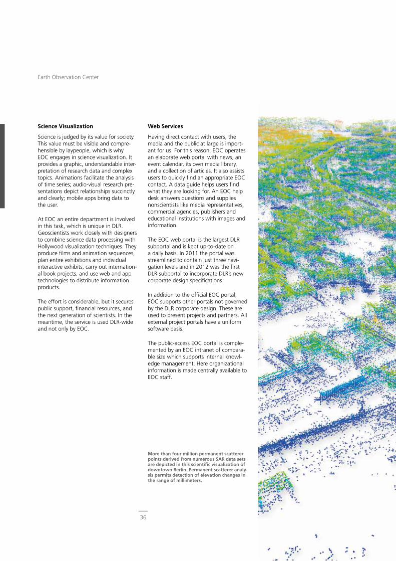
Science Visualization
Science is judged by its value for society. This value must be visible and compre-hensible by laypeople, which is why EOC engages in science visualization. It provides a graphic, understandable inter-pretation of research data and complex topics. Animations facilitate the analysis of time series; audio-visual research pre-sentations depict relationships succinctly and clearly; mobile apps bring data to the user.
At EOC an entire department is involved in this task, which is unique in DLR. Geoscientists work closely with designers to combine science data processing with Hollywood visualization techniques. They produce films and animation sequences, plan entire exhibitions and individual interactive exhibits, carry out internation-al book projects, and use web and app technologies to distribute information products.
The effort is considerable, but it secures public support, financial resources, and the next generation of scientists. In the meantime, the service is used DLR-wide and not only by EOC.
Web Services
Having direct contact with users, the media and the public at large is import-ant for us. For this reason, EOC operates an elaborate web portal with news, an event calendar, its own media library, and a collection of articles. It also assists users to quickly find an appropriate EOC contact. A data guide helps users find what they are looking for. An EOC help desk answers questions and supplies nonscientists like media representatives, commercial agencies, publishers and educational institutions with images and information.
The EOC web portal is the largest DLR subportal and is kept up-to-date on a daily basis. In 2011 the portal was streamlined to contain just three navi-gation levels and in 2012 was the first DLR subportal to incorporate DLR’s new corporate design specifications.
In addition to the official EOC portal, EOC supports other portals not governed by the DLR corporate design. These are used to present projects and partners. All external project portals have a uniform software basis.
The public-access EOC portal is comple-mented by an EOC intranet of compara-ble size which supports internal knowl-edge management. Here organizational information is made centrally available to EOC staff.
More than four million permanent scatterer points derived from numerous SAR data sets are depicted in this scientific visualization of downtown Berlin. Permanent scatterer analy-sis permits detection of elevation changes in the range of millimeters.
36
Earth Observation Center
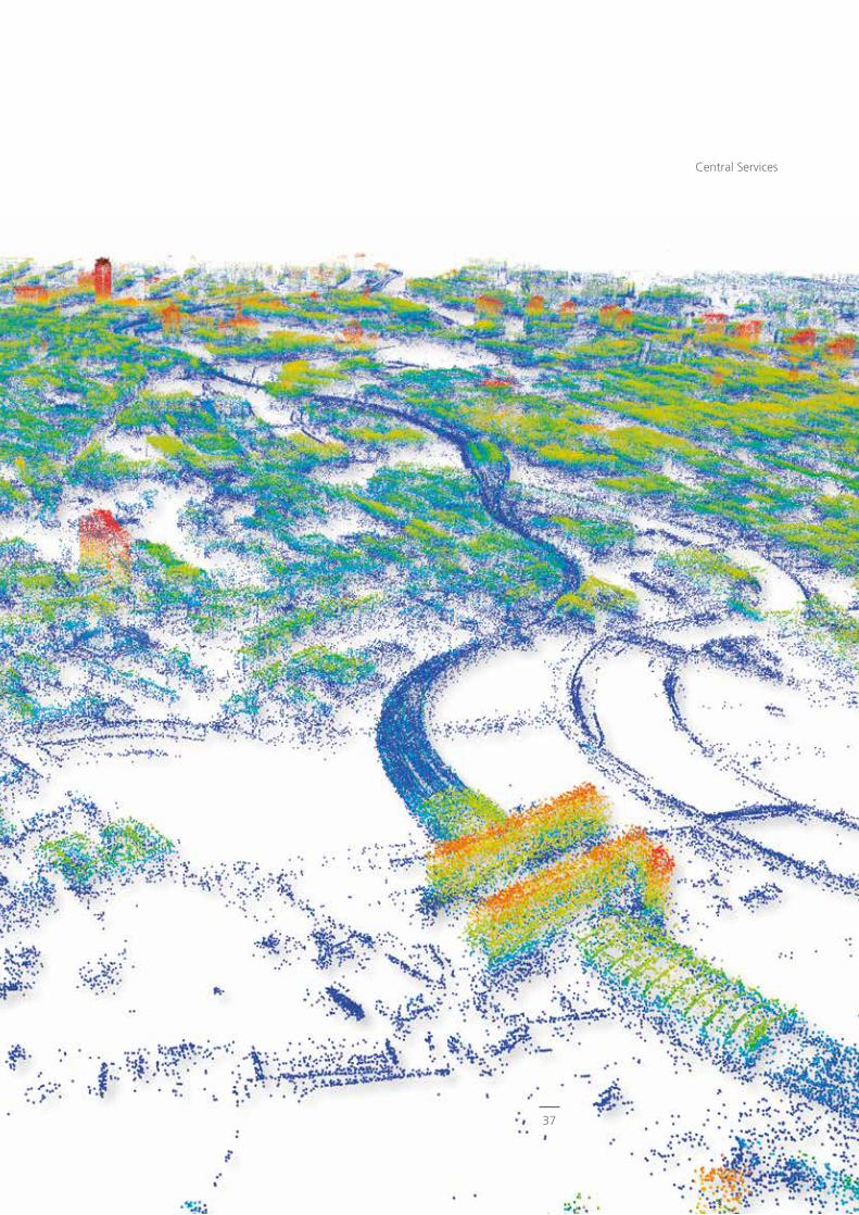
37
Central Services

38

39
Central Services
Bilder über
39
Remote Sensing Technology Institute
Introduction
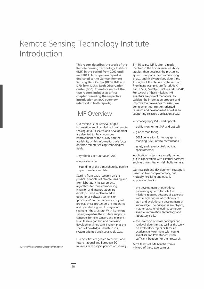
40
Earth Observation Center
40
This report describes the work of the Remote Sensing Technology Institute (IMF) in the period from 2007 until mid-2013. A companion report is dedicated to the German Remote Sensing Data Center (DFD). IMF and DFD form DLR's Earth Observation center (EOC). Therefore each of the two reports includes as a first chapter preceding the respective introduction an EOC overview (identical in both reports).
IMF Overview
Our mission is the retrieval of geo-information and knowledge from remote sensing data. Research and development are devoted to the continuous improvement of the quality and the availability of this information. We focus on three remote sensing technological fields:
synthetic aperture radar (SAR)
optical imaging
sounding of the atmosphere by passive spectrometers and lidar.
Starting from basic research on the physical principles of remote sensing and from laboratory measurements, algorithms for forward modeling, inversion and interpretation are developed and implemented as operational software systems or ‘processors’. In the framework of joint projects these processors are integrated and operated e.g. in DFD’s ground segment infrastructure. With its remote sensing expertise the institute supports concepts for new sensors and missions. In all these algorithm and processor development lines care is taken that the specific knowledge is built-up in a system-oriented and sustainable way.
Our activities are geared to current and future national and European EO missions with project periods of typically
5 – 10 years. IMF is often already involved in the first mission feasibility studies, then develops the processing systems, supports the commissioning phase, and finally provides algorithms throughout the lifetime of the mission. Prominent examples are TerraSAR-X, TanDEM-X, MetOp/GOME-2 and EnMAP. For several of these missions IMF scientists are project managers. To validate the information products and improve their relevance for users, we complement our mission-oriented research and development activities by supporting selected application areas:
oceanography (SAR and optical)
traffic monitoring (SAR and optical)
glacier monitoring
DEM generation for topographic mapping (SAR, optical stereoscopic)
safety and security (SAR, optical, spectrometric).
Application projects are mostly carried out in cooperation with external partners such as universities or Helmholtz centers.
Our research and development strategy is based on two complementary, but mutually fertilizing and equally appreciated tracks:
the development of operational processing systems for satellite missions requires decades of expertise with a high degree of continuity of staff and evolutionary development of knowledge. The disciplines are physics, mathematics, engineering, computer science, information technology and laboratory skills.
the invention of novel concepts and retrieval algorithms as well as the work on exploratory topics calls for an academic environment with young scientists and PhD students with sufficient freedom for their research.
Most teams of IMF benefit from a mixture of these two cultures.
Remote Sensing Technology Institute Introduction
IMF staff at campus Oberpfaffenhofen
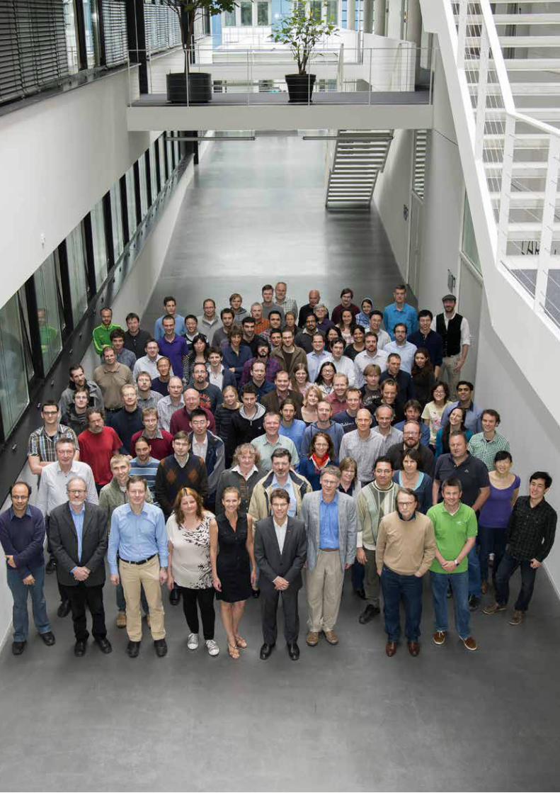
41
Central Services
40
This report describes the work of the Remote Sensing Technology Institute (IMF) in the period from 2007 until mid-2013. A companion report is dedicated to the German Remote Sensing Data Center (DFD). IMF and DFD form DLR's Earth Observation center (EOC). Therefore each of the two reports includes as a first chapter preceding the respective introduction an EOC overview (identical in both reports).
IMF Overview
Our mission is the retrieval of geo-information and knowledge from remote sensing data. Research and development are devoted to the continuous improvement of the quality and the availability of this information. We focus on three remote sensing technological fields:
synthetic aperture radar (SAR)
optical imaging
sounding of the atmosphere by passive spectrometers and lidar.
Starting from basic research on the physical principles of remote sensing and from laboratory measurements, algorithms for forward modeling, inversion and interpretation are developed and implemented as operational software systems or ‘processors’. In the framework of joint projects these processors are integrated and operated e.g. in DFD’s ground segment infrastructure. With its remote sensing expertise the institute supports concepts for new sensors and missions. In all these algorithm and processor development lines care is taken that the specific knowledge is built-up in a system-oriented and sustainable way.
Our activities are geared to current and future national and European EO missions with project periods of typically
5 – 10 years. IMF is often already involved in the first mission feasibility studies, then develops the processing systems, supports the commissioning phase, and finally provides algorithms throughout the lifetime of the mission. Prominent examples are TerraSAR-X, TanDEM-X, MetOp/GOME-2 and EnMAP. For several of these missions IMF scientists are project managers. To validate the information products and improve their relevance for users, we complement our mission-oriented research and development activities by supporting selected application areas:
oceanography (SAR and optical)
traffic monitoring (SAR and optical)
glacier monitoring
DEM generation for topographic mapping (SAR, optical stereoscopic)
safety and security (SAR, optical, spectrometric).
Application projects are mostly carried out in cooperation with external partners such as universities or Helmholtz centers.
Our research and development strategy is based on two complementary, but mutually fertilizing and equally appreciated tracks:
the development of operational processing systems for satellite missions requires decades of expertise with a high degree of continuity of staff and evolutionary development of knowledge. The disciplines are physics, mathematics, engineering, computer science, information technology and laboratory skills.
the invention of novel concepts and retrieval algorithms as well as the work on exploratory topics calls for an academic environment with young scientists and PhD students with sufficient freedom for their research.
Most teams of IMF benefit from a mixture of these two cultures.
Remote Sensing Technology Institute Introduction
IMF staff at campus Oberpfaffenhofen
Introduction > IMF Overview
41
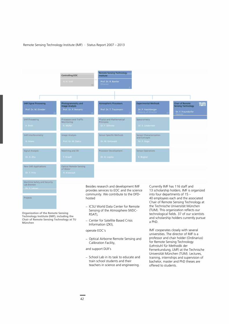
42
Earth Observation Center
42
Remote Sensing Technology Institute (IMF) ∙ Status Report 2007 – 2013
Besides research and development IMF provides services to EOC and the science community. We contribute to the DFD-hosted
ICSU World Data Center for Remote Sensing of the Atmosphere (WDC-RSAT),
Center for Satellite Based Crisis Information (ZKI),
operate EOC's
Optical Airborne Remote Sensing and Calibration Facility,
and support DLR’s
School Lab in its task to educate and train school students and their teachers in science and engineering.
Currently IMF has 116 staff and 13 scholarship holders. IMF is organized into four departments of 15 – 40 employees each and the associated Chair of Remote Sensing Technology at the Technische Universität München (TUM). This organization reflects our technological fields. 37 of our scientists and scholarship holders currently pursue a PhD.
IMF cooperates closely with several universities. The director of IMF is a professor and chair holder (Ordinarius) for Remote Sensing Technology (Lehrstuhl für Methodik der Fernerkundung, LMF) at the Technische Universität München (TUM). Lectures, training, internships and supervision of bachelor, master and PhD theses are offered to students.
Organization of the Remote Sensing Technology Institute (IMF), including the Chair of Remote Sensing Technology at TU München
Introduction > Structure of this Report
43
IMF staff in Berlin-Adlershof (top), Neustrelitz (left) and Bremen (right)
Structure of this Report
The following IMF part of the report is arranged in three chapters reflecting our three technology fields of SAR, optical imaging and sounding of the atmosphere. Each chapter is structured into three parts: First our contributions to EO missions are listed, followed by a depiction of our generic processing system developments. Finally scientific method developments and applications are described. Each section closes with a selection of relevant publications authored by IMF scientists.
The fourth chapter ‘Documentation’ concludes the report with a compilation of academic activities and publications to document IMF’s scientific output.
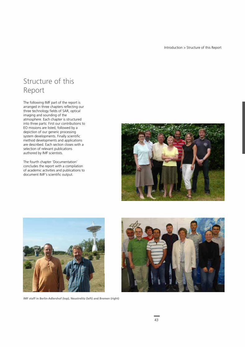
43
Central Services
42
Remote Sensing Technology Institute (IMF) ∙ Status Report 2007 – 2013
Besides research and development IMF provides services to EOC and the science community. We contribute to the DFD-hosted
ICSU World Data Center for Remote Sensing of the Atmosphere (WDC-RSAT),
Center for Satellite Based Crisis Information (ZKI),
operate EOC's
Optical Airborne Remote Sensing and Calibration Facility,
and support DLR’s
School Lab in its task to educate and train school students and their teachers in science and engineering.
Currently IMF has 116 staff and 13 scholarship holders. IMF is organized into four departments of 15 – 40 employees each and the associated Chair of Remote Sensing Technology at the Technische Universität München (TUM). This organization reflects our technological fields. 37 of our scientists and scholarship holders currently pursue a PhD.
IMF cooperates closely with several universities. The director of IMF is a professor and chair holder (Ordinarius) for Remote Sensing Technology (Lehrstuhl für Methodik der Fernerkundung, LMF) at the Technische Universität München (TUM). Lectures, training, internships and supervision of bachelor, master and PhD theses are offered to students.
Organization of the Remote Sensing Technology Institute (IMF), including the Chair of Remote Sensing Technology at TU München
Introduction > Structure of this Report
43
IMF staff in Berlin-Adlershof (top), Neustrelitz (left) and Bremen (right)
Structure of this Report
The following IMF part of the report is arranged in three chapters reflecting our three technology fields of SAR, optical imaging and sounding of the atmosphere. Each chapter is structured into three parts: First our contributions to EO missions are listed, followed by a depiction of our generic processing system developments. Finally scientific method developments and applications are described. Each section closes with a selection of relevant publications authored by IMF scientists.
The fourth chapter ‘Documentation’ concludes the report with a compilation of academic activities and publications to document IMF’s scientific output.

44
Earth Observation Center
44
Remote Sensing Technology Institute (IMF) ∙ Status Report 2007 – 2013
45
Central Services
44
Remote Sensing Technology Institute (IMF) ∙ Status Report 2007 – 2013
Synthetic Aperture Radar
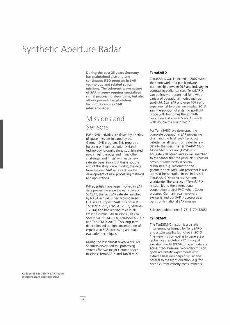
46
Earth Observation Center
46
During the past 25 years Germany has maintained a strong and continuous R&D program in SAR technology and related space missions. The coherent-wave nature of SAR imagery requires specialized signal processing algorithms, but also allows powerful exploitation techniques such as SAR interferometry.
Missions and Sensors IMF’s SAR activities are driven by a series of space missions initiated by the German SAR program. This program, focusing on high resolution X-Band technology, brought along sophisticated new imaging modes and many other challenges and ‘firsts’ with each new satellite generation. But this is not the end of the story: once in orbit, the data from the new SAR sensors drives the development of new processing methods and applications.
IMF scientists have been involved in SAR data processing since the early days of SEASAT, the first SAR satellite launched by NASA in 1978. They accompanied ESA in all European SAR missions (ERS-1/2 1991/1995, ENVISAT 2002, Sentinel-1 2014) and had leading roles in all civilian German SAR missions (SIR-C/X-SAR 1994, SRTM 2000, TerraSAR-X 2007 and TanDEM-X 2010). This long-term dedication led to high concentration of expertise in SAR processing and data evaluation techniques.
During the last almost seven years, IMF scientists developed the processing systems for two major German space missions: TerraSAR-X and TanDEM-X.
TerraSAR-X
TerraSAR-X was launched in 2007 within the framework of a public private partnership between DLR and industry. In contrast to earlier sensors, TerraSAR-X can be freely programmed for a wide variety of operational modes such as spotlight, ScanSAR and even TOPS and experimental two-channel modes. 2013 saw the addition of a staring spotlight mode with four times the azimuth resolution and a wide ScanSAR mode with double the swath width.
For TerraSAR-X we developed the complete operational SAR processing chain and the final level-1 product palette, i.e. all steps from satellite raw data to the user. The TerraSAR-X Multi Mode SAR processor (TMSP) is so accurately designed and so well matched to the sensor that the products surpassed previous world bests in several disciplines, e.g. radiometric and geometric accuracy. Our processor is also licensed for operation in the industrial TerraSAR-X Direct Access Stations worldwide. The success of TerraSAR-X mission led to the international cooperation project PAZ, where Spain procured German radar hardware elements and our SAR processor as a basis for its national SAR mission.
Selected publications: [178], [179], [205]
TanDEM-X
The TanDEM-X mission is a bistatic interferometer formed by TerraSAR-X and a twin satellite launched in 2010. The main mission goal is to generate a global high resolution (12 m) digital elevation model (DEM) using a moderate across track baseline. Secondary mission goals are bistatic experiments with extreme baselines perpendicular and parallel to the flight direction, e.g. for ocean current velocity measurements.
Synthetic Aperture Radar
Collage of TanDEM-X SAR image, interferogram and final DEM
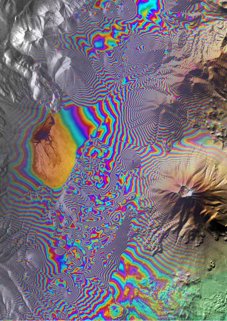
47
Central Services
46
During the past 25 years Germany has maintained a strong and continuous R&D program in SAR technology and related space missions. The coherent-wave nature of SAR imagery requires specialized signal processing algorithms, but also allows powerful exploitation techniques such as SAR interferometry.
Missions and Sensors IMF’s SAR activities are driven by a series of space missions initiated by the German SAR program. This program, focusing on high resolution X-Band technology, brought along sophisticated new imaging modes and many other challenges and ‘firsts’ with each new satellite generation. But this is not the end of the story: once in orbit, the data from the new SAR sensors drives the development of new processing methods and applications.
IMF scientists have been involved in SAR data processing since the early days of SEASAT, the first SAR satellite launched by NASA in 1978. They accompanied ESA in all European SAR missions (ERS-1/2 1991/1995, ENVISAT 2002, Sentinel-1 2014) and had leading roles in all civilian German SAR missions (SIR-C/X-SAR 1994, SRTM 2000, TerraSAR-X 2007 and TanDEM-X 2010). This long-term dedication led to high concentration of expertise in SAR processing and data evaluation techniques.
During the last almost seven years, IMF scientists developed the processing systems for two major German space missions: TerraSAR-X and TanDEM-X.
TerraSAR-X
TerraSAR-X was launched in 2007 within the framework of a public private partnership between DLR and industry. In contrast to earlier sensors, TerraSAR-X can be freely programmed for a wide variety of operational modes such as spotlight, ScanSAR and even TOPS and experimental two-channel modes. 2013 saw the addition of a staring spotlight mode with four times the azimuth resolution and a wide ScanSAR mode with double the swath width.
For TerraSAR-X we developed the complete operational SAR processing chain and the final level-1 product palette, i.e. all steps from satellite raw data to the user. The TerraSAR-X Multi Mode SAR processor (TMSP) is so accurately designed and so well matched to the sensor that the products surpassed previous world bests in several disciplines, e.g. radiometric and geometric accuracy. Our processor is also licensed for operation in the industrial TerraSAR-X Direct Access Stations worldwide. The success of TerraSAR-X mission led to the international cooperation project PAZ, where Spain procured German radar hardware elements and our SAR processor as a basis for its national SAR mission.
Selected publications: [178], [179], [205]
TanDEM-X
The TanDEM-X mission is a bistatic interferometer formed by TerraSAR-X and a twin satellite launched in 2010. The main mission goal is to generate a global high resolution (12 m) digital elevation model (DEM) using a moderate across track baseline. Secondary mission goals are bistatic experiments with extreme baselines perpendicular and parallel to the flight direction, e.g. for ocean current velocity measurements.
Synthetic Aperture Radar
Collage of TanDEM-X SAR image, interferogram and final DEM
Synthetic Aperture Radar > Missions and Sensors
47
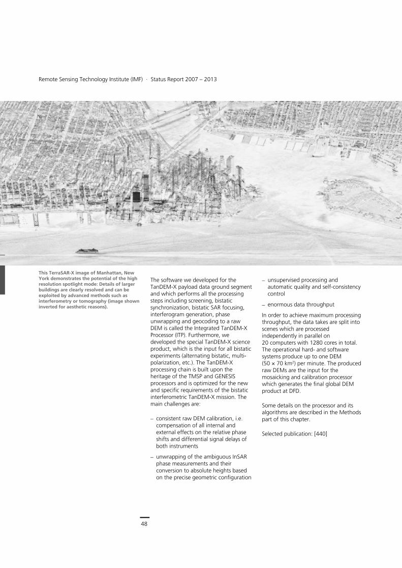
48
Earth Observation Center
Remote Sensing Technology Institute (IMF) ∙ Status Report 2007 – 2013
48
The software we developed for the TanDEM-X payload data ground segment and which performs all the processing steps including screening, bistatic synchronization, bistatic SAR focusing, interferogram generation, phase unwrapping and geocoding to a raw DEM is called the Integrated TanDEM-X Processor (ITP). Furthermore, we developed the special TanDEM-X science product, which is the input for all bistatic experiments (alternating bistatic, multi-polarization, etc.). The TanDEM-X processing chain is built upon the heritage of the TMSP and GENESIS processors and is optimized for the new and specific requirements of the bistatic interferometric TanDEM-X mission. The main challenges are:
consistent raw DEM calibration, i.e. compensation of all internal and external effects on the relative phase shifts and differential signal delays of both instruments
unwrapping of the ambiguous InSAR phase measurements and their conversion to absolute heights based on the precise geometric configuration
unsupervised processing and automatic quality and self-consistency control
enormous data throughput
In order to achieve maximum processing throughput, the data takes are split into scenes which are processed independently in parallel on 20 computers with 1280 cores in total. The operational hard- and software systems produce up to one DEM (50 × 70 km2) per minute. The produced raw DEMs are the input for the mosaicking and calibration processor which generates the final global DEM product at DFD.
Some details on the processor and its algorithms are described in the Methods part of this chapter.
Selected publication: [440]
This TerraSAR-X image of Manhattan, New York demonstrates the potential of the high resolution spotlight mode: Details of larger buildings are clearly resolved and can be exploited by advanced methods such as interferometry or tomography (image shown inverted for aesthetic reasons).
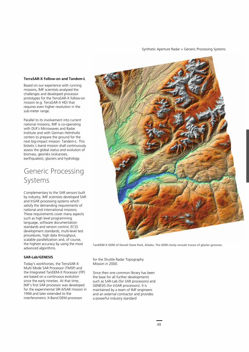
49
Central Services
Remote Sensing Technology Institute (IMF) ∙ Status Report 2007 – 2013
48
The software we developed for the TanDEM-X payload data ground segment and which performs all the processing steps including screening, bistatic synchronization, bistatic SAR focusing, interferogram generation, phase unwrapping and geocoding to a raw DEM is called the Integrated TanDEM-X Processor (ITP). Furthermore, we developed the special TanDEM-X science product, which is the input for all bistatic experiments (alternating bistatic, multi-polarization, etc.). The TanDEM-X processing chain is built upon the heritage of the TMSP and GENESIS processors and is optimized for the new and specific requirements of the bistatic interferometric TanDEM-X mission. The main challenges are:
consistent raw DEM calibration, i.e. compensation of all internal and external effects on the relative phase shifts and differential signal delays of both instruments
unwrapping of the ambiguous InSAR phase measurements and their conversion to absolute heights based on the precise geometric configuration
unsupervised processing and automatic quality and self-consistency control
enormous data throughput
In order to achieve maximum processing throughput, the data takes are split into scenes which are processed independently in parallel on 20 computers with 1280 cores in total. The operational hard- and software systems produce up to one DEM (50 × 70 km2) per minute. The produced raw DEMs are the input for the mosaicking and calibration processor which generates the final global DEM product at DFD.
Some details on the processor and its algorithms are described in the Methods part of this chapter.
Selected publication: [440]
This TerraSAR-X image of Manhattan, New York demonstrates the potential of the high resolution spotlight mode: Details of larger buildings are clearly resolved and can be exploited by advanced methods such as interferometry or tomography (image shown inverted for aesthetic reasons).
Synthetic Aperture Radar > Generic Processing Systems
49
TanDEM-X DEM of Denali State Park, Alaska. The DEM nicely reveals traces of glacier grooves.
TerraSAR-X Follow-on and Tandem-L
Based on our experience with running missions, IMF scientists analyzed the challenges and developed processor prototypes for the TerraSAR-X follow-on mission (e.g. TerraSAR-X HD) that requires even higher resolution in the sub-meter range.
Parallel to its involvement into current national missions, IMF is co-operating with DLR’s Microwaves and Radar Institute and with German Helmholtz centers to prepare the ground for the next big-impact mission: Tandem-L. This bistatic L-band mission shall continuously assess the global status and evolution of biomass, georisks (volcanoes, earthquakes), glaciers and hydrology.
Generic Processing Systems
Complementary to the SAR sensors built by industry, IMF scientists developed SAR and InSAR processing systems which satisfy the demanding requirements of national and international missions. These requirements cover many aspects such as high level programming language, software documentation standards and version control, ECSS development standards, multi-level test procedures, high data throughput, scalable parallelization and, of course, the highest accuracy by using the most advanced algorithms.
SAR-Lab/GENESIS
Today’s workhorses, the TerraSAR-X Multi Mode SAR Processor (TMSP) and the Integrated TanDEM-X Processor (ITP) are based on a continuous evolution since the early nineties. At that time, IMF’s first SAR processor was developed for the experimental SIR-X/SAR mission in 1994 and later extended to the interferometric X-Band DEM processor
for the Shuttle Radar Topography Mission in 2000.
Since then one common library has been the base for all further developments such as SAR-Lab (for SAR processors) and GENESIS (for InSAR processors). It is maintained by a team of IMF engineers and an external contractor and provides a powerful industry standard
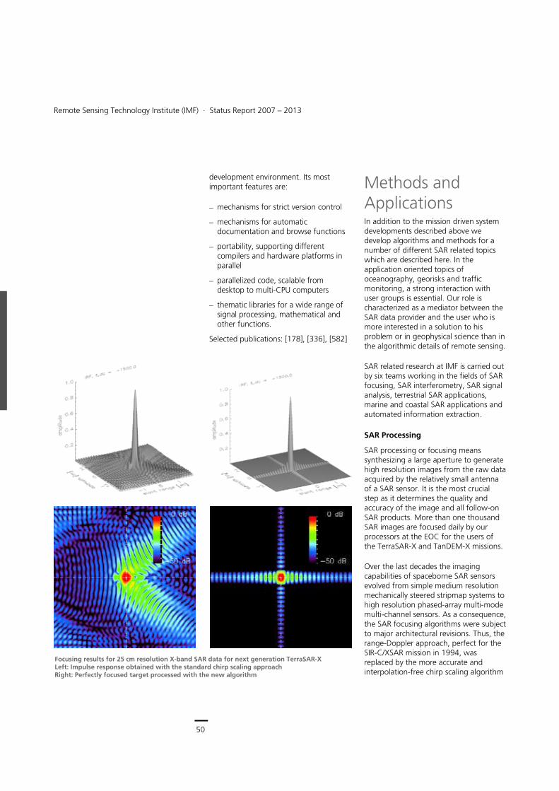
50
Earth Observation Center
Remote Sensing Technology Institute (IMF) ∙ Status Report 2007 – 2013
50
development environment. Its most important features are:
mechanisms for strict version control
mechanisms for automatic documentation and browse functions
portability, supporting different compilers and hardware platforms in parallel
parallelized code, scalable from desktop to multi-CPU computers
thematic libraries for a wide range of signal processing, mathematical and other functions.
Selected publications: [178], [336], [582]
Methods and Applications In addition to the mission driven system developments described above we develop algorithms and methods for a number of different SAR related topics which are described here. In the application oriented topics of oceanography, georisks and traffic monitoring, a strong interaction with user groups is essential. Our role is characterized as a mediator between the SAR data provider and the user who is more interested in a solution to his problem or in geophysical science than in the algorithmic details of remote sensing.
SAR related research at IMF is carried out by six teams working in the fields of SAR focusing, SAR interferometry, SAR signal analysis, terrestrial SAR applications, marine and coastal SAR applications and automated information extraction.
SAR Processing
SAR processing or focusing means synthesizing a large aperture to generate high resolution images from the raw data acquired by the relatively small antenna of a SAR sensor. It is the most crucial step as it determines the quality and accuracy of the image and all follow-on SAR products. More than one thousand SAR images are focused daily by our processors at the EOC for the users of the TerraSAR-X and TanDEM-X missions.
Over the last decades the imaging capabilities of spaceborne SAR sensors evolved from simple medium resolution mechanically steered stripmap systems to high resolution phased-array multi-mode multi-channel sensors. As a consequence, the SAR focusing algorithms were subject to major architectural revisions. Thus, the range-Doppler approach, perfect for the SIR-C/XSAR mission in 1994, was replaced by the more accurate and interpolation-free chirp scaling algorithm
Focusing results for 25 cm resolution X-band SAR data for next generation TerraSAR-X Left: Impulse response obtained with the standard chirp scaling approach Right: Perfectly focused target processed with the new algorithm
Synthetic Aperture Radar > Methods and Applications
51
for SRTM in 2000. Later, this processor was extended by SPECAN elements for ScanSAR, TOPSAR and sliding spotlight processing and, most importantly, fused into the hybrid TerraSAR-X Multi-mode SAR processor (TMSP) for the TerraSAR-X mission.
For processing of bistatic SAR data IMF developed two algorithms, the ‘equivalent velocity approach’ and ‘NuSAR’. Whereas the NuSAR algorithm is flexible enough to handle even extreme bistatic configurations, the highly efficient equivalent velocity approach is now an extension to TMSP for focusing TanDEM-X data with a moderately bistatic configuration.
The most recent algorithm development activities at IMF are heading towards extremely high resolution SAR for the next generation X-band SAR systems with bandwidths exceeding 1 GHz. In this regime, the approximation to the SAR transfer function introduced with the invention of the chirp scaling algorithm by IMF scientists has been critically revised. As a result, the analytical computation and approximation of filter functions are supplemented by numerical computations and are updated even within the synthetic aperture. This new algorithm has been successfully tested by a prototype SAR processor. In the framework of an industrial contract study for the TerraSAR-X follow-on system it has proven to achieve a resolution better than 25 cm in both range and azimuth. The essential elements of the new VHR algorithm have also been incorporated into the operational TMSP enabling focusing of the new TerraSAR-X staring spotlight data at an azimuth resolution of 22 cm. For focusing data in this resolution class, the correction of atmospheric propagation delays is crucial. TMSP uses a built-in dry troposphere model which reduces residual range errors to less than 50 cm. Higher accuracies are achieved by more sophisticated corrections as described later.
In order to implement the best possible geometric pixel localization accuracy, the conventional start-stop approximation and the analytic computation of the velocity parameter are replaced by a numeric reconstruction of the phase history. It takes into account satellite motion between transmitting and receiving a chirp and even during chirp transmission. This ensures that SAR focusing does not contribute to the pixel location error budget. In fact, the high accuracy enabled us to detect and calibrate the receiver gain dependent instrument delays on the order 10-11 s, corresponding to a few millimeters.
As mentioned before, all developments are made on a common unified software development environment so that all SAR nomenclature, units, parameter calculation, sub-routines etc. are consistent, even across different SAR systems and modes. Only so can a complex software environment be maintained over decades, as required by SAR satellite missions.
Selected publications: [178], [226], [596], [939]
TerraSAR-X high resolution spotlight image of DLR Oberpfaffenhofen with a resolution of approximately 1 m (top). The new staring spotlight mode provides up to 25 cm azimuth resolution or an improved radimetry as shown in this image (bottom).
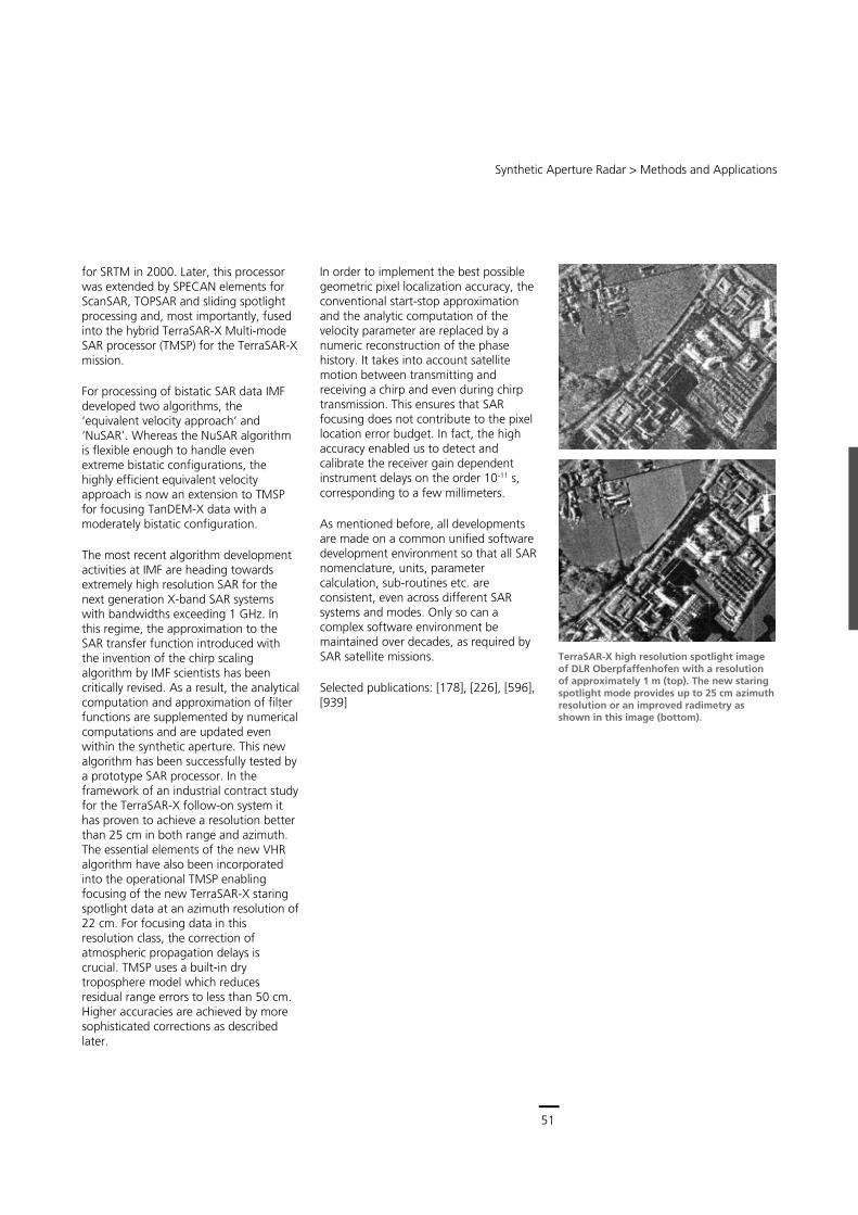
51
Central Services
Remote Sensing Technology Institute (IMF) ∙ Status Report 2007 – 2013
50
development environment. Its most important features are:
mechanisms for strict version control
mechanisms for automatic documentation and browse functions
portability, supporting different compilers and hardware platforms in parallel
parallelized code, scalable from desktop to multi-CPU computers
thematic libraries for a wide range of signal processing, mathematical and other functions.
Selected publications: [178], [336], [582]
Methods and Applications In addition to the mission driven system developments described above we develop algorithms and methods for a number of different SAR related topics which are described here. In the application oriented topics of oceanography, georisks and traffic monitoring, a strong interaction with user groups is essential. Our role is characterized as a mediator between the SAR data provider and the user who is more interested in a solution to his problem or in geophysical science than in the algorithmic details of remote sensing.
SAR related research at IMF is carried out by six teams working in the fields of SAR focusing, SAR interferometry, SAR signal analysis, terrestrial SAR applications, marine and coastal SAR applications and automated information extraction.
SAR Processing
SAR processing or focusing means synthesizing a large aperture to generate high resolution images from the raw data acquired by the relatively small antenna of a SAR sensor. It is the most crucial step as it determines the quality and accuracy of the image and all follow-on SAR products. More than one thousand SAR images are focused daily by our processors at the EOC for the users of the TerraSAR-X and TanDEM-X missions.
Over the last decades the imaging capabilities of spaceborne SAR sensors evolved from simple medium resolution mechanically steered stripmap systems to high resolution phased-array multi-mode multi-channel sensors. As a consequence, the SAR focusing algorithms were subject to major architectural revisions. Thus, the range-Doppler approach, perfect for the SIR-C/XSAR mission in 1994, was replaced by the more accurate and interpolation-free chirp scaling algorithm
Focusing results for 25 cm resolution X-band SAR data for next generation TerraSAR-X Left: Impulse response obtained with the standard chirp scaling approach Right: Perfectly focused target processed with the new algorithm
Synthetic Aperture Radar > Methods and Applications
51
for SRTM in 2000. Later, this processor was extended by SPECAN elements for ScanSAR, TOPSAR and sliding spotlight processing and, most importantly, fused into the hybrid TerraSAR-X Multi-mode SAR processor (TMSP) for the TerraSAR-X mission.
For processing of bistatic SAR data IMF developed two algorithms, the ‘equivalent velocity approach’ and ‘NuSAR’. Whereas the NuSAR algorithm is flexible enough to handle even extreme bistatic configurations, the highly efficient equivalent velocity approach is now an extension to TMSP for focusing TanDEM-X data with a moderately bistatic configuration.
The most recent algorithm development activities at IMF are heading towards extremely high resolution SAR for the next generation X-band SAR systems with bandwidths exceeding 1 GHz. In this regime, the approximation to the SAR transfer function introduced with the invention of the chirp scaling algorithm by IMF scientists has been critically revised. As a result, the analytical computation and approximation of filter functions are supplemented by numerical computations and are updated even within the synthetic aperture. This new algorithm has been successfully tested by a prototype SAR processor. In the framework of an industrial contract study for the TerraSAR-X follow-on system it has proven to achieve a resolution better than 25 cm in both range and azimuth. The essential elements of the new VHR algorithm have also been incorporated into the operational TMSP enabling focusing of the new TerraSAR-X staring spotlight data at an azimuth resolution of 22 cm. For focusing data in this resolution class, the correction of atmospheric propagation delays is crucial. TMSP uses a built-in dry troposphere model which reduces residual range errors to less than 50 cm. Higher accuracies are achieved by more sophisticated corrections as described later.
In order to implement the best possible geometric pixel localization accuracy, the conventional start-stop approximation and the analytic computation of the velocity parameter are replaced by a numeric reconstruction of the phase history. It takes into account satellite motion between transmitting and receiving a chirp and even during chirp transmission. This ensures that SAR focusing does not contribute to the pixel location error budget. In fact, the high accuracy enabled us to detect and calibrate the receiver gain dependent instrument delays on the order 10-11 s, corresponding to a few millimeters.
As mentioned before, all developments are made on a common unified software development environment so that all SAR nomenclature, units, parameter calculation, sub-routines etc. are consistent, even across different SAR systems and modes. Only so can a complex software environment be maintained over decades, as required by SAR satellite missions.
Selected publications: [178], [226], [596], [939]
TerraSAR-X high resolution spotlight image of DLR Oberpfaffenhofen with a resolution of approximately 1 m (top). The new staring spotlight mode provides up to 25 cm azimuth resolution or an improved radimetry as shown in this image (bottom).
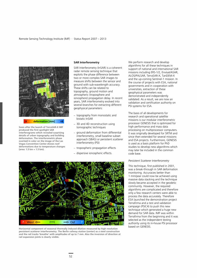
52
Earth Observation Center
Remote Sensing Technology Institute (IMF) ∙ Status Report 2007 – 2013
52
SAR Interferometry
SAR Interferometry (InSAR) is a coherent radar remote sensing technique that exploits the phase difference between two or more complex SAR images to measure shifts between the sensor and ground with sub-wavelength accuracy. These shifts can be related to topography, ground motion and atmospheric (troposphere and ionosphere) propagation delay. In recent years, SAR interferometry evolved into several branches for extracting different geophysical parameters:
topography from monostatic and bistatic InSAR
3D and 4D reconstruction using tomographic techniques
ground deformation from differential interferometry, small baseline subset approach (SBAS) or persistent scatterer interferometry (PSI)
tropospheric propagation effects
dispersive ionospheric effects.
We perform research and develop algorithms for all these techniques in support of national and international SAR missions including ERS-1/2, Envisat/ASAR, ALOS/PALSAR, TerraSAR-X, TanDEM-X and the up-coming Sentinel-1 mission. In the course of projects with ESA, national governments and in cooperation with universities, extraction of these geophysical parameters was demonstrated and independently validated. As a result, we are now an validation and certification authority on PSI systems for ESA.
The basis of all developments for research and operational satellite missions is our modular interferometric processor GENESIS that is optimized for high performance and mass data processing on multiprocessor computers. It was originally developed for SRTM and since then extended for several missions and ESA projects. Furthermore, GENESIS is used as a basis platform for PhD studies to develop new algorithms which may later be included in the common code base.
Persistent Scatterer Interferometry
This technique, first published in 2001, was a break-through in SAR deformation monitoring. Accuracies better than 1 mm/year could now be achieved using massive data stacking and the technique slowly became accepted in the geodetic community. However, the required algorithms are complicated and therefore only a few research centers were able to process the data accurately. Therefore ESA launched the demonstration project Terrafirma and a test and validation campaign (PSIC4) to push this new technique which generated a huge new demand for SAR data. IMF was within Terrafirma from the beginning and it was selected as the independent testing authority using its in-house PSI processor based on GENESIS.
Horizontal component of seasonal thermally induced dilation measured by high resolution persistent scatterer interferometry. The Berlin railway station (center) as a steel construction and the rail tracks ‘breathe’ with amplitudes of up to 7 mm. Also the inversion of direction at rail expansion joints is clearly visible.
Soon after the launch of TerraSAR-X IMF produced the first spotlight SAR interferograms which revealed surprising details of urban topography and building deformation. The interferometric phase overlaid in color on the image of the Las Vegas Convention Center shows roof deformations due to temperature changes (area: 1.5 km × 1.5 km).
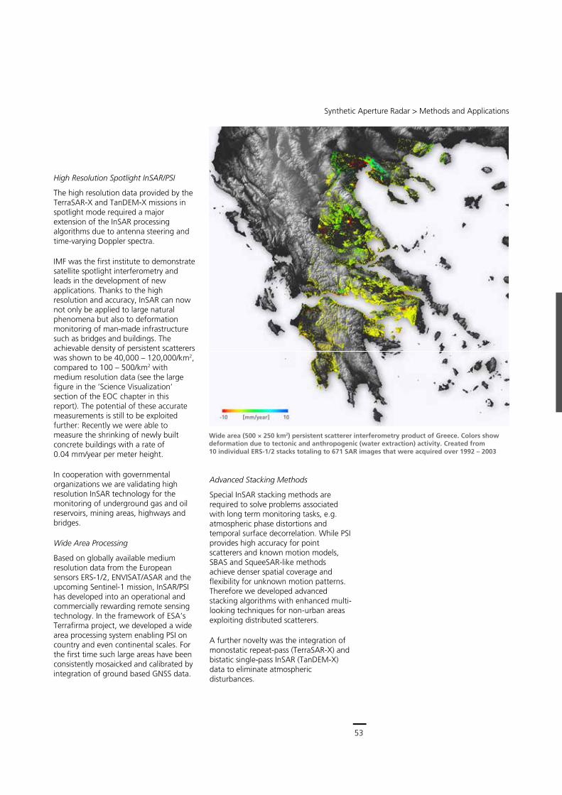
53
Central Services
Remote Sensing Technology Institute (IMF) ∙ Status Report 2007 – 2013
52
SAR Interferometry
SAR Interferometry (InSAR) is a coherent radar remote sensing technique that exploits the phase difference between two or more complex SAR images to measure shifts between the sensor and ground with sub-wavelength accuracy. These shifts can be related to topography, ground motion and atmospheric (troposphere and ionosphere) propagation delay. In recent years, SAR interferometry evolved into several branches for extracting different geophysical parameters:
topography from monostatic and bistatic InSAR
3D and 4D reconstruction using tomographic techniques
ground deformation from differential interferometry, small baseline subset approach (SBAS) or persistent scatterer interferometry (PSI)
tropospheric propagation effects
dispersive ionospheric effects.
We perform research and develop algorithms for all these techniques in support of national and international SAR missions including ERS-1/2, Envisat/ASAR, ALOS/PALSAR, TerraSAR-X, TanDEM-X and the up-coming Sentinel-1 mission. In the course of projects with ESA, national governments and in cooperation with universities, extraction of these geophysical parameters was demonstrated and independently validated. As a result, we are now an validation and certification authority on PSI systems for ESA.
The basis of all developments for research and operational satellite missions is our modular interferometric processor GENESIS that is optimized for high performance and mass data processing on multiprocessor computers. It was originally developed for SRTM and since then extended for several missions and ESA projects. Furthermore, GENESIS is used as a basis platform for PhD studies to develop new algorithms which may later be included in the common code base.
Persistent Scatterer Interferometry
This technique, first published in 2001, was a break-through in SAR deformation monitoring. Accuracies better than 1 mm/year could now be achieved using massive data stacking and the technique slowly became accepted in the geodetic community. However, the required algorithms are complicated and therefore only a few research centers were able to process the data accurately. Therefore ESA launched the demonstration project Terrafirma and a test and validation campaign (PSIC4) to push this new technique which generated a huge new demand for SAR data. IMF was within Terrafirma from the beginning and it was selected as the independent testing authority using its in-house PSI processor based on GENESIS.
Horizontal component of seasonal thermally induced dilation measured by high resolution persistent scatterer interferometry. The Berlin railway station (center) as a steel construction and the rail tracks ‘breathe’ with amplitudes of up to 7 mm. Also the inversion of direction at rail expansion joints is clearly visible.
Soon after the launch of TerraSAR-X IMF produced the first spotlight SAR interferograms which revealed surprising details of urban topography and building deformation. The interferometric phase overlaid in color on the image of the Las Vegas Convention Center shows roof deformations due to temperature changes (area: 1.5 km × 1.5 km).
Synthetic Aperture Radar > Methods and Applications
53
High Resolution Spotlight InSAR/PSI
The high resolution data provided by the TerraSAR-X and TanDEM-X missions in spotlight mode required a major extension of the InSAR processing algorithms due to antenna steering and time-varying Doppler spectra.
IMF was the first institute to demonstrate satellite spotlight interferometry and leads in the development of new applications. Thanks to the high resolution and accuracy, InSAR can now not only be applied to large natural phenomena but also to deformation monitoring of man-made infrastructure such as bridges and buildings. The achievable density of persistent scatterers was shown to be 40,000 – 120,000/km2, compared to 100 – 500/km2 with medium resolution data (see the large figure in the ‘Science Visualization’ section of the EOC chapter in this report). The potential of these accurate measurements is still to be exploited further: Recently we were able to measure the shrinking of newly built concrete buildings with a rate of 0.04 mm/year per meter height.
In cooperation with governmental organizations we are validating high resolution InSAR technology for the monitoring of underground gas and oil reservoirs, mining areas, highways and bridges.
Wide Area Processing
Based on globally available medium resolution data from the European sensors ERS-1/2, ENVISAT/ASAR and the upcoming Sentinel-1 mission, InSAR/PSI has developed into an operational and commercially rewarding remote sensing technology. In the framework of ESA’s Terrafirma project, we developed a wide area processing system enabling PSI on country and even continental scales. For the first time such large areas have been consistently mosaicked and calibrated by integration of ground based GNSS data.
Advanced Stacking Methods
Special InSAR stacking methods are required to solve problems associated with long term monitoring tasks, e.g. atmospheric phase distortions and temporal surface decorrelation. While PSI provides high accuracy for point scatterers and known motion models, SBAS and SqueeSAR-like methods achieve denser spatial coverage and flexibility for unknown motion patterns. Therefore we developed advanced stacking algorithms with enhanced multi-looking techniques for non-urban areas exploiting distributed scatterers.
A further novelty was the integration of monostatic repeat-pass (TerraSAR-X) and bistatic single-pass InSAR (TanDEM-X) data to eliminate atmospheric disturbances.
Wide area (500 × 250 km2) persistent scatterer interferometry product of Greece. Colors show deformation due to tectonic and anthropogenic (water extraction) activity. Created from 10 individual ERS-1/2 stacks totaling to 671 SAR images that were acquired over 1992 – 2003
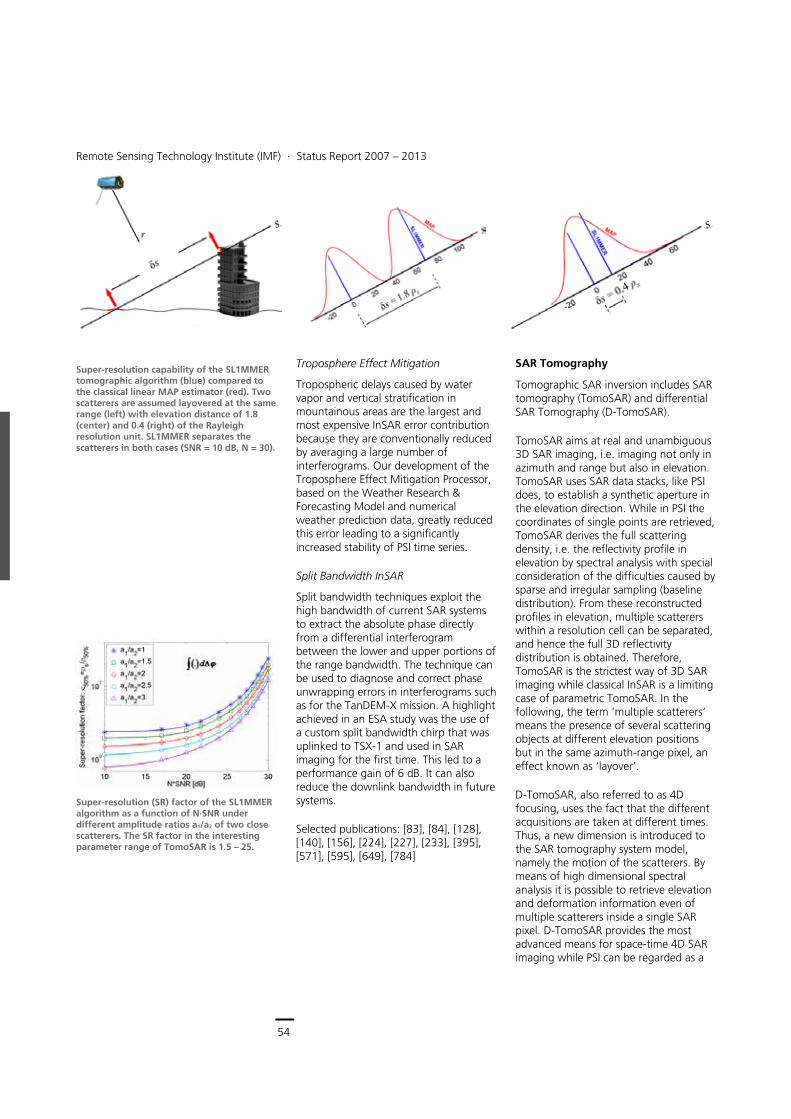
54
Earth Observation Center
Remote Sensing Technology Institute (IMF) ∙ Status Report 2007 – 2013
54
Troposphere Effect Mitigation
Tropospheric delays caused by water vapor and vertical stratification in mountainous areas are the largest and most expensive InSAR error contribution because they are conventionally reduced by averaging a large number of interferograms. Our development of the Troposphere Effect Mitigation Processor, based on the Weather Research & Forecasting Model and numerical weather prediction data, greatly reduced this error leading to a significantly increased stability of PSI time series.
Split Bandwidth InSAR
Split bandwidth techniques exploit the high bandwidth of current SAR systems to extract the absolute phase directly from a differential interferogram between the lower and upper portions of the range bandwidth. The technique can be used to diagnose and correct phase unwrapping errors in interferograms such as for the TanDEM-X mission. A highlight achieved in an ESA study was the use of a custom split bandwidth chirp that was uplinked to TSX-1 and used in SAR imaging for the first time. This led to a performance gain of 6 dB. It can also reduce the downlink bandwidth in future systems.
Selected publications: [83], [84], [128], [140], [156], [224], [227], [233], [395], [571], [595], [649], [784]
SAR Tomography
Tomographic SAR inversion includes SAR tomography (TomoSAR) and differential SAR Tomography (D-TomoSAR).
TomoSAR aims at real and unambiguous 3D SAR imaging, i.e. imaging not only in azimuth and range but also in elevation. TomoSAR uses SAR data stacks, like PSI does, to establish a synthetic aperture in the elevation direction. While in PSI the coordinates of single points are retrieved, TomoSAR derives the full scattering density, i.e. the reflectivity profile in elevation by spectral analysis with special consideration of the difficulties caused by sparse and irregular sampling (baseline distribution). From these reconstructed profiles in elevation, multiple scatterers within a resolution cell can be separated, and hence the full 3D reflectivity distribution is obtained. Therefore, TomoSAR is the strictest way of 3D SAR imaging while classical InSAR is a limiting case of parametric TomoSAR. In the following, the term ‘multiple scatterers’ means the presence of several scattering objects at different elevation positions but in the same azimuth-range pixel, an effect known as ‘layover’.
D-TomoSAR, also referred to as 4D focusing, uses the fact that the different acquisitions are taken at different times. Thus, a new dimension is introduced to the SAR tomography system model, namely the motion of the scatterers. By means of high dimensional spectral analysis it is possible to retrieve elevation and deformation information even of multiple scatterers inside a single SAR pixel. D-TomoSAR provides the most advanced means for space-time 4D SAR imaging while PSI can be regarded as a
Super-resolution capability of the SL1MMER tomographic algorithm (blue) compared to the classical linear MAP estimator (red). Two scatterers are assumed layovered at the same range (left) with elevation distance of 1.8 (center) and 0.4 (right) of the Rayleigh resolution unit. SL1MMER separates the scatterers in both cases (SNR = 10 dB, N = 30).
Super-resolution (SR) factor of the SL1MMER algorithm as a function of N∙SNR under different amplitude ratios a1/a2 of two close scatterers. The SR factor in the interesting parameter range of TomoSAR is 1.5 – 25.
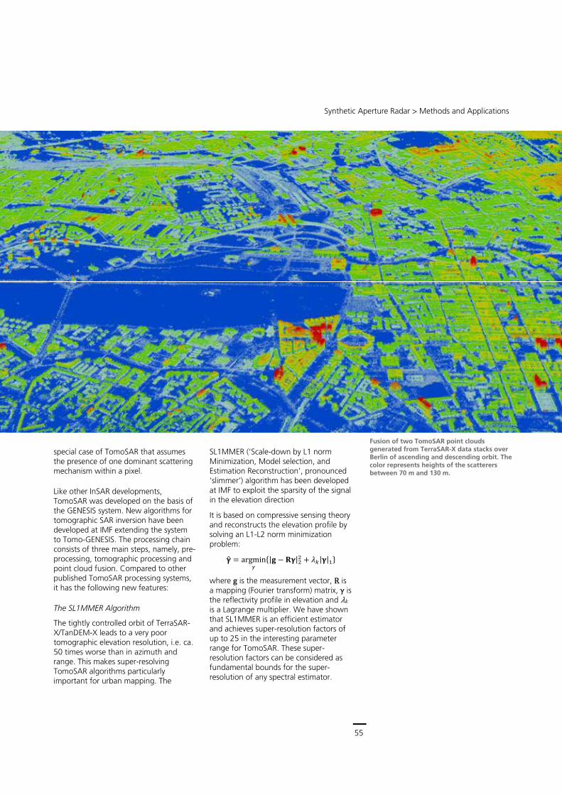
55
Central Services
Remote Sensing Technology Institute (IMF) ∙ Status Report 2007 – 2013
54
Troposphere Effect Mitigation
Tropospheric delays caused by water vapor and vertical stratification in mountainous areas are the largest and most expensive InSAR error contribution because they are conventionally reduced by averaging a large number of interferograms. Our development of the Troposphere Effect Mitigation Processor, based on the Weather Research & Forecasting Model and numerical weather prediction data, greatly reduced this error leading to a significantly increased stability of PSI time series.
Split Bandwidth InSAR
Split bandwidth techniques exploit the high bandwidth of current SAR systems to extract the absolute phase directly from a differential interferogram between the lower and upper portions of the range bandwidth. The technique can be used to diagnose and correct phase unwrapping errors in interferograms such as for the TanDEM-X mission. A highlight achieved in an ESA study was the use of a custom split bandwidth chirp that was uplinked to TSX-1 and used in SAR imaging for the first time. This led to a performance gain of 6 dB. It can also reduce the downlink bandwidth in future systems.
Selected publications: [83], [84], [128], [140], [156], [224], [227], [233], [395], [571], [595], [649], [784]
SAR Tomography
Tomographic SAR inversion includes SAR tomography (TomoSAR) and differential SAR Tomography (D-TomoSAR).
TomoSAR aims at real and unambiguous 3D SAR imaging, i.e. imaging not only in azimuth and range but also in elevation. TomoSAR uses SAR data stacks, like PSI does, to establish a synthetic aperture in the elevation direction. While in PSI the coordinates of single points are retrieved, TomoSAR derives the full scattering density, i.e. the reflectivity profile in elevation by spectral analysis with special consideration of the difficulties caused by sparse and irregular sampling (baseline distribution). From these reconstructed profiles in elevation, multiple scatterers within a resolution cell can be separated, and hence the full 3D reflectivity distribution is obtained. Therefore, TomoSAR is the strictest way of 3D SAR imaging while classical InSAR is a limiting case of parametric TomoSAR. In the following, the term ‘multiple scatterers’ means the presence of several scattering objects at different elevation positions but in the same azimuth-range pixel, an effect known as ‘layover’.
D-TomoSAR, also referred to as 4D focusing, uses the fact that the different acquisitions are taken at different times. Thus, a new dimension is introduced to the SAR tomography system model, namely the motion of the scatterers. By means of high dimensional spectral analysis it is possible to retrieve elevation and deformation information even of multiple scatterers inside a single SAR pixel. D-TomoSAR provides the most advanced means for space-time 4D SAR imaging while PSI can be regarded as a
Super-resolution capability of the SL1MMER tomographic algorithm (blue) compared to the classical linear MAP estimator (red). Two scatterers are assumed layovered at the same range (left) with elevation distance of 1.8 (center) and 0.4 (right) of the Rayleigh resolution unit. SL1MMER separates the scatterers in both cases (SNR = 10 dB, N = 30).
Super-resolution (SR) factor of the SL1MMER algorithm as a function of N∙SNR under different amplitude ratios a1/a2 of two close scatterers. The SR factor in the interesting parameter range of TomoSAR is 1.5 – 25.
Synthetic Aperture Radar > Methods and Applications
55
special case of TomoSAR that assumes the presence of one dominant scattering mechanism within a pixel.
Like other InSAR developments, TomoSAR was developed on the basis of the GENESIS system. New algorithms for tomographic SAR inversion have been developed at IMF extending the system to Tomo-GENESIS. The processing chain consists of three main steps, namely, pre-processing, tomographic processing and point cloud fusion. Compared to other published TomoSAR processing systems, it has the following new features:
The SL1MMER Algorithm
The tightly controlled orbit of TerraSAR-X/TanDEM-X leads to a very poor tomographic elevation resolution, i.e. ca. 50 times worse than in azimuth and range. This makes super-resolving TomoSAR algorithms particularly important for urban mapping. The
SL1MMER (‘Scale-down by L1 norm Minimization, Model selection, and Estimation Reconstruction’, pronounced ‘slimmer’) algorithm has been developed at IMF to exploit the sparsity of the signal in the elevation direction
It is based on compressive sensing theory and reconstructs the elevation profile by solving an L1-L2 norm minimization problem:
�� � ��g����
�|� � ��|�� � ��|�|��
where g is the measurement vector, R is a mapping (Fourier transform) matrix, γ is the reflectivity profile in elevation and λk
is a Lagrange multiplier. We have shown that SL1MMER is an efficient estimator and achieves super-resolution factors of up to 25 in the interesting parameter range for TomoSAR. These super-resolution factors can be considered as fundamental bounds for the super-resolution of any spectral estimator.
Fusion of two TomoSAR point clouds generated from TerraSAR-X data stacks over Berlin of ascending and descending orbit. The color represents heights of the scatterers between 70 m and 130 m.
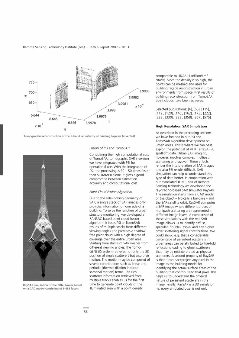
56
Earth Observation Center
Remote Sensing Technology Institute (IMF) ∙ Status Report 2007 – 2013
56
Fusion of PSI and TomoSAR
Considering the high computational cost of TomoSAR, tomographic SAR inversion we have integrated with PSI for operational use. With the integration of PSI, the processing is 30 – 50 times faster than SL1MMER alone. It gives a good compromise between estimation accuracy and computational cost.
Point Cloud Fusion Algorithm
Due to the side-looking geometry of SAR, a single stack of SAR images only provides information on one side of a building. To serve the function of urban structure monitoring, we developed a RANSAC based point cloud fusion algorithm. It fuses PSI or TomoSAR results of multiple stacks from different viewing angles and provides a shadow-free point cloud with a high degree of coverage over the entire urban area. Starting from stacks of SAR images from different viewing angles, the Tomo-GENESIS system retrieves not only the 3D position of single scatterers but also their motion. The motion may be composed of several contributions such as linear and periodic (thermal dilation induced seasonal motion) terms. The rich scatterer information retrieved from multiple tracks enables us for the first time to generate point clouds of the illuminated area with a point density
comparable to LiDAR (1 million/km²/stack). Since the density is so high, the points can be meshed and used for building façade reconstruction in urban environments from space. First results of building reconstruction from TomoSAR point clouds have been achieved.
Selected publications: [6], [65], [115], [119], [120], [140], [162], [173], [222], [223], [330], [333], [358], [367], [575]
High Resolution SAR Simulation
As described in the preceding sections we have focused in our PSI and TomoSAR algorithm development on urban areas. This is where we can best exploit the potential of VHR TerraSAR-X spotlight data. Urban SAR imaging, however, involves complex, multipath scattering and layover. These effects render the interpretation of SAR images and also PSI results difficult. SAR simulation can help us understand this type of data better. In cooperation with our associated TUM Chair of Remote Sensing technology we developed the ray-tracing-based SAR simulator RaySAR. The simulation starts from a CAD model of the object – typically a building – and the SAR satellite orbit. RaySAR computes a SAR image where different orders of multipath scattering are represented in different image layers. A comparison of these simulations with the real SAR image allows us to identify diffuse, specular, double-, triple- and any higher order scattering signal contributions. We could show, e.g. that a considerable percentage of persistent scatterers in urban areas can be attributed to five-fold reflections leading to ghost scatterers that may be misinterpreted as physical scatterers. A second property of RaySAR is that it can backproject any pixel in the image to the building model for identifying the actual surface areas of the building that contribute to that pixel. This helps us to understand the physical nature of persistent scatterers in the image. Finally, RaySAR is a 3D simulator, i.e. every simulated pixel is not only
Tomographic reconstruction of the X-band reflectivity of building façades (inverted)
RaySAR simulation of the Eiffel tower based on a CAD model consisting of 9,488 facets
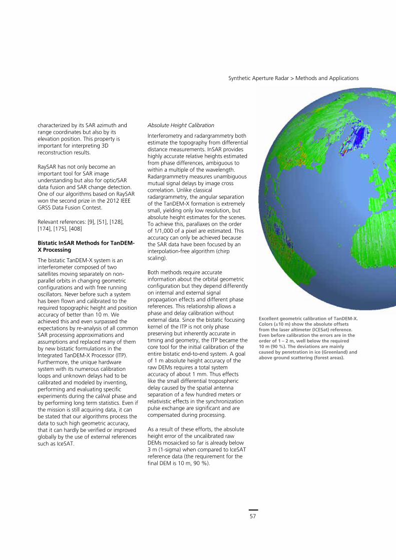
57
Central Services
Remote Sensing Technology Institute (IMF) ∙ Status Report 2007 – 2013
56
Fusion of PSI and TomoSAR
Considering the high computational cost of TomoSAR, tomographic SAR inversion we have integrated with PSI for operational use. With the integration of PSI, the processing is 30 – 50 times faster than SL1MMER alone. It gives a good compromise between estimation accuracy and computational cost.
Point Cloud Fusion Algorithm
Due to the side-looking geometry of SAR, a single stack of SAR images only provides information on one side of a building. To serve the function of urban structure monitoring, we developed a RANSAC based point cloud fusion algorithm. It fuses PSI or TomoSAR results of multiple stacks from different viewing angles and provides a shadow-free point cloud with a high degree of coverage over the entire urban area. Starting from stacks of SAR images from different viewing angles, the Tomo-GENESIS system retrieves not only the 3D position of single scatterers but also their motion. The motion may be composed of several contributions such as linear and periodic (thermal dilation induced seasonal motion) terms. The rich scatterer information retrieved from multiple tracks enables us for the first time to generate point clouds of the illuminated area with a point density
comparable to LiDAR (1 million/km²/stack). Since the density is so high, the points can be meshed and used for building façade reconstruction in urban environments from space. First results of building reconstruction from TomoSAR point clouds have been achieved.
Selected publications: [6], [65], [115], [119], [120], [140], [162], [173], [222], [223], [330], [333], [358], [367], [575]
High Resolution SAR Simulation
As described in the preceding sections we have focused in our PSI and TomoSAR algorithm development on urban areas. This is where we can best exploit the potential of VHR TerraSAR-X spotlight data. Urban SAR imaging, however, involves complex, multipath scattering and layover. These effects render the interpretation of SAR images and also PSI results difficult. SAR simulation can help us understand this type of data better. In cooperation with our associated TUM Chair of Remote Sensing technology we developed the ray-tracing-based SAR simulator RaySAR. The simulation starts from a CAD model of the object – typically a building – and the SAR satellite orbit. RaySAR computes a SAR image where different orders of multipath scattering are represented in different image layers. A comparison of these simulations with the real SAR image allows us to identify diffuse, specular, double-, triple- and any higher order scattering signal contributions. We could show, e.g. that a considerable percentage of persistent scatterers in urban areas can be attributed to five-fold reflections leading to ghost scatterers that may be misinterpreted as physical scatterers. A second property of RaySAR is that it can backproject any pixel in the image to the building model for identifying the actual surface areas of the building that contribute to that pixel. This helps us to understand the physical nature of persistent scatterers in the image. Finally, RaySAR is a 3D simulator, i.e. every simulated pixel is not only
Tomographic reconstruction of the X-band reflectivity of building façades (inverted)
RaySAR simulation of the Eiffel tower based on a CAD model consisting of 9,488 facets
Synthetic Aperture Radar > Methods and Applications
57
characterized by its SAR azimuth and range coordinates but also by its elevation position. This property is important for interpreting 3D reconstruction results.
RaySAR has not only become an important tool for SAR image understanding but also for optic/SAR data fusion and SAR change detection. One of our algorithms based on RaySAR won the second prize in the 2012 IEEE GRSS Data Fusion Contest.
Relevant references: [9], [51], [128], [174], [175], [408]
Bistatic InSAR Methods for TanDEM-X Processing
The bistatic TanDEM-X system is an interferometer composed of two satellites moving separately on non-parallel orbits in changing geometric configurations and with free running oscillators. Never before such a system has been flown and calibrated to the required topographic height and position accuracy of better than 10 m. We achieved this and even surpassed the expectations by re-analysis of all common SAR processing approximations and assumptions and replaced many of them by new bistatic formulations in the Integrated TanDEM-X Processor (ITP). Furthermore, the unique hardware system with its numerous calibration loops and unknown delays had to be calibrated and modeled by inventing, performing and evaluating specific experiments during the cal/val phase and by performing long term statistics. Even if the mission is still acquiring data, it can be stated that our algorithms process the data to such high geometric accuracy, that it can hardly be verified or improved globally by the use of external references such as IceSAT.
Absolute Height Calibration
Interferometry and radargrammetry both estimate the topography from differential distance measurements. InSAR provides highly accurate relative heights estimated from phase differences, ambiguous to within a multiple of the wavelength. Radargrammetry measures unambiguous mutual signal delays by image cross correlation. Unlike classical radargrammetry, the angular separation of the TanDEM-X formation is extremely small, yielding only low resolution, but absolute height estimates for the scenes. To achieve this, parallaxes on the order of 1/1,000 of a pixel are estimated. This accuracy can only be achieved because the SAR data have been focused by an interpolation-free algorithm (chirp scaling).
Both methods require accurate information about the orbital geometric configuration but they depend differently on internal and external signal propagation effects and different phase references. This relationship allows a phase and delay calibration without external data. Since the bistatic focusing kernel of the ITP is not only phase preserving but inherently accurate in timing and geometry, the ITP became the core tool for the initial calibration of the entire bistatic end-to-end system. A goal of 1 m absolute height accuracy of the raw DEMs requires a total system accuracy of about 1 mm. Thus effects like the small differential tropospheric delay caused by the spatial antenna separation of a few hundred meters or relativistic effects in the synchronization pulse exchange are significant and are compensated during processing.
As a result of these efforts, the absolute height error of the uncalibrated raw DEMs mosaicked so far is already below 3 m (1-sigma) when compared to IceSAT reference data (the requirement for the final DEM is 10 m, 90 %).
Excellent geometric calibration of TanDEM-X. Colors (±10 m) show the absolute offsets from the laser altimeter (ICESat) reference. Even before calibration the errors are in the order of 1 – 2 m, well below the required 10 m (90 %). The deviations are mainly caused by penetration in ice (Greenland) and above ground scattering (forest areas).
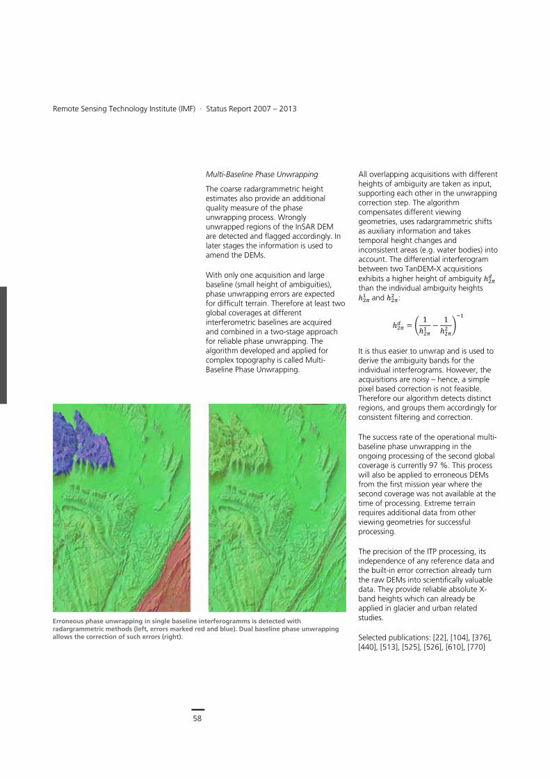
58
Earth Observation Center
Remote Sensing Technology Institute (IMF) ∙ Status Report 2007 – 2013
58
Multi-Baseline Phase Unwrapping
The coarse radargrammetric height estimates also provide an additional quality measure of the phase unwrapping process. Wrongly unwrapped regions of the InSAR DEM are detected and flagged accordingly. In later stages the information is used to amend the DEMs.
With only one acquisition and large baseline (small height of ambiguities), phase unwrapping errors are expected for difficult terrain. Therefore at least two global coverages at different interferometric baselines are acquired and combined in a two-stage approach for reliable phase unwrapping. The algorithm developed and applied for complex topography is called Multi-Baseline Phase Unwrapping.
All overlapping acquisitions with different heights of ambiguity are taken as input, supporting each other in the unwrapping correction step. The algorithm compensates different viewing geometries, uses radargrammetric shifts as auxiliary information and takes temporal height changes and inconsistent areas (e.g. water bodies) into account. The differential interferogram between two TanDEM-X acquisitions exhibits a higher height of ambiguity ���� than the individual ambiguity heights ���� and ���� :
���� � � 1���� � 1
���� ���
It is thus easier to unwrap and is used to derive the ambiguity bands for the individual interferograms. However, the acquisitions are noisy – hence, a simple pixel based correction is not feasible. Therefore our algorithm detects distinct regions, and groups them accordingly for consistent filtering and correction.
The success rate of the operational multi-baseline phase unwrapping in the ongoing processing of the second global coverage is currently 97 %. This process will also be applied to erroneous DEMs from the first mission year where the second coverage was not available at the time of processing. Extreme terrain requires additional data from other viewing geometries for successful processing.
The precision of the ITP processing, its independence of any reference data and the built-in error correction already turn the raw DEMs into scientifically valuable data. They provide reliable absolute X-band heights which can already be applied in glacier and urban related studies.
Selected publications: [22], [104], [376], [440], [513], [525], [526], [610], [770]
Erroneous phase unwrapping in single baseline interferogramms is detected with radargrammetric methods (left, errors marked red and blue). Dual baseline phase unwrapping allows the correction of such errors (right).
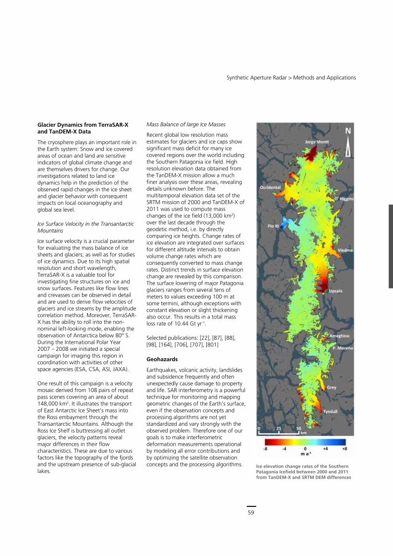
59
Central Services
Remote Sensing Technology Institute (IMF) ∙ Status Report 2007 – 2013
58
Multi-Baseline Phase Unwrapping
The coarse radargrammetric height estimates also provide an additional quality measure of the phase unwrapping process. Wrongly unwrapped regions of the InSAR DEM are detected and flagged accordingly. In later stages the information is used to amend the DEMs.
With only one acquisition and large baseline (small height of ambiguities), phase unwrapping errors are expected for difficult terrain. Therefore at least two global coverages at different interferometric baselines are acquired and combined in a two-stage approach for reliable phase unwrapping. The algorithm developed and applied for complex topography is called Multi-Baseline Phase Unwrapping.
All overlapping acquisitions with different heights of ambiguity are taken as input, supporting each other in the unwrapping correction step. The algorithm compensates different viewing geometries, uses radargrammetric shifts as auxiliary information and takes temporal height changes and inconsistent areas (e.g. water bodies) into account. The differential interferogram between two TanDEM-X acquisitions exhibits a higher height of ambiguity ���� than the individual ambiguity heights ���� and ���� :
���� � � 1���� � 1
���� ���
It is thus easier to unwrap and is used to derive the ambiguity bands for the individual interferograms. However, the acquisitions are noisy – hence, a simple pixel based correction is not feasible. Therefore our algorithm detects distinct regions, and groups them accordingly for consistent filtering and correction.
The success rate of the operational multi-baseline phase unwrapping in the ongoing processing of the second global coverage is currently 97 %. This process will also be applied to erroneous DEMs from the first mission year where the second coverage was not available at the time of processing. Extreme terrain requires additional data from other viewing geometries for successful processing.
The precision of the ITP processing, its independence of any reference data and the built-in error correction already turn the raw DEMs into scientifically valuable data. They provide reliable absolute X-band heights which can already be applied in glacier and urban related studies.
Selected publications: [22], [104], [376], [440], [513], [525], [526], [610], [770]
Erroneous phase unwrapping in single baseline interferogramms is detected with radargrammetric methods (left, errors marked red and blue). Dual baseline phase unwrapping allows the correction of such errors (right).
Synthetic Aperture Radar > Methods and Applications
59
Glacier Dynamics from TerraSAR-X and TanDEM-X Data
The cryosphere plays an important role in the Earth system: Snow and ice covered areas of ocean and land are sensitive indicators of global climate change and are themselves drivers for change. Our investigations related to land ice dynamics help in the prediction of the observed rapid changes in the ice sheet and glacier behavior with consequent impacts on local oceanography and global sea level.
Ice Surface Velocity in the Transantarctic Mountains
Ice surface velocity is a crucial parameter for evaluating the mass balance of ice sheets and glaciers, as well as for studies of ice dynamics. Due to its high spatial resolution and short wavelength, TerraSAR-X is a valuable tool for investigating fine structures on ice and snow surfaces. Features like flow lines and crevasses can be observed in detail and are used to derive flow velocities of glaciers and ice streams by the amplitude correlation method. Moreover, TerraSAR-X has the ability to roll into the non-nominal left-looking mode, enabling the observation of Antarctica below 80° S. During the International Polar Year 2007 – 2008 we initiated a special campaign for imaging this region in coordination with activities of other space agencies (ESA, CSA, ASI, JAXA).
One result of this campaign is a velocity mosaic derived from 108 pairs of repeat pass scenes covering an area of about 148,000 km2. It illustrates the transport of East Antarctic Ice Sheet‘s mass into the Ross embayment through the Transantarctic Mountains. Although the Ross Ice Shelf is buttressing all outlet glaciers, the velocity patterns reveal major differences in their flow characteristics. These are due to various factors like the topography of the fjords and the upstream presence of sub-glacial lakes.
Mass Balance of large Ice Masses
Recent global low resolution mass estimates for glaciers and ice caps show significant mass deficit for many ice covered regions over the world including the Southern Patagonia ice field. High resolution elevation data obtained from the TanDEM-X mission allow a much finer analysis over these areas, revealing details unknown before. The multitemporal elevation data set of the SRTM mission of 2000 and TanDEM-X of 2011 was used to compute mass changes of the ice field (13,000 km2) over the last decade through the geodetic method, i.e. by directly comparing ice heights. Change rates of ice elevation are integrated over surfaces for different altitude intervals to obtain volume change rates which are consequently converted to mass change rates. Distinct trends in surface elevation change are revealed by this comparison. The surface lowering of major Patagonia glaciers ranges from several tens of meters to values exceeding 100 m at some termini, although exceptions with constant elevation or slight thickening also occur. This results in a total mass loss rate of 10.44 Gt yr-1.
Selected publications: [22], [87], [88], [98], [164], [706], [707], [801]
Geohazards
Earthquakes, volcanic activity, landslides and subsidence frequently and often unexpectedly cause damage to property and life. SAR interferometry is a powerful technique for monitoring and mapping geometric changes of the Earth’s surface, even if the observation concepts and processing algorithms are not yet standardized and vary strongly with the observed problem. Therefore one of our goals is to make interferometric deformation measurements operational by modeling all error contributions and by optimizing the satellite observation concepts and the processing algorithms. Ice elevation change rates of the Southern
Patagonia Icefield between 2000 and 2011 from TanDEM-X and SRTM DEM differences
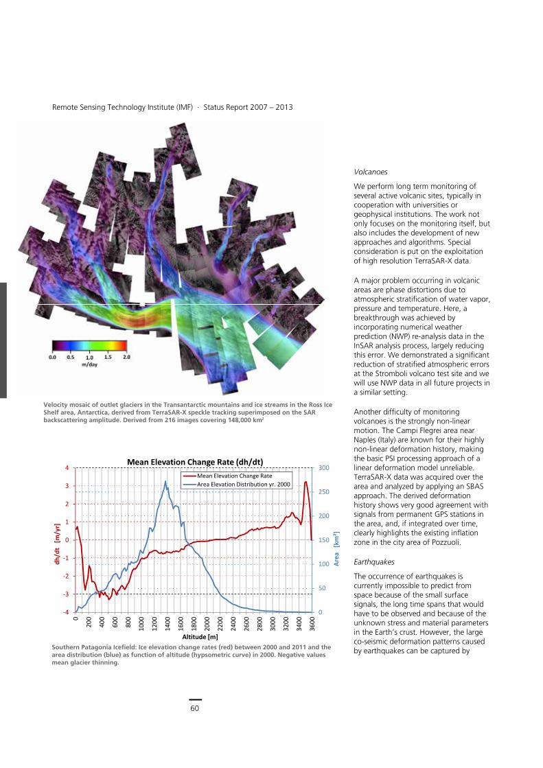
60
Earth Observation Center
Remote Sensing Technology Institute (IMF) ∙ Status Report 2007 – 2013
60
Volcanoes
We perform long term monitoring of several active volcanic sites, typically in cooperation with universities or geophysical institutions. The work not only focuses on the monitoring itself, but also includes the development of new approaches and algorithms. Special consideration is put on the exploitation of high resolution TerraSAR-X data.
A major problem occurring in volcanic areas are phase distortions due to atmospheric stratification of water vapor, pressure and temperature. Here, a breakthrough was achieved by incorporating numerical weather prediction (NWP) re-analysis data in the InSAR analysis process, largely reducing this error. We demonstrated a significant reduction of stratified atmospheric errors at the Stromboli volcano test site and we will use NWP data in all future projects in a similar setting.
Another difficulty of monitoring volcanoes is the strongly non-linear motion. The Campi Flegrei area near Naples (Italy) are known for their highly non-linear deformation history, making the basic PSI processing approach of a linear deformation model unreliable. TerraSAR-X data was acquired over the area and analyzed by applying an SBAS approach. The derived deformation history shows very good agreement with signals from permanent GPS stations in the area, and, if integrated over time, clearly highlights the existing inflation zone in the city area of Pozzuoli.
Earthquakes
The occurrence of earthquakes is currently impossible to predict from space because of the small surface signals, the long time spans that would have to be observed and because of the unknown stress and material parameters in the Earth’s crust. However, the large co-seismic deformation patterns caused by earthquakes can be captured by
Velocity mosaic of outlet glaciers in the Transantarctic mountains and ice streams in the Ross Ice Shelf area, Antarctica, derived from TerraSAR-X speckle tracking superimposed on the SAR backscattering amplitude. Derived from 216 images covering 148,000 km2
Southern Patagonia Icefield: Ice elevation change rates (red) between 2000 and 2011 and the area distribution (blue) as function of altitude (hypsometric curve) in 2000. Negative values mean glacier thinning.
0
50
100
150
200
250
300
‐4
‐3
‐2
‐1
0
1
2
3
4
0
200
400
600
800
1000
1200
1400
1600
1800
2000
2200
2400
2600
2800
3000
3200
3400
3600
Area
[km²]
dh/dt
[m/yr]
Altitude [m]
Mean Elevation Change Rate (dh/dt)Mean Elevation Change RateArea Elevation Distribution yr. 2000
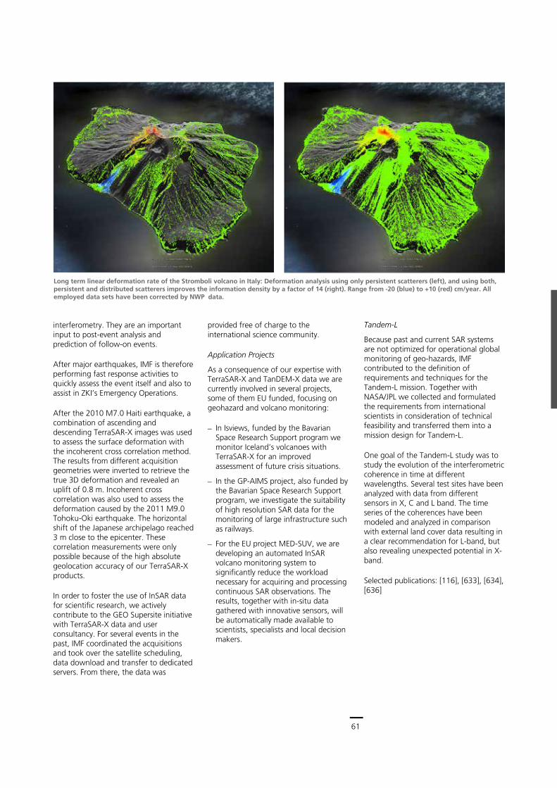
61
Central Services
Remote Sensing Technology Institute (IMF) ∙ Status Report 2007 – 2013
60
Volcanoes
We perform long term monitoring of several active volcanic sites, typically in cooperation with universities or geophysical institutions. The work not only focuses on the monitoring itself, but also includes the development of new approaches and algorithms. Special consideration is put on the exploitation of high resolution TerraSAR-X data.
A major problem occurring in volcanic areas are phase distortions due to atmospheric stratification of water vapor, pressure and temperature. Here, a breakthrough was achieved by incorporating numerical weather prediction (NWP) re-analysis data in the InSAR analysis process, largely reducing this error. We demonstrated a significant reduction of stratified atmospheric errors at the Stromboli volcano test site and we will use NWP data in all future projects in a similar setting.
Another difficulty of monitoring volcanoes is the strongly non-linear motion. The Campi Flegrei area near Naples (Italy) are known for their highly non-linear deformation history, making the basic PSI processing approach of a linear deformation model unreliable. TerraSAR-X data was acquired over the area and analyzed by applying an SBAS approach. The derived deformation history shows very good agreement with signals from permanent GPS stations in the area, and, if integrated over time, clearly highlights the existing inflation zone in the city area of Pozzuoli.
Earthquakes
The occurrence of earthquakes is currently impossible to predict from space because of the small surface signals, the long time spans that would have to be observed and because of the unknown stress and material parameters in the Earth’s crust. However, the large co-seismic deformation patterns caused by earthquakes can be captured by
Velocity mosaic of outlet glaciers in the Transantarctic mountains and ice streams in the Ross Ice Shelf area, Antarctica, derived from TerraSAR-X speckle tracking superimposed on the SAR backscattering amplitude. Derived from 216 images covering 148,000 km2
Southern Patagonia Icefield: Ice elevation change rates (red) between 2000 and 2011 and the area distribution (blue) as function of altitude (hypsometric curve) in 2000. Negative values mean glacier thinning.
0
50
100
150
200
250
300
‐4
‐3
‐2
‐1
0
1
2
3
4
0
200
400
600
800
1000
1200
1400
1600
1800
2000
2200
2400
2600
2800
3000
3200
3400
3600
Area
[km²]
dh/dt
[m/yr]
Altitude [m]
Mean Elevation Change Rate (dh/dt)Mean Elevation Change RateArea Elevation Distribution yr. 2000
Synthetic Aperture Radar > Methods and Applications
61
interferometry. They are an important input to post-event analysis and prediction of follow-on events.
After major earthquakes, IMF is therefore performing fast response activities to quickly assess the event itself and also to assist in ZKI’s Emergency Operations.
After the 2010 M7.0 Haiti earthquake, a combination of ascending and descending TerraSAR-X images was used to assess the surface deformation with the incoherent cross correlation method. The results from different acquisition geometries were inverted to retrieve the true 3D deformation and revealed an uplift of 0.8 m. Incoherent cross correlation was also used to assess the deformation caused by the 2011 M9.0 Tohoku-Oki earthquake. The horizontal shift of the Japanese archipelago reached 3 m close to the epicenter. These correlation measurements were only possible because of the high absolute geolocation accuracy of our TerraSAR-X products.
In order to foster the use of InSAR data for scientific research, we actively contribute to the GEO Supersite initiative with TerraSAR-X data and user consultancy. For several events in the past, IMF coordinated the acquisitions and took over the satellite scheduling, data download and transfer to dedicated servers. From there, the data was
provided free of charge to the international science community.
Application Projects
As a consequence of our expertise with TerraSAR-X and TanDEM-X data we are currently involved in several projects, some of them EU funded, focusing on geohazard and volcano monitoring:
In Isviews, funded by the Bavarian Space Research Support program we monitor Iceland’s volcanoes with TerraSAR-X for an improved assessment of future crisis situations.
In the GP-AIMS project, also funded by the Bavarian Space Research Support program, we investigate the suitability of high resolution SAR data for the monitoring of large infrastructure such as railways.
For the EU project MED-SUV, we are developing an automated InSAR volcano monitoring system to significantly reduce the workload necessary for acquiring and processing continuous SAR observations. The results, together with in-situ data gathered with innovative sensors, will be automatically made available to scientists, specialists and local decision makers.
Long term linear deformation rate of the Stromboli volcano in Italy: Deformation analysis using only persistent scatterers (left), and using both, persistent and distributed scatterers improves the information density by a factor of 14 (right). Range from -20 (blue) to +10 (red) cm/year. All employed data sets have been corrected by NWP data.
Tandem-L
Because past and current SAR systems are not optimized for operational global monitoring of geo-hazards, IMF contributed to the definition of requirements and techniques for the Tandem-L mission. Together with NASA/JPL we collected and formulated the requirements from international scientists in consideration of technical feasibility and transferred them into a mission design for Tandem-L.
One goal of the Tandem-L study was to study the evolution of the interferometric coherence in time at different wavelengths. Several test sites have been analyzed with data from different sensors in X, C and L band. The time series of the coherences have been modeled and analyzed in comparison with external land cover data resulting in a clear recommendation for L-band, but also revealing unexpected potential in X-band.
Selected publications: [116], [633], [634], [636]
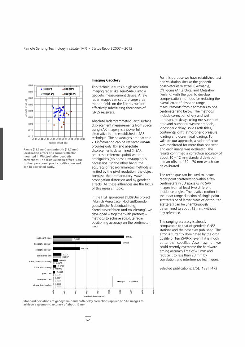
62
Earth Observation Center
Remote Sensing Technology Institute (IMF) ∙ Status Report 2007 – 2013
62
Imaging Geodesy
This technique turns a high resolution imaging radar like TerraSAR-X into a geodetic measurement device. A few radar images can capture large area motion fields on the Earth’s surface, effectively substituting thousands of GNSS receivers.
Absolute radargrammetric Earth surface displacement measurements from space using SAR imagery is a powerful alternative to the established InSAR technique. The advantages are that true 2D information can be retrieved (InSAR provides only 1D) and absolute displacements determined (InSAR requires a reference point) without ambiguities (no phase unwrapping is necessary). On the other hand, the accuracy of radargrammetric methods is limited by the pixel resolution, the object contrast, the orbit accuracy, wave propagation distortion and by geodetic effects. All these influences are the focus of this research topic.
In the HGF sponsored DLR@Uni project ‘Munich Aerospace: Hochauflösende geodätische Erdbeobachtung, Korrekturverfahren und Validierung’, we developed – together with partners – methods to achieve absolute radar positioning accuracy on the centimeter level.
For this purpose we have established test and validation sites at the geodetic observatories Wettzell (Germany), O’Higgins (Antarctica) and Metsähovi (Finland) with the goal to develop compensation methods for reducing the overall error of absolute range measurements from decimeters to one centimeter and below. The methods include correction of dry and wet atmospheric delays using measurement data and numerical weather models, ionospheric delay, solid Earth tides, continental drift, atmospheric pressure loading and ocean tidal loading. To validate our approach, a radar reflector was monitored for more than one year and each image was evaluated. The results confirmed a correction accuracy of about 10 – 12 mm standard deviation and an offset of 30 – 70 mm which can be calibrated.
The technique can be used to locate radar point scatterers to within a few centimeters in 3D space using SAR images from at least two different incidence angles. The relative motion in the radar range direction of single point scatterers or of larger areas of distributed scatterers can be unambiguously determined to about 12 mm, without any reference.
The ranging accuracy is already comparable to that of geodetic GNSS stations and the best ever published. The error is currently dominated by the orbit quality of TerraSAR-X, even if it is much better than specified. Also in azimuth we could recently overcome the hardware timing accuracy limit of 43 mm and reduce it to less than 20 mm by correlation and interference techniques.
Selected publications: [75], [138], [473]
Range (11.2 mm) and azimuth (11.7 mm) localization errors of a corner reflector mounted in Wettzell after geodetic corrections. The residual mean offset is due to the operational product calibration and can be corrected easily.
0.0635
0.0608
0.0238
0.0073
0.0041
0.0027
0.0017
0.0001
0.0000
0.0170
0.0067
0.0010
0.0005
0.0001
0.0000
0.0000
0.00
0.01
0.02
0.03
0.04
0.05
0.06
0.07
0.08
0.09
solid earth tides
tropospheric delay
ionospheric delay
continental drift
atmos. pressure loading
ocean tidal loading
pole tides
ocean pole tides
atmos. tidal loading
standard deviation [m]
range azimuth
Standard deviations of geodynamic and path delay corrections applied to SAR images to achieve a geometric accuracy of about 12 mm
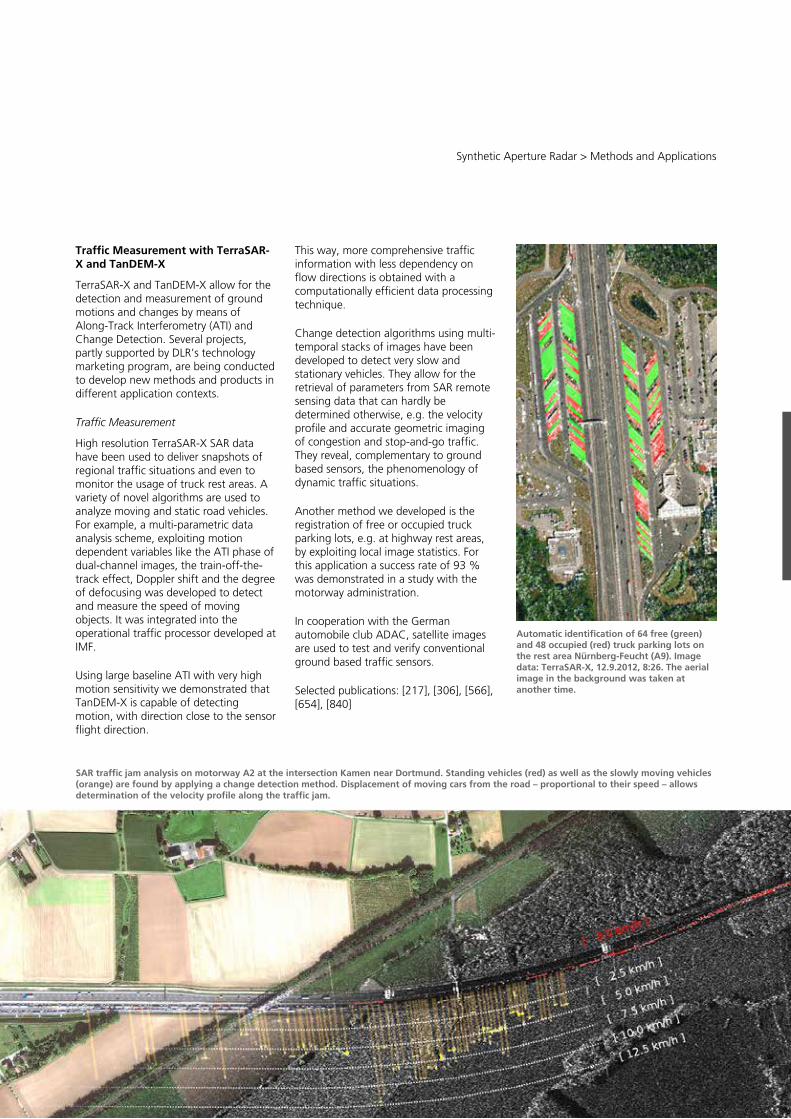
63
Central Services
Remote Sensing Technology Institute (IMF) ∙ Status Report 2007 – 2013
62
Imaging Geodesy
This technique turns a high resolution imaging radar like TerraSAR-X into a geodetic measurement device. A few radar images can capture large area motion fields on the Earth’s surface, effectively substituting thousands of GNSS receivers.
Absolute radargrammetric Earth surface displacement measurements from space using SAR imagery is a powerful alternative to the established InSAR technique. The advantages are that true 2D information can be retrieved (InSAR provides only 1D) and absolute displacements determined (InSAR requires a reference point) without ambiguities (no phase unwrapping is necessary). On the other hand, the accuracy of radargrammetric methods is limited by the pixel resolution, the object contrast, the orbit accuracy, wave propagation distortion and by geodetic effects. All these influences are the focus of this research topic.
In the HGF sponsored DLR@Uni project ‘Munich Aerospace: Hochauflösende geodätische Erdbeobachtung, Korrekturverfahren und Validierung’, we developed – together with partners – methods to achieve absolute radar positioning accuracy on the centimeter level.
For this purpose we have established test and validation sites at the geodetic observatories Wettzell (Germany), O’Higgins (Antarctica) and Metsähovi (Finland) with the goal to develop compensation methods for reducing the overall error of absolute range measurements from decimeters to one centimeter and below. The methods include correction of dry and wet atmospheric delays using measurement data and numerical weather models, ionospheric delay, solid Earth tides, continental drift, atmospheric pressure loading and ocean tidal loading. To validate our approach, a radar reflector was monitored for more than one year and each image was evaluated. The results confirmed a correction accuracy of about 10 – 12 mm standard deviation and an offset of 30 – 70 mm which can be calibrated.
The technique can be used to locate radar point scatterers to within a few centimeters in 3D space using SAR images from at least two different incidence angles. The relative motion in the radar range direction of single point scatterers or of larger areas of distributed scatterers can be unambiguously determined to about 12 mm, without any reference.
The ranging accuracy is already comparable to that of geodetic GNSS stations and the best ever published. The error is currently dominated by the orbit quality of TerraSAR-X, even if it is much better than specified. Also in azimuth we could recently overcome the hardware timing accuracy limit of 43 mm and reduce it to less than 20 mm by correlation and interference techniques.
Selected publications: [75], [138], [473]
Range (11.2 mm) and azimuth (11.7 mm) localization errors of a corner reflector mounted in Wettzell after geodetic corrections. The residual mean offset is due to the operational product calibration and can be corrected easily.
0.0635
0.0608
0.0238
0.0073
0.0041
0.0027
0.0017
0.0001
0.0000
0.0170
0.0067
0.0010
0.0005
0.0001
0.0000
0.0000
0.00
0.01
0.02
0.03
0.04
0.05
0.06
0.07
0.08
0.09
solid earth tides
tropospheric delay
ionospheric delay
continental drift
atmos. pressure loading
ocean tidal loading
pole tides
ocean pole tides
atmos. tidal loading
standard deviation [m]
range azimuth
Standard deviations of geodynamic and path delay corrections applied to SAR images to achieve a geometric accuracy of about 12 mm
Synthetic Aperture Radar > Methods and Applications
63
SAR traffic jam analysis on motorway A2 at the intersection Kamen near Dortmund. Standing vehicles (red) as well as the slowly moving vehicles (orange) are found by applying a change detection method. Displacement of moving cars from the road – proportional to their speed – allows determination of the velocity profile along the traffic jam.
Traffic Measurement with TerraSAR-X and TanDEM-X
TerraSAR-X and TanDEM-X allow for the detection and measurement of ground motions and changes by means of Along-Track Interferometry (ATI) and Change Detection. Several projects, partly supported by DLR’s technology marketing program, are being conducted to develop new methods and products in different application contexts.
Traffic Measurement
High resolution TerraSAR-X SAR data have been used to deliver snapshots of regional traffic situations and even to monitor the usage of truck rest areas. A variety of novel algorithms are used to analyze moving and static road vehicles. For example, a multi-parametric data analysis scheme, exploiting motion dependent variables like the ATI phase of dual-channel images, the train-off-the-track effect, Doppler shift and the degree of defocusing was developed to detect and measure the speed of moving objects. It was integrated into the operational traffic processor developed at IMF.
Using large baseline ATI with very high motion sensitivity we demonstrated that TanDEM-X is capable of detecting motion, with direction close to the sensor flight direction.
This way, more comprehensive traffic information with less dependency on flow directions is obtained with a computationally efficient data processing technique.
Change detection algorithms using multi-temporal stacks of images have been developed to detect very slow and stationary vehicles. They allow for the retrieval of parameters from SAR remote sensing data that can hardly be determined otherwise, e.g. the velocity profile and accurate geometric imaging of congestion and stop-and-go traffic. They reveal, complementary to ground based sensors, the phenomenology of dynamic traffic situations.
Another method we developed is the registration of free or occupied truck parking lots, e.g. at highway rest areas, by exploiting local image statistics. For this application a success rate of 93 % was demonstrated in a study with the motorway administration.
In cooperation with the German automobile club ADAC, satellite images are used to test and verify conventional ground based traffic sensors.
Selected publications: [217], [306], [566], [654], [840]
Automatic identification of 64 free (green) and 48 occupied (red) truck parking lots on the rest area Nürnberg-Feucht (A9). Image data: TerraSAR-X, 12.9.2012, 8:26. The aerial image in the background was taken at another time.
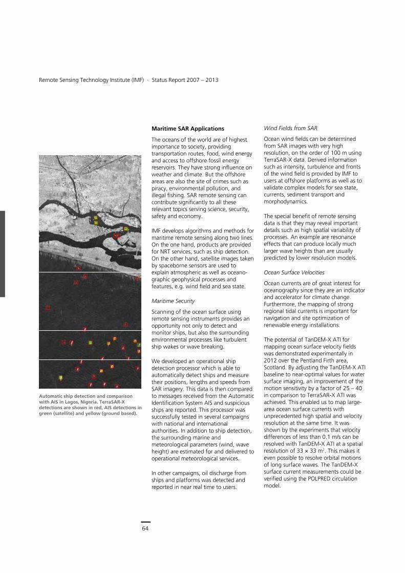
64
Earth Observation Center
Remote Sensing Technology Institute (IMF) ∙ Status Report 2007 – 2013
64
Maritime SAR Applications
The oceans of the world are of highest importance to society, providing transportation routes, food, wind energy and access to offshore fossil energy reservoirs. They have strong influence on weather and climate. But the offshore areas are also the site of crimes such as piracy, environmental pollution, and illegal fishing. SAR remote sensing can contribute significantly to all these relevant topics serving science, security, safety and economy.
IMF develops algorithms and methods for maritime remote sensing along two lines. On the one hand, products are provided for NRT services, such as ship detection. On the other hand, satellite images taken by spaceborne sensors are used to explain atmospheric as well as oceano-graphic geophysical processes and features, e.g. wind field and sea state.
Maritime Security
Scanning of the ocean surface using remote sensing instruments provides an opportunity not only to detect and monitor ships, but also the surrounding environmental processes like turbulent ship wakes or wave breaking.
We developed an operational ship detection processor which is able to automatically detect ships and measure their positions, lengths and speeds from SAR imagery. This data is then compared to messages received from the Automatic Identification System AIS and suspicious ships are reported. This processor was successfully tested in several campaigns with national and international authorities. In addition to ship detection, the surrounding marine and meteorological parameters (wind, wave height) are estimated for and delivered to operational meteorological services.
In other campaigns, oil discharge from ships and platforms was detected and reported in near real time to users.
Wind Fields from SAR
Ocean wind fields can be determined from SAR images with very high resolution, on the order of 100 m using TerraSAR-X data. Derived information such as intensity, turbulence and fronts of the wind field is provided by IMF to users at offshore platforms as well as to validate complex models for sea state, currents, sediment transport and morphodynamics.
The special benefit of remote sensing data is that they may reveal important details such as high spatial variability of processes. An example are resonance effects that can produce locally much larger wave heights than are usually predicted by lower resolution models.
Ocean Surface Velocities
Ocean currents are of great interest for oceanography since they are an indicator and accelerator for climate change. Furthermore, the mapping of strong regional tidal currents is important for navigation and site optimization of renewable energy installations.
The potential of TanDEM-X ATI for mapping ocean surface velocity fields was demonstrated experimentally in 2012 over the Pentland Firth area, Scotland. By adjusting the TanDEM-X ATI baseline to near-optimal values for water surface imaging, an improvement of the motion sensitivity by a factor of 25 – 40 in comparison to TerraSAR-X ATI was achieved. This enabled us to map large-area ocean surface currents with unprecedented high spatial and velocity resolution at the same time. It was shown by the experiments that velocity differences of less than 0.1 m/s can be resolved with TanDEM-X ATI at a spatial resolution of 33 × 33 m2. This makes it even possible to resolve orbital motions of long surface waves. The TanDEM-X surface current measurements could be verified using the POLPRED circulation model.
Automatic ship detection and comparison with AIS in Lagos, Nigeria. TerraSAR-X detections are shown in red, AIS detections in green (satellite) and yellow (ground based).
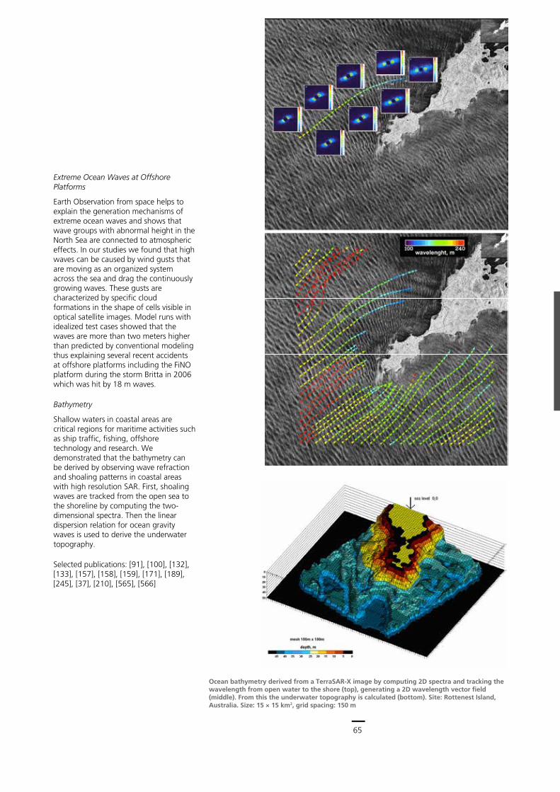
65
Central Services
Remote Sensing Technology Institute (IMF) ∙ Status Report 2007 – 2013
64
Maritime SAR Applications
The oceans of the world are of highest importance to society, providing transportation routes, food, wind energy and access to offshore fossil energy reservoirs. They have strong influence on weather and climate. But the offshore areas are also the site of crimes such as piracy, environmental pollution, and illegal fishing. SAR remote sensing can contribute significantly to all these relevant topics serving science, security, safety and economy.
IMF develops algorithms and methods for maritime remote sensing along two lines. On the one hand, products are provided for NRT services, such as ship detection. On the other hand, satellite images taken by spaceborne sensors are used to explain atmospheric as well as oceano-graphic geophysical processes and features, e.g. wind field and sea state.
Maritime Security
Scanning of the ocean surface using remote sensing instruments provides an opportunity not only to detect and monitor ships, but also the surrounding environmental processes like turbulent ship wakes or wave breaking.
We developed an operational ship detection processor which is able to automatically detect ships and measure their positions, lengths and speeds from SAR imagery. This data is then compared to messages received from the Automatic Identification System AIS and suspicious ships are reported. This processor was successfully tested in several campaigns with national and international authorities. In addition to ship detection, the surrounding marine and meteorological parameters (wind, wave height) are estimated for and delivered to operational meteorological services.
In other campaigns, oil discharge from ships and platforms was detected and reported in near real time to users.
Wind Fields from SAR
Ocean wind fields can be determined from SAR images with very high resolution, on the order of 100 m using TerraSAR-X data. Derived information such as intensity, turbulence and fronts of the wind field is provided by IMF to users at offshore platforms as well as to validate complex models for sea state, currents, sediment transport and morphodynamics.
The special benefit of remote sensing data is that they may reveal important details such as high spatial variability of processes. An example are resonance effects that can produce locally much larger wave heights than are usually predicted by lower resolution models.
Ocean Surface Velocities
Ocean currents are of great interest for oceanography since they are an indicator and accelerator for climate change. Furthermore, the mapping of strong regional tidal currents is important for navigation and site optimization of renewable energy installations.
The potential of TanDEM-X ATI for mapping ocean surface velocity fields was demonstrated experimentally in 2012 over the Pentland Firth area, Scotland. By adjusting the TanDEM-X ATI baseline to near-optimal values for water surface imaging, an improvement of the motion sensitivity by a factor of 25 – 40 in comparison to TerraSAR-X ATI was achieved. This enabled us to map large-area ocean surface currents with unprecedented high spatial and velocity resolution at the same time. It was shown by the experiments that velocity differences of less than 0.1 m/s can be resolved with TanDEM-X ATI at a spatial resolution of 33 × 33 m2. This makes it even possible to resolve orbital motions of long surface waves. The TanDEM-X surface current measurements could be verified using the POLPRED circulation model.
Automatic ship detection and comparison with AIS in Lagos, Nigeria. TerraSAR-X detections are shown in red, AIS detections in green (satellite) and yellow (ground based).
Synthetic Aperture Radar > Methods and Applications
65
Ocean bathymetry derived from a TerraSAR-X image by computing 2D spectra and tracking the wavelength from open water to the shore (top), generating a 2D wavelength vector field (middle). From this the underwater topography is calculated (bottom). Site: Rottenest Island, Australia. Size: 15 × 15 km2, grid spacing: 150 m
Extreme Ocean Waves at Offshore Platforms
Earth Observation from space helps to explain the generation mechanisms of extreme ocean waves and shows that wave groups with abnormal height in the North Sea are connected to atmospheric effects. In our studies we found that high waves can be caused by wind gusts that are moving as an organized system across the sea and drag the continuously growing waves. These gusts are characterized by specific cloud formations in the shape of cells visible in optical satellite images. Model runs with idealized test cases showed that the waves are more than two meters higher than predicted by conventional modeling thus explaining several recent accidents at offshore platforms including the FiNO platform during the storm Britta in 2006 which was hit by 18 m waves.
Bathymetry
Shallow waters in coastal areas are critical regions for maritime activities such as ship traffic, fishing, offshore technology and research. We demonstrated that the bathymetry can be derived by observing wave refraction and shoaling patterns in coastal areas with high resolution SAR. First, shoaling waves are tracked from the open sea to the shoreline by computing the two-dimensional spectra. Then the linear dispersion relation for ocean gravity waves is used to derive the underwater topography.
Selected publications: [91], [100], [132], [133], [157], [158], [159], [171], [189], [245], [37], [210], [565], [566]
66
Earth Observation Center
Remote Sensing Technology Institute (IMF) ∙ Status Report 2007 – 2013
66
Image Information Mining
The data volumes delivered by Earth observation instruments have continuously increased over the years and huge archives containing satellite data are approaching the Exabyte (109 Gigabyte) dimension. The challenge is the exploration and understanding of this data and the delivery of focused information to users.
In order to meet this Big Data challenge, we developed a new field of study: Image Information Mining (IIM). IIM seeks to automate the mining of information from images contained in Earth observation data archives. But IIM is more than just an extension of data mining principles to images: It aims at supporting user understanding. Typical applications deal with complicated spatial, structural and temporal relationships among image objects.
IIM calls for new concepts based on intensive preprocessing of images to extract relevant features, structures and objects, and to analyze their interrelationships, prior to learning their behavior and detecting new information. We developed methods and algorithms and integrated them into systems with intelligent interfaces to the user.
In particular, we concentrated on the following research and development areas:
spatial and semantic image recognition and annotation
information- and complexity-based image analysis
machine learning and context-aware image understanding.
Our models and algorithms discover the scene signatures from SAR images. For the recognition of urban and industrial scenes we applied Bayesian inference, particular particle filters extended to images in the wavelet transform domain.
Due to the computational loads imposed by the very large data volumes, we had to develop extremely simple image descriptors, such as the Bag of Words technique. In addition, we searched for parameter-free techniques that are applicable to any type of data. Therefore, we extended the fast compression based distance technique derived from Kolmogorov complexity theory.
In the fields of learning and classification algorithms we introduced new paradigms integrating statistical and machine learning principles. To reduce the computational burden, we introduced a hierarchical top-down processing scheme to retrieve objects from high-volume image databases: We learn a cascade of classifiers via a multi-stage active learning process. These learning algorithms are then integrated with tools for semantic annotation, i.e. attaching catchwords to image patches. We also integrated linked data referring to geographical names as well as to geological and political categories. We implemented algorithms for automated latent semantic annotation based on Dirichlet models. They are used to generate semantic catalogues for image data archives and provide easy access to their content.
Two other rather recent developments are Visual Analytics and Immersive Image Information Mining. Here, local descriptors in over-complete representations are extracted from images and various projections are used for information visualization. A human operator, immersed in a Cave Automatic Virtual Environment interacts with the parameters and images to disambiguate the non-visual content, create a structure of categories, and retrieve further images that contain significant information.
The developed algorithms have been integrated into systems and tools, such as:
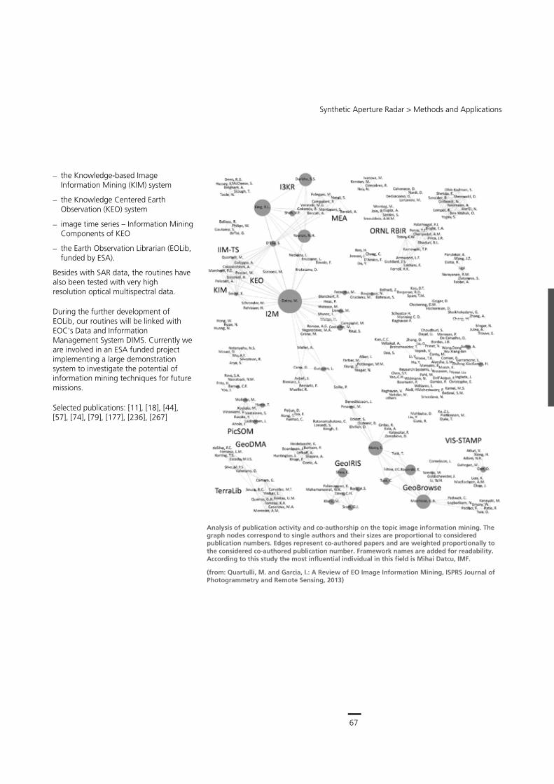
67
Central Services
Remote Sensing Technology Institute (IMF) ∙ Status Report 2007 – 2013
66
Image Information Mining
The data volumes delivered by Earth observation instruments have continuously increased over the years and huge archives containing satellite data are approaching the Exabyte (109 Gigabyte) dimension. The challenge is the exploration and understanding of this data and the delivery of focused information to users.
In order to meet this Big Data challenge, we developed a new field of study: Image Information Mining (IIM). IIM seeks to automate the mining of information from images contained in Earth observation data archives. But IIM is more than just an extension of data mining principles to images: It aims at supporting user understanding. Typical applications deal with complicated spatial, structural and temporal relationships among image objects.
IIM calls for new concepts based on intensive preprocessing of images to extract relevant features, structures and objects, and to analyze their interrelationships, prior to learning their behavior and detecting new information. We developed methods and algorithms and integrated them into systems with intelligent interfaces to the user.
In particular, we concentrated on the following research and development areas:
spatial and semantic image recognition and annotation
information- and complexity-based image analysis
machine learning and context-aware image understanding.
Our models and algorithms discover the scene signatures from SAR images. For the recognition of urban and industrial scenes we applied Bayesian inference, particular particle filters extended to images in the wavelet transform domain.
Due to the computational loads imposed by the very large data volumes, we had to develop extremely simple image descriptors, such as the Bag of Words technique. In addition, we searched for parameter-free techniques that are applicable to any type of data. Therefore, we extended the fast compression based distance technique derived from Kolmogorov complexity theory.
In the fields of learning and classification algorithms we introduced new paradigms integrating statistical and machine learning principles. To reduce the computational burden, we introduced a hierarchical top-down processing scheme to retrieve objects from high-volume image databases: We learn a cascade of classifiers via a multi-stage active learning process. These learning algorithms are then integrated with tools for semantic annotation, i.e. attaching catchwords to image patches. We also integrated linked data referring to geographical names as well as to geological and political categories. We implemented algorithms for automated latent semantic annotation based on Dirichlet models. They are used to generate semantic catalogues for image data archives and provide easy access to their content.
Two other rather recent developments are Visual Analytics and Immersive Image Information Mining. Here, local descriptors in over-complete representations are extracted from images and various projections are used for information visualization. A human operator, immersed in a Cave Automatic Virtual Environment interacts with the parameters and images to disambiguate the non-visual content, create a structure of categories, and retrieve further images that contain significant information.
The developed algorithms have been integrated into systems and tools, such as:
Synthetic Aperture Radar > Methods and Applications
67
the Knowledge-based Image Information Mining (KIM) system
the Knowledge Centered Earth Observation (KEO) system
image time series – Information Mining Components of KEO
the Earth Observation Librarian (EOLib, funded by ESA).
Besides with SAR data, the routines have also been tested with very high resolution optical multispectral data.
During the further development of EOLib, our routines will be linked with EOC’s Data and Information Management System DIMS. Currently we are involved in an ESA funded project implementing a large demonstration system to investigate the potential of information mining techniques for future missions.
Selected publications: [11], [18], [44], [57], [74], [79], [177], [236], [267]
Analysis of publication activity and co-authorship on the topic image information mining. The graph nodes correspond to single authors and their sizes are proportional to considered publication numbers. Edges represent co-authored papers and are weighted proportionally to the considered co-authored publication number. Framework names are added for readability. According to this study the most influential individual in this field is Mihai Datcu, IMF.
(from: Quartulli, M. and Garcia, I.: A Review of EO Image Information Mining, ISPRS Journal of Photogrammetry and Remote Sensing, 2013)

68
Earth Observation Center
Remote Sensing Technology Institute (IMF) ∙ Status Report 2007 – 2013
68

69
Central Services
Remote Sensing Technology Institute (IMF) ∙ Status Report 2007 – 2013
68
Bilder über „Kopf- und Fußzeile „hinterlegen“
Optical Imaging
70
Earth Observation Center
“
70
Optical remote sensing has undergone a rapid development in recent years. This is due to several factors boosting the use of these cross-cutting technologies. One factor is the many new sensors and missions that have been launched. Those with major contributions from IMF will be detailed in this chapter. Another factor is the need from users for robust methodologies and software systems to extract geo-information from these complex and heterogeneous data in a reliable and automatic way. These requirements necessitate basic research on the development of methods for remote sensing applications. This is the focus of the second part of this chapter.
Missions, Sensors and Systems
Missions, sensors and systems are the driving forces behind remote sensing technology development. Besides specialized hardware evolution, robust software solutions are a prerequisite for high quality preprocessing of the data. IMF is engaged in characterizing and operating airborne sensor systems and produces operational processor systems for different optical airborne and spaceborne sensors.
EnMAP
IMF is responsible for managing the development of the EnMAP ground segment which is comprised of Mission Operations, the Payload Data Ground Segment, and Processor Development, Calibration and Validation. We are also developing the fully automatic processing chain for EnMAP imaging spectroscopy data and metadata. The processors are subject to integration into EOC’s multi-mission Data and Information Management System (DIMS). The
operational processing chain consists of the following elements:
the Systematic and Radiometric Processor corrects the raw hyperspectral image data for systematic effects and converts them to physical at-sensor radiance values based on regularly updated calibration tables. Quality layers and metadata for further processing are attached to the product
the Orthorectification Processor generates map-conformal products by removing geometric distortions caused by sensor internal geometry, thermally influenced mounting angles, satellite motion during data acquisition, and terrain related influences. An improved sensor model is achieved using ground control points, which are extracted automatically from global reference images of superior geometric quality using image matching techniques.
the Atmospheric Correction Processor converts top-of-atmosphere radiance values to ground surface reflectance values. For land and water applications different processors are applied. Scenes may be processed in both modes, e.g. for coastal zones or inland waters that contain a large percentage of both, land and water areas.
Optical Imaging
Digital Surface Model of the Allianz-Arena and surroundings, Munich, derived from approximately thirty imgages of our 3K camera system. Bundle adjustment, dense matching and DSM generation software were developed by IMF and integrated in a CATENA processing chain.
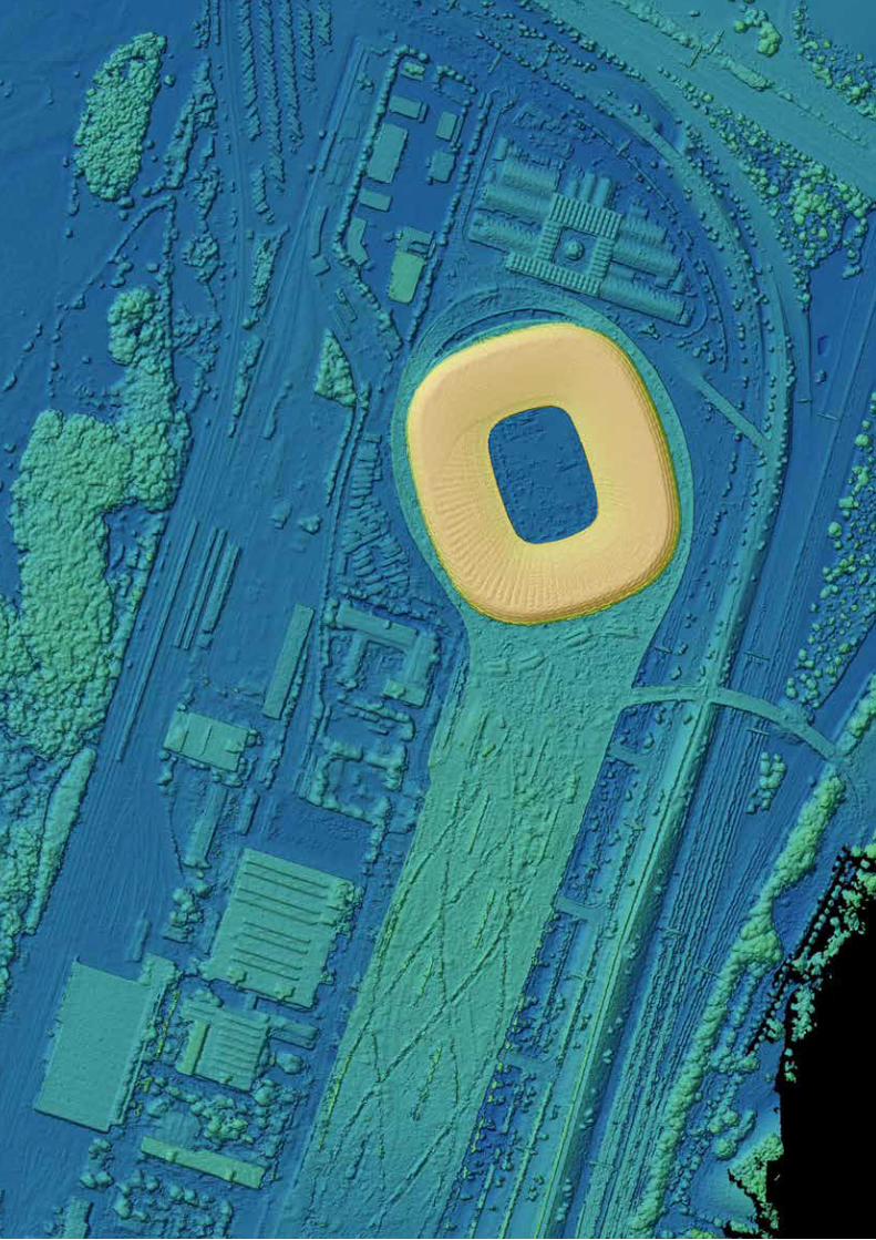
71
Central Services
“
70
Optical remote sensing has undergone a rapid development in recent years. This is due to several factors boosting the use of these cross-cutting technologies. One factor is the many new sensors and missions that have been launched. Those with major contributions from IMF will be detailed in this chapter. Another factor is the need from users for robust methodologies and software systems to extract geo-information from these complex and heterogeneous data in a reliable and automatic way. These requirements necessitate basic research on the development of methods for remote sensing applications. This is the focus of the second part of this chapter.
Missions, Sensors and Systems
Missions, sensors and systems are the driving forces behind remote sensing technology development. Besides specialized hardware evolution, robust software solutions are a prerequisite for high quality preprocessing of the data. IMF is engaged in characterizing and operating airborne sensor systems and produces operational processor systems for different optical airborne and spaceborne sensors.
EnMAP
IMF is responsible for managing the development of the EnMAP ground segment which is comprised of Mission Operations, the Payload Data Ground Segment, and Processor Development, Calibration and Validation. We are also developing the fully automatic processing chain for EnMAP imaging spectroscopy data and metadata. The processors are subject to integration into EOC’s multi-mission Data and Information Management System (DIMS). The
operational processing chain consists of the following elements:
the Systematic and Radiometric Processor corrects the raw hyperspectral image data for systematic effects and converts them to physical at-sensor radiance values based on regularly updated calibration tables. Quality layers and metadata for further processing are attached to the product
the Orthorectification Processor generates map-conformal products by removing geometric distortions caused by sensor internal geometry, thermally influenced mounting angles, satellite motion during data acquisition, and terrain related influences. An improved sensor model is achieved using ground control points, which are extracted automatically from global reference images of superior geometric quality using image matching techniques.
the Atmospheric Correction Processor converts top-of-atmosphere radiance values to ground surface reflectance values. For land and water applications different processors are applied. Scenes may be processed in both modes, e.g. for coastal zones or inland waters that contain a large percentage of both, land and water areas.
Optical Imaging
Digital Surface Model of the Allianz-Arena and surroundings, Munich, derived from approximately thirty imgages of our 3K camera system. Bundle adjustment, dense matching and DSM generation software were developed by IMF and integrated in a CATENA processing chain.
Optical Imaging > Missions, Sensors and Systems
71
72
Earth Observation Center
Remote Sensing Technology Institute (IMF) ∙ Status Report 2007 – 2013
72
Besides developing the processing chain the following activities will be performed for EnMAP by IMF:
In-flight calibration refers to all measurement and data analysis aimed at assessing the radiometric, spectrometric, and geometric characteristics of the EnMAP imaging spectrometers in orbit. The sensor system will undergo extensive prelaunch characterization and calibration measurements and will be re-calibrated after launch by updating the calibration tables.
Instrument monitoring takes a broader view of the in-orbit functioning of the instrument by analyzing essential housekeeping data in addition to the results of calibration on a long-term basis. It analyzes changes and trends in instrument behavior that might indicate problems and combines all available information for synoptic analysis. Therefore, it is closely linked to in-flight calibration.
Quality Control is a systematic and continuous image data product verification which addresses the accuracy and completeness of intermediate and final data products. It includes on-line as well as off-line analysis of quality-related parameters.
After a successful Critical Design Review (end of Phase C), the development and coding of the processor system has started. We apply the ESA ECSS standard to all developments within the EnMAP ground segment.
Selected publications: [49], [107], [331], [397], [403]
ALOS-PRISM, -AVNIR
The Japanese Advanced Land Observing Satellite operated between 2006 and 2011. It carried two optical remote sensing instruments: One was PRISM providing a geometric resolution of 2.5 m for digital elevation model
production. The other was the 4-band radiometer AVNIR-2 with a geometric resolution of 10 m for disaster monitoring and land coverage observation.
On behalf of ESA we developed operational processors for both optical instruments using ECSS standards and implemented them for operation at ESA facilities. The complex processing chain includes data quality improvements through deconvolution, matching with global reference databases to improve the geolocation accuracy for consistent product families, and orthorectification employing global DEM databases.
Selected publications: [160], [253], [747], [816], [852]
Cartosat-1 (IRS-P5)
Cartosat-1 was launched in 2005 as part of India’s EO remote sensing program, and is still in operation. Its payload is comprised of two panchromatic cameras that are especially designed for in-flight stereo viewing in support of cartography and terrain modeling applications.
IMF has developed a fully automatic processing chain that generates digital surface models (DSMs) from Cartosat-1 data. By applying dense stereo matching to all pairs of input images high quality DSMs are generated. For large areas a computationally stable bundle adjustment procedure has been developed and reference data of different kinds can be used within the automatic procedure. This processor is licensed to the company Euromap/GAF to generate a European-wide DSM. At present negotiations with ISRO are underway for worldwide processing of Cartosat-1 data.
Selected publications: [50], [54], [126], [670], [695], [778]
Optical Imaging > Missions, Sensors and Systems
73
Hyperspectral Camera HySpex
In 2011 EOC purchased the commercial hyperspectral camera system HySpex (NEO, Norway) for operation onboard of DLR research aircraft. The system consists of two imaging spectrometers and a high quality navigation system. The data of the two cameras are combined during postprocessing into a single data set spanning wavelengths from 416 to 2,500 nm in up to 316 spectral channels. The navigation system provides position and attitude data for georeferencing and correction of geometric errors caused by angular movements of the airplane. For laboratory operation, HySpex can be equipped with close-up lenses for distances of 0.3, 1 and 3 m. Mounted on a translation or rotary stage, it provides hyperspectral images of objects with a resolution down to 0.1 mm.
After a commissioning phase, which included preparation for operational use (airworthiness certification, set-up of an automatic data processing chain) and extensive testing (laboratory characterization, test flights), we integrated the HySpex system into EOC’s user service OpAiRS. Regular calibration and characterization is performed at our Calibration Home Base (CHB) for imaging spectrometers.
Since 2012 HySpex has been employed in European-wide airborne campaigns for different scientific applications. The airborne data are also used to simulate data of hyperspectral satellite sensors, in particular to support algorithm development for EnMAP. Laboratory data have been applied for characterization of the laboratory equipment, in particular to assess the homogeneity of radiance sources used for calibration.
Selected publications: [489], [528], [825]
‘3K‘ Real-time Camera System
Based on a three-head (= ‘3K‘) aerial camera system, IMF developed a real-time sensor and data processing system for road traffic monitoring and rapid mapping applications in case of major events and disasters within the project VABENE. The system is based on an airborne and a ground component. The airborne part is mainly comprised of:
the wide angle 3K camera
a navigation unit consisting of a differential GPS receiver
an inertial measurement unit (IMU) measuring the flight attitude
an onboard processing unit with four industrial PCs.
Aerial images, acquired with a frequency of 2 – 5 Hz, are immediately georeferenced and orthorectified on GPUs using the GPS-IMU data. For a 1,000 m flight altitude it is possible to acquire an area of 2.5 km x 10 km within 2 minutes. Algorithms have been developed to derive vehicle velocity and density on-board the aircraft of all imaged roads in near real-time. All resulting data are transferred to the ground station in real-time via an air-to-ground radio link system installed
3K camera system consisting of 3 off-the-shelf Canon cameras mounted on a ZEISS frame, for acquiring sequential images at a frame rate of up to 5 Hz
Digital surface model (DSM) of northern Italy generated from more than 400 Cartosat-1 scenes after bundle block adjustment
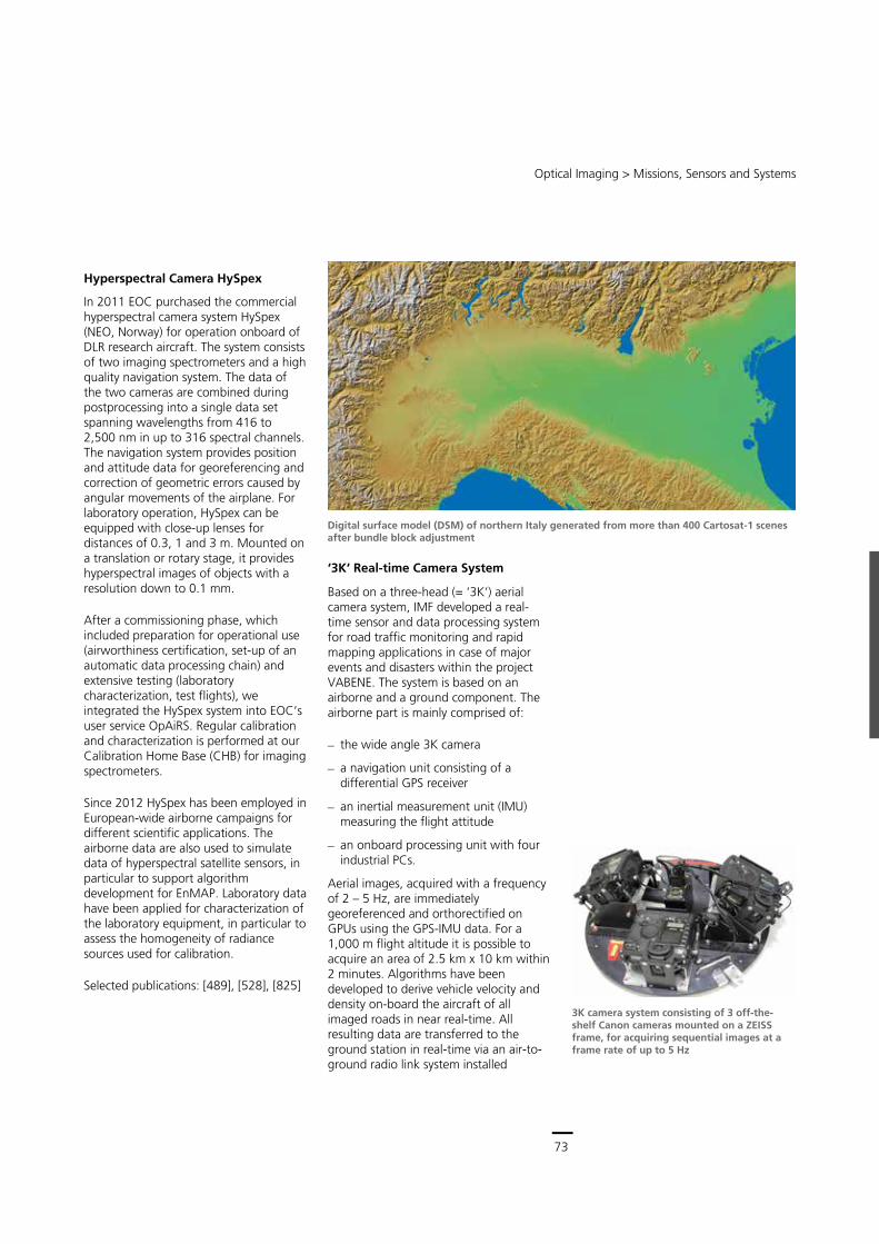
73
Central Services
Remote Sensing Technology Institute (IMF) ∙ Status Report 2007 – 2013
72
Besides developing the processing chain the following activities will be performed for EnMAP by IMF:
In-flight calibration refers to all measurement and data analysis aimed at assessing the radiometric, spectrometric, and geometric characteristics of the EnMAP imaging spectrometers in orbit. The sensor system will undergo extensive prelaunch characterization and calibration measurements and will be re-calibrated after launch by updating the calibration tables.
Instrument monitoring takes a broader view of the in-orbit functioning of the instrument by analyzing essential housekeeping data in addition to the results of calibration on a long-term basis. It analyzes changes and trends in instrument behavior that might indicate problems and combines all available information for synoptic analysis. Therefore, it is closely linked to in-flight calibration.
Quality Control is a systematic and continuous image data product verification which addresses the accuracy and completeness of intermediate and final data products. It includes on-line as well as off-line analysis of quality-related parameters.
After a successful Critical Design Review (end of Phase C), the development and coding of the processor system has started. We apply the ESA ECSS standard to all developments within the EnMAP ground segment.
Selected publications: [49], [107], [331], [397], [403]
ALOS-PRISM, -AVNIR
The Japanese Advanced Land Observing Satellite operated between 2006 and 2011. It carried two optical remote sensing instruments: One was PRISM providing a geometric resolution of 2.5 m for digital elevation model
production. The other was the 4-band radiometer AVNIR-2 with a geometric resolution of 10 m for disaster monitoring and land coverage observation.
On behalf of ESA we developed operational processors for both optical instruments using ECSS standards and implemented them for operation at ESA facilities. The complex processing chain includes data quality improvements through deconvolution, matching with global reference databases to improve the geolocation accuracy for consistent product families, and orthorectification employing global DEM databases.
Selected publications: [160], [253], [747], [816], [852]
Cartosat-1 (IRS-P5)
Cartosat-1 was launched in 2005 as part of India’s EO remote sensing program, and is still in operation. Its payload is comprised of two panchromatic cameras that are especially designed for in-flight stereo viewing in support of cartography and terrain modeling applications.
IMF has developed a fully automatic processing chain that generates digital surface models (DSMs) from Cartosat-1 data. By applying dense stereo matching to all pairs of input images high quality DSMs are generated. For large areas a computationally stable bundle adjustment procedure has been developed and reference data of different kinds can be used within the automatic procedure. This processor is licensed to the company Euromap/GAF to generate a European-wide DSM. At present negotiations with ISRO are underway for worldwide processing of Cartosat-1 data.
Selected publications: [50], [54], [126], [670], [695], [778]
Optical Imaging > Missions, Sensors and Systems
73
Hyperspectral Camera HySpex
In 2011 EOC purchased the commercial hyperspectral camera system HySpex (NEO, Norway) for operation onboard of DLR research aircraft. The system consists of two imaging spectrometers and a high quality navigation system. The data of the two cameras are combined during postprocessing into a single data set spanning wavelengths from 416 to 2,500 nm in up to 316 spectral channels. The navigation system provides position and attitude data for georeferencing and correction of geometric errors caused by angular movements of the airplane. For laboratory operation, HySpex can be equipped with close-up lenses for distances of 0.3, 1 and 3 m. Mounted on a translation or rotary stage, it provides hyperspectral images of objects with a resolution down to 0.1 mm.
After a commissioning phase, which included preparation for operational use (airworthiness certification, set-up of an automatic data processing chain) and extensive testing (laboratory characterization, test flights), we integrated the HySpex system into EOC’s user service OpAiRS. Regular calibration and characterization is performed at our Calibration Home Base (CHB) for imaging spectrometers.
Since 2012 HySpex has been employed in European-wide airborne campaigns for different scientific applications. The airborne data are also used to simulate data of hyperspectral satellite sensors, in particular to support algorithm development for EnMAP. Laboratory data have been applied for characterization of the laboratory equipment, in particular to assess the homogeneity of radiance sources used for calibration.
Selected publications: [489], [528], [825]
‘3K‘ Real-time Camera System
Based on a three-head (= ‘3K‘) aerial camera system, IMF developed a real-time sensor and data processing system for road traffic monitoring and rapid mapping applications in case of major events and disasters within the project VABENE. The system is based on an airborne and a ground component. The airborne part is mainly comprised of:
the wide angle 3K camera
a navigation unit consisting of a differential GPS receiver
an inertial measurement unit (IMU) measuring the flight attitude
an onboard processing unit with four industrial PCs.
Aerial images, acquired with a frequency of 2 – 5 Hz, are immediately georeferenced and orthorectified on GPUs using the GPS-IMU data. For a 1,000 m flight altitude it is possible to acquire an area of 2.5 km x 10 km within 2 minutes. Algorithms have been developed to derive vehicle velocity and density on-board the aircraft of all imaged roads in near real-time. All resulting data are transferred to the ground station in real-time via an air-to-ground radio link system installed
3K camera system consisting of 3 off-the-shelf Canon cameras mounted on a ZEISS frame, for acquiring sequential images at a frame rate of up to 5 Hz
Digital surface model (DSM) of northern Italy generated from more than 400 Cartosat-1 scenes after bundle block adjustment
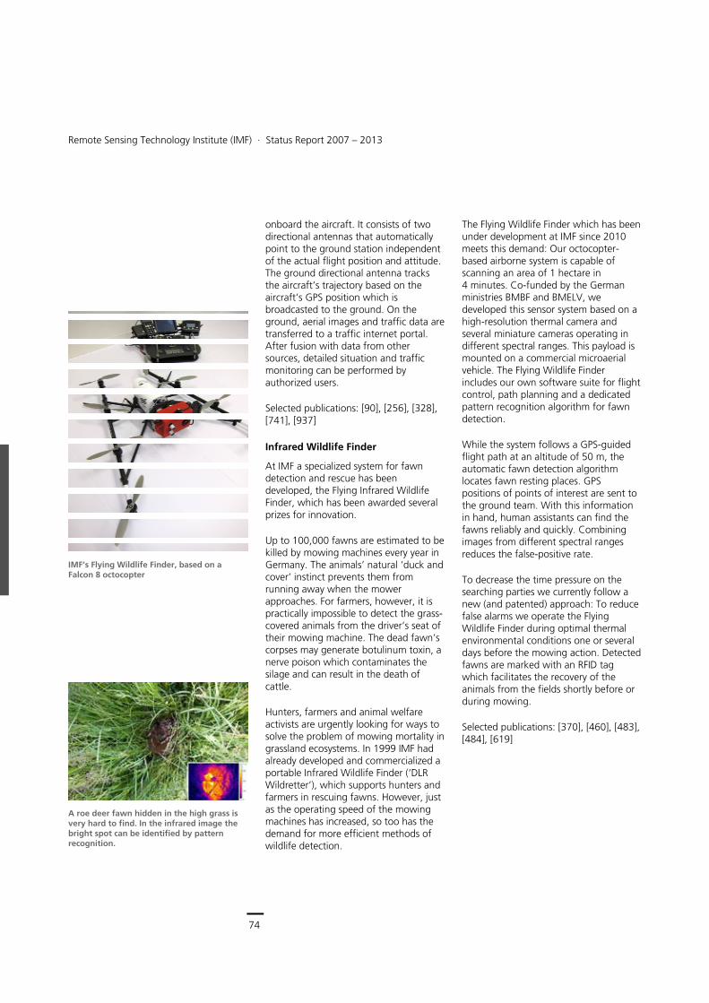
74
Earth Observation Center
Remote Sensing Technology Institute (IMF) ∙ Status Report 2007 – 2013
74
onboard the aircraft. It consists of two directional antennas that automatically point to the ground station independent of the actual flight position and attitude. The ground directional antenna tracks the aircraft’s trajectory based on the aircraft’s GPS position which is broadcasted to the ground. On the ground, aerial images and traffic data are transferred to a traffic internet portal. After fusion with data from other sources, detailed situation and traffic monitoring can be performed by authorized users.
Selected publications: [90], [256], [328], [741], [937]
Infrared Wildlife Finder
At IMF a specialized system for fawn detection and rescue has been developed, the Flying Infrared Wildlife Finder, which has been awarded several prizes for innovation.
Up to 100,000 fawns are estimated to be killed by mowing machines every year in Germany. The animals’ natural ‘duck and cover’ instinct prevents them from running away when the mower approaches. For farmers, however, it is practically impossible to detect the grass-covered animals from the driver’s seat of their mowing machine. The dead fawn’s corpses may generate botulinum toxin, a nerve poison which contaminates the silage and can result in the death of cattle.
Hunters, farmers and animal welfare activists are urgently looking for ways to solve the problem of mowing mortality in grassland ecosystems. In 1999 IMF had already developed and commercialized a portable Infrared Wildlife Finder (‘DLR Wildretter’), which supports hunters and farmers in rescuing fawns. However, just as the operating speed of the mowing machines has increased, so too has the demand for more efficient methods of wildlife detection.
The Flying Wildlife Finder which has been under development at IMF since 2010 meets this demand: Our octocopter-based airborne system is capable of scanning an area of 1 hectare in 4 minutes. Co-funded by the German ministries BMBF and BMELV, we developed this sensor system based on a high-resolution thermal camera and several miniature cameras operating in different spectral ranges. This payload is mounted on a commercial microaerial vehicle. The Flying Wildlife Finder includes our own software suite for flight control, path planning and a dedicated pattern recognition algorithm for fawn detection.
While the system follows a GPS-guided flight path at an altitude of 50 m, the automatic fawn detection algorithm locates fawn resting places. GPS positions of points of interest are sent to the ground team. With this information in hand, human assistants can find the fawns reliably and quickly. Combining images from different spectral ranges reduces the false-positive rate.
To decrease the time pressure on the searching parties we currently follow a new (and patented) approach: To reduce false alarms we operate the Flying Wildlife Finder during optimal thermal environmental conditions one or several days before the mowing action. Detected fawns are marked with an RFID tag which facilitates the recovery of the animals from the fields shortly before or during mowing.
Selected publications: [370], [460], [483], [484], [619]
A roe deer fawn hidden in the high grass is very hard to find. In the infrared image the bright spot can be identified by pattern recognition.
IMF’s Flying Wildlife Finder, based on a Falcon 8 octocopter
Optical Imaging > Generic Processing Systems
75
Generic Processing Systems
A fundamental topic at IMF is the development of operational software processors from new scientific methods and algorithms for a variety of spaceborne and airborne optical sensor data. The challenge here is to turn scientific algorithms into robust processors, capable of processing thousands of images automatically in a short time. Operational and fully automatic processing chains are a prerequisite for generating higher level products.
XDibias
The development of operational image processors for optical sensors at IMF is based on XDibias, the development environment for image processing, established at DLR since the late 1970s and now in its 7th generation. This software system contains about 500 image processing modules. They range from simple cutting and merging over image algebra, masking, and filtering to high level algorithms such as image matching, geo-projection, spectral analysis, classification, and DEM generation. The XDibias framework can use any Linux environment and modules may be written in C, C++, Python and other programming languages. A big advantage of XDibias is that developments by, e.g. PhD students, are generated in a well documented way. Therefore, they are kept in a modular database and can be used for several tasks and projects.
CATENA
The starting point for the development of fully automatic operational processors at IMF was our mandate for preprocessing and orthorectification of about 3,500 satellite scenes for the ESA GMES Fast Track Land Service Image2006. Two
European-wide coverages (38 member states) of IRS-P6 and SPOT-4/5 data have been processed in less than half a year – a tedious task if manual measurements of ground control points (GCP) had been necessary to fulfill customer requirements. Therefore, we developed robust methods for automatic GCP generation from image databases and used them to improve sensor models and orthorectification. The accuracies reached are in the order of half a pixel.
Based on the Image2006 experience, the modular, configurable, and fully automatic processing system CATENA emerged. CATENA is a framework of modules which can be combined into processing chains for generic project needs or general processing like automatic orthorectification, employing worldwide reference data bases of orthoimages and DEMs, or atmospheric correction of satellite imagery. This general processing scheme is embedded in a sophisticated distributed grid computing framework, managing the automatic execution of the requested jobs on any set of workstations. Since it is a generic processing chain, only new import modules have to be written for new sensors. Up to now CATENA can handle high and very high resolution sensors like SPOT4/5, IRS-P6-LISS III/AWiFS, ALOS-AVNIR/PRISM, Ikonos,
CATENA processing system: Distributed grid computing fetches jobs from a task database and executes them using requested input data and the processing chain definition.

75
Central Services
Remote Sensing Technology Institute (IMF) ∙ Status Report 2007 – 2013
74
onboard the aircraft. It consists of two directional antennas that automatically point to the ground station independent of the actual flight position and attitude. The ground directional antenna tracks the aircraft’s trajectory based on the aircraft’s GPS position which is broadcasted to the ground. On the ground, aerial images and traffic data are transferred to a traffic internet portal. After fusion with data from other sources, detailed situation and traffic monitoring can be performed by authorized users.
Selected publications: [90], [256], [328], [741], [937]
Infrared Wildlife Finder
At IMF a specialized system for fawn detection and rescue has been developed, the Flying Infrared Wildlife Finder, which has been awarded several prizes for innovation.
Up to 100,000 fawns are estimated to be killed by mowing machines every year in Germany. The animals’ natural ‘duck and cover’ instinct prevents them from running away when the mower approaches. For farmers, however, it is practically impossible to detect the grass-covered animals from the driver’s seat of their mowing machine. The dead fawn’s corpses may generate botulinum toxin, a nerve poison which contaminates the silage and can result in the death of cattle.
Hunters, farmers and animal welfare activists are urgently looking for ways to solve the problem of mowing mortality in grassland ecosystems. In 1999 IMF had already developed and commercialized a portable Infrared Wildlife Finder (‘DLR Wildretter’), which supports hunters and farmers in rescuing fawns. However, just as the operating speed of the mowing machines has increased, so too has the demand for more efficient methods of wildlife detection.
The Flying Wildlife Finder which has been under development at IMF since 2010 meets this demand: Our octocopter-based airborne system is capable of scanning an area of 1 hectare in 4 minutes. Co-funded by the German ministries BMBF and BMELV, we developed this sensor system based on a high-resolution thermal camera and several miniature cameras operating in different spectral ranges. This payload is mounted on a commercial microaerial vehicle. The Flying Wildlife Finder includes our own software suite for flight control, path planning and a dedicated pattern recognition algorithm for fawn detection.
While the system follows a GPS-guided flight path at an altitude of 50 m, the automatic fawn detection algorithm locates fawn resting places. GPS positions of points of interest are sent to the ground team. With this information in hand, human assistants can find the fawns reliably and quickly. Combining images from different spectral ranges reduces the false-positive rate.
To decrease the time pressure on the searching parties we currently follow a new (and patented) approach: To reduce false alarms we operate the Flying Wildlife Finder during optimal thermal environmental conditions one or several days before the mowing action. Detected fawns are marked with an RFID tag which facilitates the recovery of the animals from the fields shortly before or during mowing.
Selected publications: [370], [460], [483], [484], [619]
A roe deer fawn hidden in the high grass is very hard to find. In the infrared image the bright spot can be identified by pattern recognition.
IMF’s Flying Wildlife Finder, based on a Falcon 8 octocopter
Optical Imaging > Generic Processing Systems
75
Generic Processing Systems
A fundamental topic at IMF is the development of operational software processors from new scientific methods and algorithms for a variety of spaceborne and airborne optical sensor data. The challenge here is to turn scientific algorithms into robust processors, capable of processing thousands of images automatically in a short time. Operational and fully automatic processing chains are a prerequisite for generating higher level products.
XDibias
The development of operational image processors for optical sensors at IMF is based on XDibias, the development environment for image processing, established at DLR since the late 1970s and now in its 7th generation. This software system contains about 500 image processing modules. They range from simple cutting and merging over image algebra, masking, and filtering to high level algorithms such as image matching, geo-projection, spectral analysis, classification, and DEM generation. The XDibias framework can use any Linux environment and modules may be written in C, C++, Python and other programming languages. A big advantage of XDibias is that developments by, e.g. PhD students, are generated in a well documented way. Therefore, they are kept in a modular database and can be used for several tasks and projects.
CATENA
The starting point for the development of fully automatic operational processors at IMF was our mandate for preprocessing and orthorectification of about 3,500 satellite scenes for the ESA GMES Fast Track Land Service Image2006. Two
European-wide coverages (38 member states) of IRS-P6 and SPOT-4/5 data have been processed in less than half a year – a tedious task if manual measurements of ground control points (GCP) had been necessary to fulfill customer requirements. Therefore, we developed robust methods for automatic GCP generation from image databases and used them to improve sensor models and orthorectification. The accuracies reached are in the order of half a pixel.
Based on the Image2006 experience, the modular, configurable, and fully automatic processing system CATENA emerged. CATENA is a framework of modules which can be combined into processing chains for generic project needs or general processing like automatic orthorectification, employing worldwide reference data bases of orthoimages and DEMs, or atmospheric correction of satellite imagery. This general processing scheme is embedded in a sophisticated distributed grid computing framework, managing the automatic execution of the requested jobs on any set of workstations. Since it is a generic processing chain, only new import modules have to be written for new sensors. Up to now CATENA can handle high and very high resolution sensors like SPOT4/5, IRS-P6-LISS III/AWiFS, ALOS-AVNIR/PRISM, Ikonos,
CATENA processing system: Distributed grid computing fetches jobs from a task database and executes them using requested input data and the processing chain definition.
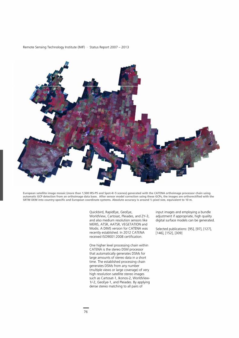
76
Earth Observation Center
Remote Sensing Technology Institute (IMF) ∙ Status Report 2007 – 2013
76
Quickbird, RapidEye, GeoEye, WorldView, Cartosat, Pleiades, and ZY-3, and also medium resolution sensors like MERIS, ATSR, AATSR, VEGETATION and Modis. A DIMS version for CATENA was recently established. In 2012 CATENA received ISO9001:2008 certification.
One higher level processing chain within CATENA is the stereo DSM processor that automatically generates DSMs for large amounts of stereo data in a short time. The established processing chain generates DSMs from any number (multiple views or large coverage) of very high resolution satellite stereo images such as Cartosat-1, Ikonos-2, WorldView-1/-2, GeoEye-1, and Pleiades. By applying dense stereo matching to all pairs of
input images and employing a bundle adjustment if appropriate, high quality digital surface models can be generated.
Selected publications: [95], [97], [127], [146], [152], [309]
European satellite image mosaic (more than 1,500 IRS-P5 and Spot-4/-5 scenes) generated with the CATENA orthoimage processor chain using automatic GCP detection from an orthoimage data base. After sensor model correction using these GCPs, the images are orthorectified with the SRTM DEM into country-specific and European coordinate systems. Absolute accuracy is around ½ pixel size, equivalent to 10 m.
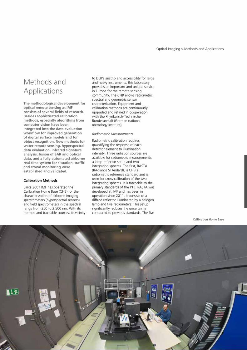
77
Central Services
Remote Sensing Technology Institute (IMF) ∙ Status Report 2007 – 2013
76
Quickbird, RapidEye, GeoEye, WorldView, Cartosat, Pleiades, and ZY-3, and also medium resolution sensors like MERIS, ATSR, AATSR, VEGETATION and Modis. A DIMS version for CATENA was recently established. In 2012 CATENA received ISO9001:2008 certification.
One higher level processing chain within CATENA is the stereo DSM processor that automatically generates DSMs for large amounts of stereo data in a short time. The established processing chain generates DSMs from any number (multiple views or large coverage) of very high resolution satellite stereo images such as Cartosat-1, Ikonos-2, WorldView-1/-2, GeoEye-1, and Pleiades. By applying dense stereo matching to all pairs of
input images and employing a bundle adjustment if appropriate, high quality digital surface models can be generated.
Selected publications: [95], [97], [127], [146], [152], [309]
European satellite image mosaic (more than 1,500 IRS-P5 and Spot-4/-5 scenes) generated with the CATENA orthoimage processor chain using automatic GCP detection from an orthoimage data base. After sensor model correction using these GCPs, the images are orthorectified with the SRTM DEM into country-specific and European coordinate systems. Absolute accuracy is around ½ pixel size, equivalent to 10 m.
Optical Imaging > Methods and Applications
77
Methods and Applications
The methodological development for optical remote sensing at IMF consists of several fields of research. Besides sophisticated calibration methods, especially algorithms from computer vision have been integrated into the data evaluation workflow for improved generation of digital surface models and for object recognition. New methods for water remote sensing, hyperspectral data evaluation, infrared signature analysis, fusion of SAR and optical data, and a fully automated airborne real-time system for situation, traffic and crowd monitoring were established and validated.
Calibration Methods
Since 2007 IMF has operated the Calibration Home Base (CHB) for the characterization of airborne imaging spectrometers (hyperspectral sensors) and field spectrometers in the spectral range from 350 to 2,500 nm. With its normed and traceable sources, its vicinity
to DLR’s airstrip and accessibility for large and heavy instruments, this laboratory provides an important and unique service in Europe for the remote sensing community. The CHB allows radiometric, spectral and geometric sensor characterization. Equipment and calibration methods are continuously upgraded and refined in cooperation with the Physikalisch-Technische Bundesanstalt (German national metrology institute).
Radiometric Measurements
Radiometric calibration requires quantifying the response of each detector element to illumination intensity. Three radiation sources are available for radiometric measurements, a lamp-reflector-setup and two integrating spheres. The first, RASTA (RAdiance STAndard), is CHB’s radiometric reference standard and is used for cross-calibration of the two integrating spheres. It is traceable to the primary standards of the PTB. RASTA was developed at IMF and has been in operation since 2011. It consists of a diffuse reflector illuminated by a halogen lamp and five radiometers. This setup significantly reduces the uncertainty compared to previous standards. The five
Calibration Home Base
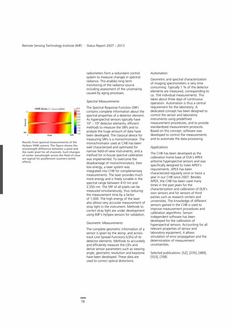
78
Earth Observation Center
Remote Sensing Technology Institute (IMF) ∙ Status Report 2007 – 2013
78
radiometers form a redundant control system to measure changes in spectral radiance. This enables long term monitoring of the radiance source including assessment of the uncertainty caused by aging processes.
Spectral Measurements
The Spectral Response Function (SRF) contains complete information about the spectral properties of a detector element. As hyperspectral sensors typically have 105 – 106 detector elements, efficient methods to measure the SRFs and to analyze the huge amount of data have been developed. The classical device for measuring SRFs is a monochromator. The monochromator used at CHB has been well characterized and optimized for narrow field-of-view instruments, and a method for in-house spectral calibration was implemented. To overcome the disadvantage of monochromators, their low energy, a laser system was integrated into CHB for complementary measurements. The laser provides much more energy and is freely tunable in the spectral range between 410 nm and 2,550 nm. The SRF of all pixels can be measured simultaneously, thus reducing the measurement time by a factor of 1,000. The high energy of the laser also allows very accurate measurement of stray light in the instrument. Methods to correct stray light are under development using IMF’s HySpex sensors for validation.
Geometric Measurements
The complete geometric information of a sensor is given by the along- and across-track Line Spread Functions (LSFs) of its detector elements. Methods to accurately and efficiently measure the LSFs and derive sensor parameters such as viewing angle, geometric resolution and keystone have been developed. These data are used to correct optical distortions.
Automation
Geometric and spectral characterization of imaging spectrometers is very time consuming. Typically 1 % of the detector elements are measured, corresponding to ca. 104 individual measurements. This takes about three days of continuous operation. Automation is thus a central requirement for the laboratory. A dedicated concept has been designed to control the sensor and laboratory instruments using predefined measurement procedures, and to provide standardized measurement protocols. Based on this concept, software was developed to control the measurements and to automate the data processing.
Applications
The CHB has been developed as the calibration home base of ESA’s APEX airborne hyperspectral sensors and was specifically designed to meet APEX’s requirements. APEX has been characterized regularly once or twice a year in our CHB since 2007. Besides APEX, the CHB has been used many times in the past years for the characterization and calibration of DLR’s own sensors and for sensors of third parties such as research centers and universities. The knowledge of different sensors gained in the CHB is used to improve measurement procedures and calibration algorithms. Sensor-independent software has been developed for the calibration of hyperspectral sensors. Accounting for all relevant properties of sensor and laboratory equipment, it allows simulation of error propagation and the determination of measurement uncertainties.
Selected publications: [52], [235], [489], [553], [708]
Results from spectral measurements of the HySpex VNIR camera. The figure shows the wavelength difference between a pixel and the nadir pixel for all channels. Such changes of center wavelength across the field of view are typical for pushbroom scanners (smile effect).
Optical Imaging > Methods and Applications
79
Orthorectification
Orthorectification is one of the most important preprocessing steps in remote sensing image processing. Particularly for optical data, the absolute orientation of satellite image data, as provided by navigation instruments, is not accurate enough to allow direct georeferencing. Therefore, in addition to a DSM, ground control points (GCPs) are necessary to achieve absolute geometric accuracies in orthoimages on the order of the pixel size. Since measuring GCPs manually is a tedious task, IMF has developed several robust algorithms to find GCPs in orthorectified image data bases. The matching techniques range from area based matching to SIFT- and SURF-operators. Mutual information or other similarity metrics are used in order to find corresponding points in the reference image data and the images of interest. Block adjustment procedures, developed at IMF, are applied for combined processing of large image blocks in this context.
For image resolutions of 5 m and better, optical reference data are not generally available. In this case TerraSAR-X data can be used as a basis for finding GCPs, alternatively, if stereo data are available, DSMs can be used as reference.
DSM-based Georeferencing
Traditional methods for the absolute orientation of optical satellite images require the use of GCPs if the sensor does not provide the required absolute accuracy. While reference imagery can be used for many applications, like for the Image2006 project, no worldwide reference with an absolute accuracy better than 10 m is freely available. This is a problem for continent-wide generation of DEMs using e.g. Cartosat-1 data, as the raw Cartosat-1 sensor model has an accuracy of only several hundred meters. The SRTM height data, however, is specified with a 3D error of less than 10 m and is freely available for 80 % of
the Earth’s landmass. Established processors only use it as a vertical reference. We developed an approach for using SRTM height data as both a vertical and horizontal reference for optical stereo data. Other potential reference DEMs are the ASTER GDEM and in future the TanDEM-X DEM or any locally available consistent DEM. The approach can not only be applied to single stereo pairs, but also to large blocks consisting of thousands of images. The accuracy of the fully automatic processing was validated using 22 well distributed test scenes and results in a horizontal accuracy of 6.7 m (CE90) and a vertical accuracy of 5.1 m (LE90).
Selected publications: [97], [126], [160], [163], [253], [475], [503]
DSM Generation
Several methods for optimizing the generation of DSMs from airborne and spaceborne optical stereo data have been developed at IMF. Robust dense matching methodologies are the main focus of our work. Scientific developments have enabled the extraction of further information from DSMs such as digital terrain models, single building objects and 3D changes.
Dense Stereo Matching
Classical window based matching algorithms do not allow extraction of highly detailed DSMs due to the smoothing effect of the matching window. State-of-the-art stereo matching algorithms perform matching for each pixel by minimizing a global energy function of the disparities. This energy function consists of an edge preserving smoothness term and a data term C measuring how well a matching hypothesis fits the image data expressed as e.g.:
min� ������� �� ������ ������� ��
Top: DSM result for SGM as regularization measure Bottom: The Total Variation regularizer with convex optimization leads to much sharper building edges. (Site: Frauenkirche, Munich)
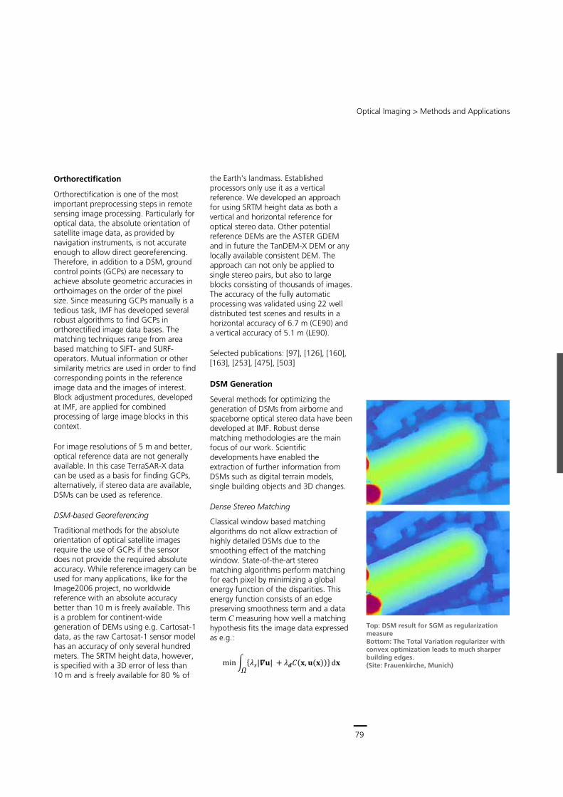
79
Central Services
Remote Sensing Technology Institute (IMF) ∙ Status Report 2007 – 2013
78
radiometers form a redundant control system to measure changes in spectral radiance. This enables long term monitoring of the radiance source including assessment of the uncertainty caused by aging processes.
Spectral Measurements
The Spectral Response Function (SRF) contains complete information about the spectral properties of a detector element. As hyperspectral sensors typically have 105 – 106 detector elements, efficient methods to measure the SRFs and to analyze the huge amount of data have been developed. The classical device for measuring SRFs is a monochromator. The monochromator used at CHB has been well characterized and optimized for narrow field-of-view instruments, and a method for in-house spectral calibration was implemented. To overcome the disadvantage of monochromators, their low energy, a laser system was integrated into CHB for complementary measurements. The laser provides much more energy and is freely tunable in the spectral range between 410 nm and 2,550 nm. The SRF of all pixels can be measured simultaneously, thus reducing the measurement time by a factor of 1,000. The high energy of the laser also allows very accurate measurement of stray light in the instrument. Methods to correct stray light are under development using IMF’s HySpex sensors for validation.
Geometric Measurements
The complete geometric information of a sensor is given by the along- and across-track Line Spread Functions (LSFs) of its detector elements. Methods to accurately and efficiently measure the LSFs and derive sensor parameters such as viewing angle, geometric resolution and keystone have been developed. These data are used to correct optical distortions.
Automation
Geometric and spectral characterization of imaging spectrometers is very time consuming. Typically 1 % of the detector elements are measured, corresponding to ca. 104 individual measurements. This takes about three days of continuous operation. Automation is thus a central requirement for the laboratory. A dedicated concept has been designed to control the sensor and laboratory instruments using predefined measurement procedures, and to provide standardized measurement protocols. Based on this concept, software was developed to control the measurements and to automate the data processing.
Applications
The CHB has been developed as the calibration home base of ESA’s APEX airborne hyperspectral sensors and was specifically designed to meet APEX’s requirements. APEX has been characterized regularly once or twice a year in our CHB since 2007. Besides APEX, the CHB has been used many times in the past years for the characterization and calibration of DLR’s own sensors and for sensors of third parties such as research centers and universities. The knowledge of different sensors gained in the CHB is used to improve measurement procedures and calibration algorithms. Sensor-independent software has been developed for the calibration of hyperspectral sensors. Accounting for all relevant properties of sensor and laboratory equipment, it allows simulation of error propagation and the determination of measurement uncertainties.
Selected publications: [52], [235], [489], [553], [708]
Results from spectral measurements of the HySpex VNIR camera. The figure shows the wavelength difference between a pixel and the nadir pixel for all channels. Such changes of center wavelength across the field of view are typical for pushbroom scanners (smile effect).
Optical Imaging > Methods and Applications
79
Orthorectification
Orthorectification is one of the most important preprocessing steps in remote sensing image processing. Particularly for optical data, the absolute orientation of satellite image data, as provided by navigation instruments, is not accurate enough to allow direct georeferencing. Therefore, in addition to a DSM, ground control points (GCPs) are necessary to achieve absolute geometric accuracies in orthoimages on the order of the pixel size. Since measuring GCPs manually is a tedious task, IMF has developed several robust algorithms to find GCPs in orthorectified image data bases. The matching techniques range from area based matching to SIFT- and SURF-operators. Mutual information or other similarity metrics are used in order to find corresponding points in the reference image data and the images of interest. Block adjustment procedures, developed at IMF, are applied for combined processing of large image blocks in this context.
For image resolutions of 5 m and better, optical reference data are not generally available. In this case TerraSAR-X data can be used as a basis for finding GCPs, alternatively, if stereo data are available, DSMs can be used as reference.
DSM-based Georeferencing
Traditional methods for the absolute orientation of optical satellite images require the use of GCPs if the sensor does not provide the required absolute accuracy. While reference imagery can be used for many applications, like for the Image2006 project, no worldwide reference with an absolute accuracy better than 10 m is freely available. This is a problem for continent-wide generation of DEMs using e.g. Cartosat-1 data, as the raw Cartosat-1 sensor model has an accuracy of only several hundred meters. The SRTM height data, however, is specified with a 3D error of less than 10 m and is freely available for 80 % of
the Earth’s landmass. Established processors only use it as a vertical reference. We developed an approach for using SRTM height data as both a vertical and horizontal reference for optical stereo data. Other potential reference DEMs are the ASTER GDEM and in future the TanDEM-X DEM or any locally available consistent DEM. The approach can not only be applied to single stereo pairs, but also to large blocks consisting of thousands of images. The accuracy of the fully automatic processing was validated using 22 well distributed test scenes and results in a horizontal accuracy of 6.7 m (CE90) and a vertical accuracy of 5.1 m (LE90).
Selected publications: [97], [126], [160], [163], [253], [475], [503]
DSM Generation
Several methods for optimizing the generation of DSMs from airborne and spaceborne optical stereo data have been developed at IMF. Robust dense matching methodologies are the main focus of our work. Scientific developments have enabled the extraction of further information from DSMs such as digital terrain models, single building objects and 3D changes.
Dense Stereo Matching
Classical window based matching algorithms do not allow extraction of highly detailed DSMs due to the smoothing effect of the matching window. State-of-the-art stereo matching algorithms perform matching for each pixel by minimizing a global energy function of the disparities. This energy function consists of an edge preserving smoothness term and a data term C measuring how well a matching hypothesis fits the image data expressed as e.g.:
min� ������� �� ������ ������� ��
Top: DSM result for SGM as regularization measure Bottom: The Total Variation regularizer with convex optimization leads to much sharper building edges. (Site: Frauenkirche, Munich)
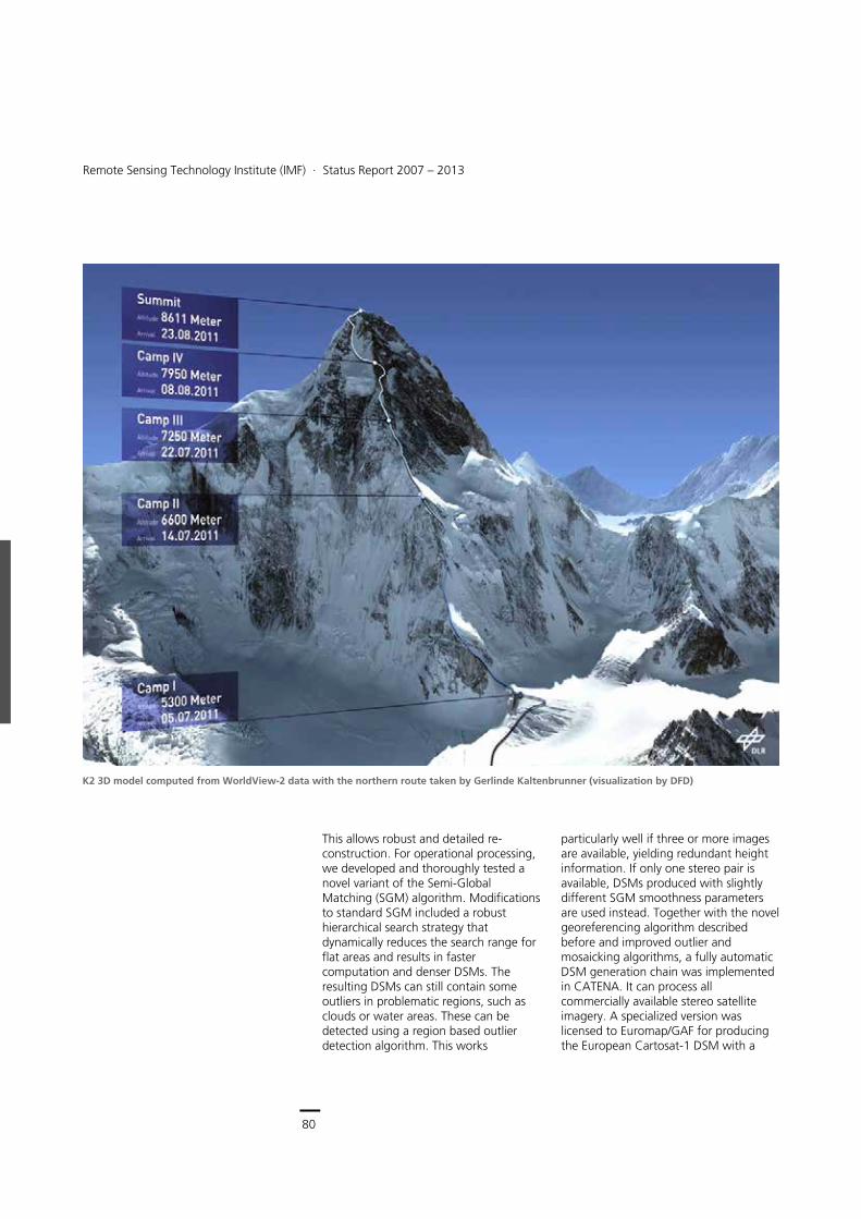
80
Earth Observation Center
Remote Sensing Technology Institute (IMF) ∙ Status Report 2007 – 2013
80
This allows robust and detailed re-construction. For operational processing, we developed and thoroughly tested a novel variant of the Semi-Global Matching (SGM) algorithm. Modifications to standard SGM included a robust hierarchical search strategy that dynamically reduces the search range for flat areas and results in faster computation and denser DSMs. The resulting DSMs can still contain some outliers in problematic regions, such as clouds or water areas. These can be detected using a region based outlier detection algorithm. This works
particularly well if three or more images are available, yielding redundant height information. If only one stereo pair is available, DSMs produced with slightly different SGM smoothness parameters are used instead. Together with the novel georeferencing algorithm described before and improved outlier and mosaicking algorithms, a fully automatic DSM generation chain was implemented in CATENA. It can process all commercially available stereo satellite imagery. A specialized version was licensed to Euromap/GAF for producing the European Cartosat-1 DSM with a
K2 3D model computed from WorldView-2 data with the northern route taken by Gerlinde Kaltenbrunner (visualization by DFD)
Optical Imaging > Methods and Applications
81
resolution of 5 m, and thousands of DSMs have already been produced. The system consists of a scene-based processor that performs stereo matching of each pair and a mosaicking processor. The mosaicking processor performs a bundle block adjustment of typically several hundred stereo pairs using SRTM as reference. DSMs are generated for each stereo pair and robustly merged into a DSM mosaic. A filled DSM is then used to produce a geometrically and radiometrically consistent orthomosaic.
DSMs with a resolution of up to 0.5 m can be generated efficiently for any part of the world using stereo triplets from VHR satellites, such as the WorldView and Pleiades satellites. Examples include height models of the world’s two highest mountains, Mt. Everest and K2. In 2011 Gerlinde Kaltenbrunner and her team visited the EOC to get a detailed look at our K2 model before starting their expedition to climb the demanding K2 north route. Our K2 model shows far more details than existing maps. The climbers were impressed by the interactive 3D fly-through in DFD’s visualization lab and got valuable information for planning their route.
IMF also used multi-view satellite imagery to produce high resolution DSMs of cities with a quality that is traditionally only available from aerial surveys. For the London example shown here, 25 WorldView-2 images were available, and oblique views could be used for texturing building façades. In 2012 we computed high resolution DSMs of 10 large cities in Africa, Eastern Europe and Asia from WorldView-2 triplets. Sequential airborne images from the 3K camera system are also used to generate high quality DSMs by our algorithms.
As the lead of a working group for ISPRS Commission I, IMF has set up an open stereo matching benchmark site near Barcelona, where matching algorithms can be evaluated against ground truth data provided by the Institut Cartogràfic de Catalunya. It currently includes a Worldview-1 stereo pair donated by Digital Globe and a Cartosat-1 stereo pair provided by Euromap GmbH.
While our existing operational system allows highly detailed 3D extraction, small errors remain, especially on building contours and in shadow areas.
3D textured model of Canary Wharf, London, generated from WorldView-2 data
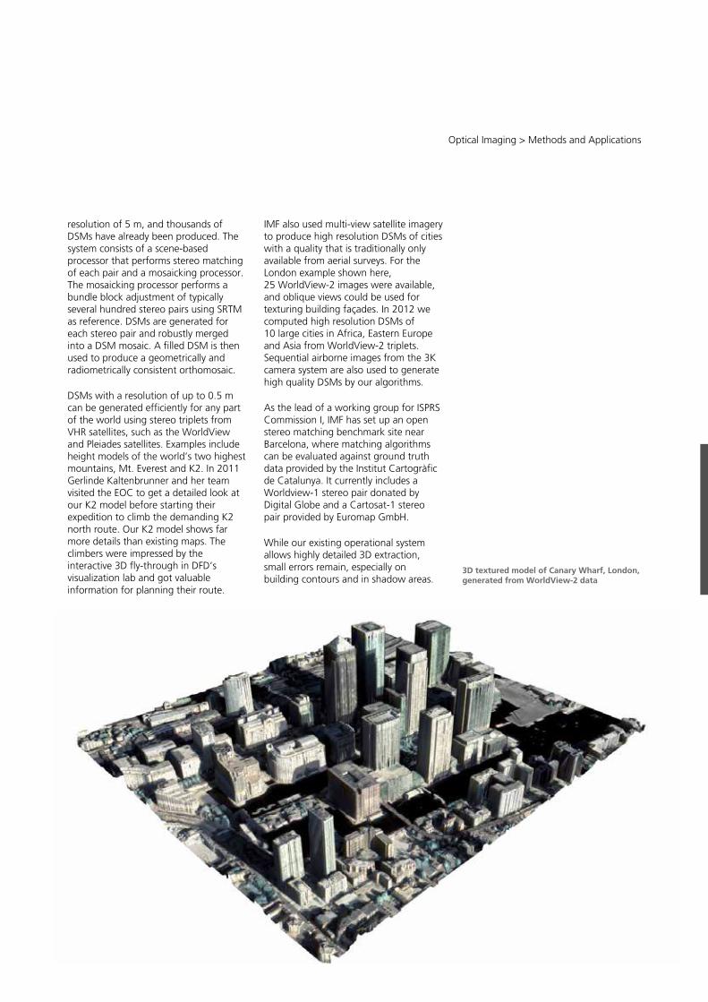
81
Central Services
Remote Sensing Technology Institute (IMF) ∙ Status Report 2007 – 2013
80
This allows robust and detailed re-construction. For operational processing, we developed and thoroughly tested a novel variant of the Semi-Global Matching (SGM) algorithm. Modifications to standard SGM included a robust hierarchical search strategy that dynamically reduces the search range for flat areas and results in faster computation and denser DSMs. The resulting DSMs can still contain some outliers in problematic regions, such as clouds or water areas. These can be detected using a region based outlier detection algorithm. This works
particularly well if three or more images are available, yielding redundant height information. If only one stereo pair is available, DSMs produced with slightly different SGM smoothness parameters are used instead. Together with the novel georeferencing algorithm described before and improved outlier and mosaicking algorithms, a fully automatic DSM generation chain was implemented in CATENA. It can process all commercially available stereo satellite imagery. A specialized version was licensed to Euromap/GAF for producing the European Cartosat-1 DSM with a
K2 3D model computed from WorldView-2 data with the northern route taken by Gerlinde Kaltenbrunner (visualization by DFD)
Optical Imaging > Methods and Applications
81
resolution of 5 m, and thousands of DSMs have already been produced. The system consists of a scene-based processor that performs stereo matching of each pair and a mosaicking processor. The mosaicking processor performs a bundle block adjustment of typically several hundred stereo pairs using SRTM as reference. DSMs are generated for each stereo pair and robustly merged into a DSM mosaic. A filled DSM is then used to produce a geometrically and radiometrically consistent orthomosaic.
DSMs with a resolution of up to 0.5 m can be generated efficiently for any part of the world using stereo triplets from VHR satellites, such as the WorldView and Pleiades satellites. Examples include height models of the world’s two highest mountains, Mt. Everest and K2. In 2011 Gerlinde Kaltenbrunner and her team visited the EOC to get a detailed look at our K2 model before starting their expedition to climb the demanding K2 north route. Our K2 model shows far more details than existing maps. The climbers were impressed by the interactive 3D fly-through in DFD’s visualization lab and got valuable information for planning their route.
IMF also used multi-view satellite imagery to produce high resolution DSMs of cities with a quality that is traditionally only available from aerial surveys. For the London example shown here, 25 WorldView-2 images were available, and oblique views could be used for texturing building façades. In 2012 we computed high resolution DSMs of 10 large cities in Africa, Eastern Europe and Asia from WorldView-2 triplets. Sequential airborne images from the 3K camera system are also used to generate high quality DSMs by our algorithms.
As the lead of a working group for ISPRS Commission I, IMF has set up an open stereo matching benchmark site near Barcelona, where matching algorithms can be evaluated against ground truth data provided by the Institut Cartogràfic de Catalunya. It currently includes a Worldview-1 stereo pair donated by Digital Globe and a Cartosat-1 stereo pair provided by Euromap GmbH.
While our existing operational system allows highly detailed 3D extraction, small errors remain, especially on building contours and in shadow areas.
3D textured model of Canary Wharf, London, generated from WorldView-2 data
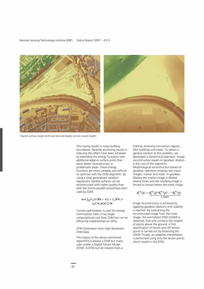
82
Earth Observation Center
Remote Sensing Technology Institute (IMF) ∙ Status Report 2007 – 2013
82
This mainly results in noisy building boundaries. Recently promising results in reducing this effect have been achieved by extending the energy functions with additional edge or surface priors that allow better reconstruction in problematic areas. These energy functions are more complex and difficult to optimize with the SGM algorithm. By using a total generalized variation regularizer, slanted surfaces can be reconstructed with higher quality than with the fronto-parallel smoothness term used by SGM:
min� ���|���� � ��| � ��|��| �� ������ ������ ��
Convex optimization is used for energy minimization here. It has larger computational cost than SGM but can be efficiently implemented on GPUs.
DTM Generation from High Resolution DSM Data
The output of the above mentioned algorithms is always a DSM but many users prefer a Digital Terrain Model (DTM). A DTM can be created from a
DSM by removing non-terrain regions (like buildings and trees). To obtain a general solution to this problem, we developed a hierarchical approach. Image reconstruction based on geodesic dilation is the core of the algorithm. Morphological reconstruction based on geodesic operation employs two input images: marker and mask. In geodesic dilation the marker image is dilated several times and the resulting image is forced to remain below the mask image:
�������� � ������������������� ����������������������������������
Image reconstruction is achieved by applying geodesic dilations until stability is reached. By subtracting the reconstructed image from the mask image, the normalized DSM (nDSM) is obtained, that only contains the heights of points above the ground. A first classification of terrain and off-terrain points is carried out by binarizing the nDSM. Finally, an adaptive interpolation is performed using only the terrain points which results in the DTM.
Digital surface model (left) and derived digital terrain model (right)
Optical Imaging > Methods and Applications
83
3D Building Reconstruction
Automatic building reconstruction from optical and DSM data is an ongoing topic of research. It introduces real 3D objects instead of only a surface model. We have developed a methodology aimed at simplifying the 3D reconstruction of building blocks by decomposing the overall model into several smaller ones corresponding to building parts. This allows parametric representation of roof shapes using the gable and hip models, among others. The automatic 3D building reconstruction algorithm is comprised of the following major steps:
Ridge-based decomposition
Projection-based reconstruction of parametric roofs
Prismatic model generation related to flat roof segments
Merging of parametric and prismatic models and refining of corner nodes.
A final model for the parametric roof structure of the building block is found by appropriate merging all the individual models. Additionally, prismatic models with flat roofs are provided for the remaining objects that do not contain ridge lines. All parametric and prismatic models are merged to produce a final 3D model of the buildings. The results are very promising for larger buildings. For Munich city center we could determine the heights of ridge and eave lines to an accuracy of about the pixel size (0.5 m) by applying our methodology to WorldView-2 DSM data.
DSM-assisted Change Detection
Change information can play an important role in different applications such as disaster assessment (e.g. after earthquakes) and urban area construction or destruction monitoring. Change detection methods using only optical image data rely on changes related to the reflectance values and/or local textural changes, which very often
lead to false alarms. Without the height information from a DSM, changes in vertical direction such as building height change or forest growth are difficult to detect. On the other hand the limited quality of DSMs generated from spaceborne stereo imagery hinder reliable change detection using only DSMs from different acquisition times. Therefore, depending on the quality of the DSM, the availability of multispectral channels and the requirements of the change detection task, we developed several approaches for automatic change detection of buildings and forest areas by fusing changes from DSMs and optical images.
DSM-assisted change detection based on feature fusion uses a region based procedure to fuse height changes from DSMs, optimized region boundaries and spectral changes from panchromatic images. We developed segmentation methods to obtain initial change regions, followed by extraction and comparison of height and spectral features at region level to highlight changes.
Another DSM-assisted change detection approach is built on fusing different change indicators. These can be extracted directly from images and the DSMs. A decision-fusion-based change detection method which uses height changes and a Kullback-Leibler divergence similarity measure has been developed. The Dempster-Shafer fusion theory is adopted to combine several change indicators. In addition, vegetation and shadow classification are used as no-building change indicators for refining the change detection results. Finally, an object based building extraction method based on shape features is performed. Results are very promising and lead to change detection accuracies on the order of 70 to 90 % depending on the size of the objects.
Selected publications: [5], [8], [31], [50], [53], [54], [67], [77], [89], [110], [126], [137], [168]
WorldView-2 DSM with enhanced building borders and regularized roofs parts
CAD model from automatic building extraction (generated from DSM above). Accuracies for building height and size are in the order of the pixel size of WorldView-2 data, 0.5 m.
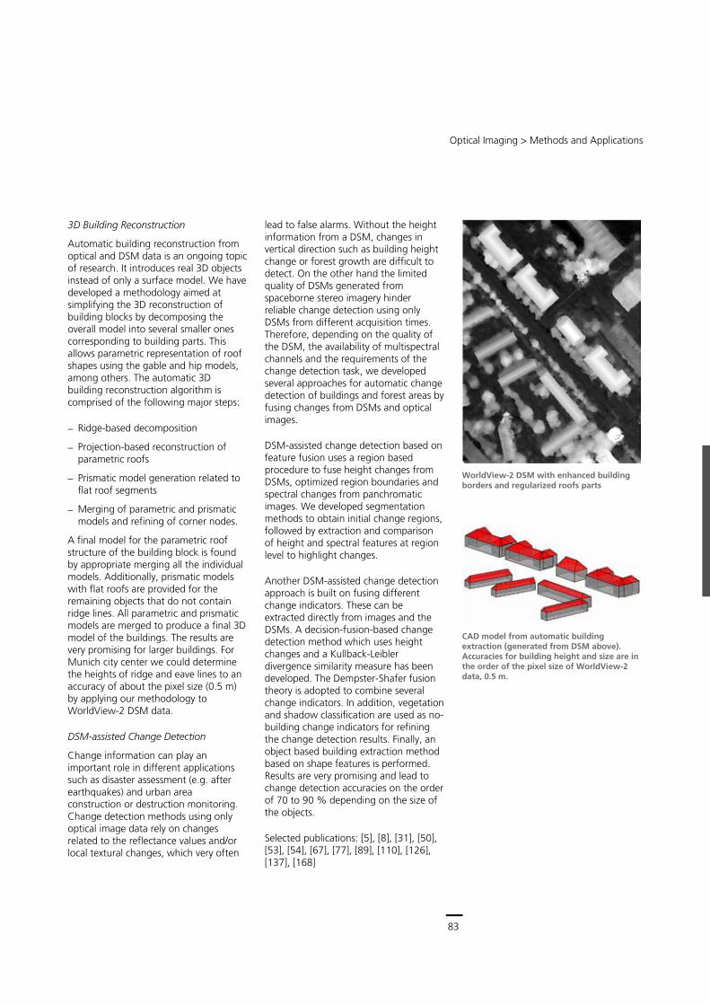
83
Central Services
Remote Sensing Technology Institute (IMF) ∙ Status Report 2007 – 2013
82
This mainly results in noisy building boundaries. Recently promising results in reducing this effect have been achieved by extending the energy functions with additional edge or surface priors that allow better reconstruction in problematic areas. These energy functions are more complex and difficult to optimize with the SGM algorithm. By using a total generalized variation regularizer, slanted surfaces can be reconstructed with higher quality than with the fronto-parallel smoothness term used by SGM:
min� ���|���� � ��| � ��|��| �� ������ ������ ��
Convex optimization is used for energy minimization here. It has larger computational cost than SGM but can be efficiently implemented on GPUs.
DTM Generation from High Resolution DSM Data
The output of the above mentioned algorithms is always a DSM but many users prefer a Digital Terrain Model (DTM). A DTM can be created from a
DSM by removing non-terrain regions (like buildings and trees). To obtain a general solution to this problem, we developed a hierarchical approach. Image reconstruction based on geodesic dilation is the core of the algorithm. Morphological reconstruction based on geodesic operation employs two input images: marker and mask. In geodesic dilation the marker image is dilated several times and the resulting image is forced to remain below the mask image:
�������� � ������������������� ����������������������������������
Image reconstruction is achieved by applying geodesic dilations until stability is reached. By subtracting the reconstructed image from the mask image, the normalized DSM (nDSM) is obtained, that only contains the heights of points above the ground. A first classification of terrain and off-terrain points is carried out by binarizing the nDSM. Finally, an adaptive interpolation is performed using only the terrain points which results in the DTM.
Digital surface model (left) and derived digital terrain model (right)
Optical Imaging > Methods and Applications
83
3D Building Reconstruction
Automatic building reconstruction from optical and DSM data is an ongoing topic of research. It introduces real 3D objects instead of only a surface model. We have developed a methodology aimed at simplifying the 3D reconstruction of building blocks by decomposing the overall model into several smaller ones corresponding to building parts. This allows parametric representation of roof shapes using the gable and hip models, among others. The automatic 3D building reconstruction algorithm is comprised of the following major steps:
Ridge-based decomposition
Projection-based reconstruction of parametric roofs
Prismatic model generation related to flat roof segments
Merging of parametric and prismatic models and refining of corner nodes.
A final model for the parametric roof structure of the building block is found by appropriate merging all the individual models. Additionally, prismatic models with flat roofs are provided for the remaining objects that do not contain ridge lines. All parametric and prismatic models are merged to produce a final 3D model of the buildings. The results are very promising for larger buildings. For Munich city center we could determine the heights of ridge and eave lines to an accuracy of about the pixel size (0.5 m) by applying our methodology to WorldView-2 DSM data.
DSM-assisted Change Detection
Change information can play an important role in different applications such as disaster assessment (e.g. after earthquakes) and urban area construction or destruction monitoring. Change detection methods using only optical image data rely on changes related to the reflectance values and/or local textural changes, which very often
lead to false alarms. Without the height information from a DSM, changes in vertical direction such as building height change or forest growth are difficult to detect. On the other hand the limited quality of DSMs generated from spaceborne stereo imagery hinder reliable change detection using only DSMs from different acquisition times. Therefore, depending on the quality of the DSM, the availability of multispectral channels and the requirements of the change detection task, we developed several approaches for automatic change detection of buildings and forest areas by fusing changes from DSMs and optical images.
DSM-assisted change detection based on feature fusion uses a region based procedure to fuse height changes from DSMs, optimized region boundaries and spectral changes from panchromatic images. We developed segmentation methods to obtain initial change regions, followed by extraction and comparison of height and spectral features at region level to highlight changes.
Another DSM-assisted change detection approach is built on fusing different change indicators. These can be extracted directly from images and the DSMs. A decision-fusion-based change detection method which uses height changes and a Kullback-Leibler divergence similarity measure has been developed. The Dempster-Shafer fusion theory is adopted to combine several change indicators. In addition, vegetation and shadow classification are used as no-building change indicators for refining the change detection results. Finally, an object based building extraction method based on shape features is performed. Results are very promising and lead to change detection accuracies on the order of 70 to 90 % depending on the size of the objects.
Selected publications: [5], [8], [31], [50], [53], [54], [67], [77], [89], [110], [126], [137], [168]
WorldView-2 DSM with enhanced building borders and regularized roofs parts
CAD model from automatic building extraction (generated from DSM above). Accuracies for building height and size are in the order of the pixel size of WorldView-2 data, 0.5 m.
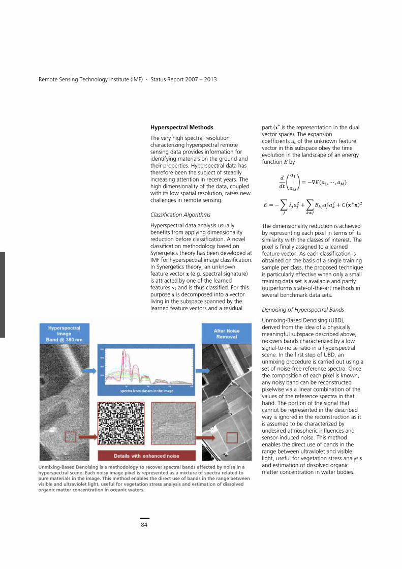
84
Earth Observation Center
Remote Sensing Technology Institute (IMF) ∙ Status Report 2007 – 2013
84
Hyperspectral Methods
The very high spectral resolution characterizing hyperspectral remote sensing data provides information for identifying materials on the ground and their properties. Hyperspectral data has therefore been the subject of steadily increasing attention in recent years. The high dimensionality of the data, coupled with its low spatial resolution, raises new challenges in remote sensing.
Classification Algorithms
Hyperspectral data analysis usually benefits from applying dimensionality reduction before classification. A novel classification methodology based on Synergetics theory has been developed at IMF for hyperspectral image classification. In Synergetics theory, an unknown feature vector x (e.g. spectral signature) is attracted by one of the learned features vk and is thus classified. For this purpose x is decomposed into a vector living in the subspace spanned by the learned feature vectors and a residual
part (x+ is the representation in the dual vector space). The expansion coefficients ak of the unknown feature vector in this subspace obey the time evolution in the landscape of an energy function E by
��� �
��⋮��� � �������� � ���
� � ��������
��������������
� �������
The dimensionality reduction is achieved by representing each pixel in terms of its similarity with the classes of interest. The pixel is finally assigned to a learned feature vector. As each classification is obtained on the basis of a single training sample per class, the proposed technique is particularly effective when only a small training data set is available and partly outperforms state-of-the-art methods in several benchmark data sets.
Denoising of Hyperspectral Bands
Unmixing-Based Denoising (UBD), derived from the idea of a physically meaningful subspace described above, recovers bands characterized by a low signal-to-noise ratio in a hyperspectral scene. In the first step of UBD, an unmixing procedure is carried out using a set of noise-free reference spectra. Once the composition of each pixel is known, any noisy band can be reconstructed pixelwise via a linear combination of the values of the reference spectra in that band. The portion of the signal that cannot be represented in the described way is ignored in the reconstruction as it is assumed to be characterized by undesired atmospheric influences and sensor-induced noise. This method enables the direct use of bands in the range between ultraviolet and visible light, useful for vegetation stress analysis and estimation of dissolved organic matter concentration in water bodies.
Unmixing-Based Denoising is a methodology to recover spectral bands affected by noise in a hyperspectral scene. Each noisy image pixel is represented as a mixture of spectra related to pure materials in the image. This method enables the direct use of bands in the range between visible and ultraviolet light, useful for vegetation stress analysis and estimation of dissolved organic matter concentration in oceanic waters.
Optical Imaging > Methods and Applications
85
Compressive Sensing Hyperspectral Unmixing
In 2004 the theory of Compressive Sensing (CS) was proven to be an alternative to the Nyquist-Shannon sampling theorem. CS allows signal reconstruction from an underdetermined linear system of equations, i.e. from much fewer samples than the bandwidth would require. At IMF the Sparse Spectral Unmixing (SSU) method has been developed. It benefits from the CS theory through the assumption that a hyperspectral pixel can be represented as a sparse sampling from a large external library containing the measured spectra of pure materials (endmembers). Thus SSU, in contrast to competing methods, allows automatic unmixing of hyperspectral images without the need to select expected endmembers from the library. This approach allows automatic processing of large hyperspectral scenes creating abundance maps of materials.
Fusion of DSM and Hyperspectral Image Data
Fusion of hyperspectral images and digital surface models enables more reliable and precise extraction of objects by taking advantage of spectral, spatial, and height information from the data sets. In hyperspectral images the object boundaries are mostly mixed pixels, composed of object and surrounding material. Urban areas contain an especially wide variety of objects with different materials and heights within a relatively small area. What is more, some objects do not differ in material, e.g. a building with a concrete roof and a concrete sidewalk. Thus, the additional use of height information is crucial for better object discrimination. In the developed methodology we detect building boundaries with subpixel precision using the amount of roofing material in mixed pixels. The probability of an edge is computed from height data and prior knowledge about object shapes. The result of the proposed method is a building model with the
attributes height, material, and accuracy of the boundary.
Selected publications: [10], [12], [13], [63], [105], [232], [341], [364], [480]
Optic/SAR Data Fusion
Single-sensor data is often not sufficient for retrieving the required geoinformation. Thus multisensor imagery is important for many applications such as urban area mapping, classification, and change detection. The decision, whether pixel-based, feature-based, or information-based fusion is required, depends on the available data and the application. Particularly for optical and radar data fusion, aspects such as acquisition geometry and the incommensurable nature of the features have to be addressed. Coregistration is an important prerequisite for all types of image data fusion. To combine incommensurable data in a classification procedure, information based fusion methods have been developed.
Automatic Multisensor Data Coregistration
Although great progress has been made in producing georeferenced and orthorectified data products, registration differences still exist between different data sets and must be removed. Classical approaches based on manual measurement of ground control points are time consuming and not suitable for operational applications. Due to radiometric and geometric differences between optical and SAR data, image-based registration methods fail, especially in urban areas. We use mutual information (MI) as a metric. Coregistration accuracy in the order of the pixel size can be achieved using the developed automatic MI approach. Results are promising even for heterogeneous urban areas if strong scatterers are removed before applying MI.
Material abundance map of special coated red tile roofs in Munich city derived from HySpex airborne data. Results from conventional (center) and Compressive Sensing algorithms (bottom). WorldView-2 data (top) are given as visual reference.
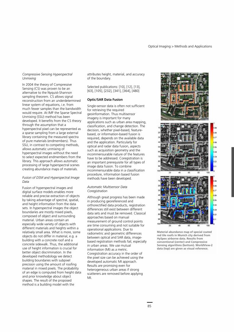
85
Central Services
Remote Sensing Technology Institute (IMF) ∙ Status Report 2007 – 2013
84
Hyperspectral Methods
The very high spectral resolution characterizing hyperspectral remote sensing data provides information for identifying materials on the ground and their properties. Hyperspectral data has therefore been the subject of steadily increasing attention in recent years. The high dimensionality of the data, coupled with its low spatial resolution, raises new challenges in remote sensing.
Classification Algorithms
Hyperspectral data analysis usually benefits from applying dimensionality reduction before classification. A novel classification methodology based on Synergetics theory has been developed at IMF for hyperspectral image classification. In Synergetics theory, an unknown feature vector x (e.g. spectral signature) is attracted by one of the learned features vk and is thus classified. For this purpose x is decomposed into a vector living in the subspace spanned by the learned feature vectors and a residual
part (x+ is the representation in the dual vector space). The expansion coefficients ak of the unknown feature vector in this subspace obey the time evolution in the landscape of an energy function E by
��� �
��⋮��� � �������� � ���
� � ��������
��������������
� �������
The dimensionality reduction is achieved by representing each pixel in terms of its similarity with the classes of interest. The pixel is finally assigned to a learned feature vector. As each classification is obtained on the basis of a single training sample per class, the proposed technique is particularly effective when only a small training data set is available and partly outperforms state-of-the-art methods in several benchmark data sets.
Denoising of Hyperspectral Bands
Unmixing-Based Denoising (UBD), derived from the idea of a physically meaningful subspace described above, recovers bands characterized by a low signal-to-noise ratio in a hyperspectral scene. In the first step of UBD, an unmixing procedure is carried out using a set of noise-free reference spectra. Once the composition of each pixel is known, any noisy band can be reconstructed pixelwise via a linear combination of the values of the reference spectra in that band. The portion of the signal that cannot be represented in the described way is ignored in the reconstruction as it is assumed to be characterized by undesired atmospheric influences and sensor-induced noise. This method enables the direct use of bands in the range between ultraviolet and visible light, useful for vegetation stress analysis and estimation of dissolved organic matter concentration in water bodies.
Unmixing-Based Denoising is a methodology to recover spectral bands affected by noise in a hyperspectral scene. Each noisy image pixel is represented as a mixture of spectra related to pure materials in the image. This method enables the direct use of bands in the range between visible and ultraviolet light, useful for vegetation stress analysis and estimation of dissolved organic matter concentration in oceanic waters.
Optical Imaging > Methods and Applications
85
Compressive Sensing Hyperspectral Unmixing
In 2004 the theory of Compressive Sensing (CS) was proven to be an alternative to the Nyquist-Shannon sampling theorem. CS allows signal reconstruction from an underdetermined linear system of equations, i.e. from much fewer samples than the bandwidth would require. At IMF the Sparse Spectral Unmixing (SSU) method has been developed. It benefits from the CS theory through the assumption that a hyperspectral pixel can be represented as a sparse sampling from a large external library containing the measured spectra of pure materials (endmembers). Thus SSU, in contrast to competing methods, allows automatic unmixing of hyperspectral images without the need to select expected endmembers from the library. This approach allows automatic processing of large hyperspectral scenes creating abundance maps of materials.
Fusion of DSM and Hyperspectral Image Data
Fusion of hyperspectral images and digital surface models enables more reliable and precise extraction of objects by taking advantage of spectral, spatial, and height information from the data sets. In hyperspectral images the object boundaries are mostly mixed pixels, composed of object and surrounding material. Urban areas contain an especially wide variety of objects with different materials and heights within a relatively small area. What is more, some objects do not differ in material, e.g. a building with a concrete roof and a concrete sidewalk. Thus, the additional use of height information is crucial for better object discrimination. In the developed methodology we detect building boundaries with subpixel precision using the amount of roofing material in mixed pixels. The probability of an edge is computed from height data and prior knowledge about object shapes. The result of the proposed method is a building model with the
attributes height, material, and accuracy of the boundary.
Selected publications: [10], [12], [13], [63], [105], [232], [341], [364], [480]
Optic/SAR Data Fusion
Single-sensor data is often not sufficient for retrieving the required geoinformation. Thus multisensor imagery is important for many applications such as urban area mapping, classification, and change detection. The decision, whether pixel-based, feature-based, or information-based fusion is required, depends on the available data and the application. Particularly for optical and radar data fusion, aspects such as acquisition geometry and the incommensurable nature of the features have to be addressed. Coregistration is an important prerequisite for all types of image data fusion. To combine incommensurable data in a classification procedure, information based fusion methods have been developed.
Automatic Multisensor Data Coregistration
Although great progress has been made in producing georeferenced and orthorectified data products, registration differences still exist between different data sets and must be removed. Classical approaches based on manual measurement of ground control points are time consuming and not suitable for operational applications. Due to radiometric and geometric differences between optical and SAR data, image-based registration methods fail, especially in urban areas. We use mutual information (MI) as a metric. Coregistration accuracy in the order of the pixel size can be achieved using the developed automatic MI approach. Results are promising even for heterogeneous urban areas if strong scatterers are removed before applying MI.
Material abundance map of special coated red tile roofs in Munich city derived from HySpex airborne data. Results from conventional (center) and Compressive Sensing algorithms (bottom). WorldView-2 data (top) are given as visual reference.
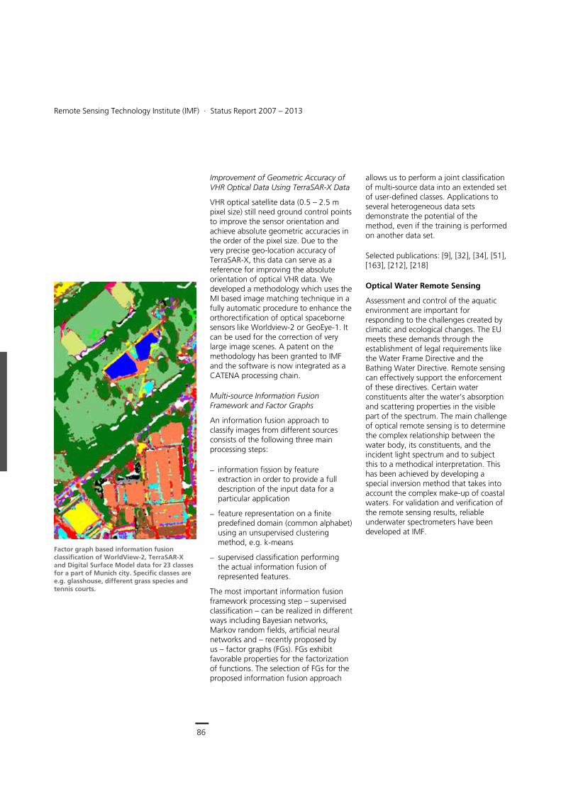
86
Earth Observation Center
Remote Sensing Technology Institute (IMF) ∙ Status Report 2007 – 2013
86
Improvement of Geometric Accuracy of VHR Optical Data Using TerraSAR-X Data
VHR optical satellite data (0.5 – 2.5 m pixel size) still need ground control points to improve the sensor orientation and achieve absolute geometric accuracies in the order of the pixel size. Due to the very precise geo-location accuracy of TerraSAR-X, this data can serve as a reference for improving the absolute orientation of optical VHR data. We developed a methodology which uses the MI based image matching technique in a fully automatic procedure to enhance the orthorectification of optical spaceborne sensors like Worldview-2 or GeoEye-1. It can be used for the correction of very large image scenes. A patent on the methodology has been granted to IMF and the software is now integrated as a CATENA processing chain.
Multi-source Information Fusion Framework and Factor Graphs
An information fusion approach to classify images from different sources consists of the following three main processing steps:
information fission by feature extraction in order to provide a full description of the input data for a particular application
feature representation on a finite predefined domain (common alphabet) using an unsupervised clustering method, e.g. k-means
supervised classification performing the actual information fusion of represented features.
The most important information fusion framework processing step – supervised classification – can be realized in different ways including Bayesian networks, Markov random fields, artificial neural networks and – recently proposed by us – factor graphs (FGs). FGs exhibit favorable properties for the factorization of functions. The selection of FGs for the proposed information fusion approach
allows us to perform a joint classification of multi-source data into an extended set of user-defined classes. Applications to several heterogeneous data sets demonstrate the potential of the method, even if the training is performed on another data set.
Selected publications: [9], [32], [34], [51], [163], [212], [218]
Optical Water Remote Sensing
Assessment and control of the aquatic environment are important for responding to the challenges created by climatic and ecological changes. The EU meets these demands through the establishment of legal requirements like the Water Frame Directive and the Bathing Water Directive. Remote sensing can effectively support the enforcement of these directives. Certain water constituents alter the water’s absorption and scattering properties in the visible part of the spectrum. The main challenge of optical remote sensing is to determine the complex relationship between the water body, its constituents, and the incident light spectrum and to subject this to a methodical interpretation. This has been achieved by developing a special inversion method that takes into account the complex make-up of coastal waters. For validation and verification of the remote sensing results, reliable underwater spectrometers have been developed at IMF.
Factor graph based information fusion classification of WorldView-2, TerraSAR-X and Digital Surface Model data for 23 classes for a part of Munich city. Specific classes are e.g. glasshouse, different grass species and tennis courts.
Optical Imaging > Methods and Applications
87
Principal Component Inversion Method
Heuristic or empirical interpretation methods are not sufficient for today’s accuracy requirements. The developed algorithm belongs to the class of model-based implementations. With respect to the actual state-of-the-art, three classes of substances are accounted for, Chlorophyll-a, inorganic particulate matter and dissolved organic matter –Gelbstoff. By means of a specific optical model a large number of satellite spectra are simulated, taking into account the properties of the ocean color instrument as well as the observing geometry. The information concerning the concentration of the three constituents is distributed over several spectral channels. By a principal component transformation on the simulated data, this information is redistributed and concentrated in a few principal components (PCs). The higher components carry information about the ecological concentration values while the lower PCs contain residual measurement errors and model uncertainties. By correlating the geo-variables with the PCs an intermediate estimation formula can be derived, and using the corresponding eigenvectors, one obtains the correlation and interpretation formula in terms of physically universal radiance values. This methodology has been implemented as an automated, full resolution processing chain providing geo-ecological monitoring products for German coastal waters and the development of a new method for the detection of blue algae blooms (cyanobacteria). The latter is a successful and innovative extension of our interpretation portfolio.
The main concern in the development of such algorithms is the transfer into operational chains, allowing spatial and temporal monitoring on global scales. In this context the ESA MARCOAST project was funded from 2005 – 2008, continuing as MARCOAST-2 from 2009, to drive forward operational product delivery. IMF has developed a fully
automatic chain for the daily provision of interpreted MERIS data over the Baltic Sea with the following water quality products:
water constituents: chlorophyll, inorganic suspended matter, dissolved organic matter
water transparency
sea surface temperature
algae bloom strength/risk indicator, allocation and extent of algal bloom.
Based on these daily products, additional 10-day, monthly and seasonal averages are produced. The service is complemented by validation activities using in-situ data from the monitoring network.
Atmospheric Correction and Aerosol Parameter Retrieval
An important aspect for the correct application of water quality interpretation algorithms is proper consideration of atmospheric influences. To this end, an advanced algorithm for aerosol parameter retrieval and atmospheric correction for MERIS data was developed. The aerosols are interpreted as a mixture of ‘fine’ and ‘coarse’ aerosols. Output parameters from the inversion algorithm are:
total optical depth
optical depth of ‘fine’ aerosol part
optical depth of ‘coarse’ aerosol part
suspended matter in water.
Consideration of Water Surface Specular Effects
Sensors intended for measuring the water leaving radiance collect not only the information-bearing signal from the water body but also radiation originating from specular reflections at the water surface. Waves, ripples, and foam create a complex and ever-changing surface
Cyanobakteria concentration in the Baltic Sea around Gotland derived from MERIS data
Downwelling spectral irradiances in different water depths recorded during a campaign in the Baltic Sea with an underwater spectrometer developed at IMF. The spectra show a high Gelbstoff and low chlorophyll concentration.
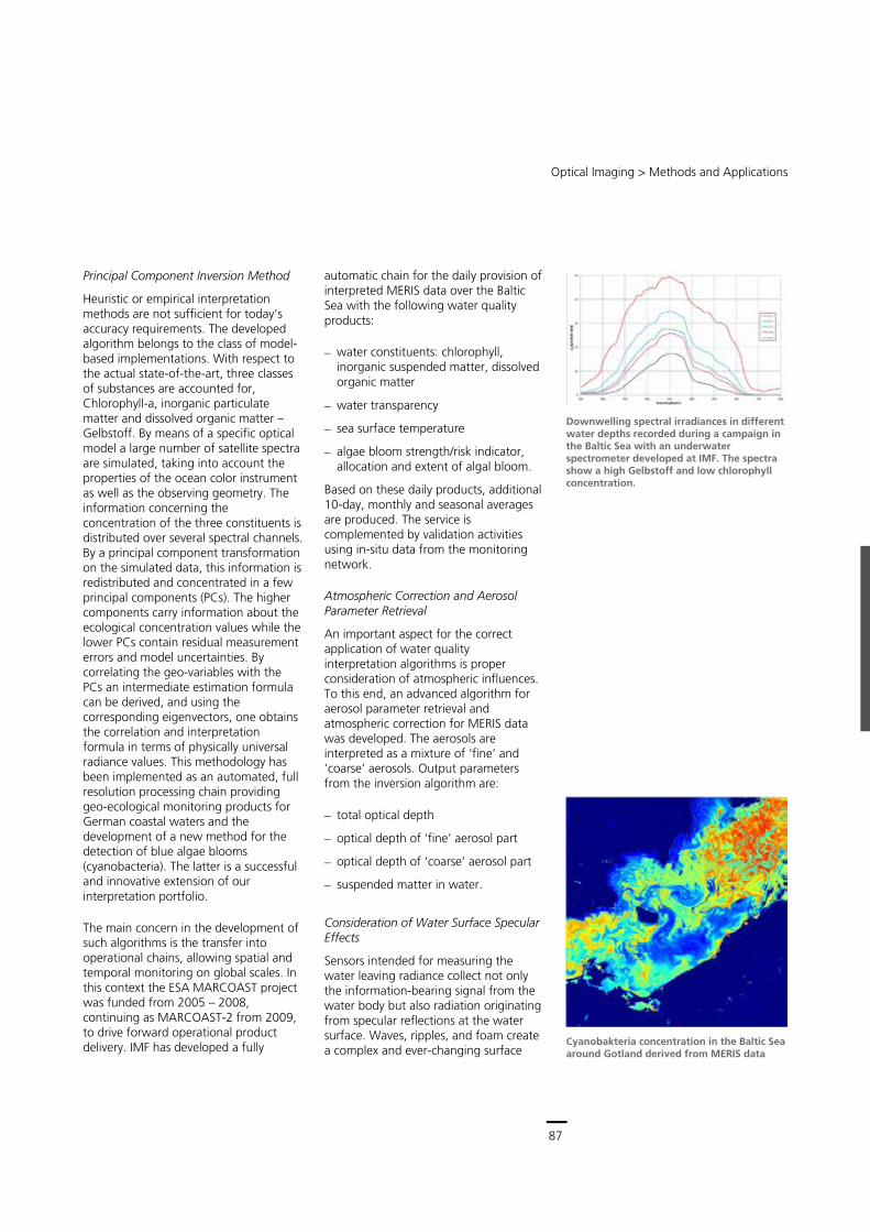
87
Central Services
Remote Sensing Technology Institute (IMF) ∙ Status Report 2007 – 2013
86
Improvement of Geometric Accuracy of VHR Optical Data Using TerraSAR-X Data
VHR optical satellite data (0.5 – 2.5 m pixel size) still need ground control points to improve the sensor orientation and achieve absolute geometric accuracies in the order of the pixel size. Due to the very precise geo-location accuracy of TerraSAR-X, this data can serve as a reference for improving the absolute orientation of optical VHR data. We developed a methodology which uses the MI based image matching technique in a fully automatic procedure to enhance the orthorectification of optical spaceborne sensors like Worldview-2 or GeoEye-1. It can be used for the correction of very large image scenes. A patent on the methodology has been granted to IMF and the software is now integrated as a CATENA processing chain.
Multi-source Information Fusion Framework and Factor Graphs
An information fusion approach to classify images from different sources consists of the following three main processing steps:
information fission by feature extraction in order to provide a full description of the input data for a particular application
feature representation on a finite predefined domain (common alphabet) using an unsupervised clustering method, e.g. k-means
supervised classification performing the actual information fusion of represented features.
The most important information fusion framework processing step – supervised classification – can be realized in different ways including Bayesian networks, Markov random fields, artificial neural networks and – recently proposed by us – factor graphs (FGs). FGs exhibit favorable properties for the factorization of functions. The selection of FGs for the proposed information fusion approach
allows us to perform a joint classification of multi-source data into an extended set of user-defined classes. Applications to several heterogeneous data sets demonstrate the potential of the method, even if the training is performed on another data set.
Selected publications: [9], [32], [34], [51], [163], [212], [218]
Optical Water Remote Sensing
Assessment and control of the aquatic environment are important for responding to the challenges created by climatic and ecological changes. The EU meets these demands through the establishment of legal requirements like the Water Frame Directive and the Bathing Water Directive. Remote sensing can effectively support the enforcement of these directives. Certain water constituents alter the water’s absorption and scattering properties in the visible part of the spectrum. The main challenge of optical remote sensing is to determine the complex relationship between the water body, its constituents, and the incident light spectrum and to subject this to a methodical interpretation. This has been achieved by developing a special inversion method that takes into account the complex make-up of coastal waters. For validation and verification of the remote sensing results, reliable underwater spectrometers have been developed at IMF.
Factor graph based information fusion classification of WorldView-2, TerraSAR-X and Digital Surface Model data for 23 classes for a part of Munich city. Specific classes are e.g. glasshouse, different grass species and tennis courts.
Optical Imaging > Methods and Applications
87
Principal Component Inversion Method
Heuristic or empirical interpretation methods are not sufficient for today’s accuracy requirements. The developed algorithm belongs to the class of model-based implementations. With respect to the actual state-of-the-art, three classes of substances are accounted for, Chlorophyll-a, inorganic particulate matter and dissolved organic matter –Gelbstoff. By means of a specific optical model a large number of satellite spectra are simulated, taking into account the properties of the ocean color instrument as well as the observing geometry. The information concerning the concentration of the three constituents is distributed over several spectral channels. By a principal component transformation on the simulated data, this information is redistributed and concentrated in a few principal components (PCs). The higher components carry information about the ecological concentration values while the lower PCs contain residual measurement errors and model uncertainties. By correlating the geo-variables with the PCs an intermediate estimation formula can be derived, and using the corresponding eigenvectors, one obtains the correlation and interpretation formula in terms of physically universal radiance values. This methodology has been implemented as an automated, full resolution processing chain providing geo-ecological monitoring products for German coastal waters and the development of a new method for the detection of blue algae blooms (cyanobacteria). The latter is a successful and innovative extension of our interpretation portfolio.
The main concern in the development of such algorithms is the transfer into operational chains, allowing spatial and temporal monitoring on global scales. In this context the ESA MARCOAST project was funded from 2005 – 2008, continuing as MARCOAST-2 from 2009, to drive forward operational product delivery. IMF has developed a fully
automatic chain for the daily provision of interpreted MERIS data over the Baltic Sea with the following water quality products:
water constituents: chlorophyll, inorganic suspended matter, dissolved organic matter
water transparency
sea surface temperature
algae bloom strength/risk indicator, allocation and extent of algal bloom.
Based on these daily products, additional 10-day, monthly and seasonal averages are produced. The service is complemented by validation activities using in-situ data from the monitoring network.
Atmospheric Correction and Aerosol Parameter Retrieval
An important aspect for the correct application of water quality interpretation algorithms is proper consideration of atmospheric influences. To this end, an advanced algorithm for aerosol parameter retrieval and atmospheric correction for MERIS data was developed. The aerosols are interpreted as a mixture of ‘fine’ and ‘coarse’ aerosols. Output parameters from the inversion algorithm are:
total optical depth
optical depth of ‘fine’ aerosol part
optical depth of ‘coarse’ aerosol part
suspended matter in water.
Consideration of Water Surface Specular Effects
Sensors intended for measuring the water leaving radiance collect not only the information-bearing signal from the water body but also radiation originating from specular reflections at the water surface. Waves, ripples, and foam create a complex and ever-changing surface
Cyanobakteria concentration in the Baltic Sea around Gotland derived from MERIS data
Downwelling spectral irradiances in different water depths recorded during a campaign in the Baltic Sea with an underwater spectrometer developed at IMF. The spectra show a high Gelbstoff and low chlorophyll concentration.
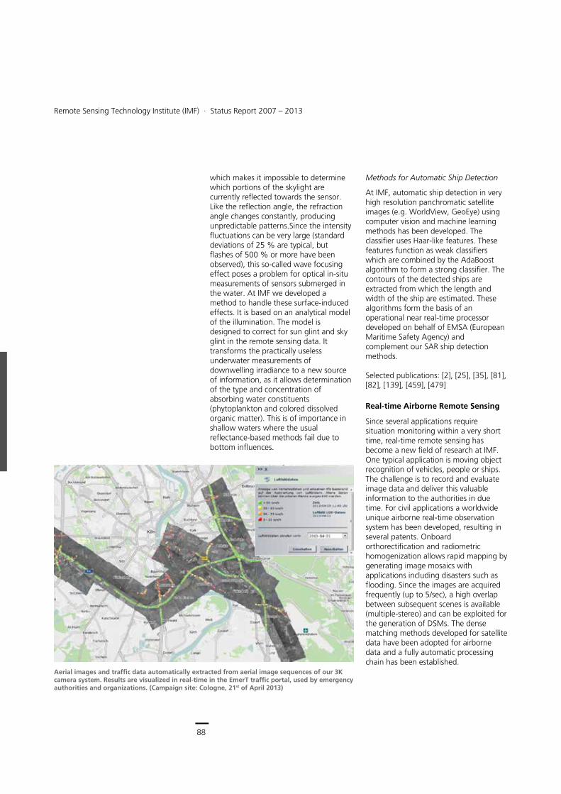
88
Earth Observation Center
Remote Sensing Technology Institute (IMF) ∙ Status Report 2007 – 2013
88
which makes it impossible to determine which portions of the skylight are currently reflected towards the sensor. Like the reflection angle, the refraction angle changes constantly, producing unpredictable patterns.Since the intensity fluctuations can be very large (standard deviations of 25 % are typical, but flashes of 500 % or more have been observed), this so-called wave focusing effect poses a problem for optical in-situ measurements of sensors submerged in the water. At IMF we developed a method to handle these surface-induced effects. It is based on an analytical model of the illumination. The model is designed to correct for sun glint and sky glint in the remote sensing data. It transforms the practically useless underwater measurements of downwelling irradiance to a new source of information, as it allows determination of the type and concentration of absorbing water constituents (phytoplankton and colored dissolved organic matter). This is of importance in shallow waters where the usual reflectance-based methods fail due to bottom influences.
Methods for Automatic Ship Detection
At IMF, automatic ship detection in very high resolution panchromatic satellite images (e.g. WorldView, GeoEye) using computer vision and machine learning methods has been developed. The classifier uses Haar-like features. These features function as weak classifiers which are combined by the AdaBoost algorithm to form a strong classifier. The contours of the detected ships are extracted from which the length and width of the ship are estimated. These algorithms form the basis of an operational near real-time processor developed on behalf of EMSA (European Maritime Safety Agency) and complement our SAR ship detection methods. Selected publications: [2], [25], [35], [81], [82], [139], [459], [479]
Real-time Airborne Remote Sensing
Since several applications require situation monitoring within a very short time, real-time remote sensing has become a new field of research at IMF. One typical application is moving object recognition of vehicles, people or ships. The challenge is to record and evaluate image data and deliver this valuable information to the authorities in due time. For civil applications a worldwide unique airborne real-time observation system has been developed, resulting in several patents. Onboard orthorectification and radiometric homogenization allows rapid mapping by generating image mosaics with applications including disasters such as flooding. Since the images are acquired frequently (up to 5/sec), a high overlap between subsequent scenes is available (multiple-stereo) and can be exploited for the generation of DSMs. The dense matching methods developed for satellite data have been adopted for airborne data and a fully automatic processing chain has been established.
Aerial images and traffic data automatically extracted from aerial image sequences of our 3K camera system. Results are visualized in real-time in the EmerT traffic portal, used by emergency authorities and organizations. (Campaign site: Cologne, 21st of April 2013)
Optical Imaging > Methods and Applications
89
Automatic crowd monitoring with quantitative estimation of number, movement and density of people at the Allianz Arena entrance, Munich. The color indicates high density (red), medium density (yellow, green) and low density (blue).
Airborne Traffic Monitoring
In the case of major events or disasters, ground infrastructure for situation and traffic monitoring may be insufficient or even, in case of disasters, unavailable. To allow real-time large scale traffic and situation monitoring, we developed the already mentioned 3K camera system with an onboard image processing unit and an air-to-ground data link that transfers data to a ground station immediately. For the generation of road traffic information from aerial image sequences obtained by the camera system, we developed algorithms that automatically extract traffic data in real-time. We use machine learning algorithms such as adaptive boosting (AdaBoost) and support vector machines for vehicle detection. The search space in the images is reduced by using a street database. Since the detection process is very fast, vehicles are recognized in a few seconds for an image data set of 15,000 x 3,500 pixels. Vehicle tracking uses a shape-based matching algorithm as the main operator. For more complicated traffic situations particle filters for tracking have been developed. The quality of traffic data (number of vehicles, their density and velocity), derived from aerial image sequences at a flight altitude of 1,000 m above ground, is competitive with the quality of ground stationary sensor networks consisting of induction loops and traffic cam sensors. Detection rates are between 80 % and 90 %, tracking rates are even higher.
Monitoring of Crowds
During mass events like football games and festivals, organizers, fire departments, and other security authorities often do not have sufficient information on the location, number, and direction of movement of crowds. Aerial images of city centers and the areas around football stadiums are of particular interest. Quantitative information is required and therefore a method for automatic detection of pedestrians and estimation of crowd
densities has been developed. The main challenge is the size and appearance of pedestrians in 15 cm resolution images. One person is represented by roughly ten pixels – not more than a little blob – so the identification of individuals is impossible and ‘privacy by design’ is guaranteed. Due to the dynamic of pedestrian groups the blobs are never at the same position and the background can change randomly. Therefore robust texture features are extracted which are invariant to this change in appearance. These features gave us promising results when used for classifier training. The initialization of the classifier, using e.g. FAST features, and the number of positive and negative training samples influence the quality of the detection results and are part of ongoing research.
Selected publications: [47], [55], [72], [73], [80], [111], [134], [193], [198], [199], [208], [228], [268], [294], [297], [306], [306], [310], [311]
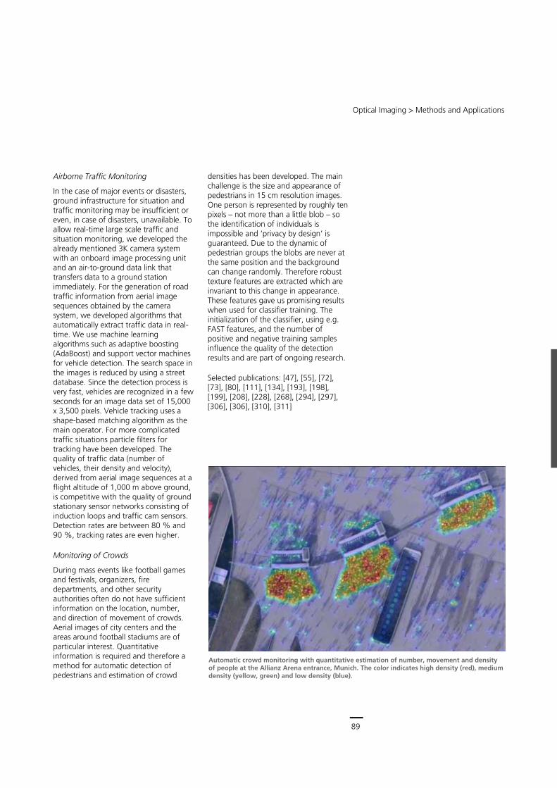
89
Central Services
Remote Sensing Technology Institute (IMF) ∙ Status Report 2007 – 2013
88
which makes it impossible to determine which portions of the skylight are currently reflected towards the sensor. Like the reflection angle, the refraction angle changes constantly, producing unpredictable patterns.Since the intensity fluctuations can be very large (standard deviations of 25 % are typical, but flashes of 500 % or more have been observed), this so-called wave focusing effect poses a problem for optical in-situ measurements of sensors submerged in the water. At IMF we developed a method to handle these surface-induced effects. It is based on an analytical model of the illumination. The model is designed to correct for sun glint and sky glint in the remote sensing data. It transforms the practically useless underwater measurements of downwelling irradiance to a new source of information, as it allows determination of the type and concentration of absorbing water constituents (phytoplankton and colored dissolved organic matter). This is of importance in shallow waters where the usual reflectance-based methods fail due to bottom influences.
Methods for Automatic Ship Detection
At IMF, automatic ship detection in very high resolution panchromatic satellite images (e.g. WorldView, GeoEye) using computer vision and machine learning methods has been developed. The classifier uses Haar-like features. These features function as weak classifiers which are combined by the AdaBoost algorithm to form a strong classifier. The contours of the detected ships are extracted from which the length and width of the ship are estimated. These algorithms form the basis of an operational near real-time processor developed on behalf of EMSA (European Maritime Safety Agency) and complement our SAR ship detection methods. Selected publications: [2], [25], [35], [81], [82], [139], [459], [479]
Real-time Airborne Remote Sensing
Since several applications require situation monitoring within a very short time, real-time remote sensing has become a new field of research at IMF. One typical application is moving object recognition of vehicles, people or ships. The challenge is to record and evaluate image data and deliver this valuable information to the authorities in due time. For civil applications a worldwide unique airborne real-time observation system has been developed, resulting in several patents. Onboard orthorectification and radiometric homogenization allows rapid mapping by generating image mosaics with applications including disasters such as flooding. Since the images are acquired frequently (up to 5/sec), a high overlap between subsequent scenes is available (multiple-stereo) and can be exploited for the generation of DSMs. The dense matching methods developed for satellite data have been adopted for airborne data and a fully automatic processing chain has been established.
Aerial images and traffic data automatically extracted from aerial image sequences of our 3K camera system. Results are visualized in real-time in the EmerT traffic portal, used by emergency authorities and organizations. (Campaign site: Cologne, 21st of April 2013)
Optical Imaging > Methods and Applications
89
Automatic crowd monitoring with quantitative estimation of number, movement and density of people at the Allianz Arena entrance, Munich. The color indicates high density (red), medium density (yellow, green) and low density (blue).
Airborne Traffic Monitoring
In the case of major events or disasters, ground infrastructure for situation and traffic monitoring may be insufficient or even, in case of disasters, unavailable. To allow real-time large scale traffic and situation monitoring, we developed the already mentioned 3K camera system with an onboard image processing unit and an air-to-ground data link that transfers data to a ground station immediately. For the generation of road traffic information from aerial image sequences obtained by the camera system, we developed algorithms that automatically extract traffic data in real-time. We use machine learning algorithms such as adaptive boosting (AdaBoost) and support vector machines for vehicle detection. The search space in the images is reduced by using a street database. Since the detection process is very fast, vehicles are recognized in a few seconds for an image data set of 15,000 x 3,500 pixels. Vehicle tracking uses a shape-based matching algorithm as the main operator. For more complicated traffic situations particle filters for tracking have been developed. The quality of traffic data (number of vehicles, their density and velocity), derived from aerial image sequences at a flight altitude of 1,000 m above ground, is competitive with the quality of ground stationary sensor networks consisting of induction loops and traffic cam sensors. Detection rates are between 80 % and 90 %, tracking rates are even higher.
Monitoring of Crowds
During mass events like football games and festivals, organizers, fire departments, and other security authorities often do not have sufficient information on the location, number, and direction of movement of crowds. Aerial images of city centers and the areas around football stadiums are of particular interest. Quantitative information is required and therefore a method for automatic detection of pedestrians and estimation of crowd
densities has been developed. The main challenge is the size and appearance of pedestrians in 15 cm resolution images. One person is represented by roughly ten pixels – not more than a little blob – so the identification of individuals is impossible and ‘privacy by design’ is guaranteed. Due to the dynamic of pedestrian groups the blobs are never at the same position and the background can change randomly. Therefore robust texture features are extracted which are invariant to this change in appearance. These features gave us promising results when used for classifier training. The initialization of the classifier, using e.g. FAST features, and the number of positive and negative training samples influence the quality of the detection results and are part of ongoing research.
Selected publications: [47], [55], [72], [73], [80], [111], [134], [193], [198], [199], [208], [228], [268], [294], [297], [306], [306], [310], [311]

90
Earth Observation Center
Remote Sensing Technology Institute (IMF) ∙ Status Report 2007 – 2013
90
Infrared Scene Simulation
In terms of dual-use, IMF utilizes its expertise in research areas such as spectral signature modeling, radiative transfer and image processing to support a few selected defense related projects. Focusing on infrared (IR) signatures and scene simulation, our capability has evolved over many years, enabling us to meet the modeling requirements imposed by new military equipment. Furthermore, measurement campaigns have been conducted to verify the model predictions. The IR signature models have served as a basis for successful participation in several projects and industrial cooperations.
Infrared Signatures
IMF focuses on signature prediction for air vehicles including aircraft, rockets and missiles. IR signatures depend on many parameters. Some of these are related to the vehicle’s properties, such as paint or the engine power setting. Other influences are due to the environment (weather). Moreover, the position and performance parameters of the sensor used for detection play an important role. By using IMF’s models, the IR signature can be examined for many combinations of these parameters and in this manner the design can be optimized. The following projects highlight the contributions of IMF:
Generic scene simulation led to a new thermal model for the determination of soil and vegetation temperature called TSM (Thermal Surface Model).
The IR model NIRATAM (NATO Infrared Air Target Model) was applied to predict signatures of jet engine exhaust in afterburner conditions. The results were used by our partners to design a multi-band IR camera for spectrally and spatially resolved measurements of jet exhaust infrared emissions in flight. Furthermore, ground based measurements on a
fighter aircraft were performed to validate the NIRATAM results.
Several projects aimed at fostering the cooperation between DLR institutes with expertise in designing or validating the design of military aircraft, especially UCAVs (unmanned combat air vehicles). The requirements for the IR signature prediction led to the development of a new model MIRA (Model for IR Scene Analysis), which will replace NIRATAM in the future. MIRA was coupled to the project development system. An important improvement is the coupling of MIRA to DLR’s computational fluid dynamics model TAU, which is used to determine the dispersion of exhaust gases. Using TAU, i.e. project internal results, for the MIRA input provides greater flexibility in the design.
Selected publications: [93], [531]
Infrared signature of a rocket shortly after launch (model MIRA). Altitude 10 km, spectral region 2 – 5 μm. The IR signature models can handle gas temperatures up to 3,000 K.
91
Central Services
Remote Sensing Technology Institute (IMF) ∙ Status Report 2007 – 2013
90
Infrared Scene Simulation
In terms of dual-use, IMF utilizes its expertise in research areas such as spectral signature modeling, radiative transfer and image processing to support a few selected defense related projects. Focusing on infrared (IR) signatures and scene simulation, our capability has evolved over many years, enabling us to meet the modeling requirements imposed by new military equipment. Furthermore, measurement campaigns have been conducted to verify the model predictions. The IR signature models have served as a basis for successful participation in several projects and industrial cooperations.
Infrared Signatures
IMF focuses on signature prediction for air vehicles including aircraft, rockets and missiles. IR signatures depend on many parameters. Some of these are related to the vehicle’s properties, such as paint or the engine power setting. Other influences are due to the environment (weather). Moreover, the position and performance parameters of the sensor used for detection play an important role. By using IMF’s models, the IR signature can be examined for many combinations of these parameters and in this manner the design can be optimized. The following projects highlight the contributions of IMF:
Generic scene simulation led to a new thermal model for the determination of soil and vegetation temperature called TSM (Thermal Surface Model).
The IR model NIRATAM (NATO Infrared Air Target Model) was applied to predict signatures of jet engine exhaust in afterburner conditions. The results were used by our partners to design a multi-band IR camera for spectrally and spatially resolved measurements of jet exhaust infrared emissions in flight. Furthermore, ground based measurements on a
fighter aircraft were performed to validate the NIRATAM results.
Several projects aimed at fostering the cooperation between DLR institutes with expertise in designing or validating the design of military aircraft, especially UCAVs (unmanned combat air vehicles). The requirements for the IR signature prediction led to the development of a new model MIRA (Model for IR Scene Analysis), which will replace NIRATAM in the future. MIRA was coupled to the project development system. An important improvement is the coupling of MIRA to DLR’s computational fluid dynamics model TAU, which is used to determine the dispersion of exhaust gases. Using TAU, i.e. project internal results, for the MIRA input provides greater flexibility in the design.
Selected publications: [93], [531]
Infrared signature of a rocket shortly after launch (model MIRA). Altitude 10 km, spectral region 2 – 5 μm. The IR signature models can handle gas temperatures up to 3,000 K.
Bilder
Spectrometric Sounding of the Atmosphere
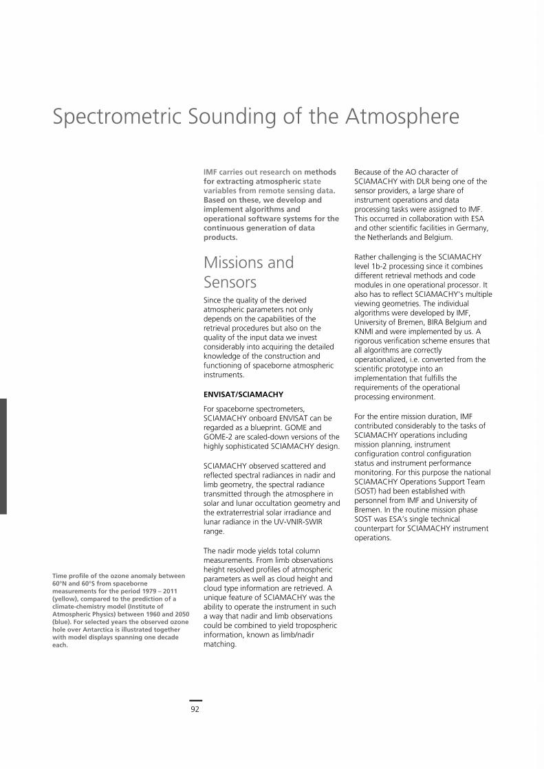
92
Earth Observation Center
92
IMF carries out research on methods for extracting atmospheric state variables from remote sensing data. Based on these, we develop and implement algorithms and operational software systems for the continuous generation of data products.
Missions and Sensors Since the quality of the derived atmospheric parameters not only depends on the capabilities of the retrieval procedures but also on the quality of the input data we invest considerably into acquiring the detailed knowledge of the construction and functioning of spaceborne atmospheric instruments.
ENVISAT/SCIAMACHY
For spaceborne spectrometers, SCIAMACHY onboard ENVISAT can be regarded as a blueprint. GOME and GOME-2 are scaled-down versions of the highly sophisticated SCIAMACHY design.
SCIAMACHY observed scattered and reflected spectral radiances in nadir and limb geometry, the spectral radiance transmitted through the atmosphere in solar and lunar occultation geometry and the extraterrestrial solar irradiance and lunar radiance in the UV-VNIR-SWIR range.
The nadir mode yields total column measurements. From limb observations height resolved profiles of atmospheric parameters as well as cloud height and cloud type information are retrieved. A unique feature of SCIAMACHY was the ability to operate the instrument in such a way that nadir and limb observations could be combined to yield tropospheric information, known as limb/nadir matching.
Because of the AO character of SCIAMACHY with DLR being one of the sensor providers, a large share of instrument operations and data processing tasks were assigned to IMF. This occurred in collaboration with ESA and other scientific facilities in Germany, the Netherlands and Belgium.
Rather challenging is the SCIAMACHY level 1b-2 processing since it combines different retrieval methods and code modules in one operational processor. It also has to reflect SCIAMACHY's multiple viewing geometries. The individual algorithms were developed by IMF, University of Bremen, BIRA Belgium and KNMI and were implemented by us. A rigorous verification scheme ensures that all algorithms are correctly operationalized, i.e. converted from the scientific prototype into an implementation that fulfills the requirements of the operational processing environment.
For the entire mission duration, IMF contributed considerably to the tasks of SCIAMACHY operations including mission planning, instrument configuration control configuration status and instrument performance monitoring. For this purpose the national SCIAMACHY Operations Support Team (SOST) had been established with personnel from IMF and University of Bremen. In the routine mission phase SOST was ESA’s single technical counterpart for SCIAMACHY instrument operations.
Spectrometric Sounding of the Atmosphere
Time profile of the ozone anomaly between 60°N and 60°S from spaceborne measurements for the period 1979 – 2011 (yellow), compared to the prediction of a climate-chemistry model (Institute of Atmospheric Physics) between 1960 and 2050 (blue). For selected years the observed ozone hole over Antarctica is illustrated together with model displays spanning one decade each.
Spectrometric Sounding of the Atmosphere > Missions and Sensors
93
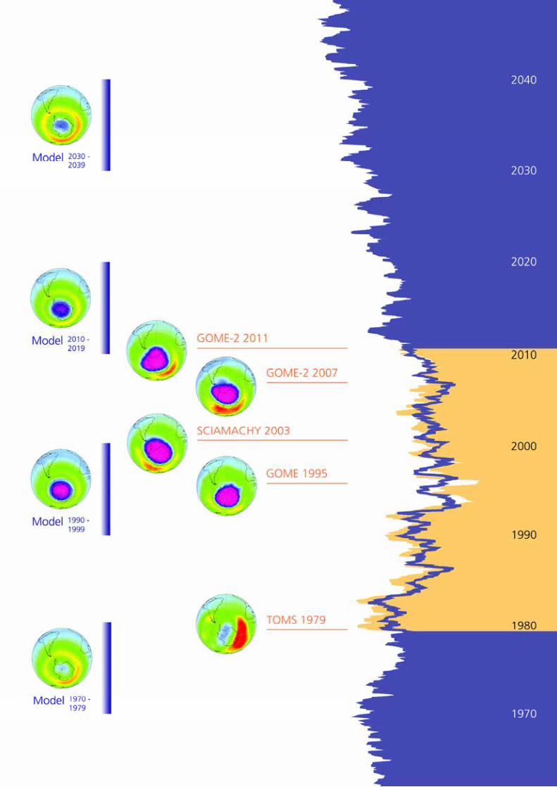
93
Central Services
92
IMF carries out research on methods for extracting atmospheric state variables from remote sensing data. Based on these, we develop and implement algorithms and operational software systems for the continuous generation of data products.
Missions and Sensors Since the quality of the derived atmospheric parameters not only depends on the capabilities of the retrieval procedures but also on the quality of the input data we invest considerably into acquiring the detailed knowledge of the construction and functioning of spaceborne atmospheric instruments.
ENVISAT/SCIAMACHY
For spaceborne spectrometers, SCIAMACHY onboard ENVISAT can be regarded as a blueprint. GOME and GOME-2 are scaled-down versions of the highly sophisticated SCIAMACHY design.
SCIAMACHY observed scattered and reflected spectral radiances in nadir and limb geometry, the spectral radiance transmitted through the atmosphere in solar and lunar occultation geometry and the extraterrestrial solar irradiance and lunar radiance in the UV-VNIR-SWIR range.
The nadir mode yields total column measurements. From limb observations height resolved profiles of atmospheric parameters as well as cloud height and cloud type information are retrieved. A unique feature of SCIAMACHY was the ability to operate the instrument in such a way that nadir and limb observations could be combined to yield tropospheric information, known as limb/nadir matching.
Because of the AO character of SCIAMACHY with DLR being one of the sensor providers, a large share of instrument operations and data processing tasks were assigned to IMF. This occurred in collaboration with ESA and other scientific facilities in Germany, the Netherlands and Belgium.
Rather challenging is the SCIAMACHY level 1b-2 processing since it combines different retrieval methods and code modules in one operational processor. It also has to reflect SCIAMACHY's multiple viewing geometries. The individual algorithms were developed by IMF, University of Bremen, BIRA Belgium and KNMI and were implemented by us. A rigorous verification scheme ensures that all algorithms are correctly operationalized, i.e. converted from the scientific prototype into an implementation that fulfills the requirements of the operational processing environment.
For the entire mission duration, IMF contributed considerably to the tasks of SCIAMACHY operations including mission planning, instrument configuration control configuration status and instrument performance monitoring. For this purpose the national SCIAMACHY Operations Support Team (SOST) had been established with personnel from IMF and University of Bremen. In the routine mission phase SOST was ESA’s single technical counterpart for SCIAMACHY instrument operations.
Spectrometric Sounding of the Atmosphere
Time profile of the ozone anomaly between 60°N and 60°S from spaceborne measurements for the period 1979 – 2011 (yellow), compared to the prediction of a climate-chemistry model (Institute of Atmospheric Physics) between 1960 and 2050 (blue). For selected years the observed ozone hole over Antarctica is illustrated together with model displays spanning one decade each.
Spectrometric Sounding of the Atmosphere > Missions and Sensors
93
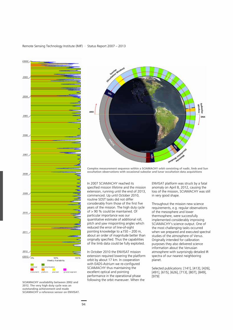
94
Earth Observation Center
Remote Sensing Technology Institute (IMF) ∙ Status Report 2007 – 2013
94
In 2007 SCIAMACHY reached its specified mission lifetime and the mission extension, running until the end of 2013, commenced. Up until October 2010, routine SOST tasks did not differ considerably from those of the first five years of the mission. The high duty cycle of > 90 % could be maintained. Of particular importance was our quantitative estimate of additional roll, pitch and yaw mispointing angles which reduced the error of line-of-sight pointing knowledge to ±150 – 200 m, about an order of magnitude better than originally specified. Thus the capabilities of the limb data could be fully exploited.
In October 2010 the ENVISAT mission extension required lowering the platform orbit by about 17 km. In cooperation with EADS-Astrium we re-configured SCIAMACHY thus maintaining the excellent optical and pointing performance in the operational phase following the orbit maneuver. When the
ENVISAT platform was struck by a fatal anomaly on April 8, 2012, causing the loss of the mission, SCIAMACHY was still in very good shape.
Throughout the mission new science requirements, e.g. regular observations of the mesosphere and lower thermosphere, were successfully implemented considerably improving SCIAMACHY’s science output. One of the most challenging tasks occurred when we prepared and executed spectral studies of the atmosphere of Venus. Originally intended for calibration purposes they also delivered science information about the Venusian atmosphere with surprisingly detailed IR spectra of our nearest neighboring planet.
Selected publications: [141], [413], [426], [491], [615], [626], [713], [807], [849], [979]
SCIAMACHY availability between 2002 and 2012. The very high duty cycle was an outstanding achievement and made SCIAMACHY a reference sensor on ENVISAT.
Complex measurement sequence within a SCIAMACHY orbit consisting of nadir, limb and Sun occultation observations with occasional subsolar and lunar occultation data acquisitions
Spectrometric Sounding of the Atmosphere > Missions and Sensors
95
ERS-2/GOME
Acknowledging the fact that a European spaceborne mission had urgently been required at the end of last century, ESA embarked on a 'fast-track' activity GOME onboard the ERS-2 platform. Only a nadir mode for the UV-VNIR range was implemented. While the nominal swath width of 960 km remained identical to that of SCIAMACHY, the ground pixel resolution was inferior at 320 × 40 km2 as compared to SCIAMACHY’s 26 × 30 km2.
Between 1995 and 2011, IMF, in collaboration with partner institutes, developed the algorithms and operated the processors for the generation of operational near-realtime, offline and reprocessed GOME level 1 and level 2 products.
The data from GOME continues to be used as the reference for the generation of climate data records and also as test- bed for the development and validation of new retrieval algorithms and improved versions of our UPAS level 2 processor.
Selected publications: [113], [204], [259], [262], [303], [461], [775], [828], [854]
MetOp/GOME-2
By operating GOME-2 on MetOp, a satellite series consisting of three platforms, GOME-type measurements will be available far into the 21st century. The GOME-2 swath can reach up to 1,920 km and the spatial resolution, when the swath is reduced by a factor of 2, reaches 40 × 40 km2.
The operational GOME-2 trace gas column and cloud products are provided by EUMETSAT’s Satellite Application Facility on Ozone and Atmospheric Chemistry Monitoring (O3M-SAF). During the first Continuous Development and Operations Phase (CDOP) of the O3M-SAF, which started in 2007 and lasted for five years, we developed GOME-2 trace
gas column algorithms and cloud parameters. The operational retrieval of these products used our well-established GOME Data Processor (GDP). Services provided by the O3M-SAF at EOC occur in near realtime, offline and reprocessing mode. They focus on climate and air quality monitoring applications.
In February 2012, the CDOP-2 started, which will run until 2017. During CDOP-2 we will develop new and improved products, implement new dissemination methods and enhance user services.
Selected publications: [112], [124], [151], [170], [225], [445], [461], [828], [836], [856]
Sentinel-5 Precursor
With GOME-2, we successfully made the transition from ESA research missions (GOME and SCIAMACHY) to operational EUMETSAT missions and services. All experience gained with the O3M-SAF can be regarded as a big asset in the preparation for our engagement in future Copernicus atmospheric missions, such as Sentinel-5 Precursor (S5p), Sentinel-4 and -5, aiming at the provision of global information on atmospheric composition for operational applications on air quality and climate. The first of these will be S5p. Its TROPOMI payload will measure solar radiance and irradiance in the UV-VNIR-SWIR range with an unprecedented spatial resolution of 7 × 7 km2 at nadir in a 2,600 km wide swath.
IMF plays a central role in the processing and handling of the S5p data. Our main involvement in the development of the payload data ground segment concerns the provision of one of the level 2 processors. Level 2 algorithm and processor development occurs in the framework of a European-wide working group where we contribute our GDP expertise by:
Atmospheric parameters operationally retrieved by IMF’s GOME-2 processing system UPAS in the framework of the O3M-SAF
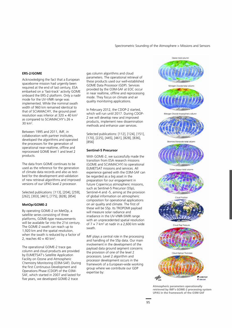
95
Central Services
Remote Sensing Technology Institute (IMF) ∙ Status Report 2007 – 2013
94
In 2007 SCIAMACHY reached its specified mission lifetime and the mission extension, running until the end of 2013, commenced. Up until October 2010, routine SOST tasks did not differ considerably from those of the first five years of the mission. The high duty cycle of > 90 % could be maintained. Of particular importance was our quantitative estimate of additional roll, pitch and yaw mispointing angles which reduced the error of line-of-sight pointing knowledge to ±150 – 200 m, about an order of magnitude better than originally specified. Thus the capabilities of the limb data could be fully exploited.
In October 2010 the ENVISAT mission extension required lowering the platform orbit by about 17 km. In cooperation with EADS-Astrium we re-configured SCIAMACHY thus maintaining the excellent optical and pointing performance in the operational phase following the orbit maneuver. When the
ENVISAT platform was struck by a fatal anomaly on April 8, 2012, causing the loss of the mission, SCIAMACHY was still in very good shape.
Throughout the mission new science requirements, e.g. regular observations of the mesosphere and lower thermosphere, were successfully implemented considerably improving SCIAMACHY’s science output. One of the most challenging tasks occurred when we prepared and executed spectral studies of the atmosphere of Venus. Originally intended for calibration purposes they also delivered science information about the Venusian atmosphere with surprisingly detailed IR spectra of our nearest neighboring planet.
Selected publications: [141], [413], [426], [491], [615], [626], [713], [807], [849], [979]
SCIAMACHY availability between 2002 and 2012. The very high duty cycle was an outstanding achievement and made SCIAMACHY a reference sensor on ENVISAT.
Complex measurement sequence within a SCIAMACHY orbit consisting of nadir, limb and Sun occultation observations with occasional subsolar and lunar occultation data acquisitions
Spectrometric Sounding of the Atmosphere > Missions and Sensors
95
ERS-2/GOME
Acknowledging the fact that a European spaceborne mission had urgently been required at the end of last century, ESA embarked on a 'fast-track' activity GOME onboard the ERS-2 platform. Only a nadir mode for the UV-VNIR range was implemented. While the nominal swath width of 960 km remained identical to that of SCIAMACHY, the ground pixel resolution was inferior at 320 × 40 km2 as compared to SCIAMACHY’s 26 × 30 km2.
Between 1995 and 2011, IMF, in collaboration with partner institutes, developed the algorithms and operated the processors for the generation of operational near-realtime, offline and reprocessed GOME level 1 and level 2 products.
The data from GOME continues to be used as the reference for the generation of climate data records and also as test- bed for the development and validation of new retrieval algorithms and improved versions of our UPAS level 2 processor.
Selected publications: [113], [204], [259], [262], [303], [461], [775], [828], [854]
MetOp/GOME-2
By operating GOME-2 on MetOp, a satellite series consisting of three platforms, GOME-type measurements will be available far into the 21st century. The GOME-2 swath can reach up to 1,920 km and the spatial resolution, when the swath is reduced by a factor of 2, reaches 40 × 40 km2.
The operational GOME-2 trace gas column and cloud products are provided by EUMETSAT’s Satellite Application Facility on Ozone and Atmospheric Chemistry Monitoring (O3M-SAF). During the first Continuous Development and Operations Phase (CDOP) of the O3M-SAF, which started in 2007 and lasted for five years, we developed GOME-2 trace
gas column algorithms and cloud parameters. The operational retrieval of these products used our well-established GOME Data Processor (GDP). Services provided by the O3M-SAF at EOC occur in near realtime, offline and reprocessing mode. They focus on climate and air quality monitoring applications.
In February 2012, the CDOP-2 started, which will run until 2017. During CDOP-2 we will develop new and improved products, implement new dissemination methods and enhance user services.
Selected publications: [112], [124], [151], [170], [225], [445], [461], [828], [836], [856]
Sentinel-5 Precursor
With GOME-2, we successfully made the transition from ESA research missions (GOME and SCIAMACHY) to operational EUMETSAT missions and services. All experience gained with the O3M-SAF can be regarded as a big asset in the preparation for our engagement in future Copernicus atmospheric missions, such as Sentinel-5 Precursor (S5p), Sentinel-4 and -5, aiming at the provision of global information on atmospheric composition for operational applications on air quality and climate. The first of these will be S5p. Its TROPOMI payload will measure solar radiance and irradiance in the UV-VNIR-SWIR range with an unprecedented spatial resolution of 7 × 7 km2 at nadir in a 2,600 km wide swath.
IMF plays a central role in the processing and handling of the S5p data. Our main involvement in the development of the payload data ground segment concerns the provision of one of the level 2 processors. Level 2 algorithm and processor development occurs in the framework of a European-wide working group where we contribute our GDP expertise by:
Atmospheric parameters operationally retrieved by IMF’s GOME-2 processing system UPAS in the framework of the O3M-SAF
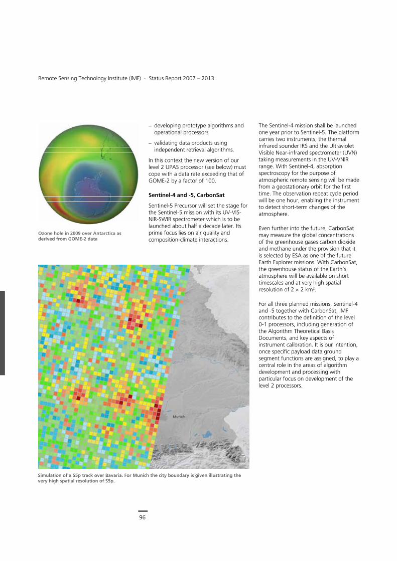
96
Earth Observation Center
Remote Sensing Technology Institute (IMF) ∙ Status Report 2007 – 2013
96
developing prototype algorithms and operational processors
validating data products using independent retrieval algorithms.
In this context the new version of our level 2 UPAS processor (see below) must cope with a data rate exceeding that of GOME-2 by a factor of 100.
Sentinel-4 and -5, CarbonSat
Sentinel-5 Precursor will set the stage for the Sentinel-5 mission with its UV-VIS-NIR-SWIR spectrometer which is to be launched about half a decade later. Its prime focus lies on air quality and composition-climate interactions.
The Sentinel-4 mission shall be launched one year prior to Sentinel-5. The platform carries two instruments, the thermal infrared sounder IRS and the Ultraviolet Visible Near-infrared spectrometer (UVN) taking measurements in the UV-VNIR range. With Sentinel-4, absorption spectroscopy for the purpose of atmospheric remote sensing will be made from a geostationary orbit for the first time. The observation repeat cycle period will be one hour, enabling the instrument to detect short-term changes of the atmosphere.
Even further into the future, CarbonSat may measure the global concentrations of the greenhouse gases carbon dioxide and methane under the provision that it is selected by ESA as one of the future Earth Explorer missions. With CarbonSat, the greenhouse status of the Earth's atmosphere will be available on short timescales and at very high spatial resolution of 2 × 2 km2.
For all three planned missions, Sentinel-4 and -5 together with CarbonSat, IMF contributes to the definition of the level 0-1 processors, including generation of the Algorithm Theoretical Basis Documents, and key aspects of instrument calibration. It is our intention, once specific payload data ground segment functions are assigned, to play a central role in the areas of algorithm development and processing with particular focus on development of the level 2 processors.
Ozone hole in 2009 over Antarctica as derived from GOME-2 data
Simulation of a S5p track over Bavaria. For Munich the city boundary is given illustrating the very high spatial resolution of S5p.
Spectrometric Sounding of the Atmosphere > Missions and Sensors
97
ADM-Aeolus
ADM-Aeolus is Europe's first lidar mission for atmospheric wind profiling. The Doppler instrument ALADIN will illuminate the atmosphere off-track from nadir with UV pulses at 355 nm and record the light backscattered by molecules and particles.
IMF's responsibilities for ADM-Aeolus are twofold. Firstly, on the basis of recent instrument characteristics IMF developed and refined several modules of the end-to-end instrument simulator. With our contributions, the laser pulse model is now able to handle backscatter on a single-pulse level. This enables a broad field of scientific investigations into heterogeneous atmospheric conditions and the impact of laser frequency jitter on measurement accuracy. In addition, instrument imperfections in the Fizeau-/Fabry-Pérot interferometers and the accumulation CCD can be modeled. Secondly, IMF has further improved and optimized the level 1b algorithms. Because of our scattering expertise, including exploitation of the IMF developed scattering database for spheroidal particles, one focus is on lidar signal scattering by aerosols, polar stratospheric and thin cirrus clouds. From this, recommendations for optimizing the algorithms and software of the operational level 1b processor will be set.
Selected publications: [106], [250], [322]
MERLIN
Currently, DLR develops its first active spaceborne atmospheric sensor in the context of the Franco-German MERLIN mission. The goal is high precision retrieval of methane concentration. This requires accurate in-orbit performance of the differential absorption lidar instrument in combination with novel aspects for processor development. IMF contributes considerably to instrument related tasks. The success of MERLIN relies on optimum selection of the laser
SWIR wavelengths at about 1.65 μm. By using our Py4CAtS line-by-line tool we performed atmospheric transmittance calculations and identified a suitable spectral region with strong methane absorption and minimal interference from other gases. Since a precise knowledge of the behavior of the instrument is of paramount importance for level 0-1 processing, we will invest considerably into the monitoring of MERLIN’s in-orbit performance. Based on our experience with SCIAMACHY, IMF develops and implements a concept which provides the required information over long time scales.
We are also responsible for the level 0-1a and level 1a-1b processors. They will be based on algorithms established within MERLIN’s science community. From these the reference prototype processor will be developed and implemented in a preoperational test environment. By
Mission/Sensor Wavelength (nm) Species
ENVISAT/SCIAMACHY UV-VIS-NIR: 215 – 1063 SWIR: 1934 – 2044 2259 – 2386
nadir: O3, NO2, BrO, H2O, SO2, HCHO, OClO,CHOCHO, CO, CH4, AAIA, clouds limb: O3, NO2, BrO, clouds limb/nadir matching: tropospheric NO2
ERS-2/GOME UV-VIS-NIR: 237 – 794 O3, NO2, H2O, BrO, SO2, HCHO, OClO, tropospheric O3, tropospheric NO2, clouds
MetOp/GOME-2 UV-VIS-NIR: 240 – 790 O3, NO2, H2O, BrO, SO2, HCHO, tropospheric NO2, tropospheric O3, OClO, CHOCHO, clouds
Sentinel-5 Precursor UV-VIS-NIR: 270 – 775 SWIR: 2305 – 2385
O3, SO2, HCHO, tropospheric O3, NO2, tropospheric NO2, BrO, clouds
Sentinel-5 UV-VIS-NIR: 270 – 775 SWIR: 1590 – 1675 2305 – 2385
O3, NO2, H2O, BrO, SO2, HCHO, tropospheric NO2, tropospheric O3, OClO, CHOCHO, clouds
Sentinel-4 UV-VIS-NIR: 305 – 775 O3, NO2, H2O, BrO, SO2, HCHO, tropospheric NO2, tropospheric O3, OClO, CHOCHO, clouds
CarbonSat NIR: 757 – 775 SWIR: 1559 – 1675 2043 – 2095
CO2, CH4
ADM-Aeolus UV: 355 wind profiles
MERLIN SWIR: 1645 CH4
Suite of sensors used at IMF for the
spectrometric sounding of the Earth’s atmosphere. The listed target species are those where IMF contributed to the operational (bold) or scientific products either in processor or algorithm development. For future missions intended parameters are provided.
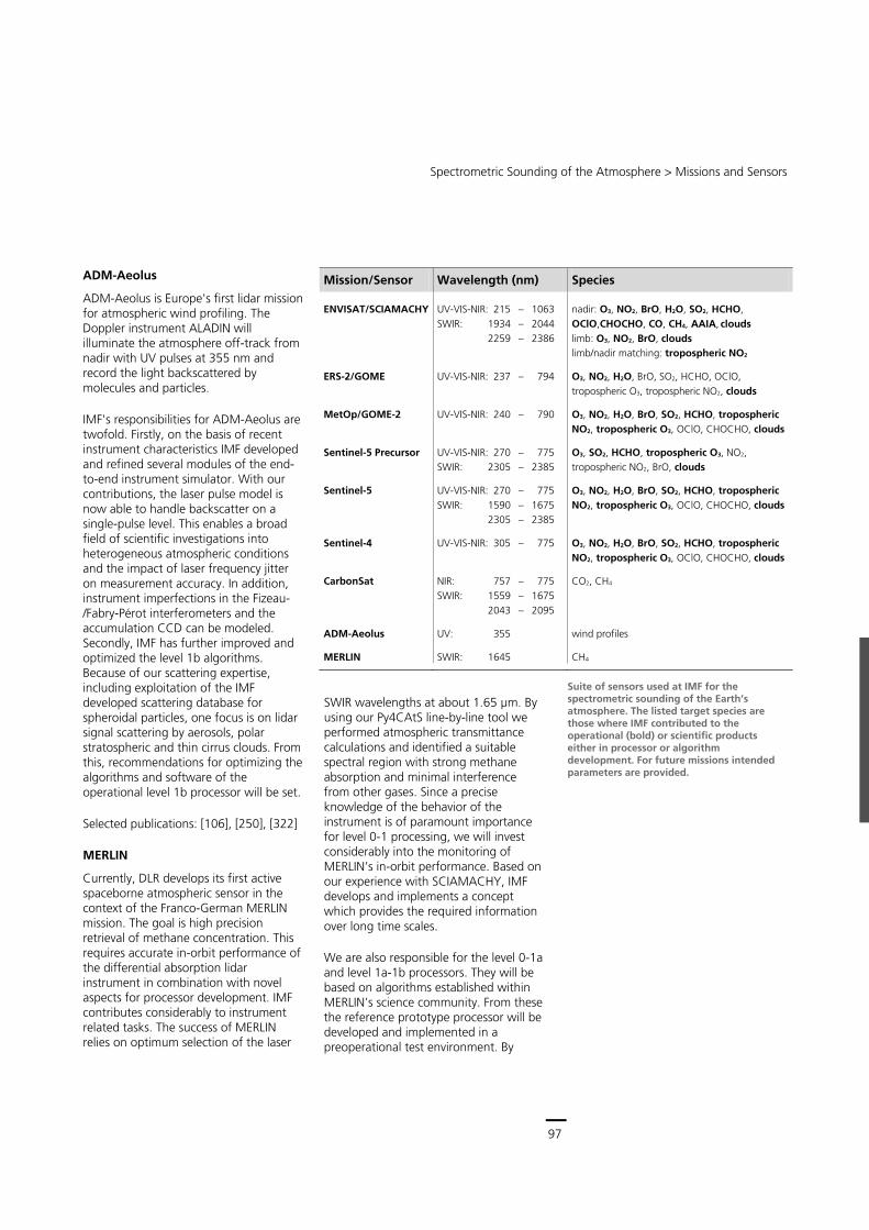
97
Central Services
Remote Sensing Technology Institute (IMF) ∙ Status Report 2007 – 2013
96
developing prototype algorithms and operational processors
validating data products using independent retrieval algorithms.
In this context the new version of our level 2 UPAS processor (see below) must cope with a data rate exceeding that of GOME-2 by a factor of 100.
Sentinel-4 and -5, CarbonSat
Sentinel-5 Precursor will set the stage for the Sentinel-5 mission with its UV-VIS-NIR-SWIR spectrometer which is to be launched about half a decade later. Its prime focus lies on air quality and composition-climate interactions.
The Sentinel-4 mission shall be launched one year prior to Sentinel-5. The platform carries two instruments, the thermal infrared sounder IRS and the Ultraviolet Visible Near-infrared spectrometer (UVN) taking measurements in the UV-VNIR range. With Sentinel-4, absorption spectroscopy for the purpose of atmospheric remote sensing will be made from a geostationary orbit for the first time. The observation repeat cycle period will be one hour, enabling the instrument to detect short-term changes of the atmosphere.
Even further into the future, CarbonSat may measure the global concentrations of the greenhouse gases carbon dioxide and methane under the provision that it is selected by ESA as one of the future Earth Explorer missions. With CarbonSat, the greenhouse status of the Earth's atmosphere will be available on short timescales and at very high spatial resolution of 2 × 2 km2.
For all three planned missions, Sentinel-4 and -5 together with CarbonSat, IMF contributes to the definition of the level 0-1 processors, including generation of the Algorithm Theoretical Basis Documents, and key aspects of instrument calibration. It is our intention, once specific payload data ground segment functions are assigned, to play a central role in the areas of algorithm development and processing with particular focus on development of the level 2 processors.
Ozone hole in 2009 over Antarctica as derived from GOME-2 data
Simulation of a S5p track over Bavaria. For Munich the city boundary is given illustrating the very high spatial resolution of S5p.
Spectrometric Sounding of the Atmosphere > Missions and Sensors
97
ADM-Aeolus
ADM-Aeolus is Europe's first lidar mission for atmospheric wind profiling. The Doppler instrument ALADIN will illuminate the atmosphere off-track from nadir with UV pulses at 355 nm and record the light backscattered by molecules and particles.
IMF's responsibilities for ADM-Aeolus are twofold. Firstly, on the basis of recent instrument characteristics IMF developed and refined several modules of the end-to-end instrument simulator. With our contributions, the laser pulse model is now able to handle backscatter on a single-pulse level. This enables a broad field of scientific investigations into heterogeneous atmospheric conditions and the impact of laser frequency jitter on measurement accuracy. In addition, instrument imperfections in the Fizeau-/Fabry-Pérot interferometers and the accumulation CCD can be modeled. Secondly, IMF has further improved and optimized the level 1b algorithms. Because of our scattering expertise, including exploitation of the IMF developed scattering database for spheroidal particles, one focus is on lidar signal scattering by aerosols, polar stratospheric and thin cirrus clouds. From this, recommendations for optimizing the algorithms and software of the operational level 1b processor will be set.
Selected publications: [106], [250], [322]
MERLIN
Currently, DLR develops its first active spaceborne atmospheric sensor in the context of the Franco-German MERLIN mission. The goal is high precision retrieval of methane concentration. This requires accurate in-orbit performance of the differential absorption lidar instrument in combination with novel aspects for processor development. IMF contributes considerably to instrument related tasks. The success of MERLIN relies on optimum selection of the laser
SWIR wavelengths at about 1.65 μm. By using our Py4CAtS line-by-line tool we performed atmospheric transmittance calculations and identified a suitable spectral region with strong methane absorption and minimal interference from other gases. Since a precise knowledge of the behavior of the instrument is of paramount importance for level 0-1 processing, we will invest considerably into the monitoring of MERLIN’s in-orbit performance. Based on our experience with SCIAMACHY, IMF develops and implements a concept which provides the required information over long time scales.
We are also responsible for the level 0-1a and level 1a-1b processors. They will be based on algorithms established within MERLIN’s science community. From these the reference prototype processor will be developed and implemented in a preoperational test environment. By
Mission/Sensor Wavelength (nm) Species
ENVISAT/SCIAMACHY UV-VIS-NIR: 215 – 1063 SWIR: 1934 – 2044 2259 – 2386
nadir: O3, NO2, BrO, H2O, SO2, HCHO, OClO,CHOCHO, CO, CH4, AAIA, clouds limb: O3, NO2, BrO, clouds limb/nadir matching: tropospheric NO2
ERS-2/GOME UV-VIS-NIR: 237 – 794 O3, NO2, H2O, BrO, SO2, HCHO, OClO, tropospheric O3, tropospheric NO2, clouds
MetOp/GOME-2 UV-VIS-NIR: 240 – 790 O3, NO2, H2O, BrO, SO2, HCHO, tropospheric NO2, tropospheric O3, OClO, CHOCHO, clouds
Sentinel-5 Precursor UV-VIS-NIR: 270 – 775 SWIR: 2305 – 2385
O3, SO2, HCHO, tropospheric O3, NO2, tropospheric NO2, BrO, clouds
Sentinel-5 UV-VIS-NIR: 270 – 775 SWIR: 1590 – 1675 2305 – 2385
O3, NO2, H2O, BrO, SO2, HCHO, tropospheric NO2, tropospheric O3, OClO, CHOCHO, clouds
Sentinel-4 UV-VIS-NIR: 305 – 775 O3, NO2, H2O, BrO, SO2, HCHO, tropospheric NO2, tropospheric O3, OClO, CHOCHO, clouds
CarbonSat NIR: 757 – 775 SWIR: 1559 – 1675 2043 – 2095
CO2, CH4
ADM-Aeolus UV: 355 wind profiles
MERLIN SWIR: 1645 CH4
Suite of sensors used at IMF for the
spectrometric sounding of the Earth’s atmosphere. The listed target species are those where IMF contributed to the operational (bold) or scientific products either in processor or algorithm development. For future missions intended parameters are provided.
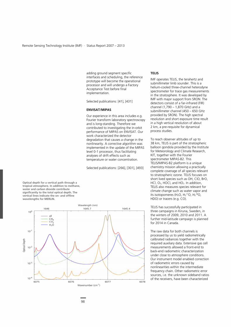
98
Earth Observation Center
Remote Sensing Technology Institute (IMF) ∙ Status Report 2007 – 2013
98
adding ground segment specific interfaces and scheduling, the reference prototype will become the operational processor and will undergo a Factory Acceptance Test before final implementation.
Selected publications: [41], [431]
ENVISAT/MIPAS
Our experience in this area includes e.g. Fourier transform laboratory spectroscopy and is long-standing. Therefore we contributed to investigating the in-orbit performance of MIPAS on ENVISAT. Our work characterized the detector degradation that causes a change in the nonlinearity. A corrective algorithm was implemented in the update of the MIPAS level 0-1 processor, thus facilitating analyses of drift effects such as temperature or water concentration.
Selected publications: [266], [301], [493]
TELIS
IMF operates TELIS, the terahertz and submillimeter limb sounder. This is a helium-cooled three-channel heterodyne spectrometer for trace gas measurements in the stratosphere. It was developed by IMF with major support from SRON. The detectors consist of a far-infrared (FIR) channel (1,790 – 1,870 GHz) and a submillimeter channel (450 – 650 GHz provided by SRON). The high spectral resolution and short exposure time result in a high vertical resolution of about 2 km, a pre-requisite for dynamical process studies.
To reach observer altitudes of up to 38 km, TELIS is part of the stratospheric balloon gondola provided by the Institute for Meteorology and Climate Research, KIT, together with the Fourier spectrometer MIPAS-B2. This TELIS/MIPAS-B2 platform is a unique chemistry mission allowing a practically complete coverage of all species relevant to stratospheric ozone. TELIS focuses on short lived species such as OH, ClO, BrO, HCl, O3, HOCl, and HO2. In addition, TELIS also measures species relevant for climate change such as water vapor and its isotopomeres (H2O, H2
17O, H218O,
HDO) or tracers (e.g. CO).
TELIS has successfully participated in three campaigns in Kiruna, Sweden, in the winters of 2009, 2010 and 2011. A further mid-latitude campaign is planned for 2014 in Canada.
The raw data for both channels is processed by us to yield radiometrically calibrated radiances together with the required auxiliary data. Extensive gas cell measurements allowed a front-end to back-end radiometric characterization under close to atmosphere conditions. Our instrument model enabled correction of radiometric errors caused by nonlinearities within the intermediate frequency chain. Other radiometric error sources, i.e. the unknown sideband ratios of the receivers, have been characterized
Optical depth for a vertical path through a tropical atmosphere. In addition to methane, water and carbon dioxide contribute significantly to the total optical depth. The vertical lines indicate the on- and offline wavelengths for MERLIN.
Spectrometric Sounding of the Atmosphere > Generic Processing Systems
99
Balloon campaign 2009, Kiruna/Sweden: TELIS and MIPAS-B (KIT) ready for lift-off
in a series of quality-improving measurements, greatly profiting from IMF’s new FT spectrometer BRUKER IFS 125 HR.
For the retrieval of geophysical parameters, i.e. molecular concentrations, we use the PILS code developed at IMF. It is based on the GARLIC forward model and DRACULA regularization modules and is applicable for microwave to mid IR limb emission spectra. For a quantitative assessment we have performed an exhaustive sensitivity study indicating that for OH nonlinearity effects, inaccurate sideband ratios and pointing are the dominant error sources. Furthermore, multichannel retrieval exploiting FIR and submillimeter data concurrently showed significant improvements for hydrogen chloride compared to single channel retrieval. The concentration profiles retrieved so far show good agreement with other instruments such as MIPAS-B2 or SMILES.
Selected publications: [27], [42], [78], [334], [577], [687]
Generic Processing Systems
Universal Processor for Atmospheric Sensors – UPAS
Operational level 2 processing systems translate the theoretical basics of radiative transfer, inversion and scattering into software tools applicable to calibrated level 1 data. Their structures require flexibility because ongoing research produces new retrieval algorithms which have to be incorporated to maintain state-of-the-art performance. IMF decided to develop UPAS, the Universal Processor for Atmospheric UV/VIS/NIR Sensors as a generic multi-mission system for the retrieval of trace gases and cloud properties. Since its operational readiness back in 2004, UPAS has been continuously improved and forms the backbone level 2 retrieval system at IMF.
UPAS follows an object oriented design and is implemented in C++ under Linux. It uses a client/server architecture for fast processing of satellite data on a cluster of multi-core computers. The settings of the retrieval algorithms can be easily changed using XML configuration files.
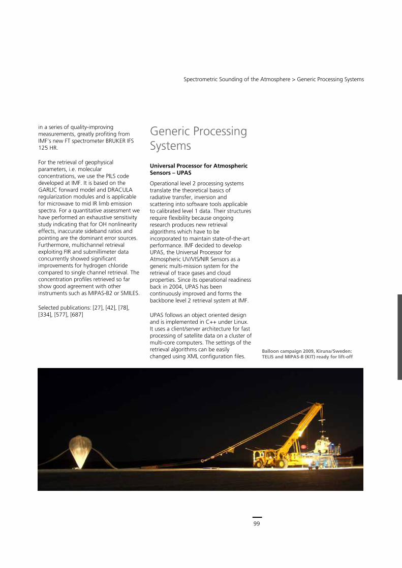
99
Central Services
Remote Sensing Technology Institute (IMF) ∙ Status Report 2007 – 2013
98
adding ground segment specific interfaces and scheduling, the reference prototype will become the operational processor and will undergo a Factory Acceptance Test before final implementation.
Selected publications: [41], [431]
ENVISAT/MIPAS
Our experience in this area includes e.g. Fourier transform laboratory spectroscopy and is long-standing. Therefore we contributed to investigating the in-orbit performance of MIPAS on ENVISAT. Our work characterized the detector degradation that causes a change in the nonlinearity. A corrective algorithm was implemented in the update of the MIPAS level 0-1 processor, thus facilitating analyses of drift effects such as temperature or water concentration.
Selected publications: [266], [301], [493]
TELIS
IMF operates TELIS, the terahertz and submillimeter limb sounder. This is a helium-cooled three-channel heterodyne spectrometer for trace gas measurements in the stratosphere. It was developed by IMF with major support from SRON. The detectors consist of a far-infrared (FIR) channel (1,790 – 1,870 GHz) and a submillimeter channel (450 – 650 GHz provided by SRON). The high spectral resolution and short exposure time result in a high vertical resolution of about 2 km, a pre-requisite for dynamical process studies.
To reach observer altitudes of up to 38 km, TELIS is part of the stratospheric balloon gondola provided by the Institute for Meteorology and Climate Research, KIT, together with the Fourier spectrometer MIPAS-B2. This TELIS/MIPAS-B2 platform is a unique chemistry mission allowing a practically complete coverage of all species relevant to stratospheric ozone. TELIS focuses on short lived species such as OH, ClO, BrO, HCl, O3, HOCl, and HO2. In addition, TELIS also measures species relevant for climate change such as water vapor and its isotopomeres (H2O, H2
17O, H218O,
HDO) or tracers (e.g. CO).
TELIS has successfully participated in three campaigns in Kiruna, Sweden, in the winters of 2009, 2010 and 2011. A further mid-latitude campaign is planned for 2014 in Canada.
The raw data for both channels is processed by us to yield radiometrically calibrated radiances together with the required auxiliary data. Extensive gas cell measurements allowed a front-end to back-end radiometric characterization under close to atmosphere conditions. Our instrument model enabled correction of radiometric errors caused by nonlinearities within the intermediate frequency chain. Other radiometric error sources, i.e. the unknown sideband ratios of the receivers, have been characterized
Optical depth for a vertical path through a tropical atmosphere. In addition to methane, water and carbon dioxide contribute significantly to the total optical depth. The vertical lines indicate the on- and offline wavelengths for MERLIN.
Spectrometric Sounding of the Atmosphere > Generic Processing Systems
99
Balloon campaign 2009, Kiruna/Sweden: TELIS and MIPAS-B (KIT) ready for lift-off
in a series of quality-improving measurements, greatly profiting from IMF’s new FT spectrometer BRUKER IFS 125 HR.
For the retrieval of geophysical parameters, i.e. molecular concentrations, we use the PILS code developed at IMF. It is based on the GARLIC forward model and DRACULA regularization modules and is applicable for microwave to mid IR limb emission spectra. For a quantitative assessment we have performed an exhaustive sensitivity study indicating that for OH nonlinearity effects, inaccurate sideband ratios and pointing are the dominant error sources. Furthermore, multichannel retrieval exploiting FIR and submillimeter data concurrently showed significant improvements for hydrogen chloride compared to single channel retrieval. The concentration profiles retrieved so far show good agreement with other instruments such as MIPAS-B2 or SMILES.
Selected publications: [27], [42], [78], [334], [577], [687]
Generic Processing Systems
Universal Processor for Atmospheric Sensors – UPAS
Operational level 2 processing systems translate the theoretical basics of radiative transfer, inversion and scattering into software tools applicable to calibrated level 1 data. Their structures require flexibility because ongoing research produces new retrieval algorithms which have to be incorporated to maintain state-of-the-art performance. IMF decided to develop UPAS, the Universal Processor for Atmospheric UV/VIS/NIR Sensors as a generic multi-mission system for the retrieval of trace gases and cloud properties. Since its operational readiness back in 2004, UPAS has been continuously improved and forms the backbone level 2 retrieval system at IMF.
UPAS follows an object oriented design and is implemented in C++ under Linux. It uses a client/server architecture for fast processing of satellite data on a cluster of multi-core computers. The settings of the retrieval algorithms can be easily changed using XML configuration files.
100
Earth Observation Center
Remote Sensing Technology Institute (IMF) ∙ Status Report 2007 – 2013
100
Retrievals in UPAS are performed with the GOME Data Processor (GDP) version 4, which was implemented from the outset. We develop the corresponding algorithms together with the partner institutes BIRA (Belgium), University of Bremen and RTS Inc. (USA). Independent geophysical validation is performed by AUTH (Greece) and BIRA. The GOME total ozone products, generated by GDP4/UPAS, reached accuracies at the percentage level, comparable to that of ground-based sensors. The first version of UPAS was available for use in 2004 for the generation of operational GOME products. Presently, UPAS is being used for the reprocessing of SCIAMACHY nadir measurements and for the operational processing of GOME-2 data from MetOp-A and MetOp-B. The GOME-2 near-realtime products are generated in 10 minutes, thus achieving the challenging requirement of level 2 product dissemination in less than 2 hours from sensing. UPAS has turned out to be very robust and stable, it runs standalone in a 24/7 environment and already fulfills the operational requirements of the Copernicus program. A second generation of UPAS is under development in order to cope with the hundredfold increase in data volume expected from future missions.
Selected publications: [113], [151], [283], [303]
Generic Calibration Processing System – GCAPS
The design of level 0-1 processors should provide operational flexibility to ensure adaptability to different sensors while still possessing lean, programmer-friendly structures. The existing prototype processor for SCIAMACHY is IDL based and does not support bulk processing as required by ESA's reprocessing campaigns. Therefore we decided to transfer the corresponding algorithms existing at IMF into a new generic level 0-1 processing framework, GCAPS, the
Generic Calibration Processing System. Its requirements include:
provision of structures for controlling the data flow and configuring calibration chains
instrument independency
internal data representation independency from the input/output data formats
full configurability by the user, i.e. switchable and changeable calibration steps
processor multithreading.
These requirements led to a lean structure providing the basic functionality needed for level 0-1 processing. From this, one can build instrument specific processors by coding the relevant plug-ins and defining calibration chains in the configuration file. This framework also facilitates the cross-calibration of sensors. Because algorithms are easily exchangeable, one can use identical algorithms for a given calibration step and compare the results. Any remaining differences can then only be caused by different input data, but not by a given instrument specific algorithm.
Currently, we are implementing the plug-ins needed for the reprocessing of SCIAMACHY level 0 data. The resulting GCAPS version has been selected by ESA to become the new operational level 0-1 processor. It will also be used for the GOME level 0-1 processor update and will be the system of choice whenever IMF handles level 0-1 algorithm and processor development for future sensors.
Spectrometric Sounding of the Atmosphere > Methods and Applications
101
Methods and Applications Retrieval, or determining atmospheric characteristics from electromagnetic spectra, requires input data of the highest quality. For this reason we develop calibration algorithms for the entire suite of atmospheric sensors exploited at IMF. Furthermore, a deep understanding of radiative transfer, inversion and scattering is needed. We perform research activities aimed at either deriving known atmospheric state variables with the highest precision or at retrieving new parameters from remote sensing data.
Sensor Calibration Algorithms
The first step in the derivation of geophysical parameters from remote sensing data is the generation of level 1 data by applying the full sequence of calibration steps to the instrument raw data. At the end of this step the raw measurements have to be converted to physical quantities. IMF is actively pursuing:
development of calibration algorithms
conceptual design and development of operational processors.
The typical calibration chain for spectral imagers consists of:
correction of detector effects such as nonlinearity, memory effect, pixel-to-pixel gain and etalon, smear and dark signal
correction of instrument stray light
spectral and radiometric calibration
polarization correction
correction/monitoring of any degradation effects such as dead and bad pixel mask.
Stray light correction and spectral calibration usually turn out to be the most difficult to implement. A full resolution stray light calculation requires a multiplication for each pixel of the CCD array with all other pixels and a subsequent addition of all contributions. However, this would consume too much time in level 0-1 processing. In addition, the corresponding on-ground reference measurements necessary as input would last much longer than what is usually assigned to calibration campaigns. Therefore practical solutions have to be found not jeopardizing the accuracy, e.g. finding a suitable reduction for the stray light matrix. For the Sentinel-4 UVN instrument, IMF is currently working on a solution to this problem.
The main challenge in spectral calibration is that it has to use the spectrum itself together with a model to obtain the high accuracies needed for retrieval. Hence, non-observable characteristics such as an inhomogeneous illumination of the instrument slit already lead to an unacceptably high uncertainty in the spectral position of the detector pixels. Our studies aim at developing algorithms for spectral calibration, mitigating the impact of heterogeneous scenes and at performing corresponding error analyses.
For GOME and SCIAMACHY the level 0-1 processors have been developed by IMF and are still maintained and improved for post-mission reprocessing campaigns. Additionally, for several upcoming absorption spectroscopy type missions IMF has already adopted the task of developing the level 0-1 chain. Extending this work to active spectral instruments will even allow us to contribute the level 0-1 processing for MERLIN.
Selected publications: [262], [451], [453], [796]
SCIAMACHY stray light in channel 5 on a logarithmic scale. Each row shows the stray light spectrum caused by unit input (y axis). The diagonal black region is defined as part of the slit function and free of stray light. Diagonal lines are caused by focus reflections of one part of the spectrum to another (‘ghosts’). Since stray light introduces spectral artifacts which spoil retrievals, its portion in a spectrum has to be reduced to < 1 % of the relative signal changes. Stray light algorithms are instrument-specific. The experience gained from SCIAMACHY supports our efforts to establish solutions for Sentinel-4.
Comparison between spectral calibration of the GOME-2A nadir range using the onboard spectral line source and a spectral calibration derived from the spectrum itself. The latter method might be used to correct for spectral shifts caused by inhomogeneous scene illumination. Differences between the two approaches are shown in units of spectral pixels for measurements along one orbit.
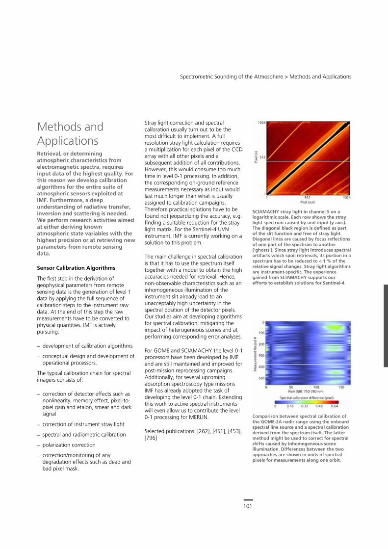
101
Central Services
Remote Sensing Technology Institute (IMF) ∙ Status Report 2007 – 2013
100
Retrievals in UPAS are performed with the GOME Data Processor (GDP) version 4, which was implemented from the outset. We develop the corresponding algorithms together with the partner institutes BIRA (Belgium), University of Bremen and RTS Inc. (USA). Independent geophysical validation is performed by AUTH (Greece) and BIRA. The GOME total ozone products, generated by GDP4/UPAS, reached accuracies at the percentage level, comparable to that of ground-based sensors. The first version of UPAS was available for use in 2004 for the generation of operational GOME products. Presently, UPAS is being used for the reprocessing of SCIAMACHY nadir measurements and for the operational processing of GOME-2 data from MetOp-A and MetOp-B. The GOME-2 near-realtime products are generated in 10 minutes, thus achieving the challenging requirement of level 2 product dissemination in less than 2 hours from sensing. UPAS has turned out to be very robust and stable, it runs standalone in a 24/7 environment and already fulfills the operational requirements of the Copernicus program. A second generation of UPAS is under development in order to cope with the hundredfold increase in data volume expected from future missions.
Selected publications: [113], [151], [283], [303]
Generic Calibration Processing System – GCAPS
The design of level 0-1 processors should provide operational flexibility to ensure adaptability to different sensors while still possessing lean, programmer-friendly structures. The existing prototype processor for SCIAMACHY is IDL based and does not support bulk processing as required by ESA's reprocessing campaigns. Therefore we decided to transfer the corresponding algorithms existing at IMF into a new generic level 0-1 processing framework, GCAPS, the
Generic Calibration Processing System. Its requirements include:
provision of structures for controlling the data flow and configuring calibration chains
instrument independency
internal data representation independency from the input/output data formats
full configurability by the user, i.e. switchable and changeable calibration steps
processor multithreading.
These requirements led to a lean structure providing the basic functionality needed for level 0-1 processing. From this, one can build instrument specific processors by coding the relevant plug-ins and defining calibration chains in the configuration file. This framework also facilitates the cross-calibration of sensors. Because algorithms are easily exchangeable, one can use identical algorithms for a given calibration step and compare the results. Any remaining differences can then only be caused by different input data, but not by a given instrument specific algorithm.
Currently, we are implementing the plug-ins needed for the reprocessing of SCIAMACHY level 0 data. The resulting GCAPS version has been selected by ESA to become the new operational level 0-1 processor. It will also be used for the GOME level 0-1 processor update and will be the system of choice whenever IMF handles level 0-1 algorithm and processor development for future sensors.
Spectrometric Sounding of the Atmosphere > Methods and Applications
101
Methods and Applications Retrieval, or determining atmospheric characteristics from electromagnetic spectra, requires input data of the highest quality. For this reason we develop calibration algorithms for the entire suite of atmospheric sensors exploited at IMF. Furthermore, a deep understanding of radiative transfer, inversion and scattering is needed. We perform research activities aimed at either deriving known atmospheric state variables with the highest precision or at retrieving new parameters from remote sensing data.
Sensor Calibration Algorithms
The first step in the derivation of geophysical parameters from remote sensing data is the generation of level 1 data by applying the full sequence of calibration steps to the instrument raw data. At the end of this step the raw measurements have to be converted to physical quantities. IMF is actively pursuing:
development of calibration algorithms
conceptual design and development of operational processors.
The typical calibration chain for spectral imagers consists of:
correction of detector effects such as nonlinearity, memory effect, pixel-to-pixel gain and etalon, smear and dark signal
correction of instrument stray light
spectral and radiometric calibration
polarization correction
correction/monitoring of any degradation effects such as dead and bad pixel mask.
Stray light correction and spectral calibration usually turn out to be the most difficult to implement. A full resolution stray light calculation requires a multiplication for each pixel of the CCD array with all other pixels and a subsequent addition of all contributions. However, this would consume too much time in level 0-1 processing. In addition, the corresponding on-ground reference measurements necessary as input would last much longer than what is usually assigned to calibration campaigns. Therefore practical solutions have to be found not jeopardizing the accuracy, e.g. finding a suitable reduction for the stray light matrix. For the Sentinel-4 UVN instrument, IMF is currently working on a solution to this problem.
The main challenge in spectral calibration is that it has to use the spectrum itself together with a model to obtain the high accuracies needed for retrieval. Hence, non-observable characteristics such as an inhomogeneous illumination of the instrument slit already lead to an unacceptably high uncertainty in the spectral position of the detector pixels. Our studies aim at developing algorithms for spectral calibration, mitigating the impact of heterogeneous scenes and at performing corresponding error analyses.
For GOME and SCIAMACHY the level 0-1 processors have been developed by IMF and are still maintained and improved for post-mission reprocessing campaigns. Additionally, for several upcoming absorption spectroscopy type missions IMF has already adopted the task of developing the level 0-1 chain. Extending this work to active spectral instruments will even allow us to contribute the level 0-1 processing for MERLIN.
Selected publications: [262], [451], [453], [796]
SCIAMACHY stray light in channel 5 on a logarithmic scale. Each row shows the stray light spectrum caused by unit input (y axis). The diagonal black region is defined as part of the slit function and free of stray light. Diagonal lines are caused by focus reflections of one part of the spectrum to another (‘ghosts’). Since stray light introduces spectral artifacts which spoil retrievals, its portion in a spectrum has to be reduced to < 1 % of the relative signal changes. Stray light algorithms are instrument-specific. The experience gained from SCIAMACHY supports our efforts to establish solutions for Sentinel-4.
Comparison between spectral calibration of the GOME-2A nadir range using the onboard spectral line source and a spectral calibration derived from the spectrum itself. The latter method might be used to correct for spectral shifts caused by inhomogeneous scene illumination. Differences between the two approaches are shown in units of spectral pixels for measurements along one orbit.
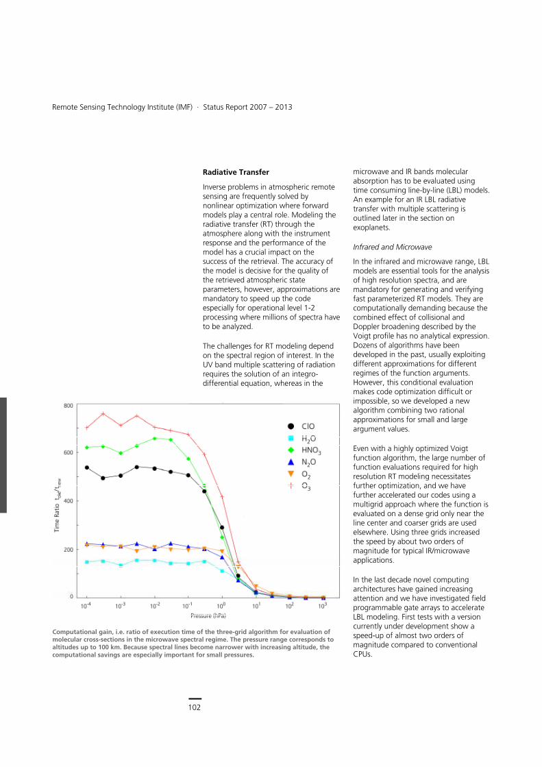
102
Earth Observation Center
Remote Sensing Technology Institute (IMF) ∙ Status Report 2007 – 2013
102
Radiative Transfer
Inverse problems in atmospheric remote sensing are frequently solved by nonlinear optimization where forward models play a central role. Modeling the radiative transfer (RT) through the atmosphere along with the instrument response and the performance of the model has a crucial impact on the success of the retrieval. The accuracy of the model is decisive for the quality of the retrieved atmospheric state parameters, however, approximations are mandatory to speed up the code especially for operational level 1-2 processing where millions of spectra have to be analyzed.
The challenges for RT modeling depend on the spectral region of interest. In the UV band multiple scattering of radiation requires the solution of an integro-differential equation, whereas in the
microwave and IR bands molecular absorption has to be evaluated using time consuming line-by-line (LBL) models. An example for an IR LBL radiative transfer with multiple scattering is outlined later in the section on exoplanets.
Infrared and Microwave
In the infrared and microwave range, LBL models are essential tools for the analysis of high resolution spectra, and are mandatory for generating and verifying fast parameterized RT models. They are computationally demanding because the combined effect of collisional and Doppler broadening described by the Voigt profile has no analytical expression. Dozens of algorithms have been developed in the past, usually exploiting different approximations for different regimes of the function arguments. However, this conditional evaluation makes code optimization difficult or impossible, so we developed a new algorithm combining two rational approximations for small and large argument values.
Even with a highly optimized Voigt function algorithm, the large number of function evaluations required for high resolution RT modeling necessitates further optimization, and we have further accelerated our codes using a multigrid approach where the function is evaluated on a dense grid only near the line center and coarser grids are used elsewhere. Using three grids increased the speed by about two orders of magnitude for typical IR/microwave applications.
In the last decade novel computing architectures have gained increasing attention and we have investigated field programmable gate arrays to accelerate LBL modeling. First tests with a version currently under development show a speed-up of almost two orders of magnitude compared to conventional CPUs.
Computational gain, i.e. ratio of execution time of the three-grid algorithm for evaluation of molecular cross-sections in the microwave spectral regime. The pressure range corresponds to altitudes up to 100 km. Because spectral lines become narrower with increasing altitude, the computational savings are especially important for small pressures.
Spectrometric Sounding of the Atmosphere > Methods and Applications
103
The multigrid Voigt algorithm constitutes the core of our LBL program GARLIC that is used extensively for a variety of Earth remote sensing applications and, more recently, also for the modeling and analysis of planetary spectra. A Python implementation of the LBL routines enabling cross-section and optical depth calculations from HITRAN and GEISA data has been made publically available in the context of an ESA study.
For the iterative solution of nonlinear inverse problems, derivatives of the spectra with respect to the parameters to be fitted are required in addition to the spectra themselves. Finite difference approximations are time-consuming and subject to truncation or cancellation errors, whereas hand-coding derivatives in the forward model are tedious and error-prone. The retrieval codes built up using GARLIC as the forward model utilize automatic differentiation techniques that allow for quick implementation of the exact Jacobians.
Ultraviolet and Visible
In anticipation of the huge amount of data to be delivered by the new generation of European UV/VNIR atmospheric composition sensors such as S5p, fast and accurate RT models for simulating satellite-based measurements in a cloudy atmosphere are required. We developed DOME, a software tool that includes as a forward model the discrete ordinate method with matrix exponential, and SAM, the small-angle modification of the RT equation. In the latter approach, the solution of the RT equation under the small-angle approximation is subtracted from the total radiance; the resulting radiance field is much smoother than the diffuse radiance and the method is more appropriate for modeling strongly anisotropic scattering.
The discrete ordinate method with matrix exponential and the small-angle modification of the RT equation have been equipped with several acceleration techniques. These include:
the left eigenvectors matrix approach for computing the inverse of the right eigenvectors matrix
the telescoping technique
the method of false discrete ordinate
and provide a considerable increase in relative speed.
A further reduction of the computational time by a factor of 4 – 6 has been achieved by using various dimensionality reduction techniques for the optical parameters of an atmospheric system. Besides principal component analysis, these techniques include local linear embedding methods (locality pursuit embedding, locality preserving projection, locally embedded analysis) and discrete orthogonal transforms (cosine, Legendre, wavelet).
For a better understanding of the influence of real cloud fields on trace gas retrievals, we developed deterministic and stochastic multi-dimensional RT models. The deterministic model solves the integral form of the RT transfer equation by the Picard iterative method. This method, which is a successive order of scattering solution method, computes the radiance field on a discrete spatial grid with the angular distribution represented in a spherical harmonic series. The radiance field can be computed by using first- and high-order difference schemes equipped with interpolation and flux conservation error calculations, or by employing the Galerkin method. Moreover, the adaptive grid technique improves the solution accuracy by increasing the spatial resolution in regions where the source function is changing more rapidly.
Monography on Radiative Transfer co-authored by Thomas Trautmann, IMF
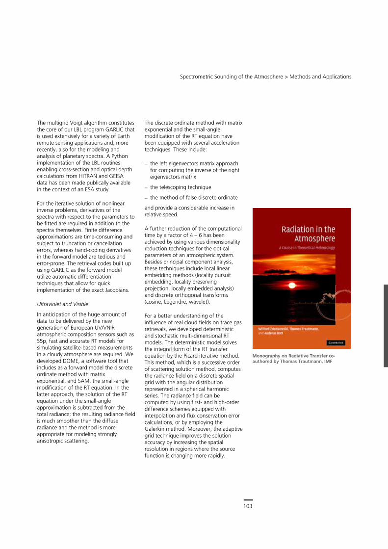
103
Central Services
Remote Sensing Technology Institute (IMF) ∙ Status Report 2007 – 2013
102
Radiative Transfer
Inverse problems in atmospheric remote sensing are frequently solved by nonlinear optimization where forward models play a central role. Modeling the radiative transfer (RT) through the atmosphere along with the instrument response and the performance of the model has a crucial impact on the success of the retrieval. The accuracy of the model is decisive for the quality of the retrieved atmospheric state parameters, however, approximations are mandatory to speed up the code especially for operational level 1-2 processing where millions of spectra have to be analyzed.
The challenges for RT modeling depend on the spectral region of interest. In the UV band multiple scattering of radiation requires the solution of an integro-differential equation, whereas in the
microwave and IR bands molecular absorption has to be evaluated using time consuming line-by-line (LBL) models. An example for an IR LBL radiative transfer with multiple scattering is outlined later in the section on exoplanets.
Infrared and Microwave
In the infrared and microwave range, LBL models are essential tools for the analysis of high resolution spectra, and are mandatory for generating and verifying fast parameterized RT models. They are computationally demanding because the combined effect of collisional and Doppler broadening described by the Voigt profile has no analytical expression. Dozens of algorithms have been developed in the past, usually exploiting different approximations for different regimes of the function arguments. However, this conditional evaluation makes code optimization difficult or impossible, so we developed a new algorithm combining two rational approximations for small and large argument values.
Even with a highly optimized Voigt function algorithm, the large number of function evaluations required for high resolution RT modeling necessitates further optimization, and we have further accelerated our codes using a multigrid approach where the function is evaluated on a dense grid only near the line center and coarser grids are used elsewhere. Using three grids increased the speed by about two orders of magnitude for typical IR/microwave applications.
In the last decade novel computing architectures have gained increasing attention and we have investigated field programmable gate arrays to accelerate LBL modeling. First tests with a version currently under development show a speed-up of almost two orders of magnitude compared to conventional CPUs.
Computational gain, i.e. ratio of execution time of the three-grid algorithm for evaluation of molecular cross-sections in the microwave spectral regime. The pressure range corresponds to altitudes up to 100 km. Because spectral lines become narrower with increasing altitude, the computational savings are especially important for small pressures.
Spectrometric Sounding of the Atmosphere > Methods and Applications
103
The multigrid Voigt algorithm constitutes the core of our LBL program GARLIC that is used extensively for a variety of Earth remote sensing applications and, more recently, also for the modeling and analysis of planetary spectra. A Python implementation of the LBL routines enabling cross-section and optical depth calculations from HITRAN and GEISA data has been made publically available in the context of an ESA study.
For the iterative solution of nonlinear inverse problems, derivatives of the spectra with respect to the parameters to be fitted are required in addition to the spectra themselves. Finite difference approximations are time-consuming and subject to truncation or cancellation errors, whereas hand-coding derivatives in the forward model are tedious and error-prone. The retrieval codes built up using GARLIC as the forward model utilize automatic differentiation techniques that allow for quick implementation of the exact Jacobians.
Ultraviolet and Visible
In anticipation of the huge amount of data to be delivered by the new generation of European UV/VNIR atmospheric composition sensors such as S5p, fast and accurate RT models for simulating satellite-based measurements in a cloudy atmosphere are required. We developed DOME, a software tool that includes as a forward model the discrete ordinate method with matrix exponential, and SAM, the small-angle modification of the RT equation. In the latter approach, the solution of the RT equation under the small-angle approximation is subtracted from the total radiance; the resulting radiance field is much smoother than the diffuse radiance and the method is more appropriate for modeling strongly anisotropic scattering.
The discrete ordinate method with matrix exponential and the small-angle modification of the RT equation have been equipped with several acceleration techniques. These include:
the left eigenvectors matrix approach for computing the inverse of the right eigenvectors matrix
the telescoping technique
the method of false discrete ordinate
and provide a considerable increase in relative speed.
A further reduction of the computational time by a factor of 4 – 6 has been achieved by using various dimensionality reduction techniques for the optical parameters of an atmospheric system. Besides principal component analysis, these techniques include local linear embedding methods (locality pursuit embedding, locality preserving projection, locally embedded analysis) and discrete orthogonal transforms (cosine, Legendre, wavelet).
For a better understanding of the influence of real cloud fields on trace gas retrievals, we developed deterministic and stochastic multi-dimensional RT models. The deterministic model solves the integral form of the RT transfer equation by the Picard iterative method. This method, which is a successive order of scattering solution method, computes the radiance field on a discrete spatial grid with the angular distribution represented in a spherical harmonic series. The radiance field can be computed by using first- and high-order difference schemes equipped with interpolation and flux conservation error calculations, or by employing the Galerkin method. Moreover, the adaptive grid technique improves the solution accuracy by increasing the spatial resolution in regions where the source function is changing more rapidly.
Monography on Radiative Transfer co-authored by Thomas Trautmann, IMF
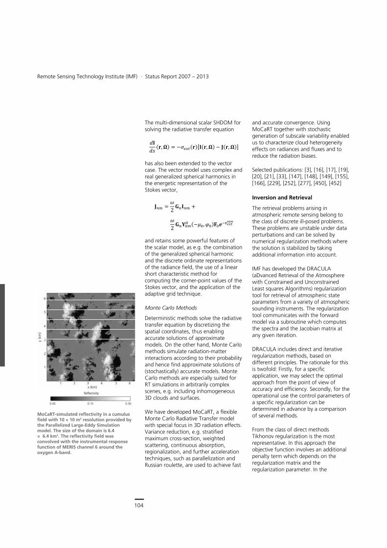
104
Earth Observation Center
Remote Sensing Technology Institute (IMF) ∙ Status Report 2007 – 2013
104
The multi-dimensional scalar SHDOM for solving the radiative transfer equation
���� ��� �� � ������������� �� � ���� ���
has also been extended to the vector case. The vector model uses complex and real generalized spherical harmonics in the energetic representation of the Stokes vector,
��� � �2 ����� �
�2 �����
� ����� ��������������
and retains some powerful features of the scalar model, as e.g. the combination of the generalized spherical harmonic and the discrete ordinate representations of the radiance field, the use of a linear short characteristic method for computing the corner-point values of the Stokes vector, and the application of the adaptive grid technique.
Monte Carlo Methods
Deterministic methods solve the radiative transfer equation by discretizing the spatial coordinates, thus enabling accurate solutions of approximate models. On the other hand, Monte Carlo methods simulate radiation-matter interactions according to their probability and hence find approximate solutions of (stochastically) accurate models. Monte Carlo methods are especially suited for RT simulations in arbitrarily complex scenes, e.g. including inhomogeneous 3D clouds and surfaces.
We have developed MoCaRT, a exible Monte Carlo Radiative Transfer model with special focus in 3D radiation effects. Variance reduction, e.g. stratied maximum cross-section, weighted scattering, continuous absorption, regionalization, and further acceleration techniques, such as parallelization and Russian roulette, are used to achieve fast
and accurate convergence. Using MoCaRT together with stochastic generation of subscale variability enabled us to characterize cloud heterogeneity effects on radiances and fluxes and to reduce the radiation biases.
Selected publications: [3], [16], [17], [19], [20], [21], [33], [147], [148], [149], [155], [166], [229], [252], [277], [450], [452]
Inversion and Retrieval
The retrieval problems arising in atmospheric remote sensing belong to the class of discrete ill-posed problems. These problems are unstable under data perturbations and can be solved by numerical regularization methods where the solution is stabilized by taking additional information into account.
IMF has developed the DRACULA (aDvanced Retrieval of the Atmosphere with Constrained and Unconstrained Least squares Algorithms) regularization tool for retrieval of atmospheric state parameters from a variety of atmospheric sounding instruments. The regularization tool communicates with the forward model via a subroutine which computes the spectra and the Jacobian matrix at any given iteration.
DRACULA includes direct and iterative regularization methods, based on different principles. The rationale for this is twofold: Firstly, for a specific application, we may select the optimal approach from the point of view of accuracy and efficiency. Secondly, for the operational use the control parameters of a specific regularization can be determined in advance by a comparison of several methods.
From the class of direct methods Tikhonov regularization is the most representative. In this approach the objective function involves an additional penalty term which depends on the regularization matrix and the regularization parameter. In the
MoCaRT-simulated reflectivity in a cumulus field with 10 × 10 m2 resolution provided by the Parallelized Large-Eddy Simulation model. The size of the domain is 6.4 × 6.4 km2. The reflectivity field was convolved with the instrumental response function of MERIS channel 6 around the oxygen A-band.
Spectrometric Sounding of the Atmosphere > Methods and Applications
105
DRACULA implementation of Tikhonov regularization, the regularization matrix can be chosen as the Cholesky factor of an a priori profile covariance matrix, or as discrete approximations to the first- and second-order derivative operators. An appropriate estimate of the regularization can be computed by using a priori, a posteriori and error-free parameter choice. From the second category, we mention the discrepancy principle, the error consistency method, and the unbiased predictive risk estimator method, while the third category comprises the generalized cross-validation, the maximum likelihood estimation, the quasi-optimality criterion, and the L-curve method. The efficiency of the algorithm is increased by using step-length and trust-region methods for minimizing the Tikhonov function. In these methods, the new iterate can be computed by means of several algorithms based on the singular value decomposition of the standard-form transformed Jacobian matrix, the bi-diagonalization of the Jacobian matrix, and on iterative methods using a special class of preconditioners constructed by means of the Lanczos algorithm.
In some applications, the Tikhonov function may have many local minima, and a decent method for solving the optimization problem tends to get stuck especially for severely ill-posed problems. In this case, iterative regularization methods are a good alternative. In iterative regularization methods the number of iteration steps plays the role of the regularization parameter, and the iterative process is stopped after an appropriate number of steps in order to avoid an uncontrolled expansion of the noise error. DRACULA incorporates several iterative approaches, including:
the nonlinear Landweber iteration
the iteratively regularized Gauss-Newton method
the regularizing Levenberg-Marquardt method
the Newton-CG method
asymptotic regularization methods.
These approaches are insensitive to overestimation of the regularization parameter, do not depend on a priori information, and can be applied to large-scale problems.
Additionally, the regularization tool contains special direct regularization methods such as:
the regularized total least squares method which is attractive when the Jacobian matrix is inexact,
mollifier methods, in which the generalized inverse is constructed by means of a priori information,
the maximum entropy regularization, which uses the relative or cross entropy as non-quadratic penalty terms.
DRACULA has been applied to data processing for SCIAMACHY, MIPAS, GOME, and more recently, for GOME-2 and IASI. Furthermore it is used for the analysis of observations of the balloon-borne FIR limb sounder TELIS mentioned before.
In some cases only vertical column densities rather than altitude dependent concentration profiles are needed and the complexities of regularization can be avoided. Accordingly, for analysis of SCIAMACHY SWIR nadir observations we have developed the Beer Infrared Retrieval Algorithm (BIRRA) that embraces an optimized forward model built from our GARLIC code embedded in a separable nonlinear least squares fit. It takes into account that some of the unknowns enter the forward model linearly. BIRRA is part of the operational SCIAMACHY level 1-2 processor and is used for retrieval of carbon monoxide and methane vertical column densities. Furthermore, we use BIRRA in a prototype fashion for scientific purposes, e.g. for retrieval of methane from Japan's
Monography on regularization for atmospheric inverse problems by IMF authors Adrian Doicu, Thomas Trautmann and Franz Schreier
105
Central Services
Remote Sensing Technology Institute (IMF) ∙ Status Report 2007 – 2013
104
The multi-dimensional scalar SHDOM for solving the radiative transfer equation
���� ��� �� � ������������� �� � ���� ���
has also been extended to the vector case. The vector model uses complex and real generalized spherical harmonics in the energetic representation of the Stokes vector,
��� � �2 ����� �
�2 �����
� ����� ��������������
and retains some powerful features of the scalar model, as e.g. the combination of the generalized spherical harmonic and the discrete ordinate representations of the radiance field, the use of a linear short characteristic method for computing the corner-point values of the Stokes vector, and the application of the adaptive grid technique.
Monte Carlo Methods
Deterministic methods solve the radiative transfer equation by discretizing the spatial coordinates, thus enabling accurate solutions of approximate models. On the other hand, Monte Carlo methods simulate radiation-matter interactions according to their probability and hence find approximate solutions of (stochastically) accurate models. Monte Carlo methods are especially suited for RT simulations in arbitrarily complex scenes, e.g. including inhomogeneous 3D clouds and surfaces.
We have developed MoCaRT, a exible Monte Carlo Radiative Transfer model with special focus in 3D radiation effects. Variance reduction, e.g. stratied maximum cross-section, weighted scattering, continuous absorption, regionalization, and further acceleration techniques, such as parallelization and Russian roulette, are used to achieve fast
and accurate convergence. Using MoCaRT together with stochastic generation of subscale variability enabled us to characterize cloud heterogeneity effects on radiances and fluxes and to reduce the radiation biases.
Selected publications: [3], [16], [17], [19], [20], [21], [33], [147], [148], [149], [155], [166], [229], [252], [277], [450], [452]
Inversion and Retrieval
The retrieval problems arising in atmospheric remote sensing belong to the class of discrete ill-posed problems. These problems are unstable under data perturbations and can be solved by numerical regularization methods where the solution is stabilized by taking additional information into account.
IMF has developed the DRACULA (aDvanced Retrieval of the Atmosphere with Constrained and Unconstrained Least squares Algorithms) regularization tool for retrieval of atmospheric state parameters from a variety of atmospheric sounding instruments. The regularization tool communicates with the forward model via a subroutine which computes the spectra and the Jacobian matrix at any given iteration.
DRACULA includes direct and iterative regularization methods, based on different principles. The rationale for this is twofold: Firstly, for a specific application, we may select the optimal approach from the point of view of accuracy and efficiency. Secondly, for the operational use the control parameters of a specific regularization can be determined in advance by a comparison of several methods.
From the class of direct methods Tikhonov regularization is the most representative. In this approach the objective function involves an additional penalty term which depends on the regularization matrix and the regularization parameter. In the
MoCaRT-simulated reflectivity in a cumulus field with 10 × 10 m2 resolution provided by the Parallelized Large-Eddy Simulation model. The size of the domain is 6.4 × 6.4 km2. The reflectivity field was convolved with the instrumental response function of MERIS channel 6 around the oxygen A-band.
Spectrometric Sounding of the Atmosphere > Methods and Applications
105
DRACULA implementation of Tikhonov regularization, the regularization matrix can be chosen as the Cholesky factor of an a priori profile covariance matrix, or as discrete approximations to the first- and second-order derivative operators. An appropriate estimate of the regularization can be computed by using a priori, a posteriori and error-free parameter choice. From the second category, we mention the discrepancy principle, the error consistency method, and the unbiased predictive risk estimator method, while the third category comprises the generalized cross-validation, the maximum likelihood estimation, the quasi-optimality criterion, and the L-curve method. The efficiency of the algorithm is increased by using step-length and trust-region methods for minimizing the Tikhonov function. In these methods, the new iterate can be computed by means of several algorithms based on the singular value decomposition of the standard-form transformed Jacobian matrix, the bi-diagonalization of the Jacobian matrix, and on iterative methods using a special class of preconditioners constructed by means of the Lanczos algorithm.
In some applications, the Tikhonov function may have many local minima, and a decent method for solving the optimization problem tends to get stuck especially for severely ill-posed problems. In this case, iterative regularization methods are a good alternative. In iterative regularization methods the number of iteration steps plays the role of the regularization parameter, and the iterative process is stopped after an appropriate number of steps in order to avoid an uncontrolled expansion of the noise error. DRACULA incorporates several iterative approaches, including:
the nonlinear Landweber iteration
the iteratively regularized Gauss-Newton method
the regularizing Levenberg-Marquardt method
the Newton-CG method
asymptotic regularization methods.
These approaches are insensitive to overestimation of the regularization parameter, do not depend on a priori information, and can be applied to large-scale problems.
Additionally, the regularization tool contains special direct regularization methods such as:
the regularized total least squares method which is attractive when the Jacobian matrix is inexact,
mollifier methods, in which the generalized inverse is constructed by means of a priori information,
the maximum entropy regularization, which uses the relative or cross entropy as non-quadratic penalty terms.
DRACULA has been applied to data processing for SCIAMACHY, MIPAS, GOME, and more recently, for GOME-2 and IASI. Furthermore it is used for the analysis of observations of the balloon-borne FIR limb sounder TELIS mentioned before.
In some cases only vertical column densities rather than altitude dependent concentration profiles are needed and the complexities of regularization can be avoided. Accordingly, for analysis of SCIAMACHY SWIR nadir observations we have developed the Beer Infrared Retrieval Algorithm (BIRRA) that embraces an optimized forward model built from our GARLIC code embedded in a separable nonlinear least squares fit. It takes into account that some of the unknowns enter the forward model linearly. BIRRA is part of the operational SCIAMACHY level 1-2 processor and is used for retrieval of carbon monoxide and methane vertical column densities. Furthermore, we use BIRRA in a prototype fashion for scientific purposes, e.g. for retrieval of methane from Japan's
Monography on regularization for atmospheric inverse problems by IMF authors Adrian Doicu, Thomas Trautmann and Franz Schreier
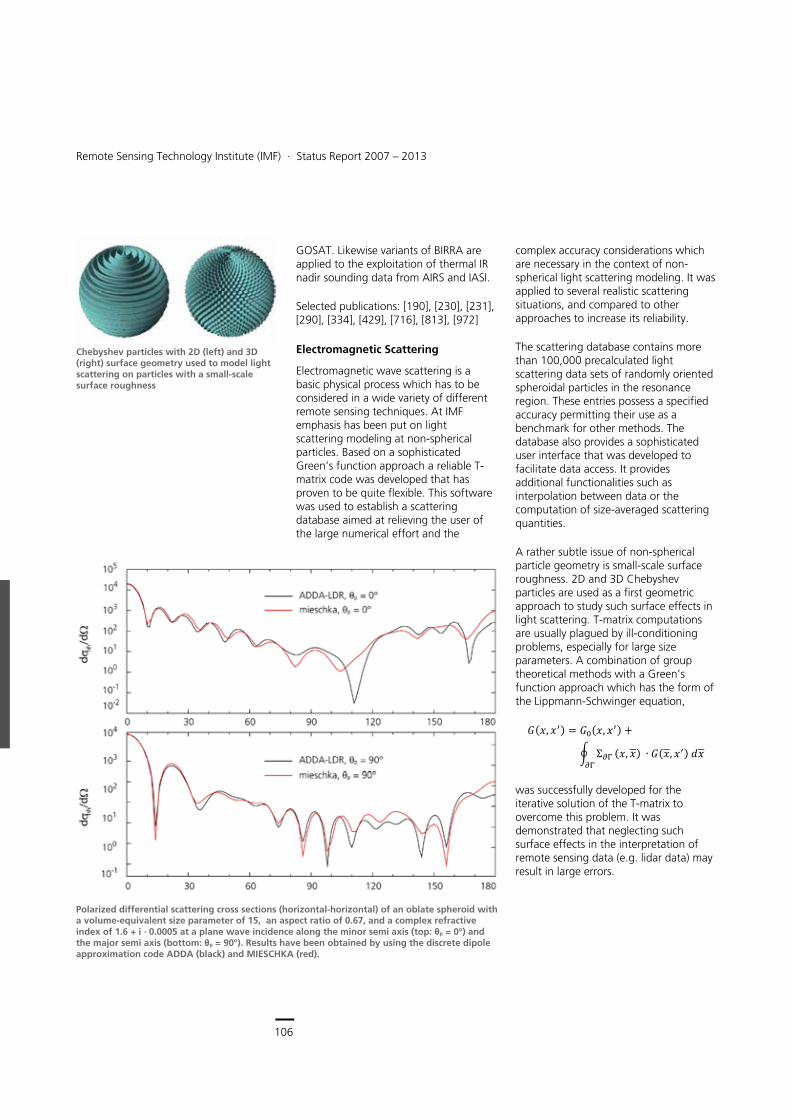
106
Earth Observation Center
Remote Sensing Technology Institute (IMF) ∙ Status Report 2007 – 2013
106
Polarized differential scattering cross sections (horizontal-horizontal) of an oblate spheroid with a volume-equivalent size parameter of 15, an aspect ratio of 0.67, and a complex refractive index of 1.6 + i ∙ 0.0005 at a plane wave incidence along the minor semi axis (top: θp = 0°) and the major semi axis (bottom: θp = 90°). Results have been obtained by using the discrete dipole approximation code ADDA (black) and MIESCHKA (red).
GOSAT. Likewise variants of BIRRA are applied to the exploitation of thermal IR nadir sounding data from AIRS and IASI.
Selected publications: [190], [230], [231], [290], [334], [429], [716], [813], [972]
Electromagnetic Scattering
Electromagnetic wave scattering is a basic physical process which has to be considered in a wide variety of different remote sensing techniques. At IMF emphasis has been put on light scattering modeling at non-spherical particles. Based on a sophisticated Green’s function approach a reliable T-matrix code was developed that has proven to be quite flexible. This software was used to establish a scattering database aimed at relieving the user of the large numerical effort and the
complex accuracy considerations which are necessary in the context of non-spherical light scattering modeling. It was applied to several realistic scattering situations, and compared to other approaches to increase its reliability.
The scattering database contains more than 100,000 precalculated light scattering data sets of randomly oriented spheroidal particles in the resonance region. These entries possess a specified accuracy permitting their use as a benchmark for other methods. The database also provides a sophisticated user interface that was developed to facilitate data access. It provides additional functionalities such as interpolation between data or the computation of size-averaged scattering quantities.
A rather subtle issue of non-spherical particle geometry is small-scale surface roughness. 2D and 3D Chebyshev particles are used as a first geometric approach to study such surface effects in light scattering. T-matrix computations are usually plagued by ill-conditioning problems, especially for large size parameters. A combination of group theoretical methods with a Green’s function approach which has the form of the Lippmann-Schwinger equation,
���� ��� � ����� ��� �� ��
����� �� � ���� �����
was successfully developed for the iterative solution of the T-matrix to overcome this problem. It was demonstrated that neglecting such surface effects in the interpretation of remote sensing data (e.g. lidar data) may result in large errors.
Chebyshev particles with 2D (left) and 3D (right) surface geometry used to model light scattering on particles with a small-scale surface roughness
Spectrometric Sounding of the Atmosphere > Methods and Applications
107
Together with colleagues from the University of Novosibirsk (Russia) and SMHI (Sweden), calculations for different particle geometries have been performed to test the range of applicability and reliability of our own T-matrix program as well as other publicly available scattering programs. The programs under consideration were either different implementations of T-matrix methods or of the discrete dipole approximation. We could show that the fulfillment of the reciprocity condition can be used with benefit to estimate the accuracy of the scattering results obtained by the different programs. It turned out that reciprocity is highly sensitive to numerical inaccuracies, and that it is a much stronger criterion than energy conservation. We further demonstrated that the widespread discrete dipole approximations are more intricate due to the complex interplay between the different polarizability models needed in these approximations and the considered scattering configuration. Simply relying on the latter methods may lead to highly erroneous results, especially if higher size parameters and higher refractive indices of the particles are considered.
Selected publications: [106], [144], [250], [430]
Spectroscopic References
The retrieval of atmospheric parameters from remote sensing data requires quantitative knowledge of molecular absorption features for radiative transfer calculations. Therefore, a number of databases (HITRAN, GEISA, etc.) exist, providing the necessary information such as line parameters or absorption cross-sections. These databases must undergo permanent update, either for improving their completeness and accuracy or because new missions have additional needs.
IMF operates a spectroscopic laboratory for contributing parameters with defined uncertainties to spectroscopic databases
covering the range from UV to millimeter wavelengths. One of the key topics of our laboratory work concerns the quality of the data. Numerous sources contribute to it. Their characterization requires expertise in many fields such as instrumentation, preparation of gaseous samples and data analysis procedures. Our laboratory belongs to the few world-wide capable of providing spectroscopic data with well-defined error bars. Our team is part of the HITRAN scientific advisory committee.
The laboratory spectroscopy facility was utilizing a commercial high resolution Fourier transform spectrometer (Bruker IFS 120HR, spectral range from NIR to millimeter wave) until 2009, which meanwhile has been replaced by the successor model IFS 125HR (UV to millimeter wave). When laboratory work is aiming at highest quality particular attention has to be paid to the absorption cells. In our laboratory four cells are available, all designed by ourselves. They cover the temperature range of 190 – 1,000 K and absorption path lengths from 0.16 m to 120 m. One cell is equipped with two window pairs for measuring different spectral regions such as UV/MIR or MIR/FIR for the same gas sample. A flow system and gas handling system allows synthesizing all relevant atmospheric constituents. An 800 liter mixing chamber and calibrated pressure and temperature sensors permit generating defined gas/air mixtures.
Software for data processing has been developed for:
correction of instrument errors including detector nonlinearity, channeling and sample/instrument thermal emission
line fitting building on more than 10 years of experience with the FitMAS code
calculation of line positions, line strengths, pressure broadening and
Monography on Electromagnetic scattering on nonspherical particles by Tom Rother, IMF
IMF-developed absorption cell for the Bruker IFS 125HR sample compartment with an absorption path of 22 cm, applicable to a temperature range 190 – 350 K. The cell body is a double-jacketed glass tube. The windows are mounted on stainless steel flanges coated with PFA. The window openings with baffles can be seen.
107
Central Services
Remote Sensing Technology Institute (IMF) ∙ Status Report 2007 – 2013
106
Polarized differential scattering cross sections (horizontal-horizontal) of an oblate spheroid with a volume-equivalent size parameter of 15, an aspect ratio of 0.67, and a complex refractive index of 1.6 + i ∙ 0.0005 at a plane wave incidence along the minor semi axis (top: θp = 0°) and the major semi axis (bottom: θp = 90°). Results have been obtained by using the discrete dipole approximation code ADDA (black) and MIESCHKA (red).
GOSAT. Likewise variants of BIRRA are applied to the exploitation of thermal IR nadir sounding data from AIRS and IASI.
Selected publications: [190], [230], [231], [290], [334], [429], [716], [813], [972]
Electromagnetic Scattering
Electromagnetic wave scattering is a basic physical process which has to be considered in a wide variety of different remote sensing techniques. At IMF emphasis has been put on light scattering modeling at non-spherical particles. Based on a sophisticated Green’s function approach a reliable T-matrix code was developed that has proven to be quite flexible. This software was used to establish a scattering database aimed at relieving the user of the large numerical effort and the
complex accuracy considerations which are necessary in the context of non-spherical light scattering modeling. It was applied to several realistic scattering situations, and compared to other approaches to increase its reliability.
The scattering database contains more than 100,000 precalculated light scattering data sets of randomly oriented spheroidal particles in the resonance region. These entries possess a specified accuracy permitting their use as a benchmark for other methods. The database also provides a sophisticated user interface that was developed to facilitate data access. It provides additional functionalities such as interpolation between data or the computation of size-averaged scattering quantities.
A rather subtle issue of non-spherical particle geometry is small-scale surface roughness. 2D and 3D Chebyshev particles are used as a first geometric approach to study such surface effects in light scattering. T-matrix computations are usually plagued by ill-conditioning problems, especially for large size parameters. A combination of group theoretical methods with a Green’s function approach which has the form of the Lippmann-Schwinger equation,
���� ��� � ����� ��� �� ��
����� �� � ���� �����
was successfully developed for the iterative solution of the T-matrix to overcome this problem. It was demonstrated that neglecting such surface effects in the interpretation of remote sensing data (e.g. lidar data) may result in large errors.
Chebyshev particles with 2D (left) and 3D (right) surface geometry used to model light scattering on particles with a small-scale surface roughness
Spectrometric Sounding of the Atmosphere > Methods and Applications
107
Together with colleagues from the University of Novosibirsk (Russia) and SMHI (Sweden), calculations for different particle geometries have been performed to test the range of applicability and reliability of our own T-matrix program as well as other publicly available scattering programs. The programs under consideration were either different implementations of T-matrix methods or of the discrete dipole approximation. We could show that the fulfillment of the reciprocity condition can be used with benefit to estimate the accuracy of the scattering results obtained by the different programs. It turned out that reciprocity is highly sensitive to numerical inaccuracies, and that it is a much stronger criterion than energy conservation. We further demonstrated that the widespread discrete dipole approximations are more intricate due to the complex interplay between the different polarizability models needed in these approximations and the considered scattering configuration. Simply relying on the latter methods may lead to highly erroneous results, especially if higher size parameters and higher refractive indices of the particles are considered.
Selected publications: [106], [144], [250], [430]
Spectroscopic References
The retrieval of atmospheric parameters from remote sensing data requires quantitative knowledge of molecular absorption features for radiative transfer calculations. Therefore, a number of databases (HITRAN, GEISA, etc.) exist, providing the necessary information such as line parameters or absorption cross-sections. These databases must undergo permanent update, either for improving their completeness and accuracy or because new missions have additional needs.
IMF operates a spectroscopic laboratory for contributing parameters with defined uncertainties to spectroscopic databases
covering the range from UV to millimeter wavelengths. One of the key topics of our laboratory work concerns the quality of the data. Numerous sources contribute to it. Their characterization requires expertise in many fields such as instrumentation, preparation of gaseous samples and data analysis procedures. Our laboratory belongs to the few world-wide capable of providing spectroscopic data with well-defined error bars. Our team is part of the HITRAN scientific advisory committee.
The laboratory spectroscopy facility was utilizing a commercial high resolution Fourier transform spectrometer (Bruker IFS 120HR, spectral range from NIR to millimeter wave) until 2009, which meanwhile has been replaced by the successor model IFS 125HR (UV to millimeter wave). When laboratory work is aiming at highest quality particular attention has to be paid to the absorption cells. In our laboratory four cells are available, all designed by ourselves. They cover the temperature range of 190 – 1,000 K and absorption path lengths from 0.16 m to 120 m. One cell is equipped with two window pairs for measuring different spectral regions such as UV/MIR or MIR/FIR for the same gas sample. A flow system and gas handling system allows synthesizing all relevant atmospheric constituents. An 800 liter mixing chamber and calibrated pressure and temperature sensors permit generating defined gas/air mixtures.
Software for data processing has been developed for:
correction of instrument errors including detector nonlinearity, channeling and sample/instrument thermal emission
line fitting building on more than 10 years of experience with the FitMAS code
calculation of line positions, line strengths, pressure broadening and
Monography on Electromagnetic scattering on nonspherical particles by Tom Rother, IMF
IMF-developed absorption cell for the Bruker IFS 125HR sample compartment with an absorption path of 22 cm, applicable to a temperature range 190 – 350 K. The cell body is a double-jacketed glass tube. The windows are mounted on stainless steel flanges coated with PFA. The window openings with baffles can be seen.
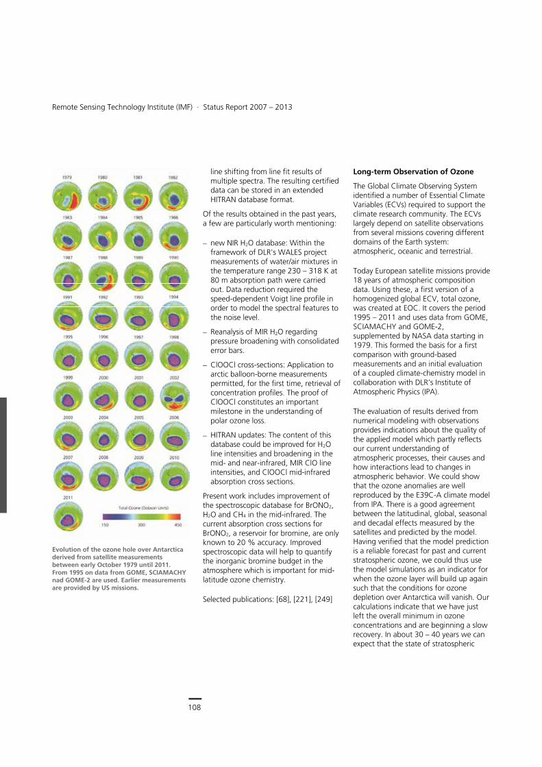
108
Earth Observation Center
Remote Sensing Technology Institute (IMF) ∙ Status Report 2007 – 2013
108
line shifting from line fit results of multiple spectra. The resulting certified data can be stored in an extended HITRAN database format.
Of the results obtained in the past years, a few are particularly worth mentioning:
new NIR H2O database: Within the framework of DLR's WALES project measurements of water/air mixtures in the temperature range 230 – 318 K at 80 m absorption path were carried out. Data reduction required the speed-dependent Voigt line profile in order to model the spectral features to the noise level.
Reanalysis of MIR H2O regarding pressure broadening with consolidated error bars.
ClOOCl cross-sections: Application to arctic balloon-borne measurements permitted, for the first time, retrieval of concentration profiles. The proof of ClOOCl constitutes an important milestone in the understanding of polar ozone loss.
HITRAN updates: The content of this database could be improved for H2O line intensities and broadening in the mid- and near-infrared, MIR ClO line intensities, and ClOOCl mid-infrared absorption cross sections.
Present work includes improvement of the spectroscopic database for BrONO2, H2O and CH4 in the mid-infrared. The current absorption cross sections for BrONO2, a reservoir for bromine, are only known to 20 % accuracy. Improved spectroscopic data will help to quantify the inorganic bromine budget in the atmosphere which is important for mid-latitude ozone chemistry.
Selected publications: [68], [221], [249]
Long-term Observation of Ozone
The Global Climate Observing System identified a number of Essential Climate Variables (ECVs) required to support the climate research community. The ECVs largely depend on satellite observations from several missions covering different domains of the Earth system: atmospheric, oceanic and terrestrial.
Today European satellite missions provide 18 years of atmospheric composition data. Using these, a first version of a homogenized global ECV, total ozone, was created at EOC. It covers the period 1995 – 2011 and uses data from GOME, SCIAMACHY and GOME-2, supplemented by NASA data starting in 1979. This formed the basis for a first comparison with ground-based measurements and an initial evaluation of a coupled climate-chemistry model in collaboration with DLR’s Institute of Atmospheric Physics (IPA).
The evaluation of results derived from numerical modeling with observations provides indications about the quality of the applied model which partly reflects our current understanding of atmospheric processes, their causes and how interactions lead to changes in atmospheric behavior. We could show that the ozone anomalies are well reproduced by the E39C-A climate model from IPA. There is a good agreement between the latitudinal, global, seasonal and decadal effects measured by the satellites and predicted by the model. Having verified that the model prediction is a reliable forecast for past and current stratospheric ozone, we could thus use the model simulations as an indicator for when the ozone layer will build up again such that the conditions for ozone depletion over Antarctica will vanish. Our calculations indicate that we have just left the overall minimum in ozone concentrations and are beginning a slow recovery. In about 30 – 40 years we can expect that the state of stratospheric
Evolution of the ozone hole over Antarctica derived from satellite measurements between early October 1979 until 2011. From 1995 on data from GOME, SCIAMACHY nad GOME-2 are used. Earlier measurements are provided by US missions.
Spectrometric Sounding of the Atmosphere > Methods and Applications
109
ozone will be similar to the status assumed for the early 20th century.
This work was awarded the DLR’s Science Prize in 2011.
In the ESA ozone CCI project we are responsible for the generation of the total ozone ECV and system engineering tasks. The second version of the total ozone ECV using improved retrieval algorithms reaches accuracies at the percent level per decade.
Selected publications: [241], [436], [444]
Volcanic Sulphur Dioxide from Space
Spaceborne atmospheric sensors like GOME-2 on the MetOp satellites enable the detection of the emissions of volcanic gases such as sulphur dioxide (SO2) and aerosols, and hence the monitoring of volcanic activity and eruptions on a global scale. This is of great importance since volcanic eruptions are a major natural hazard, not only to the local environment and populations near large volcanoes but also to aviation.
The retrieval of volcanic SO2 emissions using the GOME-2 instrument is performed by IMF within the framework of EUMETSAT's Satellite Application Facility. The high spectral resolution of the instrument allows the retrieval of the total column density of SO2 from solar backscatter measurements in the UV wavelength region (around 320 nm) by applying the DOAS method.
We have studied several major volcanic eruptions that deposited large amounts of volcanic gases and ash into the atmosphere. Three eruptions of the Kasatochi volcano in August 2008 in Alaska transported volcanic SO2 and ash particles to a height of at least 10 km, where they became a major hazard to aviation. GOME-2 measured very large SO2 column amounts of about 150 DU the first day after the eruption. Although the Kasatochi eruption was rather strong,
the ejected ash concentrations were low, making it difficult to track the volcanic plume by ash retrieval techniques. However, our studies demonstrated in this case that volcanic cloud tracking is also possible using SO2 measurements.
The Eyjafjallayökull eruption in southern Iceland from April to May 2011 had a severe impact on global mobility. Prevailing winds carried volcanic ash to the European continent and caused European-wide disruption to aviation for several days. The GOME-2 near-realtime retrieval performed at IMF allowed continuous monitoring of the volcanic plume. We also tested a new algorithm to retrieve both the total SO2 column density as well as the height of the volcanic plume. Plume height is essential information for aviation safety and forecasting of the trajectory of the volcanic cloud. The retrieved SO2 plume heights from the Eyjafjallayökull eruption estimated from GOME-2 observations on May 5 ranged from 8 – 13 km, in good agreement to within 1 – 3 km of visual observations, radar data and modeling
SO2 distribution over the Atlantic Ocean after the eruption of the Copahue volcano in Chile (red triangle) on 22 December 2012. The image is an eight days composite of GOME-2 SO2 retrievals.
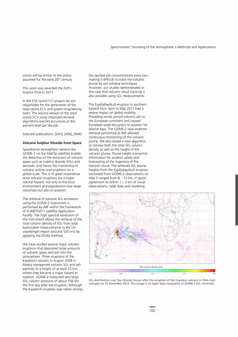
109
Central Services
Remote Sensing Technology Institute (IMF) ∙ Status Report 2007 – 2013
108
line shifting from line fit results of multiple spectra. The resulting certified data can be stored in an extended HITRAN database format.
Of the results obtained in the past years, a few are particularly worth mentioning:
new NIR H2O database: Within the framework of DLR's WALES project measurements of water/air mixtures in the temperature range 230 – 318 K at 80 m absorption path were carried out. Data reduction required the speed-dependent Voigt line profile in order to model the spectral features to the noise level.
Reanalysis of MIR H2O regarding pressure broadening with consolidated error bars.
ClOOCl cross-sections: Application to arctic balloon-borne measurements permitted, for the first time, retrieval of concentration profiles. The proof of ClOOCl constitutes an important milestone in the understanding of polar ozone loss.
HITRAN updates: The content of this database could be improved for H2O line intensities and broadening in the mid- and near-infrared, MIR ClO line intensities, and ClOOCl mid-infrared absorption cross sections.
Present work includes improvement of the spectroscopic database for BrONO2, H2O and CH4 in the mid-infrared. The current absorption cross sections for BrONO2, a reservoir for bromine, are only known to 20 % accuracy. Improved spectroscopic data will help to quantify the inorganic bromine budget in the atmosphere which is important for mid-latitude ozone chemistry.
Selected publications: [68], [221], [249]
Long-term Observation of Ozone
The Global Climate Observing System identified a number of Essential Climate Variables (ECVs) required to support the climate research community. The ECVs largely depend on satellite observations from several missions covering different domains of the Earth system: atmospheric, oceanic and terrestrial.
Today European satellite missions provide 18 years of atmospheric composition data. Using these, a first version of a homogenized global ECV, total ozone, was created at EOC. It covers the period 1995 – 2011 and uses data from GOME, SCIAMACHY and GOME-2, supplemented by NASA data starting in 1979. This formed the basis for a first comparison with ground-based measurements and an initial evaluation of a coupled climate-chemistry model in collaboration with DLR’s Institute of Atmospheric Physics (IPA).
The evaluation of results derived from numerical modeling with observations provides indications about the quality of the applied model which partly reflects our current understanding of atmospheric processes, their causes and how interactions lead to changes in atmospheric behavior. We could show that the ozone anomalies are well reproduced by the E39C-A climate model from IPA. There is a good agreement between the latitudinal, global, seasonal and decadal effects measured by the satellites and predicted by the model. Having verified that the model prediction is a reliable forecast for past and current stratospheric ozone, we could thus use the model simulations as an indicator for when the ozone layer will build up again such that the conditions for ozone depletion over Antarctica will vanish. Our calculations indicate that we have just left the overall minimum in ozone concentrations and are beginning a slow recovery. In about 30 – 40 years we can expect that the state of stratospheric
Evolution of the ozone hole over Antarctica derived from satellite measurements between early October 1979 until 2011. From 1995 on data from GOME, SCIAMACHY nad GOME-2 are used. Earlier measurements are provided by US missions.
Spectrometric Sounding of the Atmosphere > Methods and Applications
109
ozone will be similar to the status assumed for the early 20th century.
This work was awarded the DLR’s Science Prize in 2011.
In the ESA ozone CCI project we are responsible for the generation of the total ozone ECV and system engineering tasks. The second version of the total ozone ECV using improved retrieval algorithms reaches accuracies at the percent level per decade.
Selected publications: [241], [436], [444]
Volcanic Sulphur Dioxide from Space
Spaceborne atmospheric sensors like GOME-2 on the MetOp satellites enable the detection of the emissions of volcanic gases such as sulphur dioxide (SO2) and aerosols, and hence the monitoring of volcanic activity and eruptions on a global scale. This is of great importance since volcanic eruptions are a major natural hazard, not only to the local environment and populations near large volcanoes but also to aviation.
The retrieval of volcanic SO2 emissions using the GOME-2 instrument is performed by IMF within the framework of EUMETSAT's Satellite Application Facility. The high spectral resolution of the instrument allows the retrieval of the total column density of SO2 from solar backscatter measurements in the UV wavelength region (around 320 nm) by applying the DOAS method.
We have studied several major volcanic eruptions that deposited large amounts of volcanic gases and ash into the atmosphere. Three eruptions of the Kasatochi volcano in August 2008 in Alaska transported volcanic SO2 and ash particles to a height of at least 10 km, where they became a major hazard to aviation. GOME-2 measured very large SO2 column amounts of about 150 DU the first day after the eruption. Although the Kasatochi eruption was rather strong,
the ejected ash concentrations were low, making it difficult to track the volcanic plume by ash retrieval techniques. However, our studies demonstrated in this case that volcanic cloud tracking is also possible using SO2 measurements.
The Eyjafjallayökull eruption in southern Iceland from April to May 2011 had a severe impact on global mobility. Prevailing winds carried volcanic ash to the European continent and caused European-wide disruption to aviation for several days. The GOME-2 near-realtime retrieval performed at IMF allowed continuous monitoring of the volcanic plume. We also tested a new algorithm to retrieve both the total SO2 column density as well as the height of the volcanic plume. Plume height is essential information for aviation safety and forecasting of the trajectory of the volcanic cloud. The retrieved SO2 plume heights from the Eyjafjallayökull eruption estimated from GOME-2 observations on May 5 ranged from 8 – 13 km, in good agreement to within 1 – 3 km of visual observations, radar data and modeling
SO2 distribution over the Atlantic Ocean after the eruption of the Copahue volcano in Chile (red triangle) on 22 December 2012. The image is an eight days composite of GOME-2 SO2 retrievals.
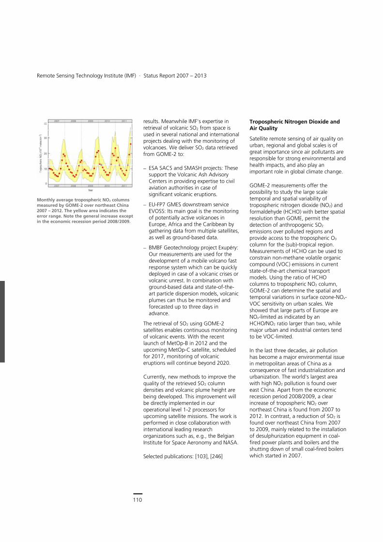
110
Earth Observation Center
Remote Sensing Technology Institute (IMF) ∙ Status Report 2007 – 2013
110
results. Meanwhile IMF's expertise in retrieval of volcanic SO2 from space is used in several national and international projects dealing with the monitoring of volcanoes. We deliver SO2 data retrieved from GOME-2 to:
ESA SACS and SMASH projects: These support the Volcanic Ash Advisory Centers in providing expertise to civil aviation authorities in case of significant volcanic eruptions.
EU-FP7 GMES downstream service EVOSS: Its main goal is the monitoring of potentially active volcanoes in Europe, Africa and the Caribbean by gathering data from multiple satellites, as well as ground-based data.
BMBF Geotechnology project Exupéry: Our measurements are used for the development of a mobile volcano fast response system which can be quickly deployed in case of a volcanic crises or volcanic unrest. In combination with ground-based data and state-of-the-art particle dispersion models, volcanic plumes can thus be monitored and forecasted up to three days in advance.
The retrieval of SO2 using GOME-2 satellites enables continuous monitoring of volcanic events. With the recent launch of MetOp-B in 2012 and the upcoming MetOp-C satellite, scheduled for 2017, monitoring of volcanic eruptions will continue beyond 2020.
Currently, new methods to improve the quality of the retrieved SO2 column densities and volcanic plume height are being developed. This improvement will be directly implemented in our operational level 1-2 processors for upcoming satellite missions. The work is performed in close collaboration with international leading research organizations such as, e.g., the Belgian Institute for Space Aeronomy and NASA.
Selected publications: [103], [246]
Tropospheric Nitrogen Dioxide and Air Quality
Satellite remote sensing of air quality on urban, regional and global scales is of great importance since air pollutants are responsible for strong environmental and health impacts, and also play an important role in global climate change.
GOME-2 measurements offer the possibility to study the large scale temporal and spatial variability of tropospheric nitrogen dioxide (NO2) and formaldehyde (HCHO) with better spatial resolution than GOME, permit the detection of anthropogenic SO2 emissions over polluted regions and provide access to the tropospheric O3 column for the (sub)-tropical region. Measurements of HCHO can be used to constrain non-methane volatile organic compound (VOC) emissions in current state-of-the-art chemical transport models. Using the ratio of HCHO columns to tropospheric NO2 column, GOME-2 can determine the spatial and temporal variations in surface ozone-NOx-VOC sensitivity on urban scales. We showed that large parts of Europe are NOx-limited as indicated by an HCHO/NO2 ratio larger than two, while major urban and industrial centers tend to be VOC-limited.
In the last three decades, air pollution has become a major environmental issue in metropolitan areas of China as a consequence of fast industrialization and urbanization. The world's largest area with high NO2 pollution is found over east China. Apart from the economic recession period 2008/2009, a clear increase of tropospheric NO2 over northeast China is found from 2007 to 2012. In contrast, a reduction of SO2 is found over northeast China from 2007 to 2009, mainly related to the installation of desulphurization equipment in coal-fired power plants and boilers and the shutting down of small coal-fired boilers which started in 2007.
Monthly average tropospheric NO2 columns measured by GOME-2 over northeast China 2007 – 2012. The yellow area indicates the error range. Note the general increase except in the economic recession period 2008/2009.
Spectrometric Sounding of the Atmosphere > Methods and Applications
111
The 2008 Olympic Games, EXPO 2010 and the 2010 Asian Games have been held in the Chinese megacities Beijing, Shanghai and Guangzhou respectively. To improve the air quality during these mega-events, many emission control measures focusing on energy, industry, transport and construction were implemented by host cities before and during the mega-events. We have assessed the effectiveness of these measures and studied the impact on pollutants over these host cities using our GOME-2 trace gas products:
Olympic period in 2008: Tropospheric NO2 has decreased by up to 38 % in Beijing
EXPO period in 2010: Tropospheric NO2 columns over Shanghai showed a significant reduction when they decreased about 8 % compared to the same period in the previous year, while the tropospheric NO2 columns increased about 20 % during the post Expo period.
IMF's expertise on satellite observations of important trace gases is also used to monitor air quality changes over China caused by the East Asian monsoon circulation within the framework of the ESA-MOST Dragon 3 project. The East Asian monsoon is a major atmospheric system affecting air mass transport, convection and precipitation and studies showed that it plays a significant role in characterizing the temporal variation and spatial patterns of air pollution over China. The project will also contribute to explore the potential impact of air pollutants over China on a regional climate change.
Selected publications: [114], [142], [170]
Average tropospheric NO2 columns measured by GOME-2 over Europe for 2007 – 2012. High concentrations are obvious above large urban and industrial areas including the Po Valley, the Benelux, South-East England and Germany's Ruhr area. Also the city-size polluted areas around Paris, Madrid and Moscow can be identified as hot spots.
Average tropospheric NO2 columns measured by GOME-2 over East Asia for 2007 – 2012
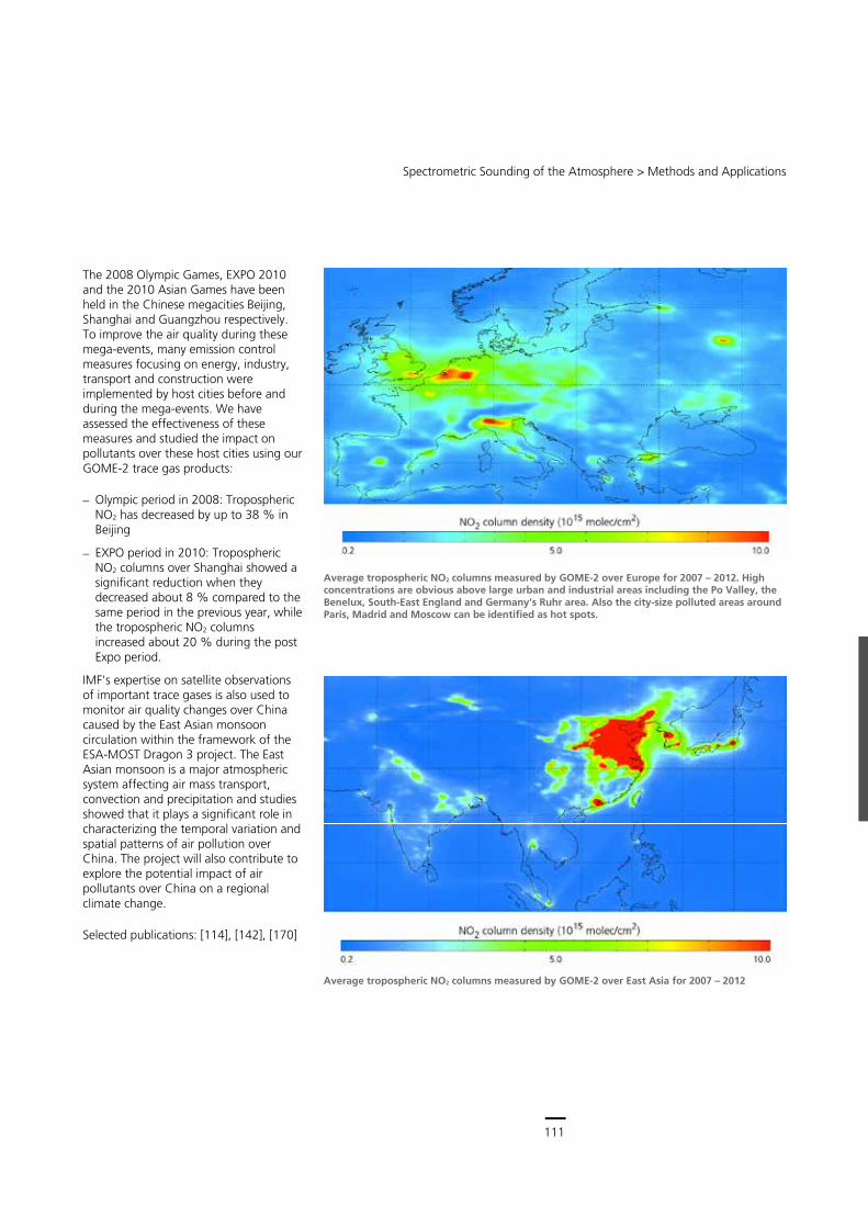
111
Central Services
Remote Sensing Technology Institute (IMF) ∙ Status Report 2007 – 2013
110
results. Meanwhile IMF's expertise in retrieval of volcanic SO2 from space is used in several national and international projects dealing with the monitoring of volcanoes. We deliver SO2 data retrieved from GOME-2 to:
ESA SACS and SMASH projects: These support the Volcanic Ash Advisory Centers in providing expertise to civil aviation authorities in case of significant volcanic eruptions.
EU-FP7 GMES downstream service EVOSS: Its main goal is the monitoring of potentially active volcanoes in Europe, Africa and the Caribbean by gathering data from multiple satellites, as well as ground-based data.
BMBF Geotechnology project Exupéry: Our measurements are used for the development of a mobile volcano fast response system which can be quickly deployed in case of a volcanic crises or volcanic unrest. In combination with ground-based data and state-of-the-art particle dispersion models, volcanic plumes can thus be monitored and forecasted up to three days in advance.
The retrieval of SO2 using GOME-2 satellites enables continuous monitoring of volcanic events. With the recent launch of MetOp-B in 2012 and the upcoming MetOp-C satellite, scheduled for 2017, monitoring of volcanic eruptions will continue beyond 2020.
Currently, new methods to improve the quality of the retrieved SO2 column densities and volcanic plume height are being developed. This improvement will be directly implemented in our operational level 1-2 processors for upcoming satellite missions. The work is performed in close collaboration with international leading research organizations such as, e.g., the Belgian Institute for Space Aeronomy and NASA.
Selected publications: [103], [246]
Tropospheric Nitrogen Dioxide and Air Quality
Satellite remote sensing of air quality on urban, regional and global scales is of great importance since air pollutants are responsible for strong environmental and health impacts, and also play an important role in global climate change.
GOME-2 measurements offer the possibility to study the large scale temporal and spatial variability of tropospheric nitrogen dioxide (NO2) and formaldehyde (HCHO) with better spatial resolution than GOME, permit the detection of anthropogenic SO2 emissions over polluted regions and provide access to the tropospheric O3 column for the (sub)-tropical region. Measurements of HCHO can be used to constrain non-methane volatile organic compound (VOC) emissions in current state-of-the-art chemical transport models. Using the ratio of HCHO columns to tropospheric NO2 column, GOME-2 can determine the spatial and temporal variations in surface ozone-NOx-VOC sensitivity on urban scales. We showed that large parts of Europe are NOx-limited as indicated by an HCHO/NO2 ratio larger than two, while major urban and industrial centers tend to be VOC-limited.
In the last three decades, air pollution has become a major environmental issue in metropolitan areas of China as a consequence of fast industrialization and urbanization. The world's largest area with high NO2 pollution is found over east China. Apart from the economic recession period 2008/2009, a clear increase of tropospheric NO2 over northeast China is found from 2007 to 2012. In contrast, a reduction of SO2 is found over northeast China from 2007 to 2009, mainly related to the installation of desulphurization equipment in coal-fired power plants and boilers and the shutting down of small coal-fired boilers which started in 2007.
Monthly average tropospheric NO2 columns measured by GOME-2 over northeast China 2007 – 2012. The yellow area indicates the error range. Note the general increase except in the economic recession period 2008/2009.
Spectrometric Sounding of the Atmosphere > Methods and Applications
111
The 2008 Olympic Games, EXPO 2010 and the 2010 Asian Games have been held in the Chinese megacities Beijing, Shanghai and Guangzhou respectively. To improve the air quality during these mega-events, many emission control measures focusing on energy, industry, transport and construction were implemented by host cities before and during the mega-events. We have assessed the effectiveness of these measures and studied the impact on pollutants over these host cities using our GOME-2 trace gas products:
Olympic period in 2008: Tropospheric NO2 has decreased by up to 38 % in Beijing
EXPO period in 2010: Tropospheric NO2 columns over Shanghai showed a significant reduction when they decreased about 8 % compared to the same period in the previous year, while the tropospheric NO2 columns increased about 20 % during the post Expo period.
IMF's expertise on satellite observations of important trace gases is also used to monitor air quality changes over China caused by the East Asian monsoon circulation within the framework of the ESA-MOST Dragon 3 project. The East Asian monsoon is a major atmospheric system affecting air mass transport, convection and precipitation and studies showed that it plays a significant role in characterizing the temporal variation and spatial patterns of air pollution over China. The project will also contribute to explore the potential impact of air pollutants over China on a regional climate change.
Selected publications: [114], [142], [170]
Average tropospheric NO2 columns measured by GOME-2 over Europe for 2007 – 2012. High concentrations are obvious above large urban and industrial areas including the Po Valley, the Benelux, South-East England and Germany's Ruhr area. Also the city-size polluted areas around Paris, Madrid and Moscow can be identified as hot spots.
Average tropospheric NO2 columns measured by GOME-2 over East Asia for 2007 – 2012
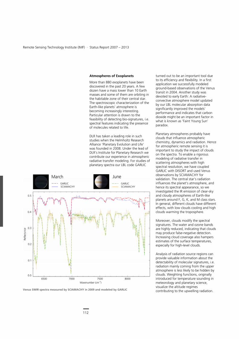
112
Earth Observation Center
Remote Sensing Technology Institute (IMF) ∙ Status Report 2007 – 2013
112
Atmospheres of Exoplanets
More than 880 exoplanets have been discovered in the past 20 years. A few dozen have a mass lower than 10 Earth masses and some of them are orbiting in the habitable zone of their central star. The spectroscopic characterization of the Earth-like planets' atmosphere is becoming increasingly interesting. Particular attention is drawn to the feasibility of detecting bio-signatures, i.e. spectral features indicating the presence of molecules related to life.
DLR has taken a leading role in such studies when the Helmholtz Research Alliance ‘Planetary Evolution and Life’ was founded in 2008. Under the lead of DLR's Institute for Planetary Research we contribute our experience in atmospheric radiative transfer modeling. For studies of planetary spectra our LBL code GARLIC
turned out to be an important tool due to its efficiency and flexibility. In a first application we successfully modeled ground-based observations of the Venus transit in 2004. Another study was devoted to early Earth: A radiative-convective atmosphere model updated by our LBL molecular absorption data significantly improved the models' performance and indicates that carbon dioxide might be an important factor in what is known as ‘Faint Young Sun’ paradox.
Planetary atmospheres probably have clouds that influence atmospheric chemistry, dynamics and radiation. Hence for atmospheric remote sensing it is important to study the impact of clouds on the spectra. To enable a rigorous modeling of radiative transfer in scattering atmospheres with high spectral resolution, we have coupled GARLIC with DISORT and used Venus observations by SCIAMACHY for validation. The central star's radiation influences the planet's atmosphere, and hence its spectral appearance, so we investigated the IR emission of clear-sky and cloudy atmospheres of Earth-like planets around F, G, K, and M class stars. In general, different clouds have different effects, with low clouds cooling and high clouds warming the troposphere.
Moreover, clouds modify the spectral signatures. The water and ozone bands are highly reduced, indicating that clouds may produce false-negative detection. Increasing cloud coverage also hampers estimates of the surface temperatures, especially for high-level clouds.
Analysis of radiation source regions can provide valuable information about the detectability of molecular signatures, i.e. radiation mainly coming from the upper atmosphere is less likely to be hidden by clouds. Weighting functions, originally introduced for temperature sounding in meteorology and planetary science, visualize the altitude regimes contributing to the upwelling radiation. Venus SWIR spectra measured by SCIAMACHY in 2009 and modeled by GARLIC
Spectrometric Sounding of the Atmosphere > Methods and Applications
113
The red dwarf Gliese 581 is one of our closest galactic neighbors at a distance of only 20 light years. It has attracted increasing attention because at least three potentially low-mass planets are orbiting this M class star, one of which, GL 581d, could be a habitable Super-Earth. Atmospheric model scenarios of GL 581d with moderate surface temperatures were used to calculate high resolution spectra with GARLIC. Assuming a transiting system, we studied the detectability of species directly or indirectly related to biology, i.e. O2, O3, CO, CO2 and H2O. The spectra indicate that without careful examination, CO2 bands could be erroneously interpreted as evidence for ozone or methane, indicating the risk of false-positive or false-negative detection of biomarkers.
In first retrieval studies we have investigated whether signatures of atmospheres indicating a habitable exoplanet can be detected in the near future. In one study GARLIC was used to create transmission and emission spectra of an Earth-like exoplanet for a large set of scenarios involving different stellar types and orbital distances. Signal-to-noise ratios for instruments planned for the ground-based European Extremely Large Telescope and the James Webb Space Telescope were calculated. We were able to show that with transmission spectroscopy, signal-to-noise ratios for some photometric filters could be high enough to detect biosignatures under favorable conditions.
Another study concluded that for spaceborne mission concepts such as DARWIN and EChO, emission spectroscopy alone may perhaps not be capable of characterizing the atmospheres of potentially habitable planets. A combination with other techniques or exploitation of multiple observations will be necessary.
Selected publications: [26], [58], [59], [60], [64], [86], [143], [161], [172], [281]
Weighting functions for a clear sky (top) and a high cloud (H2O ice) covered (bottom) planet orbiting an F-star
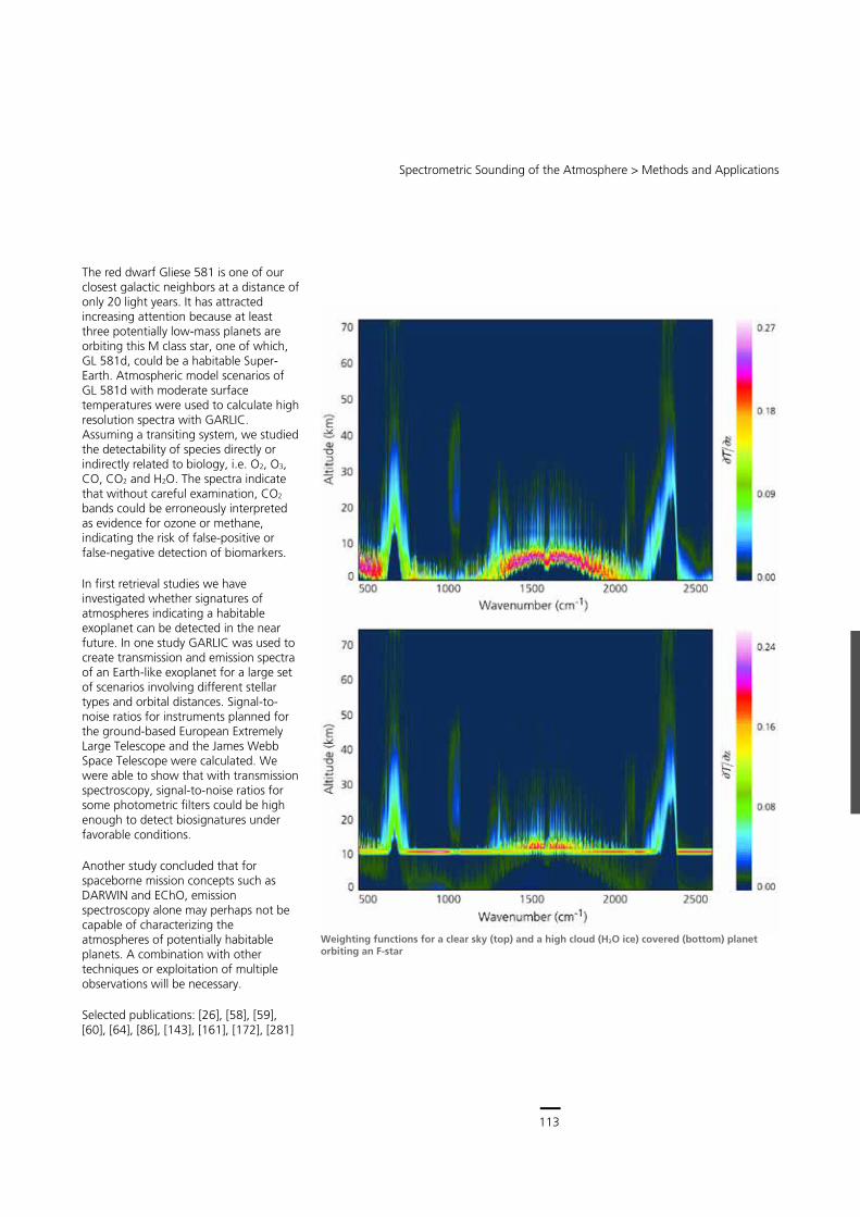
113
Central Services
Remote Sensing Technology Institute (IMF) ∙ Status Report 2007 – 2013
112
Atmospheres of Exoplanets
More than 880 exoplanets have been discovered in the past 20 years. A few dozen have a mass lower than 10 Earth masses and some of them are orbiting in the habitable zone of their central star. The spectroscopic characterization of the Earth-like planets' atmosphere is becoming increasingly interesting. Particular attention is drawn to the feasibility of detecting bio-signatures, i.e. spectral features indicating the presence of molecules related to life.
DLR has taken a leading role in such studies when the Helmholtz Research Alliance ‘Planetary Evolution and Life’ was founded in 2008. Under the lead of DLR's Institute for Planetary Research we contribute our experience in atmospheric radiative transfer modeling. For studies of planetary spectra our LBL code GARLIC
turned out to be an important tool due to its efficiency and flexibility. In a first application we successfully modeled ground-based observations of the Venus transit in 2004. Another study was devoted to early Earth: A radiative-convective atmosphere model updated by our LBL molecular absorption data significantly improved the models' performance and indicates that carbon dioxide might be an important factor in what is known as ‘Faint Young Sun’ paradox.
Planetary atmospheres probably have clouds that influence atmospheric chemistry, dynamics and radiation. Hence for atmospheric remote sensing it is important to study the impact of clouds on the spectra. To enable a rigorous modeling of radiative transfer in scattering atmospheres with high spectral resolution, we have coupled GARLIC with DISORT and used Venus observations by SCIAMACHY for validation. The central star's radiation influences the planet's atmosphere, and hence its spectral appearance, so we investigated the IR emission of clear-sky and cloudy atmospheres of Earth-like planets around F, G, K, and M class stars. In general, different clouds have different effects, with low clouds cooling and high clouds warming the troposphere.
Moreover, clouds modify the spectral signatures. The water and ozone bands are highly reduced, indicating that clouds may produce false-negative detection. Increasing cloud coverage also hampers estimates of the surface temperatures, especially for high-level clouds.
Analysis of radiation source regions can provide valuable information about the detectability of molecular signatures, i.e. radiation mainly coming from the upper atmosphere is less likely to be hidden by clouds. Weighting functions, originally introduced for temperature sounding in meteorology and planetary science, visualize the altitude regimes contributing to the upwelling radiation. Venus SWIR spectra measured by SCIAMACHY in 2009 and modeled by GARLIC
Spectrometric Sounding of the Atmosphere > Methods and Applications
113
The red dwarf Gliese 581 is one of our closest galactic neighbors at a distance of only 20 light years. It has attracted increasing attention because at least three potentially low-mass planets are orbiting this M class star, one of which, GL 581d, could be a habitable Super-Earth. Atmospheric model scenarios of GL 581d with moderate surface temperatures were used to calculate high resolution spectra with GARLIC. Assuming a transiting system, we studied the detectability of species directly or indirectly related to biology, i.e. O2, O3, CO, CO2 and H2O. The spectra indicate that without careful examination, CO2 bands could be erroneously interpreted as evidence for ozone or methane, indicating the risk of false-positive or false-negative detection of biomarkers.
In first retrieval studies we have investigated whether signatures of atmospheres indicating a habitable exoplanet can be detected in the near future. In one study GARLIC was used to create transmission and emission spectra of an Earth-like exoplanet for a large set of scenarios involving different stellar types and orbital distances. Signal-to-noise ratios for instruments planned for the ground-based European Extremely Large Telescope and the James Webb Space Telescope were calculated. We were able to show that with transmission spectroscopy, signal-to-noise ratios for some photometric filters could be high enough to detect biosignatures under favorable conditions.
Another study concluded that for spaceborne mission concepts such as DARWIN and EChO, emission spectroscopy alone may perhaps not be capable of characterizing the atmospheres of potentially habitable planets. A combination with other techniques or exploitation of multiple observations will be necessary.
Selected publications: [26], [58], [59], [60], [64], [86], [143], [161], [172], [281]
Weighting functions for a clear sky (top) and a high cloud (H2O ice) covered (bottom) planet orbiting an F-star

114
Earth Observation Center
Remote Sensing Technology Institute (IMF) ∙ Status Report 2007 – 2013
114

115
Central Services
Remote Sensing Technology Institute (IMF) ∙ Status Report 2007 – 2013
114
Bilder über Kopf- und Fußzei
115
Documentation
116
Earth Observation Center
116
This Documentation chapter covers scientific activities of IMF and LMF staff in the time period between January 1, 2007 and June 30, 2013.
Teaching and Education
Lectures at Technische Universität München (TUM)
University courses conducted by IMF/LMF staff from 2007 until summer semester 2013 (lecturers of TUM-LMF in italic typeface) Course fully given by IMF/LMF staff Course with modules contributed by IMF/LMF staff Winter semester courses are listed in the year of beginning. Therefore lectures in winter semester 2013/14 are not listed.
University Title Lecturers 2007 2008 2009 2010 2011 2012 2013
TUM Introduction to Photogrammetry, Remote Sensing & GIS
Hinz, S.
TUM Introduction to Photogrammetry, Remote Sensing & GIS
Eineder, M.
TUM Photogrammetrie Hinz, S.
TUM Photogrammetrie Butenuth, M.
TUM Photogrammetry Hinz, S.
TUM Photogrammetry Butenuth, M.
TUM Photogrammetrie und Fernerkundung III Hinz, S.
TUM Photogrammetrie und Fernerkundung IV (Übung)
Auer, S.
TUM Photogrammetrie und Fernerkundung IV (Vorlesung + Übung)
Butenuth, M. Eineder, M. Auer, S. Frey, D.
TUM Photogrammetrie und Fernerkundung IV (Vorlesung + Übung)
Auer, S. Eineder, M. Frey, D.
TUM Systems Theory and Signal Processing (Lecture + Tutorial)
Bamler, R. Auer, S. Zhu, X.
TUM Systemtheorie u. Signalverarbeitung (Vorlesung + Übung)
Bamler, R. Auer, S. Zhu, X.
TUM Introduction into Microwave and SAR Remote Sensing
Eineder, M.
TUM Applied Signal Processing Zhu, X.
Documentation
117
Documentation > Teaching and Education
University Title Lecturers 2007 2008 2009 2010 2011 2012 2013
TUM Estimation Theory (Lecture + Tutorial)
Bamler, R. Kurz, F. Lenhart, D. Szottka, I. Zhu, X. Avbelj, J.
TUM Schätztheorie (Vorlesung + Übung)
Bamler, R. Kurz, F. Lenhart, D. Szottka, I. Zhu, X. Avbelj, J.
TUM Cybernetics, Sensors and Signal Processing (Lecture + Tutorial)
Bamler, R. Zhu, X.
TUM Fernerkundung – Methoden (Vorlesung + Übung)
Hinz, S.
TUM Remote Sensing – Selected and Advanced Methods
Hinz, S.
TUM Remote Sensing – Advanced Methods Eineder, M. Trautmann, T. Adam, N. Lehner, S.
TUM Seminar Remote Sensing Butenuth, M.
TUM Seminar Remote Sensing Gernhardt, S.
TUM Seminar Remote Sensing Zhu, X.
TUM Fernerkundung und Signalverarbeitung Eineder, M. Trautmann, T. Adam, N. Lehner, S.
TUM Satellitenfernerkundung Butenuth, M. Eineder, M.
TUM Satellitenfernerkundung Auer, S. Eineder, M.
TUM Digitale Bildverarbeitung – Übung Lenhart, D.
TUM Bildverstehen I Hinz, S.
117
Central Services
116
This Documentation chapter covers scientific activities of IMF and LMF staff in the time period between January 1, 2007 and June 30, 2013.
Teaching and Education
Lectures at Technische Universität München (TUM)
University courses conducted by IMF/LMF staff from 2007 until summer semester 2013 (lecturers of TUM-LMF in italic typeface) Course fully given by IMF/LMF staff Course with modules contributed by IMF/LMF staff Winter semester courses are listed in the year of beginning. Therefore lectures in winter semester 2013/14 are not listed.
University Title Lecturers 2007 2008 2009 2010 2011 2012 2013
TUM Introduction to Photogrammetry, Remote Sensing & GIS
Hinz, S.
TUM Introduction to Photogrammetry, Remote Sensing & GIS
Eineder, M.
TUM Photogrammetrie Hinz, S.
TUM Photogrammetrie Butenuth, M.
TUM Photogrammetry Hinz, S.
TUM Photogrammetry Butenuth, M.
TUM Photogrammetrie und Fernerkundung III Hinz, S.
TUM Photogrammetrie und Fernerkundung IV (Übung)
Auer, S.
TUM Photogrammetrie und Fernerkundung IV (Vorlesung + Übung)
Butenuth, M. Eineder, M. Auer, S. Frey, D.
TUM Photogrammetrie und Fernerkundung IV (Vorlesung + Übung)
Auer, S. Eineder, M. Frey, D.
TUM Systems Theory and Signal Processing (Lecture + Tutorial)
Bamler, R. Auer, S. Zhu, X.
TUM Systemtheorie u. Signalverarbeitung (Vorlesung + Übung)
Bamler, R. Auer, S. Zhu, X.
TUM Introduction into Microwave and SAR Remote Sensing
Eineder, M.
TUM Applied Signal Processing Zhu, X.
Documentation
117
Documentation > Teaching and Education
University Title Lecturers 2007 2008 2009 2010 2011 2012 2013
TUM Estimation Theory (Lecture + Tutorial)
Bamler, R. Kurz, F. Lenhart, D. Szottka, I. Zhu, X. Avbelj, J.
TUM Schätztheorie (Vorlesung + Übung)
Bamler, R. Kurz, F. Lenhart, D. Szottka, I. Zhu, X. Avbelj, J.
TUM Cybernetics, Sensors and Signal Processing (Lecture + Tutorial)
Bamler, R. Zhu, X.
TUM Fernerkundung – Methoden (Vorlesung + Übung)
Hinz, S.
TUM Remote Sensing – Selected and Advanced Methods
Hinz, S.
TUM Remote Sensing – Advanced Methods Eineder, M. Trautmann, T. Adam, N. Lehner, S.
TUM Seminar Remote Sensing Butenuth, M.
TUM Seminar Remote Sensing Gernhardt, S.
TUM Seminar Remote Sensing Zhu, X.
TUM Fernerkundung und Signalverarbeitung Eineder, M. Trautmann, T. Adam, N. Lehner, S.
TUM Satellitenfernerkundung Butenuth, M. Eineder, M.
TUM Satellitenfernerkundung Auer, S. Eineder, M.
TUM Digitale Bildverarbeitung – Übung Lenhart, D.
TUM Bildverstehen I Hinz, S.
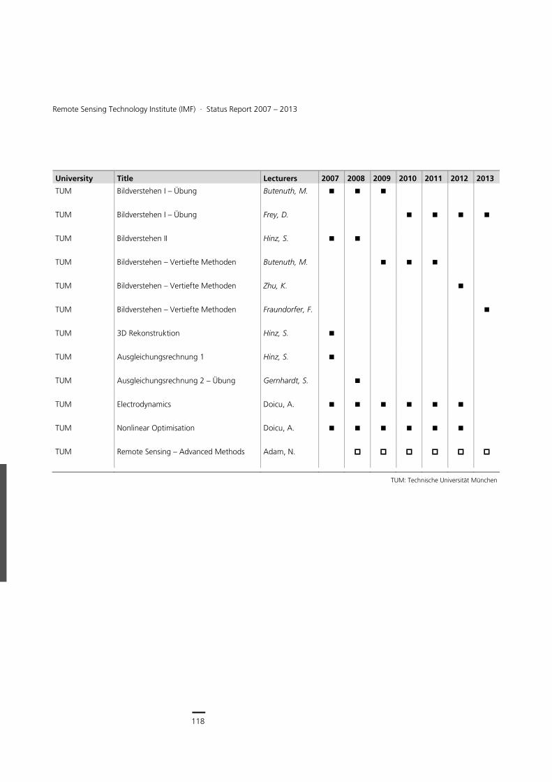
118
Earth Observation Center
118
Remote Sensing Technology Institute (IMF) ∙ Status Report 2007 – 2013
University Title Lecturers 2007 2008 2009 2010 2011 2012 2013
TUM Bildverstehen I – Übung Butenuth, M.
TUM Bildverstehen I – Übung Frey, D.
TUM Bildverstehen II Hinz, S.
TUM Bildverstehen – Vertiefte Methoden Butenuth, M.
TUM Bildverstehen – Vertiefte Methoden Zhu, K.
TUM Bildverstehen – Vertiefte Methoden Fraundorfer, F.
TUM 3D Rekonstruktion Hinz, S.
TUM Ausgleichungsrechnung 1 Hinz, S.
TUM Ausgleichungsrechnung 2 – Übung Gernhardt, S.
TUM Electrodynamics Doicu, A.
TUM Nonlinear Optimisation Doicu, A.
TUM Remote Sensing – Advanced Methods Adam, N.
TUM: Technische Universität München
119
Documentation > Teaching and Education
Lectures at other Universities
University courses conducted by IMF staff from 2007 until summer semester 2013 Course fully given by IMF staff Course with modules contributed by IMF staff Winter semester courses are listed in the year of beginning. Therefore lectures in winter semester 2013/14 are not listed.
University Title Lecturers 2007 2008 2009 2010 2011 2012 2013
Karlsruhe Bildanalyse – Fernerkundung Adam, N.
Osnabrück Methoden der Bildverarbeitung II Cerra, D.
Paris (ParisTech-Telecom)
Stochastic Image Analysis Datcu, M.
Bukarest (Politehnica)
Decision and Estimation/Data Mining Datcu, M.
Rome (Tor Vergata)
Image Information Mining Datcu. M
Alcala SAR signal processing Datcu, M
München (HS) Messtechnik-Praktikum Haschberger, P.
München (HS) PC-gestütztes Messen Haschberger, P.
Osnabrück Methoden der Fernerkundung Reinartz, P.
Osnabrück Fernerkundung in der Umweltanalyse Reinartz, P.
Hannover Operationelle Fernerkundung Reinartz, P.
Leipzig Modellierung nichtsphärischer Streuprozesse
Rother, T.
Deggendorf Optische Sensorik und Messtechnik Schötz, P.
Leipzig Atmosphärische Strahlung Trautmann, T.
Leipzig Strahlungstransferlabor Trautmann, T.
TUM: Technische Universität München LMU: Ludwig-Maximilians-Universität
HS: Hochschule
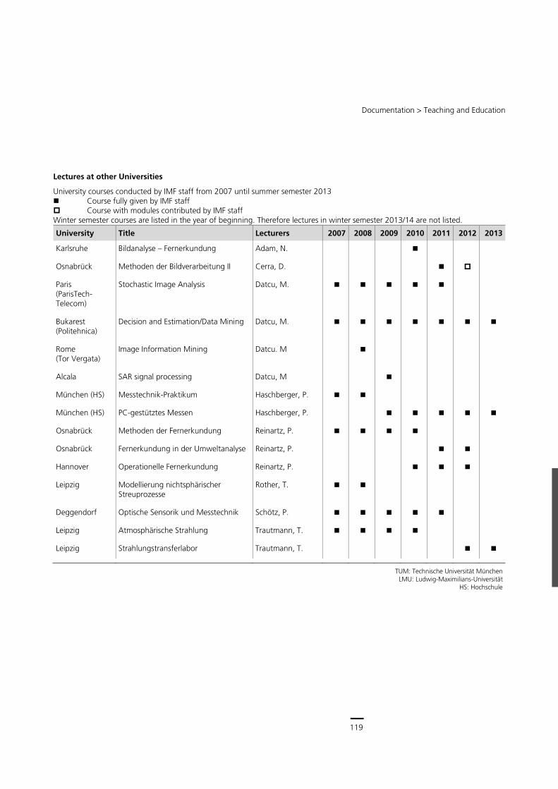
119
Central Services
118
Remote Sensing Technology Institute (IMF) ∙ Status Report 2007 – 2013
University Title Lecturers 2007 2008 2009 2010 2011 2012 2013
TUM Bildverstehen I – Übung Butenuth, M.
TUM Bildverstehen I – Übung Frey, D.
TUM Bildverstehen II Hinz, S.
TUM Bildverstehen – Vertiefte Methoden Butenuth, M.
TUM Bildverstehen – Vertiefte Methoden Zhu, K.
TUM Bildverstehen – Vertiefte Methoden Fraundorfer, F.
TUM 3D Rekonstruktion Hinz, S.
TUM Ausgleichungsrechnung 1 Hinz, S.
TUM Ausgleichungsrechnung 2 – Übung Gernhardt, S.
TUM Electrodynamics Doicu, A.
TUM Nonlinear Optimisation Doicu, A.
TUM Remote Sensing – Advanced Methods Adam, N.
TUM: Technische Universität München
119
Documentation > Teaching and Education
Lectures at other Universities
University courses conducted by IMF staff from 2007 until summer semester 2013 Course fully given by IMF staff Course with modules contributed by IMF staff Winter semester courses are listed in the year of beginning. Therefore lectures in winter semester 2013/14 are not listed.
University Title Lecturers 2007 2008 2009 2010 2011 2012 2013
Karlsruhe Bildanalyse – Fernerkundung Adam, N.
Osnabrück Methoden der Bildverarbeitung II Cerra, D.
Paris (ParisTech-Telecom)
Stochastic Image Analysis Datcu, M.
Bukarest (Politehnica)
Decision and Estimation/Data Mining Datcu, M.
Rome (Tor Vergata)
Image Information Mining Datcu. M
Alcala SAR signal processing Datcu, M
München (HS) Messtechnik-Praktikum Haschberger, P.
München (HS) PC-gestütztes Messen Haschberger, P.
Osnabrück Methoden der Fernerkundung Reinartz, P.
Osnabrück Fernerkundung in der Umweltanalyse Reinartz, P.
Hannover Operationelle Fernerkundung Reinartz, P.
Leipzig Modellierung nichtsphärischer Streuprozesse
Rother, T.
Deggendorf Optische Sensorik und Messtechnik Schötz, P.
Leipzig Atmosphärische Strahlung Trautmann, T.
Leipzig Strahlungstransferlabor Trautmann, T.
TUM: Technische Universität München LMU: Ludwig-Maximilians-Universität
HS: Hochschule
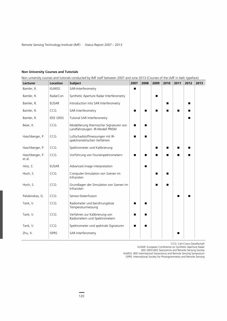
120
Earth Observation Center
120
Remote Sensing Technology Institute (IMF) ∙ Status Report 2007 – 2013
Non University Courses and Tutorials
Non university courses and tutorials conducted by IMF staff between 2007 and June 2013 (Courses of the LMF in italic typeface)
Lecturer Location Subject 2007 2008 2009 2010 2011 2012 2013
Bamler, R. IGARSS SAR-Interferometry
Bamler, R. RadarCon Synthetic Aperture Radar Interferometry
Bamler, R. EUSAR Introduction into SAR Interferometry
Bamler, R. CCG SAR Interferometry
Bamler, R. IEEE GRSS Tutorial SAR Interferometry
Beier, K. CCG Modellierung thermischer Signaturen von Landfahrzeugen: IR-Modell PRISM
Haschberger, P. CCG Luftschadstoffmessungen mit IR-spektrometrischen Verfahren
Haschberger, P. CCG Spektrometer und Kalibrierung
Haschberger, P. et al.
CCG Vorführung von Fourierspektrometern
Hinz, S. EUSAR Advanced image interpretation
Hoch, S. CCG Computer-Simulation von Szenen im Infraroten
Hoch, S. CCG Grundlagen der Simulation von Szenen im Infraroten
Palubinskas, G. CCG Sensor-Datenfusion
Tank, V. CCG Radiometer und berührungslose Temperaturmessung
Tank, V. CCG Verfahren zur Kalibrierung von Radiometern und Spektrometern
Tank, V. CCG Spektrometer und spektrale Signaturen
Zhu, X. ISPRS SAR Interferometry
CCG: Carl-Cranz-Gesellschaft EUSAR: European Conference on Synthetic Aperture Radar
IEEE GRSS:IEEE Geoscience and Remote Sensing Society IGARSS: IEEE International Geoscience and Remote Sensing Symposium
ISPRS: International Society for Photogrammetry and Remote Sensing
121
Documentation > Teaching and Education
Internal Seminar Series
Title Comments
IMF Seminar 10 – 15 presentations per year, IMF and guest scientists
Seminars of IMF sections seminars of IMF-ATP and IMF-SAR, 15 – 20 presentations per year, IMF and guest scientists
IMF Doktorandentage annual event, 15 – 20 PhD status presentations
Doktorandenseminar TUM 5 – 8 presentations per year, LMF PhD presentations and reading sessions
DLR/TUM Summer School annual 3 days event, 30 – 40 PhD and scientists, guest lecturers
Various Summer Schools HGF Alliances, Munich Aerospace, SAR Education Initiative
In-House Interns and Trainees
76 students received practical training and supervision from IMF staff during short-term periods of stay at IMF between 2007 and 2013.
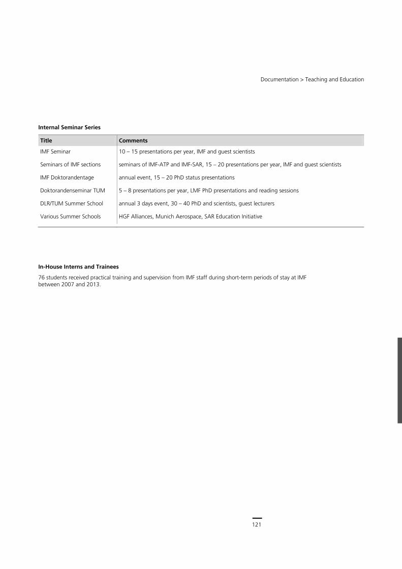
121
Central Services
120
Remote Sensing Technology Institute (IMF) ∙ Status Report 2007 – 2013
Non University Courses and Tutorials
Non university courses and tutorials conducted by IMF staff between 2007 and June 2013 (Courses of the LMF in italic typeface)
Lecturer Location Subject 2007 2008 2009 2010 2011 2012 2013
Bamler, R. IGARSS SAR-Interferometry
Bamler, R. RadarCon Synthetic Aperture Radar Interferometry
Bamler, R. EUSAR Introduction into SAR Interferometry
Bamler, R. CCG SAR Interferometry
Bamler, R. IEEE GRSS Tutorial SAR Interferometry
Beier, K. CCG Modellierung thermischer Signaturen von Landfahrzeugen: IR-Modell PRISM
Haschberger, P. CCG Luftschadstoffmessungen mit IR-spektrometrischen Verfahren
Haschberger, P. CCG Spektrometer und Kalibrierung
Haschberger, P. et al.
CCG Vorführung von Fourierspektrometern
Hinz, S. EUSAR Advanced image interpretation
Hoch, S. CCG Computer-Simulation von Szenen im Infraroten
Hoch, S. CCG Grundlagen der Simulation von Szenen im Infraroten
Palubinskas, G. CCG Sensor-Datenfusion
Tank, V. CCG Radiometer und berührungslose Temperaturmessung
Tank, V. CCG Verfahren zur Kalibrierung von Radiometern und Spektrometern
Tank, V. CCG Spektrometer und spektrale Signaturen
Zhu, X. ISPRS SAR Interferometry
CCG: Carl-Cranz-Gesellschaft EUSAR: European Conference on Synthetic Aperture Radar
IEEE GRSS:IEEE Geoscience and Remote Sensing Society IGARSS: IEEE International Geoscience and Remote Sensing Symposium
ISPRS: International Society for Photogrammetry and Remote Sensing
121
Documentation > Teaching and Education
Internal Seminar Series
Title Comments
IMF Seminar 10 – 15 presentations per year, IMF and guest scientists
Seminars of IMF sections seminars of IMF-ATP and IMF-SAR, 15 – 20 presentations per year, IMF and guest scientists
IMF Doktorandentage annual event, 15 – 20 PhD status presentations
Doktorandenseminar TUM 5 – 8 presentations per year, LMF PhD presentations and reading sessions
DLR/TUM Summer School annual 3 days event, 30 – 40 PhD and scientists, guest lecturers
Various Summer Schools HGF Alliances, Munich Aerospace, SAR Education Initiative
In-House Interns and Trainees
76 students received practical training and supervision from IMF staff during short-term periods of stay at IMF between 2007 and 2013.

122
Earth Observation Center
122
Remote Sensing Technology Institute (IMF) ∙ Status Report 2007 – 2013
Academic Degrees
Professorship Appointments
Professorship appointments of IMF or LMF (in italic typeface) staff between 2007 and June 2013
Name Professorship University Year
Eineder, M. Honorary Professorship München (TU) 2013
Meyer, F. Associate Professorship Fairbanks, Alaska 2012
Reinartz, P. Honorary Professorship Osnabrück 2010
Hinz, S. Full Professorship (Ordinarius) Karlsruhe (KIT) 2008
Habilitations and Venia Legendi
Habilitations awarded, supervised or completed by IMF or LMF (in italic typeface) staff between 2007 and June 2013
Name Subject University Year Reviewers
Zhu, X. Signal Processing München (TU) ongoing Prof. Meng Prof. Bamler Prof. Hinz
Doicu, A. Atmospheric Remote Sensing München (TU) 2011 Prof. Rummel Prof. Bamler Prof. Trautmann
Hinz, S. Bewegtobjekterkennung und -charakterisierung in Fernerkundungsbilddaten mit Fokus auf Verkehrsanwendungen
München (TU) 2008 Prof. Bamler Prof. Stilla Prof. Heipke
Doctoral Theses
Doctoral Theses being supervised or completed at IMF, LMF (in italic typeface) or Competence Center DLR – CNES – ENST between 2007 and June 2013
Name Title University Year Reviewers
Abdel Jaber, W. Ableitung von Bewegung und geometrischen Oberflächenparametern aus hochauflösenden Radardaten
München (TU) ongoing Bamler, R. Rott,H. Eineder, M.
Alonso-Gonzalez, K. Heterogeneous Data Mining for EO Applications: an Information Theoretical Approach
Siegen ongoing Loffelt, O. Datcu, M.
123
Documentation > Academic Degrees
Name Title University Year Reviewers
Avbelj, J. Fusion of Hyperspectral Images and Height Models in Urban Areas
München (TU) ongoing Bamler, R. Reinartz, P.
Bahmanyar, R. Multi Descriptor Content Indexing of Synthetic Aperture Radar Images
München (TU) ongoing Rigoll, G. Datcu, M.
Bieniarz, J. Enhancement of Hyperspectral Data Evaluation with Optimized Registration and Fusion Techniques
Osnabrück ongoing Reinartz, P. Ehlers, M.
Bruck, M. Sea State Measurements Using TerraSAR-X Data Kiel ongoing Mayerle, R.
Burkert, F. Interpretation of trajectories generated with tracked people from image sequences
München (TU) ongoing Bamler, R.
Cong, X. Advanced SAR Interferometric Techniques for Monitoring Volcanic Deformation
München (TU) ongoing Bamler, R. Eineder, M.
Cui, S. Spatial and Temporal SAR Image Information Mining Siegen ongoing Loffelt, O. Datcu, M.
Gimeno-Garcia, S. Radiative transfer in three-dimensional inhomogeneous cloudy atmospheres
Leipzig ongoing Trautmann, T.
Goel, K. Development and Test of Advanced Persistent Scatterer Interferometry Techniques
München (TU) ongoing Bamler, R. Soergel, U. Hanssen, R.
Gomba, G. Estimation and Compensation of Ionospheric Propagation Delay in Synthetic Aperture Radar (SAR) Signals
München (TU) ongoing Bamler, R. Eineder, M.
Grohnfeldt, C. Exploiting Sparsity in Earth Observation – Modeling München (TU) ongoing Bamler, R.
Israel, M. Bildgebende Verfahren zur Rehkitzrettung Osnabrück ongoing Reinartz, P. Tank, V.
Kahyaoglu, N. D. Feature Extraction for Bistatic SAR Images Siegen ongoing Loffelt, O. Datcu, M.
Köhler, C. Radiative Effect of mixed Biomass Burning and Mineral Dust Aerosol in the Thermal Infrared
Leipzig ongoing Trautmann, T.
Lachaise, M. Phase Unwrapping of Multichannel SAR data München (TU) ongoing Bamler, R. Eineder, M.
Lenhard, K. Determination and Reduction of Measurement Uncertainties in Imaging Spectrometers for Earth Observation
Zürich ongoing Schaepman, M. Jehle, M. Purves, J.
Loos, J. Improving Spectroscopic Data of H2O for Application on Remote Atmospheric Measurements in the Infrared
Karlsruhe (KIT) ongoing Orphal, J.
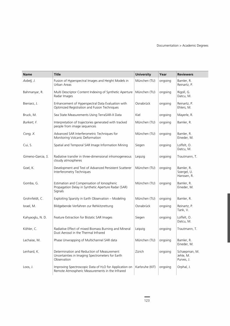
123
Central Services
122
Remote Sensing Technology Institute (IMF) ∙ Status Report 2007 – 2013
Academic Degrees
Professorship Appointments
Professorship appointments of IMF or LMF (in italic typeface) staff between 2007 and June 2013
Name Professorship University Year
Eineder, M. Honorary Professorship München (TU) 2013
Meyer, F. Associate Professorship Fairbanks, Alaska 2012
Reinartz, P. Honorary Professorship Osnabrück 2010
Hinz, S. Full Professorship (Ordinarius) Karlsruhe (KIT) 2008
Habilitations and Venia Legendi
Habilitations awarded, supervised or completed by IMF or LMF (in italic typeface) staff between 2007 and June 2013
Name Subject University Year Reviewers
Zhu, X. Signal Processing München (TU) ongoing Prof. Meng Prof. Bamler Prof. Hinz
Doicu, A. Atmospheric Remote Sensing München (TU) 2011 Prof. Rummel Prof. Bamler Prof. Trautmann
Hinz, S. Bewegtobjekterkennung und -charakterisierung in Fernerkundungsbilddaten mit Fokus auf Verkehrsanwendungen
München (TU) 2008 Prof. Bamler Prof. Stilla Prof. Heipke
Doctoral Theses
Doctoral Theses being supervised or completed at IMF, LMF (in italic typeface) or Competence Center DLR – CNES – ENST between 2007 and June 2013
Name Title University Year Reviewers
Abdel Jaber, W. Ableitung von Bewegung und geometrischen Oberflächenparametern aus hochauflösenden Radardaten
München (TU) ongoing Bamler, R. Rott,H. Eineder, M.
Alonso-Gonzalez, K. Heterogeneous Data Mining for EO Applications: an Information Theoretical Approach
Siegen ongoing Loffelt, O. Datcu, M.
123
Documentation > Academic Degrees
Name Title University Year Reviewers
Avbelj, J. Fusion of Hyperspectral Images and Height Models in Urban Areas
München (TU) ongoing Bamler, R. Reinartz, P.
Bahmanyar, R. Multi Descriptor Content Indexing of Synthetic Aperture Radar Images
München (TU) ongoing Rigoll, G. Datcu, M.
Bieniarz, J. Enhancement of Hyperspectral Data Evaluation with Optimized Registration and Fusion Techniques
Osnabrück ongoing Reinartz, P. Ehlers, M.
Bruck, M. Sea State Measurements Using TerraSAR-X Data Kiel ongoing Mayerle, R.
Burkert, F. Interpretation of trajectories generated with tracked people from image sequences
München (TU) ongoing Bamler, R.
Cong, X. Advanced SAR Interferometric Techniques for Monitoring Volcanic Deformation
München (TU) ongoing Bamler, R. Eineder, M.
Cui, S. Spatial and Temporal SAR Image Information Mining Siegen ongoing Loffelt, O. Datcu, M.
Gimeno-Garcia, S. Radiative transfer in three-dimensional inhomogeneous cloudy atmospheres
Leipzig ongoing Trautmann, T.
Goel, K. Development and Test of Advanced Persistent Scatterer Interferometry Techniques
München (TU) ongoing Bamler, R. Soergel, U. Hanssen, R.
Gomba, G. Estimation and Compensation of Ionospheric Propagation Delay in Synthetic Aperture Radar (SAR) Signals
München (TU) ongoing Bamler, R. Eineder, M.
Grohnfeldt, C. Exploiting Sparsity in Earth Observation – Modeling München (TU) ongoing Bamler, R.
Israel, M. Bildgebende Verfahren zur Rehkitzrettung Osnabrück ongoing Reinartz, P. Tank, V.
Kahyaoglu, N. D. Feature Extraction for Bistatic SAR Images Siegen ongoing Loffelt, O. Datcu, M.
Köhler, C. Radiative Effect of mixed Biomass Burning and Mineral Dust Aerosol in the Thermal Infrared
Leipzig ongoing Trautmann, T.
Lachaise, M. Phase Unwrapping of Multichannel SAR data München (TU) ongoing Bamler, R. Eineder, M.
Lenhard, K. Determination and Reduction of Measurement Uncertainties in Imaging Spectrometers for Earth Observation
Zürich ongoing Schaepman, M. Jehle, M. Purves, J.
Loos, J. Improving Spectroscopic Data of H2O for Application on Remote Atmospheric Measurements in the Infrared
Karlsruhe (KIT) ongoing Orphal, J.
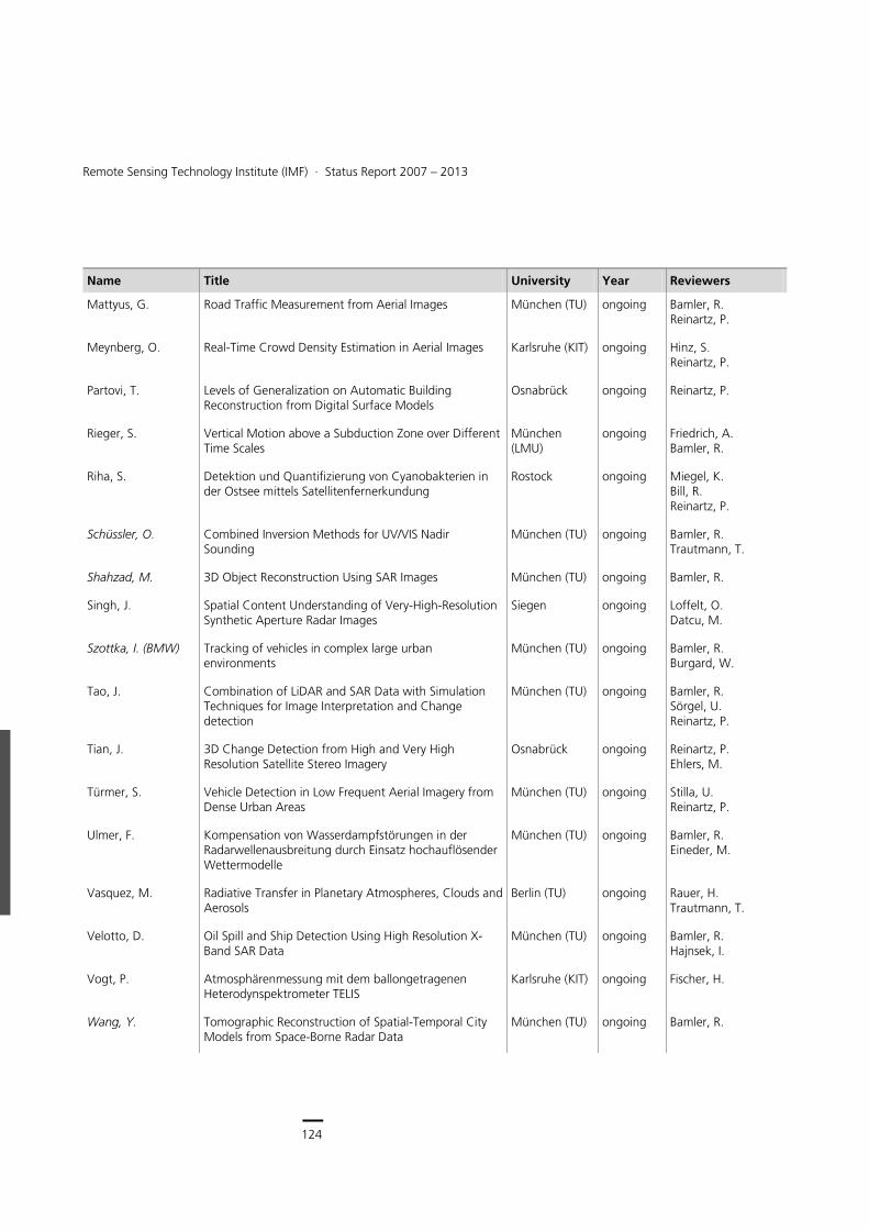
124
Earth Observation Center
124
Remote Sensing Technology Institute (IMF) ∙ Status Report 2007 – 2013
Name Title University Year Reviewers
Mattyus, G. Road Traffic Measurement from Aerial Images München (TU) ongoing Bamler, R. Reinartz, P.
Meynberg, O. Real-Time Crowd Density Estimation in Aerial Images Karlsruhe (KIT) ongoing Hinz, S. Reinartz, P.
Partovi, T. Levels of Generalization on Automatic Building Reconstruction from Digital Surface Models
Osnabrück ongoing Reinartz, P.
Rieger, S. Vertical Motion above a Subduction Zone over Different Time Scales
München (LMU)
ongoing Friedrich, A. Bamler, R.
Riha, S. Detektion und Quantifizierung von Cyanobakterien in der Ostsee mittels Satellitenfernerkundung
Rostock ongoing Miegel, K. Bill, R. Reinartz, P.
Schüssler, O. Combined Inversion Methods for UV/VIS Nadir Sounding
München (TU) ongoing Bamler, R. Trautmann, T.
Shahzad, M. 3D Object Reconstruction Using SAR Images München (TU) ongoing Bamler, R.
Singh, J. Spatial Content Understanding of Very-High-Resolution Synthetic Aperture Radar Images
Siegen ongoing Loffelt, O. Datcu, M.
Szottka, I. (BMW) Tracking of vehicles in complex large urban environments
München (TU) ongoing Bamler, R. Burgard, W.
Tao, J. Combination of LiDAR and SAR Data with Simulation Techniques for Image Interpretation and Change detection
München (TU) ongoing Bamler, R. Sörgel, U. Reinartz, P.
Tian, J. 3D Change Detection from High and Very High Resolution Satellite Stereo Imagery
Osnabrück ongoing Reinartz, P. Ehlers, M.
Türmer, S. Vehicle Detection in Low Frequent Aerial Imagery from Dense Urban Areas
München (TU) ongoing Stilla, U. Reinartz, P.
Ulmer, F. Kompensation von Wasserdampfstörungen in der Radarwellenausbreitung durch Einsatz hochauflösender Wettermodelle
München (TU) ongoing Bamler, R. Eineder, M.
Vasquez, M. Radiative Transfer in Planetary Atmospheres, Clouds and Aerosols
Berlin (TU) ongoing Rauer, H. Trautmann, T.
Velotto, D. Oil Spill and Ship Detection Using High Resolution X-Band SAR Data
München (TU) ongoing Bamler, R. Hajnsek, I.
Vogt, P. Atmosphärenmessung mit dem ballongetragenen Heterodynspektrometer TELIS
Karlsruhe (KIT) ongoing Fischer, H.
Wang, Y. Tomographic Reconstruction of Spatial-Temporal City Models from Space-Borne Radar Data
München (TU) ongoing Bamler, R.
125
Documentation > Academic Degrees
Name Title University Year Reviewers
Xu, J. Inversion for Limb Infrared Atmospheric Sounding München (TU) ongoing Bamler, R. Doicu, A. Bühler, S.
Zhu, K. Ableitung von Bewegung und geometrischen Oberflächenparametern aus hochauflösenden Radardaten
München (TU) ongoing Bamler, R. Reinartz, P.
Loyola, D. Methodologies for solving Satellite Remote Sensing Problems using Neuro Computing Techniques
München (LMU)
2013 Bamler, R. Wirsing, M. Mayer, B.
Alam, K. Remote Sensing of Aerosol Characteristics and Radiative Forcing in Pakistan
Salzburg 2012 Blaschke, T. Trautmann, T.
Otto, S. Optische Eigenschaften nichtkugelförmiger Saharamineralstaubpartikel und deren Einfluss auf den Strahlungstransport in der Erdatmosphäre
Leipzig 2012 Trautmann, T. Böckmann, C.
Rix, M. Observation of volcanic SO2 plumes based on the satellite-borne GOME-2 instrument
München (TU) 2012 Bamler, R. Trautmann, T. Dingwell, D.
Auer, S. 3D Synthetic Aperture Radar Simulation for Interpreting Complex Urban Reflection Scenarios
München (TU) 2011 Bamler, R. Hinz, S. Iodice, A.
Brusch, S. High Resolution Wind and Bathymetry Maps from Synthetic Aperture Radar to increase Ship Safety and Ship Traffic Monitoring from Space
Hamburg 2011 Grassl, H. Bakan, S. Lehner, S.
Espinoza-Molina, D. Advanced Methods for High Resolution SAR Information Extraction: Data and User-driven Evaluation Approaches for Image Information Mining
Paris (ParisTech-Telecom)
2011 Ovarlez, J. Reinartz, P. Pottier, E. Trouve, E. Nicolas, J. Ferecatu, M. Datcu, M. Gleich, D.
Gernhardt, S. High Precision 3D Localization and Motion Analysis of Persistent Scatterers using Meter-Resolution Radar Satellite Data
München (TU) 2011 Bamler, R. Hinz, S. Meyer, F.
Zhu, X. Very High Resolution Tomographic SAR Inversion for Urban Infrastructure Monitoring – A Sparse and Nonlinear Tour
München (TU) 2011 Bamler, R. Sörgel, U. Moreira, A.
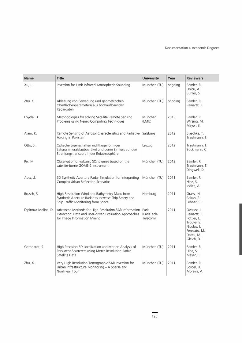
125
Central Services
124
Remote Sensing Technology Institute (IMF) ∙ Status Report 2007 – 2013
Name Title University Year Reviewers
Mattyus, G. Road Traffic Measurement from Aerial Images München (TU) ongoing Bamler, R. Reinartz, P.
Meynberg, O. Real-Time Crowd Density Estimation in Aerial Images Karlsruhe (KIT) ongoing Hinz, S. Reinartz, P.
Partovi, T. Levels of Generalization on Automatic Building Reconstruction from Digital Surface Models
Osnabrück ongoing Reinartz, P.
Rieger, S. Vertical Motion above a Subduction Zone over Different Time Scales
München (LMU)
ongoing Friedrich, A. Bamler, R.
Riha, S. Detektion und Quantifizierung von Cyanobakterien in der Ostsee mittels Satellitenfernerkundung
Rostock ongoing Miegel, K. Bill, R. Reinartz, P.
Schüssler, O. Combined Inversion Methods for UV/VIS Nadir Sounding
München (TU) ongoing Bamler, R. Trautmann, T.
Shahzad, M. 3D Object Reconstruction Using SAR Images München (TU) ongoing Bamler, R.
Singh, J. Spatial Content Understanding of Very-High-Resolution Synthetic Aperture Radar Images
Siegen ongoing Loffelt, O. Datcu, M.
Szottka, I. (BMW) Tracking of vehicles in complex large urban environments
München (TU) ongoing Bamler, R. Burgard, W.
Tao, J. Combination of LiDAR and SAR Data with Simulation Techniques for Image Interpretation and Change detection
München (TU) ongoing Bamler, R. Sörgel, U. Reinartz, P.
Tian, J. 3D Change Detection from High and Very High Resolution Satellite Stereo Imagery
Osnabrück ongoing Reinartz, P. Ehlers, M.
Türmer, S. Vehicle Detection in Low Frequent Aerial Imagery from Dense Urban Areas
München (TU) ongoing Stilla, U. Reinartz, P.
Ulmer, F. Kompensation von Wasserdampfstörungen in der Radarwellenausbreitung durch Einsatz hochauflösender Wettermodelle
München (TU) ongoing Bamler, R. Eineder, M.
Vasquez, M. Radiative Transfer in Planetary Atmospheres, Clouds and Aerosols
Berlin (TU) ongoing Rauer, H. Trautmann, T.
Velotto, D. Oil Spill and Ship Detection Using High Resolution X-Band SAR Data
München (TU) ongoing Bamler, R. Hajnsek, I.
Vogt, P. Atmosphärenmessung mit dem ballongetragenen Heterodynspektrometer TELIS
Karlsruhe (KIT) ongoing Fischer, H.
Wang, Y. Tomographic Reconstruction of Spatial-Temporal City Models from Space-Borne Radar Data
München (TU) ongoing Bamler, R.
125
Documentation > Academic Degrees
Name Title University Year Reviewers
Xu, J. Inversion for Limb Infrared Atmospheric Sounding München (TU) ongoing Bamler, R. Doicu, A. Bühler, S.
Zhu, K. Ableitung von Bewegung und geometrischen Oberflächenparametern aus hochauflösenden Radardaten
München (TU) ongoing Bamler, R. Reinartz, P.
Loyola, D. Methodologies for solving Satellite Remote Sensing Problems using Neuro Computing Techniques
München (LMU)
2013 Bamler, R. Wirsing, M. Mayer, B.
Alam, K. Remote Sensing of Aerosol Characteristics and Radiative Forcing in Pakistan
Salzburg 2012 Blaschke, T. Trautmann, T.
Otto, S. Optische Eigenschaften nichtkugelförmiger Saharamineralstaubpartikel und deren Einfluss auf den Strahlungstransport in der Erdatmosphäre
Leipzig 2012 Trautmann, T. Böckmann, C.
Rix, M. Observation of volcanic SO2 plumes based on the satellite-borne GOME-2 instrument
München (TU) 2012 Bamler, R. Trautmann, T. Dingwell, D.
Auer, S. 3D Synthetic Aperture Radar Simulation for Interpreting Complex Urban Reflection Scenarios
München (TU) 2011 Bamler, R. Hinz, S. Iodice, A.
Brusch, S. High Resolution Wind and Bathymetry Maps from Synthetic Aperture Radar to increase Ship Safety and Ship Traffic Monitoring from Space
Hamburg 2011 Grassl, H. Bakan, S. Lehner, S.
Espinoza-Molina, D. Advanced Methods for High Resolution SAR Information Extraction: Data and User-driven Evaluation Approaches for Image Information Mining
Paris (ParisTech-Telecom)
2011 Ovarlez, J. Reinartz, P. Pottier, E. Trouve, E. Nicolas, J. Ferecatu, M. Datcu, M. Gleich, D.
Gernhardt, S. High Precision 3D Localization and Motion Analysis of Persistent Scatterers using Meter-Resolution Radar Satellite Data
München (TU) 2011 Bamler, R. Hinz, S. Meyer, F.
Zhu, X. Very High Resolution Tomographic SAR Inversion for Urban Infrastructure Monitoring – A Sparse and Nonlinear Tour
München (TU) 2011 Bamler, R. Sörgel, U. Moreira, A.
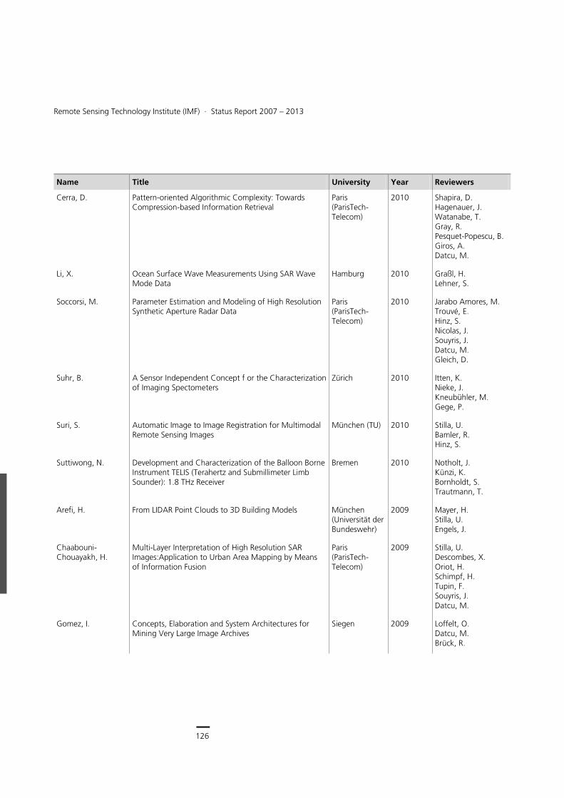
126
Earth Observation Center
126
Remote Sensing Technology Institute (IMF) ∙ Status Report 2007 – 2013
Name Title University Year Reviewers
Cerra, D. Pattern-oriented Algorithmic Complexity: Towards Compression-based Information Retrieval
Paris (ParisTech-Telecom)
2010 Shapira, D. Hagenauer, J. Watanabe, T. Gray, R. Pesquet-Popescu, B. Giros, A. Datcu, M.
Li, X. Ocean Surface Wave Measurements Using SAR Wave Mode Data
Hamburg 2010 Graßl, H. Lehner, S.
Soccorsi, M. Parameter Estimation and Modeling of High Resolution Synthetic Aperture Radar Data
Paris (ParisTech-Telecom)
2010 Jarabo Amores, M. Trouvé, E. Hinz, S. Nicolas, J. Souyris, J. Datcu, M. Gleich, D.
Suhr, B. A Sensor Independent Concept f or the Characterization of Imaging Spectometers
Zürich 2010 Itten, K. Nieke, J. Kneubühler, M. Gege, P.
Suri, S. Automatic Image to Image Registration for Multimodal Remote Sensing Images
München (TU) 2010 Stilla, U. Bamler, R. Hinz, S.
Suttiwong, N. Development and Characterization of the Balloon Borne Instrument TELIS (Terahertz and Submillimeter Limb Sounder): 1.8 THz Receiver
Bremen 2010 Notholt, J. Künzi, K. Bornholdt, S. Trautmann, T.
Arefi, H. From LIDAR Point Clouds to 3D Building Models München (Universität der Bundeswehr)
2009 Mayer, H. Stilla, U. Engels, J.
Chaabouni-Chouayakh, H.
Multi-Layer Interpretation of High Resolution SAR Images:Application to Urban Area Mapping by Means of Information Fusion
Paris (ParisTech-Telecom)
2009 Stilla, U. Descombes, X. Oriot, H. Schimpf, H. Tupin, F. Souyris, J. Datcu, M.
Gomez, I. Concepts, Elaboration and System Architectures for Mining Very Large Image Archives
Siegen 2009 Loffelt, O. Datcu, M. Brück, R.
127
Documentation > Academic Degrees
Name Title University Year Reviewers
Lienou, M. Use of Automated Learning in Remote Sensing: Validation of Semantic Learning for Land Use Man Generation
Paris (ParisTech-Telecom)
2009 Datcu, M. Maitre, H. Gros, P. Bolon, P. Chanussot, J. Inglada, J. Kosch, H.
Costache, M. Support Vector Machines and Bayesian Methods for Category-Based Semantic Learning: A Search Engine for Image Satellite Database
Paris (ParisTech-Telecom)
2008 Datcu, M. Maitre, H. Cocquerez, J.-P. Boujemaa, N. Petrou, M. King, R. Inglada, J.
KIT: Karlsruher Institut für Technologie LMU: Ludwig-Maximilians-Universität
TU: Technische Universität

127
Central Services
126
Remote Sensing Technology Institute (IMF) ∙ Status Report 2007 – 2013
Name Title University Year Reviewers
Cerra, D. Pattern-oriented Algorithmic Complexity: Towards Compression-based Information Retrieval
Paris (ParisTech-Telecom)
2010 Shapira, D. Hagenauer, J. Watanabe, T. Gray, R. Pesquet-Popescu, B. Giros, A. Datcu, M.
Li, X. Ocean Surface Wave Measurements Using SAR Wave Mode Data
Hamburg 2010 Graßl, H. Lehner, S.
Soccorsi, M. Parameter Estimation and Modeling of High Resolution Synthetic Aperture Radar Data
Paris (ParisTech-Telecom)
2010 Jarabo Amores, M. Trouvé, E. Hinz, S. Nicolas, J. Souyris, J. Datcu, M. Gleich, D.
Suhr, B. A Sensor Independent Concept f or the Characterization of Imaging Spectometers
Zürich 2010 Itten, K. Nieke, J. Kneubühler, M. Gege, P.
Suri, S. Automatic Image to Image Registration for Multimodal Remote Sensing Images
München (TU) 2010 Stilla, U. Bamler, R. Hinz, S.
Suttiwong, N. Development and Characterization of the Balloon Borne Instrument TELIS (Terahertz and Submillimeter Limb Sounder): 1.8 THz Receiver
Bremen 2010 Notholt, J. Künzi, K. Bornholdt, S. Trautmann, T.
Arefi, H. From LIDAR Point Clouds to 3D Building Models München (Universität der Bundeswehr)
2009 Mayer, H. Stilla, U. Engels, J.
Chaabouni-Chouayakh, H.
Multi-Layer Interpretation of High Resolution SAR Images:Application to Urban Area Mapping by Means of Information Fusion
Paris (ParisTech-Telecom)
2009 Stilla, U. Descombes, X. Oriot, H. Schimpf, H. Tupin, F. Souyris, J. Datcu, M.
Gomez, I. Concepts, Elaboration and System Architectures for Mining Very Large Image Archives
Siegen 2009 Loffelt, O. Datcu, M. Brück, R.
127
Documentation > Academic Degrees
Name Title University Year Reviewers
Lienou, M. Use of Automated Learning in Remote Sensing: Validation of Semantic Learning for Land Use Man Generation
Paris (ParisTech-Telecom)
2009 Datcu, M. Maitre, H. Gros, P. Bolon, P. Chanussot, J. Inglada, J. Kosch, H.
Costache, M. Support Vector Machines and Bayesian Methods for Category-Based Semantic Learning: A Search Engine for Image Satellite Database
Paris (ParisTech-Telecom)
2008 Datcu, M. Maitre, H. Cocquerez, J.-P. Boujemaa, N. Petrou, M. King, R. Inglada, J.
KIT: Karlsruher Institut für Technologie LMU: Ludwig-Maximilians-Universität
TU: Technische Universität
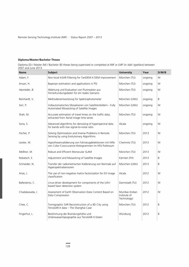
128
Earth Observation Center
128
Remote Sensing Technology Institute (IMF) ∙ Status Report 2007 – 2013
Diploma/Master/Bachelor Theses
Diploma (D) / Master (M) / Bachelor (B) theses being supervised or completed at IMF or LMF (in italic typeface) between 2007 and June 2013.
Name Subject University Year D/M/B
Adam, F. Non-local InSAR Filtering for TanDEM-X DEM improvement München (TU) ongoing M
Ansari, H. Bayesian estimation and applications in PSI München (TU) ongoing M
Hanrieder, B. Ableitung und Evaluation von Flutmasken aus Fernerkundungsdaten für ein reales Szenario
München (TU) ongoing M
Reinhardt, V. Methodenentwicklung für Spektrophotometer München (LMU) ongoing B
Serr, P. Vollautomatisches Mosaikieren von Satellitenbildern - Fully Automated Mosaicking of Satellite Images
München (LMU) ongoing M
Shah, M. Accurate estimation of travel times on the traffic data, extracted from Aerial image time series
München (TU) ongoing M
Soria, S. Advanced algorithms for denoising of hyperspectral data for bands with low signal-to-noise ratio
Alcala ongoing M
Fischer, P. Solving Optimization and Inverse Problems in Remote Sensing by using Evolutionary Algorithms
München (TU) 2013 M
Leister, W. Hypothesenvalidierung von Fahrzeugdetektionen mit Hilfe von Color-Cooccurance-Histogrammen im HSV-Farbraum
Chemnitz (TU) 2013 M
Meßner, M. Robust and Efficient Monocular SLAM München (TU) 2013 M
Robatsch, E. Adjustment and Mosaicking of Satellite Images Kärnten (FH) 2013 B
Schneider, N. Transfer der radiometrischen Kalibrierung von Normale auf Hyperspektralsensoren
München (LMU) 2013 B
Arias, J. The use of non-negative matrix factorization for EO image classification
Alcala 2012 M
Ballesteros, C. Linux-driver development for components of the UAV-based fawn detection system
Darmstadt (TU) 2012 M
Chadalawada, J. Assessment of Earth Observation Data Content Based on Data Compression
Mumbai (Indian Institute of Technology)
2012 M
Chee, C. Tomographic SAR Reconstruction of a 4D City using TerraSAR-X data – The Shanghai Case
München (TU) 2012 B
Fingerhut, L. Bestimmung der Brandungshöhe und Unterwassertopographie aus TerraSAR-X Daten
Würzburg 2012 B
129
Documentation > Academic Degrees
Name Subject University Year D/M/B
Hashemi, H. Entwicklung und Optimierung eines detektorbasierten Verfahrens zur radiometrischen Kalibrierung von Strahldichtequellen
Darmstadt (TU) 2012 M
Homolka, A. Bestimmung der Unterwassertopographie und Küstenlinien aus TerraSAR-X Daten
München (LMU) 2012 B
Jayashree, C. Assessment of Earth Observation Data Content Based on Date Compression – Applications to Settlement Understanding
Mumbai (Indian Institute of Technology)
2012 M
Li, W. Development of Robust Vehicle Tracking Algorithms in Aerial Image Sequences
München (TU) 2012 M
Schaumberger, S. Klassifikation einer Zeitserie von AwiFS-Multispektraldaten Würzburg 2012 D
Truckenbrodt, J. Bestimmung und Validierung von U10 Windfeldern aus TerraSAR-X Daten und deren Nutzung für operationelle Schiffsdetektion
Jena 2012 B
Wehner, A. Analyse von Gebäudebewegungen auf Grundlage der Persistent Scatterer Interferometrie
München (TU) 2012 B
Apfel, M. Extraktion von Gebäudeumrissen aus fusionierten 3D-PS-Punktwolken
München (TU) 2011 B
Bollinger, C. Untersuchung eines durchstimmbaren Lasers zur spektralen Charakterisierung von Hyperspektralsensoren
Amberg-Weiden 2011 D
Evers, S. Implementierung eines Mustererkennungsalgorithmus für die Rehkitzrettung
Augsburg 2011 D
Gräser, L. Entwicklung einer Autopilotsoftware zur Steuerung einer fliegenden Sensorplattform
Baden-Württemberg (Duale Hochschule)
2011 B
Grötsch, P. Optimization and Verification of a new Analytical Radiative Transfer Model
München (LMU) 2011 D
Haupt, L. Entwicklung und Untersuchung von neuen Verfahren zur Änderungsanalyse
Koblenz (FH) 2011 B
Hu, X. Methods for Quality Control of large Cartosat-1 Stereo Blocks
Stuttgart 2011 D
Ludwig, W. Generierung der automatisierten InSAR Prozessierung im NEST Toolbox
München (TU) 2011 B
Mende, A. Entwicklung eines Verfahrens zur Klassifikation heterogener Räume auf der Basis hyperspektraler Flugzeugdaten
Dresden (TU) 2011 D
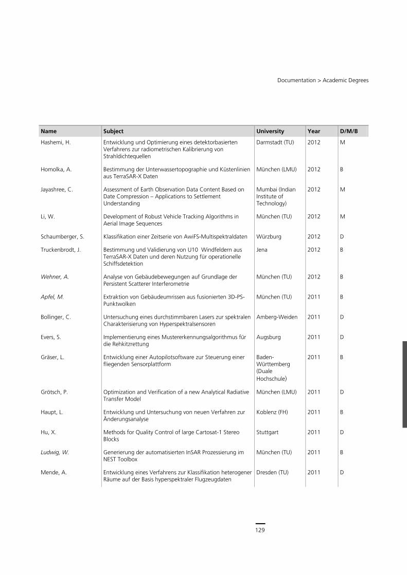
129
Central Services
128
Remote Sensing Technology Institute (IMF) ∙ Status Report 2007 – 2013
Diploma/Master/Bachelor Theses
Diploma (D) / Master (M) / Bachelor (B) theses being supervised or completed at IMF or LMF (in italic typeface) between 2007 and June 2013.
Name Subject University Year D/M/B
Adam, F. Non-local InSAR Filtering for TanDEM-X DEM improvement München (TU) ongoing M
Ansari, H. Bayesian estimation and applications in PSI München (TU) ongoing M
Hanrieder, B. Ableitung und Evaluation von Flutmasken aus Fernerkundungsdaten für ein reales Szenario
München (TU) ongoing M
Reinhardt, V. Methodenentwicklung für Spektrophotometer München (LMU) ongoing B
Serr, P. Vollautomatisches Mosaikieren von Satellitenbildern - Fully Automated Mosaicking of Satellite Images
München (LMU) ongoing M
Shah, M. Accurate estimation of travel times on the traffic data, extracted from Aerial image time series
München (TU) ongoing M
Soria, S. Advanced algorithms for denoising of hyperspectral data for bands with low signal-to-noise ratio
Alcala ongoing M
Fischer, P. Solving Optimization and Inverse Problems in Remote Sensing by using Evolutionary Algorithms
München (TU) 2013 M
Leister, W. Hypothesenvalidierung von Fahrzeugdetektionen mit Hilfe von Color-Cooccurance-Histogrammen im HSV-Farbraum
Chemnitz (TU) 2013 M
Meßner, M. Robust and Efficient Monocular SLAM München (TU) 2013 M
Robatsch, E. Adjustment and Mosaicking of Satellite Images Kärnten (FH) 2013 B
Schneider, N. Transfer der radiometrischen Kalibrierung von Normale auf Hyperspektralsensoren
München (LMU) 2013 B
Arias, J. The use of non-negative matrix factorization for EO image classification
Alcala 2012 M
Ballesteros, C. Linux-driver development for components of the UAV-based fawn detection system
Darmstadt (TU) 2012 M
Chadalawada, J. Assessment of Earth Observation Data Content Based on Data Compression
Mumbai (Indian Institute of Technology)
2012 M
Chee, C. Tomographic SAR Reconstruction of a 4D City using TerraSAR-X data – The Shanghai Case
München (TU) 2012 B
Fingerhut, L. Bestimmung der Brandungshöhe und Unterwassertopographie aus TerraSAR-X Daten
Würzburg 2012 B
129
Documentation > Academic Degrees
Name Subject University Year D/M/B
Hashemi, H. Entwicklung und Optimierung eines detektorbasierten Verfahrens zur radiometrischen Kalibrierung von Strahldichtequellen
Darmstadt (TU) 2012 M
Homolka, A. Bestimmung der Unterwassertopographie und Küstenlinien aus TerraSAR-X Daten
München (LMU) 2012 B
Jayashree, C. Assessment of Earth Observation Data Content Based on Date Compression – Applications to Settlement Understanding
Mumbai (Indian Institute of Technology)
2012 M
Li, W. Development of Robust Vehicle Tracking Algorithms in Aerial Image Sequences
München (TU) 2012 M
Schaumberger, S. Klassifikation einer Zeitserie von AwiFS-Multispektraldaten Würzburg 2012 D
Truckenbrodt, J. Bestimmung und Validierung von U10 Windfeldern aus TerraSAR-X Daten und deren Nutzung für operationelle Schiffsdetektion
Jena 2012 B
Wehner, A. Analyse von Gebäudebewegungen auf Grundlage der Persistent Scatterer Interferometrie
München (TU) 2012 B
Apfel, M. Extraktion von Gebäudeumrissen aus fusionierten 3D-PS-Punktwolken
München (TU) 2011 B
Bollinger, C. Untersuchung eines durchstimmbaren Lasers zur spektralen Charakterisierung von Hyperspektralsensoren
Amberg-Weiden 2011 D
Evers, S. Implementierung eines Mustererkennungsalgorithmus für die Rehkitzrettung
Augsburg 2011 D
Gräser, L. Entwicklung einer Autopilotsoftware zur Steuerung einer fliegenden Sensorplattform
Baden-Württemberg (Duale Hochschule)
2011 B
Grötsch, P. Optimization and Verification of a new Analytical Radiative Transfer Model
München (LMU) 2011 D
Haupt, L. Entwicklung und Untersuchung von neuen Verfahren zur Änderungsanalyse
Koblenz (FH) 2011 B
Hu, X. Methods for Quality Control of large Cartosat-1 Stereo Blocks
Stuttgart 2011 D
Ludwig, W. Generierung der automatisierten InSAR Prozessierung im NEST Toolbox
München (TU) 2011 B
Mende, A. Entwicklung eines Verfahrens zur Klassifikation heterogener Räume auf der Basis hyperspektraler Flugzeugdaten
Dresden (TU) 2011 D
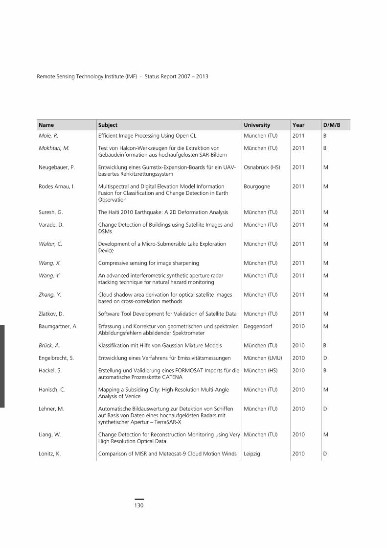
130
Earth Observation Center
130
Remote Sensing Technology Institute (IMF) ∙ Status Report 2007 – 2013
Name Subject University Year D/M/B
Moie, R. Efficient Image Processing Using Open CL München (TU) 2011 B
Mokhtari, M. Test von Halcon-Werkzeugen für die Extraktion von Gebäudeinformation aus hochaufgelösten SAR-Bildern
München (TU) 2011 B
Neugebauer, P. Entwicklung eines Gumstix-Expansion-Boards für ein UAV-basiertes Rehkitzrettungssystem
Osnabrück (HS) 2011 M
Rodes Arnau, I. Multispectral and Digital Elevation Model Information Fusion for Classification and Change Detection in Earth Observation
Bourgogne 2011 M
Suresh, G. The Haiti 2010 Earthquake: A 2D Deformation Analysis München (TU) 2011 M
Varade, D. Change Detection of Buildings using Satellite Images and DSMs
München (TU) 2011 M
Walter, C. Development of a Micro-Submersible Lake Exploration Device
München (TU) 2011 M
Wang, X. Compressive sensing for image sharpening München (TU) 2011 M
Wang, Y. An advanced interferometric synthetic aperture radar stacking technique for natural hazard monitoring
München (TU) 2011 M
Zhang, Y. Cloud shadow area derivation for optical satellite images based on cross-correlation methods
München (TU) 2011 M
Zlatkov, D. Software Tool Development for Validation of Satellite Data München (TU) 2011 M
Baumgartner, A. Erfassung und Korrektur von geometrischen und spektralen Abbildungsfehlern abbildender Spektrometer
Deggendorf 2010 M
Brück, A. Klassifikation mit Hilfe von Gaussian Mixture Models München (TU) 2010 B
Engelbrecht, S. Entwicklung eines Verfahrens für Emissivitätsmessungen München (LMU) 2010 D
Hackel, S. Erstellung und Validierung eines FORMOSAT Imports für die automatische Prozesskette CATENA
München (HS) 2010 B
Hanisch, C. Mapping a Subsiding City: High-Resolution Multi-Angle Analysis of Venice
München (TU) 2010 M
Lehner, M. Automatische Bildauswertung zur Detektion von Schiffen auf Basis von Daten eines hochaufgelösten Radars mit synthetischer Apertur – TerraSAR-X
München (TU) 2010 D
Liang, W. Change Detection for Reconstruction Monitoring using Very High Resolution Optical Data
München (TU) 2010 M
Lonitz, K. Comparison of MISR and Meteosat-9 Cloud Motion Winds Leipzig 2010 D
131
Documentation > Academic Degrees
Name Subject University Year D/M/B
Lopez Garro, I. Characterization of spectral stray light in a field spectrometer
München (TU) 2010 M
Saati, A. Evaluation of Errors in Digital Terrain Models generated by High Resolution Satellite Images
München (TU) 2010 M
Tuttas, S. Joint Gravimetric and Geometric Survey of Geophysical Signals – Feasibility Study for the TERENO Alpine and Prealpine Ammer Observatory
München (TU) 2010 M
Wimmer, R. True Orthophoto Generation Landshut (FH) 2010 B
Brankatschk, R. Implementierung einer Software-Schnittstelle zur Einbindung eines Hyperspektralsensors in eine Kalibriereinrichtung
Zittau/Görlitz (Hochschule)
2009 D
Burkert, F. Schnelle Bildsegmentierung mit der Level Set Methode München (TU) 2009 M
Geiger, F. Analyse und Korrektur der radiometrischen Fehler des Autokorrelator Spektrometers von TELIS
München (LMU) 2009 D
Goel, K. A Bayesian Method for Very High Resolution MultiAspect Angle Radargrammetry
München (TU) 2009 M
Held, P. Bestimmung der Unterwasser Bodentopographie und der Höhe brechender Wellen aus TerraSAR-X Daten
München (LMU) 2009 D
Kirschner, M. Entwicklung einer Methodik zur Bestimmung der BRDF von Wasserpflanzen mit einem abbildenden Feldspek-trometer
Stuttgart 2009 D
Koller, M. Road-extraction in sequences of overlapping airborne-images
München (TU) 2009 M
Merkl, A. Automatische Passpunktmessung auf Vektordaten zur Orthokorrektur von Satellitenbildern
München (TU) 2009 M
Meynberg, O. Development of a new Middleware for Real Time Image Processing in Remote Sensing
Braunschweig (TU) 2009 D
Rexer, M. Genauigkeits- und Vollständigkeitsanalyse von OpenStreetMap Daten
München (TU) 2009 B
Rodriguez Gonzales, F. Modelado y Analisis de Interferometria Radar de Apertura Sintetica de Alta Resolucion
Madrid (Universidad Politecnica)
2009 M
Schüssler, O. Constrained Regularization Methods for Ozone Profile Retrieval from UV/VIS Nadir Spectrometers
München (TU) 2009 M
Schwarzmaier, T. Konstruktion einer mechanischen Nachführung zur Bildstabilisierung einer Infrarotkamera
München (HS) 2009 D
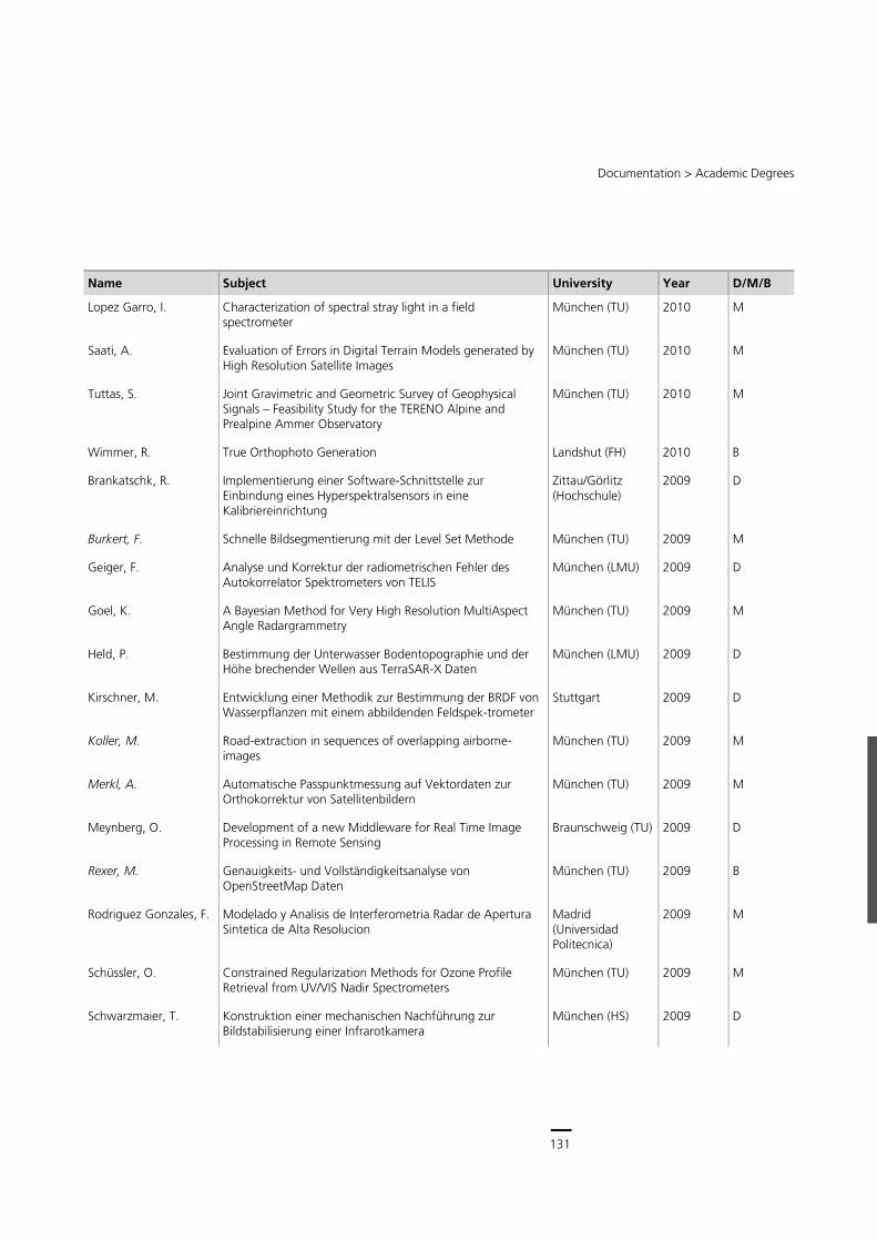
131
Central Services
130
Remote Sensing Technology Institute (IMF) ∙ Status Report 2007 – 2013
Name Subject University Year D/M/B
Moie, R. Efficient Image Processing Using Open CL München (TU) 2011 B
Mokhtari, M. Test von Halcon-Werkzeugen für die Extraktion von Gebäudeinformation aus hochaufgelösten SAR-Bildern
München (TU) 2011 B
Neugebauer, P. Entwicklung eines Gumstix-Expansion-Boards für ein UAV-basiertes Rehkitzrettungssystem
Osnabrück (HS) 2011 M
Rodes Arnau, I. Multispectral and Digital Elevation Model Information Fusion for Classification and Change Detection in Earth Observation
Bourgogne 2011 M
Suresh, G. The Haiti 2010 Earthquake: A 2D Deformation Analysis München (TU) 2011 M
Varade, D. Change Detection of Buildings using Satellite Images and DSMs
München (TU) 2011 M
Walter, C. Development of a Micro-Submersible Lake Exploration Device
München (TU) 2011 M
Wang, X. Compressive sensing for image sharpening München (TU) 2011 M
Wang, Y. An advanced interferometric synthetic aperture radar stacking technique for natural hazard monitoring
München (TU) 2011 M
Zhang, Y. Cloud shadow area derivation for optical satellite images based on cross-correlation methods
München (TU) 2011 M
Zlatkov, D. Software Tool Development for Validation of Satellite Data München (TU) 2011 M
Baumgartner, A. Erfassung und Korrektur von geometrischen und spektralen Abbildungsfehlern abbildender Spektrometer
Deggendorf 2010 M
Brück, A. Klassifikation mit Hilfe von Gaussian Mixture Models München (TU) 2010 B
Engelbrecht, S. Entwicklung eines Verfahrens für Emissivitätsmessungen München (LMU) 2010 D
Hackel, S. Erstellung und Validierung eines FORMOSAT Imports für die automatische Prozesskette CATENA
München (HS) 2010 B
Hanisch, C. Mapping a Subsiding City: High-Resolution Multi-Angle Analysis of Venice
München (TU) 2010 M
Lehner, M. Automatische Bildauswertung zur Detektion von Schiffen auf Basis von Daten eines hochaufgelösten Radars mit synthetischer Apertur – TerraSAR-X
München (TU) 2010 D
Liang, W. Change Detection for Reconstruction Monitoring using Very High Resolution Optical Data
München (TU) 2010 M
Lonitz, K. Comparison of MISR and Meteosat-9 Cloud Motion Winds Leipzig 2010 D
131
Documentation > Academic Degrees
Name Subject University Year D/M/B
Lopez Garro, I. Characterization of spectral stray light in a field spectrometer
München (TU) 2010 M
Saati, A. Evaluation of Errors in Digital Terrain Models generated by High Resolution Satellite Images
München (TU) 2010 M
Tuttas, S. Joint Gravimetric and Geometric Survey of Geophysical Signals – Feasibility Study for the TERENO Alpine and Prealpine Ammer Observatory
München (TU) 2010 M
Wimmer, R. True Orthophoto Generation Landshut (FH) 2010 B
Brankatschk, R. Implementierung einer Software-Schnittstelle zur Einbindung eines Hyperspektralsensors in eine Kalibriereinrichtung
Zittau/Görlitz (Hochschule)
2009 D
Burkert, F. Schnelle Bildsegmentierung mit der Level Set Methode München (TU) 2009 M
Geiger, F. Analyse und Korrektur der radiometrischen Fehler des Autokorrelator Spektrometers von TELIS
München (LMU) 2009 D
Goel, K. A Bayesian Method for Very High Resolution MultiAspect Angle Radargrammetry
München (TU) 2009 M
Held, P. Bestimmung der Unterwasser Bodentopographie und der Höhe brechender Wellen aus TerraSAR-X Daten
München (LMU) 2009 D
Kirschner, M. Entwicklung einer Methodik zur Bestimmung der BRDF von Wasserpflanzen mit einem abbildenden Feldspek-trometer
Stuttgart 2009 D
Koller, M. Road-extraction in sequences of overlapping airborne-images
München (TU) 2009 M
Merkl, A. Automatische Passpunktmessung auf Vektordaten zur Orthokorrektur von Satellitenbildern
München (TU) 2009 M
Meynberg, O. Development of a new Middleware for Real Time Image Processing in Remote Sensing
Braunschweig (TU) 2009 D
Rexer, M. Genauigkeits- und Vollständigkeitsanalyse von OpenStreetMap Daten
München (TU) 2009 B
Rodriguez Gonzales, F. Modelado y Analisis de Interferometria Radar de Apertura Sintetica de Alta Resolucion
Madrid (Universidad Politecnica)
2009 M
Schüssler, O. Constrained Regularization Methods for Ozone Profile Retrieval from UV/VIS Nadir Spectrometers
München (TU) 2009 M
Schwarzmaier, T. Konstruktion einer mechanischen Nachführung zur Bildstabilisierung einer Infrarotkamera
München (HS) 2009 D
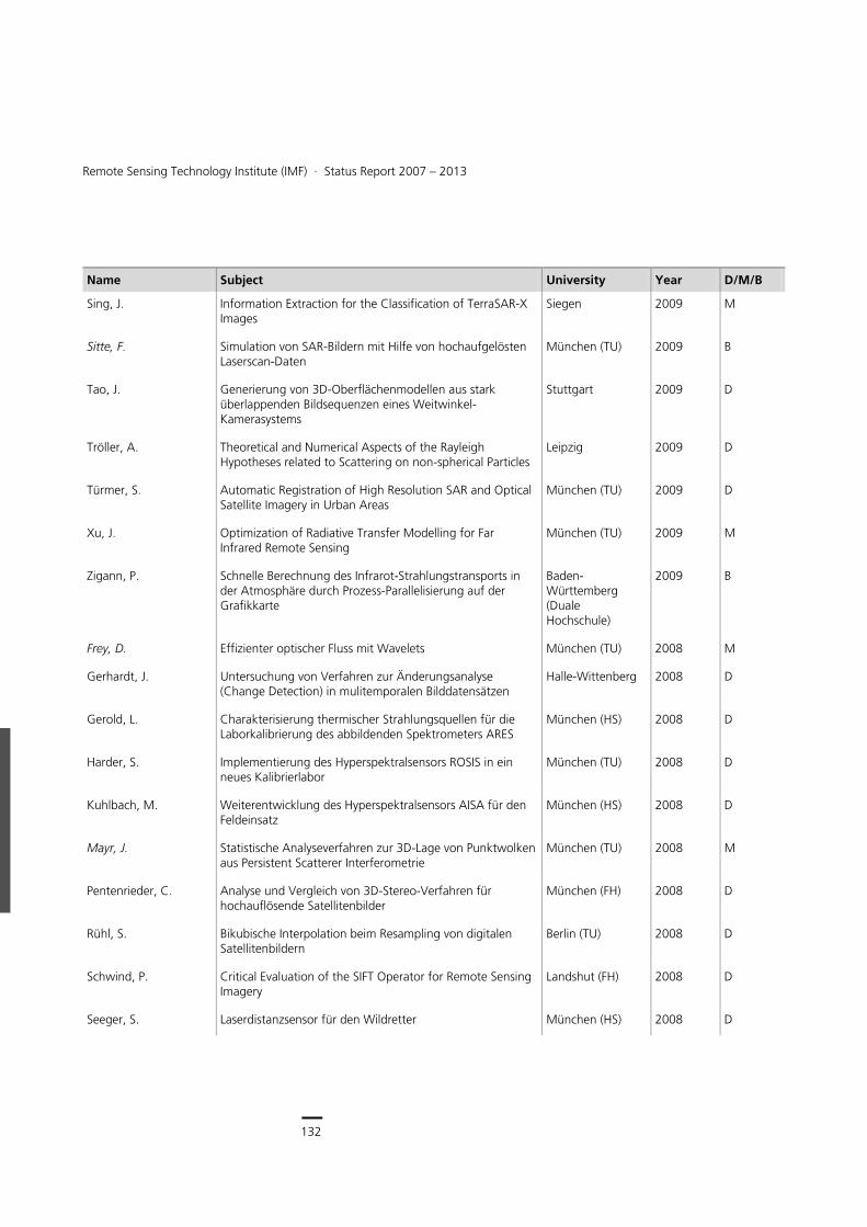
132
Earth Observation Center
132
Remote Sensing Technology Institute (IMF) ∙ Status Report 2007 – 2013
Name Subject University Year D/M/B
Sing, J. Information Extraction for the Classification of TerraSAR-X Images
Siegen 2009 M
Sitte, F. Simulation von SAR-Bildern mit Hilfe von hochaufgelösten Laserscan-Daten
München (TU) 2009 B
Tao, J. Generierung von 3D-Oberflächenmodellen aus stark überlappenden Bildsequenzen eines Weitwinkel-Kamerasystems
Stuttgart 2009 D
Tröller, A. Theoretical and Numerical Aspects of the Rayleigh Hypotheses related to Scattering on non-spherical Particles
Leipzig 2009 D
Türmer, S. Automatic Registration of High Resolution SAR and Optical Satellite Imagery in Urban Areas
München (TU) 2009 D
Xu, J. Optimization of Radiative Transfer Modelling for Far Infrared Remote Sensing
München (TU) 2009 M
Zigann, P. Schnelle Berechnung des Infrarot-Strahlungstransports in der Atmosphäre durch Prozess-Parallelisierung auf der Grafikkarte
Baden-Württemberg (Duale Hochschule)
2009 B
Frey, D. Effizienter optischer Fluss mit Wavelets München (TU) 2008 M
Gerhardt, J. Untersuchung von Verfahren zur Änderungsanalyse (Change Detection) in mulitemporalen Bilddatensätzen
Halle-Wittenberg 2008 D
Gerold, L. Charakterisierung thermischer Strahlungsquellen für die Laborkalibrierung des abbildenden Spektrometers ARES
München (HS) 2008 D
Harder, S. Implementierung des Hyperspektralsensors ROSIS in ein neues Kalibrierlabor
München (TU) 2008 D
Kuhlbach, M. Weiterentwicklung des Hyperspektralsensors AISA für den Feldeinsatz
München (HS) 2008 D
Mayr, J. Statistische Analyseverfahren zur 3D-Lage von Punktwolken aus Persistent Scatterer Interferometrie
München (TU) 2008 M
Pentenrieder, C. Analyse und Vergleich von 3D-Stereo-Verfahren für hochauflösende Satellitenbilder
München (FH) 2008 D
Rühl, S. Bikubische Interpolation beim Resampling von digitalen Satellitenbildern
Berlin (TU) 2008 D
Schwind, P. Critical Evaluation of the SIFT Operator for Remote Sensing Imagery
Landshut (FH) 2008 D
Seeger, S. Laserdistanzsensor für den Wildretter München (HS) 2008 D
133
Documentation >
Name Subject University Year D/M/B
Wendleder, A. Generierung hochauflösender Geländemodelle und Geokodierung für die TanDEM-X Mission
München (TU) 2008 M
Zeller, K. Entwicklung eines Bildverarbeitungssystems zur 3D und 4D Analyse von transparenten ETFE-Folien
München (TU) 2008 M
Zhu, X. High-Resolution Spaceborne Radar Tomography München (TU) 2008 M
Alberter, C. Unterstützung der Fahrzeugdetektion in satellitengestützten SAR-Daten mittels statistischer Verkehrsflussparameter
München (TU) 2007 M
Beinhauer, S. Untersuchung zur Orthobilderstellung von hochauflösenden Satellitenbildern auf der Basis von automatisch zugeordneten Passpunkten
München (HS) 2007 D
Damm, M. Charakterisierung und Korrektur von Streulicht in einem flugzeuggetragenen Hyperspektralsystem
Mittweida (Hochschule)
2007 D
Ebner, V. Potentiale und Grenzen des Einsatzes einer 3-Kopf-Kamera zur Erfassung und Bewertung von Massenbewegungen – Fallbeispiel Doren (Vorarlberg)
Innsbruck 2007 D
Ecker, M. Automatisierung einer optoelektronischen Kalibrier-einrichtung
Landshut (FH) 2007 D
Edirisinghage, S. Automatisierung eines abbildenden Feldspektrometers Offenburg (FH) 2007 D
Goubeau, M. Automatisierung des Hyperspektralsensors AISA für den Feld- und Laboreinsatz
München (TU) 2007 D
Leistenschneider, S. Software zur automatisierten Kalibrierung optischer Sensoren
München (FH) 2007 D
Miller, R. Projektivinvariante Objekterkennung in Echtzeit München (TU) 2007 M
Mitic, P. Evaluation of digital surface models from IKONOS stereo images for building extraction
München (TU) 2007 M
Puttkammer, F. Analyse von Verkehrsmodellen zur Unterstützung der Verkehrserfassung aus Fernerkundungsdaten
München (TU) 2007 M
Riha, S. Umsetzung GIS-kompatibler Fernerkundungsprodukte und Untersuchungen zu ihrer Validierung
Erlangen-Nürnberg
2007 D
FH: Fachhochschule HS: Hochschule
KIT: Karlsruher Institut für Technologie München (LMU): Ludwig-Maximilians-Universität München
TU: Technische Universität

133
Central Services
132
Remote Sensing Technology Institute (IMF) ∙ Status Report 2007 – 2013
Name Subject University Year D/M/B
Sing, J. Information Extraction for the Classification of TerraSAR-X Images
Siegen 2009 M
Sitte, F. Simulation von SAR-Bildern mit Hilfe von hochaufgelösten Laserscan-Daten
München (TU) 2009 B
Tao, J. Generierung von 3D-Oberflächenmodellen aus stark überlappenden Bildsequenzen eines Weitwinkel-Kamerasystems
Stuttgart 2009 D
Tröller, A. Theoretical and Numerical Aspects of the Rayleigh Hypotheses related to Scattering on non-spherical Particles
Leipzig 2009 D
Türmer, S. Automatic Registration of High Resolution SAR and Optical Satellite Imagery in Urban Areas
München (TU) 2009 D
Xu, J. Optimization of Radiative Transfer Modelling for Far Infrared Remote Sensing
München (TU) 2009 M
Zigann, P. Schnelle Berechnung des Infrarot-Strahlungstransports in der Atmosphäre durch Prozess-Parallelisierung auf der Grafikkarte
Baden-Württemberg (Duale Hochschule)
2009 B
Frey, D. Effizienter optischer Fluss mit Wavelets München (TU) 2008 M
Gerhardt, J. Untersuchung von Verfahren zur Änderungsanalyse (Change Detection) in mulitemporalen Bilddatensätzen
Halle-Wittenberg 2008 D
Gerold, L. Charakterisierung thermischer Strahlungsquellen für die Laborkalibrierung des abbildenden Spektrometers ARES
München (HS) 2008 D
Harder, S. Implementierung des Hyperspektralsensors ROSIS in ein neues Kalibrierlabor
München (TU) 2008 D
Kuhlbach, M. Weiterentwicklung des Hyperspektralsensors AISA für den Feldeinsatz
München (HS) 2008 D
Mayr, J. Statistische Analyseverfahren zur 3D-Lage von Punktwolken aus Persistent Scatterer Interferometrie
München (TU) 2008 M
Pentenrieder, C. Analyse und Vergleich von 3D-Stereo-Verfahren für hochauflösende Satellitenbilder
München (FH) 2008 D
Rühl, S. Bikubische Interpolation beim Resampling von digitalen Satellitenbildern
Berlin (TU) 2008 D
Schwind, P. Critical Evaluation of the SIFT Operator for Remote Sensing Imagery
Landshut (FH) 2008 D
Seeger, S. Laserdistanzsensor für den Wildretter München (HS) 2008 D
133
Documentation >
Name Subject University Year D/M/B
Wendleder, A. Generierung hochauflösender Geländemodelle und Geokodierung für die TanDEM-X Mission
München (TU) 2008 M
Zeller, K. Entwicklung eines Bildverarbeitungssystems zur 3D und 4D Analyse von transparenten ETFE-Folien
München (TU) 2008 M
Zhu, X. High-Resolution Spaceborne Radar Tomography München (TU) 2008 M
Alberter, C. Unterstützung der Fahrzeugdetektion in satellitengestützten SAR-Daten mittels statistischer Verkehrsflussparameter
München (TU) 2007 M
Beinhauer, S. Untersuchung zur Orthobilderstellung von hochauflösenden Satellitenbildern auf der Basis von automatisch zugeordneten Passpunkten
München (HS) 2007 D
Damm, M. Charakterisierung und Korrektur von Streulicht in einem flugzeuggetragenen Hyperspektralsystem
Mittweida (Hochschule)
2007 D
Ebner, V. Potentiale und Grenzen des Einsatzes einer 3-Kopf-Kamera zur Erfassung und Bewertung von Massenbewegungen – Fallbeispiel Doren (Vorarlberg)
Innsbruck 2007 D
Ecker, M. Automatisierung einer optoelektronischen Kalibrier-einrichtung
Landshut (FH) 2007 D
Edirisinghage, S. Automatisierung eines abbildenden Feldspektrometers Offenburg (FH) 2007 D
Goubeau, M. Automatisierung des Hyperspektralsensors AISA für den Feld- und Laboreinsatz
München (TU) 2007 D
Leistenschneider, S. Software zur automatisierten Kalibrierung optischer Sensoren
München (FH) 2007 D
Miller, R. Projektivinvariante Objekterkennung in Echtzeit München (TU) 2007 M
Mitic, P. Evaluation of digital surface models from IKONOS stereo images for building extraction
München (TU) 2007 M
Puttkammer, F. Analyse von Verkehrsmodellen zur Unterstützung der Verkehrserfassung aus Fernerkundungsdaten
München (TU) 2007 M
Riha, S. Umsetzung GIS-kompatibler Fernerkundungsprodukte und Untersuchungen zu ihrer Validierung
Erlangen-Nürnberg
2007 D
FH: Fachhochschule HS: Hochschule
KIT: Karlsruher Institut für Technologie München (LMU): Ludwig-Maximilians-Universität München
TU: Technische Universität
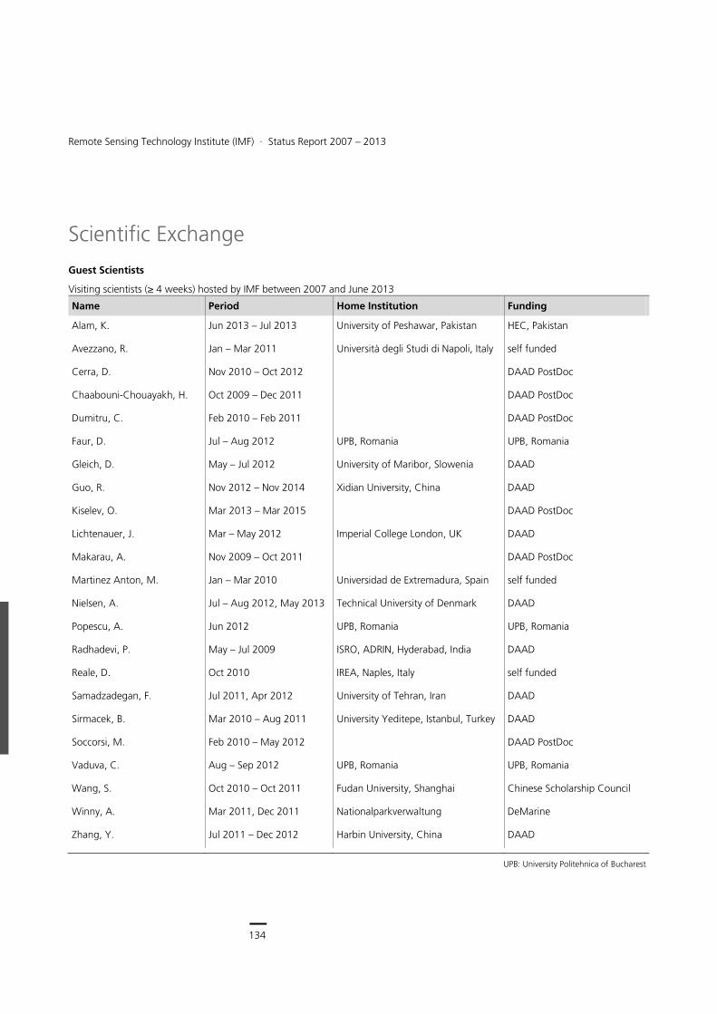
134
Earth Observation Center
134
Remote Sensing Technology Institute (IMF) ∙ Status Report 2007 – 2013
Scientific Exchange
Guest Scientists
Visiting scientists (≥ 4 weeks) hosted by IMF between 2007 and June 2013
Name Period Home Institution Funding
Alam, K. Jun 2013 – Jul 2013 University of Peshawar, Pakistan HEC, Pakistan
Avezzano, R. Jan – Mar 2011 Università degli Studi di Napoli, Italy self funded
Cerra, D. Nov 2010 – Oct 2012 DAAD PostDoc
Chaabouni-Chouayakh, H. Oct 2009 – Dec 2011 DAAD PostDoc
Dumitru, C. Feb 2010 – Feb 2011 DAAD PostDoc
Faur, D. Jul – Aug 2012 UPB, Romania UPB, Romania
Gleich, D. May – Jul 2012 University of Maribor, Slowenia DAAD
Guo, R. Nov 2012 – Nov 2014 Xidian University, China DAAD
Kiselev, O. Mar 2013 – Mar 2015 DAAD PostDoc
Lichtenauer, J. Mar – May 2012 Imperial College London, UK DAAD
Makarau, A. Nov 2009 – Oct 2011 DAAD PostDoc
Martinez Anton, M. Jan – Mar 2010 Universidad de Extremadura, Spain self funded
Nielsen, A. Jul – Aug 2012, May 2013 Technical University of Denmark DAAD
Popescu, A. Jun 2012 UPB, Romania UPB, Romania
Radhadevi, P. May – Jul 2009 ISRO, ADRIN, Hyderabad, India DAAD
Reale, D. Oct 2010 IREA, Naples, Italy self funded
Samadzadegan, F. Jul 2011, Apr 2012 University of Tehran, Iran DAAD
Sirmacek, B. Mar 2010 – Aug 2011 University Yeditepe, Istanbul, Turkey DAAD
Soccorsi, M. Feb 2010 – May 2012 DAAD PostDoc
Vaduva, C. Aug – Sep 2012 UPB, Romania UPB, Romania
Wang, S. Oct 2010 – Oct 2011 Fudan University, Shanghai Chinese Scholarship Council
Winny, A. Mar 2011, Dec 2011 Nationalparkverwaltung DeMarine
Zhang, Y. Jul 2011 – Dec 2012 Harbin University, China DAAD
UPB: University Politehnica of Bucharest
135
Documentation > Scientific Exchange
Professional Leaves
Periods of stay (≥ 4 weeks) by IMF and LMF (italic) staff at external institutions between 2007 and June 2013
Staff Member Institution Period Funding
Auer, S. UNINA, Naples, Italy Feb 2008, Feb 2009, Feb 2010 TUM graduate program
Burkert, F. University of Central Florida, Tampa, USA
March 2012 – June 2012 TUM graduate program
Frey, D. TU Denmark, Lyngby, Denmark Chinese Academy of Science, Beijing, China
April 2009 – June 2009 Feb 2010 – March 2010
TUM graduate program
Lenhard, K. JPL, Pasadena, USA Jan 2011 – Mar 2011 DLR staff mobility program
Tao, J. University of Trento, Italy Jun 2012 DLR staff mobility program
Tian, J. ETH Zürich, Switzerland Oct 2011 – Nov 2011 DLR staff mobility program
Türmer, S. CASM, Beijing, China Mar 2012 – Apr 2012 DLR staff mobility program
Zhu, K. University of Saskatchewan, Saskatchewan, Canada
May 2012 – July 2012 TUM graduate program
Zhu, X. IREA-CNR, Naples, Italy Sep 2009 – Nov 2009 TUM graduate program
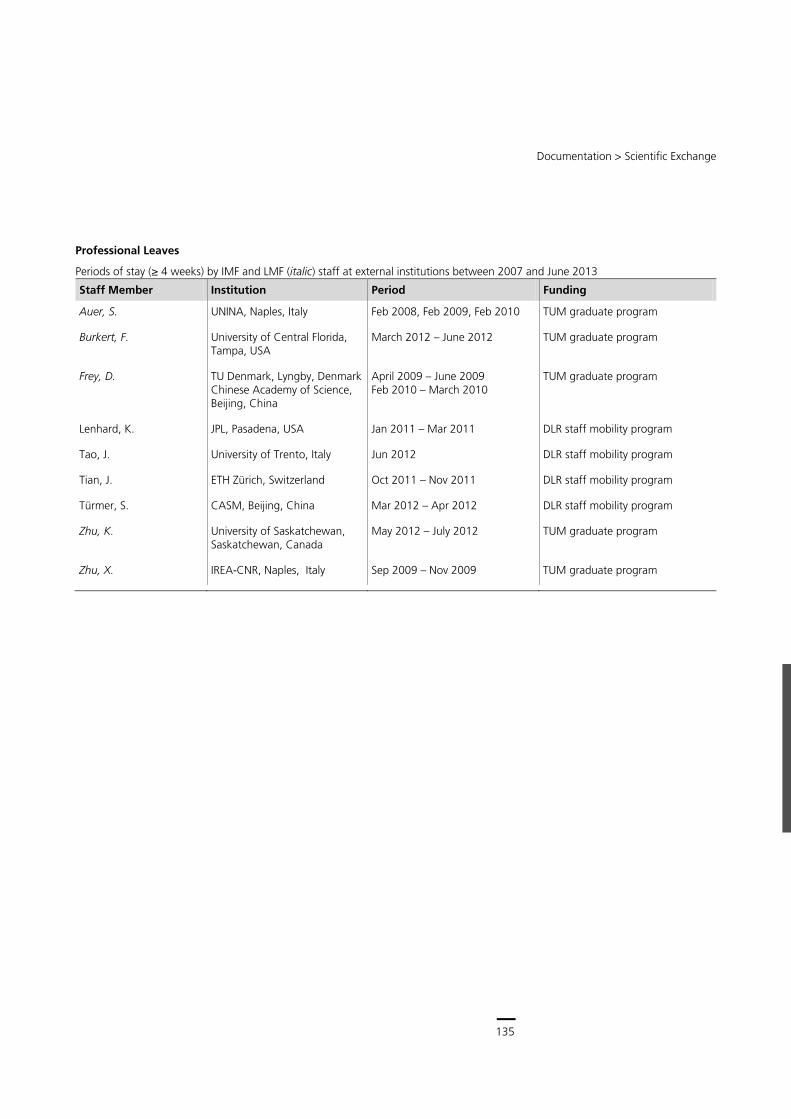
135
Central Services
134
Remote Sensing Technology Institute (IMF) ∙ Status Report 2007 – 2013
Scientific Exchange
Guest Scientists
Visiting scientists (≥ 4 weeks) hosted by IMF between 2007 and June 2013
Name Period Home Institution Funding
Alam, K. Jun 2013 – Jul 2013 University of Peshawar, Pakistan HEC, Pakistan
Avezzano, R. Jan – Mar 2011 Università degli Studi di Napoli, Italy self funded
Cerra, D. Nov 2010 – Oct 2012 DAAD PostDoc
Chaabouni-Chouayakh, H. Oct 2009 – Dec 2011 DAAD PostDoc
Dumitru, C. Feb 2010 – Feb 2011 DAAD PostDoc
Faur, D. Jul – Aug 2012 UPB, Romania UPB, Romania
Gleich, D. May – Jul 2012 University of Maribor, Slowenia DAAD
Guo, R. Nov 2012 – Nov 2014 Xidian University, China DAAD
Kiselev, O. Mar 2013 – Mar 2015 DAAD PostDoc
Lichtenauer, J. Mar – May 2012 Imperial College London, UK DAAD
Makarau, A. Nov 2009 – Oct 2011 DAAD PostDoc
Martinez Anton, M. Jan – Mar 2010 Universidad de Extremadura, Spain self funded
Nielsen, A. Jul – Aug 2012, May 2013 Technical University of Denmark DAAD
Popescu, A. Jun 2012 UPB, Romania UPB, Romania
Radhadevi, P. May – Jul 2009 ISRO, ADRIN, Hyderabad, India DAAD
Reale, D. Oct 2010 IREA, Naples, Italy self funded
Samadzadegan, F. Jul 2011, Apr 2012 University of Tehran, Iran DAAD
Sirmacek, B. Mar 2010 – Aug 2011 University Yeditepe, Istanbul, Turkey DAAD
Soccorsi, M. Feb 2010 – May 2012 DAAD PostDoc
Vaduva, C. Aug – Sep 2012 UPB, Romania UPB, Romania
Wang, S. Oct 2010 – Oct 2011 Fudan University, Shanghai Chinese Scholarship Council
Winny, A. Mar 2011, Dec 2011 Nationalparkverwaltung DeMarine
Zhang, Y. Jul 2011 – Dec 2012 Harbin University, China DAAD
UPB: University Politehnica of Bucharest
135
Documentation > Scientific Exchange
Professional Leaves
Periods of stay (≥ 4 weeks) by IMF and LMF (italic) staff at external institutions between 2007 and June 2013
Staff Member Institution Period Funding
Auer, S. UNINA, Naples, Italy Feb 2008, Feb 2009, Feb 2010 TUM graduate program
Burkert, F. University of Central Florida, Tampa, USA
March 2012 – June 2012 TUM graduate program
Frey, D. TU Denmark, Lyngby, Denmark Chinese Academy of Science, Beijing, China
April 2009 – June 2009 Feb 2010 – March 2010
TUM graduate program
Lenhard, K. JPL, Pasadena, USA Jan 2011 – Mar 2011 DLR staff mobility program
Tao, J. University of Trento, Italy Jun 2012 DLR staff mobility program
Tian, J. ETH Zürich, Switzerland Oct 2011 – Nov 2011 DLR staff mobility program
Türmer, S. CASM, Beijing, China Mar 2012 – Apr 2012 DLR staff mobility program
Zhu, K. University of Saskatchewan, Saskatchewan, Canada
May 2012 – July 2012 TUM graduate program
Zhu, X. IREA-CNR, Naples, Italy Sep 2009 – Nov 2009 TUM graduate program

136
Earth Observation Center
136
Remote Sensing Technology Institute (IMF) ∙ Status Report 2007 – 2013
Conferences
Major conferences, colloquia and workshops (co-)organized by IMF and LMF between 2007 and June 2013
Date Event Location Participants
21 – 24 May 2013 ISPRS Workshop High-Resolution Earth Imaging for Geospatial Information
Hannover 120
24 – 26 Nov 2012 8th Image Information Mining Conference Oberpfaffenhofen 85
18 Apr 2012 CEOSS Atmospheric Composition constellation Meeting (ACC-8) Columbia 50
11 – 12 Oct 2011 1. EOC-Symposium Oberpfaffenhofen 125
14 – 17 Jun 2011 ISPRS Workshop High-Resolution Earth Imaging for Geospatial Information
Hannover 100
18 – 19 May 2011 SMPR International Conference on Sensors and Models in Photogrammetry and Remote sensing
Teheran 200
30 Mar – 1 Apr 2011 7th Image Information Mining Conference Ispra 70
11 – 13 Apr 2011 JURSE 2011, Joint Urban Remote Sensing Event Munich 200
11 – 13 Oct 2010 ISPRS Commission I, WG 4 Workshop Istanbul 40
7 – 11 Nov 2009 OceanSAR 2009 Herrsching 80
3 – 5 Nov 2009 6th Image Information Mining Conference Torrejon 50
2 – 5 Jun 2009 ISPRS Workshop: High-Resolution Earth Imaging for Geospatial Information
Hannover 150
12 – 13 Nov 2008 Tandem-L-Science Workshop Oberpfaffenhofen 50
30 Sep – 1 Oct 2008 SAR Coordination Workshop in the framework of the Space Task Group (STG) for the International Polar Year (IPY)
Oberpfaffenhofen 20
4 – 6 Mar 2008 5th Image Information Mining Conference Frascati 140
137
Documentation > Patents
Patents
Filed Patent Applications
Name Patent Patent No Year Countries
Baumgartner, A. Relative radiometrische Homogenitätsmessung von Flächen und einhergehende relative radiometrische Kalibrierung von abbildenden Detektoren
DE 10 2013 106571.6 2013 DE
Israel, M. Verfahren zum Auffinden von Lebewesen aus der Luft sowie Flugobjekte zum Auffinden von Lebewesen aus der Luft
DE 10 2012 221580.8 2012 DE
Kurz, F. Müller, R. Reize, T.
Verfahren zur rechnergestützten Bestimmung der Lage eines Objekts aus digitalen Bildern
DE 10 2012 207119A1 2012 DE, EP
Schwarzmaier, T. Gege, P.
Vorrichtung zur Kalibrierung eines optischen Sensors DE 10 2012 014263.3 2012 DE
Bamler, R. Zhu, X. Wang, X.
Verfahren zur rechnergestützten Verarbeitung digitalisierter Bilder
DE 10 2011 002907.9-53 2011 DE, EP
Behrens, J. Hauer, L. Suhr, B.
Unterstützungssystem DE 10 2011 113153.5 2011 DE
Eineder, M. Verfahren zur Messung des Wasserstands eines Gewässers
DE 10 2010 001440.0-52 2010 DE, EP
Dequet, W. Tank, V.
Hochelastischer Verbundwerkstoff sowie Sportbogen aus einem hochelastischen Verbundwerkstoff
DE 10 2009 032663.4 2009 DE
Reinartz, P. Bamler, R. Suri, S.
Verfahren zur Georeferenzierung optischer Fernerkundungsbilder
EP 2225533 2009 EP, USA
Reinartz, P. Angermann, M.
Verfahren zur Echtzeit-Übertragung und –Verarbeitung von in einem bildaufnehmenden Sensor innerhalb eines Beobachtungsbereiches anfallenden Dateien
DE 10 2008 062799.2 2008 DE
Tank, V. Nitsche, R:
Verfahren und Vorrichtung zur Sortierung von Solarzellen DE 10 2008 058517.3 2008 DE
DE = Germany, AT = Austria, AU = Australia, BR = Brasilien, CA = Canada, CH = Switzerland, ES = Spain, EP = European Patent Organization, FR = France, GB = United Kingdom,
IT = Italy, NL = The Netherlands, RU = Russia SE = Sweden, US = USA
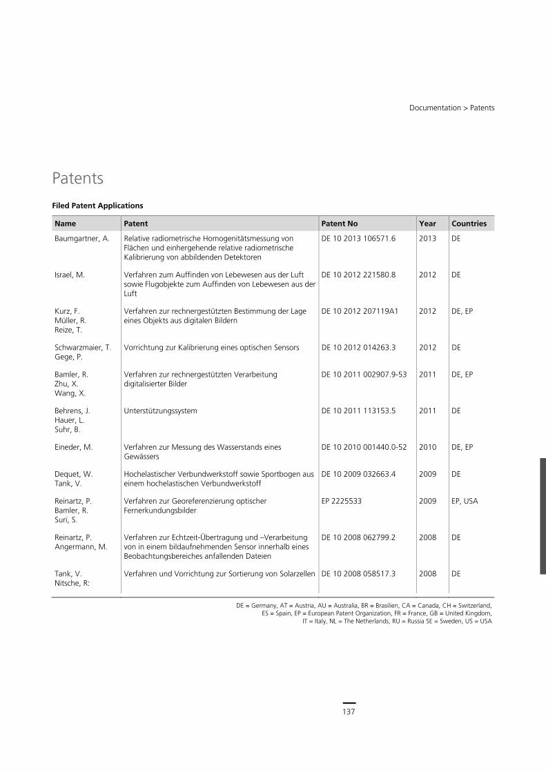
137
Central Services
136
Remote Sensing Technology Institute (IMF) ∙ Status Report 2007 – 2013
Conferences
Major conferences, colloquia and workshops (co-)organized by IMF and LMF between 2007 and June 2013
Date Event Location Participants
21 – 24 May 2013 ISPRS Workshop High-Resolution Earth Imaging for Geospatial Information
Hannover 120
24 – 26 Nov 2012 8th Image Information Mining Conference Oberpfaffenhofen 85
18 Apr 2012 CEOSS Atmospheric Composition constellation Meeting (ACC-8) Columbia 50
11 – 12 Oct 2011 1. EOC-Symposium Oberpfaffenhofen 125
14 – 17 Jun 2011 ISPRS Workshop High-Resolution Earth Imaging for Geospatial Information
Hannover 100
18 – 19 May 2011 SMPR International Conference on Sensors and Models in Photogrammetry and Remote sensing
Teheran 200
30 Mar – 1 Apr 2011 7th Image Information Mining Conference Ispra 70
11 – 13 Apr 2011 JURSE 2011, Joint Urban Remote Sensing Event Munich 200
11 – 13 Oct 2010 ISPRS Commission I, WG 4 Workshop Istanbul 40
7 – 11 Nov 2009 OceanSAR 2009 Herrsching 80
3 – 5 Nov 2009 6th Image Information Mining Conference Torrejon 50
2 – 5 Jun 2009 ISPRS Workshop: High-Resolution Earth Imaging for Geospatial Information
Hannover 150
12 – 13 Nov 2008 Tandem-L-Science Workshop Oberpfaffenhofen 50
30 Sep – 1 Oct 2008 SAR Coordination Workshop in the framework of the Space Task Group (STG) for the International Polar Year (IPY)
Oberpfaffenhofen 20
4 – 6 Mar 2008 5th Image Information Mining Conference Frascati 140
137
Documentation > Patents
Patents
Filed Patent Applications
Name Patent Patent No Year Countries
Baumgartner, A. Relative radiometrische Homogenitätsmessung von Flächen und einhergehende relative radiometrische Kalibrierung von abbildenden Detektoren
DE 10 2013 106571.6 2013 DE
Israel, M. Verfahren zum Auffinden von Lebewesen aus der Luft sowie Flugobjekte zum Auffinden von Lebewesen aus der Luft
DE 10 2012 221580.8 2012 DE
Kurz, F. Müller, R. Reize, T.
Verfahren zur rechnergestützten Bestimmung der Lage eines Objekts aus digitalen Bildern
DE 10 2012 207119A1 2012 DE, EP
Schwarzmaier, T. Gege, P.
Vorrichtung zur Kalibrierung eines optischen Sensors DE 10 2012 014263.3 2012 DE
Bamler, R. Zhu, X. Wang, X.
Verfahren zur rechnergestützten Verarbeitung digitalisierter Bilder
DE 10 2011 002907.9-53 2011 DE, EP
Behrens, J. Hauer, L. Suhr, B.
Unterstützungssystem DE 10 2011 113153.5 2011 DE
Eineder, M. Verfahren zur Messung des Wasserstands eines Gewässers
DE 10 2010 001440.0-52 2010 DE, EP
Dequet, W. Tank, V.
Hochelastischer Verbundwerkstoff sowie Sportbogen aus einem hochelastischen Verbundwerkstoff
DE 10 2009 032663.4 2009 DE
Reinartz, P. Bamler, R. Suri, S.
Verfahren zur Georeferenzierung optischer Fernerkundungsbilder
EP 2225533 2009 EP, USA
Reinartz, P. Angermann, M.
Verfahren zur Echtzeit-Übertragung und –Verarbeitung von in einem bildaufnehmenden Sensor innerhalb eines Beobachtungsbereiches anfallenden Dateien
DE 10 2008 062799.2 2008 DE
Tank, V. Nitsche, R:
Verfahren und Vorrichtung zur Sortierung von Solarzellen DE 10 2008 058517.3 2008 DE
DE = Germany, AT = Austria, AU = Australia, BR = Brasilien, CA = Canada, CH = Switzerland, ES = Spain, EP = European Patent Organization, FR = France, GB = United Kingdom,
IT = Italy, NL = The Netherlands, RU = Russia SE = Sweden, US = USA
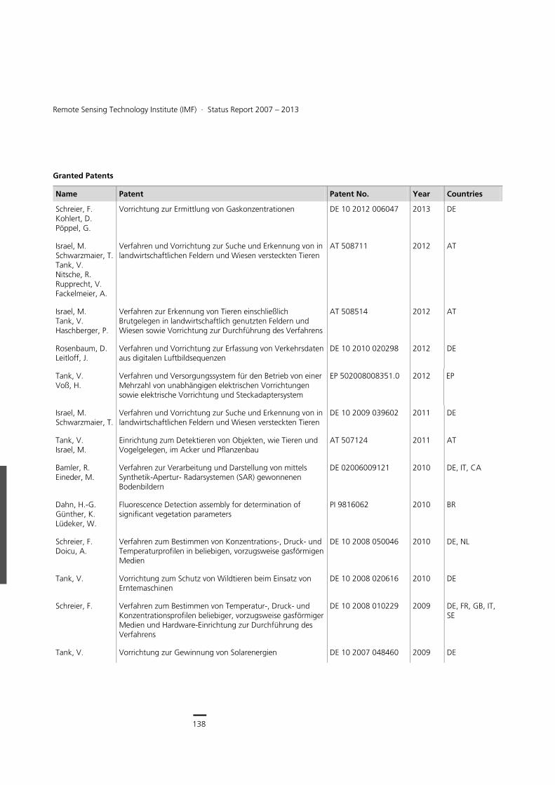
138
Earth Observation Center
138
Remote Sensing Technology Institute (IMF) ∙ Status Report 2007 – 2013
Granted Patents
Name Patent Patent No. Year Countries
Schreier, F. Kohlert, D. Pöppel, G.
Vorrichtung zur Ermittlung von Gaskonzentrationen DE 10 2012 006047 2013 DE
Israel, M. Schwarzmaier, T. Tank, V. Nitsche, R. Rupprecht, V. Fackelmeier, A.
Verfahren und Vorrichtung zur Suche und Erkennung von in landwirtschaftlichen Feldern und Wiesen versteckten Tieren
AT 508711 2012 AT
Israel, M. Tank, V. Haschberger, P.
Verfahren zur Erkennung von Tieren einschließlich Brutgelegen in landwirtschaftlich genutzten Feldern und Wiesen sowie Vorrichtung zur Durchführung des Verfahrens
AT 508514 2012 AT
Rosenbaum, D. Leitloff, J.
Verfahren und Vorrichtung zur Erfassung von Verkehrsdaten aus digitalen Luftbildsequenzen
DE 10 2010 020298 2012 DE
Tank, V. Voß, H.
Verfahren und Versorgungssystem für den Betrieb von einer Mehrzahl von unabhängigen elektrischen Vorrichtungen sowie elektrische Vorrichtung und Steckadaptersystem
EP 502008008351.0 2012 EP
Israel, M. Schwarzmaier, T.
Verfahren und Vorrichtung zur Suche und Erkennung von in landwirtschaftlichen Feldern und Wiesen versteckten Tieren
DE 10 2009 039602 2011 DE
Tank, V. Israel, M.
Einrichtung zum Detektieren von Objekten, wie Tieren und Vogelgelegen, im Acker und Pflanzenbau
AT 507124 2011 AT
Bamler, R. Eineder, M.
Verfahren zur Verarbeitung und Darstellung von mittels Synthetik-Apertur- Radarsystemen (SAR) gewonnenen Bodenbildern
DE 02006009121 2010 DE, IT, CA
Dahn, H.-G. Günther, K. Lüdeker, W.
Fluorescence Detection assembly for determination of significant vegetation parameters
PI 9816062 2010 BR
Schreier, F. Doicu, A.
Verfahren zum Bestimmen von Konzentrations-, Druck- und Temperaturprofilen in beliebigen, vorzugsweise gasförmigen Medien
DE 10 2008 050046 2010 DE, NL
Tank, V. Vorrichtung zum Schutz von Wildtieren beim Einsatz von Erntemaschinen
DE 10 2008 020616 2010 DE
Schreier, F. Verfahren zum Bestimmen von Temperatur-, Druck- und Konzentrationsprofilen beliebiger, vorzugsweise gasförmiger Medien und Hardware-Einrichtung zur Durchführung des Verfahrens
DE 10 2008 010229 2009 DE, FR, GB, IT, SE
Tank, V. Vorrichtung zur Gewinnung von Solarenergien DE 10 2007 048460 2009 DE
139
Documentation > Patents
Name Patent Patent No. Year Countries
Tank, V. Einrichtung zum Feststellen und Auffinden von sich in Wiesen aufhaltenden Tieren
DE 10 2005 029732 2009 DE, AT, CH
Bamler, R. Verfahren zur Bilderzeugung bei einem Synthetischen Apertur Radar
DE 10 2004 045273 2008 DE
Eineder, M. Interferometrisches Mikowellen-Radarverfahren DE 50 2004 007353 2008 DE, CA, IT
Runge, H. Synthetik-Apertur-Radar (SAR)-System DE 50 2006 001476 2008 DE, FR, IT, GB, CA
Runge, H. Hochauflösendes Synthetik-Apertur-Seitensicht-Radarsystem (SAR)
DE 10 2005 022028 2008 DE
Lindermeir, E. Tank, V:
Verfahren zum Analysieren und ständigen Überwachen von Abgasparametern in Triebwerken von Flugzeugen während des Flugs
DE 199 44006 B4 2007 DE
Tank, V. Verfahren zum Detektieren und Diskriminieren von Tieren in landwirtschaftlich genutzten Wiesenflächen
DE 10 2005 055919 2007 DE, CH, AT
Tank, V. Verfahren zum Orten von Objekten in Form von Gasaustritten an der Erdoberfläche
DE 50 2004 003077 2007 DE
Tank, V. Haschberger, P. Schulz, J.
Verfahren zum Bestimmen des Düngebedarfs in Gärten, Gärtnereien oder Parkanlagen
DE 10 2004 001748 2007 DE, FR, GB
Tank, V. Lindermeir, E.
Verfahren zur Bestimmung von Konzentrations-, Druck- und Temperaturprofilen von Gasen in Verbrennungsprozessen und deren Abgasströmen und –wolken
DE 10 2005 060245 2007 DE, GB
For country abbreviations see footnote to previous table of Filed Patent Applications
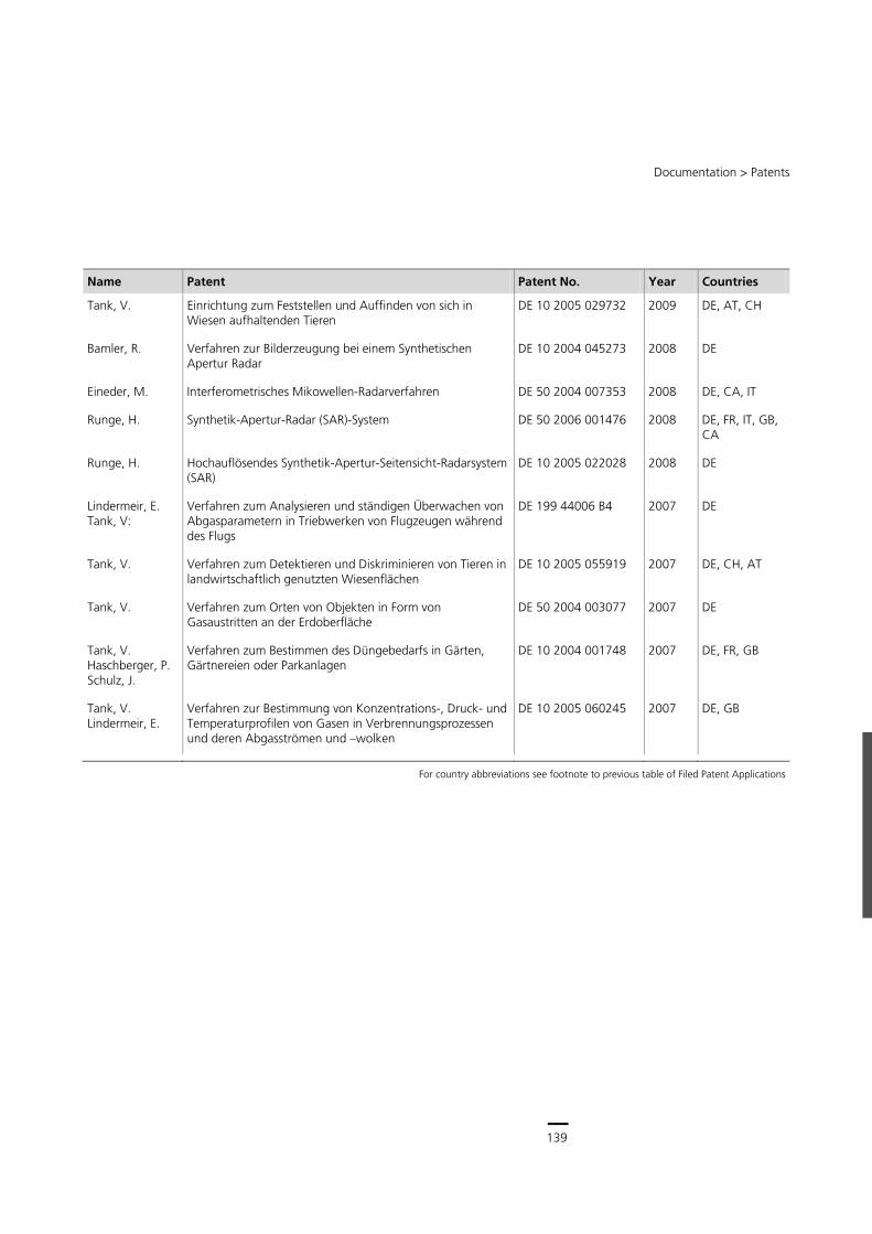
139
Central Services
138
Remote Sensing Technology Institute (IMF) ∙ Status Report 2007 – 2013
Granted Patents
Name Patent Patent No. Year Countries
Schreier, F. Kohlert, D. Pöppel, G.
Vorrichtung zur Ermittlung von Gaskonzentrationen DE 10 2012 006047 2013 DE
Israel, M. Schwarzmaier, T. Tank, V. Nitsche, R. Rupprecht, V. Fackelmeier, A.
Verfahren und Vorrichtung zur Suche und Erkennung von in landwirtschaftlichen Feldern und Wiesen versteckten Tieren
AT 508711 2012 AT
Israel, M. Tank, V. Haschberger, P.
Verfahren zur Erkennung von Tieren einschließlich Brutgelegen in landwirtschaftlich genutzten Feldern und Wiesen sowie Vorrichtung zur Durchführung des Verfahrens
AT 508514 2012 AT
Rosenbaum, D. Leitloff, J.
Verfahren und Vorrichtung zur Erfassung von Verkehrsdaten aus digitalen Luftbildsequenzen
DE 10 2010 020298 2012 DE
Tank, V. Voß, H.
Verfahren und Versorgungssystem für den Betrieb von einer Mehrzahl von unabhängigen elektrischen Vorrichtungen sowie elektrische Vorrichtung und Steckadaptersystem
EP 502008008351.0 2012 EP
Israel, M. Schwarzmaier, T.
Verfahren und Vorrichtung zur Suche und Erkennung von in landwirtschaftlichen Feldern und Wiesen versteckten Tieren
DE 10 2009 039602 2011 DE
Tank, V. Israel, M.
Einrichtung zum Detektieren von Objekten, wie Tieren und Vogelgelegen, im Acker und Pflanzenbau
AT 507124 2011 AT
Bamler, R. Eineder, M.
Verfahren zur Verarbeitung und Darstellung von mittels Synthetik-Apertur- Radarsystemen (SAR) gewonnenen Bodenbildern
DE 02006009121 2010 DE, IT, CA
Dahn, H.-G. Günther, K. Lüdeker, W.
Fluorescence Detection assembly for determination of significant vegetation parameters
PI 9816062 2010 BR
Schreier, F. Doicu, A.
Verfahren zum Bestimmen von Konzentrations-, Druck- und Temperaturprofilen in beliebigen, vorzugsweise gasförmigen Medien
DE 10 2008 050046 2010 DE, NL
Tank, V. Vorrichtung zum Schutz von Wildtieren beim Einsatz von Erntemaschinen
DE 10 2008 020616 2010 DE
Schreier, F. Verfahren zum Bestimmen von Temperatur-, Druck- und Konzentrationsprofilen beliebiger, vorzugsweise gasförmiger Medien und Hardware-Einrichtung zur Durchführung des Verfahrens
DE 10 2008 010229 2009 DE, FR, GB, IT, SE
Tank, V. Vorrichtung zur Gewinnung von Solarenergien DE 10 2007 048460 2009 DE
139
Documentation > Patents
Name Patent Patent No. Year Countries
Tank, V. Einrichtung zum Feststellen und Auffinden von sich in Wiesen aufhaltenden Tieren
DE 10 2005 029732 2009 DE, AT, CH
Bamler, R. Verfahren zur Bilderzeugung bei einem Synthetischen Apertur Radar
DE 10 2004 045273 2008 DE
Eineder, M. Interferometrisches Mikowellen-Radarverfahren DE 50 2004 007353 2008 DE, CA, IT
Runge, H. Synthetik-Apertur-Radar (SAR)-System DE 50 2006 001476 2008 DE, FR, IT, GB, CA
Runge, H. Hochauflösendes Synthetik-Apertur-Seitensicht-Radarsystem (SAR)
DE 10 2005 022028 2008 DE
Lindermeir, E. Tank, V:
Verfahren zum Analysieren und ständigen Überwachen von Abgasparametern in Triebwerken von Flugzeugen während des Flugs
DE 199 44006 B4 2007 DE
Tank, V. Verfahren zum Detektieren und Diskriminieren von Tieren in landwirtschaftlich genutzten Wiesenflächen
DE 10 2005 055919 2007 DE, CH, AT
Tank, V. Verfahren zum Orten von Objekten in Form von Gasaustritten an der Erdoberfläche
DE 50 2004 003077 2007 DE
Tank, V. Haschberger, P. Schulz, J.
Verfahren zum Bestimmen des Düngebedarfs in Gärten, Gärtnereien oder Parkanlagen
DE 10 2004 001748 2007 DE, FR, GB
Tank, V. Lindermeir, E.
Verfahren zur Bestimmung von Konzentrations-, Druck- und Temperaturprofilen von Gasen in Verbrennungsprozessen und deren Abgasströmen und –wolken
DE 10 2005 060245 2007 DE, GB
For country abbreviations see footnote to previous table of Filed Patent Applications
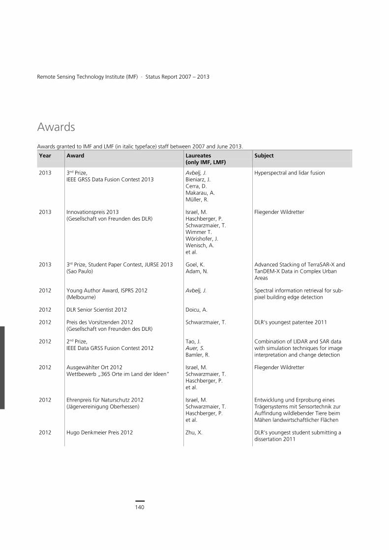
140
Earth Observation Center
140
Remote Sensing Technology Institute (IMF) ∙ Status Report 2007 – 2013
Awards
Awards granted to IMF and LMF (in italic typeface) staff between 2007 and June 2013.
Year Award Laureates (only IMF, LMF)
Subject
2013 3nd Prize, IEEE GRSS Data Fusion Contest 2013
Avbelj, J. Bieniarz, J. Cerra, D. Makarau, A. Müller, R.
Hyperspectral and lidar fusion
2013 Innovationspreis 2013 (Gesellschaft von Freunden des DLR)
Israel, M. Haschberger, P. Schwarzmaier, T. Wimmer T. Wörishofer, J. Wenisch, A. et al.
Fliegender Wildretter
2013 3rd Prize, Student Paper Contest, JURSE 2013 (Sao Paulo)
Goel, K. Adam, N.
Advanced Stacking of TerraSAR-X and TanDEM-X Data in Complex Urban Areas
2012 Young Author Award, ISPRS 2012 (Melbourne)
Avbelj, J. Spectral information retrieval for sub-pixel building edge detection
2012 DLR Senior Scientist 2012 Doicu, A.
2012 Preis des Vorsitzenden 2012 (Gesellschaft von Freunden des DLR)
Schwarzmaier, T. DLR’s youngest patentee 2011
2012 2nd Prize, IEEE Data GRSS Fusion Contest 2012
Tao, J. Auer, S. Bamler, R.
Combination of LIDAR and SAR data with simulation techniques for image interpretation and change detection
2012 Ausgewählter Ort 2012 Wettbewerb „365 Orte im Land der Ideen”
Israel, M. Schwarzmaier, T. Haschberger, P. et al.
Fliegender Wildretter
2012 Ehrenpreis für Naturschutz 2012 (Jägervereinigung Oberhessen)
Israel, M. Schwarzmaier, T. Haschberger, P. et al.
Entwicklung und Erprobung eines Trägersystems mit Sensortechnik zur Auffindung wildlebender Tiere beim Mähen landwirtschaftlicher Flächen
2012 Hugo Denkmeier Preis 2012 Zhu, X. DLR’s youngest student submitting a dissertation 2011
141
Documentation > Awards
Year Award Laureates (only IMF, LMF)
Subject
2011 Best Paper Award IEEE Geoscience and Remote Sensing Letters, 2011
Zhu, X. Bamler, R. et al.
Tomographic Imaging and Monitoring of Buildings with Very High Resolution SAR
2011 DLR Wissenschaftspreis 2011 Coldewey-Egbers, M. Loyola, D. et al.
Global long-term monitoring of the ozone layer – a prerequisite for predictions (Intern. Journal of Remote Sensing, 30 (2009), pp. 4295-4318)
2011 Innovation Award, SIMA 2011 (Paris) Israel, M. Schwarzmaier, T. Haschberger, P. et al.
Technical sensor system to detect wild animals during the mowing of agricultural land.
2011 IEEE GRS Education Award 2011, IEEE Geoscience and Remote Sensing Society Symposium (Vancouver)
Bamler, R. Significant educational contributions to Geoscience and Remote Sensing
2011 2011 ASLI Choice, Atmospheric Science Librarians International
Gottwald, M. et al.
SCIAMACHY – Exploring the Changing Earth’s Atmosphere
2011 3rd Prize, Student Paper contest JURSE 2011 (Munich)
Wang, Y. Zhu, X. Bamler, R.
Advanced Coherence Stacking Technique Using High Resolution TerraSAR-X Spotlight Data
2011 Harbert Award 2011 for outstanding Diploma Thesis
Tao, J. Generierung von 3D-Oberflächenmodellen aus stark überlappenden Bildsequenzen eines Weitwinkel-Kamerasystems
2011 Dimitri N. Chorofas Foundation Research Award 2011
Zhu, X. Very High Resolution Tomographic SAR Inversion for Urban Infrastructure Monitoring – A Sparse and Nonlinear Tour
2010 Symposium Prize Paper Award IEEE Geoscience and Remote Sensing Society 2010
Zhu, X. Adam, N. Bamler, R.
Space-borne High Resolution Tomographic Interferometry
2010 GNSS Living Lab Prize (Health), European Satellite Navigation Competition 2010
Tank, V. Cardiac Power Monitoring
2010 Best Poster Award 2010 24. Intern. Polar Meeting 2010 (Obergurgl)
Floricioiu, D. Abdel Jaber, W.
Variations of a large, high elevation glacier during the last century: Fedchenko Glacier, Pamir
2009 Franz-Xaver-Erlacher-Förderpreis 2009 (Gesellschaft von Freunden des DLR)
Vogt, P. Atmosphärenmessungen mit dem ballongetragenen Heterodyn-spektrometer TELIS
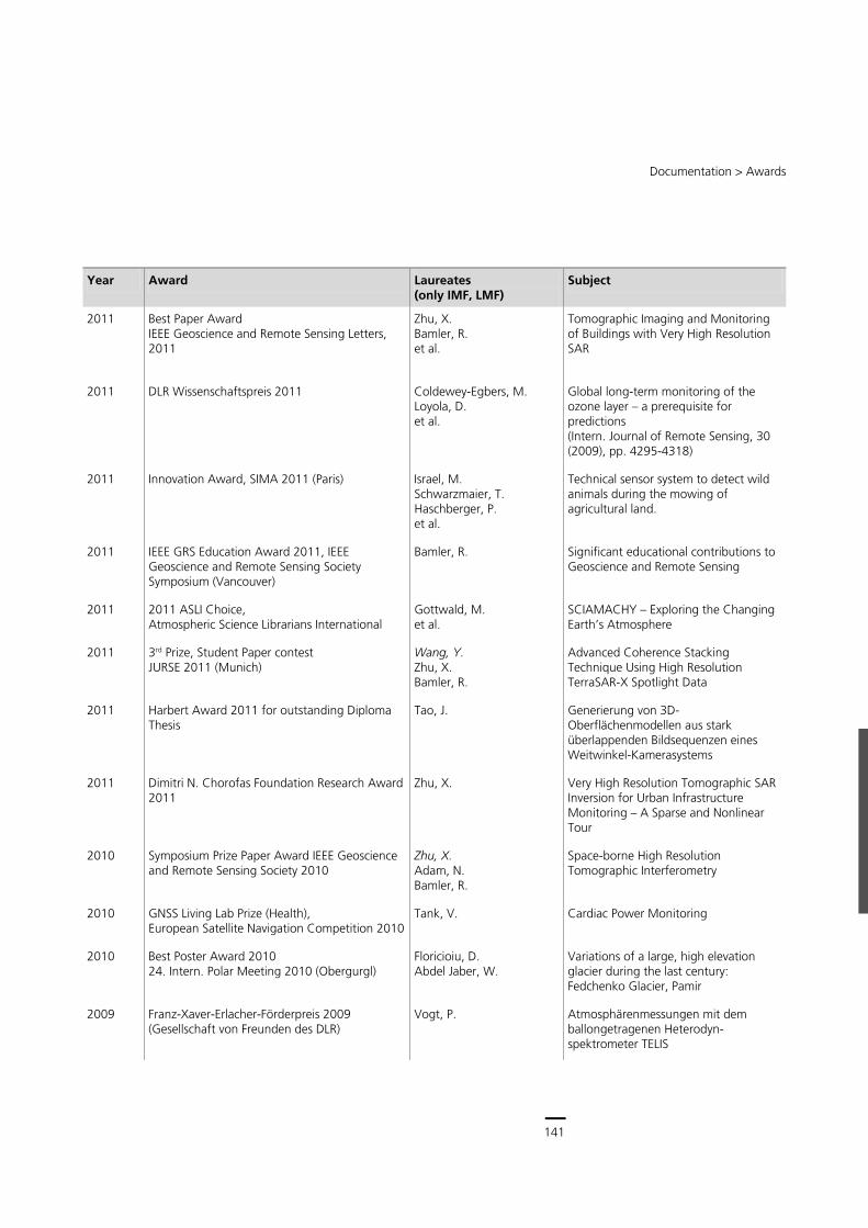
141
Central Services
140
Remote Sensing Technology Institute (IMF) ∙ Status Report 2007 – 2013
Awards
Awards granted to IMF and LMF (in italic typeface) staff between 2007 and June 2013.
Year Award Laureates (only IMF, LMF)
Subject
2013 3nd Prize, IEEE GRSS Data Fusion Contest 2013
Avbelj, J. Bieniarz, J. Cerra, D. Makarau, A. Müller, R.
Hyperspectral and lidar fusion
2013 Innovationspreis 2013 (Gesellschaft von Freunden des DLR)
Israel, M. Haschberger, P. Schwarzmaier, T. Wimmer T. Wörishofer, J. Wenisch, A. et al.
Fliegender Wildretter
2013 3rd Prize, Student Paper Contest, JURSE 2013 (Sao Paulo)
Goel, K. Adam, N.
Advanced Stacking of TerraSAR-X and TanDEM-X Data in Complex Urban Areas
2012 Young Author Award, ISPRS 2012 (Melbourne)
Avbelj, J. Spectral information retrieval for sub-pixel building edge detection
2012 DLR Senior Scientist 2012 Doicu, A.
2012 Preis des Vorsitzenden 2012 (Gesellschaft von Freunden des DLR)
Schwarzmaier, T. DLR’s youngest patentee 2011
2012 2nd Prize, IEEE Data GRSS Fusion Contest 2012
Tao, J. Auer, S. Bamler, R.
Combination of LIDAR and SAR data with simulation techniques for image interpretation and change detection
2012 Ausgewählter Ort 2012 Wettbewerb „365 Orte im Land der Ideen”
Israel, M. Schwarzmaier, T. Haschberger, P. et al.
Fliegender Wildretter
2012 Ehrenpreis für Naturschutz 2012 (Jägervereinigung Oberhessen)
Israel, M. Schwarzmaier, T. Haschberger, P. et al.
Entwicklung und Erprobung eines Trägersystems mit Sensortechnik zur Auffindung wildlebender Tiere beim Mähen landwirtschaftlicher Flächen
2012 Hugo Denkmeier Preis 2012 Zhu, X. DLR’s youngest student submitting a dissertation 2011
141
Documentation > Awards
Year Award Laureates (only IMF, LMF)
Subject
2011 Best Paper Award IEEE Geoscience and Remote Sensing Letters, 2011
Zhu, X. Bamler, R. et al.
Tomographic Imaging and Monitoring of Buildings with Very High Resolution SAR
2011 DLR Wissenschaftspreis 2011 Coldewey-Egbers, M. Loyola, D. et al.
Global long-term monitoring of the ozone layer – a prerequisite for predictions (Intern. Journal of Remote Sensing, 30 (2009), pp. 4295-4318)
2011 Innovation Award, SIMA 2011 (Paris) Israel, M. Schwarzmaier, T. Haschberger, P. et al.
Technical sensor system to detect wild animals during the mowing of agricultural land.
2011 IEEE GRS Education Award 2011, IEEE Geoscience and Remote Sensing Society Symposium (Vancouver)
Bamler, R. Significant educational contributions to Geoscience and Remote Sensing
2011 2011 ASLI Choice, Atmospheric Science Librarians International
Gottwald, M. et al.
SCIAMACHY – Exploring the Changing Earth’s Atmosphere
2011 3rd Prize, Student Paper contest JURSE 2011 (Munich)
Wang, Y. Zhu, X. Bamler, R.
Advanced Coherence Stacking Technique Using High Resolution TerraSAR-X Spotlight Data
2011 Harbert Award 2011 for outstanding Diploma Thesis
Tao, J. Generierung von 3D-Oberflächenmodellen aus stark überlappenden Bildsequenzen eines Weitwinkel-Kamerasystems
2011 Dimitri N. Chorofas Foundation Research Award 2011
Zhu, X. Very High Resolution Tomographic SAR Inversion for Urban Infrastructure Monitoring – A Sparse and Nonlinear Tour
2010 Symposium Prize Paper Award IEEE Geoscience and Remote Sensing Society 2010
Zhu, X. Adam, N. Bamler, R.
Space-borne High Resolution Tomographic Interferometry
2010 GNSS Living Lab Prize (Health), European Satellite Navigation Competition 2010
Tank, V. Cardiac Power Monitoring
2010 Best Poster Award 2010 24. Intern. Polar Meeting 2010 (Obergurgl)
Floricioiu, D. Abdel Jaber, W.
Variations of a large, high elevation glacier during the last century: Fedchenko Glacier, Pamir
2009 Franz-Xaver-Erlacher-Förderpreis 2009 (Gesellschaft von Freunden des DLR)
Vogt, P. Atmosphärenmessungen mit dem ballongetragenen Heterodyn-spektrometer TELIS
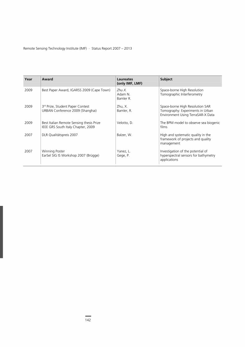
142
Earth Observation Center
142
Remote Sensing Technology Institute (IMF) ∙ Status Report 2007 – 2013
Year Award Laureates (only IMF, LMF)
Subject
2009 Best Paper Award, IGARSS 2009 (Cape Town) Zhu X. Adam N. Bamler R.
Space-borne High Resolution Tomographic Interferometry
2009 3rd Prize, Student Paper Contest URBAN Conference 2009 (Shanghai)
Zhu, X. Bamler, R.
Space-borne High Resolution SAR Tomography: Experiments in Urban Environment Using TerraSAR-X Data
2009 Best Italian Remote Sensing thesis Prize IEEE GRS South Italy Chapter, 2009
Velotto, D. The BPM model to observe sea biogenic films
2007 DLR Qualitätspreis 2007 Balzer, W. High and systematic quality in the framework of projects and quality management
2007 Winning Poster EarSel SIG IS Workshop 2007 (Brügge)
Yanez, L. Gege, P.
Investigation of the potential of hyperspectral sensors for bathymetry applications
Documentation > Publications in ISI or Scopus Journals
143
Publications
This chapter lists in reverse chronological order for the time period between January 1, 2007 and June 30, 2013
publications in ISI and SCOPUS journals,
other publications with full paper review
books and book contributions,
other publications.
Internal reports as well as doctoral, diploma, Master and Bachelor theses are not listed.
IMF authors appear in bold typeface, employees of the TUM-LMF are in bold and italic typeface.
Publications in ISI or Scopus Journals
2013 under review
[1] Cui, S., Datcu, M.: A Benchmark for Change Simulation and Evaluation of Information Similarity Measures for Multitemporal SAR Image Analysis, IEEE Transactions on Geoscience and Remote Sensing, submitted, 2013.
[2] Gege, P.: WASI-2D: A software tool for regionally optimized analysis of imaging spectrometer data from deep and shallow waters, Computers & Geosciences, submitted, 2013.
[3] Schreier, F., Gimeno Garcia, S., Hedelt, P., Hess, M., Mendro, J., Vasquez, M., Xu, J.: GARLIC - A General Purpose Atmospheric Radiative Transfer Line-by-Line Infrared Code: Implementation and Evaluation, Journal of Quantitative Spectroscopy and Radiative Transfer, submitted, 2013.
[4] Singh, J., Espinoza-Molina, D., Datcu, M.: Evaluation of Gibbs Random Fields-based and Wavelet-based Methods for Information Extraction in Metric-Resolution SAR Images, IEEE Journal of Selected Topics in Applied Earth Observations and Remote Sensing, submitted, 2013.
[5] Tian, J., Nielsen, A., Reinartz, P.: Improving change detection in forest areas based on stereo panchromatic imagery using kernel MNF, IEEE Transactions on Geoscience and Remote Sensing, submitted, 2013.
[6] Wang, Y., Zhu, X. X., Bamler, R.: An efficient approach for tomographic inversion using meter resolution SAR image stacks, IEEE Geoscience and Remote Sensing Letters, submitted, 2013.
2013
[7] Alam, K., Trautmann, T., Blaschke, T., Majid, H.: Aerosol optical and radiative properties during summer and winter seasons over Lahore and Karachi, Atmospheric Environment, 50, pp. 234-245, 2013.
[8] Arefi, H., Reinartz, P.: Building Reconstruction Using DSM and Orthorectified Images, Remote Sensing, 5 (4), pp. 1681-1703, 2013.
[9] Berger, C., Voltersen, M., Eckardt, R., Eberle, J., Heyer, T., Salepci, N., Hese, S., Schmullius, C., Tao, J., Auer, S., Bamler, R., Ewald, K., Gartley, M., Jacobson, J., Buswell, A., Du, Q., Pacifici, F.: Multi-Modal and Multi-Temporal Data Fusion: Outcome of the 2012 GRSS Data Fusion Contest, IEEE Journal of Selected Topics in Applied Earth Observations and Remote Sensing, 6 (3), pp. 1324-1340, 2013.
[10] Bigdeli, B., Samadzadegan, F., Reinartz, P.: Band Grouping versus Band Clustering in SVM Ensemble Classification of Hyperspectral Imagery, Photogrammetric Engineering and Remote Sensing (PE&RS), 79 (6), pp. 523-534, 2013.
[11] Cerra, D., Datcu, M.: Expanding the Algorithmic Information Theory Frame for Applications to Earth Observation, Entropy, 15 (1), pp. 407-415, 2013.
[12] Cerra, D., Müller, R., Reinartz, P.: A Classification Algorithm for Hyperspectral Images based on Synergetics Theory, IEEE Transactions on Geoscience and Remote Sensing, 51 (5), pp. 2887-2898, 2013.
[13] Cerra, D., Müller, R., Reinartz, P.: Noise Reduction in Hyperspectral Images through Spectral Unmixing, IEEE Geoscience and Remote Sensing Letters, 11 (1), in press, 2013.
[14] Cui, S., Dumitru, C. O., Datcu, M.: Ratio-Detector-Based Feature Extraction for Very High Resolution SAR Image Patch Indexing, IEEE Geoscience and Remote Sensing Letters, pp. 1-5, 2013.
[15] De Zan, F., Parizzi, A., Prats, P., López-Dekker, P.: A SAR interferometric model for soil moisture, IEEE Transactions on Geoscience and Remote Sensing, accepted, 2013.
[16] Doicu, A., Efremenko, D., Trautmann, T.: A multi-dimensional vector spherical harmonics discrete ordinate method for atmospheric radiative transfer, Journal of Quantitative Spectroscopy and Radiative Transfer, 118, pp. 121-131, 2013.
[17] Doicu, A., Efremenko, D., Trautmann, T.: An analysis of the short-characteristic method for the spherical harmonic discrete ordinate method (SHDOM), Journal of Quantitative Spectroscopy and Radiative Transfer, 2013.
[18] Dumitru, O., Datcu, M.: Information Content of Very High Resolution SAR Images: Study of Feature Extraction and Imaging Parameters, IEEE Transactions on Geoscience and Remote Sensing, accepted, 2013.
[19] Efremenko, D., Doicu, A., Loyola, D., Trautmann, T.: Accelerations of the Discrete Ordinate Method for Nadir Viewing Geometries, AIP Conference Proceedings, 1531, pp. 55-58, 2013.
[20] Efremenko, D., Doicu, A., Loyola, D., Trautmann, T.: Acceleration techniques for the discrete ordinate method, Journal of Quantitative Spectroscopy and Radiative Transfer, 114, pp. 73-81, 2013.
[21] Efremenko, D., Doicu, A., Loyola, D., Trautmann, T.: Small-angle modification of the radiative transfer equation for a pseudo-spherical atmosphere, Journal of Quantitative Spectroscopy and Radiative Transfer, 114, pp. 82-90, 2013.
[22] Eineder, M., Bamler, R., Cong, X., Gernhardt, S., Fritz, T., Zhu, X. X., Balss, U., Breit, H., Adam, N., Floricioiu, D.: Globale Kartierung und lokale Deformationsmessungen mit den Satelliten TerraSAR-X und TanDEM-X, ZFV – Zeitschrift für Geodasie, Geoinformation und Landmanagement, 1/2013, pp. 75-84, 2013.
[23] Espinoza-Molina, D., Datcu, M.: Earth-Observation Image Retrieval Based on Content, Semantics, and Metadata, IEEE Transactions on Geoscience and Remote Sensing, pp. 1-15, 2013.
[24] Fioletov, V. E., McLinden, C. A., Krotkov, N., Yang, K., Loyola, D., Valks, P., Theys, N., Van Roozendael, M., Nowlan, C., Chance, K., Liu, X., Lee, C., Martin, R. V.: Application of OMI, SCIAMACHY and GOME-2 satellite SO2 retrievals for detection of large emission sources, Journal of Geophysical Research, accepted, 2013.
[25] Gege, P.: A model of underwater spectral irradiance accounting for wave focusing, AIP Conference Proceedings, 1531, pp. 931-934, 2013.
[26] Hedelt, P., von Paris, P., Godolt, M., Gebauer, S., Grenfell, J. L., Rauer, H., Schreier, F., Selsis, F., Trautmann, T.: Spectral features of Earth-like planets and their detectability at different orbital distances around F, G, and K-type stars, Astronomy & Astrophysics, 553, pp. 1-14, 2013.
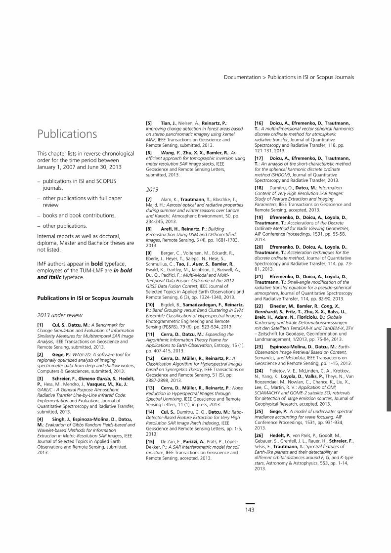
143
Central Services
142
Remote Sensing Technology Institute (IMF) ∙ Status Report 2007 – 2013
Year Award Laureates (only IMF, LMF)
Subject
2009 Best Paper Award, IGARSS 2009 (Cape Town) Zhu X. Adam N. Bamler R.
Space-borne High Resolution Tomographic Interferometry
2009 3rd Prize, Student Paper Contest URBAN Conference 2009 (Shanghai)
Zhu, X. Bamler, R.
Space-borne High Resolution SAR Tomography: Experiments in Urban Environment Using TerraSAR-X Data
2009 Best Italian Remote Sensing thesis Prize IEEE GRS South Italy Chapter, 2009
Velotto, D. The BPM model to observe sea biogenic films
2007 DLR Qualitätspreis 2007 Balzer, W. High and systematic quality in the framework of projects and quality management
2007 Winning Poster EarSel SIG IS Workshop 2007 (Brügge)
Yanez, L. Gege, P.
Investigation of the potential of hyperspectral sensors for bathymetry applications
Documentation > Publications in ISI or Scopus Journals
143
Publications
This chapter lists in reverse chronological order for the time period between January 1, 2007 and June 30, 2013
publications in ISI and SCOPUS journals,
other publications with full paper review
books and book contributions,
other publications.
Internal reports as well as doctoral, diploma, Master and Bachelor theses are not listed.
IMF authors appear in bold typeface, employees of the TUM-LMF are in bold and italic typeface.
Publications in ISI or Scopus Journals
2013 under review
[1] Cui, S., Datcu, M.: A Benchmark for Change Simulation and Evaluation of Information Similarity Measures for Multitemporal SAR Image Analysis, IEEE Transactions on Geoscience and Remote Sensing, submitted, 2013.
[2] Gege, P.: WASI-2D: A software tool for regionally optimized analysis of imaging spectrometer data from deep and shallow waters, Computers & Geosciences, submitted, 2013.
[3] Schreier, F., Gimeno Garcia, S., Hedelt, P., Hess, M., Mendro, J., Vasquez, M., Xu, J.: GARLIC - A General Purpose Atmospheric Radiative Transfer Line-by-Line Infrared Code: Implementation and Evaluation, Journal of Quantitative Spectroscopy and Radiative Transfer, submitted, 2013.
[4] Singh, J., Espinoza-Molina, D., Datcu, M.: Evaluation of Gibbs Random Fields-based and Wavelet-based Methods for Information Extraction in Metric-Resolution SAR Images, IEEE Journal of Selected Topics in Applied Earth Observations and Remote Sensing, submitted, 2013.
[5] Tian, J., Nielsen, A., Reinartz, P.: Improving change detection in forest areas based on stereo panchromatic imagery using kernel MNF, IEEE Transactions on Geoscience and Remote Sensing, submitted, 2013.
[6] Wang, Y., Zhu, X. X., Bamler, R.: An efficient approach for tomographic inversion using meter resolution SAR image stacks, IEEE Geoscience and Remote Sensing Letters, submitted, 2013.
2013
[7] Alam, K., Trautmann, T., Blaschke, T., Majid, H.: Aerosol optical and radiative properties during summer and winter seasons over Lahore and Karachi, Atmospheric Environment, 50, pp. 234-245, 2013.
[8] Arefi, H., Reinartz, P.: Building Reconstruction Using DSM and Orthorectified Images, Remote Sensing, 5 (4), pp. 1681-1703, 2013.
[9] Berger, C., Voltersen, M., Eckardt, R., Eberle, J., Heyer, T., Salepci, N., Hese, S., Schmullius, C., Tao, J., Auer, S., Bamler, R., Ewald, K., Gartley, M., Jacobson, J., Buswell, A., Du, Q., Pacifici, F.: Multi-Modal and Multi-Temporal Data Fusion: Outcome of the 2012 GRSS Data Fusion Contest, IEEE Journal of Selected Topics in Applied Earth Observations and Remote Sensing, 6 (3), pp. 1324-1340, 2013.
[10] Bigdeli, B., Samadzadegan, F., Reinartz, P.: Band Grouping versus Band Clustering in SVM Ensemble Classification of Hyperspectral Imagery, Photogrammetric Engineering and Remote Sensing (PE&RS), 79 (6), pp. 523-534, 2013.
[11] Cerra, D., Datcu, M.: Expanding the Algorithmic Information Theory Frame for Applications to Earth Observation, Entropy, 15 (1), pp. 407-415, 2013.
[12] Cerra, D., Müller, R., Reinartz, P.: A Classification Algorithm for Hyperspectral Images based on Synergetics Theory, IEEE Transactions on Geoscience and Remote Sensing, 51 (5), pp. 2887-2898, 2013.
[13] Cerra, D., Müller, R., Reinartz, P.: Noise Reduction in Hyperspectral Images through Spectral Unmixing, IEEE Geoscience and Remote Sensing Letters, 11 (1), in press, 2013.
[14] Cui, S., Dumitru, C. O., Datcu, M.: Ratio-Detector-Based Feature Extraction for Very High Resolution SAR Image Patch Indexing, IEEE Geoscience and Remote Sensing Letters, pp. 1-5, 2013.
[15] De Zan, F., Parizzi, A., Prats, P., López-Dekker, P.: A SAR interferometric model for soil moisture, IEEE Transactions on Geoscience and Remote Sensing, accepted, 2013.
[16] Doicu, A., Efremenko, D., Trautmann, T.: A multi-dimensional vector spherical harmonics discrete ordinate method for atmospheric radiative transfer, Journal of Quantitative Spectroscopy and Radiative Transfer, 118, pp. 121-131, 2013.
[17] Doicu, A., Efremenko, D., Trautmann, T.: An analysis of the short-characteristic method for the spherical harmonic discrete ordinate method (SHDOM), Journal of Quantitative Spectroscopy and Radiative Transfer, 2013.
[18] Dumitru, O., Datcu, M.: Information Content of Very High Resolution SAR Images: Study of Feature Extraction and Imaging Parameters, IEEE Transactions on Geoscience and Remote Sensing, accepted, 2013.
[19] Efremenko, D., Doicu, A., Loyola, D., Trautmann, T.: Accelerations of the Discrete Ordinate Method for Nadir Viewing Geometries, AIP Conference Proceedings, 1531, pp. 55-58, 2013.
[20] Efremenko, D., Doicu, A., Loyola, D., Trautmann, T.: Acceleration techniques for the discrete ordinate method, Journal of Quantitative Spectroscopy and Radiative Transfer, 114, pp. 73-81, 2013.
[21] Efremenko, D., Doicu, A., Loyola, D., Trautmann, T.: Small-angle modification of the radiative transfer equation for a pseudo-spherical atmosphere, Journal of Quantitative Spectroscopy and Radiative Transfer, 114, pp. 82-90, 2013.
[22] Eineder, M., Bamler, R., Cong, X., Gernhardt, S., Fritz, T., Zhu, X. X., Balss, U., Breit, H., Adam, N., Floricioiu, D.: Globale Kartierung und lokale Deformationsmessungen mit den Satelliten TerraSAR-X und TanDEM-X, ZFV – Zeitschrift für Geodasie, Geoinformation und Landmanagement, 1/2013, pp. 75-84, 2013.
[23] Espinoza-Molina, D., Datcu, M.: Earth-Observation Image Retrieval Based on Content, Semantics, and Metadata, IEEE Transactions on Geoscience and Remote Sensing, pp. 1-15, 2013.
[24] Fioletov, V. E., McLinden, C. A., Krotkov, N., Yang, K., Loyola, D., Valks, P., Theys, N., Van Roozendael, M., Nowlan, C., Chance, K., Liu, X., Lee, C., Martin, R. V.: Application of OMI, SCIAMACHY and GOME-2 satellite SO2 retrievals for detection of large emission sources, Journal of Geophysical Research, accepted, 2013.
[25] Gege, P.: A model of underwater spectral irradiance accounting for wave focusing, AIP Conference Proceedings, 1531, pp. 931-934, 2013.
[26] Hedelt, P., von Paris, P., Godolt, M., Gebauer, S., Grenfell, J. L., Rauer, H., Schreier, F., Selsis, F., Trautmann, T.: Spectral features of Earth-like planets and their detectability at different orbital distances around F, G, and K-type stars, Astronomy & Astrophysics, 553, pp. 1-14, 2013.
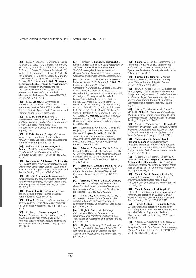
144
Earth Observation Center
Remote Sensing Technology Institute (IMF) ∙ Status Report 2007 – 2013
144
[27] Kasai, Y., Sagawa, H., Kreyling, D., Suzuki, K., Dupuy, E., Sato, T. O., Mendrok, J., Baron, P., Nishibori, T., Mizobuchi, S., Kikuchi, K., Manabe, T., Ozeki, H., Sugita, T., Fujiwara, M., Irimajiri, Y., Walker, K. A., Bernath, P. F., Boone, C., Stiller, G., von Clarmann, T., Orphal, J., Urban, J., Murtagh, D., Llewellyn, E. J., Degenstein, D., Bourassa, A. E., Lloyd, N. D., Froidevaux, L., Birk, M., Wagner, G., Schreier, F., Xu, J., Vogt, P., Trautmann, T., Yasui, M.: Validation of stratospheric and mesospheric ozone observed by SMILES from International Space Station, Atmospheric Measurement Techniques Discussions (AMTD), 6 (2), pp. 2643-2720, 2013.
[28] Li, X., Lehner, S.: Observation of TerraSAR-X for studies on offshore wind turbine wake in near and far fields, IEEE Journal of Selected Topics in Applied Earth Observations and Remote Sensing, 6 (3), in press, 2013.
[29] Li, X.-M., Lehner, S., Bruns, T.: Simultaneous Measurements by Advanced SAR and Radar Altimeter on Potential Improvement of Ocean Wave Model Assimilation, IEEE Transactions on Geoscience and Remote Sensing, in press, 2013.
[30] Li, X.-M., Lehner, S.: Algorithm for sea surface wind retrieval from TerraSAR-X and TanDEM-X data, IEEE Transactions on Geoscience and Remote Sensing, in press, 2013.
[31] Mahmoudi, F., Samadzadegan, F., Reinartz, P.: Object oriented image analysis based on multi-agent recognition system, Computers & Geosciences, 54 (1), pp. 219-230, 2013.
[32] Makarau, A., Palubinskas, G., Reinartz, P.: Alphabet-based Multisensory Data Fusion and Classification using Factor Graphs, IEEE Journal of Selected Topics in Applied Earth Observations and Remote Sensing, 6 (2), pp. 969-990, 2013.
[33] Otto, S., Trautmann, T.: A note on G-functions within the scope of radiative transfer in turbid vegetation media, Journal of Quantitative Spectroscopy and Radiative Transfer, pp. 2813-2819, 2013.
[34] Palubinskas, G.: Fast, simple and good pan-sharpening method, Journal of Applied Remote Sensing, accepted, 2013.
[35] Pflug, B.: Ground based measurements of aerosol properties using Microtops instruments, AIP Conference Proceedings, 1531, pp. 588-591, 2013.
[36] Rastiveis, H., Samadzadegan, F., Reinartz, P.: A fuzzy decision making system for building damage map creation using high resolution satellite imagery, Natural Hazards and Earth System Sciences (NHESS), 13 (1), pp. 455-472, 2013.
[37] Romeiser, R., Runge, H., Suchandt, S., Kahle, R., Rossi, C., Bell, P.: Quality Assessment of Surface Current Fields From TerraSAR-X and TanDEM-X Along-Track Interferometry and Doppler Centroid Analysis, IEEE Transactions on Geoscience and Remote Sensing, accepted, 2013.
[38] Rothman, L. S., Gordon, I. E., Babikov, Y., Barbe, A., Benner, D. C., Bernath, P. F., Birk, M., Bizzocchi, L., Boudon, V., Brown, L. R., Campargue, A., Chance, K., Coudert, L. H., Devi, V. M., Drouin, B. J., Fayt, A., Flaud, J.-M., Gamache, R. R., Harrison, J., Hartmann, J.-M., Hill, C., Hodges, J. T., Jacquemart, D., Jolly, A., Lamouroux, J., LeRoy, R. J., Li, G., Long, D., Mackie, C. J., Massie, S. T., Mikhailenko, S., Müller, H. S.P., Naumenko, O. V., Nikitin, A. V., Orphal, J., Perevalov, V. I., Perrin, A., Polovtseva, E. R., Richard, C., Smith, M. A.H., Starikova, E., Sung, K., Tashkun, S. A., Tennyson, J., Toon, G. C., Tyuterev, V., Wagner, G.: The HITRAN 2012 Molecular Spectroscopic Database, Journal of Quantitative Spectroscopy and Radiative Transfer, accepted, 2013.
[39] Safieddine, S., Clerbaux, C., George, M., Hadji-Lazaro, J., Hurtmans, D., Coheur, P.-F., Wespes, C., Loyola, D., Valks, P., Hao, N.: Tropospheric ozone and nitrogen dioxide measurements in urban and rural regions as seen by IASI and GOME-2, Journal of Geophysical Research, accepted, 2013.
[40] Schreier, F., Gimeno Garcia, S., Milz, M., Kottayil, A., Höpfner, M., Clarmann von, T., Stiller, G.: Intercomparison of three microwave/infrared high resolution line-by-line radiative transfer codes, AIP Conference Proceedings, 1531, pp. 119-122, 2013.
[41] Schreier, F., Gimeno Garcia, S.: Py4CAtS – Python Tools for Line-by-Line Modelling of Infrared Atmospheric Radiative Transfer, AIP Conference Proceedings, 1531, pp. 123-126, 2013.
[42] Schreier, F., Xu, J., Doicu, A., Vogt, P., Trautmann, T.: Deriving Stratospheric Trace Gases From Balloon-borne Infrared/Microwave Limb Sounding Measurements, AIP Conference Proceedings, 1531, pp. 392-395, 2013.
[43] Shi, Y., Zhu, X. X., Ellero, M., Adams, N. A.: Analysis of interpolation schemes for the accurate estimation of energy spectrum in Lagrangian methods, Computers & Fluids, 82 (8), pp. 122-131, 2013.
[44] Singh, J., Datcu, M.: SAR Image Categorization With Log Cumulants of the Fractional Fourier Transform Coefficients, IEEE Transactions on Geoscience and Remote Sensing, pp. 1-10, 2013.
[45] Singha, S., Bellerby, T., Trieschmann, O.: Satellite Oil Spill Detection using Artificial Neural Networks, IEEE Journal of Selected Topics in Applied Earth Observations and Remote Sensing, pp. 1-9, 2013.
[46] Singha, S., Vespe, M., Trieschmann, O.: Automatic SAR based Oil Spill Detection and Performance Estimation via Semi-Automatic Operational Service Benchmark, Marine Pollution Bulletin, in press, 2013.
[47] Sirmacek, B., Reinartz, P.: Feature analysis for detecting people from remotely sensed images, Journal of Applied Remote Sensing, 7 (1), pp. 1-13, 2013.
[48] Spurr, R., Natraj, V., Lerot, C., Roozendael, M. V., Loyola, D.: Linearization of the Principal Component Analysis method for radiative transfer acceleration: Application to retrieval algorithms and sensitivity studies, Journal of Quantitative Spectroscopy and Radiative Transfer, 125, pp. 1-17, 2013.
[49] Storch, T., Habermeyer, M., Eberle, S., Mühle, H., Müller, R.: Towards a Critical Design of an Operational Ground Segment for an Earth Observation Mission, Journal of Applied Remote Sensing, 7 (1), pp. 1-12, 2013.
[50] Straub, C., Tian, J., Seitz, R., Reinartz, P.: Assessment of Cartosat-1 and WorldView-2 stereo imagery in combination with a LiDAR DTM for timber volume estimation in a highly structured forest in Germany, Forestry, pp. 1-11, 2013.
[51] Tao, J., Auer, S., Palubinskas, G., Reinartz, P., Bamler, R.: Automatic SAR simulation techniques for object identification in complex urban scenarios, IEEE Journal of Selected Topics in Applied Earth Observations and Remote Sensing, pp. 1-9, 2013.
[52] Taubert, D. R., Hollandt, J., Sperfeld, P., Höpe, A., Hauer, K.-O., Gege, P., Schwarzmaier, T., Lenhard, K., Baumgartner, A.: Providing Radiometric Traceability for the Calibration Home Base of DLR by PTB, AIP Conference Proceedings, 1531, pp. 376-379, 2013.
[53] Tian, J., Cui, S., Reinartz, P.: Building change detection based on satellite stereo imagery and digital surface models, IEEE Transactions on Geoscience and Remote Sensing, pp. 1-12, 2013.
[54] Tian, J., Reinartz, P., d'Angelo, P., Ehlers, M.: Region-based automatic building and forest change detection on Cartosat-1 stereo imagery, ISPRS Journal of Photogrammetry and Remote Sensing, 79, pp. 226-239, 2013.
[55] Türmer, S., Kurz, F., Reinartz, P., Stilla, U.: Airborne vehicle detection in dense urban areas using HoG features and disparity maps, IEEE Journal of Selected Topics in Applied Earth Observations and Remote Sensing, PP (99), pp. 1-11, 2013.
[56] Vaduva, C., Costachioiu, T., Patrascu, C., Gavat, I., Lazarescu, V., Datcu, M.: A Latent Analysis of Earth Surface Dynamic Evolution Using Change Map Time Series, in Proc. EUSIPCO 2012, 51 (4), pp. 2105-2117, 2013.
Documentation > Publications in ISI or Scopus Journals
145
[57] Vaduva, C., Gavat, I., Datcu, M.: Latent Dirichlet Allocation for Spatial Analysis of Satellite Images, in Proc. EUSIPCO 2012, 51 (5), pp. 2770-2786, 2013.
[58] Vasquez, M., Gottwald, M., Gimeno Garcia, S., Krieg, E., Lichtenberg, G., Schreier, F., Slijkhuis, S., Snel, R., Trautmann, T.: Venus observations from ENVISAT–SCIAMACHY: Measurements and modeling, Advances in Space Research, 51, pp. 835-848, 2013.
[59] Vasquez, M., Schreier, F., Gimeno Garcia, S., Kitzmann, D., Patzer, B., Rauer, H., Trautmann, T.: Infrared radiative transfer in atmospheres of Earth-like planets around F, G, K, and M stars. II. Thermal emission spectra influenced by clouds, Astronomy and Astrophysics, accepted, 2013.
[60] Vasquez, M., Schreier, F., Gimeno Garcia, S., Kitzmann, D., Patzer, B., Rauer, H., Trautmann, T.: Infrared radiative transfer in atmospheres of Earth-like planets around F, G, K, and M stars – I. Clear-sky thermal emission spectra and weighting functions, Astronomy and Astrophysics, 549 (A26), pp. 1-13, 2013.
[61] Velotto, D., Nunziata, F., Migliaccio, M., Lehner, S.: Dual-Polarimetric TerraSAR-X SAR Data for Target at Sea Observation, IEEE Geoscience and Remote Sensing Letters, 10 (5), pp. 1114-1118, 2013.
[62] Velotto, D., Soccorsi, M., Lehner, S.: Azimuth Ambiguities Removal for Ship Detection Using Full Polarimetric X-Band SAR Data, IEEE Transactions on Geoscience and Remote Sensing, pp. 1-13, 2013.
[63] Venganzones, M., Datcu, M., Graa, M.: Further results on dissimilarity spaces for hyperspectral images RF-CBIR, Pattern Recognition Letters, in press, 2013.
[64] von Paris, P., Hedelt, P., Selsis, F., Schreier, F., Trautmann, T.: Characterization of potentially habitable planets: Retrieval of atmospheric and planetary properties from emission spectra, Astronomy & Astrophysics, 551, pp. 1-14, 2013.
[65] Zhu, X. X., Shahzad, M.: Facade Reconstruction Using Multi-View Spaceborne TomoSAR Point Clouds, IEEE Transactions on Geoscience and Remote Sensing, in press, 2013.
2012
[66] Afanas'ev, V., Efremenko, D., Lubenchenko, A.: Determining the applicability boundaries of small-angle approximation to the radiative transfer equation for elastic peak electron spectroscopy, Bulletin of the Russian Academy of Sciences: Physics, 76 (5), pp. 565-569, 2012.
[67] Avbelj, J., Iwaszczuk, D., Stilla, U., Oštir, K.: Samodejna koregistracija trirazsežnih modelov stavb z grafičnimi gradniki na podobah : Automatic Coregistration of Three-Dimensional Building Models with Image Features, Geodetski Vestnik, 56 (1), pp. 41-56, 2012.
[68] Birk, M., Wagner, G.: Temperature-dependent air broadening of water in the 1250–1750 cm-1 range, Journal of Quantitative Spectroscopy and Radiative Transfer, 113 (11), pp. 889-928, 2012.
[69] Bramstedt, K., Noel, S., Bovensmann, H., Gottwald, M., Burrows, J. P.: Precise pointing knowledge for SCIAMACHY solar occultation measurements, Atmospheric Measurement Techniques, 5 (11), pp. 2867-2880, 2012.
[70] Bratasanu, D., Nedelcu, I., Datcu, M.: Interactive Spectral Band Discovery for Exploratory Visual Analysis of Satellite Images, IEEE Journal of Selected Topics in Applied Earth Observations and Remote Sensing, 5 (1), pp. 207-224, 2012.
[71] Budak, V., Efremenko, D., Shagalov, O.: Efficiency of algorithm for solution of vector radiative transfer equation in turbid medium slab, Journal of Physics: Conference Series, 369, pp. 1-10, 2012.
[72] Burkert, F., Bamler, R.: Graph-Based Analysis of Pedestrian Interactions and Events Using Hidden Markov Models, Photogrammetrie, Fernerkundung, Geoinformation, pp. 701-710, 2012.
[73] Butenuth, M., Heipke, C.: Network Snakes: Graph-based Object Delineation with Active Contour Models, Machine Vision and Applications, 23 (1), pp. 91-109, 2012.
[74] Cerra, D., Datcu, M.: A fast compression-based similarity measure with applications to content-based image retrieval, Journal of Visual Communication and Image Representation, 23 (2), pp. 293-302, 2012.
[75] Cong, X., Balss, U., Eineder, M., Fritz, T.: Imaging Geodesy—Centimeter-Level Ranging Accuracy With TerraSAR-X: An Update, IEEE Geoscience and Remote Sensing Letters, 9 (5), pp. 948-952, 2012.
[76] Cui, S., Datcu, M.: Statistical Wavelet Subband Modeling for Multi-temporal SAR Change Detection, IEEE Journal of Selected Topics in Applied Earth Observations and Remote Sensing, 5 (4), pp. 1095-1109, 2012.
[77] Cui, S., Yan, Q., Reinartz, P.: Complex building description and extraction based on Hough transformation and cycle detection, Remote Sensing Letters, 3 (2), pp. 151-159, 2012.
[78] de Lange, A., Birk, M., de Lange, G., Friedl-Vallon, F., Kiselev, O., Koshelets, V., Maucher, G., Oelhaf, H., Selig, A., Vogt, P., Wagner, G., Landgraf, J.: HCl and ClO in activated Arctic air; first retrieved vertical profiles from TELIS submillimetre limb spectra, Atmospheric Measurement Techniques, 5, pp. 487-500, 2012.
[79] Espinoza-Molina, D., Gleich, D., Datcu, M.: Evaluation of Bayesian Despeckling and Texture Extraction Methods Based on Gauss–Markov and Auto-Binomial Gibbs Random Fields: Application to TerraSAR-X Data, IEEE Transactions on Geoscience and Remote Sensing, 50 (5), pp. 2001-2025, 2012.
[80] Frey, D., Butenuth, M., Straub, D.: Probabilistic Graphical Models for Flood State Detection of Roads Combining Imagery and DEM, IEEE Geoscience and Remote Sensing Letters, 9 (6), pp. 1051-1055, 2012.
[81] Gege, P.: Analytic model for the direct and diffuse components of downwelling spectral irradiance in water, Applied Optics, 51 (9), pp. 1407-1419, 2012.
[82] Gege, P.: Estimation of phytoplankton concentration from downwelling irradiance measurements in water, Israel Journal of Plant Sciences, 60 (1-2), pp. 193-207, 2012.
[83] Gernhardt, S., Bamler, R.: Deformation monitoring of single buildings using meter-resolution SAR data in PSI, ISPRS Journal of Photogrammetry and Remote Sensing, 73, pp. 68-79, 2012.
[84] Goel, K., Adam, N.: An advanced algorithm for deformation estimation in non-urban areas, ISPRS Journal of Photogrammetry and Remote Sensing, 73, pp. 100-110, 2012.
[85] Goel, K., Adam, N.: Three dimensional positioning of point scatterers based on radargrammetry, IEEE Transactions on Geoscience and Remote Sensing, 50 (6), pp. 2355-2363, 2012.
[86] Grenfell, J. L., Griessmeier, J. M., von Paris, P., Patzer, B., Lammer, H., Stracke, B., Gebauer, S., Schreier, F., Rauer, H.: Response of atmospheric biomarkers to NOx-induced photochemistry generated by stellar cosmic rays for Earth-like planets in the habitable zone of M-dwarf stars, Astrobiology, 12 (12), pp. 1109-1122, 2012.
[87] Howat, I., Jezek, K., Studinger, M., MacGregor, J., Paden, J., Floricioiu, D., Russel, R., Linkwiler, M., Dominguez, R.: Rift in Antarctic Glacier: A Unique Chance to study Ice Shelf Retreat, Eos: transactions, 93 (8), pp. 77-78, 2012.
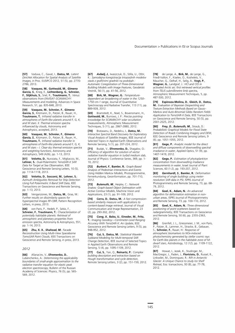
145
Central Services
Remote Sensing Technology Institute (IMF) ∙ Status Report 2007 – 2013
144
[27] Kasai, Y., Sagawa, H., Kreyling, D., Suzuki, K., Dupuy, E., Sato, T. O., Mendrok, J., Baron, P., Nishibori, T., Mizobuchi, S., Kikuchi, K., Manabe, T., Ozeki, H., Sugita, T., Fujiwara, M., Irimajiri, Y., Walker, K. A., Bernath, P. F., Boone, C., Stiller, G., von Clarmann, T., Orphal, J., Urban, J., Murtagh, D., Llewellyn, E. J., Degenstein, D., Bourassa, A. E., Lloyd, N. D., Froidevaux, L., Birk, M., Wagner, G., Schreier, F., Xu, J., Vogt, P., Trautmann, T., Yasui, M.: Validation of stratospheric and mesospheric ozone observed by SMILES from International Space Station, Atmospheric Measurement Techniques Discussions (AMTD), 6 (2), pp. 2643-2720, 2013.
[28] Li, X., Lehner, S.: Observation of TerraSAR-X for studies on offshore wind turbine wake in near and far fields, IEEE Journal of Selected Topics in Applied Earth Observations and Remote Sensing, 6 (3), in press, 2013.
[29] Li, X.-M., Lehner, S., Bruns, T.: Simultaneous Measurements by Advanced SAR and Radar Altimeter on Potential Improvement of Ocean Wave Model Assimilation, IEEE Transactions on Geoscience and Remote Sensing, in press, 2013.
[30] Li, X.-M., Lehner, S.: Algorithm for sea surface wind retrieval from TerraSAR-X and TanDEM-X data, IEEE Transactions on Geoscience and Remote Sensing, in press, 2013.
[31] Mahmoudi, F., Samadzadegan, F., Reinartz, P.: Object oriented image analysis based on multi-agent recognition system, Computers & Geosciences, 54 (1), pp. 219-230, 2013.
[32] Makarau, A., Palubinskas, G., Reinartz, P.: Alphabet-based Multisensory Data Fusion and Classification using Factor Graphs, IEEE Journal of Selected Topics in Applied Earth Observations and Remote Sensing, 6 (2), pp. 969-990, 2013.
[33] Otto, S., Trautmann, T.: A note on G-functions within the scope of radiative transfer in turbid vegetation media, Journal of Quantitative Spectroscopy and Radiative Transfer, pp. 2813-2819, 2013.
[34] Palubinskas, G.: Fast, simple and good pan-sharpening method, Journal of Applied Remote Sensing, accepted, 2013.
[35] Pflug, B.: Ground based measurements of aerosol properties using Microtops instruments, AIP Conference Proceedings, 1531, pp. 588-591, 2013.
[36] Rastiveis, H., Samadzadegan, F., Reinartz, P.: A fuzzy decision making system for building damage map creation using high resolution satellite imagery, Natural Hazards and Earth System Sciences (NHESS), 13 (1), pp. 455-472, 2013.
[37] Romeiser, R., Runge, H., Suchandt, S., Kahle, R., Rossi, C., Bell, P.: Quality Assessment of Surface Current Fields From TerraSAR-X and TanDEM-X Along-Track Interferometry and Doppler Centroid Analysis, IEEE Transactions on Geoscience and Remote Sensing, accepted, 2013.
[38] Rothman, L. S., Gordon, I. E., Babikov, Y., Barbe, A., Benner, D. C., Bernath, P. F., Birk, M., Bizzocchi, L., Boudon, V., Brown, L. R., Campargue, A., Chance, K., Coudert, L. H., Devi, V. M., Drouin, B. J., Fayt, A., Flaud, J.-M., Gamache, R. R., Harrison, J., Hartmann, J.-M., Hill, C., Hodges, J. T., Jacquemart, D., Jolly, A., Lamouroux, J., LeRoy, R. J., Li, G., Long, D., Mackie, C. J., Massie, S. T., Mikhailenko, S., Müller, H. S.P., Naumenko, O. V., Nikitin, A. V., Orphal, J., Perevalov, V. I., Perrin, A., Polovtseva, E. R., Richard, C., Smith, M. A.H., Starikova, E., Sung, K., Tashkun, S. A., Tennyson, J., Toon, G. C., Tyuterev, V., Wagner, G.: The HITRAN 2012 Molecular Spectroscopic Database, Journal of Quantitative Spectroscopy and Radiative Transfer, accepted, 2013.
[39] Safieddine, S., Clerbaux, C., George, M., Hadji-Lazaro, J., Hurtmans, D., Coheur, P.-F., Wespes, C., Loyola, D., Valks, P., Hao, N.: Tropospheric ozone and nitrogen dioxide measurements in urban and rural regions as seen by IASI and GOME-2, Journal of Geophysical Research, accepted, 2013.
[40] Schreier, F., Gimeno Garcia, S., Milz, M., Kottayil, A., Höpfner, M., Clarmann von, T., Stiller, G.: Intercomparison of three microwave/infrared high resolution line-by-line radiative transfer codes, AIP Conference Proceedings, 1531, pp. 119-122, 2013.
[41] Schreier, F., Gimeno Garcia, S.: Py4CAtS – Python Tools for Line-by-Line Modelling of Infrared Atmospheric Radiative Transfer, AIP Conference Proceedings, 1531, pp. 123-126, 2013.
[42] Schreier, F., Xu, J., Doicu, A., Vogt, P., Trautmann, T.: Deriving Stratospheric Trace Gases From Balloon-borne Infrared/Microwave Limb Sounding Measurements, AIP Conference Proceedings, 1531, pp. 392-395, 2013.
[43] Shi, Y., Zhu, X. X., Ellero, M., Adams, N. A.: Analysis of interpolation schemes for the accurate estimation of energy spectrum in Lagrangian methods, Computers & Fluids, 82 (8), pp. 122-131, 2013.
[44] Singh, J., Datcu, M.: SAR Image Categorization With Log Cumulants of the Fractional Fourier Transform Coefficients, IEEE Transactions on Geoscience and Remote Sensing, pp. 1-10, 2013.
[45] Singha, S., Bellerby, T., Trieschmann, O.: Satellite Oil Spill Detection using Artificial Neural Networks, IEEE Journal of Selected Topics in Applied Earth Observations and Remote Sensing, pp. 1-9, 2013.
[46] Singha, S., Vespe, M., Trieschmann, O.: Automatic SAR based Oil Spill Detection and Performance Estimation via Semi-Automatic Operational Service Benchmark, Marine Pollution Bulletin, in press, 2013.
[47] Sirmacek, B., Reinartz, P.: Feature analysis for detecting people from remotely sensed images, Journal of Applied Remote Sensing, 7 (1), pp. 1-13, 2013.
[48] Spurr, R., Natraj, V., Lerot, C., Roozendael, M. V., Loyola, D.: Linearization of the Principal Component Analysis method for radiative transfer acceleration: Application to retrieval algorithms and sensitivity studies, Journal of Quantitative Spectroscopy and Radiative Transfer, 125, pp. 1-17, 2013.
[49] Storch, T., Habermeyer, M., Eberle, S., Mühle, H., Müller, R.: Towards a Critical Design of an Operational Ground Segment for an Earth Observation Mission, Journal of Applied Remote Sensing, 7 (1), pp. 1-12, 2013.
[50] Straub, C., Tian, J., Seitz, R., Reinartz, P.: Assessment of Cartosat-1 and WorldView-2 stereo imagery in combination with a LiDAR DTM for timber volume estimation in a highly structured forest in Germany, Forestry, pp. 1-11, 2013.
[51] Tao, J., Auer, S., Palubinskas, G., Reinartz, P., Bamler, R.: Automatic SAR simulation techniques for object identification in complex urban scenarios, IEEE Journal of Selected Topics in Applied Earth Observations and Remote Sensing, pp. 1-9, 2013.
[52] Taubert, D. R., Hollandt, J., Sperfeld, P., Höpe, A., Hauer, K.-O., Gege, P., Schwarzmaier, T., Lenhard, K., Baumgartner, A.: Providing Radiometric Traceability for the Calibration Home Base of DLR by PTB, AIP Conference Proceedings, 1531, pp. 376-379, 2013.
[53] Tian, J., Cui, S., Reinartz, P.: Building change detection based on satellite stereo imagery and digital surface models, IEEE Transactions on Geoscience and Remote Sensing, pp. 1-12, 2013.
[54] Tian, J., Reinartz, P., d'Angelo, P., Ehlers, M.: Region-based automatic building and forest change detection on Cartosat-1 stereo imagery, ISPRS Journal of Photogrammetry and Remote Sensing, 79, pp. 226-239, 2013.
[55] Türmer, S., Kurz, F., Reinartz, P., Stilla, U.: Airborne vehicle detection in dense urban areas using HoG features and disparity maps, IEEE Journal of Selected Topics in Applied Earth Observations and Remote Sensing, PP (99), pp. 1-11, 2013.
[56] Vaduva, C., Costachioiu, T., Patrascu, C., Gavat, I., Lazarescu, V., Datcu, M.: A Latent Analysis of Earth Surface Dynamic Evolution Using Change Map Time Series, in Proc. EUSIPCO 2012, 51 (4), pp. 2105-2117, 2013.
Documentation > Publications in ISI or Scopus Journals
145
[57] Vaduva, C., Gavat, I., Datcu, M.: Latent Dirichlet Allocation for Spatial Analysis of Satellite Images, in Proc. EUSIPCO 2012, 51 (5), pp. 2770-2786, 2013.
[58] Vasquez, M., Gottwald, M., Gimeno Garcia, S., Krieg, E., Lichtenberg, G., Schreier, F., Slijkhuis, S., Snel, R., Trautmann, T.: Venus observations from ENVISAT–SCIAMACHY: Measurements and modeling, Advances in Space Research, 51, pp. 835-848, 2013.
[59] Vasquez, M., Schreier, F., Gimeno Garcia, S., Kitzmann, D., Patzer, B., Rauer, H., Trautmann, T.: Infrared radiative transfer in atmospheres of Earth-like planets around F, G, K, and M stars. II. Thermal emission spectra influenced by clouds, Astronomy and Astrophysics, accepted, 2013.
[60] Vasquez, M., Schreier, F., Gimeno Garcia, S., Kitzmann, D., Patzer, B., Rauer, H., Trautmann, T.: Infrared radiative transfer in atmospheres of Earth-like planets around F, G, K, and M stars – I. Clear-sky thermal emission spectra and weighting functions, Astronomy and Astrophysics, 549 (A26), pp. 1-13, 2013.
[61] Velotto, D., Nunziata, F., Migliaccio, M., Lehner, S.: Dual-Polarimetric TerraSAR-X SAR Data for Target at Sea Observation, IEEE Geoscience and Remote Sensing Letters, 10 (5), pp. 1114-1118, 2013.
[62] Velotto, D., Soccorsi, M., Lehner, S.: Azimuth Ambiguities Removal for Ship Detection Using Full Polarimetric X-Band SAR Data, IEEE Transactions on Geoscience and Remote Sensing, pp. 1-13, 2013.
[63] Venganzones, M., Datcu, M., Graa, M.: Further results on dissimilarity spaces for hyperspectral images RF-CBIR, Pattern Recognition Letters, in press, 2013.
[64] von Paris, P., Hedelt, P., Selsis, F., Schreier, F., Trautmann, T.: Characterization of potentially habitable planets: Retrieval of atmospheric and planetary properties from emission spectra, Astronomy & Astrophysics, 551, pp. 1-14, 2013.
[65] Zhu, X. X., Shahzad, M.: Facade Reconstruction Using Multi-View Spaceborne TomoSAR Point Clouds, IEEE Transactions on Geoscience and Remote Sensing, in press, 2013.
2012
[66] Afanas'ev, V., Efremenko, D., Lubenchenko, A.: Determining the applicability boundaries of small-angle approximation to the radiative transfer equation for elastic peak electron spectroscopy, Bulletin of the Russian Academy of Sciences: Physics, 76 (5), pp. 565-569, 2012.
[67] Avbelj, J., Iwaszczuk, D., Stilla, U., Oštir, K.: Samodejna koregistracija trirazsežnih modelov stavb z grafičnimi gradniki na podobah : Automatic Coregistration of Three-Dimensional Building Models with Image Features, Geodetski Vestnik, 56 (1), pp. 41-56, 2012.
[68] Birk, M., Wagner, G.: Temperature-dependent air broadening of water in the 1250–1750 cm-1 range, Journal of Quantitative Spectroscopy and Radiative Transfer, 113 (11), pp. 889-928, 2012.
[69] Bramstedt, K., Noel, S., Bovensmann, H., Gottwald, M., Burrows, J. P.: Precise pointing knowledge for SCIAMACHY solar occultation measurements, Atmospheric Measurement Techniques, 5 (11), pp. 2867-2880, 2012.
[70] Bratasanu, D., Nedelcu, I., Datcu, M.: Interactive Spectral Band Discovery for Exploratory Visual Analysis of Satellite Images, IEEE Journal of Selected Topics in Applied Earth Observations and Remote Sensing, 5 (1), pp. 207-224, 2012.
[71] Budak, V., Efremenko, D., Shagalov, O.: Efficiency of algorithm for solution of vector radiative transfer equation in turbid medium slab, Journal of Physics: Conference Series, 369, pp. 1-10, 2012.
[72] Burkert, F., Bamler, R.: Graph-Based Analysis of Pedestrian Interactions and Events Using Hidden Markov Models, Photogrammetrie, Fernerkundung, Geoinformation, pp. 701-710, 2012.
[73] Butenuth, M., Heipke, C.: Network Snakes: Graph-based Object Delineation with Active Contour Models, Machine Vision and Applications, 23 (1), pp. 91-109, 2012.
[74] Cerra, D., Datcu, M.: A fast compression-based similarity measure with applications to content-based image retrieval, Journal of Visual Communication and Image Representation, 23 (2), pp. 293-302, 2012.
[75] Cong, X., Balss, U., Eineder, M., Fritz, T.: Imaging Geodesy—Centimeter-Level Ranging Accuracy With TerraSAR-X: An Update, IEEE Geoscience and Remote Sensing Letters, 9 (5), pp. 948-952, 2012.
[76] Cui, S., Datcu, M.: Statistical Wavelet Subband Modeling for Multi-temporal SAR Change Detection, IEEE Journal of Selected Topics in Applied Earth Observations and Remote Sensing, 5 (4), pp. 1095-1109, 2012.
[77] Cui, S., Yan, Q., Reinartz, P.: Complex building description and extraction based on Hough transformation and cycle detection, Remote Sensing Letters, 3 (2), pp. 151-159, 2012.
[78] de Lange, A., Birk, M., de Lange, G., Friedl-Vallon, F., Kiselev, O., Koshelets, V., Maucher, G., Oelhaf, H., Selig, A., Vogt, P., Wagner, G., Landgraf, J.: HCl and ClO in activated Arctic air; first retrieved vertical profiles from TELIS submillimetre limb spectra, Atmospheric Measurement Techniques, 5, pp. 487-500, 2012.
[79] Espinoza-Molina, D., Gleich, D., Datcu, M.: Evaluation of Bayesian Despeckling and Texture Extraction Methods Based on Gauss–Markov and Auto-Binomial Gibbs Random Fields: Application to TerraSAR-X Data, IEEE Transactions on Geoscience and Remote Sensing, 50 (5), pp. 2001-2025, 2012.
[80] Frey, D., Butenuth, M., Straub, D.: Probabilistic Graphical Models for Flood State Detection of Roads Combining Imagery and DEM, IEEE Geoscience and Remote Sensing Letters, 9 (6), pp. 1051-1055, 2012.
[81] Gege, P.: Analytic model for the direct and diffuse components of downwelling spectral irradiance in water, Applied Optics, 51 (9), pp. 1407-1419, 2012.
[82] Gege, P.: Estimation of phytoplankton concentration from downwelling irradiance measurements in water, Israel Journal of Plant Sciences, 60 (1-2), pp. 193-207, 2012.
[83] Gernhardt, S., Bamler, R.: Deformation monitoring of single buildings using meter-resolution SAR data in PSI, ISPRS Journal of Photogrammetry and Remote Sensing, 73, pp. 68-79, 2012.
[84] Goel, K., Adam, N.: An advanced algorithm for deformation estimation in non-urban areas, ISPRS Journal of Photogrammetry and Remote Sensing, 73, pp. 100-110, 2012.
[85] Goel, K., Adam, N.: Three dimensional positioning of point scatterers based on radargrammetry, IEEE Transactions on Geoscience and Remote Sensing, 50 (6), pp. 2355-2363, 2012.
[86] Grenfell, J. L., Griessmeier, J. M., von Paris, P., Patzer, B., Lammer, H., Stracke, B., Gebauer, S., Schreier, F., Rauer, H.: Response of atmospheric biomarkers to NOx-induced photochemistry generated by stellar cosmic rays for Earth-like planets in the habitable zone of M-dwarf stars, Astrobiology, 12 (12), pp. 1109-1122, 2012.
[87] Howat, I., Jezek, K., Studinger, M., MacGregor, J., Paden, J., Floricioiu, D., Russel, R., Linkwiler, M., Dominguez, R.: Rift in Antarctic Glacier: A Unique Chance to study Ice Shelf Retreat, Eos: transactions, 93 (8), pp. 77-78, 2012.
146
Earth Observation Center
Remote Sensing Technology Institute (IMF) ∙ Status Report 2007 – 2013
146
[88] Joughin, I., Smith, B., Howat, I., Floricioiu, D., Alley, R., Truffer, M., Fahnestock, M.: Seasonal to decadal scale variations in the surface velocity of Jakobshavn Isbrae, Greenland: Observation and model-based analysis, Journal of Geophysical Research, 117, pp. 1-20, 2012.
[89] Klonus, S., Tomowski, D., Ehlers, M., Reinartz, P., Michel, U.: Combined Edge Segment Texture Analysis for the Detection of Damaged Buildings in Crisis Areas, IEEE Journal of Selected Topics in Applied Earth Observations and Remote Sensing, 5 (4), pp. 1118-1128, 2012.
[90] Kurz, F., Türmer, S., Meynberg, O., Rosenbaum, D., Runge, H., Reinartz, P., Leitloff, J.: Low-cost optical Camera System for real-time Mapping Applications, Photogrammetrie Fernerkundung Geoinformation, pp. 159-176, 2012.
[91] Lehner, S., Pleskachevsky, A., Bruck, M.: High resolution satellite measurements of coastal wind field and sea state, International Journal of Remote Sensing, 33 (23), pp. 7337-7360, 2012.
[92] Lenhard, K.: Determination of combined measurement uncertainty via Monte Carlo analysis for the imaging spectrometer ROSIS, Applied Optics, 51 (18), pp. 4065-4072, 2012.
[93] Lindermeir, E., Beier, K.: HITEMP derived spectral database for the prediction of jet engine exhaust infrared emission using a statistical band model, Journal of Quantitative Spectroscopy and Radiative Transfer, 113, pp. 1575-1593, 2012.
[94] Loyola, D., Coldewey-Egbers, M.: Multi-sensor data merging with stacked neural networks for the creation of satellite long-term climate data records, EURASIP Journal on Advances in Signal Processing, 91, pp. 1-10, 2012.
[95] Makarau, A., Palubinskas, G., Reinartz, P.: Analysis and selection of pan-sharpening assessment measures, Journal of Applied Remote Sensing, 6 (1), pp. 1-20, 2012.
[96] Manzini, F., Behrend, R., Comolli, L., Oldani, V., Cosmovici, C., Crippa, R., Guaita, C., Schwarz, G., Coloma, J.: Comet Machholz (C/2004 Q2): morphological structures in the inner coma and rotation parameters, Astrophysics and Space Science, 337 (2), pp. 531-542, 2012.
[97] Müller, R., Krauß, T., Schneider, M., Reinartz, P.: Automated Georeferencing of Optical Satellite Data with Integrated Sensor Model Improvement, Photogrammetric Engineering and Remote Sensing (PE&RS), 78 (1), pp. 61-74, 2012.
[98] Nick, F. M., Luckman, A., Vieli, A., Van der Veen, C. J., Van As, D., Van de Wal, R. S.W., Pattyn, F., Hubbard, A. L., Floricioiu, D.: The response of Petermann Glacier, Greenland, to large calving events, and its future stability in the context of atmospheric and oceanic warming, Journal of Glaciology, 58 (208), pp. 229-239, 2012.
[99] Plank, S., Singer, J., Minet, C., Thuro, K.: Pre-survey suitability evaluation of the differential synthetic aperture radar interferometry method for landslide monitoring, International Journal of Remote Sensing, 33 (20), pp. 6623-6637, 2012.
[100] Pleskachevsky, A., Lehner, S., Rosenthal, W.: Storm Observations by Remote Sensing and Influences of Gustiness on Ocean Waves and on Generation of Rogue Waves, Ocean Dynamics, 62 (9), pp. 1335-1351, 2012.
[101] Popescu, A., Gavat, I., Datcu, M.: Contextual Descriptors for Scene Classes in Very High Resolution SAR Images, IEEE Geoscience and Remote Sensing Letters, 9 (1), pp. 80-84, 2012.
[102] Ren, Y., Lehner, S., Brusch, S., Li, X.-M., He, M.: An algorithm for the retrieval of sea surface wind fields using X-band TerraSAR-X data, International Journal of Remote Sensing, 33 (23), pp. 7310-7336, 2012.
[103] Rix, M., Valks, P., Hao, N., Loyola, D., Schlager, H., Huntrieser, H., Flemming, J., Koehler, U., Schumann, U., Iness, A.: Volcanic SO2, BrO and plume height estimations using GOME-2 satellite measurements during the eruption of Eyjafjallajökull in May 2010., Journal of Geophysical Research, 117, pp. 1-19, 2012.
[104] Rossi, C., Rodriguez Gonzalez, F., Fritz, T., Yague Martinez, N., Eineder, M.: TanDEM-X calibrated Raw DEM generation, ISPRS Journal of Photogrammetry and Remote Sensing, 73, pp. 12-20, 2012.
[105] Samadzadegan, F., Hasanlou, M.: Comparative Study of Intrinsic Dimensionality Estimation and Dimension Reduction Techniques on Hyperspectral Images Using K-NN Classifier, IEEE Geoscience and Remote Sensing Letters, 9 (6), pp. 1046-1050, 2012.
[106] Schmidt, K., Yurkin, M. A., Kahnert, M.: A case study on the reciprocity in light scattering computations, Optics Express, 20 (21), pp. 23253-23274, 2012.
[107] Schwind, P., Müller, R., Palubinskas, G., Storch, T.: An in-depth simulation of EnMAP acquisition geometry, ISPRS Journal of Photogrammetry and Remote Sensing, 70, pp. 99-106, 2012.
[108] Schymanski, E. L., Gallampois, C. M., Krauss, M., Meringer, M., Neumann, S., Schulze, T., Wolf, S., Brack, W.: Consensus Structure Elucidation Combining GC/EI-MS, Structure Generation, and Calculated Properties., Analytical Chemistry, 84 (7), pp. 3287-3295, 2012.
[109] Singh, J., Datcu, M.: SAR Target Analysis Based on Multiple-Sublook Decomposition: A Visual Exploration Approach, IEEE Geoscience and Remote Sensing Letters, 9 (2), pp. 247-251, 2012.
[110] Sirmacek, B., Taubenböck, H., Reinartz, P., Ehlers, M.: Evaluation of automatically generated 3-D city models based on six different DSMs from airborne and space-borne sensors, IEEE Journal of Selected Topics in Applied Earth Observations and Remote Sensing, 5 (1), pp. 59-70, 2012.
[111] Sirmacek, B., Unsalan, C.: Road network detection using probabilistic and graph theoretical methods, IEEE Transactions on Geoscience and Remote Sensing, 50 (11), pp. 4441-4453, 2012.
[112] Smedt, I. D., Van Roozendael, M., Stavrakou, T., F. Mueller, J., Lerot, C., Theys, N., Valks, P., Hao, N., van der A, R.: Improved retrieval of global tropospheric formaldehyde columns from GOME-2/MetOp-A addressing noise reduction and instrumental degradation issues, Atmospheric Measurement Techniques, 5, pp. 2933-2949, 2012.
[113] Van Roozendael, M., Spurr, R., Loyola, D., Lerot, C., Balis, D., Lambert, J.-C., Zimmer, W., van Gent, J., van Geffen, J., Koukouli, M., Granville, J., Doicu, A., Fayt, C., Zehner, C.: Sixteen years of GOME/ERS-2 total ozone data: The new direct-fitting GOME Data Processor (GDP) version 5—Algorithm description, Journal of Geophysical Research, 117, pp. 1-18, 2012.
[114] Wang, S., Zhou, B., Wang, Z., Yang, S., Hao, N., Valks, P., Trautmann, T., Chen, L.: Remote sensing of NO2 emission from the central urban area of Shanghai (China) using the mobile DOAS technique, Journal of Geophysical Research, pp. 1-14, 2012.
[115] Wang, Y., Zhu, X. X., Bamler, R.: Retrieval of phase history parameters from distributed scatterers in urban areas using very high resolution SAR data, ISPRS Journal of Photogrammetry and Remote Sensing, 73, pp. 89-99, 2012.
[116] Yague-Martinez, N., Eineder, M., Cong, X., Minet, C.: Ground Displacement Measurement by TerraSAR-X Image Correlation: The 2011 Tohoku-Oki Earthquake, IEEE Geoscience and Remote Sensing Letters, 9 (4), pp. 539-543, 2012.
[117] Zenner, L., Fagiolini, E., Daras, I., Flechtner, F., Gruber, T., Schmidt, T., Schwarz, G.: Non-tidal atmospheric and oceanic mass variations and their impact on GRACE data analysis, Journal of Geodynamics, 59-60, pp. 9-15, 2012.
[118] Zhu, X. X., Bamler, R.: A Sparse Image Fusion Algorithm with Application to Pan-sharpening, IEEE Transactions on Geoscience and Remote Sensing, 51 (5), pp. 2827-2836, 2012.
[119] Zhu, X. X., Bamler, R.: Demonstration of super-resolution for tomographic SAR imaging in urban environment, IEEE Transactions on Geoscience and Remote Sensing, 50 (8), pp. 3150-3157, 2012.
Documentation > Publications in ISI or Scopus Journals
147
[120] Zhu, X. X., Bamler, R.: Super-resolution power and robustness of compressive sensing for spectral estimation with application to spaceborne tomographic SAR, IEEE Transactions on Geoscience and Remote Sensing, 50 (1), pp. 1-12, 2012.
2011
[121] Alam, K., Blaschke, T., Madl, P., Mukhtar, A., Hussain, M., Trautmann, T., Rahman, S.: Aerosol size distribution and mass concentration measurements in various cities of Pakistan, Journal of Environmental Monitoring, 13, pp. 1944-1952, 2011.
[122] Alam, K., Trautmann, T., Blaschke, T.: Aerosol optical properties and radiative forcing over mega-city Karachi, Atmospheric Research, 101, pp. 773-782, 2011.
[123] Antón, M., Bortoli, D., Kulkarni, P. S., Costa, M. J., Domingues, A. F., Loyola, D., Silva, A. M., Alados-Arboledas, L.: Long-term trends of total ozone column over the Iberian Peninsula for the period 1979–2008, Atmospheric Environment, 45 (35), pp. 6283-6290, 2011.
[124] Antón, M., Loyola, D., Clerbaux, C., López, M., Vilaplana, J. M., Bañón, M., Hadji-Lazaro, J., Valks, P., Hao, N., Zimmer, W., Coheur, P. F., Hurtmans, D., Alados-Arboledas, L.: Validation of the MetOp-A total ozone data from GOME-2 and IASI using reference ground-based measurements at the Iberian Peninsula, Remote Sensing of Environment, 115 (6), pp. 1380-1386, 2011.
[125] Antón, M., Loyola, D.: Influence of cloud properties on satellite total ozone observations, Journal of Geophysical Research, 116 (116), pp. 1-11, 2011.
[126] Arefi, H., d'Angelo, P., Mayer, H., Reinartz, P.: Iterative approach for efficient digital terrain model production from CARTOSAT-1 stereo images, Journal of Applied Remote Sensing, 5, pp. 1-19, 2011.
[127] Arefi, H., Reinartz, P.: Accuracy Enhancement of ASTER Global Digital Elevation Models Using ICESat Data, Remote Sensing, 3 (7), pp. 1323-1343, 2011.
[128] Auer, S., Gernhardt, S., Bamler, R.: Ghost Persistent Scatterers Related to Multiple Signal Reflections, IEEE Geoscience and Remote Sensing Letters, 8 (5), pp. 919-923, 2011.
[129] Bauer, S., Bierwirth, E., Esselbo, M., Petzo, A., Macke, A., Trautmann, T., Wendisch, M.: Airborne spectral radiation measurements to derive solar radiative forcing of Saharan dust mixed with biomass burning smoke particles, Tellus B – Chemical and Physical Meteorology, 63, pp. 742-750, 2011.
[130] Bratasanu, D., Nedelcu, I., Datcu, M.: Bridging the Semantic Gap for Satellite Image Annotation and Automatic Mapping Applications, IEEE Journal of Selected Topics in Applied Earth Observations and Remote Sensing, 4 (1), pp. 193-204, 2011.
[131] Bruns, T., Lehner, S., Li, X.-M., Hessner, K., Rosenthal, W.: Analysis of an Event of "Parametric Rolling" Onboard RV "Polarstern" Based on Shipborne Wave Radar and Satellite Data, IEEE Journal of Oceanic Engineering, 36 (2), pp. 364-372, 2011.
[132] Brusch, S., Held, P., Lehner, S., Rosenthal, W., Pleskachevsky, A.: Underwater Bottom-Topography in coastal areas from TerraSAR-X data, International Journal of Remote Sensing, 32 (16), pp. 4527-4543, 2011.
[133] Brusch, S., Lehner, S., Fritz, T., Soccorsi, M., Soloviev, A., van Schie, B.: Ship Surveillance With TerraSAR-X, IEEE Transactions on Geoscience and Remote Sensing, 49 (3), pp. 1092-1103, 2011.
[134] Burkert, F., Butenuth, M., Ulrich, M.: Real-time Object Detection with Subpixel Accuracy using the Level Set Method, Photogrammetric Record, 26 (134), pp. 154-170, 2011.
[135] Butenuth, M., Frey, D., Nielsen, A., Skriver, H.: Infrastructure Assessment for Disaster Management using Multi-sensor and Multi-temporal Remote Sensing Imagery, International Journal of Remote Sensing, 32 (23), pp. 8575-8594, 2011.
[136] Cerra, D., Datcu, M.: Algorithmic Relative Complexity, Entropy, 13 (4), pp. 902-914, 2011.
[137] Chaabouni-Chouayakh, H., Reinartz, P.: Towards Automatic 3D Change Detection inside Urban Areas by Combining Height and Shape Information, Photogrammetrie Fernerkundung Geoinformation, 2011 (4), pp. 205-218, 2011.
[138] Eineder, M., Minet, C., Steigenberger, P., Cong, X., Fritz, T.: Imaging Geodesy—Toward Centimeter-Level Ranging Accuracy With TerraSAR-X, IEEE Transactions on Geoscience and Remote Sensing, Vol. 49 (Issue 2), pp. 661-671, 2011.
[139] Gege, P., Pinnel, N.: Sources of variance of downwelling irradiance in water, Applied Optics, 50 (15), pp. 2192-2203, 2011.
[140] Gernhardt, S., Cong, X., Eineder, M., Hinz, S., Bamler, R.: Geometrical Fusion of Multitrack PS Point Clouds, IEEE Geoscience and Remote Sensing Letters, 9 (1), pp. 38-42, 2011.
[141] Gimeno Garcia, S., Schreier, F., Lichtenberg, G., Slijkhuis, S.: Near infrared nadir retrieval of vertical column densities: methodology and application to SCIAMACHY, Atmospheric Measurement Techniques, 4 (12), pp. 2633-2657, 2011.
[142] Hao, N., Valks, P., Loyola, D., Cheng, Y., Zimmer, W.: Space-based measurements of air quality during the World Expo 2010 in Shanghai, Environmental Research Letters, pp. 1-9, 2011.
[143] Hedelt, P., Alonso, R., Brown, P., Collados, M., Rauer, H., Schleicher, H., Schmidt, W., Schreier, F., Titz-Weider, R.: Venus transit 2004: Illustrating the capability of exoplanet transmission spectroscopy, Astronomy and Astrophysics, 533 (A136), pp. 1-8, 2011.
[144] Kahnert, M., Rother, T.: Modeling optical properties of particles with small-scale surface roughness: combination of group theory with a perturbation approach, Optics Express, 19 (12), pp. 11138-11151, 2011.
[145] Kiselev, O., Birk, M., Ermakov, A., Filippenko, L., Golstein, H., Hoogeveen, R., Kinev, N., van Kuik, B., de Lange, A., de Lange, G., Yagoubov, P., Koshelets, V.: Balloon-Borne Superconducting Integrated Receiver for Atmospheric Research, IEEE Transactions on Applied Superconductivity, 21 (3), pp. 612-615, 2011.
[146] Klonus, S., Ehlers, M., Tomowski, D., Michel, U., Reinartz, P.: Detektion von zerstörten Gebäuden in Krisengebieten aus pan-chromatischen Daten, Photogrammetrie Fernerkundung Geoinformation, 2011 (4), pp. 219-231, 2011.
[147] Kniffka, A., Trautmann, T.: Combining the independent pixel and point-spread function approaches to simulate the actinic radiation field in moderately inhomogeneous 3D cloudy media, Journal of Quantitative Spectroscopy and Radiative Transfer, 112 (8), pp. 1383-1393, 2011.
[148] Köhler, C., Trautmann, T., Lindermeir, E., Vreeling, W., Lieke, K., Kandler, K., Weinzierl, B., Gross, S., Tesche, M., Wendisch, M.: Thermal IR radiative properties of mixed mineral dust and biomass burning aerosol during SAMUM-2, Tellus B – Chemical and Physical Meteorology, 63 (4), pp. 751-769, 2011.
[149] Kohlert, D., Schreier, F.: Line-by-Line Computation of Atmospheric Infrared Spectra With Field Programmable Gate Arrays, IEEE Journal of Selected Topics in Applied Earth Observations and Remote Sensing, 4 (3), pp. 701-709, 2011.
[150] Li, X.-M., Lehner, S., Bruns, T.: Ocean Wave Integral Parameter Measurements Using Envisat ASAR Wave Mode Data, IEEE Transactions on Geoscience and Remote Sensing, 49 (1), pp. 155-174, 2011.
[151] Loyola, D., Koukouli, M., Valks, P., Balis, D., Hao, N., Van Roozendael, M., Spurr, R., Zimmer, W., Kiemle, S., Lerot, C., Lambert, J.-C.: The GOME-2 total column ozone product: Retrieval algorithm and ground-based validation, Journal of Geophysical Research, 116 (D07302), pp. 1-11, 2011.
147
Central Services
Remote Sensing Technology Institute (IMF) ∙ Status Report 2007 – 2013
146
[88] Joughin, I., Smith, B., Howat, I., Floricioiu, D., Alley, R., Truffer, M., Fahnestock, M.: Seasonal to decadal scale variations in the surface velocity of Jakobshavn Isbrae, Greenland: Observation and model-based analysis, Journal of Geophysical Research, 117, pp. 1-20, 2012.
[89] Klonus, S., Tomowski, D., Ehlers, M., Reinartz, P., Michel, U.: Combined Edge Segment Texture Analysis for the Detection of Damaged Buildings in Crisis Areas, IEEE Journal of Selected Topics in Applied Earth Observations and Remote Sensing, 5 (4), pp. 1118-1128, 2012.
[90] Kurz, F., Türmer, S., Meynberg, O., Rosenbaum, D., Runge, H., Reinartz, P., Leitloff, J.: Low-cost optical Camera System for real-time Mapping Applications, Photogrammetrie Fernerkundung Geoinformation, pp. 159-176, 2012.
[91] Lehner, S., Pleskachevsky, A., Bruck, M.: High resolution satellite measurements of coastal wind field and sea state, International Journal of Remote Sensing, 33 (23), pp. 7337-7360, 2012.
[92] Lenhard, K.: Determination of combined measurement uncertainty via Monte Carlo analysis for the imaging spectrometer ROSIS, Applied Optics, 51 (18), pp. 4065-4072, 2012.
[93] Lindermeir, E., Beier, K.: HITEMP derived spectral database for the prediction of jet engine exhaust infrared emission using a statistical band model, Journal of Quantitative Spectroscopy and Radiative Transfer, 113, pp. 1575-1593, 2012.
[94] Loyola, D., Coldewey-Egbers, M.: Multi-sensor data merging with stacked neural networks for the creation of satellite long-term climate data records, EURASIP Journal on Advances in Signal Processing, 91, pp. 1-10, 2012.
[95] Makarau, A., Palubinskas, G., Reinartz, P.: Analysis and selection of pan-sharpening assessment measures, Journal of Applied Remote Sensing, 6 (1), pp. 1-20, 2012.
[96] Manzini, F., Behrend, R., Comolli, L., Oldani, V., Cosmovici, C., Crippa, R., Guaita, C., Schwarz, G., Coloma, J.: Comet Machholz (C/2004 Q2): morphological structures in the inner coma and rotation parameters, Astrophysics and Space Science, 337 (2), pp. 531-542, 2012.
[97] Müller, R., Krauß, T., Schneider, M., Reinartz, P.: Automated Georeferencing of Optical Satellite Data with Integrated Sensor Model Improvement, Photogrammetric Engineering and Remote Sensing (PE&RS), 78 (1), pp. 61-74, 2012.
[98] Nick, F. M., Luckman, A., Vieli, A., Van der Veen, C. J., Van As, D., Van de Wal, R. S.W., Pattyn, F., Hubbard, A. L., Floricioiu, D.: The response of Petermann Glacier, Greenland, to large calving events, and its future stability in the context of atmospheric and oceanic warming, Journal of Glaciology, 58 (208), pp. 229-239, 2012.
[99] Plank, S., Singer, J., Minet, C., Thuro, K.: Pre-survey suitability evaluation of the differential synthetic aperture radar interferometry method for landslide monitoring, International Journal of Remote Sensing, 33 (20), pp. 6623-6637, 2012.
[100] Pleskachevsky, A., Lehner, S., Rosenthal, W.: Storm Observations by Remote Sensing and Influences of Gustiness on Ocean Waves and on Generation of Rogue Waves, Ocean Dynamics, 62 (9), pp. 1335-1351, 2012.
[101] Popescu, A., Gavat, I., Datcu, M.: Contextual Descriptors for Scene Classes in Very High Resolution SAR Images, IEEE Geoscience and Remote Sensing Letters, 9 (1), pp. 80-84, 2012.
[102] Ren, Y., Lehner, S., Brusch, S., Li, X.-M., He, M.: An algorithm for the retrieval of sea surface wind fields using X-band TerraSAR-X data, International Journal of Remote Sensing, 33 (23), pp. 7310-7336, 2012.
[103] Rix, M., Valks, P., Hao, N., Loyola, D., Schlager, H., Huntrieser, H., Flemming, J., Koehler, U., Schumann, U., Iness, A.: Volcanic SO2, BrO and plume height estimations using GOME-2 satellite measurements during the eruption of Eyjafjallajökull in May 2010., Journal of Geophysical Research, 117, pp. 1-19, 2012.
[104] Rossi, C., Rodriguez Gonzalez, F., Fritz, T., Yague Martinez, N., Eineder, M.: TanDEM-X calibrated Raw DEM generation, ISPRS Journal of Photogrammetry and Remote Sensing, 73, pp. 12-20, 2012.
[105] Samadzadegan, F., Hasanlou, M.: Comparative Study of Intrinsic Dimensionality Estimation and Dimension Reduction Techniques on Hyperspectral Images Using K-NN Classifier, IEEE Geoscience and Remote Sensing Letters, 9 (6), pp. 1046-1050, 2012.
[106] Schmidt, K., Yurkin, M. A., Kahnert, M.: A case study on the reciprocity in light scattering computations, Optics Express, 20 (21), pp. 23253-23274, 2012.
[107] Schwind, P., Müller, R., Palubinskas, G., Storch, T.: An in-depth simulation of EnMAP acquisition geometry, ISPRS Journal of Photogrammetry and Remote Sensing, 70, pp. 99-106, 2012.
[108] Schymanski, E. L., Gallampois, C. M., Krauss, M., Meringer, M., Neumann, S., Schulze, T., Wolf, S., Brack, W.: Consensus Structure Elucidation Combining GC/EI-MS, Structure Generation, and Calculated Properties., Analytical Chemistry, 84 (7), pp. 3287-3295, 2012.
[109] Singh, J., Datcu, M.: SAR Target Analysis Based on Multiple-Sublook Decomposition: A Visual Exploration Approach, IEEE Geoscience and Remote Sensing Letters, 9 (2), pp. 247-251, 2012.
[110] Sirmacek, B., Taubenböck, H., Reinartz, P., Ehlers, M.: Evaluation of automatically generated 3-D city models based on six different DSMs from airborne and space-borne sensors, IEEE Journal of Selected Topics in Applied Earth Observations and Remote Sensing, 5 (1), pp. 59-70, 2012.
[111] Sirmacek, B., Unsalan, C.: Road network detection using probabilistic and graph theoretical methods, IEEE Transactions on Geoscience and Remote Sensing, 50 (11), pp. 4441-4453, 2012.
[112] Smedt, I. D., Van Roozendael, M., Stavrakou, T., F. Mueller, J., Lerot, C., Theys, N., Valks, P., Hao, N., van der A, R.: Improved retrieval of global tropospheric formaldehyde columns from GOME-2/MetOp-A addressing noise reduction and instrumental degradation issues, Atmospheric Measurement Techniques, 5, pp. 2933-2949, 2012.
[113] Van Roozendael, M., Spurr, R., Loyola, D., Lerot, C., Balis, D., Lambert, J.-C., Zimmer, W., van Gent, J., van Geffen, J., Koukouli, M., Granville, J., Doicu, A., Fayt, C., Zehner, C.: Sixteen years of GOME/ERS-2 total ozone data: The new direct-fitting GOME Data Processor (GDP) version 5—Algorithm description, Journal of Geophysical Research, 117, pp. 1-18, 2012.
[114] Wang, S., Zhou, B., Wang, Z., Yang, S., Hao, N., Valks, P., Trautmann, T., Chen, L.: Remote sensing of NO2 emission from the central urban area of Shanghai (China) using the mobile DOAS technique, Journal of Geophysical Research, pp. 1-14, 2012.
[115] Wang, Y., Zhu, X. X., Bamler, R.: Retrieval of phase history parameters from distributed scatterers in urban areas using very high resolution SAR data, ISPRS Journal of Photogrammetry and Remote Sensing, 73, pp. 89-99, 2012.
[116] Yague-Martinez, N., Eineder, M., Cong, X., Minet, C.: Ground Displacement Measurement by TerraSAR-X Image Correlation: The 2011 Tohoku-Oki Earthquake, IEEE Geoscience and Remote Sensing Letters, 9 (4), pp. 539-543, 2012.
[117] Zenner, L., Fagiolini, E., Daras, I., Flechtner, F., Gruber, T., Schmidt, T., Schwarz, G.: Non-tidal atmospheric and oceanic mass variations and their impact on GRACE data analysis, Journal of Geodynamics, 59-60, pp. 9-15, 2012.
[118] Zhu, X. X., Bamler, R.: A Sparse Image Fusion Algorithm with Application to Pan-sharpening, IEEE Transactions on Geoscience and Remote Sensing, 51 (5), pp. 2827-2836, 2012.
[119] Zhu, X. X., Bamler, R.: Demonstration of super-resolution for tomographic SAR imaging in urban environment, IEEE Transactions on Geoscience and Remote Sensing, 50 (8), pp. 3150-3157, 2012.
Documentation > Publications in ISI or Scopus Journals
147
[120] Zhu, X. X., Bamler, R.: Super-resolution power and robustness of compressive sensing for spectral estimation with application to spaceborne tomographic SAR, IEEE Transactions on Geoscience and Remote Sensing, 50 (1), pp. 1-12, 2012.
2011
[121] Alam, K., Blaschke, T., Madl, P., Mukhtar, A., Hussain, M., Trautmann, T., Rahman, S.: Aerosol size distribution and mass concentration measurements in various cities of Pakistan, Journal of Environmental Monitoring, 13, pp. 1944-1952, 2011.
[122] Alam, K., Trautmann, T., Blaschke, T.: Aerosol optical properties and radiative forcing over mega-city Karachi, Atmospheric Research, 101, pp. 773-782, 2011.
[123] Antón, M., Bortoli, D., Kulkarni, P. S., Costa, M. J., Domingues, A. F., Loyola, D., Silva, A. M., Alados-Arboledas, L.: Long-term trends of total ozone column over the Iberian Peninsula for the period 1979–2008, Atmospheric Environment, 45 (35), pp. 6283-6290, 2011.
[124] Antón, M., Loyola, D., Clerbaux, C., López, M., Vilaplana, J. M., Bañón, M., Hadji-Lazaro, J., Valks, P., Hao, N., Zimmer, W., Coheur, P. F., Hurtmans, D., Alados-Arboledas, L.: Validation of the MetOp-A total ozone data from GOME-2 and IASI using reference ground-based measurements at the Iberian Peninsula, Remote Sensing of Environment, 115 (6), pp. 1380-1386, 2011.
[125] Antón, M., Loyola, D.: Influence of cloud properties on satellite total ozone observations, Journal of Geophysical Research, 116 (116), pp. 1-11, 2011.
[126] Arefi, H., d'Angelo, P., Mayer, H., Reinartz, P.: Iterative approach for efficient digital terrain model production from CARTOSAT-1 stereo images, Journal of Applied Remote Sensing, 5, pp. 1-19, 2011.
[127] Arefi, H., Reinartz, P.: Accuracy Enhancement of ASTER Global Digital Elevation Models Using ICESat Data, Remote Sensing, 3 (7), pp. 1323-1343, 2011.
[128] Auer, S., Gernhardt, S., Bamler, R.: Ghost Persistent Scatterers Related to Multiple Signal Reflections, IEEE Geoscience and Remote Sensing Letters, 8 (5), pp. 919-923, 2011.
[129] Bauer, S., Bierwirth, E., Esselbo, M., Petzo, A., Macke, A., Trautmann, T., Wendisch, M.: Airborne spectral radiation measurements to derive solar radiative forcing of Saharan dust mixed with biomass burning smoke particles, Tellus B – Chemical and Physical Meteorology, 63, pp. 742-750, 2011.
[130] Bratasanu, D., Nedelcu, I., Datcu, M.: Bridging the Semantic Gap for Satellite Image Annotation and Automatic Mapping Applications, IEEE Journal of Selected Topics in Applied Earth Observations and Remote Sensing, 4 (1), pp. 193-204, 2011.
[131] Bruns, T., Lehner, S., Li, X.-M., Hessner, K., Rosenthal, W.: Analysis of an Event of "Parametric Rolling" Onboard RV "Polarstern" Based on Shipborne Wave Radar and Satellite Data, IEEE Journal of Oceanic Engineering, 36 (2), pp. 364-372, 2011.
[132] Brusch, S., Held, P., Lehner, S., Rosenthal, W., Pleskachevsky, A.: Underwater Bottom-Topography in coastal areas from TerraSAR-X data, International Journal of Remote Sensing, 32 (16), pp. 4527-4543, 2011.
[133] Brusch, S., Lehner, S., Fritz, T., Soccorsi, M., Soloviev, A., van Schie, B.: Ship Surveillance With TerraSAR-X, IEEE Transactions on Geoscience and Remote Sensing, 49 (3), pp. 1092-1103, 2011.
[134] Burkert, F., Butenuth, M., Ulrich, M.: Real-time Object Detection with Subpixel Accuracy using the Level Set Method, Photogrammetric Record, 26 (134), pp. 154-170, 2011.
[135] Butenuth, M., Frey, D., Nielsen, A., Skriver, H.: Infrastructure Assessment for Disaster Management using Multi-sensor and Multi-temporal Remote Sensing Imagery, International Journal of Remote Sensing, 32 (23), pp. 8575-8594, 2011.
[136] Cerra, D., Datcu, M.: Algorithmic Relative Complexity, Entropy, 13 (4), pp. 902-914, 2011.
[137] Chaabouni-Chouayakh, H., Reinartz, P.: Towards Automatic 3D Change Detection inside Urban Areas by Combining Height and Shape Information, Photogrammetrie Fernerkundung Geoinformation, 2011 (4), pp. 205-218, 2011.
[138] Eineder, M., Minet, C., Steigenberger, P., Cong, X., Fritz, T.: Imaging Geodesy—Toward Centimeter-Level Ranging Accuracy With TerraSAR-X, IEEE Transactions on Geoscience and Remote Sensing, Vol. 49 (Issue 2), pp. 661-671, 2011.
[139] Gege, P., Pinnel, N.: Sources of variance of downwelling irradiance in water, Applied Optics, 50 (15), pp. 2192-2203, 2011.
[140] Gernhardt, S., Cong, X., Eineder, M., Hinz, S., Bamler, R.: Geometrical Fusion of Multitrack PS Point Clouds, IEEE Geoscience and Remote Sensing Letters, 9 (1), pp. 38-42, 2011.
[141] Gimeno Garcia, S., Schreier, F., Lichtenberg, G., Slijkhuis, S.: Near infrared nadir retrieval of vertical column densities: methodology and application to SCIAMACHY, Atmospheric Measurement Techniques, 4 (12), pp. 2633-2657, 2011.
[142] Hao, N., Valks, P., Loyola, D., Cheng, Y., Zimmer, W.: Space-based measurements of air quality during the World Expo 2010 in Shanghai, Environmental Research Letters, pp. 1-9, 2011.
[143] Hedelt, P., Alonso, R., Brown, P., Collados, M., Rauer, H., Schleicher, H., Schmidt, W., Schreier, F., Titz-Weider, R.: Venus transit 2004: Illustrating the capability of exoplanet transmission spectroscopy, Astronomy and Astrophysics, 533 (A136), pp. 1-8, 2011.
[144] Kahnert, M., Rother, T.: Modeling optical properties of particles with small-scale surface roughness: combination of group theory with a perturbation approach, Optics Express, 19 (12), pp. 11138-11151, 2011.
[145] Kiselev, O., Birk, M., Ermakov, A., Filippenko, L., Golstein, H., Hoogeveen, R., Kinev, N., van Kuik, B., de Lange, A., de Lange, G., Yagoubov, P., Koshelets, V.: Balloon-Borne Superconducting Integrated Receiver for Atmospheric Research, IEEE Transactions on Applied Superconductivity, 21 (3), pp. 612-615, 2011.
[146] Klonus, S., Ehlers, M., Tomowski, D., Michel, U., Reinartz, P.: Detektion von zerstörten Gebäuden in Krisengebieten aus pan-chromatischen Daten, Photogrammetrie Fernerkundung Geoinformation, 2011 (4), pp. 219-231, 2011.
[147] Kniffka, A., Trautmann, T.: Combining the independent pixel and point-spread function approaches to simulate the actinic radiation field in moderately inhomogeneous 3D cloudy media, Journal of Quantitative Spectroscopy and Radiative Transfer, 112 (8), pp. 1383-1393, 2011.
[148] Köhler, C., Trautmann, T., Lindermeir, E., Vreeling, W., Lieke, K., Kandler, K., Weinzierl, B., Gross, S., Tesche, M., Wendisch, M.: Thermal IR radiative properties of mixed mineral dust and biomass burning aerosol during SAMUM-2, Tellus B – Chemical and Physical Meteorology, 63 (4), pp. 751-769, 2011.
[149] Kohlert, D., Schreier, F.: Line-by-Line Computation of Atmospheric Infrared Spectra With Field Programmable Gate Arrays, IEEE Journal of Selected Topics in Applied Earth Observations and Remote Sensing, 4 (3), pp. 701-709, 2011.
[150] Li, X.-M., Lehner, S., Bruns, T.: Ocean Wave Integral Parameter Measurements Using Envisat ASAR Wave Mode Data, IEEE Transactions on Geoscience and Remote Sensing, 49 (1), pp. 155-174, 2011.
[151] Loyola, D., Koukouli, M., Valks, P., Balis, D., Hao, N., Van Roozendael, M., Spurr, R., Zimmer, W., Kiemle, S., Lerot, C., Lambert, J.-C.: The GOME-2 total column ozone product: Retrieval algorithm and ground-based validation, Journal of Geophysical Research, 116 (D07302), pp. 1-11, 2011.
148
Earth Observation Center
Remote Sensing Technology Institute (IMF) ∙ Status Report 2007 – 2013
148
[152] Makarau, A., Richter, R., Müller, R., Reinartz, P.: Adaptive Shadow Detection Using a Blackbody Radiator Model, IEEE Transactions on Geoscience and Remote Sensing, 49 (6), pp. 2049-2059, 2011.
[153] Meringer, M., Reinker, S., Zhang, J., Muller, A.: MS/MS Data Improves Automated Determination of Molecular Formulas by Mass Spectrometry, MATCH Communications in Mathematical and in Computer Chemistry, 65 (2), pp. 259-290, 2011.
[154] Otto, S., Meringer, M.: Positively homogeneous functions in atmospheric radiative transfer theory, Journal of Mathematical Analysis and Applications, 376 (2), pp. 588-601, 2011.
[155] Otto, S., Trautmann, T., Wendisch, M.: On realistic size equivalence and shape of spheroidal Saharan mineral dust particles applied in solar and thermal radiative transfer calculations, Atmospheric Chemistry and Physics, 11, pp. 4469-4490, 2011.
[156] Parizzi, A., Brcic, R.: Adaptive InSAR Stack Multilooking Exploiting Amplitude Statistics: A Comparison between Different Techniques and Practical Results, IEEE Geoscience and Remote Sensing Letters, 8 (3), pp. 441-445, 2011.
[157] Pleskachevsky, A., Dobrynin, M., Babanin, A. V., Günther, H., Stanev, E.: Turbulent mixing due to surface waves indicated by remote sensing of suspended particulate matter and its implementation into coupled modeling of waves, turbulence and circulation, Journal of Physical Oceanography, 41 (4), pp. 708-724, 2011.
[158] Pleskachevsky, A., Lehner, S., Heege, T., Mott, C.: Synergy and fusion of optical and synthetic aperture radar satellite data for underwater topography estimation in coastal areas, Ocean Dynamics, 61 (12), pp. 2099-2120, 2011.
[159] Puls, W., van Bernem, K.-H., Eppel, D., Kapitza, H., Pleskachevsky, A., Riethmüller, R., Vaessen, B.: Prediction of benthic community structure from environmental variables in a soft-sediment tidal basin (North Sea), Helgoland Marine Research, pp. 1-17, 2011.
[160] Radhadevi, P. V., Müller, R., d'Angelo, P., Reinartz, P.: In-flight Geometric Calibration and Orientation of ALOS/PRISM Imagery with a Generic Sensor Model, Photogrammetric Engineering and Remote Sensing (PE&RS), 77 (5), pp. 531-538, 2011.
[161] Rauer, H., Gebauer, S., von Paris, P., Cabrera, J., Godolt, M., Grenfell, J. L., Belu, A., Selsis, F., Hedelt, P., Schreier, F.: Potential Biosignatures in Super-Earth Atmospheres I. Spectral appearance of super-Earths around M dwarfs, Astronomy and Astrophysics, 529 (A8), pp. 1-14, 2011.
[162] Reale, D., Fornaro, G., Pauciullo, A., Zhu, X. X., Bamler, R.: Tomographic Imaging and Monitoring of Buildings with Very High Resolution SAR Data, IEEE Geoscience and Remote Sensing Letters, 8 (4), pp. 661-665, 2011.
[163] Reinartz, P., Müller, R., Schwind, P., Suri, S., Bamler, R.: Orthorectification of VHR optical satellite data exploiting the geometric accuracy of TerraSAR-X data, ISPRS Journal of Photogrammetry and Remote Sensing, 66 (1), pp. 124-132, 2011.
[164] Rott, H., Müller, F., Nagler, T., Floricioiu, D.: The imbalance of glaciers after disintegration of Larsen-B ice shelf, Antarctic Peninsula, The Cryosphere, 5, pp. 125-134, 2011.
[165] Rozanov, A., Kühl, S., Doicu, A., McLinden, C., Puķīte, J., Bovensmann, H., Burrows, J., Deutschmann, T., Dorf, M., Goutail, F., Grunow, K., Hendrick, F., von Hobe, M., Hrechanyy, S., Lichtenberg, G., Pfeilsticker, K., Pommereau, J. P., Van Roozendael, M., Stroh, F., Wagner, T.: BrO vertical distributions from SCIAMACHY limb measurements: comparison of algorithms and retrieval results, Atmospheric Measurement Techniques, 4, pp. 1319-1359, 2011.
[166] Schreier, F.: Optimized implementations of rational approximations for the Voigt and complex error function, Journal of Quantitative Spectroscopy and Radiative Transfer, 112 (6), pp. 1010-1025, 2011.
[167] Schymanski, E. L., Meringer, M., Brack, W.: Automated Strategies To Identify Compounds on the Basis of GC/EI-MS and Calculated Properties, Analytical Chemistry, 83 (3), pp. 903-912, 2011.
[168] Sirmacek, B., Unsalan, C.: A Probabilistic Framework to Detect Buildings in Aerial and Satellite Images, IEEE Transactions on Geoscience and Remote Sensing, 49 (1), pp. 211-221, 2011.
[169] Storch, T.: Finding Mount Everest and Handling Voids, Evolutionary Computation, 19 (2), pp. 325-344, 2011.
[170] Valks, P., Pinardi, G., Richter, A., Lambert, J.-C., Hao, N., Loyola, D., Van Roozendael, M., Emmadi, S.: Operational total and tropospheric NO2 column retrieval for GOME-2, Atmospheric Measurement Techniques, 4 (7), pp. 1491-1514, 2011.
[171] Velotto, D., Migliaccio, M., Nunziata, F., Lehner, S.: Dual-Polarized TerraSAR-X Data for Oil-Spill Observation, IEEE Transactions on Geoscience and Remote Sensing, 49 (12), pp. 4751-5762, 2011.
[172] von Paris, P., Cabrera, J., Godolt, M., Grenfell, J. L., Hedelt, P., Rauer, H., Schreier, F., Stracke, B.: Spectroscopic characterization of the atmospheres of potentially habitable planets: GL 581 d as a model case study, Astronomy and Astrophysics, 534 (A26), pp. 1-11, 2011.
[173] Zhu, X. X., Bamler, R.: Let's Do the Time Warp: Multicomponent Nonlinear Motion Estimation in Differential SAR Tomography, IEEE Geoscience and Remote Sensing Letters, 8 (4), pp. 735-739, 2011.
2010
[174] Auer, S., Balz, T., Becker, S., Bamler, R.: 3D SAR Simulation of Urban Areas Based on Detailed Building Models, Photogrammetric Engineering and Remote Sensing (PE&RS), 76 (12), pp. 1373-1384, 2010.
[175] Auer, S., Hinz, S., Bamler, R.: Ray-Tracing Simulation Techniques For Understanding High-Resolution SAR Images, IEEE Transactions on Geoscience and Remote Sensing, 48, pp. 1445-1456, 2010.
[176] Birjandi, P., Datcu, M.: Multiscale and Dimensionality Behavior of ICA Components for Satellite Image Indexing, IEEE Geoscience and Remote Sensing Letters, 7 (1), pp. 103-107, 2010.
[177] Blanchart, P., Datcu, M.: A Semi-Supervised Algorithm for Auto-Annotation and Unknown Structures Discovery in Satellite Image Databases, IEEE Journal of Selected Topics in Applied Earth Observations and Remote Sensing, 3 (4), pp. 698-717, 2010.
[178] Breit, H., Fritz, T., Balss, U., Lachaise, M., Niedermeier, A., Vonavka, M.: TerraSAR-X SAR Processing and Products, IEEE Transactions on Geoscience and Remote Sensing, 48 (2), pp. 727-740, 2010.
[179] Buckreuss, S., Schättler, B.: The TerraSAR-X Ground Segment, IEEE Transactions on Geoscience and Remote Sensing, 48 (2), pp. 623-632, 2010.
[180] Camacho, J. L., Antón, M., Loyola, D., Hernandez, E.: Influence of turbidity and clouds on satellite total ozone data over Madrid (Spain), Annales Geophysicae, 28, pp. 1441-1448, 2010.
[181] Cerra, D., Datcu, M.: A multiresolution approach for texture classification in high resolution satellite imagery, Italian Journal of Remote Sensing-Rivista Italiana di Telerilevamento, 42 (1), pp. 13-24, 2010.
[182] Cerra, D., Datcu, M.: Compression-based hierarchical clustering of SAR images, Remote Sensing Letters, 1 (3), pp. 141-147, 2010.
[183] Cerra, D., Mallet, A., Gueguen, L., Datcu, M.: Algorithmic Information Theory-Based Analysis of Earth Observation Images: An Assessment, IEEE Geoscience and Remote Sensing Letters, 7 (1), pp. 8-12, 2010.
[184] Chaabouni-Chouayakh, H., Datcu, M.: Backscattering and Statistical Information Fusion for Urban Area Mapping Using TerraSAR-X Data, IEEE Journal of Selected Topics in Applied Earth Observations and Remote Sensing, 3 (4), pp. 718-730, 2010.
Documentation > Publications in ISI or Scopus Journals
149
[185] Chaabouni-Chouayakh, H., Datcu, M.: Coarse-to-Fine Approach for Urban Area Interpretation Using TerraSAR-X Data, IEEE Geoscience and Remote Sensing Letters, 7 (1), pp. 78-82, 2010.
[186] Datcu, M., King, R., D'Elia, S.: Introduction to the Special Issue on Image Information Mining, IEEE Geoscience and Remote Sensing Letters, 7 (1), pp. 3-6, 2010.
[187] de Lange, G., Birk, M., Boersma, D., Dercksen, J., Dmitriev, P., Ermakov, A. B., Filippenko, L. V., Golstein, H., Hoogeveen, R., de Jong, L., Khudchenko, A., Kinev, N., Kiselev, O., van Kuik, B., de Lange, A., van Rantwijk, J., Selig, A., Sobolev, A., Torgashin, M., de Vries, E., Wagner, G., Yagoubov, P., Koshelets, V.: Development and characterization of the superconducting integrated receiver channel of the TELIS atmospheric sounder, Superconductor Science & Technology, 23 (4), pp. 1-8, 2010.
[188] Diaz Mendez, G., Lehner, S., Ocampo-Torres, F., Li, X.-M., Brusch, S.: Wind and wave observations off the south Pacific Coast of Mexico using TerraSAR-X imagery, International Journal of Remote Sensing, 31 (17), pp. 4933-4955, 2010.
[189] Dobrynin, M., Gayer, G., Pleskachevsky, A., Günther, H.: Effect of waves and currents on the dynamics and seasonal variations of suspended particulate matter in the North Sea, Journal of Marine Systems, 82 (1-2), pp. 1-20, 2010.
[190] Doicu, A., Schuessler, O., Loyola, D.: Constrained regularization methods for ozone profile retrieval from UV/VIS nadir spectrometers, Journal of Quantitative Spectroscopy and Radiative Transfer, 111 (6), pp. 907-916, 2010.
[191] Doicu, A., Wriedt, T.: Near-field computation using the null-field method, Journal of Quantitative Spectroscopy and Radiative Transfer, 111 (3), pp. 466-473, 2010.
[192] Espinoza-Molina, D., Gleich, D., Datcu, M.: Gibbs Random Field Models for Model-Based Despeckling of SAR Images, IEEE Geoscience and Remote Sensing Letters, 7 (1), pp. 73-77, 2010.
[193] Frey, D., Butenuth, M., Hinz, S.: A Modular System for Road Updating, Refinement and Classification from Satellite Images, Photogrammetrie Fernerkundung Geoinformation, pp. 453-464, 2010.
[194] Frey, D., Ulrich, M., Hinz, S.: Evaluierung effizienter Methoden zur Berechnung des optischen Flusses, Photogrammetrie Fernerkundung Geoinformation, pp. 5-18, 2010.
[195] Gleich, D., Kseneman, M., Datcu, M.: Despeckling of TerraSAR-X Data Using Second-Generation Wavelets, IEEE Geoscience and Remote Sensing Letters, 7 (1), pp. 68-72, 2010.
[196] Gomez, I., Datcu, M.: System Design Considerations for Image Information Mining in Large Archives, IEEE Geoscience and Remote Sensing Letters, 7 (1), pp. 13-17, 2010.
[197] Hoja, D., Schwinger, M., Wendleder, A., Löwe, P., Konstanski, H., Weichelt, H., Kiefl, N., Janoth, J.: Optimised Near-Real Time Data Acquisition and Pre-processing of Satellite Data for Disaster Related Rapid Mapping, Photogrammetrie Fernerkundung Geoinformation, pp. 429-438, 2010.
[198] Koller, M., Butenuth, M., Gerke, M.: Automatic Road-Tracking in Airborne Image Sequences, Photogrammetrie Fernerkundung Geoinformation, pp. 325-336, 2010.
[199] Leitloff, J., Hinz, S., Stilla, U.: Vehicle Detection in Very High Resolution Satellite Images of City Areas, IEEE Transactions on Geoscience and Remote Sensing, 48 (7), pp. 2795-2806, 2010.
[200] Lerot, C., Roozendael, M. Van., Lambert, J.-C., Granville, J., Gent, J. v., Loyola, D., Spurr, R.: The GODFIT algorithm: a direct fitting approach to improve the accuracy of total ozone measurements from GOME, International Journal of Remote Sensing, 31 (2), pp. 543-550, 2010.
[201] Li, X.-M., König, T., Schulz-Stellenfleth, J., Lehner, S.: Validation and intercomparison of ocean wave spectra inversion schemes using ASAR wave mode data, International Journal of Remote Sensing, 31 (17), pp. 4969-4993, 2010.
[202] Li, X.-M., Lehner, S., Rosenthal, W.: Investigation of Ocean Surface Wave Refraction Using TerraSAR-X Data, IEEE Transactions on Geoscience and Remote Sensing, 48 (2), pp. 830-840, 2010.
[203] Lienou, M., Maitre, H., Datcu, M.: Semantic Annotation of Satellite Images Using Latent Dirichlet Allocation, IEEE Geoscience and Remote Sensing Letters, 7 (1), pp. 28-32, 2010.
[204] Loyola, D., Thomas, W., Spurr, R., Mayer, B.: Global patterns in daytime cloud properties derived from GOME backscatter UV-VIS measurements, International Journal of Remote Sensing, 31, pp. 4295-4318, 2010.
[205] Mittermayer, J., Schättler, B., Younis, M.: TerraSAR-X Commissioning Phase Execution Summary, IEEE Transactions on Geoscience and Remote Sensing, 48 (2), pp. 649-659, 2010.
[206] Munoz-Ferreras, J., Perez-Martinez, F., Datcu, M.: Generalisation of inverse synthetic aperture radar autofocusing methods based on the minimisation of the Renyi entropy, IET Radar, Sonar & Navigation, 4 (4), pp. 586-594, 2010.
[207] Münzer, U., Mayer, C., Reichel, L., Runge, H., Fritz, T., Rossi, C.: NRT-Monitoring am Vulkanausbruch Eyjafjallajokull (Island) mit TerraSAR-X, Photogrammetrie, Fernerkundung, Geoinformation, pp. 339-354, 2010.
[208] Palubinskas, G., Kurz, F., Reinartz, P.: Model based traffic congestion detection in optical remote sensing imagery, European Transport Research Review, pp. 85-92, 2010.
[209] Reppucci, A., Lehner, S., Schulz-Stellenfleth, J., Brusch, S.: Tropical Cyclone Intensity Estimated from Wide Swath SAR Images, IEEE Transactions on Geoscience and Remote Sensing, 48 (4), pp. 1639 -1649, 2010.
[210] Romeiser, R., Suchandt, S., Runge, H., Steinbrecher, U., Grünler, S.: First Analysis of TerraSAR-X Along-Track InSAR-Derived Current Fields, IEEE Transactions on Geoscience and Remote Sensing, Volume 48 (Issue 2), pp. 820-829, 2010.
[211] Rother, T., Wauer, J.: Case study about the accuracy behavior of three different T-matrix methods, Applied Optics, 49 (30), pp. 5746-5756, 2010.
[212] Schwind, P., Suri, S., Reinartz, P., Siebert, A.: Applicability of the SIFT operator to geometric SAR image registration, International Journal of Remote Sensing, 31 (8), pp. 1959-1980, 2010.
[213] Sirmacek, B., Unsalan, C.: Using Local Features to Measure Land Development in Urban Regions, Pattern Recognition Letters, 31 (10), pp. 1155-1159, 2010.
[214] Sirmacek, B., Unsalan, C.: Urban area detection using local features and spatial voting, IEEE Geoscience and Remote Sensing Letters, 7 (1), pp. 146-150, 2010.
[215] Soccorsi, M., Gleich, D., Datcu, M.: Huber-Markov Model for Complex SAR Image Restoration, IEEE Geoscience and Remote Sensing Letters, 7 (1), pp. 63-67, 2010.
[216] Soloviev, A., Gilman, M., Young, K., Brusch, S., Lehner, S.: Sonar Measurements in Ship Wakes Simultaneous With TerraSAR-X Overpasses, IEEE Transactions on Geoscience and Remote Sensing, 48 (2), pp. 841-851, 2010.
[217] Suchandt, S., Runge, H., Breit, H., Steinbrecher, U., Kotenkov, A., Balss, U.: Automatic Extraction of Traffic Flows Using TerraSAR-X Along-Track Interferometry, IEEE Transactions on Geoscience and Remote Sensing, Volume 48 (Issue 2), pp. 807-819, 2010.
[218] Suri, S., Reinartz, P.: Mutual-Information-Based Registration of TerraSAR-X and Ikonos Imagery in Urban Areas, IEEE Transactions on Geoscience and Remote Sensing, 48 (2), pp. 939-949, 2010.
[219] Venema, V., Gimeno-Garcia, S., Simmer, C.: A new algorithm for the downscaling of cloud fields, Quarterly Journal of the Royal Meteorological Society, 136, pp. 91-106, 2010.
149
Central Services
Remote Sensing Technology Institute (IMF) ∙ Status Report 2007 – 2013
148
[152] Makarau, A., Richter, R., Müller, R., Reinartz, P.: Adaptive Shadow Detection Using a Blackbody Radiator Model, IEEE Transactions on Geoscience and Remote Sensing, 49 (6), pp. 2049-2059, 2011.
[153] Meringer, M., Reinker, S., Zhang, J., Muller, A.: MS/MS Data Improves Automated Determination of Molecular Formulas by Mass Spectrometry, MATCH Communications in Mathematical and in Computer Chemistry, 65 (2), pp. 259-290, 2011.
[154] Otto, S., Meringer, M.: Positively homogeneous functions in atmospheric radiative transfer theory, Journal of Mathematical Analysis and Applications, 376 (2), pp. 588-601, 2011.
[155] Otto, S., Trautmann, T., Wendisch, M.: On realistic size equivalence and shape of spheroidal Saharan mineral dust particles applied in solar and thermal radiative transfer calculations, Atmospheric Chemistry and Physics, 11, pp. 4469-4490, 2011.
[156] Parizzi, A., Brcic, R.: Adaptive InSAR Stack Multilooking Exploiting Amplitude Statistics: A Comparison between Different Techniques and Practical Results, IEEE Geoscience and Remote Sensing Letters, 8 (3), pp. 441-445, 2011.
[157] Pleskachevsky, A., Dobrynin, M., Babanin, A. V., Günther, H., Stanev, E.: Turbulent mixing due to surface waves indicated by remote sensing of suspended particulate matter and its implementation into coupled modeling of waves, turbulence and circulation, Journal of Physical Oceanography, 41 (4), pp. 708-724, 2011.
[158] Pleskachevsky, A., Lehner, S., Heege, T., Mott, C.: Synergy and fusion of optical and synthetic aperture radar satellite data for underwater topography estimation in coastal areas, Ocean Dynamics, 61 (12), pp. 2099-2120, 2011.
[159] Puls, W., van Bernem, K.-H., Eppel, D., Kapitza, H., Pleskachevsky, A., Riethmüller, R., Vaessen, B.: Prediction of benthic community structure from environmental variables in a soft-sediment tidal basin (North Sea), Helgoland Marine Research, pp. 1-17, 2011.
[160] Radhadevi, P. V., Müller, R., d'Angelo, P., Reinartz, P.: In-flight Geometric Calibration and Orientation of ALOS/PRISM Imagery with a Generic Sensor Model, Photogrammetric Engineering and Remote Sensing (PE&RS), 77 (5), pp. 531-538, 2011.
[161] Rauer, H., Gebauer, S., von Paris, P., Cabrera, J., Godolt, M., Grenfell, J. L., Belu, A., Selsis, F., Hedelt, P., Schreier, F.: Potential Biosignatures in Super-Earth Atmospheres I. Spectral appearance of super-Earths around M dwarfs, Astronomy and Astrophysics, 529 (A8), pp. 1-14, 2011.
[162] Reale, D., Fornaro, G., Pauciullo, A., Zhu, X. X., Bamler, R.: Tomographic Imaging and Monitoring of Buildings with Very High Resolution SAR Data, IEEE Geoscience and Remote Sensing Letters, 8 (4), pp. 661-665, 2011.
[163] Reinartz, P., Müller, R., Schwind, P., Suri, S., Bamler, R.: Orthorectification of VHR optical satellite data exploiting the geometric accuracy of TerraSAR-X data, ISPRS Journal of Photogrammetry and Remote Sensing, 66 (1), pp. 124-132, 2011.
[164] Rott, H., Müller, F., Nagler, T., Floricioiu, D.: The imbalance of glaciers after disintegration of Larsen-B ice shelf, Antarctic Peninsula, The Cryosphere, 5, pp. 125-134, 2011.
[165] Rozanov, A., Kühl, S., Doicu, A., McLinden, C., Puķīte, J., Bovensmann, H., Burrows, J., Deutschmann, T., Dorf, M., Goutail, F., Grunow, K., Hendrick, F., von Hobe, M., Hrechanyy, S., Lichtenberg, G., Pfeilsticker, K., Pommereau, J. P., Van Roozendael, M., Stroh, F., Wagner, T.: BrO vertical distributions from SCIAMACHY limb measurements: comparison of algorithms and retrieval results, Atmospheric Measurement Techniques, 4, pp. 1319-1359, 2011.
[166] Schreier, F.: Optimized implementations of rational approximations for the Voigt and complex error function, Journal of Quantitative Spectroscopy and Radiative Transfer, 112 (6), pp. 1010-1025, 2011.
[167] Schymanski, E. L., Meringer, M., Brack, W.: Automated Strategies To Identify Compounds on the Basis of GC/EI-MS and Calculated Properties, Analytical Chemistry, 83 (3), pp. 903-912, 2011.
[168] Sirmacek, B., Unsalan, C.: A Probabilistic Framework to Detect Buildings in Aerial and Satellite Images, IEEE Transactions on Geoscience and Remote Sensing, 49 (1), pp. 211-221, 2011.
[169] Storch, T.: Finding Mount Everest and Handling Voids, Evolutionary Computation, 19 (2), pp. 325-344, 2011.
[170] Valks, P., Pinardi, G., Richter, A., Lambert, J.-C., Hao, N., Loyola, D., Van Roozendael, M., Emmadi, S.: Operational total and tropospheric NO2 column retrieval for GOME-2, Atmospheric Measurement Techniques, 4 (7), pp. 1491-1514, 2011.
[171] Velotto, D., Migliaccio, M., Nunziata, F., Lehner, S.: Dual-Polarized TerraSAR-X Data for Oil-Spill Observation, IEEE Transactions on Geoscience and Remote Sensing, 49 (12), pp. 4751-5762, 2011.
[172] von Paris, P., Cabrera, J., Godolt, M., Grenfell, J. L., Hedelt, P., Rauer, H., Schreier, F., Stracke, B.: Spectroscopic characterization of the atmospheres of potentially habitable planets: GL 581 d as a model case study, Astronomy and Astrophysics, 534 (A26), pp. 1-11, 2011.
[173] Zhu, X. X., Bamler, R.: Let's Do the Time Warp: Multicomponent Nonlinear Motion Estimation in Differential SAR Tomography, IEEE Geoscience and Remote Sensing Letters, 8 (4), pp. 735-739, 2011.
2010
[174] Auer, S., Balz, T., Becker, S., Bamler, R.: 3D SAR Simulation of Urban Areas Based on Detailed Building Models, Photogrammetric Engineering and Remote Sensing (PE&RS), 76 (12), pp. 1373-1384, 2010.
[175] Auer, S., Hinz, S., Bamler, R.: Ray-Tracing Simulation Techniques For Understanding High-Resolution SAR Images, IEEE Transactions on Geoscience and Remote Sensing, 48, pp. 1445-1456, 2010.
[176] Birjandi, P., Datcu, M.: Multiscale and Dimensionality Behavior of ICA Components for Satellite Image Indexing, IEEE Geoscience and Remote Sensing Letters, 7 (1), pp. 103-107, 2010.
[177] Blanchart, P., Datcu, M.: A Semi-Supervised Algorithm for Auto-Annotation and Unknown Structures Discovery in Satellite Image Databases, IEEE Journal of Selected Topics in Applied Earth Observations and Remote Sensing, 3 (4), pp. 698-717, 2010.
[178] Breit, H., Fritz, T., Balss, U., Lachaise, M., Niedermeier, A., Vonavka, M.: TerraSAR-X SAR Processing and Products, IEEE Transactions on Geoscience and Remote Sensing, 48 (2), pp. 727-740, 2010.
[179] Buckreuss, S., Schättler, B.: The TerraSAR-X Ground Segment, IEEE Transactions on Geoscience and Remote Sensing, 48 (2), pp. 623-632, 2010.
[180] Camacho, J. L., Antón, M., Loyola, D., Hernandez, E.: Influence of turbidity and clouds on satellite total ozone data over Madrid (Spain), Annales Geophysicae, 28, pp. 1441-1448, 2010.
[181] Cerra, D., Datcu, M.: A multiresolution approach for texture classification in high resolution satellite imagery, Italian Journal of Remote Sensing-Rivista Italiana di Telerilevamento, 42 (1), pp. 13-24, 2010.
[182] Cerra, D., Datcu, M.: Compression-based hierarchical clustering of SAR images, Remote Sensing Letters, 1 (3), pp. 141-147, 2010.
[183] Cerra, D., Mallet, A., Gueguen, L., Datcu, M.: Algorithmic Information Theory-Based Analysis of Earth Observation Images: An Assessment, IEEE Geoscience and Remote Sensing Letters, 7 (1), pp. 8-12, 2010.
[184] Chaabouni-Chouayakh, H., Datcu, M.: Backscattering and Statistical Information Fusion for Urban Area Mapping Using TerraSAR-X Data, IEEE Journal of Selected Topics in Applied Earth Observations and Remote Sensing, 3 (4), pp. 718-730, 2010.
Documentation > Publications in ISI or Scopus Journals
149
[185] Chaabouni-Chouayakh, H., Datcu, M.: Coarse-to-Fine Approach for Urban Area Interpretation Using TerraSAR-X Data, IEEE Geoscience and Remote Sensing Letters, 7 (1), pp. 78-82, 2010.
[186] Datcu, M., King, R., D'Elia, S.: Introduction to the Special Issue on Image Information Mining, IEEE Geoscience and Remote Sensing Letters, 7 (1), pp. 3-6, 2010.
[187] de Lange, G., Birk, M., Boersma, D., Dercksen, J., Dmitriev, P., Ermakov, A. B., Filippenko, L. V., Golstein, H., Hoogeveen, R., de Jong, L., Khudchenko, A., Kinev, N., Kiselev, O., van Kuik, B., de Lange, A., van Rantwijk, J., Selig, A., Sobolev, A., Torgashin, M., de Vries, E., Wagner, G., Yagoubov, P., Koshelets, V.: Development and characterization of the superconducting integrated receiver channel of the TELIS atmospheric sounder, Superconductor Science & Technology, 23 (4), pp. 1-8, 2010.
[188] Diaz Mendez, G., Lehner, S., Ocampo-Torres, F., Li, X.-M., Brusch, S.: Wind and wave observations off the south Pacific Coast of Mexico using TerraSAR-X imagery, International Journal of Remote Sensing, 31 (17), pp. 4933-4955, 2010.
[189] Dobrynin, M., Gayer, G., Pleskachevsky, A., Günther, H.: Effect of waves and currents on the dynamics and seasonal variations of suspended particulate matter in the North Sea, Journal of Marine Systems, 82 (1-2), pp. 1-20, 2010.
[190] Doicu, A., Schuessler, O., Loyola, D.: Constrained regularization methods for ozone profile retrieval from UV/VIS nadir spectrometers, Journal of Quantitative Spectroscopy and Radiative Transfer, 111 (6), pp. 907-916, 2010.
[191] Doicu, A., Wriedt, T.: Near-field computation using the null-field method, Journal of Quantitative Spectroscopy and Radiative Transfer, 111 (3), pp. 466-473, 2010.
[192] Espinoza-Molina, D., Gleich, D., Datcu, M.: Gibbs Random Field Models for Model-Based Despeckling of SAR Images, IEEE Geoscience and Remote Sensing Letters, 7 (1), pp. 73-77, 2010.
[193] Frey, D., Butenuth, M., Hinz, S.: A Modular System for Road Updating, Refinement and Classification from Satellite Images, Photogrammetrie Fernerkundung Geoinformation, pp. 453-464, 2010.
[194] Frey, D., Ulrich, M., Hinz, S.: Evaluierung effizienter Methoden zur Berechnung des optischen Flusses, Photogrammetrie Fernerkundung Geoinformation, pp. 5-18, 2010.
[195] Gleich, D., Kseneman, M., Datcu, M.: Despeckling of TerraSAR-X Data Using Second-Generation Wavelets, IEEE Geoscience and Remote Sensing Letters, 7 (1), pp. 68-72, 2010.
[196] Gomez, I., Datcu, M.: System Design Considerations for Image Information Mining in Large Archives, IEEE Geoscience and Remote Sensing Letters, 7 (1), pp. 13-17, 2010.
[197] Hoja, D., Schwinger, M., Wendleder, A., Löwe, P., Konstanski, H., Weichelt, H., Kiefl, N., Janoth, J.: Optimised Near-Real Time Data Acquisition and Pre-processing of Satellite Data for Disaster Related Rapid Mapping, Photogrammetrie Fernerkundung Geoinformation, pp. 429-438, 2010.
[198] Koller, M., Butenuth, M., Gerke, M.: Automatic Road-Tracking in Airborne Image Sequences, Photogrammetrie Fernerkundung Geoinformation, pp. 325-336, 2010.
[199] Leitloff, J., Hinz, S., Stilla, U.: Vehicle Detection in Very High Resolution Satellite Images of City Areas, IEEE Transactions on Geoscience and Remote Sensing, 48 (7), pp. 2795-2806, 2010.
[200] Lerot, C., Roozendael, M. Van., Lambert, J.-C., Granville, J., Gent, J. v., Loyola, D., Spurr, R.: The GODFIT algorithm: a direct fitting approach to improve the accuracy of total ozone measurements from GOME, International Journal of Remote Sensing, 31 (2), pp. 543-550, 2010.
[201] Li, X.-M., König, T., Schulz-Stellenfleth, J., Lehner, S.: Validation and intercomparison of ocean wave spectra inversion schemes using ASAR wave mode data, International Journal of Remote Sensing, 31 (17), pp. 4969-4993, 2010.
[202] Li, X.-M., Lehner, S., Rosenthal, W.: Investigation of Ocean Surface Wave Refraction Using TerraSAR-X Data, IEEE Transactions on Geoscience and Remote Sensing, 48 (2), pp. 830-840, 2010.
[203] Lienou, M., Maitre, H., Datcu, M.: Semantic Annotation of Satellite Images Using Latent Dirichlet Allocation, IEEE Geoscience and Remote Sensing Letters, 7 (1), pp. 28-32, 2010.
[204] Loyola, D., Thomas, W., Spurr, R., Mayer, B.: Global patterns in daytime cloud properties derived from GOME backscatter UV-VIS measurements, International Journal of Remote Sensing, 31, pp. 4295-4318, 2010.
[205] Mittermayer, J., Schättler, B., Younis, M.: TerraSAR-X Commissioning Phase Execution Summary, IEEE Transactions on Geoscience and Remote Sensing, 48 (2), pp. 649-659, 2010.
[206] Munoz-Ferreras, J., Perez-Martinez, F., Datcu, M.: Generalisation of inverse synthetic aperture radar autofocusing methods based on the minimisation of the Renyi entropy, IET Radar, Sonar & Navigation, 4 (4), pp. 586-594, 2010.
[207] Münzer, U., Mayer, C., Reichel, L., Runge, H., Fritz, T., Rossi, C.: NRT-Monitoring am Vulkanausbruch Eyjafjallajokull (Island) mit TerraSAR-X, Photogrammetrie, Fernerkundung, Geoinformation, pp. 339-354, 2010.
[208] Palubinskas, G., Kurz, F., Reinartz, P.: Model based traffic congestion detection in optical remote sensing imagery, European Transport Research Review, pp. 85-92, 2010.
[209] Reppucci, A., Lehner, S., Schulz-Stellenfleth, J., Brusch, S.: Tropical Cyclone Intensity Estimated from Wide Swath SAR Images, IEEE Transactions on Geoscience and Remote Sensing, 48 (4), pp. 1639 -1649, 2010.
[210] Romeiser, R., Suchandt, S., Runge, H., Steinbrecher, U., Grünler, S.: First Analysis of TerraSAR-X Along-Track InSAR-Derived Current Fields, IEEE Transactions on Geoscience and Remote Sensing, Volume 48 (Issue 2), pp. 820-829, 2010.
[211] Rother, T., Wauer, J.: Case study about the accuracy behavior of three different T-matrix methods, Applied Optics, 49 (30), pp. 5746-5756, 2010.
[212] Schwind, P., Suri, S., Reinartz, P., Siebert, A.: Applicability of the SIFT operator to geometric SAR image registration, International Journal of Remote Sensing, 31 (8), pp. 1959-1980, 2010.
[213] Sirmacek, B., Unsalan, C.: Using Local Features to Measure Land Development in Urban Regions, Pattern Recognition Letters, 31 (10), pp. 1155-1159, 2010.
[214] Sirmacek, B., Unsalan, C.: Urban area detection using local features and spatial voting, IEEE Geoscience and Remote Sensing Letters, 7 (1), pp. 146-150, 2010.
[215] Soccorsi, M., Gleich, D., Datcu, M.: Huber-Markov Model for Complex SAR Image Restoration, IEEE Geoscience and Remote Sensing Letters, 7 (1), pp. 63-67, 2010.
[216] Soloviev, A., Gilman, M., Young, K., Brusch, S., Lehner, S.: Sonar Measurements in Ship Wakes Simultaneous With TerraSAR-X Overpasses, IEEE Transactions on Geoscience and Remote Sensing, 48 (2), pp. 841-851, 2010.
[217] Suchandt, S., Runge, H., Breit, H., Steinbrecher, U., Kotenkov, A., Balss, U.: Automatic Extraction of Traffic Flows Using TerraSAR-X Along-Track Interferometry, IEEE Transactions on Geoscience and Remote Sensing, Volume 48 (Issue 2), pp. 807-819, 2010.
[218] Suri, S., Reinartz, P.: Mutual-Information-Based Registration of TerraSAR-X and Ikonos Imagery in Urban Areas, IEEE Transactions on Geoscience and Remote Sensing, 48 (2), pp. 939-949, 2010.
[219] Venema, V., Gimeno-Garcia, S., Simmer, C.: A new algorithm for the downscaling of cloud fields, Quarterly Journal of the Royal Meteorological Society, 136, pp. 91-106, 2010.
150
Earth Observation Center
Remote Sensing Technology Institute (IMF) ∙ Status Report 2007 – 2013
150
[220] Wegner, J., Auer, S., Soergel, U.: Extraction and Geometrical Accuracy of Double-bounce Lines in High Resolution SAR Images, Photogrammetric Engineering and Remote Sensing, 76 (9), pp. 1071-1080, 2010.
[221] Wetzel, G., Oelhaf, H., Kirner, O., Ruhnke, R., Friedl-Vallon, F., Kleinert, A., Maucher, G., Fischer, H., Birk, M., Wagner, G., Engel, A.: First remote sensing measurements of ClOOCl along with ClO and ClONO2 in activated and deactivated Arctic vortex conditions using new ClOOCl IR absorption cross sections, Atmospheric Chemistry and Physics, 10, pp. 931-945, 2010.
[222] Zhu, X. X., Bamler, R.: Tomographic SAR Inversion by L1 Norm Regularization – The Compressive Sensing Approach, IEEE Transactions on Geoscience and Remote Sensing, 48 (10), pp. 3839-3846, 2010.
[223] Zhu, X. X., Bamler, R.: Very High Resolution Spaceborne SAR Tomography in Urban Environment, IEEE Transactions on Geoscience and Remote Sensing, 48 (12), pp. 4296-4308, 2010.
2009
[224] Adam, N., Parizzi, A., Eineder, M., Crosetto, M.: Practical persistent scatterer processing validation in the course of the Terrafirma project, Journal of Applied Geophysics, 69 (1), pp. 59-65, 2009.
[225] Antón, M., Loyola, D., López, M., Vilaplana, J.-M., Bañón, M., Zimmer, W., Serrano, C.: Comparison of GOME-2/MetOp total ozone data with Brewer spectroradiometer data over the Iberian Peninsula, Annales Geophysicae, 27, pp. 1377-1386, 2009.
[226] Balss, U., Breit, H., Fritz, T.: Noise-Related Radiometric Correction in the TerraSAR-X Multimode SAR Processor, IEEE Transactions on Geoscience and Remote Sensing, 48 (2), pp. 741-750, 2009.
[227] Bamler, R., Eineder, M., Adam, N., Zhu, X. X., Gernhardt, S.: Interferometric Potential of High Resolution Spaceborne SAR, Photogrammetrie Fernerkundung Geoinformation, pp. 403-415, 2009.
[228] Butenuth, M., Reinartz, P., Lenhart, D., Rosenbaum, D., Hinz, S.: Analysis of Image Sequences for the Detection and Monitoring of Moving Traffic, Photogrammetrie Fernerkundung Geoinformation, 5/2009, pp. 421-430, 2009.
[229] Doicu, A., Trautmann, T.: Picard iteration methods for a spherical atmosphere, Journal of Quantitative Spectroscopy and Radiative Transfer, 110 (17), pp. 1851-1863, 2009.
[230] Doicu, A., Trautmann, T.: Adjoint problem of radiative transfer for a pseudo-spherical atmosphere and general viewing geometries, Journal of Quantitative Spectroscopy and Radiative Transfer, 110 (8), pp. 464-476, 2009.
[231] Doicu, A., Trautmann, T.: Two linearization methods for atmospheric remote sensing, Journal of Quantitative Spectroscopy and Radiative Transfer, 110 (8), pp. 477-490, 2009.
[232] Dorigo, W. A., Richter, R., Baret, F., Bamler, R., Wagner, W.: Enhanced Automated Canopy Characterization from Hyperspectral Data by a Novel Two Step Radiative Transfer Model Inversion Approach, Remote Sensing, 1, pp. 1139-1170, 2009.
[233] Eineder, M., Adam, N., Bamler, R., Yague-Martinez, N., Breit, H.: Spaceborne Spotlight SAR Interferometry With TerraSAR-X, IEEE Transactions on Geoscience and Remote Sensing, Vol. 47 (Issue 5), pp. 1524-1535, 2009.
[234] Faur, D., Gavat, I., Datcu, M.: Salient Remote Sensing Image Segmentation Based on Rate-Distortion Measure, IEEE Geoscience and Remote Sensing Letters, Vol. 6 (Issue 4), pp. 855-859, 2009.
[235] Gege, P., Fries, J., Haschberger, P., Schötz, P., Schwarzer, H., Strobl, P., Suhr, B., Ulbrich, G., Vreeling, W. J.: Calibration facility for airborne imaging spectrometers, ISPRS Journal of Photogrammetry and Remote Sensing, 64, pp. 387-397, 2009.
[236] Gleich, D., Datcu, M.: Wavelet-Based SAR Image Despeckling and Information Extraction Using Particle Filter, IEEE Transactions on Image Processing, 18 (10), pp. 2167-2184, 2009.
[237] Gottwald, M., von Savigny, C.: Exploration of noctilucent clouds in the polar mesosphere with SCIAMACHY, Environmental Earth Sciences, 59 (4), pp. 949-950, 2009.
[238] Heinen, T., Kiemle, S., Buckl, B., Mikusch, E., Loyola, D.: The Geospatial Service Infrastructure for DLR's National Remote Sensing Data Library, IEEE Journal of Selected Topics in Applied Earth Observations and Remote Sensing, Volume 2 (4), pp. 260-269, 2009.
[239] Hinz, S., Stephani, M., Schiemann, L., Zeller, K.: An image engineering system for the inspection of transparent construction materials, ISPRS Journal of Photogrammetry and Remote Sensing, pp. 297-307, 2009.
[240] Hirneiß, C., Niedermeier, A., Kernt, M., Kampik, A., Neubauer, A. S.: Gesundheitsökonomische Aspekte des Glaukomscreenings, Ophthalmologe, pp. 1-6, 2009.
[241] Loyola, D., Coldewey-Egbers, M., Dameris, M., Garny, H., Stenke, A., Van Roozendael, M., Lerot, C., Balis, D., Koukouli, M.: Global long-term monitoring of the ozone layer – a prerequisite for predictions, International Journal of Remote Sensing, 30 (15), pp. 4295-4318, 2009.
[242] Loyola, D., Hilsenrath, E., Reid,, J. S., Braathen, G.: Introduction to the Issue on Fostering Applications of Earth Observations of the Atmosphere, IEEE Journal of Selected Topics in Applied Earth Observations and Remote Sensing, 2 (3), pp. 142-143, 2009.
[243] Loyola, D., Hilsenrath, E., Reid,, J. S., Braathen, G.: Introduction to the Issue on Fostering Applications of Earth Observations of the Atmosphere—Part II, IEEE Journal of Selected Topics in Applied Earth Observations and Remote Sensing, 2 (4), pp. 270-270, 2009.
[244] Otto, S., Bierwirth, E., Weinzierl, B., Kandler, K., Esselborn, M., Tesche, M., Schladitz, A., Wendisch, M., Trautmann, T.: Solar radiative effects of a Saharan dust plume observed during SAMUM assuming spheroidal model particles, Tellus B – Chemical and Physical Meteorology, 61B, pp. 270-296, 2009.
[245] Pleskachevsky, A., Eppel, D., Kapitza, H.: Interaction of waves, currents and tides, and wave-energy impact on the beach area of Sylt Island, Ocean Dynamics, 59 (3), pp. 451-461, 2009.
[246] Rix, M., Valks, P., Hao, N., Van Geffen, J., Clerbaux, C., Clarisse, L., Coheur, P.-F., Loyola, D., Erbertseder, T., Zimmer, W., Emmadi, S.: Satellite Monitoring of Volcanic Sulfur Dioxide Emissions for Early Warning of Volcanic Hazards, IEEE Journal of Selected Topics in Applied Earth Observations and Remote Sensing, 2 (3), pp. 196-206, 2009.
[247] Rosenbaum, D., Krusch, E., Bomans, D., Dettmar, R.-J.: The large-scale environment of low surface brightness galaxies, Astronomy and Astrophysics, 504 (3), pp. 807-820, 2009.
[248] Rother, T., Wauer, J.: Considerations to Rayleigh's hypothesis, Optics Communications, 282, pp. 339-350, 2009.
Documentation > Publications in ISI or Scopus Journals
151
[249] Rothman, L. S., Gordon, I. E., Barbe, A., Benner, D. C., Bernath, P. F., Birk, M., Brown, L. R., Campargue, A., Champion, J.-P., Chance, K., Coudert, L. H., Dana, V., Devi, V. M., Fally, S., Flaud, J.-M., Gamache, R. R., Goldman, A., Jacquemart, D., Kleiner, I., Lacome, N., Lafferty, W. J., Mandin, J. Y., Massie, S. T., Mikhailenko, S. N., Miller, C. E., Moazzen-Ahmadi, N., Naumenko, O. V., Nikitin, A. V., Orphal, J., Perevalov, V. I., Perrin, A., Predoi-Cross, A., Rinsland, C. P., Rotger, M., Simeckova, M., Smith, M. A.H., Sung, K., Tashkun, S. A., Tennyson, J., Toth, R. A., Vandaele, A. C., Vander Auwera, J.: The HITRAN 2008 molecular spectroscopic database, Journal of Quantitative Spectroscopy and Radiative Transfer, 110, pp. 533-572, 2009.
[250] Schmidt, K., Wauer, J., Rother, T., Trautmann, T.: Scattering database for spheroidal particles, Applied Optics, 48 (11), pp. 2154-2164, 2009.
[251] Schreier, F.: CORRIGENDUM: Comments on “A Common Misunderstanding about the Voigt Line Profile”, Journal of the Atmospheric Sciences, 66 (12), pp. 3744-3745, 2009.
[252] Schreier, F.: Comments on “A Common Misunderstanding about the Voigt Line Profile”, Journal of the Atmospheric Sciences, 66 (6), pp. 1860-1864, 2009.
[253] Schwind, P., Schneider, M., Palubinskas, G., Storch, T., Müller, R., Richter, R.: Processors for ALOS Optical Data: Deconvolution, DEM Generation, Orthorectification, and Atmospheric Correction, IEEE Transactions on Geoscience and Remote Sensing, 47 (12), pp. 4074-4082, 2009.
[254] Schymanski, E. L., Meringer, M., Brack, W.: Matching structures to mass spectra using fragmentation patterns: are the results as good as they look?, Analytical Chemistry, 81 (9), pp. 3608-3617, 2009.
[255] Theys, N., Roozendael, M. V., Dils, B., Hendrick, F., Hao, N., Maziere, M. De: First satellite detection of volcanic bromine monoxide emission after the Kasatochi eruption, Geophysical Research Letters, 36 (L03809), pp. 1-5, 2009.
[256] Thomas, U., Rosenbaum, D., Kurz, F., Suri, S., Reinartz, P.: A new Software/Hardware Architecture for Real Time Image Processing of Wide Area Airborne Camera Images, Journal of Real-Time Image Processing, 4 (3), pp. 229-244, 2009.
[257] Wöhler, C., d'Angelo, P.: Stereo Image Analysis of Non-Lambertian Surfaces, International Journal of Computer Vision, 81 (2), pp. 172-190, 2009.
[258] Yoon, Y., Eineder, M., Yague-Martinez, N., Montenbruck, O.: TerraSAR-X Precise Trajectory Estimation and Quality Assessment, IEEE Transactions on Geoscience and Remote Sensing, 47 (6), pp. 1859-1868, 2009.
2008
[259] Antón, M., Loyola, D., Navascúes, B., Valks, P.: Comparison of GOME total ozone data with ground data from the Spanish Brewer spectroradiometers, Annales Geophysicae, 26 (3), pp. 401-412, 2008.
[260] Arnold, G., Haus, R., Döhler, W., Kappel, D., Drossart, P., Piccioni, G., VIRTIS/VEX Team, e.: Venus surface data extraction from VIRTIS/VEX measurements. Part I: Estimation of a quantitative approach, Journal of Geophysical Research, 113 (E00B10), pp. 1-13, 2008.
[261] Bamler, R., Eineder, M.: The Pyramids of Gizeh Seen by TerraSAR-X – A Prime Example For Unexpected Scattering Mechanisms in SAR, Geoscience and Remote Sensing Letters, IEEE, 5 (3), pp. 468-470, 2008.
[262] Coldewey-Egbers, M., Slijkhuis, S., Aberle, B., Loyola, D.: Long-term analysis of GOME in-flight calibration parameters and instrument degradation, Applied Optics, 47 (26), pp. 4749-4761, 2008.
[263] Coudert, L. H., Wagner, G., Birk, M., Baranov, Y. I., Lafferty, W. J., Flaud, J.-M.: The H2
16O molecule: line position and line intensity analyses up to the second triad, Journal of Molecular Spectroscopy, 1 (251), pp. 339-357, 2008.
[264] Doicu, A., Trautmann, T.: Discrete ordinate method with matrix exponential for a pseudo-spherical atmosphere: Scalar case, Journal of Quantitative Spectroscopy and Radiative Transfer, 110 (1-2), pp. 146-158, 2008.
[265] Doicu, A., Trautmann, T.: Discrete ordinate method with matrix exponential for a pseudo-spherical atmosphere: Vector case., Journal of Quantitative Spectroscopy and Radiative Transfer, 110 (1-2), pp. 159-172, 2008.
[266] Fischer, H., Birk, M., Blom, C., Carli, B., Carlotti, M., von Clarmann, T., Delbouille, L., Dudhia, A., Ehhalt, D., Endemann, M., Flaud, J.-M., Gessner, R., Kleinert, A., Koopmann, R., Langen, J., López-Puertas, M., Mosner, P., Nett, H., Oelhaf, H., Perron, G., Remedios, J., Ridolfi, M., Stiller, G., Zander, R.: MIPAS: An Instrument for Atmospheric and Climate Research, Atmospheric Chemistry and Physics, 8, pp. 2151-2188, 2008.
[267] Gueguen, L., Datcu, M.: A Similarity Metric for Retrieval of Compressed Objects: Application for Mining Satellite Image Time Series, IEEE Transactions on Knowledge and Data Engineering, 20 (4), pp. 562-575, 2008.
[268] Hinz, S., Lenhart, D., Leitloff, J.: Traffic extraction and characterisation from optical remote sensing data, Photogrammetric Record, 23 (124), pp. 424-440, 2008.
[269] Jacquinet-Husson, N., Scott, N. A., Chedin, N., Crépeau, A., Armante, R., Capelle, V., Orphal, J., Coustenis, A., Boone, C., Poulet-Crovisier, N., Barbe, A., Birk, M., Brown, L. R., Camy-Peyret, C., Claveau, C., Chance, K., Christidis, N., Clerbaux, C., Coheur, P. F., Dana, V., Daumont, L., De Backer-Barilly, M. R., Di Lonardo, G., Flaud, J.-M., Goldman, A., Hamdouni, A., Hess, M., Hurley, M. D., Jacquemart, D., Kleiner, I., Koepke, P., Mandin, J. Y., Massie, S., Mikhailenko, S., Nemtchinov, V., Nikitin, A., Newnham, D., Perrin, A., Perevalov, V. I., Pinock, S., Régalia-Jarlot, L., Rinsland, C. P., Rublev, A., Schreier, F., Schult, L., Smith, K. M., Tashkun, S. A., Teffo, J. L., Toth, R. A., Tyuterev, V., Vander-Auwera, J., Varanasi, P., Wagner, G.: The GEISA spectroscopic database: Current and future archive for Earth and planetary atmosphere studies, Journal of Quantitative Spectroscopy and Radiative Transfer, 109 (6), pp. 1043-1059, 2008.
[270] Li, X.-M., Lehner, S., He, M.-X.: Ocean wave measurements based on satellite synthetic aperture radar (SAR) and numerical wave model (WAM) data – extreme sea state and cross sea analysis, in Proc. ENVISAT SYMPOSIUM 2007, 29 (21), pp. 6403-6416, 2008.
[271] Loyola, D., van Geffen, J., Valks, P., Erbertseder, T., Van Roozendael, M., Thomas, W., Zimmer, W., Wißkirchen, K.: Satellite-based detection of volcanic sulphur dioxide from recent eruptions in Central and South America, Advances in Geosciences, 14, pp. 35-40, 2008.
[272] Maass, J., Molkenstruck, S., Thomas, U., Raatz, A., Hesselbach, J., Wahl, F.: Definition and Execution of a Generic Assembly Programming Paradigm, Assembly Automation Journal, pp. 1-8, 2008.
[273] Mallet, A., Datcu, M.: Rate Distortion Based Detection of Artifacts in Earth Observation Images, IEEE Geoscience and Remote Sensing Letters, 5 (3), pp. 354-358, 2008.
[274] Oberst, J., Schwarz, G., Behnke, T., Hoffmann, H., Matz, K.-D., Flohrer, J., Hirsch, H., Roatsch, T., Scholten, F., Hauber, E., Brinkmann, B., Jaumann, R., Williams, C., Kirk, R., Duxbury, T., Leu, C., Neukum, G.: The imaging performance of the SRC on Mars Express, Planetary and Space Science, 56 (3-4), pp. 473-491, 2008.
[275] Palubinskas, G., Datcu, M.: Information fusion approach for the data classification: an example for ERS-1/2 InSAR data, International Journal of Remote Sensing, 29 (16), pp. 4689-4703, 2008.
[276] Schmidt, T., Wickert, J., Heise, S., Flechtner, F., Fagiolini, E., Schwarz, G., Zenner, L., Gruber, T.: Comparison of ECMWF analyses with GPS radio occultations with GRACE, Annales Geophysicae, 26 (11), pp. 3225-3234, 2008.
151
Central Services
Remote Sensing Technology Institute (IMF) ∙ Status Report 2007 – 2013
150
[220] Wegner, J., Auer, S., Soergel, U.: Extraction and Geometrical Accuracy of Double-bounce Lines in High Resolution SAR Images, Photogrammetric Engineering and Remote Sensing, 76 (9), pp. 1071-1080, 2010.
[221] Wetzel, G., Oelhaf, H., Kirner, O., Ruhnke, R., Friedl-Vallon, F., Kleinert, A., Maucher, G., Fischer, H., Birk, M., Wagner, G., Engel, A.: First remote sensing measurements of ClOOCl along with ClO and ClONO2 in activated and deactivated Arctic vortex conditions using new ClOOCl IR absorption cross sections, Atmospheric Chemistry and Physics, 10, pp. 931-945, 2010.
[222] Zhu, X. X., Bamler, R.: Tomographic SAR Inversion by L1 Norm Regularization – The Compressive Sensing Approach, IEEE Transactions on Geoscience and Remote Sensing, 48 (10), pp. 3839-3846, 2010.
[223] Zhu, X. X., Bamler, R.: Very High Resolution Spaceborne SAR Tomography in Urban Environment, IEEE Transactions on Geoscience and Remote Sensing, 48 (12), pp. 4296-4308, 2010.
2009
[224] Adam, N., Parizzi, A., Eineder, M., Crosetto, M.: Practical persistent scatterer processing validation in the course of the Terrafirma project, Journal of Applied Geophysics, 69 (1), pp. 59-65, 2009.
[225] Antón, M., Loyola, D., López, M., Vilaplana, J.-M., Bañón, M., Zimmer, W., Serrano, C.: Comparison of GOME-2/MetOp total ozone data with Brewer spectroradiometer data over the Iberian Peninsula, Annales Geophysicae, 27, pp. 1377-1386, 2009.
[226] Balss, U., Breit, H., Fritz, T.: Noise-Related Radiometric Correction in the TerraSAR-X Multimode SAR Processor, IEEE Transactions on Geoscience and Remote Sensing, 48 (2), pp. 741-750, 2009.
[227] Bamler, R., Eineder, M., Adam, N., Zhu, X. X., Gernhardt, S.: Interferometric Potential of High Resolution Spaceborne SAR, Photogrammetrie Fernerkundung Geoinformation, pp. 403-415, 2009.
[228] Butenuth, M., Reinartz, P., Lenhart, D., Rosenbaum, D., Hinz, S.: Analysis of Image Sequences for the Detection and Monitoring of Moving Traffic, Photogrammetrie Fernerkundung Geoinformation, 5/2009, pp. 421-430, 2009.
[229] Doicu, A., Trautmann, T.: Picard iteration methods for a spherical atmosphere, Journal of Quantitative Spectroscopy and Radiative Transfer, 110 (17), pp. 1851-1863, 2009.
[230] Doicu, A., Trautmann, T.: Adjoint problem of radiative transfer for a pseudo-spherical atmosphere and general viewing geometries, Journal of Quantitative Spectroscopy and Radiative Transfer, 110 (8), pp. 464-476, 2009.
[231] Doicu, A., Trautmann, T.: Two linearization methods for atmospheric remote sensing, Journal of Quantitative Spectroscopy and Radiative Transfer, 110 (8), pp. 477-490, 2009.
[232] Dorigo, W. A., Richter, R., Baret, F., Bamler, R., Wagner, W.: Enhanced Automated Canopy Characterization from Hyperspectral Data by a Novel Two Step Radiative Transfer Model Inversion Approach, Remote Sensing, 1, pp. 1139-1170, 2009.
[233] Eineder, M., Adam, N., Bamler, R., Yague-Martinez, N., Breit, H.: Spaceborne Spotlight SAR Interferometry With TerraSAR-X, IEEE Transactions on Geoscience and Remote Sensing, Vol. 47 (Issue 5), pp. 1524-1535, 2009.
[234] Faur, D., Gavat, I., Datcu, M.: Salient Remote Sensing Image Segmentation Based on Rate-Distortion Measure, IEEE Geoscience and Remote Sensing Letters, Vol. 6 (Issue 4), pp. 855-859, 2009.
[235] Gege, P., Fries, J., Haschberger, P., Schötz, P., Schwarzer, H., Strobl, P., Suhr, B., Ulbrich, G., Vreeling, W. J.: Calibration facility for airborne imaging spectrometers, ISPRS Journal of Photogrammetry and Remote Sensing, 64, pp. 387-397, 2009.
[236] Gleich, D., Datcu, M.: Wavelet-Based SAR Image Despeckling and Information Extraction Using Particle Filter, IEEE Transactions on Image Processing, 18 (10), pp. 2167-2184, 2009.
[237] Gottwald, M., von Savigny, C.: Exploration of noctilucent clouds in the polar mesosphere with SCIAMACHY, Environmental Earth Sciences, 59 (4), pp. 949-950, 2009.
[238] Heinen, T., Kiemle, S., Buckl, B., Mikusch, E., Loyola, D.: The Geospatial Service Infrastructure for DLR's National Remote Sensing Data Library, IEEE Journal of Selected Topics in Applied Earth Observations and Remote Sensing, Volume 2 (4), pp. 260-269, 2009.
[239] Hinz, S., Stephani, M., Schiemann, L., Zeller, K.: An image engineering system for the inspection of transparent construction materials, ISPRS Journal of Photogrammetry and Remote Sensing, pp. 297-307, 2009.
[240] Hirneiß, C., Niedermeier, A., Kernt, M., Kampik, A., Neubauer, A. S.: Gesundheitsökonomische Aspekte des Glaukomscreenings, Ophthalmologe, pp. 1-6, 2009.
[241] Loyola, D., Coldewey-Egbers, M., Dameris, M., Garny, H., Stenke, A., Van Roozendael, M., Lerot, C., Balis, D., Koukouli, M.: Global long-term monitoring of the ozone layer – a prerequisite for predictions, International Journal of Remote Sensing, 30 (15), pp. 4295-4318, 2009.
[242] Loyola, D., Hilsenrath, E., Reid,, J. S., Braathen, G.: Introduction to the Issue on Fostering Applications of Earth Observations of the Atmosphere, IEEE Journal of Selected Topics in Applied Earth Observations and Remote Sensing, 2 (3), pp. 142-143, 2009.
[243] Loyola, D., Hilsenrath, E., Reid,, J. S., Braathen, G.: Introduction to the Issue on Fostering Applications of Earth Observations of the Atmosphere—Part II, IEEE Journal of Selected Topics in Applied Earth Observations and Remote Sensing, 2 (4), pp. 270-270, 2009.
[244] Otto, S., Bierwirth, E., Weinzierl, B., Kandler, K., Esselborn, M., Tesche, M., Schladitz, A., Wendisch, M., Trautmann, T.: Solar radiative effects of a Saharan dust plume observed during SAMUM assuming spheroidal model particles, Tellus B – Chemical and Physical Meteorology, 61B, pp. 270-296, 2009.
[245] Pleskachevsky, A., Eppel, D., Kapitza, H.: Interaction of waves, currents and tides, and wave-energy impact on the beach area of Sylt Island, Ocean Dynamics, 59 (3), pp. 451-461, 2009.
[246] Rix, M., Valks, P., Hao, N., Van Geffen, J., Clerbaux, C., Clarisse, L., Coheur, P.-F., Loyola, D., Erbertseder, T., Zimmer, W., Emmadi, S.: Satellite Monitoring of Volcanic Sulfur Dioxide Emissions for Early Warning of Volcanic Hazards, IEEE Journal of Selected Topics in Applied Earth Observations and Remote Sensing, 2 (3), pp. 196-206, 2009.
[247] Rosenbaum, D., Krusch, E., Bomans, D., Dettmar, R.-J.: The large-scale environment of low surface brightness galaxies, Astronomy and Astrophysics, 504 (3), pp. 807-820, 2009.
[248] Rother, T., Wauer, J.: Considerations to Rayleigh's hypothesis, Optics Communications, 282, pp. 339-350, 2009.
Documentation > Publications in ISI or Scopus Journals
151
[249] Rothman, L. S., Gordon, I. E., Barbe, A., Benner, D. C., Bernath, P. F., Birk, M., Brown, L. R., Campargue, A., Champion, J.-P., Chance, K., Coudert, L. H., Dana, V., Devi, V. M., Fally, S., Flaud, J.-M., Gamache, R. R., Goldman, A., Jacquemart, D., Kleiner, I., Lacome, N., Lafferty, W. J., Mandin, J. Y., Massie, S. T., Mikhailenko, S. N., Miller, C. E., Moazzen-Ahmadi, N., Naumenko, O. V., Nikitin, A. V., Orphal, J., Perevalov, V. I., Perrin, A., Predoi-Cross, A., Rinsland, C. P., Rotger, M., Simeckova, M., Smith, M. A.H., Sung, K., Tashkun, S. A., Tennyson, J., Toth, R. A., Vandaele, A. C., Vander Auwera, J.: The HITRAN 2008 molecular spectroscopic database, Journal of Quantitative Spectroscopy and Radiative Transfer, 110, pp. 533-572, 2009.
[250] Schmidt, K., Wauer, J., Rother, T., Trautmann, T.: Scattering database for spheroidal particles, Applied Optics, 48 (11), pp. 2154-2164, 2009.
[251] Schreier, F.: CORRIGENDUM: Comments on “A Common Misunderstanding about the Voigt Line Profile”, Journal of the Atmospheric Sciences, 66 (12), pp. 3744-3745, 2009.
[252] Schreier, F.: Comments on “A Common Misunderstanding about the Voigt Line Profile”, Journal of the Atmospheric Sciences, 66 (6), pp. 1860-1864, 2009.
[253] Schwind, P., Schneider, M., Palubinskas, G., Storch, T., Müller, R., Richter, R.: Processors for ALOS Optical Data: Deconvolution, DEM Generation, Orthorectification, and Atmospheric Correction, IEEE Transactions on Geoscience and Remote Sensing, 47 (12), pp. 4074-4082, 2009.
[254] Schymanski, E. L., Meringer, M., Brack, W.: Matching structures to mass spectra using fragmentation patterns: are the results as good as they look?, Analytical Chemistry, 81 (9), pp. 3608-3617, 2009.
[255] Theys, N., Roozendael, M. V., Dils, B., Hendrick, F., Hao, N., Maziere, M. De: First satellite detection of volcanic bromine monoxide emission after the Kasatochi eruption, Geophysical Research Letters, 36 (L03809), pp. 1-5, 2009.
[256] Thomas, U., Rosenbaum, D., Kurz, F., Suri, S., Reinartz, P.: A new Software/Hardware Architecture for Real Time Image Processing of Wide Area Airborne Camera Images, Journal of Real-Time Image Processing, 4 (3), pp. 229-244, 2009.
[257] Wöhler, C., d'Angelo, P.: Stereo Image Analysis of Non-Lambertian Surfaces, International Journal of Computer Vision, 81 (2), pp. 172-190, 2009.
[258] Yoon, Y., Eineder, M., Yague-Martinez, N., Montenbruck, O.: TerraSAR-X Precise Trajectory Estimation and Quality Assessment, IEEE Transactions on Geoscience and Remote Sensing, 47 (6), pp. 1859-1868, 2009.
2008
[259] Antón, M., Loyola, D., Navascúes, B., Valks, P.: Comparison of GOME total ozone data with ground data from the Spanish Brewer spectroradiometers, Annales Geophysicae, 26 (3), pp. 401-412, 2008.
[260] Arnold, G., Haus, R., Döhler, W., Kappel, D., Drossart, P., Piccioni, G., VIRTIS/VEX Team, e.: Venus surface data extraction from VIRTIS/VEX measurements. Part I: Estimation of a quantitative approach, Journal of Geophysical Research, 113 (E00B10), pp. 1-13, 2008.
[261] Bamler, R., Eineder, M.: The Pyramids of Gizeh Seen by TerraSAR-X – A Prime Example For Unexpected Scattering Mechanisms in SAR, Geoscience and Remote Sensing Letters, IEEE, 5 (3), pp. 468-470, 2008.
[262] Coldewey-Egbers, M., Slijkhuis, S., Aberle, B., Loyola, D.: Long-term analysis of GOME in-flight calibration parameters and instrument degradation, Applied Optics, 47 (26), pp. 4749-4761, 2008.
[263] Coudert, L. H., Wagner, G., Birk, M., Baranov, Y. I., Lafferty, W. J., Flaud, J.-M.: The H2
16O molecule: line position and line intensity analyses up to the second triad, Journal of Molecular Spectroscopy, 1 (251), pp. 339-357, 2008.
[264] Doicu, A., Trautmann, T.: Discrete ordinate method with matrix exponential for a pseudo-spherical atmosphere: Scalar case, Journal of Quantitative Spectroscopy and Radiative Transfer, 110 (1-2), pp. 146-158, 2008.
[265] Doicu, A., Trautmann, T.: Discrete ordinate method with matrix exponential for a pseudo-spherical atmosphere: Vector case., Journal of Quantitative Spectroscopy and Radiative Transfer, 110 (1-2), pp. 159-172, 2008.
[266] Fischer, H., Birk, M., Blom, C., Carli, B., Carlotti, M., von Clarmann, T., Delbouille, L., Dudhia, A., Ehhalt, D., Endemann, M., Flaud, J.-M., Gessner, R., Kleinert, A., Koopmann, R., Langen, J., López-Puertas, M., Mosner, P., Nett, H., Oelhaf, H., Perron, G., Remedios, J., Ridolfi, M., Stiller, G., Zander, R.: MIPAS: An Instrument for Atmospheric and Climate Research, Atmospheric Chemistry and Physics, 8, pp. 2151-2188, 2008.
[267] Gueguen, L., Datcu, M.: A Similarity Metric for Retrieval of Compressed Objects: Application for Mining Satellite Image Time Series, IEEE Transactions on Knowledge and Data Engineering, 20 (4), pp. 562-575, 2008.
[268] Hinz, S., Lenhart, D., Leitloff, J.: Traffic extraction and characterisation from optical remote sensing data, Photogrammetric Record, 23 (124), pp. 424-440, 2008.
[269] Jacquinet-Husson, N., Scott, N. A., Chedin, N., Crépeau, A., Armante, R., Capelle, V., Orphal, J., Coustenis, A., Boone, C., Poulet-Crovisier, N., Barbe, A., Birk, M., Brown, L. R., Camy-Peyret, C., Claveau, C., Chance, K., Christidis, N., Clerbaux, C., Coheur, P. F., Dana, V., Daumont, L., De Backer-Barilly, M. R., Di Lonardo, G., Flaud, J.-M., Goldman, A., Hamdouni, A., Hess, M., Hurley, M. D., Jacquemart, D., Kleiner, I., Koepke, P., Mandin, J. Y., Massie, S., Mikhailenko, S., Nemtchinov, V., Nikitin, A., Newnham, D., Perrin, A., Perevalov, V. I., Pinock, S., Régalia-Jarlot, L., Rinsland, C. P., Rublev, A., Schreier, F., Schult, L., Smith, K. M., Tashkun, S. A., Teffo, J. L., Toth, R. A., Tyuterev, V., Vander-Auwera, J., Varanasi, P., Wagner, G.: The GEISA spectroscopic database: Current and future archive for Earth and planetary atmosphere studies, Journal of Quantitative Spectroscopy and Radiative Transfer, 109 (6), pp. 1043-1059, 2008.
[270] Li, X.-M., Lehner, S., He, M.-X.: Ocean wave measurements based on satellite synthetic aperture radar (SAR) and numerical wave model (WAM) data – extreme sea state and cross sea analysis, in Proc. ENVISAT SYMPOSIUM 2007, 29 (21), pp. 6403-6416, 2008.
[271] Loyola, D., van Geffen, J., Valks, P., Erbertseder, T., Van Roozendael, M., Thomas, W., Zimmer, W., Wißkirchen, K.: Satellite-based detection of volcanic sulphur dioxide from recent eruptions in Central and South America, Advances in Geosciences, 14, pp. 35-40, 2008.
[272] Maass, J., Molkenstruck, S., Thomas, U., Raatz, A., Hesselbach, J., Wahl, F.: Definition and Execution of a Generic Assembly Programming Paradigm, Assembly Automation Journal, pp. 1-8, 2008.
[273] Mallet, A., Datcu, M.: Rate Distortion Based Detection of Artifacts in Earth Observation Images, IEEE Geoscience and Remote Sensing Letters, 5 (3), pp. 354-358, 2008.
[274] Oberst, J., Schwarz, G., Behnke, T., Hoffmann, H., Matz, K.-D., Flohrer, J., Hirsch, H., Roatsch, T., Scholten, F., Hauber, E., Brinkmann, B., Jaumann, R., Williams, C., Kirk, R., Duxbury, T., Leu, C., Neukum, G.: The imaging performance of the SRC on Mars Express, Planetary and Space Science, 56 (3-4), pp. 473-491, 2008.
[275] Palubinskas, G., Datcu, M.: Information fusion approach for the data classification: an example for ERS-1/2 InSAR data, International Journal of Remote Sensing, 29 (16), pp. 4689-4703, 2008.
[276] Schmidt, T., Wickert, J., Heise, S., Flechtner, F., Fagiolini, E., Schwarz, G., Zenner, L., Gruber, T.: Comparison of ECMWF analyses with GPS radio occultations with GRACE, Annales Geophysicae, 26 (11), pp. 3225-3234, 2008.
152
Earth Observation Center
Remote Sensing Technology Institute (IMF) ∙ Status Report 2007 – 2013
152
[277] Schreier, F., Kohlert, D.: Optimized implementations of rational approximations—a case study on the Voigt and complex error function, Computer Physics Communications, 179 (7), pp. 457-465, 2008.
[278] Schymanski, E. L., Meinert, C., Meringer, M., Brack, W.: The use of MS classifiers and structure generation to assist in the identification of unknowns in effect-directed analysis, Analytica Chimica Acta, 615 (2), pp. 136-147, 2008.
[279] Storch, T.: On the Choice of the Parent Population Size, Evolutionary Computation, 16 (4), pp. 557-578, 2008.
[280] Tank, V., Kick, H., Pfanz, H.: New remote sensing techniques for the detection and quantification of Earth surface CO2 degassing, Journal of Volcanology and Geothermal Research, pp. 515-524, 2008.
[281] von Paris, P., Rauer, H., Grenfell, J. L., Patzer, B., Hedelt, P., Stracke, B., Trautmann, T., Schreier, F.: Warming the early Earth – CO2 reconsidered, Planetary and Space Science, 56 (9), pp. 1244-1259, 2008.
[282] Zhang, J. A., Katsaros, K. B., Black, P. G., Lehner, S., French, J. R., Drennan, W. M.: Effects of Roll Vortices on Turbulent Fluxes in the Hurricane Boundary Layer, Boundary-Layer Meteorology, pp. 1-17, 2008.
2007
[283] Balis, D., Lambert, J.-C., Van Roozendael, M., Spurr, R., Loyola, D., Livschitz, Y., Valks, P., Amiridis, V., Gerard, P., Granville, J., Zehner, C.: Ten years of GOME/ERS2 total ozone data—The new GOME data processor (GDP) version 4: 2. Ground-based validation and comparisons with TOMS V7/V8, Journal of Geophysical Research, 112 (112), pp. 1-21, 2007.
[284] Bamler, R., Meyer, F., Liebhart, W.: Processing of Bistatic SAR Data From Quasi-Stationary Configurations, Geoscience and Remote Sensing, IEEE Transactions on, Vol. 45 (11), pp. 3350-3358, 2007.
[285] Bierwirth, E., Wendisch, M., Ehrlich, A., Heese, B., Tesche, M., Althausen, D., Schladitz, A., Müller, D., Otto, S., Trautmann, T., Dinter, T., von Hoyningen-Huene, W., Kahn, R.: Spectral surface albedo over Morocco and its impact on radiative forcing of Saharan dust, Tellus B – Chemical and Physical Meteorology, 61B (1), pp. 252-269, 2007.
[286] Brusch, S., Lehner, S., Schulz-Stellenfleth, J.: Synergetic Use of Radar and Optical Satellite Images to Support Severe Storm Prediction for Offshore Wind Farming, in Proc. ENVISAT SYMPOSIUM 2007, 1 (1), pp. 57-66, 2007.
[287] Butenuth, M.: Segmentation of Imagery Using Network Snakes, Photogrammetrie Fernerkundung Geoinformation, pp. 7-16, 2007.
[288] Butenuth, M., Gösseln, G., Tiedge, M., Heipke, C., Lipeck, U., Sester, M.: Integration of Heterogeneous Geospatial Data in a Federated Database, ISPRS Journal of Photogrammetry and Remote Sensing, 62 (5), pp. 328-346, 2007.
[289] Datcu, M., D'Elia, S., King, R., Bruzzone, L.: Introduction to the Special Section on Image Information Mining for Earth Observation Data, IEEE Transactions on Geoscience and Remote Sensing, 45 (4), pp. 795-798, 2007.
[290] Doicu, A., Hilgers, S., von Bargen, A., Rozanov, A., Eichmann, K.-U., von Savigny, C., Burrows, J. P.: Information operator approach and iterative regularization methods for atmospheric remote sensing, Journal of Quantitative Spectroscopy and Radiative Transfer, 103, pp. 340-350, 2007.
[291] Drossart, P., Piccioni, G., Gerard, M., Sanchez-Lavega, A., Lopez-Valverde, M. A., Hueso, R., Taylor, F. W., Zasova, L., Adriani, A., Lebonnois, S., Coradini, A., Bezard, B., Angrilli, F., Arnold, G., Baines, K. H., Bellucci, G., Benkhoff, J., Bibring, J. P., Blanco, A., Blecka, M. I., Carlson, R. W., Di Lellis, A., Encrenaz, T., Erard, S., Fonti, S., Formisano, V., Fouchet, T., Garcia, R., Haus, R., Helbert, J., Ignatiev, N. I., Irwin, P. G.J., Langevin, Y., Luz, D., Marinangeli, L., Orofino, V., Rodin, A. V., Roos-Serote, M. C., Saggin, B., Stam, D. M., Titov, D., Visconti, G., Zambelli, M., Tsang, C., et.al.: A dynamic upper atmosphere of Venus as revealed by VIRTIS on Venus Express, Nature, pp. 641-645, 2007.
[292] Flamant, P., Cuesta, J., Denneulin, M.-L., Dabas, A., Huber, D.: ADM-Aeolus retrieval algorithms for aerosol and cloud products, Tellus A – Dynamic Meteorology and Oceanography, 60 (2), pp. 273-288, 2007.
[293] Gleich, D., Datcu, M.: Wavelet-Based Despeckling of SAR Images Using Gauss-Markov Random Fields, IEEE Transactions on Geoscience and Remote Sensing, 45 (12), pp. 4127-4143, 2007.
[294] Grote, A., Butenuth, M., Heipke, C.: Road Part Extraction for the Verification of Suburban Road Databases, Photogrammetrie Fernerkundung Geoinformation, pp. 437-446, 2007.
[295] Gueguen, L., Datcu, M.: Image Time-Series Data Mining based on the Information-Bottleneck Principle, IEEE Transactions on Geoscience and Remote Sensing, 45 (4), pp. 827-838, 2007.
[296] Hertkorn, N., Ruecker, C., Meringer, M., Gugisch, R., Frommberger, M., Perdue, E. M., Witt, M., Schmitt-Kopplin, P.: High-precision frequency measurements: indispensable tools at the core of the molecular-level analysis of complex systems., Analytical and Bioanalytical Chemistry, 389 (5), pp. 1311-1327, 2007.
[297] Hinz, S., Kurz, F., Weihing, D., Meyer, F., Bamler, R.: Evaluation of Traffic Monitoring based on Spatio-Temporal Co-Registration of SAR Data and Optical Image Sequences, Photogrammetrie Fernerkundung Geoinformation, pp. 309-325, 2007.
[298] Hungershoefer, K., Zeromskiene, K., Iinuma, Y., Helas, G., Trentmann, J., Trautmann, T., Parmar, R. S., Wiedensohler, A., Andreae, M. O., Schmid, O.: Modelling the optical properties of fresh biomass burning aerosol produced in a smoke chamber: results from the EFEU campaign, Atmospheric Chemistry and Physics, 8, pp. 3427-3439, 2007.
[299] Jaumann, R., Neukum, G., Behnke, T., Duxbury, T. C., Eichentopf, K., Flohrer, J., van Gasselt, S., Giese, B., Gwinner, K., Hauber, E., Hoffmann, H., Hoffmeister, A., Köhler, U., Matz, K.-D., McCord, T. B., Mertens, V., Oberst, J., Pischel, R., Reiss, D., Ress, E., Roatsch, T., Saiger, P., Scholten, F., Schwarz, G., Stephan, K., Wählisch, M., HRSC Co-Investigator Team: The high-resolution stereo camera (HRSC) experiment on Mars Express: Instrument aspects and experiment conduct from interplanetary cruise through nominal mission, Planetary and Space Science, 55 (7-8), pp. 928-952, 2007.
[300] Jerg, M., Trautmann, T.: One-dimensional solar radiative transfer: Perturbation approach and its application to independent-pixel calculations for realistic cloud fields, Journal of Quantitative Spectroscopy and Radiative Transfer, 105 (1), pp. 32-54, 2007.
[301] Kleinert, A., Aubertin, G., Perron, G., Birk, M., Wagner, G., Hase, F., Nett, H., Poulin, R.: MIPAS Level 1B algorithms overview: operational processing and characterization, Atmospheric Chemistry and Physics, 7 (5), pp. 1395-1406, 2007.
[302] Lehrberger, G., Gillhuber, S., Minet, C.: Die Steinrohstoffe für den Bau des Klosters Teplá in Westböhmen – Eine 800jährige Entwicklungsgeschichte, Zeitschrift der Deutschen Gesellschaft für Geowissenschaften, 158 (3), pp. 501-518, 2007.
[303] Loyola, D., Thomas, W., Yakov, L., Ruppert, T., Peter, A., Hollmann, R.: Cloud Properties Derived From GOME/ERS-2 Backscatter Data for Trace Gas Retrieval, IEEE Transactions on Geoscience and Remote Sensing, 45 (9), pp. 2747-2758, 2007.
[304] Manzini, F., Schwarz, G., Cosmovici, C., Guaita, C., Comolli, L., Brunati, A., Crippa, R.: Comet Ikeya-Zhang (C/2002 C1): Determination of the Rotation Period From Obervations of Morphological Structures, Earth, Moon, and Planets, 100, pp. 1-16, 2007.
Documentation > Other Publications with Full Paper Review
153
[305] Marmer, E., Langmann, B., Hungershöfer, K., Trautmann, T.: Aerosol modeling over Europe: 2. Interannual variability of aerosol shortwave direct radiative forcing, Journal of Geophysical Research - Atmosphere, 112 (D23S16), pp. 1-14, 2007.
[306] Meyer, F., Hinz, S., Müller, R., Palubinskas, G., Laux, C., Runge, H.: Towards traffic monitoring with TerraSAR-X, Canadian Journal of Remote Sensing, 33 (1), pp. 39-51, 2007.
[307] Motagh, M., Hoffmann, J., Kampes, B., Baes, M., Zschau, J.: Strain accumulation across the Gazikoy-Saros segment of the North Anatolian Fault inferred from Persistent Scatterer Interferometry and GPS measurements, Earth and Planetary Science Letters, 255 (3-4), pp. 432-444, 2007.
[308] Otto, S., de Reus, M., Trautmann, T., Thomas, A., Wendisch, M., Borrmann, S.: Atmospheric radiative effects of an in situ measured Saharan dust plume and the role of large particles, Atmospheric Chemistry and Physics, 7, pp. 4887-4903, 2007.
[309] Palubinskas, G., Müller, R., Reinartz, P., Schroeder, M.: Radiometric normalization of sensor scan angle effects in optical remote sensing imagery, International Journal of Remote Sensing, pp. 4453-4469, 2007.
[310] Palubinskas, G., Runge, H., Reinartz, P.: Measurement of radar signatures of passenger cars: airborne SAR multi-frequency and polarimetric experiment, IET Radar, Sonar & Navigation, 1 (2), pp. 164-169, 2007.
[311] Palubinskas, G., Runge, H.: Radar Signatures of a Passenger Car, IEEE Geoscience and Remote Sensing Letters, 4 (4), pp. 644-648, 2007.
[312] Piccioni, G., Drossart, P., Sanchez-Lavega, A., Hueso, R., Taylor, F. W., Grassi, D., Zasova, L., Moriconi, M., Adriani, A., Lebonnois, S., Coradini, A., Bezard, B., Angrilli, F., Arnold, G., Baines, K. H., Bellucci, G., Benkhoff, J., Bibring, J. P., Blanco, A., Blecka, M. I., Carlson, R. W., Di Lellis, A., Encrenaz, T., Erard, S., Fonti, S., Formisano, V., Fouchet, T., Garcia, R., Haus, R., Helbert, J., Ignatiev, N. I., Irwin, P. G.J., Langevin, Y., Lopez-Valverde, M. A., Luz, D., Marinangeli, L., Orofino, V., Rodin, A. V., Roos-Serote, M. C., Saggin, B., Stam, D. M., Titov, D., Visconti, G., Zambelli, M., et.al.: South-polar features on Venus similar to those near the north pole, Nature, pp. 637-640, 2007.
[313] Reppucci, A., Lehner, S., Schulz-Stellenfleth, J., Yang, C. S.: Extreme wind conditions observed by satellite synthetic aperture radar in the North West Pacific, in Proc. ENVISAT SYMPOSIUM 2007, 29 (21), pp. 6129-6144, 2007.
[314] Romeiser, R., Runge, H., Suchandt, S., Sprenger, J., Weilbeer, H., Sohrmann, A., Stammer, D.: Current Measurements in Rivers by Spaceborne Along-Track InSAR, IEEE Transactions on Geoscience and Remote Sensing, pp. 4019-4031, 2007.
[315] Romeiser, R., Runge, H.: Theoretical Evaluation of Several Possible Along-Track InSAR Modes of TerraSAR-X for Ocean Current Measurements, IEEE Transactions on Geoscience and Remote Sensing, Vol. 45 (NO. 1), pp. 21-35, 2007.
[316] Rosenthal, W., Lehner, S.: Rogue Waves: Results of the MaxWave Project, in Proc. OMAE2007 (The 26th International Conference on Offshore Machanics and Artic Engineering), 130 (2), pp. 21006-21013, 2007.
[317] Rother, T.: Scalar Green's function for penetrable or dielectric scatterers, Optics Communications, 274, pp. 15-22, 2007.
[318] Schulz-Stellenfleth, J., König, T., Lehner, S.: An Empirical Approach for the Retrieval of Integral Ocean Wave Parameters from Synthetic Aperture Radar Data, Journal of Geophysical Research - Oceans, 112 (C03019), pp. 1-14, 2007.
[319] Storch, T.: Finding large cliques in sparse semi-random graphs by simple randomized search heuristics, Theoretical Computer Science, 386 (1-2), pp. 114-131, 2007.
[320] Swienty, O., Kurz, F., Reichenbacher, T.: Attention Guiding Visualisation in Remote Sensing IIM Systems, Photogrammetrie Fernerkundung Geoinformation, 4, pp. 239-252, 2007.
[321] Tank, V.: A new instrument for remote sensing of thermal anomalies, based on minimal thermal change detection, Proceedings of the Estonian Academy of Sciences, 13 (4), pp. 384-393, 2007.
[322] Worringen, A., Ebert, M., Trautmann, T., Weinbruch, S., Helas, G.: Optical properties of internally mixed ammonium sulfate and soot particles - a study of individual aerosol particles and ambient aerosol populations, Applied Optics, 47 (21), pp. 3835-3845, 2007.
Other Publications with Full Paper Review
2013 under review
[323] Balss, U., Gisinger, C., Hackel, S., Cong, X., Brcic, R., Eineder, M.: High Resolution Geodetic Earth Observation with TerraSAR-X: Measurements on the Obtained Pixel Localization Accuracy and Results, in Proc. 9th ASAR Workshop, submitted, 2013.
2013
[324] Baumgartner, A.: Characterization of Integrating Sphere Homogeneity with an Uncalibrated Imaging Spectrometer, in Proc. WHISPERS 2013, pp. 1-4, 2013.
[325] Kuschk, G.: Large Scale Urban Reconstruction from Remote Sensing Imagery, in Proc. 5th International Workshop 3D-ARCH'2013, XL-5/W1, pp. 139-146, 2013.
[326] Kuzmic, M., Li, X.-M., Grisogono, B., Tomazic, I., Lehner, S.: TerraSAR-X observations of the Senj bora wind: Early results, Acta Adriatica, 54 (1), in press, 2013.
[327] Lenhard, K.: Monte-Carlo based determination of measurement uncertainty for imaging spectrometers, in Proc. WHISPERS 2013, pp. 1-4, 2013.
[328] Mattyus, G., Kurz, F., Rosenbaum, D., Meynberg, O.: A real-time optical airborne road traffic monitoring system, in Proc. KEPAF 2013, pp. 645-656, 2013.
[329] Reinartz, P., Tian, J., Nielsen, A. A.: Building damage assessment after the earthquake in Haiti using two post-event satellite stereo imagery and DSM, in Proc. JURSE 2013, pp. 57-60, 2013.
[330] Shahzad, M., Zhu, X.: Building façades reconstruction using multi-view TomoSAR point clouds, in Proc. JURSE 2013, in press, 2013.
[331] Storch, T., Bachmann, M., Eberle, S., Habermeyer, M., Makasy, C., de Miguel, A., Mühle, H., Müller, R.: EnMAP Ground Segment Design: An Overview and its Hyperspectral Image Processing Chain, in Proc. Earth Observation of Global Changes 2011 (EOGC 2011), pp. 49-62, 2013.
[332] Tian, J., Reinartz, P.: Fusion of multi-spectral bands and DSM from Worldview-2 Stereo imagery for building extraction, in Proc. JURSE 2013, pp. 135-138, 2013.
[333] Wang, Y., Zhu, X. X., Bamler, R., Gernhardt, S.: Towards TerraSAR-X street view: creating city point cloud from multi-aspect data stacks, in Proc. URBAN 2013 - URS 2013, in press, 2013.
153
Central Services
Remote Sensing Technology Institute (IMF) ∙ Status Report 2007 – 2013
152
[277] Schreier, F., Kohlert, D.: Optimized implementations of rational approximations—a case study on the Voigt and complex error function, Computer Physics Communications, 179 (7), pp. 457-465, 2008.
[278] Schymanski, E. L., Meinert, C., Meringer, M., Brack, W.: The use of MS classifiers and structure generation to assist in the identification of unknowns in effect-directed analysis, Analytica Chimica Acta, 615 (2), pp. 136-147, 2008.
[279] Storch, T.: On the Choice of the Parent Population Size, Evolutionary Computation, 16 (4), pp. 557-578, 2008.
[280] Tank, V., Kick, H., Pfanz, H.: New remote sensing techniques for the detection and quantification of Earth surface CO2 degassing, Journal of Volcanology and Geothermal Research, pp. 515-524, 2008.
[281] von Paris, P., Rauer, H., Grenfell, J. L., Patzer, B., Hedelt, P., Stracke, B., Trautmann, T., Schreier, F.: Warming the early Earth – CO2 reconsidered, Planetary and Space Science, 56 (9), pp. 1244-1259, 2008.
[282] Zhang, J. A., Katsaros, K. B., Black, P. G., Lehner, S., French, J. R., Drennan, W. M.: Effects of Roll Vortices on Turbulent Fluxes in the Hurricane Boundary Layer, Boundary-Layer Meteorology, pp. 1-17, 2008.
2007
[283] Balis, D., Lambert, J.-C., Van Roozendael, M., Spurr, R., Loyola, D., Livschitz, Y., Valks, P., Amiridis, V., Gerard, P., Granville, J., Zehner, C.: Ten years of GOME/ERS2 total ozone data—The new GOME data processor (GDP) version 4: 2. Ground-based validation and comparisons with TOMS V7/V8, Journal of Geophysical Research, 112 (112), pp. 1-21, 2007.
[284] Bamler, R., Meyer, F., Liebhart, W.: Processing of Bistatic SAR Data From Quasi-Stationary Configurations, Geoscience and Remote Sensing, IEEE Transactions on, Vol. 45 (11), pp. 3350-3358, 2007.
[285] Bierwirth, E., Wendisch, M., Ehrlich, A., Heese, B., Tesche, M., Althausen, D., Schladitz, A., Müller, D., Otto, S., Trautmann, T., Dinter, T., von Hoyningen-Huene, W., Kahn, R.: Spectral surface albedo over Morocco and its impact on radiative forcing of Saharan dust, Tellus B – Chemical and Physical Meteorology, 61B (1), pp. 252-269, 2007.
[286] Brusch, S., Lehner, S., Schulz-Stellenfleth, J.: Synergetic Use of Radar and Optical Satellite Images to Support Severe Storm Prediction for Offshore Wind Farming, in Proc. ENVISAT SYMPOSIUM 2007, 1 (1), pp. 57-66, 2007.
[287] Butenuth, M.: Segmentation of Imagery Using Network Snakes, Photogrammetrie Fernerkundung Geoinformation, pp. 7-16, 2007.
[288] Butenuth, M., Gösseln, G., Tiedge, M., Heipke, C., Lipeck, U., Sester, M.: Integration of Heterogeneous Geospatial Data in a Federated Database, ISPRS Journal of Photogrammetry and Remote Sensing, 62 (5), pp. 328-346, 2007.
[289] Datcu, M., D'Elia, S., King, R., Bruzzone, L.: Introduction to the Special Section on Image Information Mining for Earth Observation Data, IEEE Transactions on Geoscience and Remote Sensing, 45 (4), pp. 795-798, 2007.
[290] Doicu, A., Hilgers, S., von Bargen, A., Rozanov, A., Eichmann, K.-U., von Savigny, C., Burrows, J. P.: Information operator approach and iterative regularization methods for atmospheric remote sensing, Journal of Quantitative Spectroscopy and Radiative Transfer, 103, pp. 340-350, 2007.
[291] Drossart, P., Piccioni, G., Gerard, M., Sanchez-Lavega, A., Lopez-Valverde, M. A., Hueso, R., Taylor, F. W., Zasova, L., Adriani, A., Lebonnois, S., Coradini, A., Bezard, B., Angrilli, F., Arnold, G., Baines, K. H., Bellucci, G., Benkhoff, J., Bibring, J. P., Blanco, A., Blecka, M. I., Carlson, R. W., Di Lellis, A., Encrenaz, T., Erard, S., Fonti, S., Formisano, V., Fouchet, T., Garcia, R., Haus, R., Helbert, J., Ignatiev, N. I., Irwin, P. G.J., Langevin, Y., Luz, D., Marinangeli, L., Orofino, V., Rodin, A. V., Roos-Serote, M. C., Saggin, B., Stam, D. M., Titov, D., Visconti, G., Zambelli, M., Tsang, C., et.al.: A dynamic upper atmosphere of Venus as revealed by VIRTIS on Venus Express, Nature, pp. 641-645, 2007.
[292] Flamant, P., Cuesta, J., Denneulin, M.-L., Dabas, A., Huber, D.: ADM-Aeolus retrieval algorithms for aerosol and cloud products, Tellus A – Dynamic Meteorology and Oceanography, 60 (2), pp. 273-288, 2007.
[293] Gleich, D., Datcu, M.: Wavelet-Based Despeckling of SAR Images Using Gauss-Markov Random Fields, IEEE Transactions on Geoscience and Remote Sensing, 45 (12), pp. 4127-4143, 2007.
[294] Grote, A., Butenuth, M., Heipke, C.: Road Part Extraction for the Verification of Suburban Road Databases, Photogrammetrie Fernerkundung Geoinformation, pp. 437-446, 2007.
[295] Gueguen, L., Datcu, M.: Image Time-Series Data Mining based on the Information-Bottleneck Principle, IEEE Transactions on Geoscience and Remote Sensing, 45 (4), pp. 827-838, 2007.
[296] Hertkorn, N., Ruecker, C., Meringer, M., Gugisch, R., Frommberger, M., Perdue, E. M., Witt, M., Schmitt-Kopplin, P.: High-precision frequency measurements: indispensable tools at the core of the molecular-level analysis of complex systems., Analytical and Bioanalytical Chemistry, 389 (5), pp. 1311-1327, 2007.
[297] Hinz, S., Kurz, F., Weihing, D., Meyer, F., Bamler, R.: Evaluation of Traffic Monitoring based on Spatio-Temporal Co-Registration of SAR Data and Optical Image Sequences, Photogrammetrie Fernerkundung Geoinformation, pp. 309-325, 2007.
[298] Hungershoefer, K., Zeromskiene, K., Iinuma, Y., Helas, G., Trentmann, J., Trautmann, T., Parmar, R. S., Wiedensohler, A., Andreae, M. O., Schmid, O.: Modelling the optical properties of fresh biomass burning aerosol produced in a smoke chamber: results from the EFEU campaign, Atmospheric Chemistry and Physics, 8, pp. 3427-3439, 2007.
[299] Jaumann, R., Neukum, G., Behnke, T., Duxbury, T. C., Eichentopf, K., Flohrer, J., van Gasselt, S., Giese, B., Gwinner, K., Hauber, E., Hoffmann, H., Hoffmeister, A., Köhler, U., Matz, K.-D., McCord, T. B., Mertens, V., Oberst, J., Pischel, R., Reiss, D., Ress, E., Roatsch, T., Saiger, P., Scholten, F., Schwarz, G., Stephan, K., Wählisch, M., HRSC Co-Investigator Team: The high-resolution stereo camera (HRSC) experiment on Mars Express: Instrument aspects and experiment conduct from interplanetary cruise through nominal mission, Planetary and Space Science, 55 (7-8), pp. 928-952, 2007.
[300] Jerg, M., Trautmann, T.: One-dimensional solar radiative transfer: Perturbation approach and its application to independent-pixel calculations for realistic cloud fields, Journal of Quantitative Spectroscopy and Radiative Transfer, 105 (1), pp. 32-54, 2007.
[301] Kleinert, A., Aubertin, G., Perron, G., Birk, M., Wagner, G., Hase, F., Nett, H., Poulin, R.: MIPAS Level 1B algorithms overview: operational processing and characterization, Atmospheric Chemistry and Physics, 7 (5), pp. 1395-1406, 2007.
[302] Lehrberger, G., Gillhuber, S., Minet, C.: Die Steinrohstoffe für den Bau des Klosters Teplá in Westböhmen – Eine 800jährige Entwicklungsgeschichte, Zeitschrift der Deutschen Gesellschaft für Geowissenschaften, 158 (3), pp. 501-518, 2007.
[303] Loyola, D., Thomas, W., Yakov, L., Ruppert, T., Peter, A., Hollmann, R.: Cloud Properties Derived From GOME/ERS-2 Backscatter Data for Trace Gas Retrieval, IEEE Transactions on Geoscience and Remote Sensing, 45 (9), pp. 2747-2758, 2007.
[304] Manzini, F., Schwarz, G., Cosmovici, C., Guaita, C., Comolli, L., Brunati, A., Crippa, R.: Comet Ikeya-Zhang (C/2002 C1): Determination of the Rotation Period From Obervations of Morphological Structures, Earth, Moon, and Planets, 100, pp. 1-16, 2007.
Documentation > Other Publications with Full Paper Review
153
[305] Marmer, E., Langmann, B., Hungershöfer, K., Trautmann, T.: Aerosol modeling over Europe: 2. Interannual variability of aerosol shortwave direct radiative forcing, Journal of Geophysical Research - Atmosphere, 112 (D23S16), pp. 1-14, 2007.
[306] Meyer, F., Hinz, S., Müller, R., Palubinskas, G., Laux, C., Runge, H.: Towards traffic monitoring with TerraSAR-X, Canadian Journal of Remote Sensing, 33 (1), pp. 39-51, 2007.
[307] Motagh, M., Hoffmann, J., Kampes, B., Baes, M., Zschau, J.: Strain accumulation across the Gazikoy-Saros segment of the North Anatolian Fault inferred from Persistent Scatterer Interferometry and GPS measurements, Earth and Planetary Science Letters, 255 (3-4), pp. 432-444, 2007.
[308] Otto, S., de Reus, M., Trautmann, T., Thomas, A., Wendisch, M., Borrmann, S.: Atmospheric radiative effects of an in situ measured Saharan dust plume and the role of large particles, Atmospheric Chemistry and Physics, 7, pp. 4887-4903, 2007.
[309] Palubinskas, G., Müller, R., Reinartz, P., Schroeder, M.: Radiometric normalization of sensor scan angle effects in optical remote sensing imagery, International Journal of Remote Sensing, pp. 4453-4469, 2007.
[310] Palubinskas, G., Runge, H., Reinartz, P.: Measurement of radar signatures of passenger cars: airborne SAR multi-frequency and polarimetric experiment, IET Radar, Sonar & Navigation, 1 (2), pp. 164-169, 2007.
[311] Palubinskas, G., Runge, H.: Radar Signatures of a Passenger Car, IEEE Geoscience and Remote Sensing Letters, 4 (4), pp. 644-648, 2007.
[312] Piccioni, G., Drossart, P., Sanchez-Lavega, A., Hueso, R., Taylor, F. W., Grassi, D., Zasova, L., Moriconi, M., Adriani, A., Lebonnois, S., Coradini, A., Bezard, B., Angrilli, F., Arnold, G., Baines, K. H., Bellucci, G., Benkhoff, J., Bibring, J. P., Blanco, A., Blecka, M. I., Carlson, R. W., Di Lellis, A., Encrenaz, T., Erard, S., Fonti, S., Formisano, V., Fouchet, T., Garcia, R., Haus, R., Helbert, J., Ignatiev, N. I., Irwin, P. G.J., Langevin, Y., Lopez-Valverde, M. A., Luz, D., Marinangeli, L., Orofino, V., Rodin, A. V., Roos-Serote, M. C., Saggin, B., Stam, D. M., Titov, D., Visconti, G., Zambelli, M., et.al.: South-polar features on Venus similar to those near the north pole, Nature, pp. 637-640, 2007.
[313] Reppucci, A., Lehner, S., Schulz-Stellenfleth, J., Yang, C. S.: Extreme wind conditions observed by satellite synthetic aperture radar in the North West Pacific, in Proc. ENVISAT SYMPOSIUM 2007, 29 (21), pp. 6129-6144, 2007.
[314] Romeiser, R., Runge, H., Suchandt, S., Sprenger, J., Weilbeer, H., Sohrmann, A., Stammer, D.: Current Measurements in Rivers by Spaceborne Along-Track InSAR, IEEE Transactions on Geoscience and Remote Sensing, pp. 4019-4031, 2007.
[315] Romeiser, R., Runge, H.: Theoretical Evaluation of Several Possible Along-Track InSAR Modes of TerraSAR-X for Ocean Current Measurements, IEEE Transactions on Geoscience and Remote Sensing, Vol. 45 (NO. 1), pp. 21-35, 2007.
[316] Rosenthal, W., Lehner, S.: Rogue Waves: Results of the MaxWave Project, in Proc. OMAE2007 (The 26th International Conference on Offshore Machanics and Artic Engineering), 130 (2), pp. 21006-21013, 2007.
[317] Rother, T.: Scalar Green's function for penetrable or dielectric scatterers, Optics Communications, 274, pp. 15-22, 2007.
[318] Schulz-Stellenfleth, J., König, T., Lehner, S.: An Empirical Approach for the Retrieval of Integral Ocean Wave Parameters from Synthetic Aperture Radar Data, Journal of Geophysical Research - Oceans, 112 (C03019), pp. 1-14, 2007.
[319] Storch, T.: Finding large cliques in sparse semi-random graphs by simple randomized search heuristics, Theoretical Computer Science, 386 (1-2), pp. 114-131, 2007.
[320] Swienty, O., Kurz, F., Reichenbacher, T.: Attention Guiding Visualisation in Remote Sensing IIM Systems, Photogrammetrie Fernerkundung Geoinformation, 4, pp. 239-252, 2007.
[321] Tank, V.: A new instrument for remote sensing of thermal anomalies, based on minimal thermal change detection, Proceedings of the Estonian Academy of Sciences, 13 (4), pp. 384-393, 2007.
[322] Worringen, A., Ebert, M., Trautmann, T., Weinbruch, S., Helas, G.: Optical properties of internally mixed ammonium sulfate and soot particles - a study of individual aerosol particles and ambient aerosol populations, Applied Optics, 47 (21), pp. 3835-3845, 2007.
Other Publications with Full Paper Review
2013 under review
[323] Balss, U., Gisinger, C., Hackel, S., Cong, X., Brcic, R., Eineder, M.: High Resolution Geodetic Earth Observation with TerraSAR-X: Measurements on the Obtained Pixel Localization Accuracy and Results, in Proc. 9th ASAR Workshop, submitted, 2013.
2013
[324] Baumgartner, A.: Characterization of Integrating Sphere Homogeneity with an Uncalibrated Imaging Spectrometer, in Proc. WHISPERS 2013, pp. 1-4, 2013.
[325] Kuschk, G.: Large Scale Urban Reconstruction from Remote Sensing Imagery, in Proc. 5th International Workshop 3D-ARCH'2013, XL-5/W1, pp. 139-146, 2013.
[326] Kuzmic, M., Li, X.-M., Grisogono, B., Tomazic, I., Lehner, S.: TerraSAR-X observations of the Senj bora wind: Early results, Acta Adriatica, 54 (1), in press, 2013.
[327] Lenhard, K.: Monte-Carlo based determination of measurement uncertainty for imaging spectrometers, in Proc. WHISPERS 2013, pp. 1-4, 2013.
[328] Mattyus, G., Kurz, F., Rosenbaum, D., Meynberg, O.: A real-time optical airborne road traffic monitoring system, in Proc. KEPAF 2013, pp. 645-656, 2013.
[329] Reinartz, P., Tian, J., Nielsen, A. A.: Building damage assessment after the earthquake in Haiti using two post-event satellite stereo imagery and DSM, in Proc. JURSE 2013, pp. 57-60, 2013.
[330] Shahzad, M., Zhu, X.: Building façades reconstruction using multi-view TomoSAR point clouds, in Proc. JURSE 2013, in press, 2013.
[331] Storch, T., Bachmann, M., Eberle, S., Habermeyer, M., Makasy, C., de Miguel, A., Mühle, H., Müller, R.: EnMAP Ground Segment Design: An Overview and its Hyperspectral Image Processing Chain, in Proc. Earth Observation of Global Changes 2011 (EOGC 2011), pp. 49-62, 2013.
[332] Tian, J., Reinartz, P.: Fusion of multi-spectral bands and DSM from Worldview-2 Stereo imagery for building extraction, in Proc. JURSE 2013, pp. 135-138, 2013.
[333] Wang, Y., Zhu, X. X., Bamler, R., Gernhardt, S.: Towards TerraSAR-X street view: creating city point cloud from multi-aspect data stacks, in Proc. URBAN 2013 - URS 2013, in press, 2013.
154
Earth Observation Center
Remote Sensing Technology Institute (IMF) ∙ Status Report 2007 – 2013
154
[334] Xu, J., Schreier, F., Vogt, P., Doicu, A., Trautmann, T.: A sensitivity study for far infrared balloon-borne limb emission sounding of stratospheric trace gases, Geoscientific Instrumentation, Methods and Data Systems Discussions (GID), 3, pp. 251-303, 2013.
[335] Zhu, K., Neilson, D., d'Angelo, P.: Confidence-Based Surface Prior for Energy-Minimization Stereo Matching, in Proc. German Conference on Pattern Recognition 2013, accepted, 2013.
[336] Zhu, X. X., Wang, Y., Gernhardt, S., Bamler, R.: Tomo-GENESIS: DLR's tomographic SAR processing system, in Proc. URBAN 2013 - URS 2013, in press, 2013.
2012
[337] Avbelj, J.: Spectral Information Retrieval for Sub-Pixel Building Detection, in Proc. XXII ISPRS Congress 2012, I-7, pp. 61-66, 2012.
[338] Belski, A., Babanin, A., Zieger, S., Dobrynin, M., Pleskachevsky, A.: Investigation and Modelling of Suspended Particulate Matter in Port Phillip Bay, in Proc. ISOPE 2012, 1-4 (III), pp. 1453-1458, 2012.
[339] Bieniarz, J., Müller, R., Zhu, X., Reinartz, P.: On the use of overcomplete dictionaries for spectral unmixing, in Proc. WHISPERS 2012, pp. 1-4, 2012.
[340] Burkert, F., Butenuth, M.: Complex Event Detection in Pedestrian Groups from UAVs, in Proc. ISPRS Ann. Photogramm. Remote Sens. Spatial Inf. Sci., I-3, pp. 335-340, 2012.
[341] Cerra, D., Müller, R., Reinartz, P.: A Classification Algorithm for Hyperspectral Data based on Synergetics Theory, in Proc. XXII ISPRS Congress, I-7, pp. 71-76, 2012.
[342] Chaabouni-Chouayakh, H., Rodes, I., Reinartz, P.: Towards automatic 3-D change detection through multi-spectral and digital elevation model information fusion, International Journal of Image and Data Fusion, 4 (3), pp. 1-13, 2012.
[343] Dumitru, C. O., Datcu, M.: Dependency of SAR Image Structure Descriptors with Incidence Angle, in Proc. SPACOMM 2012, pp. 92-97, 2012.
[344] Dumitru, C. O., Datcu, M.: Information Content of Very High Resolution SAR Images: Study of Dependency of SAR Image Structure Descriptors with Incidence Angle, International Journal on Advances in Telecommunications, 5 (3 & 4), pp. 239-251, 2012.
[345] Elatawneh, A., Tian, J., Schneider, T., Reinartz, P.: Erkennen von Strukturveränderungen in heterogenen Waldgebieten: Welche Auflösung wird für Aussagen auf Betriebsebene benötigt, AFZ - Der Wald, 2012 (18), pp. 17-19, 2012.
[346] Goel, K., Adam, N.: High resolution deformation time series estimation for distributed scatterers using TerraSAR-X data, in Proc. XXII ISPRS Congress, I-7, pp. 29-34, 2012.
[347] Koubarakis, M., Kontoes, C., Manegold, S., Datcu, M., Di Giammatteo, U., Klien, E., Michail, D., Kyzirakos, K., Karpathiotakis, M., Nikolaou, C., Vassos, S., Garbis, G., Sioutis, M., Bereta, K., Papoutsis, I., Herekakis, T., Kersten, M., Ivanova, M., Pirk, H., Zhang, Y., Schwarz, G., Dumitru, O., Espinoza-Molina, D., Molch, K., Sagona, M., Perelli, S., Reitz, T., Gregor, R.: TELEIOS: A Database-Powered Virtual Earth Observatory, Proceedings of the VLDB Endowment (PVLBD), 5, pp. 2010-2013, 2012.
[348] Kurz, F., Meynberg, O., Rosenbaum, D., Türmer, S., Reinartz, P., Schroeder, M.: Low-cost optical camera systems for disaster monitoring, in Proc. XXII International Society for Photogrammetry & Remote Sensing Congress, XXXIX-B8, pp. 33-37, 2012.
[349] Michel, U., Thuning, H., Ehlers, M., Reinartz, P.: Rapid Change Detection Algorithm for Disaster Management, in Proc. XXII ISPRS Congress 2012, I-4, pp. 107-111, 2012.
[350] Popescu, A., Vaduva, C., Faur, D., Gavat, I., Datcu, M.: A Remote Sensing Image Processing Framework for Damage Assessment in a Forest Fire Scenario, in Proc. EUSIPCO 2012, pp. 2496-2500, 2012.
[351] Reize, T., Müller, R., Kurz, F.: Relative Pose Estimation from Airborne Image Sequences, in Proc. XXII ISPRS Congress 2012, I-3, pp. 57-61, 2012.
[352] Runge, H., Kallo, J., Rathke, P., Stephan, T., Kurz, F., Rosenbaum, D., Meynberg, O.: CHICAGO – An Airborne Observation System for Security Applications, in Proc. Future Security 2012, 318, pp. 488-492, 2012.
[353] Schneider, M., Suri, S., Lehner, M., Reinartz, P.: Matching of high-resolution optical data to a shaded DEM, International Journal of Image and Data Fusion, 3 (2), pp. 111-127, 2012.
[354] Tian, J., Reinartz, P., d'Angelo, P.: Change Detection Analysis of Forest Areas Using Satellite Stereo Data, in Proc. 32. GIL-Jahrestagung, pp. 311-314, 2012.
[355] Vaduva, C., Gavat, I., Datcu, M.: Deep Learning in Very High Resolution Remote Sensing Image Information Mining Communication Concept, in Proc. EUSIPCO 2012, pp. 2506-2510, 2012.
[356] Zhu, K., d'Angelo, P., Butenuth, M.: Evaluation of Stereo Matching Costs on Close Range, Aerial and Satellite Images, in Proc. International Conference on Pattern Recognition Applications and Methods (ICPRAM), pp. 1-7, 2012.
[357] Zhu, X. X., Bamler, R.: Tomographic SAR inversion from mixed repeat- and single-Pass data stacks – the TerraSAR-X/TanDEM-X case, in Proc. XXII ISPRS Congress, pp. 97-102, 2012.
[358] Zhu, X. X., Shahzad, M.: From TomoSAR Point Clouds to Objects: Façade Reconstruction, in Proc. Tyrrhenian Workshop on Advances in Radar and Remote Sensing (TyWRRS 2012), pp. 106-113, 2012.
[359] Zhu, X. X., Spiridonova, S., Bamler, R.: A Pan-sharpening Algorithm Based on Joint Sparsity, in Proc. Tyrrhenian Workshop on Advances in Radar and Remote Sensing (TyWRRS 2012), pp. 177-184, 2012.
[360] Zhu, X. X., Wang, Y., Bamler, R.: Integration of tomographic SAR inversion and PSI for operational use, in Proc. EUSAR 2012, pp. 151-154, 2012.
2011
[361] Auer, S., Gernhardt, S., Bamler, R.: Investigations on the Nature of Persistent Scatterers Based on Simulation Methods, in Proc. JURSE 2011, pp. 61-64, 2011.
[362] Bruck, M., Pontes, M. T., Azevedo, E., Lehner, S.: Study of Sea-State Variability and Wave Groupiness Using TerraSAR-X Synthetic Aperture Radar Data, in Proc. 9th EWTEC 2011, pp. 1-7, 2011.
[363] Butenuth, M., Burkert, F., Kneidl, A., Borrmann, A., Schmidt, F., Hinz, S., Sirmacek, B., Hartmann, D.: Integrating pedestrian simulation, tracking and event detection for crowd analysis, in Proc. 1st IEEE Workshop on Modeling, Simulation and Visual Analysis of Large Crowds, pp. 1-8, 2011.
[364] Cerra, D., Bieniarz, J., Avbelj, J., Reinartz, P., Müller, R.: Compression-based Unsupervised Clustering of Spectral Signatures, in Proc. 3rd Workshop on Hyperspectral Image and Signal Processing: Evolution in Remote Sensing (WHISPERS), pp. 1-4, 2011.
[365] Chaabouni-Chouayakh, H., d'Angelo, P., Krauss, T., Reinartz, P.: Automatic urban area monitoring using digital surface models and shape features, in Proc. JURSE 2011, pp. 1-4, 2011.
[366] Cui, S., Datcu, M., Lionel, G.: Information theoretical similarity measure for change detection, in Proc. JURSE 2011, pp. 69-72, 2011.
[367] Fornaro, G., Pauciullo, A., Reale, D., Zhu, X. X., Bamler, R.: Peculiarities of urban area analysis with very high resolution interferometric SAR data, in Proc. URBAN2011-URS2011, pp. 185-188, 2011.
[368] Frey, D., Butenuth, M.: Trafficability Analysis after Flooding in Urban Areas using Probabilistic Graphical Models, in Proc. JURSE 2011, pp. 345-348, 2011.
Documentation > Other Publications with Full Paper Review
155
[369] Gernhardt, S., Hinz, S., Eineder, M., Bamler, R.: 4D city information - fusion of multi-aspect angle high resolution PS point clouds, in Proc. JURSE 2011, pp. 57-60, 2011.
[370] Israel, M.: A UAV-based Roe Deer Fawn Detection System, International Archives of Photogrammetry and Remote Sensing, Vol XXXVIII-1/C22, pp. 1-5, 2011.
[371] Liang, W., Hoja, D., Schmitt, M., Stilla, U.: Change Detection for Reconstruction Monitoring based on Very High Resolution Optical Data, in Proc. JURSE 2011, pp. 1-4, 2011.
[372] Makarau, A., Palubinskas, G., Reinartz, P.: Multi-sensor data fusion for urban area classification, in Proc. JURSE 2011, pp. 1-4, 2011.
[373] Minet, C., Eineder, M., Rezniczek, A., Niemeyer, I.: High Resolution Radar Satellite Imagery Analysis for Safeguards Applications, ESARDA Bulletin, 46, pp. 57-64, 2011.
[374] Palubinskas, G., Reinartz, P.: Multi-resolution, multi-sensor image fusion: general fusion framework, in Proc. JURSE 2011, pp. 313-316, 2011.
[375] Rosenbaum, D., Behrisch, M., Leitloff, J., Kurz, F., Meynberg, O., Reize, T., Reinartz, P.: An airborne camera system for rapid mapping in case of disaster and mass events, in Proc. EOGC 2011, pp. 1-5, 2011.
[376] Rossi, C., Fritz, T., Breit, H., Eineder, M.: First urban TanDEM-X RawDEMs analysis, in Proc. JURSE 2011, pp. 65-68, 2011.
[377] Saati, A., Arefi, H., Michael, S., Stilla, U.: Statistically Robust Detection and Evaluation of Errors in DTMs, in Proc. JURSE 2011, pp. 1-4, 2011.
[378] Sirmacek, B., Hoegner, L., Stilla, U.: An Automatic System to Detect Thermal Leakages and Damages on Building Facade Using Thermal Images, in Proc. JURSE 2011, pp. 1-4, 2011.
[379] Sirmacek, B., Reinartz, P.: Automatic crowd density and motion analysis in airborne image sequences based on a probabilistic framework, in Proc. 2nd IEEE Workshop on Analysis and Retrieval of Tracked Events and Motion in Imagery Streams (ARTEMIS'11), pp. 8, 2011.
[380] Sirmacek, B.: Graph Theory and Mean Shift Segmentation Based Classification of Building Facades, in Proc. JURSE 2011, pp. 4, 2011.
[381] Suchandt, S., Romeiser, R., Runge, H., Lawrence, J., Steinbrecher, U.: Tidal Current Measurement Using the TanDEM-X Satellite Formation, in Proc. 9th European Wave and Tidal Energy Conference 2011, pp. 1-8, 2011.
[382] Szottka, I., Butenuth, M.: An Adaptive Particle Filter Method for Tracking Multiple Interacting Targets, in Proc. IAPR Conference on Machine Vision Applications, pp. 6-9, 2011.
[383] Szottka, I., Butenuth, M.: Tracking Multiple Vehicles in Airborne Image Sequences of Complex Urban Environments, in Proc. JURSE 2011, pp. 13-16, 2011.
[384] Tao, J., Palubinskas, G., Reinartz, P., Auer, S.: Interpretation of SAR images in urban areas using simulated optical and radar images, in Proc. JURSE 2011, pp. 41-44, 2011.
[385] Türmer, S., Leitloff, J., Reinartz, P., Stilla, U.: Motion component supported Boosted Classifier for car detection in aerial imagery, in Proc. PIA11 - Photogrammetric Image Analysis, Volume 38, Part 3 / W22, pp. 1-5, 2011.
[386] Türmer, S., Leitloff, J., Reinartz, P., Stilla, U.: Vehicle Detection in Aerial Images using Boosted Classifier with Motion Mask, in Proc. JURSE 2011, pp. 1-4, 2011.
[387] Wang, Y., Zhu, X. X., Bamler, R.: Advanced coherence stacking technique using high resolution TerraSAR-X spotlight data, in Proc. URBAN2011-URS2011, pp. 233-236, 2011.
[388] Zhu, X. X., Bamler, R.: Sparse reconstruction techniques for SAR tomography, in Proc. DSP 2011, pp. 1-8, 2011.
[389] Zhu, X. X., Bamler, R.: A fundamental bound for super-resolution - with application to 3D SAR imaging, in Proc. URBAN2011-URS2011, pp. 181-184, 2011.
2010
[390] Burkert, F., Schmidt, F., Butenuth, M., Hinz, S.: People Tracking and Trajectory Interpretation in Aerial Image Sequences, International Archives of Photogrammetry, Remote Sensing and Spatial Information Sciences, Comm. III (Part A), pp. 209-214, 2010.
[391] Cerra, D., Datcu, M.: Image retrieval using compression-based techniques, in Proc. Source and Channel Coding (SCC), 2010 International ITG Conference on, pp. 1-6, 2010.
[392] Cerra, D., Datcu, M.: A Similarity Measure using Smallest Context-free Grammars, in Proc. DCC 2010, pp. 346-355, 2010.
[393] Chaabouni-Chouayakh, H., Krauss, T., d'Angelo, P., Reinartz, P.: 3D change detection inside urban areas using different digital surface models, in Proc. PCV 2010 - ISPRS Technical Commission III Symposium on Photogrammetry Computer Vision and Image Analysis, pp. 1-6, 2010.
[394] Frey, D., Butenuth, M.: Assessment System of GIS-Objects using Multi-Temporal Imagery for Near-Realtime Disaster Management, International Archives of Photogrammetry, Remote Sensing and Spatial Information Sciences XXXVIII (Part A), pp. 43-48, 2010
[395] Gernhardt, S., Adam, N., Eineder, M., Bamler, R.: Potential of very high resolution SAR for persistent scatterer interferometry in urban areas, Annals of GIS, 2 (16), pp. 103-111, 2010.
[396] Gottwald, M.: La selenografia en los siglos XIX y XX, Investigacion y Ciencia, pp. 64-73, 2010.
[397] Müller, R., Bachmann, M., Miguel, A., Müller, A., Neumann, A., Palubinskas, G., Richter, R., Schneider, M., Storch, T., Walzel, T., Kaufmann, H., Guanter, L., Segl, K., Heege, T., Kiselev, V.: The Processing Chain and Cal/Val Operations of the Future Hyperspectral Satellite Mission EnMAP, in Proc. 2010 IEEE Aerospace Conference, pp. 1-9, 2010.
[398] Palubinskas, G., Reinartz, P., Bamler, R.: Image acquisition geometry analysis for the fusion of optical and radar remote sensing data, International Journal of Image and Data Fusion, 1 (3), pp. 271-282, 2010.
[399] Palubinskas, G., Reinartz, P.: Fusion of optical and radar remote sensing data: Munich city example, in Proc. ISPRS Technical Commission VII Symposium - 100 Years ISPRS, XXXVIII (7A), pp. 181-186, 2010.
[400] Palubinskas, G., Reinartz, P.: Traffic Classification And Speed Estimation In Time Series Of Airborne Optical Remote Sensing Images, in Proc. ISPRS Technical Commision III Symposium - Photogrammetric Computer Vision and Image Analysis (PCV), XXXVIII (3A), pp. 37-42, 2010.
[401] Pontes, M. T., Bruck, M., Lehner, S., Kabuth, A.: Using Satellite Spectral Wave Data for Wave Energy Resource Characterization, in Proc. 3rd International Conference on Ocean Energy, pp. 1-7, 2010.
[402] Reinartz, P., Müller, R., Suri, S., Schwind, P.: Improving Geometric Accuracy of Optical VHR Satellite Data using TerrasSAR-X Data, in Proc. 2010 IEEE Aerospace Conference, pp. 1-10, 2010.
[403] Storch, T., Eberle, S., Makasy, C., Maslin, S., Miguel de, A., Mißling, K.-D., Mühle, H., Müller, R., Engelbrecht, S., Gredel, J., Müller, A.: On the Design of the Ground Segment for the Future Hyperspectral Satellite Mission EnMAP, in Proc. 2010 IEEE Aerospace Conference, pp. 1-11, 2010.
[404] Suri, S., Schwind, P., Uhl, J., Reinartz, P.: Modifications in the SIFT operator for effective SAR image matching, International Journal of Image and Data Fusion, 1 (3), pp. 243-256, 2010.
[405] Tomowski, D., Klonus, S., Ehlers, M., Michel, U., Reinartz, P.: Change Visualization through a Texture-Based Analysis Approach for Disaster Applications, in Proc. ISPRS Commission VII Symposium, pp. 1-6, 2010.
155
Central Services
Remote Sensing Technology Institute (IMF) ∙ Status Report 2007 – 2013
154
[334] Xu, J., Schreier, F., Vogt, P., Doicu, A., Trautmann, T.: A sensitivity study for far infrared balloon-borne limb emission sounding of stratospheric trace gases, Geoscientific Instrumentation, Methods and Data Systems Discussions (GID), 3, pp. 251-303, 2013.
[335] Zhu, K., Neilson, D., d'Angelo, P.: Confidence-Based Surface Prior for Energy-Minimization Stereo Matching, in Proc. German Conference on Pattern Recognition 2013, accepted, 2013.
[336] Zhu, X. X., Wang, Y., Gernhardt, S., Bamler, R.: Tomo-GENESIS: DLR's tomographic SAR processing system, in Proc. URBAN 2013 - URS 2013, in press, 2013.
2012
[337] Avbelj, J.: Spectral Information Retrieval for Sub-Pixel Building Detection, in Proc. XXII ISPRS Congress 2012, I-7, pp. 61-66, 2012.
[338] Belski, A., Babanin, A., Zieger, S., Dobrynin, M., Pleskachevsky, A.: Investigation and Modelling of Suspended Particulate Matter in Port Phillip Bay, in Proc. ISOPE 2012, 1-4 (III), pp. 1453-1458, 2012.
[339] Bieniarz, J., Müller, R., Zhu, X., Reinartz, P.: On the use of overcomplete dictionaries for spectral unmixing, in Proc. WHISPERS 2012, pp. 1-4, 2012.
[340] Burkert, F., Butenuth, M.: Complex Event Detection in Pedestrian Groups from UAVs, in Proc. ISPRS Ann. Photogramm. Remote Sens. Spatial Inf. Sci., I-3, pp. 335-340, 2012.
[341] Cerra, D., Müller, R., Reinartz, P.: A Classification Algorithm for Hyperspectral Data based on Synergetics Theory, in Proc. XXII ISPRS Congress, I-7, pp. 71-76, 2012.
[342] Chaabouni-Chouayakh, H., Rodes, I., Reinartz, P.: Towards automatic 3-D change detection through multi-spectral and digital elevation model information fusion, International Journal of Image and Data Fusion, 4 (3), pp. 1-13, 2012.
[343] Dumitru, C. O., Datcu, M.: Dependency of SAR Image Structure Descriptors with Incidence Angle, in Proc. SPACOMM 2012, pp. 92-97, 2012.
[344] Dumitru, C. O., Datcu, M.: Information Content of Very High Resolution SAR Images: Study of Dependency of SAR Image Structure Descriptors with Incidence Angle, International Journal on Advances in Telecommunications, 5 (3 & 4), pp. 239-251, 2012.
[345] Elatawneh, A., Tian, J., Schneider, T., Reinartz, P.: Erkennen von Strukturveränderungen in heterogenen Waldgebieten: Welche Auflösung wird für Aussagen auf Betriebsebene benötigt, AFZ - Der Wald, 2012 (18), pp. 17-19, 2012.
[346] Goel, K., Adam, N.: High resolution deformation time series estimation for distributed scatterers using TerraSAR-X data, in Proc. XXII ISPRS Congress, I-7, pp. 29-34, 2012.
[347] Koubarakis, M., Kontoes, C., Manegold, S., Datcu, M., Di Giammatteo, U., Klien, E., Michail, D., Kyzirakos, K., Karpathiotakis, M., Nikolaou, C., Vassos, S., Garbis, G., Sioutis, M., Bereta, K., Papoutsis, I., Herekakis, T., Kersten, M., Ivanova, M., Pirk, H., Zhang, Y., Schwarz, G., Dumitru, O., Espinoza-Molina, D., Molch, K., Sagona, M., Perelli, S., Reitz, T., Gregor, R.: TELEIOS: A Database-Powered Virtual Earth Observatory, Proceedings of the VLDB Endowment (PVLBD), 5, pp. 2010-2013, 2012.
[348] Kurz, F., Meynberg, O., Rosenbaum, D., Türmer, S., Reinartz, P., Schroeder, M.: Low-cost optical camera systems for disaster monitoring, in Proc. XXII International Society for Photogrammetry & Remote Sensing Congress, XXXIX-B8, pp. 33-37, 2012.
[349] Michel, U., Thuning, H., Ehlers, M., Reinartz, P.: Rapid Change Detection Algorithm for Disaster Management, in Proc. XXII ISPRS Congress 2012, I-4, pp. 107-111, 2012.
[350] Popescu, A., Vaduva, C., Faur, D., Gavat, I., Datcu, M.: A Remote Sensing Image Processing Framework for Damage Assessment in a Forest Fire Scenario, in Proc. EUSIPCO 2012, pp. 2496-2500, 2012.
[351] Reize, T., Müller, R., Kurz, F.: Relative Pose Estimation from Airborne Image Sequences, in Proc. XXII ISPRS Congress 2012, I-3, pp. 57-61, 2012.
[352] Runge, H., Kallo, J., Rathke, P., Stephan, T., Kurz, F., Rosenbaum, D., Meynberg, O.: CHICAGO – An Airborne Observation System for Security Applications, in Proc. Future Security 2012, 318, pp. 488-492, 2012.
[353] Schneider, M., Suri, S., Lehner, M., Reinartz, P.: Matching of high-resolution optical data to a shaded DEM, International Journal of Image and Data Fusion, 3 (2), pp. 111-127, 2012.
[354] Tian, J., Reinartz, P., d'Angelo, P.: Change Detection Analysis of Forest Areas Using Satellite Stereo Data, in Proc. 32. GIL-Jahrestagung, pp. 311-314, 2012.
[355] Vaduva, C., Gavat, I., Datcu, M.: Deep Learning in Very High Resolution Remote Sensing Image Information Mining Communication Concept, in Proc. EUSIPCO 2012, pp. 2506-2510, 2012.
[356] Zhu, K., d'Angelo, P., Butenuth, M.: Evaluation of Stereo Matching Costs on Close Range, Aerial and Satellite Images, in Proc. International Conference on Pattern Recognition Applications and Methods (ICPRAM), pp. 1-7, 2012.
[357] Zhu, X. X., Bamler, R.: Tomographic SAR inversion from mixed repeat- and single-Pass data stacks – the TerraSAR-X/TanDEM-X case, in Proc. XXII ISPRS Congress, pp. 97-102, 2012.
[358] Zhu, X. X., Shahzad, M.: From TomoSAR Point Clouds to Objects: Façade Reconstruction, in Proc. Tyrrhenian Workshop on Advances in Radar and Remote Sensing (TyWRRS 2012), pp. 106-113, 2012.
[359] Zhu, X. X., Spiridonova, S., Bamler, R.: A Pan-sharpening Algorithm Based on Joint Sparsity, in Proc. Tyrrhenian Workshop on Advances in Radar and Remote Sensing (TyWRRS 2012), pp. 177-184, 2012.
[360] Zhu, X. X., Wang, Y., Bamler, R.: Integration of tomographic SAR inversion and PSI for operational use, in Proc. EUSAR 2012, pp. 151-154, 2012.
2011
[361] Auer, S., Gernhardt, S., Bamler, R.: Investigations on the Nature of Persistent Scatterers Based on Simulation Methods, in Proc. JURSE 2011, pp. 61-64, 2011.
[362] Bruck, M., Pontes, M. T., Azevedo, E., Lehner, S.: Study of Sea-State Variability and Wave Groupiness Using TerraSAR-X Synthetic Aperture Radar Data, in Proc. 9th EWTEC 2011, pp. 1-7, 2011.
[363] Butenuth, M., Burkert, F., Kneidl, A., Borrmann, A., Schmidt, F., Hinz, S., Sirmacek, B., Hartmann, D.: Integrating pedestrian simulation, tracking and event detection for crowd analysis, in Proc. 1st IEEE Workshop on Modeling, Simulation and Visual Analysis of Large Crowds, pp. 1-8, 2011.
[364] Cerra, D., Bieniarz, J., Avbelj, J., Reinartz, P., Müller, R.: Compression-based Unsupervised Clustering of Spectral Signatures, in Proc. 3rd Workshop on Hyperspectral Image and Signal Processing: Evolution in Remote Sensing (WHISPERS), pp. 1-4, 2011.
[365] Chaabouni-Chouayakh, H., d'Angelo, P., Krauss, T., Reinartz, P.: Automatic urban area monitoring using digital surface models and shape features, in Proc. JURSE 2011, pp. 1-4, 2011.
[366] Cui, S., Datcu, M., Lionel, G.: Information theoretical similarity measure for change detection, in Proc. JURSE 2011, pp. 69-72, 2011.
[367] Fornaro, G., Pauciullo, A., Reale, D., Zhu, X. X., Bamler, R.: Peculiarities of urban area analysis with very high resolution interferometric SAR data, in Proc. URBAN2011-URS2011, pp. 185-188, 2011.
[368] Frey, D., Butenuth, M.: Trafficability Analysis after Flooding in Urban Areas using Probabilistic Graphical Models, in Proc. JURSE 2011, pp. 345-348, 2011.
Documentation > Other Publications with Full Paper Review
155
[369] Gernhardt, S., Hinz, S., Eineder, M., Bamler, R.: 4D city information - fusion of multi-aspect angle high resolution PS point clouds, in Proc. JURSE 2011, pp. 57-60, 2011.
[370] Israel, M.: A UAV-based Roe Deer Fawn Detection System, International Archives of Photogrammetry and Remote Sensing, Vol XXXVIII-1/C22, pp. 1-5, 2011.
[371] Liang, W., Hoja, D., Schmitt, M., Stilla, U.: Change Detection for Reconstruction Monitoring based on Very High Resolution Optical Data, in Proc. JURSE 2011, pp. 1-4, 2011.
[372] Makarau, A., Palubinskas, G., Reinartz, P.: Multi-sensor data fusion for urban area classification, in Proc. JURSE 2011, pp. 1-4, 2011.
[373] Minet, C., Eineder, M., Rezniczek, A., Niemeyer, I.: High Resolution Radar Satellite Imagery Analysis for Safeguards Applications, ESARDA Bulletin, 46, pp. 57-64, 2011.
[374] Palubinskas, G., Reinartz, P.: Multi-resolution, multi-sensor image fusion: general fusion framework, in Proc. JURSE 2011, pp. 313-316, 2011.
[375] Rosenbaum, D., Behrisch, M., Leitloff, J., Kurz, F., Meynberg, O., Reize, T., Reinartz, P.: An airborne camera system for rapid mapping in case of disaster and mass events, in Proc. EOGC 2011, pp. 1-5, 2011.
[376] Rossi, C., Fritz, T., Breit, H., Eineder, M.: First urban TanDEM-X RawDEMs analysis, in Proc. JURSE 2011, pp. 65-68, 2011.
[377] Saati, A., Arefi, H., Michael, S., Stilla, U.: Statistically Robust Detection and Evaluation of Errors in DTMs, in Proc. JURSE 2011, pp. 1-4, 2011.
[378] Sirmacek, B., Hoegner, L., Stilla, U.: An Automatic System to Detect Thermal Leakages and Damages on Building Facade Using Thermal Images, in Proc. JURSE 2011, pp. 1-4, 2011.
[379] Sirmacek, B., Reinartz, P.: Automatic crowd density and motion analysis in airborne image sequences based on a probabilistic framework, in Proc. 2nd IEEE Workshop on Analysis and Retrieval of Tracked Events and Motion in Imagery Streams (ARTEMIS'11), pp. 8, 2011.
[380] Sirmacek, B.: Graph Theory and Mean Shift Segmentation Based Classification of Building Facades, in Proc. JURSE 2011, pp. 4, 2011.
[381] Suchandt, S., Romeiser, R., Runge, H., Lawrence, J., Steinbrecher, U.: Tidal Current Measurement Using the TanDEM-X Satellite Formation, in Proc. 9th European Wave and Tidal Energy Conference 2011, pp. 1-8, 2011.
[382] Szottka, I., Butenuth, M.: An Adaptive Particle Filter Method for Tracking Multiple Interacting Targets, in Proc. IAPR Conference on Machine Vision Applications, pp. 6-9, 2011.
[383] Szottka, I., Butenuth, M.: Tracking Multiple Vehicles in Airborne Image Sequences of Complex Urban Environments, in Proc. JURSE 2011, pp. 13-16, 2011.
[384] Tao, J., Palubinskas, G., Reinartz, P., Auer, S.: Interpretation of SAR images in urban areas using simulated optical and radar images, in Proc. JURSE 2011, pp. 41-44, 2011.
[385] Türmer, S., Leitloff, J., Reinartz, P., Stilla, U.: Motion component supported Boosted Classifier for car detection in aerial imagery, in Proc. PIA11 - Photogrammetric Image Analysis, Volume 38, Part 3 / W22, pp. 1-5, 2011.
[386] Türmer, S., Leitloff, J., Reinartz, P., Stilla, U.: Vehicle Detection in Aerial Images using Boosted Classifier with Motion Mask, in Proc. JURSE 2011, pp. 1-4, 2011.
[387] Wang, Y., Zhu, X. X., Bamler, R.: Advanced coherence stacking technique using high resolution TerraSAR-X spotlight data, in Proc. URBAN2011-URS2011, pp. 233-236, 2011.
[388] Zhu, X. X., Bamler, R.: Sparse reconstruction techniques for SAR tomography, in Proc. DSP 2011, pp. 1-8, 2011.
[389] Zhu, X. X., Bamler, R.: A fundamental bound for super-resolution - with application to 3D SAR imaging, in Proc. URBAN2011-URS2011, pp. 181-184, 2011.
2010
[390] Burkert, F., Schmidt, F., Butenuth, M., Hinz, S.: People Tracking and Trajectory Interpretation in Aerial Image Sequences, International Archives of Photogrammetry, Remote Sensing and Spatial Information Sciences, Comm. III (Part A), pp. 209-214, 2010.
[391] Cerra, D., Datcu, M.: Image retrieval using compression-based techniques, in Proc. Source and Channel Coding (SCC), 2010 International ITG Conference on, pp. 1-6, 2010.
[392] Cerra, D., Datcu, M.: A Similarity Measure using Smallest Context-free Grammars, in Proc. DCC 2010, pp. 346-355, 2010.
[393] Chaabouni-Chouayakh, H., Krauss, T., d'Angelo, P., Reinartz, P.: 3D change detection inside urban areas using different digital surface models, in Proc. PCV 2010 - ISPRS Technical Commission III Symposium on Photogrammetry Computer Vision and Image Analysis, pp. 1-6, 2010.
[394] Frey, D., Butenuth, M.: Assessment System of GIS-Objects using Multi-Temporal Imagery for Near-Realtime Disaster Management, International Archives of Photogrammetry, Remote Sensing and Spatial Information Sciences XXXVIII (Part A), pp. 43-48, 2010
[395] Gernhardt, S., Adam, N., Eineder, M., Bamler, R.: Potential of very high resolution SAR for persistent scatterer interferometry in urban areas, Annals of GIS, 2 (16), pp. 103-111, 2010.
[396] Gottwald, M.: La selenografia en los siglos XIX y XX, Investigacion y Ciencia, pp. 64-73, 2010.
[397] Müller, R., Bachmann, M., Miguel, A., Müller, A., Neumann, A., Palubinskas, G., Richter, R., Schneider, M., Storch, T., Walzel, T., Kaufmann, H., Guanter, L., Segl, K., Heege, T., Kiselev, V.: The Processing Chain and Cal/Val Operations of the Future Hyperspectral Satellite Mission EnMAP, in Proc. 2010 IEEE Aerospace Conference, pp. 1-9, 2010.
[398] Palubinskas, G., Reinartz, P., Bamler, R.: Image acquisition geometry analysis for the fusion of optical and radar remote sensing data, International Journal of Image and Data Fusion, 1 (3), pp. 271-282, 2010.
[399] Palubinskas, G., Reinartz, P.: Fusion of optical and radar remote sensing data: Munich city example, in Proc. ISPRS Technical Commission VII Symposium - 100 Years ISPRS, XXXVIII (7A), pp. 181-186, 2010.
[400] Palubinskas, G., Reinartz, P.: Traffic Classification And Speed Estimation In Time Series Of Airborne Optical Remote Sensing Images, in Proc. ISPRS Technical Commision III Symposium - Photogrammetric Computer Vision and Image Analysis (PCV), XXXVIII (3A), pp. 37-42, 2010.
[401] Pontes, M. T., Bruck, M., Lehner, S., Kabuth, A.: Using Satellite Spectral Wave Data for Wave Energy Resource Characterization, in Proc. 3rd International Conference on Ocean Energy, pp. 1-7, 2010.
[402] Reinartz, P., Müller, R., Suri, S., Schwind, P.: Improving Geometric Accuracy of Optical VHR Satellite Data using TerrasSAR-X Data, in Proc. 2010 IEEE Aerospace Conference, pp. 1-10, 2010.
[403] Storch, T., Eberle, S., Makasy, C., Maslin, S., Miguel de, A., Mißling, K.-D., Mühle, H., Müller, R., Engelbrecht, S., Gredel, J., Müller, A.: On the Design of the Ground Segment for the Future Hyperspectral Satellite Mission EnMAP, in Proc. 2010 IEEE Aerospace Conference, pp. 1-11, 2010.
[404] Suri, S., Schwind, P., Uhl, J., Reinartz, P.: Modifications in the SIFT operator for effective SAR image matching, International Journal of Image and Data Fusion, 1 (3), pp. 243-256, 2010.
[405] Tomowski, D., Klonus, S., Ehlers, M., Michel, U., Reinartz, P.: Change Visualization through a Texture-Based Analysis Approach for Disaster Applications, in Proc. ISPRS Commission VII Symposium, pp. 1-6, 2010.
156
Earth Observation Center
Remote Sensing Technology Institute (IMF) ∙ Status Report 2007 – 2013
156
[406] Türmer, S., Leitloff, J., Reinartz, P., Stilla, U.: Automatic Vehicle Detection in Aerial Image Sequences of Urban Areas using 3d Hog Features, in Proc. PCV 2010, Volume XXVIII (Part 3B), pp. 50-54, 2010.
2009
[407] Adam, N., Zhu, X. X., Bamler, R.: Coherent Stacking with TerraSAR-X Imagery in Urban Areas, in Proc. 2009 Urban Remote Sensing Joint Event, pp. 1-6, 2009.
[408] Auer, S., Zhu, X. X., Hinz, S., Bamler, R.: Ray Tracing and SAR Tomography for 3D Analysis of Microwave Scattering at Man-Made Objects, in Proc. ISPRS Workshop on City Models, Roads and Traffic (CMRT), pp. 157-162, 2009.
[409] Cerra, D., Datcu, M.: Algorithmic Cross-Complexity and Relative Complexity, in Proc. DCC 09 (Data Compression Conference), pp. 342-351, 2009.
[410] Frey, D., Butenuth, M.: Classification System of GIS-Objects using Multi-Sensorial Imagery for Near-Realtime Disaster Management, International Archives of Photogrammetry, Remote Sensing and Spatial Information Sciences XXXVIII-3W4, pp. 103-108, 2009.
[411] Gernhardt, S., Adam, N., Hinz, S., Bamler, R.: Appearance of Persistent Scatterers for Different TerraSAR-X Acquisition Modes, in Proc. ISPRS, pp. 1-5, 2009.
[412] Lenhart, D., Hinz, S.: Refining Correctness of Vehicle Detection and Tracking in Aerial Image Sequences by means of Velocity and Trajectory Evaluation, International Archives of Photogrammetry, Remote Sensing and Spatial Information Sciences XXXVIII-3W4, pp. 181-186, 2009.
[413] Schreier, F., Gimeno-Garcia, S., Hess, M., Doicu, A., Lichtenberg, G.: Carbon Monoxide Vertical Column Density Retrieval from SCIAMACHY Infrared Nadir Observations, in Proc. International Radiation Symposium, 1100, pp. 327-330, 2009.
[414] Suri, S., Reinartz, P.: On the Possibility of Intensity Based Registration for Metric Resolution SAR and Optical Imagery, in Proc. 12th AGILE International Conference on Geographic Information Science, pp. 1-19, 2009.
[415] Yao, W., Hinz, S., Stilla, U.: Vehicle Activity Indication from Airborne LiDAR Data of urban Areas by Binary Shape Classification of Point Sets, International Archives of Photogrammetry, Remote Sensing and Spatial Information Sciences XXXVIII-3W4, pp. 35-40, 2009.
[416] Zhu, X. X., Adam, N., Bamler, R.: Space-borne High Resolution SAR Tomography: Experiments in Urban Environment Using TerraSAR-X Data, in Proc. JURSE 2009, pp. 1-8, 2009.
2008
[417] Badaoui, M., Schreier, F., Wagner, G., Birk, M.: Instrumental Line Shape Function for High Resolution Fourier Transform Molecular and Atmospheric Spectroscopy, in Proc. The 2007 ESO Instrument Calibration Workshop, pp. 391-396, 2008.
[418] Butenuth, M.: Topology-Preserving Network Snakes, International Archives of Photogrammetry, Remote Sensing and Spatial Information Sciences XXXVII (Part B3a), pp. 229-234, 2008.
[419] Suri, S., Reinartz, P.: Application of Generalized Partial Volume Estimation for Mutual Information based Registration of High Resolution SAR and Optical Imagery, in Proc. Annual International Fusion Conference, pp. 1-8, 2008.
[420] Thomas, U., Kurz, F., Rosenbaum, D., Müller, R., Reinartz, P.: GPU-based Orthorectification of Digital Airborne Camera Images in Real Time, in Proc. ISPRS Congress, pp. 589-594, 2008.
[421] Thomas, U., Molkenstruck, S., Wahl, F.: Automated Generation of Skill Primitive Nets for Assembly, in Proc. Robotik 2008, pp. 1-12, 2008.
[422] Yao, W., Hinz, S., Stilla, U.: Automatic analysis of traffic scenario from airborne thermal infrared video, International Archives of Photogrammetry, Remote Sensing and Spatial Geoinformation Sciences, Vol 37(B3A), pp. 223-22, 2008.
[423] Yao, W., Hinz, S., Stilla, U.: Automatic vehicle extraction from airborne LiDAR data of urban areas using morphological reconstruction, in Proc. 5th IAPR Workshop on Pattern Recognition in Remote Sensing,Tampa,USA, 2008.
2007
[424] Grote, A., Butenuth, M., Heipke, C.: Road Extraction in Suburban Areas Based on Normalized Cuts, International Archives of Photogrammetry, Remote Sensing and Spatial Information Sciences XXXVI (Part 3/W49A), pp. 51-56, 2007.
[425] Gueguen, L., Datcu, M.: The Model based similarity metric, in Proc. DCC '07, pp. 382-382, 2007.
Books
2011
[426] Gottwald, M., Bovensmann, H. (Eds.): SCIAMACHY - Exploring the Changing Earth's Atmosphere, 240 p., ISBN 978-90-481-9895-5, Springer Dordrecht Heidelberg London New York.
[427] Stilla, U., Rottensteiner, F., Mayer, M., Jutzi, B., Butenuth, M. (Eds.): Photogrammetric Image Analysis, Springer, Lecture Notes in Computer Science 6952, 309 p., ISBN 978-3-642-24392-9, 2011.
2010
[428] Benveniste, R., Sirmacek, B., Ünsalan, C.: A quick start to Texas Instruments TMS320C6713 DSK, European University Program Teaching Materials, Texas Instruments, 78 p., 2010.
[429] Doicu, A., Trautmann, T., Schreier, F.: Numerical Regularization for Atmospheric Inverse Problems, Springer Praxis Books in Environmental Sciences, Springer-Verlag and Praxis Publishing, 426 p., ISBN 978-3-642-05438-9, 2010.
[430] Sirmacek, B., Ünsalan, C.: Object Detection in Satellite and Aerial Images: Remote Sensing Applications, VDM Verlag Dr. Müller, 168 p., ISBN 3639269322, 2010.
2009
[431] Rother, T.: Electromagnetic wave scattering on nonspherical particles: basic methodology and simulations, Springer Series in Optical Sciences, Springer, 294 p., ISBN 978 3 642 00703 3, 2009.
2007
[432] Zdunkowski, W., Trautmann, T., Bott, A.: Radiation in the Atmosphere - A Course in Theoretical Meteorology, Cambridge University Press, 496 p., ISBN 9780521871075, 2007.
Documentation > Book Contributions
157
Book Contributions
2013
[433] Afanas'ev, V., Efremenko, D., Lubenchenko, A.: On the application of the invariant embedding method and the radiative transfer equation codes for surface state analysis, in: Light Scattering Reviews, Springer-Verlag Berlin Heidelberg, pp. 363-423, ISBN 978-3-642-32105-4, 2013.
[434] Ferrucci, F., Theys, N., Clarisse, L., Hirn, B., Laneve, G., Valks, P., Van Der A, R., Tait, S., Di Bartola, C., Brenot, H.: Operational integration of space borne measurements of Lava discharge rates and Sulphur Dioxide concentrations for Global Volcano Monitoring, in: Early Warning for Geological Disasters: Scientific Methods and Current Practice, Advanced Technologies in Earth Sciences, Springer, ISBN 978-3-642-12232-3, 2013.
[435] Hoja, D., Krauß, T., Reinartz, P.: Detailed Damage Assessment after the Haiti Earthquake, in: Earth Observation of Global Changes (EOGC), Lecture Notes in Geoinformation and Cartography, Springer, pp. 193-204, ISBN 978-3-642-32713-1, 2013.
[436] Lehner, S., Pleskachevsky, A., Brusch, S., Bruck, M., Soccorsi, M., Velotto, D.: Remote Sensing of African Waters using the High Resolution TerraSAR-X Satellite, in: Remote Sensing of the African Seas, Springer Verlag, 2013.
2012
[437] Dameris, M., Loyola, D.: Recent and future evolution of the stratospheric ozone layer, in: Atmospheric Physics: Background - Methods - Trends, Research Topics in Aerospace, Springer-Verlag Berlin Heidelberg, pp. 747-762, ISBN 978-3-642-30182-7, 2012.
[438] Hasselmann, K., Chapron, B., Aouf, L., Ardhuin, F., Collard, F., Engen, G., Hasselmann, S., Heimbach, P., Janssen, P., Johnsen, H., Krogstad, H., Lehner, S., Li, J.-G., Li, X.-M., Rosenthal, W., Schulz-Stellenfleth, J.: The ERS SAR Wave Mode – A Breakthrough in global ocean wave observations, in: ERS Missions: 20 Years of Observing the Earth, ESA Scientific Publications, ESA, pp. 1-38, 2012.
[439] Kohlert, D., Schreier, F.: Optimized Implementations of Floating-Point-Polynomials on FPGA-Hardware, in: Informatics Microsystems Information Systems, 1, Hochschule Regensburg and Moscow State Technical University, pp. 89-99, ISBN 978-5-7339-1000-0, 2012.
[440] Krieger, G., Zink, M., Bachmann, M., Bräutigam, B., Breit, H., Fiedler, H., Fritz, T., Hajnsek, I., Hueso Gonzalez, J., Kahle, R., König, R., Schättler, B., Schulze, D., Ulrich, D., Wermuth, M., Wessel, B., Moreira, A.: TanDEM-X, Space Technology Library, Springer, pp. 387-435, ISBN 978-1-4614-4540-1, 2012.
[441] Zenner, L., Gruber, T., Beutler, G., Jäggi, A., Flechtner, F., Schmidt, T., Wickert, J., Fagiolini, E., Schwarz, G., Trautmann, T.: Using Atmospheric Uncertainties for GRACE De-aliasing: First Results, in: Geodesy for Planet Earth, International Association of Geodesy Symposia, 2, Springer-Verlag, pp. 147-152, ISBN 987-3-642-20337-4, 2012.
2011
[442] Bovensmann, H., Aben, I., Van Roozendael, M., Kühl, S., Gottwald, M., von Savigny, C., Buchwitz, M., Richter, A., Frankenberg, C., Stammes, P., de Graaf, M., Wittrock, F., Sinnhuber, M., Sinnhuber, B. M., Schönhardt, A., Beirle, S., Gloudemans, A., Schrijver, H., Bracher, A., Rozanov, A., Weber, M., Burrows, J. P.: Chapter 10: SCIAMACHY's View of the Changing Earth's Atmosphere, in: SCIAMACHY - Exploring the Changing Earth's Atmosphere, Earth and Environmental Science, Springer Dordrecht Heidelberg London New York, pp. 175-216, ISBN 978-90-481-9895-5, 2011.
[443] Bovensmann, H., Doicu, A., Stammes, P., Van Roozendael, M., von Savigny, C., Penning de Vries, M., Beirle, S., Wagner, T., Chance, K., Buchwitz, M., Kokhanovsky, A., Richter, A., Rozanov, A., Rozanov, V.: Chapter 7: From Radiation Fields to Atmospheric Concentrations - Retrieval of Geophysical Parameters, in: SCIAMACHY - Exploring the Changing Earth's Atmosphere, Earth and Environmental Science, Springer Dordrecht Heidelberg London New York, pp. 99-128, ISBN 978-90-481-9895-5, 2011.
[444] Cui, S., Yan, Q., Reinartz, P.: Graph Search and its Application in Building Extraction from High Resolution Remote Sensing Imagery, in: Search Algorithms and Applications, InTech, pp. 133-150, ISBN 978-953-307-156-5, 2011.
[445] Dameris, M., Loyola, D.: Chemistry-climate connections – Interaction of physical, dynamical, and chemical processes in Earth atmosphere, in: Earth atmosphere, climate change - geophysical foundations and ecological effects, InTech, pp. 3-24, ISBN 978-953-307-419-1, 2011.
[446] Gottwald, M., Bramstedt, K., Snel, R., Krijger, M., Lichtenberg, G., Slijkhuis, S., von Savigny, C., Noel, S., Krieg, E.: Chapter 6: SCIAMACHY In-orbit Operations and Performance, in: SCIAMACHY - Exploring the Changing Earth's Atmosphere, Earth and Environmental Science, Springer Dordrecht Heidelberg London New York, pp. 77-98, ISBN 978-90-481-9895-5, 2011.
[447] Gottwald, M., Diekmann, F.-J., Fehr, T.: Chapter 2: ENVISAT - SCIAMACHY's Host, in: SCIAMACHY - Exploring the Changing Earth's Atmosphere, Earth and Environmental Science, Springer Dordrecht Heidelberg London New York, pp. 19-28, ISBN 978-90-481-9895-5, 2011.
[448] Gottwald, M., Hoogeveen, R., Chlebek, C., Bovensmann, H., Carpay, J., Lichtenberg, G., Krieg, E., Lützow-Wentzky, P., Watts, T.: Chapter 3: The Instrument, in: SCIAMACHY - Exploring the Changing Earth's Atmosphere, Earth and Environmental Science, Springer Dordrecht Heidelberg London New York, pp. 29-46, ISBN 978-90-481-9895-5, 2011.
[449] Gottwald, M., Moore, A., Noel, S., Krieg, E., Mager, R., Kröger, H.: Chapter 4: Instrument Operations, in: SCIAMACHY - Exploring the Changing Earth's Atmosphere, Earth and Environmental Science, Springer Dordrecht Heidelberg London New York, pp. 47-62, ISBN 978-90-481-9895-5, 2011.
[450] Koshelets, V. P., Birk, M., Boersma, D., Dercksen, J., Dmitriev, P., Ermakov, A. B., Filippenko, L. V., Golstein, H., Hoogeveen, R. W., de Jong, L., Khudchenko, A. V., Kinev, N. V., Kiselev, O. S., Kudryashov, P. V., van Kuik, B., de Lange, A., de Lange, G., Lapitsky, I. L., Pripolzin, S. I., van Rantwijk, J., Selig, A. M., Sobolev, A. S., Torgashin, M. Y., Vaks, V. L., de Vries, E., Wagner, G., Yagoubov, P.: Integrated SubmmWave Receiver: Development and Applications, in: Fundamentals of Superconducting Nano Electronics, Springer-Verlag Berlin Heidelberg, pp. 263-296, 2011.
[451] Lichtenberg, G., Eichmann, K.-U., Lerot, C., Snel, R., Slijkhuis, S., Noel, S., van Hees, R., Aberle, B., Kretschel, K., Meringer, M., Scherbakov, D., Weber, H., von Bargen, A.: Chapter 8: Processing and Products, in: SCIAMACHY - Exploring the Changing Earth's Atmosphere, Earth and Environmental Science, Springer Dordrecht Heidelberg London New York, pp. 129-146, ISBN 978-90-481-9895-5, 2011.
[452] Schüssler, O., Loyola, D.: Parallel Training of Artificial Neural Networks Using Multithreaded and Multicore CPUs, in: Adaptive and NAtural Computing Algorithms, Lecture Notes in Computer Science, Springer Berlin / Heidelberg, pp. 70-79, ISBN 978-3-642-20281-0, 2011.
[453] Snel, R., Lichtenberg, G., Noel, S., Krijger, M., Slijkhuis, S., Bramstedt, K.: Chapter 5: Calibration and Monitoring, in: SCIAMACHY - Exploring the Changing Earth's Atmosphere, Earth and Environmental Science, Springer Dordrecht Heidelberg London New York, pp. 63-76, ISBN 978-90-481-9895-5, 2011.
157
Central Services
Remote Sensing Technology Institute (IMF) ∙ Status Report 2007 – 2013
156
[406] Türmer, S., Leitloff, J., Reinartz, P., Stilla, U.: Automatic Vehicle Detection in Aerial Image Sequences of Urban Areas using 3d Hog Features, in Proc. PCV 2010, Volume XXVIII (Part 3B), pp. 50-54, 2010.
2009
[407] Adam, N., Zhu, X. X., Bamler, R.: Coherent Stacking with TerraSAR-X Imagery in Urban Areas, in Proc. 2009 Urban Remote Sensing Joint Event, pp. 1-6, 2009.
[408] Auer, S., Zhu, X. X., Hinz, S., Bamler, R.: Ray Tracing and SAR Tomography for 3D Analysis of Microwave Scattering at Man-Made Objects, in Proc. ISPRS Workshop on City Models, Roads and Traffic (CMRT), pp. 157-162, 2009.
[409] Cerra, D., Datcu, M.: Algorithmic Cross-Complexity and Relative Complexity, in Proc. DCC 09 (Data Compression Conference), pp. 342-351, 2009.
[410] Frey, D., Butenuth, M.: Classification System of GIS-Objects using Multi-Sensorial Imagery for Near-Realtime Disaster Management, International Archives of Photogrammetry, Remote Sensing and Spatial Information Sciences XXXVIII-3W4, pp. 103-108, 2009.
[411] Gernhardt, S., Adam, N., Hinz, S., Bamler, R.: Appearance of Persistent Scatterers for Different TerraSAR-X Acquisition Modes, in Proc. ISPRS, pp. 1-5, 2009.
[412] Lenhart, D., Hinz, S.: Refining Correctness of Vehicle Detection and Tracking in Aerial Image Sequences by means of Velocity and Trajectory Evaluation, International Archives of Photogrammetry, Remote Sensing and Spatial Information Sciences XXXVIII-3W4, pp. 181-186, 2009.
[413] Schreier, F., Gimeno-Garcia, S., Hess, M., Doicu, A., Lichtenberg, G.: Carbon Monoxide Vertical Column Density Retrieval from SCIAMACHY Infrared Nadir Observations, in Proc. International Radiation Symposium, 1100, pp. 327-330, 2009.
[414] Suri, S., Reinartz, P.: On the Possibility of Intensity Based Registration for Metric Resolution SAR and Optical Imagery, in Proc. 12th AGILE International Conference on Geographic Information Science, pp. 1-19, 2009.
[415] Yao, W., Hinz, S., Stilla, U.: Vehicle Activity Indication from Airborne LiDAR Data of urban Areas by Binary Shape Classification of Point Sets, International Archives of Photogrammetry, Remote Sensing and Spatial Information Sciences XXXVIII-3W4, pp. 35-40, 2009.
[416] Zhu, X. X., Adam, N., Bamler, R.: Space-borne High Resolution SAR Tomography: Experiments in Urban Environment Using TerraSAR-X Data, in Proc. JURSE 2009, pp. 1-8, 2009.
2008
[417] Badaoui, M., Schreier, F., Wagner, G., Birk, M.: Instrumental Line Shape Function for High Resolution Fourier Transform Molecular and Atmospheric Spectroscopy, in Proc. The 2007 ESO Instrument Calibration Workshop, pp. 391-396, 2008.
[418] Butenuth, M.: Topology-Preserving Network Snakes, International Archives of Photogrammetry, Remote Sensing and Spatial Information Sciences XXXVII (Part B3a), pp. 229-234, 2008.
[419] Suri, S., Reinartz, P.: Application of Generalized Partial Volume Estimation for Mutual Information based Registration of High Resolution SAR and Optical Imagery, in Proc. Annual International Fusion Conference, pp. 1-8, 2008.
[420] Thomas, U., Kurz, F., Rosenbaum, D., Müller, R., Reinartz, P.: GPU-based Orthorectification of Digital Airborne Camera Images in Real Time, in Proc. ISPRS Congress, pp. 589-594, 2008.
[421] Thomas, U., Molkenstruck, S., Wahl, F.: Automated Generation of Skill Primitive Nets for Assembly, in Proc. Robotik 2008, pp. 1-12, 2008.
[422] Yao, W., Hinz, S., Stilla, U.: Automatic analysis of traffic scenario from airborne thermal infrared video, International Archives of Photogrammetry, Remote Sensing and Spatial Geoinformation Sciences, Vol 37(B3A), pp. 223-22, 2008.
[423] Yao, W., Hinz, S., Stilla, U.: Automatic vehicle extraction from airborne LiDAR data of urban areas using morphological reconstruction, in Proc. 5th IAPR Workshop on Pattern Recognition in Remote Sensing,Tampa,USA, 2008.
2007
[424] Grote, A., Butenuth, M., Heipke, C.: Road Extraction in Suburban Areas Based on Normalized Cuts, International Archives of Photogrammetry, Remote Sensing and Spatial Information Sciences XXXVI (Part 3/W49A), pp. 51-56, 2007.
[425] Gueguen, L., Datcu, M.: The Model based similarity metric, in Proc. DCC '07, pp. 382-382, 2007.
Books
2011
[426] Gottwald, M., Bovensmann, H. (Eds.): SCIAMACHY - Exploring the Changing Earth's Atmosphere, 240 p., ISBN 978-90-481-9895-5, Springer Dordrecht Heidelberg London New York.
[427] Stilla, U., Rottensteiner, F., Mayer, M., Jutzi, B., Butenuth, M. (Eds.): Photogrammetric Image Analysis, Springer, Lecture Notes in Computer Science 6952, 309 p., ISBN 978-3-642-24392-9, 2011.
2010
[428] Benveniste, R., Sirmacek, B., Ünsalan, C.: A quick start to Texas Instruments TMS320C6713 DSK, European University Program Teaching Materials, Texas Instruments, 78 p., 2010.
[429] Doicu, A., Trautmann, T., Schreier, F.: Numerical Regularization for Atmospheric Inverse Problems, Springer Praxis Books in Environmental Sciences, Springer-Verlag and Praxis Publishing, 426 p., ISBN 978-3-642-05438-9, 2010.
[430] Sirmacek, B., Ünsalan, C.: Object Detection in Satellite and Aerial Images: Remote Sensing Applications, VDM Verlag Dr. Müller, 168 p., ISBN 3639269322, 2010.
2009
[431] Rother, T.: Electromagnetic wave scattering on nonspherical particles: basic methodology and simulations, Springer Series in Optical Sciences, Springer, 294 p., ISBN 978 3 642 00703 3, 2009.
2007
[432] Zdunkowski, W., Trautmann, T., Bott, A.: Radiation in the Atmosphere - A Course in Theoretical Meteorology, Cambridge University Press, 496 p., ISBN 9780521871075, 2007.
Documentation > Book Contributions
157
Book Contributions
2013
[433] Afanas'ev, V., Efremenko, D., Lubenchenko, A.: On the application of the invariant embedding method and the radiative transfer equation codes for surface state analysis, in: Light Scattering Reviews, Springer-Verlag Berlin Heidelberg, pp. 363-423, ISBN 978-3-642-32105-4, 2013.
[434] Ferrucci, F., Theys, N., Clarisse, L., Hirn, B., Laneve, G., Valks, P., Van Der A, R., Tait, S., Di Bartola, C., Brenot, H.: Operational integration of space borne measurements of Lava discharge rates and Sulphur Dioxide concentrations for Global Volcano Monitoring, in: Early Warning for Geological Disasters: Scientific Methods and Current Practice, Advanced Technologies in Earth Sciences, Springer, ISBN 978-3-642-12232-3, 2013.
[435] Hoja, D., Krauß, T., Reinartz, P.: Detailed Damage Assessment after the Haiti Earthquake, in: Earth Observation of Global Changes (EOGC), Lecture Notes in Geoinformation and Cartography, Springer, pp. 193-204, ISBN 978-3-642-32713-1, 2013.
[436] Lehner, S., Pleskachevsky, A., Brusch, S., Bruck, M., Soccorsi, M., Velotto, D.: Remote Sensing of African Waters using the High Resolution TerraSAR-X Satellite, in: Remote Sensing of the African Seas, Springer Verlag, 2013.
2012
[437] Dameris, M., Loyola, D.: Recent and future evolution of the stratospheric ozone layer, in: Atmospheric Physics: Background - Methods - Trends, Research Topics in Aerospace, Springer-Verlag Berlin Heidelberg, pp. 747-762, ISBN 978-3-642-30182-7, 2012.
[438] Hasselmann, K., Chapron, B., Aouf, L., Ardhuin, F., Collard, F., Engen, G., Hasselmann, S., Heimbach, P., Janssen, P., Johnsen, H., Krogstad, H., Lehner, S., Li, J.-G., Li, X.-M., Rosenthal, W., Schulz-Stellenfleth, J.: The ERS SAR Wave Mode – A Breakthrough in global ocean wave observations, in: ERS Missions: 20 Years of Observing the Earth, ESA Scientific Publications, ESA, pp. 1-38, 2012.
[439] Kohlert, D., Schreier, F.: Optimized Implementations of Floating-Point-Polynomials on FPGA-Hardware, in: Informatics Microsystems Information Systems, 1, Hochschule Regensburg and Moscow State Technical University, pp. 89-99, ISBN 978-5-7339-1000-0, 2012.
[440] Krieger, G., Zink, M., Bachmann, M., Bräutigam, B., Breit, H., Fiedler, H., Fritz, T., Hajnsek, I., Hueso Gonzalez, J., Kahle, R., König, R., Schättler, B., Schulze, D., Ulrich, D., Wermuth, M., Wessel, B., Moreira, A.: TanDEM-X, Space Technology Library, Springer, pp. 387-435, ISBN 978-1-4614-4540-1, 2012.
[441] Zenner, L., Gruber, T., Beutler, G., Jäggi, A., Flechtner, F., Schmidt, T., Wickert, J., Fagiolini, E., Schwarz, G., Trautmann, T.: Using Atmospheric Uncertainties for GRACE De-aliasing: First Results, in: Geodesy for Planet Earth, International Association of Geodesy Symposia, 2, Springer-Verlag, pp. 147-152, ISBN 987-3-642-20337-4, 2012.
2011
[442] Bovensmann, H., Aben, I., Van Roozendael, M., Kühl, S., Gottwald, M., von Savigny, C., Buchwitz, M., Richter, A., Frankenberg, C., Stammes, P., de Graaf, M., Wittrock, F., Sinnhuber, M., Sinnhuber, B. M., Schönhardt, A., Beirle, S., Gloudemans, A., Schrijver, H., Bracher, A., Rozanov, A., Weber, M., Burrows, J. P.: Chapter 10: SCIAMACHY's View of the Changing Earth's Atmosphere, in: SCIAMACHY - Exploring the Changing Earth's Atmosphere, Earth and Environmental Science, Springer Dordrecht Heidelberg London New York, pp. 175-216, ISBN 978-90-481-9895-5, 2011.
[443] Bovensmann, H., Doicu, A., Stammes, P., Van Roozendael, M., von Savigny, C., Penning de Vries, M., Beirle, S., Wagner, T., Chance, K., Buchwitz, M., Kokhanovsky, A., Richter, A., Rozanov, A., Rozanov, V.: Chapter 7: From Radiation Fields to Atmospheric Concentrations - Retrieval of Geophysical Parameters, in: SCIAMACHY - Exploring the Changing Earth's Atmosphere, Earth and Environmental Science, Springer Dordrecht Heidelberg London New York, pp. 99-128, ISBN 978-90-481-9895-5, 2011.
[444] Cui, S., Yan, Q., Reinartz, P.: Graph Search and its Application in Building Extraction from High Resolution Remote Sensing Imagery, in: Search Algorithms and Applications, InTech, pp. 133-150, ISBN 978-953-307-156-5, 2011.
[445] Dameris, M., Loyola, D.: Chemistry-climate connections – Interaction of physical, dynamical, and chemical processes in Earth atmosphere, in: Earth atmosphere, climate change - geophysical foundations and ecological effects, InTech, pp. 3-24, ISBN 978-953-307-419-1, 2011.
[446] Gottwald, M., Bramstedt, K., Snel, R., Krijger, M., Lichtenberg, G., Slijkhuis, S., von Savigny, C., Noel, S., Krieg, E.: Chapter 6: SCIAMACHY In-orbit Operations and Performance, in: SCIAMACHY - Exploring the Changing Earth's Atmosphere, Earth and Environmental Science, Springer Dordrecht Heidelberg London New York, pp. 77-98, ISBN 978-90-481-9895-5, 2011.
[447] Gottwald, M., Diekmann, F.-J., Fehr, T.: Chapter 2: ENVISAT - SCIAMACHY's Host, in: SCIAMACHY - Exploring the Changing Earth's Atmosphere, Earth and Environmental Science, Springer Dordrecht Heidelberg London New York, pp. 19-28, ISBN 978-90-481-9895-5, 2011.
[448] Gottwald, M., Hoogeveen, R., Chlebek, C., Bovensmann, H., Carpay, J., Lichtenberg, G., Krieg, E., Lützow-Wentzky, P., Watts, T.: Chapter 3: The Instrument, in: SCIAMACHY - Exploring the Changing Earth's Atmosphere, Earth and Environmental Science, Springer Dordrecht Heidelberg London New York, pp. 29-46, ISBN 978-90-481-9895-5, 2011.
[449] Gottwald, M., Moore, A., Noel, S., Krieg, E., Mager, R., Kröger, H.: Chapter 4: Instrument Operations, in: SCIAMACHY - Exploring the Changing Earth's Atmosphere, Earth and Environmental Science, Springer Dordrecht Heidelberg London New York, pp. 47-62, ISBN 978-90-481-9895-5, 2011.
[450] Koshelets, V. P., Birk, M., Boersma, D., Dercksen, J., Dmitriev, P., Ermakov, A. B., Filippenko, L. V., Golstein, H., Hoogeveen, R. W., de Jong, L., Khudchenko, A. V., Kinev, N. V., Kiselev, O. S., Kudryashov, P. V., van Kuik, B., de Lange, A., de Lange, G., Lapitsky, I. L., Pripolzin, S. I., van Rantwijk, J., Selig, A. M., Sobolev, A. S., Torgashin, M. Y., Vaks, V. L., de Vries, E., Wagner, G., Yagoubov, P.: Integrated SubmmWave Receiver: Development and Applications, in: Fundamentals of Superconducting Nano Electronics, Springer-Verlag Berlin Heidelberg, pp. 263-296, 2011.
[451] Lichtenberg, G., Eichmann, K.-U., Lerot, C., Snel, R., Slijkhuis, S., Noel, S., van Hees, R., Aberle, B., Kretschel, K., Meringer, M., Scherbakov, D., Weber, H., von Bargen, A.: Chapter 8: Processing and Products, in: SCIAMACHY - Exploring the Changing Earth's Atmosphere, Earth and Environmental Science, Springer Dordrecht Heidelberg London New York, pp. 129-146, ISBN 978-90-481-9895-5, 2011.
[452] Schüssler, O., Loyola, D.: Parallel Training of Artificial Neural Networks Using Multithreaded and Multicore CPUs, in: Adaptive and NAtural Computing Algorithms, Lecture Notes in Computer Science, Springer Berlin / Heidelberg, pp. 70-79, ISBN 978-3-642-20281-0, 2011.
[453] Snel, R., Lichtenberg, G., Noel, S., Krijger, M., Slijkhuis, S., Bramstedt, K.: Chapter 5: Calibration and Monitoring, in: SCIAMACHY - Exploring the Changing Earth's Atmosphere, Earth and Environmental Science, Springer Dordrecht Heidelberg London New York, pp. 63-76, ISBN 978-90-481-9895-5, 2011.
158
Earth Observation Center
Remote Sensing Technology Institute (IMF) ∙ Status Report 2007 – 2013
158
[454] Zhu, K., d'Angelo, P., Butenuth, M.: A Performance Study on Different Stereo Matching Costs using Airborne Image Sequences and Satellite images, in: Photogrammetric Image Analysis, Lecture Notes in Computer Sciences (LNCS), Springer, pp. 159-170, ISBN 978-3-642-24392-9, 2011.
2010
[455] Kurz, F., Rosenbaum, D., Leitloff, J., Reinartz, P.: Fernerkundliche Anwendungen zur Verkehrs- und Lageerfassung, in: Fernerkundung im urbanen Raum, Wissenschaftliche Buchgesellschaft, pp. 106-115, ISBN 978 3534234813, 2010.
[456] Meringer, M.: Structure enumeration and sampling, in: Handbook of Chemoinformatics Algorithms, CRC/Chapman&Hall, pp. 233-267, ISBN 978-1-4200829-2-0, 2010.
[457] Neumann, A., Krawczyk, H., Riha, S.: Remote Sensing of Coastal Water Quality in the Baltic Sea Using MERIS, in: Advances in Earth Observation of Global Change, Springer, pp. 55-68, ISBN 078-90-481-9084-3, 2010.
[458] Romeiser, R., Johannessen, J., Collart, F., Kudryavtsev, V., Runge, H., Suchandt, S.: Direct Surface current Field Imaging From Space By Along-Track InSAR And Conventional SAR, in: Oceanography from Space, Earth and Environmental Science, Springer Science+Business Media, pp. 73-91, ISBN 978-90-481-8680-8, 2010.
2009
[459] Dekker, R., Künzer, C., Reinartz, P., Lehner, M., Niemeyer, I., Nussbaum, S., Lacroix, V., Sequeira, V., Stringa, E., Schoepfer, E.: Change Detection Tools (Chapter 9), in: Remote Sensing from Space, Springer, pp. 119-140, ISBN 978-1-4020-8483-6, 2009.
[460] Israel, M.: Rehkitzrettung bei der Grünlandmahd, in: Schriftenreihe des Landesjagdverbandes Bayern e. V., Tierschutz in der Jagd, Landesjagdverband Bayern e. V., pp. 79-80, ISBN 978 3 00 026608 9, 2009.
[461] Loyola, D., Erbertseder, T., Balis, D., Lambert, J.-C., Spurr, R., Van Roozendael, M., Valks, P., Zimmer, W., Meyer-Arnek, J., Lerot, C.: Operational Monitoring of the Antarctic Ozone Hole: Transition from GOME and SCIAMACHY to GOME-2, in: Twenty Years of Ozone Decline, Springer Publication, pp. 213-236, ISBN 978-90-481-2468-8, 2009.
[462] Otto, S., Trautmann, T.: On a generalised G-function in radiative transfer theory of turbid vegetation media, in: Meteorologische Arbeiten (XIV) und Jahresbericht 2008 des Instituts für Meteorologie der Universität Leipzig, Wissenschaftliche Mitteilungen aus dem Institut für Meteorologie der Universität Leipzig, Selbstverlag, pp. 131-137, ISBN 978-3-9811114-5-3, 2009.
[463] Rother, T.: Green functions for plane wave scattering on single nonspherical particles, in: Light Scattering Reviews, Springer, jointly published with Praxis Publishing, UK, pp. 121-168, ISBN 978 3 540 74275 3, 2009.
2008
[464] Doicu, A., Schuh, R., Wriedt, T.: Scattering by particles on or near a plane surface, in: Light Scattering Reviews 3, Light Scattering and Reflection, Springer Praxis Books, Springer Berlin Heidelberg, pp. 109-130, ISBN 978-3-540-48305-2 (Print) 978-3-540-48546-9 (Online), 2008.
[465] Reinartz, P.: Serial Images from Airborne Digital Frame Camera Systems for Monitoring of Traffic Dynamics, in: Geoinformatics paves the Highway to Digital Earth, gi-reports@igf, pp. 109-113, 2008.
[466] Romeiser, R., Runge, H.: Current Measurements in European Coastal Waters and Rivers by Along-Track InSAR, in: Remote Sensing of the European Seas, Geo- und Umweltwissenschaften, Springer Sciene and Business Media, pp. 411-422, ISBN 978-1-4020-6771-6, 2008.
2007
[467] Bamler, R., Eineder, M., Dietrich, R.: SAR and Imaging Techniques, in: National Report of the Federal Republic of Germany on the Geodetic Activities in the Years 2003-2007, Angewandte Geodäsie, 315, Verlag der bayerischen Akademie der Wissenschaften in Kommission beim Verlag C.H. Beck, 130 p., ISBN 3-7696-8595-4, 2007.
[468] Butenuth, M., Jetzek, F.: Network Snakes for the Segmentation of Adjacent Cells in Confocal Images, in: Horsch, Deserno, Handels, Meinzer, Tolxdoff (eds.), Bildverarbeitung für die Medizin 2007, Informatik aktuell, Springer, pp. 247-251, 2007.
[469] Gottwald, M.: The ENVISAT Mission - Observing our Planet from Space, in: Christian Doppler, Life and Work - Principle and Applications, Living Edition, pp. 159-176, ISBN 978-3-901585-09-8, 2007.
[470] Krauß, T., Reinartz, P., Lehner, M.: Modeling of Buildings in Urban Areas from high resolution stereo Satellite Images for Population Estimation and Change Detection, in: JRC Scientific and Technical Reports, 23033, EU, Luxembourg, pp. 350-360, ISBN 978-92-79-07584-1, 2007.
Documentation > Other Publications
159
Other Publications
2013
[471] Arefi, H., Alizadeh, A., Ghafouri, A.: Building Extraction Using Surface Model Classification, in Proc. GIS Ostrava 2013 - Geoinformatics for City Transformations, pp. 1-10, 2013.
[472] Auer, S., Gernhardt, S., Eder K.: Evaluation of Persistent Scatterer Patterns at Building Facades by Simulation Techniques, in Proc. ISPRS Hannover Workshop, XL-1/W1, pp. 7-12, 2013.
[473] Balss, U., Gisinger, C., Cong, X., Eineder, M., Brcic, R.: Precise 2-D and 3-D Ground Target Localization with TerraSAR-X, in Proc. ISPRS Hannover Workshop, XL-1/W1, pp. 23-28, 2013.
[474] Brcic, R., Adam, N.: Detecting Changes in Persistent Scatterers, in Proc. 2013 IEEE International Geoscience and Remote Sensing Symposium, pp. 1-4, 2013.
[475] d'Angelo, P.: Evaluation of ZY-3 for DSM and Ortho Image Generation, in Proc. ISPRS Hannover Workshop 2013, XL-1/W1, pp. 57-61, 2013.
[476] Krauss, T., d'Angelo, P., Schneider, M., Gstaiger, V.: The Fully Automatic Optical Processing System CATENA at DLR, in Proc. ISPRS Hannover Workshop 2013, XL-1/W1, pp. 177-181, 2013.
[477] Lehner, S., Li, X.-M., Ren, Y., He, M.-X.: Sea surface wind field by X-band TerraSAR-X and Tandem-X, in Proc. Dragon 2 final results and Dragon 3 kickoff symposium, pp. 1-10, 2013.
[478] Lehner, S., Pleskachevsky, A., Li, X.-M., Brusch, S., Bruck, M., Velotto, D.: SAR Oceanography: Wind, Waves, Currents and Oil detection, in Proc. Education TOOL, pp. 1-150, 2013.
[479] Mattyus, G.: Near real-time automatic vessel detection on optical satellite images, in Proc. ISPRS Hannover Workshop 2013, Volume XL-1/W1, pp. 233-237, 2013.
[480] Müller, R., Cerra, D., Reinartz, P.: Synergetics Framework for Hyperspectral Image Classification, in Proc. High-Resolution Earth Imaging for Geospatial Information, Volume XL-1/W1, 2013, pp. 257-262, 2013.
[481] Riha, S., Krawczyk,H.: Remote Sensing of Cyanobacteria and Green Algae in the Baltic Sea, in Proc. ASPRS 2013 Annual Conference, pp. 1-8, 2013.
[482] Velotto, D., Nunziata, F., Migliaccio, M., Lehner, S.: A Robust Symmetry-Based Approach to Exploit TERRASAR-X Dual-Pol Data for Targets at Sea Observation, in Proc. POLinSAR 2013, pp. 1-6, 2013.
[483] Wimmer, T., Israel, M., Haschberger, P., Weimann, A.: Rehkitzrettung mit dem Fliegenden Wildretter: Erfahrungen der ersten Feldeinsätze, in Proc. 19. Workshop Computer-Bildanalyse in der Landwirtschaft und 2. Workshop Unbemannte autonom fliegende Systeme (UAS) in der Landwirtschaft, pp. 85-95, 2013.
[484] Wimmer, T., Israel, M., Haschberger, P., Weimann, A.: Der Fliegende Wildretter in Aktion: DLR und BJV nutzen ferngesteuerte Flugplattform zur Rehkitzrettung, in Proc. Symposium des Landesjagdverbandes Bayern - Hege und Bejagung des Rehwildes, 20, pp. 71-77, 2013.
[485] Zhu, X. X., Bamler, R.: Sparse Reconstruction techniques for Tomographic SAR Inversion, in Proc. 2013 European Signal Processing Conference (EUSIPCO-2013), pp. 1-6, 2013.
2012
[486] Arefi, H., Reinartz, P.: Multi-Level Building Reconstruction for Automatic Enhancement of High Resolution DSMS, in Proc. XXII ISPRS Congress 2012, XXXIX-B2, pp. 11-16, 2012.
[487] Auer, S., Gisinger, C., Bamler, R.: Characterization of SAR Image Patterns Pertinent to Individual Facades, in Proc. IGARSS 2012, pp. 3611-3614, 2012.
[488] Balss, U., Cong, X., Brcic, R., Rexer, M., Minet, C., Breit, H., Eineder, M., Fritz, T.: High Precision Measurement on the Absolute Localization Accuracy of TerraSAR-X, in Proc. IGARSS 2012, pp. 1625-1628, 2012.
[489] Baumgartner, A., Gege, P., Köhler, C., Lenhard, K., Schwarzmaier, T.: Characterisation methods for the hyperspectral sensor HySpex at DLR’s calibration home base, in Proc. SPIE Remote Sensing 2012, pp. 1-8, 2012.
[490] Bieniarz, J., Müller, R., Zhu, X., Reinartz, P.: Sparse approximation, coherence and use of derivatives in hyperspectral unmixing., in Proc. Third Annual Hyperspectral Imaging Conference, pp. 1-4, 2012.
[491] Bovensmann, H., Eichmann, K.-U., Noel, S., Wittrock, F., Buchwitz, M., von Savigny, C., Rozanov, A., Kokhanovsky, A., Lelli, L., Hillboll, A., Vountas, M., Burrows, J. P., Lichtenberg, G., Doicu, A., Schreier, F., Hrechanyy, S., Gimeno-Garcia, S., Kretschel, K., Meringer, M., Hess, M., Gottwald, M., Tilstra, L. G., Snel, R., Krijger, J. M., Lerot, C., De Smedt, I., Van Roozendael, M., Brizzi, G., Dehn, A., Fehr, T.: Development and Maintenance of SCIAMACHY operational ESA level 2 products: from Version 5 towards Version 6, in Proc. Atmospheric Science Conference, pp. 1-6, 2012.
[492] Bruck, M., Lehner, S.: Sea State Measurements Using TerraSAR-X Data, in Proc. IGARSS 2012, pp. 7609-7612, 2012.
[493] Carli, B., Birk, M., Wagner, G., et. al., e. a.: The Global Picture of the Atmospheric Composition Provided by MIPAS on ENVISAT, in Proc. IGARSS 2012, pp. 1860-1863, 2012.
[494] Cerra, D., Bieniarz, J., Müller, R., Reinartz, P.: New approaches on dimensionality reduction in hyperspectral images for classification purposes, in Proc. IGARSS 2012, pp. 1413-1416, 2012.
[495] Cerra, D., Müller, R., Reinartz, P.: A Classification Algorithm for Hyperspectral Data based on Synergetics Theory, in Proc. Third Annual Hyperspectral Imaging Conference, 2, pp. 18-23, 2012.
[496] Chadalawade, J., Espinoza-Molina, D., Datcu, M.: Assessment of Earth Observation Data Content Based on Data Compression - Application to Settlements Understanding, in Proc. IGARSS 2012, pp. 6130-6133, 2012.
[497] Cong, X., Eineder, M., Brcic, R., Adam, N., Minet, C.: Validation of Centimeter-Level SAR Geolocation Accuracy after Correction for Atmospheric Delay using ECMWF Weather Data, in Proc. FRINGE 2011, pp. 1-4, 2012.
[498] Cong, X., Eineder, M.: Volcano Deformation Measurement Using Persistent Scatterer Interferometry With Atmospheric Delay Corrections, in Proc. EUSAR 2012, pp. 681-684, 2012.
[499] Costachioiu, T., Constantinescu, R., Aizenk, B., Datcu, M.: Semantic Analysis of Satellite Image Time Series, in Proc. EUSIPCO 2012, pp. 2492-2495, 2012.
[500] Costachioiu, T., Iulian, N., Lazarescu, V., Datcu, M.: A Semantic Framework for Data Retrieval in Large Remote Sensing Databases, in Proc. IGARSS 2012, pp. 5285-5288, 2012.
[501] Cui, S., Datcu, M.: Cascade active learning for SAR image annotation, in Proc. IGARSS 2012, pp. 2000-2003, 2012.
[502] d'Angelo, P., Kuschk, G.: Dense Multi-View Stereo from Satellite Imagery, in Proc. IGARSS 2012, pp. 6944-6947, 2012.
[503] d'Angelo, P., Reinartz, P.: DSM Based Orientation of Large Stereo Satellite Image Blocks, in Proc. XXII ISPRS Congress 2012, XXXIX-B1, pp. 209-214, 2012.
[504] De Zan, F., Parizzi, A., Prats, P.: A proposal for a SAR interferometric model of soil moisture, in Proc. IGARSS 2012, pp. 1-4, 2012.
[505] Dumitru, C., Datcu, M.: Study and Assessment of Selected Primitive Features Behaviour for SAR Image Description, in Proc. IGARSS 2012, pp. 3596-3599, 2012.
[506] Dumitru, C., Singh, J., Datcu, M.: Selection of Relevant Features and TerraSAR-X Products for Classification of High Resolution SAR Images, in Proc. EUSAR 2012, pp. 243-246, 2012.
159
Central Services
Remote Sensing Technology Institute (IMF) ∙ Status Report 2007 – 2013
158
[454] Zhu, K., d'Angelo, P., Butenuth, M.: A Performance Study on Different Stereo Matching Costs using Airborne Image Sequences and Satellite images, in: Photogrammetric Image Analysis, Lecture Notes in Computer Sciences (LNCS), Springer, pp. 159-170, ISBN 978-3-642-24392-9, 2011.
2010
[455] Kurz, F., Rosenbaum, D., Leitloff, J., Reinartz, P.: Fernerkundliche Anwendungen zur Verkehrs- und Lageerfassung, in: Fernerkundung im urbanen Raum, Wissenschaftliche Buchgesellschaft, pp. 106-115, ISBN 978 3534234813, 2010.
[456] Meringer, M.: Structure enumeration and sampling, in: Handbook of Chemoinformatics Algorithms, CRC/Chapman&Hall, pp. 233-267, ISBN 978-1-4200829-2-0, 2010.
[457] Neumann, A., Krawczyk, H., Riha, S.: Remote Sensing of Coastal Water Quality in the Baltic Sea Using MERIS, in: Advances in Earth Observation of Global Change, Springer, pp. 55-68, ISBN 078-90-481-9084-3, 2010.
[458] Romeiser, R., Johannessen, J., Collart, F., Kudryavtsev, V., Runge, H., Suchandt, S.: Direct Surface current Field Imaging From Space By Along-Track InSAR And Conventional SAR, in: Oceanography from Space, Earth and Environmental Science, Springer Science+Business Media, pp. 73-91, ISBN 978-90-481-8680-8, 2010.
2009
[459] Dekker, R., Künzer, C., Reinartz, P., Lehner, M., Niemeyer, I., Nussbaum, S., Lacroix, V., Sequeira, V., Stringa, E., Schoepfer, E.: Change Detection Tools (Chapter 9), in: Remote Sensing from Space, Springer, pp. 119-140, ISBN 978-1-4020-8483-6, 2009.
[460] Israel, M.: Rehkitzrettung bei der Grünlandmahd, in: Schriftenreihe des Landesjagdverbandes Bayern e. V., Tierschutz in der Jagd, Landesjagdverband Bayern e. V., pp. 79-80, ISBN 978 3 00 026608 9, 2009.
[461] Loyola, D., Erbertseder, T., Balis, D., Lambert, J.-C., Spurr, R., Van Roozendael, M., Valks, P., Zimmer, W., Meyer-Arnek, J., Lerot, C.: Operational Monitoring of the Antarctic Ozone Hole: Transition from GOME and SCIAMACHY to GOME-2, in: Twenty Years of Ozone Decline, Springer Publication, pp. 213-236, ISBN 978-90-481-2468-8, 2009.
[462] Otto, S., Trautmann, T.: On a generalised G-function in radiative transfer theory of turbid vegetation media, in: Meteorologische Arbeiten (XIV) und Jahresbericht 2008 des Instituts für Meteorologie der Universität Leipzig, Wissenschaftliche Mitteilungen aus dem Institut für Meteorologie der Universität Leipzig, Selbstverlag, pp. 131-137, ISBN 978-3-9811114-5-3, 2009.
[463] Rother, T.: Green functions for plane wave scattering on single nonspherical particles, in: Light Scattering Reviews, Springer, jointly published with Praxis Publishing, UK, pp. 121-168, ISBN 978 3 540 74275 3, 2009.
2008
[464] Doicu, A., Schuh, R., Wriedt, T.: Scattering by particles on or near a plane surface, in: Light Scattering Reviews 3, Light Scattering and Reflection, Springer Praxis Books, Springer Berlin Heidelberg, pp. 109-130, ISBN 978-3-540-48305-2 (Print) 978-3-540-48546-9 (Online), 2008.
[465] Reinartz, P.: Serial Images from Airborne Digital Frame Camera Systems for Monitoring of Traffic Dynamics, in: Geoinformatics paves the Highway to Digital Earth, gi-reports@igf, pp. 109-113, 2008.
[466] Romeiser, R., Runge, H.: Current Measurements in European Coastal Waters and Rivers by Along-Track InSAR, in: Remote Sensing of the European Seas, Geo- und Umweltwissenschaften, Springer Sciene and Business Media, pp. 411-422, ISBN 978-1-4020-6771-6, 2008.
2007
[467] Bamler, R., Eineder, M., Dietrich, R.: SAR and Imaging Techniques, in: National Report of the Federal Republic of Germany on the Geodetic Activities in the Years 2003-2007, Angewandte Geodäsie, 315, Verlag der bayerischen Akademie der Wissenschaften in Kommission beim Verlag C.H. Beck, 130 p., ISBN 3-7696-8595-4, 2007.
[468] Butenuth, M., Jetzek, F.: Network Snakes for the Segmentation of Adjacent Cells in Confocal Images, in: Horsch, Deserno, Handels, Meinzer, Tolxdoff (eds.), Bildverarbeitung für die Medizin 2007, Informatik aktuell, Springer, pp. 247-251, 2007.
[469] Gottwald, M.: The ENVISAT Mission - Observing our Planet from Space, in: Christian Doppler, Life and Work - Principle and Applications, Living Edition, pp. 159-176, ISBN 978-3-901585-09-8, 2007.
[470] Krauß, T., Reinartz, P., Lehner, M.: Modeling of Buildings in Urban Areas from high resolution stereo Satellite Images for Population Estimation and Change Detection, in: JRC Scientific and Technical Reports, 23033, EU, Luxembourg, pp. 350-360, ISBN 978-92-79-07584-1, 2007.
Documentation > Other Publications
159
Other Publications
2013
[471] Arefi, H., Alizadeh, A., Ghafouri, A.: Building Extraction Using Surface Model Classification, in Proc. GIS Ostrava 2013 - Geoinformatics for City Transformations, pp. 1-10, 2013.
[472] Auer, S., Gernhardt, S., Eder K.: Evaluation of Persistent Scatterer Patterns at Building Facades by Simulation Techniques, in Proc. ISPRS Hannover Workshop, XL-1/W1, pp. 7-12, 2013.
[473] Balss, U., Gisinger, C., Cong, X., Eineder, M., Brcic, R.: Precise 2-D and 3-D Ground Target Localization with TerraSAR-X, in Proc. ISPRS Hannover Workshop, XL-1/W1, pp. 23-28, 2013.
[474] Brcic, R., Adam, N.: Detecting Changes in Persistent Scatterers, in Proc. 2013 IEEE International Geoscience and Remote Sensing Symposium, pp. 1-4, 2013.
[475] d'Angelo, P.: Evaluation of ZY-3 for DSM and Ortho Image Generation, in Proc. ISPRS Hannover Workshop 2013, XL-1/W1, pp. 57-61, 2013.
[476] Krauss, T., d'Angelo, P., Schneider, M., Gstaiger, V.: The Fully Automatic Optical Processing System CATENA at DLR, in Proc. ISPRS Hannover Workshop 2013, XL-1/W1, pp. 177-181, 2013.
[477] Lehner, S., Li, X.-M., Ren, Y., He, M.-X.: Sea surface wind field by X-band TerraSAR-X and Tandem-X, in Proc. Dragon 2 final results and Dragon 3 kickoff symposium, pp. 1-10, 2013.
[478] Lehner, S., Pleskachevsky, A., Li, X.-M., Brusch, S., Bruck, M., Velotto, D.: SAR Oceanography: Wind, Waves, Currents and Oil detection, in Proc. Education TOOL, pp. 1-150, 2013.
[479] Mattyus, G.: Near real-time automatic vessel detection on optical satellite images, in Proc. ISPRS Hannover Workshop 2013, Volume XL-1/W1, pp. 233-237, 2013.
[480] Müller, R., Cerra, D., Reinartz, P.: Synergetics Framework for Hyperspectral Image Classification, in Proc. High-Resolution Earth Imaging for Geospatial Information, Volume XL-1/W1, 2013, pp. 257-262, 2013.
[481] Riha, S., Krawczyk,H.: Remote Sensing of Cyanobacteria and Green Algae in the Baltic Sea, in Proc. ASPRS 2013 Annual Conference, pp. 1-8, 2013.
[482] Velotto, D., Nunziata, F., Migliaccio, M., Lehner, S.: A Robust Symmetry-Based Approach to Exploit TERRASAR-X Dual-Pol Data for Targets at Sea Observation, in Proc. POLinSAR 2013, pp. 1-6, 2013.
[483] Wimmer, T., Israel, M., Haschberger, P., Weimann, A.: Rehkitzrettung mit dem Fliegenden Wildretter: Erfahrungen der ersten Feldeinsätze, in Proc. 19. Workshop Computer-Bildanalyse in der Landwirtschaft und 2. Workshop Unbemannte autonom fliegende Systeme (UAS) in der Landwirtschaft, pp. 85-95, 2013.
[484] Wimmer, T., Israel, M., Haschberger, P., Weimann, A.: Der Fliegende Wildretter in Aktion: DLR und BJV nutzen ferngesteuerte Flugplattform zur Rehkitzrettung, in Proc. Symposium des Landesjagdverbandes Bayern - Hege und Bejagung des Rehwildes, 20, pp. 71-77, 2013.
[485] Zhu, X. X., Bamler, R.: Sparse Reconstruction techniques for Tomographic SAR Inversion, in Proc. 2013 European Signal Processing Conference (EUSIPCO-2013), pp. 1-6, 2013.
2012
[486] Arefi, H., Reinartz, P.: Multi-Level Building Reconstruction for Automatic Enhancement of High Resolution DSMS, in Proc. XXII ISPRS Congress 2012, XXXIX-B2, pp. 11-16, 2012.
[487] Auer, S., Gisinger, C., Bamler, R.: Characterization of SAR Image Patterns Pertinent to Individual Facades, in Proc. IGARSS 2012, pp. 3611-3614, 2012.
[488] Balss, U., Cong, X., Brcic, R., Rexer, M., Minet, C., Breit, H., Eineder, M., Fritz, T.: High Precision Measurement on the Absolute Localization Accuracy of TerraSAR-X, in Proc. IGARSS 2012, pp. 1625-1628, 2012.
[489] Baumgartner, A., Gege, P., Köhler, C., Lenhard, K., Schwarzmaier, T.: Characterisation methods for the hyperspectral sensor HySpex at DLR’s calibration home base, in Proc. SPIE Remote Sensing 2012, pp. 1-8, 2012.
[490] Bieniarz, J., Müller, R., Zhu, X., Reinartz, P.: Sparse approximation, coherence and use of derivatives in hyperspectral unmixing., in Proc. Third Annual Hyperspectral Imaging Conference, pp. 1-4, 2012.
[491] Bovensmann, H., Eichmann, K.-U., Noel, S., Wittrock, F., Buchwitz, M., von Savigny, C., Rozanov, A., Kokhanovsky, A., Lelli, L., Hillboll, A., Vountas, M., Burrows, J. P., Lichtenberg, G., Doicu, A., Schreier, F., Hrechanyy, S., Gimeno-Garcia, S., Kretschel, K., Meringer, M., Hess, M., Gottwald, M., Tilstra, L. G., Snel, R., Krijger, J. M., Lerot, C., De Smedt, I., Van Roozendael, M., Brizzi, G., Dehn, A., Fehr, T.: Development and Maintenance of SCIAMACHY operational ESA level 2 products: from Version 5 towards Version 6, in Proc. Atmospheric Science Conference, pp. 1-6, 2012.
[492] Bruck, M., Lehner, S.: Sea State Measurements Using TerraSAR-X Data, in Proc. IGARSS 2012, pp. 7609-7612, 2012.
[493] Carli, B., Birk, M., Wagner, G., et. al., e. a.: The Global Picture of the Atmospheric Composition Provided by MIPAS on ENVISAT, in Proc. IGARSS 2012, pp. 1860-1863, 2012.
[494] Cerra, D., Bieniarz, J., Müller, R., Reinartz, P.: New approaches on dimensionality reduction in hyperspectral images for classification purposes, in Proc. IGARSS 2012, pp. 1413-1416, 2012.
[495] Cerra, D., Müller, R., Reinartz, P.: A Classification Algorithm for Hyperspectral Data based on Synergetics Theory, in Proc. Third Annual Hyperspectral Imaging Conference, 2, pp. 18-23, 2012.
[496] Chadalawade, J., Espinoza-Molina, D., Datcu, M.: Assessment of Earth Observation Data Content Based on Data Compression - Application to Settlements Understanding, in Proc. IGARSS 2012, pp. 6130-6133, 2012.
[497] Cong, X., Eineder, M., Brcic, R., Adam, N., Minet, C.: Validation of Centimeter-Level SAR Geolocation Accuracy after Correction for Atmospheric Delay using ECMWF Weather Data, in Proc. FRINGE 2011, pp. 1-4, 2012.
[498] Cong, X., Eineder, M.: Volcano Deformation Measurement Using Persistent Scatterer Interferometry With Atmospheric Delay Corrections, in Proc. EUSAR 2012, pp. 681-684, 2012.
[499] Costachioiu, T., Constantinescu, R., Aizenk, B., Datcu, M.: Semantic Analysis of Satellite Image Time Series, in Proc. EUSIPCO 2012, pp. 2492-2495, 2012.
[500] Costachioiu, T., Iulian, N., Lazarescu, V., Datcu, M.: A Semantic Framework for Data Retrieval in Large Remote Sensing Databases, in Proc. IGARSS 2012, pp. 5285-5288, 2012.
[501] Cui, S., Datcu, M.: Cascade active learning for SAR image annotation, in Proc. IGARSS 2012, pp. 2000-2003, 2012.
[502] d'Angelo, P., Kuschk, G.: Dense Multi-View Stereo from Satellite Imagery, in Proc. IGARSS 2012, pp. 6944-6947, 2012.
[503] d'Angelo, P., Reinartz, P.: DSM Based Orientation of Large Stereo Satellite Image Blocks, in Proc. XXII ISPRS Congress 2012, XXXIX-B1, pp. 209-214, 2012.
[504] De Zan, F., Parizzi, A., Prats, P.: A proposal for a SAR interferometric model of soil moisture, in Proc. IGARSS 2012, pp. 1-4, 2012.
[505] Dumitru, C., Datcu, M.: Study and Assessment of Selected Primitive Features Behaviour for SAR Image Description, in Proc. IGARSS 2012, pp. 3596-3599, 2012.
[506] Dumitru, C., Singh, J., Datcu, M.: Selection of Relevant Features and TerraSAR-X Products for Classification of High Resolution SAR Images, in Proc. EUSAR 2012, pp. 243-246, 2012.
160
Earth Observation Center
Remote Sensing Technology Institute (IMF) ∙ Status Report 2007 – 2013
160
[507] Eckardt, R., Richter, N., Auer, S., Eineder, M., Roth, A., Hajnsek, I., Thiel, C., Schmullius, C.: SAR-EDU - A German Education Initiative for Applied Synthetic Aperture Radar Remote Sensing, in Proc. IGARSS 2012, pp. 5315 -5317, 2012.
[508] Ehlers, M., Klonus, S., Jarmer, T., Sofina, N., Michel, U., Reinartz, P., Sirmacek, B.: Cest Analysis: Automated Change Detection from Very-High-Resolution Remote Sensing Images, in Proc. XXII ISPRS Congress 2012, XXXIX-B7, pp. 317-322, 2012.
[509] Erten, E., Rossi, C., Hajnsek, I.: Glacier Surface Monitoring by Maximizing Mutual Information, in Proc. ISPRS 2012, pp. 41-44, 2012.
[510] Espinoza-Molina, D., Quartulli, M., Datcu, M.: Query by Example in Earth-Observation Image Archive Using Data Compression-Based Approach, in Proc. IGARSS 2012, pp. 6035-6038, 2012.
[511] Feilhauer, H., Stenzel, S., Kübert, C., Metz, A., Conrad, C., Ehlers, M., Esch, T., Klein, D., Oldenburg, C., Reinartz, P., Schmidtlein, S.: RapidEye im Projekt MSAVE - Multisaisonale Fernerkundung für das Vegetationsmonitoring, in Proc. 4. RESA Workshop, 2, pp. 153-164, 2012.
[512] Fornaro, G., Reale, D., Pauciullo, A., Zhu, X. X., Bamler, R.: SAR Tomography: an advanced tool for spaceborne 4D radar scanning with application to imaging and monitoring of cities and single buildings, IEEE Geoscience and Remote Sensing Newsletter, pp. 9-17, 2012.
[513] Fritz, T., Breit, H., Rossi, C., Balss, U., Lachaise, M., Duque, S.: Interferometric processing and products of the TanDEM-X mission, in Proc. IGARSS 2012, pp. 1904-1907, 2012.
[514] Gege, P.: Utilizing Downwelling Irradiance for Phytoplankton Determination, in Proc. Ocean Optics XXI, pp. 1-9, 2012.
[515] Goel, K., Adam, N.: Deformation estimation via object adaptive phase filtering and L1 norm based SBAS technique, in Proc. IGARSS 2012, pp. 4, 2012.
[516] Goel, K., Adam, N.: Parameter estimation for distributed scatterers using high resolution SAR data, in Proc. IGARSS 2012, pp. 4, 2012.
[517] Gottwald, M.: Reisen zu den Planeten. Teil 3: Jenseits des Mars, Sterne und Weltraum, 12, pp. 52-62, 2012.
[518] Gottwald, M.: Reisen zu den Planeten. Teil 2: Die Nachbarn der Erde, Sterne und Weltraum, 11, pp. 44-54, 2012.
[519] Gottwald, M.: Reisen zu den Planeten. Teil 1: Die ersten Schritte, Sterne und Weltraum, 10, pp. 34-45, 2012.
[520] Grötsch, P., Gege, P.: Determination of sensor depth from downwelling irradiance measurements, in Proc. IGARSS 2012, pp. 1-4, 2012.
[521] Koubarakis, M., Garbis, G., Kyzirakos, K., Karpathiotakis, M., Nikolaou, C., Vassos, S., Sioutis, M., Bereta, K., Kontoes, C., Papoutsis, I., Herekakis, T., Michail, D., Manegold, S., Kersten, M., Ivanova, M., Pirk, H., Zhang, Y., Datcu, M., Schwarz, G., Dumitru, O., Espinoza-Molina, D., Molch, K., Di Giammatteo, U., Sagona, M., Perelli, S., Reitz, T., Klien, E., Gregor, R.: Building remote sensing applications using scientific database and semantic web technologies, in Proc. ESA-EUSC-JRC 8th Conference on Image Information Mining, pp. 56, 2012.
[522] Koubarakis, M., Sioutis, M., Kyzirakos, K., Karpathiotakis, M., Nikolaou, C., Vassos, S., Garbis, G., Bereta, K., Datcu, M., Schwarz, G., Dumitru, O., Espinoza-Molina, D., Molch, K.: Building virtual earth observatories using ontologies, linked geospatial data and knowledge discovery algorithms, in Proc. ESA-EUSC-JRC 8th Conference on Image Information Mining, pp. 60-63, 2012.
[523] Koubarakis, M., Sioutis, M., Kyzirakos, K., Karpathiotakis, M., Nikolaou, C., Vassos, S., Garbis, G., Bereta, K., Dumitru, O., Espinoza-Molina, D., Molch, K., Schwarz, G., Datcu, M.: Building virtual Earth observatories using ontologies, linked geospatial data and knowledge discovery algorithms, in Proc. ODBASE 2012, pp. 1-18, 2012.
[524] Krauß, T., Sirmacek, B., Arefi, H., Reinartz, P.: Fusing stereo and multispectral data from WorldView-2 for urban modeling, in Proc. SPIE Defense, Security and Sensing 2012, 8390 (2012), pp. 1-15, 2012.
[525] Lachaise, M., Balss, U., Fritz, T., Breit, H.: The dual-baseline interferometric processing chain for the TanDEM-X mission, in Proc. IGARSS 2012, pp. 5562-5565, 2012.
[526] Lachaise, M., Fritz, T., Balss, U., Bamler, R., Eineder, M.: Phase unwrapping correction with dual-baseline data for the TanDEM-X mission, in Proc. IGARSS 2012, pp. 5566-5569, 2012.
[527] Lehner, S., Pleskachevsky, A., Bruck, M.: Sea State Variability and Coastal Interaction Processes Observed by High Resolution TerraSAR-X Satellite Radar Images, in Proc. IGARSS 2012, pp. 5638-5641, 2012.
[528] Lenhard, K., Baumgartner, A., Gege, P., Köhler, C., Schwarzmaier, T.: Independent laboratory characterization of NEO HySpex VNIR-1600 and NEO HySpex SWIR-320M-E hyperspectral imagers, in Proc. IGARSS 2012, pp. 1-3, 2012.
[529] Li, X.-M., Lehner, S.: Sea Surface Wind Field Retrieval from TerraSAR-X and its Applications to Coastal Areas, in Proc. IGARSS 2012, pp. 2059-2062, 2012.
[530] Liebhart, W., Adam, N., Rodriguez Gonzalez, F., Parizzi, A.: Four level least squares adjustment in Persistent Scatterer Interferometry for the Wide Area Product, in Proc. IGARSS 2012, pp. 3859-3862, 2012.
[531] Lindermeir, E.: Development of an IR Signature Model for Stealth Aircraft, in Proc. Optro 2012 - International Symposium on Optronics in Defence and Security, pp. 1-9, 2012.
[532] Makarau, A., Müller, R., Palubinskas, G., Reinartz, P.: Hyperspectral data classification using factor graphs, in Proc. ISPRS 2012, XXXIX-B7, pp. 137-140, 2012.
[533] Makarau, A., Palubinskas, G., Reinartz, P.: Factor graph models for for multisensory data fusion: from low-level features to high level interpretation, in Proc. IGARSS 2012, pp. 162-165, 2012.
[534] Makarau, A., Palubinskas, G., Reinartz, P.: Selection of numerical measures for pan-sharpening assessment, in Proc. IGARSS 2012, pp. 2264-2267, 2012.
[535] Marques, L., Baudoin, Y., Muscato, G., Turnbull, G., Hoja, D., Alli, G., Ginestet, A., Braunstein, J., Zoppi, M., Cepolina, E. E.: TIRAMISU : FP7-Project for an integrated toolbox in Humanitarian Demining: focus on Technical Survey and Close-in-Detection, in Proc. Detectors, Systems & Tools for Demining, EOD and IED, pp. 1-11, 2012.
[536] Méger, N., Rigotti, C., Gueguen, L., Lodge, F., Pothier, C., Andréoli, R., Datcu, M.: Normalized mutual information-based ranking of spatio-temporal localisation maps, in Proc. ESA-EUSC-JRC 8th Conference on Image Information Mining, pp. 11-14, 2012.
[537] Metz, A., Schmitt, A., Esch, T., Reinartz, P., Klonus, S., Ehlers, M.: Synergetic use of TerraSAR-X and Radarsat-2 time series data for identification and characterization of grassland types – a case study in Southern Bavaria, in Proc. IGARSS 2012, pp. 3560-3563, 2012.
[538] Michaelsen, E., Iwaszczuk, T., Hoegner, L., Sirmacek, B., Stilla, U.: Gestalt Grouping on Façade Textures from IR Image Sequences: Comparing Different Production Systems, in Proc. XXII ISPRS Congress 2012, XXXIX-B3, pp. 303-308, 2012.
[539] Müller, R., Bachmann, M., Chlebek, C., Krawczyk, H., Miguel, A., Palubinskas, G., Schneider, M., Schwind, P., Storch, T., Mogulsky, V., Sang, B.: The EnMAP Hyperspectral Satellite Mission. An Overview and Selected Concepts, in Proc. Third Annual Hyperspectral Imaging Conference, pp. 39-44, 2012.
Documentation > Other Publications
161
[540] Palubinskas, G., Makarau, A., Reinartz, P.: Information extraction using optical and radar remote sensing data fusion, in Proc. ASPRS 2012, pp. 1-9, 2012.
[541] Palubinskas, G.: How to fuse optical and radar imagery?, in Proc. IGARSS 2012, pp. 4010-4013, 2012.
[542] Palubinskas, G.: Spectral speckle filter for SAR imagery, in Proc. IGARSS 2012, pp. 2171-2173, 2012.
[543] Patrascu, C., Popesci, A. A., Datcu, M.: SBAS and PS Measurement Fusion for Enhancing Displacement Measurements, in Proc. IGARSS 2012, pp. 3947-3950, 2012.
[544] Pleskachevsky, A., Lehner, S., Rosenthal, W.: Storm Observations by Remote Sensing and Influences of Organized Gusts on Ocean Surface Waves, in Proc. IGARSS 2012, pp. 5634-5637, 2012.
[545] Popesco, A., Datcu, M.: High Resolution SAR Classification using Ränyi Entropy Constrained Spectrum Estimates, in Proc. EUSAR 2012, pp. 247-250, 2012.
[546] Popescu, A., Gavat, I., Datcu, M.: A High Resolution SAR Image Spectral Analysis Framework for Multiple Class Image Mining in Urban Areas, in Proc. COMM 2012, pp. 379-382, 2012.
[547] Radoi, A., Datcu, M.: SAR Imagery from the Perspective of Multiscale Chirplet Transform, in Proc. EUSAR 2012, pp. 187-190, 2012.
[548] Riha, S.: Remote Sensing of Cyanobacteria in the Baltic Sea, in Proc. Trainings Course "Remote Sensing of the Baltic Sea", pp. 1-20, 2012.
[549] Rossi, C., Fritz, T., Eineder, M., Erten, E., Zhu, X. X., Gernhardt, S.: Towards an Urban DEM Generation with Satellite SAR Interferometry, in Proc. ISPRS 2012, pp. 73-78, 2012.
[550] Schneider, M., Müller, R., Krawczyk, H., Bachmann, M., Storch, T., Mogulsky, V., Hofer, S.: The Future Spaceborne Hyperspectral Imager EnMAP: Its In-Flight Radiometric and Geometric Calibration Concept, in Proc. XXII ISPRS Congress 2012, XXXIX-B1, pp. 267-272, 2012.
[551] Schneider, T., Tian, J., Elatawneh, A., Rappl, A., Reinartz, P.: Tracing structural changes of a complex forest by a multiple systems approach, in Proc. 1st Workshop on Temporal Analysis of Satellite Images, pp. 159-165, 2012.
[552] Schwarz, G., Datcu, M.: Identification and Characterization of Railway Trains in High Resolution TerraSAR-X Images, in Proc. IGARSS 2012, pp. 1793-1796, 2012.
[553] Schwarzmaier, T., Baumgartner, A., Gege, P., Köhler, C., Lenhard, K.: The Radiance Standard RASTA of DLR's calibration facility for airborne imaging spectrometers, in Proc. SPIE Remote Sensing 2012, pp. 1-6, 2012.
[554] Schwarzmaier, T., Baumgartner, A., Gege, P., Köhler, C., Lenhard, K.: DLR's New Traceable Radiance Standard “RASTA”, in Proc. IGARSS 2012, pp. 1-4, 2012.
[555] Shahzad, M., Zhu, X. X., Bamler, R.: Façade structure reconstruction using spaceborne TomoSAR point clouds, in Proc. IGARSS'12, pp. 467-470, 2012.
[556] Singh, J., Cui, S., Datcu, M., Dusan, G.: A Survey of Density Estimation for SAR Images, in Proc. 20th European Signal Processing Conference (EUSIPCO-2012), pp. 2526-2530, 2012.
[557] Singh, J., Datcu, M.: Automated Interpretation of Very-High Resolution SAR Images, in Proc. IGARSS 2012, pp. 3724-3727, 2012.
[558] Singh, J., Datcu, M.: Use of the Second-Kind Statistics for VHR SAR Image Retrieval, in Proc. COMM 2012, pp. 367-370, 2012.
[559] Singh, J., Datcu, M.: Mining Very High Resolution Complex-Valued SAR Images Using the Fractional Fourier Transform, in Proc. EUSAR 2012, pp. 135-138, 2012.
[560] Sirmacek, B., Arefi, H., Krauss, T.: Performance Assessment of Fully Automatic Three-Dimensional City Model Reconstruction Methods, in Proc. XXII ISPRS Congress 2012, XXXIX-B3, pp. 331-337, 2012.
[561] Sirmacek, B., Lichtenauer, J., Unsalan, C., Reinartz, P.: Performance assessment of automatic crowd detection techniques on airborne images, in Proc. IGARSS 2012, pp. 2198-2201, 2012.
[562] Sirmacek, B., Taubenboeck, H., Reinartz, P.: A Novel 3D City Modelling Approach for Satellite Stereo Data Using 3D Active Shape Models on DSMS, in Proc. XXII ISPRS Congress 2012, XXXIX-B3, pp. 325-330, 2012.
[563] Sirmacek, B., Wegmann, M., Reinartz, P., Dech, S.: Automatic population counts for improved wildlife management using aerial photography, in Proc. IEMSS 2012, pp. 1-8, 2012.
[564] Storch, T., Lenfert, K., Schneider, M., Mogulski, V., Bachmann, M., Sang, B., Müller, R., Hofer, S., Chlebek, C.: Pre- and In-Flight Geometric Characterization and Calibration Concepts for the EnMAP Mission, in Proc. IGARSS 2012, pp. 5021-5024, 2012.
[565] Suchandt, S., Runge, H.: First Results Of TanDEM-X Along-Track Interferometry, in Proc. IGARSS 2012, pp. 1908-1911, 2012.
[566] Suchandt, S., Runge, H.: Along-Track Interferometry Using TanDEM-X: First Results from Marine and Land Applications, in Proc. EUSAR 2012, pp. 392-395, 2012.
[567] Suhr, B., Hauer, L.-C., Behrens, J.: Detektion von Funksignalen im internationalen Schiffsverkehr, in Proc. 22. Workshop des Arbeitskreises „Umweltinformationssysteme“ der Fachgruppe „Informatik im Umweltschutz“, 03/2012, pp. 87-92, 2012.
[568] Tao, J., Auer, S., Reinartz, P.: Detecting changes between a DSM and a high resolution SAR image with the support of simulation based separation of urban scenes, in Proc. EUSAR 2012, pp. 1-4, 2012.
[569] Toutin, T., Schmitt, C. V., Wang, H., Reinartz, P.: 3D Photogrammetric Processing of Worldview-2 Data without GCP, in Proc. XXII ISPRS Congress 2012, XXXIX-B1, pp. 277-280, 2012.
[570] Türmer, S., Kurz, F., Reinartz, P., Stilla, U.: Airborne traffic monitoring supported by fast calculated digital surface models, in Proc. IGARSS 2012, pp. 6837-6840, 2012.
[571] Ulmer, F.-G., Adam, N., Eineder, M.: Ensemble based atmospheric phase screen estimation using least squares, in Proc. IGARSS 2012, pp. 5606-5609, 2012.
[572] Veganzones, M., Grana, M., Datcu, M.: Relevance feedback by dissimilarity spaces for hyperspectral CBIR, in Proc. ESA-EUSC-JRC 8th Conference on Image Information Mining, pp. 1-5, 2012.
[573] Velotto, D., Lehner, S., Soloviev, A., Maingot, C.: Analysis of Oceanic Features from Dual-Polarization High Resolution X-Band SAR Imagery for Oil Spill Detection Purposes, in Proc. IGARSS 2012, pp. 2841-2844, 2012.
[574] Velotto, D., Soccorsi, M., Lehner, S.: Azimuth Ambiguities Removal for Ship Detection Using Full Polarimetric X-Band SAR Data, in Proc. IGARSS 2012, pp. 7621 -7624, 2012.
[575] Wang, Y., Zhu, X. X., Shi, Y., Bamler, R.: Operational TomoSAR processing using TerraSAR-X high resolution spotlight stacks from multiple view angles, in Proc. IGARSS 2012, pp. 7047-7050, 2012.
[576] Weizeng, S., Lehner, S., Changlong, G.: Study on Polarisation Ratio for X-Band Using Dual-Polarisation Terra-SAR X Image, in Proc. IGARSS 2012, pp. 3768-3771, 2012.
[577] Xu, J., Schreier, F., Doicu, A., Vogt, P., Trautmann, T.: Retrieval of Stratospheric Trace Gases from FIR/Microwave Limb Sounding Observations, in Proc. ATMOS 2012 - Advances in Atmospheric Science and Applications, pp. 1-6, 2012.
[578] Zhu, K., Cui, S.: Near Real-Time SAR Change Detection Using CUDA, in Proc. IGARSS 2012, pp. 1-4, 2012.
[579] Zhu, X. X., Bamler, R.: Sparse tomographic SAR reconstruction from mixed TerraSAR-X/TanDEM-X data stacks, in Proc. IGARSS 2012, pp. 7468-7471, 2012.
161
Central Services
Remote Sensing Technology Institute (IMF) ∙ Status Report 2007 – 2013
160
[507] Eckardt, R., Richter, N., Auer, S., Eineder, M., Roth, A., Hajnsek, I., Thiel, C., Schmullius, C.: SAR-EDU - A German Education Initiative for Applied Synthetic Aperture Radar Remote Sensing, in Proc. IGARSS 2012, pp. 5315 -5317, 2012.
[508] Ehlers, M., Klonus, S., Jarmer, T., Sofina, N., Michel, U., Reinartz, P., Sirmacek, B.: Cest Analysis: Automated Change Detection from Very-High-Resolution Remote Sensing Images, in Proc. XXII ISPRS Congress 2012, XXXIX-B7, pp. 317-322, 2012.
[509] Erten, E., Rossi, C., Hajnsek, I.: Glacier Surface Monitoring by Maximizing Mutual Information, in Proc. ISPRS 2012, pp. 41-44, 2012.
[510] Espinoza-Molina, D., Quartulli, M., Datcu, M.: Query by Example in Earth-Observation Image Archive Using Data Compression-Based Approach, in Proc. IGARSS 2012, pp. 6035-6038, 2012.
[511] Feilhauer, H., Stenzel, S., Kübert, C., Metz, A., Conrad, C., Ehlers, M., Esch, T., Klein, D., Oldenburg, C., Reinartz, P., Schmidtlein, S.: RapidEye im Projekt MSAVE - Multisaisonale Fernerkundung für das Vegetationsmonitoring, in Proc. 4. RESA Workshop, 2, pp. 153-164, 2012.
[512] Fornaro, G., Reale, D., Pauciullo, A., Zhu, X. X., Bamler, R.: SAR Tomography: an advanced tool for spaceborne 4D radar scanning with application to imaging and monitoring of cities and single buildings, IEEE Geoscience and Remote Sensing Newsletter, pp. 9-17, 2012.
[513] Fritz, T., Breit, H., Rossi, C., Balss, U., Lachaise, M., Duque, S.: Interferometric processing and products of the TanDEM-X mission, in Proc. IGARSS 2012, pp. 1904-1907, 2012.
[514] Gege, P.: Utilizing Downwelling Irradiance for Phytoplankton Determination, in Proc. Ocean Optics XXI, pp. 1-9, 2012.
[515] Goel, K., Adam, N.: Deformation estimation via object adaptive phase filtering and L1 norm based SBAS technique, in Proc. IGARSS 2012, pp. 4, 2012.
[516] Goel, K., Adam, N.: Parameter estimation for distributed scatterers using high resolution SAR data, in Proc. IGARSS 2012, pp. 4, 2012.
[517] Gottwald, M.: Reisen zu den Planeten. Teil 3: Jenseits des Mars, Sterne und Weltraum, 12, pp. 52-62, 2012.
[518] Gottwald, M.: Reisen zu den Planeten. Teil 2: Die Nachbarn der Erde, Sterne und Weltraum, 11, pp. 44-54, 2012.
[519] Gottwald, M.: Reisen zu den Planeten. Teil 1: Die ersten Schritte, Sterne und Weltraum, 10, pp. 34-45, 2012.
[520] Grötsch, P., Gege, P.: Determination of sensor depth from downwelling irradiance measurements, in Proc. IGARSS 2012, pp. 1-4, 2012.
[521] Koubarakis, M., Garbis, G., Kyzirakos, K., Karpathiotakis, M., Nikolaou, C., Vassos, S., Sioutis, M., Bereta, K., Kontoes, C., Papoutsis, I., Herekakis, T., Michail, D., Manegold, S., Kersten, M., Ivanova, M., Pirk, H., Zhang, Y., Datcu, M., Schwarz, G., Dumitru, O., Espinoza-Molina, D., Molch, K., Di Giammatteo, U., Sagona, M., Perelli, S., Reitz, T., Klien, E., Gregor, R.: Building remote sensing applications using scientific database and semantic web technologies, in Proc. ESA-EUSC-JRC 8th Conference on Image Information Mining, pp. 56, 2012.
[522] Koubarakis, M., Sioutis, M., Kyzirakos, K., Karpathiotakis, M., Nikolaou, C., Vassos, S., Garbis, G., Bereta, K., Datcu, M., Schwarz, G., Dumitru, O., Espinoza-Molina, D., Molch, K.: Building virtual earth observatories using ontologies, linked geospatial data and knowledge discovery algorithms, in Proc. ESA-EUSC-JRC 8th Conference on Image Information Mining, pp. 60-63, 2012.
[523] Koubarakis, M., Sioutis, M., Kyzirakos, K., Karpathiotakis, M., Nikolaou, C., Vassos, S., Garbis, G., Bereta, K., Dumitru, O., Espinoza-Molina, D., Molch, K., Schwarz, G., Datcu, M.: Building virtual Earth observatories using ontologies, linked geospatial data and knowledge discovery algorithms, in Proc. ODBASE 2012, pp. 1-18, 2012.
[524] Krauß, T., Sirmacek, B., Arefi, H., Reinartz, P.: Fusing stereo and multispectral data from WorldView-2 for urban modeling, in Proc. SPIE Defense, Security and Sensing 2012, 8390 (2012), pp. 1-15, 2012.
[525] Lachaise, M., Balss, U., Fritz, T., Breit, H.: The dual-baseline interferometric processing chain for the TanDEM-X mission, in Proc. IGARSS 2012, pp. 5562-5565, 2012.
[526] Lachaise, M., Fritz, T., Balss, U., Bamler, R., Eineder, M.: Phase unwrapping correction with dual-baseline data for the TanDEM-X mission, in Proc. IGARSS 2012, pp. 5566-5569, 2012.
[527] Lehner, S., Pleskachevsky, A., Bruck, M.: Sea State Variability and Coastal Interaction Processes Observed by High Resolution TerraSAR-X Satellite Radar Images, in Proc. IGARSS 2012, pp. 5638-5641, 2012.
[528] Lenhard, K., Baumgartner, A., Gege, P., Köhler, C., Schwarzmaier, T.: Independent laboratory characterization of NEO HySpex VNIR-1600 and NEO HySpex SWIR-320M-E hyperspectral imagers, in Proc. IGARSS 2012, pp. 1-3, 2012.
[529] Li, X.-M., Lehner, S.: Sea Surface Wind Field Retrieval from TerraSAR-X and its Applications to Coastal Areas, in Proc. IGARSS 2012, pp. 2059-2062, 2012.
[530] Liebhart, W., Adam, N., Rodriguez Gonzalez, F., Parizzi, A.: Four level least squares adjustment in Persistent Scatterer Interferometry for the Wide Area Product, in Proc. IGARSS 2012, pp. 3859-3862, 2012.
[531] Lindermeir, E.: Development of an IR Signature Model for Stealth Aircraft, in Proc. Optro 2012 - International Symposium on Optronics in Defence and Security, pp. 1-9, 2012.
[532] Makarau, A., Müller, R., Palubinskas, G., Reinartz, P.: Hyperspectral data classification using factor graphs, in Proc. ISPRS 2012, XXXIX-B7, pp. 137-140, 2012.
[533] Makarau, A., Palubinskas, G., Reinartz, P.: Factor graph models for for multisensory data fusion: from low-level features to high level interpretation, in Proc. IGARSS 2012, pp. 162-165, 2012.
[534] Makarau, A., Palubinskas, G., Reinartz, P.: Selection of numerical measures for pan-sharpening assessment, in Proc. IGARSS 2012, pp. 2264-2267, 2012.
[535] Marques, L., Baudoin, Y., Muscato, G., Turnbull, G., Hoja, D., Alli, G., Ginestet, A., Braunstein, J., Zoppi, M., Cepolina, E. E.: TIRAMISU : FP7-Project for an integrated toolbox in Humanitarian Demining: focus on Technical Survey and Close-in-Detection, in Proc. Detectors, Systems & Tools for Demining, EOD and IED, pp. 1-11, 2012.
[536] Méger, N., Rigotti, C., Gueguen, L., Lodge, F., Pothier, C., Andréoli, R., Datcu, M.: Normalized mutual information-based ranking of spatio-temporal localisation maps, in Proc. ESA-EUSC-JRC 8th Conference on Image Information Mining, pp. 11-14, 2012.
[537] Metz, A., Schmitt, A., Esch, T., Reinartz, P., Klonus, S., Ehlers, M.: Synergetic use of TerraSAR-X and Radarsat-2 time series data for identification and characterization of grassland types – a case study in Southern Bavaria, in Proc. IGARSS 2012, pp. 3560-3563, 2012.
[538] Michaelsen, E., Iwaszczuk, T., Hoegner, L., Sirmacek, B., Stilla, U.: Gestalt Grouping on Façade Textures from IR Image Sequences: Comparing Different Production Systems, in Proc. XXII ISPRS Congress 2012, XXXIX-B3, pp. 303-308, 2012.
[539] Müller, R., Bachmann, M., Chlebek, C., Krawczyk, H., Miguel, A., Palubinskas, G., Schneider, M., Schwind, P., Storch, T., Mogulsky, V., Sang, B.: The EnMAP Hyperspectral Satellite Mission. An Overview and Selected Concepts, in Proc. Third Annual Hyperspectral Imaging Conference, pp. 39-44, 2012.
Documentation > Other Publications
161
[540] Palubinskas, G., Makarau, A., Reinartz, P.: Information extraction using optical and radar remote sensing data fusion, in Proc. ASPRS 2012, pp. 1-9, 2012.
[541] Palubinskas, G.: How to fuse optical and radar imagery?, in Proc. IGARSS 2012, pp. 4010-4013, 2012.
[542] Palubinskas, G.: Spectral speckle filter for SAR imagery, in Proc. IGARSS 2012, pp. 2171-2173, 2012.
[543] Patrascu, C., Popesci, A. A., Datcu, M.: SBAS and PS Measurement Fusion for Enhancing Displacement Measurements, in Proc. IGARSS 2012, pp. 3947-3950, 2012.
[544] Pleskachevsky, A., Lehner, S., Rosenthal, W.: Storm Observations by Remote Sensing and Influences of Organized Gusts on Ocean Surface Waves, in Proc. IGARSS 2012, pp. 5634-5637, 2012.
[545] Popesco, A., Datcu, M.: High Resolution SAR Classification using Ränyi Entropy Constrained Spectrum Estimates, in Proc. EUSAR 2012, pp. 247-250, 2012.
[546] Popescu, A., Gavat, I., Datcu, M.: A High Resolution SAR Image Spectral Analysis Framework for Multiple Class Image Mining in Urban Areas, in Proc. COMM 2012, pp. 379-382, 2012.
[547] Radoi, A., Datcu, M.: SAR Imagery from the Perspective of Multiscale Chirplet Transform, in Proc. EUSAR 2012, pp. 187-190, 2012.
[548] Riha, S.: Remote Sensing of Cyanobacteria in the Baltic Sea, in Proc. Trainings Course "Remote Sensing of the Baltic Sea", pp. 1-20, 2012.
[549] Rossi, C., Fritz, T., Eineder, M., Erten, E., Zhu, X. X., Gernhardt, S.: Towards an Urban DEM Generation with Satellite SAR Interferometry, in Proc. ISPRS 2012, pp. 73-78, 2012.
[550] Schneider, M., Müller, R., Krawczyk, H., Bachmann, M., Storch, T., Mogulsky, V., Hofer, S.: The Future Spaceborne Hyperspectral Imager EnMAP: Its In-Flight Radiometric and Geometric Calibration Concept, in Proc. XXII ISPRS Congress 2012, XXXIX-B1, pp. 267-272, 2012.
[551] Schneider, T., Tian, J., Elatawneh, A., Rappl, A., Reinartz, P.: Tracing structural changes of a complex forest by a multiple systems approach, in Proc. 1st Workshop on Temporal Analysis of Satellite Images, pp. 159-165, 2012.
[552] Schwarz, G., Datcu, M.: Identification and Characterization of Railway Trains in High Resolution TerraSAR-X Images, in Proc. IGARSS 2012, pp. 1793-1796, 2012.
[553] Schwarzmaier, T., Baumgartner, A., Gege, P., Köhler, C., Lenhard, K.: The Radiance Standard RASTA of DLR's calibration facility for airborne imaging spectrometers, in Proc. SPIE Remote Sensing 2012, pp. 1-6, 2012.
[554] Schwarzmaier, T., Baumgartner, A., Gege, P., Köhler, C., Lenhard, K.: DLR's New Traceable Radiance Standard “RASTA”, in Proc. IGARSS 2012, pp. 1-4, 2012.
[555] Shahzad, M., Zhu, X. X., Bamler, R.: Façade structure reconstruction using spaceborne TomoSAR point clouds, in Proc. IGARSS'12, pp. 467-470, 2012.
[556] Singh, J., Cui, S., Datcu, M., Dusan, G.: A Survey of Density Estimation for SAR Images, in Proc. 20th European Signal Processing Conference (EUSIPCO-2012), pp. 2526-2530, 2012.
[557] Singh, J., Datcu, M.: Automated Interpretation of Very-High Resolution SAR Images, in Proc. IGARSS 2012, pp. 3724-3727, 2012.
[558] Singh, J., Datcu, M.: Use of the Second-Kind Statistics for VHR SAR Image Retrieval, in Proc. COMM 2012, pp. 367-370, 2012.
[559] Singh, J., Datcu, M.: Mining Very High Resolution Complex-Valued SAR Images Using the Fractional Fourier Transform, in Proc. EUSAR 2012, pp. 135-138, 2012.
[560] Sirmacek, B., Arefi, H., Krauss, T.: Performance Assessment of Fully Automatic Three-Dimensional City Model Reconstruction Methods, in Proc. XXII ISPRS Congress 2012, XXXIX-B3, pp. 331-337, 2012.
[561] Sirmacek, B., Lichtenauer, J., Unsalan, C., Reinartz, P.: Performance assessment of automatic crowd detection techniques on airborne images, in Proc. IGARSS 2012, pp. 2198-2201, 2012.
[562] Sirmacek, B., Taubenboeck, H., Reinartz, P.: A Novel 3D City Modelling Approach for Satellite Stereo Data Using 3D Active Shape Models on DSMS, in Proc. XXII ISPRS Congress 2012, XXXIX-B3, pp. 325-330, 2012.
[563] Sirmacek, B., Wegmann, M., Reinartz, P., Dech, S.: Automatic population counts for improved wildlife management using aerial photography, in Proc. IEMSS 2012, pp. 1-8, 2012.
[564] Storch, T., Lenfert, K., Schneider, M., Mogulski, V., Bachmann, M., Sang, B., Müller, R., Hofer, S., Chlebek, C.: Pre- and In-Flight Geometric Characterization and Calibration Concepts for the EnMAP Mission, in Proc. IGARSS 2012, pp. 5021-5024, 2012.
[565] Suchandt, S., Runge, H.: First Results Of TanDEM-X Along-Track Interferometry, in Proc. IGARSS 2012, pp. 1908-1911, 2012.
[566] Suchandt, S., Runge, H.: Along-Track Interferometry Using TanDEM-X: First Results from Marine and Land Applications, in Proc. EUSAR 2012, pp. 392-395, 2012.
[567] Suhr, B., Hauer, L.-C., Behrens, J.: Detektion von Funksignalen im internationalen Schiffsverkehr, in Proc. 22. Workshop des Arbeitskreises „Umweltinformationssysteme“ der Fachgruppe „Informatik im Umweltschutz“, 03/2012, pp. 87-92, 2012.
[568] Tao, J., Auer, S., Reinartz, P.: Detecting changes between a DSM and a high resolution SAR image with the support of simulation based separation of urban scenes, in Proc. EUSAR 2012, pp. 1-4, 2012.
[569] Toutin, T., Schmitt, C. V., Wang, H., Reinartz, P.: 3D Photogrammetric Processing of Worldview-2 Data without GCP, in Proc. XXII ISPRS Congress 2012, XXXIX-B1, pp. 277-280, 2012.
[570] Türmer, S., Kurz, F., Reinartz, P., Stilla, U.: Airborne traffic monitoring supported by fast calculated digital surface models, in Proc. IGARSS 2012, pp. 6837-6840, 2012.
[571] Ulmer, F.-G., Adam, N., Eineder, M.: Ensemble based atmospheric phase screen estimation using least squares, in Proc. IGARSS 2012, pp. 5606-5609, 2012.
[572] Veganzones, M., Grana, M., Datcu, M.: Relevance feedback by dissimilarity spaces for hyperspectral CBIR, in Proc. ESA-EUSC-JRC 8th Conference on Image Information Mining, pp. 1-5, 2012.
[573] Velotto, D., Lehner, S., Soloviev, A., Maingot, C.: Analysis of Oceanic Features from Dual-Polarization High Resolution X-Band SAR Imagery for Oil Spill Detection Purposes, in Proc. IGARSS 2012, pp. 2841-2844, 2012.
[574] Velotto, D., Soccorsi, M., Lehner, S.: Azimuth Ambiguities Removal for Ship Detection Using Full Polarimetric X-Band SAR Data, in Proc. IGARSS 2012, pp. 7621 -7624, 2012.
[575] Wang, Y., Zhu, X. X., Shi, Y., Bamler, R.: Operational TomoSAR processing using TerraSAR-X high resolution spotlight stacks from multiple view angles, in Proc. IGARSS 2012, pp. 7047-7050, 2012.
[576] Weizeng, S., Lehner, S., Changlong, G.: Study on Polarisation Ratio for X-Band Using Dual-Polarisation Terra-SAR X Image, in Proc. IGARSS 2012, pp. 3768-3771, 2012.
[577] Xu, J., Schreier, F., Doicu, A., Vogt, P., Trautmann, T.: Retrieval of Stratospheric Trace Gases from FIR/Microwave Limb Sounding Observations, in Proc. ATMOS 2012 - Advances in Atmospheric Science and Applications, pp. 1-6, 2012.
[578] Zhu, K., Cui, S.: Near Real-Time SAR Change Detection Using CUDA, in Proc. IGARSS 2012, pp. 1-4, 2012.
[579] Zhu, X. X., Bamler, R.: Sparse tomographic SAR reconstruction from mixed TerraSAR-X/TanDEM-X data stacks, in Proc. IGARSS 2012, pp. 7468-7471, 2012.
162
Earth Observation Center
Remote Sensing Technology Institute (IMF) ∙ Status Report 2007 – 2013
162
[580] Zhu, X. X., Bamler, R.: Super-resolution of sparse reconstruction for tomographic SAR imaging - demonstration with real data, in Proc. EUSAR 2012, pp. 4, 2012.
[581] Zuo, Z., Liu, Z., Zhang, L., Türmer, S.: General Mathematical Model of Least Squares 3D surface matching and its Application of strip adjustment, in Proc. XXII ISPRS Congress, XXXIX (B3), pp. 205-210, 2012.
2011
[582] Adam, N., Rodriguez Gonzalez, F., Parizzi, A., Liebhart, W.: Wide Area Persistent Scatterer Interferometry: Algorithms and Examples, in Proc. FRINGE 2011, pp. 1-5, 2011.
[583] Adam, N., Rodriguez Gonzalez, F., Parizzi, A., Liebhart, W.: Wide Area Persistent Scatterer Interferometry, in Proc. IGARSS 2011, pp. 1481-1484, 2011.
[584] Arefi, H., Reinartz, P.: Building reconstruction from Worldview DEM using image information, in Proc. SMPR 2011, pp. 1-6, 2011.
[585] Auer, S., Gernhardt, S., Bamler, R.: Ghost Persistent Scatterers Related to Signal Reflections Between Adjacent Buildings, in Proc. IGARSS 2011, pp. 1485-1488, 2011.
[586] Avezzano, R., Velotto, D., Soccorsi, M., Del Frate, F., Lehner, S.: Neural Network for Oil Spill Detection using TerraSAR-X Data, in Proc. SPIE Conference on Remote Sensing 2011, 8179 (817911), pp. 1-7, 2011.
[587] Bamler, R., Eineder, M.: Die Vermessung der Erde mit TanDEM-X, TUMcampus, 2/2011 (2/2011), pp. 11, 2011.
[588] Bieniarz, J., Cerra, D., Avbelj, J., Müller, R., Reinartz, P.: Hyperspectral Image Resolution Enhancement Based on Spectral Unmixing and Information Fusion, in Proc. ISPRS Hannover Workshop 2011 High-Resolution Earth Imaging for Geospatial Information, Volume XXXVIII-4/W19, 2011, pp. 33-37, 2011.
[589] Blanchart, P., Ferecatu, M., Datcu, M.: Indexation of large satellite image repositories using small training sets, in Proc. ESA-EUSC-JRC 2011, pp. 37-40, 2011.
[590] Blanchart, P., Ferecatu, M., Datcu, M.: Cascaded active learning for object retrieval using multiscale coarse to fine analysis, in Proc. ICIP 2011, pp. 2793-2796, 2011.
[591] Blanchart, P., Ferecatu, M., Datcu, M.: Mining large satellite image repositories using semi-supervised methods, in Proc. IGARSS 2011, pp. 1585-1588, 2011.
[592] Blanchart, P., Ferecatu, M., Datcu, M.: Active learning using the data distribution for interactive image classification and retrieval, in Proc. CIDM 2011, pp. 7-14, 2011.
[593] Borrmann, A., Butenuth, M., Chakraborty, S., Kneidl, A., Schäfer, M.: Towards multi-layer pedestrian interaction models for simulation, tracking, interpretation and indoor navigation, in Proc. 23rd European Conference Forum Bauinformatik, pp. 123-131, 2011.
[594] Bratasanu, D., Vaduva, C., Gavat, I., Datcu, M.: Latent knowledge discovery in satellite images, in Proc. ESA-EUSC-JRC 2011, pp. 29-32, 2011.
[595] Brcic, R., Parizzi, A., Eineder, M., Bamler, R., Meyer, F.: Ionospheric Effects in SAR Interferometry: An Analysis and Comparison of Methods for their Estimation, in Proc. IGARSS 2011, pp. 1497-1500, 2011.
[596] Breit, H., Younis, M., Niedermeier, A., Grigorov, C., Hueso Gonzales, J., Krieger, G., Eineder, M., Fritz, T.: Bistatic Synchronization and Processing of TanDEM-X Data, in Proc. IGARSS 2011, pp. 2424-2427, 2011.
[597] Bruck, M., Lehner, S.: Sea state measurements from TS-X SAR data, in Proc. 4. TerraSAR-X Science Team Meeting, pp. 1-5, 2011.
[598] Cerra, D., Bieniarz, J., Avbelj, J., Müller, R., Reinartz, P.: Spectral Matching through Data Compression, in Proc. ISPRS Hannover Workshop 2011 High-Resolution Earth Imaging for Geospatial Information, Volume XXXVIII-4/W19, 2011, pp. 75-78, 2011.
[599] Chaabouni-Chouayakh, H., Rodes-Arnau, I., Reinartz, P.: Multi-spectral and digital elevation model information fusion for automatic 3d change detection, in Proc. CDSM 2011, pp. 1-14, 2011.
[600] Cong, X., Eineder, M., Minet, C.: Monitoring Volcanic Area with Radar Interferometry - Case Study Fogo Volcano within Exupery Project, in Proc. EURSAR 2010, pp. 1-4, 2011.
[601] Costachioiu, T., Lazarescu, V., Datcu, M.: Classification of scene evolution patterns from Satellite Image Time Series based on spectro-temporal signatures, in Proc. ISSCS 2011, pp. 1-4, 2011.
[602] Cui, S., Datcu, M.: Coarse to fine patches-based multitemporal analysis of very high resolution satellite images, in Proc. 6th International Workshop on the Analysis of Multi-temporal Remote Sensing Images (Multi-Temp), 2011, pp. 85-88, 2011.
[603] Cui, S., Datcu, M.: Mining Satellite Image Time Series: Statistical Modeling and Evolution Analysis, in Proc. 2011 International Symposium on Image and Data Fusion (ISIDF), pp. 1-4, 2011.
[604] Cui, S., Gueguen, L., Datcu, M.: Information similarity measures for change detection: Estimation and evaluation, in Proc. ESA-EUSC-JRC 2011, pp. 89-92, 2011.
[605] d'Angelo, P., Reinartz, P.: Semiglobal Matching Results on the ISPRS Stereo Matching Benchmark, in Proc. High-Resolution Earth Imaging for Geospatial Information, pp. 1-6, 2011.
[606] Datcu, M., Dumitru, C., D'Elia, S., Farres, J., Giros, A., Della Veccia, A., Iapaolo, M., Nagler, T., Natali, S., Rosati, C., Scalzo, C., Schwarz, G., Triebnig, G., Zelli, C.: KEO demonstrator with models for land use management (KLAUS), in Proc. ESA-EUSC-JRC 2011, pp. 129-132, 2011.
[607] Eineder, M., Abdel Jaber, W., Floricioiu, D., Rott, H., Yague-Martinez, N.: Glacier Flow and Topography Measurements with TerraSAR-X and TanDEM-X, in Proc. IGARSS 2011, pp. 3835-3838, 2011.
[608] Espinoza-Molina, D., Schwarz, G., Datcu, M.: Knowledge based image information functions for the TerraSAR-X / TanDEM-X payload ground segment: Validation results, in Proc. IGARSS 2011, pp. 1-3, 2011.
[609] Frey, D., Butenuth, M.: Multi-Temporal Damage Assessment of Linear Infrastructural Objects Using Dynamic Bayesian Networks, in Proc. IEEE International Workshop on the Analysis of Multi-Temporal Remote Sensing Images, pp. 61-64, 2011.
[610] Fritz, T., Rossi, C., Yague-Martinez, N., Rodriguez Gonzalez, F., Lachaise, M., Breit, H.: Interferometric processing of TanDEM-X data, in Proc. IGARSS 2011, pp. 2428-2431, 2011.
[611] Goel, K., Adam, N., Minet, C.: Long term analysis of strong non-linear deformations induced by coal mining using the SBAS technique, in Proc. FRINGE 2011, pp. 1-6, 2011.
[612] Goel, K., Adam, N.: High Resolution Differential Interferometric Stacking via Adaptive Spatial Phase Filtering, in Proc. IGARSS 2011, pp. 1341-1344, 2011.
[613] Goel, K., Adam, N.: Deformation estimation in non-urban areas exploiting high resolution SAR data, in Proc. FRINGE 2011, pp. 1-7, 2011.
[614] Goel, K., Parizzi, A., Adam, N.: Salt mining induced subsidence mapping of Lueneburg (Germany) using PSI and SBAS techniques exploiting ERS and TerraSAR-X data, in Proc. FRINGE 2011, pp. 1-4, 2011.
[615] Gottwald, M., Krieg, E., Lichtenberg, G., Slijkhuis, S., Noel, S., Bramstedt, K., Bovensmann, H., von Savigny, C., Snel, R., Krijger, M.: Nine Years of Atmospheric Remote Sensing with SCIAMACHY - Instrument Performance, in Proc. IGARSS 2011, pp. 3538-3541, 2011.
[616] Hamidi, D., Lehner, S., König, T., Pleskachevsky, A.: On the Sea Ice Motion Estimation with Synthetic Aperture Radar, in Proc. 4. TerraSAR-X Science Team Meeting, pp. 1-10, 2011.
Documentation > Other Publications
163
[617] Heiden, U., Pinnel, N., Mühle, H., Pengler, I., Storch, T.: The EnMAP user interface and user request scenarios, in Proc. EARSeL 7th SIG-Imaging Spectroscopy Workshop, pp. 1-6, 2011.
[618] Hoja, D., Krauß, T., Reinartz, P.: Detailed Damage Assessment after the Haiti Earthquake, in Proc. EOGC 2011, pp. 1-9, 2011.
[619] Israel, M., Evers, S.: Mustererkennung zur Detektion von Rehkitzen in Thermalbildern, in Proc. 17. Workshop Computer-Bildanalyse in der Landwirtschaft 2011, pp. 1-6, 2011.
[620] Jezek, K., Abdel Jaber, W., Floricioiu, D.: TerraSAR-X observations of Antarctic outlet glaciers in the Ross Sea sector, in Proc. IGARSS 2011, pp. 3855-3858, 2011.
[621] Kahnert, M., Rother, T.: A T-matrix approach for particles with small-scale surface roughness, in Proc. ELS XIII-Conference, 89 (1), pp. 27-29, 2011.
[622] King, R., Younan, N., Datcu, M., Nedelcu, I.: Innovative data mining techniques in support of GEOSS: A workshop's findings, in Proc. ICST 2011, pp. 1-4, 2011.
[623] Krauß, T., Arefi, H., Reinartz, P.: Evaluation of selected methods for extracting digital terrain models from satellite born digital surface models in urban areas, in Proc. SMPR2011, pp. 1-7, 2011.
[624] Krauß, T., d'Angelo, P.: Morphological filling of digital elevation models, in Proc. High-Resolution Earth Imaging for Geospatial Information, pp. 1-8, 2011.
[625] Kurz, F., Rosenbaum, D., Leitloff, J., Meynberg, O., Reinartz, P.: Real time camera system for disaster and traffic monitoring, in Proc. SMPR 2011, pp. 1-6, 2011.
[626] Lichtenberg, G., Gottwald, M., Doicu, A., Schreier, F., Hrechanyy, S., Kretschel, K., Meringer, M., Hess, M., Gimeno-Garcia, S., Bovensmann, H., Eichmann, K.-U., Noel, S., von Savigny, C., Richter, A., Buchwitz, M., Rozanov, A., Burrows, J. P., Snel, R., Lerot, C., van Roozendael, M., Tilstra, G., Fehr, T.: Nine Years of Atmospheric Remote Sensing with SCIAMACHY - Atmospheric Parameters and Data Products, in Proc. IGARSS 2011, pp. 3680-3683, 2011.
[627] Maingot, C., Soloviev, A., Gilman, M., Matt, S., Fenton, J., Lehner, S., Velotto, D., Brusch, S., Perrie, W., Zhang, B.: Observation of natural and artificial features on the sea surface from SAR satellite imagery with in-situ measurements, in Proc. IGARSS 2011, pp. 241-244, 2011.
[628] Makarau, A., Palubinskas, G., Reinartz, P.: Discrete Graphical Models for Alphabet-Based Multisensory Data Fusion and Classification, in Proc. International Symposium on Image and Data Fusion (ISIDF), pp. 1-4, 2011.
[629] Makarau, A., Palubinskas, G., Reinartz, P.: Classification accuracy increase using multisensor data fusion, in Proc. ISPRS Hannover Workshop 2011, XXXVIII-4/W19, pp. 1-6, 2011.
[630] Mende, A., Heiden, U., Bachmann, M., Hoja, D., Buchroithner, M.: Development of a new spectral library classifier for airborne hyperspectral images on heterogeneous environments, in Proc. EARSeL 7th SIG-Imaging Spectroscopy Workshop, pp. 1-9, 2011.
[631] Metzig, R., Diedrich, E., Reissig, R., Schwinger, M., Riffel, F., Henniger, H., Schättler, B.: The TanDEM-X Ground Station Network, in Proc. IGARSS 2011, pp. 902-905, 2011.
[632] Meyer, F., Kim, J., Brcic, R., Pi, X.: Potential Contributions of the DESDynI Mission to Ionospheric Research, in Proc. IGARSS 2011, pp. 1-4, 2011.
[633] Minet, C., Eineder, M., Yague-Martinez, N.: Haiti Earthquake (12.01.2010) Surface Shift Estimation Using TerraSAR-X Data, in Proc. IGARSS 2011, pp. 2488-2491, 2011.
[634] Minet, C., Goel, K., Aquino, I., Avino, R., Berrino, G., Caliro, S., Chiodini, G., De Martino, P., Del Gaudio, C., Ricco, C., Siniscalchi, V., Borgstrom, S.: High Resolution Monitoring of Campi Flegrei (Naples, Italy) by exploiting TerraSAR-X data: An Application to Solfatara Crater, in Proc. FRINGE 2011, pp. 1-7, 2011.
[635] Missling, K.-D., Damerow, H., Habermeyer, M., Kaufmann, H., Maass, H., Mühle, H., Müller, R., Schwarz, J., Storch, T., Tegler, M., Tian, T.: Payload Ground Segment of the EnMAP Mission, in Proc. 45. Ziolkovski- Konferenz, pp. 23-29, 2011.
[636] Moreira, A., Krieger, G., Younis, M., Hajnsek, I., Papathanassiou, K., Eineder, M., De Zan, F.: Tandem-L: A Mission Proposal for Monitoring Dynamic Earth Processes, in Proc. IGARSS 2011, pp. 1-4, 2011.
[637] Mrowka, F., Geyer, M. P., Lenzen, C., Spörl, A., Göttfert, T., Maurer, E., Wickler, M., Schättler, B.: The Joint TerraSAR-X / TanDEM-X Mission Planning System, in Proc. IGARSS 2011, pp. 3971-3974, 2011.
[638] Palubinskas, G., Makarau, A., Reinartz, P.: Multi-sensor remote sensing information fusion for urban area classification and change detection, in Proc. SPIE Defence, Security, and Sensing Symposium, 8064, pp. 1-10, 2011.
[639] Palubinskas, G., Makarau, A., Tao, J.: Fusion of optical and radar data for the extraction of higher quality information, in Proc. 4th TerraSAR-X Science Team Meeting, pp. 1-9, 2011.
[640] Parizzi, A., Brcic, R.: Amplitude based InSAR stack multi-looking: Performance and Application., in Proc. IGARSS 2011, pp. 1489-1492, 2011.
[641] Passaro, A., Murray, N., Snel, R., Krieg, E.: Coupled CFD-DSMC Simulations for Contamination Evaluation on ENVISAT due to OCM Thruster Plumes, in Proc. 7th European Symposium on Aerothermodynamics, SP-692, pp. 1-9, 2011.
[642] Patrascu, C., Datcu, M.: High resolution coherent SAR product indexing for data mining applications, in Proc. ESA-EUSC-JRC 2011, pp. 9-12, 2011.
[643] Pleskachevsky, A., Lehner, S.: Estimation of Underwater Topography using Satellite High Resolution Synthetic Aperture Radar Data., in Proc. 4. TerraSAR-X Science Team Meeting, pp. 1-19, 2011.
[644] Popescu, A., Datcu, M.: High resolution TerraSAR-X image mining using RELAX, in Proc. ESA-EUSC-JRC 2011, pp. 133-136, 2011.
[645] Popescu, A., Gavat, I., Datcu, M.: Scene class recognition using high resolution SAR/InSAR spectral decomposition methods, in Proc. IGARSS 2011, pp. 2704-2707, 2011.
[646] Popescu, A., Patrascu, C., Vaduva, C., Gavat, I., Datcu, M.: Semantic annotation of high resolution TerraSAR-X images using Information Mining, in Proc. ISSCS 2011, pp. 1-4, 2011.
[647] Reinartz, P., Rosenbaum, D., Kurz, F., Leitloff, J., Meynberg, O.: Real Time Airborne Monitoring for Disaster and Traffic Applications, in Proc. ISRSE34, pp. 1-4, 2011.
[648] Riha, S., Krawczyk, H.: Development of a remote sensing algorithm for Cyanobacterial Phycocyanin pigment in the Baltic Sea using Neural Network approach, in Proc. SPIE Conference on Remote Sensing 2011, 8175, pp. 1-7, 2011.
[649] Rodriguez Gonzalez, F., Bhutani, A., Adam, N.: L1 network inversion for robust outlier rejection in persistent scatterer interferometry, in Proc. IGARSS 2011, pp. 75-78, 2011.
[650] Roman-Gonzalez, A., Datcu, M.: Satellite image artifacts detection based on complexity distortion theory, in Proc. IGARSS 2011, pp. 1437-14440, 2011.
[651] Roman-Gonzalez, A., Datcu, M.: Data cleaning: Approaches for earth observation image information mining, in Proc. ESA-EUSC-JRC 2011, pp. 117-120, 2011.
[652] Roman-Gonzalez, A., Veganzones, M., Grana, M., Datcu, M.: A novel data compression technique for remote sensing data mining, in Proc. ESA-EUSC-JRC 2011, pp. 101-104, 2011.
[653] Rott, H., Mueller, F., Nagler, T., Floricioiu, D., Eineder, M.: Mass deficit of glaciers at the Northern Antarctic Peninsula derived from satellite borne SAR and altimeter measurements, in Proc. IGARSS 2011, pp. 3645-3648, 2011.
163
Central Services
Remote Sensing Technology Institute (IMF) ∙ Status Report 2007 – 2013
162
[580] Zhu, X. X., Bamler, R.: Super-resolution of sparse reconstruction for tomographic SAR imaging - demonstration with real data, in Proc. EUSAR 2012, pp. 4, 2012.
[581] Zuo, Z., Liu, Z., Zhang, L., Türmer, S.: General Mathematical Model of Least Squares 3D surface matching and its Application of strip adjustment, in Proc. XXII ISPRS Congress, XXXIX (B3), pp. 205-210, 2012.
2011
[582] Adam, N., Rodriguez Gonzalez, F., Parizzi, A., Liebhart, W.: Wide Area Persistent Scatterer Interferometry: Algorithms and Examples, in Proc. FRINGE 2011, pp. 1-5, 2011.
[583] Adam, N., Rodriguez Gonzalez, F., Parizzi, A., Liebhart, W.: Wide Area Persistent Scatterer Interferometry, in Proc. IGARSS 2011, pp. 1481-1484, 2011.
[584] Arefi, H., Reinartz, P.: Building reconstruction from Worldview DEM using image information, in Proc. SMPR 2011, pp. 1-6, 2011.
[585] Auer, S., Gernhardt, S., Bamler, R.: Ghost Persistent Scatterers Related to Signal Reflections Between Adjacent Buildings, in Proc. IGARSS 2011, pp. 1485-1488, 2011.
[586] Avezzano, R., Velotto, D., Soccorsi, M., Del Frate, F., Lehner, S.: Neural Network for Oil Spill Detection using TerraSAR-X Data, in Proc. SPIE Conference on Remote Sensing 2011, 8179 (817911), pp. 1-7, 2011.
[587] Bamler, R., Eineder, M.: Die Vermessung der Erde mit TanDEM-X, TUMcampus, 2/2011 (2/2011), pp. 11, 2011.
[588] Bieniarz, J., Cerra, D., Avbelj, J., Müller, R., Reinartz, P.: Hyperspectral Image Resolution Enhancement Based on Spectral Unmixing and Information Fusion, in Proc. ISPRS Hannover Workshop 2011 High-Resolution Earth Imaging for Geospatial Information, Volume XXXVIII-4/W19, 2011, pp. 33-37, 2011.
[589] Blanchart, P., Ferecatu, M., Datcu, M.: Indexation of large satellite image repositories using small training sets, in Proc. ESA-EUSC-JRC 2011, pp. 37-40, 2011.
[590] Blanchart, P., Ferecatu, M., Datcu, M.: Cascaded active learning for object retrieval using multiscale coarse to fine analysis, in Proc. ICIP 2011, pp. 2793-2796, 2011.
[591] Blanchart, P., Ferecatu, M., Datcu, M.: Mining large satellite image repositories using semi-supervised methods, in Proc. IGARSS 2011, pp. 1585-1588, 2011.
[592] Blanchart, P., Ferecatu, M., Datcu, M.: Active learning using the data distribution for interactive image classification and retrieval, in Proc. CIDM 2011, pp. 7-14, 2011.
[593] Borrmann, A., Butenuth, M., Chakraborty, S., Kneidl, A., Schäfer, M.: Towards multi-layer pedestrian interaction models for simulation, tracking, interpretation and indoor navigation, in Proc. 23rd European Conference Forum Bauinformatik, pp. 123-131, 2011.
[594] Bratasanu, D., Vaduva, C., Gavat, I., Datcu, M.: Latent knowledge discovery in satellite images, in Proc. ESA-EUSC-JRC 2011, pp. 29-32, 2011.
[595] Brcic, R., Parizzi, A., Eineder, M., Bamler, R., Meyer, F.: Ionospheric Effects in SAR Interferometry: An Analysis and Comparison of Methods for their Estimation, in Proc. IGARSS 2011, pp. 1497-1500, 2011.
[596] Breit, H., Younis, M., Niedermeier, A., Grigorov, C., Hueso Gonzales, J., Krieger, G., Eineder, M., Fritz, T.: Bistatic Synchronization and Processing of TanDEM-X Data, in Proc. IGARSS 2011, pp. 2424-2427, 2011.
[597] Bruck, M., Lehner, S.: Sea state measurements from TS-X SAR data, in Proc. 4. TerraSAR-X Science Team Meeting, pp. 1-5, 2011.
[598] Cerra, D., Bieniarz, J., Avbelj, J., Müller, R., Reinartz, P.: Spectral Matching through Data Compression, in Proc. ISPRS Hannover Workshop 2011 High-Resolution Earth Imaging for Geospatial Information, Volume XXXVIII-4/W19, 2011, pp. 75-78, 2011.
[599] Chaabouni-Chouayakh, H., Rodes-Arnau, I., Reinartz, P.: Multi-spectral and digital elevation model information fusion for automatic 3d change detection, in Proc. CDSM 2011, pp. 1-14, 2011.
[600] Cong, X., Eineder, M., Minet, C.: Monitoring Volcanic Area with Radar Interferometry - Case Study Fogo Volcano within Exupery Project, in Proc. EURSAR 2010, pp. 1-4, 2011.
[601] Costachioiu, T., Lazarescu, V., Datcu, M.: Classification of scene evolution patterns from Satellite Image Time Series based on spectro-temporal signatures, in Proc. ISSCS 2011, pp. 1-4, 2011.
[602] Cui, S., Datcu, M.: Coarse to fine patches-based multitemporal analysis of very high resolution satellite images, in Proc. 6th International Workshop on the Analysis of Multi-temporal Remote Sensing Images (Multi-Temp), 2011, pp. 85-88, 2011.
[603] Cui, S., Datcu, M.: Mining Satellite Image Time Series: Statistical Modeling and Evolution Analysis, in Proc. 2011 International Symposium on Image and Data Fusion (ISIDF), pp. 1-4, 2011.
[604] Cui, S., Gueguen, L., Datcu, M.: Information similarity measures for change detection: Estimation and evaluation, in Proc. ESA-EUSC-JRC 2011, pp. 89-92, 2011.
[605] d'Angelo, P., Reinartz, P.: Semiglobal Matching Results on the ISPRS Stereo Matching Benchmark, in Proc. High-Resolution Earth Imaging for Geospatial Information, pp. 1-6, 2011.
[606] Datcu, M., Dumitru, C., D'Elia, S., Farres, J., Giros, A., Della Veccia, A., Iapaolo, M., Nagler, T., Natali, S., Rosati, C., Scalzo, C., Schwarz, G., Triebnig, G., Zelli, C.: KEO demonstrator with models for land use management (KLAUS), in Proc. ESA-EUSC-JRC 2011, pp. 129-132, 2011.
[607] Eineder, M., Abdel Jaber, W., Floricioiu, D., Rott, H., Yague-Martinez, N.: Glacier Flow and Topography Measurements with TerraSAR-X and TanDEM-X, in Proc. IGARSS 2011, pp. 3835-3838, 2011.
[608] Espinoza-Molina, D., Schwarz, G., Datcu, M.: Knowledge based image information functions for the TerraSAR-X / TanDEM-X payload ground segment: Validation results, in Proc. IGARSS 2011, pp. 1-3, 2011.
[609] Frey, D., Butenuth, M.: Multi-Temporal Damage Assessment of Linear Infrastructural Objects Using Dynamic Bayesian Networks, in Proc. IEEE International Workshop on the Analysis of Multi-Temporal Remote Sensing Images, pp. 61-64, 2011.
[610] Fritz, T., Rossi, C., Yague-Martinez, N., Rodriguez Gonzalez, F., Lachaise, M., Breit, H.: Interferometric processing of TanDEM-X data, in Proc. IGARSS 2011, pp. 2428-2431, 2011.
[611] Goel, K., Adam, N., Minet, C.: Long term analysis of strong non-linear deformations induced by coal mining using the SBAS technique, in Proc. FRINGE 2011, pp. 1-6, 2011.
[612] Goel, K., Adam, N.: High Resolution Differential Interferometric Stacking via Adaptive Spatial Phase Filtering, in Proc. IGARSS 2011, pp. 1341-1344, 2011.
[613] Goel, K., Adam, N.: Deformation estimation in non-urban areas exploiting high resolution SAR data, in Proc. FRINGE 2011, pp. 1-7, 2011.
[614] Goel, K., Parizzi, A., Adam, N.: Salt mining induced subsidence mapping of Lueneburg (Germany) using PSI and SBAS techniques exploiting ERS and TerraSAR-X data, in Proc. FRINGE 2011, pp. 1-4, 2011.
[615] Gottwald, M., Krieg, E., Lichtenberg, G., Slijkhuis, S., Noel, S., Bramstedt, K., Bovensmann, H., von Savigny, C., Snel, R., Krijger, M.: Nine Years of Atmospheric Remote Sensing with SCIAMACHY - Instrument Performance, in Proc. IGARSS 2011, pp. 3538-3541, 2011.
[616] Hamidi, D., Lehner, S., König, T., Pleskachevsky, A.: On the Sea Ice Motion Estimation with Synthetic Aperture Radar, in Proc. 4. TerraSAR-X Science Team Meeting, pp. 1-10, 2011.
Documentation > Other Publications
163
[617] Heiden, U., Pinnel, N., Mühle, H., Pengler, I., Storch, T.: The EnMAP user interface and user request scenarios, in Proc. EARSeL 7th SIG-Imaging Spectroscopy Workshop, pp. 1-6, 2011.
[618] Hoja, D., Krauß, T., Reinartz, P.: Detailed Damage Assessment after the Haiti Earthquake, in Proc. EOGC 2011, pp. 1-9, 2011.
[619] Israel, M., Evers, S.: Mustererkennung zur Detektion von Rehkitzen in Thermalbildern, in Proc. 17. Workshop Computer-Bildanalyse in der Landwirtschaft 2011, pp. 1-6, 2011.
[620] Jezek, K., Abdel Jaber, W., Floricioiu, D.: TerraSAR-X observations of Antarctic outlet glaciers in the Ross Sea sector, in Proc. IGARSS 2011, pp. 3855-3858, 2011.
[621] Kahnert, M., Rother, T.: A T-matrix approach for particles with small-scale surface roughness, in Proc. ELS XIII-Conference, 89 (1), pp. 27-29, 2011.
[622] King, R., Younan, N., Datcu, M., Nedelcu, I.: Innovative data mining techniques in support of GEOSS: A workshop's findings, in Proc. ICST 2011, pp. 1-4, 2011.
[623] Krauß, T., Arefi, H., Reinartz, P.: Evaluation of selected methods for extracting digital terrain models from satellite born digital surface models in urban areas, in Proc. SMPR2011, pp. 1-7, 2011.
[624] Krauß, T., d'Angelo, P.: Morphological filling of digital elevation models, in Proc. High-Resolution Earth Imaging for Geospatial Information, pp. 1-8, 2011.
[625] Kurz, F., Rosenbaum, D., Leitloff, J., Meynberg, O., Reinartz, P.: Real time camera system for disaster and traffic monitoring, in Proc. SMPR 2011, pp. 1-6, 2011.
[626] Lichtenberg, G., Gottwald, M., Doicu, A., Schreier, F., Hrechanyy, S., Kretschel, K., Meringer, M., Hess, M., Gimeno-Garcia, S., Bovensmann, H., Eichmann, K.-U., Noel, S., von Savigny, C., Richter, A., Buchwitz, M., Rozanov, A., Burrows, J. P., Snel, R., Lerot, C., van Roozendael, M., Tilstra, G., Fehr, T.: Nine Years of Atmospheric Remote Sensing with SCIAMACHY - Atmospheric Parameters and Data Products, in Proc. IGARSS 2011, pp. 3680-3683, 2011.
[627] Maingot, C., Soloviev, A., Gilman, M., Matt, S., Fenton, J., Lehner, S., Velotto, D., Brusch, S., Perrie, W., Zhang, B.: Observation of natural and artificial features on the sea surface from SAR satellite imagery with in-situ measurements, in Proc. IGARSS 2011, pp. 241-244, 2011.
[628] Makarau, A., Palubinskas, G., Reinartz, P.: Discrete Graphical Models for Alphabet-Based Multisensory Data Fusion and Classification, in Proc. International Symposium on Image and Data Fusion (ISIDF), pp. 1-4, 2011.
[629] Makarau, A., Palubinskas, G., Reinartz, P.: Classification accuracy increase using multisensor data fusion, in Proc. ISPRS Hannover Workshop 2011, XXXVIII-4/W19, pp. 1-6, 2011.
[630] Mende, A., Heiden, U., Bachmann, M., Hoja, D., Buchroithner, M.: Development of a new spectral library classifier for airborne hyperspectral images on heterogeneous environments, in Proc. EARSeL 7th SIG-Imaging Spectroscopy Workshop, pp. 1-9, 2011.
[631] Metzig, R., Diedrich, E., Reissig, R., Schwinger, M., Riffel, F., Henniger, H., Schättler, B.: The TanDEM-X Ground Station Network, in Proc. IGARSS 2011, pp. 902-905, 2011.
[632] Meyer, F., Kim, J., Brcic, R., Pi, X.: Potential Contributions of the DESDynI Mission to Ionospheric Research, in Proc. IGARSS 2011, pp. 1-4, 2011.
[633] Minet, C., Eineder, M., Yague-Martinez, N.: Haiti Earthquake (12.01.2010) Surface Shift Estimation Using TerraSAR-X Data, in Proc. IGARSS 2011, pp. 2488-2491, 2011.
[634] Minet, C., Goel, K., Aquino, I., Avino, R., Berrino, G., Caliro, S., Chiodini, G., De Martino, P., Del Gaudio, C., Ricco, C., Siniscalchi, V., Borgstrom, S.: High Resolution Monitoring of Campi Flegrei (Naples, Italy) by exploiting TerraSAR-X data: An Application to Solfatara Crater, in Proc. FRINGE 2011, pp. 1-7, 2011.
[635] Missling, K.-D., Damerow, H., Habermeyer, M., Kaufmann, H., Maass, H., Mühle, H., Müller, R., Schwarz, J., Storch, T., Tegler, M., Tian, T.: Payload Ground Segment of the EnMAP Mission, in Proc. 45. Ziolkovski- Konferenz, pp. 23-29, 2011.
[636] Moreira, A., Krieger, G., Younis, M., Hajnsek, I., Papathanassiou, K., Eineder, M., De Zan, F.: Tandem-L: A Mission Proposal for Monitoring Dynamic Earth Processes, in Proc. IGARSS 2011, pp. 1-4, 2011.
[637] Mrowka, F., Geyer, M. P., Lenzen, C., Spörl, A., Göttfert, T., Maurer, E., Wickler, M., Schättler, B.: The Joint TerraSAR-X / TanDEM-X Mission Planning System, in Proc. IGARSS 2011, pp. 3971-3974, 2011.
[638] Palubinskas, G., Makarau, A., Reinartz, P.: Multi-sensor remote sensing information fusion for urban area classification and change detection, in Proc. SPIE Defence, Security, and Sensing Symposium, 8064, pp. 1-10, 2011.
[639] Palubinskas, G., Makarau, A., Tao, J.: Fusion of optical and radar data for the extraction of higher quality information, in Proc. 4th TerraSAR-X Science Team Meeting, pp. 1-9, 2011.
[640] Parizzi, A., Brcic, R.: Amplitude based InSAR stack multi-looking: Performance and Application., in Proc. IGARSS 2011, pp. 1489-1492, 2011.
[641] Passaro, A., Murray, N., Snel, R., Krieg, E.: Coupled CFD-DSMC Simulations for Contamination Evaluation on ENVISAT due to OCM Thruster Plumes, in Proc. 7th European Symposium on Aerothermodynamics, SP-692, pp. 1-9, 2011.
[642] Patrascu, C., Datcu, M.: High resolution coherent SAR product indexing for data mining applications, in Proc. ESA-EUSC-JRC 2011, pp. 9-12, 2011.
[643] Pleskachevsky, A., Lehner, S.: Estimation of Underwater Topography using Satellite High Resolution Synthetic Aperture Radar Data., in Proc. 4. TerraSAR-X Science Team Meeting, pp. 1-19, 2011.
[644] Popescu, A., Datcu, M.: High resolution TerraSAR-X image mining using RELAX, in Proc. ESA-EUSC-JRC 2011, pp. 133-136, 2011.
[645] Popescu, A., Gavat, I., Datcu, M.: Scene class recognition using high resolution SAR/InSAR spectral decomposition methods, in Proc. IGARSS 2011, pp. 2704-2707, 2011.
[646] Popescu, A., Patrascu, C., Vaduva, C., Gavat, I., Datcu, M.: Semantic annotation of high resolution TerraSAR-X images using Information Mining, in Proc. ISSCS 2011, pp. 1-4, 2011.
[647] Reinartz, P., Rosenbaum, D., Kurz, F., Leitloff, J., Meynberg, O.: Real Time Airborne Monitoring for Disaster and Traffic Applications, in Proc. ISRSE34, pp. 1-4, 2011.
[648] Riha, S., Krawczyk, H.: Development of a remote sensing algorithm for Cyanobacterial Phycocyanin pigment in the Baltic Sea using Neural Network approach, in Proc. SPIE Conference on Remote Sensing 2011, 8175, pp. 1-7, 2011.
[649] Rodriguez Gonzalez, F., Bhutani, A., Adam, N.: L1 network inversion for robust outlier rejection in persistent scatterer interferometry, in Proc. IGARSS 2011, pp. 75-78, 2011.
[650] Roman-Gonzalez, A., Datcu, M.: Satellite image artifacts detection based on complexity distortion theory, in Proc. IGARSS 2011, pp. 1437-14440, 2011.
[651] Roman-Gonzalez, A., Datcu, M.: Data cleaning: Approaches for earth observation image information mining, in Proc. ESA-EUSC-JRC 2011, pp. 117-120, 2011.
[652] Roman-Gonzalez, A., Veganzones, M., Grana, M., Datcu, M.: A novel data compression technique for remote sensing data mining, in Proc. ESA-EUSC-JRC 2011, pp. 101-104, 2011.
[653] Rott, H., Mueller, F., Nagler, T., Floricioiu, D., Eineder, M.: Mass deficit of glaciers at the Northern Antarctic Peninsula derived from satellite borne SAR and altimeter measurements, in Proc. IGARSS 2011, pp. 3645-3648, 2011.
164
Earth Observation Center
Remote Sensing Technology Institute (IMF) ∙ Status Report 2007 – 2013
164
[654] Runge, H., Suchandt, S., Reclus, F., Nour-Eddin, E. F., Ygnace, J.-L., Vérité, M.: Verification Of Traffic Information Using Advancd Radar Satellites, in Proc. 8th ITS European Congress, pp. 1-12, 2011.
[655] Saati, A., Arefi, H., Aeini, N., Reinartz, P.: Accuracy assessment of Digital Surface Models generated by Semiglobal matching algorithm using Lidar data, in Proc. SMPR2011, pp. 1-4, 2011.
[656] Schättler, B., Kahle, R., Metzig, R., Steinbrecher, U., Zink, M.: The Joint TerraSAR-X / TanDEM-X Ground Segment, in Proc. IGARSS 2011, pp. 2298-2301, 2011.
[657] Singh, J., Datcu, M.: Multiple sub-aperture decomposition based tool for visual target analysis in complex-valued SAR images, in Proc. ESA-EUSC-JRC 2011, pp. 85-88, 2011.
[658] Singh, J., Popescu, A., Soccorsi, M., Datcu, M.: Mining Very High Resolution InSAR Data based on Complex-GMRF Cues and Relevance Feedback, in Proc. FRINGE 2011, pp. 1-4, 2011.
[659] Sirmacek, B., Reinartz, P.: Automatic crowd analysis from very high resolution satellite images, in Proc. PIA 2011, pp. 1-6, 2011.
[660] Sirmacek, B., Reinartz, P.: Automatic Crowd Analysis from Airborne Images, in Proc. 5th International Conference on Recent Advances in Space Technologies (RAST'2011), pp. 5, 2011.
[661] Sirmacek, B., Unsalan, C.: Road Detection From Aerial Images Using Color Features, in Proc. 5th International Conference on Recent Advances in Space Technologies (RAST'2011), pp. 4, 2011.
[662] Sirmacek, B., Unsalan, C.: A Probabilistic Approach to Detect Urban Regions from Remotely Sensed Images Based on Combination of Local Features, in Proc. 5th International Conference on Recent Advances in Space Technologies (RAST'2011), pp. 5, 2011.
[663] Sirmacek, B., Unsalan, C.: Using Structural Features to Detect Buildings in Panchromatic Satellite Images, in Proc. 5th International Conference on Recent Advances in Space Technologies (RAST'2011), pp. 5, 2011.
[664] Soloviev, A., Maingot, C., Fujimura, A., Gilman, M., Fenton, J., Matt, S., Lehner, S., Velotto, D., Brusch, S.: Fine structure of the upper ocean from high-resolution Terrasar-X imagery and In-Situ measurements, in Proc. IGARSS 2010, pp. 1944-1947, 2011.
[665] Storch, T., Bachmann, M., Eberle, S., Habermeyer, M., Makasy, C., Miguel de, A., Mühle, H., Müller, R.: EnMAP Ground Segment Design: An Overview and Its Hyperspectral Image Processing Chain, in Proc. EOGC2011, pp. 1-10, 2011.
[666] Suresh, G., Minet, C., Eineder, M., Parizzi, A., Yague-Martinez, N.: Haiti 2010 Earthquake: A 3D Deformation Analysis, in Proc. FRINGE 2011, pp. 1-6, 2011.
[667] Tao, J., Palubinskas, G., Reinartz, P.: Automatic interpretation of high resolution SAR images: first results of SAR image simulation for single buildings, in Proc. ISPRS Hannover Workshop 2011, XXXVIII-4/W19, 2011, pp. 1-5, 2011.
[668] Tao, J., Palubinskas, G., Reinartz, P.: Simulation based change detection between DSM and high resolution SAR image, in Proc. The 2011 International Symposium on Image and Data Fusion, pp. 1-4, 2011.
[669] Tian, J., Chaabouni-Chouayakh, H., Reinartz, P.: 3D Building Change Detection from High Resolution Spaceborne Stereo Imagery, in Proc. 2011 International Workshop on Multi-Platform Multi-Sensor Remote Sensing and Mapping, pp. 1-4, 2011.
[670] Tian, J., Leitloff, J., Krauss, T., Reinartz, P.: Region Based Forest Change Detection from Cartosat-1 Stereo Imagery, in Proc. ISPRS Hannover Workshop 2011, pp. 1-6, 2011.
[671] Tian, J., Reinartz, P.: Multitemporal 3D Change Detection in Urban Areas Using Stereo Information from Different Sensors, in Proc. ISIDF 2011, pp. 1-4, 2011.
[672] Türmer, S., Leitloff, J., Reinartz, P., Stilla, U.: Evaluation of selected features for car detection in aerial images, in Proc. ISPRS Hannover Workshop 2011, pp. 1-6, 2011.
[673] Vaduva, C., Costachioiu, T., Patrascu, C., Gavat, I., Lazarescu, V., Datcu, M.: Classification of dynamic evolutions from satellite image time series based on similarity measures, in Proc. MultiTemp 2011, pp. 141-144, 2011.
[674] Vaduva, C., Patrascu, C., Costachioiu, T., Gavat, I., Lazarescu, V., Datcu, M.: Time evolution analysis and change detection for data mining systems, in Proc. ESA-EUSC-JRC 2011, pp. 13-16, 2011.
[675] Vaduva, C., Patrascu, C., Popescu, A., Faur, D., Gavat, I., Datcu, M.: Knowledge based information mining for urban classification using multispectral high resolution images, in Proc. ISSCS 2011, pp. 1-4, 2011.
[676] Velotto, D., Lehner, S., Migliaccio, M.: On The Use Of Terrasar-X Dual-Pol Mode For Oil Slicks Observation, in Proc. 4. TerraSAR-X Science Team Meeting, pp. 1-6, 2011.
[677] Wang, X., Zhu, X. X., Bamler, R., Makarau, A.: Compressive Sensing for PAN-Sharpening, in Proc. International Symposium on Image and Data Fusion (ISIDF), pp. 1-4, 2011.
[678] Wang, Y., Zhu, X. X., Bamler, R.: Optimal estimation of distributed scatterer phase history parameters from meter-resolution SAR data, in Proc. IGARSS 2011, pp. 3468-3471, 2011.
[679] Zhu, X. X., Bamler, R.: Multi-component nonlinear motion estimation in differential SAR tomography – the time-warp method, in Proc. IGARSS 2011, pp. 2409-2412, 2011.
[680] Zhu, X. X., Bamler, R.: Within the resolution cell: super-resolution in tomographic SAR imaging, in Proc. IGARSS 2011, pp. 2401 -2404, 2011.
[681] Zhu, X. X., Wang, X., Bamler, R.: Compressive sensing for image fusion – with application to pan-sharpening, in Proc. IGARSS 2011, pp. 2793-2796, 2011.
2010
[682] Adam, N., Gernhardt, S., Eineder, M., Bamler, R.: Multi Beam Joined Estimation For Persistent Scatterer Interferometry, in Proc. IGARSS 2010, pp. 4403-4406, 2010.
[683] Arefi, H., Hahn, M., Reinartz, P.: Ridge based decomposition of complex buildings for 3D model generation from high resolution digital surface models, in Proc. ISPRS Workshop 2010, Modeling of optical airborne and space borne sensors, pp. 1-6, 2010.
[684] Arefi, H., Reinartz, P.: Elimination of the outliers from Aster GDEM data, in Proc. Canadian Geomatics Conference 2010, pp. 1-5, 2010.
[685] Auer, S., Bamler, R.: 3D Analysis of Trihedral Reflection Based on SAR Simulation Methods, in Proc. EUSAR 2010, pp. 269-272, 2010.
[686] Balss, U., Niedermeier, A., Breit, H.: TanDEM-X Bistatic SAR Processing, in Proc. EUSAR 2010, pp. 751-753, 2010.
[687] Birk, M., Wagner, G., de Lange, G., de Lange, A., Ellison, B. N., Harman, M. R., Murk, A., Oelhaf, H., Maucher, G., Sartorius, C.: TELIS: TErahertz and subMMW LImb Sounder – Project summary after first successful flight, in Proc. 21st International Symposium on Space Terahertz Technology, pp. 195-200, 2010.
[688] Börner, T., De Zan, F., López-Dekker, F., Krieger, G., Hajnsek, I., Papathanassiou, K., Villano, M., Younis, M., Danklmayer, A., Dierking, W., Nagler, T., Rott, H., Lehner, S., Fügen, T., Moreira, A.: SIGNAL: Sar for Ice, Glacier and Global Dynamics, in Proc. IGARSS 2010, pp. 1-4, 2010.
[689] Brcic, R., Parizzi, A., Eineder, M., Bamler, R., Meyer, F.: Estimation and compensation of ionospheric delay for SAR Interferometry, in Proc. IGARSS 2010, pp. 2908-2911, 2010.
Documentation > Other Publications
165
[690] Bruck, M., Lehner, S.: Extraction of wave field from TerraSAR-X data, in Proc. SEASAR 2010 Workshop, pp. 1-5, 2010.
[691] Brusch, S., Lehner, S.: Near real time ship detection experiments, in Proc. SEASAR 2010 Workshop, pp. 1-5, 2010.
[692] Butenuth, M.: Geometric Refinement of Road Networks using Network Snakes and SAR Images, in Proc. IGARSS 2010, pp. 449-452, 2010.
[693] Cong, X., Eineder, M., Gernhardt, S., Minet, C.: Diverse Methods to Monitoring Volcanic Deformation Based on SAR Interferometry, in Proc. IGARSS 2010, pp. 661-664, 2010.
[694] Costachioiu, T., Datcu, M.: Land cover dynamics classification using multi-temporal spectral indices from satellite image time series, in Proc. COMM 2010, pp. 157-160, 2010.
[695] d'Angelo, P., Uttenthaler, A., Carl, S., Barner, F., Reinartz, P.: Automatic Generation Of High Quality DSM Based On IRS-P5 CARTOSAT-1 Stereo Data, in Proc. ESA Living Planet Symposium, pp. 1-5, 2010.
[696] d'Angelo, P.: Image Matching and Outlier Removal For large Scale DSM Generation, in Proc. ISPRS Symposium Commission I, pp. 1-5, 2010.
[697] Datcu, M., Espinoza-Molina, D., de Miguel, A., Schwarz, G.: Texture Estimation in SAR Images: The Impact of Scale and Model Parameters, in Proc. IGARSS 2010, pp. 2844-2847, 2010.
[698] Datcu, M., Schwarz, G.: Image Information Mining Methods for Exploring and Understanding High Resolution Images, in Proc. IGARSS 2010, pp. 33-35, 2010.
[699] de Miguel, A., Bachmann, M., Makasy, C., Müller, R., Neumann, A., Palubinskas, G., Richter, R., Schneider, M., Storch, T., Walzel, T., Wang, X., Heege, T., Kiselev, V.: Processing and Calibration Activities of the Future Hyperspectral Satellite Mission EnMAP, in Proc. ISPRS Commission I, pp. 1-6, 2010.
[700] De Zan, F., Eineder, M., Krieger, G., Parizzi, A., Prats, P.: Tandem-L: mission performance and optimization for repeat-pass interferometry, in Proc. EUSAR 2010, pp. 48-51, 2010.
[701] Dorendorf, S., Neumann, A., Baschek, B., Stelzer, K., Schroeter, J.: Operational Remote Sensing Services for Environmental Monitoring of German Coastal Waters: The GMES Research Project DeMarine-Environment, in Proc. Oceans from Space Symposium, EUR 24324 EN - 2010, pp. 1-2, 2010.
[702] Eineder, M., Cong, X., Minet, C., Steigenberger, P., Fritz, T., Abdel Jaber, W.: Imaging Geodesy With TerraSAR-X, in Proc. IGARSS 2010, pp. 4827-4830, 2010.
[703] Eineder, M., Minet, C., Cong, X., Fritz, T., Steigenberger, P.: Towards Imaging Geodesy - Achieving Centimetre Pixel Localization Accuracy with TerraSAR-X, in Proc. EUSAR 2010, 2010, pp. 1-4, 2010.
[704] Espinoza-Molina, D., Datcu, M., Gleich, D.: Assessment of two Gibbs random field based feature extraction methods for SAR images using a Cramer-Rao bound, in Proc. EUSAR 2010, pp. 869-872, 2010.
[705] Espinoza-Molina, D., Datcu, M.: Impact of model order and estimation windows for indexing using TerraSAR-X images and model-based methods, in Proc. SPIE Remote Sensing 2010: SAR Image Analysis, Modeling, and Techniques, 7829, pp. 1-8, 2010.
[706] Floricioiu, D., Jezek, K., Eineder, M., Farness, K., Abdel Jaber, W., Yague-Martinez, N.: TerraSAR-X Observations over the Antarctic Ice Sheet, in Proc. IGARSS 2010, pp. 2614-2617, 2010.
[707] Floricioiu, D., Yague-Martinez, N., Jezek, K., Eineder, M., Farness, K.: TerraSAR-X interferometric observations of the Recovery Glacier system, Antarctica, in Proc. FRINGE 2009, pp. 1-5, 2010.
[708] Gege, P., Fries, J., Haschberger, P., Lenhard, K., Schötz, P., Schwarz, C., Schwarzmaier, T.: Concept for improved radiometric calibration of radiance sources at the CHB facility, in Proc. Hyperspectral Workshop 2010, pp. 1-7, 2010.
[709] Gernhardt, S., Bamler, R.: Towards Deformation Monitoring of Single Buildings – Persistent Scatterer Interferometry using TerraSAR-X Very High Resolution Spotlight Data, in Proc. EUSAR 2010, pp. 1138-1141, 2010.
[710] Goel, K., Adam, N.: A Bayesian Method for Very High Resolution Multi Aspect Angle Radargrammetry, in Proc. EUSAR 2010, pp. 158-161, 2010.
[711] Gottwald, M., Krieg, E., Lichtenberg, G., Noel, S., Bramstedt, K., Bovensmann, H., Cirillo, F., Lützow-Wentzky, P.: Preparing SCIAMACHY for the Mission Extension Phase, in Proc. ESA Living Planet Symposium, pp. 1-7, 2010.
[712] Gottwald, M., Krieg, E., Lichtenberg, G., Slijkhuis, S., von Savigny, C., Noel, S., Bovensmann, H., Bramstedt, K.: The Status of the SCIAMACHY Line-of-Sight Knowledge, in Proc. ESA Living Planet Symposium, pp. 1-7, 2010.
[713] Gottwald, M.: Origenes y desarrollo de la cartografia lunar, Investigacion y Ciencia, pp. 78-88, 2010.
[714] Gueguen, L., Cui, S., Schwarz, G., Datcu, M.: Multitemporal Analysis of Mulktisensor Data: Information Theoretical Approaches, in Proc. IGARSS 2010, pp. 2559-2562, 2010.
[715] Hrechanyy, S., Doicu, A., Aberle, B., Lichtenberg, G., Meringer, M.: Sensitivity Analysis for SCIAMACHY Ozone Limb Retrieval, in Proc. ESA Living Planet Symposium, pp. 1-4, 2010.
[716] Israel, M., Schlagenhauf, G., Fackelmeier, A., Haschberger, P.: Untersuchungen zur Wilderkennung beim Mähen, in Proc. 68. Internationale Tagung Landtechnik, pp. 451-456, 2010.
[717] Krauß, T., Reinartz, P.: Urban object detection using a fusion approach of dense urban digital surface models and VHR optical satellite stereo data, in Proc. ISPRS Istanbul Workshop 2010, WG I/4, 38 (1/W4), pp. 6, 2010.
[718] Krauß, T., Reinartz, P.: Enhancment of dense urban digital surface models from VHR optical satellite stereo data by pre-segmentation and object detection, in Proc. Canadian Geomatics Conference 2010, pp. 6, 2010.
[719] Krieger, G., Hajnsek, I., Papathanassiou, K., Eineder, M., Younis, M., De Zan, F., Huber, S., Lopez-Dekker, P., Prats, P., Werner, M., Shen, Y., Freeman, A., Rosen, P., Hensley, S., Johnson, B., Villeux, L., Grafmüller, B., Werninghaus, R., Bamler, R., Moreira, A.: Tandem-L: An Innovative Interferometric and Polarimetric SAR Mission to Monitor Earth System Dynamics with High Resolution, in Proc. IGARSS 2010, pp. 1-4, 2010.
[720] Krieger, G., Hajnsek, I., Papathanassiou, K., Eineder, M., Younis, M., DeZan, F., Lopez-Dekker, P., Huber, S., Werner, M., Prats, P., Fiedler, H., Werninghaus, R., Freeman, A., Rosen, P., Hensley, S., Grafmüller, B., Bamler, R., Moreira, A.: Tandem-L: A Mission for Monitoring Earth System Dynamics with High Resolution SAR Interferometry, in Proc. EUSAR 2010, pp. 506-509, 2010.
[721] Krisp, J., Peters, S., Burkert, F., Butenuth, M.: Visual Identification of Scattered Crowd Movement Patterns Using a Directed Kernel Density Estimation, in Proc. SPM2010 Mobile Tartu, on CD, 2010.
[722] Kseneman, M., Gleich, D., Espinoza-Molina, D., Datcu, M.: Despeckling and information extraction from SLC Synthetic Aperture Radar Images using Huber-Markov model and Gauss-Markov Random Fields, in Proc. EUSAR 2010, pp. 849-852, 2010.
[723] Lachaise, M., Bamler, R., Rodriguez Gonzalez, F.: Multibaseline Gradient Ambiguity Resolution To Support Minimum Cost Flow Phase Unwrapping, in Proc. IGARSS 2010, pp. 4411-4414, 2010.
[724] Lachaise, M., Bamler, R.: Minimum Cost Flow phase unwrapping supported by multibaseline unwrapped gradient, in Proc. EUSAR 2010, pp. 774-777, 2010.
[725] Lenhard, K., Baumgartner, A.: Estimation of radiometric uncertainty after smile correction, in Proc. ESA Hyperspectral Workshop 2010, pp. 1-5, 2010.
165
Central Services
Remote Sensing Technology Institute (IMF) ∙ Status Report 2007 – 2013
164
[654] Runge, H., Suchandt, S., Reclus, F., Nour-Eddin, E. F., Ygnace, J.-L., Vérité, M.: Verification Of Traffic Information Using Advancd Radar Satellites, in Proc. 8th ITS European Congress, pp. 1-12, 2011.
[655] Saati, A., Arefi, H., Aeini, N., Reinartz, P.: Accuracy assessment of Digital Surface Models generated by Semiglobal matching algorithm using Lidar data, in Proc. SMPR2011, pp. 1-4, 2011.
[656] Schättler, B., Kahle, R., Metzig, R., Steinbrecher, U., Zink, M.: The Joint TerraSAR-X / TanDEM-X Ground Segment, in Proc. IGARSS 2011, pp. 2298-2301, 2011.
[657] Singh, J., Datcu, M.: Multiple sub-aperture decomposition based tool for visual target analysis in complex-valued SAR images, in Proc. ESA-EUSC-JRC 2011, pp. 85-88, 2011.
[658] Singh, J., Popescu, A., Soccorsi, M., Datcu, M.: Mining Very High Resolution InSAR Data based on Complex-GMRF Cues and Relevance Feedback, in Proc. FRINGE 2011, pp. 1-4, 2011.
[659] Sirmacek, B., Reinartz, P.: Automatic crowd analysis from very high resolution satellite images, in Proc. PIA 2011, pp. 1-6, 2011.
[660] Sirmacek, B., Reinartz, P.: Automatic Crowd Analysis from Airborne Images, in Proc. 5th International Conference on Recent Advances in Space Technologies (RAST'2011), pp. 5, 2011.
[661] Sirmacek, B., Unsalan, C.: Road Detection From Aerial Images Using Color Features, in Proc. 5th International Conference on Recent Advances in Space Technologies (RAST'2011), pp. 4, 2011.
[662] Sirmacek, B., Unsalan, C.: A Probabilistic Approach to Detect Urban Regions from Remotely Sensed Images Based on Combination of Local Features, in Proc. 5th International Conference on Recent Advances in Space Technologies (RAST'2011), pp. 5, 2011.
[663] Sirmacek, B., Unsalan, C.: Using Structural Features to Detect Buildings in Panchromatic Satellite Images, in Proc. 5th International Conference on Recent Advances in Space Technologies (RAST'2011), pp. 5, 2011.
[664] Soloviev, A., Maingot, C., Fujimura, A., Gilman, M., Fenton, J., Matt, S., Lehner, S., Velotto, D., Brusch, S.: Fine structure of the upper ocean from high-resolution Terrasar-X imagery and In-Situ measurements, in Proc. IGARSS 2010, pp. 1944-1947, 2011.
[665] Storch, T., Bachmann, M., Eberle, S., Habermeyer, M., Makasy, C., Miguel de, A., Mühle, H., Müller, R.: EnMAP Ground Segment Design: An Overview and Its Hyperspectral Image Processing Chain, in Proc. EOGC2011, pp. 1-10, 2011.
[666] Suresh, G., Minet, C., Eineder, M., Parizzi, A., Yague-Martinez, N.: Haiti 2010 Earthquake: A 3D Deformation Analysis, in Proc. FRINGE 2011, pp. 1-6, 2011.
[667] Tao, J., Palubinskas, G., Reinartz, P.: Automatic interpretation of high resolution SAR images: first results of SAR image simulation for single buildings, in Proc. ISPRS Hannover Workshop 2011, XXXVIII-4/W19, 2011, pp. 1-5, 2011.
[668] Tao, J., Palubinskas, G., Reinartz, P.: Simulation based change detection between DSM and high resolution SAR image, in Proc. The 2011 International Symposium on Image and Data Fusion, pp. 1-4, 2011.
[669] Tian, J., Chaabouni-Chouayakh, H., Reinartz, P.: 3D Building Change Detection from High Resolution Spaceborne Stereo Imagery, in Proc. 2011 International Workshop on Multi-Platform Multi-Sensor Remote Sensing and Mapping, pp. 1-4, 2011.
[670] Tian, J., Leitloff, J., Krauss, T., Reinartz, P.: Region Based Forest Change Detection from Cartosat-1 Stereo Imagery, in Proc. ISPRS Hannover Workshop 2011, pp. 1-6, 2011.
[671] Tian, J., Reinartz, P.: Multitemporal 3D Change Detection in Urban Areas Using Stereo Information from Different Sensors, in Proc. ISIDF 2011, pp. 1-4, 2011.
[672] Türmer, S., Leitloff, J., Reinartz, P., Stilla, U.: Evaluation of selected features for car detection in aerial images, in Proc. ISPRS Hannover Workshop 2011, pp. 1-6, 2011.
[673] Vaduva, C., Costachioiu, T., Patrascu, C., Gavat, I., Lazarescu, V., Datcu, M.: Classification of dynamic evolutions from satellite image time series based on similarity measures, in Proc. MultiTemp 2011, pp. 141-144, 2011.
[674] Vaduva, C., Patrascu, C., Costachioiu, T., Gavat, I., Lazarescu, V., Datcu, M.: Time evolution analysis and change detection for data mining systems, in Proc. ESA-EUSC-JRC 2011, pp. 13-16, 2011.
[675] Vaduva, C., Patrascu, C., Popescu, A., Faur, D., Gavat, I., Datcu, M.: Knowledge based information mining for urban classification using multispectral high resolution images, in Proc. ISSCS 2011, pp. 1-4, 2011.
[676] Velotto, D., Lehner, S., Migliaccio, M.: On The Use Of Terrasar-X Dual-Pol Mode For Oil Slicks Observation, in Proc. 4. TerraSAR-X Science Team Meeting, pp. 1-6, 2011.
[677] Wang, X., Zhu, X. X., Bamler, R., Makarau, A.: Compressive Sensing for PAN-Sharpening, in Proc. International Symposium on Image and Data Fusion (ISIDF), pp. 1-4, 2011.
[678] Wang, Y., Zhu, X. X., Bamler, R.: Optimal estimation of distributed scatterer phase history parameters from meter-resolution SAR data, in Proc. IGARSS 2011, pp. 3468-3471, 2011.
[679] Zhu, X. X., Bamler, R.: Multi-component nonlinear motion estimation in differential SAR tomography – the time-warp method, in Proc. IGARSS 2011, pp. 2409-2412, 2011.
[680] Zhu, X. X., Bamler, R.: Within the resolution cell: super-resolution in tomographic SAR imaging, in Proc. IGARSS 2011, pp. 2401 -2404, 2011.
[681] Zhu, X. X., Wang, X., Bamler, R.: Compressive sensing for image fusion – with application to pan-sharpening, in Proc. IGARSS 2011, pp. 2793-2796, 2011.
2010
[682] Adam, N., Gernhardt, S., Eineder, M., Bamler, R.: Multi Beam Joined Estimation For Persistent Scatterer Interferometry, in Proc. IGARSS 2010, pp. 4403-4406, 2010.
[683] Arefi, H., Hahn, M., Reinartz, P.: Ridge based decomposition of complex buildings for 3D model generation from high resolution digital surface models, in Proc. ISPRS Workshop 2010, Modeling of optical airborne and space borne sensors, pp. 1-6, 2010.
[684] Arefi, H., Reinartz, P.: Elimination of the outliers from Aster GDEM data, in Proc. Canadian Geomatics Conference 2010, pp. 1-5, 2010.
[685] Auer, S., Bamler, R.: 3D Analysis of Trihedral Reflection Based on SAR Simulation Methods, in Proc. EUSAR 2010, pp. 269-272, 2010.
[686] Balss, U., Niedermeier, A., Breit, H.: TanDEM-X Bistatic SAR Processing, in Proc. EUSAR 2010, pp. 751-753, 2010.
[687] Birk, M., Wagner, G., de Lange, G., de Lange, A., Ellison, B. N., Harman, M. R., Murk, A., Oelhaf, H., Maucher, G., Sartorius, C.: TELIS: TErahertz and subMMW LImb Sounder – Project summary after first successful flight, in Proc. 21st International Symposium on Space Terahertz Technology, pp. 195-200, 2010.
[688] Börner, T., De Zan, F., López-Dekker, F., Krieger, G., Hajnsek, I., Papathanassiou, K., Villano, M., Younis, M., Danklmayer, A., Dierking, W., Nagler, T., Rott, H., Lehner, S., Fügen, T., Moreira, A.: SIGNAL: Sar for Ice, Glacier and Global Dynamics, in Proc. IGARSS 2010, pp. 1-4, 2010.
[689] Brcic, R., Parizzi, A., Eineder, M., Bamler, R., Meyer, F.: Estimation and compensation of ionospheric delay for SAR Interferometry, in Proc. IGARSS 2010, pp. 2908-2911, 2010.
Documentation > Other Publications
165
[690] Bruck, M., Lehner, S.: Extraction of wave field from TerraSAR-X data, in Proc. SEASAR 2010 Workshop, pp. 1-5, 2010.
[691] Brusch, S., Lehner, S.: Near real time ship detection experiments, in Proc. SEASAR 2010 Workshop, pp. 1-5, 2010.
[692] Butenuth, M.: Geometric Refinement of Road Networks using Network Snakes and SAR Images, in Proc. IGARSS 2010, pp. 449-452, 2010.
[693] Cong, X., Eineder, M., Gernhardt, S., Minet, C.: Diverse Methods to Monitoring Volcanic Deformation Based on SAR Interferometry, in Proc. IGARSS 2010, pp. 661-664, 2010.
[694] Costachioiu, T., Datcu, M.: Land cover dynamics classification using multi-temporal spectral indices from satellite image time series, in Proc. COMM 2010, pp. 157-160, 2010.
[695] d'Angelo, P., Uttenthaler, A., Carl, S., Barner, F., Reinartz, P.: Automatic Generation Of High Quality DSM Based On IRS-P5 CARTOSAT-1 Stereo Data, in Proc. ESA Living Planet Symposium, pp. 1-5, 2010.
[696] d'Angelo, P.: Image Matching and Outlier Removal For large Scale DSM Generation, in Proc. ISPRS Symposium Commission I, pp. 1-5, 2010.
[697] Datcu, M., Espinoza-Molina, D., de Miguel, A., Schwarz, G.: Texture Estimation in SAR Images: The Impact of Scale and Model Parameters, in Proc. IGARSS 2010, pp. 2844-2847, 2010.
[698] Datcu, M., Schwarz, G.: Image Information Mining Methods for Exploring and Understanding High Resolution Images, in Proc. IGARSS 2010, pp. 33-35, 2010.
[699] de Miguel, A., Bachmann, M., Makasy, C., Müller, R., Neumann, A., Palubinskas, G., Richter, R., Schneider, M., Storch, T., Walzel, T., Wang, X., Heege, T., Kiselev, V.: Processing and Calibration Activities of the Future Hyperspectral Satellite Mission EnMAP, in Proc. ISPRS Commission I, pp. 1-6, 2010.
[700] De Zan, F., Eineder, M., Krieger, G., Parizzi, A., Prats, P.: Tandem-L: mission performance and optimization for repeat-pass interferometry, in Proc. EUSAR 2010, pp. 48-51, 2010.
[701] Dorendorf, S., Neumann, A., Baschek, B., Stelzer, K., Schroeter, J.: Operational Remote Sensing Services for Environmental Monitoring of German Coastal Waters: The GMES Research Project DeMarine-Environment, in Proc. Oceans from Space Symposium, EUR 24324 EN - 2010, pp. 1-2, 2010.
[702] Eineder, M., Cong, X., Minet, C., Steigenberger, P., Fritz, T., Abdel Jaber, W.: Imaging Geodesy With TerraSAR-X, in Proc. IGARSS 2010, pp. 4827-4830, 2010.
[703] Eineder, M., Minet, C., Cong, X., Fritz, T., Steigenberger, P.: Towards Imaging Geodesy - Achieving Centimetre Pixel Localization Accuracy with TerraSAR-X, in Proc. EUSAR 2010, 2010, pp. 1-4, 2010.
[704] Espinoza-Molina, D., Datcu, M., Gleich, D.: Assessment of two Gibbs random field based feature extraction methods for SAR images using a Cramer-Rao bound, in Proc. EUSAR 2010, pp. 869-872, 2010.
[705] Espinoza-Molina, D., Datcu, M.: Impact of model order and estimation windows for indexing using TerraSAR-X images and model-based methods, in Proc. SPIE Remote Sensing 2010: SAR Image Analysis, Modeling, and Techniques, 7829, pp. 1-8, 2010.
[706] Floricioiu, D., Jezek, K., Eineder, M., Farness, K., Abdel Jaber, W., Yague-Martinez, N.: TerraSAR-X Observations over the Antarctic Ice Sheet, in Proc. IGARSS 2010, pp. 2614-2617, 2010.
[707] Floricioiu, D., Yague-Martinez, N., Jezek, K., Eineder, M., Farness, K.: TerraSAR-X interferometric observations of the Recovery Glacier system, Antarctica, in Proc. FRINGE 2009, pp. 1-5, 2010.
[708] Gege, P., Fries, J., Haschberger, P., Lenhard, K., Schötz, P., Schwarz, C., Schwarzmaier, T.: Concept for improved radiometric calibration of radiance sources at the CHB facility, in Proc. Hyperspectral Workshop 2010, pp. 1-7, 2010.
[709] Gernhardt, S., Bamler, R.: Towards Deformation Monitoring of Single Buildings – Persistent Scatterer Interferometry using TerraSAR-X Very High Resolution Spotlight Data, in Proc. EUSAR 2010, pp. 1138-1141, 2010.
[710] Goel, K., Adam, N.: A Bayesian Method for Very High Resolution Multi Aspect Angle Radargrammetry, in Proc. EUSAR 2010, pp. 158-161, 2010.
[711] Gottwald, M., Krieg, E., Lichtenberg, G., Noel, S., Bramstedt, K., Bovensmann, H., Cirillo, F., Lützow-Wentzky, P.: Preparing SCIAMACHY for the Mission Extension Phase, in Proc. ESA Living Planet Symposium, pp. 1-7, 2010.
[712] Gottwald, M., Krieg, E., Lichtenberg, G., Slijkhuis, S., von Savigny, C., Noel, S., Bovensmann, H., Bramstedt, K.: The Status of the SCIAMACHY Line-of-Sight Knowledge, in Proc. ESA Living Planet Symposium, pp. 1-7, 2010.
[713] Gottwald, M.: Origenes y desarrollo de la cartografia lunar, Investigacion y Ciencia, pp. 78-88, 2010.
[714] Gueguen, L., Cui, S., Schwarz, G., Datcu, M.: Multitemporal Analysis of Mulktisensor Data: Information Theoretical Approaches, in Proc. IGARSS 2010, pp. 2559-2562, 2010.
[715] Hrechanyy, S., Doicu, A., Aberle, B., Lichtenberg, G., Meringer, M.: Sensitivity Analysis for SCIAMACHY Ozone Limb Retrieval, in Proc. ESA Living Planet Symposium, pp. 1-4, 2010.
[716] Israel, M., Schlagenhauf, G., Fackelmeier, A., Haschberger, P.: Untersuchungen zur Wilderkennung beim Mähen, in Proc. 68. Internationale Tagung Landtechnik, pp. 451-456, 2010.
[717] Krauß, T., Reinartz, P.: Urban object detection using a fusion approach of dense urban digital surface models and VHR optical satellite stereo data, in Proc. ISPRS Istanbul Workshop 2010, WG I/4, 38 (1/W4), pp. 6, 2010.
[718] Krauß, T., Reinartz, P.: Enhancment of dense urban digital surface models from VHR optical satellite stereo data by pre-segmentation and object detection, in Proc. Canadian Geomatics Conference 2010, pp. 6, 2010.
[719] Krieger, G., Hajnsek, I., Papathanassiou, K., Eineder, M., Younis, M., De Zan, F., Huber, S., Lopez-Dekker, P., Prats, P., Werner, M., Shen, Y., Freeman, A., Rosen, P., Hensley, S., Johnson, B., Villeux, L., Grafmüller, B., Werninghaus, R., Bamler, R., Moreira, A.: Tandem-L: An Innovative Interferometric and Polarimetric SAR Mission to Monitor Earth System Dynamics with High Resolution, in Proc. IGARSS 2010, pp. 1-4, 2010.
[720] Krieger, G., Hajnsek, I., Papathanassiou, K., Eineder, M., Younis, M., DeZan, F., Lopez-Dekker, P., Huber, S., Werner, M., Prats, P., Fiedler, H., Werninghaus, R., Freeman, A., Rosen, P., Hensley, S., Grafmüller, B., Bamler, R., Moreira, A.: Tandem-L: A Mission for Monitoring Earth System Dynamics with High Resolution SAR Interferometry, in Proc. EUSAR 2010, pp. 506-509, 2010.
[721] Krisp, J., Peters, S., Burkert, F., Butenuth, M.: Visual Identification of Scattered Crowd Movement Patterns Using a Directed Kernel Density Estimation, in Proc. SPM2010 Mobile Tartu, on CD, 2010.
[722] Kseneman, M., Gleich, D., Espinoza-Molina, D., Datcu, M.: Despeckling and information extraction from SLC Synthetic Aperture Radar Images using Huber-Markov model and Gauss-Markov Random Fields, in Proc. EUSAR 2010, pp. 849-852, 2010.
[723] Lachaise, M., Bamler, R., Rodriguez Gonzalez, F.: Multibaseline Gradient Ambiguity Resolution To Support Minimum Cost Flow Phase Unwrapping, in Proc. IGARSS 2010, pp. 4411-4414, 2010.
[724] Lachaise, M., Bamler, R.: Minimum Cost Flow phase unwrapping supported by multibaseline unwrapped gradient, in Proc. EUSAR 2010, pp. 774-777, 2010.
[725] Lenhard, K., Baumgartner, A.: Estimation of radiometric uncertainty after smile correction, in Proc. ESA Hyperspectral Workshop 2010, pp. 1-5, 2010.
166
Earth Observation Center
Remote Sensing Technology Institute (IMF) ∙ Status Report 2007 – 2013
166
[726] Li, X.-M., Lehner, S.: Empirical algorithm developed for SAR/ASAR wave mode data, in Proc. SEASAR 2010 Workshop, pp. 1-5, 2010.
[727] Liebhart, W., Adam, N., Parizzi, A.: Least Squares Estimation of PSI Networks for Large Scenes with Multithreaded Singular Value Decomposition, in Proc. EUSAR 2010, pp. 154-157, 2010.
[728] Makarau, A., Palubinskas, G., Reinartz, P.: Mulitresolution Image Fusion: Phase Congruency for spatial Consistency Assessment, in Proc. ISPRS Technical Commision VII Symposium - 100 Years ISPRS, XXXVIII (7B), pp. 383-388, 2010.
[729] Meynberg, O., Rosenbaum, D., Kurz, F., Leitloff, J., Thomas, U.: Efficient Image Data Processing based on an Airborne Distributed System Architecture, in Proc. ISPRS Commission I, pp. 1-5, 2010.
[730] Müller, R., Krauß, T., Schneider, M., Reinartz, P.: A Method For Geometric Processing Of Optical Satellite Images Using Automatically Determined Ground Control Information, in Proc. Canadian Geomatics Conference 2010, pp. 1-6, 2010.
[731] Pleskachevsky, A., Li, X.-M., Brusch, S., Lehner, S.: Investigation of wave propagation rays in near shore zones, in Proc. SEASAR 2010 Workshop, ESA-SP 679, pp. 1-5, 2010.
[732] Popescu, A., Costache, M., Singh, J., Datcu, M., Schwarz, G.: Generic Object Recognition in High Resolution SAR Images, in Proc. IGARSS 2010, pp. 1629-1632, 2010.
[733] Popescu, A., Patrascu, C., Singh, J., Datcu, M.: A spectral space-variant approach for structure indexing in Spotlight TerraSAR-X data, in Proc. COMM 2010, pp. 169-172, 2010.
[734] Popescu, A., Patrascu, C., Singh, J., Gavat, I., Datcu, M.: Spotlight TerraSAR-X Data Modelling using Spectral Space-Variant Measures, for scene Targets and Structure Indexing, in Proc. EUSAR 2010, pp. 28-31, 2010.
[735] Popescu, A., Vaduva, C., Faur, D., Raducanu, D., Gavat, I., Datcu, M.: User image mining for natural hazards, in Proc. AQTR 2010, pp. 1-6, 2010.
[736] Reale, D., Fornaro, G., Pauciullo, A., Zhu, X. X., Bamler, R.: Advanced techniques and new high resolution SAR sensors for monitoring urban areas, in Proc. IGARSS 2010, pp. 4, 2010.
[737] Reinartz, P., d'Angelo, P., Krauß, T., Poli, D., Jacobsen, K.: Benchmarking and Quality Analysis of Dem Generated from High and Very High Resolution Optical Stereo Satellite Data, in Proc. ISPRS Symposium Commission I, XXXVIII (1), pp. 1-6, 2010.
[738] Reinartz, P., Kurz, F., Rosenbaum, D., Leitloff, J., Palubinskas, G.: Image Time Series for Near Real Time Airborne Monitoring of Disaster Situations and Traffic Applications, in Proc. ISPRS Istanbul Workshop, 38 (part I/W4), pp. 1-6, 2010.
[739] Rix, M., Valks, P., Loyola, D., Maerker, C., Gent, J. v., Van Roozendael, M., Spurr, R., Hao, N., Emmadi, S., Zimmer, W.: Monitoring of volcanic eruptions and determination of SO2 plume height from GOME-2 measurements., in Proc. ESA Living Planet Symposium 2010, pp. 1-6, 2010.
[740] Roman-Gonzalez, A., Datcu, M.: Parameter free image artifacts detection: a compression based approach, in Proc. SPIE Remote Sensing 2010, 7830, pp. 1-13, 2010.
[741] Rosenbaum, D., Leitloff, J., Kurz, F., Meynberg, O., Reize, T.: Real-Time Image Processing For Road Traffic Data Extraction From Aerial Images, in Proc. ISPRS Technical Commission VII Symposium 2010, XXXVIII (7B), pp. 469-474, 2010.
[742] Rossi, C., Eineder, M., Fritz, T., Breit, H.: TanDEM-X Mission: Raw DEM Generation, in Proc. EUSAR 2010, pp. 146-149, 2010.
[743] Rossi, C., Runge, H., Breit, H., Fritz, T.: Surface Current Retrieval From TerraSAR-X Data Using Doppler Measurements, in Proc. IGARSS 2010, pp. 4, 2010.
[744] Schättler, B., Kahle, R., Steinbrecher, U., Metzig, R., Balzer, W., Zink, M.: Extending the TerraSAR-X Ground Segment for TanDEM-X, in Proc. EUSAR 2010, pp. 1-4, 2010.
[745] Schmeltz, M., Froidefond, J.-M., Gege, P., Jourdin, F.: Inferred IOP and particulate matter from MERIS and MODIS multi-spectral satellite images, in Proc. XII International Symposium on Oceanography (ISOBAY), pp. 1-2, 2010.
[746] Schmeltz, M., Froidefond, J.-M., Jourdin, F., Gege, P.: Remote sensing reflectance reconstruction to obtain water optical properties from MERIS multispectral satellite images, in Proc. SPIE Asia-Pacific Remote Sensing, pp. 1-10, 2010.
[747] Schneider, M., Müller, R., Krauss, T., Reinartz, P., Hörsch, B., Schmuck, S.: Urban Atlas – DLR Processing Chain for Orthorectification of Prism and AVNIR-2 Images and TerraSAR-X as possible GCP Source, in Proc. 3rd ALOS PI Symposium, pp. 1-6, 2010.
[748] Schneider, T., Rößler, S., Wolf, P., Melzer, A., Gege, P., Pinnel, N.: Water column characterization on base of HyMap airborne and RAMSES underwater spectroradiometer data of an artificial surface in Lake Starnberg, in Proc. ISPRS 1910-2010 Centenary Celebration Vienna, pp. 1-5, 2010.
[749] Schreier, F., Gimeno-Garcia, S., Lichtenberg, G., Hess, M.: Intercomparison of Near Infrared SCIAMACHY and Thermal Infrared Nadir Vertical Column Densities, in Proc. ESA Living Planet Symposium, SP-686, pp. 1-5, 2010.
[750] Schwarz, C., Gege, P., Lenhard, K.: Concept For Fast Spectral Characterisation Of Imaging Spectrometers, in Proc. ESA - Hyperspectral Workshop 2010, pp. 1-4, 2010.
[751] Schwarz, E., Lehner, S., Brusch, S.: Ship Detection Service, in Proc. GeoForum MV 2010 - Vernetzte Geodaten: vom Sensor zum Web, pp. 115-118, 2010.
[752] Schwind, P., Müller, R., Palubinskas, G., Storch, T., Makasy, C.: A Geometric Simulator for the hyperspectral Mission EnMAP, in Proc. Canadian Geomatics Conference 2010, pp. 1-6, 2010.
[753] Singh, J., Datcu, M.: Target Analysis using a 4-D Representation based on Sub-Aperture Decomposition of SAR Images, in Proc. EUSAR 2010, pp. 246-248, 2010.
[754] Singh, J., Soccorsi, M., Datcu, M.: SAR Complex Image Analysis: A Gauss Markov versus a multiple sub-aperture based target characterization, in Proc. IGARSS 2010, pp. 1585-1588, 2010.
[755] Sirmacek, B., d'Angelo, P., Krauss, T., Reinartz, P.: Enhancing Urban Digital Elevation Models Using Automated Computer Vision Techniques, in Proc. ISPRS Commission VII Symposium, pp. 6, 2010.
[756] Sirmacek, B., d'Angelo, P., Reinartz, P.: Detecting complex building shapes in panchromatic satellite images for digital elevation model enhancement, in Proc. ISPRS Workshop on Modeling of optical airborne and space borne sensors, XXXVIII (1/W4), pp. 6, 2010.
[757] Soccorsi, M., Lehner, S.: Ship speed retrieval from single channel TerraSAR-X images, in Proc. SEASAR 2010 Workshop, pp. 1-5, 2010.
[758] Soccorsi, M., Lehner, S.: Single Channel Complex SAR Images Ship Speed and Current Motion Retrieval, in Proc. 2010 IEEE Gold Remote Sensing Conference, pp. 1-3, 2010.
[759] Suchandt, S., Runge, H., Romeiser, R., Tous-Ramon, N., Steinbrecher, U.: Tidal Current Measurement with TerraSAR-X Along-Track Interferometry, in Proc. IGARSS 2010, pp. 2432-2435, 2010.
[760] Suchandt, S., Runge, H., Steinbrecher, U.: Ship Detection and Measurement using the TerraSAR-X Dual-Receive Antenna Mode, in Proc. IGARSS 2010, pp. 2860-2863, 2010.
[761] Tian, J., Chaabouni-Chouayakh, H., Reinartz, P., Krauss, T., d'Angelo, P.: Automatic 3d Change Detection Based On Optical Satellite Stereo Imagery, in Proc. ISPRS Technical Commission VII Symposium - 100 Years ISPRS, 38 (7B), pp. 586-591, 2010.
Documentation > Other Publications
167
[762] Tomowski, D., Klonus, S., Ehlers, M., Michel, U., Reinartz, P.: Visualisierung von Veränderungen in Katastrophengebieten mittels texturbasierter Auswerteverfahren, in Proc. Geoinformatik 2010, pp. 164-171, 2010.
[763] Vasquez, M., Schreier, F., Gottwald, M., Slijkhuis, S., Gimeno-Garcia, S., Krieg, E., Lichtenberg, G.: Venus Near-Infrared Spectra: SCIAMACHY-Observations and Modeling, in Proc. International Radiation Symposium, 430, pp. 549-550, 2010.
[764] Velotto, D., Lehner, S., Migliaccio, M.: North Sea Offshore Platform Oil Monitoring By Single And Dual Polarization TerraSAR-X Data, in Proc. 2010 IEEE G Gold Remote Sensing Conference, pp. 1-3, 2010.
[765] Velotto, D., Migliaccio, M., Nunziata, F., Lehner, S.: Oil-slick observation using single look complex TerraSAR-X dual-polarized data, IGARSS 2010, pp. 3684-3687, 2010.
[766] Velotto, D., Migliaccio, M., Nunziata, F., Lehner, S.: On the TerraSAR-X dual-mode for oil slick observation, in Proc. SEASAR 2010 Workshop, Proceedings of SeaSAR 2010 (ESA-SP 679 (on CD-ROM)), pp. 1-5, 2010.
[767] Villano, M., Moreira, A., Miller, H., Rott, H., Hajnsek, I., Bamler, R., López-Dekker, P., Börner, T., De Zan, F., Krieger, G., Papathanassiou, K. P.: SIGNAL: Mission Concept and Performance Assessment, in Proc. EUSAR 2010, pp. 520-523, 2010.
[768] Weide, S., Gege, P., Schwarz, C., Bachmann, M., Holzwarth, S., Habermeyer, M., Müller, A., Haschberger, P., Schötz, P., Lenhard, K., Bogner, E., Schwarzmaier, T.: Flugzeuggetragene Hyperspektrale Fernerkundung am Deutschen Zentrum für Luft- und Raumfahrt (DLR), in Proc. 3-Ländertagung 2010 DGPF-OVG-SGPBF, pp. 405-413, 2010.
[769] Yague-Martinez, N., Eineder, M., Brcic, R., Breit, H., Fritz, T.: TanDEM-X Mission: SAR Image Coregistration Aspects, in Proc. EUSAR 2010, pp. 576-579, 2010.
[770] Yague-Martinez, N., Rossi, C., Lachaise, M., Rodriguez-Gonzalez, F., Fritz, T., Breit, H.: Interferometric Processing Algorithms of TanDEM-X Data, in Proc. IGARSS 2010, pp. 3518-3521, 2010.
[771] Zhu, X. X., Bamler, R.: Compressive sensing for high resolution differential SAR tomography - the SL1MMER algorithm, in Proc. IGARSS 2010, pp. 17-20, 2010.
[772] Zhu, X. X., Bamler, R.: Space-Time Tomographic Infrastructure Reconstruction via Compressive Sensing Using TerraSAR-X High Resolution Spotlight Data, in Proc. International Workshop Spatial Information Technologies for Monitoring the Deformation of Large-Scale Man-made Linear Features, pp. 1-11, 2010.
[773] Zhu, X. X., Bamler, R.: Compressive sensing for high resolution differential SAR tomography - the SL1MMER algorithm, in Proc. IGARSS 2010, pp. 1-4, 2010.
[774] Zhu, X. X., Bamler, R.: Super-resolution for 4-D SAR tomography via compressive sensing, in Proc. EUSAR 2010, pp. 1-4, 2010.
2009
[775] Aberle, B., Coldewey-Egbers, M., Slijkhuis, S., Hoffmann, P., Loyola, D.: The new GOME/ERS-2 Level 1 data with GDP_01 version 4, in Proc. Atmospheric Science Conference, pp. 1-4, 2009.
[776] Adam, N., Zhu, X. X., Minet, C., Liebhart, W., Eineder, M., Bamler, R.: Techniques and Examples for the 3D Reconstruction of complex Scattering Situations using TerraSAR-X, in Proc. IGARSS 2009, pp. 900-903, 2009.
[777] Antón, M., Lopez, M., Vilaplana, J., Loyola, D., Kroon, M., McPeters, R., Serrano, A., Bañon, M., de la Morena, B.: Performance of the Spanish Brewer Network assessed using satellite data from TOMS, GOME, OMI and GOME-2 instruments, in Proc. Atmospheric Science Conference, pp. 1-8, 2009.
[778] Arefi, H., d'Angelo, P., Mayer, H., Reinartz, P.: Automatic generation of digital terrain models from Cartosat-1 stereo images, in Proc. ISPRS Workshop Hannover 2009, 83 (1-4-7 / W5), pp. 1-6, 2009.
[779] Auer, S., Zhu, X. X., Hinz, S., Bamler, R.: 3D analysis of scattering effects based on Ray Tracing techniques, in Proc. IGARSS 2009, pp. 1-4, 2009.
[780] Birjandi, P., Datcu, M.: Bag of words model using ICA components for high resolution satellite image characterization, in Proc. SPIE Conference 7477, pp. 1-9, 2009.
[781] Blanchart, P., Datcu, M.: Semi-supervised learning and discovery of unknown structures among data: application to satellite image annotation, in Proc. IGARSS 2009, pp. 777-780, 2009.
[782] Bovensmann, H., Eichmann, K.-U., Noël, S., Richter, A., Buchwitz, M., von Savigny, C., Rozanov, A., Burrows, J. P., Lichtenberg, G., Doicu, A., Schreier, F., Hrechanyy, S., Meringer, M., Kretschel, K., Hess, M., Gottwald, M., Friker, A., Gimeno-Garcia, S., van Gijsel, J. A.E., Tilstra, L. G., Snel, R., Lerot, C., Van Roozendael, M., Dehn, A., Förster, H., Fehr, T.: Development Of SCIAMACHY Operational ESA Level 2 Products Towards Version 5 And Beyond, in Proc. Atmospheric Science Conference, pp. 1-6, 2009.
[783] Brcic, R., Eineder, M., Bamler, R., Steinbrecher, U., Schulze, D., Metzig, R., Papathanassiou, K., Nagler, T., Mueller, F., Suess, M.: Delta-k Wideband SAR Interferometry for DEM Generation and Persistent Scatterers using TerraSAR-X Data, in Proc. FRINGE 2009, pp. 1-8, 2009.
[784] Brcic, R., Eineder, M., Bamler, R.: Interferometric Absolute Phase Determination with TerraSAR-X Wideband SAR Data, in Proc. RadarCon09, pp. 1-6, 2009.
[785] Breit, H., Fritz, T., Eineder, M., Bamler, R., Lachaise, M., Brcic, R., Adam, N., Yague-Martinez, N.: Processing System and Algorithm for the TanDEM-X Mission, in Proc. IGARSS 2009, pp. 765-768, 2009.
[786] Bruns, T., Lehner, S., Li, X.-M., Hessner, K., Rosenthal, W.: Analysis of an Event of „Parametric Rolling“ onboard RV “Polarstern” based on Data from a Shipborne Wave Radar, in Proc. 11th International Workshop on Wave Hindcasting and Forecasting and coastal Hazard Symposium, pp. 1-18, 2009.
[787] Brusch, S., Held, P., Lehner, S.: Monitoring River Estuaries and Coastal Areas using TerraSAR-X, in Proc. OCEANS2009-EUROPE, pp. 1-4, 2009.
[788] Butenuth, M.: Analysis of Road Networks after Flood Disasters using Multi-sensorial Remote Sensing Techniques, in Proc. 2nd International Conference on Earth Observation for Global Changes (EOGC), pp. 1398-1405, 2009.
[789] Cerra, D., Israel, M., Datcu, M.: Parameter-free clustering: Application to fawns detection, in Proc. IGARSS 2009, pp. 467-469, 2009.
[790] Chaabouni-Chouayakh, H., Datcu, M.: High resolution sar image analysis by combining the pca and the azimuth sub-band decompositions, Transactions of Systems, Signals and Devices, 4 (3), pp. 445-463, 2009.
[791] Cong, X., Minet, C., Eineder, M.: Deformation Monitoring using SAR Interferometry on the Azores within Exupéry Project, in Proc. FRINGE 2009, pp. 1-5, 2009.
[792] Cucu-Dumitrescu, C., Datcu, M., Serban, F., Buican, M.: Data Mining in Satellite Imagery: Similarity Measure between Regions vs. Segmentation, Absorption Technique vs. Segmentation Scale, in Proc. ESA-EUSC-JRC_2009, pp. 1-4, 2009.
[793] d'Angelo, P., Schwind, P., Krauß, T., Barner, F., Reinartz, P.: Automated DSM based Georeferencing of CARTOSAT-1 Stereo Scenes, in Proc. IPI-Workshop, pp. 1-6, 2009.
[794] Datcu, M., Cerra, D., Chaabouni-Chouayakh, H., de Miguel, A., Espinoza-Molina, D., Schwarz, G., Soccorsi, M.: Design and Use of Earth Observation Image Content Tools, in Proc. PV 2009, pp. 1-4, 2009.
167
Central Services
Remote Sensing Technology Institute (IMF) ∙ Status Report 2007 – 2013
166
[726] Li, X.-M., Lehner, S.: Empirical algorithm developed for SAR/ASAR wave mode data, in Proc. SEASAR 2010 Workshop, pp. 1-5, 2010.
[727] Liebhart, W., Adam, N., Parizzi, A.: Least Squares Estimation of PSI Networks for Large Scenes with Multithreaded Singular Value Decomposition, in Proc. EUSAR 2010, pp. 154-157, 2010.
[728] Makarau, A., Palubinskas, G., Reinartz, P.: Mulitresolution Image Fusion: Phase Congruency for spatial Consistency Assessment, in Proc. ISPRS Technical Commision VII Symposium - 100 Years ISPRS, XXXVIII (7B), pp. 383-388, 2010.
[729] Meynberg, O., Rosenbaum, D., Kurz, F., Leitloff, J., Thomas, U.: Efficient Image Data Processing based on an Airborne Distributed System Architecture, in Proc. ISPRS Commission I, pp. 1-5, 2010.
[730] Müller, R., Krauß, T., Schneider, M., Reinartz, P.: A Method For Geometric Processing Of Optical Satellite Images Using Automatically Determined Ground Control Information, in Proc. Canadian Geomatics Conference 2010, pp. 1-6, 2010.
[731] Pleskachevsky, A., Li, X.-M., Brusch, S., Lehner, S.: Investigation of wave propagation rays in near shore zones, in Proc. SEASAR 2010 Workshop, ESA-SP 679, pp. 1-5, 2010.
[732] Popescu, A., Costache, M., Singh, J., Datcu, M., Schwarz, G.: Generic Object Recognition in High Resolution SAR Images, in Proc. IGARSS 2010, pp. 1629-1632, 2010.
[733] Popescu, A., Patrascu, C., Singh, J., Datcu, M.: A spectral space-variant approach for structure indexing in Spotlight TerraSAR-X data, in Proc. COMM 2010, pp. 169-172, 2010.
[734] Popescu, A., Patrascu, C., Singh, J., Gavat, I., Datcu, M.: Spotlight TerraSAR-X Data Modelling using Spectral Space-Variant Measures, for scene Targets and Structure Indexing, in Proc. EUSAR 2010, pp. 28-31, 2010.
[735] Popescu, A., Vaduva, C., Faur, D., Raducanu, D., Gavat, I., Datcu, M.: User image mining for natural hazards, in Proc. AQTR 2010, pp. 1-6, 2010.
[736] Reale, D., Fornaro, G., Pauciullo, A., Zhu, X. X., Bamler, R.: Advanced techniques and new high resolution SAR sensors for monitoring urban areas, in Proc. IGARSS 2010, pp. 4, 2010.
[737] Reinartz, P., d'Angelo, P., Krauß, T., Poli, D., Jacobsen, K.: Benchmarking and Quality Analysis of Dem Generated from High and Very High Resolution Optical Stereo Satellite Data, in Proc. ISPRS Symposium Commission I, XXXVIII (1), pp. 1-6, 2010.
[738] Reinartz, P., Kurz, F., Rosenbaum, D., Leitloff, J., Palubinskas, G.: Image Time Series for Near Real Time Airborne Monitoring of Disaster Situations and Traffic Applications, in Proc. ISPRS Istanbul Workshop, 38 (part I/W4), pp. 1-6, 2010.
[739] Rix, M., Valks, P., Loyola, D., Maerker, C., Gent, J. v., Van Roozendael, M., Spurr, R., Hao, N., Emmadi, S., Zimmer, W.: Monitoring of volcanic eruptions and determination of SO2 plume height from GOME-2 measurements., in Proc. ESA Living Planet Symposium 2010, pp. 1-6, 2010.
[740] Roman-Gonzalez, A., Datcu, M.: Parameter free image artifacts detection: a compression based approach, in Proc. SPIE Remote Sensing 2010, 7830, pp. 1-13, 2010.
[741] Rosenbaum, D., Leitloff, J., Kurz, F., Meynberg, O., Reize, T.: Real-Time Image Processing For Road Traffic Data Extraction From Aerial Images, in Proc. ISPRS Technical Commission VII Symposium 2010, XXXVIII (7B), pp. 469-474, 2010.
[742] Rossi, C., Eineder, M., Fritz, T., Breit, H.: TanDEM-X Mission: Raw DEM Generation, in Proc. EUSAR 2010, pp. 146-149, 2010.
[743] Rossi, C., Runge, H., Breit, H., Fritz, T.: Surface Current Retrieval From TerraSAR-X Data Using Doppler Measurements, in Proc. IGARSS 2010, pp. 4, 2010.
[744] Schättler, B., Kahle, R., Steinbrecher, U., Metzig, R., Balzer, W., Zink, M.: Extending the TerraSAR-X Ground Segment for TanDEM-X, in Proc. EUSAR 2010, pp. 1-4, 2010.
[745] Schmeltz, M., Froidefond, J.-M., Gege, P., Jourdin, F.: Inferred IOP and particulate matter from MERIS and MODIS multi-spectral satellite images, in Proc. XII International Symposium on Oceanography (ISOBAY), pp. 1-2, 2010.
[746] Schmeltz, M., Froidefond, J.-M., Jourdin, F., Gege, P.: Remote sensing reflectance reconstruction to obtain water optical properties from MERIS multispectral satellite images, in Proc. SPIE Asia-Pacific Remote Sensing, pp. 1-10, 2010.
[747] Schneider, M., Müller, R., Krauss, T., Reinartz, P., Hörsch, B., Schmuck, S.: Urban Atlas – DLR Processing Chain for Orthorectification of Prism and AVNIR-2 Images and TerraSAR-X as possible GCP Source, in Proc. 3rd ALOS PI Symposium, pp. 1-6, 2010.
[748] Schneider, T., Rößler, S., Wolf, P., Melzer, A., Gege, P., Pinnel, N.: Water column characterization on base of HyMap airborne and RAMSES underwater spectroradiometer data of an artificial surface in Lake Starnberg, in Proc. ISPRS 1910-2010 Centenary Celebration Vienna, pp. 1-5, 2010.
[749] Schreier, F., Gimeno-Garcia, S., Lichtenberg, G., Hess, M.: Intercomparison of Near Infrared SCIAMACHY and Thermal Infrared Nadir Vertical Column Densities, in Proc. ESA Living Planet Symposium, SP-686, pp. 1-5, 2010.
[750] Schwarz, C., Gege, P., Lenhard, K.: Concept For Fast Spectral Characterisation Of Imaging Spectrometers, in Proc. ESA - Hyperspectral Workshop 2010, pp. 1-4, 2010.
[751] Schwarz, E., Lehner, S., Brusch, S.: Ship Detection Service, in Proc. GeoForum MV 2010 - Vernetzte Geodaten: vom Sensor zum Web, pp. 115-118, 2010.
[752] Schwind, P., Müller, R., Palubinskas, G., Storch, T., Makasy, C.: A Geometric Simulator for the hyperspectral Mission EnMAP, in Proc. Canadian Geomatics Conference 2010, pp. 1-6, 2010.
[753] Singh, J., Datcu, M.: Target Analysis using a 4-D Representation based on Sub-Aperture Decomposition of SAR Images, in Proc. EUSAR 2010, pp. 246-248, 2010.
[754] Singh, J., Soccorsi, M., Datcu, M.: SAR Complex Image Analysis: A Gauss Markov versus a multiple sub-aperture based target characterization, in Proc. IGARSS 2010, pp. 1585-1588, 2010.
[755] Sirmacek, B., d'Angelo, P., Krauss, T., Reinartz, P.: Enhancing Urban Digital Elevation Models Using Automated Computer Vision Techniques, in Proc. ISPRS Commission VII Symposium, pp. 6, 2010.
[756] Sirmacek, B., d'Angelo, P., Reinartz, P.: Detecting complex building shapes in panchromatic satellite images for digital elevation model enhancement, in Proc. ISPRS Workshop on Modeling of optical airborne and space borne sensors, XXXVIII (1/W4), pp. 6, 2010.
[757] Soccorsi, M., Lehner, S.: Ship speed retrieval from single channel TerraSAR-X images, in Proc. SEASAR 2010 Workshop, pp. 1-5, 2010.
[758] Soccorsi, M., Lehner, S.: Single Channel Complex SAR Images Ship Speed and Current Motion Retrieval, in Proc. 2010 IEEE Gold Remote Sensing Conference, pp. 1-3, 2010.
[759] Suchandt, S., Runge, H., Romeiser, R., Tous-Ramon, N., Steinbrecher, U.: Tidal Current Measurement with TerraSAR-X Along-Track Interferometry, in Proc. IGARSS 2010, pp. 2432-2435, 2010.
[760] Suchandt, S., Runge, H., Steinbrecher, U.: Ship Detection and Measurement using the TerraSAR-X Dual-Receive Antenna Mode, in Proc. IGARSS 2010, pp. 2860-2863, 2010.
[761] Tian, J., Chaabouni-Chouayakh, H., Reinartz, P., Krauss, T., d'Angelo, P.: Automatic 3d Change Detection Based On Optical Satellite Stereo Imagery, in Proc. ISPRS Technical Commission VII Symposium - 100 Years ISPRS, 38 (7B), pp. 586-591, 2010.
Documentation > Other Publications
167
[762] Tomowski, D., Klonus, S., Ehlers, M., Michel, U., Reinartz, P.: Visualisierung von Veränderungen in Katastrophengebieten mittels texturbasierter Auswerteverfahren, in Proc. Geoinformatik 2010, pp. 164-171, 2010.
[763] Vasquez, M., Schreier, F., Gottwald, M., Slijkhuis, S., Gimeno-Garcia, S., Krieg, E., Lichtenberg, G.: Venus Near-Infrared Spectra: SCIAMACHY-Observations and Modeling, in Proc. International Radiation Symposium, 430, pp. 549-550, 2010.
[764] Velotto, D., Lehner, S., Migliaccio, M.: North Sea Offshore Platform Oil Monitoring By Single And Dual Polarization TerraSAR-X Data, in Proc. 2010 IEEE G Gold Remote Sensing Conference, pp. 1-3, 2010.
[765] Velotto, D., Migliaccio, M., Nunziata, F., Lehner, S.: Oil-slick observation using single look complex TerraSAR-X dual-polarized data, IGARSS 2010, pp. 3684-3687, 2010.
[766] Velotto, D., Migliaccio, M., Nunziata, F., Lehner, S.: On the TerraSAR-X dual-mode for oil slick observation, in Proc. SEASAR 2010 Workshop, Proceedings of SeaSAR 2010 (ESA-SP 679 (on CD-ROM)), pp. 1-5, 2010.
[767] Villano, M., Moreira, A., Miller, H., Rott, H., Hajnsek, I., Bamler, R., López-Dekker, P., Börner, T., De Zan, F., Krieger, G., Papathanassiou, K. P.: SIGNAL: Mission Concept and Performance Assessment, in Proc. EUSAR 2010, pp. 520-523, 2010.
[768] Weide, S., Gege, P., Schwarz, C., Bachmann, M., Holzwarth, S., Habermeyer, M., Müller, A., Haschberger, P., Schötz, P., Lenhard, K., Bogner, E., Schwarzmaier, T.: Flugzeuggetragene Hyperspektrale Fernerkundung am Deutschen Zentrum für Luft- und Raumfahrt (DLR), in Proc. 3-Ländertagung 2010 DGPF-OVG-SGPBF, pp. 405-413, 2010.
[769] Yague-Martinez, N., Eineder, M., Brcic, R., Breit, H., Fritz, T.: TanDEM-X Mission: SAR Image Coregistration Aspects, in Proc. EUSAR 2010, pp. 576-579, 2010.
[770] Yague-Martinez, N., Rossi, C., Lachaise, M., Rodriguez-Gonzalez, F., Fritz, T., Breit, H.: Interferometric Processing Algorithms of TanDEM-X Data, in Proc. IGARSS 2010, pp. 3518-3521, 2010.
[771] Zhu, X. X., Bamler, R.: Compressive sensing for high resolution differential SAR tomography - the SL1MMER algorithm, in Proc. IGARSS 2010, pp. 17-20, 2010.
[772] Zhu, X. X., Bamler, R.: Space-Time Tomographic Infrastructure Reconstruction via Compressive Sensing Using TerraSAR-X High Resolution Spotlight Data, in Proc. International Workshop Spatial Information Technologies for Monitoring the Deformation of Large-Scale Man-made Linear Features, pp. 1-11, 2010.
[773] Zhu, X. X., Bamler, R.: Compressive sensing for high resolution differential SAR tomography - the SL1MMER algorithm, in Proc. IGARSS 2010, pp. 1-4, 2010.
[774] Zhu, X. X., Bamler, R.: Super-resolution for 4-D SAR tomography via compressive sensing, in Proc. EUSAR 2010, pp. 1-4, 2010.
2009
[775] Aberle, B., Coldewey-Egbers, M., Slijkhuis, S., Hoffmann, P., Loyola, D.: The new GOME/ERS-2 Level 1 data with GDP_01 version 4, in Proc. Atmospheric Science Conference, pp. 1-4, 2009.
[776] Adam, N., Zhu, X. X., Minet, C., Liebhart, W., Eineder, M., Bamler, R.: Techniques and Examples for the 3D Reconstruction of complex Scattering Situations using TerraSAR-X, in Proc. IGARSS 2009, pp. 900-903, 2009.
[777] Antón, M., Lopez, M., Vilaplana, J., Loyola, D., Kroon, M., McPeters, R., Serrano, A., Bañon, M., de la Morena, B.: Performance of the Spanish Brewer Network assessed using satellite data from TOMS, GOME, OMI and GOME-2 instruments, in Proc. Atmospheric Science Conference, pp. 1-8, 2009.
[778] Arefi, H., d'Angelo, P., Mayer, H., Reinartz, P.: Automatic generation of digital terrain models from Cartosat-1 stereo images, in Proc. ISPRS Workshop Hannover 2009, 83 (1-4-7 / W5), pp. 1-6, 2009.
[779] Auer, S., Zhu, X. X., Hinz, S., Bamler, R.: 3D analysis of scattering effects based on Ray Tracing techniques, in Proc. IGARSS 2009, pp. 1-4, 2009.
[780] Birjandi, P., Datcu, M.: Bag of words model using ICA components for high resolution satellite image characterization, in Proc. SPIE Conference 7477, pp. 1-9, 2009.
[781] Blanchart, P., Datcu, M.: Semi-supervised learning and discovery of unknown structures among data: application to satellite image annotation, in Proc. IGARSS 2009, pp. 777-780, 2009.
[782] Bovensmann, H., Eichmann, K.-U., Noël, S., Richter, A., Buchwitz, M., von Savigny, C., Rozanov, A., Burrows, J. P., Lichtenberg, G., Doicu, A., Schreier, F., Hrechanyy, S., Meringer, M., Kretschel, K., Hess, M., Gottwald, M., Friker, A., Gimeno-Garcia, S., van Gijsel, J. A.E., Tilstra, L. G., Snel, R., Lerot, C., Van Roozendael, M., Dehn, A., Förster, H., Fehr, T.: Development Of SCIAMACHY Operational ESA Level 2 Products Towards Version 5 And Beyond, in Proc. Atmospheric Science Conference, pp. 1-6, 2009.
[783] Brcic, R., Eineder, M., Bamler, R., Steinbrecher, U., Schulze, D., Metzig, R., Papathanassiou, K., Nagler, T., Mueller, F., Suess, M.: Delta-k Wideband SAR Interferometry for DEM Generation and Persistent Scatterers using TerraSAR-X Data, in Proc. FRINGE 2009, pp. 1-8, 2009.
[784] Brcic, R., Eineder, M., Bamler, R.: Interferometric Absolute Phase Determination with TerraSAR-X Wideband SAR Data, in Proc. RadarCon09, pp. 1-6, 2009.
[785] Breit, H., Fritz, T., Eineder, M., Bamler, R., Lachaise, M., Brcic, R., Adam, N., Yague-Martinez, N.: Processing System and Algorithm for the TanDEM-X Mission, in Proc. IGARSS 2009, pp. 765-768, 2009.
[786] Bruns, T., Lehner, S., Li, X.-M., Hessner, K., Rosenthal, W.: Analysis of an Event of „Parametric Rolling“ onboard RV “Polarstern” based on Data from a Shipborne Wave Radar, in Proc. 11th International Workshop on Wave Hindcasting and Forecasting and coastal Hazard Symposium, pp. 1-18, 2009.
[787] Brusch, S., Held, P., Lehner, S.: Monitoring River Estuaries and Coastal Areas using TerraSAR-X, in Proc. OCEANS2009-EUROPE, pp. 1-4, 2009.
[788] Butenuth, M.: Analysis of Road Networks after Flood Disasters using Multi-sensorial Remote Sensing Techniques, in Proc. 2nd International Conference on Earth Observation for Global Changes (EOGC), pp. 1398-1405, 2009.
[789] Cerra, D., Israel, M., Datcu, M.: Parameter-free clustering: Application to fawns detection, in Proc. IGARSS 2009, pp. 467-469, 2009.
[790] Chaabouni-Chouayakh, H., Datcu, M.: High resolution sar image analysis by combining the pca and the azimuth sub-band decompositions, Transactions of Systems, Signals and Devices, 4 (3), pp. 445-463, 2009.
[791] Cong, X., Minet, C., Eineder, M.: Deformation Monitoring using SAR Interferometry on the Azores within Exupéry Project, in Proc. FRINGE 2009, pp. 1-5, 2009.
[792] Cucu-Dumitrescu, C., Datcu, M., Serban, F., Buican, M.: Data Mining in Satellite Imagery: Similarity Measure between Regions vs. Segmentation, Absorption Technique vs. Segmentation Scale, in Proc. ESA-EUSC-JRC_2009, pp. 1-4, 2009.
[793] d'Angelo, P., Schwind, P., Krauß, T., Barner, F., Reinartz, P.: Automated DSM based Georeferencing of CARTOSAT-1 Stereo Scenes, in Proc. IPI-Workshop, pp. 1-6, 2009.
[794] Datcu, M., Cerra, D., Chaabouni-Chouayakh, H., de Miguel, A., Espinoza-Molina, D., Schwarz, G., Soccorsi, M.: Design and Use of Earth Observation Image Content Tools, in Proc. PV 2009, pp. 1-4, 2009.
168
Earth Observation Center
Remote Sensing Technology Institute (IMF) ∙ Status Report 2007 – 2013
168
[795] de Miguel, L. S., Dehn, A., Fehr, T., Niro, F., Barrot, G., Bovensmann, H., Canela, M., Gessner, R., Gottwald, M., Laur, H., Lecomte, P., Perron, G., Raspollini, P.: The ENVISAT Atmospheric Chemistry missions: monitoring status and evolution, in Proc. ESA Atmospheric Science Conference, SP-676, pp. 1-4, 2009.
[796] Dehn, A., Fehr, T., Niro, F., de Miguel, L. S., Barrot, G., Bovensmann, H., Canela, M., Gessner, R., Gottwald, M., Laur, H., Lecomte, P., Perron, G., Raspollini, P.: Calibration approaches and quality aspects for the ENVISAT Atmospheric Chemistry instruments, in Proc. ESA Atmospheric Science Conference, SP-676, pp. 1134-4, 2009.
[797] Eineder, M., Friedrich, A., Minet, C., Bamler, R., Flerit, F., Hajnsek, I.: Scientific Requirements and Feasibility on an L-band Mission dedicated to Measure Surface Deformation, in Proc. IGARSS 2009, pp. 789-792, 2009.
[798] Espinoza-Molina, D., Gleich, D., Datcu, M.: Cramer-Rao Bound for Evaluation Despeckling and Texture Extraction from SAR images, in Proc. IWSSIP 2009, pp. 1-4, 2009.
[799] Espinoza-Molina, D., Schwarz, G., Datcu, M.: Experience gained with texture modeling and classification of 1 meter resolution SAR images, in Proc. SPIE Conference 7477, 7477, pp. 1-9, 2009.
[800] Floricioiu, D., Eineder, M., Rott, H., Yague-Martinez, N., Nagler, T.: Surface velocity and variations of outlet glaciers of the Patagonia icefields by means of TerraSAR-X, in Proc. IGARSS 2009, pp. 1028-1031, 2009.
[801] Floricioiu, D., Jezek, K.: Antarctica during the IPY: TerraSAR-X images of the Recovery Glacier system, Environmental Geology, 58 (2), pp. 457-458, 2009.
[802] Frey, D., Butenuth, M.: Near-Realtime Classification of Intact Road Networks for Disaster Management using Multi-sensorial Spaceborne Imagery, Publikationen der Deutschen Gesellschaft für Photogrammetrie, Fernerkundung und Geoinformation 18, pp. 69-77, 2009.
[803] Gege, P., Fries, J., Haschberger, P., Schötz, P., Suhr, B., Vreeling, W., Schwarzer, H., Strobl, P., Ulbrich, G.: A new laboratory for the characterisation of hyperspectral airborne sensors, in Proc. 6th EARSeL SIG IS Workshop, pp. 1-5, 2009.
[804] Gernhardt, S., Adam, N., Eineder, M., Bamler, R.: TerraSAR-X High Resolution Spotlight Persistent Scatterer Interferometry, in Proc. FRINGE 2009, pp. 1-5, 2009.
[805] Gimeno-Garcia, S., Schreier, F., Lichtenberg, G., Slijkhuis, S., Aberle, B.: Carbon Monoxide and Methane Retrievals from SCIAMACHY Infrared Channels, in Proc. Atmospheric Science Conference, pp. 1-7, 2009.
[806] Gleich, D., Planinsic, P., Kseneman, M., Soccorsi, M., Datcu, M.: Regularization of complex SAR images using Markov Random Fields, in Proc. IWSSIP 2009, pp. 1-4, 2009.
[807] Gottwald, M., Krieg, E., Lichtenberg, G., Noel, S., Bramstedt, K., Bovensmann, H., Snel, R.: SCIAMACHY Instrument Status - from 2009 to 2013, in Proc. ESA Atmospheric Science Conference, SP-676, pp. 1-7, 2009.
[808] Gottwald, M., Krieg, E., Reissig, K., How, J., Dehn, A., Fehr, T., Bucarelli, A.: The SCIAMACHY Consolidated Level 0 Master Archive, in Proc. ESA Atmospheric Science Conference, SP-676, pp. 1-6, 2009.
[809] Gottwald, M., Slijkhuis, S., Krieg, E., Schreier, F., Lichtenberg, G., Vasquez, M., Snel, R., Stam, D., de Kok, R.: Venus Observations with SCIAMACHY, in Proc. ESA Atmospheric Science Conference, SP-676, pp. 1-7, 2009.
[810] Hao, N., Valks, P., Loyola, D., Rix, M., Zimmer, W., Emmadi, S.: Air quality measurements during the 2008 Olympic Games from the GOME-2 instrument on MetOp, in Proc. Atmospheric Science Conference, pp. 1-7, 2009.
[811] Hoja, D., d'Angelo, P.: Analysis of DEM combination methods using high resolution optical stereo imagery and interferometric SAR data, in Proc. ISPRS Hannover Workshop 2009 High-Resolution Earth Imaging for Geospatial Information, XXXVIII (1-4-7/W5), pp. 6, 2009.
[812] Hrechanyy, S., Lichtenberg, G., Aberle, B., Meringer, M., Doicu, A.: Operational and scientific limb retrieval for the SCIAMACHY instrument, in Proc. Atmospheric Science Conference, pp. 1-3, 2009.
[813] Jezek, K., Floricioiu, D., Farness, K., Yague-Martinez, N., Eineder, M.: TerraSAR-X observations of the Recovery Glacier system, Antarctica, in Proc. IGARSS 2009, pp. 226-229, 2009.
[814] Koukouli, M., Lambert, J.-C., Balis, D., Loyola, D., Van Roozendael, M., Lerot, C., Granville, J., Zimmer, W.: Validation of different configurations of the GODFIT/GDP5 algorithm using ground-based total ozone data, in Proc. Atmospheric Science Conference, pp. 1-6, 2009.
[815] Krauß, T., Reinartz, P.: Refinement of urban digital elevation models from very high resolution stereo satellite images, in Proc. IPI-Workshop, pp. 1-6, 2009.
[816] Krauß, T., Schneider, M., Reinartz, P.: Orthorectification and DSM generation with ALOS-Prism data in urban areas, in Proc. IGARSS 2009, 5, pp. 33-36, 2009.
[817] Krawczyk, H., Neumann, A., Riha, S.: Multivariate interpretation algorithm for water quality in the Baltic Sea, in Proc. Remote Sensing Europe 2009, pp. 1-12, 2009.
[818] Krieger, G., Hajnsek, I., Papathanassiou, K., Eineder, M., Younis, M., De Zan, F., Prats, P., Huber, S., Werner, M., Fiedler, H., Freeman, A., Rosen, P., Hensley, S., Johnson, W., Veilleux, L., Grafmüller, B., Werninghaus, R., Bamler, R., Moreira, A.: The Tandem-L Mission Proposal: Monitoring Earth’s Dynamics with High Resolution SAR Interferometry, in Proc. IEEE Radar Conference (RadarCon), pp. 1-6, 2009.
[819] Kseneman, M., Gleich, D., Cucej, Z., Espinoza-Molina, D., Soccorsi, M., Datcu, M.: Despeckling and Information Extraction from Synthetic Aperture Radar Images using GPUs, in Proc. ESA-EUSC-JRC_2009, pp. 1-6, 2009.
[820] Kurz, F., Rosenbaum, D., Thomas, U., Leitloff, J., Palubinskas, G., Zeller, K., Reinartz, P.: Near real time airborne monitoring system for disaster and traffic applications, in Proc. ISPRS Hannover Workshop 2009, pp. 1-6, 2009.
[821] Kurz, F.: Accuracy assessment of the DLR 3K camera system, in Proc. DGPF Jahrestagung 2009, 18, pp. 1-7, 2009.
[822] Lehner, S., Brusch, S., Fritz, T.: Ship surveillance by joint use of SAR and AIS, in Proc. OCEANS2009-Europe, pp. 1-5, 2009.
[823] Lehner, S., Brusch, S., Li, X.-M.: Coastal wind field and sea state measured by TerraSAR-X, in Proc. RadarCon09, pp. 1-3, 2009.
[824] Lehner, S., Li, X.-M., Brusch, S., Bruns, T., Rosenthal, W.: Global ENVISAT ASAR and coastal TerraSAR X Measurements of Sea State for validation of Ocean Wave Models, in Proc. 11th International Workshop on Wave Hindcasting and Forecasting and coastal Hazard Symposium, pp. 1-13, 2009.
[825] Lenhard, K., Gege, P., Damm, M.: Implementation of algorithmic correction of stray light in a pushbroom hyperspectral sensor, in Proc. EARSeL 2009, pp. 1-4, 2009.
[826] Li, X.-M., Lehner, S.: Utilization of ASAR Wave Mode Data for Shipping Safety, in Proc. OCEANS2009-EUROPE, pp. 1-5, 2009.
[827] Li, X.-M., Lehner, S.: Study of ocean wave measurement using spaceborne SAR, in Proc. International Symposium of Remote Sensing 2009, pp. 1-5, 2009.
[828] Loyola, D., Coldewey-Egbers, M., Zimmer, W., Lerot, C., Van Roozendael, M., Dameris, M., Koukouli, M., Balis, D.: Total Ozone Trends Derived from the 14-Year Combined GOME/SCIAMACHY/GOME-2 Satellite Data Record, in Proc. Atmospheric Science Conference, pp. 1-5, 2009.
[829] Moreira, A., Hajnsek, I., Krieger, G., Papathanassiou, K., Eineder, M., De Zan, F., Younis, M., Werner, M.: Tandem-L: Monitoring the Earth's Dynamics with InSAR and Pol-InSAR, in Proc. International Workshop on Applications of Polarimetry and Polarimetric Interferometry (Pol-InSAR), ESA-SP 668 (on CD-ROM), pp. 1-5, 2009.
Documentation > Other Publications
169
[830] Müller, R., Bachmann, M., Makasy, C., Miguel, A., Müller, A., Neumann, A., Palubinskas, G., Richter, R., Schneider, M., Storch, T., Walzel, T., Kaufmann, h., Guanter, L., Segl, K.: EnMAP - The future hyperspectral Satellite Mission Product Generation, in Proc. ISPRS Hannover Workshop 2009, High-Resolution Earth Imaging for Geospatial Information, pp. 1-6, 2009.
[831] Müller, R., Schneider, M., Radhadevi, P. V., Reinartz, P., Schwonke, F.: Stereo Evaluation Of ALOS PRISM And IKONOS In Yemen, in Proc. IGARSS 2009, pp. 1-4, 2009.
[832] Niro, F., Dehn, A., de Miguel, L. S., Fehr, T., Laur, H., Lecomte, P., Canela, M., Gessner, R., Perron, G., Raspollini, P., Barrot, G., Bovensmann, H., Gottwald, M.: Seven years of data quality of the ENVISAT Atmospheric Chemistry missions: highlights, lessons learned and perspectives, in Proc. ESA Atmospheric Science Conference, SP-676, pp. 1-6, 2009.
[833] Palubinskas, G., Kurz, F., Reinartz, P.: Traffic congestion parameter estimation in time series of airborne optical remote sensing images, in Proc. ISPRS Hannover Workshop 2009 - High Resolution Earth Imaging for Geospatial Information, XXXVIII-1-4-7 (W5), pp. 1-6, 2009.
[834] Palubinskas, G., Reinartz, P., Brusch, S., Lehner, S.: Joint use of optical and SAR data for ship detection, in Proc. Workshop on SAR Ocean Remote Sensing OceanSAR, pp. 1-6, 2009.
[835] Parizzi, A., Cong, X., Eineder, M.: First Results from Multifrequency Interferometry. A comparison of different decorrelation time constants at L, C, and X Band, in Proc. FRINGE 2009, pp. 1-5, 2009.
[836] Pflug, B., Loyola, D.: Spectral surface albedo derived from GOME-2/Metop measurements, in Proc. Remote Sensing Europe 2009, Vol. 7475, pp. 1-8, 2009.
[837] Pflug, B.: Estimation of optical thickness of volcanic ash clouds using satellite data, in Proc. Remote Sensing Europe 2009, pp. 1-7, 2009.
[838] Plank, S., Singer, J., Minet, C., Thuro, K.: GIS based suitability evaluation of the Differential Radar Interferometry method (D-InSAR) for detection and deformation monitoring of landslides, in Proc. FRINGE 2009, pp. 1-8, 2009.
[839] Popescu, A., Patrascu, C., Gavat, I., Datcu, M.: Damage Assessment based on SAR image analysis, in Proc. IWSSIP 2009, pp. 1-5, 2009.
[840] Reints, W., Schmid, A., Runge, H.: Online Verkehrsmodelle in der Praxis, Straßenverkehrstechnik, 53. Jahrgang, pp. 805-809, 2009.
[841] Rix, M., Valks, P., van Geffen, J., Maerker, C., Seidenberger, K., Erbertseder, T., Hao, N., Loyola, D., Van Roozendael, M.: Operational monitoring of SO2 emissions using the GOME-2 satellite instrument, in Proc. Atmospheric Science Conference, pp. 1-6, 2009.
[842] Rix, M., Valks, P., van Geffen, J., Maerker, C., Seidenberger, K., Erbertseder, T., Hao, N., van Roozendael, M., Loyola, D.: Operational monitoring of SO2 emissions using the GOME-2 satellite instrument, in Proc. 2009 EUMETSAT Meteorological Satellite Conference, pp. 1-8, 2009.
[843] Rodriguez-Gonzalez, F., Datcu, M.: Enhancing complex interferograms by anisotropic diffusion, in Proc. IGARSS 2009, pp. 546-549, 2009.
[844] Rodriguez-Gonzalez, F., Datcu, M.: Bayesian restoration of interferometric phase through biased anisotropic diffusion, in Proc. IGARSS 2009, pp. 17-20, 2009.
[845] Romeiser, R., Suchandt, S., Runge, H., Steinbrecher, U.: Analysis of first TerraSAR-X Along-Track InSAR-derived Surface Current Fields, in Proc. IGARSS 2009, pp. 21-24, 2009.
[846] Romeiser, R., Suchandt, S., Runge, H., Steinbrecher, U.: High-Resolution Current Measurements from Space with TerraSAR-X Along-Track InSAR, in Proc. IEEE Oceans 2009, pp. 1-5, 2009.
[847] Rossi, C., Breit, H., Fritz, T., Runge, H.: TerraSAR-X Products and Methods for Surface Currents Retrieval, in Proc. OceanSAR2009, pp. 1-5, 2009.
[848] Schneider, M., Reinartz, P.: Matching of high Resolution optical Data to a shaded DEM, in Proc. IGARSS 2009, pp. 1-4, 2009.
[849] Schreier, F., Gimeno-Garcia, S., Lichtenberg, G., Hoffmann, P.: Intercomparison of Carbon Monoxide Retrievals from SCIAMACHY and AIRS Nadir Observations, in Proc. Atmospheric Science Conference, SP-676, pp. 1-6, 2009.
[850] Schreier, F., Szopa, M., Doicu, A., Gimeno-Garcia, S., Boeckmann, C., Hoffmann, P.: First Results of Atmospheric Composition Retrieval using IASI-METOP and AIRS-AQUA Data, in Proc. 2nd EPS/METOP Rao Workshop, SP-675, pp. 1-8, 2009.
[851] Schwarz, G., Soccorsi, M., Chaabouni-Chouayakh, H., Espinoza-Molina, D., Cerra, D., Rodriguez-Gonzales, F., Datcu, M.: Automated information extraction from high resolution SAR images: TerraSAR-X image interpretation applications, in Proc. IGARSS 2009, pp. 667-680, 2009.
[852] Schwind, P., Palubinskas, G., Storch, T., Müller, R.: Evaluation of Deconvolution Methods for PRISM Images, in Proc. ALOS PI Symposium 2008, pp. 1-6, 2009.
[853] Singh, J., Soccorsi, M., Datcu, M.: Parametric versus non-parametric complex-values image analysis, in Proc. IGARSS 2009, pp. 9-12, 2009.
[854] Slijkhuis, S., Beirle, S., Kalakoski, N., Mies, K., Noël, S., Schulz, J., Wagner, T.: Comparison of H2O retrievals from GOME and GOME-2, in Proc. EUMETSAT Meteorological Satellite Conference, pp. 1-8, 2009.
[855] Smedt, I. D., Stavrakou, T., Müller, J.-F., Hao, N., Valks, P., Loyola, D., Roozendael, M. V.: H2CO columns retrieved from GOME-2: first scientific results and progress towards the development of an operational product, in Proc. EUMETSAT Meteorological Satellite Conference, pp. 1-6, 2009.
[856] Storch, T., de Miguel, A., Palubinskas, G., Müller, R., Richter, R., Müller, A., Guanter, L., Segl, K., Kaufmann, H.: Processing Chain for the Future Hyperspectral Mission EnMAP, in Proc. 6th EARSeL SIG IS workshop Imaging Spectroscopy, pp. 1-6, 2009.
[857] Suchandt, S., Runge, H., Kotenkov, A., Breit, H., Steinbrecher, U.: Extraction of Traffic Flows and Surface Current Information using TerraSAR-X Along-Track Interferometry Data, in Proc. IGARSS 2009, pp. 17-20, 2009.
[858] Suri, S., Schwind, P., Reinartz, P., Uhl, J.: Combining Mutual Information and Scale Invariant Feature Transform for Fast and Robust Multisensor SAR Image Registration, in Proc. 75th Annual ASPRS Conference, pp. 1-12, 2009.
[859] Suri, S., Türmer, S., Reinartz, P., Stilla, U.: Registration of High Resolution SAR and Optical Satellite Imagery in Urban Areas, in Proc. ISPRS Hannover Workshop 2009, pp. 1-6, 2009.
[860] Suttiwong, N.: Development and characterization of the balloon borne instrument TELIS (TErahertz and summ LImb Sounder), in Proc. 19th ESA Symposium on European Rocket and Balloon Programmes, pp. 1-4, 2009.
[861] Vasquez, M., et al: DWARFS - Diverse Worlds Around Faint Stars, in Proc. Exoplanets: Discovering and characterizing Earth type planets, pp. 1-9, 2009.
[862] Vasquez, M., Schreier, F., Gottwald, M., Slijkhuis, S., Krieg, E., Lichtenberg, G.: Venus Modeled Spectrum and Observations with SCIAMACHY, in Proc. Pathways Towards Habitable Planets, pp. 1-2, 2009.
[863] Yao, W., Hinz, S., Stilla, U.: Object extraction based on 3d-segmentation of LiDAR data by combining mean shift with normalized cuts: two examples from urban areas, in Proc. URBAN 2009, pp. 1-6, 2009.
169
Central Services
Remote Sensing Technology Institute (IMF) ∙ Status Report 2007 – 2013
168
[795] de Miguel, L. S., Dehn, A., Fehr, T., Niro, F., Barrot, G., Bovensmann, H., Canela, M., Gessner, R., Gottwald, M., Laur, H., Lecomte, P., Perron, G., Raspollini, P.: The ENVISAT Atmospheric Chemistry missions: monitoring status and evolution, in Proc. ESA Atmospheric Science Conference, SP-676, pp. 1-4, 2009.
[796] Dehn, A., Fehr, T., Niro, F., de Miguel, L. S., Barrot, G., Bovensmann, H., Canela, M., Gessner, R., Gottwald, M., Laur, H., Lecomte, P., Perron, G., Raspollini, P.: Calibration approaches and quality aspects for the ENVISAT Atmospheric Chemistry instruments, in Proc. ESA Atmospheric Science Conference, SP-676, pp. 1134-4, 2009.
[797] Eineder, M., Friedrich, A., Minet, C., Bamler, R., Flerit, F., Hajnsek, I.: Scientific Requirements and Feasibility on an L-band Mission dedicated to Measure Surface Deformation, in Proc. IGARSS 2009, pp. 789-792, 2009.
[798] Espinoza-Molina, D., Gleich, D., Datcu, M.: Cramer-Rao Bound for Evaluation Despeckling and Texture Extraction from SAR images, in Proc. IWSSIP 2009, pp. 1-4, 2009.
[799] Espinoza-Molina, D., Schwarz, G., Datcu, M.: Experience gained with texture modeling and classification of 1 meter resolution SAR images, in Proc. SPIE Conference 7477, 7477, pp. 1-9, 2009.
[800] Floricioiu, D., Eineder, M., Rott, H., Yague-Martinez, N., Nagler, T.: Surface velocity and variations of outlet glaciers of the Patagonia icefields by means of TerraSAR-X, in Proc. IGARSS 2009, pp. 1028-1031, 2009.
[801] Floricioiu, D., Jezek, K.: Antarctica during the IPY: TerraSAR-X images of the Recovery Glacier system, Environmental Geology, 58 (2), pp. 457-458, 2009.
[802] Frey, D., Butenuth, M.: Near-Realtime Classification of Intact Road Networks for Disaster Management using Multi-sensorial Spaceborne Imagery, Publikationen der Deutschen Gesellschaft für Photogrammetrie, Fernerkundung und Geoinformation 18, pp. 69-77, 2009.
[803] Gege, P., Fries, J., Haschberger, P., Schötz, P., Suhr, B., Vreeling, W., Schwarzer, H., Strobl, P., Ulbrich, G.: A new laboratory for the characterisation of hyperspectral airborne sensors, in Proc. 6th EARSeL SIG IS Workshop, pp. 1-5, 2009.
[804] Gernhardt, S., Adam, N., Eineder, M., Bamler, R.: TerraSAR-X High Resolution Spotlight Persistent Scatterer Interferometry, in Proc. FRINGE 2009, pp. 1-5, 2009.
[805] Gimeno-Garcia, S., Schreier, F., Lichtenberg, G., Slijkhuis, S., Aberle, B.: Carbon Monoxide and Methane Retrievals from SCIAMACHY Infrared Channels, in Proc. Atmospheric Science Conference, pp. 1-7, 2009.
[806] Gleich, D., Planinsic, P., Kseneman, M., Soccorsi, M., Datcu, M.: Regularization of complex SAR images using Markov Random Fields, in Proc. IWSSIP 2009, pp. 1-4, 2009.
[807] Gottwald, M., Krieg, E., Lichtenberg, G., Noel, S., Bramstedt, K., Bovensmann, H., Snel, R.: SCIAMACHY Instrument Status - from 2009 to 2013, in Proc. ESA Atmospheric Science Conference, SP-676, pp. 1-7, 2009.
[808] Gottwald, M., Krieg, E., Reissig, K., How, J., Dehn, A., Fehr, T., Bucarelli, A.: The SCIAMACHY Consolidated Level 0 Master Archive, in Proc. ESA Atmospheric Science Conference, SP-676, pp. 1-6, 2009.
[809] Gottwald, M., Slijkhuis, S., Krieg, E., Schreier, F., Lichtenberg, G., Vasquez, M., Snel, R., Stam, D., de Kok, R.: Venus Observations with SCIAMACHY, in Proc. ESA Atmospheric Science Conference, SP-676, pp. 1-7, 2009.
[810] Hao, N., Valks, P., Loyola, D., Rix, M., Zimmer, W., Emmadi, S.: Air quality measurements during the 2008 Olympic Games from the GOME-2 instrument on MetOp, in Proc. Atmospheric Science Conference, pp. 1-7, 2009.
[811] Hoja, D., d'Angelo, P.: Analysis of DEM combination methods using high resolution optical stereo imagery and interferometric SAR data, in Proc. ISPRS Hannover Workshop 2009 High-Resolution Earth Imaging for Geospatial Information, XXXVIII (1-4-7/W5), pp. 6, 2009.
[812] Hrechanyy, S., Lichtenberg, G., Aberle, B., Meringer, M., Doicu, A.: Operational and scientific limb retrieval for the SCIAMACHY instrument, in Proc. Atmospheric Science Conference, pp. 1-3, 2009.
[813] Jezek, K., Floricioiu, D., Farness, K., Yague-Martinez, N., Eineder, M.: TerraSAR-X observations of the Recovery Glacier system, Antarctica, in Proc. IGARSS 2009, pp. 226-229, 2009.
[814] Koukouli, M., Lambert, J.-C., Balis, D., Loyola, D., Van Roozendael, M., Lerot, C., Granville, J., Zimmer, W.: Validation of different configurations of the GODFIT/GDP5 algorithm using ground-based total ozone data, in Proc. Atmospheric Science Conference, pp. 1-6, 2009.
[815] Krauß, T., Reinartz, P.: Refinement of urban digital elevation models from very high resolution stereo satellite images, in Proc. IPI-Workshop, pp. 1-6, 2009.
[816] Krauß, T., Schneider, M., Reinartz, P.: Orthorectification and DSM generation with ALOS-Prism data in urban areas, in Proc. IGARSS 2009, 5, pp. 33-36, 2009.
[817] Krawczyk, H., Neumann, A., Riha, S.: Multivariate interpretation algorithm for water quality in the Baltic Sea, in Proc. Remote Sensing Europe 2009, pp. 1-12, 2009.
[818] Krieger, G., Hajnsek, I., Papathanassiou, K., Eineder, M., Younis, M., De Zan, F., Prats, P., Huber, S., Werner, M., Fiedler, H., Freeman, A., Rosen, P., Hensley, S., Johnson, W., Veilleux, L., Grafmüller, B., Werninghaus, R., Bamler, R., Moreira, A.: The Tandem-L Mission Proposal: Monitoring Earth’s Dynamics with High Resolution SAR Interferometry, in Proc. IEEE Radar Conference (RadarCon), pp. 1-6, 2009.
[819] Kseneman, M., Gleich, D., Cucej, Z., Espinoza-Molina, D., Soccorsi, M., Datcu, M.: Despeckling and Information Extraction from Synthetic Aperture Radar Images using GPUs, in Proc. ESA-EUSC-JRC_2009, pp. 1-6, 2009.
[820] Kurz, F., Rosenbaum, D., Thomas, U., Leitloff, J., Palubinskas, G., Zeller, K., Reinartz, P.: Near real time airborne monitoring system for disaster and traffic applications, in Proc. ISPRS Hannover Workshop 2009, pp. 1-6, 2009.
[821] Kurz, F.: Accuracy assessment of the DLR 3K camera system, in Proc. DGPF Jahrestagung 2009, 18, pp. 1-7, 2009.
[822] Lehner, S., Brusch, S., Fritz, T.: Ship surveillance by joint use of SAR and AIS, in Proc. OCEANS2009-Europe, pp. 1-5, 2009.
[823] Lehner, S., Brusch, S., Li, X.-M.: Coastal wind field and sea state measured by TerraSAR-X, in Proc. RadarCon09, pp. 1-3, 2009.
[824] Lehner, S., Li, X.-M., Brusch, S., Bruns, T., Rosenthal, W.: Global ENVISAT ASAR and coastal TerraSAR X Measurements of Sea State for validation of Ocean Wave Models, in Proc. 11th International Workshop on Wave Hindcasting and Forecasting and coastal Hazard Symposium, pp. 1-13, 2009.
[825] Lenhard, K., Gege, P., Damm, M.: Implementation of algorithmic correction of stray light in a pushbroom hyperspectral sensor, in Proc. EARSeL 2009, pp. 1-4, 2009.
[826] Li, X.-M., Lehner, S.: Utilization of ASAR Wave Mode Data for Shipping Safety, in Proc. OCEANS2009-EUROPE, pp. 1-5, 2009.
[827] Li, X.-M., Lehner, S.: Study of ocean wave measurement using spaceborne SAR, in Proc. International Symposium of Remote Sensing 2009, pp. 1-5, 2009.
[828] Loyola, D., Coldewey-Egbers, M., Zimmer, W., Lerot, C., Van Roozendael, M., Dameris, M., Koukouli, M., Balis, D.: Total Ozone Trends Derived from the 14-Year Combined GOME/SCIAMACHY/GOME-2 Satellite Data Record, in Proc. Atmospheric Science Conference, pp. 1-5, 2009.
[829] Moreira, A., Hajnsek, I., Krieger, G., Papathanassiou, K., Eineder, M., De Zan, F., Younis, M., Werner, M.: Tandem-L: Monitoring the Earth's Dynamics with InSAR and Pol-InSAR, in Proc. International Workshop on Applications of Polarimetry and Polarimetric Interferometry (Pol-InSAR), ESA-SP 668 (on CD-ROM), pp. 1-5, 2009.
Documentation > Other Publications
169
[830] Müller, R., Bachmann, M., Makasy, C., Miguel, A., Müller, A., Neumann, A., Palubinskas, G., Richter, R., Schneider, M., Storch, T., Walzel, T., Kaufmann, h., Guanter, L., Segl, K.: EnMAP - The future hyperspectral Satellite Mission Product Generation, in Proc. ISPRS Hannover Workshop 2009, High-Resolution Earth Imaging for Geospatial Information, pp. 1-6, 2009.
[831] Müller, R., Schneider, M., Radhadevi, P. V., Reinartz, P., Schwonke, F.: Stereo Evaluation Of ALOS PRISM And IKONOS In Yemen, in Proc. IGARSS 2009, pp. 1-4, 2009.
[832] Niro, F., Dehn, A., de Miguel, L. S., Fehr, T., Laur, H., Lecomte, P., Canela, M., Gessner, R., Perron, G., Raspollini, P., Barrot, G., Bovensmann, H., Gottwald, M.: Seven years of data quality of the ENVISAT Atmospheric Chemistry missions: highlights, lessons learned and perspectives, in Proc. ESA Atmospheric Science Conference, SP-676, pp. 1-6, 2009.
[833] Palubinskas, G., Kurz, F., Reinartz, P.: Traffic congestion parameter estimation in time series of airborne optical remote sensing images, in Proc. ISPRS Hannover Workshop 2009 - High Resolution Earth Imaging for Geospatial Information, XXXVIII-1-4-7 (W5), pp. 1-6, 2009.
[834] Palubinskas, G., Reinartz, P., Brusch, S., Lehner, S.: Joint use of optical and SAR data for ship detection, in Proc. Workshop on SAR Ocean Remote Sensing OceanSAR, pp. 1-6, 2009.
[835] Parizzi, A., Cong, X., Eineder, M.: First Results from Multifrequency Interferometry. A comparison of different decorrelation time constants at L, C, and X Band, in Proc. FRINGE 2009, pp. 1-5, 2009.
[836] Pflug, B., Loyola, D.: Spectral surface albedo derived from GOME-2/Metop measurements, in Proc. Remote Sensing Europe 2009, Vol. 7475, pp. 1-8, 2009.
[837] Pflug, B.: Estimation of optical thickness of volcanic ash clouds using satellite data, in Proc. Remote Sensing Europe 2009, pp. 1-7, 2009.
[838] Plank, S., Singer, J., Minet, C., Thuro, K.: GIS based suitability evaluation of the Differential Radar Interferometry method (D-InSAR) for detection and deformation monitoring of landslides, in Proc. FRINGE 2009, pp. 1-8, 2009.
[839] Popescu, A., Patrascu, C., Gavat, I., Datcu, M.: Damage Assessment based on SAR image analysis, in Proc. IWSSIP 2009, pp. 1-5, 2009.
[840] Reints, W., Schmid, A., Runge, H.: Online Verkehrsmodelle in der Praxis, Straßenverkehrstechnik, 53. Jahrgang, pp. 805-809, 2009.
[841] Rix, M., Valks, P., van Geffen, J., Maerker, C., Seidenberger, K., Erbertseder, T., Hao, N., Loyola, D., Van Roozendael, M.: Operational monitoring of SO2 emissions using the GOME-2 satellite instrument, in Proc. Atmospheric Science Conference, pp. 1-6, 2009.
[842] Rix, M., Valks, P., van Geffen, J., Maerker, C., Seidenberger, K., Erbertseder, T., Hao, N., van Roozendael, M., Loyola, D.: Operational monitoring of SO2 emissions using the GOME-2 satellite instrument, in Proc. 2009 EUMETSAT Meteorological Satellite Conference, pp. 1-8, 2009.
[843] Rodriguez-Gonzalez, F., Datcu, M.: Enhancing complex interferograms by anisotropic diffusion, in Proc. IGARSS 2009, pp. 546-549, 2009.
[844] Rodriguez-Gonzalez, F., Datcu, M.: Bayesian restoration of interferometric phase through biased anisotropic diffusion, in Proc. IGARSS 2009, pp. 17-20, 2009.
[845] Romeiser, R., Suchandt, S., Runge, H., Steinbrecher, U.: Analysis of first TerraSAR-X Along-Track InSAR-derived Surface Current Fields, in Proc. IGARSS 2009, pp. 21-24, 2009.
[846] Romeiser, R., Suchandt, S., Runge, H., Steinbrecher, U.: High-Resolution Current Measurements from Space with TerraSAR-X Along-Track InSAR, in Proc. IEEE Oceans 2009, pp. 1-5, 2009.
[847] Rossi, C., Breit, H., Fritz, T., Runge, H.: TerraSAR-X Products and Methods for Surface Currents Retrieval, in Proc. OceanSAR2009, pp. 1-5, 2009.
[848] Schneider, M., Reinartz, P.: Matching of high Resolution optical Data to a shaded DEM, in Proc. IGARSS 2009, pp. 1-4, 2009.
[849] Schreier, F., Gimeno-Garcia, S., Lichtenberg, G., Hoffmann, P.: Intercomparison of Carbon Monoxide Retrievals from SCIAMACHY and AIRS Nadir Observations, in Proc. Atmospheric Science Conference, SP-676, pp. 1-6, 2009.
[850] Schreier, F., Szopa, M., Doicu, A., Gimeno-Garcia, S., Boeckmann, C., Hoffmann, P.: First Results of Atmospheric Composition Retrieval using IASI-METOP and AIRS-AQUA Data, in Proc. 2nd EPS/METOP Rao Workshop, SP-675, pp. 1-8, 2009.
[851] Schwarz, G., Soccorsi, M., Chaabouni-Chouayakh, H., Espinoza-Molina, D., Cerra, D., Rodriguez-Gonzales, F., Datcu, M.: Automated information extraction from high resolution SAR images: TerraSAR-X image interpretation applications, in Proc. IGARSS 2009, pp. 667-680, 2009.
[852] Schwind, P., Palubinskas, G., Storch, T., Müller, R.: Evaluation of Deconvolution Methods for PRISM Images, in Proc. ALOS PI Symposium 2008, pp. 1-6, 2009.
[853] Singh, J., Soccorsi, M., Datcu, M.: Parametric versus non-parametric complex-values image analysis, in Proc. IGARSS 2009, pp. 9-12, 2009.
[854] Slijkhuis, S., Beirle, S., Kalakoski, N., Mies, K., Noël, S., Schulz, J., Wagner, T.: Comparison of H2O retrievals from GOME and GOME-2, in Proc. EUMETSAT Meteorological Satellite Conference, pp. 1-8, 2009.
[855] Smedt, I. D., Stavrakou, T., Müller, J.-F., Hao, N., Valks, P., Loyola, D., Roozendael, M. V.: H2CO columns retrieved from GOME-2: first scientific results and progress towards the development of an operational product, in Proc. EUMETSAT Meteorological Satellite Conference, pp. 1-6, 2009.
[856] Storch, T., de Miguel, A., Palubinskas, G., Müller, R., Richter, R., Müller, A., Guanter, L., Segl, K., Kaufmann, H.: Processing Chain for the Future Hyperspectral Mission EnMAP, in Proc. 6th EARSeL SIG IS workshop Imaging Spectroscopy, pp. 1-6, 2009.
[857] Suchandt, S., Runge, H., Kotenkov, A., Breit, H., Steinbrecher, U.: Extraction of Traffic Flows and Surface Current Information using TerraSAR-X Along-Track Interferometry Data, in Proc. IGARSS 2009, pp. 17-20, 2009.
[858] Suri, S., Schwind, P., Reinartz, P., Uhl, J.: Combining Mutual Information and Scale Invariant Feature Transform for Fast and Robust Multisensor SAR Image Registration, in Proc. 75th Annual ASPRS Conference, pp. 1-12, 2009.
[859] Suri, S., Türmer, S., Reinartz, P., Stilla, U.: Registration of High Resolution SAR and Optical Satellite Imagery in Urban Areas, in Proc. ISPRS Hannover Workshop 2009, pp. 1-6, 2009.
[860] Suttiwong, N.: Development and characterization of the balloon borne instrument TELIS (TErahertz and summ LImb Sounder), in Proc. 19th ESA Symposium on European Rocket and Balloon Programmes, pp. 1-4, 2009.
[861] Vasquez, M., et al: DWARFS - Diverse Worlds Around Faint Stars, in Proc. Exoplanets: Discovering and characterizing Earth type planets, pp. 1-9, 2009.
[862] Vasquez, M., Schreier, F., Gottwald, M., Slijkhuis, S., Krieg, E., Lichtenberg, G.: Venus Modeled Spectrum and Observations with SCIAMACHY, in Proc. Pathways Towards Habitable Planets, pp. 1-2, 2009.
[863] Yao, W., Hinz, S., Stilla, U.: Object extraction based on 3d-segmentation of LiDAR data by combining mean shift with normalized cuts: two examples from urban areas, in Proc. URBAN 2009, pp. 1-6, 2009.
170
Earth Observation Center
Remote Sensing Technology Institute (IMF) ∙ Status Report 2007 – 2013
170
[864] Yao, W., Hinz, S., Stilla, U.: Unveiling Short-Term Dynamic of Urban Areas with Airborne LiDAR Data for Change Detection, in Proc. 2nd International Conference on Earth Observation for Global Changes (EOGC2009), Chengdu, pp. 1990-1999, 2009.
[865] Zhu, X. X., Adam, N., Bamler, R.: Space-Borne High Resolution Tomographic Interferometry, in Proc. IGARSS 2009, pp. 869-872, 2009.
[866] Zhu, X. X., Bamler, R.: Very high Resolution SAR tomography via Compressive Sensing, in Proc. FRINGE 2009, pp. 1-7, 2009.
2008
[867] Adam, N., Eineder, M., Yague-Martinez, N., Bamler, R.: High Resolution Interferometric Stacking with TerraSAR-X, in Proc. IGARSS 2008, pp. 117-120, 2008.
[868] Adam, N., Eineder, M., Yague-Martinez, N., Bamler, R.: TerraSAR-X High Resolution SAR Interferometry, in Proc. EUSAR 2008, pp. 1-4, 2008.
[869] Aragone, M., Caridi, A., Serpico, S., Moser, G., Cerra, D., Datcu, M.: Study of information content of SAR images, in Proc. IEEE Radar Conference 2008, RADAR '08, pp. 1-6, 2008.
[870] Arnold, G., Haus, R., Döhler, W., Kappel, D., Drossart, P., Piccioni, G., VIRTIS/VEX Team: Venus surface investigation based on VIRTIS measurements on Venus Express, in Proc. 37th COSPAR Scientific Assembly 2008, pp. 1-2, 2008.
[871] Arnold, G., Haus, R., Döhler, W., Kappel, D., Drossart, P., Piccioni, G.: VIRTIS/VEX surface and near surface observations of Venus’ northern hemisphere, in Proc. European Planetary Science Congress, 3 (2008-A-00376), pp. 1-2, 2008.
[872] Auer, S., Gernhardt, S., Hinz, S., Bamler, R.: Simulation of Radar Reflection at Man-Made Objects and its Benefits for Persistent Scatterer Interferometry, in Proc. EUSAR 2008, pp. 1-4, 2008.
[873] Auer, S., Hinz, S., Bamler, R.: Ray Tracing for Simulating Scattering Phenomena in SAR Images, in Proc. IGARSS 2008, pp. 518-521, 2008.
[874] Bamler, R., Adam, N., Hinz, S., Eineder, M.: SAR-Interferometrie für geodätische Anwendungen, Allgemeine Vermessungs-Nachrichten AVN, 7/2008, pp. 243-252, 2008.
[875] Bamler, R., Eineder, M., Haschberger, P., Trautmann, T.: Earth Observation from Space and from the Air, in Proc. Luft- und Raumfahrt in Bayern 2008, pp. 16-20, 2008.
[876] Bamler, R., Eineder, M., Haschberger, P., Trautmann, T.: Erdbeobachtung aus dem Weltraum und aus der Luft, Luft- und Raumfahrt in Bayern, pp. 16-20, 2008.
[877] Bomans, D. J., Rosenbaum, D.: Linking Clustering Properties and the Evolution of Low Surface Brightness Galaxies, in Proc. International Astronomical Union Symposium 2007, 3 (244), pp. 274-278, 2008.
[878] Brcic, R., Eineder, M., Bamler, R.: Absolute Phase Estimation from TerraSAR-X Acquisitions using Wideband Interferometry, in Proc. CEOS SAR 2008, pp. 1-4, 2008.
[879] Breit, H., Fritz, T., Schättler, B., Balss, U., Damerow, H., Schwarz, E.: TerraSAR-X SAR Payload Data Processing: Results from Commissioning and Early Operational Phase, in Proc. EUSAR 2008, pp. 1-4, 2008.
[880] Breit, H., Schättler, B., Fritz, T., Balss, U., Damerow, H., Schwarz, E.: TerraSAR-X Payload Data Processing: Results from Commissioning and Early Operational Phase, in Proc. IGARSS 2008, pp. 209-212, 2008.
[881] Brockmann, C., Stelzer, K., Viel, M., Mangin, A., Tornfeldt-Sørensen, J. V., Stipa, T., Neumann, A., Krawczyk, H., Figueroa, A. P., Campbell, G., Bruniquel, J.: Routine water quality services for the Baltic Sea (GMES MarCoast), in Proc. US-EU-Baltic 2008, pp. 1-6, 2008.
[882] Brusch, S., Lehner, S., Reppucci, A.: SAR Derived Fields of Mesoscale Cyclones, in Proc. IGARSS 2008, pp. II-489-II-492, 2008.
[883] Brusch, S., Schulz-Stellenfleth, J., Lehner, S.: Synergetic Use of Radar and Optical Satellite Images to Support Severe Storm Prediction for Offshore Wind Farming, in Proc. SeaSAR2008 (the 2nd international workshop on advances in SAR oceanography from Envisat and ERS missions), pp. 1-8, 2008.
[884] Butenuth, M., Hinz, S.: Verification of Intact Road Networks in Satellite Imagery for Crises Applications, Publikationen der Deutschen Gesellschaft für Photogrammetrie, Fernerkundung und Geoinformation 17, pp. 111-117, 2008
[885] Cerra, D., Datcu, M.: Image Classifaction and Indexing Using Data Compression Based Techniques, in Proc. IGARSS 2008, pp. 237-240, 2008.
[886] Cerra, D., Mallet, A., Gueguen, L., Datcu, M.: Complexity based Analysis of Earth Observation Imagery: an Assessment, in Proc. ESA EUSC 2008: Image Information Mining, pp. 1-5, 2008.
[887] Chaabouni-Chouayakh, H., Datcu, M.: Optimal Processing for Geometric and Topological Features Extraction from TerraSAR-X Data, in Proc. IGARSS 2008, pp. 157-160, 2008.
[888] Chaabouni-Chouayakh, H., Datcu, M.: Optimized PCA Based Feature Extraction from Multi-look/Multi-resolution TerraSAR-X Data, in Proc. ESA EUSC 2008: Image Information Mining, pp. 1-6, 2008.
[889] Chaabouni-Chouayakh, H., de la Mata-Moya, D., Datcu, M.: TerraSAR-X Image Analysis using PCA, ICA and SVM, in Proc. 7th European Conference on Synthetic Aperture Radar, 4, pp. 95-98, 2008.
[890] d'Angelo, P., Lehner, M., Krauss, T., Hoja, D., Reinartz, P.: Towards Automated DEM Generation from High Resolution Stereo Satellite Images, in Proc. ISPRS Conference 2008, XXXVII (B4), pp. 1137-1342, 2008.
[891] Datcu, M., Cerra, D., Chaabouni-Chouayakh, H., de Miguel, A., Espinoza-Molina, D., Schwarz, G., Soccorsi, M.: Automated Information Extraction from TerraSAR-X Data, in Proc. IGARSS 2008, pp. 82-85, 2008.
[892] Fiedler, H., Fritz, T., Kahle, R.: Verification of the Total Zero Doppler Steering, in Proc. 2008 International Conference on Radar, pp. 340-342, 2008.
[893] Floricioiu, D., Eineder, M., Rott, H., Nagler, T.: Velocities of Major Outlet Glaciers of the Patagonia Icefield Observed by TerraSAR-X, in Proc. IGARSS 2008, pp. 347-350, 2008.
[894] Fritz, T., Breit, H., Eineder, M., Adam, N., Lachaise, M.: Interferometric SAR Processing: From TerraSAR-X to TanDEM-X, in Proc. EUSAR 2008, pp. 1-4, 2008.
[895] Fritz, T., Breit, H., Schättler, B., Lachaise, M., Balss, U., Eineder, M.: TerraSAR-X Image Products: Characterization and Verification, in Proc. IGARSS 2008, pp. 1-4, 2008.
[896] Fritz, T., Breit, H., Schättler, B., Lachaise, M., Eineder, M., Balss, U.: TerraSAR-X Image Products: Characterization and Verification, in Proc. EUSAR 2008, pp. 1-4, 2008.
[897] Gege, P.: Sensitivity analysis of water depth determination, in Proc. Ocean Optics XIX, pp. 1-11, 2008.
[898] Gernhardt, S., Hinz, S.: Advanced Displacement Estimation for PSI Using HiRes SAR Data, in Proc. IGARSS 2008, pp. 1276-1279, 2008.
[899] Gleich, D., Kseneman, M., Datcu, M.: Despeckling of TerraSAR-X data using second generation wavelets, in Proc. ESA EUSC 2008: Image Information Mining, pp. 1-7, 2008.
[900] Gottwald, M.: Die Kartierung des Mondes. Teil 1: Von den Anfängen bis ins 19. Jahrhundert, Sterne und Weltraum, 7, pp. 52-62, 2008.
[901] Gottwald, M.: Die Kartierung des Mondes. Teil 2: Von den Anfängen der Fotografie bis zum Beginn der Erkundung vor Ort, Sterne und Weltraum, 8, pp. 52-61, 2008.
[902] Hao, N., Valks, P., Rix, M., Loyola, D., Van Roozendael, M., Pinardi, G., Lambert, J.-C, Theys, N., Zimmer, W., Emmadi, S.: Operational O3M-SAF trace-gas column products:GOME-2 tropospheric NO2, Ozone, and total SO2, in Proc. 7th AT2 workshop, pp. 1-4, 2008.
Documentation > Other Publications
171
[903] Heinen, T., Buckl, B., Erbertseder, T., Kiemle, S., Loyola, D.: Standardized Data Access Services For GOME-2/METOP Atmospheric Trace Gas Products, in Proc. EUMETSAT Meteorological Satellite Conference, P.52, pp. 1-8, 2008.
[904] Hinz, S., Weihing, D., Suchandt, S., Bamler, R.: Detection and Velocity Estimation of Moving Vehicles in High-Resolution Spaceborne Synthetic Aperture Radar Data, in Proc. IEEE Computer Vision and Pattern Recognition Conference, Workshop on Object Tracking and Classification Beyond the Visible Spectrum 2008, pp. 1-6, 2008.
[905] Hoja, D., Schneider, M., Müller, R., Lehner, M., Reinartz, P.: Comparison of orthorectification methods suitable for rapid mapping using direct georeferencing and RPC for optical satellite data, in Proc. ISPRS Conference 2008, XXXVII (B4), pp. 1617-1624, 2008.
[906] Köhler, C., Lindermeir, E., Trautmann, T.: Measurement of Mixed Biomass Burning and Mineral Dust Aerosol in the Thermal Infrared, in Proc. International Radiation Symposium 2008, 1100, pp. 169-172, 2008.
[907] Krauß, T., Lehner, M., Reinartz, P.: Generation of coarse 3D models of urban areas from high resolution stereo satellite images, in Proc. 21. ISPRS Congress on Photogrammetry and Remote Sensing, 37 (B1), pp. 1091-1098, 2008.
[908] Kurz, F., Ebner, V., Rosenbaum, D., Thomas, U., Reinartz, P.: Near Real Time Processing of DSM from Airborne Digital Camera System for Disaster Monitoring, in Proc. XXI Congress of the ISPRS, XXXVII B4 Comm. IV, pp. 1-6, 2008.
[909] Le Men, C., Joulea, A., Méger, N., Datcu, M., Bolon, P., Maitre, H.: Radiometric evolution classification in a High Resolution Satellite Image Time Series (SITS), in Proc. ESA EUSC 2008: Image Information Mining, pp. 1-7, 2008.
[910] Lehner, M., d'Angelo, P., Müller, R., Reinartz, P.: Stereo Evaluation of CARTOSAT-1 Data Summary of DLR Results During CARTOSAT-1 Scientific Assessment Program, in Proc. ISPRS Conference 2008, B1, pp. 1295-1300, 2008.
[911] Lehner, S., Schulz-Stellenfleth, J., Brusch, S., Li, X.-M.: Use of TerraSAR-X Data for Oceanography, in Proc. EUSAR 2008, pp. 1-4, 2008.
[912] Lehner, S., Schulz-Stellenfleth, J., Brusch, S.: TERRASAR-X Measurements of Wind Fields, Ocean Waves and Currents, in Proc. SeaSAR2008 (the 2nd international workshop on advances in SAR oceanography from Envisat and ERS missions), pp. 1-5, 2008.
[913] Lehner, S., Schulz-Stellenfleth, J., König, T., Song, G., Li, X.-M.: Sea State Statistics and Extreme Waves Observed by Satellite, in Proc. 27th International Conference on Offshore Mechanics and Arctic Engineering (OMAE 2008), pp. 1-7, 2008.
[914] Li, X.-M., Lehner, S.: Ocean Wave Measurements in High and Complex Sea State by SAR Wave Mode Data and Numerical Wave Model, in Proc. SeaSAR2008 (the 2nd international workshop on advances in SAR oceanography from Envisat and ERS missions), pp. 1-5, 2008.
[915] Li, X.-M.: Coastal Wind Analysis Based on Active Radar in Qingdao for Olympic Sailing Event, in Proc. ISPRS Congress Beijing 2008, XXXVII (Part B8), pp. 653-658, 2008.
[916] Lienou, M., Maitre, H., Datcu, M.: Semantic Allocation of Satellite Images using Latent Dirichlet Allocation, in Proc. ESA EUSC 2008: Image Information Mining, pp. 1-5, 2008.
[917] Mallet, A., Datcu, M.: Model Free Earth Observation Image Artifact Detection, in Proc. IGARSS 2008, IV, pp. 549-552, 2008.
[918] Mallet, A., Datcu, M.: Data Cleaning for EO Images: Complexity Based Artefacts Detection, in Proc. ESA EUSC 2008: Image Information Mining, pp. 1-6, 2008.
[919] Marotti, L., Parizzi, A., Adam, N., Papathanassiou, K.: Coherent vs. Persistent Scatterers: A Case Study, in Proc. EUSAR 2008, pp. 1-4, 2008.
[920] Meyer, F., Bamler, R., Leinweber, R., Fischer, J.: A Comparative Analysis of Tropospheric Water Vapor Measurements from MERIS and SAR, in Proc. IGARSS 2008, pp. 228-231, 2008.
[921] Minet, C., Eineder, M., Bamler, R., Hajnsek, I., Friedrich, A.: Requirements for an L-band SAR-Mission for global Monitoring of Tectonic Activities, in Proc. USEReST '08, pp. 77-79, 2008.
[922] Mittermayer, J., Schättler, B., Younis, M.: TerraSAR-X Commissioning Phase Execution and Results, in Proc. IGARSS 2008, pp. 1-4, 2008.
[923] Moreira, A., Hajnsek, I., Krieger, G., Eineder, M., Kugler, F., Papathanassiou, K., Minet, F.: Tandem-L: Eine Satellitenmission zur Erfassung von dynamischen Prozessen auf der Erdoberfläche, pp. 24, 2008.
[924] Müller, R., Krauß, T., Lehner, M., Reinartz, P., Schroeder, M., Hörsch, B.: GMES Fast Track Land Service 2006-2008 - Orthorectification of SPOT 4/5 and IRS-P6 LISS III Data, in Proc. ISPRS Congress Beijing 2008, pp. 1709-1805, 2008.
[925] Munoz-Ferreras, J., Perez-Martinez, F., Datcu, M.: Detection of the Along-Track Speed of Moving Targets in SAR Imagery based on the Radon Transform, in Proc. 7th European Conference on Synthetic Aperture Radar, 3, pp. 77-80, 2008.
[926] Munro, R., Lang, R., Livschitz, Y., Kujanpää, Y., Loyola, D., Valks, P., Stammes, P., Tuinder, O.: GOME-2 Mission And Product Validation Status, in Proc. EUMETSAT Meteorological Satellite Conference, pp. 1-7, 2008.
[927] Nieke, J., Itten, K. I., Meuleman, K., Gege, P., Dell’Endice, F., Hueni, A., Alberti, E., Ulbrich, G., Meynart, R.: Supporting Facilities of the Airborne Imaging Spectrometer APEX, in Proc. IGARSS 2008, pp. 1-4, 2008.
[928] Olagnon, M., Lehner, S., Maisondieu, C.: Localisation d’objets dérivants en mer dans le cadre du projet Sar-Drift, in Proc. Les 7èmes journées scientifiques et techniques du CETMEF, pp. 1-8, 2008.
[929] Palubinskas, G., Kurz, F., Reinartz, P.: Detection of traffic congestion in optical remote sensing imagery, in Proc. IGARSS08, pp. 426-429, 2008.
[930] Palubinskas, G., Runge, H.: Change detection for traffic monitoring in TerraSAR-X imagery, in Proc. IGARSS08, pp. 169-172, 2008.
[931] Palubinskas, G., Runge, H.: Detection of Traffic Congestion in SAR Imagery, in Proc. EUSAR 2008, 4, pp. 139-142, 2008.
[932] Pflug, B., Aberle, B., Loyola, D., Valks, P.: Near-Real-Time Estimation of Spectral Surface Albedo from GOME-2/METOP Measurements, in Proc. EUMETSAT 2008 (Meteorological Satellite Conference), pp. 1-7, 2008.
[933] Popescu, A., Gavat, I., Datcu, M.: Complex SAR image characterization using space variant spectral analysis, in Proc. 2008 IEEE Radar Conference, pp. 1-4, 2008.
[934] Reppucci, A., Lehner, S., Schulz-Stellenfleth, J.: A New SAR Retrieval Method for Hurricane Wind Parameters, in Proc. SeaSAR2008 (the 2nd international workshop on advances in SAR oceanography from Envisat and ERS missions), pp. 1-5, 2008.
[935] Rix, M., Valks, P., Hao, N., Erbertseder, T., Van Geffen, J.: Monitoring of volcanic SO2 emissions using the GOME-2 satellite instrument, in Proc. Second workshop on USE of Remote Sensing Techniques (USEReST) for Monitoring Volcanoes and Seismogenic Areas, pp. 1-5, 2008.
[936] Rosenbaum, D., Charmette, B., Kurz, F., Suri, S., Thomas, U., Reinartz, P.: Automatic Traffic Monitoring from an Airborne Wide Angle Camera System, in Proc. ISPRS 2008 (21. Congress), pp. 557-562, 2008.
[937] Rosenbaum, D., Kurz, F., Thomas, U., Suri, S., Reinartz, P.: Towards automatic near real-time traffic monitoring with an airborne wide angle camera system, European Transport Research Review, 1, pp. 11-21, 2008.
171
Central Services
Remote Sensing Technology Institute (IMF) ∙ Status Report 2007 – 2013
170
[864] Yao, W., Hinz, S., Stilla, U.: Unveiling Short-Term Dynamic of Urban Areas with Airborne LiDAR Data for Change Detection, in Proc. 2nd International Conference on Earth Observation for Global Changes (EOGC2009), Chengdu, pp. 1990-1999, 2009.
[865] Zhu, X. X., Adam, N., Bamler, R.: Space-Borne High Resolution Tomographic Interferometry, in Proc. IGARSS 2009, pp. 869-872, 2009.
[866] Zhu, X. X., Bamler, R.: Very high Resolution SAR tomography via Compressive Sensing, in Proc. FRINGE 2009, pp. 1-7, 2009.
2008
[867] Adam, N., Eineder, M., Yague-Martinez, N., Bamler, R.: High Resolution Interferometric Stacking with TerraSAR-X, in Proc. IGARSS 2008, pp. 117-120, 2008.
[868] Adam, N., Eineder, M., Yague-Martinez, N., Bamler, R.: TerraSAR-X High Resolution SAR Interferometry, in Proc. EUSAR 2008, pp. 1-4, 2008.
[869] Aragone, M., Caridi, A., Serpico, S., Moser, G., Cerra, D., Datcu, M.: Study of information content of SAR images, in Proc. IEEE Radar Conference 2008, RADAR '08, pp. 1-6, 2008.
[870] Arnold, G., Haus, R., Döhler, W., Kappel, D., Drossart, P., Piccioni, G., VIRTIS/VEX Team: Venus surface investigation based on VIRTIS measurements on Venus Express, in Proc. 37th COSPAR Scientific Assembly 2008, pp. 1-2, 2008.
[871] Arnold, G., Haus, R., Döhler, W., Kappel, D., Drossart, P., Piccioni, G.: VIRTIS/VEX surface and near surface observations of Venus’ northern hemisphere, in Proc. European Planetary Science Congress, 3 (2008-A-00376), pp. 1-2, 2008.
[872] Auer, S., Gernhardt, S., Hinz, S., Bamler, R.: Simulation of Radar Reflection at Man-Made Objects and its Benefits for Persistent Scatterer Interferometry, in Proc. EUSAR 2008, pp. 1-4, 2008.
[873] Auer, S., Hinz, S., Bamler, R.: Ray Tracing for Simulating Scattering Phenomena in SAR Images, in Proc. IGARSS 2008, pp. 518-521, 2008.
[874] Bamler, R., Adam, N., Hinz, S., Eineder, M.: SAR-Interferometrie für geodätische Anwendungen, Allgemeine Vermessungs-Nachrichten AVN, 7/2008, pp. 243-252, 2008.
[875] Bamler, R., Eineder, M., Haschberger, P., Trautmann, T.: Earth Observation from Space and from the Air, in Proc. Luft- und Raumfahrt in Bayern 2008, pp. 16-20, 2008.
[876] Bamler, R., Eineder, M., Haschberger, P., Trautmann, T.: Erdbeobachtung aus dem Weltraum und aus der Luft, Luft- und Raumfahrt in Bayern, pp. 16-20, 2008.
[877] Bomans, D. J., Rosenbaum, D.: Linking Clustering Properties and the Evolution of Low Surface Brightness Galaxies, in Proc. International Astronomical Union Symposium 2007, 3 (244), pp. 274-278, 2008.
[878] Brcic, R., Eineder, M., Bamler, R.: Absolute Phase Estimation from TerraSAR-X Acquisitions using Wideband Interferometry, in Proc. CEOS SAR 2008, pp. 1-4, 2008.
[879] Breit, H., Fritz, T., Schättler, B., Balss, U., Damerow, H., Schwarz, E.: TerraSAR-X SAR Payload Data Processing: Results from Commissioning and Early Operational Phase, in Proc. EUSAR 2008, pp. 1-4, 2008.
[880] Breit, H., Schättler, B., Fritz, T., Balss, U., Damerow, H., Schwarz, E.: TerraSAR-X Payload Data Processing: Results from Commissioning and Early Operational Phase, in Proc. IGARSS 2008, pp. 209-212, 2008.
[881] Brockmann, C., Stelzer, K., Viel, M., Mangin, A., Tornfeldt-Sørensen, J. V., Stipa, T., Neumann, A., Krawczyk, H., Figueroa, A. P., Campbell, G., Bruniquel, J.: Routine water quality services for the Baltic Sea (GMES MarCoast), in Proc. US-EU-Baltic 2008, pp. 1-6, 2008.
[882] Brusch, S., Lehner, S., Reppucci, A.: SAR Derived Fields of Mesoscale Cyclones, in Proc. IGARSS 2008, pp. II-489-II-492, 2008.
[883] Brusch, S., Schulz-Stellenfleth, J., Lehner, S.: Synergetic Use of Radar and Optical Satellite Images to Support Severe Storm Prediction for Offshore Wind Farming, in Proc. SeaSAR2008 (the 2nd international workshop on advances in SAR oceanography from Envisat and ERS missions), pp. 1-8, 2008.
[884] Butenuth, M., Hinz, S.: Verification of Intact Road Networks in Satellite Imagery for Crises Applications, Publikationen der Deutschen Gesellschaft für Photogrammetrie, Fernerkundung und Geoinformation 17, pp. 111-117, 2008
[885] Cerra, D., Datcu, M.: Image Classifaction and Indexing Using Data Compression Based Techniques, in Proc. IGARSS 2008, pp. 237-240, 2008.
[886] Cerra, D., Mallet, A., Gueguen, L., Datcu, M.: Complexity based Analysis of Earth Observation Imagery: an Assessment, in Proc. ESA EUSC 2008: Image Information Mining, pp. 1-5, 2008.
[887] Chaabouni-Chouayakh, H., Datcu, M.: Optimal Processing for Geometric and Topological Features Extraction from TerraSAR-X Data, in Proc. IGARSS 2008, pp. 157-160, 2008.
[888] Chaabouni-Chouayakh, H., Datcu, M.: Optimized PCA Based Feature Extraction from Multi-look/Multi-resolution TerraSAR-X Data, in Proc. ESA EUSC 2008: Image Information Mining, pp. 1-6, 2008.
[889] Chaabouni-Chouayakh, H., de la Mata-Moya, D., Datcu, M.: TerraSAR-X Image Analysis using PCA, ICA and SVM, in Proc. 7th European Conference on Synthetic Aperture Radar, 4, pp. 95-98, 2008.
[890] d'Angelo, P., Lehner, M., Krauss, T., Hoja, D., Reinartz, P.: Towards Automated DEM Generation from High Resolution Stereo Satellite Images, in Proc. ISPRS Conference 2008, XXXVII (B4), pp. 1137-1342, 2008.
[891] Datcu, M., Cerra, D., Chaabouni-Chouayakh, H., de Miguel, A., Espinoza-Molina, D., Schwarz, G., Soccorsi, M.: Automated Information Extraction from TerraSAR-X Data, in Proc. IGARSS 2008, pp. 82-85, 2008.
[892] Fiedler, H., Fritz, T., Kahle, R.: Verification of the Total Zero Doppler Steering, in Proc. 2008 International Conference on Radar, pp. 340-342, 2008.
[893] Floricioiu, D., Eineder, M., Rott, H., Nagler, T.: Velocities of Major Outlet Glaciers of the Patagonia Icefield Observed by TerraSAR-X, in Proc. IGARSS 2008, pp. 347-350, 2008.
[894] Fritz, T., Breit, H., Eineder, M., Adam, N., Lachaise, M.: Interferometric SAR Processing: From TerraSAR-X to TanDEM-X, in Proc. EUSAR 2008, pp. 1-4, 2008.
[895] Fritz, T., Breit, H., Schättler, B., Lachaise, M., Balss, U., Eineder, M.: TerraSAR-X Image Products: Characterization and Verification, in Proc. IGARSS 2008, pp. 1-4, 2008.
[896] Fritz, T., Breit, H., Schättler, B., Lachaise, M., Eineder, M., Balss, U.: TerraSAR-X Image Products: Characterization and Verification, in Proc. EUSAR 2008, pp. 1-4, 2008.
[897] Gege, P.: Sensitivity analysis of water depth determination, in Proc. Ocean Optics XIX, pp. 1-11, 2008.
[898] Gernhardt, S., Hinz, S.: Advanced Displacement Estimation for PSI Using HiRes SAR Data, in Proc. IGARSS 2008, pp. 1276-1279, 2008.
[899] Gleich, D., Kseneman, M., Datcu, M.: Despeckling of TerraSAR-X data using second generation wavelets, in Proc. ESA EUSC 2008: Image Information Mining, pp. 1-7, 2008.
[900] Gottwald, M.: Die Kartierung des Mondes. Teil 1: Von den Anfängen bis ins 19. Jahrhundert, Sterne und Weltraum, 7, pp. 52-62, 2008.
[901] Gottwald, M.: Die Kartierung des Mondes. Teil 2: Von den Anfängen der Fotografie bis zum Beginn der Erkundung vor Ort, Sterne und Weltraum, 8, pp. 52-61, 2008.
[902] Hao, N., Valks, P., Rix, M., Loyola, D., Van Roozendael, M., Pinardi, G., Lambert, J.-C, Theys, N., Zimmer, W., Emmadi, S.: Operational O3M-SAF trace-gas column products:GOME-2 tropospheric NO2, Ozone, and total SO2, in Proc. 7th AT2 workshop, pp. 1-4, 2008.
Documentation > Other Publications
171
[903] Heinen, T., Buckl, B., Erbertseder, T., Kiemle, S., Loyola, D.: Standardized Data Access Services For GOME-2/METOP Atmospheric Trace Gas Products, in Proc. EUMETSAT Meteorological Satellite Conference, P.52, pp. 1-8, 2008.
[904] Hinz, S., Weihing, D., Suchandt, S., Bamler, R.: Detection and Velocity Estimation of Moving Vehicles in High-Resolution Spaceborne Synthetic Aperture Radar Data, in Proc. IEEE Computer Vision and Pattern Recognition Conference, Workshop on Object Tracking and Classification Beyond the Visible Spectrum 2008, pp. 1-6, 2008.
[905] Hoja, D., Schneider, M., Müller, R., Lehner, M., Reinartz, P.: Comparison of orthorectification methods suitable for rapid mapping using direct georeferencing and RPC for optical satellite data, in Proc. ISPRS Conference 2008, XXXVII (B4), pp. 1617-1624, 2008.
[906] Köhler, C., Lindermeir, E., Trautmann, T.: Measurement of Mixed Biomass Burning and Mineral Dust Aerosol in the Thermal Infrared, in Proc. International Radiation Symposium 2008, 1100, pp. 169-172, 2008.
[907] Krauß, T., Lehner, M., Reinartz, P.: Generation of coarse 3D models of urban areas from high resolution stereo satellite images, in Proc. 21. ISPRS Congress on Photogrammetry and Remote Sensing, 37 (B1), pp. 1091-1098, 2008.
[908] Kurz, F., Ebner, V., Rosenbaum, D., Thomas, U., Reinartz, P.: Near Real Time Processing of DSM from Airborne Digital Camera System for Disaster Monitoring, in Proc. XXI Congress of the ISPRS, XXXVII B4 Comm. IV, pp. 1-6, 2008.
[909] Le Men, C., Joulea, A., Méger, N., Datcu, M., Bolon, P., Maitre, H.: Radiometric evolution classification in a High Resolution Satellite Image Time Series (SITS), in Proc. ESA EUSC 2008: Image Information Mining, pp. 1-7, 2008.
[910] Lehner, M., d'Angelo, P., Müller, R., Reinartz, P.: Stereo Evaluation of CARTOSAT-1 Data Summary of DLR Results During CARTOSAT-1 Scientific Assessment Program, in Proc. ISPRS Conference 2008, B1, pp. 1295-1300, 2008.
[911] Lehner, S., Schulz-Stellenfleth, J., Brusch, S., Li, X.-M.: Use of TerraSAR-X Data for Oceanography, in Proc. EUSAR 2008, pp. 1-4, 2008.
[912] Lehner, S., Schulz-Stellenfleth, J., Brusch, S.: TERRASAR-X Measurements of Wind Fields, Ocean Waves and Currents, in Proc. SeaSAR2008 (the 2nd international workshop on advances in SAR oceanography from Envisat and ERS missions), pp. 1-5, 2008.
[913] Lehner, S., Schulz-Stellenfleth, J., König, T., Song, G., Li, X.-M.: Sea State Statistics and Extreme Waves Observed by Satellite, in Proc. 27th International Conference on Offshore Mechanics and Arctic Engineering (OMAE 2008), pp. 1-7, 2008.
[914] Li, X.-M., Lehner, S.: Ocean Wave Measurements in High and Complex Sea State by SAR Wave Mode Data and Numerical Wave Model, in Proc. SeaSAR2008 (the 2nd international workshop on advances in SAR oceanography from Envisat and ERS missions), pp. 1-5, 2008.
[915] Li, X.-M.: Coastal Wind Analysis Based on Active Radar in Qingdao for Olympic Sailing Event, in Proc. ISPRS Congress Beijing 2008, XXXVII (Part B8), pp. 653-658, 2008.
[916] Lienou, M., Maitre, H., Datcu, M.: Semantic Allocation of Satellite Images using Latent Dirichlet Allocation, in Proc. ESA EUSC 2008: Image Information Mining, pp. 1-5, 2008.
[917] Mallet, A., Datcu, M.: Model Free Earth Observation Image Artifact Detection, in Proc. IGARSS 2008, IV, pp. 549-552, 2008.
[918] Mallet, A., Datcu, M.: Data Cleaning for EO Images: Complexity Based Artefacts Detection, in Proc. ESA EUSC 2008: Image Information Mining, pp. 1-6, 2008.
[919] Marotti, L., Parizzi, A., Adam, N., Papathanassiou, K.: Coherent vs. Persistent Scatterers: A Case Study, in Proc. EUSAR 2008, pp. 1-4, 2008.
[920] Meyer, F., Bamler, R., Leinweber, R., Fischer, J.: A Comparative Analysis of Tropospheric Water Vapor Measurements from MERIS and SAR, in Proc. IGARSS 2008, pp. 228-231, 2008.
[921] Minet, C., Eineder, M., Bamler, R., Hajnsek, I., Friedrich, A.: Requirements for an L-band SAR-Mission for global Monitoring of Tectonic Activities, in Proc. USEReST '08, pp. 77-79, 2008.
[922] Mittermayer, J., Schättler, B., Younis, M.: TerraSAR-X Commissioning Phase Execution and Results, in Proc. IGARSS 2008, pp. 1-4, 2008.
[923] Moreira, A., Hajnsek, I., Krieger, G., Eineder, M., Kugler, F., Papathanassiou, K., Minet, F.: Tandem-L: Eine Satellitenmission zur Erfassung von dynamischen Prozessen auf der Erdoberfläche, pp. 24, 2008.
[924] Müller, R., Krauß, T., Lehner, M., Reinartz, P., Schroeder, M., Hörsch, B.: GMES Fast Track Land Service 2006-2008 - Orthorectification of SPOT 4/5 and IRS-P6 LISS III Data, in Proc. ISPRS Congress Beijing 2008, pp. 1709-1805, 2008.
[925] Munoz-Ferreras, J., Perez-Martinez, F., Datcu, M.: Detection of the Along-Track Speed of Moving Targets in SAR Imagery based on the Radon Transform, in Proc. 7th European Conference on Synthetic Aperture Radar, 3, pp. 77-80, 2008.
[926] Munro, R., Lang, R., Livschitz, Y., Kujanpää, Y., Loyola, D., Valks, P., Stammes, P., Tuinder, O.: GOME-2 Mission And Product Validation Status, in Proc. EUMETSAT Meteorological Satellite Conference, pp. 1-7, 2008.
[927] Nieke, J., Itten, K. I., Meuleman, K., Gege, P., Dell’Endice, F., Hueni, A., Alberti, E., Ulbrich, G., Meynart, R.: Supporting Facilities of the Airborne Imaging Spectrometer APEX, in Proc. IGARSS 2008, pp. 1-4, 2008.
[928] Olagnon, M., Lehner, S., Maisondieu, C.: Localisation d’objets dérivants en mer dans le cadre du projet Sar-Drift, in Proc. Les 7èmes journées scientifiques et techniques du CETMEF, pp. 1-8, 2008.
[929] Palubinskas, G., Kurz, F., Reinartz, P.: Detection of traffic congestion in optical remote sensing imagery, in Proc. IGARSS08, pp. 426-429, 2008.
[930] Palubinskas, G., Runge, H.: Change detection for traffic monitoring in TerraSAR-X imagery, in Proc. IGARSS08, pp. 169-172, 2008.
[931] Palubinskas, G., Runge, H.: Detection of Traffic Congestion in SAR Imagery, in Proc. EUSAR 2008, 4, pp. 139-142, 2008.
[932] Pflug, B., Aberle, B., Loyola, D., Valks, P.: Near-Real-Time Estimation of Spectral Surface Albedo from GOME-2/METOP Measurements, in Proc. EUMETSAT 2008 (Meteorological Satellite Conference), pp. 1-7, 2008.
[933] Popescu, A., Gavat, I., Datcu, M.: Complex SAR image characterization using space variant spectral analysis, in Proc. 2008 IEEE Radar Conference, pp. 1-4, 2008.
[934] Reppucci, A., Lehner, S., Schulz-Stellenfleth, J.: A New SAR Retrieval Method for Hurricane Wind Parameters, in Proc. SeaSAR2008 (the 2nd international workshop on advances in SAR oceanography from Envisat and ERS missions), pp. 1-5, 2008.
[935] Rix, M., Valks, P., Hao, N., Erbertseder, T., Van Geffen, J.: Monitoring of volcanic SO2 emissions using the GOME-2 satellite instrument, in Proc. Second workshop on USE of Remote Sensing Techniques (USEReST) for Monitoring Volcanoes and Seismogenic Areas, pp. 1-5, 2008.
[936] Rosenbaum, D., Charmette, B., Kurz, F., Suri, S., Thomas, U., Reinartz, P.: Automatic Traffic Monitoring from an Airborne Wide Angle Camera System, in Proc. ISPRS 2008 (21. Congress), pp. 557-562, 2008.
[937] Rosenbaum, D., Kurz, F., Thomas, U., Suri, S., Reinartz, P.: Towards automatic near real-time traffic monitoring with an airborne wide angle camera system, European Transport Research Review, 1, pp. 11-21, 2008.
172
Earth Observation Center
Remote Sensing Technology Institute (IMF) ∙ Status Report 2007 – 2013
172
[938] Rott, H., Eineder, M., Nagler, T., Floricioiu, D.: New results on dynamic instability of Antarctic Peninsula glaciers detected by TerraSAR-X ice motion analysis, in Proc. EUSAR 2008, pp. 1-4, 2008.
[939] Schättler, B., Fritz, T., Breit, H., Adam, N., Balss, U., Lachaise, M., Eineder, M., Niedermeier, A.: TerraSAR-X SAR Data Processing: Results from Commissioning and Early Operational Phase, in Proc. Remote Sensing - New Challenges of High Resolution - EARSel Joint Workshop 2008, pp. 226-241, 2008.
[940] Schneider, M., Lehner, M., Müller, R., Reinartz, P.: Stereo Evaluation of ALOS/PRISM Data on ESA-AO Test Sites – First DLR Results, in Proc. XXI Congress of ISPRS, XXXVII (B1), pp. 739-744, 2008.
[941] Schneider, M., Lehner, M., Müller, R., Reinartz, P.: Stereo Evaluation of ALOS/PRISM Data on ESA-AO Test Sites - First DLR Results, in Proc. ALOS PI Symposium 2008, pp. 1-8, 2008.
[942] Schroeder, M.: The Relevance of Spatial Resolution and Stereo Capability for the Interpretation of Remote Sensing Imagery, in Proc. Geoinformatics paves the Highway to Digital Earth, 8, pp. 119-121, 2008.
[943] Schulz-Stellenfleth, J., König, T., Lehner, S., Li, X.-M.: First Results Obtained in the OSIRIS Project, in Proc. SeaSAR2008 (the 2nd international workshop on advances in SAR oceanography from Envisat and ERS missions), pp. 1-24, 2008.
[944] Schulz-Stellenfleth, J., Lehner, S., König, T.: Use of satellite SAR systems to support ocean wind and wave farming, in Proc. 27th International Conference on Offshore Mechanics and Arctic Engineering (OMAE 2008), pp. 1-7, 2008.
[945] Schwarz, G., Datcu, M.: Image Information Mining: Perspectives seen by DLR, in Proc. ESA-EUSC 2008: Image Information Mining, pp. 1-4, 2008.
[946] Schwarz, G., Espinoza-Molina, D., Breit, H., Datcu, M.: Optimized Multilooking for Robust SAR Image Indexing, in Proc. IGARSS 2008, pp. 86-89, 2008.
[947] Schwarz, G., Espinoza-Molina, D., Datcu, M.: A New Look at Feature Selection, in Proc. ESA EUSC 2008: Image Information Mining, pp. 1-5, 2008.
[948] Soccorsi, M., Datcu, M.: TerraSAR-X a Complex Image Approach for Feature Extraction and Modeling, in Proc. IGARSS 2008, pp. 99-102, 2008.
[949] Soccorsi, M., Datcu, M.: TerraSAR-X Data Evidence Maximization-based Feature Extraction and Despeckling, in Proc. 7th European Conference on Synthetic Aperture Radar, 3, pp. 481-483, 2008.
[950] Soccorsi, M., Datcu, M.: TerraSAR-X Data Feature Extraction: a Complex-Valued Data Analysis, in Proc. ESA EUSC 2008: Image Information Mining, pp. 1-4, 2008.
[951] Storch, T., de Miguel, A., Müller, R., Müller, A., Neumann, A., Walzel, T., Bachmann, M., Palubinskas, G., Lehner, M., Richter, R., Borg, E., Fichtelmann, B., Heege, T., Schroeder, M., Reinartz, P.: The Future Spaceborne Hyperspectral Imager EnMAP: Its Calibration, Validation, and Processing Chain, in Proc. ISPRS Conference 2008, XXXVII (B1), pp. 1265-1270, 2008.
[952] Suchandt, S., Runge, H., Breit, H., Kotenkov, A., Weihing, D., Hinz, S.: Traffic Measurement with TerraSAR-X: Processing System Overview and First Results, in Proc. EUSAR 2008, pp. 55-58, 2008.
[953] Viel, M., Garnesson, P., Gohin, F., Hesselmans, G., Krawczyk, H., Lange, U., Op 't Eyndt, T., Peters, S., Pettersson, L. H., Figueroa, A. P., Pyhälahti, T., Ruddick, K., Stelzer, K., Stipas, T., Tornfeldt-Sørensen, J. V.: MARCOAST: The Water quality services two years of experiences and achievements, in Proc. EuroGOOS 2008 ( Coastal to Global Operational Oceanography: Achievements and Challenges), pp. 1-6, 2008.
[954] Weihing, D., Suchandt, S., Hinz, S., Runge, H., Bamler, R.: Traffic Parameter Estimation Using TerraSAR-X Data, in Proc. ISPRS 2008, pp. 153-156, 2008.
[955] Yao, W., Hinz, S., Stilla, U.: Traffic monitoring from airborne LiDAR - feasibility, simulation and analysis, XXI Congress, International Archives of Photogrammetry, Remote Sensing and Spatial Geoinformation Sciences, Vol 37(B3B), pp. 593-598, 2008.
[956] Zhu, X. X., Adam, N., Bamler, R.: First Demonstration of Spaceborne High Resolution SAR Tomography in Urban Environment Using TerraSAR-X Data, in Proc. CEOS SAR Workshop '08, pp. 1-8, 2008.
2007
[957] Auer, S. ,Hinz, S.: Automatic Extraction of Salient Geometric Entities from LIDAR Point Clouds, in Proc. IGARSS 2007, Barcelona, pp. 2507-2510, 2007.
[958] Bamler, R., Hinz, S., Eineder, M.: Scharfer Blick von oben: TerraSAR-X im Orbit - erste Daten begeistern Wissenschaftler, TUM-Mitteilungen der Technischen Universität München, 4/2007, pp. 53-54, 2007.
[959] Bethke, K.-H., Runge, H.: Hightech beugt dem Infarkt vor, DLR Nachrichten, 118, pp. 62-65, 2007.
[960] Breit, H., Balss, U., Bamler, R., Fritz, T., Eineder, M.: Processing of TerraSAR-X payload data: first results, in Proc. SPIE Europe Remote Sensing, SAR Image Analysis, Modeling, and Techniques, pp. 1-12, 2007.
[961] Brusch, S., Lehner, S., Schulz-Stellenfleth, J.: Remote Sensing Of North Atlantic Storms: Synergetic Use Of Active Microwave And Optical Data, in Proc. ENVISAT SYMPOSIUM 2007, SP-636 on CD-ROM (2P1), pp. 1-5, 2007.
[962] Chaabouni-Chouayakh, H., Datcu, M.: Linear versus Non-linear Analysis of Relevant Scatterers in High Resolution SAR images, in Proc. IGARSS 2007, pp. 3895-3898, 2007.
[963] Chaabouni-Chouayakh, H., Datcu, M.: PCA vs. ICA Decomposition of HR SAR Images: Application to Urban Structures Recognition, in Proc. Remote Sensing 2007, pp. 1-9, 2007.
[964] Costache, M., Datcu, M.: Learning - unlearning for mining high resolution EO images, in Proc. IGARSS '07, pp. 4761-4764, 2007.
[965] Datcu, M., Schwarz, G., Kiemle, S., de Miguel, A., Colapicchioni, A., Rosati, C., Galoppo, A., Valente, A., Harms, P., Bilgin, B., D’Elia, S., Iapaolo, M., Seidel, K.: PIMS: Knowledge based Image Information Mining providing new functionalities in the TerraSAR Ground Segment System, in Proc. Ensuring Long-term Preservation and Adding Value to Scientific and Technical Data, pp. 1-5, 2007.
[966] Datcu, M., Schwarz, G., Soccorsi, M., Chaabouni, H.: Phase information contained in meter-scale SAR images, in Proc. SAR Image Analysis, Modeling, and Techniques IX, pp. 1-7, 2007.
[967] Datcu, M., Schwarz, G.: The Earth Observation Image Librarian, in Proc. PV 2007 Conference, pp. 1-7, 2007.
[968] de Miguel, A., Colapicchioni, A., Schwarz, G., Datcu, M.: Knowledge Centred Earth Observation: Feature Extraction, in Proc. IGARSS 2007, pp. 417-420, 2007.
[969] Dehn, A., Niro, F., von Bargen, A., Fehr, T.: Data Processing and Quality Control in Support to the SCIAMACHY Mission, in Proc. ENVISAT Symposium 2007, pp. 1-5, 2007.
[970] DiGiacomo, P., Neumann, A., Hook, S., Groom, S., Hoepffner, N., Dowell, M., Jones, B., Liew, S. C., Dekker, A., Gons, H., Costa, M., Wang, M., Berthon, J.-F., Morrison, R., Mannaerts, C., Byfield, V., Moufaddal, W., Hoque, B. A.: GEO Inland and Nearshore Coastal Water Quality Remote Sensing Workshop, in Proc. GEO Inland and Nearshore Coastal Water Quality Remote Sensing Workshop, pp. 1-30, 2007.
[971] Doicu, A., Schreier, F., Hilgers, S., von Bargen, A.: DRACULA - Advanced Retrieval Tool for Atmospheric Remote Sensing, in Proc. ENVISAT Symposium, pp. 1-4, 2007.
Documentation > Other Publications
173
[972] Faur, D., Gavat, I., Datcu, M.: Relevance of Earth Observation Images information Mining to Humanitarian Crisis Management, in Proc. IWSSIP 2007 and EC-SIPMCS 2007, pp. 475-478, 2007.
[973] Faur, D., Gavat, I., Datcu, M.: Earth Observation images information mining for humanitarian crisis management related applications, in Proc. 1st IMEKO TC19 International Symposium, pp. 113-118, 2007.
[974] Gavat, I., Faur, D., Piso, M., Serban, F., Datcu, M.: Knowledge Based Image Information Mining System -KIM used for flooding and other risk assessments, in Proc. PV 2007, pp. 1-12, 2007.
[975] Gernhardt, S., Hinz, S., Adam, N., Bamler, R.: Enhancements for Persistent Scatterer Interferometry with High Resolution SAR, in Proc. FRINGE 2007, pp. 1-7, 2007.
[976] Gernhardt, S., Meyer, F., Bamler, R., Adam, N.: A Stability Analysis of the Lambda Estimator for Solving the Ambiguity Problem in Persistent Scatterer Interferometry, in Proc. IGARSS 2007, pp. 2082-2085, 2007.
[977] Gomez, I., Datcu, M.: A Bayesian multi-class image content retrieval, in Proc. IGARSS 2007, pp. 326-329, 2007.
[978] Gottwald, M., Bovensmann, H.: SCIAMACHY - Neue Ansichten der Erdatmosphäre, Physik in unserer Zeit, 38, pp. 64-71, 2007.
[979] Gottwald, M., Krieg, E., Noel, S., Bramstedt, K., Bovensmann, H.: SCIAMACHY Operations in an Extended Mission up to 2010, in Proc. ENVISAT Symposium 2007, pp. 1-6, 2007.
[980] Gottwald, M., Krieg, E., Slijkhuis, S., von Savigny, C., Noel, S., Bovensmann, H., Bramstedt, K.: Determination of SCIAMACHY LOS Misalignments, in Proc. ENVISAT Symposium 2007, pp. 1-6, 2007.
[981] Gottwald, M., Krieg, E., von Savigny, C., Noel, S., Reichl, P., Richter, A., Bovensmann, H., Burrows, J. P.: SCIAMACHY's View of the Polar Atmosphere, in Proc. 10. International Symposium on Antarctic Earth Sciences, pp. 1-4, 2007.
[982] Grote, A., Butenuth, M., Gerke, M., Heipke, C.: Segmentation Based on Normalized Cuts for the Detection of Suburban Roads in Aerial Imagery, in Proc. URBAN 2007, pp. 1-5, 2007.
[983] Hedman, K., Hinz, S., Stilla, U.: Road Extraction from SAR Multi-Aspect Data Supported by a Statistical Context-Based Fusion, in Proc. URBAN 2007, Paris, pp. 1-6, 2007.
[984] Hinz, S.: The Role of Explicit Modeling for Inferring Traffic Activity from Remote Sensing Data, in Proc. IGARSS 2007, Barcelona, pp. 671-674, 2007.
[985] Hinz, S., Kurz, F., Weihing, D., Suchandt, S.: Spatio-Temporal Matching of Moving Objects in Optical and SAR-Data, International Archives of Photogrammetry and Remote Sensing, 36 (W49A), pp. 155-159, 2007.
[986] Hinz, S., Stephani, M., Schiemann, L., Rist, F.: Automatic Reconstruction of Shape Evolution of ETFE-Foils by Close-Range Photogrammetric Image Analysis, International Archives of Photogrammetry, Remote Sensing, and Spatial Information Sciences, Vol. 36-3/W49B, pp. 49-53, 2007.
[987] Hoja, D., Reinartz, P., Schroeder, M.: Comparison of DEM Generation and Combination Methods Using High Resolution Optical Stereo Imagery and Interferometric SAR Data, Revue Française de Photogrammétrie et de Télédétection, 2006 (4), pp. 89-94, 2007.
[988] Hoogeveen, R., Yagoubov, P., de Lange, G., de Lange, A., Koshelets, V., Ellison, B. N., Birk, M.: Balloon-borne heterodyne stratospheric limb sounder TELIS ready for flight, in Proc. SPIE European Remote Sensing Conference 2007, 6744, 67441U, pp. 1-10, 2007.
[989] Kleinert, A., Birk, M., Wagner, G., Friedl-Vallon, F.: Radiometric Accuracy of MIPAS Calibrated Spectra, in Proc. ENVISAT Symposium 2007, pp. 1-4, 2007.
[990] König, T., Lehner, S., Schulz-Stellenfleth, J.: Global Analysis of a 2 Year ERS-2 Wavemode Dataset Over the Ocean, in Proc. IGARSS 2007, pp. 3281-3284, 2007.
[991] Krauß, T., Reinartz, P., Lehner, M., Stilla, U.: Coarse and fast modelling of urban areas from high resolution stereo satellite images, in Proc. URBAN 2007, pp. 1-10, 2007.
[992] Krauß, T., Reinartz, P., Lehner, M.: Comparison of DSM Generation Methods of Urban Areas from Ikonos Images, Revue Francaise de Photogrammetrie et de Teledection, 2006 (4), pp. 101-106, 2007.
[993] Krauß, T., Reinartz, P., Lehner, M.: Modeling of urban areas from high resolution stereo satellite images, in Proc. ISPRS Hannover Workshop 2007, 36 (1), pp. 1-6, 2007.
[994] Krauß, T., Reinartz, P., Stilla, U.: Extracting Orthogonal Building Objects in urban Areas from high resolution Stereo Satellite Image Pairs, in Proc. PIA 2007 - Photogrammetric Image Analysis, 36 (3/W49B), pp. 1-6, 2007.
[995] Krawczyk, H., Neumann, A., Walzel, T., Gerasch, B.: Regional products for the Baltic Sea in the frame of MARCOAST GMES, in Proc. Regional products for the Baltic Sea in the frame of MARCOAST GMES, SP-636 on CD-ROM (4P15), pp. 1-4, 2007.
[996] Kurz, F., Charmette, B., Suri, S., Rosenbaum, D., Spangler, M., Leonhardt, A., Bachleitner, M., Stätter, R., Reinartz, P.: Automatic traffic monitoring with an airborne wide-angle digital camera system for estimation of travel times, in Proc. PIA07, pp. 1-6, 2007.
[997] Kurz, F., Müller, R., Stephani, M., Reinartz, P., Schroeder, M.: Calibration of a Wide-Angel Digital Camera System for Near Real Time Scenarios, in Proc. High Resolution Earth Imaging for Geospatial Information, pp. 1-6, 2007.
[998] Lachaise, M., Eineder, M., Fritz, T.: Multi Baseline SAR Acquisition Concepts and Phase Unwrapping Algorithms for the TanDEM-X Mission, in Proc. IGARSS 2007, pp. 5272-5276, 2007.
[999] Lehner, M., Müller, R., Reinartz, P., Schroeder, M.: Stereo Evaluation of Cartosat-1 Data for French and Catalonian Test Sites, in Proc. ISPRS Hannover Workshop 2007: High Resolution Earth Imaging for Geospatial Information, Volume XXXVI, pp. 739-744, 2007.
[1000] Lehner, S., König, T., Schulz-Stellenfleth, J.: Global Statistics of Extreme Windspeed and Sea State from SAR, in Proc. ENVISAT Symposium 2007, SP-636 on CD-ROM (2F4), pp. 1-6, 2007.
[1001] Lehner, S., Schulz-Stellenfleth, J., Brusch, S.: Validation of an X Band SAR Wind Algorithm by SIR C/X SAR Data, in Proc. IGARSS 2007, pp. 3285-3288, 2007.
[1002] Li, X.-M., König, T., Lehner, S., Schulz-Stellenfleth, J.: Measurement of Extreme Wave Height by ERS-2 SAR and Numerical Wave Model (WAM), in Proc. IGARSS 2007, pp. 905-908, 2007.
[1003] Li, X.-M., Lehner, S., Ming-Xia, H., Schulz-Stellenfleth, J.: Cross Sea Detection based on Synthetic Aperture Radar (SAR) Data and Numerical Wave Model (WAM), in Proc. ENVISAT SYMPOSIUM 2007, SP-636 on CD-ROM (2P1), pp. 1-6, 2007.
[1004] Loyola, D., Thomas, W., Albert, P., Aberle, B., Livschitz, Y., Ruppert, T., Zimmer, W., Hollmann, R.: Comparison of Operational Cloud Properties derived from GOME/ERS-2 and MSG/SEVIRI Data, in Proc. ENVISAT Symposium, pp. 1-6, 2007.
[1005] Marotti, L., Parizzi, A., Adam, N., Papathanassiou, K.: Coherent vs. Persistent Scatterers: A Case Study., in Proc. FRINGE 2007, ESA-SP 649 on CD-ROM, pp. 1-7, 2007.
[1006] Minet, C., Adam, N.: First results of PS-InSAR analysis of crustal deformation and landslides in Galilee (Israel) and presentation of the Joint German-Israeli Research Program to improve assessments of the seismic hazard generated by the Dead Sea Transform Fault, in Proc. FRINGE 07, pp. 1-7, 2007.
173
Central Services
Remote Sensing Technology Institute (IMF) ∙ Status Report 2007 – 2013
172
[938] Rott, H., Eineder, M., Nagler, T., Floricioiu, D.: New results on dynamic instability of Antarctic Peninsula glaciers detected by TerraSAR-X ice motion analysis, in Proc. EUSAR 2008, pp. 1-4, 2008.
[939] Schättler, B., Fritz, T., Breit, H., Adam, N., Balss, U., Lachaise, M., Eineder, M., Niedermeier, A.: TerraSAR-X SAR Data Processing: Results from Commissioning and Early Operational Phase, in Proc. Remote Sensing - New Challenges of High Resolution - EARSel Joint Workshop 2008, pp. 226-241, 2008.
[940] Schneider, M., Lehner, M., Müller, R., Reinartz, P.: Stereo Evaluation of ALOS/PRISM Data on ESA-AO Test Sites – First DLR Results, in Proc. XXI Congress of ISPRS, XXXVII (B1), pp. 739-744, 2008.
[941] Schneider, M., Lehner, M., Müller, R., Reinartz, P.: Stereo Evaluation of ALOS/PRISM Data on ESA-AO Test Sites - First DLR Results, in Proc. ALOS PI Symposium 2008, pp. 1-8, 2008.
[942] Schroeder, M.: The Relevance of Spatial Resolution and Stereo Capability for the Interpretation of Remote Sensing Imagery, in Proc. Geoinformatics paves the Highway to Digital Earth, 8, pp. 119-121, 2008.
[943] Schulz-Stellenfleth, J., König, T., Lehner, S., Li, X.-M.: First Results Obtained in the OSIRIS Project, in Proc. SeaSAR2008 (the 2nd international workshop on advances in SAR oceanography from Envisat and ERS missions), pp. 1-24, 2008.
[944] Schulz-Stellenfleth, J., Lehner, S., König, T.: Use of satellite SAR systems to support ocean wind and wave farming, in Proc. 27th International Conference on Offshore Mechanics and Arctic Engineering (OMAE 2008), pp. 1-7, 2008.
[945] Schwarz, G., Datcu, M.: Image Information Mining: Perspectives seen by DLR, in Proc. ESA-EUSC 2008: Image Information Mining, pp. 1-4, 2008.
[946] Schwarz, G., Espinoza-Molina, D., Breit, H., Datcu, M.: Optimized Multilooking for Robust SAR Image Indexing, in Proc. IGARSS 2008, pp. 86-89, 2008.
[947] Schwarz, G., Espinoza-Molina, D., Datcu, M.: A New Look at Feature Selection, in Proc. ESA EUSC 2008: Image Information Mining, pp. 1-5, 2008.
[948] Soccorsi, M., Datcu, M.: TerraSAR-X a Complex Image Approach for Feature Extraction and Modeling, in Proc. IGARSS 2008, pp. 99-102, 2008.
[949] Soccorsi, M., Datcu, M.: TerraSAR-X Data Evidence Maximization-based Feature Extraction and Despeckling, in Proc. 7th European Conference on Synthetic Aperture Radar, 3, pp. 481-483, 2008.
[950] Soccorsi, M., Datcu, M.: TerraSAR-X Data Feature Extraction: a Complex-Valued Data Analysis, in Proc. ESA EUSC 2008: Image Information Mining, pp. 1-4, 2008.
[951] Storch, T., de Miguel, A., Müller, R., Müller, A., Neumann, A., Walzel, T., Bachmann, M., Palubinskas, G., Lehner, M., Richter, R., Borg, E., Fichtelmann, B., Heege, T., Schroeder, M., Reinartz, P.: The Future Spaceborne Hyperspectral Imager EnMAP: Its Calibration, Validation, and Processing Chain, in Proc. ISPRS Conference 2008, XXXVII (B1), pp. 1265-1270, 2008.
[952] Suchandt, S., Runge, H., Breit, H., Kotenkov, A., Weihing, D., Hinz, S.: Traffic Measurement with TerraSAR-X: Processing System Overview and First Results, in Proc. EUSAR 2008, pp. 55-58, 2008.
[953] Viel, M., Garnesson, P., Gohin, F., Hesselmans, G., Krawczyk, H., Lange, U., Op 't Eyndt, T., Peters, S., Pettersson, L. H., Figueroa, A. P., Pyhälahti, T., Ruddick, K., Stelzer, K., Stipas, T., Tornfeldt-Sørensen, J. V.: MARCOAST: The Water quality services two years of experiences and achievements, in Proc. EuroGOOS 2008 ( Coastal to Global Operational Oceanography: Achievements and Challenges), pp. 1-6, 2008.
[954] Weihing, D., Suchandt, S., Hinz, S., Runge, H., Bamler, R.: Traffic Parameter Estimation Using TerraSAR-X Data, in Proc. ISPRS 2008, pp. 153-156, 2008.
[955] Yao, W., Hinz, S., Stilla, U.: Traffic monitoring from airborne LiDAR - feasibility, simulation and analysis, XXI Congress, International Archives of Photogrammetry, Remote Sensing and Spatial Geoinformation Sciences, Vol 37(B3B), pp. 593-598, 2008.
[956] Zhu, X. X., Adam, N., Bamler, R.: First Demonstration of Spaceborne High Resolution SAR Tomography in Urban Environment Using TerraSAR-X Data, in Proc. CEOS SAR Workshop '08, pp. 1-8, 2008.
2007
[957] Auer, S. ,Hinz, S.: Automatic Extraction of Salient Geometric Entities from LIDAR Point Clouds, in Proc. IGARSS 2007, Barcelona, pp. 2507-2510, 2007.
[958] Bamler, R., Hinz, S., Eineder, M.: Scharfer Blick von oben: TerraSAR-X im Orbit - erste Daten begeistern Wissenschaftler, TUM-Mitteilungen der Technischen Universität München, 4/2007, pp. 53-54, 2007.
[959] Bethke, K.-H., Runge, H.: Hightech beugt dem Infarkt vor, DLR Nachrichten, 118, pp. 62-65, 2007.
[960] Breit, H., Balss, U., Bamler, R., Fritz, T., Eineder, M.: Processing of TerraSAR-X payload data: first results, in Proc. SPIE Europe Remote Sensing, SAR Image Analysis, Modeling, and Techniques, pp. 1-12, 2007.
[961] Brusch, S., Lehner, S., Schulz-Stellenfleth, J.: Remote Sensing Of North Atlantic Storms: Synergetic Use Of Active Microwave And Optical Data, in Proc. ENVISAT SYMPOSIUM 2007, SP-636 on CD-ROM (2P1), pp. 1-5, 2007.
[962] Chaabouni-Chouayakh, H., Datcu, M.: Linear versus Non-linear Analysis of Relevant Scatterers in High Resolution SAR images, in Proc. IGARSS 2007, pp. 3895-3898, 2007.
[963] Chaabouni-Chouayakh, H., Datcu, M.: PCA vs. ICA Decomposition of HR SAR Images: Application to Urban Structures Recognition, in Proc. Remote Sensing 2007, pp. 1-9, 2007.
[964] Costache, M., Datcu, M.: Learning - unlearning for mining high resolution EO images, in Proc. IGARSS '07, pp. 4761-4764, 2007.
[965] Datcu, M., Schwarz, G., Kiemle, S., de Miguel, A., Colapicchioni, A., Rosati, C., Galoppo, A., Valente, A., Harms, P., Bilgin, B., D’Elia, S., Iapaolo, M., Seidel, K.: PIMS: Knowledge based Image Information Mining providing new functionalities in the TerraSAR Ground Segment System, in Proc. Ensuring Long-term Preservation and Adding Value to Scientific and Technical Data, pp. 1-5, 2007.
[966] Datcu, M., Schwarz, G., Soccorsi, M., Chaabouni, H.: Phase information contained in meter-scale SAR images, in Proc. SAR Image Analysis, Modeling, and Techniques IX, pp. 1-7, 2007.
[967] Datcu, M., Schwarz, G.: The Earth Observation Image Librarian, in Proc. PV 2007 Conference, pp. 1-7, 2007.
[968] de Miguel, A., Colapicchioni, A., Schwarz, G., Datcu, M.: Knowledge Centred Earth Observation: Feature Extraction, in Proc. IGARSS 2007, pp. 417-420, 2007.
[969] Dehn, A., Niro, F., von Bargen, A., Fehr, T.: Data Processing and Quality Control in Support to the SCIAMACHY Mission, in Proc. ENVISAT Symposium 2007, pp. 1-5, 2007.
[970] DiGiacomo, P., Neumann, A., Hook, S., Groom, S., Hoepffner, N., Dowell, M., Jones, B., Liew, S. C., Dekker, A., Gons, H., Costa, M., Wang, M., Berthon, J.-F., Morrison, R., Mannaerts, C., Byfield, V., Moufaddal, W., Hoque, B. A.: GEO Inland and Nearshore Coastal Water Quality Remote Sensing Workshop, in Proc. GEO Inland and Nearshore Coastal Water Quality Remote Sensing Workshop, pp. 1-30, 2007.
[971] Doicu, A., Schreier, F., Hilgers, S., von Bargen, A.: DRACULA - Advanced Retrieval Tool for Atmospheric Remote Sensing, in Proc. ENVISAT Symposium, pp. 1-4, 2007.
Documentation > Other Publications
173
[972] Faur, D., Gavat, I., Datcu, M.: Relevance of Earth Observation Images information Mining to Humanitarian Crisis Management, in Proc. IWSSIP 2007 and EC-SIPMCS 2007, pp. 475-478, 2007.
[973] Faur, D., Gavat, I., Datcu, M.: Earth Observation images information mining for humanitarian crisis management related applications, in Proc. 1st IMEKO TC19 International Symposium, pp. 113-118, 2007.
[974] Gavat, I., Faur, D., Piso, M., Serban, F., Datcu, M.: Knowledge Based Image Information Mining System -KIM used for flooding and other risk assessments, in Proc. PV 2007, pp. 1-12, 2007.
[975] Gernhardt, S., Hinz, S., Adam, N., Bamler, R.: Enhancements for Persistent Scatterer Interferometry with High Resolution SAR, in Proc. FRINGE 2007, pp. 1-7, 2007.
[976] Gernhardt, S., Meyer, F., Bamler, R., Adam, N.: A Stability Analysis of the Lambda Estimator for Solving the Ambiguity Problem in Persistent Scatterer Interferometry, in Proc. IGARSS 2007, pp. 2082-2085, 2007.
[977] Gomez, I., Datcu, M.: A Bayesian multi-class image content retrieval, in Proc. IGARSS 2007, pp. 326-329, 2007.
[978] Gottwald, M., Bovensmann, H.: SCIAMACHY - Neue Ansichten der Erdatmosphäre, Physik in unserer Zeit, 38, pp. 64-71, 2007.
[979] Gottwald, M., Krieg, E., Noel, S., Bramstedt, K., Bovensmann, H.: SCIAMACHY Operations in an Extended Mission up to 2010, in Proc. ENVISAT Symposium 2007, pp. 1-6, 2007.
[980] Gottwald, M., Krieg, E., Slijkhuis, S., von Savigny, C., Noel, S., Bovensmann, H., Bramstedt, K.: Determination of SCIAMACHY LOS Misalignments, in Proc. ENVISAT Symposium 2007, pp. 1-6, 2007.
[981] Gottwald, M., Krieg, E., von Savigny, C., Noel, S., Reichl, P., Richter, A., Bovensmann, H., Burrows, J. P.: SCIAMACHY's View of the Polar Atmosphere, in Proc. 10. International Symposium on Antarctic Earth Sciences, pp. 1-4, 2007.
[982] Grote, A., Butenuth, M., Gerke, M., Heipke, C.: Segmentation Based on Normalized Cuts for the Detection of Suburban Roads in Aerial Imagery, in Proc. URBAN 2007, pp. 1-5, 2007.
[983] Hedman, K., Hinz, S., Stilla, U.: Road Extraction from SAR Multi-Aspect Data Supported by a Statistical Context-Based Fusion, in Proc. URBAN 2007, Paris, pp. 1-6, 2007.
[984] Hinz, S.: The Role of Explicit Modeling for Inferring Traffic Activity from Remote Sensing Data, in Proc. IGARSS 2007, Barcelona, pp. 671-674, 2007.
[985] Hinz, S., Kurz, F., Weihing, D., Suchandt, S.: Spatio-Temporal Matching of Moving Objects in Optical and SAR-Data, International Archives of Photogrammetry and Remote Sensing, 36 (W49A), pp. 155-159, 2007.
[986] Hinz, S., Stephani, M., Schiemann, L., Rist, F.: Automatic Reconstruction of Shape Evolution of ETFE-Foils by Close-Range Photogrammetric Image Analysis, International Archives of Photogrammetry, Remote Sensing, and Spatial Information Sciences, Vol. 36-3/W49B, pp. 49-53, 2007.
[987] Hoja, D., Reinartz, P., Schroeder, M.: Comparison of DEM Generation and Combination Methods Using High Resolution Optical Stereo Imagery and Interferometric SAR Data, Revue Française de Photogrammétrie et de Télédétection, 2006 (4), pp. 89-94, 2007.
[988] Hoogeveen, R., Yagoubov, P., de Lange, G., de Lange, A., Koshelets, V., Ellison, B. N., Birk, M.: Balloon-borne heterodyne stratospheric limb sounder TELIS ready for flight, in Proc. SPIE European Remote Sensing Conference 2007, 6744, 67441U, pp. 1-10, 2007.
[989] Kleinert, A., Birk, M., Wagner, G., Friedl-Vallon, F.: Radiometric Accuracy of MIPAS Calibrated Spectra, in Proc. ENVISAT Symposium 2007, pp. 1-4, 2007.
[990] König, T., Lehner, S., Schulz-Stellenfleth, J.: Global Analysis of a 2 Year ERS-2 Wavemode Dataset Over the Ocean, in Proc. IGARSS 2007, pp. 3281-3284, 2007.
[991] Krauß, T., Reinartz, P., Lehner, M., Stilla, U.: Coarse and fast modelling of urban areas from high resolution stereo satellite images, in Proc. URBAN 2007, pp. 1-10, 2007.
[992] Krauß, T., Reinartz, P., Lehner, M.: Comparison of DSM Generation Methods of Urban Areas from Ikonos Images, Revue Francaise de Photogrammetrie et de Teledection, 2006 (4), pp. 101-106, 2007.
[993] Krauß, T., Reinartz, P., Lehner, M.: Modeling of urban areas from high resolution stereo satellite images, in Proc. ISPRS Hannover Workshop 2007, 36 (1), pp. 1-6, 2007.
[994] Krauß, T., Reinartz, P., Stilla, U.: Extracting Orthogonal Building Objects in urban Areas from high resolution Stereo Satellite Image Pairs, in Proc. PIA 2007 - Photogrammetric Image Analysis, 36 (3/W49B), pp. 1-6, 2007.
[995] Krawczyk, H., Neumann, A., Walzel, T., Gerasch, B.: Regional products for the Baltic Sea in the frame of MARCOAST GMES, in Proc. Regional products for the Baltic Sea in the frame of MARCOAST GMES, SP-636 on CD-ROM (4P15), pp. 1-4, 2007.
[996] Kurz, F., Charmette, B., Suri, S., Rosenbaum, D., Spangler, M., Leonhardt, A., Bachleitner, M., Stätter, R., Reinartz, P.: Automatic traffic monitoring with an airborne wide-angle digital camera system for estimation of travel times, in Proc. PIA07, pp. 1-6, 2007.
[997] Kurz, F., Müller, R., Stephani, M., Reinartz, P., Schroeder, M.: Calibration of a Wide-Angel Digital Camera System for Near Real Time Scenarios, in Proc. High Resolution Earth Imaging for Geospatial Information, pp. 1-6, 2007.
[998] Lachaise, M., Eineder, M., Fritz, T.: Multi Baseline SAR Acquisition Concepts and Phase Unwrapping Algorithms for the TanDEM-X Mission, in Proc. IGARSS 2007, pp. 5272-5276, 2007.
[999] Lehner, M., Müller, R., Reinartz, P., Schroeder, M.: Stereo Evaluation of Cartosat-1 Data for French and Catalonian Test Sites, in Proc. ISPRS Hannover Workshop 2007: High Resolution Earth Imaging for Geospatial Information, Volume XXXVI, pp. 739-744, 2007.
[1000] Lehner, S., König, T., Schulz-Stellenfleth, J.: Global Statistics of Extreme Windspeed and Sea State from SAR, in Proc. ENVISAT Symposium 2007, SP-636 on CD-ROM (2F4), pp. 1-6, 2007.
[1001] Lehner, S., Schulz-Stellenfleth, J., Brusch, S.: Validation of an X Band SAR Wind Algorithm by SIR C/X SAR Data, in Proc. IGARSS 2007, pp. 3285-3288, 2007.
[1002] Li, X.-M., König, T., Lehner, S., Schulz-Stellenfleth, J.: Measurement of Extreme Wave Height by ERS-2 SAR and Numerical Wave Model (WAM), in Proc. IGARSS 2007, pp. 905-908, 2007.
[1003] Li, X.-M., Lehner, S., Ming-Xia, H., Schulz-Stellenfleth, J.: Cross Sea Detection based on Synthetic Aperture Radar (SAR) Data and Numerical Wave Model (WAM), in Proc. ENVISAT SYMPOSIUM 2007, SP-636 on CD-ROM (2P1), pp. 1-6, 2007.
[1004] Loyola, D., Thomas, W., Albert, P., Aberle, B., Livschitz, Y., Ruppert, T., Zimmer, W., Hollmann, R.: Comparison of Operational Cloud Properties derived from GOME/ERS-2 and MSG/SEVIRI Data, in Proc. ENVISAT Symposium, pp. 1-6, 2007.
[1005] Marotti, L., Parizzi, A., Adam, N., Papathanassiou, K.: Coherent vs. Persistent Scatterers: A Case Study., in Proc. FRINGE 2007, ESA-SP 649 on CD-ROM, pp. 1-7, 2007.
[1006] Minet, C., Adam, N.: First results of PS-InSAR analysis of crustal deformation and landslides in Galilee (Israel) and presentation of the Joint German-Israeli Research Program to improve assessments of the seismic hazard generated by the Dead Sea Transform Fault, in Proc. FRINGE 07, pp. 1-7, 2007.
174
Earth Observation Center
Remote Sensing Technology Institute (IMF) ∙ Status Report 2007 – 2013
174
[1007] Mittermayer, J., Younis, M., Bräutigam, B., Fritz, T., Kahle, R., Metzig, R.: Verification of TerraSAR-X System, in Proc. IGARSS 2007, pp. 4929-4932, 2007.
[1008] Noel, S., Bramstedt, K., Bovensmann, H., Burrows, J. P., Gottwald, M., Krieg, E.: SCIAMACHY Degradation Monitoring Results, in Proc. ENVISAT Symposium 2007, pp. 1-6, 2007.
[1009] Palubinskas, G., Runge, H.: Detection of traffic congestion in airborne SAR imagery, in Proc. IRS 2007, pp. 655-659, 2007.
[1010] Pflug, B., Loyola, D., Valks, P., Zimmer, W.: Near-real-time estimation of spectral surface albedo from GOME/ERS-2 and GOME-2/MetOP measurements, in Proc. ENVISAT Symposium 2007, SP-636 on CD-ROM (3P4), pp. 1-4, 2007.
[1011] Raspollini, P., Aubertin, G., Bartha, S., Birk, M., Carli, B., Carlotti, M., Ceccherini, S., von Clarmann, T., De Laurentis, M., Dinelli, B. M., Dudhia, A., Fehr, T., Fischer, H., Flaud, J.-M., Gessner, R., Hase, F., Höpfner, M., Kleinert, A., Koopman, R., López-Puertas, M., Peter Mosner, P., Niro, F. C., Oelhaf, H., Perron, G., Remedios, J. J., Ridolfi, M., Wagner, G.: Overview of MIPAS operational Products, in Proc. ENVISAT Symposium 2007, ESA-SP 636 on CD-ROM, pp. 1-6, 2007.
[1012] Reppucci, A., Lehner, S., Schulz-Stellenfleth, J., Breit, H.: Extreme Wind Conditions in Tropical Cyclones Observed from Synthetic Aperture Radar Images, in Proc. IGARSS 2007, pp. 894-897, 2007.
[1013] Reppucci, A., Lehner, S., Schulz-Stellenfleth, J.: Tropical Cyclones Features Inferred from SAR Images, in Proc. ENVISAT Symposium 2007, SP-636 on CD-ROM (2P1), pp. 1-6, 2007.
[1014] Runge, H., Rack, W., Alba, R.-L., Hepperle, M.: A Solar-Powered HALE-UAV for Arctic Research, in Proc. CEAS Conference, pp. 1-6, 2007.
[1015] Runge, H., Suchandt, S., Kotenkov, A., Breit, H., Vonavka, M., Balss, U.: Space Borne SAR Traffic Monitoring, in Proc. IRS 2007, pp. 1-5, 2007.
[1016] Schiemann, L., Rist, F., Hinz, S., Stephani, M.: Bursting of ETFE-Foils, Structural Membranes 2007, in Proc. International Conference on Textile Composites and Inflatable Structures, Barcelona, on CD, 2007.
[1017] Schneider, T., Schopfer, J., Oppelt, N., Dorigo, W., Vreeling, W., Gege, P.: GonioExp06 - A field goniometer intercomparison campaign, in support of physical model inversion and upscaling methods for hyperspectral, multidirectional RS data., in Proc. ENVISAT Symposium 2007, pp. 1-6, 2007.
[1018] Schreier, F., Gimeno-Garcia, S., Hess, M., Doicu, A., von Bargen, A., Buchwitz, M., Khlystova, I., Bovensmann, H., Burrows, J. P.: Intercomparison of vertical column densities derived from SCIAMACHY Infrared Nadir Observations, in Proc. ENVISAT Symposium, pp. 1-6, 2007.
[1019] Schulz-Stellenfleth, J., Lehner, S., König, T., Reppucci, A., Brusch, S.: Use of Tandem pairs of ERS-2 and ENVISAT SAR data for the analysis of oceanographic and atmospheric processes, in Proc. IGARSS 2007, pp. 3265-3268, 2007.
[1020] Schulz-Stellenfleth, J., Lehner, S., Reppucci, A., Brusch, S., König, T.: On the Divergence and Vorticity of SAR Derived Wind Fields, in Proc. ENVISAT Symposium 2007, SP-636 on CD-ROM (2F2), pp. 1-6, 2007.
[1021] Schwarz, G., de Miguel, A., Datcu, M.: The case of PIMS: image information mining in a SAR data ground segment, in Proc. SAR Image Analysis, Modeling, and Techniques IX, pp. 1-7, 2007.
[1022] Slijkhuis, S., Snel, R., Aberle, B., Lichtenberg, G., Meringer, M., von Bargen, A.: Results of a new straylight correction for SCIAMACHY, in Proc. ENVISAT Symposium 2007, pp. 1-5, 2007.
[1023] Soccorsi, M., Datcu, M.: Stochastic Models of SLC HR SAR Images, in Proc. IGARSS 2007, pp. 3887-3890, 2007.
[1024] Soccorsi, M., Datcu, M.: Phase Characterization of PolSAR Images, in Proc. SPIE Europe Remote Sensing, pp. 1-8, 2007.
[1025] Song, G., Grassl, H., Lehner, S., Schulz-Stellenfleth, J.: Statistical Analyses of Ocean Wave and Wind Parameters Retrieved with an Empirical SAR Algorithm, in Proc. ENVISAT Symposium 2007, SP-636 on CD-ROM (5G2), pp. 1-6, 2007.
[1026] Song, G., Lehner, S., Schulz-Stellenfleth, J., Grassl, H., Breit, H.: Validation of a New Empirical SAR Algorithm, in Proc. IGARSS 2007, pp. 3289-3292, 2007.
[1027] Stilla, U., Yao, W., Jutzi, B.: Detection of weak laser pulses by full waveform stacking, in Proc. PIA07 Photogrammetric Image Analysis 2007, International Archives of Photogrammetry, Remote Sensing, and Spatial Information Sciences, Vol 36(3/W49A), pp. 25-30, 2007.
[1028] Theys, N., Roozendael, M. Van, Errera, Q., Chabrillat, S., Daerden, F., Hendrick, F., Loyola, D., Valks, P.: A stratospheric BrO climatology based on the BASCOE 3D chemical transport model, in Proc. ENVISAT Symposium 2007, pp. 1-6, 2007.
[1029] von Bargen, A., Schröder, T., Doicu, A., Kretschel, K., Lerot, C., Van Roozendael, M., Kokhanovsky, A., Vountas, M., Bovensmann, H., Hess, M., Aberle, B., Schreier, F.: SCIAMACHY Level 1b-2 Data Processing: Update of Off-line Data Processor to Version 3.0, in Proc. Third Workshop on the Atmospheric Chemistry Validation of ENVISAT (ACVE-3), pp. 1-6, 2007.
[1030] von Bargen, A., Schröder, T., Kretschel, K., Hess, M., Lerot, C., Van Roozendael, M., Vountas, M., Kokhanovsky, A., Lotz, W., Bovensmann, H.: Operational SCIAMACHY Level 1b-2 Offline Processor: Total Vertical Columns for O3 and NO2 and Cloud Products, in Proc. ENVISAT Symposium 2007, pp. 1-5, 2007.
[1031] von Savigny, C., Rozanov, A., Bovensmann, H., Noel, S., Gottwald, M., Slijkhuis, S., Burrows, J. P.: Studying Envisat Attitude with SCIAMACHY Limb-scatter Measurements, in Proc. ENVISAT Symposium 2007, pp. 1-5, 2007.
[1032] Weihing, D., Hinz, S., Meyer, F., Suchandt, S., Bamler, R.: An Integral Detection Scheme for Moving Object Indication in Dual-Channel High Resolution Spaceborne SAR Data, in Proc. URBAN 2007, pp. 1-6, 2007.
[1033] Weihing, D., Hinz, S., Meyer, F., Suchandt, S., Bamler, R.: An Integrated Statistical Approach for Dual-Channel SAR-GTMI, in Proc. ISPRS Comm. VII (WG2 & WG7), pp. 1-7, 2007.
[1034] Weihing, D., Hinz, S., Meyer, F., Suchandt, S., Bamler, R.: Detecting moving targets in dual-channel high resolution spaceborne SAR images with a compound detection scheme, in Proc. IGARSS 2007, pp. 4818-4821, 2007.

175
Central Services
Remote Sensing Technology Institute (IMF) ∙ Status Report 2007 – 2013
174
[1007] Mittermayer, J., Younis, M., Bräutigam, B., Fritz, T., Kahle, R., Metzig, R.: Verification of TerraSAR-X System, in Proc. IGARSS 2007, pp. 4929-4932, 2007.
[1008] Noel, S., Bramstedt, K., Bovensmann, H., Burrows, J. P., Gottwald, M., Krieg, E.: SCIAMACHY Degradation Monitoring Results, in Proc. ENVISAT Symposium 2007, pp. 1-6, 2007.
[1009] Palubinskas, G., Runge, H.: Detection of traffic congestion in airborne SAR imagery, in Proc. IRS 2007, pp. 655-659, 2007.
[1010] Pflug, B., Loyola, D., Valks, P., Zimmer, W.: Near-real-time estimation of spectral surface albedo from GOME/ERS-2 and GOME-2/MetOP measurements, in Proc. ENVISAT Symposium 2007, SP-636 on CD-ROM (3P4), pp. 1-4, 2007.
[1011] Raspollini, P., Aubertin, G., Bartha, S., Birk, M., Carli, B., Carlotti, M., Ceccherini, S., von Clarmann, T., De Laurentis, M., Dinelli, B. M., Dudhia, A., Fehr, T., Fischer, H., Flaud, J.-M., Gessner, R., Hase, F., Höpfner, M., Kleinert, A., Koopman, R., López-Puertas, M., Peter Mosner, P., Niro, F. C., Oelhaf, H., Perron, G., Remedios, J. J., Ridolfi, M., Wagner, G.: Overview of MIPAS operational Products, in Proc. ENVISAT Symposium 2007, ESA-SP 636 on CD-ROM, pp. 1-6, 2007.
[1012] Reppucci, A., Lehner, S., Schulz-Stellenfleth, J., Breit, H.: Extreme Wind Conditions in Tropical Cyclones Observed from Synthetic Aperture Radar Images, in Proc. IGARSS 2007, pp. 894-897, 2007.
[1013] Reppucci, A., Lehner, S., Schulz-Stellenfleth, J.: Tropical Cyclones Features Inferred from SAR Images, in Proc. ENVISAT Symposium 2007, SP-636 on CD-ROM (2P1), pp. 1-6, 2007.
[1014] Runge, H., Rack, W., Alba, R.-L., Hepperle, M.: A Solar-Powered HALE-UAV for Arctic Research, in Proc. CEAS Conference, pp. 1-6, 2007.
[1015] Runge, H., Suchandt, S., Kotenkov, A., Breit, H., Vonavka, M., Balss, U.: Space Borne SAR Traffic Monitoring, in Proc. IRS 2007, pp. 1-5, 2007.
[1016] Schiemann, L., Rist, F., Hinz, S., Stephani, M.: Bursting of ETFE-Foils, Structural Membranes 2007, in Proc. International Conference on Textile Composites and Inflatable Structures, Barcelona, on CD, 2007.
[1017] Schneider, T., Schopfer, J., Oppelt, N., Dorigo, W., Vreeling, W., Gege, P.: GonioExp06 - A field goniometer intercomparison campaign, in support of physical model inversion and upscaling methods for hyperspectral, multidirectional RS data., in Proc. ENVISAT Symposium 2007, pp. 1-6, 2007.
[1018] Schreier, F., Gimeno-Garcia, S., Hess, M., Doicu, A., von Bargen, A., Buchwitz, M., Khlystova, I., Bovensmann, H., Burrows, J. P.: Intercomparison of vertical column densities derived from SCIAMACHY Infrared Nadir Observations, in Proc. ENVISAT Symposium, pp. 1-6, 2007.
[1019] Schulz-Stellenfleth, J., Lehner, S., König, T., Reppucci, A., Brusch, S.: Use of Tandem pairs of ERS-2 and ENVISAT SAR data for the analysis of oceanographic and atmospheric processes, in Proc. IGARSS 2007, pp. 3265-3268, 2007.
[1020] Schulz-Stellenfleth, J., Lehner, S., Reppucci, A., Brusch, S., König, T.: On the Divergence and Vorticity of SAR Derived Wind Fields, in Proc. ENVISAT Symposium 2007, SP-636 on CD-ROM (2F2), pp. 1-6, 2007.
[1021] Schwarz, G., de Miguel, A., Datcu, M.: The case of PIMS: image information mining in a SAR data ground segment, in Proc. SAR Image Analysis, Modeling, and Techniques IX, pp. 1-7, 2007.
[1022] Slijkhuis, S., Snel, R., Aberle, B., Lichtenberg, G., Meringer, M., von Bargen, A.: Results of a new straylight correction for SCIAMACHY, in Proc. ENVISAT Symposium 2007, pp. 1-5, 2007.
[1023] Soccorsi, M., Datcu, M.: Stochastic Models of SLC HR SAR Images, in Proc. IGARSS 2007, pp. 3887-3890, 2007.
[1024] Soccorsi, M., Datcu, M.: Phase Characterization of PolSAR Images, in Proc. SPIE Europe Remote Sensing, pp. 1-8, 2007.
[1025] Song, G., Grassl, H., Lehner, S., Schulz-Stellenfleth, J.: Statistical Analyses of Ocean Wave and Wind Parameters Retrieved with an Empirical SAR Algorithm, in Proc. ENVISAT Symposium 2007, SP-636 on CD-ROM (5G2), pp. 1-6, 2007.
[1026] Song, G., Lehner, S., Schulz-Stellenfleth, J., Grassl, H., Breit, H.: Validation of a New Empirical SAR Algorithm, in Proc. IGARSS 2007, pp. 3289-3292, 2007.
[1027] Stilla, U., Yao, W., Jutzi, B.: Detection of weak laser pulses by full waveform stacking, in Proc. PIA07 Photogrammetric Image Analysis 2007, International Archives of Photogrammetry, Remote Sensing, and Spatial Information Sciences, Vol 36(3/W49A), pp. 25-30, 2007.
[1028] Theys, N., Roozendael, M. Van, Errera, Q., Chabrillat, S., Daerden, F., Hendrick, F., Loyola, D., Valks, P.: A stratospheric BrO climatology based on the BASCOE 3D chemical transport model, in Proc. ENVISAT Symposium 2007, pp. 1-6, 2007.
[1029] von Bargen, A., Schröder, T., Doicu, A., Kretschel, K., Lerot, C., Van Roozendael, M., Kokhanovsky, A., Vountas, M., Bovensmann, H., Hess, M., Aberle, B., Schreier, F.: SCIAMACHY Level 1b-2 Data Processing: Update of Off-line Data Processor to Version 3.0, in Proc. Third Workshop on the Atmospheric Chemistry Validation of ENVISAT (ACVE-3), pp. 1-6, 2007.
[1030] von Bargen, A., Schröder, T., Kretschel, K., Hess, M., Lerot, C., Van Roozendael, M., Vountas, M., Kokhanovsky, A., Lotz, W., Bovensmann, H.: Operational SCIAMACHY Level 1b-2 Offline Processor: Total Vertical Columns for O3 and NO2 and Cloud Products, in Proc. ENVISAT Symposium 2007, pp. 1-5, 2007.
[1031] von Savigny, C., Rozanov, A., Bovensmann, H., Noel, S., Gottwald, M., Slijkhuis, S., Burrows, J. P.: Studying Envisat Attitude with SCIAMACHY Limb-scatter Measurements, in Proc. ENVISAT Symposium 2007, pp. 1-5, 2007.
[1032] Weihing, D., Hinz, S., Meyer, F., Suchandt, S., Bamler, R.: An Integral Detection Scheme for Moving Object Indication in Dual-Channel High Resolution Spaceborne SAR Data, in Proc. URBAN 2007, pp. 1-6, 2007.
[1033] Weihing, D., Hinz, S., Meyer, F., Suchandt, S., Bamler, R.: An Integrated Statistical Approach for Dual-Channel SAR-GTMI, in Proc. ISPRS Comm. VII (WG2 & WG7), pp. 1-7, 2007.
[1034] Weihing, D., Hinz, S., Meyer, F., Suchandt, S., Bamler, R.: Detecting moving targets in dual-channel high resolution spaceborne SAR images with a compound detection scheme, in Proc. IGARSS 2007, pp. 4818-4821, 2007.
176
Earth Observation Center
176
Remote Sensing Technology Institute (IMF) ∙ Status Report 2007 – 2013
Acronyms and Abbreviations
3K System of three Canon EOS1Ds Mark II digital cameras developed by IMF
AATSR Advanced Along-Track Scanning Radiometer (onboard ENVISAT)
ACE Advanced Composition Explorer (NASA)
ADM-Aeolus Atmospheric Dynamics Mission (ESA)
AIRS Advanced Infrared Sounder (USA)
ALADIN Doppler Lidar instrument (onboard ADM-Aeolus)
ALOS Advanced Land Observing Satellite (Japan)
AO Announcement of opportunity
APEX Airborne Prism Experiment (imaging spectrometer, ESA)
AQUA NASA satellite of the EOS
ASAR Advanced SAR (onboard ENVISAT)
ASI Agenzia Spaziale Italiana (Italian Space Agency)
ATI Along-track interferometry
AVHRR Advanced Very High Resolution Radiometer (onboard NOAA satellites)
AVNIR2 Advanced Visible and Near Infrared Radiometer type 2
AWI Alfred-Wegener-Institut für Polar- und Meeresforschung (Alfred Wegener Institute for Polar and Marine Research)
BIRA Belgisch Instituut voor Ruimte-Aëronomie (Belgian Institute for Space Aeronomy)
BIRD Bi-spectral Infrared Detection satellite (DLR)
BIROS German satellite mission
BIRRA Beer Infrared Retrieval Algorithm (developed at IMF)
BMBF Bundesministerium für Bildung und Forschung (German Ministry for Education and Research)
BMELV Bundesministerium für Ernährung, Landwirtschaft und Verbraucherschutz (German Ministry for Food, Agriculture and Consumer Protection)
BMI Bundesministerium des Inneren (German Ministry of the Interior)
Cartosat-1 Indian remote sensing satellite for cartographic applications
CATENA Automatic processing system (developed at IMF)
CCI Climate Change Initiative (ESA)
CDOP Continuous Development and Operations Phase
CEOS Committee on Earth Observation Satellites
CE90 Circular Error of 90 %
CHAMP German satellite mission
CHB Calibration Home Base (established by IMF under ESA contract)
CNES Centre National d’Etudes Spatiales (French Space Agency)
CNRST Le Centre National pour la Recherche Scientifique et Technique, Morocco
Copernicus (since 2013 European (ESA, EU) Program for Global Monitoring for Environment and Security, former GMES
CS Compressive Sensing
D-PAC German Processing and Archiving Center
D-PAF German Processing and Archiving Facility
D-SDA German Satellite Data Archive
D-TomoSAR Differential SAR Tomography
DEM Digital Elevation Model
DFD Deutsches Fernerkundungsdatenzentrum (German Remote Sensing Data Center)
DFG Deutsche Forschungsgemeinschaft (German Research Foundation)
DIMS Data and Information Management System of DFD
DLR Deutsches Zentrum für Luft- und Raumfahrt e.V. (German Aerospace Center)
DOAS Differential Optical Absorption Spectroscopy
DOME Discrete Ordinate method with Matrix Exponential
DRACULA semi-stochastic regularization code (develop at IMF)
Dragon Earth observation exploitation program (ESA project)
DSM Digital Surface Model
DTM Digital Terrain Model
D-TomoSAR Differential SAR Tomography
177
Documentation > Acronyms and Abbreviations
EADS Astrium European Aeronautic Defence and Space company
ECMWF European Centre for Medium-Range Weather Forecasts
ECSS European Cooperation for Space Standardization
ECV Essential Climate Variables
EEA European Environment Agency
EmerT portal Emergency mobility of rescue forces and regular Traffic portal
EMSA European Maritime Safety Agency
EnMAP Environmental Mapping and Analysis Program (German hyperspectral satellite)
ENVISAT Environmental Satellite (ESA)
EO Earth Observation
EOC Earth Observation Center
EOS Earth Observing System (NASA series of satellites)
EOWEB User interface of DIMS (Earth Observation on the WEB)
ERS European Remote Sensing Satellite (ESA)
ESA European Space Agency
EU European Union
EUMETSAT European Organisation for the Exploitation of Meteorological Satellites
EUSC EU Satellite Centre, Torrejón de Ardoz, Spain
EUSI European Space Imaging
FASCODE Fast Atmospheric Signature Code
FAST Features from Accelerated Segment Test
FG Factor graph
FiNO Research Platforms in the North and Baltic Seas (Germanischer Lloyd WindEnergie GmbH)
FIR Far infrared spectral region
FitMAS Fit Molecular Absorption Spectra (developed at IMF)
FRESCO Fast Retrieval Scheme for Clouds from the O2A Band
GARLIC Generic Atmospheric Radiation Line-by-Line Infrared Code (developed at IMF)
GCAPS Generic Calibration Processing System (developed at IMF)
GCP Ground Control Point
GDP GOME Data Processor
GEISA Gestion et Etude des Informations Spectroscopiques Atmosphériques (Management and Study of Atmospheric Spectroscopic Information)
GENESIS DLR’s Generic System for Interferometric SAR Processing
GEO Group on Earth Observation
GeoFarm EOC processing infrastructure
GFZ Geoforschungszentrum Potsdam (Germany’s National Research Centre for Geosciences)
GIS Geographic Information System
GMES Global Monitoring for Environment and Security, since 2013: Copernicus
GOME Global Ozone Monitoring Experiment (onboard ERS-2)
GOMOS Global Ozone Monitoring by Occultation of Stars (onboard ENVISAT)
GOSAT Greenhouse Gases Observing Satellite (JAXA)
GRACE German satellite mission
GSE GMES Service Element
GSOC German Space Operations Center
HGF Helmholtz-Gemeinschaft Deutscher Forschungszentren (Helmholtz Association of German Research Centres)
HITRAN High-Resolution Transmission Molecular Absorption Database
HySpex Imaging spectrometer (Norsk Elektro Optikk)
IASI Infrared Atmospheric Sounding Interferometer (onboard MetOp)
ICSU International Council of Scientific Unions
IHR Institut für Hochfrequenztechnik und Radarsysteme (Microwaves and Radar Institute)
IIM Image Information Mining
IKONOS Earth imaging satellite (European Space Imaging)
IMF Institut für Methodik der Fernerkundung (Remote Sensing Technology Institute)
InSAR Interferometric SAR
IOW Institut für Ostseeforschung, Warnemünde (Baltic Sea Research Institute)
177
Central Services
176
Remote Sensing Technology Institute (IMF) ∙ Status Report 2007 – 2013
Acronyms and Abbreviations
3K System of three Canon EOS1Ds Mark II digital cameras developed by IMF
AATSR Advanced Along-Track Scanning Radiometer (onboard ENVISAT)
ACE Advanced Composition Explorer (NASA)
ADM-Aeolus Atmospheric Dynamics Mission (ESA)
AIRS Advanced Infrared Sounder (USA)
ALADIN Doppler Lidar instrument (onboard ADM-Aeolus)
ALOS Advanced Land Observing Satellite (Japan)
AO Announcement of opportunity
APEX Airborne Prism Experiment (imaging spectrometer, ESA)
AQUA NASA satellite of the EOS
ASAR Advanced SAR (onboard ENVISAT)
ASI Agenzia Spaziale Italiana (Italian Space Agency)
ATI Along-track interferometry
AVHRR Advanced Very High Resolution Radiometer (onboard NOAA satellites)
AVNIR2 Advanced Visible and Near Infrared Radiometer type 2
AWI Alfred-Wegener-Institut für Polar- und Meeresforschung (Alfred Wegener Institute for Polar and Marine Research)
BIRA Belgisch Instituut voor Ruimte-Aëronomie (Belgian Institute for Space Aeronomy)
BIRD Bi-spectral Infrared Detection satellite (DLR)
BIROS German satellite mission
BIRRA Beer Infrared Retrieval Algorithm (developed at IMF)
BMBF Bundesministerium für Bildung und Forschung (German Ministry for Education and Research)
BMELV Bundesministerium für Ernährung, Landwirtschaft und Verbraucherschutz (German Ministry for Food, Agriculture and Consumer Protection)
BMI Bundesministerium des Inneren (German Ministry of the Interior)
Cartosat-1 Indian remote sensing satellite for cartographic applications
CATENA Automatic processing system (developed at IMF)
CCI Climate Change Initiative (ESA)
CDOP Continuous Development and Operations Phase
CEOS Committee on Earth Observation Satellites
CE90 Circular Error of 90 %
CHAMP German satellite mission
CHB Calibration Home Base (established by IMF under ESA contract)
CNES Centre National d’Etudes Spatiales (French Space Agency)
CNRST Le Centre National pour la Recherche Scientifique et Technique, Morocco
Copernicus (since 2013 European (ESA, EU) Program for Global Monitoring for Environment and Security, former GMES
CS Compressive Sensing
D-PAC German Processing and Archiving Center
D-PAF German Processing and Archiving Facility
D-SDA German Satellite Data Archive
D-TomoSAR Differential SAR Tomography
DEM Digital Elevation Model
DFD Deutsches Fernerkundungsdatenzentrum (German Remote Sensing Data Center)
DFG Deutsche Forschungsgemeinschaft (German Research Foundation)
DIMS Data and Information Management System of DFD
DLR Deutsches Zentrum für Luft- und Raumfahrt e.V. (German Aerospace Center)
DOAS Differential Optical Absorption Spectroscopy
DOME Discrete Ordinate method with Matrix Exponential
DRACULA semi-stochastic regularization code (develop at IMF)
Dragon Earth observation exploitation program (ESA project)
DSM Digital Surface Model
DTM Digital Terrain Model
D-TomoSAR Differential SAR Tomography
177
Documentation > Acronyms and Abbreviations
EADS Astrium European Aeronautic Defence and Space company
ECMWF European Centre for Medium-Range Weather Forecasts
ECSS European Cooperation for Space Standardization
ECV Essential Climate Variables
EEA European Environment Agency
EmerT portal Emergency mobility of rescue forces and regular Traffic portal
EMSA European Maritime Safety Agency
EnMAP Environmental Mapping and Analysis Program (German hyperspectral satellite)
ENVISAT Environmental Satellite (ESA)
EO Earth Observation
EOC Earth Observation Center
EOS Earth Observing System (NASA series of satellites)
EOWEB User interface of DIMS (Earth Observation on the WEB)
ERS European Remote Sensing Satellite (ESA)
ESA European Space Agency
EU European Union
EUMETSAT European Organisation for the Exploitation of Meteorological Satellites
EUSC EU Satellite Centre, Torrejón de Ardoz, Spain
EUSI European Space Imaging
FASCODE Fast Atmospheric Signature Code
FAST Features from Accelerated Segment Test
FG Factor graph
FiNO Research Platforms in the North and Baltic Seas (Germanischer Lloyd WindEnergie GmbH)
FIR Far infrared spectral region
FitMAS Fit Molecular Absorption Spectra (developed at IMF)
FRESCO Fast Retrieval Scheme for Clouds from the O2A Band
GARLIC Generic Atmospheric Radiation Line-by-Line Infrared Code (developed at IMF)
GCAPS Generic Calibration Processing System (developed at IMF)
GCP Ground Control Point
GDP GOME Data Processor
GEISA Gestion et Etude des Informations Spectroscopiques Atmosphériques (Management and Study of Atmospheric Spectroscopic Information)
GENESIS DLR’s Generic System for Interferometric SAR Processing
GEO Group on Earth Observation
GeoFarm EOC processing infrastructure
GFZ Geoforschungszentrum Potsdam (Germany’s National Research Centre for Geosciences)
GIS Geographic Information System
GMES Global Monitoring for Environment and Security, since 2013: Copernicus
GOME Global Ozone Monitoring Experiment (onboard ERS-2)
GOMOS Global Ozone Monitoring by Occultation of Stars (onboard ENVISAT)
GOSAT Greenhouse Gases Observing Satellite (JAXA)
GRACE German satellite mission
GSE GMES Service Element
GSOC German Space Operations Center
HGF Helmholtz-Gemeinschaft Deutscher Forschungszentren (Helmholtz Association of German Research Centres)
HITRAN High-Resolution Transmission Molecular Absorption Database
HySpex Imaging spectrometer (Norsk Elektro Optikk)
IASI Infrared Atmospheric Sounding Interferometer (onboard MetOp)
ICSU International Council of Scientific Unions
IHR Institut für Hochfrequenztechnik und Radarsysteme (Microwaves and Radar Institute)
IIM Image Information Mining
IKONOS Earth imaging satellite (European Space Imaging)
IMF Institut für Methodik der Fernerkundung (Remote Sensing Technology Institute)
InSAR Interferometric SAR
IOW Institut für Ostseeforschung, Warnemünde (Baltic Sea Research Institute)
178
Earth Observation Center
178
Remote Sensing Technology Institute (IMF) ∙ Status Report 2007 – 2013
IPA DLR’s Institute of Atmospheric Physics
IUP-IFE Institute of Environmental Physics, Institute of Remote Sensing at University of Bremen
IR Infrared (spectral range)
IRS-P3 Indian Remote Sensing Satellite
IRTM Infrared Thermal Mapper (NASA)
ISPRS International Society for Photogrammetry and Remote Sensing
ISRO Indian Space Research Organization
ITP Integrated TanDEM-X Processor
JAXA Japan Aerospace Exploration Agency
JPL Jet Propulsion Laboratory
KEO Knowledge centered Earth Observation
KIM Knowledge-based Image Information Mining
KIT Karlsruher Institut für Technologie
KNMI Koninklijk Nederlands Meteorologisch Instituut (Royal Netherlands Meteorological Institute)
Landsat Earth-observing satellite missions (NASA and USGS)
L-curve Regularization parameter selection method
LBL Line-by-line
LE90 Linear Error of 90 %
LMF Lehrstuhl für Methodik der Fernerkundung, TU München (Remote Sensing Technology)
LSF Line Spread Function
MED-SUV Meriterranean Supersite Volcanoes (FP7 project)
MERIS Medium-Resolution Imaging Spectrometer (onboard ENVISAT)
MERLIN Methane Remote Sensing Lidar Mission (Franco-German cooperative mission)
MetOp Meteorological Operational Satellites (EUMETSAT)
MI Mutual information
MIESCHKA Scattering code (developed at IMF)
MIRA Model for IR Scene Analysis
MIPAS Michelson Interferometer for Passive Atmospheric Sounding (onboard ENVISAT)
MIPAS-B MIPAS, balloon-borne version (IMK)
MoCaRT Monte Carlo Radiative Transfer model (developed at IMF)
MODIS Moderate Resolution Imaging Spectroradiometer (onboard AQUA)
MPI Max Planck Institute for Meteorology Hamburg
MTF Modulation Transfer Function
MTG Meteosat Third Generation satellite (EUMETSAT)
NASA National Aeronautics and Space Administration (USA)
nDSM Normalized DSM
NDVI Normalized Difference Vegetation Index
NDSC Network for the Detection of Stratospheric Change
NIR Near infrared (spectral range)
NIRATAM NATO Infrared Air Target Model
NOAA National Oceanic and Atmospheric Administration (USA)
NuSAR SAR focusing approach with numerically computed transfer functions (developed at IMF)
O3M-SAF Ozone Monitoring Satellite Application Facility (EUMETSAT project)
OGC Open Geospatial Consortium
OLCI Ocean and Land Colour Instrument
OpAiRS Optical Airborne Remote Sensing Facility and Calibration Home Base (EOC user service)
PAC Processing and Archiving Center
PALSAR Phased Array Type L-band SAR (onboard ALOS)
PAZ Spanish X-Band SAR satellite based on TerraSAR-X
PDGS Payload Data Ground Segment
PGS Payload Ground Segment
PILS Profile Inversion for Limb Sounding (developed at IMF)
POLPRED Tidal computation and visualisation package (from NOC/UK)
PRISM Panchromatic Remote Sensing Instrument for Stereo Mapping (onboard ALOS)
PROMOTE Protocol Monitoring for the GSE: Atmosphere
PS Persistent scatterer
PSF Point spread function
PSI Persistent scatterer interferometry
179
Documentation > Acronyms and Abbreviations
PSIC4 PSI Code Cross-Comparison and Certification (ESA project)
PTB Physikalisch-Technische Bundesanstalt
Py4CatS Python scripts for Computational Atmospheric Spectroscopy
QuickBird Earth imaging satellite (DigitalGlobe)
QWG Quality Working Group
RadarSat Canadian SAR satellite
RANSAC Random Sample Consensus, a robust method to estimate model parameters
RASTA Radiance Standard as part of the CHB equipment
R&D Research and Development
RMS Root Mean Square (Error)
RT Radiative transfer
S5p Sentinel 5 Precursor (ESA mission)
SAN Storage Area Network
SAR Synthetic Aperture Radar
SAR-Lab IMF’s research and development environment for SAR processing
SBAS Small Baseline Subset
ScanSAR Scanning Synthetic Aperture Radar with increased range observation swath
SCIAMACHY Scanning Imaging Absorption Spectrometer for Atmospheric Cartography (onboard ENVISAT)
SGM Semi-global matching
SIR-C/XSAR Spaceborne Imaging Radar-C/X-Band Synthetic Aperture Radar (1994)
SL1MMER Scale-down by L1 norm Minimization, Model selection, and Estimation Reconstruction, pronounced ‘slimmer’ (developed at IMF)
SMHI Swedish Meteorological and Hydrological Institute
SNR Signal-to-noise ratio
SOST SCIAMACHY Operations Support Team
SPECAN SPECtral Analysis SAR focusing method
SPOT Satellite Pour l’Oberservation de la Terre (Earth observing satellites by Spot Image, France)
SRF Spectral response function
SRON Netherlands Institute for Space Research
SRTM Shuttle Radar Topography Mission (2000)
SSU Sparse Spectral Unmixing
SWIR Shortwave infrared spectral region
TanDEM-X German TerraSAR-X add-on for Digital Elevation Measurement
Tandem-L Mission proposal based on two L-Band SARs
TAU DLR’s computational fluid dynamics model
TDX TanDEM-X
TELIS Terahertz and Submillimeter-Wave Limb Sounder (developed at IMF)
TerraSAR-X German high-resolution X-band SAR satellite
TET-1 Technologieerprobungsträger (German satellite mission)
TMSP TerraSAR-X Multi-Mode SAR Processor (developed at IMF)
TomoSAR SAR tomography
TOPSAR Terrain Observation by Progressive Scans (to increase swath width)
TROPOMI Tropospheric Ozone Monitoring Instrument
TUM Technische Universität München (Technical University of Munich)
UBD Unmixing-based Denoising
UKis Environmental and Crisis Information Systems
UPAS Universal Processor for UV/VIS/NIR Atmospheric Sensors (developed at IMF)
USGS US Geological Survey
UV Ultra-violet (spectral range)
VHR Very high resolution
VIS Visible (spectral range)
VNIR Visible and near infrared spectral region
WALES Water Vapour Lidar Experiment in Space (ESA Earth Explorer Mission)
WDC-RSAT World Data Center for Remote Sensing of the Atmosphere
WMO World Meteorological Organization
XDibias IMF’s image processing system
ZKI Center for Satellite-based Crisis Information at DFD
ZY-3 Chinese remote sensing satellite
179
Central Services
178
Remote Sensing Technology Institute (IMF) ∙ Status Report 2007 – 2013
IPA DLR’s Institute of Atmospheric Physics
IUP-IFE Institute of Environmental Physics, Institute of Remote Sensing at University of Bremen
IR Infrared (spectral range)
IRS-P3 Indian Remote Sensing Satellite
IRTM Infrared Thermal Mapper (NASA)
ISPRS International Society for Photogrammetry and Remote Sensing
ISRO Indian Space Research Organization
ITP Integrated TanDEM-X Processor
JAXA Japan Aerospace Exploration Agency
JPL Jet Propulsion Laboratory
KEO Knowledge centered Earth Observation
KIM Knowledge-based Image Information Mining
KIT Karlsruher Institut für Technologie
KNMI Koninklijk Nederlands Meteorologisch Instituut (Royal Netherlands Meteorological Institute)
Landsat Earth-observing satellite missions (NASA and USGS)
L-curve Regularization parameter selection method
LBL Line-by-line
LE90 Linear Error of 90 %
LMF Lehrstuhl für Methodik der Fernerkundung, TU München (Remote Sensing Technology)
LSF Line Spread Function
MED-SUV Meriterranean Supersite Volcanoes (FP7 project)
MERIS Medium-Resolution Imaging Spectrometer (onboard ENVISAT)
MERLIN Methane Remote Sensing Lidar Mission (Franco-German cooperative mission)
MetOp Meteorological Operational Satellites (EUMETSAT)
MI Mutual information
MIESCHKA Scattering code (developed at IMF)
MIRA Model for IR Scene Analysis
MIPAS Michelson Interferometer for Passive Atmospheric Sounding (onboard ENVISAT)
MIPAS-B MIPAS, balloon-borne version (IMK)
MoCaRT Monte Carlo Radiative Transfer model (developed at IMF)
MODIS Moderate Resolution Imaging Spectroradiometer (onboard AQUA)
MPI Max Planck Institute for Meteorology Hamburg
MTF Modulation Transfer Function
MTG Meteosat Third Generation satellite (EUMETSAT)
NASA National Aeronautics and Space Administration (USA)
nDSM Normalized DSM
NDVI Normalized Difference Vegetation Index
NDSC Network for the Detection of Stratospheric Change
NIR Near infrared (spectral range)
NIRATAM NATO Infrared Air Target Model
NOAA National Oceanic and Atmospheric Administration (USA)
NuSAR SAR focusing approach with numerically computed transfer functions (developed at IMF)
O3M-SAF Ozone Monitoring Satellite Application Facility (EUMETSAT project)
OGC Open Geospatial Consortium
OLCI Ocean and Land Colour Instrument
OpAiRS Optical Airborne Remote Sensing Facility and Calibration Home Base (EOC user service)
PAC Processing and Archiving Center
PALSAR Phased Array Type L-band SAR (onboard ALOS)
PAZ Spanish X-Band SAR satellite based on TerraSAR-X
PDGS Payload Data Ground Segment
PGS Payload Ground Segment
PILS Profile Inversion for Limb Sounding (developed at IMF)
POLPRED Tidal computation and visualisation package (from NOC/UK)
PRISM Panchromatic Remote Sensing Instrument for Stereo Mapping (onboard ALOS)
PROMOTE Protocol Monitoring for the GSE: Atmosphere
PS Persistent scatterer
PSF Point spread function
PSI Persistent scatterer interferometry
179
Documentation > Acronyms and Abbreviations
PSIC4 PSI Code Cross-Comparison and Certification (ESA project)
PTB Physikalisch-Technische Bundesanstalt
Py4CatS Python scripts for Computational Atmospheric Spectroscopy
QuickBird Earth imaging satellite (DigitalGlobe)
QWG Quality Working Group
RadarSat Canadian SAR satellite
RANSAC Random Sample Consensus, a robust method to estimate model parameters
RASTA Radiance Standard as part of the CHB equipment
R&D Research and Development
RMS Root Mean Square (Error)
RT Radiative transfer
S5p Sentinel 5 Precursor (ESA mission)
SAN Storage Area Network
SAR Synthetic Aperture Radar
SAR-Lab IMF’s research and development environment for SAR processing
SBAS Small Baseline Subset
ScanSAR Scanning Synthetic Aperture Radar with increased range observation swath
SCIAMACHY Scanning Imaging Absorption Spectrometer for Atmospheric Cartography (onboard ENVISAT)
SGM Semi-global matching
SIR-C/XSAR Spaceborne Imaging Radar-C/X-Band Synthetic Aperture Radar (1994)
SL1MMER Scale-down by L1 norm Minimization, Model selection, and Estimation Reconstruction, pronounced ‘slimmer’ (developed at IMF)
SMHI Swedish Meteorological and Hydrological Institute
SNR Signal-to-noise ratio
SOST SCIAMACHY Operations Support Team
SPECAN SPECtral Analysis SAR focusing method
SPOT Satellite Pour l’Oberservation de la Terre (Earth observing satellites by Spot Image, France)
SRF Spectral response function
SRON Netherlands Institute for Space Research
SRTM Shuttle Radar Topography Mission (2000)
SSU Sparse Spectral Unmixing
SWIR Shortwave infrared spectral region
TanDEM-X German TerraSAR-X add-on for Digital Elevation Measurement
Tandem-L Mission proposal based on two L-Band SARs
TAU DLR’s computational fluid dynamics model
TDX TanDEM-X
TELIS Terahertz and Submillimeter-Wave Limb Sounder (developed at IMF)
TerraSAR-X German high-resolution X-band SAR satellite
TET-1 Technologieerprobungsträger (German satellite mission)
TMSP TerraSAR-X Multi-Mode SAR Processor (developed at IMF)
TomoSAR SAR tomography
TOPSAR Terrain Observation by Progressive Scans (to increase swath width)
TROPOMI Tropospheric Ozone Monitoring Instrument
TUM Technische Universität München (Technical University of Munich)
UBD Unmixing-based Denoising
UKis Environmental and Crisis Information Systems
UPAS Universal Processor for UV/VIS/NIR Atmospheric Sensors (developed at IMF)
USGS US Geological Survey
UV Ultra-violet (spectral range)
VHR Very high resolution
VIS Visible (spectral range)
VNIR Visible and near infrared spectral region
WALES Water Vapour Lidar Experiment in Space (ESA Earth Explorer Mission)
WDC-RSAT World Data Center for Remote Sensing of the Atmosphere
WMO World Meteorological Organization
XDibias IMF’s image processing system
ZKI Center for Satellite-based Crisis Information at DFD
ZY-3 Chinese remote sensing satellite