OPUCEM: A library with error checking mechanism for computing oblique parameters

Recent left-oblique slip faulting in the central eastern
Trans-Mexican Volcanic Belt:
Seismic hazard and geodynamic implications
G. Norini,1,2 G. Groppelli,3 A. M. F. Lagmay,4 and L. Capra5
Received 1 July 2005; revised 24 April 2006; accepted 30 May 2006; published 29 July 2006.
[1] Detailed structural analysis was conducted on theE-W trending Tenango Fault System (TFS) at thewestern end of the La Pera Fault System, a majorstructure within the Trans-Mexican Volcanic Belt(TMVB). Field mapping, which included trenchingthe fault trace, revealed the displacement of recentvolcanic deposits. The study indicates that the TFS isan active subvertical fault with transtensive left-lateralmovement consistent with the contemporary stressregime in the region. The estimated Holocene slip rateis 0.3–0.5 mm/yr. The TFS activity constitutes animportant seismic hazard in the intra-arc Lerma basin.Several towns are located within this basin and areparticularly vulnerable to seismic risk because of itsunderlying strata consisting of lacustrine andvolcaniclastic deposits (estimated maximum Mw 6.8–7). The TFS is an important structural element in thecomplex tectonic deformation history of centraleastern TMVB and influenced the behavior of recentvolcanism within the Lerma basin. Citation: Norini, G.,
G. Groppelli, A. M. F. Lagmay, and L. Capra (2006), Recent left-
oblique slip faulting in the central eastern Trans-Mexican
Volcanic Belt: Seismic hazard and geodynamic implications,
Tectonics, 25, TC4012, doi:10.1029/2005TC001877.
1. Introduction
[2] This work presents the results of a detailed morphos-tructural and field study of the surface exposure of LateQuaternary faults in the central eastern Trans-Mexican Vol-canic Belt (TMVB). The faults that were studied are part ofthe active Tenango Fault System (TFS) [Yamamoto andMota, 1988;Garcıa-Palomo et al., 2000; Ferrari and Capra,2001], which is an E-Woriented structure that passes through
the Nevado de Toluca Volcano and continuous for 50 kmacross the studied area. This study attempts to characterizethe geometry and kinematics of the TFS and relate it with thegeodynamic setting of the region. The results of the study arethen used to identify the potential hazards associated with theTFS considering that it is located nearby densely populatedregions, namely, Toluca and Mexico cities (Figure 1).[3] The study began with the identification of lineaments
and fault scarps from aerial photographs, satellite images, anddigital elevation models (DEMs) of the research area. Thesestructures were then verified in the ground through analyses ofstructural stations, eruptive fractures, trenches and infrastruc-ture affected by recent deformation. Descriptive analysis andkinematic interpretation were conducted on all of the observedstructural features. Strain deformation structures were thenevaluated in terms of the geodynamics of the region.[4] The surface deformation features were interpreted
from Aster satellite images with a resolution of 15 m(channels 1, 2, and 3) [Pieri and Abrams, 2004]; B/Waerial photographs and orthophotos, with scales varyingbetween 1:5,000 and 1:75,000 covering selected parts ofthe study area; and digital elevation models generated from1:50,000 digitized contour maps (20 m contour interval)produced by Instituto Nacional de Estadıstica Geografica yInformatica (INEGI). Ground verification involved the useof direct field observations and available geological maps.These maps are the 1:300,000 geological map of theNevado de Toluca area published by Garcıa-Palomo et al.[2002], and the 1:25,000 geological map of the Nevado deToluca Volcano [Bellotti et al., 2004]. The attitudes of faultsand fractures associated with the TFS were measured. Faultsseen in outcrops were carefully observed for sense-of-movement indicators such as the presence of slickensidesand displacement. Because of the poor preservation ofkinematic indicators on fault planes, some of the kinematicanalyses for strike-slip movement were based on the orien-tation of fault population sets in each structural station. Forthe evaluation of relative movements on fault surfaces, thecriteria proposed by Petit [1987] were mostly used. Thefield analysis was devoted not only to the exposure of faultplanes, but also to the geometry of monogenetic eruptivecenters related to the TFS. Eruptive fissures were measuredbecause their orientation reflected the geometry of themagma feeding system, which is related to the directionof the regional maximum horizontal stress [Nakamura,1977]. To evaluate the displacement rates and paleosismo-logical parameters of the TFS, and relate them to the seismichazard in the Toluca area, a trench was excavated across onewell-defined fault scarp along the TFS main trace. In
TECTONICS, VOL. 25, TC4012, doi:10.1029/2005TC001877, 2006ClickHere
for
FullArticle
1Dipartimento di Scienze dalla Terra ‘‘Ardito Desio’’, Universita degliStudi di Milano, Milan, Italy.
2Now at Istituto Nazionale di Geofisica e Vulcanologia, Sezione diCatania, Catania, Italy.
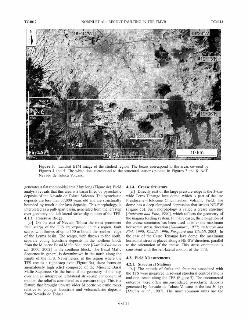
3Istituto per la Dinamica dei Processi Ambientali, Sezione di Milano,CNR, Milan, Italy.
4National Institute of Geological Science, University of the Philippines,Quezon City, Philippines.
5Instituto de Geografıa, Universidad Nacional Autonoma de Mexico,Mexico D.F., Mexico.
Copyright 2006 by the American Geophysical Union.0278-7407/06/2005TC001877$12.00
TC4012 1 of 21

addition, displaced infrastructure located along the TFS wasused to confirm its recent state of activity and displacementrates.
2. Regional Geologic Setting
2.1. Trans-Mexican Volcanic Belt
[5] The TMVB strikes WNW-ESE across central Mex-ico, from the Pacific coast to the Gulf of Mexico. It is a1200-km-long active continental volcanic arc resulting fromthe subduction of the Cocos and Rivera plates beneath theNorth American plate in the Middle American Trench(MAT) (Figure 2a) [Nixon, 1982; Ponce et al., 1992; Pardoand Suarez, 1993]. The TMVB consists of volcanic centersdistributed with a 15�–20� trend relative to the MAT withits geometry interpreted as a result of the subduction angleof the slab. The Rivera and Cocos plates subduct with asteep angle below western Mexico and southern Mexico,respectively. The subduction angle changes in central Mex-ico (103�–98� W) where the Cocos plate is at a gentleangle, changing to almost horizontal at a depth of 50 km upto 250 km [Pardo and Suarez, 1995]. The location andorientation of the volcanic belt have also been attributed tothe eastward translation of the Chortiz block, a part of theCaribbean plate (Figure 2a) [Herrmann et al., 1994], andthe existence of a major shear zone along the TMVB[Shurbet and Cebull, 1984].
[6] The TMVB consists of three regions with differentstructural and volcanological features (Figure 2b) [Pasquareet al., 1987; Ferrari, 2000]. The western part of the arc islinked with the opening of the Gulf of California and ischaracterized by the Colima-Chapala-Tepic triple junction.The central sector of the TMVB was identified as anautonomous structural province (between longitude100�W and 103�W), separated from the eastern sector bythe NNW-SSE Taxco-Queretaro Fault System [Demant,1978; Nixon et al., 1987; Pasquare et al., 1987]. The centralsector is dominated by the E-W to ENE-WSW majorfault system named Chapala-Tula fault zone (Figure 2b)[Johnson and Harrison, 1990]. The eastern sector of thevolcanic belt continues eastward from the Taxco-QueretaroFault System near Mexico City to the Cofre de Perote–Picode Orizaba lineament, and is characterized by an extensiveplateau (Eastern Plateau [Pasquare et al., 1987]). Its altitudeis generally above 2000 m above sea level (asl) and reaches2700 m asl near the cities of Toluca and Puebla. The easternsector is mainly characterized by N-S trending volcanicchains composed of major stratovolcanoes (Figure 2b)[Demant, 1978; Pasquare et al., 1987].
2.2. Geology of Toluca Area and theTenango Fault System (TFS)
[7] The study area, which is in the region of Toluca City(Figure 1), is a complex segment of the central eastern
Figure 1. Outline map with the location of the Tenango, San Antonio, and Taxco-Queretaro faultsystems and the main volcanoes in the studied area, on a mosaic of ASTER satellite images. TMVB,Trans-Mexican Volcanic Belt; MX, Mexico City; NdT, Nevado de Toluca Volcano; SA, San AntonioVolcano; TB, Tenango Basalt; CT, Cerro Tenango dome; LC, Las Tres Cruces cinder cones; SMG, SanMiguel Graben; T, Tenango City.
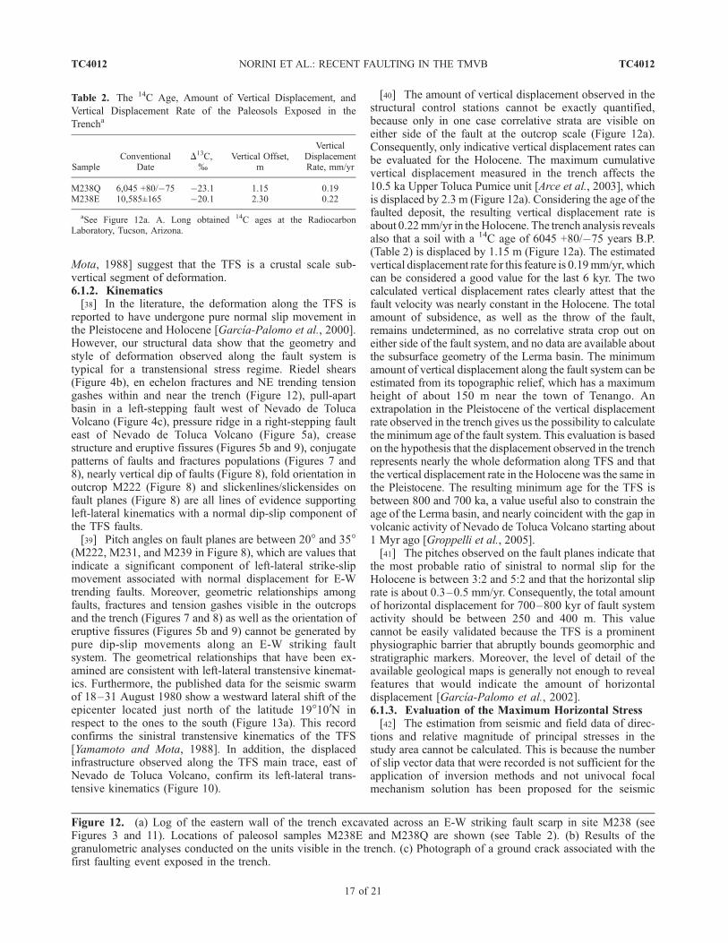
TC4012 NORINI ET AL.: RECENT FAULTING IN THE TMVB
2 of 21
TC4012

TMVB [Pasquare et al., 1987; Ferrari et al., 1994]. TheSan Antonio (3680 m asl) and Nevado de Toluca volcanoes(4680 m asl) and the Sierra Las Cruces Volcanic Range arethe prominent topographic features in this region. The SanAntonio and Nevado de Toluca edifices are located justalong the regional slope break separating the volcanic arcfront in the south from the Eastern Plateau in the north ofthe studied area. Toluca is within the Lerma basin, which isfilled by lake sediments and volcaniclastic rocks (Figure 1)[Caballero et al., 2001].[8] The stratigraphy of the Toluca area includes volcanic
products deposited from the Mesozoic to Holocene [Macıaset al., 1997; Garcıa-Palomo et al., 2000, 2002]. These have
originated from the nearby volcanoes and volcanic centers,namely, the San Antonio Volcano, Sierra Las Cruces Vol-canic Range, Cones and Domes complexes, Nevado deToluca Volcano, and the western edge of the ChichinautzinVolcanic Field [Garcıa-Palomo et al., 2000, 2002]. Belowthese volcanic units is a complex volcano-sedimentarybasement of Jurassic to late Miocene age, which has beensubjected to greenschist facies metamorphism [Garcıa-Palomo et al., 2000, 2002].[9] The Pliocene-Holocene Nevado de Toluca Volcano is
the highest and most prominent volcanic edifice in thestudied area. Its volcanological evolution is very complexand is characterized by a very long history with prolonged
Figure 2. (a) Location of the Trans-Mexican Volcanic Belt (TMVB) in the geodynamic frame of Northand Central America. Triangles show major volcanoes; the box corresponds to the areas covered byFigure 2b. (b) Neotectonic map of the TMVB; 1, Colima Volcanic Complex; 2, Nevado de TolucaVolcano; 3, Popocatepetl Volcano; M, Morelia City; T, Toluca City; MX, Mexico City (modified fromJohnson and Harrison [1990] and Suter et al. [2001]).
TC4012 NORINI ET AL.: RECENT FAULTING IN THE TMVB
3 of 21
TC4012

gaps and changes in volcanic style and chemical composi-tion. Previous authors recognized two phases in the Nevadode Toluca evolution; the older one, called Paleonevado,consists of extrusions of viscous andesitic lava domes dated1.6–1.3 Ma by Cantagrel et al. [1981] and 2.6–1.2 Ma byGarcıa-Palomo et al. [2002]. Recent works based on adetailed field survey have shown a more complex historystarting 2.6 Ma, where Nevado de Toluca activity ischaracterized by two main gaps, each one of about 1 Myr[Bellotti et al., 2004]. The last gap on the Nevado de Tolucaactivity started about 1 Myr ago and was dominated byalteration and erosion of the previous volcanic edificeincluding lateral collapses, deep incisions of the volcanoand wide distribution of epiclastic deposits [Cantagrel et al.,1981; Capra and Macıas, 2000; Garcıa-Palomo et al.,2002; Bellotti et al., 2004; Groppelli et al., 2005]. Thequiescence of volcanic activity ended 50 kyr ago with thegrowth of the actual Nevado de Toluca cone, which is madeof dacitic domes and mantled by a thick sequence ofpyroclastic and epiclastic deposits [Bloomfield and Valastro,1974, 1977; Cantagrel et al., 1981; Macıas et al., 1997;Arce et al., 2003; Bellotti et al., 2004].[10] The western edge of the late Pleistocene–Holocene
Chichinautzin Volcanic Field, along with the most recentactivity of Nevado de Toluca Volcano, represents theyoungest volcanic activity in the Toluca area. This areaconsists of basaltic-andesitic scoria cones and fissure-fedlava flows. The Chichinautzin Volcanic Field marks thesouthern limit of the Lerma and Mexico basins. It is situatedbetween the Popocatepetl and Nevado de Toluca Quaternarystratovolcanoes. The volcanic field is composed of over 220monogenetic volcanic centers and small shield cones,emplaced during the last 40,000 years. Volcanic materialscover approximately 2400 km2 in a general E-W direction[Marquez et al., 1999]. The age of the volcanic centers ofthe western Chichinautzin Volcanic Field in the study arearanges from 38,000 to 8000 years B.P. The most significantare the Tenango Basalt fissural lava flows and the Las TresCruces, Cerro Lama and Cerro Tenango scoria cones andlava domes (Figure 1) [Bloomfield, 1974, 1975; Garcıa-Palomo et al., 2002; Martınez-Serrano et al., 2004].[11] The geological evolution of the studied area is
strictly related with the complex geodynamic setting ofthe eastern central sector of the TMVB. The Toluca areais located at the intersection of three fault systems (Figure 1)[Garcıa-Palomo et al., 2000]. These fault systems are thefollowing:[12] 1. Taxco-Queretaro Fault System (TQFS) is a NNW-
SSE striking, regional fault system separating the centraland eastern sectors of the TMVB. The TQFS is about250 km long and consists of N10�E and N20�W strikingfault planes. Garcıa-Palomo et al. [2000] documentednormal and right-lateral episodes of activity of this faultsystem in the late Oligocene–Pliocene.[13] 2. San Antonio Fault System (SAFS) is a NE-SW
graben-forming fault system about 60 km long, between theSan Antonio and Nevado de Toluca volcanoes. The tectonicdepression is called the San Miguel graben. The SAFSconsists of N40�E striking fault planes, which have under-
gone a phase of movement with a left-lateral componentand successive extensional reactivations in the Pliocene[Garcıa-Palomo et al., 2000].[14] 3. Tenango Fault System (TFS) is an E-W active
fault system that affects the studied area. It is the youngestof the three fault systems and consists of N90�E andN30�E–N60�E striking fault planes [Garcıa-Palomo etal., 2000]. Previous authors have suggested that this faultsystem had right-lateral oblique extension in the Plioceneand pure dip-slip movement in the Pleistocene and Holo-cene [Garcıa-Palomo et al., 2000].
3. Neotectonics of the Central Eastern
TMVB: A Review
[15] Recent tectonic activity within the central TMVB isrepresented by active E-W striking normal faults that definea 50- to 100-km-wide segment of distributed deformation[Pasquare et al., 1988; Johnson and Harrison, 1990;Ferrari et al., 1991, 1994; Suter et al., 1992, 1995a,1995b, 1996, 2001; Ramırez-Herrera, 1998; Langridge etal., 2000; Szynkaruk et al., 2004]. This continuous segmentof extensional faulting was named the Chapala–Tula FaultSystem (Figure 2b), a regional structure that extends over adistance of 450 km from the Chapala Lake to the north-western part of Mexico City [Johnson and Harrison, 1990].Numerous E-W elongated tectonic intra-arc basins filledwith lake sediments and volcanic rocks exist in the centralpart of the TMVB, and are associated with the Chapala–Tula Fault System [Johnson and Harrison, 1990; Suter etal., 2001]. Some of these basins are known to be sites ofrecent active faulting and shallow extensional seismicactivity [Suter et al., 1992, 1995a, 1995b, 2001; Langridgeet al., 2000]. The more important basins that have beendescribed previously are, from west to east, the Moreliaarea, the Cuitzeo graben, the Acambay graben, the Aljibeshalf graben and the Mezquital graben (Figure 2b) [Suter etal., 2001]. The normal faults in the Morelia region strikebetween E-W and NE-SW, the Quaternary vertical slip rateswere estimated for several of these faults and are between0.02 and 0.05 mm/yr [Garduno et al., 1997; Suter et al.,2001]. A minor left-lateral strike-slip component along thefaults of the Morelia region was suggested by Suter et al.[2001] based on the right-stepping en echelon patternformed by some of these structures. The Cuitzeo graben isa major structural depression in the central TMVB and isoccupied by about 12 faults with Quaternary activity. Thefaults are normal with a minor component of left-lateralstrike-slip motion. The strike is oriented E-W and theirQuaternary vertical slip rates range between 0.09 and0.18 mm/yr [Ferrari et al., 1991; Suter et al., 2001]. TheAcambay graben is the most prominent basin withinthe central part of the TMVB. The graben is defined by theAcambay-Tixmadeje and Pastores faults and is part of a largeE-Wstriking fault system that also includes theVentadeBravofault [Suter et al., 1992, 1995a, 2001]. The present relativedisplacement along the Pastores and Venta de Bravo faults isnormal with a component of left-lateral strike-slip motion,while theAcambay-Tixmadeje faultwasdocumentedasapure
TC4012 NORINI ET AL.: RECENT FAULTING IN THE TMVB
4 of 21
TC4012

normal fault [Suter et al., 1995a]. The Quaternary slip rate ofthese structures is about 0.04–0.17 mm/yr [Suter et al.,1992, 1995a, 2001; Langridge et al., 2000]. The Acambaygraben is a seismically active zone. During the Ms = 6.9Acambay earthquake of 12 November 1912, surface rup-tures occurred along both margins of the graben [Urbina andCamacho, 1913; Suter et al., 1995a]. The Aljibes half grabenis located at the northern margin of the TMVB and ischaracterized by several E-W striking normal faults. TheQuaternary slip rate of these faults ranges between 0.08 and0.16 mm/yr [Suter et al., 1995b, 2001]. The Mezquitalgraben is a fault bounded intra-arc lake basin characterizedby shallow seismicity. The margins of the graben are alongE-W striking normal faults with an estimated Quaternary sliprate of 0.02 mm/yr [Suter et al., 1996, 2001].[16] At the boundary between the central and eastern
sectors of the TMVB are two very wide intra-arc basins.These are the Lerma basin, where Toluca City is sited, andthe Mexico City basin. In this area, the Nevado de TolucaVolcano, the Chichinautzin Volcanic Field and the Popoca-tepetl Volcano form a 150-km-long topographic high at thefront of the arc that bounds the Eastern Plateau (Figure 2b)[Pasquare et al., 1987]. The E-W trending topographicrelief is traversed by a complex set of structures collectivelynamed the La Pera Fault System and described as a crustalsegment of normal faulting [Delgado et al., 1997; Ferrariand Capra, 2001]. Because of the rare fault scarps related tothe La Pera Fault System, only morphological, geologicaland geophysical evidence have been used to define thisactive crustal structure [Ferrari and Capra, 2001]. In termsof morphology, there is a topographic discontinuity, up to1000–1500 m high, separating the Eastern Plateau (betweenNevado de Toluca and Popocatepetl volcanoes) from thearea to its south [Pasquare et al., 1987]. Another is thepresence of several tectonic structures within the Chichi-nautzin Volcanic Field that are primarily oriented E-W andsecondarily along a NE-SW trend [Marquez et al., 1999].The geophysical lines of evidence are four seismic zoneswith an E-W trend corresponding to the La Pera FaultSystem [Ferrari and Capra, 2001].[17] The best exposure of the La Pera Fault System was
identified by Ferrari and Capra [2001] as E-W faults, withthrows to the north of up to 150 m, exposed at the westernlimit of the Chichinautzin Volcanic Field. These structurescoincide with the Tenango Fault System (TFS) which wasfirst identified by Garcıa-Palomo et al. [2000] and de-scribed as a complex set of faults and fractures locatedimmediately to the east of Nevado de Toluca Volcano. Thisfault system was related by Garcıa-Palomo et al. [2000] tothe regional Chapala–Tula Fault System [Johnson andHarrison, 1990]. Garcıa-Palomo et al. [2000] recognizedtwo main sets of faults as part of the TFS, the first onetrends E-W with dips ranging from 30� to 45�, the secondset trends NE-SW with dips varying from 60� to 90�. Thestructural analysis of the previous authors suggests that theTFS has undergone two episodes of movement. The oldestevent, which occurred in the late Pliocene, was accommo-dated by right-lateral oblique extension [Garcıa-Palomo etal., 2000]. This event was followed in the Pleistocene-
Holocene by an extensional phase that reactivated theTFS structures as normal faults [Garcıa-Palomo et al.,2000]. A seismic swarm in 1980, ML = 3.5, was locatedjust 20 km southeast of Toluca City [Yamamoto and Mota,1988] and was related to the TFS motion by Garcıa-Palomoet al. [2000]. Although the focal solutions for this eventwere not very clear and consistent, the preliminary inter-pretation of Yamamoto and Mota [1988] was that of normalfaulting. The authors also recognized a westward lateralshift of the epicenter located just north of the latitude19�100N in respect to those in the south [Yamamoto andMota, 1988], suggesting left-lateral movement of the north-ern block along an approximately E-W trending structure.
4. Neotectonics in the Toluca Area:
Morphostructural and Field Evidence
4.1. Morphostructural Interpretation of theToluca Area and Relationship With the Geology
[18] The TFS is a prominent morphological feature in theToluca area and is easily recognized on aerial photos andtopographic maps. Linear structures corresponding to theTFS have curved traces and form en echelon. The main faultsystem follows a general E-W trend and is continuous for50 km across the studied area, passing through the Nevadode Toluca Volcano (Figure 3). On the volcano flanks, thestrike of the TFS changes from E-W to ESE-WNW anddefines a narrow graben-like structure (Figure 4a) [Norini etal., 2004]. This E-W graben is partially filled by the mostrecent pyroclastic and epiclastic deposits of Nevado deToluca Volcano (less than 50,000 years). The fault systemalso appears to influence the crater morphology of thesummit of Nevado de Toluca, creating an offset in the lipof the present crater and forming a ridge at the western flankof the volcano’s summit. Considering the young age of thepresent cone of Nevado de Toluca, there is good evidence ofactivity of the TFS at least during the last 50,000 years.[19] Associated with the main E-W fault system are
(1) Riedel shears, (2) a pull-apart structure, (3) a pressureridge, and (4) a crease structure. All these recognizedmorphostructural features related with the TFS weremapped and surveyed in the field. These structural featuresare used in this work as part basis for the interpretation ofthe kinematics of the TFS. The descriptions of each of thesestructural elements are reported below.4.1.1. Riedel Shears[20] The morphostructural analysis indicates that the TFS
is composed of two principal sets of structures. The main setstrikes E-W east of Nevado de Toluca Volcano and WNW-ESE on the other side of the volcano. The second set offractures is oriented NE-SW and is interpreted as secondaryfaults. This secondary set is interpreted as Riedel shears and/or T structures for a fault that has a left-lateral component ofmotion (Figure 4b). Other less prominent lineaments strikeNW-SE and form the P andX shear arrangements (Figure 4b).4.1.2. Pull-Apart[21] At the western end of the TFS near the base of the
Nevado de Toluca Volcano, a left step over of the main fault
TC4012 NORINI ET AL.: RECENT FAULTING IN THE TMVB
5 of 21
TC4012
generates a flat rhomboidal area 2 km long (Figure 4c). Fieldanalysis reveals that this area is a basin filled by pyroclasticdeposits of the Nevado de Toluca Volcano. The pyroclasticdeposits are less than 37,000 years old and are structurallybounded by much older lava deposits. This morphology isinterpreted as a pull-apart basin, generated from the left stepover geometry and left-lateral strike-slip motion of the TFS.4.1.3. Pressure Ridge[22] On the east of Nevado Toluca the most prominent
fault scarps of the TFS are exposed. In this region, faultscarps with throws of up to 150 m bound the southern edgeof the Lerma basin. The scarps, with throws to the north,separate young lacustrine deposits in the northern blockfrom the Miocene Basal Mafic Sequence [Garcıa-Palomo etal., 2000, 2002] in the southern block. The Basal MaficSequence in general is downthrown in the north along thelength of the TFS. Nevertheless, in the region where theTFS creates a right step over (Figure 5a), there forms ananomalously high relief composed of the Miocene BasalMafic Sequence. On the basis of the geometry of the stepover and an interpreted left-lateral strike-slip component ofmotion, the relief is considered as a pressure ridge. This is afeature that brought upward older Miocene volcanic rocksrelative to younger lacustrine and volcaniclastic depositsfrom Nevado de Toluca.
4.1.4. Crease Structure[23] Directly east of the large pressure ridge is the 3-km-
wide Cerro Tenango lava dome, which is part of the latePleistocene–Holocene Chichinautzin Volcanic Field. Thedome has a deep elongated depression that strikes NE-SW(Figure 5b). Such morphology is called a crease structure[Anderson and Fink, 1990], which reflects the geometry ofthe magma feeding system. In many cases, the elongation ofthe crease structures has been used to infer the maximumhorizontal stress direction [Nakamura, 1977; Anderson andFink, 1990; Tibaldi, 1996; Pasquare and Tibaldi, 2003]. Inthe case of the Cerro Tenango lava dome, the maximumhorizontal stress is placed along a NE-SW direction, parallelto the orientation of the crease. This stress orientation isconsistent with the left-lateral motion of the TFS.
4.2. Field Measurements
4.2.1. Structural Stations[24] The attitude of faults and fractures associated with
the TFS were measured in several structural control stationsand one trench along the TFS (Figure 3). The encounteredoutcrops were often unconsolidated pyroclastic depositsgenerated by Nevado de Toluca Volcano in the last 50 kyr[Macıas et al., 1997]. The most common units are the
Figure 3. Landsat ETM image of the studied region. The boxes correspond to the areas covered byFigures 4 and 5. The white dots correspond to the structural stations plotted in Figures 7 and 8. NdT,Nevado de Toluca Volcano.
TC4012 NORINI ET AL.: RECENT FAULTING IN THE TMVB
6 of 21
TC4012

Figure 4. (a) Shaded relief image of the studied area showing the narrow graben-like structure thatstrikes E-W and WNW-ESE across the Nevado de Toluca Volcano. (b) Morphotectonic map showing theevidences of neotectonics in the eastern portion of the studied area. (c) Aster satellite image showing thepull-apart basin located along the TFS in the western portion of the studied area.
TC4012 NORINI ET AL.: RECENT FAULTING IN THE TMVB
7 of 21
TC4012

10.5 ka Upper Toluca Pumice, formed by pyroclastic fall,flow and surge deposits associated with a major Plinianeruption [Arce et al., 2003], and the block and ash flowdeposits formed 13, 28, and 37 ka by summit dacitic domescollapses (Figures 6a, 6b, and 6c) [Macıas et al., 1997].Thick soil cover caps these units. The data were plotted onRose and Schmidt diagrams for kinematic analysis.[25] Faults were measured in 10 structural stations, there
were two structural stations on the western side of theNevado de Toluca Volcano and eight on its eastern periph-ery. Faults that were measured on the west of the volcanocut through Miocene basalts (M229, M230). Of the eightthat were measured on the eastern side, seven structuralstations (M222, M231, M234, M235, M236, M237, M238)were outcrops of recent volcaniclastic deposits from Nevadode Toluca (Figure 6a, 6b, and 6c). The remaining structuralstation (M239) was an outcrop of a well-exposed lava domedeposits (Figure 6d).
[26] Rose diagram plots of the structural stations areplotted in Figure 7. One of the plots show only one generaltrend (M238 trench) with the other exhibiting 3 orientations(e.g., M222, M236, M231, M239). Combining all thestructural data in one rose diagram shows a dense trendalong a general E-W direction and two other trends in theNE and ENE directions. For structural data measured onlyin recent volcaniclastic deposits (M222, M231, M234,M235, M236, M237, M238), the rose diagram plot againshows three distinct trends, the major trend is in an E-Wdirection and the other two along a NE and ESE strike. TheNE trend is minor but nonetheless evident.[27] The conjugate pattern of the fault population sets and
the near vertical angle of the faults that were measuredreveal that the E-W TFS is a strike-slip fault [Wilcox et al.,1973]. Pitch angles of about 20�–35� in slickenlines ob-served in fault planes (Figure 6) support this interpretation
Figure 5. (a) Schematic geological map of the area east of Nevado de Toluca Volcano. The pressureridge that affects the Basal Mafic Sequence is shown (modified from Garcıa-Palomo et al. [2000]).(b) Aster satellite image of the Cerro Tenango lava dome affected by a NE-SW crease structure, whichhas been used to infer the maximum horizontal stress.
TC4012 NORINI ET AL.: RECENT FAULTING IN THE TMVB
8 of 21
TC4012
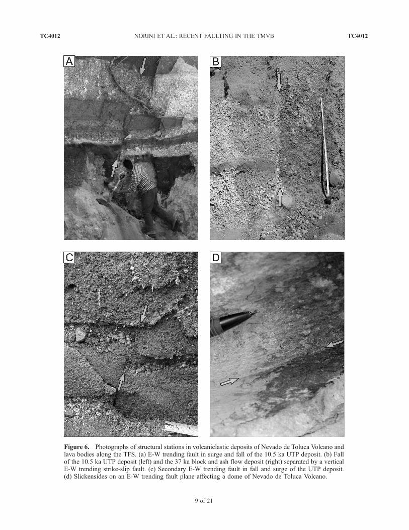
Figure 6. Photographs of structural stations in volcaniclastic deposits of Nevado de Toluca Volcano andlava bodies along the TFS. (a) E-W trending fault in surge and fall of the 10.5 ka UTP deposit. (b) Fallof the 10.5 ka UTP deposit (left) and the 37 ka block and ash flow deposit (right) separated by a verticalE-W trending strike-slip fault. (c) Secondary E-W trending fault in fall and surge of the UTP deposit.(d) Slickensides on an E-W trending fault plane affecting a dome of Nevado de Toluca Volcano.
TC4012 NORINI ET AL.: RECENT FAULTING IN THE TMVB
9 of 21
TC4012

Figure 7. Rose diagrams showing the orientations of faults and fractures in structural control stationslocated along the TFS. The measurement sites are marked in Figure 3.
TC4012 NORINI ET AL.: RECENT FAULTING IN THE TMVB
10 of 21
TC4012

and show the dominance of strike-slip movement over dipslip with a ratio in the range of 3:2 to 5:2.[28] In assessing the lateral component of movement of
the TFS and the orientation of the maximum horizontalstress acting on the E-W fault, indicators such as slicken-sides, apparent fault movement, fold, and orientation oftension gashes are shown in Schmidt plots (Figure 8). Instations M222, M231, and M239 slickensides indicatedfault planes that have a left-lateral component of shear.Faults in station M237 have ESE-WNW direction andapparent normal movement with the southern block on thedownthrown side. This is interpreted to be due to westdipping strata that have been offset in a left-lateral fashion.In the same station was observed a tension gash about 5 cmwide and oriented in a NE direction.[29] Furthermore, the presence of numerous normal faults
including graben structures in stations M222, M237, andM238 and the identified left-lateral component of shearalong E-W and ESE oriented faults strongly suggest that theTFS is a transtensional fault. For the TFS to move in thisfashion, the maximum horizontal stress should be along ageneral NE-SW direction. In addition, folding observedin structural station M222 helped in the kinematic anddynamic analyses, since the orientation of the fold hingeis indicative of NE-SW oriented maximum horizontal stress(Figure 8), in agreement with the orientation of theoreticalcompressive structures developed in transcurrent tectonicregimes [Wilcox et al., 1973]. Faults found in station M239have nearly pure left-lateral movements along a NE-SWtrending plane indicative of local N-S striking maximumhorizontal stress. This rotation of maximum horizontalstress can be explained by considering the location of thestructural station, which corresponds in the field to a push-up block generated by left-lateral strike-slip movementalong the TFS (Figures 3 and 4b).4.2.2. Tenango Basalt[30] Field analysis of the Tenango Basalt reveals a com-
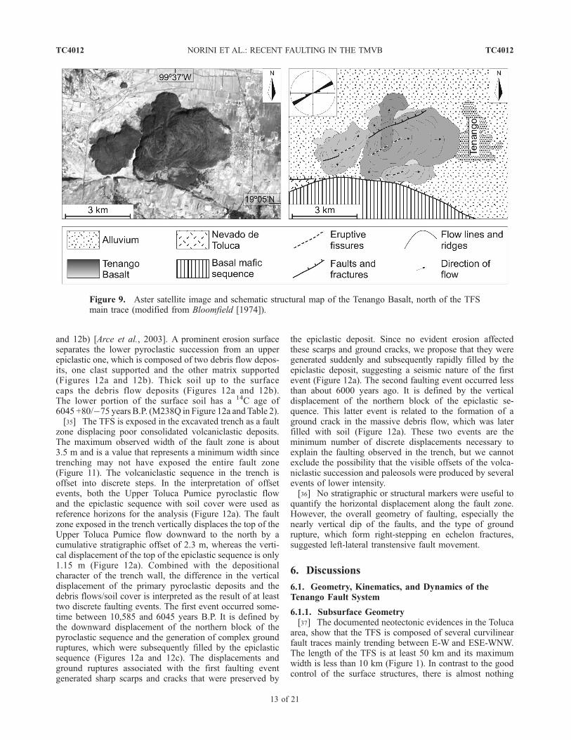
plex set of compound lava flows generated by severaleruptive fissures. The complex fissural lava flow depositsformed from at least four to five eruptive phases (depicted asshades of gray in Figure 9) and appear to have been laid overunconsolidated alluvial and lacustrine deposits. Major lavaflow deposits of the Tenango Basalt appear to have been fedby parallel eruptive fissures, which strike betweenN60�E andN70�E (Figure 9). On top of the widest compound lava flow(Figure 9), the SWeruptive fissure tip intersects a series of atleast three concentric curvilinear ridges, which are opentoward the NE. The ridges are up to 10–15 m high and aremade of superimposed thin lava flows deposits. In the field,they appear as gently sloping lava-scoria cones generated bythe effusion of lava along an eruptive fracture. The exposedsections of the fissure show dikes 1–2 m thick reachingthe surface and continuous with thin lava flow deposits. Theorientation of the dikes is N50�E and is consistent with thegeneral trend of identified eruptive fissures. Normal faultsand fractures that were measured also trend N60�E, markinga 30-m-high fault scarp with throws to the north (Figure 9).[31] As suggested by previous authors, the age and
location of the Tenango Basalt are related with the activity
of the TFS [Garcıa-Palomo et al., 2000, 2002]. This studyfurther recognizes the structures within the Tenango Basaltas good indicators for the state of stress and kinematics ofthe TFS in the last 50,000 years. These are, namely, theeruptive fissures, dikes, fractures and faults that trendbetween N50�E and N70�E. Observing the strict relation-ship between the direction of the maximum horizontal stressand the geometry of the magma feeding system [Nakamura,1977] the measured structures within the Tenango Basalt allpoint to a maximum horizontal stress oriented betweenN50�E and N70�E. Such stress orientation is consistentwith left-lateral movement of an E-W fault as interpreted insection 4.2.1.4.2.3. Displaced Infrastructure[32] Several displaced and/or fractured walls and asphalt
roads were identified along the morphostructural trace of theTFS (Figure 10). The faults and fractures observed in theseinfrastructures are oriented N80�E to N100�E. Their notableabsence outside the bounds of the E-W fault trace indicatesa possible relationship with the activity of the TFS. Dis-placed wall structures were used to estimate slip rates for theTFS and are described in Table 1. Using the measureddisplacement and the known age of the displaced walls, sliprates of the TFS were estimated to be less than 1 mm/yr.
5. Trenching the Active Tenango Fault
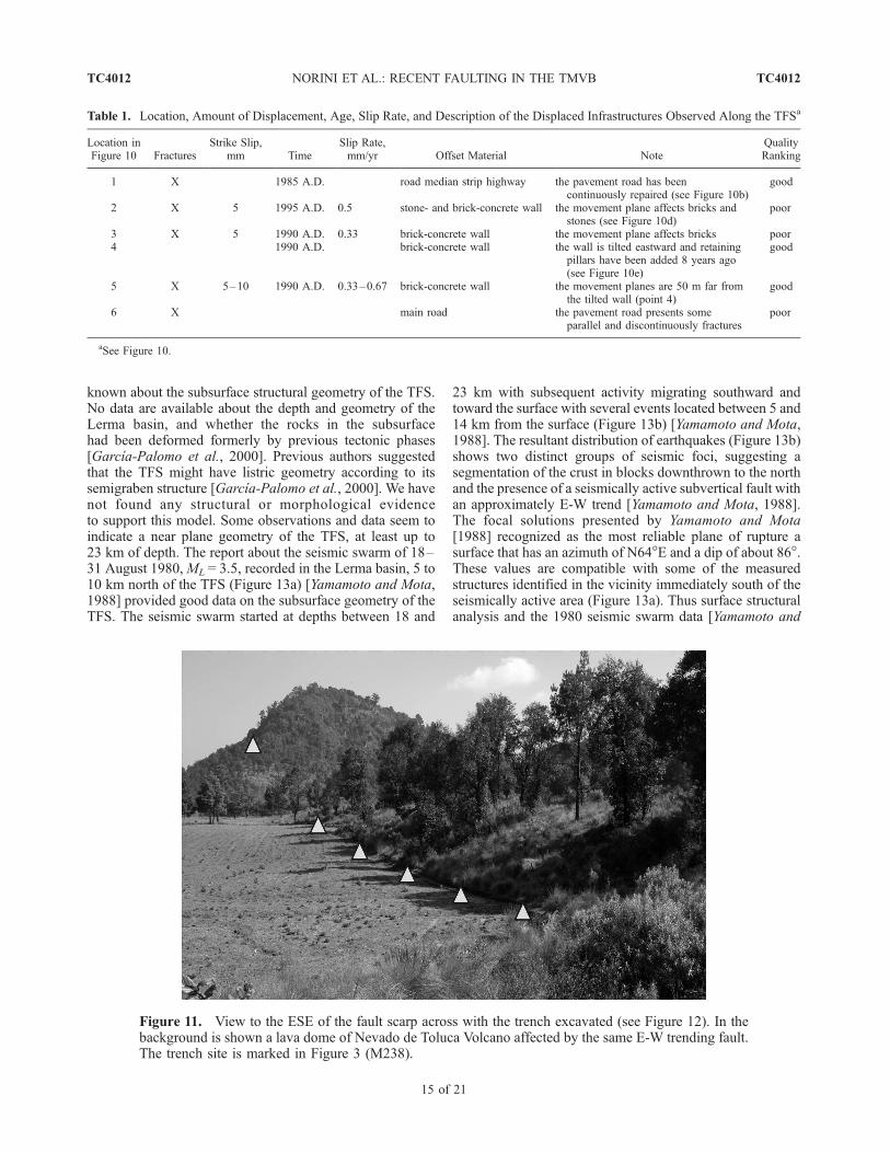
[33] The site location for trenching was selected amongthe best exposed fault scarps available along the TFS. Thefinal position of the trench was chosen where a sharp E-Wtrending fault scarp crosses a flat plain filled by pyroclasticand epiclastic deposits generated by Nevado de TolucaVolcano (M238 in Figures 3 and 11). One trench wasexcavated perpendicular to the selected fault scarp. Thewalls of the trench, which showed clearly displaced stratarepresenting multiple faulting events, were logged in detail(scale 1:20).[34] The trench exposed a succession of volcaniclastic
deposits and paleosols (Figure 12a). The oldest unit exposedin the trench is a 30-cm-thick fall horizon composed ofsand- to silt-size pumice and lithic fragments. On the basisof the known tephrostratigraphy of Nevado de TolucaVolcano and on the numerous outcrops near the trench site,the oldest deposit exposed in the trench is the White PumiceFlow unit of Macıas et al. [1997] (WPF in Figure 12a),which was generated by a Plinian eruption [Arce et al.,2003]. This explosive event occurred at Nevado de TolucaVolcano about 12,100 years B.P. [Garcıa-Palomo et al.,2002; Arce et al., 2005]. The oldest deposit is capped bya 10-cm-thick brown-gray paleosoil with a 14C age of10,585 ± 165 years (M238E in Figure 12a and Table 2).Above the paleosoil is a 1.36-m-thick sequence of interca-lating fall and surge deposits. It is part of the Upper TolucaPumice unit (UTP in Figure 12a) [Macıas et al., 1997] andis the deposit of the largest Plinian eruption of Nevado deToluca Volcano, which occurred about 10,500 years B.P.[Arce et al., 2003]. A massive 1.30-m-thick pyroclastic flowdeposit lay on top of the Upper Toluca Pumice fall andsurge deposits and is part of the same unit (Figures 12a
TC4012 NORINI ET AL.: RECENT FAULTING IN THE TMVB
11 of 21
TC4012

Figure 8. Projections of faults and fractures data collected in structural control stations located alongthe TFS (Schmidt, lower hemisphere). The measurement sites are marked in Figure 3.
TC4012 NORINI ET AL.: RECENT FAULTING IN THE TMVB
12 of 21
TC4012
and 12b) [Arce et al., 2003]. A prominent erosion surfaceseparates the lower pyroclastic succession from an upperepiclastic one, which is composed of two debris flow depos-its, one clast supported and the other matrix supported(Figures 12a and 12b). Thick soil up to the surfacecaps the debris flow deposits (Figures 12a and 12b).The lower portion of the surface soil has a 14C age of6045 +80/�75 years B.P. (M238Q in Figure 12a and Table 2).[35] The TFS is exposed in the excavated trench as a fault
zone displacing poor consolidated volcaniclastic deposits.The maximum observed width of the fault zone is about3.5 m and is a value that represents a minimum width sincetrenching may not have exposed the entire fault zone(Figure 11). The volcaniclastic sequence in the trench isoffset into discrete steps. In the interpretation of offsetevents, both the Upper Toluca Pumice pyroclastic flowand the epiclastic sequence with soil cover were used asreference horizons for the analysis (Figure 12a). The faultzone exposed in the trench vertically displaces the top of theUpper Toluca Pumice flow downward to the north by acumulative stratigraphic offset of 2.3 m, whereas the verti-cal displacement of the top of the epiclastic sequence is only1.15 m (Figure 12a). Combined with the depositionalcharacter of the trench wall, the difference in the verticaldisplacement of the primary pyroclastic deposits and thedebris flows/soil cover is interpreted as the result of at leasttwo discrete faulting events. The first event occurred some-time between 10,585 and 6045 years B.P. It is defined bythe downward displacement of the northern block of thepyroclastic sequence and the generation of complex groundruptures, which were subsequently filled by the epiclasticsequence (Figures 12a and 12c). The displacements andground ruptures associated with the first faulting eventgenerated sharp scarps and cracks that were preserved by
the epiclastic deposit. Since no evident erosion affectedthese scarps and ground cracks, we propose that they weregenerated suddenly and subsequently rapidly filled by theepiclastic deposit, suggesting a seismic nature of the firstevent (Figure 12a). The second faulting event occurred lessthan about 6000 years ago. It is defined by the verticaldisplacement of the northern block of the epiclastic se-quence. This latter event is related to the formation of aground crack in the massive debris flow, which was laterfilled with soil (Figure 12a). These two events are theminimum number of discrete displacements necessary toexplain the faulting observed in the trench, but we cannotexclude the possibility that the visible offsets of the volca-niclastic succession and paleosols were produced by severalevents of lower intensity.[36] No stratigraphic or structural markers were useful to
quantify the horizontal displacement along the fault zone.However, the overall geometry of faulting, especially thenearly vertical dip of the faults, and the type of groundrupture, which form right-stepping en echelon fractures,suggested left-lateral transtensive fault movement.
6. Discussions
6.1. Geometry, Kinematics, and Dynamics of theTenango Fault System
6.1.1. Subsurface Geometry[37] The documented neotectonic evidences in the Toluca
area, show that the TFS is composed of several curvilinearfault traces mainly trending between E-W and ESE-WNW.The length of the TFS is at least 50 km and its maximumwidth is less than 10 km (Figure 1). In contrast to the goodcontrol of the surface structures, there is almost nothing
Figure 9. Aster satellite image and schematic structural map of the Tenango Basalt, north of the TFSmain trace (modified from Bloomfield [1974]).
TC4012 NORINI ET AL.: RECENT FAULTING IN THE TMVB
13 of 21
TC4012

Figure 10. Displaced infrastructures along the trace of the TFS used to estimate slip rates for the faultsystem (see Table 1).
TC4012 NORINI ET AL.: RECENT FAULTING IN THE TMVB
14 of 21
TC4012
known about the subsurface structural geometry of the TFS.No data are available about the depth and geometry of theLerma basin, and whether the rocks in the subsurfacehad been deformed formerly by previous tectonic phases[Garcıa-Palomo et al., 2000]. Previous authors suggestedthat the TFS might have listric geometry according to itssemigraben structure [Garcıa-Palomo et al., 2000]. We havenot found any structural or morphological evidenceto support this model. Some observations and data seem toindicate a near plane geometry of the TFS, at least up to23 km of depth. The report about the seismic swarm of 18–31 August 1980,ML = 3.5, recorded in the Lerma basin, 5 to10 km north of the TFS (Figure 13a) [Yamamoto and Mota,1988] provided good data on the subsurface geometry of theTFS. The seismic swarm started at depths between 18 and
23 km with subsequent activity migrating southward andtoward the surface with several events located between 5 and14 km from the surface (Figure 13b) [Yamamoto and Mota,1988]. The resultant distribution of earthquakes (Figure 13b)shows two distinct groups of seismic foci, suggesting asegmentation of the crust in blocks downthrown to the northand the presence of a seismically active subvertical fault withan approximately E-W trend [Yamamoto and Mota, 1988].The focal solutions presented by Yamamoto and Mota[1988] recognized as the most reliable plane of rupture asurface that has an azimuth of N64�E and a dip of about 86�.These values are compatible with some of the measuredstructures identified in the vicinity immediately south of theseismically active area (Figure 13a). Thus surface structuralanalysis and the 1980 seismic swarm data [Yamamoto and
Table 1. Location, Amount of Displacement, Age, Slip Rate, and Description of the Displaced Infrastructures Observed Along the TFSa
Location inFigure 10 Fractures
Strike Slip,mm Time
Slip Rate,mm/yr Offset Material Note
QualityRanking
1 X 1985 A.D. road median strip highway the pavement road has beencontinuously repaired (see Figure 10b)
good
2 X 5 1995 A.D. 0.5 stone- and brick-concrete wall the movement plane affects bricks andstones (see Figure 10d)
poor
3 X 5 1990 A.D. 0.33 brick-concrete wall the movement plane affects bricks poor4 1990 A.D. brick-concrete wall the wall is tilted eastward and retaining
pillars have been added 8 years ago(see Figure 10e)
good
5 X 5–10 1990 A.D. 0.33–0.67 brick-concrete wall the movement planes are 50 m far fromthe tilted wall (point 4)
good
6 X main road the pavement road presents someparallel and discontinuously fractures
poor
aSee Figure 10.
Figure 11. View to the ESE of the fault scarp across with the trench excavated (see Figure 12). In thebackground is shown a lava dome of Nevado de Toluca Volcano affected by the same E-W trending fault.The trench site is marked in Figure 3 (M238).
TC4012 NORINI ET AL.: RECENT FAULTING IN THE TMVB
15 of 21
TC4012
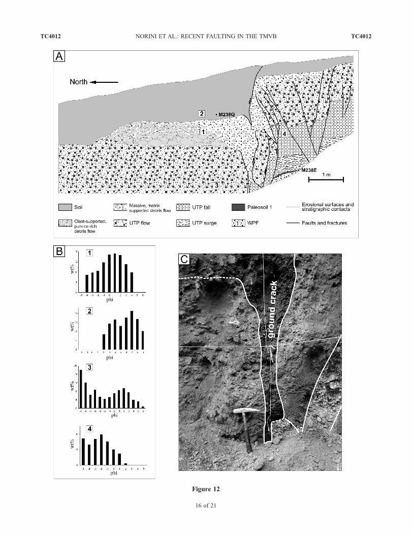
Figure 12
TC4012 NORINI ET AL.: RECENT FAULTING IN THE TMVB
16 of 21
TC4012
Mota, 1988] suggest that the TFS is a crustal scale sub-vertical segment of deformation.6.1.2. Kinematics[38] In the literature, the deformation along the TFS is
reported to have undergone pure normal slip movement inthe Pleistocene and Holocene [Garcıa-Palomo et al., 2000].However, our structural data show that the geometry andstyle of deformation observed along the fault system istypical for a transtensional stress regime. Riedel shears(Figure 4b), en echelon fractures and NE trending tensiongashes within and near the trench (Figure 12), pull-apartbasin in a left-stepping fault west of Nevado de TolucaVolcano (Figure 4c), pressure ridge in a right-stepping faulteast of Nevado de Toluca Volcano (Figure 5a), creasestructure and eruptive fissures (Figures 5b and 9), conjugatepatterns of faults and fractures populations (Figures 7 and8), nearly vertical dip of faults (Figure 8), fold orientation inoutcrop M222 (Figure 8) and slickenlines/slickensides onfault planes (Figure 8) are all lines of evidence supportingleft-lateral kinematics with a normal dip-slip component ofthe TFS faults.[39] Pitch angles on fault planes are between 20� and 35�
(M222, M231, and M239 in Figure 8), which are values thatindicate a significant component of left-lateral strike-slipmovement associated with normal displacement for E-Wtrending faults. Moreover, geometric relationships amongfaults, fractures and tension gashes visible in the outcropsand the trench (Figures 7 and 8) as well as the orientation oferuptive fissures (Figures 5b and 9) cannot be generated bypure dip-slip movements along an E-W striking faultsystem. The geometrical relationships that have been ex-amined are consistent with left-lateral transtensive kinemat-ics. Furthermore, the published data for the seismic swarmof 18–31 August 1980 show a westward lateral shift of theepicenter located just north of the latitude 19�100N inrespect to the ones to the south (Figure 13a). This recordconfirms the sinistral transtensive kinematics of the TFS[Yamamoto and Mota, 1988]. In addition, the displacedinfrastructure observed along the TFS main trace, east ofNevado de Toluca Volcano, confirm its left-lateral trans-tensive kinematics (Figure 10).
[40] The amount of vertical displacement observed in thestructural control stations cannot be exactly quantified,because only in one case correlative strata are visible oneither side of the fault at the outcrop scale (Figure 12a).Consequently, only indicative vertical displacement rates canbe evaluated for the Holocene. The maximum cumulativevertical displacement measured in the trench affects the10.5 ka Upper Toluca Pumice unit [Arce et al., 2003], whichis displaced by 2.3 m (Figure 12a). Considering the age of thefaulted deposit, the resulting vertical displacement rate isabout 0.22mm/yr in theHolocene. The trench analysis revealsalso that a soil with a 14C age of 6045 +80/�75 years B.P.(Table 2) is displaced by 1.15 m (Figure 12a). The estimatedvertical displacement rate for this feature is 0.19mm/yr, whichcan be considered a good value for the last 6 kyr. The twocalculated vertical displacement rates clearly attest that thefault velocity was nearly constant in the Holocene. The totalamount of subsidence, as well as the throw of the fault,remains undetermined, as no correlative strata crop out oneither side of the fault system, and no data are available aboutthe subsurface geometry of the Lerma basin. The minimumamount of vertical displacement along the fault system can beestimated from its topographic relief, which has a maximumheight of about 150 m near the town of Tenango. Anextrapolation in the Pleistocene of the vertical displacementrate observed in the trench gives us the possibility to calculatethe minimum age of the fault system. This evaluation is basedon the hypothesis that the displacement observed in the trenchrepresents nearly the whole deformation along TFS and thatthe vertical displacement rate in the Holocene was the same inthe Pleistocene. The resulting minimum age for the TFS isbetween 800 and 700 ka, a value useful also to constrain theage of the Lerma basin, and nearly coincident with the gap involcanic activity of Nevado de Toluca Volcano starting about1 Myr ago [Groppelli et al., 2005].[41] The pitches observed on the fault planes indicate that
the most probable ratio of sinistral to normal slip for theHolocene is between 3:2 and 5:2 and that the horizontal sliprate is about 0.3–0.5 mm/yr. Consequently, the total amountof horizontal displacement for 700–800 kyr of fault systemactivity should be between 250 and 400 m. This valuecannot be easily validated because the TFS is a prominentphysiographic barrier that abruptly bounds geomorphic andstratigraphic markers. Moreover, the level of detail of theavailable geological maps is generally not enough to revealfeatures that would indicate the amount of horizontaldisplacement [Garcıa-Palomo et al., 2002].6.1.3. Evaluation of the Maximum Horizontal Stress[42] The estimation from seismic and field data of direc-
tions and relative magnitude of principal stresses in thestudy area cannot be calculated. This is because the numberof slip vector data that were recorded is not sufficient for theapplication of inversion methods and not univocal focalmechanism solution has been proposed for the seismic
Figure 12. (a) Log of the eastern wall of the trench excavated across an E-W striking fault scarp in site M238 (seeFigures 3 and 11). Locations of paleosol samples M238E and M238Q are shown (see Table 2). (b) Results of thegranulometric analyses conducted on the units visible in the trench. (c) Photograph of a ground crack associated with thefirst faulting event exposed in the trench.
Table 2. The 14C Age, Amount of Vertical Displacement, and
Vertical Displacement Rate of the Paleosols Exposed in the
Trencha
SampleConventional
DateD13C,%
Vertical Offset,m
VerticalDisplacementRate, mm/yr
M238Q 6,045 +80/�75 �23.1 1.15 0.19M238E 10,585±165 �20.1 2.30 0.22
aSee Figure 12a. A. Long obtained 14C ages at the RadiocarbonLaboratory, Tucson, Arizona.
TC4012 NORINI ET AL.: RECENT FAULTING IN THE TMVB
17 of 21
TC4012

swarm of 18–31 August 1980 [Yamamoto and Mota, 1988].On the other hand, evaluation of the maximum horizontalstress direction can be inferred from the orientation oferuptive fissures, crease structures, attitude of faults, geom-etry of faults and fractures sets and tension gashes in thestructural control stations. On the basis of these data, theazimuth of the maximum horizontal stress for the Holoceneis placed between N50�E and N70�E.6.1.4. Activity[43] Since observed deformations along the fault system
affected Pleistocene-Holocene pyroclastic deposits and veryrecent epiclastic deposits and paleosols (Figures 6 and 12and Table 2), the left-lateral transtensive kinematic move-ment seems to be persistent along the TFS at least in theHolocene. Furthermore, displacements of man-made infra-structure (Figure 10 and Table 1) along with the seismicswarm of 18–31 August 1980 [Yamamoto and Mota, 1988]clearly indicate that the TFS is an active tectonic structure.
6.2. Seismic Hazard Implications
[44] The Toluca area is located at the boundary betweenthe eastern and the central TMVB, in a region characterizedby shallow seismicity along E-W oriented faults [Yamamotoand Mota, 1988; Suter et al., 1992, 1995a, 1995b, 1996,2001; Langridge et al., 2000; A. Garcıa-Palomo, personalcommunication, 2004]. The largest earthquake, registered100 km northwest of Toluca City, was the event of19 November 1912, Ms = 6.9, in the Acambay area [Urbinaand Camacho, 1913; Suter et al., 1995a]. Other importantseismic events associated with the E-W striking faults werelocated north and northwest of the Toluca City area [Suter etal., 1995b]. Moreover, a seismic swarm recorded in 18–31 August 1980, ML = 3.5, was located 20 km SE of TolucaCity and related with the TFS activity (Figure 13) [Yamamotoand Mota, 1988; Garcıa-Palomo et al., 2000]. These obser-vations, alongwith the neotectonic evidence described above,indicate that the TFS is active and has the potential forgenerating medium- to large-magnitude seismic events.
[45] The main fault scarps of the TFS east of Nevado deToluca Volcano bound the southern edge of the intra-arcLerma basin. At 2600 m asl, it is the highest of a series oflacustrine basins lying within the TMVB. This basin is thesource of the Rio Lerma, which drains northward out of thebasin, before flowing west to Lake Chapala and ultimatelyin to the Pacific Ocean. Analyses of stratigraphic sectionsand cores up to 12 m deep (M. Caballero, personal com-munication, 2005) reveal that volcanic activity had a greatinfluence on lacustrine sedimentation, as thick packets ofvolcaniclastic deposits were repeatedly deposited in the lakebasin [Newton and Metcalfe, 1999; Caballero et al., 2001].Among the volcanic features in the basin, Nevado de Tolucastratovolcano has greatly contributed to the input of primaryvolcanic materials and secondary volcaniclastic sedimentsinto the Lerma basin during the last 50 kyr. Consequently, thestratigraphic record of the basin is formed by alternatingmassive lacustrine silts and unconsolidated pyroclastic andepiclastic deposits [Newton and Metcalfe, 1999;Caballero etal., 2001]. In such environment, the material amplification incase of an earthquake can be high. In fact, the intensity ofshaking of unconsolidated volcaniclastic and lacustrine sedi-ments may be much more severe than for bedrock.[46] The presence of large human settlements in the
Lerma basin, including Toluca and Tenango cities, and itslocation in respect of the TFS, account for the necessity toestimate the moment magnitude (Mw) of the maximumcredible earthquake that may occur along the faults of theTFS. Despite the availability of new structural and neo-tectonic data, along with seismic data [Yamamoto and Mota,1988], it remains uncertain how much of the tectonicactivity along the TFS faults is by seismic slip. However,ground ruptures observed in the trench (Figure 12c) and inthe outcrops and the evidence that aseismic slip is a rarephenomenon in the continental crust [Scholz, 2002], suggestthat seismic slip along the TFS is common. The assessmentof the intensity of the maximum credible earthquake thatcan occur along the faults of the TFS is based on the
Figure 13. Spatial distribution of the (a) epicenter and (b) hypocenter of the seismic swarm of 18–31 August 1980, ML = 3.5, recorded in the Lerma basin, 5 to 10 km north of the TFS (modified fromYamamoto and Mota [1988] with permission from Universidad Nacional Autonoma de Mexico).
TC4012 NORINI ET AL.: RECENT FAULTING IN THE TMVB
18 of 21
TC4012
estimation of the seismic moment (Mo), which is a measureof the overall deformation in an earthquake.Mo is defined as
Mo ¼ SAm ð1Þ
where S is the average amount of slip (m) on the faultthat produced the earthquake, A is the area (m2) of thefault plane that ruptured, and m is the shear modulus ofthe rocks that failed [Hanks, 1985]. Hanks [1985] suggestsfor the continental crust an average value of m of about 3 �1010 N m�2. To estimate the seismic moment (Mo) of themaximum credible earthquake on the faults of the TFS, itwas assumed that the faults system reaches at least a depthof 20 km, as indicated by the seismic event recorded in1980 (Figure 13b) [Yamamoto and Mota, 1988]. Themaximum composite length of the TFS was estimated at50 km and the average displacement along the fault planesbetween 50 cm and 1 m (Figure 12). On the basis of thesevalues, the resultant seismic moment Mo is between 1.5 �1019 and 3 � 1019 N m.[47] The moment magnitude (Mw) of an earthquake is
defined in terms of the energy released during faulting andis then determined from the mathematical relationship
Mw ¼ 2=3 logMo � 6:0 ð2Þ
where Mo is the seismic moment (N m) and 6.0 is a constant[Hanks, 1985]. On the basis of the estimates for the Mo, theresulting moment magnitude Mw is between 6.8 and 7.These values are completely consistent with the intensityof the event of 19 November 1912, Ms = 6.9, in the E-Wstriking Acambay graben, 100 km northwest of Toluca City[Urbina and Camacho, 1913; Suter et al., 1995a].[48] The level of uncertainty for this estimation is high,
but the performed calculation can give an idea about theexpected maximum earthquake that can strike the denselypopulated Toluca City area located on top of unconsolidatedlacustrine and volcaniclastic deposits. An earthquake withMw = 6.8–7 is a strong major earthquake capable of causingextensive to catastrophic damage. This result underscoresthe need to prepare for such catastrophic event throughscientific investigation (TFS monitoring, seismic hazardzonation) and development of specific civil protection andland use plans.
6.3. Geodynamic Implications
[49] The TFS represents the western culmination of theLa Pera Fault System, which is known to be a major crustalsegment of active faulting within the TMVB (Figure 2b)[Delgado et al., 1997; Ferrari and Capra, 2001]. To ourknowledge, no systematic structural field analyses of the LaPera Fault System, including paleoseismologic studies, havebeen published before. Consequently, the presented neo-tectonic data correspond to the first detailed look at the LaPera Fault System, which has important geodynamic impli-cations at different scales, both on the volcanologicalevolution of the Toluca area (1), and on the tectonicdeformation of the entire TMVB (2).
[50] 1. In the Pliocene-Quaternary TMVB, intraplatemafic lavas with distinct geochemical composition pro-duced wide monogenetic volcanic fields, together with thedominant calc-alkaline volcanism that was mainly generatedby composite volcanoes and calderas [Ferrari, 2004]. In theToluca area during the late Pleistocene and Holocene thesame pattern of contrasting volcanic activities occurredalong the TFS. Volcanic products of similar age, emplacedduring the last 40 kyr along the E-W trending fault system,include the mainly basaltic-andesitic almost primitive maficmagmas of the western Chichinautzin Volcanic Field, andthe evolved dacitic products of the Nevado de TolucaVolcano [Martınez-Serrano et al., 2004; Meriggi et al.,2004]. Martınez-Serrano et al. [2004] proposed a similarsource for the magmas of Nevado de Toluca and somevolcanoes of the western Chichinautzin Volcanic Fieldbased on geochemical patterns of some trace elements andisotopic data. One of the most significant examples of suchcontrasting volcanism along the TFS is represented by theTenango Basalt lava flows and the El Ombligo lava dome(Figure 14). The Tenango Basalt is composed of basaltic-andesitic fissural lava extruded about 8500 years B.P.(Figure 9) [Bloomfield, 1974]. As suggested by petrographicand geochemical data, the magma of Tenango Basalt isprimitive and reached the surface directly from the mantlewithout significant evolution (L. Meriggi, personal commu-nication, 2003), through the 50-km-thick crust [Urrutia-Fucugauchi and Flores Ruiz, 1996]. On the contrary, the9100 ± 500 years B.P. El Ombligo dome [Arce et al., 2003],located in the crater of Nevado de Toluca Volcano, 15 kmwest of Tenango Basalt, has dacitic composition, which isattributed to magma differentiation through fractional crys-tallization and possibly crustal assimilation [Macıas et al.,1997; Martınez-Serrano et al., 2004]. Therefore we suggestthat TFS geometry, kinematics, and dynamics controlled notonly the location of Pleistocene and Holocene volcanicactivity in the Toluca area, but partially also the evolutionof magma and the eruptive style. The possible mechanismresponsible for such tectonic influence on the nature ofvolcanism is related with the strike-slip component of theTFS kinematics. Since the TFS appears to be a crustalstructure, local compression and extension, along theoblique-slip fault in coincidence with restraining and re-leasing bends, can directly influence the circulation ofmagma and its evolution. Local compression facilitatesstanding and evolution of magma at different levels in thecrust, and may encourage dikes arrest and formation ofmagma chambers [Gudmundsson, 1990]. On the other hand,distension helps in the ascent of primitive magmas directlytoward the surface. Therefore the evolution of the daciticmagma of El Ombligo dome can be partly controlled by theTFS kinematic that forms a restraining bend in coincidenceof the Nevado de Toluca Volcano (Figures 1 and 14). Itshould be noted also that the NNW-SSE Taxco-QueretaroFault System probably played a role in the ascent andevolution of magma beneath Nevado de Toluca Volcano[Alaniz-Alvarez et al., 1998].[51] 2. The central TMVB is neotectonically character-
ized by the presence of E-W striking faults forming the
TC4012 NORINI ET AL.: RECENT FAULTING IN THE TMVB
19 of 21
TC4012

Chapala–Tula Fault System, which is known to be the siteof active mainly normal and minor sinistral movements[Suter et al., 2001; Ego and Ansan, 2002]. The La PeraFault System represents another important E-W trendingactive structures within the continental volcanic arc(Figure 2b) [Delgado et al., 1997; Ferrari and Capra,2001]. The diffuse arc-parallel faulting in the central easternTMVB suggests that the entire region is tectonically active.For the deformation of the central part of the arc, previousauthors proposed that the deformation in the TMVB isrelated to the development of a sinistral megashear alongthe volcanic arc [Pasquare et al., 1988]. On the contrary,others authors suggested that TMVB is collapsing [Suter etal., 1992; Suter et al., 2001]; isostatically compensatedsurface loads related to the high elevation of the TMVBwas indicated as the main cause of the gravitational collapseand then of the active arc-parallel deformation within thevolcanic belt [Suter et al., 1992; Suter et al., 2001].Evidence of recent and active faulting along the TFS isuseful to validate the two hypotheses. The TFS geometry,kinematics, and dynamics indicate that even if isostaticallycompensated surface loads may play a role in the Quater-nary deformation of the studied area, it cannot be consid-ered the sole and principal cause of the observed
deformation. The crustal-scale nature of the TFS and itssignificant sinistral component of motion imply that E-Wtrending faults in the studied area are related to the complexdeformation and plate tectonic framework of North andCentral America. This statement arises from the fact that theTFS is the western part of the La Pera Fault System in theeastern TMVB and sinistral fault movement are known tobe common also in the central part of the arc. Thus,although displacement rates are quite low, the TMVBshould be considered an active structural element in thegeneral tectonic deformation of the North American plate.
[52] Acknowledgments. We gratefully acknowledge Anna Merlini,Fernando Bellotti, and Mark Lapus for their help in the fieldwork. Helpfulreviews by Agust Gudmundsson and Olivier Merle are greatly appreciated.We acknowledge the Municipalidad de Tenango which provided the trench-ing equipment. Armando Garcıa-Palomo provided unpublished tectonic andseismic data on the Mexico City basin. We thank Alessandro Maria Michettiand Andrey Kozhurin for useful comments. This work was supported bygrant CONACYT J37889-T to Lucia Capra. The Ministry of Foreign Affairsof Italy and SRE of Mexico provided travel grants to Gianluca Groppelli andGianluca Norini. The 14C ages were obtained by Austin Long atthe Radiocarbon Laboratory, Gould-Simpson Building, Tucson, Arizona.Michael Abrams from the Jet Propulsion Laboratory, Caltech, providedLandsat imagery. The stereographic projections were realized by the authorswith Daisy software by F. Salvini, Universita degli Studi di Roma Tre, andGeorient software by R. J. Holcombe, University of Queensland.
Figure 14. Location map of the El Ombligo dome and Tenango Basalt in respect to TFS main trace on ashaded relief image of the studied area.
References
Alaniz-Alvarez, S. A., A. F. Nieto-Samaniego, andL. Ferrari (1998), Effect of strain rate in thedistribution of monogenetic and polygeneticvolcanism in the Transmexican volcanic belt,Geology, 26, 591–594.
Anderson, S. W., and J. H. Fink (1990), The develop-ment and distribution of surface textures at theMount St Helens Dome, in Lava Flows and Do-
mes, IAVCEI Proc. Volcanol., vol. 2, edited by J. H.Fink, pp. 25 –46, Springer, New York.
Arce, J. L., J. L. Macıas, and L. Vazquez-Selem (2003),The 10.5 ka Plinian eruption of Nevado de Toluca
volcano, Mexico: Stratigraphy and hazard implica-tions, Geol. Soc. Am. Bull., 115, 230–248.
Arce, J. L., K. E. Cervantes, J. L. Macyas, and J. C. Mora(2005), The 12.1 ka Middle Toluca Pumice: A daciticPlinian–subplinian eruption of Nevado de Toluca incentralMexico, J. Volcanol.Geoth. Res., 147, 125–143.
Bellotti, F., L. Capra, M. Casartelli, M. D’Antonio,E. De Beni, A. Gigliuto, R. Lunghi, A. Merlini,G. Norini, and D. Sarocchi (2004), Geology ofNevado de Toluca volcano (Mexico), paper pre-sented at 32nd International Geological Conress,Int. Union of Geol. Sci., Florence, Italy, 20–28Aug.
Bloomfield, K. (1974), The age and significance of theTenango Basalt, central Mexico, Bull. Volcanol.,37, 586–595.
Bloomfield, K. (1975), A late Quaternary monogeneticvolcano field in central Mexico, Geol. Rundsch.,64, 476–497.
Bloomfield, K., and S. Valastro (1974), Late Pleisto-cene eruptive history of Nevado de Toluca, centralMexico, Geol. Soc. Am. Bull., 85, 901–906.
Bloomfield, K., and S. Valastro (1977), Late Quatern-ary tephracronology of Nevado de Toluca, centralMexico, Overseas Geol. Miner. Resour., 46, 1 – 15.
TC4012 NORINI ET AL.: RECENT FAULTING IN THE TMVB
20 of 21
TC4012
Caballero, M., J. L. Macıas, S. Lozano-Garcıa,J. Urrutia-Fucugauchi, and R. Castaneda-Bernal(2001), Late Pleistocene – Holocene volcanicstratigraphy and paleoenvironments of the upperLerma basin, Mexico, Spec. Publ. Int. Assoc.
Sedimentol., 30, 247–261.Cantagrel, J. M., C. Robin, and P. Vincent (1981), Les
grandes etapes d’evolution d’un volcan andesitiquecomposite: Exemple du Nevado de Toluca, Bull.Volcanol., 44, 177–188.
Capra, L., and J. L. Macıas (2000), Pleistocene cohe-sive debris flows at Nevado de Toluca Volcano,central Mexico, J. Volcanol. Geotherm. Res., 102,149–168.
Delgado, H., J. Nieto-Obregon, J. F. Lermo-Samaniego,G. Silva-Romo, C. C. Mendoza-Rosales, and J. O.Campos-Enriquez (1997), La Pera fault system; amajor active structure in central Mexico, Eos Trans.AGU, 78(46), Fall Meet. Suppl., F823.
Demant, A. (1978), Caracterısticas del eje neovolcani-co transmexicano y sus problemas de interpreta-cion, Rev. Mex. Cienc. Geol., 2, 172–187.
Ego, F., and V. Ansan (2002), Why is the centralTrans-Mexican Volcanic Belt (102�– 99�W) intranstensive deformation?, Tectonophysics, 359,189–208.
Ferrari, L. (2000), Avances en el conocimiento de laFaja Volcanica Transmexicana durante la ultimadecada, Bol. Soc. Geol. Mex., 53, 84–92.
Ferrari, L. (2004), Slab detachment control on maficpulse and mantel heterogeneity in central Mexico,Geology, 32, 77 –80.
Ferrari, L., and L. Capra (2001), Quaternary normalfaulting south of Mexico City and its role in con-trolling Holocene monogenetic volcanic activityand sector collapse of stratovolcanoes, paper pre-sented at First International Workshop on Effects ofBasement Structural and Stratigraphic Heritages onVolcano Behavior and Implications for Human Ac-tivities, IGCP Proj. 455, UNESCO-IUGS-IGCP,Milan, Italy, 9 – 10 July.
Ferrari, L., V. H. Garduno, G. Pasquare, and A. Tibaldi(1991), The Los Azufres caldera, Mexico, and itsrelations with regional tectonics, J. Volcanol.
Geotherm. Res., 47, 129–148.Ferrari, L., V. H. Garduno, G. Pasquare, and A. Tibaldi
(1994), Volcanic and tectonic evolution of centralMexico: Oligocene to present, Geofıs. Int., 33, 91–105.
Garcıa-Palomo, A., J. L. Macıas, and V. H. Garduno-Monroy (2000), Miocene to Recent structural evo-lution of the Nevado de Toluca volcano region,central Mexico, Tectonophysics, 318, 281–302.
Garcıa-Palomo, A., J. L. Macıas, J. L. Arce, L. Capra,J. M. Espındola, and V. H. Garduno-Monroy(2002), Geology of Nevado de Toluca Volcanoand surrounding areas, central Mexico, Geol. Soc.Am. Map Chart Ser., MCH099, 14 pp.
Garduno, V. H., Y. Israde, L. Francalanci, O. Carranza,S. Chiesa, P. Corona, and E. Arreygue (1997), Se-dimentology, volcanism, and tectonics of the south-ern margin of the lacustrine basins of Maravatıoand Cuitzeo, Michoacan, Mexico, paper presentedat 1997 General Assembly, Field Trip Guide, Int.Assoc. of Volcanol. and Chem. of the Earth’s Inter.,Puerto Vallarta, Mexico.
Groppelli, G., G. Norini, L. Capra, and F. Bellotti(2005), The control of basement structures on theevolution of the Nevado de Toluca volcano, paperpresented at European Geosciences Union GeneralAssembly, Vienna, Austria, 24–29 April.
Gudmundsson, A. (1990), Emplacement of dikes, sills,and magma chambers at divergent plate bound-aries, Tectonophysics, 176, 257–275.
Hanks, T. C. (1985), The national earthquake hazardsreduction program: Scientific status, U.S. Geol.Surv. Bull., 1659, 40 pp.
Herrmann, U. R., B. K. Nelson, and L. Ratschbacher(1994), The origin of a terrane: U/Pb zircon geo-chronology and tectonic evolution of the Xolapa
complex (southern Mexico), Tectonics, 13, 455 –474.
Johnson, C. A., and C. G. A. Harrison (1990), Neotec-tonics in central Mexico, Phys. Earth Planet. Inter.,64, 187–210.
Langridge, R. M., R. J. Weldon, J. C. Moya, andG. Suarez (2000), Paleoseismology of the1912 Acambay earthquake and the Acambay-Tixmadeje fault, Trans-Mexican Volcanic Belt,J. Geophys. Res., 105, 3019–3037.
Macıas, J. L., J. L. Arce, A. Garcıa-Palomo, C. Siebe,J. M. Espındola, J. C. Komorowski, and K. Scott(1997), Late Pleistocene –Holocene cataclysmiceruptions at Nevado de Toluca and Jocotitlan vol-canoes, central Mexico, in Proterozoic to Recent
Stratigraphy, Tectonics and Volcanology, Utah, Ne-
vada, Southern Idaho and Central Mexico, Geol.Stud., vol. 42, part I, edited by K. P. Link and B. J.Kowallis, pp. 493 – 528, Brigham Young Univ.,Salt Lake City, Utah.
Marquez, A., S. P. Verma, F. Anguita, R. Oyarzun, andJ. L. Brandle (1999), Tectonics and volcanism ofSierra Chichinautzin: Extension at the front of thecentral Trans-Mexican Volcanic belt, J. Volcanol.Geotherm. Res., 93, 125–150.
Martınez-Serrano, R. G., P. Schaaf, G. Solıs-Pichardo,M. S. Hernandez-Bernal, T. Hernandez-Trevino,J. J. Morales-Contreras, and J. L. Macıas(2004), Sr, Nd and Pb isotope and geochemicaldata from the Quaternary Nevado de Toluca vol-cano, a source of recent adakitic magmatism, andthe Tenango Volcanic Field, Mexico, J. Volcanol.Geotherm. Res., 138, 77–110.
Meriggi, L., J. L.Macıas, S. Tommasini, and G. Vaggelli(2004), Magma genesis and evolution in westernChichinautzin Volcanic Field, central Mexico,paper presented at 32nd International GeologicalConress, Int. Union of Geol. Sci., Florence, Italy,20–28 Aug.
Nakamura, K. (1977), Volcanoes as possible indicatorsof tectonics stress orientation: Principle and propo-sal, J. Volcanol. Geotherm. Res., 2, 1 – 16.
Newton, A., and S. E. Metcalfe (1999), Tephrochronol-ogy of the Toluca basin, central Mexico, Quat. Sci.Rev., 18, 1039–1059.
Nixon, G. T. (1982), The relationship between Qua-ternary volcanism in central Mexico and the seis-micity and the structure of subducted oceanlithosphere, Geol. Soc. Am. Bull., 93, 514–523.
Nixon, G. T., A. Demant, R. L. Amstrong, and J. E.Harakal (1987), K-Ar and geologic data bearing onthe age and evolution of the Trans-Mexican Volca-nic Belt, Geofıs. Int., 26, 109 –158.
Norini, G., G. Groppelli, L. Capra, and E. De Beni(2004), Morphological analysis of Nevado de To-luca volcano (Mexico): New insights into the struc-ture and evolution of an andesitic to daciticstratovolcano, Geomorphology, 62, 47 –61.
Pardo, M., and G. Suarez (1993), Steep subductiongeometry of the Rivera plate beneath the Jaliscoblock in western Mexico, Geophys. Res. Lett., 20,2391–2394.
Pardo, M., and G. Suarez (1995), Shape of the sub-ducted Rivera and Cocos plates in southern Mex-ico: Seismic and tectonic implications, J. Geophys.Res., 100, 12,357–12,373.
Pasquare, F. A., and A. Tibaldi (2003), Do transcurrentfaults guide volcano growth? The case of NW Bi-col Volcanic Arc, Luzon, Philippines, Terra Nova,15, 204–212.
Pasquare, G., L. Vezzoli, and A. Zanchi (1987), Mor-phological and structural model of Mexican Volca-nic Belt, Geofıs. Int., 26, 159 –176.
Pasquare, G., V. H. Garduno, A. Tibaldi, and L. Ferrari(1988), Stress pattern evolution in the central sectorof the Mexican Volcanic Belt, Tectonophysics, 146,353–364.
Petit, J. O. (1987), Criteria for the sense of movementon fault surfaces in brittle rocks, J. Struct. Geol., 9,597–608.
Pieri, D., and M. Abrams (2004), ASTER watches theworld’s volcanoes: A new paradigm for volcanolo-gical observations from orbit, J. Volcanol.
Geotherm. Res., 135, 13–28.Ponce, L., R. Gaulon, G. Suarez, and E. Lomas (1992),
Geometry and state of stress of the downgoingCocos plate in the Isthmus of Tehuantepec, Mex-ico, Geophys. Res. Lett., 19, 773–776.
Ramırez-Herrera, M. T. (1998), Geomorphic assess-ment of active tectonics in the Acambay graben,Mexican volcanic belt, Earth Surf. Processes
Landforms, 23, 317–332.Scholz, C. H. (2002), The Mechanics of Earthquakes
and Faulting, 2nd ed., 439 pp., Cambridge Univ.Press, New York.
Shurbet, D. H., and S. E. Cebull (1984), Tectonic inter-pretation of the Trans-Mexican Volcanic Belt, Tec-tonophysics, 101, 159–165.
Suter, M., O. Quintero, and C. A. Johnson (1992),Active faults and state of stress in the central partof the Trans-Mexican volcanic belt: 1. The Ventade Bravo fault, J. Geophys. Res., 97, 11,983 –11,994.
Suter, M., O. Quintero-Legorreta, M. Lopez-Martınez,G. Aguirre-Dıaz, and E. Farrar (1995a), The Acam-bay graben-Active intra-arc extension in the Trans-Mexican Volcanic Belt, Mexico, Tectonics, 14,1245–1262.
Suter, M., M. Carrillo Martınez, M. Lopez Martınez,and E. Farrar (1995b), The Aljibes half-graben-Ac-tive extension at the boundary between the Trans-Mexican Volcanic Belt and the Basin and RangeProvince, Mexico, Geol. Soc. Am. Bull., 107, 627–641.
Suter, M., M. Carrillo-Martınez, and O. Quintero-Legorreta (1996), Macroseismic study of shallowearthquakes in the central and eastern parts ofthe Trans-Mexican Volcanic Belt, Mexico, Bull.
Seismol. Soc. Am., 86, 1952–1963.Suter, M., M. Lopez Martınez, O. Quintero Legorreta,
and M. Carrillo Martınez (2001), Quaternary intra-arc extension in the central Trans-Mexican volca-nic belt, Geol. Soc. Am. Bull., 113, 693–703.
Szynkaruk, E., V. H. Graduno-Monroy, and G. Bocco(2004), Active fault systems and tectono-topo-graphic configuration of the central Trans-MexicanVolcanic Belt, Geomorphology, 61, 111 –126.
Tibaldi, A. (1996), Non-tectonic faulting: examplesfrom late Quaternary trachytes of Ischia Islandand basalts of Mt. Etna, Italy, Acta Vulcanol., 8,91 –98.
Urbina, F., and H. Camacho (1913), La zona megaseis-mica Acambay-Tixmadeje, Estado de Mexico, con-movida el 19 de noviembre de 1912, Inst. Geol.Mex. Bol., 32, 1 –125.
Urrutia-Fucugauchi, J., and J. H. Flores Ruiz (1996),Bouguer gravity anomaly and regional crustalstructure in central Mexico, Int. Geol. Rev., 38,176 –194.
Wilcox, R. E., T. P. Harding, and D. R. Seely (1973),Basic wrench tectonics, Am. Assoc. Pet. Geol.Bull., 57, 74– 96.
Yamamoto, J., and R. Mota (1988), La secuencia detemblores del valle de Toluca, Mexico, de agosto1980, Geofıs. Int., 27, 279–298.
���������L. Capra, Instituto de Geografıa, Universidad Na-cional Autonoma de Mexico, C.U., Coyoacan, 04510Mexico D.F., Mexico.
G. Groppelli, Istituto per la Dinamica dei ProcessiAmbientali, Sezione di Milano, CNR, via Mangiagalli34, I-20133 Milano, Italy.
A. M. F. Lagmay, National Institute of GeologicalScience, University of the Philippines, Velasquez St.corner C.P. Garcia, Quezon City, 1101 Philippines.
G. Norini, Istituto Nazionale di Geofisicae Vulcanologia, Sezione di Catania, Piazza Roma 2,I-95123 Catania, Italy. ([email protected])
TC4012 NORINI ET AL.: RECENT FAULTING IN THE TMVB
21 of 21
TC4012
Copyright © 2022 FDOKUMEN