Late Tertiary faulting along the coastal plain of Israel
22
Late Tertiary faulting along the coastal plain of Israel J. Steinberg, 1,3 Z. Gvirtzman, 2 H. Gvirtzman, 1 and Y. Ben-Gai 3 Received 9 May 2007; revised 17 December 2007; accepted 27 March 2008; published 21 August 2008. [1] This study documents a 70-km long and 200– 400 m high step at the base of the Pliocene section in the Israeli coastal plain. Depositional explanations for this lineament, such as a buried shelf edge or reef front, are very unlikely; whereas a fault scarp explanation is supported by seismic profiles and geological cross sections. The eastern elevated side of the fault was eroded before its burial, though a quantitive distinction between this erosion, earlier truncations, and original hiatuses, is not possible at this stage. Sediments covering the fault scarp constrain its age to Late Miocene and/or Early Pliocene. The presence of such a fault along the Israeli coastal plain may also shed light on numerous post-Mid-Cretaceous faults previously documented along the coastal plain, but never explained. In a wider perspective, the fault described here along with other documented processes indicate that in the Late Tertiary tectonism along the Levant continental margin resumed after a long passive history. This renewed activity is coeval with the Africa-Arabian breakup and the Red Sea- Suez rifting. In particular, the fault described here is coeval with plate reorganization and vertical motions along the Dead Sea transform and possibly along the Cypriot Arc during the Late Miocene-Early Pliocene. Citation: Steinberg, J., Z. Gvirtzman, H. Gvirtzman, and Y. Ben-Gai (2008), Late Tertiary faulting along the coastal plain of Israel, Tectonics, 27, TC4014, doi:10.1029/2007TC002151. 1. Introduction [2] The passive margin of the Eastern Levant basin formed in the Early Mesozoic by the breakup of the northern edge of the African-Arabian plate (Figure 1) [Bein and Gvirtzman, 1977; Garfunkel and Derin, 1984; Garfunkel, 1988a]. Three phases of extension and normal faulting thinned the continental crust and produced block-like structures with syn-rift subsidence and sedimentation [Druckman, 1974; Goldberg and Friedman, 1974; Garfunkel and Derin, 1984; Garfunkel, 1988a]. By the Middle Jurassic, passive margin conditions were established and postrift subsidence and sedimentation associated with lithospheric cooling continued. By the Early Tertiary the thermal subsi- dence decayed to very low rates [Tibor, 1992; Gvirtzman and Garfunkel, 1998]. [3] The postrift sedimentation was characterized by a transition from shallow marine sediments over the edge of the Arabian plate to pelagic sediments in the Mediterranean basin. In between, a lithofacial transition zone of shelf edge deposits was formed [Barzel and Friedman, 1970; Cohen, 1971; Bein and Gvirtzman, 1977]. This zone, which is a few kilometers wide, was designated as the ‘‘hinge-line’’ (Figure 2) [Gvirtzman and Klang, 1972; Bein and Gvirtzman, 1977; Ginzburg and Gvirtzman, 1979]. Interestingly, this long-lived lithofacial hinge-line representing approximately 100 Ma of shelf-slope transition disappeared after the Turonian and is not noticed either in the Senonian Mount Scopus Group, or in the Eocene Avedat Group. [4] The Senonian-Eocene sedimentation pattern was main- ly controlled by the Syrian Arc folding, which represents the Late Cretaceous convergence of the African- Arabian plate northward toward the Alpine Orogenic belt. This had intro- duced a compressional stress regime into the Arabian Plate, resulting in folding and reverse faulting (Figure 1) [Flexer , 1968; Eyal, 1996; Garfunkel, 1998, 2004]. [5] After the main phases of folding and after a long period of relatively slow subsidence, sedimentation of the Levant margin was renewed in accelerated rates. This subsidence was accompanied by inland uplifting, erosion, and clastic supply into the Mediterranean basin. The Saqiye Group that accumulated during that period thickens from zero approximately fifteen kilometers east of the present- day coastline, to 1500 m along the coastline, and to more than 2000 m in the present-day shelf [Gvirtzman, 1970; Gvirtzman and Buchbinder, 1978]. Offshore Central Israel a local basin with 2500 m thick sediments was formed (Jaffa Basin [Gvirtzman et al., 2008]). [6] In addition, during the Miocene, some magmatism occurred in the central coastal plain [Gvirtzman, 1970; Steinitz et al., 1978]. Such magmatism, as is present in a number of wells, transpired 100 Ma after the Early Cretaceous magmatic phase [Garfunkel, 1988a; Gvirtzman and Garfunkel, 1998] and 150 Ma after the continental breakup and formation of the passive margins. [7] What has caused the renewed magmatism, inland uplifting, and accelerated subsidence of the Levant margin? Tibor and his colleagues [Tibor, 1992; Tibor et al., 1992] focused on the flexure produced by the heavy load of the Nile River, more than 4 km thick. They postulated that the bowl-like structure formed in this way caused the Levant continental margin to subside and possibly contributed to the uplifting of the Judea Hills [Tibor, 1992; Tibor et al., 1992]. TECTONICS, VOL. 27, TC4014, doi:10.1029/2007TC002151, 2008 Click Here for Full Articl e 1 Institute of Earth Sciences, Hebrew University of Jerusalem, Jerusalem, Israel. 2 Geological Survey of Israel, Jerusalem, Israel. 3 Geophysical Institute of Israel, Lod, Israel. Copyright 2008 by the American Geophysical Union. 0278-7407/08/2007TC002151$12.00 TC4014 1 of 22
Transcript of Late Tertiary faulting along the coastal plain of Israel

Late Tertiary faulting along the coastal plain of Israel
J. Steinberg,1,3 Z. Gvirtzman,2 H. Gvirtzman,1 and Y. Ben-Gai3
Received 9 May 2007; revised 17 December 2007; accepted 27 March 2008; published 21 August 2008.
[1] This study documents a 70-km long and 200–400m high step at the base of the Pliocene section in theIsraeli coastal plain. Depositional explanations for thislineament, such as a buried shelf edge or reef front, arevery unlikely; whereas a fault scarp explanation issupported by seismic profiles and geological crosssections. The eastern elevated side of the fault waseroded before its burial, though a quantitive distinctionbetween this erosion, earlier truncations, and originalhiatuses, is not possible at this stage. Sediments coveringthe fault scarp constrain its age to Late Miocene and/orEarly Pliocene. The presence of such a fault along theIsraeli coastal plain may also shed light on numerouspost-Mid-Cretaceous faults previously documentedalong the coastal plain, but never explained. In a widerperspective, the fault described here along with otherdocumented processes indicate that in the Late Tertiarytectonism along the Levant continental margin resumedafter a long passive history. This renewed activity iscoeval with the Africa-Arabian breakup and the RedSea- Suez rifting. In particular, the fault described here iscoeval with plate reorganization and vertical motionsalong the Dead Sea transform and possibly along theCypriot Arc during the Late Miocene-Early Pliocene.Citation: Steinberg, J., Z. Gvirtzman, H. Gvirtzman, and Y. Ben-Gai
(2008), Late Tertiary faulting along the coastal plain of Israel,
Tectonics, 27, TC4014, doi:10.1029/2007TC002151.
1. Introduction
[2] The passive margin of the Eastern Levant basinformed in the Early Mesozoic by the breakup of the northernedge of the African-Arabian plate (Figure 1) [Bein andGvirtzman, 1977; Garfunkel and Derin, 1984; Garfunkel,1988a]. Three phases of extension and normal faultingthinned the continental crust and produced block-likestructures with syn-rift subsidence and sedimentation[Druckman, 1974;Goldberg and Friedman, 1974;Garfunkeland Derin, 1984;Garfunkel, 1988a]. By the Middle Jurassic,passive margin conditions were established and postriftsubsidence and sedimentation associated with lithospheric
cooling continued. By the Early Tertiary the thermal subsi-dence decayed to very low rates [Tibor, 1992;Gvirtzman andGarfunkel, 1998].[3] The postrift sedimentation was characterized by a
transition from shallow marine sediments over the edge ofthe Arabian plate to pelagic sediments in the Mediterraneanbasin. In between, a lithofacial transition zone of shelf edgedeposits was formed [Barzel and Friedman, 1970; Cohen,1971; Bein and Gvirtzman, 1977]. This zone, which is a fewkilometers wide, was designated as the ‘‘hinge-line’’(Figure 2) [Gvirtzman and Klang, 1972; Bein and Gvirtzman,1977; Ginzburg and Gvirtzman, 1979]. Interestingly, thislong-lived lithofacial hinge-line representing approximately100 Ma of shelf-slope transition disappeared after theTuronian and is not noticed either in the Senonian MountScopus Group, or in the Eocene Avedat Group.[4] The Senonian-Eocene sedimentation pattern was main-
ly controlled by the Syrian Arc folding, which represents theLate Cretaceous convergence of the African- Arabian platenorthward toward the Alpine Orogenic belt. This had intro-duced a compressional stress regime into the Arabian Plate,resulting in folding and reverse faulting (Figure 1) [Flexer,1968; Eyal, 1996; Garfunkel, 1998, 2004].[5] After the main phases of folding and after a long
period of relatively slow subsidence, sedimentation of theLevant margin was renewed in accelerated rates. Thissubsidence was accompanied by inland uplifting, erosion,and clastic supply into the Mediterranean basin. The SaqiyeGroup that accumulated during that period thickens fromzero approximately fifteen kilometers east of the present-day coastline, to 1500 m along the coastline, and to morethan 2000 m in the present-day shelf [Gvirtzman, 1970;Gvirtzman and Buchbinder, 1978]. Offshore Central Israel alocal basin with 2500 m thick sediments was formed (JaffaBasin [Gvirtzman et al., 2008]).[6] In addition, during the Miocene, some magmatism
occurred in the central coastal plain [Gvirtzman, 1970;Steinitz et al., 1978]. Such magmatism, as is present in anumber of wells, transpired �100 Ma after the EarlyCretaceous magmatic phase [Garfunkel, 1988a; Gvirtzmanand Garfunkel, 1998] and �150 Ma after the continentalbreakup and formation of the passive margins.[7] What has caused the renewed magmatism, inland
uplifting, and accelerated subsidence of the Levant margin?Tibor and his colleagues [Tibor, 1992; Tibor et al., 1992]focused on the flexure produced by the heavy load of theNile River, more than 4 km thick. They postulated that thebowl-like structure formed in this way caused the Levantcontinental margin to subside and possibly contributed tothe uplifting of the Judea Hills [Tibor, 1992; Tibor et al.,1992].
TECTONICS, VOL. 27, TC4014, doi:10.1029/2007TC002151, 2008ClickHere
for
FullArticle
1Institute of Earth Sciences, Hebrew University of Jerusalem, Jerusalem,Israel.
2Geological Survey of Israel, Jerusalem, Israel.3Geophysical Institute of Israel, Lod, Israel.
Copyright 2008 by the American Geophysical Union.0278-7407/08/2007TC002151$12.00
TC4014 1 of 22

Figure 1. (a) Tectonic map of the Eastern Mediterranean and surroundings. Plate boundaries takenfrom Garfunkel [1988a]. Location of Syrian Arc structures taken from Garfunkel [1988b].(b) Present-day topography of Israel [Hall, 1993] with geographical areas of interest.
TC4014 STEINBERG ET AL.: LATE TERTIARY FAULTING, ISRAEL COAST
2 of 22
TC4014

Figure 2
TC4014 STEINBERG ET AL.: LATE TERTIARY FAULTING, ISRAEL COAST
3 of 22
TC4014

[8] Such a model does not require renewed tectonism toexplain the observations; rather it relates the sedimentationpatterns found in the Israeli coastal plain to sedimentaryloads a few hundred kilometers to the west. However, thismodel fails to explain the fact that acceleration of subsi-dence at the continental margins and the inland uplift of theJudean Hills began much before the Pliocene. Thick Oligo-cene and Miocene sections, which compose the LowerSaqiye Group, indicate that the enhanced sedimentationbegan much before the Pliocene. In addition, ancientMiocene shorelines which have been associated with riverfans and conglomerates covering the Early Middle MioceneZiqlag Fm. indicate that much before the Pliocene theJudean Hills were sufficiently uplifted to be eroded andincised by rivers [Buchbinder et al., 1993].[9] An alternative explanation for the renewed subsi-
dence of the continental margin during the Tertiary is therenewal of tectonic activity. In fact, Tertiary faulting wasfirst suggested in the 1970s. On the basis of well data andon poor quality seismic material, Gvirtzman [1970] andGvirtzman and Klang [1972] mapped a series of N-Slongitudinal faults in the subsurface of the coastal plainthat displace Oligocene and Early Miocene sediments(Figure 2). Twenty years later, with the release of anabundant amount of seismic material, such faults wereidentified in the central and northern coastal plain. To thesouth, these faults were recognized as displacing theHaShephela Group (Senonian-Eocene) but not displacingyounger sediments [Fleischer et al., 1993]. Gelberman[1995], on the other hand, marked several faults as displac-ing the Pliocene Yafo Fm. but not reaching the surface.[10] The question of Tertiary faulting in the Levant
margin was raised again when offshore seismic data clearlyshowed faulting of the Plio-Pleistocene sediments. Twobasic interpretations have been proposed to explain theorigin of these faults. One group of researchers raised thepossibility of recent tectonic activity [Neev et al., 1976;Mart et al., 1978; Ben-Avraham, 1978; Mart, 1982]. Theslump complexes noticed along the coastal plain were thussuggested to have been caused by the accelerated subsi-dence of the eastern Mediterranean since the Pliocene [Neevet al., 1976].[11] On the other hand, Garfunkel and his collaborators
[Garfunkel et al., 1979; Garfunkel, 1984; Garfunkel andAlmagor, 1985] suggested that the slump complexes and anumber of huge disturbances along the Southeast Mediter-ranean coast all express thin-skinned tectonics caused byhalokinetics. According to this interpretation, the Messinianevaporites act as a lubricant detachment surface for thesediments above allowing them to slide into the basin.[12] Evidence to this has been shown in seismic reflec-
tion surveys in which the Messinian evaporites (defined inseismic reflection surveys as ‘‘reflector M’’, 1 in Figure 3)
are displaced by faults that do not penetrate deeper reflec-tors [Garfunkel et al., 1979; Garfunkel, 1984; Garfunkeland Almagor, 1985; Ben-Gai, 1996; Ben-Gai et al., 2005].Detailed studies of salt motion in the Eastern Mediterraneanand its associated processes were recently published byBertoni and Cartwright [2005, 2006, 2007], Gradmann etal. [2005], Martinez et al. [2005], and Netzeband et al.[2006].[13] Regardless of the controversy about the nature of the
Plio-Pleistocene faulting offshore (thin-skinned or deep-seated tectonics), the possibility of Tertiary faulting arisesfrom the existence of a vast amount of faults throughout theIsraeli coastal plain that displace the Upper CretaceousJudea Group, and are covered by an undisrupted Pleistocenesection. These faults are evident on the structural map of thetop of the Turonian (Figure 2) [Fleischer and Gafsou,2003].[14] When did these faults formed? Faults marked in red
(Figure 2) are generally associated with the ‘‘Syrian arc,’’ asthey were defined as reverse faults and they are of a generaldirection of NE-SW. The remaining faults, marked in blackand interpreted by Fleischer and Gafsou [2003] as normalfaults, have two general directions, E-W and N-S. Thesefaults do not coincide with the active faults associated withthe Dead Sea Transform as marked by Bartov et al. [2002].Can such faults be tied to the compressional Syrian Arcstress regime? If not, when were they formed?[15] The numerous amounts of unexplained post Turo-
nian normal faults along with the Late Tertiary renewal ofsubsidence, lead us to explore the possibility of tectonicreactivation along the passive margins of the SoutheastLevant. This paper reexamines seismic data from the Israelicoastal plain in order to check the possibility of LateTertiary faulting. In what follows we reveal a 200–400 mhigh step buried under Pliocene sediments. This step formsa 70 km long lineament running along the coastal plainsouth of Mount Carmel.
2. Stratigraphy and Seismic Interpretation
[16] A number of seismic reflectors are evident in thecoastal plain stratigraphic column (Figure 3) [Fleischer,2002]. (1) The Base Pliocene horizon (Base Yafo Fm.),commonly known as ‘‘reflector M’’, which is the mostmappable horizon visible throughout the coastal plain andoffshore; (2) The Base Late Eocene horizon (Base SaqiyeGroup); (3) The Base Senonian horizon (Base HaShephelaGroup); (4) The Top Albian horizon (Top Yagur Fm. east ofthe hinge-line; Top Talme Yafe Fm. west of the hinge-line);(5) The Base Albian horizon (Base Yakhini/Top TelamimFm. east of the hinge-line; Base Talme Yafe/Top GvaramFm. west of the hinge-line); (6) Top Valanginian (TopGvaram Fm.; This refelector can only be found in the
Figure 2. Structural map of the Top of the Judea Gp. (top Turonian) emphasizing normal (black) and reverse (red) faults[Fleischer and Gafsou, 2003]. Miocene faults postulated by Gvirtzman [1970] are marked by dashed black lines. EarlyMesozoic depositional hinge-belt mapped by Bein and Gvirtzman [1977] is marked by diagonal grey lines. The lineamentmapped in this paper is marked by the orange line.
TC4014 STEINBERG ET AL.: LATE TERTIARY FAULTING, ISRAEL COAST
4 of 22
TC4014

Figure 3. Chronostratigraphic table of the southern and central coastal plain of Israel [Fleischer, 2002].Seismic horizons which have been mapped are numbered and marked, and consistent with colors in thefollowing figures.
TC4014 STEINBERG ET AL.: LATE TERTIARY FAULTING, ISRAEL COAST
5 of 22
TC4014

Heletz block); (7) The Top Jurassic horizon (Base Kurnub/Top Arad Groups); (8) Top Dogger (Top Zohar Fm.);(9) The Top Lower Jurassic horizon (Top Qeren Fm.);and (10) the Top Triassic horizon (Top Mohila Fm.).[17] It is apparent from the data analyzed in this study
and from data gathered and reviewed from previous studies[Gvirtzman, 1970; Gvirtzman and Klang, 1972; Gelberman,1995; Gardosh, 2002; Fleischer and Gafsou, 2003] that thehinge-line acts as a distinct boundary between two prov-inces with different stratigraphic nomenclature and differentseismic characteristics. The Kurnub and Judea Groups(Berriasian- Turonian) east of the hinge-line form subhor-izontal reflectors, whereas the Gvaram and Talme Yafeformations form clear westward dipping reflectors.[18] The lower part of the Kurnub Group bounded by
reflectors 5 and 7 was divided to the Telamim, Heletz, andGvaram formations, whereas the equivalent sediments westof the hinge-line were generalized as one unit named theGvaram Formation. In areas where the transition from theTelamim and Heletz Formations to the Gvaram Formationis vertical, an additional reflector 6 is used. This reflectoris limited to certain areas within the facies hinge belt(Figure 3).[19] Geological interpretation of seismic reflectors in the
vicinity of the hinge-line is difficult due to the abruptchanges in the sedimentary facies. Such facies changescause lateral gradients in the seismic velocity, thus compli-cating the coherency and continuity of the seismic reflec-tors. In this area, the validation of faults, which depends onidentifying correlative reflectors in both sides, is thusproblematic, as will be discussed below.
3. Data
[20] The seismic data used in this study (gray lines inFigure 4a) consists of numerous single and multi channel2D seismic reflection lines. These lines, which were mainlyacquired for hydrocarbon exploration, are distributed irreg-ularly throughout onshore and offshore Israel. Certain areasof the coastal plain have a dense network of seismic lines,while others are scarce. The offshore data set was acquiredin 1983 and covers a vast part of the Southeast Levantbasin. The 52 2D seismic lines which make up the offshoresurvey trend approximately perpendicular and parallel to theIsraeli coastal plain, and are spaced �10 km from eachother. The quality of this stacked time series is generallygood, despite being acquired with 120 channels. Seismicreprocessing and interpretation were controlled by a vastnumber of oil and gas wells. Many of these wells containgeophysical logs, velocity surveys, and a detailed descrip-tion of the lithology. For wells with velocity data, formationtops and wireline geophysical logs were converted to time.
4. Results
4.1. Base Pliocene TWT Map
[21] The Base Pliocene horizon is a distinct marker,which continuously crosses the Mesozoic depositional
hinge-line. Along the present-day coastline and westward,Pliocene sediments of the Yafo Fm. (Upper Saqiye Gr.) lieconformably on the Messinian evaporites. A few kilometerseastward these sediments unconformably cover Mioceneand Oligocene units (Lower Saqiye Group) and in the hingebelt they directly cover Upper Cretaceous sediments of theHaShephela and even the Judea Group [Gvirtzman, 1970].[22] A two-way traveltime (TWT) map to the base
Pliocene horizon was prepared based on both continentaland marine seismic lines (Figure 4a). This map, whichgreatly resembles the Base Pliocene map recently publishedby Bertoni and Cartwright [2006], reveals a steep relief thatexisted offshore Israel 5 Ma ago. This relief was last shapedduring the Messinian crisis when the Mediterranean Seadried up [Hsu et al., 1973, 1978], and the continental slopewas deeply incised by rivers [Gvirtzman, 1970; Gvirtzmanand Buchbinder, 1978; Druckman et al., 1995].[23] Offshore, a clear lineament approximately coincid-
ing with the present-day continental slope is prominent.This ‘‘cliff’’ drops 1.3 s upon a distance of less than 20 km.This lineament has been mapped intensively in the past; ithas been named the ‘‘Pelusium line’’, and has been relatedto different geological stress regimes and different periodsof activity [Neev et al., 1976, 1982; Gardosh, 2002;Gardosh and Druckman, 2006; Gradmann et al., 2005;Netzeband et al., 2006; Gvirtzman et al., 2008; Schattnerand Ben-Avraham, 2007]. The general trend of this steepcliff is NE-SW extending from the Sinai Peninsula until atleast the northern edge of the offshore data set.[24] Onshore, an additional lineament can be noticed,
generally trending N-S. This lineament, which is thoroughlydescribed below in a number of seismic surveys andgeological cross sections, is considerably shorter than theoffshore lineament and can only be noticed throughout thecentral and southern coastal plain (south of Mt. Carmel).[25] To further examine the onshore lineament depth
conversion of the TWT map was performed and a slopemap was derived (Figure 4b). This was performed for theonshore surveys based on a constant P wave velocity of2000 m/s and on the neglection of the thin Quaternarysection overlying the Yafo Fm. This value is based onvelocities of the Yafo Fm. in wells of the coastal plain whichvaries between 1790 to 2380 m/s depending on its thickness[Klang, 1966, 1984; Gelberman et al., 1980]. The slopemap emphasizes the coastal plain lineament which is 70 kmlong and 200–400 m high, forming a step up to 40� steep.[26] The northern edge of the costal plain lineament
seems to obliquely converge with the offshore lineamentopposite the city of Petah Tikva. An additional change ofdirection can be noticed on the southern edge of the mappedlineament (Figure 4), but differing from the northern edge,the change in direction here expresses the buried NeogeneAfiq channel [Buchbinder et al., 1993], which drains to thewest.[27] Since lineaments are frequently produced by faults,
many available seismic profiles crossing this lineamentwere reexamined. In the following sections profiles fromtwo areas along the onshore lineament will be analyzed indetail.
TC4014 STEINBERG ET AL.: LATE TERTIARY FAULTING, ISRAEL COAST
6 of 22
TC4014

Figure 4
TC4014 STEINBERG ET AL.: LATE TERTIARY FAULTING, ISRAEL COAST
7 of 22
TC4014

4.2. Southern Coastal Plain: Ashdod-Ashqelon
[28] The structure of this area can be seen in the geolog-ical cross section of Figure 5 and in seismic profile MI-2119of Figure 6. The center zone is the ascended Heletz block,which has been penetrated by numerous wells in the vicinityof the Heletz oil field. Throughout this block, the reflectionsare weak, incoherent, and convex. To the east, they arestronger and subhorizontal. To the west, they are strong anddip westward.[29] The Base Pliocene reflector (purple), resembling the
above mentioned unconformity, gradually covers older unitsto the east, reaching the Albian Yagur Formation in theHeletz block. The Base Late Eocene (blue) reflector is onlypresent west of the Heletz block. The Base Senonian (green)and Top Albian (orange) reflectors are only recognized eastof the Heletz block. The Base Albian (red; Top TelamimFm. which changes laterally to the Top Gvaram Fm.), canbe followed throughout the entire profile, as does the TopJurassic (light brown), Top Qeren Fm. (blue), and the TopTriassic (violet). The yellow reflector which is only presenteast of the Mesozoic hinge-line is recognized in the Heletzblock and to the east.[30] The eastern fault of the Heletz block has been
intensively mapped in many studies [e.g., Gelberman,1995; Fleischer and Gafsou, 2003]. This fault displacesreflectors above the Top Jurassic and younger reflectorsupwards relative to the eastern zone, whereas deeper reflec-tors are displaced downward (Figures 6 and 7). This hasbeen interpreted by Gardosh and Druckman [2006] as aresult of two faulting phases. During the Early Mesozoicrifting, which formed the Levant continental margin, thisfault was active by normal, down to the basin motion,lowering the Heletz block relative to the eastern block bymore than 1700 m. Afterward, in the Late Cretaceous,during the Syrian Arc compressional regime, this faultwas reactivated in reverse motion elevating the Heletz blockrelative to the eastern block by almost 500 m. The reversalof motion along the Eastern Heletz fault resulted in thecurrent situation where the Top Jurassic and youngerreflectors in the Heletz block are 500 m higher relative tothe eastern block, whereas deeper reflectors are lowerapproximately 1200 m.[31] The western fault, which is the focus of this study, has
not been previously mapped, though the existence ofMiocene faults along the coastal plain has been postulatedby Gvirtzman [1970] based on geological considerations(thick dotted lines in Figure 2). Our interpretation(Figures 6–9), based on the reexamination of the seismicdata, confirms the existence, location, and sense of motionof at least one fault postulated by Gvirtzman [1970];although the age of the faulting might be a bit younger.Differing from the East Heletz fault, here displacement isnoticed up to the Base Pliocene. Reflectors above the Base
Pliocene do not seem to be faulted, although some foldingcan be noticed (Figures 6–9). Such folding in the ductilePliocene sediments of the Yafo Fm. can be consideredextensional force folds [Withjack et al., 1992], as docu-mented in the vicinity of the Suez rift [Garfunkel andBartov, 1977]. This perhaps indicates that the western faultof the Heletz block may have still been active during thePliocene. However, no evidence from the seismic datapresented here, or from numerous mapping studies alongthe coastal plain [e.g., Sneh et al., 1998] suggest that thisfault or any other fault in the direct vicinity reach theQuaternary sections or is still active today.[32] Survey DS-0801 was reprocessed in an attempt to
enhance the coherency of the reflections in the central zone,and reveals details not seen in other profiles (Figure 8).Westward dipping clinoforms can be noticed in the YafoFm. as it approaches the Pleistocene Kurkar Gr. near theshallow parts of the seismic sections. Onlap relations can benoticed in the contact between the Lower Saqiye Gr. (bluereflector) and the underlying Talme Yafe Fm. Thickening ofthe Lower Cretaceous Gvaram Fm. is noticed on the westpart of the profile on account of the truncated UpperJurassic strata. This truncation is part of a large EarlyCretaceous erosive phase that produced a huge canyonacross the continental margins [Cohen, 1971; Gelberman,1995; Rosenfeld and Hirsch, 2005].
4.3. Central Coastal Plain: Petah Tikva
[33] The structure of the Petah Tikva area as seen in thegeological cross section of Figure 10 and in seismic profileDS-0670 (Figure 11) contains a syncline and a faultedanticline. The anticlinal-synclinal structure is well knownand has been related to the Syrian Arc stress regime whilethe normal fault, locally known as the Zafaria fault, has alsobeen previously recognized [Reiss and Gvirtzman, 1962;Gil, 1965; Fleicher and Gafsou, 2003], but was neverexplained with a general tectonic framework.[34] Differing from the southern coastal plain, the transi-
tion from platformal to pelagic sediments in the Petah Tikvaarea occurs to the west of the Zafaria fault, making seismicinterpretation easier. Reiss and Gvirtzman [1962] and Gil[1965] acknowledged the presence of this fault based onanalysis of well data and preliminary seismic data. Theysuggested a vertical displacement of 100–150 m whichdoes not differ significantly from the structural map pub-lished 40 years later (Figure 2) [Fleischer and Gafsou,2003] that relates �200 m vertical displacement of theTop Judea Gr. horizon. This map, which is based on anabundant amount of seismic data, also shows a reverse faultwith a general direction of N40E bounding the Petah Tikvaanticline to the east.[35] Survey DS-0670 was reprocessed in an attempt to
reassure the presence of the Zafaria fault and reestimate its
Figure 4. (a) TWT map of the Base Pliocene (reflector 1 in Figure 3). Map was prepared based on continental and marinesurveys marked as gray lines. Lineaments are marked by thick black dashed lines. Drainage system developed during theMessinian dessiciation event is marked by thin dashed black lines. (b) Onshore slope map derived from the Base PlioceneTWT map after time-depth conversion. Note the �70 km. long lineament revealed by the slope map.
TC4014 STEINBERG ET AL.: LATE TERTIARY FAULTING, ISRAEL COAST
8 of 22
TC4014

Figure
5
TC4014 STEINBERG ET AL.: LATE TERTIARY FAULTING, ISRAEL COAST
9 of 22
TC4014

vertical displacement, with an emphasis on the influence oflateral velocity changes. The interpreted and uninterpretedmigrated time sections are presented in Figure 11. Indeed,the quality of the survey was improved, and the reflectorsbelow the area of lateral velocity changes seem to bedisrupted and incoherent. Between offsets 6000 m and11,000 m, weak reflectors are folded. A reverse faultbounding the anticline to the east, previously marked byFleischer and Gafsou [2003], is difficult to identify. TheZafaria fault, on the other hand, breaks the west flank ofthe anticline and displaces the Base Pliocene marker by�200 milliseconds, which is approximately equivalent to200 m (based on constant velocity of 2000 m/s). Thisinterpretation is consistent with the Top Judea Gr. structuralmap [Fleischer and Gafsou, 2003].[36] To the west of the Zafaria fault, the Lower Saqiye Gr.
thickens including a thick column of volcanic flows. Theseflows, commonly know as ‘‘National Park Volcanics,’’ havebeen found in a number of wells, and are clearly identifiedby their strong and short wavelength magnetic anomalies[Rybakov et al., 1997], and are also evident in seismicprofile DS-0670.
5. Discussion
5.1. Coastal Plain Lineament
[37] Seismic lines presented here show that the lineamentin the Base Pliocene time map coincides with a down to thewest fault. However, due to the poor quality of the onshoreseismic data and due to the presence of steep lateral seismicvelocity changes across the interpreted profiles, we realizethat one can doubt the uniqueness of the suggested inter-pretation. In light of this difficulty +we explore an alterna-tive explanation for the origin of the coastal plain lineamentand show that it is unlikely.[38] The convergence of the lineament discussed here and
the Mesozoic shelf edge that disappeared after the Turonianand was revived in the Miocene (Figure 12) raise thepossibility that the topographic step at the base of thePliocene is not a fault scarp, but was originated by depo-sitional processes along the ancient continental slope whichremained in tact for �170 Ma. According to this explana-tion the absence of Late Cretaceous and Early Tertiarysediments, depicted as a blue strip in Figure 12, can berelated to sediment instability along the same continentalslope.[39] In our opinion, this explanation is not reasonable for
a number of reasons.[40] Assuming that the 200–400 m high step buried
under Pliocene sediments is the edge of a Miocene shelf(reef front), we would expect the lineament to follow themapped shelf edges north of Petah Tikva. However,Figure 12 shows that the northern edge of the lineament
veers to the NNW, coinciding with the blue strip whereSenonian- Middle Miocene sediments are absent. Similarly,if the absence of Senonian to Middle Miocene sedimentsalong the study area express a steep and unstable continentalslope that could not accumulate sediments for 70 millionyears we, again, would expect the strip of missing sedimentsto follow the Mesozoic shelf edge north of Petah Tikva.Why does it veer to the NNW? Moreover, why are thesesediments present north and south of the Base Pliocenelineament?[41] Kenter [1990] and Schlager and Camber [1986]
compared more than 20 examples of fossil carbonateplatform systems with slope angles ranging from 2� to40� establishing relationships between slope angle, slopeheight, and sediment fabric. They concluded that grain-supported fabrics can build slope angles varying from 12� to40�, while mud-supported fabrics may yield slope up to 15�.Wackestones and floatstones may also build slopes up to15�, while mudstones can only yield slopes of up to 5�.[42] Accordingly, the shallow carbonates composing the
Upper Cretaceous Judea Group and the Miocene ZiqlagFormation may have had steep slopes, whereas the chalkySenonian-Eocene sediments as well as the marly Oligocenesediments did not. Therefore the presence of Senonian-Miocene sediments north and south of the area studied hereindicates that the continental slope was not so steep then.[43] In contrast with these difficulties, our explanation for
the elongated step at the base of the Pliocene is geologicallyreasonable. First, a fault scarp is the simplest and mostcommon explanation for elongated steps at the surface ofthe Earth. Second, postulating that Senonian-Miocene sedi-ments were originally deposited throughout the entire coast-al plain, we suggest that at least part of these sedimentswere eroded toward the end of the Miocene or during theEarly Pliocene along the steep cliff formed by faulting. Theseismic lines previously presented further support thisexplanation.
5.2. Relationship Between Late Tertiary and EarlierTruncations
[44] The absence of Senonian- Middle Miocene sedimentsand possibly the Turonian Bina Formation on the descendedblock of the Zafaria fault, which was not eroded duringfaulting, indicate that at least part of the erosion, occurredbefore the Late Tertiary faulting. This erosion is probablyassociated with the truncation of the Petah Tikva anticlineduring the Syrian Arc folding [Reiss and Gvirtman, 1962;Gil, 1965; Flexer, 1968].[45] At this stage, however, differentiation between Late
Cretaceous and Late Tertiary erosion is difficult to assess,because of several uncertainties. The main uncertainty isrelated to the original spatial distribution of the syn-tectonicSenonian-Eocene sediments [Flexer, 1968], which are dif-
Figure 5. Geological section across the Southern coastal plain (location in Figure 2). The elevated Heletz block isbounded by an eastern fault mapped by Fleischer and Gafsou [2003], and a western fault coinciding with both a Miocenefault mapped by Gvirtzman [1970] and the lineament mapped in this study. Inset map includes wells, seismic lines, andcross section displayed on the Top Judea Gp. Structural map [Fleischer and Gafsou, 2003].
TC4014 STEINBERG ET AL.: LATE TERTIARY FAULTING, ISRAEL COAST
10 of 22
TC4014

Figure 6. (a) Uninterpreted and (b) interpreted migrated time section of seismic survey MI-2119.Location of survey and wells can be found in Figure 5. Color code for horizons can be found inFigure 3.
TC4014 STEINBERG ET AL.: LATE TERTIARY FAULTING, ISRAEL COAST
11 of 22
TC4014

Figure 7. (a) Uninterpreted and (b) interpreted migrated time section of seismic survey LP-3556.Location of survey and wells can be found in Figure 5. Color code for horizons can be found inFigure 3.
TC4014 STEINBERG ET AL.: LATE TERTIARY FAULTING, ISRAEL COAST
12 of 22
TC4014

Figure 8. (a) Uninterpreted and (b) interpreted reprocessed stacked time section of seismic survey DS-0801. Location of survey and wells can be found in Figure 5. Color code for horizons can be found inFigure 3.
TC4014 STEINBERG ET AL.: LATE TERTIARY FAULTING, ISRAEL COAST
13 of 22
TC4014

Figure 9. (a) Uninterpreted and (b) interpreted migrated time section of seismic survey DS-0806.Seismic Location of survey can be found in Figure 5. Color code for horizons can be found in Figure 3.
TC4014 STEINBERG ET AL.: LATE TERTIARY FAULTING, ISRAEL COAST
14 of 22
TC4014

Figure
10.
Geological
sectionbased
onwelldataacross
thecentral
coastalplain
(Locationin
Figure
2).Insetmap
includes
wells,seismiclines,andcross
sectiondisplayed
ontheTopJudea
Gp.Structuralmap
[Fleischer
andGafsou,
2003].
TC4014 STEINBERG ET AL.: LATE TERTIARY FAULTING, ISRAEL COAST
15 of 22
TC4014

ficult to reconstruct in large parts of the country. In addition,the original thickness of Cenomanian-Turonian carbonate isalso unclear. These sediments are missing in the vicinity ofthe hinge-line, but reappear scarcely in certain areas off-shore. In the offshore Yam Yafo oil well, for instance, theyare 290 m thick [Fleischer and Varshavsky, 2002].[46] In spite of these difficulties, Figure 13 schematically
presents three stages in the development of the Petah Tikvaregion. At the end of the Turonian the long-lived passivemargin structure of the Levant was still undisturbed andthickness variations were controlled by sedimentary pro-
cesses. During the Syrian Arc folding the Petah Tikvaanticline was formed and its crest was truncated. In theLate Tertiary that anticline was crosscut by a fault and itselevated eastern part was further eroded. Finally, in thePliocene the entire region was tilted westward and buried byNile-derived sediments.
6. Regional Implications
[47] The prolonged (>150 Ma) passive history of theLevant continental margin has been well documented in
Figure 11. (a) Uninterpreted and (b) interpreted reprocessed migrated time section of seismic surveyDS-0670. Location of survey and wells can be found in Figures 10 and 8. Color code for interpretedsection can be found in caption of Figure 3.
TC4014 STEINBERG ET AL.: LATE TERTIARY FAULTING, ISRAEL COAST
16 of 22
TC4014

Figure 12. Spatial distribution of geological elements showing that north of Petah Tikva the strip ofabsent sediments and the Base Pliocene lineament diverge from the Early Mesozoic depositional hinge-belt and the Miocene shelf edge.
TC4014 STEINBERG ET AL.: LATE TERTIARY FAULTING, ISRAEL COAST
17 of 22
TC4014

Figure 13. Schematic illustration of the Mesozoic and Cenozoic history of the Israeli coastal plain.Albian-Turonian: Passive margin deposition and litho-facial transition between shallow carbonate anddeep water basin; Senonian-Eocene: Syrian Arc folding, syn-tectonic deposition of the HaShephelaGroup, and truncation of the anticlinal crest.Miocene-Pliocene: Faulting, erosion along the fault cliff, andmagmatism followed by westward tilting and burial.
TC4014 STEINBERG ET AL.: LATE TERTIARY FAULTING, ISRAEL COAST
18 of 22
TC4014

Figure 14
TC4014 STEINBERG ET AL.: LATE TERTIARY FAULTING, ISRAEL COAST
19 of 22
TC4014
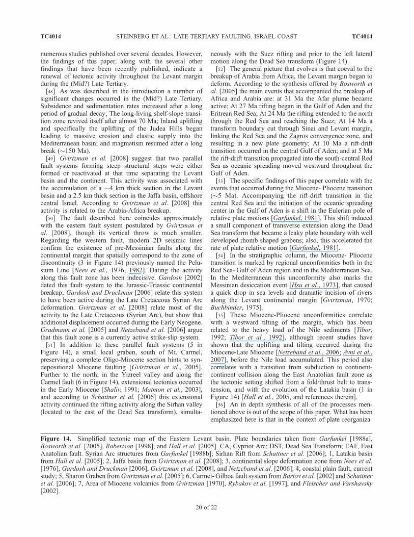
numerous studies published over several decades. However,the findings of this paper, along with the several otherfindings that have been recently published, indicate arenewal of tectonic activity throughout the Levant marginduring the (Mid?) Late Tertiary.[48] As was described in the introduction a number of
significant changes occurred in the (Mid?) Late Tertiary.Subsidence and sedimentation rates increased after a longperiod of gradual decay; The long-living shelf-slope transi-tion zone revived itself after almost 70 Ma; Inland upliftingand specifically the uplifting of the Judea Hills beganleading to massive erosion and clastic supply into theMediterranean basin; and magmatism resumed after a longbreak (�150 Ma).[49] Gvirtzman et al. [2008] suggest that two parallel
fault systems forming steep structural steps were eitherformed or reactivated at that time separating the Levantbasin and the continent. This activity was associated withthe accumulation of a �4 km thick section in the Levantbasin and a 2.5 km thick section in the Jaffa basin, offshorecentral Israel. According to Gvirtzman et al. [2008] thisactivity is related to the Arabia-Africa breakup.[50] The fault described here coincides approximately
with the eastern fault system postulated by Gvirtzman etal. [2008], though its vertical throw is much smaller.Regarding the western fault, modern 2D seismic linesconfirm the existence of pre-Messinian faults along thecontinental margin that spatially correspond to the zone ofdiscontinuity (3 in Figure 14) previously named the Pelu-sium Line [Neev et al., 1976, 1982]. Dating the activityalong this fault zone has been indecisive. Gardosh [2002]dated this fault system to the Jurassic-Triassic continentalbreakup; Gardosh and Druckman [2006] relate this systemto have been active during the Late Cretaceous Syrian Arcdeformation. Gvirtzman et al. [2008] relate most of theactivity to the Late Cretaceous (Syrian Arc), but show thatadditional displacement occurred during the Early Neogene.Gradmann et al. [2005] and Netzeband et al. [2006] arguethat this fault zone is a currently active strike-slip system.[51] In addition to these parallel fault systems (5 in
Figure 14), a small local graben, south of Mt. Carmel,preserving a complete Oligo-Miocene section hints to syn-depositional Miocene faulting [Gvirtzman et al., 2005].Further to the north, in the Yizreel valley and along theCarmel fault (6 in Figure 14), extensional tectonics occurredin the Early Miocene [Shaliv, 1991; Matmon et al., 2003],and according to Schattner et al. [2006] this extensionalactivity continued the rifting activity along the Sirhan valley(located to the east of the Dead Sea transform), simulta-
neously with the Suez rifting and prior to the left lateralmotion along the Dead Sea transform (Figure 14).[52] The general picture that evolves is that coeval to the
breakup of Arabia from Africa, the Levant margin began todeform. According to the synthesis offered by Bosworth etal. [2005] the main events that accompanied the breakup ofAfrica and Arabia are: at 31 Ma the Afar plume becameactive; At 27 Ma rifting began in the Gulf of Aden and theEritrean Red Sea; At 24 Ma the rifting extended to the norththrough the Red Sea and reaching the Suez; At 14 Ma atransform boundary cut through Sinai and Levant margin,linking the Red Sea and the Zagros convergence zone, andresulting in a new plate geometry; At 10 Ma a rift-drifttransition occurred in the central Gulf of Aden; and at 5 Mathe rift-drift transition propagated into the south-central RedSea as oceanic spreading moved westward throughout theGulf of Aden.[53] The specific findings of this paper correlate with the
events that occurred during the Miocene- Pliocene transition(�5 Ma). Accompanying the rift-drift transition in thecentral Red Sea and the initiation of the oceanic spreadingcenter in the Gulf of Aden is a shift in the Eulerian pole ofrelative plate motions [Garfunkel, 1981]. This shift induceda small component of transverse extension along the DeadSea transform that became a leaky plate boundary with welldeveloped rhomb shaped grabens; also, this accelerated therate of plate relative motion [Garfunkel, 1981].[54] In the stratigraphic column, the Miocene- Pliocene
transition is marked by regional unconformities both in theRed Sea- Gulf of Aden region and in the Mediterranean Sea.In the Mediterranean this unconformity also marks theMessinian desiccation event [Hsu et al., 1973], that causeda quick drop in sea levels and dramatic incision of riversalong the Levant continental margin [Gvirtzman, 1970;Buchbinder, 1975].[55] These Miocene-Pliocene unconformities correlate
with a westward tilting of the margin, which has beenrelated to the heavy load of the Nile sediments [Tibor,1992; Tibor et al., 1992], although recent studies haveshown that the uplifting and tilting occurred during theMiocene-Late Miocene [Netzeband et al., 2006; Avni et al.,2007], before the Nile load accumulated. This period alsocorrelates with a transition from subduction to continent-continent collision along the East Anatolian fault zone asthe tectonic setting shifted from a fold/thrust belt to trans-tension, and with the evolution of the Latakia basin (1 inFigure 14) [Hall et al., 2005, and references therein].[56] An in depth synthesis of all of the processes men-
tioned above is out of the scope of this paper. What has beenemphasized here is that in the context of plate reorganiza-
Figure 14. Simplified tectonic map of the Eastern Levant basin. Plate boundaries taken from Garfunkel [1988a],Bosworth et al. [2005], Robertson [1998], and Hall et al. [2005]. CA, Cypriot Arc; DST, Dead Sea Transform; EAF, EastAnatolian fault. Syrian Arc structures from Garfunkel [1988b]; Sirhan Rift from Schattner et al. [2006]; 1, Latakia basinfrom Hall et al. [2005]; 2, Jaffa basin from Gvirtzman et al. [2008]; 3, continental slope deformation zone from Neev et al.[1976], Gardosh and Druckman [2006], Gvirtzman et al. [2008], and Netzeband et al. [2006]; 4, coastal plain fault, currentstudy; 5, Sharon Graben fromGvirtzman et al. [2005]; 6, Carmel- Gilboa fault system from Bartov et al. [2002] and Schattneret al. [2006]; 7, Area of Miocene volcanics from Gvirtzman [1970], Rybakov et al. [1997], and Fleischer and Varshavsky[2002].
TC4014 STEINBERG ET AL.: LATE TERTIARY FAULTING, ISRAEL COAST
20 of 22
TC4014

tion and vertical motions, a 70 km long fault was formed inthe Israeli coastal plain during the Late Miocene or EarlyPliocene.
7. Summary and Conclusions
[57] (1) The TWT map of the Base Pliocene horizonreveals clear lineaments both onshore and offshore Israel.This paper focuses on the onshore lineament.[58] (2) The coastal plain lineament, south of Mt. Carmel,
is an elongated step, 70 km long and 200–400 m high. Thisstep is now buried by Pliocene sediments.[59] (3) Seismic profiles and geological cross sections
perpendicular to this lineament suggest that this lineament isa fault scarp.[60] (4) This fault was possibly active during the Late
Miocene and/or Pliocene.
[61] (5) The elevated side of the fault was eroded beforeits burial, however, a quantitive distinction between thiserosion, earlier truncations, and original hiatuses, is notpossible at this stage.[62] (6) In a wider perspective, the Africa-Arabia breakup
was accompanied by renewal of the tectonic activity alongthe Levant continental margin. The fault described hereadds another piece of evidence to this process.
[63] Acknowledgments. We would like to thank the Israeli WaterCommission and the Israeli Science Foundation for their support of thisresearch, the Israeli petroleum commissioner for permission to use seismicdata, and Seismic Micro Technology, Inc. for the use of the Kingdomsoftware. We are also much grateful to H. Ron, A. Starinsky, Z. Garfunkel,Y. Folkman, and two anonymous reviewers for their comments and advice.This research was supported by the Israeli Science Foundation (grant768/07).
ReferencesAvni, Y., A. Segev, and H. Ginat (2007), Eocene-
Oligocene tectono-sedimentary stages of rifting inthe northern tip of the Red Sea and its environs: Akey to the early breakup stages of the Arabo-Nu-bian plate; Israel Geological Society Annual meet-ing, Neve Zohar, Israel.
Bartov, Y., A. Sneh, L. Fleischer, V. Arad, andM. Rosensaft (2002), Potentially active faults inIsrael, GSI/29/2002, Geol. Surv. of Isr., Jerusalem.
Barzel, A., and G. M. Friedman (1970), The Zoharformation (Jurassic) in southern Israel: A modelof shallow water marine carbonate sedimentation,Isr. J. Earth Sci., 19, 183–207.
Bein, A., and G. Gvirtzman (1977), A Mesozoic fossiledge of the Arabian plate along the Levant coastlineand its bearing on the evolution of the Eastern Medi-terranean, paper presented at Int. Symp. on the Struct.Hist. of the Mediterranean basins, Split, Yugoslovia.
Ben-Avraham, Z. (1978), The structure and tectonicsetting of the Levant continental margin, EasternMediterranean, Tectonophysics, 46, 313 –331.
Ben-Gai, Y. (1996), Sequence stratigraphy of the Pli-Pleistocene in the continental margin of the South-ern Levant, Ph.D. thesis, Tel Aviv Univ.
Ben-Gai, Y., Z. Ben-Avraham, B. Buchbinder, andC. Kendall (2005), Post-Messinian evolution ofthe southeastern Levant Basin based on two-dimensional stratigraphic simulation, Mar. Geol.,221, 359 – 379.
Bertoni, C., and J. A. Cartwright (2005), 3D seismicanalysis of circular evaporite dissolution structures,East. Mediter. J. Geol. Soc. London, 162, 909–926.
Bertoni, C., and J. Cartwright (2006), Controls on thebasinwide architecture of late Miocene (Messinian)evaporites on the Levant margin (Eastern Mediter-ranean), Sediment. Geol., 188–189, 93 –114.
Bertoni, C., and J. A. Cartwright (2007), Major erosionat the end of the Messinian Salinity Crisis: Evi-dence from the Levant Basin, East. Mediter., BasinRes., 19, 1 –18.
Bosworth, W., P. Huchon, and K. McClay (2005), TheRed Sea and Gulf of Aden basins, J. Afr. Earth Sci.,43, 334–378.
Buchbinder, B. (1975), Lithogenesis of Miocene reeflimestones in Israel with particular reference tothe significance of the red algae, Ph.D. thesis,173 pp, Hebrew Univ., Jerusalem.
Buchbinder, B., G. Martinoty, R. Siman-Tov, andE. Zilberman (1993), Temporal and spatial relation-ships in Miocene reef carbonate in Israel, Paleo.Paleo. Paleo., 101, 97– 116.
Cohen, Z. (1971), The Geology of the Lower Cretac-eous of the Helez field, Israel, Ph.D. thesis, 98 pp.,Hebrew Univ., Jerusalem.
Druckman, Y. (1974), The stratigraphy of the Triassicsequence in Southern Israel, 92 pp., GSI/64, Geol.Sur. of Isr., Jerusalem.
Druckman, Y., D. Gill, L. Fleischer, E. Gelberman, andO. Wolff (1995), Subsurface geology and structuralevolution of the Northwestern Negev, Southern Is-rael, Israel J. Earth Sci., 44, 115 –135.
Eyal, Y. (1996), Stress field fluctuations along the DeadSea rift since the Middle Miocene, Tectonics, 15,157–170.
Fleischer, L. (2002), Stratigraphic table of Israel: Outcropsand subsurface, 874/202/02, Geophys. Inst. of Isr.
Fleischer, L., and R. Gafsou (2003), Top Judea Groupdigital structural map of Israel, 753/312/03, Geo-phys. Inst. of Isr.
Fleischer, L., and A. Varshavsky (2002), A lithostrati-graphic data base of oil and gas wells drilled inIsrael, 874/202/02, Geophys. Inst. of Isr.
Fleischer, L., E. Gelberman, and O. Wolff (1993), Ageological-geophysical reassessment of the JudeaGroup (Yarqon-Taninim Aquifer), I.P.R.G. 244/147/92.
Flexer, A. (1968), Sratigraphy and facies developmentof Mount Scopus Group (Senonian-Paleocene) inIsrael and adjacent countries, Isr. J. Earth Sci., 17,85– 114.
Gardosh, M. (2002), The sequence stratigraphy andpetroleum systems of the Mesozoic, SoutheasternMediterranean continental margin, Ph.D. thesis,157 pp., Tel Aviv Univ.
Gardosh, M., and Y. Druckman (2006), Seismic stratigra-phy, structure, and tectonic evolution of the LevantineBasin, offshore Israel, in Tectonic development of theEastern Mediterranean region, edited by A. H. F.Robertson and D. Mountrakos, pp. 201–227, Geol.Soc., London.
Garfunkel, Z. (1981), Internal structure of the Dead Sealeaky transform (rift) in relation to plate kinematics,Tectonophysics, 80, 81– 108.
Garfunkel, Z. (1984), Large scale submarine rotationalslumps and growth faults in the eastern Mediterra-nean, Mar. Geol., 55, 305–324.
Garfunkel, Z. (1988a), Relation between continentalrifting and uplifting: Evidence from the Suez riftand northern Red Sea, Tectonophysics, 150, 33–49.
Garfunkel, Z. (1988b), The pre-quaternary geology ofIsrael, in The Zoogeography of Israel, edited byY. Yom-Tov and E. Tchernov, pp. 7 –34, Dr. W.Junk Publishers, Dordrecht, Netherlands.
Garfunkel, Z. (1998), Constrains on the origin and his-tory of the Eastern Mediterranean basin, Tectono-physics, 298, 5 – 35.
Garfunkel, Z. (2004), Origin of the EasternMediterraneanbasin: A reevaluation, Tectonophysics, 391, 11–34.
Garfunkel, Z., and G. Almagor (1985), Geology andstructure of the continental margin off northernIsrael and the adjacent part of the Levantine basin,Mar. Geol., 62, 105–131.
Garfunkel, Z., and Y. Bartov (1977), The tectonics ofthe Suez Rift, Geol. Surv. Isr. Bull., 71, 1 –44.
Garfunkel, Z., and B. Derin (1984), Permian-Early Me-sozoic tectonism and continental margin formationin Israel and its implications for the history of theEastern Mediterranean, paper presented at Proc.Conf. East. Mediter., Edinburgh.
Garfunkel, Z., A. Arad, and G. Almagor (1979), ThePalmahim disturbance and its regional setting,56 pp., vol. 72, Geol. Surv. of Isr., Jerusalem.
Gelberman, E. (1995), Revised seismic structural andisopach maps - Central and Southern Israel,I.P.R.G., 201/22/89-94.
Gelberman, E., P. Thacker, and U. Amitai (1980),Deep well velocity data, review and interpretation,I.P.R.G., 5/501/78.
Gil, D. (1965), The subsurface geology of the PetahTikvah area, M.Sc. thesis, Hebrew Univ. of Jerusa-lem, Jerusalem.
Ginzburg, A., and G. Gvirtzman (1979), Changes in thecrust and in the sedimentary cover across the transi-tion from the Arabian platform to the Mediterraneanbasin: Evidence for seismic refraction and sedimen-tary studies in Israel and Sinai, pp. 19–36.
Goldberg, M., and G. M. Friedman (1974), Paleoenvir-onments and paleogeographic evolution of the Jur-assic system in Southern Israel, 44 pp., vol. 61,Geol. Surv. of Isr., Jerusalem.
Gradmann, S., C. Hubscher, Z. Ben-Avraham,D. Gajewski, andG.Netzeband (2005), Salt tectonicsoff northern Israel, Mar. Pet. Geol., 22, 597–611.
Gvirtzman, G. (1970), The Saqiye Group (late Eoceneto early Pleistocene) in the coastal plain and Hash-phela regions, Israel, Ph.D. thesis, 170 pp., HebrewUniv., Jerusalem.
Gvirtzman, G., and B. Buchbinder (1978), The LateTertiary of the coastal plain and continental shelfof Israel and its bearing on the history of the EasternMediterranean, Initial reports of the deep sea dril-ling project, XLII, pp. 1195–1222.
Gvirtzman, Z., and Z. Garfunkel (1998), The transfor-mation of Southern Israel from a swell to a basin:Stratigraphic and geodynamic implications for in-tracontinental tectonics, Earth Planet. Sci. Lett.,163, 275–290.
Gvirtzman, G., and A. Klang (1972), A structural anddepositional hinge-line along the coastal plain ofIsrael, evidenced by Magneto-Tellurics, 18 pp.,GSI/55, Geol. Surv. of Isr., Jerusalem.
TC4014 STEINBERG ET AL.: LATE TERTIARY FAULTING, ISRAEL COAST
21 of 22
TC4014

Gvirtzman, Z., R. Siman-Tov, R. Calvo, L. Grossowicz,and A. Almogi-Labin (2005), Evidence of Tertiaryfaulting in the Sharon region, Israel in light of newbiostratigraphic data, Geol. Surv. of Isr., Jerusalem,GSI/18/2005.
Gvirtzman, Z., E. Zilberman, and Y. Folkman (2008),Reactivation of the Levant passive margin duringthe Late Tertiary and formation of the Jaffa basinoffshore central Israel, J. Geol. Soc. London, 165,563–578.
Hall, J. K. (1993), The GSI digital terrain model(DTM) completed, in GSI Current Research, editedby R. Bogoch and Y. Eshet, pp. 47–50, Geol. Surv.of Isr., Jerusalem.
Hall, J., A. E. Aksu, T. J. Calon, and D. Yasar (2005),Varying tectonic control on basin development at anactive microplate margin: Latakia Basin, East.Mediter. Mar. Geol., 221, 15 –60.
Hsu, K. J., W. B. F. Ryan, and M. B. Cita (1973), LateMiocene desiccation of the Mediterranean, Nature,242, 240–244.
Hsu, K. J., L. Montadert, D. Bernoulli, M. BiancaCita, A. Erickson, R. E. Garrison, R. B. Kidd,F. Melieres, C. Muller, and R. Wright (1978),History of the Mediterranean salinity crisis, InitialRep. Deep Sea Drill. Proj., 42, 1053–1079.
Kenter, J. A. M. (1990), Carbonate platform flanks:Slope angle and sediment fabric, Sedimentology,37, 777–794.
Klang, A. (1966), Compilation of seismic velocity datafor Israel, I.P.R.G., 1013.
Klang, A. (1984), Deep well velocity data: Review andinterpretation, I.P.R.G., 8F/82; R3/84.
Mart, Y. (1982), Quaternary tectonic patterns along thecontinental margin of the southeastern Mediterra-nean, Mar. Geol., 49, 327–344.
Mart, Y., B. Eisin, and Y. Folkman (1978), The Palma-him structure - A model of continuous activity sincethe Upper Miocene in the southeastern Mediterra-nean off Israel, Earth Planet. Sci. Lett., 39, 328–334.
Martinez, J. F., J. Cartwright, and B. Hall (2005), 3Dseismic interpretation of slump complexes: Exam-ples from the continental margin of Israel, BasinRes., 17, 83–108.
Matmon, A., S. Wdowinski, and J. K. Hall (2003),Morphological and structural relations in the Gali-lee extensional domain, Northern Israel, Tectono-physics, 371, 323–341.
Neev, D., G. Almagor, A. Arad, A. Ginzburg, andJ. K. Hall (1976), The geology of the southeasternMediterranean Sea, Bulletin, 51 pp., vol. 68, G.S.I.,Jerusalem.
Neev, D., J. K. Hall, and J. M. Saul (1982), The Pelu-sium megashear system across Africa and asso-ciated lineament swarms, J. Geophys. Res., 87,1015–1030.
Netzeband, G., C. Hubscher, and D. Gajewski (2006),The structural evolution of the Messinian evaporitesin the Levantine Basin, Mar. Geol., 230, 249–273.
Reiss, Z., and G. Gvirtzman (1962), Subsurface Neo-gene stratigraphy of the Israeli coastal plain, Geol.Surv. of Isr., Jerusalem, Pal/4/62.
Robertson, A. H. F. (1998), Mesozoic-Tertiary tectonicevolution of the easternmost Mediterranean area:Integration of marine and land evidence, in Pro-
ceedings of the Ocean Drilling Program; ScientificResults, edited by A. H. F. Robertson et al., OceanDrilling Program.
Rosenfeld, A., and F. Hirsch (2005), The Cretaceousof Israel, in Geological Framework of the Levant,edited by J. K. Hall et al., Geol. Surv. of Isr.,Jerusalem.
Rybakov, M., V. Goldshmidt, and Y. Rotstein (1997),New regional and magnetic maps of the Levant,Geophys. Res. Lett., 24, 33–36.
Schattner, U., and Z. Ben-Avraham (2007), Transformmargin of the northern Levant, eastern Mediterra-nean: From formation to reactivation, Tectonics, 26,TC5020, doi:10.1029/2007TC002112.
Schattner, U., Z. Ben-Avraham, M. Reshef, G. Bar-Am,and M. Lazar (2006), Oligocene-Miocene forma-tion of the Haifa basin: Qishon-Sirhan rifting coevalwith the Red Sea-Suez rift system, Tectonophysics,419, 1 –12.
Schlager, W., and O. Camber (1986), Submarine slopeangles, drowning unconformities, and self-erosionof limestone escarpments, Geology, 14, 762–765.
Shaliv, G. (1991), Stages in the tectonic and volcanichistory of the Neogene basin in the Lower Galileeand the valleys, Geol. Surv. of Isr. report GSI/11/91.
Sneh, A., Y. Bartov, and M. Rosensaft (1998), Geolo-gical map of Israel, 1:200,000, Geol. Surv. of Isr.,Jerusalem.
Steinitz, G., Y. Bartov, and J. C. Hunziker (1978), K-Ardeterminations of some Miocene-Pliocene basalts inIsrael: Their significance to the tectonics of the riftvalley, Geol. Mag., 115, 329 –340.
Tibor, G. (1992), Quantitive basin analysis of the lateTertiary Levat passive continental margin, easternMediterranean and its implications to the under-standing of the Messinian event, Ph.D. thesis,120 pp., Tel Aviv Univ., Tel Aviv.
Tibor, G., Z. Ben-Avraham, M. Steckler, and H.Fligelman (1992), Late Tertiary subsidence historyof the Southern Levant margin, Eastern Mediterra-nean Sea, and its implications to the understanding ofthe Messinian event, J. Geophys. Res., 97, 17,593–517,614.
Withjack, M. O., J. Olson, and E. Peterson (1992),Experimental models of extensional forced folds,AAPG Bull., 74, 1038–1054.
���������Y. Ben-Gai, Geophysical Institute of Israel, P.O.
Box 182, Lod 71100, Israel.
H. Gvirtzman and J. Steinberg, Institute of EarthSciences, Hebrew University of Jerusalem, Jerusalem91904, Israel. ( [email protected])
Z. Gvirtzman, Geological Survey of Israel, 30Malkhe Yisrael Street, Jerusalem 95501, Israel.
TC4014 STEINBERG ET AL.: LATE TERTIARY FAULTING, ISRAEL COAST
22 of 22
TC4014