On the post-25 Ma geodynamic evolution of the western Mediterranean
INTRODUCTION
One of the paradigms of plate tectonics is that plate bound-aries record the deformation related to the ongoing geodynamicprocesses, assuming a single tectonic setting. This article dealswith an expansion of this concept, discussing the possibility thatin a given area multiple geodynamic processes work together,overlapping each other and generating a deformational patternthat represents the sum of distinct tectonic styles that we may
consider independent. The coexistence of four independent geo-dynamic processes was proposed by Doglioni and Carminati(2002) for northeastern Italy, where the Alpine and Dinaridethrust belts interplayed in an area that was undergoing remotesubsidence due to the Apennines subduction and affected by thePannonian back-arc extension. In the western Mediterranean,the Valencia rifting obliquely crosscut the coeval and indepen-dent Betic orogen (Doglioni et al., 1997, 1998, 1999). Along theSan Andreas system, two tectonic settings overlap where the
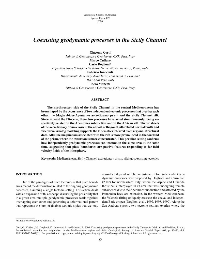
Geological Society of AmericaSpecial Paper 409
2006
Coexisting geodynamic processes in the Sicily Channel
Giacomo CortiIstituto di Geoscienze e Georisorse, CNR, Pisa, Italy
Marco CuffaroCarlo Doglioni*
Dipartimento di Scienze della Terra, Università La Sapienza, Roma, ItalyFabrizio Innocenti
Dipartimento di Scienze della Terra, Università di Pisa, andIGG-CNR Pisa, Italy
Piero ManettiIstituto di Geoscienze e Georisorse, CNR, Pisa, Italy
ABSTRACT
The northwestern side of the Sicily Channel in the central Mediterranean hasbeen shaped by the occurrence of two independent tectonic processes that overlap eachother, the Maghrebides-Apennines accretionary prism and the Sicily Channel rift.Since at least the Pliocene, these two processes have acted simultaneously, being re-spectively related to the Apennines subduction and to the African rift. Thrust sheetsof the accretionary prism crosscut the almost orthogonal rift-related normal faults andvice versa. Analog modeling supports the kinematics inferred from regional structuraldata. Alkaline magmatism associated with the rift is more pronounced in the forelandof the prism, where the extension is more concentrated. This peculiar setting confirmshow independently geodynamic processes can interact in the same area at the sametime, suggesting that plate boundaries are passive features responding to far-field velocity fields of the lithosphere.
Keywords: Mediterranean, Sicily Channel, accretionary prism, rifting, coexisting tectonics
83
*E-mail: [email protected].
Corti, G., Cuffaro, M., Doglioni, C., Innocenti, F., and Manetti, P., 2006, Coexisting geodynamic processes in the Sicily Channel in Dilek, Y., and Pavlides, S., eds., Postcollisional tectonics and magmatism in the Mediterranean region and Asia: Geological Society of America Special Paper 409, p. 83–96, doi:10.1130/2006.2409(05). For permission to copy, contact [email protected]. ©2006 Geological Society of America. All rights reserved.

North America plate overrides the Pacific plate with a left lat-eral transpression along the faster right lateral transtensionaltransfer zone connecting the Juan de Fuca Ridge and the BajaCalifornia rift, as suggested by Doglioni and Harabaglia (1996).
We propose here the case of the Sicily Channel (Figs. 1 and2) as an archetype of an area where two geodynamic settings areactive at the same time, generating a peculiar structural style thatis a function of the related overlap. In this area, the subduction-related Maghrebides-Sicily-Apennines accretionary prism iscrosscut by almost orthogonal normal faults due to an in-dependent rifting affecting northern and northeastern Africa,both on-shore and off-shore (Figs. 1 and 2). The geologic modelis supported by analog model experiments and also focuses onthe structural interference pattern and its relationship with therelated alkaline magmatism.
TECTONIC SETTING
The Sicily Channel is located within a south central seg-ment of the Apennines-Maghrebides belt developing in the cen-
tral western Mediterranean (Fig. 1). Three main elements markthe accretionary prism of Sicily and its off-shore continuation:(a) a Pliocene–Pleistocene northwest-dipping foreland mono-cline generating the overlying foredeep; (b) a roughly ENE-WSW to east-west-trending thin-skinned imbricate wedgeprogressively emplaced from the early–middle Miocene to pres-ent (e.g., Roure et al., 1990; Giunta, 1991; Catalano et al., 1996;Giunta et al., 2000); and (c) northwest-trending normal faultsand a related graben or half graben. Pliocene–Pleistocene rift-ing (Figs. 2 and 3) collapsed the accretionary prism (Reuther andEisbacher, 1985; Argnani, 1990; Casero and Roure, 1994; Tri-cart et al., 1994; Torelli et al., 1995), leading to the developmentof the Sicily Channel, which allows the western and easternparts of the Mediterranean Sea to connect (Fig. 1). The collapsedaccretionary prism has been detected in seismic reflection pro-files (e.g., Tricart et al., 1994; Catalano et al., 1995, Catalano etal., 2000a,b; Casero, 2004), showing thrusts and folds that de-form the seafloor, indicating active deformation.
To the northwest, the Sicily Channel rift appears connectedto the Campidano graben in southwest Sardinia (Fig. 3). The
84 G. Corti et al.
CG
SyCh
GS R
ed Sea
RG
Alps
ApenninesTS
LS
Aegeanextension
PannonianBasin
VT
Sirte basinsAFRICA
EUROPECarpathians
Py
Fig 2
CG: Campidano grabenGS: Gulf of SuezLS: Libyan SeaPb: Provencal basinPy: Pyrenees
SCh: Sardinia ChannelSyCh: Sicily ChannelTS: Tyrrhenian SeaVT: Valencia Trough
Adriatic Sea
Black Sea
Dinaride s
Maghrebides
0 200 km
N
SCh
Pb
RG: Rhine graben
Figure 1. Schematic plate tectonic setting of the Mediterranean area. Extensional structures in the Sardinia and SicilyChannels and in the Sirte region are reported in detail (after Bosworth, 1994; Skuce, 1994; Ahlbrandt, 2001). Note thenormal fault systems, shown in white, that propagate from the Sicily Channel toward the southeast into the Sirte basin,Libya, and northern Egypt, suggesting a connection with the Red Sea rift. This extension crosscuts the Apennines-Maghrebides accretionary prism. Therefore, it is clearly independent of the subduction system and the related back-arcextension in the Algerian and Tyrrhenian basins. The inset shows the location of the study area, depicted in Figure 2.

rifting is affecting the Pelagian shelf and Tunisia on-shore andcontinues to the southeast into the Sirte basin (Bosworth, 1994;Skuce, 1994; Ahlbrandt, 2001) (Fig. 1). Northwest-trendingnormal faults and ENE-trending transfer zones continue on-shore in Libya and Egypt, suggesting a link of the Sicily Chan-nel with the Red Sea and the East African rift in general (Fig. 1).Therefore, the rifting in the Sicily Channel seems to be unrelatedto the subduction process occurring beneath the Apennines-Maghrebides accretionary prism. Stratigraphic columns of thestudy area are reported in Figure 4.
Extension in the area gives rise to the presence of majormorphological structures defining deep tectonic depressions,
namely the Pantelleria, Malta, and Linosa grabens. Majorboundary faults and associated minor normal faults that controlthe deep depressions are clearly observable in seismic lines (see,for instance, the seismic profile in Figure 5 showing the exten-sional structures bordering the Pantelleria graben). These faultsare northwest-southeast-directed; deviations from this principaltrend may be accommodated by the presence of transfer zones,most probably controlled by east-west or north-south transver-sal structures. Boundary faults of the grabens display variablethrows, which generally increase toward the southeast; esti-mated displacements range, indeed, from the ~500 m displace-ment of the Pantelleria graben to the ~1000 m displacement in
Coexisting geodynamic processes in the Sicily Channel 85
10˚ 11˚ 12˚ 13˚ 14˚ 15˚
10˚ 11˚ 12˚ 13˚ 14˚ 15˚35˚
36˚
37˚
38˚
39˚
35˚
36˚
37˚
38˚
39˚0
45
90
135
180
225
270
315
-4000 -3000 -2000 -1000 0 1000 2000 3000 4000
Tunisia
Sicily
Tyrrhenian Sea
PG
MG
LG
Sicily Channel
Linosa I.
Pantelleria I.
Malta I.
Figure 2. Bathymetry of the Sicily Channel and surrounding areas. PG—Pantelleria graben; LG—Linosa graben; MG—Malta graben. Data from the GEBCO (General Bathymetric Chart of the Oceans) Digital Atlas (IOC, IHO, and BODC,2003).
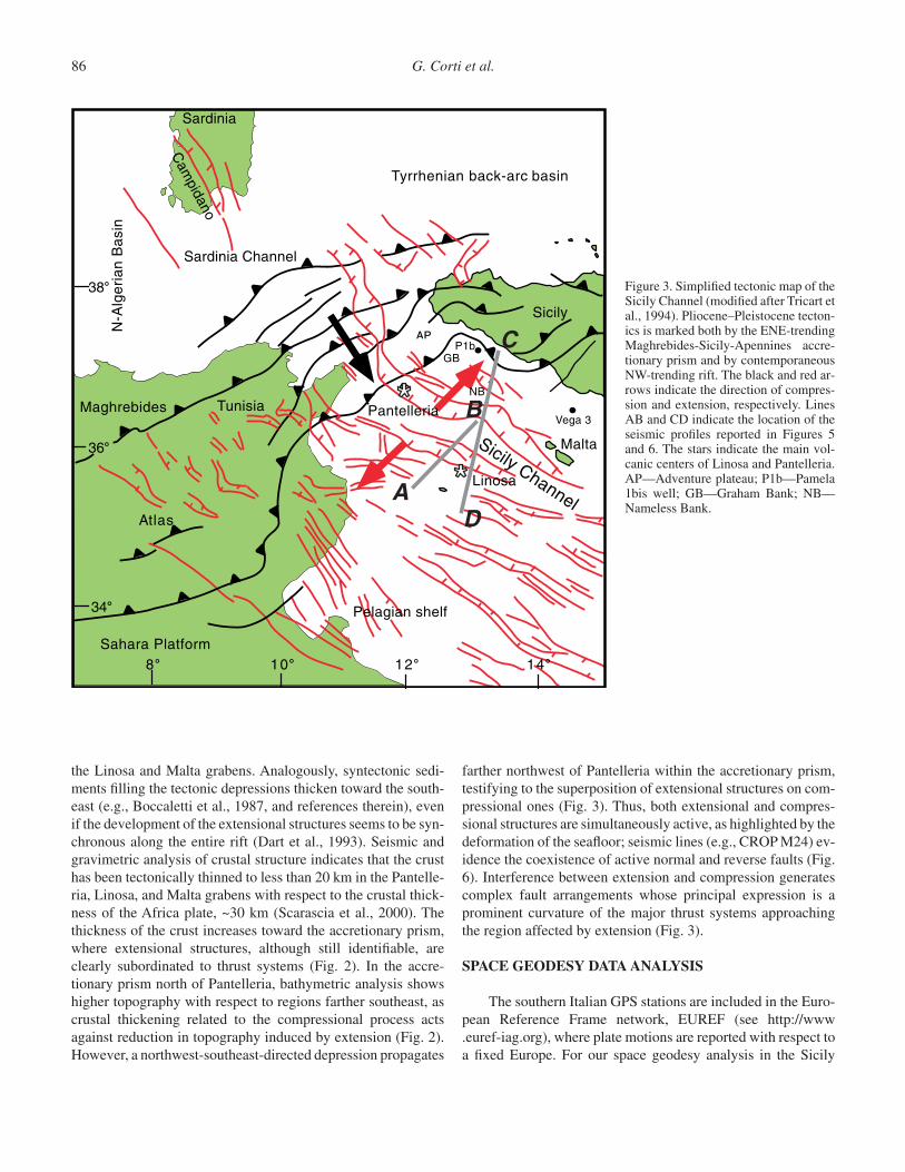
the Linosa and Malta grabens. Analogously, syntectonic sedi-ments filling the tectonic depressions thicken toward the south-east (e.g., Boccaletti et al., 1987, and references therein), evenif the development of the extensional structures seems to be syn-chronous along the entire rift (Dart et al., 1993). Seismic andgravimetric analysis of crustal structure indicates that the crusthas been tectonically thinned to less than 20 km in the Pantelle-ria, Linosa, and Malta grabens with respect to the crustal thick-ness of the Africa plate, ~30 km (Scarascia et al., 2000). Thethickness of the crust increases toward the accretionary prism,where extensional structures, although still identifiable, areclearly subordinated to thrust systems (Fig. 2). In the accre-tionary prism north of Pantelleria, bathymetric analysis showshigher topography with respect to regions farther southeast, ascrustal thickening related to the compressional process actsagainst reduction in topography induced by extension (Fig. 2).However, a northwest-southeast-directed depression propagates
farther northwest of Pantelleria within the accretionary prism,testifying to the superposition of extensional structures on com-pressional ones (Fig. 3). Thus, both extensional and compres-sional structures are simultaneously active, as highlighted by thedeformation of the seafloor; seismic lines (e.g., CROP M24) ev-idence the coexistence of active normal and reverse faults (Fig.6). Interference between extension and compression generatescomplex fault arrangements whose principal expression is aprominent curvature of the major thrust systems approachingthe region affected by extension (Fig. 3).
SPACE GEODESY DATA ANALYSIS
The southern Italian GPS stations are included in the Euro-pean Reference Frame network, EUREF (see http://www.euref-iag.org), where plate motions are reported with respect toa fixed Europe. For our space geodesy analysis in the Sicily
86 G. Corti et al.
Tyrrhenian back-arc basin
Sardinia
Sicily
Tunisia
Sahara Platform
N-A
lger
ian
Bas
in
Maghrebides
Atlas
38
36
34
108 12 14
*
*Sicily Channel
Pelagian shelf
Malta
Pantelleria
P1bAPAAAPPP
GB
NB
Vega 3
Linosa
Sardinia Channel
Cam
pidano
A
C
D
B
Figure 3. Simplified tectonic map of theSicily Channel (modified after Tricart etal., 1994). Pliocene–Pleistocene tecton-ics is marked both by the ENE-trendingMaghrebides-Sicily-Apennines accre-tionary prism and by contemporaneousNW-trending rift. The black and red ar-rows indicate the direction of compres-sion and extension, respectively. LinesAB and CD indicate the location of theseismic profiles reported in Figures 5and 6. The stars indicate the main vol-canic centers of Linosa and Pantelleria.AP—Adventure plateau; P1b—Pamela1bis well; GB—Graham Bank; NB—Nameless Bank.

Coexisting geodynamic processes in the Sicily Channel 87
SeaLevel
PANTELLERIARIFT
VEGA 3MALTA HORST
Seabed
SeabedSea Level
PRE-
RIFT
EARL
YSI
N-RI
FTLA
TE S
IN-R
IFT
PQ
UC
BC
G
K
LC
BC
G
LC
23-65
50-160
132
457
710
995
1335
1583
2145
2329
2468
>465
0-1200PQ
Plio-Quaternary Succession
Clays withmarls at the base (Ribera Fm. - Pliocene)
Gypsum with shale (Gessoso-Solfifera Fm. - Messinian)
Marls and shales (Tellaro Fm. - Tortonian-Langhian)
Carbonates and marls(Ragusa Fm. - Oligocene)
Cherty limestones (Amerillo Fm. - Eocene-Upper Cretaceous)
Marls(Hybla Fm. - Lower Cretaceous)
Marls and shales (Hybla Fm. - Lower Cretaceous)
Limestones (Chiaramonte Fm. -Lower Cretaceous-Upper Tithonian)
Marls (Buccheri Fm. - Malm-Dogger)
Shallow carbonates (Syracuse Fm. - Liassic)
PAMELA 1BIS
SeabedSea Level
156
1470
2133
1744
2723
2973
Shales and marls(Ribera Fm. - Pliocene)
Wackeston/mudstone(Amerillo Fm. - Eocene-Upper Cretaceous)
Dolostone(Taormina Fm. - Triassic)
Dolostone(Inici Fm. - Jurassic)
UC
Upper CorallineLimestone Fm.(Miocene)
LC
Lower CorallineLimestone Fm.(Paleogene-Oligocene)
KNaxxar Gp.(Cretaceous)
BCBlue Clay(Miocene)
G
GlobigerinaLimestone Fm.(Miocene)
300
50-30
100-500
Nor
mal
Fau
lt
SICILY CHANNEL RIFT ACCRETIONARY PRISM FORELAND
Figure 4. Lithostratigraphic columns of the rift system and accretionary prism foreland. Data for the Pantelleria rift and Malta horst were derivedby integrating outcrop, well, and seismic data (after Dart et al., 1993); well data for Pamela 1bis and Vega 3 are from Barbier et al. (2000) andAAVV (1987), respectively, and their locations are in Figure 3.
BA10 km
Rollover anticline
Plio-Quaternary
After Torelli et al. (1995)
SW NESICILYAFRICA
0
1
2
3
4
TW
T (
S)
0
1
2
3
4
TW
T (
S)
s.l.
EK
EK M K
Figure 5. Line drawing of a seismic section across the Sicily Channel, after Torelli et al. (1995). E—middle–upper Eocene; K—Cretaceous; M—Messinian.
Channel, we used station velocities from Hollenstein et al. (2003)derived from GPS acquisitions obtained in 1994, 1996, 2000, and2001. These data were evaluated in the ITRF97 (Boucher et al.,1998), and then the results were finally rotated from the absoluteframe to a Eurasia plate considered fixed, using the Eulerian parameters (pole and angular velocity) from Sella et al. (2002).
In this reference frame, we selected two GPS stations,LAMP (Lampedusa Isle, Sicily) and NOTO (Noto, Sicily), and
their motions relative to the fixed station of CAGL (Cagliari,Sardinia) were computed (Fig. 7). This analysis shows thenorthwestward convergence of Noto and Lampedusa relative toCagliari at 4–5 mm/yr. Cagliari has very slow motion relative to fixed Eurasia (e.g., Hollenstein et al., 2003). This compres-sion is consistent with the Neogene to present Maghrebides-Sicilian belt. Noto and Lampedusa have similar velocities(vLAMP = [3.677 ± 0.806 mm/yr], vNOTO = [3.992 ± 0.100 mm/yr]),

PELAGIAN shelf
CROP M24
DC
CROP M24
SICILY off-shore
NEFigure 6. Seismic reflection profile of the Sicily Channel showing the coexistence of the rift and the accretionary prism, both processes de-forming the seafloor (Seismic section CROP M24, Scrocca et al., 2003). Red lines normal faults, black lines thrust faults.
Figure 7. Velocity vector analysis in theSicily Channel. The blue vectors rep-resent the velocities of GPS stations reported in a fixed CAGL (Cagliari) ref-erence frame (data from Hollenstein et al.,2003), and they imply active northwest-southeast contraction of NOTO (Noto)and LAMP (Lampedusa) relative toCAGL in Sardinia. The red vector is therelative motion velocity of NOTO withrespect to fixed LAMP, and it representsthe rifting rate in the Sicily Channel. This confirms the coexistence of twopresently active tectonic settings, such asa northwest-southeast-trending compres-sion and a northeast-southwest-trendingextension in the same area. Map gener-ated with the Generic Mapping Tools ofWessel and Smith (1995).

but Noto has a more northerly azimuth than Lampedusa. Thisdifferent trend generates extension between the two GPS sites.Computing the relative motion of the NOTO station relative toa fixed LAMP, the estimated rifting rate is vrel = (1.556 ± 0.800)mm/yr with a northeastern direction (Fig. 7). This confirms the coexistence of the two presently active tectonic settings of a northwest-southeast-directed compression and a northeast-southwest-oriented extension in the same area.
Calculations of the strain rate field from the GPS data con-firm the northeast-directed extension in the Sicily Channel rift-ing system (Hollenstein et al., 2003). Dextral shear strains wereobserved only on faults trending oblique to the regional stressfields; this component of movement can be a result of the obliq-uity of fault segments to the regional extension direction (e.g.,Corti, 2004).
VOLCANISM IN THE SICILY CHANNEL
In the Sicily Channel, volcanic activity is concentratedmainly on the islands of Pantelleria and Linosa. Minor sub-marine volcanism took place in Adventure plateau and in Grahamand Nameless Banks. The oldest products have been found in asubmarine volcanic seamount located eastward of NamelessBank, where hawaiitic dredged samples gave a K-Ar age of 9.5± 0.4 Ma (Beccaluva et al., 1981). However, the climax of thevolcanism occurred during the Pleistocene on the islands ofLinosa and Pantelleria; the volcanic centers recognized in Ad-venture plateau (Anfitrite and Tetide) are also considered to be
of Plio-Pleistocene age (Calanchi et al., 1989). Historic activitytook place in the nineteenth century close to Pantelleria. On Graham Bank, in A.D. 1831 a submarine volcano was con-structed at a depth of ~200 m, giving rise to an ephemeral island~65 m above sea level named Foerstner volcano. This volcanoerupted again in 1863. The youngest eruptions of the region tookplace in 1891 ~5 km northwest of Pantelleria, where a sub-marine volcanic eruption was recorded (Washington, 1909), and in 1941 at the Pinne Marine Bank at the southeastern wedge of Graham Bank, where emissions of gases were ob-served (Imbò, 1965; Carapezza et al., 1979).
Pantelleria, with its 83 km2 of surface area, represents thelargest extent of emerged volcanic rocks of the Sicily Channel;they were erupted between 0.324 and 0.003 Ma (Mahood andHidreth, 1983; Civetta et al., 1998). The structure of the islandis dominated by two nested calderas (Mahood and Hidreth,1983). Several tens (~40) of volcanic centers have been recog-nized in and around the caldera structures: they are composed ofpyroclastic cones, domes, and cinder cones (Villari, 1974; Orsiet al., 1991). The volcanological and structural evolution of theisland is considered an expression of the occurrence of smallmagma reservoirs at shallow depths (Mahood and Baker, 1986).The erupted products show an alkaline to peralkaline affinityand consist mainly of alkali basalts, hawaiites, trachytes, andperalkaline trachytes to peralkaline rhyolites (pantellerites). Thevolcanic association is typically bimodal, with the evolved rockslargely dominant (more than 95% of the outcropping materials)(Fig. 8). The genesis of peralkaline-evolved rocks is still a de-
Coexisting geodynamic processes in the Sicily Channel 89
Pantelleria
Linosa Foerstner Volcano
Submarine volcanic centers (Adventure Bank, Nameless Bank)
0
2
4
6
8
1 0
1 2
1 4
Figure 8. Total alkali silica diagram forvolcanic rocks from the Strait of Sicily.Classification grid from Le Maitre(2002). Dividing red line between alkaline and subalkaline fields taken from Irvine and Baragar (1971). Datasources: Barberi et al. (1969); Villari(1974); Carapezza et al. (1979); Becca-luva et al. (1981); Mahood and Baker(1986); Calanchi et al. (1989); Esper-ança and Crisci (1995); Rossi et al.(1996); Civetta et al. (1998); Prosperiniet al. (2000); Bindi et al. (2002);Avanzinelli (2004).

bated problem. On the basis of petrological, geochemical, andisotopic data, two main processes are competing, i.e., a crystalfractionation starting from a transitional mildly alkaline basaltversus partial melting of an alkaline gabbro formed in a rela-tively shallow magma chamber (Ferrara and Treuil, 1974; Ma-hood and Baker, 1986; Lowenstern and Mahood, 1991; Civettaet al., 1998; Avanzinelli et al., 2004).
The island of Linosa is much smaller than Pantelleria, ~6 km2; it was built up through three main stages of volcanic ac-tivity developed between 1.06 and 0.53 Ma (Lanzafame et al.,1994) with either submarine or subaerial eruptions. Indeed, theeruptive activity was characterized by the emission of hydro-magmatic tuffs, locally palagonitized, and by the constructionof tuff rings associated with scoria cones, spatter cones, and lavaflows forming a small lava field. In some volcanic centers, onecan observe a transition from hydromagmatic to strombolian ac-tivity, which produced the ejection of hydromagmatic tuffs followed by basaltic scorias as the eruption advanced (Rossi et al., 1996). The emitted products are mildly alkaline, scarcelyevolved rocks; they are dominated by alkali basalts and trachy-basalts. Rare trachyandesites and trachytes are mainly found asxenoliths in pyroclastic rocks erupted during the oldest stage ofactivity (Fig. 8).
The submarine volcanic centers sampled in Adventureplateau and in Graham and Nameless Banks (Carapezza et al.,1979; Beccaluva et al., 1981; Calanchi et al., 1989) are alsocharacterized by the eruption of scarcely evolved Na-alkalineproducts represented by alkali basalts and hawaiites. Only somebasic samples collected by Carapezza et al. (1979) and consid-ered erupted by Foerstner volcano show Na2O ≤ K2O.
Overall, the volcanic products erupted in the Strait of Sicilyconstitute a bimodal sodic, moderately alkaline association. Thebasic rocks, alkali basalts and hawaiites, are largely predomi-nant, and in many volcanic areas, as on the island of Linosa andin the submarine volcanoes of Adventure plateau and Grahamand Nameless Banks, are the only products found. Therefore,the bimodal compositional distribution of the erupted productsis essentially due to the conspicuous presence of pantellirites,pantelleritic trachytes, and trachytes outcropping only on the is-land of Pantelleria. The general petrologic features of the vol-canism of the Strait of Sicily point to an anorogenic magmatismakin to that found in continental rift areas (Corti et al., 2003).The trace element distribution is comparable with that observedin intraplate basalts or ocean island basalts. This is well illus-trated in Figure 9, where primordial mantle-normalized multi-element patterns are plotted for representative basalts fromLinosa and Pantelleria and compared with the pattern of oceanisland basalts. Even if the trace element patterns are similar inthe two islands, the basalts from Pantelleria display higher contents of incompatible trace elements compatible with theirrelatively more evolved character; in fact, the Mgv (i.e., Mg/[Mg+Fe2+] atomic ratio) of Pantelleria basalts varies between50 and 53, whereas in Linosa it ranges between 69 and 76. It isworth noting that all the samples exhibit a slight negative anom-
90 G. Corti et al.
1
5
10
50
100
Pantelleria
RbBa
ThU
TaNb
KLa
CePb
PrSr
PNd
HfZr
SmEu
TiGd
DyHo
YEr
YbLu
1
5
10
50
100
RbBa
ThU
TaNb
KLa
CePb
PrSr
PNd
HfZr
SmEu
TiGd
DyHo
YEr
YbLu
Linosa
Roc
k/P
rim
ordi
alM
antle
Roc
k/P
rim
ordi
alM
antle
Figure 9. Primordial mantle-normalized incompatible element dia-grams for selected basalts from Pantelleria and Linosa. Data sources:Civetta et al. (1998); Avanzinelli (2004). Ocean island basalts pattern(gray line) and normalizing values from Sun and McDonough (1989).
aly of Hf and K; the latter has been thought to reflect the pres-ence of a residual K-bearing phase (mica or amphibole) in themantle source (Wilson and Bianchini, 1999).
ANALOG MODELING
Experimental Set-up
Analog modeling was used to investigate the structural pattern resulting from interaction between two coeval distinctgeodynamic processes, namely compression with a super-imposed orthogonal extensional regime. Experiments were per-formed in the Tectonic Modeling Laboratory of the IGG-CNR(Consiglio Nazionale delle Richerce–Instituto di Geoscienze eGeorisorse) settled at the Earth Sciences Department of Flor-ence University (Italy). Models with dimensions of 40 cm × 45

cm × 6 cm were built over the basal metal plate of the deforma-tion apparatus; two orthogonal stepper motors controlled by acentral unit were used to drive compression with contempora-neous orthogonal extension (Fig. 10). In particular, shorteningof the models was obtained by movement of a mobile wall at aconstant velocity of ~5 cm/h up to ~10 cm of compression(~25% bulk shortening). Coeval extension was imposed on themodels by pulling a thin acetate sheet at the base of the model,creating a central velocity discontinuity (VD) parallel to the di-rection of compression (Fig. 10). Extension was applied at 1cm/h up to 2 cm of stretching (~5% bulk extension).
Models consisted of a single quartz sandpack simulating thebrittle behavior of upper-crustal rocks in nature. The sand had adensity of ~1500 kg m–3, a cohesion of ~65 Pa, and an angle of
internal friction of ~39°. Experiments were conveniently scaledsuch that 1 cm in the models represented 1 km in nature, imply-ing that the models simulated a 5-km-thick layer of upper-crustal rocks in nature. Because the brittle behavior of sand isstrain-rate independent, scaling for velocity was not critical inthese experiments. However, in order to closely mimic the nat-ural example, compression was driven about five times fasterthan extension.
Model Results
Figure 11 portrays the evolution of model SCh 03, which istaken as representative of the whole experimental series. For alow amount of deformation, compression was taken up by a ma-
Coexisting geodynamic processes in the Sicily Channel 91
B
A
Mobile wall
Compressionat 5 cm/hr
Extensionat 1 cm/hr
Fixed wall
Basal acetate sheet
VD
40 c
m
Sand
Basal acetate sheet
6 cm
VD
20 c
m
45 cm
22 cm
22 cm
A B
A BFigure 10. (A) Experimental set-up and(B) model rheology. VD—velocity dis-continuity. See text for details.
VD
VD
VD
VD
VD
VD
VD
VD
Compr: 0 mmExt: 0 mm
Compr: 27 mmExt: 6 mm
Compr: 55 mmExt: 12 mm
Compr: 95 mmExt: 20 mm
A
B
C
D
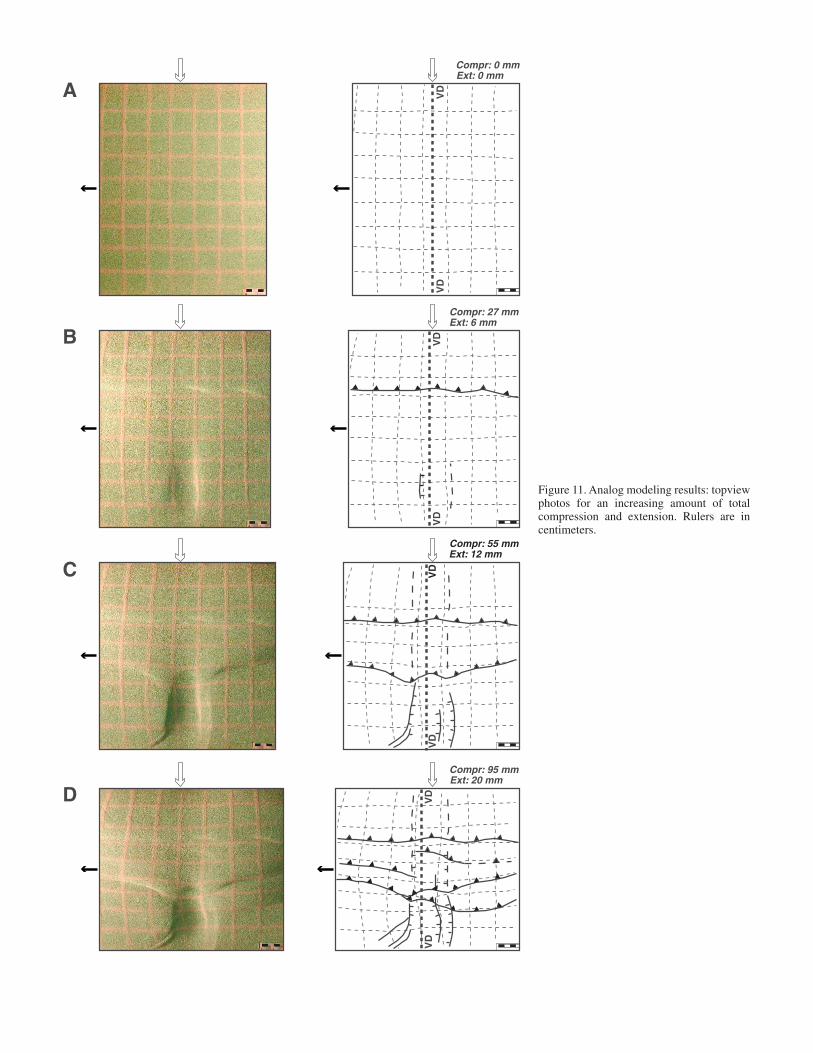
Figure 11. Analog modeling results: topviewphotos for an increasing amount of totalcompression and extension. Rulers are incentimeters.

jor thrust system parallel to the moving wall and developing at~10 cm away from it. Extensional deformation localized in thecorrespondence of the basal VD, with the development of a cen-tral depression orthogonal to the moving wall. This depressionwas bordered by normal faults, clearly evident close to the fixedwall of the deformation apparatus (Fig. 11B). For increasing de-formation (Fig. 11C), thrust faults propagated toward the fore-land portions of the model, with the development of a secondthrust system ~18–20 cm from the moving wall. This thrust sys-tem displayed an evident curvature in correspondence to thecentral depression. Further extension was accommodated by in-creased throw along major normal faults and by subsidencewithin the central graben.
In the latest stages of deformation (compression 9.5 cm;extension 2 cm; Fig. 11D) major thrust systems were charac-terized by a complex arrangement resulting from the interac-tion with extensional structures. In particular, this interaction isevidenced by (1) curvature of thrusts, (2) development of thrustsplays corresponding to the central depression, and (3) a loweramount of rift subsidence in the regions affected by compres-sive deformation.
The complex fault pattern resulting from the contempora-neous compression and extension is also seen through analysisof model cross-sections (Fig. 12). Away from the central VD, noextensional structures developed, and deformation was taken upby a regular array of thrusts and back-thrusts (Fig. 12, sectionAB); conversely, close to the fixed wall in the regions not af-fected by compressive deformation, the cross-section shows themain graben above the VD, bordered by steep normal faults(Fig. 12, section CD). In the central part of the model, the cross-sections display the complex patterns of superposition betweencompressional and extensional structures (Fig. 12, sections EFand GH). In summary, interaction between thrust systems andnormal faults gave rise to a complicated 3-D geometry of mainstructures.
COEXISTING GEODYNAMIC PROCESSES IN THE SICILY CHANNEL
Structural and geophysical data suggest that the structuralpattern of the northwestern side of the Sicily Channel is charac-terized by a northeast-southwest-striking accretionary prismcomposed of thrusts and folds and a system of northwest-south-east-trending normal faults and grabens. Analysis of seismicprofiles suggests that both thrusts and folds related to the accre-tionary prism and normal faults actively deform the seafloor; thethrust-sheets crosscut the almost orthogonal rift-related normalfaults and vice versa. Although previous models (e.g., Giunta etal., 2000) described coeval compressional and extensionalstructures related to an east-west-trending simple shear systemin the Sicilian-Maghrebides Tyrrhenian back-arc margin, thegeometry of extensional structures in the Sicily Channel (almostorthogonal to and in the foreland of the thrust system) and thelocation of the rift far away to the southeast of the accretionary
Coexisting geodynamic processes in the Sicily Channel 93
VD
VD
VD
A B
C D
E F
G H
VD
VD
A
CB
D
E F
G H
A
B
Figure 12. (A) Top-view photo showing locations of cross-sections inpanel B. (B) Analog modeling results: photos of cross-sections. VD—velocity discontinuity. Rulers are in centimeters.
prism rule out the possibility that normal faults and compressivestructures formed in a single (transcurrent or transpressive) geodynamic process. These observations suggest that the SicilyChannel may be being shaped by the occurrence of two in-dependent tectonic processes that act simultaneously and over-lap each other: the Maghrebides-Apennines accretionary prismand the Sicily Channel rift. The structural pattern resulting fromsuch a complex scenario was analyzed through scaled analogmodels reproducing the main boundary conditions inferred tooperate in the Sicily Channel. Model deformation resulted in acomplex arrangement of compressive and extensional structuresshowing a close similarity to that observed in the natural case.In particular, the main points of similarity are (1) the develop-ment of graben systems orthogonal to the thrust fronts, (2) thecontemporaneous activity of normal and reverse faults with thethrust system that is crosscut by extensional structures and viceversa, (3) prominent curvature of the thrust fronts approachingthe area affected by extensional deformation, and (4) extensionthat is more pronounced in the foreland of the accretionaryprism with an increase in subsidence and vertical throw of ma-jor graben-bounding faults proceeding southeastward (i.e.,away from the compressive structures). Comparison of seismicsections with model cross-sections shows a strong similarity inthe geometry of structures between nature and experiments,with the coexistence of normal and reverse faults (e.g., comparesection EF of Fig. 12 with seismic line CROP M24 in Fig. 6).
Volcanic activity displays Na-alkaline affinity and a bi-modal compositional distribution typical of intraplate rift-relatedmagmatism. Consistent with analog modeling, the spatial dis-tribution of alkaline products is more diffuse in the foreland ofthe prism, where the extension is more pronounced. Addition-ally, the composition of the volcanic products is compatible withan increase in the amount of crustal extension proceeding south-eastward. Indeed, on Pantelleria island the tectonic setting fa-vored the development of magma chambers, with consequentabundance of evolved products; by contrast, on Linosa island,the more pronounced extension facilitated emission of moreprimitive magmas. Distribution of single volcanic centers withrespect to extensional structures shows that the volcanic centerof Linosa is located in an off-axis position on the rift flank, pos-sibly indicating lateral magma migration toward the footwall ofmajor boundary faults as inferred for narrow rifts (Corti et al.,2004). Conversely, the Pantelleria volcanic center lies within thegraben depression, suggesting that control may be exerted by atransfer zone in favoring a rift-parallel magma migration andmelt accumulation at the transfer zone itself (Corti et al., 2004).
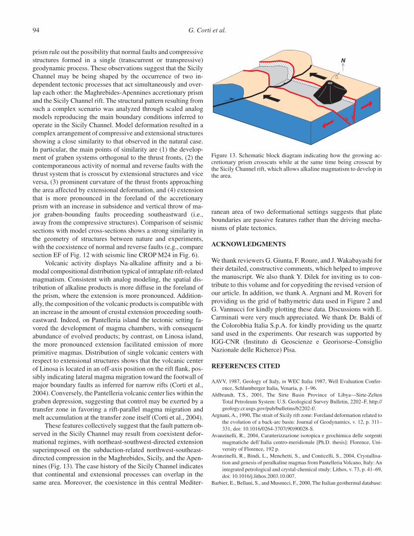
These features collectively suggest that the fault pattern ob-served in the Sicily Channel may result from coexistent defor-mational regimes, with northeast-southwest-directed extensionsuperimposed on the subduction-related northwest-southeast-directed compression in the Maghrebides, Sicily, and the Apen-nines (Fig. 13). The case history of the Sicily Channel indicatesthat continental and extensional processes can overlap in thesame area. Moreover, the coexistence in this central Mediter-
94 G. Corti et al.
N
Figure 13. Schematic block diagram indicating how the growing ac-cretionary prism crosscuts while at the same time being crosscut by the Sicily Channel rift, which allows alkaline magmatism to develop inthe area.
ranean area of two deformational settings suggests that plateboundaries are passive features rather than the driving mecha-nisms of plate tectonics.
ACKNOWLEDGMENTS
We thank reviewers G. Giunta, F. Roure, and J. Wakabayashi fortheir detailed, constructive comments, which helped to improvethe manuscript. We also thank Y. Dilek for inviting us to con-tribute to this volume and for copyediting the revised version ofour article. In addition, we thank A. Argnani and M. Roveri forproviding us the grid of bathymetric data used in Figure 2 andG. Vannucci for kindly plotting these data. Discussions with E.Carminati were very much appreciated. We thank Dr. Baldi ofthe Colorobbia Italia S.p.A. for kindly providing us the quartzsand used in the experiments. Our research was supported byIGG-CNR (Instituto di Geoscienze e Georisorse–ConsiglioNazionale delle Richerce) Pisa.
REFERENCES CITED
AAVV, 1987, Geology of Italy, in WEC Italia 1987, Well Evaluation Confer-ence, Schlumberger Italia, Venaria, p. 1–96.
Ahlbrandt, T.S., 2001, The Sirte Basin Province of Libya—Sirte-ZeltenTotal Petroleum System: U.S. Geological Survey Bulletin, 2202–F, http://geology.cr.usgs.gov/pub/bulletins/b2202-f/.
Argnani, A., 1990, The strait of Sicily rift zone: Foreland deformation related tothe evolution of a back-arc basin: Journal of Geodynamics, v. 12, p. 311–331, doi: 10.1016/0264-3707(90)90028-S.
Avanzinelli, R., 2004, Caratterizzazione isotopica e geochimica delle sorgentimagmatiche dell’Italia centro-meridionale [Ph.D. thesis]: Florence, Uni-versity of Florence, 192 p.
Avanzinelli, R., Bindi, L., Menchetti, S., and Conticelli, S., 2004, Crystallisa-tion and genesis of peralkaline magmas from Pantelleria Volcano, Italy: Anintegrated petrological and crystal-chemical study: Lithos, v. 73, p. 41–69,doi: 10.1016/j.lithos.2003.10.007.
Barbier, E., Bellani, S., and Musmeci, F., 2000, The Italian geothermal database:

Proceedings World Geothermal Congress 2000, Japan, Abstracts, p. 3991–3995.
Barberi, F., Borsi, S., Ferrara, G., and Innocenti, F., 1969, Strontium isotopiccomposition of some recent basic volcanites of the Southern TyrrhenianSea and Sicily Channel: Contributions to Mineralogy and Petrology, v. 23,p. 157–172, doi: 10.1007/BF00375177.
Beccaluva, L., Macciotta, G., Di Girolamo, P., and Savelli, C., 1981, UpperMiocene submarine volcanism in the Strait of Sicily (Banco Senza Nome):Bulletin of Volcanology, v. 44, p. 573–581.
Bindi, L., Tasselli, F., Olmi, F., Peccerillo, A., and Menchetti, S., 2002, Crystalchemistry of clinopyroxenes from Linosa Volcano, Sicily Channel, Italy:Implications for modelling the magmatic plumbing system: MineralogicalMagazine, v. 66, p. 953–968, doi: 10.1180/0026461026660070.
Boccaletti, M., Cello, G., and Tortorici, L., 1987, Transtensional tectonics in the Sicily Channel: Journal of Structural Geology, v. 9, p. 869–876, doi:10.1016/0191-8141(87)90087-3.
Bosworth, W., 1994, A model for the three-dimensional evolution of continen-tal rift basins, northeast Africa: Geologische Rundschau, v. 83, p. 671–688,doi: 10.1007/BF00251067.
Boucher, C., Altamimi, Z., and Sillard, P., 1998, The 1997 International Terres-trial Reference Frame (ITRF97): IERS Tech. Note 27, Obs. de Paris, Paris,France.
Calanchi, N., Colantoni, P., Rossi, P.L., Saitta, M., and Serri, G., 1989, The Straitof Sicily continental rift systems: Physiography and petrochemistry of thesubmarine volcanic centres: Marine Geology, v. 87, p. 55–83, doi: 10.1016/0025-3227(89)90145-X.
Carapezza, M., Ferla, P., Nuccio, P.M., and Valenza, M., 1979, Caratteri petro-logici e geochimici delle vulcaniti dell’Isola “Ferdinandea”: Rendicontidella Società Italiana Mineralogia di e Petrologia, v. 35, p. 377–388.
Casero, P., 2004, Structural setting of petroleum exploration plays in Italy, inCrescenti et al., eds., Geology of Italy: Società Geologica Italiana SpecialVolume, p. 189–200.
Casero, P., and Roure, F., 1994, Neogene deformation at the Sicilian–NorthAfrican plate boundary, in Roure, F., ed., Peri-Tethyan platforms: Paris,Editions Technip, p. 27–50.
Catalano, R., Infuso, S., and Sulli, A., 1995, Tectonic history of the submergedMaghrebian Chain from the Southern Tyrrhenian Sea to the Pelagian Fore-land: Terra Nova, v. 7, p. 17–188.
Catalano, R., Di Stefano, P., Sulli, A., and Vitale, F.P., 1996, Paleogeographyand structure of the central Mediterranean: Sicily and its offshore area:Tectonophysics, v. 260, p. 291–323, doi: 10.1016/0040-1951(95)00196-4.
Catalano, R., Franchino, A., Merlini, S., and Sulli, A., 2000a, Central westernSicily structural setting interpreted from seismic reflection profiles: Mem-orie della Società Geologica Italiana, v. 55, p. 5–16.
Catalano, R., Franchino, A., Merlini, S., and Sulli, A., 2000b, A crustal sectionfrom the eastern Algerian basin to the Ionian ocean (Central Mediter-ranean): Memorie della Società Geologica Italiana, v. 55, p. 71–85.
Civetta, L., D’Antonio, M., Orsi, G., and Tilton, G.R., 1998, The geochemistryof volcanic rocks from Pantelleria Island, Sicily Channel: Petrogenesis andcharacteristics of the mantle source region: Journal of Petrology, v. 39, p. 1453–1491, doi: 10.1093/petrology/39.8.1453.
Corti, G., 2004, Centrifuge modeling of the influence of crustal fabrics on thedevelopment of transfer zones: Insights into the mechanics of continentalrifting architecture: Tectonophysics, v. 384, p. 191–208, doi: 10.1016/j.tecto.2004.03.014.
Corti, G., Bonini, M., Cloetingh, S., Innocenti, F., Manetti, P., and Sokoutis, D.,2003, Analogue modelling of continental extension: A review focused onthe relations between the patterns of deformation and the presence ofmagma: Earth-Science Reviews, v. 63, p. 169–247, doi: 10.1016/S0012-8252(03)00035-7.
Corti, G., Bonini, M., Sokoutis, D., Innocenti, F., Manetti, P., Cloetingh, S., andMulugeta, G., 2004, Continental rift architecture and patterns of magmamigration: A dynamic analysis based on centrifuge models: Tectonics, v. 23, p. TC2012, doi: 10.1029/2003TC001561.
Dart, C.J., Bosence, W.J., and McClay, K.R., 1993, Stratigraphy and structureof the Maltese graben system: Geological Society Journal, v. 150, p. 1153–1166.
Doglioni, C., and Carminati, E., 2002, The effects of four subductions in NEItaly: Transalp Conference, Memorie Scienze Geologiche, v. 54, p. 1–4.
Doglioni, C., and Harabaglia, P., 1996, The kinematic paradox of the San Andreas fault: Terra Nova, v. 8, p. 525–531.
Doglioni, C., Gueguen, E., Sabat, F., and Fernandez, M., 1997, The westernMediterranean extensional basins and the Alpine orogen: Terra Nova, v. 9,p. 109–112.
Doglioni, C., Fernandez, M., Gueguen, E., and Sabat, F., 1998, On the inter-ference between the early Apennines-Maghrebides backarc extension and the Alps-Betics orogen in the Neogene geodynamics of the WesternMediterranean: Bollettino della Società Geologica Italiana, v. 118, p. 75–89.
Doglioni, C., Gueguen, E., Harabaglia, P., and Mongelli, F., 1999, On the originof W-directed subduction zones and applications to the western Mediter-ranean: Geological Society Special Publication, v. 156, p. 541–561.
Esperança, S., and Crisci, G.M., 1995, The island of Pantelleria: A case for thedevelopment of DMM-HIMU isotopic compositions in a long-lived exten-sional setting: Earth and Planetary Science Letters, v. 136, p. 167–182, doi:10.1016/0012-821X(95)00178-F.
Ferrara, G., and Treuil, M., 1974, Petrological implications of trace element and Sr isotope distributions in basalt-pantellerite series: Bulletin of Vol-canology, v. 38, p. 548–574.
Giunta, G., 1991, Elementi per an modello cinematico delle Maghrebidi sicil-iane: Memorie Società Geologica Italiana, v. 47, p. 297–311.
Giunta, G., Nigro, F., Renda, P., and Goirgianni, A., 2000, The Sicilian-Magrebides Tyrrhenian Margin: A neotectonic evolutionary model: Bol-lettino della Società Geologica Italiana, v. 119, p. 553–565.
Hollenstein, Ch., Kahle, H.-G., Geiger, A., Jenny, S., Goes, S., and Giardini, D.,2003, New GPS constraints on the Africa-Eurasia plate boundary zone insouthern Italy: Geophysical Research Letters, v. 30, no. 18, p. 1935, doi:10.1029/2003GL017554.
Imbò, G., 1965, Catalogue of the active volcanoes of the world, Italy, 18: Rome,IAVCEI, 72 pp.
IOC, IHO, and BODC, 2003. Centenary Edition of the GEBCO Digital Atlas:Published on CD-ROM on behalf of the Intergovernmental OceanographicCommission and the International Hydrographic Organization as part ofthe General Bathymetric Chart of the Oceans, British Oceanographic DataCentre, Liverpool.
Irvine, T.N., and Baragar, W.R.A., 1971, A guide to the chemical classifica-tion of common volcanic rocks: Canadian Journal of Earth Sciences, v. 8,p. 523–548.
Lanzafame, G., Rossi, P.L., Tranne, C.A., and Lanti, E., 1994, Carta geologicadell’isola di Linosa, scale 1:5.000: Firenze, SELCA.
Le Maitre, R.W., 2002, Igneous rocks: A classification and glossary of terms:Cambridge, Cambridge University Press, 236 p.
Lowenstern, J.B., and Mahood, G.A., 1991, New data on magmatic H2Ocontents of pantellerite, with applications for petrogenesis and eruptive dynamics at Pantelleria: Bulletin of Volcanology, v. 54, p. 78–83, doi:10.1007/BF00278208.
Mahood, G.A., and Baker, D.R., 1986, Experimental constraints on depths offractionation of mildly alkalic basalts and associated felsic rocks: Pantel-leria, Strait of Sicily: Contributions to Mineralogy and Petrology, v. 93, p. 251–264, doi: 10.1007/BF00371327.
Mahood, G.A., and Hidreth, W., 1983, Nested calderas and the trapdoor upliftat Pantelleria, Strait of Sicily: Geology, v. 11, p. 722–726, doi: 10.1130/0091-7613(1983)11<722:NCATUA>2.0.CO;2.
Orsi, G., Ruvo, L., and Scarpati, C., 1991, The recent explosive volcanism atPantelleria: Geologische Rundschau, v. 80, p. 187–200, doi: 10.1007/BF01828776.
Prosperini, N., Perugini, D., Poli, G., and Manetti, P., 2000, Magmatic enclavesdistribution within the Khaggiar lava dome (Pantelleria, Italy): Implication
Coexisting geodynamic processes in the Sicily Channel 95

for magma chamber dynamics and eruption: Acta Vulcanologica, v. 12, p. 37–47.
Reuther, C.-D., and Eisbacher, G.H., 1985, Pantelleria rift-crustal extension ina convergent intraplate setting: Geologische Rundschau, v. 74, p. 585–597,doi: 10.1007/BF01821214.
Rossi, P.L., Tranne, C.A., Calanchi, N., and Lanti, E., 1996, Geology, stratigra-phy and volcanological evolution of the island of Linosa (Sicily Channel):Acta Vulcanologica, v. 8, p. 73–90.
Roure, F., Howell, D.G., Muller, C., and Moretti, 1., 1990, Late Cenozoic sub-duction complex of Sicily: Journal of Structural Geology, v. 12, p. 259–266.
Scarascia, S., Cassinins, R., Lozej, A., and Nebulosi, A., 2000, A seismic andgravimetric model of crustal structures across the Sicily Channel Rift Zone:Bollettino della Società Geologica Italiana, v. 119, p. 213–222.
Scrocca, D., Doglioni, C., Innocenti, F., Manetti, P., Mazzotti, A., Bertelli, L.,Burbi, L., and D’Offizi, S., eds., 2003, CROP atlas: Seismic reflectionprofiles of the Italian crust: Memorie Descrittive della Carta Geologica d’Italia, v. 62, 194 p.
Sella, G.F., Dixon, T.H., and Mao, A., 2002, REVEL: A model for Recent platevelocities from space geodesy: Journal of Geophysical Research, v. 107,B4, doi: 10.1029/2000JB000033.
Skuce, A.G., 1994, A structural model of a graben boundary fault system, SirteBasin, Libya: Compaction structures and transfer zones: Canadian Journalof Exploration Geophysics, v. 30, no. 2, p. 84–92.
Sun, S.S., and McDonough, W.F., 1989, Chemical and isotopic systematics ofoceanic basalts: Implications for mantle composition and processes, inSaunders, A.D., and Norry, M.J., eds., Magmatism in ocean basins: Geo-logical Society of London Special Publication, p. 313–345.
Torelli, L., Grasso, M., Mazzoldi, G., Peis, D., and Gori, D., 1995, Cretaceousto Neogene structural evolution of the Lampedusa shelf (Pelagian Sea,Central Mediterranean): Terra Nova, v. 7, p. 200–212.
Tricart, P., Torelli, L., Argnani, A., Rekhiss, F., and Zitellini, N., 1994, Exten-sional collapse related to compressional uplift in the Alpine chain off north-ern Tunisia (Central Mediterranean): Tectonophysics, v. 238, p. 317–329,doi: 10.1016/0040-1951(94)90062-0.
Villari, L., 1974, The Island of Pantelleria: Bulletin of Volcanology, v. 38, p. 680–724.
Washington, H.S., 1909, The submarine eruption of 1831 and 1891 near Pan-telleria: American Journal of Science, v. 27, p. 131–150.
Wessel, P., and Smith, W.H.F., 1995, New version of the Generic Mapping Toolsreleased: Eos (Transactions, American Geophysical Union), v. 76, p. 329.
Wilson, M., and Bianchini, G., 1999, Tertiary–Quaternary magmatism withinthe Mediterranean and surrounding regions, in Durand, B., et al., eds., TheMediterranean Basins: Tertiary Extension within the Alpine Orogen: Geo-logical Society of London Special Publication, p. 141–168.
MANUSCRIPT ACCEPTED BY THE SOCIETY 30 DECEMBER 2005
96 G. Corti et al.
Printed in the USA
Copyright © 2022 FDOKUMEN