Granites and the geodynamic history of the neoproterozoic Brası́lia belt, Central Brazil: a review
Upload
independentCategory
view
2download
0
Pergamon
PII: sot395-9811(%)ooo16-8 Printed in Great Britain. All righl.v resew&
Ot?YS-Yn1 MY6 t I5.00 + 0.w
Geodynamic evolution of the Neogene intermontane Chota basin, Northern Andes of Ecuador
‘ROBERTO BARRAGAN, 2ROGER BAUDINO and 3RENE MAROCCO
‘Department of Geology, University of Idaho, Moscow, ID 83843, USA 2Laboratoire de modtlisation des bassins sedimentaires,
Departement de Geologic - IPRA, Universite de Pau, 64000 Pau, France 31nstitut Fransais de Recherche Scientifique pour le Developpement en Cooperation - ORSTOM,
Apartado 17-l I-06596, Quito, Ecuador
Abstract - The development of intermontane basins with a thick non-marine sedimentary pile is one of the main characteris- tics of the Andean geodynamic evolution during the Neogene. The Chota basin is the northernmost Neogene intermontane basin recognized in the Andes of Ecuador. This basin is located in the Interandean Depression and presents a sedimentary fill of con- tinental deposits.
The detailed stratigraphic and tectonic analysis of this basin allows for a new subdivision of the sedimentary sequence in four main units with a total minimum thickness of 2400 m. Sequence analysis suggests a cyclic evolution characterized by two megasequences. The first one, represented by the Chota Unit, displays an evolution from proximal to more distal facies (braided alluvial to lacustrine facies) during the opening of the basin. The second one, represented by the Santa Rosa Unit to the. west, and the Pefias coloradas and Carpuela Units to the east, displays a thickening-coarsening evolution related with the. filling of the basin and with the development of prograding alluvial fan deposits.
The structural analysis in the Chota basin shows two main tectonic events. The tirst event is responsible for the opening of the basin, and is the result of a tensional tectonic period with 03 along a Nl30”E direction. The second event caused the closing of the basin, as a result of a regional compressional regime with a Nl20”E trending, which then rotated to an E-W compressive trend.
The Chota Basin is interpreted as a Neogene intermontane basin, with a sedimentary till controlled by a continuous tectonic deformation. The deposits of this basin recorded large scale geodynamic events and are a unique example for the study of the Neogene evolution of the Ecuadorian Northern Andes. Copyright 0 1996 Elsevier Science Ltd & Barth Sciences & Resources Institute
Resumen - Durante el Nebgeno, el desarollo de cuencas intramontafiosas con una potente sedimentacidn continental repre- senta una de las principales caracterfsticas de la evolucidn geodinimica andina. La cuenca intramontaiiosa del Chota es la m8s septentrional y unica reconocida en el norte de 10s Andes Ecuatorianos. EstP situada en la Depresidn lnterandina y presenta un relleno conformado por sedimentos detriticos continentales de edad cenozoica.
El estudio estratigrafico permiti proponer una nueva divisi6n de la serie sedimentaria terciaria en cuatro unidades principales que alcanzan un espesor total mfnimo de 2400 m. El analisis sedimentoldgico muestra una evoluci6n cfclica, diferenciattdose dos megasecuencias que caracterizan el relleno sedimentario de esta cuenca. La primera megasecuencia reprensentada por 10s depdsitos de la Unidad Chota, muestra una evoluci6n de facies proximales a facies mas distales (fluvial en trenza a lacustte) durante la apettura de la cuenca. La segunda megasecuencia, reprensentada por 10s depdsitos de la Unidad Santa Rosa al oeste y las unidades Peftas Coloradas y Carpuela al este, muestra una evolucidn grano y estrato creciente, relacionada con la acti- vaci6n de reliefs y caracterizada por facies conglomeraticas de abanicos aluviales progradantes, adosados a fallas responsables del cierre de la cuenca.
El analisis estructural permitid defmir dos eventos tect6nicos principales: el primer0 es responsable de la abertura de la cuenca, provocada por una extensi6n con a3 de direction Nl30”E. El Segundo evento es responsable del cierre. provocado por una compresi6n Nl20”E la cual posteriormente rota hacia un eje compresivo E-W.
La cuenca del Chota esta interpretada coma una cuenca intramontaiiosa nebgena cuyo relleno est4 controlado por una defor- macibn tect6nica continua. Los depositos de esta cuenca son 10s testigos de eventos geodinamicos a gran escala y son dnicos ejemplos para el estudio de la evoluci6n Ne6gena de 10s Andes Ecuatorianos Septentrionales.
INTRODUCTION common features, such as synsedimentary volcanism and deformation, and a geodynamic evolution controlled by
During the Neogene, thick alluvial, lacustrine and vol- displacement along regional faults limiting the basin mar- canoclastic continental sedimentation took place in sev- gins (Marocco et al.. 1995).
y ’ era1 intermontane basins located along the Interandean Depression. This N-S trending depression separates the The Chota basin is located in the Interandean Depres-
Western and the Eastern Cordillera (Cordillera Real) of sion, 100 km northeast of Quito, in the northern Ecuado-
the Ecuadorian Andes. All of these basins present several rian Andes (Fig. 1). This basin belongs to a string of
Address all correspondence to: R. Baudino.
309

310 R. BARRAGAN et al.
Fig. 1. Geologic map of the Chota basin. 1. Metamorphic basement; 2. Chota Unit; 3. Santa Rosa Unit; 4. Gavilanes breccias; 5. PeiIas Coloradas and Carpuela Units; 6. Quaternary (undifferentiated); 7. Fault; 8. Normal contact; 9. Anticline axis; 10. Syncline axis; II. Diping (a. c 50”; b. > 50”; c. vertical; d. reverse); 12. Location of studied folds; 13. Location of studied microfractures sites.
Tertiary Intermontane basins (Cuenca, Girbn, Nab6n,
Loja and Vilcabamba) formed after the Paleocene-Eocene
collision and accretion of oceanic terranes and during the
Tertiary subduction of the Nazca plate under South
America (Lavenu et al., 1995). The margins of the Chota
Basin consist of several major faults that limit the filling
deposits from the basement, made up of metamorphic
rocks of the Cordillera Real (the Paleozoic Ambuqui
Group, according to Baldock, 1982; or the Late Jurassic
Ambuqui and Pacheco lithotectonic subdivisions, accord- ing to Aspden and Litherland, 1992). The tectonic dis-
placement along these major faults induced a control in
the sedimentation of the filling deposits.
The purpose of this paper is to describe, on the basis of recent field work (Baudino et al., 199 1; BarragBn, 1992), the evolution of the sedimentary fill and the differ- ent tectonic events that gave rise to the Chota Basin. In addition, we propose a redefinition of the classic strati-
graphic scheme, and a coherent geodynamic model for the evolution of the Chota Basin.
REGIONAL STRATIGRAPHY
Until recently, the stratigraphic subdivision used for the Chota basin comprised two formations (Fig. 2), with
differing lithologies, and a total thickness of almost
3000 m. These two formations are, from base to top, the
conglomerates, tuffaceous sandstones, lignite interbeds
and multicolored shales of the Tumbatli Formation, and
the volcanic breccia, conglomerate and tuffaceous sedi-
ments of the Chota Formation (Hall In: Bristow and Hoff-
stetter, 1977).
The Tumbatli Formation is considered to be of
Miocene age based on the presence of gastropod Liris A$ Minuscula fauna (Bristow and Parodiz, 1982).
In addition, there are a few radiometric age determina-
tions of the volcanic rocks that overlie the Chota For-
mation along the Chota river: 6.31 rf: 0.1 Ma and 6.30 + 0.06 Ma in the western side (Angochahua Formation), and 3.65 2 0.07 Ma in the eastern side (Barberi et al., 1988).
Most of the Chota basin is covered by a thick sequence of volcanic, volcanoclastic, alluvial, and colluvial sub- horizontal Plio-Quaternary deposits (Villalba, 1981).
Our field observations allow us to propose a new stratigraphic subdivision of the Neogene sedimentary fill of the Chota basin. Four units are defined (Figs. 2 and 3), each of them characterized by a particular depositional environment, source area, and related tectonic events.

Geodynamic evolution of the Neogene intermontane Chota basin, Northern Andes of Ecuador 311
According to Bristow and Hoffstetter (1977)
According to the authors
Om-
Fig. 2. Type stratigraphic columns for the Chota basin, according to Bristow and Hoffstetter (1977), and to the authors.
These are, from base to top: The Chota Unit, exposed THE SEDIMENTARY ENVIRONMENTS
mainly in the central part of the basin, the Santa Rosa
Unit, developed on the western margin, and the Petias In the Chota basin, the sedimentary rocks are continen-
Coloradas and Carpuela Units developed on the eastern tal with an important proportion of volcanic products
margin of the basin. intercalated in the sediments. Only fluviatile and lacus- trine sedimentary environments have been recognized.
312 R. BARRAGAN et al.
The JIuviatile depositional environment
This depositional environment is characterized by basic fining upward sequences, 0.5 to 15 m thick. The
vicinity of the source areas, confirmed by numerous inter-
calated debris flow deposits, and the exiguous area of the
basin resulted in proximal braided river systems. The
basic sequence starts with a lower conglomeratic or
coarse microconglomeratic sandstone, with frequent
large-scale cross stratifications and pebble imbrications,
in scoured basal contact with overlying deposits. It corre-
sponds to a channel filling deposit. At the top finer con- glomerates of longitudinal bars may exist with coarse
horizontal laminations (Collinson, 1986). Above the coarse facies come sandstone levels, with horizontal lami-
nations, belonging to low water-level periods. Finally, the
top of the sequence may contain several meters of clays or silts, with small diverging channels and/or paleosoils,
that represent overbank deposits of the flooding plain.
Elementary sequences are joined in large deca- or hecto-
metric sequences showing coarsening upward or lining
upward.
Other fluviatile deposits present in this basin belong to
alluvial fans. The basic sequence is conglomeratic, 2 to
50 m thick. Coarsening upward can lead to enormous
boulders, several meters in diameter, at the top of the sequence. The conglomerate beds generally do not show
structures but can enclose layers of stream channel depos-
its. There are also sheetflood deposits, sieve deposits or
debris flow deposits which imply periods of intense rain fall separated by more of less long periods of drought
characteristic an arid to semi-arid climate (Walker, 1984).
The clayey lower parts that may exist in alluvial
sequences indicate a decline in the coarse sedimentation
process (for example, a momentary break of the volcanic
activity or long drought periods) that favour soil forma-
tion. In the Chota basin the alluvial fan deposits rest
against the border faults and coarsen upward. Sequences
that coarsen upwards develop when the energy and sedi- ment input into the system do not diminish in time, and
lead to coarse elastic sedimentation extending progres- sively farther into the basin. It implies a constant uplift of
the source areas which kept in pace with the sedimenta- tion rate.
The lacustrine depositional environment
In the lacustrine sedimentary environments, two types of facies are known: quiet sedimentation facies - with fine laminated deposits - and catastrophic sedimentation facies - with metric to decametric turbiditic layers and slumps - which can be related to tectonic (Noblet and Marocco, 1989) or climatic events. In the Chota basin only the first facies was recognized. Sedimentation in near shore zones is quite different from sedimentation in offshore zones (Matter and Tucker, 1978). Near shore elastic sedimentation is located near river mouths or along the shore line, transported by the action of lateral currents (Boggs, 1987). Away from the river mouths, sediments are finer, clayey and/or muddy with a strong
animal and plant bioturbation in palustrine zones. Bio-
chemical and evaporitic sedimentation may also be pro- duced in these shallow zones. In offshore deeper zones,
sediments are clayey or fine grained, white to yellow in
color, well stratified with strata that can be followed hun-
dreds of meters. Small turbiditic, low density Bouma type
layers, measured in centimeters to decimeters can be
intercalated. Biochemical sediments can also occur.
Some differences exist between sedimentation in
hydrologically open and closed lakes. The first ones dis-
play a higher number of different facies and depositional
structures linked to the presence of varied depositional
zones (deltaic, palustrine, evaporitic and deep water) with
predominantly elastic deposits. In hydrologically closed
lakes, the sedimentation is mainly chemical, biochemical
and evaporitic while the elastic sedimentation is limited.
THE FILLING SERIES OF THE RIO CHOTA
BASIN
Chota Unit
The Chota Unit is mainly exposed in the central part
of the basin, where it overlies, apparently directly, the
metamorphic basement (Fig. 3). It conformably underlies
the Santa Rosa Unit, and unconformably underlies the
Peiias Coloradas Unit. Therefore, the Chota Unit is the
oldest of these three units.
The Chota Unit is approximately 500 m thick, with
two main sequences (Fig. 3). The lower 250 m represent
sequence Sl, which is composed of several minor thin-
ning and fining-upwards alluvial sequences corresponding
to braided river deposits. The conglomerate clasts are pre-
dominantly volcanic (basic and intermediate composi-
tion), and metamorphic with some intraclasts. The top of
SI is characterized by thick mudstone and clay intervals.
This occurrence of a higher proportion of overbank
deposits in braided rivers systems may be linked, in part,
to climatic and erogenic factors (Shumm, 1968; Baker, 1978).
The upper 250 m (sequence S2) are laminated clayey
(grey to black) to muddy (white to yellow) deposits with
intercalated conglomerates and sandstones showing paral-
lel and low angle cross lamination. These features, asso-
ciated with evaporitic deposits, leaf impressions, organic
rich layers and abundant fossilized gastropods point to near shore lacustrine deposits in a hydrologically open lake. The conglomeratic and sandy layers that appear toward the top of the sequence S2 are of two kinds. Those with normally graded pebbles and scoured basal contacts correspond to channel fill deposits, while those ungraded
with poor sorting of clasts and sharp basal contacts can be interpreted as sheetflood units deposited under upper-flow conditions in shallow water (Van Der Wiel et al., 1992). The presence of sheetflood deposits, reworked fossils and fossilized wood imply an increase in elastic input leading to the filling of the lake.

Geodynamic evolution of the Neogene intermontane Chota basin, Northern Andes of Ecuador 313
Om
300
5 a
Om
Om
Fig. 3. Lithostratigraphic columns and sequence analysis of the Neogene units of the Chota basin.
Paleocurrent analysis of clasts imbrications and sedi-
mentary structures suggest transport directions of terrig-
enous supply towards NlO”E-N30”E in the alluvial
sequence S 1, and towards N25”E-N50”E in the lacustrine
S2 sequence.
Santa Rosa Unit
The Santa Rosa Unit is developed on the western part
of the basin, conformably overlying the Chota Unit. The
western limit of outcrops could not be defined due to Quaternary cover. A few metamorphic basement outcrops present within this unit suggest that to the west it was
developed not only overlying the Chota Unit, but also
directly overlying the basement. Stratigraphic analysis of
this unit indicates six thick sequences that reach a mini-
mum total thickness of 1000 m (Fig. 3).
The clast composition of conglomerates is mainly of metamorphic clasts, with sedimentary clasts (at the base only), intermediate volcanic type clasts, and intraclasts. Pumice clasts are abundant throughout the unit in both fluviatile deposits and air-fall interlayer deposits.
The first sequence (srl, 80 m thick) show basic sequences which characterize fluviatile deposits of allu-
vial fans. The clasts in conglomeratic layers are less than
10 cm in diameter. Sandstones, generally cross stratified
and incised by conglomeratic channels, are dominant and
interpreted as prograding sandy deposits. Clays and silts
of overbank deposits are also present in a high proportion.
These features point to lower alluvial fan deposits.
The second sequence (sr2, 300 m thick) shows an
increase in volcanoclastic materials. The first 200 m are almost exclusively made of debris flow deposits and other
epiclastic rocks with intercalated volcanic breccias and
andesitic lavas. In the upper part strictly defined alluvial fan deposits reappear. The lack of overbank deposits can
be explained by an increased elastic input in the lower fan areas, but sieve deposits and sheetflood deposits indicate
more proximal facies of middle to upper fan areas.
Sequences sr3, 4 and 5 also display middle to upper fan deposits. The proportion of sandstone increases but maximum clast size of the conglomerates remain roughly constant. Towards the top, some of these sandstones con- tain scattered cobbles up to 50 cm in diameter, and thin pumice and gravel lenses are often present at various lev- els. They could be interpreted as hyperconcentrated-flow deposits realised under conditions of waning flow energy (Smith, 1986; Pierson and Scott, 1985). Debris flow and

314 R. BARRAGAN et al.
sheetflood deposits are also present. These three
sequences belong to the same sedimentary environment
as sequence sr2, but the proportion of coarse volcanoclas- tic deposits is less here. This may correspond to a waning
activity of volcanic centers to the west or a climatic
change. The second option seems more probable because
the proportion and size of pumice fragments remain con-
stant.
In the last sequence clayey and silty overbank depos-
its are present, with laminated sandstones and conglomer-
ates in scoured basal contacts. Associated with sieve
deposits they indicate a middle alluvial fan depositional
environment. The proportion of conglomerates and the
average clast diameter decrease, while the proportion of finer deposits increases. The lesser input of coarse elastic
material, compared to the previous sequences, might
reflect an eroded topography linked to waning tectonic
activity, considering that neither changes in climate nor
volcanic activity seem justified.
Paleocurrent studies indicate that elastic deposits of
the Santa Rosa Unit come from uplifted metamorphic and
volcanic areas located toward the west side of the basin. Contemporaneous with the uplift, volcanic centers located
in the western edge of the basin were active during all of
the deposition of the Santa Rosa Unit.
A group of massive and chaotic deposits (Gavilanes breccias) are found atop the alluvial fan sequences of the
Santa Rosa Unit overlying them unconformably (Figs. I
and 3). These deposits reach a total thickness of 200 m
and are composed of debris flow deposits, with charred
debris at the base, volcanic breccias and epiclastic sedi-
ments. Faulting, folding and good lithification of the
Gavilanes breccias suggest that they could be older than
Quaternary in age. If the relations between the Gavilanes
breccia and the lower Pliocene Angochahua volcanics are confirmed (DGGM, 1978) as suggested by the similar
lithology and depositional environment, it would imply that the Santa Rosa Unit is probably of pre-Pliocene age.
These ages are compatible with the radiogenic date of 6.3
2 0.1 Ma obtained in the western part of the basin (Bar-
beri et al., 1988). These deposits strongly eroded the pre- vious ones and were apparently deposited on a
preexisting topography. This implies an erosional period
which might be related to tectonic or climatic changes.
Pefias Coloradks Unit
The Peiias Coloradas Unit is exposed in the eastern part of the basin (Fig. I), where it displays a fault contact with the metamorphic rocks of the Ambuqui subdivision, and an unconformable angular contact with the Chota Unit. This latter observation suggests that its deposition
may have started later that of the Santa Rosa Unit which conformably overlie the Chota Unit. The Peiias Coloradas Unit is approximately 600 m thick (Fig. 3) and is formed by six thickening and coarsening sequences (pcl to pc6), with the lower one developed directly over the basement. Close to the basin’s eastern border, mainly proximal
facies deposits representing portions of the mid and upper alluvial fan are seen. The more western outcrops display
very fine-grained deposits that represent the lower alluvial
fan.
The presence of sheet flow, debris flow, and sieve
deposits could indicate semi-arid to arid climatic condi-
tions (Walker, 1984). The terrigenous supply is mostly
from a metamorphic source (Ambuqui subdivision rock-
types), and a volcanic source is also evident. A lesser
input of coarse volcanoclastic material explain the higher
proportion of fine grained deposits compared to the
sequences of the Santa Rosa Unit.
Average paleocurrent directions vary from N270”E to
the east, to NO” in the south, suggesting that the PeAas Coloradas Unit was fed from the relief, probably limiting
the basin through faults oriented N30”E and N80”E
respectively. Thus, the Peiias Coloradas Unit represents
the progradation of alluvial fans towards the west related
to the development of basement faults limiting the basin
to the east and south-east.
Carpuela Unit
The Carpuela Unit is exposed in the eastern part of the
Chota basin, I km south of Carpuela (Fig. I), isolated from the rest of the filling deposits. It displays a fault
contact with the metamorphic rocks of the Pacheco sub-
division that represents its basement. This unit, 300 m
thick, consists of four thickening and coarsening sequences (Fig. 3). These sequences are characterized by
coarse-grained conglomeratic facies from proximal zones
defining the progradation of alluvial fans. The source is
identified as mainly metamorphic (rocks of the Pacheco
subdivision), as well as volcanic. Paleocurrents indicate
transport from west to east. The thickness and coarsening
upwards of these deposits imply that they were feed by tectonically active zones.
Peiias Coloradas and Carpuela Units are unconform-
ably capped by volcanic deposits mainly composed of
pyroclastic flows and air-fall deposits, apparently coming
from an eastern source.
Sedimentary evolution of the Chotu basin
The sedimentary filling of the Chota basin is defined
by four units organized in two megasequences. The first one (Ml), corresponds to the deposition of the Chota Unit; it begins with braided alluvial systems that evolve from proximal to more distal facies (sequence Sl). The change from fluviatile to lacustrine depositional environ- ments in the transition from sequences Sl to S2 indicates a deepening of the basin. The presence of slumps and
synsedimentary normal faults in the lacustrine deposits of sequence S2 suggests that this evolution is directly related to increases in the subsidence rate rather than in climatic or eustatic changes.
The second megasequence (M2) represents the deposi- tion of the Santa Rosa Unit to the west, and the Peiias

Geodynamic evolution of the Neogene intermontane Chota basin, Northern Andes of Ecuador 315
Coloradas and Carpuela Units to the east. M2 is charac- terized by conglomeratic facies of prograding alluvial fans related to activity along the faults defining the basin margins. These faults resulted in the reactivation and maintenance of adjacent reliefs, both to the west and to the east, with a thickening and coarsening development that defines the closure of the basin.
STRUCTURAL ANALYSIS
The Neogene continental sediments of the Chota basin are affected by important synsedimentary and postsedi- mentary deformation. The purpose of this structural analysis is to describe the main tectonic events recorded in the Chota basin sedimentary fill and their relative tim- ing.
The margins of the Chota basin are major faults that separate the sedimentary fill from the metamorphic rocks of the Ambuqui and Pacheco subdivisions. This type of margin is not clear towards the north and west because of the thicker Quaternary volcanoclastic sequence that cov- ers the Chota basin. The faults were only identified along the east and southeast borders of the basin, which were found to correspond to large reverse and reverse strike- slip faults, oriented NO” to N40”E and N50”E to N80”E, respectively (Fig. 1). The paleocurrent directions suggest that N-S to N30”E faults along the western margin gener- ated the relief that fed the thick alluvial fan sequences of the Santa Rosa Unit.
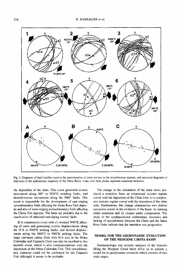
Some examples of the study of the type of structural deformation affecting the units in the basin follow, based on measurements of folds and microfractures found in each of them. In order to define the stress regime respon- sible for the fracture and fold distribution, the method of microtectonic data inversion was used, which allows the determination of the stress tensor for each sampled popu- lation of striated microfaults (Carey, 1979), from the observed relative displacement along the planes. The computed stress vectors characterize a tectonic event at each particular site during each deformational period.
Chotu Unit
A structural analysis identified synsedimentary normal faults, striking N-S to N80”E, associated with a distensive stress s3 oriented N130”E (Fig. 4.1 and 4.2).
Reverse faults are present at all scales of observation, some of them as reactivated normal faults (Fig. 4.3), and are associated with the intense folding undergone by this unit. Microtectonic analysis of these structures resulted in the identification of a compressive axis sl oriented N120”E. The same stress regime generated an intense postdepositional folding deformation of this unit. Verging folds have been displaced to the west, with axes striking N25”-35”E (Fig. 4.A).
A family of reverse faults, striking N350”E to NlO”E (Fig. 4.4), indicates a compressive regime with sl strik- ing N82”E.
Santa Rosa Unit
This unit presents overturned folds verging to the east related to a syndepositional event of shortening. Fold axes strike N30”E, defining a compressive tectonic regime with sl oriented Nl20”E approximately (Fig. 4.B). Several reverse and dextral-reverse faults can also be observed in this unit, striking NO” to N40”E and N50”E to N80”E respectively. According to the microtectonic analysis, these faults are due to a compressive regime with the main axis sl oriented N82”E (Fig. 4.5). Relative chronology of the two compresional events could not be determined.
The discordant deposits of the Gavilanes breecia are also deformed, but the type of stress generating the defor- mation could not be identified due to the scarcity of struc- tural evidence.
Peiias Coloradas Unit
A structural analysis of microfractures in this unit allows us to identify a compressive stress regime (Fig. 4.6) with the main axis sl striking N90”E approximately. This stress regime generated reverse faults striking NO” to 40”E, and dextral faults striking N60”E to N80”E.
This unit has also undergone a syndepositional folding deformation characterized by folds which strike N350”E to NIO”E, with large curvature radius. An E-W synsedi- mentary compressive event is responsible for the forma- tion of these structures (Fig. 4.C).
Carpuela Unit
The only deformation identified in these deposits is a conspicuous synclinal fold resulting from E-W compres- sion, with a large curvature radius with axis N-S, similar to that described for the Peiias Coloradas Unit. Although it was not possible to tind synsedimentary structures in this unit, the very nature and the great thickness of these coarsening up alluvial deposits imply an intensive con- temporary tectonic activity generating feeding reliefs.
Pefias Coloradas and Carpuela Units are unconformably overlain by Quatemary subhorizontal volcanoclastic depos- its. The absence of other tectonic events suggest that the shortening responsible for the deformation in both the Pefias Coloradas and Carpuela Units could be the same.
Tectonic evolution of the Neogene Chota River Basin
Structural analysis supports the existence of three suc- cessive tectonic events of deformation undergone by the Neogene deposits of the Chota basin:
1) An extensional event with s3 oriented N130”E, pro- ducing (a) sinistral displacements along N60”E striking faults, (b) normal synsedimentary faults oriented N-S to N40”E, and (c) sliding structures affecting the Chota Unit.
2) A compressive event with sl striking N120”E, affect- ing the Chota and Santa Rosa Units, contemporaneous with
316 R. BARRAGAN et al.
NlWE
Fig. 4. Diagrams of fault families used in the determination of stress tensors in the microfracture stations, and structural diagrams of fold axes in the sedimentary sequence of the Chota Basin. Lines over fault planes represent measured striations.
the deposition of the latter. This event generated reverse movement along NO” to N50”E trending faults, and dextral-reverse movements along the N80” faults. This
event is responsible for the development of east-verging
synsedimentary folds affecting the Santa Rosa Unit depos- its and also of west-verging postsedimentary folds affecting
the Chota Unit deposits. The latter are probably due to the reactivation of inherated east-diping normal faults.
3) A compressive event with sl oriented N90”E affect- ing all units and generating reverse displacements along the N-S to N40”E striking faults, and dextral displace- ments along the N60”E to N80”E striking faults. The large curvature radius folds with N-S axis in the Pefias Coloradas and Carpuela Units can also be ascribed to this tectonic event, which is also contemporaneous with the deposition of the PeAas Coloradas Unit. This synsedimen- tary character could not be confirmed for the Carpuela Unit althought it seems to be probable.
The change in the orientation of the main stress pro- duced a transition from an extensional tectonic regime
coeval with the deposition of the Chota Unit, to a compres-
sive tectonic regime coeval with the deposition of the other units. Furthermore, this change characterizes two distinct
successive events in the evolution of the basin: its opening
under extension and its closure under compression. The study of the syndepositional sedimentary structures and lacking of unconformity between the Chota and the Santa
Rosa Units indicate that the transition was progressive.
MODEL FOR THE GEODYNAMIC EVOLUTION
OF THE NEOGENE CHOTA BASIN
Sedimentologic and tectonic analyses of the deposits filling the Neogene Chota basin allow us to present a model for its geodynamic evolution which consists of two main stages.

Geodynamic evolution of the Neogene intermontane Chota basin, Northern Andes of Ecuador 317
The opening of the basin which took place before or during the Miocene times, mostly as a consequence of extension and displacements along normal faults striking N-S to N40”, and sinistral displacements along N50”E to N80”E striking faults. This extension was caused by a transtensional event with s3 striking N130”E. Interplay of
Y /
/
/ 0 -%
lkm
these faults generated a NE-SW depression with contem- poraneous installation of a braided river system flowing NE, represented by the deposits at the base of the Chota Unit (Fig. 5.1). Subsequent lacustrine deposits with abun- dant syndepositional normal faults and slumps indicate a deepening of the basin related to an increased velocity of
I - ---m--w
--------
W E
3
Iw
I 4
Fig. 5. Schematic palaeogeographic map and synthetic cross section of each formation of the Chota basin intilling. 1. Fluviatile deposits of the Chota Unit (sequence Sl); 2. Lacustrine deposits of the Chota Unit (sequence S2); 3. Alluvial fans of the Santa Rosa Unit (west); 4. Alluvial fans of the PeAas Coloradas and Carpuela Units (east); a. Relief zone and source; b. Fluviatile depositional setting; c. Lacustrine depositional setting; d. Alluvial fan depositional setting; e. Marginal basin fault; f. Fold axis; g. Paleocurrent direction.

318 R. BARRAGAN et al.
tectonic subsidence (Fig. 5.2). In fact, the change from an of the basin consisting of two main stages, the opening
alluvial to a lacustrine environment suggests a process of and closure. The first one is characterized by a thinning-
retrogradation of the more proximal environments, as and fining-upwards megasequence (Ml) resulting from a
indicated by the thinning and fining of the overall transtensional tectonic regime and development of a sub-
sequence deposits. Higher up in the section, sandstone siding depression oriented NE-SW. The second stage is
and conglomerate beds with paleocurrents from the SW characterized by a thickening- and coarsening-upwards
indicate the gradual filling of the lacustrine basin. The megasequence (M2) originated by the gradual change to
Chota Unit thus represents the disposition of a fining- and a compressive tectonic regime. This regime resulted in
thinning-upwards megasequence controlled by the inter- basement uplifts and new source areas leading to the fill-
play of normal faults corresponding to the opening phase ing of the Chota basin first at the west and then at the
in the evolution of the basin during the Neogene. east.
The second stage - the closure - in the evolution of
the basin is characterized by a change in the source area
and in the depositional environments. A gradual change
towards a compressive tectonic regime with sl oriented
NW-SE allowed the interplay of reverse faults striking
N-S to N30”E, and led to the development of marked
reliefs along the western side of the basin. This change is
recorded by the deposition of the Santa Rosa Unit, which represents the progradation of alluvial fan proximal facies
towards the east (Fig. 5.3). In this unit, sedimentary struc- tures indicate a volcanic activity contemporaneous with
its deposition. According to available data, the age of the
Santa Rosa Unit is pre-Pliocene, probably Late Miocene.
This evolution in two megasequences has been recog-
nized in other Andean Neogene sedimentary basins of
Southern Ecuador (Noblet et al., 1988; Marocco et al.,
1990; Marocco et al., 1993; Mediavilla, 1991; Izquierdo,
199 1; Fierro, 199 1; Baudino et al., 1994). In those basins
the geodynamic evolution is linked to strike-slip faults
movements during ongoing Neogene tectonism (Lavenu
et al., 1995).
The rotation of the main compressive stress vector sl
to an E-W direction generated dextral faults striking
N50”E to N80”E and reverse faults striking N-S to
N40”E. These faults resulted in the development of relicts
along the eastern margin of the basin, with outcrop of the metamorphic basement lifted as a pop-up structure, and
generated the deposition of the Pefias Coloradas and Car-
puela Units. Both units represent the progradation of allu-
vial fans, towards the west in the case of the PeAas Coloradas Unit, and towards the east in the case of the
Carpuela Unit, probably as two synchronic subbasins
(Fig. 5.4). Thus, the development of coarse-grained
alluvial-fan directly related with faults, first to the west
(Santa Rosa Unit) and then to the east (Peiias Coloradas
and Carpuela Units), implies a diachronism in the devel-
opment of the reliefs.
The present study of the Neogene Chota basin also
show an ongoing tectonic evolution from opening to clos-
ing. The second stage is linked to the functioning of
reverse and reverse strike slip faults. Furthermore, the
study of synsedimentary deformations in the Chota basin
suggest a west to east displacement of the compresional
deformation during the closure phase of its evolution, a
process quite similar to that observed in the Bolivian Alti-
plano (Baby et al., 1990). It is possible that the closure of
the Chota basin resulted from the advance of the defor-
mation of the Andean Chain towards the east. This proc-
ess could be related to movements along antithetic (backthrust) reverse faults which resulted in the develop-
ment of subbasins represented by the Santa Rosa Unit to
the west and the Pefias Coloradas and Carpuela Units of
the east. The Chota Basin is thus interpreted as an inter-
montane intra-arc basin developed under a compressive regime during its longer evolutionary stage (closure), and
with sedimentary fill controlled by continuous tectonic
activity.
The Santa Rosa, Petias Coloradas and Carpuela Units
constitute a thickening- and coarsening-upwards megas- equence deposited under a compressive tectonic regime. This second stage in the evolution of the basin corre-
sponds to the closure of the Neogene Chota basin result- ing from a reorientation of the main tectonic stress
vectors.
The deposits of the Chota basin records larger scale
geodynamic events and represent a unique example for the study of the Neogene evolution of the Andes of north- ern Ecuador. They show that this area of the Interandean
Depression has experienced an important Neogene com-
pressional deformation. More detailed studies are needed
(age determinations in progress will be especially useful)
in order to make comparisons with other areas of the northwestern Andes.
CONCLUSIONS
The Neogene continental deposits filling the Chota intra-arc basin arc subdivided into four units character- ized by distinct depositional environments and styles of
deformation. These units record a period in the evolution of the basin covering at least from the Miocene to the early Pliocene, with a minimum total thickness of 2100 m.
Structural analysis indicates a geodynamic evolution
Acknowledgements - This work is a summary of the thesis of Roberto
Barragan, carried out under the agreement between the lnstitut FranGais
de Recherche Scientifique pour le DCveloppement en CoopCration
(ORSTOM) and the Escuela Politecnica National (EPN), and between
ORSTOM and lnstitut FranGais d’Etudes Andines (IFEA). This research
is part of the program to study of the Neogene intra-arc basins of Ecua-
dor. Our most sincere gratitude to the French missions ORSTOM and
IFEA for the scientific and logistic assistance and a special thanks to
Enrique Diaz Martinez. M. L. Hall and A. Lnvenu for the constructive
reviews.

Geodynamic evolution of the Neogene intermontane Chota basin, Northern Andes of Ecuador 319
REFERENCES
Aspden, J.A., and Litherland, M., 1992. The Geology and Mesozoic
collisional history of the Cordillera Real, Ecuador, Tectonophysics
205. 187-204.
Baby, P., Sempere, T., Oiler. J., Barrios, L., Herail, G., and Marocco. R..
1990. Un bassin en compression d’8ge oligo-miocbne dans le sud de
I’Altiplano Bolivien. C.R. Acud. Sci. furis S&ie /I 311, 341-347.
Baker, V.R.. 1978. Adjustment of fluvial systems to climate and source
terrain in tropical and subtropical environments. In: Fluviul Sedi-
mentulogy (edited by A. D. Miall). Canadian Society of Petroleum
Geologists, Memoir 5, 21 I-230.
Baldock, J.W., 1982. Ceologiu del Ecuador: Boletin de lo explicucicin
de1 Mupu Geolt~gico de lu Repu’blicu de1 Ecuudur; Est. I:1 ‘000.000.
Ministerio de Recursos Naturales y Energia, Quito, 70 p.
Barberi. F., Coltelli, M., Ferrara, G., Innocenti, F., Navarro. J.M.. and
Santacroce, R., 1988. Plio-Quatemary volcanism in Ecuador. Geol-
ogy Muguzine 125, l-l 4.
Barragtin R., 1992.. Evolucicin geodindmicu de lu cuencu terciuriu del
Rio Chotu. Provinciu de Imbuburu. Unpublished Thesis, Escuela Polidcnica National. Quito, 140 p.
Baudino, R.. BarragSn, R.. and Marocco, R., 1991. Nuevos datos sobte
la estratignfia de la cuenw del Rio Chota-Ecuador. Sexto Cungreso
Ecuutoriuno de lngenieriu en Geolugiu, Minus, Petrcileos y Geotec-
niu, Guuyuyuil. I8 p.
Baudino, R., Lavenu. A.. and Delfaud, J.. 1994. Un Cvdnement tecto-
nique neogene majeur dans les Andes du Sud de I’Equateur. Defor-
mation synsedimentaire dam le bassin de Nab6n. C.R. Acud. Sci.
Pun’s S&e 11319, 127-133.
Boggs, S.. 1987. Principles of sedimentology und strutigruphy, Merry
Publishing Company, Ohio, 784 p.
Bristow, C.R., and Hoffstetter. R., 1977. L&iyue strutigruphique,
AmPriyue Lutine, Fas. 5 a 2 Ecuador, 2e edition, CNRS, Paris,
410 p.
Bristow, C.R., and Parodiz, J., 1982. The stratigraphical paleontology of
the tertiary non-marine sediments of Ecuador. Bulletin of Curnegie
Museum of Nuturul History 19, l-53.
Carey. E., 1979. Recherche des directions principales de contraintes
associees au jeu d’une population de failles. Revue de Gk~gruphie
Physique et G&logie Dynumiyue 21 (I), 57-66.
Collinson, J., 1986. Alluvial sediments, In: Sedimentury environments
und fucies (edited H.G. Reading) Blackwell Scientific Publications,
615 p.
Direcci6n General de Geologia y Minas (DGGM), 1978. Hoja geoldgica
de Ibarra, Ecuador, Est. l:lOO.OOO, Ministerio de Recursos Natu-
rales y Energia. Quito.
Fierro. J., 1991. Evolrrcicjn geodindmicu necjgenu de lu cuencu intru-
montu&su de Mulucutos-Vifcubumbu, Unpublished Thesis, Escuela
Politecnica National. Quito, I I4 p.
Izquierdo, 0.. I99 I. Estudio geodindmico de lu cuewu irltrumontuiio.wt
cenozuicu de Loju (Sur de1 Ecuudor). Unpublished Thesis, Escuela
Politecnica National, Quito, 139 p.
Lavenu, A., Noblet C., and Winter, T., 1995. Neogene ongoing tectonics
in the Southern Ecuadorian Andes. Analysis of the evolution of the
stress field. Journul of Structurul Geology 17 (I). 47-58.
Marocco, R., Lavenu A., and Baudino, R.. 1995. The intermontane Late
PaleogeneINeogene basins of the Andes of Ecuador and Peru: Sedi-
mentologic and Tectonic Implications, In: Petroleum Basins of
South America, Americun Associution uf Petroleum Geologists,
Memoir 62.
Marocco, R., Lavenu, A., and Fierro, J., 1993. Sedimentaci6n continen-
tal ne6gena en context0 tectbnico: la cuenca de Vilcabamba-
Mrdacatos (sur del Ecuador). Boletin Geolrjgico de1 Ecuudor 3,
l-28.
Marocco, R., Lavenu, A., and Noblet, C., 1990. La cuenca intmmon-
taiiosa en compresi6n de Vilcabamba (sur del Ecuador). Analisis
tecto-sedimentario. Internotional Symposium on Andeun Geodynum-
its, Grenoble, extended ubstructs, 285-288.
Matter, A., and Tucker, M., 1978. Modem and ancient lake sediments.
The Internutionul ussociution of Sedimentologists, London, no 2.
169-187.
Mediavilla, J., 1991. Evolucicin geodindmicu de h cuencu terciuriu de
Gir&-Suntu Isabel, Sur de1 Ecuudor, Unpublished Thesis, Escuela
Politdcnica National, Quito, 210 p.
Noblet, C.. and Marocco, R., 1989. Lacustrine megaturbidites in an
intermontane strike slip basin: the Miocene Cuenca basin of South
Ecuador. Ptweedings from the Internutionul Symposium on Inter-
montune basins, Geology und Resources, Chiung Mui-Thailund,
282-293.
Noblet. C., Lavenu, A., and Schneider, F., 1988. Etude geodynamique
d’un bassin intramontagneux tertiaire sur dtcrochements dans les
Andes du Sud de I’Equateur : I’exemple du bassin de Cuenca. G&
dynumiyue 3 (l-2). 117-138.
Pierson, T.C., and Scott, K.M., 1985. Downstream dilution of a lahar:
transition from debris flow to hyperconcentrated stream-flow. Wuter
Resources Reseurch, 21 (IO), I5 I I-1524.
Schumm, S.A., 1968. Speculations concerning paleohydrologic controls
of terrestrial sedimentation. Bulletin of the Geologicul Society of
Americu 78. 1573-1588.
Smith, G.A., 1986. Coarse-grained nonmarine volcanoclastic sediment:
Terminology and depositional process. Bulletin of the Geologicul
Society of Americu 97, I-IO.
Van Der Wiel, A.M.. and Van Den Bergh, G.D., 1992. Uplift, subsidence
and volcanism in the Southern Neiva basin, Colombia, part I: Influ-
ence on fluvial deposition in the Miocene Honda Formation. Jour-
nul uf South Americun Eurth Sciences 5 (2). 53- 173.
VillaJba, F., I98 I. Geologiu de1 Cuuternurio en lu zonu entre Chotu y
Anrbugui, Prov. de Imbuburu-Curchi, Unpublished Thesis, Escuela
Politecnica National, Quito, 140 p.
Walker, R.G., 1984. Fucies Models. Department of Geology McMaster
University, Canada, 3 I7 p.
Copyright © 2022 FDOKUMEN