The Present Day Drainage Patterns of the Congo River System and their Neogene Evolution
23
The Present Day Drainage Patterns of the Congo River System and their Neogene Evolution 15 Tyrel J. Flu ¨ gel, Frank D. Eckardt, and Fenton P.D. Cotterill “A river or a drainage basin might best be considered to have a heritage rather than an origin. It is like an organic form, the product of a continuous evolutionary line through time” p. 421 Leopold et al. (1964) 15.1 Introduction The immense ca. 3.67 million km 2 Congo Basin (CB) is an intracontinental basin occupying central Africa. This roughly circular basin stretches across 22 of longitude (from ~12 E to ~34 E) and 21 of latitude (from ~9 N to~13 S) (Figs. 15.1 and 15.2). The basin’s unique location straddling the Equator and its size and shape allows the Congo River (CR) to maintain a near constant flow year round: its immense size and exposure to continuous precipi- tation results in an annual discharge of 1,250 10 9 m 3 (Meade 1996). This discharge makes the CR Africa’s largest river and the world’s second largest river in terms of volume, only being surpassed by the Amazon with a discharge 6,300 10 9 m 3 (Meade 1996). The CR is the culmination of a complex and extensive drainage network that exhibits localised drainage patterns and controls. As there appears to be no clear correlation between the present day solid loads of the large river systems and the climatic conditions, Pinet and Souriau (1988) consider that relief is the major controlling factor of the development of the drainage systems of the CB. The drainage network of the Congo River System (CRS) suggests a multi-stage and sometimes interlinked develop- ment of the basins river systems (Figs. 15.3 and 15.4). As rivers are one of the major drivers of topographic change, a better understanding of their evolution will provide insights into the evolution of the broader landscape of the CB. The river systems of the CB are described in terms of their present day drainage pattern and fluvial evolution in order to better understand the geomorphic evolution of the basin during the Neogene. Here, the term CB refers to the hydrographic network of the CRS and its associated landscapes. This network incorporates the geologically delimited central Congo Basin and extends eastward to include the Lake Tanganyika and Malagarasi systems (Figs. 15.1, 15.2 and 15.3). Ultimately, the water from the CRS flows into the Atlantic Ocean via the CR mouth near Monanda (Fig. 15.1c). The discharge of the CR is connected to an active deep sea fan by the 1,135 km long, meandering and deeply incised submarine Congo Canyon (Fig. 15.2; Babonneau et al. 2002). The outflow and sedimentary load of the CR comprises of integrated chemical and lithological inputs from runoff across a diverse range of climatic and tectonic terranes of its catchments (Dupre ´ et al. 1996; Lavier et al. 2001). The CR exports a total of 87 10 6 t of matter per a year (Laraque et al. 2009), with a mechanical and chemical erosion rate of 8 t/km 2 yr 1 and 5 t/km 2 yr 1 respectively, as measured at Pool Malebo (Stanley Pool) (Fig. 15.5; Gaillardet et al. 1995). The high rainfall associated with the Africa Equatorial region also sustains the world’s second large continuous forest covering a ca. 2.8 million km 2 area that stretches from ~5 S to ~4 N (Fig. 15.1b). This Equatorial forest supports exceptionally rich biodiversity with the highest species richness in Africa (WWF 2006) and is bisected by the CR. Both the basin’s extent and its vast, dense forests have impeded detailed geomorphic investigations. This is especially true of the central basin (Cuvette Central) landscapes, and much of the existing data and chronology has been derived from studies closer to the basin’s peripheries. The study of the rivers that flow through the T.J. Flu ¨gel (*) F.D. Eckardt Department of Environmental and Geographical Science, Upper Campus, University of Cape Town, Private Bag X3, Rondebosch, Cape Town 7700, South Africa e-mail: tyrelfl[email protected]; [email protected] F.P.D. Cotterill AEON Geoecodynamic Research Hub, Department of Botany and Zoology, Stellenbosch University, Private Bag X1, Matieland 7602, Stellenbosch, South Africa e-mail: [email protected] M.J. de Wit et al. (eds.), Geology and Resource Potential of the Congo Basin, Regional Geology Reviews, DOI 10.1007/978-3-642-29482-2_15, # Springer-Verlag Berlin Heidelberg 2015 315
Transcript of The Present Day Drainage Patterns of the Congo River System and their Neogene Evolution

The Present Day Drainage Patterns of the CongoRiver System and their Neogene Evolution 15Tyrel J. Flugel, Frank D. Eckardt, and Fenton P.D. Cotterill
“A river or a drainage basin might best be considered to have a heritage rather than an origin. It is like anorganic form, the product of a continuous evolutionary line through time” p. 421 Leopold et al. (1964)
15.1 Introduction
The immense ca. 3.67 million km2 Congo Basin (CB) is an
intracontinental basin occupying central Africa. This
roughly circular basin stretches across 22� of longitude
(from ~12�E to ~34�E) and 21� of latitude (from ~9�Nto~13�S) (Figs. 15.1 and 15.2). The basin’s unique locationstraddling the Equator and its size and shape allows the
Congo River (CR) to maintain a near constant flow year
round: its immense size and exposure to continuous precipi-
tation results in an annual discharge of 1,250 � 109 m3
(Meade 1996). This discharge makes the CR Africa’s largestriver and the world’s second largest river in terms of volume,
only being surpassed by the Amazon with a discharge
6,300 � 109 m3 (Meade 1996). The CR is the culmination
of a complex and extensive drainage network that exhibits
localised drainage patterns and controls. As there appears to
be no clear correlation between the present day solid loads of
the large river systems and the climatic conditions, Pinet and
Souriau (1988) consider that relief is the major controlling
factor of the development of the drainage systems of the CB.
The drainage network of the Congo River System (CRS)
suggests a multi-stage and sometimes interlinked develop-
ment of the basins river systems (Figs. 15.3 and 15.4). As
rivers are one of the major drivers of topographic change, a
better understanding of their evolution will provide insights
into the evolution of the broader landscape of the CB.
The river systems of the CB are described in terms of
their present day drainage pattern and fluvial evolution in
order to better understand the geomorphic evolution of the
basin during the Neogene. Here, the term CB refers to the
hydrographic network of the CRS and its associated
landscapes. This network incorporates the geologically
delimited central Congo Basin and extends eastward to
include the Lake Tanganyika and Malagarasi systems
(Figs. 15.1, 15.2 and 15.3). Ultimately, the water from the
CRS flows into the Atlantic Ocean via the CR mouth near
Monanda (Fig. 15.1c). The discharge of the CR is connected
to an active deep sea fan by the 1,135 km long, meandering
and deeply incised submarine Congo Canyon (Fig. 15.2;
Babonneau et al. 2002). The outflow and sedimentary load
of the CR comprises of integrated chemical and lithological
inputs from runoff across a diverse range of climatic and
tectonic terranes of its catchments (Dupre et al. 1996; Lavier
et al. 2001). The CR exports a total of 87 � 106 t of matter
per a year (Laraque et al. 2009), with a mechanical and
chemical erosion rate of 8 t/km2 yr�1 and 5 t/km2 yr�1
respectively, as measured at Pool Malebo (Stanley Pool)
(Fig. 15.5; Gaillardet et al. 1995).
The high rainfall associated with the Africa Equatorial
region also sustains the world’s second large continuous
forest covering a ca. 2.8 million km2 area that stretches
from ~5�S to ~4�N (Fig. 15.1b). This Equatorial forest
supports exceptionally rich biodiversity with the highest
species richness in Africa (WWF 2006) and is bisected by
the CR. Both the basin’s extent and its vast, dense forests
have impeded detailed geomorphic investigations. This is
especially true of the central basin (Cuvette Central)
landscapes, and much of the existing data and chronology
has been derived from studies closer to the basin’speripheries. The study of the rivers that flow through the
T.J. Flugel (*) � F.D. EckardtDepartment of Environmental and Geographical Science,
Upper Campus, University of Cape Town, Private Bag X3,
Rondebosch, Cape Town 7700, South Africa
e-mail: [email protected]; [email protected]
F.P.D. Cotterill
AEON Geoecodynamic Research Hub, Department of Botany and
Zoology, Stellenbosch University, Private Bag X1, Matieland 7602,
Stellenbosch, South Africa
e-mail: [email protected]
M.J. de Wit et al. (eds.), Geology and Resource Potential of the Congo Basin, Regional Geology Reviews,
DOI 10.1007/978-3-642-29482-2_15, # Springer-Verlag Berlin Heidelberg 2015
315

Fig. 15.1 The geographical setting of the Congo River System (CRS).
(A) Illustrates the CRS in relation to several other large African rivers
(numbered). The grey shading indicates elevations above 1,000 m.a.s.
l., highlighting the biomodal topography of Africa. (B) The extent of
the Congo Basin (dark grey line) and the Equatorial forest (light greyshading) in central Africa. Central Africa is an area of high rainfall,
which is related to the movement of the Inter-Tropical Convergence
Zone (ITCZ); the maximum extent of which is indicated by the dashedgrey lines. The East African Rift System (EARS) forms two branches:
the Eastern (E) with theWestern (W) branch forming part of the eastern
boundary of the Congo Basin. (C) The Congo Basin (dashed black line)straddles the Equator and measures ca. 2,600 km at its longest and ca.2,400 km at its widest. The CB extends beyond the Democratic Repub-
lic of Congo into Gabon, Cameroon, Republic of the Congo, Central
African Republic, Rwanda, Burundi, Tanzania, Zambia and Angola.
Selected town (white circles) and countries (heavy white lines) are
named. Major rivers and waterbodies are shown in solid black. Notethat the Congo River crosses the Equator twice
316 T.J. Flugel et al.

Equatorial forest, not only the CR and its large tributaries
(e.g. Tshuapa) reveal insights into the development of these
central basin landscapes. Understanding the interplay
between tectonically induced topography and geomorphic
responses of fluvial networks can reveal where and when
important events occurred in fluvial evolution (Karner and
Driscoll 1999; Burbank and Anderson 2001).
Recent advances in remote sensing and availability of
digital geospatial datasets makes it feasible to study the
CRS in greater detail. In particular the digital surface
model (DSM) derived from the Shuttle Radar Topography
Mission (SRTM) (Kobrick 2006; Reuter et al. 2007) has
enabled the characterisation of the large scale geomorphol-
ogy of the CB (Figs. 15.2 and 15.3). Utilising this dataset in
conjunction with biological evidence (phylogeographic
data), we have analysed aspects of the Neogene evolution
of the CRS.
15.2 The Congo Basin
15.2.1 Overview
The crescent shaped CR is the only large river in the world to
cross the Equator twice (Fig. 15.1), ensuring that some
sector of the river always experiences a wet season. The
present day climate of the CB is dominantly tropical (hot
and humid) around the equatorial region. As the basin
straddles the north-south global climatic zone, the seasonal
movement of the Inter-Tropical Convergence Zone (ITCZ)
is the dominant controlling factor of rainfall in the basin
(Fig. 15.1b). The basin thus experiences the northern hemi-
sphere wet season from April to September that maintains
the outflow of the southerly flowing tributaries (e.g. the
Oubangui River), with northerly flowing tributaries of the
southern catchment having high flows during the southern
wet season, from October to May. The equatorial basin
interior receives 1,600–2,400 mm of rainfall per a year
(Nicholson 2000; Runge 2007). A large portion of the north-
ern central and eastern CB north Equator has no dry season,
while the rest of the basin experiences two wet and dry
season; maximum rainfall occurs over November—Decem-
ber with the rainy season being 7–12 months long
(Nicholson 2000). This results in the CR having a double
discharge peak flow regime, although there is a limited water
level fluctuation in Malebo Pool (Runge 2007). The larger
peak occurs during November–January, and a smaller, sec-
ond peak occurs during April–June (Laraque et al. 2009).
The southern highlands (ranging from ca. 850 to a maximum
of ca. 1,400 m.a.s.l) are cooler and drier compared to the
central basin, with the highlands (ca. 900 m to maximum of
ca. 3,000 m.a.s.l) in the east being cool and wet. Since the
Fig. 15.2 A north-east facing terrain view of central Africa,
highlighting major features of the CB. The limit of the hydrographic
CB basin is shown (heavy black line). Notable rivers are—Ar Aruwimi,
Cu Cuanza, Ka Kasai, Kw Kwango, Lu Lukemie, Ma Malagarasi, OgOgoue, Ou Oubangui, Sa Sangha, Ts Tshuapa and Za Zambezi. Major
landforms labelled include—CC Congo Canyon, CH Cameroon
Highlands, KU Kundelungu Plateau, LU Luangwa Valley, LV Lake
Victoria, RW Rwenzori Mountains, UP Upemba trough, BP Bateke
Plateau (generated from: ETOPO1 (Amante and Eakins 2009) and
SRTM DEM V4 250 m (Reuter et al. 2007; Jarvis et al. 2011)
15 The Present Day Drainage Patterns of the Congo River System and their Neogene Evolution 317

beginning of the twentieth Century the CR experienced a
near constant flow (Laraque et al. 2001). During the 1960s,
the CR recorded a discharge exceeding the previous 40 years
average, which was followed by a 10 % drop in its interan-
nual discharge in the 1990s which may be related to the high
degree of variability of rainfall over central Africa over
decadal and centennial time scales (Nicholson 2000;
Laraque et al. 2001). Owing to differential denudation
between high and low relief of the CB, development in the
drainage network will occur different rates throughout the
basin (Pinet and Souriau 1988).
The first order geomorphology of the CB can be attributed
the interplay between the geodynamics that have led to
Africa’s bimodal topography (Fig. 15.1a), controls of tecton-
ics (uplift and rifting) and surface processes. The latter have
resulted in incision and erosion of valleys around the basin
margins, with concomitant deposition of thick lacustrine and
fluvial sediments and autogenic river rearrangements, some-
times across drainage divides (Fig. 15.2). For example, during
the Palaeogene there was extensive reworking, transport and
deposition of sediments within Africa, with limited erosion of
the cratonic areas, as evidenced by widely distributed
Palaeogene sediments over continental Africa (Seranne et al.
2008). These surface processes, in turn are linked to climatic
factors, with past effects of this climatic signal being pre-
served in the sedimentary record (e.g. Linol et al., this vol-
ume, Chap. 11, this Book). The present day CRS preserves
evidence of important geomorphic and tectonic events. These
events include breaching of pre-existing barriers (pertinently
the Atlantic Rise) and expansion of the CRS, especially along
its southern margins by drainage capture events. The latter
have been most important in significantly increasing the total
area of the southern catchment.
Evidence of first order events of the CB’s Cenozoic devel-opment, including fluvial changes and climatic and
geodynamic signals are indicated in the offshore terrigenous
sedimentary evidence (Lavier et al. 2001). The Oligocene saw
large amounts of sediments transported into the Lower Congo
Basin, a consequence of late Cenozoic uplift and formation of
the Congo River, forming the Cenozoic Congo deep sea fan
(Anka and Seranne 2004; Seranne et al. 2008; Anka et al.
2010; Linol et al., Chap. 10, this book). The Neogene saw an
Fig. 15.3 Present day drainage
patterns of the CB, elevations and
major drainage patterns including
C contorted, T trellis, D dendritic,
Sd sub-dendritic, P parallel, Spsub-parallel, R rectangular, RArectangular-angulate (whitelines). Refer to Table 15.1 for
pattern descriptions and
Table 15.2 for drainage pattern
classification. River courses
generated from the SRTM DEM
V4 250 m (Reuter et al. 2007 and
Jarvis et al. 2011)
318 T.J. Flugel et al.

increase of terrigenous sediment deposition in the coastal
zone (Lavier et al. 2001) that was likely a result of due to a
period of sustained uplift in the Miocene, with sediment
supply being further enhanced by a climatic shift (Lavier
et al. 2001; Seranne et al. 2008). During the recent past the
region was drier during the late Pliocene—Pleistocene and
based on sedimentary evidence it is thought that the rivers
have remained relatively stable throughout the Quaternary
(Guillocheau et al., Chap. 14, this book).
15.2.2 Regional Geomorphological Structure
Since the break-up of Gondwana, Africa’s principal drainagesystems have undergone substantial rearrangements (Goudie
2005). Details of these rearrangements for the central Africa
are poorly known. While much of the Congo Basin’s drain-age may post-date the break-up of Gondwana, the drainage
incorporates many older, inherited structures that have their
origins in the assembly of Gondwana. Some of these
structures, such as cratons and lithospheric fabrics, continue
to maintain a dominant, regional, controlling influence over
the geomorphology. This includes consideration of Meso-
zoic and Cenozoic events, especially where the basin’sstructural controls persist. However, it appears that events
in the Neogene have had the most discernible impacts on the
geomorphology of the CB. This is especially true where the
eastern Congo Basin has been, and is currently, heavily
impacted by the Western branch of the East African Rift
System (EARS) and its incipient south-western extension,
especially in the Katanga region of south-eastern Demo-
cratic Republic of Congo (DRC; Fig. 15.1b, c). Untangling
the complex nature of the CRS represented in all the forms
and features that comprise the basin, requires an apprecia-
tion of their context and interrelationships. Below we sum-
marize the main evidence that allow a synthesis of the
Cenozoic evolutionary history of the CB. This evidence
comes mainly from the offshore sedimentary record and
regional geomorphological structure.
The deep sea Congo Fan, centred on the modern CR
outlet, is composed of two units, a Cretaceous and mid- to
late-Cenozoic (Oligocene to Present) unit, suggesting two
cycles of offshore deposition (Anka et al. 2010). Although
the exact palaeo-coastal drainage is unknown, as is the age
and nature of the initial canyon, the Congo’s outlet has
remained fairly stable since Late Cretaceous, although sedi-
ment deposition has not been constant (Anka et al. 2010).
For example, an early Cenozoic sedimentary hiatus on the
Congo Fan was ended by the establishment of a CR-Atlantic
Ocean connection during the mid Cenozoic (Anka et al.
2010; see Linol et al., Chap. 10, this book). A steady increase
in offshore sediment depositions since the Neogene to the
Present suggest an ongoing phase of incision of the
Cretaceous–Paleogene sedimentary sequence within the
CB and consequent exposure of the cratonic basement
(Seranne et al. 2008; Anka et al. 2009). Thus, during the
Cenozoic, the CB has undergone a period of reworking
followed by a period of increasing incision, a model which
fits with the increase of terrigenous sedimentation in the
continental passive margin off Gabon-Congo-Angola (equa-
torial Africa) and the growth of the deep sea fan in the
Neogene (Anka and Seranne 2004; Anka et al. 2010). This
temporal evolution of erosion-transport-deposition has been
correlated with dramatic climatic changes in the Cenozoic
that are thought to have resulted in increased mechanical
erosion which correlates with increased terrigenous material
being transported to the margin observed in the Neogene
(Lavier et al. 2001; Seranne et al. 2008).
Presently the CB ranges in elevation, from sea level at the
Congo River’s outlet near Moanada (downstream of Matadi;
Fig. 15.1c), to heights in excess of 3,000 m.a.s.l in the
Mitumba Mountains (in the south-east) with the Rwenzori
Range, one of Africa’s highest mountain ranges (exceeding
5,000 m.a.s.l) lying just outside of the CRS (Fig. 15.2).
Overall the Basin has a mean elevation of ~900 m.a.s.l.
The Cuvette Central and northern areas of the basin are
low regions (ca. 290–400 m.a.s.l) with subdued relief
(Figs. 15.2 and 15.3). They are bounded to the south by
dissected watershed, comprised principally of the Angolan
Highlands, the northern limit of the Kalahari Plateau in the
south and margins of the EARS (Figs. 15.1, 15.2, 15.3 and
15.5). This Western Branch of the EARS runs the entire
length (ca. 2,100 km) of the eastern margin of the Congo
Basin (Fig. 15.1b). This rugged relief consist of a series of
elongated, narrow rift valleys and scarps extending from
Lake Albert (~3�N) in the north to Lake Malawi (10�S). Inthe west, Congo basin is bounded by the Atlantic Rise (also
known as the Western Escarpment and Monts Crystal),
which has been deeply incised by the channel of the lower
Congo. The Basin’s northern extent is delimited by
watersheds shared with the Ogoue River in the west, includ-
ing parts of the Cameroon Highlands which extends east-
ward to form the Asande Rise (North Equatorial Plateau) in
the north east zone of the CB.
The western and eastern highlands of the Congo Basin,
being of tectonic origin (the West Congo Orogen and EARS
respectively), exhibit high topographic roughness. The
northern watershed incorporates parts of the Central African
mobile belt (see de Wit and Linol, Chap. 2 this book). The
Basin’s highlands are dominated by the plateau, as
exemplified by the Congo-Zambezi watershed (Fig. 15.3;
Dixey 1943), which corresponds to a change of Africa’sbimodal topography, from the low Congo basin (ca.
400 m.a.s.l) to the high Kalahari Plateau (ca. 1,100 m.a.s.l;
Fig. 15.6a–c). The Congo River receive significant inflow in
the Cuvette Centrale from several large tributary rivers.
These systems include the Sanhga and Oubangi from the
north and the Kasai (Kasai—Kwango—Lukemie) and
15 The Present Day Drainage Patterns of the Congo River System and their Neogene Evolution 319

Lomami and Tshuapa Rivers (Figs. 15.2 and 15.5). Late
Neogene and Quaternary alluvium mantling this oval, shal-
low bowl like depression overlie thick continental sediments
(Runge 2007; Guillocheau et al., Chap. 14, this book). These
continental sediments are thought to originate from the ero-
sion of the surrounding periphery of the basin and have been
accumulating in the basin since the mid Paleozoic (e.g. Linol
et al., Chaps. 7 and 11, this book). The subdued surface relief
of the Cuvette Central, along with thick sedimentary
deposits and reworked sediments of the Congo River, has
lead several authors to suggest that the central CB has
experienced a tendency for recurrent subsidence, with
corresponding uplift around its edges (Linol et al., Chap.
11, this book).
The southern reaches of the Congo Basin are dominated
by the northward extension of the Kalahari Plateau
(Figs. 15.2 and 15.5). It is along this plateau that the water-
shed of the northward flowing Congo rivers and the
Fig. 15.4 Examples of the drainage types found within the Congo
Basin, with stream channels derived from the SRTM data. The
corresponding drainage types are : (A) Dendritic, (B) Sub-dendritic,
(C) Parallel, (D) Sub-parallel, (E) Trellis, (F) Rectangular, (G)
Rectangular-angulate, (H) Contorted. (I) shows the approximate
locations of the drainage examples. Refer to Table 15.1 for pattern
descriptions and Table 15.2 for drainage pattern classification. Stream
channels were generated from SRTM DSM V3 90 m (Reuter et al.
2007; Jarvis et al. 2008)
320 T.J. Flugel et al.

southward flowing rivers of the Okavango-Zambezi is found
as well as that of the coastal draining Cuanza system
(Figs. 15.2 and 15.5). In the west this plateau region consists
of the dome like Angolan Highlands and its surrounds,
further east: including the Bulozi plains and the Kafue
Highlands (Moore et al. 2007, Figs. 15.5 and 15.6a). The
western region is heavily eroded by the Cuanza River and
the Kwango River in the west, with the Kwango River
having eroded to the Precambrian basement in parts of its
deep valley (Figs. 15.5 and 15.6a). A shallow basin formed
by the Sangha, Oubangi and Congo rivers in the north of
Fig. 15.6a represents the site of Western Congolian wetland
complex. Moving eastward (Fig. 15.6b) one can see that the
transition from the southern highland regions to the basin is
the most gentle in this zone, relative to the western and
eastern sections (Fig. 15.6a, c).
The topographic enhancement contributed by the EARS
is illustrated in the rough topography of cross-section C
(Fig. 15.6c). The area around the EARS is dominated by
rectangular and modified drainage. Several phases of tecton-
ics, rifting and uplift associated with the EARS has resulted
in several steep, incised valleys flowing west, directly into
the basin (Bauer et al. 2010; Ring 2008; Roller et al. 2010).
The relief of the southern portion of the eastern catchments
are dominated by the Kundelungu Plateau which has been
uplifted to an elevation higher than that of the Congo-
Zambezi watershed (Figs. 15.2 and 15.6c). Thus, the mean
elevations of these southern Congo tributaries range from
1,000–1,400 m.a.s.l, compared to the elevations of
550–900 m.a.s.l of the northern tributaries (Figs. 15.5 and
15.6c). Of interest is the higher mean elevation of the eastern
section of the southern basin (the Chambeshi River region)
Fig. 15.5 The topography of CB
system depicting major rivers
and water bodies of the region.
The placement of the
topographic north-south cross-
sections (a, b and c) as seen in
Fig. 15.6a, b and c are shown
15 The Present Day Drainage Patterns of the Congo River System and their Neogene Evolution 321

Fig. 15.6 (a) The western most
cross section from a (north) to a’(south) with the location of major
rivers and major watersheds
(Okavango–Cuanza,
Cuanza–Congo and Congo-Lake
Chad) marked in bold. Note theconvex topography of the
Angolan Highlands region to the
south and the concave profile to
the north, which also includes the
lower Kwango River. (b) Thecentral north-south cross section
depicting the gentle slopes of the
CB system to the north and
gradual transition towards a
convex shape below the Zambezi-
Congo watershed in the south. (c)Two first order landscapes are
visible, a high, flat landscape at
ca. 1,000 m.a.s.l in the south and
a low, flat landscape at ca. 500 m.
a.s.l. The high, flat landscape is
punctuated by the topographic
spike of the Kundulungu Plateau.
The northern, low, flat landscape
has several elevation spikes,
representing the Western Branch
of the EARS in the form of the
eastern highlands of the Congo
Basin. The trough of the Gwembe
graben (Kariba valley) is
conspicuous in the south. The
watershed between the Zambezi-
Congo and Congo-Nile are
shown. The Kundulungu Plateau
lies northward of the Zambezi-
Congo watershed and is of a
greater elevation than the
watershed, representing a major
deviation from the overall
cross–section. The transition from
the Zambezi to Congo system
does not exhibit the general
convex nature that is seen in the
profiles further west (Fig. 15.6a,
b), with rivers in the region
incised to similar elevations
322 T.J. Flugel et al.

which is dominantly 1,400 m.a.s.l (with a maximum of ca.1,600 m.a.s.l) compared to the rest of southern basin; as are
the uplifted plateau separating the lower regions of the
Mweru-Lufira-Upemba Complex. To the east of cross-
section C, in the NW trending portion of the Western Rift
lies the Tanganyika-Rukwa-Malawi (TRM) Rift (Fig. 15.5).
The TRM is arranged in a rectilinear en-echelon array that
reflects its formation in one of the most seismically active
regions of the EARS with several active faults and ongoing
seismic activity affecting most of the crust to ~30 km depths
(Delvaux et al. 2012). The central zone of the TRM
incorporates the well-defined Rukwa basin and the west
bounding Ufipa Plateau. The tilted block comprising the
Ufipa Plateau was uplifted during the late Cenozoic, largely
within the Ufipa terrane (Delvaux et al. 2012). Here align-
ment of inselbergs and the footwall of faults systems
illustrates the multi-stage tectonic history of the region
(Delvaux et al. 2012).
The central zone of the CB is likely less erosively active
than either of the western and eastern regions, although the
convex nature of the transition from the Zambezi basin (high
Africa) to the CB (low Africa) implies ongoing erosion. The
flat nature of the Zambezi drainage system headwaters
suggests limited vertical incision while the concave nature
of the CB provides a depositional environment for material
eroded from the convex southern headwater regions
(Fig. 15.6b). The magnitude of this fluvial action in the
central zone appears to be less than that occurring in the
western zone, as indicated by the rough topography and
deeply incised river valleys of the Kwango and Cuanza in
the region of the Angola Highlands (Figs. 15.2 and 15.6a).
While the overall concave nature of the central basin
suggests a zone of sediment accumulation, the flat nature
of the basin north of the Congo and Sangha Rivers suggest
horizontal reworking of sediment rather than deposition
(Fig. 15.6a). In the east of the CB, the incised river valleys
indicate that vertical fluvial incision is dominant, and inter-
estingly many of the rivers have incised to similar channel
elevations (Fig. 15.6c). The overall flat nature of the ele-
vated, high Africa region in the south and flat low Africa in
the north indicates that these are dominantly sediment tran-
sition zones (Fig. 15.6c). The three cross-sections suggest
that the eastern basin a zone dominated by vertical river
incision and sediment transport, with the central is basin is
more balanced between vertical river incision and sediment
transport and deposition (Fig. 15.6b, c). In the west the
central basin regions provide a sediment sink and horizontal
sediment reworking is dominant, while in the south vertical
river incision is active in regions (Fig. 15.6a). The implica-
tion for drainage pattern development is that, generally the
eastern regions are likely to experience more frequent river
re-organisation while the central and western regions
patterns are, overall more established.
15.3 Present Day Drainage Patternsof the Congo Basin
The complex nature of the Congo Basin’s hydrographic
network was recognised by pioneering geologists (Veatch
1935; Roberts 1946; Cahen 1954) especially the evidence
for the juxtaposition of several, apparently disparate, drain-
age patterns. It is believed the entire drainage network of the
Congo Basin has been active since the late Cretaceous
(Roberts 1946; Cahen 1954; Deffontaines and Chorowicz
1991; Goudie 2005). Deffontaines and Chorowicz (1991)
have suggested that much of the present day drainage is
superimposed, having originated in the early Cenozoic, and
Cahen (1954) suggested even older ages for substantial
portions of the basin. Our classification of the Congo Basin’sdrainage patterns (Figs. 15.3 and 15.4, and Tables 15.1 and
15.2) made extensive use of the SRTM DSM (Jarvis et al.
2008) and satellite imagery, namely Landsat Enhanced 7
Thematic Mapper Plus. This DSM was used to generate
river networks based on a 90 m pixel resolution. These
river networks where than classified into their drainage
types, making use of the finer scale satellite imagery
(30 m pixel size) in ambiguous areas, such as boundaries
and drainage type changes. This allowed for a greater differ-
entiation of pattern types than was previously possible (i.e.
Roberts 1946; Deffontaines and Chorowicz 1991). As drain-
age patterns have a number of controls, such as geology,
tectonics and regional topography, they may have conver-
gent and divergent development histories making the inter-
pretation of drainage patterns challenging (Fig. 15.3 and
Table 15.1). Furthermore, drainage patterns may represent
the cumulative effects of multiple controls. Nevertheless it is
possible, and informative, to classify such drainage patterns
at a regional scale. Of special interest are the boundary zones
between patterns which may be indicative of active geomor-
phic changes in the basin.
Regionally, the CRS may be divided into eight dominant
drainage patterns (see Table 15.1) occurring as 18 discrete
zones (Fig. 15.3). This consist of the basic (major) patterns
of dendritic, parallel, trellis and rectangular (Zernitz 1932)
and contorted (Howard 1967) patterns. Three additional
modified patterns, (which are deviations from the basic
pattern due to structural or topographic controls, or the
transition from one basic pattern to another) were used,
namely, sub-dendritic, sub-parallel and a rectangular-
angulate compound (Howard 1967). Naturally, more drain-
age types would be recognised on finer spatial scales. Here
modified and palimpsest patterns are of special interest as
they may indicate tectonic activity, but as these patterns are
more local in nature (Howard 1967), they have not been
included in the regional classification. A brief summation
of those patterns of interest is shown in Table 15.1. The
15 The Present Day Drainage Patterns of the Congo River System and their Neogene Evolution 323
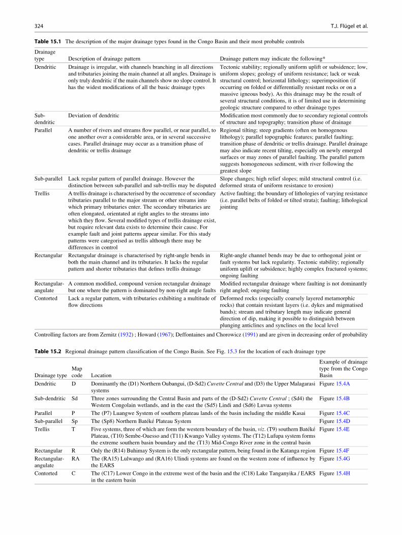
Table 15.1 The description of the major drainage types found in the Congo Basin and their most probable controls
Drainage
type Description of drainage pattern Drainage pattern may indicate the following*
Dendritic Drainage is irregular, with channels branching in all directions
and tributaries joining the main channel at all angles. Drainage is
only truly dendritic if the main channels show no slope control. It
has the widest modifications of all the basic drainage types
Tectonic stability; regionally uniform uplift or subsidence; low,
uniform slopes; geology of uniform resistance; lack or weak
structural control; horizontal lithology; superimposition (if
occurring on folded or differentially resistant rocks or on a
massive igneous body). As this drainage may be the result of
several structural conditions, it is of limited use in determining
geologic structure compared to other drainage types
Sub-
dendritic
Deviation of dendritic Modification most commonly due to secondary regional controls
of structure and topography; transition phase of drainage
Parallel A number of rivers and streams flow parallel, or near parallel, to
one another over a considerable area, or in several successive
cases. Parallel drainage may occur as a transition phase of
dendritic or trellis drainage
Regional tilting; steep gradients (often on homogenous
lithology); parallel topographic features; parallel faulting;
transition phase of dendritic or trellis drainage. Parallel drainage
may also indicate recent tilting, especially on newly emerged
surfaces or may zones of parallel faulting. The parallel pattern
suggests homogeneous sediment, with river following the
greatest slope
Sub-parallel Lack regular pattern of parallel drainage. However the
distinction between sub-parallel and sub-trellis may be disputed
Slope changes; high relief slopes; mild structural control (i.e.
deformed strata of uniform resistance to erosion)
Trellis A trellis drainage is characterised by the occurrence of secondary
tributaries parallel to the major stream or other streams into
which primary tributaries enter. The secondary tributaries are
often elongated, orientated at right angles to the streams into
which they flow. Several modified types of trellis drainage exist,
but require relevant data exists to determine their cause. For
example fault and joint patterns appear similar. For this study
patterns were categorised as trellis although there may be
differences in control
Active faulting; the boundary of lithologies of varying resistance
(i.e. parallel belts of folded or tilted strata); faulting; lithological
jointing
Rectangular Rectangular drainage is characterised by right-angle bends in
both the main channel and its tributaries. It lacks the regular
pattern and shorter tributaries that defines trellis drainage
Right-angle channel bends may be due to orthogonal joint or
fault systems but lack regularity. Tectonic stability; regionally
uniform uplift or subsidence; highly complex fractured systems;
ongoing faulting
Rectangular-
angulate
A common modified, compound version rectangular drainage
but one where the pattern is dominated by non-right angle faults
Modified rectangular drainage where faulting is not dominantly
right angled; ongoing faulting
Contorted Lack a regular pattern, with tributaries exhibiting a multitude of
flow directions
Deformed rocks (especially coarsely layered metamorphic
rocks) that contain resistant layers (i.e. dykes and migmatised
bands); stream and tributary length may indicate general
direction of dip, making it possible to distinguish between
plunging anticlines and synclines on the local level
Controlling factors are from Zernitz (1932) ; Howard (1967); Deffontaines and Chorowicz (1991) and are given in decreasing order of probability
Table 15.2 Regional drainage pattern classification of the Congo Basin. See Fig. 15.3 for the location of each drainage type
Drainage type
Map
code Location
Example of drainage
type from the Congo
Basin
Dendritic D Dominantly the (D1) Northern Oubangui, (D-Sd2) Cuvette Central and (D3) the Upper Malagarasi
systems
Figure 15.4A
Sub-dendritic Sd Three zones surrounding the Central Basin and parts of the (D-Sd2) Cuvette Central ; (Sd4) theWestern Congolain wetlands, and in the east the (Sd5) Lindi and (Sd6) Luvua systems
Figure 15.4B
Parallel P The (P7) Luangwe System of southern plateau lands of the basin including the middle Kasai Figure 15.4C
Sub-parallel Sp The (Sp8) Northern Bateke Plateau System Figure 15.4D
Trellis T Five systems, three of which are form the western boundary of the basin, viz. (T9) southern BatekePlateau, (T10) Sembe-Ouesso and (T11) Kwango Valley systems. The (T12) Lufupa system forms
the extreme southern basin boundary and the (T13) Mid-Congo River zone in the central basin
Figure 15.4E
Rectangular R Only the (R14) Buhimay System is the only rectangular pattern, being found in the Katanga region Figure 15.4F
Rectangular-
angulate
RA The (RA15) Lulwango and (RA16) Ulindi systems are found on the western zone of influence by
the EARS
Figure 15.4G
Contorted C The (C17) Lower Congo in the extreme west of the basin and the (C18) Lake Tanganyika / EARS
in the eastern basin
Figure 15.4H
324 T.J. Flugel et al.

individual drainage patterns will now be discussed in more
detail. Figure 15.3 indicates the extent and location of the
various drainage patterns for the CRS and Table 15.2
provides the names and map codes of each drainage type
and an example of the drainage pattern from the CB is
illustrated in Fig. 15.4.
15.3.1 Dendritic Patterns
In the CB there are three regions exhibiting dendritic
patterns and four exhibiting sub-dendritic patterns (see
Table 15.2 and Figs. 15.3 and 15.4A):
15.3.1.1 Northern Oubangui System(D1 in Fig. 15.3)
This large, northern area of the basin appears to correspond
to the underlying Precambrian basement (Chap. 2, this
book). The occurrence of fractured, weathering resistant
Proterozoic quartzitic sandstones provides localised struc-
tural control on some tributaries (Runge 2007).
15.3.1.2 Cuvette Central (D-Sd2 in Fig. 15.3)The drainage pattern of the Cuvette Central is dominantly
dendritic, although several large extents of interleaved sub-
dendritic drainage patterns are present. Cahen (1954)
suggested a Neogene to early Quaternary age for the large
portions the Cuvette Central dendritic pattern and that
portions of present day channels of the Sangha, Oubangi
and Congo Rivers that flow through the Western Congolian
wetlands, along with the Lukemie River, are related to the
formation of Malebo (Stanley) Pool (Fig. 15.5). These
sections thus represent the youngest part of the network
(Cahen 1954). It is likely that portions of the Cuvette Central
have been superimposed, flowing along inherited older
trends (Deffontaines and Chorowicz 1991).
15.3.1.3 Upper Malagarasi System (D3 in Fig. 15.3)The upper Malagarasi system exhibits a dendritic pattern.
The dendritic pattern lies predominantly on Tanzanian cra-
tonic region, in the shallow basin region south of Lake
Victoria. The tectonic stability and broadly uniform lithol-
ogy this region would have allowed for the uninterrupted
development the Malagarasi system.
15.3.2 Sub-dendritic
15.3.2.1 Cuvette Central (D-Sd3 in Fig. 15.3)There are several of zones of sub-dendritic drainage that
occur within the overall dendritic pattern of the CuvetteCentral. This sub-dendritic drainage dominantly occurs in
the western, eastern and southern zones of the Cuvette
Central (see Table 15.2 and Figs. 15.3 and 15.4B). Several
of these zones are associated with areas of locally outcrop-
ping resistant lithologies and structure, in a region that is
dominantly alluvial in nature. Abrupt changes in flow direc-
tion in zones of transition from one dendritic to sub-dendritic
patterns reveal the presence of NE–SW and ESE–WNW
trending faults (Deffontaines and Chorowicz 1991). Addi-
tionally, to the south, the Lukemie and Kasai Rivers have
parallel interfluves that suggest the modification of river
patterns by a horst block or tilted block (Deffontaines and
Chorowicz 1991). The abrupt change in river direction of the
Congo River near Kisangani, the middle section of the
Sankuru River and also in the lower Kasai to the south
such structural controls, which have experienced vertical
movements since the Cenozoic (Figs. 15.1 and 15.5;
Deffontaines and Chorowicz 1991). The regular, trending
to parallel drainage pattern of the lower Kasai River in the
south, may indicate a distinct, major block tilted northwards
(Deffontaines and Chorowicz 1991).
15.3.2.2 Western Congolian Wetlands(Sd4 in Fig. 15.3)
The drainage pattern of the rivers flowing south into the CR
just before it crosses the Equator for a second time is sub-
dendritic. This drainage zone corresponds to a large,
inundated region of dominantly Holocene alluvium that
forms the Western Congolian wetlands. A combination of
low gradients and mosaics of very dense tropical rainforest
and swamplands has prevented the establishment of den-
dritic drainage. This can be seen in the multi-branching
meandering form of Likoula aux Herbes River (a tributary
of the lower Sangha River, Fig. 15.5) as it flows through the
wetlands. Parts of the region have be influenced by
neotectonics (namely Lac Tele (Master 2010) which has
likely further inhibited the development of a dendritic pat-
tern through network reorganisation.
15.3.2.3 Lindi System (Sd5 in Fig. 15.3)This small zone of sub-dendritic drainage occurs in the
north-east of the basin with trellis and dendritic drainage
lying on the downstream side to the west and north, while
rectangular angulate and contorted drainage occurs upstream
in the southern and eastern sections. The Lindi systems thus
appears to be influenced both by the structural influence of
the EARS to the west and the trellis network of the down-
stream mid-Congo. It is possible that the Lindi System was
part of the Cuvette Centrale and Luvua (sub) dendritic
system and has been subsequently isolated by downstream
capture and modified by the EARS in its headwater zones.
15.3.2.4 Luvua System (Sd6 in Fig. 15.3)The Luvua system occurs in the south-western areas of the
Congo Basin and extends northward along the CR. The
15 The Present Day Drainage Patterns of the Congo River System and their Neogene Evolution 325

southern reaches have a dominant south-west orientation,
suggesting some degree of structural control in the region.
A large portion of this zone corresponds to the Precambrian
basement (Deffontaines and Chorowicz 1991); with evi-
dence of recent tectonic activity along Lake Mweru and a
wide alluvial plain upstream of the lake, near Kasenga (Tack
et al. 2003). This tectonic activity, associated with the West-
ern Branch of the EARS, is the probable explanation of the
sub-dendritic pattern in this region (Fig. 15.7). The similar
morphologies of the Ufipa Plateau and Rukwa basins (north
of the Chambeshi headwaters, in the Tanganyika-Rukwa-
Malawi rift zone) to the Kundelungu Plateau and Lake
Mweru provide further evidence of tectonic control of the
drainage (Fig. 15.5). While the Rukwa Plateau is generally
tilted towards Lake Tanganyika, several of its rivers drain
into Lake Rukwa, possibly reflecting a combination of ante-
cedence and tectonic control of these rivers (Delvaux et al.
2012). Additionally there appears to be no river offsets
across the scarps (Delvaux et al. 2012). The importance of
tectonic events in the region is illustrated by 1910 earth-
quake in the region that is estimated to have been 7.4 in
magnitude (Delvaux et al. 2012). Similarly, localised
faulting and uplift appears to have morphed the dendritic
network into a sub-dendritic pattern. In summary, much of
the sub-dendritic pattern represents the interplay between
the inherent structural controls of the Precambrian basement
on the one hand, and extensional movements of Neogene to
late Holocene age, as is suggested for the Upemba Trough
(Fig. 15.5; Deffontaines and Chorowicz 1991). This may be
further enhanced by rift associated uplift that promoted
erosion and incision of the pre-rift sediment and/or base-
ment, with this rift flank induced river system draining into
the basins (i.e. Mweru) in structurally low-lying regions
between fault segments.
15.3.3 Parallel
Within the CB, two areas exhibit parallel type drainages: the
parallel drainage of the southern plateau region of the basin,
as seen in the Luangwe System and the sub-parallel drainage
Fig. 15.7 The EARS (blackdashed lines) and its affect on the
CB drainage patterns. The
stippling indicates the regions of
the CB that been affected by
seismic activity linked to the
EARS. Drainages close to the rift
are most affected by seismic
activity, which has a calculated
extent of up to 450 km west of the
EARS. At distances greater than
450 km, the probability of a
seismic event exceeding a peak
ground acceleration (PGA) of
0.05 g is less than 10 % in 50
years (Mavonga and Durrheim
2009). This relative higher
probability and greater PGA of
seismic events closer to the rift
could account for the occurrence
of Sd5 (Lindi), RA15
(Lulwango), RA16 (Ulindi), Sd6
(Luvua), R14 (Bushimay) and
T12 (Lufupa) networks. The
limited affects on D3 (Upper
Malagarasi) may be related to its
proximity to a cratonic region.
Interestingly the lower region of
the Malagarasi river has become
contorted (C18)
326 T.J. Flugel et al.
of the Northern Bateke Plateau System of the basin western
margin (see Table 15.2 and Figs. 15.3 and 15.4C) .
15.3.3.1 Luangwe System (P7 in Fig. 15.3)The southern plateau areas, which incorporates the Luangwe
basin and associated tributary catchments in the southern
Basin has dominantly parallel drainage pattern. The bound-
ary zone varies from parallel to sub-parallel and it covers a
region that has been suggested to have remnants of an upper
Jurassic drainage network (Cahen 1954). The parallel drain-
age is associated with the transition zone of the low gradient
slopes of the northern extent of the Kalahari Plateau to the
basin of Cuvette Central. The parallel pattern suggests
uniform lithology which allows the river to flow along the
greatest slope, as seen to the south of Kasai (Zernitz 1932;
Deffontaines and Chorowicz 1991).
15.3.4 Sub-parallel
15.3.4.1 Northern Bateke Plateau System (Sp8 inFig. 15.3)
The Northern Bateke Plateau System comprises of many
near linear rivers, flowing across a NE dipping plateau (see
Table 15.2 and Figs. 15.3 and 15.4D). The combination of
the a strong NNE flow direction and the linearity of the
rivers with connections between parallel rivers being short
suggests a degree of fault control. The location of the plateau
to the Atlantic margin, lead Karner and Driscoll (1999) to
suggest a Gondwana break-up origin of these rivers. These
rivers may have begun flowing basinward due to flexural
rebound associated with Gondwana break-up, that
established numerous, short rivers toward the interior basin
(Karner and Driscoll 1999) and these patterns have been
maintained to present day.
15.3.5 Trellis
There are five instances where trellis drainage was
identified, with this drainage type occurring mainly along
the peripheries of the central basin (see Table 15.2 and
Figs. 15.3 and 15.4E).
15.3.5.1 Southern Bateke Plateau System(T9 in Fig. 15.3)
The Southern Bateke Plateau System differs from the North-
ern Bateke Plateau System in that the rivers in the region are
shorter, with more right angles and flow directly into CR.
The geometry of the rivers and the consistent directionality
of many of the river segments, being WWN, reveal a
dominant fault control. Additionally much of this zone
corresponds to the Precambrian basement (Deffontaines
and Chorowicz 1991), which incorporates a portion of the
West Congolian orogenic belt making it probable that tec-
tonics, lithological structures and rock differences, have
resulted in a trellis drainage forming. Subsequent tectonic
activity may have modified the rivers further.
15.3.5.2 Sembe-Ouesso (T10 in Fig. 15.3)This pattern is controlled by numerous south-north trending
faults, with several NNE trending faults, with the rivers
flowing on Precambrian basement. Dolerite outcrops further
add to the structural control of this trellis pattern. Therefore
the Sembe-Ouesso drainage network is predominantly con-
trolled by the directionality of the faults, and the underlying
lithology.
15.3.5.3 Kwango Valley (T11 in Fig. 15.3)The Kwango Valley, found along the southern margin of the
CB exhibits a trellis pattern drainage pattern. Here the
Kwango River flows in a north-west direction, compared to
parallel, north flowing rivers of adjacent Luangwe System to
the east. Incision into the Precambrian basement by the
Kwango River appears to have caused the diversion and
breakup of the longer parallel streams into several shorter
rivers. Thus the Kwango River trellis pattern, at least in the
eastern region close to the Luangwe System, likely
represents a modification of a parallel drainage that existed
on the tilted plateau, previous to incision by the Kwango
River. Furthermore, its location on the margin of the West
Congolian orogenic belt has resulted in the western part of
the Kwango Valley developing a strong trellis pattern,
shaped by structural control in this region. The Kwango
Valley drainage therefore is dominantly a modified parallel
network with subsidiary structural control.
15.3.5.4 Lufupa System (T12 in Fig. 15.3)Forming the southern margin of the Congo Basin the Lufupa
trellis drainage system comprises of the easterly flowing
Kasai River in the west and the northerly flowing upper
Congo (Lualaba) River in the east. The Lufupa system thus
forms the main portion of the Congo-Zambezi Watershed.
The western part of this trellis network, around the Kasai
River, may contain the remnants of late-Cretaceous rivers
(Cahen 1954) and thus it inherited to some degree. Whereas,
the presence of folded schists and tillites of the Kanga-
System (Upper Precambrian) and tectonics (indicated by
three major fault scarps) (De Dapper 1988) in the eastern
half of the trellis drainage are the likely controlling factors
on the drainage pattern.
15 The Present Day Drainage Patterns of the Congo River System and their Neogene Evolution 327

15.3.5.5 Mid-Congo River (T13 in Fig. 15.3)The northern bank of the middle CR is dominantly trellised
with the southern bank having numerous small rivers join the
Congo at right angles. This start of the trellis network closely
corresponds to the abrupt and localised braiding of the CR
that begins at 0�24�E and continues until 1�N 16�E. Thebraiding of stream channels suggests an inability to transport
the bed load. This may be due to local coarser bedload, and/
or loss of velocity due to flattening of gradient (Howard
1967). It is likely that trellis pattern represents a modification
of pre-existing dendritic network, as the middle Congo trel-
lis network is bounded between the northern Oubangui and
central basin dendritic networks. This modification could be
related to the capture of the lower CR. It is probable that this
trellis pattern has been enhanced by local structural controls
such as exposed outcrops of basement.
15.3.6 Rectangular
The CB contains a single zone of rectangular drainage, this
being found in the south-east region of the basin (see
Table 15.2 and Figs. 15.3 and 15.4F).
15.3.6.1 Bushimay System (R14 in Fig. 15.3)The rivers in this zone have a general north-northeast orien-
tation, bounded in the west by a high ridge, which separates
the upper CR (also referred to as the Lualaba) from the Kasai
system (Cahen 1954). Roberts (1946) suggested that these
north-northeast river courses exhibit strong inheritance,
where they occupy Karoo palaeovalleys. The persistent seis-
micity all around the Upemba Trough attests to Neogene to
Recent extensional movements (Deffontaines and
Chorowicz 1991). Therefore this area is likely a zone of
intense faulting.
15.3.7 Rectangular-Angulate
There are two zone of rectangular-angulate drainage, both
relatively small and located in the eastern CB in proximity of
the Western Branch of the EARS (see Table 15.2 and
Figs. 15.3 and 15.4G).
15.3.7.1 Lulwango (RA15 in Fig. 15.3)The Lulwango system, is a small area, with a mixture of
channels with right-angle bends and channel junctions
forming acute angles. The combination of NE–SW trending,
linear ridges and Basement rock outcrops appears to be the
local controls of the drainage. The linear ridges have resulted
in channels running near parallel in part, forming right-
angles as they cut across the ridges. Additinoally as the
sub-dendritic Luvua System (Sd6) lies to the south and
west (downstream) and the contorted Lake Tanganyika
(C18) to the north and west (upstream) the Luluwango
system exhibits both structural and tectonic controls evident
in these systems. It is probable that the Lulwango system is
an area of ongoing modification, forming a zone of interac-
tion between the Luvua and Lake Tanganyika systems. The
multiple phases of deformation and rejuvenation experi-
enced by the Western Branch (Cahen and Snelling 1966)
has likely enhanced rectangular-angulate pattern (Fig. 15.7).
The interaction of these factors likely accounts for the sys-
tem having deviated from a topographically controlled (lin-
ear ridges) trellis or rectangular pattern.
15.3.7.2 Ulindi (RA16 in Fig. 15.3)The Ulindi system is surrounded by the sub-dendritic
systems of the Lindi (Sd5) and Luvua (Sd6) to the north
and west (downstream), with the contorted drainage of Lake
Tanganyika (C18) being to the south and north (upstream).
The drainage exhibits is more rectangular compared to the
Lulwango but lacks perpendicular channel junctions and. It
is likely that the outcropping Basement rocks providing a
degree of structural control, with the Western Branch having
a limited, direct influence on the Ulindi system (Fig. 15.7).
Occurring between two dominant drainage types (sub-
dendritc downstream and to the north; contorted upstream
and to the south) this modified pattern forms a interface zone
between the two drainages.
15.3.8 Contorted
In the CB contorted drainages are associated with two zones
of deformation, the Atlantic Rise and the EARS (see
Table 15.2 and Figs. 15.3 and 15.4H).
15.3.8.1 Lower Congo (C17 in Fig. 15.3)The contorted drainage of the Lower Congo corresponds to
the area where the CR and its associated tributary rivers
straddle the Western Escarpment and the coastal region of
the CR. Here, the river morphology appears to be controlled
dominantly by the exposure of Precambrian rocks; the
contorted drainage follows the various zones of the West
Congolian orogeny. It is likely that tectonic activity, combi-
nation of uplift (thought to be more than 300 m) and warping
and/or tilting, associated with the Miocene reactivation of
the West African margin, resulted in drainage
reorganisation, further enhanced the contorted drainage pat-
tern (Cahen and Snelling 1966; Lavier et al. 2001). It has
been suggested that increased sediment loading on the
coastal shelf during was the cause of this tectonic reactiva-
tion (Deffontaines and Chorowicz 1991; Driscoll and Karner
1994; Anka and Seranne 2004; Anka et al. 2010).
328 T.J. Flugel et al.

15.3.8.2 Lake Tanganyika/East African Rift System
(C18 in Fig. 15.3)The eastern margin of the CB is dominated by a contorted
drainage pattern. The area of contorted pattern corresponds
to the Eastern Highlands and thus forms the headwater zone
of many of the westerly flowing rivers. The streams and
rivers of this zone lack a consistent drainage pattern, with
rivers flowing in several different directions and near-
straight channelled rivers flow adjacent to rivers. This lack
of consistent pattern indicates a dominance of fault and
lithology controls in the region. The fact that much of this
drainage system corresponds to the Western Branch of the
EARS, it is likely that much of the drainage has been
influenced by phases of tectonic activity (Fig. 15.7). Indeed
several phases of tectonic activity have been identified,
resulting in the overprinting of faults by succeeding faults
and the formation of valleys and regional blocks (Cahen and
Snelling 1966; Ring 2008; Bauer et al. 2010). In the
Rwenzori Mountains (Fig. 15.2), the Precambrian basement
rocks widely resist fluvial erosion, causing the rivers to
predominantly exploit predetermined structures (Bauer
et al. 2012). It is thus likely that the contorted drainage
pattern is strongly linked to the ongoing tectonic activity
associated with development of the Western Branch. For
example, the uplift of the Ufipa Plateau severed the drainage
linkages to the Tanzanian Plateau in the east, notably those
of the greater Rufiji drainage system (Fig. 15.1A). This uplift
appears to be Pliocene in age (e.g. Cotterill and de Wit 2011;
Goodier et al. 2011).
Therefore a large portion of Lake Tanganyika’s drainageis geological young and fault controlled, with the contorted
pattern being related to a combination of multiple phases of
uplift, subsidence, tectonic activity and exposure of Precam-
brian rock. This is distinctly seen in the lower Malagarasi
(Fig. 15.2) and Lukuga systems that drain into and out of
Lake Tanganyika respectively. The Malagarasi systems
changes from a dendritic pattern to a contorted pattern in
the zone where the river begins to flow off craton and
becomes influence by rifting. Previous to the formation of
the Western branch there was greater linkage between the
drainage of Eastern Africa and the CB. This palaeo-channel
is represented in the topological unity of modern Malagarasi
River, draining into Lake Tanganyika. These preserved
landforms attest to the profound impact of the EARS, in
particular its Western branch, on the evolution of the eastern
rivers of the CRS (Fig. 15.3).
15.4 Timing of Emplacement of the ModernRiver Systems of the Congo Basin
15.4.1 Cenozoic Events
The marine sedimentary evidence lead to the suggestion of
several scenarios of CB evolution. The three models pro-
posed to account for this marine sedimentary record are :
1) at the end of the Cretaceous there was a progressive
change of the depocentre from the Ogoue and Cuanza
(Kwanza) Rivers to the Congo as a result of capture of
the endorehic Congo Basin (Babonneau et al. 2002; Anka
et al. 2010). Today these southern and northern systems
exhibit multiple incised valleys and gorges along the
coastal areas, often occupied by under fit river channels.
2) There was a net southward migration of the outlet of the
CRS from the Cretaceous to the Cenozoic (Karner and
Driscoll 1999; Nibbelink and Budihardjo 2002). During
the late Cretaceous, the entire CB was drained by an outlet
at or near the present day Ogoue River (northern Gabon)
(Karner and Driscoll 1999; Nibbelink and Budihardjo
2002). Through the mid-Cenozoic the outlet migrated
south, forming a connection near/at the present day
Kouilou River, reachingthe present day CR outlet in the
Oligocene (Karner and Driscoll 1999; Nibbelink and
Budihardjo 2002). Karner and Driscoll (1999) suggest
that feedbacks between sediment loading and flexural
uplift of the hinterland may have played a role in the
migration of the outlet, although the mechanism of migra-
tion is unclear. This migration may be evidenced in the
misfit of the present Ogoue and Kouilou Rivers (see
Fig. 15.1a, c, the Kouilou River is near Point-Noire
Fig. 15.1c) that occupy abandoned channels and their
valleys, relic drainages and the large estuary near
Liberville and the large size of the Late Cretaceous—
early Cenozoic delta along the Gabon coast relative to
present-day coastal river systems (Karner and Driscoll
1999). This tectonic activity may have lead to the capture
of the interior drainage of the Congo Basin by a coastal
valley (Cahen 1954).The lower CR crosses an area of
lower modelled flexural uplift (Anka et al. 2010)
suggesting that the lower Congo River comprises of
inherited drainage. This antecedent lower CR is evidenced
by the deeply incised gorge and waterfalls downstream of
Kinshasa (Anka et al. 2010).
15 The Present Day Drainage Patterns of the Congo River System and their Neogene Evolution 329

15.4.2 Neogene Events: Evidence fromPhylogeographic Studies of Fishesand Mammals
While there is some geologic and geomorphic data regarding
the timing of river re-arrangements, this data is often discon-
tinuous or lacking in terms of resolution. This lack of data of
river developments can be circumvented by using biological
data as proxies to identify changes to drainage topology.
These proxies use phylogenetic reconstructions of related
species that have become geographically isolated by
changes in the landscape in which they live. Over evolution-
ary time, the isolated populations accumulate changes in
their DNA, with the genetic difference between the
populations allowing for an estimation of time since separa-
tion based on a molecular clock (Avise 2000; DeSalle and
Rosenfeld 2013). It is possible to determine the average rate
at which a species has accumulated genetic differences
(mutation rate) over time. By measuring the number of
genetic differences between two related groups and applying
the average mutation rate, a time estimate of when the two
populations were once freely breeding can be calculated
(Avise 2000). This process gives the approximate age of
genetic divergence of the two groups from their last shared
common population, or most recent common ancestor
(MRCA) (Avise 2000). The use of Bayesian methods allows
for age estimates to be assigned a measure of statistical error,
usually expressed at the 95 % level, which constrains the
probability of the true age value (DeSalle and Rosenfeld
2013).
The challenges involved in using phylogenetic data (such
as calibration methods and sampling density of species) can
be mitigated by using phylogenetic data from several spe-
cies. The congruence of age estimates across different spe-
cies provides insights into the spatio-temporal changes in the
fluvial geomorphology of central Africa during the late
Cenozoic (i.e. Cotterill and de Wit 2011; Goodier et al.
2011; Schwarzer et al. 2011; Hart et al. 2012; Kawamoto
et al. 2013). For example, it appears that the CR is the only
river that contains the extent of the large primates, namely
chimpanzees (Pan troglodytes) and gorillas (Gorilla
gorilla), preventing these primates from occurring south of
the CR, although both having successfully dispersed across
smaller rivers (see Fig. 15.8a). Fish are the most accessible
of these biological indicators and being restricted to water
systems their biogeography and evolution are tightly linked
to the evolution of fluvial systems (Cotterill and de Wit
2011). This link of biogeography and landform can be seen
in the broad congruence that differenct fish assemblages
show with regional drainage basins. Although fish
assemblages may differ locally, owing to the interplay of
numerous abiotic and biotic factors (i.e. water pH, tempera-
ture, biological competitors and predators) some fish species
occupy definitive niches (stenotypes), and are thus forced to
track their local environments. Over evolutionary
timescales, these stenotypes either successfully track their
specific physical habitats, or become extinct. Therefore
stenotopic fish may record the timings of river events, such
as disruption or connections of river channels, when water
transfer between the river systems ends or begins. The
events dates by molecular proxies, record of the start of the
current phase of the river drainage structuring (assuming
equal ability of dispersal up and down rivers, that is no
barriers) as connections may be seasonal (i.e. yearly flood)
or event based (i.e. 1 in 10 year floods). The use of primate
evidence goes some way in solving problems with the timing
of prolonged river channel emplacements as many primate
taxa distribution patterns are often contained by major rivers
that serve as barriers to movement, both on a genus and
species levels (Anthony et al. 2007; Harcourt and Wood
2012).
Yet not all rivers are equally effective barriers, with wider
and faster flowing rivers being formidable barriers compared
to narrower, smaller tributaries and thus the lower reaches of
a river are often more effective barriers compared to their
upper reaches; for example, the lower sections of the CR
seem to be more effective barriers than its smaller tributaries
and headwaters (Harcourt and Wood 2012). As African
rivers form the border of distributions for more subspecies
rather than genera, Harcourt and Wood (2012) suggest that
primate taxonomic level may be a useful, albeit rough, proxy
to estimate times of population isolation by river emplace-
ment. Therefore primate divergence estimations (calculated
from the MRCA) may serve as proxies of rivers achieving a
sufficient size, and continuity of flow, to become a barrier to
dispersal. The CR acts a major, regional barrier to primate
dispersal, with fewer primate species and subspecies strad-
dling the CR compared to other rivers (Harcourt and Wood
2012). Owing to the relationship between rivers as a barrier
and primate size (Harcourt andWood 2012), it can be argued
that timings of divergence of large primates (i.e. bonobos,
chimpanzees and gorillas) relate to the development of large
rivers (i.e. Congo) with medium and smaller primates
serving as proxies for emplacement of medium and smaller
rivers. However the inherent heterogeneity of a river in both
space and time must be borne in mind when considering
rivers as barriers to primate dispersal. This is highlighted by
a genetic study of chimpanzees either side of the Malagarasi
River, an assumed barrier river (Piel et al. 2013). Although
the Malagarsi River is over 100 m wide for extensive
stretches, both field observations and genetic analysis of
chimpanzees populations either of the river, close to a ford,
indicated that the chimpanzees made use of this natural
bridge to cross the river (Piel et al. 2013). Thus the
Malagarasi River is likely only a seasonal barrier to primate
movement in areas where natural rock bridges may have
330 T.J. Flugel et al.

allowed gene flow (Piel et al. 2013). Similar situations may
be found for other rivers of the CRS with more extensive and
intensive field research. Ultimately information on paleo-
environmental changes in the CB during the late Noegene
and Quaternary are required to fully elucidate the genetic
structure of many of the primates in the basin (i.e.
Kawamoto et al. 2013). Furthermore, the geographical pat-
tern of a primate grouping may take hundreds of thousands
of years to develop (i.e. Kawamoto et al. 2013), thus requir-
ing rivers to be effective barriers during the entire period.
Fig. 15.8 (a) The geographicaldistribution and molecular
divergence dates of bonobos,
chimpanzees (Genus Pan) andgorillas (Genus Gorilla), incentral and western Africa. The
Lukuga River (outflow of Lake
Tanganyika) appears to have
become a recent barrier to eastern
chimpanzees (modified from
Prufer et al. 2012; Scally et al.
2012). Chimpanzees (green) andbonobos (orange) were separatedby the Congo River between 2.5
and 1.5 Ma; and the western and
eastern gorillas show an
analogous divergence at ca.1.7 Ma. (Bonobo, chimpanzee
and gorilla distributions derived
from UNEP-WCMC and IUCN
International Union for
Conservation of Nature 2008a, b,
c. (b) The geographicaldistributions of bonobos,
chimpanzees, guenons (Genus
Cercopithecus) and mandrills
(Genus Mandrillus). SeeMolecular divergence dates of the
southern and northern mandrills
of Gabon in the west suggest that
the present day Ogoue River
became established 0.8 Ma
(Telfer et al. 2003). To the east of
the CB, divergence dates suggest
that the guenon populations were
separated by the Lomami –
Congo rivers at 1.7 Ma (Hart et al.
2012). See Fig. 15.8a for
congruent biogeoraphical
patterns in of bonobos and
chimpanzees
15 The Present Day Drainage Patterns of the Congo River System and their Neogene Evolution 331

This also means there will be a lag time from when a river
becomes a barrier and its effects are seen in the genetic
signal.
15.4.2.1 Phylogenetic Age Estimatesof Geomorphic Events
In central Africa, a synthesis of phylogenetic studies of
primates provide an estimation of river emplacement
(Fig. 15.8a, b; Table 15.3) in the Late Pliocene and Early
Pleistocene. Evidence from the divergence of bonobos-
chimpanzees suggests that the Equatorial arc of the Congo
River was an effective barrier to large primate dispersal,
with Prufer et al. (2012) suggesting a 2.5–1.5 Ma, although
a different genetic marker provides a 1 Ma age estimate
(Kawamoto et al. 2013). The divergence estimate of
1.75 Ma for the western (Gorilla gorilla) and eastern (G.
beringei) gorilla populations (Scally et al. 2012) suggests
that the CR (and possibly the Oubangui) formed a barrier to
gorilla dispersal at a similar time of the bonobo-chimpanzee
divergence (Fig. 15.8a; Table 15.3). Genetic data for the
lowland gorillas indicate a subsequent, moderate genetic
exchange between the two groups, since the initial split
suggesting movement of individuals between the two
populations until the late Pleistocene; with the eastern popu-
lation experiencing a genetic bottleneck that is indicative of
low population numbers (Ackermann and Bishop 2010;
Scally et al. 2012). Nevertheless both molecular and mor-
phologically studies support the classification of the two
species, eastern and western gorillas with further subdivision
down to subspecies possible. This is further evidence for
genetic structuring within the western and eastern gorilla
populations, suggesting a barrier role of rivers smaller than
the Congo River (Anthony et al. 2007; Ackermann and
Bishop 2010) Yet more extensive sampling of both gorilla
populations is needed to allow for better resolution of diver-
gence times (Scally et al. 2012).
While the CR is an effective barrier to bonobos dispersal
northward, almost all the dendritic to sub-dendritic drainage
of the Cuvette Central (D-Sd2 in Fig. 15.3) have had little
affect on gene flow between populations (cohorts), apart
from the lower Lomami River (Fig. 15.5; Kawamoto et al.
2013). The barrier effect of the Lomami River is seen in the
greater genetic distance of the bonobo cohort east of the river
(the area between the Congo and Lomami rivers) compared
to the central and western cohorts (Kawamoto et al. 2013).
Additionally the genetic distances among the central and
western bonobos cohorts suggest that in the central region
of the basin that rivers only provide a weak barrier
(Kawamoto et al. 2013).
The recently discovered species of guenon monkey in the
genus Cercopithecus (C. lomamiensis), based on morpho-
logical and molecular evidence, provides proxy evidence of
the emplacement of the Lomami River (Hart et al. 2012). C.
lomamiensis is separated from its nearest congener,
C. Hamlyni, by both the Congo and the Lomami rivers
(Hart et al. 2012) (Figs. 15.5 and 15.8b; Table 15.3). C.
lomamiensis is endemic to the region confined by the upper
Tshuapa River in the west through to the Lomami River in
the east, whilst the eastern-most distribution of C. hamlyni is
bounded by the CR (Hart et al. 2012). Hart et al. (2012)
suggest the Lomami and upper Congo rivers are the biogeo-
graphic barriers responsible for this speciation event. Molec-
ular divergence dates estimate the time to MRCA of the C.
lomamiensis–C. hamlyni clade based on two different
genetic makers, provide age estimates of ca. 1.7 Ma
(3.2–0.5 Ma at 95 % confidence level) and ca. 2.8 Ma
(4.3–0.6 Ma at 95 % confidence level) respectively (Hart
et al. 2012).
The congruence of the divergence data for the bonobos-
chimpanzees, gorillas and guenon species, supports the
emplacement of the modern, crescent shaped CR river by
1.5 Ma. The CR became an effective barrier to gene flow
(i.e. larger than 100 m—assumed effective barrier size for
chimpanzees see Piel et al. 2013) between 2.5 and 1.5 Ma
based on the most recent common ancestor of bonbos and
chimpanzees. This places an age constraint on the drainage
pattern of the Cuvette Central (D-Sd2 in Fig. 15.3), with its
relatively young age accounting for the mixture of dendritic
and sub-dendritic features. The separation of Cercopithecusaround 1.7 Ma by the northerly flowing Lomami River
strengthens the emplacement age of the modern CR.
The north-western boundary of the CB is formed by the
watershed between the Congo and Ogoue rivers is marked by
the Bateke Plateau. The eastern portion of the plateau slopes
gently toward the CR and is incised by numerous, actively
eroding headwaters of tributaries of the Ogoue River
(Seranne et al. 2008). Telfer et al. 2003 report a divergence
time of the mandrill (Mandrillus sphinx) populations northand south of the Ogoue River at ca. 800 Ka, constraining the
emplacement of the modern Ogoue River to at least 800 Ka.
With a sediment load of 19.7 � 106 t a�1 the Ogoue River
has a comparable sediment to the CR (22.7 � 106 t a�1)
although the Ogoue water volume is a magnitude less than
the Congo’s River, suggesting the Ogoue watershed is
undergoing active erosion (Seranne et al. 2008). Thus the
headwater regions of the Ogoue are actively incising back-
ward, and have likely captured smaller north-western
tributaries of the CR within the last 800 ka.
332 T.J. Flugel et al.

Table 15.3 The fluvial changes of in the Congo basin during the Neogene and Quaternary. The timing of events is based on age estimates
reported by phylogeographic studies.
Period Geomorphic event and time estimate Phylogenetic evidence
Neogene
Early to middle
Miocene
(1) Diversion of north eastern Congo of the
Aruwimi River headwaters drainage towards the Nile
(1a) “Haplochromic” species “Yaekama” is distributed in the
north eastern CRS near Kisangani but groups with Lake Victoria
superflocks (Schwarzer et al. 2012).
(1b) A sistergroup of modern haplochromines found in Lake
Kivu occurs in Lake Victoria (Schwarzer et al. 2012)
(2) Major drainage re-organisations of central CRS
drainage flowing off the southern escarpment with:
(i) severance of connections between the Fwa, Inkisi
and Kiwul Rivers (rivers presently adjacent to
one another in south western CB);
(ii) disruption of the Sankuru-Lukemie system,
with diversion of present day Sankuru flowing into
the Kasai system
(2a) Close phylogenetic relationship of “Haplochromis” specieshaplotypes of the Fwa-Inkisi-Kwilu Rivers (Schwarzer et al.
2012)
(2b) Genetic markers of the Fwa “Haplochromis” closely relatedto these in the mid-Kasai and mid-Kwango Rivers and; Fwa
haplochromides closely relates to “H.” cf bakongo and “H.”snoeki from the lower CR system (Schwarzer et al. 2012)
Late Neogene
(3) Partial re-arrangement across the headwaters of the
Lufira, Kwango and Cuanza (an Angolan coastal basin)
systems; capture of Zamnezian headwaters by the Lufira
(3) Hybrid taxa of northern and southern Oreochromictorrenticolo and Serranochromis sp. “red scales” that presently
occur either side of the Congo-Cuanza and Congo-Zambezi
divides (Schwarzer et al. 2012)
(4) Approximately 4 Ma: Establishment of water flow
across the modern day lower rapids of the CR connecting
the CRS to the Atlantic Ocean (established by 5 Ma?)
(4) High level of cichlid flocks (Steatocranus and Nanochromis)diversification in the lower CR; these cichlids are endemic to
rapids (Schwarzer et al. 2011)
(5) 3.1 Ma : Disruption of drainage between Lake
Tanganyika and Lake Victoria/East Africa drainage
(5) Phylogenetic dating of the timing of divergence of
Hydrocynus tanzania and H. vittatus (Goodier et al., 2011)
Quaternary
Pleistocene (6) 2.5–1.5 Ma: Establishment of the ‘modern’, sickle
shape of CR is established in the region of the Equator
(6a) Divergence date between chimpanzees occurring on the
northern and eastern banks of the Congo River with bonobos
restricted to an area inside the arc of the CR. Dates of 2.5–1.5 Ma
(Prufer et al. 2012). See Fig. 15.8a
(6b) Divergence age between western and eastern gorillas of the
CB calculated to have been at 1.75 Ma (Scally et al. 2012). See
Fig. 15.8a
(7) 2.0 Ma: Separation of the Bangweulu and Lufubu
drainage systems from the upper-western CR tributaries
(7) Founding of Hydrocynus “clade B”, and “Clade C” diverges
from “Clade D” and H. vittatus ca. 2.0 Ma (0.8–3.0 Ma)
(Goodier et al. 2011)
(8) 1.8 Ma: The Lufubu system is isolated from the
Bangweulu river system and flows into Lake Tanganyika
(8a) Speciation of Pseudocranilabrus “lufubu” (1.4–2.3 Ma)
(Koblmuller et al. 2008).
(8b) Divergence of Synodontis nigromaulata 2 from S.nigromaculata3 (1.0–2.7 Ma) (Day et al. 2009)
(9) 1.7 Ma: Major south to north flowing tributaries of
the Cuvette Central region are in place i.e. Lomami
River
(9) Two genetic markers of the guenons populations
(Cercopithecus lomamiensis and C. hamlyni) have beenestimated to be 1.7 Ma (3.2 Ma–0.5 Ma at 95 % confidence level)
and 2.8 Ma (4.3 Ma–0.6 Ma at 95 % confidence). C. lomamiensisis separated from C. hamlyni by both the Congo and Lomami
rivers (Hart et al. 2012). See Fig. 15.8b
(10) 1.5 Ma: isolation of Lake Taganyika from the CRS,
with consequent establishment of the Lukuga River
outflow
(10a) Phylogenetic dating of the Hydrocynus population in LakeTanganyika compared populations in the Bangweulu system
(Goodier et al. 2011)
(10b) Lukuga River appears to from a partial barrier between
two chimpanzee population (see Fig. 15.8a)
(11) 0.8 Ma: Establishment of the modern day Ogoue
River sands (Seranne et al. 2008)
(11) Divergence date between southern and northern mandrills
(Telfer et al. 2003). See Fig. 15.8b
15 The Present Day Drainage Patterns of the Congo River System and their Neogene Evolution 333

15.5 The Evolution of the Congo BasinDrainage
Owing to the sensitivity of rivers to vertical tectonic
displacements, and their ability to adjust to surface warping
through changes in their channel, and subsequently their
drainage pattern (Howard 1967; Holbrook and Schumm
1999), the CB rivers patterns provide insight into the evolu-
tion of the broader landsurface. Although the time response
to change remains difficult to estimate, as it depends on rock
strength, stream characteristics and the magnitude of tec-
tonic activity (Holbrook and Schumm 1999; Leturmy et al.
2003; Lucazeau et al. 2003).
Major changes in the fluvial geomorphology of the CB
occurred during the late Cenozoic (Table 15.3). Throughout
the Neogene, the major rivers of the CRS began to develop
their modern day forms. This change was driven by several
factors, dominantly structural controls, tectonics and related
autogenic fluvial processes. However this ongoing develop-
ment was not uniform, as can be seen from 18 of the present
day drainage patterns, indicating that the development of the
CRS has been multi-phase and has several dominant
controls.
The rivers of the eastern CB have been highly influenced
by the geological young, and ongoing tectonic activity of the
EARS, in particular its Western Branch (Fig. 15.7). While the
geodynamic effects of the Western Branch have a limited
spatial extent in the north-east of the CB, it is extensive in
the south-east being and has resulted in the present contorted,
trellis and modified rectangular-angulate and sub-dendritic
drainages (Table 15.2; Figs. 15.3 and 15.7). These drainages
are probably the second youngest of the CB drainages, having
undergone significant re-organisation since the development
of the EARS. The affects of the EARS on drainage in the
region likely began in the Late Miocene with the formation of
horst and graben structures, with increasing tectonic activity,
including uplift, until the Pliocene-Pleistocene (Ring 2008;
Bauer et al. 2010, 2012; Decree et al. 2010; Roller et al.
2010). This multiple tectonic phases resulted in the contorted
pattern of over the majority of the region (Figs. 15.3 and
15.7). This is evident in Fig. 15.6c, where vertical incision is
dominant and the river channels in the region have eroded to
similar elevations.
According to Pinet and Souriau (1988) there are two
phases that characterise regional uplift: the initial 2.5 Myr
phase involving constant denudation focused on the uplifted
region, resulting in high sediment production and infilling of
basin areas. The second phase occurs once the tectonic
activity has ceased, with a 25 Myr period of weaker erosion
occurring across a greater spatial extent leading to sediment
movement throughout the greater basin (Pinet and Souriau
1988). Therefore, in the CB, the uplifting eastern basin
margin is likely providing a large sediment supply that is
transported westward by the eroding eastern rivers, and
along with sediments transported by the northerly flowing
rivers of the south CRS, accumulates in the central basin
(Fig. 15.6a, b), where it undergoes reworking before being
deposited offshore. This accumulation of poorly
consolidated sediments has allowed the central drainages
(Cuvette central and Western Congolain wetlands) to
accommodate fluvial changes through horizontal re-working
of the sediments. Thus the rivers of the central basin are
more likely to have accommodated rejuvenation and adjust-
ment than those on the Precambrian basement, as shown by
their sub-dendritic to dendritic pattern. This development of
a highly dynamic river network in the region is probably
younger than the drainages of the eastern basin; serving as
the regional interface between changes in the eastern and
western drainages and changes in the CRS base level at the
CR mouth. Thus the eastern and central drainages of the CB
are likely to be Pliocene in age, with elements being
inherited from Middle to Late Miocene.
The peripheral drainage patterns to the south, west and
north of the central basin, are dominantly structurally con-
trolled (the trellis drainages of southern Bateke, Sembe-
Ouseso, Kwango Valley and mid-Congo; Table 15.2 and
Fig. 15.3) and along with parallel drainage in the south
(Lunagwe, Table 15.2 and Fig. 15.3) pre-date the central
basin drainage (i.e. mid-Cenozoic to Mid-Miocene). This is
not to say there have been no changes in these drainages
systems but rather that the dominant drainage was already
established by the Mid-Miocene.
Biotic evolutionary events provide important lines of
evidence to constrain timing of major changes in location
of river channels of the Congo drainage net. These include
timing of formation of the present day CR and expansion and
development of the drainage network. Comparison of river
topology at regional scales reveals strong controls of the
local geology, as indicated by the juxtaposed drainage
patterns.
The south-to-north flowing rivers of the central basin
region are likely to precede the east-to-west flowing rivers
of the region; with the northerly flowing rivers being
emplaced ca. 2 Ma. This is evidenced by genetic differences
of the guenons and genetic variance of bonobos to the east
and west of the Lomami River (Hart et al. 2012; Kawamoto
et al. 2013; Table 15.3 and Fig. 15.8a, b). None of the east-
to-west flowing rivers (apart from the CR) appear to have
been a barrier to bonbos (Kawamoto et al. 2013), these rivers
are therefore likely younger and/or of have not been contin-
uously flowing for a sufficient time to form a true barrier.
Similarly, it appears that only the north-to-south lower
Oubangui River is a barrier dividing central and eastern
chimpanzees, with easern chimpanzees moving across the
east-to-west flowing rivers on the northern central basin
334 T.J. Flugel et al.

(Fig. 15.8a). Both these situations in the CB may be analo-
gous to that seen in the east-to-west flowing Malagarasi
River (Fig. 15.3) that forms an ephemeral barrier to chim-
panzee dispersal (Piel et al. 2013). The smaller east-to-west
flowing rivers of the central basin appear to form ephemeral
barriers (if they form barriers at all) which suggests that
these rivers are dynamic, changing both in size and location.
It is important to consider the relative roles of inheritance
and rejuvenation, versus the origin of new features as
interacting controls over the overall evolution of the basin.
A better understanding of the development of the CRS will be
achieved with the increasing merging of geomorphic, geo-
logic (especially direct dates of prominent features, such as
large waterfalls, e.g. the Lower Congo) and phylogenetic
studies. It is through the combination of the fluvial evidence,
data about the landforms over which they flow and the species
they host (fishes) and impact (primates) that increasingly
detailed and accurate picture of landscape evolution over the
Neogene will be elucidated.
Acknowledgements Tyrel Flugel thanks the National Research Foun-
dation (South Africa), John Ellerman Foundation and the ERANDA
Foundation for their funding. The authors also thank Maarten J. de Wit
for his support and encouragement during the writing of this chapter as
well as the two reviewers whose comments improved this document.
References
Ackermann RR, Bishop JM (2010) Morphological and molecular evi-
dence reveals recent hybridization between gorilla taxa. Evolution
64:271–290
Amante C, Eakins BW (2009) ETOPO1 1 Arc-minute global relief
model: procedures, data sources and analysis. NOAA technical
memorandum NESDIS NGDC-24. National Geophysical Data Cen-
ter, NOAA. doi: 10.7289/V5C8276M. Available online at: http://
www.ngdc.noaa.gov/mgg/global/global.html. Accessed Jun 2011
Anka Z, Seranne M (2004) Reconnaissance study of the ancient Zaire
(Congo) deep-sea fan (ZaiAngo Project). Mar Geol 209:223–244
Anka Z, Seranne M, di Primio R (2010) Evidence of a large upper-
Cretaceous depocentere across the Continent-Ocean boundary of
the Congo-Angola basin. Implications for paleao-drainage and
potential ultra-deep source rocks. Mar Petrol Geol 27:601–611
Anka Z, Seranne M, Lopez M, Scheck-Wenderoth M, Savoye B (2009)
The long-term evolution of the Congo deep-sea fan: a basin-wide
view of the interaction between a giant submarine fan and a mature
passive margin (ZaiAngo project). Tectonophysics 470:42–55
Anthony NM, Johnson-Bawe M, Jeffery KJ, Clifford S, Abernethy K,
Tutin CEG, Lahm S, White LJT, Utley JW, Wickings EJ, Bruford
MW (2007) The role of Pleistocene refugia and rivers in shaping
gorilla genetic diversity in central Africa. Proc Natl Acad Sci 104
(51):20432–20436
Avise JC (2000) Phylogeography: the history and formation of species.
Harvard University Press, Cambridge, p 447
Babonneau N, Savoye B, Klein B (2002) Morphology and architecture
of the present canyon and channel system of the Zaire deep-sea fan.
Mar Petrol Geol 19:445–467
Bauer FU, Glasmacher UA, Ring U, Schumann A, Nagudi B (2010)
Thermal and exhumation history of the central Rwenzori
Mountains, Western Rift of the East African Rift system, Uganda.
Int J Earth Sci 99:1575–1597
Bauer FU, Karl M, Glasmacher UA, Nagudi B, Schumann A,
Mroszewski L (2012) The Rwenzori Mountains of western Uganda
– aspects on the evolution of their remarkable morphology within
the Albertine Rift. J Afr Earth Sci 73–74:44–56
Burbank DW, and Anderson RS, (2001) Tectonic Geomorphology.
Blackwell Science, Oxford. pp 274
Cahen L (1954) Geologie du Congo Belge. H. Vaillant Carmanne,
Liege, p 490
Cahen L, Snelling NJ (1966) The geochronology of equatorial Africa.
North-Holland Publishing Company, Amsterdam, Netherlands, p 195
Cotterill FPD, de Wit MJ (2011) Geoecodynamics and the Kalahari
epeirogeny: linking its genomic record, tree of life and palimpsest
into a unified narrative of landscape evolution. S Afr J Geol
114:489–514
Day JJ, Bills R, Friel JP (2009) Lacustrine radiations in African
Synodontis catfish. J Evol Biol 22(4):805–817Decree S, Deloule E, Ruffet G, Dewaele S, Mees F, Marignac C, De
Putter T (2010) Geodynamic and climate controls in the formation
of Mio–Pliocene world-class oxidized cobalt and manganese ores in
the Katanga province, DR Congo. Mineral Deposita 45:621–629
De Dapper M (1988) Geomorphology of the sand-covered plateaux in
southern Shaba, Zaire. In: Dardis GF, Moon BP (eds) Geomorpho-
logical studies in Southern Africa. Balkema, Rotterdam, pp
115–135
Delvaux D, Kervyn F, Macheyeki AS, Temu EB (2012) Geodynamic
significance of the TRM segment in East African Rift (W-
Tanzania): active tectonics and paleostress in the Ufipa plateau
and Rukwa basin. J Struct Geol 37:161–180
Deffontaines D, Chorowicz J (1991) Principles of drainage basin anal-
ysis from multisource data: application to the structural analysis of
the Zaire Basin. Tectonophysics 194:237–263
DeSalle R, Rosenfeld J (2013) Phylogenomics: a primer. Garland
Science, New York, p 338
Dixey F (1943) The morphology of the Congo-Zambesi watershed. S
Afr Geogr J 25:20–41
Driscoll NW, Karner GD (1994) Flexural deformation due to Amazon
fan loading: a feedback mechanism affecting sediment delivery to
margins. Geology 22:1015–1018
Dupre B, Gaillardet J, Rosseau D, Allegre CJ (1996) Major and trace
elements of river-borne material: The Congo Basin. Geochem
Cosmochim Acta 60(8):1301–1321
Gaillardet J, Dupre B, Allerge CJ (1995) A global geochemical mass
budget applied to the Congo Basin rivers: erosion rates and conti-
nental crust composition. Geochem Cosmochim Acta 59
(17):3469–3485
Goodier SAM, Cotterill FPD, O’Ryan C, Skelton PH, deWit MJ (2011)
Cryptic diversity of African tigerfish (Genus Hydrocynus) revealspalaeogeographic signatures of linked Neogene geotectonic events.
PLoS One 6(12):e28775. doi:10.1371/journal.pone.0028775
Goudie AS (2005) The drainage of Africa since the Cretaceous. Geo-
morphology 67:437–456
Hart JA, Detwiler KM, Gilbert CC, Burrell AS, Fuller JL, Emetshu M,
Hart TB, Vosper A, Sargis EJ, Tosi AJ (2012) Lesula: a new species
of Cercopithecus monkey endemic to the Democratic Republic of
Congo and implications for conservation of Congo’s Central Basin.PloS One 7(9):e44271
Harcourt AH, Wood MA (2012) Rivers as barriers to primate
distributions in Africa. Int J Primatol 33:168–183
Holbrook J, Schumm SA (1999) Geomorphic and sedimentary response
of rivers to tectonic deformation: a brief review and critique of a
tool for recognizing subtle epeirogenic deformation in modern and
ancient settings. Tectonophysics 305:287–306
15 The Present Day Drainage Patterns of the Congo River System and their Neogene Evolution 335

Howard AD (1967) Drainage analysis in geological interpretation: a
summary. AAPG Bull 51:2246–2259
Jarvis A, Reuter HI, Nelson A, Guevara E (2008) Hole-filled SRTM for
the globe Version 4, available from the CGIAR-CSI SRTM 90m
Database. Available online at: http://srtm.csi.cgiar.org. Accessed
August 2010
Jarvis A, Reuter HI, Nelson A, Guevara E (2011) Hole-filled SRTM for
the globe Version 4, available from the CGIAR-CSI SRTM 250m
Database. Available online at: http://srtm.csi.cgiar.org. Accessed
June 2011
Karner GD, Driscoll NW (1999) Tectonic and stratigraphic develop-
ment of the West African and eastern Brazilian margins: insights
from quantitative basin modelling. In: Cameron NR, Bate RH,
Clure VS (eds) The oil and gas habitats of the South Atlantic, vol
153. Geological Society, London, pp 11–40, 474 (Special
Publications)
Koblmuller S, Schliewen UK, Duftner N, Sefc KM, Katongo C,
Sturmbauer C (2008) Age and spread of the haplochromine cichlid
fishes in Africa. Mol Phylogenet Evol 49(1):153–169
Kobrick M (2006) On the toes of giants — how SRTM was born.
Photogramm Eng Remote Sens 72(3):206–210
Kawamoto Y, Takemoto H, Higuchi S, Sakamaki T, Hart JA, Hart TB,
Tokuyama N, Reinartz GE, Guislan P, Dupain J, Cobden AK,
Mulavwa MN, Yangozene K, Darroze S, Devos C, Furuichi T
(2013) Genetic structure of wild bonobo populations: diversity of
mitochondrial DNA and geographical distribution. PLoS One 8(3):
e59660. doi:10.1371/journal.pone.0059660
Laraque A, Bricquet JP, Pandi A, Olivry JC (2009) A review of
material transport by the Congo River and its tributaries. Hydrol
Processes 23:3216–3224
Laraque A, Mahe G, Orange D, Marieu B (2001) Spatiotemporal
variations in hydrological regimes within Central Africa during
the XXth century. J Hydrol 245:104–117
Lavier LL, Steckler MS, Briguad F (2001) Climate and tectonic control
on the Cenozoic evolution of the West African margin. Mar Geol
178:63–80
Leturmy P, Lucazeau F, Briguad F (2003) Dynamice interactions
between the Gulf of Guinea passive margin and the Congo River
drainage basin: 1. Morphology and mass balance. J Geophys Res
108(B8):2383. doi:10.1029/2002JB001927
Leopold LB, Wolman MG, Miller JP (1964) Fluvial process in geo-
morphology. W.H. Freeman, San Francisco, 552
Lucazeau F, Brigaud F, Letumy P (2003) Dynamic interactions
between the Gulf of Guinea passive margin and the Congo River
drainage basin: 2. Isostasy and uplift. J Geophys Res 108(B8):2384.
doi:10.1029/2002JB001928
Master S (2010) Lac Tele structure, Republic of Congo: geological
setting of a cryptozoological and biodiversity hotspot, and evidence
against an impact origin. J Afr Earth Sci 58:667–679
Mavonga T, Durrheim RJ (2009) Probabilistic seismic hazard assess-
ment for the Democratic Republic of Congo and surrounding areas.
S Afr J Geol 112:329–342. doi:10.2113/gssajg.112.3-4.329
Meade RH (1996) River-sediment inputs to major deltas. In: Milliman
JD, Haq BU (eds) Sea-level rise and coastal subsidence: causes,
consequences and strategies. Kluwer, Dordrecht, pp 63–85, 384
Moore AE, Cotterill FPD, Main MPL, Williams HB (2007) The
Zambezi River. In: Gutpa A (ed) Large rivers: geomorphology
and management. Wiley, New York, pp 311–332
Nicholson SE (2000) The nature of rainfall variability over Africa on
times scales of decades to millennia. Global Planet Change
26:137–158
Piel AK, Stwart FA, Pintea L, Li Y, Ramirez MA, Loy DE, Crystal PA,
Learn GH, Knapp LA, Sharp PM, Hahn BA (2013) The Malagarasi
river does not form an absolute barrier to chimpanzee movement in
western Tanzania. PloS One 8(3):e58965. doi:10.1371/journal.
pone.0058965
Pinet P, Souriau M (1988) Continental erosion and large-scale relief.
Tectonics 7(3):563–582
Prufer K, Munch K, Hellmann I, Akagi K, Miller JR, Walenz B, Koren
S, Sutton G, Kodira C, Winer R, Knight JR, Mullikin JC, Meader SJ,
Ponting CP, Lunter G, Higashino S, Hobolth A, Dutheil J, Karakoc
E, Alkan C, Sajjadian S, Catacchio CR, Ventura M, Marques-Bonet
T, Eichler EE, Andre C, Atencia R, Mugisha L, Junhold J, Patterson
N, Siebauer M, Good JM, Fischer A, Ptak SE, Lachmann M, Symer
DE, Mailund T, Schierup MH, Andres AM, Kelso J, Paabo S (2012)
The bonobo genome compared with the chimpanzee and human
genomes. Nature 486:527–531. doi:10.1038/nature11128
Nibbelink K, Budihardjo S (2002) Paleo-Congo River Fan in Northern
Gabon, AAPG annual meeting, March, Houston, USA
Robert M (1946) Le Congo Physique (3e edition). Presse Universitaires
de France, Liege, p 499Reuter HI, Nelson A, Jarvis A (2007) An evaluation of void filling
interpolation methods for SRTM data. Int J Geogr Inf Sci 21
(9):983–1008
Ring U (2008) Extreme uplift of the Rwenzori Mountains in the East
African Rift, Uganda: structural framework and possible role of
glaciations. Tectonics 27, TC4018. doi:10.1029/2007TC002176
Roller S, Hornung J, Hinderer M, Ssemmanda I (2010) Middle Miocene
to Pleistocene sedimentary record of rift evolution in southern
Albert Rift (Uganda). Int J Earth Sci 99:1643–1661. doi:10.1007/
s00531-010-0560-z
Runge J (2007) The Congo River, Central Africa. In: Gutpa A (ed)
Large rivers: geomorphology and management. Wiley, New York,
pp 293–309
Scally A, Dutheil JY, Hillier LW, Jordan GE, Goodhead I, Herrero J,
Hobolth A, Lappalainen T, Mailund T, Marques-Bonet T,
McCarthy S, Montgomery SH, Schwalie PC, Tang YA, Ward
MC, Xue Y, Yngvadottir B, Alkan C, Andersen LN, Ayub O, Ball
EV, Beal K, Bradley BJ, Chen Y, Clee CM, Fitzgerald S, Graves
TA, Gu Y, Heath P, Heger A, Karakoc E, Kolb-Kokocinski A, Laird
GK, Lunter G, Meader S, Mort M, Mullikin JC, Munch K,
O’Connor TD, Phillips AD, Prado-Martinez J, Rogers AS, Sajjadian
S, Schmidt D, Shaw K, Simpson JT, Stenson PD, Turner DJ,
Vigilant L, Vilella AJ, Whitener W, Zhu B, Cooper DN, de Jong
P, Dermitzakis ET, Eichler EE, Flicek P, Goldman N, Mundy NI,
Ning Z, Odom DT, Ponting CP, Quail MA, Ryder OA, Searle SM,
Warren WC, Wilson RK, Schierup MH, Rogers J, Tyler-Smith C,
Durbin R (2012) Insights into hominid evolution from the gorilla
genome sequence. Nature 483:169–175
Schwarzer J, Misof B, Ifuta SN, Schliewen UK (2011) Time and origin
of cichlid colonization of the lower Congo rapids. PLoS One 6:
e22380
Schwarzer J, Swartz ER, Vreven E, Snoeks J, Cotterill FPD, Misof B,
Schliewen UK (2012) Repeated trans-watershed hybridization
among haplochromine cichlids (Cichlidae) triggered by Neogene
landscape evolution. Proc R Soc Lond Ser B. Published online, pp
1–11 doi:10.1098/rspb.2012.1667
Seranne M, Bruguier O, Moussavou M (2008) U-Pb single zircon grain
dating of present fluvial and Cenozoic aeolian sediments from
Gabon: consequences on sediment provenance, reworking, and
erosion processes on equatorial West African margin. Bulletin de
la Societe geologique de France 179(1):29–40
Tack L, Fernandez-Alonso M, Trefois P, Lavreau J (2003) New data
raise new questions on the regional geology of the Katanga Prov-
ince as figured on the 1974 Geological Map (1/2 000 000) of the
Democratic Republic of Congo (DRC). In: Cailteux JLH (ed) Pro-
terozoic base metal deposits of Western Gondwana. 3rd IGCP-450
conference and guide book of the field workshop, pp 78–82
Telfer PT, Souquiere S, Clifford SL, Abernethy KA, Bruford MW,
Disotell DR, Sterner KN, Roques P, Marx PA, Wickings EJ
(2003) Molecular evidence for deep phylogenetic divergence in
Mandrillus sphinx. Mol Ecol 12:2019–2024
336 T.J. Flugel et al.

UNEP-WCMC and IUCN (International Union for Conservation of
Nature) (2008a) Gorilla gorilla. In: IUCN 2013. IUCN Red List of
Threatened Species. Version 2013.2. http://maps.iucnredlist.org/
map.html?id¼9404. Accessed 7 Jan 2013
UNEP-WCMC and IUCN (International Union for Conservation of
Nature) (2008b) Pan paniscus. In: IUCN 2013. IUCN Red List of
Threatened Species. Version 2013.2. http://maps.iucnredlist.org/
map.html?id¼15932. Accessed 7 Jan 2013
UNEP-WCMC and IUCN (International Union for Conservation of
Nature) (2008c) Pan troglodytes. In: IUCN 2013. IUCN Red List
of Threatened Species. Version 2013.2. http://maps.iucnredlist.org/
map.html?id¼15933. Accessed 7 Jan 2013
Veatch AC (1935) Evolution of the Congo Basin. Mem Geol Soc Am
3:183
WWF (2006) A vision for biodiversity conservation in Central Africa:
biological priorities for conservation in the Guinean-Congolian
Forest and freshwater region. WWF-US/ Central Africa Regional
Program Office, Washington, DC
Zernitz ER (1932) Drainage patterns and their significance. J Geol 40
(6):498–521
15 The Present Day Drainage Patterns of the Congo River System and their Neogene Evolution 337