Neogene Through Quaternary Tectonic Reactivation of SW Iberian Passive Margin
23
Neogene Through Quaternary Tectonic Reactivation of SW Iberian Passive Margin N. ZITELLINI 1 , M. ROVERE 2 , P. TERRINHA 3 , F. CHIERICI 4 , L. MATIAS 5 , and BIGSETS TEAM 6 Abstract — Southwest Portugal, the Gulf of Cadiz and Morocco are under the potential threat of natural hazards linked to seismicity and tsunami generation. We report the results of two multi-channel seismic (MCS) surveys carried out in 1992 and 1998 along the continental margin and oceanic crust of SW Iberia. This MCS data set shows the evidence of the compressional deformation which involves both the continental and the oceanic crust of the study area. The area of deformation extends from the southern border of the Tagus Abyssal Plain to the Seine Abyssal Plain, encompassing the continental margin of SW Portugal. Most of the structures observed are probably related to a Mid-Miocene phase of Africa-Europe plate convergence. In this paper we discuss the recent advances on the identification of the tectonic structures that are still active and that may generate great earthquakes and tsunamis. The tectonic structures identified are located respectively at the Guadalquivir Bank, along the eastern border of the Horseshoe Abyssal Plain and along the southern continental slope of SW Portugal. Key words: Southwest Iberia, seismic reflection data, active faulting, compressional tectonic, earthquake, tsunami. Introduction Since historical times a number of destructive earthquakes/tsunamis has been reported to have occurred in SW Iberia like the tsunami of 60–63 B.C., which devastated the city of Cadiz, and the 1531 and 1722 events that struck the coasts of SW Portugal. This area was also the source of the famous 1755 Lisbon Earthquake 1 Istituto di Scienze del Mare, Sezione di Bologna CNR, Via P. Gobetti, 101, 40129 Bologna, Italy. E-mail: [email protected] 2 Dipartimento di Scienza della Terra e Geologico-Ambientali, Universita` di Bologna, Via Zamboni, 67, 40120 Bologna, Italy. 3 Instituto Geolo´gico e Mineiro, Departamento de Geologia Marinha, 2721–866 Amadora, Portugal; also at Faculdade de Cieˆ ncias da Universidade de Lisboa, Departamento de Geologia, LATTEX 1749–016 Lisboa, Portugal. 4 Istituto Radio Astronomia, CNR, Matera, Italy. 5 Centro de Geofisica da Universidade de Lisboa, Portugal. 6 BIGSETS Team: L. Mendes Victor, C. Corela, A. Ribeiro, D. Cordoba, J. J. Danobeitia, E. Gra´cia, R. Bartolome´, R. Nicolich, G. Pellis, B. DellaVedova, R. Sartori, L. Torelli, A. Correggiari, L. Vigliotti. Pure appl. geophys. 161 (2004) 565–587 0033 – 4553/04/030565 – 23 DOI 10.1007/s00024-003-2463-4 Ó Birkha ¨ user Verlag, Basel, 2004 Pure and Applied Geophysics
Transcript of Neogene Through Quaternary Tectonic Reactivation of SW Iberian Passive Margin

Neogene Through Quaternary Tectonic Reactivation
of SW Iberian Passive Margin
N. ZITELLINI1, M. ROVERE
2, P. TERRINHA3, F. CHIERICI
4,
L. MATIAS5, and BIGSETS TEAM
6
Abstract—Southwest Portugal, the Gulf of Cadiz and Morocco are under the potential threat of
natural hazards linked to seismicity and tsunami generation. We report the results of two multi-channel
seismic (MCS) surveys carried out in 1992 and 1998 along the continental margin and oceanic crust of SW
Iberia. This MCS data set shows the evidence of the compressional deformation which involves both the
continental and the oceanic crust of the study area. The area of deformation extends from the southern
border of the Tagus Abyssal Plain to the Seine Abyssal Plain, encompassing the continental margin of SW
Portugal. Most of the structures observed are probably related to a Mid-Miocene phase of Africa-Europe
plate convergence. In this paper we discuss the recent advances on the identification of the tectonic
structures that are still active and that may generate great earthquakes and tsunamis. The tectonic
structures identified are located respectively at the Guadalquivir Bank, along the eastern border of the
Horseshoe Abyssal Plain and along the southern continental slope of SW Portugal.
Key words: Southwest Iberia, seismic reflection data, active faulting, compressional tectonic,
earthquake, tsunami.
Introduction
Since historical times a number of destructive earthquakes/tsunamis has been
reported to have occurred in SW Iberia like the tsunami of 60–63 B.C., which
devastated the city of Cadiz, and the 1531 and 1722 events that struck the coasts of
SW Portugal. This area was also the source of the famous 1755 Lisbon Earthquake
1 Istituto di Scienze del Mare, Sezione di Bologna CNR, Via P. Gobetti, 101, 40129 Bologna, Italy.
E-mail: [email protected] Dipartimento di Scienza della Terra e Geologico-Ambientali, Universita di Bologna, Via Zamboni,
67, 40120 Bologna, Italy.3 Instituto Geologico e Mineiro, Departamento de Geologia Marinha, 2721–866 Amadora, Portugal;
also at Faculdade de Ciencias da Universidade de Lisboa, Departamento de Geologia, LATTEX 1749–016
Lisboa, Portugal.4 Istituto Radio Astronomia, CNR, Matera, Italy.5 Centro de Geofisica da Universidade de Lisboa, Portugal.6 BIGSETS Team: L. Mendes Victor, C. Corela, A. Ribeiro, D. Cordoba, J. J. Danobeitia, E. Gracia,
R. Bartolome, R. Nicolich, G. Pellis, B. DellaVedova, R. Sartori, L. Torelli, A. Correggiari, L. Vigliotti.
Pure appl. geophys. 161 (2004) 565–5870033 – 4553/04/030565 – 23DOI 10.1007/s00024-003-2463-4
� Birkhauser Verlag, Basel, 2004
Pure and Applied Geophysics
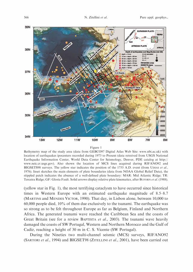
(yellow star in Fig. 1), the most terrifying cataclysm to have occurred since historical
times in Western Europe with an estimated earthquake magnitude of 8.5–8.7
(MARTINS and MENDES VICTOR, 1990). That day, in Lisbon alone, between 10,000 to
60,000 people died, 10% of them due exclusively to the tsunami. The earthquake was
so strong as to be felt throughout Europe as far as Belgium, Finland and Northern
Africa. The generated tsunami wave reached the Caribbean Sea and the coasts of
Great Britain (see for a review BAPTISTA et al., 2003). The tsunami wave heavily
damaged the coasts of SW Portugal, Western and Northern Morocco and the Gulf of
Cadiz, reaching a height of 30 m in C. S. Vicente (SW Portugal).
During the Nineties two multi-channel seismic (MCS) surveys, RIFANO92
(SARTORI et al., 1994) and BIGSET98 (ZITELLINI et al., 2001), have been carried out
Figure 1
Bathymetry map of the study area (data from GEBCO97 Digital Atlas Web Site: www.nbi.ac.uk) with
location of earthquakes ipocenters recorded during 1973 to Present (data retreived from USGS National
Earthquake Information Center, World Data Center for Seismology, Denver, PDE catalog at http://
www.neic.cr.usgs.gov). Also shown the location of MCS lines acquired during RIFANO92 and
BIGSETS98 surveys. The yellow star indicates the position of the 1755 A.D. event (from UDIAS et al.,
1976). Inset sketches the main elements of plate boundaries (data from NOAA Global Relief Data), the
stippled patch indicates the absence of a well-defined plate boundary: MAR: Mid Atlantic Ridge; TR:
Terceira Ridge; GF: Gloria Fault. Solid arrows display relative plate kinematics, after BUFORN et al. (1988).
566 N. Zitellini et al. Pure appl. geophys.,

offshore SW Iberia (Fig. 1) with the aim to localize and to map the tectonic
structures related to the source area of the 1755 Lisbon Earthquake. This research led
to the identification of the most probable source area (ZITELLINI et al., 1999, 2001),
the Marques de Pombal (Fig. 1), an abyssal mountain of tectonic origin located on
the continental margin off SW Iberia, about 100 km WSW of Cape San Vincente
(Fig. 1). This localization was strengthened by the backward ray-tracing tsunami
modeling and shallow-water simulations performed by BAPTISTA et al. (1998). The
two geophysical investigations have shown that besides the Marques de Pombal
Mountain, other active tectonic structures are present in the area. The major aim of
this work is to provide their documentation as well as a more extensive record of
the structural setting of the Marques de Pombal structure. The progress in the
knowledge of the tectonic evolution during Neogene through recent times of the
seismogenic area and the detailed study of the largest tectonic structures is a
necessary step for a better assessment of the seismic/tsunami hazard of the area.
Geological Setting
The region off the SW Iberian Peninsula and the Gulf of Cadiz shows an
important natural seismic activity and puzzling tectonics (Fig. 1). The southern
margin formed during the Jurassic continental breakup between North America and
Africa, the western margin is the result of Cretaceous separation of Iberia with
respect to North America. In the Gulf of Cadiz, the South Iberia and Moroccan
passive margins are partially overlain by a thick accretionary wedge related to the
neogenic westward migration of the Alboran Microplate and by huge olistostromes,
discharged gravitationally from the tectonic melange itself (TORELLI et al., 1997).
According to plate tectonic reconstruction the Eurasia/Africa plate boundary owns
its present configuration only since late Oligocene. The Europe-Africa plate
boundary (inset of Fig. 1) trends roughly E-W, connecting the Azores-Triple
Junction to the Gibraltar Strait. Along this boundary the present plate motion is
divergent east of the Azores with a dextral strike-slip component, transform in the
middle segment, and convergent to the east of the Tore-Madeira Ridge. In the area
between the Gorringe Ridge and the Gibraltar Strait, compressive stress trends
mainly NNW-SSE with plate convergence rate of 4 mm yr1 in the last three million
years. In this area the plate boundary consists of diffuse, active compressive
deformation, distributed over a 200–300 km wide area (SARTORI et al., 1994;
HAYWARD et al., 1999; TORTELLA et al., 1997). The seismicity pattern reflects this
kind of plate interaction with the presence of scattered hypocenters spanning from
shallow in the oceanic area to intermediate depth in the continental domain (Fig. 1).
Focal mechanisms display a mixture of thrust and strike-slip motion (BUFORN et al.,
1988). The plate convergence is responsible for the reactivation of the older rift
faults, and a number of large, active, tectonic structures have been detected along
Vol. 161, 2004 Tectonic Reactivation off SW Iberia 567
the continental margin and within the oceanic domain (ZITELLINI et al., 2001).
Apparently, the tectonic reactivation began in the Miocene. This is supported by the
age of the inversion at the Lusitanian Basin located along the western Portuguese
coast, approximately 150 km North of Cape S. Vicente (RIBEIRO et al., 1990;
KULLBERG et al., 2000) and by the existence of a Middle Miocene major
unconformity observed within the sedimentary cover in the Tagus Abyssal Plain
(MAUFFRET et al., 1989, Fig. 10). In the southern Portuguese Margin, the Miocene
compression is milder and it is superimposed on an older important tectonic
inversion that took place during latest Cretaceous through Paleogene times
(TERRINHA, 1998). Two major questions arise to assess the seismic/tsunami hazard
of the area. One is related to the dimension of the rupture area of the 1755 Lisbon
Earthquake. ZITELLINI et al. (2001) suggested that the most probable location of the
source area of this great earthquake is the Marques de Pombal Thrust Fault (MPTF
in Fig. 3) which, during the earthquake, may rupture simultaneously with a
subsidiary thrust fault acting as a back thrust fault. The resulting earthquake
magnitude for a mean displacement of 15 meters of the hypothesized rupture system
is of the same order of magnitude of the 1755 Lisbon Earthquake although it does
not reach the 8.5–8.7 value inferred by MARTINS and MENDES VICTOR (1990). This
implies that the hypothesized rupture system could be part of a larger generator
involving an area twice as large as the one calculated in ZITELLINI et al. (2001). This
fact is stressed by the recent paper of TERRINHA et al. (2003), which suggests a
northward continuation of the fault system associated with the Marques de Pombal
structure. The second question is related to the possible presence of other potential
seismogenic/tsunamigenic structures offshore SW Iberia. This is testified by the
occurrence of other historical large earthquakes and tsunamis, such as the 1531,
which was probably as strong as the 1775 Lisbon event, and the 1722 event, that were
mostly likely located offshore SW Portugal (UDIAS et al., 1976). An additional
question arises concerning the reciprocal interaction of the various active tectonic
structures during an earthquake activity. This last point is far beyond the scope of
the present work because we lack the key data relative to the architecture of the
decollement surfaces at depth and the knowledge of the rheology and the thermal
state of the crust.
MCS Acquisition and Processing
The first survey (RIFANO92 lines in Fig. 1) was sponsored by the Italian
Consiglio Nazionale delle Ricerche. The survey was performed during 1992 on
board the R/V OGS-Explora and collected 2,000 km of seismic lines across the
Africa-Europe plate boundary: from Seine to Tagus Plains and from Gibraltar Arc
to Horseshoe Plain. The energy source was generated by a 32 airgun array with a
total volume of 4880 cubic inches and 50 m shooting interval. The data were
568 N. Zitellini et al. Pure appl. geophys.,

acquired with a 3000-m-long, 120-channel streamer, with 25 m group interval. The
second survey was performed in 1998 and was funded by the European
Community, project BIGSETS (BIG Sources of Earthquake and Tsunami in SW
Iberia, ENV4-CT97–9547). BIGSETS survey was focused in the area between the
Gorringe Ridge and the continental margin of SW Portugal to investigate the
tectonic deformation related to the ‘‘1755 Lisbon Earthquake’’ (BIGSETS98 lines
in Fig. 1). This second survey collected 1,715 km of seismic lines and it was carried
out on board the R/V Urania. The data were acquired using a 48-channel, 1,200-m-
long streamer made available by the Institut de Ciencies de la Terra Jaume Almera
of Barcelona (Spain). The energy source was generated by two GI guns with total
volume varying from 150 to 465 cubic inches and shooting interval of 25, 37 and 50
meters. The processing of the MCS lines shown in this paper was performed at the
Institute of Marine Geology of Bologna using the commercial DISCO package of
PARADIGM Inc. The processing sequence was: decimation from 2 ms to 4 ms,
common depth point gathering, spiking deconvolution in RIFANO92 lines,
velocity analysis every 2.5 km, normal move out correction, CDP staking, spherical
divergence correction, finite-difference wave-equation migration using stacking
velocities with reduction of 10%.
Data Description
The first investigation, the RIFANO92 survey (Fig. 1), was designed to acquire
geophysical information, on a regional scale, about the plate interaction between
Africa and Europe across the plate boundary in the region of the Gorringe Ridge.
The MCS lines were shot in E-W and NNW-SSE direction, roughly parallel and
perpendicular to the present day NNW-SSE slip vectors. One 500-km-long, east-west
oriented, line AR01 (Fig. 1) was acquired from Gibraltar Arc to the Horseshoe Plain.
One NNW-SSE line was shot from the Tagus to the Seine Plain throughout the
deformed area of the Gorringe Ridge (line AR03-AR08 in Fig. 1). This line was
located entirely in oceanic domain, from the undeformed Cretaceous oceanic crust of
the Tagus Plain to the undeformed Jurassic oceanic crust of the Seine Plain. Another
NNW-SSE MCS line AR10 (Fig. 1) was shot closer to SW Iberia, entirely in
continental domain. The main results from this study have been reported by TORELLI
et al. (1997) for line AR01, SARTORI et al. (1994) for line AR03-AR08 and ZITELLINI
et al. (1999) for line AR10. The whole MCS data set showed that the area is
dominated by the presence of compressive tectonic structures, most of them still
active. In particular the discovery of a large tectonic structure 100 km WSW of Cape
S. Vicente, thought as the possible generator of the 1755 Earthquake (ZITELLINI
et al., 1999), led to the acquisition campaign BIGSETS98. This campaign was
designed to investigate in detail the structure found offshore Cape S. Vicente and to
search for other possible, undetected tsunamigenic sources along the margin. The
Vol. 161, 2004 Tectonic Reactivation off SW Iberia 569

first results of BIGSETS98, regarding the structure found offshore Cape S. Vicente,
were described by ZITELLINI et al. (2001), who named the structure ‘‘Marques de
Pombal.’’ Here we report a more comprehensive documentation on the Marques de
Pombal and on the other active structures found along the SW Iberia continental
margin integrating the RIFANO92 and BIGSETS98 data sets. The data show that
all the major morphological features, i.e., the Marques de Pombal Mountain, the
Horseshoe Scarp, the Guadalquivir Bank, the Gorringe Ridge, the Princes de Avis
Mountains and the Pereira de Sousa Scarp (Fig. 1) are of tectonic origin. For clarity
we will describe them individually.
Marques de Pombal Mountain
The continental slope of the SW Portuguese Margin displays two promontories
before reaching the abyssal depths, the Marques de Pombal Mountain (Fig. 1 and
MPM in Fig. 2) and the Principes de Avis Mountains (Fig. 1 and PAM in Fig. 2),
both described in this paper. The Marques de Pombal Mountain stands out
morphologically as an elevated rectangular smooth surface bounded by the Pereira
Figure 2
Bathymetry map of the study area. Contours are every 400 m (data from GEBCO97). Heavy lines
represent the portions of the MCS lines shown in the following figures. Grey shaded areas indicate
compressional structures. MPM: Marques de Pombal Mountain; HSS: Horseshoe Scarp; GB:
Guadalquivir Bank; PSS: Pereira de Sousa Scarp; PAM: Principes de Avis Mountains.
570 N. Zitellini et al. Pure appl. geophys.,

Figure
3
Post-stack
timemigrationoflineAR10,forlocationseeFigures2and5.
Vol. 161, 2004 Tectonic Reactivation off SW Iberia 571

Figure
4
LineAR10depth
convertedafter
post-stack
timemigrationusingintervalvelocities
derived
bysm
oothingthestack
velocities.
572 N. Zitellini et al. Pure appl. geophys.,
de Sousa Scarp (Fig. 1 and PSS in Fig. 2) and the Cape S. Vicente Canyon (Fig. 5).
A network of 10 MCS of lines (Fig. 1), 6 of them presented in this paper, could be
used to trace the deformation associated with the Marques de Pombal thrust fault
(MPTF in Fig. 3) and constrain its geometry and kinematics. The whole set of
existent MCS lines show that the Marques de Pombal Thrust Fault consists of an
approximately 55-km long NNE trending blind thrust, breaching through the
youngest sediments of the continental slope only at line BS22 (Fig. 6c). Altogether
the MPTF deforms a 100-km long narrow area that is being transported westwards
on top of a landward dipping thrust whose depth conversion (Fig. 4) revealed an
apparent average dip angle of 24 � in the upper 11 km, according to ZITELLINI et al.
(2001).
To the North, the MPTF does not breach the surface (line BS20, Fig. 6a) and we
observe a simple flexure of the sediment cover on the hanging-wall (line BS20,
Fig. 6a; line BS21, Fig. 6b) of MPTF. Inspection of Figs 6b and 6c shows that the
maximum uplift and steepest scarp along the MPTF occur on lines BS21 and BS22.
To the South, lines BS23 and BS24 (Figs 6d, 6e) show the presence of two anticlines
in the hanging-wall of MPTF. These observations indicate that the style of
deformation in the northern and southern parts of the MPTF is different. This,
together with the different strike of the fault between these two, led to propose that
the MPTF constitute two independent fault segments connected by a relay fault zone
(Fig. 5), as suggested by TERRINHA et al. (2003).
Figure 5
Tectonic sketch of the Marques de Pombal Mountain.
Vol. 161, 2004 Tectonic Reactivation off SW Iberia 573

Figure 6
a) Time migration of line BS20, b) time migration of line BS21, c) time migration of line BS22 showing the
Marques de Pombal Thrust Fault (MPTF) breaching the sea bottom, d) time migration of line BS23, e)
time migration of line BS24; all the lines have been acquired across the Marques de Pombal structure, until
the Cabo de Sao Vicente Canyon.
574 N. Zitellini et al. Pure appl. geophys.,

The NNE-SSW striking faults of the western Portuguese Margin are generally
inherited from the late orogenic Variscan fracturing event of Permian age
(ARTHAUD and MATTE, 1977). It is somewhat possible that the MPTF was
originally formed in the late stages of the orogenic event and that it played an
active role during the Mesozoic tectonic extension and was reactivated again in the
Cenozoic.
Figure 6
(Contd.)
Vol. 161, 2004 Tectonic Reactivation off SW Iberia 575

Horseshoe Scarp
The Horseshoe Scarp is a prominent feature that bounds eastward the
Horseshoe Plain (Fig. 1). The Horseshoe Plain lies at a depth of 5000 m and is
filled by about 2–5 km of sediments, where the oldest sediments are probably of
Late Jurassic age (SARTORI et al., 1994; HAYWARD et al., 1999). Underneath the
Horseshoe Scarp develops the Horseshoe Fault (HSF in Fig. 7) which consists of a
NE-SW trending blind thrust. The chaotic body present within the sedimentary
section formed by down-slope flow of olistostromes and debris discharged from the
tectonic melange associated with the subduction system of the Betic and Rifain
chain (TORELLI et al., 1997). The emplacement of this huge chaotic body formed by
Figure 7
a) Time migration of line AR01 across the Horseshoe Scarp (HSS), for location of the MCS line see
Figure 2. b) Interpretative sketch of the seismic line.
576 N. Zitellini et al. Pure appl. geophys.,

mass transport processes is certainly contemporaneous with the main uplift phase
of the Betic-Rifain Cordillera of Middle to Late Miocene times, whilst the tectonic
melange associated with the Africa-Iberia subduction is older, possibly of
Paleogene age, also the age of tectonic inversion of the Algarve Basin, South
Portugal (TERRINHA, 1998). The chaotic body is capped by plane-parallel, laterally
continuous reflections related to turbiditic sedimentation as suggested by the coring
of the uppermost sediment layers (THOMSON and WEAVER, 1994). The chaotic body
in the Horseshoe Abyssal Plain is an important stratigraphic marker, because it
acts as a reference level for the post Middle Miocene tectonic deformation. The
Horseshoe Fault is very continuous laterally, some 180-km long, it is almost
rectilinear and it extends from the Ampere-Coral Patch Seamounts to the southern
termination of the Cape S. Vicente canyon (Fig. 1). This fault yields a clear
morphological expression (Fig. 1) and it is shown by MCS lines AR01 (Fig. 7),
BS13 (Fig. 8) and also by the reflection profile PQ published in HAYWARD et al.
(1999). The vertical displacement, using the chaotic body as reference level, varies
along the fault increasing from south to north, about 0.7 s TWT in line AR01
(Fig. 7) and 1.6 s TWT in line BS13 (Fig. 8). This is also evident from the
bathymetry map (Fig. 1). AR01 (Fig. 7) and BS13 (Fig. 8) MCS lines show that
movements along the Horseshoe Fault post-date the deposition of the chaotic
body. Moreover the fault is active at present since it deforms the uppermost
sediments which, by lateral correlation with other BIGSETS MCS lines, can be
dated as Quaternary. From our data set we cannot infer the southern and northern
termination of the fault.
Guadalquivir Bank Structure
The Guadalquivir Bank shown by line AR04 (Fig. 9) is an elongated ENE-
WSW seamount 50 km long and 30 km wide, (Fig. 1). It formed initially as a
basement horst during the Mesozoic stretching of the southern Iberia continent
and it represents the southern boundary of the Algarve Basin, whose rift phases
lasted from Triassic to Albian-Cenomanian times (TERRINHA, 1998). Dredges
taken from this seamount show that the basement crops out at the sea floor and
consists of the low grade metamorphic sediments of Carboniferous age of the
South Portuguese Zone (TERRINHA, 1998). MCS lines acquired across this
basement high show that it is partially covered by sediments of Miocene through
Quaternary age. The Guadalquivir Bank behaved as a rigid block during the main
phases of tectonic inversion of the Algarve Basin of Late Cretaceous-Paleogene age
during which it suffered uplift and compression. During Neogene times it subsided
more than 1 km during the formation of the flexural Miocene Algarve Basin
(TERRINHA, 1998).
Vol. 161, 2004 Tectonic Reactivation off SW Iberia 577

Line AR04 (Fig. 9) shows that the Guadalquivir Bank is presently bounded by
reverse faults (T1 and T2 in Fig. 9), which are responsible for the subsequent vertical
uplift of the basement. The displacement of the most recent reflectors shows the
Figure 8
a) Time migration of line BS13a showing the northern termination of the Horseshoe Scarp and associated
Fault (HSS and HSF), for location of the line see Figure 2. b) Interpretative sketch of the seismic line.
578 N. Zitellini et al. Pure appl. geophys.,
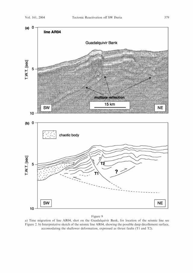
Figure 9
a) Time migration of line AR04, shot on the Guadalquivir Bank, for location of the seismic line see
Figure 2. b) Interpretative sketch of the seismic line AR04, showing the possible deep decollement surface,
accomodating the shallower deformation, expressed as thrust faults (T1 and T2).
Vol. 161, 2004 Tectonic Reactivation off SW Iberia 579

present-day activity of the reverse faults, and the displacement of more than 1.0 s
TWT of the chaotic body indicates the importance of the post Middle Miocene
tectonic shortening in this sector. This is also testified by the presence of a cluster of
shallow seismic activity just underneath and northward of the structure (Fig. 1). The
paucity of MCS lines in this sector does not allow the determination of the fault trace
around the structure.
Gorringe Ridge
The Gorringe Ridge (Fig. 1) is the most important topographic feature of the
area. It is an uplifted block of crustal and upper mantle rocks (AUZENDE et al., 1978;
AUZENDE et al., 1982; RYAN et al., 1973; FERAUD et al., 1986; GIRARDEAU et al.,
1998) forming one of the most prominent gravimetric anomalies of the world. The
Gorringe Ridge separates the 5000 m deep Tagus Abyssal Plain from the Horseshoe
Abyssal Plain reaching a water depth of 25 m at its top. The Gorringe Ridge trends
NE-SW, it is 200-km long and 60-km wide and it is asymmetric with the northern
flank steeper than the southern. The Gorringe Ridge was considered the most likely
tectonic source for the 1755 Lisbon Earthquake (FUKAO, 1973) until the work of
BAPTISTA et al. (1998), who demonstrated that the source zone should trend N-S and
have proximity to the Portuguese coast. SARTORI et al. (1994) showed that the
Gorringe Ridge overthrusted the Tagus Abyssal Plain for 4–5 km. RYAN et al. (1973)
suggested that the uplift of the Gorringe Ridge occurred during post-Langhian, pre-
early Pliocene time. Additional details of the structure can be inferred from the
BIGSETS98 lines (Fig. 1). These MCS lines were collected on the eastern side of the
Gorringe, presumably on thinned continental crust. Here the presence of a thicker
sedimentary cover allows a better understanding of the deformation patterns and the
tectonic timing. In Figure 10 MCS line BS13b summarizes the characteristics of this
sector. Here the vertical uplift is still considerable, of the order of 3.0 secs TWT, and
the flanks of the Gorringe Ridge are still asymmetric with the northern side steeper
than the southern. This asymmetry is reflected by the different degree of tectonic
deformation which is very intense in the northern side and on the apex of the
seamount while it is minor in the southern flank. A relevant unconformity is
detectable in the Tagus Abyssal Plain (Fig. 10). This unconformity marks the end of
the northwestwards directed over thrusting of the Gorringe Ridge. This unconfor-
mity has a regional significance being widespread all over the Tagus Abyssal Plain
and it corresponds to the unconformity found by MAUFFRET et al. (1989) in the area.
Unfortunately there is no precise time calibration of this unconformity. MAUFFRET
et al. (1989) assigned a Mid-Miocene age to it, based on seismic correlation with
DSDP site 398 (SIBUET et al., 1979).
580 N. Zitellini et al. Pure appl. geophys.,

Principes de Avis Mountains
The Principes de Avis Mountain is located on the continental slope (Fig. 1) and it
lies on the continuation of the Gorringe Ridge and has the same NE-SW trend. MCS
line BS08 (Fig. 11) crosses the structure normal to the major axis and displays the
presence of two folds trending parallel to the mountain. The two folds are
asymmetric and their geometry indicates northwestward tectonic transport direction.
The southern fold is a nice example of ductile deformation of the sedimentary cover
on top of a blind thrust dipping to the southeast. Shortening and uplift caused the
progressive southeastward migration of the basin’s depocenter, which is presently
closer to the Pereira de Sousa Scarp (Fig. 11). Within the sedimentary cover of the
modern Rincao do Lebre Basin a major unconformity separates a lower sequence of
plane-parallel reflectors from an upper one of progressive on-lapping reflectors (‘‘Y’’
in Fig. 11). This unconformity separates the pre-deformation from the syn-
deformation or syntectonic sedimentary units; unfortunately there is no time
calibration available for the unconformity. A second unconformity located in the
upper part of the younger sequence marks the end of the contraction phase (‘‘X’’ in
Fig. 11). This unconformity is less clear and separates a lower ‘‘wedged’’ sequence
from an upper one made up of more parallel, laterally discontinuous reflectors, which
are related to re-sedimentary processes such as mass flow and debris flow originating
from the flank of the topographic high. These processes are probably the cause of the
Figure 10
Time migration of line BS13b showing fold-related structures on the northeastern termination of the
Gorringe Ridge and the Middle-Miocene unconformity in the Tagus Abyssal Plain, for location see
Figure 2. The inset shows a magnification of the Tagus Abyssal Plain sedimentary sequence at the foot of
the Gorringe Ridge.
Vol. 161, 2004 Tectonic Reactivation off SW Iberia 581

local thickening of sediments on both sides of the basin. This unconformity is also
poorly constrained in time.
Pereira de Sousa Scarp
The Pereira de Sousa Scarp (Fig. 1) is the morphological expression of a fault
formed initially as a rift fault during the Mesozoic continental separation between
Figure 11
a) Time migration of line BS08 showing the basin Rincao do Lebre between the Principes de Avis
Mountains and the Pereira de Sousa Scarp (see Figs. 1 and 2 for location). Also shown is the intersection
with line BS18, shown in Figure 12. b) Interpretative sketch of the seismic line: letters indicate the major
unconformities recognized within the basin and b = basement top. m =Middle Miocene unconformity; y,
x, more recent angular unconformities, see text for a more exhaustive discussion.
582 N. Zitellini et al. Pure appl. geophys.,

Iberia and North America (PSF in Fig. 12). This fault originated one of the most
prominent morphological features of the continental margin off SW Portugal, even
recognizable on the bathymetry map (Fig. 1). The fault trends approximately N-S,
offsets the basement by more than 4.5 s TWT and exhibits a steep well preserved
fault scarp 600-m high (Fig. 12) and 45-km long (Fig. 1). The Pereira de Sousa Fault
is described in this paper because of its following singular characteristics: 1) it
Figure 12
a) Time migration of line BS18 shot normal to the Pereira de Sousa Scarp (PSS), showing the scarp and the
intersection of line BS08, for location see Figure 2. b) Interpretative sketch of the seismic line, showing the
same angular unconformities presented in Figure 11.
Vol. 161, 2004 Tectonic Reactivation off SW Iberia 583

remains an extensional fault from a geometrical point of view, despite the fact of
being located in an area where compressive deformation is widespread, 2) it is
laterally bounded by two compressional structures, the Marques de Pombal
Mountain and the Principes de Avis Mountain also described in this paper, 3) it
represents the best developed morphological scarp of the area and 4) it is associated
with the development of an active sedimentary system that produces sedimentary
ridges that can reach 20 km of run out distance (TERRINHA et al., 2003). The
geometry of the PSF is best shown on MCS line BS18, which is normal to it (Fig. 12).
The Pereira de Sousa fault limits landward the lower continental slope where a
thick sedimentary basin, 3.0 s TWT, is present (Fig. 12). The fault is listric as testified
by the marked rotation of a large basement block of the hanging-wall and by the
wedging of the Mesozoic syn-rift sediments (Fig. 12). Line BS18 is parallel to the
direction of the Cretaceous extension while it is almost perpendicular to the direction
of transport of the most recent compressive event. This fact makes the identification
of the tectonic structures, and associated unconformities, more difficult regarding the
last event. We can overcome the difficulties analyzing line BS08 (Fig. 11), which is
nearly parallel to the direction of crustal shortening. On this MCS line we can see
that the major shortening event affecting the post-rift sediments is confined below
unconformity ‘‘X’’ (Fig. 11). Once the unconformity ‘‘X’’ is calibrated on line BS18
(Fig. 12) we infer that above ‘‘X’’ the sedimentation is dominated by sedimentary
processes rather than tectonic movements. At the foot of the Pereira de Sousa Scarp
the post ‘‘X’’ sequence appears related to the interplay of turbiditic with mass and
debris flow deposition filling and smoothing a pre-existent topographic low.
Seaward, in the other side of the basin, the sediment’s mound is possibly related
to velocity drop of turbiditic currents against a preexistent topographic high, with
consequent local deposition. In conclusion, differently from the Marques de Pombal
Mountain, which has a similar trend and a similar Mesozoic history, the Pereira de
Sousa Fault appears only slightly reactivated in compression during pre ‘‘X’’ time. In
any case, at the present stage of knowledge, we cannot rule out that a minor
contraction is also taking place today.
TERRINHA et al. (2003) in fact argue that the PSF is presently being uplifted,
back-rotated, i.e., it is getting steeper and dissected by wrench faults from which can
be inferred a WNW-ESE direction of compression. The completely different
behavior of the Marques de Pombal Mountain and Pereira de Sousa Scarp is still
puzzling and may be related to the different orientation of the MPTF (roughly
N10�E) and PSF (N10�W) with respect to the main stress field.
Discussion and Conclusions
In the investigated area, in addition to the Marques de Pombal, there are at least
two other remarkable, active, tectonic structures related to crustal shortening and
584 N. Zitellini et al. Pure appl. geophys.,
showing considerable tectonic uplift: the Horseshoe Fault and the Guadalquivir
Bank. The Gorringe Ridge and the Principes de Avis Mountains are also
contractional structures although they appear deformed mostly during the Middle
Miocene phase and present activity is almost absent or not detectable at the resolution
of our data set. The most active structures are located where the present seismicity is
higher, i.e., between latitude 35.5�N and 37.0�N and mostly within the continental
crust. The lack of good stratigraphic control of the sedimentary cover prevents a more
precise definition for the start and for the end of the Middle Miocene phase as well as
for the beginning of the inversion of the Marques de Pombal Thrust Fault, the
Horseshoe Fault and the Guadalquivir Bank. The deformation style associated with
the Neogene compressive episodes is very uniform and is expressed mainly by blind
thrusts, i.e., thrust faults that do not reach the surface of the sea bottom. This
deformation style produces folds in the sedimentary cover which are the most
common tectonic features of the area and are easily recognizable in the high-
resolution bathymetric map (GRACIA et al., 2003). Only the largest thrust faults reach
the surface as in theMarques de Pombal structure. The structural trends related to the
Neogene compression found in the oceanic lithosphere are mainly NE-SW as in the
Gorringe Ridge and in the Horseshoe Fault. The structural trends vary considerably
along the continental margin, this is due to the local response to the shortening of pre-
existing E-W Mesozoic and N-S Cretaceous extensional faults of the South and West
Iberian passive margins respectively, as it is testified by the Marques de Pombal and
the Guadalquivir Bank strikes. Locally, along the continental margin, the preexisting
faults may not be, or are only slightly, reactivated as for the Pereira de Sousa Fault.
SARTORI et al. (1994) and HAYWARD et al. (1999) have shown that the deformation
associated with the NE-SW compressive stress is spread over an area 200-km wide.
From our investigations we can attest that the shortening is accommodated, on the
upper crust, mainly by few major but large tectonic structures, of the order of tens of
kilometers. The existence of few major active structures accommodating most of the
deformations and their precise localisation should help greatly for future monitoring
of the structure for risk assessment and forecast. The possible lateral prolongation of
the Marques de Pombal fault system, to obtain a larger rupture area for the 1755
Lisbon Earthquake, has a limited number of solutions being restricted to the
structures found at the Horseshoe Fault and the Guadalquivir Bank. This solution
does not role out the hypothesis of TERRINHA et al. (2003) which needs further proof
to be demonstrated. The way different tectonic structures interact during a very large
earthquake is at the moment speculative because we do not know the position of the
decollement surfaces that may connect at depth the faults observed in the first few
kilometres of crust. The existence at depth of a common decollement surface allows
the contemporaneous, or almost contemporaneous, rupture of more than one fault.
To enlighten this last aspect it will be necessary to perform additional investigations
on the deep structure architecture of the SW Iberian margin.
Vol. 161, 2004 Tectonic Reactivation off SW Iberia 585

Acknowledgements
The research was funded by the EC Environment and Climate Program 1994–
1998, Technologies to Forecast, Prevent and Reduce Natural Risks (contract n.
ENV4-CT97-0547, project BIGSETS). Additional funding was supported by the
Portuguese Project MATESPRO (PDCTM/P/MAR/15264/1999). IGM contribution
No. 1321.
REFERENCES
ARTHAUD, F. and MATTE, P. (1977), Late Paleozoic Strike-slip Faulting in Southern Europe and Northern
Africa: Result of a Right-lateral Shear Zone between the Appalachians and the Urals, Geol. Soc. Am. Bull.
88, 1305–1320.
AUZENDE, J.-M., OLIVET, J. L., CHARVET, J., LEHANN, A., LE PICHON, X., MONTEIRO, J. C., NICOLAS, A.,
and RIBEIRO, A. (1978), Sampling and Observation of Oceanic Mantle and Crust on Gorringe Ridge,
Nature 273, 45–49.
AUZENDE, J.-M. and CYAGOR GROUP II (1982), The Gorringe Ridge: First Results of the Submersible
Expedition CYAGOR II, Terra Cognita 2, 2, 123–130.
BAPTISTA, M. A., MIRANDA, J. M., CHIERICI, F., and ZITELLINI, N. (2003), New Study of the 1755
Earthquake Source Based on Multi-channel Seismic Survey and Tsunami Modeling, Natural Hazards and
Earth System Sciences 3, 333–340.
BAPTISTA, M. A., MIRANDA, P. M. A., and MENDES VICTOR, L. (1998), Constraints on the Source of the
1755 Lisbon Tsunami Inferred from Numerical Modelling of Historical data, J. Geod. 25 (2), 159–174.
BUFORN, E., UDIAS, A., and COLOMBAS, M. A. (1988), Seismicity, Source Mechanisms and Tectonics of the
Azores-Gibraltar Plate Boundary, Tectonophys. 152, 89–118.
FERAUD, G., YORK, D., MEVEL, C., CORNEN, G., HALL, C. M., and AUZENDE, J.-M. (1986), Additional
40Ar/39Ar Dating of the Basement and the Alkaline Volcanism of Gorringe Bank (Atlantic Ocean), Earth
Plan. Sci. Lett. 79, 255–269.
FUKAO, Y. (1973), Thrust Faulting at a Lithospheric Plate Boundary, The Portugal Earthquake of 1969,
Earth plan. Sci. Lett. 18, 205–216.
GIRARDEAU, J., CORNEN, G., BESLIER, M.-O., LEGALL, B., MONNIER, C., AGRINIER, P., DUBUISSON, G.,
PINHEIRO, L., RIBEIRO, A., and WHITECHURCH, H. (1998), Extensional Tectonics in the Gorringe Ridge
Rocks, Eastern Atlantic Ocean: Evidence of an Oceanic Ultra Slow Mantellic Accreting Center, Terra
Nova 10, 330–336.
GRACIA, E., DANOBEITIA, J. J., VERGES, J., CORDOBA, D., and PARSIFAL CRUISE PARTY (2003), Mapping
Active Faults at the SW Iberia Margin (38�–36�) from High-resolution Swath-Bathymetry Data.
Implications for Earthquake Hazard Assessment, Geology 31(1), 83–86.
HAYWARD, N., WATTS, A. B., WESTBROOK, G. K., and COLLIER, J. S. (1999), A Seismic Reflection and
GLORIA Study of Compressional Deformation in the Gorringe Bank Region, Eastern North Atlantic,
Geophys. J. Int. 138, 831–850.
KULLBERG, M. C., KULLBERG, J. C., and TERRINHA, P. (2000), Tectonica da cadeia da Arrabida, Mem.
Geociencias, Museu Nac. Hist. Nat. Univ. Lisboa 2, 35–84.
MAUFFRET, A., MOUGENOT, D., MILES, P. R., and MALOD, J. A. (1989), Cenozoic Deformation and
Mesozoic Abandoned Spreading Center in the Tagus Abyssal Plain (West of Portugal): Results of the
Multichannel Seismic Survey, Can. J. Earth Sci. 26, 1101–1123.
MARTINS, L. and MENDES VICTOR, L. A. (1990), Contribuicao para o estudo da sismicidade de Portugal
continental. Univ. De Lisboa, Instituto Geofisico do Infante D. Luis, publicacao 18, 1–70.
RYAN, W. B. F. et al. (1973), Initial Reports of the Deep Sea Drilling Project, 13, pp. 19–41, US Gov.
Printing Office, Washington, DC.
586 N. Zitellini et al. Pure appl. geophys.,

RIBEIRO, A., KULLBERG, M. C., KULLBERG, J. C., MANUPPELLA, G., and PHIPPS, S. (1990), A review of
Alpine Tectonics in Portugal: Foreland Detachment in Basement and Cover Rocks, Tectonophysics 184,
357–366.
SARTORI, R., TORELLI, L., ZITELLINI, N., PEIS, D., and LODOLO, E. (1994), Eastern Segment of the Azores-
Gibraltar Line (Central-eastern Atlantic): An Oceanic Plate Boundary with Diffuse Compressional
Deformation, Geology 22, 555–558.
SIBUET, J.-C., RYAN, W. B. F. et al. (1979), Initial Reports of the Deep Sea Drilling Project, 47, US Gov.
Printing Office, Washington, DC.
TERRINHA, P., PINHEIRO, L. M., HENRIET, J.-P., MATIAS, L., IVANOV, M. K., MONTEIRO, J. H.,
AKHMETZHANOV, A., VOLKONSKAYA, A., CUNHA, T., SHASKIN, P., ROVERE, M., and the TTR10
SHIPBOARD SCIENTIFIC PARTY (2003), Tsunamigenic-seismogenic Structures, Neotectonics, Sedimentary
Processes and Slope Instability on the Southwest Portuguese Margin, Marine Geology 195, 55–73.
TERRINHA, P. (1998), Structural Geology and Tectonic Evolution of the Algarve Basin, South Portugal,
Ph.D. Thesis, Imperial College, London.
THOMSON, J. and WEAVER, P. P. E. (1994), An AMS Radiocarbon Method to Determine the Emplacement
Time of Recent Deep-sea Turbidites, Sed. Geol. 89, 1–7.
TORELLI, L., SARTORI, R., and ZITELLINI, N. (1997), The Giant Chaotic Body in the Atlantic Ocean off
Gibraltar: New Results from a Deep Seismic Reflection Survey, Mar. Pet. Geol. 14, 125–138.
TORTELLA, D., TORNE, M., and PEREZ-ESTAUN, A. (1997), Geodynamic Evolution of the Eastern Segment of
the Azores-Gibraltar Zone: The Gorringe Bank and the Gulf of Cadiz Region, Mar. Geophys. Res. 19,
211–230.
UDIAS, A., LOPEZ-ARROYO, A., and MEZCUA, J., (1976), Seismotectonic of the Azores-Alboran Region,
Tectonophys. 31, 259–289.
ZITELLINI, N., CHIERICI, F., SARTORI, R., and TORELLI, L. (1999), The Tectonic Source of the 1755 Lisbon
Earthquake and Tsunami, Annali di Geofisica 42, 1, 49–55.
ZITELLINI, N., MENDES, L. A., CORDOBA, D., DANOBEITIA, J., NICOLICH, R., PELLIS, G., RIBEIRO, A.,
SARTORI, R., TORELLI, L., BARTOLOME, R., BORTOLUZZI, G., CALAFATO, A., CARRILHO, F., CASONI, L.,
CHIERICI, F., CORELA, C., CORREGGIARI, A., DELLA VEDOVA, B., GRACIA, E., JORNET, P., LANDUZZI,
M., LIGI, M., MAGAGNOLI, A., MAROZZI, G., MATIAS, L., PENITENTI, D., RODRIGUEZ, P., ROVERE, M.,
TERRINHA, P., VIGLIOTTI, L., and ZAHINOS-RUIZ, A. (2001), Source of 1755 Lisbon Earthquake and
Tsunami Investigated, EOS, Transactions, Am. Geophys. Union 82, 26, 285–282.
(Received June 5, 2002, revised February 2, 2003, accepted February 26, 2003)
To access this journal online:
http://www.birkhauser.ch
Vol. 161, 2004 Tectonic Reactivation off SW Iberia 587