Advisory for SW monsoon Preparedness.pdf
145
-
Upload
khangminh22 -
Category
Documents
-
view
0 -
download
0
Transcript of Advisory for SW monsoon Preparedness.pdf


Name Of The District: Date:
Total Score Number of Villages that are identified as vulnerable to flood and landslide
Total number of the population estimated to be vulnerable to flood?
Number of identified population 1. Pregnant women, 2. Disabled, 3. Migrants and 4. Children in the vulnerable population
Have you Identified Vulnerable critical infrastructure i.e roads, connectivity (mobile network) drainage, water supply, schoolsetc (Yes/No)
Have you prepared a detailed vulnerability points on the district map (Yes/No)
8
If answered = 1, If no: 0 ( Number of villages indicate the
severity of the problem)
If answered = 1, if no: 0 ( Number of population indicates the severity of
the problem)
If all vulnerables identified 4, if any three identified 3, if two identified: 2, anyone
identified: 1, not identified: 0If yes: 1, If no: 0 If yes:1, If no: :0
Good: 6 - 8,Average: 3-5,
Poor: 0-3
Total ScoreHave you formulated a team
for earlywarning to monitor rainfall,
water levels in the dams, thunderstorm, lightening and
to disseminate alerts and warning? (yes/No)
Narrate the mechanism established for
communicating the early warnings ?
Have you developed determinants ( Water level,
rainfall etc.) for the evacuation in consultation
with nodal agencies?
Have you planned any early evacuation of the villages or specific pockets in your districts?
Have you appointmented nodal officers for the vulnerable gram panchayats?
9
If Yes: 1, If No: 0 Narrative: 0 - 5 Marks If Yes answer 1; If No: 0 If Yes answer 1; If No: 0 If Yes answer 1; If No: 1Good: 7-9Average: 4-6Poor: 0-3
Total ScoreHave you evolved any plan for search, rescue and evacuation in the district inclusive of the road map, transportation plan etc? (Yes/No)
Have you established Coordination mechanism to facilitate search, rescue and evacuation among police, fire and emergency, local teams and external forces like NDRF,army etc? (Yes/No)
Explain the status of the inventory and procurement of search, rescue equipment?
Narrate how are you prepared for mass casualty management (Ambulances & other transport arrangements, Hospital identification, facilities at hospitals)?
Any mock drills conducted amid COVID 19 for the flood preparedness?
9
If Yes: 1, If No: 0 If Yes: 1, If No: 0Good: 3, Satisfactory: 2,
Poor: 1Good: 3, Satisfactory: 2, Poor: 1 If yes: 1, If no: 0
Good: 7 - 9,Average: 4-6,
Poor: 0-3
Total ScoreWhat is the status of DDMA meetings ?
Narrate the arrangements for uninterrupted essential services? ( Road, Electricity, clearing of drains/ channels/ debris removal, tree pruning, etc.
Narrate your plans for the management of drinking water (source of the water and water supply) in case of emergency?
Narrate the arrangements for stocking of essential commodities (food grain, kerosene oil, salt, edible oil etc) including medicine?
What is the status of Emergency Operation Center/Control Room (District level, taluka level, corporation, andmunicipality)?
15
1. Vulnerability Assessment:
2. Early warning and early Evacuation:
3. Search, Rescue & Evacuation Plan
Annexure I - Status of District Flood Preparation and Evaluation Matrix
4. Preparedness for the Emergency Relief Response & Emergency operation Centre
Good: 3, Satisfactory: 2, Poor: 1Good: 3, Satisfactory: 2,
Poor: 1Good: 3, Satisfactory: 2,
Poor: 1Good: 3, Satisfactory: 2, Poor: 1
Good: 3, Satisfactory: 2,Poor: 1
Good: 11 - 15,Average: 6-10,
Poor: 0-5
Total ScoreNumber of Shelters Identified Adequate facility to
ensure Water, Sanitation (temporary toilets, waste management, vector control etc) and Hygiene in the shelter place (Yes/No)
Identified and made necessary arrangements for Food and nutrition in the shelter (yes/no)
Identified and Stock held of non-food items: clothes, buckets, mugs etc (yes/no)
Health teams identified for Shelters: RCH, MCH, Communicable diseases, psychological first aid and psychosocial care and
7
If Yes: 1, If No: 0Good: 3, Satisfactory: 2,
Poor: 1If Yes: 1, If No: 0 If Yes: 1, If No: 0 If Yes: 1, If No: 0
Good: 5-7,Average: 3-4 ,
Poor: 0-2
Total ScoreNarrate comprehensive plan made for early evacuation ofcattle?
Identification of community cattle shed with the provision offodder? (yes/no)
Identification medicine stock and veterinary team? (yes/no)
Mobile team for the search, rescue and evacuation of the cattle.(yes/no)
Carcass management plan (yes/no)
7
Good: 3, Satisfactory: 2, Poor: 1 If Yes: 1, If No: 0 If Yes: 1, If No: 0 If Yes: 1, If No: 0 If Yes: 1, If No: 0Good: 5-7,
Average: 3-4,Poor: 0-2
Total ScoreGive narration about the mechanism established for the Rapid Damage Assessment in case of flood or landslide?
Details of measures taken by Gram Panchayat about Disaster Management plan ?
Narrate how are you involving the community, NGOs and other stakeholders?
Details of the status of capacity building training undertaken for the disaster preparedness including volunteers training etc?
Narrate how you are creatingawareness on individual disaster preparedness and family disaster
15
Good: 3, Satisfactory: 2, Poor: 1Good: 3, Satisfactory: 2,
Poor: 1Good: 3, Satisfactory: 2,
Poor: 1Good: 3, Satisfactory: 2, Poor: 1
Good: 3, Satisfactory: 2,Poor: 1
Good: 11 - 15,Average: 6-10,
Poor: 0-5
Total: 70Good: 50 - 71Average: 25 - 49Poor: 0 - 24
6. Animal Protection and Carcass Management
Deputy Commissioner and Chairman DDMA
8. Challenges if any
9. Suggestions if any
7. Damage Assessment
5. Status of Shelter Management:

1
Annexure II
STANDARD OPERATING PROCEDURES (SOP)
Department Wise Response to Disaster (Flood)
DISTRICT CONTROL ROOM
a. Vulnerability Map of the District.
b. Resource Inventory, Capacity Analysis.
c. List of Cut off Areas with Safe Route Map for Communication.
d. List of Storage Facilities, Dealers of Food.
e. Control Room Setup/Assignment of Control Room Duty.
f. Pre-Positioning of Staff for Site Operation Centres.
g. Arrangement of Alternative Communication/Generator Sets Etc.
h. Arrangement of Vehicles/Boats for Evacuation.
i. Dissemination of Warning/ Coordination with District Control Room.
j. Maintain Law & order.
k. Undertake search & rescue works well as orderly evacuation to safer places.
l. Undertake firefighting, if occurs.
m. Protection of supply & convoys and assist in orderly distribution of relief
assistance.
Advance Preparedness
a. Formation of team & delegation or areas.
b. Skill up gradation trainings for the officers and Supporting staff & wardens/ Post
wardens.
c. Mock drills according to plans.
d. Equipment/ machines upgraded & are in working condition.

2
e. Conduct Community capacity building programme at District/Sub-Divn/
panchayath and school level.
f. Emergency Control Rooms Operational.
g. Adequate warning mechanism for evacuation.
h. Identification of alternative routes.
i. Important telephone/ Contact details available.
j. Unsocial elements/ ground identified.
k. Identification of sensitive areas and patrolling.
l. Patrolling on important building/ highways.
m. Support to administrative on training to volunteers.
n. Keeping close contact with administration.
1) REVENUE DEPARTMENT
a. Establish linkages with District Control Rooms.
b. Close Contact with Armed Forces for specialized assistance/ equipment’s for
search and rescue.
c. Establish Radio Communication through joint Control Rooms (JCR) to assist
evacuation, information dissemination and checking rumours.
d. Evacuation of people & immediate reporting to higher authority.
e. Assist seriously injured persons to go to treatment centres.
f. Maintain law and order.
g. Assist fire brigade personal in their efforts.
h. Assist and encourage the community in road clearing operation.
i. Traffic management and patrolling as required.
j. Salvage operation.
k. Provide security in transit and relief camps, affected areas, lifeline,
infrastructures & services, ensure, identified are cordoned off.

3
l. Provide security arrangement for visiting VVIPS and VIPs.
m. Assist administration to take necessary actions against hoarders, block marketers
and those manipulating relief materials.
n. Identified and register the names of the dead and disposal persons.
o. Assist administration in supply and distribution of relief materials.
p. Deploy police personnel near relief godowns.
q. Escort relief carrier vehicle and personnel.
r. Regular reporting to higher authority about the situation including expenditure
statement etc.
s. In post-disaster phase, sit with the teams, discuss problems, suggest remedies,
collect feedback etc., to upgrade mitigation as well as action plans.
t. Taking up Rapid Visual Screening (RVS) and other necessary assessment, non-
destructive test & retrofitting of roads and bridges.
u. List of safe alternative routes.
v. Important/ contact details available.
w. Training of masons on retrofitting and building bye-laws.
x. Keeping close contact with administration.
y. Pre-contact arrangement with suppliers for requisite equipment/stores.
z. Generate awareness on community level preparedness.
2) HEALTH & FAMILY WELFARE DEPARTMENT
To provide immediate medical, health and public hygiene service. To check outbreak of
epidemics and provide onsite OT and Trauma service.
Advance preparedness
a. Identify likely diseases associated with disasters.
b. Setting of quick response teams with team leader and supporting staff (identify
by name & allocation)

4
c. Skill up gradation training for the officers/supporting staff & volunteers.
d. Plan for emergence accommodation for staff & other officers from outside area.
e. Equipment/machines etc., upgraded & are in working condition.
f. Emergence fuel stored, vehicles including it is batteries inspected & are in
working condition.
g. List of safe alternative routes.
h. Important/contact details available.
i. Keeping close contact with administration.
j. Determine the quantity, Type of medicines, medical support, equipment etc., that
will be required per day/district Sub-Division/Block village, including relief
camps etc., in case of and emergency.
k. Maintain inventory including portable equipment’s at different locations.
Post Disaster Management
a. Establish linkages with District Control Room.
b. Close contact with administration.
c. Large stock of surgical packs be sterilized to last for one week, at least & keep in
a safer place.
d. Arrange for emergency supplies of anorthic drugs.
e. Acquisition of medical/equipment etc., as per the pre-contact with the suppliers.
f. Ensure stock of equipment and drugs, which are needed and/or request HQ on
priority basis, to supply to the hospital immediately,
g. Arrangement of alternative power/energy source as planned, to operate hospital
centres and ensure adequate sanitary condition.
h. All valuable equipment/instruments and medicines should be packed in
protective covering and stored in a safer place authority as planned and establish
communication links.
5
i. Ensure storage of safe drinking water and encourage water saving in the hospital.
j. Ensure emergency admission procedures with adequate record keeping &
establish public information centre to let the people know about the type of job
done and the necessary relief aid/new schemes etc.
k. Ensure availability of staff and teams of doctors and assistants visiting disasters
sites.
l. Assist volunteers/village leader/police personnel in rescue & evacuation and/of
disposal of carcass as well get as will as get insurance benefit.
m. Assist administration for setting up transit and camps, feeding centre and ensure
adequate sanitary condition.
n. All valuable equipment/instrument and medicines should be packed in
protective covering and stored in a safer place.
o. Regular reporting to higher authority about the situation including expenditure
statement etc.
p. In post operation phase, sit with the teams, review situation, discuss problem,
suggest remedies, collect feedback etc., to upgrade mitigation as well action
plans.
3) Water Resources
a. Communication establishment with District and Block Control Rooms and
departmental offices within the district.
b. An Officer to be appointed as Nodal Officer.
c. Activation of flood monitoring mechanism.
d. Methods/ communication arrangement of alerting officers on various sites
established.
e. Mechanism evolved for forewarning settlements in the down stream/
evacuation/coordination with other dam authorities
f. Identification of materials required for response operations.

6
g. Repairs/under construction activity is well secured.
h. Water level gauges marked.
i. Inlet and outlet to tanks are cleared.
j. Watch and ward of weak embankments & stock piling of repair materials at
vulnerable points. Guarding of weak embankments. All staff informed about the
disasters, likely damages and effects.
4) ELECTRICITY DEPARTMENT
Restoration of power supply and making provision of power/electricity to
hospitals, lifeline building, feeding centre.
Advance Preparedness
a. Clear definition of individual domain- who will do what?
b. Skill up-gradation training for the officers/supporting staffs.
c. Identify hazard prone zones. Formation of team & delegation of areas.
d. Plan for Emergency accommodation for officers & staff from outside area.
e. Equipment/machines etc. are in working condition.
f. Emergency fuel stored, vehicles including its batteries inspection & are in
working condition.
g. List of alternative safe routes.
h. Important telephone/contact details available/
i. Pre-contact with suppliers(equipment).
j. Arrange disaster management took kit, at each Sub-station, comprising cable
cutters, pulley, blocks, jungle knives axes, crowbars, ropes back saw spanners
and tents for crews.
k. Generate awareness on community level preparedness.
Post Disaster Management
a. Establish linkages with District control Rooms.
7
b. Deployment team with necessary equipment logistic support and authority as
planned and establish communication links.
c. Switch of the power supply immediately avoid further damaged to file and
property during the time the disaster.
d. Immediately undertake inspection of power grids, barrage, high tension lines,
tower, substations, transformers, insulators, poles, and other, high equipment
and review extent of damage undertake restoration works.
e. Restore power supply and ensure uninterrupted power to all vital installation
facilities and sites(relief camps, feeding centre, go down)
f. Recruit casual labours on an emergency basis for cleating damaged poles and
salvage of important equipment and accessories.
g. Requisition off equipment etc as per the pre-contact with the suppliers.
h. Arrangement of alternative power/energy sources, as planned to operate hospital
centre’s and lifeline buildings (DM & Collector/ office/Dist. EOCs/police
stations/BSNL Building etc.,
i. Regular reporting to higher authorities about the situation including expenditure
statement etc.
j. In post operation phase, sit with the team, review situation, discuss problems,
and suggest remedies, collect feedback etc to upgrade mitigation as well as action
plans.
5) AGRICULTURE DEPARTMENT
Assist in assessment of damage to agriculture & farming community and help them to
restart their agriculture/farming operations.
Advance preparedness
a. Identify hazard prone zones.
b. Skill up gradation training for the officers/supporting staff & volunteers.
c. Formation of team & delegation of areas,
8
d. Plan for emergency accommodation for agriculture staff & other officers from
outside area.
e. Equipment/machines etc upgraded & are in working condition.
f. List of alternative safe routes.
g. Important telephone/contact details available.
h. Keeping close contact with administration.
i. Encourage & ensure crop insurance by farmers,
j. Determine the quantity type of seed/plants/medicines/tools and equipment etc
which will be required per district/Sub-divn./block/village incase of an
emergency.
k. Ensure people/farmer take the advantage of new schemes, technology and
facilities provided by the government,
l. List of possible storage godowns,
m. Per-contact with suppliers(seed/plants/medicines/manure/tools/equipments),
n. Estimate & maintain register of type of agriculture practices, amount of
cultivated area, insured crops etc keep it updating.
o. Monitors pest & disease control.
p. Generate awareness on community level preparedness.
Post Disaster Management
a. Establish linkages with District control Room.
b. Ensure available of staff and teams (extension officers and other) visiting
/stationed respective disaster sites with necessary equipment, medicines, logistic
support and authority as planned and establish communication links.
c. Assess the extent of damage to soil, crop, plantation ,micro-irrigation systems,
storage facilities and the required intervention ( estimate the requirement of seed
, fertilizers, pesticides, labour, tools and equipment’s etc)

9
d. Ensure stock of seed /plants /medicines/ manure/tools/equipment, which are
needed and to supply immediately.
e. Requisition of seed /plants/medicines/manure/tools/equipment, etc as per the
pre-contact with the suppliers.
f. Clearance of debris, if any, due to land side and flash flood and assist community
in developing agriculture land.
g. Organize transport, storage and distribution of the relief aid with adequate
record keeping procedure.
h. Establish contact with water testing laboratories/office.
i. Restore the agriculture operations (including soil conditions)
j. Crop protection.
k. Restore agriculture produce.
l. Arrangement of alternative power/energy sources, as planned, to operate
agriculture.
m. Establish public information centre to let the people know above the type of job
done and the necessary relief aid /new schemes etc.
n. Monitor pest and disease control.
o. Assist community /farmers getting insurance benefit.
p. All valuable equipment /instrument /seed/manure/fertilizers and medicines etc
should be packed in protective coverings and stored in a safe place.
q. Regular reporting to higher authorities about the situation including expenditure
statement etc.
r. In post operation phase, sit with the teams, review situation, discuss problems,
suggest remedies, collect feedback etc, to upgrade mitigation as wee action.
10
6) FOREST DEPARTMENT
Advance Preparedness
a. Publishing for public knowledge details of forest cover, use of land under the
forest dept. the rate depletion and list causes.
b. Keep saws (both for power manual) and other tree cutting and road clearing
equipment in working conditions.
c. Provision of seeding to the community and encouraging plantation activities,
promoting nurseries for providing seeding in case of destruction of tree during
natural disasters.
d. IES activities for greater awareness regarding the role of trees and forest for
protection during emergency and also to minimize environmental impact which
result as a result of deforestation like climate change, soil erosion etc.
e. Increasing involvement of the community NGO’s and CBOs in plantation,
protection and other forest protection, rejuvenation and restoration activities.
f. Plan for redacting the incidence, and minimize the impact of forest fire.
Post Disaster Management
a. Assist in road clearness,
b. Provider of tree cutting equipment,
c. Unites for tree cutting and disposal to be put under the control DM & Collector,
SDM during emergency, Provider of building materials such as bamboos etc. for
construction of shelters,
d. Take up plantation to make good the damage caused to tree cover.
7) INFORMATION AND PUBLIC RELATIONS DEPARTMENT
Advance Preparedness and Post Disaster Management
a. Creation of public awareness regarding various types of disaster through media
propagation.

11
b. Dissemination of information to public others concerned regarding do’s and
don’ts various disaster.
c. Regular visioning with the media response activities.
d. Setting up of a control room to provide authentic information to public regarding
impending emergencies.
e. Daily press briefing at fixed times at district level to provide official version.
f. Keep the public information about the latest of the emergency situation (area
affected, lives lost etc).
g. Keep the public informed about various post disaster assistances and recovery
programme.
8) FOOD AND CIVIL SUPPLIES DEPARTMENT
To meet the shortage of supply of food and Action against black marketers, hoarders,
etc.
Advance Preparedness
a. Identify hazard prone zones. Formation of team & DELEGATION OF AREA.
b. Determine the quantity & type of suppliers required in a disaster (e,g. dry food
ready to eat food ,essential commodities, toiletries , blankets etc) & tie up
suppliers.
c. Identify stored facilities, location & capacity wise.
d. Maintain a list of suppliers of different commodities in the state & outside the
state
e. Plan for emergency accommodation for officers & staff from outside area.
f. Emergency fuel stored,
g. Vehicles including its batteries inspected & area in working condition.
h. List of alternative safe routes.
i. Important telephone/contact detail available.

12
j. Pre-contact with suppliers.
k. Post Disaster management.
l. Arrange and dispatch supplies to affected areas as per the requisition.
m. Arrangement distribution of commodities to the affected people.
n. Take action against black marketers, hoarders etc and maintain price line.
o. Regular reporting to higher authorities about the situation including expenditure
statement etc.
p. In post operation phases, sit with the teams, review situation, discuss problems
suggest remedies, collect feedback etc top upgrade mitigation as well as action
plans.
9) ANIMAL HUSBANDRY DEPARTMENT
Disposal of dead cattle and others animals to prevent outbreak of health and sanitation
problems. Management of livestock in emergency. Assist Police and Civil Defence &
police in disposal of dead bodies claimed/ unclaimed, after observing all formatives.
Advance preparedness
a. Skill up gradation training for the officers/ supporting staff & volunteers.
b. Formation of teams & delegation of area.
c. Plan for emergency accommodation for veterinary staff & other officers from
outside area.
d. Equipment/ machines etc are in working condition.
e. Emergency fuel stored, vehicles including its batteries inspected & are in
working condition.
f. List of alternative safe routes.
g. Important telephone/contact details available.
h. Keeping close contact with administration.

13
i. Determine the quantity, type of fodder/ medicines etc which will be required per
day/ district/ subdivn/
j. block/ village, including relief camps etc in case of an emergency.
k. List of possible shelters (camps) for animals.
l. Pre-contact with suppliers (fodders/medicines/equipments).
m. Maintain livestock update.
n. Indentify hazard prone zones.
o. Monitor disease control.
p. Encourage formers for insurance of their livestock.
10) PWD (R & B)
To clear road, replace collapsed bridges by temporary bridging equipment or making
temporary arrangement. Assist concerned authority to repair damaged air-stripes,
helipads. Providing engineering support to search and Rescue Team(SRT). Providing
support of heavy equipment i,e., Earth Movers, Bulldozers etc.. Assist District
machinery to provide temporary shelters/tents.
Advance Preparedness
a. Formation of teams & delegation of areas.
b. Skill up gradation training for the officers and supporting staffs.
c. Mock drills according to plans.
d. Identify weak structures/weak points vulnerable to earthquake/landslide.
e. Inspect all roads, bridge, including under water inspection of foundation and
piers. A full checks should be made on all concrete and steel work.
f. Equipment/machines etc. up-gradation & are in working condition procurement
of tent age equipment.
g. Emergency fuel stored, vehicle including its batteries inspected are in working
condition.

14
h. Preparation of possible helipads, in from its longitude/ latitude to District
Control Rooms.
PWD (Engineering & Water supply)
To provide immediate sully of clean drinking water in the disaster affected areas and in
the relief camps and hospital etc.
Advance preparedness
a. Identified hazard prone zones. Maintain a list of weak points/ disaster prone
area.
b. Skill up gradation training for the officers/ supporting staff & volunteers.
c. Formation of teams & delegation of area.
d. Plan for emergency accommodation for veterinary staff & other officers from
outside area.
e. Equipment /machines etc upgraded & are in working condition.
f. Emergency fuel stored, vehicles including its batteries inspected & are in
working condition.
g. List of alternative safe routes.
h. Important telephone/contact details available.
i. Mitigation undertaken as per the plan.
j. Keeping close contact with administration.
k. Pre-contact with suppliers (tools/equipment).
l. Generate awareness on community level preparedness.
Post Disaster Management
a. Establish linkage with district control room.
b. Close contact with administration.
c. Deployment of teams and with necessary equipments/tools, logistic support &
authority as planned and establish communication links.
15
d. Immediately undertake inspection of intake structures, pumping stations, water
sources, treatment plants, storage tanks (hospital etc) sewerage lines and of other
equipments and review extent of damage.
e. Undertake chlorination bacteriological analysis, determination of chlorine
residue & restoration of water work. Daily determination of the chlorine residual
in public water to avoid the presence of Escherichia coli & other contamination
in public water supply.
f. Recruit casual labours on and emergency basic for cleaning damaged pipes
blocked sewerage and salvage of important equipment and accessories.
g. Check the condition contamination level of private water sources including
water from streams, well , tube well etc if any and use scientific methods of
determination of make in edible/ use of worthy.
h. Restore and ensure uninterrupted water supply to all vital installation, facilities
and sites (life line building, relief camps, feeding centres, godowns hospital etc).
i. Assist health authorities to identify appropriate sources of potable water.
j. Encourage public for economic use water.
k. Make provision to acquire tankers and establish other temporary means of
distributing water on and emergency basis.
l. Requisition of equipment’s etc as per the pre-contact with the suppliers.
m. A minimum level of stock should be maintained for emergencies and should
include extra length of pipes, connections, joint, hydrants and disinfectant/
bleaching powder. Adequate tools should be on hand to carry out emergency
repairs.
n. Arrangement of alternative power/energy sources, as planned to operate PHE
centers.
o. Cover and guard the pumps/motors with adequate protection so that it is not
damaged or stolen.

16
p. Regular reporting to higher authorities about the situation including expenditure
statement etc.
11) FIRE SERVICE DEPARTMENT
Damage assessment, All time preparedness to attend fire call other accident etc.. Search
and rescue team /that training to update the practical knowledge. Conduct capacity
building programme with the local people to participation in mock drill programme.
Advance preparedness
a. Formation of Search and Rescue Team and determination of areas.
b. Skill of gradation for the officers and firemen.
c. Participation in mock drill programme.
d. Acquisition of equipment /modern vehicles to face the emergent situation.
e. Warning mechanism for evacuation.
f. During /Post Disaster Management.
g. Establishment Dist. Control Room.
h. Immediate response to attend fire calls /other emergent like situation
/accident.
i. Evacuation of people/ search & rescue.
j. Damage Assessment and submission of report.
12) District Disaster Management Authority (DDMA)
a. Share information and coordination with the Revenue Department (DM), Govt.
of Karnataka on daily basis.
b. Immediate strengthening of DEOC on emergent situation/ receipt dissemination
of important messages among the important line dept. and to act as per IRS
(Incident Response System) provision.

17
c. See that Sub Divisional Disaster Management Task Force has been formed under
the leadership of concerning SDM.
d. See that Sub- Divisional Disaster Management Task Force has been sent by the
SDM to the spot of incident for quick response on the event of any disaster
/emergent situation.
e. Formation of District Disaster Response Force involving all line dept./NGO’s etc
and their movement at the time of need.
f. Periodical meeting of DDMA/DDRF.
g. Arrangement of Awareness programme, Training programme, Evacuation,
Mock drill programme from dist. Level to GP level.
h. Arrangement of Shelter House.
i. Acquisition of Disaster Management related equipment.
j. Damage Assessment /finalization of report.
k. Financial mobilization as per SDRF/ FC etc.
Information Management
• The objective of information management is to provide the right information to
the right person at the right time in the right format. During emergency response
activities, all participating agencies, persona affected and the wider community
needs information. Dissemination of critical information required during
emergencies through use of display boards, etc can minimize confusion can be
voided through regular press briefings.
Media Liaison
• Media management during a disaster is an important aspect. The DDMA will
ensure that up-to –date and accurate information is made available.
• A media centre should be established with the involvement of PRO in the district
affected.

18
• The office of the DDMA will also establish a media centre attached to the State
EOC to be operated by the Team leader Media Team and regular media briefing
should be arranged as per the SOP for media briefing.
Post –operational Debriefing
• The DDMA/DM & Collector is responsible for convening a debriefing conference
as soon as practicable after cessation of response activities. All agencies that
participated in those activities will be represented with a view to assessing the
adequacy of the response and to recommend any changes to the relevant (plans).

Annexure III
Checklist for Southwest Monsoon 2021 Preparedness
Sl.No. Activity Remarks (Yes/No)
1 Updating of list of low lying/flood prone areas and maps
2 Flood preparedness awareness and training to the community volunteers
3 District and Sub-division level WhatsApp group for sharing warnings, damage reports and awareness information - Iink with control rooms and key officials for sharing of information/ warnings
4 Training to disaster management teams on operation of equipment’s (boats etc), search, rescue and first aid and allocation of areas, sharing their mobile numbers to key officials
5 Refresher training to trained students and Aapda mitra volunteers who have already trained in flood management, The details of the trained person should be publicized
6 Development of database of trained persons and publication in the website and DDMPs
7 Coordination with NDRF, SDRF, Civil Defence, Society and local NGOs for their immediate response.
8 Confirmation of damage assessment teams, assignment of areas. The tehsildar may be the informer for any damage to the SDMs and provide preliminary damage report of his area within 3 hours of any disaster / event
9 Identification of official for submission of daily situation report (morning-9 am and afternoon 2pm)
10 Functioning of 24x7 emergency operation centre, clear instruction on command / control / coordination and communication
11 Checking of equipment’s, if defunct, contact for immediate repairing
12 Coordination with KSNDMC for getting daily rainfall data and Forecast
13 Check functioning of satellite phones on periodically and ensure full charge
14 Identification of persons for operation the equipment’s
15 Identification of safe shelters/ relief camps, ensure arrangement of water, electricity, relief materials, identification of camp officer
16 Maintenance of essential service- responsibility to be given to the line departments such as Power, RDPR, PWD, WR,/telecommunication etc for maintenance of services before monsoon and immediate restoration after any damage.
17 Cleaning of drains, sewerages in urban areas
18 WR Department should share water level of the rivers periodically to the control rooms and during flood time the frequency of recording should be on one hourly basis

Sl.No. Activity Remarks (Yes/No)
19 WR Department should complete restoration of vulnerable embankment before monsoon
20 During monsoon the official department should keep close vigil to condition of embankment periodically and intimate the status to the DC
21 Deployment of local volunteers/officials in upper catchment areas to provide flow of flood water to DC/local authority during heavy rainfall (where there is no water resource offices available)
22 Stocking of essential commodities - coordination with food dept. for stocking of adequate food and essential commodities
23 Medicines - Health dept. to ensure adequate medicines that required during flood
24 Drinking Water - RDPR dept. to ensure supply of drinking water
25 Submission of updated Flood Matrix to Revenue Dept. (DM)
26 Submission of updated district flood management plan to Revenue Dept. (DM)
26 Pre-contract - local authority may undergo pre-contract with local suppliers for supplying essential food/ flood rescue items immediately
27 Updating of KSDMIS portal on daily basis
28 Organizing mock drill in flood prone areas by involving trained volunteers & community
29 Use of SDRF as per the norms only
(Deputy Commissioner)

ANNEXURE IV Tasks and Responsibility Matrix for ensuing
for SW Monsoon 2021
Task Responsibility Control Room and Communication:
x To ensure District Emergency Operation Center are operational and manned 24/7. In case of emergency, DEOC to be upgraded to integrated command center by deploying officers from line department for situation assessment and quick decision making.
x Taluk Emergency Operation Center (TEOC) to be activated and manned 24/7.
x Crowd source information using social media such as Whatsapp, Twitter, etc, for situational awareness.
x Control room number and Dedicated Whatapp number to be circulated be public for incidence reporting.
x Identification of vulnerable area for flooding (urban/riverine flooding) and landslides.
x Update Database of contact numbers of all concerned officers.
x VHF communication to be strengthened/ upgraded especially in communication shadow region.
x Checking the readiness of equipment and communication systems.
x Conduct meeting with all mobile/telecom service providers in the district. Service providers to be directed to prepare contingency plan to restore communication at the shortest possible time during emergency.
x Updation of human resource, equipment and other resources pertaining to Disaster Management in Indian Disaster Resource Network (IDRN).
x Deputy Commissioner and Chairman District Disaster Management Authority (DDMA). Adequate funds have been allocated for strengthening DEOC.
x Members of DDMA x ADC, AC and
Tasildhars. x District Disaster
Management Professionals.
x BSNL and other mobile service providers.

Task Responsibility
Warning/alert dissemination:
x KSNDMC is the nodal agency in Karnataka to provide all weather related information such as alerts/warning to public all stake holders and other weather related data to all districts. KSNDMC alerts high intensity rainfall using information/forecast from IMD and other sources.
x There is 24/7 interactive call center “Varuna Mitra” which provides forecast details to general public. KSNDMC has developed Sidulu App for thunderstorm alert.
x KSNDMC Flood forecasting cell to provide district specific flood alerts with actionable points.
x KSNDMC to disseminate timely alerts and warning related to heavy rainfall to SEOC, DEOC and TEOC through email and SMS
x KSNDMC mandated to provide urban flood forecast for BBMP.
x Real time hydrograph is provided by Central Water Commission for each reservoir. Flood forecasting network is available at ffs.india-water.gov.in. Moreover, IMD in coordination with CWC will be providing outflow forecast for each reservoir.
x Separate Whatsapp groups have been formed for Krishna, Bhima and Cauvery basin for real time dissemination of alerts and outflows.
x KSNDMC. x IMD x CWC x INCOIS x SEOC x DEOC x Water Resource
Department x District Information
Center

Task Responsibility Search and Rescue (SAR):
x Fire and Emergency Personnel and SDRF to be kept on alert equipped with required search and rescue equipment.
x Services of Civil Defence, home guards, Apada Mitra trained Volunteers to be utilized for SAR operations.
x Identify swimmers, volunteers from the community for SAR activities.
x Quick Response Team to be constituted comprising of personnel from Fire and Emergency, Civil Defence, Home Guards and volunteers, etc.
x If necessary teams be pre-emptively deployed to vulnerable areas.
x Inventory of SAR equipment such as inflatable boat, cutters, ropes, etc be maintained.
x State has requested 4 NDRF teams to be predeployed in vulnerable districts.
x Similarly SDRF shall also be predeployed if required.
x Deputy
Commissioner. x Superintendent of
Police. x District Fire Officer,
Home Guards and Civil Defence.
x SDRF and NDRF (on request)
x Revenue Department (DM)
Relief and Rehabilitation: x Identify safe shelters /Kalaji Kendras in
advance in vulnerable villages factoring prevailing COVID 19 situation.
x Triage and CCC to be opened adjacent to Kalaji Kendras.
x Essential commodities such as pulse, oil, rice etc to be adequately stocked in depots.
x Transportation arrangements to be made if situation warrants evacuation.
x Providing timely financial assistance as per SDRF/NDRF norms to affected victims.
x DDMA. x RDPR x Food and Civil
Services. x Transport.

Task Responsibility Desilting/Clearing of Drains/Channels:
x Cleaning and desilting of channels/cannal/drainages to ensure unrestricted flow of water to be undertaken before monsoon.
x Clearing of blockages in culverts to ensure smooth flow of water
x Identifying and strengthening of vulnerable points along the embankments of rivers/lakes/irrigation tanks/channels to prevent breaches.
x Drains to be adequately covered with footpath/concrete slabs. Ensure there are no missing slabs. Damaged cover to be replaced immediately.
x Works related flood mitigation such as flood walls to be expedited and completed before monsoon.
x Stock sufficient sand bags which can be used as temporary fill/block in case of breach and prevent soil erosion.
x Inventory of dewater water pump/desiel pump set to be maintained at taluk level. If need pump sets be installed in areas vulnerable to inundation.
x PWD x Panchayat Raj
Engineering x Municipal
Commissioners/Chief Officers.
x Minor/Major Irrigation
Debris Removal:
x Clearing of roads due to mudslide/rockslide (especially in Western Ghats and other hilly region).
x Clearing fallen trees x Database of contact details of JCBs and other
heavy earth moving equipment to be maintained.
x NHAI to identify vulnerable zones, especially where vertical cuts are made along NH, necessary reinforcement to be constructed to prevent mudslide/landslide.
x PWD x Panchayat Raj
Engineering x Forest Department x NHAI x Other department as
desired by Deputy Commissioner

Task Responsibility Tree Pruning
x Pruning of trees. x Cutting of dead trees as per the protocol. x Tree trimming wherever there is fouling of tree
branches with transmission lines
x Forest Department x DISCOMs x Municipal
Commissioners
Electricity Supply: x Pole to pole inspection to identify and rectify
any defects in the insulators, air breaking switches of lines and earthening system.
x Rectification of weak links in the entire network that is vulnerable to break down during the monsoon.
x Check distribution transformers for optimum level of oil, breathers and earthening system.
x Develop database of inventory of equipment along with human resource.
x Quick response team in place to attend any power outage/emergency and restore power supply in quick time.
x DISCOMs.
Health: x To open triage and CCC center near relief
camps in event of floods/landslides. x Adequate stock of medicines, disinfectants,
vaccines, inoculation and chlorination equipment to deal with any outbreak of epidemic during south west monsoon.
x Sufficient anti snake venom to maintained at PHCs.
x Quick response team comprising of doctors, paramedics and ambulance to be formed wherever necessary.
x Fogging to be carried out regularly to prevent breeding of mosquito.
x Prevent stagnation of water. x Extensive awareness through ICT to be
conducted to sensitize public.
x District Health
Officer x AYUSH x Municipal
Commissioner. x Tasildhar. x EO

Task Responsibility Animal Husbandry
x Conducting regular survey to check for outbreak of disease.
x Regular de-worming of all susceptible livestock.
x Quick response team to be formed to tackle any outbreak.
x Stocking adequate medicines. x Identifying safe shelters in flood prone areas. x Carcass disposal.
x JD/DD Veterinary
Department.
Coastal Specific Precautions: x Sea during south west monsoon to be rough,
communities and tourist to be warned not to venture into the sea.
x As per the convention during South West Monsoon, fishing is banned.
x Water based recreational activity at the coast to be suspended during monsoon.
x Popular beaches be manned by police to dissuade tourist from swimming or venturing into sea.
x Revenue
Department. x Ports and Fisheries. x Police. x District Information
Center
Malnad/Coastal (Kodagu, Chikkamagaluru, Hassan, Shivamogga, Udupi, Dakshina Kannada and Uttara Kannada):
x District administration to identify habitations which are marked as vulnerable to landslides/mudflows by GSI and other competent authority.
x A team of experts to visit the vulnerable habitation to inspect the status of cracks, slop stability.
x Based on the report of the teams, if need be vulnerable habitation to be temporarily shifted to safe locations until South West Monsoon is over.
x AC, Tasildhar. x PDO. x KSNDMC, GSI,
Geologist.

It is requested that a DDMA meeting be immediately convened to stock of above listed measures.
Task Responsibility Management of dead bodies after disasters
x List of mortuary in the district, forensic experts, documentation and record keeping and labelling. Prepare inventory of transportation and storage equipment. Ensure availability of protective equipment for those dealing with dead bodies.
x Precautions to be taken for infectious disease spreading from dead bodies.
x DHO, THO x Revenue/RDPR
Preparation of Vulnerability maps and customized maps on GIS platform for decision support system. Processing of high resolution satellite imagery
K-GIS, KSRAC
Inter-State Coordination for flood control due to releases from Dams/reservoirs: Chief Engineer, Water Resources Department, to be in constant touch with dam authorities of adjoining State (Maharashtra, Telangana, Tamil Nadu and Kerala) as per the defined communication protocol regarding the releases water from Dams. All stakeholders to be given prior intimation before releases.
x Regional Commissioner of concerned Division.
x Deputy Commissioners of Concerned districts.
x Chief Engineer, Water Resources Department.

ANNEXURE V
TEMPLATE
FOR
GRAMAPANCHAYATH (GP) LEVEL
FLOOD MANAGEMENT PLAN

CHAPTER I: GRAM PANCHAYAT PROFILE
1. GP Name: 2. No. of villages: 3. Village Names: 4. Bordering Villages of GP:
5. Approaches (Roads and shadow roads to the village: Maps prepared by NRDMS, KSRSAC)
6. Land use pattern: Maps prepared by NRDMS, KSRSAC
7. Rainfall Details: (Monthly normal)
Jan Feb Mar Apr May June Jul Aug Sep Oct Nov Dec
8. Demographic Details of GP (Village wise):
Sl. No Details Village 1 Village 2 Village 3 Total
1 No. of households 2 Males 3 Females 4 Pregnant Mothers 5 Infants 6 Under five’s 7 Children between 6 – 14 8 Widow 9 Single/Divorced women
10 Elderly (above 60 years) II Migrant Population I Total Population 1 Males 2 Females

3 Pregnant Mothers 4 Infants 5 Under five’s 6 Children between 6 – 14 7 Elderly (above 60 years) III Physically and Mentally
Challenged Persons
1 Locomotor Disability 2 Visual Impairment 3 Hearing Impairment 4 Intellectual Disability IV Total Number of Families 1 Total Antyodaya
Cardholders
2 Total BPL Cardholders 3 Total APL Cardholders 4 Total Primitive Tribes
Families
5 Total Schedule Caste 6 Schedule Tribe Families 7 Total Other Backward
class families
VI Total Houses 1 Total Thatched Houses 2 Total Tiled Houses 3 Total Asbestos Houses 4 Total RCC Houses

10. LIVESTOCK RESOURCES (VILLAGE WISE):
Sl. No Live Stocks Village 1 Village 2 Village 3 Total
1 Cows
2 Buffalos
3 Bullock
4 Sheep’s and Goats
5 Poultry
6 Others
11. AGRICULTURE RESOURCES
Sl. No Agriculture Cropping Season Village 1 (area
in ha) Village 2 (area
in ha) Village 3 (area
in ha) Total areas in ha
I Agriculture Pattern 1 Rainfed 2 Irrigated II Horticulture and
Vegetables crop
1 Plantation (Perrinial) 2 Vegetable

12. LIVELIHOOD ACTIVITIES
Sl. No. Occupation Pattern Village 1 (Number of
families) Village 2 (Number of
families) Total (Number
of families I Person Engaged in Primary Activities 1 Agriculture 2 Livestock (Animal Husbandry) 3 Fisheries 4 Mining 5 Plantation/Horticulture 6 Orchids/Jasmine (floriculture) and allied activities 7 Any other/Shops etc II Persons engaged in secondary activities 1 Manufacturing Units a Handlooms/Power looms 2 Processing Units 3 Service Repair and Household Industry (Papad etc) 4 Construction Industry 5 Trade and Commerce 6 Tourism 7 Transport Storage and Communication II Tertiary Activities 1 Service Sector (call centers) 2 Any other
13. CRITICAL INFRASTRUCTURE RESOURCES
Sl. No Particulars Village 1 Village 2 Village 3 Total
I Education 1 Anganwadi 2 Primary School 3 High School 4 Pre-university College

Sl. No Particulars Village 1 Village 2 Village 3 Total
5 First Grade College 6 ITI/ Vocational Courses II Health 1 Sub Center 2 Primary Health Center 3 Community Health Center 4 Poly Clinic - Private 5 Nursing Home – Private 4 Hospital – Private III Water Source
1 Ground water/Surface Water (if surface, specify, river, pond, canals etc)
2 No. of Borewell (Government/ Private)
3 Open Well (Government/ Private) IV Water Supply
1 Mini Water Supply Scheme
2 Piped Water Supply Scheme (Spring Water)
3 Multi Village Water Supply Scheme (Jack well)
4 RO Plant V Waste Management
1 Solid Waste Management Units (Yes/No) 2 Liquid Waste Management Units (Yes/No) VI Market/Shop (Numbers) 1 PDS 2 Grocery Shop 3 Medicine 4 Kerosene

Sl. No Particulars Village 1 Village 2 Village 3 Total
5 Dry Food 6 Rice/Floor Mill 7 Hotels
VII Other Infrastructure Numbers 1 Community Hall 2 Temples 3 Mosque 4 Church 5 Prayer hall/Bhajana Mandir 6 Youth Club Building 7 Others
VIII Others 1 Community Cattle Shed (Goshala) 2 Burial Ground 4 Animal Carcass Disposal Area
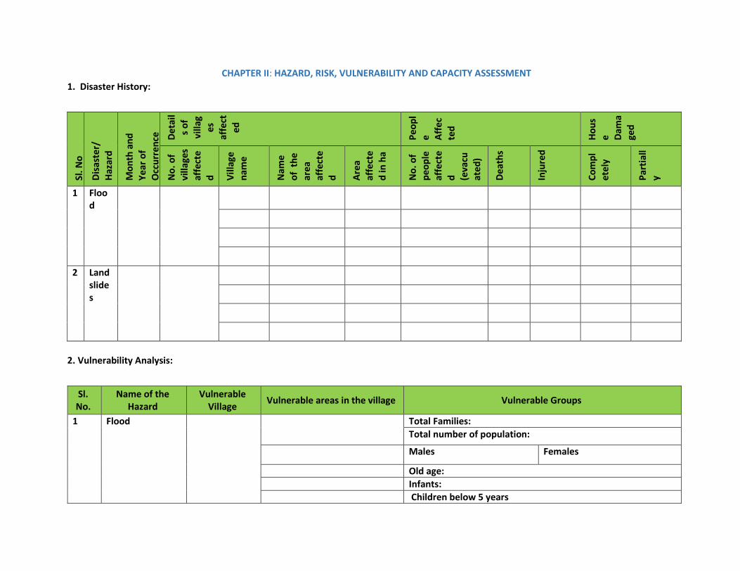
CHAPTER II: HAZARD, RISK, VULNERABILITY AND CAPACITY ASSESSMENT 1. Disaster History:
Sl. N
o
Dis
aste
r/
Haz
ard
Mon
th a
nd
Year
of
Occ
urre
nce Det
ail
s of
vi
llag
es
affe
cted
Peop
le A
ffec
ted
Hou
se D
ama
ged
No.
of
villa
ges
affe
cte
d Vill
age
nam
e
Nam
e of
the
ar
ea
affe
cte
d Are
a af
fect
ed
in h
a
No.
of
peop
le
affe
cte
d (eva
cuat
ed)
Dea
ths
Inju
red
Com
plet
ely
Part
iall
y
1 Flood
2 Landslides
2. Vulnerability Analysis:
Sl. No.
Name of the Hazard
Vulnerable Village
Vulnerable areas in the village Vulnerable Groups
1 Flood Total Families: Total number of population:
Males Females
Old age: Infants: Children below 5 years

Sl. No.
Name of the Hazard
Vulnerable Village
Vulnerable areas in the village Vulnerable Groups
Children 6 years to 14 years: Pregnant Mothers: Disabled:
Migrant Population:
Below Poverty Level: Scheduled Caste/tribes:
Primitive Tribes:
Sl. No.
Name of the Hazard
Vulnerable Village
Vulnerable areas in the village
Vulnerable Groups
2 Landslide Total Families: Total number of population:
Males Females
Old age: Infants: Children below 5 years Children 6 years to 14 years: Pregnant Mothers: Disabled: Migrant Population: Below Poverty Level: Scheduled Caste/tribes:
Primitive Tribes:

3. COMMUNITY RESOURCE/ CAPACITY ASSESSMENT:
Health Facility
Name/Type of the
Institute
Village 1 Distance Remarks
Location Contact
Number Location Contact Number Location Contact Number
Sub-Centre
PHC
CHC
Private Clinic
Nursing Home
Hospital

AMBULATORY CARE AND MEDICAL SHOP
Details
Village I Village II Village III
Name Contact
Details Name Contact Details Name Contact Details
Ambulance other
than 108
Medical Shop
HUMAN RESOURCE
Skilled Village I Village II Village III
Name Contact
Details
Name Contact Details Name Contact Details
Doctor
Specialist Doctor
AYUSH Doctor
Staff Nurse
Allied Health Staff
Paramedical Staff
(Specify)
Junior Health
Assistant Male

Junior Health
Assistant Female
ASHA
Private Doctor
Private AYUSH
Doctor
Veterinary Health Facility
Name/Type of the
Institute
Location Distance Contact Number Remarks
Government Veterinary
Clinic
HUMAN RESOURCE
Skilled Name Contact Remarks
Doctor
Trained Veterinary
Assistant

Public Distribution System and Market/Shop
Details Village I Village II Village III
If Yes, Location and Phone Number If Yes Location and Phone Number If Yes, Location and Phone Number
PDS
Petrol Pump
Kerosene Depot
Gas Agency
Rice Mill
Bazar day details
Others Village I (Numbers) Village II (Numbers) Village III (Numbers)
Vegetable/Fruit Shops Hotels Liquor Shops Garments General Stores
Village wise Education
Infrastructures Details
No of Rooms No of Toilets
Easy Connectivity to the Shelter (Yes/No)
Safety of the Shelter Yes/No
Contact Details
Village I
Anganwadi I
Anganavadi II
Anganawadi III

Village wise Education
Infrastructures Details
No of Rooms No of Toilets
Easy Connectivity to the Shelter (Yes/No)
Safety of the Shelter Yes/No
Contact Details
Anganawadi IV
Primary School
Primary School
High School
Pre-University College
Others
Village wise Power and Communication
Electricity Yes/No Contact Number Remarks
Village I Electric Sub Station
Electricity Available in Village
Street Light Facility
Generator (Public)
Generator (Private)
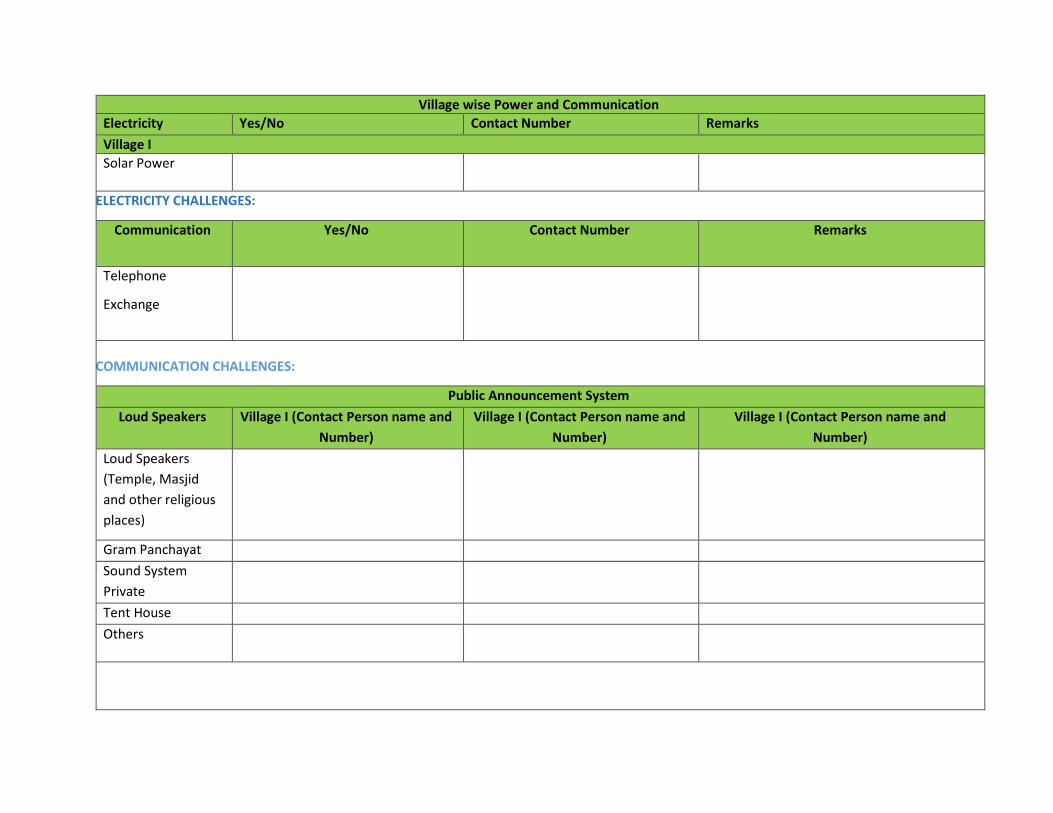
Village wise Power and Communication Electricity Yes/No Contact Number Remarks
Village I Solar Power
ELECTRICITY CHALLENGES:
Communication Yes/No Contact Number Remarks
Telephone
Exchange
COMMUNICATION CHALLENGES:
Public Announcement System
Loud Speakers Village I (Contact Person name and
Number)
Village I (Contact Person name and
Number)
Village I (Contact Person name and
Number)
Loud Speakers (Temple, Masjid and other religious places)
Gram Panchayat
Sound System Private
Tent House
Others

Village wise Power and Communication Electricity Yes/No Contact Number Remarks
Village I
PANCHAYAT’S TRADITIONAL APPROACH AND CHALLENGES IN NARROW CASTING:
Nationalised Banks and Co-operative Banks
Name of the Bank Village 1 (Contact Person and
Number)
Village 1 (Contact Person and
Number)
Village 1 (Contact Person and Number)
WASTE – DISPOSAL
Details Village I (If yes, Location and
Contact Person and Contact Details)
Village II (If yes, Location and
Contact Person and Contact Details)
Village III (If yes, Location and Contact
Person and Contact Details)
Solid Waste Disposal Area
Dumpsters
Liquid Waste Disposal

Village wise Power and Communication Electricity Yes/No Contact Number Remarks
Village I
BURIAL GROUND
Details Village I (If yes, Location and Contact Person and Contact
Details)
Village II (If yes, Location and Contact Person and Contact
Details)
Village III (If yes, Location and Contact Person and Contact Details)
Burial Ground
Carcass Disposal Area
PUBLIC PLACE FOR RECREATION
Details Village I (If yes, Location and
Contact Person and Contact
Details)
Village II (If yes, Location and
Contact Person and Contact
Details)
Village III (If yes, Location and Contact
Person and Contact Details)
Community Hall
Library
Panchayat Ghar
Sports Ground
Parks
Place of village meeting
Village wise Power and Communication Electricity Yes/No Contact Number Remarks
Village I PLACES OF WORSHIP
Details Village I (If yes, Location and Contact Person and Contact
Details)
Village II (If yes, Location and Contact Person and Contact
Details)
Village III (If yes, Location and Contact Person and Contact Details)
Temple Mosque Church
Prayer Hall Others
CONNECTIVITY Type of Road From To Condition: Good/Bad Alternative Road: Yes/No
National Highway
State Highway Pucca Road Kucchha Road Shadow Road Any other Specify
OTHER INFRASTRUCTURE
Other
Infrastructure
Yes No Condition: Yes/No Remarks
Bus Stand
Rickshaw/Van/Car
Stand
Transport Yes No Numbers if Yes
Bus

Village wise Power and Communication Electricity Yes/No Contact Number Remarks
Village I Mini Bus
Truck
Jeep
Own Car
Own Jeep
Own Bike
Tractors
SAFE SHELTERS DURING HAZARD
Shelter Identified Location Contact
Details
Capacity No of
Toilets
Water Source
Village I Shelter I Shelter II Shelter III
HUMAN RESOURCES – VILLAGE WISE
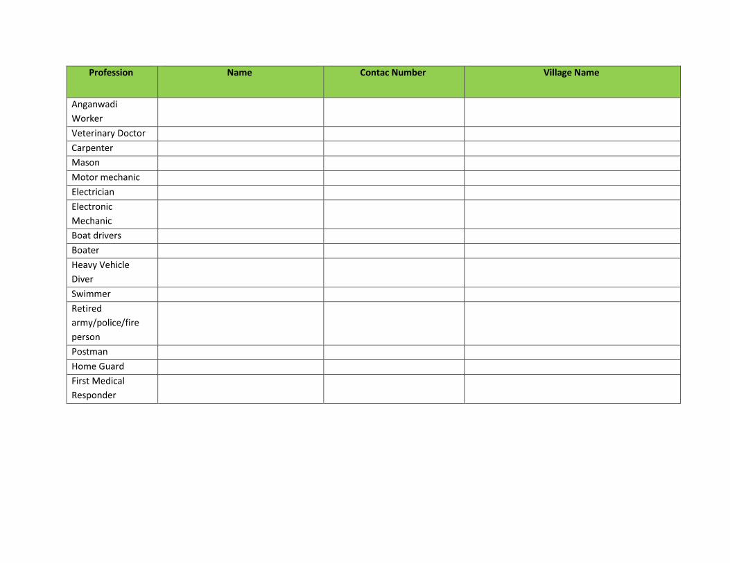
Profession Name Contac Number Village Name
Doctor – MBBS
Specialist Doctor
Doctor AYUSH
Nurse
ANM
Pharmacist
Para Medical Staff
Allied Health Staff
Profession Name Contac Number Village Name
Anganwadi Worker
Veterinary Doctor
Carpenter
Mason
Motor mechanic
Electrician
Electronic Mechanic
Boat drivers
Boater
Heavy Vehicle Diver
Swimmer
Retired army/police/fire person
Postman
Home Guard
First Medical Responder
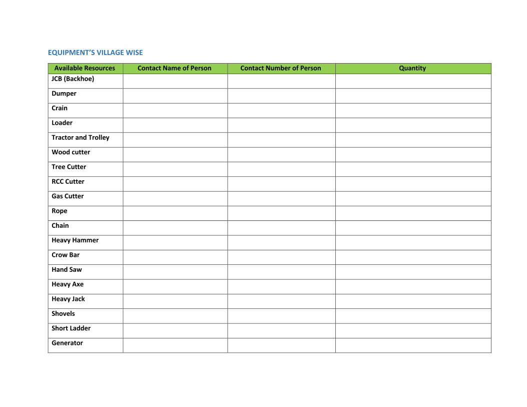
EQUIPMENT’S VILLAGE WISE
Available Resources Contact Name of Person Contact Number of Person Quantity
JCB (Backhoe)
Dumper
Crain
Loader
Tractor and Trolley
Wood cutter
Tree Cutter
RCC Cutter
Gas Cutter
Rope
Chain
Heavy Hammer
Crow Bar
Hand Saw
Heavy Axe
Heavy Jack
Shovels
Short Ladder
Generator

Available Resources Contact Name of Person Contact Number of Person Quantity
Lands and Torches
Tarpaulin
Cooking Vessels for
100 members
Gas Geyser
Four wheeler
Others

Chapter III: Mitigation and Preparedness Plan
CONSTITUTION OF GRAM PANCHAYAT DISASTER MANAGEMENT COMMITTEE (GPDMC):
To carry out disaster management activities i.e. Gram Panchayat Disaster Management Plan, training and awareness activities, identification of
resources and search & rescue activity at village level conducted by Village Disaster Management Committee.
GPDMC conducts a community-based risk assessment, analysis and develop risk mitigation plans to increase communities’ preparedness.
Key GPDMC functions in Disaster Risk Reduction:
x Village level hazard mapping. x Conduction of GP disaster risk assessment. x Analysis of disaster risk based on the assessment and prioritize the key activities to be undertaken to undertake disaster risk mitigation
measures. x Identification and prioritization of critical community infrastructure needed for the disaster risk mitigation measures. x Formulation of project implementation committees. x Coordination with UDMCs and sharing of information needed to plan Community Based Disaster Management activities
Preparedness Function of GPDMC:
x Share community Disaster Risk Management Plan (DRMPs) with all members of the Community. x Conduct disaster preparedness training with GPDMC members. x Raise community awareness on what to do before, during, and after a disaster. x Monitor disaster threats, conduct drills, and draw lessons to improve the plan. x Expand membership and involvement in disaster risk management committees and activities.
Emergency Functions of GPDMC:
x Issue warnings in case of emergencies. x Manage evacuations at village level.

x Organize search and rescue with community participation at village level. x Conduct Damage Assessment at village level and report damages and needs to government and disaster management agencies for assistance
as per Government designed reporting formats and criteria. x Coordinate, plan, and implement emergency relief delivery operations with DDMA, civil defence and other local agencies.
Recovery functions of GPDMC:
x Ensure that risk reduction measures are integrated during construction and rehabilitation of critical community infrastructures. x Evaluate the performance of VDMC capacity and effectiveness to promote community safety. x Coordinate with DDMAs for the implementation of different recovery measures.
The following is the VDMC members:-
S.No Name Designation Role Contact Numbers
1 President Chairman
PDO Co – Chairman
2 Village Accountant Member Secretary
3 Vice President Member
4 GP Member 1 Member
5 GP Member 2 Member
6 SHG Member Member
7 Medical Officer Member
8 School Head Master/Mistress
Member
9 Assistant
Superintendent of Police
Member
10 Agriculture Assistant Member
The teams: The teams are to be formed at GP level and their SOPs shall be listed down here.

1. Early Warning Team
Composition of the team:
S.No Name Designation Contact Numbers
1 GP President 2 GP Vice President 3 Local GP Member 1 4 Local GP Member 2 5 Local GP Member 3 6 PDO 7 Village Accountant 8 Bill Collector 9 Social Worker/SHG
Roles of the Evacuation, Search and Response Team:
x Coordination for the alert with District Emergency Operation Center. x Dissemination of the alert and warning to specified location (last mile connectivity) x Communication with shelter team
x Communicate the information with other teams. x Assistance to Police and F&E x Transportation and emergency medical response for the victims and responders x Head count mechanism x Directing the rescue community to the shelters. x Deploying rescue boats and rescue kits. x Evacuating of cattle and livestock. x Update contact details of local resources/ offices, etc. x Identifying safe evacuation routes, places, assembly points in and around the village. x Search people who trapped in buildings and rescue them. x Transport victims to safe location. x Contact DEOC / SEOC / KSNDMC (Varuna Mitra - 9243345433) for updated information on Weather Forecast and probable Flood situation.

x On issue of warning all GPDMC members move to the designated shelter & carry out assigned roles & responsibilities, co-ordination of implementing the preparedness measures
2. Evacuation, Search and Rescue Team
Fire and Emergency services, SDRF, and NDRF available in the district in case of emergency situation. Community will be first responder: GP level search and rescue teams to be formed. The member of this should include physically strong men and women in the age group of 18-35 years, team also shall include Ex-army, Rtd. Paramilitary personnel, Rtd. Police and Rtd. Fire and emergency personnel in the team. Gram Panchayat Member of the village shall also be part of the team. The Evacuation and Rescue team shall coordinate with the Taluk and District administration for any support government.
Composition of the Team: S.No Name Designation Contact Numbers
1 GP President 2 GP Vice President Local GP Member
3 ASI-Police 4 Local Home Guards 5 Ex-Army, Rtd. Paramilitary, Ex-Police 6 Expert swimmers, Experts drivers 7 Electrician 8 Boatman 9 Trained volunteers
Roles of the Evacuation, Search and Rescue Team:
x Keeping information about the more vulnerable group and the area in which they work and live. Update the information regularly. x Identify safe routes to reach the vulnerable population and plan their evacuation. x Keeping transport ready for use to evacuate people x Informing concerned officials for road repair and get it done in liaison with officials. x Prepare a rescue kit which contains a rope, iron hooks or tow belongings, rafts/boats, container to bail out the water, torches, transistor, a
first aid kit, life jackets, tyres and other floatable objects. x Identify earthmoving equipment such as JCBs, excavators, etc at the nearest location.

x Keeping some tools handy such as cutting saw and blades, crowbar, hammer, nails etc to cut the fallen trees and to rescue people stuck under falls houses or debris.
x Identify highlands for evacuating cattle and livestock which had enough fodder for about a week. x Carry out a mock drill for evacuation to get a fair idea of the kind of problems that need to be tackled at such times. x Help the vulnerable people to get into their respective shelters with minimum important belongings (important documents). x Arrange to shift of acute cases to the nearest PHC
3. Medical and First Aid Team: The medical and first aid team should comprise of Medical Officer, Elected Representatives, Para Medical staff
and local trained volunteers. This team is meant to provide the first and other health services in the emergency relief response phase. Composition of the Team:
S.No Name Designation Contact Numbers
1 GP President 2 GP Vice President 3 PHC Doctor 4 Local Doctors 5 Nurses 6 Junior Health Asst. Male and female 7 ASHA Workers 8 SHG members 9 Trained volunteers
Roles of the Medical and First Aid Team:
x Maintain list of pregnant women, infants, people with special medical needs, etc. x Keeping First-Aid box with disinfectants, antiseptics, ORS, etc. x Updated contact number of emergency services i.e. Ambulance, near hospital public & private. x Moving medicine stocks and first aid kits to the shelters or safe places. x Looking after the medical needs of the evacuees. x Attending to injuries of the rescued people. x Informing the relief group about medical supplies which are running low. x Helping doctors and paramedics shift the sick & injured to hospitals.

x Isolating cases with infectious diseases and prevent them from spreading after giving due primary care. x Providing preventive medication if there is a danger of epidemic outbreak like cholera, dysentery, malaria. x All COVID 19 precautionary measures to be adhered in all phases of disaster. x Communicable Disease Identification x Non-Communicable diseases x Reproductive and Child Health x Maternal Health x Psycho-social care x Psychological first aid
4. Shelter Management team (Water Sanitation and Hygiene (WASH), Nutrition and Food Security): This team will play crucial role in the
emergency relief response in terms of providing the Water, Sanitation, Hygiene Services, Food and Nutrition, Non – Food items and Shelter
facilities in the disaster affected areas.
THE TEAM COMPOSITION:
S.No Name Designation Contact Numbers
1 GP President 2 GP Vice President 3 GP Member PHC Doctor
4 PDO 5 Village Account 6 School Head Master 7 Junior Health Assistant (male and female) 8 Anganwadi teacher 9 Water Man
10 ASHA Worker 11 Hostel Cooks/Mid meal cook 12 Swatchagrahis

Roles of the Shelter Management team (Water Sanitation and Hygiene (WASH), Nutrition and Food Security):
x Identify safe shelter in village, open spaces for tents installation and nearby areas in case of evacuate the people from village. x Shelter identifications in the safe places based on hazard and vulnerability x Safety:
9 Road connectivity, communication 9 Safety of the building 9 Non-schools as much as possible 9 Space – 3.5 sqm/person 9 Power Supply 9 Water Supply - 15 litres per person 9 Toilets (1: 25 toilets), frequently cleaning of toilets in light of COVID 19 9 Bathroom facility with hot water 9 Kitchen facility – Community Kitchen
x Stocks of food, drinking water, utensil and medicines and stocks made available x Arrangement of sufficient space to house the evacuee family x Strict hygiene conditions (WASH)
9 Water Quality and Quantity 9 Water supply 15 lts/person 9 Hot water for drinking and bathing 9 Drainage 9 Toilet for 1: 25 9 Vector control 9 Solid Waste Management 9 Hygiene promotion (hand washing, cough hygiene) 9 Personal protective equipment (face mask for all, hand gloves, head cap and foot wear for cooks, volunteers, food servers, sanitation
workers) 9 Disinfectants 9 MHM – Sanitary pads 9 Oils, comb, mirrors 9 Laundry

x Special care provisions for the more vulnerable group. x Every evacuee’s name registration and identification slips x Safety and protection x Nutrition:
9 To provide food within nutritional limits for temporary maintenance 9 Water: plain water, beverage (like tea, coffee) milk 9 Calories: cereal products, breads, roti, chapatti, ragi, jowar 9 Protein: egg, sprouted grams, milk and milk products, legumes 9 Thiamine: Guava, Gooseberry, Orange 9 Salt: it is needed to conserve water in the body, thus prevent dehydration
5. Animal Protection and Carcass Disposal Team: Team shall work in coordination with the villagers to safeguard the livestock. Team Composition:
S.No Name Designation Contact Numbers
1 GP Members 2 Veterinary Doctor/Assistant 3 Milk Cooperative Society Members 4 Social Workers 5 Self Help Groups
Roles of Animal Protection and Carcass Disposal Team:
x Identification of space for carcass disposal. x Stocking kerosene and fuel for disposal of carcass. x Maintaining storage of sackcloth to cover dead bodies of animals. x Proper spray of disinfectants (eg: DDT) to keep the air clean
6. Damage & Need Assessment Team: The team will facilitate the villagers on damage and need assessment.

COMPOSITION OF THE TEAM: S.No Name Designation Contact Numbers
1 Revenue Inspector 2 PDO 3 Village Accountant 4 Agriculture Assistant 5 Horticulture Assistant
Roles of the Damage and Need Assessment Team:
x Help in forecasting damages including lives lost and losses to property and assets such as houses, livestock, agriculture, plantation, etc. x Sensitizing families of village to keep their important documents safe, and in emergency kit.

CHAPTER IV: RESPONSE PLAN Flood/Landslide Response Plan:
Elements at Risk Response Plan
Area People/Families Structure Others Response and Approach Responders (Contact details of the teams head)
Early Warning: Early warning will be issued through GP, which will be based on the alert and warnings issued by the DDMA. A warning will be disseminated to early warning and dissemination team by GP. Dissemination: Messages will be disseminated through narrowcasting i.e loudspeakers, mouth to mouth message and also mobile, whatsapp group or Wireless. Early Evacuation: Roads and alternative roads are identified; the evacuation team will take a lead to evacuation. Vehicles for transportation and drivers are identified in the plan. Search, Rescue and Evacuation: Search, Rescue and Evacuation team will assist the Police, Fire and Emergency and NDRF teams in search, rescue and evacuation. Equipment essential for the search, rescue and evacuations are identified in the village and will be utilised for the same. First aid and Health team will assist and communicate with the respective centers in the health emergency. Special attention will be paid for the women, children, disabled, senior citizens, pregnant mother, chronically ill in the search, rescue and evacuation.
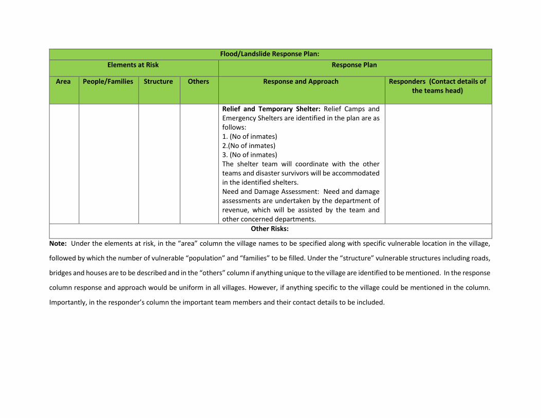
Flood/Landslide Response Plan:
Elements at Risk Response Plan
Area People/Families Structure Others Response and Approach Responders (Contact details of the teams head)
Relief and Temporary Shelter: Relief Camps and Emergency Shelters are identified in the plan are as follows: 1. (No of inmates) 2.(No of inmates) 3. (No of inmates) The shelter team will coordinate with the other teams and disaster survivors will be accommodated in the identified shelters. Need and Damage Assessment: Need and damage assessments are undertaken by the department of revenue, which will be assisted by the team and other concerned departments.
Other Risks:
Note: Under the elements at risk, in the “area” column the village names to be specified along with specific vulnerable location in the village,
followed by which the number of vulnerable “population” and “families” to be filled. Under the “structure” vulnerable structures including roads,
bridges and houses are to be described and in the “others” column if anything unique to the village are identified to be mentioned. In the response
column response and approach would be uniform in all villages. However, if anything specific to the village could be mentioned in the column.
Importantly, in the responder’s column the important team members and their contact details to be included.

CHAPTER V: CONTACT NUMBERS Administrative Contacts:
S.No Designation Contact Details
Office Residence Mobile
1 Deputy Commissioner
2 Chief Executive Officer
3 Superintendent of Police
4 Additional Deputy Commissioner
5 Tahashildar
6 Executive Officer
7 DYSP
8 DHO
9 DDPI
10 PWD
11 PRED
12 NHA
13 DDPU
14 DD – F&CF
15 DD – Agriculture
16 DD Horticulture
17 DCF
18 Social Forestry
19 Territory Forest
20 DD – Mines and Geology
21 DD - WCD

22 DF & E
23 BSNL
24 District Information and Broad Casting Officer
25 CHESCOM
26 DD – Animal Husbandry
Taluk Level Administrator
S.No Designation Office Residence Mobile 1 2
Gram Panchayat Contacts
S.No Designation Office Residence Mobile
1 2
NGO’s Contact Details
S.No Name of the NGO Type of NGO Contact Person Contact Number
1
2 3
Emergency Contact Numbers:
S.No Name of the Department Contact Number
1
2
3

Chapter VI: Relief Shelter/Camps Guidelines 1. Shelter Checklist:
Checklist for the shelter management (Relief Homes)
1 Particulars Yes No N/A I Shelter requirements 1 Safety of the building 2 Power supply 3 Kitchen facility: stove, cooking oil, vegetables, rice other cooking items etc 4 Utensils for Kitchen 5 Gaslight (alternative lights) 6 Candles, matchbox, kerosene, torches etc 7 Registers, registration and attendance II Water, Sanitation and Hygiene Promotion (WASH) 1 Drinking Water 2 Water Safety 3 Water for other purpose 4 Hot water for bathing 5 Toilet (1: 25) 6 Sanitation near toilet 7 Vector control 8 Solid waste management 9 MHM – Sanitary Pad
10 Oils, comb, mirror etc. 11 Hygiene items: Soaps, toothbrush, toothpaste, sanitary pads 12 Laundry (optional) 13 Hygiene Promoters 14 IEC Materials on WASH III Nutrition 1 Menu for the food to be followed in accordance with nodal officer’s checklist 2 Special focus on nutrition of
● Breastfeeding of infants

● Under-five children ● Children ● Pregnant mothers ● Postnatal mothers
3 Nutritional Supplements (if requires) IV Health/Medical Team – PSC 1 1 Doctor 2 1 Staff Nurse 3 2 ANMs 4 1 Counsellor 5 Local ASHA’s 1 Particulars Yes No N/A 6 Emergency Medicine Basic 7 Laboratory facility 8 Special focus (Children, Women, Pregnant, Specially abled, NCD and
Communicable Disease)
9 Psychological First aid III Non-Food Items (Based on the need) 1 Mattress for the floor 2 Blankets, bedsheets, bath towel 3 Clothes (if requires) including sweater, warm clothes, inner garments,
skullcaps, scarfs, lungi, nighty etc
4 Plastic buckets 5 Mugs 6 Raincoats 7 Umbrella 8 Gumboots 9 Slippers etc V Self-efficacy 1 Scouts and Guides team deployment VI Law and Order 1 Police and Home guards
VII Livelihood Activities (if stay of inmates exceeds for a week)

2. Nodal Officers Responsibilities:
The responsibilities of the nodal officer appointed for the shelter management are as follows:
1. They should issue identity number for the disaster survivors. 2. Food and relief materials to be distributed in accordance with the ID number. 3. It is the responsibility of the Nodal Officer to maintain a sanitation and hygiene at Relief Shelter. 4. Before receiving the materials at the relief shelter, materials need to be checked for the expiry dates. Expired and spoiled materials should
not be received and distributed to the disaster survivors. 5. Vulnerable including pregnant mother, children, senior citizens to be provided with nutritious food and beds. 6. Nodal officer should make sure the self-reliance in the shelter. 7. Waste management including the segregation of the waste at the relief shelter are the responsibility of the respective nodal officers. 8. The sufficient toilet facility and water supply to be maintained in the relief shelters. 9. The daily menu to be developed in consultation with the disaster survivors and dietician which provides balanced diet. 10. The medical team to be deployed in the relief shelter and should oversee providing the health and psychosocial care. 11. Daily nodal officer should report to the taluk and district authority 12. Nodal Officer should maintain few registers at the relief shelter including initial registration registry, attendance registry, outgoing registry,
stock registry etc. 13. Law and order at the relief shelter to be maintained.
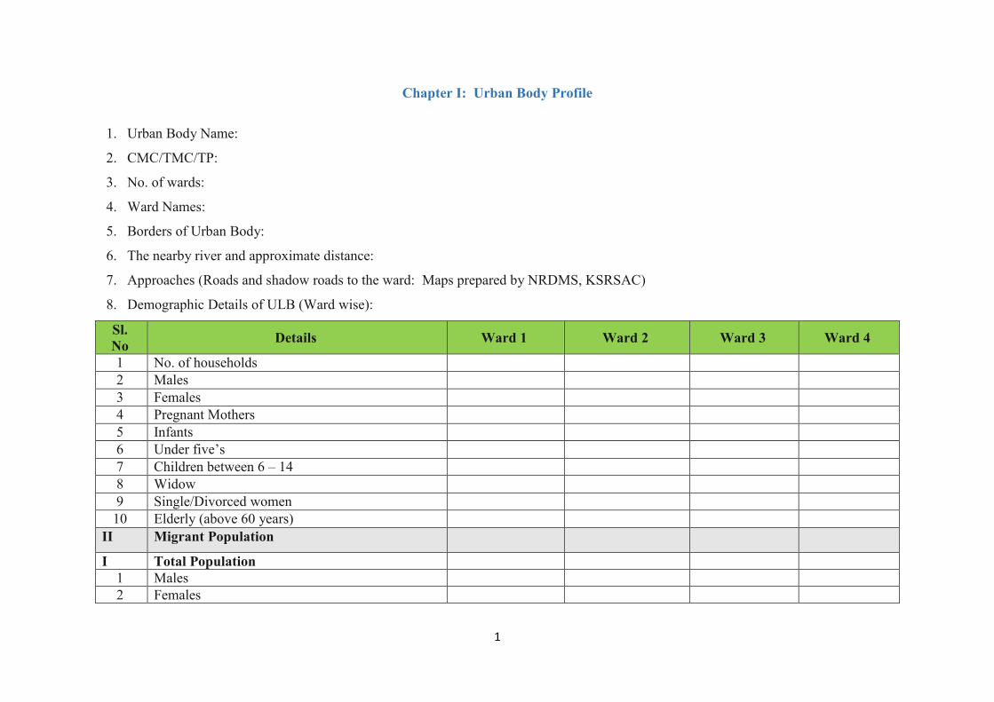
1
Chapter I: Urban Body Profile
1. Urban Body Name:
2. CMC/TMC/TP:
3. No. of wards:
4. Ward Names:
5. Borders of Urban Body:
6. The nearby river and approximate distance:
7. Approaches (Roads and shadow roads to the ward: Maps prepared by NRDMS, KSRSAC)
8. Demographic Details of ULB (Ward wise):
Sl. No Details Ward 1 Ward 2 Ward 3 Ward 4
1 No. of households 2 Males 3 Females 4 Pregnant Mothers 5 Infants 6 Under five’s 7 Children between 6 – 14 8 Widow 9 Single/Divorced women 10 Elderly (above 60 years)
II Migrant Population
I Total Population 1 Males 2 Females

2
Sl. No Details Ward 1 Ward 2 Ward 3 Ward 4
3 Pregnant Mothers 4 Infants 5 Under five’s 6 Children between 6 – 14 7 Elderly (above 60 years)
III Physically and Mentally Challenged Persons
1 Locomotor Disability 2 Visual Impairment 3 Hearing Impairment 4 Intellectual Disability
IV Total Number of Families
1 Total Antyodaya Cardholders 2 Total BPL Cardholders 3 Total APL Cardholders 4 Total Primitive Tribes Families 5 Total Schedule Caste 6 Schedule Tribe Families 7 Total Other Backward class families
VI Total Houses
1 Total Thatched Houses 2 Total Tiled Houses 3 Total Asbestos Houses 4 Total RCC Houses

3
8. Livelihood Activities
Sl. No. Occupation Pattern Ward 1
(Number of families) Ward 2
(Number of families) Total
(Number of Families) 1 Livestock (Animal Husbandry)
2 Fisheries
3 Mining
4 Any other/Shops etc
5 Business/Industries etc
6 Labour
7 Manufacturing Units
8 Handlooms/Power looms
9 Processing Units
10 Service Repair and Household
Industry (Papad etc)
11 Construction Industry
12 Trade and Commerce
13 Tourism
14 Transport Storage and
Communication
15 Service Sector (call centres)
16 Any other

4
9. Livestock Resources (Ward wise):
Sl. No. Live Stocks Ward 1 Ward 2 Ward 3 Total
1 Cows
2 Buffalos
3 Bullock
4 Sheep’s and Goats
5 Poultry
6 Others
10. Critical Infrastructure Resources
Sl. No. Particulars Ward 1 Ward 2 Ward 3 Total
I Education (number of students in brackets)
1 Anganwadi / Play homes 2 Primary School and higher primary school 3 High School 4 Pre-university College 5 First Grade College 6 Professional colleges (Medical / Engineering / Nursing / Hotel
Management)
7 ITI/ Vocational Courses II Health
1 Sub Center 2 Primary Health Center 3 Community Health Center

5
Sl. No. Particulars Ward 1 Ward 2 Ward 3 Total
4 Poly Clinic – Private 5 Nursing Home – Private 4 Hospital – Private *Total bed strength
III Water Source
1 Groundwater/Surface Water (surface, specify, river, pond, canals etc) 2 No. of Borewell (Government/Private) 3 Open Well (Government/Private)
IV Water Supply
1 Mini Water Supply Scheme 2 Piped Water Supply Scheme (Spring Water) 3 Multi Ward Water Supply Scheme (Jack well) 4 RO Plant
V Waste Management
1 Solid Waste Management Units (Yes/No) 2 Effluent treatment plant(Yes/No)
VI Market/Shop (Numbers)
1 PDS 2 Grocery Shop 3 Medicine 4 Kerosene 5 Dry Food 6 Rice/Floor Mill 7 Hotels
APMC / weekly market VII Other Infrastructure Numbers
1 Community Hall 2 Temples

6
Sl. No. Particulars Ward 1 Ward 2 Ward 3 Total
3 Mosque 4 Church 5 Prayer hall/Bhajana Mandir 6 Youth Club Building 7 Others (Rangamandira etc)
VIII Others
1 Community Cattle Shed (Goshala) 2 Burial Ground 4 Animal Carcass Disposal Area
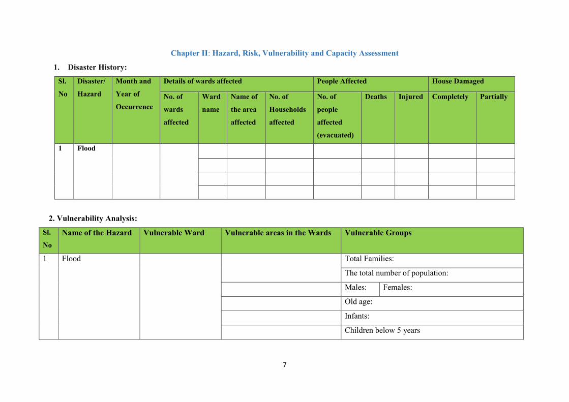
7
Chapter II: Hazard, Risk, Vulnerability and Capacity Assessment
1. Disaster History:
Sl.
No
Disaster/
Hazard
Month and
Year of
Occurrence
Details of wards affected People Affected House Damaged
No. of
wards
affected
Ward
name
Name of
the area
affected
No. of
Households
affected
No. of
people
affected
(evacuated)
Deaths Injured Completely Partially
1 Flood
2. Vulnerability Analysis:
Sl.
No Name of the Hazard Vulnerable Ward Vulnerable areas in the Wards Vulnerable Groups
1 Flood Total Families:
The total number of population:
Males: Females:
Old age:
Infants:
Children below 5 years

8
Sl.
No Name of the Hazard Vulnerable Ward Vulnerable areas in the Wards Vulnerable Groups
Children 6 years to 14 years:
Pregnant Mothers:
Disabled:
Migrant Population:
Below Poverty Level:
Scheduled Caste/tribes:
Primitive Tribes:
3. Community Resource/ Capacity Assessment:
Health Facility
Name/Type of the Institute Ward 1 Distance Remarks
Location Contact Number Location Contact Number Location Contact Number
Sub-Centre
PHC
CHC
General Hospitals
Private Clinic
Nursing Home

9
Health Facility
Ambulatory Care and Medical Shop
Details Ward I Ward II Ward III
Name Contact Details Name Contact Details Name Contact Details
Ambulance other than 108
Medical Shop
Human Resource
Skilled Ward I Ward II Ward III
Name Contact Details Name Contact Details Name Contact Details
Doctor
Specialist Doctor
AYUSH Doctor
Staff Nurse
Allied Health Staff
Paramedical Staff (Specify)
Junior Health Assistant Male
Junior Health Assistant
Female
ASHA
Private Doctor
Private AYUSH Doctor

10
Health Facility
Veterinary Health Facility
Name/Type of the Institute Location Distance Contact
Number
Remarks
Government Veterinary Clinic
Private Veterinary Clinic
Human Resource
Skilled Name Contact Remarks
Doctor
Trained Veterinary Assistant
Public Distribution System and Market/Shop
Details Ward I Ward II Ward III
If Yes, Location and Phone Number If Yes Location and Phone Number If Yes, Location and Phone Number
PDS
Petrol Pump
Kerosene Depot
Gas Agency
Warehouse
Bazar day details
Malls

11
Public Distribution System and Market/Shop
Cold Storage
Others Ward I (Numbers) Ward II (Numbers) Wards III (Numbers)
Vegetable/Fruit
Shops
Hotels
Liquor Shops
Garments
General Stores
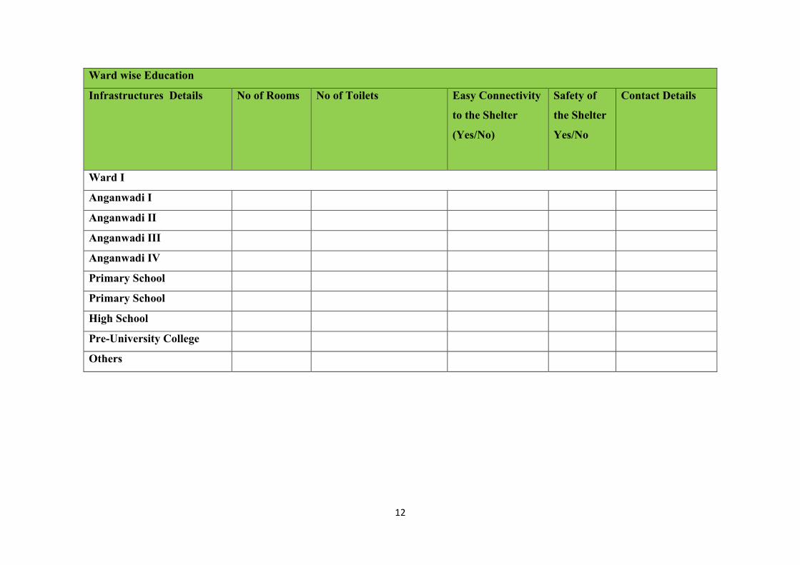
12
Ward wise Education
Infrastructures Details No of Rooms No of Toilets Easy Connectivity
to the Shelter
(Yes/No)
Safety of
the Shelter
Yes/No
Contact Details
Ward I
Anganwadi I
Anganwadi II
Anganwadi III
Anganwadi IV
Primary School
Primary School
High School
Pre-University College
Others

13
Ward wise Power and Communication
Electricity Yes/No Contact Number Remarks
Ward I
Electric Sub-Station
Electricity Available in Ward
Street Light Facility
Generator (Public)
Generator (Private)
Solar Power
Others
Electricity Challenges:
Communication Yes/No Contact Number Remarks
Telephone Exchange
Communication Challenges:
Public Announcement System
Loud Speakers Ward I (Contact Person Name and Number)
Ward I (Contact Person Name and Number)
Ward I (Contact Person Name and Number)
Loud Speakers (Temple, Masjid and other religious places)
Sound System Private
Tent House
Others

14
Urban Body’s traditional approach and challenges in narrowcasting:
Nationalised Banks and Co-operative Banks
Name of the Bank Ward 1 (Contact Person and
Number)
Ward 1 (Contact Person and
Number)
Ward 1 (Contact Person and
Number)
Waste – Disposal
Details Ward I (If yes, Location and Contact Person and Contact Details)
Ward II (If yes, Location and Contact Person and Contact Details)
Ward III (If yes, Location and Contact Person and Contact Details)
Solid Waste Disposal Area
Dumpsters
Liquid Waste Disposal
Burial Ground
Details Ward I (If yes, Location and Contact Person and Contact Details)
Ward II (If yes, Location and Contact Person and Contact Details)
Ward III (If yes, Location and Contact Person and Contact Details)
Burial Ground
Carcass Disposal Area

15
Public Place for Recreation
Details Ward I (If yes, Location and Contact Person and Contact Details)
Ward II (If yes, Location and Contact Person and Contact Details)
Ward III (If yes, Location and Contact Person and Contact Details)
Government buildings (Taluk office /
Inspection Bungalow / Court complex /
Mini Vidhana Soudha
Community Hall
Library
Ward House
Sports Ground
Parks
Place of ward meeting
Places of Worship
Details Ward I (If yes, Location and Contact Person and Contact Details)
Ward II (If yes, Location and Contact Person and Contact Details)
Ward III (If yes, Location and Contact Person and Contact Details)
Temple
Mosque
Church
Prayer Hall
Others

16
Connectivity
Type of Road From To Condition:
Good/Bad
Alternative Road: Yes/No
National Highway
State Highway
Pucca Road
Kucchha Road
Shadow Road
Any other Specify
Other Infrastructure
Other Infrastructure Yes No Condition:
Yes/No
Remarks
Bus Stand
Railway Station
Nearest Airport / Helipad
Rickshaw/Van/Car Stand
Transport Yes No Numbers if Yes
Bus
Mini Bus
Truck
Jeep

17
Own Car
Own Jeep
Own Bike
Tractors
Safe Shelters during Hazard:
Shelter Identified Location Contact
Details
Capacity No of Toilets Water
Source
Ward I
Shelter I
Shelter II
Shelter III

18
Human Resources – Ward Wise
Profession Name Contact Number Ward Name
Doctor – MBBS
Specialist Doctor
Doctor AYUSH
Nurse
ANM
Pharmacist
Para Medical Staff
Allied Health Staff
Anganwadi Worker
Veterinary Doctor
Carpenter
Mason
Motor mechanic
Electrician
Electronic Mechanic
Boat drivers
Boater
Heavy Vehicle Diver
Swimmer

19
Retired army/police/fire person
Postman
Home Guard
First Medical Responder
Equipment’s Ward Wise
Available Resources Contact Name of Person Contact Number of Person Quantity
JCB (Backhoe)
Dumper
Crain
Loader
Tractor and Trolley
Woodcutter
Tree Cutter
RCC Cutter
Gas Cutter
Rope
Chain
Heavy Hammer
Crow Bar
Hand Saw

20
Heavy Axe
Heavy Jack
Shovels
Short Ladder
Generator
Lands and Torches
Tarpaulin
Cooking Vessels for 100 members
Gas Geyser
Four-wheeler
Other Fire and Emergency Equipment
Others

21
Chapter III: Mitigation and Preparedness Plan
Constitution of Urban Local Body Disaster Management
Committee (ULBDMC):
The Urban Local Body Disaster Management Committee is to carry
out disaster management activities viz preparing Disaster
Management Plan, training and awareness activities, identification of
resources and search & rescue activity at ward level.
ULBDMC also conducts a community-based risk assessment,
analysis and develop risk mitigation plans to enhance communities’
preparedness.
Key ULBDMC functions in Disaster Risk Reduction:
x Ward level hazard mapping.
x Conduction of ULB disaster risk assessment.
x Analysis of disaster risk based on the assessment and
prioritize the key activities to be undertaken in disaster risk
mitigation measures.
x Identification and prioritization of critical community
infrastructure needed for the disaster risk mitigation
measures.
x Formulation of project implementation committees.
x Coordination with ULBDMCs and sharing of information
needed to plan Community Based Disaster Management
activities
Preparedness Function of ULBDMC:
x Share community Disaster Risk Management Plan (DRMPs)
with all members of the Community.
x Conduct disaster preparedness training with ULBDMC
members.
x Raise community awareness on what to do before, during,
and after a disaster.
x Monitor disaster threats, conduct drills and draw lessons to
improve the plan.
x Expand membership and involvement in disaster risk
management committees and activities.
Emergency Functions of ULBDMC:
x Issue of warnings in case of emergencies.
x Manage evacuations at ward level.
x Organize search and rescue with community participation at
ward level.

22
x Conduct Damage Assessment at ward level and report
damages and needs to government and disaster management
agencies for assistance as per Government designed reporting
formats and criteria.
x Coordinate, plan and implement emergency relief delivery
operations with DDMA, civil defence and other local
agencies.
Recovery functions of ULBDMC:
x Ensure that risk reduction measures are integrated during the
construction and rehabilitation of critical community
infrastructures.
x Evaluate the performance of ULBDMC capacity and
effectiveness to promote community safety.
x Coordinate with DDMAs for the implementation of different
recovery measures.
The following is the ULBDMC members:-
S.No Name Designation Role Contact Numbers
1 President Chairman
2 CO/AEE Co-Chairman
3 Revenue Officer Member Secretary
4 Deputy Mayor/Vice President Member
5 ULB Member1 Member
6 ULB Member 2 Member
7 NGO/SHG Member Member
8 Medical Officer Member
9 School Head Master/Mistress Member
10 Assistant Superintendent of Police Member
11 Engineer Member

23
The teams: The teams are to be formed at ULB level and their SOPs shall be listed down here.
1. Early Warning Team
Composition of the team:
S.No Name Designation Contact Numbers
1 ULB Representative
2 ULB Representative
3 Local ULB Member 1
4 Local ULB Member 2
5 Local ULB Member 3
6 Commissioner/CO
7 Revenue Officer
8 Engineer
9 Social Worker/SHG
Roles of the Evacuation, Search and Response Team:
x Coordination for the alert with District Emergency Operation
Center.
x Dissemination of the alert and warning to the specified
location (last-mile connectivity)
x Communication with shelter team
x Communicate the information with other teams.
x Assistance to Police and F&E
x Transportation and emergency medical response for the
victims and responders
x Headcount mechanism
x Directing the rescue community to the shelters.
x Deploying rescue boats and rescue kits.
x Evacuating of cattle and livestock.

24
x Update contact details of local resources/ offices, etc.
x Identifying safe evacuation routes, places, assembly points in
and around the ward.
x Search people who trapped in buildings and rescue them.
x Transport victims to a safe location.
x Contact ULB EOC/DEOC / SEOC / KSNDMC (Varuna
Mitra - 9243345433) for updated information on Weather
Forecast and probable Flood situation.
x On the issue of warning, all ULBDMC members move to the
designated shelter & carry out assigned roles &
responsibilities, co-ordination of implementing the
preparedness measures
2. Evacuation, Search and Rescue Team
Fire and Emergency services, SDRF, and NDRF available in the
district in case of an emergency. The community will be the first
responder: ULB level search and rescue teams to be formed. The
member of this should include physically strong men and women
in the age group of 18-35 years, the team also shall include Ex-
army, Rtd. Paramilitary personnel, Rtd. Police and Rtd. Fire and
emergency personnel in the team. Urban Body Member of the
ward shall also be part of the team. The Evacuation and Rescue
team shall coordinate with the Taluk and District administration
for any support government.
Composition of the Team:
S.No Name Designation Contact Numbers
1 ULB Representative
2 ULB Representative
3 Local ULB Member
4 ASI-Police
5 Local Home Guards
6 Ex-Army, Rtd. Paramilitary, Ex-Police

25
7 Expert swimmers, Experts drivers
8 Electrician
9 Boatman
10 Trained volunteers/ NSS/NCC
Roles of the Evacuation, Search and Rescue Team:
x Keeping information about the more vulnerable group and the
area in which they work and live. Update the information
regularly.
x Identify safe routes to reach the vulnerable population and
plan their evacuation.
x Keeping transport ready for use to evacuate people
x Informing concerned officials for road repair and get it done
in liaison with officials.
x Prepare a rescue kit which contains a rope, iron hooks or tow
belongings, rafts/boats, container to bail out the water,
torches, transistor, a first aid kit, life jackets, tyres and other
floatable objects.
x Identify earthmoving equipment such as JCBs, excavators,
etc at the nearest location.
x Keeping some tools handy such as cutting saw and blades,
crowbar, hammer, nails etc to cut the fallen trees and to rescue
people stuck under falls houses or debris.
x Identify highlands for evacuating cattle and livestock which
had enough fodder for about a week.
x Carry out a mock drill for evacuation to get a fair idea of the
kind of problems that need to be tackled at such times.
x Help the vulnerable people to get into their respective shelters
with minimum important belongings (important documents).
x Arrange to shift of acute cases to the nearest PHC
3. Medical and First Aid Team: The medical and first aid team
should comprise of Medical Officer, Elected Representatives,
Para-Medical staff and locally trained volunteers. This team

26
is meant to provide the first and other health services in the
emergency relief response phase.
Composition of the Team:
S.No Name Designation Contact Numbers
1 ULB Representative
2 ULB Representative
3 PHC Doctor
4 Local Doctors
5 Nurses
6 Junior Health Asst. Male and female
7 ASHA Workers
8 NGO/SHG members/NSS/NCC/Rangers/Rovers
9 Trained volunteers
Roles of the Medical and First Aid Team:
x Maintain a list of pregnant women, infants, people with
special medical needs, etc.
x Keeping First-Aid box with disinfectants, antiseptics, ORS,
etc.
x The updated contact number of emergency services i.e.
Ambulance, near hospital public & private.
x Moving medicine stocks and first aid kits to the shelters or
safe places.
x Looking after the medical needs of the evacuees.
x Attending to injuries of the rescued people.
x Informing the relief group about medical supplies which are
running low.

27
x Helping doctors and paramedics shift the sick & injured to
hospitals.
x Isolating cases with infectious diseases and prevent them
from spreading after giving due primary care.
x Providing preventive medication if there is a danger of
epidemic outbreak like cholera, dysentery, malaria.
x All COVID 19 precautionary measures to have adhered in all
phases of disaster.
x Communicable Disease Identification
x Non-Communicable diseases
x Reproductive and Child Health
x Maternal Health
x Psycho-social care
x Psychological first aid
4. Shelter Management team (Water Sanitation and
Hygiene (WASH), Nutrition and Food Security): This
team will play a crucial role in the emergency relief response
in terms of providing the Water, Sanitation, Hygiene
Services, Food and Nutrition, Non – Food items and Shelter
facilities in the disaster-affected areas.
The Team Composition:
S.No Name Designation Contact Numbers
1 ULB Representative
2 ULB Representative
3 ULB Member
4 PHC Doctor
5 COMMISSIONER/CO/Engineer
6 Revenue Officer
7 School Head Master
8 Junior Health Assistant (male and female)

28
9 Anganwadi teacher
10 Water Man
11 ASHA Worker
12 Hostel Cooks/Mid meal cook
13 Swatchagrahis
14 Scouts/Guides/NSS/NCC Teachers
Roles of the Shelter Management team (Water Sanitation
and Hygiene (WASH), Nutrition and Food Security):
x Identify safe shelter inward, open spaces for tents installation
and nearby areas in case of evacuating the people from the
ward.
x Shelter identifications in safe places based on hazard and
vulnerability
x Safety:
9 Road connectivity, communication
9 Safety of the building
9 Non-schools as much as possible
9 Space – 3.5 sqm/person
9 Power Supply
9 Water Supply - 15 litres per person
9 Toilets (1: 25 toilets), frequently cleaning of toilets in
light of COVID 19
9 Bathroom facility with hot water
9 Kitchen facility – Community Kitchen
x Stocks of food, drinking water, utensil and medicines and
stocks made available
x Arrangement of sufficient space to house the evacuee family
x Strict hygiene conditions (WASH)
9 Water Quality and Quantity
9 Water supply 15 lts/person
9 Hot water for drinking and bathing
9 Drainage
9 Toilet for 1: 25
9 Vector control

29
9 Solid Waste Management
9 Hygiene promotion (handwashing, cough hygiene)
9 Personal protective equipment (face mask for all,
hand gloves, head cap and footwear for cooks,
volunteers, food servers, sanitation workers)
9 Disinfectants
9 MHM – Sanitary pads
9 Oils, comb, mirrors
9 Laundry
x Special care provisions for the more vulnerable group.
x Every evacuee’s name registration and identification slips
x Safety and protection
x Nutrition:
9 To provide food within nutritional limits for
temporary maintenance
9 Water: plain water, beverage (like tea, coffee)
milk
9 Calories: cereal products, bread, roti, chapatti,
ragi, jowar
9 Protein: egg, sprouted grams, milk and milk
products, legumes
9 Thiamine: Guava, Gooseberry, Orange
9 Salt: it is needed to conserve water in the body,
thus prevent dehydration
5. Animal Protection and Carcass Disposal Team: Team shall work in coordination with the wards to safeguard the livestock.
Team Composition:
S.No Name Designation Contact Numbers
1 ULB Members
2 Veterinary Doctor/Assistant
3 Milk Cooperative Society Members
Social Workers
4 Self Help Groups
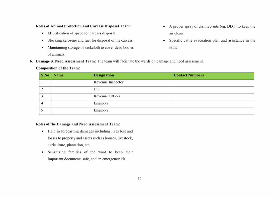
30
Roles of Animal Protection and Carcass Disposal Team:
x Identification of space for carcass disposal.
x Stocking kerosene and fuel for disposal of the carcass.
x Maintaining storage of sackcloth to cover dead bodies
of animals.
x A proper spray of disinfectants (eg: DDT) to keep the
air clean
x Specific cattle evacuation plan and assistance in the
same
6. Damage & Need Assessment Team: The team will facilitate the wards on damage and need assessment.
Composition of the Team:
S.No Name Designation Contact Numbers
1 Revenue Inspector
2 CO
3 Revenue Officer
4 Engineer
5 Engineer
Roles of the Damage and Need Assessment Team:
x Help in forecasting damages including lives lost and
losses to property and assets such as houses, livestock,
agriculture, plantation, etc.
x Sensitizing families of the ward to keep their
important documents safe, and an emergency kit.

31
Chapter IV: Response Plan
Flood/Landslide Response Plan:
Elements at Risk Response Plan
Area People/Families Structure
(Roads,
Buildings
other
infrastructures
located in low
lying areas)
Others Response and Approach Responders (Contact
details of the teams
head)
Early Warning: Early warning will be issued
through ULB, which will be based on the alert and
warnings issued by the DDMA. A warning will be
disseminated to early warning and dissemination
team by ULB.
Dissemination: Messages will be disseminated
through narrowcasting i.e loudspeakers, mouth to
mouth message and also mobile, WhatsApp group
or Wireless.

32
Flood/Landslide Response Plan:
Elements at Risk Response Plan
Early Evacuation: Roads and alternative roads are
identified; the evacuation team will take a lead to
evacuation. Vehicles for transportation and drivers
are identified in the plan.
Search, Rescue and Evacuation: Search, Rescue
and Evacuation team will assist the Police, Fire and
Emergency and NDRF teams in search, rescue and
evacuation. Equipment essential for the search,
rescue and evacuations are identified in the ward
and will be utilised for the same. First aid and
Health team will assist and communicate with the
respective centers in the health emergency. Special
attention will be paid for the women, children,
disabled, senior citizens, pregnant mother,
chronically ill in the search, rescue and evacuation.
The task force should be formulated to coordinate
the uninterrupted essential services.

33
Flood/Landslide Response Plan:
Elements at Risk Response Plan
Relief and Temporary Shelter: Relief Camps and
Emergency Shelters are identified in the plan are as
follows:
1. (No of inmates)
2.(No of inmates)
3. (No of inmates)
The shelter team will coordinate with the other
teams and disaster survivors will be accommodated
in the identified shelters.
Animal Management: Specific plan for the early
evacuation of cattle’s etc and also identification of
the cattle shed for the cattle management with
sufficient fodder and drugs.
Need and Damage Assessment: Need and
damage assessments are undertaken by the
department of revenue, which will be assisted by
the team and other concerned departments The
need and damage assessment team to be formulated
and it is to work closely with the disaster survivors.
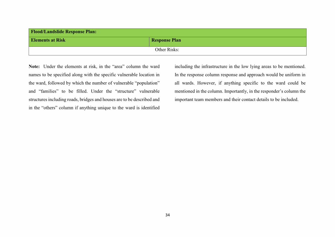
34
Flood/Landslide Response Plan:
Elements at Risk Response Plan
Other Risks:
Note: Under the elements at risk, in the “area” column the ward
names to be specified along with the specific vulnerable location in
the ward, followed by which the number of vulnerable “population”
and “families” to be filled. Under the “structure” vulnerable
structures including roads, bridges and houses are to be described and
in the “others” column if anything unique to the ward is identified
including the infrastructure in the low lying areas to be mentioned.
In the response column response and approach would be uniform in
all wards. However, if anything specific to the ward could be
mentioned in the column. Importantly, in the responder’s column the
important team members and their contact details to be included.

35
Chapter V: Contact Numbers
Administrative Contacts:
Sl.
No
Designation Contact Details
Office Residence Mobile
Deputy Commissioner
Chief Executive Officer
Superintendent of Police
Additional Deputy Commissioner
Project Director - ULB
AEE - ULB
Tahashildar
Executive Officer
DYSP
DHO
DDPI
PWD
PRED
NHA
DDPU
DD – F&CF
DD – Agriculture

36
DD Horticulture
DCF
Social Forestry
Territory Forest
DD – Mines and Geology
DD - WCD
DF & E
BSNL
District Information and Broad Casting Officer
ESCOM
DD – Animal Husbandry
Taluk Level Administrator
S.
No
Designation Office Residence Mobile
Urban Body Contacts
S.
No
Designation Office Residence Mobile

37
NGO’s Contact Details
S.
No
Name of the NGO Type of NGO Contact Person Contact Number
S.
No
Name of the Student Organisations
(NCC/NSS/Rangers/Rovers/Scouts/G
uides)
Level (College/School/Pre-university) Contact Person Contact Number
Emergency Contact Numbers:
S.
No
Name of the Department Contact Number

38
Chapter VI: Relief Shelter/Camps Guidelines
1. Shelter Checklist:
Checklist for the shelter management (Relief Homes)
1 Particulars Yes No N/A
I Shelter requirements
1 Safety of the building
2 Power supply
3 Kitchen facility: stove, cooking oil, vegetables, rice other cooking items etc
4 Utensils for Kitchen
5 Gaslight (alternative lights)
6 Candles, matchbox, kerosene, torches etc
7 Registers, registration and attendance
II Water, Sanitation and Hygiene Promotion (WASH)
1 Drinking-Water
2 Water Safety
3 Water for other prposes
4 Hot water for bathing
5 Toilet (1: 25)
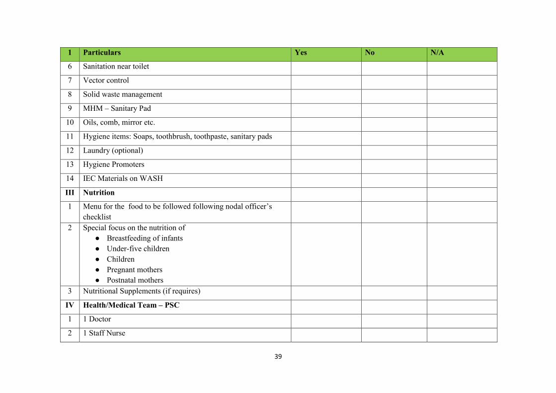
39
1 Particulars Yes No N/A
6 Sanitation near toilet
7 Vector control
8 Solid waste management
9 MHM – Sanitary Pad
10 Oils, comb, mirror etc.
11 Hygiene items: Soaps, toothbrush, toothpaste, sanitary pads
12 Laundry (optional)
13 Hygiene Promoters
14 IEC Materials on WASH
III Nutrition
1 Menu for the food to be followed following nodal officer’s checklist
2 Special focus on the nutrition of ● Breastfeeding of infants ● Under-five children ● Children ● Pregnant mothers ● Postnatal mothers
3 Nutritional Supplements (if requires)
IV Health/Medical Team – PSC
1 1 Doctor
2 1 Staff Nurse

40
1 Particulars Yes No N/A
3 2 ANMs
4 1 Counsellor
5 Local ASHA’s
1 Particulars Yes No N/A
6 Emergency Medicine Basic
7 Laboratory facility
8 Special focus (Children, Women, Pregnant, Specially abled, NCD and Communicable Disease)
9 Psychological First aid
III Non-Food Items (Based on the need)
1 Mattress for the floor
2 Blankets, bed sheets, bath towel
3 Clothes (if requires) including sweater, warm clothes, inner garments, skullcaps, scarfs, lungi, nighty etc
4 Plastic buckets
5 Mugs
6 Raincoats
7 Umbrella
8 Gumboots
9 Slippers etc
V Self-efficacy

41
1 Particulars Yes No N/A
1 Scouts and Guides team deployment
VI Law and Order
1 Police and Home guards
VII Livelihood Activities (if the stay of inmates exceeds for a week)
Nodal Officers Responsibilities:
The responsibilities of the nodal officer appointed for the
shelter management are as follows:
1. They should issue the identification number for the
disaster survivors.
2. Food and relief materials to be distributed following the
ID number.
3. It is the responsibility of the Nodal Officer to maintain
sanitation and hygiene at Relief Shelter.
4. Before receiving the materials at the relief shelter,
materials need to be checked for the expiry dates. Expired
and spoiled materials should not be received and
distributed to the disaster survivors.
5. Vulnerable including pregnant mother, children, senior
citizens to be provided with nutritious food and beds.
6. The nodal officer should make sure the self-reliance in the
shelter.
7. Waste management including the segregation of the waste
at the relief shelter is the responsibility of the respective
nodal officers.
8. The sufficient toilet facility and water supply to be
maintained in the relief shelters.
9. The daily menu to be developed in consultation with the
disaster survivors and dietician which provides a balanced
diet.
10. The medical team to be deployed in the relief shelter and
should oversee providing health and psychosocial care.
11. The daily nodal officer should report to the taluk and
district authority

42
12. Nodal Officer should maintain few registers at the relief
shelter including initial registration registry, attendance
registry, outgoing registry, stock registry etc.
13. Law and order at the relief shelter to be maintained.

District Sl.No. District
Taluk Sl.No.
Taluk 2018 2019 2020 Total
TUMKUR 1 Madhugiri Yes 12 Challakere Yes 13 Chitradurga Yes 14 Hiriyur Yes 15 Holalkere Yes 16 Hosadurga Yes 17 Molakalmuru Yes 18 Channagiri Yes 19 Harapanahalli Yes Yes 210 Harihar Yes Yes 211 Honnali Yes Yes 212 Jagalur Yes 1
CHAMARAJANAGAR 13 Kollegal Yes Yes 214 Heggadadevanakote Yes Yes Yes 315 Hunsur Yes Yes Yes 316 Krishnarajanagar Yes Yes 217 Mysuru Yes Yes 218 Nanjanagud Yes Yes Yes 319 Periyapatna Yes Yes Yes 320 T.Narasipur Yes Yes 221 Krishnarajapet Yes Yes 222 Malavalli Yes 123 Pandavapura Yes 124 Srirangapatna Yes 125 Ballari Yes 126 Hadagali Yes Yes 227 Hospet Yes 1
28 Hagaribommanahalli Yes 129 Kudligi Yes 130 Sandur Yes 131 Siruguppa Yes 132 Gangavathi Yes Yes 233 Koppala Yes Yes 234 Kushtagi Yes 135 Yelburga Yes 136 Deodurga Yes Yes 237 Lingsugur Yes Yes 238 Manvi Yes Yes 239 Raichuru Yes Yes 240 Sindhanur Yes Yes 241 Afzalpur Yes Yes 242 Aland Yes 143 Chincholi Yes 144 Chitapur Yes Yes 245 Kalaburagi Yes Yes 246 Jewargi Yes Yes 247 Sedam Yes 148 Shahapur Yes Yes 249 Shorapur Yes Yes 250 Yadgir Yes Yes 2
2 CHITRADURGA
3 DAVANGERE
ANNEXURE VI
5 MYSORE
6
7 BELLARY
8 KOPPAL
9 RAICHUR
10 GULBARGA
11 YADGIR
Flood Affected - District/Taluk - 2018-2020
MANDYA
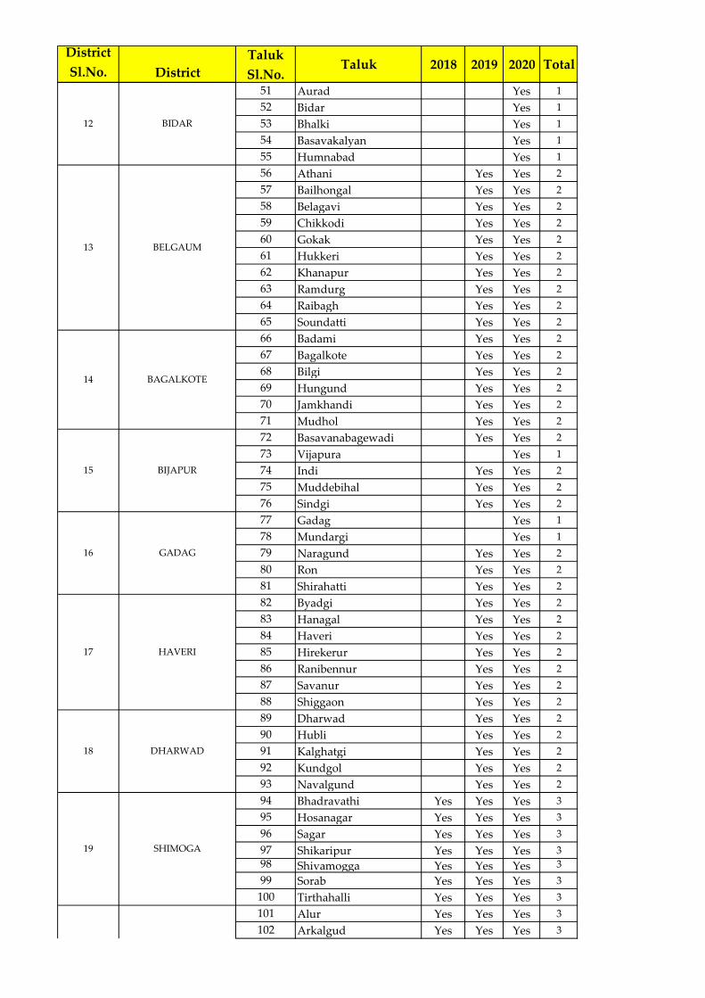
District Sl.No. District
Taluk Sl.No.
Taluk 2018 2019 2020 Total
51 Aurad Yes 152 Bidar Yes 153 Bhalki Yes 154 Basavakalyan Yes 155 Humnabad Yes 156 Athani Yes Yes 257 Bailhongal Yes Yes 258 Belagavi Yes Yes 259 Chikkodi Yes Yes 260 Gokak Yes Yes 261 Hukkeri Yes Yes 262 Khanapur Yes Yes 263 Ramdurg Yes Yes 264 Raibagh Yes Yes 265 Soundatti Yes Yes 266 Badami Yes Yes 267 Bagalkote Yes Yes 268 Bilgi Yes Yes 269 Hungund Yes Yes 270 Jamkhandi Yes Yes 271 Mudhol Yes Yes 272 Basavanabagewadi Yes Yes 273 Vijapura Yes 174 Indi Yes Yes 275 Muddebihal Yes Yes 276 Sindgi Yes Yes 277 Gadag Yes 178 Mundargi Yes 179 Naragund Yes Yes 280 Ron Yes Yes 281 Shirahatti Yes Yes 282 Byadgi Yes Yes 283 Hanagal Yes Yes 284 Haveri Yes Yes 285 Hirekerur Yes Yes 286 Ranibennur Yes Yes 287 Savanur Yes Yes 288 Shiggaon Yes Yes 289 Dharwad Yes Yes 290 Hubli Yes Yes 291 Kalghatgi Yes Yes 292 Kundgol Yes Yes 293 Navalgund Yes Yes 294 Bhadravathi Yes Yes Yes 395 Hosanagar Yes Yes Yes 396 Sagar Yes Yes Yes 397 Shikaripur Yes Yes Yes 398 Shivamogga Yes Yes Yes 399 Sorab Yes Yes Yes 3100 Tirthahalli Yes Yes Yes 3101 Alur Yes Yes Yes 3102 Arkalgud Yes Yes Yes 3
12 BIDAR
13 BELGAUM
14 BAGALKOTE
15 BIJAPUR
16 GADAG
HAVERI
18 DHARWAD
19 SHIMOGA
17
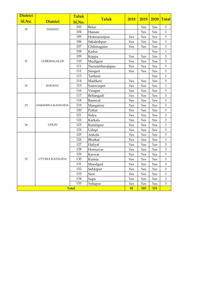
District Sl.No. District
Taluk Sl.No.
Taluk 2018 2019 2020 Total
103 Belur Yes Yes 2104 Hassan Yes Yes 2105 Holenarasipur Yes Yes Yes 3106 Sakaleshpur Yes Yes Yes 3107 Chikmagalur Yes Yes Yes 3108 Kadur Yes 1109 Koppa Yes Yes Yes 3110 Mudigere Yes Yes Yes 3111 Narasimharajapur Yes Yes Yes 3112 Sringeri Yes Yes Yes 3113 Tarikere Yes 1114 Madikeri Yes Yes Yes 3115 Somwarpet Yes Yes Yes 3116 Virajpet Yes Yes Yes 3117 Beltangadi Yes Yes Yes 3118 Bantwal Yes Yes Yes 3119 Mangalore Yes Yes Yes 3120 Puttur Yes Yes Yes 3121 Sulya Yes Yes Yes 3122 Karkala Yes Yes Yes 3123 Kundapur Yes Yes Yes 3124 Udupi Yes Yes Yes 3125 Ankola Yes Yes Yes 3126 Bhatkal Yes Yes Yes 3127 Haliyal Yes Yes Yes 3128 Honnavar Yes Yes Yes 3129 Karwar Yes Yes Yes 3130 Kumta Yes Yes Yes 3131 Mundgod Yes Yes Yes 3132 Siddapur Yes Yes Yes 3133 Sirsi Yes Yes Yes 3134 Supa Yes Yes Yes 3135 Yellapur Yes Yes Yes 3
45 103 131Total
HASSAN
23 DAKSHINA KANNADA
24 UDUPI
25 UTTARA KANNADA
20
21 CHIKMAGALUR
22 KODAGU

²
BELAGAVI
BALLARI
RAICHUR
BIDAR
VIJAYAPURA
KALABURAGI
HASSAN
TUMAKURU
MYSURU
YADGIR
HAVERI
GADAG
KOPPALA
KOLAR
SHIVAMOGGACHITRADURGA
BAGALKOTE
MANDYA
UDUPI
UTTARA KANNADA
KODAGU
DHARWAD
CHIKKAMAGALURU
DAVANGERE
CHAMARAJA NAGAR
CHIKABALLAPUR
INDI
SUPA
SIRA
SINDGI
RON
SAGAR
MANVI
ATHANI
SIRSI
ALAND
KOLLEGAL
YADGIR
JEVARGI
VIJAYAPURA
GOKAK
KADUR
HIRIYUR
GUBBI
BALLARI
KUDLIGI
SHAHPUR
AURAD
BADAMI
CHITAPUR
SORAB
VIRAJPET
SHORAPUR
LINGSUGUR
RAICHUR
SINDHNUR
KHANAPUR
SANDUR
UDUPI
GADAG
CHALLAKERE
KOPPALA
SEDAM
SAVADATTI
BIDAR
BHALKI
CHIKODI
MADIKERI
BILGI
YALBURGA
SULYA
HUNGUND
CHINCHOLI
KUSHTAGI
PAVAGADA
KALABURAGI
PUTTUR
BELUR
KARKAL
KUNDAPURA
AFZALPUR
YELLAPUR
DEVADURGA
HOSPET
TARIKERE
HASSAN
GANGAVATI
RAYBAG
HOSADURGA
GUNDLUPET
KOLAR
KANAKAPURA
MUDDEBIHAL
ARASIKERE
DHARWAD
HUNSUR
ANKOLA
TIPTUR
HUBLI
MUDHOL
HAVERI
KUNIGAL
HUKKERI
MUDIGERE
RAMADURG
JAGALUR
HOSANAGARA
BELAGAVI
BASAVANABAGEVADI
BELTHANGADI
HALIYAL
MAGADI
JAMKHANDI
MYSURU
CHANNAGIRIHONNALI
SIRUGUPPA
CHITRADURGA
MADHUGIRI
HARPANAHALLIHANGAL
NAVALGUND
TUMAKURU
MALUR
HOLALKERE
N.R.PURA
SIDDAPUR
KOPPA
HUMNABAD
BAILHONGAL
BAGEPALLI
SOMVARPET
MANDYA
SHIVAMOGGA
THIRTHAHALLI
KUMTA
CHIKKAMAGALURU
MUNDARGI
DAVANGERE
HONAVAR
ALUR
BASAVAKALYAN
SHIRAHATTI
BANTWAL
SHIKARIPUR
NANJANAGUD
BANGARPET
SAKALESHPUR
MALAVALLI
KUNDGOL
ANEKAL
RANIBENNURU
PIRIYAPATNA
SAVANUR
BYADGI
KALGHATGI
TURUVEKERE
HARIHAR
KORATAGERE
NARGUND
DAKSHINA KANNADA
RAMANAGARAM
BANGALORE RURAL
BANGALORE URBAN
BAGALKOTE
MADDUR
HEGGADADEVANAKOTE
HIREKERUR
NAGAMANGALA
MUNDGOD
MULABAGAL
CHINTHAMANI
CHAMARAJA NAGAR
GAURIBIDANUR
SHIGGAON
SRINIVASAPURA
KRISHNARAJPETARAKALGUD
CHANNARAYAPATNA
HOSAKOTE
BHADRAVATHI
SIDLAGHATTA
HUVVINAHADAGALI
SRINGERI
MOLAKALMURU
DODDABALLAPUR
CHIKKANAYAKANAHALLI
RAMANAGARA
T.NARASIPURA
DAKSHINA KANNADA
UTTARA KANNADA
CHIKBALLAPUR
HAGARIBOMMANAHALLI
BANGALORE NORTH
PANDAVAPURA
BHATKAL
CHANNAPATNA
DEVANHALLI
NELAMANGALA
HOLE NARASIPURA
BANGALORE SOUTH
KRISHNARAJA NAGARA
YELANDUR
SRIRANGAPATNA
GUDIBANDA
BANGALORE EAST
Scale
Karnataka State Natural Disaster Monitoring Centre0 50 10025
Kilometers
MM AA HH AA RR AA SS TT RR AA
TT EE LL AA NN GG AA NN AA
AA RR AA BB II AA NN SS EE AA
TT AA MM II LL NN AA DD UU
KK EE RR AA LL AA
GGOOAA
KARNATAKAFlood Affected Taluks From 2018 To 2020
Last 3 Years
Legend
2 Years (74) Taluks
3 Years (25) Taluks
Rivers
1 Year (37) Taluks
No Flood (40) Taluks

Dist. Sl.No.
District Name
Taluk Sl.No.
Taluk Name
Hobli Sl.No.
Hobli Name
GP Sl.No.
Gram Panchayat
NameSl.No. Village Name Flood Hazard
Class
1 2 3 4 5 6 7 8 9 10 111 Yadyanawadi Moderate Risk Area2 Malikwad Very High Risk Area3 Sadalgi (TP) Very High Risk Area4 Examba Very High Risk Area5 Sadalaga (Rural) Very High Risk Area
3 Shamanewadi 6 Shamanewadi Very High Risk Area4 Sadalaga (Rural) 7 Sadalaga (Rural) Very High Risk Area5 Janawad 8 Janwad Very High Risk Area
9 Yamagarni Moderate Risk Area10 Naganur Moderate Risk Area11 Budihal Moderate Risk Area
7 Jatrat 12 Jatrat Moderate Risk Area8 Akkol 13 Akkol Moderate Risk Area
14 Bhivashi Moderate Risk Area15 Soundalga Moderate Risk Area16 Kurli Moderate Risk Area17 Bhatnaganur Moderate Risk Area
11 Adi 18 Chandur Moderate Risk Area19 Bolewadi Moderate Risk Area20 Benadi Moderate Risk Area
13 Koganoli 21 Koganoli Moderate Risk Area14 Mamadapur K.L. 22 Mamadapur (KL) Moderate Risk Area15 Shidnal 23 Sidnal Moderate Risk Area16 Galataga 24 Galatga Moderate Risk Area17 Hunnaragi 25 Hunnaragi Moderate Risk Area18 Bhoj 26 Bhoj Very High Risk Area19 Bedakihal 27 Bedkihal Very High Risk Area
28 Kunnur Very High Risk Area29 Gajabarwadi Very High Risk Area
21 Barawad 30 Barwad Very High Risk Area22 Shiradawad 31 Shiradwad Very High Risk Area23 Mangur 32 Mangur Very High Risk Area24 Karadaga 33 Karadaga Very High Risk Area25 Doniwadi 34 Boragaon Very High Risk Area26 Manakapur 35 Manakapur Moderate Risk Area
ANNEXURE VII Basin wise list of Flood prone Villages
Upper Krishna Sub-Basin (K1)List of Flood Hazard Risk Villages
Malikawad
Sadalgi (TP)
Yamagrani
1
2
1
2
Kurli
Benadi
Kunnur
Belagavi
Chikkodi
Nippani
Sadalgi
Nippani
Sadalgi
1
Soundalaga
3
1
2
6
9
10
12
20

Dist. Sl.No.
District Name
Taluk Sl.No. Taluk Name Hobli
Sl.No. Hobli Name GP Sl.No. Gram Panchayat Name Sl.No. Village Name Flood Hazard Class
1 2 3 4 5 6 7 8 9 10 111 Kadoor Moderate Risk Area2 Antarthana Moderate Risk Area
2 Karidigudda 3 Nilvanji Very High Risk Area4 Anjal Very High Risk Area5 Gopalpur Very High Risk Area6 Anchesugur Very High Risk Area7 Herur Very High Risk Area8 Yatgal Very High Risk Area9 Wagadambli Very High Risk Area10 Huvinhadgi Very High Risk Area11 Joladhadgi Very High Risk Area12 Dondambli Very High Risk Area13 Benkal Very High Risk Area14 Karkihalli Very High Risk Area15 Konchapli Very High Risk Area16 Mydargol Very High Risk Area17 Hunur Very High Risk Area18 Kopper Very High Risk Area19 Kurkihalli Very High Risk Area20 Paratpur Very High Risk Area21 Baswantpur Very High Risk Area22 Apprahal Very High Risk Area23 Madarkal Very High Risk Area24 Hireraikumpi Very High Risk Area25 Chickraikumpi Very High Risk Area26 Itagi Very High Risk Area27 Gugal Very High Risk Area
10 Palkanmaradi 28 Devergud Moderate Risk Area29 Veergot Moderate Risk Area30 Bunkaldoddi Very High Risk Area31 Chinchodi Very High Risk Area32 Lingadhalli Very High Risk Area
12 Amarapur 33 Suladgud Moderate Risk Area13 Jalahalli 34 Chapalki Very High Risk Area
35 Bagur Very High Risk Area36 Mudgot Very High Risk Area37 Herundi Very High Risk Area38 Buddinni Very High Risk Area39 Roudal Banda Very High Risk Area40 Jungi-Rampur Very High Risk Area41 Upperi (Small) Very High Risk Area42 Sunkal Very High Risk Area
16 Gorebal 43 Halbhavi Very High Risk Area6 Gurgunta 17 Guntgol 44 Jaldurga Very High Risk Area
18 Yapaldinni 45 Budidipad Moderate Risk Area46 Athkur Very High Risk Area47 Dongarampur Moderate Risk Area48 Korvakala Moderate Risk Area49 Korvakhurd Moderate Risk Area50 Agrahar Moderate Risk Area51 Wadloor Moderate Risk Area52 Ganjhalli Very High Risk Area53 Yedlapur Very High Risk Area54 Korvihal Very High Risk Area55 Korthkunda Very High Risk Area56 Deosugur Very High Risk Area57 Shaktinagar (CT) Moderate Risk Area58 Kadlur Very High Risk Area59 Gurjapur Very High Risk Area60 Arshanagi Very High Risk Area61 Karekal Very High Risk Area
9 Kalmali 24 Chikkasugur 62 Chicksugur Moderate Risk Area63 Mahishwadgi Very High Risk Area64 Janawad Very High Risk Area
26 Nandeshawar 65 Nandeshwar Very High Risk Area27 Shegunashi 66 Shegunshi Very High Risk Area28 Satti 67 Satti Very High Risk Area
68 Dodwad Very High Risk Area69 Naganur P.K. Very High Risk Area70 Avarkhod Very High Risk Area
30 Shankarhatti 71 Khavatkoppa Very High Risk Area31 Savadi 72 Savadi Very High Risk Area
73 Chikkud Moderate Risk Area74 Saptasagar Very High Risk Area75 Teerth Very High Risk Area
Karegudda3
4
22
23
25
29
32
11
14
15
19
20
21
1
5
6
7
8
9
10
Chandrabanda
Devarsugur
Athani
1
2
3
4
5
7
8
3
4
1
2
1
2
Naganur -Pk
Saptsagar
Hemnal
Shavantagera
Gugal
Chinchodi
Karidigudda
Rodalbanda U.K.P.
Antarathana
Gugal
Dondambli
Koppar
Kushtagi
Devadurga
Lingasuguru
Raichur
Athani5
Middle Krishna Sub-Basin (K2)List of Flood Hazard Risk Villages
Koppal
Raichur
Hanamsagar
Devadurga
Gabbur
Jalihalli
Lingasuguru
Atkoor
Yadlapur
Sagamkunta
Devasugur
Kadlur
Mahishawadagi

Dist. Sl.No.
District Name
Taluk Sl.No. Taluk Name Hobli
Sl.No. Hobli Name GP Sl.No. Gram Panchayat Name Sl.No. Village Name Flood Hazard Class
33 Darur 76 Darur Very High Risk Area34 Radderahatti 77 Radderahatti Moderate Risk Area35 Nadi-Ingalagaon 78 Nadi-Ingalgaon Very High Risk Area36 Halyal 79 Halyal Moderate Risk Area37 Hulagabali 80 Hulagabali Very High Risk Area
81 Shinal Very High Risk Area82 Tangadi Very High Risk Area
39 Zunjarwad 83 Junjarwad Very High Risk Area40 Shirahatti 84 Shirahatti Very High Risk Area41 Nandagaon 85 Nandagaon Moderate Risk Area42 Telsang 86 Telsang Moderate Risk Area43 Kannala 87 Bannur Moderate Risk Area44 Kakamari 88 Kakamari Moderate Risk Area45 Kottalagi 89 Kottalgi Moderate Risk Area46 Ankali 90 Ankali Very High Risk Area47 Manajari 91 Manjari Very High Risk Area
92 Yadur Very High Risk Area93 Hosa Yedur Very High Risk Area94 Yadurwadi Very High Risk Area
49 Manajari 95 Manjariwadi Very High Risk Area50 Ingali 96 Ingali Very High Risk Area
97 Chandur Very High Risk Area98 Chandur - Tek Very High Risk Area
13 Sadalgi 52 Kallol 99 Kallol Very High Risk Area53 Nasalapur 100 Nasalapur Very High Risk Area54 Diggewadi 101 Diggewadi (Old) Very High Risk Area55 Savadatti 102 Soundatti Very High Risk Area
103 Jalalpur Very High Risk Area104 Chinchali Moderate Risk Area
57 Bhiradi 105 Bhiradi Very High Risk Area58 Khemalapur 106 Khemalapur Very High Risk Area59 Paramanandwadi 107 Paramanandwadi Very High Risk Area60 Siddapura 108 Siddapur Very High Risk Area
109 Kudachi (Rural) Very High Risk Area110 Kudchi (TP) Moderate Risk Area111 Shiragur Very High Risk Area112 Gundwad Very High Risk Area113 Molwad Very High Risk Area114 Kusnal Very High Risk Area
64 Jugul 115 Shahapur Very High Risk Area65 Shiraguppi 116 Shiraguppi Moderate Risk Area66 Krishana Kittur 117 Krishna Kittur Very High Risk Area
118 Ugar Budruk Very High Risk Area119 Ugar Khurd Very High Risk Area120 Jugul Very High Risk Area121 Mangavati Very High Risk Area122 Banajawad Very High Risk Area123 Shedbal Moderate Risk Area124 Ainapur Very High Risk Area
70 Tangadi 125 Katral Very High Risk Area71 Kagawad 126 Kagawad Moderate Risk Area72 Mole 127 Mole Moderate Risk Area
128 Gulbal Moderate Risk Area129 Budihal(S.G.) Moderate Risk Area130 Budihal(S.G.) Moderate Risk Area131 Badgi Moderate Risk Area
74 Teggi 132 Ballur Moderate Risk Area75 Galagali 133 Galagali Very High Risk Area
134 Hanchinal(Inam) Moderate Risk Area135 Gudadinni Moderate Risk Area136 Girgaon Very High Risk Area137 Rabkavi Very High Risk Area138 Chowdapur Very High Risk Area139 Chickhanchinal Very High Risk Area140 Kolur Very High Risk Area141 Mundaganur Very High Risk Area
18 Anagvadi 78 Girisagar 142 Girisagar Moderate Risk Area79 Nagur 143 Nagur Moderate Risk Area
144 Hungund (Rural) Moderate Risk Area145 Hungund (Rural) Moderate Risk Area
81 Hungund (TP) 146 Hungund (TP) Moderate Risk Area82 Kudalasangam 147 Sangam Very High Risk Area
148 Valakaladinni Very High Risk Area149 Bisaladinni Very High Risk Area
84 Jamkhandi (Rural) 150 Jamkhandi (Rural) Moderate Risk Area85 Jamkhandi (CMC) 151 Jamkhandi (CMC) Moderate Risk Area
152 Chingundi Moderate Risk Area153 Jakanur Moderate Risk Area
80
83
86
67
68
69
73
76
77
48
51
56
61
62
63
38
17
19
11
12
14
15
16
9
10
8
3
Badagi
Inam-Hanchinal
Kolur
Hungund (Rural)
Bisaladinni
Kunchanur
Ugar - Bk
Jugul
Krishana Kittur
Tangadi
Yadur
Chandur
Jalalpur
Kudachi (Rural)
Shiragur
Kusanal
Kudchi
Kagwad
Bilgi
Hungund
Athani
Chikkodi
Raibagh
Kagwad
5
6
7
Belagavi
Bilgi
Hungund
Telsang
Chikkodi
Raibagh

Dist. Sl.No.
District Name
Taluk Sl.No. Taluk Name Hobli
Sl.No. Hobli Name GP Sl.No. Gram Panchayat Name Sl.No. Village Name Flood Hazard Class
154 Kunchanur Very High Risk Area155 Kumbarhal Moderate Risk Area156 Jamkhandi (Rural) Very High Risk Area157 Sanal Moderate Risk Area
88 Alagur 158 Alagur Very High Risk Area159 Kankanawadi Very High Risk Area160 Kadakol Very High Risk Area161 Shiraguppi Very High Risk Area162 Maigur Very High Risk Area
91 Muttur 163 Muttur Very High Risk Area164 Bidari Very High Risk Area165 Janawad Very High Risk Area166 Kavatagi Very High Risk Area167 Chikkapadasalgi Very High Risk Area168 Naganur Moderate Risk Area169 Hirepadasalgi Very High Risk Area170 Jambagi.(B.K.) Very High Risk Area171 Takkalaki Very High Risk Area172 Takkod Very High Risk Area173 Shurpali Very High Risk Area174 Jambagi.(K.D.) Moderate Risk Area175 Tubachi Very High Risk Area176 Ishwarnagar Moderate Risk Area177 Hireupnal Moderate Risk Area178 Balakundi Moderate Risk Area
98 Hire Kodagali 179 Hanamanal Moderate Risk Area99 Balakundi 180 Ilkal (CMC) Moderate Risk Area
181 Madanamatti Very High Risk Area182 Asangi Very High Risk Area
101 Halingali 183 Halingali Very High Risk Area102 Kulahalli 184 Kulhalli Very High Risk Area103 Tamadaddi 185 Tamadaddi Very High Risk Area104 Hipparagi 186 Hipparagi Very High Risk Area105 Managuli 187 Managuli Very High Risk Area106 Ukkali 188 Ukkali Moderate Risk Area
189 Bisanal Moderate Risk Area190 Bommanahalli Moderate Risk Area191 Donur Moderate Risk Area192 Mullal Moderate Risk Area193 Neginal Moderate Risk Area194 Yambatnal Moderate Risk Area
109 Jumanal 195 Jumnal Moderate Risk Area110 Hitnalli 196 Hittinahalli Very High Risk Area111 Sarwad 197 Khatijapur Moderate Risk Area
198 Bijapur (Rural) Very High Risk Area199 Bijapur (Rural) Moderate Risk Area
113 Hegadihal 200 Ukumanal Moderate Risk Area114 Kumatagi 201 Kumatagi Moderate Risk Area115 Kolur 202 Devoor Moderate Risk Area
203 Handargall Moderate Risk Area204 Kandaganur Moderate Risk Area
117 Khakandaki 205 Kakhandaki Very High Risk Area118 Karjol 206 Tonsyal Very High Risk Area
207 Babaleshwar Very High Risk Area208 Adavisangapur Very High Risk Area
120 Honaganahalli 209 Honaganahalli Very High Risk Area210 Dadamatti Very High Risk Area211 Sarawad Very High Risk Area
122 Nidoni 212 Nidoni Very High Risk Area213 Kanamuchanal Moderate Risk Area214 Dhanyal Very High Risk Area215 Jambagi(H) Very High Risk Area216 Chikka-Galagali Very High Risk Area217 Hosur Very High Risk Area218 Kanabur Very High Risk Area
125 Jainapur 219 Jainapur Moderate Risk Area220 Babalad Moderate Risk Area221 Shirabur Very High Risk Area222 Sutagundi Moderate Risk Area223 Lingadalli Moderate Risk Area224 Devara-Gennur Moderate Risk Area225 Atalatti Very High Risk Area226 Toravi (Part) Moderate Risk Area
129 Kotyal 227 Kotyal Moderate Risk Area228 Harnal Moderate Risk Area229 Ratnapura Moderate Risk Area230 Malakandevarahatti Moderate Risk Area
131 Honawad 231 Honawad Moderate Risk Area
130
121
123
124
126
127
128
100
107
108
112
116
119
92
93
94
95
96
97
87
89
90
20
21
22
23
24
25
26
27
28
29
17
18
11
12
13
14
15
16
4
5
Gunadal
D.Gennur
Toravi
Tajpur.H
Bijapur (Rural)
Yarazari
Babaleswar
Sarwad
Tajpur.H
Hosur
Jambagi-B.K
Shurpali
Balakundi
Asangi
Markabbinalli
Donur
Kumbar-Hall
Kankanavadi
Maigur
Bidari
Chikkpadasalagi
Hirepadasalagi
Mamdapur
Tikota
Ilkal
Terdal
Managuli
Vijayapura
Muddebihal
Babaleshwar
Jamakhandi
Savalagi
Vijayapura
Rabakavi Banahatti
Basavana Bagewadi
Vijayapura
Muddebihal
Babaleshwar
Tikota
Bagalkote
Jamakhandi
Ilkal

Dist. Sl.No.
District Name
Taluk Sl.No. Taluk Name Hobli
Sl.No. Hobli Name GP Sl.No. Gram Panchayat Name Sl.No. Village Name Flood Hazard Class
232 Rampur Moderate Risk Area233 Tikota Moderate Risk Area
19 Kolhar 30 Kolhar 133 Mulawad 234 Mulawad Very High Risk Area31 Devar Hipparagi 134 Jalawad 235 Jalwad Moderate Risk Area
236 Yalwar Moderate Risk Area237 Nagaraldon Moderate Risk Area
136 Satihal 238 Satihal Moderate Risk Area33 Gogi 137 Gogi (K) 239 Gogikona Moderate Risk Area
240 Markal Very High Risk Area241 Tonnur Very High Risk Area242 Chandral Very High Risk Area243 Goudoor Very High Risk Area244 Kollur Very High Risk Area245 Mushtalli Very High Risk Area246 Kagarhal Very High Risk Area247 Shalgi Very High Risk Area248 Aralhalli Very High Risk Area249 Kampapur Very High Risk Area250 Devapur Very High Risk Area251 Bevinhal Very High Risk Area252 Hemwadgi Very High Risk Area253 Sugur Very High Risk Area254 Adwadgi Very High Risk Area255 Choudeshwarhal Very High Risk Area256 Karnal Moderate Risk Area
141 Hemanoor 257 Hemnoor Very High Risk Area36 Kakkeri 142 Tinthni 258 Tinthni Very High Risk Area
259 Kodal Very High Risk Area260 Kadrapur Very High Risk Area261 Habshihal Moderate Risk Area262 Itga Simt Wadgera Very High Risk Area263 Tumkur Very High Risk Area264 Channur Jagir Very High Risk Area265 Konkal Very High Risk Area266 Gondenoor Very High Risk Area267 Ekchinti Very High Risk Area268 Hayyal (B) Very High Risk Area
147 Konkal 269 Aneksugur Very High Risk Area148 Aikur 270 Alkur Very High Risk Area149 Narayanpur 271 Jangangaddi Very High Risk Area
272 Kotigud Moderate Risk Area273 Rayangola Very High Risk Area274 Jogandabhavi Moderate Risk Area
143
144
145
146
150
132
135
138
139
140
32
34
35
37
38
39
20
21
Haiyal (B)
Jogundbhavi
6
Kollur (M)
Devapur
Sugoor
Bendebembli
Tumakura
Konkal
22
23
24
Tikota
Yalawar
Wadagera
Hayyala Buzurg
Kodekal
Huvinhiprgi
Hayyalbuzurg
Shorapur
Yadgir
Devar Hipparagi
Shahpur
Shorapur
Wadagera
Hunasagi

Dist. Sl.No.
District Name
Taluk Sl.No. Taluk Name Hobli
Sl.No. Hobli Name GP Sl.No. Gram Panchayat Name Sl.No. Village Name Flood Hazard Class
1 2 3 4 5 6 7 8 9 10 111 Peeranwadi 1 Peeranwadi (CT) Moderate Risk Area2 Belgaum (M Corp. + OG) 2 Belgaum (M Corp. + OG) Moderate Risk Area3 Mutaga 3 Mutga (CT) Moderate Risk Area4 Nilaji 4 Nilaji Moderate Risk Area5 Balekundari Kh 5 Balekundri (K.H) Moderate Risk Area
6 Sulebhavi (CT) Moderate Risk Area7 Khanagaon (B.K) Moderate Risk Area8 Chandur Moderate Risk Area
7 Mucchandi 9 Muchandi Moderate Risk Area8 Kalakhamba 10 Kalakhamb Moderate Risk Area
11 Aste Moderate Risk Area12 Chandgad Moderate Risk Area
10 Kangrali Kh 13 Alatage Moderate Risk Area11 Kangrali Bk 14 Goundawad (Part) Moderate Risk Area
15 Jafarwadi Moderate Risk Area16 Kadoli Moderate Risk Area17 Devagiri Moderate Risk Area
13 Kakti 18 Kakati (CT) Moderate Risk Area14 Honaga 19 Honaga Moderate Risk Area
20 Kallehol Moderate Risk Area21 Sulge (Uchagaon) Moderate Risk Area22 Bachi Moderate Risk Area23 Turamari Moderate Risk Area
17 Kangrali Kh 24 Kangrali (KH) (CT) Moderate Risk Area18 Uchagaon 25 Uchagaon Moderate Risk Area
26 Mannur Moderate Risk Area27 Ambewadi Moderate Risk Area
20 Kangrali Bk 28 Kangrali (BK) (CT) Moderate Risk Area29 Gokak (Rural) Moderate Risk Area30 Gokak (CMC) Very High Risk Area31 Adibatti Very High Risk Area32 Melavanki Very High Risk Area33 Chigadolli Very High Risk Area34 Kalarkoppa Very High Risk Area35 Hadiginal Very High Risk Area36 Udagatti Very High Risk Area37 Talakatnal Very High Risk Area38 Molmanatti Moderate Risk Area39 Shingalapur Moderate Risk Area40 Lolasur Moderate Risk Area41 Basaligundi Moderate Risk Area42 Shivapur Moderate Risk Area43 Nallanatti Moderate Risk Area
27 Dhupadal 44 Dhupadal Moderate Risk Area45 Mutnal Moderate Risk Area46 Nandagaon Moderate Risk Area47 Khanapur Moderate Risk Area48 Balobal Very High Risk Area49 Beerangaddi Moderate Risk Area50 Shindihatti Moderate Risk Area51 Hospet Moderate Risk Area
31 Mavanur 52 Ankalgudiketra Moderate Risk Area32 Godageri 53 Nadigudiketra Moderate Risk Area
54 Yarnal Moderate Risk Area55 Ingali Moderate Risk Area56 Hosur Moderate Risk Area57 Yargatti Moderate Risk Area58 Badkundri Moderate Risk Area59 Goudawad Moderate Risk Area
35 Bastawad 60 Bastawad Moderate Risk Area61 Madamakkanal Moderate Risk Area62 Beniwad Moderate Risk Area63 Noginhal Moderate Risk Area64 Sultanpur Moderate Risk Area65 Awargol Moderate Risk Area
38 Kotabagi 66 Kotabagi Moderate Risk Area39 Shiradaana 67 Zangatihal Moderate Risk Area40 Gudas 68 Gudas Moderate Risk Area41 Hanchinal 69 Chikalgud Moderate Risk Area42 Kurani 70 Kurni Moderate Risk Area
71 Arjunwad Moderate Risk Area72 Kochari Moderate Risk Area
44 Hebbal 73 Hebbal Moderate Risk Area45 Hunashyal.P.G 74 Hunshyal (P.G.) Very High Risk Area
75 Waderatti Moderate Risk Area76 Fulagaddi Very High Risk Area
47 Masaguppi 77 Masaguppi Very High Risk Area48 Patagundi 78 Patagundi Moderate Risk Area
79 Kamaladinni Very High Risk Area80 Rangapur Moderate Risk Area81 Munyal Very High Risk Area
50 Yadawad 82 Yadwad Moderate Risk Area51 Tigadi 83 Tigadi Very High Risk Area52 Kamanakatti 84 Kopadatti Moderate Risk Area53 Sunadholi 85 Sunadholi Very High Risk Area
86 Bairanatti Moderate Risk Area87 Hunshyal (P.Y.) Very High Risk Area88 Bisanakoppa Moderate Risk Area89 Hale Yaragudri Moderate Risk Area90 Avaradi Very High Risk Area91 Dhavaleshwar Very High Risk Area92 Aralimatti Very High Risk Area
57 Gaddanakeri 93 Gaddankeri Moderate Risk Area58 Kaladagi 94 Kaladgi Very High Risk Area59 Chikkashellikeri 95 Govindkopp Moderate Risk Area
96 Muranal Moderate Risk Area97 Kesanur * Moderate Risk Area98 Yadahalli Moderate Risk Area99 Chebbi Moderate Risk Area
100 Ankalagi Moderate Risk Area101 Sharadal Very High Risk Area
Ghataprabha Sub-Basin (K3)List of Flood Hazard Risk Villages
Sulebhavi
Ashte
Kadoli
Sulaga (U)
Lolasur
Nallanatti
Nandagaon1
6
9
12
15
16
Balobal
Hospet
Turmuri
Ambewadi
Kolavi
Melavanki
Udagatti
Talakatnal
Munyal
Avaradi
Hunashyal.P.Y.
Dhavaleshwar
Muranal
Hosur
Badakundri
Beniwad
Sultanapur
Kochari
Waderahatti
Belagavi
Belagavi
Gokak
Hukkeri
Mudalgi
BagalkoteYadahalli
Khajjidoni
1
2
3
4
Hukkeri
Sankeswar
Arbhavi
Kowjalgi
Kaladgi
Belagavi
Hirebagevadi
Kakti
Uchagaon
Gokak
Kowjalgi
Arbhavi
5
1
2
3
4
5
6
7
8
9
10
11
12
19
21
22
23
24
25
36
37
43
46
49
54
26
28
29
30
33
34
55
56
60
61
62

Dist. Sl.No.
District Name
Taluk Sl.No. Taluk Name Hobli
Sl.No. Hobli Name GP Sl.No. Gram Panchayat Name Sl.No. Village Name Flood Hazard Class
102 Udagatti Moderate Risk Area103 Devanal Moderate Risk Area104 Sokanadgi Moderate Risk Area105 Chikk-Sansi Moderate Risk Area
64 Chikkashellikeri 106 Hire-Sansi Moderate Risk Area107 Yadahalli Very High Risk Area108 Amalzari Moderate Risk Area109 Lingapur(S.K) Moderate Risk Area110 Katarki Very High Risk Area111 Shiraguppi Moderate Risk Area112 Kundargi Moderate Risk Area113 Venkatapura Moderate Risk Area
68 Anagawadi 114 Anagawadi Moderate Risk Area115 Budhihal(S.H) Moderate Risk Area116 Bavalatti Moderate Risk Area117 Kovalli Moderate Risk Area118 Koppa(S.K) Moderate Risk Area119 Algundi Moderate Risk Area
7 Jamakhandi 15 Jamakhandi 71 Linganur 120 Gani Moderate Risk Area72 Gulagal-Jambagi 121 Rugi Very High Risk Area
122 Uttur Moderate Risk Area123 Jaliber Very High Risk Area124 Ranjanagi Very High Risk Area125 Mallapur(P.J) Moderate Risk Area126 Mirji Moderate Risk Area127 Vantigodi Very High Risk Area128 Channal Moderate Risk Area
75 Mudhol (TMC) 129 Mudhol (TMC) Moderate Risk Area130 Akkimaradi Very High Risk Area131 Nagaral Very High Risk Area
77 Malali 132 Malali Very High Risk Area133 Mudhol(Rural) Moderate Risk Area134 Belagali Moderate Risk Area
79 Bhantanur 135 Bhantnur Moderate Risk Area136 Hebbal Very High Risk Area137 Chitrabanukoti Moderate Risk Area138 Timmapur Moderate Risk Area139 Petlur Moderate Risk Area140 Chikkur Moderate Risk Area141 Badnur Moderate Risk Area142 Junnur Very High Risk Area143 Muddapur Moderate Risk Area144 Kasba Jambgi(B.K) Very High Risk Area145 Budni Khurd Very High Risk Area146 Antapur Moderate Risk Area147 Baragi Very High Risk Area148 Bidri Moderate Risk Area149 Machaknur Moderate Risk Area150 Budni (B.K.) Very High Risk Area151 Alagundi(B.K) Very High Risk Area152 1501006017002 Moderate Risk Area153 Chinchakhandi(K.D) Very High Risk Area154 Jambgi(K.D) Very High Risk Area
86 Gulagal-Jambagi 155 Gulgal Jambagi Very High Risk Area156 Ingalagi Very High Risk Area157 Yadahalli Moderate Risk Area
88 Vajramatti 158 Vajjaramatti Moderate Risk Area89 Madabhavi 159 Marapur Very High Risk Area90 Nandagav 160 Nandagoan Very High Risk Area91 Dhavaleshwar 161 Dhavaleshwar Very High Risk Area92 Mahalingpur (TMC) 162 Mahalingpur (TMC) Moderate Risk Area
Yadahalli
Kataraki
Chichakhandi-K.D
Machakanur
Ingalagi
Bagalkote
Mudhol(Rural)
Hebbal
Bhantanur
Baragi
Kasaba-Jambagi
Budihal-Sh
Chikkalagundi
Kundaragi
Uttur
Vantigodi
Nagaral
Devanal
2
Bilgi
Bilgi
Mudhol
Rabakavi Banahatti
6
8
9
17
18
13
14
16
Anagvadi
Mudhol
Lokapur
Mudhol
65
66
67
69
70
73
63
83
84
85
87
74
76
78
80
81
82

Dist. Sl.No. District Name Taluk
Sl.No. Taluk Name Hobli Sl.No. Hobli Name GP
Sl.No. Gram Panchayat Name Sl.No. Village Name Flood Hazard Class
1 2 3 4 5 6 7 8 9 10 111 Belagavi 1 Belagavi 1 Yallur 1 Yellur (CT) Moderate Risk Area
2 Kagganagi Moderate Risk Area3 Chikadinkop Moderate Risk Area
2 Itagi 4 Itagi Moderate Risk Area3 Hirehattiholi 5 Hire-Hattiholi Moderate Risk Area4 Devarashigihalli 6 Marganakoppa Moderate Risk Area
7 Veerapur Moderate Risk Area8 Dastikoppa Moderate Risk Area
6 M.K.Hubli 9 M.K.Hubli Moderate Risk Area10 Manneri Moderate Risk Area11 Jakanur Moderate Risk Area12 Neeralagi Moderate Risk Area13 Katharaki Moderate Risk Area14 Thaminal Moderate Risk Area15 Chikkanasabi Moderate Risk Area
8 Beloor 16 Dhanakashirur Moderate Risk Area9 Cholachagudd 17 Cholachagudda Moderate Risk Area
18 Hirenasabi Moderate Risk Area19 Mangalur Moderate Risk Area20 Gonal Moderate Risk Area21 Shirabadagi Moderate Risk Area
11 Badami (TMC) 22 Badami (TMC) Moderate Risk Area12 Nandikeshwar 23 Nelwagi Moderate Risk Area13 Badami (Rural) * 24 Badami (Rural) * Moderate Risk Area14 Nandikeshwar 25 Nandikeshwar Moderate Risk Area
26 Bachinagudd Moderate Risk Area27 Pattadakall Moderate Risk Area28 Hebballi Moderate Risk Area29 Mumaraddikoppa Moderate Risk Area30 Sulla Moderate Risk Area31 Kittali Moderate Risk Area32 Beeranur Moderate Risk Area33 Talakawad Moderate Risk Area34 Alur .S.K. Moderate Risk Area
19 Kakanur 35 Karalakoppa Moderate Risk Area20 Chittaragi 36 Chittaragi Very High Risk Area
37 Chickmagi Moderate Risk Area38 Khairwadgi Moderate Risk Area39 Chickmalagavi Very High Risk Area40 Belgal Very High Risk Area41 Medinapur Very High Risk Area42 Huvanur Very High Risk Area
23 Hiremalagavi 43 Hiremalagavi Moderate Risk Area24 Dhannur 44 Iddalgi Moderate Risk Area
45 Nandanoor Very High Risk Area46 Ganjihal Very High Risk Area
26 Kudalasangam 47 Sangam Very High Risk Area27 Bisaladinni 48 Chowdakamaladinni Moderate Risk Area
49 Nimbalgundi Moderate Risk Area50 Aiahole Moderate Risk Area
29 Huvinahalli 51 Ramathal Moderate Risk Area52 Hiremagi Moderate Risk Area53 Bevinal Moderate Risk Area54 Budihal (Inam) Moderate Risk Area
31 Kamatgi (CT) 55 Kamatgi (CT) Moderate Risk Area56 Kadiwal Kallapur Moderate Risk Area57 Suralikal Moderate Risk Area58 Basawanal Moderate Risk Area59 Basarikatti Moderate Risk Area60 Budihal (S.K.) Moderate Risk Area
8 Karadi 33 Dhannur 61 Kamadatta Moderate Risk Area62 Katapur Moderate Risk Area63 Mangalagudda Moderate Risk Area64 Chimmalagi Moderate Risk Area65 Kataginahalli Moderate Risk Area66 Layadagundi Moderate Risk Area67 Kotnalli Moderate Risk Area68 Asangi Moderate Risk Area
36 Nagaral-S.P 69 Subbalahunashi Moderate Risk Area70 Allur. S.P. Moderate Risk Area71 Haradolli Moderate Risk Area72 Haladur Moderate Risk Area
10 Naragund 38 Banahatti 73 Kurlageri Moderate Risk Area39 Surkod 74 Surkod Moderate Risk Area40 Konnur 75 Budihal Moderate Risk Area41 Chikkamannur 76 Hiremannur Moderate Risk Area
77 Basarakod Moderate Risk Area78 B-S-Beler Moderate Risk Area
43 Koujageri 79 Malawad Moderate Risk Area80 Hunagundi Moderate Risk Area81 Benahal Moderate Risk Area
45 Holealur 82 Holealur Moderate Risk Area46 Holemannur 83 Gadgoli Moderate Risk Area47 Menasagi 84 Menasigi Moderate Risk Area
85 Kuruvinakoppa Moderate Risk Area86 Hole Hadagali Moderate Risk Area87 Amaragol Moderate Risk Area
14 Nargil 49 D.S.Hadagali 88 Hadagali -S- Dambal Moderate Risk Area89 Hosur Moderate Risk Area
Malaprabha Sub-Basin (K4)List of Flood Hazard Risk Villages
Belagavi
Kodachawad
Dastikoppa
Khanapur
Kittur
Ihole
Hiremagi
1
2
7
9
Muganur
Kataraki
Mangalur
Pattadakall
Hebballi
Kittali
Alur-Sk
21
22
25
28
Bagalkote
Gadag
Badami
Hungund
Guledagudda
Hosur
Mangalagudda
Layadagundi
Haladur
Amaragol
Hunagundi
Amaragol
Hiremalagavi
Belagall
Ganjihal
Khanapur
Kittur
Badami
Kulgeri
Hungund
Amingarh
Guledagudda
Konnur
Ron
Naragund
Ron
2
3
4
5
6
12
3
2
3
4
5
6
7
8
30
32
1
5
7
10
15
16
17
18
11
34
35
37
42
44
48
13 Hole Alur
50

Dist. Sl.No. District Name Taluk
Sl.No. Taluk Name Hobli Sl.No. Hobli Name GP
Sl.No. Gram Panchayat Name Sl.No. Village Name Flood Hazard Class
90 Yattinahalli Moderate Risk Area91 Aratal Moderate Risk Area92 Dhundshi Moderate Risk Area
52 Madli 93 Kunnur Moderate Risk Area53 N M Tadas 94 Adavisomapur Moderate Risk Area
95 Kamalanagar Moderate Risk Area96 Tadas Moderate Risk Area97 Muthalli Moderate Risk Area
10 Dharwad 16 Aminbhavi 55 Harobelawadi 98 Harobelavadi Moderate Risk Area56 Kiresur 99 Kirasur Moderate Risk Area57 Hebsur 100 Hebsur Moderate Risk Area
101 Belligatti Moderate Risk Area102 Jigalur Moderate Risk Area103 Ramanakoppa Moderate Risk Area104 Hosakatti Moderate Risk Area
59 Guruvinahalli 105 Vithalapur Moderate Risk Area60 Kubihal 106 Kubihal Moderate Risk Area61 Yeliwala 107 Yaliwal Moderate Risk Area
108 Chikkanarti Moderate Risk Area109 Mullahalli Moderate Risk Area110 Yaraguppi Moderate Risk Area
63 Gudenakatti 111 Yarinarayanpur Moderate Risk Area112 Kumaragoppa Moderate Risk Area113 Yamanur Moderate Risk Area
65 Navalgund (TMC) 114 Navalgund (TMC) Moderate Risk Area115 Ahetti Moderate Risk Area116 Shirur Moderate Risk Area
67 Gudisagar 117 Gudisagar Moderate Risk Area68 Halakusugal 118 Shanawad Moderate Risk Area69 Belavatagi 119 Belavatagi Moderate Risk Area
120 Dundur Moderate Risk Area121 Bennur Moderate Risk Area122 Ballarawad Moderate Risk Area
Yamanur
Shirur
Shishvinahalli
Haveri
Dharwad
Hosur
Dhundasi
Tadas
Ramanakoppa
Yaraguppi
Annigeri
Shiggaon
Hubballi
Kundgol
Navalgund
4
5
13
14
9
11
12
62
Kundgol
Saunshi
Dhundsi
Shirguppi
64
20
21
15
17
18
19
Annigeri
66
70
50
51
54
58
Moraba

Dist. Sl.No.
District Name
Taluk Sl.No.
Taluk Name
Hobli Sl.No.
Hobli Name
GP Sl.No.
Gram Panchayat
NameSl.No. Village Name Flood Hazard Class
1 2 3 4 5 6 7 8 9 10 111 Maragur Moderate Risk Area2 Dhulikhed (Old) Very High Risk Area3 Chanegaon Moderate Risk Area4 Taddewadi Very High Risk Area5 Takali Moderate Risk Area6 Umrani (Old) Moderate Risk Area7 Nivargi Moderate Risk Area8 Govindapur Moderate Risk Area
4 Dhulakhed 9 Shirnal Moderate Risk Area5 Hattalli 10 Sankha (Old) Moderate Risk Area
11 Umraj Moderate Risk Area12 Dasur Moderate Risk Area
7 Babanagar 13 Babanagar Moderate Risk Area8 Bijjaragi 14 Bijjaragi Moderate Risk Area9 Kanamadi 15 Kanamadi Moderate Risk Area
1
2
3
6
Upper Bhima Sub-Basin (K5)List of Flood Hazard Risk Villages
Vijayapura
Chadchan
Tikota
Chadchan
Tikota
Dhulakhed
Umarani
D.Nimbaragi
Umaraja
1
1
2
1
2

Dist. Sl.No.
District Name
Taluk Sl.No. Taluk Name Hobli
Sl.No. Hobli Name GP Sl.No.
Gram Panchayat Name Sl.No. Village Name Flood Hazard Class
1 2 3 4 5 6 7 8 9 10 111 Ghatterga Very High Risk Area2 Hawalga Moderate Risk Area3 Kolnur Very High Risk Area4 Guddewadi Moderate Risk Area5 Shivpur Moderate Risk Area6 Kesapur Moderate Risk Area7 Guolnur Very High Risk Area8 Kalur Very High Risk Area9 Batgera Very High Risk Area
10 Karkanahalli Very High Risk Area11 Tellur Very High Risk Area12 Afzalpur (Rural) Moderate Risk Area13 Gour (K) Moderate Risk Area14 Awarad Moderate Risk Area
4 Hasargundagi 15 Umerga Very High Risk Area5 Bandarwad 16 Banderwad Moderate Risk Area6 Deval Ghanagapur 17 D.Ghangapur Very High Risk Area7 Choudapur 18 Chinmmgera Moderate Risk Area8 Gobbur (B) 19 Shivajinagar Moderate Risk Area9 Madara(B) 20 Ingalgi (B) Moderate Risk Area
10 Bhairamadagi 21 Bhairamadgi Moderate Risk Area11 Kugnur 22 Goudgaon Very High Risk Area
23 Dudangi Very High Risk Area24 Mangaroli Moderate Risk Area25 Algi (B) Very High Risk Area
13 Gour (B) 26 Soan Very High Risk Area27 Bhosga Moderate Risk Area28 Bhankalga Moderate Risk Area29 Hiriyal Moderate Risk Area30 Udchan Very High Risk Area31 Shivoor Very High Risk Area
16 Ram Nagar 32 Kodagnur Very High Risk Area17 Mannur 33 Mannur Very High Risk Area18 Tadakal 34 Bharked Moderate Risk Area
35 Sirur (G) Moderate Risk Area36 Gadlegaon Moderate Risk Area
20 Bhodhan 37 Bhodhan Moderate Risk Area38 Betjewargi Moderate Risk Area39 Kamalanagar Moderate Risk Area40 Sawalgi (K) Moderate Risk Area
22 Bhodhan 41 Bilgunda Moderate Risk Area42 Sangunda Moderate Risk Area43 Belamogi Moderate Risk Area
24 Yalsangi 44 Benisirur Moderate Risk Area25 Hittalsiroor 45 Kudki Moderate Risk Area
46 Vaijapur Moderate Risk Area47 Alur (B) Moderate Risk Area
27 Nimbarga 48 Nimberga Moderate Risk Area28 Hittalsiroor 49 Hithal Sirur Very High Risk Area
50 Battarga Very High Risk Area51 Dhangapur Moderate Risk Area52 Devanti Moderate Risk Area
30 Hittalsiroor 53 Jawali.D Very High Risk Area31 Miriyan 54 Kallur Road Very High Risk Area
55 Ganganpalli Very High Risk Area56 Anwar Very High Risk Area57 Chincholi (TP) Very High Risk Area58 Neemahosalli Very High Risk Area59 Goudanhalli Very High Risk Area60 Degalmadi Very High Risk Area61 Garampalli Very High Risk Area62 Tajlapur Very High Risk Area63 Chimmanchod Very High Risk Area64 Tumkunta Moderate Risk Area65 Salebeernhalli Very High Risk Area66 Chintpalli Moderate Risk Area67 Raikod Moderate Risk Area68 Gadikeshwar Moderate Risk Area69 Karachkhed Moderate Risk Area70 Chatarsal Moderate Risk Area71 Iragpalli Moderate Risk Area72 Sangam[K] Moderate Risk Area73 Benkanhalli Moderate Risk Area74 Bhantanahalli Moderate Risk Area75 Garagpalli Very High Risk Area76 Pardarmotakpalli Moderate Risk Area
10 Kodli Chincholi 41 Kanakpur (Karakmukli) 77 Karakmukli Very High Risk Area42 Kardal 78 Kardal Moderate Risk Area43 Kamarwadi 79 Alura Moderate Risk Area44 Chitapur (TMC) 80 Chitapur (TMC) Moderate Risk Area
40
35
36
37
38
39
1
2
3
12
14
15
19
21
23
26
29
32
33
34
6
7
8
9
1
2
3
4
5
1
2
3
Afzalpur
Aland
Chincholi
Afzalpur
Atanur
Karajgi
Khajuri
Narona
Nimbarga Tanda
Chincholi
Ainapur
Sulepet
Kerolli
Garagapalli
Garampalli
Chimmanchod
Salebeernalli
Gadikeshwar
Karchkhed
Lower Bhima Sub-Basin (K6)List of Flood Hazard Risk Villages
Chincholi (TP)
Ghattarga
Kallur
Tellur
Allagi B
Bankalaga
Udachan
Alanga
Kamalanagar
Belamagi
Suntnoor
Dhangapur
Anwar
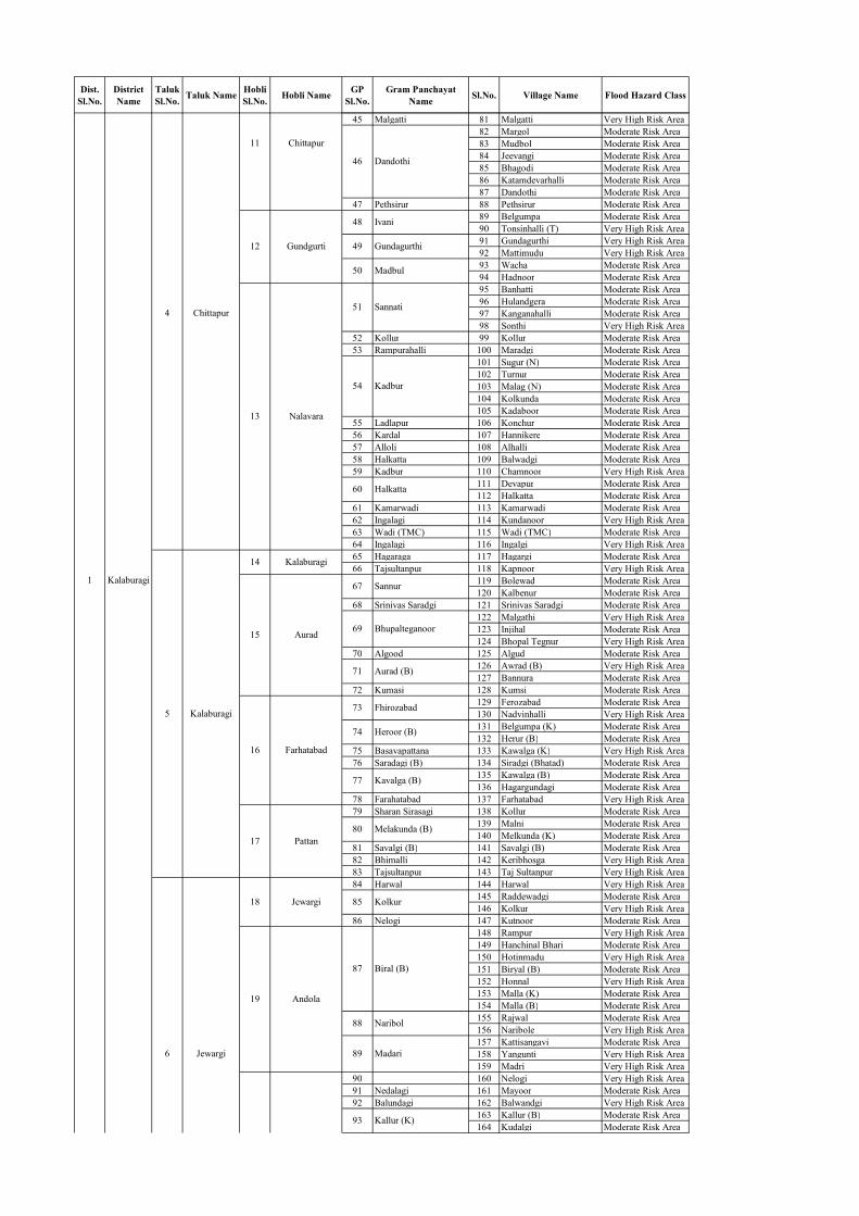
Dist. Sl.No.
District Name
Taluk Sl.No. Taluk Name Hobli
Sl.No. Hobli Name GP Sl.No.
Gram Panchayat Name Sl.No. Village Name Flood Hazard Class
45 Malgatti 81 Malgatti Very High Risk Area82 Margol Moderate Risk Area83 Mudbol Moderate Risk Area84 Jeevangi Moderate Risk Area85 Bhagodi Moderate Risk Area86 Katamdevarhalli Moderate Risk Area87 Dandothi Moderate Risk Area
47 Pethsirur 88 Pethsirur Moderate Risk Area89 Belgumpa Moderate Risk Area90 Tonsinhalli (T) Very High Risk Area91 Gundagurthi Very High Risk Area92 Mattimudu Very High Risk Area93 Wacha Moderate Risk Area94 Hadnoor Moderate Risk Area95 Banhatti Moderate Risk Area96 Hulandgera Moderate Risk Area97 Kanganahalli Moderate Risk Area98 Sonthi Very High Risk Area
52 Kollur 99 Kollur Moderate Risk Area53 Rampurahalli 100 Maradgi Moderate Risk Area
101 Sugur (N) Moderate Risk Area102 Turnur Moderate Risk Area103 Malag (N) Moderate Risk Area104 Kolkunda Moderate Risk Area105 Kadaboor Moderate Risk Area
55 Ladlapur 106 Konchur Moderate Risk Area56 Kardal 107 Hannikere Moderate Risk Area57 Alloli 108 Alhalli Moderate Risk Area58 Halkatta 109 Balwadgi Moderate Risk Area59 Kadbur 110 Chamnoor Very High Risk Area
111 Devapur Moderate Risk Area112 Halkatta Moderate Risk Area
61 Kamarwadi 113 Kamarwadi Moderate Risk Area62 Ingalagi 114 Kundanoor Very High Risk Area63 Wadi (TMC) 115 Wadi (TMC) Moderate Risk Area64 Ingalagi 116 Ingalgi Very High Risk Area65 Hagaraga 117 Hagargi Moderate Risk Area66 Tajsultanpur 118 Kapnoor Very High Risk Area
119 Bolewad Moderate Risk Area120 Kalbenur Moderate Risk Area
68 Srinivas Saradgi 121 Srinivas Saradgi Moderate Risk Area122 Malgathi Very High Risk Area123 Injihal Moderate Risk Area124 Bhopal Tegnur Very High Risk Area
70 Algood 125 Algud Moderate Risk Area126 Awrad (B) Very High Risk Area127 Bannura Moderate Risk Area
72 Kumasi 128 Kumsi Moderate Risk Area129 Ferozabad Moderate Risk Area130 Nadvinhalli Very High Risk Area131 Belgumpa (K) Moderate Risk Area132 Herur (B) Moderate Risk Area
75 Basavapattana 133 Kawalga (K) Very High Risk Area76 Saradagi (B) 134 Siradgi (Bhatad) Moderate Risk Area
135 Kawalga (B) Moderate Risk Area136 Hagargundagi Moderate Risk Area
78 Farahatabad 137 Farhatabad Very High Risk Area79 Sharan Sirasagi 138 Kollur Moderate Risk Area
139 Malni Moderate Risk Area140 Melkunda (K) Moderate Risk Area
81 Savalgi (B) 141 Savalgi (B) Moderate Risk Area82 Bhimalli 142 Keribhosga Very High Risk Area83 Tajsultanpur 143 Taj Sultanpur Very High Risk Area84 Harwal 144 Harwal Very High Risk Area
145 Raddewadgi Moderate Risk Area146 Kolkur Very High Risk Area
86 Nelogi 147 Kutnoor Moderate Risk Area148 Rampur Very High Risk Area149 Hanchinal Bhari Moderate Risk Area150 Hotinmadu Very High Risk Area151 Biryal (B) Moderate Risk Area152 Honnal Very High Risk Area153 Malla (K) Moderate Risk Area154 Malla (B) Moderate Risk Area155 Rajwal Moderate Risk Area156 Naribole Very High Risk Area157 Kattisangavi Moderate Risk Area158 Yangunti Very High Risk Area159 Madri Very High Risk Area
90 160 Nelogi Very High Risk Area91 Nedalagi 161 Mayoor Moderate Risk Area92 Balundagi 162 Balwandgi Very High Risk Area
163 Kallur (B) Moderate Risk Area164 Kudalgi Moderate Risk Area
85
87
88
89
93
71
73
74
77
80
51
54
60
67
69
46
48
49
50
17
18
19
13
14
15
16
11
12
4
5
6
Kalaburagi
Chittapur
Kalaburagi
Jewargi
Jewargi
Andola
Nalavara
Kalaburagi
Aurad
Farhatabad
Pattan
Chittapur
Gundgurti
Ivani
Biral (B)
Naribol
Madari
Kallur (K)
Heroor (B)
Kavalga (B)
Melakunda (B)
Kolkur
Aurad (B)
Fhirozabad
Sannati
Kadbur
Dandothi
Gundagurthi
Madbul
1
Halkatta
Sannur
Bhupalteganoor

Dist. Sl.No.
District Name
Taluk Sl.No. Taluk Name Hobli
Sl.No. Hobli Name GP Sl.No.
Gram Panchayat Name Sl.No. Village Name Flood Hazard Class
165 Hullur Very High Risk Area166 Narayanpur Moderate Risk Area167 Harnal (K) Moderate Risk Area168 Hanchinal S.Nelogi Moderate Risk Area169 Ankalga Moderate Risk Area170 Mogan Itga Moderate Risk Area171 Gulihal Moderate Risk Area172 Itga Very High Risk Area173 Nrupathanga Moderate Risk Area174 Bhimnagar Moderate Risk Area175 Rajivnagar Moderate Risk Area176 Malkhed (J) Very High Risk Area177 Samkhed Very High Risk Area178 Sedam (Rural) Moderate Risk Area179 Sedam (Rural) Moderate Risk Area
99 Uoodagi 180 Hanganhalli Moderate Risk Area100 Sedam (TMC) 181 Sedam (TMC) Very High Risk Area
182 Beeranhalli Moderate Risk Area183 Kukunda Very High Risk Area
102 Yadaga 184 Taranhalli Very High Risk Area103 Neelhalli 185 Sangavi (M) Moderate Risk Area
186 Telkur Moderate Risk Area187 Habal (T) Moderate Risk Area
22 Adki 105 Batagera -K 188 Batgera(B) Moderate Risk Area106 Tengali 189 Tengli Very High Risk Area107 Kodadur 190 Mangalgi Moderate Risk Area108 Rajapur 191 Rajapur Moderate Risk Area109 Kalgi 192 Kalgi Moderate Risk Area
193 Gotur Very High Risk Area194 Sugur (K) Moderate Risk Area195 Chincholi (H) Very High Risk Area196 Banbi Very High Risk Area197 Hulgera Moderate Risk Area198 Kalhipperga Very High Risk Area199 Herur (K) Very High Risk Area
113 Bedsur 200 Sanjay Nagar Moderate Risk Area201 Allapur Moderate Risk Area202 Sunthan Moderate Risk Area203 Ratkal Moderate Risk Area204 Mukramba Moderate Risk Area205 Muchakhed Very High Risk Area206 Kalgurthi Very High Risk Area207 Malaghan Very High Risk Area208 Kansoor Very High Risk Area209 Bennur (K) Very High Risk Area210 Hebbal Very High Risk Area211 Tonchi Very High Risk Area212 Jeevanmardgi Very High Risk Area213 Shelgi Moderate Risk Area214 Belura Moderate Risk Area215 Bhunyara(K) Moderate Risk Area216 Jeevangi Moderate Risk Area217 Ankalga Moderate Risk Area218 Siradhone Moderate Risk Area
121 Nagur 219 Tadkal Moderate Risk Area220 Bhusangi Very High Risk Area221 Kannura Very High Risk Area
123 Mahagoan 222 Mahagaon Very High Risk Area124 Holakunda 223 Dastapur Moderate Risk Area
224 Apchand Very High Risk Area225 Hodal Moderate Risk Area
126 Muddadaga 226 Madki Moderate Risk Area227 Kudmud Moderate Risk Area228 Ambalga Moderate Risk Area
128 Lad Mugali 229 Ladmugli Very High Risk Area29 Ainapur 129 Chengta 230 Pangarga Moderate Risk Area
10 Yadrami 30 Ijeri 130 Ijeri 231 Ijeri Moderate Risk Area232 Hongunta Very High Risk Area233 Kadhalli Very High Risk Area
132 Tonasnhalli(S) 234 Gola (K) Moderate Risk Area133 Shahabad (CMC) 235 Shahabad (CMC) Very High Risk Area
236 Bhankur (OG) Moderate Risk Area237 Mutga Moderate Risk Area
135 Maratur 238 Martur Moderate Risk Area239 Gilagili Moderate Risk Area240 Hattarga (Sarhad) Moderate Risk Area241 Sirgur Moderate Risk Area242 Gadlegaon (K) Moderate Risk Area
137 Kohinoor 243 Mankhed Moderate Risk Area33 Mudabi 138 Harkud 244 Kherda (K) Moderate Risk Area
13 Chitguppa 34 Nirna 139 Changlera 245 Alipur Moderate Risk Area14 Vijayapura 35 Vijayapura 140 Honnutagi 246 Honnutagi Moderate Risk Area
141 Miragi 247 Miragi Very High Risk Area142 Lalasangi 248 Rodagi Moderate Risk Area
131
134
136
119
120
122
125
127
114
115
116
117
118
101
104
110
111
112
94
95
96
97
98
28
31
32
23
24
25
26
27
20
21
2
7
8
9
11
12Bidar
Sedam
Kalagi
Kamalapur
Shahabad
Basavakalyan
Shahabad
Kohinoor
Kodli
Gundgurti
Kamalapur
Mahagaon Tanda
Narona
Nelogi
Sedam
Kalagi
Shrichand
Ambalga
Honagunta
Ratkal
Korwar
Gotoor
Hebbal
Jeevangi
Telkur
Gotoor
Chincholli (H)
Heroor (K)
Kodli
Ankalga
Itga
Bhankur
Betgera
Kurikota
Babalad (Ik)
Malkhed
Sedam (Rural)
Kukkunda
Hullura

Dist. Sl.No.
District Name
Taluk Sl.No. Taluk Name Hobli
Sl.No. Hobli Name GP Sl.No.
Gram Panchayat Name Sl.No. Village Name Flood Hazard Class
249 Khedgi Very High Risk Area250 Bhuyar Very High Risk Area251 Nagarhalli Moderate Risk Area
144 Gubbewada 252 Mannur Very High Risk Area253 Agarkhed Very High Risk Area254 Gubbewad Very High Risk Area
146 Gubbewada 255 Shiragur Inam (Old) Very High Risk Area256 Baragudi Very High Risk Area257 Hingani Very High Risk Area
148 Padanur 258 Padanur Very High Risk Area149 Kakkalameli 259 Kakkalameli Moderate Risk Area
260 Kulekumatgi Moderate Risk Area261 Shirasgi Moderate Risk Area262 Bagalur Moderate Risk Area263 Havalgi Very High Risk Area
151 Devar Navadgi 264 Kumashigi Very High Risk Area265 Kadlewad(P.A) Moderate Risk Area266 Shambewad Moderate Risk Area267 Devangaon Very High Risk Area268 Byadgihal (Old) Moderate Risk Area269 Tarapur (Old) Very High Risk Area270 Tavarkhed (Old) Moderate Risk Area271 Kadani Very High Risk Area272 Halasangi Moderate Risk Area273 Anachi Very High Risk Area
155 Dhulakhed 274 Shiragur Khalasa Moderate Risk Area156 Shirval 275 Sirwal Very High Risk Area157 Anabi 276 Anabi Moderate Risk Area
277 Ibrahimpur Moderate Risk Area278 Tangadgi Moderate Risk Area279 Hursgundgi Very High Risk Area280 Habballi Moderate Risk Area
160 Chamanal 281 Nadihal Moderate Risk Area161 Ukkinal 282 Ukkinhal Moderate Risk Area
283 Achola Moderate Risk Area284 Siddarthnagar Moderate Risk Area
44 Saidapur 163 Badiyal 285 Badiyal Moderate Risk Area286 Gundloor Very High Risk Area287 Shivepur Very High Risk Area288 Gonal Very High Risk Area289 Sugoor Moderate Risk Area290 Konganda Simt Wadgera Moderate Risk Area291 Bendebembli Very High Risk Area292 Rotnadgi Very High Risk Area
158
159
162
164
165
147
150
152
153
154
143
145
43
45
38
39
40
41
42
36
37
3
4
15
16
Shahpur
Yadgir
Wadagera
Vijayapura
Yadgir
17
18
19
20 Wadagera
Indi
Sindhagi
Chadchan Chadchan
Shahpur
Doranahlli
Gogi
Hattikuni
Indi
Ballolli
Almel
Hurasagundagi
Arakera (B)
Ginal
Bendebembli
Bagalur
Devangaon
Kadani
Halasangi
Ibrahimpur
Khedagi
Agarkhed
Hingani

Dist. Sl.No. District Name Taluk
Sl.No. Taluk Name Hobli Sl.No. Hobli Name GP
Sl.No. Gram Panchayat Name Sl.No. Village Name Flood Hazard Class
1 2 3 4 5 6 7 8 9 10 111 Kanivebilachi 1 Haronahalli Moderate Risk Area
2 Hirekurubarahalli Moderate Risk Area3 Uduva Moderate Risk Area4 Chiradoni Moderate Risk Area5 Kulumenahalli Moderate Risk Area
4 Navilehal 6 Basavapura Moderate Risk Area5 Tyavanagi 7 Thyavanige Moderate Risk Area
8 Jadaganahalli Moderate Risk Area9 Kanagondanahalli Very High Risk Area
10 Balluru Very High Risk Area11 Vaderahalli Very High Risk Area12 Mudahadadi Very High Risk Area13 Jarikatte Moderate Risk Area
8 Davanagere (M Corp.) 14 Davanagere (M Corp.) Moderate Risk Area9 Kakkaragolla 15 Kodihalli Moderate Risk Area
16 Malagondanahalli Moderate Risk Area17 Mahajenahalli Moderate Risk Area18 Rajanahalli Very High Risk Area19 Halasabalu Very High Risk Area
12 Amaravathi (CT) 20 Amaravathi (CT) Moderate Risk Area13 Harihar (CMC + OG) 21 Harihar (CMC + OG) Moderate Risk Area14 Haralapura (CT) 22 Haralapura (CT) Moderate Risk Area
23 Bakkapura Moderate Risk Area24 Guttur (OG) Very High Risk Area25 Dheetur Very High Risk Area26 Pamenahalli Very High Risk Area27 Sarathi Very High Risk Area28 Chikkabidre Very High Risk Area29 Muginagondi Very High Risk Area30 Baggadanahalu Very High Risk Area31 Kokkanur Moderate Risk Area
18 Haralahalli 32 Guladahalli Moderate Risk Area19 Devarabelakere 33 Budihalu Very High Risk Area
34 Govinahalu Very High Risk Area35 Nandigudi Very High Risk Area36 Hindasaghatte Moderate Risk Area37 Vasana Very High Risk Area38 Palya Very High Risk Area
22 Kunibelakere 39 Kunibelakere Very High Risk Area23 Kadaranayakanahalli 40 Kadaranaikanahalli Moderate Risk Area24 Holesirigere 41 Sirigere Moderate Risk Area
42 Malalahalli Very High Risk Area43 Yalehole Very High Risk Area44 Huliginahole Very High Risk Area
26 Ukkadagathri 45 Ukkadagathri Very High Risk Area46 Nandigavi Moderate Risk Area47 Dhulehole Very High Risk Area48 Bilasanur Very High Risk Area
28 Kammaraghatte 49 Kammaragatte Moderate Risk Area50 Devarahonnali Very High Risk Area51 Gollarahalli Moderate Risk Area52 Belimallur Very High Risk Area53 Kotemallur Very High Risk Area
31 Hiregonigere 54 Konanathale Very High Risk Area55 Haralahalli Very High Risk Area56 Didagur Very High Risk Area57 Bidaragadde Very High Risk Area58 Holemadapura Very High Risk Area59 Devanayakanahalli Moderate Risk Area60 Konayakanahalli Very High Risk Area61 Balleshwara Very High Risk Area62 Holeharalahalli Very High Risk Area63 Hanagavadi Very High Risk Area64 Lingapura Moderate Risk Area65 Huralihalli Very High Risk Area66 Bommenahalli Very High Risk Area67 Kulagatte Moderate Risk Area68 Mavinakote Very High Risk Area
38 Rampura 69 Bullapura Very High Risk Area70 Iyanoor Very High Risk Area71 Sasavehalli Very High Risk Area72 Rampura Very High Risk Area73 Hottyapura Very High Risk Area74 Hirebasur Very High Risk Area75 Beeragondanahalli Very High Risk Area
42 Benakanahalli 76 Chikkabasur Very High Risk Area77 Tavaragopagondanahalli Moderate Risk Area78 Malali Very High Risk Area79 Thaggehalli Very High Risk Area
44 Chiluru 80 Chilur Very High Risk Area81 Goravarakatte Very High Risk Area
41
43
34
35
36
37
39
40
29
30
32
33
11
15
16
17
20
21
2
3
6
7
10
6
1
2
3
4
5
1
2
3
4
5
6
7
1 Davangere
Honnali
Nyamati
Honnali
Nyamati
Govinakovi (2)
Basavapatna (1)
Davangere
Harihara
Malebennur
Honnali
Rampura
Biragondanahalli
T. Gopagondanahalli
Haralahalli
H. Kadadakatte
Hanumasagara
Lingapura
Hosahalli
Sasvehalli
Kulagatte
Vasana
Kokkanur
Yalehole
Nandigavi
Masadi
Belimallur
Kadlebalu
Rajanahalli
Guttur
Sarathi
Ukkadagathri
Tungabhadra Sub-Basin (K8)List of Flood Hazard Risk Villages
Kamsagara
Chiradoni
Kanagondanahalli
Mudahadadi
Channagiri
Davangere
Harihar
25
27

Dist. Sl.No. District Name Taluk
Sl.No. Taluk Name Hobli Sl.No. Hobli Name GP
Sl.No. Gram Panchayat Name Sl.No. Village Name Flood Hazard Class
82 Kotehalu Very High Risk Area83 Marigondanahalli Very High Risk Area84 Achuthapura Very High Risk Area85 Sevalal Nagar Moderate Risk Area86 Kuruva Very High Risk Area87 Govinakovi Very High Risk Area
47 Makarabbi 88 Kotihal Very High Risk Area48 Birabbi 89 Angoor Very High Risk Area
90 Magala Very High Risk Area91 Rangapura Very High Risk Area92 Thimalapura Very High Risk Area93 Nowli Very High Risk Area94 Kotanakal Very High Risk Area
51 Kombali 95 Kombli Moderate Risk Area52 Kalwi West 96 Kalvi West Moderate Risk Area
97 Harivi Very High Risk Area98 Harivi Basapura Very High Risk Area99 Kuravathi Very High Risk Area
54 Mylara 100 Mylar Moderate Risk Area101 Makarabbi Very High Risk Area102 Byalhunsi Very High Risk Area
56 Hospet (CMC) 103 Hospet (CMC) Moderate Risk Area57 Hosuru 104 Hosur Moderate Risk Area58 Hampi 105 Narasapura Moderate Risk Area
10 Kamalapura 59 Nagenahalli 106 Kalghatta Moderate Risk Area60 Vallabhapura 107 Chintrapalli Moderate Risk Area61 Hagaribommanahalli 108 Hagaribommanahalli Moderate Risk Area
109 Hampasagara Very High Risk Area110 Enigi Very High Risk Area111 Bachigondanahalli Moderate Risk Area112 Ankasamudra Very High Risk Area
64 Marabbihal 113 Marabbihal Very High Risk Area114 Basarakodu Very High Risk Area115 Seeganahalli Moderate Risk Area116 Bannigola Moderate Risk Area
66 Thambrahalli 117 Thambrahalli Very High Risk Area118 Kithanur Moderate Risk Area119 Rameswara Bandi Moderate Risk Area120 Malvi Moderate Risk Area121 Haregondanahalli Moderate Risk Area
69 Desanooru 122 Dasanur Moderate Risk Area123 Kududarahal Moderate Risk Area124 Seedaragadda Very High Risk Area125 Halekota Very High Risk Area126 Honnarahalli Very High Risk Area127 Chikka Bellary Very High Risk Area128 Hatcholli Very High Risk Area129 Matur Very High Risk Area
72 Nadavi 130 Nittur Moderate Risk Area131 Herakal Very High Risk Area132 Kenchanagudda Very High Risk Area
74 Duggavathi 133 Duggavatti Moderate Risk Area75 Kadathi 134 Kadathi Very High Risk Area76 Nittur 135 Nittur Very High Risk Area77 Halavagalu 136 Halavagal Very High Risk Area
137 Muddapura No.2 Moderate Risk Area138 Sanapura Moderate Risk Area139 Ittigi Moderate Risk Area
79 No. 10 Muddapura 140 Belugoduhal Moderate Risk Area80 Chikka Jantkal 141 Ayodhya Moderate Risk Area
142 Danapur Moderate Risk Area143 Hebbal Moderate Risk Area
82 Hiresindogi 144 Budihal Moderate Risk Area83 Gondabal 145 Muddaballi Moderate Risk Area
146 Naregal Moderate Risk Area147 Chilwadgi Moderate Risk Area148 Madinur Moderate Risk Area149 Devlapur Moderate Risk Area
86 Kalakera 150 Kalkera Moderate Risk Area151 Tigari Very High Risk Area152 Hunkuntiakkapur Very High Risk Area153 Mattur Very High Risk Area154 Nilogipur Very High Risk Area155 Bochanhalli Very High Risk Area156 Belur Very High Risk Area157 Dombarhalli Moderate Risk Area
90 Hiresindogi 158 Hiresindogi Moderate Risk Area91 Kolur 159 Chiksindogi Moderate Risk Area92 Munirabad Dam 160 Hulgi Moderate Risk Area93 Hitnal 161 Kampasagar Moderate Risk Area94 Bandiharlapur 162 Narayanpet Moderate Risk Area
163 Mohammad Nagar Moderate Risk Area164 Shivapur Moderate Risk Area
24 Irkalgada 96 Kinnal 165 Kinhal Moderate Risk Area
84
85
87
88
89
95
68
70
71
73
78
81
53
55
62
63
65
67
45
46
49
50
19
20
21
22
23
17
18
7
8
9
11
12
14
15
13
14
15
16
9
10
11
12
13
7
2
3
8
Ballari
Koppal Koppal
Hospet
Hagaribommanahalli
Siruguppa
Harapanahalli
Kampli
Gangavathi
Nyamati
Hadagali
Kampli
Marali
Koppal
Alawandi
Hitnal
Tambarahalli
Kogali
Siruguppa
Hachcholli
Tekkalakote
Telagi
Hadagali
Hirehadagalli
Hospet
Hagaribommanahalli
Hampa Sagara
Shivapur
Danapur
Ojanahalli
Madinur
Mattur
Bochanahalli
Katarki Gudlanur
Muthkur
Malavi
Kududhurahal
Hachcholi
Kenchanagudda
Sanapura
Navali
Kuruvaththi
Makarabbi
Hampasagara
Bachigondanahalli
Bannigola
Chi. Kadadakatte
Govinakovi
Magala

Dist. Sl.No. District Name Taluk
Sl.No. Taluk Name Hobli Sl.No. Hobli Name GP
Sl.No. Gram Panchayat Name Sl.No. Village Name Flood Hazard Class
97 Mustur 166 Mustur Moderate Risk Area98 Baragur 167 Kuntoji Moderate Risk Area
168 Yedival Very High Risk Area169 Pannur Jagir Moderate Risk Area170 Nalgamdinni Moderate Risk Area171 Chikkotankal Moderate Risk Area172 Chikalparvi Moderate Risk Area173 Buddinni Very High Risk Area174 Rangdhal Very High Risk Area175 Madlapur Very High Risk Area176 Katarki Very High Risk Area
101 Sadapur 177 Daddal Very High Risk Area178 Burhanpur Moderate Risk Area179 Rabbankal Moderate Risk Area
103 Manvi [R] 180 Manvi [R] Moderate Risk Area27 Hire Katankal 104 Potnal 181 Kharabadinni Moderate Risk Area
182 Jukur Very High Risk Area183 Tammapur Very High Risk Area184 Kambalanetti Very High Risk Area185 Walkam Dinni Very High Risk Area186 Pannuru Very High Risk Area187 Korvi Moderate Risk Area
107 Sunkeshwar 188 Arnalli Very High Risk Area189 Rajoli Very High Risk Area190 Advi Khanapur Moderate Risk Area191 Sunkeswara Moderate Risk Area192 Bailmarchad Moderate Risk Area
110 Talamari 193 Talmari Very High Risk Area194 Chickmanchal Very High Risk Area195 Bullapur Very High Risk Area196 Gandhal Moderate Risk Area197 Gangwar Very High Risk Area198 Naddigaddimalkapur Very High Risk Area199 Gunderveli Very High Risk Area200 Tungabhadra Very High Risk Area201 Gillesugur Very High Risk Area202 Dugnoor Very High Risk Area203 Karebudur Moderate Risk Area
114 Bichali 204 Bichal Very High Risk Area205 Kataknur Very High Risk Area206 Hanmapur Very High Risk Area207 Gatbichal Moderate Risk Area
116 Talamari 208 Mirzapur Moderate Risk Area117 Bichali 209 Yedlapur Moderate Risk Area118 Idapanur 210 Meerapur Moderate Risk Area119 Poorthipli 211 Turkandona Moderate Risk Area
212 Uppal Very High Risk Area213 Puldinni Moderate Risk Area214 Vengalapur - (D) Moderate Risk Area215 Badarli Moderate Risk Area
122 Vala Ballary 216 Giniwar Very High Risk Area217 Walbellary Very High Risk Area218 Hedginhal Very High Risk Area219 Pulmeswardinni Very High Risk Area220 Chitrali Very High Risk Area221 Chintamandoddi Very High Risk Area222 Ayyanur Very High Risk Area223 Singapur Very High Risk Area224 Arlihalli(Simth Mukunda) Moderate Risk Area225 Mukunda Very High Risk Area226 Kurtkota (D) Moderate Risk Area227 Kengal Moderate Risk Area228 Dhadesugur Very High Risk Area229 Cincheri Very High Risk Area
126 Turvihal 230 Turvihal Moderate Risk Area231 Chikbhergi Moderate Risk Area232 Hirebhergi Moderate Risk Area233 Hattigudda Moderate Risk Area
35 Walkamdinni 128 Gonwar 234 Gonwar Very High Risk Area129 Maski 235 Maski Moderate Risk Area130 Maraldinni 236 Venkatapur Moderate Risk Area
237 Belladamaradi Moderate Risk Area238 Benkanhal Moderate Risk Area239 S.Ramal Dinni Moderate Risk Area240 Hire Kadboor Moderate Risk Area241 Udbal (Umli) Moderate Risk Area242 Kyathanahatti Moderate Risk Area243 Sunkanur Moderate Risk Area244 Chikkkadbur Moderate Risk Area245 Vithalapur Very High Risk Area246 Bidarahalli Very High Risk Area247 Gumgol Very High Risk Area248 Hammigi Very High Risk Area249 Shingatalur Very High Risk Area
132
133
134
135
136
121
123
124
125
127
131
109
111
112
113
115
120
99
100
102
105
106
108
33
34
36
37
38
39
28
29
30
31
32
25
26
20
21
4
5
16
17
18
19
Raichur
GadagMundargi
Karatagi
Raichur
Sindhanur
Maski
Manvi
Salgundi
Turvihal
Maski
Halapur
Gudadur
Mundargi
Manvi
Kurdi
Gilasuguru
Badarli
Hadganhal
Huda
Siddapur
Adavibhavi (Maski)
Halapura
Udabal
Bidarahalli
Hammigi
Shingalalur
Dhadesugur
Badarli
Hedaginala
Mukkunda
Dhadesugur
Kalmangi
Aroli
Sunkeshwar
Nadigaddi Malkapura
Ganadhal
Heerapura
Gillesugur
Chikkakotnikal
Madlapur
Madlapur
Sadapur
Gorkal

Dist. Sl.No. District Name Taluk
Sl.No. Taluk Name Hobli Sl.No. Hobli Name GP
Sl.No. Gram Panchayat Name Sl.No. Village Name Flood Hazard Class
250 Sheernahalli Very High Risk Area251 Gangapur Very High Risk Area
137 Korlahalli 252 Korlhalli Very High Risk Area138 Itigi 253 Sasarwad Very High Risk Area139 Hebbal 254 Tolali Very High Risk Area
255 Gondi Very High Risk Area256 Makarvalli Very High Risk Area257 Balihalli Moderate Risk Area258 Hanumanakoppa Very High Risk Area259 Gadiyankanahalli Moderate Risk Area260 Laxmipur Moderate Risk Area261 Sagarvalli Moderate Risk Area262 Sringeri Moderate Risk Area263 Hirur Very High Risk Area
143 Sammasagi 264 Savikeri Moderate Risk Area144 Gejjihalli 265 Gejjihalli Moderate Risk Area
266 Chikkeri Moderate Risk Area267 Basavanagara Moderate Risk Area268 Shivajinagar Moderate Risk Area
146 Kopparashikoppa 269 Kopparsikoppa Moderate Risk Area147 Sanvasagi 270 Savasgi Moderate Risk Area148 Tilavalli 271 Tilavalli Very High Risk Area
272 Honkan Moderate Risk Area273 Lakmapur (Inam) Very High Risk Area
150 Kelavarakoppa 274 Byathanal Very High Risk Area275 Kanneshwar Very High Risk Area276 Kusnur Very High Risk Area277 Wasan Very High Risk Area
152 Malagund 278 Malagund Very High Risk Area279 Somapur Very High Risk Area280 Basapur (M) Adur Very High Risk Area281 Havanagi Moderate Risk Area282 Veerapura Moderate Risk Area283 Hirehullal Very High Risk Area284 Tumarikoppa Very High Risk Area285 Lakamapur (M) Adur Very High Risk Area286 Sheegihalli (Shingahalli) Moderate Risk Area287 Shingapur Very High Risk Area
156 Adur 288 Adur Moderate Risk Area289 Wardi Moderate Risk Area290 Naregal Very High Risk Area
158 Kanchinegalur 291 Jakkanaikankoppa Moderate Risk Area159 Sanvasagi 292 Satenhalli Moderate Risk Area
293 Nellibeed Moderate Risk Area294 Hombli Moderate Risk Area295 Bhingapur Moderate Risk Area
161 Karagudari 296 Kargudri Moderate Risk Area162 Baichavalli 297 Ramathirtha Moderate Risk Area163 Belagalpete 298 Belagalapeth Moderate Risk Area
299 Thimmapur (M) Nidasangi Moderate Risk Area300 Gudagudi Moderate Risk Area301 Kudal Very High Risk Area302 Allapur Moderate Risk Area303 Haranagiri Moderate Risk Area304 Harvi Moderate Risk Area
166 Maranabeed 305 Maranabeed Moderate Risk Area167 Kopparashikoppa 306 Dasharatkoppa Moderate Risk Area168 Hullatti 307 Hullatti Moderate Risk Area
308 Benakanahalli Moderate Risk Area309 Shiddeshwar Nagar Moderate Risk Area310 Kabbur Moderate Risk Area311 Kurabagonda Moderate Risk Area312 Kallapur Moderate Risk Area313 Hirelingadahalli Moderate Risk Area314 Shivajinagar Moderate Risk Area315 Timmapur-M-Adur Moderate Risk Area316 Najikalakamapur Moderate Risk Area317 Kulenur Moderate Risk Area318 Gourapur-M-Adur Moderate Risk Area
172 Hombaradi 319 Hombardi Moderate Risk Area320 Chikkalingadahalli Moderate Risk Area321 Bujruk Kodihalli Moderate Risk Area322 Didagur Moderate Risk Area323 Bidaragaddi Very High Risk Area324 Sangur Very High Risk Area325 Venkatapur Very High Risk Area326 Kerimattihalli Moderate Risk Area327 Hosalli-M-Adur Moderate Risk Area328 Aladakatti Moderate Risk Area
176 Haveri (CMC) 329 Haveri (CMC) Moderate Risk Area177 Devihosur 330 Devihosur Moderate Risk Area
331 Benchihalli Very High Risk Area332 Naganur Very High Risk Area333 Varadahalli Very High Risk Area
178
169
170
171
173
174
175
154
155
157
160
164
165
141
142
145
149
151
153
136
140
40
41
42
43
44
22
23
5 Gadag
Shirahatti
Hangal
Shirahatti
Hangal
Akki Alur
Bommanhalli
Haveri
Aladakatti
Naganur
Kudal
Kabbur
Kurabagonda
Kulenur
Kanakapur
Sangur
Havanagi
Hirehullal
Sheegihallishingapur
Naregal
Maranabeed
Kopparashikoppa
Gondi
Heerur
Mantagi
Hirekanagi
Honkana
Kusanur
Shingalalur

Dist. Sl.No. District Name Taluk
Sl.No. Taluk Name Hobli Sl.No. Hobli Name GP
Sl.No. Gram Panchayat Name Sl.No. Village Name Flood Hazard Class
179 Devagiri 334 Devagiri Very High Risk Area335 Kuragund Moderate Risk Area336 Bharadi Moderate Risk Area337 Rajivnagar Moderate Risk Area338 Kancharagatti Moderate Risk Area339 Haralahalli Moderate Risk Area
182 Shivanagar 340 Shivanagar Moderate Risk Area341 Basapur Moderate Risk Area342 Bommanakatti Moderate Risk Area
184 Guttal 343 Guttal Moderate Risk Area344 Haleritti Moderate Risk Area345 Hosaritti Moderate Risk Area346 Akkur Very High Risk Area347 Channur Very High Risk Area
186 Hanvashi 348 Shyakar Moderate Risk Area187 Negalur 349 Neglur Moderate Risk Area
350 Galaganath Moderate Risk Area351 Guilagundi Moderate Risk Area352 Kodabal Very High Risk Area353 Marol Very High Risk Area354 Gudur Very High Risk Area
190 Belavagi 355 Neeralagi-M-Guttal Moderate Risk Area191 Hosakittura 356 Bailmadapura Moderate Risk Area
357 Taredahalli Moderate Risk Area358 Meundi Moderate Risk Area359 Gudisalkoppa Moderate Risk Area360 Kerikop Moderate Risk Area361 Nelogal Moderate Risk Area362 Totadayellapur Moderate Risk Area363 Kallihal Moderate Risk Area364 Bujruk Veerapur Moderate Risk Area365 Malapur Moderate Risk Area366 Katenahalli Moderate Risk Area367 Hanumanahalli Moderate Risk Area
197 Kanvalli 368 Kanavalli Moderate Risk Area369 Timmenhalli Moderate Risk Area370 Budagatti Moderate Risk Area371 Basavanakatti Moderate Risk Area372 Machapur Moderate Risk Area
199 Agadi 373 Agadi Moderate Risk Area200 Devagiri 374 Devagiri Yellapur Moderate Risk Area
375 Ganajur Moderate Risk Area376 Kolur Very High Risk Area
202 Karjagi 377 Karjagi Very High Risk Area378 Ramapur Very High Risk Area379 Yalagachi Moderate Risk Area380 Agasanamatti Very High Risk Area381 Shirmapur Moderate Risk Area382 Konana Tambigi Very High Risk Area383 Kesaralli Very High Risk Area384 Mannur Very High Risk Area
205 Hosakittura 385 Koradur Very High Risk Area386 Handiganur Moderate Risk Area387 Melmuri Moderate Risk Area
207 Tumminakatti 388 Tumminakatti Moderate Risk Area389 Kusagatti Very High Risk Area390 Fattepur Very High Risk Area391 Badabasapur Moderate Risk Area392 Nitapalli Moderate Risk Area393 Kotihal Very High Risk Area394 Holeanveri Very High Risk Area395 Mudenur Very High Risk Area396 Nagenahalli Very High Risk Area
211 Makanur 397 Makanur Very High Risk Area212 Kavalettu 398 Kawalettu (CT) Moderate Risk Area213 Kodiyal 399 Nalawagal Moderate Risk Area214 Kamadod 400 Yennihosahalli Moderate Risk Area
401 Waderayanahalli Moderate Risk Area402 Hulikatti Moderate Risk Area403 Nadiharalalli Very High Risk Area
216 Irani 404 Airani Very High Risk Area217 Hirebidri 405 Hirebidari Very High Risk Area218 Aremallapur 406 Aremallapur Moderate Risk Area219 Somalapur 407 Somlapur Moderate Risk Area220 Medleri 408 Medleri Very High Risk Area
409 Somlapur Very High Risk Area410 Konanatambigi Very High Risk Area411 Udagatti Very High Risk Area412 Kudrihal Very High Risk Area413 Haranagiri Very High Risk Area414 Heeladahalli Very High Risk Area415 Belur Very High Risk Area416 Chikka Kuravatti Very High Risk Area417 Chandapur Very High Risk Area
224
209
210
215
221
222
223
198
201
203
204
206
208
189
192
193
194
195
196
180
181
183
185
188
46
47
48
4524
25
6 Haveri
Haveri
Ranebennur
Karajgi
Kuppelur
Medleri
Guttal
Haranagiri
Belur
Chikkakuravatti
Malanaykanahalli
Mudenur
Lingadahalli
Nadiharalahalli
Somalapur
Katenahalli
Budagatti
Kolur
Yalagachcha
Konanatambagi
Handiganur
Mevundi
Marol
Mevundi
Halagi
Nelogall
Kallihal
Kuragund
Kancharagatti
Basapur
Hosaritti

Dist. Sl.No. District Name Taluk
Sl.No. Taluk Name Hobli Sl.No. Hobli Name GP
Sl.No. Gram Panchayat Name Sl.No. Village Name Flood Hazard Class
26 Savanur 49 Savanur 225 Tevaramellihalli 418 Halasur Moderate Risk Area419 Puradakeri Very High Risk Area420 Chatnalli Very High Risk Area421 Kirageri Very High Risk Area
227 Bhadravati (CMC) 422 Bhadravati (CMC) Moderate Risk Area423 Holeneralakere Very High Risk Area424 Bilaki Moderate Risk Area425 Koppadalu Moderate Risk Area426 Padmenahalli Moderate Risk Area
229 Donabagatta 427 Donabaghatta Very High Risk Area230 Tadasa 428 Tadasa Very High Risk Area
429 Nellisara Very High Risk Area430 Malenahalli Very High Risk Area431 Malligenahalli Very High Risk Area432 Goneebeedu Very High Risk Area
232 Kambadal Hosuru 433 Honnehatti Moderate Risk Area434 Hiriyur Moderate Risk Area435 Nanjapura Very High Risk Area436 Veerapura Moderate Risk Area437 Siriyur Moderate Risk Area
52 Hole Honnuru (1) 235 Sidlipura 438 Sidlipura Very High Risk Area236 Bhimaneri 439 Shiravala Moderate Risk Area
440 Adaranthe Very High Risk Area441 Masuru Moderate Risk Area442 Yadehalli Moderate Risk Area443 Anandapuram Moderate Risk Area444 Achapura Moderate Risk Area445 Khyra Moderate Risk Area446 Tangalavadi Moderate Risk Area
240 Anandapura 447 Malanduru Moderate Risk Area448 Kannur Sarkari Moderate Risk Area449 Kannur Inam Moderate Risk Area450 Kannur Sarkari Moderate Risk Area451 Danandur Moderate Risk Area452 Gowthampura Very High Risk Area
242 Hirebilagunji 453 Sampalli Moderate Risk Area454 Kudigere Very High Risk Area455 Thyagarthi Very High Risk Area
244 Shiravanthe 456 Baradavalli Very High Risk Area245 Talaguppa 457 Talaguppa Very High Risk Area246 Kanle 458 Kanle Very High Risk Area247 Hirenelluru 459 Hirenellur Very High Risk Area
460 Sydur Moderate Risk Area461 Tadagalale Very High Risk Area
249 Hirenelluru 462 Shuntikoppa Very High Risk Area463 Ramapura Moderate Risk Area464 Chunchinakoppa Moderate Risk Area
251 Kappanahalli 465 Kappanahalli Moderate Risk Area252 Shikarpur (TMC) 466 Shikarpur (TMC) Moderate Risk Area253 Amatekoppa 467 Shettihalli Moderate Risk Area254 Esuru 468 Issuru Moderate Risk Area255 Saluru 469 Saluru Moderate Risk Area256 Tharlaghatta 470 Chikkajogihalli Moderate Risk Area257 Goddanakoppa 471 Mugalagere Moderate Risk Area
472 Mattikote Moderate Risk Area473 Nimbegondi Moderate Risk Area474 Suragihalli Moderate Risk Area475 Harnahalli Moderate Risk Area
260 Ambaragoppa 476 Thumrihosuru Moderate Risk Area261 Udugani 477 Udugani Moderate Risk Area262 Thadagani 478 Neralagi Moderate Risk Area263 Haragi 479 Guddadahosalli Moderate Risk Area
480 Shiralakoppa (Rural) Moderate Risk Area481 Malooru Moderate Risk Area
61 Shivamogga (2) 265 Melinahanasavadi 482 Gondichatnahalli Very High Risk Area483 Echavadi Moderate Risk Area484 Ramenakoppa Moderate Risk Area
267 Shimoga (CMC) 485 Shimoga (CMC) Moderate Risk Area268 Melinahanasavadi 486 Melina Hanasavadi Moderate Risk Area
487 Hole Hanasavadi Very High Risk Area488 Bedara Hosahalli Very High Risk Area489 Madike Chiluru Moderate Risk Area490 Hadona Halli Moderate Risk Area
271 Pillangere 491 Pillangere Very High Risk Area272 B.Beeranahalli 492 Belagalu Very High Risk Area
493 Chikkudli Very High Risk Area494 Kudli Very High Risk Area495 Gerukoppa Moderate Risk Area496 Kumsi Moderate Risk Area497 Ankaravalli Very High Risk Area498 Gunjanur Very High Risk Area499 Gudavi Very High Risk Area500 Hosuru Very High Risk Area
277 Udri 501 Udri Moderate Risk Area
270
273
274
275
276
250
258
259
264
266
269
237
238
239
241
243
248
226
228
231
233
234
60
62
63
64
65
54
55
56
57
58
59
50
51
53
27
28
29
30
31
7 Shivamogga
Bhadravathi
Sagar
Shikaripur
Shivamogga
Rattihalli
Talagunda
Shivamogga (1)
Holalur (1)
Holalur (2)
Sorab
Anandapuram
Talguppa
Shikaripur
Anjanapura
Husuru
Udagani
Rattihalli
Bhadravathi (1)
Sagar
Gudavi
Agasavalli
Bedara Hosahalli
Hadonahalli
Kudli
Biluvani
Hechhe
Thyagarthi
Syduru
Hothana Katte
Matthikote
Guddada Thumminakatte
Belligavi
Hiriyuru
Kallahalli
Keladi
Yedehalli
Achapura
Gowthampura
Hallur
Bilaki
Tavaragatta

Dist. Sl.No. District Name Taluk
Sl.No. Taluk Name Hobli Sl.No. Hobli Name GP
Sl.No. Gram Panchayat Name Sl.No. Village Name Flood Hazard Class
502 Kathuvalli Very High Risk Area503 Bennuru Moderate Risk Area504 Kubaturu Moderate Risk Area505 Lakkavalli Very High Risk Area506 Neralige Moderate Risk Area507 Mallapura Moderate Risk Area508 Muguru Very High Risk Area509 Agasanahalli Very High Risk Area510 Dwarahalli Very High Risk Area511 Thoravanda Very High Risk Area512 Bommarsikoppa Very High Risk Area
281 Mudidoddikoppa 513 Mudidoddikoppa (Mudi) Very High Risk Area514 Abasi Very High Risk Area515 Kadasuru Very High Risk Area516 Andavalli Very High Risk Area517 Holemaruru Very High Risk Area518 Chandraguthi Very High Risk Area
284 Hechhe 519 Heche Very High Risk Area520 Chikkamakoppa Very High Risk Area521 Hiremakoppa Very High Risk Area522 Nyarshi Very High Risk Area523 Pura Very High Risk Area524 Sambapura Moderate Risk Area525 Bennuru Very High Risk Area526 Kamaruru Very High Risk Area527 Mangarshikoppa Moderate Risk Area528 Chikkalagodu Moderate Risk Area529 Hirekalagodu Moderate Risk Area530 Eduru Moderate Risk Area531 Varadikoppa Moderate Risk Area532 Chagaturu Very High Risk Area533 Hosakoppa Very High Risk Area534 Jademadapura Moderate Risk Area535 Hanaji Moderate Risk Area536 Kaliggeri Moderate Risk Area537 Halekoppa Very High Risk Area538 Bankasana Very High Risk Area
289 Katuvalli 539 Tumarikoppa Very High Risk Area540 Telagadde Very High Risk Area541 Mallasamudra Very High Risk Area542 Yadamatha Moderate Risk Area543 Thuilikoppa Very High Risk Area544 Sabara Moderate Risk Area545 Shakunavalli Very High Risk Area546 Basuru Moderate Risk Area547 Haralikoppa Very High Risk Area
293 Katuvalli 548 Kerehalli Very High Risk Area70 Ulvi 294 Induvalli 549 Hirekasavi Moderate Risk Area71 Thirthahalli 295 Hosahalli 550 Kodlu Moderate Risk Area
551 Kunda Moderate Risk Area552 Shiruru Moderate Risk Area553 Kesalur Moderate Risk Area554 Arehalli Moderate Risk Area
298 Heggodu 555 Chakkodabylu Moderate Risk Area556 Kudige Very High Risk Area557 Thuduru Moderate Risk Area558 Kangalakoppa Very High Risk Area559 Dabbanagadde Moderate Risk Area560 Munduvalli Very High Risk Area561 Hedduru Very High Risk Area
34 Narasimharajapur 75 Narasimharajapur 301 Muttinakoppa 562 Muthinakoppa Moderate Risk Area302 Lakkavalli 563 Lakkavalli Very High Risk Area303 Kenchekoppa 564 Malikoppa Moderate Risk Area
565 Veerapur Moderate Risk Area566 Haraganalli Moderate Risk Area567 Malgi Moderate Risk Area
305 Pala 568 Ingalki Moderate Risk Area306 Manamane 569 Malalavalli Moderate Risk Area
570 Nejjur Very High Risk Area571 Kavanchur Moderate Risk Area572 Arendur Moderate Risk Area573 Haralikoppa Moderate Risk Area574 Akkunji Moderate Risk Area575 Mugdur Moderate Risk Area576 Balekoppa (Shiralgi) Moderate Risk Area577 Bikkalse Moderate Risk Area578 Shiralgi Moderate Risk Area579 Manmane Moderate Risk Area580 Hasavante Moderate Risk Area
310 Halageri 581 Husur Moderate Risk Area582 Mugvalli Very High Risk Area583 Naroor Very High Risk Area584 Bhasi Very High Risk Area585 Banavasi Very High Risk Area
309
311
297
299
300
304
307
308
287
288
290
291
292
296
279
280
282
283
285
286
278
76
77
78
79
67
68
69
72
73
74
66
32
33
35
36
37
8
9
Chikkamagaluru
Uttara Kannada
Tarikere
Mundgod
Siddapura
Sorab
Thirthahalli
Malur
Lakavalli
Pala
Siddapura
Kodkani
Anavatti
Chandragutti
Jade
Kuppagadde
Agumbe
Mandagadde
Kavanchur
Shiralagi
Manamane
Bhasi
Dyavanahalli
Honnethalu
Arehalli
Bejjavalli
Hedduru
Malagi
Nyarshi
Bennuru
Harishi
Jade
Talagadde
Shakunavalli
Katuvalli
Kubturu
Agasanahalli
Mutuguppe
Chandragutti

Dist. Sl.No. District Name Taluk
Sl.No. Taluk Name Hobli Sl.No. Hobli Name GP
Sl.No. Gram Panchayat Name Sl.No. Village Name Flood Hazard Class
586 Tigani Very High Risk Area312 Banavasi 587 Kadgod Very High Risk Area
588 Kantraji Very High Risk Area589 Ajjarni Very High Risk Area590 Gudnapur Moderate Risk Area591 Madralli Moderate Risk Area592 Madralli Very High Risk Area593 Hadalagi Moderate Risk Area
314 Andagi 594 Kalkardi Moderate Risk Area
313
8038 Sirsi Banavasi
Guddapur

Dist. Sl.No. District Name Taluk
Sl.No. Taluk Name Hobli Sl.No. Hobli Name GP
Sl.No. Gram Panchayat Name Sl.No. Village Name Flood Hazard Class
1 2 3 4 5 6 7 8 9 10 111 Boggur Moderate Risk Area2 Chanakanur Moderate Risk Area3 Karchiganur Moderate Risk Area4 Gajiginahal Moderate Risk Area
2 Raravi 5 Raravi Moderate Risk Area6 Tondehal Moderate Risk Area7 T.Rampura Moderate Risk Area8 Kuruvalli Moderate Risk Area9 Bagawady Very High Risk Area10 Kesarakoni Moderate Risk Area
5 Kududhurahal 11 Nagalapura Moderate Risk Area2 Tekkalakote 6 Halekote 12 Halekota Moderate Risk Area
Bagguru
Kuruvalli
Bagewadi
Tungabhadra Sub-Basin (K8)List of Flood Hazard Risk Villages
1 1 1
1
3
4
Ballari Siruguppa Siruguppa

Dist. Sl.No. District Name Taluk
Sl.No. Taluk Name Hobli Sl.No. Hobli Name GP
Sl.No. Gram Panchayat Name Sl.No. Village Name Flood Hazard Class
1 2 3 4 5 6 7 8 9 10 111 Kunthur Moderate Risk Area2 Teramballi Moderate Risk Area3 Tagarapura Moderate Risk Area4 Hosamalangi Very High Risk Area
3 Kollegal (CMC) 5 Kollegal (CMC) Very High Risk Area4 Siddaianapura 6 Siddayyanapura Moderate Risk Area
7 Hampapura Very High Risk Area8 Harale Moderate Risk Area9 Dasanapura Very High Risk Area
2 Palya 6 Madhuvinahalli 10 Madhuvanahalli Moderate Risk Area2 Yelandur 3 Agara ( (Mamballi) 7 Agara 11 Kinakahalli Moderate Risk Area
12 Mirle Moderate Risk Area13 Shyabalu Moderate Risk Area
9 Saligrama 14 Saligrama Very High Risk Area10 Ankanahalli 15 Ankanahalli Moderate Risk Area
16 Yadakola Very High Risk Area17 Kuppegala Moderate Risk Area
12 Kalale 18 Kalale Moderate Risk Area13 Devarasanahalli 19 Uppinahalli Moderate Risk Area
20 Karlapura Moderate Risk Area21 Deveerammanahalli Moderate Risk Area22 Harathale Moderate Risk Area23 Heggadahalli Moderate Risk Area24 Kongahalli Moderate Risk Area
16 Nanjangud(Rural) 25 Nanjangud(Rural) Moderate Risk Area26 Byalaru Moderate Risk Area27 Handhvinahalli Moderate Risk Area28 Debur Moderate Risk Area29 Mullur Very High Risk Area30 Horalavadi Very High Risk Area31 Alambur Moderate Risk Area32 Haniyamballi Moderate Risk Area33 Saragooru Very High Risk Area34 Nagarle Very High Risk Area35 Kupparavalli Very High Risk Area36 Jeemaralli Moderate Risk Area37 Suthur Very High Risk Area38 Bilugali Very High Risk Area39 Gejjiganahalli Moderate Risk Area40 Jodihariharapura (Igli) Very High Risk Area41 Thayuru Very High Risk Area42 Hejjige Very High Risk Area43 Thoremavu Very High Risk Area44 Basavanapura Moderate Risk Area45 Bokkahalli Very High Risk Area46 Immavu Very High Risk Area47 Hulimavu Moderate Risk Area
24 Maraluru 48 Yechagalli Very High Risk Area49 Moodahalli Very High Risk Area50 Alathur Very High Risk Area51 Hosakote Very High Risk Area
26 Hadinaru 52 Hadinaru Very High Risk Area27 Thumnerale 53 Thumnerale Very High Risk Area
54 Motha Moderate Risk Area55 Madanahalli Moderate Risk Area56 Shiramalli Moderate Risk Area57 Belale Moderate Risk Area
30 Kurihundi 58 Kanenur Moderate Risk Area31 Hullahalli 59 Hullahalli Moderate Risk Area
60 Kiragasuru Very High Risk Area61 Hunsuru Very High Risk Area62 Hosakote Very High Risk Area63 Induvalu Very High Risk Area64 Muthathi Moderate Risk Area65 Thumbala Moderate Risk Area66 Honnuru Moderate Risk Area
35 Kotthegala 67 Kannahalli Very High Risk Area36 Karohatti 68 Kethahalli Moderate Risk Area
69 Nilasoge Moderate Risk Area70 Hosapura Moderate Risk Area
38 Sosale 71 S.K.P.Agrahara Moderate Risk Area39 Kethupura 72 Bevinahalli Moderate Risk Area
73 Thottavadi Very High Risk Area74 T.Doddapura Very High Risk Area75 Chakkur Very High Risk Area76 Moleyur (Kalihundi) Very High Risk Area
42 Saraguru 77 Ballagere Moderate Risk Area78 Maralahalli Moderate Risk Area79 Purigali Very High Risk Area
9 Belur 17 Arehalli 44 Thumbudevanhalli 80 Hosahalli Very High Risk Area81 Nallulli Very High Risk Area
Cauvery Basin, KarnatakaList of Flood Hazard Risk Villages
Kunthooru
Tagarapura
Harale
Chamarajanagara1 1
Nanjangud
2
1
2
5
8
11
14
15
17
18 Horalavadi
Nagarle
Suthuru
Thayuru
Kempisiddanahundi
Mirle
Yadakola
Devirammanahalli
Heggadahalli
Deburu
Hosakote
Thumbala
Madapura
T.Doddapura
K.Belthuru
Hulimavu
Hosakote
Nallithalapura
Shirammalli
Kiragasuru
Kollegala
Mirale
Saligram
Varuna
Nanjangud
Biligere
Chikkayyana Chattra
Hullahalli
T.Narasipur
Muguru
Sosale
Talakad
Saraguru
Poorigali
Byakaravalli
T.Narasipur
Saraguru
Malavalli
15
163
Mysuru
Mandya 8
1
4
5
6
7
8
9
10
11
12
13
14
3
4
5
6
7
Kollegala
Krishnarajanagar
Mysuru
19
20
21
22
23
25
B G Pura (1)
37
40
41
43
45
28
29
32
33
34
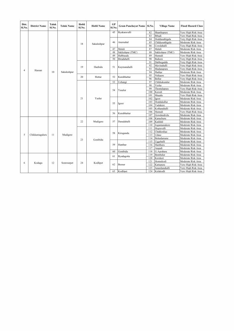
Dist. Sl.No. District Name Taluk
Sl.No. Taluk Name Hobli Sl.No. Hobli Name GP
Sl.No. Gram Panchayat Name Sl.No. Village Name Flood Hazard Class
82 Shanthapura Very High Risk Area83 Ibbadi Very High Risk Area84 Doddasathigala Very High Risk Area85 Chikkasathigala Moderate Risk Area86 Cowdahalli Very High Risk Area
47 Malali 87 Malali Moderate Risk Area48 Sakleshpur (TMC) 88 Sakleshpur (TMC) Moderate Risk Area49 Hebbasale 89 Hennali Very High Risk Area50 Biradahalli 90 Baikere Very High Risk Area
91 Dabbegadde Very High Risk Area92 Mavinahalli Very High Risk Area93 Madanapura Very High Risk Area94 Hadige Moderate Risk Area95 Nidigere Very High Risk Area96 Bellur Very High Risk Area
53 Uchangi 97 Chikkakundur Moderate Risk Area98 Yeslur Moderate Risk Area99 Thontalapura Very High Risk Area
100 Kerodi Moderate Risk Area101 Magalu Very High Risk Area102 Igoor Moderate Risk Area103 Doddakallur Moderate Risk Area104 Yadakere Moderate Risk Area105 Kothanahalli Moderate Risk Area106 Hennali Very High Risk Area107 Gowdarabylu Moderate Risk Area108 Kanachuru Moderate Risk Area109 Kadidal Moderate Risk Area110 Jogannanakere Moderate Risk Area111 Hegravalli Moderate Risk Area112 Chakkodige Moderate Risk Area113 Udase Moderate Risk Area114 Bettadamane Moderate Risk Area115 Uggehalli Moderate Risk Area116 Hanthuru Moderate Risk Area117 Angadi Moderate Risk Area
60 Gonibidu 118 G.Agrahara Moderate Risk Area119 Bembalur Moderate Risk Area120 Kerekeri Moderate Risk Area121 Honnekodi Moderate Risk Area122 Kattepura Very High Risk Area123 Janardanahalli Very High Risk Area
63 Kodlipet 124 Kelakodli Very High Risk Area
Kaymanahalli
Kurubhattur
Hanthur
Byadagotta
Bessur
Yasalur
Igoor
Kurubhattur
Daradahalli
Kirugunda
Byakaravalli
Anemahal
Sakaleshpur
Mudigere
Somwarpet
18
24
22
23
4
5
6
Hassan
Chikkamagaluru
Kodagu
10
11
12
19
20
21
Sakaleshpur
Hanbalu
Hettur
Yaslur
Mudigere
Gonibidu
Kodlipet
45
62
56
57
58
59
61
46
51
52
54
55

Dist. Sl.No. District Name Taluk
Sl.No.Taluk Name
Hobli Sl.No. Hobli Name GP
Sl.No.
Gram Panchayat
NameSl.No. Village Name Flood Hazard Class
1 2 3 4 5 6 7 8 9 10 111 Anandapuram 1 Hirebilagunji 1 Hirebilagunji Moderate Risk Area2 Talguppa 2 Marthuru 2 Marthur Very High Risk Area
3 Ammunje 3 Ammunje Moderate Risk Area4 Badagabellur 4 Badaga Bellur Moderate Risk Area5 Gurupura 5 Mulur (CT) Very High Risk Area6 Ganjimata 6 Tankaulipady Very High Risk Area7 Kandavara 7 Kandavara Very High Risk Area
8 Koikude Very High Risk Area9 Attur Moderate Risk Area
9 Kateelu 10 Kilenjur Moderate Risk Area10 Aikala 11 Ulipady Moderate Risk Area11 Balkunje 12 Karnire Moderate Risk Area
13 Madya Very High Risk Area14 Chelliru (OG) Very High Risk Area15 Surinje Very High Risk Area16 Delanthabettu Moderate Risk Area
4 Udupi 7 Udupi 14 Manipura 17 Manipura (CT) Very High Risk Area15 Paduvari 18 Paduvari Very High Risk Area16 Yadthare 19 Yedthare Very High Risk Area17 Havanje 20 Havanje Moderate Risk Area18 Uppoor 21 Uppoor Very High Risk Area19 Aroor 22 Aroor Moderate Risk Area20 Handadi 23 Matpady Very High Risk Area21 Pandeshwara 24 Moodahadu Very High Risk Area22 Barkur 25 Hosala Very High Risk Area
26 Kavadi Very High Risk Area27 Vaddarse Moderate Risk Area28 Palimar Very High Risk Area29 Nandicoor Very High Risk Area
25 Padubidri 30 Padebettu Very High Risk Area26 Thenka 31 Tenka Very High Risk Area
32 Mallar (CT) Very High Risk Area33 Majoor Very High Risk Area34 Uliargoli Very High Risk Area35 Innanje Very High Risk Area36 Pangala Very High Risk Area
29 Belle 37 Belle Very High Risk Area30 Katpaadi 38 Moodabettu (CT) Very High Risk Area
12 Ankola 31 Alageri 39 Ankola (TP + OG) Moderate Risk Area40 Hegre Very High Risk Area41 Agragon Moderate Risk Area42 Bilehoingi Very High Risk Area43 Shinganmakki Very High Risk Area44 Kanagil Very High Risk Area45 Hadav Very High Risk Area46 Poojgeri Moderate Risk Area47 Belambar Moderate Risk Area48 Kogre Very High Risk Area
36 Bobrawada 49 Bobruwada (CT) Moderate Risk Area50 Andle Moderate Risk Area51 Mogta Very High Risk Area
38 Sagadageri 52 Ulware Moderate Risk Area39 Agragona 53 Joog Moderate Risk Area40 Belase 54 Shirur Very High Risk Area41 Yalvadikavur 55 Purvarga Very High Risk Area42 Muttalli 56 Talan Moderate Risk Area43 Shirali 57 Venkatapura (CT) Very High Risk Area44 Koppa 58 Koppa Moderate Risk Area45 Karki 59 Karki Moderate Risk Area46 Haladipur 60 Haldipur Very High Risk Area
61 Navilgone Very High Risk Area62 Kakurve Moderate Risk Area
48 Kadatoka 63 Kadtoka Very High Risk Area64 Magod Very High Risk Area65 Birangod Very High Risk Area
50 Balakur 66 Balkur Moderate Risk Area51 Kelaginur 67 Kelginoor Very High Risk Area52 Melina Idagunji 68 Hosapatna Very High Risk Area
19 Mavinakurvei 53 Kudrigi 69 Kudrige Very High Risk Area70 Kerwadi Moderate Risk Area71 Katar Very High Risk Area72 Kadiye Moderate Risk Area73 Bolshitta Very High Risk Area74 Ulga Very High Risk Area
Ankola
Magoda
Keravadi
Phalimaru
Mallar (CT)
Innanje
Agragona
Honnebailu
Shetageri
West Flowing River Basin, KarnatakaList of Flood Hazard Risk Villages
Kemral
Chelairu
Surinje
Vaddarse
1
2
3
28
Sagar
Bantwal
Mangaluru
Bainduru
Brahmavara
Kapu
3
4
5
6
8
Pane Mangalore
Gurpur
Mulki
Suratkal
Bainduru
Brahmavara
Kota
Kapu
Basagod
Ghadasai
Belambar
Mogata
Navilgona
4
1
2
3
5
6
7
8
9
10
Shivamogga
Dakshina Kannada
Udupi
Uttara Kannada
8
12
13
23
24
27
14
15
16
Blale
Susgadi
Mavalli
9
10
11
13
Bhatkal
Honnavar
17
18
20
Honnavar
Manki
Ghadasaya
49
54
55
32
33
34
35
37
47

Dist. Sl.No. District Name Taluk
Sl.No.Taluk Name
Hobli Sl.No. Hobli Name GP
Sl.No.
Gram Panchayat
NameSl.No. Village Name Flood Hazard Class
75 Ghadasai Very High Risk Area76 Bhaire Very High Risk Area77 Siddar Moderate Risk Area78 Wailwada Very High Risk Area
57 Devalamakki 79 Naitisavar Very High Risk Area58 Kinnar 80 Kinnar Moderate Risk Area
81 Submerged_River Moderate Risk Area82 Kanasgiri Moderate Risk Area83 Chitakula(OG) Moderate Risk Area
60 Asnoti 84 Madhewada Very High Risk Area85 Hotegali Moderate Risk Area86 Hankon Moderate Risk Area
62 Majali 87 Majali Very High Risk Area63 Hanehalli 88 Bankikodla Very High Risk Area
89 Harumaskeri Very High Risk Area90 Nadumaskeri Very High Risk Area
24 Kujahalli 65 Devagiri 91 Horbhag Very High Risk Area92 Hegde(Part) Very High Risk Area93 Lukkeri Very High Risk Area
67 Kodakani 94 Kodkani Moderate Risk Area95 Paduvani Moderate Risk Area96 Bargi Moderate Risk Area
Bargi
Ghadasai
Vailavada
Chittakula
Hanakona
Nadumaskeri
Hegde
11
12
21
22
23 64
Karwar
Kumta
25
Kinnar
Savantvada
Gokarna
Mirjan
66
68
55
56
59
61

Almatti
Reservoir
Narayanapur
Reservoir
Tungabhadra
Reservoir
Malaprabha
Bhadra
Reservoir
Vanivilas Sagar
Ghataprabha
Krishna R
iver
Bhima River
Bhima R iverVe
dganga river
KrishnaRiver
Bhima river
Varad
hariv
er
Malaprabha Rive
r
Ghataprabha
Vedavathi
Doni R
iver
Harangi
Hemavathi
KRS
Kabani
Reservoir
Linganamakki
Reservoir
Varahi
Supa
Ujjani
Reservoir
Koyna
Reservoir
K
rishnaRiver
Bhima River
SinaRiver
Du
dh
ganga Rive
r
Belagavi
Ballari
Raichur
Bidar
Kalaburagi
Vijayapura
Tumakuru
Hassan
Mysuru
Yadgir
Koppal
Haveri
Kolar
Gadag
ChitradurgaShivamogga
Uttara Kannada
Bagalkote
Mandya
Udupi
Kodagu
Dharwad
Chikkamagaluru
Davangere
Chamarajanagara
Chikballapura
Dakshina Kannada
Ramanagara
Bengaluru Rural
Bengaluru Urban
79°0'0"E
78°0'0"E
78°0'0"E
77°0'0"E
77°0'0"E
76°0'0"E
76°0'0"E
75°0'0"E
75°0'0"E
74°0'0"E
74°0'0"E18°0'0"N
18°0'0"N
17°0'0"N
17°0'0"N
16°0'0"N
16°0'0"N
15°0'0"N
15°0'0"N
14°0'0"N
14°0'0"N
13°0'0"N
13°0'0"N
12°0'0"N
12°0'0"N
µ
MM AA HH AA RR AA SS TT RR AA
AA NN DD HH RR AA PP RR AA DD EE SS HH
TT EE LL AA NN GG AA NN AA
GG OO AA
AA RR AA BB II AA NN SS EE AA
S u b - B a s i n s o f K a r n a t a k aFlood Hazard Risk Areas