Geochemical and numerical constraints on Neoarchean plate tectonics
Post-nappe brittle tectonics and kinematic evolution of thenorth-western Alps: an integrated approach
A. Bistacchi, M. Massironi*
Dipartimento di Geologia, Paleontologia e Geo®sica, UniversitaÁ di Padova, Via Giotto 1, 35137 Padova, Italy
Received 8 December 1999; accepted 15 August 2000
Abstract
Data from remote sensing, structural geology and thermochronology provide the basis for this integrated reconstruction of
the Oligocene to Present kinematic evolution of the north-western Alpine nappe stack. Two brittle tectonic phases post-date the
Cretaceous±Eocene ductile deformation. A NW±SE extension developed in the Oligocene (D1) along three main conjugate
fault systems arranged in orthorhombic symmetry (N-, NW- and SE-dipping). Cooling rate contour maps, from published
apatite and zircon ®ssion-track ages and Rb/Sr biotite ages, highlight the differential exhumation of large fault-bounded blocks
during this phase, whilst synkinematic hydrothermal veins and calc-alkaline dykes (29±32 Ma) help to constrain its age. From
the Miocene onwards, a general rearrangement of the strain pattern led to SW-directed lateral extrusion (D2) of the Pennine-
Graian Alps block, bounded by a network of seismogenic shear zones, the most important being the Ospizio Sottile, Simplon,
Rhone and Chamonix faults. The internal deformation of the Pennine-Graian Alps block is characterised by an overall more or
less homogeneous NE±SW extension. The approach undertaken, integrating remote sensing, structural analysis on different
scales, and thermochronology (with the cooling rate map representation), is therefore effective in reconstructing the late-
orogenic extensional tectonic evolution of metamorphic nappe stacks. q 2000 Elsevier Science B.V. All rights reserved.
Keywords: Western Alps; brittle deformation; remote sensing; normal faults; cooling; exhumation
1. Introduction
The Alpine belt results from the subduction-collision
history of Cretaceous±Cenozoic age, between the
European and Adria (African) plates (e.g. Coward and
Dietrich, 1989; Polino et al., 1990; Michard et al., 1996).
The axial domain of the north-western Alps is charac-
terised by polyphase metamorphic history and penetra-
tive ductile deformation, and also by brittle faulting
whose importance has been underestimated. This is
evidenced by the relatively small number of faults that
are reported on published geological maps (e.g. Spicher,
1980; Bigi et al., 1990; Steck and Bigioggero, 2000).
Owing to the limited knowledge of these faults,
several problems concerning the last stages (Oligo-
cene±Present) of Alpine tectonics are still open. The
Oligocene mode of faulting, the age of some back-
thrusts and back-folds, and the Miocene±Present
kinematics remain matters of debate.
To tackle these problems, an integrated analysis
combining satellite image interpretation, structural
analysis and thermochronology was carried out in
the axial sector of the NW Alps (Fig. 1), between
the Chamonix line (W of the Mont Blanc Massif)
and the Canavese line (SE border of Alpine meta-
morphic nappes).
Tectonophysics 327 (2000) 267±292
0040-1951/00/$ - see front matter q 2000 Elsevier Science B.V. All rights reserved.
PII: S0040-1951(00)00206-7
www.elsevier.com/locate/tecto
* Corresponding author. Tel.: 139-498272050; fax: 139-
498272070.
E-mail address: [email protected] (M. Massironi).

A.
Bista
cchi,
M.
Ma
ssironi
/T
ectonophysics
327
(2000)
267
±292
26
8
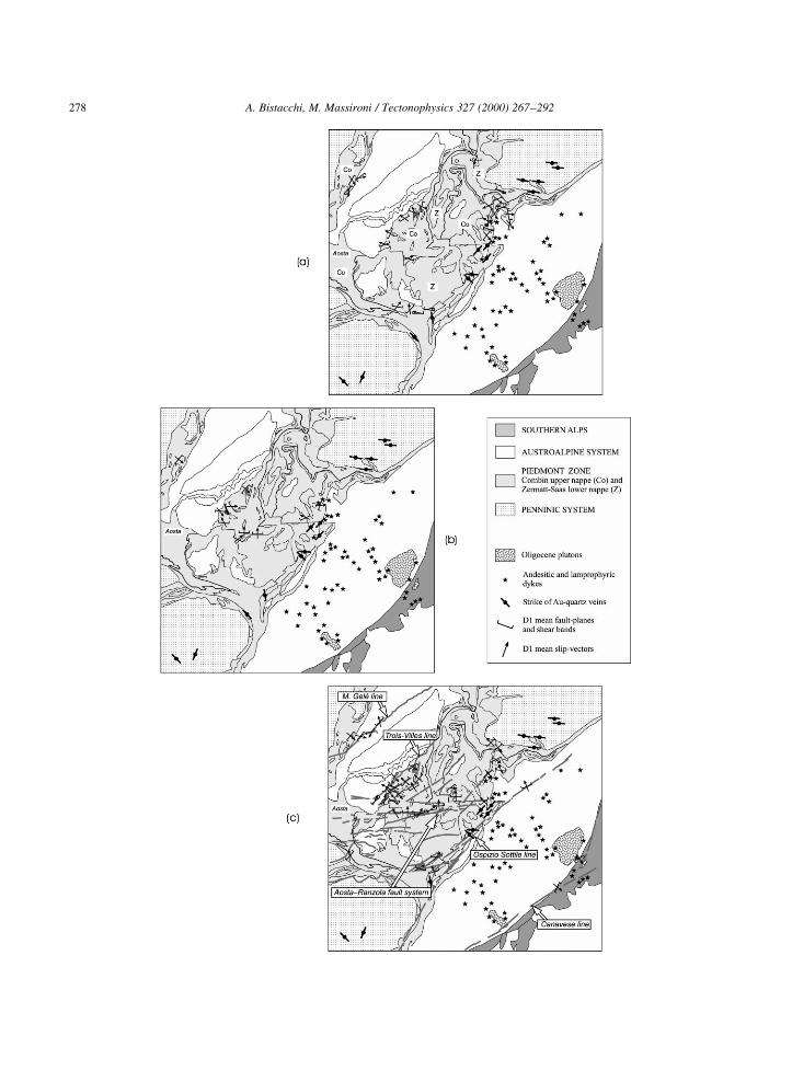
Fig. 1. Tectonic sketch-map of north-western Alps, showing principal Oligocene to Present brittle faults (thick lines) and other lineaments derived from satellite remote-sensing
interpretation (narrow lines). Inset (I): principal tectonic domains of Alps. European Foreland (EF), Jura (J), Helvetic-Dauphinois (HD), Penninic (PN), Austroalpine (AU),
Southern Alps (SA), Po Plain (Po), Appennines (AP).

In a previous paper (Bistacchi et al., 2000), we
focused on the Miocene±Present kinematics, with a
particular emphasis on the relationships between
structural and seismotectonic data. In the present
paper more details about methodologies are given,
followed by new data and discussion of the Oligocene
to Present polyphase evolution.
2. Geological outline
2.1. Regional setting
The Europe-vergent Austroalpine-Penninic wedge
is a subduction-related wedge devoid of welded litho-
spheric mantle, accreted before and during continental
collision (e.g. Nicolas et al., 1990; Polino et al., 1990;
Dal Piaz, 1999). This axial wedge consists of a
tectonic multi-layer composed of rootless basement
slices, deÂcollement cover units and minor ophiolitic
interleavings characterised by ductile deformation
and subduction-related low-T metamorphism. The
principal units of the orogenic wedge are, from top
to bottom, and from SE to NW (Fig. 1):
(1) the Adria-derived Austroalpine system,
composed of the Sesia-Lanzo inlier and of a number
of upper and lower Austroalpine outliers;
(2) the ophiolitic Piedmont zone, composed of the
Combin (upper) and Zermatt-Saas (lower) nappes
(details in Fig. 6);
(3) the Europe-derived continental nappes, includ-
ing:
(a) the inner/upper Penninic Monte Rosa, Arcesa-
Brusson and Gran Paradiso nappes;
(b) the middle Penninic Grand St. Bernard multi-
nappe system;
(c) the outer Penninic ¯ysch-dominated Sion-
Courmayeur zone;
(d) the lower Penninic Lepontine gneissic nappes
(Ossola-Tessin window), in places with minor
ophiolites.
In more detail (Fig. 1), the Monte Rosa nappe is
ultimately refolded in the Ossola Valley by the large
Vanzone back-fold (Laduron and Merlyn, 1974;
Klein, 1978; Milnes et al., 1981). The subsurface
continuity of the upper Penninic Monte Rosa and
Gran Paradiso nappes is suggested by basement
rocks of the same af®nity that crop out in the
Arcesa-Brusson window, south of the Aosta±Ranzola
fault (Fig. 1).
The Austroalpine-Penninic wedge is bounded by
two major crustal discontinuities: the Penninic frontal
thrust on its external border and the Canavese line on
the internal one (Fig. 1). The Penninic frontal thrust
separates the orogenic wedge from the Helvetic
(European) continental basement slices (Mont
Blanc, Aiguilles Rouges, Belledonne and Aar-
Gotthard external massifs) and deÂcollement cover
nappes. The Canavese line is the tectonic boundary
between the orogenic wedge and the antithetic (Adria-
vergent) Southalpine thrust belt, which developed in
the Adriatic hinterland from the Miocene onwards
(e.g. Schmid et al., 1989). Both the Helvetic and
Southalpine domains are free of ophiolites and
subduction-related metamorphic imprint.
2.2. Tectonic and metamorphic evolution of the nappe
stack
The Austroalpine-Penninic wedge developed under
a subduction-related low-T regime, during the subduc-
tion of the Mesozoic Piedmont ocean beneath Adria.
Different peak metamorphic conditions are
recorded in different groups of nappes, ranging from
blueschist to eclogite facies, and locally reaching
ultra-high-P conditions (Frey et al., 1999). Blueschist
facies climax assemblages have been found in the
upper Austroalpine outliers, Combin ophiolitic
nappe and mid-Penninic Grand St. Bernard system.
Instead, eclogite facies assemblages characterise the
Austroalpine Sesia-Lanzo inlier, lower Austroalpine
outliers, Zermatt-Saas ophiolitic nappe and upper
Penninic Monte Rosa and Gran Paradiso nappes
(BalleÁvre et al., 1986; Frey et al., 1999). Diachronous
ages of peak metamorphic assemblages in these
groups of nappes may indicate long-lasting subduc-
tion, from the Late Cretaceous to the Middle Eocene.
These nappes were independently dragged to different
depths and then exhumed within the accretionary
wedge (Michard et al., 1996; Cortiana et al., 1998;
Dal Piaz, 1999).
After collision, the subduction-related low-T
regime (ca. 208C/km) was replaced by a Late
Eocene±Early Oligocene higher-T regime (ca. 408C/
km). In this area of the Alps, the sudden change
in thermal conditions is indicated by regional
A. Bistacchi, M. Massironi / Tectonophysics 327 (2000) 267±292 269
metamorphic re-equilibration in greenschist (Aosta
Valley-Valais) to amphibolite facies (Ossola-Tessin)
conditions (Cannic et al., 1999; Desmons et al., 1999)
and by the Oligocene emplacement of the Biella and
Traversella plutons and swarms of calc-alkaline to
ultra-potassic dykes in the Austroalpine and ophiolitic
units (Dal Piaz et al., 1979).
2.3. Post-nappe brittle tectonics and pending
problems
According to the literature, the ®nal exhumation of
the Penninic-Austroalpine nappe stack was accom-
plished, from the Oligocene to the Present, through
the following steps:
(a) Oligocene extension coupled with the Periadria-
tic magmatism and emplacement of gold-bearing
quartz veins in the middle Aosta Valley (Dal Piaz et
al., 1979; Venturelli et al., 1984; Diamond, 1990; Dal
Piaz and Gosso, 1994).
(b) Differential exhumation at the Oligocene±
Miocene boundary, evidenced by thermochronologi-
cal data (Hurford et al., 1991; Hunziker et al., 1992).
This event is generally considered to be a conse-
quence of back-thrusting and back-folding, which
were in turn generated by the north-westward displa-
cement of the Adriatic indenter, a process which still
continues today (Schmid et al., 1989; Polino et al.,
1990; Giglia et al., 1996).
(c) Rapid exhumation of the western sector of the
Lepontine dome (ªSimplon sub-domeº of Merle et al.,
1989) from 18 to at least 3 Ma, accommodated by
normal displacement along the Simplon fault
(Mancktelow, 1985, 1990, 1992; Grasemann and
Mancktelow, 1993). Bistacchi et al. (2000) showed
that this still-active kinematics is coupled with the
SW-ward gravitational lateral extrusion of the
Pennine-Graian Alps block (PGA block), bounded
by the Chamonix line to the NW, the Rhone±Simplon
system to the N, and the Ospizio Sottile line to the SE
(Fig. 1).
Within this tectonic framework, many problems
still arise:
(1) No kinematic interpretation explaining the
mode of faulting during the Oligocene extension
(step ªaº) has been proposed.
(2) The late Oligocene±early Miocene NW±SE
compression (step ªbº) seems to be supported by:
(a) dextral transpression along the Canavese line
east of the Ossola Valley, and (b) the development
of the southern steep belt, which may be linked to
the Vanzone antiform (Schmid et al., 1989). In this
way, the late Oligocene±early Miocene transpression
along the Periadriatic lineament, well constrained in
the Central Alps, may extend to the SW segment of
the Canavese line (Schmid et al., 1989). However, in
this portion of the line, there is no clear ®eld evidence
for such kinematics at the Oligo-Miocene boundary
(Martin et al., 1999; Bistacchi et al., 2000). In addi-
tion, recent radiometric dating (Barnicoat et al., 1995;
Freeman et al., 1997) con®rm that, in the north-
western Alps, back-thrusting and back-folding devel-
oped in the late Eocene±earliest Oligocene, as
previously suggested by Milnes et al. (1981).
(3) The onset age of the lateral extrusion (step ªcº)
is debated (Grasemann and Mancktelow, 1993; Ring
and Merle, 1992; Seward and Mancktelow, 1994;
Schlunegger and Willett, 1999; Bistacchi et al.,
2000); according to different authors, it may be placed
between 22 and 18 Ma.
3. Methodology
3.1. Remote sensing
The brittle structural pattern of the NW-Alps was
comprehensively investigated using the regional
A. Bistacchi, M. Massironi / Tectonophysics 327 (2000) 267±292270
Fig. 2. Eastern end of Aosta±Ranzola fault system branching into Ospizio Sottile fault on Landsat TM image (band 4). (a) Spatial-edge
enhancement ®ltering emphasises high-frequency textural patterns, allowing detection of linear discontinuities evidenced by abrupt tonal
changes (arrows); sun illumination from lower right corner (SE). These changes are mainly linked to fault-related morphological features
(alignment of crests, valleys and passes, trenches, uphill- and downhill-facing scarps, ridge doubling), fault-related geological contacts, large
layers of fractured rocks. (b) Ospizio Sottile fault (white arrows) is evident throughout its extension as demonstrated by a 30-km-long array of
lineaments on this portion of Landsat TM scene; Aosta±Ranzola fault system (black arrows) is evidenced on satellite images by a 2-km-wide
system of east±west trending lineaments which do not extend east of Ospizio Sottile fault.
A. Bistacchi, M. Massironi / Tectonophysics 327 (2000) 267±292 271
synoptic vision of satellite images. In an area of such
rugged topography and deep glacial erosion, remote
sensing is very useful for tracing large faults exten-
sively covered by Quaternary deposits.
One Landsat 5 TM geocoded scene and two ERS-1
SAR/GTC (Synthetic Aperture Radar/Geocoded
Terrain Correct) images were processed, analysed
and compared. Interpretation of the Landsat TM
product was carried out mainly on bands 4 and 7
and was then cross-checked with other bands (except
for band 6, due to its low spatial resolution) and with
the 3±2±1 multi-band composition.
As a consequence of side-looking radar acquisition,
SAR images of mountain ranges are characterised by
intense geometrical and radiometric distortions
(shadowing, layover, foreshortening), which princi-
pally affect sensor-looking slopes (Curlander and
Mcdonough, 1991). For this reason, the two highly
overlapping ERS-1 scenes, acquired in ascending
and descending orbits, were used in integrated analy-
sis of slopes facing W and E, respectively. The GTC
product is the result of the correction of the raw SAR
image with a Digital Terrain Model (ESA, 1992). In
this way, any kind of image distortion is geometrically
removed, whereas the simultaneous interpretation of
both SAR scenes partially avoids radiometric distor-
tions on sensor-looking slopes.
Initially, remote sensing was used as a preliminary
tool to detect potential brittle tectonic features
(Massironi et al., 1997). Lineament interpretation on
either radar or optical data was obtained by visual
inspection. Simple contrast histogram adjustments
(equalisation, linear-piecewise, logarithmic and expo-
nential stretch; see Richards (1986), Gupta (1991) and
Sabins (1997) for complete reviews) were frequently
implemented during interpretation on both optical and
radar data, in order to enhance differently illuminated
areas. Once a fault system was detected, not all linea-
ments that could represent its possible expression
were traced; only continuous arrays of lineaments
(.4 km long), with strong morphological and/or
spectral evidence, were drawn. This technique
identi®ed clear lineament patterns with good ®eld
correspondence. Nearly 2000 lineaments were recog-
nised, ranging from 400 m to 10 km in length: 429
Landsat TM lineaments (out of 1093) and 201
ERS-1 lineaments (out of 747) were checked through
systematic ®eld survey. When the correspondence of a
lineament with any brittle structure (either faults
related to regional tectonics or deep-seated gravita-
tional slope deformations) is considered as a positive
check, the reliability estimate ranged from 65.6 to
84.2% (depending on lineament length and different
satellite products; Massironi, 1998; Bistacchi et al.,
2000). Field analysis proved that most of the linea-
ments detected by image interpretation were high-
angle brittle features (dip . 658).In a more advanced analytical stage, continuous
feedback between satellite image interpretation and
®eld surveys turned out to be a robust correlation
tool, useful in reconstructing the geometrical details
of the structural model. During this stage, major faults
(thick lines in Fig. 1) were distinguished from minor
brittle features. It was also possible to better constrain
the trace, on the Landsat TM image, of some inter-
mediate angle faults (dip . 408 and ,65±708), which
were locally recognised by ®eld analysis. At this
stage, spatial frequency and directional edge enhance-
ment processing on optical images (Figs. 2 and 3;
Richards, 1986; Gupta, 1991; Sabins, 1997) were
often implemented in order to highlight any linear
discontinuities ill de®ned in the preliminary analysis,
but revealing important ®eld evidence (e.g. thick
pseudotachylite or cataclasite layers).
Satellite image interpretation, integrated with ®eld
surveys, allowed the brittle elements to be grouped
into three different sets, striking NE±SW, E±W and
NW±SE and pervasively dissecting the NW Alpine
nappe stack (Fig. 1).
3.2. Kinematic analysis
Before remote-sensing analysis was carried out,
only a few major faults were known in this portion
A. Bistacchi, M. Massironi / Tectonophysics 327 (2000) 267±292272
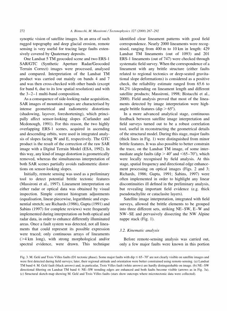
Fig. 3. M. Gele and Trois Villes faults (D1 tectonic phase). Some major faults with dip # 65±708 are not clearly visible on satellite images and
were ®rst detected during ®eld surveys; later, their regional attitude and orientation were better constrained using remote-sensing. (a) Landsat
TM band 4: M. Gele fault (black arrows) and, in particular, Trois Villes fault (white arrows) are hardly distinguishable on image. (b) NE±SW
directional ®ltering on Landsat TM band 4: NE±SW trending edges are enhanced and both faults become visible (arrows as in Fig. 3a).
(c) Structural sketch-map showing M. Gele and Trois Villes faults (stars show outcrops where microtectonic data were collected).

A. Bistacchi, M. Massironi / Tectonophysics 327 (2000) 267±292 273

of the Western Alps (Fig. 1): the Aosta±Ranzola line,
the Simplon±Rhone±Chamonix system and the
Canavese line (Spicher, 1980; Bigi et al., 1990;
Steck and Bigioggero, 2000). In addition, some data
have been published on brittle structures along the
NW and SE borders of the Dent Blanche nappe
(Wust and Silveberg, 1989; Ring, 1994). In the
present work, the complex lineament pattern detected
by remote sensing was taken as a guideline for
detailed ®eldwork. In addition, more low-angle
features were recognised during the ®eld survey.
Two principal brittle±ductile to brittle tectonic
phases (D1 and D2) were distinguished by means of
consistent cross-cutting relationships. They post-date
the Late Eocene±early Oligocene greenschist facies
regional fabrics. In areas where the strain was mainly
partitioned during D2, it was very dif®cult to ®nd
ªfossilº D1 kinematic indicators. Hence, much of
the ®eld analysis on D1 was carried out in the
Austroalpine, upper-Penninic and ophiolitic units of
the middle Aosta Valley, where the D2 strain is rela-
tively low and homogeneous (Fig. 6). In the D2 high-
strain areas, the relative timing is straightforward and
D2 kinematics could be studied in detail.
3D fault geometry was reconstructed with remote
sensing and ®eld data. Often, a remote-sensing linea-
ment was the ®rst clue to the existence of a fault and
its geometry was later constrained in the ®eld. Map-
traces of major faults that were active during D1 and
D2 are shown in Figs. 6 and 8, respectively.
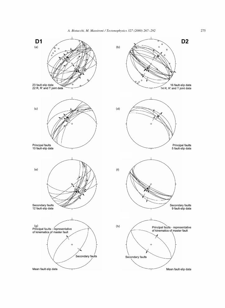
The kinematics of these faults was determined by
means of microtectonic analysis carried out on selected
outcrops. This analysis was based on over 200 sites,
selected on the basis of remote sensing and ®eld
evidence. For each site, the average kinematics was
determined for different sets of fault planes
(Figs. 5±8). For example, Fig. 4 documents measure-
ments at an outcrop in the S. Bartelemy valley: two sets
of D1 mesoscopic faults and two sets of D2 mesoscopic
faults, plus R, R 0 and T joints linked to each phase (see
Petit (1987) and Hancock (1985) for terminology of
secondary joints). An average fault plane and slip
vector were calculated for each set, and average data
were rejected when they did not satisfy the following
conditions: (1) the aperture of the 95% con®dence cone
must be less than 158, and (2) the average slip vector
must be contained in the average fault plane with an
error of less than 58. Average fault planes for each set
were then compared with the large-scale 3D geometry
of faults, reconstructed from remote sensing and geol-
ogy. In the example, one set of mesoscopic faults for
each phase displays the same attitude as the corre-
sponding large-scale fault: hence, these are considered
to be ªprincipalº sets and representative of the kine-
matics of the large-scale ªmasterº fault. The other sets
are considered to be ªsecondaryº sets.
After averaging and selection, only average data
from the ªprincipalº sets were used to reconstruct
the regional kinematic model, assuming that large
faults best represent the regional kinematic pattern.
These data are shown in Figs. 5±8 for phases D1
and D2, respectively.
The result of this processing is to allocate to each
site the same weight in the reconstruction of the regio-
nal kinematic model, notwithstanding the fact that
datasets of each site were necessarily heterogeneous
owing to the high lithological variability. The occur-
rence of consistent kinematic indicators in different
rocks, found along high-angle faults cross-cutting
various levels of the almost ¯at-lying nappe stack
(Fig. 9), has been considered as important evidence
of the consistency of microtectonic data.
3.3. Cooling rates
Over 400 ®ssion-track ages on apatite (AFT) and
zircon (ZFT) and Rb/Sr biotite cooling ages
have been published on the study area. Hunziker
et al. (1992) provide a critical review of many
of these data and discuss their reliability. Seward
A. Bistacchi, M. Massironi / Tectonophysics 327 (2000) 267±292274
Fig. 4. Example of processing of microtectonic data in order to obtain average data representative of each site. Data from a homogeneous
outcrop of Piedmont Zone calcschists in S. BarteÂlemy Valley. Four sets of mesoscopic faults and related secondary joints were measured and
attributed to phase D1 (a) and D2 (b), thanks to consistent cross-cutting relationships (great circles: fault planes; arrows: sense of movement of
hanging-wall; small circles: poles of secondary fractures). Principal faults, representative of attitudes of two cross-cutting master faults
(reconstructed by remote sensing and ®eldwork) are shown in (c) and (d). Secondary conjugate faults shown in (e) and (f). Average fault-
slip data for four sets in (g) and (h); only ªprincipalº data are used in following regional kinematic reconstruction (see Figs. 5±8).
A. Bistacchi, M. Massironi / Tectonophysics 327 (2000) 267±292 275
A. Bistacchi, M. Massironi / Tectonophysics 327 (2000) 267±292276
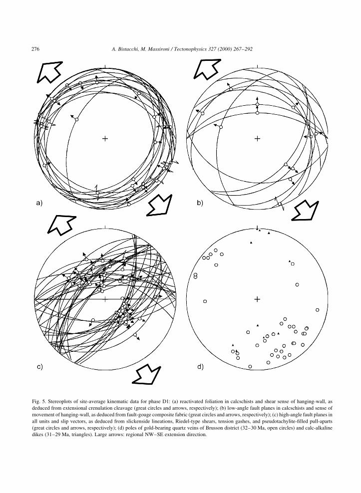
Fig. 5. Stereoplots of site-average kinematic data for phase D1: (a) reactivated foliation in calcschists and shear sense of hanging-wall, as
deduced from extensional crenulation cleavage (great circles and arrows, respectively); (b) low-angle fault planes in calcschists and sense of
movement of hanging-wall, as deduced from fault-gouge composite fabric (great circles and arrows, respectively); (c) high-angle fault planes in
all units and slip vectors, as deduced from slickenside lineations, Riedel-type shears, tension gashes, and pseudotachylite-®lled pull-aparts
(great circles and arrows, respectively); (d) poles of gold-bearing quartz veins of Brusson district (32±30 Ma, open circles) and calc-alkaline
dikes (31±29 Ma, triangles). Large arrows: regional NW±SE extension direction.
and Mancktelow (1994) and Balestrieri et al.
(1999) list more data on two key areas: the
Valais and the Mont Blanc massif, and the middle
Aosta Valley, respectively.
AFT ages clearly show that the principal fault-
bounded blocks underwent different exhumation
histories (Hurford et al., 1991). However, AFT ages
are not suf®cient to reconstruct the complex brittle
tectonic history of this part of the Alps. In fact,
when dealing with multi-phase tectonic history,
cooling age data are the discontinuous result of the
whole (continuous) cooling history, since they mark
cooling at a given closure temperature but do not give
information about the path that was followed at higher
and lower temperatures. In order to reconstruct the
kinematics and age of individual displacements, a
step-by-step instantaneous analysis is actually needed.
In particular, the kinematics of a fault at a given time can
only be reconstructed by comparing the instantaneous
exhumation rates of its hanging-wall and foot-wall.
The exhumation rate (dh/dt) can be computed only
from a set of P±T data, but at these shallow crustal
levels no P estimates are available. Alternatively, the
exhumation rate may be inferred from the cooling rate
(dT/dt) via thermal modelling (calculating T as a func-
tion of depth at given times), but only with a conco-
mitant degree of uncertainty re¯ecting assumptions in
the input data (such as thermal conductivity, radio-
metric heat production and mantle heat ¯ow). There-
fore, we prefer to show raw cooling rate data, which
are not in themselves biased by any uncertainty in
geophysical modelling. Cooling rates are not linearly
proportional to exhumation rates, since geotherms are
not straight lines in a T-depth space and may differ
signi®cantly in adjacent crustal blocks owing to
advection terms, which are different in the case of
differential exhumation of large blocks (see the
numerical example for the Simplon fault in Grase-
mann and Mancktelow, 1993). Nevertheless, there is
always a positive relationship between cooling and
exhumation rate (the faster the cooling, the faster
the exhumation), since on a crustal scale the geotherm
is a positive function of depth; therefore cooling rates
can be used, qualitatively, to infer the kinematics of
fault-bounded blocks.
Cooling rates (8C/Ma) were computed from
sequences of AFT, ZFT and biotite cooling ages
obtained on the same samples. Closure temperatures
were taken as stated by Hunziker et al. (1992) for
similar cooling rates (300 ^ 508C for Bt Rb/Sr,
240 ^ 408C for ZFT and 110 ^ 208C for AFT) and
a temperature of 108C was assumed for the present-
day surface. For each sample, a cooling curve was
reconstructed by linking the array of T/cooling-age
data with linear segments in a T/time diagram
(Fig. 10). Although the real cooling history of the
sample may be quite complicated, a simple linear
interpolation was undertaken because the actual
cooling path between data-points cannot be recon-
structed with better detail. The slope of varying
segments is the average cooling rate (DT/Dt) for the
given time interval.
Cooling rates resulting from this calculation range
between 1 and 608C/Ma. If we assume a linear geother-
mal gradient of 408C/km (Cannic et al., 1999), the exhu-
mation rate turns out to be of the order of 0.025±1.5 km/
Ma but, as mentioned before, the reliability of this esti-
mate is very low. Nevertheless, present-day uplift rates
reported by Khale et al. (1997) are of the same order of
magnitude in the Valais area.
Alternatively, exhumation rates could have been
reconstructed using the age-elevation method, gener-
ally undertaken in AFT studies (e.g. Fitzgerald and
Gleadow, 1988). However, using higher-T data
(ZFT and biotite ages), a wider age interval may be
covered, allowing analysis to be extended back in
time to the Oligocene. In addition, the age-elevation
method requires that considered samples come
from the same tectonic block and display a consistent
exhumation history. However, most suitable sampling
pro®les in the study area are affected by faulting,
which may post-date cooling through the apatite
partial annealing zone. This explains the general
lack of a convincing age-elevation correlation.
Cooling rates were gridded with kriging for ages
ranging from 32 to 0 Ma, and the resulting ªcooling
rate contour mapsº are characterised by well-de®ned
and long-lasting regional cooling patterns (Fig. 11),
which qualitatively correspond to exhumation
patterns with similar topology (fast cooling areas
should correspond to fast exhumation areas).
Cooling-rate contour maps show areas of relatively
constant or gently varying cooling rates (rigid blocks),
bounded by steep gradient belts developing along
principal faults that were active (with some verti-
cal slip) in the time increment considered. Purely
A. Bistacchi, M. Massironi / Tectonophysics 327 (2000) 267±292 277
A. Bistacchi, M. Massironi / Tectonophysics 327 (2000) 267±292278

strike-slip or inactive faults are cross-cut by undis-
turbed cooling-rate contour lines.
Cooling curves, as interpolated here, using ªagesº
recorded at decreasing temperatures by single samples,
are not in themselves in¯uenced by topography (all
ªagesº in a curve come from the same sample, hence
from the same elevation). On the other hand, rugged
topography can induce lateral heterogeneities in the
geothermal ®eld, particularly at shallow depths. Thus,
interpretation of cooling rates in terms of exhumation
rates can be misleading, specially in the low-T ®eld
�T , 100±1508C; StuÈwe et al., 1994; Mancktelow and
Grasemann, 1997). However, we assume that the broad
tectonic reconstruction presented in this paper cannot be
signi®cantly affected by this error. In fact, our recon-
struction is based on the very high contrast in cooling
rates, which characterise different fault-bounded blocks
(e.g. 4 vs. 308C/km for the middle Aosta Valley and the
Lepontine dome at 12 Ma; Fig. 11c).
Grasemann and Mancktelow (1993) showed that
crustal blocks exhumed at different rates maintain a
different geothermal gradient for some million years
after the differential movement ceased, since conductive
thermal re-equilibration between adjacent blocks is
subject to delay. Therefore, the use of cooling rate
contour maps to infer the timing of movements along
major faults may be misleading; the onset or end of
a given activity along a fault is generally likely to
pre-date its thermal evidence. In any case, in the western
Alps, the contrast between exhumation rates in different
blocks should be ,2 km/Ma, and hence the horizontal
geothermal gradient across faults should be limited
(Grasemann and Mancktelow, 1993). We therefore
assume that this kind of error is of the same order as
that of thermochronological methods (about ^ 2 Ma).
4. Tectonic evolution
4.1. Oligocene extension: phase D1
In the middle and lower Aosta Valley, four sets of
extensional structures overprint the latest greenschist
facies foliations and are in turn overprinted by other
brittle structures. These systems, grouped according
to attitude, are:
(1) A system of low-angle NW- and SE-dipping
brittle±ductile detachment horizons, developing in
relatively weak rocks, such as the Piedmont
calcschists. These detachments consist of wide hori-
zons of penetrative extensional crenulation cleavage
and more localised shear zones characterised by 20- to
200-cm-thick clayey/chloritic fault-gouge layers (Fig.
9a).
(2) A system of low-angle N-dipping detachments
showing the same features as set 1. This system
mainly developed on the southern slope of the middle
Aosta Valley, locally reactivating the steep N-dipping
greenschist facies regional foliation.
(3) An intermediate to high-angle, NW- and SE-
dipping conjugate fault set, homogeneously devel-
oped all over the Aosta Valley region. These faults
show very different features, depending on the host-
rock. In carbonate rocks (e.g. Piedmont zone
calcschists), they are characterised by polished
slickensides (Fig. 9b), which always overprint the
low-angle structures, with calcite ®brous steps,
swarms of Riedel-type joints and calcite-®lled veins.
In harder rocks, such as gneisses (Austroalpine and
Penninic basement), the fault zones are characterised
by thick cataclastic layers (up to 500 m thick) with
abundant pseudotachylite-®lled joints (Fig. 9e). In
places, veining is strongly developed, indicating a
focus of hydrothermal ¯uid ¯ow owing to the
enhanced permeability of fault zones. The synkine-
matic gold-bearing quartz veins of the Brusson area
(Fig. 9c) result from this hydrothermal activity, as
well as a rather peculiar kind of hydrothermal meta-
somatism that took place where large faults cut
through serpentinites. The results of this process are
fault breccias called listvenites, characterised by
strong enrichment in Ca, K and OH, with respect to
the original composition, and by a high variability in
Si content (up to 70%; Richard, 1981; Dal Piaz and
A. Bistacchi, M. Massironi / Tectonophysics 327 (2000) 267±292 279
Fig. 6. Sketch-maps of the area where structures linked to phase D1 can be continuously traced. Site-average kinematic data (attitude and vector
symbols) shown in their geographic location: (a) reactivated foliation in calcschists and shear sense of hanging-wall as deduced from
extensional crenulation cleavage (see Fig. 5a); (b) low-angle fault planes in calcschists and sense of movement of hanging-wall (see
Fig. 5b); (c) high-angle fault planes and slip vectors (see Fig. 5c). Principal high-angle fault traces are shown in (c) as thick grey lines.
Principal units as in Fig. 1.

A. Bistacchi, M. Massironi / Tectonophysics 327 (2000) 267±292280
Fig. 7. Stereoplots of site-average fault-slip data for phase D2, as deduced by slickenside lineations, Riedel-type shears, tension gashes and
pseudotachylite-®lled pull-aparts (great circles Ð fault planes; arrows Ð sense of movement of hanging-wall): (a) faults inside PGA block
(large white arrows Ð regional extension direction); (b) faults along NW border zone (black arrows Ð dextral strike-slip); (c) faults along SE
border zone (black arrows Ð left-lateral strike-slip).
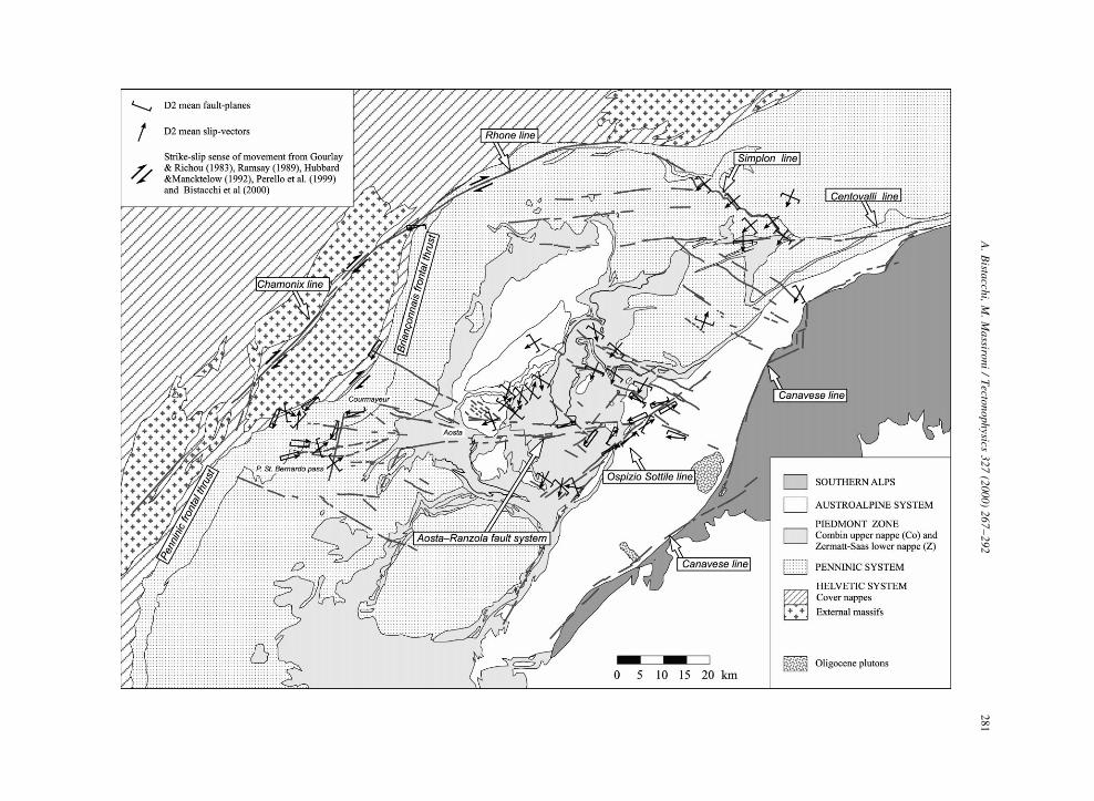
Fig. 8. Sketch-map of area where structures linked to phase D2 can be continuously traced. Site-average kinematic data (see Fig. 7) are shown
in their geographic location. Dextral strike-slip prevails along the NW border-zone (Gourlay and Richou, 1983; Ramsay, 1989; Hubbard and
Mancktelow, 1992; Maurer et al., 1997); a left-lateral overall kinematics is inferred for the SE border zone. Ductile to brittle extension along
Simplon fault (NE border zone; Mancktelow, 1992) is parallel to extension within the PGA block (about 0508). Principal fault traces shown as
thick dark grey lines. Principal units as in Fig. 1.
A.
Bista
cchi,
M.
Ma
ssironi
/T
ectonophysics
327
(2000)
267
±292
281
A. Bistacchi, M. Massironi / Tectonophysics 327 (2000) 267±292282

Omenetto, 1978). The most important faults of this set
are the Ospizio Sottile, Mont Gele and Trois Villes
lines (Figs. 1±3).
(4) An intermediate to high-angle N- and S-dipping
conjugate fault set, mainly running along the middle
Aosta Valley (Fig. 2), showing the same features as
set 3, but with a strong asymmetry. The master fault
(Aosta±Ranzola fault system) dips to the N and is
characterised by strong hydrothermal ¯uid ¯ow;
conversely, antithetic S-dipping faults always show
minor displacements and veining.
The kinematics of extensional crenulation clea-
vage and localised low-angle shear zones (Systems
1 and 2) is shown in Figs. 5a, 6a and 5b, 6b, respec-
tively. Microtectonic data of intermediate to high-
angle faults (Systems 3 and 4) are shown in Figs.
5c and 6c.
As we have seen, all these four sets show the same
deformation mechanisms and are associated with the
same type of hydrothermal ¯uid ¯ow; hence they may
be considered coeval. Given that thermal conditions
change continually during exhumation, similarity of
deformation mechanisms and hydrothermal mineral
assemblages may be considered evidence for
simultaneity.
No systematic cross-cutting relationships are asso-
ciated with the strike of the different sets. Structures
belonging to sets 1 and 2 are developed in different
areas, depending on the regional attitude of the
greenschist facies foliation. Faults belonging to sets
3 and 4 cut each other repeatedly, and therefore must
be considered coeval from a geometrical point of
view.
Steep faults (3 and 4) consistently cross-cut low-
angle detachments (1 and 2) in weak rocks such as
Piedmont calcschists, but the principal extension
direction, inferred from congruent kinematic indica-
tors, is everywhere horizontal NW±SE (Fig. 5a±d).
This is interpreted as the effect of the transition from
brittle±ductile to colder, truly brittle conditions
during continuing NW±SE extension.
Taking into account these considerations, the four
sets listed above developed in response to a single
deformation phase (D1), characterised by an overall
NW±SE extension (with vertical shortening) and
intense hydrothermal activity, focused along two
major faults: the Aosta±Ranzola and Ospizio Sottile
fault systems.
The Oligocene age of phase D1 is supported by:
(1) the occurrence of Oligocene (31±29 Ma) ande-
sitic-lamprophyric dikes in the inner Aosta and Sesia
valleys, synkinematically emplaced along sub-verti-
cal E- to NE-striking fractures (Dal Piaz et al.,
1979; Figs. 5d and 9d);
(2) the coeval (32±30 Ma) emplacement of
A. Bistacchi, M. Massironi / Tectonophysics 327 (2000) 267±292 283
Fig. 10. Two hypothetical composite cooling curves, indicating
contrasted exhumation.
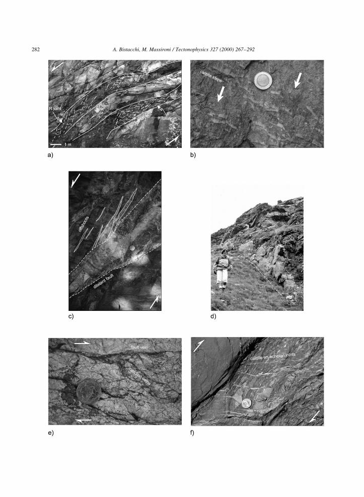
Fig. 9. (a) D1 low-angle detachments in calcschists of Piedmont zone. Shear sense is top-down to the left (NW; see Rutter et al., 1986, for
terminology of composite fabric in clayey gouge). (b) High-angle slickensides in calcschists of Piedmont zone. Same outcrop as (a) and same
extension direction (NW±SE). (c) Gold-bearing quartz vein injected into a NNW-dipping dilatant normal fault in Brusson gold district (eastern
end of the Aosta±Ranzola fault system). Sub-vertical offshoots branching from fault vein indicate NW±SE extension. (d) Lamprophyric dike
injected along an E±W fracture cross-cutting the greenschist facies foliation of Piedmont calcschists. (e) Pseudotachylite fault and injection
veins along Ospizio Sottile fault, (hand sample; see Swanson, 1992, for terminology of pseudotachylites). (f) Dextral reactivation along
Penninic frontal thrust, revealed by very penetrative en-echelon quartz±calcite vein arrays.
A. Bistacchi, M. Massironi / Tectonophysics 327 (2000) 267±292284
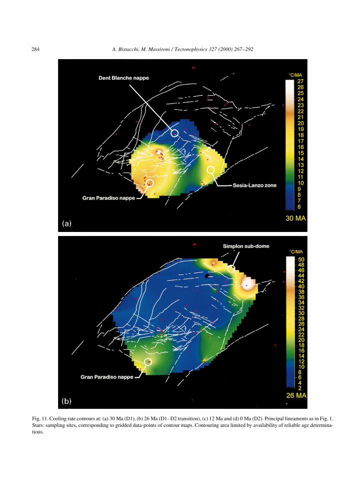
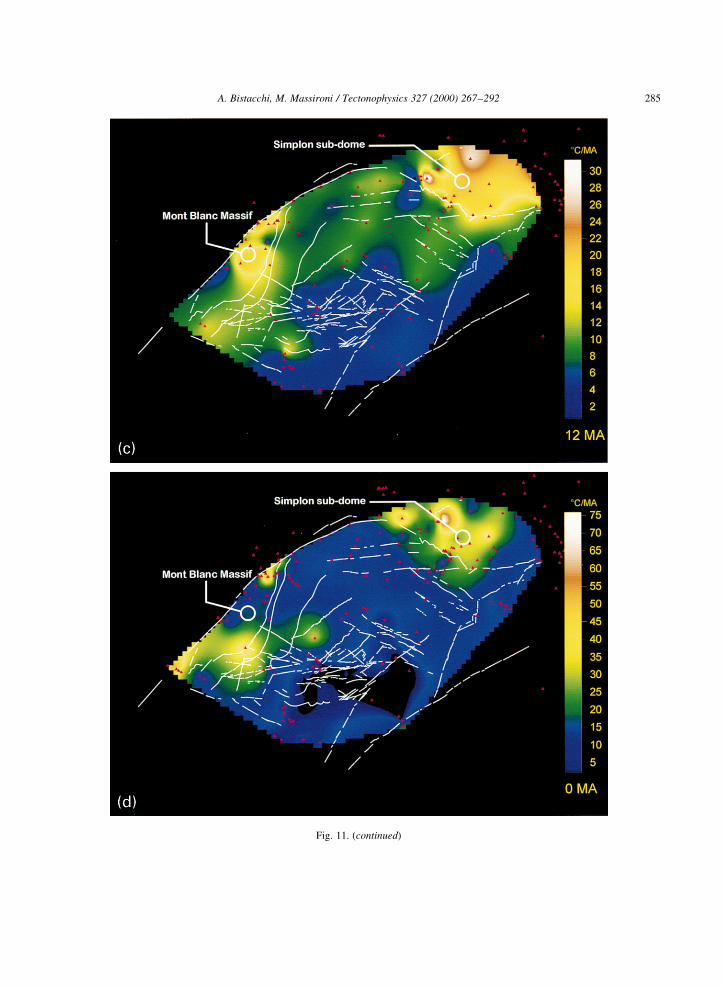
Fig. 11. Cooling rate contours at: (a) 30 Ma (D1), (b) 26 Ma (D1±D2 transition), (c) 12 Ma and (d) 0 Ma (D2). Principal lineaments as in Fig. 1.
Stars: sampling sites, corresponding to gridded data-points of contour maps. Contouring area limited by availability of reliable age determina-
tions.
A. Bistacchi, M. Massironi / Tectonophysics 327 (2000) 267±292 285
Fig. 11. (continued)
synkinematic gold-bearing quartz veins along high-
angle E- to NE-striking normal faults and tension
gashes in the Brusson area (Diamond, 1990; Figs.
5d and 9c); ¯uids related to these veins are also
responsible for listvenitic metasomatism all along
the Aosta±Ranzola and Ospizio Sottile faults;
(3) the steep cooling rate gradient across the Aosta
Valley, con®rming at 30 Ma fast cooling of the blocks
to the south of the Aosta±Ranzola fault system and
slowest cooling in correspondence to the Dent
Blanche nappe (Fig. 11a);
(4) ZFT ages, which record cooling under 2508C at
about 32 Ma throughout the Aosta Valley region
(Hunziker et al., 1992; Seward and Mancktelow,
1994); this cooling age is consistent with the
ductile-to-brittle transition on NW- and SE-dipping
faults in calcschists of the Piedmont ophiolitic units,
since 2508C is an accepted estimate for the brittle±
ductile transition in carbonate rocks (e.g. Carter and
Tsenn, 1987).
If extensional activity along the sets listed
above can be ascribed to a single tectonic phase,
A. Bistacchi, M. Massironi / Tectonophysics 327 (2000) 267±292286
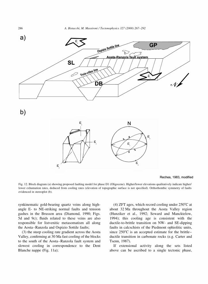
Fig. 12. Block diagram (a) showing proposed faulting model for phase D1 (Oligocene). Higher/lower elevations qualitatively indicate higher/
lower exhumation rates, deduced from cooling rates (elevation of topographic surface is not speci®ed). Orthorhombic symmetry of faults
evidenced in stereoplot (b).
synchronous displacements along these four conju-
gate sets (N-, S-, NW-, SE-dipping) can be interpreted
with the 3D faulting model of Aydin and Reches
(1982). According to this model, conjugate displace-
ments along four sets, arranged in orthorhombic
symmetry (Fig. 12), take place in response to a ªtrue
triaxialº strain ®eld, where all principal strains
�ex; ey; ez� are different from zero (Reches, 1978;
Aydin and Reches, 1982; Reches and Dieterich,
1983; Reches, 1983; Krantz, 1988). This model is
more general than the Anderson (1951) classical
model, which predicts displacement along two conju-
gate faults in the restrictive condition of plane strain
�ey � 0�; therefore, ®nding evidence of triaxial strain
is not surprising.
Applying the triaxial model to the middle Aosta
Valley, the maximum extension axis �ex� is inferred
to be NW±SE oriented, the intermediate axis �ey� is
positive (extensional) and NE±SW oriented, and
the shortening axis �ez� is vertical (ªodd axisº of
Krantz, 1988; Fig. 12). Therefore, the regional strain
ellipsoid is oblate, with a NW±SE-directed maximum
extension.
As previously noted, the fastest cooling domains
were located south of the Aosta±Ranzola fault system
(lower Champorcher Valley), whereas the area with
the slowest cooling was the Dent Blanche nappe,
bordered on both sides by antithetic NW- and SE-
dipping extensional structures. Steep cooling rate
gradients may be recognised along the Aosta±
Ranzola and Ospizio Sottile faults, which are also
characterised by hydrothermal ¯uid ¯ow; hence,
these two faults are considered the two most important
structures for the Oligocene phase D1. The block
diagram of Fig. 12 shows the proposed tectonic
model, which satis®es both the cooling-rate pattern
and the orthorhombic faulting model.
4.2. Age of back-thrusts and back-folds
As mentioned in the introduction, different authors
do not agree on the age of the last ductile deforma-
tions in this part of the NW Alps. The latest ductile
deformations are represented by open folds related to
ductile thrusts, with a transport direction opposite to
that of the overall vergence of the nappe stack (back-
folds and back-thrusts; Argand, 1911, 1916).
Hurford et al. (1991) suggest that the Miocene
differential exhumation, recorded by AFT age distri-
bution, is related to the evolution of these large-scale
ductile back-folds and therefore favour the develop-
ment of a compressional tectonic phase at the Oligo-
cene±Miocene boundary, as proposed by Argand
(1916).
However, since in this temperature range (110±
608C of the AFT partial annealing zone) no ductile
deformation would occur in basement rocks (Carter
and Tsenn, 1987), the back-thrust and back-fold phase
should be older than D1. This is con®rmed by cross-
cutting relationships and white mica Rb/Sr and Ar/Ar
ages (36±34 Ma) from the Entrelor back-thrust
(Freeman et al., 1997) and the Mischabel back-fold
(Barnicoat et al., 1995). The brittle±ductile transition
therefore probably took place in the Oligocene along
the middle Aosta Valley (at about 32 Ma), after the
greenschist facies back-thrusting and back-folding of
the middle Penninic Grand St. Bernard nappe.
Since the NE end of the Canavese line (E of the
Ossola Valley) acted as a dextral transpressive fault
during the Oligo-Miocene over-steepening of the
ªroot zoneº (caused by the NW motion of the South-
alpine indenter at 26±20 Ma; Schmid et al., 1989;
Zingg and Hunziker, 1990), this kinematic behaviour
may also be assumed for the SW part of the line.
Nevertheless, ®eld evidence shows that the Canavese
line mylonites between Ivrea and the Ossola valley are
overprinted by high-angle brittle normal faults asso-
ciated with large cataclastic layers. These are the only
structures that cut the Oligocene volcanoclastic cover
of the inner Sesia Lanzo zone. Thus, from the Oligo-
cene onwards, activity along the SW portion of the
Canavese line was extensional and, along this fault,
back-thrusting took place before the Oligocene.
In conclusion, all the ductile shortening events took
place, in the Aosta Valley region and surroundings,
before about 33 Ma and the extensional D1 phase.
This reconstruction is con®rmed by the gradual tran-
sition between cooling patterns characteristic of each
phase, shown by the cooling-rate contour map calcu-
lated between D1 and D2 (e.g. 26 Ma, Fig. 11b).
4.3. Miocene to Present lateral extrusion: phase D2
From the early Miocene to the Present, continuous
lateral extrusion has been active from the Simplon
fault to the SW, involving the whole Pennine-Graian
A. Bistacchi, M. Massironi / Tectonophysics 327 (2000) 267±292 287

Alps nappe stack which, from then on, may be consid-
ered as a continuous and almost homogeneously
deforming fault-bounded block (PGA in Fig. 13;
Hubbard and Mancktelow, 1992; Ring and Merle,
1992; Bistacchi et al., 2000). The discontinuities
bordering the PGA block are (Figs. 8 and 13): (1) to
the NE, the Simplon fault; (2) to the NW, the Rhone
line (between Brig and Martigny), Chamonix line,
Penninic frontal thrust, BriancËonnais frontal thrust,
and some high-angle fault zones between them; and
(3) to the SE, the Ospizio Sottile fault.
The NE extensional edge of the SW-escaping PGA
block (Simplon fault) underwent continuous extension
from the Miocene onwards (Mancktelow, 1992). The
Rhone line has a well-documented dextral strike-slip
between Brig and Martigny (Hubbard and Manckte-
low, 1992; Maurer et al., 1997). More to the SW it
extends into the Chamonix line, with a 208 counter-
clockwise bend resulting in a dextral transpressive
movement (Gourlay and Richou, 1983; Ramsay,
1989; Hubbard and Mancktelow, 1992). South-west
of the Piccolo S. Bernardo pass area, the low-angle
Penninic and BriancËonnais frontal thrusts were reac-
tivated as extensional detachment horizons (AilleÁres
et al., 1995; Cannic et al., 1995, 1999) and some high-
angle normal faults between these two thrusts have
been active in the last few million years (FuÈgenschuh
et al., 1999). Perello et al. (1999) have recently docu-
mented post-metamorphic dextral transpressive activ-
ity of the Penninic frontal thrust in the Courmayeur
area. Our ®eldwork has revealed late right-lateral
reactivation of the steep E-dipping slaty cleavage of
Ultrahelvetic Jurassic slates in the Ferret and Veny
valleys (Fig. 9f), as well as the presence of some
high-angle brittle faults dissecting the outer Penninic
cover sheets (Figs. 7b and 8). Within this kinematic
A. Bistacchi, M. Massironi / Tectonophysics 327 (2000) 267±292288
Fig. 13. Block diagram showing faulting model proposed for Miocene to Present orogen-parallel extrusion: while PGA block underwent more
or less homogeneous extension, Simplon sub-dome and Mont Blanc massif were exhumed faster. The latter, in transpressive conditions, may be
interpreted as a positive ¯ower structure. Higher/lower elevations qualitatively indicate higher/lower exhumation rates, deduced from cooling
rates (elevation of topographic surface is not speci®ed).
framework, the Helvetic basement units of the Mont
Blanc massif may constitute a positive ¯ower struc-
ture developing under a Neogene transpression (Fig.
13).
The principal SE edge of the PGA block is the
Ospizio Sottile line, reactivated as a sinistral transcur-
rent fault after its normal activity during D1 (Figs. 7c
and 8). Kinematic indicators, such as calcite steps in
carbonatic rocks, pseudotachylite-®lled pull-apart
structures and asymmetric injection veins (in
Austroalpine gneisses; Fig. 9e) consistently show its
sinistral strike-slip activity (Bistacchi et al., 2000).
The internal deformation of the PGA block is
characterised by a regular array of NE- and SW-
dipping normal faults, indicating a NE±SW extension
direction from the Simplon fault to the Gran Paradiso
massif. A very penetrative set of sub-vertical exten-
sional joints, striking NW±SE and extending from the
Valais to at least the Piccolo S. Bernardo Pass, is also
consistent with this extension direction (Figs. 7a and
8). Some E±W striking structures, partly inherited
from D1, are also consistent with the internal defor-
mation of the PGA block. One of the most important
is the Aosta±Ranzola fault system, which, to the W,
extended as a slightly diverging splay of mainly
dextral strike-slip faults (Aosta±Piccolo S. Bernardo
fault system; Fig. 8).
The spatial arrangement of cooling-rate contours
shows that the Lepontine dome and the Mont Blanc
massif cooled faster than the neighbouring areas from
about 26 Ma onwards. Undisturbed cooling-rate
contour lines cross-cut the Ospizio Sottile fault,
showing no evidence for any along-dip displacement
(Fig. 11c and d). This cooling pattern may be a result
of differential exhumation of fault-bounded blocks, as
shown in the tectonic model of Fig. 13. The distribu-
tion of microseismicity and fault plane solutions
indicates that this orogen-parallel extrusion is still
active (Bistacchi et al., 2000).
5. Discussion
In many sectors of the Alps, a post-collisional
extension has been referred to an orogen-parallel
extrusion, as in the case of phase D2 (Selverstone,
1988; Ratschbacher et al., 1989; Hubbard and
Mancktelow, 1992; Ring and Merle, 1992; Meyre et
al., 1998; Bistacchi et al., 2000). However, the Oligo-
cene D1 NW±SE extension, developed along four
conjugate fault sets with orthorhombic symmetry
(Fig. 12), is characterised by an oblate strain ellipsoid,
indicating net extension in all horizontal directions.
During this phase, the main extension direction,
which is perpendicular to the belt axis, apparently
contradicts the continuing convergence of European
and Adriatic plates in the Oligocene, supported by
thrusting in the Southern Alps and Helvetic domains
and by global plate-tectonic reconstructions (e.g.
Laubscher, 1985; Coward and Dietrich, 1989; Platt
et al., 1989). However, the concomitant occurrence
of extension and shortening in axial and marginal
areas, respectively, is known in other collisional
belts and is generally ascribed either to gravitational
instability arising from over-thickening of the litho-
sphere (Molnar and Lyon-Caen, 1988) or to isostatic
rebound following a slab breakoff (Dal Piaz and
Gosso, 1994; Von Blanckenburg and Davies, 1995).
With regard to the timing of D1 and D2, we recall
that a 2-Ma delay is expected between the onset (or
end) of a given tectonic phase and its thermal effect.
Hence, the transition from D1 to D2 should be earlier
by the same amount with respect to the change in the
overall cooling pattern, evidenced by cooling-rate
contour maps, at about 26 Ma. Therefore the D1±D2
transition may be placed at about 28 Ma. Dating the
end of phase D2 may also be affected by a similar
delay, but Bistacchi et al. (2000) showed, on the basis
of seismotectonic data, that this phase is still active.
6. Conclusions
In this paper, different datasets are compared in
order to reconstruct the brittle tectonic evolution of
the axial part of the north-western Alps. Remote
sensing was found to be a useful tool for preliminary
tectonic analysis of such a large area. Microtectonic
analysis is con®rmed as the fundamental basis for any
tectonic reconstruction, and thermochronology is very
useful to constrain differential exhumation of large
fault-bounded blocks. The cooling-rate contour map
approach, although affected by several uncertain-
ties, provides a synthetic view of the over-time
evolution of the regional cooling pattern. Since it
®ts independent structural data (in the present
A. Bistacchi, M. Massironi / Tectonophysics 327 (2000) 267±292 289
study, areas of steep cooling rate gradient correspond
to most important normal faults), the cooling rate
pattern is considered a good approximation of the
exhumation pattern.
All these data concur to constrain the multi-phase
kinematic model for the north-western Alps from the
Oligocene onwards, which developed through the
following stages:
(1) ductile back-thrusting and back-folding (before
32 Ma);
(2) Oligocene extension perpendicular to the belt
axis (32±28 Ma, D1);
(3) D1±D2 transition at about 28±26 Ma;
(4) Miocene±Present orogen-parallel extrusion
(26±0 Ma, D2).
Acknowledgements
The authors would like to thank Prof. Giorgio
Vittorio Dal Piaz and Drs. Antonio Germani, Bruno
Monopoli, Silvana Martin, Giorgio Pennacchioni,
Alessio Schiavo and Massimiliano Zattin for useful
discussions, encouragement and support during ®eld-
work. Profs Jean-Pierre Burg, Neil Mancktelow and
Lothar Ratschbacher are acknowledged for careful
revisions. Prof. Paolo Baggio kindly provided access
to computer facilities at LAT (University of Padova).
ERS-GTC data were studied at ASI-CGS (Matera)
with the support of I-PAF. Nicola Michelon and
Stefano Castelli are acknowledged for technical and
graphical support; Gabriel Walton revised the English
text.
References
AilleÁres, L., Bertand, J.M., MacaudieÁre, J., Champenois, M., 1995.
Structure de la Zone HoullieÁre BriancËonnaise (Alpes fran-
cËaises), tectonique neÂoalpine et conseÂquences sur l'interpreÂta-
tion des Zones Penniques Frontales. C. R. Acad. Sci. Paris 321,
247±254.
Anderson, E.M., 1951. The Dynamics of Faulting and Dyke
Formation with Application to Britain, 2nd ed. Oliver &
Boyd, Edinburgh, 206 pp.
Argand, E., 1911. Les nappes de recouvrement des Alpes Pennines
et leurs prolongements structuraux. Mat. Carte GeÂol. Suisse 31,
1±26.
Argand, E., 1916. Sur l'arc des Alpes Occidentales. Eclogae Geol.
Helv. 14, 145±191.
Aydin, A., Reches, Z., 1982. Number and orientation of fault sets in
the ®eld and in experiments. Geology 10, 107±112.
Balestrieri, M.L., Bigazzi, G., Bistacchi, A., Martin, S., Massironi,
M., Polino, R., Zattin, M., 1999. Investigation on brittle
tectonics in a collisional nappe-stack (NW Alps) using the
®ssion track analysis. Mem. Sci. Geol. Padova 51 (2), 438±440.
BalleÁvre, M., Kienast, J.R., Vuichard, J.P., 1986. La ªnappe de la
Dent Blancheº (Alpes occidentales): deux uniteÂs austroalpines
indeÂpeÂndantes. Eclogae Geol. Helv. 79, 57±74.
Barnicoat, A.C., Rex, D.C., Guise, P.G., Cliff, R.A., 1995. The
timing and nature of greenschist facies deformation and
metamorphism in the upper Pennine Alps. Tectonics 14,
279±293.
Bigi, G., Cosentino, D., Parotto, M., Sartori, R., Scandone, P., 1990.
Structural model of Italy. Sheet no. 1. In: Bigi, G., Castellarin,
A., Coli, M., Dal Piaz, G.V., Sartori, R., Scandone, P., Vai, G.B.
(Eds.), CNR Progetto Finalizzato Geodinamica.
Bistacchi, A., Eva, E., Massironi, M., Solarino, S., 2000. Miocene to
Present kinematics of the NW-Alps: evidences from remote
sensing, structural analysis, seismotectonics and thermochronol-
ogy. J. Geodynam. 30 (1±2), 205±228.
Cannic, S., Mugnier, J.L., Lardeaux, J.M., 1995. Mise en eÂvidence
d'une faille normale ductile dans l'unite du Roignais-Versoyen
(Alpes occidentales, France). C. R. Acad. Sci. Paris 321,
513±519.
Cannic, S., Mugnier, J.L., Lardeaux, J.M., 1999. Neogene extension
in the western Alps. In: Gosso, G., Jadoul, F., Sella, M., Spalla,
I. (Eds.), 3rd Workshop on Alpine Geological Studies. Mem.
Sci. Geol. 51 (1), 33±45.
Carter, N.L., Tsenn, L., 1987. Flow properties of continental litho-
sphere. Tectonophysics 136, 27±63.
Cortiana, G., Dal Piaz, G.V., Del Moro, A., Hunziker, J.C., Martin,
S., 1998. 40Ar± 39Ar and Rb±Sr dating on the Pillonet klippe and
frontal Sesia-Lanzo zone in the Ayas valley and evolution of the
western Austroalpine nappe stack. Mem. Sci. Geol. 50,
177±194.
Coward, M.P., Dietrich, D., 1989. Alpine tectonics Ð an overview.
In: Coward, M.P., Dietrich, D., Park, R.G. (Eds.), Alpine
Tectonics. Geol. Soc. London, Spec. Publ. 45, 1±29.
Curlander, J.C., Mcdonough, R., 1991. Synthetic Aperture Radar:
System and Signal Processing. Wiley, New York, 570 pp.
Dal Piaz, G.V., 1999. The Austroalpine-Piedmont nappe stack and
the puzzle of Alpine Tethys. In: Gosso, G., Jadoul, F., Sella, M.,
Spalla, I. (Eds.), 3rd Workshop on Alpine Geological Studies,
Mem. Sci. Geol. Padova 51 (1), 155±176.
Dal Piaz, G.V., Gosso, G., 1994. Some remarks on evolution of the
Alpine lithosphere. Quad. Geodinam. Alpina Quaternaria 2,
91±99.
Dal Piaz, G.V., Omenetto, P., 1978. Brevi note su alcune miner-
alizzazioni della falda piemontese in Valle d'Aosta. O®oliti 3
(2/3), 161±176.
Dal Piaz, G.V., Venturelli, G., Scolari, A., 1979. Calc-alkaline to
ultrapotassic post-collisional volcanic activity in the internal
northwestern Alps. Mem. Sci. Geol. Padova 32, 16 pp.
Desmons, J., Aprahamian, J., Compagnoni, R., Cortesogno, L.,
Frey, M., Gaggero, L., Dallagiovanna, G., Seno, S., Radelli,
L., 1999. Alpine metamorphism of the Western Alps: I. Middle
A. Bistacchi, M. Massironi / Tectonophysics 327 (2000) 267±292290

to high-P/T metamorphism. Schweiz. Mineral. Petrogr. Mitt. 79,
89±110.
Diamond, L.W., 1990. Fluid inclusion evidence for P±V±T±X
evolution of hydrothermal solutions in Late-Alpine gold-quartz
veins at Brusson, Val d'Ayas, northwest Italian Alps. Am. J. Sci.
290, 912±958.
ESA, 1992. ESA ERS-1 product speci®cation Ð ESA SP-1149
(special publication).
Fitzgerald, P.D., Gleadow, A.J.W., 1988. Fission-track
geochronology, tectonics and structure of the Transantarctic
Mountains in northern Victoria Land, Antarctica. Chem. Geol.
(Isotope Geosci. Sect.) 73, 169±198.
Freeman, S.R., Inger, S., Butler, R.W.H., Cliff, R.A., 1997. Dating
deformation using Rb±Sr in white micas: greenschist facies
deformation ages from the Entrelor shear zone, Italian Alps.
Tectonics 16, 57±76.
Frey, M., Desmons, J., Neubauer, F., 1999. The new metamorphic
map of the Alps. Schweiz. Mineral. Petrogr. Mitt. 79, 230 pp.
FuÈgenschuh, B., Loprieno, A., Ceriani, S., Schmid, S.M., 1999.
Structural analysis of the SubbriancËonnais and Valais units in
the area of Moutiers (Savoy, Western Alps): paleogeographical
and tectonic consequences. Int. J. Earth Sci. 88, 201±218.
Giglia, G., Capponi, G., Crispini, L., Piazza, M., 1996. Dynamics
and seismotectonics of the West-Alpine arc. Tectonophysics
267, 143±175.
Gourlay, P., Richou, L.E., 1983. Le jeu deÂcrochant dextre tardif de
la suture de chamonnix (Alpes francaises et suisses). C. R. Acad.
Sci. Paris 296, 927±932.
Grasemann, B., Mancktelow, N.S., 1993. Two dimensional thermal
modelling of normal faulting: the Simplon Fault Zone, Central
Alps, Switzerland. Tectonophysics 225, 155±165.
Gupta, R.P., 1991. Remote Sensing Geology. Spinger, Berlin,
356 pp.
Hancock, P.L., 1985. Brittle microtectonics: principles and practice.
J. Struct. Geol. 7 (3/4), 437±457.
Hubbard, M., Mancktelow, N.S., 1992. Lateral displacement during
Neogene convergence in the western and central Alps. Geology
20, 943±946.
Hunziker, J.C., Desmons, J., Hurford, A.J., 1992. Thirty-two years
of geochronological work in the Central and Western Alps: a
review on seven maps. MeÂm. GeÂol., Lausanne 13, 59 pp.
Hurford, A.J., Hunziker, J.C., StoÈckert, B., 1991. Constraints on the
late thermotectonic evolution of the western Alps: evidence for
episodic rapid uplift. Tectonics 10, 758±769.
Khale, H.G., Geiger, A., Burki, B., Gubler, E., Marti, U., Wirth, B.,
Rothacher, M., Gurtner, W., Beutler, G., Bauersima, I., P®ffner,
O.A., 1997. Recent crustal movements, geoid and density distri-
bution: contribution from integrated satellite and terrestrial
measurements. In: P®ffner, O.A., et al. (Eds.), Deep Structure
of the Swiss Alps: results of NRP 20. BirkhaÈuser, Basel.
Klein, J.A., 1978. Post-nappe folding southeast of the Mischabel-
ruÈck-Falte (Pennine Alps) and some aspects of the associated
metamorphism. Leid. Geol. Meded 51, 233±312.
Krantz, R.W., 1988. Multiple fault sets and three-dimensional
strain: theory and application. J. Struct. Geol. 10 (3), 225±237.
Laduron, D., Merlyn, M., 1974. Evolution structurale et meÂtamor-
phique de l'antiforme de Vanzone (Valle Anzasca et Valle
Antrona, Province de Novara, Italie). Bull. Soc. Geol. Fr. 7
Ser. 16, 264±265.
Laubscher, H.P., 1985. Large scale, thin-skinned thrusting in the
Southern Alps: kinematic model. Geol. Soc. Am. Bull. 96,
710±718.
Mancktelow, N.S., 1985. The Simplon Line: a major displacement
zone in the western Lepontine Alps. Eclogae Geol. Helv. 78 (1),
73±96.
Mancktelow, N.S., 1990. The Simplon Fault Zone. Beitr. Geol.
Karte Schweiz (NF) 163, 74 pp.
Mancktelow, N.S., 1992. Neogene lateral extension during conver-
gence in the Central Alps: evidence from interrelated faulting
and backfolding around the Simplon pass (Switzerland). Tecto-
nophysics 215, 295±317.
Mancktelow, N.S., Grasemann, B., 1997. Time-dependent effects of
heat advection and topography on cooling histories during
erosion. Tectonophysics 270, 167±195.
Martin, S., Polino, R., Bistacchi, A., Massironi, M., Zattin, M.,
Perello, P., Piana, F., Gianotti, F., Germani, A., FuÈgenschuh,
B., 1999. Exhumation of the Alpine nappe stack. Mem. Sci.
Geol. 51 (2), 483±515.
Massironi, M., 1998. Analisi di prodotti satellitari ottici e radar per
lo studio della tettonica fragile in aree di catena. Il caso delle
Alpi nord-occidentali. PhD thesis, Department of Geology,
University of Padova.
Massironi, M., Baggio, P., Dal Piaz, G.V., Loizzo, R., 1997. Brittle
tectonics in Northwestern Alps: remote-sensing applications. In:
Cecchi, G., Engman, E.T., Zilioli, E. (Eds.), Earth Surface
Remote Sensing. EUROPTO Series, vol. 3222, pp. 329±339.
Maurer, H.H., Burkard, M., Deichmann, N., Green, A.G., 1997.
Active tectonism in the central Alps: contrasting stress regimes
north and south of the Rhone Valley. Terra Nova 9, 91±94.
Merle, O., Cobbold, P.R., Schmid, S., 1989. Tertiary kinematics in
the Lepontine dome. In: Coward, M.P., Dietrich, D., Park, R.G.
(Eds.), Alpine Tectonics. Geol. Soc. London, Spec. Publ. 45,
113±134.
Meyre, C., Marquer, D., Schmid, S.M., Ciancaleoni, L., 1998. Syn-
orogenic extension along the Forcola Fault; correlation of
Alpine deformations in the Tambo and Adula nappes (eastern
Penninic Alps). Eclogae Geol. Helv. 91 (3), 409±420.
Michard, A., GoffeÂ, B., Chopin, C., Henry, C., 1996. Did the
Western Alps develop through an Oman-Type stage? The
geotectonic setting of high-pressure metamorphism in two
contrasting Tethyan transects. Eclogae Geol. Helv. 89 (1),
43±80.
Milnes, A.G., Greller, M., MuÈller, R., 1981. Sequence and style of
major post-nappe structures, Simplon-Pennine Alps. J. Struct.
Geol. 3/4, 411±420.
Molnar, P., Lyon-Caen, H., 1988. Some simple physical aspects of
the support, structure, and evolution of mountain belts. Geol.
Soc. Am. Spec. Pap. 218, 179±207.
Nicolas, A., Polino, R., Hirn, A., Nicolich, R., Ecors-Crop Working
Group, 1990. Ecors-Crop traverse and deep structure of western
Alps: a synthesis. MeÂm. Soc. GeÂol. Fr., N.S. 156, 15±27 (MeÂm.
Soc. GeÂol. Suisse 1, 15±27; Vol. Spec. Soc. Geol. Italiana 1,
15±27).
Perello, P., Piana, F., Martinotti, G., 1999. Neo-Alpine structural
A. Bistacchi, M. Massironi / Tectonophysics 327 (2000) 267±292 291
features at the boundary between the Penninic and Helvetic
domains (PreÁ S. DidieÂr-EntreÁves, Aosta valley, Italy). Eclogae
Geol. Helv. 92, 347±359.
Petit, J.P., 1987. Criteria for the sense of movement on fault surfaces
in brittle rocks. J. Struct. Geol. 9 (5/6), 597±608.
Platt, J.P., Behrmann, H., Cunningham, P.C., Dewey, J.F., Helman,
M., Parish, M., Shepley, M.G., Wallis, S., Weston, P.J., 1989.
Kinematics of the Alpine arc and the motion history of Adria.
Nature 337, 158±161.
Polino, R., Dal Piaz, G.V., Gosso, G., 1990. Tectonic erosion at the
Adria margin and accretionary processes for the Cretaceous
orogeny of the Alps. MeÂm. Soc. GeÂol. Fr. 156, 345±367.
Ramsay, J.G., 1989. Fold and fault geometry in the western Helvetic
nappes of Switzerland and France and its implication for the
evolution of the arc of the western Alps. In: Coward, M.P.,
Dietrich, D., Park, R.G. (Eds.), Alpine Tectonics. Geol. Soc.
London, Spec. Publ. 45, 33±45.
Ratschbacher, L., Frisch, W., Neubauer, F., Schmid, S.M., Neuge-
bauer, J., 1989. Extension in compressional orogenic belts: the
eastern Alps. Geology 17, 404±407.
Reches, Z., 1978. Analysis of faulting in three-dimensional strain
®eld. Tectonophysics 47, 109±129.
Reches, Z., 1983. Faulting of rocks in three-dimensional strain
®elds. II. Theoretical analysis. Tectonophysics 95, 133±156.
Reches, Z., Dieterich, J.H., 1983. Faulting of rocks in three-dimen-
sional strain ®elds. I. Failure of rocks in polyaxial, servo-control
experiments. Tectonophysics 95, 111±132.
Richard, A., 1981. Le district aurifeÁre de Challant (Val d'Aoste;
Italie): litologie, geÂochimie et metallogeÂnie de l'or. TheÁse de
doctorat de speÂcialiteÂ, Universite Scienti®que et MeÂdicale de
Grenoble.
Richards, J.A., 1986. Remote Sensing Digital Image Analysis: An
Introduction. Spinger, Berlin, 281 pp.
Ring, U., 1994. Late Alpine kinematics of the Aosta fault, north-
western Italian Alps. Neues Jahrb. Geol. Paleontol., Mh 7,
434±442.
Ring, U., Merle, O., 1992. Forethrusting, backfolding and lateral
gravitational escape in the northern part of the Western Alps
(Monte Rosa region). Geol. Soc. Am. Bull. 104, 901±914.
Rutter, E.H., Maddock, R.H., Hall, S.H., White, S.H., 1986.
Comparative microstructures of natural and experimentally
produced clay-bearing fault gouges. Pure Appl. Geophys. 124,
3±30.
Sabins, F., 1997. Remote Sensing: Principles and Interpretation, 3rd
ed. Freeman, New York, 449 pp.
Schlunegger, F., Willett, S., 1999. Spatial and temporal variations in
exhumation of the central Swiss Alps and implications for exhu-
mation mechanisms. In: Ring, U., Brandon, M.T., Lister, G.S.,
Willett, S.D. (Eds.), Exhumation processes: normal faulting,
ductile ¯ow and erosion. Geol. Soc. London, Spec. Publ. 154,
157±179.
Schmid, S.M., Aebli, H.R., Zingg, A., 1989. The role of the Peria-
driatic Line in the tectonic evolution of the Alps. In: Coward,
M.P., Dietrich, D., Park, R.G. (Eds.), Alpine Tectonics. Geol.
Soc. London, Spec. Publ. 45, 153±171.
Selverstone, J., 1988. Evidence for east±west crustal extension in
the eastern Alps: implications for the unroo®ng history of the
Tauern window. Tectonics 7, 87±105.
Seward, D., Mancktelow, N.S., 1994. Neogene kinematics of
central and western Alps: evidence from ®ssion-track dating.
Geology 22, 803±806.
Spicher, A., 1980. Tektonische Karte der Schweiz 1:500,000. Geol.
Kommission, Bern.
Steck, A., Bigioggero, B., Dal Piaz, G.V., Epard, J.-L., Escher, A.,
Gouffon, Y., Marchant, R., Martinotti, G., Masson, H., Sartori,
M., 2000. Carte tectonique des Alpes de Suisse occidentale
(1:100,000). Of®ce FeÂdeÂral de Topographie.
StuÈwe, K., White, L., Brown, R., 1994. The in¯uence of eroding
topography on steady-state isotherms. Application to ®ssion
track analysis. Earth Planet. Sci. Lett. 124, 63±74.
Swanson, M.T., 1992. Fault structures, wear mechanisms and
rupture processes in pseudotachylite generation. Tectonophy-
sics 204, 223±242.
Venturelli, G., Thorpe, R.S., Dal Piaz, G.V., Del Moro, A., Potts,
P.J., 1984. Petrogenesis of calcalcaline, shoshonitic and asso-
ciated ultrapotassic Oligocene volcanic rocks from the North-
western Alps, Italy. Contrib. Mineral. Petrol. 86, 209±220.
Von Blanckenburg, F., Davies, J.H., 1995. Slab breakoff: a model
for syncollisional magmatism and tectonics in the Alps.
Tectonics 14 (1), 120±131.
Wust, G.H., Silveberg, D.S., 1989. Northern Combin zone
complex±Dent Blanche nappe contact: extension within the
convergent Alpine belt. Schweiz Mineral. Petrogr. Mitt. 69,
251±259.
Zingg, A., Hunziker, J.C., 1990. The age of movements along the
Insubric line west of Locarno (northern Italy and southern Swit-
zerland). Eclogae Geol. Helv. 83 (3), 629±644.
A. Bistacchi, M. Massironi / Tectonophysics 327 (2000) 267±292292
Copyright © 2022 FDOKUMEN