Elements of Global Strike-Slip Tectonics: a Quasi-Neotectonic Analysis
37
© Szekler Academic Press • Sfântu Gheorghe/ Sepsiszentgyörgy Journal of Global Strike-Slip Tectonics From process to record Volume 1 Number 1 May 2015 Editor: Kovács Szilamér (Szekler Resources Ltd)
-
Upload
independent -
Category
Documents
-
view
2 -
download
0
Transcript of Elements of Global Strike-Slip Tectonics: a Quasi-Neotectonic Analysis
© Szekler Academic Press • Sfântu Gheorghe/ Sepsiszentgyörgy
Journal of
Global
Strike-Slip
Tectonics
From process to record
Volume 1
Number 1
May 2015
Editor: Kovács Szilamér (Szekler Resources Ltd)
©Szekler Academic Press
Sfântu Gheorghe/ Sepsiszentgyörgy
2015
Front cover: Piatra Secuiului, Rimetea/ Székelykő, Torockó.
Photo by Kovács J. Szilamér
Disclaimer The Publisher cannot be held responsible for errors or any consequences arising from the use of information contained in this
journal.
Distribution Free Science version: Low resolution journals without plates and references are available for download free of charge, at
www.szekler-resources.ro.
Full version: High resolution journals containing plates and references can be ordered by e-mail: [email protected]
Price of full article: 50€ including VAT.
3
JGSST
ELEMENTS OF GLOBAL STRIKE-SLIP TECTONICS: A QUASI-NEOTECTONIC ANALYSIS
Elements of Global Strike-Slip Tectonics: a QUASI-
Neotectonic Analysis
J. Sz. Kovács
Szekler Resources Ltd, Sfântu Gheorghe, Szeklerland, Romania (e-mail: [email protected]
ABSTRACT
Global Strike-Slip Tectonics (GSST) provides an alternative approach to global plate kinematics focusing on in-ternal deformation processes instead of boundary interactions of the established plate tectonic units, in order to solve paradox and mysterious basin evolution situations, and to foster hydrocarbon and ore exploration in these plate tectonic settings.
Relying on quasi-neotectonic observations, we have integrated various surface and subsurface datasets orga-nized into kinematic tracer and validator marker groups with the ultimate goal of delivering structural lineament maps, which are presented in 18 plates. Consistency of theory and interpreted data was tested in selected key loca-tions, including major strike-slip basins, orogenic domains, oceanic domains, subduction and continental rift set-tings, while using an extensive list of references, involving seismic and tomography data, gravity maps.
Theory is built on two main premises: 1) brittleness of plates, and 2) the general eastward drifting of crustal fragments. Evidences from various geophysical and geological sources are showing that neither of the tectonic plate interiors is rigid, but undergoes deformation processes, either relatively rapidly, in a detectable way or more slowly at geological scales. Because nature is imperfect, force pairs meeting the orthogonality conditions are very rare; on-ly related to some mid-oceanic rift domains can be identified. In continental domains any deformation is related to simple shear, which in turn may occur at any scale from microscopic to global. GPS station geodetic measurements have proved in many part of the world that individual stations are changing their location through time, in smaller or larger groups, the global average showing an eastward drift of plates. It can be postulated that the same kind of movement of microplates happened in the past as well. Because of the crustal inhomogeneity, and variability in shape of crustal fragments, movement of kinematic units is constrained by the presence of the others. The interac-tion of neighboring kinematic units creates a local surface-tension perturbation of the geoid, which is solved first accumulating and then releasing stress. Products of any crustal fragment interaction, and subsequently surface-tension perturbation will be governed by the law of simple shear. To keep the surface-tension of the Earth as low as possible, the main displacement planes of the Earth will be close to normal, what corresponds to strike-slip dis-placement, as we see in the case of oceanic transforms.
The concept of stress nodes was introduced to describe the spatial clustering of earthquake epicenters, while the concept of extension nodes is localizing and gives explanation to regions of intraplate magmatism, all related to aspects of the regional stress fields.
In the GSST, strike-slip faults are considered first order structural elements, because main interaction of crustal fragments happens along strike-slip contacts, i.e. kinematic unit boundaries are always strike-slip faults. The normal and reverse faults are considered as second order structural elements, because they enhance the internal defor-mation of kinematic units. Salt and shale diapirism, volcanic sill emplacement related deformation constitute the third order structural elements.
Size of these crustal fragments is varying within a wide range, thus a plate hierarchy could be established ac-cording to their size ranges. We propose the simultaneous usage of conventional 'plate' name to refer to the estab-lished large plate tectonics units, as for the lower hierarchy units, while keeping the microplate term; we have in-troduced in addition, the 'nanoplate' and 'pikoplate' names; all these low hierarchy elements are commonly inte-grated into kinematic chains, which can be made up of various oceanic and continental crustal fragments, occasion-ally linked by inactive rift segments. Kinematic chains perform a constant eastward drift towards their backstop, identified in the Jade Dragon – Smith Mp – Sunda Arc lineament. Behind this backstop lineament, crustal fragments are intensively deformed and broken into small and arcuate units.
Finally, based on multiple case studies, the concepts of orogenesis, subduction and rifting were redefined in the light of the Global Strike-Slip Tectonics theory.
DOI: 10.13140/RG.2.1.2984.0806
Final version published: May 09, 2015.
This article contains 34 figures, 18 plates.
JOURNAL OF GLOBAL STRIKE-SLIP TECTONICS
4
JGSST
QUICK LINKS (Ctrl+click to follow)
INTRODUCTION ...................................................... 4
THE STATUS QUO ................................................... 4
INCONSISTENCIES OBSERVED IN CURRENT APPLICATIONS OF PLATE TECTONICS........................... 4
EMPIRICAL EVIDENCES ......................................... 11
GLOBAL STRIKE-SLIP TECTONICS (GSST): A NEW THEORY ...................................................................... 13
KINEMATIC MARKERS .......................................... 17
WORLD MICRO- AND NANOPLATES ..................... 21
CONSISTENCY CHECK AND GEODYNAMIC IMPLICATIONS ............................................................ 25
IMPACTS ON ECONOMIC GEOLOGY ..................... 34
CONCLUDING REMARKS ....................................... 35
ACKNOWLEDGEMENTS ........................................ 36
PLATES .................................................................. 37
REFERENCES ......................................................... 56
INTRODUCTION
Inversion of global microplate kin-ematics
The Global Strike-Slip Tectonics (GSST) theory is built from empirical neotectonic observations regard-ing surface and subsurface deformations of the crust, while searching for clues from actual processes to re-cent past deformation products. The study underlying the theory follows an inverse modelling strategy. From empirical data perceived today we have tried to track back past movements of microplates, removing sedi-mentary and erosional noise. We did not want to in-vent a theory to explain the origins of the Earth; hence the choice of kinematic forward modelling approach was dropped.
The main goal of the GSST theory is to serve as an aid in hydrocarbon and ore exploration by predicting local stress fields from regional data.
Holistic approach
The current widely accepted plate tectonic subdivi-sion of the Earth focuses on the boundary phenomena of the continental and oceanic plates, which are easier to digest and to teach in schools, because they are few and they are big. However, the internal deformation of the plates is kept in shadow, what leads to a sim-plistic application of plate tectonics, and we all know that reality is more complex.
Zero tolerance for paradoxes
If a theory is raising more questions, highlights more paradoxes and mysteries during case studies than resolves problems, then the respective theory should be overviewed and corrected, or replaced completely. The classic plate tectonic viewpoint has created dozens of paradoxes, at least in the Mediter-
ranean area. We think that the Global Strike-Slip Tec-tonic approach might solve several mysteries of the area.
Use of big data
More and more free datasets are put in common globally, so we should take advantage of using them to outline and validate new hypothesis, or even for dis-solving scientific myths. For the current study we used Google Earth and NASA SRTM data for geomorpholog-ical analysis, EMSC earthquake data, GPS station kin-ematic measurements (DeMets et al., 2010), the Georoc petrological database, and a structured refer-ence database.
THE STATUS QUO
Plate tectonics arose from the concept of sea-floor spreading (Dietz, 1961; Hess, 1962; Condie, 1976) rely-ing on paleomagnetic studies of the Atlantic Ocean. To this core concept, several now widely accepted ele-ments were attached, such as: 1) rifting – narrow and wide, 2) subduction of oceanic plates, 3) the Benioff plane, to reason deep seated earthquakes, 4) triple junction, hot spot and mantle plume to explain the break-up of continents and volcanism in paradox, un-predictable locations, 5) drifting, 6) slab detachments were invented to explain seismic gaps observed be-tween clusters of earthquake epicenters, 7) back-arc spreading. The opening and closing of oceanic basins is referred to as the Wilson cycle (Burke et al., 1976).
Plate size varies from very large numbers like 100 to 60 MMkm
2 (Pacific, North America, Eurasia, Africa)
to 1000 times less, 10-20 Mkm2 (Galapagos, Explorer).
And finally, we would like to highlight several commonly assumed plate tectonic dogmas, which worth some further discussion in the forthcoming sec-tions. The African Plate is considered rigid in general; subduction below the Himalayan range happens due to northward drift of the Indian Plate. The western margins of the Indian and African continents are wide-ly accepted to be passive continental margins.
INCONSISTENCIES OBSERVED IN CUR-RENT APPLICATIONS OF PLATE TECTONICS
As more data were gathered since the core princi-ples of plate tectonics had been outlined, several mys-teries and paradoxes also got revealed. In the present section, we are going to review a few from these geo-logical conflicts, collected from both academic and industrial experience.
Relevance of paleomagnetic studies
I have met the first geological paradox the same year I have graduated University, in 2000. Paleomag-netic study based plate rotation models of the Tisza-Dacia plate were the hit in those times. Based on paleomagnetic data, a wide range of microcontinent rotation hypothesis appeared. The first model of Balla, calculated a 75-100 degree rotation for the Southern
5
JGSST
ELEMENTS OF GLOBAL STRIKE-SLIP TECTONICS: A QUASI-NEOTECTONIC ANALYSIS
Pannonian unit, and 35 degrees for the Northern Pan-nonian unit (Balla, 1985; Csontos et al., 1991).
Csontos has observed soon conflicts of the micro-continent rotation mechanism, and proposed a model involving smaller blocks (Csontos et al., 1991). Indeed, small blocks can rotate rapidly by 35 degree in 0.9Ma in a strike-slip regime, where crustal blocks deform like a set of dominoes (Freund, 1970; Einsele, 1992). Despite these early remarks, clockwise rotation of the Tisza-Alcapa microplate remained a cornerstone for the Neogene evolution history of the Eastern Panno-nian basin.
Reading through these former articles, it appeared that when rotating large blocks, for example the Apuseni Mountains, the outer segments of the plates would face extremely high segment-velocities given a constant angular plate-velocity (Kovács, 2000). To ac-commodate for a constant angular plate-velocity, out-er plate segments have to develop internal shear-zones. In this case, strike-slip tectonics should be more prominent far from the rotation pole. But contrary to this hypothesis, strike-slip faulting is uniformly present over the Apuseni Mountains, so we may conclude that block rotations, are rather restricted to paleogeo-graphically insignificant structural blocks, which do not affect directly the regional plate tectonic history.
Mysterious basins
There are several basins around the world where basin mechanics cannot be explained with the estab-lished plate tectonic approach. These are commonly termed in the informal scientific language as mysteri-ous basins (Bertotti, 2002, pers. com).
3.1. Transylvanian Basin – a cold back-arc basin
The anomalous tectonic behavior of the Transylva-nian basin has been perceived by a great percentage of the scientific community, but no satisfactory expla-nation was found in the past decades (Horváth and Royden, 1981; Royden, 1988; Ciulavu et al., 2000; Tiliţă et al., 2013). Besides its high average topogra-phy, high rates of subsidence and absence of normal faults, commonly cited by researchers, the low meas-ured heat flow (40 to 60 mWm
2) is the most promi-
nent anomaly (Demetrescu and Veliciu, 1991), contra-ry to what is expected in rifted back-arc basins.
The origin and focal mechanisms of the Vrancea seismogenic zone are frequently discussed in connec-tion with the evolution of the Transylvanian basin, despite the distribution of earthquake epicenters does not compare to proven sites of subduction, regarding the location (Györfi, 2007, pers.com) and the extent of the Vrancea Zone.
The 'back-arc basin' term is still carried on by geol-ogists as a functional approximation to basin evolution instead of using with a pure geographic meaning.
Sublithospheric processes invoked by Krézsek et al. (2010) as a cause for subsidence, albeit deflect from the Roydenian regional status quo, still operate with a subduction slab.
3.2. Po Basin and the Northern Adriatic region
The Northern Adriatic region is described in the es-tablished scientific literature as the foreland of three different orogens (Alps, Apennines and the Dinarides, and three subduction zones, all with different direc-tions (Cuffaro et al., 2009). Bertotti has shown in a short-course (2002) that there is significant variation in the strength of the lithosphere in the southern (ret-ro)foreland of the Alps, and that crustal bulges are narrow and high in the weak areas, whilst in the strong plate areas bulges are wide and low. Sedimen-tary infill geometries differ completely from those predicted by the foredeep model.
In addition, Venice area shows a longterm 0.7-1mm/yr subsidence rate, right in front of the Alps. The Po Basin is also subsiding, while the Alpine orogene is in general uplift (Carminati et al., 2003).
Interpreting the kinematic significance of the dis-placement azimuths from 40 permanent GPS stations (Cuffaro et al., 2009), which are showing a very wide range of directions with almost 180 opposite direc-tions in the northern Apennine-southern Alps area, we may conclude that current plate displacement has nothing to do with the so called subduction processes, but more likely with local strike-slip movements of small crustal fragments.
3.3. Piggyback basin mechanics at the locus typicus
Ori proposed the 'piggyback basin' term to de-scribe "all sedimentary basins that formed on active thrust sheets" (Ori and Friend, 1984). They explained the basin geometry observed at the southern margins of the Po Basin with the following phrase: "This occurs when the high-angle frontal ramp of a thrust sheet becomes inactive and a new active ramp forms in front of the old one".
Translating into kinematic words, this it would suppose that the Apennine subduction zone is the backstop of the Apennine thrustsheet system, and the weak Tyrrhenian transitional crust is the bulldozer behind.
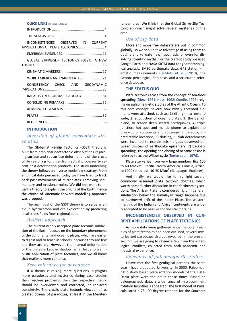
Revisiting the seismic line published in Geology (Fig. 1), we see that strike-slip tectonic elements overwrite any bulldozer-type deformation what could be assigned to frontal thrusting. Kinking of beds at fault planes is revealed indirectly by diffraction hyper-bolas. Indeed, inversion occurs, but instead of a frontal ramp we suggest a lateral ramp for the em-placement of the observed structure. In our opinion, thrusting observed should be interpreted as a side-effect of transpressional space management within microplates.
JOURNAL OF GLOBAL STRIKE-SLIP TECTONICS
6
JGSST
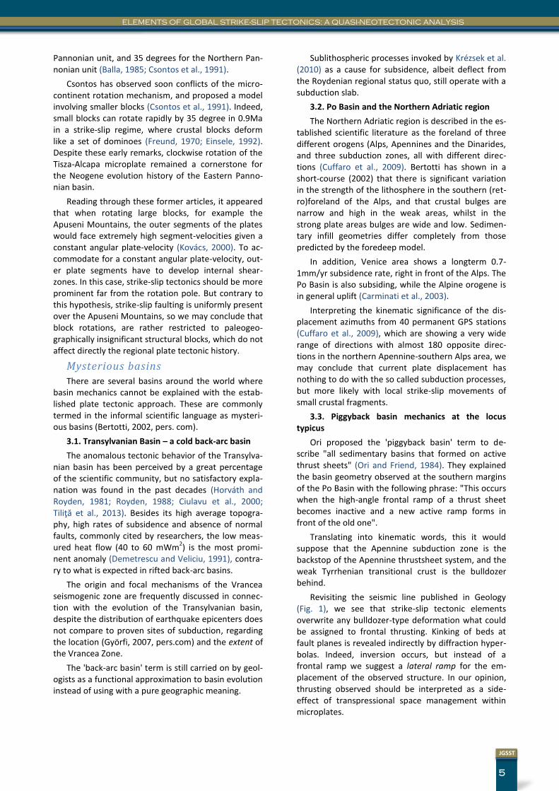
Figure 2 Interpreted seismic section through the South Adri-atic basin. The raw seismic section was published in Petrole-um Geoscience by Peace et al., 2012.
3.4. The Southern Adriatic Basin
Basin geometry of the South Adriatic basin (Fig. 2) does not resemble to that of a classic foredeep either (Bertotti et al., 2001), and basin forming mechanism has been also poorly understood. This is the birth place of the “hidden loads” theory (Royden and Karner, 1984) created to explain the huge accommo-
dation space filled up with more than 8km sediments, offshore Albania (Bertotti et al., 2001). Bertotti also mentioned that in the case of the South Adriatic basin, pinch-out points of the foreland do not move through time.
Paradoxes of the Continental Do-main
3.5. The transpressional origin of the Atlas Mountains and the Alpine orogene
The Atlas Mountains like the Alps show double vergence. In the case of the Atlas Mountains, Ellero gives an extensive overview of the authors who em-phasized the importance of inversion tectonics and strike-slip tectonics in the evolution of the High Atlas belt. They have recognized the importance of the transpressional imbricate systems and have proposed that the main deformation in the High Atlas thrust and fold belt was transpressional in character (Ellero et al., 2012), contrary to those who interpret field data in a pure compressional framework to fit into the Tell-Rif-Betic subduction model (Royden, 1993), (Frizon de Lamotte et al., 2000).
Subduction related massive volcanism is complete-ly missing not only in the Atlas Mts., but in the Alpine orogene as well, in comparison to the Apennines (Carminate et al., 2004). Carminate highlights the ab-sence of back-arc alkaline–tholeitic volcanism in the Alps. According to our morphological analysis, several mountain ridges of the Alps also show signs of Neo-gene transpression (PLATE XIX).
Figure 1 Reinterpreted linedrawing of the type-section of piggyback basins, Apennine Mountains, Italy. Original section was pub-lished in Geology as a black & white Wiggle trace section by Ori & Friend in 1984. Red lines are showing diffraction hyperbolas. We use the piggyback basin term in a pure descriptive sense without specific kinematic meaning, denoting the fact that the sedimentary basin was created on the top of an active thrust sheet.
7
JGSST
ELEMENTS OF GLOBAL STRIKE-SLIP TECTONICS: A QUASI-NEOTECTONIC ANALYSIS
In conclusion, we suggest that the evolutionary model of the High Atlas orogene should be extended to the Alpine orogene as well.
3.6. The message of the Pamir thrust earthquakes and shape of the Himalayan Range
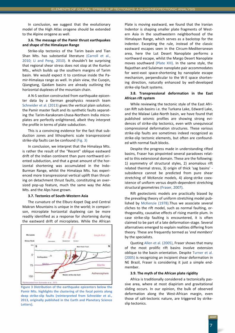
Strike-slip tectonics of the Tarim basin and Tian Shan Mts. has substantial literature (Carroll et al., 2010; Li and Peng, 2010). It shouldn’t be surprising that regional shear stress does not stop at the Kunlun Mts., which builds up the southern margins of Tarim basin. We would expect it to continue inside the Pa-mir-Himalaya range as well. In plain view, the Cuoqin, Qiangtang, Qaidam basins are already outlining the horizontal duplexes of the mountain chain.
A N-S section constructed from earthquake epicen-ter data by a German geophysics research team Schneider et al. (2013) gives the vertical plain solution; the Pamir master fault and its synthetic faults separat-ing the Tarim-Karakoram-Lhasa-Northern India micro-plates are perfectly enlightened, albeit they interpret the profile in terms of plate subduction.
This is a convincing evidence for the fact that sub-duction zones and lithospheric scale transpressional strike-slip faults can be confound (Fig. 3)
In conclusion, we interpret that the Himalaya Mts. is rather the result of the "Recent" oblique eastward drift of the Indian continent than pure northward ori-ented subduction, and that a great amount of the hor-izontal shortening was accumulated in the Indo-Burman Range, whilst the Himalaya Mts. has experi-enced more transpressional vertical uplift than thrust-ing on detachment thrust faults, constituting an over-sized pop-up feature, much the same way the Atlas Mts. and the Alps have grown.
3.7. Tectonics of South-Western Asia
The curvature of the Elburz-Kopet Dag and Central Makran Mountains is unique in the world; in compari-son, microplate horizontal duplexing can be more readily identified as a response for shortening during the eastward drift of microplates. While the African
Plate is moving eastward, we found that the Iranian Indentor is shaping smaller plate fragments of West-ern Asia in the southwestern neighborhood of the Himalayan Range, which serves as a backstop for the indentor. Excepting the rule, instead of the classic eastward escapes seen in the Circum-Mediterranean area, here the Lut Desert Nanoplate performs a northward escape, whilst the Margo Desert Nanoplate moves southward (Plate XIII). In the same style, the Rajasthan and Sulaiman nanoplate pair accommodates for west-east space-shortening by nanoplate escape mechanism, perpendicular to the W-E space shorten-ing direction, naturally enhanced by well-developed strike-slip fault systems.
3.8. Transpressional deformation in the East African rift system
While reviewing the tectonic style of the East Afri-can Rift sub-basins i.e. the Turkana Lake, Edward Lake, and the Malawi Lake-North basin, we have found that published seismic profiles are showing strong evi-dences of strike-slip tectonics, even with unequivocal compressional deformation structures. These various strike-slip faults are sometimes indeed recognized as strike-slip tectonic elements, but often are confound-ed with normal fault blocks.
Despite the progress made in understanding rifted basins, Fraser has pinpointed several paradoxes relat-ed to this extensional domain. These are the following: 1) asymmetry of structural styles, 2) anomalous rift related thermal stress, 3) origin of thick 'sag basins' - subsidence cannot be predicted from pure shear stretching of McKenzie models, 4) along-strike coex-istence of uniform versus depth-dependent stretching structural geometries (Fraser, 2007).
Rift geotectonic models are practically biased by the prevailing theory of uniform stretching model pub-lished by McKenzie (1978).Thus we associate several cliches to the rift model, such as normal faulting, or-thogonality, causative effects of rising mantle plum. In case strike-slip faulting is encountered, it is often claimed to be part of a late deformation-stage. Several alternatives emerged to explain realities differing from theory. These are frequently termed as 'end members' by the specialists.
Quoting Allen et al. (2005), Fraser shows that many of the most prolific rift basins involve extension oblique to the basin orientation. Despite Turner et al. (2005) is recognizing an incipient shear deformation in NE Brazil, Fraser is considering it just a simple end-member.
3.9. The myth of the African plate rigidity
Africa is traditionally considered a tectonically pas-sive area, where at most diapirism and gravitational sliding occurs. In our opinion, the bulk of observed deformation along the West-African margin, even those of salt-tectonic nature, are triggered by strike-slip tectonics.
Figure 3 Distribution of the earthquake epicenters below the Pamir Mts. highlights the clustering of the focal points along deep strike-slip faults (reinterpreted from Schneider et al., 2013, originally published in the Earth and Planetary Science Letters).
JOURNAL OF GLOBAL STRIKE-SLIP TECTONICS
8
JGSST
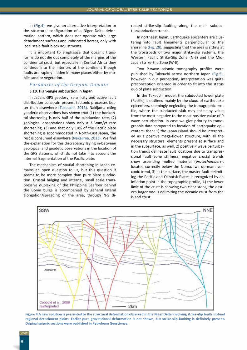
In (Fig.4), we give an alternative interpretation to the structural configuration of a Niger Delta defor-mation pattern, which does not operate with large detachment surfaces and imbricated horses, only with local scale fault block adjustments.
It is important to emphasize that oceanic trans-forms do not die out completely at the margins of the continental crust, but especially in Central Africa they continue into the interiors of the continent though faults are rapidly hidden in many places either by mo-bile sand or vegetation.
Paradoxes of the Oceanic Domain
3.10. High-angle subduction in Japan
In Japan, GPS geodesy, seismicity and active fault distribution constrain present tectonic processes bet-ter than elsewhere (Takeuchi, 2013). Nakijama citing geodetic observations has shown that (1) the horizon-tal shortening is only half of the subduction rate, (2) geological observations show only a 3-5mm/yr rate shortening, (3) and that only 10% of the Pacific plate shortening is accommodated in North-East Japan, the rest is consumed elsewhere (Nakajima, 2013). We find the explanation for this discrepancy laying in-between geological and geodetic observations in the location of the GPS stations, which do not take into account the internal fragmentation of the Pacific plate.
The mechanism of spatial shortening in Japan re-mains an open question to us, but this question it seems to be more complex than pure plate subduc-tion. Crustal bulging and internal, small scale trans-pressive duplexing of the Philippine Seafloor behind the Bonin bulge is accompanied by general lateral elongation/spreading of the area, through N-S di-
rected strike-slip faulting along the main subduc-tion/obduction trench.
In northeast Japan, Earthquake epicenters are clus-tering into fault lineaments perpendicular to the shoreline (Fig. 28), suggesting that the area is sitting at the crossroads of two major strike-slip systems, the Western Pacific Strike-Slip Zone (N-S) and the Mid-Japan Strike-Slip Zone (W-E).
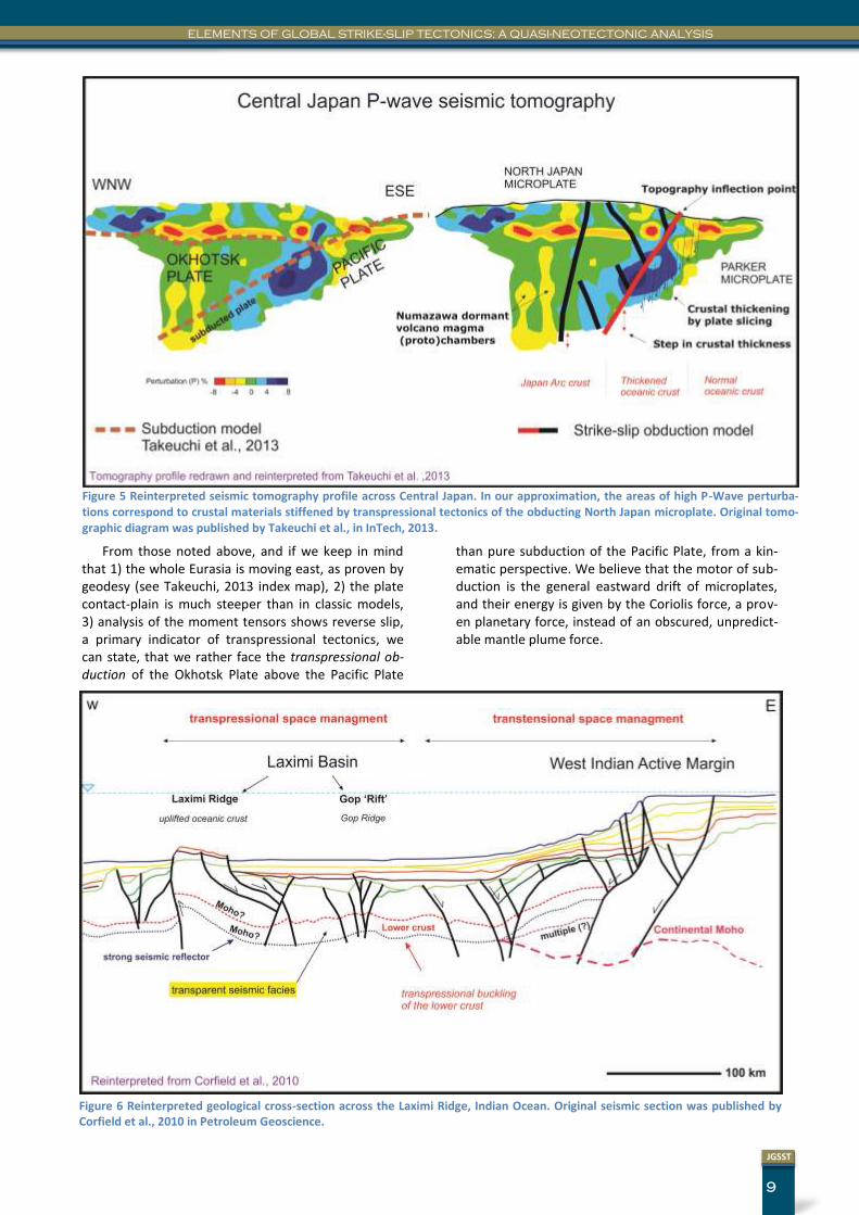
Two P-wave seismic tomography profiles were published by Takeuchi across northern Japan (Fig.5), however in our perception, interpretation was quite preconception oriented in order to fit into the status quo of plate subduction.
In the Takeuchi model, the subducted lower plate (Pacific) is outlined mainly by the cloud of earthquake epicenters, seemingly neglecting the tomographic pro-file, where the subducted slab may take any value from the most negative to the most positive value of P wave perturbation. In case we give priority to tomo-graphic data compared to location of earthquake epi-centers, then: 1) the Japan Island should be interpret-ed as a positive mega-flower structure, with all the necessary structural elements present at surface and in the subsurface, as well, 2) positive P wave perturba-tion trends delineate fault locations due to transpres-sional fault zone stiffness, negative crustal trends show ascending melted material (protochambers), located correctly below the Numazawa dormant vol-canic trend, 3) at the surface, the master fault delimit-ing the Pacific and Okhotsk Plates is recognized by an inflation point in the topographic profile, 4) the lower limit of the crust is showing two clear steps, the east-ern larger one is delimiting the oceanic crust from the island crust.
Figure 4 A new solution is presented to the structural deformation observed in the Niger Delta involving strike-slip faults instead regional detachment plains. Earlier pure gravitational deformation is not shown, but strike-slip faulting is definitely present. Original seismic sections were published in Petroleum Geoscience.
9
JGSST
ELEMENTS OF GLOBAL STRIKE-SLIP TECTONICS: A QUASI-NEOTECTONIC ANALYSIS
From those noted above, and if we keep in mind that 1) the whole Eurasia is moving east, as proven by geodesy (see Takeuchi, 2013 index map), 2) the plate contact-plain is much steeper than in classic models, 3) analysis of the moment tensors shows reverse slip, a primary indicator of transpressional tectonics, we can state, that we rather face the transpressional ob-duction of the Okhotsk Plate above the Pacific Plate
than pure subduction of the Pacific Plate, from a kin-ematic perspective. We believe that the motor of sub-duction is the general eastward drift of microplates, and their energy is given by the Coriolis force, a prov-en planetary force, instead of an obscured, unpredict-able mantle plume force.
Figure 5 Reinterpreted seismic tomography profile across Central Japan. In our approximation, the areas of high P-Wave perturba-tions correspond to crustal materials stiffened by transpressional tectonics of the obducting North Japan microplate. Original tomo-graphic diagram was published by Takeuchi et al., in InTech, 2013.
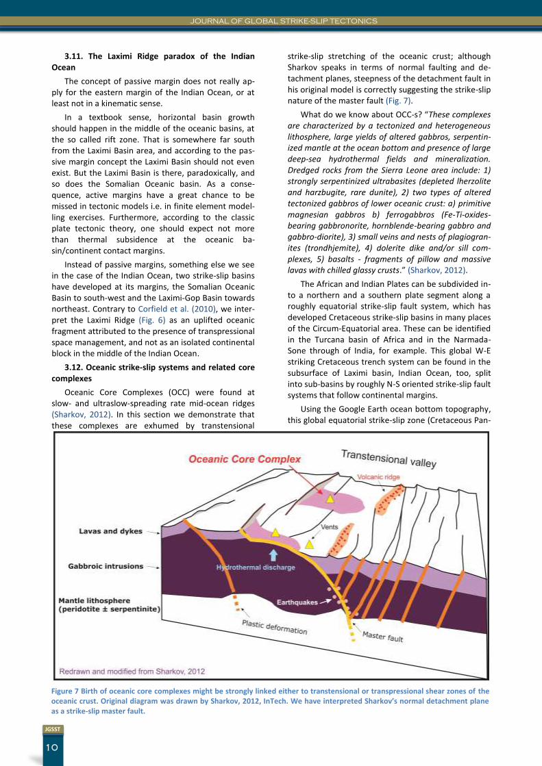
Figure 6 Reinterpreted geological cross-section across the Laximi Ridge, Indian Ocean. Original seismic section was published by Corfield et al., 2010 in Petroleum Geoscience.
JOURNAL OF GLOBAL STRIKE-SLIP TECTONICS
10
JGSST
3.11. The Laximi Ridge paradox of the Indian Ocean
The concept of passive margin does not really ap-ply for the eastern margin of the Indian Ocean, or at least not in a kinematic sense.
In a textbook sense, horizontal basin growth should happen in the middle of the oceanic basins, at the so called rift zone. That is somewhere far south from the Laximi Basin area, and according to the pas-sive margin concept the Laximi Basin should not even exist. But the Laximi Basin is there, paradoxically, and so does the Somalian Oceanic basin. As a conse-quence, active margins have a great chance to be missed in tectonic models i.e. in finite element model-ling exercises. Furthermore, according to the classic plate tectonic theory, one should expect not more than thermal subsidence at the oceanic ba-sin/continent contact margins.
Instead of passive margins, something else we see in the case of the Indian Ocean, two strike-slip basins have developed at its margins, the Somalian Oceanic Basin to south-west and the Laximi-Gop Basin towards northeast. Contrary to Corfield et al. (2010), we inter-pret the Laximi Ridge (Fig. 6) as an uplifted oceanic fragment attributed to the presence of transpressional space management, and not as an isolated continental block in the middle of the Indian Ocean.
3.12. Oceanic strike-slip systems and related core complexes
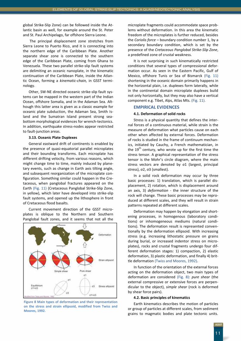
Oceanic Core Complexes (OCC) were found at slow- and ultraslow-spreading rate mid-ocean ridges (Sharkov, 2012). In this section we demonstrate that these complexes are exhumed by transtensional
strike-slip stretching of the oceanic crust; although Sharkov speaks in terms of normal faulting and de-tachment planes, steepness of the detachment fault in his original model is correctly suggesting the strike-slip nature of the master fault (Fig. 7).
What do we know about OCC-s? “These complexes are characterized by a tectonized and heterogeneous lithosphere, large yields of altered gabbros, serpentin-ized mantle at the ocean bottom and presence of large deep-sea hydrothermal fields and mineralization. Dredged rocks from the Sierra Leone area include: 1) strongly serpentinized ultrabasites (depleted lherzolite and harzbugite, rare dunite), 2) two types of altered tectonized gabbros of lower oceanic crust: a) primitive magnesian gabbros b) ferrogabbros (Fe-Ti-oxides-bearing gabbronorite, hornblende-bearing gabbro and gabbro-diorite), 3) small veins and nests of plagiogran-ites (trondhjemite), 4) dolerite dike and/or sill com-plexes, 5) basalts - fragments of pillow and massive lavas with chilled glassy crusts.” (Sharkov, 2012).
The African and Indian Plates can be subdivided in-to a northern and a southern plate segment along a roughly equatorial strike-slip fault system, which has developed Cretaceous strike-slip basins in many places of the Circum-Equatorial area. These can be identified in the Turcana basin of Africa and in the Narmada-Sone through of India, for example. This global W-E striking Cretaceous trench system can be found in the subsurface of Laximi basin, Indian Ocean, too, split into sub-basins by roughly N-S oriented strike-slip fault systems that follow continental margins.
Using the Google Earth ocean bottom topography, this global equatorial strike-slip zone (Cretaceous Pan-
Figure 7 Birth of oceanic core complexes might be strongly linked either to transtensional or transpressional shear zones of the oceanic crust. Original diagram was drawn by Sharkov, 2012, InTech. We have interpreted Sharkov’s normal detachment plane as a strike-slip master fault.
11
JGSST
ELEMENTS OF GLOBAL STRIKE-SLIP TECTONICS: A QUASI-NEOTECTONIC ANALYSIS
global Strike-Slip Zone) can be followed inside the At-lantic basin as well, for example around the St. Peter and St. Paul Archipelago, far offshore Sierra Leone.
The principal displacement zone stretches from Sierra Leone to Puerto Rico, and it is connecting into the northern edge of the Caribbean Plate. Another separate shear zone is connected to the southern edge of the Caribbean Plate, coming from Ghana to Venezuela. These two parallel strike-slip fault systems are delimiting an oceanic nanoplate, in the kinematic continuation of the Caribbean Plate, inside the Atlan-tic Ocean, forming a kinematic-chain, in GSST termi-nology.
Other, SW-NE directed oceanic strike-slip fault sys-tems can be mapped in the western part of the Indian Ocean, offshore Somalia, and in the Adaman Sea. Alt-hough this latter area is given as a classic example for oceanic plate subduction, the Adaman Sea, Smith Is-land and the Sumatran Island present strong sea-bottom morphological evidences for wrench-tectonics. In addition, earthquake stress-nodes appear restricted to fault-junction areas.
3.13. Oceanic Plate Duplexes
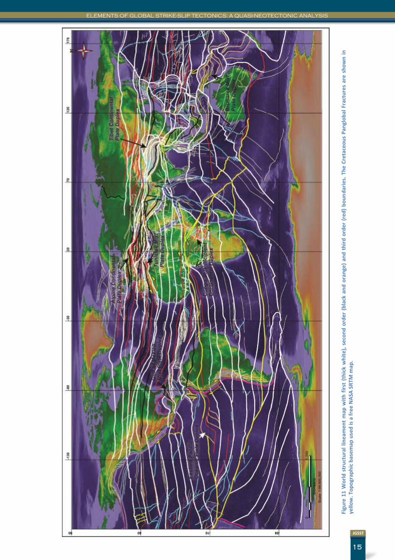
General eastward drift of continents is enabled by the presence of quasi-equatorial parallel microplates and their bounding transforms. Each microplate has different drifting velocity, from various reasons, which might change time to time, mainly induced by plane-tary events, such as change in Earth axis tilting angle, and subsequent reorganization of the microplate con-figuration. Something similar could happen in the Cre-taceous, when panglobal fractures appeared on the Earth (Fig. 11) (Cretaceous Panglobal Strike-Slip Zone, in yellow), which later have developed into strike-slip fault systems, and opened up the lithosphere in front of Cretaceous flood basalts.
Current movement direction of the GSST micro-plates is oblique to the Northern and Southern Panglobal fault zones, and it seems that not all the
microplate fragments could accommodate space prob-lems without deformation. In this area the kinematic freedom of the microplates is further reduced, besides the Coriolis force – boundary condition number 1, by a secondary boundary condition, which is set by the presence of the Cretaceous Panglobal Strike-Slip Zone, a predefined zone of crustal weakness.
It is not surprising in such kinematically restricted conditions that several types of compressional defor-mation occur. As seen in the Eastern Pacific, Gulf of Mexico, offshore Tunis or Sea of Bismarck (Fig. 11) shortening in the oceanic domain primarily happens in the horizontal plain, i.e. duplexes form laterally, while in the continental domain microplate duplexes build not only horizontally, but they may also have a vertical component e.g. Tibet, Alps, Atlas Mts. (Fig. 11).
EMPIRICAL EVIDENCES
4.1. Deformation of solid rocks
Stress is a physical quantity that defines the inter-nal forces of a continuous material, while strain is the measure of deformation what particles cause on each other when affected by external forces. Deformation of rocks is studied in the frame of continuum mechan-ics, initiated by Cauchy, a French mathematician, in the 19
th century, who wrote up for the first time the
stress tensor. A graphical representation of the stress tensor is the Mohr’s circle diagram, where the main stress vectors are denoted by σ1 (largest, principal stress), σ2, σ3 (smallest).
In a solid rock deformation may occur by three basic processes: 1) translation, which is parallel dis-placement, 2) rotation, which is displacement around an axis, 3) deformation - the inner structure of the rock will change. These basic processes may be repro-duced at different scales, and they will result in strain patterns repeated at different scales.
Deformation may happen by elongation and short-ening processes, in homogenous (laboratory condi-tions) or inhomogeneous mediums (natural condi-tions). The deformation result is represented conven-tionally by the deformation ellipsoid. With increasing stress (e.g. increasing lithostatic pressure on grains during burial, or increased indentor stress on micro-plates), rocks and crustal fragments undergo four dif-ferent deformation stages: 1) compaction, 2) elastic deformation, 3) plastic deformation, and finally 4) brit-tle deformation (Twiss and Moores, 1992).
In function of the orientation of the external forces acting on the deformation object, two main types of deformation are considered (Fig. 8): pure shear (the external compressive or extensive forces are perpen-dicular to the object), simple shear (rock is deformed by shear force pairs).
4.2. Basic principles of kinematics
Earth kinematics describes the motion of particles or group of particles at different scales, from sediment grains to magmatic bodies and plate tectonic units.
Figure 8 Main types of deformation and their representation on the stress and strain ellipsoid, modified from Twiss and Moores, 1992.
JOURNAL OF GLOBAL STRIKE-SLIP TECTONICS
12
JGSST
Kinematics is tracing the trajectory of particles and larger units assigning physical properties such as ve-locity, acceleration and position vector to them. When discussing the motion of different hierarchy plate units, notions of relative velocity, angular velocity, angular acceleration also become important. While operating with crustal kinematic units, the notion of vertical coupling should also be introduced because different lithospheric layers e.g. the upper brittle crust and lower ductile crust may deform coupled or not (Grocott et al., 2004), depending on the crustal tecton-ic history.
Kinematic chains
According to our observations, in many parts of the world crustal fragments have recorded the pres-ence of global kinematic constraints, and the kinemat-ic freedom of plate units it was, and still it is, reduced by the Coriolis force. This hypothesis is supported by the fact that oceanic transforms, i.e. longer edges of the neotectonic crustal fragments are roughly parallel to the Equator. Smaller kinematic units are often coa-lesced into kinematic chains. A typical site of micro-plate coalescence is the South American-Atlantic-African realm, where the 'suture' of kinematic chains is provided by inactive rift segments.
4.3. Strike-slip deformation
In this section, we review structural deformations related to strike-slip faulting following (Einsele, 1992; Nilsen and Sylvester, 1995).
The main shear strain is recorded in the principal displacement zone “which may be linear to curvilinear in plain view and steeply inclined in section” (Einsele, 1992). The deeper is penetrating the strike slip fault into the lithosphere, the wider will be the damage zone and the resulting flower structure. Discontinui-ties between parallel strike-slip faults, or stepovers, are regarded as the main prerequisite for the opening of pull-apart basins and for triggering the evolution of push-up ranges. Citing Reasenberg and Ellsworth (1982) Einsele highlights that the active Calaveras fault, California, is showing a distinct offset of the hy-pocenter trends, which happens somewhere between 4 to 7 kilometers.
4.4. Shear displacement products
Laboratory experiments have revealed several characteristic fracture types that are accompanying shear displacement (Einsele, 1992): 1) synthetic strike slip faults, Riedel shears (R), 2) antithetic strike-slip faults, conjugate Riedel shears (R’), 3) secondary syn-thetic faults, P-shears, 4) tension fractures, 5) Y-shears, corresponding to master fault directions – in parallel to the main displacement direction.
4.5. Extensional and contractional duplexes
Extensional and contractional duplexes usually de-velop in the bends of strike-slip faults. Their individual horses are moving vertically up and down in an uncon-strained manner (Woodcock and Fischer, 1986).
4.6. Classification of strike slip faults
Sylvester differentiates the following fault types depending on their place of occurrences, crustal pene-tration depth: 1) ridge transform faults, 2) boundary transform faults, 3) trench-linked strike-slip faults, and on the other hand, 4) indent-linked strike-slip faults, 5) intracontinental strike-slip faults, 6) tear faults, and 7) transfer faults, these latter being grouped to in-traplate transcurrent faults (Sylvester, 1988).
4.7. Classic sites of strike-slip tectonic activity
Caribbean plate boundaries, Jamaica and the Ven-ezuelan borderland
The Jamaican Island lies in 200km wide seismic zone of left-lateral strike-slip deformation at the North American-Caribbean plate boundaries. The main W-E striking strike-slip fault that connects into an Atlantic transform is bending sharply at the eastern edge of the island when meeting the NNW striking, narrow Wagwater graben that contains a Paleocene-Eocene infill.
Turkey
In Turkey have been recognized 4 different strike-slip tectonic domains (Şengör et al., 1985; Einsele, 1992): 1) in the junction area of the North Anatolian and East Anatolian faults contractional strain occurs, 2) the North Turkish domain is characterized by W-E shortening, 3) the Western Anatolian province is sub-ject to N-S extension, and 4) the central Anatolian pre-sents NE-SW shortening and NW-SE extension.
Vienna Basin, Austria
The Vienna basin is the classical site of thin- skinned deformation. Here, it is supposed that defor-mation occurs detached from the lower crust, and that such shallow detachments occur in zones close to the thrust front (Einsele, 1992). Within the Intra-Carpathian region several cool basins occur. Besides the Transylvanian basin, the Vienna basin (Royden et al., 1983) also did not fit into Royden’s back-arc basin
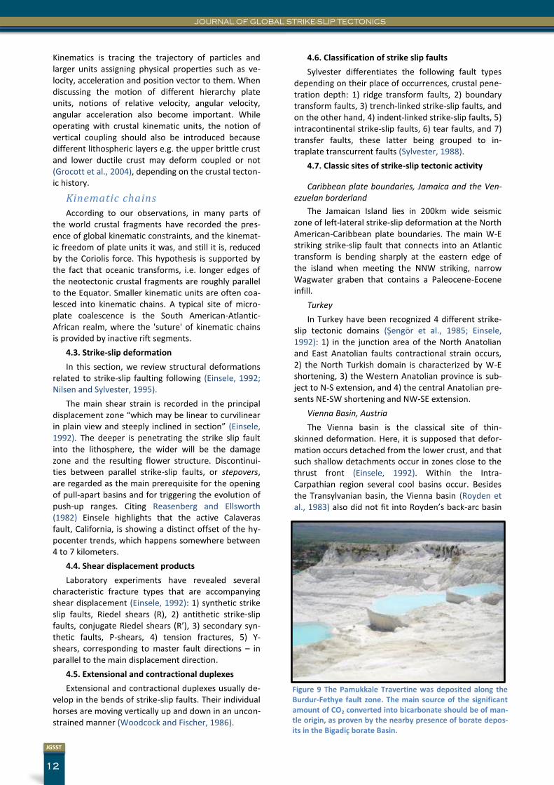
Figure 9 The Pamukkale Travertine was deposited along the Burdur-Fethye fault zone. The main source of the significant amount of CO2 converted into bicarbonate should be of man-tle origin, as proven by the nearby presence of borate depos-its in the Bigadiç borate Basin.
13
JGSST
ELEMENTS OF GLOBAL STRIKE-SLIP TECTONICS: A QUASI-NEOTECTONIC ANALYSIS
rift model.
GLOBAL STRIKE-SLIP TECTONICS (GSST): A NEW THEORY
5.1. Naming
This theory is emphasizing the global importance of strike-slip faults, and it states that strike-slip faults are setting the boundary conditions to deformations that involve crustal layers, and implicitly regional nor-mal and inverse faulting happens complementary around the main shear plane.
5.2. Premises
Brittleness of plates
Evidences from various geophysical and geological sources show that neither of the tectonic plate interi-ors is rigid, but undergoes deformation processes, either relatively rapidly, in a detectable way or more slowly at geological scales. In order to understand the kinematics of deformation in plate interiors it is im-portant to see the big difference between pure shear and simple shear deformation. Because nature is im-perfect, force pairs meeting the orthogonality condi-tions are very rare; only related to some mid-oceanic rift domains orthogonality can be identified. In conti-nental domains any deformation is related to simple shear, which in turn may occur at any scale from mi-croscopic to global.
Drifting of crustal fragments
GPS station geodetic measurements have proved in many part of the world (DeMets et al., 2010) that individual stations are changing their location through time, in smaller or larger groups, the global average showing an eastward drift of plates (see the una-vco.org maps). It can be postulated that the same kind of movement of microplates happened in the past as well. Depending on density of GPS stations present kinematic units can be delineated at different scales.
Mantle origin of CO2 and carbonate budget of oceans
Carbonate budget in the oceans of the Earth and in continental domains, as well, basically depends on the availability of CO2 in aqueous solutions, which might be a function of the mantle CO2 release by oceanic floor volcanic activity, in a given geological period. Wilson includes the enrichment in volatiles, halogens and CO2, among the general characteristics of conti-nental rift zone magmatism (Wilson, 1989). Solubility of CO2 in magmas increases with pressure and magma alkalinity (Lowenstern, 2001).
Mantle origin CO2 is commonly present in active strike-slip zones, either as bicarbonate ion in aqueous solutions, or as dry CO2, and may give birth to signifi-
cant continental carbonate deposits in the form of travertines, like in Pamukkale, Turkey (Fig. 9), or the Yellowstone travertines in the USA. For example, the Ol Doinyo Lengai volcano of the East African Rift, Tan-zania, is producing natrocarbonatite lava, accompa-nied by a flux of 6000–7200 tonnes CO2 d−1 (Koepenick et al., 1996). It is very difficult to disproof the mantle origin of these enormous CO2 fluxes.
5.3. Essentials
The theory of Global Strike-Slip Tectonics is deeply rooted into the main principles of Earth Physics. The Earth is rotating around its tilted axis, what exerts the largest kinematic force on the objects found at the surface of the planet, this is the Coriolis force. Second-ly, the global surface-tension of the Earth, which is materialized in the form of the global baselevel of the Earth, it is essentially maintained by gravitational forc-es and isostasy. A third set of forces acting on the crust, and which actually may deform the geoid, it could be the buoyancy forces of mantle plumes.
The ultimate effect of these forces it is that crustal fragments, larger or smaller, are moving (drifting) con-stantly over the Planet’s surface. There are plenty of geological arguments that prove that the classic tec-tonic plates of the Earth are not mechanically rigid crustal fragments, but develop significant internal de-formation.
Because of crustal inhomogeneity, and variability in shape of crustal fragments, movement of kinematic units is constrained by the presence of the others. The interaction of neighboring kinematic units creates a local surface-tension perturbation of the geoid, which is solved first accumulating and then releasing stress. Products of any crustal fragment interaction, and sub-sequently surface-tension perturbation will be gov-erned by the law of simple shear.
To keep the surface-tension of the Earth as low as possible, the main displacement planes of the Earth will be close to normal, what corresponds to strike-slip displacement, as we see in the case of oceanic trans-forms.
Plate fragmentation
During their displacement, crustal fragments might face various kinematic obstacles, tectonic or planetary in origin, which in turn force them to change their kin-ematic trajectory and perform rotation. In order to accommodate for a constant angular plate-velocity outer plate segments have to develop internal shear-zones (Kovács, 2000), otherwise extremely high seg-ment-velocities will appear on the outer segments. Thus, the planet-wide fragmentation of the tectonic plates it is rather a compulsory response of larger plates to shear/rotation constraints.
JOURNAL OF GLOBAL STRIKE-SLIP TECTONICS
14
JGSST
Plate interior tectonic events may happen arbitrary from plate margin conditions, and actually a wide range of crustal fragment sizes exist. The Mediterra-nean region is an area where smaller tectonic were introduced to explain structural deformation observed in-between the hinterlands of Africa and continental Europe. Previously, these unorthodox, smaller plate fragments, which behaved differently from larger plates, were termed as microplates.
Space management
Crustal fragments behave like kinematic units, and they are characterized by constant volume, unique velocity and movement vector. Kinematic units are facing space problems frequently, and mechanics pro-vides the solution to these problems. We have intro-duced the 'space management' term to describe the tectonic procedure which leads the kinematic units to find a spatial solution for drifting (Kovács, 2012).
In the GSST, strike-slip faults are considered first order structural elements, because main interaction of crustal fragments happens along strike-slip contacts, i.e. kinematic unit boundaries are always strike-slip faults. The normal and reverse faults are considered as second order structural elements, because they en-hance the internal deformation of kinematic units. Salt and shale diapirism, volcanic sill emplacement related deformation constitute the third order structural ele-ments. For example, a contractional space problem along a first order structural lineament (a microplate boundary) might be resolved in a kinematic sense by second order solutions: overthrusthing, underthrust-ing, tilting or pure subsidence.
The concept of space management can be readily applied to transpressive orogens and to the definition of orogenesis. Considering the strike-slip tectonics related genesis of the Atlas Mts., as shown by (Ellero et al., 2012), we suggest that minor push-up ranges initiated over microplate boundaries may evolve into major orogens, not only in the Atlas Mts., but in many places along the Tethys area. In other words, whenev-er microplates are facing space problems for longer geological periods, push-up ranges or proto-orogens will evolve into complex orogens. Horizontal and verti-
cal duplexing might contribute to the effective growth of the orogene.
5.4. Definition of micro-, nano-, pikoplates and kinematic chains
Being involved into various shear zones during con-tinental drift, world tectonic plates area broken into smaller and smaller tectonic units with time. Contact zones of microplate are marked by pushup ranges and evolved orogens, deep sedimentary basins, and trans-form fault scars on the oceanic floor. Most probably, a great percentage of fault-scars preserved on the sur-face of the Earth are somewhat older than Holocene, and ocean-floor fault scars are even older. The 'quasi-neotectonic' term points to this timing uncertainty.
Size of these crustal fragments is varying within a wide range, thus a plate hierarchy can be established according to their size ranges. In GSST we propose the simultaneous usage of conventional 'plate' name to refer to the classic large plate tectonics units. For mid-size plate fragments we also keep the 'microplate' term. In order to study the movement of the even smaller, but well individualized crustal fragments, we propose the use of the 'nanoplate' term, without any direct reference to the absolute plate size range. Na-noplates usually appear in areas of long lasting con-tractional stress, and are made up of incipient or well developed plate duplex horses.
'Pikoplates' are the internal components of nano-plates, smaller with about one order of magnitude. These are the most important elements of structural hydrocarbon plays and are driving the regional distri-bution of hydrocarbon and ore accumulations. What we know as hydrocarbon trends, for example, are re-lated usually to the presence of pikoplates.
Example: The Marquesas Mp.-Ganges Mp. kine-matic chain is found south of the Cretaceous Panglob-al Fracture Zone, and incorporates microplates of the Pacific Ocean, South America, Atlantic Ocean, Africa, India and the Indian Ocean.
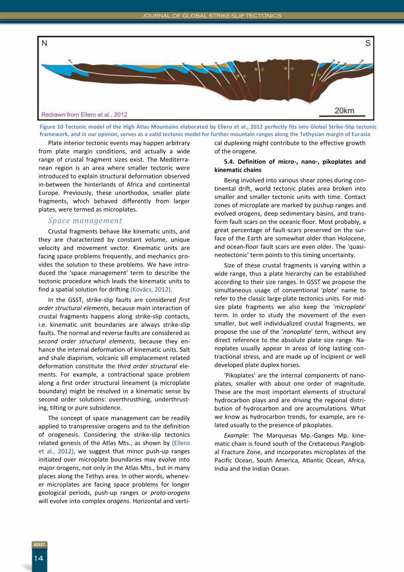
Figure 10 Tectonic model of the High Atlas Mountains elaborated by Ellero et al., 2012 perfectly fits into Global Strike-Slip tectonic framework, and in our opinion, serves as a valid tectonic model for further mountain ranges along the Tethysian margin of Eurasia
15
JGSST
ELEMENTS OF GLOBAL STRIKE-SLIP TECTONICS: A QUASI-NEOTECTONIC ANALYSIS
Figu
re 1
1 W
orl
d s
tru
ctu
ral
line
am
en
t m
ap w
ith
fir
st (
thic
k w
hit
e),
se
con
d o
rde
r (b
lack
an
d o
ran
ge)
and
th
ird
ord
er
(re
d)
bo
un
dar
ies.
Th
e C
reta
ceo
us
Pan
glo
bal
Fra
ctu
res
are
sh
ow
n i
n
yello
w. T
op
ogr
aph
ic b
ase
map
use
d is
a f
ree
NA
SA S
RTM
map
.
JOURNAL OF GLOBAL STRIKE-SLIP TECTONICS
16
JGSST
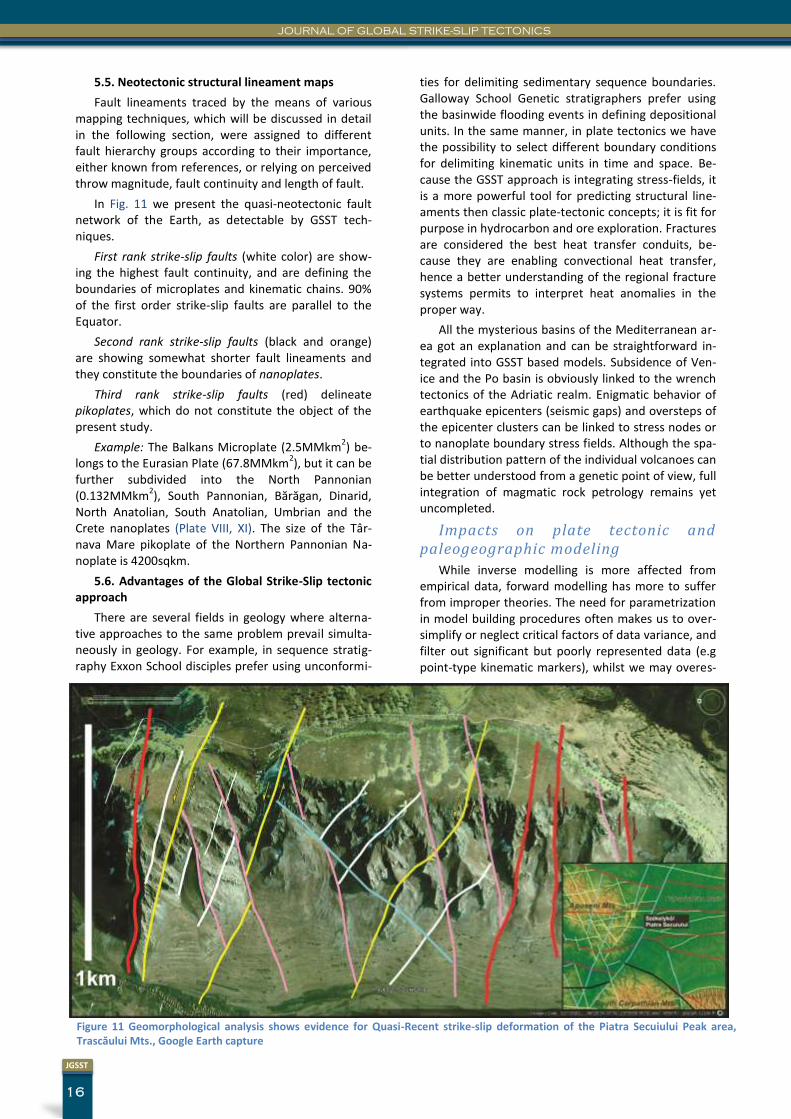
5.5. Neotectonic structural lineament maps
Fault lineaments traced by the means of various mapping techniques, which will be discussed in detail in the following section, were assigned to different fault hierarchy groups according to their importance, either known from references, or relying on perceived throw magnitude, fault continuity and length of fault.
In Fig. 11 we present the quasi-neotectonic fault network of the Earth, as detectable by GSST tech-niques.
First rank strike-slip faults (white color) are show-ing the highest fault continuity, and are defining the boundaries of microplates and kinematic chains. 90% of the first order strike-slip faults are parallel to the Equator.
Second rank strike-slip faults (black and orange) are showing somewhat shorter fault lineaments and they constitute the boundaries of nanoplates.
Third rank strike-slip faults (red) delineate pikoplates, which do not constitute the object of the present study.
Example: The Balkans Microplate (2.5MMkm2) be-
longs to the Eurasian Plate (67.8MMkm2), but it can be
further subdivided into the North Pannonian (0.132MMkm
2), South Pannonian, Bărăgan, Dinarid,
North Anatolian, South Anatolian, Umbrian and the Crete nanoplates (Plate VIII, XI). The size of the Târ-nava Mare pikoplate of the Northern Pannonian Na-noplate is 4200sqkm.
5.6. Advantages of the Global Strike-Slip tectonic approach
There are several fields in geology where alterna-tive approaches to the same problem prevail simulta-neously in geology. For example, in sequence stratig-raphy Exxon School disciples prefer using unconformi-
ties for delimiting sedimentary sequence boundaries. Galloway School Genetic stratigraphers prefer using the basinwide flooding events in defining depositional units. In the same manner, in plate tectonics we have the possibility to select different boundary conditions for delimiting kinematic units in time and space. Be-cause the GSST approach is integrating stress-fields, it is a more powerful tool for predicting structural line-aments then classic plate-tectonic concepts; it is fit for purpose in hydrocarbon and ore exploration. Fractures are considered the best heat transfer conduits, be-cause they are enabling convectional heat transfer, hence a better understanding of the regional fracture systems permits to interpret heat anomalies in the proper way.
All the mysterious basins of the Mediterranean ar-ea got an explanation and can be straightforward in-tegrated into GSST based models. Subsidence of Ven-ice and the Po basin is obviously linked to the wrench tectonics of the Adriatic realm. Enigmatic behavior of earthquake epicenters (seismic gaps) and oversteps of the epicenter clusters can be linked to stress nodes or to nanoplate boundary stress fields. Although the spa-tial distribution pattern of the individual volcanoes can be better understood from a genetic point of view, full integration of magmatic rock petrology remains yet uncompleted.
Impacts on plate tectonic and paleogeographic modeling
While inverse modelling is more affected from empirical data, forward modelling has more to suffer from improper theories. The need for parametrization in model building procedures often makes us to over-simplify or neglect critical factors of data variance, and filter out significant but poorly represented data (e.g point-type kinematic markers), whilst we may overes-
Figure 11 Geomorphological analysis shows evidence for Quasi-Recent strike-slip deformation of the Piatra Secuiului Peak area, Trascăului Mts., Google Earth capture
17
JGSST
ELEMENTS OF GLOBAL STRIKE-SLIP TECTONICS: A QUASI-NEOTECTONIC ANALYSIS
timate others (see the abundance of subduction zones in the Mediterranean area).
We believe that GSST concepts will help research-ers to better constrain kinematic boundary conditions, and to set the input parameters more properly in for-ward modelling experiments. Albeit, the more sub-stantial internal deformation of plates involved would deem paleogeographical restorations more complex, final microplate configurations could be definitely more accurate.
KINEMATIC MARKERS
Tracers
6.1. Geomorphology
World topography is shaped by a complex interac-tion of various physical and chemical processes, where climate plays an important role. Different rocks may deform in very different way under same conditions. Structural stress has its important role in precondition-ing the ultimate style of deformation in rocks, because fracture systems not only enhance, but may also drive erosional processes, especially in hard rocks, like lime-stones. Fracture systems in lowlands may be hidden by young sediments; fault scarps in deserts are rapidly covered by mobile sand, while on oceanic passive margins delta systems may shed sediment over them. Fluvial channels also migrate autocyclically in the allu-vial plain, hence cannot be used with automatism in geomorphological studies, however automatic tech-
niques might be useful in delimiting recently uplifted areas. The higher the sediment input, the less chance we have to capture neotectonic events. Because on the central part of oceanic basins sediment input is extremely low, fault scars can be traced most easily on oceanic floors.
Despite the presence of inconvenient obstacles, there still remain several principles according to which geomorphological elements can be used in tracing worldwide quasi-neotectonic lineaments: 1) sharpness of geomorphological lineaments, 2) regional continui-ty, 3) linkage of linear geomorphological lineaments to other point-type markers, 4) inter-regional altitude contrast, 5) abrupt changes in watercourse of larger rivers, 6) abrupt changes in shorelines, 7) abrupt changes in mountain ridges, 8) presence of extension-al or contractional duplexes.
In order to map strike-slip lineaments of the world we constructed digital elevation models from SRTM data for Eurasia and Northern Africa; oceanic domains and the other parts of the world were approximated using Google Earth data.
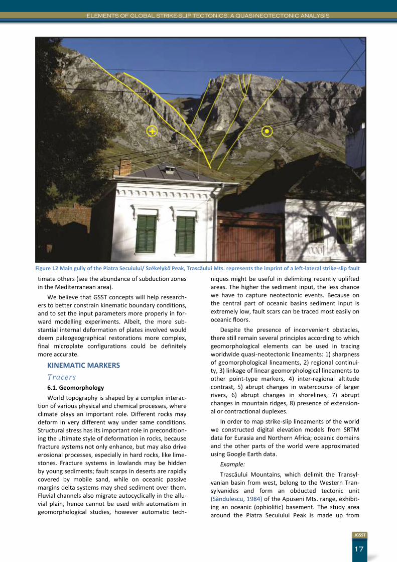
Example:
Trascăului Mountains, which delimit the Transyl-vanian basin from west, belong to the Western Tran-sylvanides and form an obducted tectonic unit (Săndulescu, 1984) of the Apuseni Mts. range, exhibit-ing an oceanic (ophiolitic) basement. The study area around the Piatra Secuiului Peak is made up from
Figure 12 Main gully of the Piatra Secuiului/ Székelykő Peak, Trascăului Mts. represents the imprint of a left-lateral strike-slip fault
JOURNAL OF GLOBAL STRIKE-SLIP TECTONICS
18
JGSST
slope and shelf-margin deposits of an Upper Jurassic-Lower Cretaceous carbonate platform (Săsăran, 2006). Given the well-cemented and compacted nature of the sedimentary succession, weathering plays only a secondary role in shaping the landscape of the Trascăului Mountains, thus regional neotectonic line-aments can be recognized at the local scale as well (Fig. 11, 12). Local fault lineaments delineated in plain view by geomorphological techniques on the Google Earth topography can be identified on field as well.
6.2. Earthquake epicenters
It is commonly accepted that the focal mechanism of earthquakes is related to energy released on fault planes. Whenever shear stress reaches the critical value slippage occurs on shear planes (Commitee on the Science of Earthquakes, 2002). These ruptures are modelled by the fracture mechanics approach, and using the moment tensor the stress-field and slip ori-entation can be determined. Deep earthquakes were discovered under both compressional and tensional conditions (Isacks and Molnar, 1971). Steeper subduc-tion along the Mariana Island it is explained by the higher density of old oceanic lithosphere. By the same reasoning, shallow dipping subduction in western part of Chile is attributed to a young lithosphere (Commitee on the Science of Earthquakes, 2002).
Reverse slip in subduction zones
At the Indonesian–Australian plate boundary sev-eral characteristics of the earthquake events come in the support of the Global Strike-Slip Tectonics ap-proach. It has been observed that large earthquakes take place in both subducting and overriding plates. Change in seismic coupling along the same plate boundary was also documented; in this respect the offshore Sumatra area is highly coupled, whilst the Java segment is poorly coupled. According to the Hei-delberg Global Stress Map (Commitee on the Science of Earthquakes, 2002) the bulk of the Western Pacific Ocean earthquake events are related to reverse slip displacements, which are occasionally (case of Japan) perpendicular to the trench.
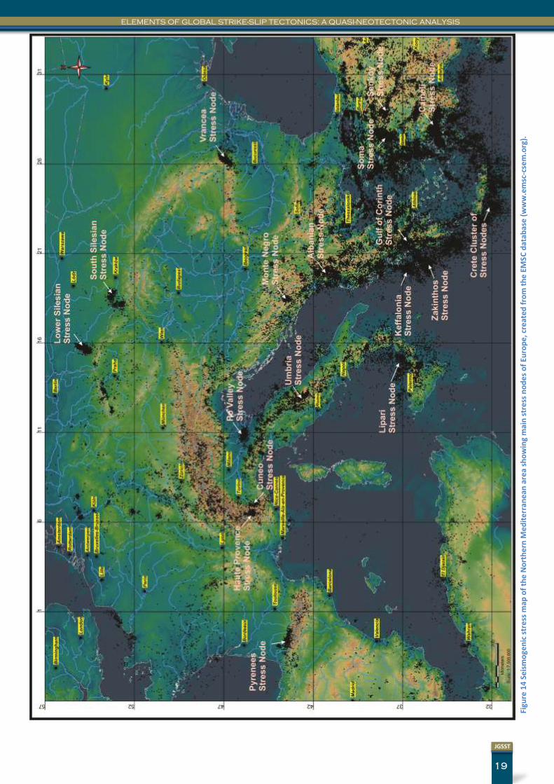
6.3. Stress nodes
There are at least 20 locations in Europe where the EMSC earthquake database is recording a spatial con-centration of earthquake epicenters, like in the Vrancea Stress Node (PLATE VIII) in Romania. We term these high activity seismogenic locations as 'stress nodes', because earthquake epicenters are sites of stress accumulation and release. High velocity bodies below a strike-slip zone are not uncommon (Hadley and Kanamori, 1977) in (Kearey and Vine, 1996). Had-ley has documented a high velocity body below the Transverse Ranges which was seismically active even at 100km.
A similar phenomenon happens in the Vrancea ar-ea, which serves as a meeting point for three different nanoplates, hence cross-cutting strike-slip faults. In this area, seismic gaps should be interpreted as over-steps of faults, as suggested in the case of the Calav-eras fault (Reasenberg and Ellsworth, 1982). The oc-currence of stress nodes in corner positions of micro-plates and nanoplates could be already predicted by GSST logics as well, without consulting the earthquake database, because significant structural deformation is also more likely to be present in corner locations.
Just nearby the Haute Provence Stress Node, in Southeastern France, 6 distinct deformation domains were isolated from the inversion of 89 focal mecha-nism (Baroux et al., 2001), which fits completely into the expected structural configuration, outlined by GSST techniques. This great variety of the recorded deformation domains is depicting the whole strike-slip stress field, including conjugate fault activity.
In the current study we have isolated the following Stress Nodes (Fig. 13): 1) Vrancea Stress Node, Eastern Carpathians, Romania, 2) South Silesian Stress Node, Poland, 3) Lower Silesian Stress Node, Poland, 4) Po Valley Stress Node, Italy, 5) Cuneo Stress Node, Alpi-Marittime, Italy, 6) Haute Provence Stress Node, Alpes-de-Haute-Provence, France, 7) Pyrenees Stress Node, Spain, 8) Umbria Stress Node, Apennines, Italy, 9) Lipari Stress Node, Tyrrhenian Sea, Italy, 10) Monte Negro Stress Node, 11) Albanian Stress Node, 12) Gulf of Corinth Stress Node, Greece, 13) Keffalonia Stress Node, Greece, 14) Zakinthos Stress Node, Greece, 15) Crete Cluster of Stress Nodes, Greece, 16) Soma Stress Node, Turkey, 17) Şenköy Stress Node, Turkey, 18) Çameli Stress Node, Turkey, 19) Sapientza Stress Node, Greece, 20) Pamukkale Stress Node, Turkey, 21) Elazig Stress Node, Turkey, 22) Tabriz Stress Node, 23) Van Lake Stress Node, Turkey, 24) Qushm Stress Node, Iran, 25) Karakul Stress Node, Pamir Mts. China-Tajikistan, 26) Badakhshan Stress Node, Pamir Mts., Tajikistan, 27) Islamabad Stress Node, Himalaya Mts., Pakistan.
A systematic description of stress nodes listed above does not represent the objective of the present study.
6.4. Volcanic markers, extension nodes
In the GSST approach, rising of magmas is related to the opening of crustal scale tension fractures. Be-cause pure shear related stress field and deformation is unlikely to exist in nature, even within compression-al belts there will exist some transtensional fracture components, which are characterized by significantly lower stress values. These tension fractures always form perpendicularly to the σ3 direction, and will serve as pathways for rising of magmas. Cross-cutting
19
JGSST
ELEMENTS OF GLOBAL STRIKE-SLIP TECTONICS: A QUASI-NEOTECTONIC ANALYSIS
Figu
re 1
4 S
eis
mo
gen
ic s
tre
ss m
ap o
f th
e N
ort
he
rn M
ed
ite
rran
ean
are
a sh
ow
ing
mai
n s
tre
ss n
od
es
of
Euro
pe
, cre
ate
d f
rom
th
e E
MS
C d
atab
ase
(w
ww
.em
sc-c
sem
.org
).
JOURNAL OF GLOBAL STRIKE-SLIP TECTONICS
20
JGSST
fault systems are quite common in nature. While in regional compressional fault intersection stress nodes may form, in tensional fault intersections, extension nodes may appear. Here, in these extension nodes magmas have the highest chance to rich to the sur-face. As a consequence, volcanic craters are the best markers of regional extension nodes. In addition to volcanic craters, other parts of the volcanic build-ups may also serve as passive kinematic indicators, be-cause of the pronounced hardness and brittleness of lavas and volcano sedimentary successions, in compar-ison to the surrounding environment.
Example: Columnar basalts at Racoșul de Jos/ Alsórákos are yielding a Pleistocene, 1200 ka to 600 ka old (Harangi et al., 2013) effusive product in one of the Perșani Mountain tension nodes, tracing the location of cross-cutting strike-slip faults.
6.5. Carbonate tufas
As shown in Section 5.2., distribution of massive CO2 occurrences and that of larger carbonate tufa domes is related to deep crustal faults, and thus sur-face carbonate tufa deposits can be used to trace deep seated crustal faults, hence we consider them as integral parts of the GSST mapping techniques. In Fig. 13 a minor carbonate tufa dome is shown from Tălișoara, which together with the Bálványos car-bonate tufa domes delineate a major W to E trending deeper crustal fault system. Another synthetic fault to the master is coming from the Racoș neovolcanic area via the Ozunca Băi carbonate tufa dome.
6.6. Paleogeographical markers
Paleogeographical markers can be used for tracing the tectonic trajectory of paleogeographical elements like facies boundaries, basin margins, shelf margins, displacement along strike-slip lineaments, as evi-denced by Kovács Sándor and Kázmér. They proved the eastward continental escape of the Bakony-Drauzug unit by the use of facies markers from Permi-an to Paleogene sedimentary successions (Kázmér and Kovács, 1985).
Recently, we have shown in a conference paper that the areal distribution of Palaogene sediments from the Aiud, Călata and Northeastern Hungarian Paleogene basins can also be used as paleogeographic markers, and that these basin fragments were dis-placed along strike-slip faults. The main strike-slip fault dividing the Aiud and Călata basins is a left-lateral fault (Kovács, 2012), which follows the Someș Valley, and resulted in a markedly different carbonate sedi-mentary facies (Kovács, 2005) on the both sides of the master fault.
Validators
6.7. Outcrop kinematic markers
After tracing the regional tectonic lineaments with the aid of the previously presented tracer markers, we may seek after field evidences in outcrops, quarries and roadcuts. Here, strain indicators can be mapped
with the traditional techniques known from structural geology.
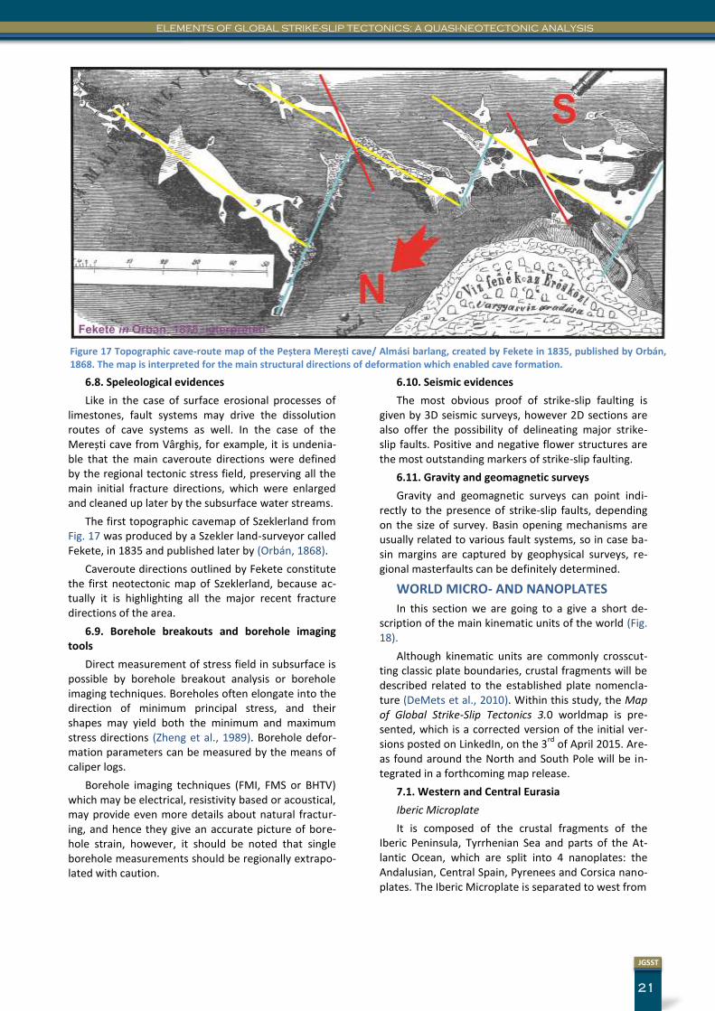
Fig. 15 is showing the presence of strike-slip faults in a Pleistocene volcano-sedimentary sequence from Racoș/ Alsórákos, Perșani Mts. Most probably, it is the same strike-slip system which otherwise enabled the rising of these young magmas (about 700ka old) to surface (Panaiotu et al., 2013).
Figure 15 Strike-slip faults in a Pleistocene volcano-sedimentary sequence
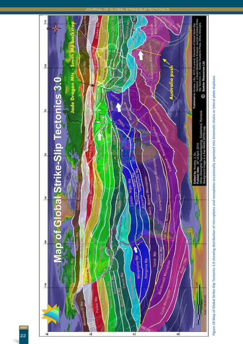
Figure 16 Fault breccia in the Peștera Merești cave/ Almási barlang, Vârghiș Gorge, Szeklerland, Romania
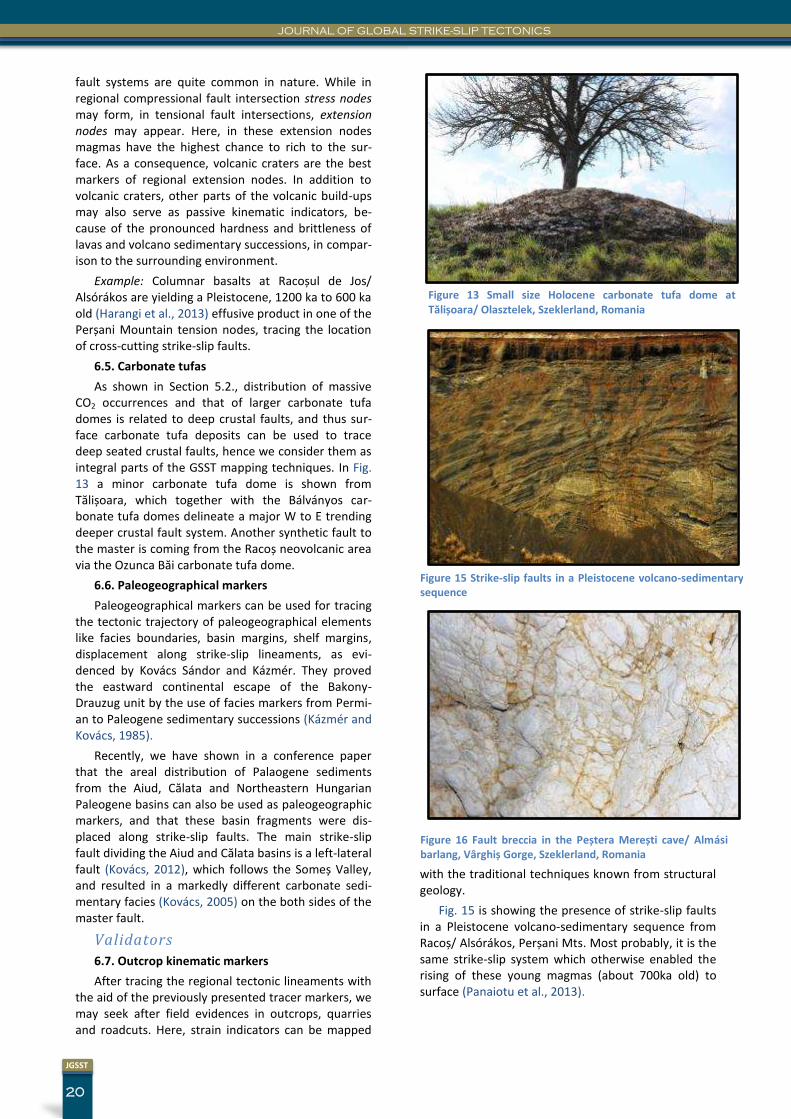
Figure 13 Small size Holocene carbonate tufa dome at Tălișoara/ Olasztelek, Szeklerland, Romania
21
JGSST
ELEMENTS OF GLOBAL STRIKE-SLIP TECTONICS: A QUASI-NEOTECTONIC ANALYSIS
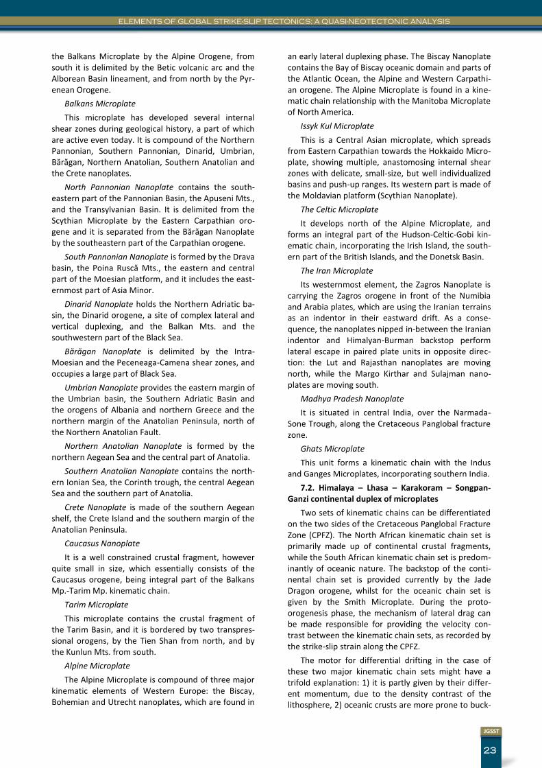
6.8. Speleological evidences
Like in the case of surface erosional processes of limestones, fault systems may drive the dissolution routes of cave systems as well. In the case of the Merești cave from Vârghiș, for example, it is undenia-ble that the main caveroute directions were defined by the regional tectonic stress field, preserving all the main initial fracture directions, which were enlarged and cleaned up later by the subsurface water streams.
The first topographic cavemap of Szeklerland from Fig. 17 was produced by a Szekler land-surveyor called Fekete, in 1835 and published later by (Orbán, 1868).
Caveroute directions outlined by Fekete constitute the first neotectonic map of Szeklerland, because ac-tually it is highlighting all the major recent fracture directions of the area.
6.9. Borehole breakouts and borehole imaging tools
Direct measurement of stress field in subsurface is possible by borehole breakout analysis or borehole imaging techniques. Boreholes often elongate into the direction of minimum principal stress, and their shapes may yield both the minimum and maximum stress directions (Zheng et al., 1989). Borehole defor-mation parameters can be measured by the means of caliper logs.
Borehole imaging techniques (FMI, FMS or BHTV) which may be electrical, resistivity based or acoustical, may provide even more details about natural fractur-ing, and hence they give an accurate picture of bore-hole strain, however, it should be noted that single borehole measurements should be regionally extrapo-lated with caution.
6.10. Seismic evidences
The most obvious proof of strike-slip faulting is given by 3D seismic surveys, however 2D sections are also offer the possibility of delineating major strike-slip faults. Positive and negative flower structures are the most outstanding markers of strike-slip faulting.
6.11. Gravity and geomagnetic surveys
Gravity and geomagnetic surveys can point indi-rectly to the presence of strike-slip faults, depending on the size of survey. Basin opening mechanisms are usually related to various fault systems, so in case ba-sin margins are captured by geophysical surveys, re-gional masterfaults can be definitely determined.
WORLD MICRO- AND NANOPLATES
In this section we are going to a give a short de-scription of the main kinematic units of the world (Fig. 18).
Although kinematic units are commonly crosscut-ting classic plate boundaries, crustal fragments will be described related to the established plate nomencla-ture (DeMets et al., 2010). Within this study, the Map of Global Strike-Slip Tectonics 3.0 worldmap is pre-sented, which is a corrected version of the initial ver-sions posted on LinkedIn, on the 3
rd of April 2015. Are-
as found around the North and South Pole will be in-tegrated in a forthcoming map release.
7.1. Western and Central Eurasia
Iberic Microplate
It is composed of the crustal fragments of the Iberic Peninsula, Tyrrhenian Sea and parts of the At-lantic Ocean, which are split into 4 nanoplates: the Andalusian, Central Spain, Pyrenees and Corsica nano-plates. The Iberic Microplate is separated to west from
Figure 17 Topographic cave-route map of the Peștera Merești cave/ Almási barlang, created by Fekete in 1835, published by Orbán, 1868. The map is interpreted for the main structural directions of deformation which enabled cave formation.
JOURNAL OF GLOBAL STRIKE-SLIP TECTONICS
22
JGSST
Figu
re 1
8 M
ap o
f G
lob
al S
trik
e-S
lip T
ect
on
ics
3.0
sh
ow
ing
dis
trib
uti
on
of
mic
rop
late
s an
d n
ano
pla
tes
occ
asio
nal
ly o
rgan
ize
d in
to k
ine
mat
ic c
ha
ins
or
late
ral
pla
te d
up
lexe
s
23
JGSST
ELEMENTS OF GLOBAL STRIKE-SLIP TECTONICS: A QUASI-NEOTECTONIC ANALYSIS
the Balkans Microplate by the Alpine Orogene, from south it is delimited by the Betic volcanic arc and the Alborean Basin lineament, and from north by the Pyr-enean Orogene.
Balkans Microplate
This microplate has developed several internal shear zones during geological history, a part of which are active even today. It is compound of the Northern Pannonian, Southern Pannonian, Dinarid, Umbrian, Bărăgan, Northern Anatolian, Southern Anatolian and the Crete nanoplates.
North Pannonian Nanoplate contains the south-eastern part of the Pannonian Basin, the Apuseni Mts., and the Transylvanian Basin. It is delimited from the Scythian Microplate by the Eastern Carpathian oro-gene and it is separated from the Bărăgan Nanoplate by the southeastern part of the Carpathian orogene.
South Pannonian Nanoplate is formed by the Drava basin, the Poina Ruscă Mts., the eastern and central part of the Moesian platform, and it includes the east-ernmost part of Asia Minor.
Dinarid Nanoplate holds the Northern Adriatic ba-sin, the Dinarid orogene, a site of complex lateral and vertical duplexing, and the Balkan Mts. and the southwestern part of the Black Sea.
Bărăgan Nanoplate is delimited by the Intra-Moesian and the Peceneaga-Camena shear zones, and occupies a large part of Black Sea.
Umbrian Nanoplate provides the eastern margin of the Umbrian basin, the Southern Adriatic Basin and the orogens of Albania and northern Greece and the northern margin of the Anatolian Peninsula, north of the Northern Anatolian Fault.
Northern Anatolian Nanoplate is formed by the northern Aegean Sea and the central part of Anatolia.
Southern Anatolian Nanoplate contains the north-ern Ionian Sea, the Corinth trough, the central Aegean Sea and the southern part of Anatolia.
Crete Nanoplate is made of the southern Aegean shelf, the Crete Island and the southern margin of the Anatolian Peninsula.
Caucasus Nanoplate
It is a well constrained crustal fragment, however quite small in size, which essentially consists of the Caucasus orogene, being integral part of the Balkans Mp.-Tarim Mp. kinematic chain.
Tarim Microplate
This microplate contains the crustal fragment of the Tarim Basin, and it is bordered by two transpres-sional orogens, by the Tien Shan from north, and by the Kunlun Mts. from south.
Alpine Microplate
The Alpine Microplate is compound of three major kinematic elements of Western Europe: the Biscay, Bohemian and Utrecht nanoplates, which are found in
an early lateral duplexing phase. The Biscay Nanoplate contains the Bay of Biscay oceanic domain and parts of the Atlantic Ocean, the Alpine and Western Carpathi-an orogene. The Alpine Microplate is found in a kine-matic chain relationship with the Manitoba Microplate of North America.
Issyk Kul Microplate
This is a Central Asian microplate, which spreads from Eastern Carpathian towards the Hokkaido Micro-plate, showing multiple, anastomosing internal shear zones with delicate, small-size, but well individualized basins and push-up ranges. Its western part is made of the Moldavian platform (Scythian Nanoplate).
The Celtic Microplate
It develops north of the Alpine Microplate, and forms an integral part of the Hudson-Celtic-Gobi kin-ematic chain, incorporating the Irish Island, the south-ern part of the British Islands, and the Donetsk Basin.
The Iran Microplate
Its westernmost element, the Zagros Nanoplate is carrying the Zagros orogene in front of the Numibia and Arabia plates, which are using the Iranian terrains as an indentor in their eastward drift. As a conse-quence, the nanoplates nipped in-between the Iranian indentor and Himalyan-Burman backstop perform lateral escape in paired plate units in opposite direc-tion: the Lut and Rajasthan nanoplates are moving north, while the Margo Kirthar and Sulajman nano-plates are moving south.
Madhya Pradesh Nanoplate
It is situated in central India, over the Narmada-Sone Trough, along the Cretaceous Panglobal fracture zone.
Ghats Microplate
This unit forms a kinematic chain with the Indus and Ganges Microplates, incorporating southern India.
7.2. Himalaya – Lhasa – Karakoram – Songpan-Ganzi continental duplex of microplates
Two sets of kinematic chains can be differentiated on the two sides of the Cretaceous Panglobal Fracture Zone (CPFZ). The North African kinematic chain set is primarily made up of continental crustal fragments, while the South African kinematic chain set is predom-inantly of oceanic nature. The backstop of the conti-nental chain set is provided currently by the Jade Dragon orogene, whilst for the oceanic chain set is given by the Smith Microplate. During the proto-orogenesis phase, the mechanism of lateral drag can be made responsible for providing the velocity con-trast between the kinematic chain sets, as recorded by the strike-slip strain along the CPFZ.
The motor for differential drifting in the case of these two major kinematic chain sets might have a trifold explanation: 1) it is partly given by their differ-ent momentum, due to the density contrast of the lithosphere, 2) oceanic crusts are more prone to buck-
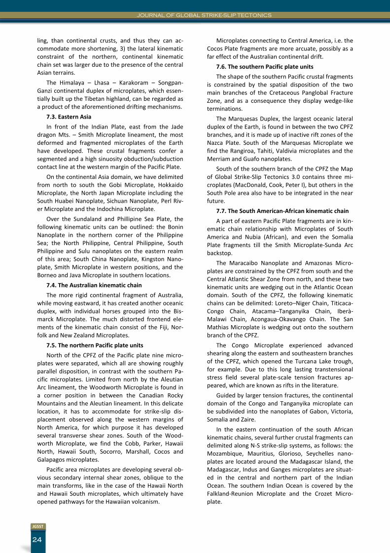
JOURNAL OF GLOBAL STRIKE-SLIP TECTONICS
24
JGSST
ling, than continental crusts, and thus they can ac-commodate more shortening, 3) the lateral kinematic constraint of the northern, continental kinematic chain set was larger due to the presence of the central Asian terrains.
The Himalaya – Lhasa – Karakoram – Songpan-Ganzi continental duplex of microplates, which essen-tially built up the Tibetan highland, can be regarded as a product of the aforementioned drifting mechanisms.
7.3. Eastern Asia
In front of the Indian Plate, east from the Jade dragon Mts. – Smith Microplate lineament, the most deformed and fragmented microplates of the Earth have developed. These crustal fragments confer a segmented and a high sinuosity obduction/subduction contact line at the western margin of the Pacific Plate.
On the continental Asia domain, we have delimited from north to south the Gobi Microplate, Hokkaido Microplate, the North Japan Microplate including the South Huabei Nanoplate, Sichuan Nanoplate, Perl Riv-er Microplate and the Indochina Microplate.
Over the Sundaland and Phillipine Sea Plate, the following kinematic units can be outlined: the Bonin Nanoplate in the northern corner of the Philippine Sea; the North Philippine, Central Philippine, South Philippine and Sulu nanoplates on the eastern realm of this area; South China Nanoplate, Kingston Nano-plate, Smith Microplate in western positions, and the Borneo and Java Microplate in southern locations.
7.4. The Australian kinematic chain
The more rigid continental fragment of Australia, while moving eastward, it has created another oceanic duplex, with individual horses grouped into the Bis-marck Microplate. The much distorted frontend ele-ments of the kinematic chain consist of the Fiji, Nor-folk and New Zealand Microplates.
7.5. The northern Pacific plate units
North of the CPFZ of the Pacific plate nine micro-plates were separated, which all are showing roughly parallel disposition, in contrast with the southern Pa-cific microplates. Limited from north by the Aleutian Arc lineament, the Woodworth Microplate is found in a corner position in between the Canadian Rocky Mountains and the Aleutian lineament. In this delicate location, it has to accommodate for strike-slip dis-placement observed along the western margins of North America, for which purpose it has developed several transverse shear zones. South of the Wood-worth Microplate, we find the Cobb, Parker, Hawaii North, Hawaii South, Socorro, Marshall, Cocos and Galapagos microplates.
Pacific area microplates are developing several ob-vious secondary internal shear zones, oblique to the main transforms, like in the case of the Hawaii North and Hawaii South microplates, which ultimately have opened pathways for the Hawaiian volcanism.
Microplates connecting to Central America, i.e. the Cocos Plate fragments are more arcuate, possibly as a far effect of the Australian continental drift.
7.6. The southern Pacific plate units
The shape of the southern Pacific crustal fragments is constrained by the spatial disposition of the two main branches of the Cretaceous Panglobal Fracture Zone, and as a consequence they display wedge-like terminations.
The Marquesas Duplex, the largest oceanic lateral duplex of the Earth, is found in between the two CPFZ branches, and it is made up of inactive rift zones of the Nazca Plate. South of the Marquesas Microplate we find the Rangiroa, Tahiti, Valdivia microplates and the Merriam and Guafo nanoplates.
South of the southern branch of the CPFZ the Map of Global Strike-Slip Tectonics 3.0 contains three mi-croplates (MacDonald, Cook, Peter I), but others in the South Pole area also have to be integrated in the near future.
7.7. The South American-African kinematic chain
A part of eastern Pacific Plate fragments are in kin-ematic chain relationship with Microplates of South America and Nubia (African), and even the Somalia Plate fragments till the Smith Microplate-Sunda Arc backstop.
The Maracaibo Nanoplate and Amazonas Micro-plates are constrained by the CPFZ from south and the Central Atlantic Shear Zone from north, and these two kinematic units are wedging out in the Atlantic Ocean domain. South of the CPFZ, the following kinematic chains can be delimited: Loreto–Niger Chain, Titicaca-Congo Chain, Atacama–Tanganyika Chain, Iberà-Malawi Chain, Acongaua-Okavango Chain. The San Mathias Microplate is wedging out onto the southern branch of the CPFZ.
The Congo Microplate experienced advanced shearing along the eastern and southeastern branches of the CPFZ, which opened the Turcana Lake trough, for example. Due to this long lasting transtensional stress field several plate-scale tension fractures ap-peared, which are known as rifts in the literature.
Guided by larger tension fractures, the continental domain of the Congo and Tanganyika microplate can be subdivided into the nanoplates of Gabon, Victoria, Somalia and Zaire.
In the eastern continuation of the south African kinematic chains, several further crustal fragments can delimited along N-S strike-slip systems, as follows: the Mozambique, Mauritius, Glorioso, Seychelles nano-plates are located around the Madagascar Island, the Madagascar, Indus and Ganges microplates are situat-ed in the central and northern part of the Indian Ocean. The southern Indian Ocean is covered by the Falkland-Reunion Microplate and the Crozet Micro-plate.
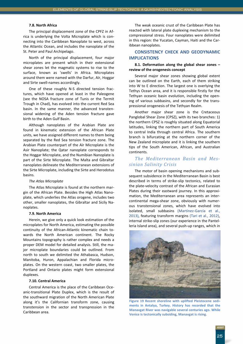
25
JGSST
ELEMENTS OF GLOBAL STRIKE-SLIP TECTONICS: A QUASI-NEOTECTONIC ANALYSIS
7.8. North Africa
The principal displacement zone of the CPFZ in Af-rica is underlying the Volta Microplate which is con-necting into the Caribbean Nanoplate to west, across the Atlantic Ocean, and includes the nanoplate of the St. Peter and Paul Archipelago.
North of the principal displacement, four major microplates are present which in their extensional shear zones let the magmatic systems to rise to the surface, known as 'swells' in Africa. Microplates around them were named with the Darfur, Aïr, Hoggar and Sirte swell-names accordingly.
One of these roughly N-S directed tension frac-tures, which have opened at least in the Paleogene (see the NOSA fracture zone of Tunis or the Termit Trough in Chad), has evolved into the current Red Sea basin. In the same manner, the advanced transten-sional widening of the Aden tension fracture gave birth to the Aden Gulf Basin.
Although nanoplates of the Arabian Plate are found in kinematic extension of the African Plate units, we have assigned different names to them being separated by the Red Sea tension fracture zone. The Arabian Plate counterpart of the Aïr Microplate is the Asir Nanoplate; the Qatar nanoplate corresponds to the Hoggar Microplate, and the Numibian Nanoplate is part of the Sirte Microplate. The Malta and Gibraltar nanoplates delineate the Mediterranean extensions of the Sirte Microplate, including the Sirte and Herodotus basins.
The Atlas Microplate
The Atlas Microplate is found at the northern mar-gin of the African Plate. Besides the High Atlas Nano-plate, which underlies the Atlas orogene, includes two other, smaller nanoplates, the Gibraltar and Sicily Na-noplates.
7.9. North America
Herein, we give only a quick look estimation of the microplates for North America, estimating the possible continuity of the African-Atlantic kinematic chain to-wards the North American continent. The Rocky Mountains topography is rather complex and needs a proper DEM model for detailed analysis. Still, the ma-jor microplate boundaries could be outlined. From north to south we delimited the Athabasca, Hudson, Manitoba, Huron, Appalachian and Florida micro-plates. On the western coast, two smaller plates, the Portland and Ontario plates might form extensional duplexes.
7.10. Central America
Central America is the place of the Caribbean Oce-anic-transitional Plate Duplex, which is the result of the southward migration of the North American Plate along it’s the Californian transform zone, causing transtension in the sector and transpression in the Caribbean area.
The weak oceanic crust of the Caribbean Plate has reacted with lateral plate duplexing mechanism to the compressional stress. Four nanoplates were delimited in this region: the Yucatan, Cayman, Haiti and the Car-ibbean nanoplates.
CONSISTENCY CHECK AND GEODYNAMIC IMPLICATIONS
8.1. Deformation along the global shear zones – review of the orogenesis concept
Several major shear zones showing global extent can be outlined on the Earth, each of them striking into W to E direction. The largest one is overlying the Tethys Ocean area, and it is responsible firstly for the Tethyan oceanic basin evolution, including the open-ing of various subbasins, and secondly for the trans-pressional orogenesis of the Tethyan Realm.
Another major shear zone is the Cretaceous Panglobal Shear Zone (CPSZ), with its two branches: 1) the northern CPSZ is roughly situated along Equatorial latitudes, linking the northern part of South America to central India through central Africa. The southern branch is bifurcating at the northern corner of the New Zealand microplate and it is linking the southern tips of the South American, African, and Australian continents.
The Mediterranean Basin and Mes-sinian Salinity Crisis
The motor of basin opening mechanisms and sub-sequent subsidence in the Mediterranean Basin is best described in terms of strike-slip tectonics, related to the plate-velocity contrast of the African and Eurasian Plates during their eastward journey. In this approxi-mation, the Mediterranean area represents an inter-continental mega-shear zone, obviously with numer-ous transtensional zones, which have evolved into isolated, small subbasins (Martínez-García et al., 2013), featuring transform margins (Tari et al., 2012), internal strike-slip zones (our experience in the Pantel-leria Island area), and several push-up ranges, which in
Figure 19 Recent shoreline with uplifted Pleistocene sedi-ments in Antalya, Turkey. History has recorded that the Manavgat River was navigable several centuries ago. While Venice is tectonically subsiding, Manavgat is rising.
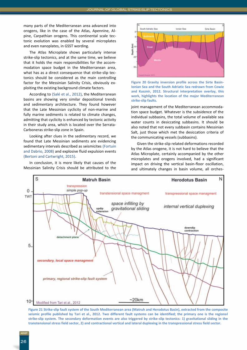
JOURNAL OF GLOBAL STRIKE-SLIP TECTONICS
26
JGSST
Figure 21 Strike-slip fault system of the South Mediterranean area (Matruh and Herodotus Basin), extracted from the composite seismic profile published by Tari et al., 2012. Two different fault systems can be identified; the primary one is the regional strike-slip system. The secondary deformation events are also triggered by strike-slip tectonics: 1) gravitational sliding in the transtensional stress field sector, 2) and contractional vertical and lateral duplexing in the transpressional stress field sector.
many parts of the Mediterranean area advanced into orogens, like in the case of the Atlas, Apennine, Al-pine, Carpathian orogens. This continental scale tec-tonic evolution was enabled by several microplates and even nanoplates, in GSST wording.
The Atlas Microplate shows particularly intense strike-slip tectonics, and at the same time, we believe that it holds the main responsibilities for the accom-modation space budget in the Mediterranean area, what has as a direct consequence that strike-slip tec-tonics should be considered as the main controlling factor for the Messinian Salinity Crisis, obviously ex-ploiting the existing background climate factors.
According to (Salé et al., 2012), the Mediterranean basins are showing very similar depositional trends and sedimentary architecture. They found however that the Late Messinian cyclicity of non-marine and fully marine sediments is related to climate changes, admitting that cyclicity is enhanced by tectonic activity in their study area, which is located over the Serrata-Carboneras strike-slip zone in Spain.
Looking after clues in the sedimentary record, we found that Late Messinian sediments are evidencing sedimentary intervals described as seismicites (Fortuin and Dabrio, 2008) and explosive fluid expulsion events (Bertoni and Cartwright, 2015).
In conclusion, it is more likely that causes of the Messinian Salinity Crisis should be attributed to the
joint management of the Mediterranean accommoda-tion space budget. Whatever is the subsidence of the individual subbasins, the total volume of available sea water counts in desiccating subbasins. It should be also noted that not every subbasin contains Messinian Salt, just those which met the desiccation criteria of the communicating vessels (subbasins).
Given the strike-slip related deformations recorded by the Atlas orogene, it is not hard to believe that the Atlas Microplate, certainly accompanied by the other microplates and orogens involved, had a significant impact on driving the vertical basin-floor oscillation, and ultimately changes in basin volume, all orches-
Figure 20 Gravity inversion profile across the Sirte Basin-Ionian Sea and the South Adriatic Sea redrawn from Cowie and Kusznir, 2012. Structural interpretation overlay, this work, highlights the location of the major Mediterranean strike-slip faults.
27
JGSST
ELEMENTS OF GLOBAL STRIKE-SLIP TECTONICS: A QUASI-NEOTECTONIC ANALYSIS
trated by the regional strike-slip stress field.
Sirte Basin – South Adria crustal section
The thinning of the Mediterranean crust below the Sirte Basin and the Ionian Sea (Fig.20) has been evi-denced recently by gravity inversion (Cowie and Kusznir, 2012). Cowie and Kusznir have also noted that the nature of the crust could be either oceanic or thinned continental. On their second profile, which transects the Herodotus Basin the transform nature of the basin margin, i.e the sudden increase of crustal thickness is more prominent, as a consequence most probably the masterfault of basin opening was local-ized on the southern basin margin of the Mediterra-nean Sea.
In our interpretation, gravity profile from Fig.20 is showing additional arguments for the transtensional origin of the Mediterranean crust. Here, contrary to the southern margin, crustal thinning was enabled by
overstepping strike-slip faults. The crustal thinning mechanism cannot be understood from the published profiles, but certainly must be sought in those of transtensional strike-slip basins.
Southern transform margin of the Mediterranean Basin (Matruh-Herodotus Basin
An ENE-ESE opening of the East Mediterranean ar-ea related to a transform margin was documented by several authors (Longacre et al., 2007) (Walley, 1998; Walley, 2001) in (Tari et al., 2012), and indeed strike-slip tectonics suggested by gravity profiles (Cowie and Kusznir, 2012) is supported by seismic profiles as well. Reinterpreting a composite profile across the Matruh-Herodotus Basin margin, we have concluded that it is likely, that an important amount of the structural traps identified in the Matruh Basin were generated by the local Neogene transpressional stress regime. Actually, down-dip contractional horses interpreted by (Tari et al., 2012) might originate partly in strike-slip deformation than solely in gravitational sliding on a Cretaceous shale detachment, as indicated by the
Figure 22 Seismic profile based geological section across the Eratosthenes Sea Mount, showing two generations of strike slip faults, and simultaneous presence of transten-sional and transpressional deformation. The original, raw seismic profile was published in Petroleum Geoscience (Peace et al, .2012).
Figure 23 Geological cross-section across the Corinth Trough em-phasizing the transtensional, i.e. strike-slip tectonics related origin of the basin. This reinterpreted seismic line was first pub-lished in Petroleum Geoscience (Bell et al., 2009).
Figure 24 Cross-section across the Current Vema Dome, Vøring Basin, showing the multiple restraining and releasing phases of the generally SW-NE striking Vigrid Shear Zone, which resulted in successive transpressional/erosive and transtensional/ collapse epi-sodes. Original seismic profile including stratigraphy was published in Petroleum Geoscience (Lundin et al., 2013).
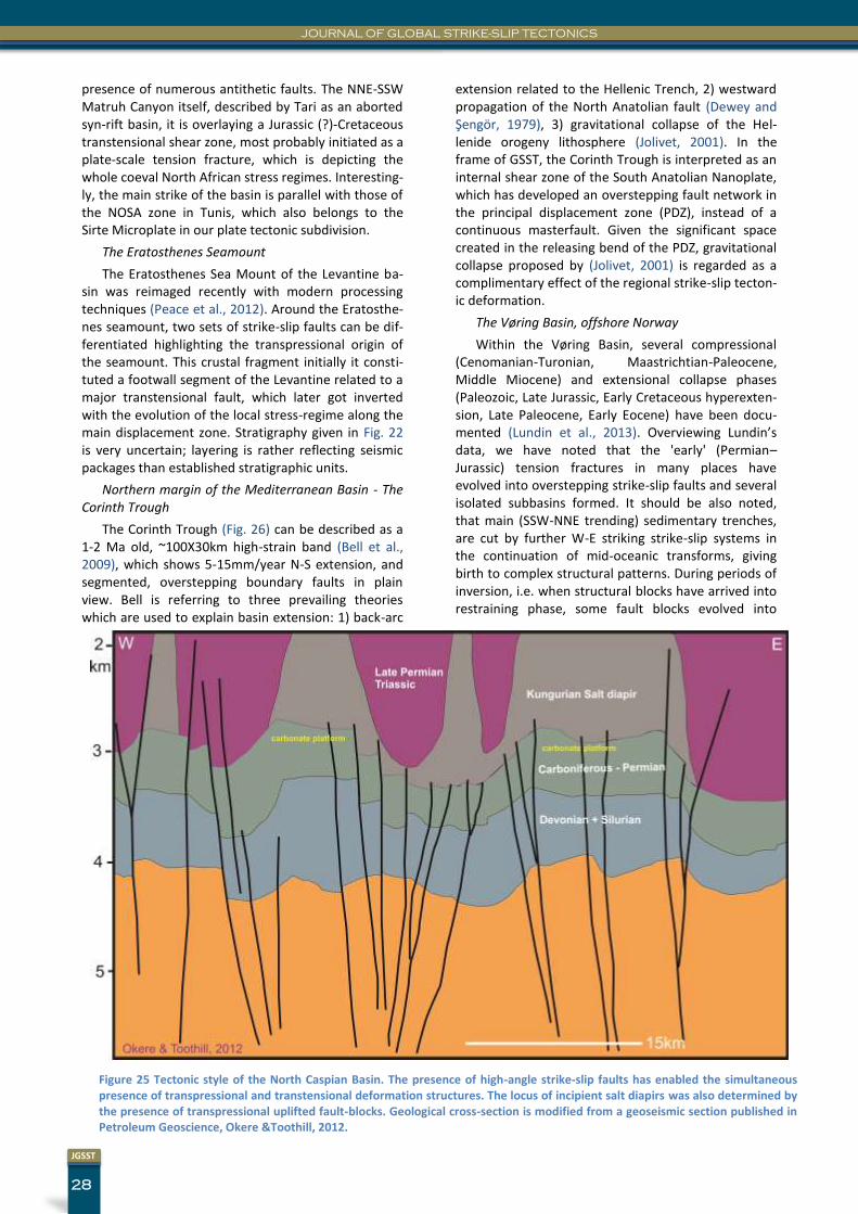
JOURNAL OF GLOBAL STRIKE-SLIP TECTONICS
28
JGSST
presence of numerous antithetic faults. The NNE-SSW Matruh Canyon itself, described by Tari as an aborted syn-rift basin, it is overlaying a Jurassic (?)-Cretaceous transtensional shear zone, most probably initiated as a plate-scale tension fracture, which is depicting the whole coeval North African stress regimes. Interesting-ly, the main strike of the basin is parallel with those of the NOSA zone in Tunis, which also belongs to the Sirte Microplate in our plate tectonic subdivision.
The Eratosthenes Seamount
The Eratosthenes Sea Mount of the Levantine ba-sin was reimaged recently with modern processing techniques (Peace et al., 2012). Around the Eratosthe-nes seamount, two sets of strike-slip faults can be dif-ferentiated highlighting the transpressional origin of the seamount. This crustal fragment initially it consti-tuted a footwall segment of the Levantine related to a major transtensional fault, which later got inverted with the evolution of the local stress-regime along the main displacement zone. Stratigraphy given in Fig. 22 is very uncertain; layering is rather reflecting seismic packages than established stratigraphic units.
Northern margin of the Mediterranean Basin - The Corinth Trough
The Corinth Trough (Fig. 26) can be described as a 1-2 Ma old, ~100X30km high-strain band (Bell et al., 2009), which shows 5-15mm/year N-S extension, and segmented, overstepping boundary faults in plain view. Bell is referring to three prevailing theories which are used to explain basin extension: 1) back-arc
extension related to the Hellenic Trench, 2) westward propagation of the North Anatolian fault (Dewey and Şengör, 1979), 3) gravitational collapse of the Hel-lenide orogeny lithosphere (Jolivet, 2001). In the frame of GSST, the Corinth Trough is interpreted as an internal shear zone of the South Anatolian Nanoplate, which has developed an overstepping fault network in the principal displacement zone (PDZ), instead of a continuous masterfault. Given the significant space created in the releasing bend of the PDZ, gravitational collapse proposed by (Jolivet, 2001) is regarded as a complimentary effect of the regional strike-slip tecton-ic deformation.
The Vøring Basin, offshore Norway
Within the Vøring Basin, several compressional (Cenomanian-Turonian, Maastrichtian-Paleocene, Middle Miocene) and extensional collapse phases (Paleozoic, Late Jurassic, Early Cretaceous hyperexten-sion, Late Paleocene, Early Eocene) have been docu-mented (Lundin et al., 2013). Overviewing Lundin’s data, we have noted that the 'early' (Permian–Jurassic) tension fractures in many places have evolved into overstepping strike-slip faults and several isolated subbasins formed. It should be also noted, that main (SSW-NNE trending) sedimentary trenches, are cut by further W-E striking strike-slip systems in the continuation of mid-oceanic transforms, giving birth to complex structural patterns. During periods of inversion, i.e. when structural blocks have arrived into restraining phase, some fault blocks evolved into
Figure 25 Tectonic style of the North Caspian Basin. The presence of high-angle strike-slip faults has enabled the simultaneous presence of transpressional and transtensional deformation structures. The locus of incipient salt diapirs was also determined by the presence of transpressional uplifted fault-blocks. Geological cross-section is modified from a geoseismic section published in Petroleum Geoscience, Okere &Toothill, 2012.
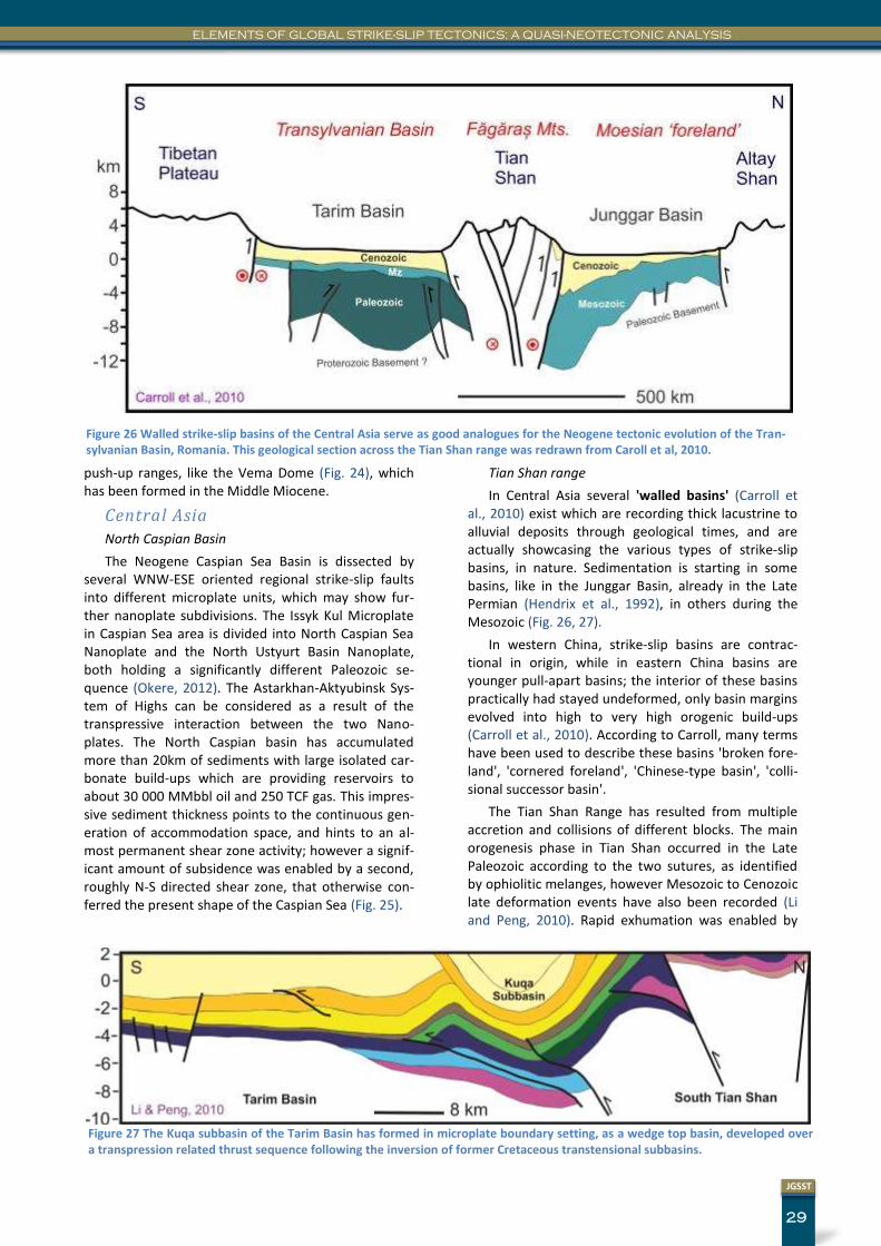
29
JGSST
ELEMENTS OF GLOBAL STRIKE-SLIP TECTONICS: A QUASI-NEOTECTONIC ANALYSIS
push-up ranges, like the Vema Dome (Fig. 24), which has been formed in the Middle Miocene.
Central Asia
North Caspian Basin
The Neogene Caspian Sea Basin is dissected by several WNW-ESE oriented regional strike-slip faults into different microplate units, which may show fur-ther nanoplate subdivisions. The Issyk Kul Microplate in Caspian Sea area is divided into North Caspian Sea Nanoplate and the North Ustyurt Basin Nanoplate, both holding a significantly different Paleozoic se-quence (Okere, 2012). The Astarkhan-Aktyubinsk Sys-tem of Highs can be considered as a result of the transpressive interaction between the two Nano-plates. The North Caspian basin has accumulated more than 20km of sediments with large isolated car-bonate build-ups which are providing reservoirs to about 30 000 MMbbl oil and 250 TCF gas. This impres-sive sediment thickness points to the continuous gen-eration of accommodation space, and hints to an al-most permanent shear zone activity; however a signif-icant amount of subsidence was enabled by a second, roughly N-S directed shear zone, that otherwise con-ferred the present shape of the Caspian Sea (Fig. 25).
Tian Shan range
In Central Asia several 'walled basins' (Carroll et al., 2010) exist which are recording thick lacustrine to alluvial deposits through geological times, and are actually showcasing the various types of strike-slip basins, in nature. Sedimentation is starting in some basins, like in the Junggar Basin, already in the Late Permian (Hendrix et al., 1992), in others during the Mesozoic (Fig. 26, 27).
In western China, strike-slip basins are contrac-tional in origin, while in eastern China basins are younger pull-apart basins; the interior of these basins practically had stayed undeformed, only basin margins evolved into high to very high orogenic build-ups (Carroll et al., 2010). According to Carroll, many terms have been used to describe these basins 'broken fore-land', 'cornered foreland', 'Chinese-type basin', 'colli-sional successor basin'.
The Tian Shan Range has resulted from multiple accretion and collisions of different blocks. The main orogenesis phase in Tian Shan occurred in the Late Paleozoic according to the two sutures, as identified by ophiolitic melanges, however Mesozoic to Cenozoic late deformation events have also been recorded (Li and Peng, 2010). Rapid exhumation was enabled by
Figure 26 Walled strike-slip basins of the Central Asia serve as good analogues for the Neogene tectonic evolution of the Tran-sylvanian Basin, Romania. This geological section across the Tian Shan range was redrawn from Caroll et al, 2010.
Figure 27 The Kuqa subbasin of the Tarim Basin has formed in microplate boundary setting, as a wedge top basin, developed over a transpression related thrust sequence following the inversion of former Cretaceous transtensional subbasins.
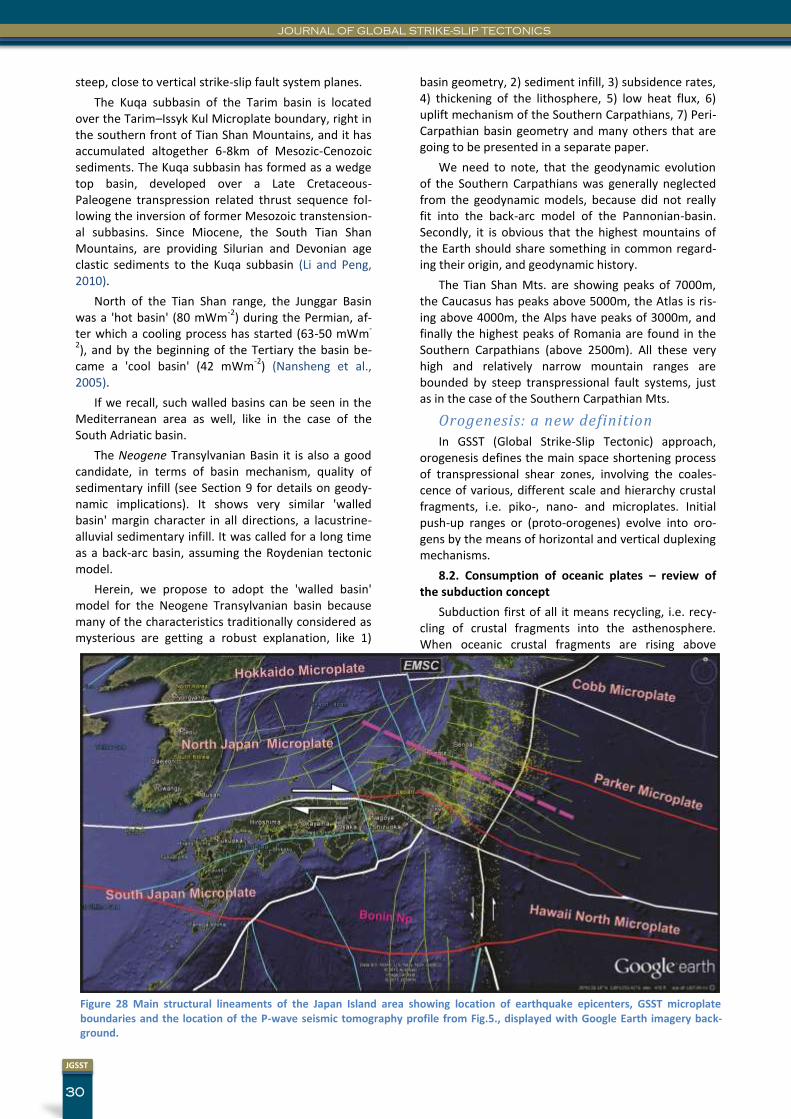
JOURNAL OF GLOBAL STRIKE-SLIP TECTONICS
30
JGSST
steep, close to vertical strike-slip fault system planes.
The Kuqa subbasin of the Tarim basin is located over the Tarim–Issyk Kul Microplate boundary, right in the southern front of Tian Shan Mountains, and it has accumulated altogether 6-8km of Mesozic-Cenozoic sediments. The Kuqa subbasin has formed as a wedge top basin, developed over a Late Cretaceous-Paleogene transpression related thrust sequence fol-lowing the inversion of former Mesozoic transtension-al subbasins. Since Miocene, the South Tian Shan Mountains, are providing Silurian and Devonian age clastic sediments to the Kuqa subbasin (Li and Peng, 2010).
North of the Tian Shan range, the Junggar Basin was a 'hot basin' (80 mWm
-2) during the Permian, af-
ter which a cooling process has started (63-50 mWm-
2), and by the beginning of the Tertiary the basin be-
came a 'cool basin' (42 mWm-2
) (Nansheng et al., 2005).
If we recall, such walled basins can be seen in the Mediterranean area as well, like in the case of the South Adriatic basin.
The Neogene Transylvanian Basin it is also a good candidate, in terms of basin mechanism, quality of sedimentary infill (see Section 9 for details on geody-namic implications). It shows very similar 'walled basin' margin character in all directions, a lacustrine-alluvial sedimentary infill. It was called for a long time as a back-arc basin, assuming the Roydenian tectonic model.
Herein, we propose to adopt the 'walled basin' model for the Neogene Transylvanian basin because many of the characteristics traditionally considered as mysterious are getting a robust explanation, like 1)
basin geometry, 2) sediment infill, 3) subsidence rates, 4) thickening of the lithosphere, 5) low heat flux, 6) uplift mechanism of the Southern Carpathians, 7) Peri-Carpathian basin geometry and many others that are going to be presented in a separate paper.
We need to note, that the geodynamic evolution of the Southern Carpathians was generally neglected from the geodynamic models, because did not really fit into the back-arc model of the Pannonian-basin. Secondly, it is obvious that the highest mountains of the Earth should share something in common regard-ing their origin, and geodynamic history.
The Tian Shan Mts. are showing peaks of 7000m, the Caucasus has peaks above 5000m, the Atlas is ris-ing above 4000m, the Alps have peaks of 3000m, and finally the highest peaks of Romania are found in the Southern Carpathians (above 2500m). All these very high and relatively narrow mountain ranges are bounded by steep transpressional fault systems, just as in the case of the Southern Carpathian Mts.
Orogenesis: a new definition
In GSST (Global Strike-Slip Tectonic) approach, orogenesis defines the main space shortening process of transpressional shear zones, involving the coales-cence of various, different scale and hierarchy crustal fragments, i.e. piko-, nano- and microplates. Initial push-up ranges or (proto-orogenes) evolve into oro-gens by the means of horizontal and vertical duplexing mechanisms.
8.2. Consumption of oceanic plates – review of the subduction concept
Subduction first of all it means recycling, i.e. recy-cling of crustal fragments into the asthenosphere. When oceanic crustal fragments are rising above
Figure 28 Main structural lineaments of the Japan Island area showing location of earthquake epicenters, GSST microplate boundaries and the location of the P-wave seismic tomography profile from Fig.5., displayed with Google Earth imagery back-ground.
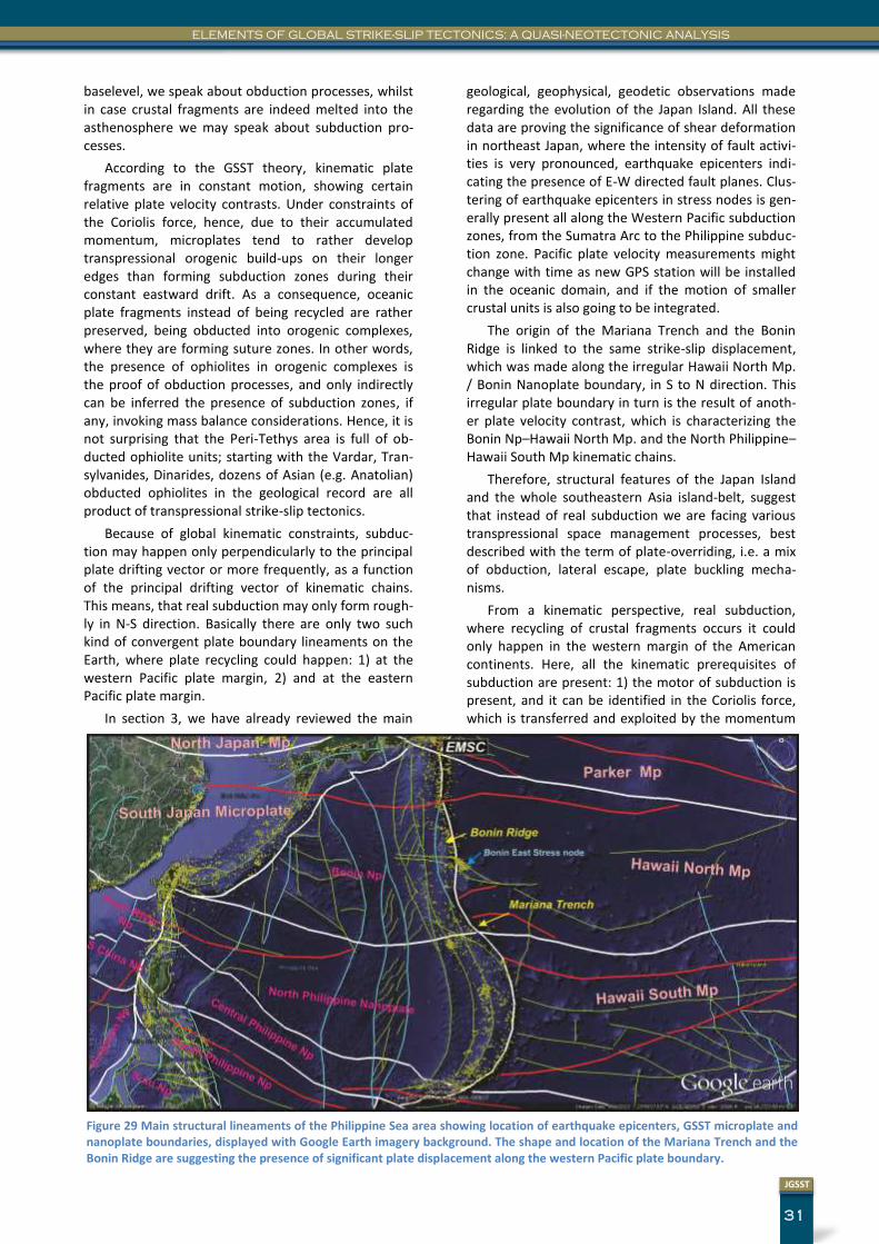
31
JGSST
ELEMENTS OF GLOBAL STRIKE-SLIP TECTONICS: A QUASI-NEOTECTONIC ANALYSIS
baselevel, we speak about obduction processes, whilst in case crustal fragments are indeed melted into the asthenosphere we may speak about subduction pro-cesses.
According to the GSST theory, kinematic plate fragments are in constant motion, showing certain relative plate velocity contrasts. Under constraints of the Coriolis force, hence, due to their accumulated momentum, microplates tend to rather develop transpressional orogenic build-ups on their longer edges than forming subduction zones during their constant eastward drift. As a consequence, oceanic plate fragments instead of being recycled are rather preserved, being obducted into orogenic complexes, where they are forming suture zones. In other words, the presence of ophiolites in orogenic complexes is the proof of obduction processes, and only indirectly can be inferred the presence of subduction zones, if any, invoking mass balance considerations. Hence, it is not surprising that the Peri-Tethys area is full of ob-ducted ophiolite units; starting with the Vardar, Tran-sylvanides, Dinarides, dozens of Asian (e.g. Anatolian) obducted ophiolites in the geological record are all product of transpressional strike-slip tectonics.
Because of global kinematic constraints, subduc-tion may happen only perpendicularly to the principal plate drifting vector or more frequently, as a function of the principal drifting vector of kinematic chains. This means, that real subduction may only form rough-ly in N-S direction. Basically there are only two such kind of convergent plate boundary lineaments on the Earth, where plate recycling could happen: 1) at the western Pacific plate margin, 2) and at the eastern Pacific plate margin.
In section 3, we have already reviewed the main
geological, geophysical, geodetic observations made regarding the evolution of the Japan Island. All these data are proving the significance of shear deformation in northeast Japan, where the intensity of fault activi-ties is very pronounced, earthquake epicenters indi-cating the presence of E-W directed fault planes. Clus-tering of earthquake epicenters in stress nodes is gen-erally present all along the Western Pacific subduction zones, from the Sumatra Arc to the Philippine subduc-tion zone. Pacific plate velocity measurements might change with time as new GPS station will be installed in the oceanic domain, and if the motion of smaller crustal units is also going to be integrated.
The origin of the Mariana Trench and the Bonin Ridge is linked to the same strike-slip displacement, which was made along the irregular Hawaii North Mp. / Bonin Nanoplate boundary, in S to N direction. This irregular plate boundary in turn is the result of anoth-er plate velocity contrast, which is characterizing the Bonin Np–Hawaii North Mp. and the North Philippine–Hawaii South Mp kinematic chains.
Therefore, structural features of the Japan Island and the whole southeastern Asia island-belt, suggest that instead of real subduction we are facing various transpressional space management processes, best described with the term of plate-overriding, i.e. a mix of obduction, lateral escape, plate buckling mecha-nisms.
From a kinematic perspective, real subduction, where recycling of crustal fragments occurs it could only happen in the western margin of the American continents. Here, all the kinematic prerequisites of subduction are present: 1) the motor of subduction is present, and it can be identified in the Coriolis force, which is transferred and exploited by the momentum
Figure 29 Main structural lineaments of the Philippine Sea area showing location of earthquake epicenters, GSST microplate and nanoplate boundaries, displayed with Google Earth imagery background. The shape and location of the Mariana Trench and the Bonin Ridge are suggesting the presence of significant plate displacement along the western Pacific plate boundary.
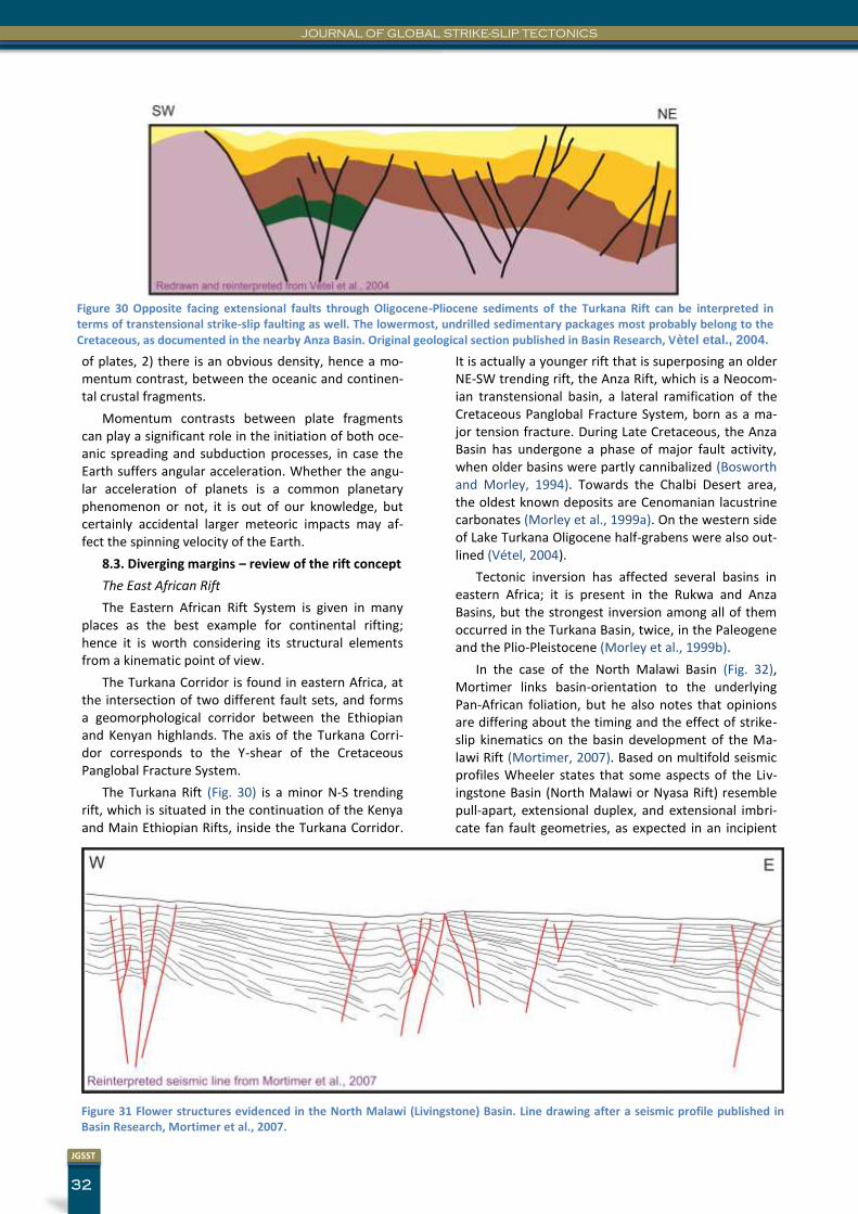
JOURNAL OF GLOBAL STRIKE-SLIP TECTONICS
32
JGSST
Figure 30 Opposite facing extensional faults through Oligocene-Pliocene sediments of the Turkana Rift can be interpreted in terms of transtensional strike-slip faulting as well. The lowermost, undrilled sedimentary packages most probably belong to the Cretaceous, as documented in the nearby Anza Basin. Original geological section published in Basin Research, Vètel etal., 2004.
of plates, 2) there is an obvious density, hence a mo-mentum contrast, between the oceanic and continen-tal crustal fragments.
Momentum contrasts between plate fragments can play a significant role in the initiation of both oce-anic spreading and subduction processes, in case the Earth suffers angular acceleration. Whether the angu-lar acceleration of planets is a common planetary phenomenon or not, it is out of our knowledge, but certainly accidental larger meteoric impacts may af-fect the spinning velocity of the Earth.
8.3. Diverging margins – review of the rift concept
The East African Rift
The Eastern African Rift System is given in many places as the best example for continental rifting; hence it is worth considering its structural elements from a kinematic point of view.
The Turkana Corridor is found in eastern Africa, at the intersection of two different fault sets, and forms a geomorphological corridor between the Ethiopian and Kenyan highlands. The axis of the Turkana Corri-dor corresponds to the Y-shear of the Cretaceous Panglobal Fracture System.
The Turkana Rift (Fig. 30) is a minor N-S trending rift, which is situated in the continuation of the Kenya and Main Ethiopian Rifts, inside the Turkana Corridor.
It is actually a younger rift that is superposing an older NE-SW trending rift, the Anza Rift, which is a Neocom-ian transtensional basin, a lateral ramification of the Cretaceous Panglobal Fracture System, born as a ma-jor tension fracture. During Late Cretaceous, the Anza Basin has undergone a phase of major fault activity, when older basins were partly cannibalized (Bosworth and Morley, 1994). Towards the Chalbi Desert area, the oldest known deposits are Cenomanian lacustrine carbonates (Morley et al., 1999a). On the western side of Lake Turkana Oligocene half-grabens were also out-lined (Vétel, 2004).
Tectonic inversion has affected several basins in eastern Africa; it is present in the Rukwa and Anza Basins, but the strongest inversion among all of them occurred in the Turkana Basin, twice, in the Paleogene and the Plio-Pleistocene (Morley et al., 1999b).
In the case of the North Malawi Basin (Fig. 32), Mortimer links basin-orientation to the underlying Pan-African foliation, but he also notes that opinions are differing about the timing and the effect of strike-slip kinematics on the basin development of the Ma-lawi Rift (Mortimer, 2007). Based on multifold seismic profiles Wheeler states that some aspects of the Liv-ingstone Basin (North Malawi or Nyasa Rift) resemble pull-apart, extensional duplex, and extensional imbri-cate fan fault geometries, as expected in an incipient
Figure 31 Flower structures evidenced in the North Malawi (Livingstone) Basin. Line drawing after a seismic profile published in Basin Research, Mortimer et al., 2007.
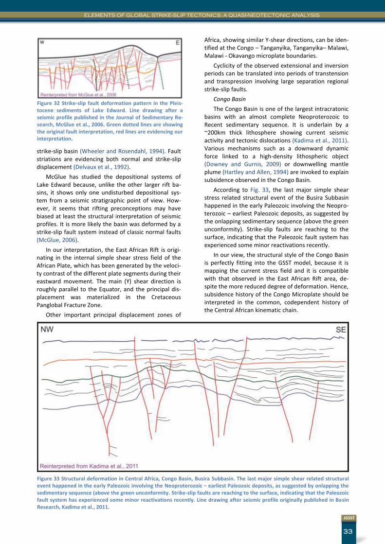
33
JGSST
ELEMENTS OF GLOBAL STRIKE-SLIP TECTONICS: A QUASI-NEOTECTONIC ANALYSIS
strike-slip basin (Wheeler and Rosendahl, 1994). Fault striations are evidencing both normal and strike-slip displacement (Delvaux et al., 1992).
McGlue has studied the depositional systems of Lake Edward because, unlike the other larger rift ba-sins, it shows only one undisturbed depositional sys-tem from a seismic stratigraphic point of view. How-ever, it seems that rifting preconceptions may have biased at least the structural interpretation of seismic profiles. It is more likely the basin was deformed by a strike-slip fault system instead of classic normal faults (McGlue, 2006).
In our interpretation, the East African Rift is origi-nating in the internal simple shear stress field of the African Plate, which has been generated by the veloci-ty contrast of the different plate segments during their eastward movement. The main (Y) shear direction is roughly parallel to the Equator, and the principal dis-placement was materialized in the Cretaceous Panglobal Fracture Zone.
Other important principal displacement zones of
Africa, showing similar Y-shear directions, can be iden-tified at the Congo – Tanganyika, Tanganyika– Malawi, Malawi - Okavango microplate boundaries.
Cyclicity of the observed extensional and inversion periods can be translated into periods of transtension and transpression involving large separation regional strike-slip faults.
Congo Basin
The Congo Basin is one of the largest intracratonic basins with an almost complete Neoproterozoic to Recent sedimentary sequence. It is underlain by a ~200km thick lithosphere showing current seismic activity and tectonic dislocations (Kadima et al., 2011). Various mechanisms such as a downward dynamic force linked to a high-density lithospheric object (Downey and Gurnis, 2009) or downwelling mantle plume (Hartley and Allen, 1994) are invoked to explain subsidence observed in the Congo Basin.
According to Fig. 33, the last major simple shear stress related structural event of the Busira Subbasin happened in the early Paleozoic involving the Neopro-terozoic – earliest Paleozoic deposits, as suggested by the onlapping sedimentary sequence (above the green unconformity). Strike-slip faults are reaching to the surface, indicating that the Paleozoic fault system has experienced some minor reactivations recently.
In our view, the structural style of the Congo Basin is perfectly fitting into the GSST model, because it is mapping the current stress field and it is compatible with that observed in the East African Rift area, de-spite the more reduced degree of deformation. Hence, subsidence history of the Congo Microplate should be interpreted in the common, codependent history of the Central African kinematic chain.
Figure 32 Strike-slip fault deformation pattern in the Pleis-tocene sediments of Lake Edward. Line drawing after a seismic profile published in the Journal of Sedimentary Re-search, McGlue et al., 2006. Green dotted lines are showing the original fault interpretation, red lines are evidencing our interpretation.
Figure 33 Structural deformation in Central Africa, Congo Basin, Busira Subbasin. The last major simple shear related structural event happened in the early Paleozoic involving the Neoproterozoic – earliest Paleozoic deposits, as suggested by onlapping the sedimentary sequence (above the green unconformity. Strike-slip faults are reaching to the surface, indicating that the Paleozoic fault system has experienced some minor reactivations recently. Line drawing after seismic profile originally published in Basin Research, Kadima et al., 2011.
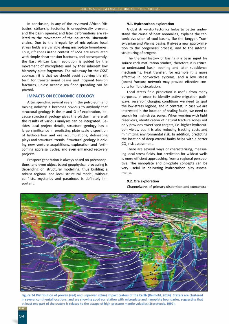
JOURNAL OF GLOBAL STRIKE-SLIP TECTONICS
34
JGSST
In conclusion, in any of the reviewed African 'rift basins' strike-slip tectonics is unequivocally present, and the basin opening and later deformations are re-lated to the movement of the equatorial kinematic chains. Due to the irregularity of microplates local stress fields are variable along microplate boundaries. Thus, rift zones in the context of GSST are assimilated with simple shear tension fractures, and consequently, the East African basin evolution is guided by the movement of microplates and by their inherent low hierarchy plate fragments. The takeaway for the GSST approach it is that we should avoid applying the rift term for transtensional basins and incipient tension fractures, unless oceanic sea floor spreading can be proved.
IMPACTS ON ECONOMIC GEOLOGY
After spending several years in the petroleum and mining industry it becomes obvious to anybody that structural geology is the α and Ω of exploration, be-cause structural geology gives the platform where all the results of various analyses can be integrated. Be-sides local project details, structural geology has a large significance in predicting plate scale disposition of hydrocarbon and ore accumulations, delineating plays and structural trends. Structural geology is driv-ing new venture acquisitions, exploration and forth-coming appraisal cycles, and even enhanced recovery projects.
Prospect generation is always based on preconcep-tions, and even object based geophysical processing is depending on structural modelling, thus building a robust regional and local structural model, without conflicts, mysteries and paradoxes is definitely im-portant.
9.1. Hydrocarbon exploration
Global strike-slip tectonics helps to better under-stand the cause of heat anomalies, explains the tec-tonic evolution of cool basins, like the Junggar, Tran-sylvanian and Vienna basins. It gives a new approxima-tion to the orogenesis process, and to the internal structuring of orogens.
The thermal history of basins is a basic input for source rock maturation studies; therefore it is critical to understand basin opening and later subsidence mechanisms. Heat transfer, for example it is more effective in convective systems, and a low stress (open) fracture network may provide effective con-duits for fluid circulation.
Local stress field prediction is useful from many purposes. In order to identify active migration path-ways, reservoir charging conditions we need to spot the low-stress regions, and in contrast, in case we are interested in the location of sealing faults, we need to search for high-stress zones. When working with tight reservoirs, identification of natural fracture zones not only provides sweet spot targets, i.e. higher hydrocar-bon yields, but it is also reducing fracking costs and minimizing environmental risk. In addition, predicting the location of deep crustal faults helps with a better CO2 risk assessment.
There are several ways of characterizing, measur-ing local stress fields, but prediction for wildcut wells is more efficient approaching from a regional perspec-tive. The nanoplate and pikoplate concepts can be very useful in delivering hydrocarbon play assess-ments.
9.2. Ore exploration
Channelways of primary dispersion and concentra-
Figure 34 Distribution of proven (red) and unproven (blue) impact craters of the Earth (Reimold, 2014). Craters are clustered in several continental locations, and are showing good correlation with microplate and nanoplate boundaries, suggesting that at least one part of the craters is related to the escape of high-pressure mantle volatiles (Storetvedt, 1997).
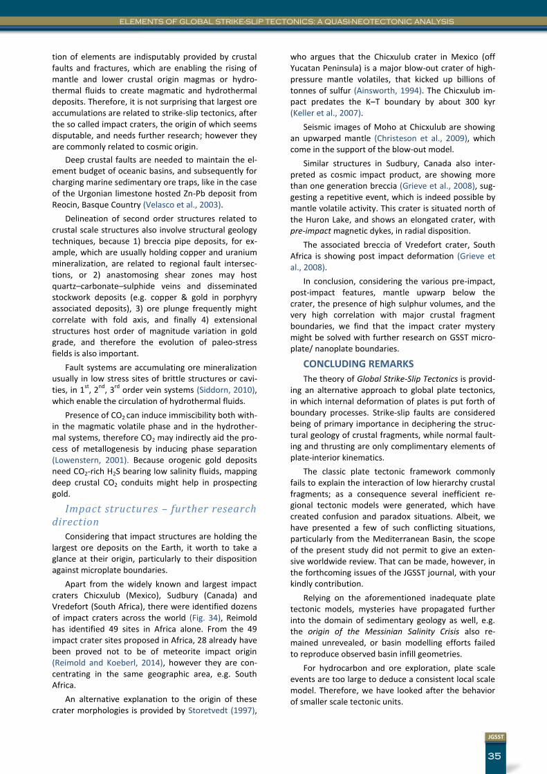
35
JGSST
ELEMENTS OF GLOBAL STRIKE-SLIP TECTONICS: A QUASI-NEOTECTONIC ANALYSIS
tion of elements are indisputably provided by crustal faults and fractures, which are enabling the rising of mantle and lower crustal origin magmas or hydro-thermal fluids to create magmatic and hydrothermal deposits. Therefore, it is not surprising that largest ore accumulations are related to strike-slip tectonics, after the so called impact craters, the origin of which seems disputable, and needs further research; however they are commonly related to cosmic origin.
Deep crustal faults are needed to maintain the el-ement budget of oceanic basins, and subsequently for charging marine sedimentary ore traps, like in the case of the Urgonian limestone hosted Zn-Pb deposit from Reocin, Basque Country (Velasco et al., 2003).
Delineation of second order structures related to crustal scale structures also involve structural geology techniques, because 1) breccia pipe deposits, for ex-ample, which are usually holding copper and uranium mineralization, are related to regional fault intersec-tions, or 2) anastomosing shear zones may host quartz–carbonate–sulphide veins and disseminated stockwork deposits (e.g. copper & gold in porphyry associated deposits), 3) ore plunge frequently might correlate with fold axis, and finally 4) extensional structures host order of magnitude variation in gold grade, and therefore the evolution of paleo-stress fields is also important.
Fault systems are accumulating ore mineralization usually in low stress sites of brittle structures or cavi-ties, in 1
st, 2
nd, 3
rd order vein systems (Siddorn, 2010),
which enable the circulation of hydrothermal fluids.
Presence of CO2 can induce immiscibility both with-in the magmatic volatile phase and in the hydrother-mal systems, therefore CO2 may indirectly aid the pro-cess of metallogenesis by inducing phase separation (Lowenstern, 2001). Because orogenic gold deposits need CO2-rich H2S bearing low salinity fluids, mapping deep crustal CO2 conduits might help in prospecting gold.
Impact structures – further research direction
Considering that impact structures are holding the largest ore deposits on the Earth, it worth to take a glance at their origin, particularly to their disposition against microplate boundaries.
Apart from the widely known and largest impact craters Chicxulub (Mexico), Sudbury (Canada) and Vredefort (South Africa), there were identified dozens of impact craters across the world (Fig. 34), Reimold has identified 49 sites in Africa alone. From the 49 impact crater sites proposed in Africa, 28 already have been proved not to be of meteorite impact origin (Reimold and Koeberl, 2014), however they are con-centrating in the same geographic area, e.g. South Africa.
An alternative explanation to the origin of these crater morphologies is provided by Storetvedt (1997),
who argues that the Chicxulub crater in Mexico (off Yucatan Peninsula) is a major blow-out crater of high-pressure mantle volatiles, that kicked up billions of tonnes of sulfur (Ainsworth, 1994). The Chicxulub im-pact predates the K–T boundary by about 300 kyr (Keller et al., 2007).
Seismic images of Moho at Chicxulub are showing an upwarped mantle (Christeson et al., 2009), which come in the support of the blow-out model.
Similar structures in Sudbury, Canada also inter-preted as cosmic impact product, are showing more than one generation breccia (Grieve et al., 2008), sug-gesting a repetitive event, which is indeed possible by mantle volatile activity. This crater is situated north of the Huron Lake, and shows an elongated crater, with pre-impact magnetic dykes, in radial disposition.
The associated breccia of Vredefort crater, South Africa is showing post impact deformation (Grieve et al., 2008).
In conclusion, considering the various pre-impact, post-impact features, mantle upwarp below the crater, the presence of high sulphur volumes, and the very high correlation with major crustal fragment boundaries, we find that the impact crater mystery might be solved with further research on GSST micro-plate/ nanoplate boundaries.
CONCLUDING REMARKS
The theory of Global Strike-Slip Tectonics is provid-ing an alternative approach to global plate tectonics, in which internal deformation of plates is put forth of boundary processes. Strike-slip faults are considered being of primary importance in deciphering the struc-tural geology of crustal fragments, while normal fault-ing and thrusting are only complimentary elements of plate-interior kinematics.
The classic plate tectonic framework commonly fails to explain the interaction of low hierarchy crustal fragments; as a consequence several inefficient re-gional tectonic models were generated, which have created confusion and paradox situations. Albeit, we have presented a few of such conflicting situations, particularly from the Mediterranean Basin, the scope of the present study did not permit to give an exten-sive worldwide review. That can be made, however, in the forthcoming issues of the JGSST journal, with your kindly contribution.
Relying on the aforementioned inadequate plate tectonic models, mysteries have propagated further into the domain of sedimentary geology as well, e.g. the origin of the Messinian Salinity Crisis also re-mained unrevealed, or basin modelling efforts failed to reproduce observed basin infill geometries.
For hydrocarbon and ore exploration, plate scale events are too large to deduce a consistent local scale model. Therefore, we have looked after the behavior of smaller scale tectonic units.
JOURNAL OF GLOBAL STRIKE-SLIP TECTONICS
36
JGSST
While approximating with a holistic approach and integrating several data types, as described in previous sections, we have discovered that established global plates can be broken down into low hierarchy crustal fragments, like nanoplates and pikoplates. These latter already can be readily used in the delineation of pro-spective trends and play assessment.
The concept of stress nodes was introduced to de-scribe the spatial clustering of earthquake epicenters, while the concept of extension nodes is localizing and gives explanation to regions of intraplate magmatism, all related to aspects of the regional stress fields.
We have emphasized the importance of simple shear stress fields in providing space management solutions for the low hierarchy crustal fragment inter-actions. Beyond that pikoplates and nanoplates are kinematically integrated into microplates, we have found that all low hierarchy elements are commonly integrated into kinematic chains, which can be made up of different oceanic and continental crustal frag-ments, occasionally linked by inactive rift segments. They are usually showing lateral kinematic constraints from the behalf of other kinematic chains, orchestrat-ed by the Coriolis force.
Like trains, kinematic chains perform a constant eastward drift towards their backstop, identified in the Jade Dragon – Smith Mp – Sunda Arc lineament. Be-hind this backstop lineament, crustal fragments are intensively deformed and broken into small and arcu-ate units. In this area, as suggested by earthquake clustering and a P-wave tomographic profile from northeastern Japan, crustal fragments are rather per-forming strike-slip overriding along steep master faults, than real subduction, and the same might apply for the Western Pacific 'subduction' zone. True sub-duction, where oceanic plate has a good chance to be recycled into the asthenosphere, is identified in the western margin of the American continents.
When contractional space problem occurs, oceanic crustal fragments either perform lateral duplexing like in the case of the Marquesas, Bismarck and Caribbean nanoplates, or may even override each-other, forming oceanic ridges (e.g. Laximi Ridge). Space problem in the continental domain is resolved in the similar way, by incipient various scale lateral duplexing, than verti-cal duplexing. Initial push-up ranges (proto-orogens) may advance into evolved orogens, like in the case of the Atlas Mountains, as proven by Ellero.
Herein, we have proposed the extension of Ellero’s model to the whole Tethys area, and gave a new defi-nition for orogenesis, in the GSST approach.
In addition to the review of the orogenesis and subduction concept, we have drawn preliminary con-clusions about the East African Rift strain patterns, as well. Selecting random rift zones from published arti-cles through the East African Rift area, strike-slip tec-tonics related faulting and deformation is as common as elsewhere in the world; however the magnitude of
fault-displacement rates appears to be smaller. Here in Eastern Africa, the role of tension fracture compo-nents is more relevant, and thus we prefer to interpret these continental rifts as microplate scale tension frac-tures. Because crustal thickness is much larger than elsewhere, structural deformation is slow, but still present along deep crustal faults, which either give birth to intraplate volcanism, or possibly produce punctual release of high-pressure mantle volatiles, as we have discussed in the impact crater related sec-tion.
ACKNOWLEDGEMENTS
We are grateful for NASA (SRTM), European Medi-terranean Seismological Centre (earthquake data-base), Max Planck Institute of Geochemistry Mainz (Georoc database), Google Earth, UNAVCO (GPS measurements) for sharing their database over the internet. ADX Energy (Perth) is thanked for providing a close seismic study opportunity on the onshore and offshore geology of Tunisia.
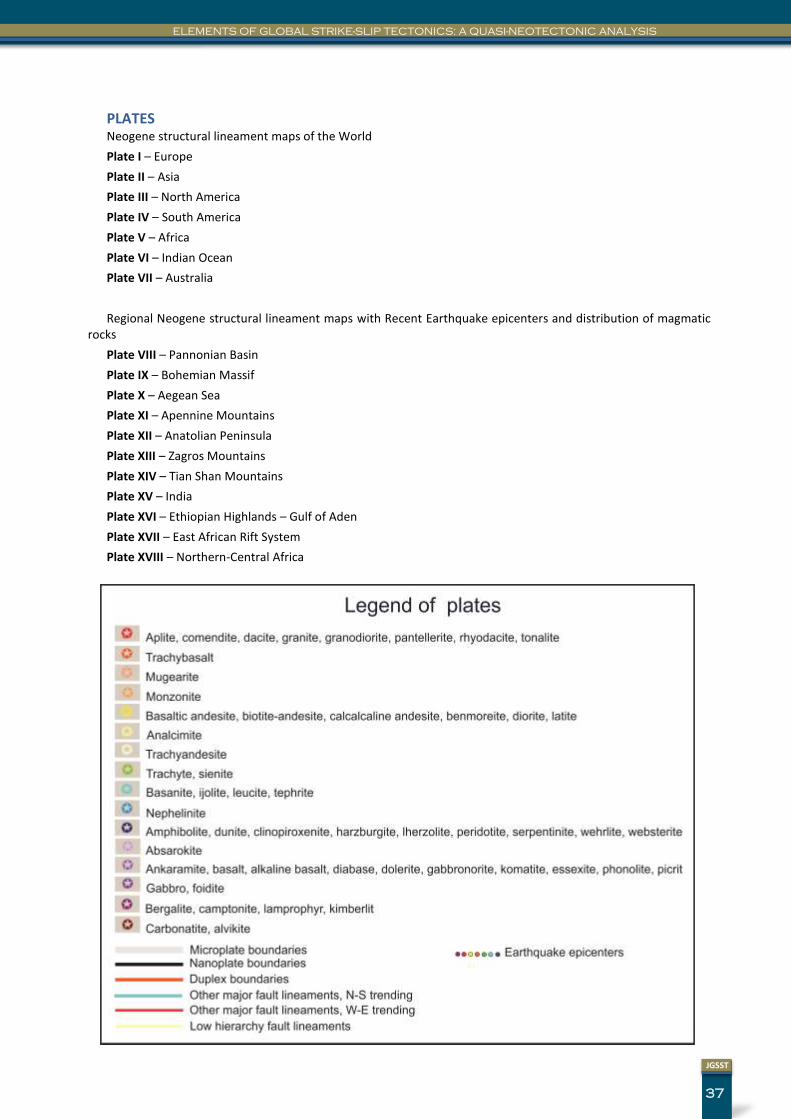
37
JGSST
ELEMENTS OF GLOBAL STRIKE-SLIP TECTONICS: A QUASI-NEOTECTONIC ANALYSIS
PLATES Neogene structural lineament maps of the World
Plate I – Europe
Plate II – Asia
Plate III – North America
Plate IV – South America
Plate V – Africa
Plate VI – Indian Ocean
Plate VII – Australia
Regional Neogene structural lineament maps with Recent Earthquake epicenters and distribution of magmatic rocks
Plate VIII – Pannonian Basin
Plate IX – Bohemian Massif
Plate X – Aegean Sea
Plate XI – Apennine Mountains
Plate XII – Anatolian Peninsula
Plate XIII – Zagros Mountains
Plate XIV – Tian Shan Mountains
Plate XV – India
Plate XVI – Ethiopian Highlands – Gulf of Aden
Plate XVII – East African Rift System
Plate XVIII – Northern-Central Africa