Tectonics and Structural Geology: Indian Context
460
Springer Geology Tectonics and Structural Geology: Indian Context Soumyajit Mukherjee Editor
-
Upload
khangminh22 -
Category
Documents
-
view
0 -
download
0
Transcript of Tectonics and Structural Geology: Indian Context
Springer Geology
Tectonics and Structural Geology: Indian Context
Soumyajit Mukherjee Editor

Springer Geology

The book series Springer Geology comprises a broad portfolio of scientific books,aiming at researchers, students, and everyone interested in geology. The seriesincludes peer-reviewed monographs, edited volumes, textbooks, and conferenceproceedings. It covers the entire research area of geology including, but not limitedto, economic geology, mineral resources, historical geology, quantitative geology,structural geology, geomorphology, paleontology, and sedimentology.
More information about this series at http://www.springer.com/series/10172

Soumyajit MukherjeeEditor
Tectonics and StructuralGeology: Indian Context
123
EditorSoumyajit MukherjeeDepartment of Earth SciencesIndian Institute of Technology BombayPowai, Mumbai, Maharashtra, India
ISSN 2197-9545 ISSN 2197-9553 (electronic)Springer GeologyISBN 978-3-319-99340-9 ISBN 978-3-319-99341-6 (eBook)https://doi.org/10.1007/978-3-319-99341-6
Library of Congress Control Number: 2018954602
© Springer Nature Switzerland AG 2019This work is subject to copyright. All rights are reserved by the Publisher, whether the whole or partof the material is concerned, specifically the rights of translation, reprinting, reuse of illustrations,recitation, broadcasting, reproduction on microfilms or in any other physical way, and transmissionor information storage and retrieval, electronic adaptation, computer software, or by similar or dissimilarmethodology now known or hereafter developed.The use of general descriptive names, registered names, trademarks, service marks, etc. in thispublication does not imply, even in the absence of a specific statement, that such names are exempt fromthe relevant protective laws and regulations and therefore free for general use.The publisher, the authors and the editors are safe to assume that the advice and information in thisbook are believed to be true and accurate at the date of publication. Neither the publisher nor theauthors or the editors give a warranty, express or implied, with respect to the material contained herein orfor any errors or omissions that may have been made. The publisher remains neutral with regard tojurisdictional claims in published maps and institutional affiliations.
This Springer imprint is published by the registered company Springer Nature Switzerland AGThe registered company address is: Gewerbestrasse 11, 6330 Cham, Switzerland
...geology contents in geological text booksfor compulsory education is not regularlyupdated, so new paradigms are includedbelatedly (as happened, e.g., with platetectonics), and this is one of the reasons whyyounger students lag behind in Geosciences.
—Brusi et al. (2016)
Brusi D, Calonge A, Souza E (2016)Textbooks: A tool to support geoscienceslearning. In: Vasconcelos C (ed) Geoscienceeducation: Indoor and outdoor. Springer,pp 173–206. ISBN: 978-3-319-43318-0.

Acknowledgements
Annett Buettener and Helen Ranchner (Springer) are thanked for handling thisbook proposal positively. The Springer proofreading team is acknowledged forsupport. I thank the authors and the reviewers for their participation. Thesis students,interns and visitors in the Geodynamics lab during 2017–2018: Narayan Bose,Dripta Dutta and Tarunkanti Das (IIT Bombay), Prof. Seema Singh and AjayKumar (Panjab University), Swagato Dasgupta (Haliburton), Troyee Dasgupta(Reliance Industries Limited),ChandanMajumdar (Schlumberger), Tuhin Biswas(ONGC),RajkumarGhosh (Geological Survey of India),Chanel Vidal (Iowa StateUniversity), Saber Idriss (University of SFax), Puja Banerjee (Institut De PhysiqueDu Globe De Paris), Ishiqua Agarwal (IIT Kharagpur), Naimisha Vanikand Haroon Saikh (MS University Baroda), Shiba Nikalje (St. Xavier’s College,Mumbai), Amey Dashputre and Renuka Kale (Fergusson College), RuchaKanchan and Samidha Shinde (Pune University), Lokesh Tayade (IISER Pune),Rohit Shaw, Madhurima Bose, Anuva Chowdhury and Jayesh Mukherjee(Presidency University, Kolkata) helped in various ways. A research sabbaticalprovided by IIT Bombay to me for the year 2017 helped much to edit this book.
Mumbai, India Soumyajit MukherjeeJune 2018 [email protected]
vii
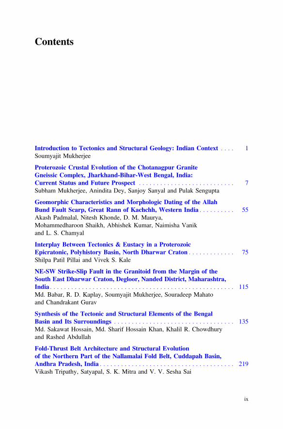
Contents
Introduction to Tectonics and Structural Geology: Indian Context . . . . 1Soumyajit Mukherjee
Proterozoic Crustal Evolution of the Chotanagpur GraniteGneissic Complex, Jharkhand-Bihar-West Bengal, India:Current Status and Future Prospect . . . . . . . . . . . . . . . . . . . . . . . . . . . 7Subham Mukherjee, Anindita Dey, Sanjoy Sanyal and Pulak Sengupta
Geomorphic Characteristics and Morphologic Dating of the AllahBund Fault Scarp, Great Rann of Kachchh, Western India . . . . . . . . . . 55Akash Padmalal, Nitesh Khonde, D. M. Maurya,Mohammedharoon Shaikh, Abhishek Kumar, Naimisha Vanikand L. S. Chamyal
Interplay Between Tectonics & Eustacy in a ProterozoicEpicratonic, Polyhistory Basin, North Dharwar Craton . . . . . . . . . . . . . 75Shilpa Patil Pillai and Vivek S. Kale
NE-SW Strike-Slip Fault in the Granitoid from the Margin of theSouth East Dharwar Craton, Degloor, Nanded District, Maharashtra,India . . . . . . . . . . . . . . . . . . . . . . . . . . . . . . . . . . . . . . . . . . . . . . . . . . . . 115Md. Babar, R. D. Kaplay, Soumyajit Mukherjee, Souradeep Mahatoand Chandrakant Gurav
Synthesis of the Tectonic and Structural Elements of the BengalBasin and Its Surroundings . . . . . . . . . . . . . . . . . . . . . . . . . . . . . . . . . . 135Md. Sakawat Hossain, Md. Sharif Hossain Khan, Khalil R. Chowdhuryand Rashed Abdullah
Fold-Thrust Belt Architecture and Structural Evolutionof the Northern Part of the Nallamalai Fold Belt, Cuddapah Basin,Andhra Pradesh, India . . . . . . . . . . . . . . . . . . . . . . . . . . . . . . . . . . . . . . 219Vikash Tripathy, Satyapal, S. K. Mitra and V. V. Sesha Sai
ix

Tectonic History of the Granitoids and Kadiri Schist Beltin the SW of Cuddapah Basin, Andhra Pradesh, India . . . . . . . . . . . . . 253Sukanta Goswami and P. K. Upadhyay
Basement Tectonics and Shear Zones in Cauvery Basin (India):Implications in Hydrocarbon Exploration . . . . . . . . . . . . . . . . . . . . . . . 279S. Mazumder, Blecy Tep, K. K. S. Pangtey and D. S. Mitra
Implication of Transfer Zones in Rift Fault Propagation:Example from Cauvery Basin, Indian East Coast . . . . . . . . . . . . . . . . . 313Swagato Dasgupta
Remote Sensing, Structural and Rock Magnetic Analysesof the Ramgarh Structure of SE Rajasthan, Central India-FurtherClues to Its Impact Origin and Time of Genesis . . . . . . . . . . . . . . . . . . 327Saumitra Misra, Pankaj Kumar Srivastava and Md. Arif
Geology, Structural Architecture and Tectonic Frameworkof the Rocks of Southern Lalitpur District Uttar Pradesh, India:An Epitome of the Indian Peninsular Shield . . . . . . . . . . . . . . . . . . . . . 353G. K. Dinkar, A. R. Bhattacharya, A. K. Verma and Pankaj Sharma
Deformation in the Kangra Reentrant, Himachal Pradeshof NW-Sub Himalaya of India: A Paradox . . . . . . . . . . . . . . . . . . . . . . 381Tejpal Singh and A. K. Awasthi
Impact of Structural Damage Zones on Slope Stability:A Case Study from Mandakini Valley, Uttarakhand State (India) . . . . . 397Mohit Kumar, Ramesh Chander Joshi and Pitamber Dutt Pant
Documentation of Brittle Structures (Back Shear and Arc-ParallelShear) from Sategal and Dhanaulti Regions of the Garhwal LesserHimalaya (Uttarakhand, India) . . . . . . . . . . . . . . . . . . . . . . . . . . . . . . . 411Souradeep Mahato, Soumyajit Mukherjee and Narayan Bose
Field Structural Geological Studies Around Kurseong,Darjeeling-Sikkim Himalaya, India . . . . . . . . . . . . . . . . . . . . . . . . . . . . 425Saikat Banerjee, Narayan Bose and Soumyajit Mukherjee
Pb—Isotopic Characterization of Major Indian Gondwana Coalfields:Implications for Environmental Fingerprinting and GondwanaReconstruction . . . . . . . . . . . . . . . . . . . . . . . . . . . . . . . . . . . . . . . . . . . . 441Rajeev Kumar, Joy Gopal Ghosh, S. S. Patel, Avijit Das, S. Sengupta,K. V. S. S. Krishna and D. Guha
x Contents
Introduction to Tectonics and StructuralGeology: Indian Context
Soumyajit Mukherjee
1 Summary of Different Chapters
Tectonics and structural geology of Indian terrain is of great interest to theGovernment and a number of private exploration agencies that are working pre-sently. This edited volume aims to meet this requirement. In addition, B.Sc. and M.Sc. geoscience students undergoing geohistory and/or tectonic courses wouldbenefit using this book.
This edited volume brings 16 research papers (Chaps. 2–17) from both academiaand industry.
Mukherjee et al. (2019) in Chap. 2 present an exhaustive review on the geologyand the geochronology and of the Chotanagpur Granite Gneissic Complex (CGGC).They classify the CGGC into three domains, and also comment on theIndia-Antarctica reconstruction.
Padmalal et al. (2019) in Chap. 3 perform morphologic dating of the seismo-genic Allah Bund Fault scarp as 208, 200, and 193 yrs B.P. These dates establishreliably that those scarps were produced by the 1819 earthquake.
Patil Pillai and Kale (2019) in Chap. 4 detail the sedimentation and the tectonichistories of the Kaladgi Purana (Proterozoic) basin. The basin in the first stageunderwent sagging. A nested continental sag basin formed afterward.
Babar et al. (2019) in Chap. 5 describe with several field photographs thedeformation features near the basement granites around Degloor (Maharashtra).They work out the stress regime and the stress axes orientations. One can comparethese findings with the Deccan tectonics as well by going through Misra et al.(2014, 2015), Misra and Mukherjee (2015, 2017), etc.
S. Mukherjee (&)Department of Earth Sciences, Indian Institute of Technology Bombay, Powai, Mumbai400076, Maharashtra, Indiae-mail: [email protected]; [email protected]
© Springer Nature Switzerland AG 2019S. Mukherjee (ed.), Tectonics and Structural Geology: Indian Context,Springer Geology, https://doi.org/10.1007/978-3-319-99341-6_1
1
In their very detailed review on the Bengal basin, Hossain et al. (2019) inChap. 6 present the basic division of this basin, fault distribution, and how thesedivisions evolved temporally with or without volcanism.
Goswami and Upadhyay (2019) in Chap. 7 study the structural geology andgeochemistry of the Kadiri schist belt (Cuddapah) and decipher an ocean-continentsubduction tectonics and a volcanic arc setting of the terrain.
Detailed field investigation of the structural geology of the Nallamalai Fold Belt(Cuddapah) by Tripathy et al. (2019) in Chap. 8 reveals a Pan-African thin-skinnedtectonics, which link with the tectonics of the East Gondwana fragments.
Multi disciplinary geoscientific studies by Mazumder et al. (2019) in Chap. 9reveal that a number of E trending steeply dipping shear zones pass through thenorthern part of the Cauvery Basin that was later reactivated.
Dasgupta (2019) in Chap. 10 reviews the Cauvery basin’s tectonics. Half gra-bens in its all the three sub basins signify a rift origin of the basin. This articleanalyzes the transfer zone geometries from the Cauvery basin that are crucial indeveloping hydrocarbon trap conditions.
Misra et al. (2019) in Chap. 11 study the field structural geology of the Ramgarhimpact structure (SE Rajasthan), and especially its fracture patterns. They concludethat impacting happened at the palaeo-channel of the river Parvati.
Dinkar et al. (2019) in Chap. 12 describe in detail field structural geology fromthe Lalitpur district (Uttar Pradesh). The notable information are E/ENE trendingaxial traces and Proterozoic to Neoproterozoic reactivation plausible in the southernpart of the study area.
Singh and Awasthi (2019) in Chap. 13 discuss the tectonics of the Kangra region(Himachal Pradesh), which is presumably devoid of any weak layer below itself.Overpressure condition at depth possibly due to fluid activity had helped topropagate this crustal wedge towards the foreland side.
Kumar et al. (2019a) in Chap. 14 describe from the field along with attractivephotographs the damage zone associated with the Munsiari Thrust, a strand of theMain Central Thrust, from the Mandakini river section, Higher Himalaya. Theauthors document more landslides from the damage zone and perform engineeringgeological studies from such zones.
Mahato et al. (2019) in Chap. 15 perform detailed field studies from theMussoorie syncline and the nearby regions from the Uttarakhand Lesser Himalaya.Top-to-N/NE back shear and Himalayan arc-parallel shears (such as top-to-NW) arethe new meso scale findings in this work.
Banerjee et al. (2019) in Chap. 16 too document orogen-parallel shear from theDarjeeling Group of rocks from the Sikkim Lesser Himalaya. A more detail workfrom the same research group has been submitted in a journal where such defor-mation is reported from the Siwalik Himalaya (Dutta et al. submitted).
Kumar et al. (2019b) in Chap. 17 discuss the database of lead (Pb) content in theIndian Gondwana coal (207Pb/206 Pb = 0.7150–0.8845; 208Pb/206 Pb = 1.9484–2.2231; Pb concentration = 3.2–566 mg kg−1). This study will have a far-reachingimplication in India-Antarctica plate reconstruction.
2 S. Mukherjee

Readers without any instructors, especially students (in some unfortunate cases),are requested to go through few recent books on structural geological and tectonicprinciples and Indian case studies (e.g., Sharma 2010; Mukherjee 2013a, b, 2014,2015a, b; Mukherjee et al. 2017; Mukherjee and Mulchrone 2015; Mukherjee et al.2015, 2017; Valdiya 2016; Bose and Mukherjee 2017; Dasgupta and Mukherjee2017; Chetty 2018; Misra and Mukherjee 2018; Roy and Purohit 2018; Acharyya,in press) before going through this book.
Refer this book as follows:
• Mukherjee S (2019) Tectonics and Structural Geology: Indian Context.Springer International Publishing AG, Cham. ISBN 978-3-319-99340-9.pp. 1–455.
Refer individual chapters of this book as follows:
• Banerjee S, Bose N, Mukherjee S (2019) Field structural geological studiesaround Kurseong, Darjeeling-Sikkim Himalaya, India. In: Mukherjee S(ed) Tectonics and Structural Geology: Indian context. Springer InternationalPublishing AG, Cham. ISBN 978-3-319-99340-9. pp. 425–440.
References
Acharyya SK (in press) Tectonic setting and Gondwana Basin architecture in the Indian Shield. In:Mukherjee S (eds) Developments in structural geology and tectonics. Elsevier.ISBN: 978-0-12-815218-8
Babar MD, Kaplay RD, Mukherjee S, Mahato S, Gurav C (2019) NE-SW strike-slip fault in thegranitoid from the margin of the South East Dharwar Craton, Degloor, Nanded district,Maharashtra, India. In: Mukherjee S (ed) Tectonics and structural geology: Indian context.Springer International Publishing AG, Cham, pp 115–134. ISBN 978-3-319-99340-9
Banerjee S, Bose N, Mukherjee S (2019) Field structural geological studies around Kurseong,Darjeeling-Sikkim Himalaya, India. In: Mukherjee S (ed) Tectonics and structural geology:Indian context. Springer International Publishing AG, Cham, pp 425–440. ISBN978-3-319-99340-9
Bose N, Mukherjee S (2017) Map interpretation for structural geologists. In: Mukherjee S(ed) Developments in structural geology and tectonics. Elsevier, Amsterdam. ISBN:978-0-12-809681-9. ISSN: 2542-9000
Chetty TRK (2018) Proterozic orogens of India: a critical Window to Gondwana. Elsevier,Amsterdam. ISBN: 9780128044414
Dasgupta S (2019) Implication of transfer zones in rift fault propagation: example from Cauverybasin, Indian east coast. In: Mukherjee S (ed) Tectonics and structural geology: Indiancontexts. Springer International Publishing AG, Cham, pp 313–326. ISBN 978-3-319-99340-9
Dasgupta S, Mukherjee S (2017) Brittle shear tectonics in a narrow continental rift: asymmetricnon-volcanic Barmer basin (Rajasthan, India). The Journal of Geology 125, 561–591
Dinkar GK, Bhattacharya AR, Verma AK, Sharma P (2019) Geology, structural architecture andtectonic framework of the rocks of Southern Lalitpur District, Uttar Pradesh, India: an epitomeof the Indian Peninsular Shield. In: Mukherjee S (ed) Tectonics and structural geology: Indiancontext. Springer International Publishing AG, Cham, pp 353–379. ISBN 978-3-319-99340-9
Introduction 3
Dutta D, Biswas T, Mukherjee S (Submitted) Orogen-parallel compression in NW Himalaya:evidence from structural and paleostress studies of brittle deformation from the pebbles ofUpper Siwalik conglomerates, Uttarakhand, India. Journal of Earth System Science
Goswami S, Upadhyay PK (2019) Tectonic history of the granitoids and Kadiri schist belt in theSW of Cuddapah basin, Andhra Pradesh, India. Tectonic history of the granitoids and Kadirischist belt in the SW of Cuddapah basin, Andhra Pradesh, India. In: Mukherjee S(ed) Tectonics and structural geology: Indian context. Springer International Publishing AG,Cham, pp 253–278. ISBN 978-3-319-99340-9
Hossain MS, Khan MSH, Chowdhury KR, Abdullah R (2019) Synthesis of the tectonic andstructural elements of the Bengal Basin and its surroundings. In: Mukherjee S (ed) Tectonicsand structural geology: Indian context. Springer International Publishing AG, Cham, pp 135–218. ISBN 978-3-319-99340-9
Kumar M, Joshi RC, Dutt Pant P (2019a) Impact of structural damage zones on slope stability: acase study from Mandakini Valley, Uttarakhand state (India). In: Mukherjee S (ed) Tectonicsand structural geology: Indian context. Springer International Publishing AG, Cham, pp 397–410. ISBN 978-3-319-99340-9
Kumar R, Ghosh JG, Patel SS, Das A, Sengupta S, Krishna KVSS, Guha D (2019b) Pb—isotopiccharacterization of major Indian Gondwana Coalfields: implications for environmentalfingerprinting and Gondwana reconstruction. In: Mukherjee S (ed) Tectonics and structuralgeology: Indian context. Springer International Publishing AG, Cham, pp 441–455. ISBN978-3-319-99340-9
Mahato S, Mukherjee S, Bose N (2019) Documentation of brittle structures (back shear andarc-parallel shear) from Sategal and Dhanaulti regions of the Garhwal Lesser Himalaya(Uttarakhand, India). In: Mukherjee S (ed) Tectonics and structural geology: Indian context.Springer International Publishing AG, Cham, pp 411–423. ISBN 978-3-319-99340-9
Mazumder S, Tep B, Pangtey KKS, Mitra DS (2019) Basement tectonics and shear zones inCauvery Basin (India): implications in hydrocarbon exploration. In: Mukherjee S(ed) Tectonics and structural geology: Indian context. Springer International Publishing AG,Cham, pp 279–311. ISBN 978-3-319-99340-9
Misra AA, Bhattacharya G, Mukherjee S, Bose N (2014) Near N-S paleo-extension in the westernDeccan region in India: Does it link strike-slip tectonics with India-Seychelles rifting?International Journal of Earth Sciences 103:1645–1680
Misra AA, Mukherjee S (2015) Tectonic inheritance in continental rifts and passive margins.Springer Briefs in Earth Sciences. ISBN 978-3-319-20576-2
Misra AA, Mukherjee S (2017) Dyke-brittle shear relationships in the Western Deccan Strike SlipZone around Mumbai (Maharashtra, India). In: Mukherjee S, Misra AA, Calvès G, Nemčok M(eds) Tectonics of the Deccan large igneous province. Geological Society, London, pp 269–295 (Special Publications 445)
Misra AA, Mukherjee S (2018) Atlas of structural geological interpretation from seismic images.Wiley Blackwell. ISBN: 978-1-119-15832-5
Misra AA, Sinha N, Mukherjee S (2015) Repeat ridge jumps and microcontinent separation:insights from NE Arabian Sea. Marine and Petroleum Geology 59, 406–428
Misra S, Srivastava PK, Arif MD (2019) Remote sensing, structural and rock magnetic analyses ofthe Ramgarh structure of SE Rajasthan, Central India—further clues to its impact origin andtime of genesis. In: Mukherjee S (ed) Tectonics and structural geology: Indian context.Springer International Publishing AG, Cham, pp 327–352. ISBN 978-3-319-99340-9
Mukherjee S (2013a) Channel flow extrusion model to constrain dynamic viscosity and Prandtlnumber of the Higher Himalayan Shear Zone. International Journal of Earth Sciences 102,1811–1835
Mukherjee S (2013b) Deformation microstructures in rocks. Springer Geochemistry/Mineralogy,Berlin, pp 1–111. ISBN 978-3-642-25608-0
Mukherjee S (2014) Atlas of shear zone structures in meso-scale. Springer Geology, Cham, pp 1–124. ISBN 978-3-319-0088-6
4 S. Mukherjee
Mukherjee S (2015a) Petroleum geosciences: Indian contexts. Springer Geology. ISBN978-3-319-03119-4
Mukherjee S (2015b) Atlas of structural geology. Elsevier, Amsterdam. ISBN 978-0-12-420152-1Mukherjee S, Mulchrone KF (2015) Ductile shear zones: from micro-to macro-scales. Wiley
Blackwell. ISBN: 978-1-118-84496-0Mukherjee S, Carosi R, van der Beek PA, Mukherjee BK, Robinson DM (2015) Tectonics of the
Himalaya: an introduction. In: Mukherjee S, Carosi R, van der Beek P, Mukherjee BK,Robinson D (eds) Geological Society, London, pp 1–3. ISBN 978-1-86239-703-3. ISSN0305-8719 (Special Publications 412)
Mukherjee S, Misra AA, Calvès G, Nemčok M (2017) Tectonics of the Deccan large igneousprovince: an introduction. In: Mukherjee S, Misra AA, Calvès G, Nemčok M (eds) Tectonicsof the Deccan large igneous province. Geological Society, London, pp. 1–9 (SpecialPublications 445)
Mukherjee S, Dey A, Sanyal S, Sengupta P (2019) Proterozoic crustal evolution of theChotanagpur Granite Gneissic complex, Jharkhand-Bihar-West Bengal, India: current statusand future prospect. In: Mukherjee S (ed) Tectonics and structural geology: Indian context.Springer International Publishing AG, Cham, pp 7–54. ISBN 978-3-319-99340-9
Padmalal A, Khonde N, Maurya DM, Shaikh M, Kumar A, Vanik N, Chamyal LS (2019)Geomorphic characteristics and morphologic dating of the Allah Bund Fault scarp, Great Rannof Kachchh, Western India. In: Mukherjee S (ed) Tectonics and structural geology: Indiancontext. Springer International Publishing AG, Cham, pp 55–74. ISBN 978-3-319-99340-9
Pillai SP, Kale VS (2019) Interplay between tectonics & eustasy in a Proterozoic epicratonic,polyhistoric basin: Kaladgi basin: North Dharwar craton. In: Mukherjee S (ed) Tectonics andstructural geology: Indian context. Springer International Publishing AG, Cham, pp 75–114.ISBN 978-3-319-99340-9
Roy AB, Purohit R (2018) Indian shield: Precambrian evolution and Phanerozoic reconstitution.Elsevier, Amsterdam. ISBN: 9780128098394
Sharma RS (2010) Cratons and fold belts of India. Springer, Berlin. ISBN: 978-3-642-01459-8Singh T, Awasthi AK (2019) Deformation in the Kangra Reentrant, Himachal Pradesh of NW-Sub
Himalaya of India: a paradox. In: Mukherjee S (ed) Tectonics and structural geology: Indiancontext. Springer International Publishing AG, Cham, pp 381–396. ISBN 978-3-319-99340-9
Tripathy V, Satyapal, Mitra SK, Sai BBS (2019) Fold-thrust belt architecture and structuralevolution of the Northern part of the Nallamalai Fold Belt, Cuddapah basin, Andhra Pradesh,India. In: Mukherjee S (ed) Tectonics and structural geology: Indian context. SpringerInternational Publishing AG, Cham, pp 219–252. ISBN 978-3-319-99340-9
Valdiya KS (2016) The making of India, 2nd edn. Springer, Berlin. ISBN: 978-3-319-25029-8
Introduction 5
Proterozoic Crustal Evolutionof the Chotanagpur Granite GneissicComplex, Jharkhand-Bihar-WestBengal, India: Current Statusand Future Prospect
SubhamMukherjee, Anindita Dey, Sanjoy Sanyal and Pulak Sengupta
1 Introduction
We presently believe that the continental crust grew episodically and that smallercontinents were united and disintegrated several times in the past *4000 Ma(Hoffmann 1989; Rogers 1996). This process of plate jostling and its subsequentdestruction, commonly termed as ‘supercontinental cycle’, eventually controls theharmonic interactions among lithosphere, hydrosphere and atmosphere over geo-logical time (Worsley et al. 1985, 1986; Piper 2013). The antiquity and thepetrological diversity of the rocks in the Indian shield offer unique opportunity toconfigure the supercontinents that existed in the geological past (Acharyya 2003;Meert et al. 2010). One of the outstanding and hotly debated problems is theposition of the Indian shield in the proposed Precambrian supercontinents in generaland timing of suturing of India and east Antarctica in particular (Torsvik et al. 2001;Dasgupta and Sengupta 2003; Pisarevsky et al. 2003; Bhowmik et al. 2012). Withregard to the latter, two competing views exist. One view is India and Antarcticawere united at least from *1000 Ma (Hoffmann 1989; Dalziel 1991; Li et al.2008). The disclaimers of this view propose that the two continents got juxtaposednot earlier than *900 Ma (Bhowmik et al. 2012) if not after *750 Ma (Merdithet al. 2017; Torsvik et al. 2001). In the reconstructed Rodinia, a Proterozoicsupercontinent, the CGGC and the Eastern Ghats Mobile Belt juxtaposed againstthe east Antarctic Precambrian basement (Dasgupta and Sengupta 2003; Chatterjeeet al. 2010; Mukherjee et al. 2017a). Therefore, rocks of these two areas of theIndian shield are likely to provide the clinching evidence about the timing ofIndo-Antarctic suturing.
Till the end of twentieth century, limited petrological information and rudi-mentary geochronological data were available from the CGGC that is positioned
S. Mukherjee � A. Dey � S. Sanyal � P. Sengupta (&)Department of Geological Sciences, Jadavpur University, Kolkata 700032, Indiae-mail: [email protected]
© Springer Nature Switzerland AG 2019S. Mukherjee (ed.), Tectonics and Structural Geology: Indian Context,Springer Geology, https://doi.org/10.1007/978-3-319-99341-6_2
7

against the Precambrian Vestfold block of east Antarctica in the reconstructedRodinia (Fig. 1). In the past one decade several studies in the light of modernpetrology and robust geochronology have been published. In this work we havereviewed the published information on the CGGC with the following aims:
(1) To establish an event stratigraphy showing the magmatic and tectonic pulsesthat shaped the rocks of the CGGC during the Precambrian Era
(2) Comparisons of the thermo-tectonic pulses that are recorded in the CGGC withthe adjoining crustal domains in the Indian shield
(3) Influence of the Precambrian supercontinental cycles on the CGGC(4) Timing of amalgamation of the Indo-Antarctic landmasses(5) To delineate the gaps in knowledge and scope of future study.
2 Extent and the Boundary Relations
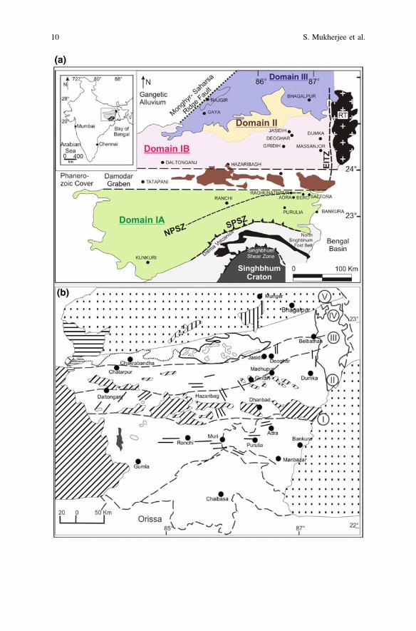
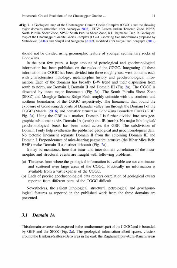
The CGGC is an east-west trending mobile belt that belongs to the east IndianShield and is exposed across the states of Jharkhand, Bihar, West Bengal andChhattisgarh covering an area of over 100,000 km2 (reviewed in Mahadevan 2002;Acharyya 2003). The northern margin of the CGGC is covered by quaternarysediments of Gangetic alluvium (Fig. 2a). Sediments of the Bengal Basin mark theeastern boundary of the terrain and Mesozoic volcanics of Rajmahal Trap coversthe northeastern fringe of the terrain. The western margin of CGGC is dominantlycovered by Gondwana deposits of Permian to mid-Cretaceous age (Mahadevan2002). However, in the northwestern part Vindhyan sediments and the Mahakoshalgroup of rocks are in contact with the Proterozoic rocks of the CGGC. Towards thesouth the contact between CGGC and Proterozoic rocks of the North SinghbhumFold Belt (NSFB) is marked by the east-west trending crustal scale shear zonecalled the South Purulia Shear Zone (SPSZ) or the Tamar-Porapahar-Khatra Shearzone.
3 Classification of the CGGC on the Basis of ExtantPetrological and Geochronological Data
Scarcity of detail petrological, lithological and geochronological data is the majorhindrance for a reasonable classification of the CGGC. Scattered distribution ofexposures, owing to tropical weathering and urbanization, further complicate theproblem. In earlier studies (Mahadevan 2002; Sanyal and Sengupta 2012), the CGGCwere divided into five N-S blocks (Fig. 2b). They considered the Chotanagpur pla-teau and the Gondwana deposits (Permian-mid Cretaceous) as the basis of classifi-cation. The authors of this communication are of the view that Precambrian CGGC
8 S. Mukherjee et al.
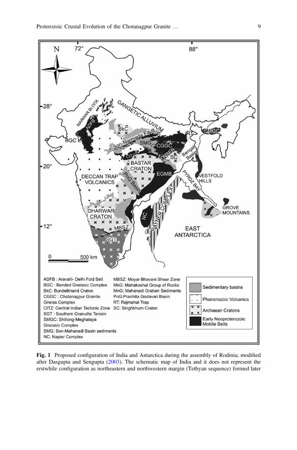
Fig. 1 Proposed configuration of India and Antarctica during the assembly of Rodinia; modifiedafter Dasgupta and Sengupta (2003). The schematic map of India and it does not represent theerstwhile configuration as northeastern and northwestern margin (Tethyan sequence) formed later
Proterozoic Crustal Evolution of the Chotanagpur Granite … 9
10 S. Mukherjee et al.
should not be divided using geomorphic feature of younger sedimentary rocks ofGondwana.
In the past few years, a large amount of petrological and geochronologicalinformation has been published on the rocks of the CGGC. Integrating all theseinformation the CGGC has been divided into three roughly east-west domains eachwith characteristics lithology, metamorphic history and geochronological infor-mation. Each of the domains has broadly E-W trend and their disposition fromsouth to north, are Domain I, Domain II and Domain III (Fig. 2a). The CGGC isdissected by three major lineaments (Fig. 2a). The South Purulia Shear Zone(SPSZ) and Monghyr-Saharsa Ridge Fault roughly coincide with the southern andnorthern boundaries of the CGGC respectively. The lineament, that bound theexposure of Gondwana deposits of Damudar valley run through the Domain I of theCGGC (Mandal 2016) and hereafter termed as Gondwana Boundary Faults (GBF;Fig. 2a). Using the GBF as a marker, Domain I is further divided into two geo-graphic sub-domains viz. Domain IA (south) and IB (north). No major lithological/geochronological break has been noted across the GBF. The subdivision ofDomain I only help synthesize the published geological and geochronological data.No tectonic lineament separate Domain II from the adjoining Domain III andDomain I. Preponderance of mica-bearing pegmatite intrusive (the Bihar Mica Belt;BMB) make Domain II a distinct lithounit (Fig. 2a).
It may be mentioned here that intra- and inter-domain correlation of the meta-morphic and structural events are fraught with following problems:
(a) The areas from where the geological information is available are not continuousand scattered over large areas of the CGGC. Practically no information isavailable from a vast expanse of the CGGC.
(b) Lack of precise geochronological data renders correlation of geological eventsreported from different parts of the CGGC difficult.
Nevertheless, the salient lithological, structural, petrological and geochrono-logical features as reported in the published work from the three domains arepresented.
3.1 Domain IA
This domain covers rocks exposed in the southernmost part of theCGGCand is boundedby GBF and the SPSZ (Fig. 2a). The geological information albeit sparse, clustersaround the Bankura-Saltora-Bero area in the east, the Raghunathpur-Adra-Ranchi areas
JFig. 2 a Geological map of the Chotanagpur Granite Gneiss Complex (CGGC) and the showingmajor domains (modified after Acharyya 2003). EITZ: Eastern Indian Tectonic Zone, NPSZ:North Purulia Shear Zone, SPSZ: South Purulia Shear Zone, RT: Rajmahal Trap. b Geologicalmap of the Chotanagpur Granite Gneiss Complex (CGGC) showing five subdivisions proposed byMahadevan (2002) and Sanyal and Sengupta (2012), modified after Sanyal and Sengupta (2012)
Proterozoic Crustal Evolution of the Chotanagpur Granite … 11
in the central part andRaikera-Kunkuri region in thewesternpart of thedomain (Fig. 2a).Petrology andgeochronologyof the rocks exposedaroundBankura-Saltora-Bero—havebeen extensively studied by several workers (Manna and Sen 1974; Roy 1977;Bhattacharyya andMukherjee 1987; Sen andBhattacharya 1993;Mukherjee et al. 2005;Chatterjee et al. 2008;Maji et al. 2008), which reveals that variably deformedmigmatiticfelsic orthogneisses, holding dismembered rafts of mafic granulite and calc-silicategneisses is the dominant rocktype intruded by massif type anorthositic rocks (Bengalanorthosite). Metamorphic grade varies from amphibolite to granulite grade conditions.Documentationofgranulite and amphibolite facies rocksmostly coming from the easternand the western part of the domain respectively (Karmaker et al. 2011; Goswami andBhattacharya 2010, 2013; Maji et al. 2008; Chatterjee et al. 2008; Sanyal and Sengupta2012).However thepublished informationdoesnot support any systemicvariation in theestimated metamorphic conditions along any geographic direction. The rocks in thisregion are folded to east-west closing folds and an E-W trending axial planar fabricdipping steeply towards north (Maji et al. 2008).
In the easternmost parts, near Bero-Saltora-Santuri, high grade metapelitic rocksand migmatitic quartzofeldspathic rocks are exposed. Three deformation (D1-3)phases accompanied by four metamorphic events (M1-4) have been inferred fromthe area by Maji et al. (2008). Earliest tectonothermal event (M1), considered to beof granulite grade (minimum P–T estimates of 5–6 kbar and 750–850 °C), pro-duced the migmatitic banding of the orthogneisses (S1) (Sen and Bhattacharya1993; Maji et al. 2008) and occurred at ca. 1.70 Ga, inferred from chemical datingof monazite (Chatterjee et al. 2010). Both the subsequent deformations (D2-3)occurred under amphibolite facies (M2-3) between 1.3 and 1.1 Ga and replaces theolder granulite mineralogy to variable extant (Maji et al. 2008). Towards the easternfringe of the domain, near Saltora (West Bengal) (Fig. 2a) intrusion of massifanorthosite, called the Bengal anorthosite, occurred at ca. 1.55 Ga between the D1
and D2 (Bhattacharyya and Mukherjee 1987; Chatterjee et al. 2008; Maji et al.2008). The most pervasive metamorphic event is inferred to have occurred between1.0 and 0.95 Ga, that has been designated as M4 by Maji et al. (2008). However theP–T conditions of the event is debated. Maji et al.(2008) inferred that the meta-moprhism culminated at 650 ± 50 °C at 4–5 kbar whereas Chatterjee et al. (2008)recovered a high grade conditions (850–900 °C and 8.5–11 kbar) from gabbroanorthositic rocks. Near Kankarkiari (West Bengal), migmatitic felsic orthogneisseshas been intruded by nepheline-bearing syenite and subsequently got deformed andmetamorphosed (Das et al. 2016; Goswami and Bhattacharyya 2010). Nogeochronological data is available to constrain this tectonothermal event experi-enced by the syenitic rocks. However, field observations suggest that they haveintruded after the Grenvillian metamorphic event and subsequently got deformedand metamorphosed under amphibolite grade yielding a P–T condition of700–750 °C and *10 kbar, associated with development of foliation and folding(Das et al. 2016). Younger Neoproterozoic ages (ca. 900–820 Ma) recovered fromthe overgrowths on older monazite grains have been documented by several
12 S. Mukherjee et al.
workers (Maji et al. 2008; Chatterjee et al. 2010), which further attest for the LateTonian–Early Cryogenian tectonothermal event. One of the source of heating couldbe deformation itself (Mukherjee and Mulchrone 2013; Mulchrone and Mukherjee2015, 2016; Mukherjee 2017).
The area around Raghunathpur (West Bengal), west of Bero, reveals anensemble of different generations of felsic orthogneisses (porphyritic and deformedgranitoids), metapelitic and calcareous enclaves (Dunn 1929; Baidya et al. 1987,1989; Ray Barman and Bishui 1994; Goswami and Bhattacharyya 2010, 2013;Karmakar et al. 2011). Three major deformational events (D1-D3) have beenidentified from the area associated with two major metamorphic phases (M1-M2).Non-porphyritic granite intrusion occurred at 1178 ± 61 Ma (Rb–Sr whole rockisochron, Ray Barman and Bishui 1994) and is synchronous with development ofS1 during D1 (Goswami and Bhattacharyya 2010). A porphyritic charnockite thatwas emplaced prior to D2 shows a Rb–Sr whole rock age of 1071 ± 64 Ma (RayBarman and Bishui 1994; Goswami and Bhattacharya 2010). These porphyriticgranites have been geochemically classified as Shoshonitic to high K-calc alkalicintrusives that were formed via mixing of mantle-derived mafic magma and crustalmelts followed by fractional crystallization in continent-continent collisional set-tings (Goswami and Bhattacharyya 2013). Towards the southeast of Raghunathpur,near Adra (West Bengal), migmatitic quartzofeldspathic gneiss contains enclave ofMg–Al granulite and mafic granulites. Chemical ages of monazite from these Mg–Al pelite and migmatitic gneiss indicate that the most pervasive and prominenttectonothermal event of the area occurred between ca. 990–940 Ma that culminatedat *870 °C and 11 kbar pressure followed by a steeply decompressive path(Karmakar et al. 2011). Goswami and Bhattacharyya (2010) determined a similartemperature (*800 °C) but lower pressure (6.5–7.5 kbar) and argued that M1
spanned over during both D1 and D2. Youngest monazite age population of ca.850–775 Ma recovered by Karmakar et al. (2011) are consistent with theNeoproterozoic dates (870 ± 40 Ma: K–Ar biotite of porphyritic granite and810 ± 40 Ma: K–Ar muscovite of leucogranite) reported by Baidya et al. (1987)from the western part of the area near Jaipur, West Bengal. Although petrologicalmanifestations are lacking, the youngest age clusters presumably constrains thethird tectonothermal event (D3).
Litho-package exposed in the south-central of the terrain, south of Ranchi,resembles rocktypes of the eastern part, containing garnetiferous migmatitic felsicgneiss, pelitic schist and minor calc-silicate bodies that have been intruded byporphyritic granite (Sarkar and Jha 1985; Rekha et al. 2011). Zircon and monazitegeochronological studies of both the older migmatitic gneiss and metapelite revealsNeoproterozoic ages (944 ± 9 and 921 ± 18 Ma), inferred to be metamorphic,whereas younger granites yield an emplacement age of 928 ± 23 Ma with olderinherited components of 1072 ± 17 and 1239 ± 66 Ma (Rekha et al. 2011).
At the south-western part of the terrain, near Raikera–Kunkuri region(Chhattisgarh), different generation of granite bodies are associated with peliticschist (with chlorite, biotite and hornblende schist), quartzite and dolerite
Proterozoic Crustal Evolution of the Chotanagpur Granite … 13
dykes/sills (Singh and Krishna 2009). Two-mica bearing grey granites, derivedfrom juvenile crustal sources (SrI � 0.7047 and low high field strength elements),intruded the crust at 1005 ± 51 Ma (Singh and Krishna 2009). On the other hand,younger Rb–Sr isochron age of 815 ± 47 Ma and high SrI (0.7539) determinedfrom the pink granite are inferred to be the late metasomatic event associated withthe Y-mineralization in the area (Singh and Krishna 2009).
3.2 Domain IB
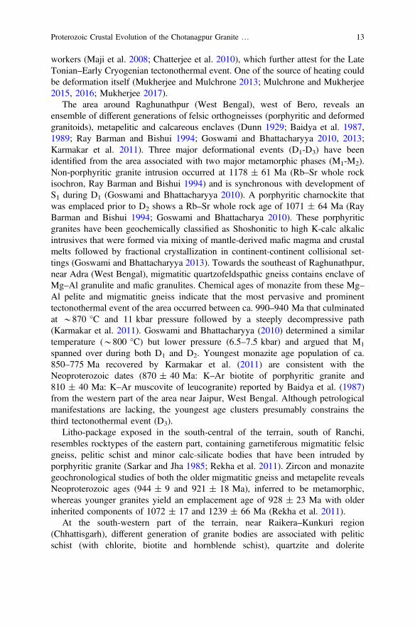
The E-W trending Domain IB is sandwiched between GBF and Domain II(Fig. 2a). From east to west, the geological information from this domain in con-centrated around the cities named Masanjor, Dumka, Deoghar, Jasidih, andDaltonganj. Amongst them, most of the granulite grade enclave rocks are exposedaround Masanjor, Dumka and Deoghar in Jharkhand (Mahadevan 2002). Thegeneral lithology of the domain is felsic gneiss of varied mineralogy and compo-sition which suffered granulite grade metamorphism and anatexis. Variably meta-morphosed gneisses and schists of supracrustals and basic rocks occur as enclaveswithin the felsic gneiss. The general strike of the domain is E-W to NW-SE exceptits northeastern part where the strike becomes N-S. At least three stages of foldinghas been identified by different workers (Ghosh and Sengupta 1999; Sanyal andSengupta 2012; Mukherjee et al. 2017a; Dey et al. under review a; Dey et al. underreview b) throughout the domain.
The eastern extremity of this domain (in and aroundMasanjor and Dumka) exposesgneisses of variable composition.Migmatitic felsic gneiss constitutes the dominant rocktype of this area. Compositionally it varies from migmatitic charnockite (orthopyrox-ene + K-feldspar + plagioclase + quartz + garnet + ilmenite) to amphibole-biotitegneiss (amphibole ± biotite + K-feldspar + plagioclase + quartz + garnet + ilmenite).Based on the on-going study of the authors it is presumed that the latter is the retro-gressed counterpart of the former. Using unpublished U–Pb zircon dates of RayBarman, Acharyya (2003) constrained the protolith ages of the migmatiticcharnockite to be 1624 ± 5 Ma. The host migmatitic felsic gneiss contains rafts/enclaves of khondalite (quartz + K-feldspar + plagioclase + sillimanite + garnet +ilmenite), Mg–Al granulite (orthopyroxene + sapphirine + spinel + sillimanite +quartz + perthite + plagioclase + garnet + ilmenite + biotite + cordierite), calc-silicates (clinopyroxene + garnet + quartz + sphene + K-feldspar + plagioclase)and mafic granulite (plagioclase + clinopyroxene + garnet + hornblende + il-menite + titanite). A large body of porphyritic charnockite (quartz + K-feldspar +plagioclase + orthopyroxene + clinopyroxene + garnet + hornblende + ilmenite +biotite + magnetite) intruded the host felsic gneiss and contains enclaves of the rocksit intruded. From mutual field relations between the litho-units, three stages ofdeformation have been established for the country rock (Mukherjee et al. 2017a;Dey et al. under review a; Sanyal and Sengupta 2012). The enclave rocks developed agneissic banding that predates the foliation of the migmatitic felsic gneiss, formed
14 S. Mukherjee et al.
during D1. The foliation in the host gneiss represents the dominant foliation of thearea and strikes E-W. They refolded during subsequent D2 and D3 deformation(Sanyal and Sengupta 2012). Protolith of porphyritic charnockite emplaced inbetween D1 and D2 at 1515 ± 5 Ma (Acharyya 2003). A swarm of mafic dykes(plagioclase + amphibole + clinopyroxene + chlorite + epidote + calcite + quartz+ ilmenite) cut across the foliation of host gneiss but is folded by open D3 folds. TheMg–Al granulitic enclave rocks develop a mineral assemblage of aluminous (7 wt%Al2O3) orthopyroxene + magnetite-hercynite + sillimanite +quartz + garnet + meltwhich is a good indicator of ultrahigh-temperature metamorphism (>900 °C) at apressure in excess of *8 kbar (Sanyal and Sengupta 2012). From conventionalgeothermobarometry of the mafic enclaves, Sanyal and Sengupta (2012) has obtaineddistinctly lower temperatures 825–850 °C at 8–9 kbar indicating subsequent coolingfollowed by the UHT metamorphism. Geothermobarometry of the porphyriticcharnockite constrain the conditions of M3 metamorphism synchronous to D3, at700 ± 50 °C and 6.5 ± 1 kbar (Sanyal and Sengupta 2012).
Maximum petrological and geochronological information is available fromfurther north-west, in between Dumka and Deoghar town (Jharkhand); especiallyfrom northern part of Dumka. The country rock of felsic orthogneiss hosts km to cmscale rafts of pelitic rocks (garnet-sillimanite-biotite-K-feldspar-plagioclase-quartz ± spinel), mafic rocks (plagioclase + clinopyroxene + orthopyrox-ene + garnet + hornblende + ilmenite + rutile), calc silicates (clinopyroxene +plagioclase + titanite ± garnet ± amphibole ± scapolite ± calcite), granulitesand augen gneisses (K-feldspar + plagioclase + quartz + biotite + hornblende+ apatite). Mineralogically the host gneiss varies from charnockitic(orthopyroxene + clinopyroxene + garnet + plagioclase + K-feldspar + quartz +hornblende + biotite + ilmenite) to biotite-hornblende gneiss to hornblende-biotitegneiss (garnet + plagioclase + K-feldspar + quartz +hornblende + biotite + il-menite) (Mukherjee et al. 2017a). Geochemical and isotopic studies of the hostfelsic gneiss confirm that they have a ferroan (A type) character (Mukherjee et al.2017a, 2018). The ortho-gneisses show a prominent N-S trending migmatiticbanding and this regional fabric locally swerves around the enclaves. The peliticenclaves contain voluminous (>30%) leucosomal segregations (S1; Fig. 3a). The S1which are discordant to and are dragged to parallelism with the pervasive foliation(S2) of the host felsic gneiss (Fig. 3a). Numerical modelling with appropriate bulkfor the metapelites constrain an early high grade event M1 occurred at 7 ± 1 kbarand 1000 ± 50 °C i.e. at MP (medium pressure)-UHT condition which generatedvoluminous S1 leucosomal foliation (Dey et al. under review, a). This event wasfollowed by another metamorphism whereby the felsic orthogneisses and themeta-sedimentary gneisses developed a prominent migmatitic foliation that arecurrently *N-S trending. Numerical modelling combined with conventionalgeo-thermobarometry of the host gneiss as well as the pelitic enclaves constrain thepeak of this metamorphism at 770 ± 50 °C and 9 ± 1 kbar (Dey et al. underreview, a; Chatterjee et al. 2008; Mukherjee et al. 2017a). However, petrologicalstudy of a suite of mafic enclave reveals much higher pressure (12 ± 1 kbar and800 ± 50 °C) for the same (Dey et al. under review, b). In all these studies
Proterozoic Crustal Evolution of the Chotanagpur Granite … 15
this HP-MT metamorphism was followed by a steep decompressive path indicatingthat the peak condition was attained through a continent-continent collisional event.Towards the western part of this domain, in a stretch from Dumka to Jasidihi(Jharkhand) (Fig. 2a), a swarm of mafic dykes (now amphibolites with orthopy-roxene + clinopyroxene + hornblende + biotite + plagioclase + titanite + quartz)occur within the felsic orthogneiss (Fig. 3c). The mafic dykes cut the S2 fabric ofthe host felsic orthogneiss. Along with S2, the mafic dykes are folded by two sets ofco-axial folds with N-S closure (D3; Ghosh and Sengupta 1999; Ray et al. 2011a, b;Mukherjee et al. 2017a; Dey et al. under review a; Dey et al. under review b).A prominent N-S trending planar fabric (S3) that is defined by hornblende devel-oped along the axial plane of the earliest fold (Ghosh and Sengupta 1999; Sanyaland Sengupta 2012; Mukherjee et al. 2017a). Locally S3 is folded by an open foldwith nearly vertical axial plane (Ghosh and Sengupta 1999; Sanyal and Sengupta2012; Mukherjee et al. 2017a). Deformation and metamorphism of the mafic dykesand their host felsic gneiss (M3-D3) mark the latest major tectonothermal event ofDomain I. The host felsic gneiss and the metapelitic granulite enclave recorded a
Fig. 3 a Internal foliation (S1) of metapelitic enclaves and external foliation (S2) within host felsicgneisses; b folding of S2, designated by coarse leucosomes, and development of axial planar S3within felsic orthogneiss; c folding of the mafic dyke during D2 and d development of S3 along theaxial planes of folded mafic dyke
16 S. Mukherjee et al.
P–T of 7.3 ± 0.1 kbar, 615 ± 15 °C and 4.3 ± 0.7 kbar, 600 ± 60 °C, respec-tively for this metamorphism (Dey et al. under review, a). Bhattacharjee et al.(2012) reported a gabbro-anorthosite body (Hizla anorthosite) near Dumka area,Jharkhand. This anorthosite body intruded the charnockitic country rock and isdeformed and metamorphosed along with the latter rock. These rocks that are likelyto be the product of D2-M2 tectonothermal event recorded an unusually wide rangeof pressure and temperature of (511–915 °C and 5.0–7.5 kbar) for the metamor-phism of the anorthosite (Bhattacharjee et al. 2012). The published petrologicalinformation is not robust enough for draw any conclusion about this wide range ofmetamorphic P–T values. Multiple generations of pegmatitic veins criss-cross allthe lithounits. No structural data on the orientation of these veins are available.Eastern margin of the Domain I is marked by a highly tectonized N- to NNE-zoneshear deformation. Shear driven non-cylindrical folds (D2-D3 fold interference) hasbeen described by Chatterjee et al. (2010). This tectonic zone is termed as theEastern Indian Tectonic Zone (EITZ; Chatterjee et al. 2010). A linear gravity highfollows the trend of EITZ over a length of approximately 400 km (Singh et al.2004). From a quartzo-feldspathic gneiss from northern part of Dumka, Chatterjeeet al. (2010) has quantified the peak conditions of the shearing and anatexis alongEITZ at *11 kbar and <800 °C followed by isothermal decompression.
U–Pb zircon and monazite age of the metapelitic enclaves attests the age of M1
metamorphism at 1630 ± 50 Ma (Dey et al. under review, a). SimilarPaleoproterozoic metamorphic ages has also been obtained by Rekha et al. (2011)and by Chatterjee et al. (2010) from metapelites and anatectic quartzofeldspathicgneiss near Dumka. From detrital zircon study of the metapelitic enclaves, Deyet al. (2017) has constrained the age of deposition of the sedimentary protoliths ofthese enclaves within 1700–1680 Ma and has ascribed that the sediments werederived from Archean and Paleoproterozoic sources (Rekha et al. 2011; Dey et al.2017). The protolith of the felsic orthogneiss was derived via high temperaturepartial melting of Paleoproterozoic crustal source (*1800–1600 Ma) with limitedmantle input (Lu–Hf model age: Mukherjee et al. 2018) and was presumablyemplaced in a continental rift setting at *1450 Ma (U–Pb zircon dating;Mukherjee et al. 2017a, 2018). Mesoproterozoic dates have also been reported fromU–Pb dating of zircon from metapelites and anatectic quartzofeldspathic gneiss inthis domain (Rekha et al. 2011; Dey et al. under review, a). Rb–Sr whole-rock datethe emplacement of a syenitic rock (1457 ± 63 Ma) and a charnockite(1331 ± 125 Ma) in Dumka-Jamua, Jharkhand area of Jharkhand (Ray Barmanet al. 1994). U–Pb zircon and Th–U–Pb monazite age constrained the age of thegranulite grade metamorphism at *1000–930 Ma (Dey et al. under review, a;Chatterjee et al. 2008, 2010; Rekha et al. 2011; Mukherjee et al. 2017a). Chatterjeeet al. (2010) has retrieved a younger age population of *870–650 Ma from themonazite dates, which they linked with the tectonothermal activity and sinistralshearing along the EITZ. Zircon and monazite from metapelite and felsic gneissyield ages for D3 and M3, ranging within 900–800 Ma (Chatterjee et al. 2010;Dey et al. under review, a; Mukherjee et al. 2017a) with very few ages as low
Proterozoic Crustal Evolution of the Chotanagpur Granite … 17
as *650 Ma (Chatterjee et al. 2010). These age of the D3 deformation of the areahave been correlated with the age duration of shearing along the EITZ.
Not much geological and geochronological information are available from fur-ther west of Jasidih, in and around Dhanbadand and Hazaribag (Jharkhand). It isnoteworthy that the strike of the schists and gneisses of these areas varies betweenE-W to NW-SE. Parts of the Dhanbad district (Jharkhand) exposes banded gneissesof amphibolite facies (Roy Chowdhury 1979) with enclaves of hornblende schistsand gneisses, olivine-orthopyroxene bearing metanorites and quartzites. The rocksfolded thrice with development of E-W to NW-SE trending foliation axial planar tothe second generation folding (Sarangi and Mohanty 1998).
Further west, near Hazaribagh (Jharkhand), amphibolites, pelitic and calcareousrocks dominate with a persistent E-W trending schistosity. The rocks have alsobeen folded thrice with first two folds being tight and coaxial, and the last one beingopen warp (Roy Chowdhury 1979; Mahadevan 2002). The whole rock Rb–Srisochron date of biotite-K-feldspar from a migmatite record one of the youngestages (481 ± 18 Ma; Pandey et al. 1986b).
The area around Daltonganj (Jharkhand) exposes granite gneisses and migma-tites interbanded with Graphite-bearing pelitic schists, limestones, quartzites andintruded by mafic-ultramafic, anorthositic-komatiitic rocks (Bhattacharya et al.2010). These ultramafic rocks host magnetite (Ghose 1983; Sinha and Bhattacharya1995), fluorite (Soni et al. 1991) and base metal mineralization (Ghose 1992;Bhattacharya et al. 2010). Thermometry of granite gneiss confirms that the gneissicfoliation formed under high grade condition (850–800 °C; Chatterjee and Ghosh2011). The granite gneisses are intruded by non-foliated granitic to granodioriticrocks (Rode, 1948; Ghose 1983; Mazumdar 1988). Anatexis of granulite to formleucogranite, and partial melting of metapelite forming these non-foliated granitoidsprobably occurred at 650–800 °C and 2–6 kbar (Srivastava and Ghose 1992).Whole-rock Rb–Sr dating of the granite gneiss suggests an event of graniticmagmatism at 1741 ± 65 Ma (Ray Barman and Bishui 1994) followed by highgrade metamorphism and anatexis. Chatterjee and Ghosh (2011) has dated this highgrade metamorphism from xenotime at 975 ± 67 Ma. The granite gneiss andmetapelitic sequence deformed thrice (D1-D3) (Lahiri and Das 1984; Patel 2007).Interference of D1 and D2 produced NW-SE trending domal structure with devel-opment of prominent axial planar schistosity. Post-D3 pegmatite veins and maficdykes are common in the area. In the Tatapani area, the calc-silicate rocks developthe rare assemblage vesuvianite + grossular garnet + diopside + wollastonite +quartz. Patel (2007) estimated the conditions of vesuvianite formation at <4 kbarand 590–650 °C in presence of a highly aqueous fluid.
3.3 Domain II
Sandwiched between Domain III (in the north) and GBF (in the south), this domainis the ENE-WSW trending the Bihar Mica belt (BMB) exposes a distinct
18 S. Mukherjee et al.
lithological ensemble in the CGGC (Fig. 2a). The geological formation in this beltinclude meta-sedimentary sequence dominantly constituting muscovite-biotiteschist interbedded with micaceous quartzites, conglomerates, calc-silicate rocksand hornblende schists. The carbonate metasediments are occasionally foundassociated with economic grade base-metal mineralization (Ghose 1992). Thesemetasedimentary rocks of BMB rest on the high grade rocks of CGGC with anerosional conglomerate base (Ghose and Mukherjee 2000). The Pb/Pb age of galenafrom base-metal deposits brackets the sedimentation age in the BMB within thetime span of 1700–1650 Ma (Singh et al. 2001). Rb–Sr whole rock dating of amigmatitic granite gneissic basement from south of BMB yields an age of1717 ± 102 Ma (Mallik et al. 1991). The meta-sedimentary package recorded threephases of folding (D1, D2 and D3), where first two folds are most dominant andproduce E-W trending axial planar foliation while the third fold is weak and lesspervasive. The whole litho-unit is extensively intruded by large bodies of granitoidrocks, dolerite dykes, gabbro anorthosite and mica pegmatites (sometimes REE andrare metal rich). Granitoids were emplaced syn- to post-D2 folding with ages ofmost of the granite intrusives clustering within 1300–1100 Ma and age of oldestgranite intrusion around 1600 Ma (Whole-rock and Rb–Sr mineral isochron ages;Pandey et al. 1986a; Misra and Dey 2002). K–Ar dating of granitoids yields lowerages (1080–850 Ma) (Sarkar 1980). The BMB plutons characteristically show veryhigh SrI ratio which suggests their derivation from sialic crustal sources (Misra andDey, 2002). Different generations of mica-bearing granite–pegmatites emplacedpre-D2 to post-D3 folding (Mahadevan 2002). The conditions of emplacement aswell as formation of the BMB granite plutons is estimated *5 kbar and slightly>1000 °C in a relatively anhydrous condition within a possible post-orogenic set-ting (Misra and Dey 2002). The age of emplacement of the oldest REE-raremetal-bearing mica pegmatites of the BMB has been restricted within960 ± 50 Ma (Pb/Pb age; Vinogradov et al. 1964) and 910 ± 20 Ma (U–Pb andPb/Pb ages of the Columbite–Tantalite minerals; Krishna et al. 2003). Fission-trackages of garnet (830 Ma), muscovite (760 Ma), biotite (590 Ma) and apatite(590 Ma) date the final exhumation of the mica pegmatites of this region (Lal et al.1976). It suggests that the rocks of this area had not received any significant thermalpulse, which by implication means cratonization, since 590 Ma (Lal et al. 1976). Insummary, this domain bears history of Paleoproterozoic and Mesoproterozoicgranitic activities. Evidence of Paleoproterozoic sedimentation is noteworthy. Theabundant intrusion of pegmatites took place in Neoproterozoic which cooledgradually.
3.4 Domain III
The northern fringe of CGGC, north of the Bihar mica Belt, exposes an ensemble ofmigmatitic quartzofeldspathic gneisses and supracrustals. Sedimentary rocks of theMunger Group and the Rajgir Group showing basement–cover relationship with the
Proterozoic Crustal Evolution of the Chotanagpur Granite … 19
CGGC gneisses demarcated by a conglomerate horizon (Ghose and Mukherjee2000). Supracrustals are dominated by quartzite and phyllite, metamorphosed underlow-grade in association with mafic-ultramafic and felsic intrusives.
The basement of these sedimentary units is marked by the porphyritic granite(K-feldspar + plagioclase + biotite + quartz) near Gaya (Bihar) and biotite granitein the Bhagalpur area (Bihar) (Chatterjee and Ghose 2011). The intrusion age ofthe granitoids are constrained at ca. 1697 ± 17 Ma from U–Th–Pb monazite(Chatterjee and Ghose 2011). U–Pb xenotime age of 1583 ± 50 Ma is inferred tobe the cooling age of the porphyritic granitoids (Chatterjee and Ghose 2011).Detailed geochemical study of the porphyritic granites reveal an A-type characterand suggest that they have been derived from predominant crustal source in anextensional (Yadav et al. 2014). In and around Bathani village, near Gaya (Bihar) avolcanic and volcano sedimentary sequence comprises of banded iron formation(BIF), garnet-mica schist, chert bands and mafic-intermediate volcanics (Saikiaet al. 2014). Detailed geochemical studies suggest that the intrusion of bimodalvolcanics, tholeiitic affinity of the basalt and calc-alkaline trend of theintermediate-felsic magmatism corroborate well with an island-arc setting (Saikiaet al. 2014, 2017). U–Pb zircon geochronology constrains the intrusion of the felsicmagmatism between ca. 1750–1660 Ma. Subsequently the lithounit got metamor-phosed at ca. 930 Ma and at 768 Ma. Earlier metamorphism occurred undergranulite grade whereas the younger age associates with a shearing linked with theEastern Indian tectonic Zone (Chatterjee et al. 2010).
4 Discussions
4.1 Tectonothermal Events at CGGC
This section collates the geological and geochronological information (Table 1) andreconstructs a plausible event stratigraphy that shaped the CGGC.
4.1.1 Sedimentation History of the Supracrustal Enclaves
Timing of sedimentation and provenance of the precursor sediments of metasedi-mentary rocks provide critical information about the tectonic history of a terrane(Sengupta et al. 2015; Dey et al. 2017). In CGGC, the supracrustal enclave rockswith quartzite, metapelite sand metacarbonate are likely to correspond to of sand-stone, shale and limestone found in a stable continental shelf (Malone et al. 2008;Basu et al. 2008, 2014; Sengupta et al. 2015; Dey et al. 2017). Strong structural andmetamorphic overprints virtually obliterate the sedimentary features of thesesupracrustal rocks. This renders reconstruction of sedimentary process in high graderocks difficult. However, using the dates obtained from detrital zircon or other
20 S. Mukherjee et al.
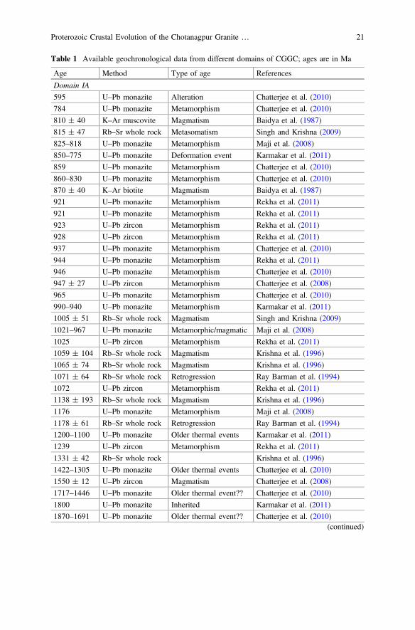
Table 1 Available geochronological data from different domains of CGGC; ages are in Ma
Age Method Type of age References
Domain IA
595 U–Pb monazite Alteration Chatterjee et al. (2010)
784 U–Pb monazite Metamorphism Chatterjee et al. (2010)
810 ± 40 K–Ar muscovite Magmatism Baidya et al. (1987)
815 ± 47 Rb–Sr whole rock Metasomatism Singh and Krishna (2009)
825–818 U–Pb monazite Metamorphism Maji et al. (2008)
850–775 U–Pb monazite Deformation event Karmakar et al. (2011)
859 U–Pb monazite Metamorphism Chatterjee et al. (2010)
860–830 U–Pb monazite Metamorphism Chatterjee et al. (2010)
870 ± 40 K–Ar biotite Magmatism Baidya et al. (1987)
921 U–Pb monazite Metamorphism Rekha et al. (2011)
921 U–Pb monazite Metamorphism Rekha et al. (2011)
923 U–Pb zircon Metamorphism Rekha et al. (2011)
928 U–Pb zircon Metamorphism Rekha et al. (2011)
937 U–Pb monazite Metamorphism Chatterjee et al. (2010)
944 U–Pb monazite Metamorphism Rekha et al. (2011)
946 U–Pb monazite Metamorphism Chatterjee et al. (2010)
947 ± 27 U–Pb zircon Metamorphism Chatterjee et al. (2008)
965 U–Pb monazite Metamorphism Chatterjee et al. (2010)
990–940 U–Pb monazite Metamorphism Karmakar et al. (2011)
1005 ± 51 Rb–Sr whole rock Magmatism Singh and Krishna (2009)
1021–967 U–Pb monazite Metamorphic/magmatic Maji et al. (2008)
1025 U–Pb zircon Metamorphism Rekha et al. (2011)
1059 ± 104 Rb–Sr whole rock Magmatism Krishna et al. (1996)
1065 ± 74 Rb–Sr whole rock Magmatism Krishna et al. (1996)
1071 ± 64 Rb–Sr whole rock Retrogression Ray Barman et al. (1994)
1072 U–Pb zircon Metamorphism Rekha et al. (2011)
1138 ± 193 Rb–Sr whole rock Magmatism Krishna et al. (1996)
1176 U–Pb monazite Metamorphism Maji et al. (2008)
1178 ± 61 Rb–Sr whole rock Retrogression Ray Barman et al. (1994)
1200–1100 U–Pb monazite Older thermal events Karmakar et al. (2011)
1239 U–Pb zircon Metamorphism Rekha et al. (2011)
1331 ± 42 Rb–Sr whole rock Krishna et al. (1996)
1422–1305 U–Pb monazite Older thermal events Chatterjee et al. (2010)
1550 ± 12 U–Pb zircon Magmatism Chatterjee et al. (2008)
1717–1446 U–Pb monazite Older thermal event?? Chatterjee et al. (2010)
1800 U–Pb monazite Inherited Karmakar et al. (2011)
1870–1691 U–Pb monazite Older thermal event?? Chatterjee et al. (2010)(continued)
Proterozoic Crustal Evolution of the Chotanagpur Granite … 21

Table 1 (continued)
Age Method Type of age References
Domain IB
481 ± 18 Rb–Sr Bt, Kfs ? Pandey et al. (1986a)
649 U–Pb monazite Metamorphism Chatterjee et al. (2010)
850–750 U–Pb monazite Metamorphism Sanyal et al. (2007)
872–838 U–Pb monazite Metamorphism Chatterjee et al. (2010)
876 U–Pb monazite Metamorphism Chatterjee et al. (2010)
902 U–Pb zircon Metamorphism Mukherjee et al. (2017a)
907 ± 49 U–Pb zircon Metamorphism Mukherjee et al. (2018)
910 U–Pb monazite Metamorphism Rekha et al. (2011)
937 U–Pb monazite Metamorphism Chatterjee et al. (2010)
943 U–Pb zircon Metamorphism Mukherjee et al. (2017a)
945 U–Pb monazite Metamorphism Rekha et al. (2011)
948 ± 22 U–Pb zircon Metamorphism Mukherjee et al. (2018)
950 ± 20 U–Pb monazite Retrogression Chatterjee et al. (2008)
954 U–Pb monazite Metamorphism Chatterjee et al. (2010)
965–930 U–Pb monazite Metamorphism Chatterjee et al. (2010)
975 ± 67 U–Pb monazite Metamorphism Chatterjee and Ghose (2011)
995 ± 24 U–Pb monazite Metamorphism Chatterjee et al. (2008)
1009 U–Pb zircon Metamorphism Rekha et al. (2011)
1100–930 U–Pb monazite Metamorphism Sanyal et al. (2007)
1119 Rb–Sr whole rock ? Sarkar et al. (1986)
1183 U–Pb monazite Older thermal events Chatterjee et al. (2010)
1190 ± 26 U–Pb monazite Metamorphism Chatterjee et al. (2008)
1270 U–Pb zircon ? Rekha et al. (2011)
1272 U–Pb monazite Older thermal events Chatterjee et al. (2010)
1278 U–Pb monazite Older thermal events Chatterjee et al. (2010)
1331 ± 125 Rb–Sr whole rock Cooling age Ray Barman et al. (1994)
1333 U–Pb zircon ? Rekha et al. (2011)
1377 U–Pb zircon ? Rekha et al. (2011)
1435 U–Pb zircon ? Rekha et al. (2011)
1446 ± 7 U–Pb zircon Magmatism Mukherjee et al. (2018)
1447 U–Pb zircon Magmatism Mukherjee et al. (2017a)
1457 ± 63 Rb–Sr whole rock Older thermal events Ray Barman et al. (1994)
1462 U–Pb zircon ? Rekha et al. (2011)
1470 ± 2 U–Pb zircon Magmatism Mukherjee et al. (2018)
1480 U–Pb monazite ? Rekha et al. (2011)
1515 ± 5 U–Pb zircon Magmatism Acharyya (2003)(continued)
22 S. Mukherjee et al.
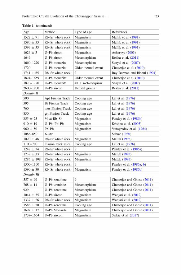
Table 1 (continued)
Age Method Type of age References
1522 ± 71 Rb–Sr whole rock Magmatism Mallik et al. (1991)
1580 ± 33 Rb–Sr whole rock Magmatism Mallik et al. (1991)
1599 ± 33 Rb–Sr whole rock Magmatism Mallik et al. (1991)
1624 ± 5 U–Pb zircon Magmatism Acharyya (2003)
1649 U–Pb zircon Metamorphism Rekha et al. (2011)
1660–1270 U–Pb monazite Metamorphism Sanyal et al. (2007)
1720 U–Pb monazite Older thermal event Chatterjee et al. (2010)
1741 ± 65 Rb–Sr whole rock ? Ray Barman and Bishui (1994)
1824–1659 U–Pb monazite Older thermal event Chatterjee et al. (2010)
1870–1720 U–Pb monazite UHT metamorpism Sanyal et al. (2007)
2600–1900 U–Pb zircon Detrital grains Rekha et al. (2011)
Domain II
590 Apt Fission Track Cooling age Lal et al. (1976)
595 Bt Fission Track Cooling age Lal et al. (1976)
760 mus Fission Track Cooling age Lal et al. (1976)
830 grt Fission Track Cooling age Lal et al. (1976)
855 ± 25 Mica Rb–Sr Magmatism Pandey et al. (1986b)
910 ± 19 U–Pb, Pb–Pb Magmatism Krishna et al. (2003)
960 ± 50 Pb–Pb Magmatism Vinogradov et al. (1964)
1086–850 K–Ar ? Sarkar (1980)
1020 ± 46 Rb–Sr whole rock Magmatism Mallik (1993)
1100–700 Fission track mica Cooling age Lal et al. (1976)
1242 ± 34 Rb–Sr whole rock ? Pandey et al. (1986a)
1238 ± 33 Rb–Sr whole rock Magmatism Mallik (1993)
1285 ± 108 Rb–Sr whole rock Magmatism Mallik (1993)
1300–1100 Rb–Sr whole rock ? Pandey et al. (1986a, b)
1590 ± 30 Rb–Sr whole rock Magmatism Pandey et al. (1986b)
Domain III
557 ± 99 U–Pb xenotime ? Chatterjee and Ghose (2011)
768 ± 11 U–Pb uraninite Metamorphism Chatterjee and Ghose (2011)
929 U–Pb xenotime Metamorphism Chatterjee and Ghose (2011)
1044 ± 35 U–Pb zircon Magmatism Wanjari et al. (2012)
1337 ± 26 Rb–Sr whole rock Magmatism Wanjari et al. (2012)
1583 ± 50 U–Pb xenotime Cooling age Chatterjee and Ghose (2011)
1697 ± 17 U–Pb Monazite Magmatism Chatterjee and Ghose (2011)
1737–1664 U–Pb zircon Magmatism Saikia et al. (2017)
Proterozoic Crustal Evolution of the Chotanagpur Granite … 23
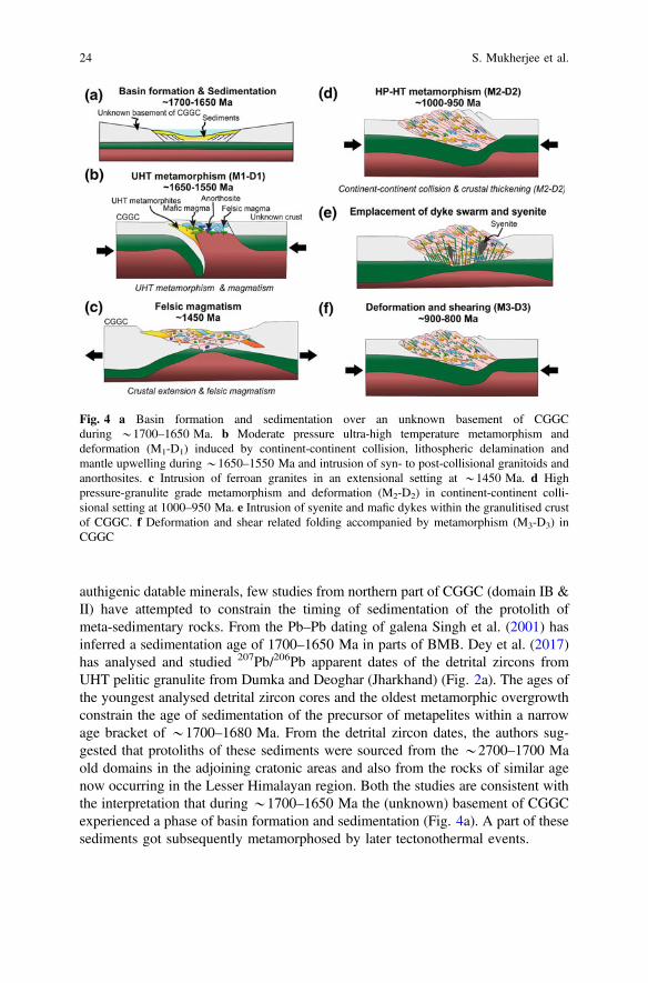
authigenic datable minerals, few studies from northern part of CGGC (domain IB &II) have attempted to constrain the timing of sedimentation of the protolith ofmeta-sedimentary rocks. From the Pb–Pb dating of galena Singh et al. (2001) hasinferred a sedimentation age of 1700–1650 Ma in parts of BMB. Dey et al. (2017)has analysed and studied 207Pb/206Pb apparent dates of the detrital zircons fromUHT pelitic granulite from Dumka and Deoghar (Jharkhand) (Fig. 2a). The ages ofthe youngest analysed detrital zircon cores and the oldest metamorphic overgrowthconstrain the age of sedimentation of the precursor of metapelites within a narrowage bracket of *1700–1680 Ma. From the detrital zircon dates, the authors sug-gested that protoliths of these sediments were sourced from the *2700–1700 Maold domains in the adjoining cratonic areas and also from the rocks of similar agenow occurring in the Lesser Himalayan region. Both the studies are consistent withthe interpretation that during *1700–1650 Ma the (unknown) basement of CGGCexperienced a phase of basin formation and sedimentation (Fig. 4a). A part of thesesediments got subsequently metamorphosed by later tectonothermal events.
Fig. 4 a Basin formation and sedimentation over an unknown basement of CGGCduring *1700–1650 Ma. b Moderate pressure ultra-high temperature metamorphism anddeformation (M1-D1) induced by continent-continent collision, lithospheric delamination andmantle upwelling during *1650–1550 Ma and intrusion of syn- to post-collisional granitoids andanorthosites. c Intrusion of ferroan granites in an extensional setting at *1450 Ma. d Highpressure-granulite grade metamorphism and deformation (M2-D2) in continent-continent colli-sional setting at 1000–950 Ma. e Intrusion of syenite and mafic dykes within the granulitised crustof CGGC. f Deformation and shear related folding accompanied by metamorphism (M3-D3) inCGGC
24 S. Mukherjee et al.

4.1.2 Magmatic History
The oldest tectonothermal event reported so far from northern and central CGGCoccurred in the late Paleoproterozoic (ca. 1750–1640 Ma) (Mallik et al. 1991; RayBarman and Bishui 1994; Chatterjee and Ghose 2011; Saikia et al. 2017). U–Pbzircon ages distinctly indicates the intrusion of arc-related bimodal volcanics in thenorthern part (Saikia et al. 2017). However, contemporaneous (1697 Ma; Chatterjeeand Ghose 2011) porphyritic granites from the northern domain are inferred to be ofanorogenic affinity (Yadav et al. 2014). In the eastern fringe of the terrain, intrusionof massif anorthosite body, occurred at 1550 Ma and inferred to be the manifes-tation of post-orogenic magmatism (Fig. 4b) (Chatterjee et al. 2008). Subsequentlyin the eastern part of the domain Mesoproterozoic (ca. 1450 Ma) ferroan graniteshave intruded the Paleoproterozoic crust in an extensional setting (Fig. 4c)(Mukherjee et al. 2017a, 2018). A body of syenite near Dumka (Jharkhand) yields aRb–Sr whole rock age of 1457 ± 63 Ma (Ray Barman and Bishui 1994). EarlyNeoproterozoic felsic magmatism so far has been reported only from southern partof the CGGC (Singh and Krishna 2009). However, post-Grenvillian (<950 Ma)magmatic pulses, including granite, syenite, mafic dykes and pegmatite intrusionshave been documented from different parts the terrain (Fig. 4e). Biotite bearinggranites have considered to intrude the early crust *870–810 Ma (Baidya et al.1987). Although no geochronological dates are available, a body of syenite intrudedthe granulitised crust in the southwestern part of the terrain, associated with NPSZ(Das et al. 2016, 2017c). A set of mafic dykes also intruded the granulitised crust inthe northeastern part of the CGGC (Sanyal and Sengupta 2012; Mukherjee et al.2017a). Numerous mica-bearing pegmatites with intrusion age of 960–855 Mahave been reported from the northern part of the terrain (Pandey et al. 1986b;Krishna et al. 2003; Vinogradov et al. 1964).
4.1.3 Metamorphism and Deformation: Summary of the Events
The oldest metamorphic event recorded in the CGGC is characterised by an ultra-hightemperature metamorphism (M1) at *1640 Ma (Dey et al. 2017). Similar ages (ca.1850–1600 Ma; U–Pb zircon and Th–U–Pb monazite dates) have been recorded byseveral workers and inferred to be the manifestation of high grade thermal event(Chatterjee et al. 2010; Rekha et al. 2011). Peak metamorphic conditions recoveredfrom themetapelitic rocks yield a P–T condition of 1000–950 °C at 7–5 kbar pressure(Sanyal and Sengupta 2012; Dey et al. under review, a). Moderate pressure ultra-hightemperature metamorphism and a clockwise P–T–t path, inferred from the mineralphase equilibria of the metapelite, presumably reflect continent-continent collisionfollowed by lithospheric delamination and mantle upwelling (Fig. 4b) (Dey et al.under review, a). Mesoproterozoic (ca. 1450–1300 Ma) ages, recovered by severalworkers, are inferred to be the manifestation of thermal imprint (Maji et al. 2008;Chatterjee et al. 2010; Karmakar et al. 2011; Rekha et al. 2011). The most pervasivetectonothermal event recorded from different parts of the CGGC occurred at
Proterozoic Crustal Evolution of the Chotanagpur Granite … 25
1000–950 Ma (M2). From the northeastern margin of the terrain, several workers(Mukherjee et al. 2017a, Dey et al. under review, a, Dey et al. under review, b) haveinferred that the metamorphism culminated at 770–800 °C and 9–12 kbar pressure,followed by a steep decompressive path. Similar P–T path has been recorded from thesouthern part of the terrainwhere the peak culminated at 870 °C and 11 kbar followedby decompression (Karmakar et al. 2011). Such high pressure event associated withclockwise path is inferred to be the manifestation of continent-continent collision(Fig. 4d). Post-Grenvillian metamorphic event (M3) has been reported from north-easternmargin of the terrain where U–Th–Pbmonazite constrains the age of the eventbetween 900 and 780 Ma (Chatterjee et al. 2010; Mukherjee et al. 2017a, Dey et al.under review, a). Chatterjee et al. (2010) estimated a high-pressure peak for M3
culminating at 820 °C and 11 kbar which correlates with the development of EasternIndian tectonic Zone (Fig. 4f).
Structural analyses from different parts of the terrane reveal that the CGGC hasexperienced multiple deformational events (Mahadevan 2002; Maji et al. 2008;Goswami and Bhattacharyya 2010; Karmakar et al. 2011; Sanyal and Sengupta2012; Mukherjee et al. 2017a). However, structural data from scattered places andscarcity of detailed geochronological information are some of the major hindrancefor correlating the different deformational and metamorphic events reported bydifferent workers over the entire CGGC. Unfortunately, sizable amount of structuraland geochronological information are available only from the rocks of Domain I. Inthe following section an attempt has been made to develop a structural history of theCGGC using the structural, metamorphic and geochronological information fromDomain I. Three major deformational phases seem to have affected the rocks ofDomain I. The earliest deformational event (D1) is preserved in the metasedi-mentary enclaves within the felsic orthogneiss. This event is marked by a mig-matitic banding (S1) which is inferred to be associated with M1 metamorphic eventthat is dated to be *1650 Ma (Fig. 4a) (Sanyal and Sengupta 2012; Mukherjeeet al. 2017a; Dey et al. under review a; Dey et al. under review, b). The next majordeformational event (D2) is manifested by the development of S2 foliations withinthe felsic orthogneisses and transposition of S1 within the metasedimentaryenclaves. The D2 is associated with *1000–950 Ma old granulite facies meta-morphism (M2) (Fig. 4c), especially from the eastern margin of the terrane (Majiet al. 2008; Karmakar et al. 2011; Mukherjee et al. 2017a; Dey et al. under review a;Dey et al. under review, b). Folding of the late intrusives (mafic dykes in thenortheastern part and nepheline syenite in the southern part), along with the S2 ofthe host felsic orthogneisses, depicts the third major deformational event (D3).There is no detail information on the age of emplacement of the mafic dykes andsubsequent D3 deformation. The EITZ and with its characteristic asymmetricalfolds, N-NNE trending planar fabric and high pressure metamorphism appear to becoeval with the D3-M3 tectonothermal event (Fig. 4f). Similar shear-related foldsalso reported by Mukherjee et al. (2015b) and Mukherjee (submitted manuscript).
26 S. Mukherjee et al.

4.2 Evaluation of Shear Zones
Several prominent crustal-scale shear zones cross through the CGGC. The‘Tamar-Porapahar-Khatra’ shear zone is the southernmost lineament affecting theProterozoic gneissic rocks of CGGC and separating it from the low grade meta-morphites of North Singhbhum Fold Belt (NSFB). This ENE-WSW trending150 km long shear zone passes through the south of the Purulia town (West Bengal)and also known as ‘South Purulia Shear Zone’ (SPSZ). *150 km long, the ‘NorthPurulia Shear Zone (NPSZ) is another prominent E-W to NE-SW trending linea-ment that affects the CGGC rocks occurring north of Purulia.
Approximately 150 km long arcuate shear zone which is referred to as the SouthPurulia Shear Zone (SPSZ: Mazumdar 1988), or Northern Shear Zone (NSZ: Kumaret al. 1978), or Tamar-Porapahar-Khatra Fault Zone (TPKF: Mahadevan 2002), is acrustal-scale ENE-WSW trending brittle-ductile shear zone that marks the southernmargin of the CGGC and separates the terrain from the low to medium grademeta-sedimentary and meta-igneous rocks of the North Singhbhum Fold Belt(Fig. 2a; Mahadevan 1992; Acharyya et al. 2006; Mahato et al. 2008; Sanyal andSengupta 2012). This shear zone has been extensively deformed during severaltectonothermal events (Bhattacharyya et al. 1992; Sengupta et al. 2005) and representsan ensemble of a nepheline-bearing syenite, tuffaceous rocks, tourmalinite, carbon-atite, apatite bearing rocks and granitoids altered hydrothermally (Banerji 1985; Basu1993; Acharyya et al. 2006; Chattopadhyay et al. 2015a). Abundance of carbonatiteand alkaline connotes crustal rifting (Acharyya et al. 2006; Chakrabarty and Sen2010). Intrusion of the alkaline rocks at ca. 922 Ma, evident from the U–Pb zircongeochronology (Reddy et al. 2009), constrains the timing of the extensional event,which was followed by another tectonothermal event that deformed thecarbonatite-alkaline rocks forming DARCs (Deformed Alkaline Carbonatite Rocks)(Chattopadhyay et al. 2015a). Economically viable apatite deposit, tuffaceous rocksand Fe-ore are reported from the area (Banerji 1985).
The NPSZ is an E-W to ENE-WSW trending crustal-scale shear zone with aprominent steep northerly dip traversing themetamorphites of CGGC. This lineamentpasses through Jhalda-Jaypur in thewest throughRaghunathpur in the central part andcan be traced up to north ofMurlu near Saltora (West Bengal) in the east (Baidya et al.1989; Mahadevan 1992; Dasgupta et al. 2000; Som et al. 2007; Maji et al. 2008;Goswami andBhattacharyya 2010). The shear zone is best developed in the granitoidswhere an early mylonitic fabric has developed in deep structural level in amphibolitefacies condition. The crystal plastic deformation of quartz and feldspar indicates thetemperature *650–700 °C during this early ductile deformation (Vernon 2004).The NPSZ has the signatures of protracted period of ductile deformation where theearly shear foliation folded. Later stage of brittle deformation has affected the earlymylonitic fabric of the NPSZ. Discrete bodies of nepheline syenite is found to beemplaced along this crustal lineament near Kankarkiari–Kusumda area near Saltora(West Bengal) cross-cutting the gneissic fabric of felsic gneiss and khondalite and getmetamorphosed and deformed when NPSZ formed (Goswami and Bhattacharyya
Proterozoic Crustal Evolution of the Chotanagpur Granite … 27

2010; Das et al. 2017b). Das et al. (2017a) has also reported carbonatite in the centralpart of NPSZ where apatite-Fe-oxide/hydroxide-silica bearing veins coexist withalkali metasomatised granitoids. In the western part of NPSZ late stage pegmatiteveins within granite and calc-silicate rocks have been explored for Cs, Li and otherrare elements (Som et al. 2007).
The Eastern Indian Tectonic Zone (EITZ), roughly N- to NNW trendingcrustal-scale shear zone, is observed towards the eastern margin of the CGGC(Fig. 2a) (Chatterjee et al. 2010). The shear fabric, manifested by asymmetric folds,developed over the older lithounits and is traceable along CGGC, North SinghbhumFold Belt and Singhbhum Craton. Detailed petrological studies by Chatterjee et al.(2010) have shown that the metamorphism associated with the development of theshear zone culminated at *11–12 kbar and 800 °C. Monazite geochronologyconstrains the timing of the of the tectonothermal event at ca. 870–780 Ma, whichagrees with the field observations that EITZ developed after the major tectonicevent at CGGC i.e. granulite grade metamorphism dated *950 Ma.
4.3 Extension of the CGGC
4.3.1 Northern Boundary of CGGC
Quaternary sediments of Gangetic alluvium cover the northern margin of the CGGC.Further north, the Late Paleoproterozoic rocks of the Lower Lesser Himalaya occursinterleaved with the Phanerozoic rocks (Mukherjee et al. 2013, 2015a; Mukherjee2013, 2015). These units expose metamorphosed and unmetamorphosed sedimen-tary sequence and granitic plutons of age *1900–1700 Ma (Fig. 5). Geochemicalsignatures of the granitoids point towards their emplacement in a continental arcsetting (Kohn et al. 2010) existing along the northern boundary of India at that time.Detrital zircon populations of the sedimentary units are characterized byPaleoproterozoic–Late Archean ages (2.6–1.8 Ga), with no younger population(Richards et al. 2005). According to Richards et al.(2005) “Detrital zircon ages areyounger than their respective Hf-isotope derived crustal formation ages by 0.7–2.1 Ga, indicating that the source regions of the detrital zircons consisted of olderterranes with considerable amounts of reworking and renewed magmatism”. Manyworkers have suggested that these Proterozoic rocks of the Lesser Himalaya con-stitute the remnants of the Greater Indian Landmass, subducted below theHimalayan orogenic belt (DeCelles 2000). Petrological and limited geochronolog-ical studies suggest that the Paleoproterozoic felsic orthogneisses exposed within thequaternary alluvium towards the north of the CGGC resembles the basementorthogneisses of the CGGC. Felsic magmatism in the northern part of the CGGC,near Bathani, shows enrichment of Th, U, and Pb over Nb, Ta and Ti which cor-roborates with the geochemical characters of the Paleoproterozoic granitoids of thelower Lesser Himalaya. Elevated magmatic temperature, derived from the zirconsaturation thermometry and predominance of crustal source also poses the possibility
28 S. Mukherjee et al.
that the Paleoproterozoic basement orthogneisses presumably continued beneath theGangetic alluvium to the lower Lesser Himalaya.
4.3.2 Western Boundary of CGGC
The Mohakoshal Belt (MB) and the Sausar Mobile Belt (SMB) occur to the NWand SW of CGGC respectively (Fig. 2a) and constitute the northern and thesouthern structural blocks of Central Indian Tectonic Zone (CITZ) that sutures twoAchaean blocks: Bundelkhand at the north and Bastar at the south (Acharyya 2003;Jain et al. 1991; Mishra et al. 2000; Radhakrishna and Naqvi 1986; Yedekar et al.1990).
The Mahakoshal belt is composed of intercalated riftogenic volcano-sedimentarysuccessions (Roy and Prasad 2003 and the references therein), metamorphosed andintruded with post-orogenic granitoids aging 1800–1700 Ma (Rb/Sr whole rock ageand U/Pb zircon age; Bora et al. 2013; Pandey et al. 1998; Sarkar 1998; Srivastavaet al. 2000). The sedimentary sequence was metamorphosed in low pressure–medium temperature conditions in a possible back arc setting (Roy and Prasad2003; Wani and Mondal 2016). On contrary, a recent study proposed that thesediments were metamorphosed in moderate pressure–low temperature conditionsin a collisional setting followed by rapid exhumation (Deshmukh et al. 2017).
The Sausar Mobile Belt occurs at the southern margin of CITZ and is a collageof different litho-tectonic components. The southern Bhandara-Balaghat granulite(BBG) domain exposes enclaves of supracrustal and meta-igneous granulitesoccurring within felsic gneisses. They have been metamorphosed under lowercrustal, ultra-high temperature (UHT) granulite facies conditions along acounter-clockwise P–T path (Bhowmik 2006; Bhowmik et al. 2005) in a possibleback arc setting associated with emplacement of arc magma (Bhowmik et al. 2011).Although early workers predicted an Archean–Early Paleoproterozoic age(Bhowmik 2006; Bhowmik et al. 2005; Roy et al. 2006), precise U–Pb zircon andtexturally controlled monazite dating constrains the timing of this metamorphismand magmatism at *1600 Ma (Bhandari et al. 2011; Bhowmik et al. 2011, 2014).This event was followed by several events of granulite-amphibolite grade over-printing (BasuSarbadhikari and Bhowmik 2008; Bhowmik et al. 2014) with aterminal phase of metamorphism at *1400 Ma (Bhandari et al. 2011; Bhowmiket al. 2011). The central Sausar Group of rocks deformed multiply and metamor-phosed in greenschist to amphibolite facies during *1060–950 Ma in a collisionalorogeny (Bhowmik et al. 1999, 2011, 2012; Bhowmik and Roy 2003;Chattopadhyay et al. 2015b; Pal and Bhowmik 1998) accompanied by felsicmagmatism (Chattopadhyay et al. 2015b; Pal and Bhowmik 1998). The northernRamakona-Katangi granulite (RKG) domain contains mafic, felsic and pelitic rocksas rafts, which are metamorphosed in high pressure upper amphibolite to granulitefacies along a clockwise P–T path indicating a continent-continent collision(Bhowmik and Roy 2003; Bhowmik and Spiering 2004) at 1040–950 Ma(Bhowmik et al. 2012). This was followed by emplacement of post-orogenic
Proterozoic Crustal Evolution of the Chotanagpur Granite … 29

granites at *940 Ma derived from a Paleo-Proterozoic crustal source (Bhowmiket al. 2012). Two suites of intrusive granite from Betul metamorphic belt, adjacentto Sausar Mobile Belt, yield Rb–Sr whole rock-mineral ages of *1550 Ma and*850 Ma (Roy and Prasad 2003).
Based on all these study (summarised in Fig. 4), the workers have concludedthat the CITZ indicates amalgamation of northern and southern Indian blocks andformation of a proto-greater-Indian landmass since Paleo-Mesoproterozoic. TheMahakoshal belt is a product of northward subduction or subduction to collisionalevent prevailing in Early Paleoproterozoic along southern margin of Bundelkhandcraton (Deshmukh et al. 2017; Roy and Prasad 2003; Wani and Mondal 2016). Thesouthern Sausar Mobile Belt bears signature of arc setting resulting from probablesubduction of north Indian blocks under the Bastar craton in the LatePaleoproterozoic (Bhandari et al. 2011; Bhowmik 2006; Bhowmik et al. 2005). It isnoteworthy that evidence of Neoproterozoic (*1050–950 Ma) collision, which iswidespread in the Sausar belt is yet to be recorded from the Mahakoshal belt. Basedon meagre data base Mesoproterozoic to Early Neoproterozoic tectonothermalevents that is recorded in the CGGC (D2-M2) has been correlated with thetectonothermal events recorded in the Sausar mobile belt and the gneissic complexof Shillong Meghalaya. (Acharyya 2003; Bhandari et al. 2011; Bhowmik et al.2005, 2012). More detail studies are required to support (or reject) this proposition.
cFig. 5 Timing of magmatic and metamorphic events in different Proterozoic mobile belts of India,Lower Lesser Himalaya and east Antarctica. Age scale changes at 1000 Ma. References: CITZ(Central Indian Tectonic Zone): Bhandari et al. (2011), Bora et al. (2013), Bhowmik et al.(2005), Roy et al. (2006), Panigrahi et al. (2004), Deshmukh et al. (2017), Pandey et al. (1986b),Bhowmik et al. (2011); Aravalli-Delhi Fold Belt: Kaur et al. (2009), (2011), (2017a, b); Buicket al. (2006), Chatterjee et al. (2017), Deb et al. (2002), Biju-Sekhar et al. (2003), Pandit et al.(2003), Bhowmik et al. (2010), Wiedenbeck et al. (1996), Dharma Rao et al. (2011, 2013),Mukhopadhyay et al. (2000), Gupta et al. (1998), Sivaraman and Raval (1995); NorthSinghbhum Fold Belt: Bhattacharya et al. (2015), Mahato et al. (2008), Rekha et al. (2011),Ramakrishnan and Vaidyanadhan (2008), Roy et al. (2002); CGGC: Chatterjee et al. (2008),Chatterjee and Ghose (2011), Karmakar et al. (2011), Rekha et al. (2011), Chatterjee et al. (2010),Mallik et al. (1991), Ray Barman and Bishui (1994), Dey et al. (2017), Mukherjee et al. (2017a,2018), Saikia et al. (2017), Sanyal et al. (2007); Lower Lesser Himalaya: Kohn et al. (2010),Sakai et al. (2013), Larson et al. (2016), Chambers et al. (2008), Treloar and Rex (1990), Richardset al. (2005), Miller et al. (2000), Célérier et al. (2009), DiPietro and Isachsen (2001), Yin et al.(2010), Liao et al. (2008), Upreti et al. (2003), Decelles et al. (2000), Long et al. (2008), Danielet al. (2003); EGMB (Eastern Ghats Mobile Belt): Dobmeier and Simmat (2002), Simmat andRaith (2008), Bose et al. (2011), Das et al. (2011), Upadhyay et al. (2006), Upadhyay and Raith(2006), Sarkar and Schenk (2016), Das et al. (2017a, b, c), Rickers et al. (2001), Korhonen et al.(2013), Krause et al. (2001), Dharma Rao et al. (2012), Mezger and Cosca (1999), Dobmeier andRaith (2003), Henderson et al. (2014); SMGC (Shillong-Meghalaya Gneissic Complex): Kumaret al. (2017), Chatterjee et al. (2007); East Antarctica: Kelly et al. (2002), Corvino et al. (2008),Liu et al. (2013, 2017, 2009), Morrissey et al. (2015), Tsunogae et al. (2014, 2016), Owada et al.(2003), Zhang et al. (2012b), Asami et al. (2002), Elburg et al. (2015), Goodge et al. (2008)
30 S. Mukherjee et al.
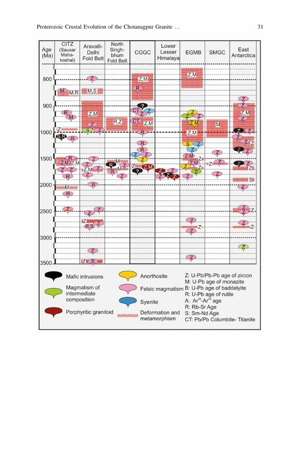
Proterozoic Crustal Evolution of the Chotanagpur Granite … 31

4.3.3 Eastern Margin
In the easternmargin, theCGGC is borderedby theCenozoic sediments ofBengal basinthat ranges more than 200,000 km2 comprising the largest alluvium delta in the worldcovering parts of West Bengal and Tripura and Bangladesh (Hossain et al. 2019).Sedimentation occurred in the continental passive margin (pre-Oligocene) to a remnantocean basin (beginning of Miocene) (Alam et al. 2003). Basement rocks below thePhanerozoic sedimentary cover compositionally ranges from tonalite, diorite to granite(Ameen et al. 1998, 2007; Kabir et al. 2001; Hossain et al. 2007). U–Pb zircongeochronology of basement rocks recovered from subcrop investigations nearMaddhapara, in the northeasternBangladesh, reveals an intrusion agesof 1722 ± 6 Mafrom a tonalite suite (Ameen et al. 2007) and 1730 ± 11 Ma from a diorite suite(Hossain et al. 2007). Limited geochemical data suggest ‘pre-plate collision’ affinity forthe tonalite and ‘syn-collisional’ affinity for granitic basements (Ameen et al. 2007)whereas contemporaneous diorite are inferred to have a calc-alkaline origin associatedwith a subduction zone settings (Hossain and Tsunogae 2014).
Towards the northeastern part of the Bengal basin, the Shillong-MeghalayaGneissic Complex (SMGC) comprises an ensemble of basement gneisses, meta-morphosed to amphibolite-granulite grade, overlain by the Shillong Group ofsediments (Ahmed 1983; Nandy 2001). Different generations metamorphosedgranite and garnodiorites and porphyritic granitoids (Fig. 4), having a wide range ofisotopic age (ca. 1700–550 Ma), are reported from the terrane (Mazumdar 1976;Ghosh et al. 1994; Bhattacharya and Ray Barman 2000; Ghosh et al. 2005; Kumaret al. 2017). Lal et al. (1978) calculated P–T conditions of 750 °C and 5 kbar fromthe metapelitic rocks near Sonapahar, eastern SMGC, whereas Chatterjee et al.(2007) determined a higher P–T of 850 °C and 7.5 kbar associated with acounter-clockwise P–T–t path. Chemical monazite dating constrains the age ofthe metamorphism at *1596 ± 15 Ma whereas in the western part nearGaro-Goalpara, the dominant metamorphism is dated to be 500 ± 14 Ma(Chatterjee et al. 2007). Mitra (1998) determined Pb–Pb ages of 1550–1530 Mafrom the detrital zircons from the supracrustals. In a recent publication Kumar et al.(2017) documented that granitoids from Rongjeng and Guwahati (Assam) intrudedthe Neo-Archean crust at 1778 ± 37 and 1630 ± 16 Ma respectively. Detailedgeochemical studies reveal dominant crustal source and intrusion of the granitoidsduring syn-collisional settings.
Lithological and geochronological similarities indicate that the SMGC has beena part of the Indian Shield (Evans 1964; Crawford 1974) or extension of CGGC(Desikachar 1974; Chatterjee et al. 2007). Considering the distinct geochronolog-ical similarity, it is also suggested that basement of the Bengal basin is theextension of the Paleoproterozoic crust of CGGC and CITZ (Hossain et al. 2007;Hossain and Tsunogae 2014). All these inferences further confirms the idea ofPaleoproterozoic crust o CGGC being extended up to SMGC as the Garo-Rajmahalgap represents a shallow basement ridge (Desikachar 1974).
32 S. Mukherjee et al.
4.4 Southern Margin: North Singhbhum Fold Belt &Singhbhum Craton
The contact between the Paleoproterozoic CGGC and Archean Singhbhum craton isdemarcated by the North Singhbhum Fold belt (NSFB), a 200 km long and 50 kmwide curvilinear orogenic belt. Extant geological information suggest that the NSFBrepresents Proterozoic rift-related sedimentation along major suture zones (Sarkar1982; Sarkar and Saha 1983; Gupta and Basu 2000; Sarkar 2000; Bhattacharya andMahapatra 2008; Bhattacharya et al. 2015). The Dalma Ophiolite Belt (DOB), anensemble of dominantly mafic- ultramafic rocks with minor felsic componentsrepresenting bimodal mafic-felsic volcanics, forms the most conspicuous part ofthe NSFB. Geochemical evidences suggest that the magmatism occurred at1619 ± 38 Ma (Rb–Sr whole rocks isochron age: Roy et al. 2002) under an exten-sional regime, presumably in a back-arc like settings (Chakrabarti 1985; Bose et al.1989). Metasedimentary rocks of the NSFB have been deformed-metamorphosed inat least three tectonothermal events (Mahato et al. 2008) representing a greenschistfacies that grades into amphibolite facies at the contact of the CGGC (Bose 1954; Rayand Gangopadhyay 1971; Mahato et al. 2008). Available geochronological studyfrom the southern part of the NSFB (S-NSFB) reveals that the metamorphismoccurred between 1.72 and 1.55 Ga in the southern part of the Dalma Volcanics(Mahato et al. 2008; Chatterjee et al. 2010; Rekha et al. 2011). In the northern part(N-NSFB) geochronological data are scarce and reveals an Early Neoproterozoictectonothermal event (*0.95 Ga; Rekha et al. 2011).
Discordant structural analyses, mismatching metamorphic grade and distinctlydifferent geochronological records suggest that Singhbhum Craton and CGGCevolved separately in distant geological time and got amalgamated afterwards. Thecontact between the Singhbhum Craton and the CGGC has been severely debatedand scarcity of geochronological and petrological data further blurs the nature andthe timing of the amalgamation and in this perspective the NSFB plays an importantrole in the formation of the East Indian Shield (EIS). Several tectonic models havebeen proposed to construct the evolutionary history of the EIS (Mahadevan 2002),which mostly revolves around two major ideas: (1) subduction of the SinghbhumCraton beneath the CGGC followed by collision between two continents (Sarkarand Saha 1962, 1977; Sarkar 1982; Mahato et al. 2008; Rekha et al. 2011). and(2) plume-driven basin formation accompanied by mafic magmatism and crustalshortening (Mukhopadhyay 1990; Gupta and Basu 2000). Former model (Sarkarand Saha 1962, 1977; Sarkar 1982; Mahato et al. 2008; Rekha et al. 2011) con-siders the Singhbhum Craton and the CGGC as separate blocks that collidedtogether and the NSFB represented a milieu of arc magmatism, sedimentation andobducted oceanic crust. Latter model indicates the presence of a unified crustalsection suggesting a prolonged connection between the Singhbhum Craton and theCGGC where NSFB represented basin formed via incipient rifting. In a recentpublication Bhattacharya et al. (2015) argued that different sedimentary basins andmagmatic bodies in the NSFB did not evolve synchronously suggesting that the
Proterozoic Crustal Evolution of the Chotanagpur Granite … 33
juxtaposition of the CGGC and the Singhbhum Craton is not straight forwards andwarrants further geochronological and petrological investigations.
4.5 CGGC and the Proterozoic Supercontinental Cycles
4.5.1 Columbia Supercontinent
Late Paleoproterozoic history of the Earth has been largely influenced by thepresence of Columbia Supercontinent that was inferred to be amalgamated between2.1 and 1.8 Ga (Rogers and Santosh 2009). However, several recent publicationsargued for more prolonged amalgamation and placed the timing of final packing atca. 1450 Ma (Sarkar and Schenk 2016; Meert and Santosh 2017). The configurationof the supercontinent is also debated owing to the scarcity of adequate petrological,geochronological and paleomagnetic data. Abundance of Late Paleoproterozoicmagmatism and metamorphism (Figs. 5 and 6) and available paleomagnetic dataindicate that Indian plate played an important role during the formation ofColumbia supercontinent (Rogers and Santosh 2002; Zhao et al. 2002; Zhang et al.2012a). Apart from its position in the supercontinent assembly, the configuration ofGreater Indian Landmass raised considerable debate as the timing of the CITZ,through which different Archean-Early Paleoproterozoic cratons of India (Yedekaret al. 1990; Acharyya 2003; Roy and Prasad 2003) amalgamated remained unclear.Initial notion of a Late Paleoproterozoic-Mesoproterozoic (*1.8–1.5 Ga) suturing(Acharyya 2003; Roy and Prasad 2003; Bhandari et al. 2011) has been challengedby the proposition of Neoproterozoic (1.0–0.95 Ga) assembly of the CITZ(Chattopadhyay and Khasdeo 2011; Bhowmik et al. 2012). However, high-grademetamorphic events at ca. 1800–1600 Ma reported from the northern and southernpart of CITZ (Bhandari et al. 2011; Deshmukh et al. 2017) and arc magmatism atca. 1750 Ma (Bora et al. 2013) points towards an accretion orogen.
In the Ongle domain (Andhra Pradesh) of Eastern Ghats Mobile Belt (EGMB)arc magmatism occurred at 1750–1710 Ma, followed by an UHT metamorphism at
cFig. 6 Regional diagram summarizing Paleoproterozoic magmatic and metamorphic events inIndia and Antarctica. The schematic configuration is drawn after Dasgupta and Sengupta (2003).The pressure–temperature trajectories of different domains are presented with their geochrono-logical data using the following references: a. Bhowmik et al. (2005, 2014); b. Bhandari et al.(2011); c. Chatterjee et al. (2007); d. Mahato et al. (2008); e. Dey et al. under review a; f. Sarkaret al. (2014); g. Sengupta et al. (1999); h. Roy et al. (2005); i. Kelly et al. (2002); j. Halpin et al.(2013); k. Halpin et al. (2013). Data for the magmatic events are collected from: Saikia et al.(2017), Chatterjee and Ghose (2011), Treloar and Rex (1990), DiPietro and Isachsen (2001),Zeitler et al. (1989), Miller et al. (2000), Singh et al. (1994), Richards et al. (2005), Chambers et al.(2008), Célérier et al. (2009), Decelles et al. (2000), Kohn et al. (2010), Daniel et al. (2003), Longet al. (2008), Yin et al. (2010), Mandal et al. (2016), Ameen et al. (2007), Hossain et al. (2007),Bora et al. (2013), Bhowmik et al. (2011), Sarkar et al. (2015), Henderson et al. (2014), Kovachet al. (2001), Kumar et al. (2017), Kaur et al. (2009, 2017a), Bhattacharya et al. (2015)
34 S. Mukherjee et al.
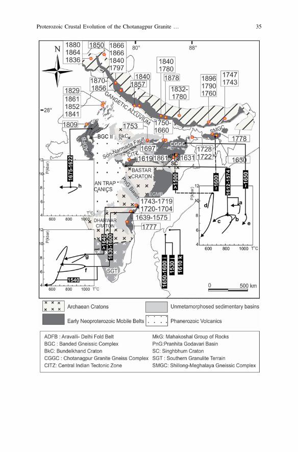
Proterozoic Crustal Evolution of the Chotanagpur Granite … 35

*1610 Ma (Sarkar and Schenk 2014; Sarkar et al. 2015). Calc-alkaline magmatismof arc-affinity with intrusion age of 1791–1771 Ma is also reported from Vinjamurudomain of the EGMB (Vadlamani et al. 2013). Paleoproterozoic (*1860–1810 Ma) arc magmatism is also reported from Aravalli-Delhi Mobile Belt (Kauret al. 2009, 2017a).
Although geochronological data are scarce from the vast terrain of the CGGC,Paleoproterozoic dates, corresponding to tectonothermal and magmatic events, arereported from different parts of the terrain (Fig. 6). Dey et al. (2017) and Dey et al.(under review, a) reported Late Paleoproterozoic (*1650 Ma) UHT metamorphismfrom the northeastern part of the terrane and the inferred P–T path corroboratewith convergent margin settings. Saikia et al. (2017) reported Paleoproterozoicvolcano-sedimentary sequence from the northern part of the terrain and the asso-ciated felsic magmatism (ca. 1750–1660 Ma) resembles an arc settings. Evidencesof such tectonothermal events from parts of CGGC indicate its involvement in theformation of the Greater Indian landmass during the assembly of Columbiasupercontinent.
The Mesoproterozoic extensional events throughout the world, manifested byrift-related magmatism, deemed to be linked with the breakdown of the super-continent (Rogers and Santosh 2002). Contemporaneous rift-related magmatism,manifested by several ferroan granite and alkaline batholiths (Vinukonda granite:1589 Ma: Dobmeier et al. 2006; Elchuru alkaline rocks: 1442 ± 30 Ma; Upadhyayet al. 2006; Errakonda and Uppalapadu alkaline rocks: 1352 ± 2 Ma; VijayaKumar et al. 2007) has been widely reported from western margin of the EasternGhats belt which reflect the extensional events. Despite their restricted occurrence,extension-related Mesoproterozoic (ca. 1450 Ma) anorogenic granites have intru-ded the Paleoproterozoic crust in the northeastern part of CGGC (Mukherjee et al.2017a, 2018). The multiple tectonothermal events (*1.75–1.3 Ga) that are recor-ded in the EGMB and CGGC are also recorded from the fragments of the erstwhileColumbia Supercontinents (Australia: Hand et al. 2007; Cutts et al. 2013; EastAntarctica: Kelly et al. 2002; Halpin et al. 2007b; Namibia: Kroner et al. 2010;Scotland : Friend and Kinny 2001). This observation points to the fact that theIndian shield was a part of the Columbia supercontinent.
4.5.2 Rodinia Supercontinent
Configuration and position of the Greater Indian landmass during the formation ofRodinia supercontinent remained highly debatable (e.g. Bhowmik et al. 2012).Widely inferred notion places the Greater Indian landmass adjacent to Australia andEast Antarctica along the marginal part of the Rodinia supercontinent (Dalziel1991; Hoffman 1991; Torsvik et al. 1996; Weil et al. 1998; Dasgupta and Sengupta2003; Li et al. 2008). However, the view has been opposed by several workers(Fitzsimons 2000; Powell et al. 2001; Torsvik et al. 2001; Powell and Pisarevsky2002; Merdith et al. 2017) based on available Paleomagnetic data. Numerousstudies have shown that Early Neoproterozoic (ca. 1000–900 Ma) tectonothermal
36 S. Mukherjee et al.

events experienced by the EGMB and the Rayner Complex of East Antarctica arevery much similar, which lends the idea of the Greater Indian landmass beingconnected to Antarctica (Dasgupta and Sengupta 2003). Neoproterozoictectonothermal events presented in this review is consistent with evolution of theCGGC in a continent-continent collision zone (Chatterjee and Ghose 2011;Karmakar et al. 2011; Sanyal and Sengupta 2012). The NSFB that is located to thesouth of the CGGC does not record strong impress of *1000–950 Matectonothermal event (reviewed in Chatterjee et al. 2010). The pervasive planarfabric in most part of the CGGC is E-W (Mahadevan 2002). This feature and the
Fig. 7 Regional diagram summarizing pressure–temperature trajectories and the geochronolog-ical data of different Neoproterozoic metamorphic events in India and Antarctica. The schematicconfiguration is drawn after Dasgupta and Sengupta (2003). The other abbreviations are NC:Napier complex, RC: Rayner Complex, ADFB: Aravalli Delhi Fld belt, BnC: BundelkhandCraton, CGGC: Chotanagpur Granite Gneissic Complex, SMGC: Shillong Meghalaya GneissicComplex, SC: Singhbhum Craton, NSFB: North Singhbhum Fold Belt, EGMB: Eastern GhatsMobile Belt, BC: Bastar Craton, SGT: Southern Granulite Terrain, CITZ: Central Indian TectonicZone. The references are as follows: a. Dey et al. (under review; b). Mukherjee et al. (2017a); c.Chatterjee et al. (2010); d. Karmakar et al. (2011); e. Bhowmik and Spiering (2004); Bhowmiket al. (2012); f. Pal and Bhowmik (1998); Bhowmik et al. (2012); g. Bhowmik et al. (2010); h.Bhowmik et al. (2009); i. Saha et al. (2008); j. Bose et al. (2017); k. Das et al. (2011), Das et al.(2017c); l. Bose et al. (2016); m. Chattopadhyay et al. (2015a); n. Halpin et al. (2005, 2007b,2013); Kelly et al. (2002); Kelly and Harley (2004); o. Halpin et al. (2007b); p. Halpin et al.(2007a)
Proterozoic Crustal Evolution of the Chotanagpur Granite … 37
structural attributes supporting that the NSFB is overridden by the CGGC (re-viewed in Mahadevan 2002). This deduction by implication points to the fact thatthe overthrusted unit possibly came from the north. The CGGC is surrounded byPhanerozoic sedimentary cover on its three sides (Fig. 2a). For this reason thenature of northern continent could not be studied.
Grenvillian tectonothermal events similar to CGGC are also recorded from theEGMB and the entire Rayner Complex of east Antarctica (reviewed in Mukherjeeet al. 2017a; Li et al. 2008). Neoproterozoic clockwise P–T paths recovered fromdifferent parts of the CITZ further corroborates the reworking of thePaleoproterozoic mobile belts of India and amalgamation of the Greater Indianlandmass (Fig. 7). However, geochronological studies have shown that althoughmost of the cratons were amalgamated by *1000 Ma, India was not attached to thesupercontinent assembly until * 950 to 900 Ma (Li et al. 2008).
Timing of the break-up of Rodinia supercontinent has been controversial andmostly placed at ca. 825 Ma, as manifested by widespread plume-related mag-matism throughout the world (reviewed in Li et al. 2008). However, lateTonian-Cryogenian (ca. 900–800 Ma) subduction-related magmatic activity hasbeen reported from different peripheral parts of Rodinia (reviewed in Cawood et al.2016). Post Grenvillian (<950 Ma) tectonothermal activity, reported from differentparts of the CGGC, EGMB and East Antarctica suggest that the final assembly andbreakup of the Rodinia was prolonged in these parts. Contemporaneous (ca. 870–780 Ma) high grade metamorphism event and shearing associated with the devel-opment of EITZ further poses the possibility that fragmentation of amalgamatedEast Antarctica and Greater Indian landmass did not initiate until ca. 780 Ma(Chatterjee et al. 2010).
5 The CGGC: Future Prospects
(A) Intra- and inter domain correlation of the magmatic, metamorphic and tectonichistory is of paramount importance to understand the evolution of the CGGC.As mentioned above, the present data base are meagre (and imprecise too) to dothis correlation. Strain patterns can change with space and metamorphicintensity may vary from place to place. Consequently, geometry of structureand estimated P–T values may vary from place to place. This may lead to awrong interpretation about the tectonic evolution of the CGGC. It is not clear ifthe contrasting metamorphic and structural information that are reported fromdifferent parts of the CGGC reflects imprecision of the data base or they areindicative of special/temporal variation of strain pattern and metamorphicintensity. This problem can be approached by the following ways:
38 S. Mukherjee et al.
(i) combined petrological and structural studied along continuous segmentsof the CGGC
(ii) Precise dating of metamorphic and structural events. This can also helpcorrelate the geological events over a large area.
(B) Studies in the light of modern petrology and geochronology are publishedmostly from the Domain I of the CGGC. The other two domains viz. Domain IIand III are least studied. *1700 to 1650 Ma old supracrustal rocks (in thejacket of low grade metamorphism) of the Domain II and III cannot be tracedsouth of the BMB. Though similar sedimentation age (1700–1680 Ma) hasbeen reported for some metapelitic enclaves from Domain I, it is not clear if thesedimentary protoliths of the metapelites (Domain I) are temporally and spa-tially linked to the supracrustal rocks of the Domain II and III of the CGGC.Basement of the low grade supracrustal rocks of Domain II and III are also notwell studied. It is also not clear if the basement of the low-grade supracrustalrocks continued further south. The *1000–850 Ma metamorphic events thatare preponderant in Domain I are absent in Domain II-III. These contrasts ingeology and geochronology raise the following questions:
(i) Do Domain II and III constitute a different crustal block that was suturedto Domain I after 850 Ma?
(ii) Is the oldest basement of all the three domains are same and that theGrenvillian front runs south of the BMB?
(C) Several workers (Chatterjee and Ghose 2011; Saikia et al. 2017) argued that thelitho ensemble that are now exposed in Domains II and III form eastwardextension of the Paleoproterozoic Mahakoshal Group of Central IndianTectonic Zone (CITZ) where such rocks are abundantly found. If this be thecase then only the Domain I should represent the CGGC. Detail petrologicaland geochronological information including delineation of the oldest compo-nents from the basement rocks of Domains II and III are likely to validate (ordiscard) the proposition.
(D) Studies have shown that nepheline syenite and carbonatite signifies crustalextension that are related to breakdown of supercontinental cycle (Upadhyayand Raith 2006). These rocks are present in NPSZ and SPSZ. It has beenmentioned before in Sects. 3.1 and 4.2 that the alkaline rocks and carbonatiterocks are deformed and metamorphosed (DARC, Burke et al. 2003). Severalstudies have shown that DARCs represent opening and closing stage of theWilson cycle of plate tectonics. Detail petrogenesis and geochronology of theDARCs may provide valuable information on the evolution of the CGGC.
(E) The extent of the *1650 Ma old UHT metamorphism as has been documentedfrom the NW part of the Domain I should be evaluated through rigorous studiesin other parts of Domain I.
(F) A few reports (cf. Misra and Dey 2002) show intrusion of voluminous hotgranitic magma (*1000 °C) within low grade supracrustal rocks in the BMB.Though heat rendering capacity of felsic magmas are certainly lower than those
Proterozoic Crustal Evolution of the Chotanagpur Granite … 39
of basaltic compositions, yet some contact effects are expected in view of thelarge volume of the felsic magma in the BMB.
(G) Felsic orthogneisses constitute the major component of the Domain I. Existingpetrological and geochronological information is available from a few scatteredareas. It is not clear if the magmatic protoliths of the entire felsic orthogneisseswere emplaced within a short time during crustal extension (Mukherjee et al.2018). Or else, different pulses of felsic magmatism were emplaced in diversetectonic setting over a protracted period of time.
(H) The relation between the CGGC (Domain I) and the NSFB require to be studiedin great detail. In view of the last high grade event at 1000–950 Ma in Domain Iand its absence in NSFB, suturing of the two unit during Paleo-Mesoproterozoic time seems implausible. Timing and mechanism of juxtapo-sition between CGGC and NSFB are to be studied.
Acknowledgements S.M. and A.D. acknowledge the financial support in the form of researchfellowships from the University Grant Commission, New Delhi and Council of Scientific andIndustrial Research, New Delhi respectively. P.S. and S.S. acknowledge the grants received fromthe programs awarded to the Department of Geological Sciences, Jadavpur University: UniversityPotential for Excellence (UPE-Phase II), Promotion of University Research and ScientificExcellence and Fund for Improvement of Science and Technology (FIST-Phase II) fromDepartment of Science and Technology and Center of Advance Studies (CAS-phase VI).Weexpress our sincere thanks to Soumyajit Mukherjee for providing very constructive detailedreview. Mukherjee (2019) summarizes this work.
References
Acharyya A, Roy S, Chaudhuri BK et al (2006) Proterozoic rock suites along South Purulia ShearZone, Eastern India: evidence for rift related setting. Journal of Geological Society of India 68,1069–1086
Acharyya SK (2003) The nature of mesoproterozoic Central indian tectonic zone with exhumedand reworked older granulites. Gondwana Research 6, 197–214
Ahmed M (1983) Depositional environment of the basal conglomerate of the Barapani Formation,Shillong Group, Khasi Hills, Meghalaya. Quarternary Journal Geological, Mining, andMetallurgical Society of India 55, 62–68
Alam M, Alam MM, Curray JR et al (2003) An overview of the sedimentary geology of theBengal Basin in relation to the regional tectonic framework and basin-fill history. SedimentaryGeology 155, 179–208
Ameen SMM, Khan MSH, Akon E, Kazi AI (1998) Petrography and major oxide chemistry ofsome Precambrian crystalline rocks from Maddhapara, Dinajpur. Bangladesh GeoscienceJournal 4, 1–19
Ameen SMM, Wilde SA, Kabir Z et al (2007) Paleoproterozoic granitoids in the basement ofBangladesh : a piece of the Indian shield or an exotic fragment of the Gondwana jigsaw ?Gondwana Research 12, 380–387
Asami M, Suzuki K, Grew ES (2002) Chemical Th-U-total Pb dating by electron microprobeanalysis of monazite, xenotime and zircon from the Archean Napier complex, East Antarctica:evidence for ultra-high-temperature metamorphism at 2400 Ma. Precambrian Research 114,249–275
40 S. Mukherjee et al.

Baidya TK, Chakravorty PS, Drubetskoy E, Khiltova VJ (1987) New geochronologic data onsome granitic phases of the Chotanagpur granite gneiss complex in the northwestern Puruliadist., West Bengal. Indian Journal of Earth Science 14, 136–141
Baidya TK, Maity N, Biswas P (1989) Tectonic phases and crustal evolution in a part of theEastern Chotanagpur Gneissic Complex. Journal of Geological Society of India 34, 318–324
Banerji AK (1985) On the nature of a part of boundary between Chotanagpur plateau andSinghbhum orogenic belt and its role in mineralization. Bulletin of the Geology, Mining andMetallurgical Society of India 53, 171–180
Basu SK (1993) Alkaline-carbonatite complex in Precambrian of South Purulia Shear Zone,Eastern India: its characteristics and mineral potentialities. Indian Minerals 47, 179–194
Basu A, Patranabis-Deb S, Schieber J, Dhang PC (2008) Stratigraphic position of the *1000 MaSukhda Tuff (Chhattisgarh Supergroup, India) and the 500 Ma question. Precambrian Research167, 383–388
Bhandari A, Pant NC, Bhowmik SK, Goswami-Banerjee S (2011) 1.6 Ga ultrahigh‐temperaturegranulite metamorphism in the Central Indian Tectonic Zone_insights from metamorphicreaction history, geothermobarometry and monazite chemical ages. Geological Journal 46,198–216
Bhattacharjee N, Ray J, Ganguly S, Saha A (2012) Mineralogical study of gabbro-anorthosite fromDumka, Chhotanagpur Gneissic complex, Eastern Indian Shield. Journal of Geological Societyof India 80, 481–492
Bhattacharya BP, Ray Barman T (2000) Precambrians of Meghalaya: a concept. Proc Dr MSKrishnan Birth Centen Sem Geol Surv, Ind Spec, Publ 55, 95–100
Bhattacharya DK, Mukherjee D, Barla VC (2010) Komatiite within Chhotanagpur GneissicComplex at Semra, Palamau district, Jharkhand: petrological and geochemical fingerprints.Journal of Geological Society of India 76, 589–606
Bhattacharya HN, Mahapatra S (2008) Evolution of the Proterozoic rift margin sediments–NorthSinghbhum Mobile Belt, Jharkhand-Orissa, India. Precambrian Research 162, 302–316
Bhattacharya HN, Nelson DR, Thern ER, Altermann W (2015) Petrogenesis and geochronology ofthe Arkasani Granophyre and felsic Dalma volcanic rocks: implications for the evolution of theProterozoic North Singhbhum Mobile Belt, east India. Geological Magazine 152, 492–503
Bhattacharyya HN, Chatterjee A, Chowdhury S (1992) Tourmalinite from Cu–U belt ofSinghbhum, Bihar, India. Journal of Geological Society of India 39, 191–195
Bhattacharyya PK, Mukherjee S (1987) Granulites in and around the Bengal anorthosite, easternIndia: genesis of coronal garnet and evolution of the granulite–anorthosite complex. GeologicalMagazine 124, 21–32
Bhowmik SK (2006) Ultra high temperature-metamorphism and its significance in the CentralIndian Tectonic Zone. Lihos 92, 484–505
Bhowmik SK, Bernhardt HJ, Dasgupta S (2010) Grenvillian age high-pressure upperamphibolite-granulite metamorphism in the Aravalli-Delhi Mobile Belt, Northwestern India:new evidence from monazite chemical age and its implication. Precambrian Research 178,168–184
Bhowmik SK, Pal T, Roy A, Pant NC (1999) Evidence for pre-Grenvillian high-pressure granulitemetamorphism from the northern margin of the Sausar mobile belt in Central India. Journal ofGeological Society of India 53, 385–399
Bhowmik SK, Roy A (2003) Garnetiferous metabasites from the Sausar Mobile Belt: petrology,P-T path and implications for the tectonothermal evolution of the Central Indian TectonicZone. Journal of Petrology 44, 387–420
Bhowmik SK, Sarbadhikari AB, Spiering B, Raith MM (2005) Mesoproterozoic reworking ofPalaeoproterozoic ultrahigh-temperature granulites in the Central Indian Tectonic Zone and itsimplications. Journal of Petrology 46, 1085–1119
Bhowmik SK, Spiering B (2004) Constraining the prograde and retrograde P-T paths of granulitesusing decomposition of initially zoned garnets : an example from the Central Indian TectonicZone. Contributions to Mineralogy and Petrology 147, 581–603
Proterozoic Crustal Evolution of the Chotanagpur Granite … 41

Bhowmik SK, Saha L, Dasgupta S, Fukuoka M (2009) Metamorphic phase relations inorthopyroxene-bearing granitoids: implication for high-pressure metamorphism and progrademelting in the continental crust. Journal of Metamorphic Geology 27:295–315. https://doi.org/10.1111/j.1525-1314.2009.00818.x
Bhowmik SK, Wilde SA, Bhandari A (2011) Zircon U-Pb/Lu-Hf and monazite chemical dating ofthe Tirodi biotite gneiss: implication for latest Palaeoproterozoic to Early Mesoproterozoicorogenesis in the Central Indian Tectonic Zone. Geological Journal 46, 574–596
Bhowmik SK, Wilde SA, Bhandari A, et al (2012) Growth of the Greater Indian Landmass and itsassembly in Rodinia : geochronological evidence from the Central Indian Tectonic Zone.Gondwana Research 22, 54–72
Bhowmik SK, Wilde SA, Bhandari A, Sarbadhikari AB (2014) Zoned monazite and zircon asmonitors for the thermal history of granulite terranes: an example from the Central IndianTectonic Zone. Journal of Petrology 55, 585–62
Biju-Sekhar S, Yokoyama K, Pandit MK et al (2003) Late Paleoproterozoic magmatism in DelhiFold Belt, NW India and its implication: evidence from EPMA chemical ages of zircons.Journal of Asian Earth Sciences 22, 189–207
Bora S, Kumar S, Yi K et al (2013) Geochemistry and U–Pb SHRIMP zircon chronology ofgranitoids and microgranular enclaves from Jhirgadandi Pluton of Mahakoshal Belt, CentralIndia Tectonic Zone, India. Journal of Asian Earth Sciences 70, 99–114
Bose M, Chakrabarti MK, Saunders AD (1989) Petrochemistry of the lavas from ProterozoicDalma volcanic belt, Singhbhum, eastern India. Geologische Rundschau 78, 633–648
Bose PK, Sarkar S, Chakrabarty S, Banerjee S (2001) Overview of the Meso-to Neoproterozoicevolution of the Vindhyan basin, central India. Sedimentary Geology 141, 395–419
Bose RN (1954) The metamorphic rocks around Barabhum and Bunduan, south Manbhum. TheQuarterly Journal of the Geological, Mining, and Metallurgical Society of India 29, 19–3
Bose S, Das K, Torimoto J et al (2016) Evolution of the Chilka Lake granulite complex, northernEastern Ghats Belt, India: first evidence of *780 Ma decompression of the deep crust and itsimplication on the India–Antarctica correlation. Lithos 263, 161–189
Bose S, Dunkley DJ, Dasgupta S et al (2011) India-Antarctica-Australia-Laurentia connection inthe Paleoproterozoic-Mesoproterozoic revisited: evidence from new zircon U-Pb and monazitechemical age data from the Eastern Ghats Belt, India. Bulletin of Geological Society ofAmerica 123, 2031–2049
Bose S, Seth P, Dasgupta N (2017) Meso-neoproterozoic mid-crustal metamorphic record from theAjmer–Shrinagar section, Rajasthan, India and its implication to the assembly of the GreaterIndian Landmass during the Grenvillian-age orogenesis. In: Pant NC, Dasgupta S (eds) Crustalevolution of India and Antarctica: the supercontinent connection. Geological Society, London,Special Publications, 457, 291–318
Buick IS, Allen C, Pandit M et al (2006) The proterozoic magmatic and metamorphic history ofthe Banded Gneiss Complex, central Rajasthan, India: LA-ICP-MS U-Pb zircon constraints.Precambrian Research 151, 119–142
Burke K, Ashwal LD, Webb SJ (2003) New way to map old sutures using deformed alkaline rocksand carbonatites. Geology 31, 391–394
Cawood PA, Strachan RA, Pisarevsky SA et al (2016) Linking collisional and accretionaryorogens during Rodinia assembly and breakup : Implications for models of supercontinentcycles. Earth and Planetary Science Letters 449, 118–126
Célérier J, Harrison TM, Webb AAG, Yin A (2009) The Kumaun and Garwhal Lesser Himalaya,India: part 1. Structure and stratigraphy. Bulletin of Geological Society of America 121, 1262–1280
Chakrabarti MK (1985) On the high-magnesian lavas of the Dalma metavolcanic sequence ofSinghbhum District, Bihar. In: Indian National Science Academy, 51, pp 598–609
Chakrabarty A, Sen AK (2010) Enigmatic association of the carbonatite and alkali-pyroxenitealong the Northern Shear Zone, Purulia, West Bengal: a saga of primary magmatic carbonatite.Journal of Geological Socoiety of India 76, 403–413
42 S. Mukherjee et al.

Chambers JA, Argles TW, Horstwood MSA et al (2008) Tectonic implications ofPalaeoproterozoic anatexis and Late Miocene metamorphism in the Lesser HimalayanSequence, Sutlej Valley, NW India. Journal of Geological Society 165, 725–737
Chatterjee N, Banerjee M, Bhattacharya A, Maji AK (2010) Monazite chronology, metamor-phism–anatexis and tectonic relevance of the mid-Neoproterozoic Eastern Indian TectonicZone. Precambrian Research 179, 99–120
Chatterjee N, Crowley JL, Ghose NC (2008) Geochronology of the 1.55 Ga Bengal anorthositeand Grenvillian metamorphism in the Chotanagpur gneissic complex, eastern India.Precambrian Research 161, 303–316
Chatterjee N, Ghose NC (2011) Extensive early Neoproterozoic high-grade metamorphism inNorth Chotanagpur Gneissic Complex of the Central Indian Tectonic Zone. GondwanaResearch 20, 362–379
Chatterjee N, Mazumdar AC, Bhattacharya A, Saikia RR (2007) Mesoproterozoic granulites of theShillong-Meghalaya Plateau: evidence of westward continuation of the Prydz Bay Pan-Africansuture into Northeastern India. Precambrian Research 152, 1–26
Chatterjee SM, Roy Choudhury M, Das S, Roy A (2017) Significance and dynamics of theneoproterozoic (810 Ma) Phulad Shear Zone, Rajasthan, NW India. Tectonics 36, 1432–1454
Chattopadhyay A, Das K, Hayasaka Y, Sarkar A (2015b) Syn-and post-tectonic granite plutonismin the Sausar Fold Belt, central India: Age constraints and tectonic implications. Journal ofAsian Earth Sciences 107, 110–112
Chattopadhyay A, Khasdeo L (2011) Structural evolution of Gavilgarh-Tan Shear Zone, CentralIndia: a possible case of partitioned transpression during Mesoproterozoic oblique collisionwithin Central Indian Tectonic Zone. Precambrian Research 186, 70–88
Chattopadhyay N, Ray S, Sanyal S, Sengupta P (2015a) Mineralogical, textural and chemicalreconstitution of granitic rock in ductile shear zone: a study from a part of the South PuruliaShear Zone, West Bengal, India. Ductile Shear Zones from micro-to macro-scales Wiley,Chichester, pp 141–163
Corvino AF, Boger SD, Henjes-kunst F et al (2008) Superimposed tectonic events at 2450 Ma,2100 Ma, 900 Ma and 500 Ma in the North Mawson Escarpment, Antarctic Prince CharlesMountains. Precambrian Research 167, 281–302
Crawford AR (1974) Indo-Antarctica, Gondwana Land and pattern of the distortion of a granulitebelt. Tectonophysics 22, 141–157
Cutts KA, Kelsey DE, Hand M (2013) Evidence for late Paleoproterozoic (ca 1690–1665 Ma)high- to ultrahigh-temperature metamorphism in southern Australia: implications forProterozoic supercontinent models. Gondwana Research 23, 617–640
Dalziel IWD (1991) Pacific margins of Laurentia and East Antarctica-Australia as a conjugate riftpair: evidence and implications for an Eocambrian supercontinent. Geology 19, 598–601
Daniel CG, Hollister LS, Parrish RR, Grujic D (2003) Exhumation of the main central thrust fromlower crustal depths, eastern Buthan Himalaya. Journal of Metamorphic Geology 21, 317–334
Das E, Karmakar S, Dey A et al (2017c) Reaction textures, pressure—temperature paths andchemical dates of monazite from a new suite of sapphirine—spinel granulites from parts of theEastern Ghats Province, India : insights into the final amalgamation of India and EastAntarctica during the formation of Rodinia. Crustal Evolution of India and Antarctica: TheSupercontinent Connection, London, Special Publications
Das K, Bose S, Karmakar S (2011) Multiple tectonometamorphic imprints in the lower crust : firstevidence of ca. 950 Ma (zircon U-Pb SHRIMP) compressional reworking of UHT aluminousgranulites from the Eastern Ghats Belt, India. Geological Journal 239, 217–239
Das S, Dasgupta N, Sanyal S et al (2017a) Dolomitic carbonatite from the Chotanagpur GraniteGneiss Complex : a new DARC (deformed alkaline rocks and carbonatite) in the Precambrianshield of India. Current Science 113, 4–6
Das S, Roy N, Sen P, Sanyal S, Karmakar S, Sengupta P, Sengupta SK (2017b) Evidence ofextensive alkali metasomatism along North Purulia Shear Zone (NPSZ) near Lanka-Nawadiharea in the southern parts of Chhotanagpur gneissic complex of East Indian shield. In:
Proterozoic Crustal Evolution of the Chotanagpur Granite … 43

Humboldt Kolleg “Earth and material sciences for sustainable societal developments” (13–15Jan), Raichak, India. pp 50–51
Das S, Sanyal S, Karmakar S, Sengupta P (2016) Petrology of a suite of deformed alkaline rocks inKankarkiari area of Purulia district, West Bengal: evidence of intra-continental suturing in partsof Eastern Indian Shield during Neoproterozoic time. In: International conference on electronmicroscopy & XXXVII annual meeting of EMSI (2–4 June), Varanasi, India, AbstractVolume, pp 85–86
Dasgupta S, Narula PL, Acharyya SK, Banerjee J (2000) Seismotectonic atlas of India and itsenvirons. In: Narula PL et al. (ed), Geological survey of India. Geological Survey of India
Dasgupta S, Sengupta P (2003) Indo-Antarctic correlation: a perspective from the Eastern GhatsGranulite Belt, India. Geological Society London Special Publications 206, 131–143
Deb M, Thorpe R, Krstic D (2002) Hindoli group of rocks in the Eastern Fringe of theAravalli-Delhi Orogenic Belt-Archean secondary Greenstone Belt or Proterozoic Supracrustals? Gondwana Research 5, 879–883
Decelles PG, Gehrels GE, Quade J et al (2000) Tectonic implications of of U-Pb U-Pb Zircon agesof of the Himalayan orogenic belt in Nepal. Science 288, 497–499
Deshmukh T, Prabhakar N, Bhattacharya A, Madhavan K (2017) Late Paleoproterozoic clockwiseP–T history in the Mahakoshal Belt, Central Indian Tectonic zone: implications for Columbiasupercontinent assembly. Precambrian Research 298, 56–78
Desikachar SV (1974) A review of the tectonic and geological history of eastern India in terms of‘plate tectonics’ theory. Journal of Geological Society of India 15, 137–149
Dey A, Karmakar S, Mauricio Ibanez-Mejia SM et al (under review, a) Petrology andgeochronology of metapelitic enclaves within felsic orthogneiss from the NE ChotanagpurGranite Gneissic Complex, eastern India: evidence for Stenian-Tonian reworking of a latePaleoproterozoic crust. Precambrian Research
Dey A, Karmakar S, Mukherjee S et al (under review, b) High Pressure metamorphism of maficgranulites from the Chotanagpur Granite Gneissic Complex, India: evidence for collisionaltectonics during assembly of Rodinia. Journal of Geodynnamics
Dey A, Mukherjee S, Sanyal S et al (2017) Deciphering sedimentary provenance and timing ofsedimentation from a suite of metapelites from the Chotanagpur Granite Gneissic complex,India: implications for Proterozoic tectonics in the East-Central part of the Indian shield. In:Mazumder R (ed) Sediment Provenance. Influences on compositional change from source tosink, Elsevier Ltd, pp 453–486
Dharma Rao CV, Santosh M, Dong Y (2012) U-Pb zircon chronology of the Pangidi-Kondapallelayered intrusion, Eastern Ghats belt, India: constraints on Mesoproterozoic arc magmatism ina convergent margin setting. Journal of Asian Earth Sciences 49, 362–375
Dharma Rao CV, Santosh M, Kim SW, Li S (2013) Arc magmatism in the Delhi Fold Belt:SHRIMP U-Pb zircon ages of granitoids and implications for Neoproterozoic convergentmargin tectonics in NW India. Journal of Asian Earth Sciences 78, 83–99
Dharma Rao CV, Santosh M, Purohit R et al (2011) LA-ICP-MS U-Pb zircon age constraints onthe Paleoproterozoic and Neoarchean history of the Sandmata Complex in Rajasthan within theNW Indian Plate. Journal of Asian Earth Sciences 42, 286–305
DiPietro JA, Isachsen CE (2001) U-Pb zircon ages from the Indian plate in northwest Pakistan andtheir significance to Himalayan and pre-Himalayan geologic history. Tectonics 20, 510
Dobmeier C, Lütke S, Hammerschmidt K, Mezger K (2006) Emplacement and deformation of theVinukonda meta-granite (Eastern Ghats, India)—Implications for the geological evolution ofpeninsular India and for Rodinia reconstructions. Precambrian Research 146, 165–178
Dobmeier C, Simmat R (2002) Post-Grenvillean transpression in the Chilka Lake area, EasternGhats Belt—implications for the geological evolution of peninsular India. PrecambrianResearch 113, 243–268
Dobmeier CJ, Raith MM (2003) Crustal architecture and evolution of the Eastern Ghats Belt andadjacent regions of India. Geological Society London Special Publications 206, 145–168
Dunn JA (1929) The geology of north Singhbhum including parts of Ranchi and Singhbhumdistricts. Memoirs of the Geological Survey of India 54, 1–280
44 S. Mukherjee et al.

Elburg M, Jacobs J, Andersen T et al (2015) Early Neoproterozoic metagabbro-tonalite-trondhjemite of Sør Rondane (East Antarctica): implications for supercontinent assembly.Precambrian Research 259, 189–206
Evans P (1964) The tectonic framework of Assam. Journal of Geological Society of India 5, 80–96Fitzsimons ICW (2000) Grenville-age basement provinces in East Antarctica: evidence for three
separate collisional orogens. Geology 28, 879–882Friend C, Kinny P (2001) A reappraisal of the Lewisian Gneiss Complex: geochronological
evidence for its tectonic assembly from disparate terranes in the Proterozoic. Contributions toMineralogy and Petrology 142, 198–218
Ghose NC (1983) Geology, tectonics and evolution of the Chhotanagpur granite-gneiss complex,Eastern India. Recent Researches in Geology 10, 211–247
Ghose NC (1992) Chhotanagpur gneiss-granulite complex, Eastern India: present status and futureprospect. Indian Journal of Geology 64, 100–121
Ghose NC, Mukherjee D (2000) Chotanagpur gneiss–granulite complex, Eastern India—akaleidoscope of global events. In: Trivedi AN, Sarkar BC, Ghose NC (eds) Geology andmineral resources of Bihar and Jharkhand, Platinum Jubilee Commemoration Volume, IndianSchool of Mines, Dhanbad, monograph 2, Institute of Geoexploration and Environment, Patna,pp 33–58
Ghosh S, Chakraborty S, Paul DK et al (1994) New Rb–Sr isotopic ages and geochemistry ofgranitoids from Meghalaya and their significance in middle to late Proterozoic crustalevolution. Indian Mineralogist 48, 33–44
Ghosh S, Fallick AE, Paul DK, Potts PJ (2005) Geochemistry and origin of Neoproterozoicgranitoids of Meghalaya, Northeast India: Implications for linkage with amalgamation ofGondwana supercontinent. Gondwana Research 8, 421–432
Ghosh SK, Sengupta S (1999) Boudinage and composite boudinage in superposed deformationsand syntectonic migmatization. Journal of Structural Geology 21, 97–110
Goodge JW, Vervoort JD, Fanning CM et al (2008) A positive test of East Antarctica–LaurentiaJuxtaposition within the Rodinia Supercontinent. Science 321, 235–240
Goswami B, Bhattacharyya C (2010) Tectonothermal Evolution of Chhotanagpur Granite Gneisscomplex from Northeastern part of Puruliya District, West Bengal, Eastern India. IndianJournal of Geology 80, 41–54
Goswami B, Bhattacharyya C (2013) Petrogenesis of shoshonitic granitoids, Eastern India:implications for the late Grenvillian post-collisional magmatism. Geoscience Frontiers 5, 821–843
Gupta A, Basu A (2000) North Singhbhum Proterozoic Mobile Belt Eastern India—a review.Geological Survey of India Special Publications 55, 195–226
Gupta P, Guha DB, Chattopadhyay B (1998) Basement-cover relationship in the Khetri copper beltand the emplacement mechanism of the granite massifs, Rajasthan, India. Journal of GeologicalSociety of India 52, 417–432
Halpin JA, Clarke GL, White RW, Kelsey DE (2007a) Contrasting P–T–t paths forNeoproterozoic metamorphism in MacRobertson and Kemp Lands, east Antarctica. Journalof Metamorphic Geology 25, 683–701
Halpin JA, Daczko NR, Clarke GL, Murray KR (2013) Basin analysis in polymetamorphicterranes: an example from east Antarctica. Precambrian Research 231, 78–97
Halpin JA, Gerakiteys CL, Clarke GL et al (2005) In-situ U – Pb geochronology and Hf isotopeanalyses of the Rayner Complex, east Antarctica. Contributions to Mineralogy and Petrology148, 689–706
Halpin JA, White RW, Clarke GL, Kelsey DE (2007b) The Proterozoic P–T–t evolution of theKemp Land coast, East Antarctica; Constraints from Si-saturated and Si-undersaturatedmetapelites. Journal of Petrolology 48, 1321–1349
Hand M, Reid A, Jagodzinski L (2007) Tectonic framework and evolution of the Gawler craton,southern Australia. Economic Geology 102, 1377–1395
Henderson B, Collins AS, Payne J et al (2014) Geologically constraining India in Columbia: theage, isotopic provenance and geochemistry of the protoliths of the Ongole Domain, SouthernEastern Ghats, India. Gondwana Research 26, 888–906
Proterozoic Crustal Evolution of the Chotanagpur Granite … 45
Hoffman PF (1991) Did the breakout of Laurentia turn Gondwanaland inside-out ? Hoffman PF,Published by : American Association for the Advancement of Science
Hoffmann P (1989) Speculations on Laurentia’s first gigayear (2.0–1.0 Ga). Geology 17, 135–138Hossain I, Tsunogae T (2014) Crystallization conditions and petrogenesis of the paleoproterozoic
basement rocks in Bangladesh : an evaluation of biotite and coexisting amphibole mineralchemistry. Journal of Earth Sciemce 25, 87–97
Hossain I, Tsunogae T, Rajesh HM (2007) Palaeoproterozoic U – Pb SHRIMP zircon age frombasement rocks in Bangladesh : a possible remnant of the Columbia supercontinent. CompetesRendus Geoscience 339, 979–986
HossainMd S, Khan SH, ChowdhuryKR, Abdullah R (2019) Synthesis of the tectonic and structuralelements of the Bengal Basin (and its surroundings). In: Mukherjee S. (Ed) Tectonics andstructural geology: Indian context. Springer International Publishing AG, Cham, pp 135–218.ISBN 978-3-319-99340-9
Jain SC, Yedekar DB, Nair KKK (1991) Central Indian shear zone: a major Pre-Cambrian crustalboundary. Journal of Geological Society of India 37, 521–531
Kabir MZ, Khalil RC, Akon E et al (2001) Petrogenetic study of Precambrian basement rocks fromMaddhapara, Dinajpur, Bangladesh. Bangladesh Geoscience Journal 7, 1–18
Karmakar S, Bose S, Sarbadhikari AB, Das K (2011) Evolution of granulite enclaves andassociated gneisses from Purulia, Chhotanagpur Granite Gneiss Complex, India: evidence for990–940 Ma tectonothermal event(s) at the eastern India cratonic fringe zone. Journal of AsianEarth Sciences 41, 69–88
Kaur P, Chaudhri N, Raczek I et al (2009) Record of 1.82 Ga Andean-type continental arcmagmatism in NE Rajasthan, India: insights from zircon and Sm-Nd ages, combined withNd-Sr isotope geochemistry. Gondwana Research 16, 56–71
Kaur P, Chaudhri N, Raczek I, et al (2011) Zircon ages of late Palaeoproterozoic (ca.1.72-1.70 Ga) extension-related granitoids in NE Rajasthan, India: regional and tectonicsignificance. Gondwana Research 19, 1040–1053
Kaur P, Zeh A, Chaudhri N (2017a) Palaeoproterozoic continental arc magmatism, andNeoproterozoic metamorphism in the Aravalli-Delhi orogenic belt, NW India: new constraintsfrom in situ zircon U-Pb-Hf isotope systematics, monazite dating and whole-rock geochem-istry. Journal of Asian Earth Sciences 136, 68–88
Kaur P, Zeh A, Chaudhri N, Eliyas N (2017b) Two distinct sources of 1.73–1.70 Ga A-typegranites from the northern Aravalli orogen, NW India: constraints from in situ zircon U-Pbages and Lu-Hf isotopes. Gondwana Research 49, 164–181
Kelly NM, Clarke GL, Fanning CM (2002) A two-stage evolution of the Neoproterozoic Raynerstructural episode: new U-Pb sensitive high resolution ion microprobe constraints from theOygarden group, Kemp Land, East Antarctica. Precambrian Res 116, 307–330
Kelly NM, Harley SL (2004) Orthopyroxene–corundum in Mg–Al-rich granulites from theOygarden Islands, east Antarctica. Journal of Petrolology 45, 1481–1512
Kohn MJ, Paul SK, Corrie SL (2010) The lower lesser Himalayan sequence : a Paleoproterozoicarc on the northern margin of the Indian plate. GSA Bulletin 122, 323–335
Korhonen FJ, Clark C, Brown M et al (2013) How long-livedis ultrahigh temperature(UHT) metamorphism? Constraints from zircon andmonazite geochronology in the EasternGhats orogenic belt, India. Precambrian Research 234, 322–350
Kovach VP, Berezhnayal NG, Salnikoval EB, Kotovl AB (2001) The Western Charnockite zoneof the Eastern Ghats Belt, India—an Laurentia-Siberia connection revisited again : an overviewof U-Pb Zircon. 6–7
Krause O, Dobmeier C, Raith MM, Mezger K (2001) Age of emplacement of massif-typeanorthosites in the Eastern Ghats Belt, India: constraints from U-Pb zircon dating and structuralstudies. Precambrian Research 109, 25–38
Krishna V, Prasad RN, Pandey UK, et al (1996) Rb-Sr geochronology of Chotanagpurgneiss-granulite complex around Kailashnathgufa area, Raigarh district, MP. In: Proceedingsof seventh national symposium on mass spectrometry
46 S. Mukherjee et al.

Krishna V, Sastry D, Pandey BK, Sinha RP (2003) U-Pb and Pb-Pb ages on columbite-tantaliteminerals from pegmatites of Bihar Mica Belt, Jharkhand, India. In: ISMAS silver jubileesymposium on mass spectrometry. V. 2: contributed papers
Kroner A, Rojas-Agramonte Y, Hegner E, et al (2010) SHRIMP zircon dating and Nd isotopicsystematics of Palaeoproterozoic migmatitic orthogneisses in the Epupa metamorphic complexof northwestern Namibia. Precambrian Research 183, 50–69
Kumar MN, Das N, Dasgupta S (1978) Geology and mineralization along the Northern ShearZone, Purulia District, West Bengal—an up-to-date appraisal. Records of the GeologicalSurvey of India 133, 25–31
Kumar S, Rino V, Hayasaka Y et al (2017) Contribution of Columbia and GondwanaSupercontinent assembly- and growth-related magmatism in the evolution of the MeghalayaPlateau and the Mikir Hills, Northeast India: constraints from U-Pb SHRIMP zircongeochronology and geochemistry. Lithos 277, 356–375
Lahiri G, Das S (1984) Petrology of the area east of Daltonganj, Palamau district, Bihar. Journal ofGeological Society of India 25, 490–504
Lal N, Saini HS, Nagpaul KK, K. Sharma K (1976) Tectonic and cooling history of the Bihar MicaBelt, India, as revealed by fission-track analysis. Tectonophysics 34, 163–180
Lal RK, Ackermand D, Seifert F, Haldar SK (1978) Chemographic relationships insapphirine-bearing rocks from Sonapahar, Assam, India. Contributions to Mineral Petrol 67,169–187
Larson KP, Kellett DA, Cottle JM et al (2016) Anatexis, cooling, and kinematics duringorogenesis: miocene development of the himalayan metamorphic core, east-central nepal.Geosphere 12, 1575–1593
Li ZX, Bogdanova SV, Collins AS et al (2008) Assembly, configuration, and break-up history ofRodinia: a synthesis. Precambrian Research 160, 179–210
Liao QA, Li DW, Lu L et al (2008) Paleoproterozoic granitic gneisses of the Dinggye andLhagoiKangri areas from the higher and northern Himalaya, Tibet: geochronology andimplications. Science China, Section D Earth Science 51, 240–248
Liu X, Zhao Y, Chen H, Song B (2017) New zircon U – Pb and Hf – Nd isotopic constraints on thetiming of magmatism, sedimentation and metamorphism in the northern Prince CharlesMountains, East Antarctica. Precambrian Research 299, 15–33
Liu X, Zhao Y, Hu J (2013) The c. 1000–900 Ma and c. 550 – 500 Ma tectonothermal events inthe Prince Charles Mountains—Prydz Bay region, East Antarctica, and their relations tosupercontinent evolution. In: Harley SL, Fitzsimons ICW, Zhao Y (eds) Antarctica andsupercontinent evolution. Geological Society, London, Special Publications, pp 95–112
Liu X, Zhao Y, Song B et al (2009) SHRIMP U-Pb zircon geochronology of high-grade rocks andcharnockites from the eastern Amery Ice Shelf and southwestern Prydz Bay, East Antarctica:constraints on late Mesoproterozoic to Cambrian tectonothermal events related to supercon-tinent assembly. Gondwana Research 16, 342–361
Long SP, McQuarrie N, Tobgay T et al (2008) Tectonostratigraphy of the lesser Himalaya ofBhutan: deducing the paleostratigraphy of the northern Indian margin. In: AGU fall meetingabstracts
Mahadevan TM (1992) Geological evolution of the Chhotanagpur gneissic complex in parts ofPurulia district. Indian Journal of Geology 64, 1–22
Mahadevan TM (2002) Geology of Bihar & Jharkhand. Geological Society of India, BangaloreMahato S, Goon S, Bhattacharya A et al (2008) Thermo-tectonic evolution of the North
Singhbhum Mobile Belt (eastern India): a view from the western part of the belt. PrecambrianResearch 162, 102–127
Maji AK, Goon S, Bhattacharya A et al (2008) Proterozoic polyphase metamorphism in theChhotanagpur Gneissic Complex (India), and implication for trans-continental Gondwanalandcorrelation. Precambrian Research 162, 385–402
Mallik AK (1993) Dating of the granite plutons in Bihar mica belt. Bihar Records of theGeological Survey of India 126:27–29
Proterozoic Crustal Evolution of the Chotanagpur Granite … 47
Mallik AK, Gupta SN, Barman Ray T (1991) Dating of early Precambrian granite-greenstonecomplex of the eastern Indian Precambrian shield with special reference to the Chotanagpurgranite gneiss complex. Records of Geological Survey of India 125, 20–21
Malone SJ et al (2008). Paleomagnetism and Detrital Zircon geochronology of the upper Vindhyansequence, Son Valley and Rajasthan, India: a ca. 1000 Ma Closure age for the Purana basins?Precambrian Research 164, 137–159
Mandal S, Robinson DM, Kohn MJ et al (2016) Zircon U-Pb ages and Hf isotopes of the Askotklippe, Kumaun, northwest India: implications for Paleoproterozoic tectonics, basin evolutionand associated metallogeny of the northern Indian cratonic margin. Tectonics 35, 965–982
Mandal P (2016) Shear-wave splitting in Eastern Indian Shield: detection of a Pan-African sutureseparating Archean and Meso-Proterozoic terrains. Precambrian Research. Elsevier B.V. 275,278–285
Manna SS, Sen SK (1974) Origin of garnet in basic granulites around Saltora, West Bengal, India.Contributions to Mineralogy and Petrology 44, 195–218
Mazumdar SK (1976) A summary of the Precambrian Geology of Khasi Hills, Meghalaya.Geologoical Survey of India Miscillineous Publications 23, 311–334
Mazumdar SK (1988) Crustal evolution of the Chotanagpur gneissic complex and the Mica Belt ofBihar. In: Mukhopadhyay D (ed) Precambrian of the Eastern Indian shield. Geological Societyof India Memoir 8, 49–84
Meert JG, Pandit MK, Pradhan VR et al (2010) Precambrian crustal evolution of Peninsular India:a 3.0 billion year odyssey. Journal of Asian Earth Sciences 39, 483–515
Meert JG, Santosh M (2017) The Columbia supercontinent revisited. Gondwana Research 50, 67–83
Merdith AS, Collins AS, Williams SE et al (2017) A full-plate global reconstruction of theNeoproterozoic. Gondwana Research 50, 84–134
Mezger K, Cosca MA (1999) The thermal history of the Eastern Ghats Belt (India) as revealed byU-Pb and 40Ar/39Ar dating of metamorphic and magmatic minerals: implications for theSWEAT correlation. Precambrian Research 94, 251–271
Miller C, Klotzli U, Frank W et al (2000) Proterozoic crustal evolution in the NW Himalaya(India) as recorded by circa 1.80 Ga mafic and 1.84 Ga granitic magmatism. PrecambrianResearch 103, 191–206
Misra S, Dey S (2002) Bihar Mica Belt plutons-an example of post-orogenic granite from easternIndian shield. Journal of Geological Society of India 59, 363–37
Mishra DC, Singh B, Tiwari VM, et al (2000) Two cases of continental collisions and relatedtectonics during the Proterozoic period in India - insights from gravity modelling constrainedby seismic and magnetotelluric studies. Precambrian Research 99:149–169. https://doi.org/10.1016/S0301-9268(99)00037-6
Mitra SK (1998) Structure, sulphide mineralization and age of the Shillong group of rocks,Meghalaya. In: SK Krishnan centenary commemorative national seminar, p 118–119
Morrissey LJ, Hand M, Kelsey DE (2015) Multi-stage metamorphism in the Rayner—EasternGhats Terrane : P–T–t constraints from the northern Prince Charles Mountains, east Antarctica.Precambrian Research 267, 137–163
Mukherjee D, Ghose NC, Chatterjee N (2005) Crystallization history of a massif anorthosite in theeastern Indian shield margin based on borehole lithology. Journal of Asian Earth Sciences 25,77–94
Mukherjee S (In press) Kinematics of pure shear ductile deformation within rigid walls: Newanalyses. In: Billi A, Fagereng A. (eds) Problems and solutions in structural geology andtectonics. Series editor: Mukherjee S, Developments in structural geology and tectonics bookseries. Elsevier. ISBN: 9780128140482. ISSN: 2542–9000
Mukherjee S (2013) Channel flow extrusion model to constrain dynamic viscosity and Prandtlnumber of the Higher Himalayan Shear Zone. International Journal of Earth Sciences 102,1811–1835
48 S. Mukherjee et al.
Mukherjee S (2015) A review on out-of-sequence deformation in the Himalaya. In: Mukherjee S,Carosi R, van der Beek P, Mukherjee B, Robinson D (eds) Tectonics of the Himalaya.Geological Society, London, Special Publications 412, 67–109
Mukherjee S (2017) Shear heating by translational brittle reverse faulting along a single, sharp andstraight fault plane
Mukherjee S (2019) Introduction to “Tectonics and Structural Geology: Indian Context”. In:Mukherjee S (ed) Tectonics and structural geology: Indian context. Springer InternationalPublishing AG, Cham, pp 1–5. ISBN: 978-3-319-99340-9
Mukherjee S, Mulchrone KF (2013) Viscous dissipation pattern in incompressible Newtoniansimple shear zones: an analytical model. International Journal of Earth Sciences 102:1165–1170
Mukherjee S, Carosi R, van der Beek P, Mukherjee B, Robinson D (2015a) Tectonics of theHimalaya: an introduction. In: Mukherjee S, Carosi R, van der Beek P, Mukherjee B,Robinson D (eds) Geological Society, London, Special Publications 412, 1–3
Mukherjee S, Dey A, Ibanez-Mejia M et al (2018) Geochemistry, U-Pb geochronology and Lu-Hfisotope systematics of a suite of ferroan (A-type) granitoids from the CGGC: Evidence forMesoproterozoic crustal extension in the east Indian shield. Precambrian Research 305, 40–63
Mukherjee S, Dey A, Sanyal S et al (2017a) Petrology and U–Pb geochronology of zircon in asuite of charnockitic gneisses from parts of the Chotanagpur Granite Gneiss Complex (CGGC):evidence for the reworking of a Mesoproterozoic basement during the formation of the Rodiniasupercontinent. In: Pant NC, Dasgupta S (Eds) Crustal evolution of India and Antarctica: thesupercontinent connection. Geological Society of London, Special Publications 451, 197–231
Mukherjee S, Mukherjee B, Thiede R (2013) Geosciences of the Himalaya-Karakoram-TibetOrogen. Thematic volume’s editorial. International Journal of Earth Sciences 102, 1757–1758
Mukherjee S, Punekar J, Mahadani T, Mukherjee R (2015b) A review on intrafolial folds and theirmorphologies from the detachments of the western Indian Higher Himalaya. In: Mukherjee S,Mulchrone KF (eds) Ductile shear zones: from micro- to macro-scales. Wiley Blackwell,pp 182–205
Mukhopadhyay D (1990) Precambrian plate tectonics in the Eastern Indian Shield. In:Sychanthavong SPH (ed) Crustal evolution and metallogeny. Oxford and IBH PublishingCo, New Delhi, pp 75–100
Mukhopadhyay D, Bhattacharyya T, Chattopadhyay N, et al (2000) Anasagar gneiss: a foldedgranitoid pluton in the Phanerozoic South Delhi Fold Belt, central Rajasthan. InternationalJournal of Earth System Sciences 109, 22–38
Mulchrone K, Mukherjee S (2015) Shear senses and viscous dissipation of layered ductile simpleshear zones. Pure and Applied Geophysics 172:2635–2642
Mulchrone K, Mukherjee S (2016) Kinematics and shear heat pattern of ductile simple shear zoneswith “slip boundary condition”. International Journal of Earth System Sciences 105:1015–1020
Nandy DR (2001) Geodynamics of the Northeastern India and the Adjoining Region. ACBPublications 209
Owada M, Osanai Y, Toyoshima T et al (2003) Early Proterozoic tectonothermal events in theNapier Complex, East Antarctica: implications for the formation of East Gondwana.Gondwana Research 6, 231–240
Pal T, Bhowmik SK (1998) Metamorphic history of Sausar Group of rocks. Geological Survey ofIndia (Unpublished report)
Pandey BK, Gupta JN, Lall Y (1986a) Whole rock and Rb-Sr isochron ages for the granites fromBihar mica belt of Hazaribagh, Bihar, India. Indian Journal of Earth Science 12, 157–162
Pandey BK, Krishna V, Chabria T (1998) An overview of Chotanagpur Gneiss-Granulite Complexand adjoining sedimentary sequences, eastern and central India. In: International seminar onPrecambrian crust in Eastern and Central India 1998. Abstract Volume UNESCO-IUGS-IGCP-368. pp 131–135
Pandey BK, Upadhayay DL, Sinha KK (1986b) Geochronology of Jajawal-Binda-Nagnahagranitoids in relation to uranium mineralisation. Indian Journal of Earth Science 13, 163–168
Proterozoic Crustal Evolution of the Chotanagpur Granite … 49
Pandit MK, Carter LM, Ashwal LD et al (2003) Age, petrogenesis and significance of 1 Gagranitoids and related rocks from the Sendra area, Aravalli Craton, NW India. Journal of AsianEarth Sciences 22, 363–381
Panigrahi MK, Bream BR, Misra KC, Naik RK (2004) Age of granitic activity associated withcopper-molybdenum mineralization at Malanjkhand, Central India. Mineralium Deposita 39,670–677
Patel SC (2007) Vesuvianite-wollastonite-grossular-bearing calc-silicate rock near Tatapani,Surguja district, Chhattisgarh. Journal of Earth System Science 116, 143–147
Piper JDA (2013) Continental velocity through Precambrian times: the link to magmatism, crustalaccretion and episodes of global cooling. Geoscience Frontiers 4, 7–36
Pisarevsky SA, Wingate MTD, Powell CM et al (2003) Models of Rodinia assembly andfragmentation. Geological Society, London, Special Publications 206, 35–55
Powell CM, Jones DL, Pisarevsky S, Wingate MTD (2001) Palaeomagnetic constraints on theposition of the Kalahari craton in Rodinia. Precambrian Research 110, 33–46
Powell CM, Pisarevsky SA (2002) Late neoproterozoic assembly of East Gondwana. Geology 30,3–6
Radhakrishna BP, Naqvi SM (1986) Precambrian continental crust of India and its evolution.Journal of Geology 94, 145–166
Ramakrishnan M, Vaidyanadhan R (2008) Geology of India. Geological Society of IndiaBangalore
Ray Barman T, Bishui PK (1994) Dating of Chotanagpur gneissic complex of eastern IndianPrecambrian shield. Records of Geological Survey of India 127, 25–27
Ray Barman T, Bishui PK, Mukhopadhyay K, Ray JN (1994) Rb-Sr geochronology of thehigh-grade rocks from Purulia, West Bengal and Jamua-Dumka sector, Bihar. Indian Minerals48, 45–60
Ray J, Saha A, Ganguly S et al (2011a) Geochemistry and petrogenesis of NeoproterozoicMylliem granitoids, Meghalaya Plateau, northeastern India. Journal of Earth System Science120, 459–473
Ray S, Gangopadhyay PK (1971) Metamorphic belt of Singhbhum, Manbhum and Chottanagpur.Journal of Geological Society of India 12, 286–294
Ray S, Sanyal S, Sengupta P (2011b) Mineralogical control on rheological inversion of a suite ofdeformed Mafic Dykes from parts of the Chottanagpur Granite Gneiss complex of EasternIndia, 263–276
Reddy S, Clarke C, Mazumder R (2009) Temporal constraints on the evolution of the SinghbhumCrustal Province from U-Pb SHRIMP data. In: Mazumder R, Saha D (eds) PaleoproterozoicSupercontinents and global evolution international association for Gondwana researchconference series, 9 abstract volume. pp 17–18
Rekha S, Upadhyay D, Bhattacharya A et al (2011) Lithostructural and chronological constraintsfor tectonic restoration of Proterozoic accretion in the Eastern Indian Precambrian shield.Precambrian Research 187, 313–333
Richards A, Argles T, Harris N et al (2005) Himalayan architecture constrained by isotopic tracersfrom clastic sediments. Earth and Planetary Science Letters 236, 773–796
Rickers K, Mezger K, Raith MM (2001) Evolution of the continental crust in the ProterozoicEastern Ghats Belt, India and new constraints for Rodinia reconstruction: implications fromSm-Nd, Rb-Sr and Pb-Pb isotopes. Precambrian Research 112, 183–210
Rode KP (1948) On charnockitic rocks of Palamau, Bihar, India. Schweiz, Min Petr Mitt 28,288–307
Rogers JJW (1996) A history of continents in the past 3 billion years. Journal of Geology 104,91–107
Rogers JJW, Santosh M (2002) Configuration of Columbia, a Mesoproterozoic supercontinent.Gondwana Research 5, 5–22
Rogers JJW, Santosh M (2009) Tectonics and surface effects of the supercontinent Columbia.Gondwana Research 15, 373–380
50 S. Mukherjee et al.

Roy A, Kagami H, Yoshida M et al (2006) Rb – Sr and Sm – Nd dating of different metamorphicevents from the Sausar Mobile Belt, central India : implications for Proterozoic crustalevolution. Journal of Asian Earth Sciences 26, 61–76
Roy A, Prasad MH (2003) Tectonothermal events in Central Indian Tectonic Zone (CITZ) and itsimplications in Rodinian crustal assembly. Journal of Asian Earth Sciences 22, 115–129
Roy A, Sarkarl A, Jeyakumar S et al (2002) Mid-Proterozoic plume-related thermal event inEastern Indian Craton : evidence from trace elements, REE geochemistry and Sr - Nd isotopesystematics of basic-ultrabasic intrusives from Dalma volcanic belt. Gondwana Research 5,133–146
Roy AB, Kroner A, Bhattachaya PK, Rathore S (2005) Metamorphic evolution and zircongeochronology of early Proterozoic granulites in the Aravalli Mountains of northwestern India.Geological Magazine 142, 287–302
Roy AK (1977) Structure and metamorphic evolution of the Bengal anorthosite and associatedrocks. Journal of Geological Society of India 18, 203–223
Roy Chowdhury M (1979) Annual general report of the Geological survey of India, for the year1972–73. Records of Geological Survey of India 107, 147–151
Saha L, Bhowmik SK, Fukuoka M, Dasgupta S (2008) Contrasting episodes of regionalgranulite-facies metamorphism in enclaves and host gneisses from the Aravalli–Delhi mobilebelt, NW India. 49
Saikia A, Gogoi B, Kaulina T et al (2017) Geochemical and U – Pb zircon age characterization ofgranites of the Bathani volcano sedimentary sequence, Chotanagpur granite gneiss complex,Eastern India : vestiges of the Nuna supercontinent in the Central Indian Tectonic zone. In:Pant NC, Dsgupta S (eds) Crustal evolution of India and Antarctica: the supercontinentconnection. Geological Society, London, Special Publications, 457, 233–252
Saikia A, Gogoi B, Ahmad M, Ahmad T (2014) Geochemical constraints on the evolution of maficand felsic rocks in the Bathani volcanic and volcanosedimentary sequence of Chotanagpurgranite gneiss complex. Journal of Earth System Science 123, 959–987
Sakai H, Iwano H, Danhara T et al (2013) Rift-related origin of the paleoproterozoic kunchaformation, and cooling history of the kuncha nappe and taplejung granites, eastern nepal lesserhimalaya: a multichronological approach. Island Arc 22, 338–360
Sanyal S, Sengupta P (2012) Metamorphic evolution of the Chotanagpur granite gneiss complex ofthe East Indian Shield : current status metamorphic evolution of the Chotanagpur granite gneisscomplex of the East Indian Shield : current status. Geological Society of London, SpecialPublications 365, 117–145
Sanyal S, Sengupta P, Goswami R (2007) Evidence of mesoproterozoic ultra-high temperaturemetamorphism from parts of CGGC, Jharkhand, India. In: International conference onPrecambrian sedimentation and tectonics and Second GPSS meeting. Indian Institute ofTechnology, Bombay, pp 62–63
Sarangi S, Mohanty S (1998) Structural studies in the Chhotanagpur gneissic complex nearGomoh, Dhanbad district, Bihar. Indian Journal of Geology 70, 73–80
Sarbadhikari AB, Bhowmik SK (2008) Constraining the metamorphic evolution of a cryptic hotMesoproterozoic orogen in the Central Indian Tectonic Zone, using P – T pseudosectionmodelling of mafic intrusions and host reworked granulites. 162, 128–149
Sarkar A (1998) Geochronology and geochemistry of mesoproterozoic intrusive plutonites fromthe eastern segments of the Mahakoshal greenstone belts, Central India. In: Seminar onPrecambrian crust in Eastern and Central India, Bhubaneswar, IGCP, Bhubaneswar, pp 82–85
Sarkar AN (1982) Precambrian tectonic evolution of eastern India: a model of convergingmicroplates. Tectonophysics 86, 363–397
Sarkar AN, Jha BN (1985) Straucture, metamorphism and and granite evolution of theChottanagpur granite gneissic complex. Geological Survey of India Records 113, 1–12
Sarkar SC (2000) Crustal evolution and metallogeny in the eastern Indian craton. GeologicalSurvey of India Special Publications 55, 195–226
Proterozoic Crustal Evolution of the Chotanagpur Granite … 51

Sarkar SN, Saha AK (1962) A revision of the Precambrian stratigraphy and tectonics ofSinghbhum and adjacent regions. Quarternary Journal Geological Mining and MetallurgicalSociety of India 34, 97–136
Sarkar SN, Saha AK (1977) The present status of the Precambrian stratigraphy, tectonics andgeochronology of Singhbhum-Keonjhar-Mayurbhanj region, eastern India. Indian Journal ofEarth Sciences, S. R. Volume 37–65
Sarkar SN, Saha AK (1983) Structure and tectonics of the Singhbhum-Orissa iron ore craton,eastern India. In: Roy S (ed) Structure and tectonics of Precambrian rocks in India. HindustanPublishing Corporation, New Delhi, Recent Researches in Geology 10, 1–25
Sarkar T, Schenk V (2014) Two-stage granulite formation in a Proterozoic magmatic arc (Ongoledomain of the Eastern Ghats Belt, India): part 1. Petrology and pressure–temperature evolution.Precambrian Research 255, 485–509
Sarkar T, Schenk V (2016) Early mesoproterozoic (1.6–1.5 Ga) granulite facies events in theOngole domain: geodynamic significance and global correlation. Journal of MetamorphicGeology 34, 765–784
Sarkar SN, Ghosh D, St Lambert RJ (1986) Rubidium-strontium and lead isotopic studies on thesoda-granites from Mosaboni, Singhbhum Copper Belt, E. India. Indian Society of EarthSciences 13:101–116
Sarkar T, Schenk V, Berndt J (2015) Formation and evolution of a Proterozoic magmatic arc:geochemical and geochronological constraints from meta-igneous rocks of the Ongole domain,Eastern Ghats Belt, India. Contributions to Mineralogy and Petrology 169, 1–27
Sarkar, SN(1980) Precambrian stratigraphy and geochronology of Peninsular India: a review.Indian Journal of Earth Sciences 7, 12–26
Sen SK, Bhattacharya A (1993) Post-peakpressure–temperature–fluid history of the granulitesaround Saltora, West Bengal. In: Proceedings of the National academy of sciences of India,63(A), 282–306
Sengupta N, Mukhopadhyay D, Sengupta P, Radegund H (2005) Tourmaline-bearing rocks in theSinghbhum shear zone, eastern India: Evidence of boron infiltration during regionalmetamorphism. American Mineralogist 90, 1241
Sengupta P, Sen J, Dasgupta S et al (1999) Ultra-high temperature metamorphism of metapeliticgranulites from Kondapalle, Eastern Ghats Belt: implications for the Indo-Antarctic correlation.Journal of Petrology 40, 1065–1087
Sengupta P, Raith MM, Kooijman E, Talukdar M, Chowdhury P, Sanyal S, Mezger K,Mukhopadhyay D (2015) Provenance, timing of sedimentation and metamorphism ofmetasedimentary rock suites from the Southern granulite terrane, India. In: Mazumder R,Eriksson PG (eds) Precambrian basins of India: stratigraphic and tectonic context. GeologicalSociety, London, Memoirs 43, 297–308
Simmat R, Raith MM (2008) U-Th-Pb monazite geochronometry of the Eastern Ghats Belt, India:timing and spatial disposition of poly-metamorphism. Precambrian Research 162, 16–39
Singh AP, Kumar N, Singh B (2004) Magmatic underplating beneath the Rajmahal Traps: gravitysignature and derived 3-D configuration. Journal of Earth System Science 113, 759–769
Singh RN, Thorpe R, Kristic D (2001) Galena Pb-isotope data of base metal occurrences in theHesatu-Belbathan belt, eastern Precambrian shield. Journal of Geological Society of India 57,535–538
Singh S, Claesson S, Jain AK, et al (1994) Geochemistry of the Proterozoic peraluminousgranitoids from the Higher Himalayan Crystalline (HHC) and Jutogh Nappe, NW-Himalaya,Himachal Pradesh, India. Journal of Nepal Geological Society 10, 125
Singh Y, Krishna V (2009) Rb–Sr geochronology and petrogenesis of granitoids from theChotanagpur granite gneiss complex of Raikera–Kunkuri region, Central India. Journal ofGeological Society of India 74, 200–208
Sinha AK, Bhattacharya DK (1995) Geochemistry of the magnetite deposits around Sua, Palamaudistrict, Bihar. Journal of Geological Society of India 46, 313–316
Sivaraman T V, Raval U (1995) U-Pb isotopic study of zircons from a few granitoids ofDelhi-Aravalli belt. Journal of Geological Society of India 46, 461–475
52 S. Mukherjee et al.
Som SK, Bandyopadhyay KC, Prasad RK (2007) Cesium enrichment and resource evaluation inaplite and pegmatite at the Southern slope of cesium enrichment and resource evaluation inaplite and pegmatite. Journal of Geological Society of India 70, 273–281
Soni S, Mukherjee AB, Sengupta DK (1991) A new fluorite deposit in the Palamau District, Biharand the associated iron-fluorine-tungsten skarns and hornfelses. Journal of Geological Societyof India 38, 504–510
Srivastava AK, Pandey KH, Kumar G (2000) Geochemical characteristics of the Jhirgadandigranitoid, Sonbhadra district, Uttar Pradesh. In: Proceedings of national seminar ontectonomagamatism, geochemistry and metamorphism of Precambrian terrains, pp 189–199
Srivastava SC, Ghose NC (1992) Petrology of the highgrade gneisses and granites around Chianki,south of daltonganj, district Palamau, Bihar. Indian Journal of Geology 64, 122–142
Torsvik TH, Carter LM, Ashwal LD, Bhushan SK (2001) Rodinia refined or obscured :palaeomagnetism of the Malani igneous suite (NW India). Precambrian Research 108, 319–333
Torsvik TH, Smethurst MA, Meert JG et al (1996) Continental break-up and collision in theNeoproterozoic and Palaeozoic—a tale of Baltica and Laurentia. Earth-Science Reviews 40,229–258
Treloar PJ, Rex DC (1990) Cooling and uplift histories of the crystalline thrust stack of the IndianPlate internal zones west of Nanga Parbat, Pakistan Himalaya. Tectonophysics 180, 323–349
Tsunogae T, Dunkley DJ, Horie K et al (2014) Petrology and SHRIMP zircon geochronology ofgranulites from Vesleknausen, Lützow-Holm complex, East Antarctica: Neoarchean magma-tism and Neoproterozoic high-grade metamorphism. Geoscience Frontiers 5, 167–182
Tsunogae T, Yang QY, Santosh M (2016) Neoarchean–Early Paleoproterozoic and earlyNeoproterozoic arc magmatism in the Lützow–Holm complex, East Antarctica: insightsfrom petrology, geochemistry, zircon U–Pb geochronology and Lu–Hf isotopes. Lithos 263,239–256
Upadhyay D, Raith MM (2006) Intrusion age, geochemistry and metamorphic conditions of aquartz-monzosyenite intrusion at the craton-Eastern Ghats Belt contact near Jojuru, India.Gondwana Research 10, 267–276
Upadhyay D, Raith MM, Mezger K, Hammerschmidt K (2006) Mesoproterozoic rift-relatedalkaline magmatism at Elchuru, Prakasam Alkaline Province, SE India. Lithos 89, 447–477
Upreti BN, Rai SM, Sakai H et al. (2003) Early Proterozoic granite of the Taplejung Window, fareastern lesser Nepal Himalaya. Journal of Nepal Geological Society 28, 9–18
Vadlamani R, Kröner A, Vasudevan D et al (2013) Zircon evaporation ages and geochemistry ofmetamorphosed volcanic rocks from the Vinjamuru domain, Krishna Province: evidence for1.78 Ga convergent tectonics along the southeastern margin of the Eastern Dharwar Craton.Geological Journal 48, 293–309
Vernon RH (2004) A practical guide to rock microstructure. 594 p. Cambridge University Press.ISBN 0 521 89133 7
Vijaya Kumar K, Frost CD, Frost BR, Chamberlain KR (2007) The Chimakurti, Errakonda, andUppalapadu plutons, Eastern Ghats Belt, India: an unusual association of tholeiitic and alkalinemagmatism. Lithos 97, 30–57
Vinogradov A, Tugarinov AL, Zhykov C et al (1964) Geochronology of Indian Precambrian. In:Report of the 22nd international congress, New Delhi. pp 553–567
Wani H, Mondal MEA (2016) Geochemical evidence for the Paleoproterozoic arc–Back arc basinassociation and its importance in understanding the evolution of the Central Indian TectonicZone. Tectonophysics 690, 318–335
Wanjari NR, Chaturvedi R, Mahanta DN (2012) Specialised thematic mapping in Munger–RajgirGroup of rocks to examine structural and stratigraphic set up in and around Gaya–Rajgir areasin parts of Gaya, Nawada and Jahanabad districts of Bihar
Weil AB, Van der Voo R, Mac Niocaill C, Meert JG (1998) The Proterozoic supercontinentRodinia: paleomagnetically derived reconstructions for 1100 to 800 Ma. Earth and PlanetaryScience Letters 154, 13–24
Wiedenbeck M, Goswami JN, Roy AB (1996) An ion microprobe study of single zircons from theAmet granite, Rajasthan. Journal of Geological Society of India 48, 127–137
Proterozoic Crustal Evolution of the Chotanagpur Granite … 53
Worsley TR, Moody JB, Nance RD (1985) Proterozoic to recent tectonic tuning of biogeochemicalcycles. Carbon cycle atmospheric CO natural variations archean to present, 561–572
Worsley TR, Nance RD, Moody JB (1986) Tectonic cycles and the history of the Earth’sbiogeochemical and paleoceanographic record. Paleoceanography 1, 233–263
Yadav BS, Wanjari N, Ahmad T, Chaturvedi R (2014) Geochemistry and petrogenesis ofproterozoic granitic rocks from northern margin of the chotanagpur gneissic complex (CGC).Journal of Earth System Science 125, 1041–1060
Yedekar DB, Jain SC, Nair KKK, Dutta KK (1990) The Central Indian collision suture.Precambrian of Central India. Geological Survey of India Special Publications 28, 1–37
Yin A, Dubey CS, Kelty TK et al (2010) Geologic correlation of the Himalayan orogen and Indiancraton: part 2. Structural geology, geochronology, and tectonic evolution of the easternHimalaya. Bulletin of Geological Society of America 122, 360–395
Zeitler PK, Sutter JF, Williams IS et al (1989) Geochronology and temperature history of theNanga Parbat–Haramosh massif, Pakistan. Geological Society of America Special Paper 232,1–22
Zhang S, Li ZX, Evans DAD et al (2012a) Pre-Rodinia supercontinent Nuna shaping up: a globalsynthesis with new paleomagnetic results from North China. Earth and Planetary SciencesLetters 353–354, 145–155
Zhang SH, Zhao Y, Liu XC et al (2012b) U-Pb geochronology and geochemistry of the bedrocksand moraine sediments from the Windmill islands: implications for Proterozoic evolution ofEast Antarctica. Precambrian Research 206–207, 52–71
Zhao G, Cawood PA, Wilde AS, Sun M (2002) Review of global 2.1-1.8 Ga orogens: implicationsfor a pre-Rhodinia supercontinent. Earth-Science Reviews 59, 125–162
54 S. Mukherjee et al.
Geomorphic Characteristicsand Morphologic Dating of the AllahBund Fault Scarp, Great Rannof Kachchh, Western India
Akash Padmalal, Nitesh Khonde, D. M. Maurya,Mohammedharoon Shaikh, Abhishek Kumar,Naimisha Vanik and L. S. Chamyal
1 Introduction
The 16 June 1819 Allah Bund earthquake is the largest known earthquake inwestern India that produced spectacular geomorphological changes in its epicentralarea in the Great Rann of Kachchh (Lyell 1855). The earthquake though notinstrumentally recorded, is described in several historical accounts (MacMurdo1824; Baker 1846; Wynne 1872; Oldham 1926). The earthquake produced*90 km long E-W trending and south facing low fault scarp to its north, blockingthe distributary of the Indus river that flowed through the Kori creek into theArabian sea and caused subsidence of the area around Sindri, which was submergedby a local tsunami. The scarp is located in the logistically challenging and largelyinaccessible saline terrain of Great Rann, which shows peculiar geomorphic char-acters (Roy and Merh 1982; Merh 2005). This is the most likely reason for the factthat very few field-based studies have been carried out on the Allah Bund Faultscarp (Rajendran and Rajendran 2001; Thakkar et al. 2012). The Great Rann is atectonically formed basin bounded by the Kachchh Mainland Fault (KMF) in thesouth and the Nagar Parkar Fault (NPF) in the north (Biswas 1987). Towards thewest the basin opens up to the Arabian Sea and the Indus delta region. The basinformed a major sink for sediments during Pleistocene-Holocene that are dominantlyfine-grained (clayey silt to silty clay) and presumably sourced from the Himalayathrough the now extinct Vedic Saraswati river and the Indus delta and deposited inshallow marine marginal gulf environment (Valdiya 2002; Maurya et al. 2013;Khonde et al. 2017a, b). In this article, we describe the geomorphological char-acteristics along the Allah Bund Fault scarp in detail and demonstrate the appli-
A. Padmalal � N. Khonde � D. M. Maurya (&) � M. ShaikhA. Kumar � N. Vanik � L. S. ChamyalDepartment of Geology, The M. S. University of Baroda,Vadodara 390002, Gujarat, Indiae-mail: [email protected]
© Springer Nature Switzerland AG 2019S. Mukherjee (ed.), Tectonics and Structural Geology: Indian Context,Springer Geology, https://doi.org/10.1007/978-3-319-99341-6_3
55
cation of morphological dating technique to determine the age of the scarp. Webegin with a detailed description of the enigmatic landscape characteristics of theGreat Rann to understand the geomorphic setting and evolution of the Allah BundFault scarp.
2 Great Rann of Kachchh
The major geomorphic components of the Great Rann are the almost flat andhyper-saline surface, hereafter described as the Rann surface, several islands(locally called ‘bet’) of different shapes and sizes and the * E-W Allah Bund scarp(Fig. 2). Part of the extensive Rann surface is salt-encrusted while the remainder isfree of salt crust though the sediments are inherently saline. The most overbearingpart of the Rann is the flatness of the Rann surface that lies 2–6 m amsl. The Rannsurface consists of several large to small islands that remain above the submergencelevel. There are several smaller islands rising up to 1–10 m above the Rann surface,especially in the northern part of the Great Rann and consist of sediments resem-bling the Rann surface raised to a higher level (Khonde et al. 2013). The top coverof these islands is usually made up of 1–2 m thick aeolian sediment blown from thewind-swept Rann surface.
The major factor responsible for the unique present day environmental condi-tions of the Rann surface is its periodic submergence by sea water and annualmonsoon precipitation. The flat Rann surface and the negligible westward gradientallows extensive inundation by sea water from the Arabian sea in the west and byriver waters from the northeast and south during the monsoon season (Glennie andEvans 1976; Roy and Merh 1982). The submergence pattern of the Rann surface ishowever not uniform as it shows very small variations in elevation which hasresulted in variable geomorphic characteristics. The Great Rann is therefore geo-morphologically divisible into four geomorphic units (Fig. 2 and 3) the Banni plain,Supra tidal salt flat, Inland saline flat and the Bet zone. Owing to imperceptiblegradient, the boundaries between the various geomorphic units are gradational.
2.1 The Banni Plain
The Banni plain is a vast flat terrain, highly vegetated with thorny shrubs andgrasses, and extending from the mainland Kachchh in the south and the Pachhamisland in the north (Fig. 1a). It is a distinct geomorphic surface of the Great Rannthat occurs at the highest elevation and is consequently completely free of presentday marine influence (Figs. 2, 3 and 4a). The entire terrain of the Banni plain isregarded as a vast raised mudflat (Kar 1995) that coincides with the subsurface
56 A. Padmalal et al.
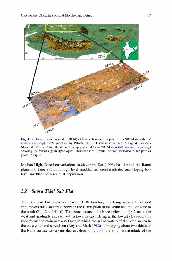
Median High. Based on variations in elevation, Kar (1995) has divided the Banniplain into three sub-units-high level mudflat, an undifferentiated and sloping lowlevel mudflat and a residual depression.
2.2 Supra Tidal Salt Flat
This is a vast but linear and narrow E-W trending low lying zone with severalcentimeters thick salt crust between the Banni plain in the south and the Bet zone tothe north (Fig. 2 and 4b–d). This zone occurs at the lowest elevation (*2 m) in thewest and gradually rises to *4 m towards east. Being at the lowest elevation, thiszone forms the main pathway through which the saline waters of the Arabian sea inthe west enter and spread out (Roy and Merh 1982) submerging about two-thirds ofthe Rann surface to varying degrees depending upon the volume/magnitude of the
Fig. 1 a Digital elevation model (DEM) of Kachchh region prepared from SRTM data (http://srtm.csi.cgiar.org). DEM prepared by Patidar (2010). Inset-Location map. b Digital ElevationModel (DEM) of Allah Bund Fault Scarp prepared from SRTM data (http://srtm.csi.cgiar.org)showing the various geomorphological characteristics. Profile location indicated is for profilesgiven in Fig. 8
Geomorphic Characteristics and Morphologic Dating … 57
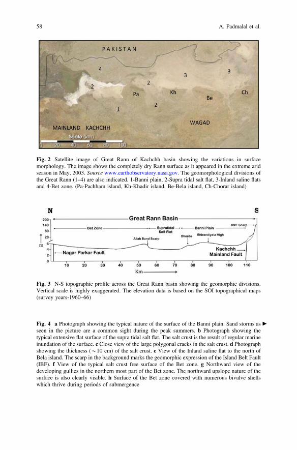
Fig. 2 Satellite image of Great Rann of Kachchh basin showing the variations in surfacemorphology. The image shows the completely dry Rann surface as it appeared in the extreme aridseason in May, 2003. Source www.earthobservatory.nasa.gov. The geomorphological divisions ofthe Great Rann (1–4) are also indicated. 1-Banni plain, 2-Supra tidal salt flat, 3-Inland saline flatsand 4-Bet zone. (Pa-Pachham island, Kh-Khadir island, Be-Bela island, Ch-Chorar island)
Fig. 3 N-S topographic profile across the Great Rann basin showing the geomorphic divisions.Vertical scale is highly exaggerated. The elevation data is based on the SOI topographical maps(survey years-1960–66)
cFig. 4 a Photograph showing the typical nature of the surface of the Banni plain. Sand storms asseen in the picture are a common sight during the peak summers. b Photograph showing thetypical extensive flat surface of the supra tidal salt flat. The salt crust is the result of regular marineinundation of the surface. c Close view of the large polygonal cracks in the salt crust. d Photographshowing the thickness (*10 cm) of the salt crust. e View of the Inland saline flat to the north ofBela island. The scarp in the background marks the geomorphic expression of the Island Belt Fault(IBF). f View of the typical salt crust free surface of the Bet zone. g Northward view of thedeveloping gullies in the northern most part of the Bet zone. The northward upslope nature of thesurface is also clearly visible. h Surface of the Bet zone covered with numerous bivalve shellswhich thrive during periods of submergence
58 A. Padmalal et al.
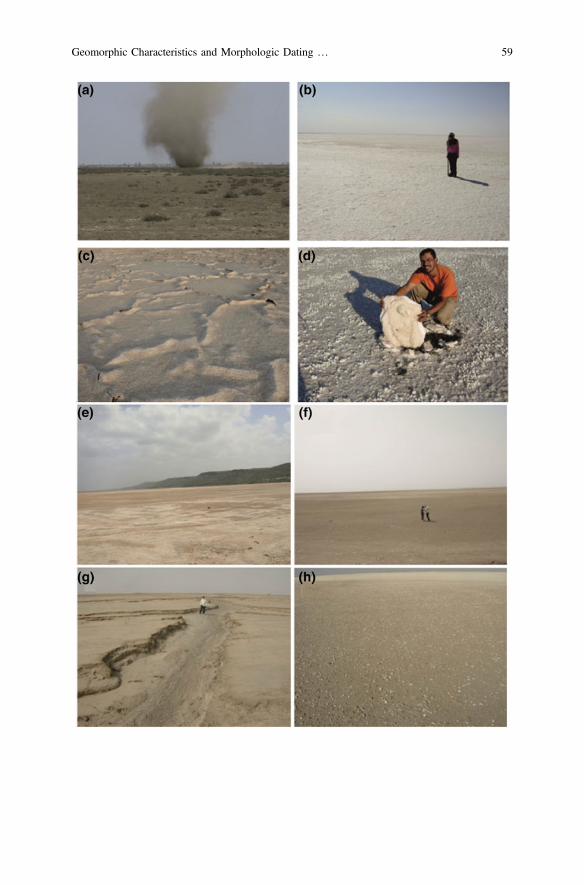
Geomorphic Characteristics and Morphologic Dating … 59
ingression resulting in a thick salt crust (Fig. 4d). Evaporation to dryness results inseveral centimeteres thick, residual salt crusts, which characterize the surface of thesupra tidal salt flats (Fig. 4b–d).
2.3 Inland Saline Flat
This zone comprises the easternmost part of the Great Rann (Fig. 2 and 4e) that isnot influenced by marine submergence, but is inundated by monsoon precipitationand by the rivers from the east and north. The elevation rises towards the margins ofthe zone, giving it a shallow bowl like morphology and comprise inherently salineRann sediments (Roy and Merh 1982).
2.4 The Bet Zone
It comprises the flat Rann surface in the northwestern part of the Great Rann showsseveral bets occurring few metres above the Rann surface (Fig. 4f–h). The Bet zoneis delimited by the Kuar and Bedia bets in the east and the supra tidal salt flat in thesouth (Fig. 2). In addition to the bets with well defined margins, several elevatedparts within the Rann surface also exist which gradually rise above the Rannsurface. Many of these are comparable to the bets in terms of their size. Theirsurfaces comprise aeolian sediments and generally support small vegetation likescrubs and grasses of various size. Morphologically, the shapes of all bets andalmost all elevated tracts described above are elongated in N-S direction, which, ona map gives the misleading impression of wide N-S trending channels separated bybets. However, these are not ‘channels’ in any sense as they are basically flat Rannsurfaces several tens of kilometers wide comprising the inter-bet regions (Khondeet al. 2013). The surface of the Bet zone shows a very gradual northward slopeaway from the Allah Bund scarp which testifies to the uplift along the ABF (Fig. 3).
The western part of the Bet zone i.e. the area around Vigukot and further westshows submergence characteristics which is slightly different from the rest of theBet zone and the Great Rann (Khonde et al. 2013). The 1819 Allah Bund earth-quake caused drastic geomorphological changes along with subsequent floodingevents of the now defunct distributary of Indus River (Burnes 1835; Oldham 1926;Bilham 1998). The now disconnected distributary of Indus—the Nara river/Pooranflowed into this region and joined Arabian sea through the Kori creek in the southbefore the earthquake. This part therefore formed the eastern margin of the IndusDelta till the 1819 earthquake changed the morphology of the area. Presently also,the region to the west and SW of Vigukot is prone to flooding frequently by riverfloods from the north and relatively less frequently by sea water influx from thesouth. In addition numerous small shallow (*0.5 m deep) channels of uncertainaffinity also exist. Overall, the role of rivers is evidently more pronounced in the
60 A. Padmalal et al.
western most part than the rest of the Bet zone. Contrary to the rest of the GreatRann, the Bet zone shows wide variation in elevation due to the presence of betsand is characterized by several seasonal short distance channels, pools i.e. localdepressions and elevated surfaces (Khonde et al. 2013).
The E-W trending intrabasinal structural features within the Great Rann like theIsland Belt Fault (IBF), the Allah Bund Fault (ABF) and the subsurface Banni faultscorrelate remarkably with the geomorphic divisions described above. A criticalevaluation of the elevation differences of the various geomorphic divisions of theGreat Rann shows a strong correlation with the above mentioned regional structuralelements worked out by Biswas (1987, 1993). All geomorphological units of theGreat Rann show prominent structural control (Maurya et al. 2013). The Banniplain astrides the subsurface Median High, while the supra tidal salt flat and theinner saline flats occupy a structural depression to the north of the subsurfaceBhirandiyala high and the Island Belt Fault (IBF). The supra tidal flats extends intoa depression to the south of the island belt between the Pachchh and Khadir islands,the Wagad highland to the east and the mainland in the south. The Bet zone occurson the upthrown northern block of the roughly E-W trending Allah Bund Fault.
Based on the distinct geomorphic divisions attributed to variable submergencepattern and their correlation with structural elements, it is inferred that the emer-gence of the Rann surface may have occurred gradually due to differential tectonicactivity along the various subsurface intrabsinal faults in the recent past, whichformed the morphologic units viz. the Banni plain, the Bet zone and the supra tidalsalt flat (Maurya et al. 2013, 2016). The Banni plain astrides the subsurface Medianhigh and is separated from the remainder of the Rann basin by the Banni Fault tothe north (Biswas 1974). Similarly, the Bet zone is delimited by the Allah BundFault to its south (Roy and Merh 1982). The close association of these units withfaults suggest differential tectonic activity along subsurface faults within the GreatRann basin may have played a major role in the emergence of various morphologicunits at different times (Maurya et al. 2013). Based on elevation and present daysubmergence characteristics, the Banni plain appears to be the first to emergefollowed by the Bet zone, the inner saline flat and the supra tidal salt flat, which stillgets submerged by marine waters regularly.
3 The 1819 Allah Bund Earthquake
The 16 June, 1819 Allah Bund earthquake is considered as a major intraplateearthquake event (Johnston 1989) which produced remarkable surface deformationin the Great Rann of Kachchh. The shocks were felt almost all over the Indiansubcontinent (MacMurdo 1824). The event is specifically well known for theextensive destruction and ground deformation. The event that killed 1543 inhabitantwas estimated to be of intensity of XI (Oldham 1926). Intense damage was reportedfrom all over Kachchh including Bhuj and Anjar towns. Far away cities such asAhmadabad also suffered damage to buildings and monuments. Based on the
Geomorphic Characteristics and Morphologic Dating … 61

intensity report, Gutenberg and Richer (1954) assigned a magnitude of 8.4 to theevent. Later on Chandra (1977) and Johnston and Kanter (1990) estimated themagnitude to be 7.8 and epicenter on 23.6° N and 69.6° E, while Quittmeyer andJacob (1979) estimated the epicenter at 24° N and 69° E. According to Bilham(1998), the 1819 event was a near the surface (0–10 km depth) reverse-slip ruptureon a 90-km-long, 50° to 70° N-dipping fault plane which matches the measuredelevation changes from the event. To et al. (2004) estimated a 50-km-long rupturedipping 45 to the north with 3–8 m slip.
Prior to the 1819 earthquake, the region was a flourishing trade route extendingnorthward into Sind through Kori creek and the distributary of the Indus (Grindlay1808). The Sindri fort was a major halting point and a revenue collection centrealong this route. Extensive surface effects resulting due to the 1819 earthquake havebeen documented in several historical records (MacMurdo 1824; Baker 1846;Wynne 1872; Oldham 1926; Frere 1870. A detailed review of historical accountsfor this earthquake is available in Bilham (1998). The earthquake produced anastonishing variety of surface effects that includes vertical movements of theground, flooding of regions near sea level, widespread liquefaction, and a localtsunami and the complete damming of a distributary of the Indus river. Two sig-nificant changes occurred in the region around Sindri fort at the western part ofGreat Rann. The foundation of fort and surrounding Rann surface subsided by morethan 1 m and the region 7 km north of fort got elevated to 3–6 m, shutting outnorthward navigation into the Sind province due to blocking of the distributary ofIndus river. The northern region (the present Bet zone) was uplifted forming a10–15 ft high south facing scarp which caused the complete damming of the river.The natural dam so formed was named by local people as the Allah Bund (dam ofGod). The scarp presently marks the sharp boundary between the Bet zone in thenorth and the active tidal flats of Kori creek and the Bet zone Notably all the abovesurface changes documented in the available historical records are from the westernpart of the Great Rann of Kachchh. However, it is also mentioned that severaltemporarily active rivers with subsequent sand venting caused transient flooding ofmajor part of Rann surface (Baker 1846; Oldham 1926).
4 Nature and Morphology of Allah Bund Fault Scarp
The Allah Bund Fault scarp is an elongated steeply dipping south facing scarpbordered on the south by the salt encrusted surface of Rann. The Bet zone com-prises the flat Rann surface in the northwestern part of the Great Rann showsseveral bets occurring few metres above the Rann surface. The Bet zone isdelimited by the Kuar and Bedia bets in the east and the supra tidal salt flat in thesouth. To the north lie the sand ridges of Sind (Pakistan). Towards the west, the Betzone imperceptibly merges with the Indus delta. Historical documents suggest thatthe south facing fault scarp was produced during the 1819 earthquake, causinguplift of the northern part of the Great Rann (Burnes 1835; Oldham 1926),
62 A. Padmalal et al.
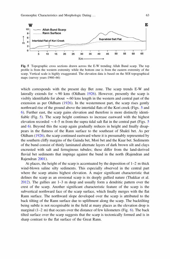
which corresponds with the present day Bet zone. The scarp trends E-W andlaterally extends for *90 kms (Oldham 1926). However, presently the scarp isvisibly identifiable for about *60 kms length in the western and central part of theextension as per Oldham (1926). In the westernmost part, the scarp rises gentlynorthward rise of the ground above the intertidal flats of the Kori creek (Figs. 5 and6). Further east, the scarp gains elevation and therefore is more distinctly identi-fiable (Fig. 5). The scarp height continues to increase eastward with the highestelevation recorded *4–5 m from the supra tidal salt flat in the central part (Figs. 5and 6). Beyond this the scarp again gradually reduces in height and finally disap-pears in the flatness of the Rann surface to the southeast of Shakti bet. As perOldham (1926), the scarp continued eastward where it is presumably represented bythe southern cliffy margins of the Gainda bet, Mori bet and the Kuar bet. Sedimentsof the bund consist of thinly laminated alternate layers of dark brown silt and claysencrusted with salt and ferruginous tubules; these differ from the land-derivedfluvial bet sediments that impinge against the bund in the north (Rajendran andRajendran 2001).
At places, the height of the scarp is accentuated by the deposition of 1–2 m thickwind-blown saline silty sediments. This especially observed in the central partwhere the scarp attains highest elevation. A major significant characteristic thatdefines the scarp as an erosional scarp is its deeply gullied nature (Thakkar et al.2012). The gullies are 1–3 m deep and usually form a dendritic pattern over thecrest of the scarp. Another significant characteristic feature of the scarp is thesubvertical northward face of the scarp surface, which finally merges with the flatRann surface. The northward slope developed over the scarp is attributed to theback tilting of the Rann surface due to upliftment along the scarp. The backtiltingbeing subtle is not recognisable in the field at many places as the elevation drop ismarginal (1–2 m) that occurs over the distance of few kilometers (Fig. 6). The backtilted surface over the scarp suggests that the scarp is tectonically formed and is insharp contrast to the flat surface of the Great Rann.
Fig. 5 Topographic cross sections drawn across the E-W trending Allah Bund scarp. The topprofile is from the western extremity while the bottom one is from the eastern extremity of thescarp. Vertical scale is highly exaggerated. The elevation data is based on the SOI topographicalmaps (survey years-1960–66)
Geomorphic Characteristics and Morphologic Dating … 63

5 Morphological Dating of the Allah Bund Fault Scarp
Numerical dating methods have opened a way for estimation of age of geomor-phological features such as fault scarps and river terraces (Wallace 1977). Thismethod has been successfully used in determining the age of the fault scarps inSouthern Arava, Israel (Enzel et al. 1994), West Yellowstone, Montana (Nash1984), Lost River fault in Custer County, Idaho (Hank and Schwartz 1987),
Fig. 6 N-S topographic profile across the Great Rann basin showing the geomorphic divisions.Vertical scale is highly exaggerated. The elevation data is based on the SOI topographical maps(survey years-1960–66)
64 A. Padmalal et al.

and terrace risers in Rhine Graben (Niviere and Marquis 2000). In tectonicallyactive areas, this method characterizes the degradation of a geomorphic markerbased on rate of vertical movement and erosion (Carretier et al. 2002). The evo-lution of a cohesionless slope through time can be evaluated quantitatively byassuming that sediment transport is a diffusion process (Colman and Watson 1983).Generally, the word diffusion describes how chemicals in solution move from areasof high concentration to areas of low concentration, and how heat moves from areasof high temperature to areas of low temperature. The sediment diffusion indicatesthe gravity transport of sediment from an area of high elevation (the top of theslope) toward an area of low elevation (the base of the slope). Without fresh upliftor down cutting, diffusion tends to make slopes smoother and less steep temporally.Scarp evolution is controlled by climate and several other geological factors.Measure of age dependent parameters such as maximum scarp slope or the cur-vature of crest will point towards the age (Wallace 1977). Under conditions inwhich the transport efficiency is uniform and the flux is dictated linearly by the localslope, the combination of the mass flux and mass conservation equations results inthe diffusion equation (Colman and Watson 1983).
jt ¼ d2
4p1
ðtan h� tan aÞ2; Colman and Watson 1983ð Þ ð1Þ
This solution and model (Eq. 1) is applied as discussed in Colman and Watson(1983) is applied to determine the morphological age of the Allah Bund Faultscarp. The parameters applied (Fig. 7) in the equation are given in Table 1.
Over a time, the morphology of a scarp is altered by gravitational and slopeprocesses (Enzel et al. 1994). For the most part of this time, it follows geomorphicprocess of slope modification i.e. mass wasting and wash processes (Summerfield1991). Fault scarps that cut unconsolidated sediment or soil are very promising for
Fig. 7 Schematic model of a fault scarp showing the various input parameters to be measured forthe solving the diffusion equation (after Colman and Watson 1983)
Geomorphic Characteristics and Morphologic Dating … 65
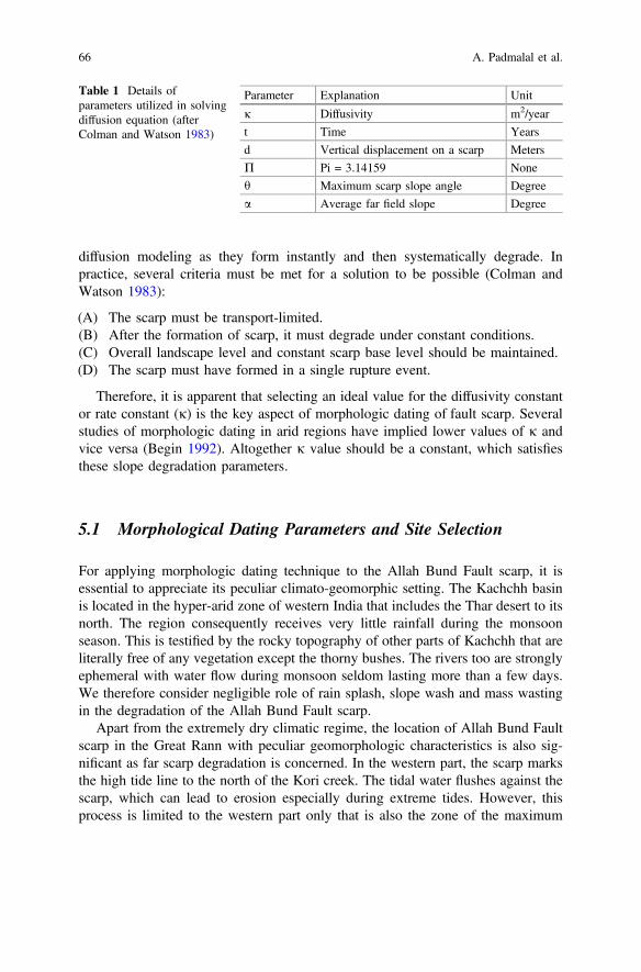
diffusion modeling as they form instantly and then systematically degrade. Inpractice, several criteria must be met for a solution to be possible (Colman andWatson 1983):
(A) The scarp must be transport-limited.(B) After the formation of scarp, it must degrade under constant conditions.(C) Overall landscape level and constant scarp base level should be maintained.(D) The scarp must have formed in a single rupture event.
Therefore, it is apparent that selecting an ideal value for the diffusivity constantor rate constant (j) is the key aspect of morphologic dating of fault scarp. Severalstudies of morphologic dating in arid regions have implied lower values of j andvice versa (Begin 1992). Altogether j value should be a constant, which satisfiesthese slope degradation parameters.
5.1 Morphological Dating Parameters and Site Selection
For applying morphologic dating technique to the Allah Bund Fault scarp, it isessential to appreciate its peculiar climato-geomorphic setting. The Kachchh basinis located in the hyper-arid zone of western India that includes the Thar desert to itsnorth. The region consequently receives very little rainfall during the monsoonseason. This is testified by the rocky topography of other parts of Kachchh that areliterally free of any vegetation except the thorny bushes. The rivers too are stronglyephemeral with water flow during monsoon seldom lasting more than a few days.We therefore consider negligible role of rain splash, slope wash and mass wastingin the degradation of the Allah Bund Fault scarp.
Apart from the extremely dry climatic regime, the location of Allah Bund Faultscarp in the Great Rann with peculiar geomorphologic characteristics is also sig-nificant as far scarp degradation is concerned. In the western part, the scarp marksthe high tide line to the north of the Kori creek. The tidal water flushes against thescarp, which can lead to erosion especially during extreme tides. However, thisprocess is limited to the western part only that is also the zone of the maximum
Table 1 Details ofparameters utilized in solvingdiffusion equation (afterColman and Watson 1983)
Parameter Explanation Unit
j Diffusivity m2/year
t Time Years
d Vertical displacement on a scarp Meters
P Pi = 3.14159 None
h Maximum scarp slope angle Degree
a Average far field slope Degree
66 A. Padmalal et al.

recorded surface effects during 1819 earthquake. As a result, the scarp sufferedmaximum degradation in this part as evidenced by its very low height. The highlygullied nature of the scarp in this part also testifies to the relatively higher mag-nitude of scarp degradation.
The scarp in the central and eastern parts is located above the high tide line.Here, the scarp witnesses periodic submergence of the vast supratidal salt flat infront of it. The submergence however is generally < a meter and rarely reaches thebase of the scarp. We therefore rule out erosion by the submerging waters of thescarp in this part. The Bet zone also gets submerged by thin sheet of rain water thatflows along the general southward slope. These waters are responsible for theformation of gullies on top of the scarp. However, as mentioned above, the scarp ishighly gullied in the western part, whereas the gullies are significantly less in thecentral and eastern part. This is due to the presence of rivers from the northdissecting through the scarp to drain into the intertidal flats of the Kori creek.However, there are no such drainages in the central and eastern parts resulting insignificantly less number of gullies, which are also shallower and wide spaced.
Also, the height of the Allah Bund Fault scarp is the maximum in the centralpart. In the eastern part, the scarp height gradually reduces before finally disap-pearing in the flat Rann surface. Evidently therefore that the scarp has undergoneleast degradation in the central part.
Taking into account the climatic and geomorphologic factors as discussed above,*2 km length in the central part of the Allah Bund Fault scarp is most suitable formorphologic dating. Moreover, the scarp in this part can be included in the transportlimited category of slope classification i.e. transportation process occurs muchslower than the weathering. For the same reasons, we assume negligible sedimenttransportation rate and diffusion constant for calculating the age of the Allah BundFault scarp. Previous studies show that faults that cut unconsolidated sediment arethe most promising ones for diffusion modeling because it forms instantaneouslyand will systematically degrade (Colman and Watson 1983). This criterion is met inthe case of Allah Bund scarp, which makes it relatively easier to quantify. Further,the scarp is not affected by any anthropogenic influences as the Great Rann is aninhospitable terrain due to its difficult environmental conditions.
Three sites were selected from the central part of the Allah Bund Fault scarp thatshows maximum elevation, is sub-vertical and has clear-cut morphologicalexpression. The general shape of the scarp is determinable by a single profilewithout the need of large sample sizes. The selected scarp face is away from thevicinity of notches, gullies and local channels. The base of the selected scarplocations are devoid of colluvium or small fan deposits, which can create irregu-larities in the scarp profile. The thickness of post-Allah Bund aeolian deposit isremoved from the profile to get the original scarp height. The age of the scarp wascalculated for these three sites as outlined by Colman and Watson (1983) and Nash(1987).
Geomorphic Characteristics and Morphologic Dating … 67
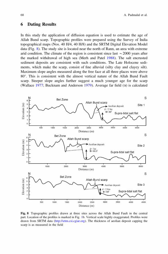
6 Dating Results
In this study the application of diffusion equation is used to estimate the age ofAllah Bund scarp. Topographic profiles were prepared using the Survey of Indiatopographical maps (Nos. 40 H/4, 40 H/8) and the SRTM Digital Elevation Modeldata (Fig. 8). The study site is located near the north of Rann, an area with extremearid condition. The climate of the region is consistent since last *2000 years afterthe marked withdrawal of high sea (Merh and Patel 1988). The salt encrustedsediment deposits are consistent with such conditions. The Late Holocene sedi-ments, which make the scarp, consist of fine alluvial (silty clay and clayey silt).Maximum slope angles measured along the free face at all three places were above80°. This is consistent with the almost vertical nature of the Allah Bund Faultscarp. Steeper slope angles further suggest a much younger age for the scarp(Wallace 1977; Bucknam and Anderson 1979). Average far field (a) is calculated
Fig. 8 Topographic profiles drawn at three sites across the Allah Bund Fault in the centralpart. Location of the profiles is marked in Fig. 1b. Vertical scale highly exaggerated. Profiles weredrawn from SRTM data (http://srtm.csi.cgiar.org). The thickness of aeolian deposit capping thescarp is as measured in the field
68 A. Padmalal et al.
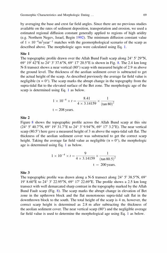
by averaging the base and crest far field angles. Since there are no previous studiesavailable on the rates of sediment deposition, transportation and erosion, we used aestimated regional diffusion constant generally applied to regions of high aridity(e.g. Northern Negev, Israel, Begin 1992). The minimum diffusion constant valueof 1� 10�4m2year�1 matches with the geomorphological scenario of the scarp asdescribed above. The morphologic ages were calculated using Eq. 1.
Site 1The topographic profile drawn over the Allah Bund Fault scarp along 24° 5′ 29″N,69° 19′ 42″E to 24° 3′ 37.6″N, 69° 17′ 20.5″E is shown in Fig. 8. The 2.4 km longN-S transect shows a near vertical (80°) scarp with measured height of 2.9 m abovethe ground level. The thickness of the aeolian sediment cover is subtracted to getthe actual height of the scarp. As described previously the average far field value isnegligible (a = 0°). The scarp marks the abrupt change in the topography from thesupra-tidal flat to the elevated surface of the Bet zone. The morphologic age of thescarp is determined using Eq. 1 as below.
1� 10�4 � t ¼ 8:414� 3:14159
� 1
tan 80ð Þ2t ¼ 208 years:
Site 2Figure 8 shows the topographic profile across the Allah Bund scarp at this site(24° 5′ 40.7″N, 69° 19′ 31.7″E to 24° 3′ 9.94″N, 69° 17′ 3.2″E). The near verticalscarp (80.5°) here gave a measured height of 3 m above the supra-tidal salt flat. Thethickness of the aeolian sediment cover was substracted to get the correct scarpheight. Taking the average far field value as negligible (a = 0°), the morphologicage is determined using Eq. 1 as below.
1� 10�4 � t ¼ 94� 3:14159
� 1
tan 80:5ð Þ2t ¼ 200 years:
Site 3The topographic profile was drawn along a N-S transect along 24° 5′ 38.5″N, 69°19′ 8.60″E to 24° 3′ 22.95″N, 69° 17′ 22.69″E. The profile shows a 2.5 km longtransect with well demarcated sharp contrast in the topography marked by the AllahBund Fault scarp (Fig. 8). The scarp marks the abrupt change in elevation of Betzone in the upthrown block and the flat monotonous supra-tidal salt flat in thedownthrown block to the south. The total height of the scarp is 4 m, however, thecorrect scarp height is determined as 2.8 m after subtracting the thickness ofthe aeolian sediment cover. The near vertical scarp (80°) and the negligible averagefar field value is used to determine the morphological age using Eq. 1 as below.
Geomorphic Characteristics and Morphologic Dating … 69
1� 10�4 � t ¼ 7:844� 3:14159
� 1
tan 80ð Þ2t ¼ 193 years:
Here values of t obtained represent the morphological age i.e. the time since thefault scarp was formed. The morphological ages of the Allah Bund Fault scarpobtained at the above three sites are 208, 200 and 193 years before present. Theseages indicate that the scarp was formed in 1809, 1817 and 1824 A.D. respectively.The results unequivocally suggest that the scarp was produced during the 1819earthquake event.
7 Concluding Discussion
The landscape of the Great Rann of Kachchh shows unique geomorphologicalcharacteristics (Roy and Merh 1982). The high intensity earthquakes during historicand prehistoric times together with marine processes from the west have governedthe geomorphic evolution of the Great Rann (Roy and Merh 1982; Glennie andEvans 1976). Looking to the several devastating earthquake that have occurredalong the various faults in Kachchh during last 200 yrs viz. in 1819, 1845, 1956 and2001 (Wynne 1872). It is apparent that the region may have been affected previ-ously by several other high-magnitude earthquakes though there is no paleoseismicrecord nor historical accounts (MacMurdo 1824, Baker 1846, Oldham 1926). Theavailable historical accounts suggest the 1819 earthquake formed a 10–15 ft highscarp that blocked the drainages from the north and simultaneously the area aroundSindri subsided and was submerged by a local tsunami (Macmurdo 1824; Baker1846). However; all contemporary accounts that describe the spectacular landscapechanges are from the western part only, which formed the trade route from Lakhpatto Sind via Sindri and a part of the eastern fringe of Indus delta. According toOldham (1926), the Allah Bund scarp extended for*90 km, however presently thescarp is identifiable for *60 km length only. Our investigations show the AllahBund scarp is highly eroded in the western parts due to the tide from the Kori creekin the south and the river water from the north during monsoon. The eastern part ofthe scarp is also low and disappears completely in the Rann surface. The scarpshows the maximum height in the central part where it is locally covered by aeoliandeposits. Modern investigations have indicated that the height of the fault scarp is areflection of cumulative uplift during 1819 and previous earthquakes (Rajendranand Rajendran 1999). However, there is no such indication from the availablehistorical accounts. In the present study morphologic dating was carried out todetermine the age of the Allah Bund scarp.
The Allah Bund scarp though having low height and laterally extensive, is foundsuitable for morphologic dating in its central part. The scarp here fulfills the nec-essary geomorphic conditions for carrying out morphologic dating (Colman and
70 A. Padmalal et al.
Watson 1983; Nash 1987). The basic parameters where measured in the field.Topographic profiles across the scarp at the selected sites were prepared fromtopographical map and SRTM data. The present geomorphological environmentalong scarp summarized earlier in the article suggests that the central part is a zoneof minimum erosion and subsequently least amount of scarp degradation. The hyperarid climate and the non influence of anthropogenic activity means the diffusionconstant for arid region can be applied to the Allah Bund scarp for determining itsmorphologic ages. We therefore selected the value of diffusion constant as1 � 10−4 m2 year−1, which has been applied successfully in the morphologicdating of fault scarps located in the arid regions (Begin 1992). The morphologicalages of the Allah Bund scarp can be calculated as per Colman and Watson (1983).
The morphological ages of the Allah Bund fault scarp at the three selected sitesyielded an age of 208, 200 and 193 years B. P. Effectively these ages means that thescarp was produced during the 1819 Allah Bund earthquake, since no other majorearthquake occurred in the Great Rann during the period indicated by the ages i.e.between 1809 and 1825.
Our studies substantiate the description in the historical accounts regarding theAllah Bund fault scarp. We therefore rule out the possibility of the scarp being aproduct of multiple earthquake events. Our study also suggests that the 1819 AllahBund earthquake was the largest earthquake that occurred in the Great Rann after itsemergence from the shallow marginal sea. This is evident from the large-scalelandscape changes, that includes the formation of a *90 km long E-W trendingsouth facing scarp and also that no other comparable scarp occurs in the vast extentof the Great Rann. Other earthquake that may have occurred during the timepossibly did not rupture the surface. However, the possibility of earthquakes ofcomparable magnitude in prehistoric times in Holocene cannot be ruled out. It islikely that some of them may have produced surface rupture, however these may beburied under thick sediments, as the Great Rann was a shallow marginal gulf duringthe Late Pleistocene to Holocene (Maurya et al. 2013; Khonde et al. 2017a, b).
It is pertinent to mention here that several large earthquakes have occurred in theKachchh rift basin, including the 1819 Allah bund earthquake and 2001 Bhujearthquake. The heightened level of seismicity is anomalous in view of the lowlevel seismic activity witnessed in the surrounding regions viz. Saurashtra in south,Gujarat alluvial plain in the east and Barmer-Jaisalmer basins in the northeast(Maurya et al. 2017). It has been suggested that the stress changes related to largeearthquakes in the Kachchh region affect the subsequent pattern of earthquakes. Toet al. (2004) demonstrated that the 1819 Allah Bund earthquake induced stresschanges which led to several moderate magnitude earthquake in the Great Rann.Post-seismic relaxation following the 1819 earthquake resulted in the loading of2001 Bhuj earthquake to a significant amount (To et al. 2004). The 2001 event wasfollowed by long aftershock activity and increased seismic activity along the SouthWagad Fault (SWF), Gedi Fault (GF) and the Island Belt Fault (IBF) (Mandal2009). Earthquake swarm activity in different part of Saurashtra since 2001 hasbeen attributed to stress perturbation caused by 2001 Bhuj earthquake (Rastogiet al. 2013). Low magnitude shocks are repeated from the Gujarat alluvial plain in
Geomorphic Characteristics and Morphologic Dating … 71
the last 200 years (Maurya et al. 2000). Reactivation of pre-existing lineaments andfaults have resulted in moderate to low seismic activity in Barmer basin also inrecent times (Dasgupta and Mukherjee in press). However, none of the knownhistorical earthquakes are known to have produced surface rupture apart from the1819 Allah Bund earthquake. Moreover, the co-seismic and post-seismic stresschanges due to pre-instrumental events still remain a topic of debate (Rajendran andRajendran 2001). Detailed palaeoseismic studies are necessary to unravel theseismic history of the Great Rann for which the Allah Bund fault scarp can serve asan analog.
Acknowledgments We are grateful to Soumyajit Mukherjee for inviting us to contribute thisarticle and for providing two rounds of review comments. The present study was funded by theMinistry of Earth Sciences (MoES), Government of India in the form of a research project (ProjectNo. MoES/P.O. (Seismo)/1(170)/2013) to DMM and LSC. Mukherjee (2019) summarizes thiswork.
References
Baker WE (1846) Remarks on the Allah Bund and on the drainage of the eastern part of the Sindbasin. Transactions Bombay Geographic Society 7, 186–188
Begin ZB (1992) Application of quantitative morphologic dating to paleo-seismicity ofnorthwestern Negev, Israel. Israel Journal of Earth Science 41, 95–103
Bilham R (1998) Slip parameters for the Rann of Kachchh, India, 16 June 1819, earthquake,quantified from contemporary accounts. Geological Society Special Publication 146, 295–319
Biswas SK (1974) Landscape of Kutch—a morphotectonic analysis. Indian Journal of EarthScience 1, 177–190
Biswas SK (1993) Geology of Kutch. K.D. Malaviya Institute of Petroleum Exploration,Dehradun, p 450
Biswas SK (1987) Regional tectonic framework, structure and evolution of the Western MarginalBasins of India. Tectonophysics 135, 307–327
Bucknam RL, Anderson RE (1979) Estimation of fault- scarp ages from a scarp-height-slope-anglerelationship. Geology 7, 11–14
Burnes A (1835) Memoir of the eastern branch of the River Indus, giving an account of thealterations produced on it by an earthquake, also a theory of the formation of the Rann andsome conjunctures on the route of Alexander the Great; drawn up in the years 1827–1828.Transactions of the Royal Asiatic Society of Great Britain and Ireland 3, 550–588
Carretier S, Ritz JF, Jackson J, Bayasgalan A (2002) Morphologic dating of cumulative reversefault scarp: examples from the GurvanBogd fault system, Mongolia. Geophysical JournalInternational 148, 256–277
Chandra U (1977) Earthquakes of Peninsular India: a seismotectonic study. Bulletin ofSeismological Society of America 67, 1387–1413
Colman SM, Watson K (1983) Ages estimated from a diffusion-equation model for scarpdegradation. Science 221, 263–265
Dasgupta S, Mukherjee S (In press) Remote sensing in lineament identification: Examples fromwestern India. In: Billi A, Fagereng A (Eds) Problems and solutions in structural geology andtectonics. Developments in structural geology and tectonics book series. Series Editor:Mukherjee S. Elsevier. ISSN: 2542–9000
72 A. Padmalal et al.
Enzel Y, Amit R, Bruce J, Harrison J, Porat N (1994) Morphologic dating of fault scarps andterrace risers in the southern Arava, Israel: comparison to other age-dating techniques andimplications for paleoseismicity. Israel Journal of Earth Science 43, 91–103
Frere HBE (1870) Notes on the Runn of Cutch and neighboring region, J. R. Geograph. Soc.London 40, 181–207
Glennie KW, Evans G (1976) A reconnaissance of the Great Rann of Kutch, India. Sedimentology23, 625–647
Grindlay (1808) Diary reproduced in Burnes A., Travels into Bokhara, Volume 3 Appendix. 1834Gutenberg B, Richer CF (1954) Seismicity of Earth. Princeton University Press, New Jersey, USA,
p 310pHanks TC, Schwartz DP (1987) Morphologic dating of the pre-1983 fault scarp on the Lost River
fault at Doublepring Pass Road, Custer County, Idaho, Bulletin of Seismological Society ofAmerica 77, 837–846
Johnston AC (1989) The seismicity of stable continental interiors. In: Gregersen S, Bhasham PW(eds), Earthquakes at North-Atlantic Passive Margins: Neotectonics and Postglacial Rebound,Kluver Academic Publishers, pp 299–327
Johnston AC, Kanter LR (1990) Earthquakes in stable continental crust. Scientific American 262,68–75
Kar A (1995) Geomorphology of the western India. Memoir of Geological Society of India 32,168–190
Khonde N, Maurya DM, Singh AD, Das A, Chamyal LS (2013) Sediment characteristics andforaminiferal distribution in the Bet Zone of the Great Rann of Kachchh, Western India.Geological Society of India, Special Publications 1, 1–15
Khonde N, Maurya, DM, Chamyal LS (2017a) Late Pleistocene-Holocene clay mineral recordfrom the Great Rann of Kachchh, Western India: implication for palaeoenvironments andsediment sources. Quaternary International 443, 86–98
Khonde N, Singh SK, Maurya DM, Rai VK, Chamyal LS, Giosan L (2017b)Tracing the VedicSaraswati River in the Great Rann of Kachchh. Scientific Reports 7, 5476
Lyell C (1855) A manual of elementary geology or, the ancient changes of the Earth and itsinhabitants as illustrated by geological monuments. John Murray, London, p 655
MacMurdo J (1824) Papers relating to the earthquake which occurred in India in 1819.Philosophical Magazine 63, 105–177
Mandal P (2009) Estimation of static stress changes after the 2001 Bhuj earthquake: implicationstowards the northward spatial migration of the seismic activity in Kachchh, Gujarat. Journal ofthe Geological Society of India 74, 487–497
Maurya DM, Raj R, Chamyal LS (2000) History of tectonic evolution of Gujarat alluvial plains,western India during Quaternary: a review. Journal of Geological Society of India 55, 343–366
Maurya DM, Khonde N, Archana Das, Chowksey V, Chamyal LS (2013) Subsurface sedimentcharacteristics of the Great Rann of Kachchh from prelimininary textural analysis of twocontinuous cores. Current Science 104, 1071–1077
Maurya DM, Tiwari M, Rajawat AS, Kumar H, Khonde N, Chamyal LS (2016) Geomorphiccharacterization of the Banni Plain, Kachchh, using orbital imaging radar (RISAT 1C) andoptical remote sensing data. In: Recent studies on the Geology of Kachchh, Thakkar MG (ed),Geological Society of India Special Publication No. 6, pp. 168–178
Maurya DM, Chowksey V, Patidar AK, Chamyal LS (2017) A review and new data onneotectonic evolution of active faults in the Kachchh Basin, Western India: legacy ofpost-Deccan Trap tectonic inversion. Geological Society, London, Special Publications 445,237–268
Merh SS (2005) The Great Rann of Kachchh: perceptions of a field geologist. Geological Societyof India 65, 9–25
Merh SS, Patel PP (1988) Quaternary geology and geomorphology of the Ranns of Kutch. In:Proceedings seminar on recent quaternary studies in India. M.S. University, Baroda, India,pp 377–393
Geomorphic Characteristics and Morphologic Dating … 73

Mukherjee S (2019) Introduction to “Tectonics and Structural Geology: Indian Context”. In:Mukherjee S (ed) Tectonics and structural geology: Indian context. Springer InternationalPublishing AG, Cham, pp 1–5. ISBN: 978-3-319-99340-9
Niviere B, Marquis G (2000) Evolution ofterrave risers along the upper Rhine Graben inferredfrom morphologic dating methods: evidence of climatic and tectonic forcing. GeophysicalJournal International 141, 577–594
Nash DB (1984) Morphologic dating of alluvial terrace scarps and fault scarps near WestYellowstone, Montana. Geological Society of America Bulletin 95, 1413–1424
Nash DB (1987) Reevaluation of the linear-diffusion model for morphologic dating of scarps. In:Proceedings of conference XXXIX directions in paleoseismology, open-file report, pp 87–673
Oldham RD (1926) The Cutch Earthquake of 16th June 1819 with a revision of the greatearthquake of 12th June 1897. Memoir of Geological Survey of India 46, 71–146
Quittmeyer RC, Jacob KH (1979) Historical and modern seismicity of Pakistan, Afghanistan,northern and southern Iran. Bulletin of Seismological Society of America 69, 773–823
Patidar AK (2010) Neotectonic studies in southern mainland Kachchh using GPR with specialreference to Katrol Hill Fault, Ph.D. thesis, The M S University of Baroda, Vadodara, India,163p. Available online at www.shodhganga.com
Rajendran K, Rajendran CP (1999) Seismogenesis in the stable continental interiors: an appraisalbased on two examples from India. Tectonophysics 305, 355–370
Rajendran CP, Rajendran K (2001) Characteristics of deformation and past seismicity associatedwith the 1819 Kutch Earthquakes, northwestern India. Bulletin of Seismological Society ofAmerica 91, 407–426
Rastogi BK, Kumar S, Aggrawal SK, Mohan K, Rao N, Rao NP, Kothyari GC (2013) The October20, 2011 Mw 5.1 Talala earthquake in the stable continental region of India. Natural Hazards.65, 1197–1216
Roy B, Merh SS (1982) The Great Rann of Kutch: intriguing Quaternary terrain, in RecentResearches in Geology, Series 9, Hindustan Publication Company, Delhi, pp. 100–108
Summerfield MA (1991) Global Geomorphology: an introduction to the study of landforms,Essex: Longman, 537p
Thakkar MG, Ngangom M, Thakker PS, Juyal N (2012) Terrain response to the 1819 Allah Bundearthquake in western Great Rann of Kachchh, Gujarat, India. Current Science 103, 208–212
To A, Bürgmann R, Pollitz F (2004) Postseismic deformation and stress changes following the1819 Rann of Kachchh, India earthquake: was the 2001 Bhuj earthquake a triggered event?Geophysical Research Letters 31(13)
Valdiya KS (2002) Saraswati: the river that disappeared, Universities Press, Hyderabad, 116ppWallace RE (1977) Profiles and ages of young fault scarps, north-central Nevada. Geological
Society of America Bulletin 88, 1267–1281Wynne AB (1872) Memoir on the geology of Kutch. Memoir of Geological Survey of India 9, 1–
294
74 A. Padmalal et al.

Interplay Between Tectonics & Eustacyin a Proterozoic Epicratonic, PolyhistoryBasin, North Dharwar Craton
Shilpa Patil Pillai and Vivek S. Kale
1 Introduction
Modern developments in sedimentary basin analysis (e.g. Einsele 2000; Miall 2000;Allen and Allen 2013) have accepted the role of Wilson cycle in the formation,growth and termination of sedimentary basins. The tectonic classifications of sed-imentary basins (Dickinson 1974; Kingston et al. 1983; Allen et al. 2015) reflectthis perception. The sediment fill of a basin manifests the interplay of sedimentsupply, eustacy and subsidence. Climate, topography and petrographic constitutionof the source region control the sediment supply. The geometry and volume of thefill depends upon the available accommodation space, moderated by tectonics andeustacy. In Precambrian basins, their deformation and metamorphism hampers theelucidation of the contents, distribution patterns and sequences of the basin fills.Sparse age controls in Precambrian sediments when compared to fossiliferousPhanerozoic sediments further hampers their accurate elaboration (Eriksson et al.2001). The Indian Peninsular Shield amalgamated into a singular continental blocktowards the end of the Archean (2700–2500 Ma) with a series of K-rich graniticbatholiths representing the terminal events of this unification (Naqvi and Rogers1987; Ramakrishnan and Vaidyanadhan 2010; Meert et al. 2010). Two contrastingregimes punctuate its ensuing history (Kale 1995). The narrow, linear metamor-phosed Early and Middle Proterozoic Mobile Belts with compressive tectonichistory (Radhakrishna and Naqvi, 1986; Ramakrishnan and Vaidyanadhan 2010)are juxtaposed against the wide, extensional epicratonic platform basins that display
S. Patil PillaiDepartment of Environmental Sciences, Savitribai Phule Pune University,Ganeshkhind, Pune 411007, India
V. S. Kale (&)Advanced Center of Water Resources Development and Management(ACWADAM), Kshipra Society, Karvenagar, Pune 411052, Indiae-mail: [email protected]
© Springer Nature Switzerland AG 2019S. Mukherjee (ed.), Tectonics and Structural Geology: Indian Context,Springer Geology, https://doi.org/10.1007/978-3-319-99341-6_4
75
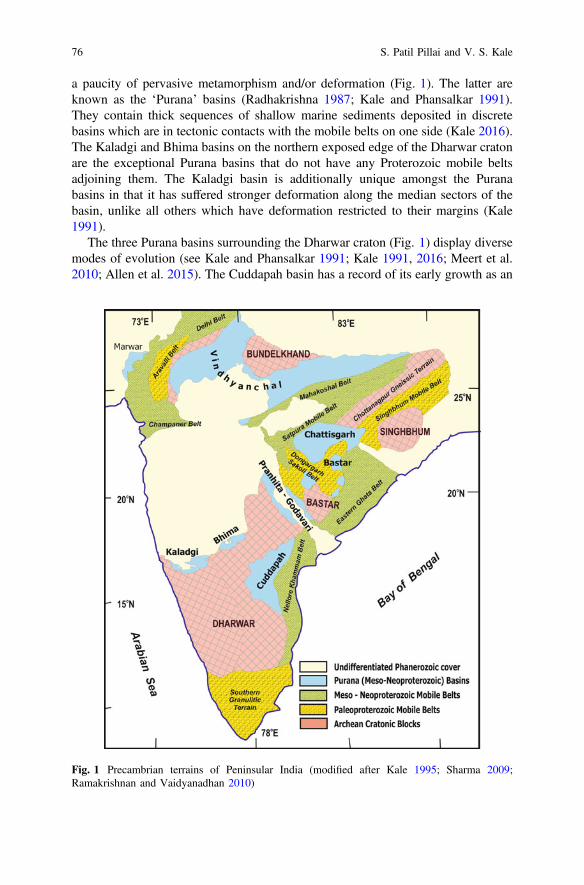
a paucity of pervasive metamorphism and/or deformation (Fig. 1). The latter areknown as the ‘Purana’ basins (Radhakrishna 1987; Kale and Phansalkar 1991).They contain thick sequences of shallow marine sediments deposited in discretebasins which are in tectonic contacts with the mobile belts on one side (Kale 2016).The Kaladgi and Bhima basins on the northern exposed edge of the Dharwar cratonare the exceptional Purana basins that do not have any Proterozoic mobile beltsadjoining them. The Kaladgi basin is additionally unique amongst the Puranabasins in that it has suffered stronger deformation along the median sectors of thebasin, unlike all others which have deformation restricted to their margins (Kale1991).
The three Purana basins surrounding the Dharwar craton (Fig. 1) display diversemodes of evolution (see Kale and Phansalkar 1991; Kale 1991, 2016; Meert et al.2010; Allen et al. 2015). The Cuddapah basin has a record of its early growth as an
Fig. 1 Precambrian terrains of Peninsular India (modified after Kale 1995; Sharma 2009;Ramakrishnan and Vaidyanadhan 2010)
76 S. Patil Pillai and V. S. Kale

extensional basin attended by basic volcanism; that eventually gave way to aretro-arc basin with overthrusting of the Eastern Ghats Mobile Belt (including theNellore belt) from the east (Matin 2015 and citations therein). The Bhima basin inthe north is a pull-apart basin (Kale and Peshwa 1995). The Kaladgi basin on thenorth-west shows events of initial extension (with minor transtensional component),compressive deformation and late extension (Dey 2015; Patil Pillai et al. 2018). Thedifferent margins of the Dharwar craton have obviously suffered diverse tectonicsand basin growth histories during the Proterozoic.
The Kaladgi basin hosts commercially exploited limestone reserves and asbestosmines located in its basement (Jayaprakash 2007). It is a “Category IV” petrolif-erous basin (Pratap et al. 1999; Biswas 2008; Kalpana et al. 2010). Uraniummineralization has been recorded from various locations within it (Dey et al. 2008;Sridhar et al. 2014). Our group has conducted extensive field studies of thesesediments across the last couple of decades; supplemented by petrographic labo-ratory studies. We enumerate the contents and architecture of this unique Puranabasin: and demonstrate signatures of the tectono-eustatic interplay during itsevolution.
2 Regional Geology
2.1 Location
The Kaladgi basin extends between the 73°E and 76°E longitudes and 15° 30′N to17°N latitudes, from the Konkan coastal tract in Sindhudurg district; across theWestern Ghats and the Deccan Plateau in Kolhapur district of Maharashtra stateinto the Belgaum, Bagalkot and Bijapur districts of northern Karnataka state.Isolated outliers of these sediments are scattered south of the main basin aroundSaundatti and Gajendragad. Inliers within Deccan Traps occur near Kallamavadiand near Jamkhandi to the north of the main basin. The westernmost exposures arefound as patchy inliers (within the Deccan Traps) in the Konkan coastal strip,around Phonda and Malvan. They are collectively referred to as the KonkanKaladgis (Sarkar and Soman 1985; Deshpande and Pitale 2014). These discon-nected outcrops show that the main basin extended far beyond its currently exposedlimits. The present exposures of about 8000 km2 represent only a fraction of thespan of the basin, that can be interpreted to occupy more than 30,000 km2.
The sediments in this basin are subdivided into the Bagalkot and Badami Groups(Viswanathiah 1979) separated by an angular and erosional unconformity. TheBagalkot Group occupies an irregular ovoid shaped basin in the eastern parts (InsetFig. 2). The Badami Group covers more than 300 km in an E-W direction.
It is significant that while the Konkan Kaladgis are exposed at elevations of lessthan 200 m above mean sea level, none of the remaining exposures (east ofKallamavadi) occur at elevations below 550 m. This elevation difference may the
Interplay Between Tectonics & Eustacy in a Proterozoic … 77
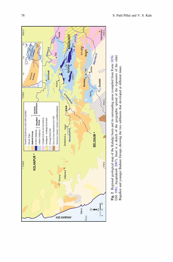
Fig.2
Regionalg
eologicalm
apof
theKaladgi
basinandits
surrou
ndingareas(com
piledfrom
Foote18
76;
GSI
1981
;Jayaprakash20
07).
Insetis
asketch
ofthegeog
raph
icspread
oftheexpo
suresof
theolder
Bagalko
tandyo
ungerBadam
iGroup
sshow
ingthetwosubb
asinsthat
developedat
differenttim
es
78 S. Patil Pillai and V. S. Kale
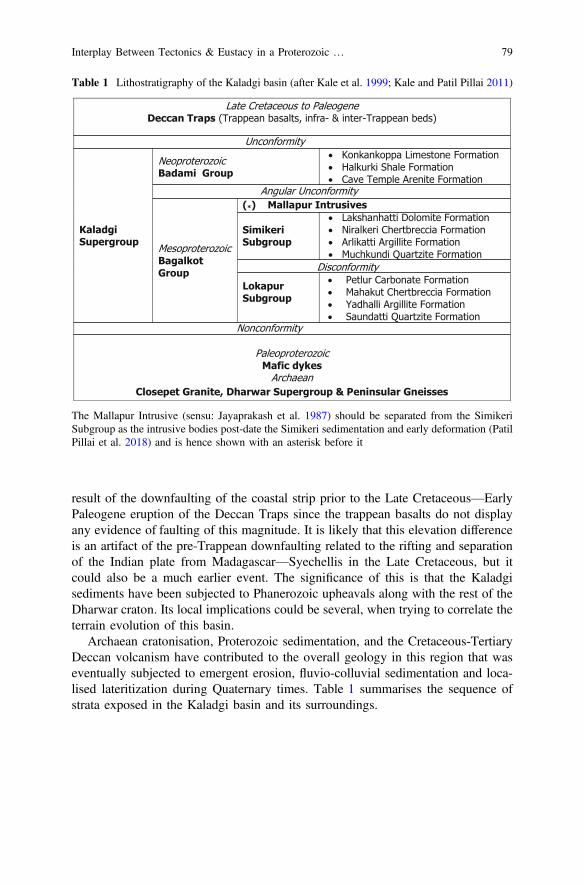
result of the downfaulting of the coastal strip prior to the Late Cretaceous—EarlyPaleogene eruption of the Deccan Traps since the trappean basalts do not displayany evidence of faulting of this magnitude. It is likely that this elevation differenceis an artifact of the pre-Trappean downfaulting related to the rifting and separationof the Indian plate from Madagascar—Syechellis in the Late Cretaceous, but itcould also be a much earlier event. The significance of this is that the Kaladgisediments have been subjected to Phanerozoic upheavals along with the rest of theDharwar craton. Its local implications could be several, when trying to correlate theterrain evolution of this basin.
Archaean cratonisation, Proterozoic sedimentation, and the Cretaceous-TertiaryDeccan volcanism have contributed to the overall geology in this region that waseventually subjected to emergent erosion, fluvio-colluvial sedimentation and loca-lised lateritization during Quaternary times. Table 1 summarises the sequence ofstrata exposed in the Kaladgi basin and its surroundings.
Table 1 Lithostratigraphy of the Kaladgi basin (after Kale et al. 1999; Kale and Patil Pillai 2011)
The Mallapur Intrusive (sensu: Jayaprakash et al. 1987) should be separated from the SimikeriSubgroup as the intrusive bodies post-date the Simikeri sedimentation and early deformation (PatilPillai et al. 2018) and is hence shown with an asterisk before it
Interplay Between Tectonics & Eustacy in a Proterozoic … 79
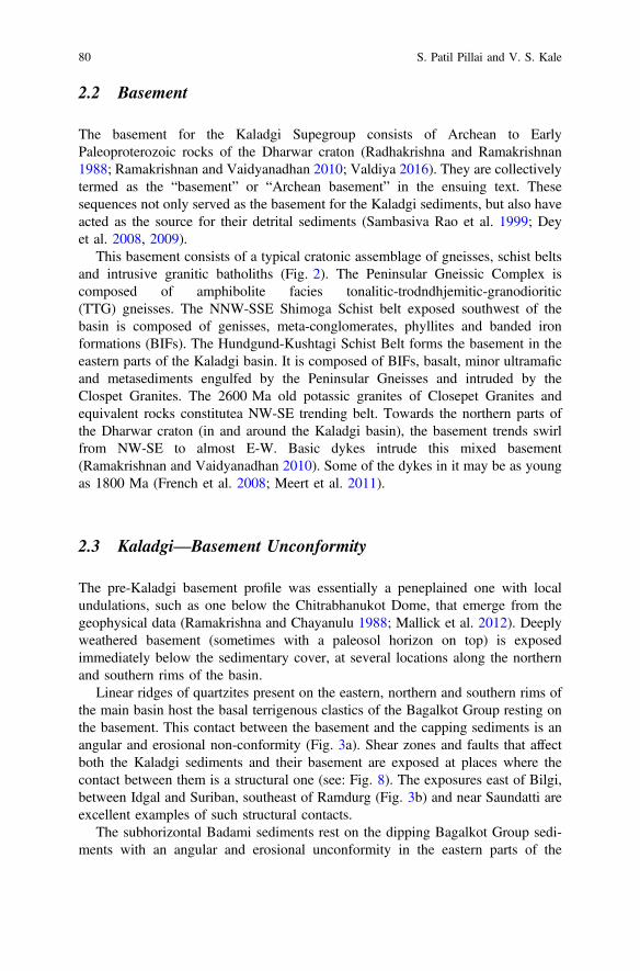
2.2 Basement
The basement for the Kaladgi Supegroup consists of Archean to EarlyPaleoproterozoic rocks of the Dharwar craton (Radhakrishna and Ramakrishnan1988; Ramakrishnan and Vaidyanadhan 2010; Valdiya 2016). They are collectivelytermed as the “basement” or “Archean basement” in the ensuing text. Thesesequences not only served as the basement for the Kaladgi sediments, but also haveacted as the source for their detrital sediments (Sambasiva Rao et al. 1999; Deyet al. 2008, 2009).
This basement consists of a typical cratonic assemblage of gneisses, schist beltsand intrusive granitic batholiths (Fig. 2). The Peninsular Gneissic Complex iscomposed of amphibolite facies tonalitic-trodndhjemitic-granodioritic(TTG) gneisses. The NNW-SSE Shimoga Schist belt exposed southwest of thebasin is composed of genisses, meta-conglomerates, phyllites and banded ironformations (BIFs). The Hundgund-Kushtagi Schist Belt forms the basement in theeastern parts of the Kaladgi basin. It is composed of BIFs, basalt, minor ultramaficand metasediments engulfed by the Peninsular Gneisses and intruded by theClospet Granites. The 2600 Ma old potassic granites of Closepet Granites andequivalent rocks constitutea NW-SE trending belt. Towards the northern parts ofthe Dharwar craton (in and around the Kaladgi basin), the basement trends swirlfrom NW-SE to almost E-W. Basic dykes intrude this mixed basement(Ramakrishnan and Vaidyanadhan 2010). Some of the dykes in it may be as youngas 1800 Ma (French et al. 2008; Meert et al. 2011).
2.3 Kaladgi—Basement Unconformity
The pre-Kaladgi basement profile was essentially a peneplained one with localundulations, such as one below the Chitrabhanukot Dome, that emerge from thegeophysical data (Ramakrishna and Chayanulu 1988; Mallick et al. 2012). Deeplyweathered basement (sometimes with a paleosol horizon on top) is exposedimmediately below the sedimentary cover, at several locations along the northernand southern rims of the basin.
Linear ridges of quartzites present on the eastern, northern and southern rims ofthe main basin host the basal terrigenous clastics of the Bagalkot Group resting onthe basement. This contact between the basement and the capping sediments is anangular and erosional non-conformity (Fig. 3a). Shear zones and faults that affectboth the Kaladgi sediments and their basement are exposed at places where thecontact between them is a structural one (see: Fig. 8). The exposures east of Bilgi,between Idgal and Suriban, southeast of Ramdurg (Fig. 3b) and near Saundatti areexcellent examples of such structural contacts.
The subhorizontal Badami sediments rest on the dipping Bagalkot Group sedi-ments with an angular and erosional unconformity in the eastern parts of the
80 S. Patil Pillai and V. S. Kale
Kaladgi basin (Fig. 3a, c). This was first recorded at B. N. Jalihal (northeast ofBadami) and Torgal Tanda (south of Ramdurg) by Viswanathiah (1968). In thewestern parts, the Badami sediments are exposed resting directly upon the basementwithout the intervening Bagalkot Group sediments, forming flat topped mesas andbuttes (Fig. 3d).
2.4 Phanerozoic Cover
Sediments in the Kaladgi basin are capped by the Deccan Trap basalts, whichconceal large tracts of the basin, making it difficult to establish their lateral conti-nuity particularly in the western parts of the basin (Fig. 2). The Deccan Trap basalts
Fig. 3 a Exposure of the Badami Group (on the top with subhorizontal disposition) restingunconformably upon the steeply dipping Bagalkot Group sediments (appearing as barren linearridges) with a nonconformable contact with the basement at B. N. Jalihal looking eastwards. Thelocation is about 3 km NE of Badami. b Steeply dipping Saundatti Quartzite exposing the shearedcontact with the basement (on the right hand side—not in the picture). The photo is lookingnortheastwards at a location about 4 km east of Ramdurg. Author standing is 1.7 m tall.c Erosional and angular unconformity between the northwards dipping Manoli Argillite (BagalkotGroup) and the capping Cave Temple Arenite (Badami Group) at Torgal Tanda located about3 km south of Ramdurg. The conglomerate is 7 m thick. d Thin cap of subhorizontal Cave TempleArenites resting directly on the Archaean Basement at the Gokak hill forming flat-topped mesas
Interplay Between Tectonics & Eustacy in a Proterozoic … 81

were erupted close to the Cretaceous—Tertiary Boundary and manifest one of thelargest continental flood basalt provinces in the world (Renne et al. 2015). At placesnear Badami, Belgaum (where it is quarried) and along the western Konkan coastaltract Late Tertiary—Quaternary lateritic caps are developed on top of the olderstrata (Fig. 2). In some of the river valleys Quaternary fluvial sedimentary depositsare developed capping the Kaladgi sediments. All of them contribute to masking ofthe exposures of the Kaladgi rocks and making the lateral correlation difficult.
3 Kaladgi Supergroup
3.1 Stratigraphy
The early description of the geological successions in this region by CaptainNewbold in the mid nineteenth century were compiled with additional inputs byFoote (1876). He classified this sedimentary sequence into six subunits ascribed tothe “Upper and Lower Kaladgi Series” that remained unquestioned for almost acentury. Recognition of the unconformity separating the undeformed succession ofsandstones, shales and limestones (‘Unit 3’ of Foote 1876) and the deformed lowersediments around B. N. Jalihal and Torgal Tanda by Viswanthiah (1968) led to therecognition of the two Groups (Badami and Bagalkot) from this basin. Jayaprakashet al. (1987) identified three cycles of sedimentation within the basin and furtherrefined the stratigraphy by dividing the deformed Bagalkot Group into two sub-groups, namely the Lokapur and Simikeri separated by a basin-wide disconformity.This was further elaborated upon by Jayaprakash (2007).
The spread of the exposures of the two constituent Groups (after discounting theyounger cover) shows that they were deposited in slightly different geographicalrealms (Fig. 4). They are recognised as subbasins of the Kaladgi basin, and can bejustified to be sedimentologically, structurally and temporaly different from eachother. They overlap in the eastern part of this basin, but the older Bagalkot Groupdoes not extend in the western areas that host the Badami Group (Fig. 2 Inset).
Jayaprakash et al. (1987) recognised 21 members assigned to 8 formations in theBagalkot Group and 6 members from 2 formations in the Badami Group. The
cFig. 4 a Map of the Bagalkot subbasin depicting the exposures of various stratigraphic units.Chitrabhanukot Dolomite and Chikshellikeri Limestones are Members of the Petlur CarbonateFormation. The locations of the stratigraphic logs (Fig. 6a) are given. Note the outline of this basinmarked in this map is traced by connecting the outermost exposures of the Bagalkot Group asexposed today. The detached exposures south of Manoli are separated from the others by structuralcontacts and hence shown separately. They comprise of Saundatti Quartzite. They indicate a largersouthward expanse of this subbasin, which is detached by structural disruptions or has beendisconnected due to subsequent erosion. b Map of the Badami subbasin depicting the distributionof various stratigraphic units. Locations of the measured logs (Fig. 6b) are given for reference.West of the limits of the Bagalkot subbasin, the Badami sediments rest directly on the Archeanbasement complex
82 S. Patil Pillai and V. S. Kale
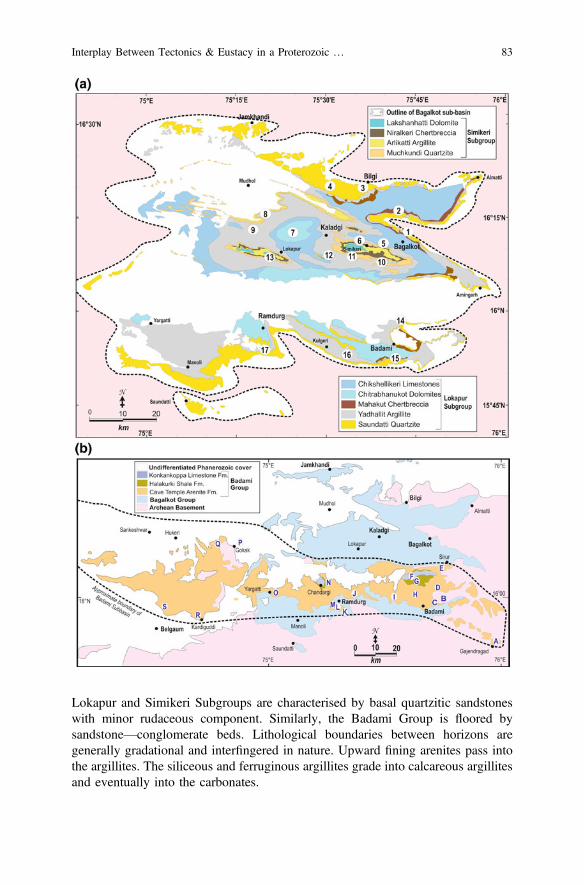
Lokapur and Simikeri Subgroups are characterised by basal quartzitic sandstoneswith minor rudaceous component. Similarly, the Badami Group is floored bysandstone—conglomerate beds. Lithological boundaries between horizons aregenerally gradational and interfingered in nature. Upward fining arenites pass intothe argillites. The siliceous and ferruginous argillites grade into calcareous argillitesand eventually into the carbonates.
Interplay Between Tectonics & Eustacy in a Proterozoic … 83
These horizons display a lateral facies change into the adjoining lithology. Thislateral facies changes have been earlier elaborated for a part of the basin by Kaleet al. (1996) and Patil Pillai (2004). Consequently there is a repetition of the argillite—carbonate horizons encountered along several traverses across the basin.Jayaprakash et al. (1987) and Jayaprakash (2007) recorded these as a number of‘members’ that they clubbed into ‘formations’. This is not valid within theframework of standard stratigraphic practices and Walther’s Law of facies suc-cession (Brenner and McHargue 1988; Catuneanu 2006). A process responsivelithostratigraphy (Table 1) of simplified, lithology-based, mappable formations waserected for the Kaladgi basin (Kale et al. 1996, 1999; Patil Pillai 2004; Kale andPatil Pillai 2011).
Direct onlap of the quartzitic sandstones of the Bagalkot Group without theintervening conglomerates is seen at numerous locations located along the structuralcontact with the basement. This indicates landward transgressive flooding beyondthe structural boundaries of the basin. While the Lokapur Subgroup is spread allacross the Bagalkot subbasin, the Simikeri Subgroup is restricted to the cores of thesynclines (Figs. 2 and 4). The Badami Group does not show any structural contactswith its basement. In the western exposures of this subbasin, the Bagalkot Group isnot present at all between the Badami sediments and the Archean basement (seeFig. 2). At no place does the Badami Group rest upon the Simikeri Subgroup. Thiscould be an indication of the limited development of the Simikeri Subroup, whichhas no representatives south of the Badami subbasin.
3.2 Constitutents
Foote (1876) described the Kaladgi sediments within the framework of the con-temporary formats. Since then, more than a century of research has been invested inthe understanding of the sediments of this basin. Viswanathiah (1979) recognizedfour major lithofacies from this basin, namely the sandstones (/quartizites), shales (/phyllites), carbonates (limestones and dolomites) and chertbreccias. The discoveryof stromatolites from the older carbonates (Viswanathiah and ChandrasekharaGowda 1970; Viswanathiah and Sreedhara Murthy 1979) was interpreted asadditional evidence of shallow marine environments.
Jayaprakash et al. (1987) showed that there were three cycles of shallow marineepicratonic sedimentation within the basin, yielding three successions separatedfrom each other by unconformable contacts. Kale et al. (1996) further refined thisview using lithofacies classification to the southern parts of the basin (see: Figs. 7and 8 of Kale et al. 1996) and later to the basin as a whole (Kale et al. 1999; Kaleand Patil Pillai 2011). A summary of the petrological characters of these faciesbased on our studies is given below.
The Bagalkot Group is characterized by two sequences comprising of fourlithofacies, namely (a) detrital siliciclastic arenites and rudites (sandstones andconglomerates), (b) argillites (siltstones, shales, mudstones and phyllites),
84 S. Patil Pillai and V. S. Kale

(c) chertbreccias and (d) carbonates (limestones and dolomites/dolostones). Theyoccur as concentric stripes with an essentially E-W to ESE-WNW trend, swirlingparallel to the rim of the basin. The clastics occur closer to the basin margin andothers successively inwards towards the basin axis. In the Badami Group, thearenaceous lithofacies dominates significantly, and the argillites and carbonates arerestricted to a narrow linear patch in the northern part of the eastern sector of thissubbasin (Fig. 4b). Chertbreccia is absent in the Badami succession.
3.2.1 Detrital Siliciclastics
Cap the basal unconformities. In case of the Lokapur Subgroup (=SaundattiQuartzite), they rest on the weathered basement; while those from the SimikeriSubgroup (=Muchkundi Quartzite) rest on the deformed sediments of the LokapurSubgroup. They occur as ridges that stand out in the low-lying terrain surroundingthem. This facies from the Badami Group (=Cave Temple Arenite) rests either onthe basement or on the deformed sediments of the Bagalkot Group, as gentlyundulating table-lands.
Conglomerates occuring immediately above the basement are several metersthick. Thin, sandy cross-stratified interbeds are common in them. Further upwardsin the sequence, they are present as thin sheets or thicker lensoid beds with poorinternal stratification (Fig. 2c) interbedded within the sandstones/quartzites.
The conglomerates are generally polymictic, matrix supported, poorly sortedrudites. The clasts in the Bagalkot conglomerates are dominantly composed ofquartzitic, vein quartz, granitoid, schists and gneissic fragments embedded in aclastic matrix which is often silicified (Fig. 5a). The Badami conglomerates containclasts derived from the Bagalkot sediments as well.
The Bagalkot sandstones display planar bedding (Fig. 5b) separated by thin mudor silt partings, with low angle internal trough cross-stratification. Low anglecross-laminations, climbing ripple laminations and widespread wave ripple markson bedding planes (Fig. 5c) suggest a coastal shoreface regime of deposition in avariety of marginal to shallow marine environments such as strandplains, beaches,deltas, estuaries, off-shore sand bars, and beaches that occasionally were influencedby tidal currents (Kale et al. 1996; Jayaprakash 2007). Some of these beds, notablyfrom the exposures around Bilgi and Jamkhindi on the northern parts of the basinare interpreted to be deposited under fluvial influence in deltaic/esturine environ-ments (Bose et al. 2008). Some of the coarser detritus (rudites) may be lag depositsor gravelly shoreline rim deposits on the landward side of the basin, representinginception of the transgression in it. Their provenance is the Dharwarian basementfrom where they were transported in a fluvial medium (Dey et al. 2009;Mukhopadhyay et al. 2014). Palaeocurrent studies (Jayaprakash et al. 1987;Stephen George 1999) have indicated a centripetal pattern. The northern exposuresdisplay southward directed palaeocurrents and the southern exposures in theRamdurg–Saundatti tract have northerly palaeocurrent directions. Change in theorientations of the current ripples in successive beds (Fig. 5c) suggest limited tidal
Interplay Between Tectonics & Eustacy in a Proterozoic … 85
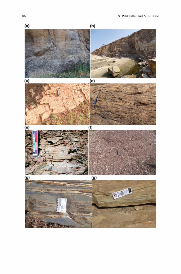
86 S. Patil Pillai and V. S. Kale
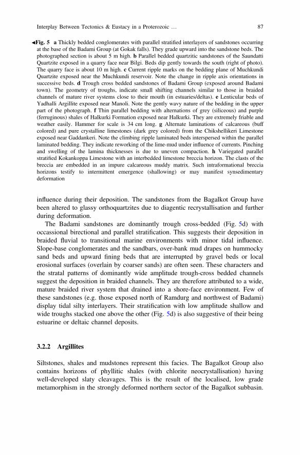
influence during their deposition. The sandstones from the Bagalkot Group havebeen altered to glassy orthoquartzites due to diagentic recrystallisation and furtherduring deformation.
The Badami sandstones are dominantly trough cross-bedded (Fig. 5d) withoccassional birectional and parallel stratification. This suggests their deposition inbraided fluvial to transitional marine environments with minor tidal influence.Slope-base conglomerates and the sandbars, over-bank mud drapes on hummockysand beds and upward fining beds that are interrupted by gravel beds or localerosional surfaces (overlain by coarser sands) are often seen. These characters andthe stratal patterns of dominantly wide amplitude trough-cross bedded channelssuggest the deposition in braided channels. They are therefore attributed to a wide,mature braided river system that drained into a shore-face environment. Few ofthese sandstones (e.g. those exposed north of Ramdurg and northwest of Badami)display tidal silty interlayers. Their stratification with low amplitude shallow andwide troughs stacked one above the other (Fig. 5d) is also suggestive of their beingestuarine or deltaic channel deposits.
3.2.2 Argillites
Siltstones, shales and mudstones represent this facies. The Bagalkot Group alsocontains horizons of phyllitic shales (with chlorite neocrystallisation) havingwell-developed slaty cleavages. This is the result of the localised, low grademetamorphism in the strongly deformed northern sector of the Bagalkot subbasin.
JFig. 5 a Thickly bedded conglomerates with parallel stratified interlayers of sandstones occurringat the base of the Badami Group (at Gokak falls). They grade upward into the sandstone beds. Thephotographed section is about 5 m high. b Parallel bedded quartzitic sandstones of the SaundattiQuartzite exposed in a quarry face near Bilgi. Beds dip gently towards the south (right of photo).The quarry face is about 10 m high. c Current ripple marks on the bedding plane of MuchkundiQuartzite exposed near the Muchkundi reservoir. Note the change in ripple axis orientations insuccessive beds. d Trough cross bedded sandstones of Badami Group (exposed around Badamitown). The geometry of troughs, indicate small shifting channels similar to those in braidedchannels of mature river systems close to their mouth (in estuaries/deltas). e Lenticular beds ofYadhalli Argillite exposed near Manoli. Note the gently wavy nature of the bedding in the upperpart of the photograph. f Thin parallel bedding with alternations of grey (siliceous) and purple(ferruginous) shales of Halkurki Formation exposed near Halkurki. They are extremely friable andweather easily. Hammer for scale is 34 cm long. g Alternate laminations of calcareous (buffcolored) and pure crystalline limestones (dark grey colored) from the Chikshellikeri Limestoneexposed near Gaddankeri. Note the climbing ripple laminated beds interspersed within the parallellaminated bedding. They indicate reworking of the lime-mud under influence of currents. Pinchingand swelling of the lamina thicknesses is due to uneven compaction. h Variegated parallelstratified Kokankoppa Limestone with an interbedded limestone breccia horizon. The clasts of thebreccia are embedded in an impure calcareous muddy matrix. Such intraformational brecciahorizons testify to intermittent emergence (shallowing) or may manifest synsedimentarydeformation
Interplay Between Tectonics & Eustacy in a Proterozoic … 87

The argillites shows basinward progressive compostional gradation from silic-eous near the basin margins to ferruginous to calcareous in the centre of the basin.The argillites occur as flat and laterally extensive facies that occupy vast tractswithin the basin, with subparallel to parallel stratification. They display a variety ofprimary sedimentary structures such as flaser and lenticular bedding (Fig. 5e),discontinuous or lensoid bedding, mud cracks, clay gals, rip up clasts, raindropimpressions etc. These features testify to their deposition in a tidal regime whichwas intermittently flooded. The occurrence of manganese nodules within theArlikatti Argillite near Niralkeri village reported by Patil Pillai et al. (1999) indi-cates the possibility of a locally developed condensed sequences within the basin.The argillaceous sediments from the Bagalkot Group (Yadhalli Argillite andArlikatti Argillite) are products of shallow intertidal off-shore flats, that sufferedphases of emergent and submergent conditions.
The shales of Badami subbasin are dominantly thinly stratified (Fig. 5f) and areocassionally glauconitic. This indicates their deposition in transitional marine set-tings. The calcareous shales (generally occurring at the top of the argillite beds)progressively grade into the impure limestones of the carbonate facies. Distributionand sedimentological characters suggest that they (Halkurki Shale) were depositedin a lagoonal environment.
3.2.3 Chertbreccias
They occur only in the Bagalkot Group but are not present in the BadamiGroup. Two separate horizons are present in the Lokapur and Simikeri Subgroups(Mahakut and Niralkeri Chertbreccia Formations respectively). In field exposuresthey can be easily misidentified as fault breccias, but are unequivocally interbeddedhorizons within the rest of the Bagalkot sediments. They have been deformedcoherently with the other enveloping sediments of this Group. They are interpretedas washed fault-generated debris produced during the synsedimentary tectonicmovements along the basinal faults and subsequently silicified (Kale and Patil Pillai2011).
The chertbreccia and argillaceous beds display a mutually exclusive develop-ment in the Bagalkot sequence. In the sectors of the basin that suffered synsedi-mentary tectonism, where chertbreccia deposits developed, the extent of themudflats was curtailed. This led to accumulation of thinner deposits of theargillaceous sediments. In other sectors such as in the southern sector aroundManoli and west of Badami, where the basin floor subsided in a more gentlecontinuum, wide tidal mudflats yielded thicker argillaceous deposits (see: Kale et al.1996).
88 S. Patil Pillai and V. S. Kale
3.2.4 Carbonates
This facies is represented by limestones and dolomites, with the latter beingrestricted to the Bagalkot Group. The limestones display a variety of colours (pink,white, green and grey) attributed to the impurities in them. The limestones ofBagalkot Group display flat, parallel-laminated alternations of impure lime mudsand pure crystalline limestone. Occurrence of climbing ripple laminations andcross-stratified lenses (Fig. 5g) indicate that they were deposited in a very shallowshelf affected by currents. The dolomites or dolostones of the Bagalkot Groupdisplay tabular parallel-laminated stratification. They are often diagenetically sili-cified. They contain wavy algal-laminated dolomites with stromatolitic colonies(Viswanathiah and Sreedhara Murthy 1979; Sharma et al. 1998) indicating waterdepths of less than 20 m and a warm equitable climate. These carbonates areinterpreted to be deposited in a carbonate flat regime with occasional interruptionsof storm surges manifested as thin sandy lenses. Occurrence of intraformationallimestone breccia horizons (Kale et al. 1998) in them is indicative of their episodicemergence or the manifestation of synsedimentary deformational events duringtheir accumulation.
The flaggy limestones of Badami Group are varigated (Fig. 5h) and contain thinlensoid intercalations of siliciclastics. They display wave ripples, clay galls, rip upclasts, tidal couplet laminae suggesting a tidally influenced depositional setting.Presence of glauconites in the sandy lenses suggests locally developed reducingenvironments during their deposition.
3.2.5 Mafic Bodies
Basic dykes and quartz veins intruding discordantly into the sediments have beenrecorded from the northern folded sector of the Bagalkot subbasin (Foote 1876;Jayaprakash et al. 1987; Jayaprakash 2007). They are collectively named asMallapur Intrusives Formation of the Simikeri Subgroup. Their occurrence alongthe axial planes of folds in the Simikeri Subgroup indicates that they were emplacedafter the cessation of sedimentation. Therefore they are separated as an independentformation post-dating the Simikeri Subgroup as listed in Table 1 (Patil Pillai et al.2018).
3.3 Lithologs
Besides the detailed lithological mapping (Fig. 4), logs of stratigraphic sectionswere reconstructed based on sections measured during field studies (Fig. 6). Theyinclude the sedimentary structures, stratal patterns and thicknesses of the variouslithotypes.
Interplay Between Tectonics & Eustacy in a Proterozoic … 89
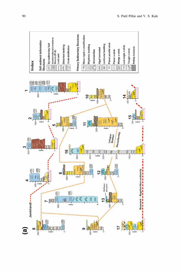
90 S. Patil Pillai and V. S. Kale

Fig.6
(con
tinued)
Interplay Between Tectonics & Eustacy in a Proterozoic … 91
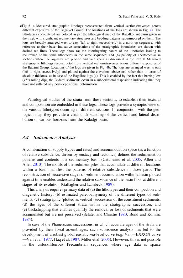
Petrological studies of the strata from these sections, to establish their texturaland composition are embedded in these logs. These logs provide a synoptic view ofthe various lithotypes occuring in different sections. In conjunction with the geo-logical map they provide a clear understanding of the vertical and lateral distri-bution of various horizons from the Kaladgi basin.
3.4 Subsidence Analysis
A combination of supply (types and rates) and accommodation space (as a functionof relative subsidence, driven by eustacy and tectonics) defines the sedimentationpatterns and contents in a sedimentary basin (Catuneanu et al. 2005; Allen andAllen 2013). The motifs of the sediment piles that accumulate at different locationswithin a basin manifest the patterns of relative subsidence in those parts. Thereconstruction of successive stages of sediment accumulation within a basin plottedagainst time enables understand the relative subsidence of the basin floor at differentstages of its evolution (Gallagher and Lambeck 1989).
This analysis requires primary data of (a) the lithotypes and their compaction anddiagenetic history, (b) estimated paleobathymetry of the different types of sedi-ments, (c) stratigraphic (plotted as vertical) succession of the constituent sediments,(d) the ages of the different strata within the stratigraphic succession; and(e) backstripping that enables quantify the removal or loss of sediments that wereaccumulated but are not preserved (Sclater and Christie 1980; Bond and Kominz1984).
In case of the Phanerozoic successions, in which accurate ages of the strata areprovided by their fossil assemblages, such subsidence analysis has led to thedevelopment of a robust global eustatic sea-level curve (e.g. Vail—EXXON curve—Vail et al. 1977; Haq et al. 1987; Miller et al. 2005). However, this is not possiblein the unfossiliferrous Precambrian sequences where age data is sparse
JFig. 6 a Measured stratigraphic lithologs reconstructed from vertical sections/traverses acrossdifferent exposures of the Bagalkot Group. The locations of the logs are shown in Fig. 4a. Thelithofacies encountered are colored as per the lithological map of the Bagalkot subbasin given inthe inset, with significant sedimentary structures and bedding patterns superimposed on them. Thelogs are broadly arranged west to east (left to right successively) in a north-up sequence, withreference to their base. Indicative correlations of the stratigraphic boundaries are shown withdashed red lines. These logs show (a) the interfingering nature of the lithofacies leading torecurrence of the same lithofacies in the same sequence; and (b) paucity of chertbreccias insections where the argillites are prolific and vice versa as discussed in the text. b Measuredstratigraphic lithologs reconstructed from vertical sections/traverses across different exposures ofthe Badami Group. Locations of the logs are given in Fig. 4b. The logs are arranged west to east(left to right successively) and plotted against the elevations above msl rather than in terms ofabsolute thickness as in case of the Bagalkot logs (a). This is enabled by the fact that barring low(<5°) rolling dips, the Badami sediments occur in a subhorizontal disposition indicating that theyhave not suffered any post-depositional deformation
92 S. Patil Pillai and V. S. Kale

(Catuneanu et al. 2005). In such cases, accurate determination of the net rate ofsubsidence of the basin floor cannot be plotted and needs to be estimated usingother proxies. Kale (1991) used these principles to plot the ‘sediment accumulationcurves’ (‘SAC’s) of the Purana basins, using the total accumulated stratigraphicthickness in the basin as a proxy of 100% time of the basin evolution. The maxi-mum stratigraphic thickness of each stratigraphic unit computed as a percentilevalue of the total thickness represents the relative time taken by it in the basin. Thisyields a relative (rather than absolute—as in case of the Phanerozoic) scale for thebasin. We have used our observations (as enumerated in Figs. 4 and 6) and themaximum thicknesses of strata as defined by Jayaprakash (2007) in these compu-tations. The cumulative uncompacted maximum stratigraphic thickness for theBagalkot Group is 13,717 m and for the Badami Group is 1846 m. These valuesmatch well with the geophysically determined maximum depth to basement (e.g.Ramakrishna and Chayanulu 1988; Kale 1991) of the Kaladgi basin.
3.4.1 Sediment Accumulation Curves
This analysis uses Cant’s (1989) equation that derives a relationship betweeneustacy (E), subsidence (Sub), sediment accumulation (Sed) and the depth of thedepositional interface (D). It is postulated that the change in water depth (DD)during the deposition of a single uninterrupted stratum with thickness (DSed), in abasin where space is created due to subsidence (tectonic or gravity driven) of thebasin floor (DSub) and eustatic sea-level change (DE) will be as follows:
DSub þ DE � DSed ¼ DD ð1Þ
If the combined effects of subsidence and eustacy are clubbed together into asingle parameter (DDI), this equation can be simplified into the following form:
DDI � DSed ¼ DD ð2Þ
In other words, the sum of sediment thickness and its depositional depth of eachstrata gives the net change in the depth of the depositional interface due to subsi-dence and eustacy:
DDI ¼ DSed þ DD ð3Þ
It is assumed that during the deposition of a single lithotype, the sedimentaccumulation (DSed) kept pace with the net subsidence (DDI) and that the changein this resulted in the succeeding lithotype to be deposited in succession. Theuncompacted thickness of each stratum in a single stratigraphic section is computedto generate the progressive accumulation, computed as the ‘cumulative DDI’.Plotting the successive values of DDI against time (as determined by the age of thesediments in a sequence) provides a glimpse of the nature of changes in the
Interplay Between Tectonics & Eustacy in a Proterozoic … 93
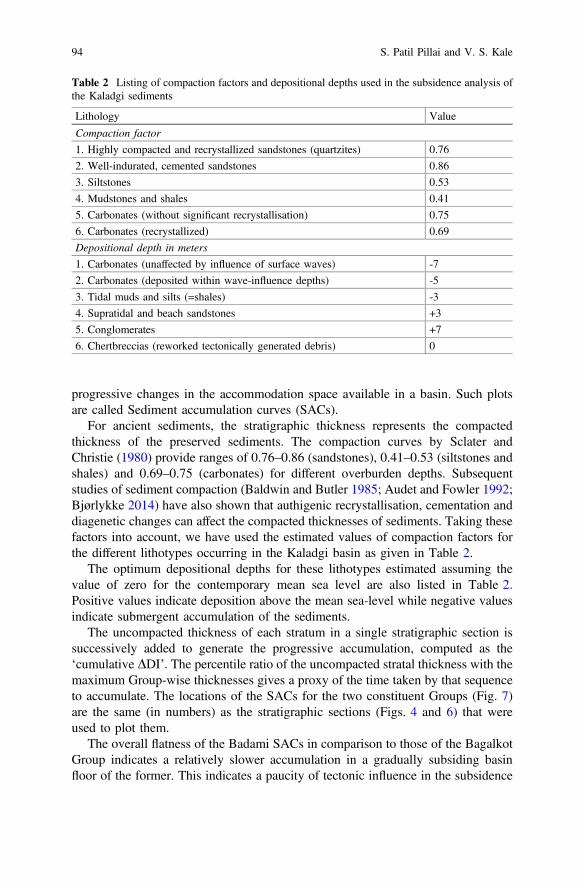
progressive changes in the accommodation space available in a basin. Such plotsare called Sediment accumulation curves (SACs).
For ancient sediments, the stratigraphic thickness represents the compactedthickness of the preserved sediments. The compaction curves by Sclater andChristie (1980) provide ranges of 0.76–0.86 (sandstones), 0.41–0.53 (siltstones andshales) and 0.69–0.75 (carbonates) for different overburden depths. Subsequentstudies of sediment compaction (Baldwin and Butler 1985; Audet and Fowler 1992;Bjørlykke 2014) have also shown that authigenic recrystallisation, cementation anddiagenetic changes can affect the compacted thicknesses of sediments. Taking thesefactors into account, we have used the estimated values of compaction factors forthe different lithotypes occurring in the Kaladgi basin as given in Table 2.
The optimum depositional depths for these lithotypes estimated assuming thevalue of zero for the contemporary mean sea level are also listed in Table 2.Positive values indicate deposition above the mean sea-level while negative valuesindicate submergent accumulation of the sediments.
The uncompacted thickness of each stratum in a single stratigraphic section issuccessively added to generate the progressive accumulation, computed as the‘cumulative DDI’. The percentile ratio of the uncompacted stratal thickness with themaximum Group-wise thicknesses gives a proxy of the time taken by that sequenceto accumulate. The locations of the SACs for the two constituent Groups (Fig. 7)are the same (in numbers) as the stratigraphic sections (Figs. 4 and 6) that wereused to plot them.
The overall flatness of the Badami SACs in comparison to those of the BagalkotGroup indicates a relatively slower accumulation in a gradually subsiding basinfloor of the former. This indicates a paucity of tectonic influence in the subsidence
Table 2 Listing of compaction factors and depositional depths used in the subsidence analysis ofthe Kaladgi sediments
Lithology Value
Compaction factor
1. Highly compacted and recrystallized sandstones (quartzites) 0.76
2. Well-indurated, cemented sandstones 0.86
3. Siltstones 0.53
4. Mudstones and shales 0.41
5. Carbonates (without significant recrystallisation) 0.75
6. Carbonates (recrystallized) 0.69
Depositional depth in meters
1. Carbonates (unaffected by influence of surface waves) -7
2. Carbonates (deposited within wave-influence depths) -5
3. Tidal muds and silts (=shales) -3
4. Supratidal and beach sandstones +3
5. Conglomerates +7
6. Chertbreccias (reworked tectonically generated debris) 0
94 S. Patil Pillai and V. S. Kale

history of the Badami Group. The steeper Bagalkot SACs suggest a faster subsi-dence, which must have been enabled by tectonic deepening besides the eustaticchanges in the sea-level through its evolutionary history.
The SACs of the section numbers 2, 7, 9, 14, 15, 16 displays a consistentgradient with little or no deflection; pointing to a rapid subsidence with a fairlyconsistent rate. These sections are not located close to any of the basement shears.On the other hand, the SACs of section numbers 1, 3, 6, 10, 11 that are located near
Fig. 7 SACs of the Kaladgi Supergroup. The curves are numbered as per the stratigraphic section(Fig. 6a, b) used to plot them. For the Bagalkot Group rows are arranged from east to west (right toleft) respectively to give a perception of the along-strike changes in subsidence patterns. The rowsare arranged north to south (top-bottom) respectively. For the Badami Group only tworepresentative SACs are given
Interplay Between Tectonics & Eustacy in a Proterozoic … 95
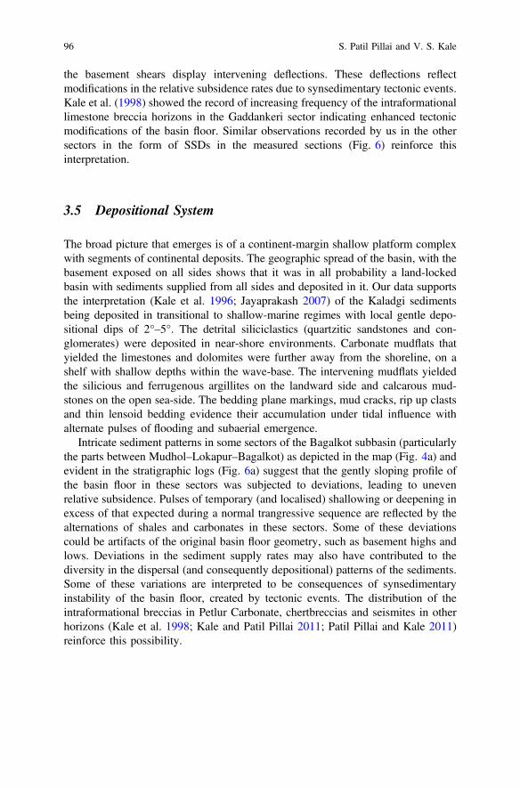
the basement shears display intervening deflections. These deflections reflectmodifications in the relative subsidence rates due to synsedimentary tectonic events.Kale et al. (1998) showed the record of increasing frequency of the intraformationallimestone breccia horizons in the Gaddankeri sector indicating enhanced tectonicmodifications of the basin floor. Similar observations recorded by us in the othersectors in the form of SSDs in the measured sections (Fig. 6) reinforce thisinterpretation.
3.5 Depositional System
The broad picture that emerges is of a continent-margin shallow platform complexwith segments of continental deposits. The geographic spread of the basin, with thebasement exposed on all sides shows that it was in all probability a land-lockedbasin with sediments supplied from all sides and deposited in it. Our data supportsthe interpretation (Kale et al. 1996; Jayaprakash 2007) of the Kaladgi sedimentsbeing deposited in transitional to shallow-marine regimes with local gentle depo-sitional dips of 2°–5°. The detrital siliciclastics (quartzitic sandstones and con-glomerates) were deposited in near-shore environments. Carbonate mudflats thatyielded the limestones and dolomites were further away from the shoreline, on ashelf with shallow depths within the wave-base. The intervening mudflats yieldedthe silicious and ferrugenous argillites on the landward side and calcarous mud-stones on the open sea-side. The bedding plane markings, mud cracks, rip up clastsand thin lensoid bedding evidence their accumulation under tidal influence withalternate pulses of flooding and subaerial emergence.
Intricate sediment patterns in some sectors of the Bagalkot subbasin (particularlythe parts between Mudhol–Lokapur–Bagalkot) as depicted in the map (Fig. 4a) andevident in the stratigraphic logs (Fig. 6a) suggest that the gently sloping profile ofthe basin floor in these sectors was subjected to deviations, leading to unevenrelative subsidence. Pulses of temporary (and localised) shallowing or deepening inexcess of that expected during a normal trangressive sequence are reflected by thealternations of shales and carbonates in these sectors. Some of these deviationscould be artifacts of the original basin floor geometry, such as basement highs andlows. Deviations in the sediment supply rates may also have contributed to thediversity in the dispersal (and consequently depositional) patterns of the sediments.Some of these variations are interpreted to be consequences of synsedimentaryinstability of the basin floor, created by tectonic events. The distribution of theintraformational breccias in Petlur Carbonate, chertbreccias and seismites in otherhorizons (Kale et al. 1998; Kale and Patil Pillai 2011; Patil Pillai and Kale 2011)reinforce this possibility.
96 S. Patil Pillai and V. S. Kale
4 Structural Configuration
For understanding the evolution of the basin, it is necessary to try and separate thediverse influences (basement undulations, supply rate variations, sea-level changesand tectonics) and their imprints in the sedimentary record. The primary require-ment for enabling this was to establish the three-dimensional geometry of varioushorizons. This is relatively straight forward in case of the subhorizontal BadamiGroup. However, the tightly folded sequence of the Bagalkot Group does notpermit the lateral continuity of the lithostratigraphic units to be established withoutdeciphering the structural patterns and ‘unfolding’ the strata.
The deformation patterns in the basin were earlier documented by Awati andKalaswad (1978), Nair and Raju (1987), Jayaprakash et al. (1987), Gokhale andPujar (1989), Jayaprakash (2007), Mukherjee et al. (2016), Jadhav and Kshirsagar(2017) amongst others. Traverse mapping to validate earlier observations and fieldobservations on the orientations of the bedding planes, fractures and phylliticcleavage (in case of the argillites) have been used to understand the sense ofmovement in different folds and faults in the basin.
Figure 8 compiles these observations in the Bagalkot subbasin that has under-gone significant tectonic deformation. It is apparently divided into the northern andsouthern sectors (Figs. 4a and 8) that are structurally different from each other,separated by younger cover. The northern sector hosts tight eastwards or westwardsplunging folds. The southern sector exposes monoclinal, northward dipping stratafrom the Lokapur Subgroup (Fig. 8). This stronger deformation of the BagalkotGroup in the central parts than that along its fringes is akin to mobile belts. Thiscontrasts to that recorded from the other Purana basins, which display deformedmargins and relatively undeformed mid-basinal sectors.
The narrow linear Badami subbasin (Inset Figs. 2 and 4b) is almost undeformed.The Badami Group is characterized by subhorizontal dips and small local faultsshowing dragging along them. No other structural deformation is recorded from thisGroup.
4.1 Regional Faults/Shears
The Kaladgi basin displays several sets of inherent as well as superimposed faults(with evidence of brittle deformation and displacement) and shears (zones ofquasi-ductile to ductile deformation). The sense of slip along them is recordedbased on slickenside surfaces, drag of the bedding and joint patterns along them.They dominantly trend E-W to ESE-WNW with gentle swirls along their lengthsand occur close to the margins of the basin.
The Sirur Shear zone extends for >100 km across the central part of the basinand further eastwards into the basement terrain. It displays a minor right-lateralsense of movement and a larger dip-slip component with downthrows towards
Interplay Between Tectonics & Eustacy in a Proterozoic … 97

north. This shear zone (Fig. 8) is largely concealed below younger cover (of theBadami Group and Deccan Traps). It occurs along the boundary between thenorthern and southern sectors of the Bagalkot subbasin. It also marks the northernedge of the Badami subbasin in the eastern sector (Fig. 4b). This suggests that itmay have suffered a reversal of sense of movement, yielding southward down-throws during the Badami sedimentation. Most of the other E-W trending faultsdisplay dominantly dip-slip displacements with basin-ward downthrows, and neg-ligible to no strike-slip components.
The NW-SE trending sinistral Anagvadi and Kolchi Shears extend into thebasement. The imprints of the former are exposed across the Bagalkot subbasin.The northward continuity of the Kolchi Shear is concealed below younger coverand is hence shown with a thinner line in Fig. 8. Both correspond to megascalegeophysical lineaments of Peninsular India (Sridhar et al. 2017; Rajaram et al.2016) that extend far beyond the bounds of the Kaladgi basin.
Minor faults have been mapped in several parts of the basin with NNE-SSW,N-S, NNW-SSE trends (Fig. 8). They appear related to folding as sympatheticfractures that show brittle deformation when transecting the quartzitic and
Fig. 8 Structural map of the Bagalkot subbasin showing the major folds and faults. The dottedoutline marks the boundary of this subbasin that is surrounded on all sides by basement rocks.Regional shear zones such as the Kolchi and Anagwadi Shears have been recorded in geophysicalstudies as crustal scale lineaments. The Sirur Shear separates the northern folded sector and thesouthern monoclinal (northward dipping) sector of this subbasin
98 S. Patil Pillai and V. S. Kale

conglomeratic horizons, while the argillites and carbonates suffered ductile drag-ging coherent with the sense of movement (see Mukherjee 2014).
The synsedimentary deformation from the Bagalkot Group is oriented parallel tothe adjoining shears and faults (Kale et al. 1998; Kale and Patil Pillai 2011; PatilPillai and Kale 2011). This indicates that they may be inherited structures from thebasement that were reactivated during and after the sedimentation in the Kaladgibasin. Faulted contact of the basement and cover sediments when traced laterally,assumes the nature of an unconformable relation, with the trace of the fault con-cealed below the sedimentary cover. This suggests that although faulting played anactive role in the basin subsidence, transgressive onlap of sediments beyond thefaults did take place. The combination of the NW-SE trending regional shears andthe E-W trending Sirur Shear suggest that basinal growth took place in atranstensional regime.
Several cross-faults that display quasi-ductile deformation in the argillaceousand carbonate sediments cross the quarzitic ridges as brittle faults lined with faultbreccia. This aspect of competency contrast provides a better understanding of thestress distribution during deformation and provides clues to the sense of slip alongthem.
4.2 Folds
Folds in the Bagalkot subbasin are easily mappable from aerial photographs andsatellite imageries (Awati and Kalaswad 1978; Nair and Raju 1987) due to the rimsof the quartzite ridges along them (Fig. 9). These folds are large amplitude, smallwavelength ‘close folds’ with inter-limb angles of less than 30°. They displayplunging fold axes and curviplanar axial planes (as shown in Figs. 8 and 9).
This has been interpreted as a weaker event of cross folding (Mukherjee et al.2016; Jadhav and Kshirsagar 2017). Alternatively, the fold geometry may have alsobeen influenced by inherited structures such as the basement shears and paleoto-pographic undulations, yielding a perception of a second phase of coaxial folding.
Incipient greenschist facies metamorphism is manifested as development ofchlorite, sericite, albite (Govinda Rajulu and Chandrasekhar Gowda 1972) andphyllitic cleavages in argillaceous sediments; and uralitization of pyroxenes andalbitisation of plagioclase in the Mallapur Intrusives (Patil Pillai et al. 2018). It ispronounced at locations where the secondary faults cut across them and along foldaxes, but becomes indistinct away from the faults and on the fold limbs.
4.3 Synthesis
Three N-S geological cross-sections are reconstructed to depict the complex natureof deformation and the stratigraphic relationships between various horizons in the
Interplay Between Tectonics & Eustacy in a Proterozoic … 99

Kaladgi basin (Fig. 10). Besides enabling understanding of the lateral facieschanges, they also show the relationships between various folds and faults in thedeformed sector of the Bagalkot subbasin.
The E-W and NW-SE trending regional shears in the basement continue as faultsaffecting the sediments. The parallel orientations of the synsedimentary deforma-tional structures to them (Patil Pillai and Kale 2011) indicate that they were activeduring the sedimentation in the basin (D0) and have influenced the basin geometry.The sediment distribution patterns as lithofacies stripes parallel to these basementstructures reinforces this interpretation. They controlled its deepening by subsi-dence of the continent-margin shallow marine platform.
The pattern of the SACs (Fig. 7), the shore-line—shelf depositional regimes ofthe sediments and their stripping patterns collectively indicate that extensionalsubsidence was responsible for the growth of the basin. Presence of synsedimentaryextensional faults as documented by Patil Pillai and Kale (2011; Fig. 5) in the lowersequences of the Kaladgi basin and the onlap of sediments across bounding faultsare additional evidences in support of multiple transgressions that occurred in aprogressively deepening basin. In absence of systematic geophysical or drillingdata, it is difficult to validate the depth penetration of the structures recognizedduring surface mapping as depicted in the cross-sections (Fig. 10).
Fig. 9 Sketch maps of major folds in the Bagalkot subbasin. The fold axes are shown with theirplunge direction and anticlinal/synclinal symbol. Faults are shown with thin dotted red lines.Strike-slip faults are depicted with the sense of slip along them. Faults with dominant dip-slipcomponent are shown without any marking of sense of movement along them
100 S. Patil Pillai and V. S. Kale
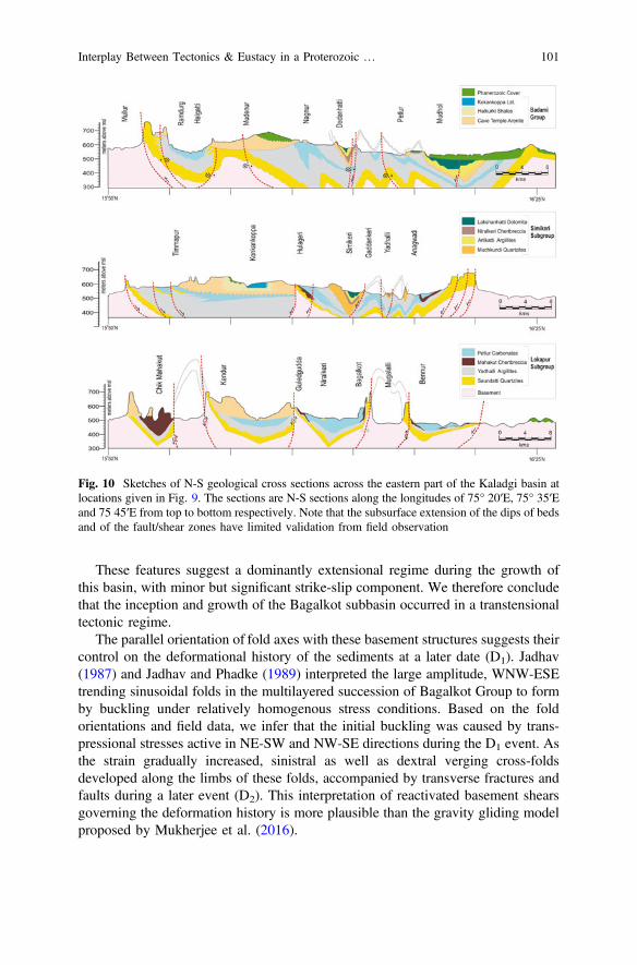
These features suggest a dominantly extensional regime during the growth ofthis basin, with minor but significant strike-slip component. We therefore concludethat the inception and growth of the Bagalkot subbasin occurred in a transtensionaltectonic regime.
The parallel orientation of fold axes with these basement structures suggests theircontrol on the deformational history of the sediments at a later date (D1). Jadhav(1987) and Jadhav and Phadke (1989) interpreted the large amplitude, WNW-ESEtrending sinusoidal folds in the multilayered succession of Bagalkot Group to formby buckling under relatively homogenous stress conditions. Based on the foldorientations and field data, we infer that the initial buckling was caused by trans-pressional stresses active in NE-SW and NW-SE directions during the D1 event. Asthe strain gradually increased, sinistral as well as dextral verging cross-foldsdeveloped along the limbs of these folds, accompanied by transverse fractures andfaults during a later event (D2). This interpretation of reactivated basement shearsgoverning the deformation history is more plausible than the gravity gliding modelproposed by Mukherjee et al. (2016).
Fig. 10 Sketches of N-S geological cross sections across the eastern part of the Kaladgi basin atlocations given in Fig. 9. The sections are N-S sections along the longitudes of 75° 20′E, 75° 35′Eand 75 45′E from top to bottom respectively. Note that the subsurface extension of the dips of bedsand of the fault/shear zones have limited validation from field observation
Interplay Between Tectonics & Eustacy in a Proterozoic … 101
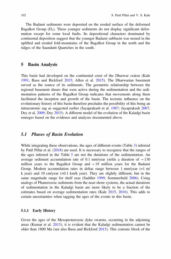
The Badami sediments were deposited on the eroded surface of the deformedBagalkot Group (D3). These younger sediments do not display significant defor-mation except for some local faults. Its depositional characters dominated bycontinental deposition suggest that the younger Badami subbasin was nested in theuplifted and eroded fold-mountains of the Bagalkot Group in the north and theridges of the Saundatti Quartzites in the south.
5 Basin Analysis
This basin had developed on the continental crust of the Dharwar craton (Kale1991; Basu and Bickford 2015; Allen et al. 2015). The Dharwarian basementserved as the source of its sediments. The geometric relationship between theregional basement shears that were active during the sedimentation and the sedi-mentation patterns of the Bagalkot Group indicates that movements along themfacilitated the inception and growth of the basin. The tectonic influence on theevolutionary history of this basin therefore precludes the possibility of this being anintracratonic sag as suggested earlier (Jayaprakash et al. 1987; Jayaprakash 2007;Dey et al. 2009; Dey 2015). A different model of the evolution of the Kaladgi basinemerges based on the evidence and analyses documented above.
5.1 Phases of Basin Evolution
While integrating these observations, the ages of different events (Table 3) inferredby Patil Pillai et al. (2018) are used. It is necessary to recognize that the ranges ofthe ages inferred in the Table 3 are not the durations of the sedimentation. Anaverage sediment accumulation rate of 0.1 mm/year yields a duration of *130million years to the Bagalkot Group and *19 million years for the BadamiGroup. Modern accumulation rates in deltas range between 1 mm/year (=1 m/k year) and 10 cm/year (=0.1 km/k year). They are slightly different, but in thesame magnitude range for shelf seas (Saddler 1999; Sommerfield 2006). Usinganalogs of Phanerozoic sediments from the near-shore systems, the actual durationsof sedimentation in the Kaladgi basin are more likely to be a fraction of theestimates based on average sedimentation rates (Kale 2015, 2016). This adds tocertain uncertainties when tagging the ages of the events in this basin.
5.1.1 Early History
Given the ages of the Mesoproterozoic dyke swarms, occurring in the adjoiningareas (Kumar et al. 2015), it is evident that the Kaladgi sedimentation cannot beolder than 1800 Ma (see also Basu and Bickford 2015). This cratonic block of the
102 S. Patil Pillai and V. S. Kale

northern Dhawar craton was subjected to an emergent period of continentalweathering and erosion leading to a peneplained topography with gentle gradientsfollowing the event of dyke intrusion. This is consistent with the period of stabilityof supercontinental assembly (between 1800 and 1500 Ma) predicted by Condieet al. (2015).
The reorganization of continental blocks and assembly of Rodinia after thebreakup of Nuna started around 1400 Ma (Cawood and Hawkesworth 2014;Condie et al. 2015). Similar coeval extensional regimes and cratonic rifting arerecorded from the other Purana basins of Peninsular India (Kale 2016). It isspeculated that the primary inception of this basin on the northern edge of theDharwar craton may be a part of this global tectono-thermal event. Transtensionalreactivation of some of the basement shears, like the Sirur Shear, enabled tecton-ically driven subsidence in the Bagalkot subbasin. It is generally accepted thatduring the existence of the Mesoproterozoic supercontinents, due to their lowtopographic gradient, even small sea-level increase could lead to flooding of largeareas creating wide-spread platform basins (Eriksson et al. 2006; Bradley 2011),similar to the Kaladgi basin.
Table 3 Chronology of events in the Kaladgi basin modified after Patil Pillai et al. (2018)
Subbasin Sedimentological events Tectono-thermal events Estimated agerange/measuredage (Ma)
Badami Continental sedimentationwith localised marinetransgression
Extension (D3) *900–800
Emergence and erosion offolded strata (+basement)
Hiatal break 1100–900
Bagalkot Post depositional events Low grademetamorphism anddeformation (D2′)
1150–1100
Mafic intrusion 1154 ± 4
Folding and faulting(D2)
Basin deepening withsynsedimentary intra-basinaltectonics
Extension *1200
Local intra-basinalreorganisation (?)
Intra-basinal tectonicswith co-axialdeformation (D1)
>1200
Peak transgression Extension andsubsidence (D0)
<1300 + 50
Basin inception *1400 + 50
Basement Emergence andpeneplanation
Continental regime >1600 Ma
Interplay Between Tectonics & Eustacy in a Proterozoic … 103
5.1.2 Growth
The growth of the Kaladgi basin between 1400–1300 Ma is consistent in the globalcontext of marginal break-up of the supercontinents. The upper crustal regimewould normally be expected to fail (under extensional stress) along brittle faultplanes. The brittle upper crustal levels of the continental crust would essentiallydisplay failure during extension with fault complexes analogous to those found inpresent day continent margin rifts (Gibbs 1984; Allen and Allen 2013) as postulatedin the model in Fig. 11a. The cross-sections across the Kaladgi basin (Fig. 10), andfault-plane orientations, can be modeled into an analogous listric system.
A postulated listric geometry of the main faults/shear zones that governed thegrowth of this basin is endorsed by the fact that at several locations, mesoscopiclistric and antithetic fault complexes of meter-scale dimensions are seen (Fig. 11b–e). The field exposures not only endorse the basin-scale listric geometry of thegrowth fault complex, but also show it’s replicability at smaller scales. The max-imum recorded vertical thickness of sediments (of *5000–6500 m) suggests thatthe depth of the detachment plane was located at those depths.
Given the element of horizontal movements recorded from various associatedfaults (see Figs. 8 and 10); the extension was associated with a degree of horizontalshear. It is therefore interpreted that the early growth of the Kaladgi basin was in atranstensional regime rather than purely extension driven by gravity as previouslymodeled by Mukherjee et al. (2016). The essentially extensional, fault-drivensubsidence (=D0) of the floor of the Bagalkot subbasin enabled accumulation ofthick sediments in it.
A minor, localized event of basin floor reorganization led to the intrabasinalunconformity between the Lokapur and Simikeri Subgroups in the northern sectorof this subbasin (Kale et al. 1998; Jayaprakash 2007). The Simikeri sediments areconfined within the doubly plunging synclinorial areas. These areas are closelyaligned with the Anagvadi, Sirur and Gaddankeri Shears (see Fig. 8). We infer thatthe localized restructuring of the basin floor in these narrow parts of the Bagalkotsubbasin may be linked to reactivation of these shears (D1). The incrementaloccurrence of intraformational limestone breccia horizons towards the GaddankeriShear (Kale et al. 1998) endorses it.
Sedimentation in other parts of the basin appears to be uninterrupted by thislocalized event (D1). It may have also produced the first generation folds in thecentral parts of this subbasin, leading to the exposure of some of the strata toweathering and erosion. The emergent strata of the Lokapur Subgroup have con-tributed sediments to the Simikeri Subgroup as evident in basal conglomerates fromthe Muchkundi Quartzites. This event reflects as kinks in the SACs that cover boththe subgroups from the central parts of the basin (e.g. nos. 6 and 10 in Fig. 7).Extension, consequent relative deepening of the basin and sedimentation continuedafter that for a relatively shorter duration, during which the thinner SimikeriSubgroup was deposited. Based on the chronological data available (Patil Pillaiet al. 2018) and the assumption of sedimentation rates ranging between *0.1 to1.0 mm/year; the event D1 is estimated to have occurred slightly before 1200 Ma.
104 S. Patil Pillai and V. S. Kale
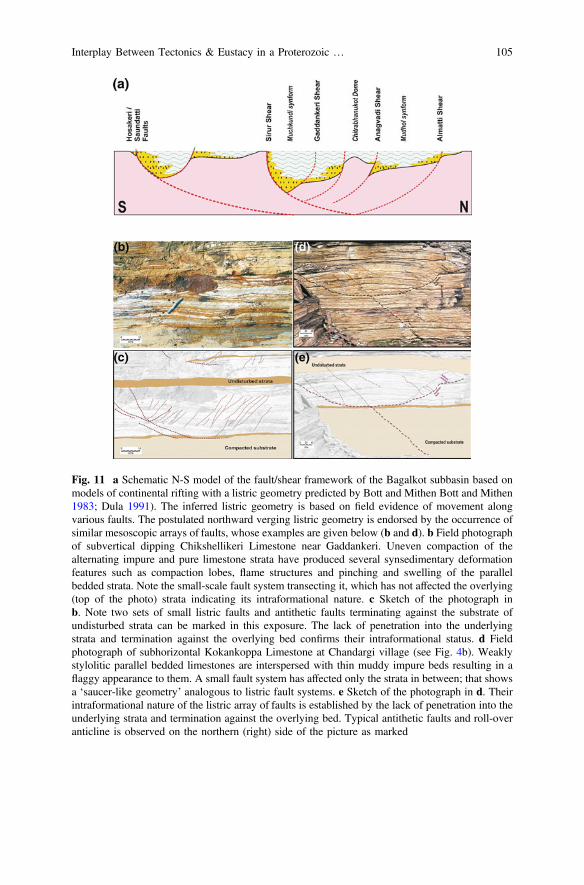
Fig. 11 a Schematic N-S model of the fault/shear framework of the Bagalkot subbasin based onmodels of continental rifting with a listric geometry predicted by Bott and Mithen Bott and Mithen1983; Dula 1991). The inferred listric geometry is based on field evidence of movement alongvarious faults. The postulated northward verging listric geometry is endorsed by the occurrence ofsimilar mesoscopic arrays of faults, whose examples are given below (b and d). b Field photographof subvertical dipping Chikshellikeri Limestone near Gaddankeri. Uneven compaction of thealternating impure and pure limestone strata have produced several synsedimentary deformationfeatures such as compaction lobes, flame structures and pinching and swelling of the parallelbedded strata. Note the small-scale fault system transecting it, which has not affected the overlying(top of the photo) strata indicating its intraformational nature. c Sketch of the photograph inb. Note two sets of small listric faults and antithetic faults terminating against the substrate ofundisturbed strata can be marked in this exposure. The lack of penetration into the underlyingstrata and termination against the overlying bed confirms their intraformational status. d Fieldphotograph of subhorizontal Kokankoppa Limestone at Chandargi village (see Fig. 4b). Weaklystylolitic parallel bedded limestones are interspersed with thin muddy impure beds resulting in aflaggy appearance to them. A small fault system has affected only the strata in between; that showsa ‘saucer-like geometry’ analogous to listric fault systems. e Sketch of the photograph in d. Theirintraformational nature of the listric array of faults is established by the lack of penetration into theunderlying strata and termination against the overlying bed. Typical antithetic faults and roll-overanticline is observed on the northern (right) side of the picture as marked
Interplay Between Tectonics & Eustacy in a Proterozoic … 105

5.1.3 Deformation
The Bagalkot sediments were folded and faulted during the event recognized as D2.The sub-parallel alignment of the fold-axes with the NW-SE to WNW-ESE regionalshear zones indicates that this event was related to another pulse of activity alongthem or that these zones channelized N-S oriented compressive stress systems. TheD2 event did not affect the southern sector of the Bagalkot subbasin as much as itdid the northern sector.
The deformation of the Bagalkot Group was interspersed with the intrusion ofdykes (=Mallapur Intrusives) along the D2 fold axes. The dykes are dated at1154 ± 4 Ma by 40Ar/39Ar method (Patil Pillai et al. 2018). The estimated age(*1200 Ma: based on the dating of a dyke (Mallapur Intrusives) that is emplacedalong the D2 fold axes) of this event corresponds well with the period of super-continental reassembly leading to the development of Rodinia (Condie and Kroner2013; Condie et al. 2015).
Further deformation and low grade greenschist facies metamorphism of thesediments along with the intrusives is recognized as the event D2’, since there isinsufficient evidence to say whether it represents the peak of the deformation event(D2) or is a separate episode altogether. Cross faulting of the earlier folds andco-axial second generation shear folds observed here are likely to have evolved at alater stage than the main folding. Jadhav and Phadke (1989) recognize two separateevents of folding while Jayaprakash (2007) records only a single deformationalevent for the Bagalkot Group. The sedimentation in this subbasin ceased followingthe deformation and low grade metamorphism.
5.1.4 Hiatal Break and Younger Cycle
The subsequent period of quiescence coincides with the period of stability of theRodinia supercontinent estimated between *1100 and 900 Ma. This period wasmarked by the emergence and erosion of the folded hills of the Bagalkot Groupalong with its basement. The deposition in the Badami subbasin is essentially acontinental sedimentation with very little component of the marine interface. Thepresence of ichnofossils from the Badami sediments (Kulkarni and Borkar 1997)confirm their Neoproterozoic age. Given that some parts of the Badami Group restdirectly upon the basement, suggests a significant removal of the precedingBagalkot sediments prior to the inception of these younger sediments. We thereforeproject the age of the extensional growth (D3) of the Badami subbasin to bebetween 800 and 900 Ma corresponding to the age of the early breakup of Rodiniabefore its reorganization into the Gondwanaland assembly (Cawood andHawkesworth 2014).
The thickly-bedded, poorly-sorted conglomerates at the base of the BadamiGroup are analogous to debris-wash deposits commonly found at the base of slopesin a continental regime. Fluvial influence in the form of braided channel sands isoverprinted on the sandstones of the Badami Group. Taken together with the
106 S. Patil Pillai and V. S. Kale
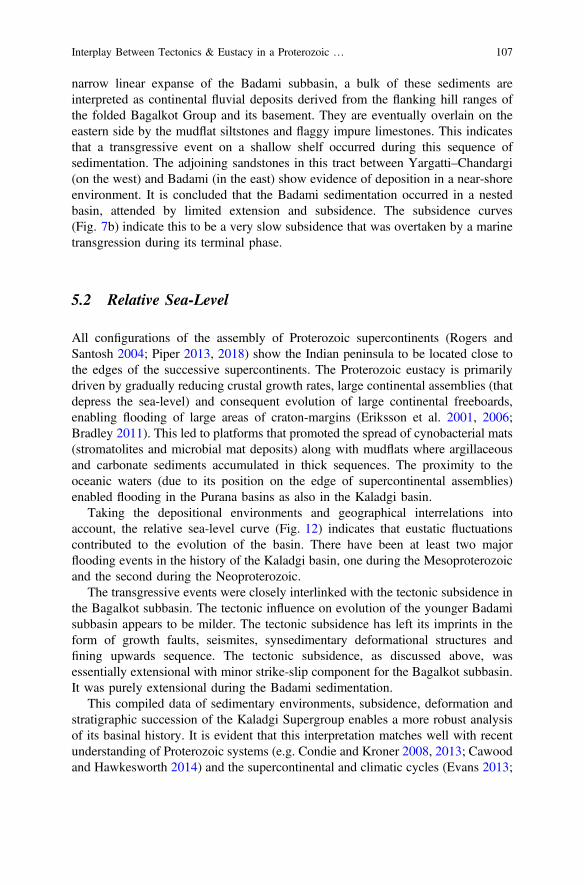
narrow linear expanse of the Badami subbasin, a bulk of these sediments areinterpreted as continental fluvial deposits derived from the flanking hill ranges ofthe folded Bagalkot Group and its basement. They are eventually overlain on theeastern side by the mudflat siltstones and flaggy impure limestones. This indicatesthat a transgressive event on a shallow shelf occurred during this sequence ofsedimentation. The adjoining sandstones in this tract between Yargatti–Chandargi(on the west) and Badami (in the east) show evidence of deposition in a near-shoreenvironment. It is concluded that the Badami sedimentation occurred in a nestedbasin, attended by limited extension and subsidence. The subsidence curves(Fig. 7b) indicate this to be a very slow subsidence that was overtaken by a marinetransgression during its terminal phase.
5.2 Relative Sea-Level
All configurations of the assembly of Proterozoic supercontinents (Rogers andSantosh 2004; Piper 2013, 2018) show the Indian peninsula to be located close tothe edges of the successive supercontinents. The Proterozoic eustacy is primarilydriven by gradually reducing crustal growth rates, large continental assemblies (thatdepress the sea-level) and consequent evolution of large continental freeboards,enabling flooding of large areas of craton-margins (Eriksson et al. 2001, 2006;Bradley 2011). This led to platforms that promoted the spread of cynobacterial mats(stromatolites and microbial mat deposits) along with mudflats where argillaceousand carbonate sediments accumulated in thick sequences. The proximity to theoceanic waters (due to its position on the edge of supercontinental assemblies)enabled flooding in the Purana basins as also in the Kaladgi basin.
Taking the depositional environments and geographical interrelations intoaccount, the relative sea-level curve (Fig. 12) indicates that eustatic fluctuationscontributed to the evolution of the basin. There have been at least two majorflooding events in the history of the Kaladgi basin, one during the Mesoproterozoicand the second during the Neoproterozoic.
The transgressive events were closely interlinked with the tectonic subsidence inthe Bagalkot subbasin. The tectonic influence on evolution of the younger Badamisubbasin appears to be milder. The tectonic subsidence has left its imprints in theform of growth faults, seismites, synsedimentary deformational structures andfining upwards sequence. The tectonic subsidence, as discussed above, wasessentially extensional with minor strike-slip component for the Bagalkot subbasin.It was purely extensional during the Badami sedimentation.
This compiled data of sedimentary environments, subsidence, deformation andstratigraphic succession of the Kaladgi Supergroup enables a more robust analysisof its basinal history. It is evident that this interpretation matches well with recentunderstanding of Proterozoic systems (e.g. Condie and Kroner 2008, 2013; Cawoodand Hawkesworth 2014) and the supercontinental and climatic cycles (Evans 2013;
Interplay Between Tectonics & Eustacy in a Proterozoic … 107
Piper 2013; Rooney et al. 2015; Condie et al. 2015) that controlled Proterozoicsedimentary basin evolution (Eriksson et al. 2006; Allen et al. 2015).
5.3 Basin Classification
The Kaladgi basin was described as an intracratonic sag/rift basin by earlier workers(Jayaprakash 2007; Dey 2015). Using the classification parameters of sedimentarybasins (see Allen et al. 2015), the Kaladgi basin qualifies as an intracratonic/continent interior basin, bounded on all sides by the basement rocks of the Dharwarcraton. Miall et al. (2015) consider this to be a ‘fault-bounded basin related to farfield tectonism’, given that there is no contemporary tectonic zone in its vicinity.Our work shows that the two constituent Groups in this basin display differenttectonic styles. A unified classification of this basin is therefore not appropriate. Itmust therefore be recognized as a polyhistory basin (sensu Kingston et al. 1983).
Fig. 12 Depositional environments of the successive lithostratigraphic units from the KaladgiSupergroup. The relative sea-level curve plotted is based on the depth of deposition ofcorresponding lithologies and their mutual interrelations (adjoining/overlapping) across differentparts of the basin. The tectonic events interpreted in this work are depicted in the next column todemonstrate the relative temporal relation between the tectonic events and sea-level fluctuations asinferred by us
108 S. Patil Pillai and V. S. Kale
Although reactivation of pre-existing shear zones appear to have played animportant role in its evolution, the fault-bounded Bagalkot subbasin shows typicalgeometry of a rifted continental crust with listric faults, suggesting an extensionalorigin. Its overall geometry and sediment distribution is consistent with typicalPrecambrian intracratonic fault-bounded sag basins (Gibbs 1984; Pirajno andSantosh 2015; Roberts et al. 2015). On the other hand, the Badami subbasin is bestascribed to a ‘successor basin’ (post-tectonic intermontane basin: sensu Allen et al.2015) that ensued after the tectonic deformation of the Bagalkot Group.
Its tectonic history bears a close temporal relationship with the break-up andreassembly of the Proterozoic supercontinental cycles; but lacks any tectonic pro-vince or oceanic crustal interface in its proximity. It is therefore concluded that theKaladgi basin is an intracratonic polyhistory basin and its origin and growth wasdriven by reactivation of basement shear zones.
6 Conclusions
The Kaladgi Supergroup is comparable to the large platform sediments accumulatedin the Purana basins of Peninsular India, but differs from them in the nature andintensity of its deformation. Its position on the northern edge of the Dharwar craton,lack of proximity to any orogenic belt or large intrusive complex; pose difficultiesin ascertaining its origin and growth.
Our studies conclude that the Bagalkot Group was deposited during a eustaticsea-level rise and transgressive incursions on the cratonic platform, in close asso-ciation with basement tectonics resulting from reactivation of the basement struc-tures. Activity along synsedimentary growth faults modified the geometry andgeography of the depositional interface in different sectors of the Bagalkot subbasin(Fig. 11). We recognize cycles of extensional subsidence interspersed with foldingand faulting during the history of this basin (Fig. 12). Our work shows that therehave been at least two clear transgressive events (and a possible third one that waseither a part of the first or an independent one) during the Mesoproterozoic andNeoproterozoic times. Whether they are contemporaneous with the transgressiveevents in the Cuddapah and Bhima basins surrounding the Dharwar craton (Kale2016) and how this compares in the global framework of the supercontinentalassemblies and breakups during the Proterozoic remains in the realm of futurestudies.
We conclude that the Kaladgi basin provides a rare glimpse of how eustacy andtectonics closely worked in generating this Proterozoic polyhistory basin. The agesof the constituent sediments are as yet poorly constrained and remain an arearequiring focused attention. Similarly, a detailed isotopic profiling of the sedimentsin the basin may not only help understand its provenance character, but actuallymay enable decipher the unroofing history of the emergent landmass of the Dharwarcraton during its evolution.
Interplay Between Tectonics & Eustacy in a Proterozoic … 109
Acknowledgements This work is the result of more than 3 decades of research in the Kaladgibasin that was funded by CSIR, DST and AMD. Different students and colleagues at differenttimes have helped in the data collection and we acknowledge their contributions to the work. Weare thankful to Prof. V. V. Peshwa, Prof. T. K. Biswal, Prof. V. G. Phansalkar, Dr. Amogh Chitrao,Dr. Anand Kale, Dr. Himanshu Kulkarni and Dr. Pradeep Jadhav for their suggestions and dis-cussions on this work. We thank Prof. Soumyajit Mukherjee for inviting us to contribute thischapter and his patient support and encouragement. The comments and suggestions from thereviewers helped improve the manuscript significantly.
References
Allen PA, Allen JR (2013) Basin analysis—principles and applications, 3rd edn. Wiley-Blackwell,549pp. ISBN: 978-0-470-67377-5
Allen PA, Eriksson PG, Alkmim FF, Betts PG, Catunaeunu O, Mazumdar R, Meng Q, Yong GM(2015) Precambrian basins of India: stratigraphic and tectonic context. In: Mazumdar R,Eriksson PG (eds) Precambrian basins of India: stratigraphic and tectonic perspective, vol 43.Geological Society, London, Special Publications, pp 5–28
Audet DM, Fowler AC (1992) A mathematical model for compaction in sedimentary basins.Geophysical Journal International 110, 577–590
Awati AB, Kalaswad S (1978) Structure of the Kaladgis around Yadwad, Belgaum district(A study based on Landsat-1). Bulletin of Earth Science 6, 43–47
Baldwin B, Butler CO (1985) Compaction curves. AAPG Bulletin 69, 622–626Basu A, Bickford ME (2015) An alternate perspective on the opening and closing of the
intracratonic Purana Basins in Peninsular India. Journal of Geological Society of India 85,5–25
Biswas SK (2008) Petroliferous basins of India—fifty years’ history and perspective. Memoir ofGeological Society of India 66, 159–201
Bjørlykke K (2014) Relationships between depositional environments, burial history and rockproperties. Some principal aspects of diagenetic process in sedimentary basins. SedimentaryGeology 301, 1–14
Bond GC, Kominz MA (1984) Construction of tectonic subsidence curves for the early Palaeozoicmiogeocline, Southern Canadian Rocky mountains: implications for subsidence mechanisms,age of breakup, and crustal thinning. Geological Society of America Bulletin 95, 155–173
Bose PK, Sarkar S, Mukhopadhyay S, Saha B, Eriksson P (2008) Precambrian basin-margin fandeposits: Mesoproterozoic Bagalkot Group, India. Precambrian Research 162, 264–283
Bott MHP, Mithen DP (1983) Mechanisms of graben formation: the Wedge-subsidenceHypothesis. Tectonophysics 94, 11–22
Bradley DC (2011) Secular trends in the geological record and supercontinental cycles. EarthScience Reviews 108, 16–33
Brenner RL, McHargue TR (1988) Integrative stratigraphy—concepts and applications. PrenticeHall, New Jersey, p 419
Cant DJ (1989) Simple equations of sedimentation: applications to sequence stratigraphy. BasinResearch 2, 73–81
Catuneanu O (2006) Principles of sequence stratigraphy. Elsevier, Amsterdam, p 375Catuneanu O, Martins-Neto MA, Eriksson PG (2005) Precambrian sequence stratigraphy.
Sedimentary Geology 176, 67–95Cawood PA, Hawkesworth CJ (2014) Earth’s middle age. Geology 42, 503–506Condie KC, Kroner A (2008) When did plate tectonics begin? evidence from the geologic record.
Geological Society of America, Special Papers 440, 281–291
110 S. Patil Pillai and V. S. Kale

Condie KC, Kroner A (2013) The building blocks of continental crust: evidence from a majorchange in tectonic setting of continental growth at the end of the Archean. Gondwana Research23, 394–402
Condie KC, Pisarevsky SA, Korenga J, Gardoll S (2015) Is the rate of supercontinental assemblychanging with time? Precambrian Research 259, 278–289
Deshpande GG, Pitale UL (2014) Geology of Maharashtra, 2nd edn. Geological Society of India,Bangalore, p 266
Dey S (2015) Geological history of the Kaladgi–Badami and Bhima basins, south India:sedimentation in a Proterozoic intracratonic setup. In: Mazumder R, Eriksson PG(eds) Precambrian basins of India: stratigraphic and tectonic context. Geological Society,London, Memoir, 43, 283–296
Dey S, Rai AK, Chaki A (2008) Widespread arkose along the northern margin of the ProterozoicKaladgi basin, Karnataka: product of uplifted granitic source of K-metasomatism? Journal ofGeological Society of India 71, 79–88
Dey S, Rai AK, Chaki A (2009) Palaeoweathering, composition and tectonics of provenance of theProterozoic Intracratonic Kaladgi–Badami basin, Karnataka, southern India: evidence fromsandstone petrography and geochemistry. Journal of Asian Earth Sciences 34, 703–715
Dickinson WR (1974) Plate tectonics and sedimentation. In: WR Dickinson WR (ed) Tectonicsand sedimentation: Society of Economic Paleontologists and Mineralogists Special Publication22, 1–27
Dula WF Jr (1991) Geometric models of listric normal faults and rollover folds. AAPG Bulletin75, 1609–1625
Einsele G (2000) Sedimentary basins: evolution, facies and sedimentary budget. Springer-Verlag,Berlin, p 792
Eriksson PG, Martins-Neto MA, Nelson DR, Aspler LB, Chiarenzelli JR, Catuneanu O, Sarkar S,Altermann W, de W Rautenback CJ. (2001) An introduction to Precambrian basins: theircharacters and genesis. Sedimentary Geology 141–142:1–35
Eriksson PG, Mazumder R, Catuneanu O, Bumby AJ, Ilondo BO (2006) Precambrian continentalfreeboard and geological evolution: a time perspective. Earth Science Reviews 79, 165–204
Evans DAD (2013) Reconstructing pre-pangean supercontinents. GSA. Bulletin 125, 1735–1751Foote RB (1876) Geological features of the south Mharatta country and adjoining districts.
Memoir of Geological Survey of India 12, 70–138French JE, Heaman LM, Chacko T, Srivastava RK (2008) 1891–1883 Ma southern Bastar–
Cuddapah mafic igneous events, India: a newly recognized large igneous province.Precambrian Research 160, 308–322
Gallagher K, Lambeck K (1989) Subsidence, sedimentation and sea-level changes in theEromanga Basin, Australia. Basin Research 2, 115–131
Geological Survey of India (1981) Geological and mineral map of Karnataka and Goa on 1:0.5million scale. GSI, Kolkatta
Gibbs AD (1984) Structural evolution of extensional basin margins. Journal of Geological Society,London 141, 609–620
Gokhale NW, Pujar GS (1989) Bedding plane faults in the Kaladgi rocks, Basidoni, Belgaumdistrict, Karnataka state. Current Science 58, 1088–1089
Govinda Rajulu BV, Chandrasekhar Gowda MJ (1972) Albitised slates from the Upper Kaladgi(Precambrian) formations, Lokapur, Bijapur district, Mysore state. Journal of GeologicalSociety of India 13, 247–261
Haq BU, Hardenbol J, Vail PR (1987) Chronology of fluctuating sea levels since the Triassic (250million years ago to present). Science 235, 1156–1167
Jadhav PB (1987) Microstructures of quartzites of Yadwad–Lokapur–Bagalkot area, Bijapurdistrict, North Karanataka. Unpubl. Ph.D. thesis, Pune University, 204pp
Jadhav PB, Kshirsagar LK (2017) Analysis of folding in the Proterozoic sedimentary sequence ofbagalkot group exposed around Yadwad, N Karnataka, India: a study based on remote sensingtechniques and field investigations. Journal of Indian Society of Remote Sensing 45, 247–258
Interplay Between Tectonics & Eustacy in a Proterozoic … 111
Jadhav PB, Phadke AV (1989) Coaxial deformation of Proterozoic Kaladgi Quartzites ofKarnataka craton, India. 28th International Geologial Congress, Washington 2, 111
Jayaprakash AV (2007) Purana basins of Karnataka. Memoir of Geological Survey of India, 129ppJayaprakash AV, Sundaram V, Hans SK, Mishra RN (1987) Geology of the Kaladgi-Badami
basin, Karnataka. Memoir of Geological Society of India 6, 201–225Kale VS (1991) Constraints on the evolution of the Purana basins of Peninsular India. Journal of
Geological Society of India 38, 231–252Kale VS (1995) Association of the Purana basins and the Middle Proterozoic Mobile belts in
Peninsular India: implications on targeting Uranium deposits. Exploration and Research forAtomic Minerals 8, 95–110
Kale VS (2015) Discussion on an alternate perspective on the opening and closing of theIntracratonic Purana basins in Peninsular India. Journal of Geological Society of India 85,627–631
Kale VS (2016) Proterozoic basins of Peninsular India: status within the global Proterozoicsystems. Proceedings of the Indian National Science Academy 82, 461–478
Kale VS, Patil Pillai S (2011) A Reinterpretation of two Chertbreccias from the Proterozoic basinsof India. Journal of Geological Society of India 78, 429–445
Kale VS, Peshwa VV (1995) Bhima basin. Geological Society of India, Bangalore, p 142Kale VS, Phansalkar VG (1991) Purana basins of Peninsular India: a review. Basin Research 3,
1–36Kale VS, Ghunkikar V, Paul Thomas P, Peshwa VV (1996) Macrofacies architecture of the first
transgressive suite along the southern margin of the Kaladgi Basin. Journal of GeologicalSociety of India 48, 75–92
Kale VS, Nair S, Patil S (1998) Testimony of intraformational limestone breccias onLokapur-Simikeri disconformity, Kaladgi Basin. Journal of Geological Society of India 51,43–48
Kale VS, Patil Pillai S, Nair Pillai S, Phansalkar VG, Peshwa VV (1999) A process-responsivelitho-stratigraphic classification of the Kaladgi Basin, Karnataka. Abstract field workshop onintegrated evaluation of the Kaladgi & Bhima Basins. Geolgical Society of India, Bangalore,4–7
Kalpana MS, Patil DJ, Dayal AM, Raju SV (2010) Near surface manifestation of hydrocarbons inProterozoic Bhima and Kaladgi basins: implications to hydrocarbon resource potential. Journalof Geological Society of India 76, 548–556
Kingston DR, Dishroom CP, Williams PA (1983) Global basin classification system. AmericanAssociation of Petroleum Geologists 67, 2175–2193
Kulkarni KG, Borkar VD (1997) On occurrence of Cochlichnus in the Proterozoic rocks ofKaladgi basin. Gondwana Geological Magazine 12, 55–59
Kumar A, Parasharumulu V, Nagaraju E (2015) A 2082 Ma radiating dyke swarm in the EasternDharwar craton, southern India and its implications to Cuddapah basin formation. PrecambrianResearch 266, 490–505
Mallick K, Vasanthi A, Sharma KK (2012) Kaladgi–Badami Basin, Karnataka–Maharashtra,India: In: Bouguer gravity regional and residual separation: application to geology andenvironment, Capital Publishing Co. (Springer), New Delhi, pp 60–67
Matin A (2015) Tectonics of the Cuddapah basin and a model of its evolution: a review. In:Mazumder R, Eriksson PG (eds) Precambrian basins of India: stratigraphic and tectoniccontext, vol 43. Geological Society of London Memoir, pp 231–254
Meert JG, Pandit MK, Pradhan VR, Banks J, Sirianni R, Stroud M, Newstead B, Gifford JOUR(2010) Precambrian crustal evolution of Peninsular India: A 3.0 billion year odyssey. Journalof Asian Earth Sciences 39, 483–515
Meert JG, Pandit MK, Pradhan VR, Kamenov G (2011) Preliminary report on the paleomagnetismof 1.88 Ga dykes from the Bastar and Dharwar cratons, Peninsular India. Gondwana Research20, 335–343
Miall AD (2000) Principles of sedimentary basin analysis, 3rd edn. Springer-Verlag, Berlin, 616pp
112 S. Patil Pillai and V. S. Kale
Miall AD, Catunenu O, Eiksson PG, Mazumder R (2015) A brief synthesis of Indian PrecambrianBasins: classification and genesis of basin fills. In: Mazumder R, Eriksson PG(eds) Precambrian basins of India: stratigraphic and tectonic context, vol 43. GeologicalSociety of London Memoir, pp 339–347
Miller KG, Kominz MA, Browning JV, Wright JD, Mountain GS, Katz ME, Sugarman PJ,Cramer BS, Christie-Blick N, Pekar SF (2005) The Phanerozoic record of global sea-levelchange. Science 310, 1293–1298
Mukherjee S (2014) Atlas of shear zone structures in meso-scale. Springer, Cham, p 124Mukherjee MK, Das S, Modak K (2016) Basement-cover structural relationships in the Kaladgi
Basin, southwestern India: indications towards a Mesoproterozoic gravity gliding of the coveralong a detached unconformity. Precambrian Research 281, 495–520
Mukhopadhyay S, Choudhuri A, Samanta P, Sarkar S, Bose PK (2014) Were the hydraulicparameters of Precambrian rivers different? Journal of Asian Earth Sciences 91, 289–297
Nair MM, Raju AV (1987) A remote sensing approach to basinal mapping of the Kaladgi andBadami sediments of Karnataka state. In: Radhakrishna BP (ed) Purana Basins of PeninsularIndia (Middle to Late Proterozoic), vol 6. Memoir of Geological Society of India, pp 375–381
Naqvi SM, Rogers JJW (1987) Precambrian Geology of India Oxford Monographs Geology &Geophysics. Clarendon Oxford Press, Oxford, p 223
Patil Pillai S (2004) Testimony of sedimentation and structural patterns of the Bagalkot-Simikeriarea on the evolution of the Proterozoic Kaladgi Basin. Unpublished Ph.D. thesis, PuneUniversity, Pune
Patil Pillai S, Kale VS (2011) Seismites in the Lokapur subgroup of the Proterozoic Kaladgi Basin,South India: A testimony to syn-sedimentary tectonism. Sedimentary Geology 240, 1–13
Patil Pillai S, Peshwa VV, Nair S, Sharma M, Shukla M, Kale VS (1999) Occurrence of amanganese-bearing horizon in the Kaladgi basin. Journal of Geological Society of India 53,201–204
Patil Pillai S, Pande K, Kale VS (2018) Implications of new 40Ar/39Ar age of Mallapur Intrusiveson the chronology and evolution of the Kaladgi Basin, Dharwar Craton, India. Journal of EarthSystem Science 127, 32, p 18
Piper JDA (2013) A planetary perspective on Earth’s evolution: lid tectonics before plate tectonics.Tectonophysics 589, 44–56
Piper JDA (2018) Dominant lid tectonics behavior of continental lithosphere in Precambrian times:paleomagnetism confirms prolonged quasi-integrity and absence of supercontinental cycles.Geoscience Frontiers 9, 61–89
Pirajno F, Santosh M (2015) Mantle plumes, supercontinents, intracontinental rifting and mineralsystems. Precambrian Research 259, 243–261
Pratap M, Sharma R, Das SK, Tripathi B (1999) Tectono-stratigraphic styles and Hydrocarbonprospectivity of Bhima-Kaladgi Basins vis-à-vis Vindhyan and other coeval ProterozoicBasins. Abstract Field workshop on Integrated evaluation of the Kaladgi & Bhima Basins.Geological Society of India, Bangalore, 61–63
Radhakrishna BP (1987) Introduction: Purana Basins of Peninsular India (Middle to LateProterozoic). Memoir of Geological Society of India 6, i–xv
Radhakrishna BP, Naqvi SM (1986) Precambrian continental crust of India and its evolution.Journal of Geology, 94, 145–166
Radhakrishna BP, Ramakrishnan M (1988) Archaean_Proterozoic Boundary in India. Journal ofGeological Society of India 32, 263–278
Rajaram M, Anand SP, Erram VC, Shinde BN (2016) Insight into the structure below the DeccanTrap covered region of Maharashtra, India from geopotential data. In: Mukherjee S, Misra AA,Calvès G, Nemčok M (eds) Tectonics of the Deccan Large Igneous Province. GeologicalSociety, London, Special Publications, 445, 219–236
Ramakrishna TS, Chayanulu AYSR (1988) A geophysical reappraisal of the Purana basins ofIndia. Journal of Geological Society of India 32, 48–60
Ramakrishnan M, Vaidyanadhan R (2010) Geology of India, vol 1. Geological Society of India,Bangalore, p 556
Interplay Between Tectonics & Eustacy in a Proterozoic … 113
Renne PR, Sprain CJ, Richards MA, Self S, Vanderkluysen L, Pande K (2015) State shift inDeccan volcanism at the Cretaceous-Paleogene boundary possibly induced by impact. Science350, 76–78
Roberts NMW, Slagstad T, Viola G (2015) The structural, metamorphic and magmatic evolutionof Mesoproterozoic orogens. Precambrian Research 265, 1–9
Rogers JJW, Santosh M (2004) Continents and Supercontinents. Oxford University Press, NewYork, p 292
Rooney AD, Strauss JV, Brandon AD, Macdonald FA (2015) A Cryogenian chronology: twolong-lasting synchronous Neoproterozoic glaciations. Geology 43, 459–462
Saddler PM (1999) The influence of hiatuses on sediment accumulation rates. GeoResearch Forum5, 15–40
Sambasiva Rao VV, Sreenivas B, Balaram V, Govil PK, Srinivasan R (1999) The nature of theArchean upper crust as revealed by the geochemistry of the Proterozoic shales of the Kaladgibasin, Karnataka, South India. Precambrian Research 98, 53–65
Sarkar PK, Soman GR (1985) Heavy mineral assemblages from the Konkan Kaladgi sediments.In: Bhaskara Rao B (ed) Proceedings of 5th Indian Geological Congress, IIT, Bombay,pp 19–25
Sclater JG, Christie PAF (1980) Continental stretching: an explanation of the post-Mid Cretaceoussubsidence of the central North Sea Basin. Journal of Geophysical Research 85(B7),3711–3739
Sharma RS (2009) Cratons and fold belts of India. Springer-Verlag, Berlin, p 304Sharma M, Nair S, Patil S, Shukla M, Kale VS (1998) Occurrence of tiny digitate stromatolite
[Yelma Digitata Grey, 1984], Yargatti Formation, Bagalkot Group, Kaladgi Basin, Karnataka,India. Current Science 75, 360–365
Sommerfield CK (2006) On sediment accumulation rates and stratigraphic completeness: lessonsfrom Holocene ocean margins. Continental Shelf Research 26, 2225–2240
Sridhar M, Chaturvedi AK, Rai AK (2014) Locating new Uranium occurrences by integratedweighted analysis in Kaladgi basin, Karanataka. Journal of the Geological Society of India 84,509–512
Sridhar M, Markandeyulu A, Chaturvedi AK (2017) Mapping subtrappean sediments anddelineating structure with the aid of heliborne time domain electromagnetics: Case study fromKaladgi basin, Karanataka. Journal of Applied Geophysics 136, 9–18
Stephen George T (1999) Sedimentology of the Kaladgi Basin. Abstract volume. Field workshopon integrated Evaluation of the Kaladgi & Bhima Basins. Geological Society of India,Bangalore, 13–17
Vail PR, Mitchum RM Jr, Thompson SIII (1977) Seismic stratigraphy and global changes of sealevel, part 3: relative changes of sea level from coastal onlap. In: Payton CE (ed.) Seismicstratigraphy-Applications to hydrocarbon exploration: American Association of PetroleumGeologists Memoir 26, 63–81
Valdiya KS (2016) The making of India: geodynamic evolution, 2nd edn. Springer International,Switzerland, 924pp
Viswanathiah MN (1968) Badami series: a new post-Kaladgi formation of Karnatak state. Bulletinof Geological Society of India 5, 94–97
Viswanathiah MN (1979) Lithostratigraphy of the Kaladgi and Badami Groups, Karnataka. IndianMineralogist 18, 122–132
Viswanathiah MN, Chandrasekhara Gowda MN (1970) Algal stromatolites from Kaladgi(Precambrian) formations near Alagundi, Bijapur district, Mysore state. Journal ofGeological Society of India 11, 378–385
Viswanathiah MN, Sreedhara Murthy TR (1979) Algal stromatolites from Kaladgi Group aroundBilgi, Bijapur district, Karnataka. Journal of Geological Society of India 20, 1–6
114 S. Patil Pillai and V. S. Kale
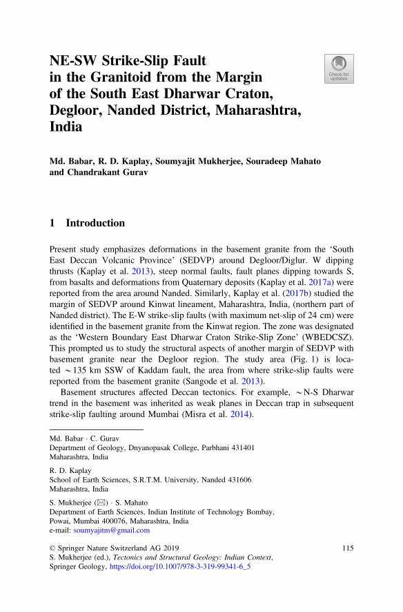
NE-SW Strike-Slip Faultin the Granitoid from the Marginof the South East Dharwar Craton,Degloor, Nanded District, Maharashtra,India
Md. Babar, R. D. Kaplay, Soumyajit Mukherjee, Souradeep Mahatoand Chandrakant Gurav
1 Introduction
Present study emphasizes deformations in the basement granite from the ‘SouthEast Deccan Volcanic Province’ (SEDVP) around Degloor/Diglur. W dippingthrusts (Kaplay et al. 2013), steep normal faults, fault planes dipping towards S,from basalts and deformations from Quaternary deposits (Kaplay et al. 2017a) werereported from the area around Nanded. Similarly, Kaplay et al. (2017b) studied themargin of SEDVP around Kinwat lineament, Maharashtra, India, (northern part ofNanded district). The E-W strike-slip faults (with maximum net-slip of 24 cm) wereidentified in the basement granite from the Kinwat region. The zone was designatedas the ‘Western Boundary East Dharwar Craton Strike-Slip Zone’ (WBEDCSZ).This prompted us to study the structural aspects of another margin of SEDVP withbasement granite near the Degloor region. The study area (Fig. 1) is loca-ted *135 km SSW of Kaddam fault, the area from where strike-slip faults werereported from the basement granite (Sangode et al. 2013).
Basement structures affected Deccan tectonics. For example, *N-S Dharwartrend in the basement was inherited as weak planes in Deccan trap in subsequentstrike-slip faulting around Mumbai (Misra et al. 2014).
Md. Babar � C. GuravDepartment of Geology, Dnyanopasak College, Parbhani 431401Maharashtra, India
R. D. KaplaySchool of Earth Sciences, S.R.T.M. University, Nanded 431606Maharashtra, India
S. Mukherjee (&) � S. MahatoDepartment of Earth Sciences, Indian Institute of Technology Bombay,Powai, Mumbai 400076, Maharashtra, Indiae-mail: [email protected]
© Springer Nature Switzerland AG 2019S. Mukherjee (ed.), Tectonics and Structural Geology: Indian Context,Springer Geology, https://doi.org/10.1007/978-3-319-99341-6_5
115
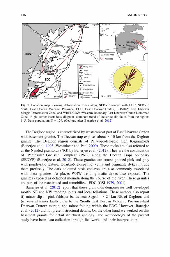
The Degloor region is characterized by westernmost part of East Dharwar Cratonwith basement granite. The Deccan trap exposes about *10 km from the Degloorgranite. The Degloor region consists of Palaeoproterozoic high K-granitoids(Banerjee et al. 1993; Wesankear and Patil 2000). These rocks are also referred toas the Nanded granitoids (NG) by Banerjee et al. (2012). They are the continuationof ‘Peninsular Gneissic Complex’ (PNG) along the Deccan Traps boundary(SEDVP) (Banerjee et al. 2012). These granites are coarse-grained pink and graywith porphyritic texture. Quartzo(-feldspathic) veins and pegmatite dykes intrudethem profusely. The dark coloured basic enclaves are also commonly associatedwith these granites. At places WNW trending mafic dykes also exposed. Thegranites exposed as detached mounds/along the course of the river. These granitesare part of the reactivated and remobilized EDC (GSI 1979, 2001).
Banerjee et al. (2012) report that these granitoids demonstrate well developedmostly NE and NW trending joints and local foliations. These authors also report(i) minor slip in pink feldspar bands near Sagroli- *24 km NE of Degloor; and(ii) several minor faults close to the ‘South East Deccan Volcanic Province-EastDharwar Cratorn margin, and minor folding within the EDC. However, Banerjeeet al. (2012) did not present structural details. On the other hand we worked on thisbasement granite for detail structural geology. The methodology of the presentstudy have been data collection through fieldwork, and their interpretation.
Fig. 1 Location map showing deformation zones along SEDVP contact with EDC. SEDVP:South East Deccan Volcanic Province, EDC: East Dharwar Craton, EDMDZ: East DharwarMargin Deformation Zone, and WBEDCDZ: ‘Western Boundary East Dharwar Craton DeformedZone’. Right corner inset: Rose diagram- dominant trend of the strike-slip faults from the regions1–5. Data population: N = 129. (Geology after Banerjee et al. 2012)
116 Md. Babar et al.

2 Structures Observed in Degloor—The Present Study
Reverse faults, normal faults (step faults), strike-slip faults, brittle shear along theboundary of veins, minor folds and boudins are observed in the basement rock. InFig. 2, a thin quartz vein is faulted in normal manner at as many as 12 locations.These faults are (sub) parallel to each other and constitute a step-like array withsmall throw. The fault plane dips 80° due W. The slip of fault plain varies from 1.6to 6.5 cm.
Brittle strike-slip faults are numerous in the study area. In some cases, singleveins are strike-slip faulted (Fig. 3a). In Fig. 3b, a pegmatite vein is dextrallyfaulted. In Fig. 3c, slightly folded pegmatite vein is slipped possibly with a “reversedrag” (Mukherjee and Koyi 2009). A medium size pegmatite vein (A) in graniticcountry rock (B), at the contact of basic dyke (C) shows reverse slip but no dragclose to the fault plane (Fig. 3d). A pegmatite vein is strike-slip sinistrally faultedtwice in two directions. Sigmoid P-planes decode the former slip, and sharp offsetthe later one (Fig. 3e). Brittle shear fractures and fault planes were also observed;Y-planes and the fault planes in Fig. 4a–d and also in Fig. 5 trend NE, showingboth sinistral and dextral slip. A thin vein, observed on a horizontal plane, is reversedragged only at one side of the fault plane. At the other side, no drag is noted(Fig. 3f). The slip is 17 cm and fault strikes *NE. A rather irregular basic intru-sion in granitic rock shows faulting. This is a strike-slip fault (Fig. 6a).
In other cases, single veins are multiply faulted (Fig. 6b). Fault ‘A’ strikes N20°E and slips 9.0 cm; ‘B’ strikes N50°E and slips 5.0 cm; ‘C’ strikes N75°W andslips 24 cm; and ‘D’ strikes N80°E and slips 28 cm. In Fig. 6c, thequartzo-feldspathic vein is dextral faulted at three places. The en-echelon joints
Fig. 2 Step faulting in quartz vein (12 faults in vertical section). We tend to think them as amanifestation of a major fault, since our observations repeat
NE-SW Strike-Slip Fault in the Granitoid from the Margin … 117

locally acted as fault planes. In Fig. 6d as well, the quartzo-feldspathic vein faultedalong joint planes at three places both dextrally and sinsitrally.
In Fig. 7a, the vein is faulted at four places. At ‘A’ the sense of movement issinistral, while at ‘B’, ‘C’ and ‘D’ the sense is dextral. At ‘B’ the vein has not lostthe continuity indicating local ductile deformation. At ‘A’, the vein is bent close tothe fault plane indicating drag.
A quartz vein (Fig. 7b) slips at three places along parallel set of N6°W-S6°Etrending faults. The displacement at ‘A’ is 7 cm, at ‘B’ it is 4.2 cm and at ‘C’ it is4 cm. In Fig. 7c, curved joints act as fault planes slipping the vein at five places.One more slip is noted at ‘F’. Some of these fault planes are curved. In some of thecases, one of the veins is strike-slip faulted (Fig. 7d) while the other parallel vein is
Fig. 3 a Normal step faults exposed on steeply inclined exposure, at ‘A’ and ‘B’ dip towards E at25°. Net slip: 5.5 cm both at ‘A’ and ‘B’. b Dextral sheared pegmatite vein, 2.1 cm net slip alongNE trending fault plane. c Joints acted locally as brittle-ductile fault planes (strike N20°E, 3.2 cmslip), at horizontal outcrop. d Dextral brittle slip. Net slip 12 cm; N45°E (horizontal exposure).e Sinstral shear (at horizontal outcrop). Strike of the fault is N20°E; net slip is 5.0 cm. f A thin veinshows bending before it is deformed in an brittle manner (horizontal exposure)
118 Md. Babar et al.
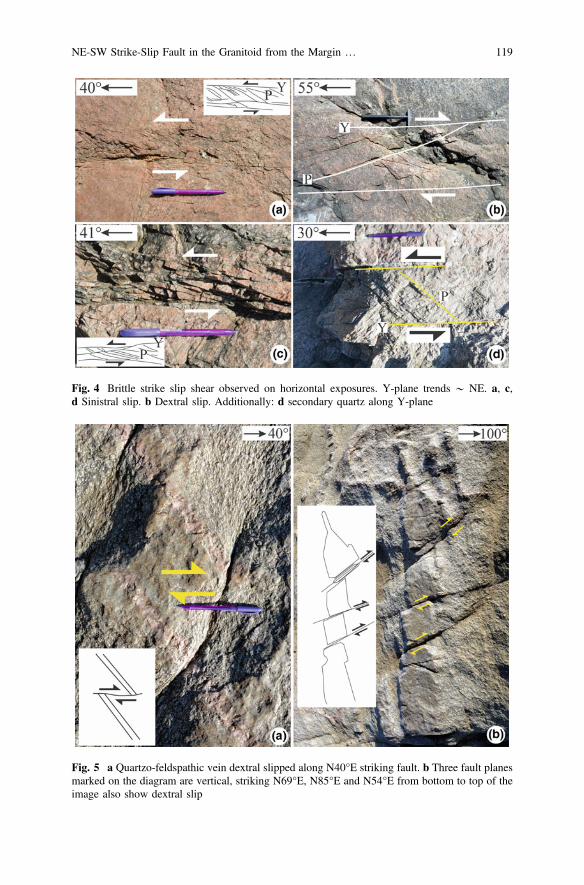
Fig. 4 Brittle strike slip shear observed on horizontal exposures. Y-plane trends * NE. a, c,d Sinistral slip. b Dextral slip. Additionally: d secondary quartz along Y-plane
Fig. 5 a Quartzo-feldspathic vein dextral slipped along N40°E striking fault. b Three fault planesmarked on the diagram are vertical, striking N69°E, N85°E and N54°E from bottom to top of theimage also show dextral slip
NE-SW Strike-Slip Fault in the Granitoid from the Margin … 119
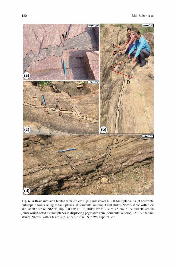
Fig. 6 a Basic intrusion faulted with 2.2 cm slip. Fault strikes NE. bMultiple faults (at horizontaloutcrop). c Joints acting as fault planes, at horizontal outcrop. Fault strikes N65°E at ‘A’ with 3 cmslip, at ‘B’: strike: N65°E, slip: 2.0 cm; at ‘C’, strike: N65°E, slip: 3.5 cm. d ‘A’ and ‘B’ are thejoints which acted as fault planes in displacing pegmatite vein (horizontal outcrop). At ‘A’ the faultstrikes N48°E, with 4.0 cm slip, at ‘C’, strike: N78°W, slip: 9.0 cm
120 Md. Babar et al.

undeformed. In other words, in meso-scale one can see termination of fault planes.In Fig. 8a, the topmost vein (A) faults at four places (locations ‘D’ to ‘G’) alongparallel en-echelon joints while the lower vein (‘B’) is not. The host rock (‘C’)above and below the vein ‘A’ is also faulted. In some other cases, parallel veinsfaulted (Fig. 8b). Here, left vein shears sinistrally and the right vein oppositely anddextrally. In Fig. 8c, however, both the veins shear dextrally.
Fig. 7 a Vein displaced at four places, at horizontal outcrop. Strike of the fault at ‘A’: N30°E,slip: 7.0 cm, at ‘B’ strike: N30°E, slip: 10 cm, at ‘C’ strike: N65°E, slip: 6.5 cm; at ‘D’ strike:N50°E, slip: 13 cm. b Quartz vein faulted at three places: ‘A’, ‘B’ and ‘C’. Sense of slip: dextral.c Curvilinear en-echelon joints acting as fault planes, at horizontal outcrop. Slip at ‘A’ is 8.0 cm, at‘B’ 0.2 cm, at ‘C’ 4 cm, at ‘D’ 2 cm, at ‘E’ 14 cm; and at ‘F’: 3.8 cm. The strike all these smallfaults is N35°E. d At ‘A’ the vein shows deformation with 8 cm strike slip. Fault strikes N60°E. At‘B’ the vein is unaffected by faulting and is open folded (at horizontal outcrop)
NE-SW Strike-Slip Fault in the Granitoid from the Margin … 121
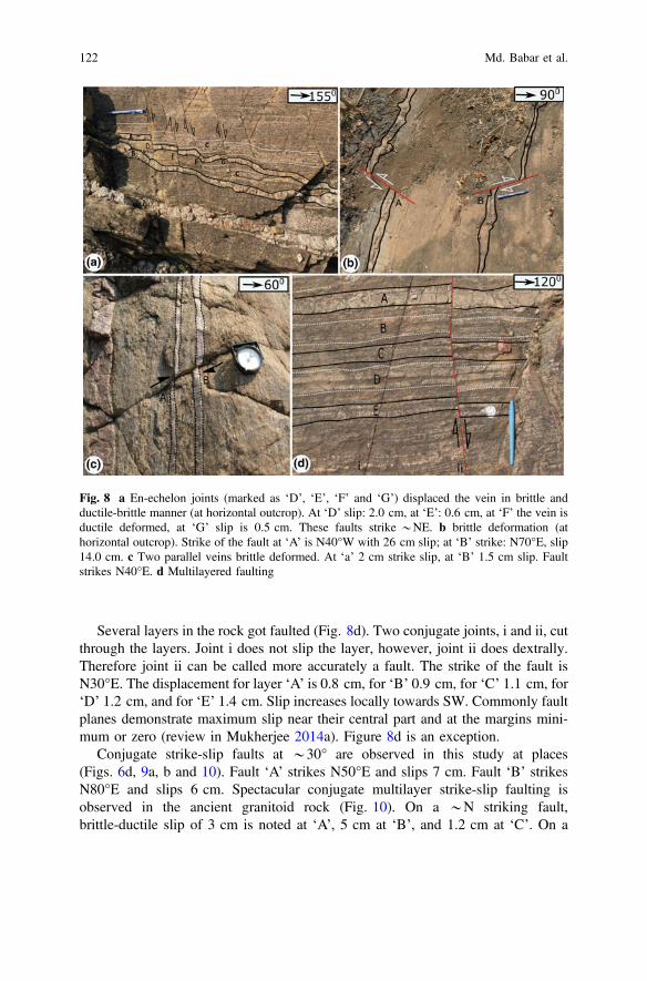
Several layers in the rock got faulted (Fig. 8d). Two conjugate joints, i and ii, cutthrough the layers. Joint i does not slip the layer, however, joint ii does dextrally.Therefore joint ii can be called more accurately a fault. The strike of the fault isN30°E. The displacement for layer ‘A’ is 0.8 cm, for ‘B’ 0.9 cm, for ‘C’ 1.1 cm, for‘D’ 1.2 cm, and for ‘E’ 1.4 cm. Slip increases locally towards SW. Commonly faultplanes demonstrate maximum slip near their central part and at the margins mini-mum or zero (review in Mukherjee 2014a). Figure 8d is an exception.
Conjugate strike-slip faults at *30° are observed in this study at places(Figs. 6d, 9a, b and 10). Fault ‘A’ strikes N50°E and slips 7 cm. Fault ‘B’ strikesN80°E and slips 6 cm. Spectacular conjugate multilayer strike-slip faulting isobserved in the ancient granitoid rock (Fig. 10). On a *N striking fault,brittle-ductile slip of 3 cm is noted at ‘A’, 5 cm at ‘B’, and 1.2 cm at ‘C’. On a
Fig. 8 a En-echelon joints (marked as ‘D’, ‘E’, ‘F’ and ‘G’) displaced the vein in brittle andductile-brittle manner (at horizontal outcrop). At ‘D’ slip: 2.0 cm, at ‘E’: 0.6 cm, at ‘F’ the vein isductile deformed, at ‘G’ slip is 0.5 cm. These faults strike *NE. b brittle deformation (athorizontal outcrop). Strike of the fault at ‘A’ is N40°W with 26 cm slip; at ‘B’ strike: N70°E, slip14.0 cm. c Two parallel veins brittle deformed. At ‘a’ 2 cm strike slip, at ‘B’ 1.5 cm slip. Faultstrikes N40°E. d Multilayered faulting
122 Md. Babar et al.
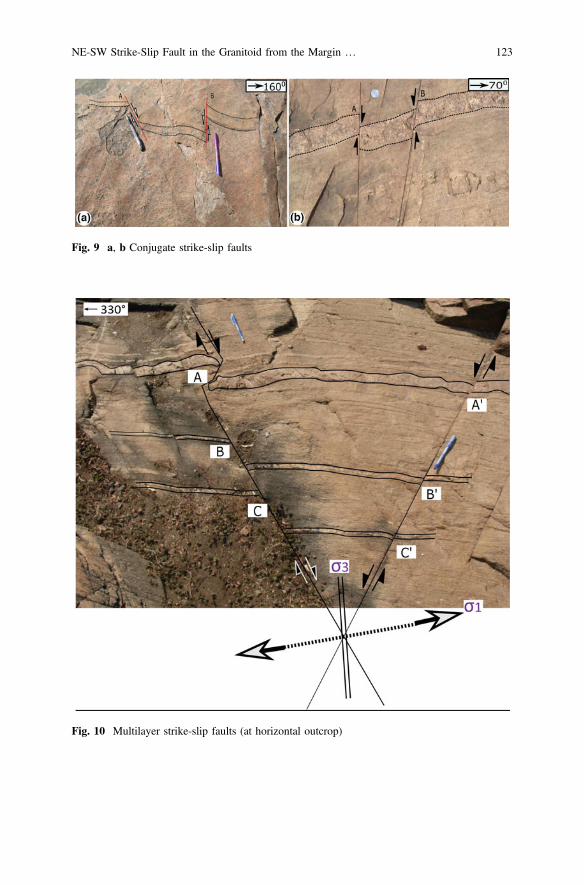
Fig. 9 a, b Conjugate strike-slip faults
Fig. 10 Multilayer strike-slip faults (at horizontal outcrop)
NE-SW Strike-Slip Fault in the Granitoid from the Margin … 123

N30°E striking plane, slip at ‘A/’ is 1 cm, at ‘B/’ is 1.1 cm, and at ‘C/’ is 1 cm. Thethickest pegmatite layer is sheared sinistrally. Note fracture patterns inside the vein.That shear acted prior to the conjugate faulting. The left hand side geographicdirection in this snap is N30°W/330°. A pegmatite vein faults along twosub-parallel planes. Since the angle between the two fault planes is rather low, theyare not conjugate faults. Fault ‘A’ strikes N25°W and slips 2 cm. Fault ‘B’ strikesN6°W and slips 4 cm.
‘Intrusion-in-intrusion’ feature is ductile sheared (Fig. 11). Basic intrusion (B),with quartz vein (C) within, inside host granitic rock (A), is ductile sheared alongN20°W-S20°E. Both the basic intrusion and the quartz vein thin significantly insidethe shear zone (Fig. 11). Outside and inside the shear zone, ‘B’ is 22 and 6 cmthick, respectively. Likewise, ‘C’ is 6 and 1 cm thick.
Though major/regional folds are absent, small (ptygmatic) folds are found invertical and horizontal sections. Synclinal type of fold is observed at one place(Fig. 12a). The axial plane is slightly inclined. A folded structure, at the horizontaloutcrop, is exposed in granitic gneiss (Fig. 12b).
Folding in quartzo-feldspathic vein/pegmatite veins is also a common featureobserved in the study area (Fig. 12c). At many places, pegmatite veins intruded inhost granitoids is ptygmatic folded (Fig. 12d; also see Mukherjee et al. 2015).Drawing tectonic inferences from ptygmatic folding would be difficult because oftheir irregular and sometimes inconsistent geometries. ‘S’ and M-type folding in
Fig. 11 Quartz vein (C) within basic intrusion (B) in host granitoid (A) ductile deformed. Shearzone is marked by red lines (at horizontal outcrop)
124 Md. Babar et al.
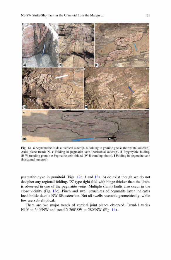
pegmatite dyke in granitoid (Figs. 12e, f and 13a, b) do exist though we do notdecipher any regional folding. ‘Z’-type tight fold with hinge thicker than the limbsis observed in one of the pegmatite veins. Multiple (faint) faults also occur in theclose vicinity (Fig. 13c). Pinch and swell structures of pegmatite layer indicateslocal brittle-ductile NW-SE extension. Not all swells resemble geometrically, whilefew are sub-elliptical.
There are two major trends of vertical joint planes observed. Trend-1 variesN10° to 340°NW and trend-2 260°SW to 280°NW (Fig. 14).
Fig. 12 a Asymmetric folds at vertical outcrop. b Folding in granitic gneiss (horizontal outcrop).Axial plane trends N. c Folding in pegmatite vein (horizontal outcrop). d Ptygmyatic folding.(E-W trending photo). e Pegmatite vein folded (W-E trending photo). f Folding in pegmatite vein(horizontal outcrop)
NE-SW Strike-Slip Fault in the Granitoid from the Margin … 125
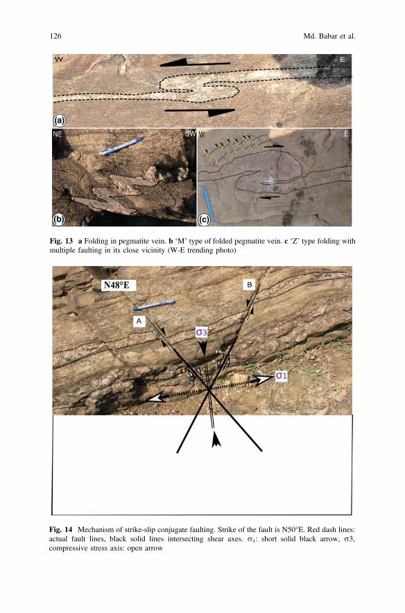
Fig. 13 a Folding in pegmatite vein. b ‘M’ type of folded pegmatite vein. c ‘Z’ type folding withmultiple faulting in its close vicinity (W-E trending photo)
Fig. 14 Mechanism of strike-slip conjugate faulting. Strike of the fault is N50°E. Red dash lines:actual fault lines, black solid lines intersecting shear axes. r1: short solid black arrow, r3,compressive stress axis: open arrow
126 Md. Babar et al.

3 Discussions
The faults/fractures/shear zones, in the Degloor region, are represented by a numberof N to NNE, NE, NE and E bound lineaments (Banerjee et al. 2008). One NEtrending fault is reported in between Shahapur and Sujayatpur, 9 km NE to thepresent study area and a shear zone near Madnoor. However, there has been noreport of faults from the study area by the previous workers.
We document 129 small faults (Table 1) out of which 116 (*90%) arestrike-slip, 12 (*9%) are normal faults, and only one (1%) is a reverse fault fromthe study area (Fig. 1). From these faults, 72% are of the strike-slip faults trend NE.80% of the total strike-slip faults shear dextrally. Net slip of all the strike slip faults,where decipherable, varies 0.5–82 cm.
Conjugate or ‘X’ type joints at *30°, devoid of any slip along them, is alsoobserved. Conjugate joins were not observed in earlier studies from (other parts of)Deccan Traps such as Devey and Lightfoot (1986), Mitchell and Widdowson(1991), Babar et al. (2017), Bhave et al (2017), Kaplay et al. (2017a, b), Misra andMukherjee (Misra and Mukherjee 2017) and Mukherjee et al. (2017). Mostprominent sets of joints strike N50°E at ‘A’ and N80°E. These trends mostly matchwith the conjugate faults reported in Fig. 6d (N48°E), Fig. 9a (N50°E), Fig. 9b(N50°E), and Fig. 10 (N30°E). These joints played crucial role in displacing theveins in the region in a strike-slip manner. Similar types of joints have displacedvarious veins at other outcrops (Figs. 9a, b and 10). The angle between these twojoints is 30°.
This work finds that the deformation style observed in the basement granite nearDegloor, close to the contact of SEDVP with E Dharwar Craton, is dominantlystrike-slip. This suggests that the region belongs to a tectonic regime with inter-mediate stress axis r2 vertical (in the past). Fault planes most dominantly trendsNE.
Numerous conjugate strike-slip faults exist in the study area (Figs. 6b, d, 8b, 9a,b and 10). At some places, conjugate shear develop within the strike slip faultsystem (Fig. 14). The state of stress in such type of faulting consists of two hori-zontal principal stresses that are compressional push (r1; Fig. 14) in one directionand tensional pull (r3) in the perpendicular direction. The r1 direction bisects theacute angle, and the r3 the obtuse angle between the two fault planes that constitutethe single conjugate set. The mechanism of faulting is shown in Fig. 14.
We refer the study area as the ‘Degloor Strike-slip Shear Zone’. Note thatstrike-slip shear is reported from the basement granite nearer to the margin ofSEDVP with Dharwar Craton at Kinwat (Kaplay et al. 2017a, b), which is*135 km NNE of the present study area. The strike-slip faults, with movementparallel to the NE trend of Kaddam fault, are also reported close to Kaddamlineament (Sangode et al. 2013). Thus the Kinwat-Degloor-Kaddam triangularzone, so far explored, shows strike-slip tectonics. However, the deformation style,*NE-SW at Degloor, does not match with the trend of those at northern margin ofSEDVP with Dharwar craton near Kinwat (*E-W) and at Kaddam (*NW-SE),
NE-SW Strike-Slip Fault in the Granitoid from the Margin … 127
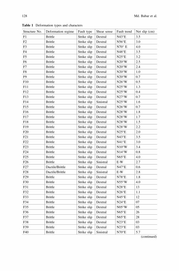
Table 1 Deformation types and characters
Structure No. Deformation regime Fault type Shear sense Fault trend Net slip (cm)
F1 Brittle Strike slip Dextral N43°E 3.5
F2 Brittle Strike slip Dextral N56°E 3.0
F3 Brittle Strike slip Dextral N70° E 4.0
F4 Brittle Strike slip Dextral N48°E 3.5
F5 Brittle Strike slip Dextral N25°E 3.2
F6 Brittle Strike slip Dextral N20°W 2.5
F7 Brittle Strike slip Dextral N20°W 2.4
F8 Brittle Strike slip Dextral N20°W 1.0
F9 Brittle Strike slip Dextral N20°W 0.7
F10 Brittle Strike slip Dextral N26°W 0.5
F11 Brittle Strike slip Dextral N25°W 1.3
F12 Brittle Strike slip Dextral N25°W 0.4
F13 Brittle Strike slip Dextral N27°W 0.7
F14 Brittle Strike slip Sinistral N25°W 1.6
F15 Brittle Strike slip Dextral N26°W 0.7
F16 Brittle Strike slip Dextral N28°W 1.8
F17 Brittle Strike slip Dextral N28°W 1.7
F18 Brittle Strike slip Dextral N28°W 1.5
F19 Brittle Strike slip Dextral N28°W 2.2
F20 Brittle Strike slip Dextral N25°E 2.0
F21 Brittle Strike slip Dextral N43°E 3.5
F22 Brittle Strike slip Dextral N41°E 3.0
F23 Brittle Strike slip Dextral N10°W 3.4
F24 Brittle Strike slip Dextral N14°W 0.8
F25 Brittle Strike slip Dextral N65°E 4.0
F26 Brittle Strike slip Sinistral E-W 2.7
F27 Ductile/Brittle Strike slip Dextral N47°E 0.6
F28 Ductile/Brittle Strike slip Sinistral E-W 2.8
F29 Brittle Strike slip Dextral N78°E 1.8
F30 Brittle Strike slip Dextral N55°W 4.0
F31 Brittle Strike slip Dextral N28°E 13
F32 Brittle Strike slip Dextral N26°E 1.1
F33 Brittle Strike slip Dextral N45°E 12
F34 Brittle Strike slip Dextral N24°E 07
F35 Brittle Strike slip Dextral N05°W 05
F36 Brittle Strike slip Dextral N65°E 26
F37 Brittle Strike slip Dextral N65°E 28
F38 Brittle Strike slip Dextral N23°E 03
F39 Brittle Strike slip Dextral N23°E 03
F40 Brittle Strike slip Sinistral N70°E 5.7(continued)
128 Md. Babar et al.

Table 1 (continued)
Structure No. Deformation regime Fault type Shear sense Fault trend Net slip (cm)
F41 Brittle Strike slip Sinistral N70°E 1.1
F42 Brittle Strike slip Sinistral N60°E 08
F43 Brittle Strike slip Dextral N65°E 03
F44 Brittle Strike slip Dextral N65°E 02
F45 Brittle Strike slip Dextral N65°E 3.5
F46 Brittle Strike slip Dextral N45°E 09
F47 Brittle Strike slip Dextral N85°E 3.0
F48 Brittle Strike slip Dextral N85°E 3.5
F49 Brittle Strike slip Dextral N20°E 7.5
F50 Brittle Strike slip Sinistral N35°W 03
F51 Brittle Strike slip Sinistral N40°E 04
F52 Brittle Strike slip Dextral N20°E 3.2
F53 Brittle Strike slip Dextral N47°E 02
F54 Brittle Strike slip Dextral N48°E 04
F55 Brittle Strike slip Sinistral N80°W 09
F56 Brittle Strike slip Dextral N30°E 07
F57 Brittle Strike slip Dextral N30°E 10
F58 Brittle Strike slip Dextral N65°E 6.5
F59 Brittle Strike slip Dextral N50°E 13
F60 Brittle Strike slip Dextral N45°E 14
F61 Brittle Strike slip Dextral N70°E 26
F62 Brittle Strike slip Sinistral N40°W 09
F63 Brittle Normal – – 12.5
F64 Brittle Strike slip Dextral N20°E 02
F65 Brittle Strike slip Dextral N50°E 02
F66 Brittle Strike slip Dextral N50°E 05
F67 Brittle Strike slip Sinistral N75°W 24
F68 Brittle Strike slip Sinistral N80°E 28
F69 Brittle Strike slip Sinistral N39°E 02
F70 Brittle Strike slip Dextral N37°E 05
F71 Brittle Strike slip Dextral N40°E 2.2
F72 Brittle Strike slip Dextral N40°E 6.0
F73 Brittle Strike slip Sinistral N40°E 1.0
F74 Brittle Strike slip Sinistral N40°E 1.5
F75 Brittle Strike slip Dextral N20°E 18
F76 Brittle Strike slip Dextral N45°E 11
F77 Brittle Strike slip Dextral N45°E 08
F78 Brittle Strike slip Dextral N43°E 6.5
F79 Brittle Normal – – 4.5
F80 Brittle Normal – – 1.6(continued)
NE-SW Strike-Slip Fault in the Granitoid from the Margin … 129
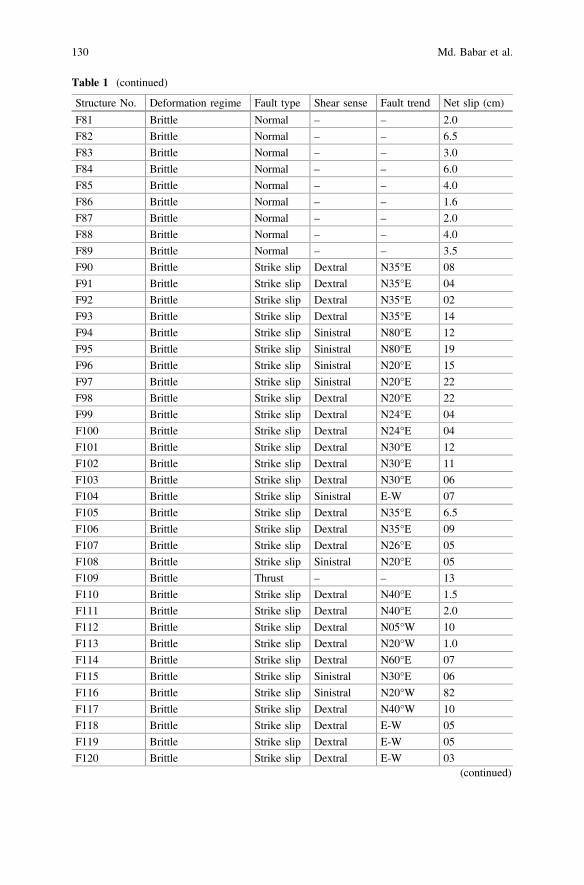
Table 1 (continued)
Structure No. Deformation regime Fault type Shear sense Fault trend Net slip (cm)
F81 Brittle Normal – – 2.0
F82 Brittle Normal – – 6.5
F83 Brittle Normal – – 3.0
F84 Brittle Normal – – 6.0
F85 Brittle Normal – – 4.0
F86 Brittle Normal – – 1.6
F87 Brittle Normal – – 2.0
F88 Brittle Normal – – 4.0
F89 Brittle Normal – – 3.5
F90 Brittle Strike slip Dextral N35°E 08
F91 Brittle Strike slip Dextral N35°E 04
F92 Brittle Strike slip Dextral N35°E 02
F93 Brittle Strike slip Dextral N35°E 14
F94 Brittle Strike slip Sinistral N80°E 12
F95 Brittle Strike slip Sinistral N80°E 19
F96 Brittle Strike slip Sinistral N20°E 15
F97 Brittle Strike slip Sinistral N20°E 22
F98 Brittle Strike slip Dextral N20°E 22
F99 Brittle Strike slip Dextral N24°E 04
F100 Brittle Strike slip Dextral N24°E 04
F101 Brittle Strike slip Dextral N30°E 12
F102 Brittle Strike slip Dextral N30°E 11
F103 Brittle Strike slip Dextral N30°E 06
F104 Brittle Strike slip Sinistral E-W 07
F105 Brittle Strike slip Dextral N35°E 6.5
F106 Brittle Strike slip Dextral N35°E 09
F107 Brittle Strike slip Dextral N26°E 05
F108 Brittle Strike slip Sinistral N20°E 05
F109 Brittle Thrust – – 13
F110 Brittle Strike slip Dextral N40°E 1.5
F111 Brittle Strike slip Dextral N40°E 2.0
F112 Brittle Strike slip Dextral N05°W 10
F113 Brittle Strike slip Dextral N20°W 1.0
F114 Brittle Strike slip Dextral N60°E 07
F115 Brittle Strike slip Sinistral N30°E 06
F116 Brittle Strike slip Sinistral N20°W 82
F117 Brittle Strike slip Dextral N40°W 10
F118 Brittle Strike slip Dextral E-W 05
F119 Brittle Strike slip Dextral E-W 05
F120 Brittle Strike slip Dextral E-W 03(continued)
130 Md. Babar et al.
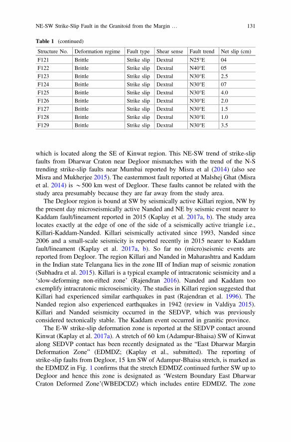
which is located along the SE of Kinwat region. This NE-SW trend of strike-slipfaults from Dharwar Craton near Degloor mismatches with the trend of the N-Strending strike-slip faults near Mumbai reported by Misra et al (2014) (also seeMisra and Mukherjee 2015). The easternmost fault reported at Malshej Ghat (Misraet al. 2014) is *500 km west of Degloor. These faults cannot be related with thestudy area presumably because they are far away from the study area.
The Degloor region is bound at SW by seismically active Killari region, NW bythe present day microseismically active Nanded and NE by seismic event nearer toKaddam fault/lineament reported in 2015 (Kaplay et al. 2017a, b). The study arealocates exactly at the edge of one of the side of a seismically active triangle i.e.,Killari-Kaddam-Nanded. Killari seismically activated since 1993, Nanded since2006 and a small-scale seismicity is reported recently in 2015 nearer to Kaddamfault/lineament (Kaplay et al. 2017a, b). So far no (micro)seismic events arereported from Degloor. The region Killari and Nanded in Maharashtra and Kaddamin the Indian state Telangana lies in the zone III of Indian map of seismic zonation(Subhadra et al. 2015). Killari is a typical example of intracratonic seismicity and a‘slow-deforming non-rifted zone’ (Rajendran 2016). Nanded and Kaddam tooexemplify intracratonic microseismicity. The studies in Killari region suggested thatKillari had experienced similar earthquakes in past (Rajendran et al. 1996). TheNanded region also experienced earthquakes in 1942 (review in Valdiya 2015).Killari and Nanded seismicity occurred in the SEDVP, which was previouslyconsidered tectonically stable. The Kaddam event occurred in granitic province.
The E-W strike-slip deformation zone is reported at the SEDVP contact aroundKinwat (Kaplay et al. 2017a). A stretch of 60 km (Adampur-Bhaisa) SW of Kinwatalong SEDVP contact has been recently designated as the “East Dharwar MarginDeformation Zone” (EDMDZ; (Kaplay et al., submitted). The reporting ofstrike-slip faults from Degloor, 15 km SW of Adampur-Bhaisa stretch, is marked asthe EDMDZ in Fig. 1 confirms that the stretch EDMDZ continued further SW up toDegloor and hence this zone is designated as ‘Western Boundary East DharwarCraton Deformed Zone’(WBEDCDZ) which includes entire EDMDZ. The zone
Table 1 (continued)
Structure No. Deformation regime Fault type Shear sense Fault trend Net slip (cm)
F121 Brittle Strike slip Dextral N25°E 04
F122 Brittle Strike slip Dextral N40°E 05
F123 Brittle Strike slip Dextral N30°E 2.5
F124 Brittle Strike slip Dextral N30°E 07
F125 Brittle Strike slip Dextral N30°E 4.0
F126 Brittle Strike slip Dextral N30°E 2.0
F127 Brittle Strike slip Dextral N30°E 1.5
F128 Brittle Strike slip Dextral N30°E 1.0
F129 Brittle Strike slip Dextral N30°E 3.5
NE-SW Strike-Slip Fault in the Granitoid from the Margin … 131
might continue SW right down up to Killari and also towards NE from Bhisa toKinwat, but is to be checked by fieldwork. The study area is bound towards SE byseismically active Killari, towards NW by microseismically active Nanded andtowards NE by recently reported microseismic event near Kaddam.
4 Conclusions
A. Deformation style, *NE-SW structures, at Degloor does not match with thoseat the South East Deccan Volcanic Province (SEDVP), with Dharwar craton atKinwat with *E-W trend and the NW-SE strike-slip faults at Kaddam.Therefore, the stretch of *105 km from Degloor to Bhainsa is designatedseparately as the ‘Western Boundary East Dharwar Craton Deformed Zone’(WBEDCDZ).
B. Orientation of stress axes deciphered from this study: Fig. 6d: r3 (N83°E), r1
(N8°W/352°). Figure 9a: r3 (N65°E), r1 (N25°W/335°). Figure 9b: r3 (N20°W/340°), r1 (N66°E/66°). Figure 10: r3 (N°55E/°), r1 (N40°W/320°). Thisshows the extent of local variation of stress regime. This work presents the firstdetail information on orientation of stress axes from the remobilized EDC.Future structural geological works in the same line can provide comparison ofhow stress pattern had varied in the past. A statistical model highlighting theprobability of earthquake occurrence can better justify the suggestion ofinstalling a seismic network along the SEDVP.
Acknowledgements D. Kaplay thanks the School of Earth Sciences, S.R.T.M. University. Dr.Babar thanks the Principal, Dnyanopasak College, Parbhani, Maharashtra for support andencouragement. S. Mukherjee was supported by the CPDA grant of IIT Bombay. A researchsabbatical provided by IIT Bombay helped him to finish this work. Fieldwork by S. Mahato wassupported partially by IIT Bombay. The anonymous reviewers provided several positive inputs intwo rounds. Mukherjee (2019) summarizes this work.
References
Babar MD, Kaplay RD, Mukherjee S and Kulkarni PS (2017) Evidences of deformation of dykesfrom Central Deccan Volcanic Province, Aurangabad, Maharashtra, India. In: Mukherjee S,Misra AA, Calvès G, Nemčok M (eds) Tectonics of the Deccan large igneous province.Geological Society, London, pp 337–353 (Special Publications 445)
Banerjee R, Veena K, Pandey BK, Parthasarathy TN (1993) Rb-Sr geochronology of theradioactive granites of Nanded area, Maharashtra, India. Journal of Atomic Mineral Science 1,111–117
Banerjee R, Jain SK, Shivkumar K (2008) Geochemistry and petrogenesis of uraninite bearinggranitoids and radioactive phosphatic cherty cataclasite of Thadisaoli Area, Nanded District,Maharashtra. Memoir of Geological Society of India 73, 55–84
132 Md. Babar et al.
Banerjee R, Shivkumar K, Maithani PB (2012) Major and trace element geochemistry ofpalaeoproterozoic nanded granitoids of Diglur-Biloli-Dharmabad Sector, Nanded District,Maharashtra: geodynamic and petrogenetic implications. Journal of Applied Geochemistry26–58
Bhave N, Siddique MI, Desai J, Pillai SP, Dole G, Kulkarni H, Kale VS (2017) Faulting in Deccantraps in the vicinity of Koyna-Warna Seismic Zone. Journal of Geological Society of India 90,748–751
Devey CW, Lightfoot PC (1986) Volcanological and tectonic control of stratigraphy and struc-ture in the western Deccan Traps. Bulletin of Volcanology 48, 195–207
Geological Survey of India (1979) Geological map of Diglur Quadrangle, Andhra Pradesh—Karnataka—Maharashtra, on 1:253,440 scale
Geological Survey of India (2001) District resource map of Nanded District, Maharashtra, on1:300,000 scale with Explanatory brochure
Kaplay RD, Babar MD, Mukherjee S, Wable D, Pisal K. (Submitted) Granitic rocks underlyingDeccan trap along the margin of east Dharwar craton, Muntyal (Maharashtra)—Bhaisa(Telengana), India, general description and deformation. Proceedings of National Academy ofSciences, India Section A: Physical Sciences
Kaplay RD, Vijay Kumar T, Sawant R (2013) Field evidence of deformations in Deccan Basalt inmicro-Seismically active Nanded, Maharashtra. Current Science 105, 1051–1052
Kaplay RD, Babar MD, Mukherjee S, Kumar TV (2017a) Morphotectonic expression ofgeological structures in eastern part of south east Deccan volcanic province (around Nanded,Maharashtra, India); In: Mukherjee S, Misra AA, Calvès G, Nemčok M (eds) Tectonics of theDeccan large igneous province. Geological Society of London, pp 317–334 (SpecialPublications 445)
Kaplay RD, Vijay Kumar T, Mukherjee S, Wesanekar PR, Babar MD, Chavan S (2017b) E-Wstrike slip shearing of Kinwat Granitoid at South East Deccan Volcanic Province, Kinwat,Maharashtra, India. Journal of Earth System of Science 126, 71
Misra AA, Mukherjee S (2015) Tectonic inheritance in continental rifts and passive margins.Springer Briefs in Earth Sciences
Misra AA, Mukherjee S (2017) Dyke-brittle shear relationships in the Western Deccan Strike SlipZone around Mumbai (Maharashtra, India); In: Mukherjee S, Misra AA, Calvès G, Nemčok M(eds) Tectonics of the Deccan large igneous province. Geological Society, London, pp 269–295 (Special Publications 445)
Misra AA, Bhattacharaya G, Mukherjee S, Bose N (2014) Near N–S paleo-extension in thewestern Deccan region, India: does it link strike-slip tectonics with India–Seychelles rifting?International Journal of Earth Sciences 103, 1645–1680
Mitchell C, Widdowson M (1991) A geological map of the southern Deccan Traps, India and itsstructural implications. Journal of Geological Society 148, 495–505
Mukherjee S (2014) Atlas of shear zone structures in Meso-scale. Springer Geology, pp 71–75Mukherjee S (2019) Introduction to “Tectonics and Structural Geology: Indian Context”. In:
Mukherjee S (ed) Tectonics and structural geology: Indian context. Springer InternationalPublishing AG, Cham, pp 1–5. ISBN: 978-3-319-99340-9
Mukherjee S, Koyi HA (2009) Flanking microstructures. Geological Magazine 146, 517–526Mukherjee S, Punekar J, Mahadani T, Mukherjee R (2015) A review on intrafolial folds and their
morphologies from the detachments of the western Indian Higher Himalaya. In: Mukherjee S,Mulchrone KF (eds) Ductile shear zones: from micro- to macro-scales. Wiley Blackwell,London, pp 182–205
Mukherjee S, Misra AA, Calvès G, Nemčok M (2017) Tectonics of the Deccan Large igneousprovince: an introduction; In: Mukherjee S, Misra AA, Calvès G, Nemčok M. (eds) Tectonicsof the Deccan large igneous province. Geological society of London, pp 1–9 (SpecialPublications 445)
Rajendran CP (2016) Paleoseismology: 2010–2016. Proceedings of Indian National ScienceAcademy 82, 695–704
NE-SW Strike-Slip Fault in the Granitoid from the Margin … 133

Rajendran CP, Ranjedran K, John B (1996) The 1993 Killari (Latur), Central India, Earthquake: anexample of fault reactivation in the Precambrian Crust. Geology 24, 651–654
Sangode SJ, Meshram DC, Kulkarni YR, Gudadhe SS, Malpe DB, Herlekar MA (2013)Neotectonic response of the Godavari and Kaddam Rivers in Andhra Pradesh, India:implications to quaternary reactivation of old fracture system. Journal Geological Society ofIndia 81, 459–471
Subhadra N Padhy S, Prabhakara PP, Seshunarayana T (2015) Site-specific ground motionsimulation and seismic response analysis for microzonation of Nanded City, India. NaturalHazards 78. https://doi.org/10.1007/s11069-015-1749-z
Valdiya KS (2015) The making of India: geodynamic evolution. Springer. ISBN 978-3-319-25029-8
Wesanekar PR, Patil RR (2000) Rb-Sr dating of pink Granites of Deglur, Nanded district,Maharashtra, India. In: Proceedings of National seminar on tectonomagmatism, geochemistryand metamorphism of Precambrian Terrain, pp 181–187
134 Md. Babar et al.
Synthesis of the Tectonic and StructuralElements of the Bengal Basin and ItsSurroundings
Md. Sakawat Hossain, Md. Sharif Hossain Khan, KhalilR. Chowdhury and Rashed Abdullah
1 Introduction
The Bengal Basin is one of the largest peripheral collisional foreland basins inSouth Asia (Mukherjee et al. 2009; DeCelles 2012; DeCelles et al. 2014) consistingof Permo-carboniferous to Mesozoic and Tertiary deposits covered by the Recentalluvium. This is one of the thickest sedimentary basins of the world consisting of*21 km thick Early Cretaceous–Holocene sedimentary succession (Curray 1991;Curray and Munasinghe 1991). Geographically, the Bengal Basin lies approxi-mately between 20° 34′ to 26° 40′N and 87° 00′ to 92° 45′E with its major portionbeing constituted by Bangladesh and also covering parts of the Indian States ofWest Bengal, Tripura and Assam (Fig. 1). To the north, the basin passes into theTertiary Shelf of the Assam Basin, and to the south, it continues as the Bengal Fan(Acharyya 2007). The Bengal Basin is bordered on the west by the Indian Shieldand the Shillong Plateau to the north, the Indo-Burman Ranges to the east and theBay of Bengal to the south (Uddin and Lundberg 2004).
The basin occupied dominantly by the Ganges-Brahmaputra-Meghna(GBM) delta named after the Ganges (Padma in Bangladesh), the Brahmaputra(Jamuna in Bangladesh) and the Meghna rivers, constituting the largestfluvio-deltaic to shallow marine sedimentary basin of the world. The Ganges entersthe basin from the northwest, the Brahmaputra from the northeast, whereas theMeghna drains the Sylhet Trough and part of the Tripura hills before flowing intothe Brahmaputra and finally into the Bay of Bengal. Cumulative sediment dispersalthrough the Bengal Basin into the Bay of Bengal per year is estimated to about 1.1Gigatonne (GT), results the formation of the biggest submarine fan of the world, the
Md. S. Hossain (&) � Md. S. H. Khan � K. R. Chowdhury � R. AbdullahDepartment of Geological Sciences, Jahangirnagar University,Dhaka 1342, Bangladeshe-mail: [email protected]
© Springer Nature Switzerland AG 2019S. Mukherjee (ed.), Tectonics and Structural Geology: Indian Context,Springer Geology, https://doi.org/10.1007/978-3-319-99341-6_6
135

Bengal Fan (Kuehl et al. 1989; Milliman et al. 1995; Curray et al. 2003; Goodbredet al. 2003; Syvitski et al. 2005; Curray 2014; Reitz et al. 2015). The GBM deltareceives most of the sediments shed from the Himalaya and is subjected to tectonic
Fig. 1 Simplified map of the geotectonic provinces of the Bengal Basin and its surroundings.Solid blue lines indicate the cross-sections position. The boundaries of the three geotectonicprovinces are taken from Bakhtine (1966), Guha (1978) and Matin et al. (1983), and the domainboundaries are taken from Wang et al. (2014). Faults and lineaments are mostly taken from Kayal(2008) and Wang et al. (2014). MBT: Main Boundary Thrust; MFT: Main Frontal Thrust; MT:Mishmi Thrust and T.: Thrust
136 M. S. Hossain et al.
influence from the Himalayan front and the Shillong Plateau uplift in the north andthe accretionary fold belt in the east (Reitz et al. 2015). The Bengal Basin traps andaccumulates less than half of the total sediment budget through flexural subsidenceover a broad area, in addition to faulting, folding and localized compaction(Goodbred and Kuehl 1998, 1999). This accumulated sediment has caused theentire Bengal Basin margin to prograde more than 300 km since the Eocene(35 Ma) (Najman et al. 2008; Reitz et al. 2015).
The geotectonics of the eastern part of the Indian Plate is dominantly influencedby its collision with the Eurasian Plate (Mukherjee 2013a, 2015; Mukherjee et al.2013, 2015) to the north and the Burmese Plate to the east, uplifting the Himalayaand the Indo-Burman Ranges (IBR) in the north and east, respectively (Alam et al.2003; Vernant et al. 2014; Wang et al. 2014; Hossain et al. 2016). The Himalayanmountain range started to form in the Mid-Late Eocene (Garzanti et al. 1987;Klootwijk et al. 1992; Searle et al. 1997; Ali and Aitchison 2008; Baxter et al.2016), whereas the IBR began to form approximately in the Middle Miocene(Acharyya 2007; Steckler et al. 2008). The Bengal Basin at the eastern part of theIndian Plate is tectonically active since the collision began (Eocene). Although thedirection of subduction of the Indian Plate below the Eurasian Plate is *N-S,whereas below the Burmese Plate, it is NE–SW (Goodbred et al. 2003; Reitz et al.2015). In the north of the Bengal-Assam Basin, *E trending Himalaya takes asouthward turn towards Myanmar and connects with the IBR (Hossain et al. 2016).The geodetic measurements show that the motion of the Indian Plate relative to theBurmese Plate is *36 mm/year (Socquet et al. 2006; Steckler et al. 2016) and theconvergence between the Shillong Plateau and the Bengal Basin across the DaukiFault varies from 3 mm/year in the west to >8 mm/year in the east (Socquet et al.2006; Vernant et al. 2014). Plate boundary deformation along these collisional beltsis broadly distributed over a series of reverse and strike-slip structures, includingthe Dauki and Haflong-Disang Faults to the north and Chittagong-Teknaf, Kaladanand Sagaing Faults to the east of the Bengal Basin, respectively (Hossain et al.2014, 2016).
The Bengal Basin rests on lithosphere that is transitional (along thepaleo-continental slope also known as the Eocene Hinge Zone) between thick,buoyant Indian continental lithosphere in the west and north and dense Indianoceanic lithosphere in the east (Bender 1983; Curray 1991; Reimann 1993; Uddinand Lundberg 2004; Singh et al. 2016). Along its northern edge, it is subjected tocontinent-continent collision whereas along eastern and southeastern edge, it issubjected to ocean-continent subduction. According to Ingersoll et al. (1995), dueto continued oblique subduction of the Indian Plate beneath the Burmese Plate tothe SE, the Bengal Basin turned into a Remnant Ocean Basin at the beginning of theMiocene. Due to eastward component of subduction of the oceanic part of theIndian Plate, the thick pile of sediments of the Bengal Basin has been deformed intoa fold belt and a huge flat accretionary prism (Alam et al. 2003; Steckler et al.2008). In general, by considering the overall regional tectonic setting, the BengalBasin as a remnant ocean basin can be divided into three major geotectonic pro-vinces: (i) the stable shelf to the northwest—passive to extensional cratonic margin
Synthesis of the Tectonic and Structural Elements … 137

in the west, (ii) the deeper foredeep basin at the center—remnant ocean basin, and(iii) fold belt to the east—the Chittagong Tripura Fold Belt (CTFB) (Bakhtine 1966;Alam 1972; Khan and Rahman 1992; Khan and Agarwal 1993; Reimann 1993;Shamsuddin and Abdullah 1997; Alam et al. 2003).
The northwest Stable Shelf of the Bengal Basin consists of an easterly dippingshelf that is separated from the Precambrian Indian Shield to the west by aprominent fault zone (Basin Margin Fault Zone: more than 350 km in length andwidth is variable in hundreds of metres) with dislocation and cataclasis (Ramanet al. 1986; Matin and Misra 2009; Roy 2014). To the southeast it is bounded by theEocene Hinge Zone that forms the paleo-continental slope (Sengupta 1966; Guha1978; Bender 1983; Rahman et al. 1990a; Reimann 1993; Uddin and Lundberg2004). Only a few studies have been performed on the basement rocks and theirpossible origin in the Stable Shelf part of the Bengal Basin (e.g., Ameen et al. 2007;Hossain et al. 2007, 2017; Ameen et al. 2016). The deeper Foredeep Basin lies inbetween the Eocene Hinge Zone to the west and CTFB to the east. The northernBoundary of the Foredeep Basin is marked by the Shillong Plateau consisting ofGaro-Khasi-Janitia-Mikir Hills of Assam, India with *2000 m elevation. In con-trast, immediate south of the plateau, the Foredeep Basin contains up to 20 kmthick pile of sediments. The Shillong Plateau and the Foredeep Basin are separatedby the E-W trending Dauki Fault (Bilham and England 2001; Biswas andGrasemann 2005a; Najman et al. 2016). This Foredeep Basin has been studied byHoltrop and Keizer (1970), Woodside (1983), Hiller and Elahi (1984), Murphy andStaff BOGMC (1988), Shamsuddin (1989), Johnson and Alam (1991), Mannan(2002), Alam et al. (2003), Rahman and Suzuki (2007), Najman et al. (2012),Farhaduzzaman et al. (2014) and Rahman and Worden (2016) to understand tec-tonic evolution of sedimentary basin architecture and provenance of the Neogenesediments.
Since 1914, the CTFB has been drawing attention to both structural andexploration geologists because of numerous earthquake epicenters and structuralcomplexities including major thrust fault, and mud volcanoes (Bakhtine 1966;Hossain and Akhter 1983; Hossain 1985; Sikder 1998; Chowdhury et al. 2003,Steckler et al. 2008; Maurin and Rangin 2009a; Das et al. 2010; Wang et al. 2014;Steckler et al. 2016). Moreover, presence of several anticlinal folds, numerousfaults and associated gas seepages attracted several national and international oil &gas companies to conduct seismic survey and drilling in the CTFB area(Shamsuddin and Abdullah 1997; Racey and Ridd 2015). Orogenic developmentand morphotectonic elements of the CTFB and IBR have been studied extensivelyby Bakhtine (1966), Gilbert (2001), Acharyya (2007), Richards et al. (2007),Bhattacharya et al. (2008), Das et al. (2011a) and Hossain et al. (2014). In addition,numerous investigations have been carried out in this area focusing mainly on 2Dstructural modeling (Sikder and Alam 2003; Mandal et al. 2004; Kabir and Hossain2009; Maurin and Rangin 2009a; Najman et al. 2012; Abdullah et al. 2015),geochemistry and provenance studies (Najman et al. 2008; Dina et al. 2016;Rahman et al. 2017), active tectonics (Goodbred and Kuehl 1999; Khan et al. 2005;Wang et al. 2014; Khan et al. 2015), and earthquake and landslide hazard studies
138 M. S. Hossain et al.
(Ansary et al. 2000; Cummins 2007; Steckler et al. 2008; Wang et al. 2014;Steckler et al. 2016). Based on spatial deformation intensity and geometry of thefolds, Bakhtine (1966) subdivided the CTFB into three zones: eastern highlycompressed disturbed zone, middle asymmetric thrust faulted zone, and westernquiet zone. Chowdhury (1970), Hossain and Akhter (1983), and Hossain (1985)performed single-fold geometric analysis on a few anticlines in the area. Nocomprehensive analysis of the fold geometric features has been carried out for alarge population of folds till date. As a result, there are still many uncertaintiesconcerning the original geometric shape as well as spatial distribution of the folddeformation intensity within the CTFB.
The first stratigraphic scheme of the Bengal Basin was originally proposed byEvans (1932) based purely on the exposures found in the CTFB and their simplelong distance lithostratigrahic correlation with type sections in Assam. Over theyears, several researchers have attempted to improve this scheme based onmicro-paleontological studies (Ahmed 1968; Ismail 1978), palynological studies(e.g., Chowdhury 1982; Uddin and Ahmed 1989; Reimann 1993), andseismo-stratigraphic studies (Lietz and Kabir 1982; Salt et al. 1986; Lindsay et al.1991; Alam et al. 2003), and consequently, abetted in solving some of the strati-graphic problems of the Bengal Basin. Three stratigraphic schemes for the threerespective geotectonic provinces of the Bengal Basin have been proposed (Bakhtine1966; Guha 1978; Khan 1991a, b; Alam et al. 2003) and these are: (i) GeotectonicProvince 1—Stable Shelf (Zaher and Rahman 1980; Lindsay et al. 1991; Reimann1993; Alam 1997; BOGMC 1997); (ii) Geotectonic Province 2—Central DeepForedeep Basin (Hiller and Elahi 1988); and (iii) Geotectonic Province 3—CTFB(Fig. 1) (Gani and Alam 1999).
Deposition of sediments within the Bengal Basin is believed to be controlled bytectonic cycles or stages related to the interaction and collision patterns of majorplates, and has taken place in five distinct phases (Alam et al. 2003): (1) Syn-riftstage: Permo-Carboniferous to Early Cretaceous (Sclater and Fisher 1974; Molnarand Tapponnier 1975; Uddin and Lundberg 2004); (2) Drifting stage: Cretaceous–Mid-Eocene (Banerji 1981; Ramana et al. 1994); (3) Early collision stage:Mid-Eocene–Early Miocene (Bender 1983; Uddin and Lundberg 1998, 2004);(4) Late Collision stage: Early Miocene–Mid-Pliocene (Ingersoll et al. 1995); and(5) Latest collision stage: Mid-Pliocene–Quaternary (Alam et al. 2003; Najmanet al. 2016). However, proper correlation of the stratigraphic succession in the threetectonic provinces and with other adjacent foreland basins is yet to be done.
Based on the above discussion, it can be concluded that there is no compre-hensive study that synthesizes the tectonic evolution and structural elements of theBengal Basin as a whole including its adjacent areas. Therefore, this chapter isaimed at understanding the tectonic evolution, structural framework, and strati-graphic succession of the Bengal Basin. The work will not only enhance theunderstanding of present day structural and tectonic elements of the Bengal Basinbut also help to comprehend their evolution with time.
Synthesis of the Tectonic and Structural Elements … 139
2 Geological Boundary of the Bengal Basin
The Bengal Basin is bounded on all sides by different tectonics and structuralcontrolled features which evolved at different geological times between the LateCretaceous and Late Neogene, except in the south where the basin is open to theBay of Bengal (Fig. 1) (Alam et al. 2003; Ali and Aitchison 2008; Roy andChatterjee 2015; Baxter et al. 2016). The southeastern boundary of the BengalBasin coincides with the eastern margin of the Chittagong Tripura Fold Belt(CTFB) bordering the western fringe of the Indo-Burman Ranges (IBR) (Acharyya2007; Hossain et al. 2014; Wang et al. 2014). In the north, the basin is bounded bythe Himalayan Foredeep, the Shillong Plateau and the Assam Basin (Roy andChatterjee 2015; Najman et al. 2016). In the NNW corner, the Bengal Basin extendsup to the Major/Main Frontal Thrust (MFT), which separates the Sub-HimalayanZone from the Indo-Gangetic Alluvial Plain (Roy and Chatterjee 2015). Thewestern and southwestern parts of the Bengal Basin consist of an easterly inclinedshelf, separated from the Singhbhum Craton of the northeastern part of the IndianShield (Acharyya 2003; Hossain et al. 2007, 2017; Kumar et al. 2017). Thesouthern boundary of the basin is marked by the northern edge of the Bengal Fan(Fig. 2) (Curray et al. 2003). A generalized description of these bordered tectonicfeatures is summarized below.
2.1 Indo-Burman Ranges
The Bengal Basin is flanked to the east by an approximately NNW–SSE trendingfold belt known as Indo-Burman Ranges (IBR)/Paleogene Inner Burman Rangesthat is separated from the CTFB/Neogene Outer Burman Ranges to the west by N-Sstriking Kaladan Fault (Najman et al. 2016). The IBR is a grand arcuate hill rangeswhich stretch from approximately 16–27.5°N originating from the collision of theIndian Plate with the Burmese Plate/Sunda Plates (Fig. 1). As a result of the col-lision, the oceanic part of the Indian Plate subducted below the Burmese Plateleading to the emergence of westward propagating accretionary wedge of sedimentsexhibiting an imbricate thrust system (Hossain et al. 2014) constituting the IBR. Itevolves from a narrow-low hills in the south to a very broad-high range in themiddle, and then again to a narrow-high range in the north. The IBR, which isbounded by the Kaladan Fault in the west and the Kabaw Fault in the east, is adistinct entity in the tectonic framework of the eastern Himalaya and SE Asia(Najman et al. 2016). It is thought to be the northern prolongation of the Indonesianisland-arc linking with the Himalaya along the Tidding Suture Zone. In an east-westsection, the IBR may be subdivided into two broad domains, a Western Belt and anEastern Belt separated by the Carnian quartzose turbidites and flysch sediments(Acharyya 2007).
140 M. S. Hossain et al.
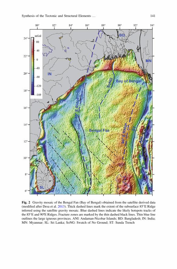
Fig. 2 Gravity mosaic of the Bengal Fan (Bay of Bengal) obtained from the satellite derived data(modified after Desa et al. 2013). Thick dashed lines mark the extent of the subsurface 85°E Ridgeinferred using the satellite gravity mosaic. Blue dashed lines indicate the likely hotspots tracks ofthe 85°E and 90ºE Ridges. Fracture zones are marked by the thin dashed black lines. Thin blue lineoutlines the large igneous provinces. ANI: Andaman-Nicobar Islands; BD: Bangladesh; IN: India;MN: Myanmar; SL: Sri Lanka; SoNG: Swatch of No Ground; ST: Sunda Trench
Synthesis of the Tectonic and Structural Elements … 141
Wang et al. (2014) divide the IBR and the CTFB into three domains alongnorth-south direction, and these are the Ramree domain to the south, the Dhakadomain in the middle, and the Naga domain to the north (Fig. 1). The Ramreedomain sustained oblique subduction to nearly orthogonal subduction and accretionalong the 450 km long plate margin. This subduction produced a belt of defor-mation that increased not only the width from 170 km in the south to 250 km in thenorth, but also the height of the IBR from <1000 m in the south to >2000 m in thenorth. In the middle Dhaka domain, plate margin sustained collision, resulting inthe formation and rapid westward propagation of a great fold belt and low anglesubduction mega thrust within the sediments of the eastern side of the Ganges–Brahmaputra-Meghna (GBM) Delta (Maurin and Rangin 2009a). The total lengthof domain is *500 km and the maximum width along 23°N is about 400 km. Theheight of the IBR in this domain increases towards N, and attains *3000 m at21.3°N.
The CTFB lies to the western margin of the Dhaka domain swing eastward to itsnorthern end. The approximately east-west oriented Dauki Fault (Biswas et al.2007; Hossain et al. 2016) marks the northern end of the Dhaka domain (beyondwhich CTFB is absent), and the beginning of the Naga domain. A major change inthe collisional characteristic occurs at the beginning of the Naga domain approxi-mately at 25°N. The Naga domain consisting of the Naga Hills (northern edge ofthe Burmese Plate) overrides the narrow continental shelf of the Assam Basin to thenortheast (Wang et al. 2014). The significant geomorphologic difference betweenthe Dhaka and the Naga domains seems to reflect the contrast in collision at shallowcrustal level rather deep-seated ones. The length of the Naga domain is *430 kmand the width of the domain narrows from *170 km in the southwest to *90 kmto the northeast, suggesting a northeastward depletion in total shortening across thehill range (Maurin and Rangin 2009a; Wang et al. 2014).
2.2 Assam Basin, Shillong Plateau and HimalayanForedeep
The Bengal Basin in the northeast is bounded by the Shillong Plateau, which wasuplifted during the Pliocene (Acharyya et al. 1986; Biswas et al. 2007), and sep-arated the Assam Basin from the Bengal Basin at the juncture of the southwesternpart of the Naga domain (Fig. 1). Approximately E-W stretching Shillong Plateauraised *2000 m elevation as continental basement pop-up structure due to twoseismically active steep reverse faults along its southern and northern edges. Thesetwo prominent faults are the E-W trending Dauki Fault in the south and theWNW-ESE trending Oldham Fault in the north (Fig. 1) (Bilham and England 2001;Biswas and Grasemann 2005a; Kayal et al. 2006; Kayal 2008). South-dippingOldham Fault is thought to be the backthrust of the north dipping master DaukiFault (Yin et al. 2010; see Mukherjee 2013b for backthrust kinematics in general,
142 M. S. Hossain et al.

also see Bose and Mukherjee, submitted-a, b). The importance of the Oldham Faultis considered to be minor compared to the Dauki Fault for the plateau uplift (Biswaset al. 2007). However, another school of thought believes the Shillong Plateau to bea large anticlinorium floored by Archean and Proterozoic basement rocks withremnants of the passive margin strata on its steep southern face adjacent to theSurma basin (Singh et al. 2016).
The plateau is separated from the Mikir Massif to the east by the NW-SEtrending Kopili Fault (also known as the Kopali Fracture Zone) (Evans 1964;Biswas and Grasemann 2005a; Biswas et al. 2007; Angelier and Baruah 2009). Inthe west, the plateau abuts against the Bengal Basin along a prominent fault, whichcontinues northward up to the Himalayan front. Up to the point of inflection of thesharply bent Brahmaputra River course from westward to southward, the fault isknown as the Jamuna Fault and to the further north as the Dhubri Fault (Desikachar1974; Nandy 2001). According to Johnson and Alam (1991) and Uddin andLundberg (1999), the paleo-Brahmaputra River flowed towards SW between thecurrent day juncture of the Shillong Plateau and the Naga Domain (accretionaryprism of the IBR) until the Miocene ended. The uplift of the Shillong Plateau aswell as the westward encroachment and the final abutment of the CTFB accre-tionary prism (Neogene Outer IBR) against the already-uplifted Shillong Plateauled to a *300 km westward shift of the Brahmaputra River to its present courseduring the Pliocene (Najman et al. 2012; Bracciali et al. 2015; Najman et al. 2016).Towards the east, the Shillong Plateau comprises the Garo, Khasi and Jaintia hills,which stretch for *97 km in N-S and *240 km in E-W (Morgan and McIntire1959). The basement of the plateau is primarily composed of intensely stressedPrecambrian and Early Paleozoic metamorphic and intrusive rocks overlain by theCretaceous and Cenozoic sediments in its steep southern face as well as east andwest margins (Wadia 1953; Nag et al. 2001; Biswas et al. 2007; Najman et al.2016).
The Shillong Plateau presumably has had a major influence on strain partitioningand consequently tectonics of the Eastern Himalaya that influenced the seismic riskin the surrounding regions (Bilham and England 2001; Banerjee et al. 2008;Najman et al. 2016). According to Mitra et al. (2005) and Vernant et al. (2014), thesouthern edge of the Shillong Plateau is elevated by stresses arising from the masterthrust (Dauki Fault), and the plateau is tilted northward at approximately 2°–4° asindicated by a 1–2 km increase in depth of the Moho between the northern edge ofthe plateau and the Himalayan Front. Under the Shillong Plateau and the Surmabasin, the Moho has been observed at similar depths of *37 km despite thecontrast of craton vs. thick sedimentary basin. This possibly indicates the uplift ofthe overthrusting Shillong Plateau and the concurrent downward flexure of theSurma basin (Singh et al. 2016). The thickness of the crust of the Indian Platebeneath the Shillong Plateau is *38–40 km (Singh et al. 2015, 2016). To the northand northwest, the Bengal Basin extends up to the Himalayan front where it isseparated by the Main Frontal Thrust (MFT) or Himalayan Frontal Thrust(HFT) (Acharyya 1994; Ganguly 1997). The Assam Basin, situated in the north ofthe Shillong Plateau and northwest of the Naga domain, was connected to the
Synthesis of the Tectonic and Structural Elements … 143
Bengal Basin up to the end of the Miocene. During the Pliocene, the upliftment ofthe Shillong Plateau separated the Assam Basin from the Bengal Basin except to thewestern part, across the N-S oriented Dhubri Fault.
2.3 Indian Shield and Rajmahal Hills
Peninsular India lying south of the Indo-Gangetic Alluvial Plain commonly referredto as the Indian Shield reportedly occupied a much wider area than the presenttriangular shaped region, made up of a diverse mosaic of igneous and metamorphicterrains that has undergone deformation and metamorphism (Roy 2014). Theseterrains, constituting the continental crust have attained tectonic stability since thePrecambrian and are designated as cratons (Valdiya 2010, 2016). The cratons areflanked by fold belts, with or without a discernible suture or shear zone, suggestingthat the cratons, as crustal blocks or micro-plates, moved against each other (Naqvi2005). Alternatively, these cratons could be the result of fragmentation of a largecraton that constituted the Indian Shield. Welded fold belts in between the neigh-bouring cratons indicate either rifting or splitting of cratons. The crustal blocks ofIndian shield are divided into six cratons (Sharma 2010; Valdiya 2010, 2016).Among these cartons, northeastern Chhotanagpur Granite-Gneiss Complex(CGGC) and Singhbhum Craton (SC) together with Satpura Mobile Belt or CentralIndian Tectonic Zone (CITZ) and Eastern Ghat Mobile Belt are lying along thewestern margin of the Bengal Basin (Misra 2006). The thickness of the crust of theIndian Plate near the western part of the Bengal Basin is *38 km (Singh et al.2015). The approximately N-S running Malda-Kishanganj Fault (Nandy 2001;Vaccari et al. 2011; Mohanty et al. 2013, 2014; Prasad and Pundir 2017) reaches upto the eastern and northeastern margins of the Rajmahal Hills which is consideredas the northwestern margin of the Bengal Basin.
The Bengal Basin constitutes the eastern continuation of the Indo-GangeticAlluvial Plain (IGAP), which separates the Extra Peninsular India to the north andthe Peninsular India to the south (Oldham 1893; Roy 2014). The Indo-Gangeticplains are stretching across northern India between Punjab to the west and Assam tothe east through Bangladesh. The Extra Peninsular India, which is the mountainousregion formed by the Himalayan ranges and their extensions into the Baluchistan tothe west and Myanmar to the east (Valdiya 2010).
To the north northwest, the Bengal Basin is separated from the Rajmahal Hills bythe approximately N-S running Rajmahal Fault (Ghose et al. 2017). The RajmahalHills of West Bengal and Bihar is a fault bounded small tectonic element situated inthe western edge of the Stable Shelf of the Bengal Basin (Fig. 1). The EarlyCretaceous (100–118 Ma; McDougall and McElhinny 1970; Baksi 1995; Kent et al.2002) Rajmahal Traps (RT), a sequence of tholeiitic basalts, crop out in theRajmahal Hills (McDougall and McElhinny 1970). Geologically, the Rajmahal Hillsis located at the juncture of the Singhbhum Craton (SC) towards west and theRangpur Saddle of the Bengal Basin to the east (Bage et al. 2014; Singh et al. 2016).
144 M. S. Hossain et al.
Rajmahal Hills is bounded by the Rajmahal Fault and Saithia-Brahmani Fault in theeast and the west sides, respectively (Ghose et al. 2017). The RT is the result of theKerguelen Plume upwelling activity in the Early Cretaceous (Ghatak and Basu 2011,Roy and Chatterjee 2015), which resulted in a massive amount of mantle materialcovering the entire surface (Baksi et al. 1987).
According to Nandy (2001), Ghatak and Basu (2011), Sager et al. (2013) and Royand Chatterjee (2015), the N–S running Jamuna Fault is coincident with the NinetyEast Ridge along the path of the Kerguelen Plume in the Bay of Bengal as evidencedby the hotspot-related magma upwelling in the region. Roy and Chatterjee (2015)suggest that the Tista Fault, the Dauki Fault and N30°E–S30°W oriented BasinMargin Fault form a triple-point intersection of lineaments/fractures because of localdoming up of the crust during upwelling of the mantle plume. Mantle upwellingextruded tholeiite lava through fractures over a wide region in and around the BengalBasin. The Rajmahal Hills evolved along the then eastern continental margin of theIndian Plate, following rifting from the Gondwana. Over time, the upper part of thistectonic element subjected to extensional brittle deformation and formed grabenstructures (Singh et al. 2004). The basalts of the RT above the Rajmahal Hills arecommonly vesicular that are filled with secondary minerals e.g., calcite, analsite,chalcedony, and agate (Ball 1877). The intertrappean beds are composed of sedi-mentary rocks like siltstone, claystone, and shale (Valdiya 2010). The central partcarries the impression of up to 28 flows, which has been identified earlier by theGeological Survey of India (Pascoe 1975; Mukhopadhyay et al. 1986). On the otherhand some other authors refer that the maximum exposed thickness of the lava isabout 230 m or approximately ten flows (Kent et al. 1997). The Sylhet Traps areequivalent to the Rajmahal Traps, and are reported to be found in the northern edgeof the Surma basin (Roy and Chatterjee 2015). Talwani et al. (2016) suggest that theRajmahal and the Sylhet Traps are not separate eruptions as they are connected by aprominent magnetic doublet (Rahman et al. 1990a). According to them, both theRajmahal and the Sylhet Traps are originated from same igneous activity.
2.4 Bengal Fan
The Bengal Fan (Fig. 2), which marks the southern end of the Bengal Basin andnortheastern lobe of the Indian Ocean, floors the entire Bay of Bengal, forming thelargest submarine fan in the world (Curray et al. 2003; Curray 2014). Continentalslope of eastern Sri Lanka and India, southern Bangladesh, and the Sunda Trenchextending from Myanmar to Andaman-Nicobar Islands marks the western, northernand eastern margins of the fan, respectively (Fig. 2). The southern end of the fanreaches up to the south distal end of the Bay of Bengal at *7°S. The fan was firstapparently recognized by Dietz (1953), and delineated and named by Curray andMoore (1971). The length of the fan is *3000 km along N-S, the width is*1430 km along E-W, the area is *3 � 106 km2 and the maximum sedimentthickness of the fan is *16.5 km (Curray et al. 2003; Shanmugam 2016).
Synthesis of the Tectonic and Structural Elements … 145
The development of the Bengal Fan is related to the creation of the Bay of Bengal,which was the direct result of the India–Asia collision and uplift of the Himalaya andthickening of the Tibetan Plateau. The initial Late Paleocene–Eocene collision of theIndian Plate with the subduction zone of the north side of the Tethys Ocean initiated asmall fan in the northern Bay of Bengal, now lying beneath the younger deltaic andshelf sediments of the Bengal Basin (Curray and Moore 1974; Alam et al. 2003;Curray 2014). From the Eocene onward, collision continued resulting rapid clasticsedimentation in the Bengal Basin primarily from erosion of the high standing andrising Himalaya and the Tibetan Plateau, and formation of fan on top of this conti-nental rise (Curray et al. 2003; Curray 2014). The GBM delta formed by the riverGanges, Brahmaputra, and Meghna gradually filled the Bengal Basin. The surplussediment, which has passed through has been distributed across the entire Bay ofBengal to eventually form the world’s biggest submarine fan. The fan graduallyprograded southward during the Tertiary (Curray et al. 2003). The Swatch of NoGround (SoNG) is the main avenue that funneled down sediment from the BengalBasin to the Bengal Fan (Curray et al. 2003). It is a shelf-incising aggrading canyon(Fournier et al. 2016) located 250 km *S of the confluence of the Ganges and theBrahmaputra rivers and only 30 km south from the coastal delta plain of Bangladesh.
Curray and Moore (1974) assumed that the formation of the modern Bengal Fancommenced during the Oligocene to the Early Miocene. Two lobes of the fanseparated by the Ninety East Ridge were active until the Middle Pleistocene,namely the Bengal Fan proper in the west and Nicobar Fan in the east (Curray andMoore 1974). The SoNG, which was the main supplier of sediments to the BengalFan is largely cut off from its supply of sediment as the modern river sedimentstrapped on the Bengal shelf due to the Holocene transgression (Emmel and Curray1985; Kuehl et al. 1989). The supply of sediments to the Nicobar Fan was cut off bythe convergence of the Ninety East Ridge and the Sunda Trench during the EarlyPleistocene. At present, only the axial area of the Sunda Trench is still receivingsediments from the fan in the Bay of Bengal (Curray and Moore 1974; Bender1983). The surface features of the Bengal Fan are mainly active and abandonedturbidity current channels, and the Ninety East Ridge and Eighty Five East Ridge(Curray et al. 2003; Curray 2014).
3 Basin Geometry and Tectonic Evolution
The Bengal Basin, a complex collisional foreland basin, exhibits intense variabilityin Neogene sediment thickness that reflects a complicated depositional environmentand tectonics (Curray et al. 2003; Uddin and Lundberg 2004; DeCelles 2012). Withbroad attributes of basin geometry, tectonic evolution and stratigraphy, the dis-cussion begins with the basin geometry, followed by the tectonic evolution. Finally,the stratigraphy in context to the basin geometry and tectonic evolution has beendiscussed in the later part.
146 M. S. Hossain et al.
3.1 Basin Geometry
The Bengal Basin is a peripheral foreland basin formed due to continent–continentcollision after the subduction of the oceanic part of the Indian Plate (Mukherjeeet al. 2009). The basin geometry is complex and asymmetric having thinner, gentlysloping sediment cover in the western and northern parts, which thicken in thebasin-ward direction to the south and southeast (Curray et al. 2003; Uddin andLundberg 2004). Gravity anomaly information indicates a considerable hetero-geneity in different parts of the basin in terms of stratigraphy, sedimentation, tec-tonics and basin evolution (Uddin and Lundberg 2004). Considerable difference inthe basement height results significant variations not only in sedimentary rock typesbut also in their individual thickness (Mukherjee et al. 2009). Based on geodynamicdevelopment, basement configuration and sedimentation pattern, the Bengal Basincan be divided into three distinct geotectonic provinces: (i) Stable Shelf orGeotectonic Province 1, (ii) Central Foredeep Basin or Geotectonic Province 2, and(iii) Folded Flank (CTFB) or Geotectonic Province 3.
The Stable Shelf or Geotectonic Province 1 has a sub-basin in the north that liesbetween the Main Frontal Thrust (MFT) to the north and the Rangpur Saddle(Bakhtine 1966) of the Garo–Rajmahal Gap, i.e. concealed Dinajpur Block (Ameenet al. 2007, 2016) to the south. Shallowest part of this sub-basin is in the south,where the thickness of the Neogene sediments overlying the Precambrian basementand the Phanerozoic Gondwana rift-basin rocks (Khan et al 1994) varies between128 and 1160 m (Rahman 1987; Khan 1991a, b; Ameen et al. 2007). The southernpart of the Stable Shelf that lies between the Indian Shield to the west and theEocene Hinge Zone to the east, is a prominent fault zone with dislocation andcataclasis running along the N15°E–S15°W marked by the crowding of gravitycontours, and shows the occurrence of laterite and lateritic soils, the protoliths(Matin and Misra 2009; Roy 2014; Roy and Chatterjee 2015). A number of halfgraben structures containing Permian coal deposits as well as numerous faults arepresent in the northeastern part of this sub-basin (Rabbani et al. 2000). Thesouthernmost part of the Stable Shelf has a low southeasterly gradient, and ischaracterized by several down-to-basin growth faults. Sediments thicken uniformlyfrom the west to the southeast (Khan and Agarwal 1993). In general, based on theconcealed basement depth and gradient, the Foreland Shelf is divided into fourdifferent parts. From north to south, these are the Himalyan Foredeep, the DinajpurShelf, the Rangpur Saddle, and the Bogra Shelf (Sengupta 1966; Guha 1978; Khanand Rahman 1992; Khan and Agarwal 1993; Reimann 1993; Guha et al. 2010).
The Central Foredeep Basin or Geotectonic Province 2 basically comprises ofthree sub-basins between the Eocene shelf-break to the west and the Folded Flankof the Bengal Basin to the east characterized by a huge sediment thickness rangingbetween 10 and 22 km (Curray 1991). These sub-basins are the Surma basin to thenorth separated from the Faridpur Trough (a sub-basin) to the southwest by theMadhupur-Tripura High. On the otherhand, the Faridpur Trough is separated fromthe Hatia Trough (another sub-basin) to the east by the Barisal-Chandpur High
Synthesis of the Tectonic and Structural Elements … 147
(Alam 1972; Das Gupta 1977; Guha 1978; Reimann 1993). In general, theForedeep Basin shows small-amplitude, isometric or geographically equant gravityanomalies (Bakhtine 1966). The transitional zone of the continent–ocean crust ofthe Indian Plate occurs in this sub-basin between the Eocene shelf-break in the westand the Barisal–Chandpur Gravity High in the east (Shamsuddin and Abdullah1997; Uddin and Lundberg 2004; Mukherjee et al. 2009).
The folded flank of the Bengal Basin or Geotectonic Province 3 comprises theeastern part of the Bengal Basin and is one of the active collisional orogenic belts inthe world. Approximately NNW to SSE trending folds that have developed in theupper part of the thick deltaic sequence of the CTFB generally exhibit linear orelongated gravity anomalies with large amplitudes (Figs. 5 and 6) (Bakhtine 1966).
3.2 Tectonic Evolution
To understand the tectonic evolution of the Bengal Basin, it is necessary to haveinsight on the plate tectonic and paleogeographic reconstruction model ofGondwana to Asia. Therefore, for the convenience, plate tectonic and paleogeo-graphic reconstruction model of Gondwana to Asia is discussed first and followedby a discussion on the tectonic evolution of the Bengal Basin.
3.2.1 Plate Tectonic and Paleogeographic Reconstruction Model
Although standard traditional models suggest that the India–Eurasia (Tibet part)collision event started 50–55 Ma ago (Rowley 1996; Hodges 2000; DeCelles et al.2002; Zhu et al. 2005; Najman 2006), Ali and Aitchison (2005, 2008), Aitchison et al.(2007), Metcalfe (2013), Misra et al. (2015), Baxter et al. (2016) andMukherjee et al.(2017) proposed new model with much younger age (Tables 1 and 2). Ali andAitchison (2008) discourse the revised plate tectonic reconstructions model into twophases: (i) Break-up and dispersal of Gondwana—Middle Jurassic throughend-Paleocene, and (ii) Convergence and collision of Indian Plate with the EurasiaPlate—Eocene. However, before discussing the revised plate tectonic reconstructionmodel, it is necessary to consider the palaeogeography of the Neotethys Ocean.
The commonly accepted standard models involved the present-day Indian Platewith some form of extension to the north as a passive margin, north of which layoceanic crust of the Neotethys. As the Indian Plate moved towards the EurasianPlate, the Neotethys was consumed beneath the Lhasa Block in a setting similar tothe present-day Sunda Arc (Hall 2002). This palaeogeographic scenario is con-sidered to be the ‘one ocean–two continent convergence model’. However, fol-lowing seismic tomography studies of the mantle beneath the Indian Ocean–SouthAsia region, geological investigations of the India–Asia suture zone, and paleo-magnetic and magnetic anomaly based India and Asia motion models, paleogeo-graphic scenario of Neotethys are considered as the ‘two ocean–two continent
148 M. S. Hossain et al.

Table 1 Major tectonic events related to the Indian and Eurasian plate collision and subsequentdevelopment of the Bengal Basin
Geologic time Age in Ma Major tectonic events
Convergence and collision of the Indian plate with the Eurasian plate—Eocene
Mid- to Late Pliocene *3.5–2.5 The major thrust related uplift of the Shillong Plateau alongthe Dauki Fault in the south and the Oldham Fault in thenorth. Centre of the Bengal Basin started evolving as aforeland basin
Late Oligocene *25 Remnant ocean basin took shape due to the collisionalorogeny of the Barail–Cachar Hills at the northeastern cornerof the Indian Plate
Eocene-Oligocenetransition
*35 The continental crust of the Indian Plate impacted with theTibet part of the Eurasian Plate, resulted in subduction of thenorthern part of the Indian Plate beneath the southern Tibet,therefore, initiated the continent–continent collision
Middle Eocene *45 The northern edge of the Indian Plate was still at somedistance south of the Lhasa Block, i.e. southern front of theEurasian Plate
Early Eocene *55 The collision of Indian Plate with a Neotethyan intra-oceanicarc (Dazhuqu Arc/Kohistan–Ladakh Arc), but not with theEurasian Plate
Break-up and dispersal of the Gondwana supercontinent—middle Jurassic through Late Paleocene
Late Paleocene *55.9 Indian Plate appears to have reached its maximum level ofisolation after being jettisoned by the Seychelles block
Cretaceous–Paleogenetransition
*66 Indian Plate started breaking from the Seychelles
Late cretaceous *90–85 India–Seychelles separated from the Madagascar
Mid-cretaceous *118 The Kerguelen large igneous province began forming on thefloor of the SE Indian Ocean, resulting the Rajmahal Traperuptions, and provided a stepping-stone for migrationsbetween the India–Seychelles–Madagascar and Australia–Antarctica for much of the Mid-Cretaceous
Mid-early cretaceous *125 East Gondwana moved along the Davie Fracture Zone on atrail roughly parallel to the coast of the eastern Africa, whichled to formation of true ocean floor (Somalia andMozambique Basin)
Early cretaceous *132 Australia–Antarctica began to drift away from the India–Seychelles–Madagascar with a fan-shaped expanse of oceanfloor that separated the two elements by gradually widening tothe east
Middle Jurassic *170–175 Gondwana supercontinent started breaking following therifting of South America–Africa (West Gondwana) from theIndia–Seychelles–Madagascar–Australia–Antarctica (EastGondwana)
Paleozoic—Mesozoic(Early—Middle Jurassic)
*180 Indian Plate presumably occupied a central location in theGondwana supercontinent
Compiled from Smith and Hallam (1970), Norton and Sclater (1979), Ingersoll et al. (1995), Storey et al.(1995), Acton (1999), Torsvik et al. (2000), Bilham and England (2001), Biswas and Grasemann (2005a),Schettino and Scotese (2005), Rabinowitz and Woods (2006), Aitchison et al. (2007), Ali and Aitchison (2008),Yin et al. (2010), Metcalfe (2013), Misra et al. (2014, 2015), Misra and Mukherjee (2015), Baxter et al. (2016),Najman et al. (2016, 2017), Mukherjee et al. (2017)
Synthesis of the Tectonic and Structural Elements … 149

convergence model’ (Fig. 3) (Allégre et al. 1984; Abrajevitch et al. 2005; Aitchisonet al. 2007; Ali and Aitchison 2008; Baxter et al. 2016). According to this model,during the Late Cretaceous–Cenozoic passage of the Indian Plate towards the Tibetpart of the Eurasian Plate, the Neotethys comprises two oceanic plates separated bynorth-dipping subduction zone (Ali and Aitchison 2008). Considering thepresent-day island arcs as a guide, Ali and Aitchison (2008) and Baxter et al. (2016)suggest that there might have some volcanic islands (Neotethyan arc) spaced every30–90 km apart present in the Neotethys ocean. If the ‘two ocean–two continentconvergence model’ is correct, one might, therefore, predict that remnants of thetwo separate ocean slabs are present beneath the subduction system in the India–Eurasia collision belt in southern Tibet (Yarlung Tsangpo Suture Zone- IndusRiver) and northern India (Himalayan Foredeep) (Ali and Aitchison 2008).
Break-up and Dispersal of Gondwana—Middle Jurassic Through LatePaleocene
In standard plate tectonic reconstruction, the Indian plate presumably occupied acentral location in the Gondwana supercontinent throughout the Paleozoic and muchof the Mesozoic (*180 Ma), i.e. up to the beginning of the Middle Jurassic (Smithand Hallam 1970; Norton and Sclater 1979). In theMiddle Jurassic (*170–175 Ma),this supercontinent started breaking following the rifting of South America–Africa
Table 2 Major tectonic events related to the Indian and Burmese plate collision and subsequentdevelopment of the Folded Flank (CTFB) of Bengal Basin
Geologic time Age inMa
Major events
LatePleistocene -Recent
*0.075 The fold has been progressively growing westward, and someof the folds in the westernmost part have been activelydeveloping
EarlyPleistocene
*2 Sediments in the upper part (*up to 5 km) within the majorindividual thrust started to deform above a de’collement levelby combined thin-skinned and thick-skinned tectonicprocesses. Many of the folds in the westernmost part have beenactively developing
Late Pliocene *3.5–3 Oblique subduction of the Indian Plate beneath the BurmesePlate in an arc-trench setting developed accretionary prism andthe CTFB started to develop within the upper parts of the thickdeltaic sequence in the eastern margin of the Bengal Basin
Early Miocene *20 Sediment contributions to the Bengal Basin began to arrivefrom the Indo-Burman Ranges (IBR) due to subduction of theIndian Plate beneath the Burmese Plate
Early Eocene *45 The northeast corner of the Indian Plate making a glancingcontact with the Sumatra Block, followed by the Burmese Plate
Compiled from Curray et al. (2003), Uddin and Lundberg (2004), Acharyya (2007), Ali andAitchison (2008), Maurin and Rangin (2009a), Wang et al. (2014) and Najman et al. (2016)
150 M. S. Hossain et al.
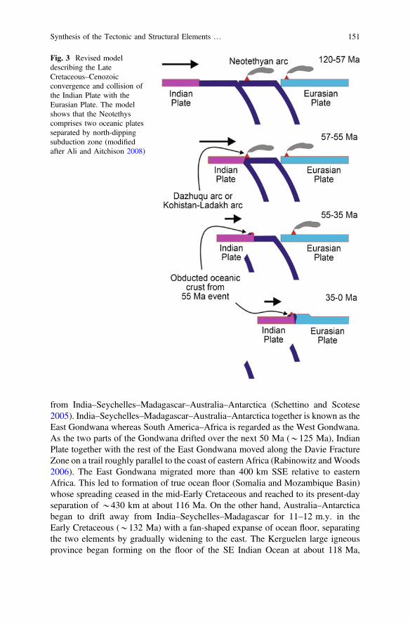
from India–Seychelles–Madagascar–Australia–Antarctica (Schettino and Scotese2005). India–Seychelles–Madagascar–Australia–Antarctica together is known as theEast Gondwana whereas South America–Africa is regarded as the West Gondwana.As the two parts of the Gondwana drifted over the next 50 Ma (*125 Ma), IndianPlate together with the rest of the East Gondwana moved along the Davie FractureZone on a trail roughly parallel to the coast of eastern Africa (Rabinowitz andWoods2006). The East Gondwana migrated more than 400 km SSE relative to easternAfrica. This led to formation of true ocean floor (Somalia and Mozambique Basin)whose spreading ceased in the mid-Early Cretaceous and reached to its present-dayseparation of *430 km at about 116 Ma. On the other hand, Australia–Antarcticabegan to drift away from India–Seychelles–Madagascar for 11–12 m.y. in theEarly Cretaceous (*132 Ma) with a fan-shaped expanse of ocean floor, separatingthe two elements by gradually widening to the east. The Kerguelen large igneousprovince began forming on the floor of the SE Indian Ocean at about 118 Ma,
Fig. 3 Revised modeldescribing the LateCretaceous–Cenozoicconvergence and collision ofthe Indian Plate with theEurasian Plate. The modelshows that the Neotethyscomprises two oceanic platesseparated by north-dippingsubduction zone (modifiedafter Ali and Aitchison 2008)
Synthesis of the Tectonic and Structural Elements … 151
resulting the Rajmahal Trap eruptions. This could have provided a stepping-stone formigrations between India–Seychelles–Madagascar and Australia–Antarctica formuch of the mid-Cretaceous. India–Seychelles–Madagascar was connected until thebeginning of the Late Cretaceous (recent reviews inMisra et al. 2014, 2015;Misra andMukherjee 2015; Mukherjee et al. 2017). In the Late Cretaceous (90–85 Ma), India–Seychelles separated from Madagascar (Storey et al. 1995; Torsvik et al. 2000;Aitchison et al. 2007). India started breaking from Seychelles around the Cretaceous–Paleogene boundary (*66 Ma), and India appears to have reached itsmaximum levelof isolation after being jettisoned by Seychelles block at the end of the Paleocene(55.9 Ma). It is believed that the jettisoned Seychelles block coincided with the mainDeccan Trap eruptions. The centre of the Indian Plate, which now sits on *23.5°N(Tropic of Cancer), was at*30°S in the Late Cretaceous, some 6000 km to the southfrom where it is today (Ali and Aitchison 2008).
Convergence and Collision of Indian Plate with Eurasian Plate—Eocene
The Indian Plate migrated rapidly northwards during the Late Cretaceous and thePaleocene (Acton 1999). According to Acton’s (1999) model, northwards advanceof the Indian Plate in between 120 and 73 Ma was *6.6 cm/year, which increasedto *21.1 cm/year between 73 and 57 Ma. At *57 Ma, the plate motion abruptlydecreased to 9.5 cm/year, which continued until 20–30 Ma when there was a fur-ther major slowdown of the rate of movement. According to Ali and Aitchison(2008) and Baxter et al. (2016), the ‘57 Ma event’ mark the collision of the IndianPlate with a Neotethyan intra-oceanic arc, but not with the Eurasian Plate. Ali andAitchison (2004, 2006) and Aitchison et al. (2007) calculate the position of the newpole that sits 5°–9° further from the present-day North Pole. This new pole placesthe southern Lhasa Block at *28°N at 55 Ma. Since then, this part of the EurasianPlate has rotated *21° clockwise relative to the spin axis and migrated 1100 kmeast. Ali and Aitchison (2008) suggest that evidence related to the collision of theoceanic part of the Indian Plate with the Dazhuqu Arc in the earliest Eocene(*55 Ma) has been found along the 2500-km-long Indus–Yarlung Tsangpo suturezone (trending *E-W in the eastern part and *NW-SE in the western part;Aitchison et al. 2007). The Dazhuqu Arc, also known as the Kohistan–Ladakh Arc(Metcalfe 2013) may have been formed as early as *135 Ma, i.e. in the EarlyCretaceous (Bosch et al. 2011). A number of island arc fragments that had obductedonto India after it collided with the Dazhuqu Arc at *55 Ma are present in thissuture zone. At the Middle Eocene (*45 Ma) the northern edge of the Indian Platewas still at some distance south of the Lhasa Block, i.e. southern front of theEurasian Plate. Isotopic studies of igneous rocks and the biostratigraphic investi-gations of sedimentary rocks from the suture zone, led to the conclusion that thehard collision between continental part of the Indian Plate and the Eurasian Plate(southern Tibet, i.e. Lhasa Block), i.e. continent-continent collision happened at thevery end of the Eocene, *35 Ma (Ali and Aitchison 2008; Baxter et al. 2016).Therefore, Aitchison et al. (2007), Ali and Aitchison (2008) and Baxter et al. (2016)
152 M. S. Hossain et al.

reasonably argued that oceanic crust of the Indian Plate collided into asub-equatorially located intra-oceanic arc (Neotethyan arc) at *55 Ma, and laterthe continental crust of the Indian Plate impacted with the Tibet part of the EurasianPlate starting around 35 Ma (Table 1). Approximately at the Eocene-Oligoceneboundary (*35 Ma), northern Indian Plate entered the north-dipping subductionzone beneath southern Tibet, thus marking the initiation of continent–continentcollision (Baxter et al. 2016). To the east, the northeast corner of the Indian Platemaking a glancing contact with Sumatra Block, followed by the Burmese Platefrom *45 Ma, i.e. Early Eocene onwards (Ali and Aitchison 2008).
3.2.2 Tectonic Evolution of the Bengal Basin
The basin evolved through two major tectonic episodes. First, it initiated as anintra-cratonic rift basin within Gondwana landmass during Late Paleozoic–MidMesozoic and received the continental Gondwana sediments. This episode of basindevelopment ended with widespread volcanism as continental flood basalts knownas the Rajmahal Trap covered the Gondwana sediments. The second episode ofbasin development began in the Late Mesozoic with the break-up of Gondwana andis still going on (Alam 1989). At this stage, the tectonic evolution of the greaterBengal Basin is fundamentally related to the collision pattern of the Indian Platewith the Eurasian Plate to the north and the Burmese Plate to the east. The firstuplift in the Himalayan and Indo-Burman region commenced in the Oligocene andthe Early Miocene, respectively (Bender 1983). In its northern journey, the IndianPlate collided with the Eurasian Plate and caused folding and thrusting forming theHimalayan orogenic belt. Further movement of the Indian Plate was in thenorth-easterly direction, resulted in collision of northeastern end of the Indian Platewith the Burmese Plate, the former subducting below the latter, and the sedimentaryaccretionary prism gave rise to the formation of the CTFB and the IBR (Alam et al.2003; Steckler et al. 2008; Wang et al. 2014).
The peri-cratonic part on the eastern margin subsided continuously and receivedvoluminous sediments from the Late Mesozoic through Tertiary to the Recenttimes. This foreland basin containing a succession of dominantly deltaic sedimentsderived primarily from the erosion of the Himalaya and the IBR. Sedimentsaccumulate in the basin through the Ganges, Brahmaputra and Meghna(GBM) River systems, and are dispersed into the Bay of Bengal, forming the largestsubmarine fan in the world (Curray et al. 2003). According to Curiale et al. (2002)and Curray et al. (2003), sediment contributions to the basin began to arrive pri-marily from the Himalaya and the Indo-Burman Ranges around the Early Oligocene(*35 Ma), and the Early Miocene (*20), respectively, and have been progradingsouthward presently. To keep the isostatic equilibrium (Mukherjee 2017), thearriving mass of these huge sediments loaded and depressed the underlying litho-sphere further, producing additional accommodation space for deltaic sediments.The additional lithospheric depression and accommodation space have resultedfrom the southward thrusting of the Shillong Plateau over the basin through the past
Synthesis of the Tectonic and Structural Elements … 153
5 Ma in the north, and from the westward thrusting of the Indo-Burman Rangestoward the basin in the east (Johnson and Alam 1991).
Geodynamic development of the previously mentioned three geotectonic pro-vinces and their successive tectonic evolution are now discussed under the light ofthe India and Asia collision to the north, and the India and Burma collision to theeast. Among the three geotectonic provinces (Alam et al. 2003), the development ofthe Geotectonic Province 1—Stable Shelf and Geotectonic Province 2—centralForedeep Basin are related to the collision between the Indian Plate to the south andthe Eurasian Plate to the north, whereas development of Geotectonic Province 3—CTFB is related to the collision of the Indian Plate to the west and the BurmesePlate to the east.
The Early Cretaceous rifting of the Indian Plate from Gondwana and con-comitant volcanic eruptions along the northeastern margin of the Indian Plate ini-tiated the tectonic evolution of the Geotectonic Province 1 and 2 (Alam et al. 2003).In Geotectonic Province 1, pre-rift Permo-Carboniferous sediments are encounteredwithin the subsurface graben basins on top of the Precambrian Basement rock(Khan 1991a, b; Reimann 1993). SW–NE trending lineaments are observed in boththe aeromagnetic anomaly map (Rahman et al. 1990a) and in the Bouguer gravityanomaly map (Rahman et al. 1990b; Khan and Rahman 1992). This reflects grabenson the continental crust part of the Geoteconic Province 2 (Surma basin)beneath the thick Late Cenozoic sediment cover, which may also hold the Permo-Carboniferous sediments at depth. The basement rock beneath the GeotectonicProvince 1 is characterized by tensional tectonics. Tension created a complexgraben system with tilted and/or downthrown blocks, which were intersected bymany normal faults (Khan and Agarwal 1993).
Along the Eocene Hinge Zone and its immediate east, alternating high and lowmagnetic values could represent (*750–950 nT; Rahman et al. 1990a) a probabletransition from continental to oceanic crust (Curray 2014). The Barisal–ChandpurGravity High probably indicates the rift valley formed during the initial break-up ofGondwana and formation of the Indian Plate along which transitional zone betweencontinent-ocean crust of the Indian Plate has been marked by pulses of basalt flow(Desikachar 1974; Lohmann 1995; Alam et al. 2003; Curray 2014). Further to theeast, seismic signature on top of the basement is characterized by numerouscross-cutting and down-going reflectors associated with basalt flows. They indicateoceanic crust below. Alam et al. (2003) also suggest that the continent–ocean crustboundary bends eastward beneath the Surma basin, and probably continues towardsthe juncture of the Dauki-Haflong Thrust. Hence, north of this Hinge Zone, at leastnorthern part of the Surma basin is floored by the continental crust, whereassoutheast of this line, basement rocks of the Bengal Basin are oceanic rather than ofcontinental origin (BOGMC 1997). In addition, it is believed that position of theEocene Hinge Zone is within Geotectonic Province 1, and it truncates against theDauki Fault in the northeast boundary of the deeper foredeep centre.
Up to the Oligocene, the Geotectonic Province 1 and 2 are believed to beundergone similar tectonic and sedimentary evolution (Alam et al. 2003). From theLate Oligocene onward, when the remnant ocean basin (Ingersoll et al. 1995) took
154 M. S. Hossain et al.
shape due to the collisional orogeny of the Barail–Cachar Hills at the northeasterncorner of India (Nandy 1986), Geotectonic Province 2 has undergone its owntectonic evolution. A major change in sedimentation pattern here probably occurredin the Mid Pliocene by the major thrust related uplift (upthrust) of the ShillongPlateau (Najman et al. 2016) along the Dauki Fault (Bilham and England 2001;Biswas and Grasemann 2005a) in the south and Oldham Fault (Yin et al. 2010) inthe north. In the Shillong Plateau, the Archaean Basement rocks are found *2 kmhigh, whereas equivalent rocks occur *16–18 and 4–5 km below sea level, in thesouth and north of the plateau, respectively (Alam et al. 2003; Najman et al. 2016).The Geotectonic Province 3—CTFB started to develop during the Late Pliocene(Maurin and Rangin 2009a) within the upper parts of the thick deltaic sequence inthe eastern margin of the Bengal Basin. At the same time, the Geotectonic Province2 started evolving as a foreland basin at the centre; whereas in the GeotectonicProvince 1, the authors of this chapter believes foredeep sediments will thrustnorthwestward in near future. Oblique subduction of the Indian Plate beneath theBurmese Plate in an arc-trench setting developed accretionary prism as well asmajor east-dipping thrusts (Kaladan Fault to the east, and Chittagong Coastal Faultto the west), which largely controlled the structural evolution of the GeotectonicProvince 3 (Gani and Alam 1999; Acharyya 2007; Maurin and Rangin 2009a;Wang et al. 2014). In this province, the sediments in the upper part (*up to 5 km)within the major individual thrust deformed above a de’collement level by com-bined thin-skinned and thick-skinned tectonic processes during the last 2 Ma(Uddin and Lundberg 2004; Maurin and Rangin 2009a), giving rise to a series ofelongate, N–S trending curvilinear folds (Sikder and Alam 2003). Through a bal-anced cross section across this geotectonic province, Maurin and Rangin (2009a)estimated a total E-W shortening of about 11 km in the past 2 Ma, which suggests ashortening rate of about 0.5 cm/year. In this regard, recent investigations suggestthat the fold belt has grown progressively westward and many of the folds in thewesternmost part of this province have been active only from the Late Pliocene oreven later (Table 2) (Johnson and Alam 1991; Khan et al. 2005; Steckler et al.2008; Maurin and Rangin 2009a; Wang et al. 2014; Khan et al. 2015, 2018).
4 Stratigraphy
The foremost depositional phase in the Bengal Basin began following the separa-tion of the Indian Plate from Antarctica at about the beginning of the LateCretaceous. This is in exception of minor Carboniferous coal that preserved at leastlocally on Precambrian continental crust (Sclater and Fisher 1974; Molnar andTapponnier 1975; Uddin and Lundberg 2004). In the beginning of the Late Eocene,thick Tertiary clastic sediments accumulated in the basin with deposition acceler-ating with the arrival of clearly orogenic sediments in the earliest Miocene (Bender1983; Uddin and Lundberg 1998, 2004). According to Alam et al. (2003), the
Synthesis of the Tectonic and Structural Elements … 155
present day active sediment depocentre is the Hatia Trough in the GeotectonicProvince 2 as well as its extension to the south into the Bengal Fan.
The sediments preserved in the Stable Shelf part of the Bengal Basin, i.e.Geotectonic Province 1 (Tables 3 and 4) show a progressive thickening towardsnorth and south from the shallowest part of the basement at the Rangpur Saddlefrom which it continues to slope progressively in both directions. Sediments attain athickness of 3–4.5 km, and *3.5 km to the northern and southern edge of theStable Shelf, respectively (Uddin and Lundberg 2004; Guha et al. 2010). Thestratigraphic unit on top of the Stable Shelf as well as in both southern and northernslopes varies in thickness, spatial extent and lithology over geologic time (Reimann1993). The basement grabens are filled up by the Gondwana sediments comprisingsandstone, shale and coal. The Rajmahal Trap lies above the Gondwana sedimentsand are overlain by the Tura Sandstone, followed by the fossliferous Eocene SylhetLimestone and then the post Eocene sediments comprising sands, gravels and clay.The facies evolution ranges from continental and volcanics through brackish andlagoonal to shallow open marine to estuarine and fresh water environments(Reimann 1993; Alam et al. 2003).
The sediments preserved within the Foredeep part, i.e., Geotectonic Province 2(Table 5) and 3 (Table 6) are ca.16–22 km thick sequence of Cenozoic sediments(Curray and Moore 1971; Curray 1994; Gani and Alam 1999; Uddin and Lundberg2004), where facies evolution ranges from marine through deltaic to fluvial envi-ronments. From oldest to youngest, the stratigraphic units are the Tura Sandstone,Sylhet Limestone, Kopili Shale, Barail, Bhuban, Bokabil, Tipam Sandstone,Girujan Clay, Dupi Tila Sandstone, and Dihing Formations. Although Rahmanet al. (2017) have tried to correlate sediment provenance with different Himalayantectonic units, the relative contributions of the sediments to the basin from theHimalaya, CTFB-IBR, and Indian Shield and Shillong Plateau are much debated(Johnson and Alam 1991; Gani and Alam 1999; Uddin and Lundberg 2004;Najman et al. 2008, 2016).
5 Geotectonic Provinces, Tectonic Elements, and TheirRelated Structures
The India-Eurasia and India-Burma (Myanmar) collisions have affected the basin sincethe Tertiary (Bender 1983). Conventionally, the basin can be divided into two largedivisions based on overall geotectonic settings: Stable Continental Shelf to the westand Bengal Foredeep to the east separated by the Continental Slope also known as theEocene Hinge Zone (Bakhtine 1966; Guha 1978; Bender 1983; Reimann 1993;Uddin and Lundberg 2004). The Bengal Foredeep occupies the enormous area betweenthe Eocene Hinge Zone to the west and the Indo-Burman Ranges to the east and playsimportant role in the tectonic evolution of the Bengal Basin. In the foredeep part of theBengal Basin, a thick pile of sedimentary strata overlies a deeply subsided basement.
156 M. S. Hossain et al.
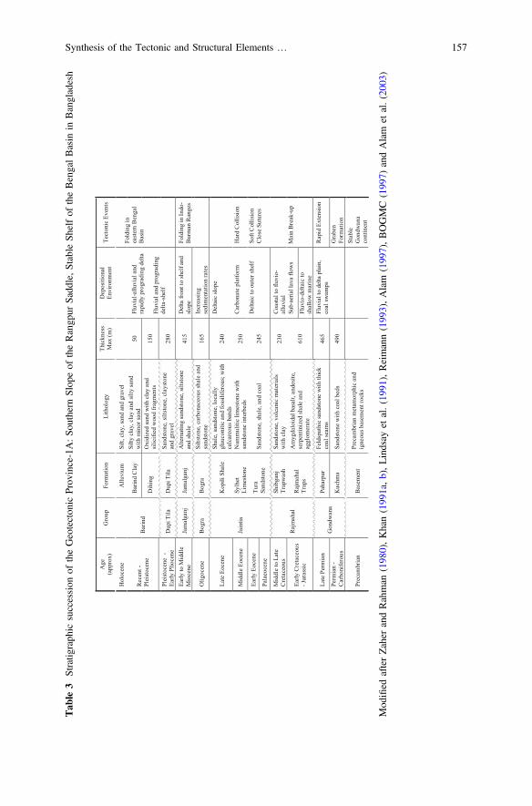
Tab
le3
Stratig
raph
icsuccession
oftheGeotecton
icProv
ince-1A:So
uthern
Slop
eof
theRangp
urSadd
le,Stable
Shelfof
theBengalBasin
inBangladesh
Age
(app
rox)
Gro
upFo
rmat
ion
Lith
olog
yTh
ickn
ess
Max
(m)
Dep
ositi
onal
En
viro
nmen
tTe
cton
ic E
vent
s
Hol
ocen
eA
lluvi
umSi
lt, c
lay,
sand
and
gra
vel
Fluv
ial-a
lluvi
al a
nd
rapi
dly
prog
radi
ng d
elta
Fluv
ial a
nd p
rogr
adin
g de
lta-s
helf
Fold
ing
in
east
ern
Ben
gal
Bas
inR
ecen
t -Pl
eist
ocen
eB
arin
dB
arin
d C
lay
Silty
cla
y, c
lay
and
silty
sand
w
ith m
inor
sand
50
Dih
ing
Oxi
dize
d sa
nd w
ith c
lay
and
silic
ified
woo
d fr
agm
ents
150
Plei
stoc
ene
-Ea
rly P
lioce
neD
upi T
ilaD
upi T
ilaSa
ndst
one,
silts
tone
, cla
ysto
ne
and
grav
el28
0
Early
to M
iddl
e M
ioce
neJa
mal
ganj
Jam
alga
njA
ltern
atin
g sa
ndst
one,
silts
tone
an
d sh
ale
415
Del
ta fr
ont t
o sh
elf a
nd
slop
eFo
ldin
g in
Indo
-B
urm
an R
ange
s
Olig
ocen
eB
ogra
Bog
raSi
ltsto
ne, c
arbo
nace
ous s
hale
and
sa
ndst
one
165
Incr
easi
ng
sedi
men
tatio
n ra
tes
Late
Eoc
ene
Jain
tia
Kop
ili S
hale
Shal
e, sa
ndst
one,
loca
lly
glau
coni
tic a
nd fo
ssili
fero
us; w
ith
calc
areo
us b
ands
240
Del
taic
slop
e
Mid
dle
Eoce
neSy
lhet
Li
mes
tone
Num
mul
itic
limes
tone
with
sa
ndst
one
inte
rbed
s25
0C
arbo
nate
pla
tform
Har
d C
ollis
ion
Early
Eoc
ene
Tura
Sa
ndst
one
Sand
ston
e, sh
ale,
and
coa
l24
5D
elta
ic to
out
er sh
elf
Soft
Col
lisio
nC
lose
Sut
ures
Pala
eoce
ne
Mid
dle
to L
ate
Cre
tace
ous
Raj
mah
al
Shib
ganj
Trap
was
hSa
ndst
one,
vol
cani
c m
ater
ials
w
ith c
lay
230
Coa
stal t
o flu
vio-
allu
vial
Early
Cre
tace
ous
-Jur
assi
cR
ajm
ahal
Tr
aps
Am
ygda
loid
al b
asal
t, an
desi
te,
serp
entin
ized
sha
le a
nd
aggl
omer
ate
610
Sub-
aeria
l lav
a flo
ws
Mai
n B
reak
-up
Fluv
io-d
elta
ic to
shal
low
mar
ine
Late
Per
mia
nG
ondw
ana
Paha
rpur
Feld
spat
hic
sand
ston
e w
ith th
ick
coal
sea
ms
465
Fluv
ial t
o de
lta p
lain
, co
al s
wam
psR
apid
Ext
ensi
on
Perm
ian
-C
arbo
nife
rous
Kuc
hma
Sand
ston
e w
ith c
oal b
eds
490
Gra
ben
Form
atio
n
Prec
ambr
ian
Bas
emen
tPr
ecam
bria
n m
etam
orph
ic a
nd
igne
ous b
asem
ent r
ocks
Stab
le
Gon
dwan
a co
ntin
ent
Mod
ified
afterZaher
andRahman
(198
0),Khan(199
1a,b),Lindsay
etal.(199
1),Reimann(199
3),Alam
(199
7),BOGMC
(199
7)andAlam
etal.(200
3)
Synthesis of the Tectonic and Structural Elements … 157
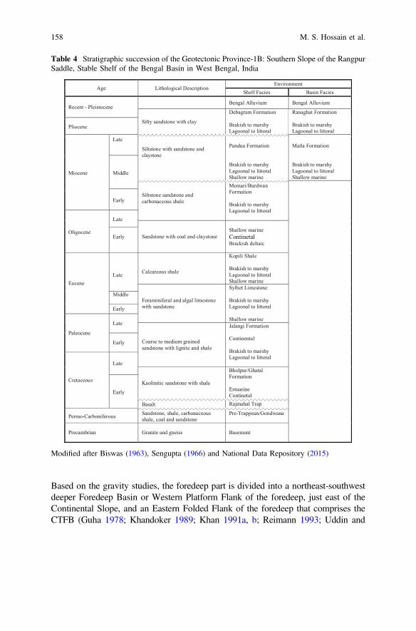
Based on the gravity studies, the foredeep part is divided into a northeast-southwestdeeper Foredeep Basin or Western Platform Flank of the foredeep, just east of theContinental Slope, and an Eastern Folded Flank of the foredeep that comprises theCTFB (Guha 1978; Khandoker 1989; Khan 1991a, b; Reimann 1993; Uddin and
Table 4 Stratigraphic succession of the Geotectonic Province-1B: Southern Slope of the RangpurSaddle, Stable Shelf of the Bengal Basin in West Bengal, India
Age Lithological DescriptionEnvironment
Shelf Facies Basin Facies
Recent - PleistoceneBengal Alluvium Bengal Alluvium
Silty sandstone with clay
Debagram Formation
Brakish to marshy Lagoonal to littoral
Ranaghat Formation
Brakish to marshy Lagoonal to littoral
Pliocene
Miocene
Late
Siltstone with sandstone andclaystone
Pandua Formation
Brakish to marshy Lagoonal to littoralShallow marine
Matla Formation
Brakish to marshy Lagoonal to littoralShallow marine
Middle
Siltstone sandstone andcarbonaceous shale
Memari/Burdwan Formation
Brakish to marshy Lagoonal to littoral
Early
Oligocene
Late
Sandstone with coal and claystoneShallow marineContinetalBrackish deltaic
Early
EoceneLate Calcareous shale
Kopili Shale
Brakish to marshy Lagoonal to littoralShallow marine
Foraminiferal and algal limestone with sandstone
Sylhet Limestone
Brakish to marshy Lagoonal to littoral
Shallow marine
Middle
Early
Paleocene
Late
Coarse to medium grained sandstone with lignite and shale
Jalangi Formation
Continental
Brakish to marshy Lagoonal to littoral
Early
Cretaceous
Late
Kaolinitic sandstone with shale
Bholpur/GhatalFormation
EstuarineContinetalEarly
Basalt Rajmahal Trap
Permo-Carboniferous Sandstone, shale, carbonaceous shale, coal and sandstone
Pre-Trappean/Gondwana
Precambrian Granite and gneiss Basement
Modified after Biswas (1963), Sengupta (1966) and National Data Repository (2015)
158 M. S. Hossain et al.

Tab
le5
Stratig
raph
icsuccession
oftheSu
rmabasin(northernpartof
theGeotecton
icProv
ince-2),centraldeeper
Foredeep
Basin,BengalBasin
Age
(app
rox)
Gro
upFo
rmat
ion
Lith
olog
yTh
ickn
ess
Max
(m)
Dep
ositi
onal
En
viro
nmen
tTe
cton
ic E
vent
s
Hol
ocen
e
Dih
ing
Dup
i Tila
Allu
vium
3350
Fluv
ial
Plei
stoc
ene
Dih
ing
Poor
ly c
onso
lidat
ed sa
ndst
one
and
clay
ey sa
ndst
one.
Late
Plio
cene
Upp
erD
upi T
ilaM
ediu
m to
coa
rse
ferr
ugin
ous
sand
ston
e w
ith la
yers
of q
uartz
pe
bble
s and
silts
tone
with
lig
nitic
frag
men
ts a
nd p
etrif
ied
woo
d.
Fluv
ial
Fold
ing
in th
e ea
ster
n
Ben
gal B
asin
Low
erD
upi T
ila
3500
Mid
Plio
cene
Tipa
mG
iruja
n C
lay
Cla
y an
d sil
tsto
ne.
Allu
vial
Dau
ki F
ault
Tipa
m S
ands
tone
Coa
rse-
grai
ned,
peb
bly,
cro
ss
bedd
ed sa
ndst
one.
Early
Plio
cene
Mio
cene
Surm
a
Upp
erM
arin
e Sh
ale
Shal
e.
3900
Fluv
ial
tidal
-del
taic
estu
arin
e
Shal
low
mar
ine
Upl
fit o
f the
Him
alay
as.
Oro
geny
Subd
uctio
nan
d
fold
ing
Indo
-Bur
man
Ran
ges
Bok
a B
ilD
ark
grey
pyr
ite-b
earin
g sh
ale,
sa
ndy
shal
e, si
ltsto
ne, a
nd
sand
ston
es.
Bhu
ban
Sand
ston
e an
d sa
ndy
shal
e,sit
ston
e.
Olig
ocen
eB
arai
lU
ndiff
eren
tiate
dB
arai
l
Pale
gre
y, m
ulti-
colo
ured
, fin
e gr
aine
d sa
ndst
one
and
silts
tone
, gr
ey c
arbo
nace
ous s
iltst
one
and
silty
sand
ston
e an
d sh
ale.
7200
Shal
low
mar
ine
to b
asin
al s
hale
Har
d co
llisi
on,
clos
ing
of th
e Eu
rasia
n
Teth
ys
Eoce
nePa
leoc
ene
Jain
tia
Kop
ili S
hale
Sand
ston
e, g
lauc
oniti
c sh
ale,
ca
rbon
aceo
us a
nd h
ighl
y fo
ssili
fero
us li
mes
tone
; ca
lcar
eous
sand
ston
e,
carb
onac
eous
shal
e an
d co
al
seam
s.
Shel
f edg
e
limes
tone
Soft
colli
sion
Nor
thw
ard
mov
emen
t
of In
dia
and
sea-
floor
spre
adin
g
Sylh
et L
imes
tone
Tura
San
dsto
neM
ediu
m to
coa
rse
grai
ned
grey
sa
ndst
one.
Mar
gina
l par
t of
the
shel
f
Pre-
Pale
ocen
eU
ndiff
eren
tiate
d se
dim
enta
ry
rock
s (w
ith s
ome
volc
anic
s?)
Mod
ified
afterEvans
(196
4),H
oltrop
andKeizer(197
0),Khanet
al.(198
8),H
iller
andElahi
(198
8),Khan(199
1a,b),Reimann(199
3),S
hamsudd
inet
al.
(200
1)andAlam
etal.(200
3)
Synthesis of the Tectonic and Structural Elements … 159
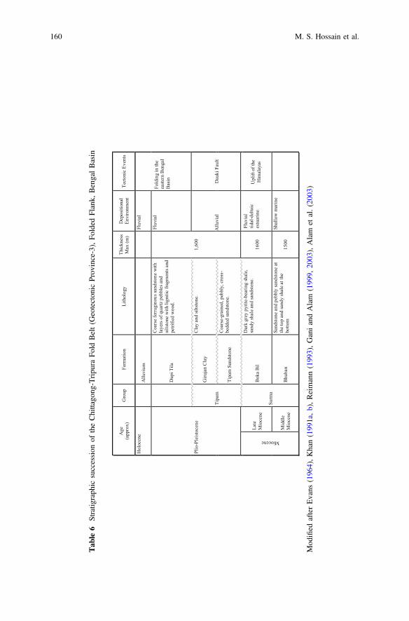
Tab
le6
Stratig
raph
icsuccession
oftheChittago
ng-Tripu
raFo
ldBelt(G
eotecton
icProv
ince-3),Fo
lded
Flank,
BengalBasin
Age
(app
rox)
Gro
upFo
rmat
ion
Lith
olog
yTh
ickn
ess
Max
(m)
Dep
ositi
onal
En
viro
nmen
tTe
cton
ic E
vent
s
Hol
ocen
e A
lluvi
um
Fluv
ial
Fold
ing
in th
e ea
ster
n B
enga
l B
asin
Plio
-Ple
isto
cene
Dup
i Tila
Coa
rse
ferr
ugin
ouss
ands
tone
with
la
yers
of q
uartz
peb
bles
and
sil
tsto
ne w
ith li
gniti
c fra
gmen
ts a
nd
petri
fied
woo
d.
1,60
0
Fluv
ial
Tipa
m
Giru
jan
Cla
y
Cla
y an
d sil
tsto
ne.
Allu
vial
D
auki
Fau
lt
Tipa
m S
ands
tone
Coa
rse-
grai
ned,
peb
bly,
cro
ss-
bedd
ed sa
ndst
one.
Miocene
Late
M
ioce
ne
Surm
a
Bok
a B
il
Dar
k gr
ey p
yrite
-bea
ring
shal
e,
sand
y sh
ale
and
sand
ston
e.
1600
Fluv
ial
tidal
-del
taic
es
tuar
ine
Upl
ift o
f the
Him
alay
as
Mid
dle
Mio
cene
B
huba
n
Sand
ston
e an
d pe
bbly
sand
ston
e at
th
e to
p an
d sa
ndy
shal
e at
the
botto
m
1500
Shal
low
mar
ine
Mod
ified
afterEvans
(196
4),Khan(199
1a,b),Reimann(199
3),GaniandAlam
(199
9,20
03),Alam
etal.(200
3)
160 M. S. Hossain et al.
Lundberg 2004). The Western Platform Flank or Foredeep Basin showssmall-amplitude, isometric or geographically equant Bouguer anomalies, whereas thefolded flank or the CTFB exhibits large-amplitude, linear or elongate Bougueranomalies (Bakhtine 1966; Uddin and Lundberg 2004). As earlier mentioned inSect. 3.1, based on the result of geophysical investigations (gravity, aeromagnetic, andseismic), field geological mappings and on well data, Bengal Basin can be divided intothree major geotectonic provinces (Fig. 1): (i) the Stable Shelf to the northwest or theGeotectonic Province 1—Passive to extensional cratonic margin, (ii) the ForedeepBasin to the center or the Geotectonic Province 2—remnant ocean basin, and(iii) Folded Flank to the east or theGeotectonic Province 3—theCTFB (Bakhtine 1966;Alam 1972; Khan and Rahman 1992; Khan and Agarwal 1993; Reimann 1993;Shamsuddin and Abdullah 1997; Alam et al. 2003). These three geotectonic provincesare synthesized in the following paragraphs.
5.1 The Stable Shelf—Geotectonic Province 1
The Stable Shelf (Fig. 4) to the northwest, also known as the Stable Pre-CambrianPlatform or Western Flank of the Bengal Basin, comprises two major tectonicelements: (i) the Foreland Shelf to the west, and (ii) the Eocene Hinge Zone or shelfbreak to the east (Bakhtine 1966; Guha 1978; Matin et al. 1983). The Bougueranomaly map of the Stable Foreland Shelf is characterized by large negativeanomalies (0 to −140 mGal), mostly related to the basement structural features(Fig. 5) (Rahman et al. 1990b; Khan and Rahman 1992). Khan and Rahman (1992)identified four tectonic zones on the basis of the trend, shape and magnitude of theBouguer gravity anomaly contours and the basement faults from the aeromagneticdata. Except the Eocene Hinge Zone, alternating gravity highs and lows with closedcontours indicate the presence of numerous graben and half-graben structures inmost of the Foreland Shelf, where Gondwana coal/sediments have been deposited(Khan 1978; Khan and Rahman 1992; Khan and Chouhan 1996).
5.1.1 The Foreland Shelf
The Foreland Shelf is characterized by the presence of complex graben system,transected by many synthetic and antithetic faults (Khan and Rahman 1992; Khanand Agarwal 1993). Based on geophysical and bore- hole data, the Foreland Shelf isdivided into four tectonic elements which are oriented approximately ENE.Towards the south, the four tectonic elements are the Himalyan Foredeep, theDinajpur Shelf, the Rangpur Saddle or the Platform Flank, and the Bogra Shelf(Fig. 4) (Bakhtine 1966; Sengupta 1966; Guha 1978; Matin et al. 1983; Khan andRahman 1992; Khan and Agarwal 1993; Reimann 1993; Guha et al. 2010).Recent GPS derived geodetic data suggest an overall very low subsidence rate(<1 mm/year) of the Foreland Shelf compared to the other geotectonic provinces of
Synthesis of the Tectonic and Structural Elements … 161

Fig. 4 Simplified tectonic map of the Geotectonic Province 1 of the Bengal Basin and itssurroundings. The tectonic element boundaries are based on Bakhtine (1966), Guha (1978) andMatin et al. (1983). Faults and lineaments are mostly taken from Kayal (2008). MBT: MainBoundary Thrust; MFT: Main Frontal Thrust
162 M. S. Hossain et al.

Fig. 5 Bouguer gravity anomaly map of Bangladesh, which covered major portion of the BengalBasin. Projection used in this map is the Lambert Conformal Conic with Everest 1969 spheroid(modified after Rahman et al. 1990b)
Synthesis of the Tectonic and Structural Elements … 163

the Bengal Basin (Reitz et al. 2015). Starting from the northernmost tectonic ele-ment, the sequential description of these tectonic elements of the foreland shelf isgiven with their tectonic evolution history. Note as the N-S oriented Rajmahal Hillsis situated outside the Basin Margin Fault Zone (Raman et al. 1986; Roy andChatterjee 2015) and at the western edge of the Foreland Shelf (Raman et al. 1986),it is not a part of the Bengal Basin.
Himalayan Foredeep
This tectonic element forms the northwestern most part of the Bengal Basin, liessouth of the Main Frontal Thrust (MFT) and is covered by the Recent to sub-Recentpiedmont plain deposits. This element is marked by the high negative Bouguergravity anomaly from −110 to −150 mGal within a short distance in the extremenorthwest of Bangladesh, and suggests noticeable thickening of basinal stratanorthward into the Siwalik foreland basin of the northeastern Himalaya (Khan andRahman 1992; Rabbani et al. 2000; Uddin and Lundberg 2004). The −110 mGalcontour near Panchagarh represents the approximate southern boundary of theHimalayan Foredeep with the Dinajpur Slope. The width of this tectonic element atthe centre is <50 km, but gradually increases towards both east and west.
The Neogene sediments consisting of sandstones, subordinate shales and clays,and gravel beds are well developed in this tectonic element and attain a thickness of3–4.5 km (Rabbani et al. 2000; Guha et al. 2010). The only well drilled in thistectonic element is located on the north-western most tip of Bangladesh atSalbanhat in Tetulia by Shell Oil Co. in 1988. The well touched the basement at2518 m depth penetrating the Mio-Pliocene sequence but did not encounter theEocene Limestone (Rabbani et al. 2000). The northern edge of this tectonic elementalong the MFT shows clear evidence of an active deformation zone as indicated byactive faulting, uplift and surface-rupture, and earthquakes (Thakur 2004). Themain deformation front related to the India-Eurasia collision slowly migratedsouthward in this zone. Two major lineaments transect the Himalayan Foredeep ofthe Bengal Basin along NW-SE direction, namely Tista and Gangtok lineaments(Chopra et al. 2013; Baruah et al. 2016).
Dinajpur Shelf/Dinajpur Slope
The Dinajpur Slope is characterized by almost E-W trending linear Bouguer gravitycontours, with values ranging between −50 and −110 mGal and sloping NNWbetween Panchagarh to the north and Nilphamari to the south (Khan and Rahman1992; Rabbani et al. 2000). The Neogene sediments are deposited in this tectoni-cally down-warped part of the Foreland Shelf, which is known as the northern slopeof the Rangpur Saddle, or Dinajpur Slope or Northern Foreland Shelf (Reimann1993) of the Bengal Basin. Although Reimann (1993) included Dinajpur Slope intothe Himalayan Foredeep, Guha et al. (2010) placed Dinajpur Slope as a separate
164 M. S. Hossain et al.
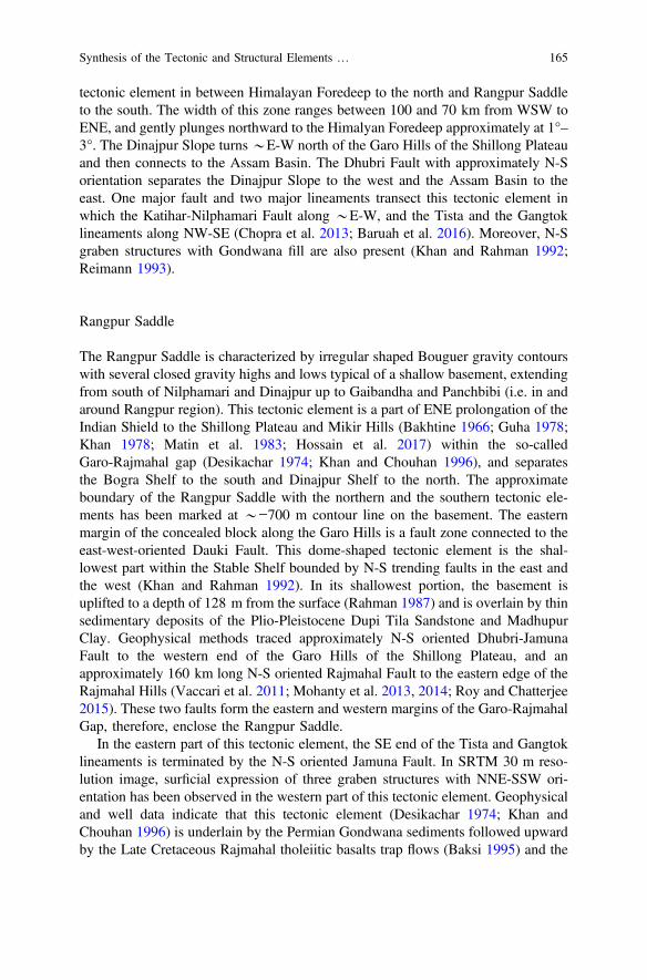
tectonic element in between Himalayan Foredeep to the north and Rangpur Saddleto the south. The width of this zone ranges between 100 and 70 km from WSW toENE, and gently plunges northward to the Himalyan Foredeep approximately at 1°–3°. The Dinajpur Slope turns *E-W north of the Garo Hills of the Shillong Plateauand then connects to the Assam Basin. The Dhubri Fault with approximately N-Sorientation separates the Dinajpur Slope to the west and the Assam Basin to theeast. One major fault and two major lineaments transect this tectonic element inwhich the Katihar-Nilphamari Fault along *E-W, and the Tista and the Gangtoklineaments along NW-SE (Chopra et al. 2013; Baruah et al. 2016). Moreover, N-Sgraben structures with Gondwana fill are also present (Khan and Rahman 1992;Reimann 1993).
Rangpur Saddle
The Rangpur Saddle is characterized by irregular shaped Bouguer gravity contourswith several closed gravity highs and lows typical of a shallow basement, extendingfrom south of Nilphamari and Dinajpur up to Gaibandha and Panchbibi (i.e. in andaround Rangpur region). This tectonic element is a part of ENE prolongation of theIndian Shield to the Shillong Plateau and Mikir Hills (Bakhtine 1966; Guha 1978;Khan 1978; Matin et al. 1983; Hossain et al. 2017) within the so-calledGaro-Rajmahal gap (Desikachar 1974; Khan and Chouhan 1996), and separatesthe Bogra Shelf to the south and Dinajpur Shelf to the north. The approximateboundary of the Rangpur Saddle with the northern and the southern tectonic ele-ments has been marked at *−700 m contour line on the basement. The easternmargin of the concealed block along the Garo Hills is a fault zone connected to theeast-west-oriented Dauki Fault. This dome-shaped tectonic element is the shal-lowest part within the Stable Shelf bounded by N-S trending faults in the east andthe west (Khan and Rahman 1992). In its shallowest portion, the basement isuplifted to a depth of 128 m from the surface (Rahman 1987) and is overlain by thinsedimentary deposits of the Plio-Pleistocene Dupi Tila Sandstone and MadhupurClay. Geophysical methods traced approximately N-S oriented Dhubri-JamunaFault to the western end of the Garo Hills of the Shillong Plateau, and anapproximately 160 km long N-S oriented Rajmahal Fault to the eastern edge of theRajmahal Hills (Vaccari et al. 2011; Mohanty et al. 2013, 2014; Roy and Chatterjee2015). These two faults form the eastern and western margins of the Garo-RajmahalGap, therefore, enclose the Rangpur Saddle.
In the eastern part of this tectonic element, the SE end of the Tista and Gangtoklineaments is terminated by the N-S oriented Jamuna Fault. In SRTM 30 m reso-lution image, surficial expression of three graben structures with NNE-SSW ori-entation has been observed in the western part of this tectonic element. Geophysicaland well data indicate that this tectonic element (Desikachar 1974; Khan andChouhan 1996) is underlain by the Permian Gondwana sediments followed upwardby the Late Cretaceous Rajmahal tholeiitic basalts trap flows (Baksi 1995) and the
Synthesis of the Tectonic and Structural Elements … 165

Cretaceous-Tertiary sediments. Near N-S oriented graben structures withGondwana fill are also indicated by the above data set (Khan and Rahman 1992).
Although the concealed basement rocks of the Rangpur Saddle and northern partof the Bogra Slope are generally considered to be an eastward subsurface contin-uation of the Indian Shield, Ameen et al. (2007, 2016) and Tapu et al. (2016)considered them as separate microcontinental blocks. Evidently diorite, tonalite andgranodiorite constitute the basement of the Rangpur Saddle, which is dissected bypegmatites and mafic/ultramafic dykes (Ameen et al. 1998; Kabir et al. 2001;Hossain et al. 2007). Based on SHRIMP Zircon U-Pb age dating, both Ameen et al.(2007) and Hossain et al. (2007) reported identical Paleoproterozoic ages 1.72, and1.73 Ga of the tonalite, and diorite from Maddhapara, respectively. A pegmatitedyke from Maddhapara has also given age similar to the host rock (1.72 Ga—basedon SHRIMP Zircon U-Pb age dating; Hossain et al. 2017). It may be mentioned thatthe undeformed tonalite/diorite pluton with age similar to 1.72 Ga has been iden-tified neither in the Chhotanagpur Granite-Gneiss Complex (CGGC) nor in theShillong Plateau. Thus, based on the 1.72 Ga age from an undeformed calc-alkalineI-type granitoid (tonalite) in Maddhapara and tentative gravity enclosure sur-rounding the region Ameen et al. (2007) and Tapu et al. (2016) suggest thatMaddhapara and surrounding diorite-tonalite basement may have constituted aPaleoproterozoic micro-continental block, which they referred to as DinajpurBlock. Few latest investigations (Chatterjee 2017; Hossain et al. 2017) however,argued that the diorite-tonalite basement of the Rangpur Saddle is a continuation ofthe Central Indian Tectonic Zone (CITZ). Nevertheless, further isotopic age datingof basement samples from different locations, detailed geochemical and structuralstudies, robust geodynamic and tectonic model related to its emplacement historyare required to check the validity of either hypothesis.
Bogra Shelf/Bogra Slope
The northern edge of the Bogra slope is characterized by the elongate close-spacedgravity contours of 0 to −30 mGa1, extending from Nawabganj to Jamalganj up toGaibandha. From south of the Nawabganj-Gaibandha up to Singra area, severalprominent closed anomaly contours are observed reflecting gravity highs and lowswithin −20 to −50 mGal range representing intra-cratonic basins, i.e. grabenstructures where Gondwana sediments deposited (Khan and Rahman 1992). Thistectonic element is also known as Southern slope of the Rangpur Saddle or theWestern Foreland Shelf of the Bengal Basin, which contains various Permian toRecent rocks, laid down on the Precambrian Basement rocks (Khan and Rahman1992; Reimann 1993). The width of this zone ranges 60–125 km from NE to SW,and gently plunges southeast to the shelf edge at 1°–3° is clearly marked by theEocene Sylhet Limestone on the seismic section (Salt et al. 1986; Reimann 1993).Seismic contours on top of the Eocene Limestone reveal a number of NE-SW
166 M. S. Hossain et al.
trending faults of which the Debagram-Bogra Fault is the most prominent (Fig. 4).Another two major faults are also present in this tectonic element and these are theNW-SE oriented Ganges-Padma Fault to the west and the N-S oriented JamunaFault to the east. Recent GPS derived geodetic data suggest an overall very lowsubsidence rate of less than 1 mm/year in the area (Reitz et al. 2015). The BograSlope (Fig. 4) turns approximately E-W near the Garo Hills of the Shillong Plateauand then traverses along the southern slope of the plateau towards the Khasi andJaintia Hills and reaches up to the southern fringe of the Mikir Hills. This tectonicelement started developing at the time of rifting of the Gondwana during theCarboniferous-Permian when graben and half-graben structures were formed, fol-lowed by the drifting of the East Gondwana from the remainder during theJurassic-Cretaceous. The later event results the Rajmahal lava flows and formed theRajmahal Trap, which crops out in the Rajmahal Hills. From the Late Cretaceous toEocene, carbonate sediments deposited at the lower edge of the shelf, whereasarenaceous sediment were deposited at the upper edge (Reimann 1993).
5.1.2 Eocene Hinge Zone
This zone is also known as shelf break or paleo-continental slope or trace of theEocene shelf edge (Bakhtine 1966; Sengupta 1966; Bender 1983; Matin et al. 1983;Rahman et al. 1990a; Reimann 1993; Uddin and Lundberg 2004; Singh et al. 2016)and lies between the Stable Shelf/Foreland Shelf to the west and the Foredeep Basinto the east. This tectonic element is characterized by almost ENE-WSW trendinglinear Bouguer gravity contours, with values ranging approximately between −30 to−15 mGal and sloping towards southeast (Khan and Rahman 1992). Precambrianbasement rock dips southeast abruptly from 2°–3° to 6°–12° at the contact of thestable platform and the Eocene Hinge Zone to the west, and then dips more gently1°–2° again in the southeast at the contact of the Hinge Zone and deeper foredeepbasin to the east (Uddin and Lundberg 2004). At its upper northwestern edge, therecorded seismic depth on top of the Eocene Sylhet Limestone is 3500 m, whereasat its lower southeastern edge, the recorded seismic depth on top of the samelimestone is 5000 m. Although Sengupta (1966) and Khandoker (1989) named thisNNE-SSW running narrow 25–100 km Hinge zone as the ‘Calcutta–Mymensinghgravity high’, more recent data (Khan and Agarwal 1993) suggest that this term isto some extent confusing and named more appropriately as Shelf-Break (Uddin andLundberg 2004; Roy and Chatterjee 2015). Although it is usually shown to truncateagainst the Dauki Fault in the northeast, the other school of thoughts suggest thatthe Hinge Zone progressively convexes basin-ward to the northeast and then passessomewhere through the northern end of the Surma basin and possibly continuestowards the Haflong Thrust at the northeastern corner of the Bengal Basin (Alamet al. 2003).
The Eocene Hinge Zone marks the structural as well as depositional transitionbetween central foredeep basin to the southeast and stable shelf to the northwest.This tectonic element possibly marks the transition from the thick continental crust
Synthesis of the Tectonic and Structural Elements … 167
(west) to extended thinned crust of the continental margin (east) (Singh et al. 2016).Eocene Sylhet Limestone, the most prominent seismic reflector of the Bengal Basinhas been interpreted to imply this shelf break (Reimann 1993). However, results ofthe recent seismic investigations suggest NE alignment of this Hinge Zone up to90° 40′E and 25° 15′N, where the E-W oriented Dauki Fault presumably truncatesthis structural element. More towards east, this paleo-continental slope is not rec-ognizable even in the deeper seismic section (6 s TWT). This probably indicatesthat the southern portion of the shelf as well as slope are downthrown by the DaukiFault and now hidden under the thick pile of the Neogene sediments deposited inthe northern part of the Surma basin (Salt et al. 1986). Although significant increaseof sedimentary thickness from *3 to *17 km is noticed across the Hinge Zone(west to east), the crust thins from 38 km at the Indian Craton to 34 km at the HingeZone to 16–19 km at the central deeper foredeep basin (Singh et al. 2016). Suchthickness of crust at the central deeper foredeep basin may result from igneousactivity related to the Kerguelen Plume at the time of rifting (Ray et al. 2005; Singhet al. 2016).
5.2 The Foredeep Basin—Geotectonic Province 2
The central deeper Foredeep Basin or the Western Platform Flank occupies thehuge area between the Eocene Hinge Zone to the west, the Shillong Plateau to thenorth, and the CTFB to the east. This deeper foredeep basin is approximately200 km wide to the north, narrowed at the middle, and then gradually widens toabout 500 km to the south, shows an overall NE trend (Fig. 6) (Reimann 1993).The basin shows small-amplitude, isometric or geographically equant Bouguergravity anomalies (Bakhtine 1966; Uddin and Lundberg 2004). The deeper fore-deep basin is a mosaic of few sub-basins (lows) and buried highs/ridges. Thisdeeper foredeep basin narrowed north-eastward by the Madhupur High in west andthe Tripura Uplift in the east, and broadly divides the basin into two parts. The ovalshaped Surma basin occupies the northern part of the deeper foredeep basinwhereas southern part is known as southern sub-basin. A NE-SW trending gravityand magnetic anomaly known as the Barisal-Chandpur High separates the southernpart of the deeper foredeep basin into another two sub-basins, the Faridpur Troughin the west and the Hatia Trough in the east (Alam 1972; Das Gupta 1977; Guha1978; Reimann 1993). The deeper foredeep basin, therefore, can be divided into sixtectonic elements, and from the north to the south these are the Surma basin/SylhetTrough, the Madhupur-Tripura High/Tangail-Tripura High, the Faridpur Trough,the Barisal-Chandpur High, the Hatia Trough, and the Bay of Bengal (Fig. 6)(Bakhtine 1966; Guha 1978; Mirkhamidov and Mannan 1981; Matin et al. 1983;Uddin and Lundberg 1999; Mukherjee et al. 2009).
168 M. S. Hossain et al.
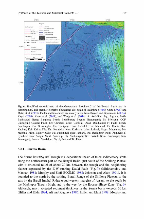
5.2.1 Surma Basin
The Surma basin/Sylhet Trough is a depositional basin of thick sedimentary strataalong the northeastern part of the Bengal Basin, just south of the Shillong Plateauwith a structural relief of about 20 km between the trough and the neighboringplateau separated by the E-W running Dauki Fault (Fig. 7) (Mirkhamidov andMannan 1981; Murphy and Staff BOGMC 1988; Johnson and Alam 1991). It isbounded to the north by the striking Barail Range of the Shillong Plateau, to theeast by the Barail-Imphal Ridge (southwestern margin) of Assam, to the south bythe Madhupur-Tripura High, and to the west by the Eocene Hinge Zone (Fig. 6).Although, much accepted sediment thickness in the Surma basin exceeds 20 km(Hiller and Elahi 1984; Ali and Raghava 1985; Hiller and Elahi 1988; Murphy and
Fig. 6 Simplified tectonic map of the Geotectonic Province 2 of the Bengal Basin and itssurroundings. The tectonic elements boundaries are based on Bakhtine (1966), Guha (1978) andMatin et al. (1983). Faults and lineaments are mostly taken from Biswas and Grasemann (2005a),Kayal (2008), Khan et al. (2011), and Wang et al. (2014). A: Anticline; Atg: Atgram; Bakh:Bakhrabad; Bang: Bangora; Beani: Beanibazar; Begum: Begumganj; Bi: Bibiyana; CCF:Chittagong Coastal Fault; Ch: Chhatak; Com: Comilla; Daud: Daudkandi; F: Fault; Fench:Fenchuganj; Go: Gowainghat; Ha: Habiganj; Haka: Hakaluki; Ja: Jalalabad; Ka: Kamta; Kac:Kachua; Kai: Kailas Tila; Ku: Kutubdia; Kus: Kushiara; Lalm: Lalmai; Magn: Magnama; Me:Meghna; Moul: Moulvibazar; Na: Narsingdi; Path: Patharia; Ra: Rashidpur; Rajn: Rajnagar; S:Syncline; San: Sangu; Sand: Sandwip; Sh: Shahbazpur; Sri: Srikail; Srim: Srimangal; Sun:Sunamganj; Sundal: Sundalpur; Sy: Sylhet and Ti: Titas
Synthesis of the Tectonic and Structural Elements … 169

Fig.7
Schematic
cross-sectionacross
theBengalBasin
andits
surrou
ndings
(drawnapprox
imatelyN-S
alon
gthelin
eAB
asshow
nin
Fig.
1)(m
odified
afterMurph
yandStaffof
BOGMC
1988
;BOGMC
1997
andWebbet
al.20
13)
170 M. S. Hossain et al.
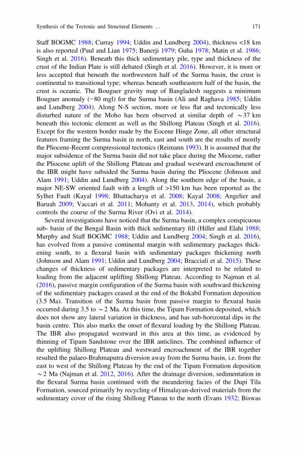
Staff BOGMC 1988; Curray 1994; Uddin and Lundberg 2004), thickness <18 kmis also reported (Paul and Lian 1975; Banerji 1979; Guha 1978; Matin et al. 1986;Singh et al. 2016). Beneath this thick sedimentary pile, type and thickness of thecrust of the Indian Plate is still debated (Singh et al. 2016). However, it is more orless accepted that beneath the northwestern half of the Surma basin, the crust iscontinental to transitional type; whereas beneath southeastern half of the basin, thecrust is oceanic. The Bouguer gravity map of Bangladesh suggests a minimumBouguer anomaly (−80 mgl) for the Surma basin (Ali and Raghava 1985; Uddinand Lundberg 2004). Along N-S section, more or less flat and tectonically lessdisturbed nature of the Moho has been observed at similar depth of *37 kmbeneath this tectonic element as well as the Shillong Plateau (Singh et al. 2016).Except for the western border made by the Eocene Hinge Zone, all other structuralfeatures framing the Surma basin in north, east and south are the results of mostlythe Pliocene-Recent compressional tectonics (Reimann 1993). It is assumed that themajor subsidence of the Surma basin did not take place during the Miocene, ratherthe Pliocene uplift of the Shillong Plateau and gradual westward encroachment ofthe IBR might have subsided the Surma basin during the Pliocene (Johnson andAlam 1991; Uddin and Lundberg 2004). Along the southern edge of the basin, amajor NE-SW oriented fault with a length of >150 km has been reported as theSylhet Fault (Kayal 1998; Bhattacharya et al. 2008; Kayal 2008; Angelier andBaruah 2009; Vaccari et al. 2011; Mohanty et al. 2013, 2014), which probablycontrols the course of the Surma River (Ovi et al. 2014).
Several investigations have noticed that the Surma basin, a complex conspicuoussub- basin of the Bengal Basin with thick sedimentary fill (Hiller and Elahi 1988;Murphy and Staff BOGMC 1988; Uddin and Lundberg 2004; Singh et al. 2016),has evolved from a passive continental margin with sedimentary packages thick-ening south, to a flexural basin with sedimentary packages thickening north(Johnson and Alam 1991; Uddin and Lundberg 2004; Bracciali et al. 2015). Thesechanges of thickness of sedimentary packages are interpreted to be related toloading from the adjacent uplifting Shillong Plateau. According to Najman et al.(2016), passive margin configuration of the Surma basin with southward thickeningof the sedimentary packages ceased at the end of the Bokabil Formation deposition(3.5 Ma). Transition of the Surma basin from passive margin to flexural basinoccurred during 3.5 to*2 Ma. At this time, the Tipam Formation deposited, whichdoes not show any lateral variation in thickness, and has sub-horizontal dips in thebasin centre. This also marks the onset of flexural loading by the Shillong Plateau.The IBR also propagated westward in this area at this time, as evidenced bythinning of Tipam Sandstone over the IBR anticlines. The combined influence ofthe uplifting Shillong Plateau and westward encroachment of the IBR togetherresulted the palaeo-Brahmaputra diversion away from the Surma basin, i.e. from theeast to west of the Shillong Plateau by the end of the Tipam Formation deposition*2 Ma (Najman et al. 2012, 2016). After the drainage diversion, sedimentation inthe flexural Surma basin continued with the meandering facies of the Dupi TilaFormation, sourced primarily by recycling of Himalayan-derived materials from thesedimentary cover of the rising Shillong Plateau to the north (Evans 1932; Biswas
Synthesis of the Tectonic and Structural Elements … 171
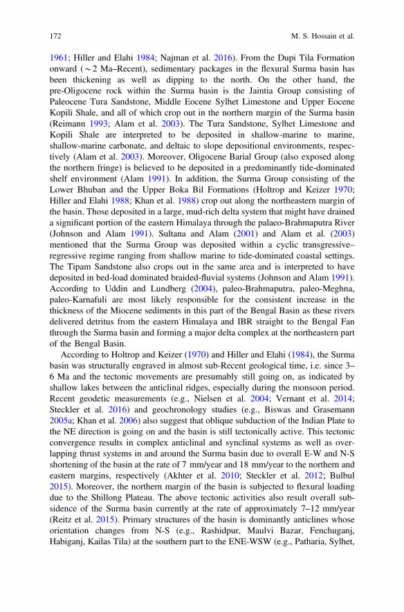
1961; Hiller and Elahi 1984; Najman et al. 2016). From the Dupi Tila Formationonward (*2 Ma–Recent), sedimentary packages in the flexural Surma basin hasbeen thickening as well as dipping to the north. On the other hand, thepre-Oligocene rock within the Surma basin is the Jaintia Group consisting ofPaleocene Tura Sandstone, Middle Eocene Sylhet Limestone and Upper EoceneKopili Shale, and all of which crop out in the northern margin of the Surma basin(Reimann 1993; Alam et al. 2003). The Tura Sandstone, Sylhet Limestone andKopili Shale are interpreted to be deposited in shallow-marine to marine,shallow-marine carbonate, and deltaic to slope depositional environments, respec-tively (Alam et al. 2003). Moreover, Oligocene Barial Group (also exposed alongthe northern fringe) is believed to be deposited in a predominantly tide-dominatedshelf environment (Alam 1991). In addition, the Surma Group consisting of theLower Bhuban and the Upper Boka Bil Formations (Holtrop and Keizer 1970;Hiller and Elahi 1988; Khan et al. 1988) crop out along the northeastern margin ofthe basin. Those deposited in a large, mud-rich delta system that might have draineda significant portion of the eastern Himalaya through the palaeo-Brahmaputra River(Johnson and Alam 1991). Sultana and Alam (2001) and Alam et al. (2003)mentioned that the Surma Group was deposited within a cyclic transgressive–regressive regime ranging from shallow marine to tide-dominated coastal settings.The Tipam Sandstone also crops out in the same area and is interpreted to havedeposited in bed-load dominated braided-fluvial systems (Johnson and Alam 1991).According to Uddin and Lundberg (2004), paleo-Brahmaputra, paleo-Meghna,paleo-Karnafuli are most likely responsible for the consistent increase in thethickness of the Miocene sediments in this part of the Bengal Basin as these riversdelivered detritus from the eastern Himalaya and IBR straight to the Bengal Fanthrough the Surma basin and forming a major delta complex at the northeastern partof the Bengal Basin.
According to Holtrop and Keizer (1970) and Hiller and Elahi (1984), the Surmabasin was structurally engraved in almost sub-Recent geological time, i.e. since 3–6 Ma and the tectonic movements are presumably still going on, as indicated byshallow lakes between the anticlinal ridges, especially during the monsoon period.Recent geodetic measurements (e.g., Nielsen et al. 2004; Vernant et al. 2014;Steckler et al. 2016) and geochronology studies (e.g., Biswas and Grasemann2005a; Khan et al. 2006) also suggest that oblique subduction of the Indian Plate tothe NE direction is going on and the basin is still tectonically active. This tectonicconvergence results in complex anticlinal and synclinal systems as well as over-lapping thrust systems in and around the Surma basin due to overall E-W and N-Sshortening of the basin at the rate of 7 mm/year and 18 mm/year to the northern andeastern margins, respectively (Akhter et al. 2010; Steckler et al. 2012; Bulbul2015). Moreover, the northern margin of the basin is subjected to flexural loadingdue to the Shillong Plateau. The above tectonic activities also result overall sub-sidence of the Surma basin currently at the rate of approximately 7–12 mm/year(Reitz et al. 2015). Primary structures of the basin is dominantly anticlines whoseorientation changes from N-S (e.g., Rashidpur, Maulvi Bazar, Fenchuganj,Habiganj, Kailas Tila) at the southern part to the ENE-WSW (e.g., Patharia, Sylhet,
172 M. S. Hossain et al.

Jalalabad, Atgram) to the middle-eastern part (Fig. 6). Most of these anticlines areplunging to the north. To the northern part of the basin, the anticlines showapproximately E-W oriented Type 1 folding (e.g., Chhatak, Gobamura, Dupi Tila)probably due to two sets of compressional forces, i.e. shortening direction one isN-S and the other is E-W, acting simultaneously (Biswas and Grasemann 2005b;Ovi et al. 2014). Some of these anticlines are fault controlled (Sikder and Alam2003; Steckler et al. 2008; Najman et al. 2012), and few of them are dissected bythe approximately N-S and E-W oriented faults (Hiller and Elahi 1984). The Surmabasin has been studied extensively as a result of successful hydrocarbon explo-rations (Holtrop and Keizer 1970; Woodside 1983; Shamsuddin 1989; Chowdhuryet al. 1996; Khanam et al. 2017). Anticlinal structures are the principal type ofhydrocarbon trap in the Surma basin (Lietz and Kabir 1982). The Miocene toearly-Pliocene shales up to a depth of 4.5 km are the source of gas/condensateaccumulated in the sandstone of the Bhuban and Bokabil Formations (Shamsuddin1989).
5.2.2 Madhupur-Tripura High
The Madhupur High to west and the Tripura Uplift to the east are connected by athreshold known as the Madhupur-Tripura High/Tangail-Trupura Uplift. This sepa-rates the Surma basin to the north and the Faridpur Trough to the southwest(Mirkhamidov and Mannan 1981; Reimann 1993; Guha et al. 2010). The MadhupurHigh, aligned approximately NW-SE, forms the south-western margin of the Surmabasin which is the northernmost sub-basin of the Bengal Foredeep. The MadhupurHigh is a Pleistocene Terrace (Morgan and McIntire 1959), which represents slightlyundulated and elevated topography from the adjacent flood plains, and is an exposedQuaternary interfluve between two pathways for the Brahmaputra River. Gravity andaero-magnetic data suggest that the basement is relatively uplifted beneath this area(Reimann 1993; Guha et al. 2010). Dissection of the initial Madhupur High is resultedfrom the Late Pleistocene monsoon climatic episodes that caused a tremendous cur-rent flow over the plain (Monsur 1995). According toGuha et al. (2010), the Nagarpurdome and the Nandina high are considered as protrusions from the basement withoutdeforming the overlying sedimentary packages above this tectonic element. Althoughits upper part is heavily eroded, the crests of the hill keep flat surfaces which are gentlytilted to the east (CDMP II 2013). A series of en-echelon faults, known as theMadhupur Fault flanks the western side of the uplifted Madhupur High/MadhupurTract. These en-echelon faulting resulted either from torsion of the region, possibly asrotational faulting (Mukherjee and Khonsari 2017) or from the effect of shear (e.g.,Mukherjee 2014a) along an assumed blind fault or possibly a combination of both(Morgan andMcIntire 1959). The upliftment of theMadhupurHighmay have exerteda significant control over the avulsion history of the Brahmaputra/Jamuna River. Thisavulsion history is cyclic, with a periodicity of*1800 years, and the position of theBrahmaputra has fluctuated between east and west of the Madhupur High (Pickeringet al. 2014). It is assumed that the Holocene Brahmaputra avulsion history, to some
Synthesis of the Tectonic and Structural Elements … 173

extent, is related to competition between tectonic deformation and transverse sedi-ment input (Grimaud et al. 2017). Therefore, any future seismicity can cause riveravulsions and related flooding (Reitz et al. 2012; Hossain et al. 2015). However, GPSderived geodetic data suggest an overall very low subsidence rate (<1 mm/year) fortheMadhupur High (Reitz et al. 2015) compared to the other parts of the centre deeperforedeep basin.Moreover, Pickering et al. (2017) claimed that theMadhupurHigh as aterrace is resulted from the highstand floodplain deposition of eustasy-driven cycles,and subsequent lowstand exposure and weathering as well as active tectonics.
Though Madhupur High/Tract is popularly known and accepted to be aPleistocene Terrace, but based on the morphology of the tract and other geomorphicsignatures (e.g., relief features, river morphology, and river incision), the authors ofthis chapter assume that this Tract is the expression of a buried anticline. However,as the uplift did not expose the older bedrocks (open fold), the younger sedimentsare very soft to survive, and the structure is very young in age, this anticline is notso pronounced. Moreover, the Madhupur High is located just immediate west of theeastern deformation front. Such close proximity to the active deformation frontjustifies the possibility of a tectonically developing young subsurface anticlinewhose surficial expression is known as Madhupur High.
On the other hand, the Tripura Uplift/High forms a topographically high zone fromwhere the terrain slopes northward aswell as southward, as characterized by the natureof drainage network of the region. However, overall decreasing trend of the elevationis towards west. Beneath the Agartala region, a dome-shaped structure has beenrecognized based on seismic survey (Ganguly 1993), suggesting that the areaup-arched (Das et al. 2011b). Thewestern part of the TripuraHigh occupies the frontalfold belt of the CTFB, comprises of sedimentary rocks with linear ridges and basinsresulting due to E-W convergence between the Indian Plate and the Burmese Plate(Desikachar 1974; Ganguly 1984; Nandy 2001). As this part of the tectonic element isconsiderably young both in terms of geology and tectonics (Das et al. 2011b), hence itis likely to exhibit more prominent morphological expressions due to continuedtectonics. The region is characterized by a series of approximately N-S orientedsub-parallel, elongated, doubly plunging folds exhibiting an arcuate shape with mildwestward convexity (Ganguly 1993). The Tripura High mostly comprising theAkhaura Terrace, is primarily deeply dissected by valleys running out of the adjoininghills (Brammer 2012, 2014). It also exhibits complex mixture of uplifted terrace andpiedmont, anticlines, synclines, and river floodplains. Overall, the Madhupur High tothewest and the TripuraHigh to the east together form a threshold region known as theMadhupur-Tripura High tectonic element to the south of the Surma basin and thenortheast of the Faridpur Trough (Figs. 5 and 6).
5.2.3 Faridpur Trough
The Faridpur Trough/Patuakhali depression (Mirkhamidov and Mannan 1981),located southeast of the Hinge Zone, is characterised by a general gravity low of <−20 (Ali and Raghava 1985; GSB, 1980) with development of the Neogene
174 M. S. Hossain et al.
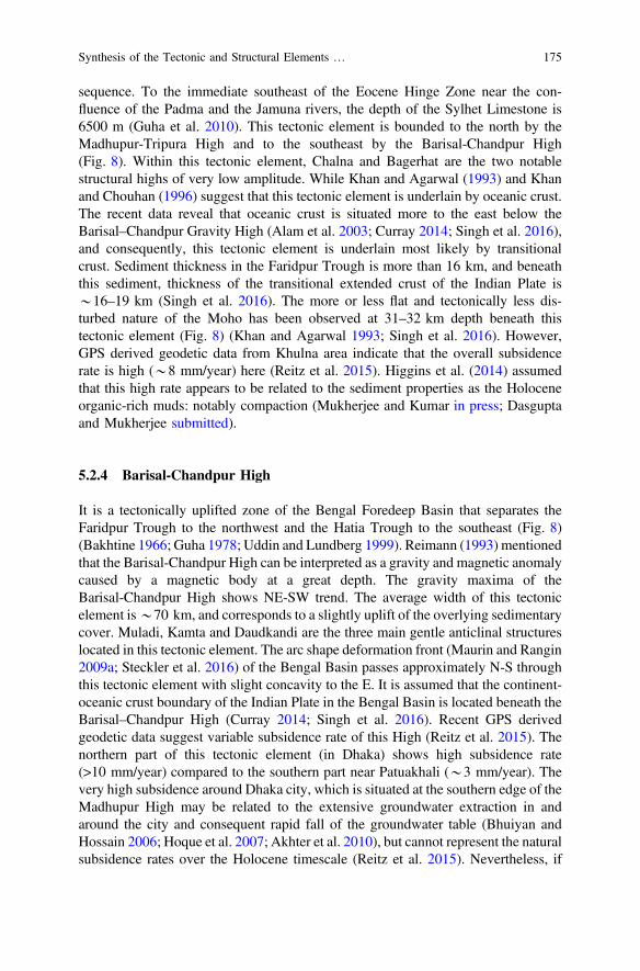
sequence. To the immediate southeast of the Eocene Hinge Zone near the con-fluence of the Padma and the Jamuna rivers, the depth of the Sylhet Limestone is6500 m (Guha et al. 2010). This tectonic element is bounded to the north by theMadhupur-Tripura High and to the southeast by the Barisal-Chandpur High(Fig. 8). Within this tectonic element, Chalna and Bagerhat are the two notablestructural highs of very low amplitude. While Khan and Agarwal (1993) and Khanand Chouhan (1996) suggest that this tectonic element is underlain by oceanic crust.The recent data reveal that oceanic crust is situated more to the east below theBarisal–Chandpur Gravity High (Alam et al. 2003; Curray 2014; Singh et al. 2016),and consequently, this tectonic element is underlain most likely by transitionalcrust. Sediment thickness in the Faridpur Trough is more than 16 km, and beneaththis sediment, thickness of the transitional extended crust of the Indian Plate is*16–19 km (Singh et al. 2016). The more or less flat and tectonically less dis-turbed nature of the Moho has been observed at 31–32 km depth beneath thistectonic element (Fig. 8) (Khan and Agarwal 1993; Singh et al. 2016). However,GPS derived geodetic data from Khulna area indicate that the overall subsidencerate is high (*8 mm/year) here (Reitz et al. 2015). Higgins et al. (2014) assumedthat this high rate appears to be related to the sediment properties as the Holoceneorganic-rich muds: notably compaction (Mukherjee and Kumar in press; Dasguptaand Mukherjee submitted).
5.2.4 Barisal-Chandpur High
It is a tectonically uplifted zone of the Bengal Foredeep Basin that separates theFaridpur Trough to the northwest and the Hatia Trough to the southeast (Fig. 8)(Bakhtine 1966; Guha 1978; Uddin and Lundberg 1999). Reimann (1993) mentionedthat the Barisal-Chandpur High can be interpreted as a gravity and magnetic anomalycaused by a magnetic body at a great depth. The gravity maxima of theBarisal-Chandpur High shows NE-SW trend. The average width of this tectonicelement is*70 km, and corresponds to a slightly uplift of the overlying sedimentarycover. Muladi, Kamta and Daudkandi are the three main gentle anticlinal structureslocated in this tectonic element. The arc shape deformation front (Maurin and Rangin2009a; Steckler et al. 2016) of the Bengal Basin passes approximately N-S throughthis tectonic element with slight concavity to the E. It is assumed that the continent-oceanic crust boundary of the Indian Plate in the Bengal Basin is located beneath theBarisal–Chandpur High (Curray 2014; Singh et al. 2016). Recent GPS derivedgeodetic data suggest variable subsidence rate of this High (Reitz et al. 2015). Thenorthern part of this tectonic element (in Dhaka) shows high subsidence rate(>10 mm/year) compared to the southern part near Patuakhali (*3 mm/year). Thevery high subsidence around Dhaka city, which is situated at the southern edge of theMadhupur High may be related to the extensive groundwater extraction in andaround the city and consequent rapid fall of the groundwater table (Bhuiyan andHossain 2006; Hoque et al. 2007; Akhter et al. 2010), but cannot represent the naturalsubsidence rates over the Holocene timescale (Reitz et al. 2015). Nevertheless, if
Synthesis of the Tectonic and Structural Elements … 175

Fig.8
Schematic
cross-sectionacross
theBengalBasin
andits
surrou
ndings
(drawnapprox
imatelyW-E
alon
gthelin
eXY
asshow
nin
Fig.
1)(m
odified
afterMurph
yandStaffof
BOGMC
1988
;BOGMC
1997
;MaurinandRangin20
09aandWanget
al.20
14)
176 M. S. Hossain et al.

such high rate of subsidence continues, channel steering behavior (Reitz et al. 2015)is most likely going to occur in near future around the Dhaka city. However, based onthe study of the Synthetic Aperture Radar (SAR) images, Higgins et al. (2014) pointsout that the ground subsidence in and around Dhaka varies significantly, and appearsto be related to the sediment properties with the lowest rates observed in thePleistocene Madhupur Clay and the highest rates in Holocene organic-rich muds.Within the city, the subsidence rate ranges 0 to >10 mm/year, and outside the city thesubsidence rate ranges 0 to >18 mm/year.
5.2.5 Hatia Trough
The Hatia Trough of the Bengal Basin is located in the southeastern part of thebasin and forms the outermost part of the west-propagating CTFB, situated inbetween CTFB to the east and the Barisal-Chandpur High to the west (Fig. 6). Thebase of this tectonic element is formed by oceanic crust of the Indian Plate (Khanand Chouhan 1996; Curray 2014; Singh et al. 2016). This tectonic element rep-resents the deepest trough of the Bengal Foredeep Basin and has received thehighest accretion of clastic sediments. Sediment thickness in the Hatia Troughexceeds 18 km, and beneath this sediment, the Indian Plate is not more than 16 kmthick (Singh et al. 2016). As pointed by Najman et al. (2016), the Himalaya formsthe dominant source for the Late Neogene-Recent sediments in the Hatia Trough.Small amount of arc-derived sediments from the Trans-Himalaya or PaleogeneIndo-Burman Ranges are also reported. Data from the Shahbazpur 1 well in theHatia Trough indicate the presence of more than 2000 m of Plio-Pliestocene sed-iments overlain by 480 m thick Holocene sediments (Alam et al. 2003). As inFaridpur Trough, the more or less flat and tectonically less disturbed Moho has alsobeen observed at 31–32 km depth beneath this tectonic element (Khan and Agarwal1993; Singh et al. 2016). Guha et al. (2010) claimed that the axis of the BengalForedeep runs through the apex of this tectonic element. Char Kajal, Shahbazpur,Kutubdia/Magnama, Sangu and a number offshore anticlinal structures are locatedin this tectonic element, of which Sangu and Shahbazpur yield hydrocarbons.Recently obtained GPS derived geodetic data suggest variable subsidence rate forthe Hatia Trough (Reitz et al. 2015). The northern onshore part of this tectonicelement (in Raipur, Noakhali) shows lower subsidence rate (*3 mm/year) than thesouthern offshore part far from the Magnama structure (*5 mm/year).
5.2.6 Bay of Bengal
The Bay of Bengal is the northeastern lobe of the Indian Ocean (Curray 2014)bordered to the west and the north by the passive continental margin of the Indianeast coast and southern edge of the Bengal Basin, respectively (Fig. 2). It is bor-dered by the oblique subduction zone between the Indian Plate to the west and theBurmese/Sunda Plate to the east, and extends into the northernmost part of the
Synthesis of the Tectonic and Structural Elements … 177
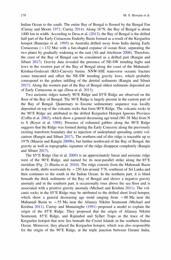
Indian Ocean to the south. The entire Bay of Bengal is floored by the Bengal Fan(Curray and Moore 1971; Curray 2014). Along 16°N, the Bay of Bengal is about1400 km in width. According to Desa et al. (2013), the Bay of Bengal is the driftedhalf part of the Early Cretaceous Enderby Basin formed as a result of the Kerguelenhotspot (Banerjee et al. 1995) as Australia drifted away from India during EarlyCretaceous (*132 Ma) with a fan-shaped expanse of ocean floor, separating thetwo plates by gradually widening to the east (Ali and Aitchison 2008). Therefore,the crust of the Bay of Bengal can be considered as a drifted part (Rangin andSibuet 2017). Gravity data revealed the presence of NE-SW trending highs andlows in the western part of the Bay of Bengal along the coast of the Mahanadi-Krishna-Godavari (KG)-Cauvery basins. NNW-SSE transverse oceanic fracturezones truncated and offset the NE-SW trending gravity lows, which probablycorrespond to the graben infilling of the detrital sediments (Rangin and Sibuet2017). Along the western part of the Bay of Bengal oldest sediments deposited areof Early Cretaceous in age (Desa et al. 2013).
Two aseismic ridges namely 90°E Ridge and 85°E Ridge are observed on thefloor of the Bay of Bengal. The 90°E Ridge is largely present in the eastern part ofthe Bay of Bengal. Quaternary to Eocene sedimentary sequence was locallydeposited on top of the volcanic rocks that form 90°E Ridge. The volcanic rocks inthe 90°E Ridge are attributed to the drifted Kerguelen Hotspot Igneous Province(Coffin et al. 2002), which show a general decreasing age trend (90–38 Ma) from Nto S (Royer et al. 1988). Presence of exhumed gabbro along the 90°E Ridgesuggests that the Ridge was formed during the Early Cenozoic along the previouslyexisting transform boundary due to injection of underplated spreading centre vol-canism (Rangin and Sibuet 2017). The northern end of this ridge is traceable up to19°N (Maurin and Rangin 2009b), but further northward of the Bay of Bengal, thegravity as well as topographic signature of the ridge disappear completely (Ranginand Sibuet 2017).
The 85°E Ridge (Sar et al. 2009) is an approximately linear and aseismic ridgewest of the 90°E Ridge, and named for its near-parallel strike along the 85°Emeridian (Fig. 2) (Bastia et al. 2010). The ridge extends from the Mahanadi Basinin the north, shifts westwards by*250 km around 5°N, southeast of Sri Lanka andthen continues to the south in the Indian Ocean. In the northern part, it is blindbeneath the thick sediments of the Bay of Bengal and shows a negative gravityanomaly and in the southern part, it occasionally rises above the sea floor and isassociated with a positive gravity anomaly (Michael and Krishna 2011). The vol-canic rocks in the 85°E Ridge may be attributed to the drifted short lived hotspot,which show a general decreasing age trend ranging from *80 Ma near theMahanadi Basin to *55 Ma near the Afanasy Nikitin Seamount (Michael andKrishna 2011). Curray and Munasinghe (1991) proposed a model to explain theorigin of the 85°E Ridge. They proposed that the origin of Afanasy NikitinSeamount, 85°E Ridge, and Rajmahal and Sylhet Traps as the trace of theKerguelen hotspot that now lies beneath the Crozet Islands in the southern IndianOcean. Moreover, they placed the Kerguelen hotspot, which was also responsiblefor the origin of the 90°E Ridge, at the triple junction between Greater India,
178 M. S. Hossain et al.

Australia, and Antarctica before the breakup of eastern Gondwana at *120 Ma.Based on marine magnetic data combining with petrology, seismic reflection, deepseismic sounding, and magnetic information of the Bengal Basin, Talwani et al.(2016) also suggest that Afanasy Nikitin Seamount, 85°E Ridge, and Rajmahal andSylhet Traps are related to the Kerguelen hotspot activity. Two sets of oceanicfracture zones have been found in the Bay of Bengal. The oldest fractures aretransform faults with orientation S50–S60°E, are considered to be of EarlyCretaceous, and occured during an early spreading episode. The youngest fracturesare submeridian and resulted from the northward drift of the Indian Plate since theend of the Mesozoic (Maurin and Rangin 2009a). Moreover, between 20° and18°N, the tilted clastic sequences dip southwest and are truncated by the dominantNE-SW trending listric normal faults (Rangin and Sibuet 2017). It is more or lesswell established that the basement in the northern part of the Bay of Bengal is ofoceanic crust. However, Sibuet et al. (2016) and Rangin and Sibuet (2017) arguedthat the crust in the northern Bay of Bengal is thinned continental in nature intrudedby volcanic products linked to the passage of the Kerguelen hotspot after thecontinental rifting of the northern Bay of Bengal. The Moho is *15 km deep at thenorthernmost part of the Bay of Bengal, and it gradually goes deeper to *37 kmbelow the northern edge of the Bengal Basin (Singh et al. 2016).
In the Bay of Bengal, another major geomorphic unit is observed known as theSwatch of No Ground (SoNG) (Fig. 2), an active submarine canyon represents thepresent submarine drainage system of the Bay of Bengal (Curray et al. 2003). Itserves as a point source for one of the major active fan valley deposits into the Bayof Bengal/Bengal Fan. In the northern end, the head of the canyon lies in shallowwater depth (*38 m) at 21° 27′N, 89° 41′E, and then continues south for 160 kmas a long, straight trough with an average gradient of 8.2 m/km. At *20°12′N and89° 12′E, it reaches *1400 m depth. At midshelf, the broad U-shaped trough has awidth of *20 km from rim to rim, and below 862 m from the rims, the width is8 km (Curray et al. 2003). The canyon continues to the south as an active channeland reaches as far as the 0° latitude (Curray 2014). The location of the mouth of thiscanyon is presumably related to the confluence of the Ganges and the Brahmaputrarivers during the last glacial low stand sea level, because an active submarinecanyon is related to river mouth migrations, sedimentation, and the Quaternary sealevel fluctuations. Due to sea level rise, the confluence of the Ganges and theBrahmaputra rivers shifted *90 km further east, therefore, the canyon receivesvery little sediments at present (Curray et al. 2003). Currently, the turbidity currentsgenerated within the SoNG are relatively small, and reach only to the middleBengal Fan, due to present highstand sea level (Curray et al. 2003; Curray 2014).Besides, large influx of sediments mainly from Himalaya and to some extent fromthe Indian peninsula is transported by the Ganges and the Brahmaputra rivers,especially during the northeast and the southwest monsoons (Chauhan andVogelsang 2006). The origin of these sediments is dominantly detrital rather thanbiogenic (Achyuthan et al. 2014).
Synthesis of the Tectonic and Structural Elements … 179
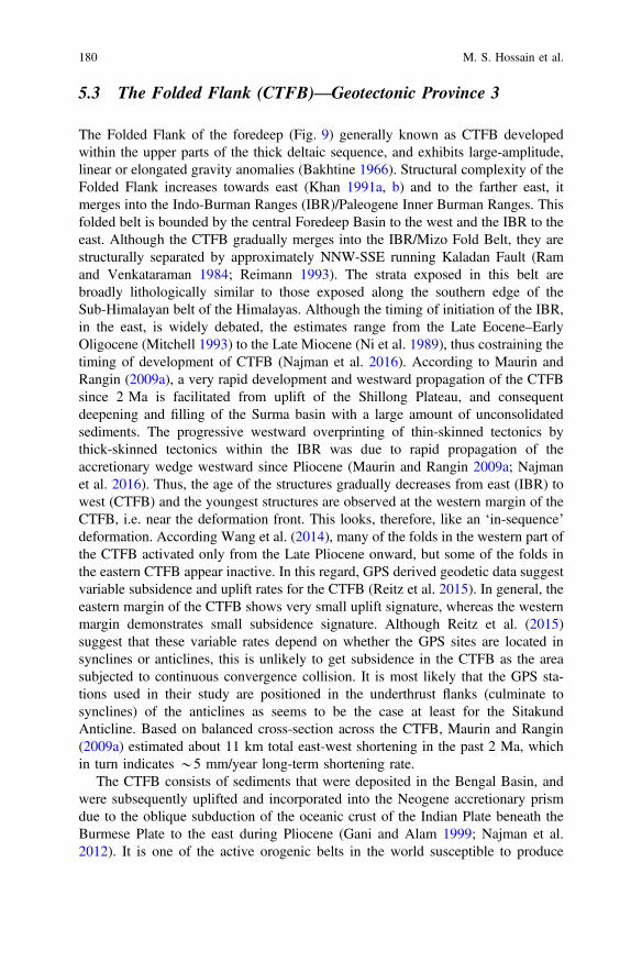
5.3 The Folded Flank (CTFB)—Geotectonic Province 3
The Folded Flank of the foredeep (Fig. 9) generally known as CTFB developedwithin the upper parts of the thick deltaic sequence, and exhibits large-amplitude,linear or elongated gravity anomalies (Bakhtine 1966). Structural complexity of theFolded Flank increases towards east (Khan 1991a, b) and to the farther east, itmerges into the Indo-Burman Ranges (IBR)/Paleogene Inner Burman Ranges. Thisfolded belt is bounded by the central Foredeep Basin to the west and the IBR to theeast. Although the CTFB gradually merges into the IBR/Mizo Fold Belt, they arestructurally separated by approximately NNW-SSE running Kaladan Fault (Ramand Venkataraman 1984; Reimann 1993). The strata exposed in this belt arebroadly lithologically similar to those exposed along the southern edge of theSub-Himalayan belt of the Himalayas. Although the timing of initiation of the IBR,in the east, is widely debated, the estimates range from the Late Eocene–EarlyOligocene (Mitchell 1993) to the Late Miocene (Ni et al. 1989), thus costraining thetiming of development of CTFB (Najman et al. 2016). According to Maurin andRangin (2009a), a very rapid development and westward propagation of the CTFBsince 2 Ma is facilitated from uplift of the Shillong Plateau, and consequentdeepening and filling of the Surma basin with a large amount of unconsolidatedsediments. The progressive westward overprinting of thin-skinned tectonics bythick-skinned tectonics within the IBR was due to rapid propagation of theaccretionary wedge westward since Pliocene (Maurin and Rangin 2009a; Najmanet al. 2016). Thus, the age of the structures gradually decreases from east (IBR) towest (CTFB) and the youngest structures are observed at the western margin of theCTFB, i.e. near the deformation front. This looks, therefore, like an ‘in-sequence’deformation. According Wang et al. (2014), many of the folds in the western part ofthe CTFB activated only from the Late Pliocene onward, but some of the folds inthe eastern CTFB appear inactive. In this regard, GPS derived geodetic data suggestvariable subsidence and uplift rates for the CTFB (Reitz et al. 2015). In general, theeastern margin of the CTFB shows very small uplift signature, whereas the westernmargin demonstrates small subsidence signature. Although Reitz et al. (2015)suggest that these variable rates depend on whether the GPS sites are located insynclines or anticlines, this is unlikely to get subsidence in the CTFB as the areasubjected to continuous convergence collision. It is most likely that the GPS sta-tions used in their study are positioned in the underthrust flanks (culminate tosynclines) of the anticlines as seems to be the case at least for the SitakundAnticline. Based on balanced cross-section across the CTFB, Maurin and Rangin(2009a) estimated about 11 km total east-west shortening in the past 2 Ma, whichin turn indicates *5 mm/year long-term shortening rate.
The CTFB consists of sediments that were deposited in the Bengal Basin, andwere subsequently uplifted and incorporated into the Neogene accretionary prismdue to the oblique subduction of the oceanic crust of the Indian Plate beneath theBurmese Plate to the east during Pliocene (Gani and Alam 1999; Najman et al.2012). It is one of the active orogenic belts in the world susceptible to produce
180 M. S. Hossain et al.
moderate to large earthquakes and holds potential for hydrocarbon exploration.Several investigations have been carried out in this area mainly focusing onstructural modeling (Sikder and Alam 2003; Mandal et al. 2004; Kabir and Hossain2009; Maurin and Rangin 2009a; Najman et al. 2012; Abdullah et al. 2015; Khanet al. 2018), active tectonics (Goodbred and Kuehl 1999; Wang et al. 2014; Khanet al. 2005, 2015, 2018), earthquake and landslide hazards studies (Ansary et al.2000; Cummins 2007; Steckler et al. 2008; Wang et al. 2014; Steckler et al. 2016),geochemistry and provenance studies (Najman et al. 2008; Dina et al. 2016;Rahman et al. 2017).
In general, gradual increase of negative gravity values to east reflects thedeepening of the Moho, apparently due to lithospheric flexure caused by loading ofthe IBR (Uddin and Lundberg 2004). However, this is comparatively much lessdistinct than the sharp increase of negative gravity values of the HimalayanForedeep in northwestern part of the Bengal Basin (Khan and Rahman 1992). TheNeogene CTFB reveals large-amplitude, linear or elongated gravity anomalies, andstructural complexity increases towards east and merges into the IBR farther eastalong approximately N-S running Kaladan Fault (Bakhtine 1966; Khan 1991a, b;Najman et al. 2012). To the west, deformation of the CTFB ceases along thedeformation front. From 24°N up to Shillong Plateau, the alignment of the fold beltshows an overall arc shaped broad curvature, starting as NNW-SSE trend from thesouth near Rakhine-Teknaf-Chittagong to approximately N-S trend near Tripura inthe middle and then finally NNE-SSW in the Surma basin to the north (Khan andChouhan 1996; Reimann 1993). Rapid westward propagation of the deformationfront is responsible for this broad curvature of the CTFB (Wang et al. 2014).
The CTFB has developed exemplary linear NNW-SSE to N–S to NNE-SSWoriented doubly plunging folds, which are arranged in a set of alternatingvalley-forming synclines and ridge-forming anticlines (Das et al. 2010). Some ofthe folds in the CTFB region are elliptical and cusp shaped synclines bounded byfault-affected ridges. According to Das et al. (2010) multi-curved geometry of someof the CTFB fold ridges are attributed to the free westward migration of fold,multi-phase deformation of soft sediments, and longitudinal thrust as well astransverse faulting. The surficial expressions of the CTFB anticlines to the west arelimited in the offshore along the line drawn western edge of the St. Martin’s Islandto the shore of the Sandwip Island. To the onshore the line continues NNW towardsLalmai anticline and then bends to follow the NE-strike and finally ends at thesoutheastern edge of the Shillong Plateau near the northeast corner of the Surmabasin (Reimann 1993). Based on the geometric shape and degree of intensity offolding, Bakhtine (1966) divided the CTFB tectonic element into three subdivi-sions. Towards west, these are eastern highly compressed disturbed zone, middleasymmetric thrust faulted zone, and western quiet zone.
Eastern Highly Compressed Zone: The eastern intensely folded narrowridge-shaped zone is highly compressed, and comprises of sharp anticlines withsteeply dipping limbs. The overall structural trend is NNW-SSE, and axial planes aresteeply inclined either to the east or to the west. The asymmetric anticlines plungevery gently. Adjacent to the Kaladan Fault, the folds are locally faulted box
Synthesis of the Tectonic and Structural Elements … 181
anticlines with pop-up and en echelon character (Maurin and Rangin 2009a). Thewidths of the synclines are generally broad in the north compared to those of thesouth. The geometrical analysis of the bedding planes of the anticlinal structuresshows that the axial plane of the anticlines strikes 330°–345°, dips 75°–85° eithertowards NE or SW, and having interlimb angle of 75°–95°. Plunge varies 5°–7°,
182 M. S. Hossain et al.
either to the north or to the south. Some of the prominent anticlines in this zone areMowdak, Sakudaung, Uttan Chatra, Barkal, Shishuk/Sisbak, Banuachari, Jumpai/Botiang.
Middle Asymmetric Thrust Faulted Zone: This zone is situated west of thehighly compressed zone, where overall structural trend is*NNW-SSE. Generally, inthis zone axial plane is steeply inclined to the west, and structures plunge very gentletowards N. As in the eastern highly compressed zone, the widths of the synclines arecommonly broad in the north than those to the south. Steep limbs of anticlines aregenerally faulted. The geometrical analysis of the bedding planes of the anticlinalstructures shows that the axial plane of the anticlines strikes 338°–350°, dips 70°–78°towards NE, and have interlimb angle of 75°–95°. Plunge varies 5°–10°, either to thenorth or to the south (Chowdhury 1970; Hossain et al. 2018). Some of the prominentanticlines in this zone are Matamuhuri, Bandarban, Gilasari, Belasari, Sitapahar(Fig. 10a), Gobamura, Changotaung, Kasalong/Kasarang, Sardeng/Sabtaung.
Fig. 10 Lower hemisphere equal area projection of the bedding attitude data shows theorientation of the fold geometric elements of the a Sitapahar and b Sitakund Anticlines of theChittagong Tripura Fold Belt (CTFB), Bengal Basin. Both the anticlines are west verging andasymmetrical, and show similar structural trend, but the Sitakund anticline is overturned in nature(Hossain et al. 2018)
JFig. 9 Simplified tectonic map of the Geotectonic Province-3 of the Bengal Basin and itssurroundings (modified after Bakhtine 1966). Faults and lineaments are mostly taken from Biswasand Grasemann (2005a), Kayal (2008), and Wang et al. (2014). A: Anticline; Athar: Atharamura;Band: Bandarban; Banu: Banuachari; Barj: Barjala; Bat: Batchia; Bela: Belasari; CCF: ChittagongCoastal Fault; Chango: Changotaung; Char: Chargola; Dakhin: Dakhin Nhila; Dho: Dholai; F:Fault; Fench: Fenchuganj; Gajal: Gajalia; Gila: Gilasari; Gobam: Gobamura; Ha: Habiganj; Hach:Hach Har; Harar: Harargaj; Jumpa: Jumpai/Botiang; Kasa: Kasalong/Kasarang; Kho: Khowai;Lamba: Lambaghona/Sarta; Langt: Langtari; Machh: Machhlithum; Magn: Magnama; Mahe:Maheskhali; Mata: Matamuhuri; Moul: Moulvibazar; Mow: Mowdak; Mual: Mualuawm; Olat:Olathang/Waylataung; Path: Patharia; Pin: Pincha; Ra: Rashidpur; Rajn: Rajnagar; Ram: Ramjtia;S: Syncline; Sakh: Sakhan; Saku: Sakudaung; Salda: Saldanadi; Sarden: Sardeng/Sabtaung; Semu:Semutang; Shish: Shishuk/Sisbak; Sita: Sitapahar; St: St. Martin’s; Tich: Tichna; Tulam: Tulamuraand Utan: Uttan Chatra
Synthesis of the Tectonic and Structural Elements … 183
Western Quiet Zone: This is the westernmost zone of the CTFB with similarstructural trends as in the other two zones. Most of the structures are doublyplunging with axial planes steeply inclined to the east, i.e. those are asymmetricoverturned structures. The structures have very gentle dips in the crest and steepdips in the flank. In general, the western flanks of the structures are underthrust,e.g., Sitakund Structure (Abdullah et al. 2015; Hossain and Akhter 1983). Thegeometrical analysis of the bedding planes of the anticlinal structures shows that theaxial plane of the anticlines strikes 335°–350°, dips 55°–65° in the NE direction,having interlimb angle of 60°–70°. Plunge amount varies 3°–10°, either to the northor to the south (Hossain et al. 2018). Some of the prominent anticlines in this zoneare St Martin’s Island, Dakhin Nhila, Inani, Olathang/Waylataung, Maheskhali,Jaldi, Patia, Sarta/Lambaghona, Sitakund (Fig. 10b), and Semutaung. A major faultis present in this zone running NNW-SSE along the western edge of the DakhinNhila-Inani-Maheskhali-Sitakund structures. Among the three zones of the CTFB,the western quiet zone is the most important and prospective tectonic sub-elementfor oil and gas in Bangladesh, where more than 15 gas fields have been discovered.Towards north some of these are Feni, Bakhrabad, Titas, Habiganj, Bibiyana,Rashidpur, Moulvibazar, Fenchuganj, and Beanibazar.
However, recent studies (Wang et al. 2014; Steckler et al. 2016) suggest thatanother fold belt exist in between western quiet zone and deformation front, andstretches from offshore to the south and onshore to the north. This very lowintensity fold belt is characterized by long-wavelength de’collement folds, locallywest verging, and subparallel to the western quiet zone. The amplitude of thesefolds decreases westward in accordance to the westward propagation of theaccretionary wedge and die out near deformation front to the west (Maurin andRangin 2009a).
6 Neotectonics and Active Tectonics of the Bengal Basin
Neotectonics and active tectonics of the Bengal Basin are directly related to theoblique collision of the Indian Plate with the Eurasian Plate to the north and theBurmese Plate to the east. The collision developed the Himalayan arc to the north,and the Burmese–Andaman arc to the east. Based on recent seismic studies, it ispresumed that subduction has clogged below the Himalayan arc and is only activelycontinuing below the Burmese–Andaman arc (Biswas and Das Gupta 1989; Biswaset al. 1992; Biswas and Majumdar 1997). Due to the resistance to subduction belowthe Eurasian Plate and plate convergence, tectonic deformation and seismic activityoccur in the Indian intra-plate region, including the stable shelf in the western partof the Bengal Basin, and result in folding and brittle deformation (Mukherjee2013c, 2014b) in conjunction with high-angle basement faults of variable trends(NE-SW, E-W, NW-SE) (Khan and Rahman 1992; Khan and Agarwal 1993;Biswas and Majumdar 1997; Mukherjee et al. 2009). To the north, tectonic loadingis accommodated along the Dauki Fault zone (Bilham and England 2001; Biswas
184 M. S. Hossain et al.

et al. 2007), which consists of a set of high angle, deepseated reverse faults. To theeast, the Cenozoic tectonic evolution of the eastern parts of the Bengal Basin isrelated mostly to the NE oblique subduction of the Indian Plate beneath theBurmese Plate. The collision also results westward migration of accretionary prismcomplexes as well as the deformation front (Gani and Alam 1999; Alam et al. 2003;Wang et al. 2014; Steckler et al. 2016). The CDMP II (2013) reported that the rateof convergence gradually decreases towards west. These multifaceted neotectonicevolutions of the Bengal Basin result in several active faults in and around theBengal Basin, especially along its northern and eastern margins. Some of thesefaults are regional, and capable of generating moderate to great earthquakes. Therate of motion and the time since the last rupture indicate that the probability ofearthquakes from the existing active faults is high (CDMP II 2013). Overall, thegeotectonic setting of the Bengal Basin at the juncture of three converging litho-spheric plates with the presence of regional scale seismogenic faults is conducivefor the frequent and recurrent earthquakes.
A general trend of increasing seismic/earthquake activity has been observed inthe Bengal Basin (Khan and Chouhan 1996; CDMP II 2013). Although theapparent increase of tectonic activity may be attributed to modern and increasedrecording facilities, the historical records and the present-day census suggest arelative increase in tectonic activity (Khan and Chouhan 1996). This seemingincrease of seismicity in the Bengal Basin indicates new fractures/faults propaga-tion from the preceding seismically undisturbed zones or the reactivation of someearlier fractures/faults in pre-existing seismically active zones. Catalogues of seis-micity of high intensity earthquakes (Table 7) in and around the Bengal Basin(Bilham 2004; Akhter 2010; Martin and Szeliga 2010; Szeliga et al. 2010; Kunduand Gahalaut 2012; Olympa and Abhishek 2015; Berthet et al. 2014; Kayal 2014;Wang et al. 2014) show a number of earthquakes that caused not only catastrophicdamages of the property and life but also shifting of the large river courses as wellas dynamic change in landscape. Among such incidents, the Chittagong earthquakeof 1762 (R 8.5+), Sirajganj earthquake of 1787 (MM X), Cachar earthquake of1869 (R 7.5), Bengal earthquake of 1885 (Mw 6.8), Great Indian/Assam earthquakeof 1897 (Mw 8.1), Srimangal earthquake of 1918 (Mw 7.6), Meghalaya earthquakeof 1923 (Ms 7.1), Dubri earthquake of 1930 (Mw 7.1), Bihar-Nepal earthquake of1934 (Mw 8.1), Assam earthquake of 1950 (R 8.5), and Nepal earthquake of 2015(Mw 7.8) are well known. The maximum felt intensity of these earthquakes islocalised in tectonically uplifted region, especially in the Bengal Basin (Martin andSzeliga 2010). Majority of the earthquakes in the Bengal Basin generally occur atshallow depth (<30 km). To the east, below the IBR, focal depths graduallyincrease in the depth range of 30–70 km and define an eastward gently dippingsubducting plate (Kundu and Gahalaut 2012). Focal depths to the north also showan increasing depth trend. In general, most of the seismic activities in the BengalBasin commonly occur along the regional active faults. The following discussionon neotectonics and active tectonic of the Bengal Basin are in terms of the neo-tectonic activities along these faults.
Synthesis of the Tectonic and Structural Elements … 185
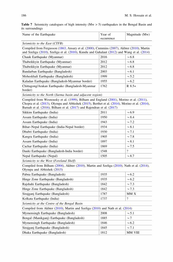
Table 7 Seismicity catalogues of high intensity (Mw > 5) earthquakes in the Bengal Basin andits surroundings
Name of the Earthquake Year ofoccurrence
Magnitude (Mw)
Seismicity to the East (CTFB)
Compiled from Fergusson (1863, Ansary et al. (2000), Cummins (2007), Akhter (2010), Martinand Szeliga (2010), Szeliga et al. (2010), Kundu and Gahalaut (2012) and Wang et al. (2014)
Chauk Earthquake (Myanmar) 2016 *6.8
Thabeikkyin Earthquake (Myanmar) 2012 *6.8
Thabeikkyin Earthquake (Myanmar) 2012 *6.8
Bandarban Earthquake (Bangladesh) 2003 *6.1
Moheskhali Earthquake (Bangladesh) 1999 *5.2
Kaladan Earthquake (Bangladesh-Myanmar border) 1955 *6.2
Chittagong/Arakan Earthquake (Bangladesh-Myanmarborder)
1762 R 8.5+
Seismicity to the North (Surma basin and adjacent region)
Compiled from Wesnousky et al. (1999), Bilham and England (2001), Morino et al. (2011),Chopra et al. (2013), Olympa and Abhishek (2015), Berthet et al. (2014), Morino et al. (2014),Baruah et al. (2016), Bilham et al. (2017) and Rajendran et al. (2017)
Sikkim Earthquake (India) 2011 *6.9
Assam Earthquake (India) 1950 *8.4
Assam Earthquake (India) 1943 *7.2
Bihar–Nepal Earthquake (India-Nepal border) 1934 *8.1
Dhubri Earthquake (India) 1930 *7.1
Kangra Earthquake (India) 1905 *7.8
Assam Earthquake (India) 1897 *8.1
Cachar Earthquake (India) 1869 *7.5
Dauki Earthquake (Bangladesh-India border) 1548 ?
Nepal Earthquake (Nepal) 1505 *8.7
Seismicity to the West (Foreland Shelf)
Compiled from Bilham (2004), Akhter (2010), Martin and Szeliga (2010), Nath et al. (2014),Olympa and Abhishek (2015)
Pabna Earthquake (Bangladesh) 1935 *6.2
Hinge Zone Earthquake (Bangladesh) 1935 *6.2
Rajshahi Earthquake (Bangladesh) 1842 *7.3
Hinge Zone Earthquake (Bangladesh) 1842 *7.3
Sirajganj Earthquake (Bangladesh) 1787 MM X
Kolkata Earthquake (India) 1737 ?
Seismicity at the Centre of the Bengal Basin
Compiled from Akhter (2010), Martin and Szeliga (2010) and Nath et al. (2014)
Mymensingh Earthquake (Bangladesh) 2008 *5.1
Bengal (Manikganj) Earthquake (Bangladesh) 1885 *7
Mymensingh Earthquake (Bangladesh) 1846 *6.2
Sirajganj Earthquake (Bangladesh) 1845 *7.1
Dhaka Earthquake (Bangladesh) 1812 MM VIII
186 M. S. Hossain et al.
6.1 Active Tectonics to the East (CTFB)
The CTFB and the IBR fold belt regions are poorly explored due to the complexgeology, dense vegetation and mountainous terrains thus making it challenging forfield observation as well as geological and geophysical data acquisition. The CTFBor Geotectonic Province 3 is an active tectonic element in the eastern part of theBengal Basin (Cummins 2007; Steckler et al. 2016). In the CTFB and the IBR foldbelt regions, five regional faults with *N-S to NNE-SSW orientation are recorded(Nandy 2001; Acharyya 2007; Maurin and Rangin 2009a; Kundu and Gahalaut2012; Hossain et al. 2014; Wang et al. 2014), which mostly accommodate thisconvergence. Towards west, these are Sagaing Fault—west of Shan Plateau andeast of Central Burma Basin (CBM) as well as Chindwin Basin, Kabaw Fault—west of CBM and east of IBR, Churachandpur Mao Fault (CMF)—at the core/centre of the IBR, Kaladan Fault—west of the IBR and east of the CTFB, and theChittagong Coastal Fault (CCF)—at the western margin of the CTFB and east ofthe Hatiya Trough (Figs. 1 and 8). CMF and CCF are also known as the Lelon Fault(Maurin and Rangin 2009a), and the Chittagong-Cox’s Bazar Fault, respectively.Geotectonic evolution and neotectonic activities in the eastern Bengal Basin,Central Burmese Basin, Chindwin Basin and Rakhine Basin of Myanmar aredirectly related to these four major faults which are parallel to the CTFB-IBR foldbelts. A shallow dipping megathrust structurally connects with the CCF, Kaladanand CMF faults (Wang et al. 2014; Steckler et al. 2016). Although variable con-vergence rate is reported (CDMP II 2013; Barman et al. 2016; Steckler et al. 2016),the rate gradually decreases from east (IBR) to west (CTFB). Among the totalconvergence of*46 mm/year, 13–17 mm/year is taken by the CTFB-IBR fold beltand the shallow dipping megathrust, and rest being accommodated by thedextral-slip motion of the Sagaing fault (*20 mm/year) and CMF (*10 mm/year).The rate of convergence to the east of the Kaladan Fault is *13 mm/year, inbetween the Kaladan Fault and CCF is *5 mm/year, and between CCF anddeformation front (Figs. 1 and 9) is *2 mm/year (CDMP II 2013). This rate ofconvergence results *200 km advancement of the outer part of the accretionaryprism (represented by the CTFB) over the last 2 Ma (Maurin and Rangin 2009a).The orientation of maximum compressive stress rotates from NE–SW across theinner and northern IBR to E–W near the western CTFB of the Bengal Basin(Angelier and Baruah 2009). The rotation of maximum stress orientation is con-sistent with the deformation partitioning related to oblique collision and is reflectedin the rotation of relative displacement vectors across the region (CTFB and IBR).This deformation partitioning results a variety of movements across the fold belt.Towards west, right-lateral slip is observed in the east of the IBR (Sagaing Fault) tooblique reverse-dextral slip in the middle and western edge of the IBR (KabawFault) and pure thrusting in the CTFB (CCF) (Fig. 8). Regardless of the highlyoblique plate motion and thick Tertiary sediments, the GPS measurements suggestthat subduction in this region to be active (Steckler et al. 2016). GPS studies alsosuggest a locked megathrust signifies an underappreciated large seismic hazard inthe CTFB and IBR regions.
Synthesis of the Tectonic and Structural Elements … 187

The *N-S oriented and *1400 km long Sagaing Fault is the major locus ofdextral-slip motion related to the northward translation of the Indian Plate againstthe Burmese Plate (Wang et al. 2014). The northern end of this transform faultdevelops horse-tail appearance and terminates into the eastern Himalayan syntaxis(Fig. 1). This fault accommodates about 20 mm/year of the north component of therelative motion of the oblique convergence between the Indian and the BurmesePlates (Barman et al. 2016). The fault is well expressed geomorphically along mostof its length due to such high slip rate. Earthquake catalogues (Table 7) show thatabout half of the Sagaing Fault has ruptured during many large earthquakes over thedecades. Based on bends, splays, terminations of historical ruptures, and distinctsecondary features, Wang et al. (2014) divide the Sagaing Fault into six distinctsegments. From south to north, these segments are Bago, Pyu, Nay Pyi Taw,Meiktila, Sagaing, and Northern Sagaing. The Northern Sagaing segment is againdivided into three sub-segments, and these are Tawma-Ban Mauk, In Daw-Mawluand Shaduzup-Kamaing-Mogang. Most of these segments of the Sagaing Fault areseismically active and produce major earthquakes except the Meiktila segments(Wang et al. 2014). About 13 major earthquakes (Mw 6.8–7.7) have been recordedsince 1929 along this mega fault and most of them occurred at shallow depth(<25 km). The most recent Thabeikkyin earthquake with 6.8 Mw occurred inNovember 2012 in the Sagaing segment, which caused damage and panic as far asin the Chittagong City of Bangladesh, approximately 400 km west of the epicentre.A notable seismic gap along the Sagaing Fault is observed in the Meiktila segment,between the new capital of Myanmar (Nay Pyi Taw) and the large city ofMandalay. If this 220 km long Meiktila segment ruptures at once, it is capable ofproducing an earthquake as large as Mw 7.8–7.9 (Blaser et al. 2010).
The oblique reverse-dextral slip and the east-dipping Kabaw Fault (Fig. 1) tra-verses the eastern side of the Kabaw valley for *800 km. The shortening rate tothe locked Kabaw Fault is *13 mm/year (Steckler et al. 2016). Based on theyouthful appearance (fresh/unweathered exposure) on SRTM and ASTER images, asegment of this fault between 22 and 24.8°N is considered as (seismically) active(Wang et al. 2014). If this *280 km segment of the Kabaw Fault ruptures at once,it could generate an Mw 8.4 earthquake. The most recent earthquake with 6.8 Mwoccurred in August 2016 along this fault near Chauk City of Myanmar. The tremorswere felt as far as in Bangladesh, Bihar (India), and Thailand and damagedinfrastructures and life.
The N-S to NNE-SSW oriented and*300 km long right-lateral Churachandpur-Mao Fault (Fig. 1) is the most prominent at the core/centre of the IBR (Fig. 1). Thissteeply east dipping fault accommodates dextral velocities of *10–18 mm/yearbetween the Indian and Burmese Plates through dextral strike-slip motion, predom-inantly through aseismic slip (Gahalaut et al. 2013; Steckler et al. 2016). However,both aseismic and seismic slips have been observed along this fault. The aseismic slippart of this fault could be related tominor tomoderate earthquakes.Wang et al. (2014)suggest that this fault creeps only at sub-surface, and that its northern part is seismic. Ifthis fault segment ruptures, it could produce an Mw 7.6 earthquake. Althoughearthquake catalogue does not show any historical seismic events that could be
188 M. S. Hossain et al.
attributed to rupture of the Churachandpur-Mao Fault (Szeliga et al. 2010), the Imphalearthquake with 6.8 Mw occurred in January 2016 in the northern segment of thisfault is a proof of seismic slip. This earthquake was strongly felt in Bangladesh andcaused significant damage.
The *450 km long west verging Kaladan Fault (Figs. 1 and 9), which mostlyfollows the course of the Kaladan River is basically the contact between the Barailand Surma range and is named after the Kaladan River (Nandy 2001; Maurin andRangin 2009a; Barman et al. 2016). Kaladan Fault marks the eastern boundary ofthe CTFB and extends from the Arakan coast in the south to the northern-most partof the CTFB and the IBR contact (Sikder and Alam 2003; Maurin and Rangin2009a; Kundu and Gahalaut 2012; Wang et al. 2014). Along 20° 30′N, the dip ofthe fault plane is 70°E with an 8°–10°S pitch, and shows a clear right-lateral offset.In this area, the orientation of the maximum compression is *N80–N60°E (Maurinand Rangin 2009a). Although, the Kaladan Fault shows both dextral strike-slip andwest verging thrust components, it is generally considered as thrust fault, andseismically the fault is sparsely active. The right-lateral slip dominates its northerntermination whereas in the middle portion pure E-W or WSW-ENE thrusting focalmechanisms are observed, suggesting that active motion is partitioned within a veryshort distances along this fault. To the south, Ramree thrust is most likely thesouthward continuation of the Kaladan Fault (Maurin and Rangin 2009a). WhileMw 6.2 earthquake in December 1955 along the Kaladan Fault nearBangladesh-Myanmar border region at a depth of 35 km is a proof of seismic slip,mainly shallow focus and low intensity earthquakes are observed along this fault(Kundu and Gahalaut 2012).
Based on the geomorphic signatures on 30 m resolution SRTM image andgeological field reconnaissance, a *300 km long major fault can be inferred alongthe western boundary of the CTFB in between *19° 40′N and 23° 30′N is knownas the Chittagong Coastal Fault (CCF). Multichannel seismic survey in the offshorearea also suggests the existence of the CCF as a crustal dextral strike-slip fault withan appreciable thrust component, and is resultant product of thin-skinned andthick-skinned tectonics (Maurin and Rangin 2009a). The fault is seismically lessactive. To the north, the fault splays before disappearing near the Tichna anticline inTripura, just south of the Surma basin. The fault is probably younger than theKaladan Fault as the accretionary wedge is progressing westward during the last2 Ma, and it is not affected by sufficient erosion yet. Maurin and Rangin (2009a)suggest that both the CCF and the Kaladan Faults can be interpreted as deep-seatedbasement reverse fault with dextral strike-slip component. The restoration of thecompressive fold belt and megathrust yields *11 km of shortening of the CTFBincluding the CCF and the Kaladan Faults. Although published earthquake cata-logues do not show any historical seismic events that can be attributed to rupture ofthe CCF, Moheskhali earthquake with 5.2 Mw occurred along the CCF inMoheskhali Island in July 1999 is a proof of seismic slip. This earthquake wasstrongly felt around Bangladesh and caused significant damage locally (Ansaryet al. 2000). Moreover, occurrence of any large earthquake in the offshore areaalong the east coast of the northern Bay of Bengal is likely to produce great tsunami
Synthesis of the Tectonic and Structural Elements … 189
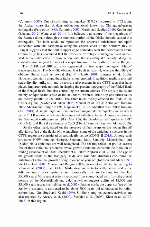
(Cummins 2007). One of such large earthquakes (R 8.5+) occurred in 1762 alongthe Arakan coast (i.e. Arakan subduction zone) known as Chittagong/Arakanearthquake (Fergusson 1863; Cummins 2007; Martin and Szeliga 2010; Kundu andGahalaut 2012; Wang et al. 2014). It is believed that rupture of the megathrust ofthe Ramree domain through the southern portion of the Dhaka domain caused thisearthquake. The fault model to reproduce the observed subsidence and upliftassociated with this earthquake along the eastern coast of the northern Bay ofBengal suggests that the fault’s upper edge coincides with the deformation front.Cummins (2007) concluded that the evidence of oblique convergence and associ-ated active subduction in conjunction with thrust earthquake activity along thecoastal region suggest the risk of a major tsunami in the northern Bay of Bengal.
The CTFB and IBR are also segmented by two major conjugate oblique/transverse faults. The NW–SE oblique Mat Fault is sinistral, whereas the NE–SWoblique Gumti Fault is dextral (Fig. 9) (Nandy 2001; Barman et al. 2016).However, seismicity along these faults is not reported. In addition, medium to smallscale dip-slip, strike-slip and thrusts are also present in the CTFB area that haveplayed important role not only in shaping the present topography of the folded flankof the Bengal Basin, but also controlling the stream courses. The dip-slip faults aremainly oblique to the strike of the anticlines, whereas strike-slip and thrust faultsare mostly parallel to the strike. The latter faults mostly affected the folds of theCTFB regions (Sikder and Alam 2003; Mandal et al. 2004; Kabir and Hossain2009; Maurin and Rangin 2009a; Najman et al. 2012; Abdullah et al. 2015; Hossainet al. 2018). A single large and few moderate magnitude earthquakes are recordedin the CTFB region, which may be connected with these faults. Among such events,the Srimangal earthquake in 1918 (Mw 7.5), the Bandarban earthquake in 1997(Mw 6.1), and Barkal earthquake in 2003 (Mw 5.7) are well known (Akhter 2010).
On the other hand, based on the presence of fault scarp on the young fluvial/alluvial surface at the flanks of the anticlines, some of the anticlinal structures in theCTFB region are considered as tectonically active (CDMP II 2013). Among suchstructures NNW trending Harargaj, Sitakund, Jaldi, Sandwip, Maheshkhali, andDakhin Nhila anticlines are well recognized. The seismic reflection profiles acrossfew of these anticlinal structures reveal growth strata that constrain the initiation offolding (Mandal et al. 2004; Steckler et al. 2008; Najman et al. 2016). The age ofthe growth strata of the Habiganj, Jaldi, and Kutubdia structures constrains theinitiation of anticlinal growth during Pliocene or younger (Johnson and Alam 1991;Steckler et al. 2008; Maurin and Rangin 2009a; Wang et al. 2014). According toKhan et al. (2015), the Dakhin Nhila structure is tectonically active and showdifferent uplift rates spatially and temporally due to faulting for the last55,000 years. More recent activity recorded from young- aged soils from the crestalportion of the Maheshkhali and Jaldi anticlines suggest uplifts of 18,000 and35,000 years respectively (Khan et al. 2005). Farther north, the upper surface of theSandwip structure is estimated to be about 7000 years old as indicated by radio-carbon date (Goodbred and Kuehl 1999). Similar young neotectonic activities arealso reported by Ansary et al. (2000), Steckler et al. (2008), Khan et al. (2017,2018) in this region.
190 M. S. Hossain et al.
6.2 Active Tectonics to the North (Surma Basinand Adjacent Region)
The geodynamics and the neotectonics of the northern part of the Bengal Basin(northern part of the Geotectonic Province 1 and 2) are directly related to thetectonic evolution of the 2500 km long Himalayan frontal belt as well as to theMain Frontal Thrust. The Himalayan frontal belt is the youngest portion of theHimalayan Orogeny (Thakur 2004). The northward convergence of the Indian Plateresulted in crustal shortening of the northern margin of the Indian continent,accommodated by south-verging Main Central Thrust (MCT), Main BoundaryThrust (MBT) and Main Frontal Thrust (MFT) (Fig. 7) (Thakur 2004). From MCTto MFT, these thrusts are progressively younger in age and shallowing at depth in asouthward direction, suggesting southward migration of the Himalayan deformationfront. Exceptions to this are the Himalayan active/out-of-sequence structures, mostnotably faults (Mukherjee 2015), some of which are even backthrust-faults (Boseand Mukherjee, submitted-a, b). The Himalayan frontal belt is limited to the southby the Main Frontal Thrust (MFT). Most of the collisional force in the Himalayanfrontal belt is accommodated by the uplift and convergence along the MFT(Wesnousky et al. 1999). Although variable convergence rates (11–21 mm/year)are observed across the Himalayan frontal belt, a general increasing trend isobserved towards the centre which is known as Nepal Himalaya (Wesnousky et al.1999; Berthet et al. 2014; Bilham et al. 2017). Towards east, the Himalaya, exceptin Pakistan, can be divided into Dehra Dun Himalaya (western Himalaya), NepalHimalaya (central Himalaya) and Bhutan-Arunachal Himalaya (Eastern Himalaya)(Thakur 2004). Here after Sikkim, Bhutan and western Arunachal are collectivelyreferred as the Bhutan Himalaya. The rate of convergence along the NepalHimalaya is *20 mm/year and along the Bhutan Himalaya (directly north of theBengal Basin) is *16–18 mm/year. The Himalayan frontal belt is one of the fewcollisional orogenic belts on-land, where earthquakes with great magnitudes anal-ogous to those of oceanic subduction zones generally occur (Berthet et al. 2014).
The northern part of the Bengal Basin mainly comprises of the Surma basin tothe east, and northern edge of the Stable Shelf to the northwest. Assam Basin andShillong Plateau are situated in between Himalayan frontal belt to the north andSurma basin to the south. Broadly, E-W oriented Brahmaputra fault is situated atthe southern margin of the Assam Basin. Oldham, Brahmaputra and few other faultsseparate the Assam Basin from the Shillong Plateau, whereas the Dauki Faultseparates the Shillong Plateau from the Surma basin. Southern portion of the Surmabasin is transacted by two major faults, the Sylhet Fault to the southeast and the OldBrahmaputra Fault to the southwest (Fig. 6). In the west, the Shillong Plateau isseparated from the Bengal Basin by the Jamuna Fault (Dhubri Fault). In the east, theShillong Plateau and the Assam Basin separate from the Naga domain/Naga Hillsby the Naga and Disang thrusts. In addition, a few other faults and lineaments alsoplay important role in neotectonic activities as well as geomorphic evolution of thispart of the Bengal Basin, and these are Dapsi (NW-SE), Haflong (*E-W), Dhudnoi
Synthesis of the Tectonic and Structural Elements … 191
(N-S) and Kopili Faults (NW-SE), and Tista and Gangtok Lineaments (NW-SE)(Fig. 1).
Approximately E-W oriented MFT separates the Assam Basin from theHimalayan frontal belt. The MFT is associated with active low-angle thrusting andassociated uplift (Berthet et al. 2014). It represents a zone of active deformationbetween the Sub-Himalaya and the Indo-Gangetic Alluvial Plain (IGAP) of thePeninsular India, thereby thrusting sediments of the Siwalik Group southward overthe IGAP (Wesnousky et al. 1999). The MFT comprises of mainly homoclinalstrata with northerly dips generally ranging 20°–30°. In the Bhutan Himalaya, thedip of the MFT is *25°–30° (Wesnousky et al. 1999; Long et al. 2011; Berthetet al. 2014) and the Holocene slip rate along the fault is*20–28 mm/year (Burgesset al. 2012; Berthet et al. 2014). The observed uplift rate across the MFT is *10–13 mm/year (Wesnousky et al. 1999; Berthet et al. 2014). The MFT is tectonicallyactive in the Bhutan-Arunachal, Nepal, and Dehra Dun Himalaya (Wesnousky et al.1999; Berthet et al. 2014). Although some of the N-S plate convergence motion isaccommodated by the upliftment of the Shillong Plateau, however they do not haveany significant effect on the high activity of the MFT in the Bhutan Himalaya. Therupture zones of 1905 Kangra earthquake (Mw *7.8), 1505 western Nepalearthquake (Mw *8.7), 1934 Bihar–Nepal earthquake (Mw *8.1), and 1950Assam earthquake (Mw *8.4) extend N–S right across the MFT zone to the MBTzone (Fig. 11) (Wesnousky et al. 1999; Berthet et al. 2014; Bilham et al. 2017;Rajendran et al. 2017). In this context, the *350 km long Bhutan Himalaya zone
Fig. 11 Active tectonic map of the Central and Eastern Himalaya (to the north of the BengalBasin). Pink and orange rectangles show the historical events and the ages of majorsurface-rupturing events, respectively. Blue and green rectangles give the Holocene shorteningrates and the geodetic slip rates, respectively. Distributions of the earthquake epicentres from 1973to 2013 recorded by the National Earthquake Information Center (NEIC) are shown in yellowcircles (modified after Berthet et al. 2014)
192 M. S. Hossain et al.

of the MFT, which is located between the epicentres of the 1934 Bihar–Nepalearthquake and 1950 Assam earthquake, appears to be an area where no similargreat earthquakes has ever been documented. These observations and the lack ofprimary surface rupture suggest a potential for great earthquakes along theHimalayan Frontal Thrust in the Bhutan Himalaya zone (Wesnousky et al. 1999;Berthet et al. 2014). An active zone of deformation, upliftment and slip observedalong the MFT, especially along the Bhutan Himalaya suggests increased seismichazard to the adjoining northern part of the Bengal Basin.
The WNW and ESE oriented Oldham Fault separates the Assam Basin from theShillong Plateau. The Oldham Fault is a *120 km long north-verging and southdipping reverse fault, and generates co-seismic displacement. Although the 1897devastating Assam earthquake (Mw *8.1) occurred due to co-seismic displace-ment along this fault (Bilham and England 2001), the source is also attributed tomultiple faults around the Shillong Plateau including the Dauki, Dapsi and OldhamFaults (Bilham and England 2001; Morino et al. 2014; Barman et al. 2016; Singhet al. 2016). The Oldham Fault together with the Dauki Fault to the south of theShillong Plateau constitutes a high-angle conjugate crustal-scale shear zone,uplifting the plateau as a pop-up structure (Biswas and Grasemann 2005a). Both thehanging wall (i.e. Shillong Plateau) and the foot wall (i.e. southern margin of theAssam Basin/Himalayan Foreland Basin) of the Oldham Fault are associated withuplift of the Shillong Plateau. However the rate of uplift of the footwall block isfound to be less than that of the hanging wall block. The rate of vertical dis-placement along the Oldham Fault is 0–0.68 mm/year (Biswas et al. 2007). Byconsidering *45°–50° dipping for the fault plane, average fault slip rate is esti-mated to be *2–4 mm/year and the horizontal shortening rate accommodated bythe plateau is *2–5 mm/year (Bilham and England 2001). However, Biswas et al.(2007) suggest much lower shortening rate (0.65–2.3 mm/year) that accounts for10–15% contraction rate of the Himalaya. The GPS measurements indicate thesouthward movement of the central Shillong Plateau at a rate of *6.5–7 mm/yearwith respect to the reference points in southern and central India (Barman et al.2016). From these rates, Bilham and England (2001) conclude that the recurrenceinterval for earthquakes resembling the 1897 Assam earthquake to be 3000–8000 years. However, examination of the past four high-intensity seismic eventsalong the northern edge of the plateau indicates a 500 years recurrence interval butthese may record shaking from moderate local earthquakes and large seismic eventsin the adjoining Bhutan Himalaya. Geological and geophysical data suggest thepresence of another large fault at the north of the Oldham Fault with E-W orien-tation known as Brahmaputra Thrust (Ghosh et al. 2015) that marks the northernmost edge of the Shillong Plateau, and may have played an important role in theplateau uplifting. This fault is an active thrust and important for the crustal reset-tlement in this part of the Indian Plate.
The *320 km-long E-W trending south-verging and north dipping Dauki Fault,a major plate boundary-influenced fault marks the boundary between the Surmabasin to the south and the Shillong Plateau to the north (Hossain et al. 2016). Thestrike of this fault is parallel to the MFT, which forms a plate boundary fault
Synthesis of the Tectonic and Structural Elements … 193

whereas the Dauki Fault is an intra-plate active reverse fault. The continuoussubsidence of the southern footwall of the Dauki Fault has resulted in the Surmabasin, where structural relief between highest point of the plateau and lowest pointof the basin is estimated to be around 20 km (Mirkhamidov and Mannan 1981;Hiller and Elahi 1984; Shamsuddin and Abdullah 1997; Biswas et al. 2007). Acrossthe Dauki Fault, a striking negative Bouguer gravity anomaly exceeding −70 mGalhas been recorded for the Surma basin, whereas the Shillong Plateau shows apositive Bouguer gravity anomaly >+20 mGal (Rahman et al. 1990b; Rajendranet al. 2004). Hence, the Dauki Fault might have been formed at the onset of theexhumation of the Shillong Plateau, and the total vertical displacement of thebasement top along this fault is *10 km (Biswas et al. 2007). During the LateTertiary, the rate of upliftment of the hanging wall rock (i.e. the Shillong Plateau)ranged 0.32–0.80 mm/year, whereas the rate of subsidence of the footwall rock (i.e.the Surma basin) is *0.45 mm/year. Consequently, the resultant mean verticaldisplacement rate along the Dauki Fault ranges 0.77–1.25 mm/year (Biswas et al.2007). Higher vertical displacement rate along the Dauki Fault than the Oldhamfault is partially responsible for the *2°–3° northward tilt of the Shillong Plateausurface. The Dauki Fault is segmented to at least 4 parts along its entire length(Biswas and Grasemann 2005a). Geomorphic indices like mountain front sinuosity,stream length gradient index, valley floor width to height, drainage basin asym-metry, and transverse topographic symmetry factor suggest that the tectonic activityof the fault is much higher in the eastern part than the western portion (Biswas andGrasemann 2005a; Sharma and Sarma 2017).
Rapid movement along the Dauki Fault started in the Pliocene, resulting insignificant topographic rise and basin loading in the north and south, respectively(Najman et al. 2016). The flexure related to seismic event has been identified alongthe Dauki Fault near Jaflong (Sylhet) and is inferred to be AD 840–920 (Morinoet al. 2014). Another rupturing in the Dauki Fault estimated to be AD 1548 hasbeen identified in a trench at Gabrakhari village, Haluaghat, Mymensingh (Morinoet al. 2011, 2014). It is also believed that the 1897 Assam earthquake that occurredalong the Oldham Fault also caused slip along the Dauki Fault. Although it waspreviously thought that the interval between these giant plateau-building earth-quakes exceeds 3000 years (Bilham and England 2001), the signature of the aboveseismic events indicates recurrence interval of 350–700 years (Morino et al. 2014).Moreover, the active fan development along the southern foothills of the ShillongPlateau is controlled by the neotectonic activities along the Dauki Fault (Alam andIslam 2017).
In the southeastern margin of the Shillong Plateau, a branched extension of theDauki Fault with approximately E-W strike is known as the Haflong thrust fault.The Haflong Fault marks the edge of the Shillong Plateau before it links up with theNaga thrust to the east (Biswas and Grasemann 2005a). The WNW–ESE trending*90–100 km long Dapsi thrust fault (Fig. 1) is located within the southwesternedge of the Shillong Plateau. This fault is the north-western extension of the DaukiFault that separates the Cretaceous–Tertiary sediments to the south and thePrecambrian Gneissic complex to the north (Barman et al. 2016). The N-S trending
194 M. S. Hossain et al.

Dudhnoi Fault lying towards the northwest of the Shillong Plateau was activatedduring the 1897 Assam earthquake (Barman et al. 2016). A significant difference inthe rate of motions has been observed on the opposite side of the Dudhnoi Fault.The central Shillong Plateau to the east shows 7 mm/year southward motion,whereas the western Shillong Plateau shows 2.1–2.7 mm/year southward motion,suggesting different tectonic settings of the plateau and dextral motion along theDudhnoi Fault (Barman et al. 2016). In addition, the development of the ShillongPlateau as a pop-up structure is also facilitated to the west by the N-S trendingDhubri and Jamuna Faults. The epicenter of the 1930 Dhubri earthquake (Mw*7.1) was along the Dhubri Fault near Dhubri, Assam. To the south, the earth-quake also caused slip in the Jamuna Fault, and west of the Garo Hills, fissures andsand vents were reported (Olympa and Abhishek 2015).
The NW-SE trending strike-slip Kopili Fault located between the ShillongPlateau and the Mikir Hills records a dextral slip of 4.7 ± 1.3 mm/year indicatingthe fragmentation of Assam Basin/Brahmaputra valley across this fault (Barmanet al. 2016). The eastern edge of the Mikir Hills marks by the Bomdila Lineament(Baruah and Hazarika 2008; Angelier and Baruah 2009). The transverse Kopilifault may be a surface expression of the deep-seated seismogenic structure(Bhattacharya et al. 2008). The western edge of the Mikir Hills appears to be lockedcurrently at 10.2 ± 1.4 km depth with the Assam Basin indicating strain accu-mulation. This strain accumulation may cause seismic event in near future alongthis seismically highly active 300 km long fault that reaches into the MFT system tothe north and Naga thrust to the south (Bhattacharya et al. 2008; Barman et al.2016). The rupture area of the 1869 Cachar earthquake (Mw *7.5) and 1943Assam earthquake (Mw *7.2) are located within the Kopili fault. The earthquakesdamaged over hundreds of kilometres across the region (Olympa and Abhishek2015).
At eastern Arunachal Himalaya over the Assam Basin and the Naga Hills, threemajor plates interact along two convergent boundaries: the Himalayan frontal beltand the IBR, which meet at the 430 km-long Assam Syntaxis (Angelier and Baruah2009; Wang et al. 2014). The northern end of the IBR (i.e. Naga Hills) and itsunderlying lithosphere experience nearly arc perpendicular extension with ESE–WNW trends, whereas easternmost Himalayan frontal belt (i.e. ArunachalHimalaya) experiences WNW-ESE compression related to convergence betweenthe outer IBR and the Indian Plate. Together, the convergence and the extensionstructures forms a complicated geotectonic system (Nandy 2001) that causes thenortheastern portion of the Indian Plate to be deformed and also results in thedevelopment of the Naga and Disang Thrusts (Evans 1964; Bilham and England2001; Angelier and Baruah 2009). The NE-SW oriented Naga Thrust with severalarcuate lobes separates the Assam Basin from the northern outermost edge of theNaga Hills (Fig. 1). The fault with clear linear scrap extends from the HaflongThrust to the southwest and terminates at *96°E where it appears to cut by a*NW-striking Mishmi Thrust and associated anticlines (Vaccari et al. 2011;Mohanty et al. 2013, 2014). The fault shows variable dips (moderate to steep) andbreaks the surface at some positions (Wang et al. 2014). The lower Miocene rocks
Synthesis of the Tectonic and Structural Elements … 195
constituting the Naga Hills are thrusted and folded over undeformed upper Plioceneto Quaternary beds and alluvium of the Assam Basin at the mountain front alongthe Naga Thrust (Aier et al. 2011). The clear geomorphological expression of someanticlines and younger terrace with 20–50 m upliftment imply that it is still activeand the dip of the thrust fault decreases at depth. Additionally the slip on the NagaThrust dies out over *100 km from the crest of the Naga Hills (Wang et al. 2014).In the immediate south, another linear thrust fault running parallel to the NagaThrust is known as the Disang Thrust. The narrow linear belt of imbricate thrustslices of 8–25 km wide in between the Naga and Disang Thrusts is known as theSchuppen Belt. Morphotectonic analysis reveals that the overall tectonic activity ofthe Schuppen Belt (i.e. along the Naga and Disang Thrusts) is higher than the DaukiFault area (Sharma and Sarma 2017).
The NNW–SSE trending Tista and Gangtok Lineaments are the two prominenttectonic features, extending from the Sikkim Himalaya to the north and RangpurSaddle to the south. The southern ends of these lineaments terminate against theJamuna Fault. The focal mechanisms in this area indicate right-lateral strike-slipalong the Tista and Gangtok Lineaments. The 2011 Sikkim earthquake (Mw *6.9)may have been caused by the seismic slip along the Tista Lineament (Chopra et al.2013; Baruah et al. 2016). Several smaller earthquakes are recorded along theselineaments, especially along the Tista Lineament suggesting that the both linea-ments are tectonically active (Baruah et al. 2016).
The Surma basin is an active tectonic element forming in response to theShillong Plateau upliftment to the north, and subduction of the Indian Plate beneaththe Burmese Plate to the east. Tectonic evolution and neotectonic activities of thisbasin are controlled by the Dauki Fault to the north, gradual westward encroach-ment of the CTFB and IBR through Haflong, Naga-Disang thrust to the east, theSylhet Fault and the CTFB to the south, and the Old Brahmaputra and JamunaFaults to the west. Except to the west, the rest of the structural features framing theSurma basin are the results of mostly compressional tectonic movements inPliocene to Recent times (Reimann 1993). The 150-km long Sylhet Fault withNE-SW orientation, passes through the southern edge of the basin, is a major fault(Kayal 1998; Bhattacharya et al. 2008; Kayal 2008; Angelier and Baruah 2009;Vaccari et al. 2011; Mohanty et al. 2013, 2014). This fault also known as HailHayalua Lineament is probably the southwest extension of the Naga-Disang Thrust(Ghosh et al. 2015) which is offset by the Dauki Fault through its dextral slipcomponent. In November 2017, a shallow focus (30.3 km depth) earthquake withMw 4.9 occurred at distance of 27 km SSW of Habiganj, Bangladesh is probablyrelated to the Sylhet Fault. Moreover, based on the presence of fault scarp on theyoung fluvial/alluvial surface at the flank of the anticline, the Fenchunganj, Sylhet,Habiganj and Rashidpur anticlines are considered as active structures within theSurma basin region. In addition, neotectonic activities are also observed in the southof the Dauki Fault in the Jaintiapur area. In the eastern part, to the immediate southof the Dauki Fault, some small hillocks present in the Jaintiapur area (Chowdhuryet al. 1996), Sylhet which are capped by Dihing Formation. The OpticallyStimulated Luminescence (OSL) dating of this formation indicates young
196 M. S. Hossain et al.
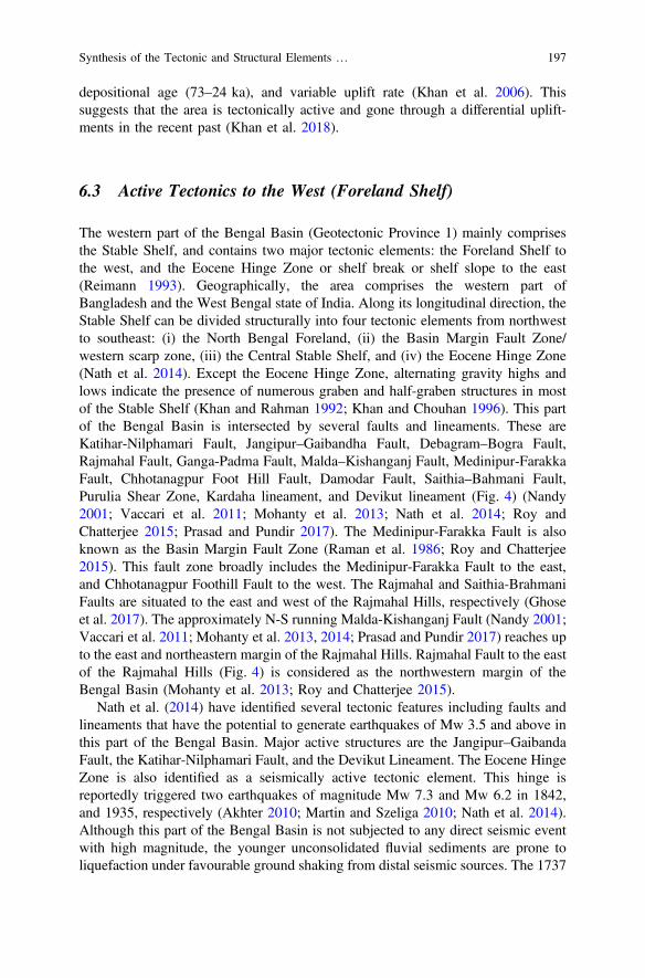
depositional age (73–24 ka), and variable uplift rate (Khan et al. 2006). Thissuggests that the area is tectonically active and gone through a differential uplift-ments in the recent past (Khan et al. 2018).
6.3 Active Tectonics to the West (Foreland Shelf)
The western part of the Bengal Basin (Geotectonic Province 1) mainly comprisesthe Stable Shelf, and contains two major tectonic elements: the Foreland Shelf tothe west, and the Eocene Hinge Zone or shelf break or shelf slope to the east(Reimann 1993). Geographically, the area comprises the western part ofBangladesh and the West Bengal state of India. Along its longitudinal direction, theStable Shelf can be divided structurally into four tectonic elements from northwestto southeast: (i) the North Bengal Foreland, (ii) the Basin Margin Fault Zone/western scarp zone, (iii) the Central Stable Shelf, and (iv) the Eocene Hinge Zone(Nath et al. 2014). Except the Eocene Hinge Zone, alternating gravity highs andlows indicate the presence of numerous graben and half-graben structures in mostof the Stable Shelf (Khan and Rahman 1992; Khan and Chouhan 1996). This partof the Bengal Basin is intersected by several faults and lineaments. These areKatihar-Nilphamari Fault, Jangipur–Gaibandha Fault, Debagram–Bogra Fault,Rajmahal Fault, Ganga-Padma Fault, Malda–Kishanganj Fault, Medinipur-FarakkaFault, Chhotanagpur Foot Hill Fault, Damodar Fault, Saithia–Bahmani Fault,Purulia Shear Zone, Kardaha lineament, and Devikut lineament (Fig. 4) (Nandy2001; Vaccari et al. 2011; Mohanty et al. 2013; Nath et al. 2014; Roy andChatterjee 2015; Prasad and Pundir 2017). The Medinipur-Farakka Fault is alsoknown as the Basin Margin Fault Zone (Raman et al. 1986; Roy and Chatterjee2015). This fault zone broadly includes the Medinipur-Farakka Fault to the east,and Chhotanagpur Foothill Fault to the west. The Rajmahal and Saithia-BrahmaniFaults are situated to the east and west of the Rajmahal Hills, respectively (Ghoseet al. 2017). The approximately N-S running Malda-Kishanganj Fault (Nandy 2001;Vaccari et al. 2011; Mohanty et al. 2013, 2014; Prasad and Pundir 2017) reaches upto the east and northeastern margin of the Rajmahal Hills. Rajmahal Fault to the eastof the Rajmahal Hills (Fig. 4) is considered as the northwestern margin of theBengal Basin (Mohanty et al. 2013; Roy and Chatterjee 2015).
Nath et al. (2014) have identified several tectonic features including faults andlineaments that have the potential to generate earthquakes of Mw 3.5 and above inthis part of the Bengal Basin. Major active structures are the Jangipur–GaibandaFault, the Katihar-Nilphamari Fault, and the Devikut Lineament. The Eocene HingeZone is also identified as a seismically active tectonic element. This hinge isreportedly triggered two earthquakes of magnitude Mw 7.3 and Mw 6.2 in 1842,and 1935, respectively (Akhter 2010; Martin and Szeliga 2010; Nath et al. 2014).Although this part of the Bengal Basin is not subjected to any direct seismic eventwith high magnitude, the younger unconsolidated fluvial sediments are prone toliquefaction under favourable ground shaking from distal seismic sources. The 1737
Synthesis of the Tectonic and Structural Elements … 197
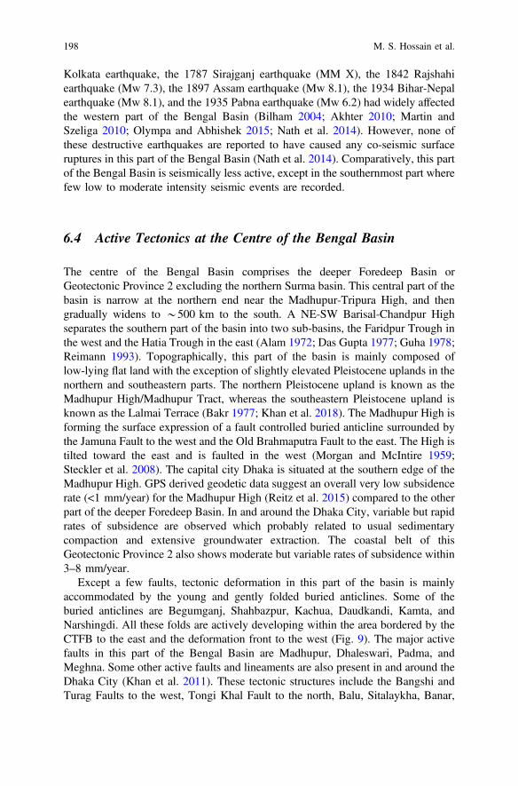
Kolkata earthquake, the 1787 Sirajganj earthquake (MM X), the 1842 Rajshahiearthquake (Mw 7.3), the 1897 Assam earthquake (Mw 8.1), the 1934 Bihar-Nepalearthquake (Mw 8.1), and the 1935 Pabna earthquake (Mw 6.2) had widely affectedthe western part of the Bengal Basin (Bilham 2004; Akhter 2010; Martin andSzeliga 2010; Olympa and Abhishek 2015; Nath et al. 2014). However, none ofthese destructive earthquakes are reported to have caused any co-seismic surfaceruptures in this part of the Bengal Basin (Nath et al. 2014). Comparatively, this partof the Bengal Basin is seismically less active, except in the southernmost part wherefew low to moderate intensity seismic events are recorded.
6.4 Active Tectonics at the Centre of the Bengal Basin
The centre of the Bengal Basin comprises the deeper Foredeep Basin orGeotectonic Province 2 excluding the northern Surma basin. This central part of thebasin is narrow at the northern end near the Madhupur-Tripura High, and thengradually widens to *500 km to the south. A NE-SW Barisal-Chandpur Highseparates the southern part of the basin into two sub-basins, the Faridpur Trough inthe west and the Hatia Trough in the east (Alam 1972; Das Gupta 1977; Guha 1978;Reimann 1993). Topographically, this part of the basin is mainly composed oflow-lying flat land with the exception of slightly elevated Pleistocene uplands in thenorthern and southeastern parts. The northern Pleistocene upland is known as theMadhupur High/Madhupur Tract, whereas the southeastern Pleistocene upland isknown as the Lalmai Terrace (Bakr 1977; Khan et al. 2018). The Madhupur High isforming the surface expression of a fault controlled buried anticline surrounded bythe Jamuna Fault to the west and the Old Brahmaputra Fault to the east. The High istilted toward the east and is faulted in the west (Morgan and McIntire 1959;Steckler et al. 2008). The capital city Dhaka is situated at the southern edge of theMadhupur High. GPS derived geodetic data suggest an overall very low subsidencerate (<1 mm/year) for the Madhupur High (Reitz et al. 2015) compared to the otherpart of the deeper Foredeep Basin. In and around the Dhaka City, variable but rapidrates of subsidence are observed which probably related to usual sedimentarycompaction and extensive groundwater extraction. The coastal belt of thisGeotectonic Province 2 also shows moderate but variable rates of subsidence within3–8 mm/year.
Except a few faults, tectonic deformation in this part of the basin is mainlyaccommodated by the young and gently folded buried anticlines. Some of theburied anticlines are Begumganj, Shahbazpur, Kachua, Daudkandi, Kamta, andNarshingdi. All these folds are actively developing within the area bordered by theCTFB to the east and the deformation front to the west (Fig. 9). The major activefaults in this part of the Bengal Basin are Madhupur, Dhaleswari, Padma, andMeghna. Some other active faults and lineaments are also present in and around theDhaka City (Khan et al. 2011). These tectonic structures include the Bangshi andTurag Faults to the west, Tongi Khal Fault to the north, Balu, Sitalaykha, Banar,
198 M. S. Hossain et al.
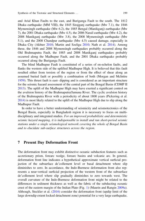
and Arial Khan Faults to the east, and Buriganga Fault to the south. The 1812Dhaka earthquake (MM VIII), the 1845 Sirajganj earthquake (Mw 7.1), the 1846Mymensingh earthquake (Mw 6.2), the 1885 Bengal (Manikganj) earthquake (Mw7), the 2001 Dhaka earthquake (Mw 4.5), the 2006 Narail earthquake (Mw 4.2), the2008 Manikganj earthquake (Mw 3.8), the 2008 Mymensingh earthquake (Mw5.1), and the 2008 Chandpur earthquake (Mw 4.5) caused damage, especially inDhaka City (Akhter 2010; Martin and Szeliga 2010; Nath et al. 2014). Amongthese, the 1846 and 2008 Mymensingh earthquakes probably occurred along theOld Brahmaputra Fault, the 1885 and 2008 Manikganj earthquakes probablyoccurred along the Madhupur Fault, and the 2001 Dhaka earthquake probablyoccurred along the Buriganga Fault.
The blind Madhupur Fault is constituted of a series of en-echelon faults, andflanks the western side of the uplifted Madhupur High. It is believed that this faultresulted either from torsion of the region or from the effect of shear along anassumed buried fault or possibly a combination of both (Morgan and McIntire1959). This thrust fault is east- dipping and is considered as an important structurefor the seismic hazard assessment of the central part of the Bengal Basin (CDMP II2013). The uplift of the Madhupur High may have exerted a significant control onthe avulsion history of the Brahmaputra/Jamuna River. The cyclic avulsion historyof the Brahmaputra River with a periodicity of about 1800 years (Pickering et al.2014) is most likely related to the uplift of the Madhupur High due to slip along theMadhupur Fault.
In order to have a better understanding of seismicity and seismotectonics of theBengal Basin, especially in Bangladesh region it is necessary to focus on multi-disciplinary and integrated studies. For an improved probabilistic and deterministicseismic hazard mapping, it is indispensable to install and run short-period seismicstations under a single seismological network covering the whole of Bengal Basinand to elucidate sub-surface structures across the region.
7 Present Day Deformation Front
The deformation front may exhibit distinctive oceanic subduction features such asaccretionary prism, forearc wedge, forearc basins and volcanic arc. In general,deformation front line indicates a hypothetical approximate vertical surficial pro-jection of the subsurface de’collement level or basal detachment where slipdiminishes to zero. In accordance, the Indo-Burmese deformation front also rep-resents a near-vertical surficial projection of the western front of the subsurfacede’collement level where slip gradually diminishes to zero towards west. Theoverall curvature of the Indo-Burmese deformation front might be related to thedifferences in sediment thickness as well as the fabric of the subducting oceaniccrust of the eastern margin of the Indian Plate (Fig. 1) (Maurin and Rangin 2009a).Although, Steckler et al. (2016) consider the deformation front (updip limit of thelarge downdip extent locked detachment zone) potential for a very large earthquake,
Synthesis of the Tectonic and Structural Elements … 199
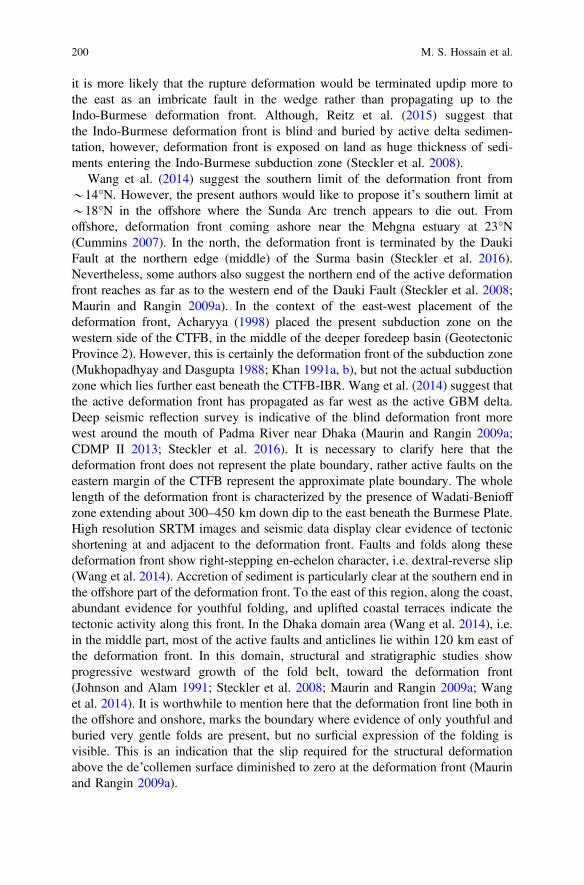
it is more likely that the rupture deformation would be terminated updip more tothe east as an imbricate fault in the wedge rather than propagating up to theIndo-Burmese deformation front. Although, Reitz et al. (2015) suggest thatthe Indo-Burmese deformation front is blind and buried by active delta sedimen-tation, however, deformation front is exposed on land as huge thickness of sedi-ments entering the Indo-Burmese subduction zone (Steckler et al. 2008).
Wang et al. (2014) suggest the southern limit of the deformation front from*14°N. However, the present authors would like to propose it’s southern limit at*18°N in the offshore where the Sunda Arc trench appears to die out. Fromoffshore, deformation front coming ashore near the Mehgna estuary at 23°N(Cummins 2007). In the north, the deformation front is terminated by the DaukiFault at the northern edge (middle) of the Surma basin (Steckler et al. 2016).Nevertheless, some authors also suggest the northern end of the active deformationfront reaches as far as to the western end of the Dauki Fault (Steckler et al. 2008;Maurin and Rangin 2009a). In the context of the east-west placement of thedeformation front, Acharyya (1998) placed the present subduction zone on thewestern side of the CTFB, in the middle of the deeper foredeep basin (GeotectonicProvince 2). However, this is certainly the deformation front of the subduction zone(Mukhopadhyay and Dasgupta 1988; Khan 1991a, b), but not the actual subductionzone which lies further east beneath the CTFB-IBR. Wang et al. (2014) suggest thatthe active deformation front has propagated as far west as the active GBM delta.Deep seismic reflection survey is indicative of the blind deformation front morewest around the mouth of Padma River near Dhaka (Maurin and Rangin 2009a;CDMP II 2013; Steckler et al. 2016). It is necessary to clarify here that thedeformation front does not represent the plate boundary, rather active faults on theeastern margin of the CTFB represent the approximate plate boundary. The wholelength of the deformation front is characterized by the presence of Wadati-Benioffzone extending about 300–450 km down dip to the east beneath the Burmese Plate.High resolution SRTM images and seismic data display clear evidence of tectonicshortening at and adjacent to the deformation front. Faults and folds along thesedeformation front show right-stepping en-echelon character, i.e. dextral-reverse slip(Wang et al. 2014). Accretion of sediment is particularly clear at the southern end inthe offshore part of the deformation front. To the east of this region, along the coast,abundant evidence for youthful folding, and uplifted coastal terraces indicate thetectonic activity along this front. In the Dhaka domain area (Wang et al. 2014), i.e.in the middle part, most of the active faults and anticlines lie within 120 km east ofthe deformation front. In this domain, structural and stratigraphic studies showprogressive westward growth of the fold belt, toward the deformation front(Johnson and Alam 1991; Steckler et al. 2008; Maurin and Rangin 2009a; Wanget al. 2014). It is worthwhile to mention here that the deformation front line both inthe offshore and onshore, marks the boundary where evidence of only youthful andburied very gentle folds are present, but no surficial expression of the folding isvisible. This is an indication that the slip required for the structural deformationabove the de’collemen surface diminished to zero at the deformation front (Maurinand Rangin 2009a).
200 M. S. Hossain et al.

As Maurin and Rangin (2009a) claim, deformation front propagated at*100 mm/year through the past 2 Ma, which is significantly greater than thecurrent convergence rate 9 mm/year across the CTFB (Nielsen et al. 2004). Ingeneral, the deformation front of the eastern Himalayas advanced more rapidlysouthward, whereas the deformation front of the CTFB-IBR probably advancesmore gradually westward to the Bengal Basin (Uddin and Lundberg 2004). Thisfast propagation of the deformation front is the key to explain the broad curvature ofthe northern end of the CTFB in the Surma basin immediate south of the ShillongPlateau. Over the past 2 Ma, the fold belt has propagated only into the basin, butnot over the Shillong Plateau. The plateau has been rising as continental basementpop-up structure since the Pliocene (Biswas and Grasemann 2005a, b; Najman et al.2016). The curvature of the fold belt thus reflects the impediment to west andnorthward propagation imposed by the Shillong Plateau (Wang et al. 2014).
In the Ramree domain, gradual increase of seismic activity has been observedalong the subducting Indian Plate towards north. The deepest hypocenters in theWadati-Benioff zone are*70 km deep and 140 km east of the deformation front inthe south, whereas, hypocenters reach depths of*120 km and extend to*300 kmeast from the deformation front in the north. The Indian Plate and the Burmese Plateare subjected to dextral-oblique convergence across the subduction zone with ratesbetween 14 and 26 mm/year, and the ratio of convergence to dextral slip is *3:2(Wang et al. 2014). In the eastern part of the Dhaka domain (i.e. beneath the IBR), awell-expressed Wadati-Benioff zone illuminates the subducting Indian oceaniclithosphere beneath the Burmese Plate (Ni et al. 1989; Guzmán-Speziale and Ni2000). In this domain, hypocentres occur as deep as 200 km and up to 450 km eastfrom the deformation front. Recent relative motions between the Indian Plate andthe Burmese Plate suggest oblique convergence across the subduction zone beneaththe CTFB and IBR. Moreover, to the northern end of Dhaka domain, convergencerate ranges 11–20 mm/year, which implies significant active right-lateral strike-slipfaulting or clockwise rotations. Although the northern end of the deformation frontis truncated by the Dauki Fault at the northeastern corner of the Surma basin,geomorphology shows stark contrast between Dhaka and Naga domains, whereasthe nature of the higher IBR does not change markedly across the domainboundary. The Wadati-Benioff zone beneath the Naga Hills reaches *160 kmdepth, and extends *150 km southeast from the Naga mountain front. The faulttrace appears from the geomorphological expression of the Naga Thrust as severalarcuate lobes along the range front (Mathur and Evans 1964).
8 Summary and Conclusions
The Bengal Basin is located at the eastern part of the Indogangetic Plain andextends up to the Bengal Deep Sea Fan in the Bay of Bengal. The development ofthe Bengal Basin is controlled and limited by the interplay between the Eurasian,the Indian and the Burmese Plates. The E-W oriented Himalayan Mobile Belt and
Synthesis of the Tectonic and Structural Elements … 201
the N-S oriented Indo-Burman Ranges developed as the Indian Plate subductedbelow the Eurasian Plate in the north and below the Burmese Plate in the east,respectively with a syntexial bend conjugating the two belts in between. Thegeometry, structural features and sediments of the Bengal Basin furnished anarchive of the past history of the area.
At the initial stage (Precambrian) only the Geotectonic Province 1 (Stable Shelfof the Bengal Basin) was part of Indian Plate when the Indian Plate was a part of theGondwana Supercontinent. Subsequently, the Indian Plate occupied a centralposition in the Gondwana Supercontinent until the beginning of Middle Jurassic(*170–175 Ma) when the break-up of the Gondwana Supercontinent started. Fromthe Middle Jurassic onward up to the end of the Palaeocene (55.9 Ma) the IndianPlate have drifted and isolated from its neighbouring cratonic blocks. During theLate Paleozoic–Mid Mesozoic time the basin developed as an intra-cratonic riftbasin as evidenced by the continental Gondwana sediments deposition in the gra-ben, half-graben structures in the Geotectonic Province 1. This episode of basindevelopment was followed by the Kerguelen igneous activity spreaded the SEIndian Ocean. The Geotectonic Province 1 experienced widespread volcanism ascontinental flood basalts known as the Rajmahal Trap covered the Gondwanasediments. At that time, the peri-cratonic part on the eastern margin (the presentposition of the Geotectonic Province 2) might have been influenced by marineenvironment and also affected by this volcanic activity. Within the GeotectonicProvince 2 the Barisal–Chandpur Gravity High may have been formed as a riftvalley during the initial break-up of the Gondwana and formation of the IndianPlate along which transitional zone between continent-ocean crust of the IndianPlate has been marked by several phases of basalt flow. Subsequently, theGeotectonic Province 2 continuously subsided and received a massive volume ofsediments from the Late Mesozoic through Tertiary to Recent times.
During the Late Cretaceous and Paleocene (between 120 and 157 Ma) the IndianPlate migrated rapidly northwards until the oceanic part of the Indian Plate collidedwith a Neotethyan intra-oceanic arc. With further migration, the continental crust ofthe Indian Plate collided with the Tibetan part of the Eurasian Plate around theEocene-Oligocene boundary (*35 Ma) causing the northern part of Indian plate tosubduct beneath the southern Tibet (initiation of continent–continent collision).This continental convergence resulted in folding and thrusting in the Himalayanregion.
The Bengal Basin was an integral part of the major basin that extended from theBurmese Plate in the east to the Indian Shield in the west during the Paleocene.During this Period, the Indian Plate moved northwards and the Tethys and theyoung Indian Ocean were interconnected across the Upper Assam Shelf.Subsequently, northern migration of the Indian plate was replaced bynorth-eastward movement and resulted in the collision of north-eastern end of theIndian Plate with the Burmese Plate uplifting the Indo–Burman Ranges (IBR) bythe Late Oligocene. The uplift of the IBR as an accretionary wedge produced a twingulf that separated the Burmese Tertiary Basins on the eastern and the Bengal–Assam Basins on the western and northern flanks, respectively. These basins were
202 M. S. Hossain et al.

fully separated with the rise of the Himalayas and IBR in the Miocene and theGeotectonic Province 2 or the central Foredeep Basin came into existence by*23 Ma considered as the ‘remnant ocean basin’.
The structural development of the Geotectonic Province 3 (CTFB) is related withthe development of IBR whereas the stratigraphy exposed in the region are broadlysimilar to those exposed along the southern sub-Himalayan Belt. As collision andfurther subduction of the Indian Plate beneath the Burmese Plate in an arc-trenchsetting continued, it resulted in the development of accretionary prism and majoreast dipping thrusts (Kaladan Fault to the east, and Chittagong Coastal Fault to thewest) that largely control the structural evolution of the Geotectonic Province 3.The age and intensity of folding and elevation of the structures increase in theeasterly direction towards the IBR and the thrust component increases westward.
The CTFB comprises NNW-SSE trending low amplitude anticlinal and synclinalfolds. The western boundary of this belt is the Chittagong Coastal Fault (CCF) andeastern boundary is Kaladan Thrust Fault. The Kaladan Thrust zone, sub-parallel toanticlines mark the tectonic boundary between CTFB of the Bengal Basin and theIndo-Burman Range. The CTFB comprises of Miocene-Recent sedimentary rocksuccessions. During the Miocene, the depositional environments changed frommarine to transitional marine. Deltaic and fluviatile conditions prevailed in thePlio-Pleistocene. Structural (folding, faulting) development in the CTFB may havestarted during Pliocene and is still going on.
A detail tectonic update of the Indian western part (Dasgupta and Mukherjee2017), Himalaya (Mukherjee and Koyi 2010a, b; Mukherjee et al. 2012; Mukherjeeand Mulchrone 2012; Banerjee et al. 2019; Mahato et al. 2019) coupled with suchworks/reviews from the eastern sector can provide a more detail tectonic evolutionof India.
Acknowledgements Thanks are due to Prof. Dr. S. M. Mahbubul Ameen for discussion andsuggestion during the writing of this manuscript. Dr. Soumyajit Mukherjee and an anonymousreviewer are greatly appreciated for their insightful comments and thoughtful suggestions on theinitial version of this manuscript. The Springer proof-reading team and Annett Buettner arethanked for their cooperation. Mukherjee (2019) summarizes this work.
References
Abdullah R, Yeasmin R, Ameen SMM, Khanam F, Bari Z (2015) 2D structural modelling andhydrocarbon potentiality of the Sitakund structure, Chittagong Tripura Fold Belt, BengalBasin, Bangladesh. Journal Geological Society of India 85, 697–705
Abrajevitch AV, Ali JR, Aitchison JC, Badengzhu, Davis AM, Liu J, Ziabrev SV (2005)Neotethys and the India-Eurasia collision: insights from a palaeomagnetic study of theDazhuqu ophiolite, southern Tibet. Earth and Planetary Science Letters 233, 87–102
Acharyya SK (1994) The Cenozoic foreland basin and tectonics of the Eastern Himalaya:problems and perspectives. Himalayan Geology 15, 3–21
Acharyya SK (1998) Break-up of the greater Indo-Australian continent and accretion of blocksframing South and East Asia. Journal of Geodynamics 26, 149–170
Synthesis of the Tectonic and Structural Elements … 203

Acharyya SK (2003) A plate tectonic model for Proterozoic crustal evolution of central Indiantectonic zone. Gondwana Geological Magazine 7, 9–31
Acharyya SK (2007) Collisional emplacement history of the Naga-Andaman ophiolites and theposition of the eastern Indian suture. Journal of Asian Earth Sciences 29, 229–242
Acharyya SK, Mitra ND, Nandy DR (1986) Regional geology and tectonic setting of NortheastIndia and adjoining region. Memoir of the Geological Survey of India 119, 6–12
Achyuthan H, Nagasundaram M, Gourlan AT, Eastoe C, Ahmad SM, Padmakumari VM (2014)Mid-Holocene Indian summer monsoon variability off the Andaman Islands, Bay of Bengal.Quaternary International 349, 232–244
Acton GD (1999) Apparent polar wander of India since the Cretaceous with implications forregional tectonics and true polar wander. In: Radhakrishna T, Piper JDA (eds) The Indiansubcontinent and Gondwana: a palaeomagnetic and rock magnetic perspective. Memoir ofGeological Society of India, vol 44, pp 129–175
Ahmed ST (1968) Cenozoic Fauna of the Cox’s Bazar coastal cliff. Unpublished M.Sc. thesis,University of Dhaka, Dhaka, 68 p
Aier I, Luirei K, Bhakuni S, Thong GT, Kothyari GC (2011) Geomorphic evolution ofMedziphema intermontane basin and quaternary deformation in the Schuppen belt, Nagaland,NE India. Geomorphology 55, 247–265
Aitchison JC, Ali JR, Davis AM (2007) When and where did India and Asia collide? Journal ofGeophysical Research 112, B05423
Akhter SH (2010) Earthquakes of Dhaka. In: Islam MA, Ahmed SU, Rabbani AKMG(eds) Environment of capital Dhaka: Plants wildlife gardens park open spaces air waterearthquake. Asiatic Society of Bangladesh, pp 401–426
Akhter SH, Steckler MS, Seeber L, Agostinetti NP, Kogan MG (2010) GPS velocities andstructure across the Burma accretionary prism and Shillong Plateau in Bangladesh. AGU FallMeeting Supplement. Abstract T22A-08
Alam M (1972) Tectonic classification of the Bengal Basin. Geological Society of AmericaBulletin 83, 519–522
Alam M (1989) Geology and depositional history of Cenozoic sediments of the Bengal Basin ofBangladesh. Palaeogeography, Palaeoclimetology, Palaeoecology 69, 125–139
Alam MM (1991) Paleoenvironmental study of the Barail succession exposed in northeasternSylhet, Bangladesh. Bangladesh Journal of Scientific Research 9, 25–32
Alam M (1997) Bangladesh. In: Moores EM, Fairbridge RW (eds) Encyclopedia of European andAsian regional geology. Chapman & Hall, London, pp 64–72
Alam AKMK, Islam MB (2017) Recent changes in Jadukata fan (Bangladesh) in response toHolocene tectonics. Quaternary International 462, 226–235
Alam M, Alam MM, Curray JR, Chowdhury MLR, Gani MR (2003) An overview of thesedimentary geology of the Bengal Basin in relation to the regional tectonic framework andbasin-fill history. Sedimentary Geology 155, 179–208
Ali JR, Aitchison JC (2004) Problem of positioning Palaeogene Eurasia: a review, efforts toresolve the issue, implications for the India–Asia collision. In: Clift PD, Wang P, Khunt W,Hayes DE (eds) Continent–ocean interactions within the East Asia Marginal Seas. AGUMonograph 149, 23–35
Ali JR, Aitchison JC (2005) Greater India. Earth-Science Reviews 72, 169–188Ali JR, Aitchison JC (2006) Positioning Paleogene Eurasia problem: solution for 60–50 Ma and
broader tectonic implications. Earth Planetary Science and Letters 251, 148–155Ali JR, Aitchison JC (2008) Gondwana to Asia: plate tectonics, paleogeography and the biological
connectivity of the Indian sub-continent from the middle jurassic through latest Eocene (166–35 Ma). Earth Science Reviews 88, 145–166
Ali SMM, Raghava MSV (1985) The Bouguer gravity map of Bangladesh and its tectono-geologicimplications. Bangladesh Journal of Geology 4, 43–56
204 M. S. Hossain et al.
Allégre CJ, Courtillot V, Tapponnier P, Hirn A, Mattauer M, Coulon C, Jaeger JJ, Achache J,Schärer U, Marcoux J, Burg JP, Girardeau J, Armijo R, Garie´ py C, Göpel C, Li TD, Xiao XC,Chang CF, Li GQ, Lin BY, Teng JW, Wang NW, Chen GM, Han TL, Wang XB, Den WM,Sheng HB, Cao YG, Zhou J, Qiu HR, Bao PS, Wang SC, Wang BX, Zhou YX, and Xu RH(1984) Structure and evolution of the Himalayan-Tibet orogenic belt. Nature, 307, 17–22
Ameen SMM, Khan MSH, Akon E, Kazi AI (1998) Petrography and major oxide chemistry ofsome Precambrian crystalline rocks from Maddhapara, Dinajpur. Bangladesh GeoscienceJournal 4, 1–19
Ameen SMM, Wilde SA, Kabir MZ, Akon E, Chowdhury KR, Khan MSH (2007)Paleoproterozoic granitoids in the basement of Bangladesh: a piece of the Indian Shield oran exotic fragment of the Gondwana jigsaw? Gondwana Research 12, 280–387
Ameen SMM, Hossain MS, Hossain MS, Abdullah R, Bari Z, Uddin MN, Das SC, Tapu AT,Jahan H, Shahriar MS (2016) Deciphering the Precambrian crust between Shillong Massif andnortheast India. In: International Association of Gondwana Research (IAGR) 2016Convention, Trivandum, India. Abstract volume, pp 75–79
Angelier J, Baruah S (2009) Seismotectonics in Northeast India: a stress analysis of focalmechanism solutions of earthquakes and its kinematic implications. Geophysical JournalInternational 178, 303–326
Ansary MA, Al-Hussaini TM, Sharfuddin M (2000) Damage assessment of July 22, 1999Moheshkhali earthquake, Bangladesh. Paper presented at 8th ASCE specialty conference onprobabilistic mechanics and structural reliability. Indiana, USA, 6 p
Bage AK, Maurya VP, Shalivahan VP, Singh S, Tripathi A (2014) Preliminary magnetotelluricsresults over Rajmahal traps. Extended Abstract, 22nd EM induction workshop, Weimar,Germany, pp 1–4
Bakhtine MI (1966) Major tectonic features of Pakistan: part II. The Eastern Province. Science &Industry 4, 89–100
Bakr MA (1977) Quaternary geomorphic evolution of the Brahmanbaria–Noakhali area, Comillaand Noakhali districts, vol 1. Records of the Geological Survey of Bangladesh, Bangladesh, p 44
Baksi AK (1995) Petrogenesis and timing of volcanism in the Rajmahal flood basalt province,northeastern India. Chemical Geology 121, 73–90
Baksi AK, Barman T, Paul D, Farrar E (1987) Widespread Early Cretaceous flood basaltvolcanism in eastern India: geochemical data from the Rajmahal–Bengal–Sylhet Traps.Chemical Geology 63, 133–141
Ball V (1877) Geology of the Rajmahal Hills. Memoir of the Geological Survey of India 13,155–248
Banerjee B, Sengupta BJ, Banerjee PK (1995) Signals of Barremian (116 Ma) or younger oceaniccrust beneath the Bay of Bengal along 14°N latitude between 81°E and 93°E. Marine Geology128, 17–23
Banerjee P, Burgmann R, Nagarajan B, Apel E (2008) Intraplate deformation of the Indiansubcontinent. Geophysical Research Letters 35, L18301
Banerjee S, Bose N, Mukherjee S (2019) Field structural geological studies around Kurseong,Darjeeling-SikkimHimalaya, India. In:Mukherjee S (ed) Tectonics and structural geology: Indiancontext. Springer International Publishing AG, Cham, pp 425–440. ISBN: 978-3-319-99340-9
Banerji RK (1979) Disang Shale, its stratigraphy, sedimentation history and basin configuration innortheastern India and Burma. Eighth Colloquium Indian Micropalaeontology andStratigraphy. Baroda, India, 12 p
Banerji RK (1981) Cretaceous-Eocene sedimentation, tectonism and biofacies in the Bengal Basin,India. Palaeogeography, Palaeoclimetology, Palaeoecology 34, 57–85
Barman P, Jade S, Shrungeshwara TS, Kumar A, Bhattacharyya S, Ray JD, Jagannathan S,Jamir WM (2016) Crustal deformation rates in Assam Valley, Shillong Plateau, EasternHimalaya, and Indo-Burmese region from 11 years (2002–2013) of GPS measurements.International Journal of Earth Sciences 106, 2025–2038
Baruah S, Hazarika D (2008) A GIS based tectonic map of north eastern India. Current Science 95,176–177
Synthesis of the Tectonic and Structural Elements … 205

Baruah S, Saikia S, Baruah S, Bora PK, Tatevossian R, Kayal JR (2016) The september 2011Sikkim Himalaya earthquake Mw 6.9: is it a plane of detachment earthquake? Geomatics,Natural Hazards and Risk 7, 248–263
Bastia R, Radhakrishna M, Das S, Kale AS, Catuneanu C (2010) Delineation of the 85°E ridge andits structure in the Mahanadi Offshore Basin, Eastern Continental Margin of India (ECMI),from seismic reflection imaging. Marine and Petroleum Geology 27, 1841–1848
Baxter AT, Aitchison JC, Ali JR, Chan JS-L, Chan GHN (2016) Detrital chrome spinel evidencefor a Neotethyan intra-oceanic island arc collision with India in the Paleocene. Journal of AsianEarth Sciences 128, 90–104
Bender F (1983) Geology of Burma. Borntraeger, Berlin, 260 pBerthet T, Ritz J-F, Ferry M, Pelgay P, Cattin R, Drukpa D, Braucher R, Hetényi G (2014) Active
tectonics of the eastern Himalaya: new constraints from the first tectonic geomorphology studyin southern Bhutan. Geology 42, 427–430
Bhattacharya PM, Mukhopadhyay S, Majumdar RK, Kayal JR (2008) 3-D seismic structure of thenortheast India region and its implications for local and regional tectonics. Journal of AsianEarth Sciences 33, 25–41
Bhuiyan AH, Hossain MS (2006) Groundwater constrains and opportunity: a key for future urbanplanning of Dhaka City, Bangladesh. Journal of Environmental Science (Dhaka) 4, 63–75
Bilham R (2004) Earthquakes in India and the Himalaya: tectonics, geodesy and history. AnnalesGeophysicae 47, 839–858
Bilham R, England PC (2001) Plateau “pop-up” in the great 1897 Assam earth-quake. Nature 410,806–809
Bilham R, Mencin D, Bendick R, Bürgmann R (2017) Implications for elastic energy storage inthe Himalaya from the Gorkha 2015 earthquake and other incomplete ruptures of the MainHimalayan Thrust. Quaternary International 462, 3–21
Biswas B (1961) Geology of the Bengal Basin with special reference to stratigraphy andmicropaleontology. Dissretation, University of Calcutta, 138 p
Biswas B (1963) Results of exploration of petroleum in western part of the Bengal basin, India. In:Proceedings of the 2nd symposium on development of petroleum resources ECAFE, mineralresource development series no. 18, 241–250. Flood basalt province, northeast India. ChemicalGeology 121, 133–141
Biswas S, Das Gupta A (1989) Distribution of stresses in the Himalayan and the Burmese arcs.Gerlands Beiträge zur Geophysik 98, 223–239
Biswas S, Grasemann B (2005a) Quantitative morphotectonics of the southern Shillong Plateau(Bangladesh/India). Australian Journal of Earth Science 97, 82–93
Biswas S, Grasemann B (2005b) Structural Modelling of the Subsurface Geology of the SylhetTrough, Bengal Basin. Bangladesh Geoscience Journal 11, 19–33
Biswas S, Majumdar RK (1997) Seismicity and tectonics of the Bay of Bengal: evidence forintraplate deformation of the northern Indian plate. Tectonophysics 269, 323–336
Biswas S, Coutand I, Grujic D, Hager C, Stockli D, Grasemann B (2007) Exhumation and uplift ofthe Shillong Plateau and its influence on the eastern Himalayas: new constraints from apatiteand zircon (U–Th–[Sm])/He and apatite fission track analysis. Tectonics 26, TC6013
Biswas S, Majumdar RK, Das Gupta A (1992) Distribution of stress axes orientation in theAndaman-Nicobar island region: a possible stress model and its significance for extensionaltectonics of the Andaman Sea. Physics of Earth and Planetary Interior 70, 57–63
Blaser L, Krüger F, Ohrnberger M, Scherbaum F (2010) Scaling relations of earthquake sourceparameter estimates with special focus on subduction environment. Bulletin of SeismologicalSociety of America 100, 2914–2926
BOGMC (1997) Petroleum exploration opportunities in Bangladesh. Bangladesh Oil, Gas andMineral Corporation (Petrobangla), Dhaka, March, 1997
Bosch D, Garrido CJ, Bruguier O, Dhuime B, Bodinier J-L, Padròn-Navarta JA, Galland B (2011)Building an island-arc crustal section: time constraints from a LA-ICP-MS zircon study. Earthand Planetary Science Letters 309, 268–279
206 M. S. Hossain et al.
Bose N, Mukherjee S (submitted-a) Field documentation and genesis of the back-structures from apart of the Garhwal Lesser Himalaya, Uttarakhand, India: Tectonic implications. In: Sharma,Villa IM, Kumar S (eds) Crustal architecture and evolution of the Himalaya-Karakoram-TibetOrogen. Geological Society of London Special Publications
Bose N, Mukherjee S (submitted-b) Field documentation and genesis of back-structures from theforeland part of a collisional orogen: Examples from the Darjeeling-Sikkim Lesser Himalaya,Sikkim, India. Gondwana Research
Bracciali L, Najman Y, Parrish RR, Akhter SH, Millar I (2015) The Brahmaputra tale of tectonicsand erosion: early Miocene river capture in the Eastern Himalaya. Earth and Planetary ScienceLetters 415, 25–37
Brammer H (2012) The physical geography of Bangladesh. University Press Ltd., Dhaka, p 547Brammer H (2014) Bangladesh’s dynamic coastal regions and sea-level rise. Climate Risk
Management 1, 51–62Bulbul MAU (2015) Neotectonics of the Surma Basin, Bangladesh from GPS analysis. AGU Fall
Meeting Supplement. Abstract T41B-2884Burgess PW, Yin A, Dubey CS, Shen Z-K, Kelty TK (2012) Holocene shortening across the main
frontal thrust zone in the eastern Himalaya. Earth and Planetary Science Letters 357–358,152–167
CDMP II (2013) Report of active fault mapping in Bangladesh: paleo-seismological study of theDauki Fault and the Indian-Burman plate boundary fault. Comprehensive DisasterManagement Programme (CDMP II), Ministry of Disaster Management and Relief,Bangladesh, 67 p
Chatterjee N (2017) Constraints from monazite and xenotime growth modelling in theMnCKFMASH-PYCe system on the P–T path of a metapelite from Shillong-MeghalayaPlateau: implications for the Indian shield assembly. Journal of Metamorphic Geology 35,393–412
Chauhan OS, Vogelsang E (2006) Climate induced changes in the circulation and dispersalpatterns of the fluvial sources during late quaternary in the middle Bengal Fan. Journal EarthSystem and Science 115, 379–386
Chopra S, Sharma J, Sutar A, Bansal BK (2013) Estimation of source parameters of Mw 6.9Sikkim Earthquake and modeling of ground motions to determine causative fault. Pure andApplied Geophysics 171, 1311–1328
Chowdhury KR (1970) Strcture and petrology of the Tertiary sedimentary sequence of thenorthern part of the Changotaung Hill Range, Chittagong Hill Tracts. M.Sc. thesis, Universityof Dhaka, 192 p
Chowdhury KR, Biswas S, Ahmed AMM (1996) The structural and tectonic set-up of Jaintiapurand adjacent areas, Sylhet District, Bangladesh. Bangladesh Geoscience Journal 2, 1–14
Chowdhury KR, Huq NE, Ibna-Hamid ML, Ameen SMM (2003) Evidence of Mud intrusion intothe deposits of the Surma Group, Bengal Basin, Bangladesh. Bangladesh Geoscience Journal 9,173–178
Chowdhury SQ (1982) Palynostratigraphy of the Neogene sediments of the Sitapahar anticline(western flank), Chittagong Hill Tracts, Bangladesh. Bangladesh Journal of Geology 1, 35–49
Coffin MF, Pringle MS, Duncan RA, Gladczenko TP, Storey M, Müller RD, Gahagan LA (2002)Kerguelen hotspot magma output since 130 Ma. Journal of Petrology 43, 1121–1137
Cummins PR (2007) The potential for giant tsunamigenic earthquakes in the northern Bay ofBengal. Nature 449, 75–78
Curiale JA, Covington GH, Shamsuddin AHM, Morelos JA, Shamsuddin AKM (2002) Origin ofpetroleum in Bangladesh. AAPG Bulletin 86, 625–652
Curray JR (1991) Possible green schist metamorphism at the base of a 22 km sedimentary section,Bay of Bengal. Geology 19, 1097–1100
Curray JR (1994) Sediment volume and mass beneath the Bay of Bengal. Earth and PlanetaryScience Letters 125, 371–383
Curray JR (2014) The Bengal depositional system: from rift to orogeny. Marine Geology 352,59–69
Synthesis of the Tectonic and Structural Elements … 207

Curray JR, Moore DG (1971) Growth of the Bengal deep-sea fan and denudation in theHimalayas. Geological Society of America Bulletin 82, 563–572
Curray JR, Moore DG (1974) Sedimentary and Tectonic processes in the Bengal deep-sea fan andgeosyncline. In: Burk CA, Drake CL (eds) The geology of continental margins. Springer,Berlin, Heidelberg
Curray JR, Munasinghe T (1991) Origin of the Rajmahal Traps and the 85°E ridge: preliminaryreconstructions of the trace of the Crozet hotspot. Geology 19, 1237–1240
Curray JR, Emmel FJ, Moore DG (2003) The Bengal Fan: morphology, geometry, stratigraphy,history and processes. Marine and Petroleum Geology 19, 1191–1223
Das Gupta AB (1977) Geology of Assam-Arakan region. Oil Commentary, India 15, 4–34Das JD, Saraf AK, Shujat Yazdana (2010) A remote sensing technique for identifying geometry
and geomorphological features of the Indo-Burman frontal fold belt. International Journal ofRemote Sensing 31, 4481–4503
Das JD, Shujat Y, Saraf AK (2011a) Spatial technologies in deriving the morphotectoniccharacteristics of tectonically active western Tripura region, Northeast India. Journal of IndianSociety of Remote Sensing 39, 249–258
Das JD, Shujat Y, Saraf AK, Rawat V, Sharma K (2011b) Morphotectonic features and faultpropagation folding of Bhuban Hills, NE India using satellite image and DEM. Journal ofIndian Society of Remote Sensing 39, 73–81
Dasgupta S, Mukherjee S (2017) Brittle shear tectonics in a narrow continental rift: asymmetricnon-volcanic Barmer basin (Rajasthan, India). Journal of Geology 125, 561–591
Dasgupta T, Mukherjee S (submitted) Sediment compaction and applications in petroleumgeoscience. In: Swenner R (ed) Springer series: advances in oil and gas exploration &production. ISSN: 2509-372X
DeCelles PG (2012) Foreland basin systems revisited: variations in response to tectonic settings.In: Busby C, Pérez A (eds) Tectonics of sedimentary basins: recent advances. Wiley,Chichester, UK, pp 405–426
DeCelles PG, Kapp P, Gehrels GE, Ding L (2014) Paleocene-Eocene foreland basin evolution inthe Himalaya of southern Tibet and Nepal: implications for the age of initial India-Asiacollision. Tectonics 33, 824–849
DeCelles PG, Robinson DM, Zandt G (2002) Implications of shortening in the Himalayanfold-thrust belt for uplift of the Tibetan Plateau. Tectonics 21, 1062
Desa MA, Ramana MV, Ramprasad T, Anuradha M, Lall MV, Kumar BJP (2013) Geophysicalsignatures over and around the northern segment of the 85°E Ridge, Mahanadi offshore,Eastern Continental Margin of India: tectonic implications. Journal of Asian Earth Sciences 73,460–472
Desikachar SV (1974) A review of the tectonic and geologic history of eastern India in terms ofplate tectonics theory. Geological Society of India Journal 15, 137–149
Dietz RS (1953) Possible deep-sea turbidity-current channels in the Indian Ocean. GeologicalSociety of America Bulletin 64, 375–378
Dina NT, Rahman MJJ, Hossain MS, Sayem ASM (2016) Provenance of the Neogene successionin the Bandarban structure, South-East Bengal Basin, Bangladesh: insights from petrographyand petrofacies. Himalayan Geology 37, 141–152
Emmel FJ, Curray JR (1985) Bengal Fan, Indian Ocean. In: Bouma AH, Barnes NE, Normark WR(eds) Submarine fans and related turbidite sequences. Springer, New York, pp 107–112
Evans P (1932) Tertiary succession in Assam. Transactions of the Mining and Geological Instituteof India 27, 155–260
Evans P (1964) The tectonic framework of Assam. Journal Geological Society of India 5, 80–96Farhaduzzaman M, Abdullah WH, Islam MA (2014) Hydrocarbon source potential and
depositional environment of the Surma Group shales of Bengal basin, Bangladesh. Journalof Geological Society of India 83, 433–446
Fergusson J (1863) On recent changes in the delta of the Ganges. Quarterly Journal of theGeological Society 19, 321–354
208 M. S. Hossain et al.

Fournier L, Fauquembergue K, Zaragosi S, Zorzi C, Malaizé B, Bassinot F, Joussain R, Colin C,Moreno E, Leparmentier F (2016) The Bengal fan: external controls on the Holocene activechannel turbidite activity. The Holocene 27, 900–913
Gahalaut VK, Kundu B, Laishram SS, Catherine J, Kumar A, Singh MD, Tiwari R, Chadha R,Samanta S, Ambikapathy A (2013) Aseismic plate boundary in the Indo-Burmese wedge,northwest Sunda Arc. Geology 41, 235–238
Ganguly S (1984) Tectonic evolution of the orogenic belt of Tripura. Quarternary Journal ofGeological Mining and Metal Society India 56, 128–137
Ganguly S (1993) Stratigraphy, sedimentation and hydrocarbon prospects of Tertiary succession ofTripura and Cachar. Indian Journal of Geology 65, 145–180
Ganguly S (1997) Petroleum geology and exploration history of the Bengal basin in India andBangladesh. Indian Journal of Geology 69, 1–25
Gani MR, Alam MM (1999) Trench-slope controlled deep-sea clastics in the exposed lower Surmagroup in the southeastern fold belt of the Bengal Basin, Bangladesh. Sedimentary Geology127, 221–236
Gani MR, Alam MM (2003) Sedimentation and basin-fill history of the Neogene clastic successionexposed in the southeastern fold belt of the Bengal Basin, Bangladesh: a high-resolutionsequence stratigraphic approach. Sedimentary Geology 155, 227–270
Garzanti E, Baud A, Mascle G (1987) Sedimentary record of the northward flight of India and itscollision with Eurasia (Ladakh Himalaya, India). Geodinamica Acta 1, 297–312
Ghatak A, Basu AR (2011) Vestiges of the Kereguelen plume in the Sylhet Traps, northeasternIndia. Earth and Planetary Science Letters 308, 52–64
Ghose NC, Chatterjee N, Windley BF (2017) Subaqueous early eruptive phase of the Late AptianRajmahal volcanism, India: evidence from volcaniclastic rocks, bentonite, black shales, andoolite. Geoscience Frontiers 8, 809–822
Ghosh GK, Dasgupta R, Reddy BJ, Singh SN (2015) Gravity data interpretation across theBrahmaputra Thrust and Dauki Fault in the north-eastern India. Journal of Geophysics XXXVI,31–38
Gilbert OE Jr (2001) Structural geology and regional tectonics of the Chittagong Hills Fold Belt,Eastern Bangladesh, GSA Annual Meeting, Houston, Texas, Abstract 21770
Goodbred SL Jr, Kuehl SA (1998) Floodplain processes in the Bengal Basin and the storage ofGanges-Brahmaputra river sediment: an accretion study using 137Cs and 210Pb geochronology.Sedimentary Geology 121, 239–258
Goodbred SL Jr, Kuehl SA (1999) Holocene and modern sediment budgets for the GangesBrahmaputra river system: evidence for highstand dispersal to floodplain, shelf and deep-seadepocenters. Geology 27, 559–562
Goodbred SL Jr, Kuehl SA, Steckler MS, Sarkar MH (2003) Controls on facies distribution andstratigraphic preservation in the Ganges-Brahmaputra delta sequence. Sedimentary Geology155, 301–316
Grimaud J-L, Paola C, Ellis C (2017) Competition between uplift and transverse sedimentation inan experimental delta. Journal of Geophysical Research: Earth Surface 122, 1339–1354
Guha DK (1978) Tectonic framework and oil & gas prospects of Bangladesh. In: Proceedings ofthe 4th annual conference Bangladesh Geological Society, pp 65–75
Guha DK, Henkel H, Imam B (2010) Geothermal potential in Bangladesh—results frominvestigations of abandoned deep wells. In: Proceedings world geothermal congress 2010, Bali,Indonesia, pp 1–8
Guzmán-Speziale M, Ni JF (2000) Comment on “Subduction in the Indo-Burma Region: is it stillactive?” by SP Satyabala. Geophysical Research Letters 27, 1065–1066
Hall R (2002) Cenozoic geological and plate tectonic evolution of SE Asia and the SW Pacific:computer-based reconstructions, model and animations. Journal of Asian Earth Scinces 20,353–431
Higgins SA, Overeem I, Steckler MS, Syvitski JPM, Seeber L, Akhter SH (2014) InSARmeasurements of compaction and subsidence in the Ganges-Brahmaputra Delta, Bangladesh.Journal of Geophysical Research Earth Surface 119, 1768–1781
Synthesis of the Tectonic and Structural Elements … 209
Hiller K, Elahi M (1984) Structural development and hydrocarbon entrapment in the Surma Basin.In: Bangladesh (northwest Indo-Burman fold belt): Fifth Offshore Southwest Conference,Singapore, pp 656–663
Hiller K, Elahi M (1988) Structural growth and hydrocarbon entrapment in the Surma basin,Bangladesh. In: Wagner HC, Wagner LC, Wang FFH, Wong FL (eds) Petroleum resources ofChina and related subjects, Houston, Texas. Circum-Pacific council for energy and mineralresources earth science series, vol 10, pp 657–669
Hodges KV (2000) Tectonics of the Himalaya and southern Tibet from two perspectives. GSABulletin 112, 324–350
Holtrop JF, Keizer J (1970) Some aspects of the stratigraphy and correlation of the Surma Basinwells, East Pakistan. In: ECAFE mineral resources development series, vol 36. United Nations,New York, pp 143–154
Hoque MA, Hoque MM, Ahmed KM (2007) Declining groundwater level and aquifer dewateringin Dhaka metropolitan area, Bangladesh: causes and quantification. Hydrogeology Journal 15,1523–1534
Hossain A, Steckler MS, Akhter SH (2015) Resistivity imaging of strata and faults in Bangladesh.AGU Fall Meeting Supplement. Abstract T41B-2886
Hossain I, Tsunogae T, Rajesh HM, Chen B, Arakawa Y (2007) Palaeoproterozoic U-Pb SHRIMPzircon age from basement rocks in Bangladesh: a possible remnant of the Columbiasupercontinent. Comptes Rendus Geosciences 339, 979–986
Hossain I, Tsunogae T, Tsutsumi Y, Takahashi K (2017) Petrology, geochemistry andLA-ICP-MS U-Pb geochronology of Paleoproterozoic basement rocks in Bangladesh: anevaluation of calc-alkaline magmatism and implication for Columbia supercontinent amalga-mation. Journal of Asian Earth Sciences 157, 22–39
Hossain KM (1985) Plate tectonic theory and the development of the folds of Chittagong andChittagong Hill Tracts. Bangladesh Journal of Geology 4, 57–67
Hossain KM, Akhter SH (1983) Structural behaviour of the Sitakund Hill range. BangladeshJournal of Geology 2, 17–27
Hossain MS, Chowdhury KR, Khan MSH, Abdullah R (2016) Geotectonic settings of the Daukifault—a highly potential source for a significant seismic threat. In: Kruhl JH (ed) Internationalconference Humboldt Kolleg on living under threat of earthquake—Kathmandu, Nepal.Abstract volume, p 25
Hossain MS, Islam MM, Islam O, Chowdhury KR, Khan MSH (2018) Deformation characteristicsof the Chittagong Tripura fold belt—an insight from the geometrical analysis of foldedstructures (in preparation)
Hossain MS, Khan MSH, Chowdhury KR, Afrooz M (2014) Morpho-structural classification ofthe Indo-Burman ranges and the adjacent regions. In: National conference on rock deformation& structures (RDS-III), Assam, India. Abstract volume, p 31
Ingersoll RN, Graham SA, Dickinson WR (1995) Remnant ocean basins. In: Busby CJ,Ingersoll RV (eds) Tectonics of sedimentary basins. Blackwell, Oxford, pp 363–391
Ismail M (1978) Stratigraphical position of Bogra limestone of the platform area of Bangladesh.In: Proceedings of the 4th annual conference of the Bangladesh geological society, pp 19–26
Johnson SY, Alam AMN (1991) Sedimentation and tectonics of the Sylhet trough, Bangladesh.Geological Society of America Bulletin 103, 1513–1527
Kabir ASS, Hossain D (2009) Geophysical interpretation of the Rashidpur structure Surma Basin,Bangladesh. Journal of Geological Society of India 74, 39–48
Kabir MZ, Chowdhury KR, Akon E, Kazi AI, Ameen SMM (2001) Petrogenetic study ofPrecambrian basement rocks from Maddhapara, Dinajpur, Bangladesh. Bangladesh GeoscienceJournal 7, 1–18
Kayal JR (1998) Seismicity of northeast India and surroundings—development over the past 100years. Journal of Geophysics 19, 9–34
Kayal JR (2008) Microearthquake seismology and seismotectonics of South Asia. Springer,Dordrecht, p 449
210 M. S. Hossain et al.
Kayal JR (2014) Seismotectonics of the great and large earthquakes in Himalaya. Current Science106, 188–197
Kayal JR, Arefiev SS, Barua S, Hazarika D, Gogoi N, Kumar A, Chowdhury SN, Kalita S (2006)Shillong plateau earthquakes in northeast India region: complex tectonic model. CurrentScience 91, 109–114
Kent RW, Saunders AD, Kempton PD, Ghose NC (1997) Rajmahal Basalts, Eastern India: Mantlesources and melt distribution at a volcanic rifted margin. In: Mahoney JJ, Coffin MF(eds) Large igneous provinces: continental, oceanic, and planetary flood volcanism. AmericanGeophysical Union, Washington, DC
Kent RW, Pringle MS, Muller RD, Saunders AD, Ghose NC (2002) 40Ar/39Ar geochronology ofthe Rajmahal Basalts, India, and their relationship to the Kerguelen Plateau. Journal ofPetrology 43, 1141–1153
Khan AA (1991a) Tectonics of the Bengal Basin. Journal of Himalayan Geology 2, 91–101Khan AA, Agarwal BNP (1993) The crustal structure of western Bangladesh from gravity data.
Tectonophysics 219, 341–353Khan AA, Chouhan RKS (1996) The crustal dynamics and the tectonic trends in the Bengal Basin.
Journal of Geodynamics 22, 267–286Khan AA, Rahman T (1992) An analysis of gravity field and tectonic evaluation of the
northwestern part of Bangladesh. Tectonophysics 206, 35l–364Khan AA, Sattar GS, Rahman T (1994) Tectogenesis of the Gondwana rifted basins of Bangladesh
in the so-called Garo-Rajmahal gap and their pre-drift regional tectonic correlation. In:Proceedings 9th international Gondwana symposium. Geological Survey of India, Calcutta,India
Khan FH (1991b) Geology of Bangladesh. The University Press Limited, Dhaka, 203 pKhan MAM (1978) Geology of the eastern and northeastern parts of Sadar subdivision, Sylhet
district. Records of the Geological Survey of Bangladesh, II(IV), BangladeshKhan, MAM, Ismail M, Ahmad M (1988) Geology and hydrocarbon prospects of the Surma
Basin. In: Seventh offshore southeast Asia conference, Singapore, Bangladesh, pp 364–387Khan MSH, Biswas S, Singh S, Pati P (2006) OSL choronology of Dihing formation and recent
upliftment rate along the Dauki Fault, NE Bangladesh. Bangladesh Geoscience Journal 12,1–11
Khan MSH, Haque MM, Pati P, Chowdhury KR, Biswas S (2015) OSL derived uplift rate ofDakhin Nhila anticline along the southeastern coast of the Bay of Bengal, Bangladesh.Himalayan Geology 36, 143–152
Khan MSH, Hossain MS, Chowdhury KR (2017) Geomorphic Implications and active tectonics ofthe Sitapahar Anticline – CTFB, Bangladesh. Bangladesh Geoscience Journal 23, 1–20
Khan MSH, Hossain MS, Uddin MA (2018) Geology and active tectonics of the Lalmai Hill area—overview from Chittagong Tripura fold belt perspective. Journal of Geological Society India(accepted)
Khan MSH, Parkash B, Kumar S (2005) Soil–landform development of a part of the fold beltalong the eastern coast of Bangladesh. Geomorphology 71, 310–327
Khan MSH, Saha RK, Akhter S (2011) Soil geomorphic evolution of Shitalakhya-Dhaleswariinterfluve. Bangladesh Geoscience Journal 17, 53–72
Khanam F, Rahman MJJ, Alam MM, Abdullah R (2017) Facies characterization of the SurmaGroup (Miocene) sediments from Jalalabad gas field, Sylhet Trough, Bangladesh: study fromcores and wireline log. Journal of Geological Society of India 89, 155–164
Khandoker RA (1989) Development of major tectonic elements of the Bengal Basin: a platetectonic appraisal. Bangladesh Journal of Scientific Research 7, 221–232
Klootwijk CT, Gee JS, Peirce JW, Smith GM, Mcfadden PL (1992) A early India-Asia contact:palaeomagnetic constraints from Ninetyeast Ridge, ODP Leg 121. Geology 20, 395–398
Kuehl SA, Hairu TM, Moore WS (1989) Shelf sedimentation off the Ganges–Brahmaputra riversystem—evidence for sediment bypassing to the Bengal Fan. Geology 17, 1132–1135
Kumar S, Rino V, Hayasaka Y, Kimura K, Raju S, Terada K, Pathak M (2017) Contribution ofColumbia and Gondwana supercontinent assembly- and growth-related magmatism in the
Synthesis of the Tectonic and Structural Elements … 211
evolution of the Meghalaya Plateau and the Mikir Hills, Northeast India: constraints from U-PbSHRIMP zircon geochronology and geochemistry. Lithos 277, 356–375
Kundu B, Gahalaut VK (2012) Earthquake occurrence processes in the Indo-Burmese wedge andSagaing fault region. Tectonophysics 524–525, 135–146
Lietz JK, Kabir J (1982) Prospects and constraints of oil exploration in Bangladesh. In:Proceedings of the 4th offshore Southeast Asia conference, Singapore, pp 1–6
Lindsay JF, Holliday DW, Hulbert AG (1991) Sequence stratigraphy and the evolution of theGanges–Brahmaputra Delta complex. AAPG Bulletin 75, 1233–1254
Lohmann HH (1995) On the tectonics of Bangladesh. Swiss Association of Petroleum Geologistsand Engineers Bulletin 62, 29–48
Long S, McQuarrie N, Tobgay T, Grujic D, Hollister L (2011) Geological map of Bhutan. Journalof Maps 7, 184–192
Mahato S, Mukherjee S, Bose N (2019) Documentation of brittle structures (back shear andarc-parallel shear) from Sategal and Dhanaulti regions of the Garhwal Lesser Himalaya(Uttarakhand, India). In: Mukherjee S (ed) Tectonics and structural geology: Indian context.Springer International Publishing AG, Cham, pp 411–423. ISBN: 978-3-319-99340-9
Mandal BC, Woobidullah ASM, Guha DK (2004) Structural style analysis of the Semutanganticline, Chittagong Hill tracts, Eastern Fold Belt of the Bengal Basin, Bangladesh. Journal ofGeological Society India 64, 211–222
Mannan A (2002) Stratigraphic evolution and geochemistry of the Neogene Surma Group, SurmaBasin, Sylhet, Bangladesh. Published doctoral dissertation. Department of Geology, Universityof Oulu, p 190. ISBN: 951-42-6711-7
Martin S, Szeliga W (2010) A catalog of felt intensity data for 589 earthquakes in India,1636–2008. Bulletin of the Seismological Society of America 100, 562–569
Mathur LP, Evans P (1964) Oil in India. 22nd session international geological congressproceedings. New Delhi, India
Matin A, Misra S (2009) Repeated cataclasis in a reactivated fault zone—an example from BengalBasin Margin Fault, Jharkhand, India. Journal of Virtual Explorer 32
Matin MA, Fariduddin M, Hussain MMT, Khan MAM, Boul MA, Kononov AI (1986) Newconcepts on the tectonic zonation of the Bengal Foredeep. In: 6th offshore South East Asiaconference and exhibition, 28–31 Jan 1986, pp 51–54, Singapore
Matin MA, Khan MAM, Fariduddin M, Boul MA, Hossain MMT, Kononov AI (1983) Thetectonic map of Bangladesh—past & present. Bangladesh Journal of Geology 2, 29–36
Maurin T, Rangin C (2009a) Structure and kinematics of the Indo-Burmese Wedge: recent and fastgrowth of the outer wedge. Tectonics 28, TC2010
Maurin T, Rangin C (2009b) Impact of the 90°E ridge at the Indo-Burmese subduction zoneimaged from deep seismic reflection data. Marine Geology 266, 143–155
McDougall I, McElhinny MW (1970) The Rajmahal traps of India—KAr ages and palaeomag-netism. Earth and Planetary Science Letters 9, 371–378
Metcalfe I (2013) Gondwana dispersion and Asian accretion: tectonic and palaeogeographicevolution of eastern Tethys. Journal of Asian Earth Sciences 66, 1–33
Michael L, Krishna KS (2011) Dating of the 85°E ridge (northeastern Indian Ocean) using marinemagnetic anomalies. Current Science 100, 1314–1322
Milliman JD, Rutkowski C, Meybeck M (1995) River discharge to sea: a global river index(GLORI). LOICZ reports and studies. LOICZ Core Project Office, Institute for Sea Research(NIOZ), 125 p
Mirkhamidov FM, Mannan MM (1981) The nature of gravitional field and it’s relation withgeotectonics of Bangladesh. Unpublished report. Petrobangla, Dhaka
Misra AA, Mukherjee S (2015) Tectonic inheritance in continental rifts and passive margins.Springer Briefs in Earth Sciences. ISBN 978–3-319-20576-2
Misra AA, Bhattacharya G, Mukherjee S, Bose N (2014) Near N-S paleo-extension in the westernDeccan region in India: does it link strike-slip tectonics with India-Seychelles rifting?International Journal of Earth Sciences 103, 1645–1680
212 M. S. Hossain et al.

Misra AA, Sinha N, Mukherjee S (2015) Repeat ridge jumps and microcontinent separation:insights from NE Arabian Sea. Marine and Petroleum Geology 59, 406–428
Misra S (2006) Precambrian chronostratigraphic growth of Singhbhum-Orissa Craton, EasternIndian Shield: an alternative model. Journal of Geological Society of India 67, 356–378
Mitchell AHG (1993) Cretaceous-Cenozoic tectonic events in the western Myanmar (Burma)–Assam region. Journal of Geological Society 150, 1089–1102
Mitra S, Priestley K, Bhattacharyya AK, Gaur VK (2005) Crustal structure and earthquake focaldepths beneath northeastern India and southern Tibet. Geophysical Journal International 160,227–248
Mohanty WK, Mohapatra AK, Verma AK, Tiampo KF, Kislay K (2014) Earthquake forecastingand its verification in northeast India. Geomatics, Natural Hazards and Risk 7, 194–214
Mohanty WK, Verma AK, Vaccari F, Panza GF (2013) Influence of epicentral distance on localseismic response in Kolkata city, India. Journal of Earth System Science 122, 321–338
Molnar P, Tapponnier P (1975) Cenozoic tectonics of Asia: effects of a continental collision.Science 189, 419–426
Monsur MH (1995) An introduction to the Quaternary geology of Bangladesh. City Press andPublications, Dhaka, Bangladesh, 70 p
Morgan JP, McIntire WG (1959) Quaternary geology of the Bengal Basin, East Pakistan and India.Bulletin of the Geological Society of America 70, 319–341
Morino M, Kamal ASMM, Akhter SH, Rahman MZ, Ali RME, Talukder A, Khan MMH,Matsuo J, Kaneko F (2014) A paleo-seismological study of the Dauki fault at Jaflong, Sylhet,Bangladesh: historical seismic events and an attempted rupture segmentation model. Journal ofAsian Earth Sciences 91, 218–226
Morino M, Kamal ASMM, Muslim D, Ali RME, Kamal MA, Rahman MZ, Kaneko F (2011)Seismic event of the Dauki Fault in 16th century confirmed by Trench investigation atGabrakhari Village, Haluaghat, Mymensingh, Bangladesh. Journal of Asian Earth Sciences 42,492–498
Mukherjee S (2013a) Channel flow extrusion model to constrain dynamic viscosity and Prandtlnumber of the higher Himalayan Shear Zone. International Journal of Earth Sciences 102,1811–1835
Mukherjee S (2013b) Higher Himalaya in the Bhagirathi section (NW Himalaya, India): itsstructures, backthrusts and extrusion mechanism by both channel flow and critical tapermechanisms. International Journal of Earth Sciences 102, 1851–1870
Mukherjee S (2013c) Deformation microstructures in rocks. Springer Geochemistry/Mineralogy,Berlin. 111 p
Mukherjee S (2014a) Review of flanking structures in meso- and micro-scales. GeologicalMagazine 151, 957–974
Mukherjee S (2014b) Atlas of Shear Zone structures in meso-scale. Springer Geology, Cham.124 p
Mukherjee S (2015) A review on out-of-sequence deformation in the Himalaya. In: Mukherjee S,Carosi R, van der Beek P, Mukherjee BK, Robinson D (eds) Tectonics of the Himalaya.Geological Society Special publications, London, vol 412, pp 67–109
Mukherjee S (2017) Airy’s isostatic model: a proposal for a realistic case. Arabian Journal ofGeosciences 10, 268
Mukherjee S (2019) Introduction to “Tectonics and Structural Geology: Indian Context”. In:Mukherjee S (ed) Tectonics and structural geology: Indian context. Springer InternationalPublishing AG, Cham, pp 1–5. ISBN: 978-3-319-99340-9
Mukherjee S, Khonsari MM (2017) Brittle rotational faults and the associated shear heating.Marine and Petroleum Geology 88, 551–554
Mukherjee S, Koyi HA (2010a) Higher Himalayan Shear Zone, Zanskar section-microstructuralstudies & extrusion mechanism by a combination of simple shear & channel flow. InternationalJournal of Earth Sciences 99, 1083–1110
Synthesis of the Tectonic and Structural Elements … 213
Mukherjee S, Koyi HA (2010b) Higher Himalayan Shear Zone, Sutlej section-structural geology& extrusion mechanism by various combinations of simple shear, pure shear & channel flow inshifting modes. International Journal of Earth Sciences 99, 1267–1303
Mukherjee S, Kumar N (in press) A first-order model for temperature rise for uniform anddifferential compression of sediments in basins. Int J Earth Sci https://doi.org/10.1007/s00531-018-1634-6
Mukherjee A, Fryar AE, Thomas WA (2009) Geologic, geomorphic and hydrologic frameworkand evolution of the Bengal basin, India and Bangladesh. Journal of Asian Earth Sciences 34,227–244
Mukherjee S, Mulchrone K (2012) Estimating the viscosity and Prandtl number of the Tso MorariGneiss Dome, western Indian Himalaya. International Journal of Earth Sciences 101,1929–1947
Mukherjee S, Carosi R, van der Beek PA, Mukherjee BK, Robinson DM (2015) In: Mukherjee S,Carosi R, van der Beek P, Mukherjee BK, Robinson D (eds) Tectonics of the Himalaya: anintroduction. Geological Society Special publications, London, vol 412, pp 1–3
Mukherjee S, Koyi HA, Talbot CJ (2012) Implications of channel flow analogue models inextrusion of the higher Himalayan Shear Zone with special reference to the out-of-sequencethrusting. International Journal of Earth Sciences 101, 253–272
Mukherjee S, Misra AA, Calvès G, Nemčok M (2017) Tectonics of the Deccan Large IgneousProvince: an introduction. In: Mukherjee S, Misra AA, Calvès G, Nemčok M (eds) Tectonicsof the Deccan Large Igneous Province. Geological Society Special publications, London,vol 445, pp 1–9
Mukherjee S, Mukherjee B, Thiede R (2013) Geosciences of the Himalaya-Karakoram-Tibetorogen. International Journal of Earth Sciences 102, 1757–1758
Mukhopadhyay M, Dasgupta S (1988) Deep structure and tectonics of the Burmese arc:constraints from earthquake and gravity data. Tectonophysics 149, 299–322
Mukhopadhyay M, Verma RK, Ashraf MH (1986) Gravity field and structures of Rajmahal hills:examples of the Palaeo-Mesozoic continental margin in eastern India. Tectonophysics 131,353–367
Murphy RW, Staff of BOGMC (1988) Bangladesh enters the oil era. Tulsa. Oil & Gas Journal,76–82
Nag S, Gaur RK, Paul T (2001) Late Cretaceous-Tertiary sediments and associated faults insouthern Meghalaya Plateau of India vis-a-vis South Tibet: their interrelationships and regionalimplications. Journal of Geological Society of India 57, 327–338
Najman Y (2006) The detrital record of orogenesis: a review of approaches and techniques used inthe Himalayan sedimentary basins. Earth-Science Reviews 74, 1–72
Najman Y, Allen R, Willett EAF, Carter A, Barford D, Garzanti E, Wijbrans J, Bickle M,Vezzoli G, Ando S, Oliver G, Uddin M (2012) The record of Himalayan erosion preserved inthe sedimentary rocks of the Hatia Trough of the Bengal Basin and the Chittagong Hill tracts,Bangladesh. Basin Research 24, 499–519
Najman Y, Bickle M, BouDagher-Fadel M, Carter A, Garzanti E, Paul M, Wijbrans J, Willett E,Oliver G, Parrish R, Akhter SH, Allen R, Ando S, Chisty E, Reisberg L, Vezzoli G (2008) ThePaleogene record of Himalayan erosion: Bengal Basin, Bangladesh. Earth and PlanetaryScience Letters 273, 1–14
Najman Y, Bracciali L, Parrish RR, Chisty E, Copley A (2016) Evolving strain partitioning in theEastern Himalaya: the growth of the Shillong Plateau. Earth and Planetary Science Letters 433,1–9
Najman Y, Jenks D, Godin L, Boudagher-Fadel M, Millar I, Garzanti E, Horstwood M, Bracciali L(2017) The Tethyan Himalayan detrital record shows that India-Asia terminal collisionoccurred by 54 Ma in the Western Himalaya. Earth and Planetary Science Letters 459,301–310
Nandy DR (1986) Tectonics, seismicity and gravity of Northeastern India and adjoining region.Memoir Geological Society of India 119, 13–16
214 M. S. Hossain et al.
Nandy DR (2001) Geodynamics of Northeast India and the adjoining region. ABC Publications,Calcutta, pp 1–209
Naqvi SM (2005) Geology and evolution of the Indian plate. Capital Publishing Company, NewDelhi, p 450
Nath SK, Adhikari MD, Maiti SK, Devaraj N, Srivastava N, Mohapatra LD (2014) Earthquakescenario in West Bengal with emphasis on seismic hazard microzonation of the city of Kolkata,India. Natural Hazards and Earth System Sciences 14, 2549–2575
National Data Repository (2015) Directorate general of hydrocarbons. Under Ministry ofPetroleum & Natural Gas, India
Ni JF, Bevis M, Holt WE, Wallace TC, Seager WR (1989) Accretionary tectonics of Burma andthe three-dimensional geometry of the Burma subduction zone. Geology 17, 68–71
Nielsen C, Chamot-Rooke N, Rangin C, Cruise Team ANDAMAN (2004) From partial to fullstrain partitioning along the Indo-Burmese hyper-oblique subduction. Marine Geology 209,303–327
Norton IO, Sclater JG (1979) A model for the evolution of the Indian Ocean and the break-up ofGondwanaland. Journal of Geophysical Research 84, 6803–6830
Oldham RD (1893) A Mannual of the geology of India and Burma, 2nd edn, vol 1, 483 pOlympa B, Abhishek K (2015) A review on the tectonic setting and seismic activity of the Shillong
Plateau in the light of past studies. Disaster Advances 8, 34–45Ovi MMH, Khan MSH, Haque MM (2014) Geomorphic signature of active tectonics from Sylhet
City and adjoining areas, Surma Basin, Bangladesh. Bangladesh Geoscience Journal 20, 19–34Pascoe EHA (1975) A manual of geology of India and Burma, vol 2, 3rd edn. Controller of
Publications, New DelhiPaul DD, Lian HM (1975) Offshore basins of southwest Asia—Bay of Bengal to South Sea. In:
Proceedings of the 9th world petrol congress, vol 3. Tokyo, pp 1107–1121Pickering JL, Goodbred SL, Beam JC, Ayers JC, Covey AK, Rajapara HM, Singhvi AK (2017)
Terrace formation in the upper Bengal basin since the Middle Pleistocene: Brahmaputra fandelta construction during multiple highstands. Basin Research 30, 550–567
Pickering JL, Goodbred SL, Reitz MD, Hartzog TR, Mondal DR, Hossain MS (2014) LateQuaternary sedimentary record and Holocene channel avulsions of the Jamuna and OldBrahmaputra River valleys in the upper Bengal delta plain. Geomorphology 227, 123–136
Prasad B, Pundir BS (2017) Gondwana biostratigraphy of the Purnea Basin (Eastern Bihar, India),and its correlation with Rajmahal and Bengal Gondwana Basins. Journal Geological Society ofIndia 90, 405–427
Rabbani MG, Chowdhury KR, Huq MM (2000) Stratigraphic analysis by interpretation of seismicand drill hole data of Rangpur Dinajpur area, Bangladesh. Bangladesh Geoscience Journal 6,1–16
Rabinowitz PD, Woods S (2006) The Africa-Madagascar connection and mammalian migrations.Journal of African Earth Sciences 40, 270–276
Racey A, Ridd MF (2015) Petroleum geology of Myanmar. Geological Society, London, Memoirs45, 93–108
Rahman A (1987) Geology of Maddhapara area, Dinajpur district, Bangladesh. Records of theGeological Survey Bangladesh 5, 1–61
Rahman MA, Blank HR, Kleinkopf MD, Kucks RP (1990a) Aeromagmetic anomaly map ofBangladesh, scale 1:1000000. Geological Survey, Bangladesh, Dhaka
Rahman MA, Mannan MA, Blank HR, Kleinkopf MD, Kucks RP (1990b) Bouguer gravityanomaly map of Bangladesh, scale 1:1000000. Geol. Surv, Bangladesh, Dhaka
Rahman MJJ, Suzuki S (2007) Geochemistry of sandstones from the Miocene Surma Group,Bengal Basin, Bangladesh: implications for provenance, tectonic setting and weathering.Geochemical Journal 41, 415–428
Rahman MJJ, Worden RH (2016) Diagenesis and its impact on the reservoir quality of Miocenesandstones (Surma Group) from the Bengal Basin, Bangladesh. Marine and PetroleumGeology 77, 898–915
Synthesis of the Tectonic and Structural Elements … 215
Rahman MJJ, Xiao W, McCann T, Songjian A (2017) Provenance of the Neogene Surma Groupfrom the Chittagong Tripura Fold Belt, southeast Bengal Basin, Bangladesh: constraints fromwhole-rock geochemistry and detrital zircon U-Pb ages. Journal of Asian Earth Sciences 148,277–293
Rajendran CP, Rajendran K, Duarah BP, Baruah S, Earnest A (2004) Interpreting the style offaulting and paleoseismicity associated with the 1897 Shillong, northeast India, earthquake:implications for regional tectonism. Tectonics, 23, TC4009
Rajendran K, Parameswaran RM, Rajendran CP (2017) Seismotectonic perspectives on theHimalayan arc and contiguous areas: inferences from past and recent earthquakes.Earth-Science Reviews 173, 1–30
Ram J, Venkataraman B (1984) Tectonic framework and hydrocarbon prospects of Mizoram.Petroliferous basins of India—II. Petroleum Asia Journal VII, 60–65
Raman, KS, Kumar S, Neogi BB (1986) Exploration in Bengal Basin India—an overview. In:Proceedings of the South East Asia petroleum exploration society, vol VII, pp 180–191
Ramana MV, Nair RR, Sarma KVLNS, Ramprassad T, Krishna KS, Subramanyam V, D’Cruz M,Subramanyam C, Paul J, Subramanyam AS, Chandra Sekhar DV (1994) Mesozoic anomaliesin the Bay of Bengal. Earth and Planetary Science Letters 121, 469–475
Rangin C, Sibuet J-C (2017) Structure of the northern Bay of Bengal offshore Bangladesh:evidences from new multi-channel seismic data. Marine and Petroleum Geology 84, 64–75
Ray JS, Pattanayak SK, Pande K (2005) Rapid emplacement of the Kerguelen plume relatedSylhet traps, eastern India: evidence from 40Ar–39Ar geochronology. Geophysical ResearchLetters 32, L10303
Reimann K-U (1993) Geology of Bangladesh. Gebrueder Borntraeger, Berlin, 160 pReitz MD, Pickering JL, Goodbred SL, Paola C, Steckler MS, Seeber L, Akhter SH (2015) Effects
of tectonic deformation and sea level on river path selection: theory and application to theGanges-Brahmaputra-Meghna River Delta. Journal of Geophysical Research Earth Surface120, 671–689
Reitz MD, Steckler MS, Paola C, Seeber L (2012) Modeling coupled avulsion and earthquaketimescale dynamics. AGU Fall Meeting Supplement. Abstract EP41A-3506
Richards S, Lister G, Kennett B (2007) A slab in depth: three-dimensional geometry and evolutionof the Indo-Australian plate. Geochemistry, Geophysics, Geosystems 8, Q12003
Rowley DB (1996) Age of initiation of collision between India and Asia; a review of stratigraphicdata. Earth and Planetary Science Letters 145, 1–13
Roy AB (2014) Indian subcontinent, reference module in earth systems and environmentalsciences. Elsevier
Roy AB, Chatterjee A (2015) Tectonic framework and evolutionary history of the Bengal Basin inthe Indian subcontinent. Current Science 109, 271–279
Royer JY, Patriat P, Bergh HW, Scotese CR (1988) Evolution of the southwest Indian Ridge fromthe Late Cretaceous (anomaly 34) to the Middle Eocene (anomaly 20). Tectonophysics 155(1),235–260
Sager WW, Zhang J, Korenaga J, Sano T, Koppers AAP, Mahony JJ (2013) An immense shieldvolcano within the Shatsky rise oceanic plateau, northwest Pacific Ocean. Nature Geoscience 6,976–981
Salt CA, Alam MM, Hossain MM (1986) Bengal Basin: current exploration of the hinge zone areaof south-western Bangladesh. In: 6th offshore SE Asia (SEAPEX) conference, Singapore,pp 55–67
Sar D, Maheshwari MK, Rangarajan S, Bahuguna CS (2009) Eighty five degrees east ridge & itshydrocarbon potential. Geohorizons Society of Petroleum Geophysicists, India 15, 15–23
Schettino A, Scotese CR (2005) Apparent polar wander paths for the major continents (200 Ma tothe present day): a palaeomagnetic reference frame for global plate tectonic reconstructions.Geophysical Journal International 163, 727–759
Sclater JG, Fisher RL (1974) Evolution of the east central Indian Ocean, with emphasis on thetectonic setting of the Ninetyeast Ridge. GSA Bulletin 85, 683–702
216 M. S. Hossain et al.
Searle MP, Corfield RI, Stephenson B, Mccarron J (1997) Structure of the north Indian continentalmargin in the Ladakh-Zanskar Himalayas: implications for the timing and obduction of theSpontang Ophiolite, India-Asia collision and deformation events in the Himalaya. GeologicalMagazine 134, 297–316
Sengupta S (1966) Geological and geophysical studies in the western part of the Bengal Basin,India. AAPG Bulletin 50, 1001–1017
Shamsuddin AHM (1989) Organic geochemistry of oligocene-miocene deposits of the BengalForedeep, Bangladesh. Journal of Geological Society of India 33, 332–352
Shamsuddin AHM, Abdullah SKM (1997) Geological evolution of the Bengal Basin and itsimplication in hydrocarbon exploration in Bangladesh. Indian Journal of Geology 69, 93–121
Shamsuddin AHM, Brown TA, Lee S, Curiale J (2001) Petroleum systems of Bangladesh. Proc13th Southeast Asia Petroleum Exploration Conference, 4 – 6th April, Singapore
Shanmugam G (2016) Submarine fans: a critical retrospective (1950–2015). Journal ofPalaeogeography 5, 110–184
Sharma RS (2010) Cratons and fold belts of India. In: Lecture notes in earth sciences, Springer,Berlin, Heidelberg
Sharma S, Sarma JN (2017) Application of Drainage basin morphotectonic analysis for assessmentof tectonic activities over two regional structures of the northeast India. Journal of theGeological Society of India 89, 271–280
Sibuet J-C, Klingelhoefer F, Huang Y-P, Yeh Y-C, Rangin C, Lee C-S, Hsu S-K (2016) Thinnedcontinental crust intruded by volcanics beneath the northern Bay of Bengal. Marine andPetroleum Geology 77, 471–486
Sikder AM (1998) Tectonic evolution of eastern folded belt of Bengal Basin. Ph.D. thesis. DhakaUniversity, Dhaka, 175 p
Sikder AM, Alam MM (2003) 2-D modelling of the anticlinal structures and structuraldevelopment of the eastern fold belt of the Bengal Basin, Bangladesh. Sedimentary Geology155, 209–226
Singh A, Bhushan K, Singh C, Steckler MS, Akhter SH, Seeber L, Kim W-Y, Tiwari AK,Biswas R (2016) Crustal structure and tectonics of Bangladesh: new constraints from inversionof receiver functions. Tectonophysics 680, 99–112
Singh A, Singh C, Kennett BLN (2015) A review of crust and upper mantle structure beneath theIndian subcontinent. Tectonophysics 644–645, 1–21
Singh AP, Kumar N, Singh B (2004) Magmatic underplating beneath the Rajmahal Traps: gravitysignature and derived 3-D configuration. Journal of Earth System Science 113, 759–769
Smith AG, Hallam A (1970) The fit of the southern continents. Nature 225, 139–144Socquet A, Vigny C, Chamot-Rooke N, Simons W, Rangin C, Ambrosius B (2006) India and
Sunda plates motion and deformation along their boundary in Myanmar determined by GPS.Journal of Geophysical Research 111, B05406
Steckler MS, Akhter SH, Seeber L (2008) Collision of the Ganges-Brahmaputra Delta with theBurma Arc. Earth and Planetary Science Letters 273, 367–378
Steckler MS, Akhter SH, Seeber L, Bilham RG, Kogan MG, Masson F, Maurin T, Mondal D,Piana Agostinetti N, Rangin C, Saha P (2012) GPS velocities and structure across the Burmaaccretionary prism and Shillong anticline in Bangladesh. AGU Fall Meeting Supplement.Abstract T51F-2667
Steckler MS, Mondal D, Akhter SH, Seeber L, Feng L, Gale J (2016) Locked and loadingmegathrust linked to active subduction beneath the Indo-Burman ranges. Nature Geoscience 9,615–618
Storey M, Mahoney JJ, Saunders AD, Duncan RA, Kelley SO, Coffin MF (1995) Timing ofhot-spot related volcanism and the breakup of Madagascar and India. Science 267, 852–855
Sultana DN, Alam MM (2001) Facies analysis of the Neogene Surma group succession in thesubsurface of the Sylhet Trough, Bengal Basin, Bangladesh. In: 10th geological confernce.Bangladesh Geological Society, Dhaka, Abstract, p 70
Syvitski JP, Vörösmarty CJ, Kettner AJ, Green P (2005) Impact of humans on the flux of terrestrialsediment to the global coastal ocean. Science 308, 376–380
Synthesis of the Tectonic and Structural Elements … 217

Szeliga W, Hough S, Martin S, Bilham R (2010) Intensity, magnitude, location and attenuation inIndia for felt earthquakes since 1762. Bulletin of Seismological Society of America 100,570–584
Talwani M, Desa MA, Ismaiel M, Krishna KS (2016) The Tectonic origin of the Bay of Bengaland Bangladesh. Journal of Geophysical Research Solid Earth 121, 4836–4851
Tapu AT, Ameen SMM, Abdullah R, Zaman MN (2016) Geochemical evaluation of the dioritebasement in Barapaharpur, Rangpur, northwest Bangladesh. Bangladesh Geoscience Journal22, 17–36
Thakur VC (2004) Active tectonics of Himalayan Frontal Thrust and Seismic Hazard to Gangaplain. Current Science 86, 1554–1560
Torsvik TH, Tucker RD, Ashwal LD, Carter LM, Jamtveit B, Vidyadharan KT, Venkataramana P(2000) Late cretaceous India-Madagascar fit and timing of break-up related magmatism. TerraNova 12, 220–224
Uddin A, Lundberg N (1998) Cenozoic history of the Himalayan-Bengal system: sandcomposition in the Bengal Basin, Bangladesh. Geological Society of America Bulletin 11,497–511
Uddin A, Lundberg N (1999) A paleo-Brahmaputra? Subsurface lithofacies analysis of Miocenedeltaic sediments in the Himalayan-Bengal system, Bangladesh. Sedimentary Geology 123,239–254
Uddin A, Lundberg N (2004) Miocene sedimentation and subsidence during continent–continentcollision, Bengal basin, Bangladesh. Sedimentary Geology 164, 131–146
Uddin MN, Ahmed Z (1989) Palynology of the Kopili formation at GDH-31, Gaibandha District,Bangladesh. Bangladesh Journal of Geology 8, 31–42
Vaccari F, Walling MY, Mohanty WK, Nath SK, Verma AK, Sengupta A, Panza GF (2011)Site-specific modeling of SH and P-SV waves for microzonation study of Kolkata metropolitancity, India. Pure and Applied Geophysics 168, 479–493
Valdiya KS (2010) The making of India: geodynamic evolution. Macmillan Publishers India.816 p
Valdiya KS (2016) The making of India: geodynamic evolution. In: Tripathi SC (ed) Society ofearth scientists series, 2nd edn. Springer, Cham, 945 p
Vernant P, Bilham R, Szeliga W, Drupka D, Kalita S, Bhattacharyya AK, Gaur VK, Pelgay P,Cattin R, Berthet T (2014) Clockwise rotation of the Brahmaputra Valley relative to India:tectonic convergence in the eastern Himalaya, Naga Hills, and Shillong Plateau. Journal ofGeophysical Research Solid Earth 119, 6558–6571
Wadia DN (1953) Geology of India. Rev Ed, Macmillan, 552 ppWang Y, Sieh K, Tun ST, Lai K-Y, Myint T (2014) Active tectonics and earthquake potential of
the Myanmar region. Journal of Geophysical Research 119, 3767–3822Webb AAG, Yin A, Dubey CS (2013) U-Pb zircon geochronology of major lithologic units in the
eastern Himalaya: implications for the origin and assembly of Himalayan rocks. GeologicalSociety of America Bulletin 125, 499–522
Wesnousky S, Kumar GS, Mohindra R, Thakur VC (1999) Uplift and convergence along theHimalayan frontal thrust of India. Tectonics 18, 967–976
Woodside PR (1983) Petroleum geology of Bangladesh. Oil & Gas Journal 81, 149–155Yin A, Dubey CS, Webb AAG, Kelty TK, Grove M, Gehrels GE, Burgess WP (2010) Geologic
correlation of the Himalayan orogen and Indian craton: part 1. Structural geology, U-Pb zircongeochronology, and tectonic evolution of the Shillong Plateau and its neighboring regions inNE India. Geological Society of America Bulletin 122, 336–359
Zaher MA, Rahman A (1980) Prospects and investigations for minerals in the northwestern part ofBangladesh. Petroleum and Mineral Resources of Bangladesh. Seminar and Exhibition, Dhaka,pp 9–18
Zhu BD, Kidd WSF, Rowley DB, Currie BS, Shaffique N (2005) Age of initiation of theIndia-Asia collision in the east-central Himalaya. Journal of Geology 113. 265–285
218 M. S. Hossain et al.

Fold-Thrust Belt Architectureand Structural Evolutionof the Northern Part of the NallamalaiFold Belt, Cuddapah Basin, AndhraPradesh, India
Vikash Tripathy, Satyapal, S. K. Mitra and V. V. Sesha Sai
1 Introduction
Fold and thrust belts play an important role in the understanding of fragmentationand amalgamation of continental fragments such as those of Columbia and Rodiniasupercontinents. Temporal changes in structural patterns of fold belts may indicatemajor tectonics, which is relatable to the global tectonic episodes. The 400 km longpoly-deformed Mesoproterozoic Nallamalai Fold Belt (NFB) is an arcuate orogeny,also called as orocline, whose eastern and western boundaries are bounded by thrustzones. NFB is thrust to the western part of the Cuddapah basin along Nallamalaithrust/Rudravaram line and in the east by the Nellore Schist Belt (NSB) alongVellikonda thrust (Fig. 1). The two thrusts restrict the NFB in the eastern part of theCuddapah basin displaying structural features, which are incomparable to thestructures recorded from rest of the basin. The structural history of NFB in con-jugation with their relation to various regional tectonic events has widely beendiscussed earlier (Nagaraja Rao et al. 1987; Meijerink et al. 1984; Venkatakrishnaand Dotiwala 1987; Matin and Guha 1996; Mukherjee 2001; Saha 1994, 2002;Saha et al. 2010; Tripathy and Saha 2013, 2015; Matin 2014). However, theimportance of the thrust zones in the northern part of the NFB has not yet been fullyrealized because of limited data. We present new detailed field data to highlight thechanges in structural fabric and their significance in the evolution of the northernpart of the NFB.
V. Tripathy (&)Geological Survey of India, Training Institute, Hyderabad, Indiae-mail: [email protected]
SatyapalGeological Survey of India, Western Region, Jaipur, India
S. K. Mitra � V. V. Sesha SaiGeological Survey of India, Southern Region, Hyderabad, India
© Springer Nature Switzerland AG 2019S. Mukherjee (ed.), Tectonics and Structural Geology: Indian Context,Springer Geology, https://doi.org/10.1007/978-3-319-99341-6_7
219
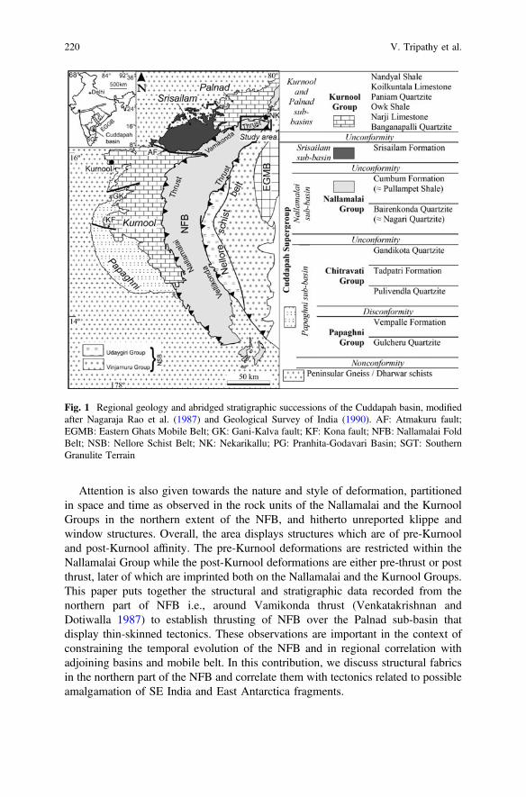
Attention is also given towards the nature and style of deformation, partitionedin space and time as observed in the rock units of the Nallamalai and the KurnoolGroups in the northern extent of the NFB, and hitherto unreported klippe andwindow structures. Overall, the area displays structures which are of pre-Kurnooland post-Kurnool affinity. The pre-Kurnool deformations are restricted within theNallamalai Group while the post-Kurnool deformations are either pre-thrust or postthrust, later of which are imprinted both on the Nallamalai and the Kurnool Groups.This paper puts together the structural and stratigraphic data recorded from thenorthern part of NFB i.e., around Vamikonda thrust (Venkatakrishnan andDotiwalla 1987) to establish thrusting of NFB over the Palnad sub-basin thatdisplay thin-skinned tectonics. These observations are important in the context ofconstraining the temporal evolution of the NFB and in regional correlation withadjoining basins and mobile belt. In this contribution, we discuss structural fabricsin the northern part of the NFB and correlate them with tectonics related to possibleamalgamation of SE India and East Antarctica fragments.
Fig. 1 Regional geology and abridged stratigraphic successions of the Cuddapah basin, modifiedafter Nagaraja Rao et al. (1987) and Geological Survey of India (1990). AF: Atmakuru fault;EGMB: Eastern Ghats Mobile Belt; GK: Gani-Kalva fault; KF: Kona fault; NFB: Nallamalai FoldBelt; NSB: Nellore Schist Belt; NK: Nekarikallu; PG: Pranhita-Godavari Basin; SGT: SouthernGranulite Terrain
220 V. Tripathy et al.
2 Geological Setting
The eastern Dharwar craton is a collage of a number of tectonic blocks juxtaposedduring various Archaean-Proterozoic tectonic events. It is bounded in the east bythe Eastern Ghat Mobile Belt (EGMB) which is an exhumed remnant of aProterozoic collisional zone resulted due to East Antarctica collision (Bhattacharya1996; Dasgupta and Sengupta 2003; Dobmeier and Raith 2003; Vijaya Kumar andLeelanandam 2008; Mukhopadhyay and Basak 2009). West of this mobile belt,Nellore Schist Belt (NSB), Nallamalai Fold Belt (NFB) and less deformed sedi-mentary deposits of Papaghni, Srisailam, Palnad and Kurnool sub-basins are pre-sent overlying the basement granitic complex and Archaean schist belts such asGadwal, Tsundupalle, Veligallu and Kadiri. The lower Cuddapah sequence isusually undeformed with sub-horizontal dips towards E except around fault zonessuch as the Gani-Kalva and the Kona faults where beds show steep dips (Tripathy2011; Tripathy and Saha 2013, 2015). In the western part of the Cuddapah basin thePaleoproterozoic lithounits (e.g., *1900 Ma, French et al. 2008) are overlainunconformably by the younger Neoproterozoic Kurnool Group (check Tripathy andSaha 2015 and references therein), both of which deformed subsequently (Tripathyand Saha 2013, 2015). The structural variation between the NFB and the westernpart of Cuddapah basin is marked by a thrust zone variously been known as theRudravaram Line (Meijerink et al. 1984) or the Nallamalai Thrust Front(Venkatakrishnan and Dotiwalla 1987) or the Maidukuru thrust (Chakraborti andSaha 2009). The eastern boundary of NFB is considered as a thrust zone named asthe Vellikonda Thrust Front (Venkatakrishnan and Dotiwalla 1987) where theNellore Schist Belt (NSB) is thrust over the NFB (Fig. 1). Similarly, Landsat imageinterpretation in the northern part of the NFB reveals a thrust zone along theNFB-Palnad sub-basin contact named as the Vamikonda Thrust Front(Venkatakrishnan and Dotiwalla 1987).
Stratigraphically, the oldest lithounits i.e., the Papaghni and the ChitravatiGroups of the Cuddapah Supergroup are restricted in the southwestern and westernpart of the basin (Fig. 1). Radiometric ages derived from mafic sills of the TadpatriFormation suggest the lower Cuddapah sedimentation to be older than *1900 Ma(Bhaskar Rao et al. 1995; Anand et al. 2003; French et al. 2008; reviewed by SeshaSai et al. 2017). Based on the occurrences of red bed sequence, Sesha Sai et al.(2016) considered Gulcheru to be deposited at around *2.1 Ga. ThePaleoproterozoic to Mesoproterozoic sedimentation of the Nallamalai Group isrestricted within the NFB and consists of lower arenaceous unit known as theBairenkonda Quartzite (Nagari Quartzite of southern NFB) and the upper argilla-ceous dominant Cumbum Formation (Pullampet Shale of southern NFB). The foldbelt records two phases of folding which has been cut through by Chelima lam-proite (1354 Ma, Chalapathi Rao et al. 1999), Zangamarajupalle lamproite andsyenite plugs (e.g. Giddalur and 1326 Ma Racherla syenite; Chalapathi Rao et al.2012) in its western part. Existence of granitic intrusions (e.g. Vellaturu, Ipuru,Vinukonda) along the eastern margin of the NFB with radiometric ages
Fold-Thrust Belt Architecture and Structural Evolution … 221

of *1575 Ma for Vellaturu Granite (Crawford and Compston 1973); *1615 MaWR isochron age and *1589 Ma U-Pb zircon age for Vinukonda Granite (Guptaet al. 1984; Dobmeier et al. 2006) provide an upper age limit for the deposition anddeformation for the Nallamalai Group. U-Pb detrital zircon age from the sedimentsof the Nallamalai Group constrain the sediments to have deposited between 1659and 1590 Ma (Collins et al. 2015).
In the northern part of the NFB, along the Vamikonda range, the CumbumFormation is exposed consisting chiefly of phyllite, slate, quartz phyllite, siltstone,argillaceous carbonate i.e., intercalated phyllite and carbonate, metamarl, quartziteand carbonate bands along with occasional chert (Rajurkar 1972; Ramlinga Swamy1972). The phyllite is steel grey, pink to purple and variegated colours. Thequartzite is thin to thickly bedded, ripple marked, trough to planar cross beddedwith unidirectional to bidirectional flow pattern and rare occurrence of desiccationcracks suggesting sediment deposition in subtidal to peritidal set up (Saha andTripathy 2012; Dasgupta and Biswas 2006).
The Kurnool Group represents the youngest lithounits of the Cuddapah basinwith a maximum stratigraphic thickness of about 450 m and is exposed in theKurnool and Palnad sub-basins (Fig. 1; Nagaraja Rao et al. 1987). The Group isrepresented by two cycles of sandstone, limestone and shale sequence. In thesouthern part of the Palnad sub-basin in the Durgi-Karampudi tract, the NarjiLimestone forms the lower most exposed unit of the group which are steel grey tobuff grey coloured pyritiferrous limestone. The limestone unit is conformablyoverlain by non-calcareous plane laminated variegated white, purple toyellow-ochre Owk Shale. The shale further grades to Paniam Quartzite, which iscoarse to medium-grained with occasional gritty layers.
3 Structural Heterogeneity in the Northern Part of NFB
Intracontinental compression deformation within the NFB broadly occurred twice.The first phase is related to *N-S trending doubly plunging F1 fold and thrust asrecorded throughout the fold belt (Nagaraja Rao et al. 1987; Matin and Guha 1996;Mukherjee 2001; Saha 1994, 2002; Chakraborti and Saha 2009; Tripathy and Saha2010; Chetty 2011; Matin 2014). The F1 folds vary geometrically due tothrust-related modifications. Progressive development of F1 fold and fault along theVellikonda thrust evolved in a general shear deformation suggesting an inclinedtranspressional tectonics (Tripathy and Saha 2010; Saha et al. 2010). The secondphase in the central part of the NFB is marked by moderately to steeplydipping *N-S trending crenulation cleavage (Sn2) that overprints the Sn1 cleavage(Tripathy and Saha 2010; Tripathy 2010).
In the western part of the NFB along the Nallamalai thrust front (the Rudravaramline), the fold belt acts as hanging wall and are thrust over the Papaghni, Kurnool,Srisailam and Palnad sub-basins. In the northern part, the Palnad nappe is exposedthat represents part of the thrust NFB over the Kurnool Group of Palnad sub-basin
222 V. Tripathy et al.

(Natarajan and Rajagopalan Nair 1977; Saha and Chakraborty 2003; Chakraborti2006; Chakraborti and Saha 2009; Saha et al. 2010). The overall arcuate pattern ofthe fold belt is an outcome of all the major deformation events, which are evaluatedin the present work.
An aerial view of the area shows NE trending lineaments (Fig. 2), which hasmarred the folding pattern within the NFB. The folds at such locations showsjuxtaposition of simultaneous antiforms along thrust plane, so that the downthrownsynform lies below the antiform. Here the fold belt shows changes in the orientationof the fabric from NE-SW to E-W and juxtaposition of the two thrust fronts i.e., theNallamalai and the Vellikonda thrust near Nekarikallu (Fig. 3). Matin (2014)suggests the NFB to be a syncline with eastern limb being overturned and an erodedanticline. In such a model the synclinal closure is envisaged in the northern end ofthe NFB near Nekarikallu. Matin (2014) viewed the deformations within the NFBrelated to contemporaneous faulting and folding in front of Vellikonda thrust andmodeled the Nallamalai thrust as its imbricate. The deformation is understood tohave resulted due to fault propagation folding. In the present discourse we bringforth the structural geometry and architecture of NFB to provide a plausiblestructural model which explains the oroclinal nature of NFB. The details of thestructural fabric in northern part of NFB is discussed in detail (cf. Matin 2014)where it changes from NE-SW to *E-W trending near to the thrust boundary withPalnad sub-basin. The data presented here from northern part of NFB is in detail ascompared to Matin 2014 and gives better understanding of tectonic set up of thearea.
The northern part of the NFB falling in the Survey of India toposheet no. 56P/11and 56P/15 south of Durgi and Nekarikallu is mapped (Fig. 3). The paper provides
Fig. 2 Google Earth image of the northern part of the Nallamalai Fold Belt showing prominentNE to E trending lineaments. Dotted line is the boundary of the NFB with Palnad sub-basin andgranitic gneiss on east. Imagery Date: 31/12/2005
Fold-Thrust Belt Architecture and Structural Evolution … 223
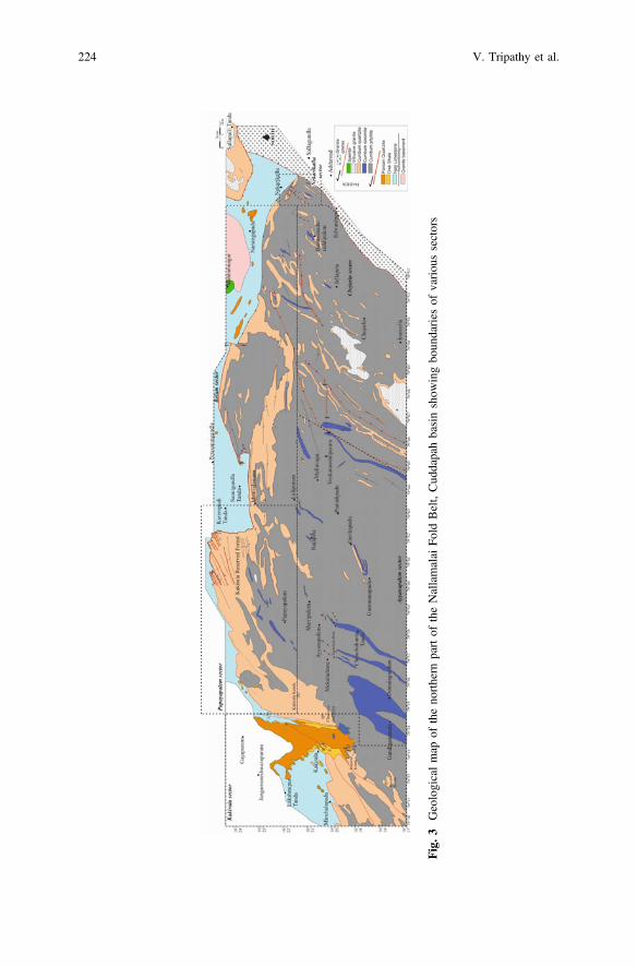
Fig.3
Geologicalmap
oftheno
rthern
partof
theNallamalai
Fold
Belt,Cud
dapahbasinshow
ingbo
undaries
ofvariou
ssectors
224 V. Tripathy et al.

an account of various structural features from the area which is divided in sixsectors towards east (Fig. 3) as described below.
The studied area can be divided into two major domains i.e., the footwall andhanging wall of the major thrust plane (Satyapal and Tripathy 2014). TheNallamalai Group of NFB acts as hanging wall while the Kurnool Group of Palnadsub-basin is footwall. Of these sectors, the Ayyanapalem and Chejarla sectors arerepresented by NE-SW trending Cumbum phyllite and minor Cumbum quartziteand dolomite bands of Nallamalai Group. This sector is part of the hanging wall ofthe major thrust. viz., Vamikonda thrust. The Chejarla sector is intruded by youngergranitoids (Sesha Sai 2004, 2013).
3.1 Ayyanapalem Sector
The Ayyanapalem sector in Gandiganamala-Ayyanapalem-Jayantiramapuramsouth of Papayapalem sector (Fig. 4a). The sector is dominated by phyllite, car-bonate and phyllite-carbonate intercalations with NE trending major foliations. Thebedding and Sn1 cleavage transpose with tight to isoclinal to overturned Fn1 foldingas also evident from stereoplots (Fig. 4a, b). The Dn1 deformations are overprintedby gently southeast dipping ductile shear zones with thrust movement (Fig. 4b, c).Southeast and southwest of Ayyanapalem, a number of such shear zones (Sc)overprint the earlier Sn0/Sn1 foliation (Fig. 4c). Later thrust-related Dn2 deformationtightened and reoriented the folds within the phyllite e.g., north of Domalagudemand around Mekaladinne. The folds are dragged with a top-to-NW movement toproduce overturned tight to isoclinals folds (Mukherjee et al. 2015 for mechanism)where the Sn0 and Sn1 transpose (Fig. 4a, b, e). Juxtaposition of Fn1 antiforms dueto the development of break thrust characterizes the structural makeup of theCumbum Quartzite. The quartzite is locally intercalated with phyllite showing closeto tight folds.
3.2 Chejarla Sector
In the Chejarla sector, Cumbum phyllite, quartzite and dolomite are exposed(Fig. 5a). Here, Chejarla granite expose with intrusive contact with the Cumbumquartzite and phyllite. The sedimentary rock units in this sector are overturned torecumbent (Fn1 fold) with northwest vergence (Fig. 5b–f). The Sn0 and Sn1 trans-pose locally (Fig. 5e, f) with fold axis plunging gently in variable directions(Fig. 5c, d, and f). These Fn1 folds developed in earlier deformation phase andreoriented to recumbent by later deformation. The recumbent Fn1 folds are over-printed by inclined asymmetric Fn2 folds which are the last folding event recordedfrom the area (Fig. 5g). The superposition of F1 and F2 folds form hook shapedType 3 interference pattern (Ramsay 1967).
Fold-Thrust Belt Architecture and Structural Evolution … 225
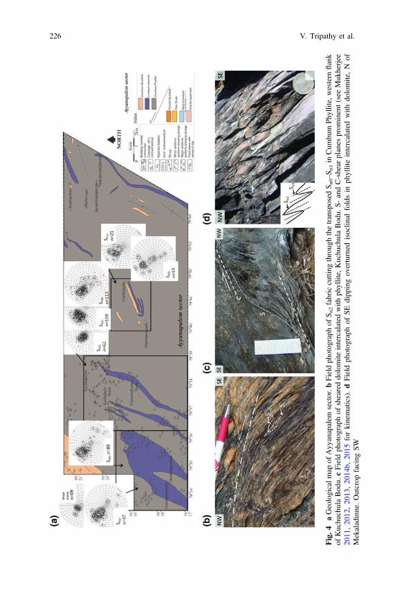
Fig.4
aGeologicalm
apof
Ayy
anapalem
sector.b
Fieldph
otog
raph
ofS n
2fabriccutting
throug
hthetransposed
S n0–S n
1in
Cum
bum
Phyllite,western
flank
ofKuchu
chulaBod
u.cFieldph
otog
raph
ofsheareddo
lomite
intercalated
with
phyllite,Kuchu
chulaBod
u.S-
andC-shear
planes
prom
inent(seeMuk
herjee
2011
,20
12,20
13,20
14b,
2015
forkinematics).dFieldph
otog
raph
ofSE
dipp
ingov
erturned
isoclin
alfoldsin
phylliteintercalated
with
dolomite,N
ofMekaladinne.Outcrop
facing
SW
226 V. Tripathy et al.

Southeast of Venkatareddipuram, NNE trending dolomite band show recumbentto inclined folds along with flat and ramp structures suggesting thrust relatedmovement. Thrust related structures on minor scale are shear band, tightening androtation of folds.
Fig. 5 a Geological map of Chejerla sector. b Field photograph of inclined folds in CumbumDolomite SE of Venkatareddipuram. Inset: Field photograph of recumbent folds in CumbumDolomite SE of Venkatareddipuram. c–f Stereographic projection of Sn0, Sn1, axial plane and foldaxis of Fn1 respectively. g Field photograph of hook shaped pattern formed by superposition of Fn1and Fn2 folds giving rise to Type-3 interference pattern (Ramsay 1967). Inset: sketch of the fieldphotograph
Fold-Thrust Belt Architecture and Structural Evolution … 227
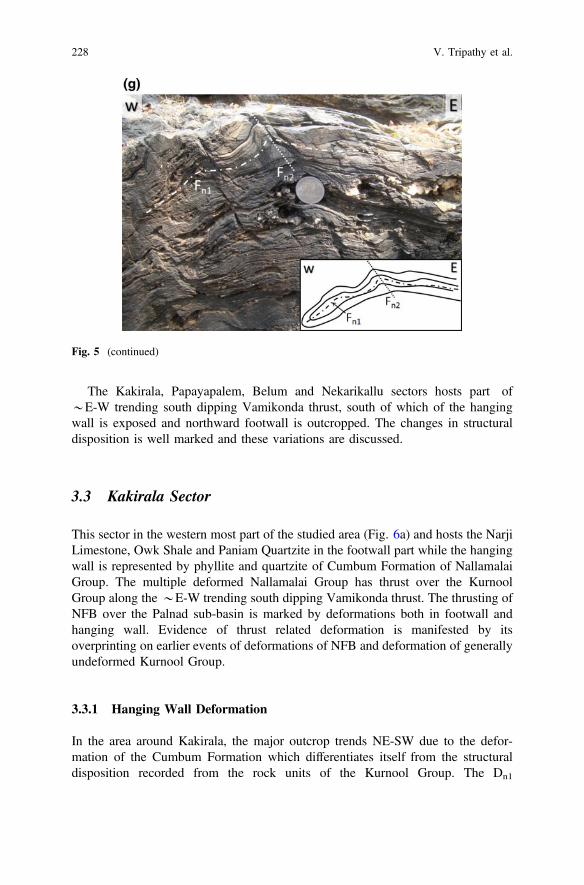
The Kakirala, Papayapalem, Belum and Nekarikallu sectors hosts part of*E-W trending south dipping Vamikonda thrust, south of which of the hangingwall is exposed and northward footwall is outcropped. The changes in structuraldisposition is well marked and these variations are discussed.
3.3 Kakirala Sector
This sector in the western most part of the studied area (Fig. 6a) and hosts the NarjiLimestone, Owk Shale and Paniam Quartzite in the footwall part while the hangingwall is represented by phyllite and quartzite of Cumbum Formation of NallamalaiGroup. The multiple deformed Nallamalai Group has thrust over the KurnoolGroup along the *E-W trending south dipping Vamikonda thrust. The thrusting ofNFB over the Palnad sub-basin is marked by deformations both in footwall andhanging wall. Evidence of thrust related deformation is manifested by itsoverprinting on earlier events of deformations of NFB and deformation of generallyundeformed Kurnool Group.
3.3.1 Hanging Wall Deformation
In the area around Kakirala, the major outcrop trends NE-SW due to the defor-mation of the Cumbum Formation which differentiates itself from the structuraldisposition recorded from the rock units of the Kurnool Group. The Dn1
Fig. 5 (continued)
228 V. Tripathy et al.
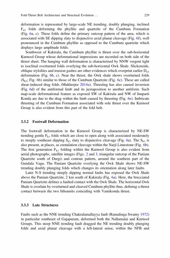
deformation is represented by large-scale NE trending, doubly plunging, inclinedFn1 folds deforming the phyllite and quartzite of the Cumbum Formation(Fig. 6a, c). These folds define the primary outcrop pattern of the area, which isassociated with SE dipping slaty to disjunctive axial planar cleavage (Fig. 6f), wellpronounced in the Cumbum phyllite as opposed to the Cumbum quartzite whichdisplays large amplitude folds.
Southwest of Kakirala, the Cumbum phyllite is thrust over the sub-horizontalKurnool Group whose deformational impressions are recorded on both side of thethrust sheet. The hanging wall deformation is characterized by NNW vergent tightto isoclinal overturned folds overlying the sub-horizontal Owk Shale. Slickenside,oblique stylolites and tension gashes are other evidences which overprint earlier Dn1
deformation (Fig. 6b, c). Near the thrust, the Owk shale shows overturned folds(Sk2; Fig. 6b) similar to those of the Cumbum Quartzite (Fig. 6c). These are calledshear-induced drag folds (Mukherjee 2014a). Thrusting has also caused inversion(Fig. 6d) of the antiformal limb and its juxtaposition to another antiform. Suchmap-scale deformational feature as exposed SW of Kakirala and NW of InupartiKonda are due to the drag within the limb caused by thrusting (Fig. 6e). Imbricatethrusting of the Cumbum Formation associated with sole thrust over the KurnoolGroup is also evident from this part of the fold belt.
3.3.2 Footwall Deformation
The footwall deformation in the Kurnool Group is characterized by NE-SWtrending gentle Fk1 folds which are close to open along with associated moderatelyto steeply southeast dipping Sk1 slaty to disjunctive cleavage (Fig. 6a). The Sk1 isalso present, at places, as crenulation cleavage within the Narji Limestone (Fig. 6b).The first generation Fk1 folding within the Kurnool Group is also evident fromaerial photographs, satellite images (Figs. 2 and 3, triangular outcrop of the PaniamQuartzite south of Durgi) and contour pattern, around the southern part of theGundala Vagu. The Paniam Quartzite overlying the Owk Shale shows NE-SWtrending doubly plunging folds which changes its orientation along later faults.
Later N-S trending steeply dipping normal faults has exposed the Owk Shaleabove the Paniam Quartzite, 2 km south of Kakirala (Fig. 6a). Here, the brecciatedPaniam Quartzite defines a faulted contact with the Owk Shale. The horizontal OwkShale is overlain by overturned and cleaved Cumbum phyllite thus, defining a thrustcontact between the two lithounits coinciding with Vamikonda thrust.
3.3.3 Late Structures
Faults such as the NNE trending Chakralamallayya fault (Ramalinga Swamy 1972)in particular southeast of Gajapuram, deformed both the Nallamalai and KurnoolGroups. This steep NNE trending fault dragged the NE trending doubly plungingfolds and axial planar cleavage with a left-lateral sense, within the NFB and
Fold-Thrust Belt Architecture and Structural Evolution … 229

230 V. Tripathy et al.

Fig. 6 (continued)
Fold-Thrust Belt Architecture and Structural Evolution … 231
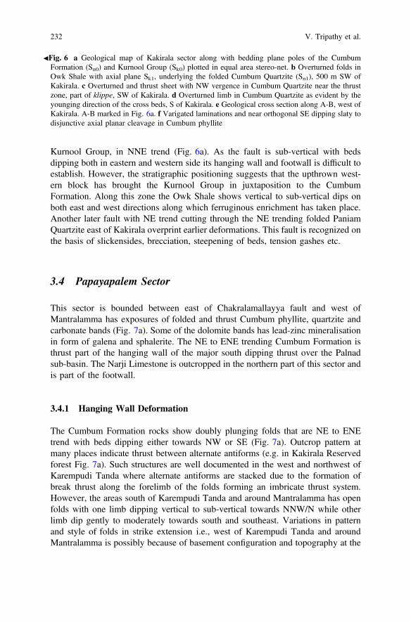
Kurnool Group, in NNE trend (Fig. 6a). As the fault is sub-vertical with bedsdipping both in eastern and western side its hanging wall and footwall is difficult toestablish. However, the stratigraphic positioning suggests that the upthrown west-ern block has brought the Kurnool Group in juxtaposition to the CumbumFormation. Along this zone the Owk Shale shows vertical to sub-vertical dips onboth east and west directions along which ferruginous enrichment has taken place.Another later fault with NE trend cutting through the NE trending folded PaniamQuartzite east of Kakirala overprint earlier deformations. This fault is recognized onthe basis of slickensides, brecciation, steepening of beds, tension gashes etc.
3.4 Papayapalem Sector
This sector is bounded between east of Chakralamallayya fault and west ofMantralamma has exposures of folded and thrust Cumbum phyllite, quartzite andcarbonate bands (Fig. 7a). Some of the dolomite bands has lead-zinc mineralisationin form of galena and sphalerite. The NE to ENE trending Cumbum Formation isthrust part of the hanging wall of the major south dipping thrust over the Palnadsub-basin. The Narji Limestone is outcropped in the northern part of this sector andis part of the footwall.
3.4.1 Hanging Wall Deformation
The Cumbum Formation rocks show doubly plunging folds that are NE to ENEtrend with beds dipping either towards NW or SE (Fig. 7a). Outcrop pattern atmany places indicate thrust between alternate antiforms (e.g. in Kakirala Reservedforest Fig. 7a). Such structures are well documented in the west and northwest ofKarempudi Tanda where alternate antiforms are stacked due to the formation ofbreak thrust along the forelimb of the folds forming an imbricate thrust system.However, the areas south of Karempudi Tanda and around Mantralamma has openfolds with one limb dipping vertical to sub-vertical towards NNW/N while otherlimb dip gently to moderately towards south and southeast. Variations in patternand style of folds in strike extension i.e., west of Karempudi Tanda and aroundMantralamma is possibly because of basement configuration and topography at the
JFig. 6 a Geological map of Kakirala sector along with bedding plane poles of the CumbumFormation (Sn0) and Kurnool Group (Sk0) plotted in equal area stereo-net. b Overturned folds inOwk Shale with axial plane Sk1, underlying the folded Cumbum Quartzite (Sn1), 500 m SW ofKakirala. c Overturned and thrust sheet with NW vergence in Cumbum Quartzite near the thrustzone, part of klippe, SW of Kakirala. d Overturned limb in Cumbum Quartzite as evident by theyounging direction of the cross beds, S of Kakirala. e Geological cross section along A-B, west ofKakirala. A-B marked in Fig. 6a. f Varigated laminations and near orthogonal SE dipping slaty todisjunctive axial planar cleavage in Cumbum phyllite
232 V. Tripathy et al.
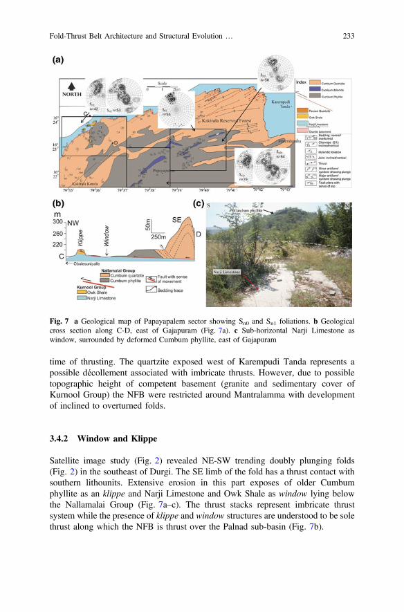
time of thrusting. The quartzite exposed west of Karempudi Tanda represents apossible décollement associated with imbricate thrusts. However, due to possibletopographic height of competent basement (granite and sedimentary cover ofKurnool Group) the NFB were restricted around Mantralamma with developmentof inclined to overturned folds.
3.4.2 Window and Klippe
Satellite image study (Fig. 2) revealed NE-SW trending doubly plunging folds(Fig. 2) in the southeast of Durgi. The SE limb of the fold has a thrust contact withsouthern lithounits. Extensive erosion in this part exposes of older Cumbumphyllite as an klippe and Narji Limestone and Owk Shale as window lying belowthe Nallamalai Group (Fig. 7a–c). The thrust stacks represent imbricate thrustsystem while the presence of klippe and window structures are understood to be solethrust along which the NFB is thrust over the Palnad sub-basin (Fig. 7b).
Fig. 7 a Geological map of Papayapalem sector showing Sn0 and Sn1 foliations. b Geologicalcross section along C-D, east of Gajapuram (Fig. 7a). c Sub-horizontal Narji Limestone aswindow, surrounded by deformed Cumbum phyllite, east of Gajapuram
Fold-Thrust Belt Architecture and Structural Evolution … 233
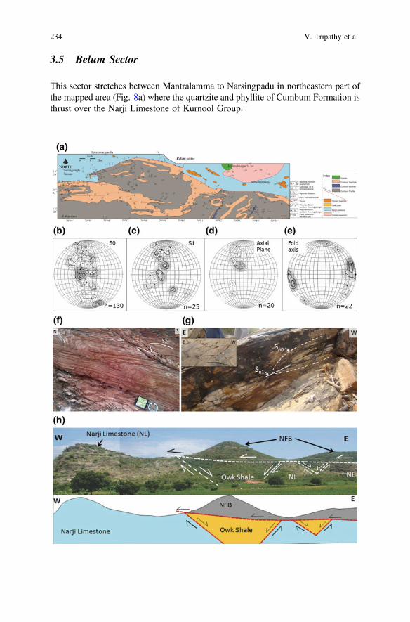
3.5 Belum Sector
This sector stretches between Mantralamma to Narsingpadu in northeastern part ofthe mapped area (Fig. 8a) where the quartzite and phyllite of Cumbum Formation isthrust over the Narji Limestone of Kurnool Group.
234 V. Tripathy et al.

3.5.1 Hanging Wall Deformation
The doubly plunging asymmetrical E trending folded lithounits of the CumbumFormation has north vergent axial planar cleavage (Fig. 8b–f). The Sn1 cleavage isslaty to disjunctive with south to southeast dip near to the thrust zone (Fig. 8c).However, further southward the bedding and cleavage show near to orthogonalrelationship. The change in axial plane of folds from S to N in this sector indicatesdrag of hanging wall near to the thrust zone as a result of top-to-north shearcomponent.
Fig. 8 (continued)
JFig. 8 a Geological map of the Belum sector. b–e Stereographic projection of Sn0, Sn1, axial planeand fold axis from Cumbum Formation exposed in the Belum sector. f Field photograph of theoverturned north vergent folds in Cumbum phyllite east of Sanigandla Tanda. g Field photographof the overturned isoclinal folds in transverse section of Cumbum Quartzite at the contact withgranite (not seen in this photograph). Inset shows ridge and groove on XY plane. h Panaromicview of the E hill range east of Sanigandla Tanda. Notice the variations in the vegetation densityand the lithological changes as viewed from the cross section. Lower part of figure shows sectionalview of the hill range with earlier formed horst and graben structures in the Kurnool Groupoverthrust by the Cumbum Formation of NFB. (i) Stereographic projection showing relationbetween Sn0 and fold axis from the thrust Cumbum Formation. Data collected from east ofSanigandla Tanda (h). j Stereographic projection of bedding plane, Sk0 from Narji Limestoneshowing gentle dip and gently plunging stretching lineation. k Sectional view of the sub-horizontalNarji Limestone showing bedding parallel shear, SE of Sanigandla Tanda. Note the plan view ininset showing bedding parallel stretching lineation in Narji Limestone
Fold-Thrust Belt Architecture and Structural Evolution … 235
In the northern part of this sector the granitic basement for the Kurnool Group inthe Palnad sub-basin is exposed west of Gopalapuram. The granite is phaneriticwith porphyry of K-feldspar, quartz and schlieren of biotite and minor hornblende.About 3.5 km south of Mahbubnagar, within the Guttikonda reserved forestphaneritic granite is exposed which has thrust contact with the Cumbum Formation(Fig. 8g). The quartzite is isoclinally folded and overturned with west vergentgently dipping axial plane (Fig. 8g). Slickenside on fold limb is represented withthe development of ridge and groove (similar to the ridge and groove of Power andTullis 1989; Means 1987 and Steps—Sheltering trails of Doblas 1998) suggestingfaulted contact between the Cumbum quartzite and the granite (Fig. 8g inset).
3.5.2 Footwall Deformation
Close to the northernmost exposed Cumbum quartzite and *1.5 km east ofSannigandla Tanda, NW of the Belum sector, the Kurnool Group shows pre-thrustand syn-thrust deformations. The Narji Limestone, Owk Shale and PaniamQuartzite of the Kurnool Group are sub-horizontally exposed here with develop-ment of horst and graben structures (Dk1), which is later thrust by northwest vergentoverturned Cumbum phyllite plunging both towards east and west (Fig. 8h).Deformations related to this thrusting has generated stretching lineation parallel tobedding plane of the Narji Limestone (Fig. 8i–k) along with development of sig-moids as evident from transverse sections (Fig. 8k).
3.6 Nekarikallu Sector
This sector is the easternmost part of the study area and is important because of thepresence of the junction of the Vamikonda (a.k.a Nallamalai) and Vellikondathrusts (Fig. 9a). The later imprints of deformations recorded in this sector isdependent up on the orientation of the structural fabric.
The ESE trending ridge of Cumbum Formation S of Nekarikallu is representedby NW trending folds (Fn1, Fig. 9b–d) and south to southeast dipping axial planarcleavage (Sn1, Fig. 9e) with SE plunging fold axis (Fig. 9f). The ridge is cutthrough by a number of imbricate thrust (D2, Fig. 9b, c) whose movement directionparallels stretching lineation and fold axis trend (Fig. 9g). Due to this thrusting, theisoclinal recumbent folds (Fn1) is overprinted by later NW vergent crenulations(Fn2) and mylonite related to the Dn3 deformation. Near the thrust zones the ESEtrending Sn1 (||Sn0) cleavage is folded/crenulated to generate reclined folds (Fig. 9d,f–h). These imbricate thrusts are linked to a sole thrust as envisaged from gentlysoutheast dipping thrust zone (Fig. 9a, i) and cross section (Fig. 9b). The sole thrustis evident by the presence of thrust contact between the overturned folded phylliteover the asymmetrical folds (Fig. 9i). The formation of recumbent folds is possibly
236 V. Tripathy et al.
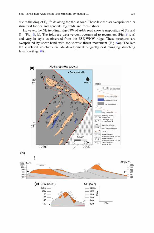
due to the drag of Fn1 folds along the thrust zone. These late thrusts overprint earlierstructural fabrics and generate Fn2 folds and thrust slices.
However, the NE trending ridge NW of Adda road show transposition of Sn0 andSn1 (Fig. 9j, k). The folds are west vergent overturned to recumbent (Fig. 9m, n)and vary in style as observed from the ESE-WNW ridge. These structures areoverprinted by shear band with top-to-west thrust movement (Fig. 9o). The latethrust related structures include development of gently east plunging stretchinglineation (Fig. 9l).
Fold-Thrust Belt Architecture and Structural Evolution … 237

Fig. 9 (continued)
238 V. Tripathy et al.
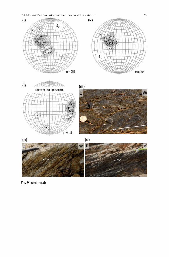
Fig. 9 (continued)
Fold-Thrust Belt Architecture and Structural Evolution … 239
4 Discussions
4.1 Geometry, Kinematic and Relative Chronologyof Deformation in NFB
The Nallamalai Group is folded and cut through by a number of thrust sheets,which are convex towards the Palnad sub-basin resembling the direction in whichthe thrust verge. The events of folding and faulting are categorized in time andspace that generated changes in the fold pattern and geometry. The fold belt(NFB) acted as footwall with respect to the Nellore schist belt (NSB) along theVellikonda thrust during Dn2 stage of deformation (Mesoproterozoic, Saha 2002;Table 1) which is unrelated to the Nallamalai/Vamikonda thrust, against which thefold belt is acting as hanging wall (Dn3 � Dk2). As the Vamikonda thrust is jux-taposing Mesoproterozoic NFB and Neoproterozoic Kurnool Group, it is envisagedthat the thrust must at least be of Late Neoproterozoic age. The geometry of foldthus formed and modified during different deformations indicates multiple com-pressions in the Eastern part of the East Dharwar craton. The prime cause of thisvariation can be because of the vorticity within the shear zone related to thrusting,rheological differences and geometry of early formed folds (Carreras et al. 2005).To understand the structural evolution, the geometry of this belt is to be consideredwhich is characterized by a number of W and NW vergent thrusts, prominentdetached folds and oroclinal nature of the fold belt. An orthogonal change in theamount of curvature of the belt from N to E (Figs. 1 and 2) represent an oroclinalbend as theoretically suggested by Johnston et al. (2013). The presence of window,klippe and imbricate thrust system along the Vamikonda thrust are evidences forallochonous nature of NFB. Further, the presence of Palnad Nappe (Natarajan andRajagopalan Nair 1977; Saha and Chakraborty 2003; Chakraborti 2006;Chakraborti and Saha 2009; Saha et al. 2010) suggests an exotic nature of NFB
JFig. 9 a Geological Map of the Nekarikallu sector. b Cross section along A-B, along the ridgeaxis of ESE ridge, south of Nekarikallu. c Cross section along C-D, across the ridge axis of ESEridge, south of Nekarikallu. d–f Stereographic projection of Sn0, Sn1 and Fn1 fold axis;g Stereographic projection showing relation between stretching lineation, Fn1 fold axis and shearplane. h Field photograph of Cumbum phyllite along the NE-SW imbricate thrust zone south ofNekarikallu with development of reclined folds (Fn2) due to the folding of transposed Sn0/Sn1.i Field photograph of Sole thrust SW of Nekarikallu marked by the thrust recumbent folds over theasymmetrical folds of Cumbum phyllite. Note variations in orientation of Fn1 folds in hanging walland footwall. j–k Stereographic projection of Sn0 and Sn1 showing transposition of the both thefabrics, along the NE trending ridge, NW of Adda Road. l Stereographic projection of thestretching lineation along the shear zone (n) showing consistent ESE plunge. m Field photographof recumbent folds in Cumbum phyllite close to the NE-SW trending thrust zone SW ofNekarikallu. n Field photograph of west vergent overturned tight folds (Fn1) in heterolithicCumbum quartz-phyllite, along the NE trending ridge NW of Adda Road. o Field photograph ofshear zone cutting through the overturned Fn1 folds (m) with a top-to-west tectonic movement inCumbum dolomite, developed along the NE trending ridge NW of Adda Road
240 V. Tripathy et al.

with respect to rest of Cuddapah basin (Saha 1994, 2002; Saha and Chakraborty2003; Tripathy and Saha 2010).
Variations in fold styles in different lithounits are well documented in thenorthern part of NFB. The NE-SW trending open folds in Cumbum Formation,south of Minchalapadu in Kakirala sector, define earlier Fn1 folds related to Dn1
deformation (Fig. 6a). The forelimb of these folds are cut through by later thrustsresulting in the juxtaposition of two antiforms with synform being downthrownbelow the former during the Dn2 deformation (Fig. 10a). These thrusts are con-nected to a sole thrust along which the NFB is thrust over the Kurnool Group ofPalnad sub-basin as evidenced by the klippe SW of Kakirala (Fig. 6e). The NWvergent Fn1 tight to isoclinal and overturned folds in Cumbum phyllite suggestsoverall top-to-NW shear component. The competency contrast between quartziteand phyllite is the principle cause for such modifications in fold style, whichdeformed predominantly by simple/general shear (Mukherjee 2012, 2013) during
Table 1 Summarised chronological sequence of deformations as recorded from northernNallamalai Fold Belt (NFB)
Cambrian (iii) Late faults such as in Kakirala sector displaces both theKurnool and Nallamalai Group of rocks
Post-thrust
Neoproterozoic (ii) Thrusting (Dn3) of NFB over Palnad sub-basin (KurnoolGroup)• Hanging wall (NFB):(a) Development of imbricate thrust in Cumbum Formationlinked to sole and imbricate thrust(b) Reorientation of and overprinting over Fn1 folds. Tightto isoclinal, overturned to recumbant/reclined fold(c) Presence of Klippe and window structures within NFB,suggesting thin-skinned tectonics• Footwall (Palnad sub-basin):Localised folding (Fk1) and development of cleavage (Sk1)due to compression (Dk2 � Dn3) related to thrusting of NFB
Syn-thrust
(i) Localised extensional events• e.g., presence of horst and graben structures (Dk1) withinKurnool Group in Belum sector
Pre-thrust
Deposition of Kurnool Group in Kurnool and Palnadsub-basins
Mesoproterozoic andPaleoproterozoic
(ii) Thrusting of Nellore Schist Belt (NSB) along VelikondaThrust• Development of asymmetrical folds and associated thrustswithin NFB
• Reorientation of Fn1 folds and refolding at places (�Dn2
deformation)• Development of break thrust within Nallamalai quartzite(i) Folding of Nallamalai Group (Fn1 folds Dn1 deformation)• Doubly plunging open to close folds
The term “thrust” used in last column viz., “pre-thrust; syn-thrust and post-thrust” are in relation to theformation of the Vamikonda thrust due to the thrusting of NFB over Palnad sub-basin
Fold-Thrust Belt Architecture and Structural Evolution … 241

Fig. 10 a Cartoon showing variations in fold style related to rheological variations as observedfrom the field. Note that the phyllite being mechanically incompetent are tighly folded totransposed fabrics, glide along a detachment plane while quartzite has development of imbricatethrust. b (i) Model showing first phase of folding in NFB (ii) which been modified and reorientedby later phase of folding and thrusting. (iii) The first phase of folding and later reorientation isshow in plan map. (iv) During syn-thrust phase, the fold belt developed oroclinal bending withdevelopment of right-lateral movement in northern part of NFB
242 V. Tripathy et al.

thrusting. The existence of such mechanical instability in a simple to general shearenvironment modified the pre-existing folds (Fn1) and developed discrete shearzones (Dn2) within phyllite and carbonate e.g., NE trending gentle shear zones withtop-to-NW thrusting SE of Ayyanapalem and Kuchchula Bodu in the Ayyanapalemsector. Similar thrust stacking are present in the Papayapalem sector whereimbricate thrust system is envisaged based on window and klippe, east ofGajapuram along with juxtaposed antiforms. The phyllite and intercalated car-bonates in the Ayyanapalem sector are isoclinal overturned to recumbent foldstrending in NE as opposed to the Papayapalem sector where the structures trend E.The bulk geometry suggests maximum compression along NW-SE. Under suchscenario, NE plunging asymmetrical folds, which are perpendicular to the shear andcompressional components, development of Type- 3 (Ramsay 1967) interferencepattern are evident (Fig. 5g). However, such structural interferences are not thesame at each location as for example in Belum sector such overprinting causednorthward vergence of fold and cleavage.
However, the structural geometry present in the eastern part of the area i.e.,Chejarla sector, the fold geometry and architecture differ significantly. The foldsbounded within the thrust sheet SE of Venkatareddipuram are recumbent to inclined(Fig. 5b; Ramsay et al. 1983). Changes in shape and orientation of folded layer andtheir axial surfaces are due to the superposition of simple shear deformation onearlier existing folds (Ramsay et al. 1983). Under conditions of intense shear, thefolds rotated towards the plane of primary shear (or the C-plane) to developoverturned, asymmetrical to recumbent folds overriding the thrust, between south ofMahbubnagar and south of Venkatareddipuram.
Due to the oroclinal bent, the two thrust fronts i.e., the Nallamalai thrust(Vamikonda thrust in northern part of NFB) and the Vellikonda thrust, whichactivated at different time, juxtapose in the northeastern end of the NFB nearNekarikallu. The latest deformational imprints over the ESE and NW trendingridges in Nekarikallu sector are important in understanding the overall structure ofthe northern part of the NFB. The Dn1 deformation in the ESE trending ridge (S ofNekarikallu, Fig. 1) is characterized by S to SE dipping axial planar cleavage inphyllite and associate with doubly plunging open folds in quartzite. However, theNE ridge (NW of Addaroad, Fig. 1) has SE dipping Sn0 overturned isoclinal to tightfolds, which are parallel to the axial planar cleavage (Sn1). Such structures are akinto those reported from Porumamilla situated in the east-central part of the NFB(Tripathy and Saha 2010; Saha et al. 2010). Imprints of later compression aredocumented from both the ridges. The presence of NE trending sole thrust andassociated imbricate thrusts in the ESE ridge (Fig. 9a–c, i) and N-S trending shearzones (Fig. 9o), modified the NE-SW trending Fn1 folds. The asymmetry of theseNW vergence folds, supports a top-to-NW thrust component related to late hori-zontal compression. The evidences of structural discordance suggest a thrust con-tact between the NE and ESE ridges.
The sedimentary lithounits have rheological differences, and the mechanicallyweak layers are surfaces along which thrusts are localized. Many thrust dominatedbelts have similarities in them as major décollements are located in shale or salt unit
Fold-Thrust Belt Architecture and Structural Evolution … 243

overlain by competent units (Mitra 2003; Nemčock et al. 2005; Mukherjee et al.2010). The deformations within the NFB imbricated thrust stacks and sole thrustalong which rock units such as shale, phyllite and carbonate frequently associatewith such weak horizons. Where thrust planes passes through competent lithounitse.g., quartzite, they steepens and form flat-ramp geometry. The Fn1 folds aremodified to overturned to recumbent in phyllite rich layers (e.g., Fig. 5b, 9 m)while in resistant quartzite layers the strain is accommodated by development ofthrust surfaces.
The Dn1 deformation is predominantly associated with axial planar slatycleavage in phyllite and disjunctive cleavage in quartzite showing variations inorientations in different sectors due to later deformations such as thrusting andrelated folding. The thrust has reoriented the fold and cleavage and provided themthe asymmetric geometry that defines the overall NW/N vergence interpreted interms of a non-coaxial Dn2 deformation. There are marked variation in the modi-fications and overprinting of Dn2 deformation over the first generation structures.Depending upon the position of the fold relative to the thrust zone the axial plane ofthe Fn1 fold are close to the plane of simple shear (e.g. in the dolomite bands east ofVenkatareddipuram and heterolithic quartz-phyllite south west of Nekarikallu,Fig. 5b). Vergence of overturned to inclined nature of fold is common throughoutthe area with similar slip sense. The overthrusting of NFB over the Palnadsub-basin must had happened after the development of thrust restricted within thefold belt as thrust surfaces has also changed their trend from NE to E similar to thevariations in the fold trends. Oroclines (Carey 1955; Johnston et al. 2013) are resultof the action of later stress over existing orogen either in a transverse (progressive)or in a longitudinal (secondary) manner. The progressive orocline involves basaldécollement with compressive stress perpendicular to the strike of the orogen whichare responsible for bending of fold and thrust belt undergoing thin-skinned tectonicsin response to ongoing crustal compression. The thin-skinned tectonic nature ofNFB is envisaged by Chakraborti and Saha (2009) from western part of the NFB.The presence of window and klippe structures (Figs. 6e and 7b, c) from presentstudy area supports the thin-skinned nature of the NFB. Thus, the geometry andarchitecture of the NFB presented here corroborate the progressive orocline as(i) the belt shows thin-skinned nature and (ii) the late compressional structures areresult of compressive stress perpendicular to the strike of the orogen. However,such late compressional structures in central and southern part of NFB where ittrends *N-S, are difficult to establish as it approximate Type 0 interference pattern(Ramsay 1967). The bending of the NFB fabric along Vamikonda thrust front isthus in response to the compression directed from SE to ESE. The presence ofgranitic basement and Kurnool Group in the Palnad sub-basin must had acted as atectonic obstacle (i.e., a backstop) due to which the northern part of thefold-and-thrust belt dragged right laterally (Fig. 10b). The footwall uplifts as rep-resented by horst and graben (Fig. 8h) south of Karempudi Tanda represented byhills of Narji Limestone must also had acted as obstacle due to which the CumbumQuartzite in this part is stacked to develop overturned to inclined folds with one
244 V. Tripathy et al.
limb being vertical to sub-vertical as opposed to the open doubly plunging foldswest of Karempudi Tanda of Papayapalem sector.
4.2 Deformations in Kurnool Group
The Kurnool Group in the Palnad sub-basin acted as footwall with respect to theVamikonda thrust and bears various stages of deformation which are pre-, syn- andpost-thrust (Table 1). The term thrust here is related to the Vamikonda thrust. Thepre-thrust deformations are mostly related to extensional structures such as N-Strending normal faults. The horst and graben structures present in the Kunool Groupare overthrust by the Cumbum Formation in Belum sector. The former structuresrepresent such extensional events related to pre-thrust deformations (Fig. 8h).
The development of NE trending folds and SE dipping disjunctive to slatycleavage in Narji Limestone, Owk Shale and Paniam Quartzite are well documentedfrom the Kakirala sector as discussed earlier. Similar development of cleavage,gently ESE plunging bedding parallel stretching lineation and development ofmylonite in Narji Limestone in Belum sector with north or northwest vergence areevidences of syn-thrust deformation (Fig. 8i–k).
The N-S trending Chakralamallayya fault cutting through the CumbumFormation and Kurnool Group east of Kakirala reoriented the structural fabric ofboth the Groups in N-S direction. The steepening of Owk Shale and PaniamQuartzite along the fault and reorientation of folds and thrusts to N-S direction areevidences of post-thrust deformation. The post thrust deformation is also reported inthe southern part of Cuddapah basin where NNE-SSW strike-slip faults arearranged in right stepover pattern (Goswami et al. 2016). The development of domeand basin structures of Type- 1 interference pattern (Ramsay 1967) in PaniamQuartzite along the fault zone in the study area are evidences of post-thrustdeformation possibly related to compression that acted on early formed NE trendingfolds.
4.3 Tectonic Implications
Evidences of 1.8–1.5 Ga Columbia supercontinent are recorded from most of thecontinents (e.g. Rogers and Santosh 2002; Nance et al. 2014). Such evidences arealso recorded from India such as the amalgamation of northern and southern Indiaalong the Central Indian Tectonic Zone (CITZ) at 1.8 Ga (Jain et al. 1991;Acharyya and Roy 2000; Bhowmik et al. 1999; Bhowmik and Roy 2003). Based onpalaeomagnetic data for the North China Block during the time interval ca. 1780–1440 Ma, Zhang et al. (2012) placed the western India adjacent to the North ChinaBlock. Such Columbia reconstruction contains the southern part of Eastern GhatsBelt and Napier Complex to have juxtaposed at 1.6 Ga (Henderson et al. 2014).
Fold-Thrust Belt Architecture and Structural Evolution … 245
In EGB, the Western Charnockite Zone (WCZ) (cf. Domain 1A of Dasgupta andSengupta 2003; Ongole domain, Krishna Province of Dobmeier and Raith 2003)has suffered *1.6 Ga granulite metamorphism without signs of Grenvillian over-print (Rickers et al. 2001; Dasgupta and Sengupta 2003; Dobmeier and Raith 2003;Bhattacharya et al. 2010) as opposed to its central and eastern parts. Such meta-morphic imprints of Columbia affinity in Eastern Dharwar craton possibly affectedthe deformations further westward in NSB and NFB (Tripathy 2010; Tripathy andSaha 2013, 2015). The Nallamalai Group has undergone two major folding eventsas evident from different parts of the fold belt (Matin and Guha 1996; Mukherjee2001; Saha 2002; Tripathy and Saha 2010; Saha et al. 2010). It is understood tohave developed as a result of compressive stresses active during the Columbiasupercontinent (Saha 2002, 2004; Tripathy and Saha 2013).
The thrust related emplacement of Kandra igneous complex and Kanigiriophiolitic melange (Sesha Sai 2009; Saha 2011; Sesha Sai 2013) in southernNellore schist belt (NSB) suggests a Paleoproterozoic (1847 + 14 Ma, VijayaKumar et al. 2010) plate convergence along the SE margin of India (Bhadra et al.2004; Saha 2011; Saha and Patranabis-Deb 2014). The earlier phase of deformationin metapelites of younger Udaygiri Group of NSB attended presumably before1933 ± 11 Ma based on retrograde metamorphic xenotime dating (Das et al.2015). The 1.8–1.9 Ga deformation and metamorphism related to the amalgamationof these East Gondwana fragments deformed and metamorphosed the NSB and itsthrusting to NFB along Vellikonda Thrust (Tripathy and Saha 2013). Variousradiometric ages of igneous intrusions in NFB (reviewed in geological setting ofthis paper) cluster around Late Paleoproterozoic to Early Mesoproterozoic (1.5–1.6 Ga). The two major folding events in NFB are also understood to be prior tosuch igneous intrusions within them (Saha and Chakraborty 2003). It is thusplausible that the first deformation phase generating the Fn1 folds and thrusts inNFB and later structures of NSB were related to compression of LatePaleoproterozoic of Columbia Supercontinental affinity. However, sedimentsdeposited during *1.9 Ga in Papaghni sub-basin in western part of Cuddapahbasin lack regional deformation and thus suggest its variance from deformed NFBin terms of deformational chronology, tectonic set up and thus paleogeographicposition.
Steep basement cutting faults such as the Gani-Kalva and the Kona faults inwestern part of the Cuddapah basin opened the Kurnool sub-basin (Tripathy andSaha 2013) possibly coeval to the emplacement of *1090 Ma kimberlite pipeswest of the basin margin (Kumar et al. 1993). Recent discoveries of 1.4–1.3 Galamproite dyke-sill complex in Tadpatri Shale are proposed as diamond provenancefor Banganapalle conglomerate (Joy et al. 2012). The deposition of Kurnool Groupthus has happened during Early to Mid Neoproterozoic. Such crustal-scale exten-sion during the Late Mesoproterozoic to Early Neoproterozoic is evidentfrom *1300 Ma Prakasam alkaline province (PAkP), which has a number ofalkaline intrusive bodies in the schist belt and considered to represent rift relatedmagmatism (Leelanandam 1989; Upadhyay et al. 2006; Leelanandam et al. 2006;Vijaya Kumar and Leelanandam 2008; Dharma Rao et al. 2010).
246 V. Tripathy et al.

The thrusting of NFB over the Palnad sub-basin and development of folds andcleavage in the Kurnool Group are related to compressional activities possiblyrelated to Pan-African orogeny (Saha 2004; Tripathy and Saha 2013; Saha andPatranabis-Deb 2014; Tripathy and Saha 2015). In the eastern part of the belt,Nekarikallu sector, the N trending imbricate thrust are thus related to the com-pression of the Late Neoproterozoic, impressions of which are also recordedthrough syn-kinematically grown phengitic white mica in mylonite fromVinukonda granite during 501–474 Ma (Dobmeier et al. 2006). The first report ofwindow and klippe along the Vamikonda Thrust from northern part of NFB rep-resent such compression involving the sedimentary packages in a thin-skinned setup. In addition, an earlier extensional episode is recorded only within the KurnoolGroup of rocks as envisaged by the presence of horst and graben structures in theBelum sector. These horst and graben affecting the Kurnool Group are overthrustby the folded Nallamalai Group of rocks (Fig. 8h), suggesting such extensionalevent to be of pre-thrust (related to Vamikonda thrust) in nature.
5 Conclusion
The present work suggests thrust stacking in eastern and northern part of NFBwhere interaction of the two temporally variant thrusts viz., Vellikonda andNallamalai thrusts happened during Neoproterozoic-Paleozoic under the compres-sional stress regimes active during Gondwana assemblage. The chronologicalsequence of deformation is summarised in Table 1 and concluded below.
• Structures within the northern part of NFB are categorised here on theirchronological occurrences in relation to the thrusting of NFB over Palnadsub-basin. Accordingly, pre-, syn- and post-thrust episodes are clubbed together.
• The pre- and syn-thrust deformation is responsible for the major regionalstructural trends presently hosted by the NFB.
• Following major structural changes are recorded in the northern NFB due to thesyn-thrust deformation:
i. Thrusting of NFB over Palnad sub-basin.ii. Bringing two spatially and temporally distinct thrusts i.e., the Vellikonda
thrust and Vamikonda (Nallamalai) thrust in close vicinity at the NE part ofthe NFB near Nekarikallu.
iii. Due to this syn-thrust compressional episode, during Late Neoproterozoiccontemporaneous with Pan-African orogeny, the structural fabric (cleavage,fold axis, axial plane, thrust internal to NFB etc.) within NFB showsreorientation of its trend from N-S to NE-SW to E-W. It is understood tohave formed due to the presence of granitic basement and Kurnool Group ofrocks in Palnad sub-basin which must had acted as a tectonic barrier due towhich the NFB in its northern part is dragged with a right lateral component.
Fold-Thrust Belt Architecture and Structural Evolution … 247
iv. Change in the orientation of the major structural fabric on regional scale isevident all along the strike of the NFB. This change is explained with themodel of progressive orocline which is a result of (i) thin-skinned nature ofthe fold belt and (ii) the late compressive stress perpendicular to the strikeof the orogen bend produce the curvature in the fold belt.
Acknowledgements The authors are grateful to the Director General, Geological Survey of Indiaand Additional Director General, GSI, SR, Hyderabad for kindly according permission to publishthe work. This work is part of the GSI project for FS 2012-14 at state unit: Andhra Pradesh. Theauthors are grateful to Dr. Soumyajit Mukherjee (IIT, Bombay), Editor for his kind invitation forcontribution to this book. This manuscript benefited greatly from the constructive reviews andcriticisms by editor and an anonymous reviewer. The views expressed in this paper are of authorsand not necessarily of GSI. Vide Mukherjee et al. (in press) for recent tectonic updates from thesouthern portion of the Cuddapah basin, and Goswami and Upadhyay (2019) in a similar context.Mukherjee (2019) summarizes this work.
References
Acharyya SK, Roy A (2000) Tectonothermal history of the Central Indian Tectonic Zone andreactivation of major faults/shear zones. Journal of the Geological Society of India 55:239–256
Anand M, Gibson SA, Subbarao KV, Kelley SP, Dickin AP (2003) Early proterozoic meltgeneration processes beneath the intra-cratonic Cuddapah basin, Southern India. Journal ofPetrology 44, 2139–2171
Bhadra S, Gupta S, Banerjee M (2004) Structural evolution across the Eastern Ghats Mobile BeltBastar craton boundary: hot over cold thrusting in an ancient collision zone. Journal ofStructural Geology 26, 233–245
Bhaskar Rao YJ, Pantulu GVC, Damodar Reddy V, Gopalan K (1995) Time ofearly sedimentationand volcanism in the proterozoic Cuddapah basin, South India: evidence from Rb-Sr age ofPulivendla mafic sill. Geological Society of India Memoirs 33, 329–338
Bhattacharya S (1996) Eastern Ghats granulite terrain of India: an overview. Journal of SoutheastAsian Earth Sciences 14, 165–174
Bhattacharya S, Das P, Chaudhary AK, Saw AK (2010) Mafic granulite xenoliths in the easternghats granulite belt: implications for lower crustal processes in the Southeastern IndianPeninsula. Indian Journal of Geology 80, 55–69
Bhowmik SK, Roy A (2003) Garnetiferous metabasites from the Sausar MobileBelt: petrology,P-T path and implications for the tectonothermal evolution of the Central Indian TectonicZone. Journal of Petrology 44, 387–420
Bhowmik SK, Pal T, Roy A, Pant NC (1999) Evidence for Pre-Grenvillian high-pressure granulitemetamorphism from the northern margin of the Sausarmobile belt in Central India. GeologicalSociety of India 53, 385–399
Carey SW (1955) The orocline concept in geotectonics. Proceedings of the Royal Society ofTasmania 89, 255–288
Carreras J, Druguet E, Griera A (2005) Shear zone-related folds. Journal of Structural Geology 27,1229–1251
Chakraborti S (2006) Analysis of fold-and-thrust structures in parts of Neoproterozoic PalnadSub-basin, Cuddapah basin, south India. Ph.D. thesis, University of Calcutta
Chakraborti S, Saha D (2009) Tectonic stresses and thin-skinned tectonics in a Proterozoicfold-and-thrust belt read from calcite mylonites in the Cuddapah basin, south India. IndianJournal of Geology 78, 37–54
248 V. Tripathy et al.

Chalapathi Rao NV, Miller JA, Gibson SA, Pyle DM, Madhavan V (1999) Precise40Ar/39Ar agedeterminations of the Kotakonda kimberlite and Chelima lamproite, India: implication for themafic dyke swarm emplacement in the Eastern Dharwar craton. Journal of Geological Societyof India 53, 425–432
Chalapathi Rao NV, Fu-Yuan Wu, Srinivas M (2012) Mesoproterozoic emplacement and enrichedmantle derivation of the Racherla alkali syenite, Palaeo-Mesoproterozoic Cuddapah Basin,southern India: insights from in situ Sr–Nd isotopic analysis on apatite. Geological Society,London, Special Publication 365, 185–195
Chetty TRK (2011) Tectonics of proterozoic Cuddapah Basin, Southern India: a conceptual model.Journal Geological Society of India 78, 446–456
Collins A, Patranabis-Deb S, Alexander E, Bertram CN, Falster GM, Gore RJ, Mackintosh J,Dhang PC, Saha D, Payne JL, Jourdan F, Backé G, Halverson GP, Wade BP (2015) Detritalmineral age, radiogenic isotopic stratigraphy and tectonic significance of the Cuddapah Basin,India. Gondwana Research 28, 1294–1309
Crawford AR, Compston W (1973) The age of the Cuddapah and Kurnool systems, SouthernIndia. Journal of Geological Society of Australia 19, 453–464
Das S, Shukla D, Bhattacharjee S, Mitra SK (2015) Age constraints of Udayagiri Domain ofNellore schist belt by xenotime dating around Pamuru, Prakasam district, Andhra Pradesh.Geological Society of India 85, 289–298
Dasgupta PK, Biswas A (2006) Rhythms in Proterozoic sedimentation: an example fromPeninsular India. Satish Serial Publishing House, Delhi, p 340
Dasgupta S, Sengupta P (2003) Indo-Antarctic correlation: a perspective from the Eastern GhatsBelt. In: Yoshida M, Windley BF, Dasgupta S (eds) Proterozoic East Gondwana:supercontinent assembly and breakup. Geological Society London, Special Publication, 206,131–143
Dharma Rao CV, Santosh M, Wu Yuan-Bao (2010) Mesoproterozoic ophiolitic mélange from theSE periphery of the Indian plate: U-Pb zircon ages and tectonic implications. GondwanaResearch. https://doi.org/10.1016/j.gr.2010.06.007
Doblas M (1998) Slickenside kinematic indicators. Tectonophysics 295, 187–197Dobmeier CJ, Raith MM (2003) Crustal architecture and evolution of the Eastern Ghats Belt and
adjacent regions of India. In: Yoshida M, Windley BF, Dasgupta S (eds) Proterozoic EastGondwana: supercontinent assembly and breakup, 206. Geological Society, SpecialPublications, London, pp 145–168
Dobmeier C, Lütke S, Hammerschmidt H, Mezger K (2006) Emplacement and deformation of theVinukonda granite—implications for the geological evolution of peninsular India and forRodinia reconstructions. Precambrian Research 146, 165–178
French JE, Heaman LM, Chacko T, Srivastava RK (2008) 1891–1883 Ma SouthernBastar–Cuddapah mafic igneous events, India: a newly recognized large igneous province.Precambrian Research 160, 308–322
Geological Survey of India (1990) Geological quadrangle map of degree sheet No. 57IGoswami S, Upadhyay PK (2019) Tectonic history of the granitoids and Kadiri schist belt in the
SW of Cuddapah basin, Andhra Pradesh, India. In: Mukherjee S (ed) Tectonics and structuralgeology: Indian context. Springer International Publishing AG, Cham, pp 253–278. ISBN978-3-319-99340-9
Goswami S, Mukherjee A, Zakaulla S, Rai AK (2016) Stress states, faulting and their effects onthe Papaghni Group, Cuddapah Basin, India: a study along Giddankivaripalle-Madyalabodutract. Indian Journal of Geosciences 70, 17–33
Gupta JN, Pandey BK, Chabria T, Banerjee DC, Jayaram KMV (1984) Rb–Sr geochronologicalstudies on the granites of Vinukonda and Kanigiri, Prakasam district, Andhra Pradesh, India.Precambrian Research 26, 105–109
Henderson B, Collins AS, Payne J, Forbes C, Saha D (2014) Geologically constraining India inColumbia: the age, isotopic provenance and geochemistry of the protoliths of the OngoleDomain, Southern Eastern Ghats, India. Gondwana Research 26, 888–906
Fold-Thrust Belt Architecture and Structural Evolution … 249
Jain SC, Yedekar DB, Nair KKK (1991) Central India shear zone: a major precambrian crustalboundary. Journal of Geological Society of India 37, 521–531
Johnston ST, Weil AB, Gutiérrez-Alonso G (2013) Oroclines: thick and thin. Geological Societyof America Bulletin 125, 643–663
Joy S, Jelsma HA, Preston RF, Kota S (2012) Geology and diamond provenance of the ProterozoicBanganapalle conglomerates, Kurnool Group, India. From: In: Mazumder R, Saha D(eds) Palaeoproterozoic of India. Geological Society, London, Special Publications, 365,pp 197–218
Kumar Vijaya, Leelanandam C (2008) Evolution of the Eastern Ghats belt, India: a plate tectonicperspective. Journal of Geological Society of India 72, 720–749
Kumar A, Kumari VMP, Dayal AM, Murthy DSN, Gopalan K (1993) Rb–Sr ages of proterozoickimberlites of india: evidence for contemporaneous emplacement. Precambrian Research 79,363–369
Leelanandam C (1989) The Prakasam Alkaline Province in Andhra Pradesh, India. JournalGeological Society of India 34, 25–45
Leelanandam C, Burke K, Ashwal LD, Webb SJ (2006) Proterozoic mountain building inPeninsular India: an analysis based primarily on alkaline rock distribution. GeologicalMagazine 143, 195–212
Matin A (2014) Tectonics in the Cuddapah fold-thrust belt in the Indian shield, Andhra Pradesh,India and its implication on the crustal amalgamation of India and Rayner craton of Antarcticaduring Neoproterozoic orogenesis. International Journal of Earth Science 103, 7–22
Matin A, Guha J (1996) Structural geometry of the rocks of the southern part of the NallamalaiFold Belt, Cuddapah Basin, Andhra Pradesh. Journal Geological Society of India 47, 535–545
Means WD (1987) A newly recognized type of slickenside striation. Journal of Sturctural Geology9, 585–590
Meijerink AMJ, Rao DP, Rupke J (1984) Stratigraphic and Structural development of thePrecambrian Cuddapah Basin, SE India. Precambrian Research 26, 57–104
Mitra S (2003) A unified kinematic model for the evolution of detachment folds. Journal ofStructural Geology 25, 1659–1673
Mukherjee MK (2001) Structural pattern and kinematic framework of deformation in the southernNallamalai fold-fault belt, Cuddapah district, Andhra Pradesh, Southern India. Journal AsianEarth Sciences 19, 1–15
Mukherjee S (2011) Mineral fish: their morphological classification, usefulness as shear senseindicators and genesis. International Journal of Earth Sciences 100, 1303–1314
Mukherjee S (2012) Simple shear is not so simple! Kinematics and shear senses in Newtonianviscous simple shear zones. Geological Magazine 149, 819–826
Mukherjee S (2013) Deformation microstructures in rocks. Springer Geochemistry/Mineralogy.Berlin. pp 1–111. ISBN 978-3-642-25608-0
Mukherjee S (2014a) Review of flanking structures in meso- and micro-scales. GeologicalMagazine 151, 957–974
Mukherjee S (2014b) Atlas of shear zone structures in meso-scale. Springer Geology, Cham,pp 1–124. ISBN 978-3-319-0088-6
Mukherjee S (2015) Atlas of structural geology. Elsevier, Amsterdam. ISBN 978-0-12-420152-1Mukherjee S (2019) Introduction to “Tectonics and Structural Geology: Indian Context”. In:
Mukherjee S (ed) Tectonics and structural geology: Indian context. Springer InternationalPublishing AG, Cham, pp 1–5. ISBN: 978-3-319-99340-9
Mukherjee S, Talbot CJ, Koyi HA (2010) Viscosity estimates of salt in the Hormuz and Namakdansalt diapirs, Persian Gulf. Geological Magazine 147, 497–507
Mukherjee S, Punekar J, Mahadani T, Mukherjee R (2015) A review on intrafolial folds and theirmorphologies from the detachments of the western Indian Higher Himalaya. In: Mukherjee S,Mulchrone KF (eds) Ductile shear zones: from micro- to macro-scales. Wiley Blackwellpp 182–205
250 V. Tripathy et al.

Mukherjee S, Goswami S, Mukherjee A (in press) Structures and their tectonic implications formthe southern part of the Cuddapah basin, Andhra Pradesh, India. Iranian Journal of Science andTechnology, Transaction A: Science. http://doi.org/10.1007/s40995-018-0566-0
Mukhopadhyay D, Basak K (2009) The Eastern Ghats belt- a polycyclic granulite terrain. JournalGeological Society of India 73, 489–518
Nagaraja Rao BK, Rajurkar ST, Ramalingaswamy G, Ravindra Babu B (1987) Stratigraphy,structure and evolution of the Cuddapah Basin. In: Radhakrishna BP (ed) Purana basins ofPeninsular India (Middle to Late Proterozoic). Geological Society of India, Memoir, 6, pp 33–86
Nance RD, Murphy JB, Santosh M (2014) The supercontinent cycle: a retrospective essay.Gondwana Research 25, 4–29
Natarajan V, Rajagopalan Nair S (1977) Post Kurnool thrust and structural features in the northeastpart of the Palnad basin, Krishna district. A.P. Journal Geological Society of India 18, 111–116
Nemčock M, Schamel S, Gayer R (2005) Thrust belts structural architecture, thermal regimes andpetroleum systems. Cambridge University press, 541 p
Power WL, Tullis TE (1989) The relationship between slickenside surfaces in fine-grained quartzand the seismic cycle. Journal of Structural Geology 11, 879–893
Rajurkar ST (1972) Geology of Vami Konda ranges and adjoining Palnad area, Cuddapah basin,Andhra Pradesh. Unpublished report, Geological Survey of India
Ramlinga Swamy G (1972) Geology of the Karempudi, Gummanampadu and adjoining areas inCuddapah basin, Guntur district, Andhra Pradesh. Geological Survey of India, unpublishedreport
Ramsay JG (1967) Folding and fracturing of rocks. MacGraw Hill, New York, p 568pRamsay JG, Casey M, Kligfield R (1983) Role of shear in development of the helvetic fold-thrust
belt of Switzerland. Geology 11, 439–442Rickers K, Mezger K, Raith MM (2001) Evolution of the continental crust in the proterozoic
Eastern Ghats Belt, India and new constraints for Rodinia reconstruction: implications fromSm–Nd, Rb–Sr and Pb–Pb isotopes. Precambrain Research 112, 183–210
Rogers JJW, Santosh M (2002) Configuration of Columbia, a mesoproterozoic supercontinent.Gondwana Research 5, 5–22
Saha D (1994) Fold-fault structures of the Nallamalai range, Diguvametta-Nandi Ka Nama Pass,Prakasam district, Andhra Pradesh, South India. Indian Journal of Geology 66, 203–213
Saha D (2002) Multi-stage deformation in the Nallamalai Fold Belt, Cuddapah Basin, South India—implications for mesoproterozoic tectonism along Southeastern margin of India. GondwanaResearch 5, 701–719
Saha D (2004) Structural asymmetry and Plate tectonic set-up for a proterozoic fold and thrust belt:Nallamalai fold belt and adjoining terrane, South India. Geological Survey of India, SpecialPublication 84, 101–119
Saha D (2011) Dismembered ophiolites in Paleoproterozoic nappe complexes of Kandra andGurramkonda, South India. Journal of Asian Earth Sciences 42, 158–175
Saha D, Chakraborty S (2003) Deformation pattern in the Kurnool and Nallamalai Groups in theNortheastern Part (Palnad Area) of the Cuddapah Basin, South India and its Implication onRodinia/Gondwana. Tectonics, Gondwana Research 6, 573–583
Saha D, Patranabis-Deb S (2014) Proterozoic evolution of Eastern Dharwar and Bastar cratons,India—an overview of the intracratonic basins, craton margins and mobile belts. Journal ofAsian Earth Sciences 91, 230–251
Saha D, Tripathy V (2012) Palaeoproterozoic sedimentation in the Cuddapah Basin south Indiaand regional tectonics—a review. In: Mazumder R, Saha D (eds) Paleoproterozoic of India, vol365. Geological Society of London Special Publication, pp 159–182
Saha D, Chakraborti S, Tripathy V (2010) Intracontinental thrusts and inclined transpression alongEastern margin of the East Dharwar craton, India. Journal Geological Society of India 75, 323–337
Fold-Thrust Belt Architecture and Structural Evolution … 251
Satyapal, Tripathy V (2014) Specialized thematic mapping in northern part of Nallamalai FoldBelt, Cuddapah basin, Guntur and Prakasam districts, Andhra Pradesh. UnpublishedGeological Report, Geological Survey of India, Hyderabad
Sesha Sai VV (2004) Petrographic and petrochemical charecterisation of Proterozoic granites inNellore schist belt and northeastern fringes of Cuddapah basin. Records Geological Survey ofIndia 137, 184–188
Sesha Sai VV (2009) Sheeted dykes in Kandra ophiolite complex, Nellore schist belt, AndhraPradesh—vestiges of oceanic crust. Journal of Geological Society of India 74, 509–514
Sesha Sai VV (2013) Proterozoic granite magmatism along the terrane boundary tectonic zone tothe East of Cuddapah Basin, Andhra Pradesh—petrotectonic implications for Precambriancrustal growth in Nellore Schist Belt of Eastern Dharwar Craton. Journal of Geological Societyof India 81, 167–182
Sesha Sai VV, Khanna TC, Krishna Reddy NR (2016) Red beds in the Cuddapah Basin, easternDharwar craton, India: implications for the initiation of sedimentation during the proterozoicoxygenation event. Journal of Indian Geophysical Union 20, 342–350
Sesha Sai VV, Tripathy V, Bhattacharjee S, Khanna TC (2017) Paleoproterozoic magmatism inthe Cuddapah basin, India. Journal of Indian Geophysical Union 21, 516–525
Tripathy V (2010) Brittle deformation in the Western Cuddapah Basin, South India andimplications for intra-continental tectonics. Jadavpur University, pp 264 (Ph.D. thesis)
Tripathy (2011) Brittle deformation in the western Cuddapah basin, South India and implicationsfor intra-continental tectonics. Unpublished Ph.D. thesis, Jadvapur University, 264 p
Tripathy V, Saha D (2010) Structure and low grade metamorphism of the east central part of theproterozoic Nallamalai fold belt, south India—thrust stacking and discontinuous metamorphicgradients along eastern margin of East Dharwar craton. Indian Journal of Geology 80(1–4),173–188
Tripathy V, Saha D (2013) Plate margin paleostress variations and intracontinental deformations inthe evolution of Cuddapah basin through the Proterozoic. Precambrian Research 235, 107–130
Tripathy V, Saha D (2015) Inversion of calcite twin data, paleostress reconstruction andmultiphase weak deformation in cratonic interior—evidence from the Proterozoic Cuddapahbasin, India. Journal of Structural Geology 77, 62–81
Upadhyay D, Raith MM, Mezger K, Hammerschmi K (2006) Mesoproterozoic rift-related alkalinemagmatism at Elchuru, Prakasam Alkaline Province, SE India. Lithos 89, 447–477
Venkatakrishnan R, Dotiwala FE (1987) The Cuddapah salient: a tectonic model for the Cuddapahbasin, India, based on Landsat image interpretation. Tectonophysics 136, 237–253
Vijaya Kumar K, Ernst WG, Leelanandam C, Wooden JL, Grove MJ (2010) First Paleoproterozoicophiolite from Gondwana: geochronologic—geochemical documentation of ancient oceaniccrust from Kandra, SE India. Tectonophysics 487, 22–32
Zhang S, Li Z-X, Evans DAD, Wu H, Li H, Dong J (2012) Pre-Rodinia supercontinent Nunashaping up: a global synthesis with new paleomagnetic results from North China. Earth andPlanetary Science Letters 353–354, 145–155
252 V. Tripathy et al.
Tectonic History of the Granitoidsand Kadiri Schist Belt in the SWof Cuddapah Basin, Andhra Pradesh,India
Sukanta Goswami and P. K. Upadhyay
1 Introduction
The Kadiri greenstone terrane in the eastern Dharwar craton has not yet beenstudied extensively. The petrotectonic associations in the Kadiri greenstone graniteterrain reflect its tectonic setting and field observations give ideas on evolution ofthe belt. Several physical and chemical factors are to be considered to reconstructthe geologic history of Archean granite-greenstone terranes. The geological andgeochemical features of this terrane provide clues to describe their genesis andevolution. Since, greenstone belt development cannot be considered in isolationfrom models for the origin of Archean highgrade granitic terranes because of closeallience between Earth’s thermal history and crustal evolution, all the rock typessuch as granitoids, greenstone belt rocks and dykes are to be considered. Based ongeochemical studies of meta-volcanics of this schist belt, Satyanarayana et al.(2000) conclude island arc and active continental marginal environment. Thecalc-alkaline association of basalt, andesite, dacite and rhyolite (BADR) is thedistinguishing volcanic rock suite of convergent margins. The low-grade green-schist facies metamorphism and associated structural deformations of rocks isnoteworthy. The Kadiri schist locates below the unconformity plane defined by theoverlying sediments of Cuddapah basin near the village Dorigallu (Fig. 1).
According to Jayananda et al. (2013b), the crystallization age of the felsicmagmas of Kadiri schist belt rocks is 2556 ± 13 Ma, dated by U–Pb SIMS. In fact,the 2.7 Ga mafic dominated episode of greenstone volcanism is coeval toemplacement of TTG suites surrounding the greenstone belt. On the other hand, the2.6–2.54 Ga volcanism was dominated by intermediate and particularly felsic lavasin the Dharwar craton (Jayananda et al. 2013a, b). The 2.6–2.54 Ga episode is
S. Goswami (&) � P. K. UpadhyayDepartment of Atomic Energy, Atomic Minerals Directorate for Explorationand Research, Bengaluru 560072, Indiae-mail: [email protected]
© Springer Nature Switzerland AG 2019S. Mukherjee (ed.), Tectonics and Structural Geology: Indian Context,Springer Geology, https://doi.org/10.1007/978-3-319-99341-6_8
253

linked to juvenile calc-alkaline magmatism and crustal reworking throughout theEDC (Chadwick et al. 2007; Chardon and Jayananda 2008; Chardon et al. 2011).The NW (*2.21 Ga) and ENE (*2.36 Ga) trending mafic dyke swarms of thearea were dated by U–Pb (Halls et al. 2007; French and Heaman 2010). Thegeological history of the Kadiri greenstone granite terrain is not yet well docu-mented. The relationship between the schist belt and the surrounding gneisses andgranitoids is also not well understood. Therefore, in this paper we approach all therock types to describe the tectonic history of the terrain for a period fromemplacement of TTG to rifting of Cuddapah basin (i.e., 2.7–1.9 Ga). For generalideas about rifting (from other terrains), consult Misra et al. (2014, 2015, 2018a, b),Misra and Mukherjee (2015, 2018) and Dasgupta and Mukherjee (2017).
2 Geology
The narrow linear Kadiri Greenstone Belt is located SW of Cuddapah Basin in theEastern Dharwar Craton (EDC) covering parts of Anantapur and Chittoor districtslocated between 13° 45′ to 14° 7′N Latitude and 78° 2′ to 78° 15′E Longitude.Survey of India Toposheet Nos. 57J/3, 57J/4, 57K/1 and 57K/2 covers this region.
Fig. 1 Geological map of the northern extreme of Kadiri greenstone belt near the non-conformitycontact with Cuddapah sediments
254 S. Goswami and P. K. Upadhyay
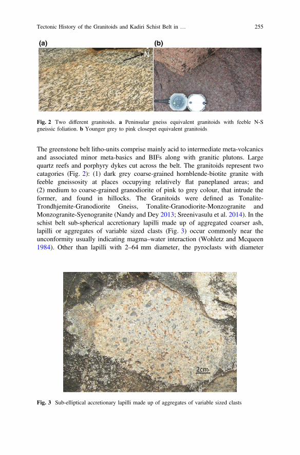
The greenstone belt litho-units comprise mainly acid to intermediate meta-volcanicsand associated minor meta-basics and BIFs along with granitic plutons. Largequartz reefs and porphyry dykes cut across the belt. The granitoids represent twocatagories (Fig. 2): (1) dark grey coarse-grained hornblende-biotite granite withfeeble gneissosity at places occupying relatively flat paneplaned areas; and(2) medium to coarse-grained granodiorite of pink to grey colour, that intrude theformer, and found in hillocks. The Granitoids were defined as Tonalite-Trondhjemite-Granodiorite Gneiss, Tonalite-Granodiorite-Monzogranite andMonzogranite-Syenogranite (Nandy and Dey 2013; Sreenivasulu et al. 2014). In theschist belt sub-spherical accretionary lapilli made up of aggregated coarser ash,lapilli or aggregates of variable sized clasts (Fig. 3) occur commonly near theunconformity usually indicating magma–water interaction (Wohletz and Mcqueen1984). Other than lapilli with 2–64 mm diameter, the pyroclasts with diameter
Fig. 2 Two different granitoids. a Peninsular gneiss equivalent granitoids with feeble N-Sgneissic foliation. b Younger grey to pink closepet equivalent granitoids
Fig. 3 Sub-elliptical accretionary lapilli made up of aggregates of variable sized clasts
Tectonic History of the Granitoids and Kadiri Schist Belt in … 255
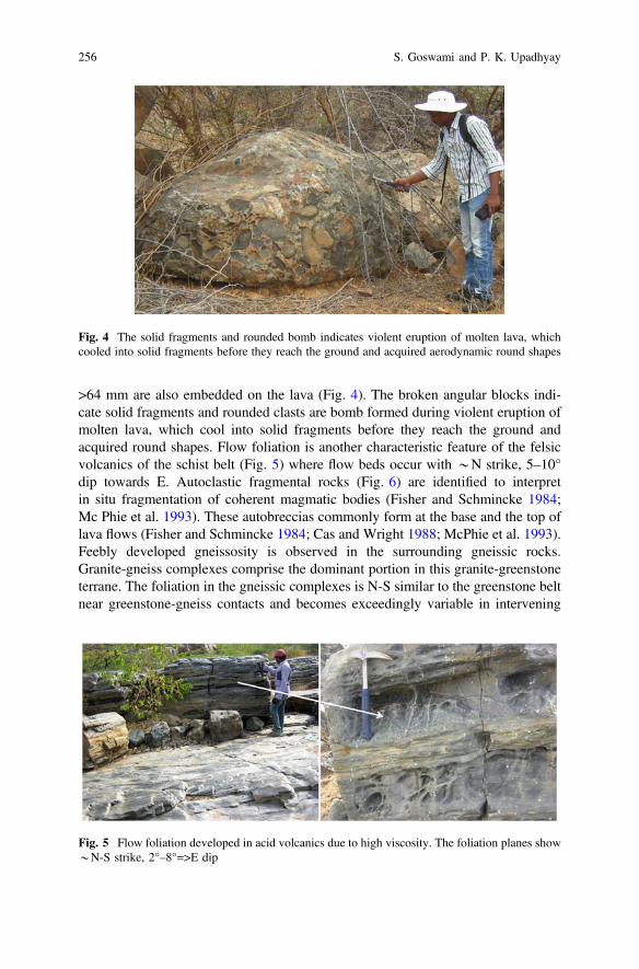
>64 mm are also embedded on the lava (Fig. 4). The broken angular blocks indi-cate solid fragments and rounded clasts are bomb formed during violent eruption ofmolten lava, which cool into solid fragments before they reach the ground andacquired round shapes. Flow foliation is another characteristic feature of the felsicvolcanics of the schist belt (Fig. 5) where flow beds occur with *N strike, 5–10°dip towards E. Autoclastic fragmental rocks (Fig. 6) are identified to interpretin situ fragmentation of coherent magmatic bodies (Fisher and Schmincke 1984;Mc Phie et al. 1993). These autobreccias commonly form at the base and the top oflava flows (Fisher and Schmincke 1984; Cas and Wright 1988; McPhie et al. 1993).Feebly developed gneissosity is observed in the surrounding gneissic rocks.Granite-gneiss complexes comprise the dominant portion in this granite-greenstoneterrane. The foliation in the gneissic complexes is N-S similar to the greenstone beltnear greenstone-gneiss contacts and becomes exceedingly variable in intervening
Fig. 4 The solid fragments and rounded bomb indicates violent eruption of molten lava, whichcooled into solid fragments before they reach the ground and acquired aerodynamic round shapes
Fig. 5 Flow foliation developed in acid volcanics due to high viscosity. The foliation planes show*N-S strike, 2°–8°=>E dip
256 S. Goswami and P. K. Upadhyay

regions. Mechanical rotation and elongation of clast along preferred N-S trend andthe internal deformation and crushing of grains at places by cataclasis duringrotation due to E-W compression are noteworthy. The deformation signature cor-responds to a shallow low temperature environment of regional metamorphism.
Isoclinal folds with steeply dipping axial planes and moderate to steep plunges arepreserved. The cross-section through rhyolite lava exhibits flow banding of visuallydistinct layers of differing crystallinity or vesicularity. The youngest dykes and quartzreefs cut across both the granite and the greenstone belt. The linear andesite anddolerite dykes often run along top of granitic hillocks for kmwith loose angular blocksarranged apparently like unsorted dump. These younger intrusives are identified asblocky lava with very rough surface composed of often loose clinkers and rubble(Fig. 7). TheCuddapah sediments overlie the basement complex along theEparchaeanunconformity with basal conglomerates (Goswami et al. 2015). Above this noncon-formity the polymictic conglomerate (Fig. 8) with abundant clasts of chert, jasper andBIF indicates supracrustal provenance with Archaean volcano-sedimentary rocks.
Fig. 6 Section of flow layers showing auto breccia with in layer suggest in situ fragmentation ofcoherent magmatic bodies
Fig. 7 Basic emplacement along NE-SW cut across granitoids exhibiting stack of pieces ofandesitic blocks are characterised as blocky lava
Tectonic History of the Granitoids and Kadiri Schist Belt in … 257

Fig. 8 a Eparchaean unconformity between Archaean basement granitoids and ProterozoicGulcheru Formation. b The lowermost Gulcheru Formation consists of polymictic conglomerateunit with abundant clasts of chert, jasper and BIF
258 S. Goswami and P. K. Upadhyay

3 Structures
E, NE, NW and N are the different fracture trends. The first two trends are moredominant (Fig. 9). Schistosity and gneissosity show a regional N and the youngergranitic intrusions too are N-S. The granitoids are intruded by basic intrusions alongNW, NE, WNW and ENE trends. Quartz reefs are also remarkable intrusive fea-tures along NW, NE and WNW. Hematitisation is noted locally near the contactzones of quartz reef and basement granitoids. The rocks are deformed with aspecific texture and structure that records the deformation by developing the pre-ferred clast orientation. The fabric appears to be a type of tectonites (Mukherjee2015). Granitic apophyses in the deformed meta-volcanic matrix of the greenstone
Fig. 9 a b diagram showing all fracture plane attitudes of the study area. b p diagram showingpoles of all fracture planes. c p diagram superimposed with corresponding rose diagram tovisualize the paleostress condition. d Superimposed pie and beta diagram of fracture shows NEtrend to be most abundant followed by E
Tectonic History of the Granitoids and Kadiri Schist Belt in … 259
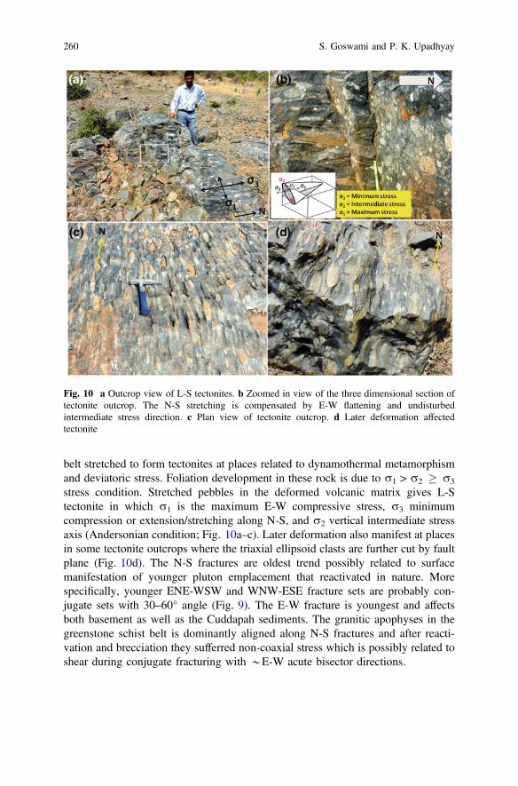
belt stretched to form tectonites at places related to dynamothermal metamorphismand deviatoric stress. Foliation development in these rock is due to r1 > r2 � r3
stress condition. Stretched pebbles in the deformed volcanic matrix gives L-Stectonite in which r1 is the maximum E-W compressive stress, r3 minimumcompression or extension/stretching along N-S, and r2 vertical intermediate stressaxis (Andersonian condition; Fig. 10a–c). Later deformation also manifest at placesin some tectonite outcrops where the triaxial ellipsoid clasts are further cut by faultplane (Fig. 10d). The N-S fractures are oldest trend possibly related to surfacemanifestation of younger pluton emplacement that reactivated in nature. Morespecifically, younger ENE-WSW and WNW-ESE fracture sets are probably con-jugate sets with 30–60° angle (Fig. 9). The E-W fracture is youngest and affectsboth basement as well as the Cuddapah sediments. The granitic apophyses in thegreenstone schist belt is dominantly aligned along N-S fractures and after reacti-vation and brecciation they sufferred non-coaxial stress which is possibly related toshear during conjugate fracturing with *E-W acute bisector directions.
Fig. 10 a Outcrop view of L-S tectonites. b Zoomed in view of the three dimensional section oftectonite outcrop. The N-S stretching is compensated by E-W flattening and undisturbedintermediate stress direction. c Plan view of tectonite outcrop. d Later deformation affectedtectonite
260 S. Goswami and P. K. Upadhyay
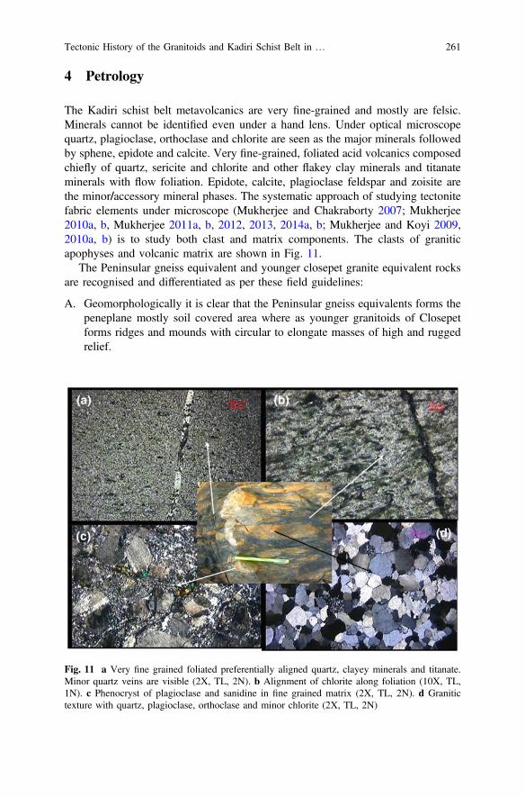
4 Petrology
The Kadiri schist belt metavolcanics are very fine-grained and mostly are felsic.Minerals cannot be identified even under a hand lens. Under optical microscopequartz, plagioclase, orthoclase and chlorite are seen as the major minerals followedby sphene, epidote and calcite. Very fine-grained, foliated acid volcanics composedchiefly of quartz, sericite and chlorite and other flakey clay minerals and titanateminerals with flow foliation. Epidote, calcite, plagioclase feldspar and zoisite arethe minor/accessory mineral phases. The systematic approach of studying tectonitefabric elements under microscope (Mukherjee and Chakraborty 2007; Mukherjee2010a, b, Mukherjee 2011a, b, 2012, 2013, 2014a, b; Mukherjee and Koyi 2009,2010a, b) is to study both clast and matrix components. The clasts of graniticapophyses and volcanic matrix are shown in Fig. 11.
The Peninsular gneiss equivalent and younger closepet granite equivalent rocksare recognised and differentiated as per these field guidelines:
A. Geomorphologically it is clear that the Peninsular gneiss equivalents forms thepeneplane mostly soil covered area where as younger granitoids of Closepetforms ridges and mounds with circular to elongate masses of high and ruggedrelief.
Fig. 11 a Very fine grained foliated preferentially aligned quartz, clayey minerals and titanate.Minor quartz veins are visible (2X, TL, 2N). b Alignment of chlorite along foliation (10X, TL,1N). c Phenocryst of plagioclase and sanidine in fine grained matrix (2X, TL, 2N). d Granitictexture with quartz, plagioclase, orthoclase and minor chlorite (2X, TL, 2N)
Tectonic History of the Granitoids and Kadiri Schist Belt in … 261
B. Presence of feebly developed N-S gneissic foliation in flat-lying older rockscompared to massive intrusives of younger closepet equivalence.
C. The younger granitoids are of two types, pink and grey coloured, with nodistinct boundary between the two and consists of mostly quartz, plagioclaseand potash feldspars with finer-grains than the older gneisses with coarsehornblende and biotite crystals.
D. Older rocks are more structurally disturbed affected by intense fracturing,venation, shear and faulting and associated mylonitization than the youngergranites with relatively less deformation features.
E. Supracrustal enclaves are more numerous in older gneiss equivalent rocks.F. Closepet equivalents are more uraniferous than the older Peninsular gneiss
equivalents.
The dykes of porphyry andesites (Fig. 12) with euhedral plagioclase laths asphenocrysts indicate earlier stage slow cooling of magma, which was forced to thesurface along linear fissures due to buoyancy and rapid cooling to form theremaining fine groundmass. The blocky nature of the lava is also seen due to thehigher viscosity, which favors preservation of the ragged and spinose form of theclinker fragments (Fig. 7). Higher silica content of the dykes than the basaltsprovided higher viscosity that developed blocks schematically defined by Rowlandand Walker (1990). Subsequent breakage of this lava along cooling joints thencontributed planar-surfaced and non-vesicular debris at the flow top. The geo-morphology of younger dykes and quartz reefs along top of the hills is because ofyounger age and relatively higher silica content, which could resist from weatheringto provide linear ridge along top of granitic hills.
5 Geochemistry
The geochemical analyses were performed in the chemistry laboratory, AtomicMinerals Directorate for Exploration and Research, Bangalore (India). Major andselective minor and trace element data (Table 1 and 2) from collected samples areused to interpret the magma evolution and the Meso Archaean to Palaeo Proterozoictectonic history. Harker diagrams (after 1909) of multiple major element oxide plotsagainst SiO2 display smooth, curvilinear trends for almost all rock data pointsindicate genetically related rock types (Figs. 13 and 14). The variations in majorelement indicate a common parent source from which diversification caused themajor elements to either increase or decrease progressively with respect to SiO2.Bowen’s reaction series is reflected in a way in our data where MgO and FeOdecrease with increasing SiO2. Unlike compatible elements like Ni, Cr etc.,incompatible elements also enrich in successively later differentiated part ofmagma. Hence, large ion lithiphile element like uranium is more enriched in latergenerated more differentiated younger granites. Most of the uranium anomalies arelocated in younger closepet equivalents. Upon fractionation, calc-alkaline magmas
262 S. Goswami and P. K. Upadhyay
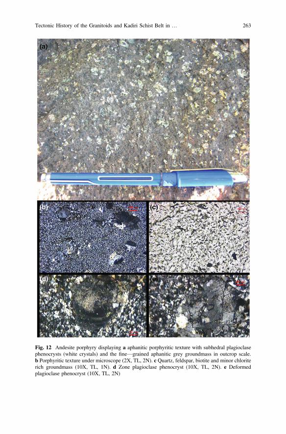
Fig. 12 Andesite porphyry displaying a aphanitic porphyritic texture with subhedral plagioclasephenocrysts (white crystals) and the fine—grained aphanitic grey groundmass in outcrop scale.b Porphyritic texture under microscope (2X, TL, 2N). c Quartz, feldspar, biotite and minor chloriterich groundmass (10X, TL, 1N). d Zone plagioclase phenocryst (10X, TL, 2N). e Deformedplagioclase phenocryst (10X, TL, 2N)
Tectonic History of the Granitoids and Kadiri Schist Belt in … 263

Tab
le1
Major
elem
entox
ide(%
)data
ofselectivesamples
from
Kadirigranite-greenston
eterrain
S.No.
Rock
Symbo
lSiO2
Al 2O3
TiO
2Fe
2O3
MnO
MgO
CaO
Na 2O
K2O
P 2O5
S-1.8/6
AlteredBasic
33.03
16.19
3.86
25.85
0.2
16.29
2.01
<0.01
<0.01
0.31
S-1.8/9
Diorite
4817
.12
0.62
10.17
0.11
9.78
10.24
2.15
0.29
0.09
1.8S
P1Basaltpo
rphy
ry64
.34
14.06
0.88
8.22
0.1
0.63
3.19
3.57
4.01
0.4
1.8S
P2Pink
Granite
73.9
13.27
0.23
1.92
0.03
0.34
0.93
3.65
5.45
0.11
1.8S
P3Diorite
57.72
14.8
0.72
7.19
0.1
5.01
5.36
4.01
2.15
0.29
1.8S
P4Basaltpo
rphy
ry65
.05
15.83
0.54
4.87
0.06
0.99
3.78
5.51
1.56
0.22
1.8S
P5Basaltpo
rphy
ry54
.87
13.46
0.71
8.78
0.13
7.94
5.97
4.24
1.67
0.32
1.8S
P6Granite
73.14
13.25
0.14
1.41
0.03
0.55
0.5
4.74
5.15
0.07
1.8S
P7Graygranite
73.59
13.45
0.13
1.12
0.01
0.15
0.11
4.59
5.44
0.07
1.8S
P8Diorite
56.36
15.69
0.7
8.55
0.1
5.38
6.15
4.37
1.82
0.27
1.8S
P9Basaltpo
rphy
ry62
.67
13.76
0.98
7.36
0.1
3.46
4.59
3.46
2.26
0.22
1.8S
P10
Granite
72.96
13.58
0.11
13.58
0.03
0.21
0.92
4.6
4.88
0.08
KS1
Schistbelt
76.69
13.23
0.22
1.25
0.04
0.89
0.69
3.15
3.29
0.18
KS2
Schistbelt
62.56
21.02
0.31
4.41
0.07
0.37
0.62
1.79
7.39
0.14
KS3
Schistbelt
73.36
16.03
0.25
1.60
0.05
0.72
0.49
2.40
4.57
0.17
KS4
Schistbelt
72.05
13.85
0.31
2.36
0.05
1.13
1.96
4.36
1.20
0.19
KS5
Schistbelt
77.54
12.57
0.14
1.10
0.03
0.92
3.41
0.81
1.53
0.18
KS6
Schistbelt
58.93
16.26
0.81
6.48
0.07
3.65
7.16
4.00
0.77
0.21
KS7
Schistbelt
67.90
15.50
0.31
3.35
0.05
0.68
1.26
6.05
2.92
0.15
264 S. Goswami and P. K. Upadhyay

record a progressive decrease in iron and magnesium with increasing SiO2 andalkali concentrations. Available FeO and MgO are progressively removed from themelt through crystallization of olivine, pyroxenes, amphiboles, biotite and ironoxide minerals such as magnetite. The removal of ferromagnesian minerals enrichesthe melt in Na2O, K2O and SiO2. The SiO2 versus FeOt/MgO plot (Miyashiro1974) and AFM diagram (after Irvine and Barager 1971) of data-points fall in thecalc-alkaline field (Figs. 15 and 16). The progressive changes in chemical com-position are plotted on the AFM (A, alkali; F, iron; M, magnesium wt%) diagram(Fig. 16) to study along with the Harker diagrams (Figs. 13 and 14). This is todemonstrate that the calc-alkaline rocks generated by diversification of andesiticparent magma. Thus, with increasing fractionation from magma, the calc—alkalineseries exhibits increase in SiO2, Na2O and K2O and decrease in CaO, MgO and thetotal iron (Bowen 1928; Miyashiro 1974; Grove and Kinzler 1986). However, dueto successive metamorphism and alterations the addition or removal of certainoxides can show some discrepancy (Table 2).
As far as tectonic setting is concerned, the plutonic and hypabyssal rocks wereseparately studied and interpreted from volcanics. Felsic volcanic data suggestconvergent plate margin for greenstone belt rocks (Fig. 17a) wherein youngerbatholiths and composite volcanoes develop above the subduction zone. It is likelythat the parent melts for the acid volcanics produced by partial melting of a rela-tively undepleted mantle source. Older dioritic to granidioritic peninsular gneissequivalent and younger closepet equivalent granitoids along with intermediateyounger hypabyssal porphyries are plotted in the tectonic discrimination diagramsafter Maniar and Piccoli (1989). The older gneiss equivalences plot in thepost-orogenic granitoids (POG) field on the Al2O3 versus SiO2 plot (Fig. 17b).Thus we can consider the Dharwar batholith to have formed during the cruststabilizing post-orogenic environment. Whereas the younger granitoids and dykesplot in the combined field (Fig. 17c), which must be clarified from other supportivediscrimination diagrams. The geochemical data are also plotted into the Batchelorand Bowden’s diagram (1985) that support the tectonic environment for oldergniess equivalents as post-orogenic. Additionally it shows younger granitoids andporphyries to associate with post-plate collision uplift (Fig. 17d).
6 Discussions
The greenstone belt rocks near Dorigallu indicate submarine volcanism along fissuresdeveloped in convergent plate boundary involved the transfer of magma (togetherwith phenocrysts, dissolved volatiles, and country-rock material entrained from theconduit walls or ground surface) from some depth. The breccias and agglomeratesindicate fissure vent surrounding environment (Goswami et al. 2018a, b). Fragmentsin breccias are chiefly felsic volcanics and range up to 1 m across although generallyaveraging 10–30 cm. According to Goodwin et al. (1972) the ratio of pyroclastics toflows increases both with increasing stratigraphic height andwith decreasing distance
Tectonic History of the Granitoids and Kadiri Schist Belt in … 265

to eruptive centers. Thus the studied sections in Kadiri schist belt suggest middleportion of the greenstone succession. The intensive shearing and brecciation ofgranitic apophyses, intruded along schistosity plane in the northern part of Kadirigreenstone belt, causes pseudo appearance of agglomerate. The actual agglomerateunits are not well-sorted sorted and fragments are generally angular although someunits are composed ofwell-rounded bombs. Themedium tofine ash-flow tuff units arewelded and well bedded. Individual beds are 1 cm to few meters thick.
The basalt, andesite, dacite and rhyolite (BADR) is the signature suite of rocksindicates calc-alkaline volcanic association. This suite can act as a fingerprint ofconvergent plate margin. This setting constitutes possibly one of themost voluminousrock assemblages on the Earth after MORB (Perfit et al. 1980; Grove and Kinzler1986). Harker diagram plots of major elements indicate a liquid line of descent from acommon magma source. This BADR rock association are derived from a commonparent magma of basaltic to andesitic composition. These calcalkaline volcanic rocks
Fig. 13 Variation diagram (Harker Harker 1909) showing multiple oxide (%) plots against SiO2
(%)
266 S. Goswami and P. K. Upadhyay
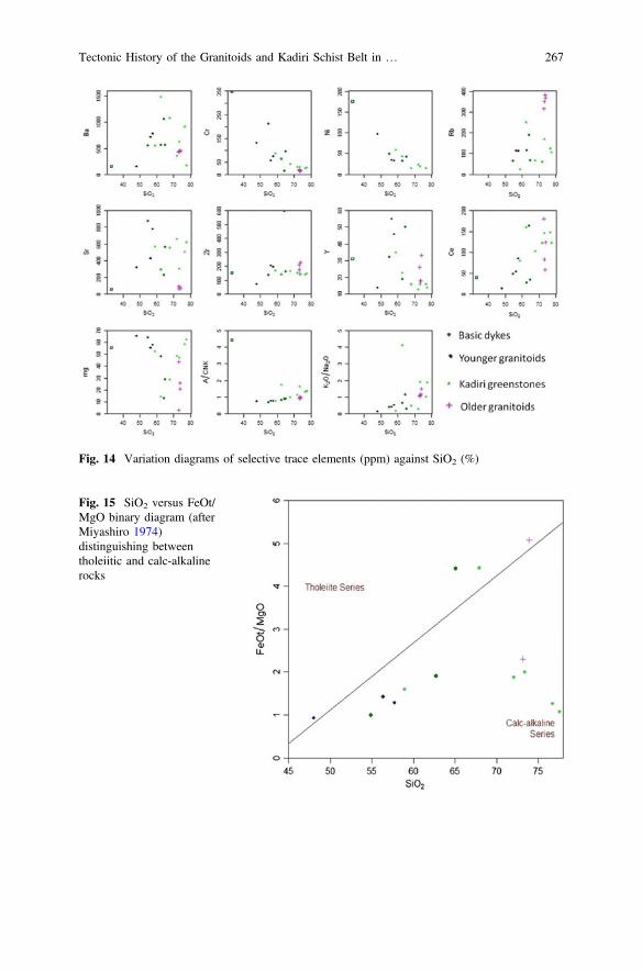
Fig. 14 Variation diagrams of selective trace elements (ppm) against SiO2 (%)
Fig. 15 SiO2 versus FeOt/MgO binary diagram (afterMiyashiro 1974)distinguishing betweentholeiitic and calc-alkalinerocks
Tectonic History of the Granitoids and Kadiri Schist Belt in … 267

are formed at convergent margins where more silicic rocks represent enhancedfractionation. The calc-alkaline trend with ocean-continent convergence setting of thepresent data supports the observation of Chadwick et al. (2000). The calc-alkalinesuite is also reflected from enrichment in SiO2, alkalis (Na2O and K2O), LILE,volatiles and is relatively depleted in FeO, MgO, HFS concentrations (Miyashiro1974; Hawkesworth et al. 1993; Pearce and Peate 1995) like the Phanerozoic con-vergent margins eg., Sierra Nevada (Fliedner et al. 2000; Ducea 2001) and ring offirein present day. The peraluminous to metaluminous nature (Fig. 18a, b) with domi-nantly acidic composition indicates ocean-continent convergence that took placeduring Late Archaean time (*2.6 Ga). Oceanic or thinner continental lithosphere inthe overlying plate generally produces metaluminous, mafic to intermediate rocks(Miyashiro 1974; Gill 1981). Thicker continental lithosphere overlying the subduc-tion zones commonly yields peraluminous, potassic, intermediate to silicic rocks. Thehigh K calc-alkaline and shoshonite i.e., high K andesite magma (Fig. 19a) indicatemelting at the base of the lithospheric stack. In Th versus Co plot (Fig. 19b) as perHastie et al. (2007), the high K calc-alkaline and shoshonite series indicate late stageocean-continent subduction. The progression from tholeiite to calc-alkaline toshoshonite (trachyandesite) reflects increasing K2O and K2O/Na2O and decreasingiron enrichment (Jakes and White 1972; Miyashiro 1974). The hot, buoyant Archeanocean lithosphere possibly favoured shallow low-angle subduction, which can beexplained by Al2O3, K2O and SiO2 rich rhyolites, rhyodacites and shoshonites andplutonic rocks of increasingly granitic composition. This points to a relativelylow-angle subduction (*25°) of thick continental lithosphere (>25 km) with higherdegrees of partial melting (Davies 1992; Ernst 2007; Stern 2008).
Fig. 16 AFM diagram (afterIrvine and Barager 1971)serves to discriminatebetween calc-alkaline andtholeiitic subalkaline series. Inthis ternary diagram A =(Na2O+K2O), F = FeOt andM = MgO
268 S. Goswami and P. K. Upadhyay
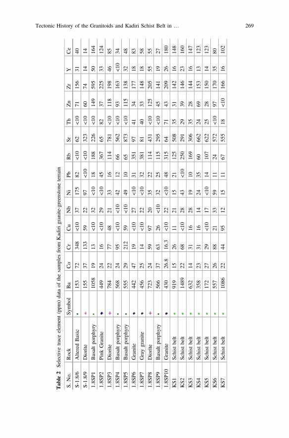
Tab
le2
Selectivetraceelem
ent(ppm
)data
ofthesamples
from
Kadirigranite-greenston
eterrain
S.No.
Rock
Symbo
lBa
Co
Cr
Cu
Nb
Ni
PbRb
SrTh
Zn
Zr
YCe
S-1.8/6
AlteredBasic
153
7234
8<1
037
175
82<1
062
<10
7115
631
40
S-1.8/9
Diorite
155
3713
359
2297
<10
<10
323
<10
6074
1414
1.8S
P1Basaltpo
rphy
ry10
5819
13<1
032
<10
1818
822
6<1
014
959
550
164
1.8S
P2Pink
Granite
449
2416
<10
29<1
045
367
6582
3722
533
124
1.8S
P3Diorite
784
2277
4821
3316
114
781
<10
118
198
4685
1.8S
P4Basaltpo
rphy
ry56
824
95<1
0<1
042
1266
562
<10
9316
3<1
034
1.8S
P5Basaltpo
rphy
ry55
529
212
59<1
049
1065
873
<10
115
138
3248
1.8S
P6Granite
442
4719
<10
27<1
031
351
9741
3417
718
83
1.8S
P7Graygranite
456
2514
<10
22<1
032
381
8140
3314
818
58
1.8S
P8Diorite
723
2459
9720
3522
114
431
<10
125
205
5555
1.8S
P9Basaltpo
rphy
ry56
637
6326
<10
3225
115
295
<10
4514
119
27
1.8S
P10
Granite
430
26.8
16.3
<10
22<1
048
315
6471
4320
926
180
KS1
Schistbelt
919
1526
1121
1521
125
508
3531
142
1614
8
KS2
Schistbelt
1489
2268
<10
2843
<10
250
291
2939
146
2316
0
KS3
Schistbelt
632
1431
1628
1910
169
306
3528
144
1614
7
KS4
Schistbelt
358
2331
1614
2435
6066
224
6915
313
123
KS5
Schistbelt
172
2729
<10
17<1
014
107
622
2528
150
1412
3
KS6
Schistbelt
557
2688
2133
5911
2457
2<1
097
170
3580
KS7
Schistbelt
1086
2244
9512
1511
6755
518
<10
166
1610
2
Tectonic History of the Granitoids and Kadiri Schist Belt in … 269

To relate Archean high-grade gneiss with low grade (granite-greenstone) terranewe have to determine one of the following three situations (after Shackleton 1976).1. Both age and tectonic setting differ. 2. Same age but different tectonic setting. 3.High-grade terranes are the deep crustal equivalents of granite greenstone terranes.Since, the age of greenstone/schist belt is different from that of granitoids, thesecond possibility eliminates. The term Dharwar Batholith after Chadwick et al.(2000) is introduced to differentiate from Peninsular gneiss as the rocks are moregranitic than gneissic. In most of the areas, the contact between the DharwarBatholith and the schist belt is blind. Since, Kadiri is the northern extension ofKolar schist belt it is logical to accept the same mechanism of rifting associatedwith mantle-plume as suggested for Kolar schist belt (Rajamani et al. 1985;Rajamani 1990). However, the mantle plume related extension and rifting perhaps
Fig. 17 a The logarithmic Zr versus Ti plot of data points fall in Island arc lava field whichsuggest convergent plate margin (after Pearce, Pearce 1982). b Al2O3 versus SiO2 plot (afterManiar and Piccoli, Maniar and Piccoli 1989). c AFM ternary (after Maniar and Piccoli, Maniarand Piccoli 1989). Note: IAG = island arc granitoids, CAG = continental arc granitoids, CCG =continental collision granitoids, POG = post-orogenic granitoids, RRG = rift-related granitoids,CEUG = continental epirogenic uplift granitoids, OP = oceanic plagiogranites. d R1–R2 binarydiagram (De La Roche et al. 1980) with geotectonic implications (after Batchelor and Bowden1985)
270 S. Goswami and P. K. Upadhyay
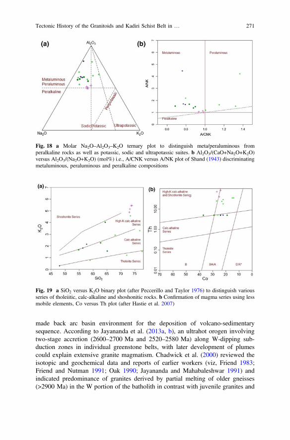
made back arc basin environment for the deposition of volcano-sedimentarysequence. According to Jayananda et al. (2013a, b), an ultrahot orogen involvingtwo-stage accretion (2600–2700 Ma and 2520–2580 Ma) along W-dipping sub-duction zones in individual greenstone belts, with later development of plumescould explain extensive granite magmatism. Chadwick et al. (2000) reviewed theisotopic and geochemical data and reports of earlier workers (viz, Friend 1983;Friend and Nutman 1991; Oak 1990; Jayananda and Mahabaleshwar 1991) andindicated predominance of granites derived by partial melting of older gneisses(>2900 Ma) in the W portion of the batholith in contrast with juvenile granites and
Fig. 18 a Molar Na2O–Al2O3–K2O ternary plot to distinguish meta/peraluminous fromperalkaline rocks as well as potassic, sodic and ultrapotassic suites. b Al2O3/(CaO+Na2O+K2O)versus Al2O3/(Na2O+K2O) (mol%) i.e., A/CNK versus A/NK plot of Shand (1943) discriminatingmetaluminous, peraluminous and peralkaline compositions
Fig. 19 a SiO2 versus K2O binary plot (after Peccerillo and Taylor 1976) to distinguish variousseries of tholeiitic, calc-alkaline and shoshonitic rocks. b Confirmation of magma series using lessmobile elements, Co versus Th plot (after Hastie et al. 2007)
Tectonic History of the Granitoids and Kadiri Schist Belt in … 271
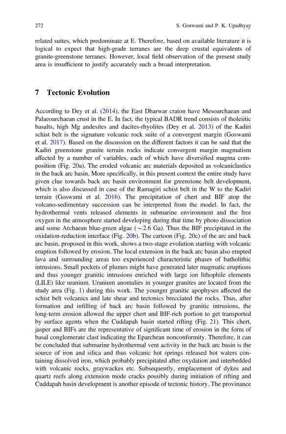
related suites, which predominate at E. Therefore, based on available literature it islogical to expect that high-grade terranes are the deep crustal equivalents ofgranite-greenstone terranes. However, local field observation of the present studyarea is insufficient to justify accurately such a broad interpretation.
7 Tectonic Evolution
According to Dey et al. (2014), the East Dharwar craton have Mesoarchaean andPalaeoarchaean crust in the E. In fact, the typical BADR trend consists of tholeiiticbasalts, high Mg andesites and dacites-rhyolites (Dey et al. 2013) of the Kadirischist belt is the signature volcanic rock suite of a convergent margin (Goswamiet al. 2017). Based on the discussion on the different factors it can be said that theKadiri greenstone granite terrain rocks indicate convergent margin magmatismaffected by a number of variables, each of which have diversified magma com-position (Fig. 20a). The eroded volcanic arc materials deposited as volcaniclasticsin the back arc basin. More specifically, in this present context the entire study havegiven clue towards back arc basin environment for greenstone belt development,which is also discussed in case of the Ramagiri schist belt in the W to the Kadiriterrain (Goswami et al. 2016). The precipitation of chert and BIF atop thevolcano-sedimentary succession can be interpreted from the model. In fact, thehydrothermal vents released elements in submarine environment and the freeoxygen in the atmosphere started developing during that time by photo dissociationand some Archaean blue-green algae (*2.6 Ga). Thus the BIF precipitated in theoxidation-reduction interface (Fig. 20b). The cartoon (Fig. 20c) of the arc and backarc basin, proposed in this work, shows a two-stage evolution starting with volcaniceruption followed by erosion. The local extension in the back arc basin also eruptedlava and surrounding areas too experienced characteristic phases of batholithicintrusions. Small pockets of plumes might have generated later magmatic eruptionsand thus younger granitic intrusions enriched with large ion lithophile elements(LILE) like uranium. Uranium anomalies in younger granites are located from thestudy area (Fig. 1) during this work. The younger granitic apophyses affected theschist belt volcanics and late shear and tectonics brecciated the rocks. Thus, afterformation and infilling of back arc basin followed by granitic intrusions, thelong-term erosion allowed the upper chert and BIF-rich portion to get transportedby surface agents when the Cuddapah basin started rifting (Fig. 21). This chert,jasper and BIFs are the representative of significant time of erosion in the form ofbasal conglomerate clast indicating the Eparchean nonconformity. Therefore, it canbe concluded that submarine hydrothermal vent activity in the back arc basin is thesource of iron and silica and thus volcanic hot springs released hot waters con-taining dissolved iron, which probably precipitated after oxydation and interbeddedwith volcanic rocks, graywackes etc. Subsequently, emplacement of dykes andquartz reefs along extension mode cracks possibly during initiation of rifting andCuddapah basin development is another episode of tectonic history. The provinance
272 S. Goswami and P. K. Upadhyay
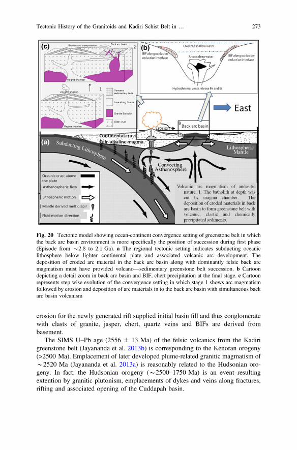
erosion for the newly generated rift supplied initial basin fill and thus conglomeratewith clasts of granite, jasper, chert, quartz veins and BIFs are derived frombasement.
The SIMS U–Pb age (2556 ± 13 Ma) of the felsic volcanics from the Kadirigreenstone belt (Jayananda et al. 2013b) is corresponding to the Kenoran orogeny(>2500 Ma). Emplacement of later developed plume-related granitic magmatism of*2520 Ma (Jayananda et al. 2013a) is reasonably related to the Hudsonian oro-geny. In fact, the Hudsonian orogeny (*2500–1750 Ma) is an event resultingextention by granitic plutonism, emplacements of dykes and veins along fractures,rifting and associated opening of the Cuddapah basin.
Fig. 20 Tectonic model showing ocean-continent convergence setting of greenstone belt in whichthe back arc basin environment is more specifically the position of succession during first phase(Episode from *2.8 to 2.1 Ga). a The regional tectonic setting indicates subducting oceaniclithosphere below lighter continental plate and associated volcanic arc development. Thedeposition of eroded arc material in the back arc basin along with dominantly felsic back arcmagmatism must have provided volcano—sedimentary greenstone belt succession. b Cartoondepicting a detail zoom in back arc basin and BIF, chert precipitation at the final stage. c Cartoonrepresents step wise evolution of the convergence setting in which stage 1 shows arc magmatismfollowed by erosion and deposition of arc materials in to the back arc basin with simultaneous backarc basin volcanism
Tectonic History of the Granitoids and Kadiri Schist Belt in … 273
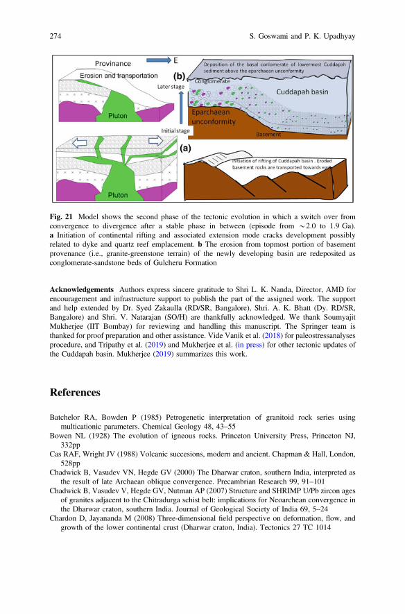
Acknowledgements Authors express sincere gratitude to Shri L. K. Nanda, Director, AMD forencouragement and infrastructure support to publish the part of the assigned work. The supportand help extended by Dr. Syed Zakaulla (RD/SR, Bangalore), Shri. A. K. Bhatt (Dy. RD/SR,Bangalore) and Shri. V. Natarajan (SO/H) are thankfully acknowledged. We thank SoumyajitMukherjee (IIT Bombay) for reviewing and handling this manuscript. The Springer team isthanked for proof preparation and other assistance. Vide Vanik et al. (2018) for paleostressanalysesprocedure, and Tripathy et al. (2019) and Mukherjee et al. (in press) for other tectonic updates ofthe Cuddapah basin. Mukherjee (2019) summarizes this work.
References
Batchelor RA, Bowden P (1985) Petrogenetic interpretation of granitoid rock series usingmulticationic parameters. Chemical Geology 48, 43–55
Bowen NL (1928) The evolution of igneous rocks. Princeton University Press, Princeton NJ,332pp
Cas RAF, Wright JV (1988) Volcanic succesions, modern and ancient. Chapman & Hall, London,528pp
Chadwick B, Vasudev VN, Hegde GV (2000) The Dharwar craton, southern India, interpreted asthe result of late Archaean oblique convergence. Precambrian Research 99, 91–101
Chadwick B, Vasudev V, Hegde GV, Nutman AP (2007) Structure and SHRIMP U/Pb zircon agesof granites adjacent to the Chitradurga schist belt: implications for Neoarchean convergence inthe Dharwar craton, southern India. Journal of Geological Society of India 69, 5–24
Chardon D, Jayananda M (2008) Three-dimensional field perspective on deformation, flow, andgrowth of the lower continental crust (Dharwar craton, India). Tectonics 27 TC 1014
Fig. 21 Model shows the second phase of the tectonic evolution in which a switch over fromconvergence to divergence after a stable phase in between (episode from *2.0 to 1.9 Ga).a Initiation of continental rifting and associated extension mode cracks development possiblyrelated to dyke and quartz reef emplacement. b The erosion from topmost portion of basementprovenance (i.e., granite-greenstone terrain) of the newly developing basin are redeposited asconglomerate-sandstone beds of Gulcheru Formation
274 S. Goswami and P. K. Upadhyay
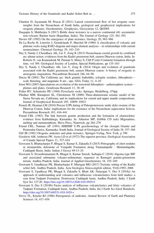
Chardon D, Jayananda M, Peucat JJ (2011) Lateral constrictional flow of hot orogenic crust:insights from the Neoarchean of South India, geological and geophysical implications fororogenic plateaux. Geochemistry, Geophysics, Geosystems 12, Q02005
Dasgupta S, Mukherjee S (2017) Brittle shear tectonics in a narrow continental rift: asymmetricnon-volcanic Barmer basin (Rajasthan, India). The Journal of Geology 125, 561–591
Davies GF (1992) On the emergence of plate tectonics. Geology 20, 963–966De La Roche H, Leterrier J, Grandclaude P, Marchal M (1980) A classification of volcanic and
plutonic rocks using R1R2-diagram and major element analyses – its relationships with currentnomenclature. Chemical Geology 29, 183–210
Dey S, Nandy J, Choudhary AK, Liu Y, Zong K (2013) Neoarchaean crustal growth by combinedarc–plume action: evidences from the Kadiri greenstone belt, eastern Dharwar craton, India. In:Roberts N, van Kranendonk M, Parman S, Shirey S, Clift P (eds) Continent formation throughtime, vol 389. Geological Society of London, Special Publications, pp 135–163
Dey S, Nandy J, Choudhary AK, Liu Y, Zong K (2014) Origin and evolution of granitoidsassociated with the Kadiri greenstone belt, eastern Dharwar craton: A history of orogenic toanorogenic magmatism. Precambrian Research 246, 64–90
Ducea M (2001) The California arc: thick granitic batholiths, eclogitic residues, lithospheric—scale thrusting, and magmatic fl are—ups. GSA Today 11, 4–10
Ernst WG (2007) Speculations on evolution of the terrestrial lithosphere—asthenosphere system—plumes and plates. Gondwana Research 11, 38–49
Fisher RV, Schmincke HU (1984) Pyroclastic rocks. Springer, Heidelberg, 474ppFliedner MM, Klemperer SL, Christensen NI (2000) Three-dimensional seismic model of the
Sierra Nevada arc, California, and its implications for crustal and upper mantle compositions.Journal of Geophysical Research 105, 10899–10921
French JE, Heaman LM (2010) Precise U/Pb dating of Paleoproterozoic mafic dyke swarms of theDharwar Craton, India: implications for the existence of the Neoarchean supercraton Sclavia.Precambrian Research 183, 416–441
Friend CRL (1983) The link between granite production and the formation of charnockites:evidence from Kabbaldurga, Karnataka. In: Atherton MP, Gribble CD (eds) Migmatities,melting and metamorphism. Shiva Press, Nantwich, pp 264–276
Friend CRL, Nutman AP (1991) SHRIMP U-Pb geochronology of the closepet Granite andPeninsular Gneiss, Karnataka, South India. Journal of Geological Society of India 38, 357–368
Gill JB (1981) Orogenic andesites and plate tectonics. Springer-Verlag, New York, p 390Goodwin AM, Ambrose JW, Ayres LD et al (1972) The superior province. Geological Association
of Canada Special Papers 11, 527–624Goswami S, Bhattacharjee P, Bhagat S, Kumar S, Zakaulla S (2015) Petrography of chert nodules
in stromatolitic dolostone of Vempalle Formation along Tummalapalle - Motnutalapalle,Cuddapah Basin, India. Indian J Geosci 69:13–24
Goswami S, Sivasubramaniam R, Bhagat S, Kumar Suresh, Sarbajna C (2016) Algoma type BIFand associated submarine volcano-sedimentary sequence in Ramagiri granite-greenstoneterrain, Andhra Pradesh, India. Journal of Applied Geochemistry 18, 155–169
Goswami S, Upadhayay PK, Bhattacharjee P, Murugan MG (2017) Tectonic setting of the Kadirischist belt, Andhra Pradesh, India. Acta Geologica Sinica-english edition. 91(6):1992–2006
Goswami S, Upadhyay PK, Bhagat S, Zakaulla S, Bhatt AK, Natarajan V, Dey S (2018a) Anapproach of understanding acid volcanics and tuffaceous volcaniclastics from field studies: acase from Tadpatri Formation, Proterozoic Cuddapah basin, Andhra Pradesh, India. J EarthSyst Sci 127:20. https://doi.org/10.1007/s12040-018-0929-0
Goswami S, Dey S (2018b) Facies analysis of tuffaceous volcaniclastics and felsic volcanics ofTadpatri Formation, Cuddapah basin, Andhra Pradesh, India. Int J Earth Sci (Geol Rundsch).https://doi.org/10.1007/s00531-018-1620-z
Grove TL, Kinzler RJ (1986) Petrogenesis of andesites. Annual Review of Earth and PlanetarySciences 14, 417–454
Tectonic History of the Granitoids and Kadiri Schist Belt in … 275
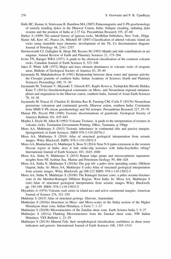
Halls HC, Kumar A, Srinivasan R, Hamilton MA (2007) Palaeomagnetic and U-Pb geochronologyof easterly trending dykes in the Dharwar Craton, India: feldspar clouding, radiating dykeswarms and the position of India at 2.37 Ga. Precambrian Research 155, 47–68
Harker A (1909) The natural history of igneous rocks. McMillan Publishers, New York, 384ppHastie AR, Kerr AC, Pearce JA, Mitchell SF (2007) Classification of altered volcanic island arc
rocks using immobile trace elements: development of the Th, Co discrimination diagram.Journal of Petrology 48, 2341–2357
Hawkesworth CJ, Gallagher K, Hergt JM, Keynes M (1993) Mantle and slab contributions in arcmagmas. Annual Review of Earth and Planetary Sciences 21, 175–204
Irvine TN, Barager WRA (1971) A guide to the chemical classification of the common volcanicrocks. Canadian Journal of Earth Sciences 8, 523–548
Jakes P, White AJR (1972) Major and trace element abundances in volcanic rocks of orogenicareas. Bulletin of Geological Society of America 83, 29–40
Jayananda M, Mahabaleshwar B (1991) Relationship between shear zones and igneous activity:the Closepet graninte of southern India. Indian Academy of Sciences (Earth and PlanetarySciences) Proceedings 100, 31–36
Jayananda M, Tsutsumi Y, Miyasaki T, Gireesh RV, Kapfo Kowe-u, Tushipokla Hiroshi Hidaka,Kano T (2013a) Geochronological constraints on Meso- and Neoarchean regional metamor-phism and magmatism in the Dharwar craton, southern India. Journal of Asian Earth Sciences78, 18–38
Jayananda M, Peucat JJ, Chardon D, Krishna Rao B, Fanning CM, Corfu F (2013b) Neoarcheangreenstone volcanism and continental growth, Dharwar craton, southern India: Constraintsfrom SIMS U-Pb zircon geochronology and Nd isotopes. Precambrian Research 227, 55–76
Maniar PD, Piccoli PM (1989) Tectonic discriminations of granitoids. Geological Society ofAmerica Bulletin 101, 635–643
Mcphie J, Doyle M, Allen R (1993) Volcanic Textures. A guide to the interpretation of textures involcanic rocks. Tasmanian Government Printing, Office, Tasmania, p 196pp
Misra AA, Mukherjee S (2015) Tectonic inheritance in continental rifts and passive margins.Springerbriefs in Earth Sciences. ISBN 978-3-319-20576-2
Misra AA, Mukherjee S (2018) Atlas of structural geological interpretation from seismicimages. Wiley Blackwell. ISBN: 978-1-119-15832-5
Misra AA, Bhattacharya G, Mukherjee S, Bose N (2014) Near N-S paleo-extension in the westernDeccan region in India: does it link strike-slip tectonics with India-Seychelles rifting?International Journal of Earth Sciences 103, 1645–1680
Misra AA, Sinha N, Mukherjee S (2015) Repeat ridge jumps and microcontinent separation:insights from NE Arabian Sea. Marine and Petroleum Geology 59, 406–428
Misra AA, Sinha N, Mukherjee S (2018a) The gop rift: a paleo slow spreading centre, OffshoreGujarat, India. In: Misra AA, Mukherjee S (eds) Atlas of structural geological interpretationfrom seismic images. Wiley Blackwell, pp 208-212 ISBN: 978-1-119-15832-5
Misra AA, Sinha N, Mukherjee S (2018b) The Ratnagiri fracture zone: a paleo oceanic‐fracture‐zone in the Mumbai‐Ratnagiri Offshore Region, West India. In: Misra AA, Mukherjee S(eds) Atlas of structural geological interpretation from seismic images. Wiley Blackwell,pp. 195-199. ISBN: 978-1-119-15832-5
Miyashiro A (1974) Volcanic rock series in island arcs and active continental margins. AmericanJournal of Science 274, 321–355
Mukherje S (2015) Atlas of structural geology. Elsevier, AmsterdamMukherjee S (2010a) Structures in Meso- and Micro-scales in the Sutlej section of the Higher
Himalayan shear zone, Indian Himalaya. e-Terra 7, 1–27Mukherjee S (2010b) Microstructures of the Zanskar shear zone. Earth Science India 3, 9–27Mukherjee S (2011a) Flanking Microstructures from the Zanskar shear zone, NW Indian
Himalaya. YES Bulletin 1, 21–29Mukherjee S (2011b) Mineral Fish: their morphological classification, usefulness as shear sense
indicators and genesis. International Journal of Earth Sciences 100, 1303–1314
276 S. Goswami and P. K. Upadhyay
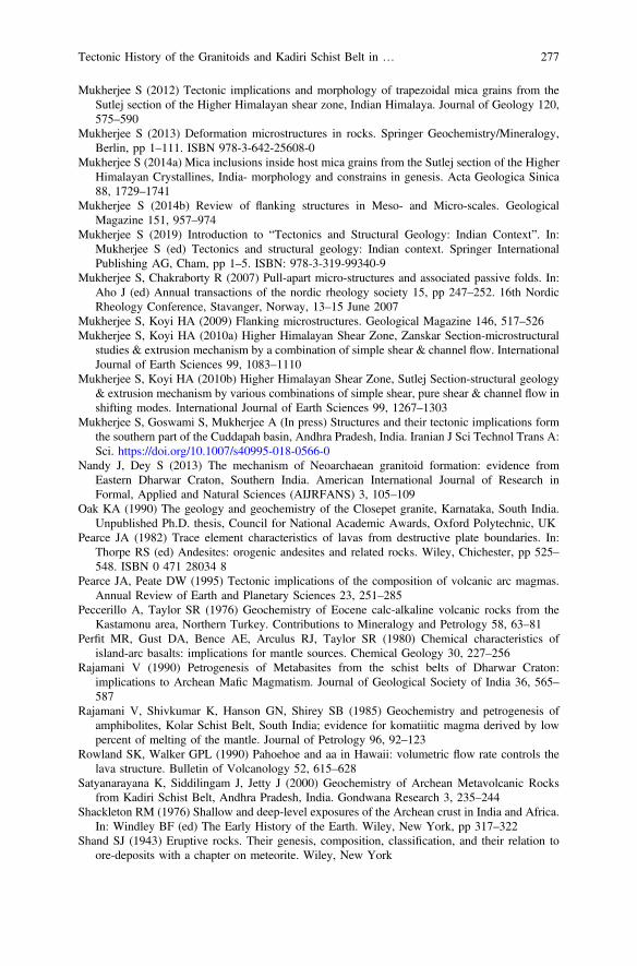
Mukherjee S (2012) Tectonic implications and morphology of trapezoidal mica grains from theSutlej section of the Higher Himalayan shear zone, Indian Himalaya. Journal of Geology 120,575–590
Mukherjee S (2013) Deformation microstructures in rocks. Springer Geochemistry/Mineralogy,Berlin, pp 1–111. ISBN 978-3-642-25608-0
Mukherjee S (2014a) Mica inclusions inside host mica grains from the Sutlej section of the HigherHimalayan Crystallines, India- morphology and constrains in genesis. Acta Geologica Sinica88, 1729–1741
Mukherjee S (2014b) Review of flanking structures in Meso- and Micro-scales. GeologicalMagazine 151, 957–974
Mukherjee S (2019) Introduction to “Tectonics and Structural Geology: Indian Context”. In:Mukherjee S (ed) Tectonics and structural geology: Indian context. Springer InternationalPublishing AG, Cham, pp 1–5. ISBN: 978-3-319-99340-9
Mukherjee S, Chakraborty R (2007) Pull-apart micro-structures and associated passive folds. In:Aho J (ed) Annual transactions of the nordic rheology society 15, pp 247–252. 16th NordicRheology Conference, Stavanger, Norway, 13–15 June 2007
Mukherjee S, Koyi HA (2009) Flanking microstructures. Geological Magazine 146, 517–526Mukherjee S, Koyi HA (2010a) Higher Himalayan Shear Zone, Zanskar Section-microstructural
studies & extrusion mechanism by a combination of simple shear & channel flow. InternationalJournal of Earth Sciences 99, 1083–1110
Mukherjee S, Koyi HA (2010b) Higher Himalayan Shear Zone, Sutlej Section-structural geology& extrusion mechanism by various combinations of simple shear, pure shear & channel flow inshifting modes. International Journal of Earth Sciences 99, 1267–1303
Mukherjee S, Goswami S, Mukherjee A (In press) Structures and their tectonic implications formthe southern part of the Cuddapah basin, Andhra Pradesh, India. Iranian J Sci Technol Trans A:Sci. https://doi.org/10.1007/s40995-018-0566-0
Nandy J, Dey S (2013) The mechanism of Neoarchaean granitoid formation: evidence fromEastern Dharwar Craton, Southern India. American International Journal of Research inFormal, Applied and Natural Sciences (AIJRFANS) 3, 105–109
Oak KA (1990) The geology and geochemistry of the Closepet granite, Karnataka, South India.Unpublished Ph.D. thesis, Council for National Academic Awards, Oxford Polytechnic, UK
Pearce JA (1982) Trace element characteristics of lavas from destructive plate boundaries. In:Thorpe RS (ed) Andesites: orogenic andesites and related rocks. Wiley, Chichester, pp 525–548. ISBN 0 471 28034 8
Pearce JA, Peate DW (1995) Tectonic implications of the composition of volcanic arc magmas.Annual Review of Earth and Planetary Sciences 23, 251–285
Peccerillo A, Taylor SR (1976) Geochemistry of Eocene calc-alkaline volcanic rocks from theKastamonu area, Northern Turkey. Contributions to Mineralogy and Petrology 58, 63–81
Perfit MR, Gust DA, Bence AE, Arculus RJ, Taylor SR (1980) Chemical characteristics ofisland-arc basalts: implications for mantle sources. Chemical Geology 30, 227–256
Rajamani V (1990) Petrogenesis of Metabasites from the schist belts of Dharwar Craton:implications to Archean Mafic Magmatism. Journal of Geological Society of India 36, 565–587
Rajamani V, Shivkumar K, Hanson GN, Shirey SB (1985) Geochemistry and petrogenesis ofamphibolites, Kolar Schist Belt, South India; evidence for komatiitic magma derived by lowpercent of melting of the mantle. Journal of Petrology 96, 92–123
Rowland SK, Walker GPL (1990) Pahoehoe and aa in Hawaii: volumetric flow rate controls thelava structure. Bulletin of Volcanology 52, 615–628
Satyanarayana K, Siddilingam J, Jetty J (2000) Geochemistry of Archean Metavolcanic Rocksfrom Kadiri Schist Belt, Andhra Pradesh, India. Gondwana Research 3, 235–244
Shackleton RM (1976) Shallow and deep-level exposures of the Archean crust in India and Africa.In: Windley BF (ed) The Early History of the Earth. Wiley, New York, pp 317–322
Shand SJ (1943) Eruptive rocks. Their genesis, composition, classification, and their relation toore-deposits with a chapter on meteorite. Wiley, New York
Tectonic History of the Granitoids and Kadiri Schist Belt in … 277

Sreenivasulu P, Padmasree P, Hanumanthu PC (2014) Granitoids adjoining Kadiri schist belt,Andhra Pradesh, South India: field and petrographic implications. International Journal ofGeology, Earth and Environmental Sciences 4, 244–258
Stern RJ (2008) Modern style plate tectonics began in Neoproterozoic time: an alternativeinterpretation of Earth’ s tectonic history. In: Condie KC and Pease V (eds) When did platetectonics begin on planet earth? Geological Society of America Special Paper 440, pp 265–280
Tripathy V, Satyapal, Mitra SK, Sai BBS (2019) Fold-thrust belt architecture and structuralevolution of the Northern part of the Nallamalai Fold Belt, Cuddapah basin, Andhra Pradesh,India. In: Mukherjee S (ed) Tectonics and structural geology: Indian context. SpringerInternational Publishing AG, Cham, pp 219–252. ISBN 978-3-319-99340-9
Wohletz KH, Mcqueen RG (1984) Volcanic and stratospheric dust like particles produced byexperimental water-melt interactions. Geology 12, 591–594
Vanik N, Shaikh H, Mukherjee S, Maurya DM, Chamyal LS (2018) Post-deccan trap stressreorientation under transpression: evidence from fault slip analyses from SW Saurashtra,Western India. Journal of Geodynamics 121, 9–19
278 S. Goswami and P. K. Upadhyay

Basement Tectonics and Shear Zonesin Cauvery Basin (India): Implicationsin Hydrocarbon Exploration
S. Mazumder, Blecy Tep, K. K. S. Pangtey and D. S. Mitra
1 Introduction
Structural and tectonic modelling plays a major role in providing solutions indifferent phases and aspects of hydrocarbon exploration. Different tectonic phasesand their associated structures play a significant role right from basin evolution upto prospect generation and exploitation/development strategies. This influence oftectonics and structural analysis have more impact in case of basement explorationwhere different phases of Pre-Cambrian to Phanerozoic basement tectonics controlvarious elements of exploration like prospective areas, well placement, reservoircapacity etc. These elements are governed by the parameters of basement prospectslike formation of basement highs, fracture pattern and densities, generation ofsecondary porosities by neotectonic deformations and reactivations of earlierstructures.
In the Indian context, basement exploration is not a rather new concept with thefractured basement in Borholla field of South Assam Shelf in Assam and AssamArakan Basin being under production for almost five decades. However, withgradual decrease in large and easy-to-find oil pools, there is a shift in the focus ofexploration from conventional sedimentary reservoirs to unconventional hydro-carbon accumulations. Basement oil pools fit into the latter category with presentefforts for basement exploration being underway in the basins of Cambay, MumbaiHigh, Cauvery, Krishna-Godavari and Assam Shelf of India.
The Cauvery Basin forms a Category I sedimentary basin or an oil province withan established commercial production. Most of its established petroleum systemsare limited to Cretaceous and Paleocene sequences with an estimated hydrocarbonresource of 700 MMT of oil and oil equivalent gas (DGH India 2015). However, in
S. Mazumder (&) � B. Tep � K. K. S. Pangtey � D. S. MitraONGC, Dehradun, Indiae-mail: [email protected]
© Springer Nature Switzerland AG 2019S. Mukherjee (ed.), Tectonics and Structural Geology: Indian Context,Springer Geology, https://doi.org/10.1007/978-3-319-99341-6_9
279
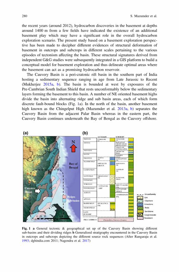
the recent years (around 2012), hydrocarbon discoveries in the basement at depthsaround 1400 m from a few fields have indicated the existence of an additionalbasement play which may have a significant role in the overall hydrocarbonexploration scenario. The present study based on a basement exploration perspec-tive has been made to decipher different evidences of structural deformation ofbasement in outcrops and subcrops in different scales pertaining to the variousepisodes of tectonism affecting the basin. These structural signatures derived fromindependent G&G studies were subsequently integrated in a GIS platform to build aconceptual model for basement exploration and thus delineate optimal areas wherethe basement can act as a promising hydrocarbon reservoir.
The Cauvery Basin is a peri-cratonic rift basin in the southern part of Indiahosting a sedimentary sequence ranging in age from Late Jurassic to Recent(Mukherjee 2015a, b). The basin is bounded at west by exposures of thePre-Cambrian South Indian Shield that rests unconformably below the sedimentarylayers forming the basement to this basin. A number of NE oriented basement highsdivide the basin into alternating ridge and sub basin areas, each of which formdiscrete fault-bound blocks (Fig. 1a). In the north of the basin, another basementhigh known as the Chingelput High (Mazumder et al. 2013a, b) separates theCauvery Basin from the adjacent Palar Basin whereas in the eastern part, theCauvery Basin continues underneath the Bay of Bengal as the Cauvery offshore.
Fig. 1 a General tectonic & geographical set up of the Cauvery Basin showing differentsub-basins and their dividing ridges b Generalized stratigraphy encountered in the Cauvery Basinin outcrops and subcrops depicting the different source rock sequences (After Rangaraju et al.1993; dghindia.com 2011; Nagendra et al. 2017)
280 S. Mazumder et al.
The basinal area in onshore part is covered by a thick layer of alluvium thatconceals structural and geological information.
1.1 Basement Tectonics
The sedimentary sequence of the Cauvery Basin along with its basement (Fig. 1b)has suffered multiple episodes of tectonism. These different episodes of tectonismand their effects in the basement are described below.
1.1.1 Precambrian Basement Tectonics
The Southern Granulite Terrane (SGT) of Late Archean to Neo-Proterozoic age(Meert et al. 2010) effectively forms the basement of the entire Cauvery Basin andis exposed in the western part beyond the basin margin. The SGT is effectivelyconstituted of polydeformed, poly-metamorphosed (Bhutani et al. 2007) andexhumed granulite facies lower-crustal rocks e.g. charnockites, khondalites andother high-grade metamorphic rocks with intrusions of granitic rocks (RavindraKumar 2005; Plavsa 2014). Genetically SGT is believed to have been formed by theaccretion of number of high-grade metamorphic blocks (Meert et al. 2010). Theboundaries of each of these juxtaposed crustal provinces are marked byNeoproterozoic shear zones (Meert et al. 2010) most of which are associated withdeep seated faults (Rao and Prasad 2006; Harinarayana et al. 2006). One of themost significant tectonic feature in the SGT is the Cauvery Shear Zone (CSZ) thatforms an crustal scale E-W trending zone of intense planar fabrics that are exposedin outcrop areas beyond basin margin and separate the northern Late Archaeangranulite block from the Proterozoic Madurai granulite block (Chetty 2015). TheMadurai block is itself separated by an isotopic boundary into a southern andnorthern Madurai Block (SMB and NMB) (Plavsa 2014). This boundary correlateswith the surface extension of prominent southward dipping reflector in the upperand the middle crust (Rajendra Prasad et al. 2007) suggesting it to be a majorterrane boundary. Studies by Gupta et al. (2015) conceptualized the extension ofthis boundary below Cauvery Basin parallel to the CSZ.
The CSZ comprises a network of anastomosing broadly E-W shear zonesranging from 1 to 10 km width, which represent belts of high strain separated bydomains of relatively low strain (Santosh et al. 2009). It is bound by the MoyarBhawani Shear Zone (MBSZ) in the north and the Palghat Cauvery Shear Zone(PCSZ) (Janardhan 1999; Rao et al. 2006) to the south (Chetty and Bhaskar Rao2006) with its eastern extension disappearing in the Bay of Bengal. Overall, it isconsidered a product of two deformation phases, D1 during the Archean-Proterozoic boundary and D2 during Proterozoic-Cambrian boundary (Santoshet al. 2012). The D1 episode is associated with large-scale north verging thrusts andN-S shortening, probably a result of subduction between different blocks, one of
Basement Tectonics and Shear Zones … 281
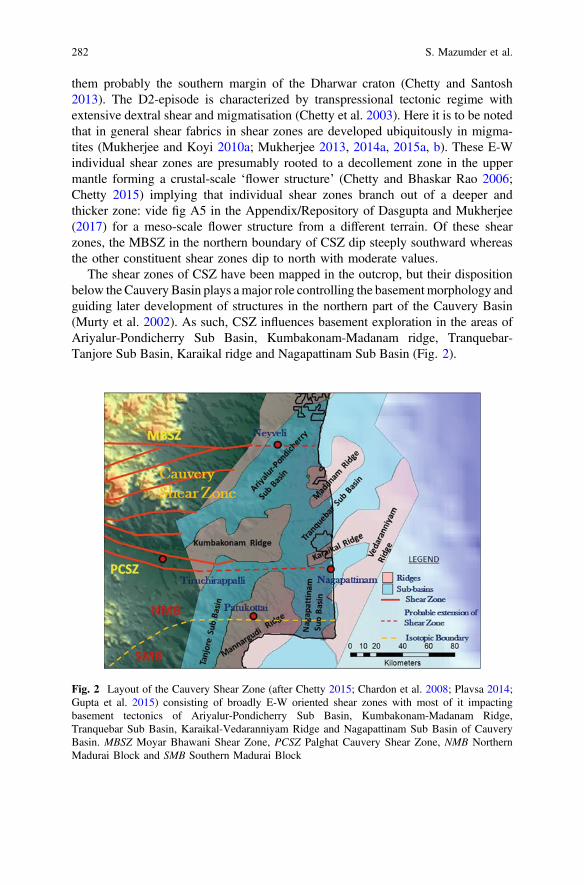
them probably the southern margin of the Dharwar craton (Chetty and Santosh2013). The D2-episode is characterized by transpressional tectonic regime withextensive dextral shear and migmatisation (Chetty et al. 2003). Here it is to be notedthat in general shear fabrics in shear zones are developed ubiquitously in migma-tites (Mukherjee and Koyi 2010a; Mukherjee 2013, 2014a, 2015a, b). These E-Windividual shear zones are presumably rooted to a decollement zone in the uppermantle forming a crustal-scale ‘flower structure’ (Chetty and Bhaskar Rao 2006;Chetty 2015) implying that individual shear zones branch out of a deeper andthicker zone: vide fig A5 in the Appendix/Repository of Dasgupta and Mukherjee(2017) for a meso-scale flower structure from a different terrain. Of these shearzones, the MBSZ in the northern boundary of CSZ dip steeply southward whereasthe other constituent shear zones dip to north with moderate values.
The shear zones of CSZ have been mapped in the outcrop, but their dispositionbelow the Cauvery Basin plays amajor role controlling the basementmorphology andguiding later development of structures in the northern part of the Cauvery Basin(Murty et al. 2002). As such, CSZ influences basement exploration in the areas ofAriyalur-Pondicherry Sub Basin, Kumbakonam-Madanam ridge, Tranquebar-Tanjore Sub Basin, Karaikal ridge and Nagapattinam Sub Basin (Fig. 2).
Fig. 2 Layout of the Cauvery Shear Zone (after Chetty 2015; Chardon et al. 2008; Plavsa 2014;Gupta et al. 2015) consisting of broadly E-W oriented shear zones with most of it impactingbasement tectonics of Ariyalur-Pondicherry Sub Basin, Kumbakonam-Madanam Ridge,Tranquebar Sub Basin, Karaikal-Vedaranniyam Ridge and Nagapattinam Sub Basin of CauveryBasin. MBSZ Moyar Bhawani Shear Zone, PCSZ Palghat Cauvery Shear Zone, NMB NorthernMadurai Block and SMB Southern Madurai Block
282 S. Mazumder et al.
1.1.2 Phanerozoic Basement Tectonics
Other than the formation of shear zones during Precambrian, the basement ofCauvery Basin has also undergone three major episodes of tectonism that governedthe development of basement structures.
Formation of N-S Faults
One of the probable episodes of tectonism affecting the basement is the formationof N-S faults during Lower Gondwana (Late Carboniferous—Permian). Evidencesof these tectonic phase exists as a number of N-S morphotectonic faults, major N-Slineaments (Subrahmanyam et al. 1995; Saravanavel and Ramasamy 2003;Prabaharan et al. 2013) and magnetic lineaments mapped in the onland CauveryBasin and offshore (Subrahmanyam et al. 1995). These structural trends are sym-pathetic to the southern part of the adjacent Palar rift that hosts Ongur Formation(Fig. 3a) dated to be Late Carboniferous to Early Permian (Rangaraju et al. 1993;Vairavan 1993). In the Cauvery Basin, well P-2 drilled in Kumbakonam Ridgealong the N-S trend has also yielded palynofossil assemblage equivalent to OngurFormation (Prasad and Phor 2009). This implies the existence of N-S faults/riftscontinuing from Palar Basin in the north and affecting at least the northern part ofbasement of Cauvery Basin (Fig. 3a).
Formation of NE-SW Faults
The principal event that initiated and shaped the morphology of Cauvery Basin isthe NE trending rifting associated with the separation of India-Sri Lanka systemfrom Antarctica and Australia in Late Jurassic to Early Cretaceous (Veevers andTewari 1995; Gaina et al. 2007; Veevers 2009; Lal et al. 2009; Nemcok et al. 2013).The continental separation associated with rifting began at Late Jurassic (160 ma)and produced genetically related rift systems of Cauvery, Palar, Pennar andKrishna-Godavari. In Cauvery and Palar Basins the separation probably occurredalong pre-existing NE-SW oriented weaknesses in the Pre Cambrian basement(linkages between shear zones) that may have guided later structures (Lal et al.2009; Dasgupta and Mukherjee 2017). Such reactivation along existing fabric iscalled “tectonic inheritance” (Misra and Mukherjee 2015). This led to the formationof a series of major NE-SW horst and graben features in the basement dividing thebasin into a number of fault-bound ridges and sub-basin areas (Lal et al. 2009).
Formation of NW-SE Faults
In Early Cretaceous, transpression along the junction of Antarctica and SriLanka-India developed a N-S strike slip fault that had been variously interpreted as
Basement Tectonics and Shear Zones … 283
a transcurrent fault (Lal et al. 2009) or a dextral strike-slip transform fault (Nemcoket al. 2013) along which Antarctica moved southward. The combined and simul-taneous effect of the NE-SW rift trend and NNW trending strike slip fault probablyled to the development of NW-SE cross trends (Mazumder et al. 2013a, b). This
Fig. 3 a N-S oriented morphotectonic faults and lineaments (Subrahmanyam et al. 1995;Saravanavel and Ramasamy 2003; Prabaharan et al. 2013) probably formed during LowerGondwana (Lower Carboniferous—Permian) that are sympathetic to the Ongur rift in Palar Basinand also host well P-2 in Thanjavur Sub Basin that yielded palynoflora equivalent to OngurFormation. b Formation of NW-SE cross trends (Saravanavel and Ramasamy 2003; Prabaharanet al. 2013) that had affected the basement as a result of simultaneous activity of the NE-SW riftingand N-S strike slip faulting (Mazumder et al. 2013)
284 S. Mazumder et al.
also resulted in a rotation of the earlier rift trends (Mazumder et al. 2013a, b)causing a wide zone of fracturing along the rotational axis (Fig. 3a, b).
These tectonic phases in their respective times have its individual sympatheticstructural signatures that constitute part of the fabric of the basin, controlling itsevolution, sedimentation pattern to even the distribution of hydrocarbon systems.Results of these phases of tectonism may also have led to parts of the basementacting as a hydrocarbon reservoir as observed from the results of a number of wellsdrilled by ONGC in the basin with depths varying from 2000 to 3500 m.
1.2 Basement Character as Hydrocarbon Reservoir
Now, in order to act as an effective reservoir rock, the basement should have thefollowing characteristics:
(a) Most basement hydrocarbons are hosted in structural highs of varying butgenerally moderate to large elevation. The highs are formed by fault-controlledblocks, often in rift settings like upthrown sides of faulted block, horsts within agraben (Chung 1982) or by palaeo-hills buried unconformably below sedi-mentary cover (Gutmanis 2009).
(b) Younger sediments, which act as hydrocarbon sources, either flank or directlyoverlie the basement (Sircar 2004). Charging mostly takes place laterally or byup-dip migration from adjacent structural lows, however, downward migrationmay also take place from overlying source rocks into underlying basement(Gutmanis 2009).
(c) Most basement rocks are characterized with low matrix porosity (typically<0.5%) and permeability. As a result, reservoir quality in basement rocksdepends on the development of secondary porosity and the presence of aconnected open fracture network. A number of such fractured reservoirs inbasement exist worldwide e.g. Aerxia Oil Field in China with well-developedjoints, faults and fractures in phyllite, slate and meta-sandstone (Sircar 2004),White Tiger field, Vietnam constituted of fractured granite basement (Danget al. 2011), Dayung Field in South Sumatra with fractured basement com-prising Permian carbonates intruded by granites (Darmadi et al. 2013) andfractured basement reservoir in Zeit Bay oil field, Gulf of Suez, Egypt com-posed of pegmatic granites (Zahran and Askary 1988). This secondary porosityconsists of results of structural deformation like joints, faults, fractures rangingin scale from microfractures to seismic scale faults and their damage zones(Sircar 2004; Satyanaryana et al. 2010). As a result, the porosity and perme-ability values in a basement reservoir are irregularly distributed laterally as wellas in depth, In case of White Tiger field, the largest field of Vietnam forbasement oil, maximum porosity is found to be 4% with permeability occa-sionally reaching 0.8D (Huy et al. 2012). However, dense micro-cracks asso-ciated to major fault structures that may be formed as a result of multiple
Basement Tectonics and Shear Zones … 285
episodes of tectonism can develop porosity up to 10% and permeability up to0.1 D (Walter et al. 2017). Accordingly, areas of basement that suffer and bearthe imprints of multiple episodes of tectonism and reactivation can be con-sidered as optimal areas that can act as basement reservoir (Trice 2014).
(d) Both up-dip and lateral charging occur in periods of tectonic activity whenactive faults act as open conduits for the migration of fluids with overlyingnon-breached relatively tight and low permeability sedimentary units acting asseals (Sircar 2004; Gutmanis 2009). This is aided by the episodic and repeatedmechanisms of seismic pumping, associated with reactivations and earthquakeprocesses (Gutmanis 2009) depending upon the state of stress acting on theregion. Here seismic pumping refers to the intermittent re-distribution of fluidsincluding hydrocarbons mainly in and around fault zones during fault activity.Seismic faulting acts as a pumping mechanism whereby release of seismogenicstress during earthquakes creates a fluid potential difference between upper andlower part in a fault and thus acts as an important force resulting in rapid porefluid migration (Sibson et al. 1975; Cao et al. 2011; Hua 1995). Basementprospects that are oriented parallel/sub parallel to the maximum in situ stressesin the region are considered as more favourable targets compared to those athigh angles to these (Vasudevan et al. 2012).
(e) Analysis of production performance in basement reservoirs indicate high flowrates concentrated in late faults that are reactivated closely before the oilmigration time (Huy et al. 2012).
The above mentioned salient features that qualify a basement to be a goodreservoir indicates the significance of the different episodes of tectonism and theircorresponding structural deformations in controlling basement exploration param-eters like optimal reservoir area, areas of maximum fracturing, conduits formigration etc. In the rest of the manuscript, different studies like remote sensing andgeomorphology, geological fieldworks, seismic data, electrologs, gravity andmagnetics have been used to analyse the basement of Cauvery Basin to detectdifferent structural signatures of tectonic episodes. Based on the signatures, theabove parameters are integrated to delineate the promising areas of basementexploration in the basin.
2 Analysis and Methodology
The present study presumes that signatures of structural deformation resulting froma particular episode of tectonics are similar in pattern but may vary in their scaledepending upon the tools and perspective used to view them. Based on this premise,pattern of signatures of a particular phase of tectonism observed in outcrops may berepeated in larger scale in subsurface seismic data or in further regional scale inremote sensing images. In accordance to the above assumption, structural patterns
286 S. Mazumder et al.
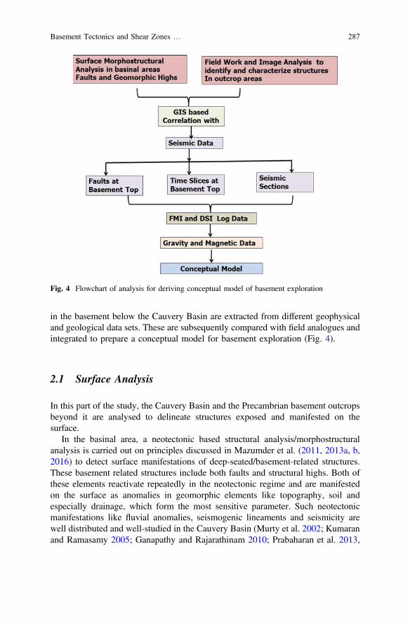
in the basement below the Cauvery Basin are extracted from different geophysicaland geological data sets. These are subsequently compared with field analogues andintegrated to prepare a conceptual model for basement exploration (Fig. 4).
2.1 Surface Analysis
In this part of the study, the Cauvery Basin and the Precambrian basement outcropsbeyond it are analysed to delineate structures exposed and manifested on thesurface.
In the basinal area, a neotectonic based structural analysis/morphostructuralanalysis is carried out on principles discussed in Mazumder et al. (2011, 2013a, b,2016) to detect surface manifestations of deep-seated/basement-related structures.These basement related structures include both faults and structural highs. Both ofthese elements reactivate repeatedly in the neotectonic regime and are manifestedon the surface as anomalies in geomorphic elements like topography, soil andespecially drainage, which form the most sensitive parameter. Such neotectonicmanifestations like fluvial anomalies, seismogenic lineaments and seismicity arewell distributed and well-studied in the Cauvery Basin (Murty et al. 2002; Kumaranand Ramasamy 2005; Ganapathy and Rajarathinam 2010; Prabaharan et al. 2013,
Fig. 4 Flowchart of analysis for deriving conceptual model of basement exploration
Basement Tectonics and Shear Zones … 287
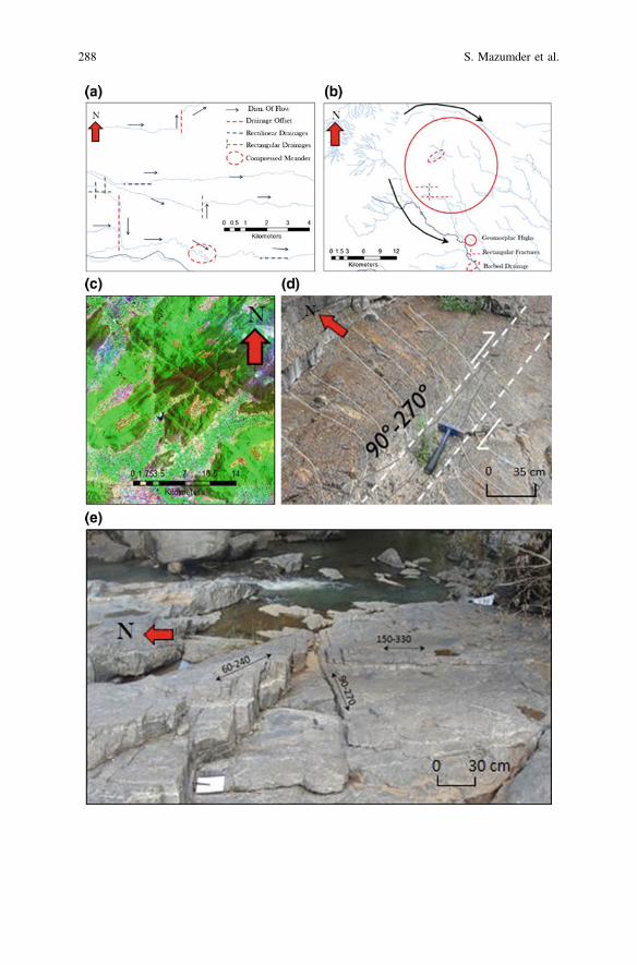
288 S. Mazumder et al.

Singh et al. 2016; Resmi et al. 2016 etc.). In this study, features in drainagegeometry (e.g. drainage offsets, rectangular drainages, compressed meanders)(Fig. 5a), abrupt changes in surface slope and lineaments derived from tonalvariations in images are used to delineate fault segments. Similarly, geomorphichighs forming surface expression of probable structural highs in basement arederived from features like radial and peripheral drainages. Associations with fea-tures like barbed drainages, rectangular drainage patterns and low moisture contentsare used to build up and classify these geomorphic highs as per their degree ofconfidence based on their probabilities in representing basement structural highs(Fig. 5b). These morpho-structural interpretations are subsequently validated byextensive field checks where the mapped structures are checked for neotectonicfaulting imprints and evidences like unpaired terracing, abnormal incisions andsudden appearance of braiding.
In areas beyond the basin margin of Cauvery Basin, extensive field work andimage analysis have been carried out to identify structural features in the exposedbasement rocks. LANDSAT ETM+ (EarthExplorer, USGS) band combinations ofband 7, 4 and 1 have been pan-sharpened, contrast enhanced and edge filtered toidentify different regional scale structural features (Fig. 5c). Abrupt termination ofbasement outcrops to delineate faults, instances of folding in basement lithology,prominent lineament patterns have been deciphered from separate image data sets.As a part of fieldwork in these outcrops, attitude of joint sets and fractures (Fig. 5e)developed in basement lithology were measured, characterized and used to identifytrends of their causative regional faults. Outcrop scale deformations like folding,faulting (Fig. 5f) and shearing (Fig. 5d) were also analysed in view of theirgeometry and inter-relationships for modelling of subsurface basement features.
These two sets of surface structural data pertaining to the alluvial coveredbasinal area and the exposed basement area were correlated and joined in a GISplatform to understand the disposition of basement structures in the basinal area(Fig. 6).
JFig. 5 a Drainage features used to interpret probable fault segments that may be manifestations ofbasement faults. b Geomorphic highs indicating sub surface structural highs interpreted based onperipheral drainage geometry. Associations with elements like barbed drainage and rectangulardrainages imply a greater degree of confidence of representing sub surface structural highs(Trenchard 2007). c Evidences of folding and jointing in the exposed basement near Salemdelineated from LANDSAT ETM+ band combination 7, 4 and 1. d Shear zone exposed in a riverbed in Belur near Salem oriented E-W with earlier NE-SW foliations rotated parallel to sense ofshearing. e Joints developed in Charnockite in the exposed basement. f Fault oriented NW-SE inthe Cuddalore Formation near Neyveli. Geographical positions of the geomorphic, outcrop andimage based features cited above marked in the Fig. 5g
Basement Tectonics and Shear Zones … 289
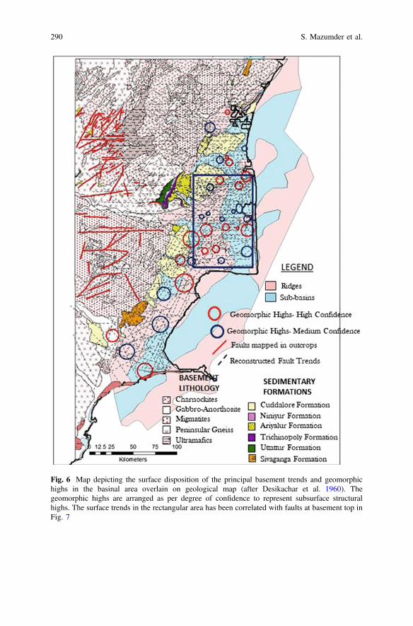
Fig. 6 Map depicting the surface disposition of the principal basement trends and geomorphichighs in the basinal area overlain on geological map (after Desikachar et al. 1960). Thegeomorphic highs are arranged as per degree of confidence to represent subsurface structuralhighs. The surface trends in the rectangular area has been correlated with faults at basement top inFig. 7
290 S. Mazumder et al.

2.2 Correlation with Seismic Data
3D Pre-Stack Time Migrated (PSTM) seismic data used for imaging subsurfacedatasets exhibiting complex geological structures recorded in the Cauvery Basinarea has been used to validate and establish the continuity of the surface mor-phostructural interpretations and to identify the structural effects of different phasesof tectonism.
An overlay analysis of faults mapped on basement top from seismic data inKali-Kuthalam area (Fig. 6) with surface basement trends and morphostructuralfaults shows a positive correlation. This probably implies the basement relatedsubsurface faults may have cut through Mesozoic and Tertiary sections as a resultof multiple reactivations of them and have been manifested on the surface due topresent day neotectonism affecting Cauvery Basin (Fig. 7). This also suggests theinterpreted surface trends represent the basement faults.
In a further attempt to correlation, seismic time slices acquired at 2000 ms timeequivalent depth (within basement, near basement top) in Madanam and Kuthalamarea (Fig. 8a) had been digitally filtered in an image processing software to highlightand extract lines of high seismic amplitude. Here it is to be noted that though crys-talline formations are associated with lack of acoustic contrast, however structures onor near basement top can be identified (Gutmanis 2009). These extracted lines appearto define a similar geometry to the E-Woriented folds observed in image data (Fig. 8c)and in outcrops (Fig. 8d) and also display an analogous association with the E-Wfaults as observed in those areas. As such, it is possible that these features are sheathfolds defined as highly non-cylindrical folds (Reber et al. 2013) that may be producedas a result of pronounced ductile shear (Mukherjee 2014b; Mukherjee et al. 2015).Similar sheath folds have beenmapped byChetty et al. (2012) inMahadeviHills in theaxial zone of Cauvery Shear Zone that are also characterized by E-W axial traces(Fig. 9). TheE-W trends probably act asmanifestations of the shear zones in basementwith the sheath folds forming contemporaneously with the dextral shearing alongthem. Fold amplifies during shearing with the fold axes rotating towards sheardirection. At the highest strain level, the fold axes becomes sub-parallel to sheardirection (Burg 2017a, b) and existing foliations of the country rock are found to bedeflected parallel to the E-W trends (Fig. 5d).
In addition, seismic sections are correlated with surface interpretations to validatethe morpho-structural manifestations of basement top morphology (Fig. 5b). Thecorrelation indicates that faults affecting basement top when extrapolated up-dipmatchwith the surface fault trends re-iterating the fact that they are reactivation relatedmanifestations of the basement faults (Fig. 9e). Also, most of the geomorphic highsspatially coincide with the areas of basement highs associated with a high amount ofstructural relief. Since most of the interpreted geomorphic highs are found to beassociated with NE trending surface features, probably the NE faults create basementhighs with a higher structural relief (Fig. 9a). Other than these structural highs, thebasement top is also found to depict a series of smaller undulations with much smallervariation in basement relief compared to the structural highs. These small undulations
Basement Tectonics and Shear Zones … 291
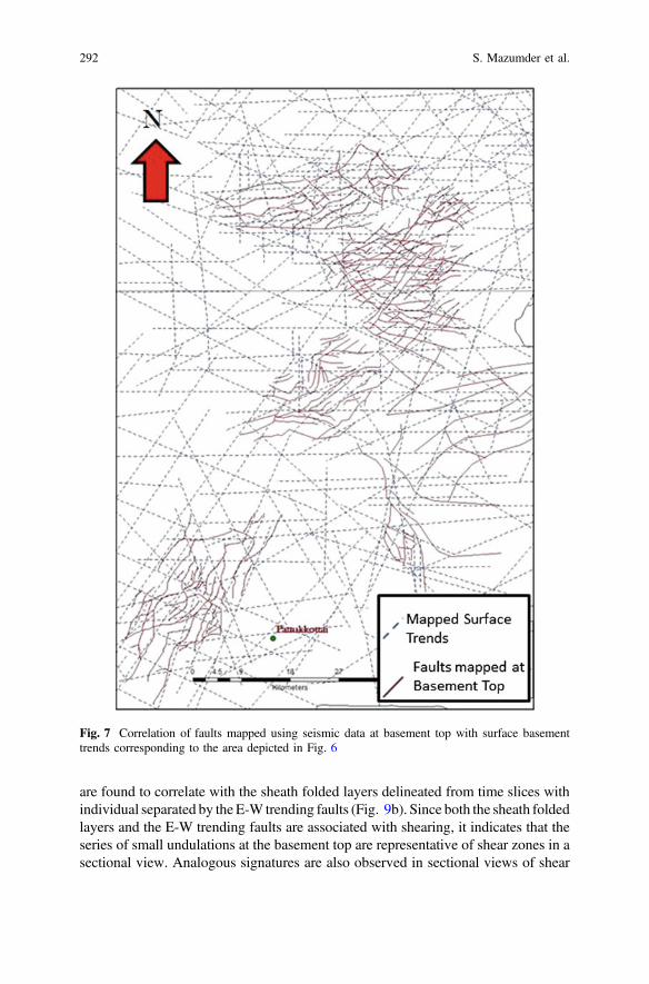
are found to correlate with the sheath folded layers delineated from time slices withindividual separated by the E-W trending faults (Fig. 9b). Since both the sheath foldedlayers and the E-W trending faults are associated with shearing, it indicates that theseries of small undulations at the basement top are representative of shear zones in asectional view. Analogous signatures are also observed in sectional views of shear
Fig. 7 Correlation of faults mapped using seismic data at basement top with surface basementtrends corresponding to the area depicted in Fig. 6
292 S. Mazumder et al.
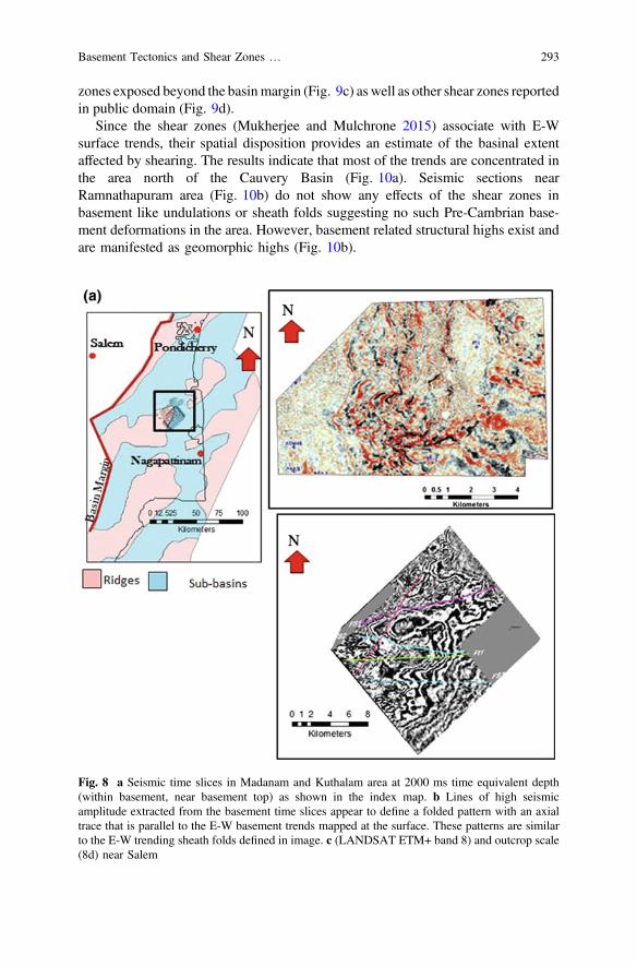
zones exposed beyond the basinmargin (Fig. 9c) as well as other shear zones reportedin public domain (Fig. 9d).
Since the shear zones (Mukherjee and Mulchrone 2015) associate with E-Wsurface trends, their spatial disposition provides an estimate of the basinal extentaffected by shearing. The results indicate that most of the trends are concentrated inthe area north of the Cauvery Basin (Fig. 10a). Seismic sections nearRamnathapuram area (Fig. 10b) do not show any effects of the shear zones inbasement like undulations or sheath folds suggesting no such Pre-Cambrian base-ment deformations in the area. However, basement related structural highs exist andare manifested as geomorphic highs (Fig. 10b).
Fig. 8 a Seismic time slices in Madanam and Kuthalam area at 2000 ms time equivalent depth(within basement, near basement top) as shown in the index map. b Lines of high seismicamplitude extracted from the basement time slices appear to define a folded pattern with an axialtrace that is parallel to the E-W basement trends mapped at the surface. These patterns are similarto the E-W trending sheath folds defined in image. c (LANDSAT ETM+ band 8) and outcrop scale(8d) near Salem
Basement Tectonics and Shear Zones … 293
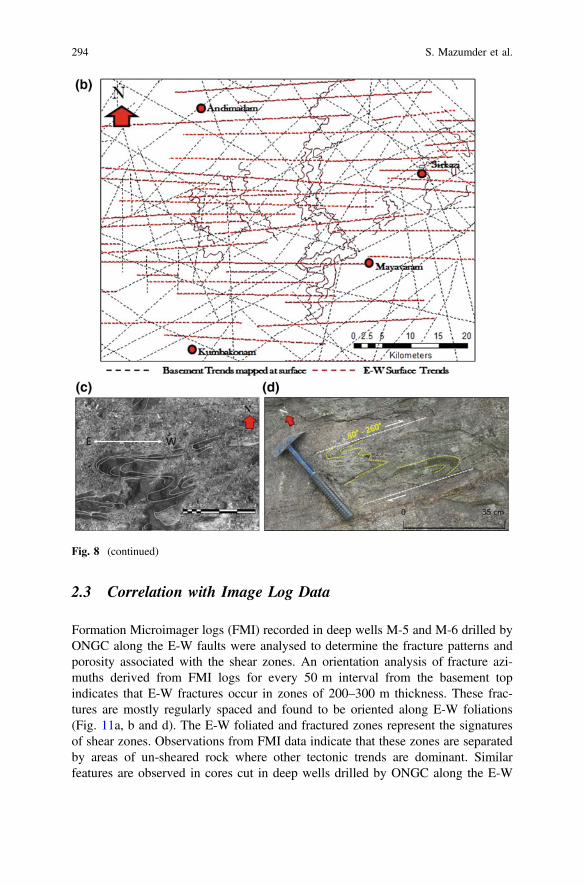
2.3 Correlation with Image Log Data
Formation Microimager logs (FMI) recorded in deep wells M-5 and M-6 drilled byONGC along the E-W faults were analysed to determine the fracture patterns andporosity associated with the shear zones. An orientation analysis of fracture azi-muths derived from FMI logs for every 50 m interval from the basement topindicates that E-W fractures occur in zones of 200–300 m thickness. These frac-tures are mostly regularly spaced and found to be oriented along E-W foliations(Fig. 11a, b and d). The E-W foliated and fractured zones represent the signaturesof shear zones. Observations from FMI data indicate that these zones are separatedby areas of un-sheared rock where other tectonic trends are dominant. Similarfeatures are observed in cores cut in deep wells drilled by ONGC along the E-W
Fig. 8 (continued)
294 S. Mazumder et al.
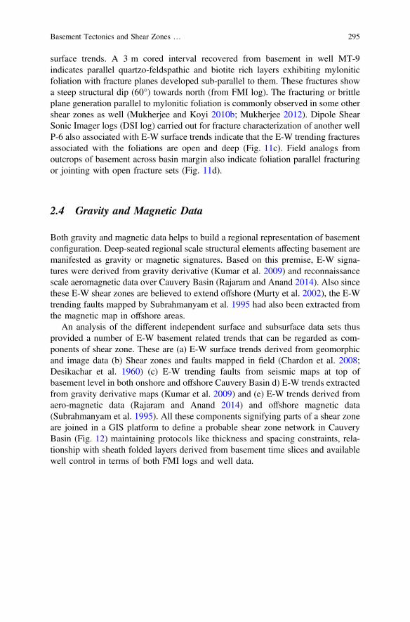
surface trends. A 3 m cored interval recovered from basement in well MT-9indicates parallel quartzo-feldspathic and biotite rich layers exhibiting myloniticfoliation with fracture planes developed sub-parallel to them. These fractures showa steep structural dip (60°) towards north (from FMI log). The fracturing or brittleplane generation parallel to mylonitic foliation is commonly observed in some othershear zones as well (Mukherjee and Koyi 2010b; Mukherjee 2012). Dipole ShearSonic Imager logs (DSI log) carried out for fracture characterization of another wellP-6 also associated with E-W surface trends indicate that the E-W trending fracturesassociated with the foliations are open and deep (Fig. 11c). Field analogs fromoutcrops of basement across basin margin also indicate foliation parallel fracturingor jointing with open fracture sets (Fig. 11d).
2.4 Gravity and Magnetic Data
Both gravity and magnetic data helps to build a regional representation of basementconfiguration. Deep-seated regional scale structural elements affecting basement aremanifested as gravity or magnetic signatures. Based on this premise, E-W signa-tures were derived from gravity derivative (Kumar et al. 2009) and reconnaissancescale aeromagnetic data over Cauvery Basin (Rajaram and Anand 2014). Also sincethese E-W shear zones are believed to extend offshore (Murty et al. 2002), the E-Wtrending faults mapped by Subrahmanyam et al. 1995 had also been extracted fromthe magnetic map in offshore areas.
An analysis of the different independent surface and subsurface data sets thusprovided a number of E-W basement related trends that can be regarded as com-ponents of shear zone. These are (a) E-W surface trends derived from geomorphicand image data (b) Shear zones and faults mapped in field (Chardon et al. 2008;Desikachar et al. 1960) (c) E-W trending faults from seismic maps at top ofbasement level in both onshore and offshore Cauvery Basin d) E-W trends extractedfrom gravity derivative maps (Kumar et al. 2009) and (e) E-W trends derived fromaero-magnetic data (Rajaram and Anand 2014) and offshore magnetic data(Subrahmanyam et al. 1995). All these components signifying parts of a shear zoneare joined in a GIS platform to define a probable shear zone network in CauveryBasin (Fig. 12) maintaining protocols like thickness and spacing constraints, rela-tionship with sheath folded layers derived from basement time slices and availablewell control in terms of both FMI logs and well data.
Basement Tectonics and Shear Zones … 295
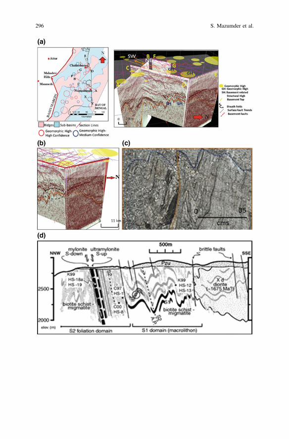
296 S. Mazumder et al.
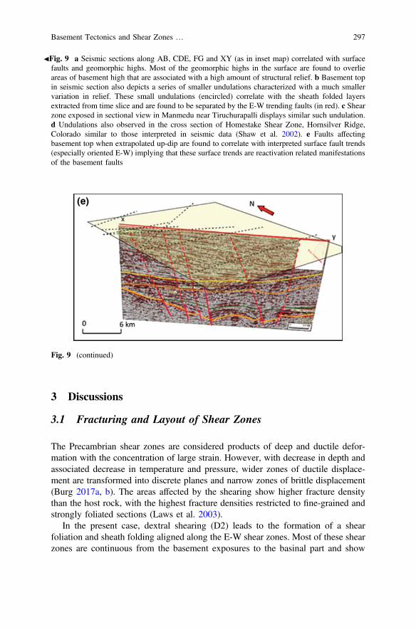
3 Discussions
3.1 Fracturing and Layout of Shear Zones
The Precambrian shear zones are considered products of deep and ductile defor-mation with the concentration of large strain. However, with decrease in depth andassociated decrease in temperature and pressure, wider zones of ductile displace-ment are transformed into discrete planes and narrow zones of brittle displacement(Burg 2017a, b). The areas affected by the shearing show higher fracture densitythan the host rock, with the highest fracture densities restricted to fine-grained andstrongly foliated sections (Laws et al. 2003).
In the present case, dextral shearing (D2) leads to the formation of a shearfoliation and sheath folding aligned along the E-W shear zones. Most of these shearzones are continuous from the basement exposures to the basinal part and show
JFig. 9 a Seismic sections along AB, CDE, FG and XY (as in inset map) correlated with surfacefaults and geomorphic highs. Most of the geomorphic highs in the surface are found to overlieareas of basement high that are associated with a high amount of structural relief. b Basement topin seismic section also depicts a series of smaller undulations characterized with a much smallervariation in relief. These small undulations (encircled) correlate with the sheath folded layersextracted from time slice and are found to be separated by the E-W trending faults (in red). c Shearzone exposed in sectional view in Manmedu near Tiruchurapalli displays similar such undulation.d Undulations also observed in the cross section of Homestake Shear Zone, Hornsilver Ridge,Colorado similar to those interpreted in seismic data (Shaw et al. 2002). e Faults affectingbasement top when extrapolated up-dip are found to correlate with interpreted surface fault trends(especially oriented E-W) implying that these surface trends are reactivation related manifestationsof the basement faults
Fig. 9 (continued)
Basement Tectonics and Shear Zones … 297

similar type of sheath folding and foliation properties both in outcrops and subcrops(Fig. 13c). However, upon reaching a critical length, the shear zones link obliquelyalong step over areas (Schrank et al. 2008) forming NE-SW oriented linkagesbetween the adjacent shear belts. The shear foliations along the E-W shear beltsexposed at the basement top level changes to a weakly bonded planar fabric.Deformations occurring subsequent to the formation of the shear zones reactivatedthese planes of weakness, both along the shear zones and their linkages eventuallyforming fractures oriented along the foliations. These areas of fracturing due to theformation of shear zones are about 250–300 m in orthogonal thickness and areassociated with a moderate to steep dip. As such, these shear zones could havebranched out of a thicker, gentler and a more ductile layer in the deeper part ofbasement (Fig. 13a, b). Hence it is possible that more than one shear zone could beencountered in a particular drilled well that are separated by an interval ofun-sheared and less fractured rock thus increasing the probability of encountering azone of high porosity (secondary).
The isotopic boundary probably forms the limit of the area where the basementis affected by shearing.
Fig. 10 a E-W trends appear to be concentrated in the northern part of the Cauvery Basinindicating that the effect of shear zone on basement is restricted to solely that area. b Seismicsections along lines AB and CD in southern part of Cauvery Basin showing no indications ofshearing (GH stands for Geomorphic Highs)
298 S. Mazumder et al.
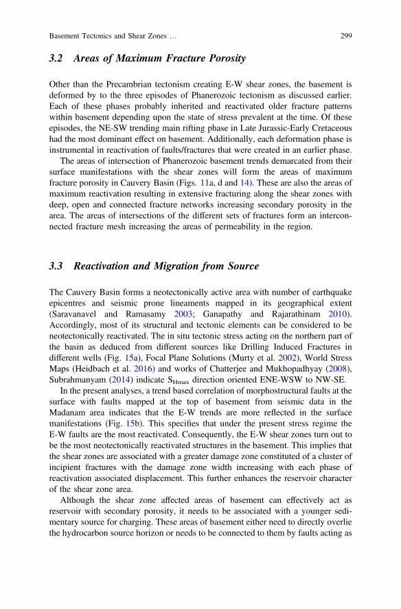
3.2 Areas of Maximum Fracture Porosity
Other than the Precambrian tectonism creating E-W shear zones, the basement isdeformed by to the three episodes of Phanerozoic tectonism as discussed earlier.Each of these phases probably inherited and reactivated older fracture patternswithin basement depending upon the state of stress prevalent at the time. Of theseepisodes, the NE-SW trending main rifting phase in Late Jurassic-Early Cretaceoushad the most dominant effect on basement. Additionally, each deformation phase isinstrumental in reactivation of faults/fractures that were created in an earlier phase.
The areas of intersection of Phanerozoic basement trends demarcated from theirsurface manifestations with the shear zones will form the areas of maximumfracture porosity in Cauvery Basin (Figs. 11a, d and 14). These are also the areas ofmaximum reactivation resulting in extensive fracturing along the shear zones withdeep, open and connected fracture networks increasing secondary porosity in thearea. The areas of intersections of the different sets of fractures form an intercon-nected fracture mesh increasing the areas of permeability in the region.
3.3 Reactivation and Migration from Source
The Cauvery Basin forms a neotectonically active area with number of earthquakeepicentres and seismic prone lineaments mapped in its geographical extent(Saravanavel and Ramasamy 2003; Ganapathy and Rajarathinam 2010).Accordingly, most of its structural and tectonic elements can be considered to beneotectonically reactivated. The in situ tectonic stress acting on the northern part ofthe basin as deduced from different sources like Drilling Induced Fractures indifferent wells (Fig. 15a), Focal Plane Solutions (Murty et al. 2002), World StressMaps (Heidbach et al. 2016) and works of Chatterjee and Mukhopadhyay (2008),Subrahmanyam (2014) indicate SHmax direction oriented ENE-WSW to NW-SE.
In the present analyses, a trend based correlation of morphostructural faults at thesurface with faults mapped at the top of basement from seismic data in theMadanam area indicates that the E-W trends are more reflected in the surfacemanifestations (Fig. 15b). This specifies that under the present stress regime theE-W faults are the most reactivated. Consequently, the E-W shear zones turn out tobe the most neotectonically reactivated structures in the basement. This implies thatthe shear zones are associated with a greater damage zone constituted of a cluster ofincipient fractures with the damage zone width increasing with each phase ofreactivation associated displacement. This further enhances the reservoir characterof the shear zone area.
Although the shear zone affected areas of basement can effectively act asreservoir with secondary porosity, it needs to be associated with a younger sedi-mentary source for charging. These areas of basement either need to directly overliethe hydrocarbon source horizon or needs to be connected to them by faults acting as
Basement Tectonics and Shear Zones … 299
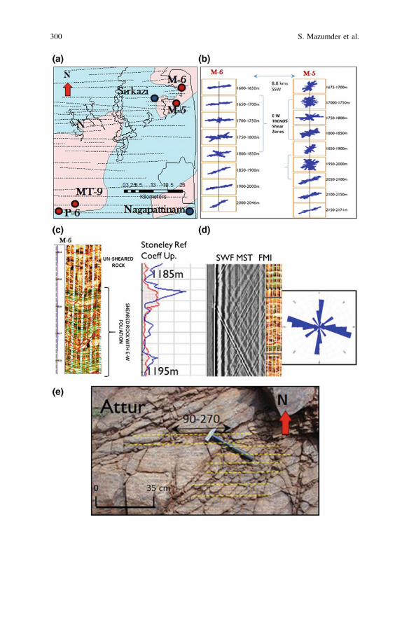
300 S. Mazumder et al.
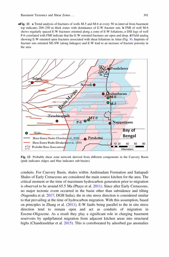
conduits. For Cauvery Basin, shales within Andimadam Formation and SattapadiShales of Early Cretaceous are considered the main source kitchen for the area. Thecritical moment or the time of maximum hydrocarbon generation prior to migrationis observed to be around 65.5 Ma (Phaye et al. 2011). Since after Early Cretaceous,no major tectonic event occurred in the basin other than subsidence and tilting(Nagendra et al. 2017; DGH India), the in situ stress direction is considered similarto that prevailing at the time of hydrocarbon migration. With this assumption, basedon principles in Zhang et al. (2011), E-W faults being parallel to the in situ stressdirection tend to remain open and act as conduits of migration inEocene-Oligocene. As a result they play a significant role in charging basementreservoirs by updip/lateral migration from adjacent kitchen areas into structuralhighs (Chandrasekhar et al. 2015). This is corroborated by adsorbed gas anomalies
JFig. 11 a Trend analysis of fractures of wells M-5 and M-6 at every 50 m interval from basementtop indicates 200–250 m thick zones with dominance of E-W fracture sets. b FMI of well M-6shows regularly spaced E-W fractures oriented along a zone of E-W foliations. c DSI logs of wellP-6 correlated with FMI indicate that the E-W oriented fractures are open and deep. d Field analogshowing E-W oriented open fractures associated with shear foliations in Attur (Fig. 9). Imprints offracture sets oriented NE-SW (along linkages) and E-W lead to an increase of fracture porosity inthe area
Fig. 12 Probable shear zone network derived from different components in the Cauvery Basin(pink indicates ridges and blue indicates sub-basins)
Basement Tectonics and Shear Zones … 301
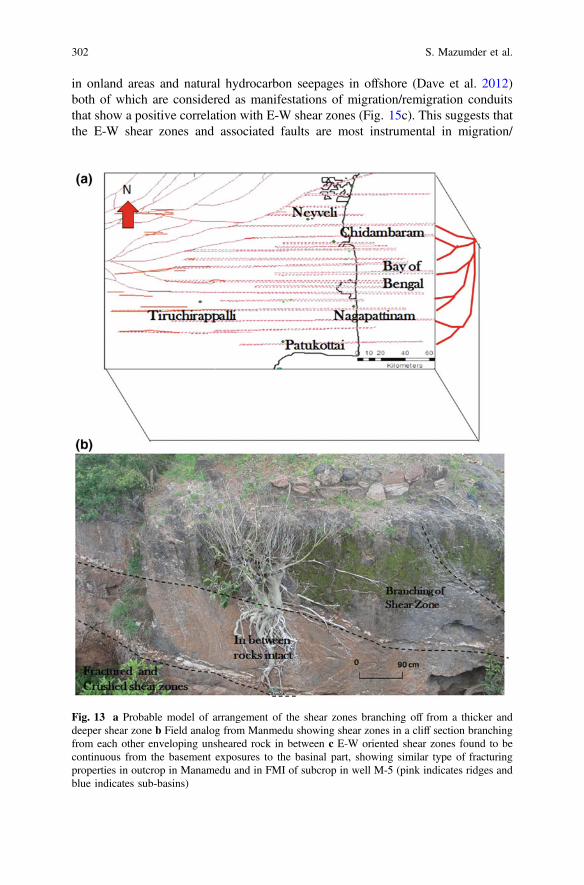
in onland areas and natural hydrocarbon seepages in offshore (Dave et al. 2012)both of which are considered as manifestations of migration/remigration conduitsthat show a positive correlation with E-W shear zones (Fig. 15c). This suggests thatthe E-W shear zones and associated faults are most instrumental in migration/
Fig. 13 a Probable model of arrangement of the shear zones branching off from a thicker anddeeper shear zone b Field analog from Manmedu showing shear zones in a cliff section branchingfrom each other enveloping unsheared rock in between c E-W oriented shear zones found to becontinuous from the basement exposures to the basinal part, showing similar type of fracturingproperties in outcrop in Manamedu and in FMI of subcrop in well M-5 (pink indicates ridges andblue indicates sub-basins)
302 S. Mazumder et al.
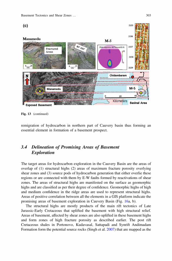
remigration of hydrocarbon in northern part of Cauvery basin thus forming anessential element in formation of a basement prospect.
3.4 Delineation of Promising Areas of BasementExploration
The target areas for hydrocarbon exploration in the Cauvery Basin are the areas ofoverlap of (1) structural highs (2) areas of maximum fracture porosity overlyingshear zones and (3) source pods of hydrocarbon generation that either overlie theseregions or are connected with them by E-W faults formed by reactivations of shearzones. The areas of structural highs are manifested on the surface as geomorphichighs and are classified as per their degree of confidence. Geomorphic highs of highand medium confidence in the ridge areas are used to represent structural highs.Areas of positive correlation between all the elements in a GIS platform indicate thepromising areas of basement exploration in Cauvery Basin (Fig. 16a, b).
The structural highs are mostly products of the main rift tectonics of LateJurassic-Early Cretaceous that uplifted the basement with high structural relief.Areas of basement, affected by shear zones are also uplifted in these basement highsand form zones of high fracture porosity as described earlier. The post riftCretaceous shales in Portonovo, Kudavasal, Sattapadi and Synrift AndimadamFormation form the potential source rocks (Singh et al. 2007) that are mapped as the
Fig. 13 (continued)
Basement Tectonics and Shear Zones … 303
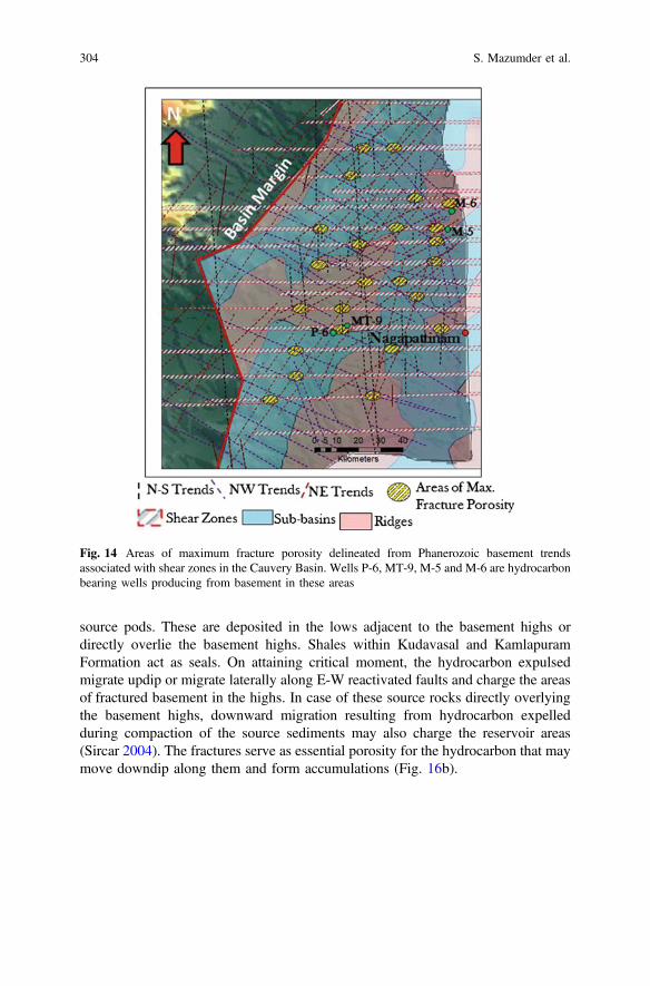
source pods. These are deposited in the lows adjacent to the basement highs ordirectly overlie the basement highs. Shales within Kudavasal and KamlapuramFormation act as seals. On attaining critical moment, the hydrocarbon expulsedmigrate updip or migrate laterally along E-W reactivated faults and charge the areasof fractured basement in the highs. In case of these source rocks directly overlyingthe basement highs, downward migration resulting from hydrocarbon expelledduring compaction of the source sediments may also charge the reservoir areas(Sircar 2004). The fractures serve as essential porosity for the hydrocarbon that maymove downdip along them and form accumulations (Fig. 16b).
Fig. 14 Areas of maximum fracture porosity delineated from Phanerozoic basement trendsassociated with shear zones in the Cauvery Basin. Wells P-6, MT-9, M-5 and M-6 are hydrocarbonbearing wells producing from basement in these areas
304 S. Mazumder et al.
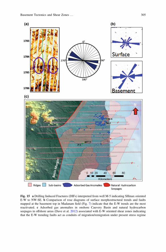
Fig. 15 a Drilling Induced Fractures (DIFs) interpreted from well M-5 indicating SHmax orientedE-W to NW-SE. b Comparison of rose diagrams of surface morphostructural trends and faultsmapped at the basement top in Madanam field (Fig. 7) indicate that the E-W trends are the mostreactivated. c Adsorbed gas anomalies in onshore Cauvery Basin and natural hydrocarbonseepages in offshore areas (Dave et al. 2012) associated with E-W oriented shear zones indicatingthat the E-W trending faults act as conduits of migration/remigration under present stress regime
Basement Tectonics and Shear Zones … 305

Fig. 16 a Promising areas of basement exploration extracted from the spatial correlation of theareas of maximum porosity in shear zones, geomorphic highs and source pods that spatiallyoverlap each other. Wells P-6, MT-9, M-5, M-6 and P-9 are hydrocarbon bearing wells producingfrom basement in these areas. b Schematic model (not to scale) of (i) Initial basement rock withprobable NE-SW trending foliations (ii) Formation of E-W trending shear zones (in red lines)associated with dextral shearing resulting in re-orientation of earlier foliations, formation of E-Wfractures at basement top and NE-SW oriented linkages connecting the shear zones (iii) Probableformation of N-S trending faults resulting in reactivations of earlier fractures (iv) Main phase ofrifting due to NE-SW trending faults forming a number of basement highs and lows. Basementhighs associated with shear fractures and fault intersections act as promising areas c Block diagramof conceptual model for basement exploration
306 S. Mazumder et al.

4 Conclusions
The study emphasizes on the use of tectonics and structures in basement explorationin Cauvery Basin. A GIS based correlation of different surface and subsurfacegeological & geophysical datasets using outcrop structural analogues model thedisposition of shear zones in the northern part of Cauvery Basin. The mapped shearzones occur as individual bands of 250–400 m thick spaced apart by 500 m to afew km and dipping moderately to steeply near the basement top thereby fracturingextensively basement top areas. These shear zone fractures develop in an E-Worientation parallel to the shear foliations that opened due to repeated reactivations.Imprints of subsequent basement tectonism on these zones increases fractureporosity and creates connectivity with different fracture sets thus enhancing thereservoir character of the basement. Structural highs created during the main phaseof rifting and associated with fractured basement forms promising areas of base-ment exploration. Neotectonic reactivations due to changes in in-situ stress regimeresults in hydrocarbon charging into the basement reservoirs thus creating hydro-carbon prospects. A similar procedure may be effective delineating basementhydrocarbon in other similar basins that have undergone multiple episodes oftectonism.
Acknowledgements The authors express their gratitude to Soumyajit Mukherjee (IIT Bombay)for handing and reviewing this manuscript. The other anonymous reviewer is also thanked.Mukherjee (2019) summarizes this work.The views expressed by the authors in this manuscript are not necessarily similar to the views of
the organization they represent.
References
Bhutani R, Balakrishnan S, Nevin CG, Jeyabal S (2007) Sm–Nd isochron ages from SouthernGranulite Terrain, South India: Age of protolith and metamorphism. In: Goldschmidtconference abstracts 2007, A89
Burg JP (2017a) Ductile Faults: Shear Zones. http://www.files.ethz.ch/structuralgeology/JPB/files/English/13shearzones.pdf
Burg JP (2017b). Folds. http://www.files.ethz.ch/structuralgeology/JPB/files/English/8folds.pdfCao J, Liu S, He X (2011) Earthquake-induced secondary hydrocarbon migration and
accumulation in Longmanshan region, China. In: American Geophysical Union, fall meeting2011, abstract #T42B-04
Chandrasekhar N, Mane PH, Rajappan P (2015) Basement hydrocarbon exploration-overview ofbasement exploration. In: Multicomponent seismic analysis, identification of fractures andstatus of Indian basin exploration. Geohorizons July, pp 36–46
Chardon D, Jayananda M, Chetty TRK, Peucat JJ (2008) Precambrian continental strain and shearzone patterns: South Indian case. Journal of Geophysical Research 113, B08402
Chatterjee R, Mukhopadhyay M (2008) In-situ stress results from east coast sedimentary basins ofIndia. In: Oral session VI: stress field interpretation at regional scale, 3rd world stress mapconference 15–17. Potsdam
Basement Tectonics and Shear Zones … 307
Chetty TRK, Bhaskar Rao YJ (2006) The Cauvery Shear Zone, Southern Granulite Terrain, India:A crustal-scale flower structure. Gondwana Res 10(1–2):77–85
Chetty TRK, Santosh M (2013) Proterozoic orogens in southern Peninsular India: contiguities andcomplexities. Journal of Asian Earth Sciences 78, 39–53
Chetty TRK (2015) The Cauvery suture zone: map of structural architecture and recent advances.Journal of Geological Society of India 85, 37–44
Chetty TRK, Bhaskar Rao YJ, Narayana BL (2003) A structural cross section along Krishnagiri–Palani Corridor, Southern Granulite Terrain of India. Memoir Geological Society of India 50,255–277
Chetty TRK, Yellappa T, Mohanty DP, Nagesh P, Sivappa VV, Santosh M, Tsunogae T (2012)Mega sheath fold of the Mahadevi Hills, Cauvery Suture Zone, Southern India: implication foraccretionary tectonics. Journal Geological Society of India 80, 747–758
Chung HP (1982) Petroleum in basement rocks. American Association of Petroleum Geologists66, 1597–1643
Dang CTQ, Chen Z, Nguyen NTB, Bae W, Phung TH (2011) Improved oil recovery for fracturedgranite basement reservoirs: historical lessons, successful application, and possibility forimprovement. In: Society of petroleum engineers, SPE-144148-MS, SPE European formationdamage conference, 7–10 June, Noordwijk, The Netherlands
Darmadi Y, Harahap A, Achidat R, Ginanjar M, Hughes J (2013) Reservoir characterization offractured basement using seismic attributes, Dayung field case study, South Sumatra Indonesia.In: Proceedings, Indonesian petroleum association 37th annual convention and exhibition, May2013
Dasgupta S, Mukherjee S (2017) Brittle shear tectonics in a narrow continental rift: asymmetricnon-volcanic Barmer basin (Rajasthan, India). The Journal of Geology 125, 561–591
Dave HD, Mazumder S, Samal JK, Pangtey KKS, Mitra DS (2012) Mapping Hydrocarbonseepages using satellite SAR data in Eastern offshore—essential input in oil exploration, P-137.In: Proceedings of 9th Biennial international conference and exposition on petroleumgeophysics, SPG Hyderabad, 2012
Desikachar SV, Ramanathan S, Babu PVLP (1960) Progress report of geological exploration ofCauvery Basin. 1959–60. ONGC Unpublished report
DGH India (2015) Estimated resources of crude oil & natural gas, exp.about.resources2015.pdf.https://www.ndrdgh.gov.in/NDR/?page_id=1251
EarthExplorer, USGS. https://earthexplorer.usgs.gov/Gaina C, Müller RD, Brown B et al (2007) Breakup and early seafloor spreading between India
and Antarctica. Geophysical Journal International, 170, 151–169Ganapathy GP, Rajarathinam (2010) Use of remote sensing and seismotectonic parameters to
identify seismogenic sources of Tamil Nadu State. International Journal of AppliedEngineering Research 1, 59–76
Gupta P, Rathore SS, Raza S, Uniyal GC (2015) Radiometric dating and textural characterizationof Basement rocks of East Coast, KG and Cauvery Basins, ONGC report, unpublished
Gutmanis J (2009) Basement reservoirs—a review of their geological and production character-istics. In: International petroleum technology conference, IPTC 13156
Harinarayana T, Naganjaneyulu K, Patro BPK (2006) Detection of a collision zone in south Indianshield region from magnetotelluric studies, Gondwana Research 10, 48–56
Heidbach O, Rajabi M, Reiter K, Ziegler M, Team WSM (2016) World stress map databaserelease 2016. GFZ Data Services. https://doi.org/10.5880/WSM.2016.001
Hua B (1995) Stress field, seismic pumping and oil-gas migration. Acta Sedimentological Sinica13, 77–85
Huy XN, Bae W, San TN, Xuan VT, SungMin J, Kim DY (2012) Fractured basement reservoirsand oil displacement mechanism in white tiger field. In: Offshore Vietnam, APG Search andDiscovery Article #90155©2012 AAPG international conference & exhibition, Singapore,16–19 September
Janardhan AS (1999) Southern Granulite Terrain, south of the Palghat Cauvery Shear Zone:implications for India Madagascar connection. Gondwana Research 2, 463–469
308 S. Mazumder et al.

Kumar N, Singh AP, Singh B, (2009) Structural fabric of the Southern Indian shield as defined bygravity trends. Journal of Asian Earth Sciences 34, 577–585
Kumaran CJ, Ramasamy SM, (2005) Fluvial anomalies and Neotectonics of parts of WesternGhats, Tamil Nadu, India. In: Ramaswami SM (ed) Remote Sensing in Geomorphology,Chapter: Chapter-7, Publisher: New India Publishing Agency. pp 81–88
Lal NK, Siawal A, Kaul AK (2009) Evolution of east Coast of India—a plate tectonicreconstruction. Journal of Geological Society of India 73, 249–260
Laws S, Eberhardt E, Loew S, Descoeudres F (2003) Geomechanical properties of shear zones inthe Eastern Aar Massif, Switzerland and their Implication on Tunnelling. Rock Mechanics andRock Engineering 36, 271–303
Mazumder S, Dave HD, Samal JK, Mitra DS (2011) Delineation of shallow structures asexploratory input in Ganga Basin based on Morphotectonic studies. ONGC Bulletin 46,190–198
Mazumder S, Pangtey KKS, Mitra DS (2013a) Delineation of a possible subsurface ridge inOnshore Palar Basin based on morphotectonic studies and its implications. In: Proceedings of10th Biennial international conference & exposition, SPG, Kochi
Mazumder S, Tep B, Pangtey KKS, Mitra DS (2013b) A Morphotectonic based approach to derivetectonic framework and possible areas of hydrocarbon accumulation in onshore Palar Basin.ONGC Bulletin 48, 113–123
Mazumder S, Adhikari K, Mitra DS, Mahapatra S, Pangtey KKS (2016) A Neotectonic basedgeomorphic analysis using remote sensing data to delineate potential areas of hydrocarbonexploration: Cachar Area, Assam. Journal Geological Society of India 88, 87–97
Meert JG, Pandit MK, Pradhan VR, Banks J, Sirianni R, Stroud M, Newstead B, Gifford J (2010)Precambrian crustal evolution of Peninsular India: A 3.0 billion year odyssey, Journal of AsianEarth Sciences 39, 483–515
Misra AA, Mukherjee S (2015) Tectonic Inheritance in Continental Rifts and Passive Margins.Springerbriefs in Earth Sciences. ISBN 978-3-319-20576-2
Mukherjee S (2012) Tectonic implications and morphology of trapezoidal mica grains from theSutlej section of the Higher Himalayan Shear Zone, Indian Himalaya. The Journal of Geology120, 575–590
Mukherjee S (2013) Deformation microstructures in rocks. Springer Geochemistry/Mineralogy,Berlin, pp 1–111. ISBN 978-3-642-25608-0
Mukherjee S (2014a) Atlas of shear zone structures in meso-scale. Springer Geology, Cham,pp 1–124. ISBN 978-3-319-0088-6
Mukherjee S (2014b) Review of flanking structures in meso- and micro-scales. GeologicalMagazine 151, 957–974
Mukherjee S (2015a) Atlas of structural geology. Elsevier, Amsterdam. ISBN: 978-0-12-420152-1Mukherjee S (2015b) Petroleum geosciences: Indian contexts. Springer Geology. ISBN
978-3-319-03119-4Mukherjee S (2019) Introduction to “Tectonics and Structural Geology: Indian Context”. In:
Mukherjee S (ed) Tectonics and structural geology: Indian context. Springer InternationalPublishing AG, Cham, pp 1–5. ISBN: 978-3-319-99340-9
Mukherjee S, Koyi HA (2010a) Higher Himalayan Shear Zone, Zanskar section-microstructuralstudies & extrusion mechanism by a combination of simple shear & channel flow. InternationalJournal of Earth Sciences 99, 1083–1110
Mukherjee S, Koyi HA (2010b) Higher Himalayan Shear Zone, Sutlej section- structural geology& extrusion mechanism by various combinations of simple shear, pure shear & channel flow inshifting modes. International Journal of Earth Sciences 99, 1267–1303
Mukherjee S, Mulchrone KF (2015) Ductile Shear Zones: From Micro-to Macro-scales. WileyBlackwell. ISBN: 978-1-118-84496-0
Mukherjee S, Punekar J, Mahadani T, Mukherjee R (2015) A review on intrafolial folds and theirmorphologies from the detachments of the western Indian Higher Himalaya. In: Mukherjee S,Mulchrone KF (eds) Ductile shear zones: from micro- to macro-scales. Wiley
Basement Tectonics and Shear Zones … 309

Murty GPS, Subrahmaniyam AS, Murthy KSR, Sarma KVLNS (2002) Evidence of faultreactivation off Pondicherry coast from marine geophysical data. Current Science 83,1446–1449
Nagendra R, Reddy AN (2017) Major geologic events of the Cauvery Basin, India and theircorrelation with global signatures a review. Journal of Palaeogeography 6, 69–83
Nemcok M, Sinha ST, Stuart CJ et al (2013) East Indian margin evolution and crustal architecture:integration of deep reflection seismic interpretation and gravity modelling. In: Mohriak WU,Danforth A, Post PJ et al (eds) Conjugate divergent margins. Special Publications 369, TheGeological Society, London, pp 477–496
Phaye DK, Nambiar MV, Srivastava DK (2011) Evaluation of petroleum systems ofAriyalur-Pondicherry Sub-basin (Bhuvangiri area) of Cauvery Basin, India: a two dimensional(2-D) Basin modeling study. In: AAPG search and discovery Article #90118
Plavsa D (2014) The tectonic evolution of the Southern Granulite Terrane of India and its role inthe amalgamation of Gondwana, Ph.D. Thesis, University of Adelaide
Prabaharan S, Subramani T, Manonmani R, Ramalingam M (2013) Satellite lineaments and Subtlestructures in Cauvery Basin, Tamil Nadu. International Journal of Remote Sensing &Geoscience 2, 8–11
Prasad B, Phor L (2009) Palynostratigraphy of the subsurface Gondwana and post-GondwanaMesozoics of the Cauvery Basin, India. Journal of the Palaeontological Society of India 54,41–71
Rajaram M, Anand SP (2014) Aeromagnetic signatures of Precambrian shield and suture zones ofPeninsular India. Geoscience Frontiers 5, 3–14
Rajendra Prasad B, Rao GK, Mall DM, Rao PK, Raju S, Reddy MS, Rao GSP, Sridher V,Prasad ASSSRS (2007) Tectonic implications of seismic reflectivity pattern observed over thePrecambrian Southern Granulite Terrain, India. Precambrian Research 153, 1–10
Rangaraju MK, Agrawal A, Prabhakar KN (1993) Tectono-Stratigraphy, structural styles,evolutionary model and hydrocarbon habitat, Cauvery and Palar basins. In: Proceedings ofsecond seminar on Petroliferous Basins of India, Vol I, pp 371–388
Rao VV, Prasad BR (2006) Structure and evolution of the Cauvery Shear Zone system,SouthernGranulite Terrain, India: evidence from deep seismic and other geophysical studies.Gondwana Research 10, 29–40
Rao VV, Sain K, Reddy PR, Mooney WD (2006) Crustal structure and tectonics of the northernpart of the Southern Granulite Terrane, India. Earth and Planetary Science Letters 251, 90–103
Ravindra Kumar GR (2005) Lithology and metamorphic evolution of granulite-facies segments ofKerala, Southern India. Journal of Geological Society of India 66, 253–254
Reber JE, Dabrowski M, Galland O, Schmid DW (2013) Sheath fold morphology in simple shear.Journal of Structural Geology 53, 15–26
Resmi MR, Achyuthan H, Jaiswal MK (2016) Middle to late Holocene paleochannels andmigration of the Palar River, Tamil Nadu: implications of neotectonic activity, QuaternaryInternational 443, 211–222
Santosh M, Maruyama S, Sato K (2009) Anatomy of a Cambrian suture in Gondwana: Pacific-typeorogeny in southern India? Gondwana Research 16, 321–34
Santosh M, Xiao WJ, Tsunogaed T, Chetty TRK, Yellappae T (2012) The Neoproterozoicsubduction complex in southern India: SIMS zircon U–Pb ages and implications for Gondwanaassembly. Precambrian Research 192–195, 190–208
Saravanavel J, Ramasamy SM (2003) Probable Seismo Tectonic Lineaments in South India. In:Proceedings of annual convection of ISRS and national conference on remote sensing, CESS,At Trivandrum
Satyanaryana P, Sinha PK, Gupta DK, Sathe AV, Katiyar GC (2010). Hydrocarbon prospectivityof the Basement of Mumbai High Field, P-374. In: Proceedings of 8th Biennial internationalconference and exposition on petroleum geophysics, SPG 2010, Hyderabad
Schrank CE, Handy MR, Fusseis F (2008) Multiscaling of shear zones and the evolution of thebrittle-to-viscous transition in continental crust. Journal of Geophysical Research 113, B01407
310 S. Mazumder et al.

Shaw CA, Karlstrom KE, McCoy A, Williams ML, Jercinovic MJ, Dueker K (2002) ProterozoicShear Zones in the Colorado Rocky Mountains: From Continental Assembly toIntracontinental Reactivation. In: Lageson D (ed) Science at the highest level. GeologicalSociety of America Field Guide 3, 102–117
Sibson RH, Moore JMM, Rankin AH (1975) Seismic pumping—a hydrothermal fluid transportmechanism. Journal of the Geological Society 131, 653–659
Singh H, Goswami BG, Pahari S, Prasad IVSV, Singh RR (2007) Petroleum Geochemistry of theCauvery Basin, India. In: AAPG Search and Discover Article #90063©2007 AAPG AnnualConvention, Long Beach, California
Singh Y, John B, Ganapathy GP, George A, Harisanth S, Divyalakshmi KS, Kesavan S (2016)Geomorphic observations from southwestern terminus of Palghat Gap, south India and theirtectonic implications. Journal of Earth System Sciences 125, 821–839
Sircar A (2004) Hydrocarbon production from fractured basement formations. Current Science 87,147–151
Subrahmanyam AS, Lakshminarayana S, Chandrasekhar DV, Murthy KSR, Rao TCS (1995)Offshore Structural Trends from Magnetic data over Cauvery Basin, East Coast of India.Journal of Geological Society of India 46, 269–273
Subrahmanyam DS (2014) Stress Provinces of India–contribution to world stressmap. International Journal of Advanced Earth Science and Engineering 3, 108–113
Trenchard S (2007) Geomorphology as applied to oil exploration in Northwest Kansas. http://www.docstoc.com/docs/96655562/Geomorphology-as-Applied-to-Oil-Exploration-in-Northwest-Kansas
Trice R (2014) Fractured basement reservoirs: a new play for the UK, Offshore Engineer. http://www.oedigital.com/energy/item/5363-fractured-basement-reservoirs-a-new-p-lay-for-the-uk
Vairavan V (1993) Tectonic Hisyory and Hydrocarbon prospects of Palar and Pennar Basins,India. In: Proceedings of second seminar on Petroliferous Basins of India Vol I, 308–396
Vasudevan K, Rao PH, Vairavan V (2012) Role of tectonics in development of fractured basementreservoir in Mumbai High Field, Western Offshore Basin, India. In: 9th Biennial InternationalConference and Exposition on Petroleum Geophysics, p 482
Veevers JJ (2009) Palinspastic (pre-rift and -drift) fit of India and conjugate Antarctica andgeological connections across the suture. Gondwana Research 16, 90–108
Zahran I, Askary S (1988) Basement reservoir in Zeit Bay oil field, Gulf of Suez. https://www.researchgate.net/publication/236487721_Basement_reservoir_in_Zeit_Bay_oil_field_Gulf_of_Suez
Zhang L, Luo X, Guy V, Yu C, Yang W, Lei Y, Song C, Yu L, Yan J (2011) Evaluation ofgeological factors in characterizing fault connectivity during hydrocarbon migration:Application to Bohai Bay basin, Marine and Petroleum Geology, 28, 1634–1647
Basement Tectonics and Shear Zones … 311
http://www.docstoc.com/docs/96655562/Geomorphology-as-Applied-to-Oil-Exploration-in-Northwest-Kansas
http://www.docstoc.com/docs/96655562/Geomorphology-as-Applied-to-Oil-Exploration-in-Northwest-Kansas
Implication of Transfer Zones in RiftFault Propagation: Examplefrom Cauvery Basin, Indian East Coast
Swagato Dasgupta
1 Introduction
The Cauvery basin, a rift zone located in the southern part of the eastern India,records a poly-phase rift-drift transition (Veevers and Tewari 1995; Veevers 2009;Lal et al. 2009; Sinha et al. 2010; Nemčok et al. 2013; Mukherjee 2018). The basinevolved by Late Jurassic-Early Cretaceous rifting of the Indian plate from theAntarctic plate (Sastri et al. 1981; Veevers 2009; Sinha et al. 2010). It was a part ofthe rift system that included Palar–Pennar, Krishna–Godavari and Mahanadi riftzones, and dextral Coromondal, North Vizag and Konark transform faults (Veevers2009; Sinha et al. 2010). The Cauvery rift zone evolved as a system of rift unitscontrolled by NE striking normal faults, having a trend similar to that of Krishna–Godavari and Mahanadi rift zones. The Cauvery basin, in the southern part, initi-ated as India separated from Sri Lanka due to India–Africa break–up (Katz 1978;Chari Narasimha et al. 1995; Gaina et al. 2007; Veevers 2009). Thus the basinexperienced a poly phase rifting episode which ended by dextral strike-slip andoblique-slip separation of Antarctic plate along the Coromondal transform margin(Veevers 2009; Sinha et al. 2010; Nemčok et al. 2013). This *NNW trendingtransform fault (*200–300 km length) comprise of horse-tail structure, whichoverprints the previously developed normal fault pattern of the Cauvery offshorebasin in the southern part of India (Nemčok et al. 2013). The northern horse-tailstructure (*NNE-NE trend, *150–200 km length) of the NNW strikingCoromondal transform margin got linked with the Krishna–Godavari rift zone(Sinha et al. 2010; Nemčok et al. 2013). Some small-scale pull-apart basins existalong the Coromondal transfer zone, immediately N of the Cauvery basin(Dasgupta 2018b).
S. Dasgupta (&)301-Platinum Aura, Sector-20, Roadpali, Navi Mumbai 410218, Indiae-mail: [email protected]
© Springer Nature Switzerland AG 2019S. Mukherjee (ed.), Tectonics and Structural Geology: Indian Context,Springer Geology, https://doi.org/10.1007/978-3-319-99341-6_10
313
Some authors document that the Cauvery basin is a failed arm rift between thePeninsular India in NW and the Sri Lankan landmass towards SE with structuraltrend sub-parallel to the adjacent Precambrian Eastern Ghat lineaments (Katz 1978;Chari Narasimha et al. 1995; Lal et al. 2009; see Misra and Mukherjee 2015 oninheritance issue). Precisely this basin, having different rift-drift transition history,can be termed as a pericratonic rift basin considering its setting within the Indiancarton (Biswas et al. 1993).
Like other extensional rift settings, relay structures and transfer zones playimportant roles in rift fault propagation in the Cauvery basin (Dasgupta and Maitra2018; Dasgupta 2018a). In a rifted setting the strain transfer occurs along adjacentfaults. This transfer of displacement along a set of faults is normally gradual, atypical characteristic of a relay structure or accommodation zone (Rosendahl 1987;Morley et al. 1990; Morley 1999a). Pre-existing basement lineations further governthe formation of transfer zones and segment the rift basin into different sub-basins(Morley 1999b; Morley et al. 2004; Fossen and Rotevatn 2016; Misra andMukherjee 2015; Dasgupta and Mukherjee 2017).
2 Tectonics and Geology
The Cauvery basin is subdivided into a number of fault-controlled horst and grabenstructures with sediment thickness ranging from 1 to >6 km (Chari Narasimha et al.1995). The basement rock of the Cauvery basin comprise of Archean–Proterozoicgranite gneiss complex, a part of the Southern Granulite Terrain (Janardhan 1999;Rajaram and Anand 2003; Rao et al. 2006; Mazumder et al. 2019). The major riftfaults orient NE. The *NW trending extension initiated the rifting between thesouthern part of the Indian peninsular and Sri Lanka along pre-existing Precambrian*E trending weak zones (Rao et al. 2006; Chetty 2015; Mazumder et al. 2019).Further, extension along NW sub-divided the Cauvery basin into five sub–basinscorroborated by a number of NW trending transverse faults, which played a keyrole in the basin evolution. Rift extension and subsequent anticlockwise rotation ofthe peninsular India and Sri Lanka (Katz 1978; Chari Narasimha et al. 1995; Lalet al. 2009) developed the Gulf of Mannar basin towards south of the Cauverybasin.
In the onland portion and towards south, the major depressions are the Ariyalur–Pondicherry sub-basin, the Tranquebar sub-basin, the Tanjavur/Tanjore sub-basin,the Nagapattinam sub-basin and the Ramnad-Palk bay sub-basin (Fig. 1; Sastriet al. 1979; Chari Narasimha et al. 1995; Murthy et al. 2008; Chaudhuri et al. 2010).The Mandapam-Delft Ridge separates it in the south from the Gulf of MannarBasin. The onshore and offshore portions of the Cauvery basin are separated bythree major horsts, which include the Madanam/Portonovo Ridge in north, KaraikalRidge and the Vedaranniyam Terrace towards south (Fig. 1; Chari Narasimha et al.1995; Murthy et al. 2008). These basement highs and sub-basins, shear zonescorrelate well with the gravity anomaly map derived from the Bouguer gravity
314 S. Dasgupta
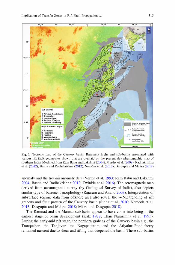
anomaly and the free-air anomaly data (Verma et al. 1993; Ram Babu and Lakshmi2004; Bastia and Radhakrishna 2012; Twinkle et al. 2016). The aeromagnetic mapderived from aeromagnetic survey (by Geological Survey of India), also depictssimilar type of basement morphology (Rajaram and Anand 2003). Interpretation ofsubsurface seismic data from offshore area also reveal the *NE trending of riftgrabens and fault pattern of the Cauvery basin (Sinha et al. 2010; Nemčok et al.2013; Dasgupta and Maitra. 2018; Misra and Dasgupta 2018).
The Ramnad and the Mannar sub-basin appear to have come into being in theearliest stage of basin development (Katz 1978; Chari Narasimha et al. 1995).During the early-mid rift stage, the northern grabens of the Cauvery basin e.g., theTranquebar, the Tanjavur, the Nagapattinam and the Ariyalur–Pondicherryremained nascent due to shear and rifting that deepened the basin. These sub-basins
Fig. 1 Tectonic map of the Cauvery basin. Basement highs and sub-basins associated withvarious rift fault geometries shown that are overlaid on the present day physiographic map ofsouthern India. Modified from Ram Babu and Lakshmi (2004), Murthy et al. (2008), Radhakrishnaet al. (2012), Bastia and Radhakrishna (2012), Nemčok et al. (2013), Dasgupta and Maitra (2018)
Implication of Transfer Zones in Rift Fault Propagation … 315

probably started with the deposition of ill-sorted Early Cretaceous sediments at thebase. The oldest sediments of the Upper Gondwana expose in the western margin ofthe Cauvery basin known as the Sivaganga bed/Therani Formation comprising ofcoarse gritty conglomerates with occasionally argillaceous sandstones and shales(Roy Moulik and Prasad 2007; Watkinson et al. 2007; Kale 2010). The oldestunit of the sub-crop stratigraphy is of Jurassic age drilled in few sub-basins(Chaudhuri et al. 2010).
This tectonic phase was followed by continued deepening of the grabens mainlyin response to the tensional forces and partly to thermal subsidence (Sag Phase: RoyMoulik and Prasad 2007; Nagendra et al. 2011). A cumulative thickness of *3 kmof Lower Cretaceous sediments in the northern part of the block suggests a longperiod of basin deepening followed by a differentiated sedimentation history (Rajuet al. 2005; Nagendra et al. 2011). During the Cenomanian–Turonian (*100–89 Ma) as Madagascar was getting separated from the Indian west-coast, it tiltedthe Cauvery basin towards SE (Chari Narasimha et al. 1995; Storey et al. 1995; RoyMoulik and Prasad 2007; Reeves 2013). This generated a set of prograding chan-nelized system in the deep-waters. Widespread marine sedimentation happened inthe Late Cretaceous (Rangaraju et al. 1993; Roy Moulik and Prasad 2007; Bastiaand Radhakrishna 2012). It essentially marks the development of the shelf-slopesystem with the outer shelf sinking or tilting relatively faster (Nagendra et al. 2011).Differential compaction (Mukherjee and Kumar submitted for mechanism) and fastrate of sedimentation in the Late Cretaceous formed a polygonal fault system thatare mainly fluid escape features (Dasgupta and Misra 2018; also see Dasgupta andMukherjee submitted for general concepts).
3 Transfer Zone Nomenclature
Transfer zone terminologies were initially applied to explain the structures formedin between the overlapping tips of the thrusts (Dahlstrom 1970). These terms wereused subsequently in extensional settings as well to define the zone of accommo-dation between the two overlapping normal fault tips (Rosendahl 1987).Accommodation zones are areas enclosed by terminating segments of overlappingfaults that dip in same or opposite direction (Rosendahl 1987; Faulds and Varga1998). The amount of overlap between the normal faults controls the geometry ofthe accommodation zone (Rosendahl 1987). The term ‘transfer zone’ or ‘relaystructure’ is preferred by many authors over accommodation zone in extensionalregimes (Morley et al. 1990; Gawthorpe and Hurst 1993; Morley 1999a; Fossen2016; Fossen and Rotevatn 2016). These transfer zones preserve both the strainamount as well as the elevation difference between the adjacent footwalls(Morley et al. 1990).
Transfer faults have been defined as transverse to oblique faults with a strongstrike-slip component (Gibbs 1984). Strain transfer facilitates in extensionalregimes from one normal fault to another along these transfer faults (Gibbs 1984;
316 S. Dasgupta
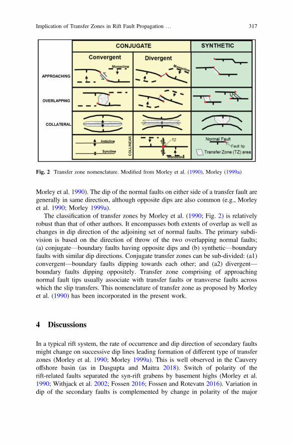
Morley et al. 1990). The dip of the normal faults on either side of a transfer fault aregenerally in same direction, although opposite dips are also common (e.g., Morleyet al. 1990; Morley 1999a).
The classification of transfer zones by Morley et al. (1990; Fig. 2) is relativelyrobust than that of other authors. It encompasses both extents of overlap as well aschanges in dip direction of the adjoining set of normal faults. The primary subdi-vision is based on the direction of throw of the two overlapping normal faults;(a) conjugate—boundary faults having opposite dips and (b) synthetic—boundaryfaults with similar dip directions. Conjugate transfer zones can be sub-divided: (a1)convergent—boundary faults dipping towards each other; and (a2) divergent—boundary faults dipping oppositely. Transfer zone comprising of approachingnormal fault tips usually associate with transfer faults or transverse faults acrosswhich the slip transfers. This nomenclature of transfer zone as proposed by Morleyet al. (1990) has been incorporated in the present work.
4 Discussions
In a typical rift system, the rate of occurrence and dip direction of secondary faultsmight change on successive dip lines leading formation of different type of transferzones (Morley et al. 1990; Morley 1999a). This is well observed in the Cauveryoffshore basin (as in Dasgupta and Maitra 2018). Switch of polarity of therift-related faults separated the syn-rift grabens by basement highs (Morley et al.1990; Withjack et al. 2002; Fossen 2016; Fossen and Rotevatn 2016). Variation indip of the secondary faults is complemented by change in polarity of the major
Fig. 2 Transfer zone nomenclature. Modified from Morley et al. (1990), Morley (1999a)
Implication of Transfer Zones in Rift Fault Propagation … 317
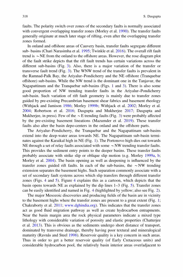
faults. The polarity switch over zones of the secondary faults is normally associatedwith convergent overlapping transfer zones (Morley et al. 1990). The transfer faultsgenerally originate at much later stage of rifting, even after the overlapping transferzones formed.
In onland and offshore areas of Cauvery basin, transfer faults segregate differentsub- basins (Chari Narasimha et al. 1995; Twinkle et al. 2016). The overall rift faulttrend is*NE from the onland to the offshore areas. However, the rose diagram plotof the fault strike depicts that the rift fault trends has certain variations across thedifferent sub-basins (Fig. 3). Also, there is a major variation of the transfer ortransverse fault trend (Fig. 3). The WNW trend of the transfer faults is prevalent inthe Ramnad-Palk Bay, the Ariyalur–Pondicherry and the NE offshore (Tranquebaroffshore) sub-basins. While the NW trend is the dominant one in the Tanjavur, theNagapattinum and the Tranquebar sub-basins (Figs. 1 and 3). There is also somegood proportion of NW trending transfer faults in the Ariyalur–Pondicherrysub-basin. Such variation of rift fault geometry is mainly due to transfer zonesguided by pre-existing Precambrian basement shear fabrics and basement rheology(Withjack and Jamison 1986; Morley 1999b; Withjack et al. 2002; Morley et al.2004; Robertson et al. 2016; Dasgupta and Mukherjee 2017; Dasgupta andMukherjee, in press). Few of the*E trending faults (Fig. 3) were probably affectedby the pre-existing basement lineations (Mazumder et al. 2019). These transferfaults also alter the basin depo-centers in the onland and the offshore parts.
The Ariyalur–Pondicherry, the Tranquebar and the Nagapattinam sub-basinsextend into the deep-water areas towards NE. The Nagapattinam sub-basin termi-nates against the Karaikal high in NE (Fig. 1). The Portonovo high dies out towardsNE through a set of relay faults associated with some*NW trending transfer faults.This provides the sediment entry points to the deeper basins. These transfer faultsprobably associate with strike slip or oblique slip motion (e.g. Morley 1999a, b;Morley et al. 2004). The basin opening as well as deepening is influenced by thetransfer zones guided rift faults. In each of the sub-basins, the *NW trendingextension separates the basement highs. Such separation commonly associate with aset of secondary fault systems across which slip transfers through different transferzones (Figs. 4 and 5). Figure 4 explains this as a cartoon, which depicts that thebasin opens towards NE as explained by the dip lines 1–3 (Fig. 5). Transfer zonescan be easily identified and named in Fig. 4 (highlighted by yellow; also see Fig. 2).
The major Mesozoic discoveries and producing fields of the basin are in vicinityto the basement highs where the transfer zones are present to a great extent (Fig. 1;Chakraborty et al. 2011; www.dghindia.org). This indicates that the transfer zonesact as good fluid migration pathway as well as create hydrocarbon entrapments.Near the basin margin area the rock physical parameters indicate a mixed typelithology with considerable variation of porosity and elastic properties (Chatterjeeet al. 2013). This is obvious as the sediments undergo short distance of transport,dominated by transverse drainage, thereby having poor textural and mineralogicalmaturity (Ravnås and Steel 1998). Reservoir quality is a key concern in such areas.Thus in order to get a better reservoir quality (of Early Cretaceous units) andconsiderable hydrocarbon pool, the relatively basin interior areas over/adjacent to
318 S. Dasgupta
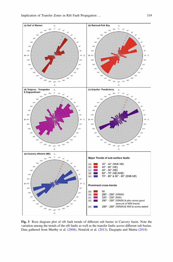
Fig. 3 Rose diagram plot of rift fault trends of different sub basins in Cauvery basin. Note thevariation among the trends of the rift faults as well as the transfer faults across different sub basins.Data gathered from Murthy et al. (2008), Nemčok et al. (2013), Dasgupta and Maitra (2018)
Implication of Transfer Zones in Rift Fault Propagation … 319
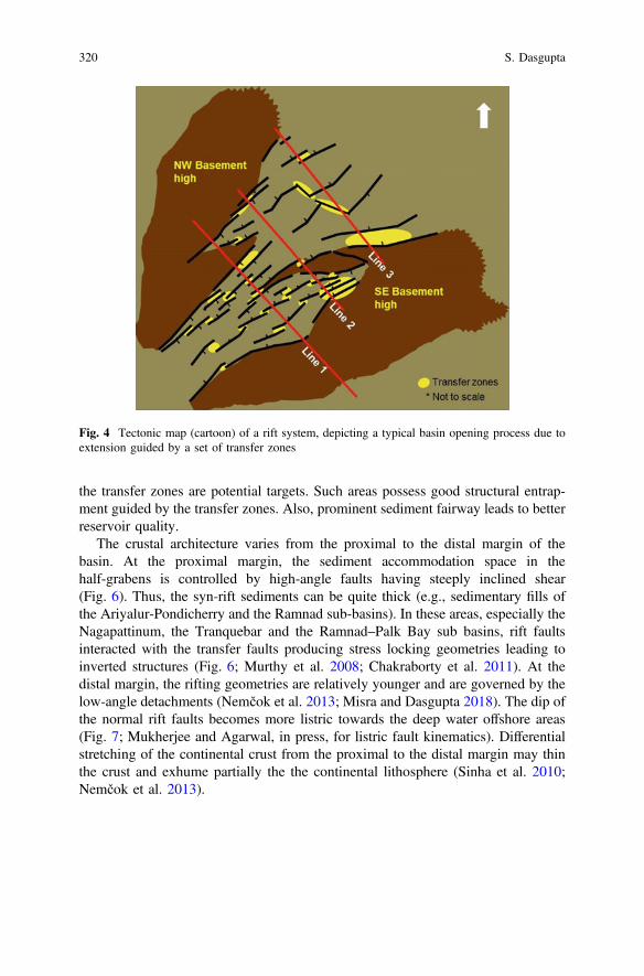
the transfer zones are potential targets. Such areas possess good structural entrap-ment guided by the transfer zones. Also, prominent sediment fairway leads to betterreservoir quality.
The crustal architecture varies from the proximal to the distal margin of thebasin. At the proximal margin, the sediment accommodation space in thehalf-grabens is controlled by high-angle faults having steeply inclined shear(Fig. 6). Thus, the syn-rift sediments can be quite thick (e.g., sedimentary fills ofthe Ariyalur-Pondicherry and the Ramnad sub-basins). In these areas, especially theNagapattinum, the Tranquebar and the Ramnad–Palk Bay sub basins, rift faultsinteracted with the transfer faults producing stress locking geometries leading toinverted structures (Fig. 6; Murthy et al. 2008; Chakraborty et al. 2011). At thedistal margin, the rifting geometries are relatively younger and are governed by thelow-angle detachments (Nemčok et al. 2013; Misra and Dasgupta 2018). The dip ofthe normal rift faults becomes more listric towards the deep water offshore areas(Fig. 7; Mukherjee and Agarwal, in press, for listric fault kinematics). Differentialstretching of the continental crust from the proximal to the distal margin may thinthe crust and exhume partially the the continental lithosphere (Sinha et al. 2010;Nemčok et al. 2013).
Fig. 4 Tectonic map (cartoon) of a rift system, depicting a typical basin opening process due toextension guided by a set of transfer zones
320 S. Dasgupta
Fig. 5 Schematic dip sections of three lines from SW to NE (shown in Fig. 4) in the direction ofbasin opening
Implication of Transfer Zones in Rift Fault Propagation … 321
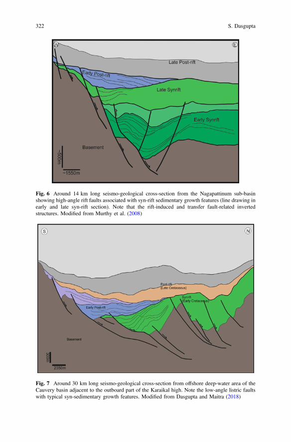
Fig. 6 Around 14 km long seismo-geological cross-section from the Nagapattinum sub-basinshowing high-angle rift faults associated with syn-rift sedimentary growth features (line drawing inearly and late syn-rift section). Note that the rift-induced and transfer fault-related invertedstructures. Modified from Murthy et al. (2008)
Fig. 7 Around 30 km long seismo-geological cross-section from offshore deep-water area of theCauvery basin adjacent to the outboard part of the Karaikal high. Note the low-angle listric faultswith typical syn-sedimentary growth features. Modified from Dasgupta and Maitra (2018)
322 S. Dasgupta
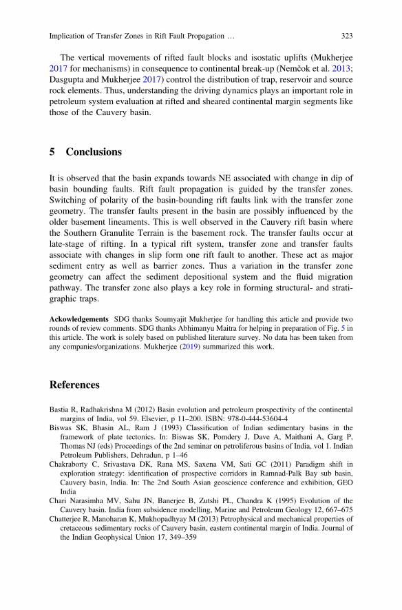
The vertical movements of rifted fault blocks and isostatic uplifts (Mukherjee2017 for mechanisms) in consequence to continental break-up (Nemčok et al. 2013;Dasgupta and Mukherjee 2017) control the distribution of trap, reservoir and sourcerock elements. Thus, understanding the driving dynamics plays an important role inpetroleum system evaluation at rifted and sheared continental margin segments likethose of the Cauvery basin.
5 Conclusions
It is observed that the basin expands towards NE associated with change in dip ofbasin bounding faults. Rift fault propagation is guided by the transfer zones.Switching of polarity of the basin-bounding rift faults link with the transfer zonegeometry. The transfer faults present in the basin are possibly influenced by theolder basement lineaments. This is well observed in the Cauvery rift basin wherethe Southern Granulite Terrain is the basement rock. The transfer faults occur atlate-stage of rifting. In a typical rift system, transfer zone and transfer faultsassociate with changes in slip form one rift fault to another. These act as majorsediment entry as well as barrier zones. Thus a variation in the transfer zonegeometry can affect the sediment depositional system and the fluid migrationpathway. The transfer zone also plays a key role in forming structural- and strati-graphic traps.
Ackowledgements SDG thanks Soumyajit Mukherjee for handling this article and provide tworounds of review comments. SDG thanks Abhimanyu Maitra for helping in preparation of Fig. 5 inthis article. The work is solely based on published literature survey. No data has been taken fromany companies/organizations. Mukherjee (2019) summarized this work.
References
Bastia R, Radhakrishna M (2012) Basin evolution and petroleum prospectivity of the continentalmargins of India, vol 59. Elsevier, p 11–200. ISBN: 978-0-444-53604-4
Biswas SK, Bhasin AL, Ram J (1993) Classification of Indian sedimentary basins in theframework of plate tectonics. In: Biswas SK, Pomdery J, Dave A, Maithani A, Garg P,Thomas NJ (eds) Proceedings of the 2nd seminar on petroliferous basins of India, vol 1. IndianPetroleum Publishers, Dehradun, p 1–46
Chakraborty C, Srivastava DK, Rana MS, Saxena VM, Sati GC (2011) Paradigm shift inexploration strategy: identification of prospective corridors in Ramnad-Palk Bay sub basin,Cauvery basin, India. In: The 2nd South Asian geoscience conference and exhibition, GEOIndia
Chari Narasimha MV, Sahu JN, Banerjee B, Zutshi PL, Chandra K (1995) Evolution of theCauvery basin. India from subsidence modelling, Marine and Petroleum Geology 12, 667–675
Chatterjee R, Manoharan K, Mukhopadhyay M (2013) Petrophysical and mechanical properties ofcretaceous sedimentary rocks of Cauvery basin, eastern continental margin of India. Journal ofthe Indian Geophysical Union 17, 349–359
Implication of Transfer Zones in Rift Fault Propagation … 323
Chaudhuri A, Rao MV, Dobriyal JP, Saha GC, Chidambaram L, Mehta AK, Ramana LV,Murthy KS (2010) Prospectivity of Cauvery Basin in deep syn-rift sequences, SE India; Searchand Discovery Article #10232, Adapted from oral presentation at AAPG Annual Conventionand Exhibition, Denver, Colorado, USA, June 7–10
Chetty TRK (2015) The Cauvery suture zone: map of structural architecture and recent advances.Journal of Geological Society of India 85, 37–44
Dahlstrom CDA (1970) Structural geology in the eastern margin of the Canadian RockyMountains. Bulletin of Canadian Petroleum Geology 18, 332–406
Dasgupta S (2018a) Sedimentary deformation features produced by differential compaction andbuoyancy in the offshore Palar Basin, East Coast of India (Chapter 24). In: Misra AA,Mukherjee S (eds) Atlas of structural geological interpretation from seismic images. WileyBlackwell, Hoboken, pp 131–133. ISBN: 978-1-119-15832-5
Dasgupta S (2018b) Pull-apart basin in the offshore Cauvery–Palar Basin, India (Chapter 23). In:Misra AA, Mukherjee S (eds) Atlas of structural geological interpretation from seismic images.Wiley Blackwell, Hoboken, pp 127–129. ISBN: 978-1-119-15832-5
Dasgupta S, Maitra A (2018) Transfer zone geometry in the offshore Cauvery Basin, India. In:Misra AA, Mukherjee S (eds) Atlas of structural geological interpretation from seismic images.Wiley Blackwell, Hoboken, pp 117–120. ISBN: 978-1-119-15832-5
Dasgupta S, Misra AA (2018) Polygonal fault system in late cretaceous sediments of Cauverydeepwater Basin, India. In: Misra AA, Mukherjee S (eds) Atlas of structural geologicalinterpretation from seismic images. Wiley Blackwell, Hoboken, pp 113–116. ISBN:978-1-119-15832-5
Dasgupta S, Mukherjee S (2017) Brittle shear tectonics in a narrow continental rift: asymmetricnon-volcanic Barmer basin (Rajasthan, India). The Journal of Geology 125, 561–591
Dasgupta S, Mukherjee S (in press) Remote sensing in lineament identification: examples fromwestern India. In: Billi A, Fagereng A (eds) Problems and solutions in structural geology andtectonics. Developments in structural geology and tectonics book series. Series Editor:Mukherjee S, Elsevier ISSN: 2542-9000
Dasgupta T, Mukherjee S (Submitted) Sediment compaction and applications in petroleumgeoscience. Springer. Series: Advances in oil and gas exploration & production. Series Editor:Swenner R. ISSN: 2509-372X
Faulds JE, Varga RJ (1998) The role of accommodation zones and transfer zones in the regionalsegmentation of extended terranes. Geological Society of America, Special Paper, p 323
Fossen H (2016) Structural geology, 2nd edn. Cambridge University Press, Cambridge. ISBN:9781107057647
Fossen H, Rotevatn A (2016) Fault linkage and relay structures in extensional settings—a review.Earth-Science Reviews 154, 14–28
Gaina C, Müller RD, Brown B, Ishihara T, Ivanov S (2007) Breakup and early seafloor spreadingbetween India and Antarctica. Geophysical Journal International 170, 151–169
Gawthorpe RL, Hurst JM (1993) Transfer zones in extensional basins: their structural style andinfluence on drainage development and stratigraphy. Geological Society of London 150, 1137–1152
Gibbs AD (1984) Structural evolution of extensional basin margins. Geological Society of London141, 609–620
Janardhan AS (1999) Southern granulite terrain, south of the Palghat-Cauvery shear zone:implications for India-Madagascar connection. Gondwana Research 2, 463–469
Kale A (2010) Comments on ‘Sequence surfaces and paleobathymetric trends in Albian toMaastrichtian sediments of Ariyalur area, Cauvery Basin, India’ from Nagendra, Kannan, Sen,Gilbert, Bakkiaraj, Reddy, and Jaiprakash. Mar Pet Geol 28:1252–1259
Katz MB (1978) Sri Lanka in Gondwanaland and the evolution of the Indian Ocean. GeologicalMagazine 115, 237–244
Lal NK, Siwal A, Kaul AK (2009) Evolution of East Coast of India—a plate tectonicreconstruction. Journal Geological Society of India 73, 249–260
324 S. Dasgupta
Mazumder S, Tep B, Pangtey KKS et al (2019) Basement tectonics and shear zones in Cauverybasin: implications in hydrocarbon exploration. In: Mukherjee S (ed) Tectonics and structuralgeology: Indian context. Springer International Publishing AG, Cham, pp 279–311. ISBN978-3-319-99340-9
Misra AA, Dasgupta S (2018) Shallow detachment along a transform margin in Cauvery Basin,India. In: Misra AA, Mukherjee S (eds) Atlas of structural geological interpretation fromseismic images. Wiley Blackwell, Hoboken, pp 101–105. ISBN: 978-1-119-15832-5
Misra AA, Mukherjee S (2015) Tectonic inheritance in continental rifts and passive margins.Springer briefs in Earth Sciences, Berlin. ISBN 978-3-319-20576-2
Morley CK (1999a) Aspects of transfer zone geometry and evolution in East African rifts. In:Morley CK (ed) Geoscience of rift systems—evolution of East Africa, AAPG Studies inGeology No. 44, p 161–171
Morley CK (1999b) How successful are analogue models in addressing the influence ofpre-existing fabrics on rift structure? Journal of Structural Geology 21, 1267–1274
Morley CK, Nelson RA, Patton TL, Munn SG (1990) Transfer zones in the East African riftsystems and their relevance to hydrocarbon exploration in rifts. AAPG Bulletin 74, 1234–1253
Morley CK, Haranya C, Phoosongsee W, Pongwappe S, Kornsawan A, Wonganan N (2004)Activation of rift oblique and rift parallel pre-existing fabrics during extension and their effecton deformation style: examples from the rifts of Thailand. Journal of Structural Geology 26,1803–1829
Mukherjee S (2017) Airy’s isostatic model: a proposal for a realistic case. Arabian Journal ofGeosciences 10, 268
Mukherjee S (2019) Introduction to “Tectonics and Structural Geology: Indian Context”. In:Mukherjee S (ed) Tectonics and structural geology: Indian context. Springer InternationalPublishing AG, Cham, pp 1–5. ISBN: 978-3-319-99340-9
Mukherjee S, Agarwal I (in press) Shear heat model for gouge free dip-slip listric normal faults.Marine and petroleum geology. https://doi.org/10.1016/j.marpetgeo.2018.09.004
Murthy KS, Chaudhuri A, Ramana LV, Rao MV, Dobriyal JP (2008) Hydrocarbon exploration ofsyn rift sediments in Nagapattinam Sub Basin, Cauvery Basin—a case study. In: 7th Biennialinternational conference and exposition on petroleum geophysics, society of petroleumgeophysicists (SPG), p 443
Nagendra R, Kamalak Kannan BV, Sen G, Gilbert H, Bakkiaraj D, Reddy AN, Jaiprakash BC(2011) Sequence surfaces and paleobathymetric trends in Albian to Maastrichtian sediments ofAriyalur area, Cauvery Basin, India. Marine and Petroleum Geology 28, 895–905
Nemčok M, Sinha ST, Stuart CJ et al (2013) East Indian margin evolution and crustal architecture:integration of deep reflection seismic interpretation and gravity modelling. In: Mohriak WU,Danforth A, Post PJ et al (eds) Conjugate divergent margins, special publications, vol 369.Geological Society London, pp 477–496
Radhakrishna M, Twinkle D, Nayak S, Bastia R, Rao S (2012) Crystal structure and rift architectureacross the Krishna–Godavari basin in the central Eastern Continental Margin of India based onanalysis of gravity and seismic data. Marine and Petroleum Geology 37, 129–146
Rajaram M, Anand SP (2003) Crustal structure of south India from aeromagnetic data. Journal ofthe Virtual Explorer 12, 72–82
Raju DSN, Ramesh P, Mohan SKG, Uppal S (2005) Sequence and bio-chronostratigraphicsubdivisions of the Cretaceous and Cenozoic of India with notes on pre-Cretaceous events: anoverview. In: Raju DSN, Peters J, Shankar R, Kumar G (eds) Association of petroleumgeologists special publication No. 1, pp 97–103
Ram Babu HV, Lakshmi MP (2004) A reappraisal of the structure and tectonics of the CauveryBasin (India) from aeromagnetics and gravity. In: 5th conference & exposition on petroleumgeophysics. SPG Hyderabad, India, pp 19–23
Rangaraju MK, Aggarwal A, Prabhakar KN (1993) Tectono-stratigraphy, structural styles,evolutionary model and hydrocarbon prospects of Cauvery and Palar Basins, India. In:Biswas SK, Alak D, Garg P, Pandey J, Maithani A, Thomas NJ (eds) Proceedings of the 2nd
Implication of Transfer Zones in Rift Fault Propagation … 325

seminar on petroliferous basins of India, vol 1. Indian Petroleum Publishers, Dehradun, India,pp 331–354
Rao VV, Sain K, Reddy PR, Mooney WD (2006) Crustal structure and tectonics of the northernpart of the Southern Granulite Terrane, India. Earth and Planetary Science Letters 251, 90–103
Ravnås R, Steel RJ (1998) Architecture of marine rift-basin successions. AAPG Bulletin 82(1),110–146
Reeves CV (2013) The global tectonics of the Indian Ocean and its relevance to India’s westernmargin. J Geophys 34:87–94
Robertson EAM, Biggs J, Cashman KV, Floyd MA, Vye-Brown C (2016) Influence of regionaltectonics and pre-existing structures on the formation of elliptical calderas in the Kenyan Rift.In: Wright TJ, Ayele A, Ferguson DJ, Kidane T, Vye-Brown C (eds) Magmatic rifting andactive volcanism, vol 420. Geological Society of London Special Publications, pp 43–67
Rosendahl BR (1987) Architecture of continental rifts with special reference to East Africa.Annual review of Earth and Planetory Science Letters 15, 445–504
Roy Moulik SK, Prasad GK (2007) Seismic expression of the canyon fill facies and its geologicalsignificance—a case study from Ariyalur-Pondicherry Sub-basin, Cauvery Basin, India. AAPGAnnual Convention, Long Beach, California
Sastri VV, Raju DSN, Venkatachala BS, Acharyya SK (1979) Sedimentary basin map of India,stratigraphic correlation between sedimentary basins of the ESCAP region. Mineral ResourceDevelopment Series, United Nations, New York, p 45
Sastri VV, Venkatachala BS, Narayanan V (1981) The evolution of the east coast of India.Palaeogeography, Palaeoclimatology, Palaeoecology 36, 23–54
Sinha ST, Nemčok M, Choudhuri M, Misra AA, Sharma SP, Sinha N, Venkatraman S (2010) Thecrustal architecture and continental break up of East India Passive Margin: an integrated studyof deep reflection seismic interpretation and gravity modeling; Search and Discovery Article40611
Storey M, Mahoney JJ, Saunders AD, Duncan RA, Kelley SP, Coffin MF (1995) Timing ofhot-spot related volcanism and the breakup of Madagascar and India. Sci 267:852–855
Twinkle D, Rao GS, Radhakrishna M, Murthy KSR (2016) Crustal structure and rift tectonicsacross the Cauvery–Palar basin, eastern continental margin of India based on seismic andpotential field modelling. Journal of Earth System Science 125, 329–342
Veevers JJ (2009) Palinspastic (pre-rift and -drift) fit of India and conjugate Antarctica andgeological connections across the suture. Gondwana Research 16, 90–108
Veevers JJ, Tewari RC (1995) Gondwana master basin of peninsular india between Tethys and theinterior of the Gondwanaland Province of Pangea. Geological Society of America Memoir,pp 72–187
Verma RK, Rao SC, Satyanarayana Y (1993) Gravity field and evolution of Krishna–Godavari andCauvery basins of India. Indian Journal of Petroleum Geology 2, 39–52
Watkinson MP, Hart MB, Joshi A (2007) Cretaceous tectonostratigraphy and the development ofthe Cauvery Basin, Southeast India. Petroleum Geoscience 13, 181–191
Withjack MO, Jamison WR (1986) Deformation produced by oblique rifting. Tectonophysics 126,99–124
Withjack MO, Schlische RW, Olsen PE (2002) Rift-basin structure and its influence onsedimentary systems. In: Renaut RW, Ashley GM (eds) Sedimentation of continental rifts.SEPM Special Publication 73, pp 57–81
326 S. Dasgupta

Remote Sensing, Structural and RockMagnetic Analyses of the RamgarhStructure of SE Rajasthan, CentralIndia-Further Clues to Its Impact Originand Time of Genesis
Saumitra Misra, Pankaj Kumar Srivastava and Md. Arif
1 Introduction
The Ramgarh structure (centered at 25° 20′N, 76° 38′E) of SE Rajasthan, centralIndia (Figs. 1 and 2a), is a ring-shaped structure of an outer diameter of � 4 km,and is situated within the Vindhyan Supergroup of sedimentary rocks of Meso- toNeoproterozoic age (Sharma 1973; Prasad 1984; Ramasamy 1987). Although, it isa potential candidate of asteroid impact crater for last many decades (e.g., Crawford1972; Grieve et al. 1988; Sisodia et al. 2006a, b), the supporting evidences in favourof this idea are slowly accumulating. A re-investigation of its origin is thusimportant since it is the only known potential candidate for asteroid impact crater inIndia excavated in the sedimentary target rocks. The other comparable terrestrialasteroid impact craters on sedimentary target-rocks of equivalent diameter are:B. P. structure, Libya (25° 19′N, 24° 20′E); Goyder Crater, northern Australia(13° 9′S, 135° 2′E), and Gusev Crater, Russia (48° 26′N, 40° 32′E) (Earth Impactdatabase, http://www.unb.ca/passc/ImpactDatabase).
The Ramgarh structure has many of the physical attributes of an impact craterwith a raised rim (Fig. 2a), as described below, but its origin has been debated andmore than one hypotheses have been proposed. Sharma (1973) first suggested that
S. Misra (&)Discipline of Geological Sciences, SAEES, University of KwaZulu-Natal,Durban 4000, South Africae-mail: [email protected]
P. K. SrivastavaDepartment of Petroleum Engineering and Earth Sciences,University of Petroleum and Energy Studies, Dehradun 248007, India
Md. ArifBirbal Sahni Institute of Palaeosciences, Lucknow 226007, India
© Springer Nature Switzerland AG 2019S. Mukherjee (ed.), Tectonics and Structural Geology: Indian Context,Springer Geology, https://doi.org/10.1007/978-3-319-99341-6_11
327

Fig. 1 Sketch map of a India, and b Vindhyan basin (in light grey shade), central India, showingthe position of the Ramgarh structure
328 S. Misra et al.
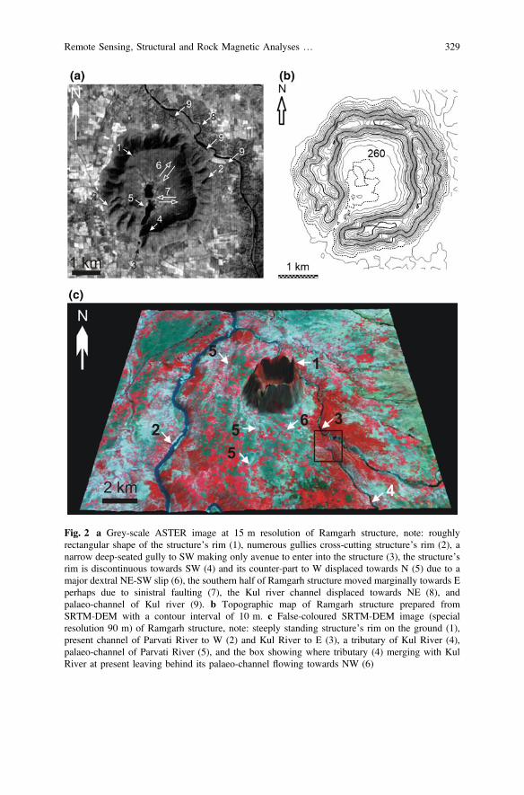
Fig. 2 a Grey-scale ASTER image at 15 m resolution of Ramgarh structure, note: roughlyrectangular shape of the structure’s rim (1), numerous gullies cross-cutting structure’s rim (2), anarrow deep-seated gully to SW making only avenue to enter into the structure (3), the structure’srim is discontinuous towards SW (4) and its counter-part to W displaced towards N (5) due to amajor dextral NE-SW slip (6), the southern half of Ramgarh structure moved marginally towards Eperhaps due to sinistral faulting (7), the Kul river channel displaced towards NE (8), andpalaeo-channel of Kul river (9). b Topographic map of Ramgarh structure prepared fromSRTM-DEM with a contour interval of 10 m. c False-coloured SRTM-DEM image (specialresolution 90 m) of Ramgarh structure, note: steeply standing structure’s rim on the ground (1),present channel of Parvati River to W (2) and Kul River to E (3), a tributary of Kul River (4),palaeo-channel of Parvati River (5), and the box showing where tributary (4) merging with KulRiver at present leaving behind its palaeo-channel flowing towards NW (6)
Remote Sensing, Structural and Rock Magnetic Analyses … 329

this structure could have been resulted due to magmatic activity. However, thishypothesis can safely be discarded because no igneous plug/activity has beendescribed within this structure, including in borehole studies reaching to *450 mdepth and in surrounding areas (Ramasamy 1987). Furthermore, the regionalaeromagnetic anomaly map does not support the presence of any magnetic highbelow the structure (Kumar et al. 2011) suggestive of any magmatism.Alternatively, it has been suggested that the Ramgarh structure formed due totectonic activity by ‘rheid’ flow of shales and associated horizontal compression insubordinate scale (Ramasamy 1987). But there is no evidence of structures dictatedby compressive forces in the bed rocks surrounding the Ramgarh structure. Thismodel, therefore, fails to explain the origin of this unique structure within theundeformed, flat-lying sedimentary country rocks.
The third upcoming hypothesis is that this structure could have been formed byasteroid impact. Some of the important observations favouring the impacthypothesis are (a) presence of a prominent conical central peak (Grieve et al. 1988;Master and Pandit 1999), (b) shatter-cone like structure in colluvium near its center(Crawford 1972); (c) presence of closed spaced Planar Fractures (PF) and granu-lation in quartz grains in shocked sandstones from this structure (Balasundaram andDube 1973; Das et al. 2011), and (d) occurrences of impact spherule-lookingmaterials, diaplectic glasses, and possible Planer Deformation Fracture (PDF) inquartz grains from this structure (Sisodia et al. 2006a, b; Purohot and Sisodia 2013;Rana and Agrawal 2016), although the true nature of these PDFs remain ques-tionable (Reimold et al. 2006; also cf. Vernooij and Langenhorst 2005; French andKoeberl 2010).
The iron-silica rich mm-sized particles/spherules from within the alluvium insidethe Ramgarh structure have been primarily investigated in Misra et al. (2008b). TheBack Scattered Electron (BSE) images of these magnetic particles are similar toimpact-induced accretionary lapilli reported from other established impact struc-tures (cf. Graup 1981; Koeberl et al. 2007; Newsom et al. 2016). These particles/spherules have cores consisting of coarse grained quartz fragments surrounded bymultiple concentric layers of fine-grained materials with smaller quartz fragments(Misra et al. 2008b; Das et al. 2011). Our studies further suggest that theseiron-silica rich particles have very high Natural Remnant Magnetization(NRM) (*2–19 Am−1) and high REM (after Yu 2006 and references therein)(*7–145%) that could indicate the presence of a high magnetic field during theirformation, much higher than the ambient Earth magnetic field (*40 Am−1) (Daset al. 2009). The exact reason of this local high magnetic field in and around theRamgarh structure is not clearly known, but it could be resulted by asteroid impact(cf. Crawford and Schultz 1988, 1999). More recently, a few fragments of iron-richCa–Al silicate glassy pieces, recovered from the soil inside the Ramgarh structureand nearby outside the western rim of the structure, contain dendritic magnetitewith occasional inclusions of relict native iron containing high proportions of Co(*350–3000 ppm), Ni (*200–4000 ppm) and Cu (*2200–7000 ppm) (withsimilar Co/Ni ratios), and these iron globules are thought to be extra-terrestrial inorigin (Misra et al. 2013).
330 S. Misra et al.
Hence, the emerging geological evidences favour more towards the asteroidimpact origin of the Ramgarh structure. The only lacuna is that the bedrocksandstones from the rim of this structure do not show any confirming PDF under thetransmitted light polarizing microscope satisfying the definition described in Frenchand Koeberl (2010). However, the general absence of PDF in quartz grains withinthe Ramgarh structure sandstones does not preclude the asteroid impact origin ofthis structure. This is because this microstructure could also be formed by terrestriallightning strikes (Chen et al. 2017; Melosh 2017), and hence cannot be consideredas a confirming criterion for identification of an impact crater. On the other hand,although some geochemical clues on possible impact origin of the Ramgarhstructure have been documented (Ahmed et al. 1974; Sisodia and Lashkari 2003;Sisodia et al. 2006a; Misra et al. 2008b, 2013), no detail information on thestructural geology and/or rock magnetic properties on this structure in favour oragainst of its asteroid impact origin presently exist. In the present study, we thusexamine the available remote sensing images, and structural data of the Ramgarhstructure in more detail (cf. Misra et al. 2008a). The rock magnetic properties of afew glassy samples from this structure (cf. Das et al. 2009) have also beenexamined to re-evaluate the asteroid impact origin of the Ramgarh structure.
2 Geology of Ramgarh Structure
The Vindhyan Supergroup, into which the Ramgarh structure is situated, exposes as asickle-shaped, east-west elongated outcrop in the central India (Oldham 1856; Mallet1869; Auden 1933), and occupies *178,000 km2 (Tandon et al. 1991) with athickness up to *4.5 km (Ahmad 1958) (Fig. 1). This Supergroup of rocks areunmetamorphosed and only mildly deformed. Geophysical investigations revealedthat the rifting across E-W faults initiated the formation of the Vindhyan basin (Boseet al. 2001). The N-S rifting was accompanied by a dextral shear and as a result thebasin segmented into several NW-SE elongated sub-basins. Between the two majorsectors of the Vindhyan Supergroup, the Ramgarh structure occurs in the western(Rajasthan) sector of this huge sedimentary outcrop (Ramasamy 1987). This structureis excavated in the flat-lying sandstone, shale, and minor limestone horizons of theLower Bhander Group of the Vindhyan Supergroup (Prasad 1984; Ramasamy 1987).The oldest to youngest stratigraphic sequences of the Lower Bhander Group that areexposed within the Ramgarh structure include the Ganurgarh Shale (thickness*630 m), Lower Bhander Limestone (*26 m), Samaria Shale (*52 m) and LowerBhander sandstone (*400 m) (cf. Fig. 3 in Ramasamy 1987).
The ring-like, prominently rectangular shaped Ramgarh structure has arim-to-rim diameter of *2.37 and 2.48 km along E-W and N-S respectively(measured from Google Earth Imagery 2017), and a more or less continuous raisedrim along its periphery except to the southwest, which rises *200 m above thesurrounding undisturbed, flat-lying plain (cf. Sisodia et al. 2006a; Misra et al.2008b) (Fig. 2a). Earlier reports indicate the presence of a central conical peak
Remote Sensing, Structural and Rock Magnetic Analyses … 331

within this structure (Grieve et al. 1988; Master and Pandit 1999; Sisodia et al.2006a). The Upper Bhander sandstone, constituting the youngest Formation of theVindhyan Supergroup, has been dated as 1000–1070 Ma (U-Pb zircon age, Maloneet al 2008), which could be the upper age limit of formation of the Ramgarhstructure.
The sandstone exposures on the rim of the Ramgarh structure have dips between*45° and 78°, which gradually reduce to *20°–30° at the lower outer slope, andto *5°–15° at the foot of the outer rim (Prasad 1984). The rim of the structure isonly discontinuous at the SW corner and displaced by a set of NE-SW dextral strikeslip faults (Prasad 1984; Ramasamy 1987; Sisodia et al. 2006a; Misra et al. 2008a).Additional joint/fault systems that cross-cut the Ramgarh structure trend E-W, N-Sand NW-SE (Ramasamy 1987; Misra et al. 2008a). Geomorphologically, theRamgarh structure appears to have more degraded state (i.e. modified by erosion) ascompared to those of the Arizona Crater, USA, and Lonar Crater, India (Grant1999). This conclusion is well supported by the presence of reworked materials (i.e.materials derived during weathering of the rim crest rocks of the structure) within avery limited zone (*770 m) in the outer flank of the structure rim (Misra et al.2008a). Although the Ramgarh structure is eroded, the sandstone exposed on its rimshows quaquaversal dips (Sharma 1973; Ramasamy 1987) like other impact craters(e.g., Lonar Crater, Misra et al. 2010).
3 Analytical Techniques
The rock magnetic characterization experiments were carried out on a dark reddishcoloured, glassy silicate sample (RJ-26) of a maximum size of 3 cm (Fig. 9 inAppendix), which was recovered from within the rocky debris derived from the rimcrest rocks and deposited on the outer slope of the western rim of the Ramgarhstructure (Fig. 3). The glassy piece was magnetic, and under transmitted light,polarizing, optical microscope it was looking similar to the glassy sample R-82reported in Misra et al. (2013).
Our experimental studies include measurements of Natural RemanentMagnetization (NRM), REM (=NRM/SIRM expressed in %, where SIRM—Saturation Isothermal Remanent Magnetization) (after Yu 2006 and referencestherein), Isothermal Remanent Magnetization (IRM) acquisition and backfieldSIRM dc demagnetization, and Lowrie-Fuller test (methods and techniques of ourexperiments after McElhinny and McFadden 2000). All these measurements werecarried out at the Palaeomagnetism Laboratory, Birbal Sahni Institute ofPalaeosciences (Lucknow, India). Four mm-sized sub-samples were cut from theoriginal glassy silicate piece for our present measurements. The NRM was mea-sured by an Agico JR-6 spinner magnetometer. The IRM was imparted in pro-gressively increasing magnetic fields up to 1 T and their back field application tothe saturation IRM for evaluating remanence coercive force (Hcr) by an ASCscientific IM-10–30 impulse magnetizer; magnetic remanence after each IRM step
332 S. Misra et al.
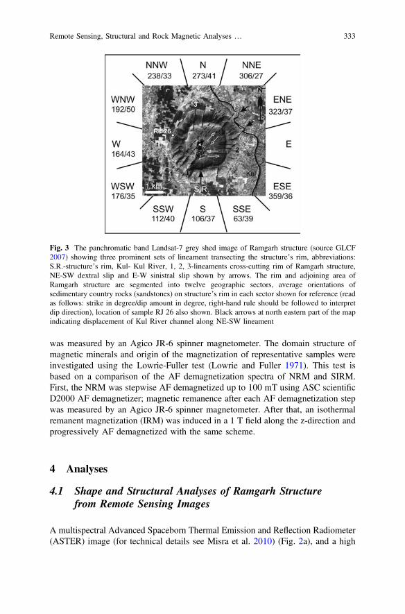
was measured by an Agico JR-6 spinner magnetometer. The domain structure ofmagnetic minerals and origin of the magnetization of representative samples wereinvestigated using the Lowrie-Fuller test (Lowrie and Fuller 1971). This test isbased on a comparison of the AF demagnetization spectra of NRM and SIRM.First, the NRM was stepwise AF demagnetized up to 100 mT using ASC scientificD2000 AF demagnetizer; magnetic remanence after each AF demagnetization stepwas measured by an Agico JR-6 spinner magnetometer. After that, an isothermalremanent magnetization (IRM) was induced in a 1 T field along the z-direction andprogressively AF demagnetized with the same scheme.
4 Analyses
4.1 Shape and Structural Analyses of Ramgarh Structurefrom Remote Sensing Images
A multispectral Advanced Spaceborn Thermal Emission and Reflection Radiometer(ASTER) image (for technical details see Misra et al. 2010) (Fig. 2a), and a high
Fig. 3 The panchromatic band Landsat-7 grey shed image of Ramgarh structure (source GLCF2007) showing three prominent sets of lineament transecting the structure’s rim, abbreviations:S.R.-structure’s rim, Kul- Kul River, 1, 2, 3-lineaments cross-cutting rim of Ramgarh structure,NE-SW dextral slip and E-W sinistral slip shown by arrows. The rim and adjoining area ofRamgarh structure are segmented into twelve geographic sectors, average orientations ofsedimentary country rocks (sandstones) on structure’s rim in each sector shown for reference (readas follows: strike in degree/dip amount in degree, right-hand rule should be followed to interpretdip direction), location of sample RJ 26 also shown. Black arrows at north eastern part of the mapindicating displacement of Kul River channel along NE-SW lineament
Remote Sensing, Structural and Rock Magnetic Analyses … 333
spatial resolution (*15 m) panchromatic band of Landsat 7 imagery [acquired onOctober 22, 1999 (GLCF 2007)] (Fig. 3) were used to evaluate the morphology ofthe Ramgarh structure and its surroundings in the present study. A contour map ofthe Ramgarh structure with maximum and minimum contours of 260 and 450 mrespectively was also produced using Shuttle Radar Topographic Mission (SRTM)data of 90 m special resolution with a contour interval of *10 m (after Misra et al.2010) (Fig. 2b). The SRTM-DEM (DEM-Digital Elevation Model) was also drapedover the panchromatic image to reconstruct 3D view of the Ramgarh structure(Fig. 2c).
The ASTER and Landsat 7 images, and the contour map reconfirm that theRamgarh structure is a rectangular-shaped morphologic feature with a steeply raisedrim along its periphery except to the southwest (Figs. 2a, b and 3). The analysis ofthe SRTM-DEM image further confirms that the rim of the structure is steeplystanding on the ground (Fig. 2c). The highest elevation of the rim is *450 m,observed in the ENE sector of the structure (Fig. 2b). There are several furrow-likefeatures on the rim (Fig. 2a), and many of them appear to be continuous andcross-cut the Ramgarh structure rim especially in NE-SW direction (Fig. 3, linea-ment 1). The displacement of the NNW-SSE trending Kul River channel (situatedto E of the Ramgarh structure) towards NE is evident at least at two places along theNE-SW lineament (Figs. 2a, and 3). The SW rim crest appears to have beendetached from its continuation towards the east and have moved dextrally alongNE-SW lineament. There are two more sets of lineament trending E-W and N-Sthose cross-cut the Ramgarh structure rim (Fig. 3, lineaments 2 and 3 respectively).The southern half of the structure appears to have been displaced marginallytowards the east along the E-W lineament (Fig. 2a).
4.2 Field Geology and Field Structural Analysesof Ramgarh Structure
The sedimentary country rocks surrounding the Ramgarh structure are essentiallyflat (Fig. 4a). Our observations in the Parvati and Kul River sections to the W andNNE respectively of the Ramgarh structure (Fig. 2), and around *19.4 km southof this structure show wide-spaced (*2 m) cross-cutting fractures trending NE-SWand NW-SE (Figs. 4b and 6a). The cross-cutting field relationship at the ParvatiRiver section suggests that the NE-SW fracture could have developed early insequence, followed by the formation of NW-SE fracture.
The bedding plane (So) in sandstone on the rim crest of the Ramgarh structureshow quaquaversal dips at moderate angle (Fig. 4c) (cf. Sharma 1973; Ramasamy1987). In places, the rim sandstones also dip *vertical (Fig. 4d). The sandstonesexamined on the rim crest (Fig. 4e, f), the structure wall (Fig. 4g), and the shaleexposed at the base inside the structure (Fig. 4h) are extremely fractured. Thesequence of fracture development within the Ramgarh structure appears to be
334 S. Misra et al.
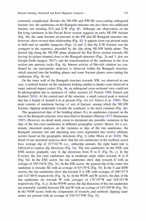
extremely complicated. Besides the NE-SW and NW-SE cross-cutting orthogonalfracture sets, the sandstones on the Ramgarh structure rim also show two additionalfracture sets trending N-S and E-W (Fig. 4f). Although our observation on theflat-lying sandstone in the Parvati River section suggests an early NE-SW fracture(Fig. 4b), the same fracture set presents in the SW and SE Ramgarh structure rim,however, show reverse time relationship (Fig. 4i). It appears from our present studyin field and on satellite imageries (Figs. 2a and 3) that the E-W fracture was theyoungest in the sequence, preceded by the slip along NE-SW brittle plane. Thedextral slip along the NE-SW plane displaced the Kul River section towards NEleaving its palaeo-channel close to the Ramgarh structure (Figs. 2a and 3, also seeGoogle Earth imagery 2017), and the transformation of the sandstone in the riversection into gneissic rocks (Fig. 4j). Intense activity of Mn-rich solution (as con-firmed by our microprobe analyses) is observed within the Ramgarh structure,which injected into the bedding planes and some fracture planes cross-cutting thesandstones (Fig. 4k–m).
On the inner wall of the Ramgarh structure towards NW, we observed in onecase, a surficial feature on the sandstone looking similar to shatter cone observed inmany asteroid impact craters (Fig. 4n, an orthogonal cross-sectional view could notbe photographed due to steepness of valley section) (cf. French 1998; French andKoeberl 2010). At the central part of the structure, a small conical peak is noticedthat has a height of around 6 m at present (Fig. 4o) (cf. Grieve et al. 1988). Thispeak consists of sandstone having >1 sets of fracture, among which the NE-SWfracture, dipping moderately towards the southeast, is the most common (Fig. 4p).
The quaquaversal dips of the bedding planes (So) in sandstones exposed on therim of the Ramgarh structure were described in literature (Sharma 1973; Ramasamy1987). However, no detail study exists to document any possible variations in thedips of the rim crest sandstones in different geographic sectors. Hence, for a sys-tematic structural analyses on the variation in dips of the rim sandstones, theRamgarh structure rim and adjoining area were segmented into twelve arbitrarysectors based on the geographic directions (Fig. 3) (after Misra et al. 2010). Thedetail of our structural analyses show that the rim sandstones in the northern sectorhave average dip of 273°/41°N (i.e., strike/dip amount, the right hand rule isfollowed to express dip direction) (Fig. 5a). The rim sandstones on the NNE andENE sectors gradually vary in dip directions from N to E (Fig. 5b, c). In theE-sector, the rim crest sandstones dip at moderate angle either towards N or E(Fig. 5d). In the ESE sector, the rim sandstones show dips towards E with anaverage of 359°/36°E (Fig. 5e). In the SSE sector, the general dip of the crater rimsandstone is towards SE with an average of 63°/39°E (Fig. 5f). In the S and SSWsectors, the rim sandstones show dip towards S or SW with averages of 106°/37°Sand 112°/40°S respectively (Fig. 5g, h). In the WSW and W sectors, the dips of therim sandstones are towards W with averages of 176°/35°W and 164°/43°Wrespectively (Fig. 5i, j). In the WNW sector, the dip directions of the rim sandstonesare extremely variable between SW and W with an average of 192°/50°W (Fig. 5k).In the NNW-sector, both the components of westerly and northerly dipping sand-stones are present with an average of 238°/33°NW (Fig. 5l).
Remote Sensing, Structural and Rock Magnetic Analyses … 335

336 S. Misra et al.

Unlike the surrounding undeformed sedimentary country rocks (Fig. 6a), therocks inside the Ramgarh structure show extreme development of fractures(Fig. 6b). These fractures, including both the joints and faults, could primarily beclassified into two types: vertical and moderately dipping fractures. The formerfractures trend in all directions, while the dipping fractures trend *NE-SW andNW-SE. In the N-NNE-ENE sectors of the Ramgarh structure (Fig. 3), the dippingfractures trend *NE-SW and dip at moderate angle both towards NW and SE(Fig. 6c, d). Two subordinate sets of fractures are also identified having (1) trend ofNW-SE and dipping moderately towards SW, and (2) trend E-W and dippingmoderately towards S. The second important sector, where sufficient data wereavailable, is the S-SSW-WSW sectors (Fig. 3). Here, two sets of fractures arenoticed, e.g. the NE-SW trending fracture dipping towards NW, and the NW-SEtrending fracture dipping towards NE (Fig. 6g, h). In the W-WNW-NNW sectors,we have the NE-SW trending fracture dipping both towards NW and SE, and theNW-SE trending fracture dips towards NE. There is also an E-W trending fracturedips towards the south.
JFig. 4 a Cross sectional view of flat-lying Vindhyan Supergroup of sedimentary rocks includinglimestone (lst), sandstone (sst) and shale at Parvati River section at *4 km W of Ramgarhstructure [width of photograph is *30 m, Ramgarh structure (RS) to E in background], b planview of flat-lying Vindhyan Supergroup of sedimentary rocks at Parvati River section showingdevelopment of well-spaced (*2 m) orthogonal fractures where NW-SE fracture cross-cutsNE-SW fracture (length of hammer *27.9 cm), c quaquaversal dip of bedding plane (So) insandstone on the western rim crest of Ramgarh structure, white arrow indicates towards the centerof structure to E. d sub-vertical orientation of So in sandstone on NNE rim crest [hammer(*27.9 cm length) placed parallel to So]. e plan view of N-S subvertical fracture (shown by arrow)and cross fracture on sandstones exposed at SSW sector of rim crest (hammer’s head points to N).f plan view of sandstone exposed on SSW rim crest showing development of N-S, E-W andNE-SW trending fractures intersecting each other (hammer’s head pointed towards E).g cross-sectional view of inner wall of Ramgarh structure at the southern sector of rim crestshowing highly fractured sandstone with flowage of Mn-rich solution along few selected fractures(shown by arrow). h plan view of Ganurgarh Shale exposed at the base inside the Ramgarhstructure towards SW close to the entrance showing development of extensive cross-cuttingfractures. i plan view of sandstone on SSW structure rim showing NE-SW fracture crosscutsNW-SE fracture, both fractures are cross-cut by E-W fracture. j a view of rock sample at Kul Riversection towards NE of Ramgarh structure showing gneissic foliation (diameter of coin shown asscale is 25 mm). k cross-sectional view of inner wall of Ramgarh structure at southern sectorshowing flowage of Mn-rich solution along few fracture planes (shown by arrow) (diameter ofcoin shown as scale is 23 mm). l plan view on northern rim crest showing injection of Mn-solutionalong So plane of tilted sandstone (shown by arrow). m plan view on SE rim crest showinginjection of Mn-solution along So plane of sandstone and fracture planes (shown by arrow, widthof photograph *50 cm). n a shatter cone-like structure on the inner wall of Ramgarh structure atNW rim crest. o view of *6 m high central uplift with an ancient temple at top (shown by arrow),and. p cross sectional view of extremely fractured sandstone in central uplift (width of photograph*20 cm)
Remote Sensing, Structural and Rock Magnetic Analyses … 337
Fig. 4 (continued)
338 S. Misra et al.
4.3 Remote Sensing Images in and Around RamgarhStructure
An examination of the ASTER image of the greater areal extent suggests that theRamgarh structure is most likely situated on the palaeo-channel of the ParvatiRiver, which is indicated by the presence of a NNW-SSE trending abundantchannel of this river to the south and west of this structure (Fig. 7). The presentcourse of Parvati River to the west of the Ramgarh structure is extremely irregularcompared to the rest of the course of this river. The SRTM-DEM image furthershows that the river marked ‘4’ was previously a tributary of Parvati River(Fig. 2c). Presently this river changes its course leaving its palaeo-channel to thesouth of Ramgarh structure (channel marked 6) and merges with the Kul River.
4.4 Rock Magnetic Properties of Glassy Samplesfrom Ramgarh Structure
The NRM of all four sub-samples from sample RJ26 (Fig. 3) ranges between 9 and19 Am−1, and their REM (i.e., NRM/SIRM ratio in %) varies between 40 and 78%.In all sub-samples, the NRM decay curves are above the SIRM decay curves for thelower range of AF demagnetization fields, whereas there are always overlapbetween these two curves in the higher AF fields (Fig. 8a–d) indicating a mixture ofSingle Domain (SD), Pseudo-SD and Multi Domain (MD) grains in them. The IRMacquisition curves of all our sub-samples seem to saturate at higher fields of500 mT indicating high coercivity magnetic mineral as the remanence carrier(Fig. 8e). Their IRM backfield curves indicated a range of coercivity of remanence(Hcr) between 30 and 45 mT (Fig. 8f).
5 Discussion
The Vindhyan Supergroup of sedimentary rocks studied in the Chittorgarh area,*208 km WSW of Ramgarh structure (Fig. 1b), contain four sets of fractures(joints), e.g., E-W/vertical (or 80°N); N-S/vertical (or 45–65°W); NE-SW/verticaland NNW-SSE/vertical (Prasad 1984). The area surrounding the Ramgarh structure,however, shows only a set of orthogonal, widely spaced (*2 m), vertical fracturestrending NE-SW and NW-SE (Figs. 4b and 6a).
On the other hand, the sedimentary country rocks within the Ramgarh structureshow evidences of extensive brittle deformations. For examples, the vertical radialfractures present within the Ramgarh structure have trend in numerous orientations(Fig. 6b). The NE-SW and NW-SE fractures dip moderately within the Ramgarhstructure (Fig. 6c–j) in contrast to their vertical dip as observed in Chittorgarh
Remote Sensing, Structural and Rock Magnetic Analyses … 339

Fig. 5 Stereographic projections of bedding planes (So) in sandstones exposed along the rim crestof the Ramgarh structure, the sectors selected along the rim (Fig. 3) is purely geographical after theconvention described in Misra et al. (2010), for detail see text
340 S. Misra et al.
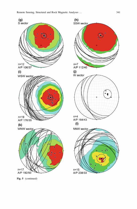
Fig. 5 (continued)
Remote Sensing, Structural and Rock Magnetic Analyses … 341

Fig. 6 Stereographic projections of a fracture planes in flat-lying sedimentary country rock(s)around Ramgarh structure, and b, c, e, g, i fracture planes developed in the rim crest sandstones ofRamgarh structure, and d, f, h, j projections of their respective poles, which are grouped accordingto their strike directions, e.g., northeast (ne), northwest (nw) and east-west (ew), note Ramgarhstructure is associated with numerous fractures, which are both vertical and dipping, differentgeographic sectors of Ramgarh structure rim after Fig. 3
342 S. Misra et al.

(Prasad 1984), and in area surrounding the Ramgarh structure (Figs. 4b and 6a).The evidence of extensive dextral shear along the NE-SW fracture planecross-cutting the Ramgarh structure, and following minor sinistral shear along theE-W fracture planes are only seen within the Ramgarh structure (Figs. 2a and 3).All these brittle deformation features suggest that the sedimentary country rockswithin the Ramgarh structure could have experienced a sudden shock that generatednew fractures and reactivated the pre-existing fractures promoting limited slip.
The quaquaversal dips of the country rock sandstone along the rim of theRamgarh structure (Fig. 5), along with its extreme brittle deformations resemble inseveral aspects to those observed in the Lonar impact Crater, India (Kumar 2005;Misra et al. 2010). The Ramgarh structure is * rectangular (Figs. 2a and 3), whichis similar in shape to the Arizona Crater, USA (Grieve et al. 1988). The presentdiameter/depth ratio of the Ramgarh structure is*12 (measured from Google EarthImagery 2017), which is within the range (10–20) of the terrestrial complex asteroid
Fig. 7 False colour ASTERimage (resolution *15 m)showing modification ofdrainage pattern adjacent toRamgarh structure at present,abbreviations: 1—Ramgarhstructure, 2—present courseof Parvati River, 3—palaeo-channel of ParvatiRiver, 4—present course ofKul River, note shift ofParvati River from a relativelysmooth palaeo-channeladjacent to Ramgarh structureto an irregular channel to W atpresent, the points wherepalaeo-channel of ParvatiRiver meets with its presentcourse are shown in box
Remote Sensing, Structural and Rock Magnetic Analyses … 343

impact craters (cf. Smith 1971; Koeberl and Sharpton 2017). Like other terrestrialcomplex impact crater, the Ramgarh structure has a prominent conical central peak(Fig. 4o) (also Grieve et al. 1988; Master and Pandit 1999), which consists ofsandstone and has a present height of *6 m (Misra et al. 2008a). The subsurfacepresence of this central peak below the present alluvium is also modelled based onborehole data (Ramasamy 1987). Hence it can be modelled that the extreme brittledeformation of the country rocks observed within the Ramgarh structure, thedevelopment of shatter cone like structure on the wall of the Ramgarh structure(Fig. 4n) and central uplift within the structure (Fig. 4o) were resulted due to asudden shock effect caused by asteroid impact (cf. French 1998).
Fig. 8 a–d Alternating field demagnetization of NRM and SIRM of sub-samples from RJ26glassy sample recovered from Ramgarh structure (Fig. 3), note position of NRM decay curvesabove SIRM decay curve for lower range of AF demagnetization field. e IRM acquisition curves ofall four glassy samples showing saturation at higher field of *500 mT. f IRM backfield curves ofglassy sub-samples
344 S. Misra et al.
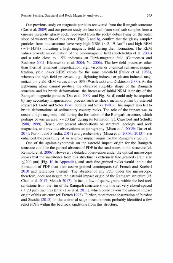
Our previous study on magnetic particles recovered from the Ramgarh structure(Das et al. 2009) and our present study on four small (mm-size) sub-samples from acm-size magnetic glassy rock, recovered from the rocky debris lying on the outerslope of western rim of this crater (Figs. 3 and 8), confirm that the glassy sample/particles from this structure have very high NRM (*2–19 Am−1) and high REM(*7–145%) indicating a high magnetic field during their formation. The REMvalues provide an estimation of the paleomagnetic field (Kletetschka et al. 2003)and a ratio close to 1.5% indicates an Earth-magnetic field (Gattacceca andRochette 2004; Kletetschka et al. 2004; Yu 2006). The low-field processes otherthan thermal remanent magnetization, e.g., viscous or chemical remanent magne-tization, yield lower REM values for the same paleofield (Fuller et al. 1988),whereas the high-field processes, e.g., lightning-induced or plasma-induced mag-netization, yield REM values above 10% (Wasilewski and Dickinson 2000). As thelightening alone cannot produce the observed ring-like shape of the Ramgarhstructure and its brittle deformations, the increase of initial NRM intensity of theRamgarh magnetic particles (Das et al. 2009, and Fig. 8a–d) could only be acquiredby any secondary magnetization process such as shock metamorphism by asteroidimpact (cf. Gold and Soter 1976; Schultz and Srnka 1980). This impact also led tobrittle deformations of sedimentary country rocks. The role of the impact was tocreate a high magnetic field during the formation of the Ramgarh structure, whichperhaps covers an area >*20 km2 during its formation (cf. Crawford and Schultz1988, 1999). Hence, our present observations on structural geology and rockmagnetics, and previous observations on petrography (Misra et al. 2008b; Das et al.2011; Purohit and Sisodia, 2013) and geochemistry (Misra et al. 2008b; 2013) haveenhanced the possibility of an asteroid impact origin for the Ramgarh structure.
One of the against-hypothesis on the asteroid impact origin for the Ramgarhstructure could be the general absence of PDF in the sandstones in this structure (cf.Reimold et al. 2006). However, a detailed observation under the optical microscopeshows that the sandstones from this structure is extremely fine grained (grain size� 200 lm) (Fig. 10 in Appendix), and such fine-grained rocks would inhibit theformation of PDF than their coarse-grained counterparts (cf. French and Koeberl2010 and references therein). The absence of any PDF under the microscope,therefore, does not negate the asteroid impact origin of the Ramgarh structure (cf.Chen et al. 2017; Melosh 2017). In fact, a few of quartz grains within the bed rocksandstone from the rim of the Ramgarh structure show one set very closed-spaced(� 20 lm) fractures (PFs) (Das et al. 2011), which could favour the asteroid impactorigin of this structure (cf. French 1998). Further, more recent observation of Purohotand Sisodia (2013) on the universal stage measurements probably identified a fewrelict PDFs within the bed rock sandstone from this structure.
Remote Sensing, Structural and Rock Magnetic Analyses … 345
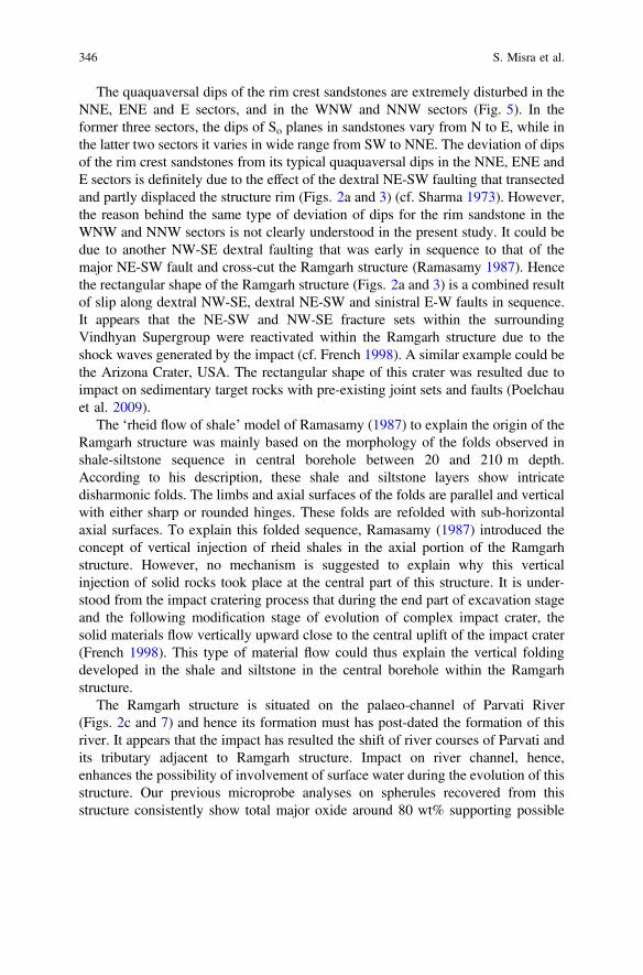
The quaquaversal dips of the rim crest sandstones are extremely disturbed in theNNE, ENE and E sectors, and in the WNW and NNW sectors (Fig. 5). In theformer three sectors, the dips of So planes in sandstones vary from N to E, while inthe latter two sectors it varies in wide range from SW to NNE. The deviation of dipsof the rim crest sandstones from its typical quaquaversal dips in the NNE, ENE andE sectors is definitely due to the effect of the dextral NE-SW faulting that transectedand partly displaced the structure rim (Figs. 2a and 3) (cf. Sharma 1973). However,the reason behind the same type of deviation of dips for the rim sandstone in theWNW and NNW sectors is not clearly understood in the present study. It could bedue to another NW-SE dextral faulting that was early in sequence to that of themajor NE-SW fault and cross-cut the Ramgarh structure (Ramasamy 1987). Hencethe rectangular shape of the Ramgarh structure (Figs. 2a and 3) is a combined resultof slip along dextral NW-SE, dextral NE-SW and sinistral E-W faults in sequence.It appears that the NE-SW and NW-SE fracture sets within the surroundingVindhyan Supergroup were reactivated within the Ramgarh structure due to theshock waves generated by the impact (cf. French 1998). A similar example could bethe Arizona Crater, USA. The rectangular shape of this crater was resulted due toimpact on sedimentary target rocks with pre-existing joint sets and faults (Poelchauet al. 2009).
The ‘rheid flow of shale’ model of Ramasamy (1987) to explain the origin of theRamgarh structure was mainly based on the morphology of the folds observed inshale-siltstone sequence in central borehole between 20 and 210 m depth.According to his description, these shale and siltstone layers show intricatedisharmonic folds. The limbs and axial surfaces of the folds are parallel and verticalwith either sharp or rounded hinges. These folds are refolded with sub-horizontalaxial surfaces. To explain this folded sequence, Ramasamy (1987) introduced theconcept of vertical injection of rheid shales in the axial portion of the Ramgarhstructure. However, no mechanism is suggested to explain why this verticalinjection of solid rocks took place at the central part of this structure. It is under-stood from the impact cratering process that during the end part of excavation stageand the following modification stage of evolution of complex impact crater, thesolid materials flow vertically upward close to the central uplift of the impact crater(French 1998). This type of material flow could thus explain the vertical foldingdeveloped in the shale and siltstone in the central borehole within the Ramgarhstructure.
The Ramgarh structure is situated on the palaeo-channel of Parvati River(Figs. 2c and 7) and hence its formation must has post-dated the formation of thisriver. It appears that the impact has resulted the shift of river courses of Parvati andits tributary adjacent to Ramgarh structure. Impact on river channel, hence,enhances the possibility of involvement of surface water during the evolution of thisstructure. Our previous microprobe analyses on spherules recovered from thisstructure consistently show total major oxide around 80 wt% supporting possible
346 S. Misra et al.
involvement of volatiles during the formation of Ramgarh structure (Misra et al.2008b). Therefore, based on this observation along with our present observation onintense activity of Mn-rich hydrothermal solution along the bedding planes ofsandstones and some fracture planes cross-cutting these sandstones within theRamgarh structure (Fig. 4k–m), it can be modelled that the Ramgarh impact cra-tering took place essentially under hydrous environment.
6 Conclusions
(a) The flat-lying, nearly undeformed Vindhyan Supergroup of sedimentary rockssurrounding to the Ramgarh structure show only two sets of vertical fracturetrending NE-SW and NW-SE. In contrast, the sedimentary country rocks withinand adjacent to the Ramgarh structure show extreme brittle deformationincluding vertical radial fracture in numerous directions, and moderately dip-ping fractures trending NE-SW and NW-SE.
(b) The ring-like shape of the Ramgarh structure with a central conical peak, thequaquaversal dips of its rim crest sandstones, along with its present diameter/depth ratio (*12) suggest that this structure could have formed by asteroidimpact. The impact-induced shock was responsible for the extreme brittledeformation of the sedimentary country rocks within and adjacent to thisstructure and reactivation of some pre-impact fracture plane in the countryrocks.
(c) The present rock magnetic studies on sub-samples from a glassy silicate piece,along with our previous observation on magnetic particles recovered from thealluvium of the Ramgarh structure (Das et al. 2009) suggest that these magneticsubstances have very high NRM (*2–19 Am−1) and REM (*7–145%)indicating the presence of a high magnetic field during their formation, muchhigher than the ambient Earth’s magnetic field.
(d) A natural phenomenon that could generate a unique ring-shaped deformationstructure on a monotonously flat-lying, undeformed sedimentary country rockas well as a high magnetic field in and around this structure is a hypervelocityasteroid impact. Many previous observations on petrography (Das et al. 2011;Purohot and Sisodia 2013) and geochemistry (Misra et al. 2008b; 2013) pub-lished in the form of extended abstracts also support this conclusion.
(e) The rectangular shape of the Ramgarh structure, which is similar to that of theArizona Crater, USA, was resulted due to post-impact dextral movement alongNW-SE fault, followed by dextral movement along NE-SW fracture, andsinistral movement along E-W fracture in minor scale.
Remote Sensing, Structural and Rock Magnetic Analyses … 347

(f) Observation on remote sensing images confirms that the asteroid impacttook place on the palaeo-channel of Parvati River, which is now displacedtowards W.
Acknowledgements The first author (S. M.) is grateful to PLANEX, Indian Space ResearchOrganization, and NRF, South Africa (grant no. 91089) for supporting this research work. Specialthanks to Anand Dube of India, for helpful guidance to the first author during the field work, toHorton Newsom of USA for his continuous encouragement during the progress of this research,and to Tesfaye Kidane for helping in stereoplot software. We are indebted to Dr. SoumyajitMukherjee and an anonymous reviewer for their constructive comments on the early version of themanuscript.
Appendix
See Figs. 9 and 10.
Fig. 9 Hand specimenphotograph of cm-sizedsilicate glassy piece recoveredfrom within the rocky debrisdeposited on the outer wall ofwestern rim of Ramgarhstructure (diameter of coinshown as scale is 22 mm)
348 S. Misra et al.
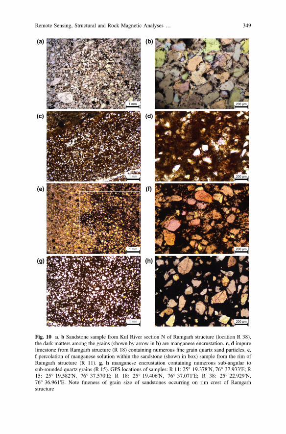
Fig. 10 a, b Sandstone sample from Kul River section N of Ramgarh structure (location R 38),the dark matters among the grains (shown by arrow in b) are manganese encrustation. c, d impurelimestone from Ramgarh structure (R 18) containing numerous fine grain quartz sand particles. e,f percolation of manganese solution within the sandstone (shown in box) sample from the rim ofRamgarh structure (R 11). g, h manganese encrustation containing numerous sub-angular tosub-rounded quartz grains (R 15). GPS locations of samples: R 11: 25° 19.378′N, 76° 37.933′E; R15: 25° 19.582′N, 76° 37.570′E; R 18: 25° 19.406′N, 76° 37.071′E; R 38: 25° 22.929′N,76° 36.961′E. Note fineness of grain size of sandstones occurring on rim crest of Ramgarhstructure
Remote Sensing, Structural and Rock Magnetic Analyses … 349
References
Ahmad K (1958) Paleogeography of Central India in the Vindhyan period. Geological Suvey ofIndia Records 87, 531–548
Ahmed N, Bhardwaj BD, Sajid HA, Hasnain I (1974) Ramgarh meteorite crater. Current Science43, 598
Auden JB (1933) Vindhyan sedimentation in the Son valley, Mirzapur district. Geological Surveyof India Memoirs 62, 141–250
Balasundaram MS, Dube A (1973) Ramgarh structure, India. Nature 242, 40Bose PK, Sarkar S, Chakrabarty S, Banerjee S (2001) Overview of the Meso- to Neoproterozoic
evolution of the Vindhyan basin, central India. Sedimentary Geology 41–142, 395–419Chen J, Elmi C, Goldsby DL, Gieré R (2017) Generation of shock lamellae and melting in rocks
by lightning-induced shock waves and electrical heating. Geophysical Research Letters 44,8757–8768
Crawford AR (1972) Possible impact structure in India. Nature 237, 96Crawford DA, Schultz PH (1988) Laboratory observations of impact–generated magnetic fields.
Nature 336, 50–52Crawford DA, Schultz PH (1999) Electromagnetic properties of impact-generated plasma, vapor
and debris. International Journal of Impact Engineering 23, 169–180Das PK, Misra S, Basavaiah N, Newsom H, Dube A (2009). Rock magnetic evidence of asteroid
impact origin of Ramgarh structure. India. In: 40th Lunar and planetary science conference.Abstract no. 1466
Das PK, Misra S, Newsom HE, Sisodia MS (2011) Possible planer fractures, coesite, andaccretionary lapilli from Ramgarh structure, India: new evidence suggesting an impact originof the crater. In: 42nd Lunar and planetary science conference. Abstract no. 1294
French BM (1998) Traces of catastrophe: a handbook of shock-metamorphic effects in terrestrialmeteorite impact structures. In: Lunar and planetary institute contribution series. vol 954, p 120
French BM, Koeberl C (2010) The convincing identification of terrestrial meteorite impactstructures: what works, what doesn’t, and why. Earth-Science Reviews 98, 123–170
Fuller M, Cisowski S, Hart M, Haston R, Schmidtke E, Jarrard R (1988) NRM:IRM(S)demagnetization plots; an aid to the interpretation of natural remanent magnetization.Geophysical Research Letters 15, 518–521
Gattacceca J, Rochette P (2004) Toward a robust normalized magnetic paleointensity methodapplied to meteorites. Earth and Planetary Science Letters 227, 377–393
GLCF (2007) Global land cover facility. University of Maryland, USA. Available online at http://glcf.umiacs.umd.edu
Gold T, Soter S (1976) Cometary impact and the magnetization of the Moon. Planetary and SpaceScience 24, 45–54
Grant JA (1999) Evaluating the evolution of process specific degradation signatures around impactcraters. International Journal of Impact Engineering 23, 331–340
Graup G (1981) Terrestrial chondrules, glass spherules and accretionary lapilli from the suevite,Ries Crater, Germany. Earth and Planetary Science Letters 55, 407–418
Grieve RAF, Wood CA, Garvin JB, Mclaughlin G, McHone JF (1988) Astronaut’s guide toterrestrial impact craters. Lunar and planetary institute technical report 88-03, Houston, p 89
Kletetschka G, Kohout T, Wasilewski PJ (2003) Magnetic remanence in the Murchison meteorite.Meteoritics and Planetary Science 38, 399–405
Kletetschka G, Acuna MH, Kohout T, Wasilewski PJ, Connerney JEP (2004) An empirical scalinglaw for acquisition of thermoremanent magnetization. Earth and Planetary Science Letters 226,521–528
Koeberl C, Sharpton VL (2017) Terrestrial impact craters, 2nd edn. www.lpi.usra.edu/publications/slidesets/craters
350 S. Misra et al.

Koeberl C, Brandstätter F, Glass BP, Hecht L, Mader D, Reimold WU (2007) Uppermost impactfall back layer in the Bosumtwi crater (Ghana): mineralogy, geochemistry, and comparisonwith ivory coast tektites. Meteoritics and Planetary Science 42, 709–729
Kumar PS (2005) Structural effects of meteorite impact on basalt: evidence from lonar crater.Journal of Geophysical Research 110, B12402
Kumar J, Negi MS, Sharma R, Saha D, Mayor S, Asthana M (2011) Ramgarh magnetic anomalyin the Chambal valley sector of Vindhyan basin: a possible meteorite impact structure and itsimplications in hydrocarbon exploration. In: American Association of Petroleum Geologists,Search and Discovery. Article #80145
Lowrie W, Fuller M (1971) On the alternating field demagnetization characteristics ofmultidomain thermoremanent magnetization in magnetite. Journal of Geophysical Research76, 6339–6349
Mallet FR (1869) On the Vindhyan series, as exhibited in the North-western and Central Provinceof India. Memoir of Geological Survey of India 7(Part 1), 129
Malone SJ, Meert JG, Banerjee DM, Pandit MK, Tamrat E, Kamenov GD, Pradhan VR, Sohl LE(2008) Paleomagnetism and detrital zircon geochronology of the Upper Vindhyan sequence,Son valley and Rajasthan, India: a ca. 1000 Ma closure age for the Purana basins? PrecambrianResearch 164, 137–159
Master S, Pandit MK (1999) New evidence for an impact origin of the Ramgarh structure.Meteoritics and Planetary Science 34, 4
McElhinny MW, McFadden PL (2000) Paleomagnetism: continents and oceans. In: Internationalgeophysics series, vol 73. Academic Press, San Diego, CA, p 386. ISBN: 0124833551
Melosh HJ (2017) Impact geologists, beware! Geophys Res Lett 44, 8873–8874Misra S, Dube A, Srivastava PK, Newsom HE (2008a) Time of formation of Ramgarh crater,
India-constraints from geological structures. In: 39th Lunar and planetary science conference.Abstract. no. 1502
Misra S, Lashkari G, Panda D, Dube A, Sisodia MS, Newsom HE, Sengupta D (2008b)Geochemical evidence for the meteorite impact origin of Ramgarh structure, India. 39th Lunarand planetary science conference. Abstract. no. 1499
Misra S, Arif M, Basavaiah N, Srivastava PK, Dube A (2010) Structural and anisotropy ofmagnetic susceptibility (AMS) evidence for oblique impact on terrestrial basalt flows: Lonarcrater, India. Bulletin of Geological Society of America 122, 563–574
Misra S, Panda D, Ray D, Newsom H, Dube A, Sisodia MS (2013) Geochemistry of glassy rocksfrom Ramgarh structure, India. In: 44th Lunar and planetary science conference. Abstract. no.1020
Newsom H, Gasnault O, Le Mouelic S, Mangold N, Le Deit L, Wiens R, Anderson R, Edgar L,Herkenhoff K, Johnson JR, Bridges N, Grotzinger JP, Gupta S, Jacob S (2016) Long distanceobservation with the ChemCam remote micro-imager: mount sharp and related deposits on galecrater floor? Geological Society of America, Denver, 25–28 Sept 2016
Oldham T (1856) Remarks on the classification of the rocks of central India resulting from theinvestigation of the Geological Survey. Journal the Asiatic Society, Calcutta 25, 224–256
Poelchau MH, Kenkmann T, Kring DA (2009) Rim uplift and crater shape in meteor crater: effectsof target heterogeneities and trajectory obliquity. Journal of Geophysical Research 114,E01006
Prasad B (1984) Geology, sedimentation and palageography of the Vindhyan Supergroup,Southeast Rajasthan. Geological Survey of India Memoirs 116, 1–107
Purohot V, Sisodia MS (2013) Universal-stage measurements of planar deformation features inshocked quartz grains recovered from Ramgarh structure. In: 44th Lunar and planetary scienceconference. Abstract. no. 1151
Ramasamy SM (1987) Evolution of Ramgarh dome, Rajasthan: India. Records of GeologicalSurvey of India 113, 13–22
Rana S, Agrawal V (2016) Microscopic evidences for the impact origin of Ramgarh structure,Rajasthan, India. Journal of Indian Geophysical Union 20, 544–550
Remote Sensing, Structural and Rock Magnetic Analyses … 351
Reimold WU, Trepmann C, Simonson B (2006) Comment on “Impact origin of the Ramgarhstructure, Rajasthan: some new evidences by M. S. Sisodia, G. Lashkari and N. Bhandari.Journal of Geological Society of India, v. 67, pp. 423–431”. Journal of Geological Society ofIndia 68, 561–563
Schultz PH, Srnka LJ (1980) Cometary collision on the moon and mercury. Nature 284, 22–26Sharma HS (1973) Ramgarh structure, India. Nature 242, 39–40Sisodia MS, Lashkari G (2003) Ramgarh structure, Rajasthan, India: meteorite impact evidences.
Workshop on Impact cratering: bridging the gap between modeling and observations, Houston.Abstract no. 8008
Sisodia MS, Lashkari G, Bhandari N (2006a) Impact origin of the Ramgarh structure, Rajasthan:Some new evidences. Journal of Geological Society of India 67, 423–431
Sisodia MS, Lashkari G, Bhandari N (2006b) Reply to “The comment on Impact origin of theRamgarh structure, Rajasthan: Some new evidences by W. U. Reimold, C. Trepmann and B.Simonson”. Journal of Geological Society of India 68, 561–563
Smith EI (1971) Determination of origin of small lunar and terrestrial craters by depth diameterratio. Journal of Geophysical Research, 76, 5683–5689
Tandon SK, Pant CC, Casshyap SM (1991) Sedimentary basins of India-Tectonic context.Gyanodaya Prakashan, Nainital
Vernooij MGC, Langenhorst F (2005) Experimental reproduction of tectonic deformation lamellaein quartz and comparison to shock-induced planar deformation features. Meteoritics andPlanetary Science 40, 1353–1361
Wasilewski P, Dickinson T (2000) Aspects of the validation of magnetic remanence in meteorites.Meteoritics and Planetary Science 35, 537–544
Yu YJ (2006) How accurately can NRM⁄SIRM determine the ancient planetary magnetic fieldintensity? Earth and Planetary Science Letters 250, 27–37
352 S. Misra et al.
Geology, Structural Architectureand Tectonic Framework of the Rocksof Southern Lalitpur District UttarPradesh, India: An Epitomeof the Indian Peninsular Shield
G. K. Dinkar, A. R. Bhattacharya, A. K. Verma and Pankaj Sharma
1 Introduction
The southern part of Uttar Pradesh is geologically known for exposing a part of theIndian peninsular shield. Both basement and cover rocks are exposed at severalareas. The Lalitpur district of this region typically exposes several geological ele-ments of the peninsular shield. The southern part of Lalitpur district (Fig. 1) epit-omizes the peninsular shield to a larger extent. This area has been studied by variousworkers mainly from the viewpoints of geology, rock types, and mineral resources.The early studies were confined to identifying the major rock groups. Later studiesfocused on identifying various rock types together with the associated metasedi-mentary sequences. Recent studies focus amongst others, on mineralogical, geo-chemical and geochronological studies to understand the evolution of the ancientcrust and crustal growth in the context of the peninsular shield. Despite geologicalstudies on several aspects, detailed lithostratigraphic and structural-tectonic studiesof south Lalitpur district are scanty. This paper fills up this gap.
2 Geological Set up
The geological setup of southern Lalitpur district is intimately related to that ofsouthern U.P. The area has been studied by various workers mainly from theviewpoints of geology, rock types, and mineral resources. Our knowledge on thegeology of south Lalitpur developed in several phases during the last 5 or 6decades.
G. K. Dinkar � A. R. Bhattacharya (&) � A. K. Verma � P. SharmaCentre of Advanced Study in Geology, University of Lucknow, Lucknow 226007, Indiae-mail: [email protected]
© Springer Nature Switzerland AG 2019S. Mukherjee (ed.), Tectonics and Structural Geology: Indian Context,Springer Geology, https://doi.org/10.1007/978-3-319-99341-6_12
353
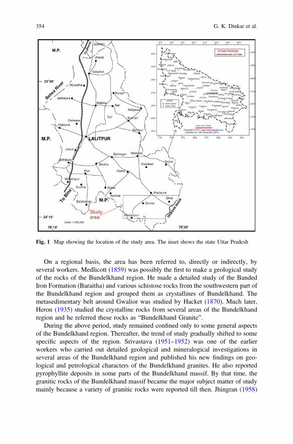
On a regional basis, the area has been referred to, directly or indirectly, byseveral workers. Medlicott (1859) was possibly the first to make a geological studyof the rocks of the Bundelkhand region. He made a detailed study of the BandedIron Formation (Baraitha) and various schistose rocks from the southwestern part ofthe Bundelkhand region and grouped them as crystallines of Bundelkhand. Themetasedimentary belt around Gwalior was studied by Hacket (1870). Much later,Heron (1935) studied the crystalline rocks from several areas of the Bundelkhandregion and he referred these rocks as “Bundelkhand Granite”.
During the above period, study remained confined only to some general aspectsof the Bundelkhand region. Thereafter, the trend of study gradually shifted to somespecific aspects of the region. Srivastava (1951–1952) was one of the earlierworkers who carried out detailed geological and mineralogical investigations inseveral areas of the Bundelkhand region and published his new findings on geo-logical and petrological characters of the Bundelkhand granites. He also reportedpyrophyllite deposits in some parts of the Bundelkhand massif. By that time, thegranitic rocks of the Bundelkhand massif became the major subject matter of studymainly because a variety of granitic rocks were reported till then. Jhingran (1958)
Fig. 1 Map showing the location of the study area. The inset shows the state Uttar Pradesh
354 G. K. Dinkar et al.
identified two major types of granites: pink granite and grey granite and he sug-gested that the former (pink granite) is younger than the latter. He also identified tentypes of granites within the great batholithic massif on the basis of grain size, colourof feldspar and presence or absence of ferromagnesian minerals. In addition tothese, he also reported gneisses, quartz–reefs, basic dikesand tuffaceous serpentiniterocks within the massif. Saxena (1961) suggested a lithostratigraphic correlation ofthe metasediments of the Bundelkhand massif with the middle Dharwarian rocks ofSouth India and the Bundelkhand granitic activity as equivalent of the Closepetgranite.
During the nineteen hundred seventies, the different rock types of theBundelkhand region including lithostratigraphic sequences of some areas came tolimelight. Prakash et al. (1975) carried out a detailed lithostratigraphic study of thesouthwestern part of Bundelkhand massif and distinguished three tectonic blocks inthis massif: a northern block (Jhansi–Lalitpur) consisting of various types ofgranitoids with enclaves of metasedimentary rocks, a southern block (south ofLalitpur) comprising of Bundelkhand granitoids including the low grademetasediments (Mehroni Group) together with the overlying Vindhyan sediments,and a central block mainly exposing the pink, massive granites. Misra and Sharma(1975) identified metasedimentary rocks within the Bundelkhand complex andsuggested that the Bundelkhand rocks can be divided into four formations; fromlower to upper these are Kuraicha Formation of high grade metamorphic rocks,Palar Formation with low grade metamorphic rocks, Bundelkhand Granite, andBundelkhand basic intrusives.
The nineteen hundred eighties witnessed a multifarious progress on several yetuntouched aspects on the geology of the region. In this connection, the contribu-tions of Basu (1986, 2001, 2007, 2010) deserve special mention. He carried outextensive field investigations and mapped almost the entire area of the BundelkhandCraton. He proposed an evolutionary model for the Precambrian crust on the basisof petrological, structural and chemical characteristics of various types of granitoidsand basic rocks. He suggested that the metallogenic and tectonometamorphic eventsof the massif were regionally dominated by plutonic and hypabyssal rocks.
Despite the available information on several aspects of the geology of the region,studies from structural angles were almost lacking. Bhattacharya (1985) estimatedtectonic strain for the rocks of the Bundelkhand massif and has shown that themineralogical behaviour of the rocks has controlled the deformation patterns of themassif. He (Bhattacharya 1986) developed a semi-quantitative method for identi-fying different fold episodes of deformed terrains and on applying this method tothe rocks of the Bundelkhand massif, he identified five different folding episodesfor the massif.
On a much larger perspective, Radhakrishna (1989) identified a “Central IndianTectonic Zone” encompassing the SONATA Belt that marks the junction betweenthe Bundelkhand block in the north and the Peninsular block in the south. Sarkaret al. (1989, 1995, 1997) on the basis of the geochronology and petrology ofvarious rock types of the Bundelkhand complex suggested that the granitic rocksbelong to three distinct intrusive phases. They also suggested that the trondhjemitic
Geology, Structural Architecture and Tectonic Framework … 355
gneiss containing Rb-Sr isotopes may be considered as 3.5 Ga old (Baghora TTGsuite). The older crust of the region (Archaean to Palaeoproterozoic) is comprisedof amphibolites, quartzites, BIF, schists, marbles and calc–silicate rocks and thatthese rocks are intruded by 3.3 Ga old syn-to-late tectonic Na-richTonalite-Trondjhemite-Granodiorite (TTG) rocks. The oldest metamorphic eventsof the Bundelkhand region have been dated at 3.3 Ga, while the oldest relics ofyounger geneisses may be 2.7–2.5 Ga old (Mondal et al. 2002). Attempts havebeen made to work out the crustal evolutionary pattern of the Bundelkhand region(Singh et al. 2007; Singh and Dwivedi 2009; Singh 2012).
Our knowledge on the hitherto unknown crustal shear systems of theBundelkhand massif is definitely a new addition as came into light by the joint workof A. R. Bhattacharya and S. P. Singh (Singh and Bhattacharya 2010, 2017;Bhattacharya and Singh 2013). They have identified the following four differentcrustal shear systems in the Bundelkhand massif. (1) The E-W shear system: It ismainly confined to the central parts of the massif and is represented by mylonitesshowing vertical foliation together with a greenstone belt developed at severalplaces with dimensions ranging from about 10 � 30 m to 30 � 50 m. This is anexample of crustal scale vertical ductile shear zone and is possibly the first report ofvertical crustal shear zone in the Indian subcontinent. (2) The NE-SW shear system:It is represented by the quartz reefs that constitute the most spectacular structure inthe Bundelkhand terrain. The quartz reefs constitute strike-slip dominated verticalto subvertical shear zones with dominant sinistral sense of shear and they representProterozoic crustal scale extensional events in the Bundelkhand massif. (3) TheNW-SE shear system: These are in the form of a number of minor basic igneousdikes emplaced in the fractures developed due to extensional processes followed bystrike-slip shearing. (4) N-S shear system: This is a major tectono–magmatic eventof the Bundelkhand craton and is represented by N-S trending quartz andquarto-feldspathic veins. This is the youngest shear system that cross-cuts all theearlier (E-W, NE-SW and NW-SE) shear systems.
In the context of vertical shear zones of the Bundelkhand massif, it may bementioned here that elsewhere in the Indian subcontinent, shear zones withsub-vertical foliations are reported from Karakoram Shear Zone (Mukherjee 2011)and vertical brittle shear zones from trap rocks near Mumbai (Misra et a. 2014).
Recently, Dinkar (2016) carried out a detailed study on the structure anddeformation patterns of the rocks of the area around Sonrai. He presented a geo-logical and a structural map of the area both on the 1:50,000 scale and worked outthe structure and structural evolution of the rocks of the area
In a nutshell, south Lalitpur district is characterized by three different geologicalsubdivisions. The northern part is represented by the Bundelkhand GneissicComplex, the central part by the rocks of the Bijawar Group and the southern partby the Vindhyan Supergroup. In addition, there are a few minor rock units also thatfall in any of these three major subdivisions. The geological information brought tolight through this paper, and the results arrived at, should thus advance ourknowledge on the Indian peninsular shield.
356 G. K. Dinkar et al.

3 The Present Work
About 460 km2 has been mapped on 1:50,000 scale covering the area aroundDigwar in the northwest, Balla in the northeast, Madanpur in the southwest andKurrat in the southeast. The study area (Fig. 1) encompasses the river valley areasof the Rohini River in the west, Bandai River in the central part and Dhasan Riverin the east.
4 Physiography
The physiography of the southern Lalitpur district is rather typical from theremaining parts of the southern Uttar Pradesh. The main reason is that in this partthe physiography appears to be related to the geology of the area. The generalsurface level of flat lying regions is 400 m above the mean sea level with hillocksrising up to about 566 m from the surrounding areas. The southern part (Fig. 2) ofthe area represents plateaus and ridges while the vast expanse of the central (Fig. 2)and northern parts is mostly alluvial exposing scattered hillocks. In general, weidentify three physiographic subdivisions (Fig. 2). The northern subdivision ismostly alluvial exposing scattered hillocks. The central subdivision mainly includesE-W trending arcuate to elongated hills. The southern part of the area is occupiedby plateau with E-W trending ridges rising up to about 566 m.
Fig. 2 Photographs showing the physiographic features of the southern Lalitpur district. Ourstudies suggest that the area shows three different geological subdivisions: the northern subdivisionexposing the Bundelkhand Gneissic Complex, the central subdivision exposing a sedimentary/metasedimentary belt consisting of the Bijawar Group of rocks while the southern one exposes therocks of the Vindhyan Supergroup. Each of these geological subdivisions has been observed toshow its typical physiography. The northern subdivision is mostly alluvial exposing scatteredhillocks. The central subdivision mainly includes E-W trending arcuate to elongated, discontin-uous hills. The southern one shows plateau with long, E-W trending ridges. The photographsshown here are representative of the latter two types of physiography, i.e. those shown by the rocksof the Bijawar Group (a) and those of the Vindhyan Supergroup (b)
Geology, Structural Architecture and Tectonic Framework … 357

The above mentioned three physiographic features seem to be related to thegeology of the area. Thus the northern part exposes Bundelkhand GneissicComplex, the central part exposes a sedimentary/metasedimentary belt consistingmainly of the Bijawar Group of rocks and the southern part exposes the rocks of theVindhyan Supergroup.
5 Lithostratigraphy
From the above discussion, we identify three distinct belts in southern Lalitpurdistrict as described above. The basement rocks are represented by the BGC, themetasedimentary sequence by the Bijawar Group while the cover sediments by theVindhyan Supergroup. In addition, a few outcrops of Deccan Trap also expose atthe southern parts of the area. A generalized lithostratigraphic succession has beenpresented in Table 1. Detailed lithostratigraphic description and the various rocktypes of the study area are given below. The lithological characteristics andlithostratigraphic details of the rocks of the area are described here:(A) Bundelkhand Gneissic Complex (BGC), (B) Bijawar Group, and (C) VindhyanSupergroup (Fig. 3).
Table 1 Generalized lithostratigraphic succession of southern Lalitpur district
358 G. K. Dinkar et al.

(A) Bundelkhand Gneissic Complex
The rocks of the Bundelkhand massif comprise of a variety of granitoids includingpink coloured and fine to coarse grained porphyritic granite along with a variety ofmetamorphic rocks including gneisses, mylonitised granite gneisses, migmatitesand amphibolite schists. The rocks of the BGC commonly show well developeddominantly planar banding represented by melanosomes and leucosomes of vari-able thicknesses. In the study area, the Bundelkhand massif represents the type areaof ‘Mehroni Schist Belt’ of Pascoe (1950) and the Archaean Mehroni Formation. Inaddition, basic and ultrabasic rocks together with metavolcanic rocks are alsopresent. Doleritic dykes trending NW-SE are noticed at a few places. Quartz reefsconstitute one of the most spectacular features of the Bundelkhand terrain. Thesereefs occur as linear ridges and typically show NE-SW to ENE-WSW alignments.The Bundelkhand granitic and mafic rocks are broadly considered as intrusives intothe basement of the overlying metasediments. In the study area the Bundelkhandmassif is cut by a series of younger intrusive rocks, some of which arepost-Bijawars (Prakash et al. 1975; Jha et al. 2012). The rocks of the BGC aregenerally metamorphosed twice. A prograde metamorphism was high grade withthe the presence of garnet, silliminite, perthite, diopside, hornblende and antho-phyllite and with the absence of muscovite, chlorite, kyanite, actinolite, tremolite,talc and epidote minerals. This was followed by a retrograde metamorphism and ismainly characterized by tonalite-trondhjemit—granodiorite suite of rocks (Fig. 4).
Fig. 3 Photographs showing the physiographic features of the study area. a Central part witheast-west trending ridges, b southern part dominated by plateau. These physiographic subdivisionsare characterized by their typical geological attributes (see text)
Geology, Structural Architecture and Tectonic Framework … 359

In the course of our field study, we have identified a few lithologic associationswithin this complex as described below.
(i) Bundelkhand Gneisses
The Bundelkhand Gneisses (Fig. 5) are exposed in the northern parts of the study area.These rocks are dominantly constituted of moderate to high grade metamorphic rocks.The major rock types include granite-gneiss, migmatite, biotite-gneiss, tonlite-trondhjemite–granodiorite (TTG), hornblende-biotite-gneiss, garnet-sillimanite-gneiss,garnet-sileimanite–cordierite-gneiss and amphibolites.The foliationof thegneissic rocksgenerally trend ENE-WSW to E-W with dips of 30°–50° southwards.
Fig. 4 Geological map of the southern Lalitpur a district, Uttar Pradesh. Modified after Prakashet al. (1975) and Sharma (1982)
Fig. 5 Field photograph showing outcrop of gneissic rock. Loc. North of Balla
360 G. K. Dinkar et al.
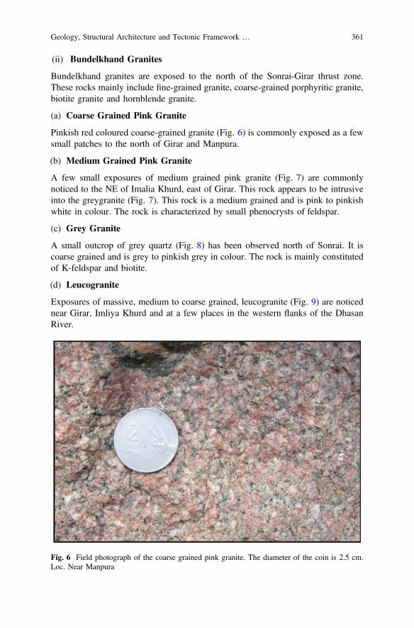
(ii) Bundelkhand Granites
Bundelkhand granites are exposed to the north of the Sonrai-Girar thrust zone.These rocks mainly include fine-grained granite, coarse-grained porphyritic granite,biotite granite and hornblende granite.
(a) Coarse Grained Pink Granite
Pinkish red coloured coarse-grained granite (Fig. 6) is commonly exposed as a fewsmall patches to the north of Girar and Manpura.
(b) Medium Grained Pink Granite
A few small exposures of medium grained pink granite (Fig. 7) are commonlynoticed to the NE of Imalia Khurd, east of Girar. This rock appears to be intrusiveinto the greygranite (Fig. 7). This rock is a medium grained and is pink to pinkishwhite in colour. The rock is characterized by small phenocrysts of feldspar.
(c) Grey Granite
A small outcrop of grey quartz (Fig. 8) has been observed north of Sonrai. It iscoarse grained and is grey to pinkish grey in colour. The rock is mainly constitutedof K-feldspar and biotite.
(d) Leucogranite
Exposures of massive, medium to coarse grained, leucogranite (Fig. 9) are noticednear Girar, Imliya Khurd and at a few places in the western flanks of the DhasanRiver.
Fig. 6 Field photograph of the coarse grained pink granite. The diameter of the coin is 2.5 cm.Loc. Near Manpura
Geology, Structural Architecture and Tectonic Framework … 361
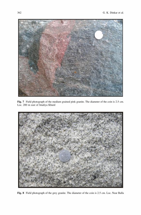
Fig. 7 Field photograph of the medium grained pink granite. The diameter of the coin is 2.5 cm.Loc. 200 m east of Imaliya Khurd
Fig. 8 Field photograph of the grey granite. The diameter of the coin is 2.5 cm. Loc. Near Balla
362 G. K. Dinkar et al.
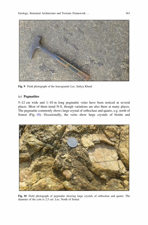
(e) Pegmatites
5–12 cm wide and 1–10 m long pegmatite veins have been noticed at severalplaces. Most of them trend N-S, though variations are also there at many places.The pegmatite commonly shows large crystal of orthoclase and quartz, e.g. north ofSonrai (Fig. 10). Occasionally, the veins show large crystals of biotite and
Fig. 9 Field photograph of the leucogranite Loc. Imliya Khurd
Fig. 10 Field photograph of pegmatite showing large crystals of orthoclase and quartz. Thediameter of the coin is 2.5 cm. Loc. North of Sonrai
Geology, Structural Architecture and Tectonic Framework … 363

muscovite, e.g. near Nathikhera. It appears that the pegmatites have intruded intothe preexisting rocks in phases as based on cross-cutting relations. Basu (1986) hasreported three generations of pegmatite veins in the Bundelkhand massif.
(iii) Mafic and Ultramafic Suite (Metavolcanic Suite)
A variety of mafic and ultramafic (Fig. 11a, b) rocks are exposed in various parts ofthe BGC. We assign these rocks to constitute a metavolcanic suite that is mainlyrepresented by metaperidotite, metapyroxinite and coarse to medium grained gab-bro. This suite of rocks is intrusive into different types of granites as well asgabbroic rocks. Earlier Prakash et al. (1975) and Sharma (1982) have reported asuite of ultrabasic and basic rocks around madaura and Sonrai. Basu (1986)reported medium grained and dark grey gabbro associated with these ultrabasics tothe east of Madaura.
Fig. 11 Field photographs of metavolcanic suite of rocks. The dashed lines show the boundariesof a metavolcanic rock (in each photo) intruded into the host granitic rocks. Loc. NW of Balla
364 G. K. Dinkar et al.

(iv) Quartz Reef
In the Bundelkhand massif, the quartz reefs constitute a spectacular physiographicfeature. These reefs constitute the NE-SW trending ridges of quartz. In the studyarea, the approximate length of these ridges vary from 50 to 200 m. Approximately400 quartz reefs (individual exposures) are exposed in BGC covering the part ofsouthern Uttar Pradesh. Quartz reefs are sharply exposed as linear ridges/hills withvarying thickness from a few meters to the maximum height of 175 m aboveground level and thus form prominent physiographic features. The ridges have beenobserved near Girar, Hansra-Hansri, north of Manpura, Balla and adjoining areas.Commonly the quartz reefs are pinched and swelled. The rocks exposures occa-sionally show brecciation and shattering such as near Girar and north of Manpura.
The quartz reefs have been interpreted in several ways. Pascoe (1950) describedthese as quartz veins. Jhingran (1958) describes these as cherty small offshootshaving cataclastic and granulated nature. Misra (1969) considers these reefs asproduct of recrystallisation of quartzites. Saxena (1961) opines the quartz reefsconstitute a part of the older rocks of the Bundelkhand massif. Prakash et al. (1975)considered these as dense sheared veins of quartz. The reefs exhibit sharp contactswith the enclosing granites. These reefs are variedly described as a monomineralicrock (Sharma 1982), as mega-veins of quartz occasionally mildly sheared by (Basu2004) and as giant quartz veins by Pati et al. (2007) and Mondal (2010). Rodayet al. (1995) presented a kinemetic model of emplacement of the quartz reefs andsubsequent deformation pattern of these reefs in Central Indian Bundelkhandbatholiths. Pati et al. (2007) described the geology and geochemisty of these reefs.Bhattacharya and Singh (2013) described these quartz reefs as shear indicators ofthe Proterozoic crust in the Bundelkhand massif, and suggested that these areassociated with the NE-SW strike-slip dominated vertical to sub-vertical shearzones.
(v) Mafic Dike Swarms
Occurrence of mafic dikes is another important physiographic feature of theBundelkhand massif. These rocks occur as NW-SE trending dike swarms. Some ofthem also show ENE-WSW trends. In the study area, mafic dikes are noticedaround Girar (Fig. 12).
(B) Mahrauni Group
Within the Bundelkhand Gneissic Complex some relics of higher grade meta-morphism are occasionally noticed that have been assigned as the Mehroni Group(Prakash et al. 1975; Jha et al. 2012). Prakash et al. (1975) subdivided the MehroniGroup into a Lower Rajaula Formation, followed up by Barwar Formation andMadaura Formation. The Rajaula Formation is mainly constituted of quartz–feld-spar biotite gneiss, chlorite schists, and meta-basalts. The Barwar Formation isconstituted of banded hematite quartzite, conglomerate, fuchsite quartzite and greyto green chlorite schists. The Madaura Formation mainly includes ultrabasic rocks,gabbro, granites and pegmeatites. However, in the study area only the rocks of the
Geology, Structural Architecture and Tectonic Framework … 365
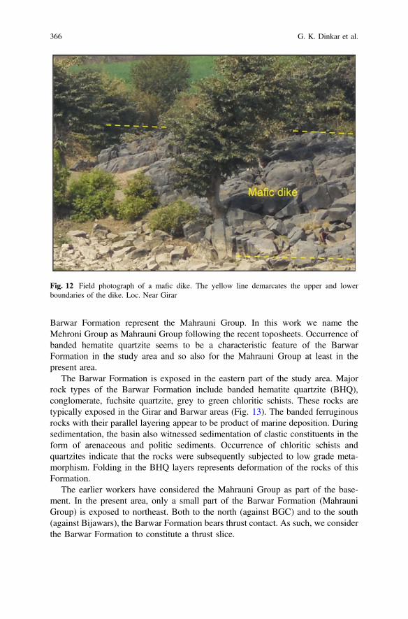
Barwar Formation represent the Mahrauni Group. In this work we name theMehroni Group as Mahrauni Group following the recent toposheets. Occurrence ofbanded hematite quartzite seems to be a characteristic feature of the BarwarFormation in the study area and so also for the Mahrauni Group at least in thepresent area.
The Barwar Formation is exposed in the eastern part of the study area. Majorrock types of the Barwar Formation include banded hematite quartzite (BHQ),conglomerate, fuchsite quartzite, grey to green chloritic schists. These rocks aretypically exposed in the Girar and Barwar areas (Fig. 13). The banded ferruginousrocks with their parallel layering appear to be product of marine deposition. Duringsedimentation, the basin also witnessed sedimentation of clastic constituents in theform of arenaceous and politic sediments. Occurrence of chloritic schists andquartzites indicate that the rocks were subsequently subjected to low grade meta-morphism. Folding in the BHQ layers represents deformation of the rocks of thisFormation.
The earlier workers have considered the Mahrauni Group as part of the base-ment. In the present area, only a small part of the Barwar Formation (MahrauniGroup) is exposed to northeast. Both to the north (against BGC) and to the south(against Bijawars), the Barwar Formation bears thrust contact. As such, we considerthe Barwar Formation to constitute a thrust slice.
Fig. 12 Field photograph of a mafic dike. The yellow line demarcates the upper and lowerboundaries of the dike. Loc. Near Girar
366 G. K. Dinkar et al.
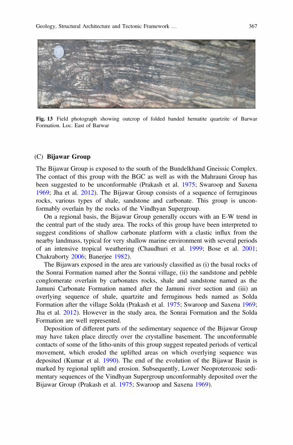
(C) Bijawar Group
The Bijawar Group is exposed to the south of the Bundelkhand Gneissic Complex.The contact of this group with the BGC as well as with the Mahrauni Group hasbeen suggested to be unconformable (Prakash et al. 1975; Swaroop and Saxena1969; Jha et al. 2012). The Bijawar Group consists of a sequence of ferruginousrocks, various types of shale, sandstone and carbonate. This group is uncon-formably overlain by the rocks of the Vindhyan Supergroup.
On a regional basis, the Bijawar Group generally occurs with an E-W trend inthe central part of the study area. The rocks of this group have been interpreted tosuggest conditions of shallow carbonate platform with a clastic influx from thenearby landmass, typical for very shallow marine environment with several periodsof an intensive tropical weathering (Chaudhuri et al. 1999; Bose et al. 2001;Chakraborty 2006; Banerjee 1982).
The Bijawars exposed in the area are variously classified as (i) the basal rocks ofthe Sonrai Formation named after the Sonrai village, (ii) the sandstone and pebbleconglomerate overlain by carbonates rocks, shale and sandstone named as theJamuni Carbonate Formation named after the Jamuni river section and (iii) anoverlying sequence of shale, quartzite and ferruginous beds named as SoldaFormation after the village Solda (Prakash et al. 1975; Swaroop and Saxena 1969;Jha et al. 2012). However in the study area, the Sonrai Formation and the SoldaFormation are well represented.
Deposition of different parts of the sedimentary sequence of the Bijawar Groupmay have taken place directly over the crystalline basement. The unconformablecontacts of some of the litho-units of this group suggest repeated periods of verticalmovement, which eroded the uplifted areas on which overlying sequence wasdeposited (Kumar et al. 1990). The end of the evolution of the Bijawar Basin ismarked by regional uplift and erosion. Subsequently, Lower Neoproterozoic sedi-mentary sequences of the Vindhyan Supergroup unconformably deposited over theBijawar Group (Prakash et al. 1975; Swaroop and Saxena 1969).
Fig. 13 Field photograph showing outcrop of folded banded hematite quartzite of BarwarFormation. Loc. East of Barwar
Geology, Structural Architecture and Tectonic Framework … 367
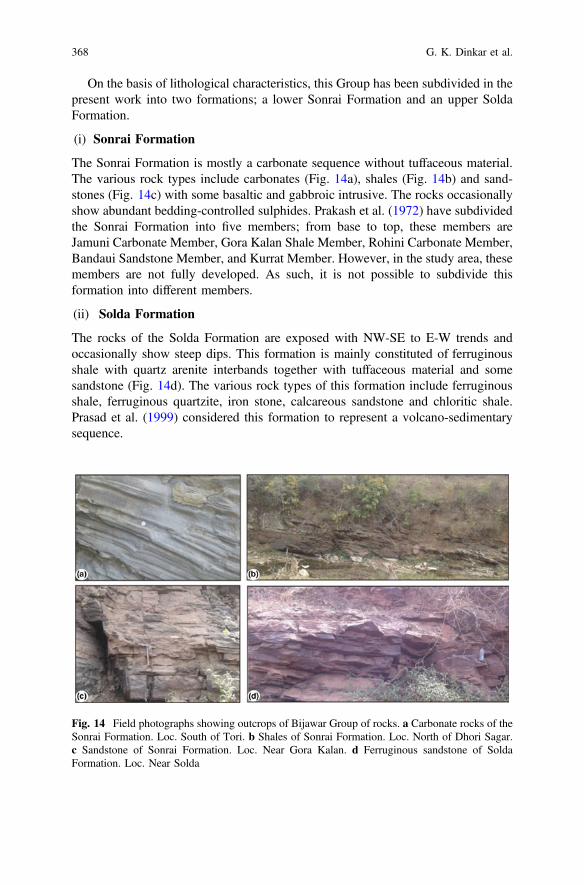
On the basis of lithological characteristics, this Group has been subdivided in thepresent work into two formations; a lower Sonrai Formation and an upper SoldaFormation.
(i) Sonrai Formation
The Sonrai Formation is mostly a carbonate sequence without tuffaceous material.The various rock types include carbonates (Fig. 14a), shales (Fig. 14b) and sand-stones (Fig. 14c) with some basaltic and gabbroic intrusive. The rocks occasionallyshow abundant bedding-controlled sulphides. Prakash et al. (1972) have subdividedthe Sonrai Formation into five members; from base to top, these members areJamuni Carbonate Member, Gora Kalan Shale Member, Rohini Carbonate Member,Bandaui Sandstone Member, and Kurrat Member. However, in the study area, thesemembers are not fully developed. As such, it is not possible to subdivide thisformation into different members.
(ii) Solda Formation
The rocks of the Solda Formation are exposed with NW-SE to E-W trends andoccasionally show steep dips. This formation is mainly constituted of ferruginousshale with quartz arenite interbands together with tuffaceous material and somesandstone (Fig. 14d). The various rock types of this formation include ferruginousshale, ferruginous quartzite, iron stone, calcareous sandstone and chloritic shale.Prasad et al. (1999) considered this formation to represent a volcano-sedimentarysequence.
Fig. 14 Field photographs showing outcrops of Bijawar Group of rocks. a Carbonate rocks of theSonrai Formation. Loc. South of Tori. b Shales of Sonrai Formation. Loc. North of Dhori Sagar.c Sandstone of Sonrai Formation. Loc. Near Gora Kalan. d Ferruginous sandstone of SoldaFormation. Loc. Near Solda
368 G. K. Dinkar et al.

(D) Vindhyan Supergroup
A part of the Vindhyan Supergroup is exposed in the southern part of the studyarea. The rocks of this unit occur as E-W and NE-SW trending continuous ridgesand smaller hills. In the study area, this supergroup is represented by two groups: aLower Semri Group and an Upper Kaimur Group. In the study area, the SemriGroup (Fig. 15a, b) includes thin-bedded sandstones and shales together withlocally developed conglomerate horizons. The Kaimur Group (Fig. 15c, d) isdominantly represented by massive sandstone, though thin-bedded sandstones arealso locally noticed.
(E) Deccan Traps
A few outcrops of Deccan Trap occur in the southern part of the area. Of these onlyone outcrop is relatively large in size; it trend almost N-S with a length of about8 km and a width of *4 km. The other outcrops are smaller and extend for a fewtens of meters only. The basalt is usually light to dark grey, fine to medium grainedrock. The Deccan Trap occurs as flat cap rocks in the area. In the study area, theDeccan Trap is mainly constituted of basaltic rocks. Most of the basaltic rocks showhighly weathered and irregular surfaces as well as lateritic soil and black alluviumsoil cover. Recently, a number of papers have been published on the structuralgeology and tectonics of the Deccan Trap (Misra et al. 2014, 2015; Misra andMukherjee 2015; Mukherjee et al. 2017).
Fig. 15 Field photographs of the rocks of the Vindhyan Supergroup (Lower Vindhyan). a Kaimursandstone. Loc. South of Uldana Khurd. b Fragile sandstone of Semri Group. Loc. NearMadanpur. c Bedded sandstone of Semri Group. Loc. South of Kurrat. d Contact of Semri andKaimur Groups. Loc. Near Madanpur
Geology, Structural Architecture and Tectonic Framework … 369
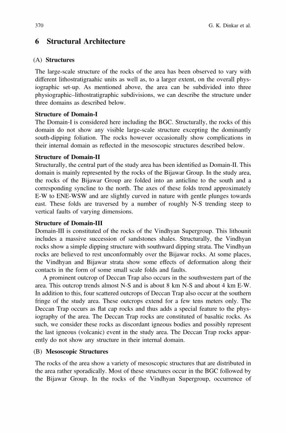
6 Structural Architecture
(A) Structures
The large-scale structure of the rocks of the area has been observed to vary withdifferent lithostratigraahic units as well as, to a larger extent, on the overall phys-iographic set-up. As mentioned above, the area can be subdivided into threephysiographic–lithostratigraphic subdivisions, we can describe the structure underthree domains as described below.
Structure of Domain-IThe Domain-I is considered here including the BGC. Structurally, the rocks of thisdomain do not show any visible large-scale structure excepting the dominantlysouth-dipping foliation. The rocks however occasionally show complications intheir internal domain as reflected in the mesoscopic structures described below.
Structure of Domain-IIStructurally, the central part of the study area has been identified as Domain-II. Thisdomain is mainly represented by the rocks of the Bijawar Group. In the study area,the rocks of the Bijawar Group are folded into an anticline to the south and acorresponding syncline to the north. The axes of these folds trend approximatelyE-W to ENE-WSW and are slightly curved in nature with gentle plunges towardseast. These folds are traversed by a number of roughly N-S trending steep tovertical faults of varying dimensions.
Structure of Domain-IIIDomain-III is constituted of the rocks of the Vindhyan Supergroup. This lithounitincludes a massive succession of sandstones shales. Structurally, the Vindhyanrocks show a simple dipping structure with southward dipping strata. The Vindhyanrocks are believed to rest unconformably over the Bijawar rocks. At some places,the Vindhyan and Bijawar strata show some effects of deformation along theircontacts in the form of some small scale folds and faults.
A prominent outcrop of Deccan Trap also occurs in the southwestern part of thearea. This outcrop trends almost N-S and is about 8 km N-S and about 4 km E-W.In addition to this, four scattered outcrops of Deccan Trap also occur at the southernfringe of the study area. These outcrops extend for a few tens meters only. TheDeccan Trap occurs as flat cap rocks and thus adds a special feature to the phys-iography of the area. The Deccan Trap rocks are constituted of basaltic rocks. Assuch, we consider these rocks as discordant igneous bodies and possibly representthe last igneous (volcanic) event in the study area. The Deccan Trap rocks appar-ently do not show any structure in their internal domain.
(B) Mesoscopic Structures
The rocks of the area show a variety of mesoscopic structures that are distributed inthe area rather sporadically. Most of these structures occur in the BGC followed bythe Bijawar Group. In the rocks of the Vindhyan Supergroup, occurrence of
370 G. K. Dinkar et al.
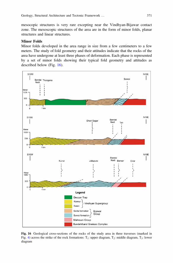
mesocopic structures is very rare excepting near the Vindhyan-Bijawar contactzone. The mesoscopic structures of the area are in the form of minor folds, planarstructures and linear structures.
Minor FoldsMinor folds developed in the area range in size from a few centimeters to a fewmeters. The study of fold geometry and their attitudes indicate that the rocks of thearea have undergone at least three phases of deformation. Each phase is representedby a set of minor folds showing their typical fold geometry and attitudes asdescribed below (Fig. 16).
Fig. 16 Geological cross-sections of the rocks of the study area in three traverses (marked inFig. 4) across the strike of the rock formations: T1: upper diagram, T2: middle diagram, T3: lowerdiagram
Geology, Structural Architecture and Tectonic Framework … 371
(i) F1 Folds
The first phase of deformation structures are represented by the F1 folds (Fig. 17a,b). These folds are well developed in the quartzite (banded hematite quartzite) ofMahrauni Group. In the BGC, these folds are commonly traced by silica bands ofthe gneissic rocks. The F1 folds are generally tight recumbent isoclinal withinterlimb angle of about 20°–30°. They commonly show thickened hinge zones andthin limbs. The F1 folds vary in size from a few centimeters to a few meters and arecharacterized by high amplitude/wavelength ratio which is up to about 4 at someplaces. The axes commonly trend between NW-SE and E-W but occasionally showminor variations due to the effect of later deformations. In general, the higherdegree of flattening at the hinge zone is associated with higher thinning of the limbs.The F1 folds are occasionally associated with an axial plane foliation designated asS1 which is parallel to F1 fold axes. However, S1 transects bedding at the closures ofthe F1 folds.
(ii) F2 Folds
The second generation folds (F2) are commonly developed in the banded hematitequartzite (Fig. 17c) and in the banded hematite jasper of Barwar Formation. The F2folds are generally coaxial to F1. In comparison with the F1 folds, the F2 folds aremore open, asymmetrical, and show low amplitude/wavelength ratio and higherinterlimb angle up to 60°. These folds generally show almost constant orthogonalthickness in the competent folded layers.
Fig. 17 Photograph showing minor folds of the study area. a, b F1 folds in the banded hematitequartzite affected by ductile shearing showing thinning of limb. Loc.1.8 km west of Girar. c F2folds in banded hematite jasper, 1.8 km southwest of Girar. d F3 folds in carbonate rocks togetherwith ferruginous layering. Loc. 0.5 km south of Gorakalan
372 G. K. Dinkar et al.

(iii) F3 Folds
The third generation (F3) folds (Fig. 17d) are relatively much less common in thearea. These are open folds with rounded hinges. Generally these are parallel foldsthus showing class 1B of Ramsay (1967). The amplitude/wavelength ratios are lowas compared with the F1 and F2 folds. In the schistose rocks, these folds commonlyoccur as crenulation folds. The F3 folds commonly show vertical axial planesstriking NNE-SSW to NNW-SSE direction. These folds are noticed in the basicdikes as well as in some rocks of the Bijawar Group. The F3 folds possibly rep-resent signatures of some large scale open folds in the form of warps that developeda curvilinear pattern to the some of the ridges of the area.
7 Tectonic Framework
Our knowledge on the tectonic framework of the rocks of the area is as yet meager.The main reason is that the nature of contact of a few lithostratigraphic units (e.g.Sonrai-Solda, Bijawar-Vindhyan) is either not known properly or is debatable (e.g.Jha et al. 2012; Kumar et al. 1990; Prakash et al. 1972). In the course of our presentwork, we have made efforts to study the nature of contact of important lithos-tratigraphic units and the related structural features, if any.
(i) BGC-Bijawar contact
The contact of crystalline rocks with sedimentary/metasedimentary (cover) rocks inany area is always of fundamental significance. The main reason, amongst others, isthat the study of the contact zone helps us to unravel the geological and palaeo-geograhical conditions of the past. In this context, the presence of the contact of theBGC and the Bijawars is also of great significance not only to the present area butalso to the peninsular shield in general. When we talk of the contact of basementrocks with cover rocks, there appears to be two possibilities: the contact is eitherunconformable or tectonic. In the first case, i.e. unconformable contact, commonlythe occurrence of conglomerates is expected in which the conglomerate horizonshould contain pebbles, cobbles, etc. derived from the basement rocks. In thesecond case, i.e. tectonic contact, development of structural features indicating thepresence of a fault or thrust is expected.
In the study area (Fig. 4), the BGC-Bijawar contact is exposed in the northernparts of the area with almost an E-W trend. It passes from the south of Sonrai in thewest through the south of Pisnari in the central part, and south of Girar in theeastern part of the area. Unfortunately the direct contact of these two rock units isexposed only at a few localities. Also, in most cases the contact zone is rathervaguely exposed. We have carried out detailed study of the contact zone at Sonrai,Pisnari, Tori, Barwar, Girar and their adjoining areas. So far, we have not observedany conglomerate horizon at the contact. We thus rule out any unconformablecontact between the BGC and the Bijawars. We have instead observed the
Geology, Structural Architecture and Tectonic Framework … 373
occurrence of tectonic structures practically in all the localities where theBGC-Bijawar contact is exposed.
Along the BGC-Bijawar contact we have observed structures indicating ductiledeformation of rocks, e.g. thick-hinge folds showing asymmetry of their axialplanes with respect to the surrounding foliation. In the light of these features, wesuggest a thrust contact between the BGC and the Bijawar Group. It may bementioned here that earlier Prakash et al. (1975) had also suggested a thrust contactbetween the BGC and the Bijawars though no distinct structures or structuralfeatures to support this view had been described. Following Prakash et al. (1975)we have retained the name of this contact as Sonrai-Girar thrust. Several mafic andultra-mafic bodies are intruded along the BGC-Bijawar contact.
(ii) Bijawar-Vindhyan Contact
The contact of the Bijawar Group with the overlying Vindhyan Supergroup isbelieved to be unconformable. However in the study area (Fig. 4), this is not so.Our field studies and mapping indicates that there are several evidences that lead tothe otherwise. In the area, the Vindhyan Supergroup is exposed in the southernparts and is represented by the Semri Group and the Kaimur Group. Both thesegroups are exposed as almost E-W trending continuous outcrops. The outcrops ofthe Semri Group however do not maintain uniform width in different parts of thearea and show variations from about 2 km to about 200 m. At the same time, thedip of the strata maintains almost uniform values, i.e. from 15° to 25° roughlytowards S. We assign this variation in width of the outcrops to the existence of afault due to which a part of the Semri Group has been concealed. Occurrence ofbreccia is noticed at a few places. Further, at some places, e.g. about 3 km north ofMadanpur, the Semri Group is missing and, as a result, the Bijawar Group isdirectly juxtaposed against the Kaimur Group. We therefore consider a faultedcontact between the Bijawar Group and the overlying Vindhyan Supergroup at leastin the study area. We name this contact as Patna–Kurrat fault.
(iii) Tectonic status of the Mahrauni Group
The Mahrauni Group is exposed in the northeastern parts of the study area. Thisrock unit thins in the west. In this work, we have mapped the Mahrauni Group as asingle lithostratigraphic unit (Fig. 4) because the Rajaula and the BarwarFormations are not mappable on the scale of our map. Along the BGC-Mahraunicontact we have not observed any evidence of unconformity. Rather, developmentof minor shear zones has been observed at one or two localities. It therefore seemspossible that the BGC-Mahrauni contact is tectonic, possibly thrusted, in the studyarea. As a matter of fact, the entire contact zone is not well exposed. Therefore onthe basis of our interpretation of a thrust contact, we can extend this generalizationfor the entire BGC-Mahraunu contact. Since this contact is in direct continuity ofthe Sonrai-Girar thrust, we therefore extend the Sonrai-Girar thrust for theBGC-Mahrauni contact also.
374 G. K. Dinkar et al.
(iv) The Overall Tectonic Framework
All the major rock units of south Lalitpur district bear tectonic contacts. TheBGC-Bijawar contact is a thrust named as the Sonrai-Girar thrust while theBirawar-Vindhyan contact is a fault named as the Patna-Kurrat fault. If we go backto the existing concepts, the Bijawars are believed to have deposited unconformablyover the crystalline basement (the BGC in this case). Likewise, the Vindhyans arealso believed to have deposited unconformably over the Bijawars. But in the southlalitpur district, the situation differs Here the contacts of practically all the majorlithostratigraphic units are tectonic. This suggests that initially the BGC-Bijawarand Bijawar-Vindhyan contacts may have been unconformable. Later, the contactswere disturbed tectonically. We suggest that the differences in the overall lithologic,and so rheologic, characters of the individual lithostratigraphic units were the majorfactors due to which the individual lithostratigraphic units behaved differently to thedeforming stresses. This possibly explains why is the overall tectonic framework ofthe lithostratigraphic units of the study area not exactly what is elsewhere in thepeninsular shield. Another possibility could be that this part of the shield may haveexperienced tectonic activities in due course of time due to some crustal distur-bances that did not affect other parts of the shield. And, further, even if other partsof the shield were affected by tectonic disturbances, the effects may have beenfeeble so that the degree of tectonization did not leave well developed and rec-ognizable signatures today, as we see them in the present study area.
8 Discussion and Conclusions
• South Lalitpur district exposes some typical rock units of the Indian peninsularshield.The area shows three distinct physiographic features: scattered hillocks tothe northern parts, nearly continuous hills in the central parts and plateau in thesouthern parts. This physiographic set-up is closely related to the geologicalsetup of the area. The northern part exposes crystalline-metamorphic rocks ofthe Bundelkhand Gneissic Complex (BGC), the central part exposes BijawarGroup and the southern part exposes rocks of the Vindhyan Supergroup.
• The BGC consists of a variety of granitoids, gneisses and schists together withmylonitised granite gneisses, migmatites and amphibolite schists. Of the gran-itoids, pink and grey granites are the dominating types. In the study area, wehave identified the following lithologic associations: gneisses designated here asBundelkhand Gneisses, Bundelkhand Granites that include coarse grained pinkporphyritic granite, medium grained pink porphyritic granite, grey granite,leucogranite, aplites and pegmatites. A few NE-SW trending quartz reefs andNW-SE trending mafic dikes are also present.
• South of the BGC, a group of schistose rocks is exposed. This group was earlierreferred to as Mehroni Group, which we rename as Mahrauni Group following
Geology, Structural Architecture and Tectonic Framework … 375

recent toposheets. The Mehroni Group was divided into four Formations.However our work reveals that in the study area only one formation, i.e. BarwarFormation, is exposed. This Formation is constituted of banded hematitequartzite, conglomerate, fuchsite quartzite and grey to green chlorite schists.
• South of the BGC occurs the Bijawar Group that extends almost E-W in thecentral parts of the area. This group includes a sequence of sedimentary rocksthat are affected by very low metamorphism. In the study area, this group isrepresented by two Formations: a Lower Sonrai Formation and an Upper SoldaFormation. The Sonrai Formation includes carbonates, shales and sandstoneswith some basaltic and gabbroic intrusive while the Solda Formation is mainlyconstituted of ferruginous shales with quartz arenite interbands together withtuffaceous material and some sandstone.
• The southern part of the area is mostly occupied by the rocks of the VindhyanSupergroup and is represented by only two formations, viz. Semri and KaimurFormations.
• In addition to the above rock units, a few outcrops of Deccan Trap also occur inthe southern parts of the area. The Trap is constituted of fine to medium grainedbasaltic rocks that are light to dark grey in colour.
• The structure of the area seems to be related to the individual lithostratigraphicunits. Thus we can identify three different structural domains towards south. TheDomain-I is assigned to the BGC, which apparently does not show any visiblelarge-scale structure excepting a dominantly south-dipping foliation. Domain-IIis represented mainly by the Bijawar Group folded into an anticline to the southand a corresponding syncline to the north. The axes of these folds trendapproximately E-W to ENE-WSW. Domain-III mainly includes the VindhyanSupergroup. The rocks of this rock units show a simple dipping structure withsouthward dipping strata.
• The rocks of the area show a variety of mesoscopic structures rather irregularlydistributed in different parts. We have identified a variety of minor folds, planarstructures and linear structures. Study of minor folds indicates that the rocks ofthe area have undergone at least three generations of folds. The first generation(F1) folds are commonly traced by quartz bands of the associated rocks and aregenerally tight recumbent isoclinal with interlimb angle of about 20°–30°. Thesecond generation (F2) folds are generally co-axial to F1 but they differ ingeometry from F1 folds in being more open, asymmetrical and occasionallygreater interlimb angle up to 60°. The third generation (F3) folds are relativelyless common in the area and occur as open folds with highwavelength-amplitude ratios.
• The tectonic framework of the rocks of the area is as yet not clearly knownmainly because the nature of contact of the lithostratigraphic units is either notknown properly or is debatable. One practical problem is that the contact ofmost of the major rock units is not clearly exposed. In the light of our obser-vations, it appears that the BGC and the Bijawars bear a thrust contact while theBijawars and the Vindhyans bear a faulted contact. The Mahrauni Group
376 G. K. Dinkar et al.
appears to bear a thrust contact with the BGC to the north as well as with theBijawars to the south. We thus consider this group to occur as a thrust slice.
• It seems possible that the contacts of the major lithotectonic units were tec-tonized due to tectonic disturbances in different parts of the peninsular shieldpossibly due to the differences in the overall lithologic, and so rheologic,characters of the individual lithostratigraphic units. As a result, the individuallithostratigraphic units behaved differently to the deforming stresses. Possiblybecause of this the overall tectonic framework of the lithostratigraphic units ofthe study area does not fully reflect the general framework elsewhere in thepeninsular shield.
Acknowledgements We express our sincere thanks to the Head, Centre of Advanced Study inGeology, University of Lucknow, for providing working facilities. GKD extends his thanks to theDirector, Directorate of Geology and Mining, U.P., for granting him permission to carry out thiswork as part of his doctorate thesis. We thank Prof. Soumyajit Mukherjee (IIT Bombay) for hiseditorial and reviewing works that significantly improved the quality of the manuscript. Mukherjee(2019) summarizes this work.
References
Banerjee DM (1982) Lithotectonics phosphate mineralization and regional correlation of BijawarGroup of rocks in Central India. In: Valdia KS, Bhatia SB, Gaur VK (eds) Geology ofVindhyanchal. Hindustan Publishing Corporation, pp 49–54
Basu AK (1986) Geology of parts of Bundelkhand Granitic Massif. Records of Geological Surveyof India 117, 61–124
Basu AK (2001) Some characteristics of the Precambrian crust in the northern part of CentralIndia. Geological Survey of India 55, 182–204
Basu AK (2004) Contemplations on the role of the Bundelkhand Massif on structural evolutionand mineralization in the western Indian Cration, Rajasthan, India. Geological Survey of IndiaSpecial Publication 72, 325–344
Basu AK (2007) Role of Bundelkhand Granite Massif and the Son-Narmada megafault inPrecambrian crustal evolution and tectonism in Central and Western India. Journal ofGeological Society of India 70, 745–770
Basu AK (2010) Precambrian geology of the Bundelkhand terrain, Central India and adjacent partof western India. Journal of Economic Geology and Georesource Management 7, 1–53
Bhattacharya AR (1985) Some unusual strain relations in elliptically deformed xenoliths andfeldspar porphyroblasts. Zeitschrift für Geologische Wissenschaften 13, 689–697
Bhattacharya AR (1986) Wavelength-amplitude characteristics of polyphase folds in thePrecambrian Bundelkhand Complex. Tectonophysics 128, 121–125
Bhattacharya AR, Singh SP (2013) Proterozoic crustal scale shearing in the Bundelkhand Massifwith special reference to quartz reefs. Journal of Geological Society of India 82, 474–484
Bose PK, Sarkar S, Chakraborty S, Banerjee S (2001) Overview of the Meso- to Neoproterozoicevolution of the Vindhyan basin, Central India. Sedimentary Geology 141, 395–419
Chakraborty C (2006) Proterozoic intra continental basin: the Vindhyan example. Journal of EarthSystem Science 115, 3–22
Chaudhuri J, Chowdhury D, Maitra U (1999) Distinct functions of eukaryotic translation initiationfactors eIF1A and eIF3 in the formation of the 40 S ribosomal preinitiation complex. Journal ofBiological Chemistry 18, 17975–17980
Geology, Structural Architecture and Tectonic Framework … 377
Dinkar GK (2016) Deformation pattern of the rocks exposed around Sonrai, district Lalitpur, UttarPradesh. Unpublished Ph.D. thesis, University of Lucknow, Lucknow
Hacket CA (1870) Geology of Gwalior and vicinity. Records of Geological Survey of India 3:33–42
Heron AM (1935) Synopsis of the Pre-Vindhyan geology of Rajasthan, Rajputana. Transactions ofthe National Institute of Science 1, 17
Jha SK, Shrivastava JP, Bhairam CL (2012) Clay mineralogical studies on Bijawars of the SonraiBasin: Palaeoenvironmental implecations and influences on the uranium mineralization.Journal of Geological Society of India 79, 117–134
Jhingran AG (1958) The problem of Bundelkhand granites and gneisses. In: Presidential Address,Proceedings of Indian Science Congress 45th session, Madras, pp 48–120
Kumar B, Srivastava RK, Jha DK, Pant NC, Bhandaru BK (1990) A revised stratigraphy of therocks of type area of the Bijawar Group in Central India. Indian Minerals 44, 303–314
Misra RC (1969) The Vindhyan System. Presidential Address (Geology & Geography Section)56th Session, Bombay
Misra RC, Sharma RP (1975) New data on the geology of Bundelkhand complex of Central India.In: Verma VK et al (ed) Recent research in geology. Hindustan PubIishing Co., Delhi, vol 2,pp 311–346
Misra AA, Mukherjee S (2015) Tectonic inheritance in continental Rifts and Passive Margins.Springer-Briefs in Earth Sciences. Springer International Publishing, Berlin. ISBN978-3-319-20576-2
Misra AA, Bhattacharya G, Mukherjee S, Bose N (2014) Near N-S paleo-extension in the westernDeccan region in India: does it link strike-slip tectonics with India-seychelles rifting?International Journal of Earth Science 103, 1645–1680
Misra AA, Sinha N, Mukherjee S (2015) Repeat ridge jumps and microcontinent separation:insights from NE Arabian Sea. Marine and Petroleum Geology 59, 406–428
Medlicott HB (1859) Vindhyan rocks and their associates in Bundelkhand. Memoir of GeologicalSurvey of India II, pp 1–95
Mondal MEA, Goswami JN, Deomurari MP, Sharma KK (2002) Ion microprobe 207Pb/Pb206 agesof Zircons from Bundelkhand massif, northern India, implications for crustal evolution of theBundelkhand-Aravalli Proto Continent. Precambrian Research 117, 85–110
Mondal MEA (2010) Geochemical evolution of the Archaean-paleoproterozoic BundelkhandCraton, Central India shield. Journal of Economic Geology and Georesource Management 7,69–80
Mukherjee S, Misra AA, Calvès G, Nemčok M (2017) Tectonics of the Deccan large igneousprovince: an introduction. In: Mukherjee S, Misra AA, Calvès G, Nemčok M (eds) Tectonicsof the Deccan large igneous province. Geological Society, London, Special Publication 445,pp 1–9
Mukherjee S (2011) Mineral fish: their morphological classification, usefulness as shear senseindicators and genesis. International Journal of Earth sciences 100, 1303–1314
Mukherjee S (2019) Introduction to “Tectonics and Structural Geology: Indian Context”. In:Mukherjee S (ed) Tectonics and structural geology: Indian context. Springer InternationalPublishing AG, Cham, pp 1–5. ISBN: 978-3-319-99340-9
Pascoe EH (1950) A manual of the Geology of India and Burma. Geological Survey of lndia,Calcutta, 1
Pati JK, Patel SC, Pruseth KL, Malviya VP, Arima M, Raju S, Pati P, Prakash K (2007) Geologyand geochemistry of gaint quartz veins from the Bundelkhand Craton, Central India and theirimplications. Journal of Earth System Science 116, 497–510
Prakash R, Srivastava RN, Saharma DP, Bhatt GD (1972) Progress of geological investigation onSonarai copper belt, Mehroni Tehsil, Jhansi, Uttar Pradesh. DGM, U.P.
Prakash R, Swarup P, Srivastava RN (1975) Geology and mineralization in the southern parts ofBundelkhand in Lalitpur district, Uttar Pradesh. Journal of Geological Society of India 16,143–156
378 G. K. Dinkar et al.
Prasad MH, Hakim A, Rao BK (1999) Metavolcanic and Metasedimentary Inclusions in theBundelkhand Granitic Complex in Tikamgarh District, Madhya Pradesh. Journal of GeologicalSociety of India 54, 359–368
Radhakrishna BV (1989) Suspect Tectono-stratigraphic terrain elements in the IndianSubcontinent. Journal of Geological Society of India 34, 1–24
Ramsay JG (1967) Folding and fracturing of rocks. McGraw-Hill, New YorkRoday PP, Diwan P, Singh S (1995) A kinematic model of emplacement of quartz reef and
subsequent deformation pattern in Central Indian Bundelkhand batholiths. Proceedings of theIndian Academy of Science—Earth and Planetary Science 104, 465–488
Sarkar A, BhaIIa JK, Bishui PK, Gupta SN, Srimal N (1989) Geochemistry and geochronology ofthe Early Proterozoic Bundelkhand granitic complex, Central India. In: Symposium onPrecambrian, Granitoids, Helsinki, Finland, Geological Survey of Finland, p 117 (Abstract 8)
Sarkar A, Paul DK, Potts PJ (1995) Geochronology and geochemistry of the Mid-Archean,Torndhjemitic gneisses from the Bundelkhand Craton, Central India. In: Saha AK (ed) Recentresearches in geology, vol 16, pp 76–92
Sarkar A, Ghosh S, Singhsi RK, Gupta SN (1997). Rb-Sr geochronology of the Dargawan sill:constraint on the age of the type Bijawar sequence of Central India. In: International conferenceon isotopes in solar system, pp 100–101 (Abstract pp 11–14)
Saxena MN (1961) Bundelkhand granites and associated rocks from Kabrai and Mauranipur areaof Harnirpur and Jhasi district; U.P., India. Research Bulletin of Panjab University 12, 85–107
Sharma RP (1982) Lithostratigraphy, structure and petrology of Bundelkhand Group. In:Valdia KS, Bhatia SB, Gaur VK (eds) Geology of Vindhyanchal. Hindustan PublishingCorporation, pp 30–46
Singh SP (2012) Geochemical signatures of Archaean felsic volcanism in Central part ofBundelkhand Craton, Central India. International Journal of Advance Earth Sciences 1, 20–32
Singh SP, Bhattacharya AR (2017) N-S crustal shear system in the Bundelkhand massif: a uniquecrustal evolution signature in the northern Indian peninsula. Journal of Earth System Science126, 121
Singh SP, Bhattacharya AR (2010) Signature of Archaean E-W crustal-scale shears in theBundelkhand massif, Central India, an example of vertical ductile shearing. Earth Science India3, 217–225
Singh SP, Singh MM, Srivastava GS, Basu AK (2007) Crustal evolution in Bundelkhand area,Central India. Journal of Himalayan Geology 28, 79–101
Singh SP, Dwivedi SB (2009) Garnet-silliminite-cordierite-quartz bearing assemblages from theearly Archaean supracrustal rocks of Bundelkhand massif, Central India. Current Science 97,103–107
Srivastava JP (1951–1952) Rocks of Probable Bijawar age overlying the Bundelkhand granite inTikamgarh district. Geological Survey of India, Unpublished Progress Report
Swaroop P, Saxena AK (1969) A report on the preliminary investigation of iron-formations nearObra, District Mirzapur, Uttar Pradesh. Report of the Directorate of Geology and Mining, U.P.
Geology, Structural Architecture and Tectonic Framework … 379
Deformation in the Kangra Reentrant,Himachal Pradesh of NW-Sub Himalayaof India: A Paradox
Tejpal Singh and A. K. Awasthi
1 Introduction
The Himalayan orogeny is geologically very complex and heterogeneous along itsentire length even though it consists of longitudinal curvilinear stripes of similarlithologies (Mukherjee 2013a). For the ease of correlation and understanding, broadsub-divisions have been made based on comparable litho-tectonic units (Fig. 1).These sub-divisions have been further verified through detailed lab (geochemical)and field studies (Valdiya 1984). Accordingly, the southern (outer)mostlitho-tectonic sub-division of the Himalaya is called the Sub-Himalayan belt. TheSub-Himalayan belt in the NW Himalaya has been studied in detail and classifiedbased on energy sequences, which are equivalent to various rock types (Raiverman2002). This belt is the youngest and most actively deforming tectonic sub-divisionof the Himalayan orogen that accommodates about 20% (*4–11 mm/yr) of thetotal India-Asia convergence (Larson et al. 1999; Lave and Avouac 2000; Bilhamet al. 2001). Note that the Sub-Himalayan belt is assumed to be tectonically col-located with the external locked zone of the Himalayas (Bilham et al. 2001; Stevensand Avouac 2015). This locked zone has an approximate width of 100 km andtends to accumulate the potential tectonic slip almost entirely as elastic (>90%)rather than inelastic (<10%) strain, which would permanently deform the rock
T. Singh (&)CSIR-Central Scientific Instruments Organisation, Chandigarh 160030, Indiae-mail: [email protected]; [email protected]
A. K. AwasthiGraphic Era (Deemed to be University), Dehradun 248002, India
A. K. AwasthiFormerly at Department of Earth Sciences, Indian Institute of TechnologyRoorkee, Roorkee 247667, India
© Springer Nature Switzerland AG 2019S. Mukherjee (ed.), Tectonics and Structural Geology: Indian Context,Springer Geology, https://doi.org/10.1007/978-3-319-99341-6_13
381

(Bilham et al. 2001). The cover sequences in this locked zone are variably coupledwith the basement and the coupling tends to maximum near the deformation fronti.e. Himalayan Frontal Thrust: HFT (Stevens and Avouac 2015).
The Sub-Himalayan belt is a typical example of a “cover sequence”, which isfaulted and folded over a rigid basement. The structures characterize the thin skindeformation of Fold-Thrust belts (FTBs). There has been a considerable progress inour understanding of thin-skin deformation of FTBs over the last few decades (Ruhet al. 2012) and as more and more data and new tools become available, refinedinterpretations are coming up (e.g., Rajendra Prasad et al. 2011; Carrillo et al.2017). The initial models are commonly based on surface geology and structure.However, the current understanding largely draws from the theoretical and exper-imental models (Suppe 1983; Suppe and Medwedeff 1990; Stokmal et al. 2007).Most of these models are based on (i) different material properties of the detach-ment e.g., frictional vs. viscous detachments (Cotton and Koyi 2000; Bahroudi andKoyi 2003), (ii) inherent properties of the cover sequences such as cohesion andpore pressure, and (iii) interaction between the detachment and cover sequencessuch as their coupling (Withjack and Callaway 2000; Paul and Mitra 2015;Borderie et al. 2018). The results are commonly interpreted in terms of evolution of(i) structural geometries such as imbricate thrusts, back thrusts, open folds etc.,(ii) topographic slope (a), and (iii) detachment dip (b) (Singh et al. 2012). In mostcases, the models are tuned compatible with the available seismic sections, welllogs, structural- and topographic maps.
The width of the Sub-Himalayan belt varies along the length of the orogen. Itreaches to a maximum of over 300 km in the western sections of Pakistan whereas
Fig. 1 Broad litho-tectonic subdivisions of the ‘Himalaya’ (after Valdiya 1984, 1998)
382 T. Singh and A. K. Awasthi
it thins to <10 km in the eastern sections, especially east of Nepal. The variablewidth to a large extent is attributed to the original basin geometry and rheology ofthe basement. The basins of deposition towards the west have been extremely wideand sediments have been deformed over rheologically weak basement in salt (Davisand Lillie 1994). This has not been the case eastwards where, the rheologicallyweak salt is not found in the basement and the belts are narrower. However, there isan interesting paradox in the Kanrga Reentrant of Western India where the width ofthe Sub-Himalayan belt is *80 km: much wider than that at east. The topographicslope (a) of the Kangra Reenetrant is *1° and together with the basement dip (b)of 3°, it forms a wedge taper of around 4°. This wedge taper is comparable to thoseof Salt Range-Potwar Plateau in Pakistan (Davis and Lillie 1994) and Fars andLorestan segments of the Zagros FTB in Iran (McQuarrie 2004). Notably the FTBsin Pakistan and Iran are extremely wide and have also evolved over a weakdetachment in salt which justifies a low wedge taper. However, there have been noreports on the presence of salt at the surface or sub-surface in the Kangra Reentrantwhich could justify a relatively low wedge taper spread over a width of 80 km. Thisarticle focuses on this paradoxical reentrant to elaborate on the geological structureand to understand the reasons for its relatively larger width.
2 Litho-Tectonic Setting
The Sub-Himalayan belt, in general comprises the Tertiary rock units, which areclassified into the Lower and the Upper Tertiaries. In western India, it consists ofparautochthonous and the autochthonous units (Table 1). The former units includethe Subathu and the Dagshai (=Lower Dharamshala) and the Kasauli (=UpperDharamshala) Formation of Lower Tertiary age. The autochthonous unit includesthe Siwalik Supergroup of Upper Tertiary to Quaternary age (Raiverman 2002).The Siwalik Supergroup is conventionally sub-divided into the Lower, Middle andUpper Siwalik Groups (Table 1). Both parautochthonous and autochthonous unitsare unconformably overlain by Quaternary terraces along the stream network(Singh et al. 2011). The Sub-Himalayan rock units thrust over the sediments of theIndo-Gangetic plains along the Himalayan Frontal Thrust (HFT). The HFT definesthe present-day tectonic boundary of active tectonic convergence (Yeats et al. 1992;Powers et al. 1998; Delcaillau et al. 2006; Kumar et al. 2006; Singh and Jain 2009).
3 Surface Topography and Taper of the Wedge
Deformation style and kinematics vary considerably across the fold-thrust belts inorogenic systems (e.g., Mukherjee 2013b). These differences may be present atmuch finer scales but their first order manifestation is readily visible in the surfacetopography as seen in various modeling approaches (Koyi 1988; Cotton and
Deformation in the Kangra Reentrant, Himachal Pradesh … 383

Tab
le1
Generalized
stratig
raph
yof
theKangraReentrant
Form
ation/grou
pDescriptio
nThickness
(m)
Age
Post-Siwalik
depo
sits
Allu
vium
/piedm
ont
Sand
andsilt
Recent
Siwalik
Supergroup
Upp
erSiwalik
Predom
inantly
cong
lomeratewith
sand
andclay
matrix
600–
1500
MiddleMiocene
toPleistocene
MiddleSiwalik
Predom
inantly
sand
ston
eand
interbeddedclays
1400
–20
00
Low
erSiwalik
Alteratio
nsof
sand
ston
e,clayston
eand
minor
siltstone
1200
–16
00
Dharamshala
Upp
erDharamshala
Sand
ston
ewith
subo
rdinateclayston
e11
00–16
00Low
er–Upp
erEoceneto
MiddleMiocene
Low
erDharamshala
Predom
inantly
clayston
ewith
minor
sand
ston
e19
00–23
00
Subathu
Shales,lim
estone
andorthoq
uatzite
400–
800
Latepaleocene-middleEocene
Haitus
Bilaspur/Bandlalim
estone
Lim
estone
450+
Baseno
texpo
sed
Neo-M
esoProterozoic
Metam
orph
ic/granitic
basement
Granitic
–Archean
Mod
ified
afterRaiverm
an(200
2)andRajendraPrasad
etal.(201
1)
384 T. Singh and A. K. Awasthi
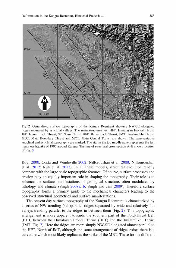
Koyi 2000; Costa and Vendeville 2002; Nilforoushan et al. 2008; Nilfouroushanet al. 2012; Ruh et al. 2012). In all these models, structural evolution readilycompare with the large scale topographic features. Of course, surface processes anderosion play an equally important role in shaping the topography. Their role is toenhance the surface manifestations of geological structure, often modulated bylithology and climate (Singh 2008a, b; Singh and Jain 2009). Therefore surfacetopography forms a primary guide to the mechanical characters leading to theobserved structural geometries and surface manifestations.
The present day surface topography of the Kangra Reentrant is characterized bya series of NW trending (sub)parallel ridges separated by wide and relatively flatvalleys trending parallel to the ridges in between them (Fig. 2). This topographicarrangement is more apparent towards the southern part of the Fold-Thrust Belt(FTB) between the Himalayan Frontal Thrust (HFT) and the Jwalamukhi Thrust(JMT; Fig. 2). Here the ridges are more simply NW-SE elongated almost parallel tothe HFT. North of JMT, although the same arrangement of ridges exists there is acurvature which most likely replicates the strike of the MBT. These form a different
Fig. 2 Generalized surface topography of the Kangra Reentrant showing NW-SE elongatedridges separated by synclinal valleys. The main structures viz. HFT: Himalayan Frontal Thrust,JbT: Januari back Thrust, ST: Soan Thrust, BbT: Barsar back Thrust, JMT: Jwalamukhi Thrust,MBT: Main Boundary Thrust and MCT: Main Central Thrust are shown. The representativeanticlinal and synclinal topography are marked. The star in the top middle panel represents the lastmajor earthquake of 1905 around Kangra. The line of structural cross-section A–B shows locationof Fig. 3
Deformation in the Kangra Reentrant, Himachal Pradesh … 385

surface expression between the JMT and MBT that is more subdued by the cover ofQuaternary alluvial fills and fans descending from the adjoining mountain ranges.Also, the surface expression in this part is complicated by the interaction of tectonicand surface processes strongly modulated by the climatic signal (Dey et al. 2016).The JMT forms an important tectonic boundary which internally constrains theSub-Himalayan wedge, although its activity has been identified only throughneotectonic studies and terrace dating (Singh et al. 2012; Mukherjee 2015; Deyet al. 2016).
The most important surface topographic parameter that contributes to the taperof the Sub-Himalayan wedge is the forelandward slope of the modern day topo-graphic envelope (a). For the Kangra reentrant, the present day topographic slope ahas been estimated to be 0.9° ± 0.2° based on analysis of topographic maps andDigital Elevation Models (Singh et al. 2012). This too small alpha is comparable tomany other wedges developed in the paleo-forelands of collisional settings overweak detachments in the Salt Range of Pakistan (Davis and Lillie 1994) and theZagros FTB of Iran (McQuarrie 2004).
4 Detachment Geometry
Although uncertainties exist about the geometry and rheology of the detachment(Main Himalaya Thrust: MHT) in the NW Himalaya, it is generally considered tobe a gently dipping single continuous sliding plane over which the cover sequencesdeform (Fig. 3). The dip of the detachment has been estimated *3°in the externalsector using well logs and seismic profiling carried out by the ONGC (Powerset al. 1998). The dip is more or less uniform under the entire Sub-Himalayan beltof Kangra reentrant. This is particularly true because any undulations in thegeometry of the detachment would locally induce stress concentrations causingclustering of seismicity, which contradicts the seismic findings (Arora et al. 2009).However, in the down dip direction further north of the MBT, the dip of thedetachment increases to about 10°–15°. This corresponds with the zone of intensemicroseismicity that defines the Himalayan mid-crustal ramp just north of the MainCentral Thrust (MCT) (Figs. 1 and 2). Mechanically the basement is a rigid massmade-up of the Vindhayan rocks equivalent and followed by the metamorphic/granitic basement at deeper levels (Powers et al. 1998; Rajendra Prasad et al.2011). The internal thrusts formed within the Sub-Himalayan belt are the result ofcontinued contraction tectonics of the Himalaya (Singh et al. 2014). They emergefrom the basement and deform the cover sequences into broad open folds (Powerset al. 1998). The anticlinal folds manifest in the surface topography as ridgesfollowed by trailing synclines manifested as wide flat intermontane depressions(Fig. 2).
386 T. Singh and A. K. Awasthi

5 Cover Sequences
The overall cross-sectional taper of the wedge is intricately related to the compe-tency contrast of the rocks in the wedge and its basal detachment (Davis et al.1983). In the Kangra reentrant the basal detachment is resolved to be a rigid surfacemade of competent rocks. However, there are outstanding issues regarding theextent of the resolution and role of the cover rocks involved in deformation. Thefrictional strengths of a wide variety of rocks in the upper crust are similar (Davisand Engelder 1985). However, there are special considerations for clay and shales,which are relatively weak and their presence can significantly modify the defor-mation style if they are predominant in the cover sequence (Davis and Lillie 1994).They tend to behave similar to weak horizons as in the case of eastern Potwarplateau (Pakistan), which exhibits increased sedimentation rates of 0.46–0.53 m/kyrduring the Middle Siwalik sedimentation towards the top of the sequence. Thesequence is predominantly sandy with interbedded clays of the Middle Siwaliks(Pennock et al. 1989).
The cover sequences of the Sub-Himalayan FTB deform over a rigid basementforming foreland verging thrusts, fault-related folds and back-thrusts. The structuralgeometries are constrained through data from surface geology, 2D-seismic profiles,well logs and other ancillary data from geophysical techniques (Figs. 2 and 3;Powers et al. 1998; Mukhopadhyay and Mishra 1999; Jayangondaperumal et al.2017). It is important to note the major thrusts towards from S to N are Himalayan
Fig. 3 Top panel shows a generalized structural section across the Sub-Himalaya of KangraReentrant (modified from Powers et al. 1998). For section line, refer to Fig. 2. Vertical andhorizontal scales are the same. The bold line forming the base of the section represents thebasement. The internal thrusts shown in the section emerge from the basement and deform thecover sequences into broad open folds (bottom panel). The bottom panel details the triangle zonestructure formed between the Soan Thrust (ST) and the Barsar back Thrust (BbT). Regional dragfolds (Mukherjee 2014) are also exemplified in this cross-section
Deformation in the Kangra Reentrant, Himachal Pradesh … 387
Frontal Thrust (HFT), Soan Thrust (ST), Jwalamukhi Thrust (JWT), PalampurThrust (PT) and the Main Boundary Thrust (MBT). The geometry of the folds i.e.Janauri Anticline (JA), Dera-Gopipur Anticline (DGA), Bahl Anticline (BA) andParor Anticline (PA), is clearly attributed to the movement on associated thrustfaults (Fig. 3). The spacing between the thrusts has controlled the development andpreservation of fault-related folds in their hanging walls. The main back thrusts areJanauri back Thrust (JbT) and Barsar back Thrust (BbT).
In the tectonic wedge of the Kangra reentrant, the sedimentary cover rocks havebeen thrust southward over a series of thrust faults (Powers et al. 1998;Mukhopadhayay and Mishra 1999; Singh et al. 2012). There is almost no evidenceof basement rocks involved in thrusting (Dubey 2004). The vergence of mainstructural elements i.e. HFT, ST, JT, PT and MBT is southward, towards theforeland. However, structures with opposite vergence are also common towards thefrontal region e.g. JbT, BbT. The thrusts and back thrusts show active deformationconsistent with the model of distributed deformation (Singh et al. 2012; Thakuret al. 2014; Dey et al. 2016; Jayangondaperumal et al. 2017; also Bose andMukherjee, submitted-1, 2). The Tertiary formations thicken towards the northeastand the structural style becomes increasingly more complex towards the hinterland,as compared over the *80 km length of the Sub-Himalayan wedge from SWtowards NE (Powers et al. 1998; Mukhopadhyay and Mishra 1999).
6 Coupling Between the Cover Sequencesand the Basement
There are a series of research contributions on the active tectonic deformation alongthrust faults in the Kangra reentrant (Malik and Mohanty 2007; Singh et al. 2012;Thakur et al. 2014; Dey et al. 2016). The last major earthquake in this area occurredin 1905 (M = 7.8) near Kangra (Fig. 2). As this happened before the beginning ofinstrumental monitoring, there are no good records on the precise location, natureand extent of the rupture zone. However, there have been outstanding debates withfew equivocal surface manifestations found (Szeliga and Bilham 2017). The 1905Kangra earthquake is generally attributed to the recent slip along the MainBoundary Thrust (MBT). In the instrumental era since late 1950s when seismicmonitoring through instruments began, there have been no major earthquakes inthis area and most of the recorded smaller events are shallow (<10 km) with 3–5magnitudes. Such seismic behaviour would also not suggest any involvement of thebasement (Mukhopadhyay and Dasgupta 2015). Geologically this would mean thatthe cover rocks are poorly coupled with the basement which has a low estimatedrange of basal friction (µb) i.e. 0.26–0.36 in the Kangra Reentrant (Singh et al.2012). Also range-normal convergence velocities across the Sub-Himalayan beltdemonstrate reduced intensities connoting poor tectonic coupling between the coverand the basement (Schiffman et al. 2013). However, in the Kangra Reentrant it can
388 T. Singh and A. K. Awasthi
be noted that the smoothed contours of range-normal convergence velocities followthe surface topography (Fig. 2). The spatial distribution of these topographiccontours in the Kangra Reentrant suggests that complete coupling is only observedin the areas beyond the active deformation front (HFT).
7 Discussions
The Kangra Reenetrant exhibits a topographic slope (a) of *1° towards SW and arelatively high basement dip (b) of 3° towards NE (Fig. 4; in comparison to FTBsin Pakistan and Iran). The two parameters (a and b) contribute to the taper of thewedge, which is *4°. This wedge taper is slightly higher than the SaltRange-Potwar Plateau (Pakistan) where it ranges 1°–3° (Davis and Lillie 1994) andFars and Lorestan segments of the Zagros FTB (Iran) where it is 1.5° (McQuarrie2004). The FTB’s in Pakistan and Iran are comparable in age to the Sub-Himalayanbelt but it is notable that both the FTBs in Pakistan and Iran have evolved over aweak detachment in salt. In fact, the wedge taper in the Kangra Reentrant iscomparable to the Dezful embayment of the Zagros FTB of Iran which is around 4°(McQuarrie 2004). The most likely reason for the increased wedge taper of theDezful embayment is its limited width of the FTB, which is controlled by the spatialdistribution of the Hormuz salt (Mukherjee et al. 2010). Overall, for the KangraReentrant the high basement dip b is supporting a gentler topographic slope a(Davis et al. 1983; Dahlen 1990; Fig. 4). What is intriguing is that the topographicslope is similar to that observed over the weak basement in Pakistan and elsewhere(Fig. 4), whereas there is no report of such a basement rheology in the KangraReentrant. The topographic slope is extremely low (*1°, almost similar to theFTBs in Pakistan and Iran) and forms a relatively narrow wedge taper over a widthof about 80 km (largest in the Indian part). Such characters of a wedge which slidesover a rigid basement give rise to a paradoxical situation that has been dealt in detailbased on a synthesis of data presented in the earlier Sects. 3, 4, 5 and 6.
In general, assuming a particular rheology of the basement, the other importantfactors controlling the growth of the FTB and surface topographic slope (a) couldbe the mechanical stratigraphy, pore-fluid pressure of the cover rocks and climaticeffects. Also in a particular area, under similar climatic conditions competent rockswould be able to retain a higher surface topography whereas incompetent rockswould not. Therefore in the Kangra Reentrant the basement is assumed to be a rigidcompetent mass over which the total thickness of incompetent clay-rich Paleogene–Neogene section is 4–8 km. This thickness is higher than similar sediments in thePotwar plateau (Davis and Lillie 1994). So, if a similar but thinner sediment layercould contribute to the weak coupling between the basement and cover sequence(Davis and Lillie 1994), it would be reasonable to believe that these horizons woulddefinitely provide a reduced resistance to slippage along faults. Also these sedi-ments would effectively couple weakly between the basement and cover rocks inthe Kangra reentrant as well (Davis and Engelder 1985). In principle, this situation
Deformation in the Kangra Reentrant, Himachal Pradesh … 389
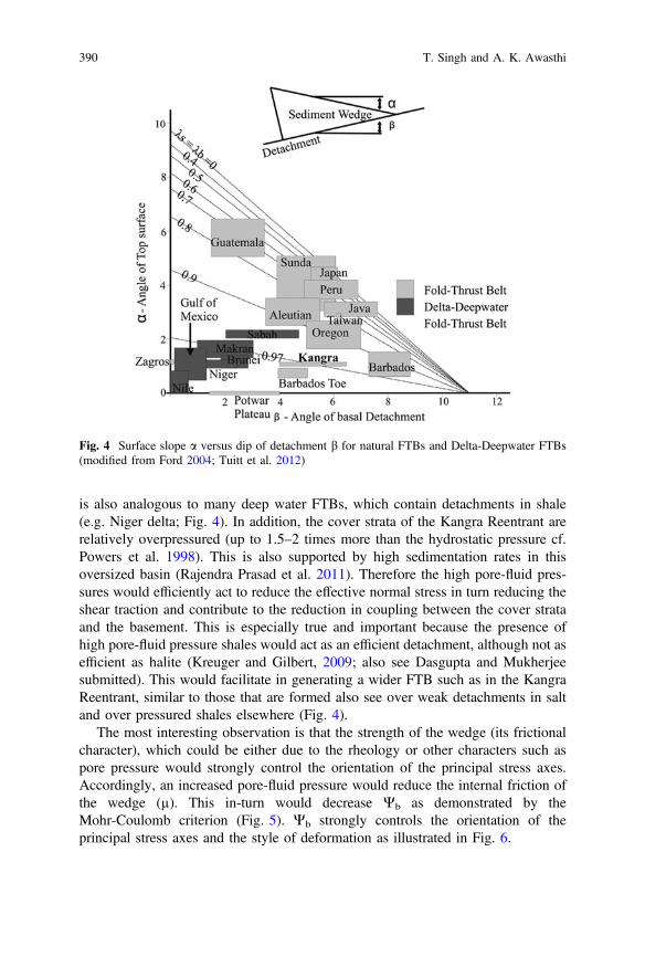
is also analogous to many deep water FTBs, which contain detachments in shale(e.g. Niger delta; Fig. 4). In addition, the cover strata of the Kangra Reentrant arerelatively overpressured (up to 1.5–2 times more than the hydrostatic pressure cf.Powers et al. 1998). This is also supported by high sedimentation rates in thisoversized basin (Rajendra Prasad et al. 2011). Therefore the high pore-fluid pres-sures would efficiently act to reduce the effective normal stress in turn reducing theshear traction and contribute to the reduction in coupling between the cover strataand the basement. This is especially true and important because the presence ofhigh pore-fluid pressure shales would act as an efficient detachment, although not asefficient as halite (Kreuger and Gilbert, 2009; also see Dasgupta and Mukherjeesubmitted). This would facilitate in generating a wider FTB such as in the KangraReentrant, similar to those that are formed also see over weak detachments in saltand over pressured shales elsewhere (Fig. 4).
The most interesting observation is that the strength of the wedge (its frictionalcharacter), which could be either due to the rheology or other characters such aspore pressure would strongly control the orientation of the principal stress axes.Accordingly, an increased pore-fluid pressure would reduce the internal friction ofthe wedge (µ). This in-turn would decrease Wb as demonstrated by theMohr-Coulomb criterion (Fig. 5). Wb strongly controls the orientation of theprincipal stress axes and the style of deformation as illustrated in Fig. 6.
Fig. 4 Surface slope a versus dip of detachment b for natural FTBs and Delta-Deepwater FTBs(modified from Ford 2004; Tuitt et al. 2012)
390 T. Singh and A. K. Awasthi

The normal (r) and shear stresses (s) acting on a plane are evaluated using theMohr-Coulomb failure criterion (Fig. 5). The normal to the plane is oriented at anangle Ɵ with the maximum principal stress, r1 direction. Accordingly, there are twoplanes oriented at an angle inclined on either side of ther1 axis. For frictional wedges
Fig. 5 Mohr-Coulombfailure criterion showing howdifferent values of Wb arerelated to the internal friction(µ) of the wedge. With thereduction of internal friction,the Wb angle also reduces. Inparticular for wedges withbasement in salt Wb would beapproximately 1° (modifiedafter Davis and Engelder,1985). The s and r representshear and normal stressrespectively
Fig. 6 The illustration showsthe relationship between theangle Wb (from Fig. 5) andthe orientation of r1. a In astronger wedge where theforethrust with a gentler dip isa preferred slip plane incomparison to the steeplydipping back thrust. b In aweaker wedge where theforethrust and back thrust areboth preferred slip planes.The section is oriented NE–SW in accordance with theKangra section of Fig. 3
Deformation in the Kangra Reentrant, Himachal Pradesh … 391

the angle Wb offsets the orientation of r1 in such a way that the r1 axis is highlyinclined with respect to the detachment (Fig. 6a). In this case, the two slip planesformed have different orientations (vergence) with reference to the slope of thetopographic wedge. The foreland verging plane, the fore-thrust, usually dips gentlytowards the hinterland whereas the hinterland verging plane, the back-thrust, dipssteeply towards the foreland (Fig. 6a). Geometrically, the fore-thrust would be thepreferred slip plane. Thus, these FTBs should have a preferred structural vergence.
On the contrary, for weaker wedges,Wb tends to be quite small (Fig. 5) leading to anear horizontalr1. In such a situation there could be two slip planes on either side of ther1, similar to the frictionalwedges. But these planes orient in such away that theymakealmost equal angle with the surface topography. The two planes in this case also areforeland-verging fore-thrust and hinterland verging back-thrust but unlike the fric-tional wedges they have comparable dips. Therefore, both these planes i.e. thefore-thrust and the back-thrust would be equally preferred slip planes butwith oppositevergence (Fig. 6b). The FTBs on suchwedges have no preferred structural vergence asis the case with theKangra Reentrant (Figs. 2 and 3). This is verywell illustrated alongthe Una–Talmehra section exhibiting a triangle zone between the ST (fore-thrust) andthe BbT (back-thrust) where the ST and BbT are separated by*10 km on the surface(Fig. 3). Therefore, wedges with incompetent rocks in the cover strata and poor cou-pling between the basement and cover strata would allow the wedge to translate over awide belt usually project outward (Figs. 2 and 3). Similar inferences have been drawnfrom the comparisons between the detachment strength to wedge strength (Stockmal1983; Davis and Engelder 1985). As the wedge in the Kangra Reentrant would rapidlypropagate forward it would incorporate the undeformed foreland into the wedge,towards the frontal part and spatially widen the wedge over the basement. This shouldsignificantly lead to the decrease in topographic slope (a) over time and reduce the taperof the wedge (Singh et al. 2012), as seen in the case of Kangra Reentrant.
In summary, the surface morphology of the Kangra Reentrant resemblesdeformation that is distributed in nature and exhibits poor coupling between thebasement and cover units. Other attributes include: (i) presence of wide-spacedfolds, (ii) abrupt changes in deformation style across the basin that usually corre-spond spatially to the weak layer distribution, (iii) narrow cross-sectional taper, and(iv) bimodal vergence of structures within the FTB. The structural evolution of theKangra Reentrant is mainly by development of fault-related folds in the cover strataover a rigid basement. It is well understood that the basement structure and asso-ciated variations in stratigraphic thickness of cover rocks are potential controls forthe localization and growth of frontal anticlines (McQuarrie 2004).
8 Conclusions
The structure of the Kangra reentrant is controlled by the geometry of the sedi-mentary basin (depocentre) that was present in front of the MBT, which largelyfollows the distribution of the thin Vindhyan basement as limited by the recognition
392 T. Singh and A. K. Awasthi
of an older fabric beneath by Rajendra Prasad et al. (2011). This provides a largeraccommodation space occupied by thick (4–8 km) incompetent clay richPaleogene-Neogene section. Therefore the distribution of the excess pore fluidpressures at the depth appears to be stratigraphy-controlled.
The poor coupling between the cover strata together with high pore pressure andpresence of thick incompetent rocks will not allow potential accumulation of shearstresses within the rocks of the Kangra area, which is characterized by the shallowand low seismicity (3–5 M) in the region since the last major event of 1905. In mostcases there in no involvement of the basement in the India-Eurasia collision induceddeformation process of the Sub-Himalayas in the Kangra Reentrant. This indicatesthat most of these earthquakes would occur by a dynamic weakening mechanismdue to overpressured shales. However, further north of the JMT there are potentialseismogenic zones, which are actively accumulating shear stresses over narrowlocalized zones. This may lead to a high magnitude seismicity, similar to the 1905event. However, the chances of the rupture propagating towards the HFT seem tobe limited.
Acknowledgements TPS thanks the Director CSIR-Central Scientific Instruments OrganisationChandigarh for providing infrastructural facilities. Mr. Sarabjeet Singh helped in meticulouslydrafting Figs. 2 and 4. Soumyajit Mukherjee reviewed this article. The work is summarized inMukherjee (2019).
References
Arora BR, Gahalaut VK, Kumar N (2009) Structural control on along-strike variation in theseismicity of the northwest Himalaya. Journal of Asian Earth Sciences 57, 15–24
Bahroudi A, Koyi HA (2003) Effect of spatial distribution of Hormuz salt on deformation style inthe Zagros fold and thrust belt: an analogue modelling approach. Journal of the GeologicalSociety 160, 719–733
Bilham R, Gaur V, Molnar P (2001) Himalayan seismic hazard. Science 293, 1442–1444Borderie S, Graveleau F, Witt C, Vendeville BC (2018) Impact of an interbedded viscous
décollement on the structural and kinematic coupling in fold-and-thrust belts: insights fromanalogue modeling. Tectonophysics 722, 118–137
Bose N, Mukherjee S (Submitted-1) Field documentation and genesis of the back-structures from apart of the Garhwal Lesser Himalaya. Uttarakhand, India. Tectonic implications. In: Sharma,Villa IM, Kumar S (eds) Crustal architecture and evolution of the Himalaya-Karakoram-TibetOrogen. Geological Society of London Special Publications
Bose N, Mukherjee S (Submitted-2) Field documentation and genesis of back-structures from theforeland part of a collisional orogen: Examples from the Darjeeling-Sikkim Lesser Himalaya,Sikkim, India. Gondwana Research
Carrillo E, Koyi HA, Nilfouroushan H (2017) Structural significance of an evaporite formationwith lateral stratigraphic heterogeneities (Southeastern Pyrenean Basin, NE Spain). Marine andPetroleum Geology 86, 1310–1326
Costa E, Vendeville BC (2002) Experimental insights on the geometry and kinematics offold-and-thrust belts above weak, viscous evaporitic decollement. Journal of StructuralGeology 24, 1729–1739
Deformation in the Kangra Reentrant, Himachal Pradesh … 393
Cotton JT, Koyi HA (2000) Modeling of thrust fronts above ductile and frictional detachments:application to structures in the Salt Range and Potwar Plateau, Pakistan. Geological Society ofAmerica Bulletin 112, 351–363
Dahlen FA (1990) Critical taper model of fold-and-thrust belts and accretionary wedges. AnnualReviews of Earth and Planetary Sciences 18, 55–99
Dasgupta T, Mukherjee S (submitted) Sediment compaction and applications in petroleumgeoscience. In: Swenner R (ed) Springer series: advances in oil and gas exploration &production. ISSN: 2509-372X
Davis D, Engelder T (1985) The role of salt in fold-and-thrust belts. Tectonophysics 119, 67–88Davis D, Lillie RJ (1994) Changing mechanical response during continental collision: active
examples from the foreland thrust belts of Pakistan. Journal of Structural Geology 16, 21–34Davis D, Suppe J, Dahlen FA (1983) Mechanics of fold-and-thrust belts and accretionary wedges.
Journal Geophysical Research 88, 1153–1172Delcaillau B, Carozza J-M, Laville E (2006) Recent fold growth and drainage development: the
Janauri and Chandigarh anticlines in the Siwalik foothills, northwest India. Geomorphology76, 241–256
Dey et al (2016) Climate-driven sediment aggradation and incision since the late Pleistocene in theNW Himalaya, India. Earth and Planetary Science Letters 449, 321–331
Dubey AK (2004) Formation of decollement upwarps during thrusting. Terra Nova 16, 91–94Ford M (2004) Depositional wedge tops: interaction between low basal friction external orogenic
wedges and flexural foreland basins. Basin Research 16, 361–375Jayangondaperumal R, Kumahara Y, Thakur VC, Kumar A, Srivastava P, Dubey S, Joevivek V,
Dubey AK (2017) Great earthquake surface ruptures along backthrust of the Janauri anticline,NW Himalaya. Journal of Asian Earth Sciences 133, 89–101
Koyi H (1988) Experimental modeling of role of gravity and lateral shortening in Zagros mountainbelt. AAPG Bulletin 72, 1381–1394
Krueger A, Gilbert E (2009) Deepwater fold-thrust belts: not all the beasts are equal. In: Americanassociation of petroleum geologists international conference and exhibition. Cape Town, SouthAfrica. AAPG Search and Discovery. Article 30085: http://www.searchanddiscovery.com/documents/2009/30085krueger
Kumar S, Wesnousky SG, Rockwell TK, Briggs RW, Thakur VC, Jayangondaperumal R (2006)Paleoseismic evidence of great surface rupture earthquakes along the Indian Himalaya. JournalGeophysical Research 111, B03304
Larson K, Burgmann R, Bilham R, Freymueller JT (1999) Kinematics of the India-Eurasiacollision zone from GPS measurements. Journal Geophysical Research 104, 1077–1093
Lavé J, Avouac JP (2000) Active folding of fluvial terraces across the Siwalik Hills, Himalayas ofcentral Nepal. Journal Geophysical Research 105, 5735–5770
Malik J, Mohanty C (2007) Active tectonic influence on the evolution of drainage and landscape:geomorphic signatures from frontal and hinterland areas along the Northwestern Himalaya,India. Journal of Asian Earth Sciences 29, 604–618
McQuarrie N (2004) Crustal scale geometry of the Zagros fold–thrust belt, Iran. Journal ofStructural Geology 26, 519–535
Mukherjee S (2013a) Channel flow extrusion model to constrain dynamic viscosity and Prandtlnumber of the Higher Himalayan Shear Zone. International Journal of Earth Sciences 102,1811–1835
Mukherjee S (2013b) Higher Himalaya in the Bhagirathi section (NW Himalaya, India): itsstructures, backthrusts and extrusion mechanism by both channel flow and critical tapermechanisms. International Journal of Earth Sciences 102, 1851–1870
Mukherjee S (2014) Review of flanking structures in meso- and micro-scales. GeologicalMagazine 151, 957–974
Mukherjee S (2015) A review on out-of-sequence deformation in the Himalaya. In: Mukherjee S,Carosi R, van der Beek P, Mukherjee BK, Robinson D (eds) Tectonics of the Himalaya,vol 412. Geological Society, London, Special Publications, pp 67–109
394 T. Singh and A. K. Awasthi
Mukherjee S (2019) Introduction to “Tectonics and Structural Geology: Indian Context”. In:Mukherjee S (ed) Tectonics and structural geology: Indian context. Springer InternationalPublishing AG, Cham, pp 1–5. ISBN: 978-3-319-99340-9
Mukherjee S, Talbot CJ, Koyi HA (2010) Viscosity estimates of salt in the Hormuz and Namakdansalt diapirs, Persian Gulf. Geological Magazine 147, 497–507
Mukhopadhayay DK, Mishra P (1999) A balanced cross section across the Himalayan forelandbelt, the Punjab and Himachal foothills: a reinterpretation of structural styles and evolution.Proceedings of Indian Academy of Science 108, 189–205
Mukhopadhyay B, Dasgupta S (2015) Seismic hazard assessment of Kashmir and Kangra valleyregion, Western Himalaya, India. Geomatics, Natural Hazards and Risk 6, 149–183
Nilforoushan F, Koyi H, Swantesson J, Talbot CJ (2008) Effect of basal friction on surface andvolumetric strain in models of convergent settings measured by laser scanner. Journal ofStructural Geology 30, 366–379
Nilfouroushan F, Pysklywec R, Cruden A (2012) Sensitivity analysis of numerical scaled modelsof fold-and-thrust belts to granular material cohesion variation and comparison with analogexperiments. Tectonophysics 526–529, 196–206
Paul D, Mitra S (2015) Role of salt in decoupling deformation and fault evolution in the Smørbukkarea, Halten Terrace, offshore Mid-Norway. In: Annual convention and exhibition. Denver,Colorado, 31 May–3 June 2015
Pennock ES, Lillie RJ, Hamid Zaman AS, Yousaf M (1989) Structural interpretation of seismicreflection data from eastern salt range and Potwar Plateau, Pakistan. AAPG Bulletin 73, 841–857
Powers PM, Lillie RJ, Yeats RS (1998) Structure and shortening of the Kangra and Dehra DunReentrants, sub-Himalaya, India. Geological Society of America Bulletin 110, 1010–1027
Raiverman V (2002) Foreland sedimentation in Himalayan TectonicRegime. A relook at theorogenic process, Bishen Singh Mahendra Pal Singh Publisher, Dehra Dun, India, p 371
Rajendra Prasad B, Klemperer SL, VijayaRao V, Tewari HC, Khare P (2011) Crustal structurebeneath the sub-Himalayan fold-thrustbelt, Kangra recess, north west India, from seismicreflection profiling: implications for Late Paleoproterozoicorogenesis and modern Earth hazard.Earth and Planetary Science Letters 308, 218–228
Ruh JB, Kaus BJP, Burg J-P (2012) Numerical investigation of deformation mechanics infold-and-thrust belts: influence of rheology of single and multiple décollements. Tectonics 31,TC3005
Schiffman C, Bali BS, Szeliga W, Bilham R (2013) Seismic slip deficit in the Kashmir Himalayafrom GPS observations. Geophysical Research Letters 40, 5642–5645
Singh T (2008a) Hypsometric analysis of watersheds developed on actively deforming MohandAnticlinal ridge, NW Himalaya. Geocarto International 23, 417–427
Singh T (2008b) Tectonic implications of geomorphometric characterization of watersheds usingspatial correlation: Mohand Ridge, NW Himalaya, India. Zeitschrift fur Geomorphologie 52,489–501
Singh T, Jain V (2009) Tectonic constraints on watershed development on frontal ridges: MohandRidge, NW Himalaya, India. Geomorphology 106, 231–241
Singh T, Sharma U, Awasthi AK, Virdi NS, Kumar R (2011) Geomorphic and structural evidencesof neotectonic activity in the Sub-Himalayan belt of Nahan Salient, India. Journal ofGeological Society of India 77, 175–182
Singh T, Awasthi AK, Caputo R (2012) The Sub-Himalayan fold-thrust belt in the 1905-Kangraearthquake zone: a critical taper model perspective for Seismic Hazard Assessment. Tectonics31, TC6002
Singh T, Awasthi AK, Paul D, Caputo R (2014) Role of internal thrusts in NW Sub-Himalaya,India, for SHA. Journal of Himalayan Earth Sciences 153
Stevens VL, Avouac J-P (2015) Interseismic coupling on the main Himalayan thrust. GeophysicalReseach Letters 42, 5828–5837
Stockmal GS (1983) Modeling of large-scale accretionary wedge deformation. Journal ofGeophysical Research, 88, 8271–8287
Deformation in the Kangra Reentrant, Himachal Pradesh … 395

Stokmal J, Beaumont C, Nguyen M, Lee B (2007) Mechanics of thin-skinned fold-and-thrustbelts: insights from numerical models. In: Sears JW, Harms TA, Evenchick CA (eds) Whencethe mountains? Inquiries into the evolution of orogenic systems: a volume in honor ofRaymond. The Geological Society of America Special Paers, pp 63–98
Suppe J (1983) Geometry and kinematics of fault-bend folding. American Journal of Science 283,684–721
Suppe J, Medwedeff DA (1990) Geometry and kinematics of fault-propagation folding. EclogaeGeologicae Helvetiae 83, 409–454
Szeliga W, Bilham R (2017) New Constraints on the mechanism and rupture area for the 1905 Mw7.8 Kangra earthquake, Northwest Himalaya. Bulletin of the Seismological Society of America107, 2467–2479
Thakur VC, Joshi M, Sahoo D, Suresh N, Jayangondaperumal R, Singh A (2014) Partitioning ofconvergence in Northwest Sub-Himalaya: estimation of late Quaternary uplift and convergencerates across the Kangra reentrant, North India. International Journal of Earth Sciences 103,1037–1056
Tuitt A, King R, Hergert T, Tingay M, Hillis R (2012) Modelling of sediment wedge movementalong low-angle detachments using ABAQUS. Geological Society of London SpecialPublication 367, 171–183
Valdiya KS (1984) Aspects of tectonics. Focus on south-central Asia. Tata McGraw-Hill,New Delhi, p 319
Valdiya KS (1998) Dynamic Himalaya. Universities Press, Hyderabad, p 186Withjack MO, Callaway S (2000) Active normal faulting beneath a salt layer: an experimental
study of deformation patterns in the cover sequence. AAPG Bulletin 84, 627–651Yeats RS, Nakata T, Farah A, Fort M, Mirza MA, Pandey MR, Stein RS (1992) The Himalayan
frontal fault system. Annals of Tectonicae 6, 85–98
396 T. Singh and A. K. Awasthi

Impact of Structural Damage Zoneson Slope Stability: A Case Studyfrom Mandakini Valley, UttarakhandState (India)
Mohit Kumar, Ramesh Chander Joshi and Pitamber Dutt Pant
1 Introduction
A damage zone represents the volume of deformation confined in a zone around afault surface (Cowie and Scholz 1992; McGrath and Davison 1995; Caine et al. 1996;Kim et al. 2004a; Childs et al. 2009; Mukherjee 2014; Choi et al. 2016 and Peacocket al. 2017). Several factors control slope stability viz., rainfall, earthquakes, jointsand their geometries, geological material, slope angles, anthropogenic activities(Hoek and Bray 1981; Panikar and Subramanyam 1997; Paul and Mahajan 1999;Pant and Luirei 1999; Gupta and Bist 2004; Stead and Eberhardt 2013a; Puniya et al.2013; Kumar et al. 2017; Sah et al. 2018). In this study, we are showing the role ofstructural damage zone on slope stability between Sonparyag and Kund.
2 Study Area and Geology
The Mandakini River originates from the Chorabari glaciers at an altitude of3840 m altitude and is joined by Son Ganga, Kali Ganga and MadhyamaheshwarGanga before it meets the Alaknanda River at Rudraprayag at 600 m altitude.
The study area is bound by the Main Central Thrust (MCT) from the south andVaikrita Thrust (VT) from the north (Fig. 1), this it comes under the Greater
M. Kumar (&)National Geotechnical Facility, Survey of India, Dehradun, Indiae-mail: [email protected]
R. C. JoshiDepartment of Geography, Kumaun University, DSB Campus, Nainital, India
P. D. PantDepartment of Geology, Kumaun University, Nainital, India
© Springer Nature Switzerland AG 2019S. Mukherjee (ed.), Tectonics and Structural Geology: Indian Context,Springer Geology, https://doi.org/10.1007/978-3-319-99341-6_14
397

Himalaya (see Mukherjee 2013a, 2015a; Mukherjee et al. 2012 etc.). MCT con-stitutes a wide zone near Kund (approximately 12 km downstream fromGuptakashi), and marks the boundary between Munsiari Formation at north andBhatwari Formation at south (Figs. 1 and 3). Tilwara Thrust (TT) separates theRamgarh Group and Lesser Himalayan Metasedimentary Rocks (Fig. 1). Differentshear zones rocks viz. mylonitic augen-gneiss, calc-silicates, biotite-gneiss andfine-grained gneiss (Fig. 2) are identified in the field during traverse mapping. TheBhatwari Formation consists of flaggy quartzite and basic intrusion in the form ofamphibolites (Fig. 3).
3 Methodology
Detailed structural mapping has been done with the help of handheld GPS andavailable data have been collected such as foliation, different joint sets, folds, faults,shear sense indicators, slope angle and height. 1:10,000 scale map has been
Fig. 1 Regional geological map of the area (Valdiya 1980)
398 M. Kumar et al.
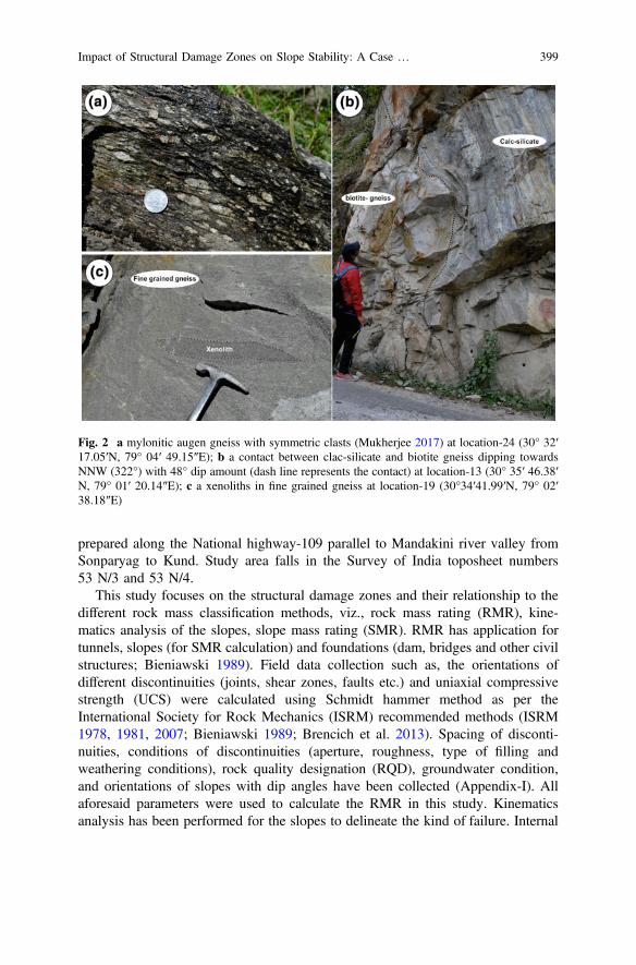
prepared along the National highway-109 parallel to Mandakini river valley fromSonparyag to Kund. Study area falls in the Survey of India toposheet numbers53 N/3 and 53 N/4.
This study focuses on the structural damage zones and their relationship to thedifferent rock mass classification methods, viz., rock mass rating (RMR), kine-matics analysis of the slopes, slope mass rating (SMR). RMR has application fortunnels, slopes (for SMR calculation) and foundations (dam, bridges and other civilstructures; Bieniawski 1989). Field data collection such as, the orientations ofdifferent discontinuities (joints, shear zones, faults etc.) and uniaxial compressivestrength (UCS) were calculated using Schmidt hammer method as per theInternational Society for Rock Mechanics (ISRM) recommended methods (ISRM1978, 1981, 2007; Bieniawski 1989; Brencich et al. 2013). Spacing of disconti-nuities, conditions of discontinuities (aperture, roughness, type of filling andweathering conditions), rock quality designation (RQD), groundwater condition,and orientations of slopes with dip angles have been collected (Appendix-I). Allaforesaid parameters were used to calculate the RMR in this study. Kinematicsanalysis has been performed for the slopes to delineate the kind of failure. Internal
Fig. 2 a mylonitic augen gneiss with symmetric clasts (Mukherjee 2017) at location-24 (30° 32′17.05′N, 79° 04′ 49.15″E); b a contact between clac-silicate and biotite gneiss dipping towardsNNW (322°) with 48° dip amount (dash line represents the contact) at location-13 (30° 35′ 46.38′N, 79° 01′ 20.14″E); c a xenoliths in fine grained gneiss at location-19 (30°34′41.99′N, 79° 02′38.18″E)
Impact of Structural Damage Zones on Slope Stability: A Case … 399
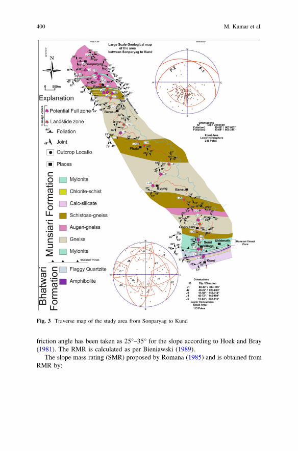
friction angle has been taken as 25°–35° for the slope according to Hoek and Bray(1981). The RMR is calculated as per Bieniawski (1989).
The slope mass rating (SMR) proposed by Romana (1985) and is obtained fromRMR by:
Fig. 3 Traverse map of the study area from Sonparyag to Kund
400 M. Kumar et al.

SMR ¼ RMRþ F1.F2.F3ð Þþ F4 ð1Þ
HereF1 depends on parallelism between joints and slope face. Its range is from 1.00
to 0.15.
F1 ¼ 1� SinAð Þ2 ð2Þ
A is angle between the dip directions of slope face and the joint for the planarand toppling failure. In wedge failure, A is the angle between trend and slope dipdirection.
F2 refers to joint dip angle in the planar mode of failure.
F2 ¼ tan2B ð3Þ
B is dip angle of joint for planer failure and for wedge failure, B is plungeamount.
F3 represents the angle between the slope and joint dip in the planar failure. Inwedge failure, F3 indicates the relationship between the slope face and plungeamount two joints.
F4 factor represents the excavation method and the rating depends on the methodas:
Natural slopes : F4 ¼ þ 15 ð4Þ
Presplitting : F4 ¼ þ 10; ð5Þ
Smooth blasting : F4 ¼ þ 8; ð6Þ
Normal blasting : F4 ¼ 0; ð7Þ
Deficient blasting : F4 ¼ �8; ð8Þ
and
Mechanical excavation : F4 ¼ 0: ð9Þ
4 Results and Discussions
The study area is mapped along the Mandakini River for *31 km length. The mainlithology is mylonite, chloritic-schist, calc-silicates, schistose-gneiss, myloniticaugen gneiss, gneiss of the Munsiari Formation, and flaggy quartzite and
Impact of Structural Damage Zones on Slope Stability: A Case … 401

amphibolites of the Bhatwari Formation (Fig. 3). The shear zone classification isperformed in the field based on the proportion of matrix and grains. Based on theshear zone rocks and structure present at the field, we have identified ductile-shearzone, ductile-brittle shear zone and brittle shear zones (Ghosh 1993). Damage zonesare deformed wall rock spatially associated with faults that form during the initi-ation and propagation of a fault, during the interaction of slip in fault linkages orjogs, or during the flexure of beds around a fault (Jamison and Stearns 1982;Chester and Logan 1986; Shipton and Cowie 2001, 2003; Flodin and Aydin 2004;Kim et al. 2004b). To delineate these damage zones in the field, we have collectedseveral structures like rocks with mylonitic foliations (Figs. 3 and 4a) and asym-metric folding (Figs. 4b and 5b),
S-C structures (Fig. 4b; Mukherjee 2010a, b, 2011), phyllonites and mylonites(Figs. 4c and 5a; Bose et al. 2018), brittle-ductile S-C structures (Fig. 4d), faultstariations (Fig. 5c; Dasgupta and Mukherjee 2017; Vanik et al. 2018) and asym-metric boudinage (Fig. 5d; few examples in Mukherjee and Koyi 2010a, b;Mukherjee 2013b, 2015b).
Fig. 4 Field photographs show: a contact between mylonite and protomylonite at location-5; b aductile damage zone show shearing and folding at location-10; c sulphur leaching on the surface ofsheared mylonitic gneiss at location-20; d ductile-brittle shearing show top to SW movement atlocation-22
402 M. Kumar et al.
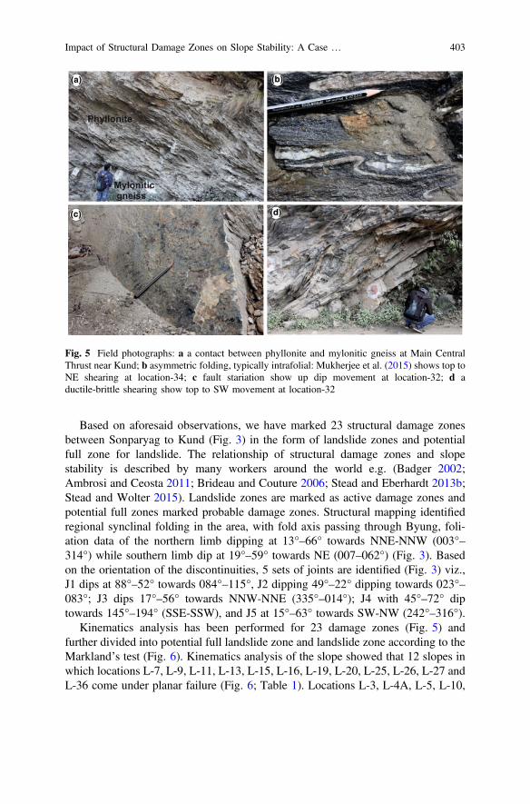
Based on aforesaid observations, we have marked 23 structural damage zonesbetween Sonparyag to Kund (Fig. 3) in the form of landslide zones and potentialfull zone for landslide. The relationship of structural damage zones and slopestability is described by many workers around the world e.g. (Badger 2002;Ambrosi and Ceosta 2011; Brideau and Couture 2006; Stead and Eberhardt 2013b;Stead and Wolter 2015). Landslide zones are marked as active damage zones andpotential full zones marked probable damage zones. Structural mapping identifiedregional synclinal folding in the area, with fold axis passing through Byung, foli-ation data of the northern limb dipping at 13°–66° towards NNE-NNW (003°–314°) while southern limb dip at 19°–59° towards NE (007–062°) (Fig. 3). Basedon the orientation of the discontinuities, 5 sets of joints are identified (Fig. 3) viz.,J1 dips at 88°–52° towards 084°–115°, J2 dipping 49°–22° dipping towards 023°–083°; J3 dips 17°–56° towards NNW-NNE (335°–014°); J4 with 45°–72° diptowards 145°–194° (SSE-SSW), and J5 at 15°–63° towards SW-NW (242°–316°).
Kinematics analysis has been performed for 23 damage zones (Fig. 5) andfurther divided into potential full landslide zone and landslide zone according to theMarkland’s test (Fig. 6). Kinematics analysis of the slope showed that 12 slopes inwhich locations L-7, L-9, L-11, L-13, L-15, L-16, L-19, L-20, L-25, L-26, L-27 andL-36 come under planar failure (Fig. 6; Table 1). Locations L-3, L-4A, L-5, L-10,
Fig. 5 Field photographs: a a contact between phyllonite and mylonitic gneiss at Main CentralThrust near Kund; b asymmetric folding, typically intrafolial: Mukherjee et al. (2015) shows top toNE shearing at location-34; c fault stariation show up dip movement at location-32; d aductile-brittle shearing show top to SW movement at location-32
Impact of Structural Damage Zones on Slope Stability: A Case … 403

L-10, L-21, L-22, L-32 and L-33 show wedge failure. Two locations L-1 and L-12are identified as anthropogenic induced landslides (Fig. 6; Table 1). Damage zonesweaken the rocks so the slopes become more prone for failure (Fig. 7). Location-19near the town Phata show planar failure. Here ductile shear zones are present alongthe foliation with 35° dip amount and dipping towards NE (055°). Rocks tend to faildue to these shear zones (Fig. 7; Table 1). At this location, the SMR values range31.9–39.9 (Table 1). SMR values vary from 0 to 55.25 at L-3 and L-33, respec-tively (Table-1). SMR values also confirm the potential damage zone for landslides.Similarly we have investigated all the locations and find that damage zoneassessment and SMR confirms our observations.
Fig. 6 Traverse map of the study area from Sonparyag to Kund
404 M. Kumar et al.

Tab
le1
Dataof
geolog
ical
investigationat
differentlocatio
ns
Sr.
No.
Location
Rocktype
RMR
(basic)
F1F2
F3F4
SMR
Structural
cond
ition
Latitu
deLon
gitude
Min
Max
Min
Max
11
30°37′
05.08″
79°00
′35
.48″
Mylon
iticaugen
gneiss
5455
0.15
1−60
045
46Due
toanthropo
genic
activ
ity
23
30°37′
15.49″
79°00
′32
.12″
Mylon
iticaugen
gneiss
5355
0.85
1−60
02
4Wedge
Failu
re/
ductile-brittleshear
34
30°37′
25.28″
79°00
′28
.63″
Mylon
iticaugen
gneiss
5455
0.15
1−50
046
.547
.5Wedge
failu
re/
ductile-brittleshear
44(A
)30
°37′
25.28″
79°00
′25
.28″
Mylon
iticgn
eiss
5455
0.4
1−25
044
45Wedge
failu
re/
ductile-brittleshear
55
30°37′
31.49″
79°00
′19
.91″
Mylon
iticaugen
gneiss
4953
0.85
1−50
06.5
10.5
Wedge
Failu
re/
Ductile-brittle
shear
67
30°37′
33.90″
78°59
′54
.69″
Mylon
iticgn
eiss
5357
11
−50
03
7Planar
failu
re/m
icaband
s
79
30°36′
55.11″
79°00
′55
.52″
Mylon
iticgn
eiss
4756
11
−25
022
31Planar
failu
re/brittleshear
810
30°36′
43.82″
79°00
′45
.01″
Biotitegn
eiss
5257
0.85
1−60
01
6Wedge
failu
re/
ductile-brittleshear
911
30°36′
45.23″
79°01
′05
.63″
Biotitegn
eiss
5151
0.85
1−60
00
0Planar
failu
re/ductileshear
1012
30°36′
32.11″
79°01
′05
.98″
Aug
engn
eiss
4548
0.7
10
045
48Lith
olog
ical
contact/Joint
control
1113
30°36′
14.22″
79°01
′18
.34″
Biotitegn
eiss
5455
0.4
1−60
030
31Planar
failu
re/jo
intcontrol
1215
30°35′
34.07″
79°01
′35
.81″
Granitic
gneiss
3035
0.15
10
030
35Planar
failu
re/
buctile-brittleshear
(con
tinued)
Impact of Structural Damage Zones on Slope Stability: A Case … 405

Tab
le1
(con
tinued)
Sr.
No.
Location
Rocktype
RMR
(basic)
F1F2
F3F4
SMR
Structural
cond
ition
Latitu
deLon
gitude
Min
Max
Min
Max
1316
30°35′
21.07″
79°01
′44
.92″
Biotitegn
eiss
4647
0.85
10
046
47Planar
failu
re/jo
intcontrol
1419
30°34′
41.99″
79°02
′38
.18″
Biotitegn
eiss
4849
0.4
1−60
024
25Planar
failu
re/ductileshear
1520
30°34′
29.19″
79°05
′20
.05″
Fine
grainedgn
eiss
4243
0.15
1−50
034
.535
.5Planar
failu
re/jo
intcontrol
1621
30°31′
43.85″
79°05
′05
.84″
Fine
grainedschistose
gneiss
4647
0.4
1−60
022
23Wedge
failu
re/jo
intcon
trol
1722
30°31′
49.06″
79°04
′59
.61″
Aug
engn
eiss
5357
0.85
1−60
02
6Wedge
failu
re/ductile
shear
1825
30°32′
56.08″
79°04
′26
.05″
Schistosegn
eiss
3538
0.85
1−6
029
.932
.9Planar
failu
re/
buctile-brittleshear
1926
30°33′
13.60″
79°02
′57
.91″
Gneiss
3745
0.85
1−6
031
.939
.9Planar
failu
re/jo
intcontrol
2027
30°33′
33.23″
79°03
′19
.77″
Fine
grainedgn
eiss
3748
0.4
1−50
017
28Planar
failu
re/jo
intcontrol
2132
30°31′
23.10″
79°04
′58
.70″
Mylon
iticgn
eiss
5253
0.4
1−60
028
29Wedge
failu
re/
ductile-brittleshear
2233
30°31′
03.80″
79°04
′58
.30″
Biotitegn
eiss
5859
0.15
1−25
054
.25
55.25
Wedge
failu
re/litholog
ical
contact
2336
30°31′
19.6″
79°05
′20
.7″
Biotitegn
eiss/greenish
gneiss
4450
0.7
1−60
02
8Planar
failu
re/litholog
ical
contact
406 M. Kumar et al.

5 Conclusions
23 structural damage zones are identified in the study area. 6 joint sets are identifiedthat reduce the rock strength. Kinematics analyses confirm that 12 slopes showplanar failure and 9 are wedge failure. SMR for different modes of failure ranges 0–55.25. This study confirms that structural damage zones are also responsible for theslope failure and are important to consider for the road construction in the hilly area.Structural damage zone assessment mapping also show relation with the slopekinematics analyses and the SMR.
Acknowledgements Authors are very thankful to the Department of Geography, DSB CampusKumaun University Nainital to provide the necessary facility for the research. Authors are also verythanking to the NRDMS, Department of Science and Technology to the financial assistance in theproject no. NRDMS/06/11/015 (G) Dt. 11.08.2015 “Large Scale Geological-GeomorphologicalMapping of Rudraprayag-Sonprayag Area, Mandakini valley National highway No.109. Reviewingand editorial handling by Soumyajit Mukherjee. This work is summarized in Mukherjee (2019).The Springer team is thanked for assistance in proofreading.
Fig. 7 Location-19 near Phata town show planar failure along the foliation plane (J0), along J0ductile shear zone inducing the landslide
Impact of Structural Damage Zones on Slope Stability: A Case … 407
References
Ambrosi C, Crosta GB (2011) Valley slope influence on deformation mechanisms of rock slopes.In: Jaboyedoff M (ed) Slope tectonics, vol 351. Geological Society, London, SpecialPublications, pp 215–233
Badger TC (2002) Fracturing within anticlines and its kinematic control on slope stability.Environmental & Engineering Geoscience 8, 19–33
Bieniawski ZT (1989) Engineering rock mass classification. Wiley, New YorkBose N, Dutta D, Mukherjee S (2018) Role of grain-size in phyllonitisation: Insights from
mineralogy, microstructures, strain analyses and numerical modeling. Journal of StructuralGeology 112, 39–52
Brencich A, Cassini G, Pera D, Riotto G (2013) Calibration and reliability of the rebound(Schmidt) hammer test. Civil Engineering and Architecture 1, 66–78
Brideau M-A, Stead D, Couture R (2006) Structural and engineering geology of the east gatelandslide, Purcell mountains, British Columbia, Canada. Engineering Geology 84, 183–206
Caine JS, Evans JP, Forster CB (1996) Fault zone architecture and permeability structure. Geology24, 1025–1028
Chester FM, Logan JM (1986) Implications for mechanical properties of brittle faults fromobservations of the Punchbowl fault zone, California. Pure and Applied Geophysics 124,79–106
Childs C, Manzocchi T, Walsh JJ, Bonson CG, Nicol A, Schöpfer MPJ (2009) A geometric modelof fault zone and fault rock thickness variations. Journal of Structural Geology 31, 117–127
Choi JH, Edwards P, Ko K, Kim YS (2016) Definition and classification of fault damage zones: areview and a new methodological approach. Earth-Science Reviews 152, 70–87
Cowie PA, Scholz CH (1992) Growth of faults by accumulation of seismic slip. Journal ofGeophysical Research 97, 11085–11095
Dasgupta S, Mukherjee S (2017) Brittle shear tectonics in a narrow continental rift: asymmetricnon-volcanic Barmer basin (Rajasthan, India). The Journal of Geology 125, 561–591
Flodin EA, Aydin A (2004) Evolution of a strike-slip fault network, Valley of Fire State Park,southern Nevada. Geological Society of America Bulletin 116, 42–59
Ghosh SK (1993) Structural geology, fundamentals and modern developments, vol 1. PergamonPress, p 598
Gupta V, Bist KS (2004) The 23 September 2003 Varunavat Parvat landslide in Uttarkashi city,Uttaranchal. Current Science 87, 1600–1605
Hoek E, Bray J (1981) Rock slope engineering. The Institution of Mining and Metallurgy, LondonInternational Society for Rock Mechanics (ISRM) (1978) Suggested methods for the quantitative
description of discontinuities in a rock mass. International Journal of Rock Mechanics andMining Sciences and Geomechanics Abstracts 6, 319–368
ISRM (1981) Suggested methods for determining hardness and abrasiveness of rocks. Rockcharacterization, testing and monitoring: ISRM suggested methods. Pergamon, Oxford,pp 95–96
ISRM (2007) The complete ISRM suggested methods for rock characterization, testing andmonitoring: 1974–2006. Springer, Berlin
Jamison WR, Stearns DW (1982) Tectonic deformation of Wingate Sandstone, Colorado NationalMonument. American Association of Petroleum Geologists Bulletin 66, 2584–2608
Kim YS, Peacock DCP, Sanderson DJ (2004a) Fault damage zones. Structural Geology 26, 503–517
Kim YS, Peacock DCP, Sanderson DJ (2004b) Fault damage zones. Structural Geology 26, 503–517
Kumar M, Rana S, Pant PD, Patel RC (2017) Slope stability analysis of Balia Nala landslide,Kumaun Lesser Himalaya, Nainital, Uttarakhand, India. Journal of Rock Mechanics andGeotechnical Engineering 9, 150–158
408 M. Kumar et al.
McGrath AG, Davison I (1995) Damage zone geometry around fault tips. Structural Geology 17,1011–1024
Mukherjee S (2010a) Structures in Meso- and Micro-scales in the Sutlej section of the HigherHimalayan Shear Zone, Indian Himalaya. e-Terra 7, 1–27
Mukherjee S (2010b) Microstructures of the Zanskar Shear Zone. E-journal: Earth Science India 3,9–27
Mukherjee S (2011) Mineral fish: their morphological classification, usefulness as shear senseindicators and genesis. International Journal of Earth Sciences 100, 1303–1314
Mukherjee S (2013a) Channel flow extrusion model to constrain dynamic viscosity and Prandtlnumber of the Higher Himalayan Shear Zone. International Journal of Earth Sciences 102,1811–1835
Mukherjee S (2013) Deformation microstructures in rocks. Springer Geochemistry/Mineralogy,Berlin, pp 1–111. ISBN 978-3-642-25608-0
Mukherjee S (2014) Atlas of shear zone structures in Meso-scale. Springer, Berlin, pp 1–128.https://doi.org/10.1007/978-3-319-00089-3
Mukherjee S (2015a) A review on out-of-sequence deformation in the Himalaya. In: Mukherjee S,Carosi R, van der Beek P, Mukherjee BK, Robinson D (eds) Tectonics of the Himalaya, vol412. Geological Society, London, Special Publications, pp 67–109
Mukherjee S (2015) Atlas of structural geology. Elsevier. Amsterdam. ISBN: 978-0-12-420152-1Mukherjee S (2017) Review on symmetric structures in ductile shear zones. International Journal
of Earth Sciences 106, 1453–1468Mukherjee S (2019) Introduction to “Tectonics and Structural Geology: Indian Context”. In:
Mukherjee S (ed) Tectonics and structural geology: Indian context. Springer InternationalPublishing AG, Cham, pp 1–5. ISBN: 978-3-319-99340-9
Mukherjee S, Koyi HA (2010a) Higher Himalayan Shear Zone, Zanskar Section- microstructuralstudies & extrusion mechanism by a combination of simple shear & channel flow. InternationalJournal of Earth Sciences 99, 1083–1110
Mukherjee S, Koyi HA (2010b) Higher Himalayan Shear Zone, Sutlej section- structural geology& extrusion mechanism by various combinations of simple shear, pure shear & channel flow inshifting modes. International Journal of Earth Sciences 99, 1267–1303
Mukherjee S, Koyi HA, Talbot CJ (2012) Implications of channel flow analogue models inextrusion of the Higher Himalayan Shear Zone with special reference to the out-of-sequencethrusting. International Journal of Earth Sciences 101, 253–272
Mukherjee S, Punekar J, Mahadani T, Mukherjee R (2015) A review on intrafolial folds and theirmorphologies from the detachments of the western Indian Higher Himalaya. In: Mukherjee S,Mulchrone KF (eds) Ductile Shear Zones: From Micro- to Macro-scales. Wiley Blackwell,pp 182–205
Panikkar SV, Subramanyan V (1997) Landslide hazard analysis of the area around DehraDun andMussoorie, Uttar Pradesh. Current Science 73, 1117–1123
Pant PD, Luirei K (1999) Malpa rockfalls of 18 August 1998 in the Northeastern KumaunHimalaya. Journal of the Geological Society of India 54, 415–420
Paul SK, Mahajan AK (1999) Malpa rockfall disaster, Kali valley, Kumaun Himalaya. CurrentScience 76, 485–487
Peacock DCP, Nixon CW, Rotevatn A, Sanderson DJ, Zuluaga LF (2017) Interacting faults.Journal of Structural Geology 97, 1–22
Puniya MK, Joshi P, Pant PD (2013) Geological investigation of Nainital Bypass: a specialemphasis on slope stability analysis, Kumaun Lesser Himalaya. In: Himalayan vulnerability,Uttarakhand, 2013: learning for planning and action. Xpressions Print & Graphics Pvt. Ltd.pp 65–72
Romana M (1985) New adjustment ratings for application of Bieniawski classification to slopes.In: Proceedings of the international symposium on the role of rock mechanics in excavationsfor mining and civil works. International Society of Rock Mechanics, Zacatecas, pp 49–53
Sah N, Kumar M, Upadhyay R, Dutt S (2018) Hill slope instability of Nainital City. KumaunLesser Himalaya, Uttarakhand, India. https://doi.org/10.1016/j.jrmge.2017.09.011
Impact of Structural Damage Zones on Slope Stability: A Case … 409

Shipton ZK, Cowie PA (2001) Damage zone and slip-surface evolution over mm to km scales inhigh-porosity Navajo sandstone, Utah. Journal of Structural Geology 23, 1823–1844
Shipton ZK, Cowie PA (2003) A conceptual model for the origin of fault damage zone structuresin high-porosity sandstone. Journal of Structural Geology 25, 333–344
Stead D, Eberhardt E (2013a) Understanding the mechanics of large landslides. Italian Journal ofEngineering Geology and Environment Book Series (6), 85–108
Stead D, Eberhardt E (2013b) Understanding the mechanics of large landslides. Italian Journal ofEngineering Geology and Environment, 85–109
Stead D, Wolter A (2015) A critical review of rock slope failure mechanism: the importance ofstructural geology. Journal of structural Geology 74, 1–23
Valdiya KS (1980) Geology of Kumaun Lesser Himalaya. Wadia Institute of Himalayan Geology,Dehradun
Vanik N, Shaikh H, Mukherjee S, Maurya DM, Chamyal LS (2018) Post-Deccan trap stressreorientation under transpression: evidence from fault slip analyses from SW Saurashtra,western India. Journal of Geodynamics, 121, 9–19
410 M. Kumar et al.
Documentation of Brittle Structures(Back Shear and Arc-Parallel Shear)from Sategal and Dhanaulti Regionsof the Garhwal Lesser Himalaya(Uttarakhand, India)
Souradeep Mahato, Soumyajit Mukherjee and Narayan Bose
1 Introduction
We study the brittle shear tectonics from the Lesser Himalayan terrain in theMussoorie, Dhanaulti and Satengal regions, Uttarakhand, India. The LesserHimalaya is bound by the Main Boundary Thrust (MBT) in the south and the MainCentral Thrust Zone (MCTZ) in the north. The Lesser Himalayan sequence isdivided in this region as the Inner Lesser Himalaya and the Outer Lesser Himalaya(Célérier et al. 2009a, b). The Mussoorie- and the Garhwal synclines are the twomajor structures of the Outer Lesser Himalaya. The area around Dhanaulti (Fig. 1)constitutes a part of the northern limb of the Mussoorie syncline. The Satengalregion (Fig. 1) lies at the core of the Mussoorie syncline. Several workers (e.g.,Srivastava et al. 2011; Bose et al. submitted-1, 2; Bose et al. 2018) discuss majorstructural features and the deformation phases from the Garhwal Himalaya.However, a detail study remained due on its brittle deformations. This workdescribes brittle shear sense indicators from the terrain.
2 Previous Works
The first-hand rock description and regional mapping in this area have been done byMiddlemiss (1887), Auden (1937), Jain (1972), Shankar and Ganesan (1973),Valdiya (1975), Saklani (1978). The Mussoorie Syncline mainly consists of sedi-mentary rocks and low-grade metamorphic rocks of Tal-, Krol-, Blaini-, Nagthat-,Chandpur-, and Mandhali Formation. Out of all these, the Mandhani, the Chandpur
S. Mahato � S. Mukherjee (&) � N. BoseDepartment of Earth Sciences, Indian Institute of Technology Bombay,Mumbai, Indiae-mail: [email protected]
© Springer Nature Switzerland AG 2019S. Mukherjee (ed.), Tectonics and Structural Geology: Indian Context,Springer Geology, https://doi.org/10.1007/978-3-319-99341-6_15
411
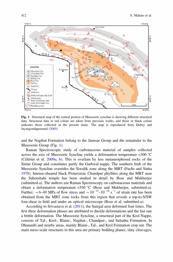
and the Nagthat Formation belong to the Jaunsar Group and the remainder to theMussoorie Group (Fig. 1).
Raman Spectroscopic study of carbonaceous material of samples collectedacross the axis of Mussoorie Syncline yields a deformation temperature <300 °C(Célérier et al. 2009a, b). This is overlain by less metamorphosed rocks of theSimur Group and constitutes partly the Garhwal nappe. The southern limb of theMussoorie Syncline overrides the Siwalik zone along the MBT (Fuchs and Sinha1978). Intense-sheared black Proterozoic Chandpur phyllites along the MBT nearthe Sahenshahi temple has been studied in detail by Bose and Mukherjee(submitted-a). The authors use Raman Spectroscopy on carbonaceous materials andobtain a deformation temperature <550 °C (Bose and Mukherjee, submitted-a).Further, *6–49 MPa of flow stress and *10−15–10−16 s−1 of strain rate has beenobtained from the MBT zone rocks from this region that reveals a top-to-S/SWfore-shear in field and under an optical microscope (Bose et al. submitted-a).
According to Srivastava et al. (2011), the Sategal area deformed four times. Thefirst three deformation phases are attributed to ductile deformations and the last onea brittle deformation. The Mussoorie Syncline, a structural part of the Krol Nappe,consists of Tal-, Krol-, Blaini-, Nagthat-, Chandpur-, and Subathu Formation. InDhanaulti and nearby areas, mainly Blaini-, Tal-, and Krol Formation crop out. Themain meso-scale structures in this area are primary bedding planes, slaty cleavages,
Fig. 1 Structural map of the central portion of Mussoorie syncline is showing different structuraldata. Structural data in red colour are taken from previous works, and those in black colourindicates those collected in the present study. The map is reproduced from Dubey andJayangondaperumal (2005)
412 S. Mahato et al.

axial planes of different generations of folds (Srivastava et al. 2011), and thrusts/faults (Dubey 2005). The pop-up klippen structure is indicated by the rocks ofChandpur, Mandhali and Subathu Formation at the Satengal area (Dubey andJayangondaperumal 2005).
The Baliana Formation (/Chandpur Formation) and the Mandhani Formation (/Saklana Formation) are separated by the Ringalgarh Thrust. The pop-up klippendeveloped since the MBT bifurcates at south into an oblique ramp and into a blindthrust that generated two low-angle backthrusts (Dubey and Jayangondaperumal2005).
At Satengal and in the adjoining areas, folding happened thrice. The mainschistosity trends NW and NE. The NW trending earlier tight to isoclinal F1 foldsare characterized by deformed quartz veins and quartzo-feldspathic layers. Theusually NE trending F2 folds developed on the limbs of the F1 folds with open toisoclinal geometries. F3 chevron folds occur in phyllites of Chandpur Formationnear Satengal and trends E-W (Srivastava et al. 2011).
3 Present Work
This section addresses details of S0 and S1 planes. Brittle shear detail is also presentedfrom the following three traverses: (i) Mussoorie up to Kathu Khal (SurkundaDevi temple) along the Mussourie-Chamba road; (ii) Kathu-Khal to Satengal; and(iii) *NE-SW traverse was taken from Raipur to Silla.
3.1 S0-Plane (Fig. 2)
Primary sedimentary bedding planes (S0) are commonly observed in the study area.These S0 planes can be identified based on lithology change and color variation.From L-1 to L-6, dip of S0 ranges 40°–42° with *SW dip direction. The dipdirection changes from SW to NW in and around L-7. Dip ranges 25°–65° witha *SW dip direction between L-8 and L-11. S0 dips oppositely towards NE and Nwith 30° dip at L-12 and L-13, south of Dhanaulti.
The S0-planes near the Satengal region between L-15 to 18 show 40°–45° dip,and dip direction towards SW. At L-24 grey coloured quartzites dip N, from L-28 to31 the dip of the S0 varies 35°–60° with dip direction NW to E, in between L-32and 33 dip direction varies from SE to S. S0 dips toward SW direction in locations33–37.
Slaty Cleavage (S1) (Fig. 2):
The exposed rocks in and around Dhanaulti are slaty. Phyllites are observed in theSatengal region. A pervasive, parallel foliation (S1) of fine-grained platy mineralsoccurs in these rocks, which generally develop perpendicular to the direction of
Documentation of Brittle Structures … 413

maximum stress. Usually this S1 plane parallels the S0 planes if not folded orsheared. In Dhanaulti region, the S1 planes dip 30°–40° towards SW. In Satengalregion, S1 dips 25°–50° and the dip direction varies widely from SW to S to SE toN.
3.2 Shear Fractures
Shear fractures (Fig. 3) are very common structural features observed in the studyarea. The P-planes at L-28 and 36 generally dip in opposite direction and with theM/Y shear fracture this makes a low-angle. Kinematically, such shear planes canusually be correlated with low-angle thrusts. Within the same setting, the Riedelfractures can be represented as low-angle normal faults. The R/-planes/antitheticfaults make a high-angle with the Y plane. The angles between the P, R and R/withthe Y-plane can depend on the rock’s physical properties and the stress regime.
Fig. 2 Stereo-plots of planer features S0 and S1 on equal area net. L-21 to L-24 shows S1-plots,and the rest represents S0-plots
414 S. Mahato et al.

3.3 Traverse-Wise Description
The first *E-W traverse was taken along the Mussoorie-Chamba road fromMussoorie up to Kathu Khal (Surkunda Devi temple). A vertical shear zone (Fig. 4)exists at L-2 on a N140°S striking road cut section. Around 13 km east of L-3,top-to-SE brittle shear (Fig. 5a) was observed at L-7. Top-to-NW down shear(Fig. 6a) was observed *650 m SE from L-6. At L-7, top-to-NE up brittle shear(Fig. 6c), i.e., back deformation, occurs in slates. About 600 m east from L-7, thesame top-to-NE up brittle shear (Fig. 6d) occurs in slates at L-8. A top-to-NEsub-horizontal brittle shear (Fig. 6b) exists in slate close to L-9. Around 300 m southof L-9, a top-to-SW up shear, also can be called a fore shear that is common inHimalayan orogen in its various units (e.g., Mukherjee 2010a, b, 2012, 2013, 2014;Mukherjee and Koyi 2010a, b) exists in slate. Top-to-NW shear (Fig. 5b) also exists.
Fig. 3 Nomenclatures for shear fractures developed in a top-to-right shear zone. M/Y, Main shearplane; P: shear fractures; R: Riedel shears; R/: fracture. From Petit (1987)
Fig. 4 Brittle vertical faultzone. Y- and P-planes welldeveloped
Documentation of Brittle Structures … 415

Fig. 5 a Field photograph of vertical exposure of quartzite showing top-to-SE shear. Y- andP-planes are stereo-plotted in inset. b Top-to-SW up brittle shear. Pole of P-plane (25° dip towards10°) is plotted in inset
Fig. 6 Brittle shear Y- and P-planes observed in a vertical rock section. Poles of brittle planes areplotted inside insets. a Note a sharp contact between slate at top and quartzite at bottom.Top-to-NW brittle shear localized in slate due to high accumulation of shear strain. P-planeattitude: 10° dip towards 140°. b Shear fractures developed on slate. Top-to-NE brittle shear sense.The P-plane dips 14° and towards 225°. c Y- (dip 34° towards 200°) and P-planes (dip 65° towards240°) developed on slate. Top-to-NE up shear. d Top-to-NE up shear. Y-plane: dip 35° towards190°, P-plane: dip 70° towards 230°
416 S. Mahato et al.

Slate is the dominant rock type at L-12 which is *2 km SW to Dhanaulti. Herethe rocks deformed in a ductile-brittle regime. In response to ductile deformation,S- and C-fabric developed prominently in slates. Secondary mineralization ofquartz is noted at few places along the shear planes that connote back-shear(Fig. 7a–c). The dip and dip-direction of S-fabric indicates a top-to-NE up shear(back-structure). Brittle shear fractures (Fig. 8c, d) also develop at L-13 showingboth top-to-NE up and horizontal shear senses.
Fig. 7 a, b Sub-vertical sections at L-12 showing S- and C-fabrics developed in slates. top-to-NEup ductile shear. Stereo-plot of S planes in inset. Fractures developed along the S-planes in slates.In particular, in c the C-planes are occupied by secondary quartz mineralization. Here the penlength is 13 cm
Documentation of Brittle Structures … 417
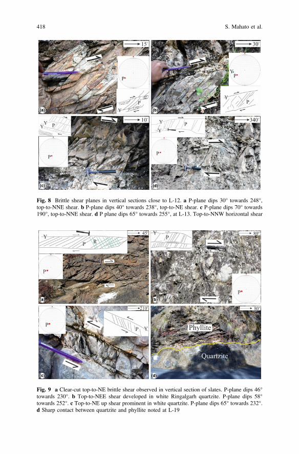
Fig. 8 Brittle shear planes in vertical sections close to L-12. a P-plane dips 30° towards 248°,top-to-NNE shear. b P-plane dips 40° towards 238°, top-to-NE shear. c P-plane dips 70° towards190°, top-to-NNE shear. d P plane dips 65° towards 255°, at L-13. Top-to-NNW horizontal shear
Fig. 9 a Clear-cut top-to-NE brittle shear observed in vertical section of slates. P-plane dips 46°towards 230°. b Top-to-NEE shear developed in white Ringalgarh quartzite. P-plane dips 58°towards 252°. c Top-to-NE up shear prominent in white quartzite. P-plane dips 65° towards 232°.d Sharp contact between quartzite and phyllite noted at L-19
418 S. Mahato et al.
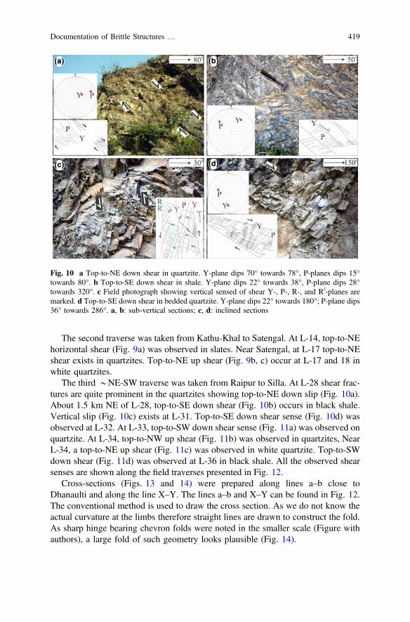
The second traverse was taken from Kathu-Khal to Satengal. At L-14, top-to-NEhorizontal shear (Fig. 9a) was observed in slates. Near Satengal, at L-17 top-to-NEshear exists in quartzites. Top-to-NE up shear (Fig. 9b, c) occur at L-17 and 18 inwhite quartzites.
The third *NE-SW traverse was taken from Raipur to Silla. At L-28 shear frac-tures are quite prominent in the quartzites showing top-to-NE down slip (Fig. 10a).About 1.5 km NE of L-28, top-to-SE down shear (Fig. 10b) occurs in black shale.Vertical slip (Fig. 10c) exists at L-31. Top-to-SE down shear sense (Fig. 10d) wasobserved at L-32. At L-33, top-to-SW down shear sense (Fig. 11a) was observed onquartzite. At L-34, top-to-NW up shear (Fig. 11b) was observed in quartzites, NearL-34, a top-to-NE up shear (Fig. 11c) was observed in white quartzite. Top-to-SWdown shear (Fig. 11d) was observed at L-36 in black shale. All the observed shearsenses are shown along the field traverses presented in Fig. 12.
Cross-sections (Figs. 13 and 14) were prepared along lines a–b close toDhanaulti and along the line X–Y. The lines a–b and X–Y can be found in Fig. 12.The conventional method is used to draw the cross section. As we do not know theactual curvature at the limbs therefore straight lines are drawn to construct the fold.As sharp hinge bearing chevron folds were noted in the smaller scale (Figure withauthors), a large fold of such geometry looks plausible (Fig. 14).
Fig. 10 a Top-to-NE down shear in quartzite. Y-plane dips 70° towards 78°, P-planes dips 15°towards 80°. b Top-to-SE down shear in shale. Y-plane dips 22° towards 38°, P-plane dips 28°towards 320°. c Field photograph showing vertical sensed of shear Y-, P-, R-, and R/-planes aremarked. d Top-to-SE down shear in bedded quartzite. Y-plane dips 22° towards 180°; P-plane dips36° towards 286°. a, b: sub-vertical sections; c, d: inclined sections
Documentation of Brittle Structures … 419

Fig. 11 a Shear fractures developed on quartzite showing top-to-SW down brittle shear sense.Y plane attitude dips 22° towards 223°; b top-to-NW up shear. P-plane dips 23° towards 218°. Therock type is quartzite. c Top-to-NE up shear. Y-plane dips 33° towards 226°, P-plane dips 62°towards 226°. Shear fractures developed quartzite. d Shear fractures developed on shale showingtop- to-SW down shear sense. Y-plane dips 31° towards 222°, P-plane dips 15° towards 18°
Fig. 12 Distributions of different brittle shear senses are shown in the map. The map isreproduced from Dubey and Jayangondaperumal (2005)
420 S. Mahato et al.

This preliminary study reports Himalayan back-shear (top-to-NE) andarc-parallel shear (top-to-NW) for the first time in terms of meso-scale structures.We have been presently working on these issues in detail.
Acknowledgements This work was a part of the M.Sc. thesis of S. Mahato. S. Mukherjee thanksIIT Bombay for providing a sabbatical in 2017. N. Bose acknowledges Junior ResearchFellowship of UGC, grant number: F.2-2/98(SA-1). The Springer proofreading team is thanked forassistance. Consult Banerjee et al. (2019) for tectonic updates on arc-parallel deformation fromSikkim Lesser Himalaya, and Dutta et al. (submitted) from that in Mohand region, Siwalik. Thiswill establish link between chapters in the book. Mukherjee (2019) summarizes this work.
References
Auden JB (1937) The structure of the Himalaya in Garhwal. Records of the Geological Survey ofIndia 71, 407–433
Banerjee S, Bose N, Mukherjee S (2019) Field structural geological studies around Kurseong,Darjeeling-Sikkim Himalaya, India. In: Mukherjee S (ed) Tectonics and structural geology:Indian context. Springer International Publishing AG, Cham, pp 425–440. ISBN978-3-319-99340-9
Fig. 13 Cross-section of the Mussoorie syncline is drawn along the X–Y line of Fig. 12. The X–Y line trends N36°E. B: Chandpur Fm, C: Nagthat Fm, D: Blaini Fm, E: Krol Fm, F: Tal Fm
Fig. 14 A NW-SE profile along the line a–b of Fig. 13
Documentation of Brittle Structures … 421
Bell TH, Rubenach MJ, Fleming PD (1986) Porphyroblast nucleation, growth and dissolution inregional metamorphic rocks as a function of deformation partitioning during foliationdevelopment. Journal of Metamorphic Geology 4, 37–67
Bose N, Dutta D, Mukherjee S (2018) Role of grain-size in phyllonitisation: insights frommineralogy, microstructures, strain analyses and numerical modeling. Journal of StructuralGeology 112, 39–52
Bose N, Mukherjee S (Submitted-1) Estimation of deformation temperature, flow stress and strainrate from the Main Boundary Thrust rocks, Garhwal Lesser Himalaya, India. Journal of EarthSystem Science
Bose N, Mukherjee S (Submitted-2) Field documentation and genesis of the back-structures froma part of the Garhwal Lesser Himalaya. Uttarakhand, India. Tectonic implications. In: Sharma,Villa IM, Kumar S (eds) Crustal Architecture and Evolution of the Himalaya-Karakoram-TibetOrogen. Geological Society of London Special Publications
Célérier J, Harrison TM, Beyssac O, Herman F, Dunlap WJ, Webb AAG (2009a) The Kumaunand Garwhal Lesser Himalaya, India: Part 2. Thermal and deformation histories. GeologicalSociety of America Bulletin 121, 1281–1297
Célérier J, Harrison TM, Webb AAG, Yin A (2009b) The Kumaun and Garhwal Lesser Himalaya,India: Part 1. Structure and stratigraphy. Geological Society of America Bulletin 121, 1262–1280
Dubey AK (2014) Understanding an orogenic belt. Springer, Cham. ISBN 978-3-319-05587-9Dubey AK, Jayangondaperumal R (2005) Pop-up klippen in the Mussoorie Syncline Lesser
Himalaya: evidence from field and model deformation studies. In: Saklani RS (ed) Himalaya(Geological Aspects), Satish Serial Publishing House, Delhi 3, pp 203–222
Dutta D, Biswas T, Mukherjee S (Submitted) Orogen-parallel compression in NW Himalaya:Evidence from structural and paleostress studies of brittle deformation from the pebbles ofUpper Siwalik conglomerates, Uttarakhand, India. Journal of Earth System Science
Fuchs G, Sinha AK (1978) The tectonics of the Garhwal-Kumaun Lesser Himalaya. Jahrbuch derGeologischen Bundesanstalt 121, 219–241
Jain AK (1972) Overthrusting and emplacement of basic rocks in Lesser Himalaya, Garhwal,UP. Journal of Geological Society of India 13, 226–237
Jayangondaperumal R, Dubey AK, Sangode SJ, Sathyanarayana KV (2001) Superimposedfolding, finite strain and magnetic lineation in the Mussoorie Syncline, Lesser Himalaya:implications for regional thrusting and the Indian Plate motion. Himalayan Geology 22, 207–216
Long S, McQuarrie N (2010) Placing limits on channel flow: insights from the Bhutan Himalaya.Earth and Planetary Science Letters 290, 375–390
Mandl G (1999) Faulting in brittle rocks: an introduction to the mechanics of tectonic faults.Springer Science and Business Media
Marshak S (1988) Kinematics of orocline and arc formation in thin-skinned orogens. Tectonics 7,73–86
Marshak S (2009) Essentials of geology, 4th edn. WW Norton and Company, pp 18. ISBN:9780471405214
Middlemiss CS (1887) Crystalline and metamorphic rocks of the Lower Himalaya, Garhwal andKumaun. Records of the Geological Survey of India 20, 134–143
Mukherjee S (2010a) Structures in meso- and micro-scales in the Sutlej section of the HigherHimalayan Shear Zone, Indian Himalaya. e-Terra 7, 1–27
Mukherjee S (2010b) Microstructures of the Zanskar Shear Zone. e-Journal: Earth Science India 3,9–27
Mukherjee S (2012) Tectonic implications and morphology of trapezoidal mica grains from theSutlej section of the Higher Himalayan Shear Zone, Indian Himalaya. The Journal of Geology120, 575–590
Mukherjee S (2013) Higher Himalaya in the Bhagirathi section (NW Himalaya, India): itsstructures, backthrusts and extrusion mechanism by both channel flow and critical tapermechanisms. International Journal of Earth Sciences 102, 1851–1870
422 S. Mahato et al.

Mukherjee S (2014) Mica inclusions inside Host Mica Grains from the Sutlej section of the HigherHimalayan Crystallines, India-Morphology and Constrains in Genesis. Acta Geologica Sinica88, 1729–1741
Mukherjee S (2019) Introduction to “Tectonics and Structural Geology: Indian Context”. In:Mukherjee S (ed) Tectonics and structural geology: Indian context. Springer InternationalPublishing AG, Cham, pp 1–5. ISBN: 978-3-319-99340-9
Mukherjee S, Koyi HA (2010a) Higher Himalayan Shear Zone, Zanskar section-microstructuralstudies and extrusion mechanism by a combination of simple shear and channel flow.International Journal of Earth Sciences 99, 1083–1110
Mukherjee S, Koyi HA (2010b) Higher Himalayan Shear Zone, Sutlej section-structural geology& extrusion mechanism by various combinations of simple shear, pure shear & channel flow inshifting modes. International Journal of Earth Sciences 99, 1267–1303
Passchier CW, Trouw RAJ (2005) Microtectonics. Springer, Berlin, pp 1–366. ISBN103-540-64003-7
Petit JP (1987) Criteria for the sense of movement on fault surfaces in brittle rocks. Journal ofStructural Geology 9, 597–608
Powell CM, Conaghan PJ (1973) Plate tectonics and the Himalayas. Earth and Planetary ScienceLetters 20, 1–12
Saklani PS (1978) Deformation and tectonism of Mukhem area, Lesser Himalaya. TectonicGeology of the Himalaya 15, 42
Shanker R, Ganesan TM (1973) A note on the Garhwal Nappe. Himalayan Geology 3, 72–82Srivastava HB, Sinha LK, Katiyar V (2011) Mesoscopic structures from the area around Satengal,
Lesser Garhwal Himalaya. Journal of Scientific Research 55, 25–34Valdiya KS (1975) Lithology and age of the Tal Formation in Garhwal, and implication on
stratigraphic scheme of Krol Belt in Kumaun Himalaya. Geological Society of India 16, 119–134
Valdiya KS (1980) Geology of Kumaun Lesser Himalaya. Wadia Institute of Himalayan Geology
Documentation of Brittle Structures … 423
Field Structural Geological StudiesAround Kurseong, Darjeeling-SikkimHimalaya, India
Saikat Banerjee, Narayan Bose and Soumyajit Mukherjee
1 Introduction
Mallet (1874) divided the metamorphic rocks of the Darjeeling-Kurseong region(see Table 1) into two Formations: Darjeeling Formation of high grade garnetiferousschist, mica gneiss and the phyllitic Daling Group of rock. The pioneering geologicalinputs provide a detailed account of the lithology and deformation of this region(e.g., Sinha Roy 1973; Acharyya and Ray 1977; Acharyya 1989). Ray (1947) hasdescribed the Senchal Series of rocks, which includes both the Darjeeling and theDaling rocks. In the study area, the Gondwana rocks are overlaid by metamorphicrocks of the Daling- and the Darjeeling Group/Formation (Fig. 1; Lahiri 1973).Mukhopadhyay and Gangopadhyay (1971) worked in the both side of Teesta valleyand found more or less the same lithology. According to Jangpangi (1972), each ofthe rock units are separated by thrust faults. On the other hand, Mallet (1874)suggested that the contact between the Daling and the Darjeeng is gradational. Asper Ray (1947), there is no distinct separation between Daling and Gonwana atTindharia. But Singh (1972) suggests near Tindharia the Daling rocks overlie theGondwana rocks and they are separated by the NE trending Tindharia Thrust. TheDaling Group consists of mainly slates and phyllites. The metamorphic-grade ofphyllite elevates near the Tindharia Thrust (Singh 1972). This could be the effect ofshear heating of the fault (Mukherjee and Mulchrone 2013; Mulchrone andMukherjee 2015, 2016; Mukherjee 2017a, b; Mukherjee and Khonsari 2017, 2018;Mukherjee and Agarwal, submitted). The Daling Group can be recognized asquartz-chlorite schist. The Darjeeling Group can be identified as garnetiferous micaschist and mica gneiss. Especially, in the Darjeeling–Bijonbari area, such rock typesare exposed (Sen 1971). The main composition of the gneiss in the Darjeeling Group
S. Banerjee � N. Bose � S. Mukherjee (&)Department of Earth Sciences, IIT Bombay, Powai, Mumbai 400076, Maharashtra, Indiae-mail: [email protected]
© Springer Nature Switzerland AG 2019S. Mukherjee (ed.), Tectonics and Structural Geology: Indian Context,Springer Geology, https://doi.org/10.1007/978-3-319-99341-6_16
425
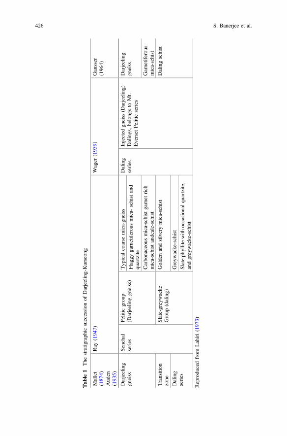
Tab
le1
The
stratig
raph
icsuccession
ofDarjeeling-Kurseon
g
Mallet
(187
4)Aud
en(193
5)
Ray
(194
7)Wager
(193
9)Gansser
(196
4)
Darjeeling
gneiss
Senchal
series
Pelitic
grou
p(D
arjeelinggn
eiss)
Typ
ical
coarse
mica-gn
eiss
Daling
series
Injected
gneiss
(Darjeeling)
Dalings,belong
sto
Mt.
Everset
Pelitic
series
Darjeeling
gneiss
Flaggy
garnetiferou
smica-
schistand
quartzite
Carbo
naceou
smica-schistgarnet
rich
mica-schistandcalc-schist
Garnetiferou
smica-schist
Transition
zone
Slate-greywacke
Group
(daling)
Goldenandsilverymica-schist
Dalingschist
Daling
series
Greyw
acke-schist
Slateph
yllitewith
occasion
alqu
artzite,
andgreywacke-schist
Reprodu
cedfrom
Lahiri(197
3)
426 S. Banerjee et al.
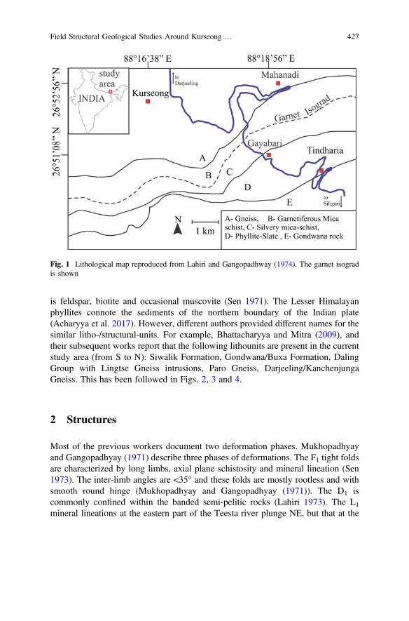
is feldspar, biotite and occasional muscovite (Sen 1971). The Lesser Himalayanphyllites connote the sediments of the northern boundary of the Indian plate(Acharyya et al. 2017). However, different authors provided different names for thesimilar litho-/structural-units. For example, Bhattacharyya and Mitra (2009), andtheir subsequent works report that the following lithounits are present in the currentstudy area (from S to N): Siwalik Formation, Gondwana/Buxa Formation, DalingGroup with Lingtse Gneiss intrusions, Paro Gneiss, Darjeeling/KanchenjungaGneiss. This has been followed in Figs. 2, 3 and 4.
2 Structures
Most of the previous workers document two deformation phases. Mukhopadhyayand Gangopadhyay (1971) describe three phases of deformations. The F1 tight foldsare characterized by long limbs, axial plane schistosity and mineral lineation (Sen1973). The inter-limb angles are <35° and these folds are mostly rootless and withsmooth round hinge (Mukhopadhyay and Gangopadhyay (1971)). The D1 iscommonly confined within the banded semi-pelitic rocks (Lahiri 1973). The L1
mineral lineations at the eastern part of the Teesta river plunge NE, but that at the
Fig. 1 Lithological map reproduced from Lahiri and Gangopadhway (1974). The garnet isogradis shown
Field Structural Geological Studies Around Kurseong … 427
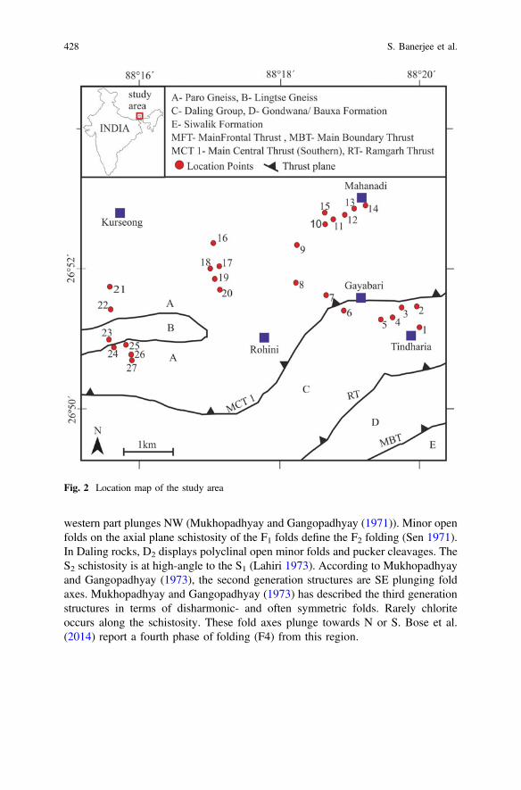
western part plunges NW (Mukhopadhyay and Gangopadhyay (1971)). Minor openfolds on the axial plane schistosity of the F1 folds define the F2 folding (Sen 1971).In Daling rocks, D2 displays polyclinal open minor folds and pucker cleavages. TheS2 schistosity is at high-angle to the S1 (Lahiri 1973). According to Mukhopadhyayand Gangopadhyay (1973), the second generation structures are SE plunging foldaxes. Mukhopadhyay and Gangopadhyay (1973) has described the third generationstructures in terms of disharmonic- and often symmetric folds. Rarely chloriteoccurs along the schistosity. These fold axes plunge towards N or S. Bose et al.(2014) report a fourth phase of folding (F4) from this region.
Fig. 2 Location map of the study area
428 S. Banerjee et al.
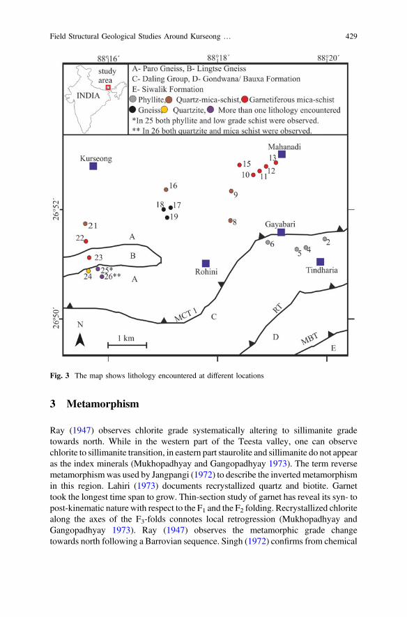
3 Metamorphism
Ray (1947) observes chlorite grade systematically altering to sillimanite gradetowards north. While in the western part of the Teesta valley, one can observechlorite to sillimanite transition, in eastern part staurolite and sillimanite do not appearas the index minerals (Mukhopadhyay and Gangopadhyay 1973). The term reversemetamorphismwas used by Jangpangi (1972) to describe the inverted metamorphismin this region. Lahiri (1973) documents recrystallized quartz and biotite. Garnettook the longest time span to grow. Thin-section study of garnet has reveal its syn- topost-kinematic nature with respect to the F1 and the F2 folding. Recrystallized chloritealong the axes of the F3-folds connotes local retrogression (Mukhopadhyay andGangopadhyay 1973). Ray (1947) observes the metamorphic grade changetowards north following a Barrovian sequence. Singh (1972) confirms from chemical
Fig. 3 The map shows lithology encountered at different locations
Field Structural Geological Studies Around Kurseong … 429
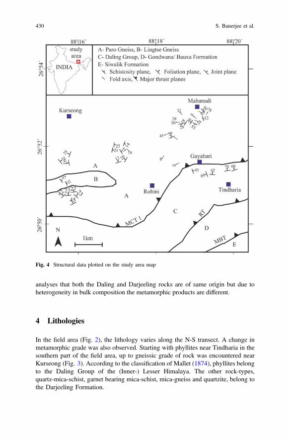
analyses that both the Daling and Darjeeling rocks are of same origin but due toheterogeneity in bulk composition the metamorphic products are different.
4 Lithologies
In the field area (Fig. 2), the lithology varies along the N-S transect. A change inmetamorphic grade was also observed. Starting with phyllites near Tindharia in thesouthern part of the field area, up to gneissic grade of rock was encountered nearKurseong (Fig. 3). According to the classification of Mallet (1874), phyllites belongto the Daling Group of the (Inner-) Lesser Himalaya. The other rock-types,quartz-mica-schist, garnet bearing mica-schist, mica-gneiss and quartzite, belong tothe Darjeeling Formation.
Fig. 4 Structural data plotted on the study area map
430 S. Banerjee et al.
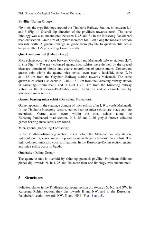
Phyllite (Daling Group):
Phylliteis the type lithology around the Tindharia Railway Station, in between L-1and 5 (Fig. 4). Overall dip direction of the phylliteis towards north. The samelithology was also encountered between L-25 and 31 in the Kurseong Pankhabariroad-cut section. Grain size of phyllite increases for 3 km along the road-cut sectiontowards north. A gradual change in grade from phyllite to quartz-biotite schisthappens after L-5 proceeding towards north.
Quartz-mica-schist (Daling Group):
Mica schists occur at places between Gayabari and Mahanadi railway stations (L-7,L-8 in Fig. 4). The grey coloured quartz-mica schists were defined by the spacedcleavage domain of biotite and coarse microlithon of quartz grains. Concordantquartz vein within the quartz mica schist occur near a landslide zone (L-9)at *2.5 km from the Gayabari Railway station towards Mahanadi. The samequartz-mica schist also occur in L-16 (*2.3 km from the Kurseong railway stationin Kurseong–Rohini road), and in L-21 (*2.1 km from the Kurseong railwaystation in the Kurseong–Pankhabari road). L-24, 25 and is characterized bylow-grade mica schists.
Garnet bearing mica schist (Darjeeling Formation):
Garnet appears in the cleavage domain of mica schists after L-9 towards Mahanadi.In the Tindharia-Kurseong section, garnet-bearing mica schists are black and arecrenulated. Garnet also occurs within the mica schists along theKurseong-Pankhabari road section. In L-25 and L-26 greyish brown colouredgarnet bearing mica-schists are found.
Mica gneiss (Darjeeling Formation):
In the Tindharia-Kurseong section, 2 km before the Mahanadi railway station,light-coloured gneissic rocks crop out along with garnetiferous mica schist. Thelight-coloured units also consist of garnets. In the Kurseong–Rohini section, gneissand mica schist occur in bands.
Quartzite (Daling Group):
The quartzite unit is overlaid by shinning greenish phyllite. Prominent foliationplanes dip towards N. In L-25 and 26, more than one lithology was encountered.
5 Structures
Foliation planes in the Tindharia–Kurseong section dip towards N, NE, and SW. InKurseong–Rohini section, they dip towards E and NW, and in the Kurseong–Pankhabari section towards NW, N and NNE (Figs. 4 and 5).
Field Structural Geological Studies Around Kurseong … 431
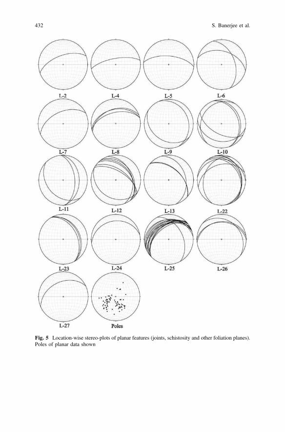
Fig. 5 Location-wise stereo-plots of planar features (joints, schistosity and other foliation planes).Poles of planar data shown
432 S. Banerjee et al.
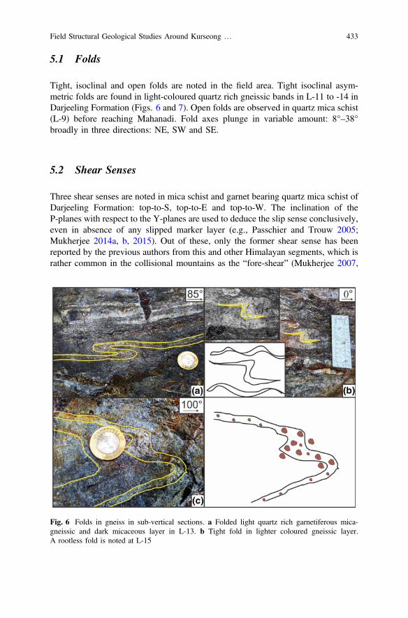
5.1 Folds
Tight, isoclinal and open folds are noted in the field area. Tight isoclinal asym-metric folds are found in light-coloured quartz rich gneissic bands in L-11 to -14 inDarjeeling Formation (Figs. 6 and 7). Open folds are observed in quartz mica schist(L-9) before reaching Mahanadi. Fold axes plunge in variable amount: 8°–38°broadly in three directions: NE, SW and SE.
5.2 Shear Senses
Three shear senses are noted in mica schist and garnet bearing quartz mica schist ofDarjeeling Formation: top-to-S, top-to-E and top-to-W. The inclination of theP-planes with respect to the Y-planes are used to deduce the slip sense conclusively,even in absence of any slipped marker layer (e.g., Passchier and Trouw 2005;Mukherjee 2014a, b, 2015). Out of these, only the former shear sense has beenreported by the previous authors from this and other Himalayan segments, which israther common in the collisional mountains as the “fore-shear” (Mukherjee 2007,
Fig. 6 Folds in gneiss in sub-vertical sections. a Folded light quartz rich garnetiferous mica-gneissic and dark micaceous layer in L-13. b Tight fold in lighter coloured gneissic layer.A rootless fold is noted at L-15
Field Structural Geological Studies Around Kurseong … 433

Fig. 7 Tight folds in sub vertical sections of light colouredgarnetiferous quartz mica gneiss.a Isoclinal fold in L-10, b secondary Z-fold in L-10
Fig. 8 Top-to-west ductile sheared quartz body within non-foliated micaceous rock insub-vertical sections. a Two shear senses observed in quartz vein within the non-foliated rockat L-10. b Sheared quartz vein within the gneissic rock at L-18. Intrafolial folding in garnet-richlight colored band within a non-foliated micaceous rock
434 S. Banerjee et al.

Fig. 9 Top-to-E sheared quartz vein in garnet-bearing mica schist in a sub-vertical section.a Lens-shaped quartz vein (L-14). b Rootless fold (L-14). c Quartz lens (L-10)
Fig. 10 Top-to-S shear sense observed in sub-vertical sections. a Quartz fish at L-6. b Brittle Y-and P-planes in low grade schist in L-6
Field Structural Geological Studies Around Kurseong … 435
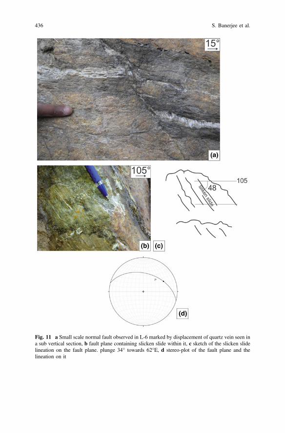
Fig. 11 a Small scale normal fault observed in L-6 marked by displacement of quartz vein seen ina sub vertical section, b fault plane containing slicken slide within it, c sketch of the slicken slidelineation on the fault plane. plunge 34° towards 62°E, d stereo-plot of the fault plane and thelineation on it
436 S. Banerjee et al.

2012, 2013a, b, c; Mukherjee and Koyi 2010a, b). The rest of the shear senses are thenew findings through this work. Intrafolially folded quartz veins show a top-to-Wshear around L-10 (Mukherjee et al. 2015; Fig. 8). Top-to-E shear in L-14 is markedby rootless intrafolial folds, lens-shape mineral fish of quartz (e.g., Mukherjee 2011),fracture planes in quartz vein (L-19), around Rohiniroad (Fig. 9). Asymmetric eye/augen-shaped clasts (Fig. 3 and 11a) and brittle Y- and P-planes in L-6 (Fig. 10)characterize the top-to-S shear. Orogen-parallel shear (top-to-E and -W) are also newfindings in this work. Mahato et al. (2019) also report the same from the LesserHimalaya from Garhwal region, Uttarakhand. Orogen parallel deformation is alsorecently further reported from Mohand area, Siwalik (Dutta et al. submitted).
5.3 Small Scale Normal Faults
In L-6 (*950 m before the Gayabari railway station), a single small-scale NNEdipping normal fault (Fig. 11) was observed within the high-grade phyllitic rockunit marked by the slip of a narrow quartz vein. The vein also shows a small-scalepinch-and-swell geometry.
Fig. 12 Joint planes in phyllitic rock cross-cutting quartz vein in L-5, observed in a sub-verticalsection
Field Structural Geological Studies Around Kurseong … 437
5.4 Foliations and Joints (Fig. 12)
Foliation planes in the Tindharia–Kurseong section dip towards N, NE, SW. InKurseong–Rohini section, they dip towards E and NW, and in the Kurseong–Pankhabari section towards NW, N and NNE. Two sets of joint planes were seen inphyllite at L-27 (*2.8 km before the location Pankhabari in the Kurseong–Pankhabari road). One set of joint planes dip towards NW.
Acknowledgements This work was a part of SB’s M.Sc. thesis. SM acknowledges the researchsabbatical for the year 2017 and the CPDA support from IIT Bombay. Annett Buettener, HelenRanchner and the Springer proof-reading team are thanked for assistance. Mukherjee (2019)summarizes this work.
References
Acharyya SK (1989) The Daling Group, its nomenclature, tectonostratigraphy and structural grain:with notes on their possible equivalents. Geological Survey of India 5–13 (Special Publication22)
Acharyya SK, Ghosh S, Mandal N, Bose S, Pande K (2017) Pre-Himalayan tectono-magmaticimprints in the Darjeeling-Sikkim Himalaya (DSH) constrained by 40Ar/39Ar dating ofmuscovite. Journal of Asian Earth Sciences 146, 211–220
Acharyya SK, Ray KK (1977) Geology of the Darjeeling–Sikkim Himalaya. Guide to ExcursionNo. 3. In: Fourth international Gondwana symposium (Calcutta). Geological Survey of India,pp 1–25
Auden JB (1935) Traverses in the Himalaya. Records of Geological survey of India 69, 123–167Bhattacharyya K, Mitra G (2009) A new kinematic evolutionary model for the growth of a duplex
—an example from the Rangit duplex, Sikkim Himalaya, India. Gondwana Research 16,697–715
Bose S, Mandal N, Acharyya SK, Ghosh S, Saha P (2014) Orogen-transverse tectonic window inthe Eastern Himalayan fold belt: a superposed buckling model. Journal of Structural Geology66, 24–41
Dutta D, Biswas T, Mukherjee S (Submitted) Orogen-parallel compression in NW Himalaya:evidence from structural and paleostress studies of brittle deformation from the pebbles ofUpper Siwalik conglomerates, Uttarakhand, India. Journal of Earth System Science
Jangpangi BS (1972) Some observations on the stratigraphy and reverse metamorphism inDarjeeling Hills. Himalayan Geology 2, 356–370
Lahiri S (1973) Some observations on structure and metamorphism of the rocks of Kurseong–Tindharia region, Darjeeling district, West Bengal. Himalayan Geology 3, 365–371
Lahiri S, Gangopadhway PK (1974) Structure pattern in rocks in Pankhabari–Tindharia regionDarjeeling district WB with special reference its bearing on stratigraphy. Himalayan Geology4, 151–170
Mahato S, Mukherjee S, Bose N (2019) Documentation of brittle structures (back shear andarc-parallel shear) from Sategal and Dhanaulti regions of the Garhwal Lesser Himalaya(Uttarakhand, India). In: Mukherjee S (ed) Tectonics and structural geology: Indian context.Springer International Publishing AG, Cham, pp 411–423. ISBN 978-3-319-99340-9
Mallet FR (1874) On the geology and mineral resources of the Darjiling District and the westernDuars. Memoirs of the Geological Survey of India 11, 1–50
Mukherjee S (2007) Geodynamics, deformation and mathematical analysis of metamorphic belts,NW Himalaya. Ph.D. thesis, Indian Institute of Technology Roorkee, pp 1–267
438 S. Banerjee et al.
Mukherjee S (2011) Mineral fish: their morphological classification, usefulness as shear senseindicators and genesis. International Journal of Earth Sciences 100, 1303–1314
Mukherjee S (2012) Tectonic implications and morphology of trapezoidal mica grains from theSutlej section of the Higher Himalayan Shear Zone, Indian Himalaya. The Journal of Geology120, 575–590
Mukherjee S (2013a) Higher Himalaya in the Bhagirathi section (NW Himalaya, India): itsstructures, backthrusts and extrusion mechanism by both channel flow and critical tapermechanisms. International Journal of Earth Sciences 102, 1851–1870
Mukherjee S (2013b) Deformation microstructures in rocks. Springer Geochemistry/Mineralogy,Berlin. pp 1–111. ISBN 978-3-642-25608-0
Mukherjee S (2013c) Channel flow extrusion model to constrain dynamic viscosity and Prandtlnumber of the Higher Himalayan Shear Zone. International Journal of Earth Sciences 102,1811–1835
Mukherjee S (2014a) Review of flanking structures in meso- and micro-scales. GeologicalMagazine 151, 957–974
Mukherjee S (2014b) Atlas of shear zone structures in meso-scale. Springer Geology, Cham, pp 1–124. ISBN 978-3-319-0088-6
Mukherjee S (2015) Atlas of structural geology. Elsevier, Amsterdam. ISBN: 978-0-12-420152-1Mukherjee S (2017a) Shear heating by translational brittle reverse faulting along a single, sharp
and straight fault plane. Journal of Earth System Science 126(1)Mukherjee S (2017b) Review on symmetric structures in ductile shear zones. International Journal
of Earth Sciences 106, 1453–1468Mukherjee S (2019) Introduction to “Tectonics and Structural Geology: Indian Context”. In:
Mukherjee S (ed) Tectonics and structural geology: Indian context. Springer InternationalPublishing AG, Cham, pp 1–5. ISBN: 978-3-319-99340-9
Mukherjee S, Khonsari MM (2017) Brittle rotational faults and the associated shear heating.Marine and Petroleum Geology 88, 551–554
Mukherjee S, Khonsari MM (2018) Inter-book normal fault-related shear heating in brittlebookshelf faults. Marine and Petroleum Geology 97,45–48
Mukherjee S, Koyi HA (2010a) Higher Himalayan Shear Zone, Sutlej Section—structural geology& extrusion mechanism by various combinations of simple shear, pure shear & channel flow inshifting modes. International Journal of Earth Sciences 99, 1267–1303
Mukherjee S, Koyi HA (2010) Higher Himalayan Shear Zone, Zanskar Section—microstructuralstudies & extrusion mechanism by a combination of simple shear & channel flow. InternationalJournal of Earth Sciences 99, 1083–1110
Mukherjee S, Mulchrone KF (2013) Viscous dissipation pattern in incompressible Newtoniansimple shear zones: an analytical model. International Journal of Earth Sciences 102, 1165–1170
Mukherjee S, Punekar JN, Mahadani T, Mukherjee R (2015) A review on intrafolial folds and theirmorphologies from the detachments of the western Indian Higher Himalaya. In: Mukherjee S,Mulchrone KF (eds) Ductile shear zones: from micro- to macro-scales. Wiley Blackwell,pp 182–205
Mukhopadhyay MK, Gangopadhyay PK (1971) Structural characteristics of rocks aroundKalimpong, West Bengal. Himalayan Geology 1, 213–230
Mukhopadhyay MK, Gangopadhyay PK (1973) Rotational Garnets And Quartz Micro-Fabric in Siand Se: An Example from Metamorphic Rocks around Takdah, Darjeeling District, WestBengal. Himalayan Geology 3, 162–175
Mulchrone KF, Mukherjee S (2015) Shear senses and viscous dissipation of layered ductile simpleshear zones. Pure and Applied Geophysics 172, 2635–2642
Mulchrone KF, Mukherjee S (2016) Kinematics and shear heat pattern of ductile simple shearzones with ‘slip boundary condition’. International Journal of Earth Sciences 105, 1015–1020
Passchier CW, Trouw, RAJ (2005) Microtectonics, 2nd edn. Springer, Berlin. pp 1–366. ISBN-103-540-64003-7
Field Structural Geological Studies Around Kurseong … 439
Ray S (1947) Zonal metamorphism in the eastern Himalaya and some aspects of local geology.Quarterly Journal of the Geological, Mining and Metallurgical Society of India 19, 117–140
Sen A (1971) Preliminary observations on the Banded Darjeeling gneiss occurring aroundSukhiapokhri, Darjeeling district, West Bengal. Himalayan Geology 1, 276–278
Sen A (1973) Structural features of the rocks in Sukhiapokhri-Bijanbari region, Darjeeling District,West Bengal. Himalayan Geology 3, 357
Singh NK (1972) Petrochemistry of the rocks around Kurseong. Darjeeling District,WBHimalayan Geology 2, 502–514
Sinha Roy S (1973) Gondwana pebble-slate in the Rangit Valley tectonic window, DarjeelingHimalayas and its significance. Bulletin-Geological Society of India 14, 31–39
Wager LR (1939) The Lachi Series of Northern Sikkim. Records of the Geological Survey of India74, 171–188
440 S. Banerjee et al.
Pb—Isotopic Characterization of MajorIndian Gondwana Coalfields:Implications for EnvironmentalFingerprinting and GondwanaReconstruction
Rajeev Kumar, Joy Gopal Ghosh, S. S. Patel, Avijit Das, S. Sengupta,K. V. S. S. Krishna and D. Guha
1 Introduction
Lead (Pb) isotopic ratios (IR) can be exploited as a mighty tracer for the globalatmospheric Pb dispersal derived from natural as well as anthropogenic sources.Geological origin controls the characteristic isotopic composition of Pb, which is aunique property. This property is used to trace Pb sources in the environment(Kylander et al. 2010). Since the phasing out of leaded gasoline from India in theyear 2000, coal—combustion remains the principal source of Pb and mercurypollution in the environment, which in turn is responsible for severe health prob-lems in the Indian scenario.
Pb as a trace element can be present in coal in the form of its own minerals suchas galena (PbS) or clausthalite (PbSe) or as an admixture of Ba minerals, in thepyrite crystalline structure substituting for Fe, or can be bonded to organic matter inlow rank coals (Swaine 1990; Finkelman 1994). The geological changes and theatmospheric inputs during coalification also control the origin of trace elements inthe coal. The interactions in the milieu of geological, biochemical and physio—chemical factors are controlling factors for concentration and distribution of traceelements in coals. Hence, it is evident that the trace elements in coal may havediverse origins (Swaine 1990). Knowledge of the mode of occurrence of a haz-ardous element, such as lead, is of great interest because it may help us tounderstand its behaviour during coal conversion processes and its potentiallyhazardous activity. Moreover, interest in lead is enhanced by the fact that by
R. Kumar (&) � S. S. Patel � A. Das � K. V. S. S. Krishna � D. GuhaG & IG Division, CHQ, GSI, 15 Kyd Street, Kolkata 700016, Indiae-mail: [email protected]
J. G. Ghosh � S. SenguptaGeological survey of India, N.I.T, N.H. 5P, Faridabad 121001, India
© Springer Nature Switzerland AG 2019S. Mukherjee (ed.), Tectonics and Structural Geology: Indian Context,Springer Geology, https://doi.org/10.1007/978-3-319-99341-6_17
441
comparing LIRs in ores, contaminant sources and contaminated sites, it can be usedas a tracer for environmental management (Díaz-Somoano et al. 2007, 2009).
Apart from environmental application, Pb isotopes have the potential forstratigraphic correlation also. The high precision radiometric dates constrain theabsolute age of Formation. Likewise, Sr—isotopes, d13C and d18O measurementsprovide meticulous correlation constrains (Veizer et al. 1999; Melchin andHolmden 2006; Jones et al. 2010). It is well established that geological origincontrols the characteristic isotopic composition of Pb, which is a unique property.In the ambit of this, the LIRs can be used for stratigraphic correlation and recon-struction also. The occurrence of coal globally dates during the Gondwana period.The coal deposits from India and the deposits from Antarctica can be similarlycorrelated in global context of Gondwana reconstruction on the basis of LIRs.
The present work aims at the measurement of high precision LIRs of IndianGondwana coals by Multi-Collector ICPMS housed at the Geological survey ofIndia, Kolkata. This dataset will help in establishing a background for identifyingrelative contribution of coal, especially those used in coal-based thermal plants forthe lead pollution in India. Not only this, these data set can be extended to havewider geological implications such as Gondwana reconstruction.
2 Regional Geology
The sedimentary strata that accumulated in different areas of peninsular Indiabetween Permo-Carboniferous and Lower Cretaceous are referred as Gondwanas(Veevers and Tewari 1995). The Gondwana deposits mark resumption of sedi-mentation in the peninsular India in Late Carboniferous after a long hiatus since theProterozoic.
Formation of Gondwana basins in India as well as in other continents records amajor tectonic event of the Earth, which has been interpreted as driven by theepisodic release of Pangean induced heat. The Gondwana successions are preservedin a number of discrete basins in the peninsular India. The structural basins arerelics of the original depositional master basin that was disrupted during and afterdeposition (Veevers and Tewari 1995). The basins define three linear belts alongthe present-day river valleys of (1) Narmada–Son–Damodar (NSD), (2) Pranhita–Godavari and (3) Mahanadi (Fig. 1). The latter two river valleys are subparallel toeach other and meet the ENE–WSW trending NSD valley and the present-dayeastern margin of the subcontinent at high angle (Biswas 1999; Mishra et al. 1999;Acharyya 2000).
Gondwana Basins of India account for nearly 99% of coal resource of thecountry. The basins occur along major river valleys either as discrete bodies or areunified by post-Permian strata and are named after the Rivers Damodar, Son,Mahanadi, Godavari etc. or the linear hill ranges like Satpura and Rajmahal(Fig. 1). Throughout the Gondwana sequence in the Peninsular India the BarakarFormation is the predominant coal bearing horizon. Indian Gondwana coal are
442 R. Kumar et al.

mostly bituminous to sub—bituminous and occurs as seams inter -banded withsediments. They typically have high ash content in range of 35–50% (Raja Rao1982, 1983, 1987; Mukherjee 2019).
3 Methodology
3.1 Sample Collection
Coal samples have been collected from actively mined Gondwana coal depositsspread all over India. The coalfields covered in the purview of this study are Talcherand Ib Valley Coalfield (40 Samples), Rajmahal Coalfield (20 samples), Wardha
Fig. 1 Location of samplingpoints from the IndianGondwana Coalfields coveredin present study
Pb—Isotopic Characterization of Major Indian Gondwana … 443

Valley Coalfield (18 samples), Godavari Valley Coalfield (18 samples) and KorbaCoalfield (14 samples). Over all 110 coal samples have been analysed in this studycovering the E, S and central Indian Coalfields with the objective to delineate interas well as intra—seam variations, if at all present which can be traced after anal-yses. All the samples are bituminous to sub—bituminous coal and feed the majorthermal power plants (TPPs) for power generation. In addition to the coal samples,fly ash samples of major TTPs in the corresponding area have also been analysedfor Pb-isotopic composition. Figure 1 shows the disposition of Indian GondwanaCoal deposits and location of the samples collected.
3.2 Analytical Procedure
The physical and chemical processing methodology adopted for the determinationof Pb—isotopic composition for coal samples was dry ashing and mineralizationprocess as per Díaz-Somoano et al. (2007). The coal samples were pulverised inagate motor and dried to constant weight at room temperature. After this step thesamples were finally dried in a muffle furnace (*90 °C; 2 h) to remove themoisture. One gm of coal sample was taken and then mineralized under controlledconditions using a programmable furnace by the dry ashing with a temperatureincrease of 1 °C per minute to a maximum temperature of 500 °C. The totalmineralization time was 10 h after attaining the required temperature. The ash—content was determined gravimetrically. The ash was then dampened with one dropof Milli-Q deionized water before treating with the 5 mL of concentrated HF and0.5 mL of concentrated HClO4 in savillex vials and left overnight. The mixture ofacids was evaporated to near dryness and this step was repeated. After attaining theincipient moisture—content, the residue was dissolved in 2 mL of concentratedHNO3, transferred to a 100 mL volumetric flask, filled to the mark with Milli-Qdeionised water and transferred to a 100 mL PP Nalgene bottle. This stock solutionwas later diluted to 2% (v/v) HNO3 for determination of the LIRs. All the exper-iments were performed with considerable number of duplicate and proceduralblanks to determine possible contamination from reagents and general handling.
The fly ash samples were dried to remove moisture content and then 0.2 g ofsample has been digested using an acid solution of HCl:HNO3:HF::3:3:2 usingAnton Paar Multiwave 3000 Microwave digestion system. The mixture of acids andfly ash was evaporated to near dryness and this step was repeated again (Zhou et al.2014). The residue was dissolved in 2 ml of concentrated HNO3, transferred to a100 ml volumetric flask, filled to the mark with MilliQ water and transferred to a100 ml HDPE bottle.
These chemically processed samples of coal and fly ash have been analysed forLIRs using Nu Plasma II MC ICPMS housed at LAMCI facility of G & IG Divisionof the Geological Survey of India, Kolkata. The instrument is equipped with 22collectors (17 F Collectors and 5 Ion Counters). Routine measurements made instatic mode using the Faraday detectors with 1011 X resistors and Ion counting
444 R. Kumar et al.
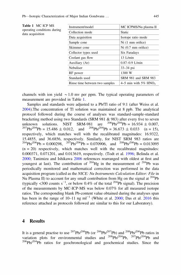
channels with ion yield *1.0 mv per ppm. The typical operating parameters ofmeasurement are provided in Table 1.
Samples and standards were adjusted to a Pb/Tl ratio of 9:1 (after Weiss et al.2004).The concentration of Tl solution was maintained at 8 ppb. The analyticalprotocol followed during the course of analyses was standard-sample-standardbracketing method using two Standards (SRM 981 & 983) after every five to sevenunknown solutions. NIST SRM-981 are 206Pb/204Pb = 16.934 ± 0.007,207Pb/204Pb = 15.486 ± 0.012, and 208Pb/204Pb = 36.673 ± 0.033 (n = 15),respectively, which matches well with the recalibrated magnitudes: 16.9322,15.4855, and 36.6856, respectively. Similarly, for NIST SRM 983 ratios are204Pb/206Pb = 0.000298, 207Pb/206Pb = 0.070906, and 208Pb/206Pb = 0.013095(n = 20) respectively, which matches well with the recalibrated magnitudes:0.000371, 0.071201, and 0.013619, respectively. (Todt et al. 1996; Belinda et al.2000; Tanimizu and Ishikawa 2006 references rearranged with oldest at first andyoungest at last). The contribution of 204Hg in the measurement of 204Pb wasperiodically monitored and mathematical correction was performed in the dataacquisition program (called as the NICE: Nu Instruments Calculation Editor: File inNu Plasma II) to account for any small contribution from Hg on the signal at 204Pb(typically <300 counts s−1, or below 0.4% of the total 204Pb signal). The precisionof the measurements by MC-ICP-MS was below 0.07% for all measured isotoperatios. The corresponding blank Pb-content value obtained during the analyses spanhas been in the range of 10–11 ng ml−1 (White et al. 2000; Das et al. 2016 thisreference attached as protocols followed are similar to this for our Laboratory).
4 Results
It is a general practise to use 207Pb/206Pb (or 206Pb/207Pb) and 208Pb/206Pb ratios invariation plots for environmental studies and 208Pb/204Pb, 207Pb/204Pb and206Pb/204Pb ratios for geochronological and geochemical studies. Since the
Table 1 MC ICP MSoperating conditions duringdata acquisition
Instrument/model MC ICPMS/Nu plasma II
Collection mode Static
Data acquisition Isotope ratio mode
Sample cone Ni (1 mm orifice)
Skimmer cone Ni (0.7 mm orifice)
Collector types used Six Faradays
Coolant gas flow 13 L/min
Auxiliary (Ar) 0.87–0.9 L/min
Nebuliser 33–34 psi
RF power 1300 W
Standards used SRM 981 and SRM 983
Rinse time between two samples 4–5 min with 5% HNO3
Pb—Isotopic Characterization of Major Indian Gondwana … 445
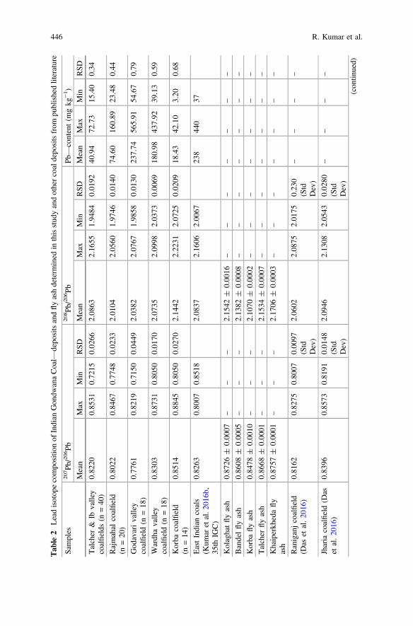
Tab
le2
Leadisotop
ecompo
sitio
nof
Indian
Gon
dwanaCoal—
depo
sitsandfly
ashdeterm
ined
inthisstud
yandothercoaldepo
sitsfrom
publishedliterature
Samples
207 Pb/
206 Pb
208 Pb/
206 Pb
Pb—content(m
gkg
−1 )
Mean
Max
Min
RSD
Mean
Max
Min
RSD
Mean
Max
Min
RSD
Talcher
&Ib
valley
coalfields
(n=40
)0.82
200.85
310.72
150.02
662.08
632.16
551.94
840.01
9240
.94
72.73
15.40
0.34
Rajmahal
coalfield
(n=20
)0.80
220.84
670.77
480.02
332.01
042.05
601.97
460.01
4074
.60
160.89
23.48
0.44
God
avarivalley
coalfield(n
=18
)0.77
610.82
190.71
500.04
492.03
822.07
671.98
580.01
3023
7.74
565.91
54.67
0.79
Wardh
avalley
coalfield(n
=18
)0.83
030.87
310.80
500.01
702.07
352.09
982.03
730.00
6918
0.98
437.92
39.13
0.59
Korba
coalfield
(n=14
)0.85
140.88
450.80
500.02
702.14
422.22
312.07
250.02
0918
.43
42.10
3.20
0.68
EastIndian
coals
(Kum
aretal.2
016b
,35
thIG
C)
0.82
630.80
070.85
182.08
372.16
062.00
6723
844
037
Kolaghatflyash
0.87
26±
0.00
07–
––
2.15
42±
0.00
16–
––
––
––
Bandelflyash
0.86
08±
0.00
05–
––
2.13
82±
0.00
08–
––
––
––
Korba
flyash
0.84
78±
0.00
10–
––
2.10
70±
0.00
02–
––
––
––
Talcher
flyash
0.86
68±
0.00
01–
––
2.15
34±
0.00
07–
––
––
––
Khaiperkh
edafly
ash
0.87
57±
0.00
01–
––
2.17
06±
0.00
03–
––
––
––
Raniganjcoalfield
(Das
etal.20
16)
0.81
620.82
750.80
070.00
97(Std
Dev)
2.06
022.08
752.01
750.23
0(Std
Dev)
––
––
Jharia
coalfield(D
aset
al.20
16)
0.83
960.85
730.81
910.01
48(Std
Dev)
2.09
462.13
082.05
430.02
80(Std
Dev)
––
––
(con
tinued)
446 R. Kumar et al.

Tab
le2
(con
tinued)
Samples
207 Pb/
206 Pb
208 Pb/
206 Pb
Pb—content(m
gkg
−1 )
Mean
Max
Min
RSD
Mean
Max
Min
RSD
Mean
Max
Min
RSD
Chinese
Coal
(Zhang
etal.20
07;
Cheng
andHu20
10)
0.84
790.86
610.83
26–
2.08
922.14
11.99
–40
400
––
World
Coal
(Díaz-So
moano
etal.20
09)
0.83
220.85
460.80
36–
2.05
672.10
131.98
22–
––
––
Indo
nesian
Coal
(Díaz-So
moano
etal.20
09)
0.84
490.84
740.84
17–
2.09
292.10
132.08
78–
––
––
Chinese
flyash
(Chenet
al.20
05)
0.86
80.86
70.85
5–
2.13
2.15
72.10
3–
––
––
Pb—Isotopic Characterization of Major Indian Gondwana … 447
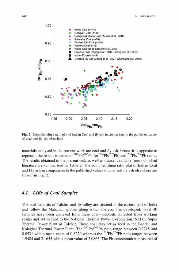
materials analysed in the present work are coal and fly ash, hence, it is apposite torepresent the results in terms of 207Pb/206Pb (or 206Pb/207Pb) and 208Pb/206Pb ratios.The results obtained in the present wok as well as dataset available from publishedliterature are summarised in Table 2. The compiled three ratio plot of Indian Coaland Fly ash in comparison to the published values of coal and fly ash elsewhere areshown in Fig. 2.
4.1 LIRs of Coal Samples
The coal deposits of Talcher and Ib valley are situated in the eastern part of Indiaand follow the Mahanadi graben along which the coal has developed. Total 40samples have been analysed from these coal—deposits collected from workingseams and act as feed to the National Thermal Power Corporation (NTPC) SuperThermal Power plant at Talcher. These coal also act as feed in the Bandel andKolaghat Thermal Power Plant. The 207Pb/206Pb ratio range between 0.7215 and0.8531 with a mean value of 0.8220 whereas the 208Pb/206Pb ratio ranges between1.9484 and 2.1655 with a mean value of 2.0863. The Pb-concentration measured of
Fig. 2 Compiled three ratio plot of Indian Coal and fly ash in comparison to the published valuesof coal and fly ash elsewhere
448 R. Kumar et al.

these coal—deposits lie between 15.40 and 72.73 mg kg−1 with a mean value of40.94 mg kg−1.
The coal-deposits of Rajmahal are situated in the eastern part of India where thecoal development has taken place along the main Rajmahal—Purnea Basin. Theanalysed coal samples (n = 20) from Rajmahal Coalfield have isotopic signatures inrange of 0.7748–0.8467 with mean value of 0.8022 and 1.9746–2.0560 with meanvalue of 2.0104 for the 207Pb/206Pb and 208Pb/206Pb ratios respectively. Thiscoalfield is also the supplier of coal to Bandel and Kolagahat Thermal Power Plantfor power generation.
The coal deposits of Godavari Valley have been developed along the course ofriver Godavari. On the Gondwana Basin’s map of India (Fig. 1); in fact twocoalfields have a linear extension from NW to SE. The NE extension of the coal-field is along Wardha River and hence, known as Wardha Valley Coalfield and theSE extension is known as the East Godavari Valley Coalfield. The 18 coal samplesanalysed from Godavari Valley Coalfield have 207Pb/206Pb ratios in range of0.7150–0.8219 with mean value of 0.7761 and 208Pb/206Pb ratios in range of1.9858–2.0767 with mean value of 2.0382. The concentration of Pb in this coalfieldobtained in range 238–566 mg kg−1 with a mean value of 238 mg kg−1.
The 18 coal samples analysed from Wardha Valley Coalfield have 207Pb/206Pbratios in range of 0.8050–0.8731 with mean value of 0.8303 and 208Pb/206Pb ratiosin range of 2.0373–2.0998 with mean value of 2.0735. The concentration of Pb inthis coalfield ranges 39–438 mg kg−1 with a mean value of 181 mg kg−1.
The Korba Coalfield forms the central Indian Gondwana Coal deposits.Quarriable potentiality of the seam of Barakar Formation and its occurrence atshallow depth (8.80 m) further enhances its importance. It is 16.82–18.74 m thickand occurs in the western part of the area only in between two NNE-SSW faults. Thefourteen samples analysed from this coalfield has isotopic composition in range0.8050–0.8845 with mean value of 0.8514 and 2.0725–2.2231 with mean value of2.1442 for the 207Pb/206Pb and 208Pb/206Pb ratios respectively. The Pb—concen-tration of these coal samples are in range of 3.2–42 mg kg−1 with mean value of18.5 mg kg−1.
4.2 LIRs of Fly Ash Samples
During the course of this work fly ash samples have also been analysed from thepower plants using the coal deposits as feed. The Kolaghat, Bandel and NTPCTalcher Termal Power Plants have their source in coalfields of Raniganj, Jharia,Talcher, Ib and Rajmhal. The NTPC Korba has its source for power generation inKorba Coalfield. The coals of Wardha valley coalfields act as feed to theKhaiperkheda Thermal Power Plant. The results obtained are presented in Table 2.
Pb—Isotopic Characterization of Major Indian Gondwana … 449

5 Discussion
As is evident from the previous section that the LIRs of Indian Gondwana coal—deposits ranges 0.7150–0.8845 for 207/206 Pb and 1.9484–2.2231 for 208/206 Pbwith Pb concentration ranges 3.2–566 mg kg−1. The variability of the Pb—contentand its isotopic composition can be attributed to high and variable ash—content ofthe coal seams including its pyrite—content and/or more radiogenic behaviour. Itmight be worth noting that the data obtained in the present work compares wellwith the records from the Chinese coals (Shanghai, Nanjing and Huinan Coalfield)that have Pb—content varying 40–400 ppm with a 206Pb/207Pb IR variation of0.8326–0.8661 and 208Pb/206Pb IR values of 1.99–2.141 (Zhang et al. 2007; Chengand Hu 2010).
Similarly the LIRs obtained in the fly ash analyses ranges 0.8478–0.8757 for207/206 Pb and 2.1070–2.1706 for 208/206 Pb. These values have an increasingtrend with respect to the feed coal Pb isotopic compositions when compared to therespective coal—deposits. Also the dataset obtained complies well with the pub-lished literature which reports the Pb isotopic composition for Chinese fly ash,which ranges 0.855–0.867 for 207/206 and 2.103–2.157 for 208/206, respectively(Chen et al. 2005).
5.1 LIRs in Fingerprinting
Uranium can be bonded to the organic material of the coal and also to the inorganiccomponents (Swaine 1990). In this case, the isotopic composition i.e. LIRs of thecoal is a result of mixing of the isotope ratios of common Pb in organic material atthe time of its sedimentation and the radioactive products of the subsequentlytransported U and Th. Because of the predominance of 238U in natural isotopicmixtures, the fingerprints of 206Pb are substantially affected by systems highlyenriched in U. This anomalous isotopic composition of Pb and the influence of U onthe Pb IR are the properties used to characterize and ultimately “fingerprinting/tracing” the source.
The present work reports and reviews the isotopic composition i.e., the LIRs ofthe Indian Gondwana basin Coal deposits. These dataset aim at establishing abackground for identifying relative contribution of coal, especially those used incoal—fired thermal plants for the Pb pollution in India. To test this hypothesis, theLIRs data generated by Das et al. (2016) for the different anthropogenic contrib-utors of Pb in Kolkata City and LIRs reported by Kumar et al. (2016c) in the duststorm aerosols of Indian subcontinent has been used for tracing/fingerprinting thepollutant in the township of Kolkata. The dataset obtained by Das et al. (2016) areon a gamut of food items (such as Rice, Dal, Spices, Vegetables, Fish, Meat,Chicken and Herbs), street dust, diesel and rainwater of Kolkata city. By applyingbinary mixing model on these dataset along with data reported by Kumar et al.
450 R. Kumar et al.
(2016a, b) has shown that coal—combustion is not the major contributor in theatmosphere of Kolkata City instead the diesel is the principal contributor in theform of vehicular exhaust. Thus using the LIR in coal samples from East IndianGondwana coal deposits, a logical clue for “tracing/fingerprinting” the Pb pollutionsource in the Indian scenario particularly for the Kolkata City has been achieved(Das et al. 2016; Kumar et al. 2017).
It is further recommended that LIRs of environmental milieu/matrices should betaken up in different power—hub Indian cities and the inventory on LIRs of Indiancoal should be compared for getting a novel qualitative as well as quantitative“fingerprinting” of environmental pollution and contribution from anthropogenicsources.
5.2 LIRs in Gondwana Reconstruction
Apart from these environmental aspect, the LIR data set generated in the presentwork particularly of the Mahanadi and Godavari valley coal—deposits can haveimplications on the Gondwana reconstruction.
The Gondwana sequence in the East Antarctica is restricted to the area aroundBeaver Lake in the Lambert graben. The sequence is known as the Amery Group(Mond 1972) and represents >4000 m thick sequence of coal—bearing conglom-erate—sandstone—minor shale association. Broadly, the sequence is >400 m thickUpper Permian Radok Conglomerate in the basal part, followed by *3000 m thickcoals bearing Bainmedart Coal Measures which is overlain by around 750 m thickTriassic Flagstone Bench Formation. The lithofacies and palynology of the rocks ofthe Amrey Group has been studied (Playford 1990; Webb and Fielding 1993;McLoughlin and Drinnan 1997), but the information on lead- isotopic compositionof this Group of rocks is not yet reported.
In the Gondwana reconstruction, there is a consensus that the *1.0 Ga mobilebelts of the Eastern Ghats in India and the Eastern Reyner Complex in Antarcticawere parts of a suture zone associated with Rhodinia Formation. However, thesebelts occur parallel to the boundaries of the continents and hence using them inGondwana reconstruction could be superfluous. The Gondwana basins of theAmery Group of the Lambert Graben and those of the Mahanadi and Godavaribasins in India that are aligned transverse to the continental margins are favouredfor a tighter Gondwana reconstruction. Available literature postulates correlation ofLambert Graben with Godavari basin on the basis of regional geology and coalpetrology (Holdgate et al. 2005) while the correlation model with Mahanadi basin isfavoured based on geophysics and bathymetry (Stagg 1985; Mishra et al. 1999)(Fig. 3). Since geophysics and bathymetry gets much influenced due topost-breakup events in the seafloor, a stronger correlation of the Lambert Grabenwith either the Mahanadi or the Godavari basin would require further constraints.The distinctive Pb—isotopic compositional variation between the coals from theMahanadi basin and the coals from the Godavari—Wardha basin as obtained in the
Pb—Isotopic Characterization of Major Indian Gondwana … 451
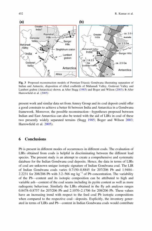
present work and similar data set from Amrey Group and its coal deposit could offera good constrain to achieve a better fit between India and Antarctica in a Gondwanaframework. Moreover, the possible reconstruction—hypotheses proposed betweenIndian and East Antarctica can also be tested with the aid of LIRs in coal of thesetwo presently widely separated terrains (Stagg 1985; Boger and Wilson 2003;Harrowfield et al. 2005).
6 Conclusions
Pb is present in different modes of occurrences in different coals. The evaluation ofLIRs obtained from coals is helpful in discriminating between the different leadspecies. The present study is an attempt to create a comprehensive and systematicdatabase for the Indian Gondwana coal deposits. Hence, the data in terms of LIRsof coal are unknown unique isotopic signature of Indian Gondwana coal. The LIRof Indian Gondwana coals varies 0.7150–0.8845 for 207/206 Pb and 1.9484–2.2231 for 208/206 Pb with 3.2–566 mg kg−1 of Pb concentration. The variabilityof the Pb—content and its isotopic composition can be attributed to high andvariable ash—content of the coal seams including its pyrite content as well as moreradiogenic behaviour. Similarly the LIRs obtained in the fly ash analyses ranges0.8478–0.8757 for 207/206 Pb and 2.1070–2.1706 for 208/206 Pb. These valueshave an increasing trend with respect to the feed coal Pb isotopic compositionswhen compared to the respective coal—deposits. Explicitly, the inventory gener-ated in terms of LIRs and Pb—content in Indian Gondwana coals would contribute
Fig. 3 Proposed reconstruction models of Permian-Triassic Gondwana illustrating separation ofIndian and Antarctic, disposition of rifted coalfields of Mahanadi Valley, Godavari Valley andLambert graben (Antarctica) shown. a After Stagg (1985) and Boger and Wilson (2003); b AfterHarrowfield et al. (2005)
452 R. Kumar et al.
to establish a background for identifying relative contribution of coal, especiallythose used in coal—fired thermal plants for the lead pollution in India. Not onlythis, these unique isotopic signatures of Pb can be used for regional implications aschemical tracers (Sr—isotopes, d13C and d18O measurements are generally used)for stratigraphic correlation and Gondwana reconstruction also.
Acknowledgements This work is the outcome of the research project (RP/CHQMIV/2014/114)approved by Ministry of Mines and to be taken up by the Geological Survey of India, Kolkata. Theauthor would like to thank the Director General, Geological Survey of India, Kolkata, for all sort ofadministrative supports and permission to publish this research outcome. The West Bengal PowerDevelopment Corporation, Kolkata and different regional ancillaries of Coal India Ltd. areacknowledged for their fruitful discussions and granting permission to collect samples fromThermal Power Plants and collieries respectively. Soumyajit Mukherjee edited and reviewed thismanuscript. This work is summarized in Mukherjee (2019).
References
Acharyya SK (2000) Tectonic setting and nature of the Gondwanic Indian crust. Proc. Vol., Int.Seminar, Precambrian Crust in Eastern and Central India. Geological Survey of India, SpecialPublication 57, 1–8
Biswas SK (1999) A review on the evolution of rift basins in India during Gondwana with specialreference to western Indian basins and their hydrocarbon prospects. In: Sahni A, Loyal RS(eds) Gondwana assembly: new issues and perspectives. proceedings of indian national scienceacademy special issue 65, pp 261–283
Boger SD, Wilson CJL (2003) Brittle faulting in the Prince Charles Mountains, East Antarctica:cretaceous transtensional tectonics related to the break-up of Gondwana. Tectonophysics 367,173–186
Chen JM, Tan MG, Li YL, Zhang YM, Lu WW, Tong YP, Zhang GL, Li Y (2005) A lead isotoperecord of Shanghai atmospheric lead emissions in total suspended particles during the period ofphasing out of leaded gasoline. Atmospheric Environment 39, 1245–1253
Cheng H, Hu Y (2010) Lead (Pb) isotopic fingerprinting and its applications in lead pollutionstudies in China: a review. Environmental Pollution 158, 1134–1146
Das A, Krishna KVSS, Kumar R, Das A, Sengupta S, Ghosh JG (2016) Tracing leadcontamination in foods in the city of Kolkata, India. Environmental Science and PollutionResearch 23, 22454–22466
Díaz-Somoano M, Suárez-Ruiz I, Alonso JIG, Ruiz Encinar J, López-Anton MA,Martínez-Tarazona MR (2007) Lead isotope ratios in Spanish coals of different characteristicsand origin. International Journal of Coal Geology 71, 28–36
Díaz-Somoano M, Kylander ME, Lopez-Anton MA, Suarez-Ruiz I, Martínez Tarazona MR,Ferrat M, Kober B, Weiss DJ (2009) Stable lead isotope compositions in selected coals fromaround the world and implications for present day aerosol source tracing. EnvironmentalScience and Technology 43, 1078–1085
Finkelman RB (1994) Modes of occurrence of potentially hazardous elements in coal: levels ofconfidence. Fuel Processing Technology 39, 21–34
Flem B, Grimstvedt A, Cook N (2000) Lead isotope determinations by inductively-coupled plasmamass spectrometry (ICP-MS): potential of sector field instruments. NGU-BULL 436, 203–207
Harrowfield M, Holdgate RG, Wilson CJL (2005) Tectonic significance of the Lambert graben,East Antarctica: Reconstructing the Gondwanan rift. Geology 33, 197–200
Pb—Isotopic Characterization of Major Indian Gondwana … 453
Holdgate GR, McLoughlin S, Drinnan AN, Finkelman RB, Willett JC (2005) Inorganic chemistry,petrography and palaeobotany of Permiancoals in the Prince Charles Mountains, EastAntarctica. International Journal of Coal Geology 63, 156–177
Jones DS, Maloof AC, Hurtgen MT, Rainbird RH, Schrag DP (2010) Regional and globalchemostratigraphic correlation of the early Neoproterozoic Shaler Supergroup, Victoria Island,Northwestern Canada. Precambrian Research 181, 43–63
Kumar R, Patel SS, Manjhi JK (2016a) Pb-isotopic characterization of major Indian Coalfields andtheir potential as heavy metal pollutants. GSI Unpublished Report
Kumar R, Patel SS, Ghosh JG (2016b) Variability of Pb-isotopes in the East Indian GondwanaCoal deposits: its influence on Kolkata street dust. 35TH IGC ABSTRACT
Kumar S, Aggarwal SG, Malherbe J, Barre JPG, Berial S, Gupta PK, Donard (2016c) Tracing dusttransport from Middle-East over Delhi in March 2012 using metal and lead isotopecomposition. Atmospheric Environment 132, 179–187
Kumar R, Patel SS, Das A, Ghosh JG, Sengupta S, Krishna KVSS, Guha D (2017) Variability ofPb-isotopes in the East Indian Gondwana Coal deposits: It’s influence on Kolkata street dust.Indian Journal of Geoscience 71(4), 575–588
Kylander ME, Klaminder J, Bindler R (2010) Natural Lead Isotope Variations in the Atmosphere.Earth and Planetary Science Letters 290, 44–53
McLoughlin S, Drinnan AN (1997) Revised stratigraphy of the Permian Bainmedart coalmeasures, northern Prince Charles Mountains, East Antarctica. Geological Magazine 134, 335–353
Melchin MJ, Holmden CE (2006) Carbon isotope chemostratigraphy in Arctic Canada: sea-levelforcing of carbonate platform weathering and implications for Hirnantian global correlation.Palaeogeography, Palaeoclimatology, Palaeoecology 234, 186–200
Mishra DC, Chandra Sekhar DV, Venkata Raju DCh, Vijay Kumar V (1999) Crustal structurebased on gravity-magnetic modelling constrained from seismic studies under Lambert Rift,Antarctica and Godavari and Mahanadi rifts, India and their interrelationship. Earth andPlanetary Science Letters 172, 287–300
Mond A (1972) Permian sediments of the Beaver Lake area, Prince Charles Mountains. In:Adie RJ (ed) Antarctic geology and geophysics. Universitetsforlaget, Oslo, pp 585–589
Mukherjee S (2019) Introduction to “Tectonics and Structural Geology: Indian Context”. In:Mukherjee S (ed) Tectonics and structural geology: Indian context. Springer InternationalPublishing AG, Cham, pp 1–5. ISBN: 978-3-319-99340-9
Playford G (1990) Proterozoic and Palaeozoic palynology of Antarctica: a review. In: Taylor TN,Taylor EL (eds) Antarctic paleobiology—its role in the reconstruction of Gondwana. SpringerVerlag, New York. Plumstead, pp 50–70
Raja Rao CS (1982) Coalfields of India. Vol-II, coal resources of Tamil Nadu, Andhra Pradesh,Orissa and Maharashtra. Geological Survey of India Bulletin Series A, 45
Raja Rao CS (1983) Coalfields of India. Vol‐III, Coal resources of Madhya Pradesh and Jammuand Kashmir. Geological Survey of India Bulletin Series A, 45
Raja Rao CS (1987) Coalfields of India. Vol-IV, Part I. Coal resources of Bihar. GeologicalSurvey of India Bulletin Series A, 45
Stagg HMJ (1985) The structure and origin of Prydz Bay and MacRoberstonShelf. East Antarctica:Tectonophysics 114, 315–340
Swaine DJ (1990) Trace elements in coal. Butterworths and Co. PublishersTanimizu M, Ishikawa T (2006) Development of rapid and precise Pb isotope analytical
techniques using MC-ICP-MS and new results for GSJ rock reference samples. GeochemicalJournal 40, 121–133
Todt W, Cliff RA, Hanser A, Hofmann AW (1996) Evaluation of a 202Pb/205Pb double spike forhigh precision lead isotope analysis in earth processes: reading the isotopic code. AmericanGeophysical Union, pp 429–437
Veevers JJ, Tewari RC (1995) Gondwana master basin of peninsular India between Tethys and theinterior of the Gondwanaland province of Pangea. Memoir of Geological Society of America187, 1–73
454 R. Kumar et al.
Veizer J, Ala D, Azmy K, Bruckschen P, Buhl D, Bruhn F, Carden GAF, Diener A, Ebneth S,Godderis Y, Jasper T, Korte C, Pawellek F, Podlaha O, Strauss H (1999) 87Sr/86Sr, 13C and18 O evolution of Phanerozoic seawater. Chemical Geology 161, 59–88
Webb A, Fielding R (1993) Permo-Triassic sedimentation within the Lambert Graben, northernPrince Charles Mountains, East Antarctica. In: Findlay RH, Uruug R, Banks MR, Veevers JJ(eds) Gondwana eight: assembly, evolution and dispersal. A. A. Balkema, Rotterdam, pp 357–369
Weiss D, Kober B, Dolgopolova A, Gallagher K, Spiro B, Le Roux G, Mason TFD, Kylander M,Coles BJ (2004) Accurate and precise Pb isotope ratio measurements in environmental samplesby MCICP- MS. International Journal of Mass Spectrometry 232, 205–215
White WM, Albaredeb F, Teloukb P (2000) High-precision analysis of Pb-isotope bymulticollector ICP-MS. Chemical Geology 167, 257–270
Zhang GL, Yang FG, Zhao WJ, Zhao YG, Yang JL, Gong ZT (2007) Historical change of soil Pbcontent and Pb isotope signatures of the cultural layers in urban Nanjing. CATENA 69, 51–56
Zhou C, Liu G, Cheng S, Fang T, Lam PKS (2014) The environmental geochemistry of traceelements and naturally radionuclides in a coal gangue brick-making plant. Scientific Reports 4,6221
Pb—Isotopic Characterization of Major Indian Gondwana … 455