diamond drilling report of the cleaver property - Geology Ontario
Upload
khangminh22Category
view
3download
0
52H06SWOO28 2.15559 WABIKON LAKE 010
St F ;; 6 •'•M.MINING Lt
NORANDA EXPLORATION COMPANY. LIMITED
REPORT ON GEOPHYSICAL SURVEYS
WHISTLE LAKE PROPERTY
EAST WHISTLE GRID
N.T.S. 52 H/6
WEST PRECAMBRIAN DISTRICT
PROJECT NO. 307 THUNDER BAY ONTARIO JULY. 1994
AL SMITHPROJECT GEOLOGIST
ROGER SHARPESENIOR GEOPHYSICIST
S2H06SWOQ28 2 15559 WABIKON IM(E
01OCTable of
1.0 INTRODUCTION . . . . . . . . . . . . . . . . . . . . . . . . . . . . . . . . . . . . . . . . . . . . . . . . . . 1
2.0 LOCATION AND ACCESS . . . . . . . . . . . . . . . . . . . . . . . . . . . . . . . . . . . . . . . . . . . . 1
3.0 PROPERTY DESCRIPTION . . . . . . . . . . . . . . . . . . . . . . . . . . . . . . . . . . . . . . . . . . . . 1
4.0 EXPLORATION HISTORY . . . . . . . . . . . . . . . . . . . . . . . . . . . . . . . . . . . . . . . . . . . . 1
5.0 GEOLOGY . . . . . . . . . . . . . . . . . . . . . . . . . . . . . . . . . . . . . . . . . . . . .. . . . . . . . . . 3
6.0 GRID PREPARATION . . . . . . . . . . . . . . . . . . . . . . . . . . . . . . . . . . . . . . . . . . . . . . . 4
7.0 GEOPHYSICAL SURVEYS . . . . . . . . . . . . . . . . . . . . . . . . . . . . . . . . . . . . . . . . . . . . 47.1 Survey Statistics ... . .. ... . . ... . . . . .. . . . ... . . . ... . ... .... . ... .. . 47.2 Instrumentation . . . . . . . . . . . . . . . . . . . . . . . . . . . . . .. . . . . . . . . . . . . . . . . 4
8.0 INTERPRETATION . . . . . . . . . . . . . . . . . . . . . . . . . . . . . . . . . . . . . . . . . . . . . . . . . 78.1 HLEM Survey . . . . . . . . . . . . . . . . . . . . . . . . . . . . . . . . . . . . . . . . . . . . . . . . . 78.2 DEEPEM Survey . . . . . . . . . . . . . . . . . . . . . . . . . . . . . . . . . . . . . . . . . . . . . . . 7
9.0 CONCLUSIONS AND RECOMMENDATIONS . . . . . . . . . . . . . . . . . . . . . . . . . . . . . . . 8
LIST OF ATTACHMENTS
Figure 1 Location MapFigure 2a Claim Location MapFigure 2b Grid Location MapFigure 3 Magnetic Survey Map (Total Field Contours)Figure 4 HLEM Survey Profiles 440 HzFigure 5 HLEM Survey Profiles 1760 HzFigure 6 DEEPEM Survey - Z componentFigure 7 DEEPEM Survey - X component
List of Appendices
Scale
1:1,000.0001:50,0001:50.0001:5.0001:5.0001:5.0001:50001:5000
Appendix l Appendix II Appendix III
List of Personnel References DEEPEM Data
1.0 INTRODUCTION
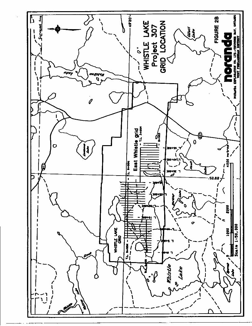
Geophysical surveys completed on the East Whistle grid during 1994 include HLEM, magnetometer and pulse EM (DEEPEM). The surveying was completed to further define an AEM conductor detected during a 1989 Questor survey flown for Cumberland Resources Ltd.
A new grid known as the East Whistle grid (10.3 km) was cut in July to allow ground surveying of the deep AEM anomaly. The East Whistle grid is located 500m southeast of the main Whistle Lake grid, to which it is connected with a tieline.
This work report describes DEEPEM, HLEM and magnetometer surveys completed on the East Whistle grid.
2.0 LOCATION AND ACCESS
The Whistle Lake property is situated approximately 90 kilometers north of Thunder Bay (Figure 1). The eastern part of the property is cut by Highway 527.
The property may be reached by travelling east from Thunder Bay on Highway 11/17 to Highway 527, and then by travelling 106 km north on Highway 527 to the Sauerbrei Road. The Sauerbrei forest road is then travelled west from the highway for 4 km to a series of old logging roads which extend northward to the Whistle Lake grid. These old logging roads provide good access for 4WD Quads (and snowmachines) to most of the grid.
3.0 PROPERTY DESCRIPTION
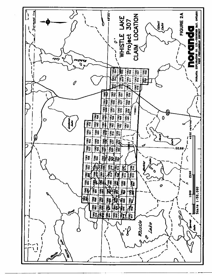
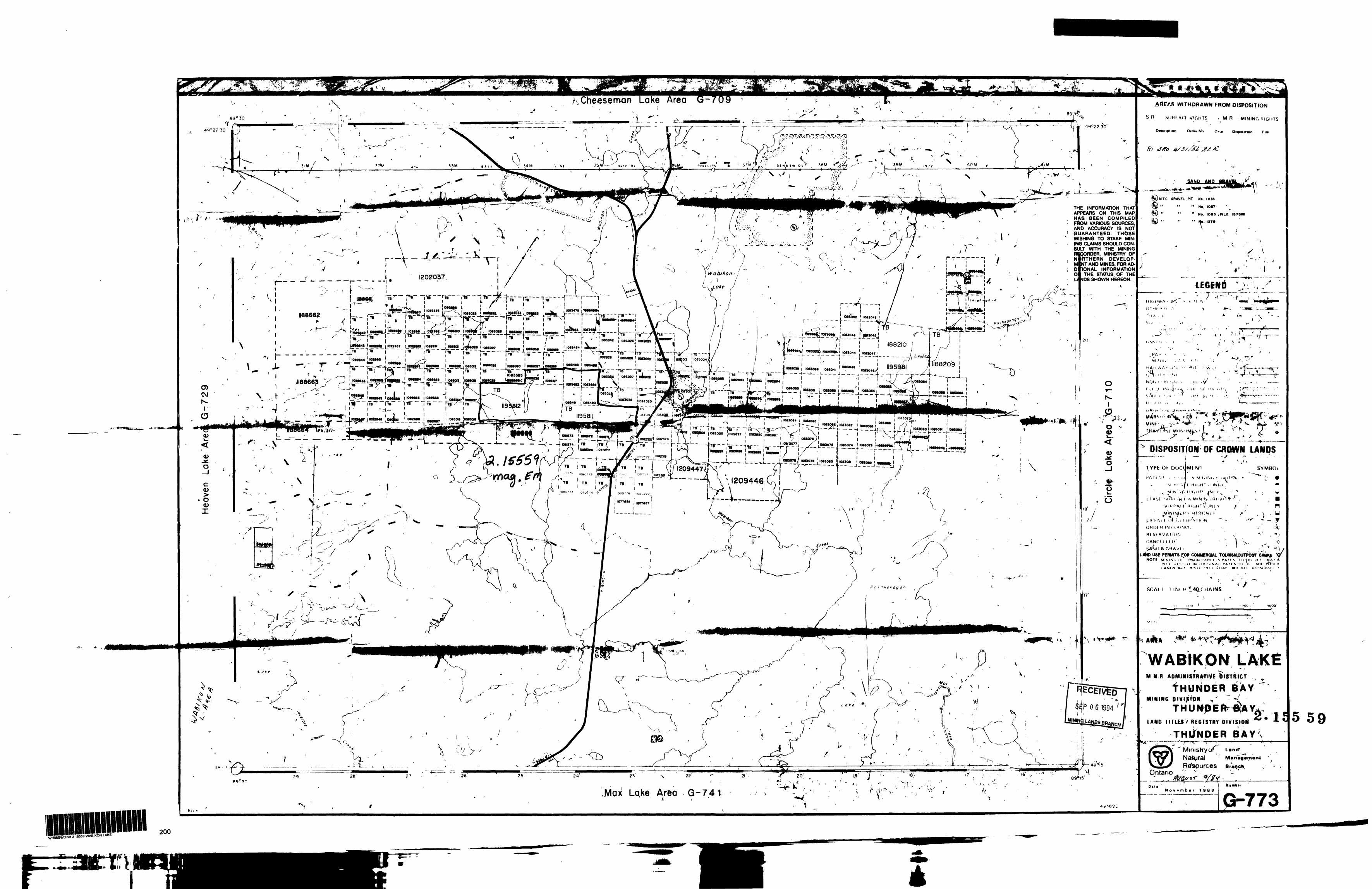
The Whistle Lake property comprises a total of 107 claims (117 claim units or 1872 hectares). The claims occur in the north central part of the Wabikon Lake map sheet G-773, and comprise a block extending approximately 6 km east-west (Figure 2a).
The claim numbers along with recording dates and due dates are listed on Table 1.
The registered owner of the claims is Noranda Exploration Company, Ltd. The property was optioned in late 1993 from Cumberland Resources Ltd. by Noranda Exploration Co. Ltd., which has the option to earn 50% interest in the property by making scheduled payments and incurring certain exploration expenditures over a four year period.
4.0 EXPLORATION HISTORY
Mineral exploration has been documented in the Whistle Lake area as early as the 1940's. Exploration activity was however more active following the construction of Highway 527 in the 1960*8.
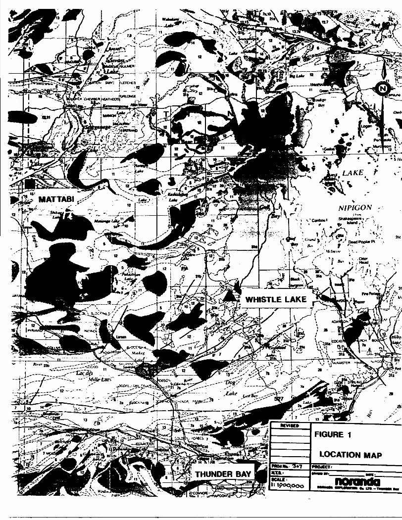
FIGURE 1
LOCATION
— S
p
urv
eyed
U
n
10*2
10
*2 f
lB
|
^S
SLLJS
SzlS
lfL**
WH
ISTL
E LA
KE
P
roje
ct
307
. 10
83 1
101J
l 10U
l
1083
10
83! 4
" i 4
'0 ^g
" "'
"Q
CLA
IM
LOC
ATIO
N
FIG
UR
E 2
A
nora
nda
NOIU
NOA
EXPL
OM
nON
CO
. II
P.-T
OW
DII
I BA
Y. O
NTAR
IOvu
t mc
Aifln
oAN
DUIW
LI
WH
ISTL
E
LAK
EPr
ojec
t 30
7G
RID
LO
CAT
ION
FIG
UR
E 2
B
nora
nda
' MO
RAND
* EX
PLOR
ATIO
N CO
. U
P.-T
HU
MP1
H B
AY.
ONT
ABO
X
V
BST
MBC
AOTB
IAH
DflR
HC
T
Previous exploration activity within the area of the present property is listed below in chronological order.
1. 1965 - Steep Rock Iron Mines Limited completed mag, geology, and soil sampling surveys on their optioned Armstrong property, located east off Nault Lake.
2. 1973 - Mineral Resources International Limited and Clarke Noyes drilled one hole (83.8m) to test a geophysical conductor outlined in the southwest part off the present property. Prior to drilling, trenching and blasting had exposed massive sulphide mineralization.
3. 1974 - Hanna Mining Company completed 4 drill notes (167m) to test geophysical conductors on their Highway property, situated in the north central to north eastern parts off the present property.
4. 1975 - Phelps Dodge completed 4 drill holes (177.4m) to test various EM anomalies. Two off these hole. 150-1 and 150-2, are located in the central and eastern parts off the current Whistle Lake property, respectively. A 1.5 m interval in note 15O-1 returned 0.11 % Zn, white a 3 m interval in note 150-2 returned Q.76% Zn.
5. 1980 - Amoco Canada Petroleum Company Limited drilled 4 holes (331.3m) within a zone off EM conductors located near the north boundary of the present property. These holes encountered both massive sulphides and graphitic sediments, with a number of anomalous Cu and Zn values.
6. 1982 - Bill Hayne completed physical work on the Nault Property, which borders the southeast part of the Whistle Lake property.
7. 1989 - Cumberland Resources Ltd. contracted Questor Surveys Ltd. to complete a fixed wing INPUT MARK VI ABEM survey over their entire Whistle Lake Property. The western half of the Cumberland property comprises the property currently under option.
8. 1990 - MingokJ optioned the Nault property and completed geological, VLF-EM. and magnetometer surveys, and 6 diamond drill holes (592.5m). The target for this work was Au mineralization.
9. 1993 - Cumberland Resources Ltd. had a grid established to cover significant ABEM conductors outlined by the 1989 survey. A program off geological mapping, lithogeochemical sampling, VLF-EM and magnetometer surveying, and trenching was completed (Leahey, 1993).
10. 1993 - Cumberland Resources Limited optioned the west part off their Whistle Lake property to Noranda Exploration Company, Limited.
Previous geological mapping in the area has been completed by the Ontario Geological Survey (ODM) in 1923 and 1964. and by the Canadian Pacific Railway Company in 1960 (Milne, 1964).
TABLE!
CLAM NUMBERS
TB 1083004 -108301 3
TB 1083015-1083023
TB 1O83O25 - 1O83O32
TB 1083393
TB 1083479
TB 1083481 - 1O83490
TB 1085010 - 1085022
TB 1085025 - 1O85033
TB 1085036 - 1O85039
TB 1O92617 - 1O92622
TB 1O92642 - 1O92653
TB 1O92655 - 1O92661
TB 1O9268O - 1O92693
TB 1O92696
TB 1195811
TB 1195812
TOTAL
TOTAL* CLAM!
10
9
8
1
1
10
13
9
4
6
12
7
14
1
1
1
107
TOTAL* UNTO
10
9
8
1
1
10
13
9
4
6
12
7
14
1
4
8
117
RECORDMODATE
09/12/88
09/12/88
09/12/88
10/31/88
10/25/88
10/25/88
10/31/88
10/31/88
10/31/88
1O/31/88
1O/31/88
10/31/88
10/31/88
1O/31/88
O8/11/92
08/11/92
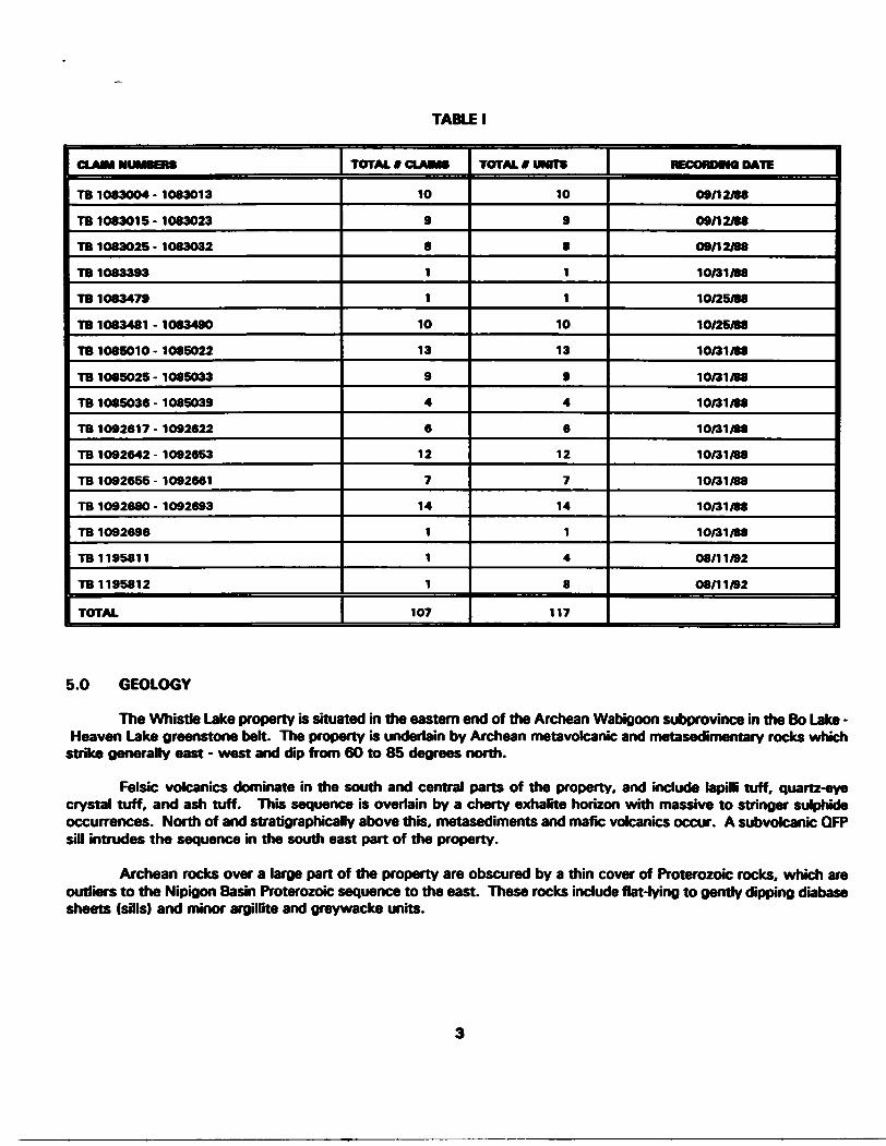
5.0 GEOLOGY
The Whistle Lake property is situated in the eastern end of the Archean Wabigoon subprovince in the Bo Lake - Heaven Lake greenstone belt. The property is underlain by Archean metavolcanic and metasedimentary rocks which
strike generally east - west and dip from 60 to 85 degrees north.
Felsic volcanics dominate in the south and central parts of the property, and include lapilli tuff, quartz-eye crystal tuff, and ash tuff. This sequence is overlain by a cherty exhalite horizon with massive to stringer sulphide occurrences. North of and stratigraphically above this, metasediments and mafic volcanics occur. A subvolcanic QFP sill intrudes the sequence in the south east part of the property.
Archean rocks over a large part of the property are obscured by a thin cover of Proterozoic rocks, which are outliers to the Nipigon Basin Proterozoic sequence to the east. These rocks include flat-lying to gently dipping diabase sheets (sills) and minor argillite and greywacke units.
6.0 GRID PREPARATION
A total of 10.3 line km of grid was cut by Northwest Geophysics Ltd. between July 11-16, 1994. This grid consists of a 1.5 km tie line oriented east-west extending east from L3000E at 300N on the main Whistle grid. Grid lines spaced 100m apart extend from 3500E to 45OOE and extend south from the tie line for 800m.
Following completion of HLEM and magnetometer surveying, the grid was extended to the east to facilitate the pulse EM survey. A tieHne was cut at 400S between L4500E and 4700E, and 500 meter long grid lines were cut at 4600E and 4700E extending to 100N. This grid extension was cut by the Noranda Exploration Company, Limited geophysics crew.
7.0 GEOPHYSICAL SURVEYS
7.1 Survey Statistics
The surveys were carried out by Noranda Exploration Company, Limited employees during July 1994, (see Table H).
Initial data collection comprised 200m coil separation HLEM and a magnetic survey. Magnetic data were not collected on the western two lines (3500E and 36OOE) due to high magnetic diurnal variation and time constraints.
A surface pulse EM (DEEPEM) survey was completed immediately following the HLEM/Mag survey to increase the resolution of a deep HLEM conductor outlined by the inrtal survey.
TABLE II - SURVEY STATISTICS
GRD
East Whistle
East Whistle
East Whistle
SURVEY TYPE
2OOmHLEM
Magnetic*
Pulse EM (DEEPEM)
UNES SURVEYED
11
11
11
UNE M.OMETERS
8.35
7.06
5.08
OATES
July 13-18. 1994
July 18. 1994
July 19-26. 1994
7.2 Instrumentation
Magnetic: A Scintrex IGS proton precession magnetometer system was used. Total magnetic field readings are taken with a precision of 0.2 nT or Gammas, although the accuracy is generally t 5 nT. Readings are corrected for diurnal variations using an identical recording unit set up as a base station in a non-anomalous area. Base station readings are taken every 30 seconds unless large or rapid variations are anticipated, in which case readings are taken more frequently.
For this survey base station readings were taken at a 30 second interval. Survey readings were recorded at 12.5 meter intervals along the line.
HLEM: An Apex Parametrics MaxMin l horizontal loop electromagnetic unit was used. In-phase and quadrature readings are measured as a percentage of the primary transmitted field. The readings represent characteristics of the secondary induced field. They are recorded at a phase separation of 90 degrees to provide maximum information. The readings are normalized to the primary field using a cable which connects the transmitter to the receiver. Readings can be read to 0.2 percent although they are usually only accurate to 1 percent.
For this survey readings were taken at a 25 meter interval along the line. A col separation of 200 meters was used. Readings were recorded at frequencies of 1760 and 440 hertz.
THE LARGE LOOP PROFILING PULSE ELECTROMAGNETIC (DEEPEM) SURVEY TECHNIQUE;
Theory;
Current flowing through a continuous wire loop will generate an electromagnetic field that is commonly referred to as the primary field. This field will generate current flow in conductive material within the area of influence of that loop. The currents flowing in the conductive material will generate their own electromagnetic fields and these are commonly referred to as the secondary fields. The secondary fields can be used to provide information about the location, size, conductivity and orientation of the conductive material.
Using the pulse or time domain electromagnetic (PEM or TDEM) survey technique secondary fields are measured in the absence of primary fields. This is accomplished by shutting off the primary field at regular intervals (typically measured in milliseconds). The secondary field strength is then measured with a receiving coil at selected times {typically measured in microseconds) after the primary shut-off. The decay rate and initial amplitude of the primary field provide information about the quality and proximity (conductivity and depth) of the conductor. To establish location, size and orientation of the conductor orthogonal components of the secondary field can be measured (X. Y and Z), and the secondary field can be measured at different spatial locations (station locations along a given grid line, and on different grid fines).
Instrumentation;
A Crone Datalogger 8 channel PEM receiver was used with a Crone 2000 Watt PEM transmitter and a Honda 2 kW motor generator. The vertical or "Z" component in-plane perpendicular or "X" components of the secondary field were measured using the standard Crone receiving coil.
The transmitter has a peak output current capability of 20 Amps, but smaller currents are generally used. Two current on times (10.8 and 21.6 ms), and 3 current shut off ramps (0.5,1 and 1.5 msec) are available.
The Receiver has the following channel specifications fisted in tables 3 and 4:

Table 3: 10.87 ms Time Base
CHANNEL
PP
1
2
3
4
5
6
7
8
MUDPOMT
-50
150
3OO
550
900
1450
24OO
4000
640O
VMDTHImicraMcanM
100
1OO
20O
300
400
700
12OO
200O
280O
GAM
1
1
1.39
1.93
2.68
3.73
5.18
7.2
1O
Table 4: 21.6 ms Time Base
CHANNEL
PP
1
2
3
4
5
6
7
8
MUDPOMTImteroMcondBl
-100
300
600
11OO
1800
290O
48OO
8OOO
12.800
VMDTH( mlrrnmm ruuutai nvGwwwonovf
200
200
400
600
800
1400
2400
400O
5600
OAK
1
1
1.39
1.93
2.68
3.73
5.18
7.2
1O
The standard receiver coil (antenna) consists of a ferrite cored copper wire coil with a preamplifier that provides 20 dB of amplification.
Synchronization between the transmitter and receiver occurs via radio or cable fink. In this case all synchronization occurred through a radio link. Sensitivity is adjusted using a ten turn potentiometer mounted on the face of the instrument. Our usual survey procedures employ a constant gain setting of 800, a 21.6 msec time base and a 1 msec shut off ramp. The actual values used are recorded on the final plots.
6
Conventions and Assumptions:
1) The primary field inside the loop is positive, outside the loop it is negative.
2) There is no secondary influence on the primary field.
Survey Specifications:
The survey was performed during July of 1994 by Jonathan Maclsaac and Craig Ritchie of Noranda Exploration. Survey readings were collected at 25 meter intervals along cut and picketed grid lines spaced 100 meters apart. A current 3.5 amps was maintained in the transmitter loop.
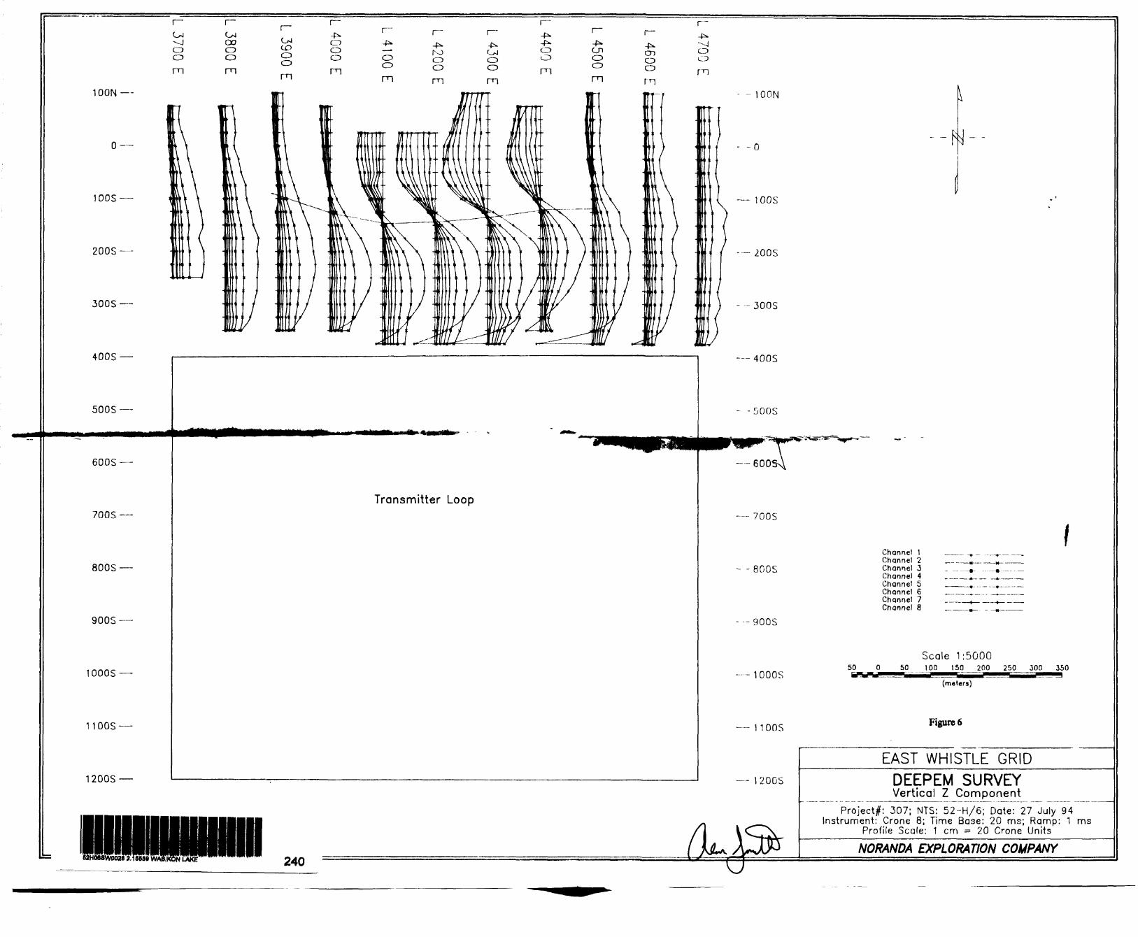
The transmitter loop was positioned up-dip (to the south of) the HLEM conductor axis. The dimensions of this loop were 1000m x 800m (Figure 6).
8.0 INTERPRETATION
8.1 HLEM Survey
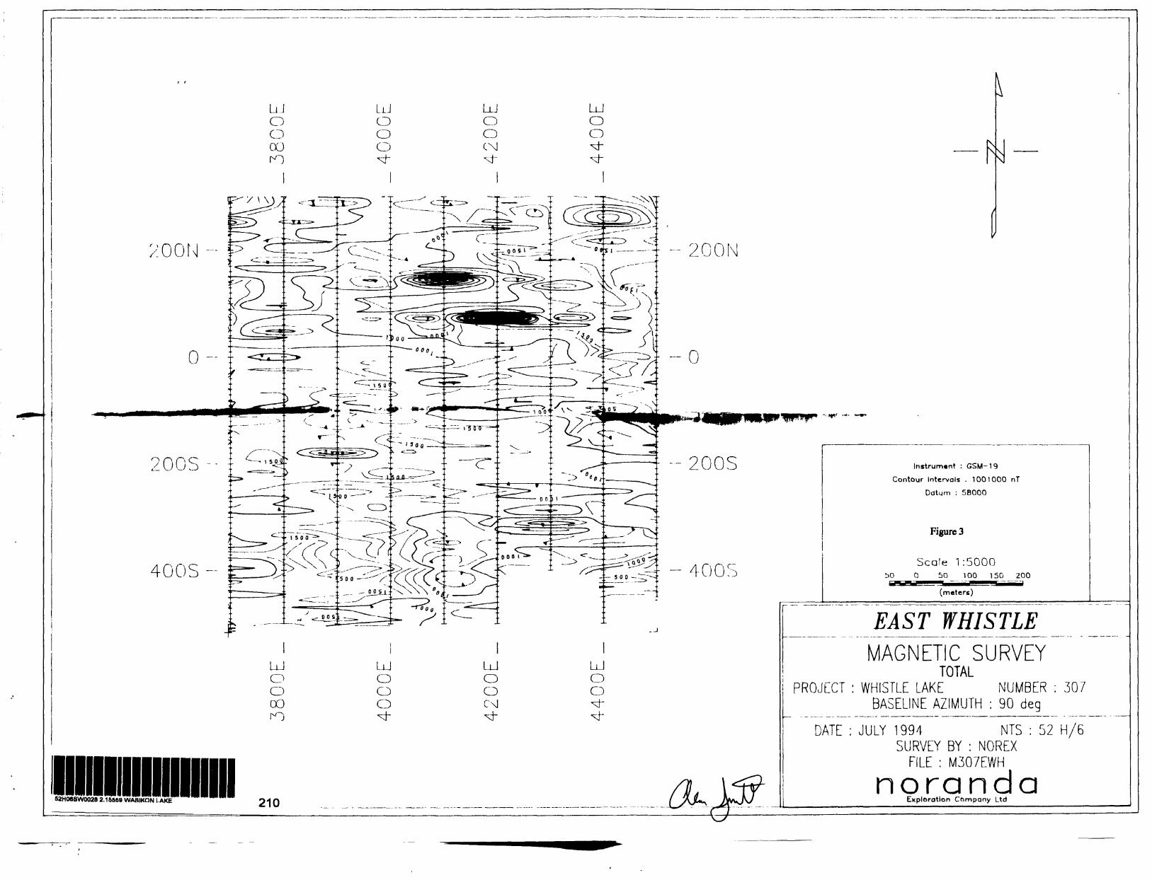
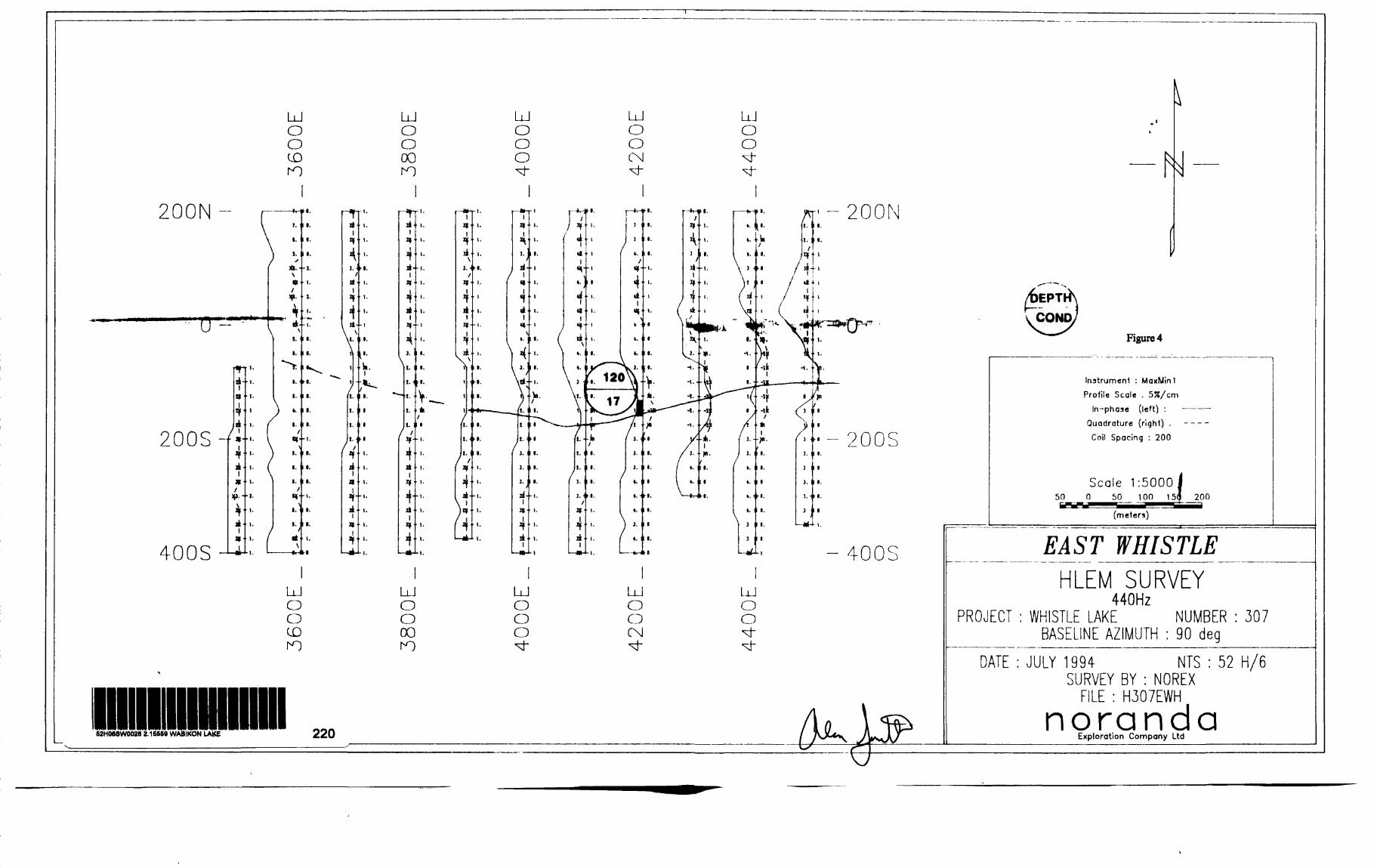
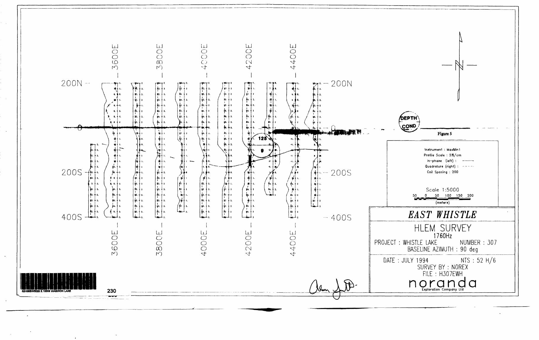
A conductor was identified from SOS on line 3600E to 1 DOS on line 45OOE (Figures 4, 5). The strongest response is located at 125S on line 4300E. The conductor exhibits no obvious magnetic correlation (Figure 3).
Large loop pulse EM was recommended to improve positioning accuracy and our knowledge of conductor variation along strike. The current interpretation is that the conductor is most shallow on lines 4200E through 4500E, but it may widen on lines 4000E through 4200E.
8.2 DEEPEM
The DEEPEM data correlates very well with the HLEM data. The conductor is indicated as being most shallow on line 4300E, and the depth is 75-150m, which is within the range of the depth of 120m calculated from the HLEM. The advantage of the DEEPEM data is that the conductor is now very well spatially resolved. A north dip is dearly defined and a strike length of at least 500m is indicated (Figures 6,7). While the highest absolute conductivity is best on line 4300E, the decay characteristics indicate that 4200E may be closer to the center of the conductor.
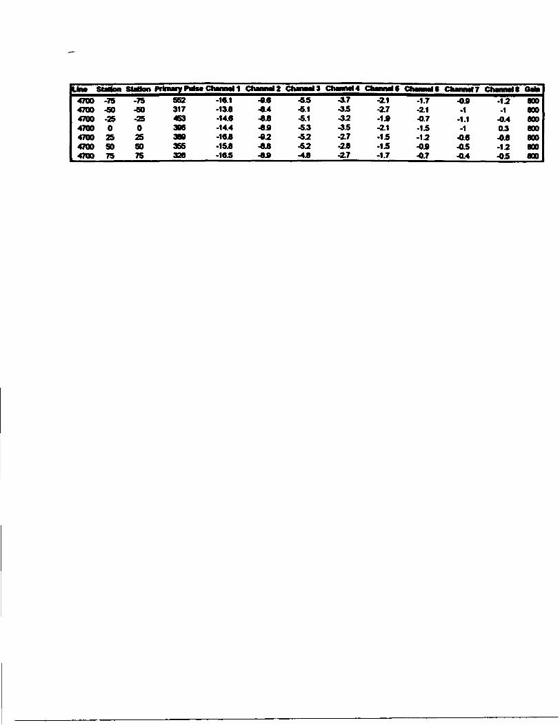
Depths and conductivities indicated by the DEEPEM survey are listed on Table 5. Raw DEEPEM data are given in Appendix III.
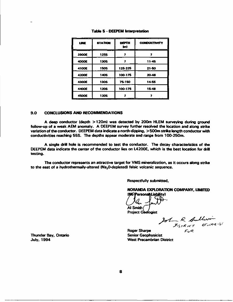
Table 5 - DEEPEM Interpretation
3900E
4000E
41OOE
42006
43OOE
440OE
45OOE
STATION
125S
130S
150S
140S
13OS
12OS
12OS
DEPTH Iml
7
7
125-225
100-175
75-150
10O-17S
7
CONDUCTIVITY
7
11-45
21 -SO
20-46
14-55
15-48
7
9.0 CONCLUSIONS AND RECOMMENDATIONS
A deep conductor (depth :*120m) was detected by 200m HLEM surveying during ground follow-up of a weak AEM anomaly. A DEEPEM survey further resolved the location and along strike variation of the conductor. DEEPEM data indicate a north-dipping, > 500m strike length conductor with conductivities reaching 55S. The depths appear moderate and range from 100-250m.
A single drill hole is recommended to test the conductor. The decay characteristics of the DEEPEM data indicate the center of the conductor lies on L4200E, which is the best location for drill testing.
The conductor represents an attractive target for VMS mineralization, as it occurs along strike to the east of a hydrothermally-altered (Na,0-depleted) felsic volcanic sequence.
Respectfully submitted,
NORANDA EXPLORATION COMPANY, LIMITED (NftPersonaMJabiity)
Al Smith Project G
Thunder Bay, Ontario July, 1994
Roger Sharpe Senior Geophysicist West Precambrian District
8

APPENDIX l
UST OF PERSONNEL
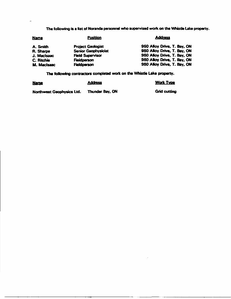
The following is a list of Noranda personnel who supervised work on the Whistle Lake property.
Name Position Address
A. Smith Project Geologist 960 ABoy Drive. T. Bay. ONR. Sharpe Senior Geophysicist 960 ABoy Drive. T. Bay. ONJ. Maclsaac Field Supervisor 960 ABoy Drive. T. Bay. ONC. Ritchie Reldperson 960 ABoy Drive. T. Bay. ONM. Maclsaac Reldperson 960 ABoy Drive. T. Bay. ON
The following contractors completed work on the Whistle Lake property.
Name Address Work Type
Northwest Geophysics Ltd. Thunder Bay, ON Grid cutting

APPENDIX II
REFERENCES
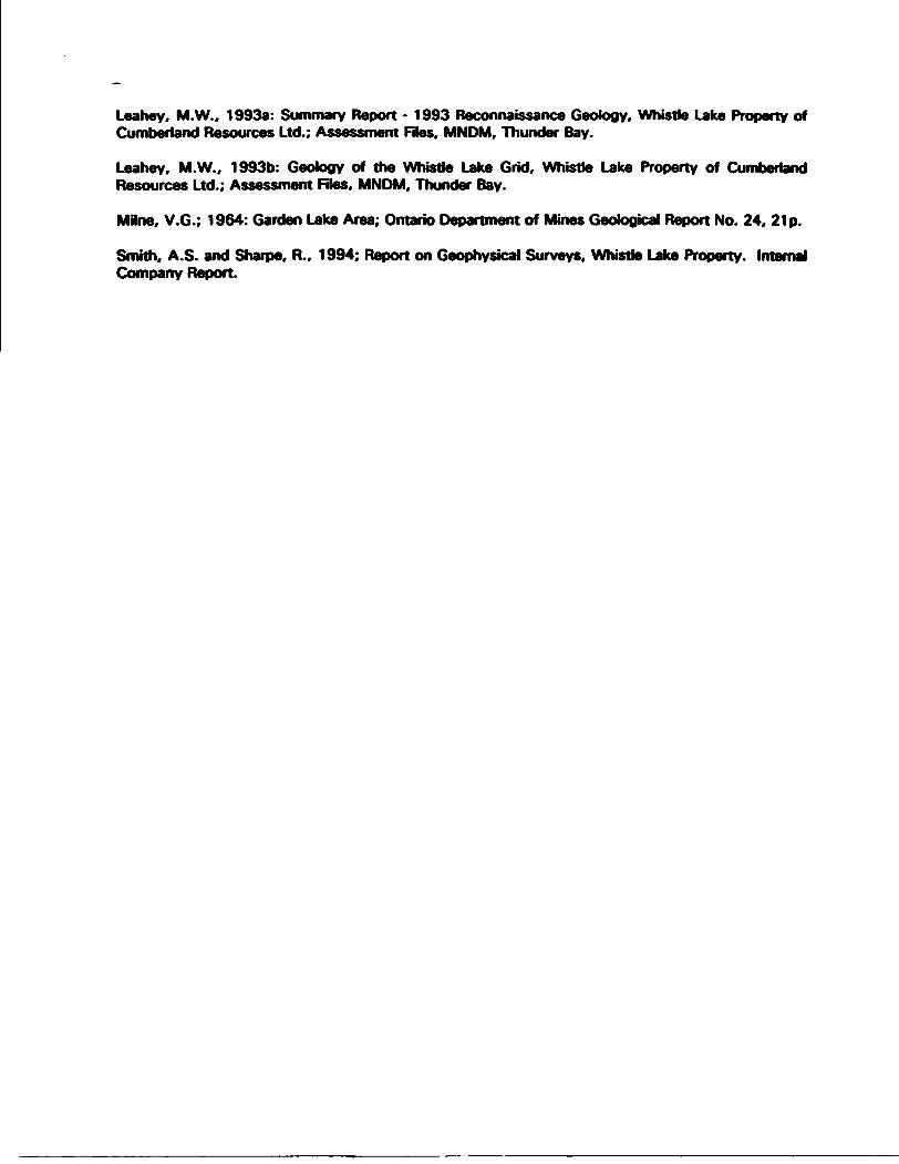
Leahey, M.W., 1993a: Summary Report - 1993 Reconnaissance Geology, Whistle Lake Property of Cumberland Resources Ltd.; Assessment Files, MNDM, Thunder Bay.
Leahey, M.W., 1993b: Geotogy of the Whistle Lake Grid. Whistle Lake Property of Cumberland Resources Ltd.; Assessment Files. MNDM, Thunder Bay.
Milne, V.G.; 1964: Garden Lake Area; Ontario Department of Mines Geological Report No. 24. 21 p.
Smith, A.S. and Sharpe, R., 1994; Report on Geophysical Surveys, Whistle Lake Property. Internal Company Report.
APPENDIX III
DEEPEN DATA
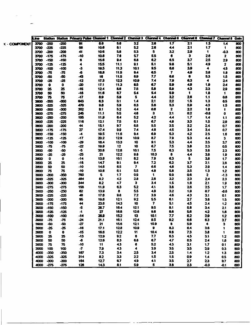
X -COMPONENT
Lira SUUon
3700 -2503700 -2253700 -2003700 -1753700 -1503700 -1253700 -1003700 -753700 -503700 -253700 03700 253700 SO3700 753800 -3503800 -3253800 -3003800 -2753800 -2503800 -2253800 -2003800 -1753800 -1503800 -1253800 -1003800 -753800 -SO3800 -253800 03800 253800 503800 753900 -3503800 -3253800 -3003800 -2753900 -2503900 -2253900 -2003900 -1753900 -1503900 -1253900 -1003900 -753900 -503900 -253900 03900 253900 503900 753900 1004000 -3504000 -3254000 -3004000 -275
-250-225-200-175-150-125-100-75-60-25025SO75
-360-325-300-275-250-225-200-175-150-125-100-75-50-250255075
-350-325-300-275-250-225-200-175-150-125-100-75-50-250255075100-350-325-300-275
91se41-1064-3-6-43-12-20-15-18-176434703022451951164427-4
-17-29-22-5-25-14-18-10-1076048434415862489544-5-1
-14-24-27-16-15-13-8-10-7
187314164126
6.610.610.610.615.615519518*18
17517.112.411.664639.89.111.111412.115.117.419.520218.419420.821
13514.714.610.6
5828211413417.819.623.626.727
26421.121
17.116512412.61174738212.714.3
CtlMMMl2
5.68.15.67.69.411.11151151151251158.66.7543.15452556.4759.79411.612413512
12512210.19.18.56.11.7424.7658
9.61Z114.316.416515216.115.6125122928545453.4356.78.1
ClunmU
3252555.7659.110.19.48410485755.45
1.4654.44.6526.1657.49.41041010
10.195829.47
5504253
525.5729210
12.112413
12.41Z1104118
6.864
25224454
ChmmU2.62.95
55625.195657.77.46.7555.44.42.15.60.63
426.75.54.8648.79.16.77510.375726.64.8
12.63.44.14.9345.57
959410.195104
910.47.76.7523.93.4154.15
Channel f
1.74.4326
6.595657
6.6745454543222552
2.14.445354555755575658
656245se0.9321535324.66.15.18.16.67.7928
8595654,7453525153535
Ctenmie2.1Z1243
3.75.134446
654445
125155422021.735323.4425.34.434554.45
3.75.3350.6251.62.6144.32.7455455626.6546.47545653.1351.4042.725
ChMiMir
151.7
12.825444
345541425141.1154515-051.4152.43.4254.435253535352.124152
2.4Z12.50.73.1342.43.44224654
3.6343.12.41.724121.425-05
Chmntia Gain
1.41
-052
242
451415Z42.424
104051510
1.1240.70.71.63
3.705Z3141.7241.412-1.32.3151.7-040.115122.114123.7311
12140.10.3150.50.7-0.1
800800800800800800800800800800800800800800800800800800800800800800800800800800800800800800800800800800800800800800800800800800800800800800800800800800800800800800800
Una SUtfon
4000 -2504000 -2254000 -2004000 -1754000 -1504000 -1254000 -1004000 -754000 -504000 -254000 04000 254000 SO4000 754100 -3754100 -3504100 -3254100 -3004100 -2754100 -2504100 -2254100 -2004100 -1754100 -1504100 -1254100 -1004100 -754100 -504100 -254100 04100 254200 -3754200 -3504200 -3254200 -3004200 -2754200 -2504200 -2254200 -2004200 -1754200 -ISO4200 -1254200 -1004200 -754200 -504200 -254200 04200 254300 -3754300 -3504300 -3254300 -3004300 -2754300 -2504300 -2254300 -200
-250-225.200-175-150-125-100-7540-25025SO75
-375-350-325-300-275-250-225-200-175-150-125-100-75-50-25025
-375-350-325-300-275-250-225-200-175-150-125-100-75-50-25025
-375-350-325-300-275-250-225-200
574129133317-202-6-2-41-3-3
94166936924412210518402-3-16-7
-21-21-16-25-256277104522571599232-42-86-94-66-67-69-61-64-45-43-740-452-224-201-175-120-153-160
20.623.73023343Z73Z129.125.423421.118413410.410.4849.612
15419.426
34.741.444.545,744438.733427.119.414.71046.410.41Z615.421427433
41448454253.146440.731.119210.654Z7Z19.710.115.618429435.7
auimelZ (12214418220.320.119420418217214213.18
6.4542432548.411415421.126.129.530.430.625.72Z417.611.484620.7345.68.111.617421
26234.438.637235429421.813.36.8
1-02-046.36.18.610.718224
:hannat3 t8.710212414414114415414113.71Z111274525.614243.76.68,411415.71842122Z62Z819418.314410.6826.30.6Z134548.613415.620.42529
28427.123.718412641.7-04-0.64.6326.87.713.717.1
nianmU (7.68
10211411
11.11Z711211.46494645.4521.71.62452648.411.413.416.118.118415.414.6129.37.66
021.8Z74.6641Z41Z316.31942342Z422319.415.611472Z40.1-22543
5.15494144
^ jiiiigj Bfftvnnvi v
54646.79492929.7941028.1746452342
243O64729.610413
1241441121149.7647
5.40.62434446
1Z610
13.517218418419.1164114107
Z8-0.6-0.134Z754548.610.7
Channel C t44425
6.772626.47474546.43.73.4Z1141.1Z632344
6.189
10.610482748.4544.65404222
3.54.41Z6729.611.614
12413410.710744.6242
-Z71.6243.74.65.462
Ehannel7 4
3.124S
5.13.734526
52343.1342.124-040.7
1141.44.14.76454727.14.752444.1244
041.40.6243.713.744648
84849.48.7726224Z102-1.104044.71.7Z654
Channel
220.54
Z114343
32Z1341.43.614Z7-040.60.41.6143.61.64.1Z74.53.6Z51.7343.3Z6Z6-0.11.80.50.5Z514.13.33.6325.544474.33.63.1
1Z304-22
1Z55.83.1-1434
1 Gain
800800800800800800800800800800800800800800800800800800800800800800800800800800800800800800800800800800800800800800800800800800800800800800800800800800800800800800800800
LJm Sutton
4300 -1754300 -1504300 -1254300 -1004300 -754300 -SO4300 -254300 04300 2543m 504300 754300 1004400 -3504400 -3254400 -3004400 -27544m -2504400 -2254400 -2004400 -1754400 -1504400 -1254400 -1004400 -754400 -SO4400 -254400 04400 254400 SO4400 754500 -3754500 -3504500 -3254500 -3004500 -2754500 -2504500 -2254500 -2004500 -1754500 -1504500 -1254500 -1004500 -754500 -504500 -254500 04500 254500 504500 754500 1004600 -3754600 -3504600 -3254600 -3004600 -2754600 -250
Sutton Primary Pub* CtumtM-175-ISO-125-100-75-SO-25025SO75100-350-325-300-275-250 225-200-175-150-125-100-75-SO-250255075
-375-350-325-300-275-250-225-200-175-150-125-100-75-90-25025SO75100-375-350-325-300-275-250
-131-153-ISO-148-138-123-104-86-75 68-75-80
-1243-692-824-666-433-307-246-222-187-201-193-200-192-187-170-152-143-123-1197-1192-1127-793-574-387-285-197-210 225-223-211-204-238-223-198-182-157-132-111
-1186-1186-845-506 500-362
45.758462455.641430.71449404-44-5.1
-10.1 042.1448.612418426
35.443451.650.741.732418211.77.66
-6.4-2414347410.113.116.319.824423.626427.122428.723418416.48.74.73212345.1548482
ChamtlZ33.640443439229422
1226.40.1 6
-64-10.1-04042.45.47.712.717224.130435.635.42942441145.82.12.7-740.63.42434547.610.613.716417418.422418420.616412211.14441.6
12.3143.64.76
ChamaU23431437
30.725419
10.44404 44-54244-0.1144.1549213.417.623.326.827.623.620.111263424-6.31.7-0.6222.15.36.67.39.713.713.814416415.616.414.29462320.7240.8043.1323244
ChanmU
19.123.426.525
184174125424-24-3.4-7.1-0.1
1244.1447.61041Z717.720.619.719.617.1112
75.14.3-2.43.41.4144
3.44.662749.510.712.714413
13412.48.4823.114220.81.714243444
Chanmlt14.11820
18418148.754414-14-3.4-540.12.12.13.152648411.713215418414.514210.67.15
44-241414242224345
747
9410
10410u611412.17.4722.31.6242.4141.72.6143.1
Chant*!*104134124144124104524.4
1 Z7-34-4.70
0414243.1425.48
941141241149.17.44.73.42.7-2.62
1.31
2.42.12.13.8326.144547.4728.4845.13.52
4.60.42.10.71.7440.712
chanmir524.45.48472347140.4-1.4-24-2404141
1.724244.15.7646.75.76.1744.7342.12.14.1140.11434121.73234143.75.18452527.4422.40.70214124204044.104
ChMMll
2444S
4.6121.43402-1-1
-22 244.4040.14.1
1121.614343.8323.93
2.714140.70200
04040.144040414044.72.43.73.15.32.40.6020.10.6-1
-12040
4.64.6
1 Gain
araaraawawanawawawawawawanawawawawawawawaraaraaraaraaraaraaraaraaraaraaraaraaraaraaraaraaraaraaraaraaraaraaraaraaraaraaraaraaraaraaraaraaraaraaraaraara

Z-COMPONENT
Una Sutton Sutton Primary Puta
4600 -2254800 -2004000 -1754600 -1504800 -1254800 -1004600 -754800 -SO4600 -254600 04600 254800 SO4600 754800 1004700 -3754700 -3504700 -3254700 -3004700 -2754700 -2504700 -2004700 -1754700 -1504700 -1254700 -1004700 -754700 -SO4700 -254700 04700 254700 504700 753700 -2503700 -2253700 -2003700 -1753700 -ISO3700 -1253700 -1003700 -753700 -SO3700 -253700 O3700 253700 503700 753800 -3503800 -3253800 -3003800 -2753800 -2503800 -2253800 -2003800 -1753800 -ISO3800 -125
-225 200-175-ISO-125-100-75-60-25025SO75100-375-350-325-300-275-250-200-175-ISO-125-100-75-50-250255075
-250-225-200-175-ISO-125-100-75-SO-250255075
-350-325 300-275-250-225-200-175-ISO-125
-346-352-356-305-295
0-208-180
-1-ISO-136-111-87-77
-1258-1255-613 580-400-466 330-269-282-240-174-174-151-126-94-99-89-74
12151220121911129858697686816105464884213853591215121712171218121812191219121911871035
11512513218517.617.7154123831351027.61.7852.4333252S36.16.68.410311.1838.77.7728.6728.175
-22.4-24.1-23.8-202-232-21.8-19.4-17.1-14.7-115-105-64-4.5 5.4-12.4-192-215-242-24.4-25.3-243-25.6-215-19.6
Channel 2
6.76510
11511212.412.71056.4957234-0.44.62153.425242.7555.66.45.8546252446
52454.7
-125-133-13
-115-125-11.4 9.5-7.4-54 35-2.1-0.4020.7
-11.6-133-13.6-134-14.5-13.8-13.6-13.6-12
-10.1
ChannaM557.77.49
958510.1102S3745432-1320515142532353.742
5.84,7454
3.64.43
3233-8
-7.6-75-75-7
-65 5.4-2.7-32-0.1O.72
153.1-7.1-85-83-8.4-aa-as-7.9-8.6-73-5.6
Channel 452454,77.4639
73854,4734423-1.73
0.4221.62.122254.13
534
344.5273.43.6252.12.6-5.6-5.8 55-55-5
-4.3-3.4-05-1.105222.1233.6-44-6.4-5.4-5.6-6
-S3-5.4-5.5-5
-3.7
Channel C3
345.462757.75553364
23-152
2214131.7242
2.13.63542334
242.63.115Z12.4-35 3.7-3.4-23-2.5-2.6-1.7-02-0.41.6323.4433.6 32-4
3.5-3.7-43-3.6-3.4-3,7-3
-2.1
Channel*32333.1453
453.74.4335.13.71.40.41.72.71.70214122
2.727152.41.72.72A1.733
1221.7-32-3
2.7 2.7-15-3
-050512230.63.73.423-2
-22-2.1-2.4-22-15-15-2.4-15-1.4
Channel?0215252.725232.415-0.7452.11.40.11322130.1-05121.12.71402250.4270.7121.50.10505-1
-02-15-0.4-02-0.7-0.7032
220.413122.6-0.7-05-1
-05-15-04-05-1.10.1-05
CtlMMMl 8 Oflta
02 021524150.415350525 05
1-12040.113-1.6 0.61503-021.1 0.60.8-0.82501
030.4-0.7-1.8-020.4 050.70.6-1.5150
-0.31.60.4215
1.8-0.6 0.8-0.6-02-1
-02-O50.4-0.403
800800800800800800800800800800800800800800800800800800800800800800800600800800800800800800800800800800800800600800800800800800800800800800800800800800800800800800800800
Una sutton41004100410041004100410042004200420042004200420042004200420042004200420042004200420042004200430043004300430043004300430043004300430043004300430043004300430043004300430043004400440044004400440044004400440044004400440044004400
-100-7540-25025
475450425400-275-250-225-200-175-150-125-100-7540-25025
-375-350-325-300-275-250-225-200-175-ISO-125-100-7540-250255075100-350 325-300-275-250 225-200-175-ISO-125-100-7540
Station Primary Pulse ChanmM Channel 2 Channels-100-7540-25025
475450425400 275-250 225-200-175-150-125-100-7540-25025
475-350425400-275-250-225-200-175-ISO-125-100-7540-250255075100460-325-300-275-250-225-200-175-ISO-125-100-7540
111196885175766459612101210121012101210121012101210121012101206110998084073466556211471148114811481146114811481149114911491148109798082571263255749644338812061207120712081207120612061206120612051151967862
6*14.717519.418416415*44-21*-285434444442414-244-1330412523.429
29527425.731.1-74-224-27.6-33.1484-39* 39.6425-19.4 4217.426434532430.726.622918
1&210.6-24-13
-215-27
-30.744.441*-25.7-14*4213.720*
10215517519419.418.7-1O-184 215-224-24.1-234-225-19*-144425
15.624429
29428427.6-12*-192-24.6-22
-244-262-25.4-25.1-19*4234
20.129.73434
33.4284254214184444244-134-17.7-19.1-204-192-1O4*4.615.422
813214
16.116.716.44-12
-14.4-14*-162-16.1-14*-13544-295.413220524.725*2522554*-124-175-14.7-15*-175-16*-16.7-12*4.13.716.724.628430.629.727.125
21.719542 3.7
4*4
-112-121-13.4-1224445.1132185
Channel 45*11.111
1341341344444-10.4-10.4-11.1-112-10544-7
-1.74.611
16520422522
21.44.445-13*-10.4-11.7-127-123-1246-343413.719.623.826226524422520.41844.6 3.7-4.44546444-744.7-1.64.194142
Channel 15.1109210.611.7114-4.141-7.7-74444
-74444
4.748414,117.617419.11844
-7.7-10.74.1484442444.7-213.1
. 10.616.119.622.422421419.417415.7-42-3.8
4*4.3444*42454.6443.47.4115
Channel 83.68*657.7848.442-4.14.1424.7444.1-44440.13.16.610.412613.41351354.1-4*454.64.4444242-45-1.6227.412715*17
16.716
14.613*12
-24-24424.844-454.1-4
-254.1244.674
Channel 7
2464425.15252-1.1-2
4.1454
4.442-2*-2145245264828,699
44-1.6-42-274442-26-42-2*-1.71.7447*11410*10.710.18.6957444-1.4-1.7-24-244
-2*-21-150143.44
Channels Oain|
0.64.6243
24254*-12-21-14-1*-2
-24-1544440*264
453*554*4.14*-1*-21-1*-1.44.745-12-15143.452656.76.7536.16.1444*-12-12-24-24-1*-1.6-22-1.4444.1
121
8001800800800800800800800800800800800 1wv i
aoo800800800800800800800800800OUW I
800 1800 l800600800800800aooaoo800800800800BOOaoo800800aooaooaoo800800
aoo800800600800800800800800800800800
Line Sutton4400 -254400 04400 254400 SO4400 754500 -3754600 -3504500 -3254500 -3004500 -2754500 -2504500 -2254500 -2004500 -1754500 -1504500 -1254500 -1004500 -754500 -504500 -254500 04500 254500 504500 754500 1004600 -3754800 -3504600 -3254800 -3004600 -2754600 -2504600 -2254800 -2004600 -1754800 -1504800 -1254800 -1004800 -754600 -504600 -254800 04800 254600 SO4800 754600 1004700 -3754700 -3604700 -3254700 -3004700 -2754700 -2504700 -2004700 -1754700 -1504700 -1254700 -100
Sutton Pi-25025SO75
375-350-325-300-275-250-225-200-175-150-125-100-75-50-25025SO75100475 350-325-300-275-250-225-200-175-150-125-100-75-50-25025SO75100-375-350-325-300-275-250-200-175-150-125-100
flnteWy Putac
7556685905264431164115411531152115211521151115111511149112695583875667659753948440338511471147114711471148114711471146114510899348216806075385114624223853611216121611861216121511451047921789701586
Channel 1 t23.622
185154102429-14
-16.1-21.7-244-27.7-274-29
272-214-204-13542411416-5.6-63•6
•4.7-4.69.4
-124-17.1-20
-224-224-24.1-204-212-244-223-204-15.7-123-104-14.4-121-125-123-134-92-15.5-13.6-175-154-175-174-21.6-19.7-225-152
aianneia t25424.622119416.4417-127-164-164-16.7-17.7-174-175-15.4-13.1-11.141.6-4
-140.4
1152
1404-74•9.6-112-126-132-129-13.6-126-125-13.4-11.6-105-74-72417416417-54411-5.6-5.5-as-74-92-9.4-10-10
-11.4-112-115-9.6
MumeM
22422521419517.441441.6-114-104-105-11.4-115-104-104418414 34-1.704223.5454.844
4.3-5.7-72-7.8•9
-744.6411-754*
-744.6416-42-29 32-2
-21-1.6-21-3.4-4.8-44-5.5-5.44.44.6454.74.844
Channel 4
18.31921651641644444.6-7.7-7.4-7.6-7.7-7.6-74-4
-224.6123.44.15.15.74.34.8-3.5 32-4.84.14.74.44.54.742-4.9-4
4.5-29-26-1
-1.1-124.1024.1-21-32-3.6 3.3-344-424.64.34.84.8
Channel C15216.6154165154.4-45444.744454445-4.74.14.1-124.62
4.1325.45.34242-26-1444-4
-4.44.7-45-4
4.4-29-1.7-25-2
-1.64.60.145051.1
1-1.1-14-21-24-14-2644-21-23-25-27
Channel*10411511211.1115-1.7 29-4.745444444-24•2.7-2
41901
24243.4423.63.4-1
-14-28-254.7-2344-24-15-14-1.1-2
-1.8-1
4.10.60.10.4041.10.6-1.104-1
4)4-1.642-1.1-14-1.6-1.7
Channel? i
65646.77.4624.4-15-23-24-26-1.7 2
-1.7-2
-28-1.10
0.7041.727341.821244.14.744-15-23-12-28-144-1.402444.74545024.1040.50.51.44)40.4•0.40.14.84.6-1203-10
"jftMMM
34443234354.4-15-14-14-12-1.4-1.74X74.6-14-144X1
. 1.144120.70.402041.1
14.144-15-2544-1.64.8-12-1.4444.6054.74.64.44X34X50.14.105-0.10.10.30.5-1.1-1.14.74.84.74.7
8 Gate
800800800800600800800800800800800600800800800600800800800800800800800800800800800800800800800800800800800800600800800800800800800800800800800800800600800800800800800800
LfcM SUdon
4/CO -764700 -504700 -754700 04700 754700 SO4700 75
-75-50-25025SO75
TkiwryPuta
552317453396380355328
t CtUMM^ri 1
-16.1-134-14.6-14.4-164-154-164
ChMNMl2
-0.6-8.4-84-8.9-9.2-84-64
Channels-5.5 5.1-5.1-5.3 5.2-62-44
ClwnmU-3.7-34-32-3.5-2.7-2.8-2.7
CtMMMU
-2.1•2.7-14-2.1-14-14-1.7
ChMMMlt
-1.7-2.1-0.7-14-12 04-0.7
ChMNMl7
-04-1
-1.1-1
-0.6-0.5-0.4
CtlMMMlt 0*1
-12-1
-0.40444-12-04
800600800800800800800
Ministry ofNo* them Developmentand u:nes
Ontario
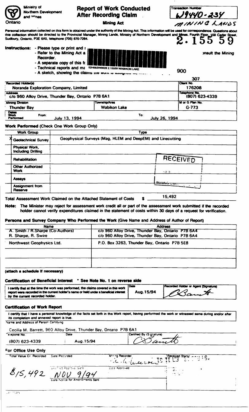
Report of Work Conducted After Recording Claim
Mining Act
Personal information collected on this term is obtained under Ilw authority of the Mining Act. This information w* be used tor corr . Questions abouttrm collection should be directed lo the Provincial Manager. Mining Lands. Ministry of Northern Development and Mnes. Fourth FtooriSS Cedar Street. Sudbury. Ontario. P3E 6A5. tetophone (70S) 670-7264. O t C C C Q
Instructions: - Please type or print and t- Refer to the Mining Act a
Recorder.- A separate copy of this ft- Technical reports and ms- A sketch, showing the claims uw
xisult the Mining
900
307
j Noranda Exploration Company, Limited
| c/o 960 Alloy Drive, Thunder Bay, Ontario P7B 6A1' fcJKjljgUl j^fcliaiV^l, MwBMey unrmun
1 Thunder Bay
J taUdueV Fr T m l wont From.Performed Julv 13. 1994
Townthip/AreiWabikon Lake
CSent No. 176208
(807) 623-4339M or G Plan No.
G-773
Julv 26. 1994
Work Performed (Check One Work Group Only)
)WorkGroup
Geotechnical Survey
Physical Work. Including Drilling
Rehabilitation
Other Authorized Work
AssaysAssignment from Reserve
—————————— 1*2 ——————————— ,Geophysical Surveys (Mag, HLEM and DeepEM) and Linecutting
pRECEIvgon
j ^, . ii ;f Mlfljrr f
x-^— - — J
Total Assessment Work Claimed on the Attached Statement of Costs 15.492
Note: The Minister may reject for assessment work credit all or part of the assessment work submitted if the recorded holder cannot verify expenditures claimed in the statement of costs within 30 days of a request for verification.
Persons and Survey Company Who Performed the Work (Give Name and Address of Author of Report)Name
A. Smith 1 R . Sharpe (Co-Authors) R. Sharpe, R. Swire
Northwest Geophysics Ltd.
Address \c/o 96O Alloy Drive, Thunder Bay, Ontario P7B 6A4 c/o 960 Alloy Drive, Thunder Bay. Ontario P7B 6A4
P.O. Box 3263. Thunder Bay. Ontario P7B 5E8
(attach m schedule If necessary)
Certification of Beneficial Interest * See Note No. 1 on reverse side
l certify that at the time the work was performed, the claims covered in this work report were recorded in the current holder's name or held under a beneficial Merest by the current recorded hoWer.
Dale
Aug. 15/94
Recorded Holder or Agent (Signature)
Certification of Work Reportl certify that l have a personal knowledge of the facts set forth in this Work report, having performed the work or witnessed same during and/or after its completion and annexed report is true.
Na-ne and Address of Person Cetifymg
Cecilia M. Barrett. 960 Alloy Drive, Thunder Bay. Ontario P7B 6A1"e epone No.
(807) 623-4339
Date j Certified By ( S gnature)
Aug. 15/94
cor Office Use OnlyTotal Value Cr Recorded Date Pecvded M- "g Recorder
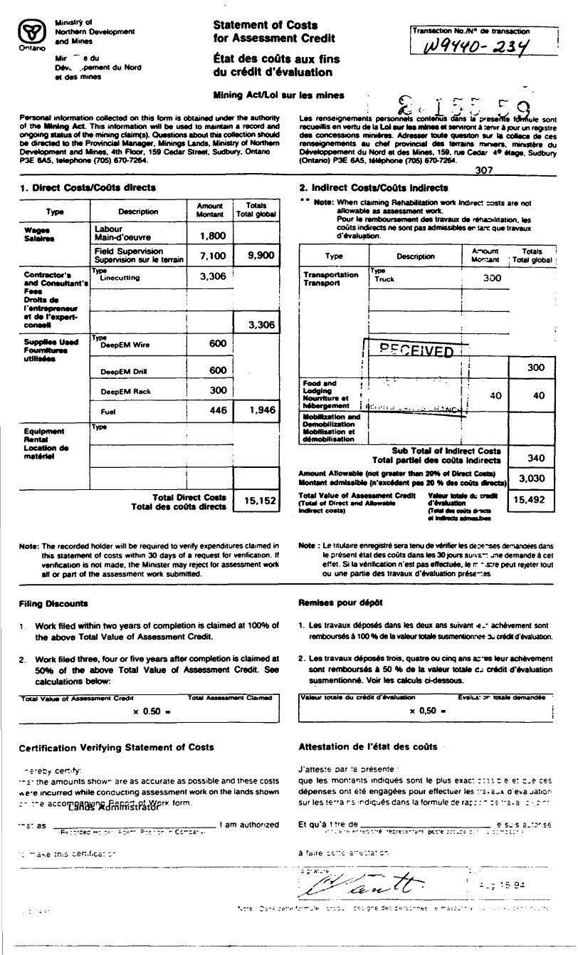
Ontario
Ministry dNorthern Developmentand Mines
Mir ~ a duOevv .^ement du Nordet des mines
Statement of Costs for Assessment Credit
ttat des couts aux fins du credit d'evaluation
Mining Act/Lol sur les mines
Transaction NoJN* de transaction
Personal information collected on this form is obtained under the authority of the Mining Act. This information will be used to maintain a record and
:- ^ c l -J ^ ,Les renseignements personnels contenus dans la jxeserecueiRis en vertu de la Lot sur le* mines et serviront a :eror a jour on registre
C" f\
rve fdmute sent
ongoing siaws 01 me mining cwirnis;. uuesiions aoout nw cwocwn WKKJKJ oes concessions rmmores. Aoresser rowe question sur la coBsce de ces be directed to the Provincial Manager. Minings Lands. Ministry of Northern renseignements au chef provincial des terrains rmmers. mmstere du Development and Mines. 4th Floor. 159 Cedar Street. Sudbury. Ontario Devetoppement du Nord et des Mines. 159. rue Cedar 4* etage Sudbury P3E 6A5. telephone (705) 670-7264. (Ontario) P3E 6A5. telephone (705) 670-7264.
307
1. Direct Costs/CoOts directs
Type
Salalres
Contractor's and Consultant's Fee* Drottsde ('entrepreneur et de I'expert- conseM
SuppUesUsad Fournttut*9s utiiiaees
Equipment Rental Location de materiel
Description
Labour Main-d'oeuvreField Supervision Supervision sur le terrain
Type Linecutting
Amount Montant
1.800
7.100
3.306t
Type DeepEM Wire
DeepEM Drill
DeepEM Rack
Fuel
600
600
300
446Type
Total Direct Costs Total des couts directs
Totals Total global
9,900
3.306
1,946
15.152
2. Indirect Cos* * Note: When cti
allowable Pour le n couts ind d'evaluat
Type
Transportation Transport
rFood and i Lodging Nourrtture et '
MobMzatlon and Demobilization Mobilisation et demobilisation
ts/Couts indirectsliming Rehabilitation work Indirect casts are not as assessment work.
Mnboursement des travaux de renaXitation. les reels ne sont pas admissibles en tare que travaux ion.
Description
Type Truck
Anount Totals Moroni : Total global
———————————— ! —— -
300
""PPCP.'VPP '-
.- - ' ' - -
^q
i;i 40
Sub Total of Indirect Costs Total partJel des couts indirects
Amount Allowable (not greater than 20H of Direct Costa) Montant admissible (n'excedant pas 20 H des couts dtovcta)Total Value of Assessment Credit Vateur Male du cndN (Total of Direct end AaowaMe d'evahjstlon Indirect costs) (Tola) dn touts dm
-
300
40
340
3.030
15.492
Note: The recorded holder will be required to verify expenditures claimed in this statement of costs within 30 days ol a request for verification. H verification is not made, the Minister may reject for assessment work all or part of the assessment work submitted
Note : Le titulaire enregjstre sera tenu de verifier les cOf^ses denanoees dans le present etat des couts dans les 30 jours su'va jne demande d eel effet. Si la verification n'est pas effectuee. le rr -.stre peut rejeier tout ou une partie des travaux d'evaluation prese-tas
Filing Discounts
i Work filed within two years of completion is claimed at 100*^ of the above Total Value of Assessment Credit.
Remises pour depot
1. Les travaux deposes dans tes deux ans suivant *. achevement sont rembourses a 100 "te de la vateur totate susmenbon^ee aj credk d'evaluation.
2. Work filed three, four or five years after completion is claimed at SOto of the above Total Value of Assessment Credit. See calculations below:
Total Value of Assessment Credit
X 0.50
2. Les travaux deposes trois. quatre ou cinq ans ar-es tour achevement sont rembourses a 50 H de la vateur totato cj credit d'evaluation susmentionne. Voir les calcub cndessous.
Valeur locale du credit d'evaluation
X 0.50
or totale demandee
Certification Verifying Statement of Costs Attestation de I'etat des couts
the amounts show- are as accurate as possible and these costs e incurred while cone uct ing assessment work on the lands shown -e accornrrK form
i: as l am authorized
J'atteste oar la oresente : que les montants mdiques sont le plus exac: depenses ont ete engagees pour effectuer les sur les reva rs -r-diqu^s dans la formule ie rap:
:n z e e: c.e ces:.C-X O'l
Et qu'a t tre de .•f:-'."t *?r;fir"a-i pcc'e ^::.rf - :
;n:s cen,f,cct ^ ~
- ,~ ' 59-
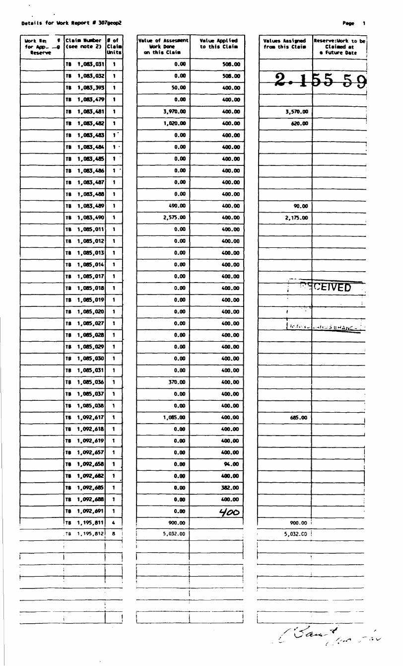
Details for Work Report f 307geop2 Page 1
Work lei 1 for App- 9 Reserve
ClaiM Murter (see note 2)
TB 1.083.031
TB 1.083.032
TB 1.083.393
TB 1.083,479
TB 1.083.481
TB 1.083.482
TB 1.083,483
TB 1.083.484
TB 1.083.485
TB 1.083.486
TB 1.083.487
TB 1.083,488
TB 1.083.489
TB 1.083.490
TB 1.085.011
TB 1.085,012
TB 1.085,013
TB 1.085,014
TB 1,085,017
TB 1,085,018
TB 1,085.019
TB 1,085,020
TB 1,085.027
TB 1,085,028
TB 1.085.029
TB 1.085,030
TB 1.085.031
TB 1.085.036
TB 1.085.037
TB 1.085.038
TB 1.092.617
TB 1.092.618
TB 1.092.619
TB 1,092,657
TB 1,092,658
TB 1.092,682
TB 1,092,685
TB 1,092,688
TB 1.092.691
TB 1.195.811
T3 1.195.813
f Of Claia Units
1
1
1
1
1
1
ri -ii -iiiiiiiiiiiiiiiiiiiiiiiiiiiii4
8 i
Value of Assesaent Work Done
on this Clai*
0.00
0.00
50.00
0.00
3.970.00
1,020.00
0.00
0.00
0.00
0.00
0.00
0.00
490.00
2.575.00
0.00
0.00
0.00
0.00
0.00
0.00
0.00
0.00
0.00
0.00
0.00
0.00
0.00
370.00
0.00
0.00
1.085.00
0.00
0.00
0.00
0.00
0.00
0.00
0.00
0.00
900.00
5.032.00
Value Applied to this Claiai
508.00
508.00
400.00
400.00
400.00
400.00
400.00
400.00
400.00
400.00
400.00
400.00
400.00
400.00
400.00
400.00
400.00
400.00
400.00
400.00
400.00
400.00
400.00
400.00
400.00
400.00
400.00
400.00
400.00
400.00
400.00
400.00
400.00
400.00
94.00
400.00
382.00
400.00
y*?o
values Assigned fro* this Claiai
Reserve:Uork to beClaiaed at
a Future Date
593,570.00
620.00
90.00
2.175.00
685.00
900.00 i
5.032.CO i
Ontario
Ministry of Ministere duNorthern Development Developpement du Nordand Mines et des Mines
Geoscience Approvals Office 933 Ramsey Lake Road 6th Floor Sudbury, Ontario P3E 6B5
Telephone: (705) 670-5853 Fax: (705) 670-5863
Our File: 2.15559 October 4, 1994 Transaction /: W9440.00234
Mining RecorderMinistry of Northern Developmentand Mines435 James Street SouthSuite B003Thunder Bay, OntarioP7E 6E3
Dear Michael Weirmeir:
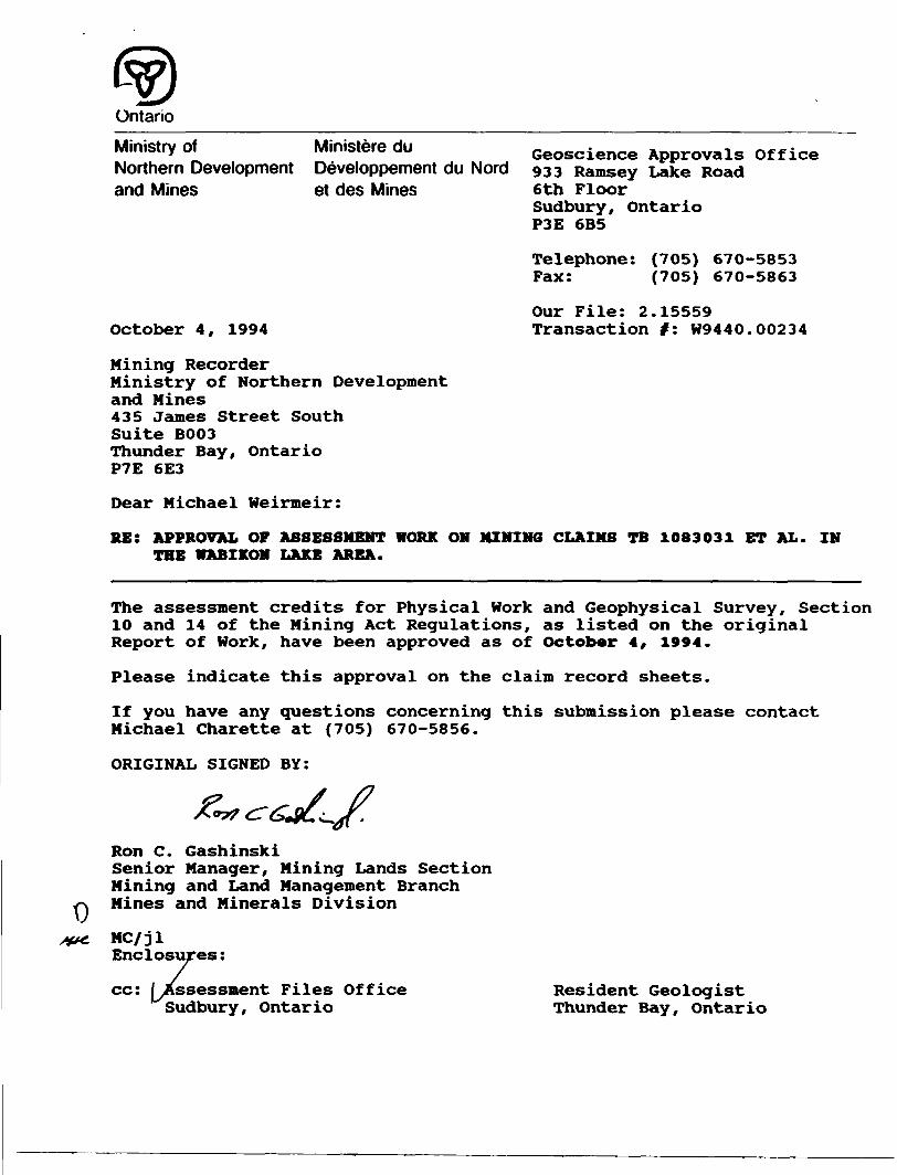
RE: APPROVAL OF ASSESSMENT WORK ON MINING CLAIMS TB 1083031 ET AL. IN THE WABIKON LAKE AREA.
The assessment credits for Physical Work and Geophysical Survey, Section 10 and 14 of the Mining Act Regulations, as listed on the original Report of Work, have been approved as of October 4, 1994.
Please indicate this approval on the claim record sheets.
If you have any questions concerning this submission please contact Michael Charette at (705) 670-5856.
ORIGINAL SIGNED BY:
Ron C. GashinskiSenior Manager, Mining Lands Section Mining and Land Management Branch Mines and Minerals Division
MC/jl Enclosures:
cc: [^Assessment Files Office Sudbury, Ontario
Resident Geologist Thunder Bay, Ontario
Cheeseman WITHDRAWN FROM DISPOSITION
f RIGHTS , MR -MINING MIGHTS
Oiipaiitian F li*
MTC GRAVEL .PIT No- 1036
© " " " Nq. 1087
" " " No. 1063 ,FILC IB7B96
IS79
THE INFORMATION THAT APPEARS ON THIS MAP
, HAS BEEN COMPILED PROM VARIOUS SOURCES, AND ACCURACY IS NOT
1 GUARANTEED. THC-SE WISHING TO STAKE MIN ING CLAIMS SHOULD CON-
WITH THE MINING RGQORDER, MINISTRY OF
RTHERN DEVELOPNT AND MINES, FOR AD- IONAL INFORMATIONTHE STATUS OF THE
(J 4DS SHOWN HEREONLEGEND
ri~~iTi—— T™~~~
--is* up^-"*" ^^-F^hf---™-*V i TV ! *P l Tt l TB ' l }J JiMiaiB luaua*
~~~ "* i ~ ~ ~ T T —Z" — — ~ —^5 — — —,tT*T^ ~"
w-w?1- .15- J*-?—' j.—-*, ..o^-~ ~ ~~~~1083031 I08S028 l KWI0221 IOMM4 MOttMI
1*1 ** l lOIMU'108*030 l 10*8037 ! 1082*1*1"*"" | 'O*"**
MM^ia^TM- ' — — Tt
a. — IJOMUp —IJO**OSLj 1?*??*. ,T1 IT. ,TB
i v H' i ! ' i l fJ*t ' I08B84* [ ""S**/! IMWWM ^
f— ns™'— — Ti T^ — -^ .0 l KWNyj ~ ~ ~AT8"~~~™~ ~ MM . "H ' l( " ''f 1 JI( "
110.3020 , .
TB jrrd" ~ \^^-i
r T-- - ' I0"2?' i I0"w 1 108308* i I08M"r~ — f-*-t- — —
rjiAVft-Kt MI ir.^
DISPOSITION OF CJUXWN LANDS[ m~*,*mmr r T ~ — -~1309447^ ~-—4, \ v 1209446
TYPb Or DUCl
PA II '^ ' ,. . ' ..
-V l fl. WlM.i. HK.H^^
SK H PAX tHi(,HT)NI Y
J. ICJ Ni l ()l l J i ( Df A T ION "~" -v
ORDt H IN ( t)i iNCI.
Rf Sf HVAT K INx '
A GHAVt i USE PERMITS ^OR COMMERCIAL TOURI8M,OUTPO*T CJMPA
NOT f MlMNi, Hi OfcON CAMII.SPAlfNMIifHi W T MA ''111 vtS'll) IN OH.'.lfgAi MAr^Ni^f H' T.HJ HOB LANDS *i, ' R S l) "I'D "MAI' MO St l
SCAl \ 1 IM H 1.4Q,fHAlNS
WABKON LAKEMMR ADMINISTRATIVE IJTRICT
f HUNDER 6AY
l AND firUS/ REGISTRY DIVISION
THNDER BAYMmis*ryof L and*
Man*g*m*rvt
Max Lake Area G-741 G-773jESK WABIKON LAKE
UJ O Ooo
Ld O O O -sl
O O
Ld Oo
/:OON - --- - 20ON
400S -
M
Instrumsnt : GSM-19
Contour Intervals . 1001000 nT
Datum : 58000
Figure 3
Scale 1:5000O 50 100 150 200
(meters)
EAST WHISTLE
S2H068W0028 2.1665B WABIKON LAKE 210
MAGNETIC SURVEYTOTAL
PROJECT : WHISTLE LAKE NUMBER : 307 BASELINE AZIMUTH : 90 deg
DATE : JULY 1994 NTS : 52 H/6 SURVEY BY : NOREX
FILE : M307EWH
norandaExploration Company Ltd
52H068W002B 2.16558 WABIKON LAKE
LJ O O CO
^L U U 1 N
\ "'\ ,7
L
" - 0 - ' l
pnA-i
0
4A
200S-
/i nnc -
ifAiwiV
Al
n
t.
•1.
1.
A. -
V
V-
^fA-
'.
i.*^*
i., J ., s .v
i \ :i.
•i.i.i
*\
i.,: f .iL.
r v.
1 1.
1 1.
1 1.-i.\.\.\.
-i.
i.
1 1.
K
ri.
1 1.
1 1.
1 1.
ri.
1.
1 1.
1.
1.
1.
1.
1.1
LJ O O
K)
l
1. - -ll
Al
rt i \
9
4t
220
LU O O 00
V-
LJ O O 00 K)
LJ O O O
LJ O O O
LJ O OCNJ
LJ O O
N- 2 00N
Figure 4
- 200S
400 C
LJ O O CN
LxJ O O
50
Instrumenl : MaxMinl Profile Scale . 5%/cm
In-phase (left) :
Quadrature (right) .
Coil Spacing : 200
Scale 1:5000O 50 100 15d
(meters)
200
EAST WHISTLE
PROJECT
HLEM SURVEY440Hz
WHISTLE LAKE NUMBER BASELINE AZIMUTH : 90 deg
307
DATE JULY 1994 NTS : SURVEY BY : NOREX
EILE : H307EWH
n o ra n d aExploration Company Ltd
52 H/6
\LJ O O
LJ O O
LJ O O
LJ O O
LU O O
S2H08
200N-
-vLT
b-
t. -
t.
t.
t.zoos -f-X).
V-k.r
400S -~
1UUIUIHHIHMHMIINMMHWIHMFMHIWII1VI(N LAKE
CO
1 — n 1 - v*\ -:) xf/ I .-i 1.
k i.\X 1\
\\ *) '., ( f
1. \ 4.1:: /;-l. it -
i. i t1
), X l.\ V1. \ fi.
- 1. its. -, l M,
J. ^ J*.
.: Ci:LJ O
i.1 1.
i.-4.
1.
4.
1
oo Cj c\i ^t ro ^t~ ^ ^t"
itr- -1 yli
r*.li. i*)"
it.. \v.i
1 \
1.
1.
•1.
1.;
1,
1.
),\
i.
l.
-I.
I.
1.
•1.
1i:*:i
ll
di
.
f
t*-
.
V-
OCO
230
i.i.i
-i.i
1t).
1
k-
tl.
i. i ^.Ik
ii.
1 1.4d
\ i•*--. ]v-
nrl1. K
,
-1.
'
1
,
-1.
1.
1.
1.
•1.
1 V
V-i 'ti.i f 5 'k-iti.i
i 'Lwr-l
LJ O
p rIM-r-i. p
' J t-
, /,
\ ,
11. X3.
\,. )l.
1
|t.
1. 1
-1. 1 !-
1. 1 :
l. t :
' (7;i p
i A1. )U
,' \J1. 191
-1.
j ;
1
tr-r-l r M. i l M l 1. ' 1 l 1
1 W.
1. \
1. 1s1 1
•'- 1i. :
'
V: (\.
. —1
MS
1
*-
t.
**
J.Vtt
1
?'
t.
H^
i ii.
i ir- l--i. fi.
iM
i.*r-
L- O
i. y fiJ ,"- 7 r
l. f *s1
-1 f] -
fi. k
1l. i(l.
*t. ^i.
j. is.
•i. l ^1.
-i X*5--1. \11. 1
•1. 1 H
" f-•i. J*
fi i. f i•i. ij -
it. |J
1
l. h\
9f
l\ t*.-
ft. -
1 '
It. 1v--
4di. \i
i.ii.-i.i1i. •i. "" 'jS* \
I.
vVi- OEkJ-JP^-""^'"'"1p-
4A
f ^
HVI
i.
UJ O
,;-i.: /.; \'"i
O O O
-+J-
].
Tdi
i H"-
f*.
1^j*.-
*v1. t.1 t
,. W\..jfr: \
r'-i.i.i
- 1L L^ _____ N.
^^^^"••••J|W|1P^
-•J.-O.r
^-J
-,.
/^
/J/-
1*"
u.
i. -\.
K -^-^f i y
(A 7 H. /l j
/7i. ( A... s*•~*--l /^ It -
l ft. - \
1 ' li
1'-Hit-
iNin ——— —i/
M7n
1.
1
1.-1
J
1 -1
LJ OO
fcr•7T-200Ni.t.t,/,.
jit
f *-
'
J
1l
i.'',
fy
4^A
9
4i
-**r-
,
•i"'
/DEPTH\' o^ \roNo7Ip^^lpillPI^ . .. -^ Figuresi,
y.^r ——
.1q
Instrument : MaxMinlw Profile Scale : SJS/cmJB In-phose (left) :
i Quadrature (right) :.,. -— O Q Q C Coil Spacing : 200
ii.
Scale 1:5000
————.- - -.
•i 50 0 50 100 150 200
(meters)
- 400S
00 O CN ^-
^1i \ "ffe-
EAST WHISTLEHLEM SURVEY
1760HzPROJECT : WHISTLE LAKE
BASELINE AZIMUTH :
DATE : JULY 1994
NUMBER : 30790 deg
NTS : 52 H/6SURVEY BY : NOREX
FILE : H307EWH
norandaExploration Company Ltd
100N —
O —
100S —
200S —
300S—
400S—
500S
600S —
700S —
800S —
900S
1000S—
11 DOS
1200S—
O-J-J o o
00o o o
o
o oCD o
om
r
ro o o
OJo om
OOrn
en o orn
en o orn
Transmitter Loop
i
o CDm
- - 100N
- -O
— 100S
— 200S
--300S
— 400S
JOOS
— 7 00 S
- - BOOS
- --900S
-— 1000S
—1100S
— l200S
240
50
\
--N
l
Channel Channel Channel Channel Channel Channel ChannelChannel 8
50Scale 1:5000100 150 200 250 300 350
(meters)
Figure 6
EAST WHISTLE GRIDDEEPEM SURVEYVertical Z Component
Project^: 307; NTS: 52-H/6; Date: 27 July 94Instrument: Crone 8; Time Base: 20 ms; Ramp: 1 ms
Profile Scale: 1 cm = 20 Crone Units
NORANDA EXPLORATION COMPANY

100S
300S
400S —
500S
400S
500S
600S
700S —
800S
900S —
1000S—
11 DOS
1200S —
Transmitter Loop700S
800S
900S
—1000S
— 11 DOS
—1200S
Channel 1 Channel 2 Channel 3 Channel 4 Channel 5 Channel 6 Channel 7 Channel 8
50Scale 1:5000
50 100 150 200 250HSiii
(meters)
Figure?
300 350
250
EAST WHISTLE GRIDDEEPEM SURVEY
In-Plane Perpendicular X ComponentProjectjjf: 307; NTS: 52-H/6; Date: 27 July 94
Instrument: Crone 8; Time Base: 20 ms; Ramp: 1 msProfile Scale: 1 cm — 2 0 Crone Units
NORANDA EXPLORATION COMPANY
Copyright © 2022 FDOKUMEN