Geology in Quran
12
Introduction Basin is defined as an active subsidence that allows accumulation of deposits in a region, at which temporary sediment deposits are not considered in this state. In other words, sediment accumulation is distinct from sedimentation and deposition because sediments not necessarily accumulated over geological time. Sediments accumulated must be higher rate than sediments with the same age, depositing at adjourning areas, causing a thick thickness of sediment accumulation. Generally, sedimentary basins begin with the transgressive sequence and ended with a regressive sequence. Transgressive sequence shows a record of deepening of the sea with migration of facies at landward direction, whereas the regressive sequence shows shallowing of the sea, migration of facies at seaward direction. We will show them Our signs in the horizons and within themselves until it becomes clear to them that it is the truth. But is it not sufficient concerning your Lord that He is, over all things, a Witness? (41:53) The miraculous nature of the Quran, is not confined to a certain field only but it emerges to challenge people in all field that they master. As mankind attains a higher knowledge, we need to uncover in the Quran signs to the scientific facts that discovered at present. This could give us to witness the Divine nature of the Quran and proof of its truthfulness. Most of the basins are formed at continental margins. Continental margins can be described as passive or active margins. This can be determined by the type of boundary between continental and oceanic lithosphere. If the boundary is a plate boundary it indicates active margin which associates with subduction and if it’s not a plate boundary considered as passive margin. The factor that controls the subsidence and uplifting of a sedimentary basin is the stress and strain resulting from geodynamic processes. Basin-generating tectonics is the pre-requisite of sediment accumulation. Convergence is when one plate subducted beneath the other plate, at a
Transcript of Geology in Quran

Introduction
Basin is defined as an active subsidence that allows accumulation of deposits in a region, at
which temporary sediment deposits are not considered in this state. In other words, sediment
accumulation is distinct from sedimentation and deposition because sediments not necessarily
accumulated over geological time.
Sediments accumulated must be higher rate than sediments with the same age, depositing at
adjourning areas, causing a thick thickness of sediment accumulation. Generally, sedimentary
basins begin with the transgressive sequence and ended with a regressive sequence.
Transgressive sequence shows a record of deepening of the sea with migration of facies at
landward direction, whereas the regressive sequence shows shallowing of the sea, migration of
facies at seaward direction.
We will show them Our signs in the horizons and within themselves until it becomes clear to them that it
is the truth. But is it not sufficient concerning your Lord that He is, over all things, a Witness? (41:53)
The miraculous nature of the Quran, is not confined to a certain field only but it emerges to
challenge people in all field that they master. As mankind attains a higher knowledge, we need to
uncover in the Quran signs to the scientific facts that discovered at present. This could give us to
witness the Divine nature of the Quran and proof of its truthfulness.
Most of the basins are formed at continental margins. Continental margins can be described as
passive or active margins. This can be determined by the type of boundary between continental
and oceanic lithosphere. If the boundary is a plate boundary it indicates active margin which
associates with subduction and if it’s not a plate boundary considered as passive margin.
The factor that controls the subsidence and uplifting of a sedimentary basin is the stress and
strain resulting from geodynamic processes. Basin-generating tectonics is the pre-requisite of
sediment accumulation. Convergence is when one plate subducted beneath the other plate, at a

convergent boundary. Divergence is when two plates move opposite direction and a new oceanic
lithosphere is formed. Transforms is when two plates move laterally to each other. The relative
motion of Plate Tectonics is used to classify the types of basin and is described as the modern
basin classification based on Ingersoll (1988).
Mantle convection is the driving mechanism of the plate tectonics and the cooling leads to
densification and plate movement.
And you see the mountains, thinking them rigid, while they will pass as the passing of clouds. [It is] the
work of Allah , who perfected all things. Indeed, He is Acquainted with that which you do. (27:88)
In this verse, the Quran emphasizes the fact that mountains are non stationary bodies that follow
the movements of the Earth.
Figure 1 : Types of Mantle Convection.
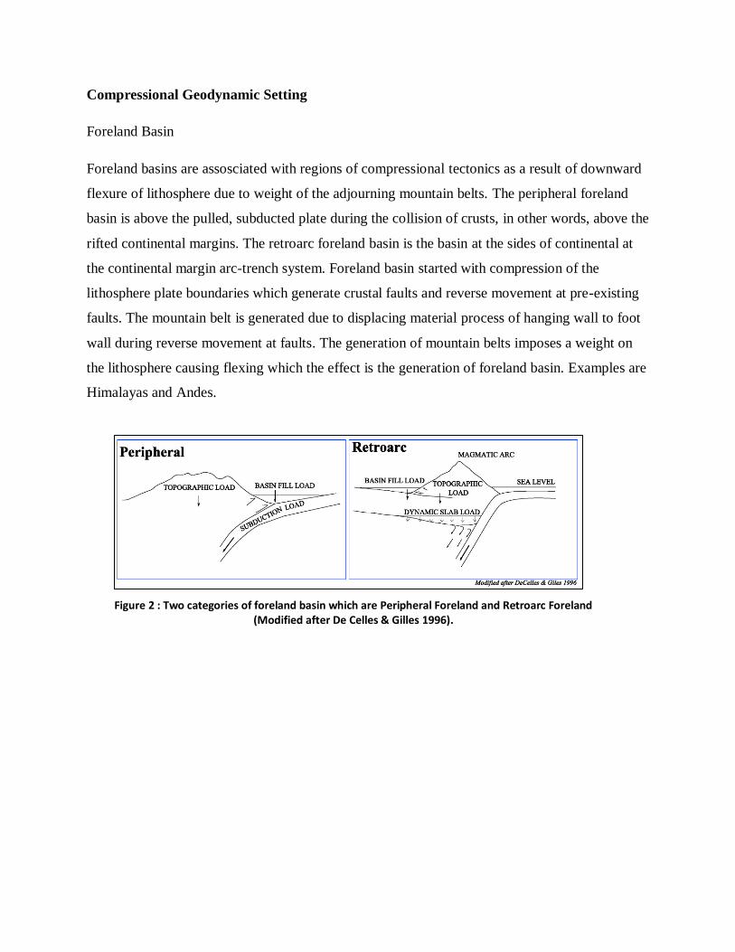
Compressional Geodynamic Setting
Foreland Basin
Foreland basins are assosciated with regions of compressional tectonics as a result of downward
flexure of lithosphere due to weight of the adjourning mountain belts. The peripheral foreland
basin is above the pulled, subducted plate during the collision of crusts, in other words, above the
rifted continental margins. The retroarc foreland basin is the basin at the sides of continental at
the continental margin arc-trench system. Foreland basin started with compression of the
lithosphere plate boundaries which generate crustal faults and reverse movement at pre-existing
faults. The mountain belt is generated due to displacing material process of hanging wall to foot
wall during reverse movement at faults. The generation of mountain belts imposes a weight on
the lithosphere causing flexing which the effect is the generation of foreland basin. Examples are
Himalayas and Andes.
Figure 2 : Two categories of foreland basin which are Peripheral Foreland and Retroarc Foreland (Modified after De Celles & Gilles 1996).

The feature of the foreland basin is a narrow elongate basin parallel to orogenic belt. Thrust
movement disseminate further towards foreland. This causes multiple thrust anticline structure
stacks on top of each other, increasing the size of the mountain belt. The foreland basin will
evolve into syndepositional system deformation at which the basin gradually incorporate into
advancing the orogen. The deformation causes the downward flexing of Moho. The basin
eventually will combine with platform and intracratonic basin.
Forearc Basin
Forearc, interarc and backarc basin are form at active continental margin which assosciated with
the development of island arcs and subduction. Forearc basin is a sea floor depression located at
associated to volcanic arcs, accretionary wedges and subduction zone. The formation is a
consequence of when overriding plate which deforms due to accretion and subduction. The
evolution of forearc basins is due to active accretion and subduction wedge deformation.
The buildup of forearc basin is a complex mélange structure with terranes bounded with many
faults. The buildup consists of low grade metamorphism rocks. The basin can be formed by
wedge that can construct a raised ridge which sediments settle down. Davis et al (1983) said that
in regions where sedimentary material from oceanic plate is actively accreted to margin, the
upper plate tend to deform into a wedge-shape profile, which is likely to be seen in the forearc
basin. The evolution of the subduction wedge to grow is determined by the accretionary flux.
Figure 3 : Illustration of idealized deformation in front of Orogenic Belt and Foreland Platform Basin.
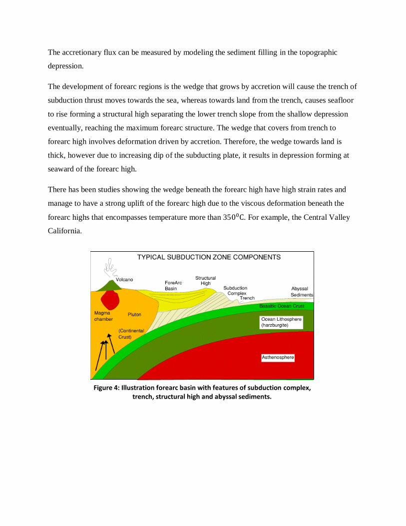
The accretionary flux can be measured by modeling the sediment filling in the topographic
depression.
The development of forearc regions is the wedge that grows by accretion will cause the trench of
subduction thrust moves towards the sea, whereas towards land from the trench, causes seafloor
to rise forming a structural high separating the lower trench slope from the shallow depression
eventually, reaching the maximum forearc structure. The wedge that covers from trench to
forearc high involves deformation driven by accretion. Therefore, the wedge towards land is
thick, however due to increasing dip of the subducting plate, it results in depression forming at
seaward of the forearc high.
There has been studies showing the wedge beneath the forearc high have high strain rates and
manage to have a strong uplift of the forearc high due to the viscous deformation beneath the
forearc highs that encompasses temperature more than 35 . For example, the Central Valley
California.
Figure 4: Illustration forearc basin with features of subduction complex, trench, structural high and abyssal sediments.

Wrench-related basin
Wrench-related basin or strike slip basin develops in both compressional geodynamics setting.
The far-field (plate margin) stress propagates into the craton’s interior causing an oblique
convergence. Transpressional systems generate wrench basins of limited size. The compression
can be inferred from wrench faults and fold belts. The pure shear arises from compressional or
tensional component across wrench zone, where the direction is given by orientation occur at
to strike-slip boundary.
Transverse ridges are isolated mountains on either or both sides of the transform fault. The ridges
require either compression or tension across the transforms fault to form islands from mantle
peridotites.
Figure 5 : Illustration of transpressional and transtensional system to generate wrench basin and strike-slip basin respectively.
Extensional Geodynamic Setting
Strong correlation between magma produced and the amount of lithospheric stretching is shown
by the Quantitative model from McKenzie and Bickel (1988). The model suggests that the sub-
lithospheric upper mantle heaving with heat underneath the extension zone controls the
chemistry and volume of erupted magmas.
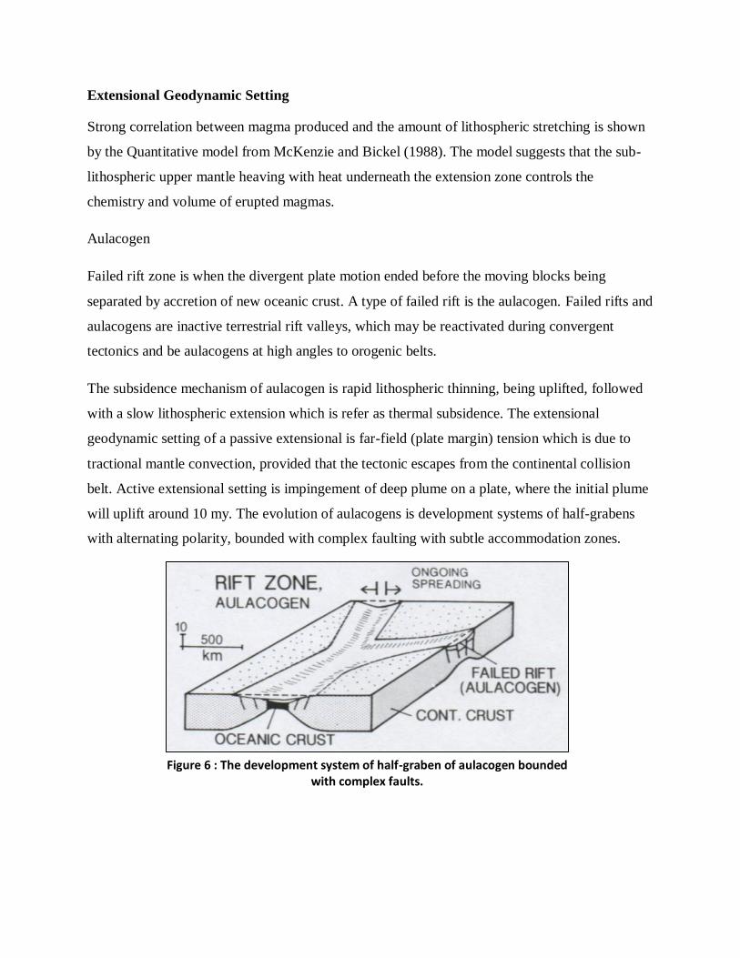
Aulacogen
Failed rift zone is when the divergent plate motion ended before the moving blocks being
separated by accretion of new oceanic crust. A type of failed rift is the aulacogen. Failed rifts and
aulacogens are inactive terrestrial rift valleys, which may be reactivated during convergent
tectonics and be aulacogens at high angles to orogenic belts.
The subsidence mechanism of aulacogen is rapid lithospheric thinning, being uplifted, followed
with a slow lithospheric extension which is refer as thermal subsidence. The extensional
geodynamic setting of a passive extensional is far-field (plate margin) tension which is due to
tractional mantle convection, provided that the tectonic escapes from the continental collision
belt. Active extensional setting is impingement of deep plume on a plate, where the initial plume
will uplift around 10 my. The evolution of aulacogens is development systems of half-grabens
with alternating polarity, bounded with complex faulting with subtle accommodation zones.
Figure 6 : The development system of half-graben of aulacogen bounded with complex faults.

The magmatism of a Passive failed rift is minor to bimodal volcanism with magmatic
underplating, whereas for Active failed rifts, a high amount mafic volcanism and dyke with
extensive underplating. Example of Active aulacogen East Africa rifts, whereas for Passive
aulacogen is the Viking Graben. During the closing of the ocean and during the orogenies,
similar basin of aulacogen can also be initiated in both processes.
Oceanic Rift Basin
Oceanic rift basin is a basin that floored by oceanic crust formed at divergent boundaries, and is
not related to arc-trench system. The divergence regime in the oceanic basin is the tension in the
crusts disseminate into areas covered by the continental crust. The continental crust of the ocean
basin is stretched and split. Continental crust is thicker, causing the ridges to appear less
apparent, however, the rifting is the dominant feature of the regime effects.
The youngest part of the oceanic basin is the new oceanic crust formed during the plate
divergence, which the rise of the mantle material and magma into the cracks of the continental
crusts. The Pacific and the Indian Ocean shows the divergence of the basin by seafloor
spreading, that are changing in spreading rate and direction, and the development of new
spreading axes. These parameters cause difficulties in determining the shape of both of the
basins.
Ocean basin is developed from the rift basins which is previously being rift valleys. Examples of
rift valleys, rift basin and ocean basin are East African Rift, the Red Sea and the Atlantic Ocean
respectively.
Figure 7 : The Evolution of Ocean basin from Rift Valley.

Intracratonic Basin
Intracratonic basin is a broad cratonic basin that is floored by failed rifts in axial zone. The
subsidence mechanism is by lithospheric extension, lithospheric densification and dynamic
lithospheric downwarp. The extensional regime in the basin is during the far-field tension failed
rift) which is associated with the global plate reorganization and contraction of the mafic
underplate. The dynamic downwarp started with the tractional convection, causing a downward-
acting dynamic force which is also associated to global plate reorganization. The faulting system
and the deformation is generally lacking since the strata are gently-dipping or flat lying strata.
The magmatism occur in the intracratonic basin is minor volcanism and some basin may posses
anorogenic granites at the basal section. The basin develops episodically with complex
subsidence, regional unconformities and basin is pinned by zone of high seismic velocity and
showing irregular basement topography. Examples are Parana and Illinois basins.
Figure 8 : Illustration of intracratonic basin floored by failed rift.
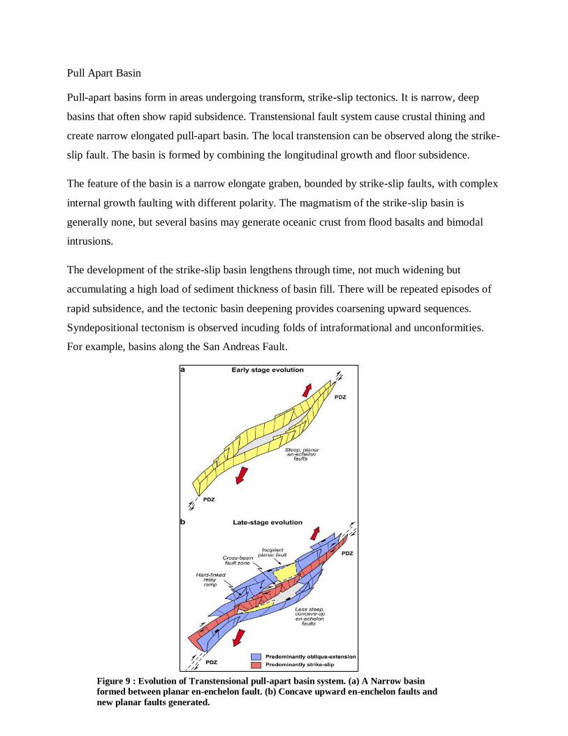
Pull Apart Basin
Pull-apart basins form in areas undergoing transform, strike-slip tectonics. It is narrow, deep
basins that often show rapid subsidence. Transtensional fault system cause crustal thining and
create narrow elongated pull-apart basin. The local transtension can be observed along the strike-
slip fault. The basin is formed by combining the longitudinal growth and floor subsidence.
The feature of the basin is a narrow elongate graben, bounded by strike-slip faults, with complex
internal growth faulting with different polarity. The magmatism of the strike-slip basin is
generally none, but several basins may generate oceanic crust from flood basalts and bimodal
intrusions.
The development of the strike-slip basin lengthens through time, not much widening but
accumulating a high load of sediment thickness of basin fill. There will be repeated episodes of
rapid subsidence, and the tectonic basin deepening provides coarsening upward sequences.
Syndepositional tectonism is observed incuding folds of intraformational and unconformities.
For example, basins along the San Andreas Fault.
Figure 9 : Evolution of Transtensional pull-apart basin system. (a) A Narrow basin
formed between planar en-enchelon fault. (b) Concave upward en-enchelon faults and
new planar faults generated.

Conclusion
The Qur’an consistently describes mountains as stabilizers for the Earth’s surface which hold it
firmly it should shake with us for the Earth that hold its surface down as a means of fixation. So,
the Qur’an, in very simple words, described the outward protrusion of mountains on the Earth’s
surface, emphasized their great downward extensions within the Earth’s crust. Such knowledge
was revealed more than 12 centuries before man started to wonder whether or not mountains
could have roots below its outcropping parts, and before he could realize any value for the
existence of mountains on the surface of our globe, a value that is only being currently conceived
by a very limited number of specialists in the field of Earth Sciences.
"Have We not made the earth as a bed, And the mountains as pegs?"(Surat An-Naba' (The Great
News): 6-7) is of great geologic interest.
The description of mountains as pegs clearly implies that such striking geomorphologic features
are not just the elevations that are seen on the surface of the Earth, but their downward
extensions in the Earth’s lithosphere is highly emphasized.
Then do they not look at the camels - how they are created? And at the sky - how it is raised? And at the
mountains - how they are erected? And at the earth - how it is spread out? So remind, [O Muhammad];
you are only a reminder. (Al-Ghashiyah :17-21)
Praise to Allah for knowledge that He gave throughout my study and His Blessings given for me
to witness His Divine .The Quran is the work of Our Creator, and Muhammad SAW is His final
Messenger.

References
1. Al-Quran English Translation. Quran.com
2. Allen, P.A. & Homewood, P (Editors). (1986).Foreland Basins. 'Foreland basins: an
introduction'. Blackwell Scientific Publications. p.453.
3. Chapman, R. E. (1983). Concepts of Sedimentary Basins, Developments in Petroleum
Science, Elsevier, 1983, Volume 16, Pages 1-22.
(http://www.sciencedirect.com/science/article/pii/S0376736108700852)
4. Davis, D., Suppe, J. & Dahlen, F.A. (1983).Mechanics of Fold and Thrust Belts and
Accretionary Wedges. Journal of Geophysical Research 88 (B2), p. 1153-1178.
5. El-Naggar, Z. (2003). Geological Concept of Mountains in the Quran. Al-Falah
Foundation. Cairo, Egypt.
6. Ingersol, R.V. (1988). Tectonics of Sedimentary Basins. Geological Society America
Bulletin 100.p 1074-1719.
7. McKenzie and Bickel, M. J. (1988). The Volume and Composition of Melt Generated by
Extension of the Lithosphere. Petrology 29 (3). p. 625-679
8. Wright, J. and Rothery, D.A. (1998). Chapter 3 - The evolution of ocean basins, The
Ocean Basins: Their Structure and Evolution (Second Edition), Butterworth-Heinemann,
Oxford. p 55-67.
(http://www.sciencedirect.com/science/article/pii/B9780750639835500047)