economic geology - CiteSeerX
17
ECONOMIC GEOLOGY AI•D THE BULLETI• OF THE SOCIETY OF ECONOMIC GEOLOGISTS VoL. 69 AUGUST, 1974 No. 5 Regional Characteristics of Porphyry CopperDeposits of the Southwest J. DAVID LOWELL Abstract ' The largest andbest studied concentration of porphyry-type deposits is the Southwest porphyry province in Arizona, southwestern New Mexico, and northern Sonora (Figure'1). Most of these deposits are in the 58 to 72 million-year-old range,with one 163 m.y. date and one 20 m.y. date. Several Mesozoic age porphyry copper deposits occur northwest of the main cluster, and mid-Tertiary age porphyry molybdenumand porphyry copper deposits are present in the Colorado mineral belt and at Bingham Canyon,Utah. A progressive decrease in age occurs from northwestto southeast among the Laramide age Southwest porphyries. Tertiary rocks contemporaneous with and younger than the Laramide mineralization appear to have been formed under conditionsof strong deformation and crustal ex- tension.Large displacement, flat, "gravity slide" faults are present in southernArizona together with evidence of abundant horst-grabenstructure and rift faulting. A correlation of rock types, structures, and intrusive and extrusive activity suggests that "basin~range"-type extensional structures were formed throughoutthe Tertiary periodand probably throughmuchof the Mesozoic as well. In detail, mineralization tends to favor N. 65 ø E. and N. 40 ø W. structures, and the deposits in some instances appear to form belts with thesealignments, but the cluster of deposits hasan overall oval shape unlikethe lineal porphyry provinces in Iran, Chile, and the Philippines. The individualporphyrybelts in the Southwest provincecross the Texas lineament with no apparent strike-slip displacement. However,currentplate tectonic theory sug- gests that a large right-lateral displacement should exist if this structure corresponds to the WalkerLine in Nevada as postulated by Jerome and Cook(1967). There is as yet little definite evidence for the presence of subduction zones in Arizona and west of Arizona during the period of formation of the Southwest porphyries, andevidence for the association of porphyry mineralization with plat. e tectonic processes as described in the literature is not convincing in theSouthwest province. It is particularly unlikely that subducted oceanic crust wasthe source of metals in the Southwest porphyry de- posits. An interpretation of depth of .erosion in porphyry deposits canbe attempted by com- paring the alteration zones ,nd mineral assemblages exposed at the present ground surface with an assumed model of vertical zonation. This suggests that erosion has cutdeeply intothe columns of Laramide mineralization in deposits in the northwestern partof thegeneral cluster and thatdeposits to thesoutheast were left generally intact by post-Laramide erosion. Introduction A •U•ER of excellent papers have dealt with the setting of the Southwest porphyry copper province and the writer has borrowed extensively from Anderson(1966), Jeromeand Cook (1967), and Cooley (1967). This paper presents summarized observations and the scope of the subject has pre- vented detailed documentation in every case. 601
-
Upload
khangminh22 -
Category
Documents
-
view
1 -
download
0
Transcript of economic geology - CiteSeerX

ECONOMIC GEOLOGY AI•D THE
BULLETI• OF THE SOCIETY OF ECONOMIC GEOLOGISTS
VoL. 69 AUGUST, 1974 No. 5
Regional Characteristics of Porphyry Copper Deposits of the Southwest
J. DAVID LOWELL
Abstract '
The largest and best studied concentration of porphyry-type deposits is the Southwest porphyry province in Arizona, southwestern New Mexico, and northern Sonora (Figure' 1). Most of these deposits are in the 58 to 72 million-year-old range, with one 163 m.y. date and one 20 m.y. date. Several Mesozoic age porphyry copper deposits occur northwest of the main cluster, and mid-Tertiary age porphyry molybdenum and porphyry copper deposits are present in the Colorado mineral belt and at Bingham Canyon, Utah. A progressive decrease in age occurs from northwest to southeast among the Laramide age Southwest porphyries.
Tertiary rocks contemporaneous with and younger than the Laramide mineralization appear to have been formed under conditions of strong deformation and crustal ex- tension. Large displacement, flat, "gravity slide" faults are present in southern Arizona together with evidence of abundant horst-graben structure and rift faulting. A correlation of rock types, structures, and intrusive and extrusive activity suggests that "basin~range"-type extensional structures were formed throughout the Tertiary period and probably through much of the Mesozoic as well.
In detail, mineralization tends to favor N. 65 ø E. and N. 40 ø W. structures, and the deposits in some instances appear to form belts with these alignments, but the cluster of deposits has an overall oval shape unlike the lineal porphyry provinces in Iran, Chile, and the Philippines.
The individual porphyry belts in the Southwest province cross the Texas lineament with no apparent strike-slip displacement. However, current plate tectonic theory sug- gests that a large right-lateral displacement should exist if this structure corresponds to the Walker Line in Nevada as postulated by Jerome and Cook (1967). There is as yet little definite evidence for the presence of subduction zones in Arizona and west of Arizona during the period of formation of the Southwest porphyries, and evidence for the association of porphyry mineralization with plat. e tectonic processes as described in the literature is not convincing in the Southwest province. It is particularly unlikely that subducted oceanic crust was the source of metals in the Southwest porphyry de- posits.
An interpretation of depth of .erosion in porphyry deposits can be attempted by com- paring the alteration zones ,nd mineral assemblages exposed at the present ground surface with an assumed model of vertical zonation. This suggests that erosion has cut deeply into the columns of Laramide mineralization in deposits in the northwestern part of the general cluster and that deposits to the southeast were left generally intact by post-Laramide erosion.
Introduction
A •U•ER of excellent papers have dealt with the setting of the Southwest porphyry copper province and the writer has borrowed extensively from
Anderson (1966), Jerome and Cook (1967), and Cooley (1967). This paper presents summarized observations and the scope of the subject has pre- vented detailed documentation in every case.
601
602 i. DAVID LOWELL
ß BRITISH COLUMBIAMOLYBDENU.,
ß • • ENDAKO
ISLAND COPPER ß • CRA•GM•NT • -- -• FACE • ] BRENDA _ •PPER MOUNTAIN CA• • • •CO
t • HEDDLESTON- BIG BEN •
S*T•LE a•e es•.•.,• c,.•o• •;so• YEE•N•ON ' , U•AD- HENOE•SO • • •ELY •CLIMAX •T.ACA •EA• eeu•s•A
SHEEP M•N. •SANTA RITA SOUTHWEST A•o• CANANNA •
POVCE o '
••,•os•,
PETA•glLLA
CEllO VE•OE•;?,• 1 ,•c• I
ß PORPHYRY COPPER-MOLYBDENUM DEPOSITS OR DISTRICTS
O SELECTED SIGNIFICANT PORPHYRY COPPER PROSPECTS OUTSIDE OF KNOWN DISTRICTS
SALVADOR - POTRE RILLOS
DISPUTADA
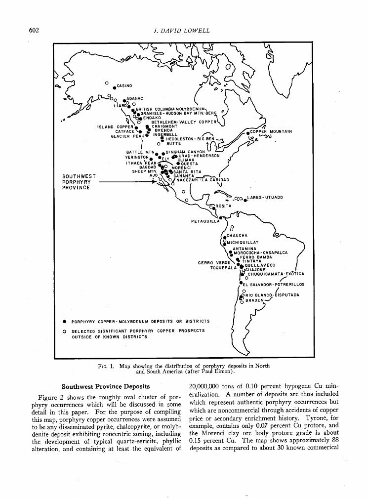
Fro. 1. Map showing the distribution of porphyry deposits in North and South America (after Paul Eimon).
Southwest Province Deposits
Figure 2 shows the roughly oval cluster of por- phyry occurrences which will be discussed in some detail in this paper. For the purpose of compiling this map, porphyry copper occurrences were assumed to be any disseminated pyrite, chalcopyrite, or molyb- denite deposit exhibiting concentric zoning, including the development oœ typical quartz-sericite, phyllic alteration. and .containing at least the equivalent of
20,000,000 tons of 0.10 percent hypogene Cu min- eralization. A number of deposits are thus included which represent authentic porphyry occurrences but which are noncommercial through accidents of copper price or secondary enrichment history. Tyrone, for example, .contains only 0.07 percent Cu protore, and the Morenci clay ore body protore grade is about 0.15 percent Cu. The map shows approximately 88 deposits as compared to about 30 known commerical
CHARACTERISTICS OF PORPHYRY COPPER DEPOSITS 603
NEVADA
'•6ø • N E W • • A R , Z 0 N A MEXICO • o •x
• • Albuquerqu•_ ' <[ 0 -
1_34 ø • • 0
I-J k • o o• s• o _ • o o • Oo o
.o
½ o ø • • o • •. •_ • Mid-T, Hiar• porph•r•
I • • o• • • Jurassic porphyry I • • • • • • Precombrion mossi•
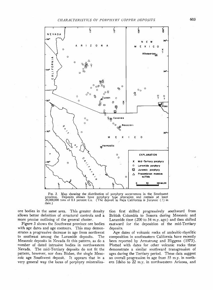
Fro. 2. Map showing the distribution of porphyry occurrences in the Southwest provirtue. Deposits shown have porphyry type alteration and contain at least 20,000,000 tons of 0.1 percent Cu. (The deposit in Baja California is Jurassic (?) in date. )
ore bodies in the same area. This greater density allows better definition of structural controls and a
more precise outlining of the general cluster. Figure 3 shows the Southwest province ore bodies
with age dates and age contours. This map demon- strates a progressive decrease in age from northwest to southeast among the Laramide deposits. The Mesozoic deposits in Nevada fit this pattern, as do a number of dated intrusive bodies in northwestern
Nevada. The mid-Tertiary deposits do not fit the pattern, however, nor does Bisbee, the single Meso- zoic age Southwest deposit. It appears that in a very general way the locus of porphyry mineraliza-
tion first shifted progressively southward from British Columbia to Sonora during Mesozoic and Laramide time (200 to 54 m.y. ago) and then shifted eastward for the deposition of the mid-Tertiary deposits.
Age dates of volcanic rocks of andesitic-rhyolitic composition in southeastern California have recently been reported by Armstrong and Higgens (1973). Plotted with dates for other volcanic rocks these
demonstrate a similar southward transgression of ages during the Tertiary period. These data suggest an overall progression in age from 55 m.y. in north- ern Idaho to 22 m.y. in northwestern Arizona, and

604 J. DAVID LOWELL
N E W
M E X I C 0
Albuquerqu•F•
•6 ø -
•4 o
I00 MILES I
Fro. 3. Map showing age dates of several Southwest porphyries which suggest a progressive southeastward shift of the locus of mineralization during Laratnide time.
this parallels to some degree the earlier transgression in ages of porphyry copper occurrences.
Geologic l, istory
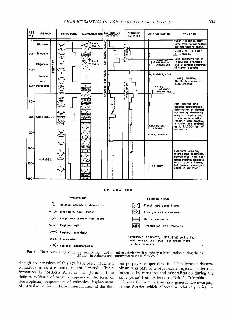
Figure 4 has been constructed to show graphically the relationship of intensity and type of structural deformation, type of sedimentation, and intensity of extrusive, intrusive, and porphyry mineralization activity during Jurassic, Cretaceous, and Tertiary time in Arizona and southwestern New Mexico. In-
formation has been summarized from a wide variety of sources including Cooley (1967), Anderson (1966), Hayes (1970), and from personal observa- tions.
In contrast to the island-arc environment, ,but similar to the setting of the Iran porphyry district, the Southwest porphyries occur in an area which, during most of the period since Precambrian time, has been a relatively quiescent shelf, or miogeo- synclinal, environment. It was associated with the Cordilleran geosyncline in Nevada and Utah, and the total thickness of Paleozoic strata in the area of the
Arizona-New Mexico-Sonora cluster was about 4,000 feet, as compared to over 20,000 feet of sediments which accumulated in the geosyncline to the north- west.
By Triassic time the first effects of the Mesozoic orogeny may have begun in southern Arizona. A1-
CHztRztCTERIoeTICS OF PORPHYRY COPPER DEPOSITS 605
AGE PERIOD STRUCTURE ISEOiMENTATIO N EXTRUSIVE INTRUSIVE MINERALIZATION REMARKS (m.y.) ' ACTIVITY ACTIVITY
' '/• • L . Valley till, tilting, upift, Pliocsne • ""--1 -AK• < •u large scale normal foulting; • L .'=' .' - •-> Valley fill• erosion.
20-- Miocene • '-::• • ] of uplands • "ø*'"' • •E Leke sedimentation in
Oligocen, • • .•-AK, ,z [ . .• < eU•ER•NE impounded drainages
ß SEDIM. < F ] ENRICH•.•ENT artd supergens enrichment • -' ' of copper deposits
40 ø ø", ] ]<.,...... •- .I, -s Eocene ? •o
• z• Strong erosion; and • • ' •e --I• 1 flysch deposition in
60*= Paleocene G • ' .'• • <-sw • '.• -- ,,,m • t. ARAMIDE
', e ß • __FI PORPHYRIES ß o
•0- %:'• • Flot faulting and • • ............. 9 ', penscontemporaneous
F_ lo .•. /.• defOrmof;oR of detrital • '1 I sediments; alternating I00- CRETACEOUS i'•? I ":':':':':':' • morginal mot;ns and , • .-'' I ---J I flysch sedimentation
•? -d ..Z.:.:-:-Z I I fogøthat with orogsny, ß ", intrusion ond eruption;
,: ,•: I rJ <YERINaTON, Up tO 21,000 feet of e.' .9 I NEVAOA sediments ß ß ß
leO- • o 'ø I I <ELY, NEVADA • =";'ø' I ,
.- L_ ß e. ee I I 4o- - :::. ',
'I, I I I • Extorts;vø erosionl I I rr' infercalated sediments, • s .'•' 1, ', pyroclastics and mar- ' I
dURASSIC • 'aø. "e I I ginol marine; geologic 160- ::.:-:.:.:.:-;.. record poorly known, • I I I • ß . I ] < BISBEE but general epe•rogemc
• ß I I ,, uplift is indicated ß '00 . ß o ,øa I
• .... • I ', -180 ':':':",':':'i [
EXPLANATION
STRUCTURE
Relotive intensity of deformorion Rift foults, horst-graben Large displocement riot faults
Regional uplift
Regional subsidence
Compression
"• Regional metamorphiem
SEDIMENTATION
:k]•J Flysch type basin filling ;.'.'• Fine grained sediments
• Morins sediments
:.:;..."• Pyroclostice and volconics
EXTRUSIVE ACTIVITY, INTRUSIVE ACTIVITY, AND MINERALIZATION: Bar graph shows relative intensity
Fro. 4. Chart correlating structure, sedimention, and intrusive activity with porphyry mineralization during the past 180 m.y. in Arizona and southwestern New Mexico.
though no intrusives of this age have been identified, tuffaceous units are found in the Triassic Chinle formation in northern Arizona. In Jurassic time definite evidence of orogeny appears in the form of diastrophism, outpourings of volcanics, implacement of intrusive bodies, and ore mineralization at the Bis-
bee porphyry copper deposit. This Jurassic diastro- phism was part of a broad-scale regional pattern as indicated by intrusion and mineralization during the same period from Arizona to British Columbia.
Lower Cretaceous time saw general downwarping of the district which allowed a relatively brief in-
606 .l. DAVID LOWELL
Tuli Syncline Messina Blocl• N. Transvaal
NW Loke I•rlb• SE
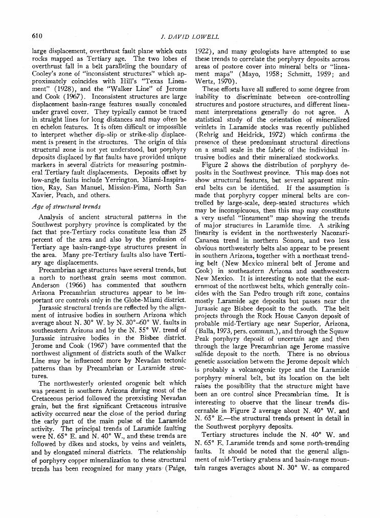
Fro. 5. (a) Diagrammatic section through crust under- going 'necking': broken subver, tical lines show direction of Pmax; potential shear directions marked by arrows (after Cox, 1970). (b) As above showing the development of faulting on shear planes of the lowest dip. (c) Diagramma- tic section across the Limpopo zone of the African Rift Valley showing faulting and warping of pre-Karroo surface; section is 175 km long. (d) Diagrammatic section across the Kariba section of the mid-Zambesi African Rift Valley.
vasion of the sea from the Sonoran geosyncline to the southeast and the deposition of up to 21,000 feet of marine clastic and carbonate sediments, (Hayes, 1970). The sea withdrew, but the region remained near sea level for the most of the middle and Upper Cretaceous period, and marginal marine sediments were interbedded with volc&nics and terrestrial clas- tic sediments. No Lower or middle Cretaceous in- trusions have been identified in Arizona although intrusive rocks of this age are present in Nevada. There were, however, outpourings of volcanic rocks in Early Cretaceous and Late Cretaceous time and evidence exists of extensive block faulting and deposi- tion of thick localized sections of basin-fill- and
flysch-type sediments. In Upper Cretaceous time some flat faulting occurred, and high-angle normal faulting and penecontemporaneous deformation of sediments indicate that crustal deformation was in
progress. Cretaceous sedimentary rocks in the Southwest province accumulated in isolated basins and are characterized by extremely rapid facies changes over short distances.
In Late Cretaceous time the main pulse of Lara- mide orogeny and intrusive activity and mineraliza-
tion began and continued for about 30 million years. It was followed by a second, weaker orogeny in middle Tertiary time. Most of the last 80-million- year period has been characterized by intense defor- mation consisting of differential uplift and subsidence of blocks along high-angle normal faults sometimes accompanied by flat faulting. The flat faults may have several different origins: some are low-angle gravity faults complementary to associated high-angle faults as, for example, the Miami fault and the San Manuel fault; some are perhaps large displacement "overthrust" flat fault lobes as will be discussed
later and some may be rotated normal faults. An- desitic volcanics were intercolated with flysch-type, poorly sorted basin-fill sediments several times dur- ing early and mid-Tertiary time (Damon and Manger 1966; Livingston et al., 1968; and Gilmour, 1972), but 10 to 15 million years ago a rather abrupt change occurred, after which bimodal basalt-rhyolite vol- canics were extruded rather than andesitic volcanics.
Following this change in type of volcanics no further flat faulting occurred, and an orogenic cycle may have terminated.
The structural record is reasonably clear in late Tertiary time but becomes progressively more ob- scure as we proceed farther back into the geologic record where more younger structures are super- imposed on the older structures. It has been ac- cepted by many geologists that the last 30 million years constitute the "Basin and Range period" dur- ing which a large part of the presently visible defor- mation took place. Figure 4 and studies by Loring (1973 and 1974) suggest that this may not be the case and that structural deformation and extrusive
and intrusive activity in the Southwest were some- what episodic but were more or less continuous from Cretaceous, or even possibly Jurassic, through late Tertiary time. Some types of structural deformation produce characteristic sediments. The differential uplift, horst-graben-type deformation tends to pro- duce sediments with rapid facies changes. These clastic basin-fill sediments and fanglomerates are of the flysch-molasse type, are poorly sorted, and some- times show penecontemporaneous deformation. Ab- normal thicknesses of sediments, regardless of grain- size, also indicate structurally formed basins. To some extent it is possible to reconstruct the type and intensity of structural deformation from the char- acteristics of the sediments deposited and in this way (Fig. 4) to extrapolate structural history on the basis of the sedimentary record.
Structural deformation
Most of the structures indicated throughout the stratigraphic column of Figure 4 are the result of high-angle horst-graben faulting with tilting of fault
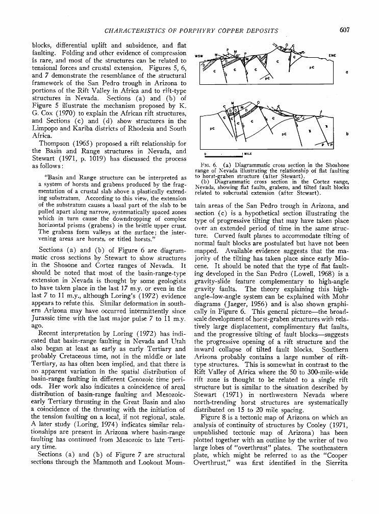
CH.4R.4CTERISTICS OF PORPHYRY COPPER DEPOSITS 607
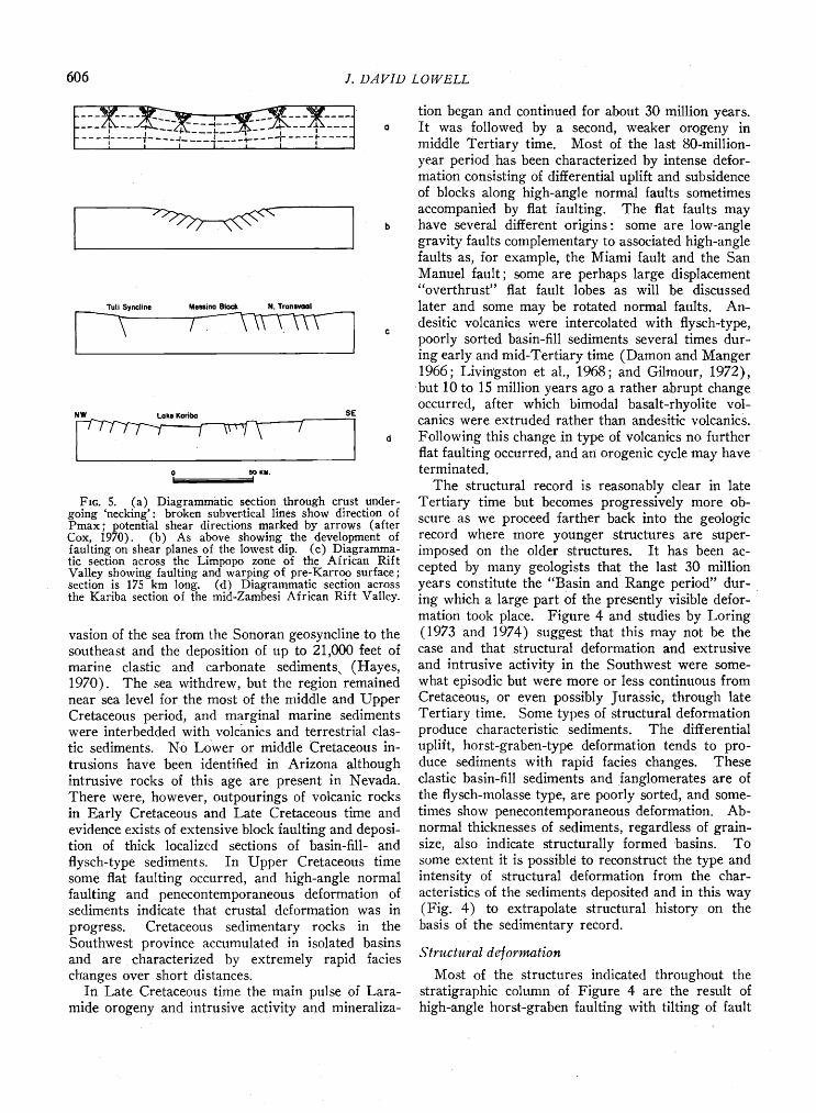
blocks, differential uplift and subsidence, and flat faulting. Folding and other evidence of compression is rare, and most of the structures can be related to tensional forces and crustal extension. Figures 5, 6, and 7 demonstrate the resemblance of the structural
framework of the San Pedro trough in Arizona to portions of the Rift Valley in Africa and to rift-type structures in Nevada. Sections (a) and (b) of Figure 5 illustrate the mechanism proposed by K. G. Cox (1970) to explain the African rift structures, and Sections (c) and (d) show structures in the Limpopo •and Kariba districts of Rhodesia and South Africa.
Thompson (1965) proposed a rift relationship for the Basin and Range structures in Nevada, and Stewart (1971, p. 1019) has discussed the process as follows:
"Basin and Range structure can be interpreted as a system of horsts and grabens produced by the frag- mentation of a crustal slab above a plastically extend- ing substratum. According to this view, the extension of the substratum causes a basal part of the slab to be pulled apart along narrow, systematically spaced zones which in turn cause the downdropping of complex horizontal prisms (grabens) in the brittle upper crust. The grabens form valleys at the surface; the inter- vening areas are horsts, or titled horsts."
Sections (a) and (b) of Figure 6 are diagram- matic cross sections by Stewart to show structures in the Shosone and Cortez ranges of Nevada. It should be noted that most of the basin-range-type extension in Nevada is thought by some geologists to have taken place in the last 17 m.y. or even in the last 7 to 11 m.y., although Loring's (1972) evidence appears to refute this. Similar deformation in south- ern Arizona may have occurred intermittently since Jurassic time with the last major pulse 7 to 11 m.y. ago.
Recent interpretation by Loring (1972) has indi- cated that basin-range faulting in Nevada and Utah also began at least as early as early Tertiary and probably Cretaceous time, not in the middle or late Tertiary, as has often been implied, and that there is no apparent variation in the spatial distribution of basin-range faulting in different Cenozoic time peri- ods. Her work also indicates a coincidence of areal distribution of basin-range faulting and Mesozoic- early Tertiary thrusting in the Great Basin and also a coincidence of the thrusting with the initiation of the tension faulting on a local, if not regional, scale. A later study (Loring, 1974) indicates similar rela• tionships are present in Arizona where basin-range faulting has continued from Mesozoic to late Terti- ary time.
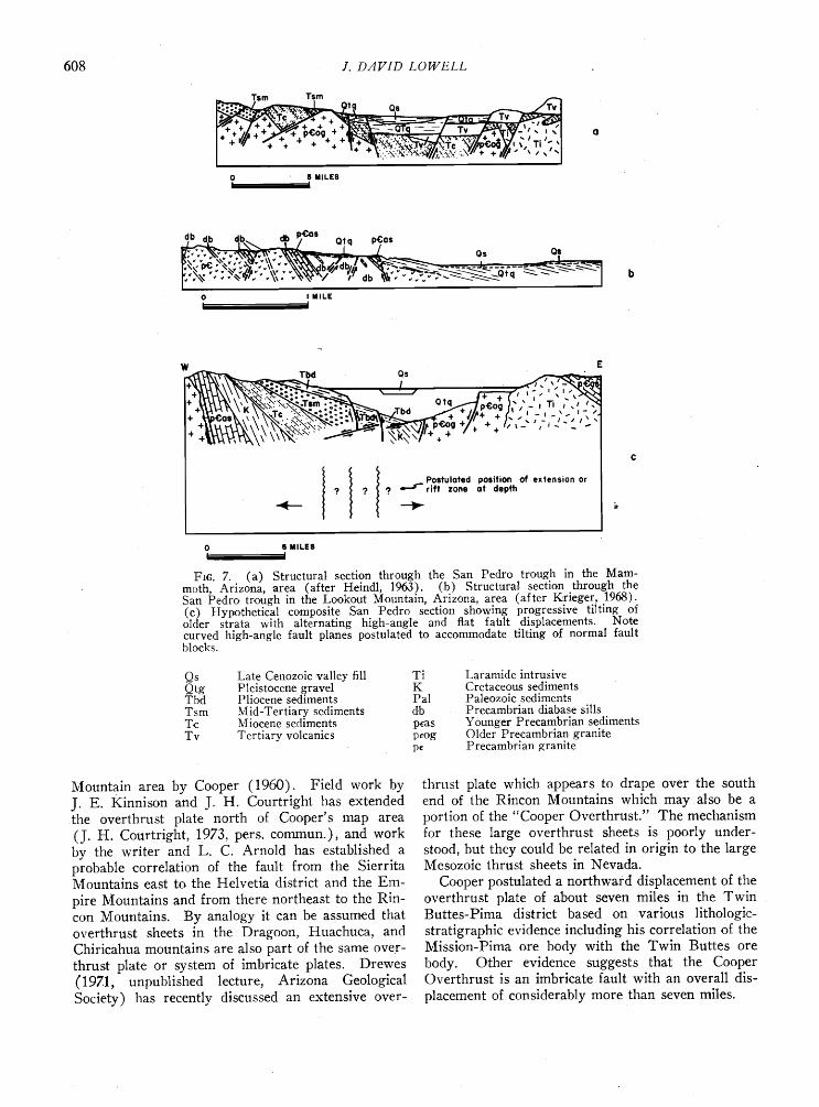
Sections (a) and (b) of Figure 7 are structural sections through the Mammoth and Lookout Moun-
MILE
Fro. 6. (a) Diagrammatic cross section in the Shoshone range of Nevada illustrating the relationship of flat faulting to horst-graben structure (after Stewart).
(b) Diagrammatic cross section in the Cortez range, Nevada, showing flat faults, grabens, and tilted fault blocks related to subcrustal extension (after Stewart).
tain areas of the San Pedro trough in Arizona, and section (c) is a hypothetical section illustrating the type of progressive tilting that may have taken place over an extended period of time in the same struc- ture. Curved fault planes to accommodate tilting of normal fault blocks are postulated but have not been mapped. Available evidence suggests that the ma- jority of the tilting has taken place since early Mio- cene. It should be noted that the type of flat fault- ing developed in the San Pedro (Lowell, 1968) is a gravi,ty-slide feature complementary to high-angle gravity faults. The theory explaining this high- angle-low-angle system can be explained with Mohr diagrams (Jaeger, 1956) and is also shown graphi- cally in Figure 6. This general picture--the broad- scale development of horst-graben structures with rela- tively large displacement, complimentary flat faults, and the progressive tilting of fault blocks--suggests the progressive opening of a rift structure and the inward collapse of tilted fault blocks. Southern Arizona probably contains a large number of riff- type structures. This is somewhat in contrast to the Rift Valley of Africa where the 50 to 300-mile-wide rift zone is thought to be related to a single rift structure but is similar to the situation described by Stewart (1971) in northwestern Nevada where north-trending horst structures are systematically distributed on 15 to 20 mile spacing.
Figure 8 is a tectonic map of Arizona on which an analysis of continuity of structures by Cooley (1971, unpublished tectonic map of Arizona) has been plotted together with an outline by the writer of two large lobes of "overthrust" plates. The southeastern plate, which might be referred to as the "Cooper Overthrust," was first identified in the Sierrita
6O8
0 • MILES I •
0 I MILLE i I
Postulated position of extension or ? e-.s" rift zone at depth
0 • MIlLEl i I
Fro. 7. (a) Structural section throuh the San Pedro trough in the Mam- moth, Arizona, area (after Heindl, 1963). (b) Structural section through the San Pedro trough in the Lookout Mountain, Arizona, area (after K. rieger, 1968). (c) Hypothetical composite San Pedro section showing progressive tilting of older strata with alternating high-angle and flat fatfit displacements. Note curved high-angle fault planes postulated to accommodate tilting of normal fault blocks.
Qs Late Cenozoic valley fill Ti Qtg Pleistocene gravel K Tbd Pliocene sediments Pal Tsm Mid-Tertiary sediments db T.c Miocene sediments peas Tv Tertiary volcanics peog
pe
Laramide intrusive Cretaceous sediments Paleozoic sediments Precambrian diabase sills Younger Precambrian sediments Older Precambrian granite Precambrian granite
Mountain area by Cooper (1960). Field work by J. E. Kinnison and J. H. Courtright has extended the overthrust plate north of Cooper's map area (J. H. Courtright, 1973, pers. commun.), and work by the writer and L. C. Arnold has established a probable correlation of the fault from the Sierrita Mountains east to the Helvetia district and the Em- pire Mountains and from there northeast to the Rin- con Mountains. By analogy it can be assumed that overthrust sheets in the Dragoon, Huachuca, and Chiricahua mountains are also part of the same over- thrust plate or system of imbricate plates. Drewes (197.1, unpublished lecture, Arizona Geological Society) has recently discussed an extensive over-
thrust plate which appears to drape over the south end of the Rincon Mountains which may also be a portion of the "Cooper Overthrust." The mechanism for these large overthrust sheets is poorly under- stood, but they could be related in origin to the large Mesozoic thrust sheets in Nevada.
Cooper postulated a northward displacement of the overthrust plate of about seven miles in the Twin Buttes-Pima district based on various lithologic- stratigraphic evidence including his correlation of the Mission-Pima ore body with the Twin Buttes ore body. Other evidence suggests that the Cooper Overthrust is an imbricate fault with an overall dis-
placement of considerably more than seven miles.
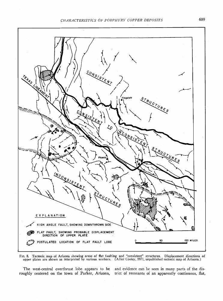
CHARACTERISTICS OF PORPHYRY COPPER DEPOSITS 609
HIGH ANGLE FAULT, SHOWING DOWNTHROWN SIO••.• FLAT FAULT• SHOWING PROBABLE DISPLACEMENT DIRECTION OF UPPER PLATE
POSTULATED LOCATION OF FLAT FAULT LOBE o 50 IOO MILES I I I
Fro. 8. Tectonic map of Arizona showing areas of flat faulting and "consistent" structures. Displacement directions of upper plates are shown as interpreted 'by various workers. (After Cooley, 1971, unpublished tectonic map of Arizona.)
The west-central overthrust lobe appears to be and evidence can be seen in many parts of the dis- roughly centered ,on the town of Parker, Arizona, trict of remnants of an apparently continuous, flat,
610 ]. DAVID LOWELL
large displacement, overthrust fault plane which cuts rocks mapped as Tertiary age. The two lobes of overthrust fall in a belt paralleling the boundary of Cooley's zone of "inconsistent structures" which ap.- proximately coincides with Hill's "Texas Linea- ment" (1928), and the "Walker Line" of Jerome and Cook (1967). Inconsistent structures are large displacement basin-range features usually concealed under gravel cover. They typically cannot be traced in straight lines for long distances and may often be en echelon features. It is often difficult or impossible to interpret whether dip-slip or strike-slip displace- ment is present in the structures. The origin of this structural zone is not yet understood, but porphyry deposits displaced by flat faults have provided unique markers in several districts for measuring postmin- eral Tertiary fault displacements. Deposits offset by low-angle faults include Yerrington, Miami-Inspira- tion, Ray, San Manuel, Mission-Pima, North San Xavier, Peach, and others.
dlge of structural trends
Analysis of ancient structural patterns in the Southwest porphyry province is complicated by the fact that pre-Tertiary rocks .constitute less than 25 percent of the area and also by the profusion of Tertiary age basin-range-type structures present in the area. Many pre-Tertiary faults also have Terti- ary age displacements.
Precambrian age structures have several trends, but a north to northeast grain seems most common. Anderson (1966) has commented that southern Arizona Precambrian structures appear to be im- portant ore controls only in the Globe-Miami district.
Jurassic structural trends are reflected by the align- ment of intrusive bodies in southern Arizona which
average about N. 30 ø W. by N. 30o-60 ø W. faults in southeastern Arizona and by the N. 55 ø W. trend of Jurassic intrusive bodies in the Bisbee district. Jerome and Cook (1967) have commented that the northwest alignment of districts south of the Walker Line may be influenced more by Nevadan tectonic patterns than by Precambrian or Laramide struc- tures.
The northwesterly oriented orogenic belt which was present in southern Arizona during most of the Cretaceous period followed the preexisting Nevadan grain, but the first significant Cretaceous intrusive activity occurred near the close of the period during the early part of the main pulse of the Laramide activity. The principal trends of Laramide faulting were N. 65 o E. and N. 40 ø W., and these trends are followed by dikes and stocks, by veins and veinlets, and by elongated mineral districts. The relationship of porphyry copper mineralization to these structural trends has been recognized for many years (Paige,
1922), and many geologists have attempted to use these trends to correlate the porphyry deposits across areas of postore cover into mineral belts or "linea- ment maps" (Mayo, 1958; Schmitt, 1959; and Wertz, 1970).
These efforts have all suffered to some degree from inability to discriminate between ore-controlling structures and postore structures, and different linea- ment interpretations generally do not agree. A statistical study of the orientation of mineralized veinlets in Laramide stocks was recently published (Rehrig and Heidrick, 1972) which confirms the presence of these predominant structural directions on a small scale in the fabric of the individual in- trusive bodies and their mineralized stockworks.
Figure 2 shows the distribution of porphyry de- posits in the Southwest province. This map does not show structural features, but several apparent min- eral belts can be identified. If the assumption is made that porphyry copper mineral belts are con- trolled by large-scale, deep-seated structures which may be inconspicuous, then this map may constitute a very useful "lineament" map showing the trends of major structures in Laramide time. A striking linearity is evident in the northwesterly Nacozari- Cananea trend. in northern Sonora, and two less obvious northwesterly belts also appear to be present in southern Arizona, together with a northeast trend- ing belt (New Mexico mineral belt of Jerome and Cook) in southeastern Arizona and southwestern New Mexico. It is interesting to note that the east- ernmost of the northwest belts, which generally coin- cides with the San Pedro trough rift zone, contains mostly Laramide age deposits but passes near the Jurassic age Bisbee deposit to the south. The belt projects through the Rock House Canyon deposit of probable mid-Tertiary age near Superior, Arizona, (Balla, 1973, pers. commun.), and through the Squaw Peak porphyry deposit of uncertain age and then through the large Precambrian age Jerome massive sulfide deposit to the north. There is no obvious genetic association between the Jerome deposit which is probably a volcanogenic type and the Laramide porphyry mineral belt, but its location on the belt raises the possibility that the structure might have been an ore control since Precambrian time. It is
interesting to observe that the linear trends dis- cernable in Figure 2 average about N. 40 ø W. and N. 65 ø E.--the structural trends present in detail in the Southwest porphyry deposits.
Tertiary structures include the N. 40 ø W. and N. 65 ø E. Laramide trends and some north-trending faults. It should be noted that the general align- ment of mid-Tertiary gra'bens and basin-range moun- tain ranges averages about N. 30 ø W. as compared

CHARACTERISTICS OF PORPHYRY COPPER DEPOSITS 611
to the N. 40 ø W. Laram.ide trend. The distribution
of these structures can be seen in Figure 8.
Relationship o I southwest basin-range structures to plate tectonics
The relationship of Tertiary structures of the Basin and Range province to plate tectonics has been out- lined by Stewart (1971) as follows:
"One of the first attempts to relate Basin and Range structure to large oceanic and continental crustal features was by Menard (1964). He sug- gested that Basin and Range structure was r.elated to convection currents and lateral spreading on the flanks of the East Pacific Rise which he, among others, suggested extended into the Basin and Range province. In support of this view, the crustal struc- ture of the Basin and Range province is different from that of other parts of the coterminous United States and similar to that of the East Pacific Rise.
Both have thin crust, low upper-mantle velocities, and high heat flow (Menard, 1964; Pakiser and Zietz, 1965; James and Steinhart, 1966; Hill and Pakiser, 1966; Pakiser and Robinson,' 1966; Wollard, 1966; Lee and Uyeda, 1965; Blackwell, 1967). In addition, Menard (1964) has pointed out that ridges and troughs analogous to the basins and ranges also occur on the ocean bottom on the flanks of the East Pacific Rise.
"More recent interpretations, however, suggest that the East Pacific Rise extends into the Gulf of Cali-
fornia, where it is offset along many transform faults, and finally along the San Andreas fault, and does not reappear again until off the northern coast of Cali- fornia (Morgan, 1968; Menard, 1969, p. 134). Ac- cording to these interpretations, the Basin and Range province lies entirely within the North American plate and not along the extension of the East Pacific Rise.
"More recent ideas relate Basin and Range struc- ture to oblique tensional fragmentation within a broad belt of right-lateral movement along the west side of the North American crustal plate. This theory is based on concepts developed by Carey (1958), Wise (1963), and Hamilton and Myers (1966), and has been put in terms of plate tectonics theory by Atwater (1970). According to this view, western North America is within a broad belt of right lateral move- ment related to differential motion between the North American and Pacific plates. Some of the right lateral movement is taken up on the San Andreas and related faults. The movement is also thought to pro- duce distributed extension and tensional crustal frag- mentation (including basin and range structure) along trends oriented obliquely to the trend of the San Andreas fault.
"Evidence supporting a relationship between Basin and Range structure and oceanic structures has been described by Christiansen and Lipman (1970) and Lipman, Pr.ostka, and Christiansen (1970). They have indicated that the initiation of extension faulting in the western United States corresponds with a
change in the dominant type of volcanism from largely an intermediate-composition calc-alkaline to alkali- calcic to a bimodal basalt-rhyolite suite. They sug- gest that this change coincides with the intersec- tion of North America with the East Pacific Rise
(McKenzie and Morgan, 1969; Atwater, 1970) which apparently is the time of the initiation of transform faulting and right lateral movement in the western United States."
The presence of porphyry deposits with ages of 20 m.y., 62 m.y., and 163 m.y. (Rock House Canyon, Ray, and Bisbee deposits), all possibly related to the San Pedro Rift Zone, suggests that:
1. This zone must be a very persistent and very ancient crustal fracture (even present conceivably during the formation of the 1,680-m.y.-old Jerome deposi. t).
2. This fracture must be a very potent localizer of the particular type of copper-rich pluton which gen- erated porphyry copper deposits.
This relationship is not unique in the Southwest porphyry province, and analogous situations are present in the Philippines, Chile, and British Colum- bia, where deposits of widely differing ages occur in relatively narrow belts which are apparently struc- turally controlled.
Trends of belts of porphyry deposits in Figure 2 suggest that:
1. The principal northwesterly porphyry trend and also the northeasterly trending New Mexico mineral belt cross the Texas Lineament with no apparent right-lateral offset. Jerome and Cook (1967) have correlated the Texas Lineament of Arizona with the Walker Line of Nevada. Since all or most of the deformation on the Walker Line is thought to be no more than 17 m.y. old (Stewart, 1971), this would suggest that only insignificant strike-slip displace- ment occurred along the Walker Line (which con- flicts with current dogma on this subject) or that the correlation of Jerome and Cook is not valid.
2. The pattern of deposits indicated by Figure 2 casts doubt on the long-held opinion that the South- west porphyries are clustered around, and somehow controlled by, the border of the Colorado Plateau (Butler, 1929).
3. The distribution pattern of Figure 2 seems to eliminate the possibility that the porphyries are clustered around and controlled by the border of the Cretaceous basin in southeastern Arizona (Anderson, 1966; and Titley, 1970).
The Southwest porphyry belts persist through several periods of orogeny or tectophases (Johnson, 1971), and the latest 20-m.y.-old porphyry deposition in Arizona, New Mexico, and Colorado postdates by
612 J. DAVID LOWELL
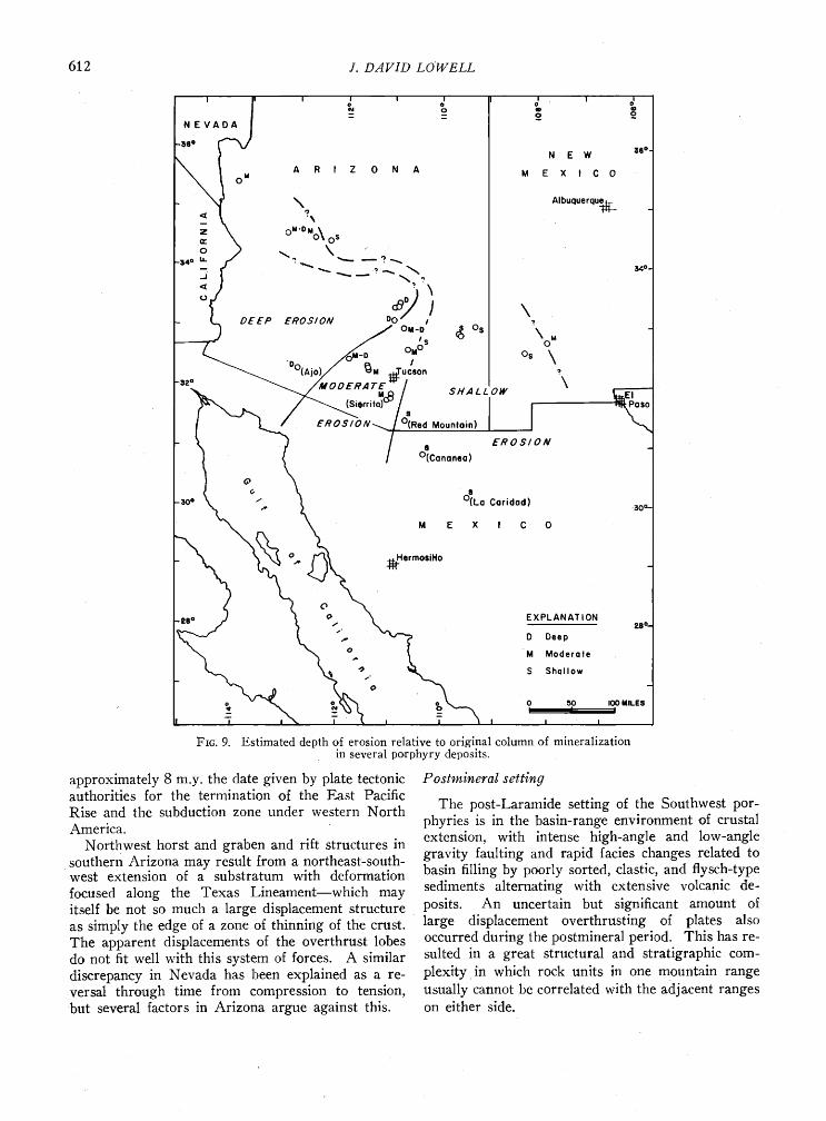
FtG. 9. Estimated depth of erosion relative to original column of mineralization in several porphyry deposits.
approximately 8 m.y. the date given by plate tectonic authorities for the termination of the East Pacific Rise and the subduction zone under western North America.
Northwest horst and graben and rift structures in southern Arizona may result from a northeast-south- west extension of a substratum with deformation focused along the Texas Lineament--which may itself be not so much a large displacement structure as simply the edge of a zone of thinning of the crust. The apparent displacements of the overthrust lobes do not fit well with this system of forces. A similar discrepancy in Nevada has been explained as a re- versal through time from compression to tension, but several factors in Arizona argue against this.
Postmineral setting
The post-Laramide setting of the Southwest por- phyries is in the basin-range environment of crustal extension, with intense high-angle and low-angle gravity faulting and rapid facies changes related to basin filling by poorly sorted, clastic, and fiysch-type sediments alternating with extensive volcanic de- posits. An uncertain but significant amount of large displacement overthrusting of plates also occurred during the postmineral period. This has re- sulted in a great structural and stratigraphic com- plexity in which rock units in one mountain range usually cannot be correlated with the adjacent ranges on either side.
CHARACTERISTICS OF PORPHYRY COPPER DEPOSITS 613
Facies changes make it impossible to correlate Tertiary marker beds across the province, and it is very difficult to appraise broad-scale, district-wide Tertiary flexures. If a standard model of vertical zoning of porphyry mikeralization is assumed, how- ever, then the depth to which individual deposits have been eroded can be used as a marker to deter-
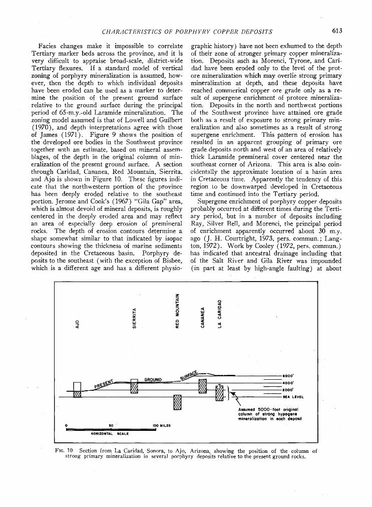
mine the position of the present ground surface relative to the ground surface during the principal period of 65-m.y..-old Laramide mineralization. The zoning model assumed is that of Lowell and Guilbert (1970), and depth interpretations agree with those of James (1971). Figure 9 shows the position of the developed ore bodies in the Southwest province together w•th an estimate, based on mineral assem- blages, of the depth in the original column of min- eralization of the present ground surface. A section through Caridad, Cananea, Red Mountain, Sierrita, and Ajo is shown in Figure 10. These figures indi- cate that the northwestern portion of the province has been deeply eroded relative to the southeast portion. Jerome and Cook's (1967) "Gila Gap" area, which is almost devoid of mineral deposits, is roughly centered in the deeply eroded area and may reflect an area of especially deep erosion of premineral rocks. The depth of erosion contours determine a shape somewhat similar to that indicated by isopac contours showing the thickness of marine sediments deposited in the Cretaceous basin. Porphyry de- posits to the southeast (with the exception of Bisbee, which is a different age and has a different physio-
graphic history) have not been exhumed to the depth of their zone of stronger primary copper mineraliza- tion. Deposits such as Morenci, Tyrone, and Cari- dad have been eroded only to the level of the prot- ore mineralization which may overlie strong primary mineralization at depth, and these deposits have reached commerical copper ore grade only as a re- sult of supergene enrichment of protore mineraliza- tion. Deposits in the north and northwest portions of the Southwest province have attained ore grade both as a result of exposure to strong primary min- eralization and also sometimes as a result of strong supergene enrichment. This pattern of erosion has resulted in an apparent grouping of primary ore grade deposits north and west of an area of relatively thick Laramide premineral cover centered near the southeast corner of Arizona. This area is also coin-
cidentally the approximate location of a basin area in Cretaceous time. Apparently the tendency of this region to be downwarped developed in Cretaceous time and continued into the Tertiary period.
Supergene enrichment of porphyry copper deposits probably occurred at different times during the Terti- ary period, but in a number of deposits including Ray, Silver Bell, and Morenci, the principal period of enrichment apparently occurred about 30 m.y. ago (J. H. Courtright, 1973, pers. commun.; Lang- ton, 1972). Work by Cooley (1972, pers. commun.) has indicated that ancestral drainage including that of the Salt River and Gila River was impounded (in part at least by high-angle faulting) at about
,•,!ff• --• ,ooo' l•'l [•l GROUND ___•u.,.'•';• • -- _ ß .ooo, 2000'
ssum•cl 5000-fOOt ori•inOI column O! StrOnO min•rolizofion in •och
o 5o IOO MILES i I
HORIZONTAL gCALE
FIG. 10. Section from La Caridad, Sonora, to Ajo, Arizona, showing the position of the column strong primary mineralization in several porphyry deposits relative to the present ground rocks.
614 J. D.4VID LOWELL
this same point in Tertiary history. The coincidence of a general impounding of drainage throughout a major portion of the Province with the formation of chalcocite blankets at several deposits suggests that perhaps a stable ground-water ta'ble was established which was conducive to concentration of chalcocite
in a limited stratum. An alternate explanation would be that the damming reflects a period of in- tense diastrophism involving large vertical displace- ments which fortuitously follow sufficient uplift and erosion to expose that part of the vertical column of mineralization best situated to yield chalcocite en- richment. Recent work at Morenci by Langton (1972) and at Caridad by Saegart et al., (1974) has suggested that at least part of the enrichment of these deposits occurred during periods of rapid differential uplift of fault blocks. Most chalcocite blankets in the Southwest province are now in the process of destruction by oxidation and leaching rather than in the process of formation.
Local Features of Southwest Porphyries
Characteristics of these deposits have been tabu- lated in several previous papers (Jerome, 1966; Lowell and Guilbert, 1970; Rose, 1970; James, 1971; and Titley, 1972) and these data will not be repeated.
The Southwest deposits occur in a wide variety of wall rocks ranging from granodiorite to diorite to andesitc to quartzite and limestone, but they com- monly occur in intermediate intrusive rocks. They are usually well zoned, with silicate zoning consisting of a central potassic zone grading outward through phyllic, argillic, and propylitic zones, and with a central chalcopyrite ore mineral zone grading out- ward through chalcopyrite and pyrite to a pyrite outer zone. The deposits tend to be more pyritic than the western Canada deposits.
s7Sr/SøSr values in the range of 0.706 to 0.708 are reported for Laramide intrusive porphyries at Santa Rita, New Mexico, and Ray, Arizona (Moorbath et al., 1967). These compare with values of 0.76 to 0.80 which wer.e assumed to represent the underlying Precambrian basement complex. Moorbath con- eluded that the intrusive rocks did not originate by fusion of ancient sialic basement but must have
developed in an environment having ratios as low, or nearly as low, as the source regions of basalt. This would appear to indicate an upper-mantle source for the intrusives and possibly for the copper and molybdenum. Additional s7Sr/SøSr values have been determined by Livingston (1972, pers. commun.) for other Southwest porphyries and these fall in the 0.706 to 0.710 range (most are from 0.708 to 0.710). These initial strontium ratios are in close agreement with similar data for volcanic rocks in the Southwest
province (Hedge and Noble, 1971). Anderson (1966) has pointed out that the average K20/K20 + Na20 content (Niggli's k value) in the South- west province is from 0.3 to 0.4, also typical of por- phyry provinces in other parts of the world.
Crackle breccia zones are present in all of the de- posits and tend to be circular in plan. These crackle zones are probably an effect of the mineralization rather than a "ground preparation" cause of min.- eralization. Breccia pipes are present in most of the deposits and are an important ore control in deposits in the Copper Basin and Copper Creek districts, Arizona, and in the Cananea, and Caridad, Sonora, districts. The Southwest porphyry deposits tend to be oval in plan, but several districts including Miami, Silver Bell, and Stafford, Arizona, and Cananea, Sonora, are multiple deposit districts which are elongated along a structural zone.
The Southwest porphyries are relatively large and are relatively well zoned as compared to porphyries in most other porphyry districts. If regularity of zoning reflects attainment of equilibrium in the min- eralization system, it seems likely that they formed at somewhat deeper levels in the crust than deposits of the southwest Pacific, the Philippines, and Chile- Peru provinces. The general "cluster" versus "belt" distribution and the well-developed zoning and lack of strong structural control suggest that they may have formed under conditions of less extreme diastro-
phism. Geologic relationships observed by the writer indicate minimum capping thicknesses of at least 5,000 feet at Red Mountain, Ari'zona, and perhaps a much greater thickness at Caridad, Sonora. No ore grade porphyry molybdenum deposits are known in the Southwest province.
A variety of porphyry deposit types and ages ac- curs within the Southwest province, but general conditions of ore deposition, including type of struc- tural control and apparent depth of formation, appear to have been relatively constant. This suggests that variations in mineralogy and alteration zoning in the deposits are related mainly to relatively superficial factors such as host-rock chemistry, local structural fabric, and depth of postmineral erosion.
Problems with Subduction Origin of Porphyries
The spatial association of porphyry belts with ocean trenches and presumed subduction zones has been noted in several recent papers (Sillitoe, 1972; and Mitchell and Garson, 1972), but this pattern does not appear to apply satisfactorily to the South- west province because of its distance from the con- tinental margin and the still inconclusive evidence of a known ocean trench at the time of the porphyry mineralization. Other problems are the long per-
CHARACTERISTICS OF PORPHYRY COPPER DEPOSITS 615
sistence through it of master fissures which were ore controls at several widely separated points in time and also the province's elliptical, not linear, shape.
The relationship of plate tectonic mechanisms to porphyry belts has been described by Mitchell and Garson (1972) as follows:
"Porphyry copper deposits are emplaced in igneous belts located either on continental margins or in island arcs. These belts are related to partial melting of wet oceanic crust descending along Benioff zones at depths of 150-250 km. Deposition of the copper oc- curs where metal-carrying solutions rising from the descending crust meet meteoric brines."
This explanation agrees with much of the observed geology in some of the Pacific island-arc districts. It fails to explain, however, how most of the copper- rich plutons in some porphyry districts are selectively steered into what may be a single fissure zone hun- dreds of miles long and which might have operated as a structural control for as long as 140 m.y. The concentration process outlined also seems unneces- sarily complicated: first metal-rich fluids were de- rived from the mid-oceanic spreading centers; second, the metal was concentrated somewhat in oceanic
crust which; third, was subducted under the con- tinental plate and melted; and fourth, the metal was concentrated by differentiation in the pluton formed and deposited in and above it as a porphyry deposit which somehow ends up along a fissure on the same alignment with another deposit formed 140 m.y. earlier.
It would seem much simpler and more logical to derive the metal directly from a source in the lower crust or upper mantle with the ore deposit produced in essentially one step, from a pluton migrating up- ward along a zone of crustal weakness. Spreading centers are postulated to 'be the source of metal-rich fluids and it is tempting to suggest that such a zone may have been present below the crust during the formation of the Southwest deposits. However, the timing of this would not fit current plate tectonic dogma and porphyry deposits are rather too acidic to match the deposits known to be associated with spreading centers.
If a subduction mechanism is called upon to ex- plain the Bolivia tin deposits and the Colorado min- eral belt porphyry molybdenum deposits, then it be- comes apparent that the principal and probably the only source of metal must have been the upper, con- tinental plate rather than the subducted wet, oceanic crust. The Bolivian tin deposits occur near the west end of a tin metallegenic province which extends across South America and is aligned with a similar province in the African continent. Tin mineraliza- tion within the province occurs in rocks ranging in
age from Precambrian to Tertiary. It seems unlikely that the tin in the Tertiary age Bolivian deposits was derived from the floor of the Pacific Ocean and
processed through complex subduction concentration with the resultant ore deposits coincidentally falling directly in the Precambrian age tin province.
A similar relationship exists in Colorado where large mid-Tertiary age porphyry molybdenum de- posits occur in the same district with molybdenum mineralization on the contacts of Precambrian age intrusions. This suggests that an abnormal molyb- denum concentration has been present in, or below, the crust at this location since Precambrian time.
The Precambrian age Jerome deposit in central Arizona is' the largest massive .sulfide copper de- posit in the western United States. The deposit is one of a group of Precambrian massive sulfide- and vein-type deposits in the Jerome and Bradshaw mountains area (Anderson, 1958) which are inter- spersed with Laramide age porphyry copper oc- currences. Here, also, it is difficult to avoid the con- vicfion that a copper concentration has existed at depth since Precambrian time.
Many aspects of the timing and distribution of Southwest porphyry mineralization fit poorly with the current plate tectonics model relating porphyry deposits to subduction. The district demonstrates evidence of a large crustal extension--perhaps be- ginning early in Mesozoic time, but the lack of offset on mineral belts crossing the Texas Lineament sug- gests that only minor northwest strike-slip displace- ment occurred along the feature. Deposition of 20- m.y.-old porphyry deposits indicates either that At- water and others have been wrong in interpreting the chronology of plate tectonic evolution in western North America or that the deposits are not related to subduction zones. The timing of the change from dominantly andesite vulcanism to basaltic vulcanism in the southwest does not agree with the plate tec- tonic model which correlates the beginning of basal- tic vulcanism with the beginning of extension and basin-range type structure (Lipman et al., 1970).
When one considers that these discrepancies occur in western North America which is the site of rela-
tively detailed geologic mapping and intensive plate tectonic research, it casts doubt on generalities as- sumed regarding the association between porphyries and subduction zones in the relatively lightly studied areas of the Pacific and South America.
Acknowledgments
The paper has been reviewed by Anne K. Loring, M. E. Cooley, L. C. Arnold, A. R. Still, J. H. Court- right, and J. D. Sell. Illustrations were made by Carolyn Shakel, and the manuscript was prepared
616 J. DAVID LOWELL
by Mary Wenzel. The author appreciates the assist- ance of all of these individuals.
5115 N. ORACLE ROAD TUCSON, AR•Z0NA 85704
July 23, 1973; January 11, 1974
REFERENCES
Anderson, C. A., 1958, Geology and ore deposits of the Jerome area, Yavapai County, Arizona: U.S. Geol. Sur- vey Prof. Paper 308, 185 p.
• 1966, Areal geology of the Southwest, in Titley, S. R., and Hicks, C. L., eds., Geology of the porphyry copper deposits, southwestern North America: Tucson, University of Arizona Press, p. 3-16.
Armstrong, L. A., and Higgins, R. E.,. 1973, K-Ar dating of the beginning of Tertiary volcanism in the Mojave Desert, California: Geol. Soc. America, Bull., v. 84, p. 1095-1100.
Atwater, Tanya, 1970, Implications of plate tectonics for the Cenozoic tectonic evolution of western North America: Geol. Soc. America Bull., v. 81, p. 3513-3536.
Blackwell, D. D., 1967, Heat flow determinations and crustal structure in the northwestern United States [Abs.)]: Am. Geophys. Union Trans., v. 48, p. 209-210.
Butler, B. S., 1929, Relation of the ore deposits of the souther. n Rocky Mountains region to the Colorado Plateau: Colorado Sci. Soc. Proc., v. 12, p. 23-36.
Carey, S. W., 1958, The tectonic approach to continental drift, in Carey, S. W., ed., Continental drift, a symposium: Hobart, Tasmania University Press, Geology Dept., p. 177-355.
Christiansen, R. L., an.d L. ipman, P. W., 1970, Cenozoic vol- canism and tectonism •n the western United States and adjacent part of the spreading ocean floor. Part 2, Late Cenozoic [abs.]: Geol. Soc. America, Abstracts with Pro- grams, Cordilleran Sect., p. 81-82.
Cooley, M. E., 1967, The geologic history of Arizona, in Arizona highway geologic map: Tucson, Arizona Geol. Soc.
Cooper, J. R., 1960, Some geologic features of the Pima mining district, Pima County, Ariz.: U.S. Geol. Survey Bull. 1112-C, p. 63-103.
Cox, K. G., 1970, Tectonics and vulcanism of the Karroo Period and their bearing on the postulated fragmentation of Gondwanaland, in Clifford, T. N., and Gass, I. G., eds., African magmatism and tectonics: Edinburgh, Oliver & Boyd, p. 211-235.
Damon, P. E., and Manger, R. L.; 1966, Epeirogeny-orogeny viewed from the Basin and Range Province: Am. Inst. Mining Metall. Petroleum Engineers Trans., v. 235, p. 99-112.
Giluly, James, 1965, Volcanism, tectonism, and plutonism in the western United States: Geol. Soc. America Spec. Paper 80, 69 p.
Gilmour, P. C., 1972, The relationship between porphyry copper deposits and post-orogenic volcanism: Am. Inst. Mining Metall. Petroleum Engineers Preprint 72-1-49.
Hamilton, Warren, and Myers, W. B., 1966, Cenozoic tectonics of the western United States: Rev. Geophysics, v. 5, p. 509-549.
Hayes, P. T., 1970, Cretaceous palcogeography of South- eastern Arizona and adjacent areas: U.S. Geol. Survey Prof. Paper 658-B, 42 v.
Hedge, C. E., and Noble, D.C., 1971, Upper Cenozoic basalts with Sr•/Sr • and Sr/Rb ratios, southern Great Basin, western United States: Geol. Soc. America Bull., v. 82, p. 350•-3510.
Heindl, L. A., 1963, Cenozoic geology in the Mammoth area, Pinal County, Arizona: U.S. Geol. Survey Bull. 1141-E, 41 v.
Hill, D. P., and Pakiser, L. C., 1966, Crustal structure be- tween the Nevada test site and Boise, Idaho, from seismic- refraction measurements, in Steinhart, J. S., and Smith, T. J., eds., The earth beneath the contlnents--a volume
of geophysical studies in honor of Merle A. Tuve: Am. Geophys. Union, Geophys. Mon. Ser. 10, p. 391-419.
Hill, R. T., 1928, Transcontinental structural digression [abs.]: Geol. Soc. America Bull., v. 39, p. 265.
Jaeger, J. C., 1956, Elasticity, fracture, and flow with engineering and geological applications: London, Methuen & Co., and New York, John Wiley and Sons, Inc., 152 p.
James, A. H., 1971, Hypothetical diagrams of several porphyry copper deposits: Ecot•. GEoI.., v. 66, p. 43-47.
James, D. E., and Steinhart, J. S., 1966, Structure beneath continents--a critical review of explosion studies 1960- 1965, in Steinhart, J. S., and Smith T. J., eds., The earth beneath the continents--a volume of geophysical studies in honor of Merle A. Tuve: Am. Geophys. Union, Geophys. Mon. Ser. 10, p. 293-333.
Jerome, S. E., 1966, Some features pertinent in exploration of porphyry copper deposits, in Titley, S. R., and Hicks, C. L., eds., Geology of the porphyry copper deposits, southwestern North America: Tucson, Univ. of Arizona Press, p. 75-86.
-- and Cook, D. R., 1967, Relation of some metal mining districts in the western United States to regional tectonic environments and igneous activity: Nevada Bur. Mines Bull. 69.
Johnson, J. G., 1971, Timing and coordination of orogenic, epeirogenic and eustatic events: Geol. Soc. America Bull., v. 82, p. 3263-3298.
Krieger, Medora H., 1968, Geologic map of the Lookout Mtn. Quadrangle, Pinal County, Arizona: U.S. Geol. Survey Map CQ-670.
Langton, J. M., 1972, Ore genesis in the Morenci-Metcalf District: Am. Inst. Mining Metall. Petroleum Engineers Prevrint 72-1-47.
Lee, W. H. K., and Uyeda, Seiya, 1965, Review of heat flow data, in Lee, W. H., ed., Terrestrial heat flow: Am. Geophys. Union, Geophys. Mon. Ser. 8, p. 87-190.
Lipman, P. W., Prostka, H. J., and Christiansen, R. L., 1970, Cenozoic volcanism and tectonism in the western U.S. and adjacent parts of the spreading ocean floor. Part I. Early and middle Tertiarv [abs.]: Geol. Soc. America, Abstracts with Programs, Corilleran Sect., p. 112-113.
Livingston, D. E., Manger, R. L., and Damon, P. E., 1968, Geochronology of the emplacement, enrichment and pres- ervation of Arizona porphyry copper deposits: EcoN. GEot.., v. 63, t). 30-36.
Lorine, Anne K., 1972, Temt>oral and spatial distribution of basin-range faulting in Nevada and Utah: M.S. thesis, University of Southern California (unpub.).
1974, The Age of basin-range faulting in Arizona: Ariz. Geol. Soc. Digest, No. 10.
Lowell, J. D., 1968, Geology of the Kalamazoo orebody, San Manuel district, Arizona: EcoN. GEot.., v. 63, p. 645- 654.
and Gullbert, J. M., 1970, Lateral and vertical altera- tion-mineralization zoning in porphyry ore deposits: EcoN. GEOL., v. 65, p. 373-408.
McKenzie, D. P., and Morgan, W. J., 1969, Evolution of triple junctions: Nature, v. 224, p. 125-133.
Mayo, E. B., 1958, Lineament tectonics and some ore dis- tricts of the southwest: Mining Engineerin.g, v. 10, p. 1169-1175.
Menard, H. W., 1964, Marine geology of the Pacific: New York, McGraw-Hill Book Co., 271 p.
1969, The deep-ocean floor: Sci. Am., v. 221, p. 126- 142.
Mitchell, A. H. G., and Garson, M. S., 1972, Relationship to porphyry coppers and circum-Pacific tin deposits to palaeo-Benioff zones: Mining and Metallurgy, Feb., 1972.
Moorbath, S., Hurley, P.M., and Fairbairn, H. W., 1967, Evidence for the origin and age of some mineralized Laramide intruslves in the southwestern U.S. from stron- tium isotove and rubidium-strontium measurements: EcoN. GEm.., v. 62, v. 228-236.
Morgan, W. J., 1968, Rises, trenches, great faults, and crustal blocks: Jour. Geophys. Research, v. 73, p. 1959- 1982.

CH.,'tR.,'tCTERISTICS OF PORPHYRY COPPER DEPOSITS 617
Paige, Sidney, 1922, Copper deposits of the Tyrone district, New Mexico: U.S. Geol. Survey Prof. Paper 122, 53 p.
Pakiser, L. C., and Robinson, Rhoda, 1966, Composition of the continental crust as estimated from seismic observa- tions, in Steinhart, J. S., and Smith, T. J., eds., The earth beneath the .continents--a volume of geophysical studies in honor of Merle A. Tuve: Amer. Geophys. Union, Geophys. Mon. Ser. 10, p. 620-626.
and Zietz, Isidor, 1965, Transcontinental crustal and upper mantle structure: Rev. Geophysics, v. 3, p. 505-520.
Rehrig, W. A., and Hei.drick, T. L., 1972, Regional fractur- ing in Larami.de stocks of Arizona and its relationship to porphyry copper mineralization: EcoN. Gv. oI.., v. 67, p. 184.
Rose, A. W., 1970, Zonal relations of wallrock alteration and sulfide distribution at porphyry copper deposits: EcoN. Gv. oI.., v. 65, p. 920-936.
Saegart, W. E., Sell, J. D., and Kilpatrick, B. E., 1974, Geology and mineralization .of the La Caridad porphyry copper deposit, Sonora, Mexico: EcoN. GEoI.., v. 69, no. 7.
Schmitt, H. A., 1959, The copper province of the southwest: Mining Eng., v. 11, p. 597--600.
Sillitoe, R. H., 1972, A plate tectonic model for the origin of porphyry copper deposits: Ecoa. Gv. oI.., v. 67, p. 184.
Stewart, John H., 1971, Basin and range structure: A sys- tem of horsts and grabens produced ,by deep-seated ex- tension: Geol. Soc. America Bull., v. 82, p. 1019-1044.
Thompson, G. A., 1965, The rift system of the western U.S., in The world rift system: International Upper Mantle Commission Symposium, Ottawa, 1965; Can. Geol. Survey Paper 66-14, p. 280-290.
Titley, S. R., 1970, Paleotectonic environment of Arizona porphyry copper. deposits: Ecoa. Gv. ot.., v. 65, p. 741.
1972, Some geological criteria applicable to the search for southwestern North America porphyry copper de- posits: Am. Inst. Mining Metall. Petroleum Engineers Preprint G12.
Wertz, J. B., 1970, The Texas lineament and its economic significance in Southeast Ar.izona: EcoN. Gv. oI.., v. 65, p. 166.
Wise, D. U., 1963, An outrageous hypothesis for the tectonic pattern, of the North American Cordillera: Geol. Soc. America Bull., v. 74, p. 357-362.
Wollard, G. P., 1966, Regional isostatic relations in the United States: in Steinhart, J. S., and Smith, T. J., eds., The earth beneath the continents---a volume of geophysical studies in honor of Merle A. Tuve: Amer. Geophys. Union, Geophys. Mort. Ser. 10, p. 557-5r)4.