The geology of Western Karakoram.
86
ABSTRACT A new geological map of the central-western part of the Karako- ram belt (Northern Areas and North West Frontier Province, Paki- stan) is presented with its explanatory notes. The map is printed at a 1:100,000 scale, summarizing original field surveys performed at a 1:25,000 scale, which result from the first systematic reconnaissance of the area. This work represents the synthesis of several years of exploration studies and is mainly based based on original strati- graphic and structural field analyses focused on one of the less known orogenic belts of Central Asia. Original field surveys have been integrated within a GIS using georeferenced Russian topo- graphic maps and grey-tone panchromatic SPOT images. The study area is located along the border between Pakistan and Afghanistan, extending from the top of the Chapursan Valley of the Hunza region to the Yarkhun Valley from the Karambar Pass to Gazin and to the upper part of the Rich Gol, which belong to Chitral. Three major tectonic units are exposed in the study area. From north to south they are: the East Hindu Kush-Wakhan, the Tirich Boundary Zone and the Karakoram Terrane. The first and the last units consist of Gondwana-related terranes showing a Pre- cambrian to earliest Paleozoic basement covered by Paleozoic to Mesozoic sedimentary successions which record their Late Paleo- zoic rifting from Gondwana, their drifting, and successive accre- tion to the Eurasian margin. They both show some similarities with the S-Parmir ranges, exposed to the north of the Afghan Wakhan. The Tirich Boundary Zone is a complex assemblage of high grade metabasites and gneiss with small remnants of sub-con- tinental peridotites, which separate East Hindu Kush from the Karakoram. Its emplacement has been related to the possible open- ing of a basin between the two blocks at the end of the Paleozoic, followed by its deformation during the collision of Karakoram with East Hindu Kush, dating to the end of Triassic or beginning of the Jurassic. Detailed mapping has been carried out in the Karakoram belt, especially along its northern portion, which consists of a complex stack of tectono-stratigraphic units, showing peculiar strati- graphic and structural features. These units were progressively deformed and thrusted during the collision with the Kohistan Paleo-Arc and with India which occurred between the end of the Cretaceous and Paleogene. These collisions were also followed by continuous crustal thickening and by left-lateral shearing, which was especially active along the western margin of the mapped area. Our map also includes parts of the Karakoram Batholith, mainly Cretaceous in age, and of the Darkot-Gazin Metasedimentary Belt, which is exposed to the south of the main intrusive bodies and consists of Permo-Triassic metasediments. KEY WORDS: Karakoram, Hindu Kush, Pakistan, Cartography, Geodynamics, Tectonics, Stratigraphy, Collisional belt. 1. INTRODUCTION AND MOTIVATIONS This paper contains the explanatory notes of a new geological map of Central-Western Karakoram (scale 1:100,000), which summarizes 15 years of researches in Northern Pakistan (fig. 1; Garzanti, 2011) on the northern portion of the Karakoram belt (figs. 2, 3). Our map is the results of the first systematic reconnaissance work car- ried out in the sedimentary cover of the Northern Karako- ram Terrain and East Hindu Kush (fig. 4) and is based on original stratigraphic and structural field work performed by the authors. The study area is part of the northern por- tion of the Karakoram Terrane, a continental block of Gondwanan affinity which is interposed between the S-Pamir ranges to the north, also of Gondwanan origin, and the Kohistan intraoceanic Paleo-arc to the south (fig. 4). The mapped area includes the East Hindu Kush block, which may be part of the southern Pamir ranges and which is structurally separated from Karakoram by the Tirich Boundary Zone, an important shear zone exposing sub-continental mantle peridotites. Several reasons make this area of particular interest for the understanding of the structure of the central Asian (*) Dipartimento di Scienze e Geologiche e Geotecnologie, Università degli studi di Milano-Bicocca, Piazza della Scienza, 4 - 20126 Milano, Italy; [email protected] (**) Dipartimento di Scienze della Terra «A. Desio», Università degli studi di Milano, Via Mangiagalli, 34 - 20133 Milano, Italy. The geology of the Karakoram range, Pakistan: the new 1:100,000 geological map of Central-Western Karakoram ANDREA ZANCHI (*) & MAURIZIO GAETANI (**) ZANCHI Ital.J.Geosci. (Boll.Soc.Geol.It.), Vol. 130, No. 2 (2011), pp. 161-262, 91 figs., 97 pls., 2 extra pls. (DOI: 10.3301/IJG.2011.09) © Società Geologica Italiana, Roma 2011 Queste bozze, cor rette deb bo no es sere re sti tuite im med iat amente alla Se gre te ria del la Società Geo log ica Ital iana c/o Di par ti men to di Scienze del la Ter ra Pi az zale Aldo Moro, 5 – 00185 ROMA Fig. 1 - Position of the mapped area within Pakistan and Central Asia.
Transcript of The geology of Western Karakoram.

ABSTRACT
A new geological map of the central-western part of the Karako-ram belt (Northern Areas and North West Frontier Province, Paki -stan) is presented with its explanatory notes. The map is printed at a1:100,000 scale, summarizing original field surveys performed at a1:25,000 scale, which result from the first systematic reconnaissanceof the area. This work represents the synthesis of several years ofexploration studies and is mainly based based on original strati-graphic and structural field analyses focused on one of the lessknown orogenic belts of Central Asia. Original field surveys havebeen integrated within a GIS using georeferenced Russian topo-graphic maps and grey-tone panchromatic SPOT images.
The study area is located along the border between Pakistanand Afghanistan, extending from the top of the Chapursan Valleyof the Hunza region to the Yarkhun Valley from the KarambarPass to Gazin and to the upper part of the Rich Gol, which belongto Chitral.
Three major tectonic units are exposed in the study area.From north to south they are: the East Hindu Kush-Wakhan, theTirich Boundary Zone and the Karakoram Terrane. The first andthe last units consist of Gondwana-related terranes showing a Pre-cambrian to earliest Paleozoic basement covered by Paleozoic toMesozoic sedimentary successions which record their Late Paleo-zoic rifting from Gondwana, their drifting, and successive accre-tion to the Eurasian margin. They both show some similaritieswith the S-Parmir ranges, exposed to the north of the AfghanWakhan. The Tirich Boundary Zone is a complex assemblage ofhigh grade metabasites and gneiss with small remnants of sub-con-tinental peridotites, which separate East Hindu Kush from theKarakoram. Its emplacement has been related to the possible open-ing of a basin between the two blocks at the end of the Paleozoic,followed by its deformation during the collision of Kara koram withEast Hindu Kush, dating to the end of Triassic or beginning of theJurassic.
Detailed mapping has been carried out in the Karakoram belt,especially along its northern portion, which consists of a complexstack of tectono-stratigraphic units, showing peculiar strati-graphic and structural features. These units were progressivelydeformed and thrusted during the collision with the KohistanPaleo-Arc and with India which occurred between the end of theCretaceous and Paleogene. These collisions were also followed bycontinuous crustal thickening and by left-lateral shearing, whichwas especially active along the western margin of the mappedarea.
Our map also includes parts of the Karakoram Batholith,mainly Cretaceous in age, and of the Darkot-Gazin MetasedimentaryBelt, which is exposed to the south of the main intrusive bodies andconsists of Permo-Triassic metasediments.
KEY WORDS: Karakoram, Hindu Kush, Pakistan, Cartography,Geodynamics, Tectonics, Stratigraphy, Collisional belt.
1. INTRODUCTION AND MOTIVATIONS
This paper contains the explanatory notes of a newgeological map of Central-Western Karakoram (scale1:100,000), which summarizes 15 years of researches inNorthern Pakistan (fig. 1; Garzanti, 2011) on the northernportion of the Karakoram belt (figs. 2, 3). Our map is theresults of the first systematic reconnaissance work car-ried out in the sedimentary cover of the Northern Karako-ram Terrain and East Hindu Kush (fig. 4) and is based onoriginal stratigraphic and structural field work performedby the authors. The study area is part of the northern por-tion of the Karakoram Terrane, a continental block ofGondwanan affinity which is interposed between the S-Pamir ranges to the north, also of Gondwanan origin,and the Kohistan intraoceanic Paleo-arc to the south (fig. 4). The mapped area includes the East Hindu Kushblock, which may be part of the southern Pamir rangesand which is structurally separated from Karakoram bythe Tirich Boundary Zone, an important shear zoneexposing sub-continental mantle peridotites.
Several reasons make this area of particular interestfor the understanding of the structure of the central Asian
(*) Dipartimento di Scienze e Geologiche e Geotecnologie,Università degli studi di Milano-Bicocca, Piazza della Scienza, 4 -20126 Milano, Italy; [email protected]
(**) Dipartimento di Scienze della Terra «A. Desio», Universitàdegli studi di Milano, Via Mangiagalli, 34 - 20133 Milano, Italy.
The geology of the Karakoram range, Pakistan: the new 1:100,000 geological map of Central-Western Karakoram
ANDREA ZANCHI (*) & MAURIZIO GAETANI (**)
ZANCHI
Ital.J.Geosci. (Boll.Soc.Geol.It.), Vol. 130, No. 2 (2011), pp. 161-262, 91 figs., 97 pls., 2 extra pls. (DOI: 10.3301/IJG.2011.09)© Società Geologica Italiana, Roma 2011
Queste bozze, cor rette deb bo no es serere sti tuite im med i at a mente alla Se g re te riadel la Società Geo log i ca Ital i a nac/o Di par ti men to di Scienze del la Ter raPi az zale Aldo Moro, 5 – 00185 ROMA
Fig. 1 - Position of the mapped area within Pakistan and Central Asia.
03a ZANCHI txt ok 161-246_GEOLOGIA 29/07/11 09.26 Pagina 161

orogenic belts. The northern portion of the Karakoramrange mainly consists of relatively poorly deformed andmetamorphosed sedimentary successions. They include apre-Ordovician crystalline basement covered by Paleozoic toMesozoic successions which record the rifting and driftingof Karakoram from Gondwana and its successive Mesozoicaccretion (Cimmerian event) to the Eurasian margin. Acomplex polyphase deformation is also testified by thethrust stack now forming the Northern Karakoram Terrain.The stack grew during several stages, recording the subse-quent collisions with the Eurasian margin of the KohistanPaleo-arc and India to the south as well as their conse-quences (extensional collapse and indentation tectonics).The geodynamic evolution reconstructed in this area can bethus compared with the history of the Karakoram Metamor-phic Complex (FRASER et alii, 2001; SEARLE et alii, 2010;SEARLE, 2011), exposed to the south of the CretaceousKarakoram Batholith which was mainly emplaced beforethe collision with Kohistan. In addition, the central-westernportion of the Northern Karakoram was almost unknownbefore the beginning of our studies. The idea of completingwestward the study of the Northern Karakoram Terrain wasborn after the publication of our map of the Hunza Karako-ram (ZANCHI & GAETANI, 1994), in order to explore analmost unknown region, yet representing a true «blank onthe map», aiming to provide a clue to the understanding ofthe complex evolution of Central Asia.
1.1 Location of the mapped area and technical notes
The study area extends from the top of the ChapursanValley and precisely from the locality of BabaghundiZiarat to the upper Karambar Valley, to the Yarkhun Val-ley from the Karambar Pass to Gazin and to the upperpart of the Morich Gol (fig. 3). Detailed work was performed especially in the uppermost Karambar andYarkhun valleys, as a general reconnaissance work wascarried out in the Siru Gol, Shah Jinali and Morich areas.
The map was surveyed in the field using a mosaic ofhigh quality Panchromatic SPOT imagery (pixel size 10 m).A georeferenced digital SPOT image was used as a topo-graphic base for the easternmost part of the study area(Chiantar-Babagundi Ziarat area). West of this area themap was redrawn using the 1:100,000 Russian topo-graphic maps of the world. The entire map was firstlydrawn by the first author in a digital format using Ilwisand was successively imported in Arcview 9.3 and pre-pared for printing by S. Sironi and S. Zanchetta.
The area directly surveyed in Pakistan was extendedthrough photo-interpretation of printed Panchromatic
SPOT imagery beyond the Afghan border, also basing onthe map of Wakhan by BUCHROITNER & GAMERITH
(1978). Google Earth has been used during the finalstages of the work.
The southern part of the mapped area, showing thenorthern side of the Karakoram Batholith was redrawnfrom the original maps drawn by LE FORT & GAETANI
(1998), integrated with original observations and photo-interpretation (PATRICK LE FORT is warmly thanked forhis contribution).
All the Pakistani people who helped us for severalyears during field work are warmly thanked for permit-ting us to live such an exciting experience.
2. PREVIOUS STUDIES
Previous studies of the area are limited, especially dueto its rough topography and remoteness. Captain GRANT
in 1898 was the first one to collect a few fossils from anundefined area around Baroghil, later considered to beEarly Devonian in age by REED (1911). HAYDEN (1915)gave the first geological report on the area along the routeacross Mastuj, Ishpirin Gorge, Lasht, Baroghil, Gharil,and the Darkot Pass to the south. He identified some basicfeatures, as the Karakoram Batholith, the presence ofDevonian and Permian rocks and other sedimentary suc-cessions. Part of the collected fossils were illustrated by REED (1922, 1925). TIPPER made the crossing of the Karambar Pass in 1923, resulting in a meagre onepage report in PASCOE (1924). No new information waspublished on the area up to the short visit in 1973 byJ.A.T. TALENT & H.H. TAHIRKHELI coming from the DarkotPass and getting out along the Yarkhun Valley. Theyproved the occurrence of Ordovician and Devonian succes-sions, dating them with conodonts (TALENT et alii, 1982).
H. GAMERITH probably had a short visit along theYarkhun Valley up to Kan Khun and to some part of theMorich Valley during his work for mineral prospecting inthe area. He published a map, mostly based on satelliteimagery, in which the Baroghil-Karambar area is alsoincluded (GAMERITH, 1982). Concerning the southernpart of the region, some general notes on the area ofDarkot are reported by TAHIRKHELI (1982). The area ofDarkot was also considered by IVANAC et alii (1956) intheir reconnaissance on the southern side of the range.
On the Afghan side, along the Wakhan corridor,reconnaissance geology was given by BUCHROITNER
(1978, 1980), following a mountaineering expedition.Some information on the intrusive rocks of that part ofthe Hindu Kush is found in DEBON et alii (1987a).
162 A. ZANCHI & M. GAETANI
Fig. 2 - Location map of the study area. The extension of the previous map of the Karakoram by ZANCHI & GAETANI (1994) is shown.
03a ZANCHI txt ok 161-246_GEOLOGIA 29/07/11 09.26 Pagina 162

THE GEOLOGY OF THE KARAKORAM RANGE, PAKISTAN 163
Fig. 3
- Geograp
hic sketch of the map
ped
area. Nam
es of localities after the 1:25
0,00
0 topog
raphic m
ap of Karak
oram
by U.S. C
orps of Engineers, S
heets NJ 43
-13 an
d NJ 43
-14.
03a ZANCHI txt ok 161-246_GEOLOGIA 29/07/11 09.26 Pagina 163

The only comprehensive geological study of theWakhan corridor was produced within the Soviet-Afghancooperation programme. After the presentation of KA -FARSKYI et alii (1974) internal report, their data weresummarized in KAFARSKYI & ABDULLAH (1976) and espe-cially in the ABDULLAH & CHMRYOV (1980) comprehen-sive book and maps on the Geology of Afghanistan(including a geological map at 1:500,000 scale). Newmaps including the Tajik Pamirs and Afghanistan wererecently published (VLASOV et alii, 1991).
Our research activity started in 1990 in the frame ofthe Ev-K2 European project in Chitral and Karambar areas,through seven expeditions, as well by the French team ofP. Le Fort and F. Debon working within the same Euro-pean project. Our activity resulted in several papers (1).
Published works dealing with neighbouring regionswere of particular interest to unravel the geology of thestudy area. The works by DESIO (1959, 1966) on Chitralshould be mentioned for new findings on Cretaceous andespecially for the Devonian of Kuragh and Shogram, aswell as the related paleontological analyses by CITA &RUSCELLI (1959), SCHOUPPÉ (1965), SARTENAER (1965),VANDERCAMMEN (1965), and GAETANI (1967). The firstdescription of the structural setting and of the ReshunFault was firstly given by PUDSEY et alii (1985). Veryimportant are also the contributions by STAUFFER (1975)and TALENT et alii (1982, 1999).
Concerning the recent studies on the Hunza and Cha-pursan valleys to the east, the basic geological, strati-graphic and structural data published by GAETANI et alii
(1990a, 1993), ZANCHI (1993), ZANCHI & GAETANI (1994),and ZANCHI & GRITTI (1996) were integrated within thepresent work. Results of these studies were summarizedin the books of KAZMI & JAN (1997) and KAZMI & ABBASI(2008). SEARLE & KHAN (1996) also included the area intheir 1:650,000 map of Pakistan, suggesting the occur-rence of Upper Paleozoic and Triassic successions in theBaroghil region.
2.1 Geographic setting and the definition of Karakoram
The study area is located along the Afghan-Pakistanborder between the western part of the Great Karakoramlocated west of the Hunza Valley, and the Chitral region,the last being part of the Hindu Raj Belt. The divisionbetween the two geographic areas runs along the Karam-bar River (fig. 2). From an administrative point of view,the area includes the former Gilgit Agency, being part ofJammu and Kashmir, now Northern Area under Pakistaniadministration, and the NW Frontier Province, the borderrunning along the Yarkhun-Karambar river divide.
The entire region is heavily glaciated (fig. 5), due to its high topographic elevation, usually over-passing the 3000 meters, with peaks reaching almost 7000 m.Extended glacial plateaus and long valley glaciers occur,with the Chiantar Glacier reaching more than 30 kilome-tres in length (fig. 6). Field surveys have been carried outonly in Pakistan, as the Afghan side of the belt has beencompiled combining information from remote sensingand previous maps.
The heads of four main river catchments are includedin the area. They comprise, from east to west:
1) the Chapursan Valley from the locality ofBabaghundi Ziarat to the Chillinji and Irshad Uwinpasses;
2) the Karambar Valley from Warghut to the Karam-bar Pass and a number of minor glaciers;
3) the Yarkhun Valley (fig. 6) down to Paur, beyondthe confluence with the valley coming down from Gazin;
4) the Rich Gol from the Afghan divide to the villageof Uzhnu.
164 A. ZANCHI & M. GAETANI
Fig. 4 - General tectonic scheme of CentralAsia: 1) Quaternary, 2) Cenozoic foredeeps, 3) Paleozoic belts, 4) Terranes of Gondwananaffinity, 5) Kohistan Paleo-Arc, 6) Waziristan(WAZ) ophiolites, and Wasser-Panjao suturezone, 7) Paleozoic Kabul block, 8) Himalayas.Modified from ZANCHI et alii (2000). WAS:Wanch-Akbaital Zone, RPZ: Rushan-PshartZone, SW-P: SW-Pamir, SE-P: SE-Pamir, ACMAlichur Mountains, EHK: East Hindu Kush,TBZ: Tirich Boundary Zone, KKSZ: Karako-ram-Kohistan Suture Zone, MMT: Main Man-tle Thrust, MBT: Main Boundary Thrust, MFT:Main Frontal Thrust, K: Kabul.
(1) List of published papers by GAETANI & LE FORT teams: AN-GIOLINI (1995, 1996 a, b; 2001); ANGIOLINI et alii (1999, 2005);ANGIO LINI & RETTORI (1994); DEBON (1995), DEBON & KHAN(1996), DEBON et alii (1996); FLÜGEL (1995); FLÜGEL & GAETANI(1991); GAETANI (1997, 1998, 2009); GAETANI & LEVEN (1993); GAE-TANI et alii (1995, 1996, 2004a, b, 2008); HUBMANN & GAETANI(2007); LE FORT & GAETANI (1998); LE FORT et alii (1994); LEVEN etalii (2007); MUTTONI et alii (2009); QUINTAVALLE et alii (2000);SCHROEDER (2004); TALENT et alii (1999); TONGIORGI et alii (1994);ZANCHI et alii (1997, 2000). A paper by PERRI et alii (2004) outsideour research projects can be added.
03a ZANCHI txt ok 161-246_GEOLOGIA 29/07/11 09.26 Pagina 164

THE GEOLOGY OF THE KARAKORAM RANGE, PAKISTAN 165
Fig. 5 - View to the SW of Lake Karambar from the Pakistan-Afghanistan border ridge. September, 1999.
Fig. 6 - View to the west of the upper part of the Yarkhun Valley from the Baroghil ridge with the Chiantar Glacier, Trifika and other peakshigher than 6000 meters. September, 1999.
03a ZANCHI txt ok 161-246_GEOLOGIA 29/07/11 09.26 Pagina 165

The Afghan side of the belt is mainly included in theAb-i Wakhan/Ab-i Panja (Oxus, Amu Darya) river catch-ments, reaching the Aral Sea. The uppermost part of theDarkot Valley is partially included in the map.
The southern and western parts of the area show the highest peaks, due to the occurrence respectively ofthe Karakoram and East Hindu Kush batholiths whichconsist of hard intrusive rocks of acidic to intermediatecomposition. The highest peaks present to the south are(fig. 7) the Koyo Zom (6872 m) and several nice moun-tains over-passing 6000 m, as the Thui 1 (6660 m), Thui 2(6523 m), and Chikar Zom (6110 m) west of the DarkotPass (4575 m), the Garmush Peak (6244 m) east of it, andthe Trifika (6416 m) along the upper Chiantar glacier.The East Hindu Kush Batholith shows the highest moun-tains of the area with the Koh-e Baba Tangi (6513 m),Koh-e Qal’a Ust (6309 m), Lunko (6902 m) and Koh-eHevad peaks (6849 m). Along the eastern-central part ofthe watershed with Afghanistan, mountains are generallybelow 6000 m, due to the occurrence of relatively softvery low grade meta-sedimentary rocks forming the sedi-mentary cover of N-Karakoram (fig. 8).
The area is poorly inhabited. Small permanent vil-lages are located usually below 4000 m along the YarkhunValley, which is now crossed by a stable jeep road reach-ing Lasht and Kan Khun, reaching also Pechus during thewinter season and, maybe in the future, also the BaroghilPass to Afghanistan. The road stopped close to Gazin dur-ing the time of our survey. Other roads reach the village
of Rua in the Rich Gol, and Babaghundi Ziarat in theChapursan Valley. The entire survey was performed withthe help of Pakistani porters using, when possible, theonly available means of transport (fig. 9).
The definition of Karakoram in a geographic sense(MASON, 1938) hardly coincides with the boundaries ofthe «geological» Karakoram. The southern geologicalboundary matches to the east with the Shyok Suturezone, also named Northern Suture (TAHIRKHELI et alii,1979; HANSON, 1989; SEARLE, 1991), and recently rede-fined as Karakoram-Kohistan Suture Zone (HEUBERGER
et alii, 2007), separating the Gondwana-related Karako-ram Terrane from the Mesozoic intra-oceanic KohistanPaleo-Arc (fig. 4). The geological boundary should extendto the west, beyond the geographical one, which followsthe Karambar Valley. The Hindu Raj Range should beincluded in within Karakoram, as magmatic and sedi-mentary units continue, quite regularly, through theYarkhun Valley and beyond it. The western boundary ofthe «geological» Karakoram is set along the TirichBoundary Zone (ZANCHI et alii, 2000). To the north, theboundary with S-Pamir is poorly defined, but access tothe Wakhan region (Afghan Pamir) is presently problem-atic. A reasonable boundary can be represented by theKilik Fault in the Chapursan Valley (fig. 4), which stacksthe Wakhan Slates on the Paleo-Mesozoic sediments ofthe Northern Karakoram Terrain (ZANCHI, 1993; ZANCHI
& GAETANI, 1994). This thrust fault can be traced throughthe Wakhan (KAFARSKYI & ABDULLAH, 1976) and across
166 A. ZANCHI & M. GAETANI
Fig. 7 - View to the east to the Koyo Zom (6872 m) from the Yarkhun Valley (July, 2004). Its high rock walls consist of the Darkot Pass Granite of the Karakoram Batholith.
03a ZANCHI txt ok 161-246_GEOLOGIA 29/07/11 09.26 Pagina 166

East Hindu Kush down to the Tirich Mir (ZANCHI et alii,2000). In this interpretation, the East Hindu Kush geolog-ically lies northwest of Karakoram and merges into theWakhan and Little Pamir.
3. REGIONAL SETTING
The mapped area includes three main domainswhich are extensively exposed in North-Western Paki -
THE GEOLOGY OF THE KARAKORAM RANGE, PAKISTAN 167
Fig. 8 - View to the NW from the Pakistan-Afghanistan border at about 5100 m. White bafflestone and black marls of the Devonian ShogramFm. belonging to the Karambar Unit. September, 1999.
Fig. 9 - Donkeys with local porters crossing the Chhateboi Glacier, September 1999. TheChhateboi Granite is exposed along the steeprock walls flanking the glacier.
03a ZANCHI txt ok 161-246_GEOLOGIA 29/07/11 09.26 Pagina 167

stan north of the Kohistan Palaeo-Island Arc (fig. 10):1) East Hindu Kush-Wakhan, northwest of the TirichBoundary Zone and north of its eastern continuation;2) the Tirich Boundary Zone (TBZ), a complex associa-tion of metamorphic rocks separating the Karakoramfrom East Hindu Kush-Wakhan; 3) the western part ofKarakoram between the TBZ and the Karakoram-Kohistan Suture Zone (KKSZ). The main features ofthe KKSZ and of the Kohistan Palaeo-Island Arc arealso briefly described at the end of this section, as theirhistory is closely related to the evolution of the study-area.
3.1 East Hindu Kush-Wakhan
This block extends across the region of East HinduKush and its eastern continuation in Wakhan (fig. 10). Itincludes a possibly Cambrian and Precambrian crys-talline basement and a Paleozoic to Mesozoic sedimen-tary succession intruded by Mesozoic plutons (fig. 11).According to previous works (GAETANI, 1997), this unit isa Gondwanan fragment with a thinned continental crust
which separated two other Gondwanan blocks, the Kara -koram and S-Pamir, since the end of the Paleozoic.
The oldest rocks consist of deformed granitoids, pos-sibly Cambrian in age (DEBON et alii, 1987a), the Qal’a-eUst Gneiss (BUCHROITHNER, 1980), which always showtectonic contacts of an undefined type with a Paleozoic toMesozoic meta-sedimentary succession. Most of the beltconsists of the Paleozoic Wakhan Slates, which recordaccumulation of thick terrigenous sediments possiblyoriginating from the Gondwana supercontinent in highlysubsiding extensional basins (GAETANI, 1997). Bryozoansand brachiopods of Paleozoic affinity were found in Chi-tral and in the Kan Khun Gol (GAETANI & LEVEN, 1993;GAETANI et alii, 2004a), although Lower Triassic con-odonts may occur at the top of the unit in Afghanistan(KAFARSKY & ABDULLAH, 1976; BUCHROITHNER, 1980).
Late Paleozoic to Triassic shallow water carbonatespartially interfingering with terrigenous beds form twolarge thrust sheets within the Wakhan Slates. The firstone, the Kan Khun Unit of LEVEN et alii (2007), extendsin Afghanistan from the upper Kan Khun Gol to the northof the Baroghil Pass. The second one is the Atark Unit
168 A. ZANCHI & M. GAETANI
Fig. 10 - General tectonic framework of Karakoram, after previous authors (ZANCHI et alii, 2000; HILDEBRAND et alii, 2004; HEUBER GER etalii, 2007) and our original data.
03a ZANCHI txt ok 161-246_GEOLOGIA 29/07/11 09.27 Pagina 168

(GAETANI & LEVEN, 1993), forming a long and continu-ous carbonate belt between the Tirich Boundary Zoneand the Wakhan Slates, which are all clearly intruded bythe Tirich Mir Granite. The Atark Unit is continuouslyexposed from the Arkari Valley west of the Tirich Mir toLasht in the Yarkhun Valley across the Atark, Tirich andRich Gol (figs. 10, 11, 12). Very low-grade metabasites,100 to 150 m thick, including lava flows interbeddedwithin the terrigenous successions of the unit occur in theupper part of the Atark Valley. The Atark Unit is locallysealed by a conglomerate similar to the Cretaceous Tupopconglomerates of central Karakoram (ZANCHI et alii, 1997).
West of the study area, the Wakhan Slates pass to acomposite metamorphic succession reaching medium-grade conditions, the Arkari Formation of LEAKE et alii(1989). The formation includes micaschists, phyllite, mar-ble, quartzite, and feldspatic gneiss, which may derivefrom the Wakhan Slates. A few Belemnite remains found75 years ago (PASCOE, 1924) may suggest a Mesozoic age
for at least part of the protholith of the metamorphiccomplex.
HILDEBRAND et alii (2000, 2001), concerning thetectono-metamorphic evolution of the Tirich Mir region,suggest a Jurassic-Early Cretaceous time interval formetamorphism and magmatic activity which are possiblyinterpreted as the results of the accretion of Karakoramto East Hindu Kush.
Jurassic to mid-Cretaceous granitoids intrude theEast Hindu Kush units (BUCHROITNER & SCHARBERT,1979; DEBON et alii, 1987a; GAETANI et alii, 1996) forminga continuous belt along the Afghan-Pakistan borderwhich gives rise to some of the highest peaks in theregion. Small isolated and undeformed granitoids alsooccur in the Rich Gol, north of Rua and in Wakhan.
The Tirich Mir pluton, possibly related to the SW con-tinuation of the East Hindu Kush batholith, as well as tothe western part of the Karakoram Batholith (HEUBERGER
et alii, 2007) extensively outcrops southwest of the study
THE GEOLOGY OF THE KARAKORAM RANGE, PAKISTAN 169
Fig. 11 - Simplified map of Chitral, modified from ZANCHI et alii (2000). GBC: Ghamu Bar Complex, BZC: Buni Zom Complex, TMP: TirichMir Pluton, KB: Karakoram Batholith.
03a ZANCHI txt ok 161-246_GEOLOGIA 29/07/11 09.27 Pagina 169

area. It consists of a coarse grained granite which hasgiven a Rb-Sr age of 115±4 Ma on a biotite (DESIO et alii,1964). Recent U-Pb dating on zircons gave 121±1 Ma andan Ar39-Ar40 age of 110.6±3.2 Ma (HEUBERGER et alii,2007) which confirm previous estimations. The plutonintruded both the East Hindu Kush and Karakoram belts,as well as the TBZ. Stoping, moderate effects on hostrocks, and absence of internal-external foliation indicatea shallow level of emplacement. In the Tirich Mir region(fig. 10), the last important metamorphic event is coevalto the emplacement of the Miocene Gharam Chasma two-mica leucogranite, giving an U-Pb 24±0.5 age on mon-azite (HILDEBRAND et alii, 1998).
3.2 The Tirich Boundary Zone (TBZ)
This important boundary zone (in the sense of CONEY,1989) forms a narrow belt (fig. 10) of amphibolites,metagabbros (hornblende gabbro, hornblende cumulatesand quartz-diorite), peridotites, serpentinites, gneisses,and quartzites, extending along the left-lateral strike-slipTirich Mir Fault from the Shah Jinali Pass to the BarumValley across the Tirich Gol out of the study area, mark-ing the tectonic boundary between East Hindu Kush andKarakoram (ZANCHI et alii, 1997, 2000). East of the ShahJinali Pass, the TBZ ends and East Hindu Kush is directlyjuxtaposed to Karakoram. The fault extends northwardalong the western flank of the Yarkhun Valley, merginginto a complex system of NE-SW trending left-lateralfaults and SE-verging thrusts which mark the NW bound-ary of Karakoram. West of the Tirich Mir pluton, thesame rocks still occur in the Sunitz, Arkari and Lutkhovalleys. From the Lutkho Valley the belt may extend west-ward into the poorly known mountains of Nuristan,Afghanistan.
The metamorphic rocks forming the TBZ reached anupper amphibolite facies conditions, followed by a green-schist-facies overprinting, and were subsequently thruston very low-grade metasediments. They were finallyintruded at shallow levels by the Cretaceous Tirich Mir
pluton. The ultramafic rocks of the TBZ were interpretedby ZANCHI et alii (2000) as part of a sub-continental mantle suggested by the relatively low T of equilibrationand by their association with deep crustal rocks. Theircomposition, along with the absence of an ophioliticsequence, may suggest that the TBZ represents a shearedlower crust- upper mantle transition associated with anintensively extended continental margin. The TBZ is partof a Jurassic-Early Cretaceous orogenic complex formeddue to the accretion of the Karakoram to East HinduKush during the Cimmerian events.
3.3 Karakoram
The Karakoram Terrane, a continental block of Gond-wanan affinity (GAETANI, 1997), includes a metamorphicbasement consisting of dark-grey meta-siltstones andquartzites, largely derived from the greenschist-faciesmetamorphism of poorly sorted subarkoses intruded bypre-Ordovician granitoids (LE FORT et alii, 1994). Its sedi-mentary succession, spanning from Ordovician to Creta-ceous, records the rifting and opening of the Neo-TethysOcean during Carboniferous-mid Permian, and the north-ward drifting of the block away from Gondwana duringLate Permian and Triassic. For the first 100 Ma it recordsthe evolution of a gently subsiding continental platform.Rifting of this platform started towards the end of MiddleDevonian (Givetian) and the rifting stage persisted formost of the Carboniferous. Rifting processes possiblyoccurred along a normal fault system, subsequently reac-tivated during the Cretaceous-Cenozoic orogenic phe-nomena, that now forms the Reshun-Upper Hunza faults.Devonian and Carboniferous successions are missing orreduced by sedimentary gaps south of this lineament,where the Lower Permian Gircha Fm. seals the syn-sedi-mentary fault activity. The Northern Karakoram was pos-sibly facing a deeper and more subsiding basin where theWakhan Slates were deposited. The rifting eventually ledto the opening of the Neo-Tethys to the south during theEarly Permian, and the consequent northward drifting of
170 A. ZANCHI & M. GAETANI
Fig. 12 - Tectonic scheme, directly obtained from mapping, reporting all the tectonostratigraphic units identified in the study area. Re-F:Reshun Fault; Ch-F: Chiantar-Chillinji Fault; U-Hu-F: Upper Hunza Fault; TA-F: Thui Pass Fault; SJ-An: Shah Jinali Pass; Ba-An: BaroghilPass; Ka-An: Karambar Pass; Ch-An: Chillinji Pass.
03a ZANCHI txt ok 161-246_GEOLOGIA 29/07/11 09.27 Pagina 170

the block away from Gondwana during Middle Permian-Triassic times.
The passive margin succession is covered by Liassicorogenic sandstones with clasts of serpentinites, radio -larites, basalts and gneiss, suggesting the erosion of anearby, newly-formed orogenic wedge (GAETANI et alii,1993) probably due to the collision of Karakoram withthe S-Pamir area during the Cimmerian orogeny whichdeeply affected Central Asia.
During the Cretaceous, the Karakoram sufferedsevere deformation combined with the emplacement ofthe Karakoram Batholith. Intrusives are mostly mid-Cre-taceous in age and have been related to the northwardsubduction of the Neo-Tethys oceanic crust below theKarakoram (DEBON et alii, 1987b). Folds and thrustsheets are sealed by mid-Cretaceous molassic conglomer-ates and by Campanian marine sediments (GAETANI etalii, 1993). This event, possibly coeval to the closure ofthe Shyok Suture, has been interpreted in the past as thefinal accretion of Kohistan to the Karakoram (GAETANI
et alii, 1993; ZANCHI, 1993; ZANCHI & GAETANI, 1994;ZANCHI & GRITTI, 1996).
Several different stages of magmatism, metamor-phism and deformation, which will be discussed at theend of the paper, affected Karakoram since the begin-ning of Cenozoic, recording the collision of India withKohistan and continuous shortening of the region stillongoing today (SEARLE, 1991; FRASER et alii, 2001;SEARLE & TRELOAR, 2010; SEARLE et alii, 2010 and ref.therein).
Karakoram can be separated into five main tectonicunits (fig. 10). They are as follows, from north to south:
1) The Northern Karakoram Terrain forms thenorthern, mostly sedimentary belt, which is the main sub-ject of this paper and has been firstly mapped in detailduring our fieldwork (fig. 12), following our previousworks in the Upper Hunza Valley (GAETANI et alii, 1990a;ZANCHI, 1993; ZANCHI & GAETANI, 1994). This unit con-sists of a pre-Ordovician crystalline basement covered byan Ordovician to Cretaceous sedimentary succession upto 4-6 km thick, bounded to the NW by a belt of Devonianvolcanic basalts and dolostones forming the Tash KuprukUnit and by a medium- to low-grade belt of metapelitic
rocks, the Shah Jinali Phyllite, widely exposed across thedivide between the Rich Gol and the Yarkhun Valley.
The boundary with East Hindu Kush is defined by the Tirich Boundary Zone (TBZ), whereas to the NE thePaleo zoic to Mesozoic sedimentary belt is directly over-thrusted by the Wakhan Slates along the Kilik Fault andits continuation in the central part of the area. A fewsmall isolated granitic bodies also occur in this unit(Chhateboi Granite).
Northern Karakoram consists of several thrust sheetsgenerally showing a somewhat different stratigraphicrecord which suggests a complex paleogeographic settingof the region during Paleozoic and Mesozoic times. Amajor structural subdivision is marked by the ReshunFault of Chitral (PUDSEY, 1986; PUDSEY et alii, 1985;ZANCHI et alii, 1997, 2000), which connects to the UpperHunza Fault in the east, over a distance of more than 200 km (fig. 13), showing a lateral continuity with the tec-tonic structures defined in the upper Chapursan Valley(GAETANI et alii, 1990a; ZANCHI & GAETANI, 1994; ZANCHI
& GRITTI, 1996). The major difference between the tec-tonic setting recognized in the Hunza and Chitral regionsstays in the occurrence of larger thrust sheets in the lat-ter, including more extensive Paleozoic to Mesozoic suc-cessions, whereas in the former, thrust sheets only consistof Permian to Mesozoic successions showing a differentand more complete Mesozoic stratigraphic succession.
In the area surveyed in our new map, the CretaceousReshun Formation unconformably occurs on successionswhich include the pre-Ordovician crystalline basementand Paleozoic sediments with reduced thickness and poorfossil evidence. An obvious unconformity between theReshun Formation and folded and cleaved Paleozoicmetasediments of the Darkot Group and Chitral Slates,the latter possibly Permian in age, is described betweenMastuj and Buni along the Yarkhun River (HAYDEN, 1915;DESIO, 1959; TALENT et alii, 1982; PUDSEY et alii, 1985).
No pre-Ordovician rocks occur to the north of theReshun Fault, where the Paleozoic to Mesozoic sedimen-tary successions are exposed, forming a complex stack ofsouth-verging imbricates (fig. 12).
North of the Reshun Fault, in the westernmost part ofthe Northern Karakoram Terrain (fig. 13), Devonian sedi-mentary rocks including the Lun Shales, the Shogram
THE GEOLOGY OF THE KARAKORAM RANGE, PAKISTAN 171
Fig. 13 - Simplified tectonic scheme of the mapped with emphasis on the Reshun and related fault systems, obtained from fig. 12.
03a ZANCHI txt ok 161-246_GEOLOGIA 29/07/11 09.27 Pagina 171

Fm. (DESIO, 1963; TALENT et alii, 1982), and Permian toTriassic limestones occur. South of the Tirich Mir aroundthe Owir Pass, BUCHROITHNER & GAMERITH (1986)describe slates and phyllite with Devonian limestone,quartzite, volcanic and volcaniclastic rocks, named OwirSeries, in part correlated with the Lun Shales. Along theArkari Valley, in the westernmost part of the study area,LEAKE et alii (1989) define the Sewakht Formation northof the Cretaceous Krinj Limestone (DESIO, 1959). The formation includes greenschists, limestone and dolomitecarbonates with sandstones and may correlate with thewestern continuation of the Devonian Owir Series. Thesame authors introduced the term of Lutkho Formationfor the monotonous greenish phyllite cropping outbetween the Sewakht Formation and the Tirich Mir gra -nite. These rocks have been previously related by PUDSEYet alii (1985) to the Lun Shales. The same authors haverecognized two main deformational events with anincrease of deformation and metamorphic grade towardthe Tirich Mir area.
The stratigraphy of the SW side of Northern Karako-ram south of Mastuj is poorly known due to a markedincrease in metamorphic conditions and scarcity of fossilremains (fig. 10). The occurrence of different tectonicunits below the Reshun unconformity points to animportant pre-Reshun tectonic event occurred in verylow-grade metamorphic conditions. West of Buni thepossibly Permian Chitral Slate which also contains vol-canic layers (TALENT et alii, 1982; PUDSEY, 1986; LEFORT & GAETANI, 1998), and the Kogozi greenstone beltof PUDSEY (1986) are exposed south of the Reshun Faultbetween the Gahiret and Lower Cretaceous Krinji Lime-stone (DESIO, 1959; PUDSEY et alii, 1985). The last one,which covers the Chitral Slates and contains fragmentsof Cretaceous rudists and Orbitolinids, is tectonicallyintercalated with the Reshun Fm. (PUDSEY et alii, 1985),which sharply closes just west of the Reshun village.HEUBERGER (2004) also mapped a volcanoclastic succes-sion including a Cretaceous fossiliferous limestone,which records the development of an active margin alongthe southern side of Karakoram. This unit is directlyimbricated with the serpentinites marking the Karako-ram-Kohistan Suture Zone.
2) The Karakoram Batholith forms one of thelargest association of intrusive bodies of the Karakoram-Himalayan range, extending more than 600 kilometresacross Northern Pakistan (fig. 13). It is a composite intru-sive complex made up by the juxtaposition of large plu-tonic units associated with important dyke swarms, dis-playing major differences in age, chemical-mineralogicalcomposition, and deformational to metamorphic history(DEBON et alii, 1987b; LE FORT & GAETANI, 1998). Theseplutonic bodies form the back-bone of the KarakoramRange. Granitic bodies generally occur in the centre ofthe batholith and are flanked to the north and south byrocks with a more mafic composition. Meta-sedimentsare often included as pinched strips and inclusions (fig. 12). Radiometric ages range from mid-Cretaceousalong the axis of the belt, recording an Andean-type evo-lution of Karakoram, to the Eocene subalkaline units ofthe central part of the belt (DEBON et alii, 1995; DEBON &KHAN, 1996) and to the latest Oligocene to Early Mioceneages of the Baltoro and Gharum Chasma granites, whichwere intruded along the eastern and western limits of the
batholith. The latest magmatic events are represented byNeogene leucogranitic intrusions in the southern portionof Karakoram (FRASER et alii, 2001; SEARLE et alii, 2010).
Different transects through the range cross plutonswith different composition and emplacement age. TheHunza transect, from south to north, crosses the HunzaPlutonic Complex, basically a granodiorite, reliably datedat 95±5 Ma (U-Pb, on zircon) (LE FORT et alii, 1983;CRAWFORD & SEARLE, 1992). To the north of it, theBatura Plutonic Complex outcrops with metaluminous orslighlty peraluminous granites and granodiorites, andalso with quartz-monzodiorites and quartz-monzonites(DEBON, 1995). A small gabbroic body also occurs. Rb/Srisochrons give ages from 63.4±2 Ma to 42.8±5.6 Ma(DEBON, 1995). Northwards, intruded in the NorthernKarakorum sedimentary belt and in the Wakhan Slatesare bimodal plutons: Mg-K metaluminous granitoids withbiotite and amphibole, and two-mica peraluminous grani-toids. Dating of this bimodal plutonism by K-Ar amphi-bole and biotite ages, suggests primary cooling agesaround 110/105 Ma (DEBON et alii, 1996).
The Karambar transect to the west of Hunza alsoshows a large development of the non-alkaline HunzaPlutonic Complex in the southern and central part, fol-lowed to the north by a subalkaline porphyritic granite(Warghut Granite) and then by a composite group of finegrained granitoids with mafic enclaves. Peculiar to thistransect is the Koz-Sar alkaline complex that gave a Rb/Srisochron of 88±4 Ma. (DEBON & KHAN, 1996).
The Yarkhun gorge transect also displays three plu-tonic bodies, the Sakirmul Granodiorite, the Darkot PassGranite and the Shulkuch Monzodiorite. The Darkot Passporphyritic granite gave a Rb/Sr isochron of 111±6(DEBON et alii, 1987; LE FORT & GAETANI, 1998), theother intrusive bodies have never been dated.
3) The Darkot-Gazin Metasedimentary Belt forms asmall sliver exposed to the south of the KarakoramBatholith (fig. 12). The belt extends E-W from Gazin tothe Karambar Valley, including all the rocks previouslygrouped in the Darkot Group. It consists of very low-grade metasediments, including meta-sandstones, slates,and recrystallized limestones with Upper Paleozoic bry-ozoans and brachiopods (HAYDEN, 1915; IVANAC et alii,1956; TAHIRKHELI, 1982) and Mesozoic bivalves. LE FORT& GAETANI (1998) defined three major lithostratigraphicunits within the group: the Gum, Barum and Rawat for-mations. The Darkot Group has been mapped along theYarkhun Valley down to Buni by PUDSEY et alii (1985),who distinguished a continuous strip of massive carbon-ates with the informal name of Yarkhun Limestone, fromGazin to 15 km to the east of Mastuj. However, no dis-tinction was made between these units that are alsoexposed to the NW of the Karakoram Batholith, wherethe North Karakoram Terrain merges the Darkot-GazinMetasedimentary Belt. Out of the mapped area, the samebelt of meta-sediments continues eastward reaching theKarambar Valley, where it is juxtaposed to the SouthernMetamorphic Belt.
4) The Ghamu Bar Unit is composed of several intru-sive bodies varying in composition from granite to diorite;they generally intrude low- to very low-grade meta-sedi-ments which form the south-western side of Karakoram,but high-grade metamorphic rocks also occur (DEBON et
172 A. ZANCHI & M. GAETANI
03a ZANCHI txt ok 161-246_GEOLOGIA 29/07/11 09.27 Pagina 172
alii, 1987b; LE FORT & GAETANI, 1998; HEUBERGER et alii,2007). This unit disappears moving eastward toward theIshkuman Valley south of the Ishkuman Pass and mayrepresent a southern branch of the Karakoram Batholith,extending discontinuously along the SW margin ofKarakoram in front of the Kohistan Paleo-Arc. The mainintrusive bodies are also mid-Cretaceous in age as most ofthe Karakoram Batholith (Phargam granite: U-Pb zirconage of 103.8±0.3; HEUBERGER et alii, 2007). They includealso sheared gabbros and diorites (U-Pb zircon age of105.2±0.3 for a meta-dioritic amphibolite; HEUBER GER etalii, 2007) and amphibolite-facies deformed intrusives ofintermediate composition which occur in this unit alongthe suture with Kohistan (HEUBERGER et alii, 2007).
Along at the southern border of our map, this beltconsists of the Aghost quartzite and migmatitic gneiss, inwhich the Cretaceous intrusives were emplaced (fig. 12).These rocks are separated to the north from the Paleozoiclow-grade meta-sediments of the Darkot-Gazin Metasedi-mentary Belt by the Thui An Fault (LE FORT & GAETANI,1998).
5) The Southern Metamorphic Belt includes meta-morphic rocks which shows a strong increase in meta-morphic conditions passing from west to east; this unit isentirely located outside of the mapped area (fig. 10). Itconsists of slates and sandstones with intercalations ofconglomerates, containing Paleozoic bryozoan- and bra-chiopod-bearing limestones. The Nialthi meta-sedimentsexposed south of the Ghamu Bar unit form a large part ofit (LE FORT & GAETANI, 1998). They consists of a verythick package of dark splintery grey slates interbeddedwith dark meta-sandstones and mud supported meta-con-glomerates. In the calcareous intercalations, IVANAC et alii(1956) reported the occurrence of fusulinids. The slatesare unconformably covered by the Hundur Conglomerate,inferred to be of Cretaceous age (HUZITA, 1965), possiblycorrelating to the Reshun conglomerate (LE FORT & GAE-TANI, 1998).
Moving to the East, this unit is juxtaposed to the Bar-rowian medium- to high-grade metamorphic complexesexposed along the Hunza and Baltoro transects (SEARLE,1991; FRASER et alii, 2001; LE FORT & PECHER, 2002 andref. therein). These units have given 63.3±0.4 Ma, ca. 50-52 Ma, and 44.0±2.0 Ma U-Pb ages of metamorphic mon-azites from sillimanite-gneisses of the Hunza Valley, andmonazites from a kyanite-schist from the Baltoro at28.0±0.5 Ma. Here the last metamorphic event is con-strained by metamorphic monazites from the DassuGneiss with a crystallization age of 5.4±0.2 Ma (FRASERet alii, 2001).
3.4 Karakoram-Kohistan Suture Zone (KKSZ)
The Karakoram-Kohistan Suture Zone (figs. 3, 10),also named in other areas the Northern or Shyok Suture,consists of a strongly deformed association of imbricateblocks of serpentinites mostly harzburgitic in composi-tion, marine turbiditic pelagic sediments and volcanoclas-tic successions which have been recently reinterpreted asthe remnants of an oceanic basin separating the KohistanPaleo-Island Arc from the southern Karakoram (HEU -BERGER, 2004; HEUBERGER et alii, 2007). Cretaceousshallow water limestones with rudists and orbitolinidsare also tectonically intercalated within the suture zone in
association with andesitic and basaltic volcanic rocks(HAYDEN, 1915; DESIO, 1959; PUDSEY et alii, 1985).
The suture zone is defined by the occurrence of ser-pentinites, as no blueschist rocks are present, and no typi-cal ophiolitic sequences have been found also along itseastern continuation (e.g. ROBERTSON & COLLINS, 2002).Serpentinites have been related to the Karakoram sub-continental mantle which was delaminated during theopening of the Neo-Tethys ocean due to the occurrence ofophicarbonates (HEUBERGER, 2004). Serpentinizationoccurred before the Barremian, as recorded by the intru-sion of a 130 Ma quartz monzodiorite cutting an unde-formed lens of serpentinite (HEUBERGER, 2004).
Detailed mapping, structural analyses and radiomet-ric data also suggest that the suture began to close duringthe Late Cretaceous (HEUBERGER, 2004; HEUBERGER etalii, 2007), according with previous observations (BROOK-FIELD & REYNOLDS, 1981; PUDSEY et alii, 1985; PETTER-SON & WINDLEY, 1985; DEBON et alii, 1986, 1987b; CO -WARD et alii, 1987; PARRISH & TIRRUL, 1989) and thatmost of the intrusions crosscutting the suture zonesderive from Karakoram, where the calc-alkaline mag-matic activity seems to have stopped at about 100 Ma.Nevertheless, granitic dykes intruding the Kohistan unitsdocument that the Karakoram-Kohistan Suture Zone wasstill deforming also during the Eocene. Polyphase defor-mation related to folding, thrusting and strike-slipmotions has been recognized in the suture zone and isattributed to left-lateral convergence since Cretaceous(HEUBERGER, 2004; HEUBERGER et alii, 2007), as alsosuggested by PUDSEY et alii (1985). Left-lateral strike-slipfaults with a reverse component characterize the recentkinematics of the suture zone (HEUBERGER et alii, 2010).
3.5 The Kohistan Paleo-Arc
The Kohistan Terrane (figs. 4, 10) has been inter-preted as a Mesozoic Paleo-island Arc (TAHIRKHELI et alii,1979; BARD, 1983; COWARD et alii, 1987) developed atequatorial latitude within the Neo-Tethys ocean above anorth-dipping subduction zone (YOSHIDA et alii, 1996;SEARLE et alii, 1999). Kohistan, which consists of a 30 to40 km thick coherent crustal section across an island arc,is now squeezed between the Karakoram belt and theIndian plate to the south. In the southern part of thepaleo-arc, the obducted ultramafic rocks of the Jijal-Patan Complex, sharply overlain by calc-alkaline garnet-plagioclase granulites, record the crustal-mantle bound-ary of the arc (BURG et alii, 1998). The Kamilaamphibolites, which have given U-Pb radiometric ages onzircons ranging between 98.9±0.4 and 82.8±1.1 Ma(SCHALTEGGER et alii, 2002) and the gabbronorites of theChilas Complex represent the variously deformed deepplutonic crust of Kohistan. The northern part of arc, closeto the Karakoram-Kohistan suture, shows volcanic andvolcaniclastic sediments interbedded with turbidites,passing upward to the fine grained sediments of the YasinGroup, which contains Aptian-Albian limestones (PUDSEYet alii, 1985, 1986). Calc-alkaline intermediate to acidicvolcanics (Chalt Volcanics) follow Early Cretaceousandesitic lavas and tuffs. Primitive island-arc tholeiiticpillow-lavas, probably developed in a back-arc basinbefore the collision of Kohistan with the Asian plate, formpart of an obducted ophiolitic slice. Metasedimentarysuccessions, exposed to the south, include deep water
THE GEOLOGY OF THE KARAKORAM RANGE, PAKISTAN 173
03a ZANCHI txt ok 161-246_GEOLOGIA 29/07/11 09.27 Pagina 173
sediments associated with calc-alkaline products, whichwere deposited in intra-arc basins (Dir, Utror, KalamGroups) during Palaeogene.
The Kohistan calc-alkaline composite batholith,resulting from at least three different plutonic eventsintrudes all the described successions. The oldest intru-sives are dated around 105 Ma and are followed by plu-tons comprised between 85 and 26 Ma, resulting fromthickening of the arc crust after its suturing to the Asianplate (PETTERSON & WINDLEY, 1991).
Similarly to the Karakoram-Kohistan Suture Zone, thenorthern part of the Kohistan Arc shows a foliation parallelto the suture with a horizontal mineral/stretching lineationdue to left-lateral strike-slip movements (HEUBERGER,2004), post-dating a down-dip to oblique lineation possiblyrelated to previous thrusting/transpression within thesuture zone.
4. THE MAPPED TECTONOSTRATIGRAPHIC UNITS:STRATIGRAPHIC AND STRUCTURAL SETTING
4.1 East Hindu Kush-Wakhan
The East Hindu Kush-Wakhan Terrane forms thenorthern section of the mapped area, which also includespart of Afghanistan beyond the continental divide. Thisarea is poorly accessible, as it is characterized by veryhigh mountains over than 6000 metres in elevation formingthe mountain ridge between Pakistan and Afghanistan,often covered by large glaciers. Due to these reasons, ourmap is here mainly based on satellite image photo-inter-pretations combined with information derived from pre-vious maps of the Afghan side of the belt (BUCHROITHNER
& GAMERITH, 1978; GAMERITH, 1982; VLASOV et alii, 1991). The boundary with Karakoram is defined westward
by the Tirich Boundary Zone, which runs from the TirichMir area to the right side of the Rich Gol Valley, crossingit south of Rua and continuing along the right side of theShah Jinali Valley, ending just to the west of the ShahJinali Pass. In this area the TBZ is juxtaposed to the ShahJinali Phyllite, a low-grade meta-pelite succession whichhas been attributed to Karakoram. From the Shah JinaliPass to the village of Inkip along the Yarkhun Valley, theAtark Unit directly lays along the contact with the Devon-ian Tash Kupruk Unit of Karakoram, including a charac-teristic association of yellow dolostones and lava flows.The Atark Unit consists of a severely deformed successionof Permian to Triassic shallow water carbonate and slates(GAETANI & LEVEN, 1993), attributed to the East HinduKush-Wakhan domain, cropping out north of the TBZfrom the Tirich Mir to the Yarkhun Valley. The AtarkUnit also ends tectonically at Inkip, showing a triangulartermination formed by the junction of the major faultswhich define the boundaries of the unit. From here to theHunza Valley, located 150 kilometres to the east, theWakhan Slates, the most extensive unit forming the EHK-W, directly override southward the North Karako-ram Terrain (NKT) along a generally N-dipping faultwhich follows the regional structural bending of theKarakoram belt. Overturned folds and thrust duplexobserved in the Jurassic limestones of the underlying SostUnit along the Chapursan Valley (ZANCHI, 1993) record areverse motion along the fault. Fossils evidence is gener-ally poor in this thick terrigenous unit, which has been
attributed to the Late Palaeozoic and possibly also to theEarly Triassic. The thrust plane often turns in its westernpart, assuming ENE-WSW trends and becoming parallelto a set of vertical faults and shear zones which show left-lateral strike-slip components of motion, especially aroundthe confluence between the Yarkhun and Kan Khun val-leys. Between Kan Khun and the Baroghil-Sarhad area in Afghanistan, the Wakhan Slates form a large duplexstructure around the Kan Khun Unit, a previously un -known succession of Permian to Triassic carbonates(LEVEN et alii, 2007). The Wakhan Slates widen east of Sarhad, running along the southern slopes of theWakhan Valley, and crossing again the watershed withAfghanistan at the head of the Chapursan Valley near theeastern closure of the map 80 km to the east.
Several E-W, N-dipping, possibly south-verging,imbricates of crystalline rocks, including the Qal’-a-UstGneiss and other undefined units, occur in Afghanistanalong the southern slope of the Ab-i Panja river betweenRoruk and Sarhad out of the area which has been directlysurveyed in the field. Crystalline rocks are also exposedeastward within the Wakhan Slates west and north of theSakar Sar. Marble intercalations occur in the upper partof the Uzhnu and Rich Gol south of the Chundum andCatch glaciers and in the eastern side of the area north ofthe Sakar Sar.
The EHK-W thrust stack is intruded by several plu-tonic units forming the East Hindu Kush Batholith, bysmall isolated bodies exposed along the Rich Gol (RuaGranodiorite), and possibly in Afghanistan by a small plu-ton close to Sarhad (DESIO et alii, 1968; BUCHROITHNER
& GAMERITH, 1978; BUCHROITHNER, 1978, 1980; DEBON
et alii, 1987a; GAETANI et alii, 1996; ZANCHI et alii, 1997;LE FORT & GAETANI, 1998). The batholith mainly consistsof the Lunko-Baba Tangi Granodiorite (DESIO et alii,1968), which intruded the Wakhan Slates (BUCHROITH-NER, 1980), and is exposed for more than 60 kilometresforming the backbone of the East Hindu Kush moun-tains. Old age determinations for these rocks rangebetween mid-Cretaceous and Late Jurassic (BUCHROITH-NER & SCHARBERT, 1979). The Shushar Granite, formingthe eastern portion of the batholith exposed North ofLasht in the Yarkhun Valley (fig. 12), gave a K-Ar EarlyJurassic age on muscovite (GAETANI et alii, 1996).
4.1.1 East Hindu Kush Batholith
Sarhad Granodiorite (ShGD) The Sarhad pluton (fig. 12) is a small intrusive body
exposed south of Sarhad. Its occurrence has been inferredthrough satellite image photo-interpretation adopting the similarity of the grey-tone pattern shown by otherintrusive bodies occurring in the area. BUCHROITHNER
& GAMERITH (1978) mapped the same outcrop as part of the Issik Granodiorite exposed in the Afghan Pamir tothe North.
Rua Granodiorite (RuGD) and related dykes (RuD)Occurrence. The Rua Granodiorite is exposed in the
upper part of the Rich Gol north of Purgram and Ruaalong the right side of the valley, where it is intruded inthe Atark Unit. The same body was already reported inthe map of BUCHROITHNER & GAMERITH (1978).
Lithology. It is a medium to fine-grained granodioritewith biotite and minor amphibole. Large dykes and
174 A. ZANCHI & M. GAETANI
03a ZANCHI txt ok 161-246_GEOLOGIA 29/07/11 09.27 Pagina 174

small stocks surrounding the main body, together with coarse-grained contact marble and low-grade meta -pelites suggest that it was intruded in the Atark Unit atshallow depth, post-dating major folding and thrustingof the unit.
Age. No radiometric ages are available. Cross-cuttingrelationships suggest that it was emplaced after theoccurrence of major folding in the Atark Unit. The thrustsurface, which stacks southward the Wakhan Slates onthe Atark carbonates, possibly cross-cuts its northernintrusive contact (Pl. 1).
Lunkho-Baba Tangi Granodiorite (L-BGD) and relateddykes (L-BD) Occurrence. The Lunkho-Baba Tangi Granodiorite
(DESIO et alii, 1968; BUCHROITHNER & GAMERITH, 1978;BUCHROITHNER, 1980) forms the highest mountain peaksoriginating from the East Hindu Kush Batholith, which isbroadly exposed for more than 100 kilometres across theNW border between Afghanistan and Pakistan (Pl. 2). Itsname is related to the two main peaks which are made ofthese rocks.
Lithology. The following information is summarizedfrom BUCHROITHNER (1980), as we did not surveyeddirectly this area. It consists of an association of largeplutonic units, mainly granodioritic in composition, rang-ing from granite to diorite. The unit is mainly intruded inthe Wakhan Slates, which often show obvious contactphenomena. A contact aureole with migmatitic gneisses,garnet-bearing banded gneisses and augen-gneisses occurtogether with biotite- and garnet-gneiss derived from theWakhan Slates, which usually show post-cinematic mus-covite around the plutons. Aplite and pegmatite dykes canbe also observed and have been reported in the map whenrecognizable from our image. Garnet- and chlorite-bear-ing pegmatite and aplitic dikes, micro-granodiorites tomicro-diorites are intruded into this unit, sendingapophyses also into the surrounding rocks.
Age. The plutonic belt is considered mid-Cretaceousby DEBON et alii (1987a), based on previous data byBUCHROITHNER & SCHARBERT (1979), who obtained fivebiotite K-Ar and whole rock Rb-Sr radiometric agesbetween 103 and 85 Ma. On the other hand, a whole-rockRb-Sr isochrone, obtained by the same authors on threesamples, gave a Late Jurassic 151 Ma age.
Shushar Granite (ShGR) and related dykes (ShD)Occurrence. Named after the Shushar Glacier and
Valley (GAETANI et alii, 1996; LE FORT & GAETANI, 1998),it is exposed between the Kushrao and Kan Khun An val-leys, north of Lasht, along the northern slopes of theYarkhun Valley.
Lithology. It is a light-coloured heterogranular two-micas, coarse-grained, granite with K-feldspar mega -crystals and slightly chloritized nests of biotite; biotite is more abundant than muscovite. The very elongated K-feldspar megacrysts (up to 10 × 1.2 cm) are zoned withfrequent cores dotted by biotite.
Contacts. The granite is intrusive into the WakhanSlates (Pl. 3). The grade of metamorphism and deforma-tion of the slates increases towards the contact, especiallyin the last 200 to 300 m, where the slates acquire a mica-ceous lustre and present a crenulation cleavage super-posed on the regional cleavage. The contact is sharp,slightly discordant on the almost vertical bedding and
open folds of the Wakhan Slates. The granite emanatesdykes of undeformed aplites and granites, some of themwith tourmaline. This can be observed in the first 50 mfrom the contact; further off, dykes are only made up ofquartz. The contact is locally faulted.
Age. A muscovite K-Ar age of 171±3.4 Ma was obtainedfor this unit (GAETANI et alii, 1996).
4.1.2 Wakhan Crystalline Basement (W)
Qal’a-e Ust Gneiss (Wq) Name. The unit is named after the type locality of
Qal’a-e Ust along the Ab-i Panja.Occurrence. The Qal’a-e Ust Gneiss occurs north of
the Afghanistan-Pakistan divide along the northern slopeof East Hindu Kush, extending from the NW corner ofthe map to Sarhad.
Lithology. The description is taken from BUCHROITH-NER (1980), as the unit is entirely exposed in Afghanistan.It consists of augen-gneiss, migmatitic gneiss with peg-matite dykes and aplitic veins. Garnet-biotite, muscovitegneiss is also present. The unit includes deformed grani-toids, possibly Cambrian in age (DESIO et alii, 1968;BUCHROITHNER, 1980; DEBON et alii, 1987a) and is wellexposed along the left side of the Ab-i Wakhan Riverwhere it forms a south-verging thrust sheet stacked onthe Wakhan Slates to the west of Sarhad.
Age. A poorly reliable WR Rb-Sr «errorchrone» of322±87 Ma is given by DEBON et alii (1987a), and also bya muscovite + WR pair date of 88±24 Ma (BUCHROITH-NER & SCHARBERT, 1979). Nevertheless, DEBON et alii(1987a) consider this unit of Early Paleozoic age (ca. 500Ma), based on petrographic data and isotopic composi-tion, being related to the magmatic event affecting Gond-wana at the beginning of the Paleozoic.
Wakhan Marble (Wm) Metacarbonates stratigraphically and tectonically
intercalated in the Wakhan Slates occur on the east sideof the upper Uzhnu Gol, a tributary valley of the RichGol, and north of the Sakar Sar in Afghanistan to theeast. They are a few hundred meters thick.
Wakhan Crystalline (Wk) This unit includes undifferentiated intrusive and
metamorphic rocks exposed north of the Ab-i WakhanRiver in Afghanistan. They occur to the S-SE of therecently described Miocene Shakhdara dome affectingthe basement of SW Pamir (HACKER et alii, 2011), caus-ing the exhumation of deep crustal rocks. The same com-plex is intruded by the Wakhan Batholith to the North.
4.1.3 Sedimentary and metasedimentary units
4.1.3.1 Wakhan Slates (Ws)
Name. The Wakhan Slates were firstly defined byHAYDEN (1915). DESIO (1963) introduced the name ofMisgar Slates for a similar unit in the upper Hunza Val-ley, that we consider as a lateral equivalent of theWakhan Slates. However, the belt of black slates is run-ning through the Wakhan and we were unable to checkits actual continuity in the field. Correlation is thusmainly based on satellite imagery interpretation.
THE GEOLOGY OF THE KARAKORAM RANGE, PAKISTAN 175
03a ZANCHI txt ok 161-246_GEOLOGIA 29/07/11 09.27 Pagina 175

Occurrence. The Wakhan Slates form a continuousstrip along the Eastern Hindu Kush, from Chitral toWakhan, largely extending eastward beyond the HunzaValley, reaching at least the Shimshal Pass. The unit isexposed in Pakistan west of the area of Kan Khun (Pl. 3)north of the Shah Jinali Pass and in the upper part of theChapursan Valley to the east along its northern slope.
Lithology. It is a monotonous successions of blackslates, with subordinate intercalations of fine sandstoneswith rare parallel laminations and recrystallized calcare-ous siltstones. Its thickness is difficult to be assessed dueto tectonic deformation, but it might encompass morethan thousand meters. Several intercalations of lightquartzarenitic sandstone layers occur through the unit,sometimes reaching some tens of meters (e.g.: N of KanKhun close to the contact with the Shushar Granite (fig. 14). In the few reachable outcrops located on thePakistan side of the belt, they show a well-developedsteep N-dipping axial plane slaty cleavage related to E-Wsouth-verging folds, observed, e.g., in the upper part ofthe Kan Khun Valley below the tectonic contact with theKan Khun Unit.
It is worth noting that these black slates, extendingfor hundreds of kilometres along the northern margin ofKarakoram, give the name to the belt, as the word meansin ancient Turkish: «black (kara) terrains (korum)».
Fossil and age. Fossils are extremely rare and stronglydeformed. Fenestellid bryozoans and fairly large Spi -riferid brachiopods were observed on the trail leading tothe Kan Khun Pass. They can be attributed to the Paleo-zoic, possibly Devonian to Permian.
Environment. The very thick monotonous lithologysuggests deposition in a highly subsiding, poorly oxy-genated basin, with an important fine terrigenous supply. No clear structures due to turbiditic currents have beenobserved. However, low energy currents carrying fine sediments on the apron at the edge of the continentalplatform, may be suggested.
4.1.3.2 Atark Unit (AK)
The Atark Unit (GAETANI & LEVEN, 1993) forms acontinuous strip of carbonate rocks lying just North of the Tirich Boundary Zone, marking the boundarybetween East Hindu Kush and Karakoram (Pl. 4), from
the SW edge of the map up to Inkip (Pl. 5) in the YarkhunValley. The unit records the evolution from a continen-tal/marine terrigenous plane to a carbonate ramp in theEarly Permian, overlain by a wide carbonate platformbearing large bivalves of Late Triassic age.
Important tectonic repetitions due to thrust stackingand superposed fold generations can be observed in thistectonic unit. Due to the impervious morphology givenby this unit, observations have been generally taken in the distance. Large NNE-SSW to NE-SW trendingrecumbent isoclinal folds suggest a dramatic shorteningof the unit. Folding associated to a very low gradeimprint is followed by a second stage of folding oftenrelated to S- to SW-verging thrusts. Well-exposed folds,associated with the early stage of shortening, enhancedby chromatic contrasts, can be observed in the upperpart of the Rich Gol and along the Shah Jinali Valley (Pl. 1). A steep south-verging imbricate fan is evidentalong the right side of the gorge in front of the ShahJinali summer settlement (Pl. 2), where different facies ofthe Atark Unit are tectonically juxtaposed. The antifor-mal structure exposed in the Atark Unit north of Aliabadand Inkip (Pl. 4), related to the overthrust of the theAtark Unit onto the NKT, is due to the second phase offolding (D2); interference between different fold genera-tions is exposed in the core of the antiform in well-bed-ded marly limestones along the deep gorge above the vil-lage of Inkip (fig. 15). The Atark Unit is intruded by theRua granodiorite post-dating at least the first foldingstage (Pl. 1). Extensive exposures of the Atark Unit occuralso along the Uzhnu Valley (Pls. 6, 7).
The SW continuation of the same belt comprising theAtark Unit, the Wakhan Slates and the TBZ is intruded by the Lower Cretaceous Tirich Mir Pluton 80 km west-ward (fig. 11), suggesting that at least part of the defor-mations affecting these units predates the graniteemplacement.
Three main facies have been mapped: Dolostones(AK3), Black Limestones (AK2) and Slates (AK1). Uncon-formable breccias (AKsb), possibly correlating with otherlate Mesozoic clastic bodies, have been found along theShah Jinali Valley.
Shah Jinali Metabreccia (AKsb)Occurrence. They crop out along the lower part of the
Shah Jinali gorge within the Atark Unit on the top of thecarbonate peaks occurring on the right side of the valley,just west of the boundary with the TBZ. The breccias areseverely faulted and deformed within the thrust stack ofthe Atark Unit.
Lithology. Breccias observed in large blocks fallenfrom the rock walls show coarse-grained poorly rounded,severely-deformed and monogenic clasts, mainly consist-ing of strongly flattened carbonate fragments in a red-dish-violet phyllite matrix showing a very low-grademetamorphic imprint (Pl. 8).
Age. They are similar to the Cretaceous Tupop Fm. ofcentral Karakoram or to the Reshun Fm. of Chitral (GAE-TANI et alii, 1993; ZANCHI & GAETANI, 1994; ZANCHI etalii, 1997; PUDSEY et alii, 1985). A Late Cretaceous toPalaeogene age is tentatively suggested.
Atark Dolostone (AK3) Name. The Atark Unit was introduced by BUCH -
ROITHNER (1978, 1980) and later emended by GAETANI &
176 A. ZANCHI & M. GAETANI
Fig. 14 - Intercalations of quartzarenitic layers in the Wakhan Slatesalong the valley taking to the Kan Khun Pass. September, 1999.
03a ZANCHI txt ok 161-246_GEOLOGIA 29/07/11 09.27 Pagina 176

LEVEN (1993) from the name of the Atark Valley, a sec-ondary stream of the Tirich Gol Valley, located east of theTirich Mir.
Occurrence. The dolostone forms a rugged belt fromInkip/Lasht in the east to the Shah Jinali Pass and alongthe northern slope of the Morich Valley.
Lithology. The massive dolostone forms a very thick,apparently monotonous, succession. Recrystallization isheavy and along the Morich Valley the dolostones areincipiently transformed into marbles especially close tothe Rua Granodiorite.
Fossils and age. Badly preserved remnants of mega-lodontids and dasycladaceans algae, observed in thedebris near Aliabad along the Yarkhun Valley, suggest aTriassic age. In Chitral, GAETANI & LEVEN (1993, theirfig. 3) found Early Permian fusulinids in the lower part ofthe unit within marly intercalations followed upsectionby accumulations of megalodontids, considered Late Triassic in age. A Permian age for the lower part of thesuccession is also tentatively suggested for the study areaespecially in the upper Morich Gol.
Atark Black Limestone (AK2)Occurrence. They form some continuous thrust sheets
within the Atark stack. They can be distinguished fromthe massive carbonates north of Aliabad in the YarkhunValley and along the right side of the lower Shah JinaliValley.
Lithology. The succession consists of well-beddedalternating dolomitic dark grey limestones, slates, andsandstones in 20 to 50 cm-thick layers which may repre-
sent a lateral equivalent of the Atark Dolostone. The esti-mated thickness is >100 m.
Age: ?Permian.
Atark Slates (AK1)Alternating well-bedded black marls, limestone and
slates are mainly exposed along the upper Rich Gol. Athrust slice of slates included within the Atark Unit imbri-cates is exposed north of Lasht in the Yarkhun Valley.Basing on lithological correlations, they may be Permianin age.
4.1.3.3 Kan Khun Unit (KK)
The occurrence of a large carbonate thrust sheet(KK2) including terrigenous sediments (KK1) in this partof the Eastern Hindu Kush was never reported before.The map published by KAFARSKYI in ABDULLAH &CHMYRIOV (1980), at the scale 1:500,000, indicates anintrusive body, of supposed Triassic age, where weobserved this light carbonate unit. Details on its internalstratigraphy are given in LEVEN et alii (2007).
The Kan Khun Unit forms a large thrust duplexwithin the Wakhan Slates, just north of the tectonicboundary with Karakoram. The unit is strongly foldedand tectonic repetitions occur particularly on the Paki -stan side of the belt (fig. 16). South-verging fault-propaga-tion parallel folds (fig. 17) are exposed in the upper KanKhun Valley in the well-stratified beds lying above themain thrust plane, which stacks the unit upon its terrige-nous layers and the Wakhan Slates (fig. 16).
THE GEOLOGY OF THE KARAKORAM RANGE, PAKISTAN 177
Fig. 15 - D2 antiformal structure within the Atark Unit, showing D1 folds in the core, Khushrao Valley north of Inkip. September, 1996.
03a ZANCHI txt ok 161-246_GEOLOGIA 29/07/11 09.27 Pagina 177

Kan Khun Carbonates (KK2)Occurrence. The unit forms the high peaks of the
watershed with Wakhan between the Kan Khun Gol andthe Baroghil Pass and it is well exposed especially alongthe Afghan side of the belt.
Lithology. In the lower part, alternating massive andwell-bedded limestones prevail (Pl. 9). The grey thin-bed-ded packstones contain very abundant fusulinids, subordi-nate gastropods and fragments of brachiopods. The upperpart is made of light massive dolostone. On the Afghan sidethe succession appears less deformed in the distance, andincludes a dark strip of sedimentary layers, several tens ofm-thick, resting below the massive light dolostone (Pl. 10).
Fossil and age. LEVEN et alii (2007) reported from thelower grey limestones several fusulinids belonging to thegenera: Misellina, Armenina, Chalaroschwagerina, Leeina,and Skinnerella. Small foraminifers are also present. Thesuggested age is Roadian (early Kubergandian), MiddlePermian (Misellina ovalis-Armenina Zone).
Environment. This unit testifies that shallow marinecarbonates transgressed also in that part of the EastHindu Kush during the Permian.
Kan Khun Clastics (KK1) Occurrence. They form a discontinuous strip at the
base of Kan Khun Carbonates, in tectonic contact withthe underlying Wakhan Slates.
Lithology. Dark slates and siltstones, with a strong pen-cil cleavage, with framboids of pyrite, intercalated to greyfine sandstones in beds up to 1 m-thick with parallel lami-nation; very subordinated grey sandy limestones occur.The apparent thickness does not exceed 200 m on the Pakistani side. Good sections (seen in the distance) occuron the Afghan side on the east side of the Rez Glacier.
Age. By analogy with other Gircha-like terrigenousbodies in the Eastern Hindu Kush (Unit 1 and 2 in GAETANI
& LEVEN, 1993) and because of the stratigraphic position,an Early Permian age is tentatively attributed to this unit.
4.2 Tirich Boundary Zone
This important tectonic unit, now interpreted as thestructural boundary between East Hindu Kush andKarakoram (ZANCHI et alii, 2000), was partially repre-sented in previous maps as an association of amphibolitesand sheared serpentinites, cropping out between theUzhnu Gol and the Shah Jinali Pass (BUCHROITHNER &GAMERITH, 1978; GAMERITH, 1982).
The portion of the Tirich Boundary Zone (TBZ)reported in the map was firstly described by ZANCHI etalii (1997) as the Rich Gol Metamorphic Complex, anintricate assemblage of serpentinized peridotites, amphi-bolites and high-grade gneisses, indicating a sharp jumpin metamorphism with respect to the surrounding units.All these different rock types have been included in thesame unit due to the complexity of its structure and espe-cially to its scarce or null accessibility. ENE-WSW verti-cal faults bound the TBZ from the western boundary ofthe mapped area up to the Shah Jinali summer village (Pl. 11). Left-lateral strike-slip motions have been observedalong faults with the same strike out of the study area andaround Shah Gharil in the Shah Jinali Phyllites. Eastwardthe TBZ is delimited by E-W north-dipping high anglefault planes, possibly suggesting an important reverse-motion component. The TBZ, extending across the wholeChitral region from the Tirich Mir area, ends a few kilo-metres to the west of the Shah Jinali Pass.
According to ZANCHI et alii (1997, 2000), the gneissesand amphibolites forming the TBZ display remnants of aprograde temperature path and a complete sequence ofretrogressive metamorphism. Higher pressure conditionsare substantially constrained by the absence of epidote intextural equilibrium with hornblende and plagioclase inthe metabasites. Maximum temperatures are suggestedby the breakdown of biotite to K-feldspar + sillimanite +garnet (+ melt?) and by the breakdown of hornblende topyroxene. Both facts suggest that these rocks attainedtemperatures higher than 800°-850° at pressures higherthan 3-4 kbar, but lower than 10 kbar, suggesting aregional metamorphism related to a collision event pre-dating the emplacement of the Tirich Mir granite, whichhas given an U-Pb zircon age of 121±1 Ma (HEUBERGER
et alii, 2007). It is also worth noting that the intrusionoccurred after exhumation of the TBZ and its couplingwith the Wakhan Slates and Atark Unit which show avery low-grade metamorphic imprint.
Tirich Boundary Zone Metamorphic Complex (TBZ) This complex mainly includes amphibolites, garnet-sil-
limanite- (± k-feldspar) biotite-gneisses and mica schists,locally displaying migmatitic textures, which are tectoni-cally associated with small lenses of sheared serpen-
178 A. ZANCHI & M. GAETANI
Fig. 16 - Thrust faults between the Kan Khun Unit and the WakhanSlates along the upper part of the Kan Khun Valley. September, 1999.
Fig. 17 - Fault-propagation folds in the dolomitic limestones of theKan Khun Unit, upper part of the Kan Khun Valley. September, 1999.
03a ZANCHI txt ok 161-246_GEOLOGIA 29/07/11 09.27 Pagina 178

tinites (upper Rich Gol). A leucocratic orthogneiss (Tor)has been observed in the distance along the right side ofthe Rich Gol (ZANCHI et alii, 1997, 2000), whithin domi-nat metabasites (Pl. 12).
Amphibolites and high-grade metapelites have beensampled west of the summer settlement of Shah Jinali andalong the left flank of the upper Rich Gol. Metabasitesshow well-preserved granoblastic textures, with a roughlyequigranular association of subeuhedral amphibole, pla-gioclase and quartz, with interstitial magnetite and titan-ite, showing minor greenschist-facies re-equilibration.Coarse grained pyroxene-amphibolites, with reaction sym-plectites of pyroxene and amphibole show a large euhe-dral green-brown hornblende affected by overgrowths ofpyroxene lamellae, suggesting a prograde breakdown ofamphibole. Amphibolites with peculiar zoning of a ‘blue-green’ amphibole, possibly barroisitic in composition, alsooccur in the upper Rich Gol. Meta-gabbroes with pre-served magmatic textures also occur in the same place.
Metapelites showing microscopic segregates of perthiticK-feldspar, plagioclase, quartz and prismatic to fibroliticsillimanite grown on relics of red-brown biotite, werefound in the lower Shah Jinali Valley, possibly indicativeof partial melting. Submillimetric garnet is homoge-neously present in the rock. Muscovite only occurs whenalkali-feldspar is absent and sillimanite is fibrolitic, sug-gesting a somewhat lower temperature of metamorphism.The occurrence of inequigranular amoeboid quartz alsoindicates a process of high-temperature annealing of previously foliated rocks.
Serpentinites found in the debris along the upperRich Gol, east of Rua and south of the junction with theShah Jinali Valley are schistose and contain a few relicsof olivine and bastite pseudomorphs grown on pyroxene.
The TBZ has been encountered also in the Uzhnu Gol,where mafic schists with a vertical NE-SW banding areassociated with amphibolite-facies metapelites. Maficschists here include fine grained well banded amphibo-lites with hornblende, plagioclase and quartz (fig. 18),showing a variable extent of greenschist-facies retrogres-sion recorded by tremolite/actinolite, chlorite and epidoteaggregates. Mica schists with a staurolite + garnet +biotite + muscovite + quartz assemblage were also foundalong the Uzhnu Gol. Biotite porphyroclasts present inmicrolithons show a polydeformational history, followedby a gentle crenulation and folding as in the Shah JinalyPhyllites of Karakoram. Due to sparce observations andpoor accessibility of the outcrops in the map area, no further considerations can be given.
4.3 Karakoram
4.3.1 Northern Karakoram Terrain
The Northern Karakoram Terrain (NKT) consists of athick and polyphase stack of thrust sheets exposed northof the Karakoram Batholith (ZANCHI & GAETANI, 1994;GAETANI et alii, 1996; ZANCHI et alii, 2000; LE FORT &GAETANI, 1998), including also a large part of Wakhan,Afghanistan (fig. 12). In the Chitral region, Karakoram isseparated from East Hindu Kush-Wakhan by the TirichBoundary Zone. East of the Shah Jinali Pass, the TBZ istectonically elided by NE-SW left-lateral strike-slip faultsand the Late Paleozoic Wakhan Slates are directlystacked to the south on the NKT units.
The southern margin of the NKT generally shows amain tectonic contact with the Karakoram Batholith (KB)which is here Cretaceous in age. Primary intrusive relation-ships are preserved in some places (DEBON & KHAN, 1996;LE FORT & GAETANI, 1998). To the west, the southernboundary of the North Karakoram Terrain consists of ahigh-angle shear zone with reverse to oblique left-lateralcomponents, passing to a south-dipping north-vergingthrust plane along the Chiantar Glacier area. Tectonicslices of the Cretaceous plutons are also included withinthe sedimentary cover of the NKT, as well as deformedmeta-sediments occur along some of the main boundariesdisplacing the single intrusive units composing thebatholith. A few isolated granitic bodies are present northof the KB (Chhateboi Granite). A significant differencebetween the Hunza region (ZANCHI & GAETANI, 1994) andthe Chitral area, up to the upper reaches of the Karambarriver, is that in the western area thrust sheets mostly con-sist of Paleozoic successions, the youngest sediments beingthe Cretaceous Reshun Fm. On the contrary, along theeastern side of the range, thrust sheets include rocks notolder than Early Permian or possibly Late Carboniferous(GAETANI et alii, 1990a; ZANCHI & GAETANI, 1994), suggest-ing that a regional detachment developed at the base of thefine-grained clastic facies of the Gircha Formation. In addi-tion, another major difference is given by the occurrence inthe study area of a crystalline basement with deformedlow-grade quartzites (Chikar Quartzite) intruded by pre-Ordovician granitoids. This important character suggests athick-skinned style for the NKT thrust stack.
We distinguished several thrust sheets within theNKT, based on their structural and stratigraphic features(fig. 19). The recognized units generally show complexgeometrical relationships and different structural evolu-tion (fig. 12). The Reshun Fault of Chitral (PUDSEY et alii,1985; PUDSEY, 1986; ZANCHI et alii, 1997, 2000) and itseastern continuation into the Upper Hunza Fault (DESIO,1964a), over a distance exceeding 200 km, is the major tec-tonic lineament of the NKT. Its continuity across the highmountains of the Chiantar Glacier area is given by thinslices of the Reshun Fm., which may be correlated withthe Tupop Fm. of the Hunza Valley (GAETANI et alii, 1993;ZANCHI & GAETANI, 1994), forming a continuous stripacross the Chillinji area along the upper Karambar Valley.
THE GEOLOGY OF THE KARAKORAM RANGE, PAKISTAN 179
Fig. 18 - Banded amphibolitic gneiss belonging to the Tirich Bound-ary Zone Metamoprhic Complex along the Uzhnu Gol. Note a small dextral fault displacing banding. September, 1996.
03a ZANCHI txt ok 161-246_GEOLOGIA 29/07/11 09.27 Pagina 179

The Reshun Fault, resulting from the inversion of aPaleozoic normal fault, exposes along its footwall the pre-Ordovician crystalline basement of Karakoram, which iscovered by a Paleozoic and partially Mesozoic succession,with internal gaps or locally almost complete, but usuallyshowing reduced thickness (Axial Unit). Other stronglydeformed units occur to the south of the Axial Unit(Dobargar-Kotalkash meta-sediments, Guhjal Unit). Mostof these thrust sheets were affected by a very low- to low-grade metamorphic imprint. The Cretaceous Reshun For-mation locally occurs with a preserved unconformableboundary above these units, with a thickness varyingfrom a few tens to hundreds meters.
The structural setting occurring north of the ReshunFault is different. The main dissimilarity is the absence ofthe pre-Ordovician crystalline basement of Karakoram. In fact, most of the floor thrusts bounding these unitspropagate from the Ordovician slates of the BaroghilGroup, forming a complex stack of imbricates juxtapos-ing several tectonic units with thick Paleozoic to Meso-zoic successions (fig. 12). West of the Baroghil Pass to
Chitral, up to the longitude of Morich, the thrust systemis bounded by the Tash Kupruk Unit (TKU) (KAFARSKIY
& ABDULLAH, 1976; GAETANI et alii, 1996), containingbasalt lava flows interbedded with Devonian carbonatesoften showing a low greenschist-facies imprint. This unitforms a continuous belt reaching Afghanistan north ofKan Khun and the Baroghil passes with E-W to NE-SWtrends (fig. 13). An isolated klippe of this unit has beenidentified also in the impervious peaks dominating Chill-inji. In the western part of the area the Tash Kupruk Unitis separated from the Tirich Boundary Zone by the ShahJinali Phyllite, a monotonous succession of greenschist-facies quartzite-bearing, garnet- and chloritoid-phyllite.
South of the Shah Jinali Pass the hanging wall of theReshun Fault consists of the Lasht and Siru Gol units(GAETANI et alii, 1996), which include several thrust sheetswith Devonian to Permian rocks (fig. 13) interposedbetween this fault and the TKU to the north. In the centralpart of the area the Karambar and Lashkargaz-Baroghilunits, showing the most complete and accessible strati-graphic section in North Karakoram, dominate, extending
180 A. ZANCHI & M. GAETANI
Fig. 19 - Stratigraphy of the main thrust sheets of the North Karakoram Terrain. Time scale according to GRADSTEIN et alii (2004).
03a ZANCHI txt ok 161-246_GEOLOGIA 29/07/11 09.27 Pagina 180

to the Wakhan region across the Afghan border. East ofthe Karambar Pass, the Reshun Fault merges into theHunza fault system (ZANCHI & GAETANI, 1994; ZANCHI &GRITTI, 1996). This regional structure forms a complexsystem of north-verging thrusts stacking the Guhjal Uniton the western continuation of the Sost Unit, previouslydefined in the Chapursan Valley (GAETANI et alii, 1990a),which consists of a Permian to Jurassic succession uncon-formably covered by the Cretaceous Tupop Fm. TheChhateboi Unit, with a low grade meta-sedimentary suc-cession possibly of Permian to Triassic age, is tectonicallyinterposed between the Karambar and the Sost thrustsheets along the uppermost part of the Karambar Valley.
UNITS NORTH OF THE RESHUN-UPPER HUNZAFAULTS
4.3.1.1 Shah Jinali Unit (SJ)
This large tectonic unit, forming the western bound-ary of the NKT to the west of the Shah Jinali Pass (Pl. 13),includes a monotonous succession of greenschist-faciesquartzite rich metapelites, interposed between the TBZand the Tash Kupruk Unit (ZANCHI et alii, 1997). Thisbelt, several kilometres-large, is exposed along the ShahJinali and Morich valleys, forming their left-side slopesup to the Shah Jinali Pass, where it ends tectonically. Inthis area, the unit is always coupled with the TBZ, whichalso ends up at the Shah Jinali Pass. Due to the strongdifference in metamorphic conditions with respect to theTBZ and to its western continuation, which seems tomerge with the other Paleozoic units of Chitral, we preferto include the Shah Jinali Unit into Karakoram, as it mayderive from the metamorphism of the Lun Shales orLutkho Fm. of Chitral. Nevertheless, its metamorphicimprint and polyphase ductile deformation prevents fromany realistic correlation with these sedimentary units. Wedistinguished only one rock type.
Shah Jinali Phyllite (SJph)They include a garnet-chlorite and chloritoid-chlorite
phyllite with muscovite and quartz, associated to thicklayers of whitish quartzite. At least two deformationalevents have been recognized in the unit (fig. 20). An Slfoliation, defined by muscovite, chlorite, and quartz layerswith garnet porphyroblasts has been successively deformedby kink bands and tight folds with gently plunging NE-SW trending sub-horizontal axes (fig. 21). A NE-SW verti-cal crenulation cleavage (S2) defined by stilpnomelaneneedles, associated to rotation and retrogression of gar-net, is characteristic of this event. Mesoscopic horizontalchevron folds (F2) with NE-SW trending axes related tothis second event (D2) can be observed everywhere alongthe Rich and Uzhnu Gol (fig. 21). Undeformed chloritoidporphyroblasts grow on the S2 cleavage similarly to whathas been recognized in the Reshun Fm. of the Axial Unit.Small NE-SW trending left-lateral strike-slip faults withchlorite fibres cutting the crenulation cleavage occur inthe upper part of the Shah Jinali Valley around ShahGharil.
4.3.1.2 Tash Kupruk Unit (TK)
The term of Tash Kupruk Zone, from a locality in Kir-gyz Wakhan (Tash: stone; Kupruk: bridge) has been intro-
duced by KAFARSKIY et alii (1974) in an internal report,later summarized in KAFARSKIY & ABDULLAH (1976) andespecially by ABDULLAH & CHMRYOV (1980). KAFARSKIY
referred this term to all the sedimentary rocks croppingout to the south of the Wakhan crystalline, i.e. a synonymof Northern Karakoram. GAETANI et alii (1996) adoptedthe term, restricting its meaning to the belt with carbon-ates and basic volcanic rocks exposed a few kilometres tothe north of the Baroghil Pass from the western side ofthe Baroghil Darya in Afghanistan. This unit forms a con-tinuous belt of about 80 kilometres along the northernedge of Karakoram, ending to the SW not far from Ma -stuj, in Chitral (fig. 12). Its lateral continuity west of theShah Jinali Pass has been directly observed by us (ZANCHI
et alii, 1997, 2000) along the left-side of the Shah Jinaliand Morich valleys (fig. 13, Pl. 13) to the east of the ShahJinali Phyllite. In addition, we also stated a net separationof this unit from the metabasites of the Uzhnu Gol (GAE-TANI & LEVEN, 1993), which are directly associated withthe TBZ. In fact this association of gneiss and amphibo-lites have no relationships with the rock types character-izing the Tash Kupruk Unit, which is entirely part of thecover of the Northern Karakoram Terrain.
The unit suffered polyphase deformation, reaching ina few areas a low greenschist-facies metamorphism,which is evident along the Yarkhun Valley. In other portion of the belt (Shah Jinali Gol) original facies aremore preserved and Devonian fossils could be identified(HUBMANN & GAETANI, 2007).
The Tash Kupruk belt shows a complex structure,characterized by continuous bends from NE-SW trendswhere vertical left-lateral strike-slip faults define itsboundaries (fig. 22), to ENE-WSW trends which show atransition to high-angle reverse faults with importantthrows. Due to its remotness and inaccessibility, fewdirect observations have been possible in this unit.
The Tash Kupruk Unit, which forms a continuousbelt a few kilometres large, can be easily recognized inthe landscape also in the distance of kilometres for itspeculiar association of yellow carbonates and dark greenlava flows. It can be clearly followed north of the BaroghilPass down to the western side of the Baroghil Darya (Pl. 14) in Afghanistan also on satellite imagery. Never-theless, it was not possible to confirm its continuation tothe east of the river. An isolated klippe of this unit has
THE GEOLOGY OF THE KARAKORAM RANGE, PAKISTAN 181
Fig. 20 - A strong lineation is defined in the Shah Jinali Phyllite by fold axes related to refolding of a previous foliation; Uzhnu Gol. August, 1990.
03a ZANCHI txt ok 161-246_GEOLOGIA 29/07/11 09.27 Pagina 181

been identified within the unreachable peaks above Chill-inji (Pl. 15), where it is affected by complex poly phasefolds successively cut by the splays of the Hunza Fault,which make this area a tectonic puzzle (Pl. 16). Folding ofthe whole structure of the klippe after its emplacement isalso evident. Folding can be responsible of apparent back-thrusting of the Guhjal Unit between the Chillinji Passand the Chillinji Glacier, whereas the Guhjal Unit isalways exposed in a lower structural position along theother contacts bounding the Tash Kupruk klippe of Chill-inji. It is worth noting that at Chillinji the TKU occupies adifferent structural position with respect to its westernexposures, as it occurs south of the Hunza-Reshun faultsystem on top of the Axial and the Guhjal units. Theoccurrence of this klippe may suggest a much largerextension of this unit with respect to its present exposure.
Superposed folds possibly related to different defor-mational events affect the TKU; repetitions of similar layers may be in part due to isoclinal folding, which isevident from interference patterns on the high peaks tothe east of the Shah Jinali Pass above Shost. Kilometre-scale synformal structures superposed on the first genera-tion of folds can be observed in the previous locality andespecially NE of Kan Khun, where a tight to close syn-
form with a vertical axial plane affects the TKU (Pl. 17).The axial trace of this fold is also deformed by theregional bending of the structural trends peculiar to thissector of Karakoram and related to left-lateral shearing ofthe belt. E-W trending upright folds are refolded by sub-sequent vertical kink folds around the Shah Jinali Pass(fig. 21, Pl. 18).
This thrust sheet includes several different units: yel-lowish dolostones, Devonian in age (Tc), black limestones(Tm), basaltic lava flows (Tb), and volcanoclastics (Tv).
Carbonates (Tc)Occurrence. The unit forms a discontinuous belt from
the Shah Jinali and Siru valleys to Kan Khun (Pl. 17) inthe Pakistani territory, continuing from the Kan KhunGol to the Wakhan side south of Sarhad (Pl. 14).
Lithology. Light grey, yellowish when altered, dolo-stones in thick to massive beds, forming elongated bodieseven 100 m thick, alternating with grey thin-bedded lime-stone. Usually they are severely recrystallized. However,ooidal dolostone with stromatolitic laminae, sparse tabu-late corals and bryozoans were collected in the area to thenorth of Inkip, on the east side of the Kushrao Gol, andalso along the Kan Khun Gol at about 4000-4100 m. On
182 A. ZANCHI & M. GAETANI
Fig. 21 - Mesoscopic structural data relative to the Shah Jinali Unit; one plot refers to the Wakhan Slates above Kan Khun, stereographicSchmidt’s projections, lower hemisphere, refer to the measured structural elements. Faults are cyclographic projections with black dots rep-resenting striations with relative sense of motion; empty circle are poles to bedding, black triangles to axial plane foliations, large black dotsto mylonitic foliation, triangles are poles to axial planes, fold axes are black small circles. Small black dots are fold axes; the relative deforma-tion stage is also shown.
Fig. 22 - Mesoscopic structural data relative to the Tash Kupruk Unit; symbols as in fig. 21.
03a ZANCHI txt ok 161-246_GEOLOGIA 29/07/11 09.27 Pagina 182

the Pakistani side, dolostones are closely associated withdark green tuffs (Tv) and lava flows (Tb). Their contactsare often sheared in the study area.
Fossils and age. B. HUBMANN (in HUBMANN & GAE-TANI, 2007) identified Celechopora devonica (SCHLÜTER),allowing to assign a Givetian (Middle Devonian) age tothe dolostones (fig. 23).
Environment. Peritidal carbonate platform.
Black limestones and marls (Tm) Occurrence. Carbonate lenses along the northern limb
of the Kan Khun synform. Slate and marl at the base ofthe unit near Chillinji.
Lithology. Grey to brownish well-bedded limestone in20-30 cm thick beds with fragments of crinoids andcorals. Limestones are often partly dolomitized. Dark silt-stones and marls, thinly bedded. All the lithologies areseverely deformed and stretched.
Age. No direct data. By analogy with the best devel-oped successions in other thrust sheets, they could beequivalent to the Shogram Fm. and thus Middle-UpperDevonian in age.
Environment. The abundance of crinoids suggests anot too deep marine environment.
Lava flows (Tb) Occurrence. They are associated with the carbonates
all along the strip forming the Task Kupruk Unit. Themost important outcrops are in the upper reaches of thePaur Gol to the west, near Zirch-Lasht-Inkip (Pl. 5), andfrom Kan Khun (Pls. 19, 20) to the NE along the KanKhun Gol. Massive lavas also occur in the Chillinji klippe(Pl. 21). They are generally interbedded within the yellow-ish dolostones (Td) and subordinately with the othermetasediments of the TKU.
Lithology. Massive dark green basaltic to andesiticflows, often shattered and altered, often associated withthin volcanoclastic layers. Petrographically (GAETANI etalii, 1996), the rocks are extremely altered in a dirtyassemblage of quartz-albite-chlorite-amphibole-epidote-sphene and opaques, due to thorough greenschist-faciesrecrystallisation. Mylonitic fabrics in greenschist condi-tions occur at Inkip along the Yarkhun Valley, whereasacross the Shah Jinali Pass (Pl. 21), effusive textures arebetter preserved, still showing pyroxene phenocrystals.
According to GAETANI et alii (1996), the variability ofabundance of the Low-Field Strength Elements (LFSE):K, Rb, Ba (Sr) and Th, reflects the deep alteration, whilstthe less mobile major elements during low-grade meta-morphism, point out to an association of alkali basalts.These alkaline characteristics are supported by the highcontent in TiO2 and P205, resembling basanites. Trace ele-ments and REE enforce these alkaline features. The highZr, Nb and La compare well with oceanic island basaltsand other alkali basalts from continental rifts.
Ophitic intersertal textures typical of diabase werefound in the area of Chillinji in loose blocks deriving fromthe klippe overlying the Axial Unit.
Volcanoclastics (Tv) Occurrence. Often associated to the lavas, they are
sufficiently thick to be mapped to the north of Inkip andin the klippe of Chillinji.
Lithology. Fine grained dark to light green volcan-oclastics interbedded with the other units of the TK. Sub-ordinated packages of dark red fine volcanoclastic sedi-ments and tuffs. Few coarser graded intercalations, 3-4 mthick also occur. All the rocks are severely altered, tecton-ically shattered, and chloritized. Apparent thickness is upto 300 m at Inkip, but repetitions cannot be ruled out.Reddish volcanoclastic layers interbedded with grey lime-stones can be observed in the klippe of Chillinji. Complexfolding hampers the reconnaissance of stratigraphic rela-tionships with the other units. A low greenschist faciesmetamorphism is suggested by the abundance of chlorite.
4.3.1.3 Siru Gol Unit (SG)
The Siru Gol Unit (SG) is exposed from the upperpart of the Paur Gol (fig. 24) along the Siru Gol (Pl. 22)from the southern border of the mapped area, endingnorth just west of Lasht, where the Reshun Fault joins thethrust plane defining the N-NW boundary of this unit.Several stratigraphic characters of the unit, as the occur-rence of the Devonian Chilmarabad and Shogram forma-tions, of Carboniferous limestones, Permian fusulinidlimestones of the Lashkargaz Fm., massive carbonates,and Gharil-like red beds make it partly comparable to theLashkargaz-Baroghil Unit and to the nearby Lasht Unit(GAETANI et alii, 1996). The main reasons for the separa-
THE GEOLOGY OF THE KARAKORAM RANGE, PAKISTAN 183
Fig. 23 - Celechephora devonica (SCHLÜTER) ofGivetian age (Middle Devonian), Tash KuprukUnit.
03a ZANCHI txt ok 161-246_GEOLOGIA 29/07/11 09.27 Pagina 183

tion of this unit from the Lasht one are related to differ-ences in the stratigraphic succession and to the occur-rence of the large E-W thrust fault stacking the massiveIsperu Dok Carbonates (Lic) of the Lasht Unit on a foldedterrigenous succession attributed to the Gircha Fm. of theSiru Gol Unit (fig. 24).
The Siru Gol Unit forms the hanging wall of theReshun Fault, being directly stacked on the Reshun Fm.of the Axial Unit all along its southern contact. The faultshows a complex evolution suggesting repeated inver-sions. The fault was active during sedimentation as a nor-mal fault separating the Axial Unit with a reduced succes-sion from the thicker Paleozoic successions now exposedto the NW. During shortening, the fault was invertedforming an ENE-WSW to NE-SW thrust plane dipping45° to NW, which has been reactivated once again withnormal oblique motions, showing important inversionphenomena. The occurrence of tectonic slices of theChilmarabad Fm. along the eastern side of the Paur Gol,between the Reshun Fm. and the Permian succession,which suggest a normal displacement along the fault, canbe related to the final process of inversion.
High-angle E-W to ENE-WSW, N- to NNW-dippingthrusts bound the Lasht Unit to the NE, stacking massivecarbonates of the Lasht Unit in the hanging wall on theGircha Fm. of the Siru Gol Unit in the footwall, whichforms a large overturned footwall syncline, complicatedby thickening and tectonic repetitions of the Gircha Fm.,due to S-verging thrust motion (Pl. 23). Duplex struc-tures, defined by light carbonate lenses, occur along themain thrust surface. Vertical NE-SW strike slip-faultsinteract with previous thrust structures, especially in thewestern portion of the unit (Pl. 24).
Ailak Formation (SGai)Occurrence. It forms the high rock walls around
round the Siru Pass and in the upper reaches of the Paur Gol.
Lithology. Light grey dolostone, in massive layers. It isoften heavily recrystallized and karstified with internalcavities and widespread cements.
Thickness. Several hundreds meters.Age. A Permian to Triassic age is suggested, being
correlated to the Ailak Fm. of the other units.
Gharil Formation (SGg)Sporadic occurrence of red siltstones with iron/phos-
phatic nodules has been observed along the southernslopes of the Siru An. Thickness: 4-10 m. (?Middle-UpperPermian).
Lashkargaz Formation (SGl)Occurrence. It is widely exposed in the upper reaches
of the Siru and Paur gols.Lithology. In the lower part (about 50 m-thick) black-
ish slates and marls with concoidal fracture prevail, withpoorly preserved brachiopods, mainly represented by pro-ductids. Thin to medium bedded arenitic intercalationsalso occur. They are overlain by grey limestones (bioclas-tic packstone) forming small coarsening-upwards cycles,with poorly preserved fusulinids, dasycladaceans, frag-ments of gastropods and brachiopods, few algal coatingsand sparse angular quartz grains (LEVEN et alii, 2007).Hybrid arenites with parallel lamination are intercalated,and partly dolomitized. Thickness about 24 m. The top ofthe unit is represented by light thick bedded grey dolo-stones, about 20 m-thick. The described section may becorrelated with members 2 and 3 of the Lashkargaz Fm.in the type-area, where the whole thickness is at least fivetimes more.
Fossils and age. The fusulinid genera Reitlingerina,Staf fella, Nankinella, Schubertella, Misellina, and the smallforaminifers Glomospira sp., Tuberitina sp., and Nodo -saria sp. have been identified (LEVEN et alii, 2007). Theage is uppermost Early Permian for the calcareous inter-mediate part (Bolorian in the Tethyan scale) with possi-bly a lowermost Middle Permian in the topmost part.
Environment. Shallow marine carbonate platform,with periodic terrigenous spillover.
Gircha Formation (SGgr)Occurrence. It forms a large overturned syncline on the
northern side of the Siru Gol and a thin strip in the upperreaches of the Paur Gol. In the eastern part of the unit, the Ribat Fm. (Lower Carboniferous) is missing and theGircha Fm. directly lies on the Shogram Fm, whereas tothe west Carboniferous marls occur below the Gircha Fm.
Lithology. The lower part (about 150 m thick) consistsof dark siltstone and shale in packages up to 10 m thick,with minor arenitic intercalations. Subordinates aremedium light quartzarenite in beds 10-50 cm amalga-mated to form layers of 3-5 m, with parallel laminations.The upper part, about 150 m thick, is formed by thickbanks of light quartzarenite, with minor shaly and silt-stone intercalations.
Age. No fossils were found. An Early Permian age isassumed by analogy to the same successions in otherthrust sheets.
Environment. A generic alluvial to marginal and shorefacies environment is assumed. No detailed observationshave been done.
Carboniferous marls (SGmr) Occurrence. The unit forms a fairly small outcrop on
the northern side of the flat at 4100 m of altitude, wherethe Siru creek is dammed by the Siru Glacier (Pl. 22).
Lithology. Well-bedded dark grey marly limestones in40-70 cm thick layers, often bioturbated by Zoophycos-like structures. Sparse crinoids at the base and few pro-ductids and rhynchonellids. The marly limestone forms
184 A. ZANCHI & M. GAETANI
Fig. 24 - The Isperu Dok massive carbonates of the Lasht Unit over-thrust the Gircha Fm. of the Siru Gol Unit just west of Lasht; view tothe W-NW, September, 1996.
03a ZANCHI txt ok 161-246_GEOLOGIA 29/07/11 09.27 Pagina 184

packages 20-30 m thick, intercalated in splintery blackishmarls and siltstones. Thickness 70-150 m.
Fossils and age. The brachiopod Cubacula sp. ind., aDictyoclostinae gen. et sp. indet., and a Tolmatchoffinigen. et sp. ind., identified in this unique calcareous hori-zon within a mostly terrigenous succession, indicate aKasimovian age (Pennsylvanian, Carboniferous) (ANGIO -LINI in GAETANI et alii, 2004b).
Environment. Shallow water, mixed carbonate/muddyramp.
Shogram Formation (SGsh) Occurrence. It forms a strip between the Ishpirin
Gorge and Siru Shel.Lithology. The lower two major litho-horizons of the
Shogran Fm. may be recognized (GAETANI et alii, 2008).The lower sandstone and conglomerates unit bears abun-dant medium to fine conglomerate with fairly wellrounded pebbles of black cherts (fig. 25). The upper unitcontains thin bedded slightly dolomitized limestones,quartzarenitic intercalations and shaly/marly layers,locally very rich in corals and brachiopods. No coral baf-flestones occur in this area, possibly due to the abun-dance of terrigenous sediments. Thickness possibly >150 m.
Fossils and age. In the Siru Gol section (GAETANI et alii,2008), brachiopods and corals were collected. Severalcorals have been described by SCHRÖDER (2004), belongingto the genera Pseudozaphrentis, Macgeea, Disphyllum, andHexagonaria. The age may be late Givetian or Frasnian(Middle-Late Devonian).
Environment. The abundance of terrigenous supply,the size of the basal conglomerates and the absence of thecoral bafflestone should suggest a deposition setting nearto the entry point of a channel with terrigenous input.
Chilmarabad Formation (SGch)Occurrence. It forms a narrow strip on the northern
side of the Siru Gol, bounded at the base by the ReshunFault. Tectonic slices of this unit occur along the ReshunFault in the Paur Gol.
Lithology. The lower part, about 50 m-thick, consistsof thin bedded light sandstones with small ripples andsubordinate dark siltstones and marls. It is overlain by 70 m of light sucrosic dolostones in thick beds, with layers still rich in terrigenous components and ghosts oftabulate corals and bryozoans. A conspicuous terrigenouscontent of the Chilmarabad Fm. is to be noted in the areaeast of Siru Shel. Thickness: >150 m.
Fossils and age. No fossils have been identified. AMiddle Devonian age is supposed by analogy to otherthrust sheets.
Environment. Peritidal flat with an important terrige-nous supply.
Dolomitic lenses (SGdb) In the upper reaches of the Siru Gol, slices of cata-
clastic light grey dolostones form lenses up to 50-70 m-thick, developed for some km in length. They were sepa-rated in the map for their structural significance, buttheir lithostratigraphic attribution is uncertain.
4.3.1.4 Lasht Unit (L)
The Lasht Unit extends around the village of Lashtalong the Yarkhun Valley and reaches the southern bor-
der of the map area along the western side of the SiruGol, crossing the upper part of the Paur Gol (Pl. 25). Theunit mainly consists of Permian and possibly Mesozoiccarbonate to terrigenous successions (GAETANI et alii,1996). Carboniferous beds have been recognized at thebase of the successions in a few outcrops.
The unit is separated to the southwest from the SiruGol Unit, exposed west of Lasht, by a NE-SW trendingthrust system, which is cross-cut by the Reshun Fault tothe east along the Yarkhun Valley, directly juxtaposingthe Lasht Unit to the Axial Unit. The Tash Kupruk isstacked on the Lasht Unit to the north along a north-dip-ping thrust fault (Pl. 26). To the east of the village ofLasht, this fault directly joins the Reshun Fault causing atectonic closure of the Lasht Unit. The central part of theunit is dominated by an open ramp anticline, deformingthe massive Isperu Dok carbonates. The fold is related tothe thrust fault which juxtaposes these rocks on the Gir-cha Fm. of the Siru Gol Unit to the south which in turn isdeformed in a closed footwall syncline complicated byduplexes. This thrust fault also shows a lateral ramp atthe termination of the Siru Gol Unit. To the west it formsa NE-SW trending vertical strip consisting of anastomos-ing lenses of massive carbonates in tectonic contact with
THE GEOLOGY OF THE KARAKORAM RANGE, PAKISTAN 185
Fig. 25 - Medium to small sized conglomerates typically with blackchert pebbles occur at the base of the Shogram Formation, as well asin the lower member of the Chilmarabad Fm. Black cherts are un-known in the sedimentary succession of the Northern KarakoramTerrain. They should originate from an unknown Precambrian unit.September, 1996.
03a ZANCHI txt ok 161-246_GEOLOGIA 29/07/11 09.27 Pagina 185

thick slices of the Lashkargaz Fm. and of the Black Marls,separating the Tash Kupruk from the Siru Gol Unit. Themain tectonic boundaries are generally represented byvertical faults, possibly with a left-lateral strike motion, inagreement with the regional faults kinematics, formingpositive flower structures. E-W trending S-verging thrustsand high-angle reverse faults associated to complex foldsin the carbonate layers are also exposed in the intermedi-ate part of the Siru Gol. Mesoscopic E-W trending reversefaults and a complex association of NE-SW left-lateraland NNW-SSE dextral have been measured along theIsperu Dok Gol at the base of the massive carbonates(Lic) of this unit (fig. 26).
Isperu Dok Massive Carbonates (Lic)Massive and poorly bedded grey to yellowish carbon-
ates forming a conspicuous strip from Lashkargaz to theupper reaches of the Paur Gol to the SW, and further tothe SSW. In the lower part in the distance we observed astrip of black limestones (Pl. 22), several tens of metersthick (Lbl). Thickness >600 m. (?Permian-?Triassic)
Isperu Dok Marly Limestone (Lit)Well bedded limestone and marl crop out along the
Isperu Dok gorge at the base of the Isperu Dok Carbon-ates (Lic). Their thickness is close to 100 m. (?Permian-?Triassic)
Lashkargaz Formation (Ll)Occurrence. Small outcrops along the west bank of
the Yarkhun Valley and folded stuff high up above Ali-abad. Isolated outcrops also occur in the upper reaches ofthe Siru Gol and Paur Gol.
Lithology. Grey dark limestone and marly limestone,with crinoids and fusulinids; hybrid arenites with abun-dant bioclasts alternating with splintery dark shales andmarls. More calcareous and massive layers crop out up inthe slope above Lasht.
Fossils and age. From loose blocks on the west side ofthe Siru An, approximately at 4500 m a.s.l., the fusulinidgenera Leeina, Chalaroschwagerina, Pseudofusulina, andPraeskinnerella were obtained (LEVEN et alii, 2007),together with fragments of crinoids, brachiopods andalgal lumps. Age: latest Early Permian.
Environment. The collected samples indicate the pres-ence of reworked carbonate crusts in a high-energy envi-ronment. The shaly interval testifies to low energy tempo-
rary conditions. Fine terrigenous to carbonate ramps,below storm wave level.
Gircha Formation (Lgr)Occurrence. Outcrops are rare and sparse along the
bottom of the Yarkhun Valley, especially NW of Rukut;other outcrops are in the tectonic slices NW of Shost-Aliabad.
Lithology. A thin veneer of sublitharenites occurs atthe base with an unconformable contact on the RibatFm.; they are overlaid by >100 m-thick package of slateswith sparse subarkose or feldspatic quartzarenites. Fur-ther development of the stratigraphic succession is hin-dered by folding and faulting.
Fossils and age. Fragments of Spiriferids have beenobserved. A ?Late Carboniferous-Early Permian age isassigned by comparison to other thrust sheets.
Environment. Muddy shelf mostly under marine con-ditions.
Ribat Formation (Lri)Occurrence. Carboniferous rocks irregularly outcrop
along the Yarkhun Valley, because of tectonics and thicksuperficial deposits. A partial section crops out nearRukut along an isolated relief forming a characteristicbump at the centre of the valley (GAETANI et alii, 1996).
Lithology. The lowermost beds contains lithic quartzare-nites interbedded to fining upwards cycles of crinoidalpackstone/grainstone. The main body of the unit consistsof mudstone/wackestone and at a minor extent of pack-stone/grainstone with crinoid, bryozoan, and brachiopodsbioclasts. At the top, dissolution cavities were observed.The thickness is >200 m.
Fossils and age. No fossils were identified; a LowerCarboniferous age is assigned by comparisons to othersections of the Ribat Fm.
Environment. Muddy shelf, occasionally swept bystorm deposits and with coarser terrigenous inputs.
Black slates (Lbs) Occurrence. They form large outcrops on a large slope
in the upper reaches of the Siru Gol. They might repre-sent a local facies of the Gircha Fm., but their thickness isunusually high.
Lithology. Grey dark splintery slates, green whenaltered. Minor arenitic layers are occasionally interca-lated. The thickness exceeds 300 m.
Fossil and age. No fossils were collected and a genericPaleozoic age is attributed.
4.3.1.5 Lashkargaz-Baroghil Unit (LB)
This unit contains one of the most complete, lessdeformed and better exposed sedimentary successionoccurring in the mapped area. Detailed stratigraphicanalyses have been carried out especially in this area andin the nearby Karambar Unit, where several type-sectionsof the described lithostratigraphic units occur. Due to thisreason, the description of its stratigraphic setting is par-ticularly extended.
The Lashkargaz-Baroghil Unit occurs in the centralpart of the map around the Baroghil Pass and the smallvillage of Lashkargaz, extending toward the KarambarPass up to Ribat (Pl. 27). The sedimentary successionspans the interval from the upper part of the Baroghil
186 A. ZANCHI & M. GAETANI
Fig. 26 - Mesoscopic structural data relative to the Lasht Unit; sym-bols as in fig. 21.
03a ZANCHI txt ok 161-246_GEOLOGIA 29/07/11 09.27 Pagina 186

Group (Ordovician-Silurian) to the Early Jurassic (Dar-waz An Fm.) with a total thickness of about 4-6 kilome-ters (GAETANI et alii, 1996; TALENT et alii, 1999). Severalstratigraphic gaps have been detected. The Upper Car-boniferous is missing and the Gircha Fm. unconformablyoverlies the limestones of the Ribat Fm. (Tournaisian).The Lower Permian sedimentary succession is the mostcomplete in western Karakoram; it is remarkably exposedand easily accessible between Baroghil and Lashkargaz,whilst minor gaps are present in the Middle and UpperPermian. The dolostone of the Ailak Fm. contains the Per-mian/Triassic boundary, but due to the coarse recrystal-lized facies, any detail is prevented as well as the internalstratigraphy of the Triassic part of the succession, inwhich gaps should occur.
The Lashkargaz-Baroghil Unit is separated to thesouth from the Axial Unit by the Reshun Fault, a com-plex system of E-W trending S-dipping reverse-obliquefaults including tectonic slices of deformed conglomer-ates and sandstones belonging to the Reshun Fm. andlenses of massive strongly recrystallized carbonates pos-sibly Permian in age (Pl. 28). In the Vidiakot ridge areathe fault is very steep, and its dip is close to the one ofthe layers in both the fault blocks, propagating from themechanically weak Ordovician layers. In the same areathe lower part of the Paleozoic sucession is doubled tec-tonically forming a duplex along the lower part of thehanging wall of the Reshun Fault. The two units are hereseparated by a horse of white recrystallized limestonespossibly Permian to Triassic in age and which can berelated to the Axial Unit. In this case the lower fault maysuggest a normal throw with the Ordovician successionof the LB Unit. In most of the other areas, the occurrenceof the Reshun Fm. in the footwall and of older rocks inthe hanging wall always indicates a reverse motion. Thisis often followed in time by a subsequent inversion witha normal slip. A more detailed discussion on the signifi-cance and evolution of the Reshun Fault is given in aspecific section.
The Garmush Granite directly overthrusts the unitalong the southern flank of the Chiantar Glacier alongdip-slip reverse and oblique left-lateral reverse faults (fig. 27). The central-southern part of this unit is lessdeformed, showing continuous sedimentary successionsincluding the Jurassic Darwaz An Formation (Pl. 29) dis-placed by small dextral NW-SE and sinistral NE-SW con-jugate strike-slip faults. The LB Unit is directly overthrust
by the Tash Kupruk west of the Baroghil Pass (Pl. 30) upto the divide with the Bazhdung Gol, and by the Karam-bar Unit from the Baroghil Pass to the east (fig. 28, Pl. 30). East of the pass the thrust plane runs inAfghanistan, reaching again the Pakistani area north ofLashkargaz. The fault dips to the north and follows an E-W trend, crossing the Ribat Bar Valley and reachingthe lower part of the Chiantar Glacier close to its conflu-ence with the Garmush Glacier. The entire northern partof the unit is intensively deformed, showing E-W trendingoverturned and recumbent fault-propagation folds in theChilmarabad and Shogram formations (figs. 22, 27),related to an imbricate south-verging thrust system. Amajor duplex is exposed north of Lashkargaz, causing therepetition of the Devonian to Permian succession (fig. 28;Pl. 29, 31). The floor thrust is complicated by smallduplexes formed within the Permian limestones, causingintensive shortening and tectonic repetition especially ofthe Lower Permian carbonates of Member 4 of theLashkargaz Fm. (Pl. 32). Folds have horizontal axes andshow a steep N-dipping axial plane cleavage developedespecially in the marly layers of the Lashkargaz Fm. Thenorth-eastern boundary with the Karambar Unit, exposedalong the Chiantar Glacier, is also very complex, showingintensive folding and shortening of the Permian units andalso post-thrust folds deforming the tectonic contact,clearly suggesting complex polyphase deformation of thisarea. Moderately plunging to vertical parasitic folds havebeen measured close to the snout of the Chiantar Glacier(fig. 27), where they are associated with a large E-Wtrending plunging syncline folding the Lashkargaz andGircha Fms. The fold forms the tip of the ridge separatingthe glacier from the Ribat Valley (Pl. 33). Steeply plung-ing fold axes may result by distortion of previous structures due to traspressive deformations along the Chiantar-Chillinji fault system.
Darwaz An Formation (LBdw)Occurrence. This new name is proposed for the dark
grey limestone occurring just east of the Darwaz Pass,forming a strip between the top of the Ailak and theDevonian Chilmarabad dolostones thrusting over them.This unit is the only dated Jurassic succession identifiedin the upper Yarkhun Valley (fig. 29).
Lithology. At the very base, few meters of thin greybrown sandstones may be present, overlaid by mediumbedded grey limestone (wackestone to packstone) with
THE GEOLOGY OF THE KARAKORAM RANGE, PAKISTAN 187
Fig. 27 - Mesoscopic structural data relative to the Lashkargaz-Baroghil Unit; symbols as in fig. 21.
03a ZANCHI txt ok 161-246_GEOLOGIA 29/07/11 09.27 Pagina 187

188 A. ZANCHI & M. GAETANI
Fig. 28 - South-verging fault propagation-fold below the main thrust surface between the Karambar Unit (hanging wall) in the backgroundand the Lashkargaz-Baroghil Unit in the footwall. View to the north from the right side of the upper Yarkhun Valley in front of Podshal nearLashkargaz, September, 1999.
03a ZANCHI txt ok 161-246_GEOLOGIA 29/07/11 09.27 Pagina 188

seams of fragmentary bivalves and some layers with tur-riculate gastropods and foraminifers. The upper part ofthis unit contains a medium to thick bedded recrystallizedlimestone, spectacularly crowded by large to giant bivalves(up to 40 cm in length), including pernids and ostreids(fig. 29). Some of them may be similar to Mytiloperna sp.,a form very common in the Lower Jurassic Calcari GrigiFm. of the Southern Alps, NE Italy (ident. by R. POSE -NATO, Ferrara) occurring in the Lithiotis-facies. The pre-served thickness is slightly less thick than 100 m.
Fossils and age. The microfacies contains Thauma -toporella parvovesiculifera, Amijiella amiji, Pseudocyclam-mina liasica, Siphovalvulina variabilis, Planinvoluta cari-nata (microfacies by R. RETTORI, Perugia). The fora-minifers in the lower part are of Pliensbachian age, asusually are also the assemblages of the Lithiotis-faciesalong the shores of the Tethys.
Environment. The high faunal density with low diver-sity is paradigmatic for restricted environments. A con-fined lagoon within the wider carbonate platform is rep-resented by this isolated outcrop. The basal sandstonesare interpreted as the transgressive tract of the sequenceon the dolostones of the Ailak Fm.
Ailak Formation (LBai) Name and occurrence. The term was introduced by
GAETANI et alii (1996) to designate the massive dolostoneswhich form the ridge of the continental divide betweenthe Baroghil and the Darwaz passes (Pl. 27, fig. 30). Thelower part of the type-section was described in LEVEN etalii (2007).
Lithology. The Ailak Formation consists chiefly ofthick bedded dolostones. The lower part includes light-grey calcareous dolostone and dolostone with stroma-tolitic laminae, in 20-50 cm thick beds (fig. 31). When nottotally transformed in a sucrosic dolostone, it consists ofa bioclastic fine to coarse packstone with micritic matrix,occasionally with gastropods, fragments of bivalves andcoated grains. Thickness near to 150 m.
They are overlain by light sucrosic dolostone and cal-careous dolostone, in 30-70 cm thick beds with poorlypreserved fragments of bivalves and gastropods. Theupper part consists of a sucrosic light dolostone, oftenwith stromatolitic laminae. Internal discontinuities occur
THE GEOLOGY OF THE KARAKORAM RANGE, PAKISTAN 189
Fig. 29 - Large bivalves characterized by a very thick shell suggest-ing an Early Jurassic age for the Darwaz An Fm., Lashkargaz-Baroghil Unit.
Fig. 30 - Stratigraphic logs in the Ailak and Darwaz An formations.The Ailak section is the type section of this formation.
Fig. 31 - Domal to planar stromatolitic layers in the mid part of theAilak Fm. along the Baroghil W section.
03a ZANCHI txt ok 161-246_GEOLOGIA 29/07/11 09.27 Pagina 189
within this unit, because at the Baroghil Pass (E side)there is striking evidence of huge paleokarst cavities, upto 100 m deep and 70-80 m wide, with polyphase infill-ings. Total thickness >550 m.
Fossil and age. The heavy dolomitization destroyedmost of the microfacies. In the lower part we found withTubiphytes sp., ostracodes, rare sphinctozoans, ghosts ofsmall foraminifers, and the fusulinids Nankinella andSphaerulina. Dasycladacean algae (Permocalculus sp.)also are present. Their age is Late Permian. Upwards, inthe prevailing stromatolitic dolostones no fossils havebeen found. Only towards the top, some ghosts offoraminifers could suggest a Late Triassic age. Instead wedidn’t find megalodontid remains, fairly common in suc-cessions referred to the Upper Triassic in other thrustsheets. Roughly it may be said that the Permian part ofthe dolostones is grey and the Triassic part is lighter.Internal gaps should be present especially in the Triassicpart of the succession.
Environment. The Ailak Formation represents a peri-tidal carbonate platform, with low subsidence rate andfrequent emersion surfaces. Several subfacies of the car-bonate platform should be present, but the dolomitiza-tion prevents a more detailed analysis.
Gharil Formation (LBg) Name. The Gharil Formation was introduced by GAE-
TANI et alii (1995) to identify a thin, but very continuousterrigenous horizon. It corresponds to the Ironstone Hori-zon of HAYDEN (1915).
Lithology. The unit is typically bipartite. A lower partconsists of medium to fine grained red conglomerate withpoorly rounded pebbles, often angular, supported by redFe-enriched matrix, overlaid by coarse arenites and thinconglomerates, with well-rounded quartzitic clasts andopaque grains interbedded with poorly laminated darkred siltstones. Clay chips and cross laminations may bepresent. They forms one or two fining-upward cycles,each about 5 to 10 m-thick. The basal cycle may infill erosion channels up to 7 m deep.
The upper part consists of finely laminated dark redsiltstones Fe-enriched with reworked grains of lateriticsoil. The presence of chamositic/illitic ooids or goethitic/hematitic peloids nodules and small spherical concretionsis very significant. This part may be up to 15 m thick.Low paleomagnetic latitudes around Equator have beenobtained from this horizon (MUTTONI et alii, 2009).
Age. No fossils were found. A latest Middle Permianor earliest Late Permian age might be proposed by thestratigraphic position. Should be the regression linked tothe end-Guadalupian low-standing, the age of the GharilFm. should be mostly earliest Late Permian.
Environment. The Gharil Formation represents a con-tinental interval in the succession. The substrate emergedand was eroded and incised, then covered by alluvialbraided streams spreading on the alluvial plain. Theupper part represents the lateritization of the alluvialplain, with partial reworking of soils.
Ini Sar Formation (LBis)Name and occurrence. The unit, firstly identified in
LEVEN et alii (2007), was previously merged erroneouslywith the Ailak Fm. (GAETANI et alii, 1996). It forms a stripfrom Lashkargaz to the Baroghil Pass, where it is drasti-cally reduced in thickness (Pl. 27).
Lithology. At the base a few metres of polymictic con-glomerate may be present, with prevailing carbonate peb-bles up to 15 cm at the base, progressively smallerupwards and with parallel laminations. They are overlaidby coarse grey calcarenites, in beds 20-50 cm thick, withsome siltstone intercalations. The microfacies consists ofcoarse grainstone with sparitic cement, and well-roundedbioclasts. Occasional fine well-rounded quartz grainsoccur. This basal part do not exceed 15 m. The bulk of theunit is represented by monotonous light grey sucrosicdolostones in massive beds, with rare ghosts of thin-shelled bioclasts. Thickness up to 370 m (figs. 32, 33).
Fossils and age. In the lower calcarenites, fusulinids,brachiopods, crinoids, bryozoans, and sphinctozoansoccur. The fusulinid Schubertella, Yangchienia, Chusenella,and several species of Neoschwagerina were identified byLEVEN et alii (2007). The assemblage is typical for theNeoschwagerina simplex Zone of Guadalupian (early Mur-gabian age in the Tethyan scale), i.e. the middle part ofthe Middle Permian.
Environment. The Ini Sar Formation represents a sed-imentary sequence bracketed by two unconformities. Atthe base a transgression on a gently eroded surfaceoccurred, with conglomerates possibly of marginal-shorecontext, followed by shore-facies calcarenites. In turnthey are overlaid by shallow water carbonates, heavilydolomitized, in a context of lateral significant changes insubsidence rate and accommodation.
Lashkargaz Formation (LBl) – Member 1-4 (LBl1-4) –Member 5 (LBl5)Name and occurrence. The unit, firstly recognized in
the Lashkargaz-Baroghil Unit (fig. 34), was establishedin GAETANI et alii (1995) and later emended by LEVEN etalii (2007).
Lithology. Five members have been identified in thetype-area to the south-west of Lashkargaz, along the cliffsleading towards the Ini Sar hillock.
The Member 1, about 300 m-thick, consists of an alter-nation of calcareous siltstone and a few quartzarenites,yielding fragments of foraminifers. In the upper part theyare replaced by calcareous siltstone with well-washedcrinoidal lenses and marls with calcareous nodules, con-taining brachiopods and bryozoans. The quartzarenite layers have mostly parallel laminations in contrast to theunderlying Gircha Fm., where high-angle cross-lamina-tions prevail.
Member 2 is dominated by calcareous sediments,more washed and coarser westwards and richer in clayeastwards, where it reaches 368 m in the Lashkargaz sec-tion. In the lower part packstones dominate, abundant infusulinids. Whilst around Baroghil dolomitization may befairly spread, in Lashkargaz instead, it prevails a continu-ous alternation of dark grey wackestone/packstone, richin oncoids and with abundant fossils. They are interbed-ded with marly layers.
Member 3 is characterized by a reappearance of ter-rigenous detritus. In Baroghil there are two majorarenitic horizons separated by oncoidal packstones andmarly limestones, for a total thickness of 144 m. AtLashkargaz arenitic intercalations are rarer and intermin-gled with shaly and marly horizons.
The base of Member 4 is characterized by the appear-ance of well-bedded grey wackestone/packstones, locallyextremely rich in fusulinids and with dark chert nodules
190 A. ZANCHI & M. GAETANI
03a ZANCHI txt ok 161-246_GEOLOGIA 29/07/11 09.27 Pagina 190

(fig. 35). Corals and brachiopods, as well as crinoids andbivalves may be abundant in the lower part. Wackestonewith dark cherts, as well as packstone rich in Tubiphytes,are largely developed at Lashkargaz, where the memberreaches 450 m in thickness. Its thickness is drasticallyreduced to the west. The topmost dolomitized 40 m in theBaroghil East section were erroneously referred by GAE-TANI et alii (1995, fig. 10) to this member. They should bereferred to the Ini Sar Fm.
Member 5. Dark grey calcareous siltstones, extensivelyburrowed and with rare brachiopod fragments. About
50 m thick. This unit was attributed to the Gharil Fm. in GAETANI et alii (1995, fig. 9).
Fossil and age. The Lashkargaz Formation is one ofthe richest units in fossils of the Western Karakoram(GAETANI et alii, 1995; ANGIOLINI 1995, 1996a, 2001).
The first member contains a brachiopod assemblageof Sakmarian age and the conodont Adetognathus paralau-tus. The second member yields an abundant fusulinid andbrachiopod fauna of Artinskian-Kungurian age. Threefusulinid assemblages have been identified. The lower-most is dominated by the genera Pseudofusulina and Pseu-
THE GEOLOGY OF THE KARAKORAM RANGE, PAKISTAN 191
Fig. 32 - The type section of the Ini Sar Forma-tion (Modified from LEVEN et alii, 2007).
Fig. 33 - The type section of the Ini Sar Fm.; at the base the conglomer-atic layer and the fusulinid levels; view to the north. September, 1999.
Fig. 34 - The Lashkargaz Formation at Gharil. Yarkhun Valley, view tothe NW, September, 1996. Lucia Angiolini for scale. September, 1996.
03a ZANCHI txt ok 161-246_GEOLOGIA 29/07/11 09.27 Pagina 191

doendothyra. The intermediate fauna is characterized bythe fusulinid genera Chalaroschwagerina, Pseudofusulina,and Pamirina. The upper one is still do minated by speciesof Pseudofusulina associated to Darvasites. Several bra-chiopods are associated with the upper assemblage. Thearenaceous spillover of Member 3 should have occurredduring the late Kungurian. At the base of the Mb. 4 a richbrachiopod assemblage [Waagenoconcha (Gruntoconcha)macrotuberculata/Callytharrrella sinensis] is associatedwith the fusulinid genera Parafusulina and Misellina,allowing to assign to the fourth member a Kungurian-Roadian age. For details refer to the papers by GAETANI etalii (1995) and ANGIOLINI (1995, 1996a, 2001). No directdating of the Member 5 is available.
Environment. The Lashkargaz Formation was depo -sited under marine conditions. Three members weredeposited under a prevailing carbonate regime. In thelowermost member, cross bedding suggests shore condi-tions progressively deepening under the fair wave base.Algal activity with oncoids, and bioclastic packstones arewidespread. To be noted the fairly large occurrence ofmicheliniid tabulate-corals in Mb. 2. Cherts increaseupwards and they are more abundant eastwards. The 3rdand 5th members consists mostly of fine to very fine terrigenous material. The sandstones are invariably
quartzarenites, which may appear also intercalated tocarbonates in the 1st member. The scenario is thus of aprogressively deeper carbonate ramp, intermittently fedby fine terrigenous inputs. Significant is also the subsi-dence rate, almost double to the east, where itapproached 100 m/Ma. To the east the deposition depthwas also higher, especially for members 4 and 5.
Gircha (LBgr) Name. DESIO (1963) introduced this unit, with type
area on the eastern side of the Hunza Valley, to the eastand NE of the Gircha village, where it forms a successionof tight folds (ZANCHI & GAETANI, 1994). Due to theoccurrence of these structures, DESIO (1963) reported anunrealistic thickness of 6000 m. DESIO & MARTINA (1972)later described the type-section in the Gircha area, with athickness of 4600 m, including in fact most of the Per-mian succession. The formation was redefined by GAE-TANI et alii (1990a) and its actual thickness in the type-area was evaluated about 1000 m.
Occurrence. The term is extended to the westernKarakorum, where the most complete development andless deformed exposures are in the Karambar andBaroghil areas.
Lithology. In the Baroghil area, the formation consistsof medium-grained quartzarenits with high-angle cross-bedding, forming festoon-shaped bodies several m-thick(fig. 36), followed by coarsening upwards parasequencesof dark burrowed siltstones, in turn overlain by very fine-grained feldspathic quartzarenites. These arenitic layersoverlies with a gentle angular unconformity the dark greywell bedded limestone of the Ribat Fm.
Fossils and age. No fossils were found in the GirchaFm. in this tectonic unit. The underlying Ribat Fm., cov-ered with angular unconformity, is late Tournaisian inage. The top is constrained by the brachiopod assemblagein the lower most part of the overlying Lashkargaz For-mation, Sakmarian in age. Most of the development ofthe Gircha Fm. should have occurred during the earliestPermian.
Environment. The Gircha Fm. was deposited mostlyunder marine conditions. Ripple and parallel laminationsin the lower part suggest deposition in shallow-waterstorm dominated environment. The increasing of coarserbeds suggests influence of fluvial to deltaic conditionswith festoon-shaped sandstone banks.
Ribat Formation (LBri)Occurrence. This unit has been detected along the
Yarkhun River and on the cliffs dominating to the norththe valley from Lashkargaz to Showar Shur. On the westslope of the Yarkhun, west of Gharil, the Gircha Fm.overlies with a gentle angular unconformity the RibatFm. (GAETANI et alii, 2004b).
Lithology. Grey to dark-grey limestones and marls.The lowermost part is characterized by hybrid crinoidallimestones, cross-bedded and with topset laminations,suggesting a transport direction towards the N-NE in pre-sent coordinates. Fossils are abundant, with crinoid ossi-cles and small fragmented solitary corals. The thickness isreduced to less than 100 m, but often deformation pre-vents a precise evaluation.
Fossils and age. Along the northern river bank of theYarkhun, about 10 m below the top of the Ribat Forma-tion, the conodonts Gnathodus semiglaber, G. delicatus, G.
192 A. ZANCHI & M. GAETANI
Fig. 35 - Chert nodule in the Mb 4 of the Laskargaz Formation in thetype-section at Lashkargaz.
Fig. 36 - Decametric festoons in the sandstones the Gircha Forma-tion to the W of Gharil. Patrick Le Fort as scale on the left. Septem-ber, 1992.
03a ZANCHI txt ok 161-246_GEOLOGIA 29/07/11 09.27 Pagina 192

cuneiformis, G. typicus, and Siphonodella lobata, wereidentified (GAETANI et alii, 2004b). The age of the RibatFormation spans in that section the middle-late Tour-naisian, being the upper part eroded or non depositedbefore the deposition of the Gircha Fm.
Environment. The Ribat Formation represents a fullymarine interval, dominated by high productivity of car-bonates, which were transported towards the basin, assuggested by displaced crinoid ossicles, brachiopod shellfragments, and solitary corals.
Margach Formation (LBma)Occurrence. This soft unit is easily eroded, thus often
covered by scree, and sheared by tectonics. Good out-crops are rare. It has been identified only on the west sideof the Yarkhun River and on the mountain ridge to thewest of the Baroghil Pass.
Lithology. Main lithologies are dark grey to blacksplintery siltstones and slates, with bioturbated horizons.Fine- to very fine-grained arenites in beds 20 to 40 cmthick occur, locally displaying parallel lamination; somearenitic intercalations show dish-and-pillar structures.Estimated thickness is about 150 m.
Fossils and age. No fossils have been detected in thisformation. The age (?Famennian-earliest Tournaisian) isinferred with reference to the type-section in the Karam-bar Unit.
Environment. The Margach Formation records sedi-mentation on a muddy shallow-marine flat, with signifi-cant terrigenous input under low-energy conditions,mainly sheltered from waves.
Shogram Formation (LBsh)Name: The section of Mt. Shogram in front of
Kuragh, Chitral, was originally proposed by DESIO (1963,1966) as the type-section. However, the classical sectionof the Kuragh Spur (HAYDEN, 1915), redescribed by TALENT et alii (1999), is a good reference section, beingmuch richer in fossils.
Occurrence. The Shogram Fm. is present in theYarkhun Valley east of the Baroghil village, and along thePakistan-Afghan border, with well exposed sections.
Lithology. Five lithozones can be identified (GAETANI
et alii, 2008, fig. 12).1) The unit invariably begins with a terrigenous litho-
zone, made of fine conglomerates and coarse arenites(sublitharenites with calcitic/siliceous cement), 25-40 mthick. In the present unit, no major conglomeratic bodieshave been observed.
2) The second lithozone consists of fine arenites(subarkoses) in thin to medium layers with faint parallellaminations, burrowed and containing rare bioclasts,cyclically overlaid by bioclastic calcarenites (mostly pack-stones) with parallel and high angle cross-lamination. Thecycles are several m thick. The bioclastic layers may bevery rich in fossils, especially brachiopods and crinoids.Corals and coralgal are also locally present in the lowerpart of this lithozone, whilst conodonts are extremelyrare. The thickness of this lithozone ranges from 70 to120-130 m.
3) Coral bafflestone, forming usually one ridge in thelandscape, rarely two. The rocks may be crowded by colo-nial corals (fig. 37), tabulates, bryozoans, and, at minorextent in the lower part, also brachiopods are preserved.Coral colonies up to 50 cm high may be preserved in life
position. Local interruption of sedimentation with lithi-fied surfaces may be present. Thickness, from less then 10to more than 40 m.
4) Nodular grey limestone in medium to thin beds,with increasing shaly intercalations and siltstone. Arena-ceous limestone and bioclastic calcarenite with bra-chiopods also occur. Thickness from 5 to 20 m.
5) The uppermost litho-interval consists mostly ofvery fine terrigenous sediments – fine arenites, silt-stones and shales – with gentle parallel lamination anddiffuse burrowing of Rhizocorallium type or withlimonitized nodules. Cross laminations are rarer. Rareoccurrence of calcareous siltstone crowded with bra-chiopods. The thickness varies from less than 20 m upto 45 m. Transition upwards to the Margach Fm. isgradual with almost complete disappearance of lime-stone intercalations.
Fossils and age. The Shogram Fm. is the most fossilif-erous unit of the Devonian of Karakoram.
The lower coral, coralline algae and brachiopod hori-zon at the base of the second litho-interval, containscorals identified by SCHRÖDER (2004), and tabulates iden-tified by HUBMANN in HUBMANN & GAETANI (2007).These are consistent with a Givetian age.
In the second litho-interval, several layers are rich inbrachiopods (TALENT & CHEN in GAETANI et alii, 2008), aswell as rugosans (SCHRÖDER, 2004). Their age is Frasnian.
The coral bafflestone is Frasnian in age according tothe corals (SCHRÖDER, 2004), and tabulates (HUBMANN &GAETANI, 2007). The fourth litho-interval is still Frasnianwith conodonts Icriodus alternatus alternatus, morph 2,and Polygnathus decorosus. Co-occurrence of the twoforms in question indicates probable Late rhenana Zone.The presence of atrypid brachiopods above this sample isconsistent with this allocation (GAETANI et alii, 2008).
Also the fifth litho-interval should be Frasnian in agebecause of the abundant atrypidid brachiopods. We haveno evidence of Famennian, but in the Yarkhun River sec-tion, TALENT et alii (1999) identified in samples from thelithozone 2 an Icriodus conodont fauna that could reachthe Famennian. This fauna is problematic and it is dis-cussed in GAETANI et alii (2008).
Environment. During the Givetian a very importantrifting event occurred over a wide area. The carbonateplatform – homogeneous under peritidal conditions (bed-ded stromatolitic dolostones) – rifted and emerged. The
THE GEOLOGY OF THE KARAKORAM RANGE, PAKISTAN 193
Fig. 37 - Devonian bryozoan and coral colonies in the Shogram Fm.
03a ZANCHI txt ok 161-246_GEOLOGIA 29/07/11 09.27 Pagina 193

shoulders of the rift were vigorously eroded. A blanket ofterrigenous sediments, 10 to 30 m thick, spread over theentire area, deposited at least in part under alluvial condi-tions, with channels and cross-laminated festoons. Thesea gradually transgressed once more, initially with mar-ginal mixed carbonate-clastic facies, then with prevailingpackstone, rarely grainstone sediments rich in bioclasts.The benthic invertebrate community was dominated bybrachiopods, sometimes in gregarious patches or accu-mulated by bottom currents in lenses along the shelf. Onwell-washed, clean bottoms during the Frasnian, coralsand bryozoans flourished, building thick bindstones andbafflestones. Fine terrigenous input gradually recoveredduring the Frasnian, and the area received coarser inputsof arenites, mostly litharenites, with carbonate sedimen-tation becoming gradually subordinate.
Chilmarabad Formation (LBch) Name and Occurrence. The unit is widely exposed
across the Yarkhun Valley, where the type-section wasmeasured to the north of the Chilmarabad village (Pl. 34),and on the plateau NW of Lashkargaz (GAETANI et alii,1996, 2008).
Lithology. Two members may be identified. Doloarenitic lower member: it is characterized by a
significant terrigenous content, mostly arenitic, but alsomicroconglomeratic, interfingering with light grey dolo-stones. The terrigenous content is characterized by grey,light-brown fine to coarse sandstones with dolomiticmatrix in 10 to 100 cm-thick beds, mostly with parallellaminations or gently low angle cross-laminations. On theVidiakot ridge, above Baroghil, the lower part of this unit,some 80 m-thick, consists of metric packages of coarserconglomerates with angular to poorly rounded clasts ofblack cherts up to 5-6 cm in size and quartzarenitic layersinterbedded with hybrid grey, yellow when weathered,dolostones. The dolostones are light grey, mostly withoutobvious structures, in 20-40 cm-thick beds, usually subor-dinated to the arenites and hybrid arenites. Total thick-ness of the member: about 125 m.
The upper dolostone member is monotonously domi-nated by light grey dolostones, usually in 20-50 cm beds,with parallel lamination, stromatolitic laminations andlocal enrichments of Tabulata, bivalves, gastropods, andalgae. The dolostones of the Tash Kupruk Unit are similarto this member. The thickness is about 110 m.
Fossils and age. No direct age evidence for the lowerdoloarenitic member. The upper member contains locallyalgae and tabulate corals. HUBMANN & GAETANI (2007)report from the ridge to the east of the Darwaz An, at analtitude of about 4300 m, along the Afghan-Pakistan bor-der: Pseudopalaeoporella, Thamnopora, Pachycanalicula,and «Caunopora». The age is Eifelian to ? Givetian.
Environment. The Chilmarabad Fm. was deposited ona wide peritidal flat on which occasional input of matureterrigenous clasts spread. The clastic spells were coarserand more abundant in the south (in present coordinates)and disappeared to the north. In the upper member theclastic input system was almost completely deactivated.
Baroghil GroupThe complete development of the Baroghil Group is
exposed only to the south of the Reshun Fault in the AxialUnit, in front of Ishkarwaz, on the Vidiakot ridge. TheGroup consists of two formations: the Yarkhun Forma-
tion below, characterized by alternating arenites andshales/slates with very rare carbonate layers, and the Vidi-akot Formation above, with a monotonous succession ofblack shales and slates, with rare arenitic intercalations,and a growing carbonate development in the topmostpart. The lower formation crops out only to the south ofthe Reshun Fault, where its primary contact with thecrystalline basement of Karakoram is often preserved. Inall the other units the basal part is tectonically elided, andonly the Vidiakot Formation is preserved.
Baroghil Group (Vidiakot Fm.) (LBba) Occurrence. From the Yarkhun Valley up to the
Vidiakot gully.Lithology. The black splintery shales dominating the
Vidiakot Fm. contain in the upper part of the unit, espe-cially to the NE of the Baroghil village, intercalations ofgrey light recrystallized dolostones, some tens of m-thick,that have a somewhat lenticular shape. They may containheavily recrystallized cephalopod orthocones. The upper-most 80 m of the formation consists of grey carbonatesiltstone in thick packages.
Fossil and age. The poorly preserved orthoceratidsmight suggest a Silurian age, but the evidence is poor.
Environment. Muddy marine shelf with carbonateshoals.
4.3.1.6 Karambar Unit (K)
The Karambar Unit extends north and east of theLashkargaz-Baroghil Unit, between the Chiantar Glacierand southern Wakhan, largely occurring across theAfghan border. North of the watershed with Afghanistan,a large part of the Karambar Unit has been attributed tothe undefined Afghan Unit.
The Karambar Unit includes the thickest and mostcomplete Devonian to Carboniferous succession of thewhole Karakoram Range (Pl. 35). At the base, the Ordovi-cian Vidiakot slates and quartzarenites are overlaid by theVandanil Fm., a thick carbonate unit ?Late Silurian-EarlyDevonian in age. The dolostones of the Chilmarabad Fm.follow upward and are in turn covered by the ShogramFm., with conglomerates at the base and sandstones pass-ing to bioclastic limestones, Middle to Late Devonian inage. The Shogram Fm. contains a bafflestone about 30 m-thick, near its top. It is overlaid by about 300 m of blackshales and fine sandstones (Margach Formation) rich indetrital muscovite (latest Devonian-earliest Carbonifer-ous). The occurrence of a thick Carboniferous successionis peculiar to the Karambar Unit; the succession isbroadly exposed around Lake Karambar and along theAfghan border, extending westward (Pl. 36) to the Ribatarea (ANGIOLINI et alii, 1999, 2001; GAETANI et alii,2004b). Four different stratigraphic units, displayingcomplex interfingering, have been identified. The Car-boniferous beds are covered by the Gircha Fm. (Pl. 37),Early Permian in age, which exceeds 1000 m in thickness.This succession represents the unique complete strati-graphic section across the Late Paleozoic in Karakoram.In fact, in other areas of the belt the Gircha Fm. is tecton-ically detached from older units, or part of the Carbonif-erous was not deposited or eroded in the pre-Gircha time,as in the Lashkargaz-Baroghil thrust sheet.
The Gircha Fm. is covered by a thick mainly carbonatePermian succession attributed to the Chapursan Group,
194 A. ZANCHI & M. GAETANI
03a ZANCHI txt ok 161-246_GEOLOGIA 29/07/11 09.27 Pagina 194

well exposed south of Shuinj along the eastern flank of theShuinj Glacier (Pls. 38, 39, 40). The upper part of this suc-cession may be Triassic in age. The succession above theGircha Fm. is poorly accessible, cropping out only alongthe slopes of high glaciers and steep rock walls.
Most of the stratigraphic sections in the Paleozoicunits have been measured along the SE side of the RibatValley taking to the Karambar Pass, as the exposed out-crops are continuous and only gently deformed (Pl. 35).
The southern sector of the Karambar Unit is inten-sively folded and is stacked onto the Lashkargaz-BaroghilUnit between the Baroghil Pass and the Chiantar Glacier.Duplex and fault propagation folds occur along the mainthrust surface between Lashkargaz and Ribat especiallyin the footwall (fig. 28, Pls. 41, 42). Duplexes consisting ofcliff-forming massive carbonates of unknown age occuralong the main thrust surface.
The entire Paleozoic succession is well exposed alongthe northern flank of the Chiantar Glacier but is usuallypoorly accessible. A large recumbent antiform with sec-ond order parasitic folds dominates the high slopes alongthe right side of the glacier, forming a tight anticline inthe Paleozoic succession. This fold is cross-cut by theReshun Fault (Pl. 43), and also affects the underlyingLashkargaz-Baroghil Unit, here consisting of light Per-mian carbonates of the Lashkargaz Fm., which areexposed in the core of the antiformal structure. East ofthe glacier the Reshun Fault juxtaposes the very low-grade metasediments of the Guhjal Unit to the Permiansuccessions of the Karambar Unit; thin tectonic slicesconsisting of the Garmush Granite, and Reshun-like con-glomerates occur along the fault (Pl. 43).
The northeastern contact with the Chhateboi Unit ispoorly defined east of the Karambar Pass, due to theimperviousness of the area and to the intrusion of theChatteboi Granite. Its contact aureole, in fact, masks pri-mary relationships between the two units. The boundaryhas been established along a NNE-verging high-anglereverse fault which runs along the southern slopes of theKarambar Valley (Pl. 42). The possible meaning of thisstructure is discussed under the description of theChhateboi Unit.
The western and the northern parts of the KarambarUnit show NNW-SSE to NW-SE trending open to closeSW-verging non cilindrical folds related to thrust propa-gation (fig. 28, Pl. 44) deforming the Carboniferous and
Permian successions (fig. 38); the easternmost part of theunit is delimited by E-W S-dipping thrust planes.
The Karambar Unit is split by a large NNE-SSWtrending tear fault extending from the Chiantar Glacierto the east of Lake Karambar with a left-lateral lateralthrow of some kilometres; the fault is associated to conjugate mesoscopic E-W trending right-lateral faults(fig. 38). This fault displaces also the Permian limestonesof the Lashkargaz-Baroghil Unit, suggesting that it wasactive after thrust stacking and related folding.
Massive carbonates (Kmc)This uit includes massive carbonates resting on top of
the Chapursan Group in the remote peaks between theShuinj and Chhateboi glaciers. They may be Permian orTriassic in age.
Chapursan Group (KCh) This succession is well exposed along the suspended
glacier occurring just south of Shuinj and here namedShuinj Glacier. Outcrops are very remote and most ofthem are unreachable. General observations have beendone on the right side of the glacier at the foot of highcliffs.
The base of the succession, stratigraphically overlyingthe Gircha Fm., consists of brownish well-bedded andmassive limestones (100-200 m) passing to characteristicwell bedded, platy black limestones (Pl. 39) with a thick-ness of about 200 m (KCh1). Massive white limestoneswith large fusulinids pass upward to grey-black well bed-ded limestones (KCh2), about 150 m thick (Pl. 40). In thedistance, on the previous unit, we have observed a succes-sion of brownish to grey slates and marls at the base (150 m), passing to cyclic repetitions of marlstones andmassive limestones (KCh3), with a total thickness ofmore than 500 m. Massive carbonates (KCh4), ranging inthickness between 200 and 500 m, forming the rock wallsabove the glacier seem to interfinger laterally with KCh3.A thick successions of undifferentiated black slates andmarlstones (400 m) occur at the top (KCh5) (Permian-?Mesozoic).
Gircha Formation (Kgr) Name. A discussion on the origin of the name pro-
posed by DESIO (1963) is given under the Lashkargaz-Baroghil unit.
THE GEOLOGY OF THE KARAKORAM RANGE, PAKISTAN 195
Fig. 38 - Stereographic projections of folds and faults occurring in the Karambar Unit; symbols as in previous projections.
03a ZANCHI txt ok 161-246_GEOLOGIA 29/07/11 09.27 Pagina 195

Lithology. Three major lithozones can be identified.From the base upwards they are:
1) Alternations of well-bedded grey fine arenites(arkoses) and dark siltstones. Occasionally they arelighter and contain thicker arenitic packages, up to 6 mthick. Thickness: 165 m.
2) Monotonous grey siltstones and dark grey splin-tery slates with rare m-thick arenitic intercalations. Theslates are occasionally bioturbated. The thickness exceeds360 m up to the glacier rim. The western branch of theKarambar Glacier flowing towards the Karambar Passcovers the remaining part of the section.
3) In the core of the syncline between the westernbranches of the Karambar Glacier (fig. 39), an unit ofthick-bedded and lighter arenitic beds crops out, over 100 m thick. They also crop out along the Pakistan-Afghanistan border to the N of the small lakes west of theKarambar Pass. Some of them are fine-grained, moder-ately to well-sorted subarkose, containing rare granitoidto hypabyssal – as well as volcanic – rock fragments, andsome intrabasinal pseudomatrix (DICKINSON, 1970).
At the present stage of knowledge, the lower bound-ary of the Gircha Formation is rather easily defined in thefield where the base of the Gircha is rich in sandstone lay-ers. Where instead, as in the Karambar area, the basalpart consists of alternating arenites and siltstones, theposition of the boundary remains uncertain. The changefrom hybrid quartzarenites, commonly barren in lithics,to lithic-bearing arkoses, subarkoses and quartzarenites,with sharply decreasing intrabasinal grains, is the mostreliable distinctive criterion, not always easily recogniz-able in the field.
Fossils and age. In the lower lithozone, ANGIOLINI etalii (2005) described, on the south side of the Ribat Valleyat 4550 m, a 2 m-thick siltstone layer, packed with bra-chiopods, referred to the Asselian stage. As this horizon isnot exactly at the base of the unit, we cannot exclude thatthe Gircha Fm. starts in the latest Carboniferous, even ifwe have no evidence at present. The top is constrained bythe brachiopod assemblage in the lower most part of theoverlying formation, Sakmarian in age. Most of the depo-sition of the Gircha Fm. occurred during the earliest Permian.
Environment. The Gircha Fm. was deposed mostlyunder marine conditions. Ripple and parallel laminationsand the shell lags in the lower part suggest deposition in a shallow-water storm dominated environment. The
increase of coarser beds in the upper part suggests influ-ence of fluvial to deltaic conditions with festoon-shapedsandstones banks.
Lupsuk Formation (Kl)Name and Occurrence. This unit has been detected
only in the present thrust sheet, on both sides of theupper Ribat Valley (Pls. 44, 45). Introduced by GAETANI etalii (2004b), the type-section is not yet formally proposed.
Lithology. Thick package of fine arenites, siltstones,slates, hybrid calcarenites and thin conglomerates, inter-posed between the limestones and marls of the underly-ing Ribat Fm. and the basal quartzarenites of the overly-ing Gircha Fm. In the Lupsuk Glacier area, the unitbegins with coarse, thick-bedded quartzarenites andmicroconglomerates, with cross-lamination and N-dip-ping foresets. Upwards, they pass to hybrid sandstones,still with microconglomeratic intercalations. This basalpart is about 40 m thick. It is overlain by grey hybridarenites and arenaceous limestones, frequently very richin crinoid ossicles, in 10-30 cm thick beds, often amalga-mated. The thickness of the horizon reaches 20 m. Theupper part of the succession consists of grey arenaceouslimestones, very rich in crinoid ossicles, with parallellamination, forming amalgamated packages up to 10 mthick. The thickness of this interval exceeds 100 m. Theunit ends with approximately 30 m of grey-green silt-stones with sulphate nodules.
On the southern side of the Ribat Valley, the sectionis dominated by medium to fine arenites in the lowerpart, more than 150 m thick. By contrast, siltstones withrare arenitic intercalations dominate in the middle partand upper parts (240 m thick). Rare crinoidal limestoneintercalations are interspersed through the section, inbeds exceptionally reaching 2 m in thickness. In addition,fragments of marine fossils are present throughout thesection. Total thickness about 400 m.
Fossils and age. Two major brachiopod assemblageshave been detected (ANGIOLINI et alii, 1999; GAETANI etalii, 2004b). The basal one, dominated by spiriferids, isSerpukhovian in age, whilst the upper assemblage shouldbe referred to the latest Carboniferous.
Environment. The onset of the formation seems to becharacterized by a renewal of erosion, coarser terrigenousinput to the basin and shore-face to fore-delta environ-ments. Upwards, the northern sector seems to be proxi-mal to banks or ramps, allowing the flourishing of crinoid
196 A. ZANCHI & M. GAETANI
Fig. 39 - An open syncline folding the intermediate part of the Gircha Fm. close to the Karambar Pass (to the left). View to the SE, September, 1999.
03a ZANCHI txt ok 161-246_GEOLOGIA 29/07/11 09.27 Pagina 196

«meadows», whose ossicles were swept in by the currentsto a mixed arenaceous/carbonate ramp. To the south,however, bottom energy rapidly decreased and only spo-radic arenitic or biocalcarenitic episodes occurred. Thewhole succession seems to consist of marine deposits.
(Kltw) Twin Valleys Member Name and Occurrence. GAETANI et alii (2004b) identi-
fied a cliff-forming carbonate unit within the Lupsuk For-mation to the north-east of the Karambar lake (Pl. 46). Itsreference section has been described in ANGIOLINI et alii(1999).
Lithology. The Twin Valleys Member comprises 30 to100 m of massive bioclastic limestones containing bry-ozoans, crinoids, recrystallized brachiopods and corals.This calcareous unit shows sharp lateral variations inthickness and is capped by a terrigenous unit, comprisingblack slates, sandstones and, more rarely, conglomerates,ascribed to the Gircha Formation.
Fossils and age. No macrofossils have been detected.A Late Carboniferous age is supposed because the mem-ber lies above a Moscovian or Kasimovian brachiopodfauna (ANGIOLINI et alii, 1999).
Environment. The Twin Valleys Member represents alocal enrichment of bioclastic sands, accumulated undertractive load-carrying current conditions. The tendencytowards a higher bioclastic content and higher energy inthe northern part of the Karambar Unit, already observedin the Ribat and Lupsuk fms., is seen also here.
Ribat Formation (Kri)Name and Occurrence. The best development of this
unit has been detected in the Ribat Valley, where the type-section has been measured (GAETANI et alii, 2004b) (fig. 40).
Lithology. Grey to dark-grey limestones and marls.The lowermost part is characterized by hybrid crinoidallimestones, cross-bedded and with topset laminations,suggesting a transport direction towards the N-NE in pre-sent coordinates. Fossils are abundant, with crinoid ossi-cles and small fragmented solitary corals. This basalinterval is overlain by grey limestones, in beds 20-40 cmthick, often very rich in crinoid ossicles, locally graded orwith parallel lamination. This lithology is rather monoto-nous along the type-section, with recurrent facies rich incrinoid ossicles and, locally, also fragmentary Spiriferidand Productoid brachiopods.
The Ribat Formation exhibits significant lateral varia-tion showing interfingering with massive facies (Krim).In the Lupsuk Glacier area, the unit forms the core of ananticline and the lower exposed part consists of thick-bedded to massive crinoidal limestones, overlain by well-bedded crinoidal limestones with sparse Productoid andSpiriferid brachiopods. In the northern part of theKarambar Unit, above the bedded crinoidal limestone,dark marly limestones, alternating locally with chert andmarls, are at least 150 m thick. The upper part is gener-ally more varied, including marls, marly and hybrid lime-stones, and calcareous sandstones. The unit may be morethan 300 m-thick.
Fossils and age. A single sample (35 m above the base)yielded the conodonts: Gnathodus pseudosemiglaber,Gnathodus typicus morph. 2, and Polygnathus bischoffi.In the middle part of the unit, where marls are more frequently intercalated in the limestone beds, the bra-chiopods Sajakella and Ectochoristites have been collected,
whereas Anthracospirifer and Permasyrinxinae were iden-tified 30 m higher in the succession. In the upper part ofthe unit, in several sections, the following brachiopod ge -nera were collected: Buxtonioides, Rhipidomella sp., Mar-tiniopsis, Spirifer, Afghanospirifer, Choristites, Gypospirifer,Syringothyris, and Composita. The age of the Ribat Forma-tion spans the late Tournaisian-Bashkirian.
Environment. The Ribat Formation represents a fullymarine interval, dominated by high productivity of car-bonates, which were transported towards the basin. Dis-placed crinoid ossicles and brachiopod shells are abun-dant in places, both in the lower part, representing thetransition from shore-face to open shelf environments,and in the overlying well-bedded, locally graded bedswhich represent the deeper parts of the depositional sys-tem. A gradual increase of clay input is recorded from themiddle part upwards.
THE GEOLOGY OF THE KARAKORAM RANGE, PAKISTAN 197
Fig. 40 - The stratigraphic sections measured in the Carboniferous ofthe Karambar Unit. To the left the type-sections of the Ribat andMargach formations.
03a ZANCHI txt ok 161-246_GEOLOGIA 29/07/11 09.27 Pagina 197

Margach Formation (Kma) Name and Occurrence. Its type-section (fig. 40) has
been measured on the southeast side of the Ribat Valley(GAETANI et alii, 2004b).
Lithology. Three lithozones are distinguished in itstype-section, Bottom to top, they are:
1) Dark grey to dark green splintery siltstones inter -calated with thin-bedded arenites, rarely with parallellaminations; rare intercalations of bioclastic limestonesbearing brachiopods and crinoid fragments, and a single0.5 m-thick bed with Receptaculites. Thickness 92 m.
2) Dark grey to black splintery siltstones and slates,with bioturbated horizons. Rare arenitic intercalationswith dish-and-pillar structures. Thickness 118 m.
3) Fine- to very fine-grained arenites in beds 20 to 40 cm thick, locally displaying parallel lamination, domi-nate in the lower part, whereas coarser sandstone beds,also displaying microconglomerate lags and erosionalchannels, tend to prevail upwards. Asymmetric ripplemarks indicate progradation from S to N. Bioturbation is more common in the thinner bedded arenites; hybridbiocalcarenites and biocalcirudites are also present.Thickness 84 m.
Fossils and age. Receptaculites cf. chardini is not agediagnostic (HUBMANN & GAETANI, 2007). No fossils werediscovered in the second lithozone, but in the third litho-zone a small brachiopod assemblage suggests an early-middle Tournaisian age (GAETANI et alii, 2004b). Evi-dence for the Famennian is presently missing.
Environment. The Margach Fm. records sedimentationon a muddy shallow-marine flat, with significant terrige-nous input under low-energy conditions, mainly shelteredfrom waves. No significant emersion was detected. Noironstones were noted, though these are present in theKuragh Spur and Mt. Shogram sections in Chitral (TALENTet alii, 1982, 1999; KLOOTWICK & CONAGHAN, 1979). A gen-eral increase in energy was observed at the beginning ofthe Carboniferous (GAETANI et alii, 2004) with traction cur-rents, erosional channels and coarser-grained detritus doc-umenting a general fore-stepping of more proximal facies.
Shogram Formation (Ksh) Occurrence. The Shogram Fm. is present across the
Ribat Valley, with a well exposed section (fig. 41).Lithology. Five lithozones can be identified (GAETANI
et alii, 2008).
198 A. ZANCHI & M. GAETANI
Fig. 41 - The stratigraphic sections measured in the Shogram Formation in different tectono-stratigraphic units, both north and south of theReshun Fault (Modified from GAETANI et alii, 2008). The thrust sheets where sections were measured are also indicated.
03a ZANCHI txt ok 161-246_GEOLOGIA 29/07/11 09.28 Pagina 198
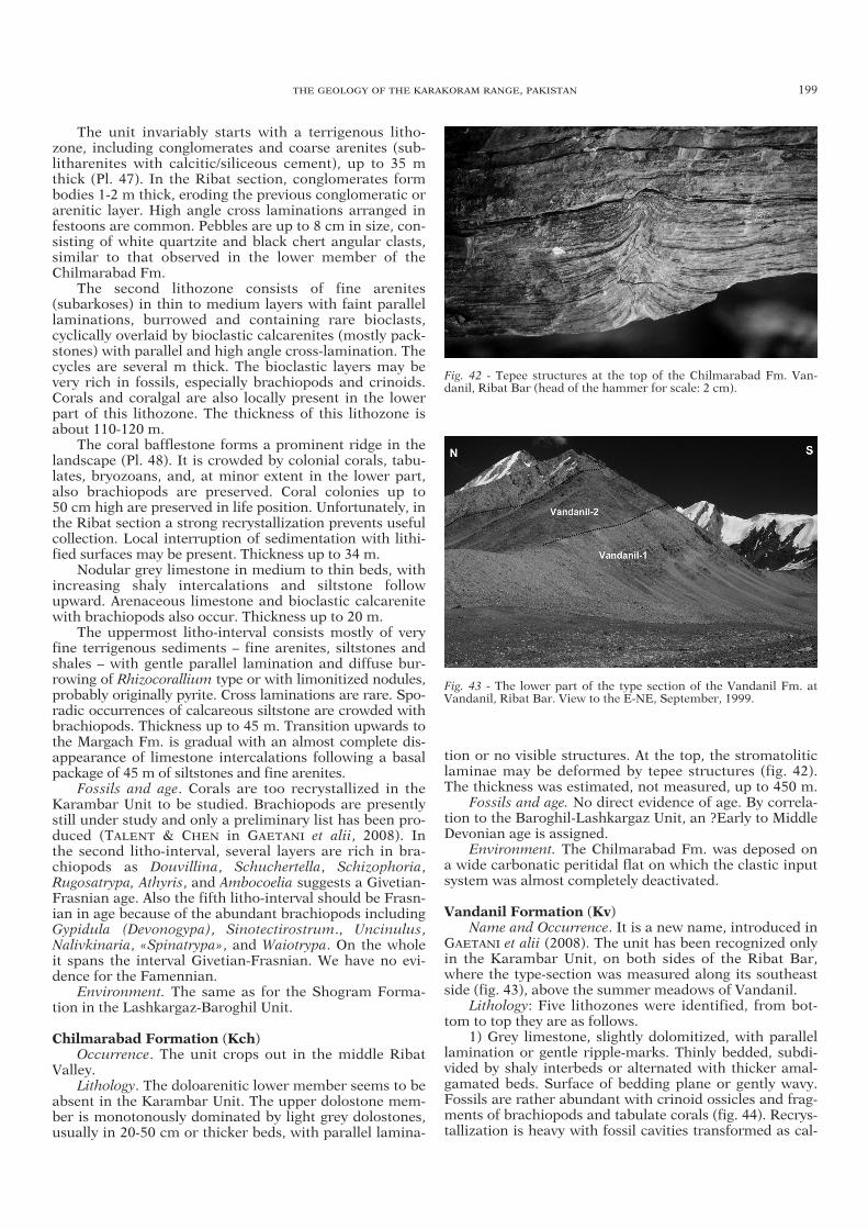
The unit invariably starts with a terrigenous litho-zone, including conglomerates and coarse arenites (sub-litharenites with calcitic/siliceous cement), up to 35 mthick (Pl. 47). In the Ribat section, conglomerates formbodies 1-2 m thick, eroding the previous conglomeratic orarenitic layer. High angle cross laminations arranged infestoons are common. Pebbles are up to 8 cm in size, con-sisting of white quartzite and black chert angular clasts,similar to that observed in the lower member of theChilmarabad Fm.
The second lithozone consists of fine arenites (subarkoses) in thin to medium layers with faint parallellaminations, burrowed and containing rare bioclasts,cyclically overlaid by bioclastic calcarenites (mostly pack-stones) with parallel and high angle cross-lamination. Thecycles are several m thick. The bioclastic layers may bevery rich in fossils, especially brachiopods and crinoids.Corals and coralgal are also locally present in the lowerpart of this lithozone. The thickness of this lithozone isabout 110-120 m.
The coral bafflestone forms a prominent ridge in thelandscape (Pl. 48). It is crowded by colonial corals, tabu-lates, bryozoans, and, at minor extent in the lower part,also brachiopods are preserved. Coral colonies up to 50 cm high are preserved in life position. Unfortunately, inthe Ribat section a strong recrystallization prevents usefulcollection. Local interruption of sedimentation with lithi-fied surfaces may be present. Thickness up to 34 m.
Nodular grey limestone in medium to thin beds, withincreasing shaly intercalations and siltstone followupward. Arenaceous limestone and bioclastic calcarenitewith brachiopods also occur. Thickness up to 20 m.
The uppermost litho-interval consists mostly of veryfine terrigenous sediments – fine arenites, siltstones andshales – with gentle parallel lamination and diffuse bur-rowing of Rhizocorallium type or with limonitized nodules,probably originally pyrite. Cross laminations are rare. Spo-radic occurrences of calcareous siltstone are crowded withbrachiopods. Thickness up to 45 m. Transition upwards tothe Margach Fm. is gradual with an almost complete dis-appearance of limestone intercalations following a basalpackage of 45 m of siltstones and fine arenites.
Fossils and age. Corals are too recrystallized in theKarambar Unit to be studied. Brachiopods are presentlystill under study and only a preliminary list has been pro-duced (TALENT & CHEN in GAETANI et alii, 2008). In the second litho-interval, several layers are rich in bra-chiopods as Douvillina, Schuchertella, Schizophoria,Rugosatrypa, Athyris, and Ambocoelia suggests a Givetian-Frasnian age. Also the fifth litho-interval should be Frasn-ian in age because of the abundant brachiopods includingGypidula (Devonogypa), Sinotectirostrum., Uncinulus,Nalivkinaria, «Spinatrypa», and Waiotrypa. On the wholeit spans the interval Givetian-Frasnian. We have no evi-dence for the Famennian.
Environment. The same as for the Shogram Forma-tion in the Lashkargaz-Baroghil Unit.
Chilmarabad Formation (Kch) Occurrence. The unit crops out in the middle Ribat
Valley. Lithology. The doloarenitic lower member seems to be
absent in the Karambar Unit. The upper dolostone mem-ber is monotonously dominated by light grey dolostones,usually in 20-50 cm or thicker beds, with parallel lamina-
tion or no visible structures. At the top, the stromatoliticlaminae may be deformed by tepee structures (fig. 42).The thickness was estimated, not measured, up to 450 m.
Fossils and age. No direct evidence of age. By correla-tion to the Baroghil-Lashkargaz Unit, an ?Early to MiddleDevonian age is assigned.
Environment. The Chilmarabad Fm. was deposed ona wide carbonatic peritidal flat on which the clastic inputsystem was almost completely deactivated.
Vandanil Formation (Kv) Name and Occurrence. It is a new name, introduced in
GAETANI et alii (2008). The unit has been recognized onlyin the Karambar Unit, on both sides of the Ribat Bar,where the type-section was measured along its southeastside (fig. 43), above the summer meadows of Vandanil.
Lithology: Five lithozones were identified, from bot-tom to top they are as follows.
1) Grey limestone, slightly dolomitized, with parallellamination or gentle ripple-marks. Thinly bedded, subdi-vided by shaly interbeds or alternated with thicker amal-gamated beds. Surface of bedding plane or gently wavy.Fossils are rather abundant with crinoid ossicles and frag-ments of brachiopods and tabulate corals (fig. 44). Recrys-tallization is heavy with fossil cavities transformed as cal-
THE GEOLOGY OF THE KARAKORAM RANGE, PAKISTAN 199
Fig. 42 - Tepee structures at the top of the Chilmarabad Fm. Van-danil, Ribat Bar (head of the hammer for scale: 2 cm).
Fig. 43 - The lower part of the type section of the Vandanil Fm. atVandanil, Ribat Bar. View to the E-NE, September, 1999.
03a ZANCHI txt ok 161-246_GEOLOGIA 29/07/11 09.28 Pagina 199

cite geoids. In the uppermost part, spells of well roundedquartz grains up to 2-3 mm in size. Thickness: 135 m.
2) Light grey dolostones in 20-40 cm thick beds.About 50 m thick.
3) Grey to dark grey carbonatic siltstones, brownishwhen altered, with intercalations, up to 20 m thick, ofwell bedded, grey nodular limestones, slightly arena-ceous, and few dolostone banks. This lithozone is cappedby about 30 m of calcareous brownish slates withcrinoids and deformed fragmentary brachiopods. Thick-ness uncertain due to the broken slope, about 150 m.
4) Grey nodular limestones with shaly interbeds, richin brachiopods, corals, crinoids and nautiloids, allstrongly recrystallized and sheared. They are overlain bylight grey dolostones, or packstone partly dolomitized in30-40 cm thick beds, overlaid by thinner platy beddeddolomitic limestones, still rich in crinoids. The units iscapped by nodular amalgamated beds, meter-thick, withghost of bioclasts and some shaly intercalations. Thick-ness about 120 m.
5) Grey dolostones in 30-50 cm beds alternating withmassive dolostones forming mounds – up to 15 m thick inthe lower part – built by dendroid to phacelloid coloniesof rugosans, tabulates, and calcareous algae. Up-sequencethe mounds, very rich in corals, are as much as 3-5 m inthickness and are interbedded with thinner bioclasticdolomitic limestones. Because of heavy recrystallization,no sampling was undertaken. The mound complexinterfingers with thin-bedded grey crinoidal limestones,forming along section intercalated packages 2-4 m-thick.Thickness estimated to be about 170 m.
Total thickness about 625 m. Fossil and age. Due to incipient metamorphism, the
fossil content, even when fairly abundant, is too poorlypreserved for identification. Conodonts have beenobtained from litho-interval 3 and 4 by R. MAWSON inGAETANI et alii (2008). In the litho-interval 3 a sampleproduced a single specimen of Pandorinellina steinhor-nensis miae, indicative of Pragian-early Emsian. Cono -donts from litho-interval 4 include Ozarkodina excavataexcavata, Oz. remscheidensis remscheidensis, Pandorinel-lina steinhornensis miae, Amydrotaxis druceana and Amy-drotaxis n. sp. The age-range indicated for this fauna isEarly Devonian; the last three conodont taxa refine theage to Pragian.
Environment. The Vandanil Fm. testify to a carbonateramp with several subenvironments. The lower part of thesuccession was characterized by fairly high energy, withbioclastic carbonatic sands, in which occasionally somespells of mature quartz sands were swept. More shelteredconditions followed upwards. This slow trend to deepen-ing was locally interrupted where a coral-algal moundwas able to grow. The sheltered muddier conditions con-tinued and developed laterally, interfingering with themound. At the top, shallower conditions prevailed and theperitidal flats of the Chilmarabad spread over the area.
Baroghil Group (Kba)Heavily disrupted outcrops of splintery black shales,
exposed in the side valleys to the south of the Vandanilmeadows and on the northern slope of the Chiantar Glac-ier, can be referred to the Vidiakot Fm. of the BaroghilGroup. They form the core of the antiformal structureexposed along the Chiantar Glacier east of the large NE-SW left-lateral transfer fault displacing the KarambarUnit. Thich layers of quartzarenites are here interbeddedwith the shales.
4.3.1.7 Chhateboi Unit (C)
This unit includes a large poorly accessible arealocated across the Chhateboi Glacier in the upper part ofthe Karambar Valley. It consists of thick, poorly fossilifer-ous terrigenous to carbonate meta-sediments showinglithological characters similar to the other well-dated Per-mian successions. In addition, part of the unit is intrudedby the Chhateboi Granite (CGR), forming a domalantiform with a well-defined contact aureole (Pl. 49). Thetectonic boundaries of the unit are poorly defined, and itis not excluded that the Chhateboi Unit may be part ofthe Sost Unit.
This thrust sheet is bounded to the south by a north-verging thrust fault which can be followed across thesouthern slope of the Karambar Valley from Khora Bhurtto the Shuinj Glacier. The eastern sector of this thrustplane belongs to the Upper Hunza fault system, directlystacking the crystalline basement of the Axial Unit on themassive metacarbonates of the Chhateboi Unit. To thewest of the Chhateboi Glacier the northern boundary ofthis thrust sheet is less defined, as the thrust fault occursbetween terrigenous facies attributed to the Gircha Fm.in both the Chhateboi and the Karambar units. The con-tact has been tentatively traced along the large valleycoming down from the Pakistan-Afghanistan divide westof Shuinj.
Sparse slices of the Reshun Fm. which uncon-formably covers in some places the massive carbonatesof the unit (Cca) occur along the Hunza fault system.The north-eastern boundary of the unit is also poorlydefined. We suggest the occurrence of a fault which sep-arates the thick carbonate succession in front of KhoraBhurt from the meta-carbonates which are intruded bythe Chhateboi Granite, passing across the QalandarUwin Pass. Deformed black marls exposed at the passmay support this interpretation.
A sharp separation of the Chhateboi Unit from the sur-rounding ones is also suggested by its stratigraphic com-position, as it shows peculiar stratigraphic characterswhich partially differ from those of the Karambar andSost units. In fact, the transition from the Gircha Fm.
200 A. ZANCHI & M. GAETANI
Fig. 44 - Tabulate corals at the base of the Vandanil section (notsampled).
03a ZANCHI txt ok 161-246_GEOLOGIA 29/07/11 09.28 Pagina 200

(Cgr) to carbonate facies (Cca) occurs through the occur-rence of a transitional facies (Cmr), which differs from thesuccession exposed in the other two units (fig. 45). On theother hand, it strictly recalls the Guhjal Unit. Contactmetamorphism may partially obscure the original featuresof the succession, hampering stratigraphic correlations.
In addition to the broad antiformal structure producedby the intrusion of the Chhateboi Granite, WNW-ESE foldsoccur in the Gircha Fm. north of Shuinj (Pl. 50), showing adifferent trend from the ones affecting to the north the Car-boniferous outcrops of the Karambar Unit.
Tupop Formation (Ct)Red conglomerates and sandstones unconformably
resting on the massive carbonates of this thrust sheet(Cca) west of Chillinji. The unit has been correlated withthe Tupop Formation of the Chapursan Valley, occurringentirely in the Sost Unit due to its similarity.
Chhateboi Carbonates (Cca)Massive carbonates more than 1000 meters thick
form the high cliffs along the snout of the ChhateboiGlacier. They are often severely recrystallized around theChhateboi Granite and generally show a pervasive cata-clastic fabric. (?Permian-Mesozoic).
Chhateboi Marly Limestone (Cmr)Well bedded limestones, marls and shales occur
between the Gircha Fm. and the overlying massive car-bonates. They show polyphase recumbent and isoclinalfolds exposed along the Chhateboi Glacier close to theChhateboi Granite. Their original thickness may reach afew hundred meters. (?Permian).
Gircha Formation (Cgr) Very thick monotonous succession of shales and
sandstones. Thick quartzarenite layers occur especiallynorth of Shuinj (Cqz). According to its composition andstratigraphic position, it has been directly correlated withthe Permian Gircha Fm. of the nearby units. Its originalthickness is obscured by faulted contacts and intensivefolding; it may be several hundred meters thick.
Crinoid Limestone (Cc)Grey bioclastic massive limestones, about 50 meters
thick, with crinoid ossicles are exposed along the upperpart of the Shuinj Valley close to the Afghan border.According to their stratigraphic position, laying appar-ently under the Gircha Fm., they may represent a Car-boniferous facies possibly correlatable with the Ribat Fm.of the Karambar Unit.
4.3.1.8 Sost Unit (S)
This thrust sheet forms the westward extension of thesame unit defined by us in the Chapursan and Hunza val-leys (GAETANI et alii, 1990a; ZANCHI, 1993; ZANCHI &GAETANI, 1994; ZANCHI & GRITTI, 1996). It is exposedfrom the Chapursan Valley to the Qalandar Uwin Pass inthe upper Karambar Valley west of Chillinji. The unitshows a comprehensive Permian to Cretaceous succes-sion including several formations, from the Permian Gir-cha Fm. to the Triassic Aghil Fm. and related facies (Hid-den Gorge limestone and Khora Bhurt marls), alsocontaining the Jurassic Yashkuk and Reshit fms., and the
Cretaceous Tupop and Darband fms. The most extendedoutcrops mainly consist of the Triassic carbonates of theAghil Fm. unconformably covered by the Tupop Fm.,which is largely exposed with a well-preserved unconfor-mity north of Buattar and to the west, across the Paki -stan-Afghanistan divide. The Campanian marls of theDarband Fm. crop out close to Buattar along the westernflank of the Koz Yaz Glacier. Ignimbrites occur at thebase of the Tupop Fm. along the Hidden Gorge Glacierand along the western flank of the Koz Yaz Glacier.
The units is bounded to the south by the N-verging E-W trending and S-dipping Upper Hunza fault systemcausing the overthrust of the Guhjal thrust sheet to thenorth onto the Sost Unit (Pl. 51). Several thrust faults,often including slices of the Tupop Fm., duplicate thesuccession in its southern sector (fig. 46). Complex rela-tionships resulting from the repetition of the Tupop Fm.within thrust slices may be due to delamination occurringalong the Tupop basal unconformity as a consequence ofstrong competence contrasts. E-W horizontal folds oftenshowing overturned limbs and a N-vergence occur in theTupop Fm. along the right side of the Chapursan Valley.They also suggest a post-Cretaceous age for this thrustsystem. In addition, NW-plunging mesoscopic folds witha metric wavelength have been measured in the DarbandFm. along the Koz Yaz Glacier.
THE GEOLOGY OF THE KARAKORAM RANGE, PAKISTAN 201
Fig. 45 - Strongly deformed intercalations of limestones and slatesalong the Chhateboi Glacier. Isoclinal folds are refolded by a seconddeformational event. September, 1996.
Fig. 46 - Stereographic projections of folds measured in the Sost andGuhjal units; symbols as in previous projections.
03a ZANCHI txt ok 161-246_GEOLOGIA 29/07/11 09.28 Pagina 201

South-verging ENE-WSW thrust faults deforming theTriassic and Jurassic successions characterize the left-sideflank of the Chapursan, which are in turn overthrusted bythe Wakhan Slates along the Kilik Fault, running close tothe boundary with Afghanistan (Pl. 52). The same situa-tion has been described eastward along the ChapursanValley (ZANCHI, 1993; ZANCHI & GRITTI, 1996). The SostUnit clearly continues into Wakhan, where it has beenincluded in the undifferentiated Afghan Unit.
The western portion of the Sost Unit is problematical,and has been poorly investigated. It surely reaches theQalandar Uwin Pass, forming a carbonate massif showingat least a 1.5 kilometre thick succession with inaccessiblerock walls, where Triassic dasycladacean algae have beenfound in its lower part. As different successions areexposed west of the Qalandar Uwin Pass, showing car-bonates passing progressively at the base to terrigenoussediments of unknown age, we have preferred to interrupthere the Sost Unit and separate it from the ChhateboiUnit occurring between the Chillinji and Karambar areas.
The Aghil carbonates and the Tutpop conglomerates(Pl. 53) are deeply involved in the thrust stack of Chillinji,showing intricate out-of-sequence duplex thrust struc-tures possibly post-dating the emplacement of the TashKupruk thrust sheet. These high-angle reverse faultsduplicating the Aghil and Tupop formations form a relaystructure between the upper Hunza Fault and the Chi-antar-Chillinji Fault (Pl. 15).
Tupop Formation (St) Name and Occurrence. The Tupop Formation (GAETANI
et alii, 1990a; GAETANI et alii, 1993; ZANCHI & GAETANI,1994) widely outcrops west and south of BabaghundiZiarat in the Chapursan Valley, along the valley of Buattarand to the north along the Irshad Uwin Valley.
Lithology. It consists of channelized red cobble andpebble conglomerates, forming amalgamated beds sev-eral m-thick, interbedded with sandstone and red shales.The conglomerate is usually clast-supported with carbon-ate cement. Clasts are predominantly of carbonate com-position; subordinate terrigenous and few volcanic rocksalso occur (Pl. 54). We observed also two significantintercalations along the western flank of the Koz YazGlacier: 1) pinkish mudstones in 2-5 cm thick beds,slightly nodular, with thin red chert lenses referred to the Campanian Darband Fm. (GAETANI et alii, 1993); 2) a dark red ignimbrite about 10 m thick including car-bonate pebbles covered by an ignimbrite breccia alsocontaining several carbonate pebbles. Rhyolitic ign-imbrites have been found also at the top of the HiddenGorge at the base of the Tupop Fm. (Pl. 53).
Age. No fossils were found. A Cretaceous age is attrib-uted because of the correlation to the ages obtained in theChapursan Valley.
Environment. The Tupop Fm. was deposited underfluviatile conditions. Marine intercalations occurred tem-porarily in a highly mobile geodynamic context.
Reshit Formation (Sre)Name and Occurrence. Name introduced by GAETANI
et alii (1990a) for a succession cropping out mainly in theChapursan Valley. It forms a rather continuous strip fromthe Irshad Uwin Pass to the east, connecting with the out-crops along the northern flank of the Chapursan Valley(ZANCHI & GAETANI, 1994).
Lithology. Dark grey, oncolitic to oolitic packstone,medium- to thick-bedded and dark grey well beddedmudstone and wackestone, locally with chert nodules,forming rather imposing steep slopes, about 300 m inthickness. Outside the map, in the Chapursan Valley, gyp-sum layers occur in the central part of the formation. Inthe same area, thin layers of coal have been recentlymined (DONNELLY, 2004).
Fossils and age. GAETANI et alii (1993) reported nan-nofossils of Aalenian-Bajocian ages from outcrops lyingto the east of the present map.
Environment. Open carbonate shelf, with evaporiticepisodes and restricted marshy lagoon.
Yashkuk Formation (Sy) Name and Occurrence. Name introduced by GAETANI
et alii (1990a) for a succession cropping out mainly alongthe Chapursan Valley. It forms a strip a few km in lengthon the southern slopes of the Sakar Sar in the upperreaches of the Sakar Jerab, in the upper Chapursan Val-ley, north of Babaghundi Ziarat.
Lithology. Fine grained, red and green litharenites andsiltstones, mostly thin-bedded, alternating with red togreenish shales, often poorly exposed. Its thicknessranges between 10 and 300 m
Fossil and age. According to GAETANI et alii (1993) theunit should be Toarcian-Aalenian in age.
Environment. Continental distal alluvial fans record-ing the dismantling of the Cimmerian orogenic belt.
Aghil Formation (Sag) Name and Occurrence. The name was introduced by
DESIO (1963), who resumed the term Aghil Limestoneintroduced by AUDEN (1938), in the Aghil Range, where,however, it was poorly defined. GAETANI et alii (1990a)adopted the term for the equivalent carbonatic layers inHunza and Chapursan, preferring the more generalspelling of Aghil Formation. These massive carbonatesform imposing steep slopes and walls in the upper Cha-pursan, in the Chillinji area and to the east of the KhoraBhurt Pass.
Lithology. To the east of the Khora Bhurt the carbon-ates (both limestone and dolostone) are in massive cyclicbeds. The total thickness may exceed 1500 m.
Fossil and age. Deformed megalodontids sections andDasycladacean fragments have been observed respectivelywest of Chillinji along the Karambar Valley and the Hid-den Gorge, suggesting a Late Triassic age. Outside thearea, south of Reshit in the Chapursan Valley, the top ofthe Aghil contains reworked scleractinian corals and badlypreserved ammonoids, suggesting a latest Triassic age.
Environment. Peritidal carbonate platform in thelower and middle parts, shifting to prevailing subtidaland deeper conditions in the topmost part, before thedeposition of the terrigenous sediments linked to theCimmerian orogeny.
Hidden Gorge Limestone (Sbl) The unit is named after a deep gorge cutting through
the carbonate massifs west of Chillinji. It consists ofwell-bedded platy black bioclastic limestones with blackmarls layers, intercalated in the Aghil Fm., suggesting aninternal lagoonal environment with restricted circula-tion. They are a few tens of metres thick and show lim-ited outcrops.
202 A. ZANCHI & M. GAETANI
03a ZANCHI txt ok 161-246_GEOLOGIA 29/07/11 09.28 Pagina 202

Qalandar Uwin Marls (Skb) They consist of terrigenous tectonic slices cropping
out at the Qalandar Uwin Pass, possibly marking theoccurrence of an important thrust fault separating theSost Unit from the Chhateboi Unit.
Gircha Formation (Sgr)Occurrence. Elongated strips in the upper reaches of
the Chapursan Valley and towards the Irshad Uwin Pass. Lithology. Dark pelites alternating with cross-lami-
nated channelized sandstones, forming lenticular bodiesup to 10 m thick in the upper part. Superb bidirectionalripple marks (fig. 47).
Fossil and age. The occurrence of conglomerate inter-calations bearing pebbles with Devonian corals is pecu-liar to the Gircha Fm. of this thrust sheet also out of themapped area. FLÜGEL (1995) identified Aphyllum sp.from the west side of the Yashkuk Glacier. HUBMANN &GAETANI (2007) recognized the Alveolites (Alveolites)hudlestoni tabulate coral in a pebble from the IrshadUwin Valley. According to its stratigraphic position, theunit should be of Early Permian age. Thickness >1000 m.
Environment. Distal alluvial fan, with meander chan-nels and even braided channels conditions in the upperpart. However, significant part of the unit has beendeposited under shallow marine conditions.
4.3.1.9 Afghan Unit (AF)
The northern part of the North Karakoram Terrainexposed in Afghanistan has been mapped on the base ofsatellite imagery photo-interpretation and on observationsin the distance taken from the high peaks along the conti-nental divide (Pl. 55). Therefore, we only have generalinformation on the nature, composition, and age of theserocks. The ages are tentatively inferred by reference to similar units extending on the Pakistani side of the range.Nevertheless, we have included these rocks in the NKT, asthey clearly outcrop south of the Wakhan Slates, which canbe easily recognized also through photo-interpre tation.Structural features defined in this area are also tentative.
Afghan Red Conglomerates (AFrh) A few isolated tectonic slices, up to 100 hundred
meters thick, of reddish conglomerates have beenobserved in the distance north of the Karamabar Passarea. They may represent the lateral equivalent of theTupop/Reshun conglomerates observed in Pakistan.
Afghan Massive Carbonates (AFmc) This unit include massive carbonates often with a
thickness exceeding 1000 m, which may correspond tothe western continuation of the Aghil Fm. of the SostUnit. Complex thrust faults prevent from a direct correla-tion with this unit. In alternative, they may represent Per-mian, shallow water limestones. They are especially evi-dent along the northern margin of the NKT, where theyform large isolated carbonate masses bounded by south-verging thrust surfaces. In the central part they are asso-ciated with black slates (AFbs), showing several repeti-tions probably due to thrust stacking and/or folding. A huge south-verging duplex structure extending inAfghanistan for several tens of kilometres up to theIrshad Uwin Pass is evident in the northeast part of themapped area just south of the Wakhan Slates.
Afghan Carbonates and Clastics (AFct)This unit includes outcrops characterized by a greyish
tone in the Panchromatic spot image, suggesting theoccurrence of marls, limestones and sandstones. Theirseparation from the black slates (AFbs) must be consid-ered cautiously due to the similarity between the twofacies in the SPOT imagery. They may correspond toUpper Paleozoic-Mesozoic successions of the NKT. Theirthickness can reach several hundred meters or more.
Afghan Black Slates (AFbs)Outcrops marked by a noticeably dark colour have
been classified within this unit, which may correspond toterrigenous sediments of the Paleozoic succession, espe-cially to the Gircha Fm. or to the Baroghil Group.
UNITS SOUTH OF THE RESHUN-UPPER HUNZAFAULTS
4.3.1.10 Axial Unit (A)
The Axial Unit, firstly defined by GAETANI et alii(1996), is one of the most important tectonic unit of theNorthern Karakoram Terrain, extending for about 100kilometres in the central and western regions covered bythe map. An isolated portion of the same unit has beenrecognized in the Chillinji area, where it occurs in a com-plex structural setting below the Guhjal and the TashKupruk units (Pls. 15, 16).
The Axial Unit shows several peculiar characters,which make it unique for the definition of the evolutionof the Karakoram block. Its most important feature is theoccurrence of a pre-Ordovician crystalline basement con-sisting of the Chikar Quartzite (Ack), which is in turnintruded by pre-Ordovician magmatic bodies (Ishkarwaz-type Granodiorite: AGR), possibly related to the finalmagmatic events of the Pan-African orogeny. The crys-talline basement is covered by the terrigenous sedimentsof the Baroghil Group, still showing a preserved basalnon-conformity, which is well exposed close to theBaroghil village area (fig. 48) and near Chillinji (LE FORTet alii, 1994; TONGIORGI et alii, 1994). A Paleozoic succes-sion, Ordovician in age at the base, follows upwardsshowing stratigraphic units directly correlated with thoseof the Karambar and Lashkargaz-Baroghil thrust sheets
THE GEOLOGY OF THE KARAKORAM RANGE, PAKISTAN 203
Fig. 47 - Ripple marks in the intermediate part of the Gircha Fm.,upper Chapursan Valley, Sost Unit.
03a ZANCHI txt ok 161-246_GEOLOGIA 29/07/11 09.28 Pagina 203

occurring to the north of the Reshun Fault. Another pecu-liar character of this unit is related to the reduced thick-ness of the whole Paleozoic section (Pl. 56), suggestingdeposition on a structural high, with respect to the suc-cessions preserved in the nearby structural units, whichwere deposited in more subsiding basins. Massive car-bonates (Pl. 57) of Permian to Triassic age (PERRI et alii,2004) close the Paleozoic succession at the top. ThePaleo zoic to Triassic units are covered by the Upper Cre-taceous Reshun Fm., generally showing a low angle angu-lar unconformity up to 15° (Pl. 58). The unconformity testifies to an important deformational event followed bya marked uplift and erosion which has been related bymost of the authors to the collision of Karakoram withKohistan (PUDSEY et alii, 1985; COWARD et alii, 1986;PUDSEY, 1986; GAETANI et alii, 1990a, 1993; SEARLE,1991; ZANCHI, 1993; ZANCHI & GRITTI, 1996).
The Axial Unit forms the footwall of the Reshun Fault.The Axial Unit is progressively overthrust from west toeast by the Siru Gol, Lasht, Tash Kupruk and Lashkargaz-Baroghil thrust sheets. East of the snout of the ChiantarGlacier, the unit is elided by a N-verging thrust fault stack-ing directly the Karakoram Batholith on the KarambarUnit. The southern boundary of the unit is also complexand generally consists of high-angle shear zones separat-ing the Lower Paleozoic units of the pre-Ordovician crys-talline basement from the Karakoram Batholith. In thewestern sector, the Sakirmul Granodiorite is often shearedalong the contact with the Axial Unit. Between the Maditand Ponarillo glaciers, LE FORT & GAETANI (1998) reporta complex structural setting including a N-verging over-thrust juxtaposing the Ordovician slates of the BaroghilGroup on the Chikar Quartzite, as well as an important N-NW trending S-dipping low-angle normal fault delami-nating the stratigraphic boundary between the two units(section 6.1). From the Madit Glacier up to the Darkot Passto the east, the Axial Unit is separated from the KarakoramBatholith by the Dobargar-Kotalkash metasediments.
Differences in thickness of the Paleozoic successionsacross the Reshun Fault suggest that it was probably aPaleozoic to Mesozoic normal fault which was invertedduring the formation of the Karakoram belt. In addition,
the Reshun Fault has been finally reactivated with a nor-mal to oblique slip, which is especially evident south ofShost and in the Baroghil area. Evidence is given forexample by the younger-on-older relationships occurringalong the footwall of the fault. These features will be discussed further on in the section on the Reshun Fault.
Polyphase deformation is also recorded within theReshun Formation, where two different generations ofaxial plane cleavages occur. This also suggests that mostof the deformation affecting the Axial Unit can occurredbetween the end of the Cretaceous and the Cenozoic.
The structural setting of the Axial Unit exposed in theChillinji area is more complex, being part of the system ofN-verging imbricates marking the Chiantar-Chillinji Faultwhich represents the linkage system between the Reshunand the Upper Hunza faults (Pl. 16). In this area the AxialUnit forms a duplex between the Guhjal and Chhateboithrust sheets. It is also intruded by an isolated portion ofthe Garmush Granite, displaced by the thrust faultsbounding the unit. Steeply plunging to vertical mesoscopicfolds with NE-SW trending axial plane cleavages occur inthe Upper Paleozoic succession at Chillinji (fig. 49).
SEDIMENTARY COVER
Reshun Formation (Arh)
Name and occurrence. The conglomerate cropping outaround Reshun (Chitral) was firstly identified by HAYDEN
(1915) and studied in more detail by PUDSEY et alii (1985)and PUDSEY (1986). In the considered area, it forms afairly continuous strip from Chillinji across the ChiantarGlacier to the Paur Gol. The formation is often severelydeformed as it lies in the footwall of the Reshun Fault.
Lithology. In the basal part coarse reddish sandstonesand red shales prevail (Pl. 59), whilst upwards also con-glomeratic layers are present (Pl. 60). Clasts of felsic vol-canic rocks mainly consisting of reddish ignimbrites havebeen observed at the base of the unit in the Baroghil areaabove the Chilmarabad Fm. The clast-supported ReshunFm. consists of moderately rounded pebbles of sedimen-
204 A. ZANCHI & M. GAETANI
Fig. 48 - Basal non-conformity between the in-tensively cleaved pre-Ordovician Ishkarwaz-type Granodiorite and the base of the BaroghilGroup at Baroghil, July 2004. People on theoutcrop are part of the members of the Pres-tige Excursion, XXXII International GeologicalCongress.
03a ZANCHI txt ok 161-246_GEOLOGIA 29/07/11 09.28 Pagina 204

tary rocks, with average clast size between 5 and 15 cm to the west. In the Paur Gol pebbles and cobbles andblocks up to 30-40 cm in size have been observed, form-ing 10-20 m-thick layers. However, the usual bedding ism-thick in the conglomerates, thinner in the sandstones.Carbonate pebbles of local provenance commonly prevailover sandstone pebbles. The matrix is mostly red. At thebase there is an erosion surface. However, no spectacularangular unconformity (max 10°-15°) is observed aroundShost (Pl. 59), where reddish marly layers occur at thebase of the unit. Its thickness increases to the west, whereit may reach >500 m along the Paur Gol; a precise evalua-tion of its maximum thickness is usually hampered bystrong tectonic deformation.
At least two major deformational events related to theevolution of the Reshun Fault have been identified withinthis unit (fig. 49). A strong pervasive axial plane foliationrelated to tight E-W trending folds with sericite growth, isoften crenulated by a second axial plane foliation, whichcan be observed in the field around Shost and Kan Khun.A strong flattening and elongation of the clasts related tothe first folding event is commonly observed in the con-glomerates of the succession, especially close to theReshun Fault at Kan Khun (Pl. 61). Post-deformationchloritoid overgrowth occurs around Shost close to thefault zone, indicating an important increase in tempera-ture conditions. Around Shost, the Reshun Fm. is deeplyinvolved within large-scale close folds and thrust struc-tures (Pl. 62). Further details on the deformation of theReshun Formation are given in the final section concern-ing the evolution of the Reshun Fault.
Age and fossils. No direct age assignment could bemade, the search for pollens resulted negative. We con-sider the conglomerate to be Late Cretaceous in age,
younger than the Orbitolina limestones, since clasts con-taining those foraminifers have been observed in looseblocks along the Yarkhun River at Gharil. In the area ofNal, near Reshun, and at Krinji, Chitral, limestones andarenites with orbitolinids and small rudist fragments,lying below the Reshun Conglomerate were collected byDESIO (1959) and TALENT et alii (1982). Close re-exami -nation of the DESIO’ samples with orbitolinids from Nal byR. SCHROEDER (Frankfurt a.M.) refers the samples tospecies of the genus Mesorbitolina, indicating a late Aptianage, thus excluding the potential Barremian age suggestedby CITA & RUSCELLI (1959) (Pers. communication, 2009).
Environment. The Reshun Fm. conglomerate was depo -sited in a fluvial context, from high energy fans evolvingin a braided river plain. The irregular distribution of theconglomerates testifies to the lateral migrations of thedistributaries high energy channels.
Massive Carbonates (Amc)Occurrence. They form a discontinuous strip with iso-
lated outcrops in the central part of the map. West of KanKhun they are continuously exposed up to Shost. Anotherlarge outcrop is the area of Chillinji.
Lithology. In the upper Yarkhun area, the lower partconsists of grey thick-bedded dolostones overlain by darkgrey limestones (packstone to wackestone) in 40-60 cm-thick beds often amalgamated to form banks exceeding 2 m; thickness about 250-300 m. They are overlaid bylight thick-bedded peritidal dolostones (>500 m) in theupper part (Siru Gol) with stromatolitic laminae and fen-estrae. At Chillinji, the lower 100 m consists of greyrecrystallized limestone in metric layers, alternating withthin to medium bedded, dark grey mudstone/wackestonebeds, with gastropods and stromatolitic laminae. Gradu-
THE GEOLOGY OF THE KARAKORAM RANGE, PAKISTAN 205
Fig. 49 - Stereographic projections of structures measured in the Axial Unit; symbols as in previous projections.
03a ZANCHI txt ok 161-246_GEOLOGIA 29/07/11 09.28 Pagina 205

ally, up in the section, thick bedded grey to light greydolostones prevail. The overlying part, more than 300 m-thick, is made of massive bedded peritidal dolostone,heavily recrystallized, with frequent stromatolitic layers.The steep wall prevents further observations. Thickness inthe Chillinji area: >400 m
Fossils and age. A very rich fauna of small foraminifers,Late Permian in age, was identified to the north ofShakirmul, along the river (GAETANI et alii, 1995).Unidentifiable corals were also observed. Along the newjeep road in the same area near the Shost bridge, PERRI etalii (2004) found a conodont fauna of Early Triassic agein the dark grey bedded limestones. No age evidence isusually available for the upper massive part of the unit,but to the south of the bridge on the Yarkhun river, whereMegalodontids have been observed (fig. 50).
Environment. The lower part of the unit was depositedunder wave base on a carbonate ramp. The upper partinstead was deposited under peritidal conditions on a carbonate flat.
Gircha Formation (Agr) Occurrence. It forms a narrow strip crossing the
Yarkhun river north of Shakirmul, directly overlappingthe slates of the Baroghil Group.
Lithology. Fine conglomerates in thick beds at thebase, overlain by well bedded quartzarenites, alternatingwith dark splintery slates. To be noted the very highquartz content. Thickness: a few tens of meters.
Fossils and age. No fossils being recovered. A Permianage is assigned by analogy with other thrust sheets.
Environment. Distal alluvial fan.
Permo-Carboniferous clastics (Apc) Occurrence. In the area of Chillinji all the terrigenous
rocks interposed between the Shogram Fm. and the Mas-sive Carbonates (Amc) are grouped in this unit.
Lithology. Fairly monotonous succession of dark greyslates, siltstones and fine arenites (Pl. 63), often with car-bonate cement with few brachiopods at the base. Thin tomedium bedded litharenites, and hybrid sandstonesoccur subordinately. In the upper part the sandstones arericher in quartz. The outcrops are crossed by thick por-phyritic dykes, dark red in colour. Thickness >300 m, butmeasures are uncertain as the succession is severely dis-rupted by faults.
Fossils and age. In the lowermost part, immediatelyabove the Shogram Fm., the brachiopod Rhipidomella hasbeen collected, suggesting an Early Carboniferous age.The unit may represent a lateral terrigenous equivalent ofthe more complete successions from the Margach to theGircha formations of the Karambar Unit.
Environment. Distal terrigenous fan, largely depositedunder marine conditions.
Shogram Formation (Ash) Occurrence. The unit crops out at Chillinji. A section
has been measured on the northern side of the river (GAE-TANI et alii, 2008).
Lithology. Coarse sandstones and microconglomeratesin amalgamated graded beds of 10-20 cm-thick occur atthe base, overlaid by alternating graded litharenites orhybrid sandstones with brachiopod shelly layers at thebase, and calcareous intercalations and fossiliferous lay-ers rich in well-preserved brachiopod faunas (fig. 51).Small meter-thick mounds with Rugosa and Tabulata.Thickness: 60 m.
Fossils and age. SCHRÖDER (2004) identified Temno-phyllum sp. and HUBMANN in HUBMANN & GAETANI
(2007) Thamnopora grandis, suggesting a possible MiddleDevonian age. The presence of the Frasnian (UpperDevonian) cannot be excluded.
Environment. Above the basal transgressive conglom-erate layers, the carbonate shelf was frequently swept byterrigenous inputs, which stopped the growth of the coralmounds.
Chilmarabad Formation (Ach)Occurrence. The unit forms a small belt across the
Karambar River in the Chillinji area.Lithology. Both members of the Chilmarabad Fm.
may be recognized. At the base, especially in the lower 30 m, the transition from the underlying unit occurs witha gradual increase of the dolomitic layers and nodules in20-50 cm layers. The terrigenous layers are made of mi -croconglomerates with typical dark chert clasts (fig. 52).The upper member consists of grey dolostones, yellowbrown when altered, in m-thick beds. Peritidal cycles,erosional surfaces lined by thin veneers of sandstone,nodular dolomitized limestones, affected by small syn-
206 A. ZANCHI & M. GAETANI
Fig. 50 - A megalodontid on the south bank of the Yarkhun River,just to the left of the bridge from Zirch. The presence of megalodon-tids in the Axial Unit is rare.
Fig. 51 - Wavy ripples and lithified clasts disrupted by bottom currentsat the top of a coral mound. Shogram Fm., Chillinji, Karambar Valley.
03a ZANCHI txt ok 161-246_GEOLOGIA 29/07/11 09.28 Pagina 206

genetic extensional faults (fig. 53) may also be observed.Thickness: 130 m
Fossils and age. No fossils have been observed and a?Lower-Middle Devonian age is assigned by analogy toother outcrops.
Environment. Peritidal carbonate flat, with significantterrigenous input in the lower part.
Chilmarabad Conglomerate (Acg) – Medium to fineconglomerates and quartzarenite with abundant clasts ofblack chert. Thickness >200 m. (?Silurian-?Devonian).
Occurrence. Small outcrop along the left side of theuppermost part of Yarkhun Valley, in front of Lashkargaz.
Lithology. Well sorted fine-bedded yellowish conglom-erates, either clast and matrix supported, in 20-40 cm-thick amalgamated beds, with thin sandstone or siltstoneintercalations. Dark chert clasts are typical. It restsunconformably on the slates of the Baroghil Group,showing a reduced thickness (Pls. 56, 57). Thickness: atleast 200 m.
Fossil and age. This unit may be correlated to the basalclastic portion of the Shogram Fm. It may also be tenta-tively correlated to the Charun Quartzite of Chitral (STAUF-FER, 1975). The age is assigned by stratigraphic position.
Environment. Distal alluvial environment.
Baroghil Group (Aba) Name. This unit was first recognized and named by
THAKIRKHELI (1982), without formalization. GAETANI etalii (1996) introduced the formational term Yarkhun forthe same unit. KAZMI & QASIM (1997) claimed the prior-ity for the name Baroghil. This opinion was accepted inTALENT et alii (1999) and QUINTAVALLE et alii (2000), rais-ing the name Baroghil to group rank and introducing asformations the names Vidiakot (Avd) and Yarkhun (Aya)to better detail the upper and lower part of the succession(Pl. 64). The name Baroghil appears as an useful compre-hensive term when it is not possible to separate the twoformations, especially when the succession is severelyaffected by tectonics. Basically, the Yarkhun Formationconsists of arenitic and shaly packages with occasionalcarbonatic layers, capped by a microconglomeratic hori-zon. The overlying Vidiakot Formation mostly includesblack shales and siltstones with rare coarser terrigenousintercalations. As this last formation is mechanicallyweak, thrust surfaces often propagate from this portion ofthe succession.
Occurrence. In the Axial Unit, the crystalline base-ment of the NKT is also present and the basal contact ofthe Baroghil Group can be observed (LE FORT et alii,1994; TONGIORGI et alii, 1994; QUINTAVALLE et alii, 2000),allowing to give the most complete description (fig. 48). Itforms an almost continuous belt between the west side ofthe map (Paur Gol) to the Baroghil area.
At Chillinji, it consists of lithic sandstones and micro-conglomerates at the base, non conformably covering theIshkarwaz-type Granodiorite. Towards the top, blacksplintery slates with small limestone nodules occur. Thebest outcrops are in front of Chillinji on the opposite sideof the Valley close to Khora Bhurt. Thickness >50 m.
Vidiakot Formation (Avd)Occurrence. It crops out continuously between the
Paur Gol and Chilmarabad. A section was measuredalong the Vidiakot Ridge, mostly on the Baroghil side
(fig. 54, Pl. 28). However, several faults affect the succes-sion and the upper part of the unit is truncated by theReshun Fault.
THE GEOLOGY OF THE KARAKORAM RANGE, PAKISTAN 207
Fig. 53 - Chillinji, lower part of the Chilmarabad Fm. A syn-sedimen-tary fault in the alternating dolostone/arenitic layers is sealed in theupper part of the outcrop.
Fig. 54 - The type-section of the Vidiakot Fm. in severely cleavedslates along the Vidiakot ridge; the Koyo Zom in the background.The Reshun Fault passes through the saddle in the foreground. Sep-tember, 1996.
Fig. 52 - Fine grained conglomerates with chert pebbles at the baseof the Chilmarabad Fm., Chillinji, Yarkhun Valley.
03a ZANCHI txt ok 161-246_GEOLOGIA 29/07/11 09.28 Pagina 207

Lithology. The lower boundary is defined at the top ofthe microconglomerate horizon that seals the YarkhunFormation. The unit mainly consists of a monotonoussuccession of black splintery slates with rare coarser silt-stone packages. Due to the very low-grade metamorphicimprint, they are usually transformed in slates showing astrong cleavage. Rare arenitic intercalations in the middlepart and dolostone and dolomitic limestone lenses, up to10 m thick, occur in the upper part.
From Lasht to the Paur Valley, the slates are darkgreen and progressively became more metamorphosedwestwards, developing a significant slaty cleavage. Thethickness is supposed of at least 400-500 m, but no definite measure may be done.
Fossils and age. Acritarchs were found only in thebasal part, where QUINTAVALLE et alii (2000) identifiedthe fossil assemblages VK3, probably assignable withinthe Arenig-Llanvirn boundary interval. No further signifi-cant acritarchs were obtained upwards, in spite of sys-tematic sampling. Most of the outcrops are not far fromthe Reshun Fault and suffered heavy recrystallization. Itis supposed that the rest of the Ordovician and at leastpart of the Silurian are present, because towards the topof the Vidiakot Fm. in the Baroghil-Lashkargaz Unit carbonate intercalations with ortoconids were observed,suggesting a Siluran age.
Environment. Outer shelf below the storm wave base,with fairly abundant clay supply. Sporadic spells of fine sands and silt. More favourable conditions allowedgradual reappraisal of a limited carbonate productiontowards the top, where isolated carbonate lenses maylocally occur.
Yarkhun Formation (Aya)Occurrence. Between the Yarkhun river and the Vidi-
akot ridge, the Vidiakot gully and the very rugged area tothe west. The type-section (Pl. 64) has been measured onthe SE side of the Vidiakot ridge (QUINTAVALLE et alii,2000).
Lithology. Grey arenites (subarkoses and litharenites)in medium to thick beds, with gentle low angle cross-lam-inations, forming packages 10-20 m thick. They are subdi-vided by two major intercalations of black splintery slatesand dark grey siltites. These intercalations are particu-larly rich in trace fossils, including burrows of Cruziana(fig. 55a) and Planolites (fig. 55b). Asymmetrical ripplesare also widespread. Towards the top single hybrid aren-ites and arenitic limestone beds may occur. It lies withnon conformity on the crystalline basement. On the trailfrom Ishkarwaz to the Baroghil Pass, the surface of thecontact is flat at the outcrop scale. On the Vidiakot ridge,the contact appears instead sheared. The unit is cappedby a layer of 10-12 m thick light grey microconglomeratesand coarse arenites, richer in quartz grains. Thicknessabout 180 m.
Fossils and age. The unit contains a fairly rich acritarchflora (TONGIORGI et alii, 1994; QUINTAVALLE et alii, 2000)and rare conodonts (TALENT et alii, 1982; 1999) with frag-ments of brachiopods and cephalopods. Several zones ofthe Arenig Series are documented and apparently the for-mation is restricted to this Series. Amongst acritarchs, 2 assemblages (VK) have been identified in the type section.The available palynological evidence dates the lowermostVK 1 as Arenig, within an interval extending from theBritish nitidus to the middle-upper hirundo graptoliteZones. The age of the assemblage VK2 probably fallsentirely within the early late Arenig hirundo graptoliteZone. The overlaying conodont level JAT 1 contains Balto-niodus sp. cf. B. medius (DZIK, 1976) and possibly indi-cates an interval ranging from variabilis to upper suecicusconodont Zones (latest Arenig-lower Llanvirn). Theassemblage of acritarchs belongs to the Peri-Gondwanabiogeographic province (LE FORT et alii, 1994; TONGIORGIet alii, 1994; QUINTAVALLE et alii, 2000).
Environment. The unit testifies to the transgressionon a peneplaned surface of metamorphic and magmaticrocks of unknown age. Due to the presence of brachiopodfragments already in the first meters of the succession,the whole unit was deposited in a shallow marine envi-ronment, periodically below the storm wave base, inwhich a rich community of burrowing and crawler ani-mals was dwelling. Important amount of silicoclastic sed-iments were introduced in the coastal shelf.
CRYSTALLINE BASEMENT
Ishkarwaz-type Granodiorite (AGR)
Name and Occurrence. It has been first described byLE FORT et alii (1994) in the surroundings of Ishkarwaz;
208 A. ZANCHI & M. GAETANI
Fig. 55 - A: Cruziana trace fossils in the Yarkhun Fm. along the sec-tion of the Vidiakot ridge, B: Planolites trace fossils in the YarkhunFm. along the section of the Vidiakot ridge.
a
b
03a ZANCHI txt ok 161-246_GEOLOGIA 29/07/11 09.28 Pagina 208

other similar intrusions occur between Kan Khun andKishmanja, in the upper part of the Barbin Glacier Valleyand around Chillinji.
Lithology. The Ishkarwaz Granodiorite (LE FORT etalii, 1994; LE FORT & GAETANI, 1998) intrudes the ChikarQuartzite and is non-conformably covered by the sedi-ments of the Baroghil Group (fig. 48, Pl. 64). It is a mid-dle-grained dark rock with biotite and amphibole almosttotally altered in chlorite. Enclaves are mainly of micro-granular type, but close to the rim of the intrusions,enclaves of quartzite and folded mica schists are frequent.The granodiorite usually shows a dark rusty to purplepatina. The whole pluton is often severely deformed andtransformed into a phyllonitic rock along cataclasticshear zones; fractures are often accompanied by millime-tre-thick veins of quartz, calcite, chlorite, and sometimesbarytine. The contact with the sedimentary cover of theAxial Unit crops out below the Baroghil meadows (fig. 48)(LE FORT et alii, 1994; TONGIORGI et alii, 1994) and alongthe steep slopes located a few hundred meters above theeastern flank of the Barbin Glacier. In this area it is alsosheared along an E-W vertical mylonitic contact with theGarmush Granite (fig. 49). Left-lateral shear is suggestedby SC structures and faint horizontal lineations. Impor-tant shear zones with similar features are exposed on theright-side of the glacier and along the boundary with theLower Paleozoic successions of the Axial Unit along thesmall valley located to the east of the glacier. Complexpopulations of conjugate strike-slip faults cross-cut themylonitic layers developed along the fault zone (fig. 49).
In the Baroghil area, where it can be easily observed,the contact surface is rather flat, and the granodiorite hasno alteration cap. A steep S1 foliation, dipping 70° to thenorth, affects both the granite and the sandstones andslates of the Baroghil Group, the dip of the beddingplanes S0 being some 20° lower (fig. 49). LE FORT & GAE-TANI (1998) describe here two small thrust slices, withcataclastic granodiorite about 25 m thick, in which thefirst one shows the upper transgressive contact with aconglomeratic sandstone.
From the geochemical point of view, the IshkarwazGranodiorite forms an alumino-cafemic ferriferous associ-ation with a calc-alkaline affinity (GAETANI et alii, 1996).
A large granodioritic body, very similar in composi-tion to the granodiorite exposed between Ishkarwaz andBaroghil, has been mapped across the Yarkhun Valley,
between Kishmanja and the tip of the Shetor Glacier,close to Kan Khun, intruding the Chikar Quartzitearound Kishmanja. This intrusion resembles very muchthat of Ishkarwaz. In particular, the chemical composi-tion, including REE patterns, is exactly the same for both.In the other areas, the granodiorite is in tectonic contactwith the surrounding units, being sheared along the high-angle NE-SW trending contact with the Baroghil Groupand transformed in a strongly foliated phyllonite sometens of meters thick with a strong cataclastic overprint-ing, often hampering its reconnaissance. SC foliationssuggest left-lateral motions, although no clear lineationshave been recognized. NE-SW left-lateral strike-slip faultscrosscut the shear zone and can be observed along themain path from Kan Khun to Kishmanja (fig. 56). N-S toNNE-SSW trending left-lateral faults in association withminor E-W dextral faults, representing a local variation ofthe major NE-SW shear zones, also occur in the samearea within the Ishkarwaz-type Granodiorite along thenew road cuts.
Another small outcrop of this rock has been observedby LE FORT & GAETANI (1998) across the divide betweenthe Barbin and the Darkot glaciers, where the granodio -rite seems to overthrust the Garmush Granite.
A small outcrop of altered granodiorites related tothis unit has been found at Sorkh Rabat near Chillinji,where it is also non-conformably covered by a conglomer-atic layer belonging to the basal lithozone of the YarkhunFm. (Ayb).
Age. No radiometric dating has been yet performed.Being covered by Ordovician sedimentary rocks, its age ispre-Ordovician.
Chikar Quartzite (Ack)Name and Occurrence. Described for the first time by
LE FORT et alii (1994), this unit forms a continuous beltfrom the northern slopes of the Yarkhun Valley (Pl. 65)SE of Lasht to the Darkot Pass. It takes name from asmall mountain village south of Baroghil at the foot of theDarkot Glacier (Pl. 66).
Lithology. It consists of dark-grey meta-siltstonesand quartzites, in layers 30-60 cm-thick, largely derivedfrom greenschist-facies metamorphism of poorly sortedsubarkoses. Preserved sedimentary features are rare dueto strong tectonic transposition; anyway, between Kish-manja and Vidiakot, primary parallel laminations and
THE GEOLOGY OF THE KARAKORAM RANGE, PAKISTAN 209
Fig. 56 - Stereographic projections left-lateral fault planes and ductile shear zones measured at Kan Khun within the Ishkarwaz-type Gran-odiorite, Axial Unit; symbols as in previous projections.
03a ZANCHI txt ok 161-246_GEOLOGIA 29/07/11 09.28 Pagina 209

small ripples have been observed. This meta-terrigenousunit is severely deformed, often showing superposedfolds. A rough schistosity related to layers richer in phyl-losilicates is locally observed especially around Chikar.Kilometre-wide open folds have been described by LEFORT & GAETANI (1998). In addition, metric to decamet-ric scale E-W trending parallel folds are exposed alongthe cliffs in front of the path taking to the Baroghil vil-lage. Vertical folds with an E-W trending axial plane,possibly related to a different deformational event,occur along the right side of the Yarkhun Valley in frontof the Pechus Glacier and between Pechus and Kish-manja (fig. 57).
The unit is locally transformed into hard spottedschist and massive hornfels-like rocks close to the contactwith the Ishkarwaz-type granodiorite (Acks) aroundKishmanja. Granitic dykes intrude the meta-sedimentsalong the eastern side of the Chhateboi Glacier. LE FORT& GAETANI (1998) describe the occurrence of migmatitesto the SE of Chikar, and up the right bank of the DarkotGlacier, where the meta-sediments become increasinglyintruded by granitic dykes. According to the sameauthors, in a few km, the injected meta-sediments seemto gradually give way to migma tites, and into anatecticgranite engulfing masses of nebulitic gneisses andagmatitic amphibolites.
A few hundred meters east of Kishmanja, spottedslates and quartzites with possible pseudomorphs ofandalusite suggest the occurrence of a contact aureolearound the intrusion, due to the occurrence of smallapophyses cropping out in this area. This unit, togetherwith the Ishkarwaz-type Granodiorite which is clearlyintruded within the Chikar Quartzite, form the crystallinebasement of Karakoram.
4.3.1.11 Upper Hunza Fault tectonic slices (H)
At least three important tectonic slices occur alongthe Upper Hunza thrust system south of Buattar, west ofthe Koz Yaz Glacier. These thrust sheets form a duplexstructure between two main thrust surfaces developed ontop of the upper Hunza fault. Due to the peculiar compo-sition of these small horses, including a Carboniferous
Limestone (Hc), the Buattar White Marble (Hm), and theChillinji Pass Dolostone (Hd), they have been distin-guished from the surrounding units.
Carboniferous Limestone (Hc) The lowermost thrust sheet is about 200 meters thick
and consists of well bedded grey-bluish marly limestoneswith a small Carboniferous brachiopod fauna includingRhipidomella sp. This unit is exposed south of Buattaralong the way to the Chillinji Pass and represents theeasternmost Carboniferous outcrop of the study area.Age: earliest middle Tournaisian (ANGIOLINI et alii, 1999).
Buattar White Marble (Hm) Tectonic slices of white massive marble up to hun-
dred meters in thickness form the intermediate horsealong the Upper Hunza fault south of Buattar. The sameunit is stacked with the Carboniferous Limestone, form-ing further tectonic repetitions.
Chillinji Pass Dolostone (Hd)Massive and bedded grey dolostones (Hd) with subor-
dinate shales and sandstones (Ht), cropping out just tothe east and north of the Chillinji Pass, form the struc-turally highest duplex. Due to the remoteness of the out-crops, this unit has been only observed in the distance.No age constraints are available for this unit, which maybe part of an Upper Paleozoic succession. Based on itsstructural position, it might be part of the Tash KuprukUnit, although no volcanic intercalations have been notedwithin the carbonate layers.
4.3.1.12 Guhjal Unit (G)
It represents the western continuation of the Guhjalthrust sheet defined by GAETANI et alii (1990a) andmapped by ZANCHI & GAETANI (1994) from the HunzaValley to the Yashkuk Glacier in the Chapursan Valley. It forms a continuous belt 70 kilometres long, reachingthe Chikar Glacier across the Chiantar area. Due to the imperviousness of the area, a large part of this unithas been mapped through the analysis of satellite SPOTimagery.
210 A. ZANCHI & M. GAETANI
Fig. 57 - Folds in the Chikar Quartzite alongthe Yarkhun Valley between Kishmanja andPechus. September, 1996.
03a ZANCHI txt ok 161-246_GEOLOGIA 29/07/11 09.28 Pagina 210

The unit consists of a terrigenous succession at thebase, attributed to the Gircha Fm. by ZANCHI & GAETANI
(1994), overlain by a thick succession of massive carbon-ates. An intermediate facies has been defined aroundBuattar in the upper part of the Chapursan Valley.
It is bounded to the north by the N-verging UpperHunza Fault from the Chapursan Valley (Pl. 51) to Chil -linji. From the Chillinji Pass to the Chillinji Glacier theunit is partially refolded or back-thrusted on the TashKupruk Unit. Above Chillinji a thin slice of slates andmarls possibly part of the Guhjal Unit separates the TashKupruk Unit occupying an upper structural position fromthe Axial Unit in a lower position. From the western sideof the Karambar Valley, the Guhjal Unit is stacked on theAxial Unit (fig. 58) and further westward the same faultstacks the Guhjal Unit on an isolated tectonic slice of theKarakoram Batholith, consisting of the Garmush Granite.Its southern boundary mainly shows intrusive relation-ships with the Karakoram Batholith, which is representedby the Koz Sar Glacier Granite, the Chiantar Granodioriteand the Garmush Granite. West of the Garmush Glacierthe unit is clearly intruded by the Garmush Granite caus-ing its ultimate closure. Isolated septa of the Guhjal Unitalso occur in the upper part of the Garmush Glacierwithin the same pluton.
A very low-grade metamorphic imprint is evidentthrough the unit, hampering fossil remnants and sedi-mentary structures. In addition, the unit is severelydeformed, showing superposed folds and tectonic repeti-tions due to thrust stacking, especially evident along its
boundaries. Nice examples of superposed folds can beobserved around Chillinji and Buattar, where large isocli-nal folds with SE-dipping axial planes are refolded byopen E-W trending upright horizontal folds (Pl. 67).These structures are clearly intruded by the Koz YazGlacier Granite, postdating deformation. No radiometricages are available for this pluton, which can be tentativelycorrelated to the Koz Sar alkaline complex (DEBON &KHAN, 1996), which has given a Rb/Sr isochrone of 88±4Ma, or alternatively to the youger lower Tertiary Baturaintrusive unit (DEBON, 1995). Interference patterns due tosuperposed folding have been observed through satellitephoto-interpretation west of the Garmush Glacier. Super-posed mesoscopic folds occur also in the metapelitic por-tion of the unit close to the tectonic boundary with theAxial Unit west of Chillinji.
Guhjal Formation (Ggu) The name has been introduced by MCMAHON (1900)
as Guhjal Limestone and moved to Guhjal Dolomite byDESIO (1963). We adopt the more general term of forma-tion (GAETANI et alii, 1990a; ZANCHI & GAETANI, 1994).The name derives from Hunza guhjal, which means«upper part of the Hunza Valley». There, in fact, this unitis widely exposed forming the high peaks south of Sost,Hunza Valley.
It consists of generally massive whitish-yellowishdolostone and calcite marble with subordinate terrige-nous intercalations, which stratigraphically overlay theGircha Fm. of the same unit. No precise stratigraphy of
THE GEOLOGY OF THE KARAKORAM RANGE, PAKISTAN 211
Fig. 58 - The northern tectonic contact between the Guhjal and the Axial units seen from the ridge above Sorkh Rabat (4500 m). The ChillinjiGlacier and the Koz Sar group are in the background; view to the west, September, 1999.
03a ZANCHI txt ok 161-246_GEOLOGIA 29/07/11 09.28 Pagina 211

this unit has been possible due to intensive deformation,metamorphism and poor ease of access of the outcrops.According to ZANCHI & GAETANI (1994), this unit is Per-mian in age, and may possibly cover part of the Mesozoic,because DESIO (1963) mentions the presence of deformedmegalodontids.
Buattar Limestone (Gb)It consists of well-bedded limestones, marls and shaly
sandstones interbedded with the Guhjal and the GirchaFms. It is exposed south of Buattar between the UpperHunza Fault and the Karakoram Batholith. According toits stratigraphic position, it should be Permian in age.
Gircha Formation (Ggr) This unit, firstly named as Pasu Slate by DESIO
(1963) from the name of a village in the upper HunzaValley, has been later correlated to the Gircha Fm.(ZANCHI & GAETANI, 1994), due to findings of MiddlePermian fusulinids (Parafusulina sp.) close to the strati-graphic boundary with the Guhjal Fm. It consists ofblack slates and sandstones at the base of the Guhjal Fm. (Ggu). The original thickness of the succession isobscured by intensive folding; it may encompass severalhundred meters.
4.3.2 Karakoram Batholith
The Karakoram Batholith (KB) forms a long and con-tinuous belt following an E-W trend to the south of the
Northern Karakoram Terrain (NKT) from the Yarkhun tothe Karambar valleys and also further eastward. It islarge up to 20 kilometres in a N-S direction, separatingthe NKT from the Darkot-Gazin Metasedimentary Belt.Most of the highest peaks of the Hindu Raj, exceeding6000 metres, are shaped within this unit (fig. 59).
The Karakoram Batholith here shows two main dis-tinct lozenge-shaped intrusive massifs, which are sepa-rated by the NW-SE Darkot Pass strike-slip fault zone(LE FORT & GAETANI, 1998). West of this fault the mainintrusive body is represented by the Darkot Pass Granite(DPG), which is bordered to the north by the SakirmulGranodiorite (SGD), forming the NW margin of thebatholith. This unit is always in tectonic contact withthe DPG and also includes tectonically a large strip ofstrongly deformed metasediments along its northerncontact with the NKT. The DPG is discontinuouslyflanked to the SW by the Shulkuch Monzodiorite(SKMD), which has been interpreted as the injectedcorona of the DPG. Its southern contact is intrusivewithin the Darkot-Gazin Metasedimentary Belt. East ofthe Darkot Pass, the DPG is progressively sheared andanother large intrusive body very similar to the previousone, the Garmush Granite (GaGR), becomes the maincomponent of the KB. Although its boundaries arestrongly affected by subsequent deformations, itintrudes the Axial and the Guhjal units of the NKT. TheGaGR crosses the highest part of the Garmush Glacierpassing to the Hunza Granodiorite, which has been rec-ognized along the Karambar Valley section (DEBON &
212 A. ZANCHI & M. GAETANI
Fig. 59 - The highest peaks of the Karakoram Batholith within the Darkot Pass Granite (Koyo Zom, 6872 m). September, 1999.
03a ZANCHI txt ok 161-246_GEOLOGIA 29/07/11 09.28 Pagina 212

KHAN, 1996). The northern boundary of the GaGR layson the continuation of the Reshun Fault, which passesto an E-W strike-slip fault across the Chiantar Glacier,merging into the Upper Hunza fault system west ofChillinji. Some minor intrusions, the Chiantar and theKoz Yaz Glacier units, the latter possibly related the KozSar alkaline complex of DEBON & KHAN (1996), havebeen distinguished in this region. The Chhateboi Gran-ite, a small pluton intruding the NKT sedimentary unitsis described in this section, due to its affinity with theKarakoram Batholith, although it forms an isolated out-crop within the sedimentary cover.
The description of the units forming the KB is basedon previous works (DEBON, 1995; DEBON & KHAN, 1996;GAETANI et alii, 1996; LE FORT & GAETANI, 1998); originalinformation has been also added in some cases. Concern-ing the area west of the Darkot Pass, our map is mainlybased on the original geological surveys used for the com-pilation of the 1:250,000 Geological Map of WesternKarakoram published by LE FORT & GAETANI (1998),which has been integrated through photo-interpretationof SPOT imagery and original surveys.
4.3.2.1 Intra-batholith Mestasedimentary TectonicSlices (IB)
The western-central part of the Karakoram Batholithis bordered to the north by a meta-sedimentary strip ofstrongly deformed marbles and terrigenous meta-sedi-ments, which can be followed for more than 50 kilome-ters from the Unawich Valley up to the left side of theDarkot Glacier. The occurrence of this belt of meta-sedi-ments enhances the tectonic nature of the northernboundary of the Karakoram Batholith all over the studiedregion.
The largest exposure of this belt occurs east of the vil-lage of Dobargar in the Yarkhun Valley (Pl. 68), fromwhich it has been named. Here its thickness exceeds 1 kilometre. This belt shows a regular vertical attitudeand an E-W trend passing to NE-SW between the Maditand Dobargar glaciers and again turning to E-W along theUnawich Valley. It marks the northern boundary of theKB between the Darkot and the Madit glaciers (Pl. 69),whereas to the west it is entirely included in the SakirmulGranodiorite, which closes before reaching the Puch UzValley. The unit ends eastward along the western side ofthe Darkot Glacier.
Two main rock associations have been mapped: theDobargar Marble (IBdm) and the Dobargar-KotalkashClastics (IBds), which might be both Paleozoic in age,although no direct evidence was found. These rocks arestrongly affected by boudinage, branching out and then,with intensive shearing affecting also the surroundingrocks for several tens of meters. LE FORT & GAETANI
(1998) show nice examples of mylonites deriving from theDarkot Pass Granite along the Pechus Glacier, where theyalso describe a deep phyllonitization and cataclasis of thegranitic mass around this unit. They also report twodetailed sections along the Darkot and the Pechus glaciersincluding a deformed association of grey bedded dolo-stones with crinoids, grey marble boudins, slates, darkschists and massive reddish to white quartzites. LE FORT& GAETANI (1998) describe the continuation of theDobargar marble layers also east of the Darkot Pass outof the mapped area along the Neo Bar Valley. Here, a
30 metres thick marble layer still separates a small stripof sheared Darkot Pass Granite to the south from the Neo Bar Monzodiorite to the north.
Dobargar Marble (IBdm) It consists of strongly recrystallized white to grey
marble and dolomite-marble, forming a narrow tectonicband between the Sakirmul Granodiorite and the DarkotPass Granite (Pls. 68, 69). Ghosts of crinoids have beenobserved along the Darkot Glacier section. Marble layersare both bedded and massive. The presence of crinoidrich layers may suggest a Paleozoic age.
Dobargar-Kotalkash Clastics (IBds)They include mainly slates with meta-sandstones and
quartzites tectonically associated to the Dobargar Marble(Pls. 68, 69); black schists occur in minor amounts.
4.3.2.2 Karakoram Batholith and Northern Intrusives
Chhateboi Granite (CGR)The Chhateboi pluton is a round, dome-shaped
body, about 5 km in length exposed along the bottom ofthe upper Karambar Valley between Shuinj and the tip of the Chhateboi Glacier. It is intruded into thedolomitic meta-carbonates and folded successions ofquartzarenites and slates, possibly Permian in age, ofthe Chhateboi Unit of the North Karakoram Terrain(Pls. 49, 70, 71). The granite is deeply cut by the ChhateboiGlacier (Pl. 70) and by the Karambar river, showing its internal features and intrusive contacts. The countryrocks are deformed by the intrusion into a broadantiform bending previous structures. GAETANI et alii(1996) describe the occurrence of a clear metamorphicaureole with cordierite spotted schists, hornfels facies,and coarse grained marble layers. The granite shows a characteristic texture with large usually twinned andzoned K-feldspar, and often rounded crystals up to7×2.5 cm. A gentle magmatic foliation is given by the K-feldspar. Microgranular enclaves and biotite schlierenoften occur along the foliation.
LE FORT & GAETANI (1998) suggest that its chemicalcomposition is that of a slightly peraluminous granodior-ite, with a normal iron to magnesium ratio, and with asteady sub-alkaline flavour. It is chemically more similarto the Cretaceous Darkot Pass Granite than to the lowerCenozoic Batura unit (DEBON et alii, 1987b).
Dykes of Chillinji (CHD) Several acidic dykes with a NE-SW trend intrude the
carbonates of the Axial Unit of the NKT around Chillinji(Pl. 72). They are generally vertical, and a few metersthick, but can be more than one kilometre in length. Theyshow a porphyritic texture with quartz, feldspars andbiotite as phenocrysts and have been emplaced after themain deformation affecting the cover.
Koz Yaz Glacier Granite (KGR)This large pluton, intruded between the southern
margin of the NKT and the KB, consists of a light-coloured to grey massive intrusive with biotite. It isexposed in the NE part of the map, along the eastern sideof the Koz Yaz Glacier, extending eastward along thesouthern flank of the Chapursan Valley toward theYashkuk area.
THE GEOLOGY OF THE KARAKORAM RANGE, PAKISTAN 213
03a ZANCHI txt ok 161-246_GEOLOGIA 29/07/11 09.28 Pagina 213

It shows clear intrusive contacts in the sedimentarycover of Northern Karakoram, indicated by dykes andapophyses injected into the slates of the Guhjal Unit (Pl. 73). According to cross-cutting relationships, itclearly postdates the deformation and emplacement ofthe Guhjal thrust sheet. This pluton can represent thenorthern part of the Koz Sar Unit of DEBON & KHAN
(1996), possibly extending up to the summit of the KozSar Peak (Pl. 74, fig. 60).
Chiantar Granodiorite (CGD)It is a grey biotite- and amphibole-bearing unde-
formed granodioritic body exposed along the southernflank of the Chiantar Glacier east of the confluence withthe Garmush Glacier (Pl. 75). It shows intrusive contactswith deformed marbles and slates of the Guhjal Unit (Pl. 76). It is also deformed by the eastern continuation of the E-W trending N-verging thrusts affecting the south-ern margin of the Karakoram Batholith. A high-angle E-W normal fault dipping to the north cross cuts thethrust system.
The unit is very similar to the Paleogene Batura-typeintrusions exposed along the Yashkuk Glacier (ZANCHI,1993; ZANCHI & GAETANI, 1994; DEBON, 1995), and alsoto the Koz Yaz Glacier Granite.
Garmush Granite (GaGR)This large granitic body forms most of the high peaks
to the east of the Darkot Pass and south of the Chiantar
Glacier, including the Garmush peak (6244 m). This unitforms a large lozenge-shaped granitic belt extending formore than 60 kilometres from the left side of the upperYarkhun Valley eastward into the upper part of ChiantarGlacier and to the Chillinji area. East of the Chikar Glac-ier the unit shows two separate branches, the southernone probably passing to the Warghut Granite, describedby DEBON & KHAN (1996) along the Karambar Valley.Due to the inaccessibility and high elevation of this exten-sively glaciated area, its SE boundary has not beendirectly observed by us and most of the outcrops of intru-sive bodies recognized through the analyses of satelliteimagery have been classified in the undifferentiated unitof the Karakoram Batholith.
The Garmush Granite is a heterogranular, slightlypinkish biotite-granite with an often bluish K-feldsparranging from 0.4 to 1.5 cm and rare amphibole, similar tothe Darkot Pass Granite. Quartz is often rounded andslightly purple. Microgranular and meta-sedimentaryenclaves are present.
Its western contact is always tectonic with the pre-Ordovician crystalline basement of Karakoram, consist-ing of the Chikar Quartzite and the Ishkarwaz-type Gra -nodiorite. Vertical E-W mylonitic shear zones showingleft-lateral motions suggested by horizontal stretching lin-eations and SC shear bands, with superimposed cataclas-tic fabrics with a similar kinematics, have been observedalong the right side of the snout of the Barbin Glacier. LEFORT & GAETANI (1998) still observed a tectonic contact
214 A. ZANCHI & M. GAETANI
Fig. 60 - Telephoto of the Koz Sar from a ridge in front of Chillinji. Dolostones of the Tash Kupruk Unit in the foreground and dark metasedi-ments belonging to the Guhjal Unit. September, 1996.
03a ZANCHI txt ok 161-246_GEOLOGIA 29/07/11 09.28 Pagina 214

SW of Chikar, where they suggest that the GarmushGranite may intrude east of the Darkot Pass into the NeoBar Monzodiorite, sending pegmatite dykes into this one.
Its northern boundary is continuously exposed alongthe rock walls flanking the Chiantar Glacier on the left,where the granite is stacked on the Devonian to Permiansediments of the Lashkargaz-Baroghil Unit (Pl. 77). Thethrust fault marking the boundary overlaps the westerncontinuation of the Reshun Fault, which is marked by athick slice of the deformed Cretaceous sandstones andconglomerates of the Reshun Fm. Small vertical tectonicslices of this unit have been found also along the northernside of the Chiantar Glacier in association with a thinband of strongly deformed conglomerates of the ReshunFm. which mark the occurrence of the Reshun Fault inthe central part of Karakoram. The same structural situa-tion occurs along the Shuinj Glacier south of the upper-most Karambar Valley. The Garmush Granite is exposedagain west of Chillinji, where it is intruded in both thecover and crystalline basement of the Axial Unit. Thesoutheastern boundary seems to be again represented bya N-verging thrust fault stacking the Guhjal Unit on top ofthe granite, as observed along the Chiantar Glacier at theconfluence with the Garmush Glacier (Pl. 78). South ofthis area toward the Chiantar Peak, satellite imageryinterpretation suggests that the southern branch of themagmatic complex preserves original intrusive contactswith the units of the Northern Karakoram Terrain,although no direct observations have been possible. Left-lateral shear zones separating this unit from the Ishkar-waz Granodiorite and the sedimentary cover of the AxialUnit occur to the east of the Barbin Glacier, east ofChikar (fig. 49).
LE FORT & GAETANI (1998) indicate peculiar geo-chemical features for this granite, as it shows a metalumi-nous to peraluminous composition with a strong ferrifer-ous character and a high content of mafic minerals. Itshows a calc-alkaline affinity, very similar to the Hunzaplutonic unit (DEBON et alii, 1987b), whereas its high fer-riferous contents is closer to the one of the WarghutGranite of DEBON & KHAN (1996).
Neo Bar Monzodiorite (NBMD)It is a medium- to fine-grained monzodiorite with
altered amphibole and biotite, cropping out in the upper-most part of the Darkot Glacier, separating the GarmushGranite from the Darkot Pass Granite (LE FORT & GAE-TANI, 1998). These author describe the outcrops asstrongly cataclastic, being crossed by several E-W left-lat-eral strike-slip faults with horizontal striations, possiblyrelated to the large fault crossing the KarakoramBatholith in the Darkot area.
Sakirmul Granodiorite (SGD) This granodiorite forms a 50 km long band north of
the Darkot Pass Granite, showing tectonic contacts alongits southern and northern margin (LE FORT & GAETANI,1998). It has been named after a village located along theYarkhun Valley (GAETANI et alii, 1996), where the unitshows its largest extension. Moving eastward it is pro-gressively sheared, to disappear below the Darkot Glacier.
The granodiorite is medium-grained with quartz, pla-gioclase, biotite, amphibole, and pyroxene, with abundantmicrogranular enclaves; it is extremely heterogeneousand appears to be shattered at all scales. The granodior-
ite, when fresh, contains nests of euhedral green horn-blende and biotite, and abundant microgranular enclavesand xenoliths. It contains numerous magmatic and meta-sedimentary inclusions, as a large pinched refolded sliceof marbles and quartzites (Pls. 68, 69) forming the Dobar-gar-Kotalkash meta-sediments, which can be followedeastward up to the Pechus Glacier. On the outcrop scale,the granodiorite contains abundant xenoliths of fine-grained psammitic banded quartzites and minor amphi-bolite intercalations cut by dykes and veins of clear-coloured granitic material. A strong deformation hastransformed most of the body in meter-thick alternationsof mylonitic orthogneiss and quartzites. Several faultsaccompanied by quartz and calcite veins cross-cut thegranodiorite, causing widespread foliation, and a green-schist facies retrogression.
The northern contact of this unit forms the northernmargin of the Karakoram Batholith which is alwaysmarked by a steep, often vertical, shear zone (fig. 61).Nevertheless, the total amount of movement along it isdifficult to determine. Along the left side of the YarkhunValley, it shows a thick E-W mylonitic and ultractaclasticshear zone often with a phyllonitic fabric displaying left-lateral strike-slip motions. These foliation are oftencrenulated. LE FORT & GAETANI (1998) describe along theMadit Glacier a north-dipping fault plane marking theboundary with the Chikar Quartzite, possibly represent-ing a normal fault.
To the south the granodiorite is always in tectoniccontact with the Darkot Pass Granite showing, as well,thick mylonitic shear bands. LE FORT & GAETANI (1998)suggest a calc-alkaline character with a sub-alkaline affin-ity similar to the Hunza plutonic unit.
Darkot Pass Granite (DPGR) The Darkot Pass Granite, firstly defined in DEBON et
alii (1987b), forms the back bone of the Hindu Raj rangeand some of its major peaks from the Chikar Zom to theKoyo Zom (6871 m), the Thui I (6660 m), the Thui II(6523 m) extending for 50 kilometres from the DarkotPass (figs. 7, 59; Pl. 66) to the Yarkun Valley. It consists ofa generally fresh amphibole- and biotite-bearing lightcoloured monzogranite with K-feldspar megacrysts.
The massive granite is lighter-coloured towards thecentre of the body. The megacrysts of K-feldspar are afew centimetres long and often zoned. The granite bears
THE GEOLOGY OF THE KARAKORAM RANGE, PAKISTAN 215
Fig. 61 - Stereographic projections of left-lateral faults and shearzone deforming the northern margin of the Sakirmul Granodiorite,Yarkhun Valley; symbols as in previous projections.
03a ZANCHI txt ok 161-246_GEOLOGIA 29/07/11 09.28 Pagina 215

216 A. ZANCHI & M. GAETANI
abundant microgranular enclaves usually a centimetre- toa half-meter in length. A magmatic foliation is alwayspresent, generally marked by biotite, but sometimes alsoby the alignments of feldspar megacrysts. Mylonitic fab-rics are often present along shear zones marking itsnorthern contact with the sedimentary successions of theNKT. In addition to this magmatic foliation, most out-crops show a pervasive schistosity linked to its advancedchloritization. The granite is cross-cut by leucocraticdykes, as can be observed from the distance along thenorthern face of the Koyo Zom (fig. 59).
Its southern contact can be followed for kilometersand seems to be generally intrusive. In the Darkot area, itdips about 70° being concordant with the main foliationof the country rock and is underlined by aplitic dykes.NW-SE mylonitic shear bands occur and also subsequentE-W trending left-lateral strike-slip faults south ofUnawich along the Yarkhun Valley (fig. 61). Along thisvalley it intrudes the Shulkuch Monzodiorite as shown bythe numerous dykes and pods of granite cross-cutting themonzodiorite, becoming progressively more abundantand voluminous southwards.
The northern contact of this unit is always of tectonicorigin. It has been directly observed along the left bank ofthe Yarkhun Valley, where it shows vertical WNW-ESEtrending mylonitic layers with SC shear bands indicatinga pure upward component of the Sakirmul Granodioritewith no lateral motions (LE FORT & GAETANI, 1998). Tothe west the contact is not clear and may continue alongthe right bank of the Unawich Gol. The northern bound-ary seems to be always tectonic also eastward, crossingthe left side glacier valleys of the Yarkhun Valley. Alongthe Pechus Glacier, it is strongly sheared and cut alongthe Dobargar Metasediments. The southern contact withthe Gazin-Darkot Metasedimentary Belt is mostly intru-sive (Pl. 79).
A lens of this unit, intruding the Sakirmul Granodior-ite, has been observed at the confluence between the Gazinand the Yarkhun valleys just close to the main bridge.
A Rb-Sr age of 111±6 Ma was obtained by DEBON etalii (1987b) on four whole-rock samples and a 109±4 Mafrom two leucocratic samples collected in the Darkot area.Chemical analyses in LE FORT & GAETANI (1998) indicatea peraluminous to metaluminos character.
Shulkuch Monzodiorite (SKMD) It is a heterogeneous and irregular medium-grained
to microgranular dark biotite- amphibole-bearing monzo-diorite, generally with a conspicuous foliation and withan irregular scattering of K-feldspar crystals, and flamesof porphyritic granite. It is named after a village locatedalong the Yarkhun Valley south of the confluence withthe Gazin Valley. It forms the SW part of the KarakoramBatholith, probably representing the injected halo of theDarkot Pass Granite. An isolated mass of this unit isexposed south of Thui 1 along the Barum Glacier, as sug-gested by boulders observed along the moraines of theglacier (LE FORT & GAETANI, 1998).
At the scale of the outcrop, the unit looks like anirregular mixture of clear-coloured porphyritic granite-forming puffs or flames of K-feldspar-rich material indark-coloured micaceous material. In some places, clear-coloured veinlets show a continuous film of micas at thecontact with the dark-coloured granitoid, forming a sortof restitic selvage, as if partial melting had occurred at
the contact. In other cases, small pegmatite veins develop.In general, the contact between the two different colouredgranitoids is diffuse and it is difficult to tell which one isyounger. The most mafic rock, a diorite, bears a mag-matic association of quartz, plagioclase, biotite, amphi-bole, and pyroxen.
The northern boundary with the Darkot Pass Granitemay be tectonic, although it has not been directlyobserved. LE FORT & GAETANI (1998) define a geochemi-cal subalkaline affinity of the unit, which shows interme-diate features between the Hunza calc-alkaline and theKoz Sar alkaline trends (DEBON & KHAN, 1996).
Karakoram Batholith (KB) We comprise in this unit all the granitoids forming
the Karakoram Batholith, which have not been directlysurveyed between the Koz Yaz and the Chiantar glaciers(fig. 62). A section across this part of the batholith isdescribed along the Karambar Valley by DEBON & KHAN
(1996), who have distinguished four main groups of plu-tonic rocks.
1) The largest group is represented by the westerncontinuation of the mid-Cretaceous calc-alkaline Hunzaplutonic unit, including strongly foliated locally blasto-mylonitic granodiorites, quartz monzodiorites and gab-bros, with biotite ± amphibole. It is exposed betweenWarghut, which is located a few kilometres to the southof Chillinji and Bhurt about 20 kilometres to the southalong the Karambar Valley, showing a marked reversezoning from gabbro to granodiorite.
2) The Warghut porphyritic granite forms a 2 kilome-tres wide stock of coarse-grained foliated rocks showingcomplex intrusive relations with the previous unit. Itcould be an eastward prolongation of the mid-Cretaceoussubalkaline Darkot Pass Granite.
3) The Koz-Sar alkaline complex includes fine-grainedgranites, monzonites and quartz monzonites, with amphi-bole and biotite ± clinopyroxene, exposed between Pekhinand Warghut west of the Koz Sar massif along a 6 kilome-ters wide section. It corresponds to a highly ferriferousalkaline association including a few mildly peralkalinerocks peculiar of this section across the KarakoramBatholith. Monzonite and quartz monzonites have given aRb/Sr isochrone of 88±4 Ma (DEBON & KHAN, 1996).
4) Diversified and variously foliated fine grained greygranitoids of acidic and intermediate composition, withbiotite ± amphibole intrude the Hunza plutonic unitforming dykes and masses of biotite-, and allanite-bearinggranites. They originate a 6 km wide complex of foliatedrocks south of Pekhin.
The foliation of the batholith usually trend WNW-ESE, i.e. parallel to its elongation, and steeply dips northin its southern part, and generally south elsewhere. Sev-eral leucocratic dykes of various composition cross-cutthe batholith. At least part of them were emplaced duringor before the deformation responsible for the foliation oftheir host granitoids. The northern margin of the Karako-ram Batholith and related dikes show a marked E-W toNE-SW trending foliation along the Karambar Valley andthe right side of the Chillinji Glacier (Pl. 80).
4.3.3 Darkot-Gazin Metasedimentary Belt
We introduce this new term, to more precisely iden-tify the Darkot Group of IVANAC et alii (1956) and the
03a ZANCHI txt ok 161-246_GEOLOGIA 29/07/11 09.28 Pagina 216

THE GEOLOGY OF THE KARAKORAM RANGE, PAKISTAN 217
Intermediate Sedimentary Belt of GAETANI (1997). It cor-responds, to some extent, to the Central unit of PUDSEY etalii (1985) and to the Darkot Group of PUDSEY (1986)who, however, included sedimentary rocks lying south ofthe Reshun Fault, but north of the Karakoram Batholith,and meta-sedimentary rocks cropping out south of theKarakoram Batholith.
The Darkot-Gazin Metasedimentary Belt consists ofmetasedimentary rocks with a very low-grade metamor-phic imprint occurring between the Karakoram Batholithand the Ghamu Bar unit between Gazin to the west, andthe Karambar Valley to the east. The belt progressivelythins out west of Gazin, where its metamorphic grade alsoincreases, as well as to the east of the Karambar Valley,where it is juxtaposed to the medium- to high-grade meta-morphic complexes exposed along the Hunza Valley. TheDarkot area is thus the place where this belt is betterexposed and may be better studied. However, no detailedstudies are available on this region. After the reconnais-sance by HAYDEN (1915), IVANAC et alii (1956) made a gen-eral survey of the Gilgit Agency, mostly to the south of theKarakoram Batholith and they introduced the name ofDarkot Group, without further subdivisions. HUZHITA
(1965), TAHIRKHELI (1972), CASNEDI (1975), PUDSEY et alii(1985), and PUDSEY (1986) made further short observa-tions on this belt. TALENT & MAWSON (1979) in a reviewpaper quote the evidence of Upper Carboniferous con-odonts in the Darkot Group, without a precise locationalong the Yasin Valley. PUDSEY & GUPTA (1985) publisheda cross section from Darkot to Darband, recognizing themain metasedimentary units. A fairly larger report is byLE FORT & GAETANI (1998). They distinguished three
major units within the Darkot Group. The Gum Fm. con-sists of a thick succession of well bedded grey stronglyrecrystallized limestones, Permian to Triassic in age, theBarum Fm. with dark litharenites and microconglomer-ates without fossils, and the Rawat Fm., which includesdark slates with terrigenous limestones with possible ?Per-mian fossils. Other lithologies, as massive marble layersand black slates related to this unit have been also distin-guished in the map. The structure consists of se veralimbricates, showing pre-thrusting tight to isoclinal folds,preserving an apparent stratigraphy from perhaps olderformations to the south, to progressively younger onesnorthwards. However, strong deformation hampered thereconstruction of stratigraphic relationships.
The units shows a northern intrusive aureole with theKarakoram Batholith, in particular with the Darkot PassGranite (Pl. 79), whereas to the south it is separated bythe Ghamu Bar unit by the Thui An normal fault, formingan half-graben structure, which accounts for the presenceof these low-grade meta-sedimentary rocks between thetwo main intrusive massifs.
Rawat Formation (Drw)Occurrence. It forms a continuous strip to the south
of the Karakoram Batholith, from Gazin to the east, and takes name from a small village in the upper DarkotValley.
Lithology. It consists of splintery dark slates and darklimestones, locally interbedded with silty to fine areniticdm-thick layers, which thicken and become more fre-quent eastward. Its thickness may encompass severalhundreds of meters, although tectonic repetitions due to
Fig. 62 - High peaks at the top of the Chiantar Glacier formed within the Karakoram Batholith. Intrusive relationships with the country rocksare exposed in the foreground. View to the E from the Chiantar Glacier. September, 1999.
03a ZANCHI txt ok 161-246_GEOLOGIA 29/07/11 09.28 Pagina 217

folding are evident. At the boundary with the Darkot PassGranite, in the Darkot area the unit shows a contact aureole accompanied by the growth of garnet, muscovite,staurolite and dotted slates.
Fossils and age. Fragments of bryozoans and bra-chiopods have been observed in the limestones. In theDarkot area, also Permian fusulinids have been reported(HAYDEN, 1915). The Darband Fm. of PUDSEY & GUPTA
(1985) is here included as a member in the Rawat Fm. Acorrelation with the Chapursan Group of the Hunzaregion seems to be reasonable.
Environment. Marine shelf with substantial terrige-nous input.
White Marble (Dm) Occurrence. It forms a lens to the NE of Gazin,
becoming thicker to the east, outside the map in the GumGlacier section.
Lithology. Strongly recrystallized, coarse grained sucrosewhitish, yellow when altered, marble in massive layers.Intercalations of slates and dark meta-sandstones locallyoccur. Its thickness may be up to >150 m.
Age. Being apparently interbedded in the Rawat Fm.,it should be Late Paleozoic in age.
Gum Formation, Member 2 (Dg2) Occurrence. It forms an imposing belt of cliffs from
the south-eastern slope of the Yarkhun Valley to thesouth of Gazin eastwards (fig. 63). It takes name from theQalandar Gum Glacier.
Lithology. Light massive limestone and dolostones,often saccharoid, and subordinate platy thin grey lime-stones (Pl. 81), in amalgamated thickened layers oftenintercalated with slates and marls, in packages of some50-100 m, with a very low-grade metamorphic imprint.Its thickness is uncertain, due to intensive folding. Itmight be >700 m.
Fossils and age. Megalodontids, indicating a Late Tri-assic age, have been observed south of Gazin and in theupper reaches of the Gazin Valley (fig. 64).
Environment. Carbonate platform. This unit shouldbe correlative with other Triassic carbonate peritidal plat-
218 A. ZANCHI & M. GAETANI
Fig. 63 - Massive carbonates of the Gum Fm. belonging to the Darkot-Gazin Metasedimentary Belt from the Thui Pass, September 1996, viewto the NW.
Fig. 64 - Upper Triassic megalodontids from a loose block comingfrom the Gum Formation along the Gazin Valley.
03a ZANCHI txt ok 161-246_GEOLOGIA 29/07/11 09.28 Pagina 218

forms like the ones of the Aghil and the Ailak fms. belong-ing to the NKT.
Gum Formation, Member 1 (Dg1) Occurrence. It is exposed mostly to the east of the
Thui Glacier along the Qalandar Gum Glacier, outside themap. To the west it forms a squeezed strip within thethick-bedded carbonates of the Gum Fm., Mb. 2.
Lithology. Dark grey limestone, thin bedded, amalga-mated in thicker layers, interbedded with splintery slates,and very subordinate arenites, at least 300 m in thickness.It appears more calcareous than the Rawat Fm. withwhich could be a lateral equivalent.
Fossils and age. On the left side of the Qalandar GumGlacier a badly preserved fauna dominated by bryozoansand subordinate brachiopods of Permian aspect was found.
Environment. Marine mixed shelf, with silicoclasticand carbonate sedimentation.
Barum Formation (Dbm)Occurrence. The Barum Fm. takes name from the Barum
Glacier, a tributary of the Aghost Glacier; it is exposedfrom the upper reaches of the Gazin Valley to the east.
Lithology. Slightly metamorphosed grey dark sand-stones, mostly litharenites, in 10-50 cm-thick beds, withseams of microconglomerates. The coarser beds prevailsin the northern part of the outcrops, whilst slaty interca-lations increase in the southern part. Rare dark greymarly limestone intercalations also occur. The unit isstrongly deformed and at least two folding events havebeen recognized by LE FORT & GAETANI (1998). Theseauthors describe the occurrence of a penetrative axialplane foliation crenulated by a second folding event char-acterised by E-W trending axes gently plunging to theeast. The total thickness is uncertain for internal folding,but a figure between 300 and 500 m could be suggested.No fossils have been found.
Age. A Paleozoic age is suggested by analogy with theterrigenous successions of the Northern Karakoram.
Darkot Basal Shales (Dbs) Occurrence. The unit forms a continuous belt appar-
ently forming the base of the previous units from the
upper reaches of the Gazin Valley to the east, layingdirectly in the hanging wall of the Thui An Fault.
Lithology. Monotonous succession of dark slates, andphyllite in the southern (lower?) part, with increasing ofarenitic, mostly quartzarenitic, layers in the northernpart, with very rare fine conglomeratic intercalations.
Whitish marble lenses up to 50 m thick occur in thesouthernmost part of the unit at 50-100 m of distancefrom the basal tectonic contact, in several sections alongThui Glacier, Thui Pass (An) and Kalandar Gum Glacier(fig. 65). Mylonitic textures occur along the Thui Passfault as well as abundant pseudotachylyte veins. N-verg-ing tight to isoclinal folds are described along the hangingwall of the fault (LE FORT & GAETANI, 1998).
Age. No direct evidence is available. A generic Paleo-zoic age is suggested.
4.3.4 Ghamu Bar Complex
This large tectonic unit forms an E-W belt includingCretaceous intrusive bodies located south of the Karako-ram Batholith, forming the high ridges of the GhamuBar and Buni Zom peaks, which are also associated torocks often with a high-grade metamorphic imprint. Itforms the footwall of the Thui An (Pass) Fault south ofthe Darkot-Gazin Metasedimentary Belt (fig. 66). In themapped area, this unit is present only to the east ofGazin along the southern border of the map, includingthe Aghost Quartzites and Migmatitic Gneiss. Thedescription of this unit is reported from LE FORT & GAE-TANI (1998).
Aghost Quartzite and Migmatitic Gneiss – (AGqm) Occurrence. They form a strip about 5 kilometrers
wide rimming the Darkot-Gazin Metasedimentary Beltsouth of the Thui Pass normal fault. The unit is deeplycut by the Gazin and Thui glaciers.
Lithology. It consists of two different portions includ-ing a meta-sedimentary unit with quartzite and high-grade gneiss and migmatites (LE FORT & GAETANI, 1998).The quartzites are more abundant to the north towardsthe contact with the Darkot-Gazin metasediments; theyare fine-grained and well banded, with occasionally still
THE GEOLOGY OF THE KARAKORAM RANGE, PAKISTAN 219
Fig. 65 - The Thui Pass with the Thui An Faultseparating the Aghost Quartzite of the GhamuBar crystalline basement from the Darkot-Gazin Metasediments; marble boudins occurtowards the base of the Darkot Basal Shales.View to the west from the Aghost Valley, Sep-tember, 1996.
03a ZANCHI txt ok 161-246_GEOLOGIA 29/07/11 09.28 Pagina 219

preserved primary cross-laminations. They are cut bystrongly foliated two-micas aplite and pegmatite dykes.Metasomatic euhedral K-feldspar crystals occur along thenorthern margin of the unit and are generally deformedby left-lateral shearing. Sillimanite is locally presentalong the main foliation and isoclinal folds with horizon-tal axes occur in the quartzites.
The high-grade gneisses are generally banded, con-taining both clear-coloured orthogneiss and darker parag-neiss (fig. 67). The orthogneiss is usually medium grainedand contains biotite ± muscovite and garnet. The parag-neiss is an heterogeneous mixture of quartzite, biotitegneiss and mica schists with thin layers of marble, andminor amphibolite. Migmatization is irregular with copi-ous injection of granite and pegmatite dykes. Fibroliticsillimanite often occurs in metapelites and garnet is pre-sent in metabasites. Shear bands and mylonites can berecognized in several outcrops. The main foliation dips70° north and shows a marked stretching lineation. Thefoliation is deformed by subsequent NW-SE trendingcrenulation folds and is cut by the Thui Pass (An) faultzone. A continuous marble layer occurs at the top of thegneiss between the Thui Pass and the Karun Bar Valley.
Age. Although some K-Ar radiometric ages have beenobtained for the Aghost Migmatitic Gneiss by CASNEDIet alii (1978) on whole-rock (62.5±1.9 Ma), K-feldspar(49.9±1.5 Ma), and biotite (81.4±2.4 Ma), they are youngerthan that of the Ghamu Bar Granite which intrudes thisunit, suggesting a complex, still unsolved, evolution of themigmatitic complex (LE FORT & GAETANI, 1998).
5. QUATERNARY DEPOSITS AND GEOMORPHOLOGY
A general description of recent deposits and othergeomorphic features including glaciers and lakes is givenin the following section. Due to the large size of themapped area and given the focus of our map, that is thereconstruction of the structural and stratigraphic settingof the pre-Quaternary substratum, recent deposits havebeen classified using general criteria based on their com-position and origin. A more detailed description of theircharacters is beyond the purposes of this work and wouldbe an interesting challenge for the reconstruction of therecent geomorphologic evolution of the range.
A recent synthesis on the glacial evolution of theHunza Valley was given by DERBYSHIRE (1996), and DER-BYSHIRE et alii (1984, 1997), who defined several stages ofglacial advance and retreat (tab. 1). OWEN et alii (2002)were able to date more precisely four of these glacialadvances via cosmogenic radionuclide dating of moraines.Glacial oscillations have been related by these authors tofluctuations in the southwest Asian monsoonal circulationsystem. The post-glacial evolution of the northern areas ofPakistan has been described by ITURRIZAGA (2008).
LakeA number of natural lakes are located in the area
between the Karambar Pass and Lashkargaz. Lake Karam-bar, located 4200 m a.s.l. east of the Karambar Pass (fig. 5),is the largest. It is dammed by ancient glacial deposits andextends for a few square kilometres. Other small lakes,ranging in size from a few tens to hundred metres, sit alongthe upper part of the Ribat Bar, and S and W of ShowarShur, filling up glacial depressions. In addition, a cluster ofglacial lakes is also present in the Ailak Fm. around the Dar-waz Pass, and west of Lashkargaz in the Lashkargaz Fm.
GlaciersThe study area is heavily glaciated, more than 30%
of the area being covered by snow fields and large valleyglaciers. The Karakoram and the East Hindu KushBatholiths, reaching about 7000 m a.s.l., show the largestapparatuses that form small plateau-like features (DarkotPass, upper part of Chiantar Glacier), and especially longand entrenched valley glaciers that flow along the valleybottoms down to about 3000 m a.s.l. (figs. 68, 69). Largeglaciers occupy the northern slopes of the KarakoramBatholith (Pl. 82, fig. 70) and flow down to about 4000 ma.s.l. By contrast, the southern slopes of the peaks carvedin the NKT show minor ice accumulations above 5000 monly. The Chiantar Glacier is the largest in the area: about30 kilometres long and more than 2 kilometres wide (fig. 6, Pl. 83). During fieldwork we have surveyed its first15 kilometres. Most of the glaciers descending from theKB are very steep, with deep crevasses and ice falls. Theextension of the glaciers’ fronts reported in the map referto the relevant positions observed from satellite imagery; a
220 A. ZANCHI & M. GAETANI
Fig. 67 - Aghost Gneiss of the Ghamu Bar Complex showing super-posed folds at the base of the walls before the Golpigol campingground.
Fig. 66 - A section in the Gazin-Darkot Metasedimentary Belt as seenfrom west towards the Golpigol camping ground. Marble boudins(m) occur in the hanging wall of the normal fault.
03a ZANCHI txt ok 161-246_GEOLOGIA 29/07/11 09.28 Pagina 220

limited number of field visits have been conducted for themain glaciers only, between 1996 and 2004.
Recent alluvial deposits (ra)This unit includes all the recent deposits adjacent to
the active channel beds (Pl. 84) that become completelyflooded during heavy rainfall events and the springsnowmelt season. Bed materials consist of coarse gravels,including cobbles and big boulders reworked from land-slides and glacial deposits, and sand.
Alluvial Fans (af) Recent, active alluvial, and mixed fans occupy the
main valley bottoms. They are particularly commonalong the Yarkhun Valley, where they extend for morethan two kilometres in length and one in width. The topsurface, which dips gently (max 10°), is smooth and inplaces has been incised by abandoned river tracts. Allu-vial fans are often eroded and terraced at the confluencewith river mainstems (fig. 71). They consist of poorly-sorted coarse deposits, often related to debris flow accu-mulations (fig. 72). Several villages have been built in themost stable portions of these fans, which represent theonly arable land. Alluvial fans developed at the mouth ofseveral glaciers have been included in the unit.
Debris Fans (df) Mixed snow avalanche and gravity-related debris
accumulation form very hazardous active fans at the footof the highest slopes of the area. They are generally
THE GEOLOGY OF THE KARAKORAM RANGE, PAKISTAN 221
Fig. 69 - The snout of the Chhateboi Glacier from the bridge on theYarkhun river W of Chikar. September, 1992.
Fig. 70 - Unnamed glacier south of Sorkh Rabat along the right sideof the Karambar Valley. September, 1999.
Fig. 71 - Stacked alluvial fans along the right side of the YarkhunValley downstream of Kishmanja. September, 1999.
Fig. 72 - Alluvial fans at Sorkh Rabat, cutting terraced alluvial de-posits (September, 1999). An active fan consisting of coarse-graineddeposits mainly due to debris-flow accumulations occurs on the other side of the Karambar Valley.
Fig. 68 - The snouts of the Chhateboi and Pechus glaciers descendingfrom the northern slopes of Koyo Zom, from the Vidiakot ridge(4500 m), July 2004.
03a ZANCHI txt ok 161-246_GEOLOGIA 29/07/11 09.28 Pagina 221

devoid of soil covers and vegetation. Often, small rockfalls take place along these fans during the warmest hoursof the day.
Slope deposits (sd) Loose talus and other gravity-related deposits cover
the lower parts of the steep slopes consisting of hardlithologies such as massive carbonates or intrusive types.Due to the peculiar dry conditions of the area, slopedeposits can rest at up to 35°. Their representation in themap refers to the largest accumulations.
Recent Swamp Deposits (sw)Thin layers of silty and shaly deposits forming bogs
and peats occur in the upper part of the Yarkhun Valleybetween Lashkargaz and Showar Shur, and in the RibatBar. Typically, they occupy areas close to small lakes, andare related to the infilling of marshes.
Recent Lacustrine Deposits (ld)South of Unawich, a few metres thick lacustrine lay-
ers, consisting of finely laminated whitish and grey clayand silty layers, occur for several kilometres. They proba-bly testify a major phase of valley damming due to the fallof a large landslide occurred along the deep gorge northof the confluence with the Gazin Valley.
Recent Glacial and Peri-glacial Deposits (rg) This unit comprises active and sub-active moraine
apparatuses and periglacial deposits, mainly includingrock glaciers. Most of the large glaciers in the area show
fresh frontal and lateral moraines related to the latestglacial advance, presumably occurred during the last cen-tury (Pasu II stage in the Hunza Valley, DERBYSHIRE etalii, 1984). At the time of survey, most of the glaciersshowed noticeable retreat, which seemed to be less pro-nounced in the largest ones (fig. 68, Pl. 82). Supraglacialdeposits often representing large rock avalanches areincluded in this unit (fig. 73, Pl. 85). Similar examples ofthis kind have been mentioned by HEWITT (1999), con-cerning the area just east of the Lake Karambar, whereaccumulation of yellowish carbonates of the ChilmarabadFm. derived from the high rock walls occurring upslope isevident (Pl. 85). In addition, a large accumulation ofdebris covers the lower part of the Chillinji Glacier, andcauses a recent advance of the snout (fig. 5, Pl. 86).
A few glacial apparatuses forming frontal and lateralmoraines located downstream of the active systems (Pl. 87)have been reported within this unit. These landforms areprobably related to previous advances, corresponding tothe Pasu I or Batura stages of DERBYSHIRE et alii (1984),occurring up to 10 ka ago (tab. 1). The precise age of thesedeposits should be evaluated carefully, case by case.
Rock glaciers are common features in NorthernKarakoram. They often develop within formerly activeglacial apparatuses. Prominent examples occur alongthe southern slopes of the Ribat Bar (Pl. 88). Theyformed in the Gircha Fm. of the Karambar Unit andmay reach several kilometres in length. The rock glacierformed above Kan Khun in the Wakhan Slates (Pl. 89)and along the upper reaches of the Paur and Siru gols inthe western part of the area, reaches a similar size.
222 A. ZANCHI & M. GAETANI
Fig. 73 - Supraglacial deposits on the upper part of the Shuinj Glacier. September, 1999.
03a ZANCHI txt ok 161-246_GEOLOGIA 29/07/11 09.28 Pagina 222

Large rock glaciers are exposed along the northernslopes of the Chiantar Glacier. Most of them are stillactive, although a detailed analysis was beyond the pur-pose of the present work (fig. 74).
Landslide Deposits (ls) A small number of active landslides have been identi-
fied in the study area. Their limited number is probablyrelated to the slope steepness and to the predominanceof rock falls with respect to rotational and sliding types.The largest event has been observed south of Chillinji (infront of the settlement), within the shales of the BaroghilGroup, which give rise to a complex slide that affects theentire slope (Pl. 90). Small slides occur also in theWakhan Slates and in the Shah Jinali Phyllite along theMorich Gol.
Terraced Alluvial Deposits (ta) Terraced loose sands and gravels bordering active
rivers occur along the main valleys. They have beenmapped along the Yarkhun Valley and in the lowerMorich Gol, and mainly consist of reworked old glacial
deposits. No precise age can be attributed to this unit(late Pleistocene-Holocene).
Ancient Glacial Deposits (ag) Undifferentiated glacial deposits unrelated to active
glacial systems cover the bottom of the major valleys ofthe mapped area. They mainly consist of undifferentiated,often consolidated, till deposits, generally representingsubglacial deposits. Good examples of these landforms inaccumulations of this kind occur north of Inkip (fig. 75).According to DERBYSHIRE et alii (1984), they can be ten-tatively ascribed to the Borit Jheel or to the previousYunz stage of the Hunza Valley, which were character-ized by main valley glaciations (tab. 1).
Ancient glacial deposits mainly occur in the Baroghilarea, across the border and along the main valleys fromthe Karambar Pass to the southern border of the map(Pls. 14, 28). They are also present along the upper part ofthe Shah Jinali Valley and along the Morich Gol. In theseareas landforms are dominated by glacial erosion, espe-cially around the Baroghil Pass, suggesting an extendedglacial cover all across the Wakhan-Karakoram region.
THE GEOLOGY OF THE KARAKORAM RANGE, PAKISTAN 223
TABLE 1
The main glacial stages recognized in the Hunza Valley of Karakoram. Compiled from previous authors.
Till unit Stage nameTentative date in ka
(Derbyshire et al., 1984)
New date in ka
(Owen et al., 2002)Description of glaciations
t8 Pasu II Historical (XIX and XX)
A minor advance of a few hundred meters –
sharpcrested, unstable, and sometimes ice-cored
moraines with fresh boulders that have no rock varnish
t7 Pasu I 0.83±0.06; 0.325±0.06
A minor advance of 1 km, restricted to tributary
valleys – high, sharp-crested moraines with boulders
that have a light yellow surface color
t6 Batura No dates ca. 10.8 – 9.0A glacial advance of 1-2 km – well-defined moraines
with strong varnished and weathered boulders
t5 Ghulkin II No dates ca. 18.4 – 15.3
Minor glacier advance of several kilometers – a
multiple series of rounded moraine ridges with deeply
weathered boulders having a strong to postmaximal
rock varnish, and a weak carbonate development
beneath boulders
t4 Ghulkin I 47±2.35 ca. 25.7 – 21.8
Minor valley glaciation, expanding into diffluence cols
and into the main Hunza Valley – well-defined
moraines with deeply weathered (cavernous) boulders
having very strong to postmaximal rock varnish, and
incipient calcrete and pendant growth of carbonate
t3 Borit Jheel 65±3.3; 50±2.5 ca. 54.7 – 43.2
Main valley glaciations with tributary valley glaciers
filling and locally overtopping diffluence cols – highly
eroded moraines with deeply weathered boulders
having a very strong to postmaximal shiny-black rock
varnish, and an extensive underlying calcrete
t2 Yunz 139±12.5
Extensive main valley glaciation – deeply weathered till
remnants on benches in the main Hunza Valley at an
altitude of 3900 m asl on the upper western slopes of
the Pasu-Ghulkin diffluence col
t1 Shanoz No datesExtensive broad valley glaciation – deeply weathered
erratics on summit surfaces at an altitude of 4150 m asl
03a ZANCHI txt ok 161-246_GEOLOGIA 29/07/11 09.28 Pagina 223

The development of an extended ice cover is recorded inthis area by the occurrence of big granitic boulders origi-nating from the Karakoram Batholith, which can befound up to some 600 m above the Baroghil Pass. They
testify to the activity of a transfluent glacier flowingtowards the Ab-i Wakhan basin. Other evidence for theoccurrence of large glaciers was found in the middleRibat Bar, where erratic cobbles with Permian fusulinidshave been transported upwards along the valley, wherefusulinid bearing-rocks are not present.
Old glacial deposits are mainly preserved in theKarambar Valley only west of Shuinj (fig. 76), as in itslower part the activity of present glaciers is dominant.Also in the upper Chapursan Valley, west of BabaghundiZiarat old glacial deposits are rare.
These deposits can be related to different stages ofmajor glacial advance, which have not been distinguishedin the course of this work. Their age can span from LatePleistocene to the beginning of Holocene (see DER-BYSHIRE, 1996 for a general classification of major glacialstages in the region).
6. THE MAIN FAULT SYSTEMS
6.1 The Reshun Fault
The Reshun Fault was firstly defined and describedby PUDSEY et alii (1985) in Chitral up to the Paur Gol inthe southern part of the mapped area. It is a major NE-SW trending thrust fault marked by the occurrence of theReshun Fm. in its footwall. The fault dips to NW and rep-resents one of the main tectonic lineament in the North-ern Karakoram Terrain (figs. 11, 12, 13). In the studyarea, the Reshun Fault reactivates an important system ofPa leozoic and possibly also Mesozoic syn-sedimentarynormal faults, which were severely inverted during theCenozoic. South of this fault, in fact, the crystalline base-ment is exposed with a reduced Paleozoic to Mesozoicsedimentary succession deposited on a structural high,whereas to the north of the fault the equivalent succes-sions show a marked thickness increase, and no rocksolder than Ordovician occur. The involvement of the pre-Ordovician crystalline basement in the Karakoram thruststack suggests a thick-skinned tectonic style also in thissector of the range.
This complex fault can be separated into two differentsectors from W to E: the first one extending between thePaur Gol and Kan Khun, the second one between Kan
224 A. ZANCHI & M. GAETANI
Fig. 74 - Active rock glacier in a hanging valley in front of Baroghil. Location in Pl. 93.
Fig. 75 - Earth pillars developed on a glacial till related to a relict iceflow presumably descending from the Yarkhun Valley. View to thenorth from Inkip, Kushrao Valley. July, 2004.
Fig. 76 - General view to the west toward Lake Karambar fromShuinj. Recent glacial and minor periglacial deposits are visible.September, 1999.
03a ZANCHI txt ok 161-246_GEOLOGIA 29/07/11 09.28 Pagina 224

Khun and the snout of the Chiantar Glacier. Moving fur-ther to the east, the fault can be followed across thewhole area with different characters, joining the UpperHunza Fault east of the Chillinji Pass around Buattar. For this reason we suggest the name of Chiantar-ChillinjiFault for this intermediate segment, which will bedescribed in the next section.
The first segment of the fault trends NE-SW andessentially consists of a reverse fault system successivelyreactivated as a normal and strike-slip fault. The footwallof the fault uniformly consists of the Reshun Formationwhich covers with a low angle unconformity the Paleozoicto Mesozoic succession of the Axial Unit. Shearing of theunconformity is described by PUDSEY et alii (1985) alongthe Paur Gol and by us at Kan Khun, whereas in most ofthe area the original stratigraphic relationshisps are gener-ally preserved. Between the Paur Gol and Khan Khun, thehanging wall of the fault includes three different imbri-cates, which consist from west to east of the Siru Gol,Lasht, and Tash Kupruk units.
The finest portions of the Reshun Formation, consist-ing of marls and siltstones, record an intensive deforma-tion especially close to the Reshun Fault. In the areaaround Lasht and Shost (Shost bridge) this unit shows acomplex mesoscopic structural pattern, which constrainsthe polyphase evolution of the fault zone (fig. 77). A firstdeformational event related to thrusting gives E-W trend-ing isoclinal folds (F1) with horizontal axes and a verticalaxial plane cleavage (S1) often causing a strong transposi-tion of the primary sedimentary layering. The S1 cleavagecrossing the Reshun bedding (S0) is kinked by F2 foldswith sub-horizontal axial planes, suggesting a top to theNW motion of the hanging wall, possibly related to theinversion of the thrust fault with a normal throw. Thesestructures show a subsequent cataclastic shearing caused
by complex associations of left-lateral strike-slip faults(fig. 78). Evidence for inversion is also given by the occur-rence of normal faults which partially reduce the thick-ness of the Paleozoic succession of the Axial Unit in thefootwall of the fault zone.
To the north of the villages of Shost and Aliabad, thehanging wall of the fault shows a complex pattern of foldsand thrusts, causing the tectonic repetition of the Paleo-zoic succession belonging to the Lasht and to the TashKupruk units.
Nice outcrops of the fault zone are exposed at thejunction between the two different segments of theReshun Fault around Kan Khun along the old path andthe new road taking to Kishmanja, as well as in the sus-pended valley NE of the village. Close to isoclinal E-Wtrending folds with a well developed axial plane cleavage(S1) with fine grained white mica occur in the sandstonesand conglomeratic beds of the Reshun Fm. along the patheast of the village (fig. 78). Bedding transposition, accom-panied by a strong flattening and preferred elongation ofthe pebbles of the Reshun Fm. can be related to the firstshortening event. Nice folds related to this stage of thrust-ing along the fault are exposed NE of Kan Khun (Pl. 91).The S1 cleavage is deflected by a second deformationalevent (D2) characterized by low angle axial planes. Thesuperposition of the two different folding stages is wellrecognizable in the same area along the Yarkhun river(fig. 78). Important NE-SW trending left-lateral faultzones occur in this area along the contacts between theReshun Fm. and the Massive Carbonates (AMC) of theAxial Unit in the fault footwall (Pl. 65). The carbonatesare in turn separated by an important left-lateral strike-slip shear zone from a thin slice of the Ishkarwaz-typeGranodiorite (AGR), which was intruded in the ChikarQuartzites forming the metamorphic basement of Kara -
THE GEOLOGY OF THE KARAKORAM RANGE, PAKISTAN 225
Fig. 77 - Superposed foliations in the ReshunFormation around the Shost bridge and at KanKhun: a) refolded isoclinal folds at the Shostbridge, Yarkhun Valley; b) D2 folds refoldingan S1 foliation; NW low-angle dipping axialplanes are consistent with a normal reactiva-tion of the Reshun thrust fault; c) an S1 folia-tions overprinting S0 lamination is in turn re-folded by a D2 folding event, Kan Khun,Yarkhun Valley; d) transposed S0 foliation atKan Khun; S1 is a spaced crenulation cleavageaccompanied by growth of fine grained whitemicas. September, 1999.
03a ZANCHI txt ok 161-246_GEOLOGIA 29/07/11 09.28 Pagina 225

koram. Also the Ishkarwaz-type Granodiorite shows NE-SW mylonitic to ultracataclastic shear zones with SC cle-vages and superposed faults with quartz growth fiberssuggesting a left-lateral shear sense (Pl. 17), which form acharacteristic phyllonitic fabric in the intrusive body.
In the second part of the fault system, between theBazhdung Valley NE of Kan Khun and the Baroghil areathe Reshun Fault runs E-W across the high peaks of thePakistan-Afghanistan divide forming a complex systemof sheared thrust slices involving the Tash Kupruk andthe Lashkargaz-Baroghil units in the hanging wall andthe Axial Unit in the footwall. The Reshun Fm. is oftenentirely sheared in this area. The fault zone is marked bydeformed carbonatic lenses of variable dimensions, oftenseverely recrystallized, which may consist of Permo-Mesozoic carbonates, separating similar Lower Paleozoicsuccessions belonging to two different tectonic units.This situation is well exposed to the west and east (Pl. 28)of the Vidiakot ridge, where white carbonates separatethe Vidiakot Fm. of the Axial Unit, from the similarlithologies of the Baroghil Group of the Lashkargaz-Baroghil Unit. Similar situations also occur within theLashkargaz-Baroghil Unit in the hanging wall of the fault(Pl. 92) along the northern part of the Vidiakot ridge,where internal repetitions and imbrication of the LowerPaleozoic succession is enhanced by the occurrence ofmassive carbonates.
East of the Baroghil area, the fault zone is still evidentup to the snout of the Chiantar Glacier, due to the contin-uous exposure of the Reshun Fm. Inversion of the thrustfault is suggested also in this area by the occurrence ofnormal faults affecting the sedimentary successionsexposed in the footwall, which show again tectonicallyreduced stratigraphic units due to extensional phenom-ena. This situation is exposed in the high mountain ridgesin front of the village of Baroghil on the left side of theYarkhun river (Pl. 93), as well as west of the Vidiakot ridge(Pl. 92). Here a reduced section of white Massive Carbon-ates of the Axial Unit is directly in contact with theOrdovician slates of the Vidiakot Fm. (Pl. 94). In addition,open to close folds with a SE-dipping axial surfaceobserved in the Chilmarabad area may be related to a top-to-the NW motion of the hanging wall of the ReshunFault, following reverse motions. The Reshun Fm. isstrongly sheared and cleaved also in this area, forming asteep south-verging tectonic slice between the Lashkargaz-Baroghil and the Axial units (Pl. 95). Left-lateral strike-slipmotions superimposed on previous high angle reversefaults are also evident along the main fault planes.
6.2 The Chiantar-Chillinji Fault
South of Lashkargaz along the left side of theYarkhun Valley, the Reshun Fault merges into a complexsystem of E-W trending, N-verging thrust planes dippingto the south which cross the glaciated mountains extend-ing between the Chiantar Glacier and the Chillinji area.Several tens of kilometers eastward, beyond the ChillinjiPass, this fault system joins the Upper Hunza Faultextending westward from the Hunza and Chapursan val-leys (ZANCHI & GAETANI, 1994; ZANCHI & GRITTI, 1996).Mesoscopic N- and S-dipping reverse dip-slip faults occuralong this system west of the snout of the Chiantar Glac-ier north of the Zindikharan Glacier. Oblique left-lateralfaults reactivate reverse faults in both sites (fig. 79).
Due to the change of the dip-direction and to theoccurrence of different units along the fault, we suggestthe name of Chiantar-Chillinji Fault for this segment,which represents, in any case, the eastern continuation ofthe Reshun Fault. Small tectonic slices of the Reshun Fm.occur along the fault, indicating a direct connection withthe western portion of the structure.
The Chiantar-Chillinji Fault joins the northern bound-ary of the Karakoram Batholith near the snout of the Chi-antar Glacier. Here the fault system forms an importantE-W trending N-verging thrust plane directly stacking theGarmush Granite on the Paleozoic successions of theLashkargaz-Baroghil Unit which include a small horse ofDevonian carbonate and slates rich in quartzite. The Gar-mush Granite is strongly reduced tectonically east of theChiantar Glacier, forming small and discontinuous lensesbetween the Guhjal Unit to the south and the KarambarUnit to the north. The Reshun Fm. is elided and/or cov-ered by the Chiantar Glacier for about 20 kilometers. It isexposed again on the eastern side of the glacier forming asmall vertical tectonic slice north of the Garmush Granite(Pl. 96). A similar situation also occurs along the ShuinjGlacier along the continuation of the same fault system,where deformed conglomerates of the Reshun Fm. havebeen recognized by us between the Karambar and theGuhjal thrust sheets.
Between the Chhateboi Glacier and the locality ofBuattar east of Chillinji, the Chiantar-Chillinji fault system splays out forming a duplex including an isolatedportion of the Axial Unit which is in turn overthusted bya klippe including the Devonian dolostone and lava flowsof the Tash Kupruk Unit. The northern branch of thefault stacks the Axial Unit, intruded by the GarmushGranite, on the Reshun Fm. unconformably resting on
226 A. ZANCHI & M. GAETANI
Fig. 78 - Stereographic projections of structural data relative to the Reshun Fm. around the Shost bridge, at Kan Khun and Chilmarabad.
03a ZANCHI txt ok 161-246_GEOLOGIA 29/07/11 09.28 Pagina 226

the massive carbonates of the Chhateboi Unit. Meso-scopic fault analyses performed along the fault aboveSorkh Rabat reveal E-W trending horizontal folds inslates and S-dipping oblique-reverse faults with the sametrend followed by a possible extensional reactivation (fig. 79). Mylonitic bands related to ductile shear zonesare restricted to the the core zone of the thrust fault inthe pre-Ordovician intrusives of the Axial Unit. Ductiledeformation predates brittle deformation, indicatingactivation of the fault zone at deeper crustal levels.
Several intricate tectonic repetitions involve theTupop and the Aghil fms. of the Sost Unit which over-thrust to the south the Axial Unit along the left side of theYarkhun river below the high peaks of Chillinji (Pl. 16)along the northern branch of the fault. The southernbranch of the fault defines the boundary between theGuhjal Unit to the south and the Axial and Tash Kuprukunits to the north. North of Chillinji the thrust surface isdeformed by ESE-WSW folds which are especially evi-dent in the overriding Tash Kupruk Unit. Passing to thewest of the Chillinji Pass the two branches of the faultmerge into the Upper Hunza Fault causing the tectonic closure of the Tash Kupruk.
6.3 The Upper Hunza Fault
The Upper Hunza Fault is a major thrust plane stack-ing the Guhjal Unit on the southern sector of the SostUnit. The fault trends E-W and dips to the south. It wasfirstly defined by DESIO (1964a) and later described inmore details by GAETANI et alii (1990a), ZANCHI (1993),ZANCHI & GAETANI (1994), and ZANCHI & GRITTI (1996)suggesting a N-ward thrusting of the Guhjal thrust sheet,based on E-W to WNW-ESE trending drag folds andreverse dip-slip faults occurring in the Upper Cretaceousbeds of the Darband Fm. forming the footwall of thefault. The fault can be continuously followed from theHunza Valley up to the Buattar area in the upper reachesof the Chapursan Valley. The junction with the eastern-most segment of the Chiantar-Chillinji Fault is exposedjust west of Sorkh Rabat, where the Axial and TashKupruk units are interposed between the two fault seg-ments.forming a large duplex. This fault system causesseveral tectonic repetitions especially in the Sost Unitwhich forms its footwall along the upper part of the Cha-pursan Valley (Pl. 51). In the mapped area, several imbri-cates are exposed south of Babaghundi Ziarat along theright-side of the valley, including slices of the Tupop Fm.,which show N-verging folds with overturned limbs. The
general structure of this portion of the belt is very similarto the one described along the Yashkuk Glacier byZANCHI (1993).
Between Buattar and the Chillinji Pass, the UpperHunza Fault shows three imbricates developed below theGuhjal Unit south of the main fault surface. They consistrespectively, from top to bottom, of an undated dolomitesuccession, of white marble, and of Carboniferous lime-stones with large brachiopods. ESE-WNW dip-slipreverse faults have been measured at Buattar betweenthe Aghil and the Tupop fms. below the main fault plane.
6.4 The Kilik Fault
The northern boundary of Karakoram is delimited by an important fault system which was firstly namedNorthern Fault (GAETANI et alii, 1990a; ZANCHI &GRITTI, 1996) and successively modified into Kilik Fault(GAETANI, 1997). This fault mainly consists of a contin-uous E-W trending S-verging thrust system stacking theWakhan Slates upon the sedimentary cover of theKarakoram (Pl. 52). In the Hunza region, where detailedstructural observations were described by ZANCHI
(1993) and ZANCHI & GRITTI (1996), the fault interactswith the right-lateral Misgar Fault. In the mapped areathe Kilik Fault shows a middle to low angle dip to the N,extending for more than 150 kilometers to the westacross the Wakhan region. South-verging im bricatesformed within the Jurassic sediments of the Sost Unitalong the westernmost part of the Chapursan Valley inthe footwall of the fault. In the upper Chapursan Valleywest of Babagundi Ziarat, the thrust pile includes aclose S-verging overturned syncline deforming theTupop Fm. In the Wakhan region its location has beenreconstructed through the analysis of satellite SPOTimagery. The fault can be observed again to the west inPakistan at Kan Khun, where it shows an ENE-WSWstrike and becomes vertical. Sinistral strike-slip motionshave been here observed along most of the faults withthe same trend. West of Inkip, the boundary betweenKarakoram and East Hindu Kush runs south of theAtark Unit, joining the Tirich Boundary Zone west ofthe Shah Jinali Pass. A continuous thrust fault definesthe southern contact of the Wakhan Slates, which over-thrust the Atark Unit across the whole Chitral region upto the Tirich Mir pluton. In the Upper Rich Gol the faultcross-cuts the isoclinal folds of the Atark Unit, whichare in turn post-dated by the emplacement of the RuaGranodiorite. According to observations in the distance,
THE GEOLOGY OF THE KARAKORAM RANGE, PAKISTAN 227
Fig. 79 - Stereographic projections concerning the Chiantar-Chillinji Fault close to the snout of the Chiantar Glacier.
03a ZANCHI txt ok 161-246_GEOLOGIA 29/07/11 09.28 Pagina 227

the Kilik Fault seems to cut also the intrusive contactswith the Rua Granodiorite.
7. PALEOGEOGRAPHIC AND GEODYNAMIC EVOLUTION
A synthesis of the geodynamic evolution of the studyarea is described in this final section. The evolution of theEast Hindu Kush and Karakoram blocks and of the inter-posed Tirich Boundary Zone has been reconstructedstarting from the beginning of the Paleozoic when theywere part of the northern Gondwanan margin. Our recon-struction (fig. 80) tracks their Late Paleozoic rifting, drift-ing and successive accretion to the southern Eurasianmargin during the Mesozoic. The effects of the followingcollisions of the Kohistan Paleo-Arc (Late Cretaceous)and of India (Eocene), as well as the post-collisional evo-lution of the area, are also discussed.
7.1 The pre-Ordovician evolution of the crystallinebasement of Karakoram and East Hindu Kush
Fragments of a possibly common Gondwanan-relatedcrystalline basement occur in both East Hindu Kush andKarakoram. The basement of East Hindu Kush is repre-sented by the Qal’-a Ust Gneiss, mainly including high-grade gneiss and migmatites, very similar to the deepcrustal gneiss forming a large part of SW Pamir whichhave been dated to the Precambrian and also show astrong Cenozoic overprint (PASHKOV & BUDANOV, 1990;SCHWAB et alii, 2004). In the mapped area, this unit ispoorly known especially because they are exposed alongthe Wakhan Corridor, in Afghanistan. DEBON et alii(1987a) distinguished within this unit Cambrian grani-toids possibly related to the (Panafrican) magmatic eventaffecting the whole Gondwanan region. The Kafiristanpluton in western Chitral, with a Rb/Sr radiometric age of480 Ma (DEBON et alii, 1987a) was also intruded withinthe same structural domain.
The crystalline basement of the Northern KarakoramTerrain crops out at the base of the Paleozoic sectionbelow the Ordovician sedimentary rocks of the Axial Unit.It consists of the Chikar Quartzite intruded by the Ishkar-waz-type Granodiorites, which can be referred to thesame «Panafrican» magmatic cycle (LE FORT & GAETANI,1998), characterizing all the Gondwanan blocks.
Other relics of Precambrian or Early Paleozoic meta-morphic rocks may be eventually identified within theGhamu Bar Complex in the Southern Metamorphic Belt,namely in the Aghost Quartzites, whereas associatedmigmatites can be instead related to the Cretaceous-Cenozoic evolution of the belt.
7.2 The Paleozoic to Mesozoic evolution
The most ancient sedimentary rocks exposed in themapped area are preserved in Karakoram where theybegin with Ordovician deposits, whilst in East HinduKush only Upper Paleozoic to Cretaceous successionsoccur, as in SE-Pamir.
The Paleozoic-Mesozoic sedimentary successionsrecord (fig. 81): i) the evolution of the Gondwanan pas-sive margin, ii) the rifting of the Cimmerian blocks fromthe Perigondwanan region and their subsequent driftingtoward the southern Eurasian margin, iii) the Cimmerian
orogeny, iv) the Cretaceous Andean-type margin, and itscollision with the Kohistan Paleo-Arc.
GAETANI (1997, 2009) recognized six major steps inthe Karakoram evolution, as the sedimentary record ismostly continuous. They respectively span from Ordovi-cian to Middle Devonian, Middle Devonian to earliest Per-mian, Early Permian to latest Triassic, latest Triassic toEarly Jurassic, Middle Jurassic to latest Jurassic/earliestCretaceous and Late Cretaceous.
7.2.1 The Gondwanan passive margin
It is represented by the sediments accumulated fromOrdovician to Middle Devonian times (fig. 82). Rocksbelonging to this stage are well exposed especially in thewestern part of the Karakoram range, from Chitral toKarambar, in the Siru Gol, Lasht, Lashkargaz-Baroghil,and Karambar units, all located to the North of theReshun and Upper Hunza fault systems. To the south ofthis major lineament, rocks referred to this stage crop outin the Axial Unit. The transgression onto the crystallinebasement occurred under marine conditions and amuddy shelf environment developed through the wholeOrdovician and probably part of the Silurian (LE FORT etalii, 1994). Sandy coastal bars were deposited with lowlateral continuity, within a general framework of muddyor silty sedimentation. Sedimentation rate was low, usu-ally not exceeding 10 m/Ma. Carbonate sedimentationwas episodic, because of terrigenous pollution, the fairlysouthern paleoposition of the NKT in the southern hemi-sphere, and cold marine currents originating from thepolar regions (TONGIORGI et alii, 1994, 1995). Carbonatesedimentation gradually became more frequent towardsthe end of the Silurian, but precise dating is missing. TheDevonian was characterized by a general climatic warm-ing coupled with the migration of the Karakoram towardslower latitudes (GOLONKA, 2002). Carbonate productivitywas consequently higher, as demonstrated by the devel-opment of patch reefs with compound corals, stromato-poroids and bryozoans. The accumulation rate, though,never exceeded 10-15 m/Ma. A wide carbonate peritidalplatform developed, intermingled in its lower part andsouthwards with lithic arenites, typically with black chertpebbles (fig. 25).
During this stage, Karakoram was apparently con-nected to the adjacent blocks forming a wide, gently sub-siding platform fringing the northern part of Gondwana.Between Early Devonian and Givetian, a wide carbonateplatform extended from Central Badakshan (Afghanistan)to Central Pamir, Karakoram and to the area now form-ing NW Himalaya, which were all parts of the same pas-sive margin. A more external and subsiding section char-acterized Karakoram and a more inner-shelf section waspresent in the NW Himalaya, more prone to intermittentemersion and sedimentary gaps (DRAGANITS et alii, 2002).
7.2.2 The fragmentation of the Perigondwanan fringe:rifting and drifting of the Cimmerian blocks
This previous trend is sutured by an erosional event,which is well developed in the Lashkargaz-Baroghil,Karambar, Lasht, and Siru Gol units, where it is docu-mented by conglomerates and coarse sandstones of Givet-ian age (Middle Devonian). In the Tash Kupruk Unit, nearLasht and Kan Khun (GAETANI et alii, 1996, 2008), vol-
228 A. ZANCHI & M. GAETANI
03a ZANCHI txt ok 161-246_GEOLOGIA 29/07/11 09.28 Pagina 228

THE GEOLOGY OF THE KARAKORAM RANGE, PAKISTAN 229
Fig. 8
0 - Ten
tative recon
struction of the tecton
ic history of the Karak
oram
Terrane from
its rifting from
Gon
dwan
a to its accretion
to the Eurasian
con
tinen
t. The sketch
also describes its
post-collisional history within the evolution
of the Him
alayan
belts.
03a ZANCHI txt ok 161-246_GEOLOGIA 29/07/11 09.29 Pagina 229
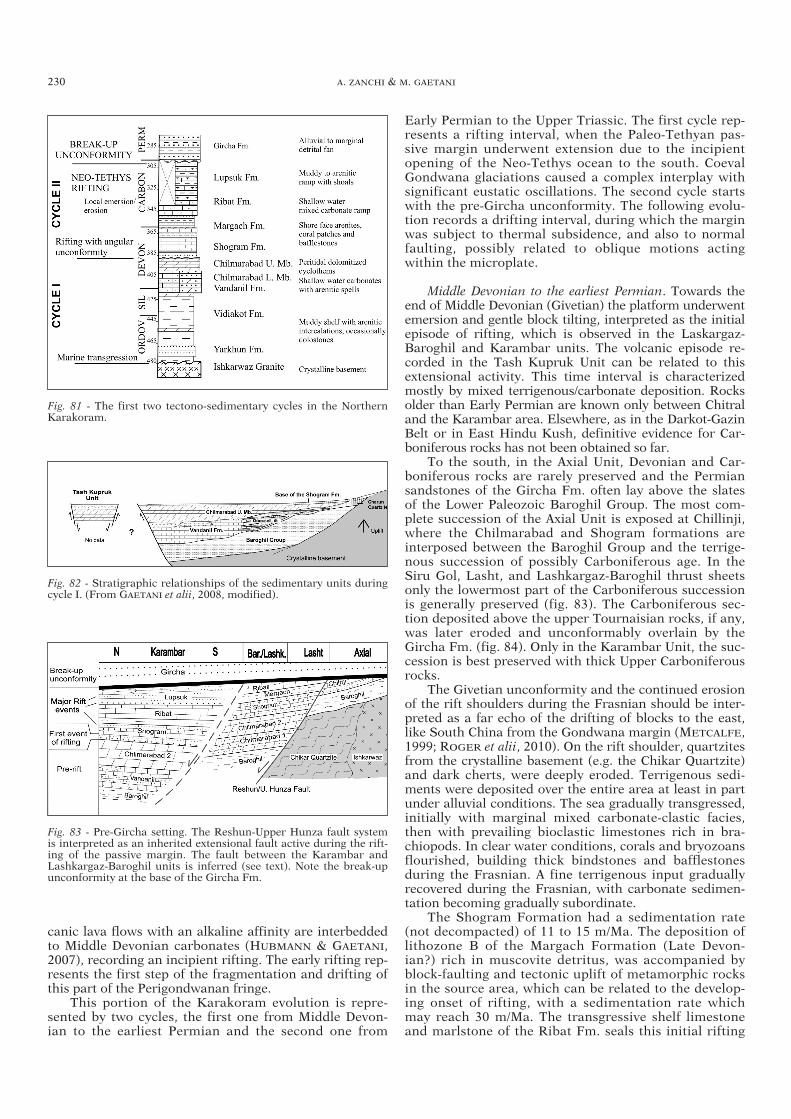
canic lava flows with an alkaline affinity are interbeddedto Middle Devonian carbonates (HUBMANN & GAETANI,2007), recording an incipient rifting. The early rifting rep-resents the first step of the fragmentation and drifting ofthis part of the Perigondwanan fringe.
This portion of the Karakoram evolution is repre-sented by two cycles, the first one from Middle Devon-ian to the earliest Permian and the second one from
Early Permian to the Upper Triassic. The first cycle rep-resents a rifting interval, when the Paleo-Tethyan pas-sive margin underwent extension due to the incipientopening of the Neo-Tethys ocean to the south. CoevalGondwana glaciations caused a complex interplay withsignificant eustatic oscillations. The second cycle startswith the pre-Gircha unconformity. The following evolu-tion records a drifting interval, during which the marginwas subject to thermal subsidence, and also to normalfaulting, possibly related to oblique motions actingwithin the microplate.
Middle Devonian to the earliest Permian. Towards theend of Middle Devonian (Givetian) the platform underwentemersion and gentle block tilting, interpreted as the initialepisode of rifting, which is observed in the Laskargaz-Baroghil and Karambar units. The volcanic episode re -corded in the Tash Kupruk Unit can be related to thisextensional activity. This time interval is characterizedmostly by mixed terrigenous/carbonate deposition. Rocksolder than Early Permian are known only between Chitraland the Karambar area. Elsewhere, as in the Darkot-GazinBelt or in East Hindu Kush, definitive evidence for Car-boniferous rocks has not been obtained so far.
To the south, in the Axial Unit, Devonian and Car-boniferous rocks are rarely preserved and the Permiansandstones of the Gircha Fm. often lay above the slatesof the Lower Paleozoic Baroghil Group. The most com-plete succession of the Axial Unit is exposed at Chillinji,where the Chilmarabad and Shogram formations areinterposed between the Baroghil Group and the terrige-nous succession of possibly Carboniferous age. In theSiru Gol, Lasht, and Lashkargaz-Baroghil thrust sheetsonly the lowermost part of the Carboniferous successionis generally preserved (fig. 83). The Carboniferous sec-tion deposited above the upper Tournaisian rocks, if any,was later eroded and unconformably overlain by the Gircha Fm. (fig. 84). Only in the Karambar Unit, the suc-cession is best preserved with thick Upper Carboniferousrocks.
The Givetian unconformity and the continued erosionof the rift shoulders during the Frasnian should be inter-preted as a far echo of the drifting of blocks to the east,like South China from the Gondwana margin (METCALFE,1999; ROGER et alii, 2010). On the rift shoulder, quartzitesfrom the crystalline basement (e.g. the Chikar Quartzite)and dark cherts, were deeply eroded. Terrigenous sedi-ments were deposited over the entire area at least in partunder alluvial conditions. The sea gradually transgressed,initially with marginal mixed carbonate-clastic facies,then with prevailing bioclastic limestones rich in bra-chiopods. In clear water conditions, corals and bryozoansflourished, building thick bindstones and bafflestonesduring the Frasnian. A fine terrigenous input graduallyrecovered during the Frasnian, with carbonate sedimen-tation becoming gradually subordinate.
The Shogram Formation had a sedimentation rate(not decompacted) of 11 to 15 m/Ma. The deposition oflithozone B of the Margach Formation (Late Devon-ian?) rich in muscovite detritus, was accompanied byblock-faulting and tectonic uplift of metamorphic rocksin the source area, which can be related to the develop-ing onset of rifting, with a sedimentation rate whichmay reach 30 m/Ma. The transgressive shelf limestoneand marlstone of the Ribat Fm. seals this initial rifting
230 A. ZANCHI & M. GAETANI
Fig. 81 - The first two tectono-sedimentary cycles in the NorthernKarakoram.
Fig. 82 - Stratigraphic relationships of the sedimentary units duringcycle I. (From GAETANI et alii, 2008, modified).
Fig. 83 - Pre-Gircha setting. The Reshun-Upper Hunza fault systemis interpreted as an inherited extensional fault active during the rift-ing of the passive margin. The fault between the Karambar andLashkargaz-Baroghil units is inferred (see text). Note the break-upunconformity at the base of the Gircha Fm.
03a ZANCHI txt ok 161-246_GEOLOGIA 29/07/11 09.29 Pagina 230
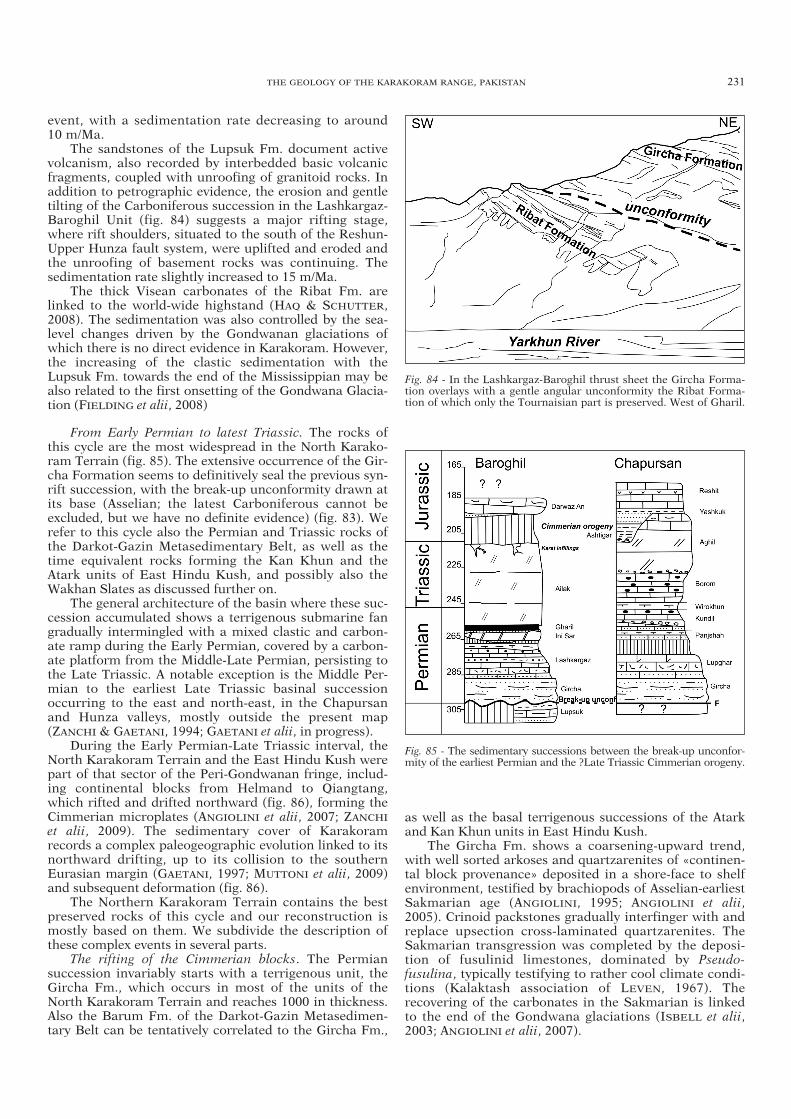
event, with a sedimentation rate decreasing to around10 m/Ma.
The sandstones of the Lupsuk Fm. document activevolcanism, also recorded by interbedded basic volcanicfragments, coupled with unroofing of granitoid rocks. Inaddition to petrographic evidence, the erosion and gentletilting of the Carboniferous succession in the Lashkargaz-Baroghil Unit (fig. 84) suggests a major rifting stage,where rift shoulders, situated to the south of the Reshun-Upper Hunza fault system, were uplifted and eroded andthe unroofing of basement rocks was continuing. The sedimentation rate slightly increased to 15 m/Ma.
The thick Visean carbonates of the Ribat Fm. arelinked to the world-wide highstand (HAQ & SCHUTTER,2008). The sedimentation was also controlled by the sea-level changes driven by the Gondwanan glaciations ofwhich there is no direct evidence in Karakoram. However,the increasing of the clastic sedimentation with the Lupsuk Fm. towards the end of the Mississippian may bealso related to the first onsetting of the Gondwana Glacia-tion (FIELDING et alii, 2008)
From Early Permian to latest Triassic. The rocks ofthis cycle are the most widespread in the North Karako-ram Terrain (fig. 85). The extensive occurrence of the Gir-cha Formation seems to definitively seal the previous syn-rift succession, with the break-up unconformity drawn atits base (Asselian; the latest Carboniferous cannot beexcluded, but we have no definite evidence) (fig. 83). Werefer to this cycle also the Permian and Triassic rocks ofthe Darkot-Gazin Metasedimentary Belt, as well as thetime equivalent rocks forming the Kan Khun and theAtark units of East Hindu Kush, and possibly also theWakhan Slates as discussed further on.
The general architecture of the basin where these suc-cession accumulated shows a terrigenous submarine fangradually intermingled with a mixed clastic and carbon-ate ramp during the Early Permian, covered by a carbon-ate platform from the Middle-Late Permian, persisting tothe Late Triassic. A notable exception is the Middle Per-mian to the earliest Late Triassic basinal successionoccurring to the east and north-east, in the Chapursanand Hunza valleys, mostly outside the present map(ZANCHI & GAETANI, 1994; GAETANI et alii, in progress).
During the Early Permian-Late Triassic interval, theNorth Karakoram Terrain and the East Hindu Kush werepart of that sector of the Peri-Gondwanan fringe, includ-ing continental blocks from Helmand to Qiangtang,which rifted and drifted northward (fig. 86), forming theCimmerian microplates (ANGIOLINI et alii, 2007; ZANCHI
et alii, 2009). The sedimentary cover of Karakoramrecords a complex paleogeographic evolution linked to itsnorthward drifting, up to its collision to the southernEurasian margin (GAETANI, 1997; MUTTONI et alii, 2009)and subsequent deformation (fig. 86).
The Northern Karakoram Terrain contains the bestpreserved rocks of this cycle and our reconstruction ismostly based on them. We subdivide the description ofthese complex events in several parts.
The rifting of the Cimmerian blocks. The Permian succession invariably starts with a terrigenous unit, theGircha Fm., which occurs in most of the units of theNorth Karakoram Terrain and reaches 1000 in thickness.Also the Barum Fm. of the Darkot-Gazin Metasedimen-tary Belt can be tentatively correlated to the Gircha Fm.,
as well as the basal terrigenous successions of the Atarkand Kan Khun units in East Hindu Kush.
The Gircha Fm. shows a coarsening-upward trend,with well sorted arkoses and quartzarenites of «continen-tal block provenance» deposited in a shore-face to shelf environment, testified by brachiopods of Asselian-earliest Sakmarian age (ANGIOLINI, 1995; ANGIOLINI et alii,2005). Crinoid packstones gradually interfinger with andreplace upsection cross-laminated quartzarenites. TheSakmarian transgression was completed by the deposi-tion of fusulinid limestones, dominated by Pseudo-fusulina, typically testifying to rather cool climate condi-tions (Kalaktash association of LEVEN, 1967). Therecovering of the carbonates in the Sakmarian is linkedto the end of the Gondwana glaciations (ISBELL et alii,2003; ANGIOLINI et alii, 2007).
THE GEOLOGY OF THE KARAKORAM RANGE, PAKISTAN 231
Fig. 84 - In the Lashkargaz-Baroghil thrust sheet the Gircha Forma-tion overlays with a gentle angular unconformity the Ribat Forma-tion of which only the Tournaisian part is preserved. West of Gharil.
Fig. 85 - The sedimentary successions between the break-up unconfor-mity of the earliest Permian and the ?Late Triassic Cimmerian orogeny.
03a ZANCHI txt ok 161-246_GEOLOGIA 29/07/11 09.29 Pagina 231

The Bazar Dara Fm. of SE-Pamir shows a comparableage and characters, suggesting a similar depositional envi-ronment for the whole area (LEVEN, 1967) also includingthe Shaksgam Valley in China NE of the Baltoro area,which is part of Karakoram (GAETANI et alii, 1990b, 1991).
The Wakhan Slates «enigma»The Wakhan Slates form a well defined tectono-strati-
graphic unit presently exposed along the boundarybetween East Hindu Kush and Karakoram, from theTirich Mir pluton of Chitral to the Chapursan Valley and
232 A. ZANCHI & M. GAETANI
Fig. 86 - Paleogeographic reconstruction ofPangea, passing from a Pangea B to a Pangea Aconfiguration across Permian and Triassictimes. The star to the northeast of Adria indi-cates the hypothetical location of a ridge-trench-transform (RTF) triple junction adjoin-ing the Gondwana, Laurasia, and Palaeo-Tethysplates. Modified from MUTTONI et alii (2009).
03a ZANCHI txt ok 161-246_GEOLOGIA 29/07/11 09.29 Pagina 232

further east to the Shimshal region out of the study area(ZANCHI & GAETANI, 1994). It consists of a monotonousand thick succession of black slates with thick quartz -arenitic layers, resembling the lower to intermediate partof the Gircha Fm. The Wakhan Slates generally showsouth-verging folds and thrusts which stack them on thenorthernmost units of the Northern Karakoram Terrain.This unit may have been deposited in a large submarineopen fan or in a bay fed by a large emerged continentalarea. We have not found evidence for deposition in aproximal fan fed by turbidity currents.
The age and the source of this impressive amount offine clastic rocks still wait to be defined. Age evidence isscanty. In the Kan Khun Gol, we found a couple of lime-stone intercalations with fairly large spiriferid brachiopods,possibly Paleozoic in age, as well as bryozoans colonies, ofsimilar age (F. BIGEY, Paris, pers. comm.). Undated chertsand crinoid limestones were also found within this unit outof the study area in the Hunza Guhjal (ZANCHI & GAETANI,1994). BUCHROITHNER (1980) found Early Triassic con-odonts within this unit in Wakhan. In a recent map ofTajikistan and surrounding areas also including Wakhanand part of Northern Karakoram (VLASOV et alii, 1991),Russian authors clearly correlate the Wakhan Slates withthe Bazar Dara Formation of SE Pamir, assuming that itwas deposited between Carboniferous and the beginning ofPermian. We thus suggest that the Wakhan Slates are thedistal muddy fans originating from the rifted shoulders ofthe Karakoram and East Hindu Kush/SE Pamir Cimmerianblocks, filling a deep extensional basin with attenuated con-tinental or eventually oceanic crust (fig. 80) which progres-sively separated the two areas since Early Permian times(GAETANI, 1997). The closure of this basin, with the colli-sion of Karakoram and East Hindu Kush, was successivelyrecorded during the first stages of the Cimmerian orogeny(GAETANI et alii, 1993; ZANCHI et alii, 2000). Further evi-dence of the existence of a deep basin are given by the sub-continental mantle serpentinites preserved within the TirichBoundary Zone of western Karakoram. These mantle rockswere possibly exhumed during an important rifting eventwhich can be correlated with the Carboniferous-Permianextension affecting the Perigondwanan blocks.
The drifting. The demise of the Gondwana glaciations(ANGIOLINI et alii, 2003; ANGIOLINI et alii, 2005; STEPHEN-SON et alii, 2007) and the opening of the Neo-Tethys arethe main factors controlling this cycle. Aggrading on theclastic Gircha Formation, a prevailing carbonate sedi-mentation started in the late Sakmarian and continued inthe Artinskian with the deposition of the Lashkargaz Fm.and corresponding units. During the Kungurian a newinput of terrigenous material fed the most complete suc-cession, but gaps and erosion surfaces characterized thereduced sections (ANGIOLINI, 1996a). With the MiddlePermian the succession is more variable and complex,with gaps to the east (Chapursan) and erosional surfacesrecorded at the base of the Ini Sar Fm., in which brecciasand fine conglomerates contain Roadian fusulinids(LEVEN et alii, 2007). The western Karakoram emergedagain around the boundary between Middle and Late Per-mian. Erosion channels were filled with lithic arenitesoverlain by cross-bedded ironstones (Gharil Fm.) withremnants of lateritic soils, indicating subaerial exposureat low latitudes (GAETANI et alii, 1995; LEVEN et alii,2007;), as demonstrated by paleomagnetic data obtained
on a ferricrete (fig. 86), which has given a –1/+1±3 paleo-latitude (MUTTONI et alii, 2009), whereas the Gondwananmargin was still close to 30°S of latitude. Paleontologicalstudies on faunal affinity of Early to Middle Permian bra-chiopods (fig. 87) also suggest that the Neo-Tethys wasalready widely opened by the Middle Permian in order toprevent genetic flux between Karakoram and the Gond-wanan margin (ANGIOLINI et alii, in progress).
The overlying succession is dolomitic for more than600 m and lacks any clastic input. In general, a carbonateperitidal platform extended over the whole Karakoramand East Hindu Kush starting at the end of the MiddlePermian or at the beginning of Late Permian, but datingis often very poor.
The average sedimentation rate for the whole Per-mian was around 50 m/Ma, with a peak in the lower partand a decrease in the upper part of the succession, espe-cially in the north-eastern basinal areas.
The basinal succession. A major differentiationoccurred during the late Middle Permian, when, in theChapursan Valley, the succession records a rapid transi-tion to cherty limestones (Kundil Fm.), which containslate Middle Permian to Upper Permian conodonts (GAE-TANI et alii, 1995). In the Chapursan area, block-faultingis mainly Wordian and Capitanian, with very rare volcan-ism. Thus, in the Late Permian a peritidal carbonate plat-form was developed in the south and west, facing to theNE a deeper basin (fig. 88), which remained deep acrossthe Permo-Triassic boundary and the Triassic until theearly Carnian (GAETANI et alii, in progress).
The recovery of the carbonate platform. In the area ofthe present map, shallow water carbonate sedimentationcontinued at low rate from the Late Permian to the Trias-sic, probably with several gaps. We referred to this inter-val most of the massive carbonate units, both in theNorth Karakoram Terrain and East Hindu Kush. Localemersions caused karstic phenomena in the Permo-Trias-sic carbonate platform.
The basin of the Chapursan Valley was unstable andfrequently fed by distal turbidity currents and breccias.
THE GEOLOGY OF THE KARAKORAM RANGE, PAKISTAN 233
Fig. 87 - Dendrograms obtained by UPGMA cluster analysis showing thechange in the biotic affinity of the Karakoram brachiopod faunas fromthe Early to the Middle Permian (courtesy of ANGIOLINI et alii, inprogress), suggesting fast northward drifting of the Karakoram Terrane.
03a ZANCHI txt ok 161-246_GEOLOGIA 29/07/11 09.29 Pagina 233

Filling and quick return to shallower conditions of thebasin occurred since the early Carnian, when shallowwater carbonate sedimentation initially fed the basin withbreccias, allowing the aggradation of the peritidal carbon-ate platform of the Aghil Fm.
The geodynamic evolution during this Permian- latestTriassic cycle is driven by the drifting of the microplateaccompanying the progressive opening of the Neo-Tethysocean and by the northward subduction of the Paleo-Tethys ocean along the Asian margin (fig. 80). However,the evolution of Karakoram during the Permian was notsimply controlled by thermal subsidence, because severalminor tectonic episodes occurred with local emersion anderosion in the west and basin opening in the east withfault scarps and deposition of huge submarine megabrec-cia bodies. Oblique movements dominated by a transten-sional regime within the Karakoram may have causedthis complex scenario. Volcanic outpour that affected theIndian Plate margin of Neo-Tethys is unknown or is notimportant on the Karakorum side.
7.2.3 The Cimmerian Orogeny
By the end of the Triassic, most of the Karakoram,East Hindu Kush and South-Central Pamir blocks wereclose to the southern Eurasian active margin, now exposedin the North Pamir belts (SCHWAB et alii, 2004). Evidenceof Karakoram approaching to an active margin are givenby the uppermost Triassic-Lower Jurassic deposits of theChapursan Valley, cropping out a few tens of kilometerseast of the mapped area (GAETANI et alii, 1990, 1993;ZANCHI & GAETANI, 1994). Here, the carbonate platformgradually drowned to slope facies and calciruditic bodies.The drowning occurred within the latest Triassic and notin the earliest Jurassic, as previously suggested (GAETANI etalii, 1993). Above the drowned carbonate platform, the are-naceous Ashtigar and Yashkuk fms. occur (Pl. 97). Thequartz-lithic sandstones of the Ashtigar Fm. contain clastsof serpentinite schists, basalts, radiolarite, chlorite schists,phyllite and paragneiss, suggesting erosion of an oceanicsubduction complex close to an arc-trench system. Thesandstones seem to have been deposited in a narrowtrench, bordered by an aggrading ramp. The Jurassic unitsare unconformably overlain by the red sandstones of theYashkuk Fm., containing sedimentary and meta -sedimentary clasts, supplied by the erosion of a forelandfold and thrust belt. The base of this unit was dated to thelatest Pliensbachian (GAETANI et alii, 1993).
In the mapped area, few evidence records the Cim-merian orogeny. In the Lashkargaz-Baroghil Unit dark
thick bedded limestones with large Lithiotis and otherlarge bivalves of the Lower Jurassic Darwaz An Fm. trans-gress the top of the Ailak Fm. which is Triassic in age.Similar Lithiotis beds are possibly present also in theDarkot-Gazin Metasedimentary Belt. In the Lashkargaz-Baroghil Unit, a thin arenitic veneer at the base of theJurassic beds suggests that the western area was onlymarginally reached by the terrigenous inputs (fig. 85).The paleokarst deposits with volcanic fragments andarenitic clasts observed around the Baroghil Pass in theAilak Fm. may be related to emersion of the platform,possibly induced by peripheral bulging of the distal por-tions of the Karakoram block in relations to the Cim-merian events.
The sedimentary record of the Cimmerian events reg-istered within the sedimentary cover of the North Karako-ram Terrain suggests that it was only marginally affectedby this important deformational event. Deep water sedi-mentation occurred only in limited, possibly fault-con-trolled basins, whilst wider areas especially to the westand to the south emerged or had thin shallow watermarine deposits, due to limited subsidence. Further con-strains on the importance of the Cimmerian orogenycome from the Baltoro Region, where SEARLE & TIRRUL(1991) identified a low-pressure, high-temperature meta-morphic event associated to the emplacement of the gran-odioritic protolith of the Late Triassic-Jurassic Hushegneiss with a radiometric age ranging between 208 and to163 and to the problematic mafic to ultramafic rocks ofthe Panmah unit, possibly representing the remnants ofan ancient ophiolitic complex (SEARLE et alii, 1989;SEARLE & TIRRUL, 1991).
Evidence of significant orogenic events during theJurassic also comes form the Tirich Boundary Zone as well as from East Hindu Kush. The Tirich BoundaryZone is a complex rock assemblage extending from theShah Jinali Pass to the SW across Chitral for more than150 kilometers out of the study area. It includes serpen-tinized subcontinental mantle peridotites, metagabbroswith hornblende cumulates, quartzites, amphibolites, andgarnet-sillimanite-biotite gneiss with migmatitic textures.We interpreted it as a fragmented crustal-mantle bound-ary developed along a zone of attenuated continentalcrust (ZANCHI et alii, 2000), possibly related to the open-ing of an oceanic or sub-oceanic basin separating EastHindu Kush from Karakoram. The deposition of theWakhan Slates may be eventually related to the initialstages of the opening of this basin.
The Tirich Boundary Zone can represent a shearedlithospheric section of a possibly Jurassic orogenic com-plex, formed during the accretion of the Karakoram blockto the East Hindu Kush, which may have been part of theSouthern Pamir belts. The Tirich Mir pluton, which hasgiven an U-Pb age on zircon of 121±1 Ma (HEUBERGER etalii, 2007), cross-cuts the TBZ, demonstrating that it wasdeformed in pre-Cretaceous times (fig. 80). The TBZ wasalready juxtaposed to the Atark Unit before the emplace-ment of the Tirich Mir Granite, as suggested by structuralrelationships exposed around the pluton (ZANCHI et alii,2000). Nevertheless, it is still a matter of debate whetherdirect coupling of the units presently forming East HinduKush and the TBZ effectively occurred during the Cim-merian events or later, when Karakoram became theactive southern Eurasian margin (HILDEBRAND et alii,2000, 2001).
234 A. ZANCHI & M. GAETANI
Fig. 88 - Cartoon suggesting the relationships between platform andbasin from late Middle Permian to early Carnian.
03a ZANCHI txt ok 161-246_GEOLOGIA 29/07/11 09.29 Pagina 234

The East Hindu Kush also records an orogenic sub-duction-related magmatism given by the intrusion of theShushar Granite with a 171±3.4 Ma K-Ar age (GAETANI etalii, 1996) and by the emplacement of subduction relatedgranitoids and medium grade metamorphism in theregion west of the Tirich Mir, associated with the forma-tion of a D1 penetrative axial plane foliation (HILDEBRAND
et alii, 2001). The same authors also obtained a 194.6±0.91Ma U-Pb monazite age on a deformed leucogranite dikefrom the upper Lutkho Valley (Tirich Mir region), indicat-ing an important Early Jurassic phase of crustal melting.
The nearest area showing severe Cimmerian deforma-tion occurs northward in SE Pamir in the Alitchur moun-tains, where important deformation, followed by ophioliteemplacement and granitoids intrusion, occurred at theend of the Triassic (DRONOV, 1986; PASKOV & SHVOLMAN,1990; BURTMAN & MOLNAR, 1993).
7.2.4 The Cretaceous Andean-type margin of Karako-ram and its collision with the Kohistan Paleo-Arc
Following its docking to the Asian margin, the Kara -koram was controlled by the Neo-Tethys evolution, by itsprogressive closing and coeval opening of the IndianOcean (fig. 80).
Between the end of Middle Jurassic and the earliestCretaceous, tectonic activity significantly decreased in theNorth Karakoram Terrain. We have no data for this timeperiod on the area of this map, but in the Chapursan Val-ley a shallow water carbonate ramp (Reshit Formation)aggraded onto the previously emerged area during theAalenian, where also coal seams and evaporitic layers havebeen found (GAETANI et alii, 1993: DONNELLY, 2004). Inthe same area, deep water limestones with lowermost Cre-taceous nannofloras also occur (GAETANI et alii, 1990a).
At about 130 Ma, the Indian Plate began its fly toEurasia (SCHETTINO & SCOTESE, 2005). Starting sincemid-Cretaceous times, an impressive calcalkaline subduc-tion-related magmatic activity resulted in the emplace-ment of the Karakoram Batholith (fig. 90), extending E-Wfor hundreds of kilometers between the Chitral and Bal-toro regions (DESIO & ZANETTIN, 1970; DEBON et alii,1987b; SEARLE, 1991; DEBON & KHAN, 1996; LE FORT &GAETANI, 1998; LE FORT & PECHER, 2002). The batholithconsists of several subduction-related large plutons,mainly granitic to granodioritic in composition, whichwere intruded in mid-Cretaceous times along the south-ern portion of the North Karakoram Terrain and in theGazin-Darkot Metasedimentary Belt between 105.7 and95 Ma (DEBON et alii, 1987b; FRASER et alii, 2001). A sep-arate belt of granitic intrusions also occurs southward(Ghamu Bar-Buni Zom Belt, fig. 11). Similar ages alsocome from the K2 gneiss which have given an U-Pb zir-con age of 115±3 Ma (SEARLE et alii, 1989). Isolated plu-tons also occur northward in the East Hindu Kush, wherethey cross the Tirich Boundary Zone (Tirich Mir Granite)and the Wakhan Slates (CRAWFORD & SEARLE, 1992;ZANCHI, 1993; DEBON, 1995), as well as in the NorthernKarakoram Terrain (DEBON et alii, 1996; LE FORT & GAE-TANI, 1998). Large Cretaceous intrusive bodies are alsopresent to the north in Wakhan and in SE- and SW-Pamir(PASHKOV & SHVOLMAN, 1990) and have been related to anorth-directed low-dipping subduction below Karakoram(SCHAUB et alii, 2004). This magmatic activity stops withthe emplacement of the Koz Sar pluton, an alkaline com-
plex exposed along the Karambar Valley, which has givena Rb/Sr age of 88 Ma (DEBON & KHAN, 1996). This plutonhas been considered as the ultimate member of the sub-duction-related Cretaceous magmatism (fig. 90).
Geochemical signature and paleogeographic recon-struction generally suggest that they can be related to theactivation of an Andean-type margin along the southernedge of the Eurasian Plate, all along the present-dayKarakoram region. North-directed subduction of oceaniclithosphere interposed between the Asian margin and the Kohistan Paleo-Arc triggered this magmatic activityduring a well defined time interval, spanning approxi-mately between 130 and 100 Ma (DEBON et alii, 1987a,b;HEUBERGER et alii, 2007; SEARLE et alii, 1989). The sub-
THE GEOLOGY OF THE KARAKORAM RANGE, PAKISTAN 235
Fig. 89 - The main eustatic and tectonic episodes recorded in thesedimentary succession of the Northern Karakoram Terrain. Themajor tectonic events are indicated with bold lines. To be noted theevidence of successive local tectonic events, most probably linked toextensional tectonics accompanied by block rotations around theMiddle Permian. Correlation of Tethyan to Global scale for the Per-mian is made according to LEVEN et alii (2007). Scale after GRAD-STEIN et alii (2004).
03a ZANCHI txt ok 161-246_GEOLOGIA 29/07/11 09.29 Pagina 235

ducted lithosphere has been either related to a back-arcsetting (PUDSEY et alii, 1985), or to the northern portionof the Neo-Tethys ocean (North Neo-Tethys), which wasisolated from the southern one by the formation of Kohis-tan in an intraoceanic setting since the Jurassic (KHAN
et alii, 2009). Cessation of the subduction of the Neo-Tethys lithosphere below Karakoram occurred the duringthe Late Cretaceous, as suggested by a sudden stop ofmagmatism, which has been related by most authors tothe Karakoram-Kohistan collision (HEUBERGER et alii,2007). During the same time period, part of the sedimen-tary succession of the North Karakoram Terrain was
deformed, forming the «Cretaceous Karakoram Range».Compressive structures resulting from an importantphase of shortening are sealed by a polymict conglomer-ate, in spectacular unconformities (GAETANI et alii, 1990a,1993). An angular unconformity up to 90° was firstlydescribed in the Tupop Valley within the easternmostportion of the Sost Unit (GAETANI et alii, 1990a; ZANCHI &GRITTI, 1996), where deformed Permian to Jurassic for-mations underlie the Tupop Conglomerate, which is inturn unconformably covered by the Campanian red marlsof the Darband Fm. (GAETANI et alii, 1993). The E-W-trending folds affecting the mid-Cretaceous belt seem to
236 A. ZANCHI & M. GAETANI
Fig. 90 - Summary of the evolution of Karakoram based on structural, magmatic, metamorphic and sedimentary record across the area.
03a ZANCHI txt ok 161-246_GEOLOGIA 29/07/11 09.29 Pagina 236

be northfacing, suggesting north-directed tectonic trans-port during the closure of the Kohistan-KarakoramSuture Zone, as indicated by COWARD et alii (1986). Thesame unconformity is well exposed across the easternpart of the Sost Unit around Chillinji. The Tupop Con-glomerate contains fragments of carbonate, clastic andalso of acidic volcanic rocks.
A similar, probably coeval, unconformable clastic suc-cession, represented by the Reshun Conglomerate (HAY-DEN, 1915; PUDSEY et alii, 1985), is exposed in the AxialUnit along the footwall of the Reshun Fault system fromChillinji to the Chitral region. In the mapped area, theunconformity is generally less pronounced than in the NEregions. The Reshun Conglomerate, often more than 1000m thick, also contains clasts of sedimentary rocks comingfrom the sedimentary cover of Karakoram as well as a fewclasts of acidic volcanic rocks, which were deposited influvial settings and in submarine fans. Out of the studyarea, in Chitral, the Reshun Conglomerate unconformablycovers different tectonic units (figs. 11, 80), which werejuxtaposed along the southern active margin of Karako-ram before the deposition of the Reshun Formation. Here,the Reshun Formation contains clasts of slates derivingfor the Chitral Slate (?Cretaceous), from the KoghoziGreenstone belt of Chitral, and a few granite pebbles andacidic to intermediate volcanic rocks (PUDSEY et alii,1985). Layers of upper Aptian limestones and arenites,unconformably laying below the Reshun Formation inChitral inequivocally suggest a post-Aptian age for theReshun Fm. Additional evidence for a pre mid-Cre taceousdeformation in the Northern Karakoram units comesfrom the Guhjal Unit, as it is intruded by the GarmushGranite which is part of the mid-Cretaceous subduction-related Karakoram Batholith. In addition, intrusive rela-tionships between the Wakhan Slates and mid-Cretaceousintrusives of the northern Hunza region indicate that theywere already deformed before the emplacement of thesemagmatic bodies (ZANCHI, 1993; DEBON et alii, 1996).
In East Hindu Kush, an important metamorphicevent related to a D1 deformation giving isoclinal foldsand penetrative foliations pre-dates the emplacement ofthe Tirich Mir granite in the Gharam Chasma area (fig.90). HILDEBRAND et alii (2001) obtained U-Pb monaziteages of 135-126 Ma on staurolite-schists, which are cross-cut by younger Tirich Mir pluton-related pegmatite dikesgiving an U-Pb 114±2 Ma age. The Dorah Pass granitealso gave a similar Rb-Sr biotite age of 96-89 Ma (DESIO,1964b). In addition, within the East Hindu Kush cover,the Shah Jinali Metabreccia, a body of coarse-grained,poorly rounded and monogenic clasts consisting of car-bonate fragments, severely-deformed in low grade condi-tions, may be tentatively correlated with the clastic suc-cessions of the Reshun Fm., representing the firstproducts of erosion of the emerging range. Sparse out-crops of red conglomerates also occur in Wakhan, and inSE Pamir, where they are also associated to acidic vol-canic deposits (PASHKOV & SHVOLMAN, 1990).
The Reshun/Tupop unconformity marks an importantorogenic event which caused severe shortening and upliftof the sedimentary cover of Karakoram; metamorphic andintrusive rocks found by PUDSEY et alii (1985) out of thestudy area suggest that the SW portion of Karakoram wasalready deformed and metamorphosed before the deposi-tion of this unit. Most of the authors relate this event tothe collision of the Kohistan Arc with Karakoram, which
is also marked by the coeval sudden cessation of the mag-matic activity (GAETANI et alii, 1990a, 1993; ZANCHI, 1993;ZANCHI & GRITTI, 1996; DEBON et alii, 1987b).
During the same time period, an important deforma-tional event (D1) accompanied by the formation of silli-manite-grade migmatitic gneisses (M1) affected theKarakoram Metamorphic Complex of the Hunza Valleybetween 82.9±6.1 and 61.9±4.7 Ma, as suggested by U-Pbradiometric ages from metamorphic monazites (FRASERet alii, 2001). These authors related this event to the colli-sion and accretion of the Kohistan Arc to Karakoram andto the consequent closure of the Kohistan-KarakoramSuture Zone (figs. 80, 90).
An alternative hypothesis was recently suggested byKHAN et alii (2009), who related the early deformation ofthis area to the accelerated subduction of the Neo-Tethysbelow the southern Asia active margin, due to the fastspreading of the Indian Ocean. According to this model,India firstly collided with the Kohistan Arc, which wasdefinitively accreted to the Eurasian margin only in thelate Cenozoic.
7.3 The Cenozoic evolution of Karakoram
After the deposition of the Upper CretaceousReshun/Tupop conglomerates, several important deforma-tional events affected the whole mapped area, especiallywithin Karakoram (fig. 80). A definitive chronology of thedifferent events is still difficult to be established as very fewtime-markers are available. Nevertheless, a comparisonwith the evolution of the surrounding regions, especiallywith the metamorphic basement of Karakoram which hasbeen extensively studied and dated in the Hunza Valley andin the Baltoro region (FRASER et alii, 2001) helps to frameour results into a general reconstruction.
7.3.1 The Cenozoic evolution the Karakoram Meta-morphic Complex (and East Hindu Kush)
According to FRASER et alii (2001), high-grade meta-morphism producing sillimanite-gneiss in the Hunza Val-ley across the Cretaceous Paleogene boundary was strictlyfollowed in time by crustal partial melting between56±0.3 Ma and 53.4±0.3 Ma and by a renewed sillimanite-grade metamorphism, occurring at 44±2 Ma. This eventwas related to continuous crustal thickening due to theIndia-Eurasia collision which occurred during Eoceneafter the accretion of the Kohistan Arc (FRASER et alii,2001). Further age constrains for this syn-collisionaldeformation come from the emplacement of the LowerCenozoic granitoids including the Kuk pluton which hasgiven a WR Rb/Sr age of 63.4±2 Ma (DEBON, 1995) andthe Batura pluton with an average K-Ar age of 43±3 Ma (4 samples) and a 45±7 Ma age (5 samples) obtained byDEBON et alii (1987b). Some of these plutons cross-cutthe mid-Cretaceous Hunza batholith, as well as deformedmetasediments of the Guhjal Unit (ZANCHI, 1993; DEBON,1995) between the Chapursan and Hunza valleys (fig. 90).
Leucogranite dikes with an U-Pb interpreted age onzircons of 50-52 Ma (Hunza dikes, set 1, FRASER et alii,2001) were also deformed during this stage, which hasbeen recently reconsidered as a later D2 stage (SEARLE etalii, 2010) causing S-verging thrusting of the Hunza Plu-tonic Unit upon the Upper Cretaceous high-grade silli-manite-gneiss. LE FORT & PECHER (2002) question the
THE GEOLOGY OF THE KARAKORAM RANGE, PAKISTAN 237
03a ZANCHI txt ok 161-246_GEOLOGIA 29/07/11 09.29 Pagina 237

occurrence of important north-dipping shear zone stack-ing southward the high-grade gneiss of the Hunza Valley.On the other hand, they recognized extensive isoclinalfolding within the Karakoram Metamorphic Complex,which can be responsible for inversion and disturbancesof the metamorphic isogrades observed by previousauthors (FRASER et alii, 2001; SEARLE et alii, 2010). In anycase, these rocks are in turn cross-cut by a younger gener-ation of undeformed granite dikes (Hunza dikes, set 2)which were emplaced at around 35 Ma (FRASER et alii,2001: U-Pb zircon age of 34.5±0.5 Ma and U-Pb monaziteage of 35.4±0.5 Ma).
Extensive crustal melting occurred in the easternmostportion of the Karakoram region between 26 and 21 Ma,when the Miocene Baltoro granite was emplaced. Recentdating of the Baltoro granites suggests that they werewere emplaced through a long time period, spanningbetween the intrusion of the Mango Gussar and theyounger Trango Towers and Biale Cathedral plutons(SEARLE et alii, 2010). In this area the undeformed MangoGussar, dated at 26.4±1.3 Ma (allanite Th-Pb age, FRASERet alii, 2001), and a regional leucogranite dike networkgiving a 24.7±3.6 Ma (SEARLE et alii, 2010) also cut previous kyanite-metapelites related to the M3 metamor-phic event which have given an U-Pb monazite age of28±0.5 Ma (FRASER et alii, 2001). The youngest granitesof the Baltoro Complex have given U-Pb ages on monazitearound 13 Ma (SEARLE et alii, 2010)
A similar event also occurred in East Hindu Kush,where extensive migmatization, was associated with theemplacement of the Gharam Chasma pluton at 24±0.5Ma, according to U-Pb monazite ages (HILDEBRAND etalii, 1998). Crustal melting was associa ted with an impor-tant D2 deformational event, associated with folding ofthe previous foliations and syn-intrusion thrusting(HILDEBRAND et alii, 2000). A final transpressional eventis well-documented across the whole Chitral region fromEast-Hindu Kush to the Karakoram Kohistan SutureZone (HILDEBRAND et alii, 2000; ZANCHI et alii, 2000;HEUBERGER et alii, 2007, 2010), post dating the emplace-ment of the Gharam Chasma granite. Similar conclusionsare also provided by fission track ages, suggesting that noor little vertical movements were active across the KKSZsince 20-13 Ma, due to the occurrence of dominant strike-slip motions (HEUBERGER et alii, 2010).
On the other hand, no intrusive rocks of this age areknown from central Karakoram, as magmatism waschiefly related to the external margins of the block. Closespatial and time relationships are evident among extensivecrustal melting, mountain uplifting (K2-Broad Peak belt inthe east and Tirich Mir Massif in the west) and the posi-tion of the intracontinental left- and right-lateral wrenchfault systems bordering the northern corner of the Indianindenter. A direct connection between tectonic activity of the Karakoram fault and magma emplacement wasalready postulated several years ago by POGNANTE (1990),suggesting that the emplacement of shoshonitic to ultra-potassic dykes around the Shaksgam Valley, northernKarakoram (China) was triggered by extensional compo-nents acting along this structure, favouring magma ascent.
A much younger Miocene metamorphism eventaffected the southern portion of the Karakoram metamor-phic complex in the Hunza Valley (staurolite-grade eventwith an U-Pb monazite age of ca. 16±1 Ma, FRASER et alii,2001), which reflected the S-verging thrusting of the silli-
manite-gneiss, and was at least in part coeval with a D3
deformation associated with the emplacement of domestructures north of the Main Karakoram Thrust. D3 fab-rics are in turn cross-cut by the Sumayar pluton, a smallundeformed two-micas leucogranite giving an U-Pb ageof 9.3±0.2 Ma (FRASER et alii, 2001). A similar history isrecorded in the Baltoro region, where a slightly olderkyanite-grade metamorphism (M2) occurred south of theBaltoro granite as recorded by kyanite metapelites givingan U-Pb monazite age of 28.0±0.5. In this area, recentmetamorphism (M4) affects the high-grade sillimanite-gneiss of Dassu, which has given several radiometric agesclose to 5 Ma (FRASER et alii, 2001) and was coeval withdome formation in the hanging wall of the Main Karako-ram Thrust. Domal structures occurring in the SE portionof Karakoram have been described by LEMMENICIER etalii (1996) and LE FORT & PECHER (2002), who recog-nized the occurrence of sillimanite-gneiss overprintingprevious minerals associations as well as the occurrenceof magmatic bodies of syenite and leucotrondhjemitecomposition showing strong mantle affinity. A complexpattern of Ar-Ar radiometric ages obtained on biotite andhornblende ranging from 3.0 to 7.7 Ma (VILLA et alii,1996) together with monazite U-Pb ages of 5.4±0.2 Mafrom the Dassu orthogneiss related to partial melting dur-ing high-grade metamorphism (FRASER et alii, 2001) sug-gest an impressively rapid exhumation of the Karakorammountains which has been related to the activity of theMain Karakoram Thrust. Dextral motions also occurredalong this major fault zone, accompanying the verticalextrusion of the metamorphic rocks (LEMMENICIER et alii,1996). Final D4 brittle deformation, assigned to Pliocene-Quaternary times, caused a retrograde greenschist faciesoverprint and the ultimate uplift of the Karakoram Meta-morphic Complex which is still active.
7.3.2 Cenozoic deformation in the Northern KarakoramTerrain
Several different deformational events have been rec-ognized within the sedimentary cover of Karakorambased on a relative chronology (tab. 2). The occurrence ofdeformed mid-Cretaceous intrusive rocks and Upper Cre-taceous sedimentary units within the thrust stack, sug-gests that most of the tectonic structures presentlyexposed in the belt formed during its Cenozoic tectonicevolution. The complex deformational evolution of theNorthern Karakoram Terrain can be summarized intothree main stages: 1) thrust stacking, 2) normal faulting,3) strike-slip tectonics.
Thrust stacking. The structural framework of themapped area is dominated by the occurrence of severaltectonostratigraphic units forming a complex thrust pileinteracting with the rigid batholiths of Karakoram and East Hindu Kush and with the Tirich Boundary Zone(fig. 91). A reconstruction of the structural evolution ofthe thrust stack has been proposed for the adjoiningHunza area, where the Wakhan, Sost and Guhjal unitsare also exposed (ZANCHI, 1993; ZANCHI & GAETANI, 1994;ZANCHI & GRITTI, 1996). According to these authors,stacking of NE- to N-verging thrusts sheets postdates thedeposition of the Upper Cretaceous Tupop Fm., as it isdeeply deformed within the thrust pile. These imbricatesare in turn intruded by the Paleogene Kuk pluton and by
238 A. ZANCHI & M. GAETANI
03a ZANCHI txt ok 161-246_GEOLOGIA 29/07/11 09.29 Pagina 238

THE GEOLOGY OF THE KARAKORAM RANGE, PAKISTAN 239
TABLE 2
Synthesis of the main deformational events recognized within the mapped units.
RELATIVE CHRONOLOGY RECOGNIZED IN EACH TECTONIC UNIT
Wakhan SlatesE-W tight folds with slatycleavage
Lunko – Baba TangiGranodiorite, ShusharGranite
S-verging thrusts
Atark Unit D1 Isoclinal foldsIntrusion of RuaGranodiorite
D2 NNE-SSW toNE-SW and E-Wclose to tightfolds; SE- to S-verging thrusts
Kan Khun Unit E-W parallel folds, S-vergingthrusts
Tirich Boundary
Zone
Schistose serpentinites witholivine and pyroxene relicsK-feldspar sillimanite gneiss,Amphibolites
Greenschist retrogressionSE-vergingthrusts
Tirich Mirintrusion (121 MaU-Pb)
Left-lateralNE-SW faults
Shah Jinaly
Phyllite
M1: Garnet-muscovite-meta-pelite with an S1foliation
M2 retrogression withstilpnomelane on an S2crenulation cleavage. NE-SW fold axes
Chloritoid staticovergrowth
Left-lateral NE-SW faults
Tash Kupruk
Unit
M1: low greenschist faciesmetamorphism with D1isoclinal folds, followed bySE- to S-verging thrusts
Post-thrust folds at Chillinji;D2 open to close folds atKan Khun
Left-lateral NE-SW faults with D3vertical kink folds
Siru Gol Unit
D1 E-W to ENE-WSW folds.Post-Reshun Fm. S- to SE-verging thrusts alongReshun fault
Inversion of the Reshunfault with normal faulting
Left-lateral NE-SW faults
Lasht Unit D1 E-W to ENE-WSW folds,S- to SE-verging thrusts
Left-lateral NE-SW faults
Lashkargaz-
Baroghil Unit
E-W to ENE-WSW folds, S- to SSE-verging thrusts;
D2 ESE-WNW post-thrustfolds along the ChiantarGlacier causing W-plungingfolds; post-Cretaceous N-NE verging thrust of the KB
Post-Reshun E-Wleft-lateral faults
Karambar Unit
D1 NNW-SSE to NW-SWfolds, WSW to SW-vergingthrusts;
D2 E-W post-thrust foldsalong the Chiantar Glacier;post-Cretaceous N-, NE-verging thrust of the KB
NNE-SSW left-and E-W right-lateral faults andN-verging thrusts
Chhateboi Unit D1 WNW-ESE folds Chhateboi Granite,intrusion-related doming
post-Tupop N-verging thrusts
Sost Unit
pre-Tupop D1 E-W foldsand thrust (Borom valley,Chapursan, out of themapped area)
post-Tupop E-W folds andN-verging thrust
S-verging thrustalong the contactwith the WakhanSlates (Kilik Fault)
Axial Unit
Folding in low greenschistfacies Chikar Quartzites(pre-Ordovician)
Intrusion of Ishkarwaz-typegranodiorite (pre-Ordovician)
Pre-Reshun Fm.deformation:angularunconformity(10°-15°)
SE-vergingthrusts with axialplane cleavage inReshun Fm.
Inversion ofReshun Faultwith normalmotionsfollowed bystrike-slipmotions
Guhjal UnitD1 Isoclinal folds with verylow grade metamorphism
KB intrusion (GarmushGranite, Hunza plutonicunit)
D2 E-W folds
Intrusions of KozYaz GlacierGranite, ChiantarGlacierGranodiorite
N- and S-vergingthrust
TE
CT
ON
IC U
NIT
S
03a ZANCHI txt ok 161-246_GEOLOGIA 29/07/11 09.29 Pagina 239

other minor intrusives related to the Paleogene BaturaUnit. These deformations were related by ZANCHI (1993)to the activation of a fold and thrust belt along the exter-nal part of an Andean-type margin as a consequence ofnorthward subduction of the Neo-Tethys beneath thesouthern margin of the Karakoram. Northward thrustingof the cover can be related to the formation of a retrobeltin a back-arc position north of the magmatic arc, repre-sented by the Karakoram Batholith. S- to SSE-vergingthrusting was successively active, stacking steep north-dipping thrust sheets along the northern side of the SostUnit, forming a complex antiformal stack with dextraltraspressional components along its eastern termination.During this stage, the Wakhan Slates were emplacedsouthward upon the Sost Unit. This phase was related(ZANCHI, 1993) to crustal thickening following the India-Eurasia collision. The thrust systems related to this eventare geometrically consistent with the Main KarakorumThrust, deforming the Hunza Metamorphic Complexesand the southern part of the mid-Cretaceous Hunza plu-tonic unit. Southward motion along the MKT was activesince the closure of the Indus Suture (REX et alii, 1988;SEARLE & TIRRUL, 1991) and continued up to recenttimes (LEMMENICIER et alii, 1996).
The tectonic complexity of the mapped area, withrespect to the Hunza region, has been described in previ-ous sections and is mainly related to the occurrence of a
large number of tectonostratigraphic units characterizingthe central-western portion of the Karakoram. The firstmain difference with the Hunza region consists in the ageand composition of the thrust sheets. A large number ofthe tectonostratigraphic units of the study area includesan almost complete Paleozoic succession which is oftenin continuity with Permo-Triassic rocks. In central-east-ern Karakoram a major detachment occurs at the base ofthe Gircha Formation, which corresponds in our interpre-tation to the break-up unconformity, determining theoccurrence of only Permian to Mesozoic successions. Inaddition, south of the Reshun-Chiantar-Chillinji fault sys-tems a pre-Ordovician crystalline basement is largelyexposed, suggesting a thick-skinned style for this portionof the belt. The occurrence of a pre-Ordovician basementis probably related to the Paleozoic to Mesozoic paleogeo-graphic setting during which a structural high developedsouth of the Reshun Fault in its footwall. Inversion ofthese extensional structures determined the difference instructural style across the Reshun and related fault sys-tems. In addition, as the central section of the mappedarea is characterized by almost dip-slip thrust motionsdue to a N-S to NNE-SSW trending shortening, the west-ern part of the area is strongly influenced by left-lateraltranspressional motions along NE-SW fault zones, whichcan be related to the shearing of the NW border of theIndian indenter. A marked rotation of the main structures
240 A. ZANCHI & M. GAETANI
Fig. 91 - Synthetic scheme showing the architecture of the thrust sheets of the northern Karakoram Terrain and their relationships with thesurrounding units.. Cross sections approximately trending N-S and traced from west to east, with reference to fig. 12. Not to scale.
03a ZANCHI txt ok 161-246_GEOLOGIA 29/07/11 09.29 Pagina 240

is also evident west of Kan Khun, and especially along theRich Gol and the lower Yarkhun Valley, where E-Wtrending thrust surfaces are deflected into a NE-SWtrend, possibly due to large post-?Miocene anticlockwsieblock rotations.
Complex relationships among thrust sheets can benoticed in several parts of the study area. They may bedue to different phenomena which have been described inmore detail in the previous chapters. Partial inversion ofprevious normal faults (Reshun Fault), folding and subse-quent reactivations of thrust surfaces during three differ-ent collisional stages (Cimmerian, Kohistan, India) fol-lowed by indentation phenomena causing extension andleft-lateral shearing may account for some complex struc-tural relationships.
Huge thrust sheets, representing single nappes, as theTash Kupruk Unit, were probably emplaced in the centralarea during the first stages of crustal shortening (fig. 91).Their occurrence is testified by the Chillinji klippe formedby the Tash Kupruk Unit, which is only exposed far-off, atleast 50 km to the west. We suggest that it may representthe oldest thrust sheet due to its position at the top of thestack. The klippe also records subsequent folding andback-thrusting/back-folding at Chillinji, indicating a longpost-emplacement deformational history of the belt. Thecontinuity of the Tash Kupruk Unit across the westernside of the belt may be related to a subsequent out-of-sequence reactivation of its floor thrust. Polyphase foldsand thrust stacking as well as folds deforming previousthrust surfaces have been recognized in several areas,especially along the contact between the Karambar andLashkargaz-Baroghil units in the Chiantar Glacier area,which has been refolded. These phenomena suggest com-plex and long-living thrust imbrication processes (tab. 2),consistent with the evolution of the Karakoram Metamor-phic Complex which records a continuous shortening andcrustal thickening, due to repeated collisional events.
N- to NNW-directed tectonic transport is restricted tothe Sost and Guhjal units which form the western contin-uation of the Sost antiformal stack of the Hunza area,where detailed mapping and structural analyses were per-formed in the past (ZANCHI & GRITTI, 1996). In the maparea, these units generally show similar structural fea-tures, with S-dipping thrust surfaces. The Tupop Fm.shows N-verging overturned folds within the stackexposed along the southern slopes. Northward thrustingof the Karakoram Batholith is also evident within the leftside of the Chiantar Glacier along the Chiantar-ChillinjiFault (fig. 79) and at Chillinji (fig. 79). Also in this areadeformational structures of the Guhjal Unit are cross-cutby undeformed granodioritic bodies which may berelated to the Batura Unit of the Hunza region. The NEportion of the Karambar Unit also shows N-vergingthrusts exposed along the right side of the upper Karam-bar Valley.
The main directions of thrusting deduced fromobserved meso- and megascopic structures suggest a topto the S and SSW in the central area, turning to SE andESE in the western part. Bedding attitude and axial planefold cleavages obtained from field analyses of thrust-related folds indicate dominant ENE-WSW- to ESE-WSWtrends, with N-NW dipping axial planes cleavage consis-tent with the direction of thrust propagation. The mainexception is given by WSW-verging thrusts and foldslocally occurring in the Karambar Unit north and west
of Lake Karambar (fig. 38). Well-exposed E-W trending S-verging thrust structures can be observed between the Karambar and Lashkargaz-Baroghil units in theLashkargaz area (figs. 27, 28; Pls, 27, 28), where duplexstructures and fault propagation folds formed during S-vergent thrusting.
Out-of-sequence thrusting may be related to the reac-tivation of some of the major fault zones forming theboundary between the Northern Karakoram Terrain andEast Hindu Kush-Wakhan. This may be the case of theKilik Fault, which shows a continuous trace across thewhole region, possibly resulting by its repeated reactiva-tion during the evolution of the belt.
Similar structures can be observed also in the EastHindu Kush, especially within the Atark Unit, which alsosuffered a polyphase deformation. It shows, in fact, isocli-nal folds refolded by open to close fault-related folds dueto ESE- and SE-directed thrusting, which may be relatedto the Cenozoic evolution of the belt.
Extensional tectonics. In spite of the dominance ofcompressive structures due to crustal shortening, we alsorecognized important regional normal faults causing adelamination of the previously formed thrust pile. Twomain fault zones show important normal movements: theReshun Fault along the Yarkhun Valley and the Thui PassFault south of Gazin.
Inversion of the Reshun Fault system was recognizedaround the Shost village, where thrust related folds andaxial plane foliations have been refolded by W-NW verg-ing open folds with subhorizontal axial planes gently dip-ping to NW (figs. 77, 78) suggesting a top to the NWshearing. Fold style is very similar to the one describedfor the extensional back-sliding of the Kohistan Paleo-Arcalong the Main Mantle Thrust (BURG et alii, 1996), whichhas been interpreted as a syn-convergence collapse fea-ture. Secondary synthetic normal fault also deform thehanging wall of the fault delaminating the exposed Paleo-zoic succession in the Siru and Paur Gol area.
Nice structures related to this event are also exposedin front of the Baroghil village along the left side of theupper Yarkhun Valley, where delamination of the foot-wall is enhanced by the occurrence of Permian carbon-ates directly on the Lower Paleozoic slates of the VidiakotFm. Left-lateral strike-slip faults are superimposed to nor-mal faults in both areas. Small NW-dipping high-anglenormal faults also cross-cut the Upper Paleozoic succes-sions of the Lashkargaz-Baroghil Unit above the Baroghilhouses north of the Vidiakot area.
We also noticed faulted contacts among the ChikarQuartzite, the Baroghil Group and the overlying Permo-Mesozoic limestones of the Axial Unit at Kan Khun with apossible normal displacement. Nevertheless, pervasivereactivations of the main contact by a left-lateral strike-slip fault zone prevent further considerations.
WSW-ENE trending NNW-dipping normal faults alsoaffect the Ordovician successions of the Axial Unit east ofthe Shost-Lasht area, which have collapsed westwardalong the contact with the underlying basement (LE FORT& GAETANI, 1998).
Important orogen-parallel N-S extension occurred inthe south-western margin of the study area next to theThui Pass normal fault along which the Darkot-GazinMetasedimentary Belt collapsed into a deep half-grabenaccompanied by the formation of one of the most contin-
THE GEOLOGY OF THE KARAKORAM RANGE, PAKISTAN 241
03a ZANCHI txt ok 161-246_GEOLOGIA 29/07/11 09.29 Pagina 241

uous pseudotachylyte horizons ever known (LE FORT &GAETANI, 1998). This low angle detachment, which washypothesized in several previous works (SEARLE & TIR-RUL, 1991), is responsible for the preservation of the lowgrade metasediments of the northern part of Karakoramand can explain the strong difference in metamorphicconditions between the high-grade metamorphic unitsexposed to the south of the mid-Cretaceous batholith andthe very low-grade metasediments occurring to the north.
Significant orogen parallel extensional collapse canbe ascribed to gravitational instability of the belt due tohigh rates of crustal thickening occurring since the India-Eurasia collision (fig. 90). These normal faults can bedirectly compared at a smaller scale to the South TibetanDetachment affecting the High Himalayas (BURCHFIEL etalii, 1992), or to the extensional fault systems active sincethe Miocene in the Pamirs (SCHAUB et alii, 2004; HACKER
et alii, 2011; STÜBNER et alii, 2011).
Strike-slip tectonics. The activation of E-W-trendingsinistral strike-slip fault systems, generally post-datingthrust emplacement, has been previously described in theChapursan and Shimshal valleys out of the study area(ZANCHI, 1993; ZANCHI & GRITTI; 1996). Left-lateral faultsare also very important in the mapped area, where someof the main fault systems are characterized by strike-slipmotions. E-W left-lateral movements characterize theintermediate portion of the Chiantar-Chillinji Fault sys-tem linking the Reshun to the Upper Hunza Fault. E-Wleft-lateral shear zones were also active along the north-ern boundary of the Karakoram Batholith in ductile con-ditions, forming large mylonitic zones marking the tec-tonic contact between the Cretaceous intrusives and thesedimentary cover (LE FORT & GAETANI, 1998).
Left-lateral motions characterize the western portionof the mapped area, between Kan Khun and the Rich Gol,where most of the main NE-SW trending vertical tectoniccontacts show horizontal lineations and striations.Impressive examples of these structures formed in brittleor brittle-ductile conditions occur east of Kan Khun,where the Ishkarwaz-type Granodiorite of the Axial Unitis entirely transformed into a phyllonitic mylonite severaltens of meters thick overprinted by brittle shear zones. Asignificant reactivation of the Tirch Boundary Zone as aleft-lateral fault zone was recognized especially out of thestudy area (ZANCHI et alii, 2000), and possibly also alongthe Rich Gol.
Similar structures were observed along the Kohistan-Karakoram Suture Zone, where lineations suggest a left-lateral transcurrent to transpressional deformation regimetestified by suture-parallel NW-dipping (Karakoram) duc-tile foliations with stretching lineations varying from hori-zontal to 70°SW and superposed faults with strike-slipstriations (HEUBERGER et alii, 2007, 2010). PUDSEY et alii(1985) also describe a subhorizontal stretching lineationwhich is interpreted as an original structural featureresulting from Cretaceous oblique convergence during theclosure of the suture zone.
This deformation pattern, which seems to be active atleast since the Miocene (about 20 Ma) results from inden-tation between India and Eurasia following continentalcollision (MOLNAR & TAPPONNIER, 1975; TAPPONNIER etalii, 1986), as suggested in ZANCHI (1993). Transition fromhigh-angle reverse to left-lateral movements along majorNE-SW fault zones may be due to the increasing impor-
tance of post-collisional sinistral shearing along the leftcorner of the Indian Indenter, represented by the Chitralregion (fig. 90). In addition, ZANCHI (1993) also describedthe occurrence of pervasive sinistral movements along E-W faults due to strain accommodation in discrete domainsbounded by E-W strike-slip faults within central-westernKarakoram. It was interpreted as a consequence of a NW-SE-directed simple-shear due to deformation along majorNW-SE dextral strike-slip faults bordering the eastern sideof Karakoram (e.g.: Karakoram Fault).
Significant anticlockwise rotations of the entire west-ern portion of the belt from a previous E-W trend to thepresent day NE-SW strike of the structural grain has beenascribed to the prolonged effect of left-lateral shearing ofthe western side of the indenter, although no reliablepaleomagnetic data are yet available to better constraineventual oroclinal bending (HILDEBRAND et alii, 2000).
ACKNOWLEDGMENTS
This work was supported by several Italian and Europeangrants to M. GAETANI (MIUR 40% and 60%). Part of these researcheswere founded through an UE project (1991-1993), to which partici-pated a French team (DEBON F. & LE FORT P.) dealing mostly withmagmatic rocks. Their results are partly incorporated in this map. L. ANGIOLINI, G. OLIVINI, A. NICORA, S. RAHMAN shared a part of thefield work, R. SCHROEDER (Frankfurt a.M.) reconsidered some of theDESIO’S samples. L. Angiolini is warmly thanked for comments andsuggestions during the preparation of the manuscript.
The field work was possible thanks to the permission of theGovernment of Pakistan and the support by the Geoscience Labora-tory of the Geological Survey of Pakistan, Islamabad, through hisDirector Dr. H. GAHUAR. The logistics were organized by the Paki -stan Adventure Tours and the Italian Focus travel agencies.
PATRICK LE FORT is warmly thanked for giving us his originalfield maps and for his contribution during several years of commonfieldwork. A. ZANCHI is indebted with M. DE AMICIS for his supportduring the first steps of the map preparation. STEFANO ZANCHETTAgave a personal contribution to microstructural analyses of thin sec-tions. F. BRARDINONI revised the description of Quaternary units.
We are also indebted for fossil identification to R. POSENATO(Ferrara), R. RETTORI (Perugia), and to F. BIGEY (Paris).
We are also grate to the stimulating comments of reviews by R. CAROSI, C. FACCENNA, M. MATTEI and S. MAZZOLI mainly con-cerning the complex structural setting of the area, to the editor inchief S. CONTICELLI, who strongly encouraged this publication andpatiently followed its long advance, and to A. ZUCCARI, for his tech-nical support.
REFERENCES
ABDULLAH J. & CHMYRIOV V.J. (eds.) (1980) - Geology and mineralresources of Afghanistan. T.1. Geology. V. of 535 pp., Izd. «Ne-dra», Moskva (in Russian).
ANGIOLINI L. (1995) - Permian Brachiopods from Karakorum: Part 1.Riv. It. Paleont. Strat., 101(2), 165-214.
ANGIOLINI L. (1996a) - Permian Brachiopods from Karakorum: Part2. Riv. It. Paleont. Strat., 102(1), 3-26.
ANGIOLINI L. (1996b) - Permian brachiopods from Karakorum. In:COOPER & JIN (eds.), Brachiopods, Proceed. Third Intern. Bra-chiopod Congress, 13-17, Balkema Press.
ANGIOLINI L. (2001) - Permian Brachiopods from Karakorum (Paki-stan). Part 3. Riv. It. Paleont. Strat., 107(3), 307-344.
ANGIOLINI L., BRUNTON H. & GAETANI M. (2005) - Early Permian(Asselian) brachiopods from Karakorum (Pakistan) and their pa-laeobiogeographical significance. Palaeontology, 48(1), 1-18.
ANGIOLINI L., BRUNTON H. & ZANCHI A. (1999) - Late CarboniferousBrachiopods from Karakoram, Pakistan. Riv. It. Paleont. Strat.,105, 3-22.
ANGIOLINI L., GAETANI M., MUTTONI G., STEPHENSON M.H. & ZAN-CHI A. (2007) - Tethyan oceanic currents and climate gradients300 m.y. ago. Geology, 35(12), 1071-1074.
242 A. ZANCHI & M. GAETANI
03a ZANCHI txt ok 161-246_GEOLOGIA 29/07/11 09.29 Pagina 242

ANGIOLINI L. & RETTORI R. (1994) - Chitralina undulata gen.n., sp.n.(Foraminiferida) from the Late Permian of Karakorum (Pakistan).Riv. It. Paleont. Strat., 100(4), 477-492.
AUDEN J.B. (1938) - Geological Results. In: SHIPTON E. (ed.), TheShaksgam Expedition, 1937. Geograph. Journ., 91, 335-336.
BARD J.-P. (1983) - Metamorphism of an obducted island arc: Exam-ple of the Kohistan sequence (Pakistan) in the Himalayan collidedrange. Earth and Planetary Science Letters, 65, 133-144.
BROOKFIELD M.E. & REYNOLDS P.H. (1981) - Late Cretaceous empla-cement of the Indus suture zone ophiolitic mélange and an Eocene-Oligocene magmatic arc on the northern edge of the Indian plate.Earth and Planetary Science Letters, 55, 157-162.
BUCHROITHNER M.F. (1978) - Zur Geologie des Afghanischen Pamir.In: DE GRANCHY R.S. & KOSTKA R. (eds.), Grosses Pamir, 85-118, Akad. Druck, Graz.
BUCHROITHNER M.F. (1980) - An outline of the geology of the AfghanPamirs. Tectonophysics, 62, 13-35.
BUCHROITHNER M. & GAMERITH H. (1978) - Pamir-e-Wakhan, Dardi-stan. Geological map of Selsela Koh-e-Wakhan (Pamir-E Wakhan)and parts of High Hindu Kush, Hindu Raj and Western Karako-ram, 1:250:000. Wien Freytag-Berndt u. Artaria K.G.
BUCHROITHNER M.F. & GAMERITH H. (1986) - On the geology of theTirich Mir area, central Hindu Kush, Pakistan. Jahrbuch Geolo-gisches Bundesanstalt, 128, 367-381.
BUCHROITNER M.F. & SCHARBERT S.M. (1979) - Geochronologicaldata from the Great Afghan Pamir and the Eastern Hindu Kush.N. Jb. Geol. Palaont., Mh., 449-456.
BURCHFIEL B.C., CHEN Z., HODGES K.V., LIU Y., ROYDEN L.H.,DENG C. & XU J. (1992) - The south Tibetan detachment system,Hinalayan orogen: extension contemporaneous with and parallelto shortening in a collisional mountain belt. Geological Societyof America Special Paper, 269.
BURG J.-P., BODINIER J.-L., CHAUDHRY M.N., HUSSAIN S. & DAWOOD H.(1998) - Infra-arc mantle-crust transition and intra-arc mantlediapirs in the Kohistan Complex (Pakistani Himalaya): petro-structural evidence. Terra Nova, 10(2), 74-80.
BURG J.P., CHAUDHRY M.N., GHAZANAFAR M., ANCKIEWICZ R. &SPENCER D. (1996) - Structural evidence for back sliding of theKohistan arc in the collisional system of northwest Pakistan. Geo-logy, 24(8), 739-742.
BURTMAN V.S. & MOLNAR P. (1993) - Geological and GeophysicalEvidence for Deep Subduction of Continental Crust Beneath thePamir. Geological Society of America, Special Paper, 281, 76 pp.
CASNEDI R. (1975) - Geological reconnaissance in the Yasin valley(NW Pakistan). Rend. Acc. Naz. Lincei, 59, 792-799.
CASNEDI R., DESIO A., FORCELLA F., NICOLETTI M. & PETRUCCIANI C.(1978) - Absolute age of some granitoid rocks between Hindu Rajand Gilgit River (Western Karakorum). Rend. Acc. Naz. Lincei,64, 204-210.
CASNEDI R. & NICORA A. (1985) - Short notes on the Shimshal valleygeology (Western Karakorum Pakistan). Riv. It. Paleont. Strat.,90 (1984), 463-480.
CITA M.B. & RUSCELLI M.A. (1959) - Cretaceous microfacies from Western Pakistan and Afghanistan. Riv. It. Paleont. Strat., 65,231-252.
CONEY P.J. (1989) - Structural aspects of suspect terranes and accre-tionary tectonics in western North America. Journal of StructuralGeology, 11, 107-125.
COWARD M.P., BUTLER R.W.H., KHAN M.A. & KNIPE R.J. (1987) -The tectonic history of Kohistan and its implications for Hima-layan structure. Journal of the Geological Society of London144, 377-391.
CRAWFORD M.B. & SEARLE M.P. (1992) - Field relationships and geo-chemistry of pre-collisional (India-Asia) granitoid magmatism inthe central Karakoram. Tectonophysics, 206, 171-192.
DEBON F. (1995) - Incipient India-Eurasia collision and plutonism:the Lower Cenozoic Batura granites (Hunza Karakoram, NorthPakistan). Journal of Geological Society of London, 152, 785-795.
DEBON F., AFZALI H., LE FORT P. & SONET J. (1987a) - Major intrusi-ve stages in Afghanistan: typology, age and geodynamic setting.Geologische Rundschau, 76, 245-264.
DEBON F. & KHAN N.A. (1996) - Alkaline orogenic plutonism in theKarakoram Batholith: the Upper Cretaceous Koz Sar Complex(Karambar valley, N. Pakistan). Geodinamica Acta, 9, 145-160.
DEBON F., LE FORT P., DAUTEL D., SONET J. & ZIMMERMANN J.L.(1987b) - Granites of western Karakoram and northern Kohistan(Pakistan): A composite mid-Cretaceous to Upper Cenozoic mag-matism. Lithos, 20, 19-40.
DEBON F., ZIMMERMANN J-L. & LE FORT P. (1996) - Upper Hunzagranites (North Karakoram, Pakistan); a syn-collision bimodalplutonism of Mid-Cretaceous age. Comptes Rendu de l’Academiedes Sciences Paris, II, 323(5), 381-388.
DERBYSHIRE E. (1996) - Quaternary glacial sediments, glaciation sty-les, climate and uplift in the Karakoram and northwestern Hima-laya: Review and speculation. Palaeogeography, Palaeobiogeo-graphy, Palaeoecology, 120, 147-157.
DERBYSHIRE E., LI JIJUN, PERROTT F.A., XU SHUYING & WATERS R.S.(1984) - Quaternary glacial history of the Hunza Valley, Karako-ram Mountains, Pakistan. In: MILLER K. (ed.), International Ka-rakoram Project: Cambridge, UK, Cambridge University Press,456-495.
DERBYSHIRE E. & OWEN L.A. (1997) - Quaternary glacial history ofthe Karakoram Mountains and northwest Himalayas: A review.Quaternary International, 38(39), 85-102.
DESIO A. (1959) - Cretaceous beds between Karakorum and HinduKush ranges (central Asia). Riv. Ital. Paleont. Strat., 65, 221-229.
DESIO A. (1963) - Review of the geologic «formations» of the westernKarakoram (Central Asia). Riv. Ital. Paleont. Strat., 69, 475-501.
DESIO A. (1964a) - Geological tentative Map of the Western Karako-rum, Scale 1:500,00. Inst. Geologia Univ. Milano.
DESIO A. (1964b) - On the geological age of some granites of the Ka-rakorum, Hindu Kush and Badakhshan (central Asia). Interna-tional Geological Congress, 22nd, Delhi, Proceedings, Part 11,Section 11, 479-496.
DESIO A. (1966) - The Devonian sequence in Mastuj valley (Chitral,north West Pakistan). Riv. Ital. Paleont. Strat., 72, 293-320.
DESIO A., GUJ P. & PASQUARÈ G. (1968) - Notes on the geology ofWakhan (North-East Afghanistan). Rend. Accad. Naz. Lincei, 8,9/2, 37-52.
DESIO A. & MARTINA E. (1972) - Geology of the Upper Hunza valley(Karakorum W. Pakistan). Boll. Soc. Geol. It., 91, 283-314.
DESIO A., TONGIORGI E. & FERRARA G. (1964) - On the geological ageof some granites of the Karakorum, Hindu Kush and Badakshan(Central Asia). Proc. 22nd Int. Geol. Congress, 11, 479-496.
DESIO A. & ZANETTIN B. (1970) - Geology of the Baltoro basin. In: A. DESIO, Italian Expeditions to the Karakorum (K2) and HinduKush. Scientific Reports, Geology-Petrography, 3(2), 308 pp.Brill, Leiden.
DICKINSON W.R. (1970) - Interpreting detrital modes of graywackesand arkose. Journal of Sedimentary Petrology, 40(2), 695-707.
DONNELLY L.J. (2004) - Geological investigations at high altitude, re-mote coal mine in Northwest Pakistan and Afghanistan frontier,Karakoram Himalaya. Coal Geology, 60, 117-150.
DRAGANITS E., MAWSON R., TALENT J.A. & KRYSTYN L. (2002) -Lithostratigraphy, conodont biostratigraphy and depositional en-vironment of the Middle Devonian (Givetian) to Early Carbonife-rous (Tournaisian) Lipak Formation in the Pin valley of Spiti(NW India). Riv. It. Paleont. Strat., 108, 7-35.
DRONOV V.L. (1986) - Stratigraphy of the Jurassic and older volcano-genic sedimentary sequence in the Bashgumbez, Irikyak, Se-dekand,Tashdzilga river basins (Southeastern Pamir) (In Rus-sian). Doklady Akademi Nauk Tadjik SSR, 29, 549-553.
FIELDING C.R., TRACY D.F. ISBELL J.L. (2008) - The late Paleozoic iceage - a review of current understanding and synthesis of global cli-mate patterns. In: FIELDING C.R., TRACY D.F. ISBELL J.L. (eds.),Resolving the late Paleozoic ice age in time and space. Geol. Soc.Am. Special Paper, 441, 343-354.
FLÜGEL H. (1995) - Aphyllum n.sp. (Rugosa) aus der Gircha-Forma-tion (?) der pakistanischen Karakorum. Neues Jahrbuch für Geo-logie und Paläontologie, Monatshefte, 1995(3), 166-172.
FLÜGEL H. & GAETANI M. (1991) - Permian Rugosa from Hunza andShaksgam valleys (Karakorum and Aghil Ranges). Riv. It. Pa-leont. Strat., 97, 35-48.
THE GEOLOGY OF THE KARAKORAM RANGE, PAKISTAN 243
03a ZANCHI txt ok 161-246_GEOLOGIA 29/07/11 09.29 Pagina 243

FRASER J.E., SEARLE M.P., PARRISH R.R. & NOBLE S.R. (2001) - Chronology of deformation, metamorphism, and magmatism inthe southern Karakoram Mountains. Geological Society of Ame-rica Bulletin, 113, 1443-1455.
GAETANI M. (1967) - Some Devonian Brachiopods from Chitral (NWPakistan). Riv. It. Paleont. Strat., 73, 3-22.
GAETANI M. (1997) - The Karakorum Block in Central Asia, from Or-dovician to Cretaceous. Sedimentary Geology, 109, 339-359.
GAETANI M. (1998) - The Karakorum Block in the Cimmerian Fra-mework. Himalayan Geology, 18, 33-47.
GAETANI M. (2009) - The geology of the Northern Karakorum: state ofart. Rend. Ist. Lombardo Sc. Lett., 141, 41-72.
GAETANI M., ANGIOLINI L., GARZANTI E., JADOUL F., LEVEN E.Y., NICORA A. & SCIUNNACH D. (1995) - Permian stratigraphy in theNorthern Karakorum, Pakistan. Riv. It. Paleont. Strat., 101(2),112-158.
GAETANI M., BURG J.P., ZANCHI A. & JAN Q.M. (2004a) - A Geologi-cal Transect from the Indian Plate to the E Hindu Kush,Pakistan. Prestige Fieldtrip Field GuideBook 32 IGC - Florence.56 pp.
GAETANI M., GARZANTI E., JADOUL F., NICORA A., PASINI M., TINTO-RI A. & KANWAR S.A.K. (1990a) - The north Karakorum side ofthe Central Asia geopuzzle. Geol. Soc. America Bull., 102, 54-62.
GAETANI M., JADOUL F., ERBA E. & GARZANTI E. (1993) - Jurassicand Cretaceous orogenic events in the North Karakorum: age con-straints from sedimentary rocks. In: TRELOAR P. & SEARLE M.(eds.), Himalayan Tectonics. Geol. Soc. London Special Publica-tion, 74, 39-52.
GAETANI M., LE FORT P., TANOLI S., ANGIOLINI L., NICORA A.,SCIUNNACH D. & KHAN A. (1996) - Reconnaissance geology inChitral, Baroghil and Karambar districts (N Pakistan). Geol.Rundschau, 85, 683-704.
GAETANI M. & LEVEN E. YA. (1993) - Permian stratigraphy and fusuli-nids from Rosh Gol (Chitral, E Hindu Kush). Riv. It. Paleont.Strat., 99(3), 307-326.
GAETANI M., MAWSON R., SCIUNNACH D. & TALENT J.A. (2008) - TheDevonian of Western Karakorum (Pakistan). Acta Geologica Po-lonica, 58(3), 261-287.
GAETANI M., POGNANTE U. & GOSSO G. (1990b) - A geological tran-sect from Kun Lun to Karakorum (Sinkiang, China). The westerntermination of the Tibetan Plateau. Preliminary note. Terra Nova,2, 23-30.
GAETANI M., POGNANTE U. & GOSSO G. (1991) - Geological Report.In: DESIO et alii (eds.), The Ev-K2 CNR Expedition to thesouthern Sinkiang (Kun Lun) and the Shaksgam Valley. It. Exped.Kun Lun Karakorum, 99-190, Ed. Ev-K2 CNR, Milano.
GAETANI M., ZANCHI A., ANGIOLINI L., OLIVINI G., SCIUNNACH D.,BRUNTON H., NICORA A. & MAWSON R. (2004b) - The Carbonife-rous of the Western Karakorum (Pakistan). Journal of AsianEarth Science, 23(2), 275-305.
GAMERITH H. (1982) - Geologische Karte von Gilgit/Chitral/Whakhan(North Pakistan und Ost Afghanistan) 1.250.000. Private Edition,Graz.
GARZANTI E. (2011) - How many colours have those black rock moun-tains?. Italian Journal of Geosciences, 130, 145-146.
GOLONKA J. (2002) - Plate-tectonic maps of the Phanerozoic. In: W. KIESSLING, E. FLÜGEL & J. GOLONKA (eds.), Phanerozoic reefpatterns. SEPM Spec. Publ., 72, 21-75.
GRADSTEIN F.M., OGG J.G., SMITH A.G., AGTERBERG F.P., BLEEKER W.,COOPER R.A., DAVYDOV V., GIBBARD P., HINNOV L., HOUSE M.R.,LOURENS L., LUTERBACHER H-P., MCARTHUR J., MELCHIN M.J.,ROBB L.J., SHERGOLD J., VILLENEUVE M., WARDLAW B.R., ALI J., BRINKHUIS H., HILGEN F.J., HOOKER J., HOWARTH R.J.,KNOLL A.H.; LASKAR J., MONECHI S., POWELL J., PLUMB K.A.,RAFFI I., ROEHL U., SANFILIPPO A., SCHMITZ B., SCHACKLETON N.J.,SHIELDS G.A., STRAUS H., VAN DAM J., VEIZER J., VAN KOLF-SHOFEN TH. & WILSON D. (2004) - A Geological Time Scale 2004.1-589, Cambridge University Press.
HACKER B., RATSCHBACHER L., STEAMS M., MCGRAW J., STÜBNE K.,KYLANDER CLARK A., PFÄNDER A., WEISE C., MINSEV V., GA-DOEV M., OIMAHMADOC I. & the TIPAGE Team (2011) - Wide-spread, Synchronous, Large-Magnitude Exhumation of the DeepPamir. Geophysical Research Abstracts, 13, EGU2011-8489.
HANSON C.R. (1989) - The northern suture in the Shigar valley, Balti-stan, northern Pakistan. Geological Society of America, Spec.Pap., 232, 203-215.
HAQ B.U. &. SCHUTTER S.R. (2008) - A Chronology of Paleozoic Sea-Level Changes. Science, 322, 03/10/, 64-68.
HAYDEN H.H. (1915) - Notes on the geology of Chitral, Gilgit and thePamirs. Rec. Geol. Surv. India, 45, 271-320.
HEUBERGER S. (Ed.) (2004) - The Karakoram-Kohistan Suture Zonein NW Pakistan-Hindu Kush Mountain Range. Geological mapand explanatory notes. vdf Hochschulverlag AG, Zürich, 99 pp.
HEUBERGER S., CELERIER B., BURG J.-P., CHAUDRY N.M., DAWOOD H.& HUSSAIN S. (2010) - Paleostress regimes from brittle faults ofthe Karakoram-Kohistan Suture Zone and surrounding areas.Journal of Asian Earth Sciences, 38, 307-335.
HEUBERGER S., SCHALTEGGER U., BURG J.P., VILLA I.M., FRANK M.,DAWOOD H., HUSSAIN S. & ZANCHI A. (2007) - Age and isotopicconstraints on magmatism along the Karakoram-Kohistan SutureZone, NW Pakistan: Evidence for subduction and continued con-vergence after India-Asia collision. Swiss Journal of Geosciences,doi: 10.1007/s00015-007-1203-7, 100, 85-107.
HEWITT K. (1999) - Quaternary moraines versus catastrophic rockavalanches in the Karakoram Himalaya, Northern Pakistan. Qua-ternary Research, 51, 220-237.
HILDEBRAND P.R., NOBLE S.R., SEARLE M.P., PARRISH R.R. & SHAKI-RULLAH T. (1998) - Tectonic significance of 24 Ma crustal meltingin the eastern Hindu Kush, Pakistan. Geology, 26, 871-874.
HILDEBRAND P.R., SEARLE M.P., SHAKIRUALLAH KHAN Z. & VAN HEST H.J. (2000) - Geological evolution of the Hindu Kush,NW Frontier, Pakistan: active margin to continent-continent colli-sion. In: KHAN M.A., TRELOAR P.J., SEARLE M.P. & JAN M.Q.(eds.), Tectonics of the Nanga Parbat Syntaxis and the WesternHimalaya. Geological Society, London, Special Publications,170, 277-293.
HILDEBRAND P.R., NOBLE S.R., SEARLE M.P., WATERS D.J. & PARRISH R.R. (2001) - Old origin for an active mountain range:Geology and geochronology of the eastern Hindu Kush, Pakistan.Geological Society of America Bulletin, 113, 625-639.
HUBMANN B. & GAETANI M. (2007) - Devonian tabulate corals, calca-reous algae, and bioclaustrations from he Karakorum Mountains(Northern Pakistan). Riv. It. Paleont. Strat., 113(3), 307-328.
HUZITA K. (1965) - Geological research in the Gilgit-Ishkuman-YasinAreas. In: MATSUSHITA S. & HUZITA K. (eds.), Geology of the Ka-rakoram and Hindu Kush. Results of the Kyoto University Scien-tific Expedition to Karakoram and Hindu Kush, 7, 7-36.
ISBELL J.L., MILLER M.F., WOLFE K.L. & LENAKER P.A. (2003) - Ti-ming of late Paleozoic glaciation in Gondwana: Was the glacia-tion responsible for the development of northern hemispherecyclo thems? Geological Society of America, Special Paper,370, 5-24.
ITURRIZAGA L. (2008) - Paraglacial landform assemblages in the Hin-dukush and Karakoram Mountains. Geomorphology, 95, 27-47.
IVANAC J.F., TRAVES D.M. & KING D. (1956) - The geology of thenorth-west portion of the Gilgit Agency. Records of the Geologi-cal Survey of Pakistan, 7(2), 3-27.
KAFARSKIY A. KH. & ABDULLAH J. (1976) - Tectonics of the North-East Afghanistan (Badakhshan, Wakhan, Nurestan) and rela-tionship with the adjacent territories. Atti Convegni Lincei, 21,87-113.
KAFARSKIY A. KH., AVERIANOV V.B. & BUREL M.P. (1974) - Geologi-cheskoe stroenhe i polesnie iskopaemie Afghanskogo Pamira. 133pp., Unpublished Report, Kabul (copy with the authors).
KAZMI A.H. & ABBASI I. (2008) - Stratigraphy and Historical Geologyof Pakistan. 524 pp., National Centre of Excellence in Geology,Peshawar.
KAZMI A.H. & JAN Q.M. (1997) - Geology and tectonics of Pakistan.544 pp., Graphic Publ., Karachi.
KHAN S.D., WALTER D.J., HALL S.A., BURKE K.C., SHAH M.T. &STOCKLI L. (2009) - Did the Kohistan-Ladakh arc collide first withIndia? Geological Society of America Bulletin, 121, 366-384.
KLOOTWIJK C.T. & CONAGHAN P.J. (1979) - The extent of greater In-dia. 1. Preliminary palaeomagnetic data from the Upper Devonianof the eastern Hindukush, Chitral (Pakistan). Earth PlanetarySci. Letters, 42, 167-182.
244 A. ZANCHI & M. GAETANI
03a ZANCHI txt ok 161-246_GEOLOGIA 29/07/11 09.29 Pagina 244
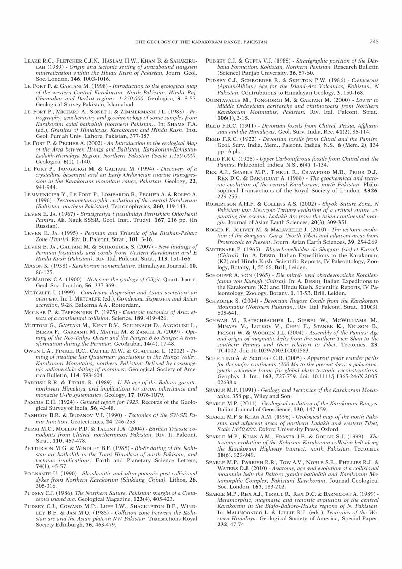
LEAKE R.C., FLETCHER C.J.N., HASLAM H.W., KHAN B. & SAHAKIRU-LAH (1989) - Origin and tectonic setting of stratabound tungstenmineralization within the Hindu Kush of Pakistan, Journ. Geol.Soc. London, 146, 1003-1016.
LE FORT P. & GAETANI M. (1998) - Introduction to the geological mapof the western Central Karakorum, North Pakistan. Hindu Raj,Ghamubar and Darkot regions. 1:250,000. Geologica, 3, 3-57.Geological Survey Pakistan, Islamabad.
LE FORT P., MICHARD A., SONET J. & ZIMMERMANN J.L. (1983) - Pe-trogrraphy, geochemistry and geochronology of some samples fromKarakoram axial batholith (northern Pakistan). In: SHAMS F.A.(ed.), Granites of Himalayas, Karakoram and Hindu Kush. Inst.Geol. Punjab Univ. Lahore, Pakistan, 377-387.
LE FORT P. & PECHER A. (2002) - An Introduction to the geological Mapof the Area between Hunza and Baltistan, Karakorum-Kohistan-Ladakh-Himalaya Region, Northern Pakistan (Scale 1:150,000).Geologica, 6(1), 1-140.
LE FORT P., TONGIORGI M. & GAETANI M. (1994) - Discovery of acrystalline basement and an Early Ordovician marine transgres-sion in the Karakorum mountain range, Pakistan. Geology, 22,941-944.
LEMMENICIER Y., LE FORT P., LOMBARDO B., PECHER A. & ROLFO A.(1996) - Tectonometamorphic evolution of the central Karakorum(Baltistan, northem Pakistan). Tectonophysics, 260, 119-143.
LEVEN E. JA. (1967) - Stratigrafiya i fusulinidyi Permskich OtlozheniiPamira. Ak. Nauk SSSR, Geol. Inst., Trudyi, 167, 216 pp. (InRussian).
LEVEN E. JA. (1995) - Permian and Triassic of the Rushan-PshartZone (Pamir). Riv. It. Paleont. Strat., 101, 3-16.
LEVEN E. JA., GAETANI M. & SCHROEDER S. (2007) - New findings ofPermian fusulinids and corals from Western Karakorum and EHindu Kush (Pakistan). Riv. Ital. Paleont. Strat., 113, 151-166.
MASON K. (1938) - Karakoram nomenclature. Himalayan Journal, 10,86-125.
MCMAHON C.A. (1900) - Notes on the geology of Gilgit. Quart. Journ.Geol. Soc. London, 56, 337-369.
METCALFE I. (1999) - Gondwana dispersion and Asian accretion: anoverview. In: I. METCALFE (ed.), Gondwana dispersion and Asianaccretion, 9-28. Balkema A.A., Rotterdam.
MOLNAR P. & TAPPONNIER P. (1975) - Cenozoic tectonics of Asia: ef-fects of a continental collision. Science, 189, 419-426.
MUTTONI G., GAETANI M., KENT D.V., SCIUNNACH D., ANGIOLINI L.,BERRA F., GARZANTI M., MATTEI M. & ZANCHI A. (2009) - Ope-ning of the Neo-Tethys Ocean and the Pangea B to Pangea A tran-sformation during the Permian. GeoArabia, 14(4), 17-48.
OWEN L.A., FINKEL R.C., CAFFEE M.W. & GUALTIERI L. (2002) - Ti-ming of multiple late Quaternary glaciations in the Hunza Valley,Karakoram Mountains, northern Pakistan: Defined by cosmoge-nic radionuclide dating of moraines. Geological Society of Ame-rica Bulletin, 114, 593-604.
PARRISH R.R. & TIRRUL R. (1989) - U-Pb age of the Baltoro granite,northwest Himalaya, and implications for zircon inheritance andmonazite U-Pb systematics. Geology, 17, 1076-1079.
PASCOE E.H. (1924) - General report for 1923. Records of the Geolo-gical Survey of India, 56, 43-48.
PASHKOV B.R. & BUDANOV V.I. (1990) - Tectonics of the SW-SE Pa-mir Junction. Geotectonics, 24, 246-253.
PERRI M.C., MOLLOY P.D. & TALENT J.A. (2004) - Earliest Triassic co-nodonts from Chitral, northernmost Pakistan. Riv. It. Paleont.Strat., 110, 467-478.
PETTERSON M.G. & WINDLEY B.F. (1985) - Rb-Sr dating of the Kohi-stan arc-batholith in the Trans-Himalaya of north Pakistan, andtectonic implications. Earth and Planetary Science Letters,74(1), 45-57.
POGNANTE U. (1990) - Shoshonitic and ultra-potassic post-collisionaldykes from Northern Karakorum (Sinkiang, China). Lithos, 26,305-316.
PUDSEY C.J. (1986). The Northern Suture, Pakistan: margin of a Creta-ceous island arc. Geological Magazine, 123(4), 405-423.
PUDSEY C.J., COWARD M.P., LUFF I.W., SHACKLETON B.F., WIND-LEY B.F. & JAN M.Q. (1985) - Collision zone between the Kohi-stan arc and the Asian plate in NW Pakistan. Transactions RoyalSociety Edinburgh, 76, 463-479.
PUDSEY C.J. & GUPTA V.J. (1985) - Stratigraphic position of the Dar-band Formation, Kohistan, Northern Pakistan. Research Bulletin(Science) Panjab University, 36, 57-60.
PUDSEY C.J., SCHROEDER R. & SKELTON P.W. (1986) - Cretaceous(Aptian/Albian) Age for the Island-Arc Volcanics, Kohistan, NPakistan. Contrubitions to Himalayan Geology, 3, 150-168.
QUINTAVALLE M., TONGIORGI M. & GAETANI M. (2000) - Lower toMiddle Ordovician acritarchs and chitinozoans from NorthernKarakorum Mountains, Pakistan. Riv. Ital. Paleont. Strat.,106(1), 3-18.
REED F.R.C. (1911) - Devonian fossils from Chitral, Persia, Afghani-stan and the Himalayas. Geol. Surv. India, Rec. 41(2), 86-114.
REED F.R.C. (1922) - Devonian fossils from Chtral and the Pamirs.Geol. Surv. India, Mem., Paleont. Indica, N.S., 6 (Mem. 2), 134pp., 6 pls.
REED F.R.C. (1925) - Upper Carboniferous fossils from Chitral and thePamirs. Palaeontol. Indica, N.S., 6(4), 1-134.
REX A.J., SEARLE M.P., TIRRUL R., CRAWFORD M.B., PRIOR D.J.,REX D.C. & BARNICOAT A. (1988) - The geochemical and tecto-nic evolution of the central Karakoram, north Pakistan. Philo-sophical Transactions of the Royal Society of London, A326,229-255.
ROBERTSON A.H.F. & COLLINS A.S. (2002) - Shyok Suture Zone, NPakistan: late Mesozoic-Tertiary evolution of a critical suture se-parating the oceanic Ladakh Arc from the Asian continental mar-gin. Journal of Asian Earth Sciences, 20(3), 309-351.
ROGER F., JOLIVET M. & MALAVIELLE J. (2010) - The tectonic evolu-tion of the Songpan- Garze (North Tibet) and adjacent areas fromProterozoic to Present. Journ. Asian Earth Sciences, 39, 254-269.
SARTENAER P. (1965) - Rhynchonelloidea de Shogran (sic) et Kuragh(Chitral). In: A. DESIO, Italian Expeditions to the Karakorum(K2) and Hindu Kush. Scientific Reports, IV Paleontology, Zoo-logy, Botany, 1, 55-66, Brill, Leiden.
SCHOUPPÉ A. VON (1965) - Die mittel- und oberdevonsiche Korallen-fauna von Kuragh (Chitral). In: A. DESIO, Italian Expeditions tothe Karakorum (K2) and Hindu Kush. Scientific Reports, IV Pa-leontology, Zoology, Botany, 1, 13-53, Brill, Leiden.
SCHRÖDER S. (2004) - Devonian Rugose Corals from the KarakorumMountains (Northern Pakistan). Riv. Ital. Paleont. Strat., 110(3),605-641.
SCHWAB M., RATSCHBACHER L., SIEBEL W., MCWILLIAMS M., MINAEV V., LUTKOV V., CHEN F., STANEK K., NELSON B., FRISCH W. & WOODEN J.L. (2004) - Assembly of the Pamirs: Ageand origin of magmatic belts from the southern Tien Shan to thesouthern Pamirs and their relation to Tibet. Tectonics, 23,TC4002, doi: 10.1029/2003TC001583.
SCHETTINO A. & SCOTESE C.R. (2005) - Apparent polar wander pathsfor the major continents (200 Ma to the present day): a palaeoma-gnetic reference frame for global plate tectonic reconstructions.Geophys. J. Int., 163, 727-759. doi: 10.1111/j.1365-246X.2005.02638.x
SEARLE M.P. (1991) - Geology and Tectonics of the Karakoram Moun-tains. 358 pp., Wiley and Son.
SEARLE M.P. (2011) - Geological evolution of the Karakoram Ranges.Italian Journal of Geoscience, 130, 147-159.
SEARLE M.P & KHAN A.M. (1996) - Geological map of the north Paki-stan and adjacent areas of northern Ladakh and western Tibet,Scale 1:650,000. Oxford University Press, Oxford.
SEARLE M.P., KHAN A.M., FRASER J.E. & GOUGH S.J. (1999) - Thetectonic evolution of the Kohistan-Karakoram collision belt alongthe Karakoram Highway transect, north Pakistan. Tectonics18(6), 929-949.
SEARLE M.P., PARRISH R.R., TOW A.V., NOBLE S.R., PHILLIPS R.J. &WATERS D.J. (2010) - Anatomy, age and evolution of a collisionalmountain belt: the Baltoro granite batholith and Karakoram Me-tamorphic Complex, Pakistani Karakoram. Journal GeologicalSoc. London, 167, 183-202.
SEARLE M.P., REX A.J., TIRRUL R., REX D.C. & BARNICOAT A. (1989) -Metamorphic, magmatic and tectonic evolution of the centralKarakoram in the Biafo-Baltoro-Hushe regions of N. Pakistan.In: MALINCONICO L. & LILLIE R.J. (eds.), Tectonics of the We-stern Himalaya. Geological Society of America, Special Paper,232, 47-74.
THE GEOLOGY OF THE KARAKORAM RANGE, PAKISTAN 245
03a ZANCHI txt ok 161-246_GEOLOGIA 29/07/11 09.29 Pagina 245

SEARLE M.P. & TIRRUL R. (1991) - Structural and thermal evolutionof the Karakoram crust. Journal Geological Society, London,148, 65-82.
SEARLE M.P. & TRELOAR P.J. (2010) - Was Late Cretaceous-Paleoceneobduction of ophiolite complexes the primary cause of crustalthickening and regional metamorphism in the Pakistan Hima-laya? Geological Society, London, Special Publications, 338,345-359, doi: 10.1144/SP338.16.
SHVOL’MAN V.A. (1980) - A Mesozoic ophiolitic complex in the Pamir(in Russian): Geotektonika, 6, 72-82. Geotectonics, 13(6), 447-456.
STEPHENSON M.H., ANGIOLINI L. & LENG M.H. (2007) - The EarlyPermian fossil record of Gondwana and its relationship to degla-ciation: a review. In: M. WILLIAMS, A.M. HAYWOOD, F.J. GRE-GORY & D.N. SCHMIDT (eds.), Deep-Time Perspectives on ClimateChange: Marrying the Signal from Computer Models and Biologi-cal Proxies. The Micropalaeontological Society, Special Publica-tions. The Geological Society, London, 103-122.
STAUFFER K.W. (1975) - Reconnaissance geology of the central Mastujvalley, Chitral State, West Pakistan. United States GeologicalSurvey Open file Report, no. 75-556, 51 pp.
STÜBNER K., RATSCHBACHER L., WEISE C., PFÄNDER J., GLOAGUEN R.,HACKER B., DUNKL I., JONCKHEERE R., STANEK K. & MINAEV V.(2011) - Miocene gneiss domes and syn-orogenic extension in thePamir. Geophysical Research Abstracts, 13, EGU2011-9992.
TAHIRKHELI R.A.K. (1982) - Geology of the Himalaya, Karakorum andHindukush in Pakistan. Geological Bull. University of Peshawar,15, 51 pp.
TAHIRKHELI R.A.K., MATTAUER M., PROUST F. & TAPPONNIER P.(1979) - The India Eurasia Suture Zone in Northern Pakistan:Synthesis and interpretation of recent data at plate scale. In: FA-RAH A. & DE JONG K.A. (eds.), Geodynamics of Pakistan. Geolo-gical Survey of Pakistan, Quetta, 125-130.
TALENT J.A., CONAGHAN P.J., MAWSON R., MOLLOY P.D. &PICKETT J.W. (1982) - Intricay of tectonics in Chitral (HinduKush). Faunal evidence and some regional implications. Hima-layan Seminar (1976), section IIA, Geological Survey of India,Miscellaneous Publications, 41, 77-101.
TALENT J.A., GAETANI M., MAWSON R., MOLLOY P.D. & CONAGHAN P.J.(1999) - Early Ordovician and Devonian conodonts from the Western Karakorum and Hindu Kush, northwestern Pakistan.Riv. It. Paleont. Strat., 105(2), 201-230.
TALENT J.A. & MAWSON R. (1979) - Palaeozoic-Mesozoic Biostrati-graphy of Pakistan in Relation to Biogeography and the Coale-scence of Asia. In: FARAH A. & DE JONG K.A. (eds.), Geodyna-mics of Pakistan. Geological Survey of Pakistan, Quetta, 81-102.
TAPPONNIER P., MATTAUER M., PROUST F. & CASSAIGNEAU C.(1981) - Mesozoic ophiolites, sutures and large-scale tectonicmovements in Afghanistan. Earth and Planetary Science Let-ters, 52, 355-371.
TAPPONNIER P., PELTZER G. & ARMIJO R. (1986) - On the mechanicsof the collision between India and Asia. In: COWARD M.P. & RIES A.C. (eds.), Collision Tectonics. Geological Society, Lon-don, Special Publications, 19,115-157.
TONGIORGI M., DI MILIA A., LE FORT P. & GAETANI M. (1994) - Paly-nological dating (Arenig) of the sedimentary sequence overlyingthe Ishkarwaz Granite (Upper Yarkhun valley, Chitral, Pakistan).Terra Nova, 6, 595-607.
TONGIORGI M., YIN L.M. & DI MILIA A. (1995) - Arenigian acritarchsform the Daping Section (Yangtze Gorges area, Hubei province,Southern China) nd their palaeogeographic seignificance. Rev. Pa-laebot. Palynol., 86, 13-48.
TRELOAR P.J., PETTERSON M.G., JAN M.Q. & SULLIVAN M.A. (1996) -A re-evaluation of the stratigraphy and evolution of the Kohistanarc sequence, Pakistan Himalaya: implications for magmatic andtectonic arc-building processes. Journal of the Geological So-ciety, London, 153, 681-693.
VANDERCAMMEN A. (1965) - Les Spiriferidae de Shogram et Kuragh(Chitral). In: A. DESIO: Italian Expeditions to the Karakorum(K2) and Hindu Kush. Scientific Reports, IV Paleontology, Zoo-logy, Botany, 1, 67-75. Brill, Leiden.
VILLA I., LEMMENICIER Y. & LE FORT P. (1996) - Late Miocene toEarly Pliocene tectonometamorphism and cooling in south-cen-tral Karakoram and Indus-Tsangpo suture, Chogo Lungma area(NE Pakistan). Tectonophysics, 260, 201-214.
VLASOV N.G., YU. A. DYAKOV & CHEREV E.S. (eds.) (1991) - Geologi-cal map of the Tajik SSR and adjacent territories, 1:500,000, VSE-GEI (Vsesojuznoi Geol. Inst.), Leningrad, Saint Petersburg.
YOSHIDA M., ZAMAN H. & AHMAD M.N. (1996) - Paleopositions ofKohistan Arc and surrounding terranes since Cretaceous time: thepaleomagnetic constraints. Proceedings of Geoscience Collo-quium, Geoscience Laboratory Project, Islamabad, Pakistan, 15,83-101.
ZANCHI A. (1993) - Structural evolution of the North Karakorum co-ver, North Pakistan. In: TRELOAR P.J. & SEARLE M.P. (eds.), Hi-malayan Tectonics. Geological Society of London, Special Publi-cation, 74, 21-38.
ZANCHI A. & GAETANI M. (1994) - Introduction to the Geological mapof the Northern Karakoram Terrain, from Chapursan valley toShimshal Pass. Riv. It. Paleont. Strat., 100(1), 125-136.
ZANCHI A., GAETANI M. & POLI S. (1997) - The Rich Gol MetamorphicComplex: evidence of separation between Hindu Kush and Ka-rakoram. Comptes Rendues de l’Academie des Sciences Paris,IIa, 325, 877-882.
ZANCHI A. & GRITTI D. (1996) - Multistage tectonic evolution of Hun-za Karakorum (Pakistan). Tectonophysics, 260, 145-165.
ZANCHI A., POLI S., FUMAGALLI P. & GAETANI M. (2000) - Mantleexhumation along the Tirich Mir Fault Zone, NW Pakistan: premid-Cretaceous accretion of the Karakoram terrane to the Asianmargin. In: KHAN M.A., TRELOAR P.J., SEARLE M.P. & JAN M.Q.(eds.), Tectonics of the Nanga Parbat Syntaxis and the WesternHimalayas. Geological Society of London, Special. Publication,170, 237-252.
ZANCHI A., ZANCHETTA S., BERRA F., MATTEI M., GARZANTI E.,MOLYNEUX S., NAWAB A. & SABOURI J. (2009) - The Eo-Cimme-rian (Late? Triassic) orogeny in north Iran. Geological Society,London, Special Publications, 312, 31-55.
246 A. ZANCHI & M. GAETANI
Manuscript received 8 April 2011; accepted 17 June 2011; editorial responsability and handling by S. Conticelli.
03a ZANCHI txt ok 161-246_GEOLOGIA 29/07/11 09.29 Pagina 246