Photo-Interpretation In Military Geology - ASPRS
9
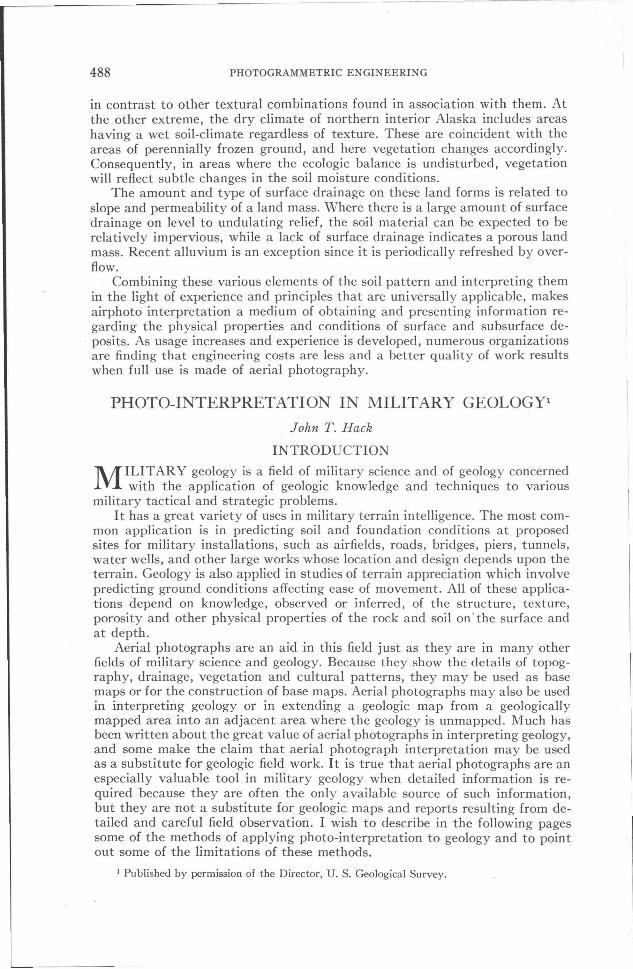
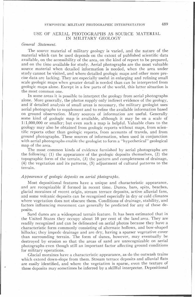
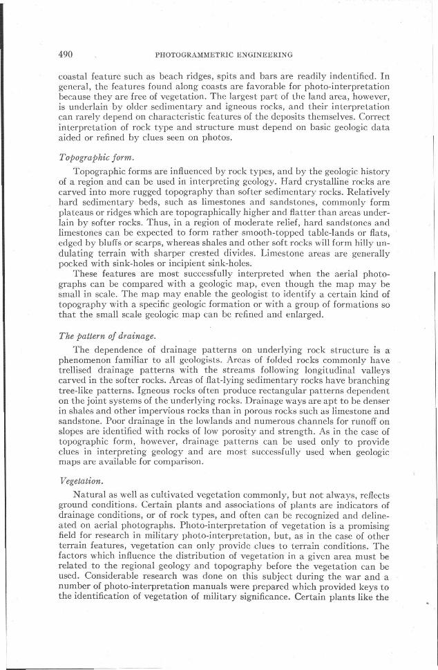
488 PHOTOGRAMMETRIC ENGINEERING in contrast to other textural combinations found in association with them. At the other extreme, the dry climate of northern interior Alaska includes areas having a wet soil-climate regardless of texture. These are coincident with the areas of perennially frozen ground, and here vegetation changes accordingly. Consequently, in areas where the ecologic balance is undisturbed, vegetation will reflect subtle changes in the soil moisture conditions. The amount and type of surface drainage on these land forms is related to slope and permeability of a land mass. Where there is a large amount of surface drainage on level to undulating relief, the soil material can be expected to be relatively impervious, while a lack of surface drainage indicates a porous land mass. Recent alluvium is an exception since it is periodically refreshed by over- flow. Combining these various elements of the soil pattern and interpreting them in the light of experience and principles that are universally applicable, makes airphoto interpretation a medium of obtaining and presenting information re- garding the physical properties and conditions of surface and subsurface de- posits. As usage increases and experience is developed, numerous organizations are finding that engineering costs are less and a better quality of work results when full use is made of aerial photography. PHOTO-INTERPRETATION IN MILITARY GEOLOGYl John T. Hack INTRODUCTION M ILITARY geology is a field of military science and of geology concerned with the application of geologic knowledge and techniques to various military tactical and strategic problems. It has a great variety of uses in military terrain intelligence. The most com- mon application is in predicting soil and foundation conditions at proposed sites for military installations, such as airfields, roads, bridges, piers, tunnels, water wells, and other large works whose location and design depends upon the terrain. Geology is also applied in studies of terrain appreciation which involve predicting ground conditions affecting ease of movement. All of these applica- tions depend on knowledge, observed or inferred, of the structure, texture, porosity and other physical properties of the rock and soil on' the surface and at depth. Aerial photographs are an aid in this field just as they are in many other fields of military science and geology. Because they show the details of topog- raphy, drainage, vegetation and cultural patterns, they may be used as base maps or for the construction of base maps. Aerial photographs may also be used in interpreting geology or in extending a geologic map from a geologically mapped area into an adjacent area where the geology is unmapped. Much has been written about the great value of aerial photographs in interpreting geology, and some make the claim that aerial photograph interpretation may be used as a substitute for geologic field work. It is true that aerial photographs are an especially valuable tool in military geology when detailed information is re- quired because they are often the only available source of such information, but they are not a substitute for geologic maps and reports resulting from de- tailed and careful field observation. I wish to describe in the following pages some of the methods of applying photo-interpretation to geology and to point out some of the limitations of these methods. 1 Published by permission of the Director, U. S. Geological Survey.
-
Upload
khangminh22 -
Category
Documents
-
view
0 -
download
0
Transcript of Photo-Interpretation In Military Geology - ASPRS
488 PHOTOGRAMMETRIC ENGINEERING
in contrast to other textural combinations found in association with them. Atthe other extreme, the dry climate of northern interior Alaska includes areashaving a wet soil-climate regardless of texture. These are coincident with theareas of perennially frozen ground, and here vegetation changes accordingly.Consequently, in areas where the ecologic balance is undisturbed, vegetationwill reflect subtle changes in the soil moisture conditions.
The amount and type of surface drainage on these land forms is related toslope and permeability of a land mass. Where there is a large amount of surfacedrainage on level to undulating relief, the soil material can be expected to berelatively impervious, while a lack of surface drainage indicates a porous landmass. Recent alluvium is an exception since it is periodically refreshed by overflow.
Combining these various elements of the soil pattern and interpreting themin the light of experience and principles that are universally applicable, makesairphoto interpretation a medium of obtaining and presenting information regarding the physical properties and conditions of surface and subsurface deposits. As usage increases and experience is developed, numerous organizationsare finding that engineering costs are less and a better quality of work resultswhen full use is made of aerial photography.
PHOTO-INTERPRETATION IN MILITARY GEOLOGYl
John T. Hack
INTRODUCTION
MILITARY geology is a field of military science and of geology concernedwith the application of geologic knowledge and techniques to various
military tactical and strategic problems.It has a great variety of uses in military terrain intelligence. The most com
mon application is in predicting soil and foundation conditions at proposedsites for military installations, such as airfields, roads, bridges, piers, tunnels,water wells, and other large works whose location and design depends upon theterrain. Geology is also applied in studies of terrain appreciation which involvepredicting ground conditions affecting ease of movement. All of these applications depend on knowledge, observed or inferred, of the structure, texture,porosity and other physical properties of the rock and soil on' the surface andat depth.
Aerial photographs are an aid in this field just as they are in many otherfields of military science and geology. Because they show the details of topography, drainage, vegetation and cultural patterns, they may be used as basemaps or for the construction of base maps. Aerial photographs may also be usedin interpreting geology or in extending a geologic map from a geologicallymapped area into an adjacent area where the geology is unmapped. Much hasbeen written about the great value of aerial photographs in interpreting geology,and some make the claim that aerial photograph interpretation may be usedas a substitute for geologic field work. It is true that aerial photographs are anespecially valuable tool in military geology when detailed information is required because they are often the only available source of such information,but they are not a substitute for geologic maps and reports resulting from detailed and careful field observation. I wish to describe in the following pagessome of the methods of applying photo-interpretation to geology and to pointout some of the limitations of these methods.
1 Published by permission of the Director, U. S. Geological Survey.
SYMPOSIUM: MILITARY PHOTOGRAPHIC INTERPRETATION 489
USE OF AERIAL PHOTOGRAPHS AS SOURCE MATERIALIN MILITARY GEOLOGY
General Statement.
The source material of military geology is varied, and the nature of thematerial which can be used depends on the extent of published scientific dataavailable, on the accessibility of the area, on the kind of report to be prepared,and on the time available for study. Aerial photographs are the most valuablesource material when detailed information is needed, when the area understudy cannot be visited, and where detailed geologic maps and other more precise data are lacking. They are especially useful in enlarging and refining smallscale geologic maps when greater detail is needed than can be interpreted fromgeologic maps alone. Except in a few parts of the world, this latter situation isthe most common one.
In some areas it is possible to interpret the geology from aerial photographsalone. More generally, the photos supply only indirect evidence of the geology,and if detailed analysis of small areas is necessary, the military geologist usesaerial photographs to supplement and to refine the available information basedon ground observation. Many sources of information are useful. Generallysome kind of geologic map is available, although it may be on a scale of1: 1,000,000 or smaller; but even such a map is helpful. Valuable clues to thegeology may also be obtained from geologic reports without maps, from scientific reports other than geologic reports, from accounts of travels, and fromground photographs. These sources of information, when used in conjunctionwith aerial photographs enable the geologist to form a "hypothetical" geologicalmap of the area.
The most common kinds of evidence furnished by aerial photographs arethe following: (1) the appearance of the geologic deposits themselves, (2) thetopographic form of the terrain, (3) the pattern and completeness of drainage,(4) the vegetation and its patterns, (5) adjustment of cultural patterns to theterrain. .
Appearance oj geologic deposits on aerial photographs.
Most depositional features have a unique and characteristic appearance,and are recognizable if formed in recent time. Dunes, bars, spits, beaches,glacial moraines of recent origin, stream terrace deposits, active alluvial fans,and some volcanic deposits can be recognized especially in dry or cold climateswhere vegetation does not obscure them. Conditions of drainage, stability, andfactors influencing movement can generally be predicted for any of these deposits.
Sand dunes are a widespread terrain feature. It has been estimated that inthe United States they occupy about 10 per cent of the land area. They arereadily recognized and can be delineated on aerial photos because they have acharacteristic form commonly consisting of alternate hollows, and bow-shapedhillocks; they impede drainage and are dry, having a sparser vegetative coverthan surrounding terrain. The form of dunes, however, may eventually bedestroyed by erosion so that the areas of sand are unrecognizable on aerialphotographs even though still an important factor affecting ground conditionsfor military operations.
Glacial moraines have a characteristic appearance, as do the outwash trainswhich extend down-slope from them. Stream terrace deposits and alluvial flatsare easily identified, and where the vegetation is sparse, even the texture ofthese deposits may sometimes be inferred by a skillful interpreter. Depositional
490 PHOTOGRAMMETRIC ENGINEERING
coastal feature such as beach ridges, spits and bars are readily indentified. Ingeneral, the features found along coasts are favorable for photo-interpretationbecause they are free of vegetation. The largest part of the land area, however,is underlain by older sedimentary and igneous rocks, and their interpretationcan rarely depend on characteristic features of the deposits themselves. Correctinterpretation of rock type and structure must depend on basic geologic dataaided or refined by clues seen on photos.
TopograpMc form.
Topographic forms are influenced by rock types, and by the geologic historyof a region and can be used in interpreting geology. Hard crystalline rocks arecarved into more rugged topography than softer sedimentary rocks. Relativelyhard sedimentary beds, such as limestones and sandstones, commonly formplateaus or ridges which are topographically higher and flatter than areas underlain by softer rocks. Thus, in a region of moderate relief, hard sandstones andlimestones can be expected to form rather smooth-topped table-lands or flats,edged by bluffs or scarps, whereas shales and other soft rocks will form hilly undulating terrain with sharper crested divides. Limestone areas are generallypocked with sink-holes or incipient sink-holes.
These features are most successfully interpreted when the aerial photographs can be compared with a geologic map, even though the map may besmall in scale. The map may enable the geologist to identify a certain kind oftopography with a specific geologic formation or with a group of formations sothat the small scale geologic map can be refined and enlarged.
The pattern of drainage.
The dependence of drainage patterns on underlying rock structure is a'phenomenon familiar to all geologists. Areas of folded rocks commonly havetrellised drainage patterns with the streams following longitudinal valleyscarved in the softer rocks. Areas of flat-lying sedimentary rocks have branchingtree-like patterns. Igneous rocks often produce rectangular patterns dependenton the joint systems of the underlying rocks. Drainage ways are apt to be denserin shales and other impervious rocks than in porous rocks such as limestone andsandstone. Poor drainage in the lowlands and numerous channels for runoff onslopes are identified with rocks of low porosity and strength. As in the case oftopographic form, however, drainage patterns can be used only to provideclues in interpreting geology and are most successfully used when geologicmaps are available for comparison.
Vegetation.
Natural as well as cultivated vegetation commonly, but not always, reflectsground conditions. Certain plants and associations of plants are indicators ofdrainage conditions, or of rock types, and often can be recognized and delineated on aerial photographs. Photo-interpretation of vegetation is a promisingfield for research in military photo-interpretation, but, as in the case of otherterrain features, vegetation can only provide clues to terrain conditions. Thefactors which influence the distribution of vegetation in a given area must berelated to the regional geology and topography before the vegetation can beused. Considerable research was done on this subject during the war and anumber of photo-interpretation manuals were prepared which provided keys tothe identification of vegetation of military significance. Certain plants like the
SYMPOSIUM: MILITARY PHOTOGRAPHIC INTERPRETATION 491
EX PLANATION
IOMILESSCALE
oI
Pleistocene
Urban Area
Upper PI iocene
Lower Eocene
Pliocene
} Lower Tertiory
IT!]
~K~ij
@II
IE:4dt·,s:.:.j
~
~~7'::J
~
!ili3~
etlf
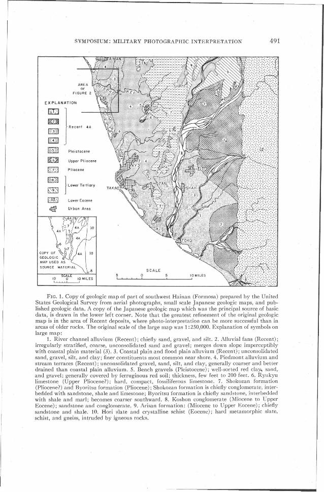
FIG. 1. Copy of geologic map of part of southwest Hainan (Formosa) prepared by the UnitedStates Geological Survey from aerial photographs, small scale Japanese geologic maps, and published geologic data. A copy of the Japanese geologic map which was the principal source of basicdata, is drawn in the lower left corner. Note that the greatest refinement of the original geologicmap is in the area of Recent deposits, where photo-interpretation can be more successful than inareas of older rocks. The original scale of the large map was 1:250,000. Explanation of symbols onlarge map:
1. River channel alluvium (Recent); chiefly sand, gravel, and silt. 2. Alluvial fans (Recent);irregularly stratified, coarse, unconsolidated sand and gravel; merges down slope imperceptiblywith coastal plain material (3). 3. Coastal plain and flood plain alluvium (Recent); unconsolidatedsand, gravel, silt, and clay; finer constituents most common near shore. 4. Piedmont alluvium andstream terraces (Recent); unconsolidated gravel, sand, silt, and clay, generally coarser and betterdrained than coastal plain alluvium. 5. Bench gravels (Pleistocene); ·well-sorted red clay., sand,and gravel; generally covered by ferruginous red soil; thickness, few feet to 200 feet. 6. Ryukyulimestone (Upper Pliocene?); hard, compact, fossiliferous limestone. 7. Shokozan formation(Pliocene?) and Byoritsu formation (Pliocene); Shokozan formation is chiefly conglomerate, interbedded with sandstone, shale and limestone; Byoritsu formation is chiefly sandstone, interbeddedwith shale and marl; becomes coarser southward. 8. Koshon conglomerate (Miocene to UpperEocene); sandstone and conglomerate. 9. Arisan formation: (Miocene to Upper Eocene); chieflysandstone and shale. 10. Hori slate and crystalline schist (Eocene); hard metamorphic slate.schist, and gneiss, intruded by igneous rocks.
492 PHOTOGRAMMETRIC ENGINEERING
nipa and sago palm of the southwest Pacific are distributed over wide areasand wherever found are good indicators of poor drainage conditions and arethus particularly valuable in photo-interpretation. Most vegetation, however,is either less selective of soil conditions or impossible to identify on aerial photographs. In southern Maryland, for example, where large areas are underlain bypoorly drained silt with interspersed areas of well drained sand and gravel,ground conditions should be expected to influence the vegetation cover. Thevegetation pattern, however, does not reveal the nature of the ground. The common holly, which is very abundant, appears to be an indicator of soils with ahigh clay or silt content and rarely grows on dry sandy or gravelly soils, but thedominant trees of the upland forest which are jack pine and white oak completely shade the holly and are less selective. They grow well on both siltysoils and on dry sand and gravel and their distribution is dependent on the history of land utilization rather than on -the properties of the soil.
Studies made by H. M. Raup and C. S. Denny (as yet unpublished) along theAlaska Highway have shown that, although several forest types in that areacan be recognized on aerial photographs, their use in interpretation of geologyis complicated by the fact that the forest composition is strongly influenced bypast forest fires. The vegetation can be used to interpret the simpler geologicfeatures, but methods of interpretation cannot be refined without a thoroughunderstanding of the plant ecology of the region.
As in the case of topography and drainage patterns, a geologist may use'the vegetation as a clue in photo-interpretation in some areas if he has a geologic map for comparison with the photos. He may then discover relationshipsbetween rock formations and kinds of vegetation, or he may discover that theforest or cultivated fields are more lush on one formation than on another, andthus be able to trace boundaries in greater detail than on the geologic mapsavailable to him. The detailed map shown in Figure 2 was prepared largely byinterpretation of vegetation patterns. It represents an area of recent alluvialdeposits in which the distribution of cultivated vegetation, mostly sugar cane,rice, and potatoes is strongly influenced by drainage conditions.
The location of roads, railroads, houses, cultivated fields, ditches and otherman-made structures are very commonly controlled in part by the kind ofground. Examples are numerous. In western Minnesota, farm houses and country roads are strung out along the old sand and gravel beach ridges of ancientglacial Lake Agassiz. Roads, railroads, and settlements generally avoid poorlydrained areas if areas of better drainage are nearby. If the soil and underlyingrock are unstable and "heavy," cultivated fields are apt to be oriented withtheir long dimensions at right angles to the slopes. If the soil is coarse-grainedand stable, orientation of fields is apt to be random, or controlled by some otherfactor that the terrain. The presence of drainage ditches indicates poor drainage.Retaining walls on low slopes indicate unstable bedrock or soil. Thus manyuseful clues can be obtained by observing the works of man and relating themto known geologic features.
INTERPRETATION AND ASSEMBLING SOURCE MATERIALFOR MILITARY GEOLOGIC REPORTS
iNearly all military geologic problems require for their solution the construction of a geologic map. Even though the objective may be to describe foundationconditions at only one spot, these conditions cannot generally be ascertainedwithout knowing the relation of the deposits at one place to other deposits in
SYMPOSIUM: MILITARY PHOTOGRAPHIC INTERPRETATION 493
the region which may lie underneath them at shallow depth and crop out ashort distance away. In preparing a geologic map, the interpreter uses the sameprocedures as a field geologist working on the ground, but his evidence is derived from inferences based on reading the aerial photographs rather than fromground observation. The biggest handicap is that he cannot observe rock texturesand measure thicknesses of strata, and he is thus often unable to work out thestructure of the rocks unless the structure is simple and the evidence on thephotographs clear.
TERRACE SOILS
COASTAL SOILS
EXPLAN ATION
5 CALE
Swamps and marshes
Shattered rockand sand
Sandy loom
Gravel
Urban Area
Loam or cloy loom
Cloy or loomof rice fields
f:,.9·\1
IJ9J41
I·: 5·:1FC-6-j- -
~
I 0'" .. ! !
1~1H~.H Cloy loom or loom
n Sandy loom or loom
LOWLAND. SOILS
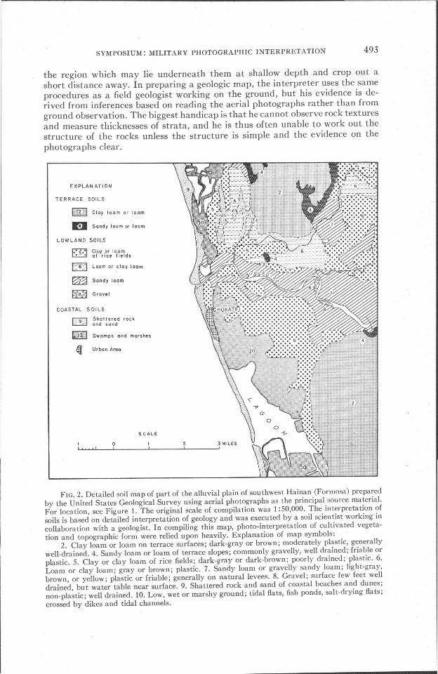
FIG. 2. Detailed soil map of part of the alluvial plain of sou thwest Hainan (Formosa) preparedby the United States Geological Survey using aerial photographs as the principal source material.For location, see Figure 1. The original scale of compilation was 1 :50,000. The interpretation ofsoils is based on detailed interpretation of geology and was executed by a soil scientist·working incollaboration with a geologist. In compiling this map, photo-interpretation of cultivated vegetation and topographic form were relied upon heavily. Explanation of map symbols:
2. Clay loam or loam on terrace surfaces; dark-gray or brown; moderately plastic, generallywell-drained. 4. Sandy loam or loam of terrace slopes; commonly gravelly, well drained; friable orplastic. 5. Clay or clay loam of rice fields; dark-gray or dark-brown; poorly drained; plastic. 6.Loam or clay loam; gray or brown; plastic. 7. Sandy loam or gravelly sandy loam; light-gray,brown, or yellow; plastic or friable; generally on natural levees. 8. Gravel; surface few feet welldrained, but water table near surface. 9. Shattered rock and sand of coastal beaches and dunes;non-plastic; well drained. 10. Low, wet or marshy ground; tidal flats, fish ponds, salt-drying flats;crossed by dikes and tidal channels.

494 PHOTOGRAMMETRIC ENGINEERING
During the planning of the invasion of Okinawa, a military geologic reportwas prepared on the foundation conditions to be expected at a proposed sitefor a large pier on the southern part of the island. In this area the rocks consisted of a limestone formation and an underlying formation of alternating bedsof sand and clay. The only geologic map available was small scale and inadequate for the solution of the problem, as it showed only generalized boundariesof the rock formations and presented little information on rock structure. Itwas easily determined by examination of aerial photographs that the rock onthe shore at the pier site was a limestone, as this formation proved to have anumber of distinguishing characteristics: (1) it generally supported pine treesrather than broad-leaved trees; (2) crops were less lush than in shale areas; (3)it tended to form bluffs along the shore; (4) it had more level but rockier topography than the clay areas. The remaining problem was to determine the thickness of the limestone at the shore so as to determine whether it formed the floorof the harbor or whether the underlying soft beds formed the floor. This problem was partially solved by mapping the geology of the area back from theshore on aerial photographs. The map permitted determination of the elevationof the limestone bed at various points and the construction of a cross sectiontoward the shore which showed the inclination of the limestone and its thickness within rather wide limits of error. It was suspected that the rocks werefaulted and that the presence of faults possibly could not be detected on aerialphotographs. The cross section indicated that the limestone was probably thinand probably nearly horizontal, so that the bottom of the harbor could be expected to be underlain by soft clay or sand. The reliability of this estimate waspoor owing to the possible existence of undetected faults. Had a good geologicmap been available, an estimate of very high reliability could have been madeas the map would have provided precise data on the thickness of the strata,their inclination, and the location of faults.
Generally, the information required in military geology is more complex andinvolves predicting or mapping ground conditions over a wider area than givenin the above example from Okinawa. Frequently, in addition to the kind ofbedrock, soil conditions must be worked out and the geologist must work incollaboration with specialists in soil science.* Whether the problem is simple orcomplex, the solution requires the same ki'nd of judgment as in possessed byskilled field geologists and their collaborators.
GEOLOGIC MAPS AS SOURCE MATERIAL
As discussed above, some kind of geologic map made from data obtainedby ground observation is almost indispensable for the solution of most militarygeologic problems. If these maps are sufficiently detailed, they are far more useful than aerial photographs for geological purposes, and the principal use ofaerial photographs becomes merely that of aiding in the location of areas forstudy and relating the geology to details of culture. Detailed geologic mapsoften allow the trained user to draw the same conclusions as could be drawnfrom a time-consuming survey on the ground. They commonly provide enoughstructural data to make possible the accurate prediction of foundation andtrafficability conditions.
To be useful for this purpose, geologic maps must be made in considerable
* A discussion of methods of photo-interpretation of soil conditions has been published byJ. G. Cady, M. M. Striker, and V. P. Sokoloff, Application of soil science in terrain intelligencestudies, Soil Science Society of America Proceedings, Vol. 10, 1945, pp. 371-374.

SYMPOSIUM: MILITARY PHOTOGRAPHIC INTERPRETATION 495
detail and must be on a scale of about 1: 50,000 or larger. Such maps, however,are available in very few areas. Less than 10 per cent of the United States, forexample, is mapped geologically on scales adequate for effective militaryplanning. Only a few countries, notably England, Germany, and France, arenearly adequately mapped. Central and western Germany is an example of suchan area. Large parts of this region are mapped geologically on the scale of1: 25,000, and easily read, colored, published maps are available.* These mapscontain a wealth of detailed information on soil, geology, and topography, andthey are supplemented by reports which describe the physical properties andstructures of the soils and rocks delineated. In preparing a geologic report onan area included on one of these maps, very little research is necessary. Thetask of the military geologist, when this kind of data is available, is simply totranslate the geology into terms of its effect on the military operations contemplated, so that the report is usable by the officers concerned with the problem.Without question, a military geologist can today advise on geologic problemswith far less effort for areas in this part of Germany than he can for most areasin the United States, where he must resort either to surveys on the ground, or,if they are too costly for the purpose, to study of aerial photographs.
ORGANIZATION OF PHOTO-INTERPRETATION INMILITARY GEOLOGY
It is apparent that, to get the most out of photo-interpretation, a geologistshould be as familiar as possible with the geology of the area being studied inorder to evaluate the terrain features seen in relation to geology. He should alsobe as familiar as possible with other elements of the terrain, such as the naturaland cultivated vegetation, so that he can recognize what he sees in the photographs, separate the landscape into its various elements, and use them as evidence for interpretation of the geology. Even the most experienced interpretersfrequently encounter new or unusual features that cannot be explained and aretempted to jump to conclusions as to their nature. To borrow an example fromanother field; I recall that, during the planning of the invasion of Okinawa, anumber of interpreters working on enemy military installations interpreted asanti-aircraft gun emplacements, numerous perfectly circular structures of unknown origin, until someone saw a ground photograph of a primitive Okinawansugar mill and realized that this was the typical gun emplacement! The samekind of error can be made in geology. These sugar mills might with some logichave been interpreted by a geologist as animal-powered water pumps. Thetemptation would have been strong, for the location of wells would indicate agreat deal about the location of underground water, and the distribution ofwater-bearing rocks.
Successful geologic photo-interpretation is a complex technique of scientificresearch, and an interpreter working with aerial photos alone is severely handicapped unless he knows the terrain intimately. The most effective geologicalphoto-interpretation for military intelligence purposes is done by teams of welltrained scientists, each of whom is thoroughly experienced in geology or one ofthe related fields, such as soil science, ecology, and forestry. A sound basis inthe fundamentals of geology, experience in the field, and ability to use thegeologic literature of foreign countries are the best possible background for amilitary geologist. A working knowledge of the use of aerial photographs canbe acquired in a few weeks' time, and, in fact, it is now a knowledge that most
* Preussische Geologische Landesanstalt, Geologische Karte von Preussen und benachbartenBundestaaten, 1: 25,000,

496 PHOTOGRAMMETRIC ENGINEERING
field geologists acquire as a part of their normal experience. But an understanding of geology and its relation to terrain features can be acquired only throughmany years of training and experience. Research teams composed of geologistsand scientists in related fields can do a better job working together than asindividual workers, for the experience and ideas of each contribute to the successof the whole group. Consultation and exchange of ideas are valuable in thisfield in which so much depends on the recognition of complex and extremelyvaried relationships.
CONCLUSION
Photo-interpretation is a valuable technique in military geology, especiallyso, because, in military geology, it is often impossible or impracticable to visitthe area under study. What can be. accomplished by photo-interpretation islimited by the knowledge of the interpreter, however acquired, of the geologyand geography of the area being studied. Photo-interpretation as a technique isdeserving of attention during peacetime as a fruitful field for research. Nevertheless, our major effort should now be spent in acquiring and organizing forready reference as a much fundamental scientific knowledge as possible of theworld's geology and geography based on field investigations.
INTERPRETATION OF MILITARY INSTALLATIONSFROM AERIAL PHOTOGRAPHS
Thad Jones, Air Research Unit, Library of Congress
I N ATTEMPTING to find an adequate approach to a discussion of interpretation of military installations from aerial photographs, it is necessary, in the
writer's opinion, to consider the technique primarily as a military procedurerather than as an independent technical operation.
The first problem encountered in identifying military installations fromaerial photographs, is what military situation exists. Before photography can beobtained for interpretation, it is necessary that the area to be photographed bedetermined, then the type and scale of photography must be determined. Thephotographic interpreter next considers the general military situation in theselected area from the point of view of the enemy. The general type of militaryinstallations that may be sited in the area are thus established. The militaryphoto interpreter knows, before he looks at his photographs, that he is going tofind, for example, coastal defenses ranging from underwater obstacles, beachobstacles, and infantry defenses to heavy coast-defense installations. Or perhapsit is a different military situation being covered, a situation requiring study ofenemy supply installations, or the communication network supporting a tacticalfront, or the tactical front lines. It is thus seen that the interpretation of militaryinstallations consists of much more than just looking at photographs and recognizing thereon all military installations. Actually, this work must be a wellorganized part of intelligence directing well planned efforts toward many specificobjectives.
Military photo interpretation in World V/ar II had several degrees of value,varying in relation to the military situation. There were situations of a naturethat severely limited useful applications of photo intelligence, and there wereother military situations in which photo intelligence played a primary role inboth strategic and tactical results. It is necessary that the influence of theseseveral types of situations on photo intelligence be understood before a satisfactory comprehension of the whole problem can be obtained. Consequently,